Natural establishment of Eucalyptus globulus Labill. in burnt stands in Portugal
Upload
independentresearcherCategory
view
0download
0
‘A MOST CURIOUS CLASS OF SMALL CAIRN’
REINTERPRETING THE BURNT MOUNDS OF SHETLAND
A thesis submitted to The University of Manchester for the degree of
Doctor of Philosophy
in the Faculty of Humanities.
2014
LAUREN DOUGHTON
SCHOOL OF ARTS, LANGUAGES AND CULTURES

2
Table of Contents
List of Figures ................................................................................................... 5
Abstract ........................................................................................................... 8
Declaration ...................................................................................................... 9
Copyright Statement ........................................................................................ 9
Acknowledgements ........................................................................................10
Chapter One: Introduction ..............................................................................11
1.1 The Burnt Mound Enigma ........................................................................................................... 11 1.2 Research Background .................................................................................................................... 14 1.3 Research Aims and Objectives ................................................................................................... 16 1.4 Scope and Focus of Study. ............................................................................................................ 19 1.5 Some Notes on Terminology. ..................................................................................................... 20
Chapter Two: Past Approaches to Burnt Mound Studies ..................................21
2.1 Introduction ...................................................................................................................................... 21 2.2 Burnt Mounds and Irish Literary Tradition. ........................................................................ 21 2.3 Burnt Mounds and Antiquarian investigation. ................................................................... 23
2.3.1 Irish Antiquarianism, Nationalism and Romanticism .................................................... 24 2.3.2 Antiquarian Investigations in Scotland ................................................................................ 26
2.4 Early Archaeological Investigations ........................................................................................ 27 2.5 Function and Economics – Burnt Mounds and the Processual Legacy. .................... 30
2.5.1 Variations in form and function: the cooking/bathing debate .................................. 31 2.5.2 The International Burnt Mound Conferences ..................................................................... 35
2.6 Recent Approaches ........................................................................................................................ 38 2.6.1 Burnt Mounds & Experimental Archaeology ...................................................................... 40
2.7 Summary ............................................................................................................................................. 41
Chapter Three - Towards a new way of working: Materials, Landscape and
Inhabitation. ...................................................................................................44
3.1 Part One: Theoretical Framework. .......................................................................................... 44 3.1.1 Introduction : Burnt Mounds and Transformation ....................................................... 44 3.1.2 Toward an embodied and emergent understanding of Materials and
Technologies ............................................................................................................................................. 45 3.1.2.1 Materials, Technology and Function .................................................................................. 45 3.1.2.2 Agency, Biography and Chaîne Opératiore ...................................................................... 48 3.1.2.3 Disclosure, encounter and emergence. .............................................................................. 52 3.1.2.4 Hot Stones and the concept of ‘Technology’ .................................................................... 54 3.1.2.5 Elements, Fragmentation and Transformation ............................................................. 56
3.1.3 Landscape, Space and Place. ................................................................................................... 59 3.1.3.1 Archaeologies of Inhabitation................................................................................................ 61

3
3.2 Part 2 – Methodology .................................................................................................................... 63 3.2.1 GIS study and in-situ survey ................................................................................................... 64 3.2.4 Experimental Firings.................................................................................................................. 68 3.4 Conclusion .......................................................................................................................................... 70 4.1 Introduction ...................................................................................................................................... 73 4.2 The Prehistoric Archaeology of Shetland .............................................................................. 73
4.2.1 A Bronze Age for Shetland? ......................................................................................................... 75 4.2.2 Settlement ........................................................................................................................................... 77 4.2.3 Funerary .............................................................................................................................................. 79
4.3 Burnt Mounds in Shetland ........................................................................................................... 82 4.3.1 Landscape Survey and Recording ............................................................................................ 83 4.3.2 Excavation .......................................................................................................................................... 84 4.3.2 Comparable Structures from Orkney. .................................................................................... 89
4.4 Characteristics of Shetland Architecture............................................................................... 94 4.4.1 Recesses ................................................................................................................................................ 94 4.4.2 Heel Shaped Façade ........................................................................................................................ 95 4.4.3 Use of Midden. ................................................................................................................................... 97
4.5 Conclusion .......................................................................................................................................... 99
Chapter Five: Burnt Mounds in their Landscape Context: GIS and In-Situ Survey
..................................................................................................................... 102
5.1 Introduction .................................................................................................................................... 102 5.2 GIS Analysis ..................................................................................................................................... 102
5.2.1 Creating the Geodatabase ........................................................................................................ 102 5.2.2 Distribution, clustering and other locational considerations. ................................. 105 5.2.3 Variations upon a theme: Burnt Mounds and Water. .................................................. 112 5.2.4 Creating a person centred GIS analysis of burnt mounds in the wider prehistoric
landscape: multi-scalar viewshed analysis .................................................................................. 119 5.3 Site Visits .......................................................................................................................................... 126
5.3.1 The Pro-Forma ............................................................................................................................... 128 5.3.2 General Position ............................................................................................................................ 131 5.3.3 Mound Shape & Size .................................................................................................................... 134 5.3.4 Structural Evidence ..................................................................................................................... 138 5.3.5 Relationship with Water ........................................................................................................... 141 5.3.6 Mound Clusters .............................................................................................................................. 144 5.3.7 Relationship with other prehistoric sites........................................................................... 145 5.3.8 Open and Closed Views ............................................................................................................... 147 5.3.9 Encountering Burnt Mound Sites. ......................................................................................... 149
5.4 Shetland’s Burnt Mounds in their Landscape Context................................................... 151 5.5 Evaluation & Conclusion ............................................................................................................ 153
Chapter Six: Experimental Firings .................................................................. 157
6.1 Introduction: Experiment or Experience? .......................................................................... 157 6.2 The Replica Tank & Hearth ....................................................................................................... 160 6.3 The Experiments ........................................................................................................................... 161
6.3.1 Transporting Stones & Heating Water ............................................................................... 161 6.3.2 Brewing ............................................................................................................................................. 167
4
6.3.3 Creating a sewn hide boat ........................................................................................................ 173 6.3.4 Washing, Dying and Fulling ..................................................................................................... 180 6.3.5 Cooking .............................................................................................................................................. 184 6.3.6 Winter Firing .................................................................................................................................. 186
6.4 Danger................................................................................................................................................ 188 6.5 Creating a Community: Shared Knowledge and Experience ....................................... 193 6.6 Sensory Engagements ................................................................................................................. 196 6.7 Networks of Shared Knowledge and Practise. .................................................................. 197
Chapter Seven: The Mound. .......................................................................... 199
7.1 Mounds and Mounding in the Bronze Age .......................................................................... 199 7.2 Mounds of Burnt Stone ............................................................................................................... 200
7.2.1 Sourcing Stone ............................................................................................................................... 203 7.2.2 Use Form and End Form ............................................................................................................ 209
7.3 Burnt Mounds, Memory and Monumentality. ................................................................... 215 7.4 Conclusion ........................................................................................................................................ 221
Chapter Eight: People of Fire and Water: Burnt Mounds and the wider Bronze
Age World. ................................................................................................... 222
8.1 An Elemental Understanding: Fire and Water. ................................................................. 222 8.1.1 Water.................................................................................................................................................. 222 8.1.2 Fire....................................................................................................................................................... 225
8.2 Fire and Water as Elemental Substances in the Bronze Age ....................................... 227 8.3 Burnt Mounds: Elemental Confluence .................................................................................. 231 8.4 Boundaries or Bridges? Reconceptualising Watery Places. ........................................ 235 8.5 Fire and Water in Prehistoric Shetland. ............................................................................. 238 8.6 Conclusion ....................................................................................................................................... 240
Chapter Nine: Summary & Conclusion ........................................................... 241
9.1 Reinterpreting the Burnt Mounds of Shetland ................................................................. 241 9.2 Reconsidering Bronze Age Shetland. .................................................................................... 245 9.3 Limitations of Study and Scope for Further Research ................................................... 249 9.4 Final Conclusions. ......................................................................................................................... 251
Bibliography ................................................................................................. 253
Appendix 1 ................................................................................................... 281
Gazeteer .................................................................................................................................................... 281 Visited Sites and their Landscape Setting .................................................................................. 294
Appendix 2: GIS Shapefiles ……………………………………………………………………….. CD
Word Count 82,173

5
List of Figures Fig 1.1 Distribution of burnt mounds throughout Europe. (Campbell Antony 2003: 1, After
Larssen 1989) _______________________________________________________________________________________ 11 Fig 1.2 Dates from Scottish burnt mounds. Red lines indicate the limits of the Bronze Age, to
which they are traditionally attributed. (Reconstructed from Campbell-Anthony 2003:64) ___ 12 Fig 1.3 Distribution of burnt mounds in Scotland. (Data courtesy of RCAHMS) _________________ 13 Fig 1.4 The Possible Functions of Burnt Mounds and Hot Stone Technologies ___________________ 14 Fig 1.5 The replica structures on Bressay in action. _______________________________________________ 16 Fig 4.1 Plans of prehistoric houses in Shetland (Downes & Lamb 2000:120) ____________________ 77 Fig 4.2 Twin Houses at Sumburgh (Downes & Lamb 2000:114). _________________________________ 79 Fig 4.3 Shetland’s Chambered Cairns, showing proposed chronology (Sheridan 2012:29) _____ 80 Fig 4.4 Overview of dates from burnt mounds in the Northern Isles (Campbell Anthony 2003:
315) __________________________________________________________________________________________________ 82 Fig 4.5 Structures at Tougs (Hedges 1986:10) ____________________________________________________ 85 Fig 4.6 Structures at Tangwick (Moore & Wilson 1999: 214) ____________________________________ 87 Fig 4.7 Structures at Cruester (Moore & Wilson 2008) ___________________________________________ 88 Fig 4.8 Structures at Liddle (Hedges 1975: 44) ____________________________________________________ 90 Fig 4.9 Structures at Beauquoy (Hedges 1975:52) ________________________________________________ 91 Fig 4.10 Structures at Meur (Toolis et al 2007:34) ________________________________________________ 93 Fig 4.11 Stanydale (Calder 1950:187) _____________________________________________________________ 96 Fig 4.12 The façade at Vementry (Bryce 1939:27) ________________________________________________ 97 Fig 5.1 Burnt Mound Distribution _________________________________________________________________ 106 Fig 5.2 Burnt Mound Density ______________________________________________________________________ 107 Fig 5.3 Differing landscapes on the West Side of Mainland: South: Dale of Walls (left) & North:
West Burrafirth (right) – Image: Eileen Brooke-Freeman. ______________________________________ 108 Fig 5.4 Distribution of Burnt Mounds, Settlement and Funerary Sites on the West Side of
Shetland ____________________________________________________________________________________________ 109 Fig 5.5 Localised clustering of burnt mound sites ________________________________________________ 111 Fig 5.6 Mounds clustered along the course of Burn of Setter. ____________________________________ 112 Fig 5.7 Location of watercourses and coastline at Cruester (Moore & Wilson 2001) ___________ 114 Fig 5.8 Mounds within 500m of coast _____________________________________________________________ 115 Fig 5.9 Mounds 500m from streams _______________________________________________________________ 116 Fig 5.10 Mounds 500m from lochs ________________________________________________________________ 117 Fig 5.11 Multiple water sources at Brunatwatt __________________________________________________ 118 Fig 5.12 - Defining Social Scales - Following Rennel 2009:108 __________________________________ 120 Fig 5.13 Local Scale visiblilty from Willapund ___________________________________________________ 122 Fig 5.14 Viewshed from settlement locations at Dalsetter, South Mainland ___________________ 122 Fig 5.15 Settlement and burnt mound intervisibility, Dutch Loch, Papa Stour. ________________ 123 Fig 5.16 Lack of intervisibility between settlement and burnt mounds at Minn, Burra. _______ 124 Fig 5.17 Tougs & its proximity to other prehistoric features. (Hedges 1986:2) ________________ 125 Fig 5.18 Sites visited _______________________________________________________________________________ 127 Fig 5.19a Proforma, Page 1. _______________________________________________________________________ 129 Fig 5.19b Proforma Page 2. ________________________________________________________________________ 130 Fig 5.20 The larger mound at Brunatwatt, located in good pasture land.______________________ 132 Fig 5.21 Lower Loch of setter, a typical rough grazing setting. _________________________________ 132 Fig 5.22 Lu Ness, Burra, situated in marshy ground prone to regular flooding.________________ 133 Fig 5.23 The original location of Cruester mound at the foreshore of Bressay Sound. _________ 133 Fig 5.24 A coastal mound at Hamnavoe, Eashaness. ____________________________________________ 134 Fig 5.25 Willapund ________________________________________________________________________________ 134 Fig 5.26 Mound shapes observed __________________________________________________________________ 135

6
Fig 5.27 Classic Kidney Shaped Mound at Eilams Wells _________________________________________ 135 Fig 5.28 Oval Shaped Mound at Burn of Setter ___________________________________________________ 136 Fig 5.29 Dual Mound at Tunnigarth ______________________________________________________________ 136 Fig 5.30 Elongated Mound and small ovoid mound at Loch of Forratwatt _____________________ 137 Fig 5.31 Primary mound and secondary mound material at Lower Loch of Setter _____________ 137 Fig 5.32 Multiple phases of deposition at Loch of Niddister _____________________________________ 138 Fig 5.33 Tank in central recess at Bogers Burn, Northmavine ___________________________________ 138 Fig 5.34 Possible structural remains in the central recess at Dutch Loch _______________________ 139 Fig 5.35 Possible structural remains at Skelberry ________________________________________________ 140 Fig 5.36 Single earthfast stone at Muckle Brownie’s Knowe _____________________________________ 140 Fig 5.37 Remains of kerbing at Hamnavoe _______________________________________________________ 140 Fig 5.38 Mounds in relation to water source _____________________________________________________ 141 Fig 5.39 Mounds at Biggins, Papa Stour with no visible water source. _________________________ 142 Fig 5.40 Seasonal runoff next to Clothie __________________________________________________________ 143 Fig 5.41 Sea views from Hamnavoe. _______________________________________________________________ 144 Fig 5.42 Prehistoric field boundaries on the approach to Tangwick ____________________________ 145 Fig 5.43 Remains of a Chambered tomb/Cist, approaching Lower Loch of Setter from the South
East._________________________________________________________________________________________________ 146 Fig 5.44 Enclosed views from Skellberry (Image Steve Doughton) _____________________________ 147 Fig 5.45 360 schematic from East Collaster demonstrating enclosed views ____________________ 148 Fig 5.46 360 schematic from Hamnavoe showing limited sea views. ____________________________ 148 Fig 5.47 Approaching Willapund from the south. ________________________________________________ 150 Fig 6.1 The replica structures on Bressay. ________________________________________________________ 160 Fig 6.2 - Constructing the fire within the hearth. _________________________________________________ 162 Fig 6.3 - Stones being transported from the hearth to the tank. _________________________________ 165 Fig 6.4 Brewing in the tank (Image courtesy of Merryn & Graham Dineley) ____________________ 169 Fig 6.5 Residue from brewing (Image Courtesy Merryn & Graham Dineley) ____________________ 170 Fig 6.6 Sediment ___________________________________________________________________________________ 172 Fig 6.7 Hides in the tank ___________________________________________________________________________ 175 Fig 6.8 Scraping the hide __________________________________________________________________________ 176 Fig 6.9 Creating the frame _________________________________________________________________________ 177 Fig 6.10 Sewing the hides __________________________________________________________________________ 178 Fig 6.11 Creating the boat _________________________________________________________________________ 178 Fig 6.12 Dyestuff in the tank _______________________________________________________________________ 181 Fig 6.13 Cleaned fleece and dyed skeins of wool. _________________________________________________ 183 Fig 6.14 Fire damage to the side cell ______________________________________________________________ 190 Fig 6.15 Broken lintel stone following stone explosion ___________________________________________ 192 Fig 6.16 Projectile stone found on top of hearth cell following explosion _______________________ 192 Fig 6.18 - Networks of materials, skills and experience utilised in burnt mounds ______________ 198 Fig 7.1 Underlying processes in the development of a burnt mound. ____________________________ 201 Fig 7.2 Stones in the tank following a firing ______________________________________________________ 202 Fig 7.3 Mounding of material around the tank at Boger’s Burn. ________________________________ 202 Fig 7.4 Possible instance of mounding against a rock outcrop at Tunnigarth. _________________ 203 Fig 7.5 Burnt mound distribution in relation to underlying Geology ____________________________ 206 Fig 7.6 A modern clearance cairn at Loch of Brouster ___________________________________________ 207 Fig 7.7 Dates obtained from Cruester Burnt Mound (Campbell Anthony 2003:310) ___________ 209 Fig 7.8 Wooden container from Clowanstown.
(http://www.archaeologicalconsultancy.com/projects_clowanstown1.asp) ___________________ 213 Fig 7.9 Utnabrake: The central indentation suggests the collapse of structures buried beneath
the mound. _________________________________________________________________________________________ 214 Fig 8.1 - Transmutability, fluidity and change provide water with a wide range of meanings. 223

7
Fig 8.2 Fire _________________________________________________________________________________________ 225 Fig 8.3 Illustration of Bronze Age cosmologies following Kaul (in Bradley 2006:374) _________ 227 Fig 8.4 Trundholm Chariot (Danish National Museum)__________________________________________ 228 Fig 8.5 The use of rock art to create inland islands in Bronze Age Sweden. (Bradley 1997:323)
______________________________________________________________________________________________________ 228 Fig 8.6 - Plans of Stanydale House, Gruting School & Yoxie, showing central hearth and rear
recess/chamber (Calder 1956) ____________________________________________________________________ 233 Fig 8.7 – Dresser at Skara Brae. ___________________________________________________________________ 234 Figs 8.8 & 8.9 Views, Loch of Breckon, Burn of Setter. ____________________________________________ 236

8
Abstract
This research is concerned with the critical reinterpretation of the burnt mounds of Shetland. Burnt mounds have been described as ‘among the most boring sites with which a field archaeologist must deal’ (Barber & Russel-White 1990:59). Traditionally burnt mound studies have been dominated by concerns relating to technology, form and function. This approach is understood to be a product of modernist understanding of the world which views technologies as primarily adaptive.
As such, it is argued that a critical reappraisal of the frameworks through which burnt mounds are interpreted is required in order to develop an account of their construction and use which situates them within wider disciplinary discourses concerning the Bronze Age. In order to do so this thesis evaluates a range of theoretical frameworks which have explored the emergent and situated nature of encounters between people, places and things. Drawing upon this, a new approach is advocated that examines the relationship between burnt mounds and their wider landscape, and explores the material and social engagements which their construction and use affords.
In order to offer a more holistic approach in keeping with current archaeological discourses, this study reconceptualises the burnt mound as an active site within Bronze Age society, a place where meanings were negotiated and materials transformed. This thesis utilises GIS analysis and in-situ observation to explore the landcape setting of the burnt mounds of Shetland and combines this with an exploration of the material engagements involved in the construction and use of burnt mounds through a series of experimental firings at a replica site. Through this burnt mounds are identified as powerfully symbolic locations involving the interplay of elemental substances which combine to transform people, places and things.
This thesis further challenges the conception that burnt mounds are unable to offer any insight into life in the Bronze Age, by analysing the impact which this reinterpretation has on our understanding of Bronze Age Shetland. In particular, it is argued that in their concern with processes of fragmentation, regeneration and transformation Burnt Mounds reflect the cosmological concerns of wider Bronze Age society. The Bronze Age in Shetland has been identified as a period of apparent isolation and stagnation within the islands. By re-evaluating burnt mounds and situating them within a framework of wider Bronze Age practise this conception is challenged, and the Bronze Age of Shetland is presented as a dynamic period in which burnt mounds played a key role in the understanding of networks of persons, places and substances.

9
Declaration
No portion of the work referred to in the thesis has been submitted in support of an
application for another degree or qualification of this or any other university or other
institute of learning.
Copyright Statement
i. The author of this thesis (including appendices and/or schedules to this thesis) owns
certain copyright or related rights in it (the “Copyright”) and s/he has given The
University of Manchester certain rights to use such Copyright, including for
administrative purposes.
ii. Copies of this thesis, either in full or in extracts and whether in hard or electronic copy,
may be made only in accordance with the Copyright, Designs and Patents Act 1988 (as
amended) and regulations issued under it or, where appropriate, in accordance with
licensing agreements which the University has from time to time. This page must form
part of any such copies made.
iii. The ownership of certain Copyright, patents, designs, trade marks and other
intellectual property (the “Intellectual Property”) and any reproductions of copyright
works in the thesis, for example graphs and tables (“Reproductions”), which may be
described in this thesis, may not be owned by the author and may be owned by third
parties. Such Intellectual Property and Reproductions cannot and must not be made
available for use without the prior written permission of the owner(s) of the relevant
Intellectual Property and/or Reproductions.
iv. Further information on the conditions under which disclosure, publication and
commercialisation of this thesis, the Copyright and any Intellectual Property and/or
Reproductions described in it may take place is available in the University IP Policy (see
http://www.campus.manchester.ac.uk/medialibrary/policies/intellectual-property.pdf),
in any relevant Thesis restriction declarations deposited in the University Library, The
University Library’s regulations (see http://www.manchester.ac.uk/library/aboutus/
regulations) and in The University’s policy on presentation of Theses.

10
Acknowledgements
This thesis would not have been possible without the encouragement and support of a
number of people. In particular I would like to express my thanks to my Supervisor Colin
Richards for his encouragement, guidance and general unflappability. Thank you for
supporting me in pursuing my own path, I am extremely grateful for the discussion,
advice and tutorship which you have provided. Secondly, I would like to express my
thanks to the Royal Anthropological Institute’s Emslie Horniman Fund for financing part
of the experimental firings undertaken for this research. Thanks also to the RCAHMS for
the provision of distribution data relating to the rest of Scotland.
I would also like to thank the numerous people within Shetland who have supported me
during this course of this research. My thanks to the staff of the Shetland Amenity Trust
and Shetland Museum and Archives for their encouragement and support. In particular I
would like to thank Eileen Brooke-Freeman, Jenny Murray, Laurie Goodlad, and Brian
Smith for their assistance and encouragement. My especial thanks to Val Turner and
Chris Dyer of the Archaeology section for their kind provision of resources and their
encouragement and interest in my work. Additional thanks go to Bruce and Jean
Stephen for their hospitality during fieldwork visits.
My especial gratitude to members of the Bressay History Society for allowing me to
work with the replica site and for supporting and assisting me in my work. Especial
thanks to Robina and Stuart Barton for their unswerving support in the face of
sometimes revolting challenges. My thanks to Sarah Foster-Jarden, Keith Prosser, Tony
Sherrat, Sonny Priest, Sally Herriett and Merryn and Graham Dineley for discussion and
assistance regarding aspects of the fieldwork. Thanks also to Ditlev Mahler, Alison
Sheridan and Flemming Kaul and Joakim Goldhahn for encouragement, discussion and
support during this research.
My thanks also to Dr Ian Parker-Heath, Dr Irene Garcia Rovira, Dr Simon Clarke and Jim
Cook for comments and feedback on chapter drafts. Especial thanks to Esther Renwick
for providing a proof reading and agony aunt service over the last few years!
Finally, I would like to express my love and thanks to my family for their support and
encouragement in the production of this thesis. I could not have done it without you. To
Adam, thank you for supporting me, following me around remote islands, and putting up
with the mess – sorry about that!

11
Chapter One: Introduction
‘Burnt mounds are, individually, among the most boring sites with which a field archaeologist must deal. Apart from new data and a new spot on the distribution map, individual sites have little to contribute to our understanding of the past.’
(Barber & Russel-White 1990:59)
1.1 The Burnt Mound Enigma
Fig 1.1 Distribution of burnt mounds throughout Europe. (Campbell Antony 2003: 1, After Larssen 1989)
Burnt mounds are among the most numerous and enigmatic monuments of prehistoric
Europe. The term refers to the heaps of fire cracked stones and ash which are found
throughout England, Ireland, Scotland, Wales, Scandinavia and part of continental
Europe (Fig 1.1). They are predominantly attributed to the Bronze Age, although
individual examples have returned dates from the Neolithic to the Middle Ages
(Campbell-Anthony 2003:2) (Fig 1.2). There are currently over 1900 burnt mounds
recorded in Scotland alone, with the highest concentrations occurring in Shetland,
Orkney, Caithness & Sutherland, and in Southern Scotland around Dumfries and
Galloway (Fig 1.3) However, despite their prolificness burnt mounds rarely feature in
syntheses of the British or European Bronze Age. This is largely because burnt mounds

12
Fig 1.2 Dates from Scottish burnt mounds. Red lines indicate the limits of the Bronze Age, to which they are traditionally attributed. (Reconstructed from Campbell-Anthony 2003:64)

13
Fig 1.3 Distribution of burnt mounds in Scotland. (Data courtesy of RCAHMS)
are notoriously difficult to interpret. A number of possible functions are proposed for
burnt mounds (Fig 1.4), including brewing (Quinn & Moore 2007), textile production
(Lucas 1965, Coles 1979, Jeffrey 1991, Denvir 1999), boat construction (Rausing 1984)
and leather working (Coles 1979). However, narratives relating to their construction and
use have generally fluctuated between their potential as sites for food preparation and
feasting, or the possibilities which they present as sites of prehistoric saunas (O’Kelly
1954, Barfield & Hodder 1987, Buckley 1990, Hodder & Barfield 1991, O’Drisceoil 1989).
Burnt mounds are renowned for being almost devoid of finds or any other diagnostic
material which might help aid the understanding of the processes which may have taken
place in order to create them, or provide information about the people who used them.
Isolated finds at individual sites, such as the spindlewhorls from Coarrhamore and
Richmond (O’Neill 2009:175) may hint at specific functions, but for the most part finds

14
are both generic and sparse. This in turn has led to the claim that they can offer little
information about the lives of prehistoric peoples beyond a dot on the
Cooking
Bathing
Brewing
Textile Working (Fulling & Dying
Hide Processing
Steam Bending/Woodworking
Boat Construction/Logboat Expansion
Metalworking
Brine Evaporation
Fig 1.4 The Possible Functions of Burnt Mounds and Hot Stone Technologies
distribution map (Barber & Russel-White 1990). The quote which appears at the
beginning of this chapter illustrates the general attitude of ambivalence and disinterest
which is displayed by archaeologists towards these sites. It is largely in response to this
statement that this thesis has been developed. It is argued that this approach is based
upon a paradigm which equates technology with adaptation, and therefore presents
function as distinct from symbolic and social meaning. Thomas (2004) has illustrated that
this concept is a product of a distinctly modern way of thinking which views matter as
given and irreducible, and relies on a conception division between the mental and
material. As such, it is recognised that in order to break the ennui which surrounds this
subject, a new approach is required which looks beyond the constraints of function and
considers the dynamic processes involved in the creation and use of burnt mound sites.
1.2 Research Background
This research has developed from a wider interest in regional identities in the British
Neolithic and Bronze Age, and specifically from investigations into the material
expression of insular identity in Shetland during this period. My first encounter with
burnt mounds came in 2007 in Shetland as part of my early research into the prehistoric
settlement and funerary architecture of the islands. This visit involved a preliminary

15
survey of 30 sites throughout Shetland with a view to developing a focussed survey area
for fieldwork to be undertaken the following year. Amongst the sites recorded during
this period, despite not being an established part of my research focus, were five burnt
mound sites, visited for no other reason than curiosity, and their close proximity to other
sites in my survey schedule. These five mounds, along with numerous others that I later
encountered whilst travelling between sites began to raise questions about the nature of
burnt mounds which form the basis of this thesis. In particular, I became interested in
what the relationship between these strange bumps in the ground and the settlement
and funerary sites that formed the basis of my original study might be. The frequency
which I encountered them as I moved around the islands told me that they must once
have formed an integral part of the daily landscape of Shetland. I was therefore intrigued
as to why, other than an occasional throwaway mention, I had not come across them
more often in my reading? Some precursory research told me that the reason that burnt
mounds were not featured in wider synthesis of the Bronze Age period was because they
were boring, and could tell me very little about the period. However, this account did
not tally with my own impression of a group of monuments which were both diverse,
and complex. The burnt mounds which I knew were a variety of shapes and sizes, and
were associated with an array of earthworks, earthfast stones and tantalising glimpses of
slab built hearths and or retaining walls. Moreover, they were irresistibly strange. If
they did indeed represent cooking sites, as all my reading seemed to tell me, why on
earth was it being performed on such a grand scale? And why were they creating these
apparently monumental structures from the waste material rather than disposing of it
discretely, or recycling the material elsewhere as wall core, or pottery temper?
Moreover, if they were not cooking sites, what were they? Were there really over 30
saunas on the tiny island of Fair Isle? And if not, what were they doing, and perhaps
more importantly why were they suddenly doing so much of it?
In 2008 my return to Shetland coincided with the opening of the reconstructed site and
replica structures at Cruester (Fig 1.5). Originally excavated in 2000 (Moore & Wilson
2001) in response to a continued threat of coastal erosion, the site was found to contain
a series of complex internal structures. Following this project the local community
adopted the site and orchestrated its rescue and reconstruction outside of the local
heritage centre. My attendance at this event proved to be the catalyst for the seeds
which had been planted the previous year. Experiencing the pop and crackle of the fire

16
and the hissing and the screaming of the stones during firings, two things became
immediately apparent. The first was that burnt mounds were far from dull. The second
Fig 1.5 The replica structures on Bressay in action.
was that a reappraisal of these sites was clearly overdue. As will be explored in Chapter
Four, the nature of Shetland’s archaeology makes the islands the ideal place for the
study of archaeological sites within their wider landscape context. Moreover, the
existence of the replica hearth and tank on Bressay allowed for the exploration of the
material engagements involved in burnt mound usage in a spatially authentic setting.
The nature of these early engagements have undoubtedly informed the direction of this
thesis. The approach taken is therefore reflective of an established understanding on my
part, formed by my previous encounters with them, that burnt mounds were a part of a
wider network of prehistoric features, and that to understand them it is also necessary
to understand the materials and landscapes which are contemporary with them.
1.3 Research Aims and Objectives
This thesis seeks to create a contextualised understanding of the burnt mounds of
Shetland, which considers both the relationship between the sites and their wider
prehistoric landscape, and examines the material and social engagements which are
afforded through their use. Additionally, it seeks to explore the potential of burnt
mounds to contribute to wider narratives relating to the Bronze Age by examining the
processes involved in their creation and use in relation to current themes within Bronze
Age research. Particular emphasis is placed on recognising the processes involved in the
construction and use of burnt mounds as elemental, fragmentary, transformative and

17
symbolically powerful. As such it offers an original perspective on the use of burnt
mounds in attempting to situate them within wider discourses relating to Bronze Age
cosmogonies. In doing so it also examines the validity of the category of burnt mounds,
and examines whether, given the number of possible interpretations that exist for their
usage, they represent one thing, or many things.
A number of research aims are therefore identified:
1) To critically analyse the approaches taken within burnt mound studies to date.
2) To develop a new framework for understanding the use of burnt mounds and hot
stone technologies which acknowledges the embodied nature of experience, and which
explores the reciprocal relationships between people, places and things in the creation
of meaning.
3) To examine the relationship between burnt mounds of Shetland and the wider
prehistoric landscape.
4) To explore the range of material engagements and networks of skill afforded through
the use and construction of burnt mounds.
5) To recontextualise burnt mounds in relation to broader themes of research currently
being explored in relation to the Bronze Age, specifically those concerning the
fragmentation, elemental substances and transformation.
In order to achieve this a number of approaches have been taken. The background and
framework for the reinterpretation of the sites is provided in Chapter Two and Three. In
Chapter Two I provide an overview of previous approaches to burnt mounds and outline
how the critical frameworks utilised within these interpretations have affected current
understandings of burnt mounds. In Chapter Three I then analyse these frameworks in
order to unpick the underlying assumptions which have prevented burnt mound studies
from developing and engaging with current discourse. In particular, I identify an
underlying conflation of technology and function which has prevented previous studies
of burnt mounds from engaging with the social and symbolic aspects of burnt mound
usage. Specifically I identify the concepts of fragmentation and transformation as
significant in developing our understanding of burnt mounds, and how they are
enmeshed with cycles of regeneration and fertility during the Bronze Age. The
identification of earth, fire and water as elemental substances, is introduced as key to
understanding the transformative nature of the processes carried out a burnt mound

18
sites. Following this I investigate an alternative framework for reconsidering these sites
which engages with the embodied and emergent nature of experience. As such, it is
identified that a critical reinterpretation of burnt mound sites must incorporate an
understanding of the situated nature of encounter, as well as engage with the manner in
which materials reveal themselves through bodily encounters. In light of the above I
outline a methodology which combines GIS analysis, in-situ landscape survey, and a
series of experimental burnt mound firings, in order to develop an overview of the
landscape setting of burnt mounds, and the nature of the skilled engagements required
to create and use them.
Chapter Four provides contextual information about the burnt mounds of Shetland
which form the object of this study. In this chapter I summarise the nature of the
prehistoric archaeology of Shetland, and draw out some of the shared characteristics of
the material. Following this, I provide a summary of previous research into Shetland’s
burnt mounds, and outline the key themes highlighted by this work. Finally, I provide an
overview of those burnt mounds within Shetland which have been subject to excavation,
and draw out some of the characteristics which define the Shetland burnt mound
tradition.
Chapter Five and Six represent the findings of fieldwork undertaken as part of this thesis.
Chapter Five presents the results of GIS and in-situ survey, and examines the landscape
settings of burnt mounds and their relationship to other prehistoric sites. It provides an
overview of their general landscape setting, and examines the relationship between
burnt mounds and other features within the landscape. In particular, it focuses on the
relationship between burnt mounds and water sources, and explores how the variation
in landscape setting affects the experience of the site. Specifically, it identifies that burnt
mounds occupy a particular type of landscape setting characterised by the presence of
water, and a preference for low lying contours. Finally, the relationship between burnt
mounds and nearby settlements are analysed, and a pattern of proximity but limited
indivisibility is identified. Chapter Six then presents the results of the experimental firings
undertaken as part of this thesis. Detailed description of each process is provided, with
an overview of the development of shared skills, social and material engagements.
Attention is given to exploring the sensory nature of burnt mound usage, and detailed
consideration is also given to the role of danger and risk in burnt mound engagements.
Following this Chapter Seven and Eight consider the implications of this information for a
more holistic approach to burnt mounds. Chapter Seven focuses on the development of

19
the mound, and considers practises of mounding in relation to other contemporary
Bronze Age practises. In particular, attention is given to the role of fragmentary materials
during the Bronze Age, and the incorporation of mounds and acts of mounding in the
manifestation of cosmological schema are explored. Crucially, burnt stone is identified as
a potent and transformative substance, and the accumulation and curation of mound
material is identified as a key strategy in ensuring the continued success of the burnt
mound. Chapter Eight considers the nature of elemental engagements and burnt mound
sites, and explores the wider role of fire and water in the Bronze Age. Burnt mounds are
then reconceptualised in light of other contemporary practises, and their status as
transformative and regenerative locations is explored. Following this, the Bronze Age of
Shetland is examined in light of the conclusions drawn in order to explore how a
reinterpretation of burnt mounds might contribute to our understanding of life in the
Bronze Age.
Finally, Chapter Nine summarises the arguments presented within this thesis, and
presents the conclusion of this research.
In addition to the material described above, Appendix 1 presents a list of all Shetland
burnt mound sites considered within this study, with coordinates and reference to the
local SMR number, and tabulated landscape and location results from in-situ survey.
Appendix B (CD in rear of the volume) presents a selection of GIS material compiled as
part of this study.
1.4 Scope and Focus of Study.
As has been noted above, burnt mounds are a temporally and geographically diverse
phenomenon. This thesis focuses specifically on the burnt mounds of Shetland, an island
archipelago north of Scotland. As will be discussed in Chapter Four, the burnt mounds of
Shetland predominantly date to the Bronze Age (see below for clarification in relation to
the use of the term ‘Bronze Age’). However, consideration of sites falling outwith this
period (eg the Neolithic site at Clowanstown, Co. Meath) are included in order to
illustrate variations in the treatment of burnt stone, and to explore wider trends in the
creation and use of burnt mound sites. It should be emphasised that this thesis
represents an attempt to contextualise the burnt mounds of Shetland in relation to
selected themes in burnt mound research, rather than a consideration of the entire
corpus of research relating burnt mound and hot stone technologies. Specific attention
is given to Irish material in order to examine the influence of the Irish literary tradition

20
and its application to Irish fulacht fiadh on the understanding of burnt mound sites. This
thesis also focuses burnt mounds as a monumental phenomena, and restricts its
investigation to those cases where the use hot stone technologies has resulted in the
presence of a mound or mounds. It does not explore the utilisation of hot stones within
a domestic contexts (eg pot boiler stones), or the occurrence of burnt stones within non-
mound contexts.
1.5 Some Notes on Terminology.
For the purposes of this thesis, the phrase ‘burnt mound’ is the preferred terminology to
describe the heaps of cracked stone which form the subject of this study. However,
these sites are also known by a number of other terminologies, including fulacht fiadh,
fulacht, skärvstenshögar or køkkenmødding. The terms fulacht, and fulacht fiadh are
utilized within this thesis when referring specifically to the Irish tradition of burnt mound
research, or to historical explorations of burnt mound sites. These terms are italicized to
identify them, but are generally interchangeable. In Chapter Seven the term ‘mound’ is
also employed to differentiate discussion between the burnt mound as a whole
(including associated structures within), and the mound of fire cracked stones which
form the primary part of the site. When the term ‘mound’ is used on its own in relation
to burnt mounds it therefore refers to this aspect of the site alone.
Secondly, this thesis refers repeatedly to the Bronze Age. The Bronze Age is generally
defined as the period falling between approximately 2000 – 500 BC. However, there is
some debate as to whether this term is applicable within a Shetland context (c.f.
Sheridan 2012). As will be explored in greater detail in Chapter Four, the Early Bronze
Age of Shetland in particular could be considered as a misnomer, as the islands retain
what appears to be a characteristically Neolithic culture for much of this period. For the
purposes of this thesis however, the term Bronze Age is employed to provide a point of
reference to activities taking place in the rest of Britain during this period and to
contextualise the use of burnt mounds with other Bronze Age practices. Additionally,
the chronology for the Neolithic and Bronze Age material in Shetland remains weak and
uncertain (See Chapter Four). As such, it is not always possible to determine which sites
would be contemporaneous with the Bronze Age use of burnt mounds in the islands, and
which represent earlier, Neolithic, activities. For the purposes of this thesis the term
‘Prehistoric’ is applied to many of Shetlands Neolithic/Bronze Age sites in order to
express the ambiguous nature of the material in the islands at the present time.
21
Chapter Two: Past Approaches to Burnt Mound Studies
2.1 Introduction
This chapter presents a detailed overview of the approaches to burnt mounds to date. It
takes a broadly historical overview, following the development of burnt mound studies
from early Irish Antiquarian writings to more recent experimental approaches. In doing
so it is able to draw out some of the key themes and concerns which have influenced
burnt mound studies to date, and explores some of the limitations of the approaches
taken.
2.2 Burnt Mounds and Irish Literary Tradition.
Some of the earliest references to burnt mounds come from the Irish Literary tradition.
While it is not clear how many of the ‘fulacht’ referred to in these texts are in fact
references to burnt mounds, as will be explored in greater detail below, these stories
have become so intrinsically linked with current archaeological interpretations that it is
helpful to assess them here.
The nature of these early literary references has been explored in detail by O’Drisceoil
(1990), who urges caution in their application to the archaeological sites that we
recognise today. He notes that the range of material in which these references are found
are extremely varied. They date from as early as the 9th Century AD to the eighteenth
century. All are written in the Irish language, and range from law tracts, glossaries, saints
lives, folklore, histories to annals and poetry. I will focus more on the implications of
using such resources to aid archaeological interpretation in greater detail at a later point,
however, as O’Drisceoil stresses, it is worth noting that the term fulacht fiadh does not
appear in any of the early material examined, but rather appears to be a nineteenth or
twentieth century invention (ibid 158). The term fulacht does appear, in various forms,
including Inadh fulachta meaning ‘cooking place,’ however it is not at all clear that these
terms refer to the boiling of water, or any of the other activities associated with burnt
mounds. The word fulacht itself may have originally meant ‘recess’ or ‘cavity’ giving rise
to the presumption that all references refer to a cooking pit or trough. However, as
O’Drisceoil notes, it is necessary to examine the context in which these references occur
in order to explore their meaning. When used in a text that relates to the privileges and
responsibilities of poets for example, it is explained that it refers to the path of the voice

22
from the lungs through the throat and mouth to the final expression of the poetry
(Gwynn 1942 in O’Drisceoil 1990:158).
Of the ten examples that O’Drisceoil explores only two appear to be convincing examples
of what we would recognise to be burnt mound activity. The first, from Keating’s ‘The
History of Ireland,’ written in the 18th century, is particularly detailed, and forms the
basis of O’Kelly’s later interpretation of burnt mound sites (see section 2.4 ). A hunting
and cooking context is prescribed to the sites, and they are attributed to the actions of
the mythical Fianna, a legendary band of warriors, found in both Irish and Scottish
mythology, led by the hero Fionn mac Cumhaill. Keating describes how that after a
morning’s hunting the Fianna would send their attendants to a particular spot in the hill,
and that they would kindle fires, in which stones would be set to roast, and dig two pits
in the clay. They would then set some of the meat to roast on the fire, and bind the rest
in rope and set it to boil in one of the pits by dropping the stones from the fire into the
pits periodically. The second pit would then be used by the Fianna for bathing and
reviving themselves after the hunt, before they ate the meal. Keating goes so far as to
identify these sites as being the places ‘now called Fulacht Fian by the peasantry’,
making a clear link between the burnt mound sites which we recognise today and the
activities described (Dinneen 1908 in O’Drisceoill 1990:160). However as O’Drisceoil
notes, Keating is writing a considerable distance from the events being described, and it
is clear that even he regards the sites as antiquities. While he may have been familiar
with the practise of cooking with stones, it is unlikely that Keating had first-hand
experience of this activity on a scale that would have produced the large mounds of
stone found at fulacht sites.
The second account, found in an eighteenth century manuscript does not contain the
word fulacht at all, but rather describes a process which fits closely to that described by
Keating. The Romance of Mis and Dubh Ruis is particularly interesting, not only because
it too describes processes of cooking and bathing using a pit and hot rocks, but because
the site seems to have curative properties, and the processes involved form part of the
cure for Mis’s insanity. Acts of cooking and bathing are also intrinsically linked with
music and sex, as Dubh Ruis first attracts and calms Mis using music, before having
intercourse with her ‘for he thought that if he could lie and have intercourse with her
that it would be a good way to bring her to sanity again’. Mis is clearly impressed with
his performance, as she immediately requests that he do it again. However, he refuses
until he has killed a deer, cooked and eaten it, and then bathed her in the grease of the

23
animal ‘until he brought streams of sweat out of her like that’ (Ó Cuív 1954 in O’Drisceoil
1990:161). Although the first written account appears in the 18th Century, it is likely that
the story itself comes from a much earlier oral tradition. There are some questions over
whether the method of cooking described in this story is in fact a later addition to the
tale. Given that the description tallies so closely with that given by Keating above, it is
possible that these details were added to embellish the tale following the publication of
his history.
What makes both of these accounts particularly interesting is the importance of food,
bathing and other activities such as music and sex in their usage. As will be examined
later (see section 2.4), accounts such as this might go some way to unlocking some of the
complex properties and associations which burnt mounds possess, although at present
these aspects remain significantly under explored.
A number of the other texts make reference to cooking activities being carried out at the
fulacht, but the method used is often roasting, or grilling, and not the boiling activities
that we would expect to take place at a burnt mound site (O’Drisceoil 1990). Others still
seem to describe locations which would be suitable for burnt mound sites, such as ‘The
Cooking of the Great Queen’ (Fulacht na Mórrigna) which describes a cooking place,
which was made a long time ago ‘and cannot be worked without water’ (Hyde 1916:345
in O’Drisceoil 1990:160). However, other descriptions of Fulacht na Mórrigna describe a
wooden shaft, a frame of iron, hooks, pullies and a sail (Mackinnon 1912 in O’Drisceoill
1990:160), which firmly establishes that these are not the archaeological fulacht fiadh
with which we are now familiar.
2.3 Burnt Mounds and Antiquarian investigation.
Given the above, it is perhaps unsurprising that some of the earliest Antiquarian
accounts of burnt mound sites also come from Ireland. The first recorded account from
outside of the literary tradition is by the Rev Horatio Townsend in the General and
Statistical Survey of the County of Cork (1815:145). Townsend refers to the sites as being
primitive cooking locations, and cites their regular proximity to water as being further
proof of this function.
Other early accounts, such as T.L Cooke’s (1951) investigations at Killyon Church,
published in the first volume of the Journal of the Royal Society of Antiquaries of Ireland,
make direct reference to the writing of Keating. Cooke explicitly links the slab lined pit
found at Killyon with those pits described by Keating, further cementing the link

24
between the archaeological sites and the mythological and literary accounts of past
behaviours. Cooke’s account seems to have coloured subsequent interpretations of
these sites. Ó Néill suggests that the ‘traditions elsewhere’ mentioned in the Cork
Examiner in relation to the discovery and excavation of a trough near Mallow in County
Cork, may be a direct reference to Cooke’s earlier publication (2009:15), although it is
equally possible that they are making reference to the early literary material given the
popularity of early folkloric material during this period.
Other notable accounts of Irish burnt mound sites during this period include the
discovery of the Mooghaun hoard, which consisted of 146 pieces, predominantly
ornamental, and at least two unwrought ingots, in 1854. This site has more recently
been identified as a burnt mound (Condit 1996), and contemporary accounts published
also noted that the gold items were found ‘only eighteen inches under the surface of
those little tumuli or mounds of stone which are supposed to be the open air cooking
places of our primitive or our martial forefathers’ (in O’Néill 2009:15). It is uncertain
whether these accounts accurately report the finding place (Condit 1996:20), however,
as O’Néill notes, what is interesting is that the finding of the hoard did not spark a
debate about the dating of these sites, despite the publication of Worsaae’s papers on
the Three Age System in the Proceedings of the Royal Irish Academy in 1847. What is
clear is that not only were burnt mounds already recognisable as a distinct type of
monument during this period in Ireland, but that the link between burnt mounds and
cooking activity was already firmly established. Evidence from excavated sites seemed
to support and perpetuate this belief, rather than challenge it. This interpretation can be
seen to continue throughout the nineteenth century, with many writers referring to
them as ‘cooking sites’ without any direct reference to Keating or other literary sources.
It is not until the 1880s that challenges to the cooking paradigm become raised in
Ireland. For example in 1885 Redmond states that some sites in County Waterford may
have been used for the purposes of brewing, while in 1895 Fairholme suggests that they
may have a connection with smelting (O’Neill 2009:17). While both of these accounts
are notable for their deviation from the accepted interpretation on these sites, as will be
demonstrated below, they have very little impact on the way that burnt mounds will be
considered for the next one hundred years.
2.3.1 Irish Antiquarianism, Nationalism and Romanticism
To fully appreciate the context in which early approaches to burnt mound studies were
being developed, it is necessary to examine the social and political climate in Ireland

25
during the late 18th and early 19th Century, when Antiquarian investigations were at their
height. By the late eighteenth century distinctions between what were previously seen
as ‘Native Irish’, ‘Old English’ and ‘New English’ had begun to blur. The English no longer
saw a clear distinction between the native Irish and descendants of early English settlers.
Slurs once applicable to Gaelic Irish only began to be applied indiscriminately, creating a
need to challenge these perceptions. Translations of early writing, such as Keating’s
History became invaluable tools for Anglo-Irish Protestants to establish their links with
the Gaelic past, and to incorporate themselves into its history (O’Halleran 2010). After
the introduction of the act of union in 1801 the period saw an explosion in literary
explorations of the notion of Irishness. Writers increasingly turned to narratives of the
past in attempt to establish a sense of identity against ongoing political turmoil.
Likewise, those wishing to study Ireland’s past increasingly turned to early Irish literature
in an attempt to create a legitimate and usable version of Irish history and identity.
There was a concerted movement towards to removal of the ‘Barbaric Irish’ stereotype,
and its replacement with notions of a Golden Age of heroic figures and bardic traditions
(Ni Munghalle 2008, O’Halleran 2006, 2010).
The link between Antiquarianism and the Romantic Movement is well documented. As
Trigger (1996:112) notes, the Romantics were deeply interested in the past, specifically
the past of individual peoples and nations. The publication of Macpherson’s Ossianic
poems in the 1760s was had a great impact on the movement, and were taken as
evidence that primitive peoples could produce great works of art (Connolley 2006;
Murray 2000; O’Halleran 2006, 2010). While it has since been determined that
Macpherson wrote the poems himself based upon a knowledge of Gaelic folklore and
mythology (ibid), the link between the popularity of this material, and the mythology
which provides the source of much burnt mound interpretation cannot be overlooked.
Ossian, or Oisin, is the son of Fionn mac Cumhaill, and narrator of many of the tales
within the Fenian Cycle, several of which he features in himself. In this context he is
regarded as one of Ireland’s most legendary poets (O’Halleran 2008, 2010, O’Connor.
The impact of these tales on scholarly practise and national identity can be seen in the
emergence of groups such as the Ossianic Society, formed with an interest in the
promotion of the Irish language, and the Fenian Brotherhood, a militant Irish Republican
group founded in America during the 1850s. The Fenian Cycle, and the stories within it
are intrinsically linked to concepts of what it meant to be Irish in the late eighteenth and
early nineteenth century (Connolley 2006; O’Halleran 2006; Smalikova 2002). The

26
stories refer to a ‘Golden Age’ populated with accomplished poets and heroic acts and it
is within this context which the stories of cooking and bathing at fulacht sites colour the
antiquarian imagination.
2.3.2 Antiquarian Investigations in Scotland
In contrast to the situation in Ireland there is very little recognition of these sites as
being a unique phenomenon in Scotland until the mid to late nineteenth century.
Although a number of sites which would now appear to be burnt mounds were
investigated, there is an implicit understanding that these sites form part of a larger
burial practise, and are often discussed in relation to other stone and earthen mounds
(e.g. Hunt’s exploration of Shetland sites, as described below, or Anderson’s accounts of
the Caithness cairns).
The earliest recognised account comes from Mitchell’s 1870 description of ‘rude stone
implements’ found in the centre of what he describes as a ‘burnt stone tumulus’.
Mitchell describes some of the material found during James Hunt’s investigations in
Shetland on behalf of the Anthropological Society of London (cf Hunt 1866). Hunt’s
particular interest was in the physical characteristics of different racial types, and he
gave several controversial lectures ‘On the Negros place in Nature’ (Smith 2011). He
visited Shetland after hearing of a large number of skulls that had been found in a cairn
on the Muckle Heog, Unst. On examination these skulls were found to exhibit qualities
‘especially in the fore part, to the cranial characteristics we find in the Australian race’.
Shetland was identified as having a wealth of anthropological and archaeological
material, due to the undeveloped nature of agriculture in the islands, and was therefore
seen to be an ideal location to study the remains of ‘aboriginal’ inhabitants. Hunt
secured funding to visit Shetland, and then set about excavating a large number of
archaeological sites, a good number of which were burnt mounds, and none of which
contained any skulls (Smith 2011). While Mitchell recognised Hunt’s mounds as being
made up of burnt stone, Hunt’s own agenda makes it clear that they believed these to be
burial cairns, and there is no other explanation sought for their existence. Neither Hunt
nor Mitchell offer any explanation as to how or why the stones came to be burnt.
Prior to Hunt’s investigations Black (1857) had also reported on a number of cairns
excavated in Shetland, which were composed of material he described as being
‘reddened.’ However, unlike Hunt, Black comes to the conclusion that these sites were
not the result of burning, but rather that the colouration was a result of the type of soils

27
in which they were found. Despite this assertion Anderson (1873: 295) later writes that
they would appear to resemble a ‘curious class of small cairn’ also found in Caithness,
and goes so far as to make the connection with sites found in Ireland and the cooking
hypothesis. This remark is the first example of an awareness of the cooking paradigm
within a Scottish context, although Anderson expresses scepticism of this interpretation,
and suggests a preferred explanation would be something of a ‘sepulchral’ nature,
reinforcing the association between burnt mound sites and burial during this period in
Scotland (ibid). Further mound sites were investigated during the nineteenth century,
including one on Fair Isle, and several in Mainland Scotland (O’Neill 2009:16-17).
However, with the exception of the occasional account on the discovery of a new site,
very little discussion of the nature of the burnt mounds occurs in print until the 20th
century.
2.4 Early Archaeological Investigations
The earliest systematic survey of burnt mound sites in England and Wales was
undertaken by T.C Cantrill and O.T. Jones (1911) in the late 19th and early 20th century.
Cantrill and Jones recorded a large number of sites while undertaking geological survey
in West Wales. Following this survey Cantrill (1913) went on to identify a number of sites
in the Birmingham area based on his experience in Wales. They too regarded burnt
mounds as cooking sites. Cantrill’s work continued to be the reference point for
investigations into burnt mound sites until the 1930s, and it is no doubt thanks to him
that, unlike their Scottish counterparts, the inventories published by the Royal
Commission on the Ancient Monuments of Wales contain separate lists for burnt mound
sites (1917, 1925, 1937). In the 1940s the RCAMS inventories for Orkney and Shetland
contain lists of burnt mound sites, suggesting the acceptance that the sites represent
something different than the burial tradition to which they had previously been
assigned. Despite these developments, very little was published on burnt mound sites in
the British Isles until the mid 20th century.
In the early 1950s O’Kelly carried out a series of excavations at Ballyvourney and Kileens,
Co. Cork (1954). At Ballyvourney 1 he also undertook to reconstruct several elements of
the mound and conducted an experimental firing ‘in order to discover how long it would
take to set up the complete cooking place’ (1954, 117). He succeeded in boiling the 454
litres of water in around 35-40 minutes. Joints of meat, wrapped in straw were added to
the trough, and through the continual addition of stones to maintain temperature were

28
cooked to an ‘edible standard’ (ibid). The experiments were successful in demonstrating
that such sites were viable as cooking sites, and that ‘such a trough made in the ground
could be used effectively for the cooking of meat in the manner described by the early
Irish literature’ (ibid, 122) as well as providing valuable observations on the number of
stones required for each firing.
That O’Kelly considered these sites to be cooking or ‘hunting camps’ from the outset is
obvious from the assumptions he makes while writing, and from his stated purpose in
running the experiments. In cases where sites were found without a water trough it was
alternatively suggested that roasting might have occurred. O’Kelly notes that this
method would take considerably fewer stones, and suggested that this might also
explain those sites where a later, secondary, and much smaller hearth was found during
excavation (1954: 123). O’Kelly draws directly from Keating in interpreting these sites,
and several elements of the Finian mythology pass directly into archaeological
interpretation without any question. Most notably evidence for seasonal usage, or
alteration of the site after successive usage, such as the reconstruction of the hearths at
Ballyvourney I and II and Killeens II, the multiple troughs at Killeens II, and the multiple
hut structures discovered at Ballyvourney II, is taken as evidence of seasonal hunting
(ibid, 137). He argues that this practise may also explain the grouping of sites, with each
site representing a successive period of use as a group returned to the area year after
year (ibid, 138). Secondly, O’Kelly’s confidence in the validity of the cooking argument
from the outset colours his interpretation of other elements of the site. Thus secondary
structures become ‘meat racks’ and ‘butchers blocks’ (Ibid 114), despite the lack of
evidence of butchery of cooking debris found at either site. The only point on which
O’Kelly deviates from Keating’s account is on the point of the second pit, in which
Keating describes the Finna bathing themselves after a day’s hunt. Here O’Kelly prefers
the interpretation of roasting or earth oven, and states that ‘while Keating was aware
that two pits were sometimes made, he was unaware of the real purpose of the second,
and to explain it away, made it a bathing-pool’ (ibid 140)
Cooney has noted that Irish archaeology is not known for embracing theoretical
approaches, and has, as a whole, been defined by an empirical tradition which prioritises
the acquisition of new data, and believes that ‘limitations in the data prevent
reconstruction of many aspects of life in the past’ (Cooney 1995:205). O’Kelly was
certainly no exception to this rule. While his work is incredibly detailed, he remains
primarily descriptive, and there is little reflection on the theoretical underpinnings of the

29
interpretations being made. Illustratively, when O’Kelly later returns to burnt mounds in
a short section in his book on Early Ireland (which in itself it notable as being one of the
few accounts of prehistoric material which includes anything more than a brief line on
this type of site), they are introduced under the heading ‘cooking places’ (O’Kelly 1989:
223-25). Despite writing after a period of intense debate about the possible uses of
burnt mound sites (see section 2.5 below), and the validity of the early literary sources in
understanding them, he makes only a cursory reference to the possibility of other
interpretations, and no attempt at critical reflection on the approaches his own research
took almost forty years previously.
Nonetheless the impact of O’Kelly’s work on burnt mound studies has been
considerable. Not only did he produce the first set of radiocarbon dates for a burnt
mound site, but the paper that he published as a result of this period of fieldwork was
subsequently heralded as ‘the definitive publication’ (Buckley, 1990b:9) on the subject,
and has, to a greater or lesser degree, influenced much of the work that was later done
at Burnt Mound sites throughout the UK. His experimental work is one of the first
tantalising glimpses into the sorts of activity which may have occurred at burnt mound
sites. As will be explored in more detail in Chapter Six, O’Kelly’s account of the
experimental processes employed at Ballyvourney gives a valuable insight into some of
the considerations regarding stone transportation, hearth management, tank filling and
cleaning. He also makes some interesting observations on the volume of stone required
per firing, the number of firings a stone might be subjected to and the materials required
to successfully carry out such an event (1954:131-132).
While the value of O’Kelly’s contribution to the field cannot be understated, its
continued prominence remains somewhat problematic. His work is significant in that it
represents the first considered archaeological account of burnt mound sites, but his
reliance on early literary sources creates problems for those who wish to use his work as
a reference for understanding burnt mound sites as a wider phenomenon. Although
their roots may lie in the same source tradition, as Holtorf and Gazin-Schwartz have
illustrated, the value of folklore as a direct ‘historical’ reference to past activity is
questionable (Holtorf & Gazin-Swartz 1999b – see also other papers in that volume).
O’Kelly’s approach was not unusual for his time. In 1951 Clarke argued that folklore
could provide a valuable resource for understanding how artefacts were made and used
in the past (Clarke, 1951). Such an approach relies on the presumption that folklore is
not only based on some sort of past ‘truth’, but that there has also been an unbroken

30
line of transmission of such tales reaching back for thousands of years. As Holtorf and
Gazin-Schwartz suggest, this presumption is more likely for material which deals with the
relatively recent past, such as the highland clearings, but becomes inherently suspect
when applied to the understanding of prehistoric events and materials. I have already
outlined some of the inconsistencies in the association with the literary references to
fulacht and the archaeological sites above. There may well be value in referring to
folklore in relation to understanding burnt mound sites beyond a derivation of function,
and this is something I will return to in greater detail in Chapter Nine, however as a
historical source it remains particularly questionable. Questions of authenticity aside,
there also exists the troubling practise of taking an analogy developed for a particular
area, with a specific set of myths and stories associated in relation to it, and applying it
to regions in which there is no such tradition. The character of Fionn Mac Cumhaill
certainly passes into the corpus of both Manx and Scottish folklore, but traditions
associated with burnt mounds and cooking do not move with him.
2.5 Function and Economics – Burnt Mounds and the Processual
Legacy.
Despite the criticisms outlined above O’Kelly’s work can be seen as remarkably forward
looking in its utilisation of experimental approaches and folklore to support the cooking
hypothesis. His work shares many similarities with the approaches developed as part of
the New Archaeology. In particular, as I will explore greater detail in Chapter Three
(Section 3.1.2.1), the focus on function, and the adaptive and exigent properties of burnt
mounds can be seen as characteristic of processual approaches to technology. This
approach, I argue, can be seen to characterise and direct understandings of burnt
mounds until the present day; however, despite this seeming synchronicity the 1960’s
and 70s saw very little discussion in relation to burnt mounds. The notable exception to
this is Hedges (1975) publication of Liddle and Beaquoy burnt mounds in Orkney.
Both Liddle and Beaquoy contain complex stone built structures within the mound,
which, despite being within relatively close proximity to each other (within the same
island group,) also demonstrate marked differences in the style of construction (Section
4.3.1 Fig 4.8 & 4.9). Hedges (1975:74) argues that the complexity and variation of these
sites lays some of the presumptions made by O’Kelly open to question. In particular he
notes that O’Kelly’s confidence in the early Irish literary sources coloured his
interpretation of many of the features on the sites (eg the ‘Butcher’s Block’ and ‘Meat

31
Racks’). In particular, Hedges (1975:74) suggests that had the Irish literary sources not
existed, very few people would have come to the conclusion that burnt mounds
represented seasonal hunting camps. Both Kileens and Ballyvouney displayed evidence
for what O’Kelly (1954:137) interpreted as phases abandonment, which he suggested
related to seasonal activity on the site, and thus, indicated their role as temporary
hunting camps. However, as Hedges notes, many prehistoric sites display evidence of
differential seasonal deposits (eg autumn leaves), however, this does not always
translate into a period of abandonment. Equally, in the context of the Northern Isles he
argues that the density of burnt mounds is much too high to support this. Instead
Hedges argues that phases of construction and remodelling are not uncommon at
prehistoric sites, and that their existence does not necessarily presuppose periods of
abandonment (1975:74). He notes that the locations in which burnt mounds are found
throughout the northern isles correlates with good farming land (ibid 98, Figs 21 & 22:
64-65), and thus suggests that the mounds are likely to have been associated with
settled agricultural populations. He argues that though the methods of construction
employed in Ireland are more likely to give the appearance of ephemerality than the slab
built construction methods employed in Orkney it is equally possible that the Irish
structures were also connected with permanent settlements (ibid 74) too. However,
despite challenging aspects of O’Kelly’s interpretation, Hedges still concludes that ‘there
cannot be much doubt, in view of the [...] evidence, that the peculiar features associated
with burnt mounds were used as adjunctions to cooking with hot stones’ (ibid 73).
Indeed, he even goes on to argue that continued discussion of the potential application
of burnt mounds and hot stone technologies is ‘a little obsessive’ (ibid) given the
availability of archaeological, ethnographic, literary and experimental evidence which
suggests that cooking can be, and was carried out using hot stones from the Neolithic
until the 18th Century. Thus, despite raising the tantalising suggestion that burnt
mounds may be more varied and complex than was previously thought, Hedges work
remains as rigidly functionalist as that which has gone before (and indeed which will
come after). There is little attempt to challenge the ongoing perceptions of the site and
no consideration of the material processes which contribute to the construction and use
of these sites.
2.5.1 Variations in form and function: the cooking/bathing debate
The late 1980s and early 1990s saw a resurgence of interest surrounding burnt mound
studies, sparked by Hedges (1975) publication of Liddle and Beaquoy, and a growing

32
awareness of the potential for variation and complexity in burnt mound structures.
These considerations sought to question the accepted account of these sites as ‘hunting
camps’ and ‘cooking sites’ and instead began to explore the possibility of alternate uses
(Barfield & Hodder 1987; O’Drisceoil 1988). This development coincided with a period of
growing dissatisfaction with the functionalist approaches to material culture found
within the ‘New Archaeology’ (e.g. Binford 1962). New approaches advocated the
importance of context in understanding culture (e.g. Hodder, 1982a; 1982b; 1992).
Functionalism, it was argued, created cross-cultural generalisations in which difference
becomes similarity, leaving no place for the existence of variation (Hodder 1982). Such
approaches allowed for the blanket application of a functional hypothesis (cooking) to be
applied to all burnt mound sites, based upon a set of shared typological traits (the
existence of mounds of burnt stone). The new emphasis on context and variation
afforded new possibilities for burnt mound studies, and for a short period of time, the
field was invigorated.
This period of debate began with the publication of two articles in Antiquity in the late
1980’s. Based upon excavations at Cobb Lane near Birmingham, Barfield and Hodder
(1987) argue for their interpretation as bathing, rather than cooking sites. They base this
argument on a number of factors, including the lack of bone found despite extensive
sieving, and the absence of artefacts that might be associated with cooking (such as
pottery or tools for butchery). They observe that the location of the site was particularly
unsuitable for inhabitation. Close proximity to the stream would render it liable to
regular flooding, thus making it unlikely to represent the kitchen unit of a permanent
settlement, while the volume of stone, suggested that the site developed over a period
of time, and was therefore not the result of one of hunting expeditions (ibid: 371) .In this
interpretation focus is switched from the heating of water to the production of steam. In
many cases water would be added to the heated stones, as apposed to the stones being
added into tanks full of water, representing a divergence from the technological
practises represented in the cooking hypothesis. Barfield and Hodder support this theory
with a number of examples of sweathouse or sauna traditions from throughout Europe
and Central America. They note that the basic requirements of a sweat or steam bath
are a ‘heat source and an enclosed space’. This space can be quite insubstantial, such as
with the pole-framed lodges erected by Native American tribes such as the Sioux,
whereas more substantial structures tended to be built by settled communities (ibid 371-
373). They also observe that a cold plunge is a frequent accompaniment to use of a

33
sauna or sweat lodge. In Finland, Russia and California sites were often located next to
streams, rivers or lakes for this purpose, while in Ireland pools and streams were often
dammed for the same requirement.. Each of these features can be seen to correlate
with the structures and locations associated with burnt mound sites throughout the
British Isles (ibid 376-378).
In a subsequent paper O’Drisceoil (1988) examines the evidence for both cooking and
bathing at burnt mound sites. His paper acknowledges Barfield and Hodder’s
contribution as a timely and much needed reassessment of burnt mound sites
(1988:671), however, he expresses scepticism about the applicability of the bathing
hypothesis, and continues to rely heavily on the experimental work of O’Kelly (ibid 674-
5), and traditional literary accounts in order to support the cooking hypothesis (ibid 673-
4). Unlike Barfield and Hodder, O’Drisceoil does not see the lack of bone and other
associated materials as evidence that cooking was not being carried out at the sites.
Rather, he suggests that the boggy locations in which they are often found may create
unfavourable conditions for preservation, and reiterates O’Kelly’s earlier argument that
the activity of wild animals, or the transferral of cooked materials to a drier location for
later consumption may also have contributed to this scenario (ibid 175). He supports
this by drawing on several Irish burnt mounds sites which have demonstrated variable
bone preservation during excavation, and which have produced evidence for the
butchery of domestic animals on or near the site (ibid) .
As was suggested by Hedges (1975:74) for the Northern Isles, O’Drisceoil concludes that
the mixture of domesticated and wild species found at sites such as Fahee South
demonstrates that the cooking hypothesis need not rely on bands of roving hunters, as
suggested by O’Kelly, but might instead prove to be an indicator of permanent
settlement (1988:677). While conceding that it is unlikely that the locations themselves
were dwelling places, he suggests that their distribution might be used as an indication
of settlement sites nearby (ibid) – an approach that will have significant weight in later
considerations of burnt mound sites (cf. Barber & Russel White 1990, see section 2.5.2
below).
O’Drisceoil also suggests that the presence of substantial tanks at a number of sites
‘argues strongly against’ any sort of bathing activity (1988:679). He suggests that
distinction needs to be drawn between wet bathing (through immersion in hot water)
and dry steam bathing, as each process would likely produce significantly different
remains. While structures such as those found by Hedges (1975) in Orkney, or at the
34
Irish site of Drombeg, may suggest a bathing function, he argues that a large number of
the pits and tanks excavated in Ireland are not found undercover, and therefore would
be of limited use in the production of steam (O’Drisceoil 1988: 677). The existence of
structures at some sites, he argues, cannot be taken as evidence for bathing activity at all
burnt mounds, as sites of this nature are currently rare. Even allowing for the possibility
that evidence of associated structures or buildings may have been missed during
excavation, he notes that at the majority of sites in Ireland it would appear that the
stones have been thrown directly from the tank onto the mound, thus making the
production of steam an unlikely product of any activities which would have taken place
around the tank (ibid). He concludes that while bathing is a possible alternative for some
sites, the most likely primary function continues to be cooking. Moreover in cases where
there is a large trough present this is particularly likely to be the case. The large
quantities of broken stone that occur in the bottom of troughs after a firing are likely to
make bathing by immersion uncomfortable and dangerous (ibid). However, he argues
that if we consider that these sites may have been used by groups of people without
pottery or other containers suitable for cooking large volumes of water over a fire, then
cooking becomes the most likely output. The possibility of bathing is not ruled out
completely, however, when it did occur, it is suggested that it was most likely in a
secondary context, as is found in Keating’s History, or in The Romance of Mis and Dubh
Ruis (ibid).
This exchange is significant in that it heralds the beginning of an ongoing debate about
the possible functions of burnt mound sites. Barfield and Hodder’s (1987) contribution
marks a departure from previous treatments in considering some of the non-tangible
aspects of burnt mound usage. They note that
‘it is not without interest that the concentration of burnt mound use in Britain corresponds to the period when we have evidence for ‘water based’ religion in Britain and in other parts of Europe’ and conclude that it might be possible that some of the purifying properties of sauna bathing may be linked to other ‘religious’ considerations of time times’
(Barfield & Hodder 1987:378.)
Yet despite this acknowledgement the focus of both papers remains primarily functional.
Barfield and Hodder make a precursory reference to a number of other possible
technological uses for hot stones, including boat building, butter production, brine
evaporation, brewing, pottery filler, fulling, leather working and metallurgy (ibid 371).
However, the overwhelming consensus from both of these papers is that there must be

35
one ‘primary function’ which best fits all burnt mound sites. As I will argue in Chapter
Three, this focus is a consequence of a lingering approach to materials and technologies
which, despite contemporary developments highlighting the importance of context,
defines meaning in relation to function at adaptation. It is this attempt to find a unitary
explanation which has dogged the field ever since, and which, as I illustrate below, has
prevented archaeologists from fully exploring the potential which burnt mound sites
have for aiding our understanding of Bronze Age life-ways and cosmologies.
2.5.2 The International Burnt Mound Conferences
The impact of a functionalist approach to burnt mound studies can be seen most clearly
in the two volumes published on the subject during the early 1990s. Following on from
the exchanges that took place in the pages of Antiquity two conferences were held
entirely devoted to the topic of burnt mounds and hot stone technologies. The
publication of these proceedings remains the most substantial body of work addressing
the subject to date, and brings together considerations of burnt mound sites from
throughout Britain, Ireland and Scandinavia for the first time.
Buckley’s introduction to the first volume gives a clear indication of the intent and tone
of the publication. He notes that the existence of a ‘definitive’ and ‘substantive’
publication on the subject, in the form of O’Kelly’s 1954 work, has served to discourage
further discussion of the sites, due to the perception that ‘everything has already been
said’ (Buckley 1990b:9). He also notes that much of the work carried out on burnt
mounds has been as a result of rescue excavation, and thus has tended to focus on the
central area of the site, the hearth, or trough. The focus on the sites themselves or the
internal structures (such as those at Liddle and Beaquoy in Orkney) has meant that while
more is understood about burnt mound sites themselves, there has been little focus on
their place within a wider prehistoric settlement framework (ibid).
Perhaps most interesting is his statement that unlike ‘fairy forts’ in the case of ringforts,
or ‘Diarmuid and Grainne’s Beds’ for megalithic monuments, fulacht carry ‘no historical
or mythical connotations in popular folklore’ (Buckley, 1990b:9). Buckley states that their
small and amorphous nature, and their location in prime development area means that
they are at the forefront of ‘the destructive processes of land reclamation’, their study
therefore takes on renewed importance ‘in the 1990s, when increased work of this kind
may wipe out these important pointers to our prehistoric settlement in north-west
Europe’ (ibid). Two points are made clear from this statement. First is that the value of

36
these sites is seen to be in their ability to indicate patterns of prehistoric settlement,
rather than in relation to any of the particular processes and practises which were
carried out at them. The second is that despite O’Drisceoill’s analysis of the role of
folklore in the development of the cooking hypothesis (1988:673-4), Buckley makes no
connection between folklore and the way in which burnt mound are perceived. While he
recognises the role which stories relating to Fairy Forts, and the pursuit of Dairmund and
Grainne have played in cementing hill forts and dolmens in the public imagination, he
does not recognise the links between established archaeological interpretations of burnt
mound sites, and those same stories. This is despite the fact that the story of Dairmund
and Grainne forms a part of the Fenian cycle, the corpus of stories from which Keating
takes his lead from in interpreting fulacht sites.
The conference proceedings aim to bring the discussion up to date by providing recent
information on survey, excavation and dating techniques in relation to burnt mound
sites in Scotland, Ireland, Wales, England and Scandinavia. Overall, volume is primarily
descriptive, with papers predominately having a focus on distribution, new survey
techniques and excavation and dating. While there is greater acknowledgement that
there may be a multiplicity of practises occurring with sites, the dominant interpretation
continues to be that of cooking (e.g. Barber 1990; Nixon 1990; Kelly 1990) and some sites
are even presented as ‘ancient cooking places’ from the outset (Ryan 1990). A list of
associated finds from Irish sites presents an illuminating overview of the range of
materials which are found in association with burnt mound sites, but there is no attempt
to analyse these relationships, nor to engage critically with previous approaches to the
sites.
In perhaps the most telling testament to the attitude towards burnt mounds, the
introduction to the Scottish material describes them as ‘among the most boring sites
with which a field archaeologist must deal. Apart from a new date and a new spot on the
distribution map, individual sites have little to contribute to our understanding of the
past’ (Barber & Russell-White 1990:59). The author goes on to acknowledge that as
statistical entities the sites may hold some value in revealing something of the ‘social
patterning of emerging life in the Scottish Later Bronze Age’ (ibid), however, it is made
perfectly clear that as entities themselves burnt mound are of little to no interest to the
prehistoric scholar.
A further proceeding from the second International Burnt Mound conference largely
continues the approach set out in the first (Barfield & Hodder 1991). While there is less

37
material concerned with descriptive overviews of sites in different areas, there is a
continued focus on techniques for surveying and identifying the sites, particularly in
relation to geophysical prospection. This volume continues the debate surrounding the
possible function of burnt mound sites following the exchange of papers in Antiquity.
Barfield (1991) states that the subject of function should be open for unbiased
discussion. He argues that the mounds themselves do not provide ‘incontrovertible
evidence’ (ibid: 59) for any particular function, and as such the question should be one
for future research. He advocates the study of burnt mound sites alongside discussion of
other ‘more general phenomenon of the use of stones for heat retention’ and ‘the
general study of hearths, ovens and furnaces’, citing examples such as Binford’s work on
Namamuit ‘grease rendering’, Iron Age brine evaporation, and a Roman site at Wall in
Staffordshire, which contained a long shallow trench filled with burnt stone and charred
wood, as among the possible candidates for comparative study (ibid 62). He also notes
the occurrence of burnt stones in non burnt mound contexts, such as the burnt flint
found in tombs in Northern Germany and Sweden, or burnt stone found in connection
with monumentos com forno from Iron Age Portugal and Spain. Crucially he argues that
the debate on function ought to continue to be an important part of burnt mound
research, particularly if their social role is to be understood. If burnt mounds are to be
used in discussions of ritual or communal feasting, or any other form of conspicuous
consumption, then it is vital that other possible functions are also understood and their
implications for these arguments be considered. He concludes that ‘all options should
be kept open for burnt stones’, and that future research programmes should be
designed specifically to follow up the question of function’ (ibid 65). Barfield’s
contribution is significant, in that it begins to open up the debate to the possibility of
multiple functions, and to challenge the a priori presumption that all heat cracked stones
represent ‘pot boilers (ibid). However, despite this acknowledgement, there remains a
rigid adherence to the concept of function. Barfield’s message is clear. If burnt mound
sites are to make a contribution to our understanding of prehistoric peoples, we must try
harder to understand the function of burnt mounds, and identify ways of determining
between different functions.
The question of function is also evident in Jeffery’s (1991) consideration of burnt mounds
possible role in fulling and early textile production. He notes that burnt stones can be
seen to have a role in the fulling of woollen textile in more recent times, citing examples
of stories from Rhum, in the Hebrides, and Connemara in Ireland, where hot stones had

38
been known to be used to heat water before the waulking (fulling) process began, as
well as footage filmed in 1929 by Aldred F Barker, of Kashmir Shawl production in
Northern India. The footage shows hot stones being used in the waulking process, once
the cloth had been dampened. The location, by a stream, and the associated features,
including a hearth, he argues, make for a striking parallel to some burnt mound sites,
although no tank structure was involved (ibid 101-2). He also suggests that burnt
mounds may have been employed in the dying process, noting that when woad was
employed for dying it was first crushed and kneaded, before being dried, crushed again,
and then fermented in steam before a final drying. This material was then added to a vat
of warm water along with a mordant to complete the dying process. Burnt mounds, or
structures similar to them, he argues could be used in both the final phase, and in the
steaming of the dyestuff during preparation. Based on their associated structures and
the locations in which they are found Jeffrey argues that burnt mounds present some of
the most promising opportunities for researching fulling and textile production in
European Bronze Age contexts, although obtaining evidence for such activities would be
difficult.
While these papers present a departure from traditional accounts of burnt mounds in
their call for the consideration of other potential uses and outputs, they remain fixed in
their determination to discover the true function of burnt mound sites. The implication
is clear, without understanding what they were for, we cannot possibly begin to discuss
their role in the wider social world. More specifically, if we do not understand what they
are for we run the risk of misrepresenting them, and employing them to make comments
on the social life of Bronze Age peoples which may not be at all applicable to the context.
Certainly Barfield’s (1991:65) call for the consideration of ‘all options’ for burnt mound
studies is admirable, but as I illustrate below, his continued emphasis of function, and of
the need to define what that function may have been has continued to limit the
potential which these sites possess for our understanding of life in Bronze Age societies.
2.6 Recent Approaches
Since the publication of the proceedings of the International Burnt Mound conferences
in the early 1990s, there has been little new material published on the subject of burnt
mounds. New examples continue to be excavated on a regular basis, and there is an
increasing corpus of data predominantly from developer contexts on their composition
and distribution, but little critical interpretative engagement. A number of PhD theses

39
have been produced dealing with aspects of burnt mound archaeology, including
Campbell-Anthony’s (2003) work on thermoluminesence dating at hot stone sites in the
Northern Isles, and O Neill’s (2009) synthesis of burnt mound research and evidence
from Britain, Ireland and Scandinavia. Campbell-Anthony’s thesis illustrates the
suitability of these sites for obtaining dates via thermoluminesence. Her work is
particularly useful in illustrating the long and complex chronologies which these sites can
possess (Chapter Seven). It also provides a succinct overview of existing dates available
for the Scottish Mounds. O’Neill (2009) quite rightly notes that while a large number of
these sites have been excavated, they still remain poorly published, and much of the
information gathered languishes unseen (ibid: 8). He provides an invaluable overview of
previous approaches to burnt mound sites, and a comprehensive gazetteer of excavated
sites throughout Britain, Ireland and Scandinavia in an attempt to develop an
overarching synthesis of knowledge relating to burnt mounds and hot stone
technologies. He focuses particularly on classifying and grouping sites by structure and
tank type, which serves to illustrate the varying range of forms that burnt mounds can
take throughout the areas in which they are recorded. However, despite the
thoroughness of their work, neither Campbell-Anthony or O’Neill seek to challenge the
theoretical assumptions which have so far gone hand in hand with our understanding of
these sites. Nor do they make any substantial attempt to situate them within a wider
Bronze Age context. Instead, as with the material found in Buckley (1990) and Hodder
and Barfield (1991), these studies concentrate on burnt mounds in isolation, and
represent a continued focus on the documentation and classification of previously
excavated sites, and the development of techniques which will allow us to draw more
data from them.
A notable exception to this trend is MacGregor’s (2008) consideration of the
transformative and elemental nature of burnt mounds. In comparing burnt mounds to
contemporary funerary practises MacGregor argues that burnt mounds can be seen as
the foci of transformative and elemental forces, and suggests that the transformations
facilitated at burnt mound sites may have been metaphorically linked to the bodily
transformations taking place at funerary sites (ibid 277) (see also Chapter Three, section
3.1.2.5, Chapter Eight). As such he suggests that both burnt mounds and cremation
practises can be seen as material expressions of how people understood the world, its
origins, and the cosmologies of the time (ibid 227-8).In developing this account
MacGregor concentrates on cooking and bathing as the most popular interpretations of

40
burnt mounds. However, despite only dealing with a fraction of the potential for
transformation and material relations at burnt mounds his account provides a tantalising
glimpse into the potential for creating relational and contextual understandings of burnt
mounds which situate the practises taking place within a wider social and cosmological
framework. Likewise, in relation to the Scandinavian material, Kaliff (2007:105-133) has
suggested that burnt mounds might be interpreted as altars. Using Indo-European
creation myths as an analogy he suggests that burnt mounds might be representations of
the ritual use of hot stone to express cosmological beliefs (ibid 134). Both of these
accounts are significant in that they identify burnt mounds as being places of elemental
transformation, and thus as relating to wider cosmological understandings, a concept
which, I argue, is key to developing our understanding of these sites.
Burnt mounds were also the focus of a session during the 2008 Word Archaeological
Congress in Ireland. Papers continued to deal predominantly with the themes of
developments in excavation and analytical techniques and questions of function,
however there was a notable move towards accepting a multi-use interpretation for
burnt mounds in general, despite continued attempt to prove or disprove or particular
functional interpretations. Significantly, there was a call to understand these sites as
locales of activity in which a particular set of technologies were employed, rather than as
a site typology. These papers are symptomatic of a more widespread dissatisfaction with
the simplistic approach that has been applied to burnt mound studies to date. Yet,
despite the general acknowledgement of variation and multi-functionality which can be
observed in discussing these sites, little of this approach has filtered its way into the
corpus of published material on these sites. The proceedings of the WAC session are, as
of yet, unpublished.
2.6.1 Burnt Mounds & Experimental Archaeology
On a more positive note the last two decades have also seen an increase in the
popularity of burnt mounds as suitable subjects for experimental archaeological
techniques. Most notable is the work undertaken by Quinn and Moore (2007) in
brewing. Their experiments have proved it is possible to run mash in a burnt mound
trough using the hot stones to convert the starches in the grain to sugar. By adding
crushed malted grain to hot water and then fermenting it they were able to produce, by
all accounts, a pleasantly drinkable ale (Quinn & Moore, pers comm.). The brewing
theory has attracted more attention than any other functional interpretation, and is now
often cited as one of the more popular theories in relation to burnt mound usage.

41
Further experiments into brewing were also undertaken by Chapman, following the
discovery of an eroding burnt mound and charred grain at Hell’s Mouth on the Lleyn
peninsula (Pitts 2010). While these experiments have proved that hot stone
technologies can be employed in the production of ale, the validity of the interpretation
has been challenged, predominantly based upon the absence of charred grain and other
associated residue at burnt mound sites (Quinn & Moore, pers. comm.).
Other experimental work has focussed on the washing, dyeing and fulling of textiles.
Denvir (1999) created a replica wooden fulacht tank with the purpose of exploring the
possibility that these sites may have been used for textile production. She employed the
tank for all three phases of the process. The first phase involved the washing of the
fleece. This was achieved by filling the tank with stale urine to remove dirt and lanolin
from the fleece, and to prepare it for the dying process. Once the urine had been
removed and the fleece washed in the running water of a nearby river, the tank was
employed to hot wash the fleece by heating the water with stones in the traditionally
accepted manner. The second phase was then to dye the fleece. A dyestuff was
produced in the tank by heating a mixture of water and ivy berries with hot stones until
the water had taken on as much of the colour of the berries as possible. The fleece was
then submerged in this mixture for approximately five hours, after which all the dyestuff
had leaked out from the tank and the fleece had taken on a dark green colour. The final
phase involved fulling of a woven textile made from fibre that Denvir had spun from her
dyed fleece. For this part of the experiment stale urine was once again employed as a
detergent, added to water and heated with hot stones in the tank. Once the water had
reached a point where the mixture frothed the woven cloth was added to the tank and
agitated with a stick until the fibres no longer appeared to separate. The result was that
once dried the cloth had shrunk by approximately 3 centimetres in each direction, and
had a visibly tighter and closer weave.
2.7 Summary
From the above overview a number of themes can be pulled out for further
consideration. The first is our continuing dependence on Irish folklore to help us
understand these sites. Despite a number of publications which explore the validity of
the written sources from which these interpretations derive, it is clear that many
accounts of burnt mound sites continue to apply these interpretations in an uncritical
manner without consideration to the specific historical and political contexts which led

42
to their creation. There is also continued failure to critically engage with the embedded
set of presumptions which accompany these sites, and this in turn has led to a general
disinterest in them as monuments in their own right.
Secondly, despite several calls for us to attempt to understand burnt mounds in
relationship to other prehistoric activities, there have been few attempts to study burnt
mounds as part of a wider suite of social practises. Although some efforts have been
made to attempt to contextualise these sites within their landscape, they are often
deficient, and restrict themselves to descriptive commentaries on what preferred
locations, contours and vegetation may have been. The tendency to consider these sites
in isolation may be attributed to both the implicit perception that they have no real
contribution to make to our understanding of the period (e.g. Barber & Russel-White
1990). This in turn is fuelled by the notion that in order to understand these sites we
must first decide what they were for (e.g. Barfield 1991). This concept brings me neatly
to my final point; the continued emphasis on function.
As is implied by Barfield (1991:65), unless we can determine the function of these sites,
there is a perception that we will continue to be unable to say anything productive about
their wider role in the understanding of Bronze Age contexts. However, as the texts
reviewed above have repeatedly demonstrated, burnt mounds continue to foil any
attempt to assign to them a definitive interpretation. Those characteristics that led
Barber & Russel-White (1990:59) to dub them ‘the most boring sites with which a field
archaeologist must deal’ are the same qualities that allow them to continue to defy a
simple interpretation. It is largely in response to these statements and attitudes that the
rest of this thesis has been developed.
Given the current disciplinary focus on the dynamic social relationships between people,
places and things in the past, burnt mound studies can be seen to lag behind in their
continued focus on technologies as a primarily adaptive tool. Nor has there been any
explicit theoretical engagement with the methods by which we approach these sites, and
what our views on their role within prehistory may have been. Most specifically there
seems to be an overwhelming lack of people in our accounts of burnt mound sites, and
(with the exception of MacGregor (2008) and Kallif (2007)) no attempt to engage with
the physical and social processes that would have gone on within them. In short, they
remain isolated from accounts of prehistoric life in which, as I will argue, they were a
monumental presence.

43
The next chapter aims to overcome the barriers that have thus far prevented burnt
mound studies from making a significant contribution to our understanding of the
Bronze Age by outlining a more critical conceptual framework through which the sites
may be reconsidered. In doing so it will be illustrated that by shifting our emphasis from
product to process, it is possible to demonstrate that burnt mounds formed an integral
part of a wider set of Bronze Age social practises and cosmologies. This framework will
then generate a set of methodologies which can be used examine the burnt mounds of
Shetland within a wider context, and to reintegrate them into contemporary discourses
of life in prehistoric Britain.

44
Chapter Three - Towards a new way of working: Materials, Landscape and Inhabitation.
3.1 Part One: Theoretical Framework.
3.1.1 Introduction : Burnt Mounds and Transformation
In the previous chapter I explored how a preoccupation with function became a
recurrent theme in studies relating to burnt mound sites. Those studying burnt mounds
in the late 1980’s and 90’s expressed dissatisfaction with the blanket application of the
cooking theory to all burnt mound sites throughout the British Isles (see Hedges 1975,
Hodder and Barfield 1987, O’Drisceoil 1988). Their attempts to reinvigorate the subject
were commendable, but ultimately they were unable to move beyond a repetitive
rehashing of the functional debate. While the call to understand burnt mound sites in a
contextual manner was consistent with contemporary thought, the continued focus on
the output of the technologies represented in the mounds, rather than the processes
which they represent has prevented the subject from fully embracing the totality of
affordances represented by burnt mound sites and the use of hot stone technologies.
This chapter aims to create a framework for reconsidering burnt mound sites in a
manner that focuses on exactly these processes. It is recognised that previous
approaches to burnt mounds have failed to engage with the epistemologies which
underpin them. This failure, it is argued, has led to the stagnation of burnt mound
studies, and to a continued focus on function at the expense of the development of
interpretative counts. Given that this thesis has been developed in response to this lack
of engagement, it is therefore critical to develop an explicit understanding of the
approaches to materials, places and people within this study to ensure absolute
transparency in the approach taken. The first section outlines the history of the
development of experiential approaches to materials, technologies and landscapes, and
explores some of the implications that these approaches have for our understanding of
burnt mounds and hot stone technologies. In particular I focus on the concept that
materials and landscapes are emergent, and disclosed through embodied and sensual
engagements. It also explores concepts of object biography and chaîne opératiore as
tools for developing a nuanced account of the use of burnt mounds which explores the
practises, skills and engagements which facilitate their construction and use.
Additionally, this chapter introduces the idea of burnt mounds as elemental and
transformative, and argues that as such they are ontologically significant and
45
symbolically potent. Following this, a methodological framework for reconsidering burnt
mound sites is developed based upon the hermeneutic framework outlined in section
one. This framework utilises a multi scalar approach to landscape via GIS and landscape
survey, and explores the range of affordances presented by burnt mounds via a series of
experimental firings.
Richards has questioned the emphasis placed on structure and finished form in studies
of prehistoric monuments (2004a; 2004b; 2009; 2013 and papers within). He argues
that the power and meaning of many of these places came from the processes of
construction involved in them, and the social relationships that were created and
manipulated during these periods of construction. In exploring these processes Richards
highlights the performative and transformative nature of the act of construction allowing
him to draw out some of the complex social and material relationships which flow
together during the creation and use of prehistoric sites (2004a; 2004b; 2013). As I will
explore in greater detail below, the concept of transformation is key to understanding
the processes undertaken at burnt mound sites. Burnt mounds are themselves
inherently transformative because whatever we might perceive their usage to be, for
instance bathing, cooking, or another entirely different application, the processes
undertaken naturally involve a number of transformative actions. By focussing attention
on these processes, and the conditions required to undertake them, rather than the
hypothetical outputs, and exploring the range of interactions between people, places
and materials which these activities facilitate, it becomes possible to explore burnt
mound sites in a greater depth than has been previously allowed.
3.1.2 Toward an embodied and emergent understanding of
Materials and Technologies
3.1.2.1 Materials, Technology and Function
If we are to avoid the pitfalls which have plagued previous attempt to understand burnt
mounds, it is perhaps sensible to begin by examining the frameworks employed within
these accounts. As has already been noted, previous approaches to burnt mound
studies have employed narrowly functionalist frameworks, which have limited our
understanding of their social role. The trajectory taken by these studies is rooted in the
work of Irish archaeologist O’Kelly (1954), and is largely symptomatic of the approaches
to material culture employed at the time. O’Kelly attributed the presence of fullacht to
bands of roving hunters, as characterised in early Irish folkloric accounts of the fianna. As

46
was explored in Chapter Two O’Kelly’s approach was primarily empiricist, and concerned
with the collection and creation of new data. However, his experimental approach to the
sites, and the manner in which he tested his data against folkloric accounts could be
seen as forward looking. Equally it would have had resonance with approaches to
materials which developed later as part of the New Archaeology and the growth of the
processual tradition. Although he never concerned himself with the study of burnt
mounds, if we examine the work of Binford on the New Archaeology and the ideas on
culture and function which it embodies, we can see that many of the critiques outlined
below continue to be applicable to the way in which burnt mounds have been
approached by a number of writers until the present.
Binford and his fellow processualists saw culture as an essentially homeostatic device
(e.g. Binford 1972; Clarke 1968; Renfrew 1972). Societies were viewed as analogous to
an organic being; if each system remains in balance then the society remains healthy.
Culture was thus understood as an essentially adaptive tool designed to ‘maintain
equilibrium relationships between the cultural system and it’s environment’ (Binford
1972:107). Changes in social systems were attributed to a change in environment, as an
attempt to ‘overcome hardships’ and adapt or adjust to the natural environment. While
Binford acknowledged that many of the environmental factors that he saw as being key
to driving change were the result of human action, he continued to present a model
which viewed society as essentially static, conservative and reactive.
Within this model each system is composed of separate sub-systems which work
together to maintain the whole. These subsystems can be broadly categorised into three
different classifications; Technomic (items which deal directly with adapting to the
physical environment, such as pottery, stone tools etc), Sociotechnic (items whose
primary function relates to the social sub system, such as crowns, jewellery, or other
prestige items), and Ideotechnic (those relating to the ideological aspects of the social
system, e.g. deity figures) (Binford 1962:219-20). In this view, a division is clearly made
between the technological (things for doing things with) and the social and symbolic
(things for communicating ideas with). As such, the meaning of a technomic artefact
rests solely in what it does, and how it helps its user adapt to their external environment.
The impact of this approach can be seen directly in the studies of burnt mounds outlined
in Chapter Two. The equation of function and meaning in burnt mound studies has
already been noted. In particular, Barfield, (1991), states that more attention needs to
be paid to the question of function if we are to determine the social implications of these

47
sites. Likewise, Barber & Russel White’s (1990:59) claim that the value of burnt mounds
lies only in a dot on a distribution map illustrates the problem of this approach. The
equation of function with meaning necessities the understanding that if we cannot
determine the function of a site, then the site cannot contribute anything to our
understanding of the people who used it.
The New Archaeology was established in reaction to the application of descriptive and
normative ideas about behaviour in the past during the Culture Historical period. In
order to eliminate the bias of subjective interpretation Binford argued for the application
of rigorous testing of hypotheses to explain materials found in the archaeological record.
He promoted the use of ethnographic analogy as a source of hypothesis by which
material patterning in the past could be tested. Behavioural traits could only be said to
exist in the past if a particular trait always went hand in hand with a specific piece of
material culture. If a lawful correlation between actions and materials could be drawn in
the present only then could this interpretation be reliably imposed upon the past
(Binford 1965, 1967; Trigger 1999: 398-400). Binford later recognised that even the use
of analogy was both subjective and theory laden. His answer to this problem was to
develop the concept of Middle Range Theory, a science of archaeological materials which
utilised cross cultural analogy, use-wear analysis and a whole range of other techniques
to understand the impact of processes in the present. Once understood, these could be
used to ‘decode’ and give meaning to the static material remains in the archaeological
record (1977, 1978, 1983, 1989). It has already been noted above that in O’Kelly’s (1954)
utilisation of experimental techniques can be seen as forward thinking. Much of his
methodology has resonances with the principles of Middle Range Theory. Drawing on
folkloric accounts of cooking O’Kelly was able to utilise experimental approaches to
prove that cooking at burnt mound sites was possible, and that these processes
replicated the kinds of results observed at excavated burnt mound sites. Certainly if we
examine the reception of his work these experiments have been taken as ‘proof’ of the
applicability of the cooking concept (eg O’Drisceoil 1988).
The impact of these approaches are far reaching, and this is not the place for complete
analysis of their implications, however, there are a number of factors that are worth
drawing out at this point. First, as has already been stated, is the equation of technology
with function and adaption. Social and symbolic roles are seen as a secondary value, and
are only applicable to the parts ‘left over’ when an object’s primary function has been
determined. Second is the separation between the material and the social. Middle
48
Range Theory argues that in order to understand the static and inert archaeological
record, we must first understand the processes which contributed to its formation. Once
the material facts are established, then we can turn our attention to the exploration and
interpretation of the ‘social’. This succeeds in ‘forcing a division between the analytical
frameworks appropriate for matter (nature) and society (culture)’ (Thomas 2004:212).
As Thomas has illustrated, this division relies on a distinctly modern way of thinking. The
concept of matter as an ‘irreducible given substance’ (ibid:207), as resource or ‘raw
material’ began with Aristotle and was later compounded the work of Locke, Newton
and Descartes. Matter was seen as an inert, transformed only through cultural action,
through which process it becomes material culture. Form, object and meaning are seen
to rest within the mind, and are transposed onto matter through a process of rational
thought. As such, this approach implies that the cultural sphere exists outside of
material, and that meaning is imposed on materials through action in this social sphere.
Yet, as will be explored in greater detail below, this division is flawed. All encounters
with material are inherently social, and therefore we can never understand matter as
meaningless and pure.
3.1.2.2 Agency, Biography and Chaîne Opératiore
The idea that materials play an active role in the way in which people understand
themselves and their world has been one of the most significant developments in
archaeological theory in recent decades. This understanding has revolutionised the way
in which we think about the sites and objects that form part of our study. This concept
was first introduced by Hodder in the early 1980s (1982a, 1982b). He argued that as
meaning could be assigned to materials both intentionally and unintentionally it was
necessary to understand the context in which the materials were created and used in
order to fully understand the ‘code’. Hodder’s work was crucial in developing the
trajectory for modern theoretical approaches, however the concept itself was not
without critique. As Thomas has noted, Hodder’s argument remains reliant on the
concept that formless matter is rendered meaningful through social interaction. Such a
view implies that materials exist in a formless and meaningless state, prior to being
‘formed into material culture by meaning-giving subjects’ (2004:214). Additionally,
Barrett has observed that Hodder’s claim that contextual archaeology provides a method
for getting at the meaning ‘in the heads of past people’ requires us to accept that past
meanings, once imposed upon materials, remain fixed and static, and therefore able to
be read by archaeologists (1988, 2001). Barrett based his rejection of this scenario on

49
the work of Giddens (1984) and Bourdieu (1977), arguing that our actions both affect
and are affected by the structures in which they take place. He stressed that actions are
materially situated, that is, that knowledge is created in reference to, not just recorded
by the material components of the world. Therefore ‘a theory of practise must
understand the materiality of practise in order to explore how that materiality is
engaged in the very structuring of practise. Materiality cannot be reduced merely to an
archaeological record of the practises which once inhabited it’ (2001:153). Moreover, if
we treat materials as the physical representation of agency, or even the physical
representations of the knowledge of agents, then we ‘lose sight of the situated nature of
practise over time and space’ (ibid: 157). In short, it is not enough to consider materials
as the physical remains of particular sets of actions or ideas. In doing so we ignore a
significant part of the relationship between people, places and things, and we overlook
the way in which these things both create and are created by each other.
This understanding clearly creates fundamental implications for the way in which burnt
mounds have previously been interpreted. As we have seen in Chapter Two, past
approaches have focussed on attempting to identify a definitive explanation for the use
burnt mounds (Barfield & Hodder 1987; O’Drisceoil 1988; Barfield 1991; Jeffrey 1991).
This implies that burnt mounds are nothing more than the physical remains of a series of
activities. Significantly, it overlooks the role of the materials involved in these activities
to influence and direct the activities undertaken. In turn these activities are both
influenced and directed by wider social structure, an aspect which is completely
overlooked when, as is the case with burnt mounds, we study sites and materials in
isolation from their wider social context. The implication for the reinterpretation of
burnt mound sites is therefore clear. Any study of burnt mounds must also be a study of
the processes by which they are formed and the social, temporal and landscape contexts
in which these processes take place
The extent to which material culture plays an active role in social engagements has been
explored in two parallel, but not necessarily exclusive strands. The concept of object
biographies was first explored in the volume The Social Life of Things: Commodities in
cultural perspective (Appadurai 1986). By examining the processes of commodification
and recommodification of objects as they are exchanged, Appadurai argues that objects,
like persons, can be seen to have social lives. He suggested that by shifting focus to
‘things which are exchanged rather than simply the forms of exchange’ (ibid 3), we are
able to explore the link between exchange and value. The meaning of things, he argued,

50
was ‘inscribed in their forms, their uses, their trajectories’. If we analyse these
trajectories, then it follows that we ought to be able to explore and interpret those
human actions that ‘enliven things’ (ibid 5). In the same volume, Kopytoff suggests that
objects cannot be understood as singular and fixed, but rather as continually
transforming in meaning. In order to understand the biography of an object he argues
what we ought to ask the same questions we might ask of a person, who made it? What
has its ‘career’ been so far, and what would the ‘ideal career’ be for an object of its type?
How has its usage changed throughout its life, and what is the appropriate treatment of
the object once its useful life has come to an end? (Kopytoff 1986; 66-67).
This approach is particularly useful when beginning to unpick the complex networks of
materials and engagements that comprise a burnt mound. As an example we might ask
these questions of the stones which are utilised in heating the water. What might the
appropriate career for a stone be? As will be explored in greater detail in Chapter Seven,
stones utilised in burnt mounds are selected from local drift geology (Buckley 1990c),
and are sourced from surrounding fields (Hedges 1986). These stones might also find
their way into clearance cairns, or in some cases be utilised as rubbing or pounding
implements. Similar stones are also utilised in the construction of burial cairns. Who
makes these mounds? Who might be responsible for the collection of the stones? Was
this specifically undertaken as part of preparations for the burnt mound, or might the
stones have been gathered during agricultural activities, as is the case for those found in
clearance cairns? If so, are the people who gather the stones the same people who work
with them in the burnt mound, and what does this say about the social relationships
created and reinforced through burnt mound use? As we will see below (cf Chapters
Seven and Eight), an understanding of the processes involved in working a burnt mound
illustrates that the selected stones undergo a series of transformations which render
them highly potent. It is argued that a comprehension of this potency is key in
understanding the significance of the mounds of shattered stone which are a
distinguishing feature of burnt mounds.
The notion of object biographies has been particularly influential in studies which have
explored the relationship between materials and identity (e.g. Brück 2006; Strathern
1988; Fowler 2004). Strathern’s work with the Hagen of Papua New Guinea
demonstrated how personal identity was produced through reciprocal networks of
relationships between people and things (1988). As such the objects created, used and
exchanged by a person are representative of their agency, and enable them to continue

51
exerting an effect on others at both spatial and temporal distances. It has also been
employed with success by proponents of Leroi-Gourhan’s chaîne opératiore (1964;
1965), as a method of moving beyond operational sequences of tool production to
methods which explore the embodied processes behind the production and use of
objects (eg Conneller 2006; Dobres 2000; Edmonds 1990). This approach has particular
value in avoiding the linear narratives often created by use of chaîne opératiore,
providing a biographical framework to explore the wider processes and engagements
that go into the production of object. As such, a biographical approach to materials is
essential for developing a framework which allows us to explore the relationships
between people and materials at burnt mound site, and to explore how these
relationships are bound up in wider concepts of personhood and cosmology.
However, it is not simply enough to simply document these engagements. We must also
understand in what form they take place, and how the objects discussed are both able to
act and be acted upon. In order to do this, a number of studies have evoked the concept
of agency. Agency is in itself a very slippery notion, about which there has been very
little explicit theorisation (Dobres & Robb 2000:3; Dobres & Robb 2005: 159). In the
context of material studies, concerns with agency have been directly related to an
objects ability to act, or otherwise. More specifically, it relates to what Dobres and Robb
describe as the ‘socially significant quality of action’ (2000; 8; cf Ahearn 2001). A number
of questions have been raised through considerations of agency. Is our application of
agency inherently reliant on notions of individuality and autonomy (Hoskins 2006)? To
what extent is agency conscious and effective, and what are the implications of this
(Robb 2004)? Perhaps more importantly for this study, are the questions can objects be
said to possess agency (Robb 2004; Gosden 2005)and if so, what form does this take
(Gell 1998)? As has been touched upon above, a number of explorations of the social
role of materials have explored their ability to ‘act’ on the behalf of their creators. As
such they may be described as having agency, but this agency is a property bestowed
upon them during the act of making (e.g. Strathern 1988).
The work of Gell (1998) has been particularly influential in exploring the agency of
materials. He draws distinction between different types of agency, suggesting that while
humans, as conscious beings exert primary agency, objects, although able to have
effects, are only able to exert a kind of secondary agency as a result of the human
intervention with the object. As such they continue to rely on the view of materials as
inanimate until activated by the agency of people (Ingold 2007:11, and see below for a

52
more detailed discussion of Ingold’s work on materiality). Robb’s analysis of the
conscious or effective nature of agency presents a more nuanced account of agental
action, in acknowledging that while objects are unlikely to exert conscious agency, they
are nevertheless able to act effectively (such as in the example of a tree falling across the
road) (2004:133). Discussions of agency have therefore been key in developing
archaeologies which consider the role of materials as active, and which engage with the
ability of objects to affect people, and participate in social action. In reinterpreting burnt
mound sites this concept is crucial if we are to appreciate the way in which the materials
and structures involved are able to enable and constrain action, and to some extent
dictate the nature of the processes taking place on site (Chapters Six, Seven and Eight).
3.1.2.3 Disclosure, encounter and emergence.
While agental and biographic approaches have succeeded in producing a number of
nuanced and detailed accounts of the relationships between things and people in the
past (e.g. Jones 2005; Henderson et al 2008), there remains an underlying separation
between the mental and the material in our approach to objects. In particular, Ingold
has noted that a fixation with notions such as materiality and agency amongst others has
led material culture studies to ignore the physical properties of materials in favour of a
series of abstract philosophical properties.
“Suffocated by the dead hand of materiality, this world can only be brought back to life
in the dreams of theorists by conjuring a magical mind dust that, sprinkled among its
constituents, is supposed to set them physically in motion. It has come to be known in
the literature as agency, and great expectations have been pinned upon it.” (Ingold
2007:13)
In a statement that has particular relevance to the interpretive framework underpinning
previous approaches to burnt mounds as described in the previous chapter, Ingold notes
that it is significant that material culture studies have tended to focus on processes of
exchange rather than processes of production. This approach has focussed on objects
‘already crystallised out from fluxes of materials and their transformations’ allowing the
materials themselves to vanish and be replaced with the finished object (ibid: 9). This
situation accurately reflects the state in which we currently find burnt mound studies, in
which the focus on discovering the output for the processes which the mounds
represent has overshadowed our understanding of what these processes may be, and

53
the potential for understanding the transformations which have taken place to bring
them about.
Instead of viewing objects as solid and fixed, Ingold suggests that we consider them as
networks of materials. As such they represent ‘hives of activity’ in which materials gather
in a complex tangle of relationships. Rather than being fixed and inherent, the
properties of materials are emergent, and to describe them is to ‘tell the story of what
happens to them as they flow, mix and mutate’ (ibid: 14). Similarly, Hodder (2012) has
noted that the interaction between humans and things is dependent on a number of
different relationships. Humans are reliant on things, to perform tasks and enable us to
carry out everyday lives. Likewise, things are dependent on people, either through the
act of construction itself, or through acts of nurturing and maintenance, planting and
tending to crops, or repairing a crumbling wall. At the same time things are dependent
on things, whether this be through networks that create an equipmental totality (a
phone being plugged into the wall to enable it to work, or the various constituents of
plaster that combine to create the whole), just as people are dependent on people in
order to function within a wider social environment. Each of these factors draws objects
and people together, in a process which Hodder describes as ‘entanglement’ (ibid 88). In
this concept things do more than just facilitate action, they also tie people through
patterns of dependency, based upon their temporal nature. In order to interact with
these things, people have to observe particular patterns or orders of doing things, and
specific timescales of action (ibid 111). These entanglements can be far reaching, both
temporally and spatially, creating long ‘chains’ of interrelatedness that require constant
tending and maintenance.
For the purposes of this thesis these ideas are key, in that that they demonstrate that
our conception of things is not fixed, but rather depends on a wider set of relations
through which meaning is emergent (cf Heidegger, 1962: 98-102). As such, to attempt to
arrive at a fixed understanding of burnt mounds which is applicable to all sites,
regardless of spatial and temporal location, and which does not take into account the
gathering of materials and identities which takes place at its heart is inherently flawed.
Instead, by exploring these chains of interrelatedness it is possible to see how activities
taking place at burnt mounds function within a network of material and social
engagements. Materials, skills, and knowledge required for working a burnt mound, for
example the stones for the mound, the wood for the fire, animals for skins and meat,
tools for butchery, would also have been utilised elsewhere in the day to day life of

54
Bronze Age people. It is argued that the meaning and significance of burnt mounds is
both born and reinforced through these reciprocal engagements.
3.1.2.4 Hot Stones and the concept of ‘Technology’
In the above sections I have already explored how critical reconsiderations of material
culture and the active role in which it plays within society have allowed material culture
studies to move beyond the Cartesian separation of mind/matter and nature/culture
which is embodied in the functionalist approach. However, I would like to take some
time here to consider these developments as they pertain to the concept of technology
in more detail. The phrase ‘hot stone technologies’ is frequently employed in the
discussion of burnt mounds, and brief analysis of this concept presents us with some
insight into the approach being taken in understanding these sites. By unpicking what
exactly is meant by the phrase ‘hot stone technologies’ it is possible to come to an
understanding of how this situation was arrived at, and the steps which are necessary to
move beyond it.
During the 1980s the increasing awareness of the active nature of material culture led to
a number of studies that called for a reconsideration of the concept of technology itself.
It was noted that while a number of previous studies had concerned themselves with the
mechanics of technology, there was little critical engagement with the concept of
technology itself (Dobres 2000; Dobres & Hoffman 1994; Ingold 2000; Lemmonier 1986,
1993; Kopytoff 1986: 84; Pfaffenberger 1992). These studies have demonstrated that this
lack of engagement and theorisation is largely due to a conception of technology as ‘the
rational principles which govern the construction of artefacts’ (Ingold 2000:294).
Considerations of technological practise have tended to focus upon ‘choice of raw
material, fabrication techniques, artefact form, function and so forth.’ These aspects are
seen to ‘reside in the physical nature of the materials worked’ (Dobres 2000: 37). As
Ingold argues however, this perception is deeply rooted in our own modern, Western
conceptions of technology and tool use, and relies deeply on a Cartesian separation of
subject and object (2007, see also Thomas 2004).
By focussing on function and separating the processes of production from the objects
produced we succeed in separating the ‘made things’ from their makers, and thus also
separate them from the social relationships through which they came into being (Dobres
& Hoffman 1994:227). As such we prioritise the relationships between things, and not
the reciprocal relationships between people, things and their surroundings. This leads to

55
a view of technology in which form follows function, and tools and objects are produced
out of necessity, and develop in a unilinear fashion (Pfaffenberger 1992:494). This
approach serves to objectify and limit technological relations to the point where people
‘drop out of the picture altogether’ (Dobres & Hoffman, 1994:230), as has been the case
to date with studies concerning burnt mounds.
For our understanding of burnt mounds this approach is immediately problematic. If
form follows function, and technology is developed as a response to an external stimulus
(i.e. as a result of an adaptive requirement), then what are we to say about a technology
for which no function can yet be determined? When viewed in this manner it is easy to
see how burnt mound studies have become stuck in a repetitive loop which continually
seeks to determine function (e.g. Barfield & Hodder 1987; O’Drisceoil 1988 and papers in
Buckley 1990; Hodder & Barfield 1991), at the expense of any understanding or even
appreciation of the social conditions under which burnt mounds come into existence.
In contrast Ingold suggests that there is no such thing as technology as we understand it
in pre-modern societies (ibid: 314). Rather, he argues for a focus on the concept of
technique and skill, and for a return to a person based approach to materials and the
processes of making. In this view the process of making an object is transformed from
the application of knowledge onto materials, to the emergence of knowledge through
engagements with them. Thus, technique is not applied through tools, but rather is
‘embedded in, and inseparable from, the experience of particular subjects in the shaping
of particular things’ (ibid: 315) While the word tekhné, originally related to concepts of
skill and craftsmanship, and logos related to ‘the framework of principles derived from
the application of reason’ (Ingold 2000: 294), in their modern combination Ingold argues
that they have come to represent the reason of art, rather than the art of reason (ibid).
Our view of the tekhne, the skill or craftsmanship, aspect of technology has therefore
been lost.
If traditional approaches to technology represent a conceptual dead end for burnt
mound studies, requiring perpetual exercises in tail chasing on the part of those
interpreting them, Ingold’s approach provides a refreshing alternative. If we were to
consider burnt mounds not as the material remains of a particular set of activities
designed around providing a given function, but rather as the location for material and
social interactions, the possibilities for understanding them become much wider and
more promising.

56
3.1.2.5 Elements, Fragmentation and Transformation
Having briefly considered Ingold’s conceptualisation of the ‘flux and flow’ of materials
(2007:14), I would now like to turn my attention to the concept of elements in order to
explore this idea further. Richards (1996) advocated an ‘elemental archaeology’ which
took into account the significance of certain materials within cosmological frameworks.
Elemental substances, he argues, ‘form a fundamental role in social beliefs of cosmogony
and tend to take primacy in classifications of the natural world’ (ibid 315). These
substances can be seen as the building blocks from which all materials, including people,
are composed, and two which they will return (ibid 316). In particular it is noted that
earth, water, air and fire are recognised as elemental substances in a wide range of
societies (ibid 315 cf Taun 1975). The significance of these elemental substances is
highlighted if we examine the central role which they often take in ritual processes. As
MacGregor observes, elemental forces are most visible at times when materials change
their form or nature (2008:207). The concept of ritual is slippery, and one which has
been subject to much discussion (cf Brück 1999; Barrett 1991,1994; Bradley 2005;
Richards & Thomas 1984; Thomas 2011). For the purposes of this discussion I will focus
on those activities which can be seem to serve the purpose of marking the transition
from one state to another (as per Barrett 1991, 1994; Turner 1967), which might be
described as transformational. Richards (1996:315) notes, ritual centres around
transitions from one state to another (cf Bell 1992, 1997; Turner 1967, 1969 1982, 1990;
Schechner 2003; Schechner & Schuman 1976; Schechner & Appel 1990). As such he
argues that the participation of elemental substances in transformative ritual acts will be
linked to symbolise destruction, rebirth and transcendency (Richards 1996:315). The
significance of individual elemental substances within a Bronze Age context will be
explored in greater detail in Chapter Eight. However this concept can be illustrated if we
examine the role of fire in cremation practises (Sorensen & Bille 2008). During cremation
the body becomes fragmented, and it is argued that this process of fragmentation
reflects the return of the body into its constituent parts. It is not merely an act of
destruction, rather it is the process through which the materials within the body are
returned to world to partake once more in natural cycles of fertility and reproduction (cf
Brück 2001, 2006a; Kaliff 2007, 2011; Rebay-Salisbury 2010).
Recently there have been a wide range of publications which have explored the
cosmological and symbolic status of materials (e.g. Boivin & Owoc 2004; Conneller
2011; Finlay 2008; Kaliff 2007; MacGregor 2008; Strang 2004; Sorensen & Bille 2008).
57
Both Kaliff (2007) and McGregor (2008) identify burnt mounds as being loci in which
elemental substances are brought together in a manner which reflects deeper
cosmological understandings. Kaliff (2007:106-118, 2011) explores the links between
Scandinavian burnt mounds and Vedic altars. While his reliance on perceived
correlations between pre-christian Scandinavia and the Vedic tradition is questionable
(Price 2008; Kristjánsdóttir 2008), in recognising the elemental and symbolic status of
the materials within a burnt mound Kaliff is able to transcend concepts of function, and
explore the role of the burnt stones themselves in understanding these sites. He argues
that rather than being viewed as a residual product of processes taking place, it is worth
considering burnt stone as being produced as a product in its own right (2007:121). This
observation has significance for understanding the construction of the mounds of burnt
stone which characterise burnt mounds. As will be explored in more detail in Chapter
Seven, the mound is an act of generative construction whereby potent and
transformative materials are gradually incorporated into the fabric of the site through
use. The construction of these mounds, I argue, is not simply a product of disposal.
Mound construction acknowledges the potency of these materials, and suggests that
they are seen as both powerful and dangerous. Thus, their incorporation into burnt
mound structures can be seen to both contain these potentially contaminating materials,
and to harness their transformative powers in order to ensure the success of future
firings.
The elemental status of burnt mounds is self-evident. Each of the functional
interpretations explored in chapters one and two relies on a combination of water, fire
and earth in order to achieve its end. In comparing burnt mounds and cremation practise
MacGregor (2008:227) describes the elemental transformations taking place at burnt
mound sites as ‘a transformation of water, through stone derived from fire’. These
elemental transformations, he argues, can be seen as metaphorically linked to the
transformation of bodies through cremation, and through the significance of water
during these cremation processes via the deployment of ‘stone derived from water in a
ritual context’. This observation, I would argue, is fundamental for understanding of
burnt mounds. Moreover, as will be explored in greater detail in chapters six, seven and
eight, burnt mounds afford a wide range of transformative potentials. Animals are
slaughtered, food is transformed from raw to cooked, skin becomes leather. Some of the
interpretations for burnt mound use can be seen as transformative in their own right.
For example, land based trees become water based boats, themselves a transformative

58
object allowing transport onto another medium. During brewing grain and water are
combined to produce alcohol, which is itself a powerfully altering substance. Perhaps
most significant however, is the transformation which takes place over time as the burnt
stone begins to pile up around the location creating the burnt mound itself, and
transforming space to place.
Brück (2006) identifies similarities between the treatment of persons and things during
the Bronze Age. She argues that the deposition of materials within structures can be
seen as ‘event marking deposits’ (ibid 298-299). As transitions in the life of a person (e.g.
birth, marriage and death) would be marked by special process, so phases within the life
of a structure were marked by the placement of deposits. Moreover the treatment of
materials and persons at the end of their lives can be seen as analogous. As was
discussed above, cremation of persons returned them to their constituent parts and
allowed these materials to re enter cycles of fertility and reproduction (Brück 2001a,
2001b, 2006a; Kaliff 2007, 2011). This process is also replicated in the treatment of
house and other categories of materials, such as pots and quern stones through
processes of fragmentation and burning (Brück 2006a: 302). The deliberate
fragmentation of materials and the presence of closing deposits appear to mirror the
treatment of human bodies after death, and therefore can be seen as indications of the
‘death’ of the object. The deposition of fragmented objects in liminal places (e.g. votive
deposits) and the utilisation of midden as fertiliser are all seen as indicators of the links
between death and fertility (Brück 2006a: 303-304, cf Brück 2001a; Downes & Lamb
2000; Fowler 2004; Parker Pearson 1996). Likewise human remains are deployed at
strategic places, often on boundaries and thresholds, marking the link between death
and other forms of transition and threshold (Brück 1995, 2006a). Both Kaliff (2007) and
MacGregor (2008) illustrate that the treatment of stone at burnt mounds can be seen as
analogous to the treatment of bodies during cremation processes. As such, it is clear that
burnt stone and thus burnt mounds were viewed as both elementally potent and
regenerative.
The treatment of persons and materials also informs us about concepts of identity during
the Bronze Age. Brück (2001a, 2001b, 2004, 2005, 2006a, 2006b) has suggested that
Bronze Age technologies such as pottery and metallurgy may serve as metaphors for the
construction of the self. Following Strathern (1988) she suggests that rather than
conceiving of the self as a bounded individual, Bronze Age identities were both fluid and
relational, and were negotiated through relationships between other beings, places and

59
things. A dividual perception of personhood accepts that personal history is an essential
part of one’s identity. As such persons, places and things which may be geographically
and temporally remote can still form part of one’s self (cf Busby 1997; Fowler 2004;
LiPuma 1998; Strathern 1988). Thus we can understand the elemental processes and
transformations at burnt mound sites as linked to cycles of change and regeneration, the
active negotiation of personal and social identity and the creation of deep links between
people, place and things.
3.1.3 Landscape, Space and Place.
So far this chapter has explored the emergence of phenomenological approaches to
materials and technologies. These approaches regard materials and technological
practise as emergent, and knowable through processes of active engagement. However,
these processes are only possible if we consider these materials and technical practises
as part of a wider network of relations and encounters. It is with this in mind that I now
turn my attention to the concepts of landscape, space and place.
Recent decades have seen an explosion of publications relating to the subject of
landscape, and in particular, the relationship between archaeological sites and particular
aspects of the landscape. This proliferation began with the publication of Bender’s
Landscapes: Politics and Perspectives (1993) and Tilley’s A Phenomenology of Landscape
(1994), but has since gone on to produce an overwhelming amount of literature
(including, but not limited to Bradley 2000; Cummings 2000, 2001, 2002, 2003a, 2003b;
Edmonds 1999; Richards 1993; Thomas 2001; Topping 1997). While a concern with
landscape in archaeology was, at the time, not a new one, the difference occurred in the
way in which landscapes were approached, and the understanding which was placed on
the relationship between sites and various aspects of this landscape.
As with concepts of materials, culture and technology discussed above, the term
landscape also brings with it a unique set of conceptual baggage. The term landscape
itself derives from the Dutch lantschap (Bender 2006; Lemaire 1997; Thomas 2001) and
etymologically, the term relates to both a piece of land, and a picture representing that
land (Lemaire 1997: 5). However, as both Thomas and Bender have explored, later
developments in our understanding of the word have developed a conceptual link
between landscape and all that is ‘natural’. As was touched upon above (section
3.1.2.1), the development of epistemological concerns during the enlightenment saw a
division between subject and object and thus allowed objects to be understood as

60
discrete and singular entities, existing in the world and knowable through analysis by a
detached subject (Thomas 2004). This subject/object dichotomy is also echoed in a
similar opposition of nature and culture. As such nature is objectified and subject to the
analysis and understanding of culture, passive, and therefore quantifiable and
observable. The conflation of landscape and nature therefore creates a situation where
landscape itself is seen as both quantifiable, controllable, and therefore commodifiable.
As such, previous archaeological approaches to landscape had focussed on landscape as
resource, or territory, and had explored the relationship between archaeological sites
and their wider settings in terms of available resources and optimum adaptational
exigency. Examples of the influence of this approach within archaeological studies can
be seen in the use of Theissen polygons to identify territorial areas in relation to
monumental sites (e.g. Renfrew 1973, Clarke 1977).
The early 1990’s saw a growing dissatisfaction with the Cartesian representations of
landscape. Following the work of human geographers (e.g. Cosgrove 1984, Cosgrove &
Daniels 1988, Daniels 1993) a number of approaches began to explore alternative ways
of understanding between people and place (e.g. Cummings 2002, 2003a, 2003b;
Cummings & Whittle 2004; Tilley 1994 Thomas 1993a, b). These considerations draw
explicitly on the work of Heidegger (1962), and incorporate a hermeneutic notion of
‘being in the word’, in order to understand prehistoric encounters with landscape.
Central to this understanding is the idea that a place is never experienced in abstract, but
is continually disclosed through embodied engagements and interpretations of it
(Heidegger 1962). Thus, place is always understood as a place ‘of something’ (Thomas
2001:173). Tilley regarded human body as the ‘fundamental mediation point’ through
which we understand the landscape (1994:14). He later argued that he human body, and
the ‘bones’ of the landscape remain essentially the same today as in the past (2004:73).
By engaging in embodied encounters with prehistoric landscapes, we are therefore able
to suggest the ways in which prehistoric people may have possibly engaged with these
same places.
One of the most frequently recurring arguments both for and against the interpretation
of burnt mounds as cooking places is the boggy and inhospitable locations in which the
mounds are often found. These locations are not deemed to be ‘suitable’ or desirable
for dwelling places, which has led to the suggestion that they either represent temporary
hunting camps (O’Kelly 1954), or that some other interpretation should be favoured
more suited to the environmental conditions under discussion (Barfield 1991; Barfield &

61
Hodder 1987; O’Drisceoil 1988; Hedges 1975). Accounts of burnt mound sites which
make significant reference to the landscape context of the site are still relatively rare,
and those that do exist generally restrict themselves to discussion on the immediate
locale, and identification of a suitable water source which would allow the site to be
worked (Barfield 1991; Barfield & Hodder 1987; O Driscoil 1988; Ehrenberg, 1991 and
other papers in Buckley 1990; Hodder & Barfield 1991). As such they continue to view
the landscape setting of burnt mound sites in a purely commoditised sense. More
recently Yates and Bradley’s (2010) work on the location of metalwork deposits and
mounds in the English fenland has demonstrated that a landscape consideration of burnt
mounds can provide an illuminating perspective on our understanding of these sites.
The apparent relationship between the landscape setting of burnt mound sites, and of
deposits of metalwork in waterly locations provides allows for interesting parelells to be
drawn between the two practises. Likewise, Pryor has noted that burnt mounds form a
fundamental part of landscape divisions in the south of England (Pryor 2011). This in turn
may link their presence with increasing agricultural activity. The presence of linear
droving ways through these formalised landscapes suggests that the mounds may be
related to practises such as sheep farming during the Bronze Age. These examples
demonstrate the value of moving away from a commodotised sense of landscape in
relation to burnt mounds. It is therefore fundamental that this thesis readdress
understanding, and develop a framework for reconsidering burnt mound sites which
situates them within a wider landscape setting, and which acknowledges that this
landscape is emergent through bodily encounters with it.
3.1.3.1 Archaeologies of Inhabitation
Phenomenological approaches have been instrumental in developing embodied
understanding of landscape, and in encouraging us as archaeologists to “think
imaginatively about the political and social implications of spatial layout and landscape
settings” (Brück 2005:65). However, despite its popularity phenomenological approaches
have not been without their critics. Specifically it has been suggested that these
approaches have a tendency to offer little insight into the sites themselves and offer
nothing but ‘banal phenomenological truisms’ (Fleming 1999, 2005; Jordan 2003:130).
Brück notes that the presumption of a universal body is flawed as does not take into
account the variability of experience which often accompanies both age and gender, or
consider ‘how culturally specific conceptualisations of the body may affect ways of
engaging with the world’ (1998:28), (see also Brück 2005:55). Likewise Barrett and Ko

62
(2009) argue that through focussing on visual correlation between monuments and
points in the landscape, the work of Tilley, Cummings, Whittle and those who follow
them move away from the phenomenology of Heidegger. The monuments become, not
the product of in-the-world engagement with materials, but rather ‘the result of pre-
planned execution, an intellectual project designed with specific intention’ (2009: 284)
As a result of this, there has been a move towards developing a sensory understanding
of the world, which acknowledges that experience is made up a number of multisensory
engagements. This approach has seen the development of a number of studies
concerned with otherwise overlooked senses, especially sound (e.g. Gosden 2001;
Hamilakis 2002; Ouzman 2001; Watson 2001).
It is clear therefore that an understanding of prehistoric landscapes based solely on
visual correlations between sites and landscape features is not satisfactory. Such an
approach is both theoretically unsound, and neglects a wide range of the sensory
experiences which make up our experience of the world around us. Ingold writes that a
place within the landscape does not exist as a ‘cut out’ from the whole. Rather it exists as
a point within a networked whole. Its character depends on those who spend time there,
and the nature of the activities carried out there. Each place has its own specific sights,
smells, sounds and affordances. It is through the experience of these, through acts of
dwelling that meaning is drawn (Ingold 1993:155). A critical reassessment of the
relationship between burnt mounds and their wider prehistoric context must therefore
encompass a broad spectrum of experience, and which focusses on engagement with
landscapes and materials, not as isolated entities, but as part of a wider network of
knowing and being.
In developing such an approach for this thesis Ingold’s concept of taskscape (1993) has
been particularly useful. For Ingold, landscape is not fixed notion, but rather is
contextual, and subject to continual change through people’s engagement with the
world. Thus, landscape exists not as a backdrop for action, from which sites can be
viewed from, or form a locus for viewing, but rather is emergent and understandable
through everyday actions. Landscape is ‘the world as it is known to those who dwell
within, who inhabit its places and journey along the paths connecting them’ (Ingold
1993:156). Ingold’s notion of the taskscape centres around the notion that human
action is always embedded within our sociality. Thus, the taskscape is ‘the entire
ensemble of tasks, in their mutual interlocking’ (ibid 158). He argues that the taskscape
is inherently temporal, not in that it adheres to a chronological or historical sense of time

63
as we might recognise it, but rather in that each event is intrinsically related. This
temporality, he suggests, is social, ‘not because society provides an external frame
against which particular tasks find independent measure, but because people, in the
performance of their tasks, also attend to one another’ (ibid 159). Furthermore, Ingold
suggests that when viewed in such a way, both landscape and taskscape are in fact one
and the same. They both exist through reciprocal engagements between people, places
and things, between inanimate and animate objects. This concept is key to formulating
an understanding of the role of burnt mound sites. Rather than viewing them are the
remains of technological processes designed to produce one specific output, we must
understand them as situated locales, in which, through embodied engagements between
persons and things, materials are transformed from one state to another. These
processes are both socially and temporally situated – thus in order to understand burnt
mound sites, we must widen our gaze, and begin to explore the totality of engagements,
or possible engagements which go into their creation and use.
Clearly then, if we are to reassess our understanding of burnt mound sites a two pronged
approach, which considers these sites within a local and specific context is required.
Such an approach needs to explore both the landscape setting and wider relationships of
burnt mounds as monuments, while simultaneously exploring the material relationships
and embodied processes that take place within the mound. This next section builds
upon the critical approaches outlined above, in order to develop a new way of working
which encompasses these points.
3.2 Part 2 – Methodology
So far this chapter has established that meaning is created through reciprocal
engagements between people, places and things, and that these engagements take
place within a specific temporal and cultural context. As was explored in Chapter Two,
current interpretations of burnt mound sites have focussed almost exclusively on
identifying a definitive output for the technologies that the sites represent. These
approaches have created a homogenised view of burnt mound sites based on typological
definition. As such, they do not allow for variation in morphology, location or temporal
context. As we have seen above, this approach is largely informed by an interpretive
framework which sees technologies as adaptive, and which views meaning as something
which is applied externally to inert matter through the application of ‘cultural’
intervention. This view has been identified as being the product of a distinctly modern

64
understanding of the world that relies on a conceptual separation of the mental and
material and nature and culture, which we have seen is inherently false. It is suggested,
therefore, that a new approach is required which moves us beyond a focus on output,
and explores some of the processes which are involved in working with burnt mound
sites. In particular, it is noted that a deeper understanding of the material engagements
involved in these processes is necessary in order to understand how these sites may
have been perceived by those who used them, and to understand the potential which
these sites afford in exploring how Bronze Age peoples related to the world around
them. In order to do so, the sites must be placed within a wider context of activities that
frame the interactions that take place within them.
In order to do this, this study has developed two distinct approaches, which when
combined will create a more detailed understanding of the creation and use of burnt
mound sites within a specific place.
Development of a nuanced understanding of landscape use and relationships
through GIS and in-situ survey.
Exploration of the material engagements involved in the construction and use of
burnt mounds through a series of experimental firings at a replica site.
3.2.1 GIS study and in-situ survey
In first section of this chapter we saw how approaches to landscape have often
perpetuated the Cartesian division between nature and culture, either by representing
the landscape as a resource to be exploited, or by requiring a separation of subject to
allow the observer to set themselves apart from the object being observed in order to
understand it (cf Tilley 1994:12 as discussed in Barrett & Ko 2009:280). Given the
phenomenological framework that informs this thesis, and the emphasis already placed
on inhabitation, engagement and being-in-the-world, it is perhaps questionable why I
have chosen to utilise Geographical Information Systems (GIS) as a medium for
understanding these sites. In order to explore this further a brief overview of the
criticisms of GIS is therefore necessary.
One of the major criticisms levelled at GIS analysis is the tendency for such studies to
create both reductionist and functionalist views of the landscape in question (e.g.
Gaffney & Van Leusen 1995; Thomas 2004; Van Hove 2004). The utilisation of GIS
software to analyse sites requires, by its very nature, a conception of landscape that
both quantifies and commoditises it, breaking units down into identifiable features, and

65
explaining relationships between these features in terms of mathematical formulae. As
such, it is the very opposite of the contextual, human perspective which is promoted
through the application of a phenomenological framework. Recently moves have been
made to incorporate a person centred approach into GIS usage, through methods such
as viewshed and pathways analysis (Cripps et al 2006; GIllings & Goodrick 1996; Goodrick
& Gillings 2000; Rennel 2009; Wheatley & Gillings 2002). However, Thomas suggests that
these approaches fail, in that they rely on the continuing perception that the pixels used
to represent soils, structures, or whichever other data we feel relevant to our enquiry
represent ‘what the world is really like’ (2004: 200). Our job is then seen as simply to
interpret how this world may have been experienced in the past.
While it is not possible to argue with the above objections, I would argue that to discard
the value of GIS as a tool for thinking about and displaying geographic data altogether is
to throw out the baby with the bathwater. The problem, I would suggest, lies not within
GIS itself, but rather the way in which we think about the use of GIS in relation to
embodied landscape experience. Kwan (2002a, 2002b) has suggested that a reflexive
approach to GIS which acknowledges the limitations and partiality of the perspective
offered by GIS may help to overcome these objections. Additionally Lock (2000:61) has
argued that GIS should be viewed as an ‘interim stage’ in landscape investigation. Rather
than considering the results of GIS analysis as being the final explanation of landscape
phenomena, we ought to view them as stepping stones to further research. Brück
(2005) notes that GIS it is also useful in identifying wider patterns of relationships that
may be useful to support phenomenological approaches that have previously been
subject to criticism. One of the critiques levelled at Tilley, Cummings and Whittle by
Flemming (1999) was that it is impossible to validate the observations made within their
work due to the highly individual nature of their methodology (see section 3.1.3.1).
Rennel (2009, 2011) notes that both GIS and phenomenological approaches can be seen
to develop partial accounts of experiencing the landscape in the past. Through the very
act of recording, describing and documenting observations and sensory experience
phenomenological approaches remove the researcher from the embodied engagements
which they seek to study (Rennel 2011:523). The creation of phenomenological
methodologies therefore requires those undertaking the study to detach themselves
from the object of their study in order to define it, thus creating an inherent
contradiction. As such Rennel argues that GIS and experiential approaches can be seen
as complementary (ibid). Each approach develops a different account of landscape

66
experience, which in combination may help to enrich each other. In this instance the
argument which Brück (2005) presented for the value of phenomenological approaches,
despite their individualising tendencies might be reiterated here. Just as
phenomenology has encouraged people to think about the social and political aspects of
landscape use, so GIS can be seen as providing a forum through which it is possible to
think about the spatial affordances of particular landscapes (cf Gillings & Goodrick 1996;
Cripps et al 2006; see also Gillings 2011 regarding GIS and the concept of affordances).
For the purposes of this thesis then, GIS is utilised in combination with in-situ landscape
survey to develop a multi-scalar approach to understanding the landscape settings of
burnt mounds in Shetland. GIS is employed to produce an initial overview of the types of
landscape settings occupied by burnt mounds within the study area. This thesis identifies
a number of research questions which it is felt are fundamental to understanding the
relationship between burnt mounds and the wider prehistoric landscape. Firstly, as was
described in Chapter One, the proximity to water has been identified as one of the
defining features of burnt mound sites. However, it is suggested that this statement
masks a number of potential variations that need further examination. As will be
explored in greater detail in Chapter Eight, water is an important and symbolically loaded
substance in many cultures (e.g. Taun 1974). The type of water source utilised in burnt
mound use (standing, free flowing, groundwater or coastal) would alter the experience
of the site and may tell us much about the types of activities undertaken at the site, and
affect how we understand the relationship between these sites, the landscape and their
place in wider cosmological frameworks.
Secondly, it has been suggested that burnt mounds occupied a marginal space within the
wider prehistoric landscape (cf Barfield & Hodder 1987; O’Drisceoil 1988 Buckley 1990;
Hodder & Barfield 1991) . The ‘unsuitability’ of these sites as dwelling places, based
upon concepts of landscape commodity and adaptational exigency has often been cited
in cases for and against the different functional interpretations (e.g. Barfield & Hodder
1987; Barfield 1990; O’Driscoil 1988, 1990). Here the nature of this marginality, will be
explored, as will the relationship between burnt mound sites and known prehistoric
settlements within the study area. I will also explore the relationship between burnt
mound sites and other contemporary and older prehistoric sites, in order to determine
the frame of reference in which burnt mound sites would have been experienced when
they were operational.

67
Finally, this study intends to explore the relationship between individual burnt mound
sites themselves. Burnt mounds are among the most numerous prehistoric monuments
attributed to the Bronze Age recorded within Scotland. As will be explored in greater
detail in Chapter Six, sites often appear to be clustered together in groups, suggesting
specific areas of burnt mound activity within the wider landscape. I will explore this
phenomenon to determine whether clusters of activity can be identified within a given
region, and to explore what the relationship between these groups and other landscape
considerations may be.
As such, the following types of analysis were undertaken:
1) Location based analysis to determine what percentage of sites are within a given
distance of water, and what types of water source are preferred (if any).
2) Viewshed analysis to explore inter-visibility between burnt mound sites and
other sites of prehistoric activity.
3) Cluster/Heat Map analysis to identify ‘hot spots’ of burnt mound activity.
The problematic nature of GIS in relation to notions of encounter, emergence and the
embodied and contextual nature of knowledge and experience has been discussed
above. As such, it is recognised that GIS analysis alone is not sufficient for understanding
the landscape setting of burnt mound sites. A supplemental programme of in-situ site
survey was therefore planned to both complement and verify the data created through
GIS analysis (cf Rennel 2009, 2011). Visits were undertaken at a selection of sites within
study area, selected as a result of insights gained from initial GIS analysis. At each site
visit in-situ observations about site location were noted, along with comments on site
morphology include mound shape, approximate size, and the visible relationship
between the site and any nearby water source. Comments were made about site
experience and all visits were documented photographically. In addition a 360 schematic
drawing was created for each site (following Cummings 2000; Cummings, Jones &
Watson 2002), noting the aspect of the site from all angles. These drawings were
produced partially as an aid-memoir to allow for later discussion of on-site observations,
but also drew from Ingold’s considerations of the role of drawing in observation and
engagement within anthropological analysis (2011).

68
3.2.4 Experimental Firings
‘Could not engagement – working practically with materials - offer a more powerful procedure of discovery than abstract analysis of things already made?’
(Ingold 2007:3)
In order to break away from the restrictive functionalist approaches discussed in the
previous chapter, this study recognises the need for practise-based interpretations of
burnt mound sites. In particular it recognises the need to look beyond site typologies to
the social processes of construction and use (as per Richards 2004). By examining the
processes involved in their creation and use it is proposed that a greater understanding
of how materials, landscape and people will not only influence what it is possible to
achieve through hot-stone technologies, but also how the materials, landscapes and
people involved in them would have been interacted with and been perceived by both
those inside and outside of the process itself. More specifically, the most prominent
feature of burnt mounds is the burnt stones that create the fabric of the monument.
Unlike other sites, such as round barrows or houses, the practises occurring at burnt
mounds can be characterised as generative processes of construction. In other words in
contrast to a view of use being a feature of constructed completion, the burnt mound is
necessarily always in a state of becoming (Chapter Seven).
In order to do so a series of experimental firings were undertaken at a replica burnt
mound site on the island of Bressay. As will be discussed in greater detail in Chapter Six,
the replica was created using the exact dimensions of a site excavated at Cruester, also
located on Bressay. As such the site presented a unique opportunity to explore how
some of the architectural characteristics of sites within the study area might constrain or
enable burnt mound usage. Ingold (2007) has called for a move away from concerns with
abstract concepts such as materiality and agency, towards an approach which takes into
consideration the properties of materials. It is through engagements with materials that
their particular qualities are revealed. The concept of affordances as described by Gibson
(1977, 1979) has been of particular use in the development of this study. Gibson noted
that knowledge obtained from perception was always practical. As such, the knowledge
which you gain about any given object or event is always directly related to the activities
in which you are currently engaged (1979:127-43). Therefore, all knowledge about an
object is related to its particular affordances. These affordances are understood to be
directly relational to the skill and requirements of the person involved. Thus, a chair

69
affords sitting only if you desire to sit down, and are capable of carrying out that action,
in other circumstances it may afford climbing upon, or door propping open (Knappet
2005:47-49). The affordances of an object are also culturally specific – there is nothing
inherent about a chair which suggests it should be sat upon other than our own cultural
awareness of that property. Nevertheless, Gibson suggests that the chair continues to
afford sitting regardless of whether or not we perceive this possibility at the time
(Knappet 2005:49). Following this, it is therefore suggested that to understand burnt
mounds fully is to understand their affordances, the potential which they represent for
the carrying out of particular activities. As these affordances are relational, and
emergent through the performance of particular tasks, they are best known through the
act of working with the burnt mounds themselves. , These experiments then, represent
not acts of reproduction or replication, but rather a medium through which it is possible
to explore some of the possible affordances of working with these technologies, and to
develop an appreciation of the relationships between people and materials which make
them understandable.
Burnt mounds have already proven to be popular subjects for experimental archaeology,
as was discussed in Chapter Two. However, previous experimental firings have focussed
on ‘testing’ hypotheses relating to the functional application of burnt mounds. This
thesis seeks to break free from functionalist approaches in order to explore the holistic
totality of interactions between people, places and things at burnt mound sites. The
firings undertaken as part of this study were not intended to determine the possibility of
carrying out individual acts at burnt mound sites. Instead, they explored a range of
potential outputs proposed for burnt mound use, as outlined in Chapter One. It was
accepted that it was at least hypothetically possible to produce each of these
applications using the technologies represented by burnt mound sites. Thus, rather than
trying to prove or disprove a particular theory, the experiments were able to focus on
the various skills, physical processes and materials involved in undertaking each
application. In doing so it was possible to explore networks of material relationships with
spread beyond individual functional outputs, and explore how the different activities
proposed became linked through shared practises and knowledge.
Specifically the study aimed to explore, through experimental processes the range of
practises afforded by burnt mounds how these are linked in with knowledge of the
landscape, local plant life, animal husbandry, geology and the sea. To examine how
relationships between people places and things might be negotiated through the use of

70
burnt mounds and create a more holistic approach to the understanding of burnt
mounds as monuments, in line with that already applied to other aspects of prehistoric
life. In order to do this a number of specific objectives were developed, as follows:
1) Establish a method of heating water using hot stones
2) Create a skin boat using the burnt mound to prepare hides and bend wood to
create the frame
3) Wash and dye fleece using local plant material.
4) Brew ale – create wort from grain mash using a hot rock mashing technique.
Create a finished ‘gruit ale’ from the wort.
5) Cooking – compare the processes boiling and dry roasting.
6) Winter firing – to test how the skills learnt during the summer firings can be
applied during winter conditions.
Observations made during the firings were recorded in a site diary, and all actions were
photographed, and, where possible, filmed. Water temperature was monitored during
each experiment using a digital thermometer to aid comparison between methods, and
notes were made on external factors which may affect the firing, such as ambient water
temperature and local weather conditions.
3.4 Conclusion
This chapter has explored the development of phenomenological approaches to both
materials and landscapes in order to create a critical framework against which burnt
mound sites can be reconsidered. It has argued that in order to move away from
restrictive functionalist approaches it is necessary to consider both the material
engagements taking place within the mound and the wider landscape and social context.
Specifically it has charted the development of hermeneutic approaches to materials and
landscape, and has argued for an embodied approach to understanding the relationships
between people, places and things. These approaches, it is argued, are fundamental to
developing a contextual and interpretive account of burnt mounds. Concepts of object
biography (Kopytoff 1986) and chaîne opératiore (Leroi Gourhan 1964, 1965) were
highlighted as holding potential for documenting the processes involved in the creation
and use of burnt mound sites, and for exploring how these processes might be employed
in the creation of identity during the Bronze Age. Additionally a brief overview of
approaches to landscape were given, focussing on the development of embodied

71
approaches to the landscape, and the importance of creating an understanding of the
world which incorporates multi sensory engagements with both materials and places (cf
Bender 1993; Bradley 2000; Cummings 2002, 2003a, b; Cummings & Whittle 2004; Tilley
1994; Thomas 1993a, b). Ingold’s (2007) concept of the taskscape was introduced as a
framework for understanding the world through reciprocal engagements of people
places and things. These approaches have highlighted the problems for burnt mound
studies in perpetuating a functional and commodified concept of people’s engagements
with materials and places. It has been illustrated that this perception relies on the
opposition of mind/body and nature/culture, which is observed to be a distinctly modern
understanding of the world.
It has been proposed that a two-pronged approach to understanding burnt mounds is
required, which explores the landscape settings of burnt mound, and places them within
their wider prehistoric context, while simultaneously exploring the affordances of those
processes taking place within the mound. In keeping with this, a methodology utilising
GIS and landscape survey in combination with experimental firings at a replica mound
was proposed.
While burnt mounds have been popular subjects for experimental activities for some
time, these approaches have tended to focus on proving (or disproving) a particular
functional theory. Traditionally, experimental archaeology has focussed on the testing of
hypotheses (cf Cunningham et al 2008; Millson 2011, Chapter Six). However, the
experiments designed as part of this thesis have been developed using a
phenomenological framework. As we have seen above, meaning is understood as
emergent through the use of things, and dependant on complex relationships between
people, places and materials (Ingold 2000, 2007; Hodder 2012; Thomas 1996) rather
than fixed and abstract, as is implicit in previous studies of burnt mounds. Therefore, if
we are to understand the nature of burnt mounds and fully explore the affordances
which this technology provides, then it is imperative that we appreciate the processes
which are behind their creation and use. As Ingold (2007:3) suggests, engagement with
materials is far more likely to produce an understanding of their properties and
potential, than the abstract analysis of things which have already been made. The
experiments detail in Chapter Six, therefore, are designed, not to test whether it is
possible to produce any of the proposed outcomes using burnt mounds, but rather to
explore the range of sensory engagements, skills and relationships which make up these
processes.

72
The implications of GIS usage have already been explored section 3.2.1. While the
universalising tendencies of GIS are understood it is argued that it presents an ideal
space for thinking about large scale patterns of landscape usage, and for generating
questions regarding landscape experience which can direct further study (Lock 2000). It
is however acknowledged that GIS alone is not sufficient as a replacement for experience
and ‘being there’. It is there suggested that by supplementing GIS analysis with in-situ
survey which records a variety of sensory experiences and bodily engagements with the
landscape this bias can largely be overcome. Additionally, the use of GIS may assist in
addressing some of the criticisms regarding the individual experiences that
phenomenological approaches develop (Rennel 2011). In combination these approaches
allow for analysis of landscape use and experience at a range of scales, and can assist in
the development of a nuanced account of the relationship between burnt mounds and
their landscape.
In clearly defining the range of critical approaches which inform this methodology, I
have attempted to address any bias or imbalance which may be present within the
frameworks applied. The problems of applying a phenomenologically informed approach
to methodologies have already been discussed above. This study does not pretend to
have overcome these concerns. However, by applying a range of different approaches to
the study at varying scales of analysis it is hoped that this thesis will be able to overcome
some of the universalising tendencies of the methodologies employed. Moreover, in
attempting to address the reductive nature of the frameworks applied in the studies
outlined in Chapter Two, it is argued that this thesis represents an original attempt to
think outside of the traditional parameters of burnt mound studies, and to explore new
possibilities for understanding these sites within a specific context.
The rest of this thesis is dedicated to reinterpreting burnt mounds in light of the
framework outlined above, and to considering results gained from the approaches
detailed within the methodology. Chapter Four outlines the current state of knowledge
regarding burnt mounds in Shetland, and provides the context against which fieldwork
takes place. Chapter Five explores the landscape settings of burnt mounds, building on
detail gathered from GIS analysis and in-situ survey, while Chapter Six details the
observations and experiences gained through experimental firings. Further detail about
the methodologies chosen is provided in each chapter respectively. Chapters Seven and
Eight then focus on exploring the implications of this data for our interpretations of
burnt mounds how they function within a wider Bronze Age context.

73
Chapter Four: Shetland’s Burnt Mounds in their
Archaeological Context.
4.1 Introduction
Having established that there is a need within burnt mound studies to develop a context
specific understanding of these sites, and to relate them to a wider set of prehistoric
practises and life ways, this chapter aims to provide the archaeological background to
the sites which will be explored in greater detail in chapters five and six. The first section
gives an overview of the Neolithic and Bronze Age of the study location, while the
second provides a more detailed account of those burnt mound sites within the study
area that have already been subject to archaeological investigation. Reference will also
be made to those sites outwith Shetland that are of relevance to the study, either as
comparative points, or to illustrate a wider trend of practise. In particular, detail is
provided on excavated burnt mound sites in Orkney, in order to situate the Shetland
sites within a wider of context of burnt mound practise within the Northern Isles.
The final section considers the information already available on the Shetland burnt
mounds in light of their archaeological context, and identifies a number of themes that
inform the direction of this thesis.
4.2 The Prehistoric Archaeology of Shetland
The Neolithic and Bronze Age periods of Shetland are, by and large, under researched
and poorly understood, particularly when compared to our understanding of the rest of
mainland Scotland, and its nearby neighbour Orkney. Over the last two decades
archaeological research in Shetland has largely been directed towards the Iron Age and
Viking period, (c.f. Dockril et al 2010; Turner 2010). The islands also present relatively
limited scope for developer-led investigation, although it is likely that this situation will
be dramatically reversed in the coming years. Yet despite this relative lack of activity,
Shetland is still recognised as one of the locations par excellence for studying prehistoric
remains in their landscape context (Sheridan 2011).
Much of Shetland’s landscape is still covered in a thick blanket of peat, which, as recent
excavations on the site of the new Laggan-Tormore gas terminal at the Hill of
Crooksetter (Brend 2010) have illustrated, can both conceal and protect substantial
archaeological deposits. Even on the more fertile lowland areas the trend towards sheep
farming over arable activities mean that few sites are subject to intensive ploughing. The

74
result is that Shetland possesses a wealth of upstanding archaeology on a scale
unrivalled anywhere else. Entire field systems and settlements can often be seen clearly
poking through the topsoil, and the pattern of land-use appears to have changed very
little from the prehistoric period until the modern day. However, while there is an
abundance of material to be studied, Shetland is lacking in the grand monumental
complexes that have attracted students of prehistory to other areas of the country. This
contrast is perhaps most striking when compared to it’s nearest neighbour, Orkney,
whose impressive monumental complexes have attracted scholars for centuries.
Until relatively recently there has been little investigation into prehistoric materials since
Whittle’s excavations at Scourd of Brouster in between 1977 and 1979 (Whittle et al
1986). The islands have undergone periods of concentrated interest, such as Calder’s
(1950, 1956, 1961, 1964) work on settlement evidence in the West Mainland and
Whalsay, Henshall’s (1956, 1963) work on Chambered Cairns and funerary practises,
the excavation of prehistoric houses at Sumburgh Airport in the 1970s (Downes & Lamb
2000), and Gordon Parry’s West Burra Survey (Hedges 1984a), which provide us with
glimpses into the quality and quantity of material available. More recently there is
evidence for an increasing interest in the Shetland material, with the discovery of
Mesolithic deposits at West Voe, Sumburgh (Melton & Nicholson 2004), and the Danish
National Museum’s Farming on the Edge: The Cultural Landscapes of the North project
(Mahler & Andersson 2011, Mahler 2012, Mahler 2013).
The earliest evidence for occupation on the islands comes from midden deposits found
at West Voe in Sumburgh. Dates obtained from the lowest levels of the midden place the
activity at approximately 4200 – 3600 BC (Melton & Nicholson 2004, Melton 2009),
suggesting at least a visiting human presence in the islands during the late Mesolithic. It
has also been suggested that a drop in the ground and shrub flora seen around 7500BP
could indicate the introduction of grazing animals such as red deer, and may be
attributed to a Mesolithic presence (Bulter 1998). While the chronology for the
Neolithisiation of Shetland remains under dispute Sheridan’s (2012) analysis of dates
obtained from sites throughout the islands demonstrates that by c3300- 3000BC
settlement in Shetland is firmly established. The earliest phases of many of the more
substantial prehistoric ‘farmstead’ settlements in the islands appear to relate to this
period, including pre-settlement evidence for houses 1 and 2 at Scord of Brouster
(Whittle et al 1986), the cist at Sumburgh Airport (Hedges & Parry 1980), and possibly
the earliest layers of occupation at Jarlshof (Hamilton 1956; Dockrill et al 2004).

75
4.2.1 A Bronze Age for Shetland?
The existence of a Bronze Age in Shetland itself is something of a moot point (cf Sheridan
2013), and the implications of this will be discussed in greater detail in the final section
of this chapter (see also Chapter Eight). This period is characterised by the arrival of
copper and copper alloy materials and the introduction of a suite of so called
‘continental novelties’ and practises (Sheridan 2012:25), such as the introduction of
individual interments with increasing indications of gender and social differentiation,
Beaker pottery, and a range of localised developments (e.g. Clava Cairns and recumbent
stone circles) (ibid). Much of this material appears to be absent from the Shetland
assemblage. Evidence for metalworking is particularly rare. Isolated examples, such as
the tanged blade from Notherhouse (Coles 1969) do exist. However, currently, the only
example of Bronze working in Shetland comes from houses III and IVa at Jarlshof
(Hamilton 1956). Moulds for numberous items, including axes, swords, gouges and pins
were found. 200 fragments of clay bivalve moulds, and 44 fragments of mould gates
were recovered in total (ibid 29). Bronze working appears to have been established in
House III during the late Bronze Age, moving to House IVa after its construction.
Fragments of crucibles and isolated bronze implements were also recovered from later
Bronze Age houses IVb, c, V and VI. Hamilton suggests that the presence of bronze
working at Jarlshof can be attributed to the arrival of a bronze smith ‘trained in Irish
traditions’ (ibid 39).
Recent reconsideration of radiocarbon dates from Shetland sites, in combination with a
re-analysis of several pottery assemblages has led some to suggest that many of the sites
which have been established as Neolithic (eg Ness of Gruting, Scord of Brouster House 2,
Benie Hoose and Stanydale ‘Temple’) may in fact date to what would traditionally be
termed the Bronze Age on the Scottish Mainland (Sheridan 2012 cf Downes & Lamb
2000: 121, Hedges 1986). As will be explored below, many of Shetland’s prehistoric sites
display evidence of continued occupation over many centuries. At Sumburgh evidence
for early wooden structures beneath the north house have been dated to 2290- 1510 cal
BC, while later stone structures are believed to have been in use from the later Bronze
age into the Iron Age (Downes & Lamb 2000:34). Other Bronze Age structures from
Shetland include House 3 at Scord of Brouster which has produced radiocarbon dates of
1750-1450 BC to two sigma and 1910-1520 to two sigma (Whittle 1986), and Ness of
Gruting, where charred grain has produced a date of 2200-1500 BC to two sigma (ibid).
Recent radiocarbon dates obtained from organic residue adhering to a large

76
undecorated steatite vessel from the Beenie Hoose, Whalsay, has also produced a
Bronze Age date (1740 – 1530 cal BC) (Sheridan 2005: 183, 2011:27).
The construction and use of steatite vessels is one of the most characteristic elements of
Bronze Age Shetland. Steatite objects have been recorded in Shetland from the late
Neolithic onwards (Foster & Sharman 2009). The majority of those found have been
recovered from Bronze Age contexts, including Sumburgh, Scord of Brouster, Kebister
and Jarlshof (ibid). The most substantial assemblage comes from the site at Bayanne,
Yell. The assemblage is comprised of more than 400 fragments, including square, sub-
rectangular and circular vessels, as well as decorated and collared vessels and decorative
items (including beads and a bracelet fragment) (ibid 31-33). While the majority of
steatite finds in Shetland come from domestic contexts, non-domestic finds are also
known. A steatite vessel was found in the cist at Little Asta, Tingwall, while two steatite
beads were recorded from the Neolithic multiple cist burial at Sumburgh. A small adze
shaped object was also recovered from a heed shaped cairn at the Hill of Dale, Delting
(Sharman 2009:39). In Orkney over 30 steatite cinerary urns have been recovered
(Sharman 2009). Perhaps the most impressive is the example found at Linga Fiold, which
is comprised of two vessels stacked on top of each other and bound together to form
one large bucket like vessel (Downes 1995). As there are no steatite outcrops in Orkney,
the Orcadian urns are likely to have been imported from Shetland. The high percentage
of steatite items from funerary contexts in Orkney contrasts with the predominance of
domestic materials from Shetland. A number of cinerary urns have been reported from
Shetland, however these were largely excavated during the antiquarian period, and have
subsequently been lost (Sharman 2009:39). As well as steatite urns a number of ceramic
urns with steatite temper have also been recovered from Orcadian contexts (Sheridan
2003: 213). The presence of Shetland steatite in Orcadian funerary contexts, and thus
the necessity of importing the materials, indicates that this material was given prestige
status. Moreover, it indicates the possibility of ongoing contact and trade links between
the two archipelagos, and perhaps most interestingly, demonstrates the level of skilled
seafaring obtained by Bronze Age occupants of Shetland and Orkney (ibid).
The lack of what might be considered to be period diagnostic materials has led some to
suggest that the Bronze Age of Shetland was a period of difficulty and isolation (Kaul
2011). However, as Sheridan has noted (2012:25-26; see above) the existance of
Shetland Steatite urns in Orkney indicates a degree of contact between the two island
groups during the Bronze Age, while the presence all over corded ware from Stanydale

77
(Calder 1950, Sheridan 2012), the adoption of cremation and cist burials, and the
deposition of finished and partial miniature battle axes at Gruting and Sumburgh (Calder
1956, Downes & Lamb 2000) indicate that Shetland was at least partially involved in
wider networks of exchange and value during the second millennium cal. BC. Despite
this, however, these elements appear largely fragmentary and isolated (Sheridan 2012).
Excavation at Scord of Brouster (Whittle et al 1986) and landuse survey in South Nesting
(Dockril et al 1998) both suggest that the period saw a phase of increasing peat
encroachment, and a depletion of available agricultural land, which gradually pushed
settlements and infield systems closer to the coastline. The continued use of crude
stone artefacts, coupled with a lack of bronzes or ‘prestige items’ has led Kaul (2011:48)
to suggest that the Bronze Age in Shetland was ‘a time of regression’. However, as I have
noted elsewhere (Doughton 2013; Chapter Eight), this view fails to take into account the
apparent explosion in burnt mound usage which takes place in both Shetland and
elsewhere during this period.
4.2.2 Settlement
Fig 4.1 Plans of prehistoric houses in Shetland (Downes & Lamb 2000:120)
Early settlement evidence in Shetland is characterised by the presence of oval houses
and associated field systems. The term ‘oval house’ was first applied by Calder (1956)

78
during his work on houses at Ness of Gruting, Gruting School and Stanydale. It describes
the floor plan of the houses, which are longer than they are wide. The internal layouts
can be divided into two broad categories. The first, such as at Stanydale, Ness of Gruting
or Gruting School, are composed of a large primary chamber, with a smaller rear
chamber, while the second appear to comprise of a larger chamber with regular recessed
cells, the largest of which is often the rear chamber, such as at Scord of Brouster, House
3 or Jarlshof (Fig. 4.1). Many of the excavated examples also exhibit evidence for earlier
structures in the form of postholes (eg Scord of Brouster, House 1 (Whittle et al 1986:7),
Sumburgh (Downes & Lamb 2000:8-10)), suggesting some of Shetland’s earliest houses
may have been at least partially timber built. A number of Shetland houses also possess
an enclosed external space, or courtyard area, (e.g Benie Hoose (Calder 1961), Jarlshof
(Hamilton 1956)). In some cases this courtyard structure is replaced with a secondary, or
‘paired’ house, such as at Sumburgh Airport (Downes & Lamb 2000). In many cases
these courtyards or pairs can be seen as an extension of the ‘heel shape’ façade as
described below. While no clear chronology has been established from the Shetland
houses, a general progression from structures with a large rear chamber (e.g Stanydale
House) to the more regular recessed interiors (e.g Benie Hoose) and then finally to sub-
oval structures with radial piers rather than recesses (e.g Mavis Grind) has been
proposed (Downes & Lamb 2000:121-123).
From Downes (Downes & Lamb 2000:117-119) analysis of the Sumburgh houses (Fig 4.2)
we can see that the use of space within Shetland houses developed over time and was
subject to frequent phases of reorganisation and restructuring. At Sumburgh activities
appear to have moved from house to house during the lifetime of the structures. Prior to
the construction of the South House and courtyard spatial distribution indicates that the
living/cooking area of the North House was situated at the back of the house, while the
front circular area functioned as a work area and animal stall (ibid:118). Later, cooking
and living activities appear to have centred around the hearth within the South House,
while the North House appears to have become ancillary to the activities taking place in
the South. While both North and South House appear to function as one distinct
dwelling, with access to the North House only possible through the South House, they
function as spatially distinct parts, the function of which was subject to change through
time. As Downes notes, these changes indicate a fluidity which reflects the dynamics of
social practise, and a recursive relationship between social structures and architecture
(ibid:119).
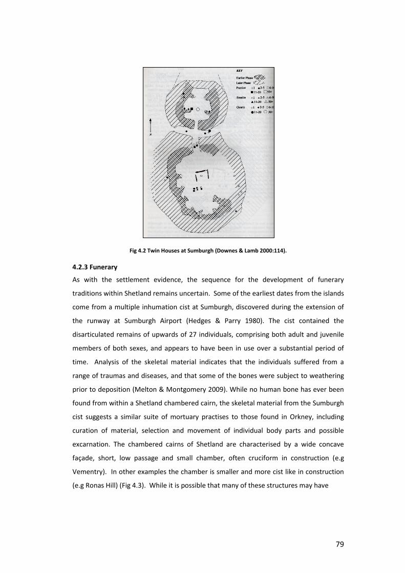
79
Fig 4.2 Twin Houses at Sumburgh (Downes & Lamb 2000:114).
4.2.3 Funerary
As with the settlement evidence, the sequence for the development of funerary
traditions within Shetland remains uncertain. Some of the earliest dates from the islands
come from a multiple inhumation cist at Sumburgh, discovered during the extension of
the runway at Sumburgh Airport (Hedges & Parry 1980). The cist contained the
disarticulated remains of upwards of 27 individuals, comprising both adult and juvenile
members of both sexes, and appears to have been in use over a substantial period of
time. Analysis of the skeletal material indicates that the individuals suffered from a
range of traumas and diseases, and that some of the bones were subject to weathering
prior to deposition (Melton & Montgomery 2009). While no human bone has ever been
found from within a Shetland chambered cairn, the skeletal material from the Sumburgh
cist suggests a similar suite of mortuary practises to those found in Orkney, including
curation of material, selection and movement of individual body parts and possible
excarnation. The chambered cairns of Shetland are characterised by a wide concave
façade, short, low passage and small chamber, often cruciform in construction (e.g
Vementry). In other examples the chamber is smaller and more cist like in construction
(e.g Ronas Hill) (Fig 4.3). While it is possible that many of these structures may have

80
Fig 4.3 Shetland’s Chambered Cairns, showing proposed chronology (Sheridan 2012:29)

81
been open for considerable periods of time, and contained the remains of several
generations, the structures themselves are not large enough to allow for the elaborate
processes which are suggested to have taken place in the Orkney monuments (e.g
Hedges 1984b). Entry to these structures is gained by crawling, and once inside there is
no room for an individual to stand up, and certainly no scope for multiple persons or
ceremonial activities to be accommodated within the tomb itself.
The lack of dating evidence available for the Shetland tombs makes it impossible to
determine a firm chronology, however Sheridan (2012) has suggested a broad
development from simple round cairn passage tombs such as that at Ronas Hill, to the
later heel shaped cairns with trefoil chambers (Fig 4.3). From the multiple phases of
construction at Vementry (Fig 4.13) it is possible to see that the heel shape is a later
development, added to a previously round cairn, which also suggests an intermediate
phase of round cairns with trefoil chambers (Bryce 1939). Other local traditions also
developed, such as the square cairns at Pettigarths fields in Eshaness, which may be
contemporary with the introduction of the heel shaped façade.
During the Bronze Age cremation appears to have become the favoured practise within
the islands, although there is evidence to suggest that both cremation and inhumation
were practised concurrently throughout the period (e.g Little Asta, a dual layered cist
containing an unburnt inhumation and steatite cinerary urn (Corrie 1932)). At some
locations, such as at Muckle Heog, Unst (Henshall 1963: 170), these cremations have
been deposited within cists found within a heel shaped cairn, while others, such as Little
Asta, displayed no indication of the presence of the monument above ground. It is worth
noting at this point that many of the early excavations at burnt mound sites identified
them as burial mounds (eg Hunt 1866). This can partly be contributed to the similarity
between mounds of burnt stone, and the stone cairns constructed around burial sites,
however, a distinct contributing factor must be the striking resemblance between the
stone troughs so often found in burnt mound sites in Shetland, and the stone cists
constructed for funerary purposes. Both cists and burnt mound troughs share the same
slab built construction, and almost certainly required the same techniques to build them.
As such, it should be considered that this similarity was probably not lost on those that
constructed them, and that the similarity between the trough and a burial cist was
probably not unnoticed by those who constructed and used burnt mounds.

82
4.3 Burnt Mounds in Shetland
There are currently over 346 burnt mounds recorded in the Shetland SMR, including over
30 to be found on the small island of Fair Isle alone. Radiocarbon and
Thermoluminesence dates from a number of excavated sites demonstrate a
predominantly Bronze Age date (Campbell Anthony 2003),(Fig 4.4) although many of
them have long and complex histories of construction, use and reconstruction and may
even date from the Neolithic onwards.
Fig 4.4 Overview of dates from burnt mounds in the Northern Isles (Campbell Anthony 2003: 315)
At Cruester underlying peat provided a terminus post quem of 2630 – 2470 cal BC
(Campbell Anthony 2003:308). TL dates obtained from throughout the mound provided
an average age of 1810 ± 70 BC (ibid 309), while an isolated deposit of stones at the east
end of the mound provided a date of 1445 ± 145 BC, suggesting an isolated firing
occurring later than the main body of activity at the site. Final abandonement of the
structures appears to have taken place after 1000BC (ibid 311), placing the site firmly
within the early-mid Bronze Age in Shetland. Likewise, dates obtained from Houlls burnt
mound indicate a wide time range for activities on site, begininning around 2500-3000BC
and terminating around 1000BC (ibid 312). The site at Loch of Garths appears to have
been in use for a shorter period of time, providing a date range of 1740 – 400 BC for the
life of the site (ibid). The date ranges suggest that burnt mound use in Shetland was
therefore contemporary with the occupation of sites such as Ness of Gruting, Scord of
Brouster house 3, and the dual house structures at Sumburgh (see above). Thus, while
burnt mounds as a whole remain substantially under-researched, the examples in

83
Shetland have been subject to a number of phases of survey and excavation, as detailed
below, allowing a more detailed picture of their nature to be developed than is often
possible elsewhere.
4.3.1 Landscape Survey and Recording
The first comprehensive account of the sites within the Isles was Calder’s (1964) survey
of the west side of Shetland. Having worked as a surveyor for the Royal Commission in
the 40s, Calder was aware that the examples detailed in the published Gazeteer
represented only a fraction of the material visible on the ground. His work was
instrumental in developing an understanding of the nature of the islands prehistoric
archaeology, and in particular the recognition of the oval shaped house sites as detailed
above. As well as increasing the number of cairns and houses recorded for the isles,
Calder noted a large number of burnt mounds. Like his contemporaries, he speculated
that they were related to cooking activities (ibid:78). He also noted a number of ‘graves’
or cist like structures found within the sites, and conjectures that these, when combined
with reports of steatite urns found within the mounds, indicate that some of the mounds
had been re-used as burial monuments (ibid: 79). While it is probable that the ‘graves’
he refers to are actually the stone lined tanks found at many of the Shetland sites (see
below for examples), none of the urns can be verified, so the possibility of the addition
of cremated material as closing deposits remains inconclusive.
While a number of antiquarian excavations had previously explored burnt mounds within
the islands (below), Calder’s survey was the first account of the sites that placed them
within their prehistoric context and considered them alongside other contemporary
sites. Following Calder’s work, surveys carried out on West Burra, by Parry (Hedges
1984a), and on Fair Isle by Hunter (1996), continued to add to our understanding of the
distribution of the sites, as well as adding valuable detail about their variable
relationships with the wider prehistoric landscape. While a number of sites appeared to
be isolated from other prehistoric structures, the majority were identified as being
peripheral to wider prehistoric settlement activity, indicated by field systems and
divisional earthworks. At Tougs in Burra, the mound itself seemed to be a central part of
the complex (Hedges 1986). This relationship was further outlined during the South
Nesting Paleolandscape Survey, which recorded the entire archaeological landscape of
the area (Dockril et al 1998). The survey outlined a shift in landscape use during the
Bronze Age, which saw settlement move closer to the coastlines as peat encroachment
in the hill began to reduce the area of cultivable land available. Burnt mounds were
84
found to occupy the marginal area between the more fertile lowland and peat covered
hill. This relationship was also supported by GIS anaylsis carried out by Mike Canter
(1998), which demonstrated that the mounds displayed a strong affinity for land below
the 50m contour. A smaller number were found to occupy land in between 50m and
100m, while no sites at that time were recorded from above the 100m contour mark, the
favoured location for burial cairns. The burnt mounds were also found to display a
preference for S-SW slopes, with a smaller cluster of sites favouring NW-N aspects.
Canter lightly suggests that the NW-N preference may have been to take advantage of
the best views of the ‘Simmer Dim’ – the period in which the Shetland experiences near
continual daylight during the summer months – during seasonal feasts, while the S-SW
facing sites would have had greatest exposure to prevailing winds, facilitating hotter fire
(ibid: 54). Oval houses were also found to occupy the lower contours, demonstrating a
similar preference for the land below 100m, with a slightly higher preference for the 50-
100m contours than was visible in the burnt mound sites (ibid: 49).
4.3.2 Excavation
The burnt mounds of Shetland have been subject to a number of excavations and
investigations, both amateur and professional, since the antiquarian period. In the 1950s
Black (1957) excavated a number of mounds on his land at Kergord, which, although not
identified as burnt mounds at the time, he described as being composed of fragmented
stone which appeared black and charred. In the 1860s Hunt and Tait also excavated a
number of burnt mounds in their search for anthropogenic material (Chapter Two).
One of the most distinguishing characteristics of the Shetland burnt mounds is the
number of sites which have been found contain substantial internal features. The earliest
example of features from a Shetland burnt mound comes from the unpublished site of
Stoura Cottage, Ness of Sound. A hearth and trough, surrounded by what has been
described as an ‘oval house’ were found (Small 1972). Structures were also found
during the excavation of Tougs (Fig 4.5), Burra (Hedges 1986). A rectangular building
containing a conjoined hearth and trough was revealed between the southern edge of a
burnt mound and a prehistoric field wall. The hearth was rectangular, of flag stone
construction measuring c.1.6m by c.0.8m. Stones set on edge defined the end abutting
the trough, however the northwest end remained open. All of the stone displayed
evidence of having been heated. The trough was also rectangular and of flagstone
construction. No

85
Fig 4.5 Structures at Tougs (Hedges 1986:10)
entrance to the structure was discernible, however Hedges speculates that it may have
been to the SE of the structure, as at this point a reserve of unburnt field stones were
found abutting the structure and the associated field wall. More recently, excavation at
the coastal mound (Mound A) at Trowie Loch (Dockril et al 1998:65-67) revealed the
remains of a hearth like feature which lay on top of a spread of burnt stone. The hearth
appeared to have at least two phases of use. Between the arms of the mound a pit was
discovered with a fill of burnt stone. Upcast material from this pit was found to be
covering the hearth, suggesting that either the hearth was an earlier feature, and that
there may have been another unexcavated tank associated with its use, or that the
upcast material represents a period of ‘cleaning out’ of the pit at a later date.
Examination of the central depression of the mound also revealed an area of flagging,
bordered by two orthostats. Further stone alignments revealed through excavating the
mound material may also be associated with this feature, and suggests the presence of a
more complex set of structures within the mound itself.
The best recorded examples of structures within a burnt mound come from the sites of
Cruester in Bressay (Moore & Wilson 2001, 2008, Below), and Tangwick (Moore &
Wilson 1999), in Eshaness. Both of these sites were subject to active coastal erosion, and
were excavated following an extensive survey of coastal sites within Shetland. In both
cases features were already visible within the coastal section prior to the

86
commencement of excavation (Moore & Wilson 1999, 2001, 2008) At Tangwick (Moore
& Wilson 1999) (Fig 4.) a stone built oval structure was revealed, partially revetted into
the mound. It was truncated to the southern and western sides, but its original
dimensions are thought to have been at least 7.6m by 6.6m. The structure was of cellular
composition, comprising at least three cells on both the east and west sides, with a
further cell to the north. A chute ran from the northern cell (Cell D), which has been
interpreted as a hearth cell, to a tank situated centrally in the south end of the structure
near to the limits of the erosion damage. It terminated at a ‘portal’ comprised of two
orthostats, one of which was still in situ at thetime of excavation, while the other existed
only as a stonehole. The chute has been interpreted as the method by which stones
were transported from the hearth to the tank (ibid:213). The tank was self filling, and
underwent two stages of construction, the first being a rectangular slab built feature,
measuring 1.6m long, 0.9m wide and 0.6m deep. A compartment was later added
dividing the tank in half, which possibly acted to protect materials within the tank from
being damaged by hot stones (ibid). The southern end of the tank displayed evidence of
clay luting, while the northern end appeared to have been left unsealed to allow for the
ingress of water. An additional stone slab was interpreted as having been used as a cover
for the tank.
The walls of the hearth cell survived to a maximum height of 1.1m and sloped inwards,
suggesting a corbelled roof. The primary floor surface was clay lined, and was covered
by two successive layers of paving, which sealed layers of peat ash. The walls and floors
of the cell were reddened in a manner that suggests exposure to extreme heat, evidence
of which could be seen continuing up the full height of the walls. The Cell was later
sealed off with a wall which was subsequently covered by stratified layers of burnt stone.
Moore & Wilson (1999:217) interpret this to mean that the site continued to be used
following the closure of the cell, although no secondary hearth is reported (See also
Chapter Seven). Three further cells (Cell A, B and E) were also subject to later sealing off
prior to the abandonment of the site (ibid: 218). In several cells a paved floor was
visible. In Cell C this extended beneath the walls of the structure, suggesting that the
walls were of secondary construction. The largest of the cells (Cell G) was connected to
the main structure by a passageway running roughly NNE. On the SW limit of the cell the
walling was interrupted by a curved slot delineated by two rows of stones set on edge.
Although this had been scoured by the sea at the time of excavation, Moore & Wilson
(1999:218) speculate that this may have contained a wooden barrier. Two paving stones
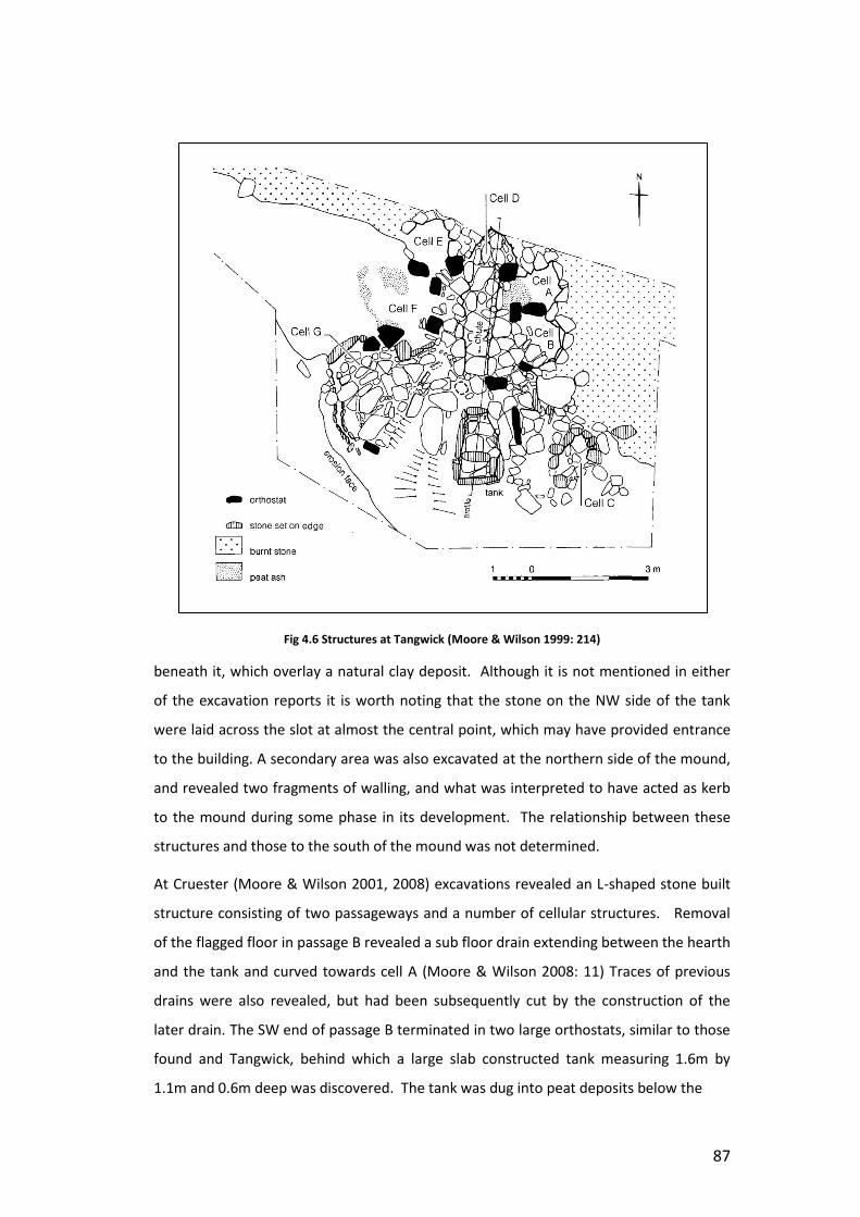
87
Fig 4.6 Structures at Tangwick (Moore & Wilson 1999: 214)
beneath it, which overlay a natural clay deposit. Although it is not mentioned in either
of the excavation reports it is worth noting that the stone on the NW side of the tank
were laid across the slot at almost the central point, which may have provided entrance
to the building. A secondary area was also excavated at the northern side of the mound,
and revealed two fragments of walling, and what was interpreted to have acted as kerb
to the mound during some phase in its development. The relationship between these
structures and those to the south of the mound was not determined.
At Cruester (Moore & Wilson 2001, 2008) excavations revealed an L-shaped stone built
structure consisting of two passageways and a number of cellular structures. Removal
of the flagged floor in passage B revealed a sub floor drain extending between the hearth
and the tank and curved towards cell A (Moore & Wilson 2008: 11) Traces of previous
drains were also revealed, but had been subsequently cut by the construction of the
later drain. The SW end of passage B terminated in two large orthostats, similar to those
found and Tangwick, behind which a large slab constructed tank measuring 1.6m by
1.1m and 0.6m deep was discovered. The tank was dug into peat deposits below the

88
Fig 4.7 Structures at Cruester (Moore & Wilson 2008)
floor and the area around it was paved with slabs that were set flush or slightly
overlapping its rim (ibid 2001:10). Removal of the tank revealed a further set of slabs
was worn smooth as if it had been subject to prolonged wear from something being
repeatedly dragged over it. To the west of the tank, along the line of the erosion edge a
further two cells (E & H) were also revealed. Both cells were badly eroded and it was not
possible to determine how they might have been accessed in relation to the rest of the
site. The floor of cell H was dug to the same level as the bottom of the tank, and filled
rapidly by water. For that reason it was interpreted to have been some form of cistern
(ibid 2001:14).
Cell G was interpreted as a hearth cell (ibid 2001:14). The walls of the cell appear to
have been cracked through exposure to heat, and had been relined at some period
during the site’s use. The floor consisted of 8 layers of heat-cracked paving. The
secondary wall appeared to be contemporary with the fourth layer of flooring. Two
upright slabs were also added at a later date to narrow the opening, and these appear to

89
be contemporary with the final soil deposits in the cell. A number of the cells survived to
a height where it was possible to determine the structure of the roof. The upper levels of
masonry in Cell H displayed signs of the beginnings of corbelling and were thought to
have originally stood at about c.1.2m. A lintel slab also survived towards the back of Cell
D, and suggested a similar roof height (ibid 2001:12). Both the cells and passages
appeared to have been subject to phases of remodelling throughout the use of the site.
Removal of what as thought to be structural slabs on the west side of passage B revealed
a further course of masonry, while removal of Cells B and C revealed a layer of burnt
stone overlying a flagged floor which appeared to have been cracked, possibly through
heat (ibid 2008:11). Access to Cell A appears to have been blocked or altered by the
addition of a series of upright slabs set across the entrance. While these slabs were not
big enough to impede entrance, it is possible that they represent the abandonment of
Cell A at some point during the life of the site (ibid 2001:11).
In addition to the stone built features described above, another, more unusual structure
was discovered at Kebister (Owen & Lowe 1999: 101-2). This feature consisted of a
double post ring outlining a sub rectangular building and contained a substantial hearth,
two ‘cooking pits’ and a conduit for transporting water. This feature was recovered from
the lower contexts of the site, and was badly disturbed in places. It has been suggested
that this structure represents a ‘cooking site’ and was in use at the time when burnt
mound technologies were being developed in Shetland (Owen & Lowe 1999:101). In plan
the structure appears to be comparable to the rectangular building found at Tougs (see
above) and the primary building at Beauquoy, Orkney (Hedges 1975). A number of other
features (e.g ‘meat racks’) are suggested with reference to features found at Irish burnt
mound sites (cf O’Kelly 1954). However, its most unusual feature is that although the
pits at Kebister were lined with burnt stones, no burnt mound material was recovered
from the structure. However Owen & Lowe (1999) suggest that the truncated nature of
the feature makes this unsurprising.
4.3.2 Comparable Structures from Orkney.
In addition to the structures found within mounds in Shetland, a number of similar
features have been excavated from sites within Orkney. These sites provide an
interesting point of comparison to the Shetland mounds. The burnt mound at Liddle
(Hedges 1975) (Fig 4.8) on South Ronaldsay , Orkney is most often compared to the

90
Fig 4.8 Structures at Liddle (Hedges 1975: 44)
Shetland mounds, due to the similarities between the complex internal structures found
within. Unlike the Shetland sites the mound at Liddle has not been subject to coastal
erosion, making it particularly interesting when exploring the use of space at these sites.
The structure was comprised of a roughly oval shaped building, containing recessed
chambers and a central tank. A substantial amount of mound material had accumulated
around the building, particularly to the south and north east of the structures, although
this had been subject to modern quarrying and was much denunded in all but the
south/southwestern end. Entrance to the building initially appears to have been gained
through the north east side of the building. Secondary walling was also constructed
along the edge of the mound on this side. This is interpreted as having been to prevent
the slippage of mound material over the access route, although this wall was later
completely submerged beneath additional mound midden material (ibid:34). The North
East entrance is also later blocked by the construction of a cell and associated drain
structure. This structure leads from a cistern cell linked to a natural spring occurring
directly outside the building to the northwest, via a flag lined gulley which leads through
a hole in the blocked north east entrance. The northernmost end of the building appears
to have been constructed over natural peat deposits, and although the site itself is
situated close by to the Burn of Liddle (now redirected) it is likely that the natural water
table also played some role in the activities carried out on site. The southern end
however is constructed directly over a local clay deposit, a situation that is echoed in the

91
location of the site at Cruester in Shetland, and may have been deliberately chosen to
assist in waterproofing the area around the tank, preventing natural water level
subsidence. A secondary entrance was found in the southern end of the building that
opened directly onto the mound itself (ibid:45). A paved pathway, partly destroyed by
quarrying appears to lead up over the mound, suggesting that in later times at least,
access to the structures was gained by walking over the mound itself, and that the users
were actively involved with landscaping and controlling the mound material during the
life of the site.
Two structures were also found in association with a mound at Beauquoy (Hedges 1975),
Mainland, Orkney (Fig 4.9). The mound had been subject to substantial damage and
alteration prior to excavation, to the extent that it was impossible to determine its exact
size and shape, other than to note that it had once bounded the stream. The primary
structure had been truncated by the construction of an agricultural shed.
Fig 4.9 Structures at Beauquoy (Hedges 1975:52)

92
Preserved features appear to show a building of sub-rectangular shape, possibly similar
to Liddle, walling was traced on the long sides of the building, but was absent for both
the NNE and SSW ends, possibly due to destruction, but which may also indicate a lack of
walling, or the presence of entrance ways in these locations. A large flag built hearth,
reinforced with clay was located in the south end of the building, two fire reddened
sockets either side of this structure have been interpreted as possible supports for a
cross piece or spit over the fire (ibid: 53). No indication of a tank or similar feature were
noted within this structure. Outside of the structure the remains of an insubstantial wall
constructed 1.2m from the main wall were discovered. This was interpreted as a possible
indicator of a ‘circumambient walk’ similar to the feature described at Liddle (ibid: 54).
The secondary building was also substantially destroyed (ibid). The walls were
constructed using two different methods. All of the south, and part of the north wall,
forming the long side of the building were rubble built using a mixture of land and river
stones. The walls in these sections appeared insubstantial, measuring only 15cm wide in
parts, were preserved to a level of 0.3 and were only faced internally. Elsewhere a
trench was dug into the original mound material, approximately 20cm wide and 19cm
deep. Burnt mound material and chocking stones were then added to accommodate
either a wooden, or more likely vertical flag built structure. The floor inside the structure
appears to have undergone several phases, and originally appears to have been formed
of primary burnt mound material, before being covered with flagstone paving. The
interior space appears to have been divided in several different ways during the life of
the building. The remains of a rectangular compartment were discovered beneath the
flag stone floor along the N wall. This feature, which measured 2m by 1.25m, was
interpreted a being similar in nature to the box bed structures found in prehistoric
Orcadian houses (ibid:56). In the south east corner of the building an area of the
flagstone floor was removed and relaid with yellow clay, which the excavators also
interpret as relating to an interior division. Entrance to the building is interpreted as
having been gained at the eastern end, marked by the presence of a silstone and
external flagging. A pile of unburnt stones were also found stacked against the northern
wall of the building.
The trough in the secondary building consisted of a pit, roughly 2.5m across and 1.7m
deep, dug into the existing mound material and lined with yellow clay (ibid:54). No
hearth was found at the site, but it is suggested that this may have been located in the
western end of the building, which was heavily disturbed (ibid). A feature described as a

93
‘quoined well-like structure’ was also revealed on the western end of the building
(ibid:56). This feature was dug through existing mound material into a natural clay
deposit, and appeared to originally protrude above it. The hole was originally floored
with flagstone before the quoining was put in. It appears to have been able to hold up to
0.5m of water, while anything in excess of this would have overflowed into the adjacent
ditch.
In 2005 severe storms revealed an additional site at Meur (Toolis et al 2007) (Fig 4.10) in
Sanday. Excavation revealed a multi-cellular structure incorporating a tank and cistern
with associated drainage feature. The entire western side was subject to coastal
erosion, and as such there is limited information available about the original extent of
the structure, and its internal spatial arrangement. The site featured a central slab built
tank, the base of which was set onto the old ground surface and lined with clay (ibid:33-
4). A flagstone floor was laid respecting the edge of the tank, although this feature only
survived in the easternmost space of the structure. A large recumbent slab was also
found partially covering the tank, which is interpreted to have acted as a cover (ibid).
Fig 4.10 Structures at Meur (Toolis et al 2007:34)
94
To the east of a tank was another compartment, defined by upright orthostats and
separated into two areas. The northernmost of these areas possessed a flag lined floor,
and had been partially subjected to coastal erosion. To the north was a secondary
corbelled structure built into existing mound material and measuring 1.2m in diameter
and over 0.85m deep. Excavation ongoing as part of the SCHARP project
(www.shcarp.co.uk) at the time of submission has indicated that this structure is a
substantial well, incorporating a series of steps leading down to a rectangular cist at the
bottom. Organic remains currently being removed from this feature have the potential
to reveal much about the usage of burnt mounds in Orkney. This feature also
incorporates a drain that fed from a sluice-like channel in its western side, suggesting a
complex system of water management at the site (ibid:36). No hearth was found in
association with the structures, but this is likely to be due to the effect of coastal
erosion, as the mound material itself presents the classic signs of having been subject to
heating. The excavators did not interpret Meur as having been roofed at any point, as
was the case at both Liddle and Beaquoy, due to the lack of substantial walling (ibid:49).
Rather, the upright orthostats were interpreted as having served to delineate space, and
to prevent ingress of mound midden into the working area.
4.4 Characteristics of Shetland Architecture
4.4.1 Recesses
Recesses are a defining element of the prehistoric architecture of Shetland, featuring in
the houses, burnt mounds and tombs. In the early prehistoric houses they appear to be a
dominant characteristic of the organisation of internal space. At Stanydale Temple,
Scord of Brouster and Jarlshof (Fig 4.1) the recesses are evenly spaced around the walls
creating a symmetrical appearance to the buildings, while at houses such as Stanydale
House and Gruting School the recesses are less regular. Recesses serve to delineate
space and creating an area which offers privacy. In a number of houses (e.g Stanydale
House, Gruting School, Jarlshof) the rear recess is larger and more distinct than the
others. It is possible that this space represents the most sacred and significant area of
the house, as is the case with the Orcadian rear dresser spaces (Downes & Lamb
2000:124, cf Parker Pearson & Richards 1994). Significantly, it is this rear space which
houses the hearth at both Cruester and Tangwick. This illustrates that fire not only
played a significant role in the use of the burnt mound itself, but that is had a significant
symbolic status in relation to the organisation of the building, and its relationship with

95
other Neolithic and Bronze Age practises. By way of comparison, the hearth in the
Shetland house almost always occupies a central location, however in burnt mounds this
space is most often occupied by a large tank, or similar structure. The full implications of
this relationship will be discussed in detail in Chapter Eight, however for now it is
sufficient to observe that this arrangement creates an interesting juxtaposition between
fire and water which serves to further cement the links between these two elemental
substances at burnt mound sites.
At Cruester (Fig 4.7) and Tangwick (Fig 4.6) the architecture seems to represent an
exaggerated form of the recesses found at house sites. Cells located off central
passageways echo the division of space, and create discrete areas for storage or other
activities. This division of space and isolation of activities can be seen as consistent with
the general approach to defining space within burnt mounds. As will be explored in
Chapter Seven, the construction of the mound acts to shield the interior of the structure
from the outside, whilst simultaneously protecting the outside world from the powerful
and transformative processes within. This approach can be seen as echoed in the
internal structures, where space is clearly differentiated, possibly to prevent the
contamination of materials and persons during firings. Moreover, as we have seen with
the architecture at Sumburgh (above), the structures within the burnt mound were
subject to frequent reorganisation, change and closure, echoing the fluid relationships
between social practise and material structures which is reflected in the domestic
architecture
4.4.2 Heel Shaped Façade
The heel shaped façade is another characteristic element of Shetland architecture. The
structure at Stanydale (Fig 4.11), identified as a ‘temple’ by Calder due to perceived
similarities with the Maltese structures (Calder 1950:203) is a excellent example of the
use of both the heel shaped façade and recesses in Shetland architecture. As with many
of the Shetland structures, Stanydale was subject to restructuring and reorganisation
during its usage (Mahler 2011:14-15). Perhaps best interpreted as a hall rather than as a
temple, Stanydale appears to have functioned as a significant gathering place, and it
situated within a highly structured and ritualised landscape containing a number of other

96
Fig 4.11 Stanydale (Calder 1950:187)
prehistoric structures, standing stones and field boundaries. As I will discuss in further
detail in Chapter Eight, it is situated in one of the few places in Shetland where the sea is
not visible. The area is skylined by ridges of high ground on top of which a number of
cairns have been constructed. In addition, a defined approach leading from the nearby
(but not visible) Loch of Gruting, delineated by small standing stones indicates that the
experience of the landscape was carefully controlled (Clarke & Renwick 2013). In this
context the façade serves to emphasise the presence of the building in the landscape,
and provides a focal point for those approaching the site. However, while this may be
the case at Stanydale, the addition of a concave façade to the buildings at Sumburgh
would have had an entirely different affect. At Sumburgh (Fig 4.2) the façades are a late
addition to the buildings, and, rather than facing out into the landscape, face inward
towards each other. The construction of the façades at Sumburgh coincides with the
decommissioning of the central hearth in the South House, demonstrating that the
hearth no longer functioned as a central feature within the house. Downes (Downes &
Lamb 2000:127) suggests that the aggrandisement of the entrances at Sumburgh might
therefore represent an increased emphasis on the importance of threshold as the new
pivotal feature of the house.
As with the houses, the role of the concave façade on the Shetland tombs is subject to
some debate. Bryce (1939) noted that while there was a temptation to define the
Shetland tombs as ‘degenerate’ versions of the Caithness horned cairns, the heel shaped
tombs appeared to be an entirely local development. While it has been suggested that

97
Fig 4.12 The façade at Vementry (Bryce 1939:27)
courtyard or horned cairns served to delineate or frame a space for ritual or ceremonial
activities outside of the tombs themselves (e.g Fleming 1973, Thomas 1990). The
location of some Shetland tombs, such as Vementry, where the façade is immediately
above a steep drop in the hillside (Fig 4.12), suggests that even if this were the case for
some sites, it is certainly not a universal application. Rather, as at Stanydale, it appears
that the façade served to draw attention to the front of the cairn, and enhance the
presence of the site on approach.
At present, none of the mounds excavated in Shetland have produced any evidence of
having utilised a heel shaped façade as an entrance marker. This may indicate (as will be
outlined in further detail in Chapter Seven), that the mounds are not intended to
monumentalise the site in a way which draws attention to the location, or to present a
‘face’ to those approaching it, but rather served to enclose or protect the site and the
viewer from inappropriate exposure. It should be noted however that at both Cruester
and Tangwick substantial areas of the site was lost to coastal erosion. As no obvious
entrance was determined for either of these sites it is probable that this was located n
those areas now lost.
4.4.3 Use of Midden.
The use of midden in building is a characteristic of Shetland houses. As will be explored
in greater detail in Chapter Seven, the use of midden in Shetland houses follows a similar
pattern to the deposition of mound material at burnt mound sites. Both processes
involve the gradual accumulation of symbolically significant material over time,
facilitating the creation of deep temporal links. Midden material appears to have been
used as foundation deposits at Ness of Gruting (Fig 4.14), where carbonised barley and a
broken quern were found at the base of the wall (Calder 1956:353). Other materials
such as peat ash, pottery and flaked stone tools are recorded as being found in wall

98
deposits from houses throughout Shetland (Calder 1956, 1964, Downes & Lamb 2000,
Whittle 1986). However, it is not just during initial acts of construction that midden is
incorporated into the structures. Rather, following the construction of the walls, material
appears to have been piled up against the structures repeatedly, so that the thickness of
the house walls grew over time. In some instances, such as at Yoxie, Beenie House and
Ness of Gruting, stone revetting was used periodically to consolidate the material (Calder
1956, 1964: Downes & Lamb 2000: 125). The practise of constructing with midden is
also common elsewhere during the Neolithic and Bronze Age, and its significance has
been discussed by a number of authors. At Skara Brae the houses were built onto
existing midden deposits, while further midden was deposited around the walls so that
the entire settlement was surrounded by the refuse of past and present inhabitants
(Childe 1931) while at the multi period site of Old Scatness midden was incorporated
into the surrounding soils (Dockril et al 2010:10). As was discussed in Chapter Three,
the deposition of fragmented materials within domestic contexts can be seen to be
linked to a concern with natural cycles of death, fertility and rebirth. As such the use of
midden within the walls of houses relates to concepts of fertility and status, and can be
seen as an active attempt to ensure the longevity and fertility of both inhabitants and
settlement (cf Parker Pearson 1996, Fowler 2004, Bruck 2001).
Of particular interest is the inclusion of flaked stone ard points and mattocks within
these midden deposits. These implements are found in large quantities both within the
walls of house structures, between floor layers, and also within field clearance cairns.
The significance of these items has been the subject of some debate. Large quantities of
stone tools have been recorded from the top layers of abandoned houses, as well as
from within wall deposits themselves. Whittle has been suggested that this pattern may
be explained by the storage of stone tools within rafters or loft space within the house,
or by the placement of stone tools on the roof of the structure following use (1986:134).
Alternatively this may represent the casual discarding of broken implements onto
abandoned structures during cultivation (Downes & Lamb 2000:126, Downes 2005:195).
However, as Downes argues, a large number of these items show no indication of wear
or use, suggesting that their deposition was intentional, and that these tools represent
something other than the casual discarding of materials which are no longer of practical
use (2000:126). At Jarlshof and Sumburgh both ard points and mattocks were recovered
from successive floor levels where no periods of abandonment were apparent (ibid).
Flaked stone tools have also been recorded from the stone kerbs surrounding Bronze

99
Age burial mounds in Orkney as closing deposits (Downes 2005). It is argued that these
deposits are related to concepts of fertility and regeneration (Chapter Seven). By placing
stone tools and midden material around the edges of the houses the inhabitants were
entering into an ongoing conversation with the land and with cycles of fertility and
reproduction. Moreover, as Downes suggests, the incorporation of midden into soils
indicates that the soil itself has become an acculturated, and that cycles of fertility and
reproduction were not a given (cf Owoc 2004). Rather, the earth had to be negotiated
with, and a complex series of practises were required to ensure the ongoing success of
agricultural endeavours. This is particularly significant in relation to our understanding
of burnt mound sites, if as has already been suggested (Chapter Three), we view them as
both transformative and elemental processes. As will be explored in greater detail in
Chapter Eight, the processes undertaken at burnt mounds have deep resonances with
wider cosmological understandings during the Bronze Age. As such their increasing
popularity may be attributed to concepts of ongoing negotiation between people and
the land, and in particular notions of the regenerative and destructive properties of both
fire and water and the immutability of stone and earth. Moreover, as will be explored in
Chapter Seven, the potency and significance of these fragmented materials suggests that
the practise of creating a mound from burnt stone at burnt mound sites involved more
than just the disposal of waste materials, and instead represents the intentional curation
of culturally and symbolically significant materials at the site.
4.5 Conclusion
One of the aims of this thesis is to place the burnt mounds of Shetland into their wider
prehistoric context. The lack of a clear chronology for early prehistoric Shetland renders
this process somewhat problematic. The lack of firm dating evidence and a clear pottery
typology for the period means that many of the sites in Shetland remain defined as ‘early
prehistoric’ without any ability to determine how early or late they may be. This
uncertainy poses difficulties in understanding the relationship between burnt mound
sites and their wider prehistoric context. Any attempt to do so, such as that which
follows in the remainder of this thesis, is therefore required to make presumptions and
judgements about the contemporaniety of sites which may or may not prove to be
incorrect in light of future works. Despite this, this chapter has been able to illustrate
number of striking links between the architecture of Shetland’s burnt mound,
settlement and funerary material. Moreover, as was explored in section 4.2.1, recent
dating programmes have been able to provide a small window into understanding the

100
chronology of early prehistoric settlement in Shetland. Evidence suggests that a large
number of the settlement sites known can be attributed to the Bronze Age (cf Sheridan
20130. Likewise dating undertaken at burnt mound sites indicated that many of the
Shetland burnt mounds date to the late Neolithic/Early Bronze Age and see continuous
use throughout the remainder of he period, indicating a reasonable degree of
contemporeinty between the sites in question.
Through this detailed examination of the excavated mounds of the Northern Isles, it
becomes clear that there is a greater degree of complexity associated with the sites than
has previously been acknowledged. Certainly within Shetland, and perhaps within parts
of Orkney too, mounds with complex internal structures are more common than is
realised. An examination of the distinctive architectural styles found in Shetland during
the prehistoric period demonstrates that burnt mounds were part of a wider set of
architectural traditions and practises. Structures found within burnt mounds display
strong similarities with the architecture of both houses and tombs. These similarities
demonstrate a shared concern for spatial organisation throughout each of the three site
types examined, as well as an ongoing concern with the deposition of fractured and
fragmented materials. As such burnt mounds can be seen as being part of a wider
tradition of practise, and a shared symbolic lexicon during the Bronze Age.
The density of the burnt mound distribution in Shetland renders some of the more
traditional approaches to burnt mound studies difficult. While it may be possible to
accept that in some places these sites may have been constructed as temporary hunting
camps for roving bands of people moving across the landscape, when applied to the
small island of Fair Isle, it immediately becomes problematic. Would such a small island
really have needed so many saunas? And if so, why are they of such varying shapes and
sizes, a will be illustrated in Chapter Five.
The integration of the mound material into the access routes at the Orcadian mounds
also highlights the importance of the mound itself in our understanding of these
structures (Chapter Seven). Rather than representing material simply discarded after
use, the mound appears to be an integral part of the structure itself, and has a direct
influence on how the interior space is accessed, and viewed from the outside. Moreover,
it is suggested that the incorporation of midden and flaked stone tools into the walls of
houses can be seen as analogous to the accumulation and curation of burnt stones at
burnt mound sites. This has clear implications for the way in which we understand the
significance of the mound, and the processes through which it is accumulated. If, as has

101
been suggested (Chapter Three) we understand the accumulation of fragmented and
fragmentary materials as being linked to death and fertility, then the curation of mound
material must therefore be seen as both an intentional and symbolic act.
While at first glance the Bronze Age of Shetland may appear to be a time of increasing
stagnation and isolation (Turner, 1998, Kaul 2011), the apparent proliferation of burnt
mound activity within the islands suggests that the period actually saw an explosion of
activity. A more detailed understanding of the processes which took place at these sites,
and the way in which they related to the wider prehistoric landscapes is therefore
required to allow us to explore the role which burnt mounds had in mediating
relationships with and increasingly challenging and changing landscape. This in turn can
be used to explore how these practises fitted in with a wider set of understandings and
cosmologies which characterise the British Bronze Age as a period. The next two
chapters will attempt to readdress the imbalance in our understanding of burnt mound
usage, by first by exploring the nuances of their location, size and morphology within
wider patterns of land use and settlement, and then exploring the range of activities
which took place within them, and how they might relate to each other to create a
network of embodied meaning through practise.

102
Chapter Five: Burnt Mounds in their Landscape Context: GIS and In-Situ Survey
5.1 Introduction
One of the aims of this thesis is to explore burnt mounds within a wider landscape
setting, and place them within the context of other prehistoric activity within the study
area. In order to achieve this a multi scalar approach was developed, which combined
GIS analysis with in-situ visits and recording. As was outlined in Chapter Three, neither
phenomenological or GIS approaches to landscape have been without their detractors. I
have argued that the combination of these two methods allows us to draw on the
strengths of each form of analysis, and to create an understanding which encompasses a
broad range of potential interactions between burnt mounds, people and their wider
landscape. As with the experimental approaches which will be described in Chapter Six it
is important to stress that these approaches are in no way intended to replicate the
engagement of prehistoric persons with their landscapes. Instead, they illustrate a range
of potential encounters, and open up discussion as to how these encounters may affect
the way in which Bronze Age people understood the use of burnt mound sites, and their
place within the wider understanding of the world.
This chapter outlines the result obtained from both GIS and in-situ survey, synthesising
the insights gained from both approaches to form an understanding of how burnt mound
sites in Shetland relate to their landscape setting. Where appropriate these insights will
be illustrated through maps, photography or hand drawn schematics, pulling together
the range of approaches taken within the study. The final section will explore how both
techniques inform upon each other, and will evaluate the potential that this approach
has on the understanding of burnt mound sites within a defined context.
5.2 GIS Analysis
5.2.1 Creating the Geodatabase
For the purpose of this thesis it was decided to create a spatially referenced site
database using the Geodatabase format supported natively by GIS. Site data was
gathered from the Shetland SMR, and backed up with information from the Royal
Commission’s CANMORE database. Data from CANMORE was provided by The Royal
Commission for Ancient and Historical Monuments as a point data shapefile, and was
directly imported into ArcGIS, while data sourced from the Shetland SMR was provided

103
in both Excel and Word format. An opensource pythonscript coordinate converter was
used to convert British National Grid References used by the SMR into Latitude and
Longitude, and the information was then imported into ArcGIS as point data using the
Add X Y function within ArcMap. Mapping data was sourced from Edina Digimap and OS
Opendata. Coastline and inland water data was sourced from OS Mastermap
Topography layer. While this layer contains the most complete record of watercourses, it
does not specify the types of water (standing or flowing), nor does it always differentiate
between natural water courses (such as streams) and modern features (such as culverts
and drainage ditches). In order to add this layer of information it was necessary to cross
reference the Master Map data with mapping data at a broader scale, such as OS
Meridian, which contains hydrographic data. By cross referencing the proximity of
master map data with the lakes and streams data from Meridian it was possible to create
a bespoke layer using the Mastermap water data but applying the classifications drawn
from the Meridian layer for all water features in Shetland. This was also cross referenced
against ariel photography layers, such as Bing Map and ArcGIS 10’s native photography
base layer to confirm the type of water feature represented in the mapping layers. An OS
Panorama DTM layer was added to create an elevation model for the creation of
viewsheds. The geodatabase allowed all information collected as part of this thesis to be
stored, viewed and searched geographically, and to be displayed with other geographic
material in a relational manner. The use of digital terrain modelling allowed for person-
centred models of site locations to be created and examined on an island wide scale.
Records downloaded from the SMR included fields for site name, type, national grid
reference, and general description of the site itself. For Burnt Mound data a simple
search was run on the term ‘Burnt Mound’ which returned of 346 results. Of these
results several represented multi-site locales, but only a single site represented in the
search had to be discarded due to an inaccurate coordinate, which placed it several
hundred meters into the North Sea. Analysis of this record demonstrated the possibility
of it being a duplicate of an already existing record however. Additional searches were
also run to capture both the funerary and settlement sites for the period. Each site
description was read through carefully to verify whether or not the record appeared to
describe a prehistoric location. As was explored above (section 4.5), many of the site
featured within this study are of uncertain early prehistoric date. However, by
monitoring the site descriptions it was possible to ensure that the sites selected
represented those with typical Neolithic/Bronze Age attributes (see section 4.4). Any

104
sites which seemed to be ambiguous, or were described as possibly representing natural
features or other non-prehistoric activity were excluded. In total 344 Burnt Mound
Sites, 122 Funerary Sites, and 432 Settlements sites were included in the GIS Database.
Due to the indeterminacy of chronologies for settlement sites within Shetland (Chapter
4, section, 2.1) settlement evidence selected for analysis included both Bronze Age and
Neolithic material. Many of the houses originally attributed to the Neolithic are now
believed to be Bronze Age (Downes & Lamb 2000:121, Hedges 1986), and thus it was felt
it was not possible to successfully differentiate between the two. Additionally, many
Shetland settlements demonstrate successive periods of remodelling and continued
occupation (Downes & Lamb 2000, Whittle et al 1986). Funerary material included
contemporary Bronze Age cairns and cremation burials, such as those at Asta or Upper
Scalloway, and Neolithic chambered cairns. There is evidence for re-use of Neolithic
cairns in Shetland during this period, such as at the South Nesting, where fragments of
cremated material were added to an existing heel shaped cairn (Turner 1998:43) As
such, it was felt that these monuments would have remained as significant landscape
features during the Bronze Age.
Two scales of analysis were completed on the data retrieved. The first examined the
wider landscape setting of the burnt mound sites, and was completed on an Island wide
scale. Simple spatial analysis was run on all burnt mound sites to determine their
relationship with water and with other prehistoric sites. At this scale the analysis
included sites from all areas of Shetland, including those in the outlying islands of Foula
and Fair Isle. For local scale analysis sites were selected from a variety of locations on
Mainland, and were supplemented by examination of sites on the islands of Papa Stour,
East and West Burra and Bressay in order to correlate with areas examined during in-situ
Survey (section 5.3). Particular attention was also paid to the west side of Mainland
during this scale of analysis. As was described in Chapter Four, each of these locations
have been subject to detailed local survey, and there is detailed data available on the
distribution of prehistoric sites within these areas. The availability of this data made
these regions the ideal location to apply more detailed analysis of the relationship
between prehistoric sites and their local landscapes. Sites from elsewhere in Shetland
were also included to supplement this data and verify whether the patterns observed
within these regions were more widely applicable to burnt mound sites throughout
Shetland.

105
5.2.2 Distribution, clustering and other locational considerations.
Canter’s (1998) work on the landscape settings of prehistoric sites in Shetland
established that burnt mound sites are to be found on land below 100m elevation.
Likewise Dockril et al (1998:81) observed burnt mounds in Nesting appeared to be
concentrated to the central fertile belt now occupied by modern day settlements, while
other prehistoric occupation was more widespread. They therefore suggest that this
distribution may be representative of a contraction of settlement area, perhaps brought
on by climatic variation in the Bronze Age. The wider patterns of site distributions were
determined through a number of methods. Firstly, the elevation of each mound was
extrapolated through the ‘Extract Values to Points’ feature within the Spatial Analyst
Toolbox in ArcGIS. This tool uses the elevation data within the DTM layer to determine
the height above sea level of particular points. Secondly, site density was determined
using the ‘Point Density’ tool within ArcGIS. This tool calculates the density of points
within a given neighbourhood. The number of points falling within the neighbourhood is
totalled, and divided by the area of the neighbourhood. The result is a ‘heat map’ giving
visual representation of areas which contain a greater concentration of sites than others.
Finally cluster analysis was undertaken to produce a representation of areas where
multiple sites could be found clustering within a given distance of each other.
A number of observations can be drawn from the analysis undertaken at this scale.
Firstly, while it is possible to see from the distribution map that burnt mound sites
appear to be relatively common throughout most of Shetland (Fig 5.1), point density
analysis (Fig 5.2) demonstrates a number of locations where the density of distribution
appears to be greater than elsewhere. It should be noted that many of these clusters
coincide with areas which have been subject to detailed archaeological survey. For
example, South Nesting was surveyed as part of the South Nesting Palaeolandscape
Project (Dockril et al 1998). The West Side of Shetland was initially surveyed intensively
by Calder (1950, 1956, 1964) and subsequently by Whittle during work undertaken at
Scord of Brouster (Whittle et al 1986,) More recently this area has also been studied as
part of the Danish National Museum’s ‘Northern Worlds’ project. Other clusters occur in
Burra, which was surveyed intensively by Gordon Parry (Hedges 1984), and later by
Deborah Lamb as part of a PhD project and Fair Isle, which has been closely documented
by Hunter (1996, 1998). A final cluster can be observed in the south Mainland, an area
which has been subject to close archaeological scrutiny as a result of the extensive

106
Sumburgh Head environs project, and the work undertaken at Old Scatness Broch by
Shetland Amenity Trust and Bradford University.
Fig 5.1 Burnt Mound Distribution

107
Fig 5.2 Burnt Mound Density

108
Given the above may appear that the distributions observed are the result of targeted
survey, rather than a true reflection of the spread of burnt mound activity. However
comparison of burnt mound distribution with known prehistoric settlement and funerary
sites suggests that there may be more to the picture than is first supposed. In particular,
it is worth paying attention to the West Side, which contains a noticeably high
concentration of burnt mound sites, particularly in the areas to the south and southwest.
Comparison between the distribution of burnt mound sites and settlement and funerary
sites (Fig 5.4) in this area demonstrates that while the West Side has, in general a higher
percentage of recorded prehistoric sites than other areas in Shetland (see Fig 5.1), both
the settlement and funerary evidence appears to be more evenly distributed than the
burnt mound data. Most notable is the relative absence of burnt mound sites from the
central and northern areas of the west side when compared with the settlement
evidence. These areas are characterised today by a rugged landscape with extensive
peat cover, and is less densely populated than the more fertile looking southern area (Fig
5.3). It is possible that the lack of modern occupation in the area has led to a lower
visibility of prehistoric sites. Sites are often uncovered through activities such as peat
cutting, or through the improvement of land for agriculture. However the identification
of prehistoric houses in the northern regions of the west side suggests that it would not
be difficult to identify burnt mound sites in this region. This distribution may therefore
support the idea that burnt mound sites are in general associated with better
agricultural lands (Dockril et all 1998).
Fig 5.3 Differing landscapes on the West Side of Mainland: South: Dale of Walls (left) & North: West Burrafirth (right) – Image: Eileen Brooke-Freeman.

109
Fig 5.4 Distribution of Burnt Mounds, Settlement and Funerary Sites on the West Side of Shetland
Secondly, as Canter observed (1998:51), there is a preference for lower lying regions for
the location of burnt mood sites. Only one site, at Graven in Delting was observed to be
located above the 100m contour. A further 31 sites were located in between 50m and
100m contours, although of these 21 were below 60m, with only 1 site found above the

110
90m contour. The rest of the sites were located well below the 50m contour, with the
majority of sites favouring locations below 30m in elevation. This preference for low-
lying values is not exclusively a feature of burnt mound sites. Of the 432 settlement
locations analysed as part of this thesis, only 82 were found to occur above the 50m
contour, and of those only 18 were found above 100m. These lower lying areas often
represent the more sheltered and fertile regions, and have remained popular for
inhabitation until the modern day. Likewise, as Canter noted, the majority of funerary
sites also appeared to favour positions below the 50m contour. The viewshed analysis,
detailed below, suggests that some funerary sites were located with more commanding
views than those otherwise associated with burnt mound or settlement sites, but that in
general the location of early prehistoric sites in Shetland does not seem to be focused
towards commanding views of the surrounding area, or focal points within the
landscape, but rather, as will be discussed in greater detail below, in creating and
defining localised landscapes.
Finally, within the areas identified as being high density, further clustering of sites was
noted during fieldwork. While burnt mounds appeared to be evenly spaced in some
areas it was observed that some locales, such as the Burn of Setter on the west side,
appeared to be focal points for burnt mound activity. In this area 4 individual mounds
could be found within close proximity of each other distributed along the length of a
stream. Analysis of sites was undertaken using the ‘collect events’ tool in ArcGIS, which
allows multiple ‘events’ (in this case, burnt mound sites) at one location to be pulled
together and displayed using a weighted symbology (Fig 5.5). This highlighted areas
where up to eight individual mounds were found clustered around a specific location,
most commonly a water source. Field visits to sites like this, e.g. Burn of Setter, the pair
of mounds at Brunatwatt, and the complex at Loch of Foratwatt (Fig 5.6), revealed that
often one of the mounds appeared to be much larger than the others. This may
represent satellite activities relating to the main burnt mound site, but could also
represent later short-term activity at an appropriate location which was known to have
been used for burnt mound activity in the past. A further more tantalising suggestion
raised during experimental firings in Bressay concerns the potential for danger, both
physical and symbolic, at burnt mound sites, as will be discussed in greater detail in
Chapter Six. In these instances it is possible to imagine that catastrophic events at burnt
mound site led to the closure of one inauspicious mound and the relocation of activities
to another nearby site respecting the taboos created by past events at the previous

111
Fig 5.5 Localised clustering of burnt mound sites

112
Fig 5.6 Mounds clustered along the course of Burn of Setter.
mound. Accepting this it is clear that some locales were considered to be particularly
suited to burnt mound usage, and acted as focal points for the activities which were
undertaken there.
5.2.3 Variations upon a theme: Burnt Mounds and Water.
Having established some of the more basic factors affecting burnt mound distribution in
Shetland, the next stage of analysis focussed on the relationship between burnt mounds
and water, the topographical association most readily attributed to burnt mounds.
Indeed, proximity to water is often seen as one of the defining features of burnt mound
sites. Water is essential to perform most of the tasks which have been suggested as
being responsible for creating burnt mound sites. Specifically, the placing of hot stones
into water is responsible for the distinctive shattered stones which make up the main
body of burnt mound sites. However, while the relationship between burnt mound sites
and water is well established, there has been little discussion about what kind of
waterside locations are preferred. For the purpose of this thesis, four separate types of
water source were identified. These were as follows:
Running freshwater, such as streams and hill runoffs.
Standing freshwater, such as lochs and smaller shuns.
Coastal saltwater locations
Groundwater.

113
Mounds constructed in boggy areas with no obvious alternative water source may have
utilised a groundwater source. Alternatively it is possible that a cistern type structures,
or self filling tanks, such as those found at Cruester (Moore & Wilson 2001, 2008) may
have been utilised in these cases. This information is unlikely to recorded in traditional
mapping, and as such groundwater utilisation was most difficult to identify through GIS
analysis. Instead it became more evident through site visits, or in the case of excavated
sites, by examining the behaviour of the local groundwater level during excavation. In
the case of coastal mounds it was often not certain whether saltwater was utilised within
the mound. Many coastal mounds, such as Cruester and Tangwick, were also located
near to sources of freshwater (Fig 5.7). While saltwater may have been utilised for brine
evaporation, none of the other interpretations required its use. However, the affinity
between some burnt mounds and coastal location may be more significant if we consider
their potential application in boat construction. Of course, the presence of saltwater
may also have had strong cosmological associations, as will be explored in Chapter Eight.
To explore the relationship between burnt mounds and water simple proximity analysis
was employed to determine the distance between burnt mounds sites and nearby water
sources. Proximity searches were run at 100m increments, with most sites having a
water source within 500m of the mound. Of 347 sites within the database, only 22 were
found to be over 500m away from a modern day source of standing or running fresh
water, and of these sites, only one was over 500m from the coast (Fig 5.8). Running
fresh water proved to be the most popular water source, with 312 sites being located
within 500m of a stream or other significant runoff, (Fig 5.9) while 128 sites were located
within 500m of lochs (Fig 5.10). Many of the sites were located within 500 meters of
both lochs and streams, such as at Brunatwatt. Here two mounds are located less than
100m from the course of a burn, and only 300m from the edge of a loch(Fig 5.11).
Analysis confirmed that there is a correlation between burnt mounds and watery
locations, but that this relationship is far from simple.

114
Fig 5.7 Location of watercourses and coastline at Cruester (Moore & Wilson 2001)

115
Fig 5.8 Mounds within 500m of coast

116
Fig 5.9 Mounds 500m from streams

117
Fig 5.10 Mounds 500m from lochs

118
Fig 5.11 Multiple water sources at Brunatwatt
In the cases where two or more types
of water source can be identified in
close proximity to the site, it is not
possible to tell if either type of source
was preferred for the processes taking
place within the mound, or whether
both may have been employed to
different ends.
While GIS analysis was useful in
demonstrating the positive nature of
the relationship between water and
burnt mounds, it was not possible to
examine the qualitative nature of this
relationship via a digital medium. Nor
was it possible to explore how the mound itself was orientated in relation to the nearby
water source, or indeed whether there were alternative water sources available to the
user, such as natural springs. Visits made to sites often revealed the locations to be
boggy and easily waterlogged, and aspects such as this were lost within the digital
model. This highlighted the necessity of being there, to corroborate the information
generated by the GIS, and to supplement the general observations made with more
specific localised information. Water data within the GIS was also not able to identify
the difference between established fast flowing streams, and what appeared to be
smaller, more seasonal runoffs in the vicinity of the mounds. What this analysis was able
to highlight however, is the problematic nature of the burnt mound and water
relationship. Rather than presenting it as clear cut, it has illustrated that even within a
small region, the type of water source utilised varies, as does the distance between the
source and the site itself, presenting a range of possibilities for interaction, from
localised flooding and ‘self-filling’ to scenarios which see the users move a greater
distance from the site to reach a water source, or are able to choose between flowing
and standing water depending on the activities being performed.

119
5.2.4 Creating a person centred GIS analysis of burnt mounds in the wider prehistoric
landscape: multi-scalar viewshed analysis
The final phase of GIS analysis involved the creation of viewsheds for a number of sites
throughout the study area. Viewer height was set at 1.6m, approximately the height of
the author, to allow for data generated through viewshed analysis to be compared with
that visible in the field at a later date. In addition to burnt mounds, viewsheds were also
calculated for nearby house sites and for funerary monuments, to enable the
comparison of visual experience at each different type of site. One of the questions
which this thesis set out to explore was how burnt mounds relate to other prehistoric
sites, and what level of interaction prehistoric peoples may have had based on that
proximity. In order to do this it is helpful to establish a quantifiable sense of scale which
relates to the way in which GIS understands landscape but is also understandable from a
person-centred point of view. Rennel’s (2009) work on incorporating GIS and
phenomenological approaches to landscape identifies a range of scales by which people
relate to their local landscape based upon site catchment analysis (ibid 108-10) (see Fig
5.12). These scales outline the distance at which people are able to recognise features
within their landscape, and the frequency with which these features would have been
encountered. Based upon sight, these scales of analysis allow us to understand how a
person working and living within this environment would experience these scales, and at
what ranges items within the landscape would begin to blur and become unrecognisable,
whilst also providing us with a geometric distance through which the GIS is able to
identify and classify these regions of interaction. These scales of analysis have proved to
be particularly useful for this study in creating a spatial definition of the scales of
interaction within a landscape which is both understandable through GIS and relates to
the way in which people interact with and understand a space. By applying these
distances as buffers to the viewsheds generated it was possible to determine whether
the visual focus from each site fell within the local, regional or distant scale, and
determine how each type of site fitted in to the wider landscape, based upon a sense of
scale for everyday interactions.

120
Fig 5.12 - Defining Social Scales - Following Rennel 2009:108
Sites for viewshed analysis were selected using a number of criteria:
Geographical Location: sites were selected from throughout Mainland to provide
a broad geographical coverage, and to represent the regional variations in
terrain which occur throughout Shetland.
Cluster Analysis: detailed focus was targeted at areas identified as being foci for
burnt mound activity through cluster analysis (section 5.2.2, Fig 5.8). In
particular, focus was paid to the West Mainland, and Burra, where good detailed

121
information on a range of prehistoric sites allowed a clearer picture of
prehistoric occupation.
Proximity Analysis: In order to explore intervisibility between sites which
appeared to fall into the ‘local scale’ as described above, and which may
therefore have formed a component of an individual settlement unit a simple
proximity search was run to select settlement sites which fell within 1500m of a
burnt mound sites, and burnt mound sites which fell within 1500m of a
settlement site. This produced records of 173 burnt mound sites which were
within a ‘local scale’ distance of known settlement sites, exactly half of all the
sites within the study area. Viewsheds created for both the settlement sites and
the burnt mounds could then be compared, to examine similarities and
differences in site aspect, and to explore patterns of intervisibility between the
different site types.
Examination of the viewsheds created suggested that the view available from the
location was not a key factor in the location of burnt mound sites. While many of the
viewsheds appeared to cover a wide area, Rennel (2009:267) has noted that this does
not necessarily equate to a wide vista. Perception of an extensive view relies on
unbroken lines of sight. Due to the low lying ground favoured for burnt mounds, these
lines of sight appeared to be restricted to the immediate vicinity of the mound, in what
Rennel terms as ‘local’ space (ibid 108) (Fig 5.13). As will be discussed below, this was
something that was borne out by the in situ survey. Instead, burnt mounds appear to be
located in areas best described as natural amphitheatres. The exception to this rule
occurred at sites located closer to the coast. These sites often had wider views out to
sea, although the landward vistas continued to be restricted by surrounding high ground.
Outside of the local scale much of the landscape visible from burnt mound sites a falls
into this category of distant landscape space. The undulating and hilly nature of the
Shetland landscape means that from the low lying areas the horizon is frequently littered
with hilltops and ridges, and it is the presence of these high points and landmarks within
the wider landscape that characterises the experience of burnt mound sites, as will be
discussed below. Comparison of viewsheds taken from settlement and burnt mound
sites demonstrated similarities and differences in the viewsheds afforded. Settlement
sites were identified as having similar visual ranges to burnt mounds within the local
scale, but were also noted to afford wider vistas over the regional and distant scale. This
was most markedly noticeable when settlement sites afforded views over the sea (Fig

122
5.14). Thus, it appears that while settlements appear to be both inward and outward
looking, visibility from burnt mounds focussed almost entirely on the immediate
environs. Intervisibility between
Fig 5.13 Local Scale visiblilty from Willapund
Fig 5.14 Viewshed from settlement locations at Dalsetter, South Mainland

123
Fig 5.15 Settlement and burnt mound intervisibility, Dutch Loch, Papa Stour.
burnt mounds and settlement is also variable. In some locations burnt mounds are in full
view of both settlement sites and other burnt mounds (Fig 5.15), whereas in others there
appears to have been an intentional use of local topography to segregate the burnt
mound from neighbouring sites (Fig 5.16). There appears, therefore, to be a dual pattern
in the relationship between burnt mounds and other contemporary prehistoric sites.
Some mounds, such as Tougs in Burra, appear to be part of a wider settlement
landscape, and show no indications of segregation or separation (Fig 5.17). This
observation appears to be contrary to the perception that burnt mounds occupy
marginal spaces on the edge of settlement, which has been used to support their
interpretation as either bathing sites, or locales of ‘unpleasant’ activity (Barfield &
Hodder 1987, Turner 1998:56). However, other sites appear to be located so as to avoid

124
visual interaction with other prehistoric locales, and as such appear to be both marginal
and isolated.
Fig 5.16 Lack of intervisibility between settlement and burnt mounds at Minn, Burra.
As was mentioned above, while 173 of the sites studied fell within 1500m of settlement
sites, and thus formed a part of the local everyday landscape, a further 173 sites did not.
As has already been discussed above the differential recording of sites in some areas of
Shetland will undoubtedly account for some of this, as will differential preservation.
Being formed of more substantial stone, settlement sites present a more attractive
source of reusable stone than burnt mound sites which may lead to greater preservation
of burnt mound sites in some areas. However, despite these factors there remains the
tantalising suggestion that some burnt mound sites were constructed in locales designed
to avoid proximity with nearby settlement. This differentiation may be related to the

125
variation function proposed in Chapter Four. It may also indicate that some activities
were considered to be more potent than others, and required greater segregation.
Fig 5.17 Tougs & its proximity to other prehistoric features. (Hedges 1986:2)
However, while they are physically apart from nearby settlements, they still maintain
some of the similarities of landscape use observed above. Viewshed analysis of burnt
mounds within 1500m proximity of settlement sites, and those without showed no
differentiation between the two. In Chapter Four I described how many burnt mound
sites shared an architectural lexicon with settlement sites. We must also remember that
the visual is not the only method through which links between people, places and things
can be developed (cf Barrett & Ko 2009). As will be discussed in the following chapter,
burnt mounds are characterised by a distinct set of sensory and bodily engagements. As
such, despite being physically remote, they remain connected to a wider network of
practises, skills and landscapes through the material engagements which take place
within them. Therefore, rather than treating burnt mounds as a segregated form of
practise, and consequently an isolated topic for study then, as has been the tendency
for past interpretations of burnt mound sites (Barfield & Hodder 1987, Buckley 1990,
Hodder & Barfield 1991, O’Drisceoil 1988) it seems pertinent to include them into our
126
considerations of day to day life in the Bronze Age . As will be discussed in greater detail
in Chapter Eight, this observation has particular bearing on the claims that the Bronze
Age in Shetland was a period of stagnation and difficulty, during which the islands
inhabitants had little time to engage with the wider set of practises more generally
associated with the British Bronze Age (Kaul 2011, Turner 1998:51-52 cf. Doughton
2013.).
5.3 Site Visits
Site visits for this thesis were undertaken over a period of four weeks in 2008 and 2009.
Survey took place on Mainland, Burra, Bressay and Papa Stour. A pro-forma (Section
5.3.1) was developed which recorded information on site location, landscape type,
mound shape, water source and a general description of the site including any
observations about visible features, as well as my own experience during the visit. Each
visit was documented photographically, and a 360 degree schematic drawing completed.
In addition to the targeted site visits, I also made extensive walks of areas known to have
good prehistoric preservation. These visits allowed me to build up a picture of the
character of Shetland’s prehistoric material in its complete topographic context. A total
of 40 locales were visited, comprising 88 mounds and approximately 35% of sites within
the study area (Fig 5.19), of these sites, two mounds were found to be so substantially
robbed and ploughed that it was not possible to determine the exact location, while a
further two had previously been excavated and had minimal material left in situ at the
time of visiting.
Areas visited were selected based upon the results of preliminary GIS analysis. Specific
areas, particularly West Mainland, and Burra were selected as being good candidates to
explore the relationship between burnt mounds and other prehistoric sites, based upon
proximity analysis described above. The opportunity to visit sites on Papa Stour was
provided during an otherwise unrelated visit to the island with Assistant Archaeologist
Chris Dyer, while mounds on Bressay were visited during time spent on the island
undertaking experimental firings at Cruester replica site (Chapter Six). Additional sites
were then chosen at random in order to achieve broader geographic coverage of
Mainland Shetland.
Site visits were comprised of two parts. The first involved extensive walks in the local
landscape, approaching the site all four cardinal directions where possible, or following
any other apparent approaches suggested by the local topography. This enabled me to

127
situate the site within its wider landscape, to explore any relationships between the
burnt mound and any other natural or archaeological features within the landscape, and
Fig 5.18 Sites visited

128
to examine any processes of disclosure and emergence which may characterise the
approach to the site from the outside. Secondly time was spent in the immediate
vicinity of the mound, recording the location in detail. Observations on site orientation
and the relationship between the site and any prominent local landmarks and the shape,
and where possible records of both the size and shape of the mound were also obtained.
5.3.1 The Pro-Forma
All sites were recorded using a standard pro-forma (Fig 5.19a & b) designed to capture
basic information regarding site location, morphology and the general landscape
experience. Page one of the form included sections for information on site name,
location, elevation, SMR number and other basic information based upon existing
database records in order to enable data to be integrated into the GIS Geodatabase at a
later date if required.
Additional fields included:
LOCATION: For recording information about the type of location in which the
mound is currently situated (eg pasture, hillside scattald, developed area, coastal
location).
NEAREST SITE: For recording details of sites identified as being within a 1500m
‘local scale’ radius of the site in question during GIS Analysis.
VISIBLE SITES: For recording details of those sites which are visible from the
location of the site in question (both within and outside the 1500m radius).
DIMENSIONS & MOUND SHAPE: For recording details about the general size and
shape of the mound (eg crescent, dual, irregular)
ORIENTATION: For recording details of any visible site orientation, and any
specific alignments with other local features.
RELATIONSHIP TO WATER: For recording observations regarding nearby water
sources, and any other relationships between the site in question and nearby
bodies of water (eg approaches, audibility etc).

129
Fig 5.19a Proforma, Page 1.

130
Fig 5.19b Proforma Page 2.

131
RELATED RECORDS: Details of other pro-formas relating to the site in question
(eg in the case of satellite mounds, twin mounds, mound complexes)
OBSERVATIONS REGARDING SITE: Space for general observations regarding the
site, landscape experience and other notable feaures.
DRAWING & OTHER NOTES: Space for completion of 360 schematic, and any
other sketches and notes.
As will be explored in greater detail in section 5.5, the pro-forma demonstrates a bias
towards the collection of visual data, which, as I have already explored in Chapter Three,
is a failing of many phenomenoligically informed archaeological studies (cf Barret & Ko
2009). The perpetuation of this within this study can, in part, be explained my own
(incorrect) supposition that as mounds, burnt mounds represent an intentional attempt
to create a monumental presence within the landscape (see Chapter Seven), which in
turn would be designed to be seen and possibly to see from. The results of this survey
demonstrated that this presumption was indeed false. In particular, the section for
recording site orientation proved to be almost obsolete. In many instances it was
impossible to determine an orientation for the mounds, except for in those instances
where a crescent shaped mound was formed, or where there were structural remains
visible to indicate a possible focus for activity on the site. In addition, the number of sites
displaying structural remains was not initially anticipated, and so no provision was made
for the recording of this within the pro-forma. Details of such occurrences were
captured within the comments section of the form, but a separate field would have
allowed for speedier data correlation and analysis. Overall however, the form facilitated
the capture and comparison of data from site visits with that already obtained from GIS
study. This, in combination with photographic records and on site diary records allowed
for the following observations regarding the landscape setting of burnt mounds to be
made.
5.3.2 General Position
Almost all of the sites visited were located in what can be described as pastoral land. All
of the sites were located in lower ground, the majority of which was either still in
cultivation, or displayed evidence of having been part of crofting landscapes in the
recent past. The nature of the pasture land varied from site to site. In some locations,

132
Fig 5.20 The larger mound at Brunatwatt, located in good pasture land.
such as Muckle & Little Brownie’s Knowe and Brunatwatt (Fig 5.20), the mounds were
found to occupy well drained fertile pasture lands. Others were located in what would be
best described as rough pasture (Fig 5.21). These locations had higher concentrations of
mosses and heather, and appeared to be less well drained than the former. Two
additional land types were also identified. The third was marsh, as at Lu Ness in Burra
(Fig 5.22), and the final was foreshore locations.
Fig 5.21 Lower Loch of setter, a typical rough grazing setting.

133
Fig 5.22 Lu Ness, Burra, situated in marshy ground prone to regular flooding.
Both of these land types were closely associated with rough grazing, and tended to be on
the periphery of grazing lands. Land at the foreshore was observed to be broken and
stony due to the action of the sea. Sites located at the foreshore, such as Cruester (Fig
5.23) and Tangwick have been subject to coastal erosion and it is likely that during the
Bronze Age these sites were further inland, and would have been in rough grazing or
marshy locations, such as those observed at Loch of Brouster, or Hamnavoe (Fig 5.24).
While the location of the mounds varied from site to site every mound visited presented
as a grass covered knoll in the landscape. Many mounds were subject to natural erosion
or rabbit action, meaning that deposits of reddened and cracked stone could be seen
protruding from the surface. The single exception to this was the mound at Willapund.
Here a thick covering of heather prevented the details of the mound from being seen,
although the general shape was observable (Fig 5.25).
Fig 5.23 The original location of Cruester mound at the foreshore of Bressay Sound.

134
Fig 5.24 A coastal mound at Hamnavoe, Eashaness.
Fig 5.25 Willapund
5.3.3 Mound Shape & Size
A number of different mound shapes were identified. These were broadly categorised
into crescentic, round, irregular and dual (Fig 5.26). The most common shape was the
classic crescentic kidney or horseshoe shape, with a central depression and two
surrounding arms, such as at Eilams Wells (Fig 5.27). The second most common shape
was a circular or ovoid shape, occasionally with a depression in the centre, but often
with no indication of a central focus of activity or possible tank location, (eg Burn of
Setter, Fig 5.28). Dual mounds, similar in appearance to the kidney shaped mound but
with a depression running right through the centre of the mound and less defined ‘arms’
were also observed, such as the mound at Tunnigarth (Fig 5.29). This site was originally
recorded in the SMR as two mounds, but appeared to be one site with separate dumps

135
Fig 5.26 Mound shapes observed
of material surrounding a central working place. Other more unusual shapes were also
recorded. At Loch of Foratwatt the mound appeared to have been spread out into an
elongated shape, running away from the loch to the east (Fig 5.30). This mound was
situated in boggy ground at the head of the loch, and was paired with a second smaller
oval mound. These mounds are currently separated by a small patch of boggy and
flooded ground, however it is not certain whether they represent separate workings, or
if they were once part of the same structure. The linear shape of this site is markedly
different from any other site observed however, and as such represents a different
approach to the management of mound material. In addition to variation in shape,
Fig 5.27 Classic Kidney Shaped Mound at Eilams Wells
Mound Shape
Crescent
Round
Irregular
Dual
None

136
Fig 5.28 Oval Shaped Mound at Burn of Setter
Fig 5.29 Dual Mound at Tunnigarth
it was also noted that mound size varied dramatically from small heaps (e.g Lower Loch
of Setter Fig 5.31) to large imposing structures (e.g Dutch Loch Fig 5.34).
At Loch of Niddister the disjointed appearance of the mound suggested that the mound
may have been subject to multiple phases of deposition (Fig 5.32). While the centre of
the mound conformed to the classic kidney shape, the east end of the mound appeared
to be made up of several smaller deposits. The larger crescentic portion of the mound
would appear to represent a period continued use during which mound managing
strategies were employed, while it is suggested that the uneven deposits to the east
represent separate events. It is possible that this represents re-use of the mound at a
later date, or perhaps the abandonment of the mound prior to material being
incorporated into the larger structure. This pattern was also witness at the Lower Loch
of Setter, where a large crescentic mound was accompanied by a several smaller
deposits of mound material on the opposite side of the burn (Fig 5.31). Evidence from
Cruester and Tangwick (Moore & Wilson 1999, 2000, 2008) illustrates that burnt mounds

137
in Shetland were subject to frequent phases of remodelling and construction. At Trowie
Loch in South Nesting, a secondary pit and hearth had been inserted into the mound at a
later date, suggesting either a total remodelling of the site, or perhaps a return to a
disused site after a period of time (Dockril et al 1998). As such, the presence of these
secondary deposits further supports the interpretation of burnt mounds as having deep
temporal links, and as being places which attracted particular types of transformative
and symbolic behaviours.
Fig 5.30 Elongated Mound and small ovoid mound at Loch of Forratwatt
Fig 5.31 Primary mound and secondary mound material at Lower Loch of Setter

138
Fig 5.32 Multiple phases of deposition at Loch of Niddister
5.3.4 Structural Evidence
Fig 5.33 Tank in central recess at Bogers Burn, Northmavine
In addition to the variation in mound shape, a number of the sites visited demonstrated
signs of possible internal structures. Several sites excavated in the Northern Isles have
produced evidence of substantial stone structures within the mound. These structures
are not normally visible above ground prior to excavation. In the case of Cruester and
Tangwick (Moore & Wilson 1999, 2001, 2008) the buildings were revealed through
coastal erosion, but in other cases mound material completely covered all structures
prior to excavation (cf Hedges 1986:3). Substantial stone structures were also found at
Tougs (Hedges 1986), and at Stoura Cottage (Small 1972) in Shetland, as well as at Liddle,
Beauquoy (Hedges 1975) and Meur (Toolis et al 2007) in Orkney (see Chapter Four). The

139
presence of large, earthfast stones in or around the perimeter of the mound were
therefore taken to be possible indicators of internal structures. With the exception of
Little Brownie’s Knowe, all of the potential structures were located in crescentic mounds,
and were focussed around the central recess. This bias does not preclude the presence
of structures within ovoid or other shaped mounds. Prior to excavation the mound at
Tougs was described as ‘elongated’ and displayed no signs of containing any materials
(Hedges 1986:3). The mounding strategies employed to construct crescentic mounds
leave shallower deposits of burnt stone around the central area. This central area is
often the location of the tank (e.g Bogers Burn, Northmavine Fig 5.33). As such, the
shallower deposits covering structures at crescentic mounds are likely to be more prone
to erosion, and thus produce evidence for materials within. The lack of this central recess
at ovoid sites may indicate the intentional remodelling of the mound following the
abandonment of associated structures, as will be discussed in Chapter Seven. Possible
structures were identified at Dutch Loch (Fig 5.34), Loch of Niddister (Fig 5.32), and
Skelberry (Fig 5.35), while other sites, such as Brunatwatt and Little Brownie’s Knowe
where noted to be associated with single earthfast stones( Fig 5.36). The relationship
between these single stones could not be determined from ground survey. Strongest
evidence for structures were identified at Hamnavoe (Fig 5.37), where a curved line of
stones ran along the edge of the central hollow in the mound. These stones appear
similar to the revetting walls employed at Liddle and may have acted as a kerb to the
mound material.
Fig 5.34 Possible structural remains in the central recess at Dutch Loch

140
Fig 5.35 Possible structural remains at Skelberry
Fig 5.36 Single earthfast stone at Muckle Brownie’s Knowe
Fig 5.37 Remains of kerbing at Hamnavoe

141
5.3.5 Relationship with Water
Fig 5.38 Mounds in relation to water source
The presence of water was the most prominent characteristic of the burnt mounds
visited. Site visits revealed a number of different categories of water associated with
burnt mounds (Fig 5.38). All of the sites visited were within close proximity of one or
more bodies of water, with the exception of two mounds at Biggings, Papa Stour (Fig
5.39), which had no visible water source. This site appeared to be substantially improved
grassland however, and it is possible that drainage activities have removed any trace of
previous watercourses. Ordinance Survey mapping indicates a number of wells in the
immediate vicinity of Biggings, which raises the possibility of a groundwater source or
spring being utilised at this location.
Despite its almost universal presence however, the relationship between water and
burnt mounds is far from straightforward. In some locations what appeared to be a
stream on the map was in actuality a patch of boggy ground with ingress and egress for
drainage (e.g Lu Ness Fig 5.24). While this water could still be tentatively classified as
‘flowing’ the stream side representation on the map does not do full justice to its true
nature. In some of these locations concentrations of mosses and marsh marigold in the
surrounding areas indicated a tendency to flooding, particularly in low lying areas
surrounded by higher ground. Other areas appeared to have no visible water source, but
bore evidence of possible seasonal runoffs which may produce flowing water during
periods of heavy rainfall (e.g Clothie Fig 5.40). In both these instances it is possible that
Water Source
Lochside
Stream
Stream & Loch
Boggy Ground
Boggy Area Next to Loch
Boggy Area Next to Coast

142
Fig 5.39 Mounds at Biggins, Papa Stour with no visible water source.
recent landscape changes have affected the local hydrology. This was particularly
evident in areas which are currently crofted, or which bear evidence of intensive crofting
activity in the recent past. Hence the relationships between mounds and water situated
in areas of improved grazing were most difficult to determine. Often these locations
overlooked a body of standing freshwater, such as a loch. In these instances the mounds
were at greater distance to the water sources than those found in rough pasture. This
was the case at both Muckle Browne’s Knowe and Brunatwatt (Fig 5.11). At Brunatwatt
a pair of mounds are situated in improved grazing or hay pasture approximately 350m
above the loch. Ordinance Survey mapping records a stream directly to the north of the
mounds running into the loch, however field visits revealed this to be a small seasonal
runoff rather than a substantial water source. At Muckle Brownie’s Knowe the nearest
source of water was a small seasonal runoff which passed by the nearby site of Little
Brownie’s Knowe approximately 350m to the east. However, the most visible source of
fresh water was Huxter Loch, some 700m north of the site.
While no obvious orientation for the mound sites could be determined for circular, dual
or irregular shaped mounds, crescentic mounds with an immediate waterside location
often opened directly onto the water. More interestingly perhaps, all of the sites which

143
Fig 5.40 Seasonal runoff next to Clothie
were identified as having a directly coastal location, and which possessed identifiable
central recesses or internal features seemed to be directly orientated towards the sea
(Fig 5.41). Often however, these were not the sites with wider views over stretches of
coastline, but rather those which have focussed and limited views of specific harbours or
coastal inlets (see below). At Tully Knowe, for example a substantial crescent shaped
mound is situated in a marshy area at the confluence of two branches of a fast flowing
burn, suggesting the possibility of the utilisation of both flowing fresh water and
groundwater sources. However, despite the proximity to both of these water sources the
central recess of the mound is directed at the sea. This observation was repeated at
Hamnavoe, Cruester, Tangwick and Loch of Brouster. All four sites were situated in
coastal locations, in marshy areas prone to flooding Many sites had multiple
relationships with water sources. The burnt mound at Lower Loch of Setter is situated on
the banks of a burn as it feeds into the Loch of Setter. Similarly both mounds at
Brunatwatt were situated in view of the loch, but were in close proximity to a small
feeder burn while the mound at Willapund was situated at the mouth of a loch, besides a
burn that drained from an area of deep marshland.

144
Fig 5.41 Sea views from Hamnavoe.
5.3.6 Mound Clusters
The presence of clusters of mounds was also a recurrent theme. Mounds regularly
occurred in pairs, such as at Minn, Muckle and Little Brownie’s Knowe and Biggins, or
even trios, such as at Lu Ness and Loch of Foratwatt. In some cases, such as at Loch of
Niddister and Lower Loch of Setter the satellite sites were so small that their appearance
would suggest they represent short lived activities, or possibly even the practise of
storing or, as was suggested above, moving mound material from the original site into an
alternative location. Even in cases where there were several more substantial mounds
(such as at Lu Ness) there was normally one mound larger than the other. At Burn of
Setter a group of four mounds was recorded spread at even intervals along the length of
the burn (Fig 5.6). The clustering of mounds in this manner suggests that certain
locations where favoured for burnt mound use, and attracted multiple uses over a
period of time. It is not certain whether these clusters indicate contemporary workings,
and are therefore indicative of centres of burnt mound usage, or whether they represent
successive periods of use and abandonment.
Visibility between burnt mounds was variable. While at Loch of Brunnatwat, Loch of
Foratwatt (Fig 5.31) and Biggins (Fig 5.40) the mounds are clearly visible from each other,
at other sites there seems to have been a conscious attempt to avoid intervisibility. This

145
is most evident at Lu Ness (Fig 5.24) in Burra where the mounds are located on a small
peninsula in the low ground between to rising slopes. The narrow spit of land is
bounded to the north by the harbour of Hamna Voe and to the south by waters leading
into Meal Beach. In the centre of the isthmus is a large rocky knoll. The Lu Ness burnt
mounds are positioned either side of this knoll, so that neither is visible from the other.
This is also the case at Tully Knowe and Green Knowe, which despite being in close
proximity are not visible from each other.
5.3.7 Relationship with other prehistoric sites
Fig 5.42 Prehistoric field boundaries on the approach to Tangwick
Intervisibility between burnt mounds and other prehistoric features was variable.
Mounds and settlement sites were found in close proximity to each other but were
observed to have limited intervisibility. This was most evident at Scord of Brouster. Here
the excavated remains of the settlement at associated field systems make the site easy
to identify from a distance. Loch of Brouster burnt mound is situated south west of
Scord of Brouster, and the head of the tidal Loch of Brouster. The crescentic mound is
situated in an area of marshy runnoff immediately adjacent to the water’s edge. As was
observed above, the central recess faces towards the water, and affords views out into
the Voe of Browland and the Ward of Browland. Views of the settlement at Scord of
Brouster are blocked by the slops of Gallow Hill. Whittle (et al 1986) notes that there are
a number of prehistoric walls and lynchets running off into Gallow Hill, and it is therefore
probable that some elements of the settlement would have been visible from the
mound. The houses, however, appear to be directly out of site. Likewise, from the
higher vantage point of the settlement it is possible to see out towards the Loch of
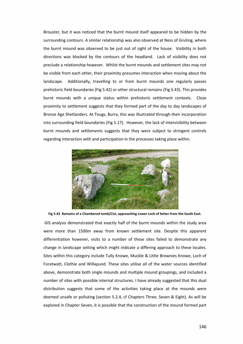
146
Brouster, but it was noticed that the burnt mound itself appeared to be hidden by the
surrounding contours. A similar relationship was also observed at Ness of Gruting, where
the burnt mound was observed to be just out of sight of the house. Visibility in both
directions was blocked by the contours of the headland. Lack of visibility does not
preclude a relationship however. Whilst the burnt mounds and settlement sites may not
be visible from each other, their proximity presumes interaction when moving about the
landscape. Additionally, travelling to or from burnt mounds one regularly passes
prehistoric field boundaries (Fig 5.42) or other structural remains (Fig 5.43). This provides
burnt mounds with a unique status within prehistoric settlement contexts. Close
proximity to settlement suggests that they formed part of the day to day landscapes of
Bronze Age Shetlanders. At Tougs, Burra, this was illustrated through their incorporation
into surrounding field boundaries (Fig 5.17). However, the lack of intervisibility between
burnt mounds and settlements suggests that they were subject to stringent controls
regarding interaction with and participation in the processes taking place within.
Fig 5.43 Remains of a Chambered tomb/Cist, approaching Lower Loch of Setter from the South East.
GIS analysis demonstrated that exactly half of the burnt mounds within the study area
were more than 1500m away from known settlement site. Despite this apparent
differentiation however, visits to a number of these sites failed to demonstrate any
change in landscape setting which might indicate a differing approach to these locales.
Sites within this category include Tully Knowe, Muckle & Little Brownies Knowe, Loch of
Foratwatt, Clothie and Willapund. These sites utilise all of the water sources identified
above, demonstrate both single mounds and multiple mound groupings, and included a
number of sites with possible internal structures. I have already suggested that this dual
distribution suggests that some of the activities taking place at the mounds were
deemed unsafe or polluting (section 5.2.4, cf Chapters Three, Seven & Eight). As will be
explored in Chapter Seven, it is possible that the construction of the mound formed part

147
of the strategy for mitigating against this danger. This argument is reinforced by the
apparent separation of burnt mounds and houses within settlement locations, and
further reiterates their status as powerful and transformative locales.
5.3.8 Open and Closed Views
Fig 5.44 Enclosed views from Skellberry (Image Steve Doughton)
Aside from the obvious affiliation with water the most consistent aspect of the landscape
setting of burnt mounds was the subjective sense of enclosure that accompanied most
visits to site locations. The topography of Shetland is such that there are very few flat
locations, but a good deal of valleys and hill ridges. At the lower locations favoured by
the burnt mound sites, there was often the appearance of a natural amphitheatre,
surrounded on all sides by higher ground. While in some instances this higher ground
was some distance away, and consisted of larger hills and notable landmarks, quite often
this appearance was enhanced by the immediate topography, so that the gentle slopes
of the immediate foreground appeared to rise up and meet with the steeper ones of the
surrounding hills (Fig 5.44). While Shetland is not mountainous, and has no especially
steep or dramatic hills, it has a constantly undulating topography which means that you
are never far from a patch of rising ground and the horizon in the low lying areas is often
formed of hilltops. Within these amphitheatre locations, the views are restricted to the
immediate vicinity (Fig 5.45), as was suggested previously through viewshed analysis.

148
Fig 5.45 360 schematic from East Collaster demonstrating enclosed views
This is a secretive, hidden world where the undulating nature of the ground means that
features which are only several meters away are not visible from nearby locations.
Hence, as was explored above, a person working at the burnt mound site may be aware
of a nearby site or settlement, and indeed may be able to hear it, smell the smoke from
the fire, and even see the plumes rising, they would not always be able to see the
buildings themselves. The lasting impression taken away from these locations however,
is not that they are separate or outside of the localised landscape. On the contrary,
being at the lowest point and looking upwards and outwards to the surrounding areas
the subject is somehow tucked away in the middle.
Fig 5.46 360 schematic from Hamnavoe showing limited sea views.
Mounds with a coastal location were generally found to have wider vistas. At
Hamnavoe, Loch of Brouster and Tully Knowe sea views were restricted and appeared to
be bounded on all sides by land (Fig 5.46). However, at Muckle & Little Brownie’s Knowe,
Wick and Links of Quendale these views are more expansive, and extend out to the
horizon. Mounds with extensive sea views were predominantly found in the south

149
mainland, and on western coast of west mainland. The cliffs and wide bays in these
areas afford wider vistas than the enclosed voes and inlets found elsewhere in Shetland.
While these open views seem to be in opposition with the sense of enclosure
experienced at other burnt mounds, they are very much in keeping with the focus on
watery places outlined above. As will be explored further in Chapter Eight, water is a
symbolically potent element. The presence of the sea may be linked with concepts of
island identity, and with the seas as a medium of transport and connection.
Undoubtedly it also links with the concept of water as a transformative element, and the
central role which these properties play within burnt mound sites. We have already seen
burnt mounds are not only located by, but appear to be orientated towards bodies of
water. As such, the presence of extensive watery vistas can be seen as an extension of
this principle
5.3.9 Encountering Burnt Mound Sites.
Having explored the locational considerations of burnt mound sites, I would now like to
turn my attention to how these factors influence the experience of burnt mounds within
the landscape. I have already outlined the various forms of water source associated with
burnt mound sites. These variations have a profound effect on the experience of burnt
mounds. The diverse character of water is explored in detail in Chapter Eight. It is
argued that it is water’s ability to take on a variety of forms, and to shift from state to
state which provides it with much of its symbolic meaning. This diverse character means
that it also affords a range of sensory experiences. The sonic qualities of water were one
of the most notable factors in the encounters with burnt mounds described above.
Watery sounds were experienced at sites next to flowing freshwater sources such as
burns and hill runoffs, and at coastal sites, but to a lesser extent at standing freshwater
sources such as lochs and marsh. The intensity of the sonic experience also depended on
weather conditions. After a period of rain the volume of water flowing through streams
and hill runoffs increases. In doing so the sound of running water becomes more intense,
and what at one time can be experienced as a gentle tinkling can become a rushing roar.
At sites such as Clothie (Fig 5.39), which is situated next to a very small hill runoff, this
change in water volume makes a marked difference in the experience of the site. This
site was visited following a period of relatively dry and stable weather. Initially I had
identified this site as having no visible water source. The slight nature of the runoff
meant that it was barely visible below overgrown grasses, and on arriving at the site I
was unable to see it. It was not until I began to explore the surrounding area that I

150
noticed the glint of water through a gap in the foliage, and was then able to trace its
path towards the mound and determine the relationship. During periods of wetter
weather this watercourse is likely to be swell and become prominent however, and so
the experience of the site, and the perception of its relationship with water is likely to
differ too. The sonic qualities of water were most evident at sites with a coastal location.
During calm weather this took the form of the gentle lap of waves upon the foreshore,
while during more unsettled weather this rose to constant roar, accompanied by the
sounds of waves crashing upon nearby rocks. However, this experience was not limited
to sites at which the sea was visible. At East Collaster the roar of the sea was distinctly
audible, despite there being no line of sight to the coast from the site. In this case, the
sonic qualities of water were able to create links between the burnt mound and bodies
of water which would otherwise have appeared disconnected from the site.
Fig 5.47 Approaching Willapund from the south.
The low lying contours occupied by burnt mounds also have a profound effect on the
way in which they are experienced. We have already seen how lines of sight between
burnt mounds and settlement sites appear to have been deliberately avoided, so that
the burnt mounds reveal themselves as you move through the landscape towards them.
This effect is heightened when approaching the sites from the surrounding area, as was
demonstrated at Willapund (Fig 5.47). The site is surrounded on three sides by high
ground, and by rising ground leading to the sea to the north. Approaching from a
distance its location next to the loch is immediately visible. While today the mound is
covered in a thick layer of foliage and heather, which makes it difficult to discern from its

151
surroundings at a distance, we must remember that the mound we see today is the final
stage of its construction, and would only have been achieved after it fell out of use
(Chapter Seven). The mound would have grown through use, and would have appeared
as a bare heap of fragmented rock besides the loch. As such we can imagine that the site
would have been more readily visible than it appears today. In approaching the mound
the agent moves through the landscape downhill. This downward movement gives the
impression of moving into the landscape. Watercourses also provide a focus for
movement, directing the agent through the landscape. Bends and meanders of
watercourses such as at Burn of Setter direct movement between mounds, and prevent
the agent from taking a direct route between mounds, instead forcing them to follow the
natural contours of the landscape, while patches of deep marsh can redirect movement
for some distance until the ground becomes firm enough to walk upon.
5.4 Shetland’s Burnt Mounds in their Landscape Context.
In this chapter I have explored the results of two different scales of analysis in order to
determine the wider landscape context of burnt mound sites. GIS analysis on a regional
scale has shown the burnt mounds of Shetland to occupy a distinct landscape setting
characterised by low lying ground and affinity to water. Within this wider pattern
however a range of variations were revealed, particularly in relation to the type of water
source which appears to have influenced the location of the sites. Two major categories
of water source were identified through GIS analysis, these being flowing water and
standing water, with a small proportion of sites appearing to display a coastal affinity
outside of these groups. However, in-situ survey demonstrated that these categories
could be further sub-divided to include marshy areas, seasonal runoffs, and apparently
multi water source locales. Further variation in site morphology was also identified
which combined with the evidence from previously excavated sites detailed in Chapter
Four suggests that far from being homogenous, the burnt mounds of Shetland appear to
possess a wide range of variation both in location, size, shape, and internal structure.
GIS analysis was also able to demonstrate that the preference for low lying locations was
not exclusive to burnt mound sites, with the majority of settlement sites also occupying
land below the 50m contour. From this observation I suggest that far from being
marginal and separate to settlement locations as has been suggested for some burnt
mound sites (Barfield & Hodder 1987), many of the burnt mounds of Shetland appear to
occupy the same landscape setting as settlement sites. Simple proximity analysis

152
demonstrated that exactly half of the sites within the study area fell within 1500m of
settlement sites, forming part of what has been defined above as the ‘local’ scale
(Rennel 2009:108). This is defined and characterised by everyday interactions by those
with an intimate knowledge of the landscape. A large percentage of these sites fall
within the areas identified above as being locales of good preservation and recording,
suggesting that it may be possible to extend this relationship to other areas within
Shetland should similar levels of recording and survey be applied to these areas.
Viewshed analysis of burnt mound sites throughout Shetland demonstrated that the
sites appeared to be locally focussed, and afforded views of the immediate landscape,
rather than being situated in locations with strategic views of nearby landscapes. This
pattern appeared to replicate the results seen for settlement sites, which also
demonstrated a local focus, rather than preferring locations with commanding views of
the wider surrounding area. Moreover, the localised focus suggested through viewshed
analysis appears to translate into a feeling of centrality and enclosure when experienced
on the ground.
The wider patterns observed through GIS analysis were supported by a series of site
visits which appeared to confirm that burnt mounds sites were indeed closely related to
the settlement evidence. In areas of good preservation it was possible to observe that
burnt mound sites and settlement sites appeared to form a network, an observation
which has also been raised by Deborah Lamb’s work exploring the development of
landscapes in Burra. Lamb observed that the location of burnt mound sites appeared to
be directly related to the location of known settlements, and even suggested that the
burnt mounds may form central points in between individual homesteads (D Lamb, pers.
com). However, while proximity does indicate a relationship, site visits have revealed this
to be complicated and nuanced. Burnt mounds are found to occupy hidden locations
within the landscape which prevent visibility from settlement locations, and often from
other burnt mounds. This is consistent with the discovery that 173 sites within the GIS
database fell outside of the ‘local’ proximity of burnt mound sites. It is possible that this
differentiation relates to the type of activities taking place at the site, and how suitable it
was deemed to be to perform this near to areas of habitation. As will be explored in
Chapter Six, many of the experimental activities carried out at the burnt mound site
(particularly tanning, but not exclusively) resulted in unpleasant odours, or utilised bodily
fluids and other materials which may be seen as polluting. However, visits to these sites
determined that they occupied the same type of location as those in close proximity to
153
settlement. It is suggested therefore that the powerful and transformative processes
taking place within necessitated landscape locations which controlled access, and
prevented the possibility of pollution. As such, the locations occupied by burnt mound
sites can be seen as having special status, and being transformative in their own right.
5.5 Evaluation & Conclusion
In this chapter I have explored how a combination of GIS analysis and in-situ survey may
be combined in order to develop a person-centred overview of the landscape setting of
Shetland’s burnt mounds. A number of methodologies have been employed in order to
achieve this:
1) Regional scale location based GIS analysis to determine patterns of landscape
use, and examine the relationship between burnt mounds, topographical
features and other prehistoric sites.
Based upon initial observations from early site visits, location based analysis was
able to successfully provide an overview of the relationship between burnt
mounds and key features within the landscape. Specifically it was possible to
identify that burnt mounds demonstrated an affinity for watery locations, and
that the water sources utilised could be subdivided into flowing freshwater,
standing freshwater and saltwater locations. Additionally it was observed that
there was an equal divide between burnt mounds which were within close
proximity to other prehistoric sites (local scale), and those which fell outside of
this proximity. However, this type of analysis was not able to illustrate some of
the more subtle nuances of burnt mound locations, particularly in relation to
types of water source.
2) Local scale viewshed analysis to explore the affordances of the visual
experience at burnt mound sites.
Viewshed analysis was utilised in order to explore the visual affordances of burnt
mound sites. Examination of viewsheds taken from sites throughout Shetland
was able to demonstrate patterns of limited visibility, and enclosed space at
burnt mound sites. However, it should be noted that it was only possible to
interpret the information from viewsheds fully with supporting information from
in-situ survey. In particular, it is viewshed models may give the appearance of
wide areas of visibility, but that this is not translated into the experience of wide
vistas on site unless the line of site is continuous and unbroken. Viewsheds

154
generated as part of this study were able to demonstrate a pattern on close
views at burnt mound sites, with the exception of coastal sites, which appeared
to have more open vistas when looking out to sea.
3) In-situ analysis of individual burnt mound sites through phenomenologically
informed site visits.
In-situ analysis of the locations of burnt mound sites was essential for the proper
understanding of data generated by GIS analysis, an enabled the more general
patterns identified above to be expanded upon, and in some cases,
reconsidered. As was noted in Chapter One, all research undertaken as part of
this thesis was developed as a result of initial site visits, through questions
relating to landscape use, and the relationship between burnt mounds, water
and other prehistoric sites were formed. Likewise, as in-situ survey allowed
provided the framework for GIS analysis, so GIS analysis provided a series of
questions and observations which were then explored more fully in the field.
Criticisms of both GIS analysis and phenomenologically informed approaches to
landscape have been noted, however I have argued that by combining the two
approaches in a reflexive dialogue it is possible to mitigate some of these critiques. As it
noted above, individually both GIS analysis and in-situ survey only gave a partial
understanding of the landscape setting of Shetland’s burnt mound sites. Rather, it was
through an iterative and reflexive dialogue between both of these methodologies that a
deeper understanding of burnt mound sites was developed. As such, I have suggested
that when combined in this manner GIS and phenomenology do not need to be mutually
exclusive, but rather can be seen as complementary. In exploring the landscape setting
of burnt mounds GIS has proved to be a useful tool in drawing together wider patterns of
landscape setting, and in providing a series of questions and observations to be explored
through survey. Site visits to burnt mounds within the study area have largely confirmed
the observations drawn from GIS analysis, but have demonstrated the need to visit sites
and experience them first hand in order to fully explore the subtleties and nuances of
the landscape experience. While viewshed analysis provides an overview of the visual
affordances of a landscape, it is not a substitute for viewing. Rennel (2009:267) has
noted that viewsheds are unable to offer an accurate understanding of views available
from site. She suggests that a viewshed with large magnitude (ie those with a large area
which is potentially viewable) does not translate into an area with a wide vista. These
vistas, she argues, depend on unbroken lines of sight, and the relative contribution of

155
different landscapes into the vista. Thus, by having a reflexive dialogue between GIS and
phenomenological approaches it has been possible to understand how the models
created through GIS relate to landscape experience. Moreover, it should be noted that
viewsheds produce a static image of visual potential from one particular point. However,
in-situ survey illustrated that the burnt mounds were involved in phases of concealment
and disclosure as the agent moved through the landscape.
The importance of being there was also highlighted through exploration of the
relationship between burnt mounds and watery locations. As was suggested by the GIS
results, stream side locations were found to be the most common, but were not as
numerous as the results indicated. While map based survey proved to be efficient at
identifying sites which were located next to standing water (loch side), it was less
accurate in differentiating between running water sources and areas of boggy ground in
which a groundwater source may have been utilised. While in situ survey was more
suitable than GIS analysis to identify some of these variations however, it should be
noted that a number of excavated sites have revealed internal drainage features and
cisterns, such as those found at Cruester, which indicate that the relationship between
mound sites and their local water sources may be even more complicated that appears
on the surface. In such cases only excavation and other invasive techniques are likely to
uncover the true nature of what appears to be a very complex relationship.
Finally, it is noted that accounts both GIS and in-situ survey continue to focus
predominantly on the visual experience of burnt mounds at the expense of other
sensory engagements. Viewshed and visibility studies were successful in highlighting the
complex relationships between burnt mounds and other prehistoric features. Specifically
they have illustrated that the location of burnt mound sites, and therefore the
experiences which they afforded was subject to high levels of control. Sites appear to
have been established in locations with limited visibility of other locales, even when in
close proximity to other activity. This, I have argued suggests that the processes involved
in their creation and use may have been seen as powerful and transformative, and as
such necessitating segregation and separation from other areas of activity. However, as
has already bee explored in Chapter Three (section 3.1.3), visual approaches rely heavily
upon the primacy of the finished object at the expense of exploring the processes and
procedures which go into its construction. As such it is necessary to engage with the full
range of sensory experiences involved in burnt mound usage. To do so requires that we
engage with the processes involved in the creation and use of the mound, rather than

156
focussing on their static final form (see also Chapter Seven). It is to this end therefore
that the next chapter turns.

157
Chapter Six: Experimental Firings
6.1 Introduction: Experiment or Experience?
This chapter will detail some of the observations, experiences and new understandings
that have come about as the result of a series of experimental firings at a burnt mound
site in Shetland. The experiments were undertaken to allow me to explore the direct
experience of thermal technologies in order to develop a new understanding of how
burnt mound practises may have been understood in the past. While previous
considerations of burnt mounds have focussed solely on the output of the technologies
employed at such sites, this study aims to unravel the range of processes involved in
achieving these outputs, and to explore the material and social engagements which both
facilitate and are facilitated by these activities. As such, the firings undertaken are
perhaps not what is traditionally thought of as ‘experimental archaeology’, therefore
before I go on to give any more detail about the work undertaken at the replica site, it is
first necessary to clarify exactly what I mean by the term ‘experimental firing’.
Experimental approaches have formed a part of archaeological practise since the
antiquarian period (Coles, 1973; Forrest 2008; Millson 2011). Experimental archaeology
is a key tool in developing our understanding of the use and creation of past
technologies. Experiments such as Pitt-River’s work using antler picks at Cissbury, Sussex
(Millson, 2011:1; Pitt Rivers 1876. 382-3), McGuire’s work with stone tools and metal
process (Coles 1979; Forrest 2008), and other, larger experiments e.g. Severin’s (2005)
replication of the Brendan Voyage and Heyedahl’s (1950) Kon-Tiki voyage allow us to
explore the limits and possibilities of the endeavours of past peoples. Despite its
longevity, there remains the sense that experimental work remains somehow ‘outside’
of standard archaeological practises. Forrest suggests that much of this may be due to
its perception as ‘amateur’ and its association with re-enactment and public engagement
activities, rather than serious academic research (2008:67). This status has led some to
call for a code of practise or guidelines for undertaking experimental archaeology (see
Cunningham et al 2008:vii), and for a return to the scientific principles of
experimentation to reinstate the field as a legitimate tool in the archaeological toolkit.
Millson describes experimental archaeology as ‘an objective approach targeting specific
questions and resulting in data which can be empirically understood (2011:3). As such it
should have a clear set of aims, and outline all methodologies and materials used, so that
it is both repeatable and testable (Cunningham et al 2008; Millson 2011). Moreover, in

158
order for it to be useful, it should always be related back to the archaeological record, so
that it can inform on our understanding of the objects, places or processes under study.
In particular, Cunningham et al draw a clear distinction between what they perceive as
experimental, and what might be termed as experiential (2008:v). While experimental
processes may be experiential, they stress that not all experiential works are
experimental. In relation to this definition then, the processes carried out as part of this
study and described below are most decidedly not experiments. It is important to stress
here that these processes are not designed to ‘test’ whether any of the proposed
functions can or cannot be carried out at a burnt mound site. Nor are they intended to
be accurate replications of prehistoric processes, using strictly prehistoric techniques,
and there is certainly no aspiration to objectivism within the design of this study. Rather,
these experiments fall within what has been described as experiential, in that they are
designed to explore the range of skills and experiences developed as part of attempting
to carry out some of the functions ascribed within the literature to burnt mound sites.
However, that is not to say that these processes do not inform on the construction and
use of burnt mound sites, and have not led to observations which can be directly related
back to the archaeological record.
In this context the term experiment is used here to describe an exploratory series of
actions designed to answer questions about the experience of working a burnt mound
site. These experiments explore questions relating to practise, and provide insight into
technologies of the body in terms of skill and actions attached to burnt mound firings.
Of course, these processes will not develop the same social relationships or require the
same material interactions as those who used them in the past. For this reason there
has been no emphasis placed on ‘authenticity’ or a rigid adherence to replicating
prehistoric methods in the performance of these tasks. Rather, these experiments are
designed in direct response to the statement that little information could be drawn from
burnt mound sites beyond an indication of settlement or population distribution (Barber
& Russell White 1990). By exploring their potential for creating relationships, developing
skills, and creating networks of materials and persons these experiments challenge this
presumption, and instead illustrate the potential for viewing burnt mound sites as hubs
of activity, and nodal points in the flux and flow of people, places and things.
As was discussed in Chapter Three, the experiments undertaken for this thesis explored a
range of activities which have thus far been proposed for burnt mound usage (cf Chapter
One), specifically:

159
Cooking
Textile Working
Steam Bending/Woodworking
Hide Processing
Brewing
In addition, a winter firing was performed in order to explore how seasonality might
affect the process of working a mound. These processes were chosen to represent the
range of processes proposed for burnt mound usage. During hide processing
experiments it was decided that the worked skins would be utilised to construct a skin
boat. This process was inspired by the Rausing’s (1984:20) account of the use of hot
stones in the expansion of dugout log boats. Shetland’s treeless nature suggests that
skin boats, rather than log boats were more likely to have been utilised during the
Bronze Age. Nevertheless, the presence of coastally located mounds (Chapter 5) raised
the possibility that burnt mounds may have been in some way connected to the sea and
the use of waterways as transport routes, and as such, the decision to construct a boat
was made. In addition, it was decided not to experiment with metalworking, due to the
lack of information available as to how these sites may have been utilised in this process.
It is my belief that this application has been suggested due to the association of burnt
mounds with hoards of metal, such as the Moughan hoard (Condit 1996), and through
their presence in locations otherwise associated with metal deposition (Yates & Bradley
2010), rather than any real indication of a metalworking application.
The applicability of many of these functions are still contested within burnt mound
studies (cf Barfield & Hodder 1987; Hodder & Barfield 1991; O’Drisceoil 1988, 1991;
Quinn & Moore 2007). However for the purposes of this study each of these applications
were treated as equally plausible. As was discussed in Chapter Four, the application of
hot stone technologies at burnt mounds in Shetland appears to have varied from site to
site. Therefore if we accept that burnt mounds could have been utilised for a range of
purposes, the question then becomes how these practises may be related, and what
kinds of skills are required to successfully perform these actions. How might the skills
acquired undertaking one task affect the way in which another is performed, and how
might any shared practical knowledge affect the way in which each of these activities are
perceived? Moreover, in what way do the practises carried out at burnt mound sites

160
relate to others understood to have been carried out elsewhere during the Bronze Age,
and how does that affect our understanding of burnt mound sites themselves?
6.2 The Replica Tank & Hearth
Fig 6.1 The replica structures on Bressay.
The experiments undertaken as part of this study were carried out at the replica hearth
and tank constructed on Bressay, as part of the Bronze Age Bressay Project. This project
was developed in partnership with Scottish Archaeology’s Adopt-a-Monument scheme
and the SCAPE Trust. The replica structures were constructed to the exact floor plan and
dimensions of structures excavated from the nearby site at Cruester. The burnt mound
at Cruester was originally identified as being under threat from coastal erosion during a
survey of sites undertaken by EASE Archaeology in 1996 (Moore & Wilson 1999, 2001,
2008). Excavation in 2000 revealed a series of complex structures (Fig 6.1) (Chapter

161
Four) as a result of which the local community decided to approach the Adopt-a-
Monument scheme with the view to fully excavating the site, removing the structures
within and reinstating them in a safer location. During excavation each stone within the
site was numbered individually, so that it might be replaced in its original position within
the reconstruction. In addition to this it was decided to create a replica site which could
be used to conduct experimental firings, and would form a part of a public outreach
project. The replica was constructed to the exact dimensions of the original site, and
includes the hearth cell, central passageway (Passage B), compete with terminating
orthostats, a side cell (Cell D) and the tank itself. As such, the site represents a unique
opportunity to explore how the specific physical setting and internal structures of the
site either constrain or enable action.
6.3 The Experiments
6.3.1 Transporting Stones & Heating Water
In order to carry out any of the processes intended to be explored as part of this study it
was first necessary to establish the essential skills involved in working the site; creating a
fire, filling the tank with water, roasting stones, and transporting the stones from the
hearth cell to the tank. Without a method for achieving each of these things none of the
other activities would have been achievable. These seemingly simple tasks form the
backbone of any process proposed to have taken place at burnt mound sites,and
O’Kelly’s (1954:119-123) accounts of experimental firings at Ballyvourney were
particularly useful at this stage in providing insight into possible methods for the
constructing the fire, transporting stones and emptying and cleaning the tank.
The stones for the experiments on Bressaywere gathered from the foreshore by a local
landowner who transported them to the site using a small flatbed trailer. They were
then stored next to the hearth in a pile prior to firing. Transferring the stones from the
trailer to the hearth cell required a large team of people, and several trips. Stones were
placed into buckets for ease of transportation, and despite the assistance of modern
technologies, the effort of shifting the items even this short distance was considerable.
Once they were on site they could be lifted by hand from the storage pile into the hearth
cell as required. During the course of the process it was found that most stones lasted
for at least three or four firings before they shattered and had to be disposed of. A new
delivery of stones was normally required every two months during regular firings.
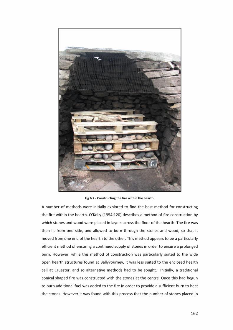
162
Fig 6.2 - Constructing the fire within the hearth.
A number of methods were initially explored to find the best method for constructing
the fire within the hearth. O’Kelly (1954:120) describes a method of fire construction by
which stones and wood were placed in layers across the floor of the hearth. The fire was
then lit from one side, and allowed to burn through the stones and wood, so that it
moved from one end of the hearth to the other. This method appears to be a particularly
efficient method of ensuring a continued supply of stones in order to ensure a prolonged
burn. However, while this method of construction was particularly suited to the wide
open hearth structures found at Ballyvourney, it was less suited to the enclosed hearth
cell at Cruester, and so alternative methods had to be sought. Initially, a traditional
conical shaped fire was constructed with the stones at the centre. Once this had begun
to burn additional fuel was added to the fire in order to provide a sufficient burn to heat
the stones. However it was found with this process that the number of stones placed in

163
the fire was not always sufficient to heat the water in the tank, and that when the stones
were piled in the centre of the fire itself not all of them were heated directly by flame.
Later, it was decided to construct the fire using a ‘pyre’ type arrangement. Alternating
layers of wood and stones were placed in the hearth one atop the other, and the fire was
built up to the required size in this manner. Kindling could then be added in the spaces in
between the wood, and the result was a large blaze with a good quantity of stone spread
evenly within it (Fig 6.2).
Unlike its prehistoric counterparts, the replica site was not situated near to a natural
water source. As such the only method of filling the tank available was to attach a
hosepipe to the tap in the public toilets outside the heritage centre. This process alone
often took in excess of 30 minutes to fill the tank, depending on the level of the local
water table and the amount of water already in the tank (as will be discussed bellow, the
tank occasionally self filled to a certain degree, and often self drained). O’Kelly
(1954:119) noted that the trough at Ballyvourney began to fill naturally once the local
water table rose. However, despite this it was still found to be necessary to draw water
from the nearby stream. A similar process could have been expected to occur at
Cruester. The tank was constructed into natural peat deposits, and during excavation
was observed to fill with water on a regular basis (Moore & Wilson 2001:10).
In filling the tank it was found that the water reached a natural level, beyond which it
was impossible to fill the tank any further. This was probably due to water escaping
through the larger gaps between the stones forming the walls of the tank at the top of
the structure. However, after a few firings it was found that this natural optimal level
was almost exactly the level required to allow for displacement of water once the stones
were added to the tank. After time this level became identifiable by a ‘tide mark’ on the
walls of the tank itself, although this was more noticeable following those processes
which left a greater degree of residue, such as brewing and hide working, than those
which involved just heating the water. The method of filling the tank at the original site
is still open to speculation, although it is probable that water would have to have been
added to the tank using a container from another water source. In the case of Cruester,
cell H, to the north of the tank appears to have been constructed as a cistern, and was
dug down below the water table to create a self filling reservoir of water (Moore &
Wilson 2001:14). Thus, while the original location appeared to have paleochannels
running around the mound it is possible that these channels were not utilised in the
filling of the tank itself.

164
The stones were heated within the hearth for upwards of an hour prior to being
removed from the hearth cell and transferred to the tank. During this period the area
around the hearth cell became hot and smoky; the frequent pops and bangs of
expanding materials within the fire made it an uncomfortable and dangerous location to
work in andconstant vigilance was required in order to avoid injury. The enclosed hearth
meant there was limited access to the fire, which restricted the options for working with
it. The replica structure was open air and only included one side cell, while the fire in
the original site was enclosed and built up on all sides. Working conditions would have
therefore have been cramped, uncomfortably hot, and occasionally quite frightening (for
more on the dangers associated with working burnt mound sites see section 6.4 below).
A long handled implement was required to rake and manage the fire. During earlier
firings there were some attempts to create suitable wooden tools to perform the task,
however many of these became charred or burnt, or were simply not efficient in moving
the stones in the manner required. Later on an old, long handled agricultural fork, which
had lain disused in the shed of one of the local volunteers, became the favoured tool for
fire management, as it provided enough reach to allow the user to stand at a more
comfortable distance from the fire whilst raking it. Wooden tongs were also created to
lift the stones into the tank, however a ‘roll and flick’ method was soon developed, using
modern gardening shovels and forks, which proved to be a faster and more intuitive
method for transferring the stones from the hearth to the tank (Fig 6.3).
During the excavation of Tangwick and Cruester it was noted that both sites appeared to
have a ‘chute’ leading from the hearth cell to the tank. At Tangwick the stones lining this
feature were reddened in a manner consistent with heating, suggesting that the chute
had been employed in transporting the stones from the hearth cell to the tank directly
below (Moore & Wilson 1999). This arrangement of hearth and tank was directly
mirrored at Cruester, and the site was constructed on a slight incline, so that there too it
was possible to imagine the stones being rolled down the passageway and into the tank.
This incline was reconstructed at the replica, facilitating the passage of the stones to the
tank, where they could then be ‘flicked’ over the lip of the tank and into the water. The
raised lip of the tank, and the two orthostats immediately before the tank meant that
stones did not often roll directly into the tank itself, nor did they go shooting past. This
enabled the individual working at the tank edge to have some control over the speed
and location at which they entered the tank. This process required at least two people,
one to roll, and one to flick. However it was actually found to be most efficient with

165
three. First one person working at the fire raked the stones from the embers. A second
propelled them from the area in front of the hearth towards the third individual who was
standing at the tank edge controlling the stones entry to the water. Successive attempts
at this process demonstrated that the faster the stones were transferred from the fire to
the tank, the higher it was possible to raise the water temperature. During these initial
tests, the water temperature was raised to an average level of 70℃ within a short space
of time, but later it quite often reached temperatures in excess of 80℃ and even reached
boiling point in parts of the tank.
Fig 6.3 - Stones being transported from the hearth to the tank.
While the word ’control’ has been applied to describe the process of ‘roll and flick’
above, it should be accepted with some caution. In fact, the process was often anything

166
but controlled. The irregular shape of the stones meant that their path down the
passageway to the tank was often erratic. Those working within this space during stone
transfers often found themselves jumping out of the way as a hot rock veered
unexpectedly at their feet. Often hot clumps of embers would also come rolling down
the passage with the stones, and would lie fizzling at the lip of the tank, or else they
would be caught up with the stones being flicked in to the tank, and would extinguish
and disintegrate on contact with the water, leaving flecks of smouldering charcoal
floating on the top of the water. The water itself, which started out greyish due to the
clay lining in the tank, soon darkened and became filled with debris from the soot, ash
and dirt clinging to the stones.
Readers of this chapter will soon note that the sounds, smells and sensations involved in
using a burnt mound site are some of its most defining features. The use of hot stone
technologies is an extremely visceral and physical process, involving a wide range of
sensory engagements. Even without the specific textures, odours and sensations
involved with working with particular materials at the mound (as will be described
below), burnt mounds have a unique set of sounds and sensations which go hand in
hand with their usage. As the stones entered the water they hissed and groaned, sending
up small clouds of steam. Eventually when the water was sufficiently heated the entire
tank was shrouded in a low haze of steam. Areas around the hottest stones continued to
bubble for some time after the stones were entered. It was also found that after adding
the stones the temperature would continue to rise for some time until the heat from the
stones transferred fully, at which point the temperature would stabilise, before
beginning to drop again. When the tank became particularly full, the addition of a new
hot stone would cause the others around it to vibrate slowly, adding a low, rumbling
sound to the hissing and growling of the stones themselves. Other stones let off a high
pitched scream as they hit the water, usually before shattering into pieces. Within the
hearth the fire popped and crackled, occasionally emitting a loud band which would send
more experienced members of the team scattering to the edges of the site, as will be
discussed in more detail below. Stones rolling from the hearth rumbled and clattered,
and the smoke from the hearth cell left everyone working there with a distinctive woody
aroma, and a dried ‘kippered’ sensation as they left for home.

167
6.3.2 Brewing
Experiments in brewing took place during the summer of 2010 and 2011. As was
discussed in Chapter Two (section 2.6.1), experiments in hot rock mashing have been
successfully carried out by Quinn & Moore in Ireland, and their work resulted in a ripple
of discussion on the potential uses of burnt mound sites both online (e.g.
http://irisharchaeology.ie, http://www.mooregroup.ie) in the popular press (Quinn &
Moore 2007) and at the 2008 World Archaeological Congress in Dublin. Early attempts
at brewing at the replica mound met with problems when the stone tank developed a
leak and required re-sealing with clay. In order to keep the planned schedule of
experiments on track it was therefore decided that an alternative container should be
sought to run the experiments in, with the view to re-running the process in the tank the
following season. As such, the first run was carried out using an old sink as the tank with
the second being performed in the stone tank the following year. Aside from the
difference in container no other variables were changed, and the processes involved in
both experiments were otherwise the same. The outcomes of both runs were
successful, however the materials responded slightly differently in the different
containers. Most notable was the difference in temperature reached during the firings.
Water in the sink took less time to heat, but retained the heat less efficiently than water
within the tank. The resultant mixture within the sink was also slightly thicker, despite
both containers having comparable capacities. These differences can be explained by
the larger surface area of the sink, which allowed for greater evaporation of liquid during
the firing process. However, this experience serves to illustrate that even slight
variations in the dimensions of internal structures within the burnt mound may have an
affect on the outcomes experienced.
The process of brewing requires the conversion of grain starches into sugars, which are
then fermented (cf Dineley 2004). The conversion requires the temperature within the
tank to remain at an optimum temperature of around 65°C in order to convert without
killing the enzymes. Brewing therefore presented a challenge in relation to fire
management, not least because the temperature needed to be maintained constantly
over a period of time in order for full conversion to be achieved. To do so it was
necessary to identify which stones had been in the tank longest and replace them
regularly, whilst simultaneously making sure that the fire was being managed in a way
which ensured a ready supply of hot stones. Initially this required continuous use of the
digital thermometer to manage the temperature. However during our second firing the

168
presence of experienced brewers on site allowed us to rely on the appearance of the
surface of the water (which gains a ‘glassy’ look at the appropriate temperature) to
determine whether the mixture was at the correct temperature.
Hot rock mashing requires the use of crushed malt for the successful conversion of
starches into sugar. Malting begins with the germination of the grain, usually achieved by
soaking the grain. Germination is then carefully monitored through the use of ‘malting
floors’ as can be seen at many historic breweries and distilleries, where the malt is
carefully turned until the appropriate level of germination has been achieved.
Germination is then stopped by drying or ‘kilning’ the grains, before the grain is gently
crushed (Dineley 2004:10-12). For the experiments in this study a six row variety of
barley known as ‘Bere’ was used. This ancient strand of barley is still grown in areas of
Orkney and Shetland, and elsewhere in Scotland, and is used locally for baking traditional
beremeal bannocks, and in the brewing of some of the local archaeologically inspired
ales. The Bere was sourced from local brewers and came pre-crushed, so no processing
was necessary.
The initial phase of brewing involved heating the water with the roasted stones as
described above, before adding them to the tank. A two person rolling method was
employed to transport the stones from the hearth cell towards the tank, and then stones
were lifted into the water. As the temperature was required to reach a specific level, this
process was slower and more controlled than at other experiments, and involved a less
frenetic activity. Once the water had reached the desired temperature a woven basket
was lowered into the tank, and the crushed malt was poured into it (Fig 6.4). This
method was employed both to control the amount of malt going into the tank, ensure its
even spread and ease of mixing. It also prevented it from charring when coming into
direct contact with the hot stones. The malt was stirred gently to mix it with the water
before it was poured out and a new batch added. In this way the mixture was created
gently, incrementally, until the correct combination of malt and water was felt to have
been achieved. During this time, the water in the tank turned from clear to a pale
brown liquid, which slowly darkened over time. On initial contact with the water the
malt separated, and the lighter husks began to float to the surface, while the floury
grains themselves began to swell and form a porridge-like substance. The more grain
was added the thicker and darker the substance became, until the entire tank became
full of a thick wet mash of saturated grain with a clear dark brown fluid floating on the
top. While unpleasant smells will become a feature of the descriptions of the processes

169
carried out during this study, one of the most notable differences between the brewing
experiments and others undertaken was the mouth watering smell which resulted. On
adding the grain to the water the mixture took on an appealing edible smell, not unlike
that of porridge or malted drinks such as Horlicks and Ovaltine which as it matured then
took on a sweeter, syrupy smell.
Fig 6.4 Brewing in the tank (Image courtesy of Merryn & Graham Dineley)
The temperature was maintained for approximately an hour while the starches in the
grains converted to sugar. During this time the tank was covered with a large wooden
sheet in order to prevent the temperature dropping too suddenly due to surface
evaporation and cooling. Occasionally new stones were added to maintain the
temperature, and older ones were taken out. On these occasions the hot stones hitting
the water resulted in a short period of hissing and bubbling, and an overpowering smell
of toasted oats. Once in the area around the stone continued to bubble for a short
period of time causing localised spikes of heat in the tank. These spikes could be seen in
the thicker mixture by a thick bubbling in the grain mixture which resembled the
movement of mud at hot springs, while in the more dilute mixtures it was evident from
the swirling of floating grain husks and froth on the surface of the liquid as the
convection currents beneath moved the material around. Once the starches had
converted, ascertained by testing the mixture to see how sweet it tasted, the stones
were removed from the tank and the liquid was then bailed out, strained through a piece
of loose woven cloth to remove the remnants of grain and husk and decanted into

170
10litre plastic fermentation containers. These containers were then left to cool for a
period, while the spent grain was removed from the tank.
Fig 6.5 Residue from brewing (Image Courtesy Merryn & Graham Dineley)
As with filling the tank, the removal of liquid from the tank itself presented some
challenges. While in many of the processes described here, the liquid in the tank was a
by-product, and could be left to slowly drain naturally, or could be reused repeatedly, in
brewing, the liquid was an essential part of the end product. Removal of this liquid firstly
required as many of the stones as possible to be removed so as to present less of a
barrier to the containers being used for bailing. This was done by hand, and required
those working the site to repeatedly plunge their hands into warm, thick and sticky
liquids, often beyond the elbow, to retrieve the stones. The stones themselves could be
hot, and so care had to be taken not to handle freshly heated stones, especially when
adding or removing stones during the heating process itself. Stones, once removed,
were covered in sticky residue, and often had parts of grain husk stuck to their surface.
Some of this made its way back into the hearth to be re-heated, and consequently added
to the smell of charred grain on site (Fig 6.5). These sticky grain remnants became a
feature of the site for several firings after the brewing processes were completed, and
small pieces of grain which had become wedged in the joins of the tank, or been pushed
into the clay seal often floated to light in later works. The liquid wort was removed by
hand using a shallow bucket, and the process of emptying the tank was both time and
labour intensive. Once the liquid was removed a large quantity of spent grain remained

171
in the tank, and had to be shovelled out into a separate container. It has been noted that
this material makes excellent as animal fodder (Dineley 2006), and while brewing
processes at the site certainly created a large amount of mess and residue in the period
following the work; its traces were not lasting and were soon washed or burnt away
during subsequent firings.
Alongside the spent grain, one of the most enduring legacies of the brewing activities
was the fine, sticky residue which remained over both the site and the practitioners
following its completion. The process of repeatedly immersing hands into the tank for
stirring, stone removal or bailing meant that those involved quickly became sticky, and
the residue left on the skin quickly attracted other material from the site such as bits of
grain husk, charcoal and flecks of dirt. The stones themselves were sticky and the
ground around the tank quickly became so too. The residue from firings proved to be
attractive to local invertebrate life, and there was a noted increase in slugs around the
area of the tank following firings.
After cooling, brewers yeast was added to the mixture to begin fermentation. At this
point small hessian bags of flavouring material were also added to the mixture. Initially it
was planned to use meadowsweet flowers in all the brews, a plant known to be used in
historical brewing processes, and which also possesses anti-inflammatory and pain killing
properties. The use of meadowsweet not only flavours the brew, but assists in its
preservation, meaning that the mixture keeps longer before turning. However, the poor
summer experienced in Shetland in 2010 meant that many of the plants were behind in
flowering, and after some last minute research into historic gruit ale recipes, sage was
selected as a suitable alternative which was readily available from the local supermarket.
During later runs however, it was possible to source meadowsweet, which grows
abundantly in Shetland. This was then crushed gently with a stone before being added to
the mixture. The mixture was then left to ferment for approximately a week, until it was
complete.

172
Fig 6.6 Sediment
Overall forty litres of wort were fermented during the first run, with a further 50 litres
produced during the 2011 season. Fermentation vessels were initially left in the side
chamber of the replica, insulated by packing material in an attempt to keep the yeast at
a suitable temperature, while material from the later runs was brought home by the
author in order to observe the process more closely. As those who have visited a
distillery or brewery will know, the smell of fermenting wort is a sharp and distinctive,
and the area inside the side cell soon began to take on this distinctive character.
Fermentation is a lively process, and as the containers bubbled away, they occasionally
leaked, spilling small amounts of sticky wort onto the floor. Modern day fermentation
vessels are closed, and contain a water filled ‘airlock’ at the top to allow for the escape
of carbon dioxide produced during fermentation. The result is a regular and audible
‘bloop’ which betrays the lively processes going on within the container. Material
fermented in open top vessels is quieter, but the bubbling and heaving frothy mass at
the top of the container would leave the observer with no doubt that some sort of life
was contained within. The resulting brew was light and pleasantly drinkable, and had a
rich honey colour. Sediments from the tank, including spent grain, clay particles and
dead yeast settled to the bottom of the fermentation vat in a thick sticky grey layer (Fig
6.6). , while the beer itself was clear and sparkling.

173
6.3.3 Creating a sewn hide boat
Of all the experiments undertaken at the site as part of the study the creation of a sewn
hide boat was by far the most involved and complicated. The creation of the boat was
designed to explore the processes involved in cleaning and working hides at the mound
site, whilst simultaneously taking in processes of steam-bending and woodworking.
While burnt mounds could conceivably have been used to work hides for a number of
purposes, the creation of the boat was chosen to explore some of the potential links
between burnt mounds and maritime activity, and was, in part inspired by the coastal
location of the eroded site at Cruester. These experiments also drew inspiration from a
description by Gad Rausing (1984:20) of Finnish log boat expansion using hot stones.
While log expansion was deemed to be impractical for the purposes of these
experiments, requiring a higher level of skill in woodworking than the author or any site
volunteers possessed, and improbable given the relatively treeless nature of Shetland
during the period under discussion, the potential for linking other related practises with
maritime activity was deemed worthy of further exploration.
One of the primary concerns for the creation of the boat was the selection of suitable
hides for the creation of the skin, and the sourcing of the required amount of wood for
the creation of the frame. For this experiment cow hides were selected as the most
suitable variety for working, as they provided the largest working surface area, and are
widely available. Willow was selected as the most appropriate wood for the frame, being
easily bendable, and popular with modern day makers of currach and coracle style skin
boats. However, while we were initially able to identify a two willow coppices within the
islands as a source of material for the experiments, at the time the hides were ready to
be worked it was discovered that none of the local sources were able to provide willow
pieces of sufficient length to form the frame of the boat. Other options, such as the
import of willow from the Scottish mainland were considered. This also proved
problematic, not only because the transportation of the materials proved to be
expensive, but because the time required to transport them to the islands meant that
they would not be available for the period during which the hide working experiments
were planned. As the wood was needed at a time when skilled labour was available, and
the hides were in a state to be worked, imported wood from a local builders merchant
was purchased instead.
The hides were sourced from an abattoir, and were delivered salted, with large deposits
of fat and other connective tissues still attached. The animals were of varying size, and

174
each hide was a different thickness with varying levels of fatty deposition. Fatty deposits
were typically thickest along the back of the animal along the spine, and particularly at
the base of the tail. In order to process these items it was therefore necessary to remove
these deposits, and to scrape the hide into as uniform thickness before sewing them
together to form the boat. There are a number of traditional methods for removing the
fat from the hide (cf. Churchill 1987; Grant 2006; Waateringe et al 1999).
These include:
Wet or dry scraping
The use of lime, soda ash or lye to burn both fatty tissue and hair from the
animal (bucking)
Leaving the hide to partially putrefy before scraping off the material.
Dry scraping requires the use of sharp implements to shave off the residual fatty tissue,
and is particularly efficient if the hides being worked are thick and require thinning prior
to working. Bucking assists in removing hair and membranous material which might
prevent the penetration of tanning materials. Wet scraping involves soaking the hide and
warming it to make the fats and sinew pliant, before scraping off the material. Unlike dry
scraping, this can be done with relatively blunt instruments and lessens the chance of
over scraping or the creation of holes during processing. As this method made most use
of the tank and hot water, and there was no intention of tanning the hides, it was
selected as the chosen methodology for working with the hides at the replica site.
The experiments in hide working took place over two weeks in July 2010. As with all the
processes described here, the author was assisted by a number of people in conducting
the work, including members of the Bressay History Group, who formed the core team of
burnt mound practitioners during the course of this study. Prior to working, the hides
needed to be soaked to remove the salt and rehydrate the skins. For this process the
water in the tank was required to be warm, but not boiling, so as to render the hides
pliant and easy to work, but not break down the tissues too extensively, or shrink the
material. As such, a single firing with one batch of stones was required to heat the
water. Stones were added prior to placing the hides within the tank so as to prevent the
hot rocks from scalding or otherwise damaging the skins on contact.

175
Fig 6.7 Hides in the tank
The work required to manage the hearth for hide working was simpler than for other
processes. As there was no requirement to achieve a particular temperature, or
maintain this temperature for a given time a single burn was all that was required.
Stones were added to the tank swiftly using the three-person technique described above
(section 6.3.1) so as not to lose too much heat in the transfer. A total of six firings were
required to complete the construction of the boat. The ambient temperature varied
from 13°C - 20°C throughout the course of the time this work was carried out. The
average pre-boil temperature was between 12°C and 16°C, while the highest
temperature reached was 85°C prior to adding the skins. Once the skins were in the tank
the temperature generally evened out to around 60°C, although during winder periods it
was recorded at low as 50°C. During the periods between firings a large piece of wood
was utilised as a cover to help maintain the temperatures in the tank.
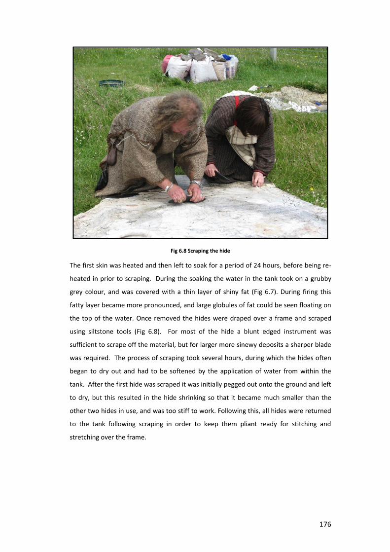
176
Fig 6.8 Scraping the hide
The first skin was heated and then left to soak for a period of 24 hours, before being re-
heated in prior to scraping. During the soaking the water in the tank took on a grubby
grey colour, and was covered with a thin layer of shiny fat (Fig 6.7). During firing this
fatty layer became more pronounced, and large globules of fat could be seen floating on
the top of the water. Once removed the hides were draped over a frame and scraped
using siltstone tools (Fig 6.8). For most of the hide a blunt edged instrument was
sufficient to scrape off the material, but for larger more sinewy deposits a sharper blade
was required. The process of scraping took several hours, during which the hides often
began to dry out and had to be softened by the application of water from within the
tank. After the first hide was scraped it was initially pegged out onto the ground and left
to dry, but this resulted in the hide shrinking so that it became much smaller than the
other two hides in use, and was too stiff to work. Following this, all hides were returned
to the tank following scraping in order to keep them pliant ready for stitching and
stretching over the frame.

177
Fig 6.9 Creating the frame
The frame of the boat was created by applying hot water from the tank to the wood in
order to bend it into shape, and was then lashed together using a length of leather thong
(Fig 6.9). Once all the hides were scraped, they were sewn together using leather
thonging, a bone needle and bone awl (Fig 6.10). Overall three hides were required,
which were trimmed along the long side to provide an even edge and then sewn using
whipstitch. They were then pulled over the wooden frame and overstitched at the top. A
small area at the bow also required an additional piece of hide removed from the top of
one of the animal’s legs in order to fill a small gap left due to the shrinking of the primary
hide. Once completed the three hides came together to form a small boat a little larger
than a traditional curricle (largely due to the lack of flexibility in the shop-bought wood
used to create the frame). The hides were then left to dry and shrink to the fame of the
boat, bringing the entire thing together and strengthening the structure (Fig 6.11).

178
Fig 6.10 Sewing the hides
The original intention was to then dry out the boat before caulking the seams using a
mixture of hair and fats. It was then planned to waterproof it using either fats, or more
readily available Stockholm tar (a pine resin) before taking the vessel (christened the
Ermintrude) out for sea trails in a nearby sheltered bay. Unfortunately in this aim we
were ultimately thwarted by the moist Shetland climate and it proved to be impossible
to dry the vessel out thoroughly in order to waterproof it. Ultimately it began to moulder
and smell so badly, that it had to be disposed of.
Fig 6.11 Creating the boat

179
While I have already stated that this was one of the most involved and complicated
processes undertaken at the site as part of this study, it is worth noting that it was also
one of the most varied in terms of the range of actions and sensory experiences. The
use of burnt mound sites is itself highly sensual, involving a range of associated sounds,
smells and sensations. During the working of the hides these sensations were
heightened further. Most striking was the lingering acrid smell of rancid fat that began to
permeate everything after the first day of working. The pre-salted hides had their own
pungent slightly rotten smell, however, once washed and supple this took on an entirely
different character, both rancid and soapy. Those who have visited a tallow candle
workshop such as the one at the Blists Hill in Shropshire will appreciate the type of smell
I am describing. Not only did the hides themselves smell, but shortly afterwards, those
working with them also began to take on the odour too. Working the hides required
constant bodily contact with them. From hauling their heavy, slippery forms out of the
tank following soaking, to the repeated process of resting arms or body over them as you
pushed all your weight into the stone tools to remove a stubborn piece of fat, or
crawling over them to scrape or sew them when stretched on the ground. The stone
tools themselves became slick with fat, and the substances pooled up behind the blade,
spilling over its edges and becoming ingrained in knuckles and behind nails. By the end
of the process, those of us involved in the scraping of the hides were slick with fatty oils
from head to toe, especially on a rainy day (of which there were several) when the
added moisture in the air seemed to help spread the fatty residues further. The ground
itself was often slippery, and littered with globules of removed fat. The local bird
population hovered expectantly throughout the whole process – the following morning
the area was always picked immaculately clean. As I sit here now typing this with my
field notebook beside me, the faint smell of rancid fat still wafts up from its pages. I had
to throw away my waterproof clothing following these activities, as the smell was too
strong to render them wearable in public ever again. It was noted, however, that all of
us involved in the process had beautifully soft skin by the end, a contrast to the usual
smoke dried, kippered sensation that usually followed working at the site. Not only did
the fat have its own particular odour, but it also created a unique sound, squelching
gently as the stone tools ran over it or bumped up against a large deposit, or creating a
satisfying gentle ripping sound when a large piece of sinuous material came away from
the body of the hide. The soft slap of wet hide hitting water, and the wet slithering

180
sound of the heavy saturated skins being dragged out of the tank again at the end all
formed an integral part of this experience.
The toolkit and raw materials required for working with the hides was also the most
extensive required for all the experiments. As well as the hides and the wood required
for constructing the boat itself, and the usual supply of stones and fuel, a supply of bone
for needles and awls was required, as well as several siltstone tools for scraping, and a
wooden frame for draping the skins over prior to scraping. As well as the hides for the
skin of the boat large quantities of leather thonging was required to sew the skins
together, while supplies of fat or tar would have been required had we have reached the
stage where the boat was ready to be waterproofed and used.
6.3.4 Washing, Dying and Fulling
The potential for burnt mound sites to have been used in textile production was first
discussed in detail by Paul Jeffery (1991). Jeffrey cites the discovery of a clay bi-conical
spindle whorl from Durrington Walls, and the existence of well-preserved woollen cloth
in Danish mound burials (cf Barber 1993; Broholm & Hald 1940) as evidence for the
existence of woven woollen textile leading back to the Neolithic (Jeffrey 1991:103) and
suggests that prior to this felting would have also been common practise (ibid 97). He
notes that there are reports of hot stones being utilised in waulking in Connemara in
Ireland and on the Island of Rhum in the Inner Hebrides (ibid 102). Likewise he suggests
that burnt mounds may have also been utilised in the process of preparing dyestuffs, and
in creating the liquor for the dying process itself.
Fulling is essentially the act of cleaning and thickening cloth, and Jeffrey suggests that
this may have been carried out while the wool was still on the fleece, or later when the
woollen cloth had been produced (1991: 97). For the purposes of this experiment it was
decided to follow the entire process from start to finish, beginning with washing the
fleece to remove the lanolin, before dying and then eventually fulling a finished cloth if
such could be produced. Fleeces were obtained locally directly off the back of the sheep,
with vegetable and faecal matter still embedded within the fibres. The initial challenge
was to clean the fleece to remove both the lanolin and any other undesirable extras
from the wool and prepare it for dying. The first experiment in fleece working was
carried out in August 2010. The fleece used during the first firing was not pre-soaked in
any detergent, but rather was simply immersed in a tank full of hot water to determine
how the fleece would react to the temperature of the tank, and to see what level of

181
cleaning could be achieved using water alone. The result was a much whiter fleece,
which though cleaner in appearance still retained too much of the lanolin to allow it to
be dyed. Much of the additional vegetable matter had been removed however, and the
faecal matter had softened and washed out during the process, meaning that the fleece
itself would have been suitable for spinning or further working if required. It was noticed
that some areas of the fleece had begun to felt. Felting is normally achieved by applying
heat and agitation to the fleece, normally through the addition of hot water and vigorous
rubbing, until the fibres bind. By using hot water and occasionally stirring the fleece in
our attempts to clean it, it would appear that we had inadvertently replicated these
conditions. As a result of this it was decided that for the purposes of future experiments
the fleece ought to be pre-treated with a form of detergent to ensure the best chance of
any dyestuffs being absorbed into the fibres. It was also noted during this process that
the water levels in the tank dropped noticeably when items were left to soak for a period
of time (24 hours as was the case above). This observation led to the use of a temporary
tank being used for early brewing processes, as described above, while the tank was re-
sealed in preparation for later work.
Fig 6.12 Dyestuff in the tank
A second run of dying experiments were carried out in 2011 (Fig 6.12). In this instance
the fleece was pre-soaked in a solution of stale urine and water for several days prior to
it being heated and washed. The soaking was undertaken in a separate container again,

182
and was stored at the author’s house so as to allow for easier addition of detergent
during the preparation period. The use of detergent resulted in a much cleaner fleece,
and simultaneously a much smellier process. Once the fleece was washed a quantity of
cut nettles was added to the tank, and the water re-heated to produce a liquor for dying.
Nettles give a subtle green colour when used as a dyestuff, and grow abundantly in most
places, including Shetland, which made them a sustainable and easily obtainable source.
While during the washing process the temperature was kept low so as not to shock or
burn the fleece too substantially, during dying it was possible to raise the temperature
higher, to ensure that the plant matter broke down and released sufficient dyestuffs to
create a strong enough liquor. The addition of hot stones also served to bruise the plant
material, acting in a similar manner to a pestle and mortar, and releasing more colour
into the water. After a while the water took on a subtle green colour, and was littered
with small pieces of floating plants. The fleece was then lowered into this, and left to
soak for 24 hours.
Unfortunately, the following day it was discovered that the water levels in the tank had
dropped so significantly that the fleece itself was found sat on a layer of stones and
nettles, clear above the water level of the tank. It appeared that at least 50% of the
water in the tank had drained naturally after the firing was completed. This was probably
due to the clay luting in the tank having been washed away during the preceding firings.
It was also noted that the work was carried out during a period of reasonably dry
weather, which resulted in the local water table being lower than was normal. As has
already been described, the original tank was built into a natural bed of clay, which
would have significantly improved the water retaining abilities of the tank. No such
bedding was applied to the replica however, so the tank sits directly above excavated
soils and bedrock and is therefore much more susceptible to self-draining. Once the
fleece was removed from the tank it was necessary to wash it again to remove the small
fragments of broken stone and plant material from the fibres of the wool. Rather than
doing this in the tank using hot water, the fleece was taken to a running stream and
immersed in the water, so that the fragments trapped could be carried off downstream
by the current. While this succeeded in cleaning off any dirt that had accumulated in the
tank, it also removed all traces of dye from the edges of the material, meaning that the
colour of the fleece, although still cleaner in appearance, was not significantly changed
by the dyeing process.

183
While the experiments to both wash and dye using the tank were unsuccessful due to
the methods employed to create the replica tank and the type of location in which it was
constructed, it does not follow that the processes employed cannot produce the desired
results. The use of a burnt mound tank to wash, dye and full cloth has already been
described by Anne-Marie Denvir, who carried out experiments as part of her
undergraduate degree at Belfast (Denvir 1999) and was successful in dying her fleece
using Ivy Berries. While we were unable to dye our fleece using the tank itself, we were
able successfully use hot stones to create a nettle dye liquor in smaller containers and
dye three skeins wool spun during the earlier experiments by one of the volunteers on
the project. The same methodology was applied, using hot stones to warm the water
and create the liquor, before soaking the spun wool in the mixture for 24 hours,
replicating the processes that were carried out at the tank on a smaller scape. The result
was that the wool took on a subtle, but distinctive sage green colour, as can be see in the
image above (Fig 6.13)
Fig 6.13 Cleaned fleece and dyed skeins of wool.
As with all the other processes described so far, the act of washing and dyeing fleece
produced its own unique set of sensory engagements. The fleece itself had a distinct
aroma prior to washing, which when combined with the smell of stale urine made for a
uniquely pungent experience. Likewise, the quantity of nettles cut to produce the
dyestuff also added to the olfactory experience on site, and produced a smell not

184
dissimilar to the urine, so that it became difficult to tell which of the combined materials
was contributing most to the aroma. The fleece itself was soft, light and greasy prior to
going into the tank, then wet, heavy and slippery upon extraction. In some places it held
together as a solid fabric, while at other times it pulled apart easily in the hands, making
the process of removing it from the tank particularly difficult. Plant material became
entangled with the fibres of the fleece, while small fragments of stone and gritty tank
lining covered it in a grey clayey substance. Away from the tank the process of nettle
pulling involved a high risk of stings and the accompanying itchiness, while washing the
fleece after soaking involved standing with hands and feet submerged in chilly fast
flowing water.
6.3.5 Cooking
While most of the experiments conducted at the replica met with some degree of
success, the only notable exception was in relation to the processes involving cooking. A
great deal of attention has been given to the role of cooking at burnt mounds, owing to
the popularity and longevity of the hypothesis. In particular, experimental work carried
out by O’Kelly (1954) demonstrated that it was possible to broil meat within a space of
roughly three hours by the continual application of hot stones to the tank. Cooking
experiments were among the earliest attempted at the replica site in Cruester. Prior to
the completion of the experiments which form part of this study the author was present
at the official opening of the replica site, as part of Archaeology Scotland’s ‘Adopt a
Monument’ scheme. As part of this event, living history practitioners ran a firing and
attempted to cook a small joint of meat within the tank. Although they were successful
in heating the water, on this occasion the cooking process was unsuccessful, and upon
removing it from the tank the joint of meat remained largely raw. Unfortunately it had
taken on a slimy, saturated and entirely unappetising appearance. As such, when
beginning these experiments it was already clear that cooking may prove to be more of a
challenge than the literature on the subject suggested.
Cooking with hot stones is well documented (cf O’Drisceoil 1988; Bullows 1927;, Burt
1754; Carson 2002; Layard 1922;, Heubert et al 2010), and ‘pot boiler’ stones are not
uncommon in prehistoric contexts. However, while the production of sufficient stones to
keep a small pot or skin container hot enough to cook is a simple enough task, when
attempting this in the replica of Cruester, the main obstacle was the production of
enough hot stones to keep the tank consistently hot for long periods of time. As
described above, many of the other applications explored in this study required

185
temperature of the tank to be raised for a short time only, or, in the case of brewing,
required warm, but not boiling temperatures to achieve the desired affects. In order to
cook, it was determined that large amounts of stone would be required both to achieve
the desired temperature initially, and then maintain it until the process was complete.
While carrying out other processes, it was discovered that one of the principle obstacles
to maintaining a sustained burn at the site was in fact the shape of the hearth cell itself.
As has already been discussed, the most successful method of fire construction
employed on site was that of a stacked pyre; in which alternate layers of fuel and stones
were place atop each other until sufficient stones had been collected to raise the
temperature in the hearth. Three layers of stones, each comprising an area of roughly
one meter square each proved to be about the quantity required to raise the
temperature in the tank to around 80℃ and sustain this for up to an hour. The stones
themselves also required approximately an hour to reach temperature. Thus, while it
was possible to raise the water to a temperature sufficient for the initial stages of
cooking, the problems came when trying to maintain this.
Once a fire was lit in the hearth cell, the chambered architecture of the cell meant it took
on a fierce character, something akin to a furnace. The area around the hearth cell
became unbearably hot and difficult to work in. During this initial period of burning it
was almost impossible to work with the stones roasting within without exposing
yourself to the dangers of burning, even with the modern safety equipment and tools
employed during these processes. Once the fire had burnt down a little it then became
possible to access the stones, and to remove them from the fire and add them to the
tank. Following this process, if additional stones were required the fire was re-built and
the process repeated. This allowed a regular supply of hot stones at intervals of
approximately 30 minutes to 1 hour, depending on the size of the fire constructed. While
this proved to be adequate for working with fleece, hides and to a lesser extent,
brewing, it was inadequate for cooking joints of meat. As was described above (6.3.1)
O’Kelly’s experiments at cooking in Ballyvourney utilised a wide hearth in which a could
be lit at one end and allowed to burn through to the other. This sort of arrangement
would certainly provide a more suitable method for roasting the stones for cooking than
that provided by the enclosed hearth cell at Cruester. However, this is not to say that it is
not possible to cook at a site such as Cruester. Rather, the level of skill in fire
management and maintenance required to do so is such as was never obtained by
members of the team during the process of these experiments. It may have been

186
possible to cook by maintaining lower temperatures over longer periods of time,
requiring less regular additions of stones; however it was not possible to achieve this
within the timescale of this study.
6.3.6 Winter Firing
The finial firing undertaken as part of this study was designed to explore challenges of
working at a burnt mound site in different weather conditions. Although the earlier
firings had been carried out in a variety of weather conditions, from brilliant sunshine,
blustery winds, driving rain and low cloud and fog, they had all been carried out during
the reasonably temperate summer season. This firing explored how the lower
temperatures experienced in winter might affect the way the site works, and how this
might affect the overall experience of working the site.
Shetland is famous for experiencing four seasons in one day. The weather is remarkably
changeable, and a day which starts bright and calm can quickly descend into howling
gales, driving rain or impenetrable fog. During each firing a note was made of the
specific weather conditions to determine whether or not these had a marked affect on
the results of the firing. The temperatures ranged from 21℃ to 13℃ during summer
firings. It was noted that during the warmer days there was a more marked difference
between the air temperature and that of the water in the tank, which normally
measured around 12-13℃. This was most likely due to the method of filling the tanks via
the local tap water supply, as on the occasions where tank water was re-used over
successive days (for example during hide working processes), the water was at a similar
temperature to that of the surrounding air.
The winter firings took place in November 2011. On the day of the firing the weather
was calm, and not particularly wintery, with a slight drizzle. The previous days had been
significantly colder however, and the surrounding ground was hard and cold. On taking
the cover off the tank after several months of disuse, the water level was found to be
quite high, and there was a significant level of debris in floating in the water, some of
which appeared to be the decomposed remains of nettles left over from the last dyeing
experiment.
The pre-firing temperature of the tank was measured at 6℃, while the ambient air
temperature measuring only a fraction more at 6.2℃. During summer firings the tank
witnessed an average temperature rise of at least 40℃, with some firings achieving
temperatures of up to 60-70℃ higher than the pre-firing temperature. During the

187
winter firing however, the highest temperature achieved was 26℃, rising to 40℃ in areas
immediately surrounding a hot stone. While this may in part be due to the colder
temperatures experienced during the firing. Lower ground temperatures may have
resulted in increased cooling from the sides of the tank as well as the surface. However it
is suspected that the primary contributing factor in the low temperatures achieved was
the poor quality of the fire used to roast the stones. Considerable difficulty was had in
lighting the fire, which burned more slowly and with less vigour than had previously
been experienced. On removing the stones from the fire it was noticed that several
large pieces of wood remained unburnt, indicating that even after a prolonged period in
the hearth, much of the fuel had not fully kindled. This supposition is supported by
experience from an additional firing carried out following the work for this thesis. During
this experiment the wood used for the fire was found to have been pre-treated with a
preservative which prevented it from properly kindling. Once again large amounts of
unburnt wood remained in the hearth following the firing, and the temperature of the
tank was only raise by 20 degrees. These observations suggest that it is not the ambient
temperature which determines whether a firing will be successful, but rather the ability
to light and maintain a fire within the hearth that will roast the stones to the required
degree. During winter months the ability to source and store enough dry fuel would be
crucial for the continued use of the mound. The significantly lower temperatures
achieved suggest that seasonality makes a substantial difference to both the experience
and outcomes of working a burnt mound.
Aside from the difficulties in maintaining the hearth and replicating the results
experienced during summer firings, the most notable difference in the winter firing was
the increase in steam generated during the process. Despite the lower temperatures
achieved within the tank, the cooler air meant that hotter stones hitting the surface of
the tank let off a more visible cloud of steam and the process of heating seemed more
tangible. In addition, it was noted that the hearth cell itself steamed during firings. It had
already been observed during a number of earlier firings that once the hearth was lit
water trapped within the drystone walls began to seep on the outside of the cell walls,
and the back of the hearth cell often appeared damp, and was very warm to the touch as
a result of this. During winter firings however, this water turned to steam, so that in
addition to the clouds of smoke billowing from the front of the cell, small puffs of steam
and hissing droplets of water could be witnessed seeping from the back of the structure.

188
6.4 Danger
While I have already discussed the various small successes and failures experienced by
the team in carrying out the processes described above, I would like now to focus on
wider concepts of success, failure, and the dangers inherent in burnt mound
technologies. Douglas observes that places, people and objects in transition are often
perceived as dangerous (1966). It has already been noted that burnt mounds are a
product of and medium for transformation and as such represent locations of danger
and uncertainty. However, while a degree of symbolic risk of failure is always present
during any technological or construction process (see Richards 2013), at times during the
firings, the very real and physical dangers represented by these technologies were made
apparent.
Of course any activity which involves fire incorporates a certain amount of risk. One of
the greatest difficulties involved in working with the burnt mound site was the immense
heat emanating from the hearth cell, which at times prevented members of the team
from getting close enough to work in the area. Doubtless many of the risks involved with
the experimental firings conducted at Bressay were the direct result of inexperience on
the part of practitioners, and would be reduced as skills and experience were gained,
however there were a number of occasions where no level of experience or preparation
would have prevented the occurrence of a sequence of unplanned events.
Some of the most common dangers encountered were related to burning. I have already
described how stones propelled down the passageway towards the tank would often
veer unexpectedly at user’s feet. I distinctly recall one rock which bore the perfect
imprint of the sole of one of the group member’s boots after accidentally stepped back
onto it during a firing. Had the individual not been wearing modern safety boots,
designed for use in the construction industry, then the result may have been burnt and
blistered skin, rather than melted rubber. Nor was this event a one off occurrence, and
it soon became habit to dodge the approaching stones while tending the tank, or to
shelter behind one of the small orthostats until the next batch of stones had arrived at
the rim and it was safe to manoeuvre them into place. On other occasions the danger
came in the form of scalding, dipping a hand into the tank to test the waters, only to find
that the temperature was much higher than was expected. This became of particular
concern when spent stones needed to be removed from the tank and replaced with
fresh warm ones. If the wrong stone was chosen and discarded at the side of the tank

189
then users ran the risk of encountering hot stones in places where they would only
normally expect to find cool ones.
It was not just hot stones that posed a risk. Stones in the hearth cell were liable to slip
and roll during the construction of the fire. My own finger was bruised and slightly
crushed when placing a stone in the hearth cell prior to lighting. The weight of the new
stone caused materials in the cell to shift slightly, and other stones rolled rapidly to the
place where my hand was still arranging the newest addition. At other times volunteers
dropped stones onto their own feet. Members of the team each had their own little tales
of burnt mound injury or near miss, and many times on site the air turned blue as the
result of some form of mishap. On these occasions, and others, the individuals involved
were protected by the modern health and safety precautions employed as part of the
project. Steel toe capped boots, protective goggles and heat proof welder’s gauntlets
were made available to any who wished for them, in order to reduce the risks to those
who gave their time. However, even these were not able to stop some of the most
dramatic incidents.
The most defining characteristic of burnt mounds is the shattered stone which makes up
the mounds themselves. These stones, subjected to thermal shock from repeated
heating and rapid cooling, broke into pieces and then were discarded (see chapter 7).
During the experiments we found that this process of shattering occurred most
frequently in the tank itself. A stone, when dropped into the water would let out a
particularly loud groan, and would disintegrate on removal, or become broken up when
other materials were added to the tank. Occasionally stones which had already been
subject to repeated firings would crumble as they were rolled down the passageway to
the tank, and would arrive in several jagged peaces, leaving splintered fragments of hot
stone in its wake. However, very occasionally the process of heating would cause small
pockets of air within the stones to expand, and on these occasions the stones exploded,
with often dramatic results.
The first time this was experienced was during one of the preliminary firings exploring
methods of fire construction and stone transportation. Members of the team were
standing at the far end of the tank, away from the hearth cell, discussing methods for
removing the stones from the hearth, when they were disturbed by a loud bang,
followed by a splash from the tank. Closer inspection revealed that this had been caused
by an exploding stone, which had sent fragments flying from the hearth cell, one of
which landed directly in the tank. This happened again on a number of occasions, and

190
soon members of the team learned not to stand directly in front of the hearth during a
firing, when possible, and were often sent scattering to a safe distance when the fire
popped or banged.
Fig 6.14 Fire damage to the side cell
On a separate occasion one of these exploding stones disturbed the structure of the fire
itself, causing the entire thing to shift dramatically, and dislodge a number of hot stones.
One of these stones rolled down the passageway, neatly illustrating the suitability of this
space for the transportation of stones. It came to a rest at the entrance of the
reconstructed side cell, just before the orthostats that mark the beginning of the tank
area. At the time the cell was being used as a store for the fermenting vats of beer from
the hot rock mash, two hand turned wooden bowls, and a pile of un-threshed grain
which one of the members of the living history team had been storing for a
demonstration on grain processing later that week. In order to keep its contents dry the
cell had been covered by an old tarpaulin, which acted as a curtain over entrance. On
hitting this tarpaulin heat from the ejected stone set it alight, and thus setting fire to the
whole structure. At this point members of the team were all within the heritage centre
building. We returned to the site to see that in a matter of minutes the tarpaulin had

191
been completely burnt away, taking with it most of the grain and one of the bowls, and
badly singing the second. Timber supporting the turf roof on the cell was also badly
scorched, as were the turves themselves (Fig 6.14). Thankfully, due to whatever product
had been used to waterproof the old tarpaulin, the fire caught and burned so rapidly,
that only the things in immediate contact with it had time to kindle, and the wider
structure and surrounding area was left unharmed. By the time most of us had realised
what was going on, it had already burnt itself out. Following this incident as a precaution
a mesh panel was hooked in front of the fire to absorb the impact of any materials flying
at it. The bent, dinted and in some places even perforated nature of this panel attests
that it has done just that, and that without it, a number of other stones may have
escaped and travelled in the direction of people working at the site.
The final incident happened, thankfully, towards the end of the programme of firings,
and did not threaten any of the events planned for this study. On this occasion a stone
exploded within the hearth cell with such force that it and another stone were sent
hurtling upwards, smashing through the stone lintel of the hearth cell itself. The lintel
was blown outwards, and the stones themselves evidently continued upwards for a short
distance, before coming back down to land as they were found resting on top of the
hearth cell itself. Again, this happened with such rapidity that members of the team
were unaware of what was taking place. A loud bang from the hearth cell was heard,
following which the top of the cell was observed to be open. Once the stones had been
removed and the structure had cooled, we were able climb up onto it and see the
remains of the lintel and the responsible stones sat atop the cell (Fig 6.15 & 6.16).
While by this point members of the team had already come to have deep respect for the
power of the fire and the potential for disaster which it represented, it was this final
incident which really illustrated how powerful it was, and how catastrophic these events
had the potential to be. It has already been mentioned, but it is worth noting again here,
that the replica site itself represents only a small part of the entire original structure and
there would have been more cells and additional walling, much of which is likely to have
been roofed. While we had the opportunity to leap aside when the fire let off a bang,
with these structures in place it would not have been possible. We have

192
Fig 6.15 Broken lintel stone following stone explosion
Fig 6.16 Projectile stone found on top of hearth cell following explosion
no information about what the cells at these sites may have been used for, and so
cannot tell whether fires such as those experienced at the replica would have been a
possibility. However, it seems safe to say that a collapsed lintel stone within a confined

193
structure could be potentially disastrous. Almost certainly those who worked regularly at
burnt mound sites would have had their own scars and stories to tell. Possibly these
marks would have identified them as being someone who undertook a particular type of
task. It is also possible to imagine injuries far greater than minor cuts and burns
occurring - might this sort of event be the cause of the abandonment of a site, or the
motivation behind the remodelling or closing off of particular areas?
6.5 Creating a Community: Shared Knowledge and Experience
Throughout the above accounts I have repeatedly referred to ‘members of the team’ or
‘volunteers’ involved in the execution of the experimental firings at the replica site. In
this section I would like to turn the spotlight onto the these figures, and explore how the
activities undertaken on site facilitated the creation of a community bonded by common
experience, and fostered through the sharing of specific skills and knowledge.
While each of the experiments undertaken for this thesis were designed and led by the
author, the successful execution of them required a wider network of skilled craft
practitioners, living historians, and specialists. In addition to this, a number of
volunteers were also required to work the mound itself, assist in the creation of the fire,
the transportation of the stones and the management of the tank. The individuals who
made up the team of practitioners on Bressay came from a variety of backgrounds and
locations. Many had been involved in the original Bronze Age Bressay project, and had
followed the site from excavation through to reconstruction. As such, their knowledge of
the site and the methods of construction used in creating it were invaluable in
developing methods for working on site, and for understanding the many quirks of the
replica itself. During firings it soon became clear that members of the groups had
strengths in particular areas, and soon the team began to develop designated roles
within the wider scope of activities. Some were particularly skilled at setting the fire,
and were able to construct it in a manner that meant that it lit with ease, and that the
stones were evenly roasted prior to adding to the tank. It is worth noting that on the two
occasions where the fire proved to be particularly difficult to manage, and the stones
failed to roast, none of the members of the specialist fire team were available to work at
the site. On these occasions the fire proved to be difficult to manage, and although
much of this can be attributed to environmental conditions such as damp wood and high
winds, it is likely that a more skilled and experienced practitioner could have coaxed a
better fire from the hearth than I was able to achieve. Others were able to provide

194
essential local knowledge which allowed us to identify suitable sources of plant matter,
stones, fuel and other resources such as clay for lining the tank. Such knowledge was
invaluable for obtaining many of the raw materials required to carry out the firings.
As well as the regular members of the team a number of specialist craftpersons and
practitioners were brought in to assist with the work at the site. Living history
practitioners Tony Sherrat and Keith Prosser of Timezone have worked regularly in
Shetland as part of living history and educational outreach projects at a variety of sites.
They also travel the country providing practical workshops and outreach activities using
traditional and historical skills. Both Keith and Tony are skilled craftspeople, and are
practised with working with a range of raw materials. They had also previously worked
with the replica site and were involved with running firings exploring heating water,
cooking and bathing in 2008 when the site was first completed. They were able to bring a
wide range of skills and experience to the project, and were invaluable in constructing
many of the tools utilised in the production of the hide boat. Having previously worked
in Shetland they were already familiar with the local raw materials, and were able to
construct siltstone tools for use on the hides using recognised forms from excavated
sites, and were able to adapt these tools to the purposes of the experiments. Keith and
Tony were also instrumental in developing the pyre style fire construction technique
which proved to be so successful in the firings. They were able to build on their previous
experience of the site to determine what shape of fire would both work within the
hearth structure and allow for a sufficient number of stones to be roasted to heat the
tank. Without their previous experience of working with the site the process of
determining the best way to heat the stones and transport them to the water would
have been longer and more complicated. Their involvement allowed this project to build
on the experience and understanding already gained from working the site during
previous firings.
During brewing experiments the project benefited from the experience of Merryn and
Graham Dineley. Merryn has conducted extensive research into prehistoric grain and
grain processing and acted as consultant to Declan Moore and Billy Quinn before they
undertook the original brewing experiments in Ireland. Graham is a craft brewer, and
both he and Merryn have previous experience in carrying out hot rock mashing
processes. During their visit they were able to work with the team in running a mash in
the tank, and were able to point out many of the subtleties of water appearance, colour
change and smell that were missed during the original brewing experiments due to lack

195
of experience. We were also happy to accept the assistance of Sarah Foster-Jarden, a
spinner and dyer who became involved with the project after visiting the site during the
earlier hide working experiments. Sarah works with natural dying techniques, and was
able to offer advice regarding the quantities of material required to create a dyestuff
within the tank, and was able to suggest appropriate ways of cleaning the fleece prior to
dying. As well as those present during the firings, I was also able access a wider network
of people to discuss the processes involved in working the site, including individuals who
had previous experience running experiments at burnt mound sites, experienced
spinners, weavers, dyers and textile workers, brewers, crofters, hide workers, and other
traditional craftspeople. Each of these encounters and engagements contributed to the
work undertaken at the site.
On site the work was a collaborative process. The working of a burnt mound site such as
that at Cruester cannot be undertaken by one person alone. It was found that at least
two people were required to enable the transfer of stones from the hearth to the tank,
although often higher numbers were necessary. During this time each individual
assumed a specific role, combining with others to ensure the completion of the task.
The result was a close knit community of burnt mound practitioners, bonded by a shared
set of experiences and stories, each understanding and participating in the processes
undertaken, and often, as will be discussed below, identifiable through appearance,
smell and even on occasion injury. Within this community were a variety of roles and
levels of expertise. Some members participated in all of the activities, developing a ‘core’
set of skills which allowed them to work the site, while others passed in and out, adding
specific knowledge and skills to the task in hand. Each firing allowed those involved to
develop their skills further, gain knew knowledge or share previous experience with
other members of the team. The processes were characterised by a shared sense of
learning and achievement, and each day was marked by learning, both on site and
behind the scenes, either through the completion of a specific task, or through the social
sharing of stories, techniques and skills.
It follows, therefore, that the construction and use of burnt mounds in the Bronze Age
was a communal activity, involving the coming together of persons with specific
knowledges and skill sets in order to create the desired outcome. Richards (2004:74)
illustrated that the construction of a monument extended far beyond the monument
itself. Through the fashioning of tools, weaving of ropes and collection of food for
offerings preparation for the construction of the monument enmeshed people within a

196
web of relationships, and created a temporality relating to the everyday lifecycles of
people involved. Thus the monument is able to shape and direct social relationships
before it is even created. This is also applicable to burnt mound sites. As we have seen,
the creation and use of burnt mounds drawn upon a wide range of skills and materials.
The processes explored within this chapter have required the sourcing of a range of
materials from plant matter to animal hides. As such we can see how burnt mounds are
related to seasonal cycles and the daily lives of Bronze Age peoples. The production and
selection of these materials thus links burnt mound with wider social networks, and
enmeshes burnt mound practise within the everyday lives of those around them.
Activities within the mound also require the development of social relationships to
ensure the successful and safe performance of the tasks in hand. We have also explored
the role of fragmentation in the creation of Bronze Age identities. The deliberate
destruction of objects is seen to be linked to concepts of death and fertility. Thus
materials can be seen to undergo the same processes of death and regeneration as
persons. Acts of construction and making are therefore metaphors for creation, and can
be seen as symbolic of the development of relationships such as kinship. The
fragmentary processes at burnt mound sites may have provided metaphors for an
understanding of personal and social identity which is both fluid and relational. Finally
we have also considered how burnt mounds can be seen as both physically and
metaphorically dangerous. The possibility of injury and physical disfigurement as a result
of working with them would identify those who used them, and serve as a powerful
reminder the potent and transformative processes taking place within. Given the highly
symbolic nature of burnt mounds it is therefore possible that those working them were
imbued with special status, due to their role as mediators or facilitators in elemental and
transformative practices.
6.6 Sensory Engagements
The sensory experience of the various processes undertaken at the replica burnt mound
site have already been remarked upon in the descriptions above, however it is worth
taking time here to dwell upon this point little further. To work a burnt mound site is to
engage in a set of specific, and often overwhelming sensory experiences. These are
apparent regardless of the functional application undertaken. The heat and crackle of
the fire, the steam from the tank and the hissing and splashing as stones hit the water
are features of every burnt mound firing undertaken. On top of this shared sensory
vocabulary, the type of process being undertaken then adds other layers of texture,

197
taste, sound and, perhaps most notably, smell. There are no two ways of putting it,
burnt mounds smell. They are smokey, quite often they are sweat-inducing and on top of
this there is the aroma of dead cow, of burnt grain, of sweet sticky wort, of stale urine,
fermenting plants and sheep wool. Not only are the mounds smelly, but after spending
any considerable amount of time within one, you become smelly. You become coated in
a thin layer of soot, and grime, slicked with animal fat, gummed together with sticky
liquids.
In Chapter Three I touched briefly on the emphasis placed on the visual within
archaeological studies, particularly those with phenomenologically informed roots. .
The application of experimental (experiential) approaches is invaluable in highlighting
the multi-sensory nature of this experience, in that, to use an appropriate turn of phrase,
they open our eyes to the range of sensory engagements available as part of any given
process. While visually and materially burnt mounds may appear to conform to a
particular class of monument, and therefore be homogenous, when the form of
classification is altered to include a range of sensory engagements we can begin to see
that they represent a far more diverse context for a wide range of experiences. Each of
these sensory experiences forms an integral part of understanding what a burnt mound
is, and how it is understood by those working within it. Each of the processes involved
has its own unique sensescape, incorporating a range of sounds, smells, textures, and
tastes which are unique to the tasks being undertaken. These in turn are situated within
a wider sensory understanding of the world, and form part a cultural lexicon which
would allow the user to place the activities being carried out within its wider social
context
6.7 Networks of Shared Knowledge and Practise.
These experiments have begun to illustrate what a visceral and sensory experience
working a burnt mound would have been. And while were not always completely
successful in producing the intended output, they have been invaluable in illustrating the
range of skills and knowledge required to successfully work with these technologies. The
limited success we have had has drawn upon a large number of people with a wide range
of skills, brought together in one place and mediated through material interactions.

198
Fig 6.18 - Networks of materials, skills and experience utilised in burnt mounds
By focussing on the output of burnt mound sites, rather than exploring the processes
taking place within, past studies have overlooked this interlinked nature, and in doing so
have been able to represent the sites as bland and meaningless. Through the
experiments described above however, it has been possible to illustrate that the practise
of constructing and using burnt mound sites is complex, temporal and dependant on a
wide range of human-thing, thing-thing, human-human and thing-human relationships
(Fig 6.18), coming together in what Ingold describes as the flux and flow of materials
(2011). The properties of burnt mound sites are emergent through their use, and
dependant on the specific qualities and affordances of those materials coming through
them, and on the skills and knowledge of the individuals working with them. As such
they represents nodal points in wider networks of social and material relations. Spaces
where things and people come together, and are ultimately transformed, through
practise (for a fuller discussion of the role of transformation at burnt mound sites, see
chapters Three, Seven and Eight.). If we examine the some of the tools and processes
involved in the performance of the various proposed applications for burnt mound sites
we can begin to see how each of these activities relate to each other through shared
networks of practise, skills and through sensory engagement with materials. Moreover,
if we expand our view beyond the immediate vicinity of the burnt mound and begin to
examine how these interactions and relationships connect with a wider set of practises it
becomes possible to understand burnt mounds, not as an isolated phenomenon, but as a
part of a wider network of understanding and engagement within the Bronze Age world.

199
Chapter Seven: The Mound.
As archaeologists we are, of course, very familiar with the imagery of prehistoric
mounds. These mounds take various forms, for example large deposits of debris and
waste such as the Mesolithic shell middens, stone built structures such as cairns or
earthen tumuli such as Bronze Age barrows. They have been interpreted as territorial
markers and demonstrations of power and wealth (Renfrew 1973), as vessels for the
dead and places for veneration, mourning and remembrance (Barrett 1994; Last 1998),
as foci for the creation or reconstruction of kinship and group identity (Garwood 1991,
1999 Mizoguchi 1992, Last 1998), or, as has been explored more recently, as dynamic
transformative locales in which concepts of identity and cosmogony are played out (cf,
Bruck 2004; Downes 2005; Owoc 2005). However, perhaps unsurprisingly given the
minimal level of attention which has previously been directed at burnt mound sites,
there are no existing accounts which explore the nature of the burnt mound, or take
time to examine how they came to assume the format which is so familiar to us today.
Thus far this thesis has given detailed consideration to the potential for, and the nature
of, material transformations taking place within burnt mounds. Little attention has been
given to one of the most defining aspects of these sites; the mound itself. In this chapter
I would like to take a moment to examine the construction of a burnt mound, to explore
the processes involved in its becoming, and to explore how these processes resonate
with or differ from other similar contemporary practises. In particular, I explore the
similarities between the construction of burnt mounds and funerary barrows. It is argued
that similarities can be drawn between the highly structured processes of construction at
barrows, and the curation of burnt stone at burnt mound sites. Specifically, it is
suggested that both of these practises represent an integral part of the transformative
act, and that as such, the construction of mounds of burnt stone at burnt mounds
represents the intentional curation of powerful symbolic and transformative substances.
7.1 Mounds and Mounding in the Bronze Age
Mounds, barrows and cairns are among the most recognisable features of the European
Bronze Age. Construction of a mound has a profound effect on the landscape. Its
presence necessitates that the area is thought about in a new way (Barrett 1994:113).
The act of construction transforms a point in the landscape from space to a meaningful
place (Thomas 1996; Taun 1977, Cummings & Whittle 2004). Their utilisation in burial
traditions has been interpreted as an attempt to make a lasting monument within the

200
landscape (Barrett 1989; Bradley 2003). As such, they have been interpreted as the focus
of commemoration and mourning (Barrett 1994; Last 1998). In particular, studies of
barrow cemeteries have focussed on the notions of kinship an ancestral identity. These
approaches understand the growth of these cemeteries as manifestations of concepts of
descent and historicity (eg Garwood 1999; Last 1998). Detailed analyses of Bronze Age
barrows in Orkney and England has revealed that their construction often follows a strict
sequence of material deposition. Owoc (2005) describes how at Trelen 2 the builders of
the mound engaged with the local landscape and with the materials involved in its
construction to create a scheme through which the mound was rendered meaningful.
Members of the community engaged with the site through processes of construction,
and the deposition of materials in an ongoing process through which group identities
and the identity of the deceased were defined (see also Bruck 1994; Barrett 1994). The
materials used in the construction of the mound carefully reflect and invert the natural
stratigraphy, representing and aiding in the processes of transformation undertaken by
both the dead and the communities around them as the individual makes the journey
from living to dead. Owoc (2005) argues that these engagements with materials,
particularly those which can be seen to have taken place after a hiatus of activity at the
site create links with ancestors and help affirm group identity, while the reversal of the
stratigraphy within the mound echoes cosmological classificatory systems relating
concepts of up/down with living/dead. Similarly, Downes (2005) describes how
deposition in Orcadian barrows place a strong emphasis on the vertical axis, both
through the use of local topography (2005:231) and through the inverted deposition of
pyre and mound material in their construction (2005: 197. See also Owoc 2001). She
argues that the materiality of the barrow relates to broader strategies relating to
regeneration, rather than to concepts of personal identity as suggested by Bruck (2004).
The barrow acts to complete an event, controlling access to, mediating or accentuating a
transformative event or place (Downes 2005:213). I would argue that a similar approach
is required in order to understand the significance of the construction of burnt mounds.
In particular, studies detailing the regenerative properties of transformative events such
as cremation and barrow construction can offer us a useful insight into how we might
interpret the practise of creating mounds at burnt mound sites.
7.2 Mounds of Burnt Stone
The presence of a mound is clearly one of the defining characteristics of burnt mounds
and its construction is one of the fundamental aspects of burnt mound usage. Unlike

201
many of the mounds mentioned above (with the notable exception of shell middens),
burnt mounds are unusual. On initial investigation they appear to be a by-product of a
prolonged activity, rather than a conscious attempt to construct a mound, as might be
ascribed, for instance, to the construction of burial cairns or mounds. While it is true
that burnt mounds are composed predominantly of what can be considered as waste
material, examination (below) of the relationship between burnt mound structures and
their mounds makes it clear that they are anything but secondary.
Fig 7.1 Underlying processes in the development of a burnt mound.
The construction of a burnt mound is a generative process which develops throughout
the life of the site. While there are a number of possible applications for hot stone
technologies, the processes through which the mound comes to be remain substantially
unchanged for each (Fig 7.1). The primary component of a burnt mound is, of course,
burnt and broken stone. Repeated heating and cooling in the hearth causes the stones to
become gradually weaker, until eventually they begin to break apart. This can take place
within the hearth as a result of heating, meaning that some stones never get as far as the
tank on their final firing. At other times they may shatter on the journey to the tank,
broken apart by the impact of being rolled or jostled with other stones. The majority
however will disintegrate within the tank. Sometimes they will do so audibly, emitting a
high pitched scream as the air is forced from cracks and crevices in the stone. More often
however it takes place out of sight, beneath the grey murky waters of the tank and
among the other materials to be heated. These broken stones remain undiscovered until
the process of cleaning the tank begins in preparation for the next firing (Fig 7.2). Stones
that have remained intact are removed from the tank and stored prior to re-use. Those
which have not are then removed and placed into a pile. Over time, and after repeated
firings, this pile builds gradually into the mounds we recognise today.
As archaeological features burnt mounds are often covered in sparse vegetation, and
thus present as grassy mounds within the landscape. At the time of working however,

202
the mound would have been bare, and the reddened fragmented stone would have been
visible. These mounds would have been extremely distinctive, and the burnt
characteristic of the debris would no doubt have served as a reminder of the activities
Fig 7.2 Stones in the tank following a firing
Fig 7.3 Mounding of material around the tank at Boger’s Burn.
taking place within to anyone who saw them. As has already been touched upon in
Chapter Five, there is a considerable degree of variation in the size and shape of burnt
mounds suggesting a variety of mounding strategies could potentially have been

203
employed by those who created and used the sites. The most common is the classic
horse shoe or kidney shaped mound, with a distinctive central depression, but variations
including elongated, dual (where the central recess of the mound appears to divide the
structure in two, creating the appearance of two individual mounds rather than one
unit), circular and ovoid also exist. The pattern in which this material was distributed
therefore varies from site to site. At Tougs (Fig 4.5) the material seems to have been
mounded against walls of the structure to the north and kept separate from the cobbled
entrance to the east. Classic kidney shaped mounds appear to be the result of a
mounding strategy which sees material distributed evenly around the rear of the site,
eventually creating the characteristic recess where the tank itself is found, such as at
Boger’s Burn in Northmavine (Fig 7.3). Other interesting mound formations observed in
Shetland include the example at Foratwatt (Fig 5.29) where the stones appear to have
been arranged in a linear fashion leading away from the water course, and at Tunnigarth
(Fig 7.4) where a dual mound appears to have been accompanied by additional material
mounded up at the foot of a natural outcrop.
Fig 7.4 Possible instance of mounding against a rock outcrop at Tunnigarth.
7.2.1 Sourcing Stone
The selection of stones is a prerequisite to burnt mound usage. As stones break and
disintegrate during firings so more stones must always be ready to fill their place. In
Chapter Three I touched upon the elemental status of stones, and explored how
processes of burnt mound usage can be seen as a transformative process combining

204
earth, water and fire. A number of studies have explored the symbolic and material
properties of stone. Parker Pearson and Ramilisonina (1998) explored the symbolic links
between stone, wood, life and death (Parker Pearson 2004). The hardness and
permanence of stone is contrasted to the transience and malleability of wood. These
properties, it is argued, are symbolically linked to concepts of hardening through age. In
particular, the permanence of stone is seen as being symbolic of the ancestors, while
wood is taken to symbolise the living. Through the contrast of materials Parker Pearson
and Ramilisonina (1998) are able to draw out a framework for the Stonehenge landscape
which understands wooden monuments such as Durrington Walls and Woodhenge, as
being monuments for the living, and the stone monument at Stonehenge as a
monument for the ancestors. Movement between these monuments therefore reflects
the journey from life to death, into ancestorhood. Other approaches to stone have also
focussed on the enduring and embodying properties of stone, and their ability to create
permanent markers within the landscape (e.g Tilley 1994, 2004; Cummings & Whittle
2004). Richards’ (2013a) work on the stone circles of the north has demonstrated how
the lithology of stones plays a central role in their selection and deployment within
monuments. At the Ring of Brodgar in Orkney stones appear to have been selected from
throughout the islands. In this way the monument acts as a materialised representation
of community (Downes et al 2013;148). Similar concerns with local lithologies are also
demonstrated at Temple Wood, Kilmartin (Richards & Wright 2013:41-45) and at circles
in Lewis (Richards et al 2013, Richards 2013b). Attention has also been given to the
social and symbolic role of quarrying (Scarre 2009, Richards 2004, 2009, 2013a, Richards
et al 2011). Quarrying can be seen as a cosmogenic process through which stones are
‘born’, and the act of quarrying involves great risk, both symbolic and practical. Other
studies have also focussed on the significance of colour in stones (e.g Cooney 2004,
Darvill 2004; MacGregor 2004). In short the properties of stone can be seen to play a
key role in its selection, use and perception (Scarre 2004). Cummings (2012) has
illustrated that far from being a homogenous material it is likely that the perceptions of
stone were based upon their individual biographies and the context in which they were
deployed. Given these observations it is therefore pertinent that we give some
consideration to the sources of stone utilised within burnt mounds.
During the occasional use of replica mound to perform experimental firings it was
sufficient to gather stones once or twice in a season, as our limited activity at the site
failed to produce large quantities of debris. The frequency of stone gathering depends
205
level of activity required at the site, the longevity of the activities being carried out there,
and the durability of the stone utilised. The amount of time a stone will last before
shattering depends on its geology. Buckley (1990b) conducted comparative analysis of
two fulact fiadh located in different parts of Ireland with differing subsurface geology.
Muingbaun in Co. Galway was located in the Limestone Belt, while Castlebellingham in
Co. Louth was located in a greywacke area. In both cases it was found that there was a
preference for sedimentary rocks, although other rocks were also utilised (cf Dennehy
2008:11). Perhaps more interestingly however, he noted that there appeared to be a
preference for drift derived material, suggesting that stones were gathered from the
surface in and around the local area, rather than quarried from specific rock outcrops
(Buckley 1990b:172; Buckley et al, 1987). As part of this study, Buckley also conducted
experimental analysis on the longevity of different geologies under firing. These
experiments found that sedimentary rocks lasted approximately 5-10 firings before
fracturing and becoming unusable, while igneous rocks appeared to have much greater
longevity. In two examples, Gabbro and Vesiculated Basalt, there appeared to be no
upper limit with as many as 25 successive firings (Buckley 1990b:171). Buckley suggests
that this differentiation might go some way to explaining the variation in burnt mound
size and distribution observed throughout the British Isles. For example at Ballyremon,
Co. Wicklow a burnt mound comprised mostly of igneous rock was found. This site was
visible only as a slight spread of stones, which although fire cracked appeared barely
burnt. In contrast other sites in the area, which he describes as “a group of classic
horseshoe-shaped mounds” were found to be composed almost entirely of sandstone
(Buckley 1990b:171). While Buckley appears to have entirely overlooked the intriguing
occurrence of an entirely igneous mound in an area of otherwise sedimentary mounds,
and the questions which such a marked variation should undoubtedly supply, it does
suggest that burnt mounds comprised of igneous rocks may take on a different, more
ephemeral appearance than their sedimentary counterparts. It also suggests that,
contrary to our own concepts of modern efficiency, the longevity and resiliency of the
stones may not have been a key factor in the selection of materials for use in burnt
mounds.
In Shetland the subsurface geology is extremely complex, and while concentrations of
burnt mounds do indeed appear to be found in areas of sedimentary geology, they also
occur in areas of igneous and metamorphic rocks, suggesting that the underlying
geology, while significant, is not the deciding factor in site location (Fig 7.5). Campbell-
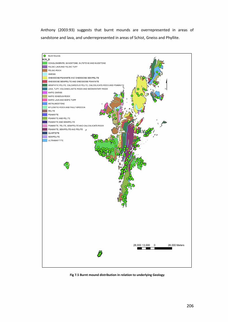
206
Anthony (2003:93) suggests that burnt mounds are overrepresented in areas of
sandstone and lava, and underrepresented in areas of Schist, Gneiss and Phyllite.
Fig 7.5 Burnt mound distribution in relation to underlying Geology
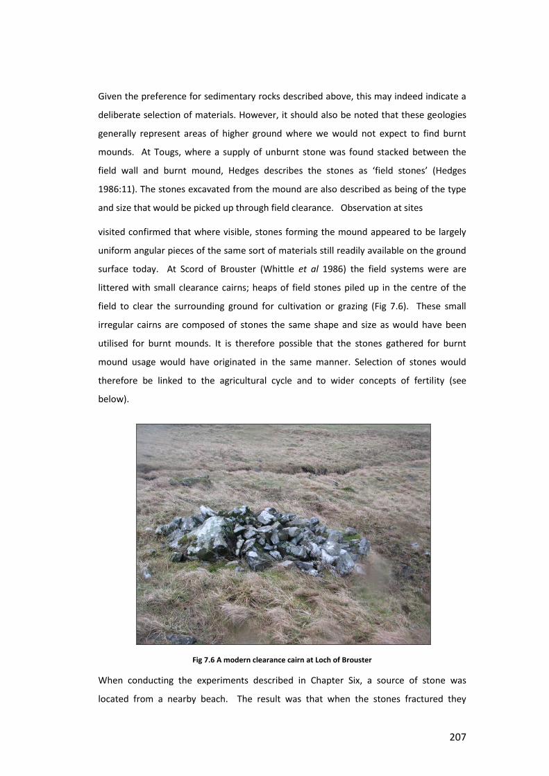
207
Given the preference for sedimentary rocks described above, this may indeed indicate a
deliberate selection of materials. However, it should also be noted that these geologies
generally represent areas of higher ground where we would not expect to find burnt
mounds. At Tougs, where a supply of unburnt stone was found stacked between the
field wall and burnt mound, Hedges describes the stones as ‘field stones’ (Hedges
1986:11). The stones excavated from the mound are also described as being of the type
and size that would be picked up through field clearance. Observation at sites
visited confirmed that where visible, stones forming the mound appeared to be largely
uniform angular pieces of the same sort of materials still readily available on the ground
surface today. At Scord of Brouster (Whittle et al 1986) the field systems were are
littered with small clearance cairns; heaps of field stones piled up in the centre of the
field to clear the surrounding ground for cultivation or grazing (Fig 7.6). These small
irregular cairns are composed of stones the same shape and size as would have been
utilised for burnt mounds. It is therefore possible that the stones gathered for burnt
mound usage would have originated in the same manner. Selection of stones would
therefore be linked to the agricultural cycle and to wider concepts of fertility (see
below).
Fig 7.6 A modern clearance cairn at Loch of Brouster
When conducting the experiments described in Chapter Six, a source of stone was
located from a nearby beach. The result was that when the stones fractured they

208
produced a mix of angular and rounded fragments. The debris closely matched that
observed at Tangwick where the rounded nature of much of the remaining mound
material suggested the utilisation of beach stone. This observation is particularly
significant, as I discovered when I began to work on the experimental material, as beach
stone has a reputation for exploding more violently than field stone. The story of
exploding beach stone was reiterated independently by a number of sources when
discussing potential experimental firings, and is plausible if it is considered that beach
stone has a greater chance of containing pockets of water which may expand on heating,
especially when using porous rocks. The number of violent explosions described in
Chapter Six may indeed stand as confirmation of this fact, although no field stones were
used in the experiments to provide a point of comparison. If this is case however, it is
notable that despite the greater chance of danger and failure through stone explosion,
this presence of this risk did not deter prehistoric burnt mound users from utilising this
stone source. This suggests an ingrained notion of risk and danger already associated
with burnt mound usage, regardless of the stone source.
Selection of stone for burnt mounds therefore appears to be focussed on two aspects.
Firstly, there is a preference for sedimentary geologies, specifically sandstones. However,
it does not appear that the underlying geology was a prime factor in the location of sites.
Nor does it appear that specific sources were utilised for stone selection, although it is
not possible to tell how wide an area stones were sourced from. Secondly, there is a
preference for readily available field stone of the type which is seen in field clearance
cairns. This preference may seen to be unusual when compared to the careful selection
and quarrying which is utilised for other monuments, as described above. However, I
would argue that the significance of this material may lie in its already fragmented state.
As will be explored below, fragmented stone from burnt mounds was regarded as a
potent and powerful material, and was subject to specific processes of deposition and
mounding, which culminated in the wrapping of the site in a mound of burnt stone. The
small and fragmented nature of field stones may therefore have been viewed as
previously fragmented, and therefore as suitable for utilisation in burnt mounds. This is
particularly significant if we consider that supplies of these stones may have regularly
been turned up through ploughing, and thus would conceivably have been seen as
having been ‘born’ from the earth, and thus integral to cycles of fertility. Moreover, the
utilisation of stone from watery sources, such as at Tangwick, would therefore appear to
echo the transformation of stone through water which occurs at burnt mound sites.

209
7.2.2 Use Form and End Form
Having explored the general processes through which burnt mounds come into being
above, I would like now to make a more detailed examination of the development of a
burnt mound, and explore the changes which it undergoes throughout its life. In
particular, I would like to explore the difference between the use form and end form of
mounds and how this might affect the experience of these sites in the past.
Fig 7.7 Dates obtained from Cruester Burnt Mound (Campbell Anthony 2003:310)
The processes involved in the construction of burnt mounds are not always clear from
excavation reports. Mounds are often excavated in spit rather than stratigraphically, as
the time required to identify and record separate layers in the complex mound matrix is
not considered to be proportionate to the amount of information the exercise would

210
yield (cf Hedges, 1986:7, Dennerhy 2008:12). In these instances the mound is treated as
a unit, and is described separately from any features associated with it; thus, the
relationship between the two, and the depositional processes which result in their final
form is not always discernible. However, work undertaken by Campbell-Anthony (2003)
at Cruester has gone some way into illuminating this elusive relationship.
Thermoluminesence dates taken from locations throughout the mound allow us to build
up a picture of how the mound grew around the site (Fig 7.7). Dates obtained indicated
that the structures were in use for a period of approximately 400 years between 1400
and 1000 BC, with pre-structure activity dating back as far as 3000BC (Campbell-Anthony
2003:314, see also Chapter One). The earliest dates were obtained from the area behind
the hearth cell and north east of the cistern, suggesting that these areas might represent
the focus for early phases of deposition. Generally however dates appear to be evenly
spread throughout the mound, indicating a uniform pattern of distribution over all areas.
Evidence from Cruester (Moore & Wilson 2008:13), Tangwick (Moore & Wilson 1999)
and Beaquoy (Hedges 1975) indicates that burnt mound activity began on site prior to
the construction of the internal structures. Structures at Cruester were found to be built
on top of, and in some cases revetted into a pre-existing layer of ashy material
containing burnt stone (Moore & Wilson 2001:6, 2008:13). Similiarly, at Tangwick two
phases of mound were identified - the primary mound, which pre-dated the construction
of the structures, and the secondary mound, which was deposited around the structures
following their completion (Moore & Wilson 1999:212). In both cases it was not deemed
to be possible to determine a difference between the burnt stone which pre-dated the
structures, and that which followed it. The presence of mound material prior to the
beginning of construction confirms the generative nature of these sites. The status of
burnt mounds as transformative locales depends on the successful performance of
firings on site. As will be explored below, existing burnt mound material attracts
subsequent phases of mound activity and, I argue, is linked to concepts of
fragmentation, transformation and cycles of fertility and rebirth. As such, it is perhaps
not surprising that a number of those sites which possess complex internal structures
appear to be well established prior to their addition.
As was discussed in Chapter Four, the structures at Cruester, Tangwick, Stoura Cottage
(Ness of Sound) and Tougs are constructed using the same methods employed in house
construction in Shetland. Structures were subject to several phases of alteration and
repair following their initial construction. At Cruester, the removal of flagstones from

211
passage B revealed additional surfaces and an a series of drains running beneath the
floor (Moore & Wilson 2008:11-12). Removal of Cells C & B also revealed a second floor
relating to an earlier phase of the structure. This surface appears to represent the floor
of a single cell which was later sealed by a layer of burnt stone when the pier of walling
separating the two cells was constructed (ibid 14). Additionally, Cell A, the largest of the
cells, was later closed off by the erection of blocking stones in the entrance(Moore &
Wilson 2001:11). This process was also echoed at Tangwick, where several cells are
described as having been closed during the life of the mound, and then subsequently
buried in burnt stone (Moore & Wilson 1999:218). At Cruester the hearth cell underwent
no less than ten phases of reconstruction. Over time the flagstone lining in the cell
became damaged through the repeated application of heat, and a new layer of clay and
flagstone flooring was added to repair it. Dates taken from these layers indicate that this
occurred approximately every 40 years (Campbell-Anthony 2003:309) suggesting that
the replacement of hearth stones would have been experienced only once by each
generation, and may have coincided with a transitional period within the mound such as
the death of a significant individual. Other mounds in Shetland also demonstrate
evidence for phases of reconstruction and maintenance during their life. At Trowlie Loch
a secondary tank was inserted into existing mound structures, a pattern repeated at
several of the sites visited as part of this thesis demonstrating indications of secondary
mound accumulation, or isolated periods of tipping following the construction of the
main mound (e.g Loch of Niddister & Lower Loch of Setter).
Following the construction of the internal structures mound material continued to build
up around the exterior. As was explored above, stones may be reused several times
before being added to the mound and this alludes to the mound material around the site
building up slowly over years of use. At Cruester the mound grew to approximately 2
meters in height and around 20m in diameter over the lifecycle of the mound (Moore &
Wilson 2008:2). The result of this would be that the experience of the mound would
gradually change over time as cumulative deposits built up around the structures. Given
the longevity of this mound the difference in mound size over one generation would
have been minimal in relation to the final whole. Moreover, this gradual accumulation
of mound over an extended period of time indicates that the final form of the mount
would have varied considerably from the form it took during use. Indeed, it may be that
for some part of the life of the mound, the mound itself appeared as a spread rather
than a mound at all, giving the site a very different character to the one with which we,

212
as archaeologists, are familiar with. At Liddle in Orkney we can see that the growth of
mound material prompted a response from the users. A retaining wall was constructed
along the inside of the mound to prevent mound material from encroaching onto the
walls of the structure, creating a circumambient walk by which access to the site was
directed between the mound and structure (Hedges 1975:34). Later, a paved walkway
was inserted over the mound, indicating that by this point the mound had already
reached a considerable height, and that users were now required to cross over the
mound and crest its height betfore being able to gain access to the structures within
(ibid) Similar structures were also found at Beauqouy, indicating that mound
management was an ongoing concern at Orcadian burnt mounds. Likewise, we have
already seen how the structures within the mound were subject to repeated alteration
and manipulation during its life. Areas were closed off, and even covered in mound
material following their abandonment. Given these processes of remodelling and
closure, what might we say about the development of the final form of the mound, and
the processes through which this came about?
As with the processes which formed them, the events which make up the end of the life
of a burnt mound can be equally difficult to determine. In Chapter Four I examined the
use of ard points as closing deposits at houses and funerary sites in the Northern Isles. It
was argued that these materials linked closely to concepts of fertility and regeneration,
and that their deployment marked periods of transformation and change (Bruck 2006a).
Bruck (1999, 2006a) has demonstrated that like persons, settlements and structures can
be seen as having a lifecycle, and that this lifecycle is linked to that of its inhabitants.
‘Odd’ deposits, such as the blade and awl found in roundhouse 3 a Black Patch are
interpreted as closing deposits, representing the death of the building. These deposits
mark a formal process by which the relationship between the deceased and the building
are ended or transformed (Bruck 1999:334, cf Barrett & Needham 1988:137). Similarly
deposition of ard points between floor layers at Jarlshof suggests that the tools were
deposited within the house to ensure the continuing success of cultivation following
periods of reconstruction and rearrangement within the household. It may be that these
events took place at a time of transformation and shift within the household, such as the
death of an individual, or the passing of household responsibility during other rites of
passage such as marriage or coming of age. Ard points and mattocks are significantly
over represented at settlement sites, the more so due to the fact that these tools are
unlikely to have been made or used within the house itself (e.g Calder 1955, 1956;

213
Downes & Lamb 2000). However they are less numerous at burnt mound sites. Where
ard and mattock points are found they are often recorded from relatively high up in the
context layers (Moore & Wilson 1999: 225), suggesting that they were deposited
intentionally, perhaps as either closing deposits, or to mark a point of transition or
alteration within the structure of the site itself. Given this observation, the question then
is whether mound material was actively used in the decommissioning of burnt mound
structures.
Fig 7.8 Wooden container from Clowanstown. (http://www.archaeologicalconsultancy.com/projects_clowanstown1.asp)
The Neolithic burnt mound site at Clowanstown in Co. Meath is unusual, in that it
represents an early example of the use of burnt mound technologies. It comprises of
five burnt mound sites, as well as an earlier Mesolithic fishing platform, and associated
structures (Mossop 2006). The mounds appear to have been intentionally located in
reference to the earlier Mesolithic site. The significance of the location may be due its
status as a transformative locale, having once been a lake before the water receded and
bog encroached on the area. Many of the mounds featured foundation deposits of
crushed cremated bone, burnt flint or broken carinated bowl, which distinguishes them
from sites examined in Shetland which appear to have no foundation deposits. Mound
material seems to have built up in a similar manner to the Shetland sites however, with
periods of activity resulting in accumulation of burnt stone into mounds. These mounds
appear to have been periodically consolidated with deposits of marl and sandstone.
There is no indication of the relationship between the mounds during their use; however
their end of life treatment suggests that the entire complex was viewed as a unit. A

214
wooden container, created from a single trunk, was placed into the top of mound A (Fig
7.8) This container had an external rebate which appeared to allow for a wooden base to
be lashed in place. This base had been replaced by two quarried limestone slabs, and a
quantity of redeposited Marl. Following this, all of the mounds were sealed with a
further stone spread, which was also found to contain a number of lithic items and
crushed and cremated bone. At least seven skulls were also found within this deposit
located around mound C (Mossop 2006). Mounds at Kilcor South on the Cork-Dublin
pipeline are also believed to have been intentionally flattened in order to cover the tank
(Hurley 1987:47), suggesting that acts of closing at burnt mounds may be more widely
practised than is currently acknowledged.
In Shetland, both Tangwick and Crueser were described as having a fill of burnt stone,
however it is not clear whether this material was intentionally spread over the site to
seal it when it went out of use, as was the case at Kilkenny (Stevens 1999) or if the
material is present as a result of post depositional slipping as the structures within the
mound began to break down. At Cruester we know that access to Cell A was closed
through the addition of upright slabs in the doorway while the structures were still in use
(Moore & Wilson 2001:11). It is also possible that oval mounds with a central recess,
such as those at Utnabrake (Fig 7.9) or Loch of Brouster might indicate the manipulation
of mound material
Fig 7.9 Utnabrake: The central indentation suggests the collapse of structures buried beneath the mound.

215
following the decommissioning of the site.. The presence of the central recess indicates
the possibility of the collapse of structures at the centre of the mound. This being the
case, the greatest volume of mound material appears to be situated over the centre of
the site, in the area where the tank and hearth are presumed to be. This distribution
may be the result of intentional piling of debris over the structures in order to formally
close the site. However, no mound answering to this description has yet been excavated
to confirm whether this is the case. Additionally a was suggested in Chapter Five, the
presence of satellite mounds around larger mounds may also relate to the deliberate
abandonment of mounds following a catastrophic event. In such cases it is possible that
the primary site may have undergone a process of closing to ensure the continued safety
of those working within its proximity.
7.3 Burnt Mounds, Memory and Monumentality.
The choice to create mounds from burnt stone rather than to dispose of it discretely or
reuse it in other locations is one that merits further consideration. The very act of
mound building itself is unlike any other act of construction. As Ingold (2013:78) notes, if,
in possession of a time machine, we returned to the past to question the intent of
mound builders in their activities, it is unlikely that any of them would answer that they
were ‘building a mound’. The process of mound building is unique, in that it is hardly
ever the purpose of the activities undertaken. Rather, mounds grow as the result of
other practises taking place on site, be they disposal of waste, the burial of the dead, or
the performance of other ritual activities. A mound, therefore, is not a finished object,
but rather, the result of a process of mounding, which is itself part of some other wider
process (ibid. Cf Downes 2005:202-225). It is important therefore to qualify what is
understood by the term monument in this context. As Scarre notes (2011:9), the term
monument invokes concepts of size, durability, permanence and memory. The danger
here then is that we conceptualise the burnt mounds as permanent monuments erected
with the intent of creating a memorial to burnt mound activity, and whilst this is
undoubtedly the affect that they have for us as archaeologists. Indeed, as was explored
in section 5.3.1) – the notion of mounds as an intentional visual marker of past activity,
meant to be seen and to see from,[qw both influenced and biased the initial approach
taken to recording burnt mounds within this study. It is true that burnt mounds serve to
mark the landscape and create a sense of place which defines these places as locations
of transformative activity. As will be explored below, this quality played a key role in
attracting subsequent phases of activity and re-use, such as at Burn of Setter, or Lower

216
Loch of Setter. However to ascribe intentionality to this aspect of the mound relies on
the notion that those who created these structures had a preconceived notion of how
they would appear when finished. If we examine the processes of mound construction
at burnt mound sites we can see that this is false. As Pauketat & Alt ask “was it the
mound that was the goal of the builders, or the act of construction itself?” (2003; 152,
original emphasis). The mound is not built, rather, as was seen above at Cruester, it
grows alongside the processes taking place on site, and is tied up with the flows and
transformations of materials of the ongoing activities which create. Burnt mounds are
inherently temporal, in that they involve, or are the product of, accumulation. It is the
accumulation of materials, produced by particular practises, that give rise to monuments
which in turn act as mnemonics to these practises.
Recently there have been a number of studies dedicated to memory (Van Dyke & Alcock
2003; Williams 2003). These studies have explored the power of monuments to act as
mnemonics, and to serve as markers for the formation of group identities and kinship.
Connerton’s seminal work on social memory identifies two types of practise through
which memory is ‘ammassed’ in the body (1989:72). Incorporating practise, such as a
handshake, are enacted through bodily activity, and are present only when the body is
present to perform it. Inscribing practise is performed through media which can store
and transmit information. While incorporating practise is likely to be unintentional and
part of a wider ingrained way of behaving within a particular social group (e.g bows,
curtseys), inscribing practise is deemed more likely to be intentional. It is the notion of
inscribing practise which appears to have most appeal to archaeologists dealing with the
concept of memory. These practises leave physical traces, and thus can be ‘read’ by
those wishing to understand them in the present day (cf Lillios 2003). The danger in this
approach is that we see past materials as the vessels of their originators intent and as
passive entities onto which meaning can be imposed (cf Barrett 1998, 2001). As was
explored in Chapter Three, this approach has the affect of separating the mental and the
physical, which Thomas has demonstrated is the product of a distinctly modern way of
understanding the world (2004). It is important therefore that we acknowledge the role
of construction within the creation and maintenance of memory (Pauketat & Alt 2003).
The act of mound building facilitates the gathering of materials both past and present,
and combines them through action. Thus those involved in its ongoing maintenance are
able, through their actions, to interact with past events, to replicate them within the
present and thus to integrate themselves within a tradition of mounding. It is therefore
217
through practise and construction, that the temporality of mounds are revealed.
Likewise, it is in their status as mnemonics to these practises that their monumentality
lies.
In Chapter Four I touched upon the tradition of using midden material within
construction in prehistoric Shetland. The accumulation of midden and its incorporation
into structures has much in common with the deposition of spent burnt stone around
burnt mound sites. In both cases waste materials from activities taking place on site are
incorporated into the wider structures, so that the debris of the past become
intertwined with the activities of the present. There are however, some fundamental
differences between the composition of midden, and the composition of burnt mound
material. Both are arguably transformative and potent, however, while midden is in the
process of transformation as it decomposes and reduces, the mound material at burnt
mound sites has already undergone its transformation. There is a contrast therefore
between the process of decay involved in middening practises, and the apparent
immutability of the stone involved in the construction of the mound. As was explored
above, there have been number of studies concerned with the properties of stone (Tilley
2004; Parker Pearson & Ramilisonina 1998; Boivin & Owoc 2004) as pertains to its use
within prehistoric contexts. Conneller notes that many of these studies have focussed on
the use of stone in monumental construction, and as such, have concentrated on the
monument as a finished product (2011:80). Thus, while there have been notable studies
concerning quarrying and construction practises, there has perhaps been an over
emphasis on the perceived hardness and durability of stone (cf Parker Pearson &
Ramilisonina 1998; O’Connor & Cooney 2009; Tilley 1996). Yet as Conneller illustrates,
while the endurance of stone is a quality which is apparent to us as archaeologists, it
does not follow that this property was recognised or selected for by those who used it in
the past. Indeed, she illustrates a number of contexts where stone can be seen as
mutable, easily worked and shaped, used, and then disposed of (2011:82, cf Cummings
2012). These mutable properties are brought to the fore through burnt mound use.
Though the mounds of stone can be seen to endure in the present day, the experience of
those creating them would have been of a material demonstrably changed through the
processes involved. Far from being immutable and fixed, the stone within burnt mound
appears as fragile, volatile and shifting. This is especially relevant if, as was noted above,
we consider the prevalence of friable and fragile sedimentary rocks within burnt mound
contexts, in comparison with the more enduring properties of igneous and metamorphic

218
rocks. As such mound and midden appear to be used to the same end. Both are
intrinsically bound up in processes of mediation between people and land, and are
instrumental in ensuring the continued success of the endeavours of those who work
with them.
In Chapter Three I introduced the transformative nature of burnt mound site and the
power of these transformative properties, I argued, has close links with the concept of
elements, and the fundamental make up of the world. Burnt mounds are locales where
materials and people are transformed from one state to another, either through acts of
feasting, acts of bathing and cleansing, the production of state altering substances, or
through the construction of new materials and objects. Through the application of fire
and water activities taking place at these sites may have had metaphoric links with
processes such as metalworking, the transformation of bodies through cremation and
traditions of votive offerings. As both Owoc (2005) and Downes (2005) argue for
barrows and burials, it is not the final form of the mounds which are significant, but
rather the role in which the materials in the mound play in mediating transformation,
and in ensuring the correct appropriate flows of materials and substances for successful
completion of the event in hand. We have already considered the transformations
undertaken by the materials within the mound, and the social transformations which
they might facilitate as part of these processes (Chapters Three and Six). Just as
materials and persons are transformed within, so the stones themselves undergo
transformation and fragmentation as part of this process. In the consideration of the
geological makeup of burnt mounds and the selection of stones for the firing process
above it was noted that a number of sites demonstrated a preference for sedimentary
rocks, despite their tendency to shatter and fragment after only a few firings. Likewise it
was also noted that despite being noted for catastrophic failure during heating, beach
stones were not avoided as a potential source of material when selecting stones for use
within burnt mounds. I would argue that the fragmentation of the stones within the
burnt mound was seen as key to the success of the other transformative processes
taking place within. Fracturing and fragmentation of the stone occurs as the heat within
the stones is transferred to the water, and the materials within the tank are
transformed, water to steam, raw to cooked and so on. When viewed in this way the
fragmentation of the stones becomes, not a by-product of repeated thermal shock, but
rather the medium through which the transformative powers of fire and water come to
be combined. Therefore, burnt and fractured stone represents a series of successful

219
transformations, and the presence of this material surrounding the site may also have
been seen to ensure the continued success of future events.
The significance of burnt stone in ensuring the success of future firings becomes more
plausible when considered in light of known sequences of construction and mound
management at excavated sites throughout the Northern Isles. At both Cruester and
Tangwick a significant amount of mound material was built up before the construction of
the internal structures (Moore & Wilson 1999, 2001, 2008). Successive phases of
building and re-modelling within both sites incorporated existing mound material within
the structures. Rather than completely clearing out the structures, deposits of
fragmented burnt stone were allowed to build up between floor layers, and were
incorporated into the fabric of the building as time went on. The entrances to both of
these sites were lost to coastal erosion, so it is not possible to say how the structures
might have originally been accessed. However, as was noted in Chapter Four, these sites
have close parallels in the Orcadian sites of Liddle and Beaquoy (Hedges 1975). At both
of these sites it is possible to see a close relationship existed between mound and
structures. At Liddle for example the mound originally surrounded the structure to the
south, east and west, although much of the material to the east has been removed by
quarrying. As was described in Chapter Four, entrance to the site was originally gained
through a door in the east wall, and a low revetting wall was constructed along the edge
of the mound to prevent it encroaching into the access route to this entry. The retaining
wall ran all around the building, allowing access to all of the walls. A similar feature was
also identified at the nearby site of Beaquoy. At Liddle the internal structures were
reorganised during a later phase (Chapter Four), during which the entrance was moved
to the south. A flagged path was found leading from the entrance onto the mound,
although this too had been partially destroyed by quarrying (Hedges 1975:45-6). The
presence of this path indicates regular passage from the structures onto the mound, and
suggested that entrance to the site was gained by crossing over the mound itself. As such
the mound can be seen to have formed an integral part of the wider structure. Those
working within the site can be seen to engage with the material on a regular basis,
adding to it through the activities taking place within the burnt mound, negotiating with
it via the construction of the retaining wall, and crossing over it to gain entrance to the
building. Kerbs have also been excavated at burnt mounds at Attyflin, Co. Limerick and
Coarhamore, Valentia, Co. Kerry (Gahan 1998, 111; Sheehan 1990, 31), and traces of
what appeared to be a kerb were observed at Hamnavoe, Eshaness. (Fig 5.36).

220
Construction of structures into existing mound material at Liddle, Beaquoy, Tangwick
and Cruester (Moore & Wilson 1999, 2001, 2008; Hedges 1975) and the insertion of a
secondary tank into the mound at Trowie Loch (Dockril et al 1998) indicates that the
presence of mound material is a central concern to the activities carried out at burnt
mounds. Mound material is actively incorporated into structures, and subsequent phases
of activity appear to be orientated towards places already established as loci of burnt
mound activity. At Lower Loch of Setter, and Niddister multiple phases of deposition and
smaller secondary mounds were observed (Fig 5.50), while at Burn of Setter several
burnt mounds were observed to cluster around a single water course (Fig 5.6). As such
we should see the accumulation of the mound as an ongoing process which both ensures
the success of the processes taking place on site, and which also establishes the location
as a place of burnt mound activity. The mound marks the location as one in which
transformative acts have taken place. Larger mounds demonstrate repeated activities,
creating deep temporal links and demonstrating the ongoing success of the site. By
constructing the mound the user actively engages with an ongoing tradition, associating
their work with that which has gone before, and in doing so ensuring its continued
success.
The presence of mound material around the entrances of the site would have had the
affect of controlling visibility of the activities taking place inside. By the end of its life the
mound at Liddle had reached approximately 2 meters in height (Hedges 1975:39). Agents
approaching the site would find their view of the interior of the structures blocked by
mound material. Entry to the structures was gained by walking over the mound via the
paved walkway. Thus, visual contact with the interior of the site would only have been
possible once the mound had been crested. The interior of the mound would
undoubtedly be seen as symbolically potent and dangerous. Given the transformative
nature of the practises which take place within, burnt mounds would have been
perceived as locations where things were constantly in flux, unstable and therefore
potentially unsafe. The mound material may therefore have also served to protect those
outside of the mound from contamination by the activities taking place within, or
conversely to protect the delicate processes within from external influences which may
jeopardise the success of the activities. Richards (2013c:16-17) introduces the concept of
wrapping as a method for conceptualising the architecture of Neolithic monuments.
Wrapping, he argues, can be utilised for a number of reasons, to conceal, protect,
contain, unify or re-present. Moreover, wrapping is indicative of a process; wrapping, or

221
unwrapping is an activity which one is engaged in, and as such can be seen as a
structuring or ordering principle. The concept of wrapping is useful for exploring the
architecture of burnt mounds, and in particular the construction of mounds of burnt
stone, rather than their disposal in discrete spreads. The accumulation of mound
material can be seen as an act of wrapping. As the mound builds up it conceals the
interior structure, protects the outside world from contamination whilst preserving the
inner space as a location of transformation and contains the transformative properties of
the burnt stone within the burnt mound.
7.4 Conclusion
In this chapter I have explored the status of burnt mounds as mounds of burnt stone.
Mounds have been identified as culturally significant structures during the Bronze Age,
and their construction is understood to relate directly to concepts of transformation and
regeneration. It is argued that far from being an accident of disposal the construction of
mounds played a central role in the success of the activities performed at burnt mounds.
Burnt Stone is identified as symbolically potent, and therefore potentially dangerous and
contaminating. The construction of the mound is therefore interpreted as a generative
process, through which the site becomes wrapped in mound material. This process is not
seen to be a conscious attempt to create a visual mnemonic to burnt mound activity;
rather it is viewed as an intentional process by which the potent and transformative
properties of burnt mounds are mediated and controlled. More specifically, the
construction of the mound is identified as being the defining characteristic of burnt
mounds. It is the curation of mound material, and the gradual construction of the mound
which sets burnt mounds apart from other uses of heated stones (eg pot boiler stones).
In chapter six I explored some of the disparate uses of burnt mounds and hot stone
technologies, and examined how each of these functions were brought together at burnt
mound sites through shared practise and a common skill set. Likewise, the construction
of the mound at burnt mound sites unifies each of these different functions. As such,
despite representing a variety of different possible functions, it is possible to see identify
burnt mounds as a distinct type of site, characterised by the curation and development
of mounds of culturally significant, transformative, heat shattered stones over the life of
the site.

222
Chapter Eight: People of Fire and Water: Burnt Mounds and the wider Bronze Age World.
8.1 An Elemental Understanding: Fire and Water.
It sort of mesmerises you doesn’t it, looking at fire… I suppose fire and water are the basic elements of life.
M Rule in Strang 2005:51
The elemental and transformative nature of burnt mounds and their wider setting has
been remarked upon throughout this thesis. Within these transformative processes fire
and water can be seen to have special significance. In this chapter I would like to take
time to examine the qualities of these elements in detail. It is argued that both of these
elements are transformative and powerful, and it is their combination which lends
symbolic potency to the practises carried out at burnt mound sites. It is also noted that
both fire and water are of special significance in other Bronze Age practises. By
examining these practises it is then possible to draw out common themes which cross
cut between different Bronze Age contexts. These themes, it is argued, are linked to an
elemental understanding of the world and the role of elements such as fire and water in
cycles of creation and fertility. Following this, I will examine how the role of water at
burnt mound sites might affect our understanding of the conceptualisation of water and
watery places within prehistory. Finally, this understanding is then applied the Bronze
Age material of Shetland, in order to draw out how an elemental and transformative
perception of burnt mounds allows them to contribute to a wider understanding of the
Bronze Age in the islands.
8.1.1 Water.
Water is constantly changing (Fig 8.1). Strang (2004, 2005, 2008) has suggested that it is
the qualities of fluidity, transmutability and change that provide water with its meanings
(cf Oestigaard 2011). It is able to shift from steam to ice, to fill any container, to shift
and flow between places. It can take the form of a large lake, a flowing stream, or a cup
or drop. In turn, each of these states has distinct and oppositional qualities (Strang 2005:
49). The contrast of solidity of ice and the fleeting rapidity of steam allows for a wide
range of symbolic properties. Within each of these properties there remains the
potential for each other (steam always has the possibility of condensing, water of
freezing and boiling etc) and as such water is always fluid and in a state of potential
transformation. The form which it takes varies depending on the context in which it is

223
found. It may be apparently constant, such as a large lake, constantly ebbing and flowing
like the sea, or dynamic and rushing such as a river. It may fall regularly as rain, or come
rarely and seasonally, through monsoon conditions. In the case of springs, it may even
appear to defy natural rules by appearing from the ground.
Fig 8.1 - Transmutability, fluidity and change provide water with a wide range of meanings.
As was noted in Chapter Five, interactions with water comprise of a specific set of
sensory engagements. The sonic experience of water is as varied as its physical
appearance. It may be soft and lulling (such as a trickling stream) or dramatic and roaring
(such as a waterfall, or the crash of storm waves on the coast). Goldhahn (2002) has
illustrated the crucial role which the sound of water plays in the location of rock art sites
in Scandinavia. Likewise smell can play a key role in our engagement with water. Water
in its pure form is both tasteless and without scent, as such smells associated with fresh
water suggest pollution and danger (Strang 2004:58). This sense is also tightly bound up
with perception of colour, and any shift or change in the hue of the water may suggest
contamination. However, while smell is not welcome in fresh water, the opposite
appears to be the case for saltwater. Thus, our perception of water and its qualities can
also be seen to be tied up in our understanding of the necessity of water for the
continuation of human life. While much of this perception is undoubtedly related to
modern concepts of cleanliness, (cf. Strang 2005:58), it goes some way to illustrate the
potential complexities in the relationship between people and water.
The duality of water also extends beyond its physical form. Water is fundamental to the
development and survival of all life yet at the same time it can be a powerful tool for
destruction. Strang (2004, 2005) illustrates that one of the most evocative engagements
people have with water is through immersion. She notes how many people associate the
act of immersion with relaxation, and a womb like sense of security. However at the
same time there is a perceived distrust of deep water and a sense of claustrophobia
associated with a fear of drowning (2004:56-7). The power of water and its potential for
destruction is illustrated by the number of sites featured within this thesis which have

224
been subject to coastal erosion. As such water can be seen as both constantly
transforming and transformative, with the power to change its physical form, and also to
change and affect the characteristics of its surrounding landscape and the people within
it. Douglas ([1966] 1994:162) has also noted water’s ability to dissolve and break down
forms, its associations with cleanliness (washing) and pollution (urine and other bodily
substances). Water is powerfully regenerative and is associated with concepts of fertility
and regeneration.
Richards notes that the movement of water from its source in the hills ‘through
inhabited lands’ and on to the sea can be seen as a metaphor for journeys (1996:316).
Likewise the flow of water is also symbolically linked with the passage of time. “To sit by
a river is to watch time passing”, it can serve as a symbol of mortality, the ebb and flow
of the river symbolising the ebb and flow of life (Strang 2004:64). As was discussed in
Chapter Three, water is recognised as an element in a wide range of societies (cf Taun
1974: 18-23). As such it constitutes one of the fundamental building blocks of the world;
a substance from which everything begins, and to which everything returns, and has
strong cosmological associations. The significance of water as an elemental substance
during the Neolithic has been remarked upon by Richards (1996) in his exploration of the
relationship between henge monuments and water. Henges are regularly found in
association with water, and are often linked to these bodies of water through the
addition of stone or wooden lined causeways. Richards argues that many of the ditches
surrounding these sites have been observed to readily fill with water during excavation,
and suggests that as archaeologists we are overlooked the symbolic significance of water
in the location and construction of these sites. He notes that the circular form of henge
monuments such as the Ring of Brodgar and Stones of Stennes in Orkney can be viewed
as embodiments of the local ‘natural’ landscape, composed using the same elemental
materials which make up the world around them. As such, the architecture of henges
embodies both spatial and temporal (through the seasonality of water tables and the
activities taking place there) definition (ibid 332).
Unsurprisingly there is a wealth of folklore, ritual and superstition surrounding water.
Stories containing water spirits, such as Kelpies, Njuggles (Fig 8.2) and Mermaids can be
found in the mythologies of many countries (for examples see Macinlay 1993; Strang,
2004, Lindenlauf 2003; McNiven 2003; Västrik 1999). Bodies of water are embodied with
the powers of spirits or deities; often the origins of a water source are accredited to
dramatic or spiritual events (Bradley 2000:21). Waters were said to heal, or malignant

225
spirits said to drown unsuspecting victims. Both Macinlay and Västrik record examples
of sacrifices made to the water spirits in order to ensure fruitful harvests or calm seas
(Macinlay 1993:4, Västrik 1999). Additionally, watery practises such as fishing are
subject to a number of taboos and superstitions (Westerdahl, 2005) relating to when it is
safe to go to sea, and with whom.
8.1.2 Fire
Fire is the ultra-living element
Bachelard (1968:7)
Fig 8.2 Fire
In discussing the visual properties of water Strang (2005:51) likens its mesmeric
properties to that of fire; dancing, unfixed and constantly changing. Like water, fire
holds a fascination for people and as with water it holds an inherent duality. It is both
substance and non-substance. It appears to have no material presence, but despite this
seeming insubstantiality we are able to both see and feel it. It brings heat and light, and
yet can bring devastation and destruction (fig 8.9). Again, like water, fire is identified as
an elemental substance in a range of societies (Taun 1974). Sørenson & Bille (2008:254)
note how fire is readily adopted as a metaphoric substance, used to express concepts of
life, death and emotion. Anger burns, love is a fire. One can be described has having
‘burnt out’ through exhaustion, and a departed person may be described as having
‘burned brightly’ in life, or to have been ‘extinguished’ too soon.
Drawing on the work of Bachelard (1968) Sørenson & Bille explore the associations
between fire and life (2008:254). Fire is constantly moving, a dynamic element

226
consuming fuel, almost giving the appearance of being a living entity itself. Likewise, fire
is fragile, liable to be starved, smothered or blown out. It must be tended and kept in
order to ensure its survival, but conversely must be controlled and monitored, to
prevent it from becoming out of control. In Chapter Three I explored concepts of
material agency, and the concept that objects might be able to act back on those who
use them and affect their surroundings (cf Dobres & Robb 2000, 2005; Robb 2004; Gell
1998; Gosden 2005). Both water and fire appear to be embodiments par-excellence of
this concept. They are able to affect the worlds around them visibly, often with lasting
and dramatic affect. In the experimental firings detailed in Chapter Six, the ability or
inability to control the fire, was one of the most limiting facets of the entire process. The
ability to achieve the correct temperatures and length of burn in order to roast the
stones and achieve the required affect was crucial for the success of each experiment.
Where the fire burned too quickly, or could not be sustained for long enough periods
then the results of our endeavours were compromised. Heat and smoke from the fire
dictated where users stood within the structures while working and much of our inability
to work with the fire in order to extend its burn during firings was related to the extreme
heat which emanated from the hearth cell. The power and physical presence of the fire
was therefore able to affect our activities, despite its very presence having originated
through our endeavours. Fire is also associated with a specific range of sensory
engagements. It provides both light and warmth but has the potential to burn and
injure. The smell of fire is distinctive, and dependent on the materials being used to fuel
it. It permeates its surroundings, so that after time both people and materials in
proximity to the flames take on a distinctive smokey smell. The presence of smoke can
also be felt as it dries the skin and eyes. Alongside smell, heat and other tactile
sensations, fire is also sonically distinctive. Flames roar, crackle, pop and bang
unpredictably. The experience can be soothing, as with a gently crackling hearth, or
dramatic and frightening, as was the case with the exploding rocks experienced during
several of the firings detailed above (Chapter Six).

227
8.2 Fire and Water as Elemental Substances in the Bronze Age
Fig 8.3 Illustration of Bronze Age cosmologies following Kaul (in Bradley 2006:374)
The role of fire as a sacred and elemental force has been explored in some detail by Kaliff
(2007, 2011), particularly in relation to the role of fire in Indo-European cosmogonies. In
the Vedic tradition fire is a substance which is active everywhere. It is embodied in the
god Agri, who is present in the sky, in lightening, the sun, but also in water, a point which
is of some significance when considering the combination of water and fire at burnt
mound sites. The significance of fire and water during the Bronze Age is expressed
through a wide and complex range of iconographies. These iconographies suggest a
cosmology focussed on images of water and the sun. Through examinations of imagery
in rock art and portable objects such as razors Kaul (1998) outlines a cosmological
schema for the Scandinavian Bronze Age which focuses on the journey of the sun across
the sky during the day, before being transported back below ground (Fig 8.3). This is
expressed through objects such as the Trundholm chariot (Fig 8.4), which is understood
be representative of the passage of the sun above ground during the day. It is also visible
in depictions of boats, which, depending on their direction of travel are understood as
transporting the sun through the sky during the day (travelling to the right), or returning

228
Fig 8.4 Trundholm Chariot (Danish National Museum)
invisible below ground during the night travelling to the left. These objects are also
associated with cosmological fish or serpents, which are viewed to assist the sun on its
journey (Kaul 1998, cf Bradley 2006, Kristiansen 2010). Brück (2011) notes that
cosmological schema involving boats and chariots are also found in other mythological
traditions. In Greek mythology Helios rode the sun chariot across the sky each day to
bring light and warmth to the world, while Charon the ferryman transported souls across
the river Styx to the underworld.
Fig 8.5 The use of rock art to create inland islands in Bronze Age Sweden. (Bradley 1997:323)
It has been suggested that watery locations function as a liminal space within the Bronze
Age, providing points of access to the underworld (Brück 2011:389). Bradley has
229
suggested that the placement of ship carvings at the foot of low hills in Sweden may
serve to ‘convey the idea of water itself’ (1997:321, Bradley 2000) (Fig 8.5). He argues
that these ship carvings create inland islands, and may mark the location of areas which
were once islands. When studied in relation to the location of cairns in the wider
landscape he argues that these carvings can be seen to define an inland archipelago
which would have been understood and used in the same manner as coastal island
groups (Fig 8.5) (ibid 322). The elemental and cosmological status of water in the Bronze
Age is also attested through the deposition of objects in watery places (cf Bradley 1990
[1998]). A wide range of materials have been found to be deposited in bodies of water
throughout the Neolithic, Bronze and Iron Ages. These include human and animal
remains, pottery, and agricultural equipment (Bennike et al 1986, Bradley 1990 [1998]
28-31, Glob 1945). In Shetland a wooden spade and clod breaker discovered during peat
cutting have been dated to the late Iron Age (Murray 2011). During the Bronze Age metal
objects were deposited in a variety of watery contexts. Drawing on the work of Strang
(2008), Yates and Bradley (2010) have explored the range of different contexts under
which watery deposition took place. Examining deposition practises within the Fenland
area they argue that a correlation between types of materials and different water
sources can be seen. They argue that there is a clear association between finds of
complete weapons and principle river channels, while hoards of weapons were found to
more commonly be associated with bogs or still water pools. In turn, fragmentary
remains of weapons were more likely to be found on dry land than whole examples
(Yates & Bradley 2010:413). Most importantly, this illustrates that a clear differentiation
was made between different types of water. This perception was acknowledged and
mediated through different strategies of deposition, and through the differentiation
between materials deposited within these locations. This distinction is also reflected in
the utilisation of different water sources at burnt mounds, as will be explored further
below.
One of the most familiar uses of fire within a Bronze Age context is, of course, the act of
cremation. While cremation was already well established as a form of mortuary ritual
during the Neolithic, it gains particular significance and popularity during the Bronze Age.
One of the most significant elements of the act of cremation is the destruction and
fragmentation of the body. Kaliff (2011:52) suggests that these processes of
fragmentation can be seen as linked to creation myths by which the world is born from
the body parts of a mythical being. The process of cremation therefore transforms the

230
body back to its constituent parts, and as such provides material for the continuation of
the cosmos. In Chapter Seven I explored how the process of mound construction at
burnt mounds can be likened to the construction of burial mounds. I argued that as a
burial mound completes the transformation of the bodies, and contains powerful
transformative materials, so the construction of a burnt mound could be seen to
complete the processes of transformation taking place within the site, and to ensure the
continued success of any future endeavours. The similiarities between burnt mounds
and cremation go beyond the construction of the mound. Fundamentally, the stones
within the burnt mound can be seen as having undergone the same process as the
cremated body, and thus, as I have argued, are powerful substances in their own right.
Each process involves the transformation of materials through fire, and the resulting
materials are both physically and metaphorically changed. These links are further
supported by the presence of burnt stone material in some burial mounds, such as at
Mousland. Here, a burial cist was found to contain deposits of burnt bone, ash, cramp
and burnt stone (Downes 1994: 146). Across the top of the cist was a close packed layer
of burnt stone (ibid 151). The similarities between cists and the troughs found within
burnt mounds in the northern isles have already been remarked upon (Chapter Four). As
such, the inclusion of burnt stone within the cist at Mousland can be seen to echo the
accumulation of burnt and fragmented stone within the tank at the end of a firing. The
use of burnt stone to seal the deposit further indicates the special symbolic status of
burnt stone, and suggests that the stones may have been viewed as having played an
active part in the transformation of the body.
As Brück (2001, 2006a:302) illustrates, processes of fragmentation are not just related to
death, but rather seem to be linked with concepts of ongoing fertility and regeneration
during the Bronze Age. In Chapter Four I discussed the accumulation and use of midden
at settlement sites in Shetland, and the deposition of stone tools associated with
pounding and grinding within burnt mound contexts. I argued that each of these
activities can also be seen to relate to a wider association with concepts of
transformation, fragmentation, death and fertility (Chapter Three). As materials are
broken up so they return to their constituent parts, and thus are able to reenter the
regenerative cycle, ensuring a continual flow of materials (cf Brück 2001, 2006a,b; Kaliff
2007, 2011).
The symbolic properties of fire would also have been familiar to Bronze Age metal
smiths. Budd & Taylor (1995) argue that the process of metalworking would have been

231
closely linked to concepts of magic and ritual. While metallurgy is often considered in
terms of industry, economy and networks of exchange, if we examine the processes
involved with the smelting and forging of metallic items we can see that they have much
in common with the transformative processes already discussed within this thesis. That
metal and metal goods were considered to be special and significant objects is evident
from the contexts in which they are often deposited, as is noted above. If however, we
disregard the objects themselves for a moment, and consider the production of metal as
a combination of fire and earth to produce new materials, then the ritual and
transformative significance of these processes becomes evident. Brück (2006a:306)
illustrates how bronze is transformed from one state to another through fragmentation
and the application of fire. Production of metal involves the crushing, smelting and
casting of ore. Likewise, existing objects may undergo processes of fragmentation prior
to deposition in watery places, or being melted and utilised in the production of new
items (ibid). Barber (2001:166) notes that in ethnographic accounts of ironworking,
smiths and smelters are often viewed as being participants in natural processes of
transformation, aiding the process through adherence to a range of rituals,
technological processes and taboos (cf Haaland 2004). Thus, we can appreciate that
Bronze Age metalworking was also subject to its own set of rituals, taboos and beliefs, all
of which combined to ensure the successful transformation of the materials involved.
8.3 Burnt Mounds: Elemental Confluence
Fire and water are at the heart of burnt mound activity. As we have already explored in
Chapter Three, the process of burnt mound usage can be understood as the elemental
transformation of materials through the application of fire, water and earth. Water is
the medium through which all materials within a burnt mound become transformed. We
have already seen how burnt mounds display a strong affinity for watery locations
(Chapter Five). Explorations of the landscape setting of burnt mounds in Shetland
demonstrated that burnt mounds are associated with a variety of different types of
water. As was explored above, water’s most significant characteristic is its
transmutability. Yates and Bradley’s (2010) analysis of the deposition of metalwork in
the Fens has demonstrated the importance of different types of watery location within
the Bronze Age. This study also illustrated that deposits of metalwork were closely
associated with spreads of burnt flint and burnt mounds (ibid 413). This association is
also seen elsewhere in Britain and Ireland (Bradley 2007: 214-6). This association
suggests that there are similar underlying cosmological considerations in the deposition

232
of metal objects in watery places, and the location of burnt mound sites. As such the
waterside location of burnt mounds is not just utilitarian. Rather, it reflects an
understanding of the world which identifies water as an elemental substance, and,
following Kaul (1998), watery places as points of contact between the different realms of
the world.
Kaliff (2007, 2011) has examined the role of fire in the creation of Scandinavian burnt
mound sites. He suggests that the reddened and cracked appearance of the stones
would have been a visible indicator that the fire was born from the stone (ibid
2007:123). Burnt stone is therefore not just the product of heating, or the medium of
heat transfer, but rather the instrument through which transformative processes are
born, and through which elemental substances combine. As such I have argued that as
elemental bodies themselves the presence of burnt stones at burnt mound sites would
have been viewed as crucial to the ongoing success of the site (Chapter Seven). The
elemental composition of burnt mounds can also be drawn out through comparison with
Vedic Altars (Kaliff, 2007:123, 2011:57). These altars are composed of bricks, each of
which can seen as a combination of elements - earth, water and fire - giving them special
symbolic meaning. The processes involved in burnt mound use, in which stones are
cracked through the application of fire and water can be seen as analogous to the
construction of these bricks. As was discussed in Chapter Seven he production of burnt
stone involves a combination of earth, water and fire and thus the stones themselves
would have been viewed as both potent and symbolic. Moreover, Kaliff (2007:122)
suggests that the production of burnt stone at burnt mound sites can be seen as an
intention of the burnt mound itself. He argues that the stones themselves can be seen as
having undergone the same transformation as cremated remains (2011:57). Analysis of
burnt mounds found in the Stockholm area demonstrated that approximately 30% of the
mounds contained human bone (Kaliff 2007:107). Mounds at Skalby in Uppland, and
Skravsta in Sodermanland also contained human remains. At Ringeby in Sweden burnt
mounds were found in association with oval stone settings and a number of burials
(O’Neill 2008:184-5). This association therefore supports the view that burnt mounds
were understood as powerfully transformative locales, and that, through the
combination of fire, water and earth, the processes involved in their construction and
use were linked with wider understandings of the cosmological makeup of the world,
and with cycles of death, fertility and reproduction.

233
Fig 8.6 - Plans of Stanydale House, Gruting School & Yoxie, showing central hearth and rear recess/chamber (Calder 1956)
From the examination of interior structures of the mounds, we can also see how fire and
water take on special significance within the spatial organisation of these buildings too.
Both Kaliff (2011:84) and Brück (2011) note that as well as being a powerfully
transformative element with strong ritual and symbolic associations, fire is also a key
player in the domestic sphere, through pottery firing and acts of cooking. Thus, as Brück
notes, the cosmological concerns played out in ritual processes are also encompassed
within the home and elsewhere in the landscape(2011: 398). As was discussed in Chapter
Four comparison of internal arrangement of burnt mounds and houses within the
Northern Isles reveals some interesting contrasts. The central role of the hearth within
Orcadian Neolithic houses has been commented on by Parker-Pearson & Richards (1994
41-42). As the main source of light, heat and as the focus for cooking and eating the fire
would have been a focal point for activities within the house. This central position is
echoed in the architecture of Shetland houses, such as those at Sumburgh, Ness of
Gruting, Scord of Brouster (Fig 8.6). However, as we have seen in Chapter Four, the
central space in burnt mound sites is often occupied by the tank, with the hearth

234
towards the rear of the structure, echoing the significant rear space within prehistoric
houses. This arrangement can be seen repeatedly in excavated examples throughout
Shetland, including Tangwick (Moore & Wilson 1999), Cruester (Moore & Wilson 2001
2008), Tougs (Hedges 1986) and Stoura Cottage (Small 1975).
Fig 8.7 – Dresser at Skara Brae.
Although as of yet none of the excavated structures in Shetland have produced
indisputable proof of an entrance, the lack of apparent access points at both Cruester
and Tangwick suggests that entry to the structures was gained from the opposite end of
the building, in the regions lost to coastal erosion. On entering the burnt mound site
your eye would therefore be drawn over the tank along to the hearth at the back of the
structure. In both Shetland and Orkney this rear space appears to have heightened
significance within house structures. In Orkney this space is often occupied by the
dresser, such as in House 7, Skara Brae and house 3, Barnhouse (Fig 8.7). In Shetland this
space is often occupied by a substantial recess, or even entirely separate chamber, such
as at Gruting School , Yoxie and Stanydale House. The subversion of the organisation of
central and rear space within burnt mound sites could therefore be seen both as
affording heightened significance to the fire and cementing the cosmological ties
between fire and water.
Excavation at Cruester and at Liddle in Orkney also revealed complex drain structures
running beneath the floors. Parallels for these structures can also be found in prehistoric

235
houses in Shetland, such as the double house at Sumburgh Airport (Downes & Lamb
2000), and at Kebister (Owen & Lowe 1999). Similar drains are also found at prehistoric
houses in Orkney, indicating a shared concern with flows of materials. At Kebister
agricultural tools, including ard points, mattocks and quernstones were utilised within
the fabric of the drain structures. As was discussed in Chapter Four, these materials are
symbolically loaded, and can be seen to relate to concepts of fertility. It is possible that
these drains were viewed as analogous to processes within the human body. Flows of
water beneath the house can be seen as representative of the flow of liquids (urine,
blood, saliva and semen) through the body, and the purging of dangerous or polluting
materials. The flow of water and other fluids through these drains can therefore be seen
to relate to concepts regarding the flow of materials, cleanliness, pollution and the
natural cycles of death, fertility and reproduction, as outlined above. The construction of
drains in both houses and burnt mounds demonstrates that these flows of materials
were considered significant, and were tightly controlled and monitored within both of
these contexts (cf. Downes 2000: 234).
8.4 Boundaries or Bridges? Reconceptualising Watery Places.
Having explored the role which water plays in bringing together substances and
transforming them in burnt mound sites, I would now like to take some time to explore
the effect this understanding has on the way in which we conceptualise watery places in
prehistory. As has already been explored above, watery places are clearly imbued with
special symbolic meaning during the Bronze Age. Given this role it is therefore very
tempting to conceptualise watery places as ‘liminal’ or ‘other’, an almost unknowable
space somehow between one thing and the other. However, I would argue that this
concept has its dangers. While it offers a rich seam for exploring symbolic meaning in
Bronze Age activities, as has been explored above, it also has the potential to marginalise
the role of water and watery places within a prehistoric context. Land and water are
often presented as two diametrically opposing states; one fluid and unpredictable, the
other solid and knowable. This conceptual boundary has been reflected in the
archaeologies which we create and the way in which we define our subject matter. In
such terms the past appears only to exist where it occurs on dry land, and the watery
landscapes are given over as the preserve of the marine or maritime archaeologist (Cobb
& Ransley 2008). These perceptions have contributed significantly to the view of Islands
as bounded and isolated (Terrel 2004, Rainbird 2007), and have created the view that
coastal locations are marginal. They rely on and perpetuate concepts of a Cartesian

236
duality between land and water. Where the sea is mentioned it often presented as
something that encircles or encloses. Something to be viewed from the land, rather than
lived upon. These interpretations have been particularly redolent in our attempts to
construct cosmologies for prehistoric communities, such as Richards (1996)
interpretation of henge monuments in Orkney – whereby the water filled ditch serves as
a symbolic referent to the sea, encircling the land, or in Phillips (2004) account of
chambered tombs, strategically placed on hilltops with sea views, facing outwards
towards the landscape of the dead. In each of these accounts water is presented as
outside, bounding the action, a place to be viewed, or to be viewed from.
However, if we examine the role of water at burnt mound sites as above, we can see that
the conceptualisation of water as a bounding or external force does not fit with the
evidence presented. As we have seen, rather than enclosing the sites, water is a central
feature which not only forms the heart of the burnt mound (the tank), but also in the
case of Cruester, flows beneath it. Construction of drains allows for the flow of
Figs 8.8 & 8.9 Views, Loch of Breckon, Burn of Setter.

237
water and other materials beneath houses and other structures. Thus, water is not
utilised as a boundary, but can be seen running beneath and through the everyday lives
of prehistoric peoples. It is controlled, covered and separated, preventing pollution, but
yet still a constant feature. Moreover, if we examine the landscape setting of burnt
mounds in Shetland (Chapter Five) we can see that water is often the central feature
within the landscape. At Loch of Breckon the mound sits directly beside a loch (Fig 8.8)
and is surrounded on all sides by rising ground, while at Burn of Setter several mounds
cluster around a stream which runs through the centre of a flat valley, again surrounded
on all sides by rising ground. (Fig 8.9). Thus, rather than being enclosed by water, the
impression is of being encircled by land. This is emphasised when we consider that
those sites with most expansive views are often the ones which are located by the sea.
Thus, rather than enclosing, watery vistas open up the landscape, and suggest the
possibility of movement and travel.
The centrality of water in Shetland is evident if we examine the location and internal
structures of Stanydale, on the West Mainland. Excavated in 1949 by Calder (1950), the
site comprises a large stone built structure with concave facade and recessed interior. It
shares many characteristics with both the Shetland oval house, and heel shaped tombs,
as described in Chapter Four. Significantly though, it is situated in one of the few
locations in Shetland where no body of water, be it loch or sea, can be seen. The site is
bounded by high ground on all sides, and these ridges are marked by lines of cairns,
marking the area out as a place of some significance (Mahler 2011). Access to the site
appears to have been controlled through the use of a route demarcated by pairs of
boulders which takes the walker over a series of ridges and furrows, so that sight of the
building is strictly controlled throughout the approach. The approach also involves the
crossing of two waterways. While the smaller seasonal runoff may conceivably have
developed later as a result in changes of vegetation cover and land use, a small boulder
built bridge across the nearby stream indicates that the crossing of waterways was a key
part of the approaching the site. At this point in the approach the building is out of sight,
however, on crossing the bridge and progressing up the ridge above the burn the site
becomes skylined (Clarke & Renwick 2013:20). The internal organisation of Stanydale
also illustrates the significance of water at the site. Traditionally the central feature of a
Shetland house is the hearth (Chapter Four), however at Stanydale the hearth is offset to
the left of the building, and the central space is dominated by two postholes each
containing a pair of spruce posts (Calder 1950:191) (Fig 4.11). Spruce is not, and never

238
has been native to Shetland (ibid: 192). The most likely source of this wood is therefore
driftwood (Dickson 1992:50-54). The implications of this on our understanding of the
building at Stanydale are significant. Despite its seeming isolation from nearby water
sources, the presence of substantial pieces of driftwood at the heart of this significant
building suggests that the sea, and by extension other watery locations have central
significance in the way in which prehistoric Shetlanders understood their world.
The centrality of water at both burnt mound sites and sites such as Stanydale urges us to
question the approach traditionally applied to watery sites by archaeologists, particularly
as pertains to the sea and island communities. Rather than bounding or enclosing, water
appears to be central and underpinning to activities. Even in areas where no water is
visible, such as at Stanydale, it remains a central presence. This is not to say that water
was not considered both powerful and transformative, and as such dangerous and
symbolically loaded. This is clearly not the case; rather that the transformative and
symbolic properties of water enable it to be seen as a medium for movement, a
substance which affords change, and facilitates the bringing together and transformation
of other materials. Instead of seeing watery places as the boundary between worlds, or
as liminal spaces, ‘half way’ between one state or another, it is perhaps more valuable to
see them as bridges, and as nodal points, where people and materials flow together in
the process of transformation.
8.5 Fire and Water in Prehistoric Shetland.
The Bronze Age was a time of regression, where Shetland was constantly facing an agricultural crisis with reduction of arable land due to peat growth and rising sea level… When times were hardest, we can imagine that some people were waiting for a ship to arrive, to carry them away from these islands of depleted and overgrazed soils at the margins of agriculture.
Kaul (2011:48)
The Bronze Age of Shetland has, until recently, been significantly under-studied. In a
period which is deemed to be characterised by the arrival of metal and other
‘continental novelties’ (Sheridan 2011. Cf ScARF, Downes 2012), Shetland, with its
relative lack of metallurgy and seeming isolation has, by and large, been overlooked. To
the uninitiated the Bronze Age of Shetland can appear under developed. As Kaul notes,
“there was a rich Neolithic full package culture in Shetland [sic]” but “no Bronze-Age”
(2011: 47). Most obvious is the almost total lack of Bronzes, or the accompanying
elaborate burial traditions that characterise the period elsewhere in Europe. There is

239
evidence for contact with the outside world, in the form of a local variation of all over
corded beaker from Stanydale, and the existence of Shetland Steatite cinerary urns in
Orkney (Ritchie 1995: 92), coupled with the adoption of cremation and cist burials
although a version of this practise has been present in Shetland from the early Neolithic,
which hints at an awareness of trends elsewhere (Hedges & Parry 1980). The presence
of an unfinished miniature battle axe at Ness of Gruting (Calder 1956: 392), along with
the finished example from Sumburgh (Downes & Lamb 2000: 67) also suggests
awareness of some of the expressions of prestige that were in use elsewhere in Britain
(see Sheridan 2012 for a full discussion). However, these expressions remain for the
large part fragmentary. Although the Bronze Age of Shetland remains recognisably
British, there is a distinct impression that Shetland followed its own trajectory during this
period, which, coupled with a continued use of stone tools and a Neolithic lifestyle gives
the impression of stagnation and isolation (cf Kaul 2011).
More recently it has been acknowledged that many of the structures previously assumed
to have been Neolithic may indeed date to the Bronze Age, (Downes 2000:121. c.f.
Hedges 1986, Chapter Four), although more work is required to establish a secure
chronology for the Shetland material. However, as was explored in Chapter One burnt
mound usage is often conspicuously absent from syntheses of the Bronze Age and whilst
getting to the roots of the function and meaning of burnt mound sites remains ellusive
and mysterious, it is possible to understand that they formed a part of a wider range of
beliefs and practises which manifested themselves in a number of ways during the
Bronze Age, as has been discussed above. The technologies involved in their creation
and use have been available to prehistoric peoples since before the Mesolithic, but their
popularity during the Bronze Age can be attributed to the way in which they enmesh
within a wider set of worldviews, and facilitate an ongoing dialogue between Bronze Age
people and the world around them. As locales of transformative processes through
which the earth, fire and water come together to create new materials and substances,
and alter the states of existing ones, burnt mounds can be seen to fit into a wider suite
of practises used to actively engage with the landscape and negotiate a place within the
world.
Therefore, while at first glance it may appear that the Bronze Age of Shetland is
impoverished and stagnant, a closer examination reveals a different scenario. The
proliferation of burnt mound usage in the Islands indicates a period of ongoing activity
and industry. The construction and use of burnt mounds indicates an active engagement

240
with the Bronze Age cosmogony identified above. Thus it would appear that not only
were the prehistoric inhabitants of Shetland aware of aspects of wider Bronze Age
culture, but that they embraced them, and incorporated them into their daily lives.
Rather than standing on the shoreline waiting for the boats that would take them away
to warmer climes, it is possible to imagine that the inhabitants of Bronze Age Shetland
embraced the challenges presented by their changing landscape, and faced them head
on.
8.6 Conclusion
This chapter has explored the elemental nature of fire and water, and has highlighted
the role which these elemental substances take in transformative practises throughout
the Bronze Age. It is argued that elemental substances are significant due to their role in
bringing the world into being. As such, ritual and transformative practises involving
water can be seen as relating to concepts of creation. By examining a range of practises
throughout the Bronze Age it has been possible to draw out recurring themes centring
around processes of fragmentation and transformation through the utilisation of
elemental substances. These processes are understood to act to ensure the continuation
of cycles of fertility and reproduction through the breaking down of materials into the
constituent elements. Moreover is argued that burnt mounds constitute powerful
locales in which elemental substances are brought together through transformative
processes in the production of new materials and objects. The proliferation of burnt
mound usage during the Bronze Age is therefore attributed to the way in which burnt
mounds and hot stone technologies relate to wider cosmological frameworks during this
period. Specifically it is argued that an understanding of burnt mounds in relation to
wider practises of transformation and fragmentation in the Bronze Age allows us to
recontextualise the Bronze Age material of Shetland. This recontextualisation
problematizes views of Bronze Age Shetland as isolated and stagnant, and instead
reinterprets it as a period of dynamic activity in which cosmological understandings of
the world were mediated and reinforced through material engagements.

241
Chapter Nine: Summary & Conclusion
… in my opinion [burnt mounds] should be regarded as among the most enigmatic and ambivalent features that occur. As such they have great potential to say something about prehistoric people, their activities and ideas.
(Kaliff 2007:110)
9.1 Reinterpreting the Burnt Mounds of Shetland
This thesis was developed to challenge to conception that burnt mounds are unable to
offer any insight into the life of prehistoric peoples. In order to do this it has focussed on
the construction of a contextualised and practise based understanding of burnt mounds
in order to reinvigorate a subject which I have argued has been rendered stagnant by
continued adherence to outdated concepts of technology, function and form. Having
opened the introductory chapter with a quote regarding the dullness of burnt mounds, it
seems fitting now to close with one which celebrates the potential which these sites hold
for exploring how Bronze Age people interacted with their world, and the manner in
which they understood it.
Chapter One introduced the subject of the burnt mound and provided the background to
this study. Most significantly, it highlighted dismissive attitude taken by archaeologists
towards burnt mounds, and introduced the belief that burnt mounds offer little by way
of understanding about life in the Bronze Age beyond a dot on a distribution map. As
such it was recognised that a critical reinterpretation of burnt mound sites was required
which focussed on the relationship between burnt mounds and their wider landscape,
and which explored the material and social engagements which their construction and
use affords. These aims have been addressed in the following manner.
Aim 1) To critically analyse the approaches taken within burnt mound studies to date.
In Chapter Two I developed a broadly historical overview of the approaches to burnt
mound sites so far. This overview highlighted three key themes which are as follows
Current interpretations continue to depend on Irish folklore in order to interpret
these sites (O’Kelly 1954, O’Drisceoil 1987, Moore & Wilson 1999). More
specifically, despite the publication of papers exploring the applicability or
otherwise of these accounts (O’Drisceoil 1990), these interpretations continue to
be applied uncritically, without consideration of the specific historical or political
context in which they were developed.
242
There is a failure to engage with the wider context of burnt mound usage.
Studies which explore the landscape context of the sites have tended to
commoditise the landscape or restrict themselves to analysis of distribution
patterns (eg Canter 1998).
There is a continued emphasis on determining the function of these sites. This, in
turn, I argue, has led to the stagnation of the subject. There is an implicit
understanding that until the true function of these sites is identified they cannot
be fully understood and as such, they cannot contribute anything to our
understanding of prehistoric life.
Following this, Chapter Three analysed the theoretical frameworks underpinning these
approaches, and argued that there was a continued conflation of technology and
function within burnt mound studies. This approach understands the meaning of things
through their adaptive value, which has been identified as a product of the modern
perception that matter is inert and meaning can therefore be imposed upon it through
social action (Thomas 2004).
Aim 2) To develop a new framework for understanding the use of burnt mounds and hot
stone technologies which acknowledges the embodied nature of experience, and which
explores the reciprocal relationships between people, places and things in the creation
of meaning.
In order to do this Chapter Three outlined the development of phenomenological
approaches to landscapes materials and technologies. Two key themes were identified
in relation to the understanding of burnt mound and hot stone technologies. First was
that materials are understood as emergent through use within an equipmental totality.
As such, meaning is revealed through embodied engagements with materials and places,
which take place with a specific historical and temporal context. Secondly, following
Ingold (1993) it is understood that concepts of place, practise and identity are
inseparable. As such any reconsideration of burnt mound sites must understand them as
situated locales which are knowable through a series of a reciprocal engagements
between people places and things. Interpretations of these sites must therefore consider
both their wider landscape setting and their relationship with other prehistoric
monuments and locales, as well as the material engagements which afford their creation
and use. To this end a programme of GIS analysis, in-situ survey and experimental firings
were proposed.
243
Aim 3) To examine the relationship between burnt mounds of Shetland and the wider
prehistoric landscape.
This was achieved through a combination of GIS analysis and in-situ survey to explore the
relationships between burnt mounds and specific landscape features, as well as record
information regarding the landscape experience of burnt mounds. The results of this
analysis were presented in Chapter Five. The relationship between burnt mounds and
other features within the landscape was explored via simple proximity analysis and the
generation of viewshed models. Following Rennel (2009) a person-centred scale was
applied which allowed data generated by the GIS to be interpreted in terms of human
engagement with the landscape. This analysis was then corroborated through site visits
which allowed me to gather information about the embodied landscape experience, and
to compare the data generated by GIS to that of the experience of ‘being there’ in
addition to gathering information about the appearance and morphology of burnt
mounds in Shetland.
The following insights were therefore drawn:
The relationship between burnt mounds and water is extremely complex. While
it is true that burnt mounds appear to be orientated towards water, this
relationship can take a number of different forms. Burnt mounds may be
associated with either flowing or standing freshwater, or a groundwater source.
Additionally, a number of mounds also seem to display a relationship with
saltwater locations, but this is nearly always found in combination with a second
freshwater watersource. Similarly, burnt mounds may have a relationship with
more than one freshwater watersource, or conversely, appear to have no
relationship with water at all
This relationship with water profoundly affects the experience of the burnt
mound site. The sonic properties of water make each encounter unique, while
bodies of water also have the power to direct movement, and to limit and affect
interactions between persons and burnt mounds.
As with water, the relationship between burnt mounds and contemporary
prehistoric sites is also extremely complex. Exactly half of the sites within the
study area were found to be within 1500m of a nearby settlement. However,
despite their proximity burnt mounds were found to have limited intervisibility
with neighbouring settlements. As such it was proposed that while burnt

244
mounds formed an integral part of the prehistoric landscape, encounters with
these sites were tightly controlled.
The landscape experience of burnt mounds is one of isolation and enclosure.
Burnt mounds were found to occupy low lying contours, and to occupy spaces
which could be described as natural amphitheatres. Sites were often bounded
on all sides by high ground and afforded limited views of the wider landscape.
The exception to this was found in coastal locations. These sites appeared to
have wider vistas than their inland counterparts, though these were restricted to
views of the sea rather than of the land.
Certain locations within the landscape appeared to attract burnt mound activity.
Mounds were observed to cluster in particular areas. Often this appeared to take
the form of one larger site accompanied by smaller satellite sites.
Aim 4) To explore the range of material engagements and networks of skill afforded
through the use and construction of burnt mounds.
Chapter Six detailed the results of series of experimental firings at the replica burnt
mound in Bressay which were designed in order to explore the material affordances of
working at a burnt mound site. These experiments explored numerous facets of burnt
mound usage including the creation of fire, transportation of hot stones into the tank
and the use of hot stone technologies in brewing, textile working, hide processing and
wood bending. Analysis also recorded details on the social networks developed as a
result of working a burnt mound site, the transfer of knowledge through skilled
engagement, the sensory experience of hot stone technologies, and the potential for
danger and disaster during burnt mound firings.
Aim 5) To recontextualise burnt mounds in relation to broader themes of research
currently being explored in relation to the Bronze Age, specifically those concerning the
fragmentation, elemental substances and transformation.
Chapters Seven and Eight explored the relationship between burnt mounds and
contemporary Bronze Age practises. Chapter Seven considered the role of the mound
during the Bronze Age, and explored the status of burnt mound as mounds of
fragmented and shattered stone. The process of mound construction was analysed and a
biography of the mound was created which explored the difference between use form
and end form. Comparison was drawn with the construction of burial mounds, and the
strategic employment of soils and cremated materials in order to subvert natural

245
topographies and reflect cosmological concerns was noted upon. The deposition of
fragmented and transformed materials was identified as playing a key role in maintaining
cycles of fertility and reproduction during the Bronze Age. As mounds of fragmented
material burnt mounds were therefore identified as being symbolically potent. As such it
was argued that the construction of mounds from burnt stone was an intentional act
concerned with the continuing success of the mound, and was therefore an integral part
of the process of working a burnt mound. Specifically, it was noted that it is this practise
of the creation of mound from fragmented stone which defines burnt mounds as a site
type, and unifies all the possible functional hypotheses, allowing burnt mounds to be
considered as distinct category of site, despite the potential for variation demonstrated.
In Chapter Eight the status of burnt mounds as an elemental practise was considered.
Fire, water and stone were identified as elemental substances, and as such were
considered to playing a key role within cosmogony and ritual practise. As locales in
which fire, water and stone come together burnt mounds were therefore identified as
powerful and transformative locales. The significance of water and fire during the Bronze
Age was drawn out through an examination of the processes of cremation and
metalworking, and through the deposition of objects within watery places. As such it was
argued that as transformative locations, concerned with the combination of fire and
water burnt mounds were reflective of wider cosmological concerns during the Bronze
Age.
This study can be seen as a unique contribution to knowledge in that it breaks tradition
with burnt mound studies by focussing on the practises of creation and use rather than
on the functional output of these sites. In doing so it is argued that this research has
been able to move burnt mound studies away from stagnant reiterations of functional
hypothesis towards an approach which considers the dynamic role which burnt mounds
play in creating Bronze Age identities.
9.2 Reconsidering Bronze Age Shetland.
Having summarised the contribution of this thesis to our understanding and perception
of burnt mound sites as a whole, I would now like to take some time to explore how the
insights gathered have advanced our understanding of the study area. One of the core
aims of this thesis was to present a contextualised account of burnt mounds, and to
reintegrate them into wider narratives concerning prehistoric life. As such, this study
focussed on reinterpreting burnt mounds from one specific region (Shetland).

246
As was discussed in Chapter Four, the prehistoric archaeology of Shetland is rich, well
preserved and highly unique. Yet despite this, or perhaps because of it, like the burnt
mounds themselves, Shetland remains substantially under-researched and
underrepresented in accounts of prehistoric life in Britain. This is particularly the case if
you compare the islands to their nearest neighbours, Orkney, which along with material
from the south of England tends to dominate discourse about the British Neolithic and
Bronze Age (cf Barclay 2000, Harding et al 1996). Much of the research undertaken to
date has focussed on empirical studies of individual sites or specific areas within the
islands (eg Downes & Lamb 2000; Moore & Wilson 1999, 2001, 2008; Whittle et al 1986).
Excavations of Shetland’s burnt mounds have proved a wealth of detail about the
potential variation at burnt mound sites, while surveys such as Calder’s (1950, 1956,
1964) work on the West Side of Mainland Shetland provided an excellent overview of the
potential of the islands for studying sites within wider prehistoric landscape. Later
studies such as Parry’s West Burra Survey (Hedges 1984a), and Dockril et al’s (1998)
South Nesting Palaeolandscape Project and a range of coastal surveys and excavations
have all added to this picture, however, until relatively recently there has been little
attempt to construct an interpretive narrative from this material. This thesis brings
together existing research into Shetlands burnt mounds, early settlement, funerary sites
and portable material culture, and begins to construct a narrative concerning how places
and things were constructed and understood in prehistoric Shetland.
Information gained from in-situ survey undertaken as part of this thesis has contributed
to a more in-depth understanding of burnt mounds in Shetland. Specifically, it has
facilitated the development of a detailed understanding of the relationship between
burnt mounds and local landscapes, and has provided an overview of the complex
relationship between burnt mounds and other prehistoric sites. Experimental
archaeology undertaken at the replica site in Bressay has also provided additional
context for the possible applications of burnt mounds and hot stone technologies in a
Shetland context. While the experiments undertaken as part of this thesis were not
designed to ‘test’ potential functional outputs, they have been able to provide an insight
into the resources and materials which would have been required to work them. In
particular the number of burnt mound sites in Shetland found in close proximity to the
modern day coastline raised the suggestion that they might be in some way connected
with maritime activites. This may have been the production of craft suitable for sea
travel, such as was attempted in our skin boat experiments, or it may have been as a

247
route to transport materials and practitioners from different areas in order to carry out
the desired activity. Experiments also offered specific insight into the possible use of
Cruester mound. As was noted in Chapter Four, the smooth lip of the tank was
consistent with repeated dragging of materials in and out of the tank. This process was
found to be replicated perfectly during experiments involving skin and textile working at
the site, providing a tantalising glimpse into (one of) the possible past uses of the site.
In Chapter Four I also presented an overview of the characteristics of early prehistoric
architecture in Shetland. Several recurring stylistic themes were identified as a result of
this process, including construction of heel shaped façades, the use of recesses, and the
incoporation of midden material into structures. In particular, it was identified that both
the use recesses and arrangement of internal space, and the utilisation of midden in
construction are reflected burnt mound practise. This allows for insights drawn from
new understandings of the construction and use of burnt mounds to be applied to other
aspects of early prehistoric life in Shetland. In particular, the deposition of fragmented
items, and the control and flow of elemental substances has been illustrated to be a key
theme in both burnt mounds and domestic sites. In Chapter Eight I explored the status
of fire and water as elemental substances in the Bronze Age, and examined their role in
understanding wider Bronze Age cosmologies. It was argued that both fire and water
were understood to be powerful transformative mediums. A concern for water at burnt
mound sites is illustrated by the central placement of the tank, and the utilisation of
complex drainage systems, such as those found at Tangwick (Moore & Wilson 1999),
Cruester (Moore & Wilson 2001, 2008) and Meur (Toolis et al 2007). This feature is also
echoed at domestic sites, such as at Sumburgh (Downes & Lamb 2000), where complex
drain systems were discovered running beneath the floors of the structures. Both burnt
mounds and settlement sites therefore appear to place emphasis on the flow of water,
and the movement of substances through the site. Likewise, fire can be understood as an
important, powerful and symbolic substance in early prehistoric Shetland. In burnt
mounds fire combines with stone to facilitate the transformation of materials within the
tank. The hearth often occupies the chamber at the rear of the site, such as at Tangwick
(Moore & Wilson 1999) and Cruester Moore & Wilson 2001, 2008). In early prehistoric
houses this space is often occupied by a deep rear recess, or a small separate chamber. It
has been suggested (Downes 2000) that this space may be the equivalent of the large
rear dresser found in Orcadian houses, and represents the most significant and sacred
space of the house. In domestic spaces fire is generally a central and focal presence, and

248
activities can be seen to take place around it. The spatial considerations of fire
placement in both burnt mounds (rear, sacred) and houses (central, focus) therefore
indicates a shared concern with the importance of fire, and its transformative and life
giving properties.
In Chapter Seven it was suggested that the construction of mounds of burnt stone at
burnt mound sites indicated a concern with the symbolic and transformative properties
of fragmented materials. These materials, it is argued, represented the stuff from which
all substances came from, and the processes through which things are created and
destroyed. Processes of fragmentation were identified as analogous to the death of an
object or person (as can be seen through the practise of cremation), but also the method
through which the materials returned to a cycle of life and creation and became
available for reintegration into new objects. As such, fragmented materials were
identified as potent symbols of fertility and regeneration. The construction of mounds of
burnt stone at burnt mound sites was therefore interpreted as a method of controlling
these powerful substances, and of ensuring the ongoing success of the site and the
processes taking place within. This process is also echoed in the incorporation of midden
materials in the construction of houses. At Ness of Gruting, large numbers of stone tools
were recovered from within and around the walls of the building, as well as peat ash,
and charred grains (Calder 1956). In Chapter Three I explored how the deposition of
broken and fragmented objects at prehistoric sites can be viewed as an expression of
personal or group identity and of wider cosmological understandings. These deposits
may have been linked with significant changes in the life of the household, such as birth,
marriage or death, and could be viewed as an active attempt to ensure the continued
success and fertility of a settlement or household.
Finally, and perhaps most significantly, this work has begun to shed new light on how we
view the Bronze Age in Shetland. As was explored in Chapter Four and Eight, the Bronze
Age of Shetland has been identified as a time of stagnation and regression. This
presumption is based on the lack of period diagnostic material, and in particular the lack
of bronze working in the isles. Examination of existing dates from early prehistoric sites
in Shetland has illustrated that a large number of what were originally labelled as
Neolithic sites have dates extending well into the Bronze Age. These dates are found to
be cotemporary with burnt mound usage in Shetland. Examination of the processes of
transformation and fragmentation at burnt mound sites, and the utilisation of elemental
substances in order to achieve these processes has been identified as relating to a wider

249
cosmology, such as that identifiable in the Scandinavian Bronze Age. Burnt mounds can
therefore be understood as part of a concern with the material make up of the word,
and an understanding of the construction and ordering of things which identifies
particular materials (water, fire, earth) as being elemental substances. These substances
are recognised as the materials through which the world and all things in it are
constructed, and to which they will return. As has been explored in the final chapters of
this thesis, this understanding is also manifested in the practise of cremation, in the
deposition of fragmented objects, and in the creation of metal objects. Such an
understanding immediately problematizes the claim that the Bronze Age of Shetland was
a time of isolation and stagnation. Evidence from burnt mound activity indicates that far
from this being the case, Bronze Age Shetlanders were engaging with wider aspects of
Bronze Age culture and cosmogony, and were actively involved in the creation and
understanding of their place within the world.
This thesis represents a unique attempt to draw together the various threads of research
relating to the early prehistory of Shetland. New knowledge generated relating to burnt
mounds has allowed the Bronze Age of Shetland to be examined in line with current
understanding about Bronze Age cosmology. This interpretive framework has been key
in highlighting hitherto unconsidered aspects of Shetland’s Bronze Age culture, and to
challenge misconceptions about the isolated nature of life in the islands during this
period. As such, it is hoped it will serve as a much needed catalyst to future discussions
of the Bronze Age in Shetland.
9.3 Limitations of Study and Scope for Further Research
The limitations of this study have largely been discussed within the body of this thesis as
they occurred, however it is pertinent to summarise them here. The main limitation
considered within this thesis is the utilisation of GIS in considerations of the landscape
setting of burnt mounds. As has been discussed, GIS represents a Cartesian
conceptualisation of the landscape, and as such is contradictory to the hermeneutic
framework which this thesis applies. This limitation is explored in greater detail in
Chapter Three, however, as I have argued the combination of GIS analysis with in-situ
survey serves to mitigate many of the criticisms of this approach. Additionally, within the
GIS scales of analysis were incorporated which are drawn from human frames of
reference. Moreover, GIS analysis was undertaken with prior experience of Shetland’s
burnt mounds and their landscape setting. This allowed for the interpretation of GIS

250
analysis in a way which relates to the embodied experience of burnt mounds. Finally, the
utilisation of experimental archaeological approaches serves to offset the primarily visual
approach to landscapes employed by both GIS and in-situ survey. As such the
combination of methodological approaches serves to create a rounded and nuanced
approach.
The second limitation which this study encountered with the variability of data available
regarding burnt mounds. Although the burnt mounds of Shetland are better
documented than many areas, it was still difficult to obtain sufficient data to explore
aspects of the creation and use of these sites. This was especially evident when trying to
obtain information regarding the development of the mound at burnt mound sites. In
many instances the mound receives nothing more than a precursory mention during the
discussion of other features at the site. Yet, as this study has illustrated, the construction
of the mound is one of the most fundamental aspects of the construction and use of
burnt mound sites. What this thesis has demonstrated is the need for detailed and
targeted research at burnt mound sites. In particular, it has highlighted the value of
detailed programmes of excavation and dating such as those carried out at Cruester in
developing chronologies which examine the construction and use of these sites.
Finally, the lack of established chronology for Neolithic and Bronze Age Shetland renders
the contextualisation of Shetlands burnt mounds difficult. As was noted in Chapters One,
Three and Four, this thesis has treated all material with a Neolithic/Bronze Age date as
potentially contemporaneous on the basis that numerous sites in Shetland have been
demonstrated to have extensive lifespans, and that there is a general sense of continuity
between the Neolithic and Bronze Age periods in Shetland. However, this limitation has
prevented the development of a more nuanced account of the relationship between
burnt mounds and other prehistoric features.
Other directions for study include the application of a similar landscape based approach
to other areas of Britain and Europe in order to determine regional patterns of burnt
mound use throughout the area. Similarly a comparison of the British burnt mound
tradition with Scandinavian hot rock sites may yield some interesting comparisons
regarding the nature of these practises. There is also a need for more good quality,
research driven excavation of burnt mound sites in order to full explore the processes
involved in their construction. In particular it is suggested that further attention be paid
to the accumulation of the mound. Finally it is noted that there are still large gaps in our
understanding of burnt mound sites. In particular studies from the Northern Isles and

251
Ireland are seen to dominate the literature. As such there is a need for a more general
interest in these sites, and their research potential.
9.4 Final Conclusions.
In concluding this thesis I would like to return once more to the folkloric accounts first
introduced in Chapter Two. In The Romance of Mis and Dubh Ruis hot stone
technologies are employed to cure Mis of her madness. Firstly, Dubh Ruis uses the hot
stones to heat water in order to cook the deer which Mis has caught. Once the deer is
eaten Dubh Ruis then utilised the hot water and fats from the cooking site to bathe Mis,
until the madness is sweated out. While I have argued that the early Irish folkloric
accounts are dissatisfactory as historical sources for the use of hot stone technologies,
the story of Mis and her return from madness is a fitting one to close our considerations
of burnt mound sites on. Burnt mounds and hot stone technologies are identified as
powerful and symbolic, and the processes involved in their creation and use had the
power to transform both people and materials. Mis’s encounter with hot stone
technologies can be seen as a continuation of this tradition. In we turn our focus away
from the methods through which Dubh Ruis returns her to sanity, and instead explore
the processes which are taking place within this story we can see that the themes
identified as part of this thesis are indeed present. It is not just the immediate use of hot
stones to heat water for cooking and bathing that is instrumental to the processes taking
place within this tale. What is clear however is that while the hot stones have been used
for both cooking and bathing, the intended outcome of these processes was neither
nutrition, or cleanliness. Rather these processes combine, with sex and music, to
facilitate the return of Mis to her senses. As such, Mis undertakes a transformation,
alongside the materials involved and is brought from madness into sanity. Moreover, in
this story the burnt stones are not just utilised for cooking, or for bathing, they are used
for both. As this thesis has demonstrated, the transformative nature of burnt mound
sites and the processes taking place within meant that the materials passing through its
centre were viewed as being imbued with special transformative and symbolic status.
Following this, it stands to reason that these potent materials might be considered as
useful to more than one end. We have already seen that burnt stone took on special
status, and that the waste materials from burnt mound activity were intentionally
reincorporated into burnt mound structures themselves, and thus were viewed as
central to the transformative processes taking place on site. Might not the same be said
for the water, or any other materials transformed within? Fragmented materials were

252
viewed as having strong connections with fertility and regeneration in the Bronze Age.
Waste products from transformations at burnt mound sites, such as spent grain, used
dyestuffs, or animal remains, would also have be understood as being potent and
powerful. We know from the treatment of cremated remains and other fragmentary
materials (Brück 2006), that these materials were viewed as having fertile properties,
and were frequently reincorporated into other contexts, or subject to complex schemes
of control in their final deposition. The fertile and transformative properties of materials
from burnt mound sites would therefore render them ripe for reincorporating into other
contexts. Spent grain provides an ideal feed for livestock (Dineley 2006), while other
materials may have been incorporated into the curated midden deposits such as those
found built up around dwelling sites in the northern isles. Given these properties, it is
reasonable to consider that not only could hot stone technologies be put to multiple
uses, but that in any given context more than one function might have been seen to be
taking place at a given time. As such it is possible that the model for an embodied,
nuanced and multivalent interpretation of burnt mound sites has been at our fingertips
the whole time. While burnt mounds still prove to be enigmatic and difficult to interpret,
the research presented in this thesis goes some way to refuting the claim that they are
among the most boring sites with which an archaeologist must deal, and instead
suggests that there is a strong possibility they may prove to be the most exciting of them
all.

253
Bibliography
Ahearn, L. 2001. Language and Anthropology. Annual Review of Anthropology.
30.109-137
Anderson, J. 1873. Notice on the excavation of ‘Kenny’s Cairn’ on the hill of
Bruan; Cairn Righ, near Carhouse; The Warth Hill Cairn, Duncansby; and
several smaller cairns in Caithness. Proceedings of the Society of
Antiquaries of Scotland. ix. 292-6.
Anthony, I.M.C. 2003 Luminesence Dating of Scottish Burnt Mounds: New
Investigations in Orkney and Shetland. Unpublished PhD Thesis. University
of Glasgow.
Appadurai, A. (ed.) 1986. The Social Life of Things. Cambridge: Cambridge
University Press.
Bachelard, G. 1968. The Psychoanalysis of Fire. Boston, MA: Beacon Press.
Barber, J. 1990. Scottish Burnt Mounds: Variations on a theme. In Buckley, V. (ed)
Burnt Offerings: International Contributions to Burnt Mound Archaeology.
Wordwell: Dublin
Barber, J & Russel-White, C.J. 1990. Preface to the Scottish Contributions in
Buckley, V. (ed) Burnt Offerings: International Contributions to Burnt
Mound Archaeology. Wordwell: Dublin
Barber, E.J.W. 1993. Prehistoric Texiles: The Development of Cloth in the Neolithic
and Bronze Ages with special reference to the Aegean. Princeton
University Press.
Barber, M. 2001. A Time and a Place for Bronze. In J Brück Bronze Age
Landscapes: Tradition and Transformation. Oxford: Oxbow Books. 161-
169.
Barrett, J., C., 1988. Fields of Discourse: reconstituting a social archaeology.
Critique of Anthropology. 7. 5-16.

254
Barrett, J.C 1989. Time and Tradition: The Rituals of Everyday Life. In H.A.
Nordström and A Knape (eds) Bronze Age Studies: Transactions of the
British Scandinavian Colloquium in Stockholm May 10-11 1985. Statens
Historika Museum: Stockholm.
Barrett, J. C. 1990. The monumentality of death. World Archaeology. 22 (2). 179-
189.
Barrett, J. C. 1991. Towards an Archaeology of Ritual. In Garwood, P. Jennings, D.
Skeates, R. & Thoms, J. (eds) Sacred and Profane: Proceedings of a
Conference on Archaeology, Ritual and Religion, Oxford, 1989. Oxford:
Oxford University Committee for Archaeology Monograph 32. 1-9.
Barrett, J. C. 1994. Fragments From Antiquity: An Archaeology of Social Life in
Britain, 2900-1200 BC. Oxford: Blackwell.
Barrett, J.C 2001. Agency, the Duality of Structure and the Problem of the
Archaeological Record. in I. Hodder (ed). Archaeological Theory Today.
Cambridge: Polity Press. 141-64.
Barrett, J.C. & S.P. Needham, 1988. Production, circulation and exchange:
problems in the interpretation of Bronze Age bronzework, in J. Barrett & I.
Kinnes. (eds) The Archaeology of Context in the Neolithic and Bronze Age:
Recent Trends. Sheffield: Department of Archaeology and Prehistory/
127–40.
Barrett, J.C. & Ko. 2009: A Phenomenlogy of Landscape: a crisis in British Field
Archaeology? Journal of Social Archaeology. 9(3). 275-294
Barfield, L. H. 1991. Hot Stones: Hot Food or Hot Baths? In Hodder, M & Barfield,
L. 1991. (ed) Burnt Mounds and Hot Stone Technology. Sandwell. 59-68
Barfield, L & Hodder, M. 1987. Burnt Mounds as Saunas and the Prehistory of
Bathing. Antiquity. 61. 370-9
Bell, C. 1992. Ritual Theory, Ritual Practice. Oxford: Oxford University Press.
Bell, C. 1997. Ritual: Perspectives and Dimensions. Oxford: Oxford University
Press

255
Bender, B (ed.) 1993. Landscape: politics and perspectives. Oxford: Berg.
Bender, B. 2006. Place and Landscape, in Tilley, C. Keane, W., Kuchler, S.,
Rowlands, M., and Spyer, P. (eds) The Handbook of Material Culture.
London: Sage, 303-14.
Bennike, P. Ebbesen, K & Bender Jørgensen, L. 1986. Early Neolithic Skeletons
from Bolkilde bog, Denmark. Antiquity. 60. 199-209.
Binford, L., R., 1962. Archaeology as Anthropology. American Antiquity. 28(2).
217-25.
Binford L.R. 1965 Archaeological systematics and the study of cultural process.
American Antiquity. 31 (2). 203‐210.
Binford L.R. 1967. Smudge pits and hide smoking: the use of analogy in
archaeological reasoning. American Antiquity. 32: 1-12
Binford L. R. 1972. An Archaeological Perspective. New York: Seminar Press.
Binford, L R. 1977. For Theory Building in Achaeology. London: Academic Press.
Binford, L.R. 1978. Nanamuit Archaeology. New York: Academic Press.
Binford, L. R. 1983. In pursuit of the past: decoding the archaeological record,
London: Thames and Hudson.
Binford, L. R. 1989. Debating Archaeology. London: Academic Press.
Black, D. D. 1857. Notice on the Excavation of a ‘Picts House’ on the Farm of
Stensall of Kergord, Zetland. Proceedings of the Society of Antiquaries of
Scotland. ii. 452-4.
Boivin, N. & Owoc, M.A. 2004. (eds) Soils, Stones and Symbols London: UCL Press
Bourdieu, P 1977. Outline of a theory of practice. Cambridge: Cambridge
University Press.
Bradley, R. 1990 [1998] The Passage of Arms: An Archaeological Analysis of
Prehistoric Hoards and Votive Deposits. Oxford: Oxbow.
Bradley, R. 1997. Boats and Footprints in the Rock Art of Western Sweden. Oxford
Journal of Archaeology. 16 (3). 315-324.

256
Bradley, R., 2000. An archaeology of natural places, London: Routledge
Bradley, R. 2003. Translation of Time. In R. M. Van Dyke & S.E. Alcock.
Archaeologies of Memory. Blackwell: Oxford 221-227
Bradley, R. 2005. Ritual and Domestic Life in Prehistoric Europe. London:
Routledge.
Bradley, R. 2006. Danish Razors and Swedish Rocks: Cosmology and the Bronze
Age Landscape. Antiquity. 80 372-389.
Bradley, R. 2007. The Prehistory of Britain and Ireland. Cambridge: Cambridge
University Press.
Brend, A. 2010: Laggan-Tormore-Crooksetter Hill. Discovery and Excavation in
Scotland. 11: 157-8.
Broholm, H.C & Hald M. 1940. Costumes of the Bronze Age in Denmark.
Copenhagen
Brück, J 1995 A place for the dead: the role of human remains in the Late Bronze
Age. Proceedings of the Prehistoric Society. 65. 145-66.
Brück, J. 1999. Ritual and Rationality: Some Problems of Interpretation in
European Archaeology. European Journal of Archaeology. 2. 313 – 44
Brück, J (ed) 2001a Bronze Age Landscapes: Tradition and Transformation.
Oxford: Oxbow Books.
Brück, J. 2001b. Body Metaphors and Technologies of Transformation in the
English Middle and Late Bronze Age., in J. Brück (ed) Bronze Age
Landscapes: Tradition and Transformation.Oxford: Oxbow Books, 149-60.
Brück, J 2004. Material Metaphors: The relational Construction of Identity in Early
Bronze Age Burials in Ireland and Britain. Journal of Social Archaeology,
4(3). 307-33.
Brück, J. 2005. Homing Instincts: Grounded Identities and Dividual Selves in the
British Bronze Age. In Casella, E. C., and Fowler, C. (eds) The Archaeology

257
of Plural and Changing Identities: Beyond Identification. New York: Kluwer
Academic/Plenum. 135-60.
Brück, J. 2006a. Fragmentation, Personhood and the Social Construction of
Technology in Middle and Late Bronze Age Britain. Cambridge
Archaeological Journal. 16:3. 297-315
Brück, J. 2006b. 'Death, exchange and reproduction in the British Bronze
Age.' European journal of archaeology. 9(1). 73-101.
Bryce, T. H. 1939. The so-called Heel-Shaped Cairns of Shetland with remarks on
the Chambered Tombs of Orkney and Shetland. Proceedings of the Society
of Antiquaries Scotland. 74. 23-36.
Buckley, V. (ed) 1990a. Burnt Offerings: International Contributions to Burnt
Mound Archaeology. Wordwell: Dublin.
Buckley, V. 1990b Foreword in Buckley, V. (ed) Burnt Offerings: International
Contributions to Burnt Mound Archaeology. Wordwell: Dublin.
Budd, P & Taylor, T. 1995. Faerie Smith Meets the Bronze Industry: Magic Versus
Science in the Interpretation of Prehistoric Metal Making. World
Archaeology 27(1). 133-143.
Bullows, W.L 1927. Notes on prehistoric cooking site and camping ground in
Sutton Park, Warwickshire, excavated October 1926, Birmingham
Archaeological Society Transactions. 52. 291-300.
Burt, E. (published anonymously). 1754. Letters from a Gentleman in the North of
Scotland. London. 2 volumes.
Busby, C., 1997. Permeable and Partible Persons: A Comparative Analysis of
Gender and Body in South India and Melanesia. Journal of the Royal
Anthropological Institute (New Series). 3. 261-78.
Butler, S. 1998. Climate, Ecology and Land-Use Since the Last Ice Age. In V Turner
(ed) Shaping of Shetland Lerwick: Shetland Times. 3-11.

258
Calder, C.S.T.1950. Report on the Excavation of a Neolithic Temple at Stanydale in
the Parish of Sandsting, Shetland Proceedings of the Society of Antiquaries
Scotland 84. 184-225
Calder, C.S.T. 1956 Report on the Discovery of Numerous Stone Age House Sites
in Shetland. Proceedings of the Society of Antiquaries Scotland 89. 340-97
Calder, C.S.T. 1961. Excavations in Whalsay, Shetland 1954-5. Proceedings of the
Society of Antiquaries Scotland
Calder, C.S.T 1964 Cairns, Neolithic Houses and Burnt Mounds in Shetland. .
Proceedings of the Society of Antiquaries Scotland. 98. 37-86
Campbell-Anthony, I.M 2003. Luminesence Dating of Scottish Burnt Mounds: New
Investigations in Orkney and Shetland. Unpublished PhD Thesis Submitted
to the University of Glasgow.
Canter, M. 1998. Prehistoric Sites in the Shetland Landscape: A GIS study of
Mainland Shetland. In V. Turner (ed) The Shaping of Shetland. Lerwick:
Shetland Times. 47 -60
Cantril, T.C & Jones O.T. 1911. Prehistoric Cooking Places in South Wales.
Archaeologica Cambrensis. 9. 253-65.
Cantril, T.C. 1913. Stone boiling in the British Isles. Report of the Brtish
Association for the Advancement of Science. 647-9.
Carson, M. 2002. Tï ovens in Polynesia. Journal of the Polynesian Society, 111
(4):339-70.
Churchill, J. 1987. The Complete Book of Tanning Skins and Furs. Mechanicsburg:
Stackpole Books.
Clark, J.G.D. 1951. Folk Culture and the Study of European Prehistory. In W.F.
Grimes (ed) Aspects of Archaeology in Britain and Beyond. London:
Edwardo. 39-48.
Clarke, D.L 1968. Analytical Archaeology. London: Meuthen.

259
Clarke D, 1977. Spatial Information in Archaeology. In. D. Clarke (ed), Spatial
Archaeology. London. 1-32
Clarke, S. & Renwick, E. 2013. A processional but not processual approach to
Staneydale Neolithic Temple in Foulds, F (ed) Experimental Archaeology
and Theory: recent approaches to testing archaeological hypotheses.
Oxbow Books, Oxford. 9-26
Cobb, H. L. & Ransley, J. 2008. "Working at the Water's Edge: Being in the World
Beyond Land, Water and Liminality". Unpublished conference, New York
TAG, May 2008.
Cosgrove, D. 1984. Social formation and symbolic landscape, London: Croom
Helm.
Cosgrove, D., and Daniels, S. (eds.) 1988. The Iconography of landscape: essays on
the symbolic representation, design and use of past environments,
Cambridge: Cambridge University Press.
Coles, J. 1973. Archaeology by Experiment. London: Hutchinson.
Coles, J. 1979. Experimental Archaeology. London: Academic Press.
Condit, T. 1996. Gold and Fulacht Fiadh – The Moughan Find 1854. Archaeology
Ireland. 10 (4). 20-23.
Conneller, C.2006. The Space and Time of the chaîne opératoire : Technological
approaches to past landscapes. Archaeolgical Review from Cambridge. 21
38-49.
Conneller, C. 2011. An Archaeology of Materials: Substantial Transformation in
Early Prehistoric Europe. London: Routledge.
Connolley, C. 2006. Irish Romanticism 1800-1830. In M Kelleher & P O’Leary
(eds) The Cambridge History of Irish Literature Vol 1. Cambridge University
Press: Cambridge. 407-448.
Connerton, P 1989. How societies remember. Cambridge: Cambridge University
Press.

260
Cooney, G. 1995. Theory and Practise in Irish Archaeology. In P Ucko (ed) Theory
in Archaeology: a World Perspective London: Routledge. 259-72.
Cooney, G. 2004. So many Shades of Rock: Colour Symbolism and Irish Stone
Axeheads. In A. Jones & G. McGregor (eds) Colouring the Past: The
Significane of Colour in Archaeological Research. Oxford: Berg. 93-108.
Cripps, P., Earl, G., Wheatley, D., 2006. A dwelling place in bits. Journal of Iberian
Archaeology. 8. 25-39.
Cummings, V., 2000. The World in a Spin: Representing the Neolithic Landscapes
of South Uist. Internet Archaeology. 8.
Cummings, V. 2001. Landscapes in Transition? Exploring the Origins of
Monumentality in South-west Wales and South-west Scotland. Cardiff:
Cardiff University, The University of Wales.
Cummings, V. 2002. Between Mountains and Sea: a Reconsideration of the
Neolithic Monuments of South-west Scotland. Proceedings of the
Prehistoric Society. 68. 125-46.
Cummings, V. 2003a. The Origins of Monumentality? Mesolithic World-Views of
the Landscape in Western Britain. In L. Larsson, H. Kindgren, K. Knutsson,
D. Loeffler, & A. Akerlund(eds) Mesolithic on the Move. Papers Presented
at the 6th International Conference in the Mesolithic in Europe, Stockholm,
2000. Oxford: Oxbow Books. 74-81.
Cummings, V. 2003b. Monuments and Landscape: Encounters at Cairnholy.
Transactions of the Dumfriesshire and Galloway Natural History and
Antiquarian Society. LXXVII, Third Series. 23-36.
Cummings, V. 2012. What Lies Beneath: Thinking about the Qualities and
Essences of Wood in the Chambered Tomb Architecture of Neolithic
Britain and Ireland. Journal of Social Archaeology. 12. 29-50.
Cummings, V. Jones, A. M. and Watson, A. (2002) In-between places: axial
symmetry and divided space in the monuments of the Black Mountains,
south-west Wales. Cambridge Archaeological Journal. 12(1). 57-70.

261
Cummings, V., and Whittle, A., 2003. Places of special virtue : megaliths in the
Neolithic landscapes of Wales. Oxford: Oxbow.
Cunningham, P. Heeb, J & Paardekooper, R. (eds) 2008 Experiencing Archaeology
by Experiment. Oxford: Oxbow.
Daniels, S. 1993: Fields of vision: landscape imagery and national identity in
England and the United States. Oxford: Polity Press
Darvil, T. 2004. White on Blone: Quartz Pebbles and the Use of Quartz at
Neolithic Monuments in the Isle of Man and Beyond. In A. Jones & G.
McGregor (eds) Colouring the Past: The Significane of Colour in
Archaeological Research. Oxford: Berg. 73- 93.
Dennehy, E. 2008. A Hot Property: The Morphology and Archaeology of Irish
Fulacht Fiadh. Kerry Archaeological and Historical Society Journal. 2(8). 2-
27.
Devir, A.M. 1999 Fulacht Fiadh and Textiles BA Dissertation submitted to Queens
University Belfast. Available online as ‘Fulacht Fiadh: An Irish Mystery’
http://www.angelfire.com/fl/burntmounds/ (Accessed Nov 2009).
Dickson, J.H. 1992. North American Driftwood, especially Picea (Spruce) from
Archaeological sites in the Hebrides and Northern Isles of Scotland.
Review of Paleobotony and Palynology 72. 49-56.
Dineley, M. 2004. Barley, Malt and Ale in the Neolithic. BAR S1213
Dineley, M. 2006. The Use of Spent Grain as Animal Feed in the Neolithic. In D.
Serjeantson & D. Field (eds) Animals in the Neolithic of Britain and Europe.
Oxford: Oxbow
Dineley, M. 2008. The Durrington Maltsters. British Archaeology 98. 30-31.
Dobres, M. A. 2000 Technology and Social Agency. Outlining a Practice
Framework for Archaeology. Oxford: Blackwell.
Dobres, M., and Hoffman, C., R., 1994. Social Agency and the Dynamics of
Prehistoric Technology. Journal of Archaeological Method and Theory,
1(3). 211-58.

262
Dobres, M. A & Robb, J.(eds) 2000 Agency in Archaeology. London: Routledge.
Dobres, M.A. & Robb, J.E. (2005). "Doing" agency: Introductory remarks on
methodology. Journal of Archaeological Method and Theory, 12(3). 159-
166
Dockril, S, Bond, J & O’Connor, T. 1998. Beyond the Burnt Mound: The South
Nesting Paleolandscape Project. In V Turner (ed) The Shaping of Shetland.
Lerwick: Shetland Times. 61-82
Doughton, L. 2013. Burnt Mounds: Transforming Space and Place in Bronze Age
Shetland. In D. Mahler (ed) The Border of Farming, Shetland and
Scandinavia: Neolithic and Bronze Age Farming. Papers from the
Symposium in Copenhagen Sept 19th-21st 2012. Danish National Museum:
Copenhagen.
Downes, J. 1994. Excavation of a Bronze Age Burial at Mousland, Stromness,
Orkney. Proceedings of the Society of Antiquaries Scotland. 124. 141-154
Downes, J. 1995. Linga Fiold. Current Archaeology 142.396-399
Downes, J. 2005. Cremation Practise in Bronze Age Orkney. Unpublished PhD
Thesis. University of Sheffield.
Downes, J. & Lamb, R. 2000. Prehistoric Houses at Sumburgh Head. Oxford:
Oxbow.
Edmonds, M. 1990. Description, understanding and the chaine operatoire.
Archaeolgical Review from Cambridge. 9(1). 55-70.
Edmonds, M. 1999a. Ancestral geographies of the Neolithic: landscapes,
monuments and memory, London: Routledge.
Ehrenberg, M. 2001. Some aspects of the distribution of burnt mounds. In M.A.
Hodder & L.H Barfield (eds) Burnt Mounds and Hot Stone Technology.
Sandwell: West Bromwich. 41-58.
Fenton, A 1976. Traditional elements in the diet of the Northern Isles of Scotland.
In The Second International Symposium for Ethnological Food Research,
Helskini. Shetland Times, Lerwick.

263
Finlay, N. 2008. Elemental Archaeologies: Introduction. World Archaeology 40:2
163-168.
Fleming, A., 1999. Phenomneology and the megaliths of Wales: a dreaming too
far? Oxford Journal of Archaeology, 18, 119-25.
Fleming, A. 1975 Tombs for the Living. Man.8 (2) 177-193
Fleming, A. 2005. Megaliths and post-modernism: the case of Wales. Antiquity,
79, 921-32.
Forrest, C. 2008. The Nature of Scientific Experimentation in Archaeology:
Exerimental Archaeology from the Nineteenth to the mid Twentieth
Century. In P Cunningham, J Heeb & R. Paardekooper (eds) Experiencing
Archaeology by Experiment. Oxford: Oxbow. 61-68.
Forster, A. & Sharman, P. 2009. Use in Early Prehistoric Shetland: from the
Neolithic to the Early Iron Age. In A. Forster & V. Turner (eds). Kleber:
Shetland’s Oldest Industry. Shetland Soapstone Since Prehistory. Shetland
Heritage Pubications: Lerwick. 27-36.
Fowler, C. 2004. The Archaeology of Personhood: An Anthropological Approach.
London:Routledge..
French, J. F.M 1899. Notes on the Family of Sherlock chiefly gathered from state
papers and other officlal documents. Journal of the Kildare
Archaeological Society. 2. 33-47.
Gaffney, V. & Leuson, V. 1995. Postscript – GIS, Environmental Determinism and
Archaeology: a parallel text. In G.R. Lock & Z. Stancic (eds) Archaeology
and Geographic Information Systems: A European Perspective. London:
Taylor & Francis 367-82
Gahan, A. 1998. Attyflin, Co. Limerick, in I. Bennett (ed.), Excavations 1997 Bray:
Wordwell. 111.
Garwood, P. 1991. 'Ritual Tradition and the Reconstitution of Society', in P
Garwood, 0 Jennings, R Steates & J Toms (eds), Sacred and Profane.

264
Oxford: Oxford University Committee for Archaeology Monographs. 32.
10-32.
Garwood, P 1999 Radiocarbon dating and the chronology of the monument
complex'in Barclay, A & Halpin C Excavations at Barrow Hills. Radley.
Oxfordshire. Volume 1 The Neolithic and Bronze Age Monument Complex,
293-308. Oxford: Oxford Archaeological Unit Thames Valley Landscapes
Vol 11.
Gazin-Schwartz, A. & Holtorf, C. (eds) 1999. Archaeology and Folklore [Kindle
Edition] London: Routledge. Available from www.amazon.co.uk. Accessed
15th July 2012.
Gazin-Schwartz, A. & Holtorf, C. 1999b ‘As long as I’ve known it… ‘ On Folklore
and Archaeology in Gazin-Schwartz, A. & Holtorf, C. (eds) 1999.
Archaeology and Folklore [Kindle Edition] London: Routledge. Available
from www.amazon.co.uk. Accessed 15th July 2012.
Gell, A., 1998. Art and agency: an anthropological theory, Oxford: Clarendon.
Gibson, J. 1977. The Theory of Affordances. In R Shaw & J Bransford (ed)
Perceiving, Acting, and Knowing. Wiley & Sons.
Gibson, J. 1979 The Ecological Approach to Visual Perception. HMH
Giddens, A., 1984. The constitution of society: outline of the theory of
structuration. Cambridge: Polity.
Gillings, M. 2011. Landscape, Phenomenology and GIS, the role of affordance.
Journal of Archaeological Method and Theory. 9. 601:611
Gillings, M., and Goodrick, G., 1996. Sensuous and Reflexive GIS: Exploring
Visualisation and VRML. Internet Archaeology, 1,
http://intarch.ac.uk/journal/issue1/gillings/toc.html.
Glob, P. 1945. Ploughs of the Døstrup type found in Denmark. Acta Archaeologica
16. 93-111
Goodrick, G., and Gillings, M., 2000. Constructs, simulations and hyperreal
worlds: the role of Virtual Reality (VR) in archaeological research, in On

265
the Practice of Archaeological Computing, eds. Lock, G., and Brown, K.
Oxford: Oxford University Committee for Archaeology.
Gosden C. 2001 Making sense: Archaeology and Aesthetics. World Archaeology
33: (2), 163- 167.
Gosden, C. 2005. What do Objects Want? Journal of Archaeological Method and
Theory, 12(3), 193-211.
Grant, B., 2006. Encyclopedia of Raw hide and leather Braiding; 9th edition.
Centreville, Maryland: Cornell Maritime Press.
Haaland, R. 2004. Technology, Tranformation and Symbolism. Norwegian
Archaeological Review. 37 (1). 1-19.
Hamilakis Y. (2002) The past as oral history: towards an archaeology of the
senses. In: Y. Hamilakis, M. Pluciennik and S. Tarlow (eds.) Thinking
Through the Body. Archaeologies of Corporeality. New York: Kluwer
Academic/Plenum.
Hamilton, J. R. C. 1956: Excavations at Jarlshof, Shetland. Her Majesty’s
Stationery Office (Ministry of Works Archaeological Reports No. 1),
Edinburgh.
Hedges, J. 1975. Excavations of two Orcadian burnt mounds at Liddle and
Beaquoy. Proceedings of Society of Antiquaries of Scotland. 106. 39-98.
Hedges, J. 1984a. Gordon Parry’s West Burra Survey. Glasgow Archaeological
Journal. 11. 41-59.
Hedges, J 1984b. Tomb of the Eagles New York: New Amsterdam Press.
Hedges, J. 1986. Excavations at Tougs, Burra. Glasgow Archaeological Journal.
13. 1-43.
Hedges, J & Parry G., 1980: A Neolithic Multiple Burial at Sumburgh Airport,
Shetland, Glasgow Archaeology .7. 15-26.
Heidegger, M., 1962 [1927]. Being and Time Oxford: Blackwell.

266
Henderson I., Foster, S., James, H. & Jones, S. 2008. A Fragmented Masterpiece:
recovering the biography of the Hilton of Cadboll Pictish cross-slab.
Edinburgh: Society of Antiquaries of Scotland.
Henshall, A. S. 1963: The Chambered Tombs of Scotland. Volume 1. Edinburgh
University Press, Edinburgh.
Henshall, A. S. 1972: The Chambered Tombs of Scotland. Volume 2. Edinburgh
University Press, Edinburgh.
Heyerdahl, T. 1950 [1948]. The Kon-Tikki Expedition (Trans F.H. Lyon) London:
Allen & Unwin.
Hodder, I. 1982a[2000] Theoretical Archaeology: a reactionary view. In
Interpretive Archaeology: A Reader, ed. J. Thomas London: Leicester
University Press. 33-55.
Hodder, I., 1982b. Symbols in Action : Ethnoarchaeological studies of material
culture., Cambridge: Cambridge University Press.
Hodder, I. 1992 [2000]. Symbolism, meaning and context, in Interpretive
Archaeology: A Reader, ed. J. Thomas London: Leicester University Press,
86-96
Hodder, I. 2012. Entangled: An Archaeology of the Relationships between
Humans and Things. Oxford: John Wiley & Sons
Hodder, M & Barfield, L. 1991. (ed) Burnt Mounds and Hot Stone Technology
Sandwell.
Hoskins, J. 2006. Agency, Biography and Object. In C Tilley, W Keane, S Kuelcher,
M Rowlands & P Spyer (eds). Handbook of Material Culture. London: Sage
74-84
Huebert, J. Allen, M. & Wallace, T. 2010. Polynesian Earth Ovens and their Fuels:
Wood Charcoal Remains from Anaho Valley, Nuku Hiva, Marquesas
Islands. Journal of the Polynesian Society. 119 (1) 69-98

267
Hunt, J. 1866. Report on explorations into the archaic anthropology of the islands
of Unst, Bressay and the mainland of Zetland. Memoirs of the Society of
Antiquaries of London. 2 302-2
Hunter, J. 1996. Fair Isle: The Archaeology of an Island Community. Edinburgh:
HMSO
Hunter, J. 1998. An Archaeological Survey of Fair Isle. In. V Turner, (ed) The
Shaping of Shetland. Lerwick: Shetland Times. 12-30
Hunter, J & Dockril, S. 1990. Recent research into burnt mounds on Fair Isle,
Shetland, and Sanday, Orkney. In V Buckley (ed) Burnt Offerings Dublin:
Wordwell 62-68.
Hurley, M.F. (1987), “Fulacht Fiadh, Kilcor South IV, Co. Cork”, in R.M. Cleary,
M.F. Hurley and E.A. Twohig (eds), Archaeological Excavations on the
Cork-Dublin Gas Pipeline (1981-82), Cork Archaeological Studies, no. 1
(Cork: Department of Archaeology, University College Cork), pp. 46-48.
Ingold, T., 1993. The Temporality of the Landscape. World Archaeology, 25(2),
152-74.
Ingold, T. 2000. The Perception of the Environment: Essays in livelihood, dwelling
and skill., London: Routledge.
Ingold, T. 2007. Materials against Materiality. Archaeolgical Dialogues, 14, 1-16.
Ingold, T. 2011. Being Alive. Essays on Movement, Knowledge and Description.
London: Taylor & Francis.
Ingold, T. 2013. Making: Anthropology, Archaeology, Art & Architecture.
London:Routledge.
Jeffrey, S. 1991. Burnt Mounds, fulling and early textiles. In Hodder, M & Barfield,
L. 1991. (ed) Burnt Mounds and Hot Stone Technology Sandwell. 97-108.
Jones, S. 2005. 'That stone was born here and that's where it belongs': Hilton of
Cadboll and the negotiation of identity, ownership and belonging. In S.
Foster and M. Cross (eds) Able Minds and Practised Hands. Scotland's

268
early medieval sculpture in the21st century, pp37-54. Edinburgh: Society
for Medieval Archaeology.
Jordan, P. D. 2003. Investigating Post-Glacial Hunter Gatherer Landscape
enculturation: ethnopgraphic anaolgy and interpretive methodologies. In
L. Larsson, H. Kindgren, K. Knutsson, D. Loeffler, & A. Akerlund (eds)
Mesolithic on the Move. Papers Presented at the 6th International
Conference in the Mesolithic in Europe, Stockholm, 2000. Oxford: Oxbow,
128-38.
Kaliff, A. 2007. Fire, Water, Heaven and Earth. Ritual Practise and Cosmology in
Ancient Scandinavia: An Indo-European Perspective. Stokholm.
Riksantikvarieämbetet.
Kaliff, A. 2011. Fire. In T Insoll (ed) The Oxford Handbook of the Archaeology of
Ritual and Religion. Oxford: Oxford University Press. 51-62
Kaul, F. 1998. Ships on Bronzes: A Study in Bronze Age Religion and Iconography.
Nationalmuseet: Copenhagen.
Kaul, F., 2011: Early Agriculture at the Border, in D. L, Mahler, & C. Andersen
eds., Farming on the edge: Cultural Landscape of the North. Short Papers
from the network meeting in Lerwick, Shetland, Sept 7th – 10th 2010,
Copenhagen: The National Museum of Denmark. 44-57.
Kelly, R.S 1990. Recent work in north-west Wales: The excavation of a burnt
mound at Graeanog, Clynnog, Gwynedd, in 1983. In Buckley, V. (ed) Burnt
Offerings: International Contributions to Burnt Mound Archaeology.
Wordwell: Dublin
Knappet, C. 2005. Thinking Through Material Culture: An Interdisciplinary
Concept. Philadelphia: University of Pennsylvania Press
Kopytoff, I., 1986. The Cultural Biography of Things: Commodization as a Process,
in The Social Life of Things, ed. A. Appadurai Cambridge: Cambridge
University Press, 64-91.

269
Kristiansen, K. 2010. Rock art and Religion: The sun journey in Indo-European
mythology and Bronze Age rock art. In Å. Fredell, K. Kristiansen & F.
Criado Boado. Representations and Communications: Creating a
mythological matrix of late prehistoric rock art. Oxford: Oxbow. 93-115.
Kristjánsdóttir, S. 2008. Review Anders Kaliff, Fire, Water, Heaven and Earth.
Ritual Practice and Cosmology in Ancient Scandinavia: An Indo-European
Perspective. European Journal of Archaeology, 11(1), pp. 118–120
Kwan, M.P 2002a Feminist Visualisation: Re-envisioning GIS as a method in
feminist Geographic research. Annals of the Association of American
Geographers. 92. 645-661
Kwan, M.P 2002b Is GIS for women? Reflections on the critical discourse of the
1990s. Gender, Place and Culture 9:3 271-279
Lanyard,N.F. 1922. Prehistoric cooking-places in Norfolk, Proceedings of the
Prehistoric Society of East Anglia 3. 483-98.
Larsson, L. 1989. Socioeconomic complexity and change in southern Sweden
500BC-500AD. In Larson & Lundmark (eds) Approaches to Swedish
Prehistory BAR Int Ser 500. 355-362.
Last, J 1998 'Books of Life: Biography and Memory in a Bronze Age Barrow',
Oxford Journal of Archaeology. 17 (1). 43-53.
Lemaire, T., 1997. Archaeology between the invention and destruction of the
landscape. Archaeolgical Dialogues. 4. 5-21.
Lemonnier, P., 1986. The study of material culture today: Towards an
anthropology of technical systems. Journal of Anthropological
Archaeology.5. 147-186.
Lemonnier, P. 1993 Introduction, in P. Lemonnier (ed) Technological Choices:
Transformation in Material Cultures since the Neolithic. London:
Routledge. 1-35.
Leroi-Gourhan, A., 1964. La geste et la parole I - technique et langage. Paris: Albin
Michel.

270
Leroi-Gourhan, A. 1965. La geste et la parole II - la memoire et les rythmes. Paris:
Albin Michel.
Lilios, K. 2003. Creating Memory in Prehistory: The Engraves Slate Plaques of
Southwest Iberia. In Van Dyke, R M and Alcock, S E (eds) 2003
Archaeologies of Memory. Oxford:Blackwell. 129-150.
Lindenlauf, A. 2003. The Sea as a Place of No Return in Ancient Greece. World
Archaeology. Vol 35 (3). 416-433
LiPuma, E., 1998. Modernity and forms of personhood in Melanesia. In eds. M.
Lambek, & A. Strathearn (eds). Bodies and Persons: Comparative studies
from Africa and Melanesia. Cambridge: Cambridge University Press, 53-
79.
Lock, G.R. 2000. Session 1 discussion: a particular view. In G.R. Lock (ed) Beyond
the Map: Archaeology and Spatial Technologies. Amsterdam: IOS Press
60-64
Macinlay, J.M. 1993. Folklore of Scottish Lochs and Springs. Llaneren Publishers:
Felin Fach
MacGregor, G. 2004. Making Monuments Out of Mountains: The Role of Colour
and Texture in the Constitution of Meaning and Identity at Recumbent
Stone Circles. In A. Jones & G. McGregor (eds) Colouring the Past: The
Significane of Colour in Archaeological Research. Oxford: Berg 140-158.
MacGregor, G. 2008. Elemental Bodies: The Nature of Transformative Practises
During the Late Third and Second Millenium BC in Scotland. World
Archaeology 40(2). 268-280.
Mahler, D. 2011. Shetland – The Border of Farming 4000-3000 BC. Some Features
of the Neolithic of Shetland. In D. Malher & C Anderson (eds) Farming on
the edge: Cultural Landscape of the North. Short Papers from the network
meeting in Lerwick, Shetland, Sept 7th – 10th 2010, Copenhagen, The
National Museum of Denmark: 6-18.

271
Mahler, D. & Anderson A. 2011 Farming on the edge: Cultural Landscape of the
North. Short Papers from the network meeting in Lerwick, Shetland, Sept
7th – 10th 2010, Copenhagen, The National Museum of Denmark:
Mahler, D. 2012 The Border of Farming and the Cultural Markers. Short papers
from the network meeting in Lerwick, Shetland 5th-9th September 2011
Copenhagen, The National Museum of Denmark
Mahler, D. 2013 The Border of Farming, Shetland and Scandinavia: Neolithic and
Bronze Age Farming. Papers from the Symposium in Copenhagen Sept
19th-21st 2012. Danish National Museum: Copenhagen.
McNiven, I.J. 2003. Saltwater People: Spiritscapes, Maritime Rituals and the
Archaeology of Indigenous Seascapes. World Archaeology. 35 (3). 329-
349.
Melton, N. D. & Nicholson, R. A. 2004: The Mesolithic in the Northern Isles: the
preliminary evaluation of an oyster midden at West Voe, Sumburgh,
Shetland, UK. Antiquity. Vol. 78, Project Gallery:
http://antiquity.ac.uk/ProjGall/nicholson/ index.html
Melton, N.D. & Montgomery, J. 2009: Sumburgh Early Neolithic burial cist:
combined isotope analysis. Discovery and Excavation in Scotland. 10. 166.
Millson, D. 2011 (ed) Experimentation and Interpretation: The Use of
Experimental Archaeology in the Study of the Past. Oxford: Oxbow.
Mitchell, A. 1870. On some remarkable discoveries of rude stone implements in
Shetland. Proceedings of the Society of Antiquaries of Scotland vii 118-34
Mizoguchi, K 1992 'A historiography of a linear barrow cemetery; a
structurationist' s point of view', Archaeological Review from Cambridge,
11 (1). 39-49.
Moore, H. & Wilson, G. 1999. Food for thought: a survey of burnt mounds of
Shetland and excavations at Tangwick. Proceedings of the Society of
Antiquities Scotland. 129. 203 – 237

272
Moore, H & Wilson, G 2001. Report on Excavations at Cruester Burnt Mound,
Bressay, Shetland. EASE Archaeology: Edinburgh
Moore, H & Wilson, G. 2008 Bronze Age Bressay! Report on a further season of
excavation at Cruester Burnt Mound, Bressay, Shetland 2008. EASE
Archaeology: Edinburgh.
Mossop, M. 2006. Clowanstown 1. Co. Meath, Ireland.
http://www.archaeologicalconsultancy.com/pdf_publications/Clowansto
wn%201.pdf (Accessed Sept 2010).
Murray, D. 2000. Romanticism, Nationalism and Irish Antiquarian Societies 1840-
80. Maynooth Monographs Series Minor III. National Univeristy of Ireland,
Maynooth.
Murray, J. 2012. Sacred Work: Cultivating the Soil in Prehistoric Shetland in.D. L,
Mahler (ed), The Border of Farming and the Cultural Markers: Papers from
the Network Meeting in Lerwick. Sept 5th –9th 2011. The National Museum
of Denmark: Copenhagen 53-61
Ni Munghaille. 2008. Anglo-Irish Antiquarianism and the Transformation of Irish
Indentity 1750-1800. In D Valone & J. Bradbury (eds) Anglo-Irish Identities
1571-1845 Bucknell University Press.
Nixon, M. J. 1990. Some South Cumbrian Burnt Mounds – an initial survey.
inBuckley, V. (ed) Burnt Offerings: International Contributions to Burnt
Mound Archaeology. Wordwell: Dublin
O’Drisceoil, D. 1988. Burnt Mounds: Cooking or Bathing. Antiquity.62. 671-680.
O’Drisceoil, D. 1990. Fulachta Fiadh: The value of early Irish literature. In V
Buckley (ed) Burnt Offerings Wordwell. Birmingham.
Oestigaard, T. 2011. Water. In T. Insoll (ed) The Oxford Handbook of the
Archaeology of Ritual and Religion. Oxford: Oxford University Press. 28-50
O’Halloran, C. 2006. Historical Writings 1680-1890. In M Kelleher & P O’Leary
(eds) The Cambridge History of Irish Literature Vol 1. Cambridge University
Press: Cambridge 599-632.

273
O'Halloran, C 2010 Harping on the Past: Translating Antiquarian Learning into
Popular Culture in Early Nineteenth-Century Ireland In: Melissa Calaresu,
Filippo de Vivo and Joan-Pau Rubies(Eds.). Exploring Cultural History:
Essays in Honour of Peter Burke. Farnham: Ashgate.
O’Kelly, M. 1954 Excavations and experiments in ancient Irish cooking-places.
Journal of the Royal Society of Antiquaries of Ireland 84, 105-55
O’Kelly. M. 1989. Early Ireland: An Introduction to Irish Prehistory. Cambridge:
Cambridge University Press.
O’Neill, J. 2009. Burnt Mounds in Northern and Western Europe: A Study of
Prehistoric Technology and Society. VDM: Saarbrücken
Owen, O & Lowe, C.E. 1999. Kebister: The Four Thousand Year old Story of One
Shetland Township Society of Antiquaries of Scotland Monograph Series
Number 14. Edinburgh.
Owoc, M A 2001 'Continuity and development in the Early Bronze Age funerary
rituals of southwestern Britain', in J Brück (ed) Bronze Age Landscapes:
Tradition and Transformation, Oxford: Oxbow Books. 193-207.
Owoc, M.A 2005. From the Ground Up: Agency, Practise and Community in the
Southwestern British Bronze Age. Journal of Archaeological Method and
Theory, 12(4). 257-81
Ouzman S. (2001) Seeing is deceiving: rock art and the non-visual. World
Archaeology 33(2). 237-56.
Parker Pearson, M., 1996. Food, fertility and front doors in the first millennium
BC, in T. Champion & J. Collis (eds) The Iron Age in Britain and Ireland:
Recent Trends. Sheffield: J.R. Collis Publications, 117–32.
Parker Pearson, M & Ramilsonina. 1998. Stonehenge for the Ancestors. Antiquity
72. 308-26
Parker Pearson, M & Richards, C. 1994. Architecture and Order: Spatial
Representation and Archaeology in. M. Parker Pearson & C. Richards

274
(eds). Architecture and Order: Approaches to Social Space. London:
Routledge. 34-66.
Parker Pearson, M., Pollard, J., Richards, C., Thomas, J., Welham, K., Albarella, U.,
Chan, B., Marshall, P. and Viner, S. 2011. Feeding Stonehenge: feasting in
Late Neolithic Britain. In G. Aranda Jimenez, S. Monton-Subias and M.
Sanchez Romero (eds) Guess Who's Coming to Dinner: commensality
rituals in the prehistoric societies of Europe and the Near East. Oxford:
Oxbow. 73-90
Pauketat, T R and Alt, S M 2003 'Mounds, Memory and Contested Mississipian
History', in R Van Dyke & S E Alcock (eds). Archaeologies of Memory.
Oxford: Blackwell. 151-180.
Pfaffenberger, B., 1992. Social Anthropology of Technology. Annual Review of
Anthropology, 21, 491-516.
Phillips, T. 2004. Seascapes and Landscapes in Orkney and Northern Scotland.
World Archaeology 35 (3). 371-384.
Pitt-Rivers, A.L.F 1876. Excavations in Cissbury Camp, Sussex. Journal of the
Anthropological Institute of Great Britain and Ireland. vol 5 357- 90
Pitts, M. 2010. News: Burnt Mound Theory Tested to Perfection. British
Archaeology. 110. http://www.archaeologyuk.org/ba/ba110/news.shtml
(Accessed March 2010).
Price, N. 2008. Review: Fire, Water, Heaven and Earth. Ritual practice and
cosmology in ancient Scandinavia: an Indo-European perspective by
Anders Kaliff. Antiquity 82:318
Pryor, F. 2011. The Making of the British Landscape: How we transformed the
land, from prehistory to today. Penguin. Kindle e-book format.
Quinn, B. & Moore, D. 2007. Ale, Brewing and Fulachta Fiadh. Archaeology
Ireland 21 (3) 8-11.
Rainbird, P. 2007. The Archaeology of Islands. Cambridge: Cambridge University
Press.
275
Rausing, G. 1984. Prehistoric Boats and Ships of Northwestern Europe. Lund:CWK
Gleerup
Rebay-Salisbury, K. 2010. Cremation: Fragmented Bodies in the Bronze and Iron
Ages. In K. Rebay-Salisbury, M.L.S. Sorenson & J Hughes. (eds). Body Parts
and Bodies Whole: Changing Relations and Meanings. Oxford: Oxbow. 64-
71.
Renfrew, C. 1972. The Emergence of Civilisation. London: Meuthen.
Rennel, R. 2009 Exploring Places and Landscapes of Everyday Experience in the
Outer Hebridean Iron Age: A Study of Theory, Method and Application in
Experiental Landscape Archaeology. Unpublished PhD Thesis.UCL
Rennel, R. 2011. Landscape, Experience and GIS: Exploring the Potential for
Methodological Dialogue. Journal of Archaeological Method and Theory
19. 510-525
Richards, C. 1993 Monumental Choreography: Architecture and Spatial
Representation in Later Neolithic Orkney. In C. Tilley (ed) Interpretative
Archaeology. Oxford: Berg. 143-81
Richards, C. 1996. Henges and Water: Towards and Elemental Understanding of
Monuments and Landscape in Late Neolithic Britain. Journal of Material
Culture. 1: 3. 313-336
Richards, C. 2004a Labouring with monuments: constructing the dolmen at
Carreg Samson, south-west Wales. In V. Cummings & C. Fowler (eds). The
Neolithic of the Irish Sea. Oxford: Oxbow Books. 72-80.
Richards, C. 2004b. A choreography of construction: monuments, mobilization
and social organization in Neolithic Orkney. In J. Cherry, C. Scarre & S.
Shennan (eds) Explaining social change: studies in honour of Colin
Renfrew. Cambridge: Cambridge University Press. 103-114.
Richards, C. 2009. Building the great stone circles of the north. In B. O'Connor, G.
Cooney & J. Chapman (eds) Materialitas: Working Stone, Carving Identity,
Oxford: Oxbow Books. 54-63.

276
Richards, C. 2013a (ed) Building the Great Stone Circles of the North. Oxford:
Windgather.
Richards, C. 2013b. The Sanctity of Crags: Mythopraxis, Transformation and the
Calanais Low Circles. In C Richards (ed) Building the Great Stone Circles of
the North. Oxford: Windgather. 254- 280
Richards, C. 2013c. Wrapping the Hearth: constructed house societies and the tall
stones of Stennes, Orkney. In C Richards (ed) Building the Great Stone
Circles of the North. Oxford: Windgather 64-89
Richards, C. Croucher, K. Paoa, T. Parish, T. Tucki M, E. & Wellham, K. 2011. Road
My Body Goes: Recreating ancestors at the great moai quarry at Rano
Raraki, Rapa Nui (Easter Island). World Archaeology, 43:2, 191-210,
Richards, C. Demetri, G, French, F. Nunn, R. Rennel, R. Roberton, M. Wellerman,
L. 2013. Expedient Monumentality: Na Dromannan and the high stone
circles of Calanais, Lewis. In C Richards (ed) Building the Great Stone
Circles of the North. Oxford: Windgather. 224- 253
Richards, C., and Thomas, J., 1984. Ritual activity and structured deposition in
Later Neolithic Wessex., in Neolithic Studies: A review of some current
research, eds. Bradley, R. and Gardiner, J. Oxford: British Archaeological
Reports (British Series 133), 189-218.
Richards, C. & Wright, J. 2013. Monuments in the Making: The Stone Circles of
Western Scotland in C. Richards (ed) Building the Great Stone Circles of
the North. Oxford: Windgather. 31- 61
Ritche, A. 1995. Prehistoric Orkney Historic Scotland, London.
Robb, J., 2004. The Extended Artefact and the Monumental Economy: a
Methodology for Material Agency., in Rethinking materiality: the
engagement of mind with the material world., eds. DeMarrais, E. Gosden,
C., and Renfrew, C. Cambridge: McDonald Institute for Archaeological
Research, 131-9.

277
Royal Commission on the Ancient and Historical Monuments of Wales 1917.
Camarthenshire: An Inventory of the Ancient Monuments in the County.
Royal Commission on the Ancient and Historical Monuments of Wales 1925.
Pembrookshire: An Inventory of the Ancient Monuments in the County.
Royal Commission on the Ancient and Historical Monuments of Wales 1937.
Anglesey: An Inventory of the Ancient Monuments in the County.
Ryan, M. 1990. Ancient cooking places at Catstown, near Hugginstown, County
Kilkenny. Buckley, V. (ed) Burnt Offerings: International Contributions to
Burnt Mound Archaeology. Wordwell: Dublin
amalíková S. 2002 The Influence of the Irish Folktales on the Notion of Irishness.
Unpublished MPhil Thesis submitted to Univerzita Pardubice.
ScARF 2012. Downes, J. (eds) Bronze Age. Scottish Archaeological Framework:
Society of Antiquaries Soctland. Avilable Online at
http://www.scottishheritagehub.com/content/scarf-bronze-age-panel-
report (Accessed Sept 2012)
Scarre, C. 2009. Megalithic Quarrying: Sourcing, extracting and manipulating the
stones. Oxford: Archaeopress.
ScHARP. 2014. Scotlands Coastal Heritage at Risk Project. www.scharp.co.uk
(accessed July 2014).
Schechner, R. 2003. Performance Theory. London: Taylor and Francis
Schechner, R. & Appel. 1990. By Means of Performance. Cambridge: Cambridge
University Press.
Schechner, R & Schuman, M 1976. Ritual Play and Performance. New York:
Seabury
Severin, T. 1978 [2005]. The Brendan Voyage: Across the Atlantic in a Leather
Boat Gill & McMillan.
Sharman, P. 2009. Steatite Funerary urns in the Early Prehistoric Northern Isles.
In A. Forster & V. Turner (eds). Kleber: Shetland’s Oldest Industry:

278
Shetland soapstone since Prehistory. Shetland Heritage Publications:
Lerwick. 39-47
Sheehan, J. 1990, The excavation of a fulacht fiadh at Coarhmore, Valentia Island,
Co. Kerry in V. Buckley (ed.), Burnt Offerings: International contributions
to Burnt Mound Archaeology Dublin: Wordwell 27-37.
Sheridan, A. 2005. The National Museums’ of Scotland radiocarbon dating
programmes: results obtained during 2004/5. Discovery and Excavation in
Scotland. 6. 182-3
Sheridan, A. 2012. Neolithic Shetland: a view from the ‘Mainland’, The Border of
Farming and the Cultural Markers. Short papers from the network meeting
in Lerwick, Shetland 5th-9th September 2011, Mahler, D. L., ed.,
Copenhagen, The National Museum of Denmark: 6-31.
Sheridan, A. 2013. Plus ça change. Developments in Shetland c 2500-1800 BC in
D. Mahler (ed) The Border of Farming, Shetland and Scandinavia: Neolithic
and Bronze Age Farming. Papers from the Symposium in Copenhagen Sept
19th-21st 2012. Danish National Museum: Copenhagen. 47-72.
Smith, B., 2011: A racist in Bressay: James Hunt’s anthropological expedition to
Shetland in 1865, The New Shetlander, Simmer Issue 2011 Johnson, L. &
Smith B. eds., Lerwick: 29-38.
Sørenson, T.F. & Bille, M. 2008. Flames of Transformation: The Role of Fire in
Cremation Practises. World Archaeology 40:2 253-267.
Stevens, P. 1997. Kilkenny http://www.excavations.ie/Pages/Details.php?Year=&
County=Kilkenny&id=436 (Accessed Nov 2013).
Strang, V. 2004. The Meaning of Water. Oxford: Berg
Strang, V. 2005. Common Senses: Water, Sensory Experience and the Generation
of Meaning. Journal of Material Culture. 10:92-120
Strang, V. 2008. The Social Construction of Water. In B.David & J. Thomas (eds)
Handbook of Landscape Archaeology. Left Coast Press: California.

279
Strathern, M., 1988. The Gender of the Gift: Problems with Women and Problems
with Society in Melanesia., London: University of California Press.
Taun, Y. 1974. Topophillia: A Study of Environmental Attitudes, Perception and
Values. New Jersey: Prentice Hall
Taun, Y. 1977. Space and Place: The Perspective of Experience University of
Minnesota Press. Minneapolis.
Terrel, J. 2004. Island models of Reticulate Evolution: The ‘ancient lagoons’
hypothesis. In S Fitzpatrack (ed). Voyages of Discovery: The Archaeology
of Islands. Westport, Connecticut: Greenwood Press. 203-222.
Thomas, J. 1990. Monuments from the Inside: The Case of the Irish Megalithic
Tombs. World Archaeology 22 (2) 168-178
Thomas, J. 1993a. The politics of vision and the archaeologies of landscape., in B.
Bender (ed) Landscape: Politics and Perspectives., Oxford: Berg, 19-48.
Thomas, J. 1993b. The Hermeneutics of Megalithic Space., in Interpretative
Archaeology, ed. C. Tilley Oxford: Berg, 73-95.
Thomas, J. 1996. Time, Culture and Identity. London: Routledge.
Thomas, J. 2001. Archaeologies of Place and Landscape, in Archaeological Theory
Today., ed. I. Hodder Cambridge: Polity Press, 165-86.
Thomas, J. 2004. Archaeology & Modernity. London:Routeledge.
Thomas, J. 2009. The occularcentrism of archaeology In J. Thomas & V. Jorge
(eds) Archaeology and the Politics of Vision in a Post-Modern Context.
Cambridge: Cambridge Scholars Press.
Thomas, J. 2011. Ritual and Religion in the Neolithic. In T. Insoll, (ed) The Oxford
Handbook of the Archaeology of Ritual and Religion. Oxford: Oxford
University Press. 371-386.
Tilley, C., 1994. A Phenomenology of Landscape: Places, Paths and Monuments.,
Oxford: Berg.

280
Tilley, C. 1996. An Ethnography of the Neolithic Early Prehistoric Societies in
Southern Scandinavia. Cambridge: Cambridge University Press.
Tilley, C. 2004. The Materiality of Stone: Explorations in Landscape
Phenomenology. Oxford: Berg.
Toolis, R. Ceron-Carrasco, R. Engl, R. Hall, A. Hunter, F. Inglis, R. McSween, A.
Madella, M. O’Connor, T. & Smith, A. 2007. Excavation of a Burnt Mound
at Meur, Sanday, Orkney. Scottish Archaeological Journal. 29(1). 31-49.
Topping, P. (ed.) 1997. Neolithic landscapes, Oxford: Oxbow.
Townsend, H. 1815. General and statistical survey of the County of Cork. 2
Volumes.
Trigger, B. 1996. A History of Archaeological Thought. Cambridge University
Press: Cambridge.
Turner, V. 1967. The Forest of Symbols: Aspects of Ndembu Ritual. Ithaca, NY:
Cornell University Press
Turner, V. 1969. The Ritual Process: Structure and Anti Structure. New York:
Adline de Gruyter
Turner, V. 1982. From Ritual to Theatre: The Human Seriousness of Play. New
York: PAJ.
Turner, V. 1990. Are there Universal of Performance in Myth, Ritual and Drama?
In R. Shechner & W Appel (eds) By Means of Performance. Cambridge:
Cambridge University Press. 8-18
Turner, V. 1998. Ancient Shetland. London: Batsford.
Van Dyke, R M and Alcock, S E (eds) 2003 Archaeologies of Memory.
Oxford:Blackwell.
Van Hove, T. 2004. Time and Experience: Taskscapes within GIS Internet
Archaeology 16 http://intarch.ac.uk/journal/issue16/ (Accessed Sept
2009)

281
Västrik, E.H. 1999. The Waters and Water Spirits in Votian Folk Belief. In Folklore.
Vol 12. http://www.folklore.ee/folklore/vol12/spirits.htm (Accessed Sept
2009)
Waateringe, W. G.-V., Kilian, M. & Van-Londen, H., 1999. The curing of hides and
skins in European prehistory. Antiquity. 73. 884-90
Wandsnider, L. 1997, The Roasted and the Boiled: Food Composition and Heat
Treatment with Special Emphasis on Pit-Hearth Cooking, Journal of
Anthropological Archaeology 16 (1). 1–48,
Watson A. 2001 The sounds of transformation. In: N. Price (ed.) The Archaeology
of Shamanism. London: Routledge.
Westerdahl, C. 2005. Seal on Land, Elk at Sea: Notes on and Applications of the
Ritual Landscape at the Seaboard. International Journal of Nautical
Archaeology. 34 (1) 2-23.
Wheatley, D., W., and Gillings, M., 2002. Spatial technology and archaeology: the
archaeological applications of GIS, London: Taylor and Francis.
Whittle, A. Keith-Lucas, M. Milles, A. Noddle, B. Rees, S & Romans, J.C.C. 1986.
Scord of Brouster: An Early Agricultural Settlement on Shetland Oxford:
Oxford University Committee for Archaeology. Monograph No. 9
Williams, H (ed) 2003 Archaeologies of Remembrance. London: Kluwer
Academic/Plenum Publishers.
Wood, J. 2000. Food and Drink in European Prehistory. European Journal of
Archaeology. 3(1) 89-111
Yates, D & Bradley, R. 2010. Still Water, Hidden Depths: The Deposition of Bronze
Age Metalwork in the English Fenland. Antiquity 84 405-415.
Appendix 1
Gazeteer

282
This appendix provides a list of the burnt mounds which comprise this study. Mounds are listed by local SMR number. Data obtained from the Shetland SMR.
31
Sweinkatofts
HU 6333 9001
37
Selli Geos
HU 613 874
50
Burn of Funzie
HU 663 897
51
Burn of Funzie - north
HU 6607 8978
53
Skeo Knowe
HU 3581 7778
67
Clings Water
HU 3140 5587
78
Voe of Clousta
HU 3090 5730
85
Tresta Voe
HU 3582 5033
92
Sefster
HU 3020 5020
93
Hockland
HU 3014 5137
111
Loch of Breckon
HU 2142 7803
115
Tangwick
HU 2335 7755
135
North House
HP 5798 0422
188
Hool
HZ 203 706
193
Murrister - North
HP 6068 0147
210
Whirlie
HU 1705 5940
211
Whirlie
HU 1711 5941
212
Sotra Water
HU 1728 5991
215
Little Heogan
HU 1823 5985
216
Sotra Water
HU 1727 5992
218
Little Brownies Knowe
HU 1737 5670
219
Muckle Brownies Knowe
HU 1716 5640
228
Loch that Ebbs and Flows – South
HU 1656 6129
231
Billy Horries Knowes
HU 1641 6141
236
Dutch Loch
HU 1607 6095
242
Setter - Southwest
HU 1710 6020
244

283
Setter
HU 1725 6028
245
Setter - North
HU 1729 6026
246
New Setter
HU 1758 6023
263
Northbanks - North
HU 1832 6114
264
Little Hoo Field
HU 1835 6128
271
Loch of Birriesgirt
HU 4408 9114
320
Gassigarth
HU 3609 3008
321
Symbister - south
HU 3716 2983
322
Symbister - S.E.
HU 3718 2981
323
Symbister - S.W
HU 3707 2973
328
Norbister and Houlls
HU 3750 3250
330
Voe of North House
HU 3801 3167
336
Gulver Knowe
HU 3789 3455
337
Tougs / Sunnybank
HU 3757 3378
338
Grunnasound
HU 3740 3343
347
Minn
HU 3620 3042
361
Fustrie's Knowe
HP 6490 1460
363
Valsgarth
HP 6440 1330
383
Burland - East
HU 3929 3712
385
Assater
HU 2978 7937
390
Bogers Burn
HU 2806 7843
399
Ness of Hillswick
HU 2749 7603
401
Loch of Niddister
HU 2790 7558
405
Skelberry
HU 3654 8691
426
Haggrister
HU 3485 7040
434
Orbister
HU 3122 7675
440
Pund
HZ 2070 7160
476
Houll
HU 3730 9100
479
Lower Loch of Setter
HU 3679 9248
480
Lower Loch of Setter
HU 3706 9229
489

284
Eillams Wells
HU 3269 9150
497
Swinster
HU 3360 8060
501
Hamnavoe-E
HU 2405 8044
531
Brough
HU 4372 7696
532
Gardins
HU 4377 7690
560
Little Holm
HU 3800 0960
574
Links of Quendale
HU 3848 1285
580
Holm Burn
HU 3880 1380
584
South Voe
HU 3982 1475
586
Southvoe
HU 3998 1444
587
Brecks
HU 3961 1496
597
Knowe of Bakkasetter
HU 3770 1550
598
Skelberry
HU 3907 164
599
Skelberry
HU 3933 1638
620
Punds
HU 4021 1161
621
Houlland - east
HU 4045 1185
625
Southvoe
HU 4000 1450
626
Taingi Geo
HU 4031 1439
627
Taingi Geo
HU 4030 1435
629
Taingi Geo
HU 4027 1429
633
Dalsetter
HU 4007 1573
634
Dalsetter
HU 4007 1585
636
Dalsetter
HU 4015 1604
641
Burn of Clumlie
HU 4009 1823
642
Knowe of Willol
HU 4109 1813
671
Loch of Sandwick
HU 5385 6170
672
Snarri Geo
HU 5392 6161
801
Voe of the Mells
HU 5386 4055
889
Utnabrake
HU 4090 4017
894
Loch of Asta
HU 4119 4110
652

285
Mutter Knowe
HU 5866 6632
658
Oo Knowe
HU 5658 6556
659
Whirlie
HU 5452 6160
661
East loch of Skaw
HU 5931 6654
690
Huxter
HU 5619 6222
697
Infant's Gaird
HU 5529 6476
700
Knowe of Willerhoull
HU 5789 6402
703
Wick of Nisthouse
HU 5810 6400
715
Knowe of Willil
HU 4112 2105
722
Burn of Setter
HU 4222 2442
724
Sand Lodge
HU 4360 2490
728
Mid Field
HU 4585 2436
730
Knowe
HU 4594 2370
735
Chapel Cottage - South
HU 3677 3156
748
Will Houll
HU 4374 2887
755
Willhoull
HU 4444 2990
757
Hellia Cluve
HU 5394 4014 (point)
763
Ullin's Water
HU 5200 4090
764
Brough
HU 5192 4121
770
Cullingsburgh
HU 5207 4213
774
Loch of Aithness
HU 5097 4411
777
Glenlea
HU 4305 3016
796
Staura Cottage
HU 4666 3961
804
Hellia Cluve
HU 5394 4007 (point)
809
Taingi Geo
HU 4031 1441
813
Eastshore
HU 4007 114
828
Sunnybank - North
HU 3740 3396
833
Bannaminn
HU 3678 3115
837
Bight of the Sandy Geos
HU 3585 2935
838
Lu Ness
HU 3689 3549
839

286
Lu Ness
HU 3688 3548
841
Lu Ness
HU 3697 3536
846
Easter Dale
HU 3820 3580
847
Bruna Ness
HU 3820 3660
851
Setter
HU 3799 3626
862
Sound of Meal
HU 3740 3540
867
Danwall
HU 4386 3685
871
King's Knowe
HU 4414 380
875
Wick
HU 4412 3919
880
Meadow Ayre
HU 4016 3855
881
South Ayre
HU 4004 3817
904
Griesta
HU 4146 4439
905
Griesta
HU 4155 4435
907
Burra Burn
HU 4240 4330
911
Dales Voe
HU 4570 4560
915
Houbie
HU 4551 4800
928
Burwick
HU 3952 4116
930
Sweenister
HU 4266 4610
932
Loch of Vatster
HU 4277 4861
969
Trowie Loch
HU 4725 5378
972
Grunna Water
HU 4579 5486
974
Benston
HU 4633 5418
978
Skellister (the southwill)
HU 4670 5470
979
Skellister - North ,
HU 4696 5500
993
Burn of Scudillswick
HU 4745 5647
997
Brettabister
HU 4815 5738
1065
Malcolm's Head
HZ 1992 7042
1134
Reeva
HZ 2008 7081
1182
Vaasetter
HZ 2088 7155
1183
Vaasetter
HZ 2086 7156
1216

287
Hoini
HZ 2051 7157
1230
Hoini
HZ 2070 7161
1231
Vaasetter
HZ 2075 7155
1232
Vaasetter
HZ 2078 7156
1248
Sukka Moor
HZ 2075 7207
1295
Eas Brecks
HZ 2173 7251
1296
Eas Brecks
HZ 2181 7258
1297
Homis Dale
HZ 2142 7227
1314
Eas Brecks
HZ 2130 7247
1337
Eas Brecks
HZ 2181 7259
1351
Vaadal
HZ 2075 7207
1408
North Shirva
HZ 2038 7074
1410
North Shirva
HZ 2051 7070
1428
Reeva
HZ 2052 7084
1448
Taing
HZ 2091 7073
1491
The Rippack
HZ 2085 7039
1632
Gilsetter
HZ 2152 7153
1633
Gilsetter
HZ 2151 7155
1636
Gilsetter
HZ 2160 7162
1638
Gilsetter
HZ 2127 7170
1667
Burn of Vatstrass
HZ 2185 7211
1744
Gilsetter
HZ 2126 7180
2469
Wats Ness
HU 1773 5088
2471
Swinister
HU 1784 5113
2472
Quildrin Knowe
HU 1936 5278
2482
Whirlie
HU 1700 5930
2621
Noonsbrough
HU 2957 5726
2001
Loch of Kirkabister
HU 494 582
2013
Loch of Garths
HU 4843 6026
2016
Loch of Garths
HU 485 641
2031

288
West Lunna Voe
HU 4845 6946
2032
West Lunna Voe
HU 4840 6977
2047
Westerwick
HU 2841 4277
2050
Burn Cottage
HU 2983 4371
2059
Sotersta
HU 2611 4462
2063
Biggings
HT 9649 3705
2064
Whirly Knowe
HT 9643 3720
2069
Wilse
HT 9601 4026
2070
South Harrier
HT 9581 4042
2073
Biggings
HT 9600 7000
2097
Harpadale
HP 5245 0472
2099
Burn of Dale
HP 5255 0440
2121
Gibb House
HU 6391 9018
2153
Houbs of Setter
HU 4910 9147
2155
Brocken Burn
HU 48 93
2174
Roseville, Fairy Knowe
HU 5165 8001
2184
Mid House, Cunnister
HU 5265 9640
2208
Loch of Brouster
HU 2590 5149
2216
Hestaford
HU 2761 5080
2221
Sefster
HU 2997 5046
2254
Whirlwill
HU 2101 5069
2257
Tunigarth
HU 2062 5112
2258
Tunigarth
HU 2064 5114
2299
Whitesness
HU 2514 4755
2301
Grunnavoe
HU 2514 4866
2306
Grunnavoe
HU 252 492
2308
Ness of Gruting
HU 2770 4840
2311
Gruting
HU 2766 4912
2313
Gruting
HU 2787 4929
2314
Sea View
HU 2785 4940
2316

289
Gruting
HU 282 491
2325
Smora Stanes
HU 6204 9054
2377
Sandhouse
HU 3450 4727
2392
Camperdown
HU 3900 4765
2397
Wadbister
HU 3924 4659
2400
Clumpers
HU 3649 4713
2412
Burn of Weisdale
HU 3956 5345
2415
Heglibister
HU 3908 5157
2421
Hevdigarth
HU 2018 4913
2422
Stany Altar
HU 2021 4911
2423
Scarvister
HU 2012 4856
2424
Littlure
HU 2044 4784
2426
Stanesland
HU 2150 4884
2428
Breibister
HU 2183 4950
2429
Breibister
HU 2193 4938
2430
Breibister
HU 2201 4960
2431
Burrastow
HU 2223 4780
2433
Houll
HU 2240 4941
2435
Brough
HU 2233 4963
2437
Loch of Kirkigarth
HU 2370 4960
2438
Voe of Vaila
HU 2240 4691
2440
Vaila
HU 2270 4685
2441
Vaila
HU 2270 4690
2444
Loch of Kirkigarth
HU 2402 4943
2445
Forratwatt
HU 2455 4944
2446
Loch of Forratwatt
HU 2447 4955
2447
Loch of Forratwat
HU 2444 4953
2448
Loch of Grunnavoe
HU 2496 4889
2455
Green Knowe
HU 1956 4954
2456
Tully Knowe, Skarpigarth
HU 1983 4970
2466

290
Clothie
HU 1950 5072
2467
Loch of Watsness
HU 1779 5051
2494
Brunatwatt
HU 2486 5101
2495
Brunatwatt
HU 2485 5107
2496
Loch of Bandister
HU 2362 5017
2497
Bottom of Cloddisdale
HU 2294 5089
2498
Burnt of Setter
HU 2115 5038
2499
Burn of Setter
HU 2485 5107
2500
Breckans
HU 2107 5025
2501
Burn of Setter
HU 2121 5049
2502
Lainwall Knowe
HU 2052 5050
2504
Noral Knowe ;
HU 2368 5144
2526
Mailand
HP 6050 0180
2530
East Collaster
HU 2148 5771
2534
Willapund
HU 2202 5680
2551
Engamoor
HU 2594 5721
2562
Murrister
HP 6090 0140
2578
Fustrie's Knowe
HP 6470 1470
2602
Engamoor Hill
HU 2575 5767
2644
Lamba Wick
HU 3042 6052
2659
Gallacroo Gill
HU 4480 8477
2668
Ayre of Cunnister
HU 5256 9647
2669
Kirkabister
HU 5393 9556
2692
Moul of Eswick
HU 4946 5384
2947
Vadill of Garth
HU 4725 5380
3001
Holm of Cruester
HU 4815 4231
3002
Lochs of Beosetter
HU 4905 4396
3005
Pettigarth
HU 4994 4087
3009
Will Houll, Grindiscol
HU 4929 4001
3078
Skeomire
HU 4160 2890
3350

291
Ravi Geo
HU 4548 2871
3481
Newton
HU 3750 3200
3482
Houllis
HU 3755 3230
3483
Norbister
HU 3750 3250
3506
Burland
HU 3900 3750
3507
Burland
HU 3900 3750
3508
Torgur
HU 3900 3750
3509
Torgur
HU 3900 3750
3512
Bight of the Sandy Geos
HU 3590 2940
3515
Bight of the Sandy Geos
HU 3590 2950
3527
Brough
HU 3750 3510
3533
Bruna Ness
HU 3835 3680
3534
Bruna Ness
HU 3835 3680
3535
Bruna Ness
HU 3835 3680
3567
Gilsetter
HZ 2120 7180
3569
HU 2333 4665
3583
Vaila
HU 2236 4666
3587
Vaila
HU 2256 4671
3589
Vaila
HU 2259 4679
3598
Pund
HZ 2070 7160
3599
The Houll
HZ 2050 7070
3603
Hool
HZ 2030 7060
3635
Murrister
HU 2271 5183
3639
Culswick
HU 2750 4513
3671
Trolla Dale
HU 3217 7410
3684
Lumbister
HU 4854 9617
3699
Sweerie Hill
HU 5173 3871
3701
Wadbister
HU 5140 3940
3702
Wadbister
HU 5155 3937
3944
Scat Ness
HU 3849 0966
4126

292
Burn of Setter
HU 2107 5027
4146
Kinkwall
HU 2170 5032
4212
Brindister Voe
HU 2825 5773
4239
Twatt
HU 3259 5353
4292
Gillsbreck
HU 4860 6544
4295
Souther
HU 4604 6662
4302
Lower Gardins, Sand
HU 3449 4772
4315
Mill Loch of Garth
HU 4072 4200
4444
Whalsies Ayre
HU 3915 3458
4447
North Roe
HU 3672 8792
4616
Bixter
HU 3430 5180
4624
Seli Voe
HU 3320 4767
4649
Burnside
HU 3050 4254
4658
Skelda Ness
HU 2973 4155
4705
Uskie Geo
HU 2098 4719
4739
Burn of Globa
HU 5037 4326
4753
Houll
HU 2020 5732
4768
Culswick
HU 2752 4506
4873
West Burra Firth
HU 2504 5735
4892
Brindister Voe
HU 2825 5773
4893
Brindister Voe
HU 2820 5760
5043
Toft
HU 4355 7642
5047
Graven
HU 4188 7198
5293
Gletness
HU 4681 5159
5392
Channerwick
HU 4030 2305
5463
Westerfield
HU 3591 5153
5467
Park Lodge
HU 3631 5132
5498
Loch of Hellister
HU 3895 5024
5559
Aith
HU 5157 4353
5630
Burn of Furse
HZ 2160 7225
5631

293
Burn of Gilsetter
HZ 2116 7185
5866
Gunhall
HU 4994 4087
5873
Wester Quarff
HU 4080 3510
5886
Burwick
HU 3958 4098
5897
Okraquoy
HU 4367 3176
5925
Camb
HU 5122 9235
6008
Cuppa
HU 5270 4270
6009
Scarpo
HP 6390 0760
6031
Gronataing
HU 2461 4692
6037
Garth, Cullingsburgh
HU 5222 4210
6038
Cruester
HU 4795 4240
7230
Burn of Breigeo
HU 4134 1899
7619
Cruister north
HU 4792 4243
7637
The Mills, Beosetter
HU 4914 4410
7641
North Beosetter
HU 4949 4414
6133
Cuckron
HU 40981 51856 (point)
6138
Sundibanks
HU 40653 37809 (point)
6213
Stanydale
HU 28916 50570 (point)
6248
Uyeasound
HP 62070 00160 (point)
6249
Springpark,
HP 62340 09080 (point)

294
Visited Sites and their Landscape Setting
This table contains an overview the sites visited as part of in-situ survey undertaken for this study. Information is presented on the relationship between the
mound and nearby water sources, its landscape setting, and its proximity to other prehistoric sites. Water sources are divided into five categories,
Freshwater – Flowing (streams and substantial hill runoffs), Freshwater – Standing (Lochs, ponds and other small bodies of water), Groundwater (Boggy
areas, or those sites known to have utilised a cistern), Saltwater (sites which appeared to have a strong link with the sea or coastline), and Unknown (sites
for which a water source could not be determined). The landscape setting is divided into the two main categories witnessed during site visits 1) Sea View –
this represents those sites in a coastal location which demonstrated open or partially open vistas across the water. 2) Closed – this category represents
those sites in inland locations where the view was substantially enclosed, or those sites with extremely limited coastal visibility which appeared to be
enclosed on all sides by other landmasses.
Site Name Proximity to Water Landscape Setting Relationship with other
sites
Freshwater
- Flowing
Freshwater -
Sanding
Groundwater
(Bog/Spring)
Saltwater Unknown Sea View
(Open/Restricted)
Closed (Land
Based)
Within local
scale
Proximity
Outside local
scale
proximity
Setter X X X
Setter - North X X X
Dutch Loch X X X
Loch that Ebbs and
Flows
X X X X
Billy Horries X X X X

295
Site Name Proximity to Water Landscape Setting Relationship with other
sites
Freshwater -
Flowing
Freshwater -
Sanding
Groundwater
(Bog/Spring)
Saltwater Unknown Sea View
(Open/Restricted)
Closed (Land
Based)
Within Local
Scale
Proximity
Outside
Local Scale
Proximity
Green Knowe X X X X
Foratwatt X X X X
Loch of Foratwatt 1 X X X X X
Loch of Foratwatt 2 X X X X X
Tully Knowe X X X
Clothie X X X
Brunatwatt 1 X X X X
Brunatwatt 2 X X X X
Burn of Setter 1 X X X
Burn of Setter 2 X X X
Burn of Setter 3 X X X
Burn of Setter 4 X X X
Gruting X X X X X

296
Site Name Proximity to Water Landscape Setting Relationship with other
sites
Freshwater -
Flowing
Freshwater -
Sanding
Groundwater
(Bog/Spring)
Saltwater Unknown Sea View
(Open/Restricted)
Closed (Land
Based)
Within Local
Scale
Proximity
Outside
Local Scale
Proximity
Sandhouse X X X X
Gassigarth X X X
Pettigarth X X X X
Minn X X X
Newton X X X X X
Houllis X X X X X
Gruting 2 X X X X
Lainwall Knowe X X X
Will Houll X X X X
Breckans X X X
Holm of Cruester X X X X X
Grunna Water X X X X
Benston X X X X

297
Site Name Proximity to Water Landscape Setting Relationship with other
sites
Freshwater -
Flowing
Freshwater -
Sanding
Groundwater
(Bog/Spring)
Saltwater Unknown Sea View
(Open/Restricted)
Closed (Land
Based)
Within Local
Scale
Proximity
Outside
Local Scale
Proximity
Burn of Scudill X X X X
Loch of Breckon X X
Tangwick X X X X X
Quildrin Knowe X X X
Loch of Brouster X X X X
Wirwill Knowe X X X
Tunnigarth 1 X X X
Tunnigarth 2 X X X
Ness of Grutin X
Bight of the Sandy
Geos
X X X X X
Gruting X X X X
West Lunna Voe 1 X X X X
Little Brownie’s Knowe X X X

298
Site Name Proximity to Water Landscape Setting Relationship with other
sites
Freshwater -
Flowing
Freshwater -
Sanding
Groundwater
(Bog/Spring)
Saltwater Unknown Sea View
(Open/Restricted)
Closed (Land
Based)
Within Local
Scale
Proximity
Outside
Local Scale
Proximity
Muckle Brownie’s
Knowe
X X X X
West Lunna Voe 2 X X X X
Utnabrake X X X
Cruister North X X X X X
Loch of Asta X X X X
Cuckron X X X
Stanydale X X X X
Willapund X X X X X
Burn of Breige X X X X X
Dalsetter X X X
Lu Ness 1 X X X
Lu Ness 2 X X X X
Sound of Meal X X X

299
Site Name Proximity to Water Landscape Setting Relationship with other
sites
Freshwater -
Flowing
Freshwater -
Sanding
Groundwater
(Bog/Spring)
Saltwater Unknown Sea View
(Open/Restricted)
Closed (Land
Based)
Within Local
Scale
Proximity
Outside
Local Scale
Proximity
Danwall X X X
Wick X X X
Greista X X X
Greista X X X
Burra Burn X X X
Sweenister X X X
Gulberwick X X X
Brough X X X
Glenlea X X X X
Bogers Burn X X X
Ness of Hillswick X X X X
Scat Ness X X X X X
Loch of Niddister X X X X

300
Site Name Proximity to Water Landscape Setting Relationship with other
sites
Freshwater -
Flowing
Freshwater -
Sanding
Groundwater
(Bog/Spring)
Saltwater Unknown Sea View
(Open/Restricted)
Closed (Land
Based)
Within Local
Scale
Proximity
Outside
Local Scale
Proximity
Skelberry X X X
Lower Gairdins X X X
Mill Loch X X X
Twatt X X X
Bight of the Sandy
Geos
X X X X X
Aasetter X X X
Links of Quendale X X X X
Gunhall X X X
Wester Quarff X X X
Okraquoy X X X X
Loch of Vasetter X X X X
Lower Loch of Setter X X X X
Lower Loch of Setter X X X X

301
Site Name Proximity to Water Landscape Setting Relationship with other
sites
Freshwater -
Flowing
Freshwater -
Sanding
Groundwater
(Bog/Spring)
Saltwater Unknown Sea View
(Open/Restricted)
Closed (Land
Based)
Within Local
Scale
Proximity
Outside
Local Scale
Proximity
Eilams Wells X X X
Swinister X X X
Hamnavoe X X X X X
Copyright © 2022 FDOKUMEN