NORTH BURNT RIVER FUEL & FOREST HEALTH PROJECT
65
NORTH BURNT RIVER FUEL & FOREST HEALTH PROJECT Environmental Assessment # DOI-BLM-OR-V050-2009-015 Introduction: The Vale District Bureau of Land Management (BLM), Baker Resource Area proposes the treatment of approximately 700 acres of forested BLM-administered lands within the Ebell Creek, Alder Creek, Hill Creek and Deer Creek drainages. The legal description of the project area is as follows: T. 11 S., R. 41 E., Section 7: NW ¼ NE ¼, E ½ NE ¼; Section 8: W ½ SW ¼, SE ¼ SW ¼; Section 11: W ½ NW ¼; Section 14: NW ¼ NW ¼, SE ¼ SW ¼; Section 23: N ½ NE ¼ SE ¼ NE ¼; Section 24: S ½ NW ¼, S ½ NE ¼ and T. 11 S., R. 42 E., Section 17 N ½ SW ¼; Section 18 NE ¼ SE ¼; Section 19 S ½ NW ¼. The project objective is to apply a three-tiered approach (e.g., a combination of Commercial Thinning (CT), Precommercial Thinning (PCT), and Prescribed Burning) to reduce fire fuels and restoring forest health, which includes the reduction of ground, ladder, and crown fuels. Proposed Action: The Baker Field Office of the Vale District, BLM proposes to remove fuels and improve forest health in the North Burnt River Area on lands administered by the BLM. Type of Statement: Environmental Assessment (EA) Agency: Bureau of Land Management, Department of Interior For further information: Bureau of Land Management Baker Field Office 3285 11th St. Baker City, OR 97814 (541) 523-1339 E-Mail: [email protected]
-
Upload
khangminh22 -
Category
Documents
-
view
4 -
download
0
Transcript of NORTH BURNT RIVER FUEL & FOREST HEALTH PROJECT

NORTH BURNT RIVER FUEL & FOREST HEALTH PROJECT
Environmental Assessment # DOI-BLM-OR-V050-2009-015
Introduction: The Vale District Bureau of Land Management (BLM), Baker Resource Area
proposes the treatment of approximately 700 acres of forested BLM-administered lands within
the Ebell Creek, Alder Creek, Hill Creek and Deer Creek drainages. The legal description of the
project area is as follows: T. 11 S., R. 41 E., Section 7: NW ¼ NE ¼, E ½ NE ¼; Section 8: W ½
SW ¼, SE ¼ SW ¼; Section 11: W ½ NW ¼; Section 14: NW ¼ NW ¼, SE ¼ SW ¼; Section
23: N ½ NE ¼ SE ¼ NE ¼; Section 24: S ½ NW ¼, S ½ NE ¼ and T. 11 S., R. 42 E., Section 17
N ½ SW ¼; Section 18 NE ¼ SE ¼; Section 19 S ½ NW ¼. The project objective is to apply a
three-tiered approach (e.g., a combination of Commercial Thinning (CT), Precommercial
Thinning (PCT), and Prescribed Burning) to reduce fire fuels and restoring forest health, which
includes the reduction of ground, ladder, and crown fuels.
Proposed Action: The Baker Field Office of the Vale District, BLM proposes to remove
fuels and improve forest health in the North Burnt River Area on lands
administered by the BLM.
Type of Statement: Environmental Assessment (EA)
Agency: Bureau of Land Management, Department of Interior
For further information:
Bureau of Land Management
Baker Field Office
3285 11th St.
Baker City, OR 97814
(541) 523-1339
E-Mail: [email protected]

North Burnt River Fuel & Forest Health Project 2
Contents
Finding of No Significant Impact (FONSI)
Introduction
Chapter 1.0 Purpose of and Need for Action
1.1 Conformance with Existing Land Use Plans
1.1.a Compliance with the National Environmental Policy Act
1.2 Issues and Concerns Identified during Scoping
1.3 Issues and Concerns that were considered, but eliminated from further
analysis
1.4 Alternatives Developed but Eliminated from Further Analysis
Chapter 2.0 Alternatives Including the Proposed Action Alternative
2.1 Alternative A (No Action)
2.2 Alternative B (Proposed Action Alternative)
2.3 Project Design Features of the Action Alternatives
Chapter 3.0 Affected Environment
3.1 Fuels and Wildfire
3.1.a Current Fire Risks
3.2 Forest and Forest Health
3.3 Wildlife and Wildlife Habitat
3.3.a Sensitive Species
3.3.b Other Species
3.4 Fisheries and Fisheries Habitat
3.4.a Fish Species and Distribution
3.5 Cultural Resources
3.6 Hydrology
3.7 Soils
3.8 Botanical Resources
3.8.a Potential Special Status plants within the Project Area
3.8.b Special Status plants within the Project Area
3.8.c Noxious Weeds
3.9 Air Resources
3.10 Recreation
3.11 Visual Resources
3.12 Wilderness Characteristics
3.13 Range
Chapter 4.0 Environmental Consequences
4.1 Fuels
4.1.0 Alternative A
4.1.1 Alternative B
4.2 Forest and Forest Health
4.2.0 Alternative A
4.2.1 Alternative B
4.3 Wildlife and Wildlife Habitat

North Burnt River Fuel & Forest Health Project 3
4.3.0 Alternative A
4.3.1 Alternative B
4.4 Fisheries and Fisheries Habitat
4.4.0 Alternative A
4.4.1 Alternative B
4.5 Cultural Resources
4.5.0 Alternative A
4.5.1 Alternative B
4.6 Hydrology
4.6.0 Alternative A
4.6.1 Alternative B
4.7 Soils
4.7.0 Alternative A
4.7.1 Alternative B
4.8 Botanical Resources
4.8.0 Alternative A
4.8.1 Alternative B
4.9 Air Resources
4.9.0 Alternative A
4.9.1 Alternative B
4.10 Recreation
4.10.0 Alternative A
4.10.1 Alternative B
4.11 Visual Resources
4.11.0 Alternative A
4.11.1 Alternative B
4.12 Wilderness Characteristics
4.12.0 Alternative A
4.12.1 Alternative B
4.13 Range
4.13.0 Alternative A
4.13.1 Alternative B
Chapter 5.0 Monitoring
Chapter 6.0 List of Preparers
Chapter 7.0 Literature Cited
Chapter 8.0 List of Agencies and Persons Consulted
Chapter 9.0 Appendix

North Burnt River Fuel & Forest Health Project 4
FINDING OF NO SIGNIFICANT IMPACT
(FONSI)
North Burnt River Fuel & Forest Health Project
I have reviewed Environmental Assessment (EA) OR_V050_2009_015, dated September 4,
2009. After consideration of the environmental effects as described in the EA, and incorporated
herein, I have determined that the proposed action with the project design specifications
(minimization measures) identified in the EA will not significantly affect the quality of the
human environment and that an Environmental Impact Statement (EIS) is not required to be
prepared.
I have determined the proposed action is in conformance with the approved Baker Resource
Management Plan and is consistent with the plans and policies of neighboring local, county,
state, tribal and federal agencies and governments. This finding and conclusion is based on my
consideration of the Council on Environmental Quality’s (CEQ) criteria for significance (40
CFR 1508.27), both with regard to the context and the intensity of impacts described in the EA.
Context: The Vale District Bureau of Land Management (BLM), Baker Resource Area
proposes the treatment of approximately 700 acres of forested BLM-administered lands within
the Ebell Creek, Alder Creek, Hill Creek and Deer Creek drainages. The legal description of the
project area is as follows: T. 11 S., R. 41 E., Section 7: NW ¼ NE ¼, E ½ NE ¼; Section 8: W ½
SW ¼, SE ¼ SW ¼; Section 11: W ½ NW ¼; Section 14: NW ¼ NW ¼, SE ¼ SW ¼; Section
23: N ½ NE ¼ SE ¼ NE ¼; Section 24: S ½ NW ¼, S ½ NE ¼ and T. 11 S., R. 42 E., Section 17
N ½ SW ¼; Section 18 NE ¼ SE ¼; Section 19 S ½ NW ¼. The project objective is to apply a
three-tiered approach (e.g., a combination of Commercial Thinning (CT), Precommercial
Thinning (PCT), and Prescribed Burning) to reduce fire fuels and restoring forest health, which
includes the reduction of ground, ladder, and crown fuels.
Management within the project area is needed for the following reasons:
The lack of fire over the past 50-80 years has significantly changed forest structure by
creating a dense understory of conifer regeneration, an overstocked canopy of trees, and
an abundance of dead/down fuels.
In some treatment areas, past logging practices removed most of the large, old, early
seral, fire tolerant species such as ponderosa pine, western larch, and Douglas-fir.
Grand fir is experiencing mortality at an accelerated rate due to a fir-engraver beetle
infestation, which exacerbates fuel loading.
The dense understory (often consisting of later seral/non-fire tolerant conifer species)
provides ladder fuels for fires to carry from the ground into the canopy, out-competes
naturally occurring grasses, forbs, and shrub species, and increases competition within the
overstory.
Increased competition within the overstory increases the trees susceptibity to insect and
disease attack beyond naturally occurring endemic levels, which could lead to increased
fuel loading.
In some stands, dwarf mistletoe exists at epidemic levels in Douglas-fir and ponderosa
pine. Additionally, mountain pine beetle activity is increasing with each passing year and
may lead to a stand replacing infestation within ponderosa pine stands.
Improve riparian habitat, specifically aspen retention, within the Ebell Creek drainage.

North Burnt River Fuel & Forest Health Project 5
Intensity:
1) Impacts that may be both beneficial and adverse.
The environmental assessment has considered both beneficial and adverse impacts of the
hazardous fuels and forest health project. On the whole, the project will result in improved
vegetative condition and fire resiliency for the project area. Ancillary effects in the manner of
overall habitat improvement, increased biodiversity of native plants and animals, and reduced
potential for catastrophic fires/ insect and disease outbreaks. A return to favorable ecological
conditions is considered as merely improving the quality of the human environment through
proactive and preventative fire management, and is not considered a significant effect both in the
short or long term.
2) The degree to which the proposed action affects public health or safety.
The current condition class within the project area is Condition Class 3. This condition class
indicates that the stands have been significantly altered from their historical conditions and are at
risk of stand replacing fires, which would result in loss of key ecosystem components and risk
public safety. Implementing the proposed action would reduce the level and extent of the
destruction caused by a potential wildfire; therefore, preventing large-scale (e.g., greater than
1000 acres) devastation/damage to vegetative communities, wildlife/wildlife habitat, forest floor
(exposure to extreme temperatures, litter and duff removal), soils (hydrophobicity), avoiding
risks to human lives/property, and reducing landscape recovery time.
3) Unique characteristics of the geographic area such as proximity to historic or cultural
resources, park lands, prime farmlands, wetlands, wild and scenic rivers, or ecologically
critical areas.
The project area is representative of Burnt River Mountains in vegetative condition and
ecological functionality. The project area does not contain any historic or cultural resources,
park lands, prime farmlands, or wetlands. The North Burnt River Area is not designated as a
Wild and Scenic River and the project area is not considered an ecologically critical area.
In addition, 40 acres of the North Burnt River Project Area occurs in the Hooker Gulch
Wilderness Characteristics Inventory Unit (OR-06-014) which has been evaluated using current
wilderness characteristic protocols. It was determined that the inventory unit does not possess
wilderness characteristics.
4) The degree to which the effects on the quality of the human environment are likely to be
highly controversial.
Commercial timber harvests can be controversial; however, this project focuses on thinning
densely stocked stands and emphasizing forest health, which would be less controversial. The
effects of hazardous fuels reduction are well known and documented and are not highly
controversial in that reduced fuels equate to reduced fire severity and better manageability.
Overall, the methods of vegetation treatment activities, including fuels reduction, are
scientifically accepted methods to employ to meet resource or management objectives and are
not considered highly controversial.

North Burnt River Fuel & Forest Health Project 6
5) The degree to which the possible effects on the human environment are highly uncertain
or involve unique or unknown risks.
There are no known effects of the proposed action identified in the EA which are considered
uncertain or involve unique or unknown risks. All fuels treatment methods proposed to be
employed are accepted standard practices.
6) The degree to which the action may establish a precedent for future actions with
significant effects or represents a decision in principle about a future consideration.
The proposed action does not establish a precedent for future actions with significant effects and
does not represent a decision in principle about a future consideration. All future hazardous fuels
and forest health projects, if they occur would be subject to the same environmental assessment
standards and independent decision making.
7) Whether the action is related to other actions with individually insignificant but
cumulatively significant impacts.
No significant cumulative impacts have been identified in the EA. Other fuels reduction and
vegetation treatment projects (both private and public) may be proposed within the Burnt River
Mountains and in the future. These projects seen together with other land disturbing activities in
the area would not result in cumulatively significant impacts at the local or watershed scale.
8) The degree to which the action may adversely affect districts, sites, highways,
structures, or objects listed in or eligible for listing in the NRHP or may cause loss or
destruction of significant scientific, cultural, or historical resources.
No districts, sites, highways, structures or objects listed in or eligible for listing in the National
Register of Historic Places (NRHP) were identified in the project area and EA. The proposed
action will not cause the loss or destruction of significant scientific, cultural or historical
resources.
9) The degree to which the action may adversely affect an endangered or threatened
species or its habitat that has been determined to be critical under the ESA of 1973.
Surveys for sensitive wildlife species were conducted and no bat maternity colonies or
ferruginous hawks were found within the proposed project area. However, northern goshawk
nests and activity were found within the proposed project area. There are approximately 26
established calling sites, 5 nests are located on BLM administered lands. In addition, there could
be more satellite nest-sites located both on federal and private lands.
The probability for habitat alteration within the project area is currently high, due to forest
insect/disease outbreaks and wildfire risk, which could affect the Northern goshawks habitat by
reducing canopy cover and changing forest structure. Reducing the potential of insect/disease
outbreaks and wildfire through timber management should reduce the probability of long-term
(e.g., greater than 10 years) habitat alteration.
In addition, there are no federally listed threatened or endangered plant species known or
suspected to occur in the project area. Nor have any Bureau special status plant species been
documented within 10 air miles of the project area.

North Burnt River Fuel & Forest Health Project 7
10) Whether the action threatens a violation of Federal, State, or local law or requirements
imposed for the protection of the environment.
The proposed action will not violate or threaten to violate any Federal, State, or local law or
requirement imposed for the protection of the environment.
_______________________________ ___________________
Ted Davis Date:
Field Manager
Baker Resource Area

North Burnt River Fuel & Forest Health Project 8
1.0 Purpose of and Need for Action The purpose of the proposed action is to reduce hazardous forest fuels and restoration of forest
ecosystem health on approximately 700 acres of Public Lands within the Ebell Creek, Alder
Creek, Hill Creek and Deer Creek drainages (Appendix 1). This action is proposed for the
following reasons:
The lack of fire over the past 50-80 years has significantly changed forest structure by
creating a dense understory of conifer regeneration, an overstocked canopy of trees, and
an abundance of dead/down fuels.
In some treatment areas, past logging practices removed most of the large, old, early
seral, fire tolerant species such as ponderosa pine, western larch, and Douglas-fir.
Grand fir is experiencing mortality at an accelerated rate due to a fir-engraver beetle
infestation, which exacerbates fuel loading.
The dense understory (often consisting of later seral/non-fire tolerant conifer species)
provides ladder fuels for fires to carry from the ground into the canopy, out-competes
naturally occurring grasses, forbs, and shrub species, and increases competition within the
overstory.
Increased competition within the overstory increases the trees susceptibity to insect and
disease attack beyond naturally occurring endemic levels, which could lead to increased
fuel loading.
In some stands, dwarf mistletoe exists at epidemic levels in Douglas-fir and ponderosa
pine. Additionally, mountain pine beetle activity is increasing with each passing year and
may lead to a stand replacing infestation within ponderosa pine stands.
Improve riparian habitat, specifically aspen retention, within the Ebell Creek drainage.
1.1 Conformance with Existing Land Use Plans and NEPA The Proposed Action has been reviewed and found to be in conformance with one or more of the
following BLM plans, programmatic environmental analyses, or policies: Vegetation Treatment on BLM Lands in Thirteen Western States FEIS and ROD (1991), Vale District Fire Management Plan (2004), Wildland and Prescribed Fire Management Policy (1998) and the Baker Resource Management Plan (1989). The Proposed Action was designed in conformance with all bureau standards and incorporated appropriate guidelines for specific required and desired conditions relevant to the project activities. 1.1.a - Compliance with the National Environmental Policy Act This project was initially analyzed as a categorical exclusion (CX) in accordance with 516 DM2, Appendix 1, 1.12 (Mechanical Treatment/Prescribed Fire) and it was determined that none of the extraordinary circumstances were met. However, due to litigation the CX authority was remanded prior to project implementation. Following this decision it was decided to analyze the project as an Environmental Assessment (EA) to determine if any environmental effects would be significant.

North Burnt River Fuel & Forest Health Project 9
1.2 Issues and Concerns Identified during Scoping There were three scoping letters sent out, one to internal personnel and two to public. On July
18, 2003, the Baker Field office sent 49 letters to concerned public, landowners, tribes, and
various agencies. On November 15, 2004, an internal letter was sent to all ID team members.
The project was re-scoped following internal input on March 15, 2005, in which another 24
scoping letters were sent to concerned public, landowners, tribes, and various agencies. The
following are a list of concerns and questions raised during the external scoping process.
CONCERNS
Concern 1. The March 15, 2005 notice did not state which categorical exclusion the BLM
intended to use. Appendix 5 – BLM is no longer analyzing as a CE
Concern 2. Useful for a site visit. Is available to any interested party; currently, Hells
Canyon Preservation Council (HPCP) has requested a date tentatively set for
September 21, 2009. Concern 3. Believe the occurrence of the Dooley Mountain fires and the condition of the
remaining green stands in the project area, relative to the rest of the landscape and
the wildlife, merit examination through an Environmental Assessment. Appendix 5
Concern 4. Open park-like stand may be the historical condition for pine stands; they argue that
most certainly is not the case for most mixed conifer stands. Appendix 5
Concern 5. The verbiage (significantly altered) in the notice exaggerated the situation and
misrepresents the terms/conditions. Appendix 5
Concern 6. If the BLM is proposing to reduce green and now relatively dense pockets within
the fires area, we are concerned about the potential for adverse impacts on wildlife
that may depend on those remaining areas in a post-fire situation. Appendix 5 and
Wildlife (Sections 3.3 and 4.3) Concern 7. Removal of insect and disease infested trees is not always desirable, particularly
when considering wildlife habitat. Appendix 5, Timber (Sections 3.2 and 4.2) and
Wildlife (Sections 3.3 and 4.3) Concern 8. Concerns about the impact of prescribed burning on the residual green trees.
(Section 2.3) Concern 9. Concern about the impact to ranch grazing permits within the project area (Section
2.3) Concern 10. Concern about communication with landowner prior to project implementation
(Section 2.3)
QUESTIONS
Question 1. The reference to the Dooley Mountain fires indicates they were uncontrollable and
in close proximity to the proposed project area. Does this mean that fire
suppression measures did not exist with respect to these fires? Appendix 5
Question 2. If the proposed project area is in close proximity to the Dooley Mountain fires, is it
in fact within the area of the fires, or directly adjacent to the areas burned by the
fires? Appendix 5
Question 3. If so, do these stands represent pockets of green forest within or adjacent to a post-
fire/burned forest area? Appendix 5
Question 4. If the proposed project area is in close proximity to the Dooley Mountain fires, did
those fires not clear out a significant amount of the ladder fuels and flashy fuels?
Appendix 5

North Burnt River Fuel & Forest Health Project 10
Question 5. In other words, did the Dooley Mountain fires have an effect of reducing fuel loads
on the landscape, which includes the project area? Appendix 5
Question 6. If the fires burned in a mosaic pattern, are the stands in the treatment area actually a
part of the remnant areas of green? Appendix 5
Question 7. Would under burning suffice in these stands (Condition Class 2)? Appendix 5
Question 8. In fact, if the Dooley Mountain fires were in close proximity to the project area,
might not the Condition Class 2 stands represent pockets of relatively dense wildlife
habitat? Appendix 5
Question 9. If a fire were to start in this area, wouldn’t the adjacent conditions created by the
Dooley Mountain fires prevent the fire from moving much beyond those green
pockets? Appendix 5
Question 10. How many acres would be treated with Precommercial Thinning (PCT) in
Condition Classes 2 and 3? Appendix 4
Question 11. Is overstory removal really needed in Condition Class 2 stands? Appendix 5
Question 12. What size classes are targeted for Commercial Thinning (CT)? Appendix 5
Question 13. Does not the removal of intermediate and codominant trees, along with PCT, equate
to creating a single strata stand? Appendix 5
Question 14. How many acres would be treated with CT in Condition Classes 2 and 3?
Appendix 4 Question 15. What are the existing soil conditions in the project area where the use of ground-
based equipment is proposed? Soils (Sections 3.7 and 4.7)
Question 16. Have wildlife and plant inventories been conducted to identify key habitats or
sensitive species sites? Appendix 5
Question 17. Has the BLM done a cultural resource inventory and consultation with relevant
tribes and State Historical Preservation Office? Appendix 5
Question 18. Are any riparian areas proposed for treatment? Hydrology (Sections 3.6 and 4.6)
and Forestry (Sections 3.2 and 4.2) Question 19. Will Ebell and Alder Creeks be affected by the project? Hydrology (Sections 3.6
and 4.6) Question 20. Has there been an analysis on the impacts on streams or other water bodies in the
area? Hydrology (Sections 3.6 and 4.6)
1.3 Issues and Concerns that were considered, but eliminated from further
analysis All concerns or questions were addressed in a letter to the public (Hells Canyon Preservation
Council (HPCP), Appendix 5) and/or the EA document; however, all were dropped from further
detailed analysis.
1.4 Alternatives that were considered, but eliminated from further analysis Eliminated Alternative 1: Areas within any of the three 30 acre goshawk nest buffers would not
be commercially thinned; however, there could potentially be limited precommercial thinning
and prescribed fire. This alternative did not meet the purpose and need of the project. This
alternative was eliminated due to the amount of insect and disease activity within and adjacent to
the goshawk buffers; specifically, there is Western pine beetle, mountain pine beetle, and
Comandra blister rust infested trees. Retaining the dense overstory/understory within the

North Burnt River Fuel & Forest Health Project 11
goshawk buffer would perpetuate the insect and disease within the stand which could potentially
impact/reduce goshawk habitat.
Eliminated Alternative 2: Riparian buffers within Ebell Creek (aspen stand) and Mahogany
springs (Units 21 and 22) would be maintained at the maximum widths (e.g., 150ft and 50ft,
respectively, Appendix 2 and 3). This alternative did not meet the purpose and need of his
project. This alternative was eliminated from further analysis due to the amount of insect/disease
activity within these areas and the inability under this alternative to restore Aspen in the Ebell
creek drainage. Within the Ebell creek drainage there is heavy Fir Engraver activity along the
riparian corridor and the aspen stand within the drainage is being overshaded by conifers. To
ensure viability the aspen stand thinning would have to occur within the riparian buffer. The
road along Ebell creek is also located within some portions of the Ebell Creek Buffer.
2.0 Alternatives Including the Proposed Action Alternative This section describes the No Action and the Action Alternatives considered for analysis. These
Alternatives represent a reasonable range of potential actions considered that would meet the
Purpose and Need described in section 1.0. This section also discusses specific design features
that would be implemented under the proposed action.
2.1 Alternative A (No Action Alternative) The No Action Alternative is required by the National Environmental Policy Act (NEPA) to
provide a baseline for the comparison of the alternatives. This alternative represents the existing
condition. If this alternative were selected there would be no fuels treatment, and no commercial
or precommercial thinning. Under the No Action Alternative, the BLM would undertake only
custodial work, such as responding to fire starts and other normal activities within available
budget, such as survey and monitoring work. Natural processes would continue at existing rates
and levels. This alternative (if chosen) would fail to achieve some aspects of the purpose and
need. Specifically, this alternative would:
Perpetuate the retention of a fire intolerant overstory species (e.g., grand fir), which has
dominated the project area because of past logging practices.
Grand fir would still experience an accelerated mortality rate due to a fir-engraver beetle
infestation, which further exacerbates fuel loading.
Retention of dense understory (often consisting of later seral/non-fire tolerant conifer
species) would provide ladder fuels, out-compete naturally occurring grasses, forbs, and
shrub species, and increase competition within the overstory.
Perpetuation of increased competition within the overstory would lead to increased
susceptibity to insect and disease attack beyond naturally occurring endemic levels.
In some stands, dwarf mistletoe would still exist at epidemic levels in Douglas-fir and
ponderosa pine. Additionally, mountain pine beetle activity would remain a threat, which
could lead to a stand replacing beetle infestation of ponderosa pine.

North Burnt River Fuel & Forest Health Project 12
2.2 Alternative B (Proposed Action Alternative) This alternative would reduce the existing fire fuel hazard, precommercial thin areas with
advanced conifer regeneration, commercial thin the pockets of dense overstory trees, release
aspen (e.g., tree removal) in Ebell Creek, and use prescribed burning to reduce the residual fuels
(Details in the Project Design Features in Section 2.3). Within each of the proposed treatment
units there are areas of heavy fuel combined with dense areas of commercial and precommercial
sized live trees. Three separate treatment methods are proposed within each of these units
including commercial thinning, precommercial thinning, and prescribed burning. The
boundaries of individual treatments may overlap, so more than one treatment may be applied to a
single unit. Precommercial thinning and prescribed burning may occur in every unit; however,
commercial thinning is designated in specific units (Appendix 1, 2 and 3). The individual
treatment areas added together exceed the total acreage of the tract, due to the overlap.
Livestock grazing would be restricted for 3-5 years after burning. Determination of when to
allow livestock onto the affected allotment depends on vegetative assessments of root health,
cover, vigor, and production conducted by the botanist and range specialists.
Table 2.2.1. Description of Commercial units.
Unit Acres Harvest Type Goshawk Nests
Present/Adjacent
Unit 11 23 Ground No
Unit 12 9 Ground No
Unit 13 67 Cable No
Unit 14 20 Ground No
Unit 15 15 Ground No
Unit 16 50 Ground No
Unit 17 1 Ground No
Unit 18 3 Ground No
Unit 19 54 Ground and Cable No
Unit 21 28 Ground No
Unit 22 29 Ground Yes
Unit 23 2 Ground No
Unit 24 57 Ground Yes
Unit 25 25 Ground No
Unit 26 9 Ground No
Unit 27 4 Ground No
Unit 28 41 Ground No
Approx. Total 437

North Burnt River Fuel & Forest Health Project 13
Table 2.2.2. Description of Precommercial units.
Unit Acres Goshawk Nests
Present/Adjacent
PCT 1 63 Yes
PCT 2 52 No
PCT 3 17 No
PCT 4 14 No
PCT 5 3 No
PCT 6 8 No
PCT 7 4 No
PCT 8 2 No
PCT 9 43 No
PCT 10 15 No
Approx. Total 221
Table 2.2.3. Description of Riparian Conservation Areas (RHCAs).
Unit Description
Ebell There will be PCT within the Ebell Creek
RHCA. Mo mechanized equipment will be
used to remove these trees. Goal is to promote
riparian vegetation (specifically aspen) by
reducing conifer stocking.
The Ebell Creek road was used as the edge of
RHCA buffer in Units 11 and 17, meaning it
was smaller than 150ft in some instances.
There is a stream crossing on private property in
Section 8 that will be use to access PCT 9, PCT
1, Unit 12 and Unit 13.
2.3 Project Design Features of the Action Alternative Design features are actions taken as part of a proposal to reduce or avoid negative effects of a
proposed action. The following project design features would be implemented in Alternative B.
Access - With the exception of a short, temporary spur, existing roads would be used for all
treatment activities. The temporary spur would consist of approximately 700 feet of minimally
constructed, unsurfaced road to access a cable landing (Appendix 2). Road construction and
maintenance would occur only when weather and soil moisture conditions are suitable.
Air Resources - Burning projects are not approved and/or is shut down if: ―Intrusion‖ of smoke
into sensitive or protected areas is likely, any state or federal air quality regulations, laws, or
North Burnt River Fuel & Forest Health Project 14
rules would be violated, another state’s published air quality standards would knowingly be
violated, and smoke is not expected to be dispersed in a timely manner
If a burning project is initiated and smoke emissions become a problem in populated or protected
areas for unforeseen reasons, ignition would be discontinued and the fire would be suppressed as
necessary until the project is in compliance with smoke management regulations. Ignition would
only be re-initiated when environmental factors dictate that smoke produced would be in
compliance with air quality regulations once again. The prescribed fire projects are implemented
under a prescribed fire plan, which specify how and where prescribed fires can be put out to
comply with smoke management regulations.
Avoidance of Sensitive Species Habitat (Plants, Fish, and Wildlife) - Surveys for sensitive
species have been conducted and appropriate measures including nesting buffers, seasonal
activity restrictions and untreated leave areas have been established. Should a previously
undetected sensitive species be encountered during implementation, treatments would be
modified to avoid or minimize disturbance to the species and its habitat.
Commercial Thinning - Commercial thinning would be completed on approximately 437 acres.
Overstory trees would be thinned to a target basal area (BA) range of 60 to 80 square feet per
acre.
Commercial thinning would occur from below, which would leave the larger trees to comprise as
much of the residual stand as possible. While some stands do have an ample larger tree
component, others do not. Where there is a large tree component in excess of the basal area
target, some large trees may be removed. These larger trees would generally be less than 21‖
dbh and in no case would be larger than 24‖ dbh. The intent is to comprise as much of the
residual stand as possible with earlier seral, fire tolerant species such as ponderosa pine, western
larch, and Douglas-fir. Some grand fir would be retained where necessary to meet the basal area
target, particularly when the grand fir are large trees that do not show symptoms of fir engraver
beetle attack. Trees that exhibit signs of insect and/or disease infection would be selected for
removal first.
Cultural Resources - Cultural sites and isolates that require protection measures would be
avoided through no entry buffers or site specific exclusions. Protection measures would be
implemented to avoid and buffer the log cabin site, the historic/prehistoric multi-component site,
and six lithic scatters. The isolated prehistoric locations are outside the boundaries of proposed
treatment areas and would also be avoided.
Fisheries, Measures Common to All Units -
a) Timber haul in all units would be restricted to dry ground conditions to prevent potential
increases in sediment delivery to stream channels.
b) Ground based logging systems would be used on slopes less than 35%.
c) Skidding logs down streamcourses or ephemeral draws would not occur. Ground
disturbing activities would be normally limited to 10% exposed soil or less within
riparian ecosystems. Minimize detrimental soil conditions with total acreage impacted
(compaction, puddling, displacement, and severe burning) not to exceed 20 percent of the
total acreage within the activity area including landings and system roads.

North Burnt River Fuel & Forest Health Project 15
d) Following skidding, skid trails would be assessed and rehabilitated as necessary by
installing waterbars and/or employing methods that lifts, fractures, and replaces
compacted soil to allow maximum infiltration of water.
e) Roads that are identified for closure would be closed using earthen berms or barricades,
or obliterated, using recontouring or subsoiling and seeded with native grasses to stabilize
soils.
f) No roads, including temporary roads, would be constructed parallel to streams within
Riparian Habitat Conservation Areas (RHCAs).
g) Temporary roads would be built, used, and obliterated within one operating season. This
would include seeding to reduce erosion and potential sediment delivery.
h) A minimum of 80 percent of the project area would be left in a non-compacted, non-
puddled, and/or non-displaced condition.
i) Timber Sale Administrators and Watershed Specialists would monitor all project actions
to make sure they are meeting the general guidance criteria and project specific criteria.
j) All areas disturbed by equipment would be seeded with native seed.
Fisheries, Underburning -
When underburing, ignition must occur outside of the designated RHCA buffers, although fire is
allowed to backburn within the RHCA buffers. RHCA buffers are as follows:
Perennial fishbearing or non-fishbearing streams: RHCAs consist of the stream and the area
on either side of the stream extending from the edges of the active stream channel to the top of
the inner gorge or to the outer edges of the 100-year floodplain, or to the outer edges of riparian
vegetation, or to a distance equal to the height of one site-potential tree, or 150 feet slope
distance (300 feet, including both sides of the stream channel), whichever is greatest.
Ponds, lakes, reservoirs, and wetlands greater than 1 acre: RHCAs consist of the body of
water or wetland and the area to the outer edges of the riparian vegetation, or to the extent of the
seasonally saturated soil, or to the extent of moderately and highly unstable areas, or to a
distance equal to the height of one site-potential tree, or 75 feet slope distance from the edge of
the maximum pool elevation of constructed ponds and reservoirs or from the edge of the
wetland, pond or lake, whichever is greatest.
Seasonally flowing or intermittent streams, wetlands less than one acre, landslides, and
landslide prone areas: This category includes features with high variability in size and site-
specific characteristics. At a minimum the RHCAs must include:
a) the extent of landslides and landslide prone areas,
b) the intermittent stream channel and the area to the top of the inner gorge,
c) the intermittent stream channel or wetland and the area to the outer edges of the riparian
vegetation,
d) the area from the edges of the stream channel, wetland, landslide, or landslide-prone area
to a distance equal to the height of one site-potential tree, or 50 feet slope distance,
whichever is greatest.
North Burnt River Fuel & Forest Health Project 16
Fisheries, Burn Piles -
a. When creating burn piles within RHCAs with a direct surface water connection to a
stream or wetland, locate the piles at least 25 feet from the top of the streambank or
wetland, and at least 25 feet away from any steep slope break to the stream or wetland.
b. When creating burn piles within RHCAs with no surface water connection to any stream
or wetland, locate the piles at least 15 feet from the streambank or wetland.
c. To minimize severe burn effects, keep hand piles under 100 square feet (11 feet in
diameter) and machine piles as small in diameter as possible.
Fisheries, Chemical Contamination/Nutrients -
a. If pickup fuel tanks in trucks are used, they are to be contained in the bed of the truck and
secured.
b. If fuel trucks are used, the trucks are to park in designated industrial sites located at least
150 feet from a stream channel or flood prone area, or as far as possible from water
bodies where local site conditions do not allow a 150-foot setback. This would minimize
the potential for a fuel spill to reach a fish bearing stream.
c. A Fuel Spill Prevention Plan would be required for each commercial operation. This is
incorporated into all timber sale contracts.
Fuels Treatment - Desirable post treatment fuel loadings would not exceed a total of 10 tons per
acre with less than 5 tons per acre in the 0 to 3 inch diameter size class. This would include
accumulations of both existing and activity generated slash.
Snag, Down Log and Green Tree Retention – With the exception of the overabundance of
standing dead grand fir, most snags over 10‖ dbh that do not present a safety hazard would be
reserved. Additionally, there are quite a few large, malformed, broken and otherwise cull
trees that are reserved and represent the future recruitment of snags in this area. Where
available, 5 to 10 down logs per acre would be reserved. Within goshawk activity areas a
minimum of 3 snags per acre would be retained and a minimum of 5 down logs. Reserved
logs would be a minimum of 12‖ at the small end and 20’ in length.
Noxious Weeds - Prior to implementation, management activities would be coordinated with the
resource area weed specialist to identify site specific actions (e.g., vehicle washing, areas to
avoid vehicle parking etc.) necessary to avoid spread of noxious weeds. Regular monitoring and
weed treatments for several years during and after this project was completed would minimize
the potential for an increase in noxious weed infestations resulting from implementation.
Precommercial Thinning (PCT) - Approximately 221 acres of precommercial treatments would
occur on advanced regeneration forest stands within the project area. Understory saplings and
small intermediate trees (trees up to 8‖ dbh) would be thinned to reduce ladder fuels, inter-tree
competition and favor development of overstory trees. PCT would favor the retention of earlier
seral, fire tolerant species, which could result in cutting a larger, later seral species in favor of
retaining a smaller, early seral species. Residual PCT stands would have an average spacing of
approximately 16 feet between trees.
Prescribed Burning - Burning would occur as pile-burning; however, if light intensity broadcast
burning is considered for future application this may require the construction of temporary

North Burnt River Fuel & Forest Health Project 17
perimeter fire lines a minimum of 3 feet wide down to mineral soil to prevent fire spread outside
of units. Existing road systems and natural fuel breaks would be used as control lines where
available.
All burning would be done in accordance with resource objectives specific to individual sites
documented in burn plans written prior to burning. Burn plans would comply with the
parameters and the standard design features within the Baker RMP and would have to be
approved by the Vale District Fire Management Officer and the Baker Resource Area Field
Manager.
The BLM would comply with a voluntary smoke management plan, which would reduce the
probability of prescribed burning significantly impacting air quality.
Additionally, slash will be pulled away from remaining trees to reduce the potential of tree
mortality following prescribed burning.
Range – To facilitate coordination with the livestock operators the range management specialist
would be contacted prior to project implementation. Grazing schedules and/or livestock
numbers would be adjusted to accommodate the implementation and success of the treatment.
Timber Harvesting and Heavy Equipment Operation - Standard Design Features (SDF’s) titled
Sale of Forest Products, which were approved in the Baker Resource Area RMP/ROD (USDI
1989), would be implemented for all logging and heavy equipment operations. Timber falling
would be done by hand or with ground-based harvesting equipment such as a feller-buncher or a
whole tree harvester. Logs would be removed either by ground-based skidding or by cable
yarding in two steeper units.
Riparian Buffers - There are some springs and tributaries in Section 7, which would require a
buffer in the proposed units.
1) Perennial streams within the project area should have a buffer of 150 feet on each side of
the creek and springs and intermittent streams should have a buffer of 50 feet on each
side.
2) In Units 15 and 16 it is recommended not to allow machinery within 50 feet of either side
of the ephemeral draw, with the exception of using the existing road on the north side of
the draw.
3) No buffer is needed on the draw located between units 21 and 22 although it is
recommended to retain trees within the channel itself and those trees that contribute to
bank stability.
4) No buffer is needed on ephemeral draw located in unit 19. It is recommended to retain
trees within the channel that contribute to bank stability.
Soil Compaction - Where traditional ground-based skidding is used the SDF’s restrict soil
compaction to less than 12% of the proposed area, excluding roads. This would be achieved by
requiring the contractor to use designated skid trails spaced a minimum of 125 feet apart and
seasonal restrictions permitting operations only during dry or frozen soil conditions, or with a
minimum depth of two feet of snow. Both skidding and cable-yarding would require one-end

North Burnt River Fuel & Forest Health Project 18
suspension of logs, and where necessary, skid trails and/or yarding corridors would be water-
barred following operations.
Mechanized harvesting equipment, grapple-pliers and slash-buster type equipment differs in
design and manner of operation from traditional ground-based equipment and thus would have
different soil compaction restrictions. While the 12% compaction rule would still apply, these
machines are not restricted to designated trails. These machines have a lower ground pressure,
which would not be allowed to exceed 6 p.s.i. and they generally make only one pass over a
given piece of ground. When used in conjunction with the seasonal restriction of operating only
on dry or frozen soil, there would be only negligible soil compaction from use of these machines.
All landings would be approved by the BLM’s Authorized Officer prior to use. The Contractor
would select landing sites that are of the minimum size commensurate with safety and equipment
requirements. Landings would be located on firm ground, not on steep side hills and would not
require excavation. Every effort would be made to locate landings on previously disturbed sites
such as roads, road shoulders and borrow pits.
Wildlife, Nesting Buffer – Northern goshawk habitat and management considerations rely on a
set of buffers (e.g., the nest and PFA buffer). The first buffer (e.g., 30-acres) is directly adjacent
to the nest and is where the most stringent rules and regulations apply.
The special management design features for this project include and are:
a) Use of aerial photography and ground based assessments to determine best residual
nesting habitat for Northern goshawks which is at least 30 acres,
b) Removal of highly diseased trees (i.e. infested by insects and/or disease),
c) Seasonal restrictions of performing treatments within the 30 acre buffer: Restrictions
occur April 1st through August 30th, and
d) Performing a series of mixed, selective treatments within the 30 acre buffer including:
Leaving at least 5 acres around the nest with no treatment, however, limited removal
of highly diseased/infested trees and precommercial thinning could occur;
Leave a mosaic of dense forest patches (e.g., precommercial thinning and removal of
insect and disease infested trees) and openings no greater than 3 acres; and
Maintaining residual BAF within matrix of the 30 acre buffer at 80.
Wildlife, Post-Fledgling Family Area (PFA) - Within the PFA, forest health projects and timber
sale activities should be designed to promote retention and development of late-successional
forest structure. This may include the thinning of overstocked early and mid-seral stage forest
stands (approximately 20-80 years) that may or may not have late-successional structural
components. Specific management considerations within the PFA and nest buffers include:
a) Harvesting activities would be undertaken within the PFA, with a minimum of 60%
managed as late-successional forest (e.g., approximately 150 + years) where sufficient
acreage exists to do so. Harvest of late-successional forest stands may occur only when
based upon a risk assessment and a determination of imminent threat to the viability of
the habitat. An example would be harvesting for the creation of a fire break.
b) Retention of all large trees, especially ponderosa pine greater than 18 inches dbh within
the buffer area.
c) Initiate snag creation and recruitment within the PFA (snag and downed log retention).

North Burnt River Fuel & Forest Health Project 19
d) Management activities must avoid or minimize disturbance during the bonding and
nesting period. Accordingly, seasonal restrictions would preclude all disturbances from
April 1 through August 30.
e) Use understory prescribed burning and/or thinning when and where appropriate to reduce
fuel loads and accelerate development of late-seral conditions.
f) Minimize mechanized harvest activities that increase susceptibility to invasion of exotic
and noxious weeds and soil erosion.
3.0 Affected Environment
3.1 Fuels and Wildfire Fires in the interior Columbia Basin have been characterized as both benign and catastrophic
(Agee 1994). Assigning a value to these natural events implies there is some level of desirability
associated with each event. Such socioeconomic value judgments are misleading for they place
fire in a positive or negative role. Fire effect on a forested environment is influenced by
frequency, duration and intensity and can vary 1000-fold (Van Wagner 1965). These factors, in
turn, vary with forest type, depending on: 1) fuels and fuel structure; 2) topography; and 3)
weather variables. What is essential is an understanding of fire’s long-term interaction in an
ecosystem process. As these ecosystems appear to be less sustainable today than they were
historically (Agee 1994), one could conclude that fire is an essential ecological process. Fire
occurring at some level of intensity and periodicity is required for long-term sustainability of
these ecosystems.
Fire has been a pervasive disturbance process in Burnt River for as long as vegetation has been
present. Historical records suggest that fire burned at frequent intervals in the forest and
grasslands of this area. Frequent fire has had a major influence on the vegetation in the area;
specifically, affecting 1) seedbed preparation, 2) nutrient cycling, 3) successional pathways, 4)
habitat modification, 5) vegetative species composition, age, and structure, 6) disease and insect
susceptibility, and 7) fire hazards. The impact of fire on the ecosystems of Burnt River varies
with intensity and frequency.
Prior to organized suppression in the early twentieth century, frequent fires of varying intensities
characterized the analysis area. A mean fire return interval less than 35 years would be expected
in the analysis area. These fires were usually low intensity surface fires, but when topography,
fuels and weather were aligned, high intensity fire would develop. This resulted in a fire regime
with a vegetative montage generally dominated by early seral, fire adapted, and fire resistant
species. The relative absence of fire has resulted in a transitional fire regime characterized by a
higher percentage of high intensity fire and vegetative changes such as greater abundance of late
seral, fire intolerant species such as grand fir.
Current Wildfire Risks
Fire Behavior Fuel Models describe how fire would burn (flame length and rate of spread)
through particular wildland fuel types. There are thirteen Fire Behavior Fuel Models, which are
grouped into four major categories: grass, shrub, timber, and slash. Definitions for each of the
thirteen fuel models come from Anderson 1982. The criteria are based on the fuels, which would

North Burnt River Fuel & Forest Health Project 20
carry a fire. Each model yields flame length and rate-of-spread information for the purpose of
fire behavior prediction and fire planning.
The fuel models in the North Burnt analysis area include Fuel Models 1, 2, 5, 6, 8, 9, and 10.
The stands proposed for mechanical treatment are primarily Fuel Model 10.
There has been a species change over the past 90 years: specifically, stands that were historically
dominated by ponderosa pine are being replaced by Douglas-fir and grand fir. Additionally,
stands are typically overstocked and forest structural classes are changing from old forest single
stratum to multi strata structural class. These changes in the forest stands and the concurrent
increase in down woody fuel loadings have caused stands that historically were Fuel Models 2,
8, or 9 to change to Fuel Model 10 (which is the timber fuel model with the highest fire
intensity). Some stands may not have changed enough to move into a different Fuel Model
classification; however, fire exclusion and the associated changes in stand condition have
increased the fire behavior potential. Current fuel conditions in the project area are different
from the historic fuel conditions; specifically, under current conditions the project area would
burn faster and with a higher intensity than fires of the past.
The current condition class within the project area is Condition Class 3. This condition class
indicates that the stands have been significantly altered from their historical conditions and are at
risk of stand replacing fires, which would result in loss of key ecosystem components.
3.2 Forest and Forest Health The absence of fire over the past 50-80 years has significantly changed the forest structure and
function within the project area by 1) creating an overstocked overstory and understory, and 2)
increasing the abundance of dead/down fuels.
The overstory and understory are both overstocked. The dense understory (primarily consisting
of later seral/non-fire tolerant conifer species) provides ladder fuels for fires to carry from the
ground into the canopy. This conifer understory out-competes the naturally occurring grasses,
forbs, and shrub species, which in many stands are now scarce or absent.
Overstocking increases the trees susceptibility to insect/disease attacks beyond naturally
occurring endemic levels. Outbreaks are already occurring, for example: in some stands dwarf
mistletoe exists at epidemic levels in Douglas-fir and ponderosa pine, while fir engraver beetle
has infested much of the grand fir and mountain pine beetle has infested and continues to infest
ponderosa pine. Mountain pine beetle activity is increasing yearly which may potentially lead to
a stand replacing infestation. Trees that succumb to insect or disease related mortality, as well as
trees that simply die from being suppressed, add to already abundant fuel loads.
The existing plant associations for the project area range from Ponderosa pine/bitterbrush/Idaho
fescue-bluebunch wheatgrass (least productive), to Ponderosa pine/common snowberry (most
productive). The basal area targets were primarily* selected from Suggested Stocking Levels for
Forest Stands in Northeastern Oregon and Southeastern Washington: An Implementation Guide
for the Umatilla National Forest (Powell 1999), which correlates to the above plant associations.
The Implementation Guide provides a range of appropriate basal areas from the most productive
sites (Upper Management Zone) to the least productive (Lower Management Zone), based on the

North Burnt River Fuel & Forest Health Project 21
quadratic mean diameter (QMD) of the stand. The QMD throughout the project area is
approximately 13‖, which has a recommended BA range of 109 (UMZ) to 11 (LMZ) square feet
per acre, which includes all plant associations. The target BA range of 60 to 80 is an average of
the UMZ’s and LMZ’s. *Note: The target BA range of 60 to 80 square feet per acre exceeds the UMZ for a couple of the plant
associations in the proposed action area. However, these plant associations are minor components of the
greater proposal that occur on the fringe of the target stands.
Quaking aspen has undergone a significant decline throughout its range in the western U.S. The
riparian area within Ebell Creek has a small stand of remnant aspen that is being encroached by
conifers. Conifer encroachment is one of the primary agents responsible for aspen’s decline.
This aspen stand is critical for vegetative diversity and wildlife habitat within the Ebell Creek
drainage.
3.3 Wildlife and Sensitive Species Habitat 3.3.a - Sensitive Species
The following terrestrial wildlife are listed as threatened, endangered, a candidate species, or a
species of concern by U.S. Fish and Wildlife Service (USFWS) that potentially occur within the
project area. The species that are either known to occur or those where habitat is available
include Northern goshawk (Accipter gentilis), ferruginous hawk (Buteo regalis), desert bighorn
(Ovis canadensis), and a number of sensitive bat species. The bat species that are of concern that
could potentially be found throughout the project area include pale western big-eared bat
(Corynorhinus townsendii pallescens), silver-haired bat (Lasionycteris noctivagans, small-footed
myotis (bat) (Myotis ciliolabrum), long-eared myotis (bat) (Myotis evotis), fringed myotis (bat)
(Myotis thysanodes), long-legged myotis (bat) (Myotis volans), and Yuma myotis (bat) (Myotis
yumanensis).
Surveys for sensitive species were conducted within the project area and no bat maternity
colonies or ferruginous hawk were found within the proposed project area. However, northern
goshawks nests and activity were found within the proposed project area. There are
approximately 26 established calling sites, five nests were located on BLM administered lands
and two affect commercial units (Table 2.2.1). In addition, there could be more satellite nest-
sites located both on federal and private lands.
Northern goshawks often have two home-ranges that contain two or more nest-sites where one
nest-site would be active during a given year (USDA Forest Service 2006). Satellite nest-sites
are alternative nesting areas/trees that are part of a nesting home-range system that Northern
goshawks may choose to fledge their young in for a year or more (Reynolds 1992). Furthermore,
satellite nests become more important when the main nesting tree/locations have been damaged
(due to an unnatural/natural event) or taken over by other wildlife species (McClaren 2002).
Northern goshawks begin nesting in late March or early April. Most pairs remain mated in the
same territory as long as both birds are alive.
Northern goshawk habitat considerations include the maintenance of extensive forest interiors,
remoteness, mid- to late-successional forest structure, and high canopy closure on moderate
slope with open understory. McGrath et. al. 2003 determined through spatial modeling that
timber harvest can be managed to maintain or enhance Northern goshawk nest site suitability

North Burnt River Fuel & Forest Health Project 22
over time in the Interior Northwest, and that a non-harvest strategy can be just as detrimental to
nesting habitat as can be aggressive, maximum-yield forestry. Forest cover types used for
nesting include deciduous, conifer and mixed forest. The project area is overstocked, susceptible
to disease/insect kill, and fire; which is not conducive to maintaining healthy habitat for northern
goshawks.
In addition to the Northern goshawk, Bighorn sheep have been sighted within the project area.
3.3.b - Other Wildlife Species
Other wildlife that are not considered endangered, threatened, candidate, or sensitive species
within the project area includes resident game such as; American pronghorn (Antilocapra
americana), mule deer (Odocoileus hemionus), elk (Cervus canadensis), coyote (Canis latrans)
bobcat (Lynx rufus), and chukar (Alectoris chukar). In addition to several nongame species that
occur in the area including the red-tailed hawk (Buteo jamaicensis), golden eagle (Aquila
chrysaetos), Luzuli buntings (Passerina amoena.), sage sparrow (Amphispiza belli), common
nighthawk (Chordeiles minor), Cooper’s Hawks (Accipiter cooperi), Great Horned Owl (Bubo
virginianus), and western meadowlarks (Sturnella neglecta).
3.4 Fisheries and Fisheries Habitat The fisheries analysis focused on streams and wetlands within and adjacent to the Ebell Creek,
Alder Creek, Hill Creek, and Deer Creek drainages and their respective subwatersheds (5th
HUCs). The 5th
HUC subwatersheds included in this analysis are Powder River-Sutton Creek
(1705020302), Pritchard Creek (1705020207), and Burnt River-Burnt River Canyon
(1705020206). This would be referred to as the analysis area, which is broader in scope than the
project area in order to capture adjacent streams and wetlands that could potentially be affected
by project activities.
Surveys for sensitive species have been conducted and appropriate mitigation measures
including buffers, seasonal activity restrictions and untreated leave areas have been established.
Should a previously undetected sensitive species be encountered during implementation,
treatments would be modified to avoid or minimize disturbance to the species and its habitat.
3.4.a - Fish Species and Distribution
The only known salmonid fish species within the analysis area are redband trout (Oncorhynchus
mykiss gibbsi) and rainbow trout (Oncorhynchus mykiss). Redband trout are listed as a sensitive
species by the US Fish and Wildlife Service (USFWS) and the BLM Oregon/Washington
Region. No threatened or endangered species or designated critical habitat exists within the
analysis area.
3.5 Cultural Resources Cultural resource inventories conducted on 718 acres for the project resulted in the location of
four historic sites, six prehistoric sites and four prehistoric isolated finds, and one site with both
historic and prehistoric components. Historic sites include two refuse dumps dating from the
1950s, one probable material borrow site, and one site with remains of a log cabin. The multi-
component may be a 1930s occupation site, which contains features and historic debris dumps
suggesting a former dwelling location. Some prehistoric flakes and tools were associated with

North Burnt River Fuel & Forest Health Project 23
the location. The six prehistoric sites are small lithic scatters with tools. The 1950s era refuse
scatters and probable modern era material borrow site are considered not eligible for the National
Register. The date of log cabin construction and occupation is unknown.
3.6 Hydrology The proposed units are scattered throughout five different subwatersheds. These subwatersheds
include Ebell Creek, Upper Alder Creek, Lower Alder Creek, Powell Creek-Burnt River, and
Cave-Creek-Burnt River. Ebell Creek is within the Powder River subbasin and all other
subwatersheds are within the Burnt River subbasin.
There is an ephemeral draw, which bisects the 80 acre parcel in Alder Creek (Units 16 and 15)
and an ephemeral draw in Celia Springs (Unit 19). Units 21 and 22 are adjacent to a spring on
private land; there is a small draw, which leads from this spring onto the BLM.
The proposed units adjacent to Ebell Creek are the only units (Appendix 2) near a perennial
stream. A search of the Oregon Department of Environmental Quality website for 303(d) listed
streams indicated that there was insufficient data to list Ebell Creek as water quality limited for
temperature or sedimentation parameters. Ebell Creek is well vegetated adjoining the stream
channel with some evidence of grazing and trailing within and adjacent to the stream channel.
The BLM has not collected any stream temperature or water quality data on this stream.
Table 3.6.1. The table below indicates road density, acreage by ownership, stream miles,
and acres within the project area by subwatershed.
A search of the Oregon Water Resources Department website revealed no domestic water rights
within one mile downstream of any of the proposed units. There were some scattered irrigation
and livestock watering water rights downstream of some of the proposed units.
Subwatershed Total
acres
Total
BLM
acres
Total
Forest
Service
acres
Total
Private
acres
Miles
of road
Road
density
(in miles per
square mile)
BL
M
road
mile
s
Total
miles
of
stream
BLM
stream
miles
Ebell Creek 17911 1232 362 16317 84.0 3.0 2.8 63.9 5.1
Upper Alder
Creek
16173 1548 0 14625 89.4 3.5 6.3 51.7 2.6
Lower Alder
Creek
24032 11052 0 12980 59.5 1.6
29.0 81.6 34.7
Powell Creek-
Burnt River
19336 9910 0 9426 73.8 2.4 29.1 65.2 28.3
Cave-Creek-
Burnt River
24587 18081 518 5988 90.4 2.4 56.0 96.9 73.0

North Burnt River Fuel & Forest Health Project 24
3.7 Soils The soils information was compiled primarily from the Natural Resources Conservation Service
Soil Survey of Baker County Area, Oregon (NRCS 1997). There are numerous soil types since
the proposed units are located between five different subwatersheds. The main soil types within
the proposed units are Hall Ranch stony loam, Inkler very gravelly loam, Klicker stony silt loam,
Highhorn-Huntrock very gravelly silt loam, Crackler-Rouen gravelly silt loam, Piersonte very
channery loam, Segundo very gravelly loam, Sisley very channery loam, Stices gravelly loam,
Top silt loam, and Top-McGarr complex. The soils listed above have many common attributes,
including: 1) erosion from timber harvest, 2) plant competition related to tree regeneration, and
3) reduced forest productivity from fires of moderate intensity. In addition, many of the soils list
wind throw as a concern and soil compaction during wet weather. The soil types are all suited to
the production of ponderosa pine, Douglas-fir, and/or grand fir. Field visits have also indicated
that there is scattered western larch in various units.
3.8 Botanical Resources The project area consists primarily of dry coniferous forests with some inclusions of sagebrush
and bunchgrass dominated shrub steppe, and some riparian areas. Slopes are occasionally steep
in the project area and there are scattered areas of talus and rock outcrops. Soils are mostly
sandy loam with some volcanic ash cap. The treatment areas are focused on the dry coniferous
forest stands. Lower elevation sites are dominated by ponderosa pine and Douglas-fir forests,
while moister upper elevation sites support western larch and grand fir. A few small streams are
present in the project area. These streams are narrow, their drainages steep, and thus the riparian
plant community they support are small and poorly developed. Streamside plant communities
contain sedges, rushes, and mesic grasses and forbs. See Appendix 7 for a list of plants observed
and Appendix 8 for a list of plant associations in the project area.
3.8.a - Potential Special Status Plants Within the Project Area
Based upon habitats present in the project area and habitat preferences of special status plants the
following special status plant species have the potential to occur within the proposed project
area:
Common
Name
Habitat Elevation
(ft)
Survey
Time
Counties Status BRA
Geyer’s onion Low Meadows and along streams May Wallowa BA1 S
2
Flat-leaved
Tolmie’s onion
Rocky, gravelly, or clay soils, in mountains or
scablands.
1300 to 9200 Apr-Jul Baker, Grant,
Umatilla, Union,
Wallowa
BT3 D
Davidson’s
rockcress
Rock crevices, large granite outcrops 4900 to 11500 Baker BT S
Hooker’s
balsamroot
Dry, rocky outcrops and dry meadows, mainly
foothills and lowlands.
<9500 Apr-Jun Baker BT S
Prairie
moonwort
Moist meadows with abundant forbs mid May-Jul Wallowa BA S
Moonwort Mesic Thuja plicata, Abies grandis, Picea,
Tsuga heterophylla, Abies lasiocarpa, or
Populus tremuloides forests near water.
mid to high Jun-Aug Grant, Harney,
Union, Wallowa
BA S

North Burnt River Fuel & Forest Health Project 25
Mingan’s Island
Moonwort
Mesic Thuja plicata, Abies grandis, Picea,
Tsuga heterophylla, Abies lasiocarpa, or
Populus tremuloides forests near surface water.
Also in moist (sometimes alpine) meadows with
abundant forbs, and mesic roadsides
mid to high Jun-Sept Baker, Crook,
Douglas, Grant,
Harney, Hood, Linn,
Umatilla, Union,
Wallowa, Wheeler,
BA S
Long-bearded
mariposa-lily
Clay loams in vernally moist sites in meadows,
forest-meadow edges, and within semi-open
areas within coniferous woods dominated by
grasses and forbs.
Jun-Jul Klamath, Lake,
Umatilla, Union,
Wasco,
BT S
Green-band
mariposa-lily
Dry plains, rocky slopes, sagebrush scrub, pine
forests, usually in volcanic soil.
900 to 8900 May-Jul Wallowa BS4 D
Bebb’s sedge Wet meadows, marshes, stream banks,
floodplains, ditches and other wet places.
low to mid Jun-Aug Baker, Union,
Wallowa
BA D5
Cordilleran
sedge
Along streams in riparian woodlands and dry
forests.
<5900 May-
Aug
Baker, Grant,
Harney, Morrow,
Umatilla, Union,
Wallowa
BA S
Involute-leaved
sedge
Open, dry to moderately wet, often grassy
places.
from plains to
high elev.
May-
Aug
Baker, Crook,
Grant?, Klamath
BA S
Meadow sedge In moist to wet meadows, along streambanks,
and in moist open forests.
low to mid Jul-Aug Baker, Grant, Hood,
Jackson, Klamath,
Lane, Morrow,
Union,
BA D
Retrorse sedge Wet meadows, bogs, swamps, and edges of
streams, lakes, and rivers.
Foothills and
lowlands
Jun-Aug Baker, Columbia,
Lane, Multnomah,
Umatilla
BA S
Pale Indian
paintbrush
Dry sagebrush and grassy meadows and slopes. 4500 to 9900 May-Jul Baker, Harney,
Malheur
BT S
Fee’s lipfern Generally limestone crevices, slopes, cliffs. 3900 to 9900 Jun-Sept Wallowa BA S
Stellar’s rock-
brake
Sheltered calcareous cliff crevices and rock
ledges, typically in coniferous forest or other
boreal habitats
Jun-Aug Baker?, Wallowa BA S
Clustered lady-
slipper
Dry to moist Pseudotsuga, Abies grandis, and
Thuja plicata forests often within shrubby
openings.
low to mid May-
Sept
Baker, Curry,
Douglas, Jackson,
Josephine
BS S
Mountain
lady’s-slipper
Dry to moist Pseudotsuga, Abies grandis, and
Pinus ponderosa forests often within shrubby
openings.
low to mid May-
Sept
all except NW and
SE
BT D
Male fern Moist open woods, along streambanks, and
among boulders and talus of granite or igneous
rock
Jun-Aug Baker, Columbia,
Malheur, Umatilla,
Union, Wallowa,
Wasco
BT S
Bolander’s
spikerush
Wet places, meadows, openings. 3200 to 6600 Jul-Aug Harney, Wallowa BA S
White cushion
erigeron
Open, rocky places in foothills and plains. 3600 to 6600 May-Jun Baker, Union,
Wallowa
BA S
Hot-rock
penstemon
Dry, rocky areas, usually in basaltic rock, or
sometimes limestone, in sagebrush, juniper
communities.
2600 to 8200 May-Jul Deschutes, Grant,
Sherman, Umatilla,
Union, Wheeler
BT D

North Burnt River Fuel & Forest Health Project 26
Short-lobed
beardtongue
Dry rocky sagebrush flats and hills. 4900 to 6600 Jun-Jul Baker, Grant,
Harney, Jefferson,
Malheur
BT S
Snake River
Goldenweed
Dry, rocky, sagebrush steppe, on Snake River
and it’s tributaries
low to mid Jun-Jul Baker, Malheur BS D
Wax current Moderately dry habitats, from lower montane in
sagebrush-serviceberry to subalpine. Snake River
and its tributaries.
2600 to 12500 Apr-Aug Baker, Wallowa BT S
Mountain-marsh
butterweed
Moist or wet meadows and grassy streambanks
middle
mid Jul-Aug Wallowa BT S
Biennial
stanleya
Dry plains or somewhat sparsely vegetated clay
or sandy soils in sagebrush steppe vegetation.
2300 to 5000 Apr-Jun Harney, Malheur BS S
[1] BA = Bureau Assessment Species
[2] S = Suspected to occur on Baker Resource Area
[3] BT = Bureau Tracking
[4] BS = Bureau Sensitive
[5] D = Documented to occur on Baker Resource Area
3.8.b - Special Status Plants Within or near the Project Area
Plant surveys were conducted in the Burnt River Fuels Treatment Area in 2003, 2004, and 2006.
There are no federally listed threatened or endangered plant species known or suspected to occur
in the project area. Nor have any Bureau special status plant species been documented within 10
air miles of the project area.
3.8.c - Noxious Weeds
There are scattered occurrences of Canada thistle (Cirsium arvense), bull thistle (Cirsium
vulgare), Scotch thistle (Onopordum acanthium spp. acanthium), hound’s tongue (Cynoglossum
officinale), sulfur cinquefoil (Potentilla recta), and whitetop (Cardaria pubescens) within the
project area. Within the project area no large infestations of these noxious weed species were
observed; therefore, no treatment is recommended.
In addition, seven locations for leafy spurge (Euphorbia esula) were found during 2004 plant
surveys (Appendix 9). These leafy spurge sites are located near Mahogany Springs and Kirby
Reservoir. These sites have been treated with herbicide over the last four years, which has
greatly reduced the extent and size of these infestations.
3.9 Air Resources All prescribed burning that occurs on the Vale District adheres to State and federal air quality
regulations. All prescribed burning is highly regulated by the Oregon State Department of
Forestry (ODF) as defined by the Clean Air Act and is done in accordance with the Oregon State
Smoke Management Plan and Blue Mountain Smoke Management MOU. Prescribed burning is
approved on a day by day basis as determined by the smoke management forecast prepared by
the ODF smoke forecasters. Using current and predicted air quality conditions, current and
forecasted weather conditions, knowledge of the local topography and wind patterns, the smoke
forecasters determine if prescribed burning projects would meet state smoke management
guidelines. The Vale District also takes the responsibility of monitoring the impacts of the

North Burnt River Fuel & Forest Health Project 27
smoke that is produced. They notify ODF if the smoke is having negative impacts and would
discontinue ignition without having to be instructed.
Within the area that may be impacted by the emissions of the North Burnt prescribed fire
projects are two Class I airsheds and the cities of Baker City and Ontario, Oregon. The Eagle
Cap Wilderness is 40 miles to the north and Hells Canyon National Recreation Area is 40 miles
to the northeast. Baker Valley (including Baker City, Oregon) is located 15 miles to the
northwest and Treasure Valley (including Ontario, Oregon) is located 50 miles to the southeast.
All of these airsheds are of the highest concern with regard to air quality issues and smoke
emissions. In the fall and winter, stable air masses, which often occur concurrently with the
optimal environmental conditions for prescribed fire, tend to create temperature inversions and
very little air movement in the valleys.
3.10 Recreation Recreation opportunities within the project area include dispersed camping, hunting (upland bird,
large and small game) scenic viewing, horseback riding, hiking and OHV use. The uses in the
planning unit vary widely, but it is believed that hunting is the primary activity in this area.
Recreation use data for the area is limited as uses in the area are seasonal and ―dispersed‖ in
nature. This ―dispersed‖ use, which consists of recreational pursuits in areas that have no
developed recreation facilities or activities, occurs randomly throughout the project area.
Public access to the area is good with legal access to different portions of the BLM lands existing
via county, USFS and BLM road systems. The northern scattered parcels within the planning
area are classified as ―open‖ for OHV uses while the southern units associated with the large
block of BLM lands along the Burnt River area are designated as ―limited‖ to existing roads and
trails for OHV uses. Most of the OHV trails that have been created over time are a direct result
of hunting pressure in the area along with some recreational OHV use.
The quality of the recreation opportunities in the North Burnt River project area is closely linked
to the amount of use occurring within the area at any given time. Although there is a large
amount of acreage associated with the unit, the amount of trails and potential for motorized use
in the area detracts from feelings of ―solitude‖ for those users interested in a more remote
outdoor experience. However, the block of BLM lands provide good hunting opportunities of
upland bird and big game species as well as potential for remote driving for pleasure,
sightseeing, and camping. Some roads and trails for recreational ―point-to-point‖ travel do exist
within the area.
3.11 Visual Resources The North Burnt River area was identified in the Baker Resource Area Management Plan as
consisting of Class III and IV Visual Resources. Class III VRM areas are ―Primarily for areas
considered important from an aesthetic view point. Not necessarily outstanding scenery.‖
Within class III areas, ―project work can be seen from travel routes, but cannot be the focal point
on the landscape‖. Class IV designation is defined as ―Primarily for general scenic landscapes
throughout much of BLM‖, and ―Project work within a Class IV area can be a focal point on the
landscape to the casual visitor (USDI 1989).

North Burnt River Fuel & Forest Health Project 28
3.12 Wilderness Characteristics The Burnt River area was not identified under the 1989 Baker Resource Area Management Plan
as an area containing characteristics that would be consistent with Wilderness or Wilderness
Study Area definitions. Under current direction to re-assess project areas for Wilderness
Characteristics, a GIS model was developed to look for continuous BLM land ownership patterns
in conjunction with Federal, State, County, BLM, USFS road systems layers to determine areas
that could meet the minimum size requirement for containing wilderness character. We set the
lower limit of the GIS model to identify BLM lands that were in blocks of 4,500 acres or more
which is 500 acres below the minimum required. The Hooker Gulch area was found to be within
the 4,500 acre qualifier. A 2009, review of the Hooker Gulch Unit (Wilderness Characteristic #
OR-035—014) concluded that the unit did not contain wilderness characteristic. Commercial
Unit 19 is partially located within the Hooker Gulch Unit (approximately) all other units are
located outside of the proposed Hooker Gulch Unit
3.13 Range and Vegetation With regard to range management the project area has several active livestock grazing permits;
specifically one allotment that encompass units 11-17, 21-27 another allotment encompasses
Units 18 and 19. Within these two allotments there are five permittees.
The increasing canopy cover, due to increased overstory, within these allotments has caused a
reduction in the density, patch size, and health and vigor of understory grasses/forbs, mountain
big sagebrush/bunchgrass, basin big sagebrush-bunchgrass, rigid sagebrush-bunchgrass, aspen,
and riparian communities.
4.0 Environmental Consequences
The Environmental Consequences section assesses Direct, Indirect, and Cumulative Effects.
The Council on Environmental Quality (CEQ) defines cumulative effects as the impact on the
environment which results from the incremental impact of the action when added to other past,
present, and reasonably foreseeable future actions regardless of what agency (federal or non-
federal) or person undertakes such other actions (40 CFR 1508.7). A June 2005 CEQ
memorandum states:
The environmental analysis required under NEPA is forward-looking, in that it focuses
on the potential impacts of the proposed action that an agency is considering. Thus,
review of past actions is required to the extent that this review informs agency decision
making regarding the proposed action. This can occur in two ways:
First, the effects of past actions may warrant consideration in the analysis of the
cumulative effects of a proposal for agency action. CEQ interprets NEPA and CEQ's
NEPA regulations on cumulative effects as requiring analysis and a concise description
of the identifiable present effects of past actions to the extent that they are relevant and
useful in analyzing whether the reasonably foreseeable effects of the agency proposal for
action and its alternatives may have a continuing, additive and significant relationship to
those effects. In determining what information is necessary for a cumulative effects

North Burnt River Fuel & Forest Health Project 29
analysis, agencies should use scoping to focus on the extent to which information is
"relevant to reasonably foreseeable significant adverse impacts," is "essential to a
reasoned choice among alternatives," and can be obtained without exorbitant cost (40
CFR 1502.22). Based on scoping, agencies have discretion to determine whether, and to
what extent, information about the specific nature, design, or present effects of a past
action is useful for the agency's analysis of the effects of a proposal for agency action and
its reasonable alternatives. Agencies are not required to list or analyze the effects of
individual past actions unless such information is necessary to describe the cumulative
effect of all past actions combined. Agencies retain substantial discretion as to the extent
of such inquiry and the appropriate level of explanation (Marsh v. Oregon Natural
Resources Council, 490 U.S. 360, 376-77 [1989]). Generally, agencies can conduct an
adequate cumulative effects analysis by focusing on the current aggregate effects of past
actions without delving into the historical details of individual past actions.
Second, experience with and information about past direct and indirect effects of
individual past actions may also be useful in illuminating or predicting the direct and
indirect effects of a proposed action. However, these effects of past actions may have no
cumulative relationship to the effects of the proposed action. Therefore, agencies should
clearly distinguish analysis of direct and indirect effects based on information about past
actions from a cumulative effects analysis of past actions.
4.1 Fuels
4.1.0 Alternative A (No Action)
Direct and Indirect Effects
The ID team determined that implementing the no action alternative would allow the analysis
area to continue on its current trend. With no harvest or prescribed fire entry into the area at this
time, ground fuels would continue to accumulate at an even higher rate as stress-induced
mortality within the stands increases. Ladder fuel densities would continue to increase as
understory trees grow larger and new understory trees begin to grow. The potential for these
stands to succumb to catastrophic wildfire would continue to increase.
Implementing this alternative would mean a delay in the progress of this area toward a more
sustainable structure that functions closer to its historic state. It is difficult, if not impossible, to
ensure ecosystem sustainability in fire adapted ecosystems in the absence of periodic low
intensity surface fires. Short interval fire adapted ecosystems undergo rapid changes in species
composition and structure under these circumstances. This often becomes the predisposing
factor to epidemic insect and disease outbreak and severe stand replacement wildfire (USDA
1993).
Cumulative Effects
The ID team has concluded that there would be no Forest and Forest Health cumulative effects
under the No Action alternative.

North Burnt River Fuel & Forest Health Project 30
4.1.1 Alternative B (Proposed Action Alternative)
Direct and Indirect Effects
The ID team concluded that if the Proposed Action alternative was implemented, the use of
prescribed fire and mechanical fuel treatments in the analysis area would begin to reduce ladder
fuels and lower ground fuel. Combined, these two effects would make the stands more resistant
to crown fires and reduce the potential for catastrophic wildfire. Implementing this alternative
would reduce the level and extent of the destruction caused by a potential wildfire; therefore,
preventing large-scale (e.g., greater than 1000 acres) devastation/damage to vegetative
communities, wildlife/wildlife habitat, forest floor (exposure to extreme temperatures, litter and
duff removal), soils (hydrophobicity), avoiding risks to human lives/property, and reducing
landscape recovery time. The prescribed fire and mechanical fuel treatments would serve not
only to reduce wildfire potential, but also to enhance biodiversity and ecosystem sustainability,
to improve wildlife habitat, to improve forage production, and to increase vegetation growth and
vigor.
A combination of prescribed fire and mechanical thinning treatments would reduce tree densities
and accomplish reduced fuel loading objectives. Mechanical tree removal works best on forests
that are too densely packed to burn and may be accomplished by many different types of timber
harvest (e.g., precommercial thinning, selection or shelterwood harvest coupled with small-
diameter tree removal, and thinning from below (Pollet and Omi 2002). These treatments
correspond to the treatments proposed in the North Burnt River project. The goal of each of the
harvest prescriptions is to manage forests for much lower tree densities leaving larger residual
trees. These mechanical tree removals (whether commercial or noncommercial) to reduce
wildfire hazard should remove small diameter trees in contrast to traditional timber harvests of
removing only the large diameter trees (Pollet and Omi 2002). In order to reduce fire severity,
the residual slash created by mechanical thinning (commercial or non-commercial) treatments
must be removed/eliminated.
The fuels treatments proposed (e.g., commercial and noncommercial) would limit the levels of
overstory mortality and mineral soil exposure. It is estimated that the Proposed Action
alternative (after both mechanical and prescribed fire treatments are completed) would convert
approximately 659 acres of high intensity fire behavior Fuel Model 10 to a Fuel Model 2 or 8
which burn with much less intensity.
Cumulative Effects
Ecosystem sustainability refers to the condition of the forest based on the landscape potential, the
existing flora and fauna, and the maintenance of potential over time and space. The prescribed
fire activities, which would occur under the Proposed Action would mimic natural processes to
move the area toward sustainable structure that functions closer to its historic state. The ID team
determined that by reducing the stand densities and promoting the growth and regeneration of the
early seral species on public lands (e.g., mechanical treatments and prescribed burning) would
enhance the landscape and initiate a progression toward the restoration of the historic levels of
species composition, size, and structure.
The implementation of the prescribed burning would improve ecosystem sustainability.
Reintroduction of fire to the forested ground would instigate a shift from the crowded conditions.

North Burnt River Fuel & Forest Health Project 31
It is expected that this would be one in a series of prescribed fire treatments on BLM and
National Forest System (NFS) administered lands, which would be conducted in the area over
the next two decades. Mimicking the fire return intervals of the past, the implementation of each
burn would restore further the landscape to a ―fire climax‖ successional stage (Condition Class
1). Repeated treatment with fire through time would continue the trend toward manageable
stocking levels, structures, and species compositions. Eventually, prescribed fire would simply
be a maintenance mechanism, rather than an instrument for change. Furthermore, the reduction
of available fuels and the consequent reduction in the risk of large scale, high intensity wildfire
would protect many of the resources within the North Burnt Analysis Area.
4.2 Forest and Forest Health
4.2.0 Alternative A (No Action)
Direct and Indirect Effects
The ID team determined that implementing the no action alternative would allow the analysis
area to continue on its current trend. With no thinning or prescribed fire implemented in the area
at this time, trees would continue to die at an accelerated rate due to increased inter-tree
competition and insect and disease infestations all due to overstocking. This increased mortality
would result in an increase in cured, readily combustible ground and ladder fuel densities. Green
ladder fuels would also continue to increase as understory trees grow larger and new understory
trees begin to grow. The potential for these stands to succumb to stand replacing wildfire would
continue to increase.
Cumulative Effects
The ID team has concluded that there would be no Forest and Forest Health cumulative effects
under the No Action alternative.
4.2.1 Alternative B (Proposed Action Alternative)
Direct and Indirect Effects
Indirect effects include the increase in the overstory/understory health and vigor. Specifically,
by decreasing the stocking rate within the project area and removing stressed trees there would
be less competition within the overstory/understory, which would indirectly increase tree growth,
defense against insects/disease, and vegetative diversity.
Direct effects are the removal of overstocked overstory, removal of some of the disease/insect
infested trees, and reduction of fuel loading within the project area. Reducing the fuel loading
and overstory stocking would positively influence the forest structure, composition, and health.
Structurally the project area and surrounding forest would be more resistant to stand replacing
fires; compositionally the forest would be more diverse; and maintaining natural stocking levels
would reduce competition, thus, reducing potential for stand replacing insect and disease
outbreaks. With regard to trees affected by insects and disease, this project is not designed to
eliminate these biological components (e.g., mistletoe, mountain pine beetle, comandra blister
rust, fir engraver beetle, etc.), but rather reduce their occurrence within the project area.
Additionally, the potential to maintain the aspen component within Ebell creek increases with
treatment.

North Burnt River Fuel & Forest Health Project 32
Other direct effects include site disturbance such as, soil compaction, vegetation removal, and
noise disturbance. However, these effects are generally short term (e.g., less that 10 years) and
there are features designed in the proposed action limiting these impacts following
implementation.
Cumulative Effects
The overstocked/dense conditions within the project area are primarily due to past fire and timber
management. Past fire and timber management practices have influenced stand structure and
function within the project area. For example, timber management in some stands specified the
removal of most of the large, old, early seral, fire tolerant species such as ponderosa pine,
western larch and Douglas-fir. Limited, if any, interim management has occurred since stands
were initially logged, which has provided an environment conducive to grand fir (a non-fire
tolerant species) regeneration. To compound the situation further, the overstocked grand fir is
experiencing mortality at an accelerated rate due to a fir-engraver beetle infestation, which
increases fuel loading.
The combined effect of limited management and/or lack of natural fire has exacerbated the
insect/disease activity and fuel loading, which has increased the need for current fuels and timber
management. Implementation of the Proposed Action alternative would reduce the impacts of
prior management activity/inactivity within the project area.
Previous and the proposed timber harvests on private lands within Ebell Creek drainage would
not alleviate the problems of overstocking, insect/disease, and fuel loading within the project
area. However, they would break up the fuel continuity between BLM and private lands by
altering the forest structure. The combined effect of these timber harvests would have a short-
term effect (e.g., less than 10 years) on forest aesthetics; however, there would also be a short-
term reduction in fuel continuity.
4.3 Wildlife and Wildlife Habitat
4.3.0 Alternative A (No Action)
Indirect and Direct Effects
The indirect effects (e.g., increased ladder fuels, mortality, potential for catastrophic disturbance,
and a longer snag creation cycle) associated with this alternative could negatively affect the
habitat of the indicator species (e.g., Northern goshawks) within the project area. In order to
maintain suitable Northern goshawk habitat a series of openings, snags (e.g., 12‖ DBH or greater
provide the best opportunity for snag dependant wildlife), and downed logs need to be present
within the landscape and this alternative does not address the maintenance of these required
structural characteristics. Specifically, this alternative could indirectly lead to increased ladder
fuels, potential for catastrophic fire, and large-scale (e.g., greater than 1000 acres) insect/disease
outbreaks within the tree species, which, may lead to large-scale (e.g., greater than 1000 acres)
tree mortality; a condition that is not beneficial to many wildlife species.
In the case of large-scale (e.g., greater than 1000 acres) disturbance many snags would be created
at one time over a large area, decreasing the structural diversity of the forested ecosystem;

North Burnt River Fuel & Forest Health Project 33
therefore, indirectly affecting wildlife diversity. Under the large-scale disturbance (e.g., greater
than 1000 acres) scenario, the snag creation cycle and snag retention would be affected.
Specifically, following the initial disturbance the creation of snags would be expansive; however,
after they fell and became downed woody debris there would be no further input of large snags
(e.g., greater than 12‖ DBH) for approximately 50+ years. Therefore, snag dependant species,
like Northern goshawks, could be severely impacted for a long time (e.g., greater than 10 years).
There would be no design features associated with this alternative that promote snag creation.
Direct effects for this alternative would result from not treating unhealthy stands. There would
be an increased risk of catastrophic fire and insect/disease outbreaks (e.g., greater than 1000
acres), which may lead to die-off in certain areas that may or may not directly benefit wildlife
species. For example, die off would not benefit many game species because of the lack of
thermal and hiding cover. Moreover, overstory canopy is required to maintain habitat for
indicator species like the goshawk. One beneficial direct impact of picking this alternative is that
BLM managed lands would not be impacted (e.g., noise pollution) by the mechanical logging
equipment, which could displace any residential wildlife within the project area. However,
avoiding noise pollution (e.g., a short-term, less than 10 yrs, impact) is not enough to deter from
the project because the outcome of a healthier forest (e.g., long-term, greater than 10 yrs, impact)
outweighs temporary displacement of wildlife during project implementation.
Cumulative Effects
The wildlife cumulative effects analysis area includes the past, present, proposed and future
management activities located within and adjacent to the project area; specifically, this includes
BLM, National Forest System (NFS-USFS), and privately administered lands. Numerous timber
and fuels projects that have been implemented within and outside of BLM lands (e.g., NFS and
private lands) not all manage for Northern goshawks. Specifically, projects on the USFS and
BLM follow Goshawk Management guidelines (Reynolds 1992); conversely, projects located on
private lands generally do not follow these guidelines. Projects within the privately owned lands
have potentially affected satellite nest-sites (e.g., alternative nests that are crucial for Northern
goshawks to fledge their young), and created non-suitable habitat for Northern goshawks.
Specifically, some of these practices include clear-cuts, overstory removal, and intense
harvesting within the 30-acre buffer. Therefore, forested lands on BLM become more important
in providing suitable habitat for indicator species such as Northern goshawks. However, by
applying a no action approach to management (e.g., no reduction of fuel loading and the
potential for large-scale (e.g., greater than 1000 acres) insect/disease damage), goshawks may be
displaced out of the area for an extensive time (e.g., 10 + yrs) due to habitat loss.
Alternative B (Proposed Action Alternative)
Indirect and Direct Effects
The ID team determined that the indirect effects include the introduction of weed species,
reduction of the potential for habitat alteration (e.g., through insect, disease, and wildfire),
potential reduction of ―suitable‖ snags, and the displacement of wildlife species.
Within the project area, the probability of weed infestation is generally low; however, the
potential would increase following disturbance. Therefore, the Proposed Action alternative has
specific design features that would facilitate alleviating future infestation.

North Burnt River Fuel & Forest Health Project 34
The probability for habitat alteration within the project area is currently high, due to forest
insect/disease outbreaks and wildfire risk, which could affect the Northern goshawks habitat by
reducing canopy cover and changing forest structure. Reducing the potential of insect/disease
outbreaks and wildfire through timber management should reduce the probability of long-term
(e.g., greater than 10 years) habitat alteration.
Snag creation may be impacted by implementation of the proposed action because tree vigor and
health would improve, thus reducing the rate of tree mortality. To compensate, project design
features specify snag requirements and snag retention plans within the project area, which would
facilitate the creation of snags within the project area. Additionally, there would be a temporary
(e.g., less than 10 years) displacement of wildlife species while the project is being implemented.
Cumulative Effects
The wildlife cumulative effects analysis area includes the past, present, proposed and future
management activities located within and adjacent to the project area; specifically, this includes
BLM, National Forest System (NFS-USFS), and privately administered lands. Numerous timber
and fuels projects that have been implemented within and outside of BLM lands (e.g., NFS and
private lands) not all manage for Northern goshawks. The ID Team determined that the
Proposed Action alternative would facilitate the creation of healthy suitable habitat for Northern
goshawks. For example, by following the recommended Reynolds (1992) guidelines for
Northern goshawks on BLM lands (e.g., non-treatment the 30-acre buffer appropriate stand
selection size for commercial thinning, and opening select forested stands) would encourage
rodent activity and discourage beetle/disease die-off, which creates suitable habitat for Northern
goshawks. Additionally, adapting special management design features within the nest buffer
would ensure that the residual BLM lands would provide the best habitat for Northern goshawks
by leaving the immediate area around their nesting site intact in a series of mosaic forest classes
that would assist in their life history requirements. By implementing management practices like
these, the BLM can potentially create habitat not only for the Northern goshawk, but other
wildlife that rely on healthy ecosystems. Furthermore, with varying management (e.g., private
lands versus public lands) within the Burnt River landscape the BLM lands become more
important in providing suitable habitat for the Northern goshawk species. In addition to helping
the Northern goshawk the proposed action alternative would also help other wildlife species by
creating sustainable ecosystems that are more resistant and/or resilient to large scale disturbance.
4.4 Fisheries and Fisheries Habitat
4.4.0 Alternative A (No Action)
Direct and Indirect Effects
The ID team concluded that no direct or indirect effects to fish and fish habitat would occur
under the No Action Alternative because no change in the overall baseline condition of the
watershed would occur, nor the baseline condition of its streams. However, fuels accumulation
within the defined project area would continue to increase, which would increase the potential
risk of catastrophic wildfire that could result in the loss of healthy riparian vegetation and
function, including stream shade and cover, which is vital to both fish and fish habitat.

North Burnt River Fuel & Forest Health Project 35
Cumulative Effects
The cumulative effect analysis includes past, present, proposed, and future management within
the BLM, NFS, and privately administered lands that are included in the subwatersheds (e.g.,
Powder River-Sutton Creek, Pritchard Creek, and Burnt River Canyon). However, the ID team
determined there would be no cumulative effects under the No Action Alternative because there
would be no implementation of BLM timber harvests within the defined project area and its
subwatersheds.
4.4.1 Alternative B (Proposed Action Alternative)
Direct and Indirect Effects
Objectives of this project are to reduce stand densities, reduce competition of conifers, and
reduce structural stage that present high risk of uncharacteristic insect outbreak and disease. The
ID team concluded that this project would also reduce ladder fuels contributing to a high risk of
crown fire and reduce hazardous fuels, which benefit the fisheries resource. Specific benefits
include the retention of fire and disease-resistant tree species and increased vigor and growth of
desirable tree species. Cleaning up natural fuels and residual slash, removing ladder fuels, and
using prescribed fire would maintain a more open area within the defined project area, thereby
decreasing the risk of catastrophic wildfires, especially within sensitive riparian areas. This
work on public lands would also encourage and assist adjacent landowners in their own ―fire-
wise‖ efforts.
With the exception of prescribed fire being allowed to back into RHCAs and resulting in a non-
measurable, negligible amount of sediment reaching stream channels, there are no direct effects
on fish or fish habitat expected from implementation of the proposed action due to minimum
activity buffers that create a physical separation between streams and project activities.
There are no indirect effects on water quality and/or fish or fish habitat expected from
implementation of any of the proposed actions due to minimum activity buffers, slope and terrain
of units, amount of ground cover, and silvicultural objectives that drive the size and species of
trees that would be removed.
Implementation of this project would result in a non-measurable, negligible amount of sediment
reaching stream channels or wetlands due to terrain, slope, ground cover, and mitigation
measures that create a physical separation between streams and project activities that are
adequate in the protection of aquatic resources.
The use of prescribed fire is not expected to increase sediment delivery rates to stream channels
over and above the natural sediment rates of the watershed. There would be no direct ignition
within RHCAs, but fire would be allowed to back into RHCAs. The fire intensity is expected to
be low in riparian areas, having little effect on riparian conditions.
Implementation of this project would not affect instream habitat for fish or fish populations in
the area. Although a non-measureable, negligible amount of sediment would reach fishbearing
streams, no instream structure would be removed, there would be no effect to streambank
stability, and stream shade and large wood recruitment levels would remain at current levels.

North Burnt River Fuel & Forest Health Project 36
Retention of overstory and streamside riparian vegetation would prevent a reduction in stream
shade and prevent an increase in stream temperature, except in Ebell Creek (see Hydrology
4.6.1).
Cumulative Effects
Present, proposed, and future management activities in these subwatersheds that could
potentially add to cumulative effects from implementation of the North Burnt River Fuel and
Forest Health Project are recreation activities, past timber harvest, and domestic grazing on
public and private land.
Potential impacts from recreation activities include sediment and removal of streamside
vegetation. These impacts are scattered and do not have a large impact on streams in these
subwatersheds. The implementation of the North Burnt River Fuel and Forest Health Project
would not have a cumulative effect since project design would result in a non-measurable,
negligible amount of sediment reaching stream channels and no streamside riparian vegetation
would be removed.
Past, present, and future timber harvest activity that has occurred within the analysis area, is
primarily on adjacent private forested lands. However, due to the small scale of this project
(based on treatment unit size and distribution), project implementation would not add to
cumulative effects within the analysis area.
Future harvest activity is expected to occur on private lands adjacent to BLM land, which could
create soil disturbance upslope of drainages that could potentially have a negative effect on
instream fish habitat by increasing the potential for sediment transport and delivery into stream
channels. However, private landowner cooperation with adjacent federal land management
agencies and adherence to state laws should prevent any negative impacts or effects on natural
resources within the logical resource area.
Active livestock grazing on allotments that encompass the project area would not add to
cumulative effects in the analysis area due to the implementation of the North Burnt River Fuel
and Forest Health Project. According to the Range Management Specialist, range condition in
these allotments is rated as good and range trend is considered stable.
Implementation of the North Burnt River Fuel and Forest Health Project would not add to
cumulative effects in this subwatershed
4.5 Cultural Resources
4.5.0 Alternative A (No Action)
Direct, Indirect, and Cumulative Effects
The No Action Alternative would have no direct, indirect or cumulative effects to identified
cultural resources. Cultural resources would be monitored as funding and priorities allow.

North Burnt River Fuel & Forest Health Project 37
4.5.1 Alternative B (Proposed Action Alternative)
Direct, Indirect, and Cumulative Effects
Protection measures would be implemented to avoid and buffer the log cabin site, the
historic/prehistoric multi-component site, and six lithic scatters. The isolated prehistoric
locations are outside the boundaries of proposed treatment areas and would also be avoided. It
was concluded that the project would have no direct, indirect, or cumulative effects to identified
historic or prehistoric archaeological resources.
4.6 Hydrology
4.6.0 Alternative A (No Action)
Direct, Indirect, and Cumulative Effects
There would be no direct or indirect effects to water quality associated with the No Action
Alternative. Water temperature would not be affected since no vegetation would be removed.
No changes to current peak and/or base flows from timber harvest and/or road building would
occur. No treatments within the RHCAs would occur, and high fuel loadings and overstocked
stands within the RHCA would be left.
Chances of having a large, uncontrollable wildfire in the analysis area are highest with this
alternative since none of the existing fuels would be treated. A wildfire could have future
cumulative impacts to water quality by removing shade, killing vegetation which stabilizes
streambanks, and increasing sedimentation. These impacts could happen under any alternative
should a wildfire start or move into the analysis area, yet these risks would be greatest under the
No Action alternative.
4.6.1 Alternative B (Proposed Action Alternative)
Direct Effects
The ID team determined there would be no anticipated direct impacts to the hydrology resource
under this alternative. Although precommercial and commercial thinning treatments are
proposed in the riparian buffer area, no falling of trees into the stream or use of equipment near
the stream is allowed (see section 2.3).
Indirect and Cumulative Effects
Potential indirect and cumulative impacts to the hydrology resource include changes in peak and
base flows, stream shade and temperature, snow accumulation, and increased sediment loading.
As treatments are proposed within the riparian buffer of Ebell Creek, there is the possibility to
decrease shade and increase stream temperature. Most of the effective shade to small streams
such as Ebell Creek is supplied by vegetation close to the streambank. As you move further
away from the stream, the effective shade that the vegetation supplies decreases. Since only
precommercial thinning would be allowed close to Ebell Creek, and the largest trees would be
retained, any decrease in shade or increase in stream temperature from the proposed activity
would be negligible. Similarly, since any commercial thinning would take place at least 75 feet
from the stream on the west side of the creek and no commercial thinning between the road and

North Burnt River Fuel & Forest Health Project 38
the creek on the east side, removal of forest canopy at this distance from Ebell Creek would not
have a measurable impact on shade or stream temperature.
Treatments close to the creek can also increase sedimentation delivered to a stream. However,
since the only mechanical equipment operating within 150 feet of Ebell Creek would be east of
the existing road and with the incorporation of project design features (PDFs) outlined in section
2.3, no measurable increase in sedimentation is expected.
Beneficial impacts to the riparian area from the proposed treatments include decreased risk of
catastrophic wildfires, which could lead to removal of all or nearly all of the shade adjacent to
the stream. Increased vigor of the remaining trees which could help decrease the likelihood of an
insect or disease outbreak which would kill a significant number of trees which are contributing
shade to Ebell Creek is another beneficial impact of the proposed treatment, as is the creation of
old-growth characteristics sooner than would happen naturally.
Harvesting of trees can increase openings in the forest canopy, which in turn can lead to greater
accumulations of snow in these openings than would occur in an undisturbed forest. Warm rain-
on-snow events can melt this increased snowpack quickly and result in higher than normal flows.
Since the proposed project involves commercial and precommercial thinning, not all trees would
be harvested, openings created in the forest canopy would be small, and any increase in
snowpack due to these openings would not be expected to be large.
The trees left on site are expected to respond to the thinning with increased growth due to the
reduction in competition. This growth from the largest trees left on site would result in this
incremental chance of increased snowpack to be temporary (e.g., less than 10 years).
Furthermore, with the relatively small amount of commercial harvest in each subwatershed and
the fact that the project is spread out between five different subwatersheds, no measurable
increases in peak flows from the proposed activity is anticipated.
Increases in base flows due to removal of vegetation are expected to be minimal and short-lived
(e.g., less than 10 years). An increase in base flow can be expected after harvesting of trees in
forested areas since the harvested trees are no longer using water from the site; however, the
remaining trees may use more water than they had previously. Additionally, increased grass and
brush cover is expected, which would also utilize more water.
Roads can intercept subsurface water, which can lead to an increase in peak flows as well as
changing the timing and delivery rate of water to the stream channels. In addition, roads can also
increase sedimentation from surface erosion and/or mass movement (landslides). The proposed
temporary road would be built on flat or nearly flat ground, or on or near a ridgetop, which
would eliminate the chance of the new roads intercepting subsurface water. The proposed
temporary road would most likely not result in any measurable increases in sedimentation or
changes to peak and/or base flows. This is due in fact to the location of this road being at or near
the ridgetop, which would require any sediment produced from road surface erosion to travel a
great distance to any waterway. Additionally, because of the location, the proposed road would
not involve cutbanks, which could intercept subsurface flows and possibly change peak and/or
base flows. While new road construction also creates openings in the forest canopy which can
lead to increased snow accumulation, the fact that the 700 feet of proposed road would result in a

North Burnt River Fuel & Forest Health Project 39
small area (less than 1 acre) being cleared, any peak and/or base flow changes due to increased
snow accumulation would not be measurable.
Due to the fact that there are no units in close proximity to downstream water rights holders,
there is no riparian treatments in close proximity to water rights holders, and the relatively small
percentage of land treated in each subwatershed, no impacts to downstream water users is
expected.
4.7 Soils
4.7.0 Alternative A (No Action)
Direct, Indirect, and Cumulative Effects
Under the No Action Alternative, no commercial or pre-commercial thinning would occur. No
fuels treatments and no new road construction would transpire either. The project area would
continue to be characterized by high fuel loads with potential for stand replacement fires which
in turn could impact soil productivity and snowpack accumulation in the project area.
No changes in sediment delivery from timber harvest and hauling would occur. No roads will be
built under this alternative, and current road maintenance would continue. Sedimentation from
existing roads would continue at the current rate.
4.7.1 Alternatives B (Proposed Action Alternative)
Direct and Indirect Effects
Mechanical treatments of forested stands can result in direct, indirect, and cumulative effects
upon the soils resource. These effects may include alterations to the physical, chemical, and/or
biological properties of the soil. Effects can also include the actual removal of soil from a site.
Management activities, which can affect soil properties include but are not limited to; soil
compaction, high intensity burning, erosion, sedimentation, soil displacement, and mass wasting.
Following the project design features listed above and the standard design features in the Baker
RMP would be key to preventing undue impacts to the soils resource (USDI 1989).
Soil compaction resulting from the use of ground-based equipment can occur during harvest and
yarding activities. Although not all of the project area would have commercial harvest activities,
some of the fuels treatment areas can also affect soil compaction as machinery would be
operating in the units. Use of existing skid trails wherever possible would minimize soil
compaction, soil displacement, and loss of productivity. Seeding of bare soil areas with native
grasses after yarding would also help vegetation establish quicker and help reduce soil erosion.
The soils in the project area have an erosion and runoff hazard that is variable between moderate
and high (NRCS 1997). The existing roads in the project area are in good shape and are not
rutted, and the existing skid trails are well vegetated. A variety of ground based and cable
logging systems would be implemented within commercial thinning units. Erosion from logging
operations increases on steeper slopes, so BMPs such as limiting number of yarding corridors,
waterbarring yarding trails, seeding bare soil areas, etc. are critical in minimizing possible
erosion and sediment impacts. If all BMPs and project design features are followed, the risk of
soil surface erosion associated with the proposed activities should be low.

North Burnt River Fuel & Forest Health Project 40
Burning of slash piles and broadcast burning can also cause impacts to the soil resource. Large
slash piles, which cause extreme heat can reduce soil productivity, remove soil nutrients, and
provide a bed for noxious weeds to become established. Impacts can be reduced by utilizing as
much chip material as possible, allowing firewood cutting before pile burning, and burning of the
piles in late fall or winter after snow is on the ground. After burning, these areas should be
seeded with native grasses as soon as possible in late winter or early spring to reduce the chance
of noxious weeds becoming established.
Burning of hand piles should have minimal impact to the soils resource. These piles would be
small and scattered throughout the units and would not produce the same intensity or duration of
heat as the large landing piles. Hand piling and burning is proposed in a portion of the Ebell
Creek buffer, therefore, it could produce several small bare soil areas, which could deliver
sediment from surface erosion to the stream.
As mentioned in Section 3.7, the soils productivity within the project area can be damaged by
moderate intensity fires (NRCS 1997). Because of this potential impact, broadcast burning must
be done at a time when only light intensity burns would occur. Broadcast burning should take
place when fine fuels left on the forest floor could be consumed without burning significant
amounts of larger material or allowing for high fire intensities that would damage the soil and
leave trees within the stand. This timing would be during the spring when the soil, duff, and
large fuel moisture contents are high, or in the fall after enough moisture has been received to
accomplish the burn plan prescriptions. The units adjacent to Ebell Creek would be the most
likely areas to have sediment delivery affect the riparian resources. However, with the project
design features listed in 2.3, the fact that not all vegetation would be killed or burned during the
prescribed fire, and down logs and other material would be on site to capture some sediment, no
measurable sediment would be expected to be mobilized downstream as a result of prescribed
fire operations.
Prescribed burns, which reduce fuels and return fires on the landscape, can produce beneficial
impacts within the project area. Reduced fuel loadings would lower the risk of catastrophic
wildfires, which can destroy all of the vegetation in an area and cause surface erosion, loss of
soil nutrients, decreased soil productivity, increased sedimentation, and loss of shade, increases
in stream temperatures, and a decrease in soil infiltration.
Cumulative Effects
Present, proposed, and future management activities within in these subwatersheds, which could
potentially add to cumulative effects from implementation of the Proposed Action alternative,
include timber harvest and livestock grazing.
Repeated timber harvest entries into forested stands can increase the percentage of compacted
and/or disturbed ground. The Baker RMP provides guidance to limit compacted ground to 12%
or less (see PDFs in Section 2.3 above). If, after treatment the project area is found to have
exceeded the 12% compaction layer, steps to mitigate this compaction such as subsoiling skid
trails and the temporary road with a winged subsoiler would occur. However, other PDFs
described above, such as use of existing skid trails and use of designated skid trails, would be
used first to keep compaction below the 12% threshold in the units.

North Burnt River Fuel & Forest Health Project 41
Since livestock grazing would be restricted for 2-4 years following project implementation, this
is not expected to have a cumulative impact on soils within the project area or adjacent lands.
With strict adherence to the project design features and the BMPs listed in the RMP, the
proposed project should not have impacts to the soils resource in excess of those analyzed in the
Baker RMP (UDSI 1989).
4.8 Botanical Resources
4.8.0 Alternative A (No Action)
Special Status Plants
Indirect, Direct, and Cumulative Effects
As determined by the ID team, there are no direct, indirect or cumulative effects to special status
plants anticipated from this project on BLM lands, because no special status plants were found
on BLM lands.
Weeds
Direct and Indirect Effects
Under the No Action alternative, the ID team concluded that noxious weed population and the
subsequent management would continue at the current levels. The increased risk of intense wild
fire activity would also increase the risk of weed expansion occurring after such fires.
Cumulative Effects
The ID team has concluded that there would be no cumulative effect associated with weed
invasion under the No Action alternative.
4.8.1 Alternative B (Proposed Action Alternative)
Special Status Plants
Indirect, Direct and Cumulative Effects
As determined by the ID team, there are no direct, indirect or cumulative effects to special status
plants anticipated from this project on BLM lands, because no special status plants were found
on BLM lands.
Weeds
Indirect and Effects
Commercial thinning, as with any disturbance, would increase the opportunity for noxious weeds
to establish or increase in density. Precommercial thinning activities and prescribed fire would
as well but to a lesser extent. This would be beyond the typical temporary increase in such
species as Canada thistle (Cirsium arvense) that usually occurs after logging activity.
Cumulative Effects
The ID team determined that even though adjoining landowners (Forest Service, Forest Capital,
etc.) are performing timber harvests these actions are not expected to significantly influence
noxious weed infestations within the project area. Specifically, there may be a short term (e.g.,

North Burnt River Fuel & Forest Health Project 42
less than 10 years) increase in noxious weed prevalence; however, the increase would be small
and should decrease over time. Forested stands are generally considered more resistant to
noxious weed invasions especially after native vegetation is given time to reestablish. Regularly
planned inventory and treatment of noxious weeds would further reduce this risk, especially
when combined with the incorporated design features. Additionally, the risk of noxious weed
invasion posed by a stand replacing fire greatly outweighs the short-term (e.g., less than 10
years) impacts of forest thinning and prescribed fire.
4.9 Air Quality
4.9.0 Alternative A (No Action)
Direct and Indirect Effects
As determined by the ID team, there are no direct or indirect effects to air quality anticipated
from this project on BLM lands, because no prescribed burning would occur.
Cumulative Effects
The risk of a high intensity wildfire would remain the same and increase over time. Wildfires
usually produce more total smoke emissions than prescribed fire. Wildfires typically burn with a
higher intensity and burn more acres. They also tend to occur under weather conditions, which
limit smoke dispersal. Thus, the ID team determined that the cumulative effect of implementing
the no action alternative is an increased potential for higher smoke production and higher impact
on the air quality in Baker Valley in the event of a wildfire within the analysis area.
4.9.1 Alternative B (Proposed Action Alternative)
Direct and Indirect Effects
Air quality would be affected on a short-term basis (e.g., less than 10 years) during the
implementation of any of the prescribed fire projects. As stated above, all burning would be
done in accordance with the Oregon State Smoke Management Plan in order to ensure that clean
air requirements are met. State and federal air quality regulations would be followed. ODF
would be consulted on the approval of burning on a daily basis.
Emissions are determined by the size and intensity of the fire. In general, prescribed fires
produce less smoke than a wildfire. Implementing the proposed prescribed fire projects would
reduce the amount of particulate emissions from wildfire. Furthermore, the amount of PM2.5
pollutants produced from the same area are less in a prescribed fire scenario than in a wildfire
scenario (Appendix 10). This chart shows the difference in the amount of PM 2.5 produced from
a 50 acre parcel of the major forest fuel types in the North Burnt project area under different
burning scenarios. The burning scenarios include: wildfire, cool moist prescribed fire
(CMRXF) or pile burning following mechanical treatment, prescribed fire only in dry
conditions, and second entry prescribed fire which is dry condition prescribed fire following
mechanical tree removal and a previous cool, moist prescribed fire entry. The fuel types
represented include ponderosa pine sites with three different fuel loadings. PiPo2 represents
more open stands with grass as the primary carrier of fire in the understory, PiPo9 represents
closed stands with litter understory, and PiPo10 represents closed stands with heavy fuels.

North Burnt River Fuel & Forest Health Project 43
The Proposed Action alternative removes excess trees prior to prescribed fire treatments. Over
time, this alternative would result in lower total smoke emissions because of fewer future
prescribed fire entries. In addition, this alternative would reduce fuel loadings and understory
biomass, the long term effect would be a decrease in the potential of very high particulate matter
emissions in a wildfire scenario, when we are unable to decide when (such as during favorable
wind current patterns) and how much to burn.
Cumulative Effects
Since all burning would be in accordance with the Oregon State Smoke Management Plan. The
ID determined that there would be no cumulative effects associated with air quality standards.
4.10 Recreation
4.10.1 Alternative A (No Action)
Indirect and Direct Effects
Under the No Action alternative, indirect effects on recreation could occur as vegetation in the
area continues in a downward trend, which would reduce the quality and quantity of the
recreational experiences in the area. Additionally, the potential for fire incidence would remain
high and if occurring would, for the short-term (e.g., less than 10 years) eliminate some of the
recreational pursuits within the project area.
As determined by the ID team, no direct effects are expected under the No Action alternative.
Cumulative Effects
The ID team has concluded that there would be no cumulative effect associated with recreation
under the No Action alternative.
4.10.2 Alternative B (Proposed Action Alternative)
Under this alternative, the overall condition to the area’s vegetation and vegetative structure
would slightly enhance the variety and quality of the recreational experience of the area as well
as improving the general view and aesthetics to the casual observer. The ID team concluded that
the slow but improving vegetation condition over time would benefit the recreational use of the
area by creating more diverse vegetation components between the arid uplands and the timbered
areas. This improvement to the habitat as well as the aesthetic view of the area would begin to
enhance the recreational experience in general for all users of the area over time. Since the areas
are designated as either ―open‖ or ―limited‖ for the use of OHV’s, the objectives of the project
are not expected to impact motorized use of the area.
Indirect and Direct Effects
Both direct and indirect effects of the project would be expected to occur in the displacement of
historical use patterns of recreationists of the area. Hunting, camping and, sightseeing
(motorized or non-motorized) could be altered by changes in vegetative cover. However, it is
anticipated that these impacts would be minimal and that use of the area would re-adjust
overtime to pre-harvest patterns.
Cumulative Effects

North Burnt River Fuel & Forest Health Project 44
The ID team has concluded that there would be no cumulative effect associated with recreation
under the Proposed Action alternative.
4.11 Visual Resources
4.11.1 Alternative A (No Action)
Indirect, Direct and Cumulative Effects
The ID team has concluded that there would be no direct, indirect and cumulative effects
associated with visual resources under the No Action alternative.
4.11.2 Alternative B (Proposed Action Alternative)
Indirect and Direct Effects
Indirect impacts to this area would occur over time as the change in vegetation would create
more diverse views to the casual observer. These subtle changes to the structure of the views
found in the area would be positive in nature and would not affect the VRM classifications of the
area.
Direct impacts to the area would be seen in the form of the alterations to the vegetation as well as
the changes to the scenery. These alterations in the structure and scenery would be both positive
and negative in appearance in the short term. Recreationists visiting the area would notice this
change, however, these impacts would not violate the Class III or Class IV VRM designations
for the area and over time, the blending of vegetation would soften this view.
Cumulative Effects
The ID team determined there are no anticipated cumulative impacts from this project on the
Visual Resources of the area.
4.12 Wilderness Characteristics
4.12.1 and 4.12.2 - Alternative A (No Action) and Alternative B (Proposed Action Alternative)
Approximately, 40 acres of the North Burnt River Project Area occurs in the Hooker Gulch
Wilderness Characteristics Inventory Unit (OR-06-014) which has been evaluated using current
wilderness characteristic protocols. BLM has determined that this Inventory Unit, while
processing more that the requisite 5,000 contiguous acres without roads, with 6,100 acres, does
not possess the outstanding opportunities for solitude, or outstanding opportunities for primitive
and unconfined recreation. This inventory unit also is not part of any citizen proposed
wilderness area. Therefore, since the wilderness inventory unit where this proposal action would
occur does not possess wilderness characteristics, no further analysis of effects to wilderness
character will be done.

North Burnt River Fuel & Forest Health Project 45
4.13 Range
4.13.1 Alternative A (No Action Alternative)
Indirect, Direct and Cumulative Effects
The ID team determined that implementing the no action alternative would allow the analysis
area to continue on its current trend. With no thinning or prescribed fire implemented in the area
at this time, the understory forbs, shrubs, and grasses would continue to decline. The potential
for the forested stands to succumb to stand replacing wildfire would continue to increase and
with a limited understory natural revegetation of native understory species would be difficult
following a fire.
4.13.2 Alternative B (Proposed Action Alternative)
Indirect, Direct and Cumulative Effects
The ID team determined that implementing the action alternative would open the canopy which
in turn would promote understory vegetation. Specifically, treatments would cause a short-term
(e.g., less than 10 years) inconvenience to the permittees; however, there would be long-term
(e.g., greater than 10 years) benefits due to increased health and vigor on the understory
vegetation.
Due to the mandatory rest periods following prescribed burning, the permittees will be directly
and cumulatively affected by this project and other fuels projects within the Burnt River Area.
There will need to be well-established coordination between BLM specialists since one allotment
(with four permittees) is affected by multiple prescribed burning projects; consequently, timing
of these projects needs to be in synchronization with each other to limit impact to the livestock
operator. Grazing schedules and/or livestock numbers would be adjusted to accommodate the
implementation and success of the treatment. Following treatment there may be a required 3-5
year rest to ensure recovery from treatment and to meet the objectives of vegetative assessments
(e.g., root health, cover, vigor, and production); timeframes are determined by the range staff
and/or botanist (USDI 1989).
5.0 Monitoring Skid trails would be monitored during and after yarding operations. Monitoring would be used
to ensure that existing skid trails are used to the greatest extent possible, skid trails are spaced an
average of 125 feet apart, and that yarding is occurring during dry or frozen soil conditions.
Monitoring would also ensure that less than 12% of the area is compacted during thinning and
fuels treatment activities.
Monitoring after yarding would include ensuring adequate waterbars are in place and native
seeding has occurred on any bare soil areas.
North Burnt River Fuel & Forest Health Project 46
Landings and large slash piles would be monitored after burning to ensure adequate vegetation
establishment and to monitor for noxious weeds.
Monitoring of the RHCAs would include ensuring that no equipment is allowed to operate in the
RHCA for yarding or fuels treatments. Monitoring would also be used to ascertain that no
increase in sediment occurred from the project activities.
Determination of when to allow livestock onto the affected allotment depends on vegetative
assessments of root health, cover, vigor, and production monitoring conducted by BLM fire or
range staff.
6.0 List of Preparers
ID Team Members Title
Eric Mayes NEPA Coordinator
Marc Pierce Forester
Mary Bresee Forester
Melissa Yzquierdo Wildlife
Roger Ferriel Botany
Melinda Martin Fuels
Mary Oman Archeologist
Mike Woods Weeds
John Quintela Fisheries
Todd Kuck Hydrology/Soils
Kevin McCoy Recreation
Gary Guymon Range
Craig Martell Range
7.0 Literature Cited
Agee, J.K. (1994) Fire and weather disturbances in terrestrial ecosystems of the eastern Cascades.
PNW-GTR-320 US Forest Service, Pacific Northwest Research Station, Portland, OR, USA
Anderson, H.E. (1982) Aids to determining Fuel Models for Estimating Fire Behavior. GTR-INT-
122. USDA Forest Service, Intermountain Forest and Range Experiment Station, Ogden, UT, USA.
Cochran, P.H., J.M. Geist, D.L. Clemens, R.R. Clausnitzer, and D.C. Powell (1994) Suggested
Stocking Levels for Forest Stands in Northeastern Oregon and Southeastern Washington. Research
Note PNW-RN-513. Portland, OR: USDA Forest Service, Pacific Northwest Research Station.
McClaren Erica L., Patricia L. Kennedy, Sarah R. Dewey Source (2002) Do Some Northern
Goshawk Nest Areas Consistently Fledge More Young than Others? The Condor, Vol. 104, No. 2
(May), pp. 343-352

North Burnt River Fuel & Forest Health Project 47
McGrath, M.T., Destephano, S., Riggs, R.A., Irwin, L.L., and Roloff, G.J. (2003) Spatially explicit
influences on Northern Goshawk nesting habitat in the interior Pacific Northwest. Wildlife Monograms.
154.
Oregon Department of Environmental Quality (1998) Oregon’s Final 1998 Water Quality Limited
Streams – 303(d) List. Portland, Oregon.
PACFISH (1994) Environmental Assessment for the Implementation of Interim Strategies for Managing
Anadromous Fish-producing Watersheds in Eastern Oregon and Washington, Idaho, and portions of
California, USDI and USDA.
Pollet, J., Omi, P.N. (2002) Effect of thinning and prescribed burning on crown fire severity in ponderosa
pine forests. International Journal of Wildland Fire. 11, 1–10
Reynolds, R. T., R. T. Graham, M. H. Reiser, R. L. Bassett, P. L. Kennedy, D. A. Boyce, G. Goodwin,
R. Smith, and E. L. Fisher (1992) Management recommendations for the Northern Goshawk in the
Southwestern United States. RM-GTR-217, 90 pp. USDA Forest Service, Rocky Mountain Forest and
Range Experiment Station, Fort Collins, CO, USA
Thomas, Jack Ward; Leckenby, Donavin A.; Henjum, Mark; Pedersen, Richard J.; Bryant, Larry D
(1988) Habitat-effectiveness index for elk on Blue Mountain winter ranges. PNW-GTR-218. Portland,
OR: U.S. Department of Agriculture, Forest Service, Pacific Northwest Research Station. 28 p.
USDA Conservation Service (1985) Soil Survey of Union County Area, Oregon.
USDA Forest Service and USDI Bureau of Land Management (2000) Interior Columbia Basin
Supplemental Draft Environmental Impact Statement Volume 1.
USDA Forest Service. Pacific Northwest Region and USDI Bureau of Land Management, (1997) Oregon
and Washington, Eastside Draft Environmental Impact Statement, Volume 1, Interior Columbia Basin
Ecosystem Management Project (ICBEMP).
USDA Forest Service, Region 6 (1993) Interim old growth definition for Douglas-fir series, grand
fir/white fir series, interior Douglas-fir series, lodgepole pine series, Pacific silver fir series, ponderosa
pine series, Port-Orford-cedar and tanoak (redwood) series, subalpine fir series, western hemlock series.
June 1993. Portland, Oregon. USDA Forest Service, Pacific Northwest Region. Unnumbered.
USDA Forest Service (2006) Habitat Guidelines for the Northern Goshawk Northern Region. Technical
Guide DRAFT.
United States Department of the Interior (1989) Baker Resource Management Plan Record of Decision.
Rangeland program summary. U.S. Department of the Interior, Bureau of Land Management, Vale
District, Baker Resource Area. 151 p.
United States Department of the Interior (2001) 6840 – Special Status Species Management. Rel. 6-121.
U. S. Department of the Interior, Bureau of Land Management.
Van Wagner, C. E. (1965) Describing forest fires-old ways and new. Forestry Chronicle 41:301-305.

North Burnt River Fuel & Forest Health Project 48
8.0 List of Agencies and Persons Consulted
Public collaboration on this Proposed Action was initially encouraged by mailing a letter to most of the persons or organizations listed below describing the current forest condition, the fuels reduction and forest health objectives and proposed treatments to achieve the objectives. This was followed by numerous contacts, both by phone and in person, with all of the adjacent private landowners. The Proposed Action was discussed at a public meeting with the Baker County Natural Resource Advisory Committee. Baker County Board of Commissioners
Baker County Natural Resource Advisory Committee
Oregon Department of Fish and Wildlife
Oregon Department of Forestry
Confederated Tribes of the Umatilla Indian Reservation
Burns Paiute Tribe
USFS – Wallowa Whitman National Forest
Hells Canyon Preservation Council
Oregon Natural Resources Council
All Adjacent Private Landowners
All Affected Grazing Permittees
USDI Fish and Wildlife Service
USDC National Marine Fisheries Service

North Burnt River Fuel & Forest Health Project 49
9.0 Appendices
Appendix 1: General map of North Burnt River Units

North Burnt River Fuel & Forest Health Project 50
Appendix 2: Map of Ebell Creek Units

North Burnt River Fuel & Forest Health Project 51
Appendix 3: Map of Alder Creek, Cecilia Springs and Mahogany Springs Units

North Burnt River Fuel & Forest Health Project 52
Appendix 4: Map of FRCC data for the Project Area

North Burnt River Fuel & Forest Health Project 53
Appendix 5: Response letter sent to the HCPC in response to concerns and questions
raised in the initial scoping (6/14/06).
5700/1790
Hells Canyon Preservation Council
Attn: Larry McLaud
P.O. Box 2768
La Grande, OR 97850
Dear Larry:
Thank you for taking the time to comment on the proposed North Burnt River #1 Fuels Reduction and
Forest Health Restoration Project. I apologize for the long delay in responding to your letter. I will
attempt to address your comments in the order that they appeared in your letter of April 14, 2005.
While the Baker County Natural Resource Advisory Committee (NRAC) does have an individual who is
responsible for considering environmental issues, he is not an actual member of an environmental group,
nor does he specifically represent the environmental community. The lack of such a representative
concerns us as well.
The Categorical Exclusion to be used for this action is 516 DM2, Appendix 1, 1.12 – Hazardous Fuel
Reduction, which states the following:
Hazardous fuels reduction activities using prescribed fire, not to exceed 4,500 acres, and
mechanical methods for crushing, piling, thinning, pruning, cutting, chipping, mulching, and
mowing, not to exceed 1,000 acres. Such activities: Shall be limited to areas (1) in wildland-
urban interface and (2) Condition Classes 2 or 3 in Fire Regime Groups I, II, or III, outside the
wildland-urban interface; Shall be identified through a collaborative framework as described in
―A Collaborative Approach for Reducing Wildland Fire Risks to Communities and the
Environment 10-Year Comprehensive Strategy Implementation Plan;‖ Shall be conducted
consistent with agency and Departmental procedures and applicable land and resource
management plans; Shall not be conducted in wilderness areas or impair the suitability of
wilderness study areas for preservation as wilderness; Shall not include the use of herbicides or
pesticides or the construction of new permanent roads or other new permanent infrastructure; and
may include the sale of vegetative material if the primary purpose of the activity is hazardous
fuels reduction.
In your letter you asked if fire suppression measures existed with respect to the Dooley Mountain fires.
The Dooley Mountain fires occurred in 1986 and 1989, which would constitute ―modern times‖ in terms
of fire suppression resources and tactics. Thus, the answer to your question is yes, suppression measures
did exist and all available measures were employed to fight these fires. However, the condition of the
fuels combined with extreme burning conditions resulted in a fire that could not be stopped or controlled.
In regard to the project area’s proximity to the Dooley fires, there are two parcels that were close to the
fire’s eastern perimeter. One 120-acre parcel is directly adjacent to the burned area and includes roughly
40 acres of burned-over land, while the other 120-acre parcel has a minimum of a quarter mile of
unburned forest between it and the fire’s perimeter. Some of the burned-over ground is severely
overstocked with thick ponderosa pine regeneration, which would receive pre-commercial thinning (PCT)

North Burnt River Fuel & Forest Health Project 54
treatment. Approximately 90 – 100 acres of the remainder of these two parcels would receive a
combination of PCT and commercial thinning (CT) treatments. While there are pockets of green forest
within the burned area, neither of these parcels are such pockets.
You asked if the Dooley fires had the effect of clearing-out a significant amount of the ladder and flashy
fuels, thus reducing fuel loads on the landscape and the proposed project area. Since these were severe,
stand-replacing fires, they did clear-out these fuels by burning all vegetative material in the path of the
fire. However, this is not the desired outcome of fuels or forest health treatments. In the years since these
fires, the majority of the burned area has regenerated, both naturally and through planting. The trees that
have regenerated naturally generally occur as extremely dense thickets, which in effect are a continuous
fuel bed increasing the risk of another intense, stand-replacing fire. The PCT referenced above is one
such thicket and represents the only part of the project area that was burned.
The classification of ―mixed conifer‖ that has been assigned to a couple of the stands within the project
area can be a little misleading. While a varied species mix of ponderosa pine, Douglas-fir, grand fir and
western larch does presently occupy these sites, this would not likely be the case had there not been
human intervention. The presence of large, widely-spaced ponderosa pine stumps and to a lesser extent
Douglas-fir stumps, suggest that had these large, early seral, fire tolerant trees not been removed and the
fire cycle not been interrupted, that these stands would in fact have a much lower tree density consisting
of primarily ponderosa pine with an open understory comprising an ―open park-like‖ stand structure.
Instead, there is an abundance of smaller trees, in varying size classes and varying species mixed with the
remaining dominant, early seral species.
The parameters we used when evaluating these stands are:
Fire Regime I: 0-35 year fire return interval, low severity fire, pine types.
Condition Class 2: Narrow Rx burning window for fire only restoration burning, likely a mechanical
entry will be needed. 2-3 missed disturbance cycles, or past recent entry and another one needed.
Fire Regime III: 35-100 year fire return interval, mixed severity fire, mixed conifer types.
Condition Class 2: Existing plantations or layered stands in which brush or ladder fuels would force a
mechanical entry prior to burning. Grand fir taking over in understory, heavy fuel accumulation, narrow
Rx burning window, several entries may be needed for restoration.
You asked whether under-burning alone would be a sufficient treatment within the Condition Class 2
stands. Recent experience in the Baker Resource Area has shown that this type of burn can be completed
in the pine type without losing control and creating a wildfire. However, due to the abundant ladder fuels
that were present (primarily conifer regeneration), these burns had to be well-timed to ensure that they
were not intense and did not ignite the ladder fuels. Thus, while the one objective of reducing ground
fuels and duff could be achieved, the overall goal of reducing catastrophic fire risk and restoring forest
ecosystem health would be left unachieved.
To achieve the goal of reducing catastrophic fire risk and restoring forest ecosystem health, thinning both
the overstory and understory is necessary. It is commonly accepted in both fuels management practice
and science, that to be most effective a treatment should reduce surface fuels, increase the height to live
crown, decrease crown density and retain large trees of fire-resistant species. Density management that
includes reduction of inter-tree competition both in the overstory and understory, coupled with retention
of earlier seral species, is also one of the basic tenets of restoring forest ecosystem health.

North Burnt River Fuel & Forest Health Project 55
In regard to the commercial thinning prescription, the objective is to reestablish historic stocking levels
that range from 30 to 80 square feet of basal area per acre. This would be accomplished by first removing
later seral trees such as grand fir. These trees are shade tolerant, thus they are prolific reproducers in the
understory which creates dense ladder fuels and competition with the overstory. The mature trees have a
thinner bark than earlier seral species which provides them with little tolerance to fire and they often have
limbs near the ground making them susceptible to torching. Grand fir are also highly susceptible to insect
and disease attacks, as can currently be witnessed in the project area where fir engraver beetles are
presently killing much of the mature and immature trees, greatly adding to fuel loads. This is not to say
that all grand fir would be removed, but most of them that are less than 21 inches diameter at breast
height (dbh) would. Where grand firs are large (> 21 inches) they would likely be retained unless there
are large, earlier seral trees on the same site that satisfy the prescribed basal area target.
As alluded to above, nearly all trees selected for removal would be less than 21 inches at dbh. Most trees
selected for removal would be significantly smaller than this diameter target. Where grand fir removal
does not satisfy the basal area target, earlier seral tree species would be selected for removal. Cut trees
would be selected based on species, size and vigor. Large ponderosa pine would nearly always be the
first tree retained, followed by large western larch and Douglas-fir. The exceptions to this rule would
occur when there are more trees than needed to satisfy the basal area target, or when a tree has very low
vigor (generally due to insect and/or disease) and there is a healthier replacement on site.
This does not mean the treatment areas would be sanitized of insect and disease activity. Most of the
treatment areas have moderate to extreme levels of disease agents at work (comandra blister rust in pine,
dwarf mistletoe in pine, larch and Douglas-fir) and the only way to eradicate these pathogens would be
through clear cutting, which is not an option being considered. In most cases a choice would have to be
made as to which infected tree to retain on site.
The present structure of most treatment stands is varied, including Old Growth remnants and/or a large
tree component, and snags and trees of varying size classes. This would still be the case for the general
canopy following treatment. The understory would be more significantly impacted in the short term, but
once a recurring under burn pattern is reestablished, the understory would take on a density and structure
reminiscent of what nature had intended. A few stands are presently not too varied, thus density
management treatments would accelerate the development of a more complex stand structure.
Snag retention would include all existing large snags (> 21 inches dbh) and where available, a minimum
of 2 to 3 snags (> 10 inches dbh) per acre. Since grand fir snags deteriorate and fall in much shorter time
frames, snags would first be selected from ponderosa pine, Douglas-fir and larch. Additionally, where
they occur, 5 to 10 down logs per acre with minimum dimensions of 12 inches at the small end and 20
feet in length would be retained on the forest floor. Efforts would be made to manually reduce fuels
around these items, as well as high value trees, prior to prescribed burning.
The Forest Management - Standard Design Features contained in the Baker Resource Area Resource
Management Plan (RMP, 1989) would guide all harvest activities. These design features limit the use of
ground-based equipment, require inventories of wildlife, plants and cultural resources and require that
buffers be established along creeks to prevent or limit impacts. At this point, wildlife and cultural
resource inventories have been completed on most proposed treatment areas and any necessary avoidance
and/or mitigation measures have been established. Plant inventories are in process and will be completed
by the end of this spring or in early summer. Approximately one mile of Ebell Creek would receive a
150-foot buffer on both sides of the creek. Several ephemeral draws (one in the Alder Creek headwaters
area) and a number of springs would all receive 50-foot buffers. These activities are all standard
operating procedures for forest management proposals.

North Burnt River Fuel & Forest Health Project 56
To answer your question regarding CEQ and BLM procedures not requiring public scoping for
categorical exclusions: (1) scoping, as defined in the CEQ regulations, only applies to EISs, and (2) CEQ
public involvement requirements only apply to environmental documents, as defined in 40 CFR 1508.10,
and (3) 40 CFR 1508.10 defines environmental documents as including EAs, EISs, FONSIs and NOIs.
Regardless, Vale BLM – Baker Field Office has chosen to provide for public input prior to making a
decision.
In closing, I look forward to working closely with you and HCPC. Together we can plan and implement
these projects based on the best methods for restoring the health of our forested lands. I can be reached at
(541) 523-1337, or Marc Pierce, our forester, can be contacted at (541) 523-1339. Again, thank you for
taking the time to review and comment on this project.
Sincerely,
/s/
Nancy K. Lull
Field Manager
Baker Resource Area

North Burnt River Fuel & Forest Health Project 57
Appendix 6: Insect and Disease Review of Cecilia Springs unit and Ebell Creek area
United States
Department of
Agriculture
Forest
Service
Blue Mountains Pest
Management Service Center
Wallowa-Whitman National Forest
1401 Gekeler Lane
La Grande, OR 97850-3456
(541) 963-7122
File Code: 3420
Date: October 2, 2008
Ms. Nancy Lull
Resource Area Manager
Vale District, BLM Baker Resource Area
3285 11th Street
P.O. Box 947
Baker City, OR 97814
Dear Ms. Lull:
Mary Bresee and I visited the Cecilia Springs unit and the Ebell Creek area to determine the
causes of recent mortality and topkill in these areas. The Cecilia Springs unit has experienced
some recent mortality of both sapling-sized ponderosa pine and larger pines up to about 12‖
diameter. In addition to the outright mortality, there was evidence of historical and ongoing
topkill as well. The Ebell Creek area had a number of pockets of older grand fir mortality that
had occurred 3-5 years ago.
All of this area is fairly dry, much of it in ponderosa pine/elk sedge or the drier Douglas-fir plant
communities (e.g., Douglas-fir/elk sedge, see Johnson and Clausnitzer 1992). Along the draws
are wetter plant communities, with more Douglas-fir communities in the Cecilia Springs area and
grand fir communities in the Ebell creek area. The ability of an area to support a given density
of trees depends on a variety of factors including moisture, soil, and climate. These factors are
reflected in the plant communities an area supports. Dry plant communities can sustain fewer
trees than wetter ones. Most dry forest communities in the west were historically maintained at
relatively low densities by fire. Trees regenerate in much higher densities than they can support
over the long term. Historically fire and to a lesser extent, bark beetles, played a crucial role in
periodically lowering stand densities to levels that allowed the long-term maintenance of fewer,
larger trees scattered widely across the landscape.
The dry plant communities represented in the Cecilia Springs area are generally overstocked
with trees from a long-term maintenance standpoint. The current bark beetle-caused mortality
reflects this. We found pine engraver (Ips species) caused mortality in smaller, sapling-sized
trees. Larger trees supported both western pine beetles (Dendroctonus brevicomis) and mountain
pine beetles (Dendroctonus ponderosae). These bark beetles, while always present in very low
numbers throughout the range of pines, occasionally build up high populations in response to
trees stressed by factors such as drought, crowding, root disease, or dwarf mistletoe. The
widespread drought in the Blue Mountains from 6-2 years ago led to increased stress in all forest
types. The current high populations of bark beetles developed in response to the drought and the
chronic overcrowding in these stands. While second-growth and younger pines are all currently
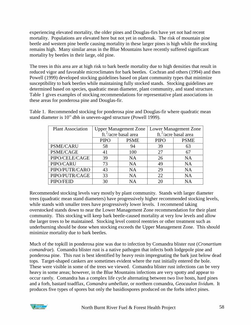
North Burnt River Fuel & Forest Health Project 58
experiencing elevated mortality, the older pines and Douglas-firs have yet not had recent
mortality. Populations are elevated here but not yet in outbreak. The risk of mountain pine
beetle and western pine beetle causing mortality in these larger pines is high while the stocking
remains high. Many similar areas in the Blue Mountains have recently suffered significant
mortality by beetles in their large, old pine.
The trees in this area are at high risk to bark beetle mortality due to high densities that result in
reduced vigor and favorable microclimates for bark beetles. Cochran and others (1994) and then
Powell (1999) developed stocking guidelines based on plant community types that minimize
susceptibility to bark beetles while maintaining fully stocked stands. Stocking guidelines are
determined based on species, quadratic mean diameter, plant community, and stand structure.
Table 1 gives examples of stocking recommendations for representative plant associations in
these areas for ponderosa pine and Douglas-fir.
Table 1. Recommended stocking for ponderosa pine and Douglas-fir where quadratic mean
stand diameter is 10‖ dbh in uneven-aged structure (Powell 1999).
Plant Association Upper Management Zone
ft.2/acre basal area
Lower Management Zone
ft.2/acre basal area
PIPO PSME PIPO PSME
PSME/CARU 58 94 39 63
PSME/CAGE 41 100 27 67
PIPO/CELE/CAGE 39 NA 26 NA
PIPO/CARU 73 NA 49 NA
PIPO/PUTR/CARO 43 NA 29 NA
PIPO/PUTR/CAGE 33 NA 22 NA
PIPO/FEID 30 NA 20 NA
Recommended stocking levels vary mostly by plant community. Stands with larger diameter
trees (quadratic mean stand diameters) have progressively higher recommended stocking levels,
while stands with smaller trees have progressively lower levels. I recommend taking
overstocked stands down to near the Lower Management Zone recommendation for their plant
community. This stocking will keep bark beetle-caused mortality at very low levels and allow
the larger trees to be maintained. Stocking level control reentries or other treatment such as
underburning should be done when stocking exceeds the Upper Management Zone. This should
minimize mortality due to bark beetles.
Much of the topkill in ponderosa pine was due to infection by Comandra blister rust (Cronartium
comandrae). Comandra blister rust is a native pathogen that infects both lodgepole pine and
ponderosa pine. This rust is best identified by heavy resin impregnating the bark just below dead
tops. Target-shaped cankers are sometimes evident where the rust initially entered the bole.
These were visible in some of the trees we viewed. Comandra blister rust infections can be very
heavy in some areas; however, in the Blue Mountains infections are very spotty and appear to
occur rarely. Comandra has a complex life cycle alternating between two live hosts, hard pines
and a forb, bastard toadflax, Comandra umbellate, or northern comandra, Geocaulon lividum. It
produces five types of spores but only the basidiospores produced on the forbs infect pines.
North Burnt River Fuel & Forest Health Project 59
These spores are small and very delicate, not able to withstand drying winds and high
temperatures. It is believed in the west that these spores are only spread sporadically when slow,
warm, moist air passes over infected plants in the late summer. We found no evidence of
continual comandra infections and the density of infected trees, while unusual, is not a cause for
management concern. I believe infection events are episodic here and not common.
Comandra blister rust causes branch kill, top kill, and tree death. The effect on a tree depends on
the site of infection and the size of the tree. Small trees die quickly from bole infections. In
branches that die before the fungus reaches the bole, the fungus dies with the branch. Contrary
to what I said while in the field, comandra cankers do expand down the bole or branch. Thus
branch infections can move to the bole, and bole infections causing top kill can kill ever more of
the top and eventually can kill even large trees. However, this can take decades. The infections
in this area were infrequent enough they did not affect the health of the overall stand. Individual
infected trees with top kill will experience greater top kill over time. Eventually, these trees may
die. However, the infections we saw in this area all appeared older and we did not see evidence
of new infections occurring repeatedly. Should future weather in this area cause an increase in
the incidence of warm, moist summer air, the presence of this rust could intensify.
Tree density management is the highest priority in these stands. All of the stands we visited
were overstocked and the current bark beetle mortality is a result of tree stress caused by
overstocking and past recent drought. It is fortunate that mortality of the larger, historical trees
has not yet occurred. There is still time to treat these stands before the older trees succumb to
competition stress and are attacked by bark beetles. We saw both red-needled trees, trees that
had been attacked in 2007 or early 2008, and green-attacked trees, trees that had been attacked in
2008 and would produce the generation to attack trees in 2009. Mountain pine beetles can
sustain population levels while experiencing over 97% mortality. Without significant moisture
or thinning to ease the competition stress in these stands, mortality here will continue and can be
expected to expand into the large, old pines.
The level of Comandra infection present here is not a forest health concern. Because many of
the trees with dead tops can be expected to eventually die from infection, this should be
accounted for in management decisions. Over time if weather patterns change, the incidence of
this rust may change, either becoming more prevalent with more warm moist summer weather,
or less prevalent with less warm summer moisture.
As always, Don, Craig, and I are available to answer insect and disease questions that might
arise.
Sincerely,
/s/Lia H. Spiegel
LIA H. SPIEGEL
Service Center Entomologist
cc: Mary Bresee, Marc Pierce, Craig L Schmitt, Donald W Scott, Robert W Rock
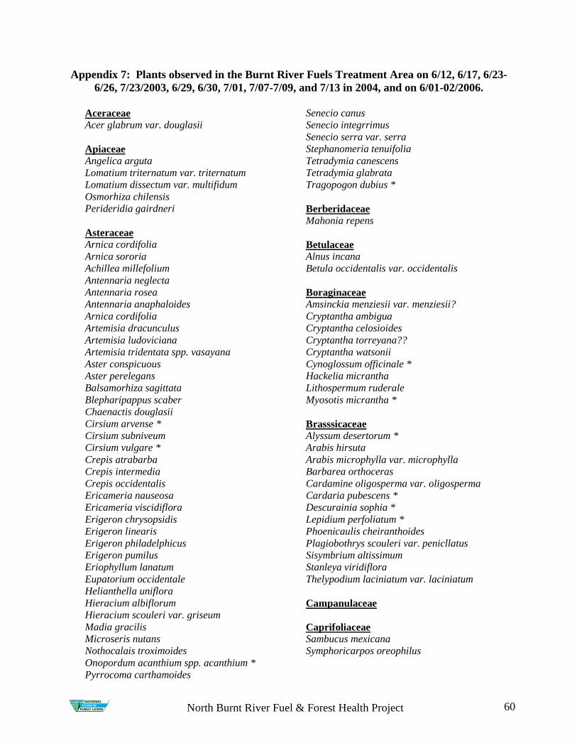
North Burnt River Fuel & Forest Health Project 60
Appendix 7: Plants observed in the Burnt River Fuels Treatment Area on 6/12, 6/17, 6/23-
6/26, 7/23/2003, 6/29, 6/30, 7/01, 7/07-7/09, and 7/13 in 2004, and on 6/01-02/2006.
Aceraceae Acer glabrum var. douglasii
Apiaceae
Angelica arguta
Lomatium triternatum var. triternatum
Lomatium dissectum var. multifidum
Osmorhiza chilensis
Perideridia gairdneri
Asteraceae
Arnica cordifolia
Arnica sororia
Achillea millefolium
Antennaria neglecta
Antennaria rosea
Antennaria anaphaloides
Arnica cordifolia
Artemisia dracunculus
Artemisia ludoviciana
Artemisia tridentata spp. vasayana
Aster conspicuous
Aster perelegans
Balsamorhiza sagittata
Blepharipappus scaber
Chaenactis douglasii
Cirsium arvense *
Cirsium subniveum
Cirsium vulgare *
Crepis atrabarba
Crepis intermedia
Crepis occidentalis
Ericameria nauseosa
Ericameria viscidiflora
Erigeron chrysopsidis
Erigeron linearis
Erigeron philadelphicus
Erigeron pumilus
Eriophyllum lanatum
Eupatorium occidentale
Helianthella uniflora
Hieracium albiflorum
Hieracium scouleri var. griseum
Madia gracilis
Microseris nutans
Nothocalais troximoides
Onopordum acanthium spp. acanthium *
Pyrrocoma carthamoides
Senecio canus
Senecio integrrimus
Senecio serra var. serra
Stephanomeria tenuifolia
Tetradymia canescens
Tetradymia glabrata
Tragopogon dubius *
Berberidaceae Mahonia repens
Betulaceae
Alnus incana
Betula occidentalis var. occidentalis
Boraginaceae
Amsinckia menziesii var. menziesii?
Cryptantha ambigua
Cryptantha celosioides
Cryptantha torreyana??
Cryptantha watsonii
Cynoglossum officinale *
Hackelia micrantha
Lithospermum ruderale
Myosotis micrantha *
Brasssicaceae
Alyssum desertorum *
Arabis hirsuta
Arabis microphylla var. microphylla
Barbarea orthoceras
Cardamine oligosperma var. oligosperma
Cardaria pubescens *
Descurainia sophia *
Lepidium perfoliatum *
Phoenicaulis cheiranthoides
Plagiobothrys scouleri var. penicllatus
Sisymbrium altissimum
Stanleya viridiflora
Thelypodium laciniatum var. laciniatum
Campanulaceae
Caprifoliaceae
Sambucus mexicana
Symphoricarpos oreophilus

North Burnt River Fuel & Forest Health Project 61
Caryophyllaceae Arenaria aculeate
Arenaria congesta var. congesta
Arenaria capillaris
Cerastium arvense
Montia linearis
Sagina procumbens
Silene douglasii
Silene menziesii
Silene oregana
Chenopodiaceae
Cupressaceae
Juniperus occidentalis
Cyperaceae Carex concinnoides
Carex spp.
Carex microptera
Carex geyeri
Carex rossii
Dipsacaceae
Dipsacus sativus *
Dryopteridaceae
Cystoperis fragilis
Ericaceae
Chimaphila umbellata
Euphorbiaceae
Euphorbia esula
Fabaceae
Astragalus beckwithii
Astragalus eremiticus
Astragalus purshii
Astragalus filipes
Astragalus salmonis
Lupinus caudatus
Lupinus leucophyllus
Medicago lupulina *
Trifolium cyathiferum
Trifolium longipes
Trifolium wormskjoldii
Trifolium repens
Vicia americana
Gentianaceae Frasera speciosa
Geraniaceae Geranium viscosissimum
Grossulariaceae Ribes aureum
Ribes cereum var. cereum
Hydrophyllaceae
Hydrophyllum capitatum
Nemophila breviflora
Nemophila pedunculata
Phacelia hastata
Phacelia linearis
Iridaceae Iris missouriensis
Juncaceae
Juncus ensifolius
Lamiaceae
Agastache urticifolia var. urticifolia
Liliaceae
Allium acuminatum
Allium nevadense
Calochortus eurycarpus
Disporum trachycarpum
Fritillaria atropurpurea
Maianthemum racemosum ssp. amplexicaule
Maianthemum stellatum
Triteleia grandiflora var. grandiflora
Veratrum viride
Zigadenus venenosus var. venenosus
Linaceae
Linum perenne
Loasaceae
Mentzelia albicaulis
Malvaceae
Sidalcea oregana var. oregana
Orchidaceae
Habenaria unalascensis
Onagraceae
Circaea alpina spp. pacifica
Clarkia rhomboidea
Epilobium ciliatum

North Burnt River Fuel & Forest Health Project 62
Epilobium paniculatum
Oenothera caespitosa
Paeoniaceae
Paeonia brownii
Pinaceae
Abies concolor
Larix occidentalis
Pinus ponderosa
Pseudotsuga menziesii
Poaceae
Achnatherum nelsonii ssp. dorei
Achnatherum thurberianum
Achnatherum lemmonii var. lemmonii
Alopecurus aequalis *
Bromus carinatus
Bromus commutatus
Bromus tectorum *
Bromus vulgaris var. vulgaris
Calamagrostis rubescens
Dactylis glomerata *
Danthonia unispicata
Deschampsia elongata
Elymus elymoides
Elymus glaucus
Elytrigia intermedia
Festuca idahoensis
Festuca occidentalis
Heterostipa comata
Koeleria macrantha
Leymus cinereus
Melica spectabilis
Melica subulata var. subulata
Pascopyrum smithii
Poa bulbosa *
Poa pratensis *
Poa secunda
Poa wheeleri var. wheeleri (Poa nervosa)
Phleum pratense*
Pseudoroegneria spicata
Polemoniaceae
Collomia linearis
Collomia grandiflora
Gilia aggregata
Gilia capillaris
Microsteris gracilis
Navarretia divaricata
Phlox hoodii
Polygonaceae Eriogonum heracleoides var. heracleoides
Eriogonum sphaerocephalum var.
sphaerocephalum
Eriogonum umbellatum
Eriogonum strictum
Eriogonum vimineum var. vimineum
Polygonum douglasii
Rumex acetosella
Rumex crispus
Polypodiaceae
Cystopteris fragilis
Portulacaceae
Claytonia perfoliata ssp. intermontana
Lewisia rediviva
Montia linearis
Ranunculaceae
Aquilegia formosa
Clematis spp.
Delphinium stachydeum
Ranunculus testiculatus
Ranunculus uncinatus
Rhamnaceae Ceanothus velutinus var. velutinus
Rosaceae
Amelanchier alnifolia
Cercocarpus ledifolius
Crataegus douglasii
Fragaria vesca
Fragaria virginiana var. platypetala
Geum macrophyllum
Geum triflorum var. ciliatum
Philadelphus lewisii
Potentilla arguta
Potentilla glandulosa
Potentilla recta *
Potentilla flabellifolia
Prunus emarginata
Prunus virginiana
Purshia tridentata var. tridentata
Rosa woodsii var. ultramontana
Rubus idaeus
Sedum lanceolatum var. lanceolatum
Spiraea betulifolia

North Burnt River Fuel & Forest Health Project 63
Rubiaceae
Galium aparine
Galium biflorum
Galium multiflorum
Salicaceae
Populus tremuloides
Salix lasiandra
Salix scouleri
Saxifragaceae
Heuchera cylindrica
Scrophulariaceae
Castilleja applegatei var. pinetorum
Castilleja chromosa
Collinsia parviflora
Cordylanthus ramosus
Mimulus guttatus
Mimulus cusickii
Mimulus nanus
Penstemon deustus var. deustus
Penstemon speciosus
Penstemon gairdneri
Verbascum thapsus *
Veronica anagallis-aquatica *
Urticaceae Urtica dioica spp. Gracilis
Valerianaceae
Valeriana edulis
Violaceae
Viola adunca
Viola purpurea
* = nonnative species
+ = Special status species
Appendix 8: Plant Associations
Pinus ponderosa/Pseudoroegneria spicata
Pinus ponderosa/Carex geyeri
Pinus ponderosa/Artemisia tridentata var. vaseyana
Pinus ponderosa/Festuca idahoensis
Pinus ponderosa/ Achnatherum nelsonii ssp. dorei
Pinus ponderosa/Calamagrostis rubecens
Pseudotsuga menziesii/Calamagrostis rubecens
Pseudotsuga menziesii/Symphoricarpos oreophilus

64
Appendix 9: Leafy Spurge locations found in 2004

65
Appendix 10: North Burnt River PM2.5 Emissions: A Comparison of Emissions
produced from different fuel types and burning scenarios.
0
20000
40000
60000
80000
PiPo2 PiPo9 Pipo10
Fuels
Po
un
ds
of
PM
2.5
Pro
du
ce
d in
50
ac
re p
arc
el
Wildfire
RX Fire Only/ First
Entry
CMRXF or Jackpot
Burn after
Mechanical
Treatment
Mechanical
Treatment/ Second
Entry Rx Fire