A NEW APPROACH FOR MESOSCALE SURFACE ANALYSIS: THE SPACE-TIME MESOSCALE ANALYSIS SYSTEM (STMAS)
Upload
independentCategory
view
0download
0
A Conjunctive Surface–Subsurface Flow Representation for Mesoscale LandSurface Models
HYUN IL CHOI
Department of Civil Engineering, Yeungnam University, Gyeongsan, South Korea
XIN-ZHONG LIANG
Department of Atmospheric and Oceanic Science, and Earth System Science Interdisciplinary Center, University of Maryland,
College Park, College Park, Maryland
PRAVEEN KUMAR
Department of Civil and Environmental Engineering, University of Illinois at Urbana–Champaign, Urbana, Illinois
(Manuscript received 10 November 2012, in final form 28 March 2013)
ABSTRACT
Most current land surface models used in regional weather and climate studies capture soil-moisture trans-
port in only the vertical direction and are therefore unable to capture the spatial variability of soil moisture and
its lateral transport. They also implement simplistic surface runoff estimation from local soil water budget and
ignore the role of surface flow depth on the infiltration rate, which may result in significant errors in the ter-
restrial hydrologic cycle. To address these issues, this study develops and describes a conjunctive surface–
subsurface flow (CSSF) model that comprises a 1D diffusion wave model for surface (overland) flow fully
interacted with a 3D volume-averaged soil-moisture transport model for subsurface flow. The proposed con-
junctive flow model is targeted for mesoscale climate application at relatively large spatial scales and coarse
computational grids as compared to the traditional coupled surface–subsurface flow scheme in a typical basin.
The CSSF module is substituted for the existing 1D scheme in the common land model (CoLM) and the
performance of this hydrologically enhanced version of the CoLM (CoLM1CSSF) is evaluated using a set of
offline simulations for catchment-scale basins around the Ohio Valley region. The CoLM1CSSF simulations
are explicitly implemented at the same resolution of the 30-km grids as the target regional climate models to
avoid downscaling and upscaling exchanges between atmospheric forcings and land responses. The results
show that the interaction between surface and subsurface flow significantly improves the stream discharge
prediction crucial to the terrestrial water and energy budget.
1. Introduction
Mesoscale regional climate models (RCMs) are rec-
ognized as an essential tool to address scientific issues
concerning climate variability, changes, and impacts at
regional to local scales. As the model resolution in-
creases, land surface models (LSMs) coupled with RCMs
need to incorporate more comprehensive physical pro-
cesses and their nonlinear interactions. This has been
the trend in recent developments (Stieglitz et al. 1997;
Chen and Kumar 2001; Warrach et al. 2002; Niu and
Yang 2003; Niu et al. 2005; Oleson et al. 2008; Choi and
Liang 2010), but most LSMs still contain simplistic pa-
rameterizations that need improvements for terrestrial
hydrologic processes. As a result, LSMs may produce
nonlinear drifts in their dynamic responses to external
forcings (e.g., Yuan and Liang 2011), which in turn feed
back to the coupled climate system and ultimately lead
to significant errors in predicting surface water and en-
ergy budgets. Improved parameterizations of key land
surface processes, especially for the terrestrial hydro-
logic cycle, are needed to get better performance from
RCMs.
Corresponding author address: Dr. Xin-Zhong Liang, Depart-
ment of Atmospheric and Oceanic Science, University of Mary-
land, College Park, 5825 University Research Court, Suite 4001,
College Park, MD 20740-3823.
E-mail: [email protected]
OCTOBER 2013 CHO I ET AL . 1421
DOI: 10.1175/JHM-D-12-0168.1
� 2013 American Meteorological Society

Most current LSMs model only vertical moisture
transport and therefore cannot capture spatial variability
of soil water induced by topographic characteristics;
thus, they are limited in predicting surface fluxes. Such
one-dimensional models are unable to represent sub-
surface lateral transport induced by topography or mois-
ture gradients. As one of the critical components in the
terrestrial hydrologic cycle, runoff is estimated using
the soil water budget without any explicit or parame-
terized routing treatment in most current models. As
shown below, these models that disregard flow routing
or runoff travel time over the basins predict surface
runoff hydrographs with unrealistic sharp peaks and
steep declining recessions. Moreover, ignoring the role
of surface flow depth on the infiltration rate causes er-
rors in both infiltration and surface flow calculations
(Schmid 1989; Singh and Bhallamudi 1997; Wallach
et al. 1997). Therefore, this study presents a numerical
model based on a conjunctive solution of surface and
subsurface flow interactions, typically applied for small-
scale modeling, here specifically targeting for use in me-
soscale land surface parameterizations over a continental
scale to improve regional climate modeling, especially
for the spatiotemporal distribution of surface and sub-
surface water that has significant influence on terrestrial
water and energy budget.
To develop the improved runoff treatment in LSMs,
this study has chosen the CommonLandModel (CoLM)
as the basic LSM that originally utilizes simplistic as-
sumptions and crude parameterizations for the terres-
trial hydrologic cycle, especially runoff processes as most
LSMs do. The CoLM is an advanced soil–vegetation–
atmosphere transfer model (Dai et al. 2003, 2004), which
has been incorporated into the state-of-the-art mesoscale
Climate–Weather Research and Forecasting (CWRF)
model (Liang et al. 2005a,b,c,d, 2006, 2012) with numer-
ous crucial updates and improvements for land pro-
cesses (Choi 2006; Choi et al. 2007; Choi and Liang
2010; Yuan and Liang 2011). The original Community
Land Model (CLM) and CoLM have been extensively
evaluated for good performance against field measure-
ments in a stand-alone mode as driven by the observa-
tional forcings (Dai et al. 2003; Niu and Yang 2003; Niu
et al. 2005;Maxwell andMiller 2005; Qian et al. 2006; Niu
and Yang 2006; Niu et al. 2007; Lawrence and Chase
2007; Lawrence et al. 2007; Oleson et al. 2008). Our own
experience, however, has shown that a direct applica-
tion of the CoLM for the CWRF at a 30-km grid spacing
leads to serious problems in predicting the hydrologic
cycle, especially runoff processes and basin discharge
(Choi and Liang 2010; Yuan and Liang 2011).
A number of attempts have been made to couple ex-
plicit runoff schemes with LSMs. Walko et al. (2000)
incorporated a modified form of Topography-based Hy-
drologicalModel (TOPMODEL) into theLandEcosystem–
Atmosphere Feedbackmodel (LEAF-2) for land–surface
processes in the Regional Atmospheric Modeling System
(RAMS) in order to represent surface and subsurface
downslope lateral transport of groundwater. M€olders
and R€uhaak (2002) coupled with an atmospheric model
a hydrothermodynamic soil–vegetation scheme that in-
corporates surface and channel runoff. Since the runoff
component was solved at a 1-km grid that differs from
other terrestrial hydrologic schemes at a 5-km grid,
the coupling using aggregation and disaggregation was
required to introduce the runoff processes. Gochis and
Chen (2003) developed a hydrologically enhanced form
of the NOAH LSM incorporating a cell-to-cell surface
flow routing scheme through disaggregated routing sub-
grids coupled to a quasi-steady state model for subsurface
lateral flow. Maxwell and Miller (2005) added in the
CoLM a variably saturated groundwater model ParFlow
without explicit surface runoff scheme. As such, the model
was mainly targeted to improve water table depth pre-
diction, but it could not capture observed monthly runoff
variations. Kollet and Maxwell (2006) incorporated an
overland flow simulator into the ParFlow, followed by
an evaluation against published data and an analytical
solution for a V catchment (1.62km3 1km). Richter and
Ebel (2006) developed a fully integrated atmospheric–
ocean–hydrology model, the Baltic Integrated Model Sys-
tem (BALTIMOS), where the regional climate model
REMO is coupled to the mesoscale hydrological model
LARSIM for simulating the water balance of large river
basins continuously. Fan and Miguez-Macho (2011)
simulated lateral groundwater flow using estimates from
three participants of the National Aeronautics and Space
Administration’s (NASA) Global Land Data Assimila-
tion System (GLDAS) (Rodell et al. 2004) such as CLM,
Mosaic, andNoah at 1-km spacing to improvewater table
depth prediction over North America.
Along with these attempts, we have been continu-
ously seeking improved representations for the terres-
trial hydrology in theCWRF. Choi (2006) andChoi et al.
(2007) developed the 3D volume-averaged soil-moisture
transport (VAST) model based on the Richards (1931)
equation to incorporate the lateral flow and subgrid
heterogeneity due to topographic characteristics in-
troduced in the work of Kumar (2004). It was demon-
strated that both the lateral flow and subgrid flux have
important effects on total soil-moisture dynamics and
spatial distribution. In general, soil-moisture moves from
hillslopes to the lower regions by lateral and subgrid
fluxes in the VAST model. Since the water would con-
verge along topographic concave hollows, any water ex-
ceeding soil porosity needs to be transported to the
1422 JOURNAL OF HYDROMETEOROLOGY VOLUME 14

vertical soil layers and then treated as lateral surface
runoff. Hence, the improved terrestrial hydrologic scheme
based on the VAST model also requires an explicit sur-
face flow computation scheme. Choi (2006) incorporated
a non-inertial diffusion wave model to account for the
downstream backwater effect. This was an approximate
form of the Saint-Venant (1871) equation, known for its
efficiency in accuracy and computation (Ponce et al.
1978; Akan and Yen 1981; Hromadka et al. 1987; Morita
and Yen 2002; Kazezyilmaz-Alhan et al. 2005). Choi
and Liang (2010) incorporated the baseflow allocation
scheme along with improved terrestrial hydrologic rep-
resentations such as realistic bedrock depth, dynamic
water table, exponential decay profile of the saturated
hydraulic conductivity, minimum residual soil water,
and maximum surface infiltration limit. This model, how-
ever, still simulates steep declining recession curves and
relatively small total runoff, primarily because it un-
derestimates the baseflow (Choi and Liang 2010). There-
fore, this study has developed and implemented in the
CoLM a new conjunctive surface–subsurface flow (CSSF)
module that comprises an 1D diffusion wave model for
the surface (overland) flow interacted with the 3DVAST
model for the unsaturated subsurface flow and an 1D
topographically controlled baseflow for the saturated
subsurface flow, where all the components are desig-
nated at the 30-km grid scale. A new formulation is
introduced for the baseflow to depict the effects of
surface macropores and vertical hydraulic conductivity
changes. The RCM grid-based overland flow routing
process is introduced in this study for mesoscale LSMs
to realistically predict the temporal variation of the spa-
tial distribution of flow depth and runoff. Such coupling
enables the CSSF to explicitly simulate surface runoff
that results from both rainfall excess and moisture satu-
ration in the whole soil column as well as its interactions
with neighboring grids. This conjunctive flow model is
solved by the mixed numerical implementation for each
flow component and then substituted for the existing
1D hydrologic scheme in the CoLM.
Most hydrologic parameterization schemes in LSMs,
including the CoLM and CLM, have been tested with
field measurements at small catchment scales (Stieglitz
et al. 1997; Warrach et al. 2002; Dai et al. 2003; Niu et al.
2005; Niu and Yang 2006), while directly applied in
much coarser resolution climate models. Given the strong
scale dependence, terrestrial hydrologic parameteriza-
tions, especially for runoff, must be tuned and evaluated
at the same resolution as their host climate models.
Therefore, we assess the new CSSFmodule as coupled
with the current CoLM built in the CWRF for their
designated application at the 30-km grid, focusing on
the representation of surface and subsurface runoff.
All schemes are explicitly implemented at the 30-km
grids rather than hydrologic basins or catchments to
avoid downscaling and upscaling exchanges between
CWRF atmospheric forcings and land responses (Choi
2006; Choi et al. 2007; Choi and Liang 2010; Yuan and
Liang 2011). This is an important advance to most pre-
vious LSMs that couple hydrologic and atmospheric
schemes usually at different scales. Furthermore, the
CSSF scheme with the scalable parameterization can
be substituted for the terrestrial hydrologic scheme in
most LSMs at any current and future finer spatial res-
olutions within the mesoscale range.
As demonstrated below, the CoLM1CSSF extension
generates runoff variations much closer to observations.
Section 2 presents a brief description of the original
CoLM with our previous improvements. Section 3 elab-
orates the key features of the new CSSF parameteriza-
tions. Section 4 depicts the numerical implementation
of the CSSF into the CWRF–CoLM at 30-km grids.
Section 5 evaluates the CSSF skill enhancement in
runoff processes and discharge predictions against
daily observations at catchment-scaled study basins
over the Ohio Valley. The final conclusions are given in
section 6.
2. State of development of the CoLM
The original CoLM is well documented in Dai et al.
(2003, 2004). Its major characteristics include a 10-layer
prediction of soil temperature and moisture; a 5-layer
prediction of snow processes (mass, cover, and age); an
explicit treatment of liquid and ice water mass and their
phase change in soil and snow; and a two-big-leaf model
for canopy temperature, photosynthesis, and stomatal
conductance. In coupling with the CWRF, the CoLM
was consistently integrated with comprehensive surface
boundary conditions (Liang et al. 2005a,b) and an ad-
vanced dynamic–statistical parameterization of land
surface albedo (Liang et al. 2005c).
Recently, Choi and Liang (2010) identified several
deficiencies in the CoLM formulations for terrestrial
hydrologic processes and developed better solutions
with a focus on stream discharge predictions. In partic-
ular, they have incorporated a realistic geographic dis-
tribution of bedrock depth to improve estimates of the
actual soil water capacity, replaced an equilibrium ap-
proximation of the water table with a dynamic pre-
diction to produce more reasonable variations of the
saturated zone depth, used an exponential decay func-
tion with soil depth for the saturated hydraulic con-
ductivity to consider the effect of macropores near the
ground surface, formulated an effective hydraulic con-
ductivity of the liquid part at the frozen soil interface
OCTOBER 2013 CHO I ET AL . 1423

and imposed a maximum surface infiltration limit to
eliminate numerically generated negative or excessive
soil moisture solution, and considered an additional
contribution to subsurface runoff from saturation lateral
runoff or baseflow controlled by topography.
The above improvements enable the CoLM to more
realistically reproduce observations of terrestrial hydro-
logic quantities, where the skill enhancement is especially
significant for runoff at peaks discharges under high-flow
conditions. For convenience, the original model with
these improvements is referred to as the CoLM in the
subsequent sections, unless specifically noted otherwise.
However, this model, using the current TOPMODEL
equation, still underestimates the baseflow and thus re-
sults in steep declining recession curves and relatively
small total runoff (Choi and Liang 2010). Therefore, we
develop the CSSF approach below to further reduce
these CoLM deficiencies so identified.
3. New CSSF parameterizations
Figure 1 illustrates the key terrestrial hydrologic pro-
cesses represented in the current CoLM and the new
CSSF module. Below we describe the new parameteri-
zations introduced into the CSSF, including the treat-
ments for various runoff components as shown in Fig. 2a
and the surface flow routing scheme as illustrated in
Fig. 2b. The CSSF also couples the VAST model to
explicitly incorporate additive lateral and subgrid mois-
ture transport fluxes due to local variations of topographic
attributes.
a. Soil-moisture transport scheme
Choi et al. (2007) developed a soil-moisture transport
formulation, the VAST model, based on the Richards
(1931) equation, incorporating both the grid-mean and
subgrid fluxes for each vertical and lateral direction:
›u
›t5
›F
›z
8>>>>>>>>>>>>>>>><>>>>>>>>>>>>>>>>:
1›
›z
0BBBBB@Dm
›w
›z|fflfflffl{zfflfflffl}mean
1›D-
›z|ffl{zffl}variability
1CCCCCA (Vertical diffusion)
2›
›z
0BBBB@ Km|{z}
mean
1 K-1|ffl{zffl}
variability
1CCCCA (Vertical drainage)
1›F
›xl
8>>>>>>>>>>>>>>>><>>>>>>>>>>>>>>>>:
1 z›
›xl
0BBBBBB@Dm
›w
›xl|fflfflffl{zfflfflffl}mean
1›D-
›xl|ffl{zffl}variability
1CCCCCCA (Lateral diffusion)
1 z›
›xl
0BBBB@Km|{z}mean
1 K-11K-
2|fflfflfflfflfflfflffl{zfflfflfflfflfflfflffl}variability
1CCCCA (Lateral drainage),
(1)
FIG. 1. Schematic diagram for the key terrestrial hydrologic processes represented in the
current CoLM and the new CSSF parameterizations.
1424 JOURNAL OF HYDROMETEOROLOGY VOLUME 14

FIG. 2. (a) Schematic diagram for surface runoff and subsurface runoff components at a single
grid cell and (b) concept sketch for the developed conjunctive flow model for the four hori-
zontal grid cells with multiple soil layers in the new CoLM1CSSF model.
OCTOBER 2013 CHO I ET AL . 1425

where u is the volumetric water content for a soil ele-
ment, F is the soil water flux, t is time, z is the vertical
coordinate, and the summation over the coordinates
xl 2 fx, yg is implied, which represents the x–y plane
following the land surface terrain. The variable w is the
effective soil wetness (saturation) defined in Eq. (A3),
and z is an anisotropic factor first introduced in LSMs by
Chen and Kumar (2001) for the desired streamflow pre-
dictions [see Eq. (A10)]. Given the functional relationships
of Eqs. (A1)–(A9) and the closure parameterization in
Choi et al. (2007), the diffusivity D and conductivity K
functions (subscript m represents the grid-mean term
and -1 and -2 denote the subgrid variability terms) are
calculated by Eqs. (A11)–(A15). Note that all variables
and coefficients represent grid volume-averaged values
in Eq. (1). The VAST model formulation and result-
ing effects were documented in details by Choi et al.
(2007).
b. Subsurface runoff representation scheme
The original CoLM predicts subsurface runoff as the
sum of only bottom drainage and saturation excess.
Recent studies have shown important additional con-
tribution from saturation lateral runoff or baseflow that
is controlled by topography (Stieglitz et al. 1997; Chen
andKumar 2001;Warrach et al. 2002; Niu andYang 2003;
Niu et al. 2005; Choi and Liang 2010). In the new CSSF
model, subsurface runoff consists of four components as
Rsb 5Rsb,bas1Rsb,dra1Rsb,int 1Rsb,sat , (2)
whereRsb,bas,Rsb,dra,Rsb,int, andRsb,sat denote subsurface
runoff from baseflow, bottom drainage, interflow, and
saturation excess, respectively. Their formulations are
presented below. Subsurface runoff is calculated directly
from the above four components in each soil column
without any interacting or routing schemes for hori-
zontal adjacent soil grids. Note that baseflow runoff
is dominant in subsurface runoff for the study basins
since all other subsurface runoff components are neg-
ligible for the given conditions in this study.
1) BASEFLOW RUNOFF
The subsurface lateral flow mainly driven by complex
terrain is collecting water along lower-valley regions. The
lateral subsurface flow from the VASTmodel is limited
to the vadose zone, the so-called interflow or through-
flow, because it is modeled by the u-based Richards
equation. Since the VAST model is insufficient to cap-
ture the real feature of baseflow in the saturated zone,
we need the further improvement of the baseflow cal-
culation scheme associated with the water table depth
variation.
Following Sivapalan et al. (1987), most TOPMODEL-
based models (Beven and Kirkby 1979) represent sub-
surface saturated lateral runoff (baseflow) induced by
topographic control as
Rsb,bas 5zKs(0)
fe2le2fz$ , (3)
where Ks(0) is the saturated hydraulic conductivity ap-
proximated by Eq. (A4) on the surface of the top soil
layer and f is the decay factor of the saturated hydraulic
conductivity obtained by calibrating the recession curve
in the observed hydrograph [see Eq. (A8)]. The quantity
l is the grid cell mean value of the topographic index
defined as l5 ln(a/tanb), where a is the drainage area
per unit contour length and tanb is the local surface
slope. The z$ is the water table depth. This topographic
index is a scale-dependent variable and has uncertainties
due to coarse-resolution digital elevation model (DEM)
data available for the regional and continental studies
(Kumar et al. 2000). Because of difficulty in defining
parameters in Eq. (3) on global scales, some models
(Niu and Yang 2003; Niu et al. 2005; Niu and Yang 2006;
Choi and Liang 2010) introduce the simplified parame-
terization using a single calibration parameter, the maxi-
mum baseflow coefficient Rsb,max, instead of zKs(0)e2l/f .
Hence, Eq. (3) can be rewritten as
Rsb,bas 5Rsb,maxe2fz$ . (4)
However, neither Eqs. (3) nor (4) can represent
contribution to baseflow because of the variation of
hydraulic conductivity corresponding to different soil
texture layers, surface macropores, and the frozen soil
area. In particular, the use of a single parameter Rsb,max
in Eq. (4) is inappropriate for a large heterogeneous
region. Choi and Liang (2010) pointed out that these
formulations may not capture observed recession curves
(underestimation) or may produce negative or less re-
maining soil moisture content than the residual value
(overestimation). Therefore, we compute baseflow di-
rectly from each saturated layer, starting with an as-
sumption that the water table is parallel to the surface,
which is the basic assumption of Eqs. (3) and (4) also.
The saturated lateral flow qb beneath a water table at
a depth z can be written as
qb(z)5Fliq(z)zKs(z) tanb , (5)
where Fliq is the unfrozen part of soil water as defined
in Eq. (A17).
The total baseflow runoff from a grid cell is computed
by integrating Eq. (5) through the entire saturated soil
layer and along the channel length as
1426 JOURNAL OF HYDROMETEOROLOGY VOLUME 14

Rsb,bas5Qb
A5
ðL
ðzN
z$
qb dz dL
A
5
ðL
ðzN
z$
Fliq(z)zKs(z) tanbdz dL
A
5
"T( j)1 �
N
k5j11
T(k)
#tan(bL)
A, (6)
where L is channel length assumed to be the orthogonal
straight line to the grid mean flow direction,A is the grid
cell area, zN is the bottom of the lowest soil layer, N is
the total number of model soil layers, and j is the layer
index with the water table. The quantity T is a trans-
missivity varying nonlinearly with depth and can be
computed for each discrete layer as:
T(k)5
ðzk
zk21
Fliq(z)zKse2f (z2z
c) dz
5
8>>>><>>>>:
Fliq(k)zKs
e2f (zk2z
c)
f[ef (zk2z$) 2 1], k5 j
Fliq(k)zKs
e2f (zk2z
c)
f(efDzk 2 1), k5 j1 1,N
,
(7)
where zc is the compacted depth representing macro-
pore effect (Beven 1982a) near the soil surface, espe-
cially in vegetated areas [see also Eq. (A8)]. The
quantity Dzk is a layer thickness between vertical co-
ordinates zk and zk21 for the layer k. Because the satu-
rated lateral flow cannot exceed the available soil liquid
water for mass conservation, qb(k) for each saturated
layer below the water table is determined as
qb(k)5min
*T(k) tan(bL)
A,
fuliq(k)2max[ur(k)2 uice(k), 0]gDz0kDt
+, (8)
where
Dz0k 5�zk 2 z$ for k5 j
zk 2 zk21 for k5 j1 1 to N,
uliq is the partial volume of liquid soil water, uice is the ice
content in frozen soil, ur is the residual moisture con-
tent at the hygroscopic condition, and Dt is a computa-
tional time increment.
Note that most existing LSMs incorporate a baseflow
allocation scheme without considering the limitation
of actual water availability in soils [the second part of
Eq. (8)]. The baseflow is finally computed as follows:
Rsb,bas5 �N
k5j
qb(k) . (9)
Baseflow from each saturated layer is employed as a sink
term, and the soil liquid water is updated by using the
following equation:
uliq(k)5 uliq(k)2qb(k)Dt
Dzk. (10)
2) BOTTOM DRAINAGE RUNOFF
The vertical gradient of soil moisture is generally very
small in the lower portion of the soil column, and the
lowest soil layer (eleventh-layer bottom is 5.7m depth
in the CoLM) may be located below the bedrock or
water table depth. Hence, the vertical diffusion flux of
soil moisture is negligible, and the drainage water flux
Rsb,dra from the soil bottom can be estimated by
Rsb,dra5Km(zN)1K-1(zN) , (11)
where Km(zN) and K-1(zN) are hydraulic conductivity
terms of the vertical mean and variability fluxes in
Eq. (1) [see also Eqs. (A13) and (A14)], respectively, at
the bottom of the lowest soil layer zN . This drainage flux
is the lower boundary condition for the vertical soil
water movement in the VAST model and treated as a
source of subsurface runoff since the CoLM lacks a deep
aquifer component in soil water dynamics. Its contri-
bution to the total subsurface runoff is small when the
actual bedrock is located in the model soil layers.
Moreover, the exponential decay profile of the saturated
hydraulic conductivity Ksz as defined in Eq. (A8) sub-
stantially reduces bottom drainage, causing a negligible
contribution to total subsurface runoff.Ksz is so small in
this study domain where the exponential decay factor
of the vertical hydraulic conductivity f is large and the
bedrock is above the model soil bottom that this runoff
component is insignificant.
3) INTERFLOW RUNOFF
The interflow is computed by lateral components in
the VAST model and significantly contributes to the
spatial distribution of soil water between horizontal
grids. Because it can be treated as subsurface runoff at
the computational domain boundary grids only, the in-
terflow runoff causes a minor contribution to the total
subsurface runoff. The interflow runoff is computed as
OCTOBER 2013 CHO I ET AL . 1427

Rsb,int5
�B�N
k51
uout(k)Dzk
Dt, (12)
where uout(k) is the outgoing soil moisture by the lateral
flux terms in the VAST model and B indicates all
boundary grid cells. Note that the interflow runoff does
not occur for this study domain with a buffer zone on all
four sides, where the same moisture content is assumed
to each boundary soil column, but it is considered for
grids bordered laterally by and located vertically above
water bodies (e.g., lakes and oceans) in the CWRF as
coupled with the CSSF.
4) SATURATION EXCESS RUNOFF
In cases where the soil water exceeds its moisture
capacity (porosity) numerically at any single layer, the
excess water is recharged to the unsaturated layers
above the water table. If the entire soil column becomes
supersaturated, saturation excess runoff occurs:
Rsb,sat5max
(0,
"�N
k51
u(k)Dzk 2 �N
k51
us(k)Dzk
#Dt
),
,
(13)
where us is the soil moisture content (porosity) at satu-
ration approximated by the pedo-transfer function in
Eq. (A6). Note that the numerically generated excessive
soil-moisture solution rarely occurs in this study by in-
corporating a maximum surface infiltration limit condi-
tion and the effective hydraulic conductivity function at
the interface of unfrozen areas [see Eq. (A18)] fromChoi
and Liang (2010).
c. Surface runoff representation scheme
1) SURFACE RUNOFF
The total available water supply rate Qw on the sur-
face is computed, incorporating the flow depth h for
a time increment Dt as:
Qw 5Qrain1Qdew1Qmelt 1h/Dt , (14)
where Qrain, Qdew, and Qmelt are rainfall, dewfall, and
snowmelt rate at the surface, respectively. Surface run-
off is generated by the Horton and the Dunn mecha-
nisms. Horton runoff occurs as rainfall intensity exceeds
soil infiltration rate while Dunn runoff takes place when
precipitation falls over the saturated area. For the com-
prehensive surface and subsurface coupling, we consider
the influence of overland flow depth on both infiltration
rate and surface runoff. The net surface runoff on the
exchange of water between the surface and the sub-
surface is
Rs 5 (12Fimp)max(0,Qw2 Imax)|fflfflfflfflfflfflfflfflfflfflfflfflfflfflfflfflfflfflfflfflfflfflfflfflfflffl{zfflfflfflfflfflfflfflfflfflfflfflfflfflfflfflfflfflfflfflfflfflfflfflfflfflffl}Hortonian
1 FimpQw|fflfflfflfflffl{zfflfflfflfflffl}Dunnian
2 h/Dt ,
(15)
where Fimp is the impermeable area fraction consisting
of the fractional saturated area Fsat and the frozen area
Ffrz as follows:
Fimp5 (12Ffrz)Fsat1Ffrz , (16)
where the frozen areaFfrz is defined inEq. (A16) and the
fractional saturated area Fsat is determined by the to-
pographic characteristics and soil moisture state:
Fsat 5
ðl$l1fZ$
g(l) dl , (17)
where g(l) is the probability density function of the to-
pographic index l. Woods and Sivapalan (1997) showed
a similarity for the cumulative distribution functions of
the topographic index among a variety of catchments.
Such similarity lends strong support to the simplifica-
tion made by Niu and Yang (2003) as:
Fsat5Fmaxe20:5fz$ , (18)
where Fmax is the maximum saturated fraction. The ex-
ponent coefficient 0.5 is derived by making the result in
agreement with the three-parameter gamma distribu-
tion of Niu et al. (2005).
The remaining variable Imax in Eq. (15) is defined as
Imax5 Fliq(1)Ksz(1)
�12
cs(1)b1d1
[12wu(1)]
�|fflfflfflfflfflfflfflfflfflfflfflfflfflfflfflfflfflfflfflfflfflfflfflfflfflfflfflfflfflfflfflfflfflfflfflfflffl{zfflfflfflfflfflfflfflfflfflfflfflfflfflfflfflfflfflfflfflfflfflfflfflfflfflfflfflfflfflfflfflfflfflfflfflfflffl}
mean flux
1 Fliq(1)Ksz(1)a2
�(2b11 3)(b11 1)2
1
2b1(b11 2)[12wu(1)
b11322b]
�|fflfflfflfflfflfflfflfflfflfflfflfflfflfflfflfflfflfflfflfflfflfflfflfflfflfflfflfflfflfflfflfflfflfflfflfflfflfflfflfflfflfflfflfflfflfflfflfflfflfflfflfflfflfflfflfflfflfflfflfflfflfflfflfflfflfflfflffl{zfflfflfflfflfflfflfflfflfflfflfflfflfflfflfflfflfflfflfflfflfflfflfflfflfflfflfflfflfflfflfflfflfflfflfflfflfflfflfflfflfflfflfflfflfflfflfflfflfflfflfflfflfflfflfflfflfflfflfflfflfflfflfflfflfflfflfflffl}
variability flux
, (19)
1428 JOURNAL OF HYDROMETEOROLOGY VOLUME 14

where (1) or subscript 1 denotes for the top soil layer.
The quantity cs is the saturated suction head, the expo-
nent b is the pore size distribution index, and a and b are
parameters characterizing the dependence of moisture
variability on the mean in the VAST model. The value
d is the node depth of a soil layer, and wu is soil wetness
for the permeable unsaturated area and calculated from
grid-mean soil wetness w as
wu(1)5max
"0,
w(1)2Fimp(1)
12Fimp(1)
#, Fimp(1), 1, (20)
wherew is the effective soil wetness (saturation) defined
in Eq. (A3). Equation (20) is derived from an assump-
tion that the surface layer is saturated during rainfall
events (Mahrt and Pan 1984; Entekhabi and Eagleson
1989; Abramopoulos et al. 1988; Boone andWetzel 1996).
This infiltrability also cannot exceed the maximum pos-
sible influx calculated using the soil water budget at the
first layer as
Imax# us(1)[12wu(1)]Dz1Dt
1Fz11E1 , (21)
where Fz1 and E1 are the soil water flux and the evapo-
transpiration flux, respectively, at the first soil layer.
Hence, the vertical flux Fz0 at the top of each soil col-
umn z0 (the upper boundary condition) is computed as
Fz052min(Qw,
Imax) . (22)
For the lateral boundary conditions, the buffer adjacent
soil columns are assumed to have the same water con-
tent to each boundary soil grid.
2) SURFACE FLOW ROUTING
One approximated solution for unsteady surface flow
is the non-inertial wave model neglecting local and
convective inertia term in the full dynamic wave equa-
tions, known as the Saint-Venant equation (Tsai and
Yen 2001; Morita and Yen 2002). The diffusion wave
equation in a wide rectangular section can be written
for a unit width element as
›h
›t1 cd
›h
›xc5Dh
›2h
›x2c1Rs , (23)
where h is a flow depth, xc is longitudinal flow direction
coordinate, and cd is the diffusion wave celerity, which
can be approximated for gentle-slope case as
cd 53
2V5
3
2
ffiffiffiffiffiffiffiffiffiffiffiffiffiffiffiffiffiffiffiffiffiffiffiffiffiffiffih
�So2
›h
›xc
�s, (24)
and Dh is the hydraulic diffusivity expressed as
Dh 5cdh
3
�So 2
›h
›xc
�5Vh
2
�So 2
›h
›xc
� , (25)
where V is flow velocity averaged over a flow depth h
and So is bottom slope in the flow direction.
There can be many converging junctions in the flow
network generated from the DEM. The boundary con-
ditions for mass and energy conservation at any junction
are required for a flow network simulation (Sevuk and
Yen 1973; Choi and Molinas 1993; Jha et al. 2000). The
continuity equation assuming no change in storage vol-
ume at the junction can be expressed as
�Qs,out 5�Qs,in , (26)
where the subscripts in and out denote inflow and out-
flow, respectively, at the junction. Qs is the surface flow
discharge through the flow cross section. The equation
of energy conservation for each branch is given as
V2in
21 ghin 5
ðxcout
xcin
dV
dtdxc1
V2out
21 ghout1 ghf , (27)
whereÐ xcoutxcin
(dV/dt) dxc is the energy loss due to accel-
eration of flow, g is the gravitational acceleration, and hfis the head loss due to fraction and other local losses.
If we ignore the change of velocity and head loss at
a junction, Eq. (27) is simply approximated as
hout 5 hin . (28)
As such, the 30-km grid-based overland flow routing
formulations are incorporated into the CSSF model
without any disaggregation and aggregation procedures
to realistically predict the temporal variation of the
spatial distribution of flow depth and runoff at regional–
local scales.
As delineated in Fig. 2b, in the hydrologically en-
hanced version of the CoLM, the surface flow equation
in Eq. (23) relies on the exchange flux Rs between the
surface and subsurface flow in Eq. (15). The spatial and
temporal variation of the surface water depends on the
exchange flux Rs (induced by vegetation, topography,
soil texture, etc.) as well as climatic factors such as rain-
fall and temperature.
d. Total runoff representation scheme
Total runoff is composed of surface and subsurface
runoff results. To estimate total runoff at a given grid
point, surface flow discharge divided by the total grid
cell area contributing to the target grid point is added to
the averaged subsurface runoff as
OCTOBER 2013 CHO I ET AL . 1429

Rtot 5Qs
nfaA1Rsb , (29)
where Rtot is total runoff, nfa is the flow accumulation
number at the target grid point, and Rsb is the averaged
subsurface runoff for the total grid cells located up-
stream of the target grid point. Total runoff variation
with time is the specific discharge hydrograph, which can
be used to compare with stream discharge observations.
4. Implementation of the new CoLM1CSSFmodel
The CSSF model is substituted for the existing ter-
restrial hydrologic representation in the CoLM. While
the CoLM performs all computations independently at
individual soil columns, the lateral subsurface flow and
surface flow in the CSSF depend on neighboring grids
and hence are calculated after the vertical subsurface
water movement is computed using a time-splitting
method.
Since the performance of the terrestrial hydrologic
schemes depends strongly on the spatial scale, the CSSF
skill enhancement in predicting runoff is evaluated over
a relatively large catchment using the actual CWRF–
CoLM 30-km grid mesh targeted for regional climate
applications. To facilitate model comparison with obser-
vations, the experiments are conducted in a stand-alone
mode, where the CoLM with or without the CSSF is
TABLE 1. The selected USGS streamflow gauge stations for evaluation of the model performance. The drainage area for each station is
documented by the USGS and the computational drainage grids are determined by 30-km flow directions for each of the three study basins.
USGS station ID Station name
Drainage area
for the station (km2)
Contributing area
in the model (km2)
03198000 Kanawha River at Charleston, WV 27 060 28 800
03287500 Kentucky River at Lock 4 at Frankfort, KY 14 014 13 500
03320000 Green River at Lock 2 at Calhoun, KY 19 596 18 000
FIG. 3. Plots of 30-km resolved flow directions (arrows), 1-km HYDRO1K stream network (curved lines), basin boundaries (black
closed curves), model basin grid boundaries (white polygons), and the three USGS streamflow gauge stations (white circles) overlaid
with spatial distributions of (a) the 30-km terrain elevation (black–gray gradation pixels) and (b) the 30-km USGS land cover type (gray-
toned pixels), along with (c) a background map for study basin locations.
1430 JOURNAL OF HYDROMETEOROLOGY VOLUME 14

driven by the most realistic surface boundary conditions
(SBCs) and meteorological forcings. This avoids the
complication from errors of atmospheric processes and
surface–atmospheric feedbacks in the fully coupled
CWRF. To implement the CSSF into the CoLM, a mixed
numerical integration approach is adopted for different
flow components. The 3D VAST is integrated using a
time-splitting algorithm by separating the vertical and
lateral components. An explicit method solves the lat-
eral flow after a fully implicit method solves the verti-
cal flow. The 1D diffusion wave model is solved by the
MacCormack (1971) scheme with second-order accuracy
in both space and time. The evaluation procedures on the
CoLM1CSSF simulations are described below.
a. Study catchments
To appropriately evaluate the performance of the
CSSF in the CoLM, we select three catchments around
the Ohio Valley within the CWRF U.S. domain. These
basins have observed records of streamflow discharges
from the U.S. Geological Survey (USGS) National Water
Information System (http://waterdata.usgs.gov/nwis/sw),
and each contains the headwater of the stream. We
choose one gauge station near each basin outlet: Kanawha
River at Charleston, West Virginia (03198000), Kentucky
River at Lock 4 at Frankfort, Kentucky (03287500), and
Green River at Lock 2 at Calhoun, Kentucky (03320000).
Figure 3 marks their locations while Table 1 gives more
specifications. Figure 3 also illustrates the portion of the
CWRF computational domain for U.S. climate applica-
tions (Liang et al. 2004) that covers the entire three study
catchments. It contains a rectangular size of 690 km (23
grid cells) by 360 km (12 grid cells) at a 30-km spacing.
b. Surface boundary conditions
The CoLM, as coupled with the CWRF, incorporates
the most comprehensive SBCs based on the best ob-
servational data over North America constructed by
Liang et al. (2005a,b). These include surface topogra-
phy, bedrock depth, sand and clay fraction profiles,
surface albedo localization factor, surface characteristic
identification, land cover category, fractional vegetation
cover, and leaf and stem area index for the 30-km grid
scale constructed from raw data at the finest possible
TABLE 2. Summary of terrain elevation, bedrock depth ranges, and major land use types for the three study basins.
Basin name Elevation range (m) Bedrock depth range (m) Major land use types
Kanawha River 269–991 1.17–4.19 Deciduous broadleaf forest mixed forest
Kentucky River 235–481 0.87–4.18 Cropland/woodland mosaic deciduous broadleaf forest mixed forest
Green River 140–338 0.93–4.97 Cropland/woodland mosaic deciduous broadleaf forest
FIG. 4. Comparison of (top) the benchmark efficiency and (bottom) correlation coefficient with the decay factor f and the
maximum baseflow coefficient Rsb,max of the current CoLM (Choi and Liang 2010) for the total runoff of the three study catchments
in 1995.
OCTOBER 2013 CHO I ET AL . 1431

resolution. The spatial distributions of terrain eleva-
tion and land cover types are shown in Fig. 3, all at the
CWRF 30-km grids, with major features summarized in
Table 2. Figures 3a and 3b depict the distributions at
the CWRF 30-km grid over the three study catchments
for terrain elevation ranging from 140 to 991m and land
cover types consisting of cropland–woodland mosaic,
deciduous broadleaf forest, and mixed forest. The bed-
rock depth distribution over these catchments, ranging
from 0.87 to 4.97m, is illustrated in Table 2.
The new CSSF model requires additional SBCs for
each 30-km grid, such as standard deviations of subgrid
FIG. 5. Comparison of the (top panels for each z value) benchmark efficiency and (bottompanels for each z value) correlation coefficient
with the decay factor f and the maximum baseflow coefficientRsb,max of the new CoLM1CSSF using the different anisotropic ratio z5 (a)
500, (b) 1000, (c) 1500, and (d) 2000 for the total runoff of the three study catchments in 1995.
1432 JOURNAL OF HYDROMETEOROLOGY VOLUME 14

local terrain slopes in the two horizontal coordinate di-
rections, and eight surface flow directions to incorporate
the topographic effects on soil moisture transport as well
as lateral surface and subsurface flows. These fields were
also constructed from the same 1-km DEM data. Fol-
lowing Lear et al. (2000), the double maximum algorithm
(DMA) based on the eight-direction pour-point model
is used to determine the flow direction that most
realistically represents the dominant direction of the
river network within the 30-km grid box. The maximum
flow accumulation is first calculated from the 1-km
DEM, and then the DMA uses a unique division of the
30-km grid box into four subsections generated from
two offset 30-km meshes overlaid with the 1-km grids.
Finally, the DMA extracts river networks from the
1-km resolution and upscales them to the CWRF 30-km
FIG. 5. (Continued)
OCTOBER 2013 CHO I ET AL . 1433

computation grid resolution. Figure 3 shows that the
so-derived 30-km flow directions represent well the
feature of the Global Hydrological 1 kilometer data-
base (HYDRO1K) stream network. See Liang et al.
(2005a,b) and Choi (2006) for the details of data
sources and construction methods for SBCs.
c. Meteorological forcings and initial conditions
The stand-alone simulations of the CoLM with and
without the CSSF model are driven by the same mete-
orological forcings constructed from the best available
observational North American Regional Reanalysis
(NARR; Mesinger et al. 2006). The NARR adopts
a 32-km grid, close to that of CWRF, and provides
3-hourly atmospheric and land data over an extensive
area that completely includes our U.S. computational
domain. The outcome represents a major improvement
upon the earlier global reanalysis datasets in both reso-
lution and accuracy. The required atmospheric variables
to drive the CoLM stand-alone simulations are pressures
at the lowest atmospheric layer and the surface (Pa),
temperature at the lowest atmospheric layer (K), spe-
cific humidity at the lowest atmospheric layer (kg kg21),
zonal and meridional winds at the lowest atmospheric
layer (ms21), the lowest atmospheric layer height (m),
convective and resolved rainfalls [mm (3h)21], snow
[mm (3h)21], planetary boundary layer height (m), and
downward longwave and shortwave radiations onto the
surface (Wm22). They are remapped onto the CWRF
30-km grid by linear spatial interpolation. Note that the
NARR data for soil temperature and moisture are
given only in four layers of 0–10, 10–40, 40–100, and
100–200 cm below the surface. Mass conservative vertical
interpolation for the 11 soil layers in the CoLM along with
a conventional LSM spinup strategy is adopted to initialize
the CoLM. Specifically, the CoLM integration is started
at 0000 UTC on 1 January 1995 and run continuously
throughout the whole year of 1995 as driven by the
NARRdata. This is repeated for five cycleswith the same
3-hourly NARR forcings of 1995. The resulting condi-
tions at the end of the fifth cycle are considered to be fully
consistent with the atmospheric forcings and hence used
as the initial conditions for the subsequent CoLM simu-
lation to be evaluated against observations.
5. Runoff simulation results
The performance for the existing improved CoLM
(Choi and Liang 2010) and the hydrologically enhanced
version of the CoLM (CoLM1CSSF) is evaluated
against the baseline CoLM model (Dai et al. 2003) by
using a normalized benchmark efficiency (Schaefli and
Gupta 2007) BE and the correlation coefficient R:
BE5 12
�N
i51
(Oi 2Si)2
�N
i51
(Oi 2Bi)2
, (30)
R5
"�N
i51
(SiOi)21
N�N
i51
Si �N
i51
Oi
#ffiffiffiffiffiffiffiffiffiffiffiffiffiffiffiffiffiffiffiffiffiffiffiffiffiffiffiffiffiffiffiffiffiffiffiffiffiffiffiffiffiffiffiffiffiffiffiffiffiffiffiffiffiffiffiffiffiffiffiffiffiffiffiffiffiffiffiffiffiffiffiffiffiffiffiffiffiffiffiffiffiffiffiffiffiffiffiffiffiffiffiffiffiffiffiffiffi"�N
i51
(Si)22
1
N
�N
i51
Si
!2#"�N
i51
(Oi)2 2
1
N
�N
i51
Oi
!2#vuut,
(31)
where N is the total number of raw data cells, Oi and Sidenote the observed and simulated values at day i, and
Bi is the benchmark results from the baseline runoff
scheme in the original CoLM (Dai et al. 2003). The nor-
malized benchmark efficiency BE measures the model
ability to simulate the observed runoff amplitudes over
the reference model results, and the correlation co-
efficient R depicts the temporal correspondence of the
model results with observations. Note that the closer
both the BE and R values are to 1, the more accurate
the model is. Total runoff consists of surface and sub-
surface parts. For surface runoff over each basin, the
CoLM alone calculates only the basinwide mean, while
the coupling with the CSSF simulates surface outflow at
each outlet grid. For subsurface runoff, the CoLM with
and without the CSSF both simulates the basin average.
We have first examined the sensitivity of the existing
CoLM modified by Choi and Liang (2010) to two cali-
bration parameters, the decay factor f (2–10m21) and
the maximum baseflow coefficient Rsb,max (1 3 1024 to
4 3 1024mm s21) for a simulation of the year 1995.
Overall, the benchmark scores are low and the maxi-
mum score occurs with different values of calibration
parameters for each study river basin as shown in Fig. 4.
The decay factor f of 4m21 and the maximum baseflow
coefficient Rsb,max of 2 3 1024mm s21 are selected for
the model calibration parameters over the three study
watersheds. As Choi and Liang (2010) demonstrated,
TABLE 3. Comparison of the model performance measured by
the benchmark efficiency BE and the correlation coefficient R of
the modified CoLM and the new CoLM1CSSF models with each
selected calibration parameter set for the three study river basins
based on the simulation result in 1995.
Kanawha
River
Kentucky
River
Green
River
CoLM BE 0.128 0.131 20.192
R 0.170 0.420 0.316
CoLM1CSSF BE 0.681 0.819 0.782
R 0.715 0.797 0.717
1434 JOURNAL OF HYDROMETEOROLOGY VOLUME 14

the change of the exponential decay factor f does not
affect much the runoff results mainly because of smaller
soil water availability and less baseflow generation in the
CoLM.
The sensitivity analysis of the new CoLM coupled
with the CSSF is performed for the two cases, the
CoLM1CSSF simulations with and without the new
baseflow scheme. When the new baseflow scheme is
FIG. 6. Comparison of daily time series of model simulated specific discharges of the total runoff from the baseline model (the original
CoLM) by Dai et al. (2003), the CoLMmodified by Choi and Liang (2010), and the new CoLM1CSSF in this study, along with the daily
observations from the three USGS gauge stations in 1995. The hyetographs of the observed total precipitation are plotted along the right-
hand vertical axis.
OCTOBER 2013 CHO I ET AL . 1435
coupled, calibration is done for the two parameters: the
decay factor f (2–10m21) and the anisotropic ratio z
(500–2000). Note that additional calibration is required
for the maximum baseflow coefficient Rsb,max when the
new baseflow scheme is uncoupled. Based on the sen-
sitivity analysis depicted in Fig. 5, f5 8m21 and z5 1000
enable the CoLM1CSSF model to produce the highest
BE and R scores. It also demonstrates that the new
baseflow scheme plays a significant role in capturing the
seasonal streamflow patterns (see more discussion later).
A larger f value in the CoLM1CSSF model facilitates
a significant surface flow depth contribution to infiltra-
tion enhancing the baseflow generation, solving the low-
sensitivity problem in the existing CoLM without the
CSSF. This is reasonable because the incorporation of
the realistic bedrock depth may confine soil water in
upper layers and a larger decay factor may enhance the
saturated hydraulic conductivity [Eq. (A8)] and base-
flow [Eq. (7)] above the root zone (;1m). We obtain
a smaller value for the anisotropic ratio (z 5 1000) as
compared with the result (z 5 2000) in Chen and Kumar
(2001). This occurs because the larger f value along with
subsurface interflow in the VAST model somewhat con-
tributes to the horizontal water movement.
Table 3 summarizes the BE and R scores for total
runoff from the CoLM and CLM1CSSF models with
each selected calibration parameter set. When the CSSF
is coupled, the results are significantly improved where
much higher values are obtained for both scores than
the CoLM results. Figure 6 compares the time series of
daily specific discharges (per unit drainage area) during
1995 observed and simulated by the baseline CoLM (Dai
et al. 2003) and the improved CoLM (Choi and Liang
2010) with–without coupling the CSSF at the three gauge
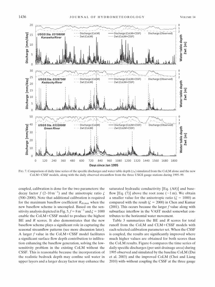
FIG. 7. Comparison of daily time series of the specific discharges and water table depth (z$) simulated from the CoLM alone and the new
CoLM1CSSF models, along with the daily observed streamflow from the three USGS gauge stations during 1995–99.
1436 JOURNAL OF HYDROMETEOROLOGY VOLUME 14

stations in the study domain. The original and current
CoLM without CSSF schemes produce discharges as
pulse fluctuations as a result of quick response to rain-
fall events, causing no recession time and overall un-
derestimation of runoff, whereas the hydrologically
enhanced version of the CoLM with the CSSF captures
the seasonal variability of streamflow quite realistically.
With each set of the selected calibration parame-
ters, the CoLM uncoupled and coupled with the CSSF
were run continuously for 5 yr from January 1995 to
December 1999. As shown in Fig. 7, the runoff simu-
lated by the CoLM alone shows an overestimate for
the peaks but an underestimate in recession periods,
while the coupling with the CSSF results in a signifi-
cant improvement by capturing observations much
more closely over the three study catchments. It is also
clear that the coupling with the CSSF significantly im-
proves the CoLM performance in representing the ba-
sin flow dynamics. Figure 7 and Table 4 demonstrate
that the CoLM1CSSF incorporating the role of surface
flow depth contribution to infiltration results in shal-
lower water table depth and enhanced baseflow gen-
eration. In the CoLM1CSSF the routed surface flow
depth and the large f value allow more water recharged
to soil layers to raise the water table and increase sub-
surface flow.
The CoLM predicts very little subsurface runoff, even
after incorporating more advanced representations, in-
cluding realistic bedrock depth, dynamic water table,
exponential decay profile of the saturated hydraulic con-
ductivity, minimum residual soil water, and maximum
surface infiltration limit (Choi and Liang 2010). In gen-
eral, when total runoff is dominated by its surface com-
ponent, LSMs tend to overestimate runoff peaks and
underestimate runoff recession. This may partially ex-
plain why the CoLM simulates extremely weak seasonal–
interannual soil moisture variability (Yuan and Liang
2011). On the other hand, the CoLM coupled with the
CSSF produces much larger subsurface runoff by in-
corporating the effects of surface flow depth and sur-
face macropores on the baseflow generation. The ratios
of subsurface to total runoff increase from 62.0%, 33.9%,
and 50.3% to 89.2%, 65.5%, and 57.4%, respectively, for
the Kanawha River, the Kentucky River, and the Green
River basins (Table 4). The study demonstrates that the
baseflow generation is extremely important for captur-
ing streamflow observations. Note that baseflow runoff
is comparable to total subsurface runoff in the CoLM
with the CSSF because other subsurface components are
confined by the use of the bedrock depth and the super-
saturation prevention scheme. Figure 8 illustrates that
the baseflow is predominant in low-flow seasons while
surface runoff is more important during the high-flow
season, especially May–June. One exception is for the
Kanawha River basin, where no considerable storm
events occurred over that period. Therefore, the new
CSSF parameterizations that enforce interactions be-
tween the routed surface flow and the subsurface flow
with topographic subgrid soil-moisture variation and base-
flow generation simulate total runoff more realistically,
especially in the recession part of the hydrograph. Rela-
tive to observations for theKanawhaRiver, theKentucky
River, and the Green River basins, the 5-yr-averaged
runoff is only 20.4%, 58.4%, and 48.1%, respectively,
in the CoLM, but increased to 81.0%, 84.2%, and 106.9%
in the CoLM1CSSF (Table 4 and Fig. 9). However, this
hydrologically enhanced version of the CoLM still can-
not capture the recessions in the early spring flooding
events. As shown in Fig. 9, the simulated monthly flow
volumes for each of the study basins are in general less
than observations during February–April. One possible
reason is that the new model does not yet include aquifer
recharge, regulation storage, deep aquifer groundwater
flow, and channel flow routing. In addition, the snowmelt
scheme may also contribute to the model–observation
discrepancy (Yuan and Liang 2011). These factors war-
rant further investigation.
6. Conclusions and summary
Most existing LSMs predict soil moisture transport
only in the vertical direction and estimate surface runoff
from local net water flux (precipitation minus surface
evapotranspiration and soil-moisture storage). However,
we found that subsurface subgrid and lateral fluxes
TABLE 4. Comparison of 5-yr-averaged simulation results from
the CoLM alone and the new CoLM1CSSF models along with
observations for the three study river basins. that the quantity Pt is
total precipitation (mmyr21),Rt is total runoff (mmyr21), rR is the
ratio of simulated Rt to observed Rt, rsb is the ratio of simulated
subsurface runoff to simulated total runoff, The ET is the evapo-
transpiration rate (mmyr21), and z$ is the water table depth (m).
All values are the 5-yr-averaged basinwide mean.
Kanawha
River
Kentucky
River
Green
River
Observations Pt 1056 1222 1285
Rt 510 403 582
CoLM Rt 104 235 280
rR 0.204 0.584 0.481
rsb 0.620 0.339 0.503
ET 912 968 1006
z$ 1.70 1.55 1.61
CoLM1CSSF Rt 413 339 622
rR 0.810 0.842 1.069
rsb 0.892 0.655 0.574
ET 972 1008 1038
z$ 0.81 0.75 0.66
OCTOBER 2013 CHO I ET AL . 1437

have significant impacts on soil-moisture spatial vari-
ability (Choi et al. 2007), and an explicit surface flow
routing scheme is required for the comprehensive terres-
trial hydrologic cycling in LSMs (Choi 2006; Choi et al.
2007; Choi and Liang 2010). They should be incorporated
in a fully interactive manner to affect the hydrologic
cycle both locally and in adjacent areas. To this end, we
have developed the CSSF module that comprises the
1D diffusion wave surface flow model coupled with the
3D VAST subsurface flow model and the 1D topo-
graphically controlled baseflow to substitute the existing
hydrologic module in the CoLM. The CSSF is im-
plemented into the CoLM by a time-split mixed nu-
merical approach, where the subsurface flow model is
FIG. 8. Modeled 5-yr-averaged climatology of monthly total model runoff consisting of
surface runoff and baseflow components in the new CoLM1CSSFmodel simulation for (top to
bottom) the three study river basins.
FIG. 9. Comparison of 5-yr-averaged climatology of monthly total runoff from the CoLM and the
new CoLM1CSSFmodels along with observations for (top to bottom) the three study river basins.
1438 JOURNAL OF HYDROMETEOROLOGY VOLUME 14

separated for the vertical component by an implicit
differencing method and the lateral component by an
explicit method, and the surface flow model is solved
by the MacCormack scheme. The implementation and
verification of the CSSF in coupling with the CoLM
is unique as compared with the conventional approach
in that the hydrological and atmospheric components
interact directly at the identical mesoscale grid mesh
without aggregation or disaggregation.
The model performance is evaluated using stand-
alone simulations of the CoLM with and without the
CSSF driven by realistic SBCs and reliable NARR cli-
mate forcing data around the Ohio Valley on the same
30-km grid over the U.S. domain of the coupling CWRF
to be applied. The CSSF incorporates advanced rep-
resentations for the lateral and subgrid soil-moisture
transport, the surface flow routing and interaction with
subsurface flow, and the topographically controlled base-
flow. As a result the coupling with the CSSF simulates
the total runoff much closer to observations than the
CoLM alone, especially for the declining recession curves
of hydrographs. The CSSF so developed demonstrates
a significant surface flow depth contribution to infiltra-
tion causing enhanced baseflow generation. Although
the soil-moisture simulation performance is not directly
evaluated due to lack of observations in the study basins,
Yuan and Liang (2011) have also demonstrated the su-
periority of the CSSF in simulating the observed Illinois
soil moisture variations from an offline test against the
CoLM and CLM. The terrestrial water dynamics by full
interactions between surface and subsurface flow in the
hydrologically enhanced version of the CoLM with the
CSSF represents an important advance to the simple
soil water budget used in the original and our modified
CoLM (Choi and Liang 2010). Ignoring these new pro-
cesses in the CoLM can cause significant model errors
and, consequently, unrealistic model parameters targeted
for calibration. The redistribution of surface and sub-
surface water by the new model may also have a large
impact on the prediction of the surface energy balance as
well. Note that the original CoLM has been demonstrated
by numerous studies for its good performance in global
climate models (see the introduction in section 1). We
contend that a resolution increase must couple with ad-
vanced model physics representation at that scale to re-
alize improved predictions. The newly developed CSSF
model provides a suite of improved modeling capability
for the CoLM to better characterize surface water and
energy fluxes crucial to climate variability and change
studies at regional–local scales.
The CSSF model, albeit with many new advances, has
yet to incorporate a more complete list of important fac-
tors for comprehensive terrestrial hydrologic simulations
over larger basins, including aquifer recharge, regulation
storage, consumptive use, and channel and groundwater
flow routing across the basin boundaries. In the current
CSSF mode, the overland-based surface flow scheme
cannot fully capture the storage effect of real streams, and
the topographically controlled baseflow scheme asso-
ciated with the water table depth neglects the possible
contribution from the deeper aquifer underlying the
bottom of the LSM soil column. These areas will be our
future targets to improve.
Acknowledgments.The research was supported by the
NOAA Education Partnership Program (EPP) COM
Howard 00073421000037534, Climate Prediction Pro-
gram for the Americas (CPPA) NA11OAR4310194 and
NA11OAR4310195, Environmental Protection Agency
RD83418902, National Science Foundation ATM-0628687,
and the National Research Foundation of Korea (NRF)
grant funded by the Korea government (MEST) (NRF-
2013R1A2A2A01008881).
APPENDIX
Soil Hydraulic Conductivity
The hydraulic conductivity K and matric potential c
are expressed as a function of soil wetness w (Brooks
and Corey 1964):
K(w)5Ksw2b13 , (A1)
c(w)5csw2b , (A2)
wherew is the effective soil wetness (saturation) defined
as
w5
8>>>>>><>>>>>>:
uliq 1 uice 2 ur
us 2 ur, uice, ur
uliq
us 2 uice, uice $ ur
, (A3)
where uliq (mmmm21) is the partial volume of liquid
soil water, uice (mmmm21) is the ice content in frozen
soil, and ur (mmmm21) is the residual moisture con-
tent at the hygroscopic condition, which is estimated
as ur 5 us(2316 230/cs)21/b (see Bonan 1996). The Ks
(mm s21), cs (mm), and us (mmmm21) are the com-
pacted hydraulic conductivity, the suction head, and
soil moisture content (porosity) at saturation, respec-
tively, and the exponent b is the pore size distribution
OCTOBER 2013 CHO I ET AL . 1439

index. They are approximated by pedo-transfer func-
tions in terms of soil sand and clay fractions (Cosby
et al. 1984; Bonan 1996) as
Ks 5 0:007 055 63 1020:88411:533sand , (A4)
cs 52102:8821:313sand , (A5)
us 5 0:4892 0:1263 sand, (A6)
b5 2:911 15:93 clay. (A7)
To improve estimates of the actual soil water ca-
pacity, we adopt the geographically distributed bed-
rock depth profiles as constructed at the CWRF 30-km
grid by Liang et al. (2005b). To approximate the water
drainage through bedrocks, we assume the hydraulic
properties of bedrocks whose porosity is 0.05 and sat-
urated hydraulic conductivity is 1% of that in the soil
layer right above, as similarly introduced in many LSMs
(Abramopoulos et al. 1988; Xue et al. 1991; Boone and
Wetzel 1996; Sellers et al. 1996).
We assume that the saturated hydraulic conductivity
follows an exponential decay with depth as developed
by Beven and Kirkby (1979), Beven (1982b, 1984), and
Elsenbeer et al. (1992):
Ksz
5Kse2f (z2z
c) , (A8)
where Ksz is the vertical saturated hydraulic conductivity
and zc is the compacted depth representing macropore
effect (Beven 1982a) near the soil surface, especially in
vegetated areas. It is assumed that the saturated con-
ductivity has reached the compacted value at the plant
root depth of 1m (Stieglitz et al. 1997; Chen and Kumar
2001). When zc is assumed 1m, Ksz is 7.13–1.41 times
greater thanKs in the CoLM soil layers 1–7 located above
zc, whereas Ksz is much less than Ks in the rest of the
lower soil layers, as shown in Table 2 of Choi and Liang
(2010). As such, vertical transport of soil moisture near
the surface is much faster with the Ksz profile because
of the effect of macropores. The value f is the decay
factor of Ksz , which can be obtained by comparison of
the recession curve in the observed hydrograph.
We also assume that soil properties (Ks, cs, us, b) are
constant and uncorrelated with each other within a grid
volume (Choi et al. 2007) and use a grid-representative
value using the layer-averaging method as
Ksz(k)5
1
Dzk
ðzk
zk21
Kse2f (z2z
c) dz
5Ks
e2f (zk2z
c)
fDzk(efDzk 2 1), (A9)
where Dzk is a layer thickness between vertical co-
ordinates zk and zk21 for the layer k. The Ksz is treated
constant within a grid volume, but can vary from one
grid to the next vertically and horizontally.
The lateral hydraulic conductivity is larger than ver-
tical to account for anisotropy (Freeze and Cherry 1979):
Ksx
5Ksy
5 zKsz
, (A10)
where z is an anisotropic factor first introduced by Chen
andKumar (2001) for the desired streamflow predictions.
Also, the diffusivityD and conductivityK functions in
Eq. (1) are calculated as:
Dm 52Ks
zcsb
uswb12 , (A11)
D- 521
2Ks
z
csb(b1 2)a2wb1322b , (A12)
Km 5 SxlKs
zw2b13 , (A13)
K-15 Sx
lKs
z(2b1 3)(b1 1)a2w2b1322b , (A14)
K-25sS
xl
Ksz
(2b1 3)aw2b132b(g11 g2w1 g3w2) ,
(A15)
where subscriptm represents the grid-mean term, and-1
and -2 denote the subgrid variability terms. The quan-
tity Sxl is the grid-mean slope and sSxlis the standard
deviation of local slopes for each grid where the sum-
mation over the coordinates xl 2 fx, yg is implied. The
variables a and b are parameters characterizing the
dependence of moisture variability on the mean, and
g1, g2, and g3 are parameters characterizing the de-
pendence of moisture on slopes, which are estimated by
the closure parameterization in Choi et al. (2007).
In addition, we need to determine the effective hy-
draulic conductivity and diffusivity functions for the
liquid part at the frozen soil interface. Choi and Liang
(2010) demonstrated that the new scheme using the
minimum of the unfrozen areas in the two adjacent soil
elements produces a mass-conserved and numerically
stable solution of soil-moisture profiles. They parame-
terized the frozen part as a function of soil liquid and
ice water contents at soil layer k:
Ffrz(k)5uice(k)
uliq(k)1 uice(k), (A16)
and the unfrozen part of soil moisture is
Fliq(k)5 12Ffrz(k) . (A17)
1440 JOURNAL OF HYDROMETEOROLOGY VOLUME 14

Hence, the effective functions for unfrozen areas at the
interface are computed as
xk11/25min[Fliq(k),Fliq(k1 1)]
�xk 1xk11
2
�, (A18)
where x represents all diffusivity and conductivity func-
tions. The quantities k and k1 1 denote one soil ele-
ment and another adjacent one, respectively, and k1 1/2
denotes the interface of the two in the vertical or
horizontal direction. Note that xzk[ xk11/2 in vertical
direction discretization. This interblock function can
reduce negative or supersaturated soil moisture solution
caused by numerical problems from the existing param-
eterization in most current LSMs (Choi and Liang 2010).
REFERENCES
Abramopoulos, F., C. Rosenzweig, and B. Choudhury, 1988: Im-
proved ground hydrology calculations for Global Climate
Models (GCMs): Soil water movement and evapotranspira-
tion. J. Climate, 1, 921–941.Akan, A. O., and B. C. Yen, 1981: Diffusion-wave flood routing
in channel networks. J. Hydraul. Eng., 107, 719–732.Beven, K. J., 1982a: Macropores and water flow in soils. Water
Resour. Res., 18, 1311–1325.——, 1982b: On subsurface stormflow: An analysis of response
times. Hydrol. Sci. J., 27, 505–521.
——, 1984: Infiltration into a class of vertically non-uniform soils.
Hydrol. Sci. J., 29, 425–434.
——, and M. J. Kirkby, 1979: A physically based, variable con-
tributing area model of basin hydrology.Hydrol. Sci. Bull., 24,
43–69.
Bonan, G. B., 1996: A land surface model (LSM version 1.0) for
ecological, hydrological, and atmospheric studies: Technical
description and user’s guide. NCAR Tech. Note NCAR/
TN-4171STR, 150 pp. [Available online at ftp://ftp.daac.ornl.
gov/data/model_archive/LSM/lsm_1.0/comp/NCAR_LSM_
Users_Guide.pdf.]
Boone, A., and P. J. Wetzel, 1996: Issues related to low resolution
modeling of soil moisture: Experience with the PLACEmodel.
Global Planet. Change, 13, 161–181.
Brooks, R. H., and A. T. Corey, 1964: Hydraulic properties in
porous media. Hydrology Paper No. 3, Colorado State Uni-
versity, 27 pp. [Available online at http://www.wipp.energy.gov/
library/cra/2009_cra/references/Others/Brooks_Corey_1964_
Hydraulic_Properties_ERMS241117.pdf.]
Chen, J., and P. Kumar, 2001: Topographic influence of the sea-
sonal and interannual variation of water and energy balance
of basins in North America. J. Climate, 14, 1989–2014.
Choi, G. W., and A. Molinas, 1993: Simultaneous solution algo-
rithm for channel network modeling. Water Resour. Res., 29,
321–328.
Choi, H. I., 2006: 3-D volume averaged soil-moisture transport
model: A scalable scheme for representing subgrid topographic
control in land-atmosphere interactions. Ph.D. dissertation,
University of Illinois at Urbana-Champaign, 189 pp.
——, and X.-Z. Liang, 2010: Improved terrestrial hydrologic rep-
resentation in mesoscale land surface models. J. Hydrome-
teor., 11, 797–809.
——, P. Kumar, andX.-Z. Liang, 2007: Three-dimensional volume-
averaged soil moisture transport model with a scalable param-
eterization of subgrid topographic variability. Water Resour.
Res., 43, W04414, doi:10.1029/2006WR005134.
Cosby, B. J., G. M. Hornberger, R. B. Clapp, and T. R. Ginn, 1984:
A statistical exploration of the relationships of soil moisture
characteristics to the physical properties of soils. Water Re-
sour. Res., 20, 682–690.Dai, Y., and Coauthors, 2003: The common land model. Bull.
Amer. Meteor. Soc., 84, 1013–1023.
——,R. E. Dickinson, andY.-P.Wang, 2004: A two-big-leaf model
for canopy temperature, photosynthesis, and stomatal con-
ductance. J. Climate, 17, 2281–2299.
Elsenbeer, H., D. K. Cassel, and J. Castro, 1992: Spatial analysis of
soil hydraulic conductivity in a tropical rainforest catchment.
Water Resour. Res., 28, 3201–3214.
Entekhabi, D., and P. S. Eagleson, 1989: Land surface hydrology
parameterization for atmospheric general circulation models
including subgrid scale spatial variability. J. Climate, 2, 816–831.Fan, Y., and G. Miguez-Macho, 2011: A simple hydrologic frame-
work for simulating wetlands in climate and earth system
models. Climate Dyn., 37, 253–278.
Freeze, R. A., and J. A. Cherry, 1979:Groundwater. Prentice-Hall,
604 pp.
Gochis, D. J., and F. Chen, 2003: Hydrological enhancements to
the community Noah Land Surface Model. NCAR Scientific
Tech. Rep., 77 pp. [Available online at http://nldr.library.ucar.
edu/collections/technotes/asset-000-000-000-516.pdf.]
Hromadka, T. V., II, R. H. McCuen, and B. C. Yen, 1987: A
comparison of overland flow hydrograph models. J. Hydraul.
Eng., 113, 1422–1440.
Jha, R., S. Herath, and K. Musiake, 2000: River network solution
for a distributed hydrological model and applications. J. Hy-
drol. Processes, 14, 575–592.Kazezyilmaz-Alhan, C. M., C. C. Medina Jr., and P. Rao, 2005: On
numerical modeling of overland flow. Appl. Math. Comput.,
166, 724–740.Kollet, S. J., and R. M. Maxwell, 2006: Integrated surface-
groundwater flow modeling: a free-surface overland flow
boundary condition in a parallel groundwater flow model.
Adv. Water Resour., 29, 945–958.Kumar, P., 2004: Layer averaged Richard’s equation with lateral
flow. Adv. Water Resour., 27, 521–531.
——, K. L. Verdin, and S. K. Greenlee, 2000: Basin level statistical
properties of topographic index for North America. Adv.
Water Resour., 23, 571–578.
Lawrence, D. M., P. E. Thornton, K. W. Oleson, and G. B. Bonan,
2007: The partitioning of evapotranspiration into transpira-
tion, soil evaporation, and canopy evaporation in a GCM:
Impacts on land–atmosphere interaction. J. Hydrometeor., 8,
862–880.
Lawrence, P. J., and T. N. Chase, 2007: Representing a new
MODIS consistent land surface in the Community Land
Model (CLM3.0). J. Geophys. Res., 112, G01023, doi:10.1029/
2006JG000168.
Lear, M., F. Olivera, J. S. Famiglietti, and D. R. Maidment, 2000:
Upscaling river network extractions from global digital ele-
vation models. CRWR Online Rep. 00-6, University of Texas
at Austin, 110 pp. [Available online at http://www.crwr.utexas.
edu/reports/pdf/2000/rpt00-6.pdf.]
Liang, X.-Z., L. Li, K. E. Kunkel, M. Ting, and J. X. L.Wang, 2004:
Regional climate model simulation of U.S. precipitation dur-
ing 1982–2002. Part I: Annual cycle. J. Climate, 17, 3510–3528.
OCTOBER 2013 CHO I ET AL . 1441

——, H. I. Choi, K. E. Kunkel, Y. Dai, E. Joseph, J. X. L. Wang,
and P. Kumar, 2005a: Development of the regional climate-
weather research and forecasting model (CWRF): Surface
boundary conditions. ISWS Scientific Rep. 2005-01, Illinois
State Water Survey, 32 pp. [Available online at http://www.
isws.illinois.edu/pubdoc/sr/iswssr2005-01.pdf.]
——, ——, ——, ——, ——, ——, and ——, 2005b: Surface
boundary conditions for mesoscale regional climate models.
Earth Interact., 9, doi:10.1175/EI151.1.
——, and Coauthors, 2005c: Development of land surface albedo
parameterization bases on Moderate Resolution Imaging Spec-
troradiometer (MODIS) data. J. Geophys. Res., 110, D11107,
doi:10.1029/2004JD005579.
——, M. Xu, J. Zhu, K. E. Kunkel, and J. X. L. Wang, 2005d:
Development of the regional climate-weather research and
forecasting model (CWRF): Treatment of topography. Proc.
2005 WRF/MM5 User’s Workshop, Boulder, CO, NCAR, 9.3.
[Available online at http://www.mmm.ucar.edu/wrf/users/
workshops/WS2005/abstracts/Session9/3-Liang.pdf.]
——, and Coauthors, 2006: Development of the regional Climate-
Weather Research and Forecasting model (CWRF): Treat-
ment of subgrid topography effects. In Proc. 7th Annual WRF
User’sWorkshop,Boulder, CO, NCAR, 7.3. [Available online
at http://www.mmm.ucar.edu/wrf/users/workshops/WS2006/
abstracts/Session07/7_3_Liang.pdf.]
——, and Coauthors, 2012: Regional Climate–Weather Research
and ForecastingModel (CWRF).Bull. Amer.Meteor. Soc., 93,
1363–1387.
MacCormack, R.W., 1971: Numerical solution of the interaction of
a shock wave with a laminar boundary layer. Proceedings of
the Second International Conference on Numerical Methods in
Fluid Dynamics, Lecture Notes in Physics, Vol. 8, Springer-
Verlag, 151–163.
Mahrt, L., and H. Pan, 1984: A two-layer model of soil hydrology.
Bound.-Layer Meteor., 29, 1–20.
Maxwell, R. M., and N. L. Miller, 2005: Development of a coupled
land surface and groundwater model. J. Hydrometeor., 6,233–247.
Mesinger, F., and Coauthors, 2006: North American regional re-
analysis. Bull. Amer. Meteor. Soc., 87, 343–360.
M€olders, N., and W. R€uhaak, 2002: On the impact of explicitly
predicted runoff on the simulated atmospheric response to
small-scale land-use changes—An integrated modeling ap-
proach. Atmos. Res., 63, 3–38.
Morita, M., and B. C. Yen, 2002: Modeling of conjunctive two-
dimensional surface-three-dimensional subsurface flows.
J. Hydraul. Eng., 128, 184–200.
Niu, G.-Y., and Z.-L. Yang, 2003: The Versatile Integrator of
Surface and Atmosphere processes (VISA) Part 2: Evaluation
of three topography based runoff schemes. Global Planet.
Change, 38, 191–208.
——, and——, 2006: Effects of frozen soil on snowmelt runoff and
soil water storage at a continental scale. J. Hydrometeor., 7,
937–952.
——, ——, R. E. Dickinson, and L. E. Gulden, 2005: A simple
TOPMODEL-based runoff parameterization (SIMTOP) for
use in GCMs. J. Geophys. Res., 110, D21106, doi:10.1029/
2005JD006111.
——, ——, ——, ——, and H. Su, 2007: Development of a simple
groundwater model for use in climate models and evaluation
with Gravity Recovery and Climate Experiment data. J. Geo-
phys. Res., 112, D07103, doi:10.1029/2006JD007522.
Oleson, K. W., and Coauthors, 2008: Improvements to the Com-
munity Land Model and their impact on the hydrological cy-
cle. J. Geophys. Res., 113,G01021, doi:10.1029/2007JG000563.
Ponce, V. M., R.-M. Li, and D. B. Simons, 1978: Applicability of
kinematic and diffusion models. J. Hydraul. Eng., 104, 353–360.
Qian, T., A. Dai, K. E. Trenberth, and K. W. Oleson, 2006: Simula-
tion of global land surface conditions from 1948 to 2004: Part I:
Forcing data and evaluations. J. Hydrometeor., 7, 953–975.Richards, L., 1931: Capillary conduction of liquids through porous
mediums. Physics, 1, 318–333.
Richter, K.-G., andM. Ebel, 2006: Analysis of runoff for the Baltic
basin with and integrated Atmospheric-Ocean-Hydrology
Model. Adv. Geosci., 9, 31–37.
Rodell, M., and Coauthors, 2004: The global land data assimilation
system. Bull. Amer. Meteor. Soc., 85, 381–394.Saint-Venant, B., 1871: Theorie du mouvement non-permanent des
eaux avec application aux crues des rivieres at a l’introdution
des marees dans leur lit. Acad. Sci. Paris C. R., 73, 147–154.
Schaefli, B., and H. Gupta, 2007: Do Nash values have value?
Hydrol. Processes, 21, 2075–2080, doi:10.1002/hyp.6825.
Schmid, B. H., 1989: On overland flow modelling: Can rainfall
excess be treated as independent of flow depth? J. Hydrol.,
107, 1–8.Sellers, P. J., S. O. Los, C. J. Tucker, C. O. Justice, D. A. Dazlich,
G. J. Collatz, and D. A. Randall, 1996: A revised land surface
parameterization (SiB2) for atmospheric GCMs. Part II: The
generation of global fields of terrestrial biophysical parame-
ters from satellite data. J. Climate, 9, 706–737.
Sevuk, A. S., and B. C. Yen, 1973: Comparison of four approaches
in routing flood wave through junctions. Proc. 15th Int. Assoc.
of Hydraulic Engineering and Research World Congress, Is-
tanbul, Turkey, IAHR, 169–172.
Singh, V., and S. M. Bhallamudi, 1997: A complete hydrodynamic
border-strip irrigation model. J. Irrig. Drain. Eng., 122, 189–197.Sivapalan, M., K. J. Beven, and E. F. Wood, 1987: On hydrologic
similarity: 2. A scaledmodel of storm runoff production.Water
Resour. Res., 23, 2266–2278.Stieglitz, M., D. Rind, J. Famiglietti, and C. Rosenzweig, 1997: An
efficient approach to modeling the topographic control of sur-
face hydrology for regional modeling. J. Climate, 10, 118–137.
Tsai, C. W.-S., and B. C. Yen, 2001: On noninertia wave versus
diffusion wave in flood routing. J. Hydrol., 244, 97–104.
Walko, R. L., andCoauthors, 2000: Coupled atmosphere-biophysics-
hydrology models for environmental modeling. J. Appl. Me-
teor., 39, 931–944.Wallach, R., G. Grigorin, and J. Rivlin, 1997: The errors in surface
runoff prediction by neglecting the relationship between in-
filtration rate and overland flow depth. J. Hydrol., 200, 243–259.
Warrach, K., M. Stieglitz, H.-T. Mengelkamp, and E. Raschke,
2002: Advantages of a topographically controlled runoff simu-
lation in a soil–vegetation–atmosphere transfer model. J. Hy-
drometeor., 3, 131–148.Woods, R. A., and M. Sivapalan, 1997: A connection between to-
pographically driven runoff generation and network structure.
Water Resour. Res., 33, 2939–2950.
Xue, Y., P. J. Sellers, J. L. Kinter III, and J. Shukla, 1991: A sim-
plified biosphere model for global climate studies. J. Climate,
4, 345–364.
Yuan, X., and X.-Z. Liang, 2011: Evaluation of a Conjunctive
Surface–Subsurface Process Model (CSSP) over the contigu-
ousUnited States at regional–local scales. J. Hydrometeor., 12,
579–599.
1442 JOURNAL OF HYDROMETEOROLOGY VOLUME 14
Copyright © 2022 FDOKUMEN