7th Quarterly Progress Report for 6 Cis Package B - citarum.org
122
TA 7189-INO: INSTITUTIONAL STRENGTHENING IN THE 6 CIS RIVER BASIN TERRITORY - PACKAGE B FOR INTEGRATED WATER RESOURCES MANAGEMENT (IWRM) ADB th 7 QUARTERLY REPORT August - October 2011
-
Upload
khangminh22 -
Category
Documents
-
view
1 -
download
0
Transcript of 7th Quarterly Progress Report for 6 Cis Package B - citarum.org

TA 7189-INO: INSTITUTIONAL STRENGTHENING
IN THE 6 CIS RIVER BASIN TERRITORY - PACKAGE BFOR INTEGRATED WATER RESOURCES MANAGEMENT (IWRM)
ADB
th7 QUARTERLY REPORT August - October 2011
TA 7189-INO Package B 7th
Quarterly Report November 2011
DHV, Deltares, MLD i
7th QUARTERLY REPORT FOR TA 7189-INO OCTOBER 2011
1. TA 7189-INO PACKAGE B ........................................................................................................... 1 1.1. Introduction ........................................................................................................................... 1 1.2. Developments during this period .......................................................................................... 1 1.3. Logistics ................................................................................................................................ 3
2. SUBCOMPONENT B1 INSTITUTIONAL STRENGTHENING AND PLANNING ......................... 4 2.1. Status of B.1 Tasks ............................................................................................................... 4 2.2. Developments and Key Findings for Component B.1A ........................................................ 4
2.2.1 Task 2.1 Stakeholders assessment and counterpart training ................................. 4 2.2.2 Institutional Strengthening ....................................................................................... 7
2.3. Developments/Key Findings in Sub-Component B.1B ......................................................... 8 2.3.1 Task B.1-3 Web-based Meta Data Base ................................................................. 8 2.3.2 Task B.1-4 Decision Support Systems .................................................................... 9 2.3.3 Task B.1-5 Basin Planning,Development of Pola and Rencana: .......................... 12 2.3.4 Task B.1-6 State of The Basin Reporting .............................................................. 16
2.4. Issues .................................................................................................................................. 17 2.4.1 Issues concerning Sub-component B.1A .............................................................. 17 2.4.2 Issues concerning Sub-component B.1B .............................................................. 19
2.5. Developments envisaged for the next Period ..................................................................... 21
3. SUB COMPONENT B.2 ............................................................................................................... 23 3.1. Status of B2 tasks ............................................................................................................... 23 3.2. Developments and issues ................................................................................................... 23
3.2.1 Developments ........................................................................................................ 23 3.2.2 Issues .................................................................................................................... 27
3.3. The need for an extension of B2 ......................................................................................... 28 3.4. Current status of the Java Spatial Model ............................................................................ 29 3.5. Developments in next period .............................................................................................. 29
4. SUB COMPONENT B.3 ............................................................................................................... 30 4.1. Status Tasks B.3 ................................................................................................................. 30 4.2. Progress in implementation Tasks B.3 ............................................................................... 30
4.2.1 Original Task B3-1, B3-3 Groundwater Use in Bandung ...................................... 30 4.2.2 Task B3-2 Water Allocation in Jatiluhur Scheme .................................................. 31 4.2.3 Bulk Water Pricing Study ....................................................................................... 31
4.3. Developments and Key Findings ........................................................................................ 32 4.3.1 Groundwater Bandung .......................................................................................... 32 4.3.2 Water Allocation Jatiluhur ...................................................................................... 32 4.3.3 Follow up activities, MoUs ..................................................................................... 35
4.4. Water Service Charge (Earlier Pricing of Bulk Water Supply) ............................................ 35 4.4.1 Change of name .................................................................................................... 35 4.4.2 Background............................................................................................................ 35 4.4.3 Sharing of joint costs ............................................................................................. 39 4.4.4 Investments to increase and assure bulk water supply to Jakarta ........................ 40 4.4.5 Additional benefits of the pipelines ........................................................................ 42
4.5. Issues .................................................................................................................................. 43 4.6. Reports ................................................................................................................................ 43 4.7. Developments for the next Period ...................................................................................... 44
5. PROJECT IMPLEMENTATION PACKAGE B ............................................................................ 45 5.1. Deliverables ........................................................................................................................ 45 5.2. Inputs .................................................................................................................................. 45 5.3. Review mission from ADB .................................................................................................. 46 5.4. Contract and Variation Order .............................................................................................. 47
5.4.1 Official documents ................................................................................................. 47 5.4.2 Proposed extension for Package B.1 .................................................................... 47 5.4.3 Proposed extension for B.2 ................................................................................... 49
Ad 1) Support TA Rencana WRM process with spatial planning input ........................................ 49 Ad 2) Intensive transfer of knowledge for water zoning tools ...................................................... 49 Ad 3) Support water zoning in spatial planning process .............................................................. 50 Ad 4) Intensive transfer of knowledge for JSM ............................................................................ 50
TA 7189-INO Package B 7th
Quarterly Report November 2011
DHV, Deltares, MLD ii
List of Table Table 2.1. Revised Project Design and Monitoring Framework for sub-component B.1 ................... 5 Table 2.2. Overview of scenarios for Pola ........................................................................................ 14 Table 2.3. Overview of Strategies and application of scenarios and JSM simulations .................... 16 Table 2.4. Overview of 2011 budgets available in the BBWS for 6 Cis (in M Rp) ............................ 18 Table 3.1. Status B2 Design and Monitoring Framework (31 October 2011) ................................... 24 Table 4.1. Challenges and Recommendations Groundwater ........................................................... 33 Table 4.2. Challenges and Recommendations on Water Allocation ................................................ 34 Table 4.3. Strategies, Challenges, MoUs and Projects on Groundwater ......................................... 36 Table 4.4. Strategies, Challenges, MoUs and Projects on Water Allocation .................................... 37 Table 4.5. Progress of follow up on Strategies B3 on Water allocation ........................................... 38 Table 4.6. Distribution of shared PJT II costs over sectors based on EBV and EBV/m
3 ................. 40
Table 4.7. Joint Cost (JC) and Specific Cost (SC) of PJT II, 2010 .................................................. 40 Table 4.8. Breakdown of fees (Rp/m3) required to cover cost of various investments .................... 41 Table 4.9. List of B3 Reports ............................................................................................................ 44 Table 5.1. Overview of budgets (M Rp) available (2011) and planned (2012) in the BBWS ........... 45 Table 5.2. Assessment of additional Inputs and required funds for extension B.1 .......................... 48 Table 5.3. Estimated costs Ad 1) ..................................................................................................... 49 Table 5.4. Estimated costs Ad 2) ..................................................................................................... 49 Table 5.5 Estimated costs Ad 3) ..................................................................................................... 50 Table 5.6 Estimated costs Ad 4) ..................................................................................................... 50
List of Figures Figure 2.1. Water Demand from DMI at current levels (green), and based on MDGs (2010, 2030) . 10 Figure 3.1. Development of sedimentation in Saguling Res.............................................................. 25 Figure 3.2. Estimated current erosion in the Upper Citarum catchment ........................................... 26 List of Annexes Annex A - Time Planning of Staff with used time up to October 2011. Annex B - Time Planning of Staff as proposed for VO3 Annex C - Membership TKPSDA Annex D - Summary of Pola, October 2011 Annex E - not applicable Annex F - Training Report Annex G - Status of activities concerning B.3 on Groundwater Annex H - Status of activities concerning B.3 on Surface water Annex I - Addional activities proposed for B.1 Annex J - Additional activities proposed for B.2 Annex K - Additional activities proposed for support in task distribution discussions Annex L - Published Reports up to October 2011
TA 7189-INO Package B 7th
Quarterly Report November 2011
DHV, Deltares, MLD iii
GLOSSARY 6 Cis RBT River Basin territory of Cidanau, Ciujung, Cidurian + Ciliwung, Cisadane + Citarum ADB Asian Development Bank AM Asset Management Balai PSDA WRM Centre (at Provincial level) BAPPEDA Local Government Planning Board BAPPENAS National Planning Board BBWS Greater Basin Territory Centre (Balai Besar Wilayah Sungai), at MPW level BLU Public Service Organization, can collect charges BTA 155 Cisadane - Cimanuk Integrated Water Resources Development project
Strategic WRM Planning project in Indonesia (1985 – 1991) BWRMC Basin Water Resources Management Council BWRMP 1) Basin Water Resources Management Plan (Rencana) 2) Project for formulation of BWRMP (2001 – 2004) BWRP Basin Water Resources Planning (1996 – 2001, later changed to BWRMP) CDAP Capacity Development Action Plan CMT Change Management Team CRB Citarum River Basin CRBOM Centre for River Basin Organizations and Management CSO Community Society Organization or NGO DAS Daerah Aliran Sungai, Watershed, River Basin DGWR Directorate General for Water Resources at MPW DMI Domestic, Municipal and Industrial (water demand) FEWS\HYMOS Hydrological data processing system based on Flood Early Warning System FHM Flood Hazard Mapping, component under Jakarta Flood Management (2007 –
2010) FMSB Flood Management in Selected Basins (2004 – 2005) GDP Gross Domestic Product GIS Geographic Information System GOI Government of Indonesia GWP Global Water Platform HRM Human Resources Management ICWRMIP Integrated Citarum WRM Investment program IWRM Integrated Water Resources Management JABOTABEK Area comprising Jakarta, Bogor, Tangerang, Bekasi JABODETABEK Area comprising Jakarta, Bogor, Depok Tangerang, Bekasi JSM Java Spatial Model JWRMS JABOTABEK WRM Study MFF Multi-tranche Facilitation Facility (for ADB loans) MIS Management Information System MOHA Ministry of Home Affairs MPW Ministry of Public Works NARBO Network for Asian River Basin Organizations NGO Non Government Organization O&M Operation and Maintenance ODS Organizational Development Specialist PBPB Performance Benchmarking for Physical Basins PISP Participatory Irrigation Sector Project PJT II National Corporation for Basin Management (for Citarum) PODES Data Base with statistical data at desa level PPTPA Present form of Water Resources Council at Basin Level PSDA WRM PTPA Present form of Water Resources Council at Provincial Level PusAir Agency for Research and Development in Water Resources, under MPW RBMO River Basin Management Organization RBT River Basin Territory (Wilayah Sungai, WS) RCMU Road Map Coordination Management Unit RIBASIM River Basin Simulation Model, Decision Support System for WR planning
/management Sawah Rice Field
TA 7189-INO Package B 7th
Quarterly Report November 2011
DHV, Deltares, MLD iv
SMP Strategic Water Resources Management Plan, (Pola) TA Technical Assistance TAMP Total Asset Management Program TKPSDA Coordination Team for WRM (Basin WRM Council) WB World Bank WISMP Water Resources and Irrigation Sector Management program WRM Water Resources Management WRMC WRM Council WTC West Tarum Canal

TA 7189-INO Package B 7th
Quarterly Report November 2011
DHV, Deltares, MLD 1
1. TA 7189-INO PACKAGE B
1.1. Introduction
Institutional Strengthening for Integrated Water Resources Management (IWRM) in the 6 Cis (six rivers) River Basin Territory (RBT) (TA 7189-INO) is located in the North Western part of Java island, comprising the metropolitan cities of Jakarta and Bandung and its surroundings. Component B, the subject of this report, is concerning institutional strengthening of government institutions and civil service organizations for planning of IWRM. Several sub-components are identified:
B1A Institutional Strengthening for IWRM in 6 Cis RBT B1B IWRM Planning in 6 Cis RBT covering strategic management planning resulting
in a Pola, and preparation of a Master Plan (Rencana) B2 Strategic Spatial Planning in 6 Cis RBT B3 Development of Key Policies and Strategies for IWRM
Implementation of Sub-component B1 started on November 11, 2009 after the contract was approved by ADB, and is intended to continue for 36 months until November 2012. Implementation of Sub-component B2 started on February 15, 2010, and was completed after 18 months in August 2011. The draft final report for B.2 has been submitted in October 2011.. Sub-component B3 started in November 2009 and delivered final results in June 2011 The draft final report for B.3 (Vol B.3 -11 and 12, concerning water allocation and gorund water) was submitted in June 2011, comments were received, and the final version will be submitted in November 2011. This seventh Quarterly Progress Report presents the status on 31 October 2011 and progress achieved during the last three months of project implementation, and also presents an indication of developments and issues affecting implementation. Each sub-component is dealt with in chapters 2, 3 and 4, respectively, while general project implementation is discussed in chapter 5.
1.2. Developments during this period
During this period the major aim under B.1 was to assist the Water Council for 6Cis RBT (TKPSDA) to start working and discuss the draft Pola submitted in July 2011. The TKPSDA for 6 Cis has been established in December 2010 under PERMEN PU 594/KPTS/M/2010, but only had its first plenary meeting on September 21 and 22. Another complicating factor was that PU wants to split the 6Ci RBT in three RBT, based on the working areas of the three River Basin Organizations (BBWS) established in the area. In anticipation of this decision the Pola was prepared in such a way that such split would not have major consequences. This implied focus group discussions and Public Consultation meetings organized per BBWS working area, and more specific attention to the provincial Water Councils and related local Agencies involved in Water Resources Management. Moreover, reorganization of PU/DG Water Resources in February 2011, resulted in many staff changes, and the consultants had to assist this new staff to familiarize themselves with the new situation and the achievements up to now of this TA. Because of this, as reported earlier, the formulation of the Pola was completed in July 2011, seven months later than originally envisaged, and Capacity Building plans could not be prepared yet. Originally the consultants would not be involved in finalization of the Pola through TKPSDA, but PU requested additional assistance. Consultants cannot be involved in the subsequent
TA 7189-INO Package B 7th
Quarterly Report November 2011
DHV, Deltares, MLD 2
process to arrange the signature of the Minister of PU (6 Cis RBT is under the authority of Central Government, because it is located in more than one province). The consultants continue with preparation of the Rencana, no delay of the final completion date (December 2012) is envisaged yet, although additional resources are required to cope with the extra resources used during the extended Pola process and additional requirements as proposed during the ADB review mission. See also chapter 5 logistics. No activities were implemented under B.2, except that the draft final report was published and submitted in October 2011. Earlier B.2 provided a new version of the Java Spatial Model (JSM 2.2), as well as a simulation of population growth and related urban growth for various scenarios until 2030 and 2050. A preliminary report for B.2 was presented in April 2010 showing the assumptions concerning scenarios, population growth and settlement growth, and resulting impacts on needs for drinking water and irrigation water, BOD pollution load etc. as used for the Pola. The activities were completed and reported in a workshop on August 1 and 2. 2011. Draft final report was submitted in October 2011. A sophisticated new technique has been employed to assess land use, using radar images, which are not obstructed by clouds, and giving a more realistic indication of the area used for irrigated rice fields and urban area. Population census data are available by kecamatan. Also a map data layer per desa is available. But the complete data set of the population census per desa could not be incorporated, because it was not available yet in August 2011 It is unclear when these data at desa level will be issued. It is intended to extend activities for B.2 also during the Rencana phase, but extra funds are needed for that. These extra funds may come available in March 2011. In the mean time some changes have been proposed in Variation Order 3, as reported in Chapter 5, to accommodate the most urgently needed assistance by the Co Team Leader for B.2 and Senior Spatial Planner, as well as GIS specialists, For B.3 the major activities have been completed in February 2011, and the office in Bandung has been reduced. The results on groundwater based on the Bandung workshop on November 2nd 2010 and the results on surface water management for Jatiluhur based on the Bandung workshop on February 17th 2011 are summarized in clear recommendations to be followed up under TA 7189 or under next programs. The draft final reports have been submitted on June 30 2011, and ADB provided comments. Also some comments have been received from the Provincial Dinases for (1) Water Resources, as well as for (2) Energy and Mineral Resources (ESDM), which is in charge of groundwater, Final versions will be submitted in November 2011.. Based on the conclusions of the review mission of ADB in October 2010 an extra study concerning pricing of water supply to Jakarta has been arranged, which started in June 2011, and is coordinated under component B.1. The study aims to formulate a methodology to establish pricing mechanisms, with focus on the situation concerning water supply from Citarum river to the water supply company of Jakarta through the West Tarum Canal, as an example for other situations. As reported above, an important issue is the intention of DGWR to split 6 Cis RBT into three RBTs, according to the working areas of the three BBWS. This may have impacts on the work for Pola and Rencana, as well as for functioning of the TKPSDA. For the moment it is intended to complete the Pola as for the whole 6 Cis RBT, and adjust later after the PerPres about delineation of RBTs has been issued if necessary. In this way the Pola for 6 Cis may function as an umbrella for integrated approach of the larger system, especially concerning the inter-basin transfers from the eastern and western side to Ciliwung-Cisadane.
TA 7189-INO Package B 7th
Quarterly Report November 2011
DHV, Deltares, MLD 3
1.3. Logistics
We are pleased to mention that almost all counterparts from PU, comprising two (three were originally envisaged) from DG for Spatial Planning, two from DGWR Jakarta and two from each BBWS, have participated in implementation of Package B. They are all junior staff, but with good education (S.1 and S.2) and high motivation. The counterparts have also participated in trainings implemented for Package B. However, it should be noted that this staff is not full-time available, which is limiting the transfer of knowledge, and the skills of the counterparts to replicate the work of the consultants. To support the team an excellent office space was provided in Jakarta in the former building of Directorate for Planning and Programming, with all facilities such as furniture, water, electricity and telephone lines. However, this building has been demolished in December 2010, and therefore the office had to move to a much smaller location in the former building of Directorate of Rivers. Office space in Bandung is adequate, although there is no fixed telephone line, and all furniture and some equipment has been provided by DHV. Two variation orders have been proposed and approved to cope with changes identified under the inception report (VO I) and the review mission in Sept/Oct 2010 (VO 2). A third one is under preparation, comprising price escalation, submitted on November 7, 2011... In April / June an ADB Review mission has been implemented for TA 7189 INO. Conclusions and follow up concerning Package B are summarized in chapter 5.
TA 7189-INO Package B 7th
Quarterly Report November 2011
DHV, Deltares, MLD 4
2. SUBCOMPONENT B1 INSTITUTIONAL STRENGTHENING AND PLANNING
2.1. Status of B.1 Tasks
Status of the Tasks for B.1 and achieved progress during the last three months is indicated in the revised Project Design and Monitoring Framework (DMF) as presented in Table 2.1 on the next pages.
2.2. Developments and Key Findings for Component B.1A
2.2.1 Task 2.1 Stakeholders assessment and counterpart training
For Task B.1-1 the activities mainly concentrated on reviewing stakeholder assessment and activiating the Basin Council for 6 Cis. On 16 December 2010 the decree for establishment of the TKPSDA (594/KPTS/M/2010) was signed by the Minister for PU. An overview of its members is indicated in Annex C. On September 21 and 22 it had its first plenary meeting. The POLA for 6 Cis RBT is supposed to be formulated by the TKPSDA, and therefore it is essential that the TKPSDA starts proper functioning. This is the task of the secretariat, which is headed by the head of the O&M division of BBWS Ciliwung Cisadane. During the first plenary session on September 21 and 22 the house rules for administration, deliberation and decision making were discussed, and the draft Pola was presented. It was decided that the Pola should first be discussed in three commissions, one for conservation, facilitated by BBWS Citarum, one for utilization, facilitated by BBWS Cidanau-Ciujung-Cidurian, and a third one for damaging impacts of water, especially floods, facilitated by BBWS Ciliwung-Cisadane. It is intended to have this completed before the end of the year, and present the agreed draft Pola to the Minister of PU for final legislation. Splitting 6 Cis RBT in three areas, implies a need for three TKPSDA. Arrangements can be quickly adapted, because most members are representatives from one of the three areas, as shown in note 2 of the box on page 4. Some people will be members of two TKPSDA. (See also Annex C) But the weakness is that there is no coordinating platform for issues beyond one RBT, such as water supply to Jakarta and efforts in upstream Citarum (watershed and water quality protection) for the benefit of the people living in Jakarta. Therefore it is proposed to continue the work of TKPSDA 6 Cis as an umbrella platform for three more local platforms in the working areas of the three BBWS or new RBT. The stakeholder analysis indicated that organization of government organizations is quite stable, although the different roles of operators PJT II, BBWS, province and district show overlaps and gaps as indicated under Task B.1-2. Non-government stakeholders are also becoming more stable.. Coordination with the stakeholders in Citarum is already well established with regular stakeholder consultations for implementation of the Citarum Roadmap. The organization of stakeholders in the Cidanau catchment is very interesting, because an independent foundation (Krakatau Water Foundation) has been established for sustainable management of Cidanau, with funds from the industries using its water resources.
TA 7189-INO Package B 7th
Quarterly Report November 2011
DHV, Deltares, MLD 5
Table 2.1. Revised Project Design and Monitoring Framework for sub-component B.1 Design Summary Performance Targets/Indicators Status 31 October 2011 Planning for next Quarter till 31 January 2012
Task B.1.1 Ongoing support for Water Resources Council (WRC) and supporting office(s),
Water Resources Council operating effectively and making appropriate decisions and recommendations to GOI (2011).
WRC in provinces established as follows: - West Java per March 2010, first meeting July 2010, app
monthly meetings afterwards - DKI Jakarta per Feb. 2010, first meeting April 2010,
inauguration Sept 2010, app. Monthly meetings - Banten: established in 2006, twice changing its member
composition, now formulating strategies.
Basin Council (TKPSDA) established per KEPMEN PU 594/KPTS/M/2010 per 16 December 2010. Inauguration expected in November 2011. (see annex C).
Stakeholder analysis report in whole RBT finalized, to be regularly updated.
Two rounds of Public Consultation Meetings in all three RBTs in October 2010 and May 2011 for Pola formulation, involving all (candidate) members of the WRC.
Assessment of Training needs for provincial Water Councils
Routine support for provincial councils in West Java and Jakarta, but special support to improve functioning of provincial water council in Banten
Support TKPSDA members during first meetings. Assess training needs
Update of stakeholder analysis based on reorganizations in December / January.
First round of PCM for Rencana envisaged in February 2012.
Task B.1.2 Improved capacity of river basin management agencies (RBMOs).
Strengthened Balai Besar for three sub-basins
Capacity of river basin management agencies to make decisions in an IWRM context improved (2010).
All three Balai Besar strengthened in areas of: (i) Leadership / teamwork, (ii) human resources
management, (iii) financial planning and
management (2012)
No follow up on CDAPs and CMT as formulated under TA 4381-INO, Problem is that there is no clear task distribution between BBWS and provinces. Official policy from DGWR is in preparation.
Functional Analysis of DGWR and Balais resulted in re-organization in January 2011, aiming to result in a more service oriented organization, with clear indicators for benchmarking of performance, which will be a sound basis for the aimed strengthening of the Balai Besar.
Representatives from DGWR and all three BBWS participated in a leadership course implemented in Solo by CRBOM and PJT I in September 2011.
Facilitate finalization of Role distribution in 6 Cis RBT
Assess impact of reorganization for DGWR and Balais in 6 Cis RBT
Assess follow up of Performance Benchmarking and potential and needs for Capacity Building
Preoare additional training courses and comparative studies.
Task B1.3:Internet-based meta-database for water, land and related data in Citarum River Basin
Meta-database designed, implemented and operational (2010)
Website (6Cis.org) has been established with general access to general information, reports and minutes of meeting, and more restricted access for persons involved in the project for more detailed information
Data collection list presented in Inception Report, based on guidelines for Pola preparation (KepMen 22/2009) and the current guidelines for Rencana preparation.
Asset management system has been tested in Ciujung basin, and found suitable for application, but current implementation is weak, especially data input verification.
Website to be established, integrated in PU website, will be named “enamci/pu.go.id ( need approval from PU)
Meta data base system based on Dublin-core standards, with access through the web-site
Asset Management system to be improved and made more familiar
TA 7189-INO Package B 7th
Quarterly Report November 2011
DHV, Deltares, MLD 6
Table 2.1 Revised Project Design and Monitoring Framework for sub-component B.1 (continued)
Design Summary Performance Targets/Indicators
Status 31 October 2011 Planning for next Quarter till 31 January 2012
Task B1.4: Effective decision support tool for use by relevant agencies for water planning.
Decision support tool designed, implemented and accessible to all relevant agencies and their staff (2010)
HYMOS/FEWS and RIBASIM available
A lot of data and modeling framework is available from earlier projects, and incorporated in the present models.
Additional hydrological data are now checked and validated, to be incorporated in the Rencana
Training has been done for the counterparts and selected staff in application of these models
Further checking and validating hydrological data series (completion November 2011)
Further updating the 6 Cis water balance model for these hydrological data, land use (see chapter 3) and recent infrastructure
Training of counterparts and other relevant staff in use of these models in training events, and preferably also during on-the-job trainings
Task B.1-5 Pola and Rencana for 6 Cis River Basin Territory.
Recommendations for
improved technical capacity: (i) flood warning & real-
time communication, (ii) management and data
information systems, (iii) quantity and quality
monitoring of flow and regulation for efficient water allocation.
Recommendations on improved institutional framework for O&M of water infrastructure
Pola (2011) and Rencana (2012) for 6Cis RBT completed and approved by GOI, and implementation commenced
Reports with recommendations for further work to improve technical capacity prepared and submitted (2011)
Reports on recommendations for improved institutional framework for O&M of water infrastructure prepared and submitted and endorsed by DGWR (2010)
Framework for Pola and Rencana available
The final draft Pola has been presented on July 5 2011 and is now processed for legalization through TKPSDA and after that to minister for PU.
Summary of draft Pola available on website 6cis.org, and included as Annex D
Consultants now continuing with preparation of the Rencana
Partly incorporated in the Pola
This will also be part of analysis for the Rencana (2012)
This could not yet be implemented, because the new organization structure was not complete, and many new staff have been appointed since February 2011. Mr. Nidhom, the public policy specialist under B.3, is now focusing on these matters, together with the institutional specialist Darismanto, who concentrates more on the Water Councils (Dewan Propinsi and TKPSDA) .
Assistance during legalization, since in principle additional resources will become available in March 2012.
An interim report based on findings during the preparation of the Pola concerning proposed technical improvements will be prepared in November 2011.
Another report concerning proposed technical improvements will be published as part of the report on Rencana (2012)
This will be addressed together with an additional study on the task distribution between the BBWS, PJT II and province and district agencies concerning O&M for Water Resources infrastructure
Task B.1-6: Annual "state of the basin" reporting system.
"State of the basin" reporting system in place and reports being produced and submitted annually
Initial report presented by W. Giesen on August 2010, February 2011 and August 2011. Preliminary design of questionnaire is presented in Annex E.
Preliminary recommendation on “State of the basin” reporting to be completed in October 2011. Implementation envisaged in Febr-April 2012.
TA 7189-INO Package B 7th
Quarterly Report November 2011
DHV, Deltares, MLD 7
Special training was given to counterparts from DGWR. Field trips in combination with short trainings were implemented for all 11 counterparts as reported before. Training in HYMOS/FEWS was done in May/June 2010, for RIBASIM on 26-28 October 2010, 18-19 March 2011, and October 2011. A special training was organized in October concerning application of the Strategic Planning concept for preparation and updating of basin plans per province. It is intended to organize a special course on IWRM for the TKPSDA together with the secretariat supporting the TKPSDA, and a special course on IWRM for the BBWS together with the provincial and district agencies involved in IWRM to enhance their cooperation and coordination, if additional funds are provided.
2.2.2 Institutional Strengthening
Concerning Task B.1-2 an update of diagnostic analysis implemented in TA 4381-INO, indicated that the Change Management Teams (CMT) were not active anymore, and Capacity Development Action Plans were not existing or not updated. The different roles of operators PJT II, BBWS, province and district show overlaps and gaps. Officially the BBWS are responsible for Water Resources Management (WRM) for the whole River Basin Territory (RBT), because it is a national basin. This includes O&M of all facilities, including the dams, rivers and the irrigation systems. But since there are already capable organizations dealing with parts of infrastructure there is a role sharing arrangements. For most irrigation systems a mandate is given to the provincial services through co-management or Tugas Perbantuan, TP. According to PP7/2010 PJT II is responsible for O&M of Jatiluhur dam and the main canals of the 240,000 ha irrigation system served from its reservoir, as well as operation of the secondary canals (maintenance is mandated to the province and districts); PJT II has its own funds from collected fees for bulk water supply and hydropower generation, and is using this also as cross subsidy for irrigation O&M. Role sharing arrangements are being formulated in a directive from PU-DGWR. MoUs between the various organizations should comprise multi-years arrangement, to allow more effective planning and implementation according to those plans. Arrangements based on budgets are arranged in annual joint operation letters (KSO). On August 31 part of the West Tarum embankment collapsed, affecting the water supply for one million clients in Jakarta. It was temporary repaired in four days through adequate intervention by BBWS Citarum, but afterwards it was not clear who is responsible for such repairs, the operator PJT II, or the BBWS. Therefore an additional study was requested to formulate impartial recommendations concerning task distribution. At the request of the BBWS Ciliwung Cisadane, also an assessment will be included about task distribution arrangements for O&M of some 200 small reservoirs (Situ situ) between the BBWS and the provincial and district agencies. This will be done after additional funds become available in March 2012. Inventories of personnel for BBWS were collected, based on quantitative and qualitative data, also as part of the preparations for the master plan for capacity building at the Ministry of Public Works (PU), DG Water Resources. This revealed that there is a wide variation in perception of how the various tasks and responsibilities have to be implemented, concentrating on questions as how much mandate is given to the provinces through TP, how much is done by own staff or by out-sourcing etc. A clear guideline from higher levels is required. This was also the conclusion from the study on preparation of a Master Plan for Human Resources Development in DGWR, implemented by UNESCO-IHE and DHV. Moreover, this study concluded that the Human Resources Development in DGWR is lacking a clear guidance and monitoring of the staff regarding development of skills and experience. There is no overview of trainings followed (other than the ones obligatory for career development).
TA 7189-INO Package B 7th
Quarterly Report November 2011
DHV, Deltares, MLD 8
A major issue is the intention of DGWR to split the 6 Cis RBT in three smaller RBTs, according to the present working areas for the three River Basin organizations (BBWS): Cidanau-Ciujung-Cidurian (3Ci), Ciliwung-Cisadane (CilCis) and Citarum.. Concerning management, this is easy, because there are already three BBWS. However, planning should be holistic and integrating the interests of all stakeholders, and this should be dealt with at the highest level where these interests are present. Jakarta, lying in the supposed Ciliwung-Cisadane area with limited water resources, is relying on water resources from Citarum, and most promising future reservoirs are in Cidanau-Ciujung-Cidurian. Therefore, the interests of the stakeholders in the three areas are inter-linked. However, if the present 6 Cis RBT is split, there will be three Pola and Rencana, as well as three Basin WR Councils. A practical solution could be one Pola for the present RBT, to be used as reference for Rencana of the three smaller RBTs. This will require final legalization of the Pola for 6 Cis before the new regulation on delineation of RBT becomes effective. Coordination of the three TKPSDAs should have special arrangements. We are still assessing what will be the impacts on TA 7189 package B, and will report as soon as the decision is endorsed by the intended new Presidential Regulation (PER PRES). In February 2011 the re-organization in DGWR was completed, and new staff was appointed at most positions. Since almost all of these persons were not familiar yet with Basin Planning, a huge effort has been done to make them aware about IWRM and the on-going basin planning for the Pola. The final draft Pola was presented and concluded on July 8 2011, which was approximately seven months later than originally envisaged.. A special issue related to role sharing is the mitigation of upper catchment degradation. The Balai Pengelolaan DAS from Forestry has prepared a comprehensive technical plan to mitigate degradation for the various types of soils and land ownership (RTkRHL), and we added additional tools. However, these plans and tools are not taken over by the various institutions, especially the Dinas Pertanian dan Kehutanan, responsible at provincial and kabupaten level. Together with Package A we have raised their awareness about these potential tools and funds available, and are continuing that in special sessions with the SPOKI team. This results in more cooperation and initiatives for joint projects in 2012.
2.3. Developments/Key Findings in Sub-Component B.1B
2.3.1 Task B.1-3 Web-based Meta Data Base
Task B.1-3 concerns development of an Internet Based Meta-database. DGWR has several ongoing programs concerning development of water resources databases and information systems. It has been agreed with DGWR and the data center of Bina Program that the 6 Cis project will not develop new information systems that might overlap in scope with these existing Information systems and developments. The most important existing information systems relevant to 6Cis project are:
1) For Citarum roadmap, Bappenas developed an internet based MIS with document management and knowledge base functionalities to facilitate information exchange with roadmap stakeholders. (http://www.citarum.org). Our web-site has a direct link to this system.
2) In the Citarum basin, PJT2 operates an Asset Management System (AMS) which could also be established in the other BBWS,. The main purpose of this system is to provide an overview of assets under responsibility of one BBWS, and how to assess priorities for maintenance. Trial application in Ciujung-Cidanau-Cidurian showed that this tool is suitable for cases where a proposed budget has been reduced, and assets have to be ranked to assess which maintenance activities have the lowest priority. However, in assessing this priority, no consideration is given on the irrigation areas depending on a certain structure or canal. Also,

TA 7189-INO Package B 7th
Quarterly Report November 2011
DHV, Deltares, MLD 9
verification of data input should get more attention, since the first trial indicated that this is the weak part of the application.
3) Within the DGWR data center an internet Water Resources Information System (WRIS) has been developed and is operational (http://sda.pu.go.id). Our web-site has a direct link to this system.
4) Within WISMP/PISP projects a stand-alone (desktop) water resources data management application, PDSDA 3.0/4.0 is under development, including Irrigation Asset Module. The application is based on open-source software components and can freely be distributed. Application by the BBWS is planned for the next period.
It has been agreed that 6 Cis project will establish a project web site with the name sda.pu.go.id/enamcis, hosted at Water Resources Data Centre (WRDC) / PUSDATA PU. This project web site (MIS) will provide a (public/restricted) platform for sharing documents (minutes of meetings, project reports, etc) and other information in the form of tables and maps. Additional content can easily be added during the project. This web-site is still under development, to comply with all requirements of DGWR. On May 31 2011 a temporary web-site has been launched, providing this information. This site is available at 6Cis.org.
2.3.2 Task B.1-4 Decision Support Systems
Water Balance Model for the 6 Cis (Activity 4.2) Because of using FEWS/HYMOS and RIBASIM already a functioning water balance model is available, with validated data from time series 1951 – 1979. This has been used for the Pola.. The original model has been updated, and data converted. Additional time-series, from 1980–2009, became available, which needed to be validated. This is time consuming because location of most of the new stations is not indicated clearly, and the Balais had to verify the locations in correct coordinates (with GPS). Also for many periods data are missing, or show dubious results. Of the original 1000 stations only 205 stations have been selected, because most of the stations did not have more than 3 years consecutive records. Stations have also been selected to ensure a sufficient representative coverage, with an adequate number of stations in the higher mountainous area. Another 70 of the selected stations did not pass the reliability test (double mass curve), which means additional data are onty available from 135 stations. Completion of checking and validating the additional hydrological data is envisaged for November 2011. Findings with the water balance model are as follows:
1. The project area is blessed with ample water resources. However, water demand, and in particular Domestic, Municipal and Industrial (DMI) water demand, increased dramatically. With the existing water distribution system, shortages occur, in particular in the dry season. At this moment DMI demand is still low (see figure 2.1), because the coverage of piped system is still low. But in line with the Millennium Development Goals the coverage will be increased from the present 40% to the future 70% of urban population, raising also the DMI demands. Existing and proposed extra conveyance systems are presented in Figure 2.2 (page 13).
2. While irrigated agriculture can adapt cropping patterns or reduce cultivated area to cope with reduced water availability, DMI water supply needs to be continued even during the dry season and with a higher reliability than irrigation supply. An example is the DMI water supply to Tangerang: even though irrigation water demands at the Pasar Baru weir for the Cisadane irrigation scheme have been dramatically reduced because of urbanization, DMI water supply is not meeting the required service level.
3. On top of that, pollution rendered certain water sources unfit for DMI water supply. Examples include the rivers that feed the West Tarum Canal (Cibeet, Cikarang and Bekasi), leading to the need for siphons or increased pressure on groundwater resources.
TA 7189-INO Package B 7th
Quarterly Report November 2011
DHV, Deltares, MLD 10
9
Id ClusterSIPA 2010
(m3/sc)
2010
(100%
Coverage)
2030
(100%
Coverage)
1 Cilegon, Kab. & Kota Serang 5.14 5.6 7.97
2 Lebak & Pandeglang 0.42 2.0 2.6
3 Tangerang : Kabupaten+Kota+TangSel 5.91 13.7 19.7
4 DKI Jakarta 19.96 38.5 41.6
5 Cekungan Bandung 1.74 18.6 22.5
6 Bekasi (Kab/Kota) 3.22 11.1 15.0
7 Kerawang + Purwakarta+Subang 5.45 10.0 13.3
8 Kota Bogor 0.71 2.7 3.6
9 Kab. Bogor 1.28 11.4 15.2
10 Kota Depok 0.24 1.9 6.7
Figure 2.1. Water Demand from DMI at current levels (green), and based on MDGs (2010, 2030)
Validation of the water balance model for POLA has been completed in October 2010, after completion of the JSM version 2.1 (see next chapter). This used the limited (1950 – 1979) hydrologic database. Additional validation of the water balance model for conveyance systems and recent changes and additions for intakes, for use in the Rencana phase, is on-going, and this is planned to be completed in November 2011. Additional Activity: Flooding During the Inception workshop it was stressed that the 6Cis project should provide more attention to flooding, as that is part of the five main tasks defined in Law 7/2004. This is possible by making use of Flood Hazard Mapping (FHM) and developments under package C. However, this is on top of the requirements initially defined. Flooding, is caused by increasing urbanization, as it is:
1. continuously increasing the densities of the population and the value of the land, and thus increasing the potential victims and damages of floods
2. continuously decreasing infiltration capacity and potential for storage and retention, and thus making the occurrence of floods more likely.
3. causing continuous development, which could be guided by special rules concerning protected zones, building codes, compensations etc. to reduce the occurrence of floods or reduce the negative impacts of floods.
For Ciliwung a special study is done to assess the effect of changing land use on hydrological characteristics. A suitable measuring point is Katulampa, just upstream of Bogor in the upper part of the Ciliwung basin. At this weir long time series are available for hourly and daily discharges, and rainfall data in the catchment. We also know the land use changes that occurred in the catchment, based on records from 1990 and 2000 and possibly also for 2007 and 2009. This will have impact both on extra runoff in the wet season, causing floods, and on availability of water in the dry season, due to reduced infiltration and storage capacity.
TA 7189-INO Package B 7th
Quarterly Report November 2011
DHV, Deltares, MLD 11
These data have been studied under a sub-contract with PusAir. Due to contractual problems the activities started only in January 2011, and it is intended to have it completed in November 2011. Aim is a better insight in the parameters to be changed in the rainfall-runoff relationships in a certain catchment for changes in land use in that same catchment. It is expected that this insight can also contribute to updates for parameters in the other basins in the project area. Preliminary assessments indicate that impact of land use on higher floods can be postulated, but impact on less dry season flow is not significant. For Ciliwung a comprehensive Flood Hazard Model has been developed under a different project. With this model several types of measures can be simulated which may reduce floods or damages of floods. A measure with first priority should be dredging the existing main drainage canals, and bringing them back to the original design capacity. The same priority should be given to completion of the East Banjir Canal by connecting this with the Ciliwung river. Overall priority is required to enforce that each new development should not be in flood prone areas and use the proper building codes to make sure that it does not increase runoff from the premises (dQ = 0), by providing sufficient temporary storage and potential for infiltration etc. Other urgent measures are utilization of potential retention in the flood zone, building codes for new developments and present storage for hazardous materials in flood prone areas, regulation provided. Various protection levels, against floods of one in five, 25, 50 or 100 years have been proposed in the Pola.. A major point is also to synchronize the planning with the envisaged protection against the sea. Land subsidence in North Jakarta threatens a large area. The present initiative under the Java Coastal Defense Strategy proposes a suitable integrated approach, incorporating the required flood management in relation to transport problems, provision of drinking water from surface water (to stop land subsidence) and pollution mitigation. These simulations will be applied in the Rencana phase to assess benefits from such measures, and related priority for such measures. During preparation of the pola this has been applied only on a strategic scale, also incorporating results from package C in Bandung area. During preparation of rencana the results of the research on differences between runoff from urban and rural areas as provided by Pusair, as well as results from assessment of vulnerable catchments from B.2 (see Inception Report section 5.4.5 under Task B2-5.3) will become available and applied in the simulations. Moreover, more information will be available concerning strategic plans for protection from the sea in the areas subject to land subsidence along the north coast. Additional Activity: Reservoir Operation Rules.
As reported earlier the BBWS asked for assistance to address operating the cascade of three reservoirs in the Citarum river, and identify alternative methods to avoid the floods that occurred in March 2010. It is clear that the capacity of the Citarum river near Karawang is not sufficient to discharge the extra water released in emergency situations from the Jatiluhur Dam in combination with stormwater runoff from the catchment of the Cikeas and Cibeet rivers. But we also indicated improvements in applying the current Standard Operation Procedures (SOP), based on simulations with the RIBASIM model for reservoir operation. Again, in 2011 the reservoirs were not operated according to these SOP, and serious shortages are envisaged. Therefore it is required that the SOP are more strictly followed. Further assistance in review of the SOP is envisaged to be provided under the Dam Operation and Institutional Strengthening Project (DOISP) assisted by the World Bank. This did not result yet in a clear directive concerning improved implementation of the SOP.
TA 7189-INO Package B 7th
Quarterly Report November 2011
DHV, Deltares, MLD 12
2.3.3 Task B.1-5 Basin Planning,Development of Pola and Rencana:
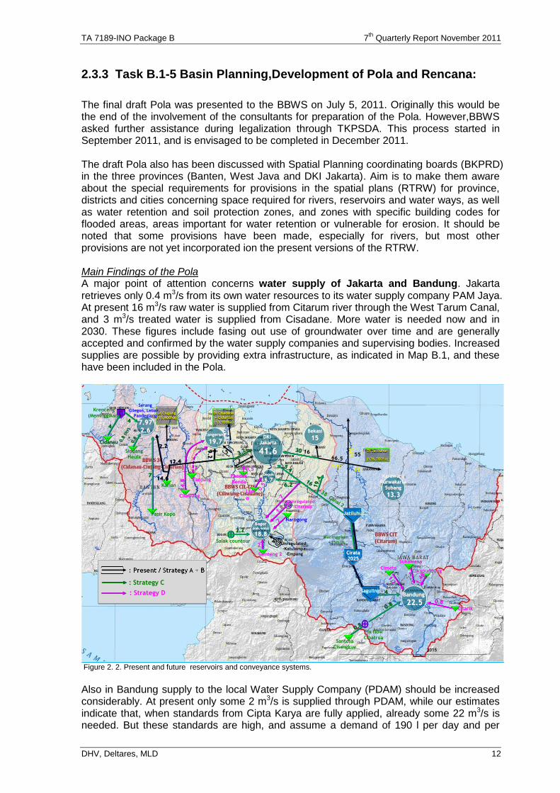
The final draft Pola was presented to the BBWS on July 5, 2011. Originally this would be the end of the involvement of the consultants for preparation of the Pola. However,BBWS asked further assistance during legalization through TKPSDA. This process started in September 2011, and is envisaged to be completed in December 2011. The draft Pola also has been discussed with Spatial Planning coordinating boards (BKPRD) in the three provinces (Banten, West Java and DKI Jakarta). Aim is to make them aware about the special requirements for provisions in the spatial plans (RTRW) for province, districts and cities concerning space required for rivers, reservoirs and water ways, as well as water retention and soil protection zones, and zones with specific building codes for flooded areas, areas important for water retention or vulnerable for erosion. It should be noted that some provisions have been made, especially for rivers, but most other provisions are not yet incorporated ion the present versions of the RTRW. Main Findings of the Pola A major point of attention concerns water supply of Jakarta and Bandung. Jakarta retrieves only 0.4 m3/s from its own water resources to its water supply company PAM Jaya. At present 16 m3/s raw water is supplied from Citarum river through the West Tarum Canal, and 3 m3/s treated water is supplied from Cisadane. More water is needed now and in 2030. These figures include fasing out use of groundwater over time and are generally accepted and confirmed by the water supply companies and supervising bodies. Increased supplies are possible by providing extra infrastructure, as indicated in Map B.1, and these have been included in the Pola.
DI Cisadane
+ Cidurian
(13.100ha)
DI Cisadane
+ Cidurian
(13.100ha)
DI Jatiluhur
(176.700ha)
DI Jatiluhur
(176.700ha)
DI Ciujung
(15.600ha)
DI Ciujung
(15.600ha)
KarawangKarawang
PurwakartaPurwakarta
SubangSubang
13.313.3
CirataCirata
20252025
SagulingSaguling
CimetaCimeta
Santosa
Cisangkuy
Fix flow
Cibatrua
1111.21.21.2
0.80.8
0.80.8
3030
66.566.5
WTCWTCETCETC
NT
CN
TC
5555
77
3838Canal 2
Canal 2
LimLim
oo
0.50.5
PondokPondok
BendaBenda
0.50.5
22
Salak countour
GentengGenteng 22
NarogongNarogong
Unregulated:Unregulated:
--CitereupCitereup
SukawanaSukawana
0.80.80.8
CitarikCitarik
CikapundungCikapundung
Bandung Bandung
22.522.5
BekasiBekasi
1515DKI DKI
JakartaJakarta
41.641.6
DepokDepok
6.76.7
BogorBogor((kab.kab.--kotakota))
18.818.8
6.26.2
1.8
1.8
TangerangTangerang
19.719.7
TanjungTanjung
CilawangCilawang
777
JatiluhurJatiluhur
4.8
4.8
4.8
Karian
SerangSerang
CilegonCilegon, , LebakLebak, ,
PandeglangPandeglang
7.977.97
2.62.6
Pasir Kopo
Sindang
Heula
Krenceng
(Meninggikan)
CidanauCidanau
14.614.6
3.23.22.22.2
12.412.4
0.8
(ir
r)
+
0.80.8
(ir
r)
+
0.8
77
4444
9.2
9.2
5.45.4
19.4
19.4
2015
44 Unregulated:Unregulated:
--KatulampaKatulampa
--EmpangEmpang
55
2.22.2
22
Meninggikan
+15m3/s
44
1616
: Strategy C: Strategy C
: Strategy D: Strategy D
1.4
61.4
61.4
6
33
1616
Figure 2. 2. Present and future reservoirs and conveyance systems.
Also in Bandung supply to the local Water Supply Company (PDAM) should be increased considerably. At present only some 2 m3/s is supplied through PDAM, while our estimates indicate that, when standards from Cipta Karya are fully applied, already some 22 m3/s is needed. But these standards are high, and assume a demand of 190 l per day and per
TA 7189-INO Package B 7th
Quarterly Report November 2011
DHV, Deltares, MLD 13
capita for metropolitan areas, full coverage and no use of groundwater. At the moment supply is in the order of 60l/day/capita, only 40% is reached, and still much groundwater is used. Therefore the water supply to Bandung has to be upgraded in stages, starting with moderate standards first and gradually upgrading to full standards in the far future. To realize this, extra local surface water resources should be developed, and the obvious source is the Saguling reservoir. This was confirmed in a Master Plan for water supply development in Bandung formulated by PU- Cipta Karya However, this requires pumping water from this reservoir to some 100m higher elevation, and a serious start with waste water treatment along Citarum. Another major point of attention is soil conservation, because the reservoir capacity of especially the Saguling reservoir is rapidly reducing because of sedimentation from the upper catchment.. This requires urgent action, at a large scale, with priority for the upper catchment of Citarum, as this is the source for Bandung and Jakarta. Preliminary estimates indicate that some 190 million US$ each year might be lost if Saguling cannot function anymore, while the cost of protecting the upper Citarum catchment are only a one time investment of 79 million US$ The present initiatives from Forestry in cooperation with PU and Agriculture can be used, upgrading to a much wider scale. This is addressed in cooperation with Package A as reported above, and we are also contributing through our conservation specialist and the special study for upper Citarum basin conservation. For water quality a major shift in paradigm and large investments are required, to address the present pollution from domestic and industrial waste in the Bandung area, because this affects the water source for the 25 million people living in and around Jakarta, as well as the 10 million living around Bandung. Aim is treating waste water from all industries and settlements before it flows into the Citarum. A beginning should be made with all new urban developments, to ensure that they apply adequate standards for sewerage and urban drainage, to avoid that major investments have to be made again later. This is included in the Pola, but requires much extra efforts. Present efforts are focused on self monitoring by the industries and regular checks by the Environmental Management Board. What is needed is an analysis whether the reported discharges by the industries are confirming the presently recorded discharges, or are significantly under-estimating present loads. This can be supported from the present version of RIBASIM, and can be completed in a short period of time. For data and information also major attention is needed. As reported above the quality of the records is low, and there is hardly follow up on provided records to check, validate and/or efforts to improve data recording. Community Participation and Institutional Strengthening are major fields of attention in the Pola, and there is much potential to improve the present situation. Spatial Planning also needs proper attention. If requirements for the water sector are adequately incorporated in the spatial plans (RTRW), a sound basis exists to implement the policies proposed. In the current version of most RTRW space has been provided for the major rivers, but most of the present and new reservoirs are not indicated, nor are there provisions for zoning of vulnerable areas for erosion and water retention or flood prone areas. This is a serious omission and a missed chance. Scenarios and Strategies applied for Pola and Rencana A third major issue is the scenarios and strategies to be applied. For the analysis we have applied the scenario as developed for JSM 2.1 concerning rise of population and economic growth. The following scenarios and strategies have been endorsed for the Pola and Rencana.
TA 7189-INO Package B 7th
Quarterly Report November 2011
DHV, Deltares, MLD 14
Scenarios Scenarios for the strategic management plan according to Permen 22/2009, require three scenarios for (1) economy, (2) climate change and (3) politics. It was agreed to apply this for 6 Cis through four parameters, as follows:
Population growth
Economic growth
Climate change
Orientation of the national politics (Governance) Indonesia does not have long-term forecasts for population and/or economic growth, and therefore we made use of long-term forecasts established in Special Report on Emissions Scenarios (SRES), a report prepared by the Intergovernmental Panel on Climate Change (IPCC) for the Third Assessment Report (TAR) in 2001. SRES established scenarios for future population and economic growth, which resulted in emission scenarios to be used for driving global circulation models to develop climate change scenarios. Conclusions are:
Population growth and economic growth need only one future scenario
For climate change two options should be followed: one for the wet season, with higher rainfall and runoff, and one for the dry season, with lower rainfall and runoff.
For orientation of national politics, two options are identified: (1) focus on short-term economic development and (2) focus on long-term sustainability. The focus on short-term economic development is classified as the current trend (“business as usual”) and long-term sustainability is paraphrased as “Good Governance”.
The assumptions for each parameter are summarized as follows: Table 2.2. Overview of scenarios for Pola
Scenario Scenario 1 Scenario 2 Scenario 3 Scenario 4
Population growth of Java
Starts at 1.1% per year and slowly declines to 0.5% per year in 2050, that is in between the A2 and B1 SRES scenarios
Economic growth of Java
Low Growth: 3% per year from 2013, limited additional funds for water resources development
Low Growth: similar to Scenario 1
Sustainable Growth: Stays well above 5% per year
High Growth: assuming a continuous economic growth of 7% per year.
Orientation of the national politics/ Governance
Current Trend Assume that current Governance and/or status quo will be maintained
Good Governance Government & 6 Cis WRM institutes are able to implement good governance and are able to enforce all their plans and are able to convince all stakeholders to implement the provided plans.
Climate change
2030 2050 Average temperature change (degrees Celsius): 0.6 1.1 Average precipitation change (mm/day): 0.3 0.5 Sea level rise (m): 0.1 0.2
The climate change scenario (based on an extensive analysis using Global Circulation Models) is limited to a change in average precipitation of 0.3 mm/day (2030) and 0.5 mm/day (2050). The estimate of the change in average precipitation is so uncertain, that it is not specified as an increase or a decrease. So for 2030 it might just as well be +0.3 mm/day as -0.3 mm/day. Strategies
1. Short-term Compliance (Kepatuhan) Strategy: The objective of this strategy is to meet the future water demands at the lowest possible cost. This implies that other policy options will not be incorporated, such as the more costly measures designed to promote the long-term sustainability of the water resources system. This strategy will be necessary in case of the low growth scenario.
TA 7189-INO Package B 7th
Quarterly Report November 2011
DHV, Deltares, MLD 15
This strategy includes the most urgently needed measures for conveyance of water from Jatiluhur reservoir to Jabodetabek, Karawang and Purwakarta, conveyance of water from the West and South side to cities in Banten and Jabodetabek, and includes components of the investments to supply DMI water to the Bandung region. No active groundwater management is envisaged, so subsidence will continue at the present alarming rates, but reliance on surface water in the Jakarta and Bandung areas will be limited during the period that groundwater still is available. Furthermore, this strategy implies low governmental involvement in improving efficiencies and from that respect precludes the implementation of non-structural measures which in the long run will be necessary to fully optimize the water supply potential of the 6 Cis RBT. Furthermore, this strategy assumes that no major investments are realized with respect to watershed conservation or restoration, and with respect to water quality improvement. Considered from a long-term perspective, this strategy is not desirable and mainly serves here as a comparison with the second strategy.
2. Short-term Compliance plus Pro-Active Governance Strategy: This Strategy 2 is like Strategy 1, but in addition institutions are strengthened in such a way that land and water resources are managed in line with the existing laws and regulations. In this strategy it is assumed that no extra funds are made available for large-scale watershed restoration, and that no major investments take place related to water quality improvements. But the government does what it can to improve efficiencies.
3. Sustainable Growth Strategy: This strategy implies meeting the water demands, based on an active and sustainable groundwater management, and an active set of measures and policies aimed at pollution control and watershed conservation and restoration. This strategy will only be possible with sufficient financial resources, and a general drive for efficiency improvement fueled by a high economic development situation. The strategy implies that the authorities undertake strong actions to mitigate and eventually stop deep-groundwater abstraction in the coastal strip of Jakarta and in the Bandung Plain. After this transition, only groundwater abstraction by Public Water Supply and small private wells will be allowed. This strategy includes the option to supply Jabodetabek from both the East and the West. For the upstream Saguling region, the set of measures is further complemented with components to satisfy the demands in this region. This strategy implies an active groundwater management, for which the surface water supply in the Jakarta and Bandung area will be increased quickly to provide an alternative to deep-groundwater supply, and consequently to allow a maximum sustainable groundwater exploitation. The strategy also assumes high governmental involvement in improving operation efficiencies. This means that great attention will be given to implementation of non-structural measures. Finally, this strategy contains measures which seems wise from a water resources development point of view, including raising Cirata dam with an additional 15 m and the development of the Rajamandala river-driven hydropower plant between Saguling and Cirata.
4. High Growth Strategy: This strategy is like strategy 3, but with a higher economic growth, assumed at 7% per year for the next 20 years. As demand will be higher, also more measures will be taken, and the higher economic growth will make it possible to provide the required extra funds. As such we will have four strategies (Short-term Compliance, Pro-active Governance, Sustainable growth and Maximum Growth) and two scenarios (Current Trend and Good Governance), It makes no sense and it is a lot of work to develop each alternative for each scenario. Therefore we will analyze only the following combinations, each to be supported by one JSM simulation.
TA 7189-INO Package B 7th
Quarterly Report November 2011
DHV, Deltares, MLD 16
Table 2.3. Overview of Strategies and application of scenarios and JSM simulations
Strategy Strategy 1 Strategy 2 Strategy 3 Strategy 4
Current Trend Compliance
Pro-active Management
Sustainable Management
Maximum Management
Keywords Strategy
Only minimum effort, including DMI-supply, with focus on water quantity
Like Strategy 1, plus strong institutions for integrated land and water management (but no extra budget available for watershed management and water quality improvement)
Most likely scenario and optimal effort, aimed at improving all aspects of land and water management
Maximum effort to meet maximum demand
Scenario used
Current Trend, Low economic growth
Good Governance Low economic growth
Good Governance Sustainable economic growth
Good Governance High economic growth
JSM simulation used for developing the Strategy
Current Trend for low economic growth
“Sustainable growth”: combining the JSM-policies Good Governance + water resources protection + food sustainability + network city for low economic growth
Like the JSM simulation for Strategy 2, but now for sustainable economic growth.
Like the JSM simulation for Strategy 2, but now for high economic growth
SCENARIO
ASSUMPTION STRATEGY
Governance Population
Growth Economic
Growth Climate Change
Identifier/Title Explanation
1 CT
Appro
xim
ate
ly 1
% ia
nd f
all
ing LOW
1
Pre
pare
for
the w
ors
t
A. Current Trend
Compliance
Only minimum effort, incl DMI-supply, focus on water quantity
2 GG LOW2
B. Proactive
Management
Like Strategy 1, plus strong institutions for integrated water resource management (but no extra budget available)
3 GG SUSTAIN
ABLE
C. Optimum
Management
Optimum effort, aimed at improving most aspects of land and water management
4 GG HIGH
D. Maximum
Management
Maximum effort, aimed at improving all aspects of land and water management and assumming cost recovery
2.3.4 Task B.1-6 State of The Basin Reporting
In July 2010 the environmentalist started assessment of possibilities for basin performance evaluation. Preliminary findings indicate that the environmental data suggested in the Kei Saki report for use as performance criteria are not collected, while a lot of other environmental data are readily available, and can give a good indication of the state of the basin. An assessment has been made of the use of pesticides in the area, and the possible impact on water quality in the rivers of 6 Cis. In September / October a final assessment will be made of available indicators and which indicators should be used for assessment of the state of the basin. A preliminary proposal for benchmarking indicators is presented in Annex E. The methodology will be discussed and finalized with BBWS Citarum in November, resulting in a final report on methodology, which is expected in December. The actual assessment is envisaged in February-May 2012. Budget should be prepared for that by BBWS Citarum. Cost estimate is 250 M Rp for upper Citarum only.
1 See note 1
2 See note 1
TA 7189-INO Package B 7th
Quarterly Report November 2011
DHV, Deltares, MLD 17
2.4. Issues
2.4.1 Issues concerning Sub-component B.1A
TKPSDA Although the TKPSDA was established in December 2010, it only has its first plenary session on September 21, 2011, and is only at the very first stage of becoming an active and effective platform for consultations and conflict management. Facilitation is provided through the secretariat, located at BBWS Ciliwung/Cisadane, with head of the O&M division as head of the secretariat and one of his staff as daily head of the secretariat. The heads of O&M divisions, heading sub=secretariats in the other BBWS, assist the secreatariat in BBWS Cil-Cis. The consultants spent much effort to stimulate this facilitation. Only after the ADB review mission in May 2011, activities were started, such as formulation of draft house rules and setting of a time schedule. It has been agreed that the present organization development specialist (Mr.Darismanto) concentrates his efforts on that, and another specialist will be appointed to give more attention for capacity building of the RBMOs under Task B.1-2. It is also important that the provincial councils are actively communicating with the TKPSDA. As such they need extra attention to have a significant role in the planning process. It has been agreed that the present organization development specialist (Darismanto) concentrates his efforts on the Provincial council in DKI Jakarta (of which he is a member), and Mrs Renny concentrates on the provincial councils in West Java and Banten. 6 Cis RBT A major issue is the intention to split 6 Cis RBT in three smaller RBTs. Main reason is that the rule “one basin, one management” is un-feasible for this large basin, and a split according to the areas of the present three BBWS is more convenient. Management is feasible by three BBWS, if bound by common rules on distribution of the water. However, planning should be holistic, integrating the interests of all stakeholders, and to be dealt with at the highest level where these interests can be negotiated. Since Jakarta, lying in the supposed RBT of Ciliwung-Cisadane, is relying on water resources from Citarum, and most promising future reservoirs are in Cidanau-Ciujung-Cidurian, the interests of the stakeholders in the three areas is inter-linked. If 6 Cis RBT is split, there will be three Pola and Rencana, as well as three Basin Councils. A practical solution could be one Pola for the present RBT, used as reference for Rencana of the three smaller RBTs. This will be possible if the present Pola is finalized before the PERPRES establishing the three WS is issued. If 6 Cis is split, coordination of the three TKPSDAs should have special arrangements. The weakness is that there is no coordinating platform for the issues beyond one RBT, such as water supply to Jakarta and efforts in upstream Citarum (management of watershed protection and water quality) for the benefit of the people living in Jakarta. It is advised that the already established TKPSDA will remain in place for strategic, inter-basin affairs, with sub-commissions dealing with issues at the individual new RBT CMTs and CDAPs implementation. Concerning Task B.1-2 no progress has been achieved concerning Change Management Teams and the Capacity Development Action Plans (CDAP). To be more effective, these CDAPs should be linked to decisions at higher level concerning distribution of tasks, especially concerning the perceptions on how to implement the tasks and responsibilities of the BBWS. Pending these decisions, the capacity development analysis cannot be implemented, and the curriculum development cannot be started. It is intended to address

TA 7189-INO Package B 7th
Quarterly Report November 2011
DHV, Deltares, MLD 18
this through an extension of the assignment of Mr. Nidhom, who is now Public Policy Specialist for B.3 and institutional specialist for Pricing Bulk Water Supply. Counterparts The counterparts from DGSP and DGWR are all junior staff, but with good education (bachelor and master degrees) and high motivation. However, they have only limited time for participating in the 6 Cis project, because DGSP, DGWR and especially the BBWS have limited personnel. If they only participate in a number of short courses, their ownership of the problems and sultions as well as their skill on implementing the developed tools will be limited. Therefore is has been decided during the ADB review mission to intensify contact with the BBWS, and provide more intensive on the job training to the counterparts during formulation of the rencana. In this way the counterparts can develop more skills in applying the analytical tools and framework for identification of problems and solutions, as well as priority ranking for strategies to be formulated for the Master Plan (Rencana). This requires extra resources for the consultants concerning planners, modelers and GIS specialists. It also requires commitment from the BBWS that they will relieve the counterparts form part of their jobs, so that they can devote more time to implementing the formulation of the Rencana. Budgets For 2011 adequate budgets are available at the BBWS to support TKPSDA and the Pola preparations are as follows: Table 2.4. Overview of 2011 budgets available in the BBWS for 6 Cis (in M Rp)
BBWS 3 Cis BBWS Cil/Cis BBWS Citarum
TKPSDA 500 1200 500
POLA/Rencana 330 300 750
For this budget the BBWS will provide a central secretariat with three permanent staff members at BBWS CilCis for the whole TKPSDA, and a decentralized secretariat at the other two BBWS. Furthermore, the head of O&M in the three BBWS will be responsible to assist the TKPSDA in proper functioning, such as convening meetings, setting the agenda, minutes of meetings, follow up of meetings etc., This implies that the BBWS, while assisting the TKPSDA, will take a major role in coordination of all WRM activities in the RBT. This should materialize in the coming months, and may need extra attention. Strong commitment from the head of BBWS for this support is essential. Budget about 175 M Rp, is also available in sub-directorate Perencanaan WS to support this activity. Similar budgets should be available for 2012. Even more may be required to cope with the more intensive approach as discussed above for the counterparts. The presemtly proposed budgets should be approximately as follows: Table 2.5. Overview of required 2012 budgets available in the BBWS for 6 Cis (in M Rp)
BBWS 3 Cis BBWS Cil/Cis BBWS Citarum
TKPSDA 600 1200 1400
POLA/Rencana 350 500 750
State of Basin benchmarking
250
TOTAL 950 1700 2400
TA 7189-INO Package B 7th
Quarterly Report November 2011
DHV, Deltares, MLD 19
2.4.2 Issues concerning Sub-component B.1B
Delay in finalization of Pola Formulation of the draft Pola has been completed, and is now in the process of legalization through discussions with the TKPSDA, and final issuance by Minister PU. However, this is seven months later than originally planned for a number of reasons, as follows:
First additional data had to be collected, especially on water supply, water quality and coastal management, as a result of PKM 1.
Secondly, we have been preparing the Pola for application even when WS 6 Cis would be split. Therefore we organized all workshops, focus group discussions etc. according to the working areas of the BBWS, which would become WS on their own.
Thirdly, the BBWS had no time to attend PCM in December, and in January the reorganization of DGWR was not yet completed.
Fourthly, in March the whole organization was changed, with many staff changes, including the relevant sub-directors, heads of BBWS and heads of divisions of BBWS. Therefore we had to familiarize the new staff with IWRM, the 6 Cis project and formulation of the Pola through an intensive round of discussions with each BBWS. The advantage is that they are now very well informed, and “ownership” of the Pola by the BBWS staff has been enhanced. But the consequence is that we have over-used our resources, and need additional resources to complete the Rencana.
For these reasons we have used more person months than originally envisaged for this stage, making use of available person months originally planned for the rencana stage. However, this threatens proper finalization of the Rencana, and therefore now additional resources are needed. Also additional activities are requested, which also requires extra resources. This is elaborated below and in the annexes I and K. Additional requests concerning assistance for Pola and Rencana. During the ADB Review mission for TA 7189 INO in April/May 2011 several extra activities were proposed, to improve the support during finalization of the Pola and preparation of the Rencana, requiring also additional resources: A. PU requested additional support in the legalization process of the Pola, during the
discussions with the TKPSDA. This is outside the original scope of work, and will require additional support from the planners.
B. PU requested a more intensive approach, with more regular formal visits and discussions with the BBWS, and on-the-job training of the counterparts in the BBWS. This was confirmed in the conclusions of the ADB review mission on TA 7189, and requires more effort from the planners and the modelers, as well as the GIS specialists.
C. The 6 Ci RBT will most likely be split in three river basins, which requires additional effort from the planners, modelers and GIS specialist. And
D. Water quality of the rivers, especially the Citarum river, needs urgent attention in the rencana, and the resources for that have not been envisaged. This will require additional input from a foreign water quality specialist and continuation of the present national water quality specialist.
E. Additional capacity strengthening through courses, workshops and comparative studies. Estimated required additional inputs is indicated in Chapter 5, section 5.4.2, and Annex I Legalization of Pola At this moment it is assumed that the Pola will be adopted more or less as presented now, and that this draft can be used as basis for the Rencana. A critical point arises when the Pola is not legalized in time, or later than the PERPRES on the new RBT delineation is issued. Then it might be necessary to take additional or different strategic measures. This should be addressed during the next review mission of December 2011. At that time a tri-partite meeting between GoI/MPW, ADB and consultants should decide how to continue with the Rencana process.
TA 7189-INO Package B 7th
Quarterly Report November 2011
DHV, Deltares, MLD 20
Hydrological database As reported above the hydrological data base available from BTA 155, covering rainfall and run-off data from 1950 – ‘79, has been extended with additional time series 1980 – 2009, with rainfall data from many station (125) and runoff data from only … stations. Using rainfall-runoff relationships established in BTA 155, and updated through the study by PusAir on changing hydrological parameters for changing landuse (reported in section 2.3.2, page 10). However, the quality of these data is much less than the original data. Moreover, they show some discrepancies that cannot be explained based on presently assumed phenomena such as climate change or land use change. Therefore, this has to be studied more in detail in the coming months. Training Several training sessions have been organized to familiarize the counterparts with the issues in the whole 6 Cis River Basin Territory (RBT), the methodology applied by the consultants to assess the present conditions, issues and potential measures to address these issues, as well as the tools developed by the consultants. As such we have familiarized them with the situation in the Ciliwung, Cisadane and Citarum basins during field trips to these areas and discussing the methodology for assessment. We have also started training in application of HYMOS/FEWS and Ribasim in a number of sessions, not only with the counterparts, but also with participants from other relevant directorates and PusAir. This training follows the gradual development of the water balance model. The following training sessions have been held and are envisaged: 1. Introduction in modeling and applying HYMOS/FEWS (June 2010) 2. Introduction in modeling and applying Ribasim (October 2010) 3. Schematization of the RBT for the water balance model (March 2011) 4. Assessment of demands from agriculture and urban water supply (DMI) (June 2011) 5. Application of the Pola concepts / Review book of Pola 6 Cis (October 2011). 6. Start application of the 6 Cis water balance model for simulating individual measures
(February 2012) 7. Full application of the 6 Cis water balance model (March 2012). Each counterpart received a laptop with HYMOS and Ribasim established, to familiarize themselves with the tools. Data included in the models are mainly based on information available from earlier projects, while we are updating the information on rainfall and runoff using additional hydrological data, (present and future) land use, (using JSM see chapter 3), and updating the information on additional infrastructure (river structures, canals, pipelines, dams etc.). Full application of the 6 Cis water balance model is only envisaged to start in October 2011. It is important that the counterparts not only familiarize themselves with the work done by the consultants, but also get more skill in applying the methodology and the tools on their own. They will not get this skill when they are only involved in certain training events, but they have to get more experience while applying this during on-the-job training. Therefore the counterparts should be more full-time available, as agreed during negotiations with the ADB at the start of the project. At this time the most active are only once a week active in the project, and have many other tasks. This was also endorsed by the ADB Review mission for TA 7189 INO. This is closely related to the additional request B as stated above (more intensive approach of BBWS), and further worked out in Annex I.. A training report has been prepared with assessment of the past trainings and recommendation for future improvements by the training specialist. This is in Annex F
TA 7189-INO Package B 7th
Quarterly Report November 2011
DHV, Deltares, MLD 21
2.5. Developments envisaged for the next Period
In the next period we expect the TKPSDA will discuss the Pola, have consultation with the Governors of West Java, Banten and Jakarta, and conclude on a version to be proposed to the Minister of PU. This is essential to get the Pola legalized before the new Perpres on River Basin Territories (WS) is issued. The members already started to get acquainted to each other during the two rounds of Public Consultations for the POLA, as discussed in section 2.3. Extra motivation could be provided through a comparative study for selected members to TKPSDA in Bengawan Solo. For TKPSDA the secretariat is already established at BBWS Ciliwung-Cisadane, with a room, computer and secretarial support. Funds are available. Empowerment through the heads of Planning and O&M will be supported. Related to this process we expect also more interaction between the Provincial Water Councils (DSDAP) and the TKPSDA. We also expect to have more clarity on distribution of tasks between the many agencies related to Water Resources Management (not only the three BBWS and PJT II as well as the provincial agencies for water resources at provincial and district level, but also forestry, agriculture, mining (groundwater), environment etc. at central, provincial and district level. Only then the tasks of the BBWS, PJT II and provincial and district agencies for water resources can be more clearly defined, and requirements for capacity building can be assessed and activities started. Capacity Building of BBWS will need an agreed MoU about role distribution concerning O&M of irrigation and other Water resources facilities. This is especially needed concerning O&M of the facilities managed by PJT II, as requested by BBWS Citarum, and the facilities of small reservoirs (siti situ), as requested by BBWS Ciliwung Cisadane. This will be funded from extra funds becoming available in March 2012, but it is expected that some activities will start before the end of the year. It will require additional input from Mr. Nidhom also as Institutional Development Specialist, and Mr. van Ommen, Institutional specialist. A small part has been proposed in VO3, while the remainder will be in the next proposal, as reported in Chapter 5 and in Annex K.. In the next period the meta database system will be available on the web-site of PU. We may also address the use of the Asset Management System for Irrigation (Pengelolaan Asset irigasi, PAI) currently applied in some BBWS, together with the PISP consultants. We will support the BBWS during the legalization process of the Pola as requested, assuming extra resources will become available from ADB in March 2012. The current VO3 already provides some initial extra months for the planners to realize this. It is assumed that the PerPres concerning delineation of River Basin Territories (RBT or Wilayah Sungai) will not be issued before that. By the time this Perpres is issued we will assess whether RBT 6 Cis has been split, and what has to be done to accommodate the impacts of splitting RBT 6 Cis. In the meantime we will continue with preparation of the Rencana, based on the conclusions for the first version of draft Pola. It is assumed that no major changes will be included during the process of legalization, and only if this occurs we will need a tri-partite meeting to discuss the impacts (especially the split in three RBT). Impacts will not be clear before November 2011. In principle we will apply the more intensive assistance approach, as already suggested by the ADB Review mission, and some initial additional inputs have been included in VO3, assuming there will be additional resources in March 2012. During preparation of the rencana more attention will be given to cost estimates and ranking of measures based on assessed benefits. Impacts of measures are assessed in simulations using the developed analytical framework and decision support tools. For flood management in Ciliwung a comprehensive Flood Hazard Model has been developed. With this model several types of measures can be simulated which may reduce floods or
TA 7189-INO Package B 7th
Quarterly Report November 2011
DHV, Deltares, MLD 22
damages of floods. Also the results of the research on differences between runoff from urban and rural areas as provided by Pusair, as well as results from B.2 will be applied in the simulations. Moreover, more information will be available concerning strategic plans for protection from the sea in the areas subject to land subsidence along the north coast of Jakarta and surroundings. In November/December 2011 we will discuss the proposed guideline for assessment of the State of the Basin report, as presented in Annex E, and to be completed. After that the mechanism as tried out under NARBO, concerning self assessment by BBWS and peer review for validation, will be applied. Implementation of the State of the Basin assessment is envisaged in February-April 2012, and the BBWS should prepare budget for that.

TA 7189-INO Package B 7th
Quarterly Report November 2011
DHV, Deltares, MLD 23
3. SUB COMPONENT B.2
3.1. Status of B2 tasks
The status of activities per 31 October 2011 and the expected status on 31 January 2012 is presented in table 3.1 on next page.
3.2. Developments and issues
3.2.1 Developments
All activities of B.2 already have been completed. In this period only the draft final report has been completed. Also some assistance was continued from the Co Team Leader and Senior Spatial Planner (included in proposed VO3) especially for the link between spatial planning and water resources planning, with focus on water zoning in the finalization of RTRW and starting up the detailed planning in the districts (RDTR). Key findings during the last reporting period with regard to the remote sensing data collection and interpretation, the calibration of JSM 2.1 and the erosion / rainfall-runoff zoning work are presented below. Remote Sensing Data Interpretation The approach is based on the Palsar radar sensor of the ALOS satellite. This can see through the clouds and thus allows 2010 imagery data to be used. A contract has been made with Applied Geo Solutions ltd in the US. The work started on 1 February 2011 and was finished and completed end of March 2011. The ALOS Palsar data is now available. On 28 April a workshop showing the results was organized. JSM Calibration results
Population: The regional model projection of population growth at kabupaten/kota level performs within normal correlation ranges of land use change models. It should be noted here that when the kabupaten total population would be looked at as an indicator, the correlation is very high. In other words the population size leading to urban area demand is predicted very accurately over the period 2000-2010.
Land use starting situation 2000. The following conclusions can be drawn from comparing the JSM 2000 and the WJ 2001 land use data: - Limited or no correlation at desa level except for forest area. - The starting situation of JSM 2000 for urban area deviates so strongly from WJ
2001 that a direct comparison of urban area values will not be useful in the analysis of the land use change from 2000 to 2010. Even at this moment the team has not been able to obtain a reliable land cover map for 2000.
Land use end situation 2010. The following conclusions can be drawn from comparing the JSM 2000 and the WJ 2001 land use data: - Considering the problem with the starting data there is a surprisingly good
consistency between ALOS 2010 and JSM 2010, especially for the forest and rice areas, also the urban and other area show a good fit at kabupaten level. Forest and rice even show a good correlation at desa level. Urban area shows a good correlation at kabupaten level but is underestimated in ALOS 2010.
Urban area growth 2000-2010: Due to major differences between the WJ2001 and ALOS 2010 datasets it is not possible to reliably calculate urban area growths from 2000-2010. This is attributed to the problem with the starting situation data. The JSM model in 2010 fits well with the measured data from ALOS 2010. This means that the WJ2001 dataset must be the least reliable.
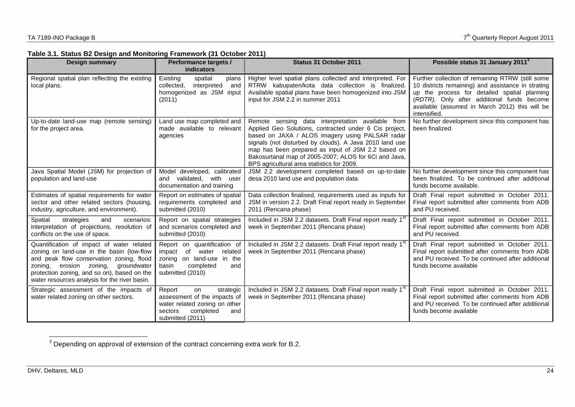
TA 7189-INO Package B 7th
Quarterly Report August 2011
DHV, Deltares, MLD 24
Table 3.1. Status B2 Design and Monitoring Framework (31 October 2011)
Design summary Performance targets / indicators
Status 31 October 2011 Possible status 31 January 20113
Regional spatial plan reflecting the existing local plans.
Existing spatial plans collected, interpreted and homogenized as JSM input (2011)
Higher level spatial plans collected and interpreted. For RTRW kabupaten/kota data collection is finalized. Available spatial plans have been homogenized into JSM input for JSM 2.2 in summer 2011
Further collection of remaining RTRW (still some 10 districts remaining) and assistance in strating up the process for detailed spatial planning (RDTR), Only after additional funds become
available (assumed in March 2012) this will be intensified.
Up-to-date land-use map (remote sensing) for the project area.
Land use map completed and made available to relevant agencies
Remote sensing data interpretation available from Applied Geo Solutions, contracted under 6 Cis project, based on JAXA / ALOS imagery using PALSAR radar signals (not disturbed by clouds). A Java 2010 land use map has been prepared as input of JSM 2.2 based on Bakosurtanal map of 2005-2007; ALOS for 6Ci and Java, BPS agricultural area statistics for 2009.
No further development since this component has been finalized.
Java Spatial Model (JSM) for projection of population and land-use
Model developed, calibrated and validated, with user documentation and training
JSM 2.2 development completed based on up-to-date desa 2010 land use and population data.
No further development since this component has been finalized. To be continued after additional funds become available.
Estimates of spatial requirements for water sector and other related sectors (housing, industry, agriculture, and environment).
Report on estimates of spatial requirements completed and submitted (2010)
Data collection finalised, requirements used as inputs for JSM in version 2.2. Draft Final report ready in September 2011 (Rencana phase)
Draft Final report submitted in October 2011. Final report submitted after comments from ADB and PU received.
Spatial strategies and scenarios: interpretation of projections, resolution of conflicts on the use of space.
Report on spatial strategies and scenarios completed and submitted (2010)
Included in JSM 2.2 datasets. Draft Final report ready 1st
week in September 2011 (Rencana phase) Draft Final report submitted in October 2011. Final report submitted after comments from ADB and PU received.
Quantification of impact of water related zoning on land-use in the basin (low-flow and peak flow conservation zoning, flood zoning, erosion zoning, groundwater protection zoning, and so on), based on the water resources analysis for the river basin.
Report on quantification of impact of water related zoning on land-use in the basin completed and submitted (2010)
Included in JSM 2.2 datasets. Draft Final report ready 1st
week in September 2011 (Rencana phase) Draft Final report submitted in October 2011. Final report submitted after comments from ADB and PU received. To be continued after additional funds become available
Strategic assessment of the impacts of water related zoning on other sectors.
Report on strategic assessment of the impacts of water related zoning on other sectors completed and submitted (2011)
Included in JSM 2.2 datasets. Draft Final report ready 1st
week in September 2011 (Rencana phase) Draft Final report submitted in October 2011. Final report submitted after comments from ADB and PU received. To be continued after additional funds become available
3 Depending on approval of extension of the contract concerning extra work for B.2.
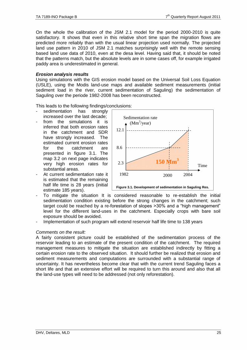
TA 7189-INO Package B 7th
Quarterly Report August 2011
DHV, Deltares, MLD 25
On the whole the calibration of the JSM 2.1 model for the period 2000-2010 is quite satisfactory. It shows that even in this relative short time span the migration flows are predicted more reliably than with the usual linear projection used normally. The projected land use pattern in 2010 of JSM 2.1 matches surprisingly well with the remote sensing based land use data of 2010, even at the desa level. Having said that, it should be noted that the patterns match, but the absolute levels are in some cases off, for example irrigated paddy area is underestimated in general. Erosion analysis results Using simulations with the GIS erosion model based on the Universal Soil Loss Equation (USLE), using the Modis land-use maps and available sediment measurements (initial sediment load in the river, current sedimentation of Saguling) the sedimentation of Saguling over the periode 1982-2008 has been reconstructed. This leads to the following findings/conclusions: - sedimentation has strongly
increased over the last decade; - from the simulations it is
inferred that both erosion rates in the catchment and SDR have strongly increased. The estimated current erosion rates for the catchment are presented in figure 3.1. The map 3.2 on next page indicates very high erosion rates for substantial areas.
- At current sedimentation rate it is estimated that the remaining half life time is 28 years (initial estimate 185 years).
- To mitigate the situation It is considered reasonable to re-establish the initial sedimentation condition existing before the strong changes in the catchment; such target could be reached by a re-forestation of slopes >30% and a “high management” level for the different land-uses in the catchment. Especially crops with bare soil exposure should be avoided.
- Implementation of such program will extend reservoir half life time to 138 years Comments on the result: A fairly consistent picture could be established of the sedimentation process of the reservoir leading to an estimate of the present condition of the catchment. The required management measures to mitigate the situation are established indirectly by fitting a certain erosion rate to the observed situation. It should further be realized that erosion and sediment measurements and computations are surrounded with a substantial range of uncertainty. It has nevertheless become clear that with the current trend Saguling faces a short life and that an extensive effort will be required to turn this around and also that all the land-use types will need to be addressed (not only reforestation).
1982 2000
2.3
8.6
12.1
Sedimentation rate
(Mm3/year)
Time 150 Mm
3
2004
Figure 3.1. Development of sedimentation in Saguling Res.
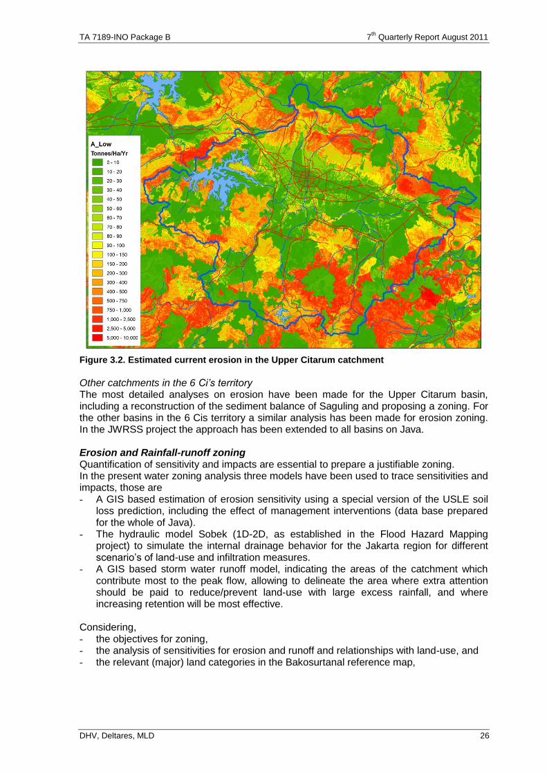
TA 7189-INO Package B 7th
Quarterly Report August 2011
DHV, Deltares, MLD 26
Figure 3.2. Estimated current erosion in the Upper Citarum catchment
Other catchments in the 6 Ci’s territory The most detailed analyses on erosion have been made for the Upper Citarum basin, including a reconstruction of the sediment balance of Saguling and proposing a zoning. For the other basins in the 6 Cis territory a similar analysis has been made for erosion zoning. In the JWRSS project the approach has been extended to all basins on Java. Erosion and Rainfall-runoff zoning Quantification of sensitivity and impacts are essential to prepare a justifiable zoning. In the present water zoning analysis three models have been used to trace sensitivities and impacts, those are - A GIS based estimation of erosion sensitivity using a special version of the USLE soil
loss prediction, including the effect of management interventions (data base prepared for the whole of Java).
- The hydraulic model Sobek (1D-2D, as established in the Flood Hazard Mapping project) to simulate the internal drainage behavior for the Jakarta region for different scenario’s of land-use and infiltration measures.
- A GIS based storm water runoff model, indicating the areas of the catchment which contribute most to the peak flow, allowing to delineate the area where extra attention should be paid to reduce/prevent land-use with large excess rainfall, and where increasing retention will be most effective.
Considering, - the objectives for zoning, - the analysis of sensitivities for erosion and runoff and relationships with land-use, and - the relevant (major) land categories in the Bakosurtanal reference map,
TA 7189-INO Package B 7th
Quarterly Report August 2011
DHV, Deltares, MLD 27
the following zoning to protect water related interests is proposed: 1) An expanded conservation area (Kawasan Lindung) comprising the following:
a. The current conservation area b. Re-forestation in areas with slope > 30% owned by the State Forestry Company
(Perhutani) or agro-forestry in areas owned by others (covers also the areas with very high erosion potential)
c. Protection of bush/scrub areas 2) Protection of dry-land agriculture and improvement of infiltration and retention for a
“bare soil” sensitive zone 3) Zone for protection of internal drainage (ΔQ=0 policy) 4) Special protection zone for flood peak runoff Ad 1): the measures to be taken for this expanded conservation zone include
- Where possible (in particular on state owned lands) re-forestation, this includes re-forestation of the recently deforested areas in the current conservation areas;
- protection of current bush/scrub areas (usually state owned) against possible further degrading; upgrading of those areas to (production) forest or agroforestry in the future; they are not a priority for rehabilitation because they are not a serious problem for erosion and runoff.
- Agro-forestry in vulnerable areas (slope > 30%) not owned by Perhutani - Further settlement should be prevented
Ad 2): measures to be taken for this zone:
- High management for agricultural areas including permanent ground cover, mixed cropping, terracing, protection of slopes
- Measures to increase infiltration and reduce surface runoff in build-up areas (infiltration pits, retention ponds)
Ad 3): urban build-up creates extra excess rainfall and fast runoff if left unchecked:
- the ΔQ=0 policy needs to be implemented for new urban areas and upgrading of existing urban areas
- application of urban building codes which specify sufficient compensating measures (retention, infiltration)
Ad 4): special protection of particular parts of the catchment based on the
hydrologic/hydraulic behavior of the catchment ; - re-forestation or agro-forestry where possible, - high management for agricultural activities, - natural depression/retention areas need to preserved; creation of extra retention
(this is the zone where retention has a maximum effect) ; - further settlement should be prevented unless in areas with a slope <15 % and
with strict implementation of the ΔQ=0 policy. For each of these aspects a zoning has been prepared for the 6Ci and this is taking onto account in the projections made with JSM 2.2 of future population and urban area growth developments.
3.2.2 Issues
In the past three months the following issues have arisen / have changed their status: 1. The census 2010 population data at kecamatan level have been delivered. The desa
level data, however, were not available in time for the B2 project. Therefore in JSM 2.2 the kecamatan data have been used to estimate desa level population, households and employment based on 2010 land use data. This is the dataset that used in producing the B2 report.
TA 7189-INO Package B 7th
Quarterly Report August 2011
DHV, Deltares, MLD 28
2. PU has requested an extension of the B2 project to ensure that the results of the B2 project can be institutionalized. ADB has indicated that preparations will be made to make extra funds available starting March 2012. This is further elaborated below, in Chapter 5 and in Annex J.
3.3. The need for an extension of B2
In view of the results achieved in B2, PU has requested that the support for spatial planning in the RENCANA phase for the 6Ci will be continued. An extension of the B2 project is needed for the following reasons:
The Indonesian B2 spatial planning staff has played a key role in the process of developing the strategic management plan for the 6Ci (POLA). This spatial planning support is needed in developing the RENCANA as well.
A comprehensive approach on how to integrate sustainable water resources aspects (‘water zoning’) in the spatial plans has been developed in B2. There is a need to secure this approach as an accepted subject in the spatial planning process. For the long term institutional strengthening is needed for this subject.
The use of a quantitative method for predicting impacts of spatial plans and zoning regulations on the future population and land use through the Java spatial model. There is a need for an intensive transfer of knowledge on this method and for institutional strengthening of this subject.
Since the project started the agricultural law on food sustainability has been legalized. This law ties in to the spatial planning law and it will result in adding agricultural land to the conservation area of the spatial plans. The B2 results so far show that support for this in the spatial planning process is one of the most effective strategies for the 6Ci river basin territory. This could take the form of formulating guidelines in cooperation with the ministry of agriculture on how to achieve food sustainability through the spatial plans.
If no additional funding is found the B2 activities will end with a promise, without fulfilling its potential.
Partly these reasons relate to short term needs and the rest is related to long term needs for which substantial funding will be needed. Rido Matari Ichwan, the Director of Planning Programming and Partnership, has requested to extend the B2 project with at least the immediate short term needs. Currently PU is considering how to formulate the goals and needs for long term institutional strengthening. For the short term a number of options were developed. The first option is considered a “must have” option in the light of the letter of Rido Matari. Depending on the budget the other options can be selected. The more options are selected the better the result will be. The following short term extension options are under consideration: 1. Support the TA Rencana WRM process with spatial planning input 2. Intensive transfer of knowledge for water zoning tools 3. Support water zoning in spatial planning process 4. Intensive transfer of knowledge for JSM 5. Reconnaissance study new agriculture sustainability law in spatial planning The long term options depend very much on scope (only 6 Cis or wider) and ambition (level of institutional strengthening). For both aspects the needs of PU are under discussion and any options given here are preliminary. The following options are under discussion:
Develop guidelines for integration of water resources aspects in spatial plans
Develop guidelines for including food sustainability aspects in the spatial plans
Institutional strengthening for water zoning and spatial modeling

TA 7189-INO Package B 7th
Quarterly Report August 2011
DHV, Deltares, MLD 29
In September ADB indicated some additional funds may become available in early 2012, and focus should be given to the first four short term extension options, i.e. 1. Support the TA Rencana WRM process with spatial planning input 2. Intensive transfer of knowledge for water zoning tools 3. Support water zoning in spatial planning process 4. Intensive transfer of knowledge for JSM An estimate of required funds is presented in Chapter 5. It is assumed that these will become available in March 2012.
3.4. Current status of the Java Spatial Model
The Java spatial model version 2.2 has been completed in July 2011 and used for analysis and reporting in the Draft Final Report, issued in October 2011. It is presently used for the Master Plan stage (Rencana) as reported in chapter 2.
3.5. Developments in next period
Effectively the project has ended in August 2011. Only the B2 Draft Final report has been submitted in October 2011. After comments have been received, we will submit the Final Report in the next period. During negotiations for Variation Order no. 3 also a continuation of part-time involvement of the Co Team Leader for B.2 and the Senior Spatial Planner, with assistance from the GIS specialist has been approved. If extension of B.2 is approved, more activities (as indicated in Annex J) will be developed, starting March 2012. In the mean time only some assistance is provided to support the formulation of Rencana with spatial planning, and assist DG for Spatial Planning to start up the Detailed Spatial Planning (RDTR) with adequate attention to requirements for Water Zoning (especially concerning erosion and water retention in the upstream areas, and flood zoning in the lower areas..
TA 7189-INO Package B 7th
Quarterly Report August 2011
DHV, Deltares, MLD 30
4. SUB COMPONENT B.3
4.1. Status Tasks B.3
All originally envisaged activities (Tasks B3-1, B.3-2 and B.3-3) have been completed, status presented in Annex G and H. Follow up is provided by the public policy specialist. Study on pricing of water supply services started in June 2011, and is envisaged to be completed in November 2011. .
4.2. Progress in implementation Tasks B.3
4.2.1 Original Task B3-1, B3-3 Groundwater Use in Bandung
The work on this activity has been mostly completed in December 2010, and was finalized in June 2011 by submission of the draft final report. ADB provided comments in July 2011, but Dinas ESDM only recently started providing comments. After all comments are received, the final report will be submitted, envisaged November 2011. Activities comprised (see also Annex G): 1) Review of current government policies and legislation:Overlaps and gaps identified,
see Table 4.1 2) Review of international best practice: completed. Report completed. 3) Data collection, discuss with ESDM & BPLHD regulation licensing, monitoring Info
obtained on regulatory, permit procedures; implementation & monitoring capacity. 4) Data collection, discussions with Pusat Lingkungan Geologi on abstraction
groundwater Bandung: Various studies identified and reviewed. Understanding of groundwater basin, aquifers systems and problems identified.
5) Identify current mechanisms and practises on licensing, registration, metering, law enforcement: Ambiguity because of licenses mostly issued by District DINAS EPSD (incl extension), while, monitoring of abstraction by province (without funds)..
6) Carry out economic assessment of level of groundwater charges: Information on fees, charges collected. Costs for groundwater abstraction through individual boreholes (direct costs only) >3 times cheaper than PDAM water. .
7) Analyze feasibility of raising groundwater charges: Included in Task 6. . 8) Review reports of alternatives to groundwater use: Short-term solutions not readily
available. Rainfall harvesting looks promising. Artificial recharge does not look promising. Strict licensing and enforcement system needed to reduce demand. High taxes in DKI moves out industry that uses groundwater (not feasible yet in Bandung). Long-term solution is to replace existing concentrated groundwater withdrawals by reliable/cheap supply of surface water.
9) Review basin planning study report on feasibility of water use from lakes, reservoirs etc: Most promising alternatives identified. Further study is/will be covered by 1) POLA at strategic level, 2) upcoming ADB project, Tranche II on Bandung Water Supply sources and development, 3) MoU between DG WR, Dinas SDA Prov. and 4 Kab/2 Kota and 4) Joint Working Group (headed by BBWSC).
10) Consultation with relevant parties: Consultations with provincial/kab agencies completed, presented in Table 4.3. Follow up by Public Policy Specialist.
11) Identify scope for improvement registration database and 12) Provide technical assistance on developing registration database Both are cancelled.. 13) Develop recommendations on groundwater licensing, pricing, institutional roles,
monitoring activities etc: Final recommendations completed. 14) Discuss recommendations and 15) Organize Workshop: ESDM Workshop was held
Nov 2, 2010. This is reported in section 4.3.1 16) Finalize reports: Draft reports submitted in June 2011. Final envisaged in Nov 2011.
TA 7189-INO Package B 7th
Quarterly Report August 2011
DHV, Deltares, MLD 31
4.2.2 Task B3-2 Water Allocation in Jatiluhur Scheme
The work on this activity was mostly completed in February 2011, and finalized after submission of the draft report in June 2011. The activities comprised: 1) Review current legislation and policies for surface water allocation: Review of
surface water legislation/policies completed. 2) Identify current practices on water allocation, water distribution Jatiluhur Current
water allocation mechanisms identified. Key player is PJTII. Annual plans (DMI and irrigation) with bi-weekly adjustments for irrigation are prepared. Activity completed.
3) Compare water allocation practices Tarum with other schemes with focus on the institutional arrangements: A comparison was made on water allocation between three basins. These are Bengawan-Solo, Brantas and Citarum. Activity completed.
4) Assess consultation, information and participatory mechanisms: An analysis of roles of various consultation mechanisms in the allocation process was carried out. Key players are Dinas Kab, Komisi Irigasi, Dinas Prov, BBWSC and PJTII. A standard mechanism for water allocation exists at annual and bimonthly periods. Activity completed.
5) Consult with concerned parties: See Task 4. Activity completed. 6) Identify scope for improved water allocation, including institutional roles& 7) Discuss recommendations with concerned parties: New ideas on improved water
distribution were discussed with PU Jakarta and BBWSC. Proposed is a benchmark system for primary irrigation off take points. Scope for four MoUs on role sharing in aspects of water distribution is identified. Further discussed in Section 4.3.2 based on results of final Workshop 17 Feb'11.
8) Prepare drafts for water allocation: Study on Bulk Water Pricing started in June 2011, and is envisaged to be completed in November 2011, See also 4.2.3
9) Organize workshop: BBWSC Workshop has been implemented on 17 Feb'11. Reported in section 4.3.2.
10) Finalize report: Draft final report submitted in June 2011. Comments received in early August, finalization envisaged in November 2011.
4.2.3 Bulk Water Pricing Study
BBWSC has requested ADB to carry out a bulk water pricing study. This study started in June 2011. The methodology includes present and future scenario’s of infrastructure development. The study is designed to be carried out in a six months period by two national specialists (economist/TL and legal/institutional) and by one international consultant (economist). On June 14, 2011 a first meeting was held in Bandung by the Technical Working Group (TWG), comprising BBWS, PJT II, Dinas PSDA West Java, and drinking water supply companies PAM Jaya, PDAM Bekasi, and PDAM Karawang as counterparts. The meeting discussed the method to be applied, and the way the TWG will function. It was concluded that the TWG would be informal, without official letters from relevant agencies. A second meeting was held in Bandung in July 27 to discuss progress sofar. This meeting did not result in major changes or additional information. A third meeting was held in Jakarta on September 30, and this one was attended by representatives from all stakeholders, with active participation. It was concluded that the study should focus on developing a rational methodology for cost allocation concerning water supply services by PJT II between the various stakeholders. Preliminary findings are reported in section 4.4. It should be noted that “Water Pricing” is an incorrect description of what is needed, because the constitution indicates that water is free. The term “Water Service Fee” is more appropriate, indicating payment to get the water from the source to the location where it is needed.

TA 7189-INO Package B 7th
Quarterly Report August 2011
DHV, Deltares, MLD 32
4.3. Developments and Key Findings
4.3.1 Groundwater Bandung
Groundwater in Bandung is extracted unsustainably and in some areas aquifers are exhausted so that bores have been closed and some industries moved away. Policy to return the groundwater basin to sustainable levels of extraction is important, although its achievement faces problems. This could be achieved by addressing nine challenges, presented in Table 4.1. Key challenges are: • Groundwater management is divided between province and district; Ambiguities exist in
licensing procedures; • Groundwater Management Plan is outdated. Formal plan with public participation has
not yet been made. There is no policy on groundwater transfers; • Groundwater is being extracted at a rate greater than natural recharge. Resources are
being mined. Estimated sustainable limits are less accurate; • Present taxes too low (Rp 530/m3) and disproportionate to DKI (Rp 23,000/m3); • Groundwater information divided over province, districts. Coordination, updating
information and monitoring are insufficient; • Over 65% of groundwater extraction is estimated to be unauthorized. Majority of
groundwater extraction is uncontrolled; • Reduce demand by industry through recycling, re-use or enhanced recharge; • Discharge of industrial wastewater into the Upper Citarum River is severe problem.
Causes extreme pollution of river. Key stakeholders concerning groundwater management in the Bandung basin are identified as follows: PJTII, DGWR, Dinas PSDA Prov Jawa Barat, Bappenas, Bappeda Prov. Jabar, ITB, Pusat Lingkungan Geologi (Bandung), Dinas ESDM Prov Jabar, BBWSC, PCMU - ICWRM, Dinas Kabupaten Bandung, Bandung Barat, Sumedang, Dinas Kota Bandung- Cimahi, Dinas Perindustrian, Kadin, BPLHD Prov. Jabar, KLH Kab Cimahi, BPLH Kota Bandung, Dinas PSDA Prov, Dinas Permukiman dan Perumahan Prov JaBarat, Dinas SDA Kab Bandung Barat, PDAM Kab Bandung, PDAM Kota Bandung, consultant 6 Cis D, Pabrik Textil PT. Kahatex, consultant Kwarsa Hexacon (partner KRC), LPE (Lembaga Penilitian Economi) from UNPAD.
4.3.2 Water Allocation Jatiluhur
Key findings concerning Water Allocation are that Water Resources in the Citarum River Basin are abundant and sufficient water is available for water supply, power generation and other uses. But in many parts of the basin scarcity of water exists, which is reflected in lower cropping intensities or over-exploitation of groundwater, resulting in reduced access to groundwater and/or land subsidence. Such scarcity is due to inadequate capacity to deliver water to the right spot, in the right amount and quality, and at the right time. One solution could be developing new water resources in the basin, especially through construction of more reservoirs. But this is expensive, and has negative social impacts (especially land acquisition). A better solution is to make more efficient use of presently available water resources, especially through better allocation of surface water resources. This could be achieved by addressing six challenges, presented in Table 4.2 (next page). Conclusions concerning challenges and follow up action were reached during the workshop on February 17 in Bandung. Presentations were given by staff from DGWR, BBWSC, Komite Nasional Indonesia Bendungan Besar and consultants. Discussions were held with key representatives from Dir Gen WR, Dir Bina SDA, BBWS-C, Dir Bina PSDA, Dir Bina O&M, Dinas PU Prov Java Barat, BAPPENAS, BAPPEDA Prov Java Barat, NGO LP3ES, KNIBB, Dinas Permukiman dan Perumahan Jawa Barat, PJTII, PAM Jaya.
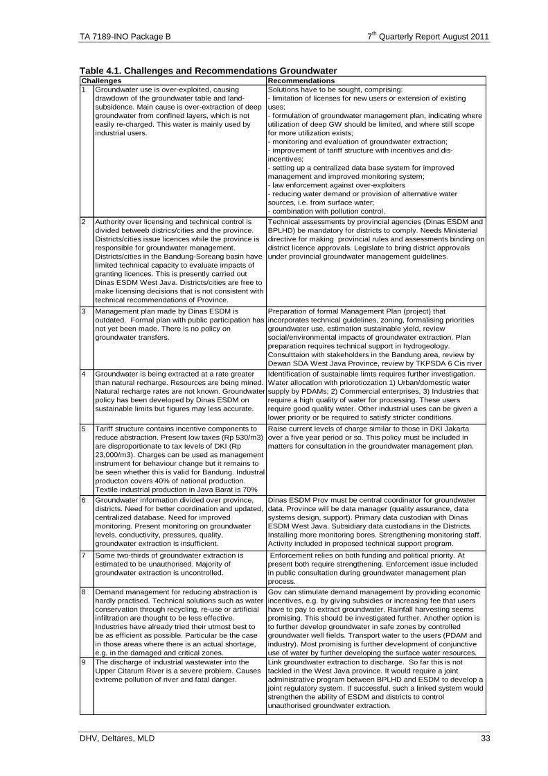
TA 7189-INO Package B 7th
Quarterly Report August 2011
DHV, Deltares, MLD 33
Table 4.1. Challenges and Recommendations Groundwater Recommendations
1 Groundwater use is over-exploited, causing
drawdown of the groundwater table and land-
subsidence. Main cause is over-extraction of deep
groundwater from confined layers, which is not
easily re-charged. This water is mainly used by
industrial users.
Solutions have to be sought, comprising:
- limitation of licenses for new users or extension of existing
uses;
- formulation of groundwater management plan, indicating where
utilization of deep GW should be limited, and where still scope
for more utilization exists;
- monitoring and evaluation of groundwater extraction;
- improvement of tariff structure with incentives and dis-
incentives;
- setting up a centralized data base system for improved
management and improved monitoring system;
- law enforcement against over-exploiters
- reducing water demand or provision of alternative water
sources, i.e. from surface water;
- combination with pollution control.
2 Authority over licensing and technical control is
divided betweeb districs/cities and the province.
Districts/cities issue licences while the province is
responsible for groundwater management.
Districts/cities in the Bandung-Soreang basin have
limited technical capacity to evaluate impacts of
granting licences. This is presently carried out
Dinas ESDM West Java. Districts/cities are free to
make licensing decisions that is not consistent with
technical recommendations of Province.
Technical assessments by provincial agencies (Dinas ESDM and
BPLHD) be mandatory for districts to comply. Needs Ministerial
directive for making provincial rules and assessments binding on
district licence approvals. Legislate to bring district approvals
under provincial groundwater management guidelines.
3 Management plan made by Dinas ESDM is
outdated. Formal plan with public participation has
not yet been made. There is no policy on
groundwater transfers.
Preparation of formal Management Plan (project) that
incorporates technical guidelines, zoning, formalising priorities
groundwater use, estimation sustainable yield, review
social/environmental impacts of groundwater extraction. Plan
preparation requires technical support in hydrogeology.
Consulttaion with stakeholders in the Bandung area, review by
Dewan SDA West Java Province, review by TKPSDA 6 Cis river
basin territory, final joint approval by Governor and Bupatis, 4 Groundwater is being extracted at a rate greater
than natural recharge. Resources are being mined.
Natural recharge rates are not known. Groundwater
policy has been developed by Dinas ESDM on
sustainable limits but figures may less accurate.
Identification of sustainable limts requires further investigation.
Water allocation with priorotiozation 1) Urban/domestic water
supply by PDAMs; 2) Commercial enterprises, 3) Industries that
require a high quality of water for processing. These users
require good quality water. Other industrial uses can be given a
lower priority or be required to satisfy stricter conditions.
5 Tariff structure contains incentive components to
reduce abstraction. Present low taxes (Rp 530/m3)
are disproportionate to tax levels of DKI (Rp
23,000/m3). Charges can be used as management
instrument for behaviour change but it remains to
be seen whether this is valid for Bandung. Industral
producton covers 40% of national production.
Textile industrial production in Java Barat is 70%
of national production.
Raise current levels of charge similar to those in DKI Jakarta
over a five year period or so. This policy must be included in
matters for consultation in the groundwater management plan.
6 Groundwater information divided over province,
districts. Need for better coordination and updated,
centralized database. Need for improved
monitoring. Present monitoring on groundwater
levels, conductivity, pressures, quality,
groundwater extraction is insufficient.
Dinas ESDM Prov must be central coordinator for groundwater
data. Province will be data manager (quality assurance, data
systems design, support). Primary data custodian with Dinas
ESDM West Java. Subsidiary data custodians in the Districts.
Installing more monitoring bores. Strengthening monitoring staff.
Activity included in proposed technical support program.
7 Some two-thirds of groundwater extraction is
estimated to be unauthorised. Majority of
groundwater extraction is uncontrolled.
Enforcement relies on both funding and political priority. At
present both require strengthening. Enforcement issue included
in public consultation during groundwater management plan
process.
8 Demand management for reducing abstraction is
hardly practised. Technical solutions such as water
conservation through recycling, re-use or artificial
infiltration are thought to be less effective.
Industries have already tried their utmost best to
be as efficient as possible. Particular be the case
in those areas where there is an actual shortage,
e.g. in the damaged and critical zones.
Gov can stimulate demand management by providing economic
incentives, e.g. by giving subsidies or increasing fee that users
have to pay to extract groundwater. Rainfall harvesting seems
promising. This should be investigated further. Another option is
to further develop groundwater in safe zones by controlled
groundwater well fields. Transport water to the users (PDAM and
industry). Most promising is further development of conjunctive
use of water by further developing the surface water resources.
9 The discharge of industrial wastewater into the
Upper Citarum River is a severe problem. Causes
extreme pollution of river and fatal danger.
Link groundwater extraction to discharge. So far this is not
tackled in the West Java province. It would require a joint
administrative program between BPLHD and ESDM to develop a
joint regulatory system. If successful, such a linked system would
strengthen the ability of ESDM and districts to control
unauthorised groundwater extraction.
Challenges
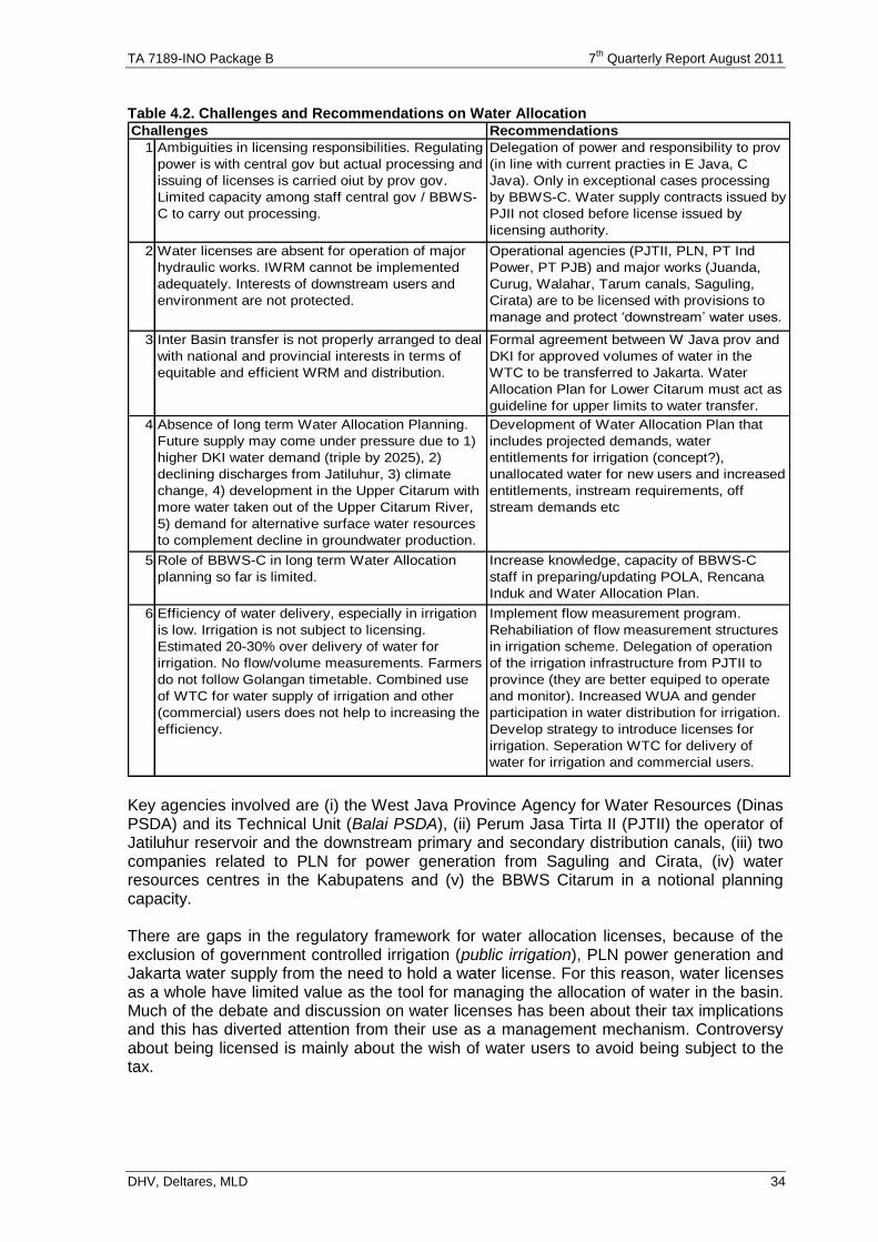
TA 7189-INO Package B 7th
Quarterly Report August 2011
DHV, Deltares, MLD 34
Table 4.2. Challenges and Recommendations on Water Allocation Recommendations
1
2 Water licenses are absent for operation of major
hydraulic works. IWRM cannot be implemented
adequately. Interests of downstream users and
environment are not protected.
Operational agencies (PJTII, PLN, PT Ind
Power, PT PJB) and major works (Juanda,
Curug, Walahar, Tarum canals, Saguling,
Cirata) are to be licensed with provisions to
manage and protect ‘downstream’ water uses.
3 Inter Basin transfer is not properly arranged to deal
with national and provincial interests in terms of
equitable and efficient WRM and distribution.
Formal agreement between W Java prov and
DKI for approved volumes of water in the
WTC to be transferred to Jakarta. Water
Allocation Plan for Lower Citarum must act as
guideline for upper limits to water transfer.
4 Absence of long term Water Allocation Planning.
Future supply may come under pressure due to 1)
higher DKI water demand (triple by 2025), 2)
declining discharges from Jatiluhur, 3) climate
change, 4) development in the Upper Citarum with
more water taken out of the Upper Citarum River,
5) demand for alternative surface water resources
to complement decline in groundwater production.
Development of Water Allocation Plan that
includes projected demands, water
entitlements for irrigation (concept?),
unallocated water for new users and increased
entitlements, instream requirements, off
stream demands etc
5 Role of BBWS-C in long term Water Allocation
planning so far is limited.
Increase knowledge, capacity of BBWS-C
staff in preparing/updating POLA, Rencana
Induk and Water Allocation Plan.
6 Efficiency of water delivery, especially in irrigation
is low. Irrigation is not subject to licensing.
Estimated 20-30% over delivery of water for
irrigation. No flow/volume measurements. Farmers
do not follow Golangan timetable. Combined use
of WTC for water supply of irrigation and other
(commercial) users does not help to increasing the
efficiency.
Implement flow measurement program.
Rehabiliation of flow measurement structures
in irrigation scheme. Delegation of operation
of the irrigation infrastructure from PJTII to
province (they are better equiped to operate
and monitor). Increased WUA and gender
participation in water distribution for irrigation.
Develop strategy to introduce licenses for
irrigation. Seperation WTC for delivery of
water for irrigation and commercial users.
Challenges
Delegation of power and responsibility to prov
(in line with current practies in E Java, C
Java). Only in exceptional cases processing
by BBWS-C. Water supply contracts issued by
PJII not closed before license issued by
licensing authority.
Ambiguities in licensing responsibilities. Regulating
power is with central gov but actual processing and
issuing of licenses is carried oiut by prov gov.
Limited capacity among staff central gov / BBWS-
C to carry out processing.
Key agencies involved are (i) the West Java Province Agency for Water Resources (Dinas PSDA) and its Technical Unit (Balai PSDA), (ii) Perum Jasa Tirta II (PJTII) the operator of Jatiluhur reservoir and the downstream primary and secondary distribution canals, (iii) two companies related to PLN for power generation from Saguling and Cirata, (iv) water resources centres in the Kabupatens and (v) the BBWS Citarum in a notional planning capacity. There are gaps in the regulatory framework for water allocation licenses, because of the exclusion of government controlled irrigation (public irrigation), PLN power generation and Jakarta water supply from the need to hold a water license. For this reason, water licenses as a whole have limited value as the tool for managing the allocation of water in the basin. Much of the debate and discussion on water licenses has been about their tax implications and this has diverted attention from their use as a management mechanism. Controversy about being licensed is mainly about the wish of water users to avoid being subject to the tax.
TA 7189-INO Package B 7th
Quarterly Report August 2011
DHV, Deltares, MLD 35
4.3.3 Follow up activities, MoUs
The B3 project came to an end in Feb'11 with completion of the final strategy reports on groundwater and water allocation. However, the policies and strategies prepared under B.3 need follow up to enhance implementation. This follow up comprises formulation of MoUs for the relevant agencies responsible and/or involved in Water Resources Management. The Public Policy Specialist is working on this, in close cooperation with these agencies. However, it appeared that some key players do not agree with the recommendations, and additional discussions have to take place on how to implement the recommendations. Therefore more input is required for Public Policy Specialist, accommodated under VO 3. . An overview of proposed MoUs is presented in Tables 4.3 and 4.4. on the next pages. Progress on follow up in surface water allocation is presented in Table 4.5. Follow up on groundwater is just starting, because a new head of ESDM has been appointed. A visit on October 25 indicated high interest, but many comments on the plans. This will be reported in next quarterly report.
4.4. Water Service Charge (Earlier Pricing of Bulk Water Supply)
4.4.1 Change of name
As indicated above the constitution indicates that water is free. Therefore there is no “price of water” But there are cost to bring the water from the source to the user, and for that the user can be charged a “water service fee” or biaya jasa sumber daya air (BJSDA). For this reason the name of this study has been changed.
4.4.2 Background
Transport of raw water for urban water supply from the large reservoirs in the Citarum rivers to Jakarta is essential to ensure healthy living conditions in Jakarta. At this moment it is estimated that present demand is 35 m3/s and roughly 50% of clean water supply comes from groundwater. About 80% of surface water supply to Jakarta is provided through the West Tarum Canal (WTC, providing 16 m3/s to Jakarta). More supply of surface water is needed, because population and industries in Jakarta and surroundings are growing rapidly, rising welfare causes incremental demand per person, and Jakarta needs to replace current groundwater use with surface water. Jakarta faces severe and acute problems with land subsidence in the northern parts of the city, in places at the rate of 15 cm per year. As a result 58% of North Jakarta is now affected by potential floods at leap tide, even in the absence of heavy rain. Without proper action in 2030 90% of Northern Jakarta could be affected. In addition, there is severe saline intrusion in many coastal areas of Jakarta such as Ancol, threatening infrastructure. One of the main causes of this land subsidence is the over-pumping of deep aquifers as was the case in Bangkok in 1970-1980. The only remedy for this land subsidence is to drastically reduce the use of groundwater either by reducing demand or by replacing it by additional surface water supply. It is assumed that the scope for reducing demand is limited and that anyhow additional surface water supply is necessary. It is estimated that clean water demand in Jakarta will rise from the present 35 m3/s to 42 m3/s in 2030 (see also section 2.3.2 Water Balance Model, page 9).. This comprises growing demand and replacing the present deep groundwater use. The Strategic Management Plan for the river basin in which Jakarta is situated indicates that 3 – 6 m3/s can be supplied from the West (Cisadane river and further west if Karian is built), and 0,5 – 5 m3/s from local sources, leaving requirements for supply from the East (Citarum river, with three reservoirs such as Jatliluhur) at minimal 31 m3/s.
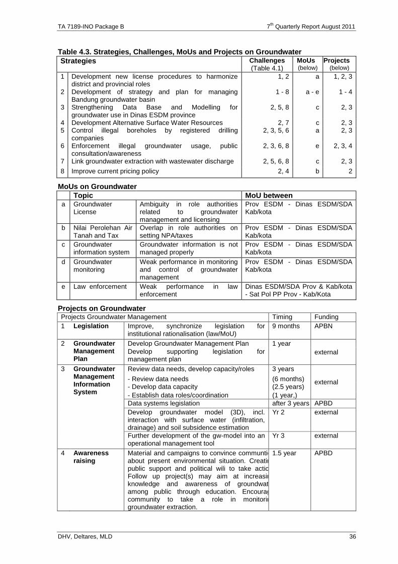
TA 7189-INO Package B 7th
Quarterly Report August 2011
DHV, Deltares, MLD 36
Table 4.3. Strategies, Challenges, MoUs and Projects on Groundwater
Strategies Challenges (Table 4.1)
MoUs (below)
Projects (below)
1 Development new license procedures to harmonize district and provincial roles
1, 2 a 1, 2, 3
2 Development of strategy and plan for managing Bandung groundwater basin
1 - 8 a - e 1 - 4
3 Strengthening Data Base and Modelling for groundwater use in Dinas ESDM province
2, 5, 8 c 2, 3
4 Development Alternative Surface Water Resources 2, 7 c 2, 3 5 Control illegal boreholes by registered drilling
companies 2, 3, 5, 6 a 2, 3
6 Enforcement illegal groundwater usage, public consultation/awareness
2, 3, 6, 8 e 2, 3, 4
7 Link groundwater extraction with wastewater discharge 2, 5, 6, 8 c 2, 3
8 Improve current pricing policy 2, 4 b 2
MoUs on Groundwater
Topic MoU between a Groundwater
License Ambiguity in role authorities related to groundwater management and licensing
Prov ESDM - Dinas ESDM/SDA Kab/kota
b Nilai Perolehan Air Tanah and Tax
Overlap in role authorities on setting NPA/taxes
Prov ESDM - Dinas ESDM/SDA Kab/kota
c Groundwater information system
Groundwater information is not managed properly
Prov ESDM - Dinas ESDM/SDA Kab/kota
d Groundwater monitoring
Weak performance in monitoring and control of groundwater management
Prov ESDM - Dinas ESDM/SDA Kab/kota
e Law enforcement Weak performance in law enforcement
Dinas ESDM/SDA Prov & Kab/kota - Sat Pol PP Prov - Kab/Kota
Projects on Groundwater
Projects Groundwater Management Timing Funding
1 Legislation Improve, synchronize legislation for institutional rationalisation (law/MoU)
9 months APBN
2 Groundwater Management Plan
Develop Groundwater Management Plan 1 year
external Develop supporting legislation for management plan
3 Groundwater Management Information System
Review data needs, develop capacity/roles 3 years
external - Review data needs (6 months) - Develop data capacity (2.5 years)
- Establish data roles/coordination (1 year,)
Data systems legislation after 3 years APBD
Develop groundwater model (3D), incl. interaction with surface water (infiltration, drainage) and soil subsidence estimation
Yr 2 external
Further development of the gw-model into an operational management tool
Yr 3 external
4 Awareness raising
Material and campaigns to convince communties about present environmental situation. Creating public support and political wili to take action. Follow up project(s) may aim at increasing knowledge and awareness of groundwater among public through education. Encourage community to take a role in monitoring groundwater extraction.
1.5 year APBD
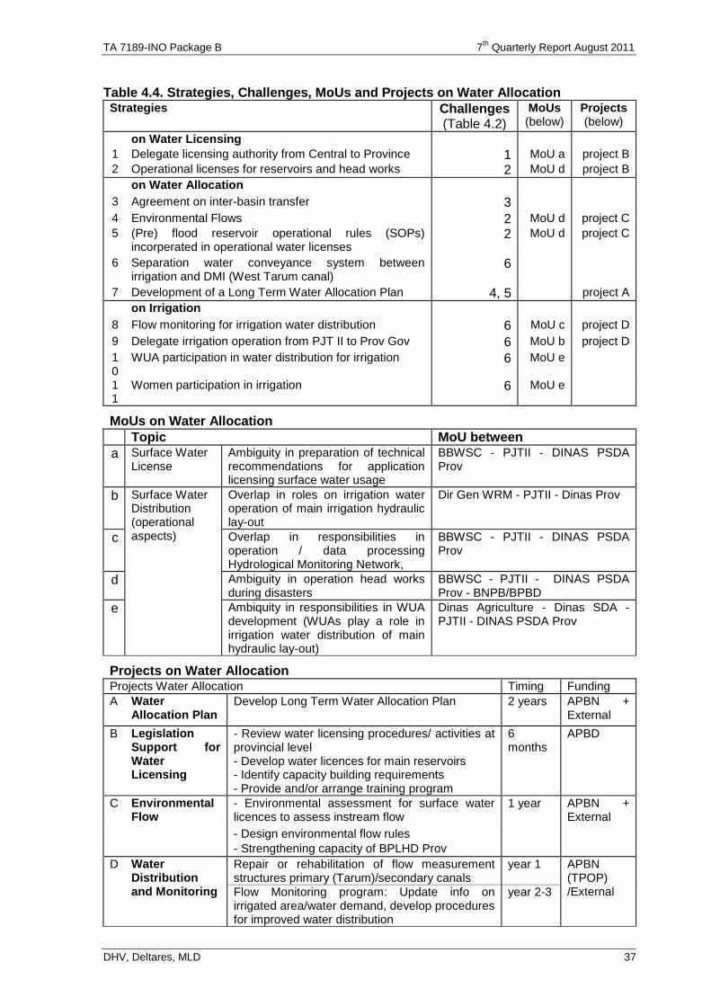
TA 7189-INO Package B 7th
Quarterly Report August 2011
DHV, Deltares, MLD 37
Table 4.4. Strategies, Challenges, MoUs and Projects on Water Allocation Strategies Challenges
(Table 4.2)
MoUs (below)
Projects (below)
on Water Licensing
1 Delegate licensing authority from Central to Province 1 MoU a project B
2 Operational licenses for reservoirs and head works 2 MoU d project B
on Water Allocation
3 Agreement on inter-basin transfer 3
4 Environmental Flows 2 MoU d project C
5 (Pre) flood reservoir operational rules (SOPs) incorperated in operational water licenses
2 MoU d project C
6 Separation water conveyance system between irrigation and DMI (West Tarum canal)
6
7 Development of a Long Term Water Allocation Plan 4, 5 project A
on Irrigation
8 Flow monitoring for irrigation water distribution 6 MoU c project D
9 Delegate irrigation operation from PJT II to Prov Gov 6 MoU b project D
10
WUA participation in water distribution for irrigation 6 MoU e
11
Women participation in irrigation 6 MoU e
MoUs on Water Allocation
Topic MoU between
a Surface Water License
Ambiguity in preparation of technical recommendations for application licensing surface water usage
BBWSC - PJTII - DINAS PSDA Prov
b Surface Water Distribution (operational aspects)
Overlap in roles on irrigation water operation of main irrigation hydraulic lay-out
Dir Gen WRM - PJTII - Dinas Prov
c Overlap in responsibilities in operation / data processing Hydrological Monitoring Network,
BBWSC - PJTII - DINAS PSDA Prov
d Ambiguity in operation head works during disasters
BBWSC - PJTII - DINAS PSDA Prov - BNPB/BPBD
e Ambiquity in responsibilities in WUA development (WUAs play a role in irrigation water distribution of main hydraulic lay-out)
Dinas Agriculture - Dinas SDA - PJTII - DINAS PSDA Prov
Projects on Water Allocation Projects Water Allocation Timing Funding
A Water Allocation Plan
Develop Long Term Water Allocation Plan 2 years APBN + External
B Legislation Support for Water Licensing
- Review water licensing procedures/ activities at provincial level - Develop water licences for main reservoirs - Identify capacity building requirements - Provide and/or arrange training program
6 months
APBD
C Environmental Flow
- Environmental assessment for surface water licences to assess instream flow
1 year APBN + External
- Design environmental flow rules
- Strengthening capacity of BPLHD Prov
D Water Distribution and Monitoring
Repair or rehabilitation of flow measurement structures primary (Tarum)/secondary canals
year 1 APBN (TPOP) /External Flow Monitoring program: Update info on
irrigated area/water demand, develop procedures for improved water distribution
year 2-3
TA 7189-INO Package B 7th
Quarterly Report August 2011
DHV, Deltares, MLD 38
Table 4.5. Progress of follow up on Strategies B3 on Water allocation
Strategies Progress on Water Licensing 1. Delegation of licensing
authority from Central to provincial Government 2. Operational Licenses for
operators of reservoirs and head works
1. Based on UU 7/2004 article 47(5): commercial use of water resources is
encouraged. As a result some big, but many small corporations apply for licenses. This is too heavy burden to be handled all by Jakarta. Cost for process (travel from Jakarta to all over Indonesia) is too high, so only large requests are processed. This could be improved through deconcentration of permit issuance for surface water to the Province, which has legal basis, and is more practical. The Province did this already satisfactorily before UU 7/2004. However, not all stakeholders agree on this solution. Therefore additional discussions take place. In principle deconcentration for issuing surface water licenses is being accommodated in draft government regulation (RPP) of Water Right prepared by the Team supervised by Chief of subdit Pengaturan Directorat of Bina PSDA (Tommy Sitompul). This is still in process in PU 2. Operational licenses for operators of reservoirs and head works has been regulated in PP 37/2010 on Dams, article 83. Licenses are stipulated by minister Public Works. It is not clear who is responsible in case of disasters, and therefore more clarity is sought. Problem is how to deal with authorities at central and provincial level (see also item 5).
On Water Allocation
3. Agreement on inter-basin transfer 4. Asses/regulate environmental flows 5. (Pre) flood reservoir operational rules (SOPs) incorporated in operational water licenses 6. Separation water conveyance system between irrigation and DMI (West Tarum Canal) 7. Development of a long term Water allocation
3. DMI requested West Java for extra supply of 15 m3/s from Citarum river. This request is in process. Discussions are on-going about surface water taxes. 4. Environmental flows have been regulated recently in PP 38/2011 on River, article 25. They should be equal to 95 % reliable flow. In extremely dry periods, this supply gets lower priority (in practice). 5. Recommendations have been provided in July 2010, but no official Kep Men PU has been issued yet. Recently it has been brought forward for approval by the DG. The issue may be the link with the tasks and responsibility of the Governor. Still in process 6. This is done partly through building siphons in the West Tarum canal as existing at Cibeet crossing, construction at Bekasi crossing and still in feasibility stage at Cikarang. In future there will be extra pipes especially for DMI, leaving the canal for irrigation. Ultimately PJT II should handle only bulk water supply and not irrigation. 7. Development of long term water allocation is partly accommodated in study of Strategic management Plan of 6 CI’s and a more detailed one in WISMP II.
On Irrigation
8. Flow monitoring for irrigation water distribution 9. Delegation of irrigation water distribution (O&M) from Central Gov (PJT II) to Provincial Government 10. WUA participation in water distribution for irrigation 11. Women participation in irrigation
8. Flow monitoring for irrigation water distribution of Jatiluhur irrigation system will be accommodated in package of modernization of Jatiluhur irrigation system under WISMP II 9. Delegation of irrigation water distribution (O&M) from Central to Provincial Government is already practiced through co-management (Tugas Pembantuan TP). As long West Tarum Canal has a double function for both irrigation and non irrigation, there is difficulty for PJT II to delegate O&M of irrigation canal to Provincial Government. For short term the best solution is agreement in MOU. The meetings have been held in June and July and more are expected in October. 10. Water Users Associations (WUA) participation in water distribution for irrigation has been regulated in PP 20/2006 on irrigation and Permen PU 33/PRT/M/2007 on WUA Strengthening for irrigation. But function of WUA in Jatiluhur is not effective, only 58 WUA for 240,000 ha. In principle Ministry of Agriculture (MoA) is responsible for WUA strengthening. Therefore a MoU between MoA and Public Works is under preparation. The MOU will cover : a. Development of irrigation infrastructures b. Processing of data c. Preparation of irrigation area. No specific activities on this subject. In principle it is agreed that WUA boards function better if there is at least one women in the board, and this is realized in most boards.
TA 7189-INO Package B 7th
Quarterly Report August 2011
DHV, Deltares, MLD 39
There are several solutions possible to bring more water to Jakarta: Increasing conveyance capacity of the present West Tarum Canal (WTC). At this
moment WTC is a canal used for both irrigation and urban water supply. Several studies show that the capacity of the WTC can be increased from the present 16 m3/s to 31 m3/s, which would be sufficient to meet additional demand and replacing deep groundwater extraction.
The construction of pipes along the WTC Studies indicate that a staged development of three pipelines, each with 5 m3/s, are technically feasible. The advantage of pipes over an open channel is that it improves water quality at the Water Treatment Plant (WTP), since the clean water is not diluted with sediments and polluted water from rivers crossing WTC. It is even possible to construct the WTP close to the Jatiluhur Dam, where land prices are 10% of prices in Jakarta.
Increasing conveyance capacity of WTC and improving water quality by constructing siphons where it crosses major rivers (Cibeet, Cikarang and Bekasi). The siphon in Bekasi is already under construction (capacity is 31 m3/s). Water from the rivers could still be used for irrigation, but the relatively clean water from Jatiluhur is not diluted, and brought directly to Jakarta.
PJT II is the public water supply company (Perum Jasa Tirta II) responsible for operation and maintenance of the raw water supply infrastructure. The basic question for this study is to assess how the cost of PJT II for transport of raw water should be recovered. Basically, this study tries to answer two questions regarding the setting of the service fee for bulk water supply from the Citarum river:
1. How should joint costs incurred by PJT II to maintain the Jatiluhur dam, the upper watershed and the West Tarum Canal be equitably shared with the various users?
2. Which investments should be made to increase and assure bulk water supply to Jakarta and which calculation method is best suited to cover the cost for this purpose?
4.4.3 Sharing of joint costs
For the distribution of shared costs in a multi-purpose water resources infrastructure such as the Jatiluhur dam which is used to generate hydropower, supply irrigation water to agriculture, raw water to the drinking water treatment plants of Bekasi, Kerawang and Jakarta and water for industry, consultants have studied various methodologies. Existing methodologies have been developed in the first place to distribute investment costs and annual costs for operation and maintenance of the joint infrastructure to the various purposes in order to determine the feasibility of supplying each of the individual purposes with water from the multi-purpose facility. For Jatiluhur the Japanese consultants applied such a methodology in 1969 to calculate the hydro power costs of the dam and to establish its feasibility as a power producer. To distribute joint operational costs the consultants recommend application of the “Use of Facilities” method. This method distributes the joint costs proportional to the benefit each of the users makes or derives from the common facility. In the case of the Jatiluhur dam, which is used for a large variety of purposes with rather different returns per unit of water, it is suggested to use net Economic Benefit Values as distribution criterion. The various purposes are: Irrigation, Flood Control, bulk water supply to Water Supply companies in Jakarta (PAM Jaya) and other cities or districts (PDAM), bulk water supply to Industries, and hydropower. The resulting distribution would then as presented in Table 4.6 below: Irrigation and Flood Control are mainly social users. Irrigation benefits can be estimated quite accurately, but the farmers’ capability to pay is limited, and community irrigation (irigasi masyarakat) is usually not charged with fees. Benefits of flood control are purely economic: no user gets extra income from that, but is only spared the damages from floods.
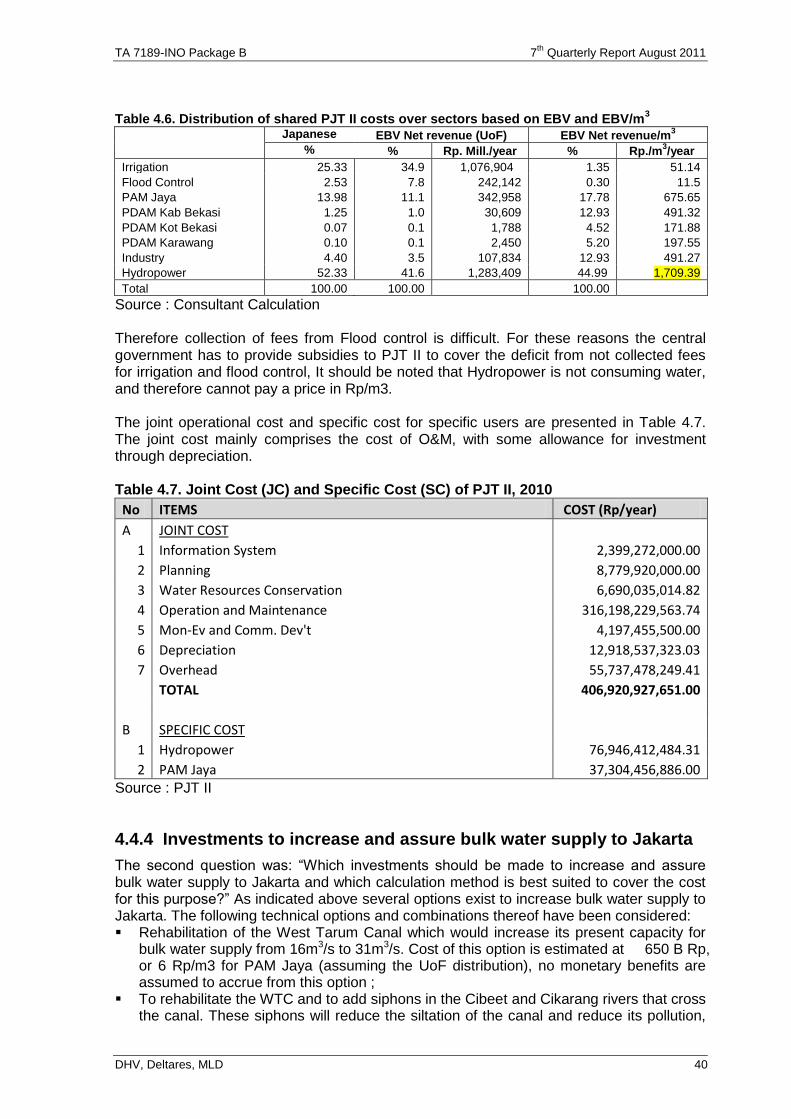
TA 7189-INO Package B 7th
Quarterly Report August 2011
DHV, Deltares, MLD 40
Table 4.6. Distribution of shared PJT II costs over sectors based on EBV and EBV/m
3
Japanese EBV Net revenue (UoF) EBV Net revenue/m3
% % Rp. Mill./year % Rp./m3/year
Irrigation 25.33 34.9 1,076,904 1.35 51.14
Flood Control 2.53 7.8 242,142 0.30 11.5
PAM Jaya 13.98 11.1 342,958 17.78 675.65
PDAM Kab Bekasi 1.25 1.0 30,609 12.93 491.32
PDAM Kot Bekasi 0.07 0.1 1,788 4.52 171.88
PDAM Karawang 0.10 0.1 2,450 5.20 197.55
Industry 4.40 3.5 107,834 12.93 491.27
Hydropower 52.33 41.6 1,283,409 44.99 1,709.39
Total 100.00 100.00 100.00
Source : Consultant Calculation Therefore collection of fees from Flood control is difficult. For these reasons the central government has to provide subsidies to PJT II to cover the deficit from not collected fees for irrigation and flood control, It should be noted that Hydropower is not consuming water, and therefore cannot pay a price in Rp/m3. The joint operational cost and specific cost for specific users are presented in Table 4.7. The joint cost mainly comprises the cost of O&M, with some allowance for investment through depreciation. Table 4.7. Joint Cost (JC) and Specific Cost (SC) of PJT II, 2010
No ITEMS COST (Rp/year)
A JOINT COST
1 Information System 2,399,272,000.00
2 Planning 8,779,920,000.00
3 Water Resources Conservation 6,690,035,014.82
4 Operation and Maintenance 316,198,229,563.74
5 Mon-Ev and Comm. Dev't 4,197,455,500.00
6 Depreciation 12,918,537,323.03
7 Overhead 55,737,478,249.41
TOTAL 406,920,927,651.00
B SPECIFIC COST
1 Hydropower 76,946,412,484.31
2 PAM Jaya 37,304,456,886.00 Source : PJT II
4.4.4 Investments to increase and assure bulk water supply to Jakarta
The second question was: “Which investments should be made to increase and assure bulk water supply to Jakarta and which calculation method is best suited to cover the cost for this purpose?” As indicated above several options exist to increase bulk water supply to Jakarta. The following technical options and combinations thereof have been considered: Rehabilitation of the West Tarum Canal which would increase its present capacity for
bulk water supply from 16m3/s to 31m3/s. Cost of this option is estimated at 650 B Rp, or 6 Rp/m3 for PAM Jaya (assuming the UoF distribution), no monetary benefits are assumed to accrue from this option ;
To rehabilitate the WTC and to add siphons in the Cibeet and Cikarang rivers that cross the canal. These siphons will reduce the siltation of the canal and reduce its pollution,
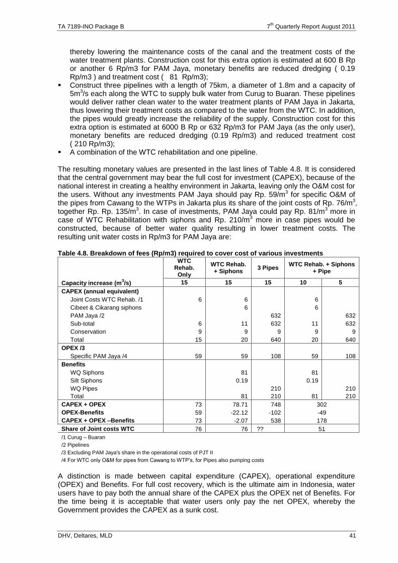
TA 7189-INO Package B 7th
Quarterly Report August 2011
DHV, Deltares, MLD 41
thereby lowering the maintenance costs of the canal and the treatment costs of the water treatment plants. Construction cost for this extra option is estimated at 600 B Rp or another 6 Rp/m3 for PAM Jaya, monetary benefits are reduced dredging ( 0.19 Rp/m3 ) and treatment cost ( 81 Rp/m3);
Construct three pipelines with a length of 75km, a diameter of 1.8m and a capacity of 5m3/s each along the WTC to supply bulk water from Curug to Buaran. These pipelines would deliver rather clean water to the water treatment plants of PAM Jaya in Jakarta, thus lowering their treatment costs as compared to the water from the WTC. In addition, the pipes would greatly increase the reliability of the supply. Construction cost for this extra option is estimated at 6000 B Rp or 632 Rp/m3 for PAM Jaya (as the only user), monetary benefits are reduced dredging (0.19 Rp/m3) and reduced treatment cost ( 210 Rp/m3);
A combination of the WTC rehabilitation and one pipeline. The resulting monetary values are presented in the last lines of Table 4.8. It is considered that the central government may bear the full cost for investment (CAPEX), because of the national interest in creating a healthy environment in Jakarta, leaving only the O&M cost for the users. Without any investments PAM Jaya should pay Rp. 59/m3 for specific O&M of the pipes from Cawang to the WTPs in Jakarta plus its share of the joint costs of Rp. 76/m3, together Rp. Rp. 135/m3. In case of investments, PAM Jaya could pay Rp. 81/m3 more in case of WTC Rehabilitation with siphons and Rp. 210/m3 more in case pipes would be constructed, because of better water quality resulting in lower treatment costs. The resulting unit water costs in Rp/m3 for PAM Jaya are: Table 4.8. Breakdown of fees (Rp/m3) required to cover cost of various investments
WTC Rehab.
Only
WTC Rehab. + Siphons
3 Pipes WTC Rehab. + Siphons
+ Pipe
Capacity increase (m3/s) 15 15 15 10 5
CAPEX (annual equivalent)
Joint Costs WTC Rehab. /1 6 6 6
Cibeet & Cikarang siphons 6 6
PAM Jaya /2 632 632
Sub-total 6 11 632 11 632
Conservation 9 9 9 9 9
Total 15 20 640 20 640
OPEX /3
Specific PAM Jaya /4 59 59 108 59 108
Benefits
WQ Siphons 81 81
Silt Siphons 0.19 0.19
WQ Pipes 210 210
Total 81 210 81 210
CAPEX + OPEX 73 78.71 748 302
OPEX-Benefits 59 -22.12 -102 -49
CAPEX + OPEX –Benefits 73 -2.07 538 178
Share of Joint costs WTC 76 76 ?? 51
/1 Curug – Buaran
/2 Pipelines
/3 Excluding PAM Jaya's share in the operational costs of PJT II
/4 For WTC only O&M for pipes from Cawang to WTP’s, for Pipes also pumping costs
A distinction is made between capital expenditure (CAPEX), operational expenditure (OPEX) and Benefits. For full cost recovery, which is the ultimate aim in Indonesia, water users have to pay both the annual share of the CAPEX plus the OPEX net of Benefits. For the time being it is acceptable that water users only pay the net OPEX, whereby the Government provides the CAPEX as a sunk cost.
TA 7189-INO Package B 7th
Quarterly Report August 2011
DHV, Deltares, MLD 42
In case we can assume that the Government will provide the CAPEX, the OPEX – Benefits is the applicable selection criterion. This is lowest for the option with the 3 pipes. This option has high CAPEX, but delivers relatively high quality water. The second best option would be the combination of one pipe and the partial rehabilitation of the WTC. The WTC rehabilitation without siphons is the least attractive option. In case CAPEX would not be absorbed by the Government and full cost recovery would be required, the ranking of options is completely different: The rehabilitation of the WTC with siphons would become the most attractive option. The options with the pipes would become rater expensive.
4.4.5 Additional benefits of the pipelines
An important additional benefit of the pipeline is increased water security for Jakarta. The pipe reduces the chance that this water gets polluted during its journey in WTC from Curug to Cawang, and the risks that this water gets accidentally polluted to the rate that its use has to be temporally halted. At present intake of water from the WTC has to be suspended in case the water turbidity is too high (> 2,000 ppm) because the system cannot cope with such high values. Other reasons to stop the intake of raw water are a breach in the canal (no supply any more), or in case the canal water is too polluted (pesticides, oil, etc.) to be treated, which could be caused by accidents such as excessive waste water pollution from industries, or a truck full of chemicals entering the WTC. In case the water intake would be disrupted for periods longer than the clean water storage capacity of PAM Jaya (4 hours), water supply has to be reduced and the water users receive less water than they require. PAM Jaya would loose business at the rate of Rp. 222 mln/hour4 at present and double that amount after rehabilitation of the WTC. This means that if such stoppage occurs during 600 days in the next 20 years (30 days per year), the construction cost are already covered5. Ultimately PAM Jaya may be forced to supply water by tankers from elsewhere (Bogor?) at a cost of Rp. 100,000/m3 (commercial rate charged by private water vendors using tankers of 7m3 capacity). PAM Jaya is not equipped to do this on a large scale and may therefore be forced to engage private tankers. In case of a severe accident with the WTC (breach of canal embankment, severe pollution, etc.) the main water supply to Indonesia’s capital is in peril. One pipeline would at least guarantee a flow of 5m3/s to the capital. In an emergency situation this would represent a value of Rp. 1,800 mln per hour67. This would be sufficient to pay for the investment in the pipe within 46 days over the 20 years lifetime of the pipe, or 2 days per year8. These 2 days are in excess of the safety storage period of PAM Jaya in Jakarta. With more pipes the safety margin of the water supply to Jakarta would increase proportionally. At the other hand such reliability may also increase by provision of extra storage. Assume storage for 2 days is needed. Daily production is 700,000 m3, thus a reservoir of 1.4 M m3 is needed. With a depth of 2.5 m, a surface of 56 ha is needed. Another additional benefit of the pipelines is that the new water treatment plant (not in the proposed investment) could be built at the intake of the pipes close to Curug, rather than in Jakarta. The area required for the construction of a 16/m3/s WTP is estimated at 50 ha9. Obtaining such an area in Jakarta could prove difficult and much more expensive. Assuming 5 M Rp/m2, cost would be 2500 B Rp in Jakarta, and only 10% in Curug.
4 Rp.7,400 * average production of 30,000 m
3/hour
5 222 x 2 x 24 x 600 x 1,000,000 = 6394 B Rp
6 Rp.100,000 * 5*60*60 / 1,000,000 = 1800 M Rp/h
7 Rp 1800 x 24 x 46 x 1,000,000 = 1987 B Rp
8 Rp 2,000,000 [pipe investment] /(100,000 [tanker costs] * 5*60*60 / 1,000,000) /24/20
9 Mott MacDonald (May 2011): Jatiluhur to Jakarta Pipeline & Water Treatment Plant – Stage 2a
TA 7189-INO Package B 7th
Quarterly Report August 2011
DHV, Deltares, MLD 43
4.5. Issues
The pricing of bulk water study needs counterparting by the Technical Working Group initiated for this. However, an official status has not yet been given, and this may cause issues concerning sustainability of the study results.
4.6. Reports
A total of 12 reports were generated under this sub-component: - two main reports with strategies on water allocation and groundwater; - ten background reports. Water Allocation Lower Citarum The Main Report (Report No 12) finds that there are several important strategic areas where improvements can be made. It also analyses the legal and institutional frameworks and concludes that many uncertainties about mandates and responsibility, would be greatly simplified by assigning primary responsibility for water licensing and allocation to the province. It proposes a number of changes to policies, organizational roles and the scope of the licensing system, and recommends monitoring of water delivery to irrigation schemes in order to understand and therefore manage the vast bulk of the water distributed for consumptive use in the basin. Six Background Reports were drafted that are complimentary to the main report. These are: - Report on Review Framework National Legislation (Report No 1, May’10); - Report on International Best Practice in Water Allocation (Report No 2, Jun’10); - Report on Water Allocation, Water Balance Jatiluhur (Report No 3, Aug’10); - Report on Gender in Irrigation (Report No 7. Jan’11); - Report on Review Framework Local Legislation (Report No 8, Jan'11); - Report on BBWSC Workshop (Report No 10, Feb’11). Groundwater Bandung-Soreang The Main Report (Report No 11) covers: - present situation and issues in the Bandung-Soreang groundwater basin with an analysis
of the issues and technical solutions for groundwater conservation; - analysis of the present legislative framework related to groundwater (national and local
with suggestions for improvement; - present institutional setting related to groundwater management and licensing with suggestions for improvements on management, licensing and taxation; - present groundwater management plan suggestions for improvements; - economic pricing of groundwater and suggestions for improvements - Present institutional setting related to groundwater management and licensing with
suggestions for improvements on management, licensing and taxation; - Present groundwater management plan suggestions for improvements; - Economic pricing of groundwater and suggestions for improvements The report ends with a strategy plan that aims at groundwater conservation in the Bandung-Soreang basin including a clearly spelled out action plan. 6 (six) Background Reports were drafted that are complimentary to the main report (two reports i.e. No 1 and 8 cover also water allocation). These are:
- Report on Review Framework National Legislation (Report No 1, May’10); - Report on Groundwater Issues in the BS basin (Report No 4, Aug'10; - Report on Groundwater Management in the BS basin (Report No 5, Aug'10; - Report ESDM Workshop Groundwater Management in BS (Report No 6, Nov'10); - Report on Review Framework Local Legislation (Report No 8, Jan'11); - Report on Groundwater Issues, update Report No. 4 (Report No. 9, Dec'10).
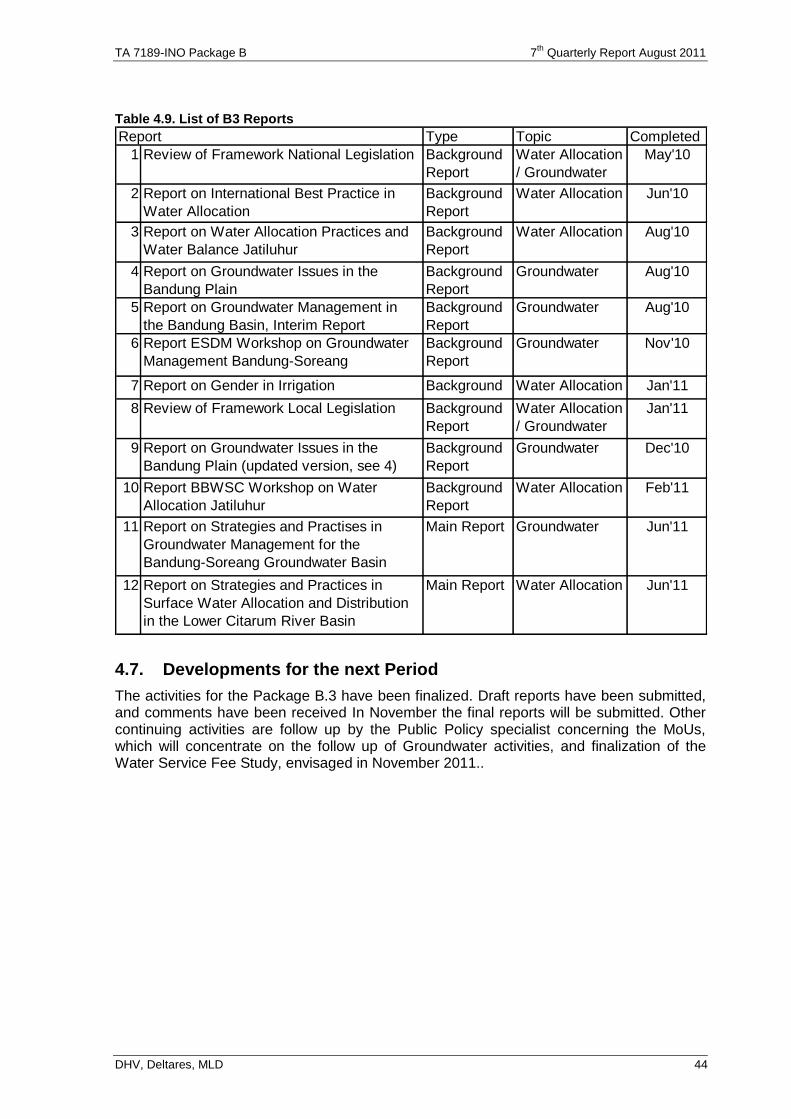
TA 7189-INO Package B 7th
Quarterly Report August 2011
DHV, Deltares, MLD 44
Table 4.9. List of B3 Reports
Type Topic Completed
1 Review of Framework National Legislation Background
Report
Water Allocation
/ Groundwater
May'10
2 Report on International Best Practice in
Water Allocation
Background
Report
Water Allocation Jun'10
3 Report on Water Allocation Practices and
Water Balance Jatiluhur
Background
Report
Water Allocation Aug'10
4 Report on Groundwater Issues in the
Bandung Plain
Background
Report
Groundwater Aug'10
5 Report on Groundwater Management in
the Bandung Basin, Interim Report
Background
Report
Groundwater Aug'10
6 Report ESDM Workshop on Groundwater
Management Bandung-Soreang
Background
Report
Groundwater Nov'10
7 Report on Gender in Irrigation Background
Report
Water Allocation Jan'11
8 Review of Framework Local Legislation Background
Report
Water Allocation
/ Groundwater
Jan'11
9 Report on Groundwater Issues in the
Bandung Plain (updated version, see 4)
Background
Report
Groundwater Dec'10
10 Report BBWSC Workshop on Water
Allocation Jatiluhur
Background
Report
Water Allocation Feb'11
11 Report on Strategies and Practises in
Groundwater Management for the
Bandung-Soreang Groundwater Basin
Main Report Groundwater Jun'11
12 Report on Strategies and Practices in
Surface Water Allocation and Distribution
in the Lower Citarum River Basin
Main Report Water Allocation Jun'11
Report
4.7. Developments for the next Period
The activities for the Package B.3 have been finalized. Draft reports have been submitted, and comments have been received In November the final reports will be submitted. Other continuing activities are follow up by the Public Policy specialist concerning the MoUs, which will concentrate on the follow up of Groundwater activities, and finalization of the Water Service Fee Study, envisaged in November 2011..
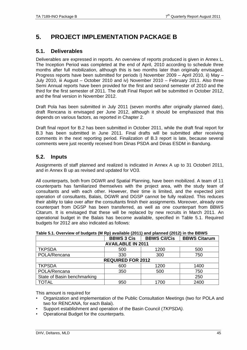
TA 7189-INO Package B 7th
Quarterly Report August 2011
DHV, Deltares, MLD 45
5. PROJECT IMPLEMENTATION PACKAGE B
5.1. Deliverables
Deliverables are expressed in reports. An overview of reports produced is given in Annex L. The Inception Period was completed at the end of April, 2010 according to schedule three months after full mobilization, although this is two months later than originally envisaged. Progress reports have been submitted for periods i) November 2009 – April 2010, ii) May – July 2010, iii August – October 2010 and iv) November 2010 – February 2011. Also three Semi Annual reports have been provided for the first and second semester of 2010 and the third for the first semester of 2011. The draft Final Report will be submitted in October 2012, and the final version in November 2012. Draft Pola has been submitted in July 2011 (seven months after originally planned date), draft Rencana is envisaged per June 2012, although it should be emphasized that this depends on various factors, as reported in Chapter 2. Draft final report for B.2 has been submitted in October 2011, while the draft final report for B.3 has been submitted in June 2011. Final drafts will be submitted after receiving comments in the next reporting period. Finalization of B.3 report is late, because several comments were just recently received from Dinas PSDA and Dinas ESDM in Bandung.
5.2. Inputs
Assignments of staff planned and realized is indicated in Annex A up to 31 Octoberl 2011, and in Annex B up as revised and updated for VO3. All counterparts, both from DGWR and Spatial Planning, have been mobilized. A team of 11 counterparts has familiarized themselves with the project area, with the study team of consultants and with each other. However, their time is limited, and the expected joint operation of consultants, Balais, DGWR and DGSP cannot be fully realized. This reduces their ability to take over after the consultants finish their assignments. Moreover, already one counterpart from DGSP has been transferred, as well as one counterpart from BBWS Citarum. It is envisaged that these will be replaced by new recruits in March 2011. An operational budget in the Balais has become available, specified in Table 5.1. Required budgets for 2012 are also indicated as follows: Table 5.1. Overview of budgets (M Rp) available (2011) and planned (2012) in the BBWS
BBWS 3 Cis BBWS Cil/Cis BBWS Citarum
AVAILABLE IN 2011
TKPSDA 500 1200 500
POLA/Rencana 330 300 750
REQUIRED FOR 2012
TKPSDA 600 1200 1400
POLA/Rencana 350 500 750
State of Basin benchmarking 250
TOTAL 950 1700 2400
This amount is required for • Organization and implementation of the Public Consultation Meetings (two for POLA and
two for RENCANA, for each Balai). • Support establishment and operation of the Basin Council (TKPSDA). • Operational Budget for the counterparts.

TA 7189-INO Package B 7th
Quarterly Report August 2011
DHV, Deltares, MLD 46
5.3. Review mission from ADB
In April/May 2011 a review mission from ADB was held for Loan 2500 /2501 (SF), Integrated Citarum Water Resources Management Investment Program (ICWRMIP I) and TA 7189-INO. Concerning TA 7189 INO Package B conclusions were as follows (follow up in Italics): Sub-component B.1 1). TKPSDA needs to be activated as soon as possible, and therefore the secretariat
should be allocated adequate daily staff and provision of dedicated guidance by the head of the secretariat, the head of O&M in BBWS Ciliwung-Cisadane. The consultants are already supporting this.
2). The mission is pleased with the presence of an adequate number of counterparts, but an important aspect of the TA is developing capacity and ownership for Balai Besar to take a lead in the Pola and Rencana development process as well have skills to operate the models and to undertake effective basin planning and implementation activities once the TA closes. Careful monitoring and dialogue with the consultants and GOI is required to ensure that these outcomes are achieved. This will require more time from the counterparts, who should be made free from other tasks.
3). The consultants with higher participation from the counterparts will provide more on-the-job training at the location of the counterparts. In addition, weekly meetings will be organized to increase the transfer of knowledge and involvement of the counterparts in Pola and Rencana formulation. This needs additional human resources for the consultants. This is worked out in section 5.4.
4). More time required from heads of Planning Divisions in the three BBWS for finalization of Pola and formulation of Rencana. This is also part of the agreement sketched above.
5). Discussions are on-going about splitting the 6 Cis RBT into three as part of the new Keppres on delineation of RBT. The consultants recommend one WS, but it is necessary to make special arrangements concerning coordination of the trans basin conveyances. No decision has been taken yet. It is important that the Pola is legalized before the split in 6 Cis RBT is officially announced. In that way an overall strategic plan is available to cover the inter-basin transfers, based on which the individual Rencana can be developed further.
6). Catchment area improvement should be coordinated between Balai PDAS (from forestry) and the province of West Java and the districts Bandung and West Bandung. For this a workshop should be organized. This will also require extra funds to be included in the next variation order.
7). Role of PJT II has been changed under PP7/2010 (see 2.2.2), Role sharing between BBWS, provinces, districts and PJT II has to be dealt with, and BBWS capacity building action plans depends on agreed roles and responsibilities (as reported under 2.4.1). This will be dealt with by the Public Policy Specialist..
8). More frequent formal meetings should be held between consultants and BBWS, preferably to discuss the contents of the progress report. This will be effectuated..
9). Several requests have been made to extend the B.2 sub component (spatial planning) in order to ensure inclusion of water zoning principles in the Rencana, and the mission will endorse this as a no cost extension. This is impossible to be effectuated without extra cost. It should be assessed whether funds are available from other sources, and PU already sent a letter to the Dutch Embassy for that.
10). BBWS 2 Cis asked attention for the 200 situ situ in their area, especially concerning role sharing for O&M.. This will be dealt with in the Rencana.
11). BBWS Citarum should give attention to allocate budget for the State of the Basin assessment, to be implemented in February – April 2012.
TA 7189-INO Package B 7th
Quarterly Report August 2011
DHV, Deltares, MLD 47
Subcomponent B.2 1). Data acquisition concerning Census 2010 is still a major issue. Data are available at
kecamatan level, but not yet at desa level. The last version of JSM 2.2 cannot wait for that. The last version has been completed based on data from kecamatan.
2). Satellite imagery from JAXA has become available. The issue of reduced quality of satellite imagery because of clouds has been solved by using PALSAR radar signals, and processing through a third party AGS.
3). Based on model outputs, the loss in the Saguling reservoir due to sedimentation and associated power production reduction has been estimated at US$ 190 million per year. Identified intervention to improve catchment conditions for 25,000 ha of reforestation and 44,000 ha agricultural land management is estimated at a one time investment of US$ 79 million, reducing erosion from the current 13.9 Mton/year to 1/7 M ton/year. This should be followed up for next financing requests to ADB.
4). To ensure continuity of activities, DGWR and DGSP requested additional support for: (i) formulation of Rencana with inclusion of water zoning principles, (ii) ensure dissemination of JSM outputs at district level for inclusion into district spatial plans (RTRW), (iii) prepare guidelines and preliminary assessment for inclusion of waterzoning principles in RTRW, (iv) further elaborate water zoning criteria and application to 6 Cis, (v) reconnaissance to incorporate food security aspects in spatial planning (application of UU41/2099 and PP1/2011 concerning protection of highly productive agricultural land) and (vi) transfer of knowledge on application of JSM in spatial planning through the counterparts in each Balai. A program for extension of services has been formulated, and a budget for additional funds required has been proposed. This is presented in section 5.4. .
Subcomponent B.3 5). Continuation of the findings from B.3 is implemented by the institutional specialist
under B.1 (This should be the public policy specialist from B.3, but now working within the coordination of B.1.).
6). A technical Working Group will be formed by 30 June 2011 to supervise the work for the Bulk Water Pricing study. This TWG has had two informal meetings, but no official status is planned yet.
5.4. Contract and Variation Order
5.4.1 Official documents
Original contract was signed on November 2009. Two variation orders have been proposed and approved to cope with changes identified under the inception report (VO I), approved in December 2010. and the review mission in Sept/Oct 2010 (VO 2), approved in June 2011. A third one is under preparation, comprising price escalation, submitted Nov 1, 2011..
5.4.2 Proposed extension for Package B.1
During the ADB Review mission for TA 7189 INO in April/May 2011 several extra activities were proposed, to improve the support during finalization of the Pola and preparation of the Rencana, requiring also additional resources: Table 5.2 presents for each activity the extra required input and funds. The extra activities identified are as follows:
A. PU requested additional support in the legalization process of the Pola, during the discussions with the TKPSDA. This is outside the original scope of work, and will require additional support from the planners.
B. PU requested a more intensive approach, with more regular formal visits and discussions with the BBWS, and on-the-job training of the counterparts in the BBWS. This was confirmed in the conclusions of the ADB review mission on TA 7189, and requires more effort from the planners and the modelers, as well as the GIS specialists.
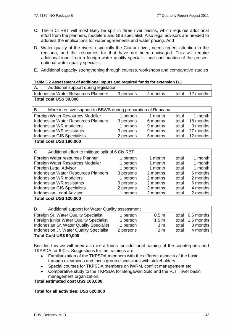
TA 7189-INO Package B 7th
Quarterly Report August 2011
DHV, Deltares, MLD 48
C. The 6 Ci RBT will most likely be split in three river basins, which requires additional effort from the planners, modelers and GIS specialist. Also legal advisors are needed to address the implications for water agreements and water pricing. And
D. Water quality of the rivers, especially the Citarum river, needs urgent attention in the rencana, and the resources for that have not been envisaged. This will require additional input from a foreign water quality specialist and continuation of the present national water quality specialist.
E. Additional capacity strengthening through courses, workshops and comparative studies
Table 5.2 Assessment of additional Inputs and required funds for extension B.1
A. Additional support during legislation
Indonesian Water Resources Planners 3 persons 4 months total 12 months
Total cost US$ 30,000
B. More intensive support to BBWS during preparation of Rencana
Foreign Water Resources Modeller 1 person 1 month total 1 month Indonesian Water Resources Planners 3 persons 6 months total 18 months Indonesian WR modelers 1 person 9 months total 9 months Indonesian WR assistants 3 persons 9 months total 27 months Indonesian GIS Specialists 2 persons 6 months total 12 months
Total cost US$ 180,000
C. Additional effort to mitigate split of 6 Cis RBT
Foreign Water resources Planner 1 person 1 month total 1 month Foreign Water Resources Modeller 1 person 1 month total 1 month Foreign Legal Advisor 1 person 1 month total 1 month Indonesian Water Resources Planners 3 persons 2 months total 6 months Indonesion WR modelers 1 person 2 months total 2 months Indonesian WR assistants 3 persons 2 months total 6 months Indonesian GIS Specialists 2 persons 2 months total 4 months Indonesian Legal Advisor 1 person 2 months total 2 months
Total cost US$ 120,000
D. Additional support for Water Quality assessment
Foreign Sr. Water Quality Specialist 1 person 0.5 m total 0.5 months Foreign junior Water Quality Specialist 1 person 1.5 m total 1.5 months Indonesian Sr. Water Quality Specialist 1 person 3 m total 3 months Indonesion Jr. Water Quality Specialist 2 persons 2 m total 4 months
Total Cost US$ 90,000 Besides this we will need also extra funds for additional training of the counterparts and TKPSDA for 6 Cis. Suggestions for the trainings are:
Familiarization of the TKPSDA members with the different aspects of the basin through excursions and focus group discussions with stakeholders
Special courses for TKPSDA members on IWRM, conflict management etc.
Comparative study to the TKPSDA for Bengawan Solo and the PJT I river basin management organization.
Total estimated cost US$ 100,000 Total for all activities: US$ 620,000
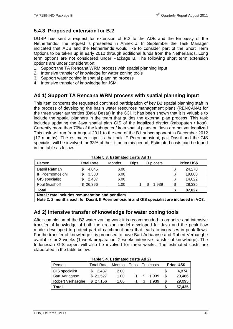
TA 7189-INO Package B 7th
Quarterly Report August 2011
DHV, Deltares, MLD 49
5.4.3 Proposed extension for B.2
DGSP has sent a request for extension of B.2 to the ADB and the Embassy of the Netherlands. The request is presented in Annex J. In September the Task Manager indicated that ADB and the Netherlands would like to consider part of the Short Term Options to be taken up in early 2012 through additional funds from the Netherlands. Long term options are not considered under Package B. The following short term extension options are under consideration: 1. Support the TA Rencana WRM process with spatial planning input 2. Intensive transfer of knowledge for water zoning tools 3. Support water zoning in spatial planning process 4. Intensive transfer of knowledge for JSM
Ad 1) Support TA Rencana WRM process with spatial planning input
This item concerns the requested continued participation of key B2 spatial planning staff in the process of developing the basin water resources management plans (RENCANA) for the three water authorities (Balai Besar) in the 6Ci. It has been shown that it is valuable to include the spatial planners in the team that guides the external plan process. This task includes updating the Java spatial plan GIS of the legalized district (kabupaten / kota). Currently more than 70% of the kabupaten/ kota spatial plans on Java are not yet legalized. This task will run from August 2011 to the end of the B1 subcomponent in December 2012 (17 months). The estimated input is that pak IF Poernomosidhi, pak Dasril and the GIS specialist will be involved for 33% of their time in this period. Estimated costs can be found in the table as follow.
Table 5.3. Estimated costs Ad 1)
Person Total Rate Months Trips Trip costs Price US$
Dasril Ratman $ 4,045 6.00 $ 24,270
IF Poernomosidhi $ 3,300 6.00 $ 19,800
GIS specialist $ 2,437 6.00 $ 14,622
Poul Grashoff $ 26,396 1.00 1 $ 1,939 $ 28,335
Total $ 87,027
Note1: rate includes remuneration and per diem Note 2: 2 months each for Dasril, If Poernomosidhi and GIS specialist are included in VO3.
Ad 2) Intensive transfer of knowledge for water zoning tools
After completion of the B2 water zoning work it is recommended to organize and intensive transfer of knowledge of both the erosion model developed for Java and the peak flow model developed to protect part of catchment area that leads to increases in peak flows. For the transfer of knowledge it is proposed to have Bart Adriaanse and Robert Verhaeghe available for 3 weeks (1 week preparation; 2 weeks intensive transfer of knowledge). The Indonesian GIS expert will also be involved for three weeks. The estimated costs are elaborated in the table below.
Table 5.4. Estimated costs Ad 2)
Person Total Rate Months Trips Trip costs Price US$
GIS specialist $ 2,437 2.00 $ 4,874
Bart Adriaanse $ 21,527 1.00 1 $ 1,939 $ 23,466
Robert Verhaeghe $ 27,156 1.00 1 $ 1,939 $ 29,095
Total $ 57,435
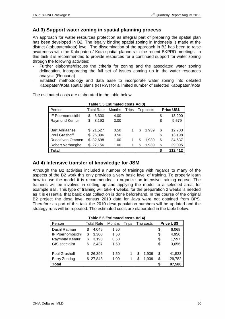
TA 7189-INO Package B 7th
Quarterly Report August 2011
DHV, Deltares, MLD 50
Ad 3) Support water zoning in spatial planning process
An approach for water resources protection as integral part of preparing the spatial plan has been developed in B2. The legally binding spatial zoning in Indonesia is made at the district (kabupaten/kota) level. The dissemination of the approach in B2 has been to raise awareness with the Kabupaten / Kota spatial planners in the recent BKPRD meetings. In this task it is recommended to provide resources for a continued support for water zoning through the following activities: - Further elaborate/discuss the criteria for zoning and the associated water zoning
delineation, incorporating the full set of issues coming up in the water resources analysis (Rencana)
- Establish methodology and data base to incorporate water zoning into detailed Kabupaten/Kota spatial plans (RTRW) for a limited number of selected Kabupaten/Kota
The estimated costs are elaborated in the table below.
Table 5.5 Estimated costs Ad 3)
Person Total Rate Months Trips Trip costs Price US$
IF Poernomosidhi $ 3,300 4.00 $ 13,200
Raymond Kemur $ 3,193 3.00 $ 9,579
Bart Adriaanse $ 21,527 0.50 1 $ 1,939 $ 12,703
Poul Grashoff $ 26,396 0.50 $ 13,198
Rudolf van Ommen $ 32,698 1.00 1 $ 1,939 $ 34,637
Robert Verhaeghe $ 27,156 1.00 1 $ 1,939 $ 29,095
Total $ 112,412
Ad 4) Intensive transfer of knowledge for JSM
Although the B2 activities included a number of trainings with regards to many of the aspects of the B2 work this only provides a very basic level of training. To properly learn how to use the model it is recommended to organize an intensive training course. The trainees will be involved in setting up and applying the model to a selected area, for example Bali. This type of training will take 4 weeks, for the preparation 2 weeks is needed as it is essential that basic data collection is done beforehand. In the course of the original B2 project the desa level census 2010 data for Java were not obtained from BPS. Therefore as part of this task the 2010 desa population numbers will be updated and the strategy runs will be repeated. The estimated costs are elaborated in the table below.
Table 5.6 Estimated costs Ad 4)
Person Total Rate Months Trips Trip costs Price US$
Dasril Ratman $ 4,045 1.50 $ 6,068
IF Poernomosidhi $ 3,300 1.50 $ 4,950
Raymond Kemur $ 3,193 0.50 $ 1,597
GIS specialist $ 2,437 1.50 $ 3,656
Poul Grashoff $ 26,396 1.50 1 $ 1,939 $ 41,533
Barry Zondag $ 27,843 1.00 1 $ 1,939 $ 29,782
Total $ 87,586
Annex A Time Planning of Staff
with used time up to October 2011
7th Quarterly Report November 2011
DHV, Deltares, MLD
Annex A : Time Planning of Staff up to October 2011
MM
MM MM MM MM MM up to COMPANY actual
prop cont VO 1 VO 2 VO 3 October MOB
2011
B.1 (36 months) 35.0 -0.4 4.1 1.0 0.0 39.7 26.6 13.1
1.1 Institutional Strengthening Spec / Team leader Aart van Nes 16.0 -1.0 15.0 10.4 4.6 DHV 11 Nov
1.2 River Basin Planning Specialist Jos Dijkman 8.0 -1.2 0.7 -1.0 6.5 4.5 2.0 Deltares 30 Jan
1.3 River Basin Modleing Specialist Wil van der Krogt 6.0 -1.2 0.7 1.0 6.5 6.5 0.0 Deltares 7 feb
1.4 MIS/GIS Spec Bart Adriaanse ^) 3.0 3.0 -0.5 5.5 2.0 3.5 Demis 14 feb
1.31 Hydrological System Specialist R. Venimmen 0.7 0.7 0.6 0.1 Deltares 17-May
1.32 Watersheed/Environment Specialist W. Giesen ^) 2.0 2.0 1.6 0.4 Euroconsult 17-May
1.33 Flood Managemet Specialist Janjaap Brinkman/ Eelco v Beek 2.0 2.0 0.0 2.0 Deltares
1.34 Economist Alexander Mueller 1.5 1.5 0.9 0.6 DHV 5-Jun
305.0 -41.0 12.0 26.9 2.7 305.6 237.2 68.4
1.5 Water Resources Man Spec/Deputy Team leader Hendarti 30.0 30.0 19.6 10.4 MLD 11 Nov
1.6 Project Management Specialist / Admin Coordinator Dadang S. Fadilah (to be deleted) 18.0 -3.0 -15.0 0.0 0.0 0.0 MLD
1.26 Quality Assurance Officer Adam Yazid 12.0 12.0 9.0 3.0 MLD 3 May
1.7 River Basin Planning Specialist Hariyanto 18.0 2.0 20.0 17.9 2.1 MLD 1 Feb
1.8 River Basin Planning Specialist [Citarum] Asep Teguh Soekmono 20.0 -2.0 2.0 20.0 18.7 1.3 PTW 1 Feb
1.9 River Basin Planning Specialist Bambang Warsito 6.0 6.0 2.0 4.7 18.7 15.4 3.3 WGA 15 feb
1.10 River Basin Planning Specialist Ahmad Afif (to be deleted) 6.0 -6.0 0.0 0.0 0.0 TB
Water shed Management Specialist Mardikajanto 12.0 -12.0 0.0 0.0 0.0 SPH
1.11 Water shed Management Specialist Dedi Kusnadi 8.0 8.0 4.8 3.2 MLD 1 June
1.27 Assistant River Basin Planning Specialist Dina Saptiarini 12.0 2.0 3.0 17.0 13.5 3.5 MLD 8 Feb
1.12 River Basin Modeling Specialist Ika Andriana Kurniawati 18.0 -2.0 -4.0 2.0 -1.2 12.8 13.0 -0.2 MLD 11 Nov
1.28 Assistant River Basin Modelling Specialist Rahmi Krishna Sari 12.0 2.0 3.0 17.0 12.1 4.9 MLD 6 Jan
1.39 Assistant River Basin Modelling Specialist Tarasinta Perwitasari 4.0 -1.6 2.4 2.4 0.0 MLD 26-Oct
Assistant River Basin Modelling Specialist Cut Endah Setya H. 4.6 4.6 2.9 1.7 MLD 4-Jul
MIS/GIS/Data base Specialist Doly Pranoto 18.0 -3.0 -15.0 0.0 0.0 0.0 MLD
1.13 MIS/GIS/Data base Specialist Satria Suryahadi 8.0 -2.3 5.7 5.7 0.0 MLD 18 Jan
1.29 GIS/Data base Specialist M. Farid Rahman 9.0 6.0 2.0 17.0 16.4 0.6 MLD 1 March
GIS/Data base Specialist Suherwan / Indrawan Suryadi 4.0 4.0 0.2 3.8 MLD 13-Oct
1.14 Asset Management & O&M Spcialist Mohammad Alif M. 12.0 -1.0 -11.0 0.0 0.0 0.0 TB
1.15 Organizational Development Spec 1 Nicolaas Darismanto 20.0 -2.0 5.0 23.0 18.9 4.1 MLD 11 Nov
1.30 Organizational Development Spec 2 Guntoro 10.0 10.0 8.4 1.6 TB 25 Feb
1.16 Hydrologist Heru Suprianto 16.0 -1.0 -4.0 -3.0 8.0 8.9 -0.9 Geo 15 feb
1.17 Hydrogeologist Nugraha Kunwardi A. 6.0 6.0 3.0 3.0 PTW 15 feb
Curriculum & Training Specialist Avianti Zulaicha 12.0 -4.0 -8.0 0.0 0.0 0.0 MLD
1.18 Curriculum & Training Specialist Praya Arie I 8.0 8.0 2.8 5.2 MLD 5 May
1.19 CSO Communication & Outreach Spec (overall) Marcelinus Molo (to be deleted) 30.0 -30.0 0.0 0.0 0.0 PPA
1.20 CSO Communication & Outreach Spec (Bandung) Renyasih 24.0 6.0 -10.0 20.0 14.0 6.0 MLD 1 Feb
1.21 CSO Communication & Outreach Spec (Banten/Jakarta) Syafril Salim 6.0 6.0 -8.5 3.5 3.5 0.0 Geo 1 Feb
1.22 CSO Communication & Outreach Spec Bambang Pujiatmoko (to be deleted) 6.0 -6.0 0.0 0.0 0.0 MLD
Socio-Economic/Gender / vulnerable people Spec Rianigustin Mozar 9.0 -1.0 -8.0 0.0 0.0 0.0 MLD
1.23 Socio-Economic/Gender / vulnerable people Spec Isja Dini Ulijati ^) 3.0 1.5 4.5 1.1 3.4 Macon 3 May
Economic and Financial Planner Bambang Triono 9.0 -1.0 -8.0 0.0 0.0 0.0 MLD
1.24 Economic and Financial Planner Johan Subarkah ^) 8.0 8.0 4.4 3.6 TB 22 Feb
1.25 Environmental Specialist Sabarman Ranudiwiryo/ Puguh Saktiono ^) 9.0 -1.0 4.0 12.0 11.6 0.4 Indec 11 Feb
1.36 Public Policy Specialist M. Nidhom Azhari 4.4 2.0 6.4 4.3 2.1 TB 1-Mar
1.37 Economist Bambang Tata 5.0 5.0 4.4 0.6 MLD 6-Jun
1.38 Water Supply Imam Hudori 2.0 2.0 0.0 2.0 MLD
B.2 (18 months) 17.0 -2.2 0.0 0.5 0.0 15.3 15.0 0.3
2.1 Planning & Programming Spec./Team Leader Poul Grashoff 10.0 -2.2 0.5 8.3 8.0 0.3 Demis 15 feb
2.2 WR/Infr.Str. Planning Spec Robert Verhaeghe 4.0 4.0 3.9 0.1 Demis 22 Feb
2.3 Watershed/Env.Planner Spec Wim Giesen ^) 0.0 0.0 0.0 Euroconsult
MIS/GIS Spec Erik van der Zee 3.0 -3.0 0.0 0.0 0.0 DHV
2.4 MIS/GIS Spec Bart Adriaanse ^) 0.5 1.5 2.0 2.1 -0.1 Demis 14 Feb
2.5 Remote Sensing Specialist Eduard Westinga 1.5 -1.5 0.0 0.0 0.0 Demis
2.11 Spatial Model Developer Michiel Benjamin 1.0 1.0 0.9 0.1 Demis 3-Jul
69.0 -8.0 -3.0 2.0 8.0 68.0 57.0 11.0
2.5 Planning and programming Specialist Poernomoshidi Poerwo 18.0 -4.0 4.0 18.0 12.9 5.1 MLD 15 feb
2.6 Water Resources and Infrastructure Planning Spec Iskandar Nugroho 6.0 6.0 4.9 1.1 PTW 1 Mar
Watershed Environmental Planning Specialist Wahyuno Sumodisastro 8.0 -8.0 0.0 0.0 0.0 SPH
2.7 Watershed Environmental Planning Specialist Dedi Kusnadi ^) 5.0 5.0 4.4 0.6 MLD 1-Jun
GIS/Data Base/Remote Sensing Specialist Muhammad Effendi 18.0 -3.0 -15.0 0.0 0.0 PPA
2.8 GIS/Data Base Yogi A 15.0 2.0 17.0 16.3 0.7 MLD 22 feb
2.9 Spatial Planning / Modeling Specialist Dasril Rathman 13.0 -1.0 4.0 16.0 12.6 3.4 MLD 15 feb
2.10 Socio-Economic Specialist Johan Subarkah ^) 6.0 6.0 5.8 0.2 TB 22 Feb
2.12 Remote Sensing Specialist TBN 0.0 0.0 0.0 PPA ?
B.3 (14 months) 21.0 -3.2 -0.8 0.0 -0.5 16.5 17.8 -1.3
3.1 WRM Specialist / Team Leader Alex Hamming 11.0 -2.2 8.8 10.3 -1.5 DHV 24 Nov
3.2 Institutional Planner Paul Taylor 6.0 -1.0 5.0 5.1 -0.1 EuroMott 5 feb
3.3 River Basin Planning Specialist Eelco van Beek ^) 4.0 -2.0 -0.5 1.5 1.0 0.5 Deltares 31-Jul
3.14 Irrigation Management Specialist Jeroen Alberts 0.7 0.7 0.7 0.0 DHV 2-Aug
3.15 Legal Specialist Bart Teeuwen *** 0.5 0.5 0.8 -0.3 DHV 18-May
61.0 4.0 -4.0 -3.9 -3.8 53.3 53.9 -0.6
3.4 Water Resources management Specialist Johannes Wibowo 14.0 -2.0 -0.5 -0.3 11.2 11.2 0.0 MLD 3 Dec
3.5 Public Policy Specialist M. Nidhom Azhari 6.0 6.0 -4.0 4.6 12.6 12.6 0.0 TB 11 Jan
3.6 Institutional Specialist Zulkarnain 8.0 -2.0 -6.0 0.0 0.0 0.0 TIA
3.7 Information System Specialist Pratolo Priyambodo 4.0 -4.0 0.0 0.0 0.0 TIA
River Basin Planning Specialist Ilham Purnomo 8.0 -8.0 0.0 0.0 0.0 SPH
3.8 River Basin Planning Specialist Soenarto 5.0 3.5 -1.7 6.8 6.8 0.0 MLD 1 June
3.9 Gender Specialist Isja Dini Ulijati ^) 6.0 -1.5 4.5 4.5 0.0 Macon 3 May
3.10 Legal Specialist Muhammad Imam 6.0 -0.1 5.9 5.9 0.0 MLD 18 Jan
Economist Sri Wiranto 4.0 -4.0 0.0 0.0 0.0 Macon
3.11 Economist Ahmad Pribadi ^) 4.0 -1.7 2.3 2.3 0.0 MLD 1 June
3.12 Environmental Specialist Yaya/ Puguh Saktiono ^) 5.0 -5.0 0.0 0.0 0.0 Macon 11 feb
3.13 Assistant Water Resources Krismahadianto***/Beny Herwayan 10.0 10.0 10.5 -0.5 MLD 6 Jan
Plan 73.0 71.5 59.4 project man, adm QA economist in B.1 and B.2 combined extra input for reservoir operation simulation
Actual Time Spent 435.0 426.9 348.1 Capacity Building for Dewan/TKPSDA and RBMO distinguished extra inpout for data conversion FEWS/HYMOS
508.0 498.4 407.5 Gender position combined for B.1 and B.2 environmentalist in B.1 and B.3 combined extra input environmentalist for state of basin
Balance Curriculum Development replacement GIS and Remote Sensing distinguished Input of van Beek, Brinkman for IWRM, and Floods
river basin planners combined, extra junior input reduced, less data management extra input for JSM modeling
Watershed planner combined proposed replacement MIS, GIS and Remote Sensing distinguished
Extra time for flood management economist from package C extra input for irrigation management
MIS, GIS and Remote Sensing distinguished more permanent position for data management extra inut for reservoir water quality
exra input for international legal specialist
CONSOLIDATION
2012
Rem.
Balance
MM
STRATEGIC MANAGEMENT PLAN
Mar
28
Apr
29 33
May Sept
36
Jun Jul
32
Aug Nov
34
Oct
3525
Dec Jan
26 30 31
Jul
20
Feb
27
Sep
22
Oct
23
Nov
24
Aug
21
Mar
16
Apr
17
May
18
Jun
19
Dec
13
Feb
15
Jan
14
Jul
8
Nov
12
Aug
9
Sep
10
Oct
116
May Jun
7
Apr
54
MarFeb
3
Jan
2
INSTITUTIONAL STRENGTHENING for INTEGRATED WATER RESOURCES MANAGEMENT in the 6 Ci's RIVER BASIN TERRITORY (PACKAGE - B)
INCEPTION
2009
DURATION (YEARS)
BASIN WATER RESOURCES MANAGEMENT PLAN
2010 2011Total
MM
MM Foreign
MM Local
MM Total
Nov/Des
1
1.5
8.1
9.6
NAMENO. POSITION
3/7 8/18 1/6
12/32
11/16/2011
Annex B Time Planning of Staff
as proposed for VO3
7th Quarterly Report November 2011
DHV, Deltares, MLD
Annex B : Time of Staff Used up to May 2011 and Planning up to March 2012
MM Prop.
Act Add. COMPANY actual
To Date VO 3 MOB
2011
B.1 (36 months) 36.7 21.5 15.2
1.1 Institutional Strengthening Spec / Team leader Aart van Nes 15.0 9.0 6.0 DHV 11 Nov
1.2 River Basin Planning Specialist Jos Dijkman 6.5 4.0 2.5 Deltares 30 Jan
1.3 River Basin Modleing Specialist Wil van der Krogt 6.5 5.0 1.5 Deltares 7 feb
1.4 MIS/GIS Spec Bart Adriaanse ^) 2.5 2.0 0.5 Demis 14 feb
1.31 Hydrological System Specialist R. Venimmen 0.7 0.6 0.1 Deltares 17-May
1.32 Watersheed/Environment Specialist W. Giesen ^) 2.0 0.9 1.1 Euroconsult 17-May
1.33 Flood Managemet Specialist Janjaap Brinkman/ Eelco v Beek 2.0 0.0 2.0 Deltares
1.34 Economist Alexander Mueller 1.5 0.0 1.5 DHV 5-Jun
302.9 197.0 105.9
1.5 Water Resources Man Spec/Deputy Team leader Hendarti 30.0 15.9 14.1 MLD 11 Nov
1.26 Quality Assurance Officer Adam Yazid 12.0 6.9 5.1 MLD 3 May
1.7 River Basin Planning Specialist Hariyanto 20.0 14.6 5.4 MLD 1 Feb
1.8 River Basin Planning Specialist [Citarum] Asep Teguh Soekmono 18.0 14.6 3.4 2.00 PTW 1 Feb
1.9 River Basin Planning Specialist Bambang Warsito 14.0 13.3 0.7 4.70 WGA 15 feb
1.10 River Basin Planning Specialist Ahmad Afif (to be deleted) 0.0 0.0 0.0 TB
1.11 Water shed Management Specialist Dedi Kusnadi 8.0 3.3 4.7 MLD 1 June
1.27 Assistant River Basin Planning Specialist Dina Saptiarini 14.0 13.5 0.5 3.00 MLD 8 Feb
Assistant River Basin Planning Specialist Cut Endah 4.60 MLD
1.12 River Basin Modeling Specialist Ika Andriana Kurniawati / Fery Ika Hardiyanto 14.0 12.8 1.2 (1.20) MLD 11 Nov
1.28 Assistant River Basin Modelling Specialist Rahmi Krishna Sari 14.0 12.1 1.9 3.00 MLD 6 Jan
1.39 Assistant River Basin Modelling Specialist Tarasinta Perwitasari 4.0 2.4 1.6 (1.60) MLD 26-Oct
1.13 MIS/GIS/Data base Specialist Satria Suryahadi 8.0 5.7 2.3 (2.30) MLD 18 Jan
1.29 GIS/Data base Specialist M. Farid Rahman 15.0 13.7 1.3 2.00 MLD 1 March
I.23a GIS/Data base Specialist Suherwan / Indrawan 4.00
1.14 Asset Management & O&M Spcialist Mohammad Alif M. 11.0 0.0 11.0 (11.00) TB
1.15 Organizational Development Spec 1 Nicolaas Darismanto 18.0 15.1 2.9 5.00 MLD 11 Nov
1.30 Organizational Development Spec 2 Guntoro 10.0 8.4 1.6 TB 25 Feb
1.16 Hydrologist Heru Suprianto 11.0 8.9 2.1 (3.00) Geo 15 feb
1.17 Hydrogeologist Nugraha Kunwardi A. 6.0 3.0 3.0 PTW 15 feb
1.18 Curriculum & Training Specialist Praya Arie I 8.0 2.3 5.7 MLD 5 May
1.20 CSO Communication & Outreach Spec (Bandung) Renyasih 20.0 12.4 7.6 MLD 1 Feb
1.21 CSO Communication & Outreach Spec (Banten/Jakarta) Syafril Salim 12.0 3.5 8.5 (8.50) Geo 1 Feb
1.23 Socio-Economic/Gender / vulnerable people Spec Isja Dini Ulijati ^) 4.5 1.1 3.4 Macon 3 May
Economic and Financial Planner Bambang Triono 0.0 0.0 0.0 MLD
1.24 Economic and Financial Planner Johan Subarkah ^) 8.0 1.8 6.3 TB 22 Feb
1.25 Environmental Specialist Sabarman Ranudiwiryo/ Puguh Saktiono ^) 12.0 9.3 2.7 Indec 11 Feb
1.36 Public Policy Specialist M. Nidhom Azhari 4.4 2.4 2.0 2.00 TB 1-Mar
1.37 Economist Bambang Tata 5.0 0.0 5.0 MLD 6-Jun
1.38 Water Supply Imam Hudori 2.0 0.0 2.0 MLD
B.2 (18 months) 15.3 12.7 2.6
2.1 Planning & Programming Spec./Team Leader Poul Grashoff 8.3 6.1 2.2 Demis 15 feb
2.2 WR/Infr.Str. Planning Spec Robert Verhaeghe 4.0 3.7 0.3 Demis 22 Feb
2.3 Watershed/Env.Planner Spec Wim Giesen ^) 0.0 0.0 0.0 Euroconsult
MIS/GIS Spec Erik van der Zee 0.0 0.0 0.0 DHV
2.4 MIS/GIS Spec Bart Adriaanse ^) 2.0 2.0 0.0 Demis 14 Feb
2.5 Remote Sensing Specialist Eduard Westinga 0.0 0.0 0.0 Demis
2.11 Spatial Model Developer Michiel Benjamin 1.0 0.9 0.1 Demis 3-Jul
60.0 51.4 8.6
2.5 Planning and programming Specialist Poernomoshidi Poerwo 14.0 12.1 1.9 4.00 MLD 15 feb
2.6 Water Resources and Infrastructure Planning Spec Iskandar Nugroho 6.0 4.9 1.1 PTW 1 Mar
2.7 Watershed Environmental Planning Specialist Dedi Kusnadi ^) 5.0 4.4 0.6 MLD 1-Jun
2.8 GIS/Data Base Yogi A (Replaced by Suherwan B.1, I 23a)) 17.0 13.3 3.7 MLD 22 feb
2.9 Spatial Planning / Modeling Specialist Dasril Rathman 12.0 11.3 0.7 4.00 MLD 15 feb
2.10 Socio-Economic Specialist Johan Subarkah ^) 6.0 5.3 0.7 TB 22 Feb
2.12 Remote Sensing Specialist TBN 0.0 0.0 0.0 PPA ?
B.3 (14 months) 17.0 17.8 -0.8
3.1 WRM Specialist / Team Leader Alex Hamming 8.8 10.3 -1.5 DHV 24 Nov
3.2 Institutional Planner Paul Taylor 5.0 5.1 -0.1 EuroMott 5 feb
3.3 River Basin Planning Specialist Eelco van Beek ^) 2.0 1.0 1.0 (0.50) Deltares 31-Jul
3.14 Irrigation Management Specialist Jeroen Alberts 0.7 0.7 0.0 DHV 2-Aug
3.15 Legal Specialist Bart Teeuwen *** 0.5 0.8 -0.3 DHV 18-May
57.1 53.9 3.2
3.4 Water Resources management Specialist Johannes Wibowo 11.5 11.2 0.3 (0.30) MLD 3 Dec
3.5 Public Policy Specialist M. Nidhom Azhari (continued as B.1, I.36) 12.6 12.6 0.0 TB 11 Jan
3.6 Institutional Specialist Zulkarnain 0.0 0.0 0.0 TIA
3.7 Information System Specialist Pratolo Priyambodo 0.0 0.0 0.0 TIA
3.8 River Basin Planning Specialist Soenarto 8.5 6.8 1.7 (1.70) MLD 1 June
3.9 Gender Specialist Isja Dini Ulijati ^) 4.5 4.5 0.0 Macon 3 May
3.10 Legal Specialist Muhammad Imam 6.0 5.9 0.1 (0.10) MLD 18 Jan
3.11 Economist Ahmad Pribadi ^) 4.0 2.3 1.7 (1.70) MLD 1 June
3.12 Environmental Specialist Yaya/ Puguh Saktiono ^) 0.0 0.0 0.0 Macon 11 feb
3.13 Assistant Water Resources Krismahadianto***/Beny Herwayan 10.0 10.5 -0.5 MLD 6 Jan
Original Plan
Plan 69.0 52.1
Actual Time Spent 420.0 302.3
New Plan 489.0 354.4
Deleted
NAMENO. POSITION
Total
MM (up
to VO 2)
2010 2011
Nov/Des
1
Rem.
Balance
MM Feb
3
INSTITUTIONAL STRENGTHENING for INTEGRATED WATER RESOURCES MANAGEMENT in the 6 Ci's RIVER BASIN TERRITORY (PACKAGE - B)
INCEPTION
2009
DURATION (YEARS)
BASIN WATER RESOURCES MANAGEMENT PLAN
Jun
7
Apr
5
Jan
2 6
May
4
Mar Jul
8
Nov
12
Aug
9
Sep
10
Oct
11
Jun
19
Dec
13
Feb
15
Jan
14
Mar
16
Apr
17
May
18 22
Oct
23
Nov
24
Aug
21
Nov
34
Oct
3526
Jul
20
Feb
27
Sep
CONSOLIDATION
2012
3331
Sept
36
Jun Jul
32
AugMay
STRATEGIC MANAGEMENT PLAN
Mar
28
Apr
29 3025
Dec Jan
3/7 8/18 1/6
12/32
11/16/2011
Annex C Membership TKPSDA
7th Quarterly Report November 2011
DHV, Deltares, MLD
7th Quarterly Report November 2011
DHV, Deltares, MLD
ANNEX C ESTABLISHMENT OF THE BASIN COUNCIL (TKPSDA) FOR 6 CIS RIVER BASIN TERRITORY
On 16 December 2010 the decree for establishment of the TKPSDA (594/KPTS/M/2010) was signed by the Minister for Public Works. The number of members is 96, comprising 48 members from the Government as indicated below, and another 48 non-Government members.
1. Representative from West Java Prov. = 5 persons 2. Representative from DKI Jkt Prov. = 5 persons 3. Representative from Banten Prov. = 5 persons 4. Representative from Districts and Cities = 28 persons 5. Repr. from Balai Besar dan PJT 2 = 4 persons 6. Repr. from (Dit BPSDA/BP) = 1 person --------------------------------------------------------------------------------+ No of members from Government = 48 persons No of members from Non Government = 48 persons _________________________________________________+ Grand Total = 96 persons
NOTE 1: Representatives from government are appointed based on their function, and will be handed over to their successor after changes in staffing. Representative positions from Provinces are according to PerPres 12/2008. Representatives from provincial government are from BAPPEDA, PU/Water Resources, Forestry, Agriculture and Environment (BPLHD). Those from Districts and Cities are only one person, and the selection team discussed with the regions which agency should fill the position. In general the agency handling water will fill the positions from the districts, and the planning board (BAPPEDA) or the regional secretaries those from the cities. NOTE 2: Members from 3 Ci : 12 Government, 10 NGO from Cil/Cis : 17 Government, 17 NGO from Citarum : 19 Government, 21 NGO In case three TKPSDA have to be formed, one for each working area of each BBWS, there will be two extra NGO members for 3 Ci and two extra provincial Government members for Citarum (one from ESDM (Energy and Minerals) and one from Housing and Human Settlement.
Annex D Summary of Pola, October 2011
7th Quarterly Report November 2011
DHV, Deltares, MLD

Annex D - Summary of Pola 7th
Quarterly Report November 2011
DHV, Deltares, MLD
TABLE OF CONTENTS Page
1. Background 1
2. Problems 1
2.1. Water Resource Conservation. 2
2.2. Water Resource Utilization. 2
2.3. Control of Water Destructive Power. 2
2.4. Water Resource Information System. 2
2.5. Empowerment and Improvement of Community and Private Sector Participation. 3
3. Skenario - Strategi 7
4. Effort – Operational Policy 9
4.1. CONSERVATION 9 4.1.1 Protection and Preservation of Water Resource 9 4.1.2 Water Preservation 9 4.1.3 Water Quality Management and Pollution Control 9
4.2. WATER RESOURCES UTILIZATION 10 4.2.1 Water Resources Allocation 10 4.2.2 Water Resources Provision 10 4.2.3 Water Resources Utilization 10 4.2.4 Water Resources Development 10
4.3. CONTROL OF WATER DESTRUCTIVE POWER 16 4.3.1 Prevention of Disaster 16 4.3.2 Mitigation 16 4.3.3 Recovery from Disaster 16
4.4. WATER RESOURCE INFORMATION SYSTEM 16
4.5. EMPOWERMENT/IMPROVEMENT OF COMMUNITY, PRIVATE SECTOR AND GOVERNMENT PARTICIPATION 17
4.6. WRM Institution 17 4.6.1 Funding 17 4.6.2 Governance 17 4.6.3 Coordination Forum for PSDA (WRM) 17 4.6.4 Empowerment & Improvement of Community and Private Sector Participation17
4.7. SPATIAL PLANNING 18 LIST OF FIGURES Figure 2.1. Map of critical land in 6 Ci River Basin Territory 4 Figure 2.2. Map of water distribution scheme in 6 Ci River Basin Territory 5 Figure 2.3. Map of Hazard Prone Area in 6 Ci River Basin Territory 6 Figure 4.1. Map of location for existing DMI demands in 6 Ci River Basin Territory 11 Figure 4.2. Map of location for proposed fulfillment of DMI demands in 6 Ci (Strategy A – 2030) 12 Figure 4.3. Map of location for proposed fulfillment of DMI demands in 6 Ci (Strategy B – 2030) 13 Figure 4.4. Map of location for proposed fulfillment of DMI demands in 6 Ci (Strategy C – 2030) 14 Figure 4.5. Map of location for proposed fulfillment of DMI demands in 6 Ci (Strategy D – 2030) 15 LIST OF TABLE Table 3.1. Scenario Based on Good Governance and Economic Growth 7 Table 3.2. Relation of Scenario, Assumption, and Strategy 8
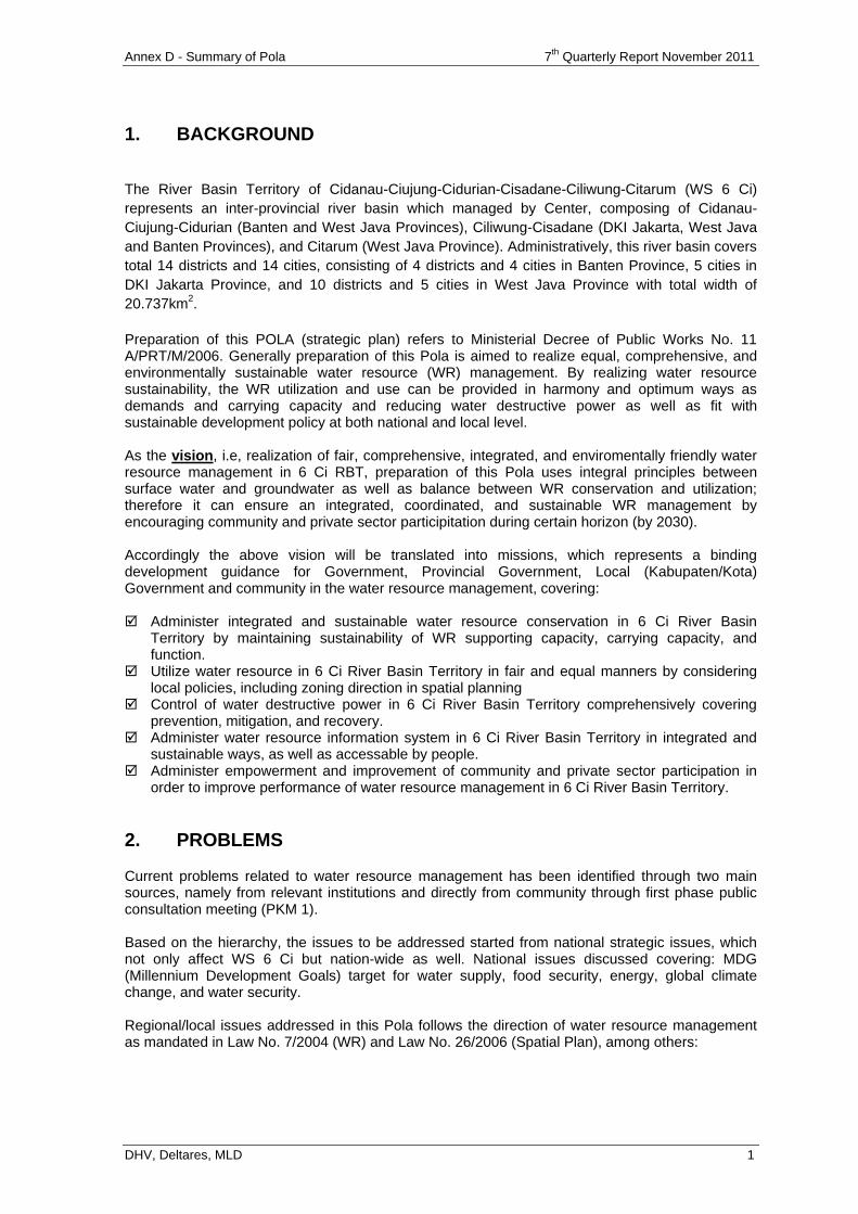
Annex D - Summary of Pola 7th
Quarterly Report November 2011
DHV, Deltares, MLD 1
1. BACKGROUND
The River Basin Territory of Cidanau-Ciujung-Cidurian-Cisadane-Ciliwung-Citarum (WS 6 Ci)
represents an inter-provincial river basin which managed by Center, composing of Cidanau-
Ciujung-Cidurian (Banten and West Java Provinces), Ciliwung-Cisadane (DKI Jakarta, West Java
and Banten Provinces), and Citarum (West Java Province). Administratively, this river basin covers
total 14 districts and 14 cities, consisting of 4 districts and 4 cities in Banten Province, 5 cities in
DKI Jakarta Province, and 10 districts and 5 cities in West Java Province with total width of
20.737km2.
Preparation of this POLA (strategic plan) refers to Ministerial Decree of Public Works No. 11 A/PRT/M/2006. Generally preparation of this Pola is aimed to realize equal, comprehensive, and environmentally sustainable water resource (WR) management. By realizing water resource sustainability, the WR utilization and use can be provided in harmony and optimum ways as demands and carrying capacity and reducing water destructive power as well as fit with sustainable development policy at both national and local level. As the vision, i.e, realization of fair, comprehensive, integrated, and enviromentally friendly water resource management in 6 Ci RBT, preparation of this Pola uses integral principles between surface water and groundwater as well as balance between WR conservation and utilization; therefore it can ensure an integrated, coordinated, and sustainable WR management by encouraging community and private sector participitation during certain horizon (by 2030). Accordingly the above vision will be translated into missions, which represents a binding development guidance for Government, Provincial Government, Local (Kabupaten/Kota) Government and community in the water resource management, covering: Administer integrated and sustainable water resource conservation in 6 Ci River Basin
Territory by maintaining sustainability of WR supporting capacity, carrying capacity, and function.
Utilize water resource in 6 Ci River Basin Territory in fair and equal manners by considering local policies, including zoning direction in spatial planning
Control of water destructive power in 6 Ci River Basin Territory comprehensively covering prevention, mitigation, and recovery.
Administer water resource information system in 6 Ci River Basin Territory in integrated and sustainable ways, as well as accessable by people.
Administer empowerment and improvement of community and private sector participation in order to improve performance of water resource management in 6 Ci River Basin Territory.
2. PROBLEMS
Current problems related to water resource management has been identified through two main sources, namely from relevant institutions and directly from community through first phase public consultation meeting (PKM 1). Based on the hierarchy, the issues to be addressed started from national strategic issues, which not only affect WS 6 Ci but nation-wide as well. National issues discussed covering: MDG (Millennium Development Goals) target for water supply, food security, energy, global climate change, and water security. Regional/local issues addressed in this Pola follows the direction of water resource management as mandated in Law No. 7/2004 (WR) and Law No. 26/2006 (Spatial Plan), among others:
Annex D - Summary of Pola 7th
Quarterly Report November 2011
DHV, Deltares, MLD 2
2.1. Water Resource Conservation.
Improper land use as its allocation, Increasing critical land and watershed deterioration, which causes erosion and
decreasing catchment areas, Water pollution, especially heavy metals, and lack of waste treatment, Deterioration of river bed and water course due to quarry (sand and gravel) mining, Excessive deep groundwater abstraction, causing decreasing groundwater level and
land subsidence, Damage of mangrove forest and coastal erosion.
Map of critical land in 6 Ci River Basin Territory can be seen in Figure 2.1.
2.2. Water Resource Utilization.
Increasing water demands for DMI (as the cities grow), Low coverage of PDAM service (compared to MDG), Limited supply of raw water for metro Jabodetabek and Bandung Plain, Less optimum utilization of potential water power, Damage of irrigation infrastructure network which cause ineffective and inefficient
water distribution due to low O&M, Improper asset (irrigation) management, Conversion of agricultural land (become urban, industrial areas), Less optimum commercialization of water supply.
Map of water distribution scheme in 6 Ci River Basin Territory can be seen in Figure 2.2.
2.3. Control of Water Destructive Power.
Forest logging, improper land use which cause erosion, sedimentation, and decreasing catchment area,
Occupy floodplain for settlements and commercial activities, decreasing function of flood control infrastructure, decreasing capacity of river flow and drainage network (narrowing river, shallowing water course, and obstruction by WR structures),
Occupy retention area for settlements, which increase flood risk, Occupy floodplain/flood-prone area for settlements without preventing flood, Waste disposal into drainage channel and water course that block the flow, causing
flood, Land subsidence, increasing threat of high tidal overflow, Landslides in several locations, Deterioration of situ (small lake) and its infrastructure, Limited fund for rehabilitation of public infrastructure and facilities after the flood.
Map of Hazard Prone Area in 6 Ci River Basin Territory can be seen in Figure 2.3.
2.4. Water Resource Information System.
Less reliable WR database (Hydrology, Hydrogeology & Hydrometeorology, WR policies, WR infrastructure, WR technology, WR environment, social, economical, and cultural activities) due to incomplete database, inadequate HR and tools, no clear coordination/responsibility for maintaining data quality as well as due to limited fund.
Annex D - Summary of Pola 7th
Quarterly Report November 2011
DHV, Deltares, MLD 3
2.5. Empowerment and Improvement of Community and Private Sector Participation.
Low performance of institutions which responsible for water resource management, and overlap and gap in delegation of role and responsible,
Stakeholders do take active role, therefore they still require government support, Potential participation of community and women in water resource management
should be enhanced. In addition to the five pillars of water resource management (WRM) above, several issues related to Spatial Planning also emerged in 6 Ci River Basin Territory, among others:
Growing settlements and non-agricultural commercial activities in the area function as water body and catchment area (plain, swamp, and situ)
settlements and non-agricultural commercial activities in the agricultural land (especially for rice filed), which technically irrigated in 6 Ci River Basin Territory, especially in metropolitan Bogor, Depok,Tangerang, Bekasi, and Metropolitan Bandung
Growing settlements and non-agricultural commercial activities along the flood plain in urban area
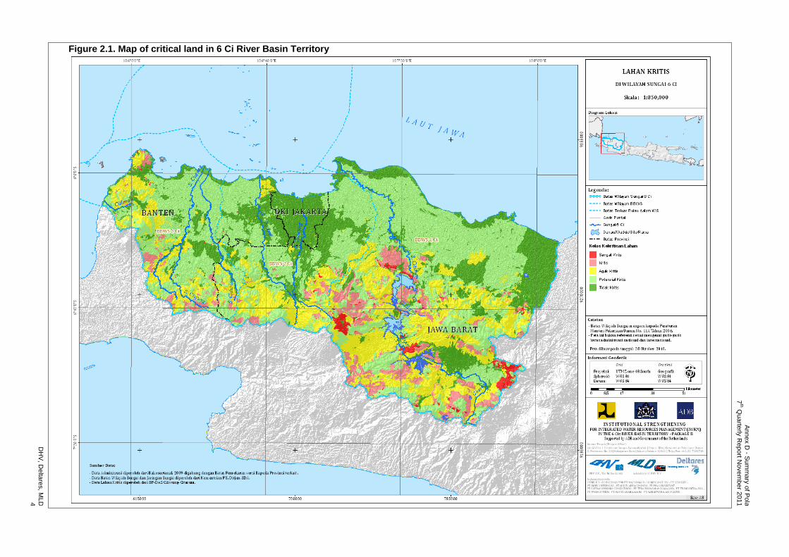
An
ne
x D
- Su
mm
ary
of P
ola
7
th Qu
arte
rly R
ep
ort N
ove
mb
er 2
011
DH
V, D
elta
res, M
LD
4
Figure 2.1. Map of critical land in 6 Ci River Basin Territory
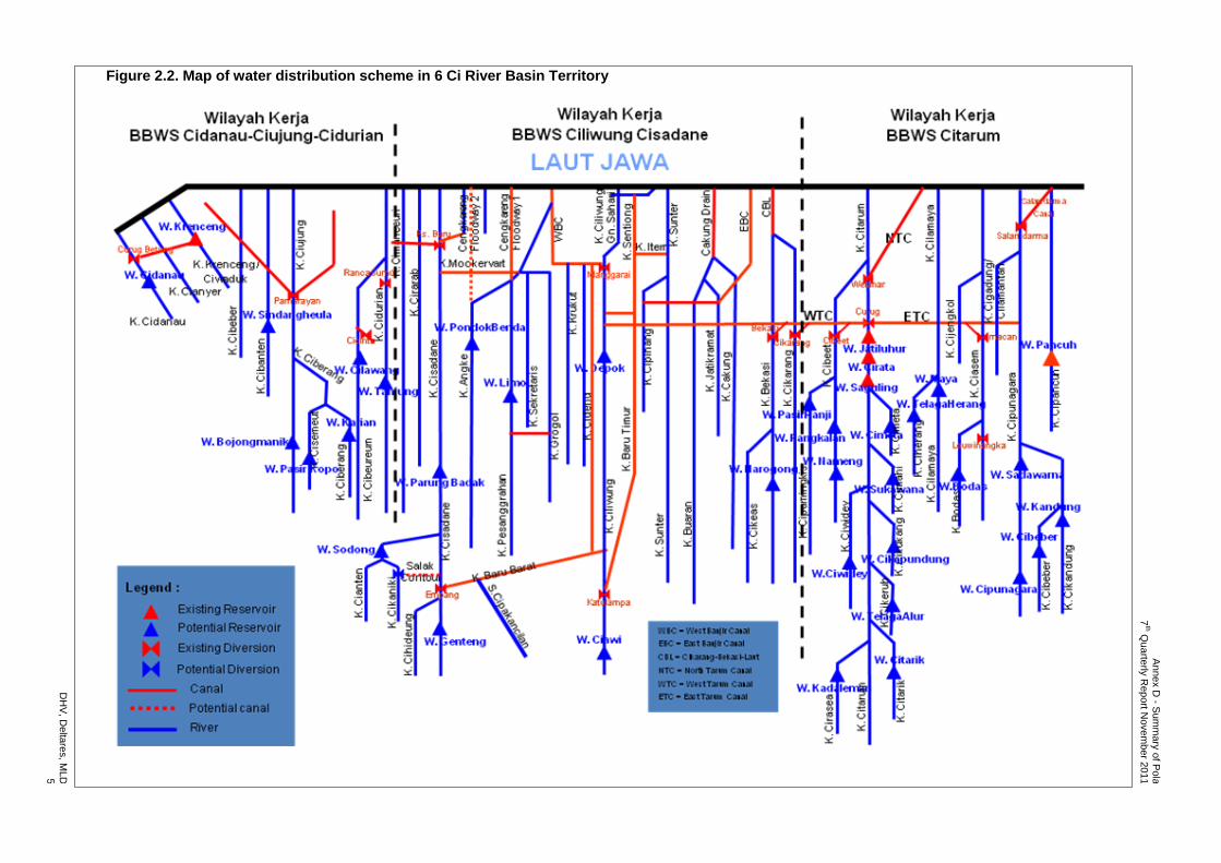
An
ne
x D
- Su
mm
ary
of P
ola
7
th Qu
arte
rly R
ep
ort N
ove
mb
er 2
011
DH
V, D
elta
res, M
LD
5
Figure 2.2. Map of water distribution scheme in 6 Ci River Basin Territory
An
ne
x D
- Su
mm
ary
of P
ola
7
th Qu
arte
rly R
ep
ort N
ove
mb
er 2
011
DH
V, D
elta
res, M
LD
6
Figure 2.3. Map of Hazard Prone Area in 6 Ci River Basin Territory
Annex D - Summary of Pola 7th
Quarterly Report November 2011
DHV, Deltares, MLD 7
3. SKENARIO - STRATEGI
Assumptions used in preparing this Pola refers to Permen 22/2009 which cover three (3) main parameters, plus one parameter to be considered, namely:
Good Governance (Political Change) Economic Growth Climate Change Population Growth (additional parameter)
Based on the above assumption there has been prepared a scenario as follows (Table 3.1): Table 3.1. Scenario Based on Good Governance and Economic Growth
Pertumbuhan ekonomi
Rendah Sedang Tinggi
Tata kelola pemerintahan CT 1 X X
GG 2 3 4 Catatan : x = negligible The scenario assumes that good governance of Current Trend in case of medium or high economic growth is not realistic. For that reason, the scenario is negligible to reduce complexity of the analysis.
From several scenarios of river basin condition there have been prepared several alternative strategy for each scenario in order to achieve goal of water resource management. In implementing the alternative strategy of water resource management, there have been prepared several concepts of operational policy. The concept made for each aspect of water resource management, and covering short, medium, and long term strategy. The relationship of assumption, scenario, and strategy is shown in Table 3.2. Goal of strategy A (Current Trend Compliance) is to meet water demands at future with the lowest price. This strategy only covers minimum efforts, including fulfillment of raw water for DMI at certain limit without implementing optimum effort for improving water quality. Meanwhile, goal of strategy B (Pro-active Management) is similar with strategy A, with additional condition of institutional improvement to manage water resource strongly and pro-actively, and land and water resource managed as prevailing law and regulation. However, in this strategy the fund available is inadequate to meet optimal management, including development of new dams and improvement of water quality.
Annex D - Summary of Pola 7th
Quarterly Report November 2011
DHV, Deltares, MLD 8
Table 3.2. Relation of Scenario, Assumption, and Strategy
SK
EN
AR
IO
ASUMSI STRATEGI
Good Governance
Climate Change
Economic Growth
Population Growth
Alternative Strategy
Explanation
1 CT P
repare
for
the w
ors
t sce
na
rio
(in
cre
ase
an
d d
ecre
ase o
f
rain
fall
less t
ha
n 0
.3 m
m/d
ay)
LOW
Appro
xim
ate
ly 1
% a
nd
de
cre
asin
g
A. Current Trend Compliance
Only minimum effort, including water for DMI, focus on water quantity
2 GG LOW B. Proactive
Management
As Strategy A, plus strong institution for WR management (but no additional budget available)
3 GG MEDIUM C. Optimum
Management
Optimum effort to improve the most part, the efforts of the aspects of natural resource management
4 GG HIGH D. Maximum
Management
Maximum effort, to improve all efforts of WR management aspects and assuming cost recovery applies
In addition to the two strategies above, there are two other strategies, namely Strategy C (Optimum Management), and Strategy D (Maximum Management). Goal of the strategy C is to conduct optimum effort in water resource management through implementation of “most” of the efforts gradually, including conservation, utilization, control of water destructive power, data and information system, and empowerment and improvement of community and private sector participation in water resource management. Strategy D is aimed as strategy C, in which “all” efforts of water resource management implemented at maximum. For that reason, this strategy D has the highest target, which of course only possible in high economic growth, and seem less realistic. In addition to the preparedness of the structural measures, it also address feasibility aspect and its detail design.

Annex D - Summary of Pola 7th
Quarterly Report November 2011
DHV, Deltares, MLD 9
4. EFFORT – OPERATIONAL POLICY
4.1. CONSERVATION
4.1.1 Protection and Preservation of Water Resource
Implement RTkRHL in priority areas located at upstream of DAS (watershed) and upstream of reservoir/reservoir plan, with primary priority at upstream of Saguling, Reservoir synchronized with Gerhan and GNKPA,
Promote public awareness to protect and improve (potential) critical land, with focus to increase their welfare and practice agricultural cultivation referring to PerMenTan No. 48/PerMenTan/OT.140/10/2009,
Protect water course and river bank at optimum, Prepare and apply Perda on development of new settlements, which follows
conservation principles and on protection and function of situ, Protect estuary and coast with structural and vegetative measures, Provide direction on location which meet the permit for sand and gravel mining, by
considering environmental sustainability together with monitoring and law enforcement,
Conduct detail mapping and establishment of clear benchmark between lands owned by Perum Perhutani, PTPN and community as well as supervision on land utilization,
Recover function of residual land from river diversion as part of river’s right of way. 4.1.2 Water Preservation
Control and monitor groundwater abstraction (providing surface water demand in sustainable way),
Conduct efficiency on water utilization in each DI (irrigation scheme) and implement SRI method,
Apply efficiency on household and industrial water use, Protect and improve catchment area and build retention pond, Control encroachment in retention area and floodplain (dQ = 0), Conduct improvement and maintenance of water spring in sustainable way, by
empowering surrounding people to participate. 4.1.3 Water Quality Management and Pollution Control
Improve river’s water quality as required by quality standard or better, Improve monitoring system of water quality and industrial database, Improve HR of the personnel related to environmental management (especially water
quality), Enforce Perda on industrial waste management and implement monitoring of waste
quality, especially heavy metals, and law enforcement for those who violates, Build/rehabilitate industrial WWTP in industrial estate, and development of urban and
rural sanitation system, Implement community empowerment toward utilization of environmental sanitation, Implement socialization on pesticide and fertilizer use as its dose, Develop WWTP for husbandry and utilization of livestock wastes, Implement waste management through 3R (reduce, reuse, recycle), Prohibit waste
disposal into river/other water bodies, and involve private sector and community participation in waste management by applying incentive.
Annex D - Summary of Pola 7th
Quarterly Report November 2011
DHV, Deltares, MLD 10
4.2. WATER RESOURCES UTILIZATION
4.2.1 Water Resources Allocation
Prepare, set up and apply Governor Decree (Pergub) on water allocation from water spring,
Set up water utilization zone and integrate them into map of RTRW Prov, kab/kota 4.2.2 Water Resources Provision
Increase number of house connections by 70% of people (MDGs), Increase water supply in major cities as existing plan, Build Karian reservoir in Ciujung River and review for raising 15 m Cirata (Citarum), Transfer water to DKI Jakarta for DMI demands from East (Citarum) of 30 or 48.6
m3/sec and from West (Karian/Ciujung) of 3.2 m
3/sec,
Clarifier Plant of 9 m3/sec in Curug and pipeline from Curug to Jakarta and study/plan
and implementation of pipeline of 30 m3/sec through canal 2 from Jatiluhur to
Jabodetabek, Study/implementation of Long Storage BKB and BKT and other situ (JABODETABEK), Implement development, operation and maintenance of Salak Contour Canal, Build reservoirs in Ciujung and Cidurian (Pasir Kopo, Tanjung, Cilawang, etc), Implement feasibility study and implement construction and OM of Genteng Reservoir
(Cisadane), Limo-C (Pesanggrahan), Pondok Benda (Angke), Narogong (Citeureup), Plan and utilize cascade of Ciliwung River in Depok, Rehabilitate irrigation network for fishery and traditional fishpond, Implement review to the implementation and operation and maintenance of Santosa
Reservoir, and water supply network of Saguling Reservoir for Metropolitan Bandung, Implement Feasibility Study, detail planning, preparation for the development and
construction of other potential reservoir in Upstream and Downstream of Citarum, Implement assessment on groundwater use in Bandung Plain, for domestic water
supply as existing demands and potential.
Map of the existing location and the proposed location for fulfillment of DMI demands in 6 Ci RBT can be seen in Figure 4.1 to Figure 4.5 . 4.2.3 Water Resources Utilization
Implement water allocation as principles of WR utilization, Rehabilitate irrigation network by 100% and implement OM for WR infrastructure to
maintain service level and reduce peak flow of irrigation needs, Budgeting of OM as real needs for maintenance of situ and irrigation network, Prepare SOP for storage/situ, Prepare priority OM, rehabilitate network based on PAI, related to areal (Rp/Ha) and
structures related to areal (Rp/ha) and main structures, Separate functional channel of raw water and irrigation, Encourage farmers to save irrigation water, and increase IP (from 215% to 280%).
4.2.4 Water Resources Development
Build hydropower plant in the dam (including Karian) and development of potential mini and micro hydropower,
Encourage development and application of desalination technology by industry/private by providing incentive for those who reduce groundwater abstraction.
DH
V, D
elta
res, M
LD
11
An
ne
x D
- Sum
ma
ry o
f Po
la
7th Q
ua
rterly
Re
po
rt Nove
mb
er 2
011
Figure 4.1. Map of location for existing DMI demands in 6 Ci River Basin Territory
DH
V, D
elta
res, M
LD
12
An
ne
x D
- Sum
ma
ry o
f Po
la
7th Q
ua
rterly
Re
po
rt Nove
mb
er 2
011
Figure 4.2. Map of location for proposed fulfillment of DMI demands in 6 Ci (Strategy A – 2030)
DH
V, D
elta
res, M
LD
13
An
ne
x D
- Sum
ma
ry o
f Po
la
7th Q
ua
rterly
Re
po
rt Nove
mb
er 2
011
Figure 4.3. Map of location for proposed fulfillment of DMI demands in 6 Ci (Strategy B – 2030)
DH
V, D
elta
res, M
LD
14
An
ne
x D
- Sum
ma
ry o
f Po
la
7th Q
ua
rterly
Re
po
rt Nove
mb
er 2
011
Figure 4.4. Map of location for proposed fulfillment of DMI demands in 6 Ci (Strategy C – 2030)
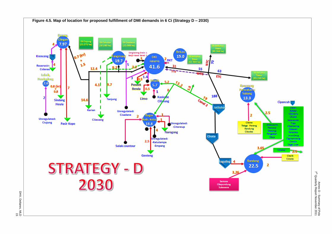
DH
V, D
elta
res, M
LD
15
An
ne
x D
- Sum
ma
ry o
f Po
la
7th Q
ua
rterly
Re
po
rt Nove
mb
er 2
011
Figure 4.5. Map of location for proposed fulfillment of DMI demands in 6 Ci (Strategy D – 2030)
Annex D - Summary of Pola 7th
Quarterly Report November 2011
DHV, Deltares, MLD 16
4.3. CONTROL OF WATER DESTRUCTIVE POWER
4.3.1 Prevention of Disaster
Reduce victims/lost due to flood Reduce frequency of flood event with plan for agricultural area (1:5 year) and urban
area (1:25 year and 1:100 year), Maintain function of flood control structure in sustainable ways, including OM of River
and Drainage Channel and eliminate sedimentation, Apply enforcement for river and situ demarcation border as in PERDA, prevent
development upon occupation that may obstruct flood flow, together with erecting of adequately visible benchmark,
Campaign public awareness not to dispose waste into river, Limit KDB and build detention pond at the housing complex and industrial estate to
reduce run-off resulting from rain, Set up evacuation locations by Pemda, Establish early warning system, Maintain and develop urban micro drainage system, Protect water front city against the threat of sea tide (Jakarta, Old Banten), Inventory and mapping of landslide prone areas at district (Kab/Kota) level, Campaign public awareness on the hazard of landslide, Apply building permit (IMB) and building code in landslide prone areas, Protect and recover capacity and function of situ, and adequately budgeting for OM.
4.3.2 Mitigation
Minimize the lost resulting from flood, Anticipate emergency condition in term of victims’ evacuation and its operation fund.
4.3.3 Recovery from Disaster
Recover house’s condition of the victims at post disaster by providing reserve fund from government and private sector, and involve people,
Recover condition and function of WR infrastructure at post flood, Recover condition of public infrastructure and facilities at post flood by providing fund
from government and private sector, and involve people.
4.4. WATER RESOURCE INFORMATION SYSTEM
Improve data quality and reliability level of the WR database in integrated and sustainable ways
Provide professional HR to handle WR information system Implement evaluation, rationalization, provision, operation and maintenance of
adequate tools to support WR information system Integrate data of WR information system for easy access Issue guidelines on management of systematic and comprehensive WR information
system Provide fund for integrated WR information system.
Annex D - Summary of Pola 7th
Quarterly Report November 2011
DHV, Deltares, MLD 17
4.5. EMPOWERMENT/IMPROVEMENT OF COMMUNITY, PRIVATE SECTOR AND GOVERNMENT PARTICIPATION
4.6. WRM Institution
Improve capacity of each unit of WRM institution in sustainable ways Improve cooperation among working units of WRM through MoU in sustainable ways Fulfill required number and capacity of personnel as reflected in work load analysis Improve implementation of personnel management Issue guidelines on role sharing in WR management Prepare and apply guidelines on asset management in WR management.
4.6.1 Funding
Improve communication and coordination in integrated WR management through TKPSDA WS 6 Ci
Review, set up and apply service fee collection of WR management Review and set up BLU of WR Management.
4.6.2 Governance
Inventory and monitor groundwater abstraction as permit issued Implement socialization and public awareness on deep groundwater abstraction Implement delegation of permitting on surface water utilization and commercialization
from Minister of PU to Governor Issue document on role sharing of OM activities in Jatiluhur irrigation network. Set up policy on water transfer among provinces.
4.6.3 Coordination Forum for PSDA (WRM)
Establish, activate, and facilitate Provincial and District (Kabupaten/Kota) Irrigation Commission
Optimize performance of Provincial Water Resource Council in 6 Ci Establish and activate District (Kabupaten/Kota) WR Council as necessary Activate Secretariat of TKPSDA 6 Ci (2 Ci, 3 Ci & 1 Ci) Establish and activate DAS Forum Improve coordination among agencies related to irrigation management Improve cooperation and coordination in flood control.
4.6.4 Empowerment & Improvement of Community and Private Sector Participation
Implement socialization, public awareness campaign on WR management, Improve awareness and capacity of farmers/WUAs in managing tertiary irrigation
network, Improve social economic condition of people in the upper DAS around the forest and
water sources through development and advisory, Make inventory of community groups whose culture in protecting forest area and
environment and provide guidance, directives and empowerment to keep sustainability of forest and environment,
Implement socialization on water saving for municipal and household demands Implement socialization and water saving through demoplot, Implement socialization on water saving for industrial demands through Reduce-
Reuse-Recycle, Develop and apply desalination technology of seawater for industrial water supply, Implement socialization on risk reduction of flood impacts, Implement community empowerment in waste management (in the channels, rivers), Improve private sector participation in WR and nature conservation through CSR fund, Improve community awareness on sanitation and use of household toilet, Develop, implement and monitor upstream-downstream cooperation of each DAS in
conservation, Implement and develop cooperation (of environmental services management).
Annex D - Summary of Pola 7th
Quarterly Report November 2011
DHV, Deltares, MLD 18
4.7. SPATIAL PLANNING
Integrate zoning requirement of WR in provincial/Kota/kabupaten RTRW and RDTR (scale 1:5,000) which used for building permit,
Disseminate, monitor, supervise and enforce upon violations of spatial laws and regulations as well as provincial/kabupaten/kota RTRW,
Apply incentive and disincentive (of property tax for unutilized/productive land, productive land with/without conservation),
Set up sustainable agricultural area for food production in RTRW to be exclusively protected by regulation,
Avoid conversion of foods agricultural land.
Annex F Training Program
7th Quarterly Report November 2011
DHV, Deltares, MLD
ANNEX F
TRAINING PROGRAM
TA7189-INO: Institutional Strengthening for Integrated Water Resources Management (IWRM) in the 6 Ci's River Basin Territory - Package B
Annex F – Training Program 7th
Quarterly Report November 2011
DHV, Deltares, MLD
TABLE OF CONTENTS Page
1 Objectives and Scope of Work 1
1.1 Training Program for Members of the TKPSDA 1
1.2 Training Program for RBMO Staffs 1
1.3 Training Program for Counterparts 1
2 Implementation 3
3 Evaluation 5
4 Conclutions and Recommendations 5
4.1 What has been Good 5
4.2 What has not been Well 6
4.3 Whats Next 6
4.4 Action Plan (detailed activities see attachment) 6

Annex F – Training Program 7th
Quarterly Report November 2011
DHV, Deltares, MLD p. 1
1 OBJECTIVES AND SCOPE OF WORK
Training program in 6 Cis project are related to project approach on capacity building. The objective for capacity building is formulated in the TOR as follows: “Introduce and effectively deliver holistic IWRM principles to the water sector in the 6 Cis River Basin Territory, through strengthening of a wide range of organisations and their related legal and regulatory framework in water resources protection, water services provision and river basin management”. In our vision, there are three levels of capacity building: individual level, organization level and sistem or enabling environment level. Even though the three levels are interdependent, this training program focus on individual level. Organization and environment level will be covered by other sub component in this project. Training is directly related to the skills, knowledge, and strategies necessary to do a particular job. It can include teaching new skills, exposing unfamiliar ideas, giving the chance to practice and get feedback on particular techniques or styles of working with people, or simply encouraging discussion about the work. And it can, and should, be ongoing throughout all project activities. (The Community Tool Box: http://ctb.ku.edu). Following all those thoughts, the objective of training program in 6 Ci‟s project is “strengthening stakeholder skills, knowledge, attitudes, motivation and work ethics to implement IWRM principles to the water sector in the 6 Cis river basin territory”. This training program involves:
1. Members of the TKPSDA, both government and non-government. 2. RBMO staffs. 3. Counterparts of 6 Cis project.
1.1 Training Program for Members of the TKPSDA
Training program for members of the TKPSDA is part of capacity building of stakeholders (Task B1-1). This task included establishment of Water Councils (TKPSDA) and empowerment of stakeholders (members of TKPSDA), to create conducive environment for proper governance in balanced participation of stakeholders. It is a continuous process, initially with focus on awareness and mobilization, evolving into active participation and information sharing. As TKPSDA only recently started functioning, we will soon start to conduct training needs assessment to identify required learning topics.
1.2 Training Program for RBMO Staffs
Training program for RBMO staffs is part of capacity building of RBMOs (Task B1-2). This task includes training for staff, and enabling measures at RBMO level or even sector level if needed, to enable trained staff to apply their new skills. Training program for RBMO staffs will generate general skills development for IWRM and specific skills for the planning process and specific follow up topics. Since task distribution between the various RBMOs is not yet clear, this part of the program has not been started yet.
1.3 Training Program for Counterparts
This part of the program has received the most attention. For counterpart , a training program has numerous benefits: (1) it makes them feel that the project is supportive of them; (2) a training program can help to convince counterpart of the culture (value) of the project's philosophy and methods; (3) it helps them to become continually more competent at what they do; (4) it increases their knowledge of the field by introducing them to the latest research and theory; (5) it can expose them to new ideas which ultimately may improve their own effectiveness and that of the organization; (6) it can expose them to other practitioners with different -- and perhaps better -- methods. In designing the training program for counterpart, we've chosen to define it as professional development, leading either to specific new knowledge, or to the next level of expertise.
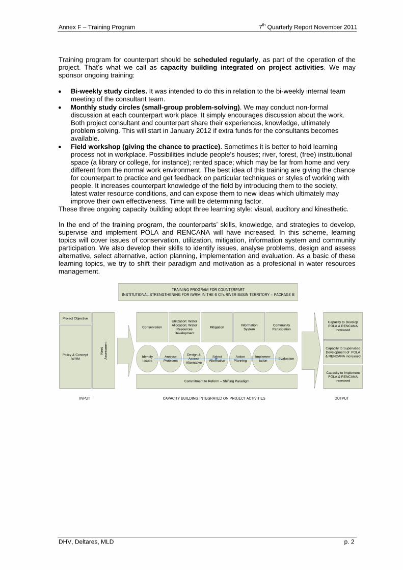
Annex F – Training Program 7th
Quarterly Report November 2011
DHV, Deltares, MLD p. 2
Training program for counterpart should be scheduled regularly, as part of the operation of the project. That‟s what we call as capacity building integrated on project activities. We may sponsor ongoing training:
Bi-weekly study circles. It was intended to do this in relation to the bi-weekly internal team meeting of the consultant team.
Monthly study circles (small-group problem-solving). We may conduct non-formal discussion at each counterpart work place. It simply encourages discussion about the work. Both project consultant and counterpart share their experiences, knowledge, ultimately problem solving. This will start in January 2012 if extra funds for the consultants becomes available.
Field workshop (giving the chance to practice). Sometimes it is better to hold learning process not in workplace. Possibilities include people's houses; river, forest, (free) institutional space (a library or college, for instance); rented space; which may be far from home and very different from the normal work environment. The best idea of this training are giving the chance for counterpart to practice and get feedback on particular techniques or styles of working with people. It increases counterpart knowledge of the field by introducing them to the society, latest water resource conditions, and can expose them to new ideas which ultimately may improve their own effectiveness. Time will be determining factor.
These three ongoing capacity building adopt three learning style: visual, auditory and kinesthetic. In the end of the training program, the counterparts‟ skills, knowledge, and strategies to develop, supervise and implement POLA and RENCANA will have increased. In this scheme, learning topics will cover issues of conservation, utilization, mitigation, information system and community participation. We also develop their skills to identify issues, analyse problems, design and assess alternative, select alternative, action planning, implementation and evaluation. As a basic of these learning topics, we try to shift their paradigm and motivation as a profesional in water resources management.
TRAINING PROGRAM FOR COUNTERPART
INSTITUTIONAL STRENGTHENING FOR IWRM IN THE 6 CI’s RIVER BASIN TERRITORY – PACKAGE B
Project Objective
Policy & Concept
IWRM
Ne
ed
Asse
ssm
en
t
Conservation
Utilization: Water
Allocation; Water
Resources
Development
MitigationInformation
System
Community
Participation
Capacity to Develop
POLA & RENCANA
increased
Capacity to Supervised
Development of POLA
& RENCANA increased
Capacity to Implement
POLA & RENCANA
increased
INPUT CAPACITY BUILDING INTEGRATED ON PROJECT ACTIVITIES OUTPUT
Identify
Issues
Analyse
Problems
Design &
Assess
Alternative
Select
Alternative
Action
Planning
Implemen-
tationEvaluation
Commitment to Reform – Shifting Paradigm
Annex F – Training Program 7th
Quarterly Report November 2011
DHV, Deltares, MLD p. 3
2 IMPLEMENTATION
Most attention was given to the training of the counterparts. We are pleased to mention that almost all counterparts from PU, comprising two (three were originally envisaged) from DG for Spatial Planning, two from DGWR Jakarta and two from each BBWS, have participated in implementation of package B. They are all junior staff, but with good education (S.1 and S.2) and high motivation.
Name Working Unit 1 Yuddi Yudistira, ST Staf Dit. BPSDA Ditjen SDA
2 Indah Salvia Amin, ST Staf Dit. BPSDA Ditjen SDA
3 Rigasony Tiamono, ST Staf BBWS Cidanau-Ciujung-Cidurian
4 Bima Ragil Saputra, ST Staf BBWS Cidanau-Ciujung-Cidurian
5 M. Rian Wahyu Kesumo, ST, M.Eng Staf BBWS Ciliwung-Cisadane
6 Ferdinanto, ST Staf BBWS Ciliwung-Cisadane
7 Angga Prawirakusuma, ST, MT Staf BBWS Citarum
8 Cecep Muhtaj Munajat, ST, MPSDA Staf BBWS Citarum
9 Meita Rudianingsih, S.Si Staf Direktorat Penataan Ruang Wilayah II
10 Aryo Hudiotomo, ST Staf Direktorat Penataan Ruang Wilayah II
As we decided to apply capacity building for counterpart integrated on project activities, the counterparts have been involved in all activities of 6 Ci‟s consultants. They participated in our internal team meeting (bi-weekly), focus group discussion with NGO, meeting with TKPSDA, BKPRD, ADB, workshop in formulating POLA, and of course in our trainings and field trips. However, it should be noted that not all of them could follow all these activities. Because of pressure of workload, most counterparts couldn‟t attend the internal team meetings (see annex counterpart involved) Joining with counterparts, we also have involved RBMO staffs in our training activities. They are also junior staff with high motivation to learn. Nine technical trainings were given to counterparts and RBMO staffs, as indicated below.
Name Working Unit 1 Anjar D. Krisnanta RCMU Bappenas
2 Radhika Puslitbang SDA
3 Mohammad Fauzi Puslitbang SDA
4 Gok Ari Joso Simamora PJT II Jatiluhur
5 Sumarno Subdit Data Informasi, Bina Program, BPSDA
6 Pandu Yuri Pratama Hidrologi, BPSDA
7 Ahmad Taufik Balai Datin SDA, PSDA Jabar
8 Ishana Pramawidhana Dinas PU DKI Jakarta
9 Arief Kautsar Dinas PU Banten
Technical Training Date
1 Hydrological Analysis Hymos - FWES-Series 1 19-21 May 2010
2 Hydrological Analysis Hymos - FWES-Series 1 24-27 May 2010
3 Hydrological Analysis Hymos - FWES-Series 1 31 May - 3 June 2010
4 Training Ribasim 25-28 October 2010
5 Training Java Spatial Model 01-02 November 2010
6 Training B2 - Water Zoning 16 June 2011
7 Teknik Zoonasi 6 July 2011
8 Java Spatial Model 2.2 02 August 2011
9 Hymos 05-06 October 2011
We conducted 4 field trips. With these activities, we developed counterparts‟ and RBMO staff‟s knowledge of the field by introducing them to the society, latest water resource conditions, and expose them to new ideas of water resources management. At the last field trip, Cidanau field trip, we combined technical training (Ribasim) and motivational training (professionalism).

Annex F – Training Program 7th
Quarterly Report November 2011
DHV, Deltares, MLD p. 4
Field Trip Topics have been discussed
Ciliwung Field Trip (23 - 24 Juli 2010)
Conservation Water allocation Water Pollution Mitigation Community Participation
Citarum Field Trip (6 - 7 Agustus 2010)
Conservation Water allocation Water Pollution
Cinangneng Field Trip (18 - 19 November 2010)
Freire consciesness Multi perspective communication Gender Tree problem analysis Vision for water resources management Structural and non-structural problem for water resources
management Shifting government‟s roles for water resources management Develop government-private-community‟s role for water
resources management
Cidanau/Anyer fieldtrip (16 - 18 Maret 2011)
Ribasim Self image of a Professional Become a Professional in water resources management Field visit pumping station Cidanau
Using „learning by doing‟ approach, counterparts were asked to critized POLA and presented it at pra-PKM 2, 8 February 2011. This meeting was attended by Dr. Ir. Djaja Murni W.D.,Dipl.HE., M.SC., Director of Water Resource Management, DGWR. And a few days ago, on 21-22 November 2011, to increased level of understanding in process of making POLA and substance content POLA of 6 Ci‟s river basin, counterparts and RBMO staffs followed 1 day training „Review Book of POLA”.
Annex F – Training Program 7th
Quarterly Report November 2011
DHV, Deltares, MLD p. 5
3 EVALUATION
One obvious ways to determine the effectiveness of our training program is feedback from trainee. At the last session of our training/fieldtrip activities, counterpart and RBMO staffs always give feedback about their understanding of learning material, performance of facilitator, performance of resources person, performance of participants, accomodation, transportation, lesson learned, their learning needs and their recommendation for the next training. Counterparts and RBMO staffs which returns the entire training evaluation sheet states that the training/field trip was very beneficial and highly contextual with their work. Therefore they said that they would use what was they learned on training/field trips in their work and want to experience field trips like this again in the future. As a state apparatus, this trip otherwise revive the awareness that the sacrifice for the country can start from small things, from ourselves. Also stated that the attitude of a good bureaucrat is to serve and protect the society, willing to plunge into the field and take a stance/decision with no/less popular that its impact is felt both in the community. During April 2011, Counterpart project 6 Cis asked to provide the evaluation through a questionnaire evaluation of learning activities undertaken by counterparts 6 Cis project. Here are some topics and evaluation findings: Counterparts generally have expectations from 6 Cis Project: gaining knowledge/new skills,
getting input effective way of working, known for their superior, actively involved in the formulation of POLA and RENCANA, opportunity to practise their knowledge, earning extra income, getting new networks, and actively involved in the formation TKPSDA 6 Cis. Most counterparts stated that they have benefited according to their expectations. Other benefits derived from the different atmosphere in the office everyday activities (refresh and fun), sharing experiences and getting a very supportive work Laptop.
7 of 9 Counterparts stated that the training program for counterpart scheme which has been
used in projects 6 Cis help Counterpart to achieve their hopes to understand the preparation of POLA and RENCANA. They stated that they got better understanding how to manage natural resources and all the problems that exist in natural resource management. They also have been getting to know the stages of formulation POLA, including portraits of the problems and potential conditions in the area of 6 Cis project.
"The existence of his fellow counterpart and support from team of consultants was very effective in providing an understanding of POLA" stated as an important role in helping the learning process in the 6 Cis. Other factors that support are the use of methods fieldtrip, access to information, freedom of discussion, the facilities provided and the support of the Kepala Balai. Meanwhile, the most difficult barrier came from “schedule of learning activities on the 6 Cis project often clash with the burden of office tasks to be done”.
4 CONCLUTIONS AND RECOMMENDATIONS
4.1 What has been Good
Counterparts 6 Cis project and RBMO staffs consists of smart people with a high desire to learn. More than just making the learning as a discourse of change, they are committed to implement the learning outcomes in work and their daily lives. The leadership of each institution in which counterparts and RBMO staffs are active is also committed to support the learning process. Scheme for counterpart training program which has been used in projects 6 Cis has been capable of helping counterpart to achieve their hopes to understand the preparation of POLA and RENCANA. This learning scheme combining the development of skills, knowledge and self-reform. 'friendly relationship' and 'encouraging learning atmosphere' was instrumental in helping the learning process in the 6 Cis.
Annex F – Training Program 7th
Quarterly Report November 2011
DHV, Deltares, MLD p. 6
4.2 What has not been Well
Generally, counterpart‟s knowledge about reality of water resource management in the field still need to be improved. Teamwork is still not running as expected. Counterparts have not been able to solve the problems of distance and time between them and raises the need to cooperate. Their Mastery of Ribasim and JSM are still not evenly distributed and not 'full'. Although the Kepala Balais have committed to support the project activities in the 6 Cis learning activities, they have only limited time for participating in the 6 Cis project, because DGSP, DGWR and especially the BBWS have limited personnel. If they only participate in a number of short courses, their ownership of the problems and sultions as well as their skill on implementing the developed tools will be limited.
4.3 Whats Next
1). As TKPSDA established, we will conduct training need assessment to identify their learning topics. We will design a questionnaire to submit this training need assessment. This task will be held on February 2012.
2). Training for RBMO is hardly possible, since task distribution is still under discussion. It is intended to organize some courses on general subjects such as IWRM, leadership, conflict management and integrity.
3). Conduct a comparative study of POLA in other river areas. This comparative study is expected to: (1) provide alternative ideas for counterpart about POLA other river areas, (2) develop problem-solving abilities river basin management, (3) provide insight into the structure, management and culture of river basin management organizations. The locations are considered to be the location of a comparative study is Sungai Berantas (PJT 1).
4). To strengthen the skills about JSM and Ribasim, Counterpart will get sustainable coaching in their respective workplaces. In periods where the load Counterpart in his office is not so high – probably in January and February 2012 – Counterpart is expected to give more time in the 6 Cis project to learn Ribasim and JSM.
5). Conduct e-learning. Marc J. Rosenberg defines e-Learning as the use of Internet technology to deliver a wide range of solutions to increase knowledge and performance. We will conduct e-learning as a strategy when learning or face to face training – must leave the workplace and gathered in one place – felt increasingly hard to do. We will provide some package of learning object, which will be accessed by the counterpart from their workplace. At every package of learning object, counterpart will answer the pre test, studying the knowledge material and then doing the post test.
4.4 Action Plan (detailed activities see attachment)
Activities Participants Time
1 Designing curriculum and learning object for e-Learning
Counterparts December 2011
2 TNA for TKPSDA Members of TKPSDA February 2012
3 Comparative Study of POLA in PJT 1 Counterparts March 2012
4 IWRM training Members of TKPSDA, counterparts and RBMO staffs
April 2012
5 JSM and Ribasim training for RENCANA
counterparts and RBMO staffs Dec 2011 - June 2012
6 Conflict management & other topics Members of TKPSDA, counterparts and RBMO staffs
Feb - June 2012
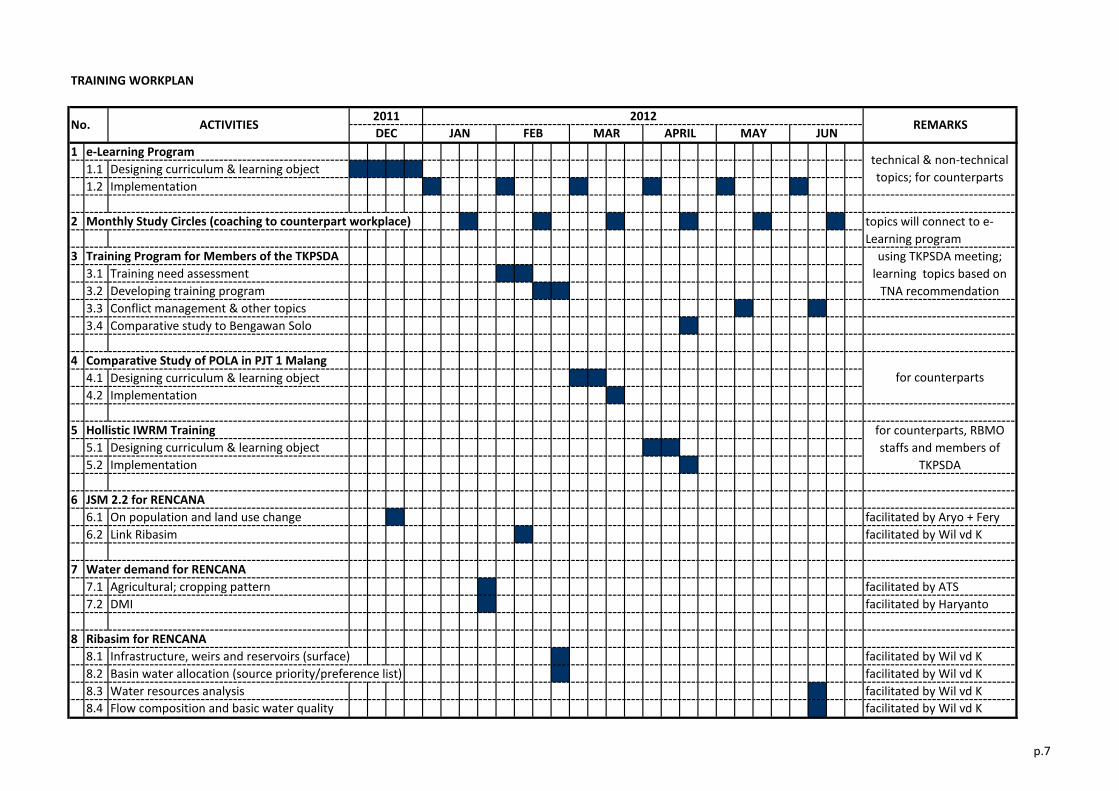
TRAINING WORKPLAN
1 e-Learning Program
1.1 Designing curriculum & learning object
1.2 Implementation
2 Monthly Study Circles (coaching to counterpart workplace)
3 Training Program for Members of the TKPSDA
3.1 Training need assessment
3.2 Developing training program
3.3 Conflict management & other topics
3.4 Comparative study to Bengawan Solo
4 Comparative Study of POLA in PJT 1 Malang
4.1 Designing curriculum & learning object
4.2 Implementation
5 Hollistic IWRM Training
5.1 Designing curriculum & learning object
5.2 Implementation
6 JSM 2.2 for RENCANA
6.1 On population and land use change facilitated by Aryo + Fery
6.2 Link Ribasim facilitated by Wil vd K
7 Water demand for RENCANA
7.1 Agricultural; cropping pattern facilitated by ATS
7.2 DMI facilitated by Haryanto
8 Ribasim for RENCANA
8.1 Infrastructure, weirs and reservoirs (surface) facilitated by Wil vd K
8.2 Basin water allocation (source priority/preference list) facilitated by Wil vd K
8.3 Water resources analysis facilitated by Wil vd K
8.4 Flow composition and basic water quality facilitated by Wil vd K
No. ACTIVITIES2011
DEC JAN
for counterparts, RBMO
staffs and members of
TKPSDA
for counterparts
using TKPSDA meeting;
learning topics based on
TNA recommendation
APRIL
technical & non-technical
topics; for counterparts
topics will connect to e-
Learning program
REMARKSMAY JUN
2012
MARFEB
p.7
Annex G Status of activities
concerning B.3 on Groundwater
7th Quarterly Report November 2011
DHV, Deltares, MLD
7th Quarterly Report November 2011
Annex G Status of Activities Concerning B3 on Groundwater (until end of October 2011)
1
2 Review of international best practices 100% Review / Report on best practises completed.
3 Data collection, discussion with DINAS Enery & Mining/BPLHD 100%
(c ) abstraction, (d) licensing, (e) registration, (f) monitoring
systems and (g) related problems (law enforcement,
participation of the community)
4 Data collection, discussions with Pusat Lingkungan Geologi on 100%(b) monitoring mechanisms and (c) monitoring activities in the
CAT Bandung Soreang
5 Identify the current mechanisms and practises on licensing,
registration, database, metering, law enforcement
100% Licensing mechanisms identified. Mechanisms were
reviewed. Licenses issued by Prov/District DINAS EPSD
(incl extension licenses, monitoring of abstraction through
metering and legal action in case of law violation). Activity
completed.
6 Carry out economic assessment of level groundwater charges
for shifting to surface water
100% Groundwater pricing analsys completed. Information on
fees, charges collected. Costs for groundwater abstraction
through individual boreholes (direct costs only) > 3 times
cheaper than PDAM water. Activity completed.
7 Analyse feasibility of raising groundwater charges for required
level for industry
100% Included in Task 6. Activity completed.
8 Review reports on alternatives groundwater usage (re-use, re-
cycling etc); identify alternatives within the Bandung context
(textile industry). Activity in coordination with B1 consultants.
100% Alternatives were reviewed. Short-term solutions not
readily available. Rainfall harvesting looks promising but
more study required. Artificial recharge of damaged
aquifers does not look promising. Strict licensing,
enforcement system needed. High taxes in DKI Jakarta
moves out industry that uses groundwater, but in
Bandung economy has high reliance on industry. Long-
term solution is to replace the existing concentrated
groundwater withdrawals by reliable/cheap supply of
surface water. Review completed.
9 Review River Basin Planning study reports on feasibility for
usage of water from lakes, reservoirs or other surface water
sources as an alternative to groundwater; Activity in
coordination with B1 consultants.
100% Three most promising alternatives identified. Further study
is/will be covered by 1) POLA at strategic level, 2)
upcoming ADB project, Tranch II on Bandung Water
Supply sources and development, 3) MoU between DG
WR, Dinas SDA Prov and 4 Kab/2 Kotas and 4) Joint
Working Group (headed by BBWSC). Review completed.
10 Conduct consultations with concerned parties (DINAS
EPSDM, PAM, Badan Geologi, Industry); Discuss and obtain
support for changes to current pricing, licensing, monitoring
systems; Assess willingness to change from groundwater to
surface water usage (price, water, reliability/quality delivery)
100% Consultations with provincial/kab agencies completed.
Findings reported in section 4.3.1 and Table 4.1
11 Identify scope for improvement registration database 50% Activity is cancelled (see 3rd Qtr report)
12 Provide technical assistance to local Gov on developing
registration database
0% Activity is cancelled (see 3rd Qtr report)
13 Develop recommendations on groundwater licensing, pricing,
institutional roles, monitoring activities etc
100% Final recommendations completed.
14 Discuss recommendations with concerned parties 100% Discussed during stakeholder consultations and ESDM
workshop. Activity completed.
14a Discuss recommendations with concerned parties 50% Follow up is provided through Public Policy Specialist, see
section 4.3.1
15 Organize Workshop 100% ESDM Workshop was held in November 2010. Workshop
report completed incl. presentations, discussions and
conclusions for follow up.
16 Finalize reports 95% Draft final distributed among key stakehodlers in June'11.
Comments from ADB received, but Dinas ESDM sent
comments in October 2011. Distribution of background
reports in October and Final report in November 2011.
Activities
100%
Task B3-3: Policy Development for Water Pricing related to groundwater Bandung
Progress to date
Review of groundwater legislation/policies completed.
Overlaps and ambiquities identified (see Table 4.1).
Activity completed.
Review of current gov policies and legislation on groundwater
licensing, pricing (price policies, price agreements, cost
recovery, tariffs, fee collection); identify ambiguities, overlaps
DHV, Deltares, MLD
Data collection and evaluation completed. Information was
obtained on regulatory, permit procedures; implementation
and monitoring capacity. Activity completed.
Various studies identified and reviewed. Understanding on
groundwater basin, aquifers. Problems identified. Activity
completed.
Task B3-1: System Development for Licensing, Registration related to groundwater Bandung
Annex H Status of activities
concerning B.3 on Surface Water
7th Quarterly Report November 2011
DHV, Deltares, MLD

7th
Quarterly Report November 2011
Annex H Status of Activities Concerning B3 on Surface Water (until end of October'11)
1 Review of current gov policies and legislation;
identify ambiguities, overlaps
100% Review of surface water legislation/policies
completed.
2 Identify current practises on water allocation,
water distribution and maintenance down to the
secondary irrigation scheme levels Tarum canal
100% Current water allocation mechanisms identified.
Key player is PJTII. Allocation is annually (DMI
and irrigation) with bi-weekly adjustments for
irrigation. Activity completed.
3 Compare water allocation practises Tarum with
other schemes with focus on the institutional
arrangements
100% A comparison was made on water allocation
between three basins. These are Bengewan-Solo,
Brantas and Citarum. Lessons learnt taken into
account for strategies. Activity completed.
4 Assess consultation, information and
participatory mechanisms (Panitia Irigasi,
Rencana Tata Tanam etc )
100% An analysis of roles of various consultation
mechanisms in the allocation process was carried
out. Key players are Dinas Kab, Kom Irigasi,
Dinas Prov, BBWSC and PJTII. A standard
mechanism for water allocation exists at annual
and bimonthly periods. Activity completed.
5 Conduct consultations with concerned parties
(PJTII, DINAS Prov/Kab WR, members Irrigation
Commission, members WUAs, staff from DINAS
Agriculture etc); Discuss and obtain support for
development of water allocation in identified
areas
100% see Taks 4. Activity completed.
6 Discuss recommendations with concerned
parties
100% New ideas on improved water distribution were
discussed with PU Jakarta and BBWSC.
Proposed is a measurable benchmark system for
primary irrigation off take points. Scope for four
MoUs on role sharing in aspects of water
distribution is identified. Discussed in final
Workshop on Feb'11.
7 Discuss recommendations with concerned
parties
100% Discussed during Workshop in February 2011.
7a Discuss recommendations with concerned
parties
50% Folow up is provided by Public Policy Specialist.
See 4.3.2.
8 Prepare report on Pricing Bulk Water Supply 50% Study started June 2011, to be completed in
November 2011. See section 4.2.3 and 4.3.3.
9 Organize Workshop 100% BBWSC Workshop was held on 17 Feb'11.
Conclusions, recommendations are included in
Report No 10 and Table 4.2
10 Finalize reports 99% Draft final distributed among key stakehodlers in
June'11. Comments from ADB received, but
Dinas PSDA sent comments in October 2011.
Distribution of background reports in October and
Final report in November 2011.
Activities Progress to date
Task B3-2: Policy Development for Water Allocation related to Irrigation Tarum System
DHV, Deltares, MLD
Annex I Additional activities proposed for B.1
7th Quarterly Report November 2011
DHV, Deltares, MLD
ANNEX I
ENVISAGED ADDITIONAL WORK
FOR COMPONENT B.1
TA7189-INO: Institutional Strengthening for Integrated Water Resources Management (IWRM) in the 6 Ci's River Basin Territory - Package B
Annex I – Additional Activities Proposed for B.1 7th
Quarterly Report November 2011
DHV, Deltares, MLD
TABLE OF CONTENTS Page
Extra resources needed for completion of Rencana 6 Cis 1
1 Background
2 Present Status and Proposed Additional Activities
LIST OF TABLE Table 2.1. Assessment of additional Inputs and required funds for extension B.1 2
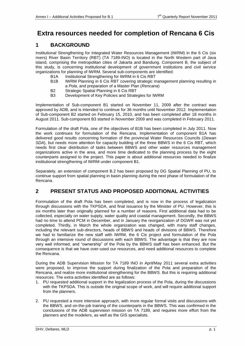
Annex I – Additional Activities Proposed for B.1 7th
Quarterly Report November 2011
DHV, Deltares, MLD p. 1
Extra resources needed for completion of Rencana 6 Cis
1 BACKGROUND
Institutional Strengthening for Integrated Water Resources Management (IWRM) in the 6 Cis (six rivers) River Basin Territory (RBT) (TA 7189-INO) is located in the North Western part of Java island, comprising the metropolitan cities of Jakarta and Bandung. Component B, the subject of this study, is concerning institutional development of government institutions and civil service organizations for planning of IWRM. Several sub-components are identified: B1A Institutional Strengthening for IWRM in 6 Cis RBT B1B IWRM Planning in 6 Cis RBT covering strategic management planning resulting in
a Pola, and preparation of a Master Plan (Rencana) B2 Strategic Spatial Planning in 6 Cis RBT B3 Development of Key Policies and Strategies for IWRM Implementation of Sub-component B1 started on November 11, 2009 after the contract was approved by ADB, and is intended to continue for 36 months until November 2012. Implementation of Sub-component B2 started on February 15, 2010, and has been completed after 18 months in August 2011. Sub-component B3 started in November 2009 and was completed in February 2011. Formulation of the draft Pola, one of the objectives of B1B has been completed in July 2011. Now the work continues for formulation of the Rencana. Implementation of component B1A has delivered good results concerning formation of the provincial Water Resources Councils (Dewan SDA), but needs more attention for capacity building of the three BBWS in the 6 Cis RBT, which needs first clear distribution of tasks between BBWS and other water resources management organizations active in the area, and more time dedicated to the planning process by the eight counterparts assigned to the project. This paper is about additional resources needed to finalize institutional strengthening of IWRM under component B1. Separately, an extension of component B.2 has been proposed by DG Spatial Planning of PU, to continue support from spatial planning in basin planning during the next phase of formulation of the Rencana.
2 PRESENT STATUS AND PROPOSED ADDITIONAL ACTIVITIES
Forrmulation of the draft Pola has been completed, and is now in the process of legalization through discussions with the TKPSDA, and final issuance by the Minister of PU. However, this is six months later than originally planned for a number of reasons. First additional data had to be collected, especially on water supply, water quality and coastal management. Secondly, the BBWS had no time to attend PCM in December, and in January the reorganization of DGWR was not yet completed. Thirdly, in March the whole organization was changed, with many staff changes, including the relevant sub-directors, heads of BBWS and heads of divisions of BBWS. Therefore we had to familiarize the new staff with IWRM, the 6 Cis project and formulation of the Pola through an intensive round of discussions with each BBWS. The advantage is that they are now very well informed, and “ownership” of the Pola by the BBWS staff has been enhanced. But the consequence is that we have over-used our resources, and need additional resources to complete the Rencana. During the ADB Supervision Mission for TA 7189 INO in April/May 2011 several extra activities were proposed, to improve the support during finalization of the Pola and preparation of the Rencana, and realize more institutional strengthening for the BBWS. But this is requiring additional resources. The extra activities identified are as follows: 1. PU requested additional support in the legalization process of the Pola, during the discussions
with the TKPSDA. This is outside the original scope of work, and will require additional support from the planners.
2. PU requested a more intensive approach, with more regular formal visits and discussions with the BBWS, and on-the-job training of the counterparts in the BBWS. This was confirmed in the conclusions of the ADB supervision mission on TA 7189, and requires more effort from the planners and the modelers, as well as the GIS specialists.
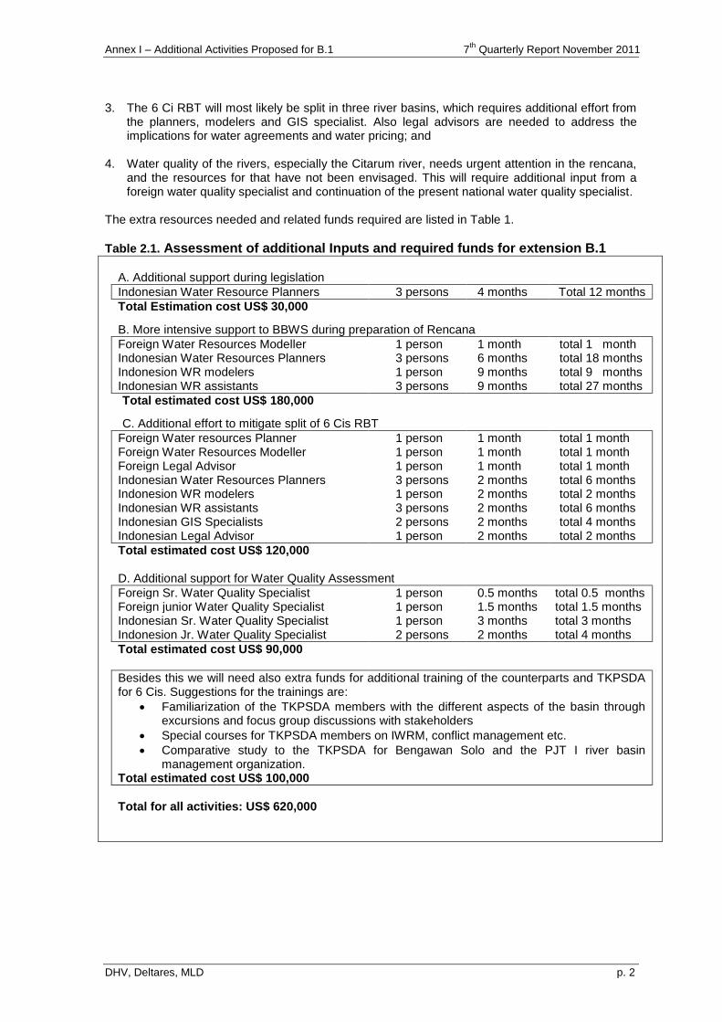
Annex I – Additional Activities Proposed for B.1 7th
Quarterly Report November 2011
DHV, Deltares, MLD p. 2
3. The 6 Ci RBT will most likely be split in three river basins, which requires additional effort from
the planners, modelers and GIS specialist. Also legal advisors are needed to address the implications for water agreements and water pricing; and
4. Water quality of the rivers, especially the Citarum river, needs urgent attention in the rencana,
and the resources for that have not been envisaged. This will require additional input from a foreign water quality specialist and continuation of the present national water quality specialist.
The extra resources needed and related funds required are listed in Table 1.
Table 2.1. Assessment of additional Inputs and required funds for extension B.1
A. Additional support during legislation
Indonesian Water Resource Planners 3 persons 4 months Total 12 months
Total Estimation cost US$ 30,000
B. More intensive support to BBWS during preparation of Rencana
Foreign Water Resources Modeller 1 person 1 month total 1 month Indonesian Water Resources Planners 3 persons 6 months total 18 months Indonesion WR modelers 1 person 9 months total 9 months Indonesian WR assistants 3 persons 9 months total 27 months
Total estimated cost US$ 180,000
C. Additional effort to mitigate split of 6 Cis RBT
Foreign Water resources Planner 1 person 1 month total 1 month Foreign Water Resources Modeller 1 person 1 month total 1 month Foreign Legal Advisor 1 person 1 month total 1 month Indonesian Water Resources Planners 3 persons 2 months total 6 months Indonesion WR modelers 1 person 2 months total 2 months Indonesian WR assistants 3 persons 2 months total 6 months Indonesian GIS Specialists 2 persons 2 months total 4 months Indonesian Legal Advisor 1 person 2 months total 2 months
Total estimated cost US$ 120,000
D. Additional support for Water Quality Assessment
Foreign Sr. Water Quality Specialist 1 person 0.5 months total 0.5 months Foreign junior Water Quality Specialist 1 person 1.5 months total 1.5 months Indonesian Sr. Water Quality Specialist 1 person 3 months total 3 months Indonesion Jr. Water Quality Specialist 2 persons 2 months total 4 months
Total estimated cost US$ 90,000
Besides this we will need also extra funds for additional training of the counterparts and TKPSDA for 6 Cis. Suggestions for the trainings are:
Familiarization of the TKPSDA members with the different aspects of the basin through excursions and focus group discussions with stakeholders
Special courses for TKPSDA members on IWRM, conflict management etc.
Comparative study to the TKPSDA for Bengawan Solo and the PJT I river basin management organization.
Total estimated cost US$ 100,000
Total for all activities: US$ 620,000
Annex J Additional activities proposed for B.2
7th Quarterly Report November 2011
DHV, Deltares, MLD
ANNEX J
ENVISAGED ADDITIONAL WORK
FOR COMPONENT B.2
TA7189-INO: Institutional Strengthening for Integrated Water Resources Management (IWRM) in the 6 Ci's River Basin Territory - Package B
Annex J – Additional Activities Proposed for B.2 7th
Quarterly Report November 2011
DHV, Deltares, MLD
TABLE OF CONTENTS Page
1 Why a B2 extension is needed 1
2 Short term options 1
2.1 Support the TA Rencana WRM process with spatial planning input 1
2.2 Intensive transfer of knowledge for water zoning tools 2
2.3 Support integration of water resources aspects in spatial planning process 2
2.4 Intensive transfer of knowledge for JSM 3
2.5 Reconnaissance study new agriculture sustainability law in spatial planning 3
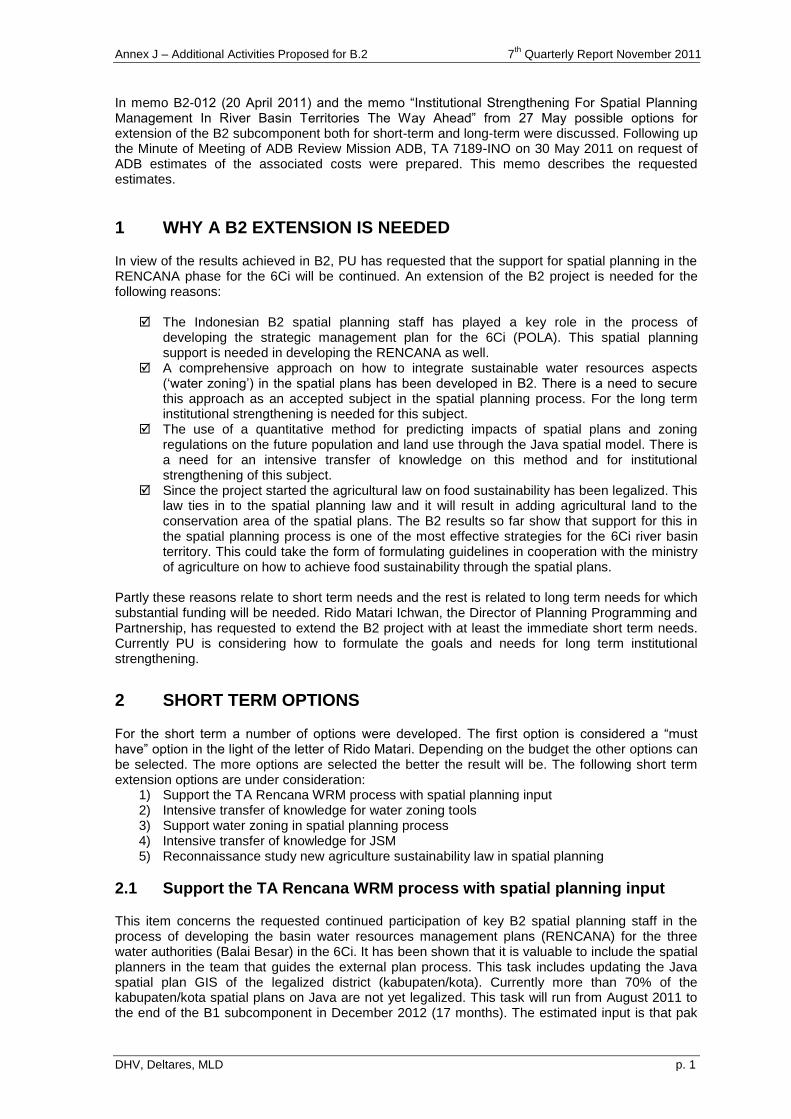
Annex J – Additional Activities Proposed for B.2 7th
Quarterly Report November 2011
DHV, Deltares, MLD p. 1
In memo B2-012 (20 April 2011) and the memo “Institutional Strengthening For Spatial Planning Management In River Basin Territories The Way Ahead” from 27 May possible options for extension of the B2 subcomponent both for short-term and long-term were discussed. Following up the Minute of Meeting of ADB Review Mission ADB, TA 7189-INO on 30 May 2011 on request of ADB estimates of the associated costs were prepared. This memo describes the requested estimates.
1 WHY A B2 EXTENSION IS NEEDED
In view of the results achieved in B2, PU has requested that the support for spatial planning in the RENCANA phase for the 6Ci will be continued. An extension of the B2 project is needed for the following reasons:
The Indonesian B2 spatial planning staff has played a key role in the process of developing the strategic management plan for the 6Ci (POLA). This spatial planning support is needed in developing the RENCANA as well.
A comprehensive approach on how to integrate sustainable water resources aspects („water zoning‟) in the spatial plans has been developed in B2. There is a need to secure this approach as an accepted subject in the spatial planning process. For the long term institutional strengthening is needed for this subject.
The use of a quantitative method for predicting impacts of spatial plans and zoning regulations on the future population and land use through the Java spatial model. There is a need for an intensive transfer of knowledge on this method and for institutional strengthening of this subject.
Since the project started the agricultural law on food sustainability has been legalized. This law ties in to the spatial planning law and it will result in adding agricultural land to the conservation area of the spatial plans. The B2 results so far show that support for this in the spatial planning process is one of the most effective strategies for the 6Ci river basin territory. This could take the form of formulating guidelines in cooperation with the ministry of agriculture on how to achieve food sustainability through the spatial plans.
Partly these reasons relate to short term needs and the rest is related to long term needs for which substantial funding will be needed. Rido Matari Ichwan, the Director of Planning Programming and Partnership, has requested to extend the B2 project with at least the immediate short term needs. Currently PU is considering how to formulate the goals and needs for long term institutional strengthening.
2 SHORT TERM OPTIONS
For the short term a number of options were developed. The first option is considered a “must have” option in the light of the letter of Rido Matari. Depending on the budget the other options can be selected. The more options are selected the better the result will be. The following short term extension options are under consideration:
1) Support the TA Rencana WRM process with spatial planning input 2) Intensive transfer of knowledge for water zoning tools 3) Support water zoning in spatial planning process 4) Intensive transfer of knowledge for JSM 5) Reconnaissance study new agriculture sustainability law in spatial planning
2.1 Support the TA Rencana WRM process with spatial planning input
This item concerns the requested continued participation of key B2 spatial planning staff in the process of developing the basin water resources management plans (RENCANA) for the three water authorities (Balai Besar) in the 6Ci. It has been shown that it is valuable to include the spatial planners in the team that guides the external plan process. This task includes updating the Java spatial plan GIS of the legalized district (kabupaten/kota). Currently more than 70% of the kabupaten/kota spatial plans on Java are not yet legalized. This task will run from August 2011 to the end of the B1 subcomponent in December 2012 (17 months). The estimated input is that pak
Annex J – Additional Activities Proposed for B.2 7th
Quarterly Report November 2011
DHV, Deltares, MLD p. 2
IF Poernomosidhi, pak Dasril and pak Yogi Agustiansyah will be involved for 33% of their time in this period. The team leader Poul Grashoff will provide backstopping and reporting. Estimated costs can be found in the table below:
Person Total Rate Months Trips Trip costs Price US$
Dasril Ratman $ 4,045 6.00 $ 24,270
IF Poernomosidhi $ 3,300 6.00 $ 19,800
Yogi Agustiansyah $ 2,437 6.00 $ 14,622
Poul Grashoff $ 26,396 1.00 1 $ 1,939 $ 28,335
Total $ 87,027
Notes: Total rate = Monthly renumeration rate plus per diem Trip costs = Trip rate + miscellaneous costs
2.2 Intensive transfer of knowledge for water zoning tools
After completion of the B2 water zoning work it is recommended to organize and intensive transfer of knowledge of both the erosion model developed for Java and the peak flow model developed to protect part of catchment area that leads to increases in peak flows. For the transfer of knowledge it is proposed to have Bart Adriaanse and Robert Verhaeghe available for 4 weeks (2 weeks preparation; 2 weeks intensive transfer of knowledge). The Indonesian GIS expert Yogi Agustiansyah will also be involved for two months. The estimated costs are elaborated in the table below.
Person Total Rate Months Trips Trip costs Price US$
Yogi Agustiansyah $ 2,437 2.00 $ 4,874
Bart Adriaanse $ 21,527 1.00 1 $ 1,939 $ 23,466
Robert Verhaeghe $ 27,156 1.00 1 $ 1,939 $ 29,095
Total $ 57,435
2.3 Support integration of water resources aspects in spatial planning process
An approach for water resources protection as integral part of preparing the spatial plan has been developed in B2. The legally binding spatial zoning in Indonesia is made at the district (kabupaten/kota) level. The dissemination of the approach in B2 has been to raise awareness with the Kabupaten / Kota spatial planners in the recent BKPRD meetings. In this task it is recommended to provide resources for a continued support for water zoning through the following activities: - Further elaborate/discuss the criteria for zoning and the associated water zoning delineation,
incorporating the full set of issues coming up in the water resources analysis (Rencana). - Establish methodology and data base to incorporate water zoning into detailed
Kabupaten/Kota spatial plans (RTRW) for a limited number of selected Kabupaten/Kota. - Advise on the need for institutional changes, such as the distribution of roles and
responsibilities and capacity building. The estimated costs are elaborated in the table below.
Person Total Rate Months Trips Trip costs Price US$
IF Poernomosidhi $ 3,300 4.00 $ 13,200
Raymond Kemur $ 3,193 3.00 $ 9,579
Bart Adriaanse $ 21,527 0.50 1 $ 1,939 $ 12,703
Poul Grashoff $ 26,396 0.50 $ 13,198
Rudolf van Ommen $ 32,698 1.00 1 $ 1,939 $ 34,637
Robert Verhaeghe $ 27,156 1.00 1 $ 1,939 $ 29,095
Total $ 112,412
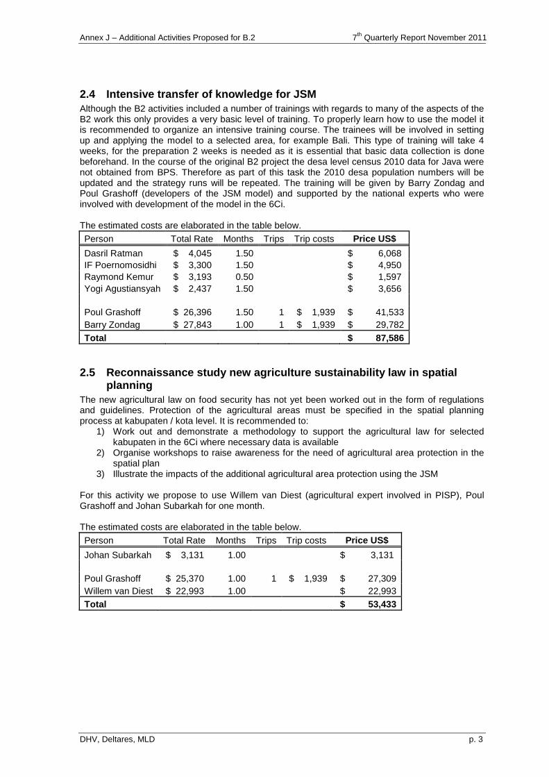
Annex J – Additional Activities Proposed for B.2 7th
Quarterly Report November 2011
DHV, Deltares, MLD p. 3
2.4 Intensive transfer of knowledge for JSM
Although the B2 activities included a number of trainings with regards to many of the aspects of the B2 work this only provides a very basic level of training. To properly learn how to use the model it is recommended to organize an intensive training course. The trainees will be involved in setting up and applying the model to a selected area, for example Bali. This type of training will take 4 weeks, for the preparation 2 weeks is needed as it is essential that basic data collection is done beforehand. In the course of the original B2 project the desa level census 2010 data for Java were not obtained from BPS. Therefore as part of this task the 2010 desa population numbers will be updated and the strategy runs will be repeated. The training will be given by Barry Zondag and Poul Grashoff (developers of the JSM model) and supported by the national experts who were involved with development of the model in the 6Ci. The estimated costs are elaborated in the table below.
Person Total Rate Months Trips Trip costs Price US$
Dasril Ratman $ 4,045 1.50 $ 6,068
IF Poernomosidhi $ 3,300 1.50 $ 4,950
Raymond Kemur $ 3,193 0.50 $ 1,597
Yogi Agustiansyah $ 2,437 1.50 $ 3,656
Poul Grashoff $ 26,396 1.50 1 $ 1,939 $ 41,533
Barry Zondag $ 27,843 1.00 1 $ 1,939 $ 29,782
Total $ 87,586
2.5 Reconnaissance study new agriculture sustainability law in spatial planning
The new agricultural law on food security has not yet been worked out in the form of regulations and guidelines. Protection of the agricultural areas must be specified in the spatial planning process at kabupaten / kota level. It is recommended to:
1) Work out and demonstrate a methodology to support the agricultural law for selected kabupaten in the 6Ci where necessary data is available
2) Organise workshops to raise awareness for the need of agricultural area protection in the spatial plan
3) Illustrate the impacts of the additional agricultural area protection using the JSM For this activity we propose to use Willem van Diest (agricultural expert involved in PISP), Poul Grashoff and Johan Subarkah for one month. The estimated costs are elaborated in the table below.
Person Total Rate Months Trips Trip costs Price US$
Johan Subarkah $ 3,131 1.00 $ 3,131
Poul Grashoff $ 25,370 1.00 1 $ 1,939 $ 27,309
Willem van Diest $ 22,993 1.00 $ 22,993
Total $ 53,433
Annex K Additional activities proposed
for Support in task distribution discussions
7th Quarterly Report November 2011
DHV, Deltares, MLD
ANNEX K
ASSISTANCE TO ENHANCE
ROLE SHARING AGREEMENTS
TA7189-INO: Institutional Strengthening for Integrated Water Resources Management (IWRM) in the 6 Ci's River Basin Territory - Package B
Annex K – Assistance to enhance role sharing agreements 7th Quarterly Report November 2011
DHV, Deltares, MLD
TABLE OF CONTENTS Page
1 Rationale 1
2 The organization of river basin management in Indonesia 2
3 Complications arising 3
3.1 Issues concerning the reservoirs in the JABODETABEK area 3 3.1.1 Background 3 3.1.2 Legal issues to be resolved 4
3.2 Issues concerning the Citarum Cascade and the West Tarum Canal 5 3.2.1 Background 5 3.2.2 Overlapping responsibilities and conflicts of interest 5
4 Assignment 7
Annex K – Assistance to enhance role sharing agreements 7th Quarterly Report November 2011
DHV, Deltares, MLD p. 1
This variation covers a possible approach to assisting in preparing role sharing agreements (a) between the national, provincial and district governments regarding management of small reservoirs (around 220) in the Jabodetabek area (included in 6CIs RBT) and (b) between BBWS Citarum, PJTII and the West Java water agency for the management of the Jatiluhur main canal system. This assistance can be provided within the framework of TA 7189 INO, Package B, with additional funding from the Royal Netherlands Embassy.
1 RATIONALE
Indonesia has an advanced system for river basin management, in which the authority over water resources management is defined based on the hydrological boundaries of river basin territories (Wilayah Sungai WS), and in which all stakeholders with common interest in water resources management participate in meetings to discuss planning, management and possible conflicts. The principle of “one basin, one plan” is making progress. However, it has not been extended to include also “one manager”, because of frictions with administrative governance. In the last decade Indonesia has gone through a turbulent process of institutional reform, mainly comprising decentralization of authority from central government to regional government, in which responsibilities for the water resources infrastructure frequently changed. This process has lead to a certain lack of clarity about the question who is responsible for proper functioning of the water resources infrastructure. Therefore BBWS of Ciliwung Cisadane asked assistance from TA 7189 INO to assess role sharing agreements for O&M of 220 small reservoirs (situ situ) and related structures, and BBWS Citarum asked the same assistance for operation and maintenance of the West Tarum Canal and its related structures. This memo describes some background and a possible approach to improving / creating:
a) role sharing agreements between the national, provincial and district governments regarding management of small reservoirs (around 220) in the Jabotabek area (included in 6CIs RBT); and
b) the role sharing agreement between BBWSC, PJTII and the West Java water agency for the management of the Jatiluhur main canal system
Annex K – Assistance to enhance role sharing agreements 7th Quarterly Report November 2011
DHV, Deltares, MLD p. 2
2 THE ORGANIZATION OF RIVER BASIN MANAGEMENT IN INDONESIA
Originally the provinces were responsible for the water resources infrastructure, especially the lakes with an irrigation function. In the JABODETABEK area this was DKI Jakarta and province of West Java, and their tasks were clearly defined in the Water Law of 1974 (UU 11/1974) and the Government Regulation on Irrigation (PP 23/1982). Districts were only responsible for small village irrigation systems, usually comprising reservoirs with an area of maximum 100 ha. In 1999 Indonesia embarked on bold institutional reforms. The Regional Autonomy Laws (UU 22/1999 and 25/1999) transferred all assets and resources within district boundaries to the district government. The provinces got only cross-district tasks. The role of the provinces was strengthened in 2004 with more coordinating tasks, when the regional autonomy laws of 1999 were revised (Laws 32/2004 and 33/2004). Because the reforms were introduced over a relatively short time and not accompanied with proper means, the district staffs were not prepared for their new tasks. Moreover, a new province of Banten was created west of Jakarta, separating from West Java. The reforms were implemented during a grave monetary crisis sweeping over South East Asia at that time. The result was that funds were extremely limited. In 2004 the old Water Law of 1974 was replaced by a new Law on Water Resources (UU 7/2004). The institutional framework established in this new law is essentially in accordance with the philosophy of autonomy, but provides the central government more control over the assets. Based on the river basin approach, the law states that central government is responsible for cross-provincial/cross-national/national strategic river basin territories (Wilayah Sungai; WS), provinces are responsible for cross-district WS, and districts are responsible for WS within one district. The designation of WS is provisionally given in a ministerial decree (KepmenPU 11A/2006) and will be made permanent in a presidential regulation. The WS of the central government in Java are managed by Water Resources Centers (Balai Besar WS). They are established through KepmenPU 12/2006 and 23/2006 as technical operating units of the Ministry of Public Works‟ Directorate General of Water Resources (DGWR) with general responsibility for effective and efficient water infrastructure development and management to meet the needs of all stakeholders. JABODETABEK is situated in WS Cidanau-Ciujung-Cidurian-Ciliwung-Cisadane-Citarum or 6 Ci river basin territory. Because of its size, the WS is managed by three BBWS, i.e. BBWS Cidanau-Ciujung-Cidurian (3Ci), BBWS Ciliwung Cisadane (CilCis) and BBWS Citarum. Since WS 6 Ci is crossing provincial boundaries, it is a WS under national responsibility. However, BBWS is not the only institution with water management responsibilities. In the Citarum Basin, other institutions dealing with water management are the Water Service Provider (PJT II), which is in charge of operation of the largest dam in the Citarum Basin (Jatiluhur Dam) as well as the operation and maintenance of the multi functional Jatiluhur irrigation scheme; the provincial Balais for Citarum, Ciliwung/Cisadane (West Java), Cisadane, Ciujung-Cidurian (Banten); and others including the districts. The new PP 7/2010 lays out the role of the PJT for operation of main and secondary canals, as well as for maintenance of the main canals.
Annex K – Assistance to enhance role sharing agreements 7th Quarterly Report November 2011
DHV, Deltares, MLD p. 3
3 COMPLICATIONS ARISING
The less than clear distribution of responsibilities usually does not pose major problems, but difficulties arise when disasters occur. On March 27, 2009, such disaster happened at the Situ Gintung dam in Tangerang, causing some 100 fatalities, 1000 affected persons and a huge financial damage. Most recently, on August 31, 2011, the Buaran Flood gate in the West Tarum Canal collapsed, causing an immediate halt in water supply for half a million water consumers in Jakarta. The disasters required immediate decisions on which institution was responsible for repair and restoring the functions of the works, and it became clear that this triggers many discussions, not only about who is responsible, but also which budget should be used. Moreover, it is clear that such disasters should be prevented, and this requires clear distribution of tasks and associated funds/budgets for the whole life cycle of the works, i.e. development, operation and maintenance, up to rehabilitation if necessary.
3.1 Issues concerning the reservoirs in the JABODETABEK area
On 27 March 2009 the saturated dike of Situ Gintung, a small reservoir just south of Jakarta, gave way and within 10 minutes reeased approx. 1 million m3 of water into the downstream area. The “little tsunami”, with a wave as high as 5 meters, destroyed everything in its path, causing 100 fatalities and severe material damage to the semi-permanent housing along the Pasanggrahan river. Immediately afterwards, in an effort to prevent repeat of such disasters, the GOI requested the GON to assist with an inventory to determine the status and possible risks regarding similar lakes in and around Jakarta. This developed into an inventory of the condition of all reservoirs in Indonesia, with special attention to the 220 reservoirs in the Ciliwung – Cisadane basin. The inventory also addressed roles and responsibilities for operation and maintenance and included, as well, a legal assessment of what was then the draft Government Regulation on dams, since released as PP 37/2010.
3.1.1 Background
Because they are located in a cross-provincial basin, which is, moreover, designated as of national-strategic importance, all lakes situated in the Cisadane-Ciliwung WS are the responsibility of the central government (ministry Public Works) and are no longer the responsibility of the regional/local government. However, the central government does not have the capacity to operate and maintain all relevant infrastructure. An informal role distribution therefore already exists, but this should be properly regulated, including responsibility to prevent disasters, repair in case of emergency, and support with the required funds. Maintenance of reservoirs by district governments is complicated by the fact that a disaster in one district may have serious impact in a downstream district. DKI Jakarta is taking good care of its infrastructure, and can afford to allocate sufficient funds for adequate operation and maintenance. But the many administrative areas neighboring Jakarta have less funds available, and this has lead to neglect of essential dam safety activities, including monitoring. Since DKI Jakarta is located downstream of most of these areas, DKI Jakarta realizes it may be affected, and is offering financial and expert assistance to its neighbors. An example is the improvement of the Pedongkolan Dam in the city of Depok. However, this has encountered objections from the National Audit Board (BPK), which has determined that this practice involves use of funds outside the territory for which they have been raised / allocated.
Annex K – Assistance to enhance role sharing agreements 7th Quarterly Report November 2011
DHV, Deltares, MLD p. 4
3.1.2 Legal issues to be resolved
Besides the institutional matter concerning the distribution of responsibilities, there were four legal issues arising from the draft Government Regulation on Dams for which the review recommended modification. It is not clear whether these modifications were ultimately included in PP 37/2010. 1. The scope of the draft regulation was limited to „big‟ dams, with specific criteria given in Article
3.1 According to this same article, dams which do not meet these criteria will be regulated in a ministerial regulation. However, it is more appropriate to cover these dams in a government regulation instead of a ministerial regulation, which can only address more technical subjects (like technical guidelines). A lot of „small‟ dams, including many of the 220 reservoirs in the Ciliwung-Cisadane basin, are situated in densely populated areas with a vast number of people living in the direct vicinity of the dam and in potential flash flood areas. Therefore it is evident and highly important that these small dams receive legal coverage at the appropriate level. Because of the hazardous situations potentially involved in these small dams the dam manager (or other government institutions) must have adequate legal tools to prevent and prohibit undesirable/illegal activities in the reservoir itself and the surrounding area of the dam (the so called demarcation area).
2. The draft regulation only addressed artificial lakes (behind a man-made dam), not natural lakes. However, many natural lakes pose potential hazard to densely populated areas. Therefore, the regulation should also cover natural lakes in such areas. Regulating these lakes in the PP on Rivers is not an option, because this is not specifically geared to water safety (in the sense of protection from the destructive power of water due to dam breaks and other emergencies). Only natural lakes that have an immediate, mutual interrelation with the river should be object of the PP on Rivers.
3. The draft regulation did not provide adequate legal tools for the dam manager to prevent user activities in the reservoir and the surrounding area (demarcation area) that can compromise dam safety. An important legal tool is the permit requirement. However, the permitting chapter of the PP does not address this. One of the consequences of this omission is that the dam manager cannot use the tools mentioned in the administrative sanctions chapter of the regulation.
4. The draft regulation provided inadequate legal basis for financing and implementing emergency measures.
Based on PP 38/2007 regarding the distribution of tasks between government agencies, any agency can only finance maintenance activities conducted on its own assets. Co-financing of assets that are the responsibility of another government agency is only possible provided an MOU is concluded to provide the basis for specific agreements regarding the separate assets.
Operational emergency measures, such as lowering the water level, also require a more transparent legal basis. The ministerial decree for dams (KepmenPU 72/PRT/1997) – which is still in force until the new PP on dams is enacted – requires an emergency plan that must meet certain procedural requirements. There is no such plan available in practice for the lakes.
1 Article 3 states that the regulation applies to:
1. dams with a height of 15 meters or more and with a reservoir capacity of at least 100.000 m3;
2. dams with a height in range 10-15 meters, and a dam top length of at least 500 meters, or a reservoir storage capacity of at least 500.000 m3, or a maximum calculated flood flow of at least 1.000 m3 per second;
3. other dams which have special foundation difficulty, or dams of new design.
Annex K – Assistance to enhance role sharing agreements 7th Quarterly Report November 2011
DHV, Deltares, MLD p. 5
3.2 Issues concerning the Citarum Cascade and the West Tarum Canal
The eastern part of Jakarta depends for its drinking water in large part on the West Tarum Canal (WTC), which provides bulk water supply from the Jatiluhur dam. This supply was interrupted on August 31, 2011, when the canal‟s Buaran Flood Gate collapsed, leaving half a million customers without piped water for four days. There have been other interruptions of bulk water supply in the past, apparently mainly due to poor maintenance of the WTC infrastructure. While the immediate crisis has been dealt with by the responsible Jakarta water company, PT Aetra Air, which supplied its customers using tanker trucks carrying water from one of its other treatment plants, the event has once again revealed confusion about responsibilities for water (resources) management in the Citarum basin.
3.2.1 Background
The WTC is operated by PT Jasa Tirta 2 (PJT2), a state held-corporation responsible for the Jatiluhur system, which includes three reservoirs and main canals that supply raw water for power generation, irrigation, and production of drinking water. As such, PJT2 is responsible for both preventive and corrective maintenance in the water infrastructure under its control. However, during the crisis, PJT2 was unable to fund emergency repairs of the WTC. In this situation, and considering the already apparent impact of reduced water supply on the capital city, the Minister of Public Works requested the Balai Besar Wilayah Sungai (BBWS) Citarum to carry out the repairs. The BBWS Citarum is inter alia responsible for: strategy and policy formulation for water resources management; program management; and rehabilitation of the main West Tarum water infrastructure. Specific projects to implement the Integrated Citarum Water Resources Management Investment Program (also known as the “Citarum Roadmap”) are carried out by the DGWR. BBWS management has acted on the Minister‟s request, but has now come under scrutiny of the BPK, which argues that the use of funds for the repairs is not in line with the BBWS task description and as such is irregular. BBWS management has now requested independent external advice on how to prevent such situation from recurring in the future.
3.2.2 Overlapping responsibilities and conflicts of interest
The situation arises from an unclear distribution of responsibilities and tasks between the BBWS and other provincial and district agencies operating in the basin. This is true in general in all basins, but the Citarum basin presents a special case because the counterpart organization for the BBWS is not only the provincial Water Resources Agency (Dinas SDA), but also is the PJT2, which is responsible for the income generating operation of water infrastructure. A similar situation exists in the Brantas river basin, where the relevant corporate operator is PJT1
2. The two corporations
differ in that PJT2 is not able to provide adequate preventive and corrective maintenance, while PJT1 does appear to have the relevant capabilities. A possible explanation may be that PJT1 does not experience the financial drag of operating a subsidized irrigation system. The responsibilities of PJT2 are laid down in Government Regulation PP7/2010, according to which it is responsible for operation of the reservoirs, water distribution, and the Jatiluhur irrigation system. The regulation also gives PJT2 certain tasks for water (resources) management, although the Dinas SDA is still responsible for integrated water resources management (IWRM) in the basin. For PJT2, this results in a potential conflict of interest between the priorities of IWRM and those of its own operations. An example is PJT2‟s maintaining high water levels in its reservoirs in the advent of the 2010 rainy season (reflecting an apparent priority for delivering water to the electricity power stations during the dry season), and – when levels became dangerously high once the rains
2 In other basins, where operation of basin infrastructure does not generate revenues, responsibility for O&M falls entirely to
the Dinas SDA and its basin-level organizations (Balai PSDA). Current thinking at the DGWR seems to be developing
towards cooperation agreements between the relevant BBWS and the Balais PSDA, in which the latter would do O&M with funding provided from DGWR.
Annex K – Assistance to enhance role sharing agreements 7th Quarterly Report November 2011
DHV, Deltares, MLD p. 6
began – its subsequent decision to release water during heavy rainfall, which resulted in (extra heavy) flooding of downstream areas. As to water distribution, PP7/2010 makes PJT2 responsible for both operation and maintenance of the main canals, while splitting O&M for secondary canals: operation for PJT2 and maintenance for the Dinas SDA. However, PJT2 argues that both operation and maintenance of the secondary canals should be the responsibility of provincial and/or kabupaten government. This opinion notwithstanding, even in its own estimation PJT2 is clearly responsible for both preventive and corrective maintenance in the WTC, which is a primary canal. Nevertheless, recurrent breakdowns suggest a significant lack of maintenance. This is especially the case for the bulk water transport system, apparently due to a politically determined pricing structure that is insufficient for full cost recovery. The aim of PP7/2010 is to specify the tasks of PJT2 as operator of basin infrastructure, and as such it does not have the ambition to present an unambiguous delineation of all responsibilities in the basin. However, the fact that it does not incorporate IWRM in a holistic manner appears to put PJT2 in a position with some conflicts of interest: 1). the regulation specifically mentions only irrigation and electricity generation as objectives of
water resources utilization – the production of drinking water is relegated to the apparently less important category of “other uses”;
2). the regulation establishes PJT2 as the operator of the Jatiluhur irrigation system, making it both producer and user of water resources for irrigation (contrary to recent efforts towards “unbundling” of tasks in the Indonesian water sector).
Since PJT2 is fully responsible and accountable for irrigation, this arrangement makes the WTC an integral part of its production/distribution system, and thus of prime importance to PJT2‟s internal operations. Conversely, it could be tempting for PJT2 to view the delivery of bulk water for the production of drinking water as only a secondary use of the WTC. After all, although it is contractually obligated to deliver bulk water, it has no responsibility for drinking water production. The continuity of drinking water production depends heavily on both quantity and quality of the raw water supply. The September water crisis is an example of the former, but there are also long standing concerns about the latter, as PJT2 has been reluctant to invest in maintaining water quality in the WTC by either diverting wastewater from discharging into the canal or investing in treatment facilities. In fact, the quality of the water delivered to PT Aetra Air‟s drinking water treatment plants is so poor that there is a structural need for high levels of treatment, and sometimes water intake even needs to be stopped when quality falls below treatable levels.
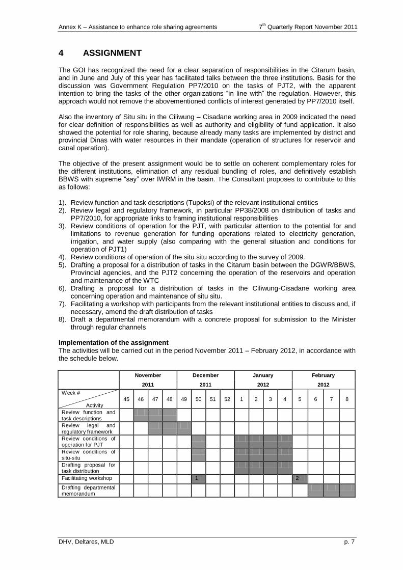
Annex K – Assistance to enhance role sharing agreements 7th Quarterly Report November 2011
DHV, Deltares, MLD p. 7
4 ASSIGNMENT
The GOI has recognized the need for a clear separation of responsibilities in the Citarum basin, and in June and July of this year has facilitated talks between the three institutions. Basis for the discussion was Government Regulation PP7/2010 on the tasks of PJT2, with the apparent intention to bring the tasks of the other organizations “in line with” the regulation. However, this approach would not remove the abovementioned conflicts of interest generated by PP7/2010 itself. Also the inventory of Situ situ in the Ciliwung – Cisadane working area in 2009 indicated the need for clear definition of responsibilities as well as authority and eligibility of fund application. It also showed the potential for role sharing, because already many tasks are implemented by district and provincial Dinas with water resources in their mandate (operation of structures for reservoir and canal operation). The objective of the present assignment would be to settle on coherent complementary roles for the different institutions, elimination of any residual bundling of roles, and definitively establish BBWS with supreme “say” over IWRM in the basin. The Consultant proposes to contribute to this as follows: 1). Review function and task descriptions (Tupoksi) of the relevant institutional entities 2). Review legal and regulatory framework, in particular PP38/2008 on distribution of tasks and
PP7/2010, for appropriate links to framing institutional responsibilities 3). Review conditions of operation for the PJT, with particular attention to the potential for and
limitations to revenue generation for funding operations related to electricity generation, irrigation, and water supply (also comparing with the general situation and conditions for operation of PJT1)
4). Review conditions of operation of the situ situ according to the survey of 2009. 5). Drafting a proposal for a distribution of tasks in the Citarum basin between the DGWR/BBWS,
Provincial agencies, and the PJT2 concerning the operation of the reservoirs and operation and maintenance of the WTC
6). Drafting a proposal for a distribution of tasks in the Ciliwung-Cisadane working area concerning operation and maintenance of situ situ.
7). Facilitating a workshop with participants from the relevant institutional entities to discuss and, if necessary, amend the draft distribution of tasks
8). Draft a departmental memorandum with a concrete proposal for submission to the Minister through regular channels
Implementation of the assignment The activities will be carried out in the period November 2011 – February 2012, in accordance with the schedule below.
November December January February
2011 2011 2012 2012
Week #
Activity
45 46 47 48 49 50 51 52 1 2 3 4 5 6 7 8
Review function and
task descriptions
Review legal and
regulatory framework
Review conditions of operation for PJT
Review conditions of situ-situ
Drafting proposal for task distribution
Facilitating workshop 1 2
Drafting departmental memorandum

Annex K – Assistance to enhance role sharing agreements 7th Quarterly Report November 2011
DHV, Deltares, MLD p. 8
The consultant will mobilize the following specialists: 1. international institutional specialist – 2 person month 2. international legal specialist – 0.5 person month (assist from the Netherlands) 3. national institutional specialist – 4 person months. 4. legal specialist – 2 person months The national specialist will begin his activities in November 2001, by collecting and analyzing basic information on the task descriptions, legal framework, and operating conditions. He will share and discuss his findings with the international specialist, who pay a brief visit to Indonesia and will otherwise spend 5 workdays in the Netherlands during the months of November and December. Together, the two specialists will develop a preliminary draft of the proposed task distribution, which the national specialist will discuss with officials of BBWS, PJT2, and Dinas SDA. In January, the international specialist will come to Indonesia (3 weeks) to further develop the proposal and participate in discussions. A final draft will be presented to a workshop with participants from all relevant stakeholders. Using the outcome of the workshop, the two specialists will prepare a draft text for a departmental memorandum in close collaboration with DGWR, which will ultimately present the memorandum to the Minister through the regular departmental channels.
Annex L Published Report up to October 2011
7th Quarterly Report November 2011
DHV, Deltares, MLD
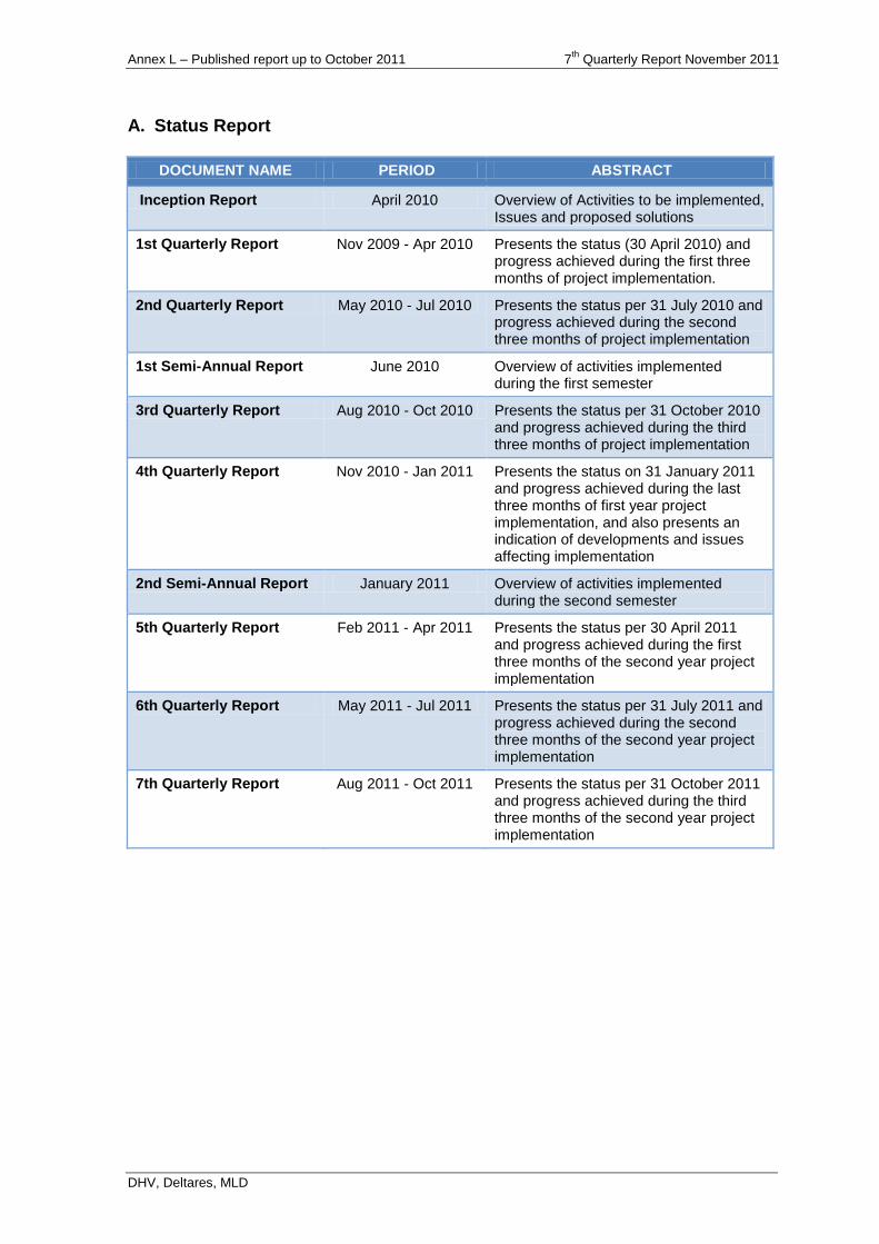
Annex L – Published report up to October 2011 7th
Quarterly Report November 2011
DHV, Deltares, MLD
A. Status Report
DOCUMENT NAME PERIOD ABSTRACT
Inception Report April 2010 Overview of Activities to be implemented, Issues and proposed solutions
1st Quarterly Report Nov 2009 - Apr 2010 Presents the status (30 April 2010) and progress achieved during the first three months of project implementation.
2nd Quarterly Report May 2010 - Jul 2010 Presents the status per 31 July 2010 and progress achieved during the second three months of project implementation
1st Semi-Annual Report June 2010 Overview of activities implemented during the first semester
3rd Quarterly Report Aug 2010 - Oct 2010 Presents the status per 31 October 2010 and progress achieved during the third three months of project implementation
4th Quarterly Report Nov 2010 - Jan 2011 Presents the status on 31 January 2011 and progress achieved during the last three months of first year project implementation, and also presents an indication of developments and issues affecting implementation
2nd Semi-Annual Report January 2011 Overview of activities implemented during the second semester
5th Quarterly Report Feb 2011 - Apr 2011 Presents the status per 30 April 2011 and progress achieved during the first three months of the second year project implementation
6th Quarterly Report May 2011 - Jul 2011 Presents the status per 31 July 2011 and progress achieved during the second three months of the second year project implementation
7th Quarterly Report Aug 2011 - Oct 2011 Presents the status per 31 October 2011 and progress achieved during the third three months of the second year project implementation
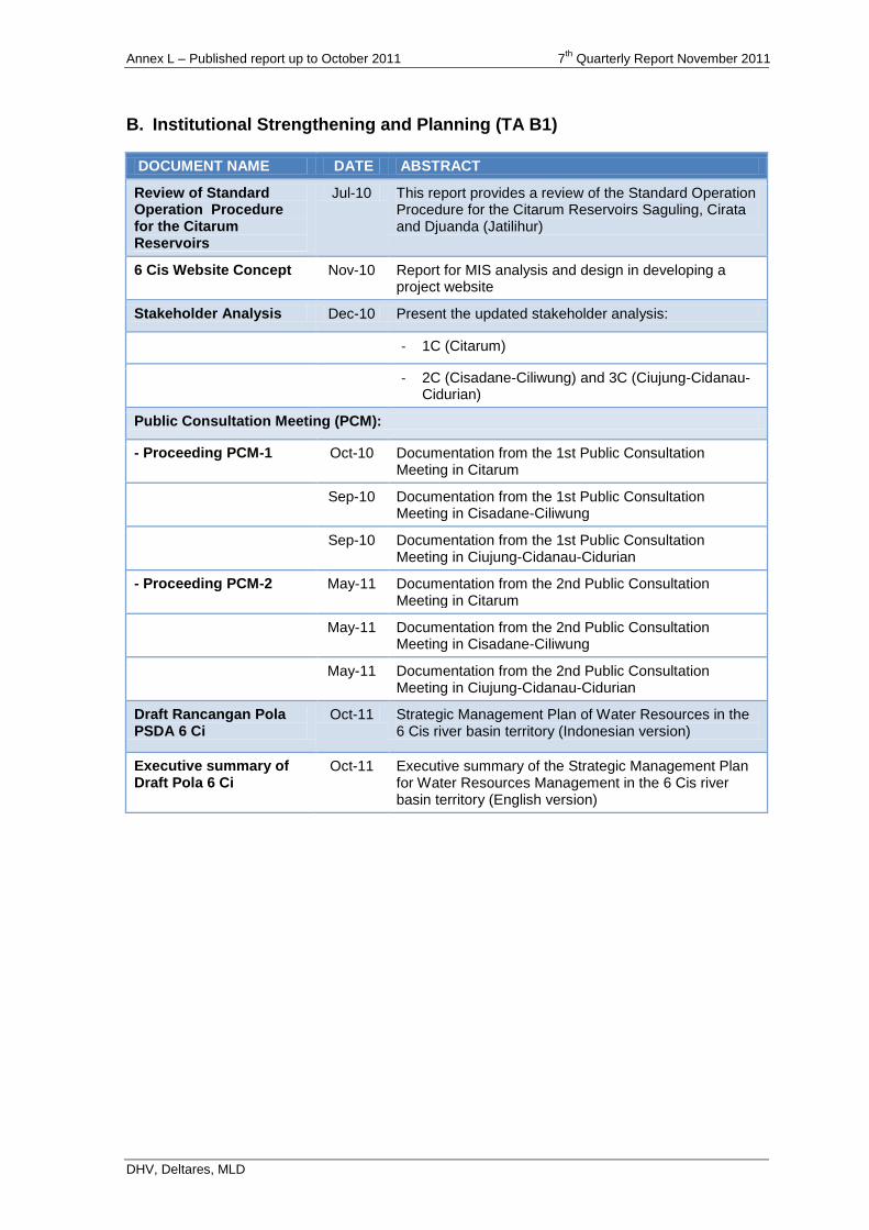
Annex L – Published report up to October 2011 7th
Quarterly Report November 2011
DHV, Deltares, MLD
B. Institutional Strengthening and Planning (TA B1)
DOCUMENT NAME DATE ABSTRACT
Review of Standard Operation Procedure for the Citarum Reservoirs
Jul-10 This report provides a review of the Standard Operation Procedure for the Citarum Reservoirs Saguling, Cirata and Djuanda (Jatilihur)
6 Cis Website Concept Nov-10 Report for MIS analysis and design in developing a project website
Stakeholder Analysis Dec-10 Present the updated stakeholder analysis:
- 1C (Citarum)
- 2C (Cisadane-Ciliwung) and 3C (Ciujung-Cidanau-Cidurian)
Public Consultation Meeting (PCM):
- Proceeding PCM-1 Oct-10 Documentation from the 1st Public Consultation Meeting in Citarum
Sep-10 Documentation from the 1st Public Consultation Meeting in Cisadane-Ciliwung
Sep-10 Documentation from the 1st Public Consultation Meeting in Ciujung-Cidanau-Cidurian
- Proceeding PCM-2 May-11 Documentation from the 2nd Public Consultation Meeting in Citarum
May-11 Documentation from the 2nd Public Consultation Meeting in Cisadane-Ciliwung
May-11 Documentation from the 2nd Public Consultation Meeting in Ciujung-Cidanau-Cidurian
Draft Rancangan Pola PSDA 6 Ci
Oct-11 Strategic Management Plan of Water Resources in the 6 Cis river basin territory (Indonesian version)
Executive summary of Draft Pola 6 Ci
Oct-11 Executive summary of the Strategic Management Plan for Water Resources Management in the 6 Cis river basin territory (English version)
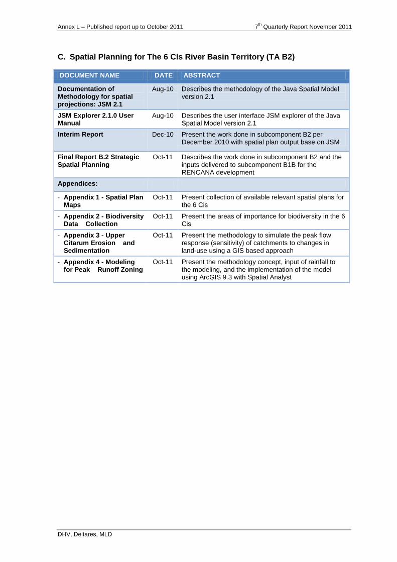
Annex L – Published report up to October 2011 7th
Quarterly Report November 2011
DHV, Deltares, MLD
C. Spatial Planning for The 6 CIs River Basin Territory (TA B2)
DOCUMENT NAME DATE ABSTRACT
Documentation of Methodology for spatial projections: JSM 2.1
Aug-10 Describes the methodology of the Java Spatial Model version 2.1
JSM Explorer 2.1.0 User Manual
Aug-10 Describes the user interface JSM explorer of the Java Spatial Model version 2.1
Interim Report Dec-10 Present the work done in subcomponent B2 per December 2010 with spatial plan output base on JSM
Final Report B.2 Strategic Spatial Planning
Oct-11 Describes the work done in subcomponent B2 and the inputs delivered to subcomponent B1B for the RENCANA development
Appendices:
- Appendix 1 - Spatial Plan Maps
Oct-11 Present collection of available relevant spatial plans for the 6 Cis
- Appendix 2 - Biodiversity Data Collection
Oct-11 Present the areas of importance for biodiversity in the 6 Cis
- Appendix 3 - Upper Citarum Erosion and Sedimentation
Oct-11 Present the methodology to simulate the peak flow response (sensitivity) of catchments to changes in land-use using a GIS based approach
- Appendix 4 - Modeling for Peak Runoff Zoning
Oct-11 Present the methodology concept, input of rainfall to the modeling, and the implementation of the model using ArcGIS 9.3 with Spatial Analyst
Annex L – Published report up to October 2011 7th
Quarterly Report November 2011
DHV, Deltares, MLD
D. Development of Key Policies and Strategies for Water Resources
Management in CRB (TA B3)
DOCUMENT NAME DATE ABSTRACT
Background Report No. 1 Review of Legal Framework for Groundwater Management Bandung and Water Allocation for Jatiluhur
May-10 Review legislation related to groundwater management in Bandung, surface water allocation Jatiluhur irrigation. Focus on UU 7/2004 and PP 43/2008, licensing, registration, water pricing, and entitlements.
Background Report No. 2 International Best Practise in Water Allocation
Jun-10 Presents the status (30 April 2010) and progress achieved during the first three months of project implementation.
Background Report No. 3 Water Allocation Practices and Water Balance Jatiluhur
Oct-10 An analysis of the water allocation and distribution in the Jatiluhur irrigation, and a review of a water balance study from the Jatiluhur Irrigation Management Improvement Project Report, March 2010.
Background Report No. 4 Groundwater Issues in the Bandung Plain
Aug-10 Assessment groundwater situation in the Bandung-Soreang groundwater basin (issues, data, on-going activities.
Background Report No. 5 Groundwater Management in the Bandung Basin
Sep-10 Outlines the situation and key issues on groundwater management, the responsible agencies for management, finances and taxation, institutional issues, groundwater management plan, management capacity.
Background Report No. 6 ESDM Workshop on Groundwater Management
Nov-10 Documentation from the ESDM Workshop in the Bandung-Soreang Basin that were discussing all possible steps to limit groundwater use, and conclude on what action could be taken in the near future.
Background Report No. 7 Gender Equity and Opportunities in Irrigation
Jan-11 Outlines to identify the opportunity to support gender equity requirements in planning, implementation, monitoring and evaluation related to water provisions, divisions, utilizations, and allocation of water for irrigation.
Background Report No. 8 Provincial Groundwater Regulations for the Bandung Area
Dec-10 This second report No. 1 outlines and comments the regulations on ground water management of the West Java Province with the goal to examine if the provincial legal framework is suitable for the implementation of new policy views on sustainable groundwater management in the Bandung area.
Background Report No. 9 Groundwater Planning in Upper Citarum
Dec-10 The report is the deteriorating groundwater situation in the Bandung Plain in the Upper Citarum basin.
Background Report No. 10 BBWSC Workshop on Strategies Water Allocation
Feb-10 Documentation from BBWSC the workshop to discuss all possible steps to improve surface water allocation in the Jatiluhur System, and conclude on what action could be taken in the near future.
Draft Main Report No. 11 Strategic and Practice in Groundwater Management for the Bandung – Soreang Ground water basin
Jun-11 This report is about policies and strategies for improved groundwater management in the Bandung-Soreang Basin. Nine challenges are addressed.
Draft Main Report No. 12 Strategies and Practices in Surface Water Allocation and Distribution in the Lower Citarum River Basin
Jun-11 This report is about policies and strategies for improved management in the Citarum Basin, especially through better allocation of surface water resources.