
6.4 Land Use Plan for GKS 2030
78
The JICA Study on Formulation of Spatial Planning for GERBANGKERTOSUSILA Zone Final Report (Main Text) 6-29 6.4 Land Use Plan for GKS 2030 6.4.1 Methodology A long-term land use plan was formulated for the GKS Zone for 2030 based on an evaluation of development potentials and constraints in the GKS (section 6.1), development suitability (section 6.2), and urbanization and land demand (section 6.3), 1) Proposed Land Use Zoning Categories Indonesia’s National Survey and Mapping Coordination Agency (BAKOSURTANAL) prepared a detailed land use map using a color-coding system for spatial planning. However, such detailed breakdown of land use categories is not relevant to the spatial plan prepared in this JICA study for two reasons, namely: (1) the mapping scale of the latter, i.e., GKS spatial plan, is 1:250,000, and (2) the GKS spatial plan aims to provides general guidelines at the macro level only and should be useful when spatial plans are prepared at the regency level. Therefore, the JICA Study Team proposed 10 categories of land uses, as shown in Table 6.4.1 . BAKOSURTANAL’s land use categories that fall under each of these 10 land uses are attached to this table. 2) Basic Directions in Land Use Planning A number of directions have been considered in preparing the land use plan for the GKS Zone. The following seven are the major considerations: • Legally Protected Forests should be strictly protected and laws enforced; • Environmentally Sensitive Areas (ESAs) should be identified and managed under a special policy; • Conservation Areas, including swampy, flood-prone, coastal areas and salt farms, as well as the Lapindo mud flow areas, should be controlled against urban development; • Conversion of Irrigated Areas to urban uses should be minimized despite strong urbanization pressure; • Agricultural Land, especially in Bangkalan and Mojokerto, should be utilized for more diversified and versatile activities, including animal husbandry especially dairy farming; • Urbanization with Green Networks should be pursued in urban areas; and • Water-saving and Pollution-free Industries should be promoted to locate in high-development potential areas and disallowed in ESAs.
-
Upload
khangminh22 -
Category
Documents
-
view
0 -
download
0
Transcript of 6.4 Land Use Plan for GKS 2030

The JICA Study on Formulation of Spatial Planning for GERBANGKERTOSUSILA Zone
Final Report (Main Text)
6-29
6.4 Land Use Plan for GKS 2030
6.4.1 Methodology
A long-term land use plan was formulated for the GKS Zone for 2030 based on an evaluation
of development potentials and constraints in the GKS (section 6.1), development suitability
(section 6.2), and urbanization and land demand (section 6.3),
1) Proposed Land Use Zoning Categories
Indonesia’s National Survey and Mapping Coordination Agency (BAKOSURTANAL)
prepared a detailed land use map using a color-coding system for spatial planning.
However, such detailed breakdown of land use categories is not relevant to the spatial plan
prepared in this JICA study for two reasons, namely: (1) the mapping scale of the latter, i.e.,
GKS spatial plan, is 1:250,000, and (2) the GKS spatial plan aims to provides general
guidelines at the macro level only and should be useful when spatial plans are prepared at the
regency level. Therefore, the JICA Study Team proposed 10 categories of land uses, as shown
in Table 6.4.1 .
BAKOSURTANAL’s land use categories that fall under each of these 10 land uses are
attached to this table.
2) Basic Directions in Land Use Planning
A number of directions have been considered in preparing the land use plan for the GKS
Zone. The following seven are the major considerations:
• Legally Protected Forests should be strictly protected and laws enforced;
• Environmentally Sensitive Areas (ESAs) should be identified and managed under
a special policy;
• Conservation Areas, including swampy, flood-prone, coastal areas and salt farms,
as well as the Lapindo mud flow areas, should be controlled against urban
development;
• Conversion of Irrigated Areas to urban uses should be minimized despite strong
urbanization pressure;
• Agricultural Land, especially in Bangkalan and Mojokerto, should be utilized for
more diversified and versatile activities, including animal husbandry especially
dairy farming;
• Urbanization with Green Networks should be pursued in urban areas; and
• Water-saving and Pollution-free Industries should be promoted to locate in
high-development potential areas and disallowed in ESAs.

The JICA Study on Formulation of Spatial Planning for GERBANGKERTOSUSILA Zone
Final Report (Main Text)
6-30
Table 6.4.1 Land Use Categories for the Proposed GKS Spatial Plan 2030
Land Use Category Objective/Attribute Note
1 Protection
Zone
� To legally protect natural resources and
critical ecosystems from disorderly
development and illegal land
conversion.
� To mitigate disasters, keeping the
existing natural conditions and pattern
protected
Refer to the
environmentally
sensitive area
(ESA) map
2 Conservation
Zone
� To conserve natural resources and
ecological assets through institutional
measures on development control and
land use management, taking account
of environmental considerations.
Including mud
flow area and
salt farms
3 Forest Zone � To manage forest areas with the legal
framework of three (3) categorized
forests: protection forest, conservation
forest, and production forest.
Should comply
with laws and
regulations
4 Irrigated
Agricultural
Zone
� To promote agricultural activities with a
well-managed water use system
5 Non-irrigated
Agricultural
Zone
� To encourage more diversified
agricultural activities, including animal
husbandry and agro-processing.
� Fishpond and salt-farming pond
6 Buffer Zone � To reserve open space and
environmental resources to serve as
green networks for a more livable
metropolis.
Including areas
reserved for
urbanization
beyond 2030.
7 Human
Settlement &
Urban
Development
Zone
� To facilitate the development of areas
for housing and urban services under
three types based on population
density: high density, medium density,
and low density.
� To develop rural villages as human
settlement areas.
Including all
public services
such as parks,
schools, health
and
government
facilities.
8 Industrial Zone � To encourage and facilitate industrial
development in the form of industrial
estates/parks or special industrial
zones.
Sewerage and
drainage
systems to be
provided.
9 Mining Zone � To promote proper environmental
management for gas and oil
exploitation as well as mineral mining
and quarrying.
No specific
areas exist in
the GKS Zone.
10 Special Zone � Including military use and cemeteries.
Source: JICA Study Team
CATEGORY SUB CATEGORY
PROTECTION ZONE A.1 Great Forest Park A.2 Cultural Preservation and Science Preservation
A.3 Spiritual Protected Areas and Local Wisdom
A.4 Coastal Boundary A.5 River Bank A.6 Area Around the Lake or Reservoir
A.7 Water Catchment Area, and Water Spring Area
A.8 Landslide Zone CONSERVATION ZONE B.1 Mangrove Coastal Zone
B.2 Flood Zone B.3 Mud Disaster Zone B.4 Flood Prone Zone; Water Reservoir
Forest Fire and Typhoon Prone Zone
B.5 Coastal Abrasion Prone Zone
B.6 Salt-farming
FOREST ZONE C.1 Protection Forest C.2 Production Forest Zone
C.3 Conservation Forest Zone
AGRICULTURAL (Irrigated) ZONE
D.1 Irrigated Land
AGRICULTURAL (Non-irrigated) ZONE
E.1 Non-irrigated land E.2 Plantation Land Zone
E.3 Animal Husbandry Zone
E.4 Fishery Zone BUFFER ZONE D.1 City Forest D.2 Green Open Area URBAN DEVELOPMENT AREA E.1 High Density Urban Settlement
E.2 Medium Density Urban Settlement;
E.3 Low density Rural Settlement
E.4 Tourism Zone E.5 Mainstay Zone E.6 New Town and Waterfront City
E.7 City Park INDUSTRIAL ZONE F.1 Industrial Zone MINING ZONE G.1 Karst Mining G.2 Gas, Oil and Mineral Mining Zone
SPECIAL ZONE H.1 Defense and Security Zone
A.
B.
C.
D.
E.
D.
E.
H.
F.
G.

The JICA Study on Formulation of Spatial Planning for GERBANGKERTOSUSILA Zone
Final Report (Main Text)
6-31
6.4.2 Proposed GKS Land Use Plan 2030
1) Overall Land Use and Spatial Patterns for 2030
A long-term land use plan for the GKS Zone targeting 2030 was prepared by the JICA Study
Team, as shown in table 6.4.1.
The areas covered by these land uses by 2030 are tabulated in Table 6.4.2. From this table,
the followings points have been noted:
• Protection Zone, Conservation Zone and Forest Zone will share 10.1%, 2.4%, and
10.3% respectively, of the total land area. Thus, about 22.8% of the entire GKS
Zone will become protected;
• Irrigated Agricultural Zone will account for 20%, and Non-irrigated Agricultural
Zone, 30.5%. This means that agricultural land will cover half (50.5%) of the GKS
Zone, making agriculture the most significant land use;
• Human Settlement & Urban Development Zone will account for 74,944 ha, sharing
11.8% of the GKS total, while the land for rural villages will account for 58,540 ha,
or 9.2%. Hence, a total of 21% of the land will be used for human settlements and
urban activities.
• Industrial Zone will have a total 13,328 ha by 2030, or a 2.1% share of the entire
GKS Zone.
In general, it was assessed that the proposed land use plan strikes a balance in terms of
environmental conservation and urban development.
Table 6.4.2 GKS Land Use Zones by 2030
Land Use Category Area (ha) Share (%)
1 Protection Zone 63,948 10.1
2 Conservation Zone 15,472 2.4
Forest Zone 65,132 10.3
Protection Forest (1,292.0) (0.2)
Conservation Forest (11,108.0) (1.7)
3
Production Forest (52,732.0) (8.3)
4 Agricultural (Irrigated) Zone 126,880 20.0
5 Agricultural (Non-irrigated) Zone 193,448 30.5
6 Buffer Zone 21,660 3.4
Human Settlement & Urban Development Zone
74,944 11.8
High Density (11,068.0) (1.7)
Middle Density (38,936.0) (6.1)
Low Density (24,940.0) (3.9)
7
Rural Villages 58,540 9.2
8 Industrial Zone 13,328 2.1
9 Mining Zone 0 0.0
10 Special Zone 1,548 0.2
Total 634,900 100.0
Source: JICA Study Team

The JICA Study on Formulation of Spatial Planning for GERBANGKERTOSUSILA Zone
Final Report (Main Text)
6-32
2) Changes in Land Use Patterns between 2009 and 2030
An analysis of land conversion from the existing conditions in 2009 to the target year 2030
was made, and a matrix of land use changes was prepared, as shown in Table 6.4.4. This
matrix indicates what uses an existing land can shift to by 2030.
From this analysis, changes in the existing irrigated agricultural areas have been noted, as
shown in Table 6.4.3. As mentioned earlier, one of the most important land use planning
strategies is minimizing the decrease in areas for irrigated agricultural lands due to
urbanization pressures. As mentioned earlier, the Law No.41/2009 places restriction on land
use conversion of the agricultural land to residential and industrial uses.
As seen in the table, the existing irrigated land accounts for 168,104 ha in total, out of which
126,536 ha (75.3%) should remain as irrigated lands and 14,680 ha (8.7%) could be
converted to environment-oriented land, such as protection and conservation areas. While
12,768 ha (7.6%) could be converted to urban development areas, 2,520 ha (1.5%) could be
shifted to industrial uses. More or less 9% of the existing irrigated land could be converted
to urban and industrial land. Such changes are considered reasonable and relevant, taking
into account the strong urbanization pressure which is anticipated in the coming decades.
Table 6.4.3 Changes in Irrigated Agricultural Land Areas from 2009 to 2030
Existing 2009
Land Use Category Irrigated Agricultural
Area 2009 (ha)
Composition
(%)
Protected area 10,144
Conservation area 736
Production forest 3,800
14,680 8.7%
Agriculture (Irrigated) 126,536 75.3%
Agriculture area 2,376 1.4%
Buffer 9,224 5.5%
Urban Dev’t Area (High Density) 464
Urban Dev’t Area (Middle Density) 5,080
Urban Dev’t Area (Low Density) 7,224
12,768 7.6%
Land Uses
by
2030
Industrial area 2,520 1.5%
Total 168,104 100.0%
Source: JICA Study Team
3) Forest Areas in 2009 and 2030
The forest areas as of 2009 covers 19, 736 ha in total over the GKS, which shares only 3.1%
of the entire territory of the GKS Zone (634,900 ha). Whilst, in the land use plan in 2030, the
forest areas will account for a total of 65,132 ha, out of which 1,292 ha is for protection
forest; 52,732 ha for production forest and 11,108 ha for conservation forest. The total
forest area shares 10.3% in the GKS Zone. The increase of forest areas will be realized by
proactive reforestation and conservation actions that are expected to be initiated by
authorities concerned.

The JICA Study on Formulation of Spatial Planning for GERBANGKERTOSUSILA Zone
Final Report (Main Text)
6-33
The coverage ratio with forest in 2030, however, does not reach 30% of the entire GKS Zone,
although the ratio of 30% is guided by the Law No.41/1999, as mentioned earlier. It is noted that the
GKS Zone does not cover the entire river basins of the major watershed. Given the expanding GKS
zone including the whole watersheds, the designated forest ratio of 30% may be complied. However,
the most important issue is to facilitate a reforestation and forest-restoration program, having the
existing forest resource conserved.

Th
e JI
CA
S
tud
y o
n
Fo
rmu
lati
on
o
f S
pat
ial
Pla
nn
ing
fo
r G
ER
BA
NG
KE
RT
OS
US
ILA
Z
on
e
Fin
al
Rep
ort
(Mai
n T
ext)
6-3
4
Fig
ure
6.4
.1 L
an
d U
se P
lan
203
0 f
or
GK
S Z
on
e

Th
e JI
CA
S
tud
y o
n
Fo
rmu
lati
on
o
f S
pat
ial
Pla
nn
ing
fo
r G
ER
BA
NG
KE
RT
OS
US
ILA
Z
on
e
Fin
al
Rep
ort
(Mai
n T
ext)
6-3
5
Ta
ble
6.4
.4 C
ha
ng
es
in
Lan
d U
se
Are
as
in
GK
S Z
on
e f
rom
20
09
to
20
30
(Uni
t: ha
) E
xist
ing
Land
Use
(20
09)
Land
Use
A
gric
ultu
reA
gric
ultu
re
(non
-irrig
ated
)
Agr
icul
ture
(ir
rigat
ed)
Cem
eter
yC
omm
erci
alD
umpi
ng
Site
F
ishp
ond
For
est/
Gra
ssla
nd/
Shr
ub
Hou
sing
/
Set
tlem
ent
Indu
stry
Man
grov
e M
ilita
ryO
pen
Spa
ce
Por
ong
Mud
Dis
aste
r
Pub
lic
Inst
itutio
n
Rec
reat
ion
/ Spo
rts
Sea
san
d/
San
d S
wam
pT
rans
port
ati
on
Vac
ant
Land
Wat
er
body
Pro
tect
ed a
rea
8,04
4 35
,700
9,
964
0 20
0
168
8,28
8 73
2 56
0
0 0
0 0
0 88
61
6 0
8 26
4
Con
serv
atio
n ar
ea
88
312
696
0 8
0 10
,800
38
4 28
8
1,62
4 0
0 58
0 0
0 8
732
0 0
204
Agr
icul
ture
are
a (ir
rigat
ed)
0 4
126,
860
0 0
0 0
0 16
0
0 0
0 0
0 0
0 0
0 0
0
Buf
fer
area
1,
912
3,68
4 9,
092
0 72
32
81
2 4,
892
340
260
12
0 80
0
48
8 12
60
13
6 20
25
6
Agr
icul
ture
are
a22
,924
11
7,60
8 16
24
13
2 4
36,2
64
6,07
2 3,
788
380
996
0 76
20
8
36
72
1,12
8 17
2 44
3,
684
Indu
stria
l are
a 68
3,
160
2,71
6 0
100
0 2,
364
444
1,32
4 2,
780
140
0 0
0 24
0
0 23
2 0
132
264
Spe
cial
zone
(m
ilita
ry)
0 0
0 0
0 0
0 34
0 28
0
0 1,
184
0 0
0 0
0 0
0 0
0
Kam
pung
0
12
28
0 12
0
120
0 58
,240
12
0
0 0
0 0
0 0
0 0
0 11
6
Pro
tect
ed fo
rest
60
64
0 0
0 0
0 1,
168
0 0
0 0
0 0
0 0
0 0
0 0
0
Pro
duct
ion
fore
st18
,040
19
,044
3,
720
0 0
0 42
8 11
,052
18
4 4
0 0
0 0
0 0
0 14
0 0
4 11
6
Con
serv
atio
n fo
rest
1,
860
172
0 0
0 0
0 9,
076
0 0
0 0
0 0
0 0
0 0
0 0
0
Urb
an
deve
lopm
ent
area
(H
igh)
80
96
38
4 0
912
0 36
41
2 6,
996
768
0 0
372
0 40
0 56
0
4 52
34
4 15
2
Urb
an
deve
lopm
ent
area
(M
id)
1,74
0 4,
768
4,79
2 0
1,08
0 0
324
1,41
2 15
,728
2,
980
4 0
1,79
2 0
700
104
8 68
21
6 2,
288
476
Land Use Plan (2030)
Urb
an
deve
lopm
ent
area
(Lo
w)
1,28
4 5,
540
7,05
2 0
156
40
776
540
7,45
6 80
0 0
0 36
8 0
32
48
8 88
17
6 11
6 42
8
Sou
rce:
JI
CA
Stu
dy T
eam

The JICA Study on Formulation of Spatial Planning for GERBANGKERTOSUSILA Zone
Final Report (Main Text)
6-36
6.5 Comprehensive Spatial Plan for GKS Zone
6.5.1 Strategic Development Zones for Equitable Economic Growth
1) Definition and Projects in the Strategic Development Zones
The Spatial Planning Law articulates that strategic development zones should be identified to
realize visions and missions envisioned in the beginning of the spatial planning process.
Based on such a direction, strategic development zones (SDZs) and their respective major
projects were defined, as follows:
• Anchor projects to realize the identified development visions;
• Key projects to boost the regional economy of the GKS and East Java;
• Large/medium-scale projects which require massive public and/or private
investments; and
• Priority projects for immediate commencement and supported by special policies.
Thus, the major projects in the SDZ are assumed to include the following:
• Industrial estates/zones;
• Transportation nodes and traffic generators such as ports, airports, railway stations,
bus terminals, cargo distribution terminals, and so on;
• Commercial and business centers;
• Tourism destinations to attract both international and domestic tourists;
• New towns, urban sub-centers, and/or new settlement centers;
• Major utility infrastructure such as reservoirs, water intakes, sewerage and drainage
systems;
• Facilities for solid waste management (final disposal sites, intermediate transfer
facilities, recycling centers, composting plants, etc.); and
• Other facilities and services indispensable to the achievement of the visions.
2) Assessment of Proposed Strategic Projects
Each kabupaten and kota spatial plan proposed a number of strategic projects with medium
and large scales. These major projects are tabulated in Table 6.5.1. They were reviewed
and prioritized by the JICA Study Team using the evaluation process shown in Figure 6.5.2.
The criteria were (1) relevance to vision and objectives of GKS development as a whole; (2)
expected impacts, effectiveness, and implicit feasibility; and (3) urgency of implementation.
All regencies expect to develop massive industrial estates. However, the incremental
demand for industrial land area is computed at about 8,680 ha until 2030. Thus,
prioritization is important in order to avoid overinvestment and overdevelopment of land.
Once agricultural lands are converted to industrial areas they will never revert to agricultural
lands again, because the process is not reversible.

The JICA Study on Formulation of Spatial Planning for GERBANGKERTOSUSILA Zone
Final Report (Main Text)
6-37
Review of the Needs
DecisionVision and
Objectives
Demand Projection
Evaluation
Impacts,
Effectiveness; Feasibilities
Urgent
Necessity
Priority Projects
Moreover, projects planned in the
“Protection Zone” were either
omitted, partially cut, or relocated
due to crucial environmental
considerations.
3) Proposed Strategic Development Zones in the GKS toward 2030
After reviewing and prioritizing the
strategic projects proposed by the
kota/kabupaten spatial plans, the
locations of these priority projects
were recognized as SDZs for the
target year 2030. In addition to
these projects, a number of other
strategic projects in the
transportation and infrastructure
sectors were included in the GKS
spatial plan. Their locations were
also regarded as SDZs.
Figure 6.5.1 Prioritization Procedure of Strategic Zones/Projects Proposed by Kota/Kabupaten
Figure 6.5.4 shows the proposed GKS strategic development zones to be developed up to
2030, which include:
• Central Commercial and Business Development Zone, where intensive urban
redevelopment be promoted to encourage pivotal commercial and business
functions as the second largest city in the Nation.
• Green Development Zone, whose environmental resources be conserved and/or
newly created for people’s recreation and tourism activities.
• Public Facilities Development Zone; where a large-scale and high-functional
public service facilities such as goods distribution and transportation, higher
educational institutes, hospitals, tourism facilities and intermodal centers, etc.
• Industrial Development Zone; where sizable industrial estates/parks, industrial
incubation facilities and/or R&D technology centers be strategically constructed
under Government Regulation No.24/2009 (Industrial Zone).
• Military Zone; where includes the designated areas for national security and
defense (further discussion in the following section)
• Other Strategic Project Locations; where a number of infrastructure development
projects are strategically proposed to achieve the development goals and visions for
GKS.

The JICA Study on Formulation of Spatial Planning for GERBANGKERTOSUSILA Zone
Final Report (Main Text)
6-38
4) Special Zones for Security and Defense
Special zones for security and defense are categorized as one of strategic zone in the GKS
spatial plan. Significant zones are located in the northern coast in Surabaya and the southern
coast in Kabupaten Bangkalan, and these are designated as military zone.
As mandated by the Act No. 3/2002 on National Defense, one of the basic principles of
preparation of the defense is to take into account the geography of Indonesia as an
archipelago.
The archipelago is formed with very diverse society, and rich natural resources. These are all
factors which greatly affect the dynamics of the unitary Republic of Indonesia. Among the
important aspects that influenced the geography of Indonesia, three key views are recognized
to explain the geo-strategy of the national defense policy, namely, views of geo-political,
geo-economic and geo-socio-cultural.
To face threats of economic dimension, the national defense effort to be taken is to build
resilience in the economy through healthy and sustainable growth. Economic development
with a sound economic growth is vital to realize economic stability, and to uplift people’s
welfare, thereby being a winner in the globalization era. To deal with the economic
dimension of the internal threat, policy priorities can be a labor-intensive employment
creation as a solution to eradicate poverty, infrastructure development, creation of a
conductive business climate, and the selection of appropriate technology as a solution to
equal opportunity employment.
Threats of socio-cultural dimension can be explained by the inner threat and outer threat.
The inner threat is driven by issues of poverty, ignorance, backwardness, and inequality.
These issues became a starting point of all social problems, such as separatism, terrorism,
and violence inherent entrenched, as a result of human-made disasters. On the other hand,
threats from outside are related to the penetration of overseas cultural values, which affects
social values of the regional to local level. This is difficult to be avoided under the era of
information technology leading to the world into a global village.
As far as these considerations are often envisaged for policy issues on national and regional
security and defense, the military land must be an practical strategic space to secure
development for peoples’ safe and sustainable livelihood.

Th
e JI
CA
S
tud
y o
n
Fo
rmu
lati
on
o
f S
pat
ial
Pla
nn
ing
fo
r G
ER
BA
NG
KE
RT
OS
US
ILA
Z
on
e
Fin
al
Rep
ort
(Mai
n T
ext)
6-3
9
Ta
ble
6.5
.1 P
rop
os
ed
Str
ate
gic
De
ve
lop
me
nt
Pro
jects
by A
rea
an
d T
he
ir P
rio
riti
za
tio
n
Ko
ta/K
abR
ef.
# 1)
PR
OJE
CT
NA
ME
PR
OJE
CT
SE
CT
OR
LO
CA
TIO
NA
RE
A (
Ha)
ST
AT
US
SC
AL
EP
RIO
RIT
Y 2)
1U
jun
g P
angk
ah
Indu
stry
Ind
ust
ryU
jun
g P
ang
kah
4,9
84
.38
Pla
nne
d u
p to
20
28
La
rge
H
3M
an
yar I
nd
ustry
Ind
ust
ryM
anya
r1
,48
9.0
0P
lan
ned
up
to 2
02
8L
arg
eM
/L
2S
ida
yu In
du
stry
Ind
ust
ryS
ida
yu1
,00
0.0
0P
lan
ned
up
to 2
02
8L
arg
eM
/L
15
ER
P (E
nvir
onm
en
t Re
cycl
ing
Pa
rk)
So
lid W
ast
eK
eda
mea
n1
20.0
0F
easi
bili
ty S
tud
y 2
010
Me
diu
mH
4H
ou
sin
g &
Se
ttle
men
tH
um
an
Set
tlem
ent
Driy
ore
jo, K
eda
me
an,
Me
nga
nti,
Ce
rme
4,0
00
of t
ota
l
29
,20
7.0
0
Pla
nne
d u
p to
20
28
La
rge
M/L
25
Sem
baya
t Ba
rrag
e (w
ate
r re
serv
oir)
Na
tura
l Res
our
ceB
ung
ah64
.00
Sta
rt 20
11M
ed
ium
H
16
TO
L ro
ad L
egun
di-M
anya
rT
ran
spor
tatio
n1
72.5
0M
ed
ium
M/L
12
Sur
am
adu
Bri
dge
Fo
otT
ouri
sm, S
erv
ice
Lab
ang
600
.00
Sta
rt 20
11M
ed
ium
H
5T
an
jun
g B
ulu
pan
dan
Po
rt H
ubT
ran
spor
tatio
nK
lam
pis
1,0
00
.00
May
be
sta
rt in
20
12
La
rge
H
13
Ble
ga
Res
erv
oir
Na
tura
l Res
our
ceG
alis
966
.30
Wat
er s
upp
ly C
apa
city
: 0.3
9 m
3/s
ec;
Cat
chm
ent A
rea:
122
Km
2.
Me
diu
mH
14
MIS
I Po
rtT
ran
spor
tatio
nS
ocah
?P
lan
ned
up
to 2
02
8M
ed
ium
M
6N
go
ro In
du
stri
al P
ark
Ind
ust
ryN
go
ro4
40.0
0O
pera
te s
ince
Me
diu
mH
6M
ojo
an
yar I
ndus
trial
Est
ate
Ind
ust
ryM
oja
nya
rP
lan
ned
up
to 2
02
8M
6Je
tis In
dus
tria
l Est
ate
Ind
ust
ryJe
tisP
lan
ned
up
to 2
02
8M
7H
ou
sin
g &
Se
ttle
men
tH
um
an
Set
tlem
ent
So
oko
, Ge
dek,
Moj
osa
ri,
Pa
cet
18,
807
of t
ota
l
31,
058
.1
Pla
nne
d u
p to
20
28
La
rge
M/L
17
TO
L ro
ad S
UM
O
Tra
nsp
orta
tion
War
u-D
riyo
rejo
-Kri
an-
Mo
joke
rto
311
.20
Sta
rt in
200
9M
ed
ium
M
21
Re
gio
nal
Mai
n M
ark
et f
or A
gro
bus
sin
ess
(PIA
)In
du
stry
Jem
und
o50
.00
Con
stru
ctio
n st
arte
d in
20
10M
ed
ium
H
20
JUAN
DA
Airp
ort
II (E
xpa
nsi
on)
Tra
nsp
orta
tion
Sed
ati
10.0
0P
lan
to b
e d
eve
lop
ed in
201
2M
ed
ium
H
8S
ibo
rian
Indu
stria
l Est
ate
&Z
one
Ind
ust
ryS
ido
arjo
-Ja
bon
-Kri
an2
,45
0.0
0P
lan
to b
e d
eve
lop
edL
arg
eL
9N
ew
To
wn
De
velo
pmen
tH
um
an
Set
tlem
ent
Su
kod
ono
1,7
16
.80
Pla
n to
be
dev
elo
ped
La
rge
M
18
Wa
terfr
ont
City
Hu
ma
n S
ettle
me
ntS
edat
iN
/AP
lan
to b
e d
eve
lop
edM
ed
ium
M/L
22
Ta
rik
Riv
ers
ide
City
Hu
ma
n S
ettle
me
ntT
ari
kN
/ AP
lan
to b
e d
eve
lop
edM
ed
ium
M
19
Ge
mo
pol
is (G
em In
dus
try)
Ind
ust
ryS
edat
i3
00.0
0P
lan
to b
e d
eve
lop
edM
ed
ium
M
26
Lam
ong
an In
tegr
ate
d S
hor
e-b
ase
Ind
ust
ryP
acir
an1
00.0
0O
pera
ting
in 2
010
Me
diu
mH
25
Sem
baya
t Ba
rrag
e (w
ate
r re
serv
oir)
Na
tura
l Res
our
ceLa
ren
10.0
0S
tart
2011
(a p
art o
f Gre
sik
loca
tion
)M
ed
ium
H
27
TO
L ro
ad G
resi
k-La
mo
nga
n-T
uba
nT
ran
spor
tatio
n3
75.0
0P
lan
ned
up
to 2
02
8M
/L
Air P
ort A
ltern
ativ
e fo
r Ju
and
a e
xte
nsi
on
Tra
nsp
orta
tion
Dis
cou
rse
Me
diu
mL
KO
TA
MO
JO
KE
RT
O-
--
--
12
Sur
am
adu
Bri
dge
Fo
otC
om
mer
cial
Tam
bak
Wed
i6
00.0
0S
tart
2011
Me
diu
mH
11
Lam
ong
Ba
y P
ort f
or C
on
tain
erT
ran
spor
tatio
nL
amon
g B
ay55
.50
Sta
rt 20
11M
ed
ium
M
12
Wa
terfr
ont
Re
sid
ent
ial S
ettl
em
ent
Hu
ma
n S
ettle
me
ntLa
mo
ng
Bay
, Su
ram
adu
Brid
ge F
oot,
Eas
t Coa
st
400
.00
Pla
nne
d u
p to
20
28
Me
diu
mM
/L
23
TO
L ro
adT
ran
spor
tatio
nE
ast
ern
Rin
g R
oa
d3
20.5
0P
lan
ned
up
to 2
02
8M
ed
ium
H
10
Sur
am
adu
Bri
dge
Tra
nsp
orta
tion
Tam
bak
Wed
i5
.40
Km
Fin
ish
and
Op
era
te s
ince
20
09L
arg
eC
om
ple
ted
LA
MO
NG
AN
KO
TA
SU
RA
BA
YA
1,5
55
.00
GR
ES
IK
BA
NG
KA
LA
N
MO
JO
KE
RT
O
La
rge
SID
OA
RJ
O
So
urc
e:
K
abupate
n a
nd k
ota
spatial pla
ns.
No
tes:
1)
Refe
rs t
o the n
um
bers
indic
ate
d in
Fig
ure
6.5
.2.
2)
Prioritization d
one b
y t
he J
ICA
Stu
dy T
ea
m:
H=
Hig
h,
M=
Me
diu
m,
an
d L
=Lo
w.

Th
e JI
CA
S
tud
y o
n
Fo
rmu
lati
on
o
f S
pat
ial
Pla
nn
ing
fo
r G
ER
BA
NG
KE
RT
OS
US
ILA
Z
on
e
Fin
al
Rep
ort
(Mai
n T
ext)
6-4
0
1
2
3
4
5
6
67
77
6
10
8
8
89
11
12
12
18
19
20
14
1516
17
13
21
22
24
23
26
25
27
Loca
tio
n o
f La
rge
an
d M
ed
ium
Pro
ject
s b
y K
ab
up
ate
n/K
ota
RT
RW
:
LAR
GE
PR
OJE
CT
:
1.
Uju
ng
Pa
ng
ka
hIn
du
stri
al
Est
ate
2.
Sid
ay
uIn
du
stri
al
Est
ate
3.
Ma
ny
ar
Ind
ust
ria
l E
sta
te
4.
Ho
usi
ng
&S
ett
lem
en
tin
Dri
yo
rejo
,
Ke
da
me
an
,
Me
ng
an
ti, C
erm
e
5.
Tg
. Bu
lup
an
da
nIn
tern
ati
on
al
Po
rt H
ub
6.
Mo
joa
ny
ar,
Je
tis
Ind
ust
ria
l E
sta
te
7.
Ho
usi
ng
&S
ett
lem
en
tin
So
ok
o,
Ge
de
k,
Mo
josa
ri, P
ace
t
8.
Sib
ori
an
Ind
ust
ria
l E
sta
te&
Zo
ne
9.
Su
ko
do
no
Ne
w T
ow
n D
ev
elo
pm
en
t
10
.S
ura
ma
du
Bri
dg
e
ME
DIU
MP
RO
JEC
T:
11
.La
mo
ng
Ba
y C
on
tain
er
Po
rt T
erm
ina
l&
Wa
terf
ron
t C
ity
12
.S
ura
ba
ya
-Ba
ng
ka
lan
Su
ram
ad
uB
rid
ge
Fo
ot
13
.B
leg
aR
ese
rvo
ir
14
.M
ISIS
oca
hP
ort
15
.E
nv
iro
nm
en
tal
Re
cycl
ing
Pa
rk K
ed
am
ea
n
16
.M
an
ya
r-Le
gu
nd
iT
oll
Ro
ad
17
.S
um
o T
oll
Ro
ad
18
.W
ate
rfro
nt
Cit
y
19
.G
em
op
oli
s(G
em
Ind
ust
ry)
20
.Ju
an
da
II D
ev
elo
pm
en
t
21
.P
IAR
eg
ion
al
Ma
in M
ark
et
for
Ag
rob
uss
ine
ss
22
.T
ari
kR
ive
rsid
e C
ity
23
.S
ura
ba
ya
Ea
ste
rn O
ute
r R
ing
Ro
ad
24
. P
era
k T
oll
Ro
ad
25
.S
em
ba
ya
tB
arr
ag
e
26
.LI
S(I
nte
gra
ted
Po
rt)
27
.La
mo
ng
an
-Tu
ba
nT
oll
Ro
ad
Fig
ure
6.5
.2 L
arg
e-
an
d M
ed
ium
-sca
le S
tra
teg
ic P
roje
cts
Pro
po
se
d b
y R
eg
en
cy S
pa
tia
l P
lan
s

Th
e JI
CA
S
tud
y o
n
Fo
rmu
lati
on
o
f S
pat
ial
Pla
nn
ing
fo
r G
ER
BA
NG
KE
RT
OS
US
ILA
Z
on
e
Fin
al
Rep
ort
(Mai
n T
ext)
6-4
1
Fig
ure
6.5
.3 P
rop
ose
d S
tra
teg
ic D
eve
lop
me
nt
Zo
ne
s in
GK
S t
ow
ard
203
0

The JICA Study on Formulation of Spatial Planning for GERBANGKERTOSUSILA Zone
Final Report (Main Text)
6-42
6.5.2 GKS Spatial Plan 2030
The preceding sections delineated and fleshed out the spatial plan for the GKS Zone leading
to 2030, as follows (refer to Figure 6.5.5):
• Visions, policies, and strategies;
• SWOT of the GKS;
• Socio-economic framework in 2030;
• Urban center hierarchical system;
• Transportation network;
• Infrastructure network;
• Land potentials and constraints;
• Environmental management system;
• Land use demand projection for 2030;
• Land use plan; and
• Strategic development zones.
Based on the above, the JICA Study Team proposes the GKS Spatial Plan 2030, as shown
in Figure 6.5.5.
Visions, Policies and Strategies
SWOT of GKS
Socio-economic Framework in
2030
Urban Center Hierarchical
System
Transportation Network
Infrastructure Network
Land Evaluation:
Potentials and Constraints
Environmental Management
System
Land Use Demand Projection in
2030
Land Use Plan
Strategic Development
Zones
GKS Spatial Plan
check
check
check
Spatial StructureSpatial Pattern
Figure 6.5.4 Planning Process to Formulate GKS Spatial Plan

Th
e JI
CA
S
tud
y o
n
Fo
rmu
lati
on
o
f S
pat
ial
Pla
nn
ing
fo
r G
ER
BA
NG
KE
RT
OS
US
ILA
Z
on
e
Fin
al
Rep
ort
(Mai
n T
ext)
6-4
3
Fig
ure
6.5
.5 P
rop
ose
d G
KS
Sp
ati
al P
lan
20
30

The JICA Study on Formulation of Spatial Planning for GERBANGKERTOSUSILA Zone
Final Report (Main Text)
6-44
6.6 Environmental Management System
6.6.1 Existing Environmental Problems in GKS Zone
The environmental problems in the GKS Zone were identified through the conduct of
various activities, which included the collection of secondary data, interviews, field surveys,
and a workshop on environmental problems analysis. These activities were conducted in
coordination with the Department of Environment and the Spatial Planning Department of
East Java province. These data were analyzed and the results are discussed in this section.
1) Types of Environmental Problems
The major environmental problems in the GKS Zone are caused mostly by human activities,
namely:
• Inappropriate land conversion
• Damage of forest and mangrove
• Pollution
• Traffic
• Solid waste
(1) Inappropriate Land Conversion
Inappropriate land conversion was of two different types, namely, forests converted into
agricultural lands and agricultural lands converted to residential and industrial areas.
The first type is forest land conversion which was observed in Pacet in Kabupaten
Mojokerto, where forest lands have been cultivated by poachers. These areas can
easily erode due to their steep slopes.
The second type is agricultural land conversion. Land conversion in the GKS Zone is
covered by Law No. 20, 2003. Land management is also controlled by the
Department of Agriculture, whereby a farmer has to ask permission if he intends to sell
his agricultural land. This policy is implemented to safeguard food security and to
sustain the department’s food security targets. However, based on the results of the
survey done in this study, approximately 19% of agricultural land is decreasing every
year. In East Java province, 72% of agricultural land is less than 1 ha in size.
According to the Department of Agriculture, some farmers, with small sized lands, are
selling their agricultural land for development purposes.
(2) Damage to Forests and Mangroves
The forest cover in East Java decreased approximately 1,000 ha/year due to illegal
logging and forest fires started by human activities, such as camping and embers from
smoked tobacco. From January to October 2009 in Pacet, Kabupaten Mojokerto alone,
there were five cases of arrests of illegal loggers.
During the Workshop on Environmental Problems Analysis with the Department of
Environment and the Department of Spatial Planning in East Java province, participants
identified the increasing trend in mangrove forest damage as a serious concern across

The JICA Study on Formulation of Spatial Planning for GERBANGKERTOSUSILA Zone
Final Report (Main Text)
6-45
the GKS. Although very limited data were available, such observation is highly
telling as to the environmental state of the region..
(3) Pollution
The GKS Zone experiences two types of pollution, i.e., water and air pollution. Most
of the rivers and drainages are polluted by industrial effluent, sewage, agricultural
chemicals, and solid waste. To date, there are two existing pumping stations for
downstream water supply. According to the Department of Environment, these
pumping stations have poor water quality levels for drinking because they are affected
by pollution from nearby factories, most of which have not followed effluent standards.
Another factor is the dumping of garbage into drainage systems, a practice which has
been more observable in the rural areas. The garbage disposal system not only results
in water pollution but also generates foul odor, thereby contributing to the poor sanitary
conditions in most areas. Dumped garbage also clogs the flow of water, causing
flooding especially during the rainy season.
On the other hand, air pollution is mainly caused by vehicles and factories. Heavy
traffic congestion is prominent in urban areas which generate more air pollution.
Poorly maintained vehicles and high numbers of two-stroke motorbikes generate
suspended particulate matters.
An increasing number of vehicles also generate air pollutants including greenhouse
gases not to mention that they contribute to the increasing number of car-related
accidents.
(4) Traffic
Traffic volume is rapidly increasing in Kota Surabaya .In fact, one of the key issues in
urban transportation in Surabaya is how to manage traffic demand in the CBD,
especially during peak hours. There are several roads in the west direction to the CBD
but these roads are relatively small and are mostly two lanes. There is actually only
one road which comes from the south and directly leads to the CBD (i.e., Jl. Achmad
Yani), but the traffic is very high in this road.
(5) Solid Waste
Based on the results of the recently conducted Workshop on Environmental Problems
Analysis, the problem on solid waste is a major concern in the GKS Zone. People throw
garbage into rivers and drainage which results in water pollution, floods, and foul odor,
among others.

Th
e JI
CA
S
tud
y o
n
Fo
rmu
lati
on
o
f S
pat
ial
Pla
nn
ing
fo
r G
ER
BA
NG
KE
RT
OS
US
ILA
Z
on
e
Fin
al
Rep
ort
(Mai
n T
ext)
6-46
Inap
pro
pri
ate
Lan
d C
on
vers
ion
D
am
ag
es t
o F
ore
sts
an
d M
an
gro
ves
Land c
onvers
ion to a
gricultura
l la
nd fro
m fore
st
Mangro
ve fore
st convert
ed to fis
hpond
Agriculture
are
a intr
udes into
fore
st are
a
Scatt
ere
d G
arb
ag
e
S
cattere
d g
arb
age in a
vacant are
a
G
arb
age in c
oasta
l are
as
Dis
posal of garb
age into
dra
inage
Thro
win
g g
arb
age a
t ro
ad s
ide
Po
llu
tio
n
Tra
ffic
R
iver
wate
r pollu
tion fro
m g
arb
age
U
ntr
eate
d s
ew
age
Sourc
e:
JIC
A S
tudy T
eam
Fig
ure
6.6
.1 E
nvir
on
me
nta
l P
rob
lem
s in
GK
S Z
on
e
The JICA Study on Formulation of Spatial Planning for GERBANGKERTOSUSILA Zone
Final Report (Main Text)
6-47
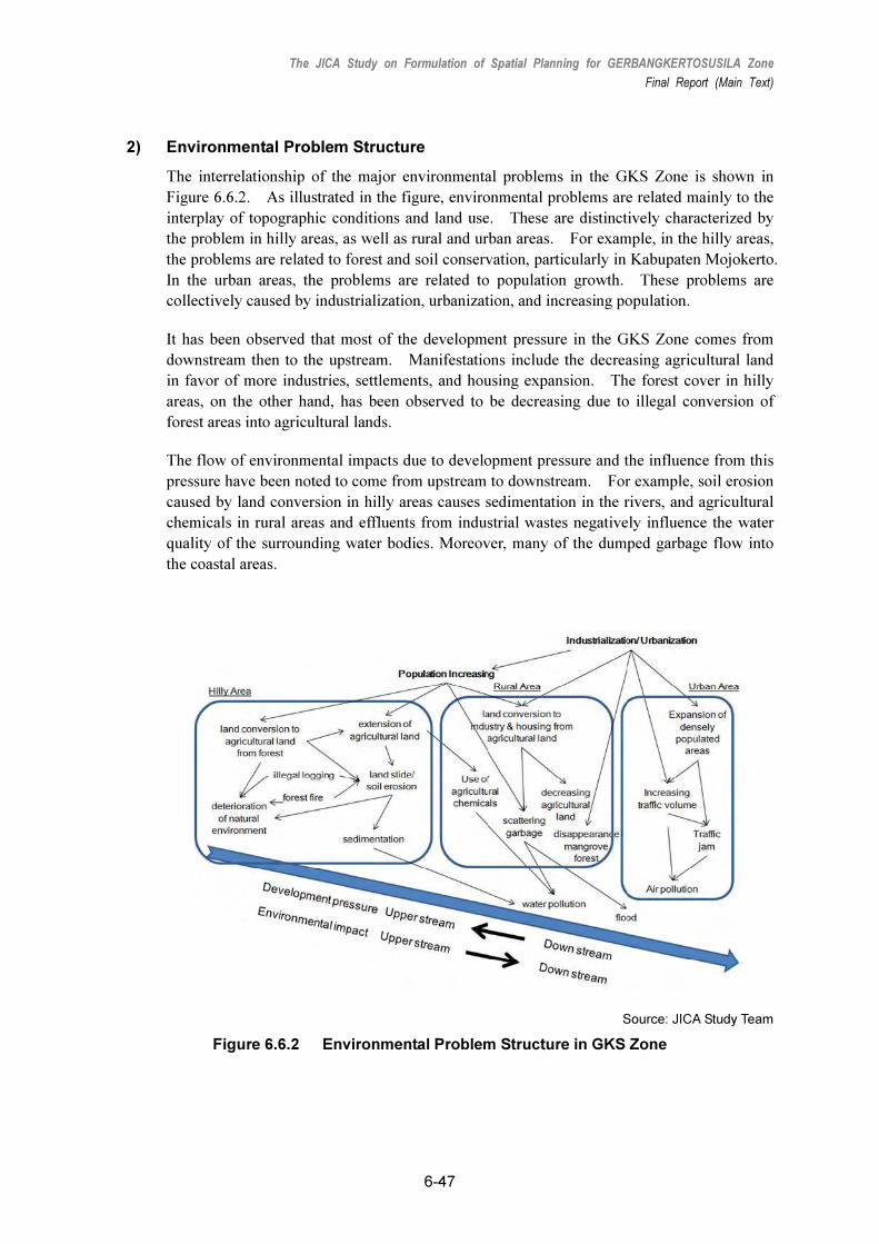
2) Environmental Problem Structure
The interrelationship of the major environmental problems in the GKS Zone is shown in
Figure 6.6.2. As illustrated in the figure, environmental problems are related mainly to the
interplay of topographic conditions and land use. These are distinctively characterized by
the problem in hilly areas, as well as rural and urban areas. For example, in the hilly areas,
the problems are related to forest and soil conservation, particularly in Kabupaten Mojokerto.
In the urban areas, the problems are related to population growth. These problems are
collectively caused by industrialization, urbanization, and increasing population.
It has been observed that most of the development pressure in the GKS Zone comes from
downstream then to the upstream. Manifestations include the decreasing agricultural land
in favor of more industries, settlements, and housing expansion. The forest cover in hilly
areas, on the other hand, has been observed to be decreasing due to illegal conversion of
forest areas into agricultural lands.
The flow of environmental impacts due to development pressure and the influence from this
pressure have been noted to come from upstream to downstream. For example, soil erosion
caused by land conversion in hilly areas causes sedimentation in the rivers, and agricultural
chemicals in rural areas and effluents from industrial wastes negatively influence the water
quality of the surrounding water bodies. Moreover, many of the dumped garbage flow into
the coastal areas.
Source: JICA Study Team
Figure 6.6.2 Environmental Problem Structure in GKS Zone

The JICA Study on Formulation of Spatial Planning for GERBANGKERTOSUSILA Zone
Final Report (Main Text)
6-48
6.6.2 Environmental Policy Framework for Spatial Planning in GKS Zone
1) Objectives of Environmental Management in Spatial Planning for the GKS Zone
The purposes of incorporating environmental management in spatial planning for the GKS
are as follows:
• To strengthen the environmental sustainability of the GKS Zone by ensuring the balance
between environmental conservation and development demand, and.
• To maintain and maximize environmental quality, including that of the natural and
manmade environments, for succeeding generations.
2) Environmental Policy Issues
The economy of the GKS Zone has developed in recent years. At present, such economic
growth has given rise to environmental problems due to industrialization and urbanization.
The assumption is that in the future the environmental conditions will further deteriorate if
the government will not improve its environmental management system.
This poses a challenge for the GKS Zone in its desire to become a model of sustainable area
development in Indonesia. Hence, in order to strengthen the GKS position, as well as
sustain and maintain its development efforts, the GKS Zone should promote sustainable area
development along essential elements that will balance economic growth and environmental
conservation. In order to achieve this goal, the following environmental policy issues
should be made integral in the planning process:
• Strengthen the symbiosis between environmental conservation and development for
sustainable prosperity;
• Ensure the sustainability of valuable and vulnerable environments and restore the
damaged environment; andContribute to the solution of global issues especially climate
change
(1) Strengthening of the symbiosis between environmental conservation and
development for sustainable prosperity
In order to achieve healthy and comfortable environment for the people in the GKS
Zone, environmental loads should be minimized where benefits are obtained from the
environment. Pursuing symbiosis with the natural environment through minimizing
environmental loads is indispensable in developing a sustainable GKS zone.
(2) Protection of valuable and vulnerable environments and restoration of damaged
environment
The JICA Study Team findings show that the GKS has many valuable and vulnerable
natural environments that need to be preserved and protected for its next generations. At the same time, the deteriorated environment caused by development activities should
be restored and rehabilitated. Hence, a comprehensive and integrated action should be undertaken. Figure 6.6.3 shows the relationship of the process:

The JICA Study on Formulation of Spatial Planning for GERBANGKERTOSUSILA Zone
Final Report (Main Text)
6-49
Source: JICA Study Team
Figure 6.6.3 Integrated Process of Environmental Preservation
(3) Contributions to the solution of global issues especially climate change
Environmental conditions in the GKS Zone are numerous and they cover a huge area.
It is therefore necessary to approach these issues from multiple directions and levels at
the same time. During the 15th session of the Conference of Parties (COP 15)to the
United Nations Framework Convention on Climate Change in Copenhagen in
December 2009, Indonesian President Susilo Bambang Yudhono declared that
Indonesia will reduce 26% of its CO2 emissions by 2020. As the second largest city in
Indonesia, Surabaya is expected to contribute significantly in this COP 15 commitment.
In the same line, the spatial plan for the GKS Zone should contribute in the reduction of
CO2 emissions, as well.
3) Environmental Considerations in Spatial Planning in the GKS Zone
The environmental planning issues are shown in Figure 6.6.4. These issues are based on
the path of environmental problems shown in Figure 6.6.2. The environment in the GKS
Zone is in a critical condition due to the adverse effects of rapid economic growth and
population increase which went on without a comprehensive environmental management
plan and adequate infrastructure to cater to the basic needs of a growing population. If this
condition continues, further environmental deterioration will ensue, leading to even more
serious deterioration of the people’s quality of life.
Source: JICA Study Team
Figure 6.6.4 Environmental Planning Issues
Management issues were identified based on environmental sensitivity and vulnerability.

The JICA Study on Formulation of Spatial Planning for GERBANGKERTOSUSILA Zone
Final Report (Main Text)
6-50
In order to achieve sustainability, hilly areas, as well as rural and urban areas should have
different spatial policies.
Spatial policies for environmental consideration in the GKS Zone are shown in Figure 6.6.5.
The figure reflects the necessity in taking different environmental actions for different areas
due to land vulnerability. For example, agricultural land in rural areas should function as
buffer zones between urban and hilly areas. In the existing agricultural land in hilly areas,
slope protection should be considered.
Source: JICA Study Team
Figure 6.6.5 Spatial Policies on Environment for GKS Zone
6.6.3 Environmentally Sensitive Zoning
1) Need for Designating Environmentally Sensitive Zones
The economy of the GKS Zone is rapidly growing and the lack, or absence, of a
comprehensive environmental management plan will aggravate the adverse environmental
impacts of this growth. As cases in point, housing and industrial developments are
constructed and developed in agricultural land and swamp areas. At the same time,
agricultural activities have vastly encroached on hilly and forested areas. This disorderly
development will cause environmental damage and disrupt the natural balance of valuable
and vulnerable environments.
In terms of spatial use, land use categories have been developed for various purposes such as
industrial development, housing development, commercial, solid waste disposal sites, in-take
of water supply, protected areas, etc. The land potentiality and vulnerability analysis
conducted by the JICA Study Team showed that the different resource uses have become
intertwined and overlapping, resulting in conflicts of uses.
Besides user conflicts, this situation can cause geographical, ecological, and social conflicts.
Coordination is necessary between and among spatial users in order to minimize the
potential conflicts which will arise from resource utilization. It is also important to note

The JICA Study on Formulation of Spatial Planning for GERBANGKERTOSUSILA Zone
Final Report (Main Text)
6-51
that the use of areas should be reasonable and integrated within the use of neighboring areas,
taking into account geographical and ecological conditions.
Due to development pressure and the associated loss and fragmentation of natural areas
throughout the GKS Zone, it has become increasingly important to preserve the remaining
natural assets. Also important is the designation of areas for protection and conservation to
ensure ecological balancesustainable production. It is also critical that a precise assessment
and research on the zone’s natural environment and ecosystem be undertaken. An
environmentally sensitive zoning map should indicate the areas that should be preserved,
conserved, and restored. This information is important and valuable for effective and
appropriate environmental management in the GKS Zone.
2) Concept of Environmentally Sensitive Zoning
The introduction of an environmental sensitive zone (ESZ) management is a strategic
approach for sustainable area development in the GKS Zone. Below is a description of
environmentally sensitive zoning:
(1) What is environmentally sensitive zoning?
Environmentally sensitive zoning is a system, or type, of designation for an area which
needs special protection due to its value and/or vulnerable landscape and/or ecosystem
from the viewpoint of environmental conservation. An ESZ map is one of the most
effective tools in environmental spatial management. It is practiced by designating
permitted uses of land on mapped zones, separating one set of land uses from another.
It also shows the areas which should be preserved, conserved, and restored from the
viewpoint of natural environmental conservation and ecosystem protection.
(2) What are the objectives of environmentally sensitive zoning?
In general, environmentally sensitive zoning aims to minimize the conflicts between
spatial and resource utilization and environmental conservation in responding to
economic and social demands.
Specifically, environmentally sensitive zoning has the following objectives:
� To preserve environmentally important and critical areas, and their unique features;
� To protect critical habitats, ecosystems, and ecological processes;
� To separate conflicts of human activities; and
� To minimize the effects of human activities in inland and coastal areas.
(3) How to use an Environmentally Sensitive Zoning map?
It is important to ensure the balance among development demand, socioeconomic

The JICA Study on Formulation of Spatial Planning for GERBANGKERTOSUSILA Zone
Final Report (Main Text)
6-52
situation, and environmental conservation. As mentioned earlier, an ESZ map shows
the areas which should be preserved, conserved, and restored for environmental
conservation. Therefore, ESZ maps are used as the basis for land use planning and
infrastructure development in order to achieve sustainable area development (see Figure
6.6.6). It can be used in setting guidelines for spatial planning, infrastructure
development, and environmental impact assessment (EIA) studies.
Source: JICA Study Team
Figure 6.6.6 Integrated Zoning and Land Use Planning
3) Methodology of Environmentally Sensitive Zoning
(1) Process of Environmentally Sensitive Zoning
The zoning process is shown in Figure 6.6.7. The existing environmental conditions
were analyzed based on the results of field surveys and secondary data collected. Based
on the analysis, key environments and ecosystems were identified, namely:
� Environmentally important and critical areas and their unique features, and
� Critical habitats, ecosystems, and ecological processes.
Source: JICA Study Team
Figure 6.6.7 Process of Environmentally Sensitive Zoning

The JICA Study on Formulation of Spatial Planning for GERBANGKERTOSUSILA Zone
Final Report (Main Text)
6-53
After the identification of key environments and ecosystems, environmentally sensitive
zones were delineated.
(2) Definition of Environmentally Sensitive Zones
The ESZs are classified into preservation zone, conservation zone, and restoration zone
based on the following definitions:
i) Preservation Zone
Preservation zones are areas where utmost preservation efforts are exerted to protect the
target environment. Some of these areas are established as core zones. Areas
included in this category are the following:
� Areas rich in natural environment;
� Areas with high ecological values, including scientific value; and
� Areas ecologically sensitive to human activities.
ii) Conservation Zone
Conservation zones are areas which protect the conditions and ensure sustainable use of
the natural environment and resources with due consideration to the areas’
environmental capacity. They serve as buffers to reduce the impacts of human activities
and restore the natural environment and expanding wildlife habitats.
iii) Restoration Zone
Restoration zones are areas damaged by natural causes and human activities and which
require restorationfrom the view points of ecosystem and natural landscape. These
areas are the following:
� Areas where deterioration of the environment is feared,, and
� Areas that influence or affect other environments.
4) Key Environment and Ecosystem in Environmentally Sensitive Zoning
Key environments and ecosystems refer to environmentally important and critical areas and
other unique features, as well as critical habitats, ecosystems, and ecological processes.
Based on an analysis of the existing environmental conditions, the key environments and
ecosystems of the GKS Zone were identified as follows:
(1) Land Stability
The major issues on land stability in the GKS are reflected mostly in areas where
substantive increases in agricultural activities are done in hilly and forested areas that
cause landslides and soil erosion. Based a map that shows the potential areas for
landslides and soil erosion from the Department of Energy and Mineral Resources, East
Java province, the landslide- and erosion-prone areas in the GKS Zone are expanding.
In order to maintain land stability and restore land resource value, land uses should be
managed against the increasing risk of landslide and soil erosion.

The JICA Study on Formulation of Spatial Planning for GERBANGKERTOSUSILA Zone
Final Report (Main Text)
6-54
Source: JICA Study Team
Figure 6.6.8 Key Environment and Ecosystem in GKS Zone
(2) Forest Ecosystem
The forest serves to maintain biodiversity through the provision of habitat and food to
endemic flora and fauna, facilitate the stability of the land, as well as support in the
absorption of CO2 gas. In the context of the GKS Zone, its forest areas are a key
environment and ecosystem.
(3) Mangrove Ecosystem
Mangrove areas provide high biodiversity in the coastal zone, serve as a habitat for
migrant birds, and protect the beaches against waves and current. Mangrove areas are
mostly found in the shoreline of Sidoarjo, accounting for approximately 3,107 ha.
Planted mangroves are also located in canals.
5) Guidelines for Environmentally Sensitive Zone Management
(1) Objectives and Parameters of the ESZs
As mentioned in the previous section, the key environments and ecosystem in the GKS
Zone consist of land stability, forest ecosystem and mangrove ecosystem. The
delineation of each zone is based on environmental and ecological features using
different criteria and guidelines because different environments and ecosystems have
varying levels of vulnerability against the impact of human activities. For example,
for terrestrial forests which are mostly located in hilly areas and mangrove forests
which can be seen along the coastline and mud bottom, where saline water is one of the
factors that restrict their growth. Furthermore, the growth rate of terrestrial trees and
mangrove trees are different. This is one of the reasons ESZs should be delineated
based on environmental and ecological features. Different environments and
ecosystems require different management approaches and techniques.

The JICA Study on Formulation of Spatial Planning for GERBANGKERTOSUSILA Zone
Final Report (Main Text)
6-55
The objectives and parameters of ESZs for each key environment and ecosystem are
detailed in Table 6.6.1.
Table 6.6.1 Objectives, Targets, and Parameters of Environmentally Sensitive Zones
Component Objective of Zoning Zoning Target Zoning Parameter
Land Stability � To protect land against natural disasters.
� Land prone to landslides and soil erosion.
� Slope and elevation� Landslide and
erosion potential (Dept. of Energy and Minerals, East Java Province)
Terrestrial Environment
Forest Ecosystem
� To protect forest ecosystems and terrestrial environments.
� To conserve water and land resources.
� Protection, conservation, and production forests
� Forest areas � Elevation
Coastal Environment
Mangrove Ecosystem
� To protect mangrove forests to ensure biodiversity, biomass and coastal protection.
� Mangrove areas � Location of mangrove areas.
Source: JICA Study Team
(2) Land Stability
i) Criteria in Delineating Zones
The ESZ criteria on land, or slope, stability are shown in Table 6.6.2. Figure 6.6.9
shows the land suitability map. It is important to note that there are two factors
regarding land stability, namely slope and elevation. According to studies, land starts
to erode approximately above 8% slope and landslides occur approximately above 18%
slope. The environmental impact caused by unstable land is dependent on its elevation.
The higher the elevation the more it needs land stability.
Most forest areas in the GKS Zone are located more than 200 m above the sea level.
To stabilize the land, the slope data mentioned above can be used in determining their
zoning classification. It is important to consider that forest areas should be preserved
and conserved, particularly areas with steep slopes.
Table 6.6.2 Criteria for Environmentally Sensitive Zone for Land Stability
Slope Type of Area Elevation (m)
8–17% 18–29% Above 30%
200–499 Conservation Zone Preservation Zone Preservation Zone
500–999 Conservation Zone Preservation Zone Preservation Zone
Forest area
above 1000 Preservation Zone Preservation Zone Preservation Zone
Non-forest area above 200 - Restoration Zone Restoration Zone
Landslide- and
Erosion-prone
high/medium/low Restoration Zone
Source: JICA Study Team

The JICA Study on Formulation of Spatial Planning for GERBANGKERTOSUSILA Zone
Final Report (Main Text)
6-56
Figure 6.6.9 Environmentally Sensitive Zones for Land Stability
ii) Activity Guidelines for ESZs
The delineation of zones for land stability aims to preserve soil and conserve watershed
in the uplands against soil erosion and landslides. Areas with over 18% of slope can
easily erode so that any development should be prohibited in these preservation zones.
However, it is possible that infrastructure and small buildings can be built here but
with slope protection measures, while wide spatial developments, such as those for
agriculture and industries, are prohibited in these areas, because of their high potential
for adverse environmental impacts.
The delineation of restoration zones for slope stability aims to restore eroded areas and
those where landslides occurred. This zone easily erodes without forest cover.
Severely unstable areas without forest cover should be prioritized for restoration. The
following restoration measures, alone or in combination, are recommended:
� Reforestation;
� Slope stability measures including bamboo fencing, grass planting, and others; and
� Soil erosion control measures including the use of wire net gabion boxes, masonry
walls, etc.

The JICA Study on Formulation of Spatial Planning for GERBANGKERTOSUSILA Zone
Final Report (Main Text)
6-57
Table 6.6.3 Activity Guidelines for ESZ of Land Stability
Preservation Zone Conservation Zone Restoration Zone
� Any spatial development is prohibited.
� Any construction of road for vehicles is prohibited.
� Construction of structure is prohibited.
� Any spatial development is prohibited.
� Construction of roads and other infrastructure without slope protection and environmental permission are prohibited.
� Construction of individual houses and small size buildings are prohibited without environmental permission.
The following restoration works are required: � Reforestation � Slope protection � Soil erosion control work
Source: JICA Study Team
(3) Forest Ecosystem
i) Criteria in Delineating Zones
The ESZ criteria on forest ecosystems are shown in Table 6.6.4, and Figure 6.6.10
shows the forest ecosystem map. The land use map of the 1990s and the SPOT
(systeme provatoire observation de la terre) image analysis were the bases in
identifying forest distribution in the GKS. Since there was no ground-truth survey
conducted, the density of the forest could not be identified at this point. Hence, the
ESZs on forest ecosystem show only the outline of forest sensitivity. It might be
necessary to re-delineate the ESZs based on a detailed map of forest distribution.
Table 6.6.4 Criteria for Environmentally Sensitive Zone for Forest Ecosystem
Elevation (m) Forest Area No-forest
50–199m Conservation Zone Restoration Zone
Above 200 m Preservation Zone Restoration Zone
Surrounding Preservation Zone - Restoration Zone
Surrounding Conservation Zone - Restoration Zone
Source: JICA Study Team
The delineation of zones on forest ecosystem aims to preserve and conserve forests as
well as forest ecosystems. The forest areas in the GKS Zone are located in higher
elevations with many endemic forest trees although their species are very limited.

The JICA Study on Formulation of Spatial Planning for GERBANGKERTOSUSILA Zone
Final Report (Main Text)
6-58
Figure 6.6.10 Environmental Sensitive Zones for Forest Ecosystem
The establishment of restoration zones strengthens the functions of preservation and
conservation zones, as the former will ensure the continuity and area of the ecosystem,
as well as fill the gaps in between preservation and conservation zones (see Figure
6.6.11). In addition, the conservation of forests and wildlife habitat will remain in the
higher areas and upland forests. It is important that upland forests are conserved, and
denuded areas restored. However, in large upland areas, where agricultural
development already has taken place, it might be difficult to restore these areas through
reforestation.
Source: JICA Study Team
Figure 6.6.11 Concept in the Delineation of Restoration Zones

The JICA Study on Formulation of Spatial Planning for GERBANGKERTOSUSILA Zone
Final Report (Main Text)
6-59
ii) Activity Guidelines for ESZss
Preservation zones are areas where strict management of a limited number of trees and
severe revitalization of forests are to be carried out. Any activity and structure which
can decrease the size of the forest areas are prohibited except for scientific purposes.
As in preservation zones, human activities are prohibited in conservation zones,
although small facilities for environmental education, such as recreation and tourism
will be allowed with permission from the Department of Environment. An EIA may
be necessary to obtain permission to use these zones.
On restoration work, a forest survey should be conducted to select suitable species that
are compatible with the surrounding indigenous trees.
The guidelines for forest ecosystems should be prioritized in areas where forest
ecosystems and land stability overlap.
Table 6.6.5 Activity Guidelines for ESZ of Forest Ecosystem
Preservation Zone Conservation Zone Restoration Zone
� Any activity which causes the decrease in forest areas is prohibited.
� Small-scale facilities for scientific research are allowed with environmental permission.
� Logging, agriculture, and other activities which cause the decrease in forest areas are prohibited.
� Small-scale facilities for tourism, environmental, and education purposes with government permits from the Department of Environment are allowed.
� Recreation and ecotourism are allowed.
� Cutting of trees for significant culture, religious, anthropological purposes, and ceremonies are allowed with permission from the Department of Environment.
A variety of indigenous tree species is planted.
Source: JICA Study Team
(4) Mangrove Ecosystem
i) Criteria in Delineating Zones
The target of this zoning is the shoreline mangroves. There are two types of
mangroves in the GKS Zone. These are shoreline mangroves and inland mangroves.
The ESZ target is shoreline mangrove because the inland mangroves are fragmented
and distributed mostly in canals. Also, the biodiversity of inland mangroves is not high
because mangrove trees were planted by people, not natural process.
The ESZ criteria for mangrove ecosystems are shown in Table 6.6.6, while Figures
6.6.12 through 6.6.15 show the mangrove ecosystem maps. The data source for
mangrove distribution is not identified since the density of the mangroves could not be
determined at this point; hence only the conservation zones were delineated.

The JICA Study on Formulation of Spatial Planning for GERBANGKERTOSUSILA Zone
Final Report (Main Text)
6-60
Table 6.6.6 Criteria for Environmentally Sensitive Zone for Mangrove Ecosystem
Location Mangrove Area Non-mangrove Area
Coast line
Conservation Zone
-
Surrounding Preservation and Conservation Zones
- Restoration Zone
Source: JICA Study Team
Figure 6.6.12 Environmentally Sensitive Zones for Mangrove Ecosystems in Northwestern GSK

The JICA Study on Formulation of Spatial Planning for GERBANGKERTOSUSILA Zone
Final Report (Main Text)
6-61
Figure 6.6.13 Environmentally Sensitive Zones for Mangrove Ecosystems
in Northern GSK
Figure 6.6.14 Environmentally Sensitive Zones for Mangrove Ecosystems in Eastern GSK

The JICA Study on Formulation of Spatial Planning for GERBANGKERTOSUSILA Zone
Final Report (Main Text)
6-62
Figure 6.6.15 Environmentally Sensitive Zones for Mangrove Ecosystems
in Northeastern GSK
ii) Activity Guidelines for ESZs
The ESZ guidelines for mangrove ecosystems are shown in Table 6.6.7. In order to
conserve and improve the functions of mangrove areas, activities that lead to the overuse, or
those that reduce, the mangrove areas are not allowed. Therefore, any spatial development
is not allowed in the conservation and restoration zones. Activities, like fishing and crab
trapping, which do not directly damage mangroves, can be allowed in the conservation zone.
In the restoration zone, mangrove areas are restored in order to sustain the continuity of
forests in the preservation and conservation zones, as well as to help establish buffer areas
for preservation zones.
Table 6.6.7 Activity Guidelines for ESZ of Mangrove Ecosystem Conservation Zone Restoration Zone
� Construction of ports is prohibited. � Construction of dike retaining walls, piers,
jetties, and causeways are prohibited. � Dredging of channel is prohibited. � Reclamation is prohibited. � Solid waste disposal is prohibited. � Liquid waste disposal is prohibited. � Fishing activities excluding decreasing
mangrove trees are allowed.
� Fishing activities are allowed. � Restoration work is promoted.
Source: JICA Study Team

The JICA Study on Formulation of Spatial Planning for GERBANGKERTOSUSILA Zone
Final Report (Main Text)
6-63
6.6.4 Integration of Environmentally Sensitive Zones into Spatial Planning
With the ESZ map as the basis for land use planning (see Figure 6.6.6), ESZs were
integrated into the GKS land use plan, as shown in Figure 6.6.16.
Conservation and restoration zones for land stability can be categorized as conservation
areas in the GKS land use plan. They are necessary measures to achieve land stability.
Conservation zones can also be used as buffers, if land stability will not decrease.
In principle, the ESZs on forest and mangrove ecosystems should be categorized as
protection areas in the GKS land use plan.
Figure 6.6.16 Integration of Environmentally Sensitive Zones into GKS Land Use Plan
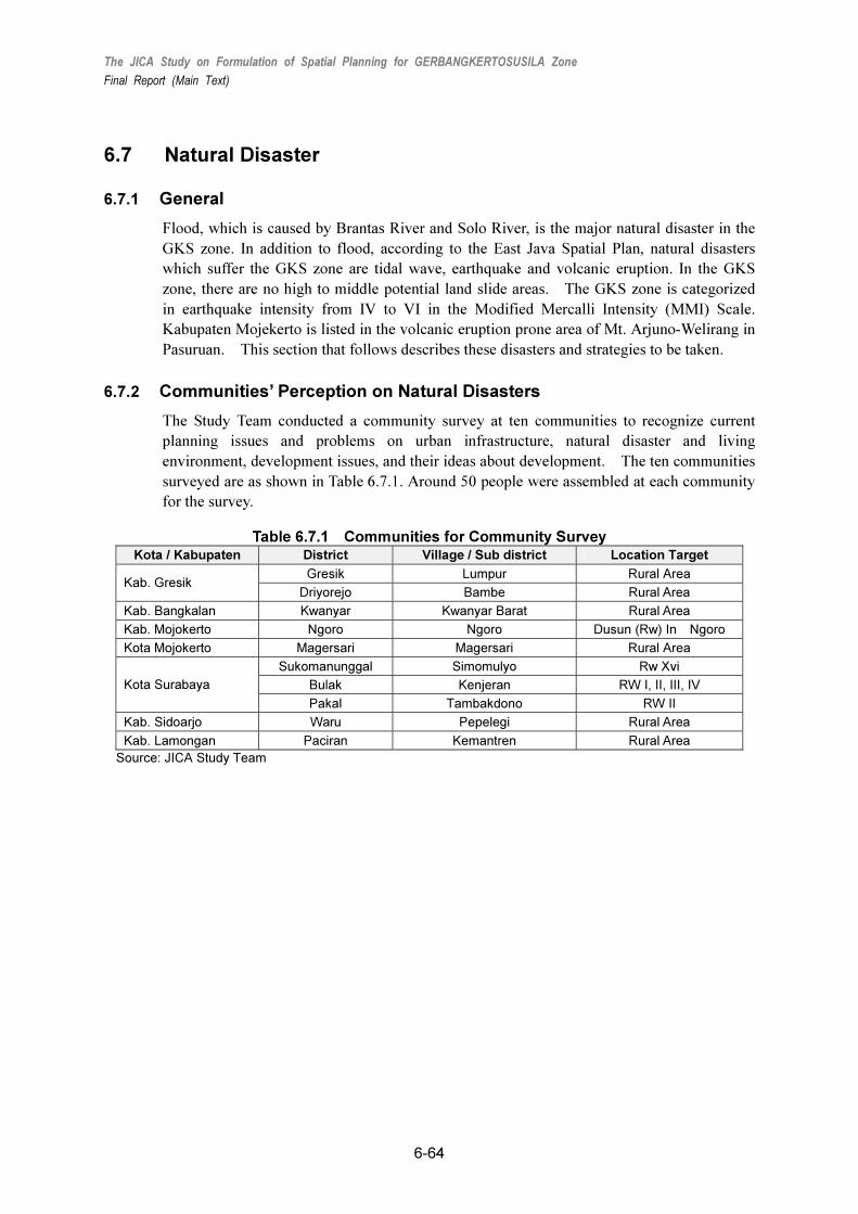
The JICA Study on Formulation of Spatial Planning for GERBANGKERTOSUSILA Zone
Final Report (Main Text)
6-64
6.7 Natural Disaster
6.7.1 General
Flood, which is caused by Brantas River and Solo River, is the major natural disaster in the
GKS zone. In addition to flood, according to the East Java Spatial Plan, natural disasters
which suffer the GKS zone are tidal wave, earthquake and volcanic eruption. In the GKS
zone, there are no high to middle potential land slide areas. The GKS zone is categorized
in earthquake intensity from IV to VI in the Modified Mercalli Intensity (MMI) Scale.
Kabupaten Mojekerto is listed in the volcanic eruption prone area of Mt. Arjuno-Welirang in
Pasuruan. This section that follows describes these disasters and strategies to be taken.
6.7.2 Communities’ Perception on Natural Disasters
The Study Team conducted a community survey at ten communities to recognize current
planning issues and problems on urban infrastructure, natural disaster and living
environment, development issues, and their ideas about development. The ten communities
surveyed are as shown in Table 6.7.1. Around 50 people were assembled at each community
for the survey.
Table 6.7.1 Communities for Community Survey Kota / Kabupaten District Village / Sub district Location Target
Gresik Lumpur Rural Area Kab. Gresik
Driyorejo Bambe Rural Area
Kab. Bangkalan Kwanyar Kwanyar Barat Rural Area
Kab. Mojokerto Ngoro Ngoro Dusun (Rw) In Ngoro
Kota Mojokerto Magersari Magersari Rural Area
Sukomanunggal Simomulyo Rw Xvi
Bulak Kenjeran RW I, II, III, IV Kota Surabaya
Pakal Tambakdono RW II
Kab. Sidoarjo Waru Pepelegi Rural Area
Kab. Lamongan Paciran Kemantren Rural Area
Source: JICA Study Team

The JICA Study on Formulation of Spatial Planning for GERBANGKERTOSUSILA Zone
Final Report (Main Text)
6-65
Source:JICA Study Team
Figure 6.7.1. Location of Communities Surveyed
Results of the community survey about natural disaster are summarized below. Major
responses from the communities are:
1) Community people do not know about the mitigation and counter-measures against
natural disasters, in particular, flood;
2) The local government do not sufficiently provide community people with proper
information about disaster mitigation and counter-measures, and disaster mitigation plan
and
3) Even though they know they live on disaster prone area, in particular flood and tidal
wave, most people are unwilling to move out of where they live presently to avoid
damage caused by disaster.
The following table summarizes the responses of community people on natural disaster.
Table 6.7.2 Responses of Community People on Natural Disaster
Kota / Kabupaten
Village /
Sub-district
Type of Natural Disaster
Perception
Kab. Gresik Lumpur
- Flood
- Tidal Wave - Half of the respondents have been troubled by natural
disaster. Natural disaster types in this area are flood and sea water high tide. About 36% of them experienced natural disasters about 1 year ago.

The JICA Study on Formulation of Spatial Planning for GERBANGKERTOSUSILA Zone
Final Report (Main Text)
6-66
Kota / Kabupaten
Village /
Sub-district
Type of Natural Disaster
Perception
- 80% respondents are unwilling to move to other safer place due to the disaster
- 82% of respondents were never informed of disaster mitigation and countermeasure from the local government. The community suggests a mitigation measure to heighten houses and dredge the river sediment.
Bambe
- Flood - 82% respondents suffered financial loss from natural disaster, especxially flood. Most of the respondents state that flood occurred about six months ago.
- Most respondents are unwiling to move out to other safer place due to the disaster.
- The community did not know about disaster mitigation plan and its implementation in their area by the government or other organizations.
Kab. Bangkalan
Kwanyar Barat
- Tidal Wave - Sea water wave and thunder often occur in the coastal settlement. About 34% respondents are suffered from material loss and boat damage.
- The community was never informed of countermeasures against the disaster by the government for their area.
Kab. Mojokerto
Ngoro
- Flood - 52% respondents answered that they would be suffered by natural disaster from flood and pollution.
- 23% of the respondents state it occurred about 3 years ago.
- Community were never informed of disaster mitigation and countermeasures from the local government or other institutions
Kota Mojokerto
Magersari
- Flood
- Until now, most of community has never suffered by natural disaster. But they afraid of potential flood that will be occur if Jasa Tirta not protect Brantas River.
- Only about 20% respondents assess suffered by natural disaster, as flood, landslide, wind and fire
- Respondents were never informed of disaster mitigation and countermeasure, whether from local government or others.
Simomulyo
- Flood
- Most respondents consider flood is teh natural disaster that happen at their community. About 84% respondents assess suffering financial loss caused by that disaster.
- Even though most respondents assess flood occur every year, they are unwilling to move from there
- Respondents were never informed of disaster mitigation and countermeasures by the local government or others
Kenjeran
- Flood
- Tidal Wave
- 46% respondents were suffered from flood and sea water high tide. 54% of the respondents usually experience the natural disaster
- These natural disasters occur every year. Even though the community bet accustomed to it, they still afraid of it.
- The respondents were never informed of disaster mitigation and countermeasure from local government but they have own way to notify each other
Kota Surabaya
Tambakdono
- Flood
- Tidal Wave
- 88% respondents suffered by natural disaster from flood, but 80% respondents don’t want to move due to disaster.
- None of respondents were infromed about disaster mitigation and countermeasures by the local government.
- The community suggest that the government should dredge the river sediment.
Kab. Sidoarjo
Pepelegi - Flood
- Tidal Wave
- Flood is the major disaster to most respondents.
- 12% of the respondents assess that flood occurs every

The JICA Study on Formulation of Spatial Planning for GERBANGKERTOSUSILA Zone
Final Report (Main Text)
6-67
Kota / Kabupaten
Village /
Sub-district
Type of Natural Disaster
Perception
year whie 64% of the respondents don’t think so.
- Most of the respondents assess that there’s flood countermeasure in their community.
Kab. Lamongan
Kemantren
- Flood
- Tidal Wave
- 64% of the respondents are suffered from flood, sea water high tide, and abrasion.
- The community gets accustomed to experience the natural disasters.
- 84% of the respondents are unwilling to move to safer place due to the disaster.
- 88% of the respondents were never informed of disaster mitigation and countermeasures from the local government. The community suggests that a break water be built to protect houses in the coastal zone and the boat harbour.
Source: Community Survey conducted by JICA Study Team
6.7.3 Flood
Flood is often caused by Solo River and Brantas River in the GKS zone. Figure 6.7.2
shows flood prone area in the GKS zone. As shown in the Figure, most of the GKS area is
vulnerable to flood. These areas have been expanding from east to west, particularly widely
spreading in the lowland areas.
Source: Department of Energy and Minerals, East Java Province
Figure 6.7.2 Flood-Prone Area in GKS
Flood prone area of High Potential of flood which is listed in the East Java Spatial Plan is
Kecamatan Gresik in Kabupaten Gresik; and those of Middle Potential of Flood are
Kecamatans of Jatiroto, Mojokerto, Bangsal, Mojosari, and Pugging in Kabupaten

The JICA Study on Formulation of Spatial Planning for GERBANGKERTOSUSILA Zone
Final Report (Main Text)
6-68
Mojeokerto, Part of Surabaya, and Kecamatan Bangkalan in Kabupaten Bangkalan.
Flood damages extensively not only people’s lives but production activities such as
agriculture and other businesses.
In order to protect people and their assets and activities against flood, flood mitigation efforts
can generally be divided into: (1) flood mitigation through spatial planning, (2)
non-structural mitigation, (3) structural, and (4) public participation.
As described in the previous section, as a result of the community survey, people who have
experience natural disasters such as flood rarely know mitigation measures and
countermeasures against the natural disaster and furthermore they are not given information
about these measures from the local government. In addition, even though they know they
live on disaster prone area, many of them are not willing to move out to avoid the natural
disaster. These aspects should be taken into account in measures.
The East Java Spatial Plan addresses the various measures, and this Study follows them.
The measures are as follows:
1. Flood Disaster Mitigation Efforts through Spatial Planning
₋ To direct development to avoid flood prone areas based on a flood-prone area or flood
hazard map with land-use controls;
₋ To diversify agricultural products such as food crops resistant to flooding or to adjust
the cropping season;
₋ To reforest the upper stream of the watersheds, and
₋ To formulate a flood evacuation plan including evacuation routes
2. Non Structural Mitigation
₋ To determine clear roles and functions of relevant agencies in order to mitigate flood
damage, which roles and functions include inspection, observation and tracking of
infrastructure and existing flood control facilities and measures;
₋ To improve flood control infrastructure and maintain them function properly;
₋ To monitor and evaluate data of rainfall, flooding, inundation areas and other
information necessary to predict flood events and identify flood-affected areas and
flood-prone areas;
₋ To prepare maps of flood prone areas equipped with "plotting" evacuation routes,
temporary refugee camps, POSKO location, and location of the observer post,
discharge flood / flood water level in rivers caused flooding.
₋ To check facilities of existing early warning systems or establish a simple warning
system if there is not any;
₋ To formulate a logistics plan for funds, equipment and materials necessary for the
operation and emergency response in the event of flood;
₋ To plan and prepare Standard Operation Procedures of all the relevant agencies and

The JICA Study on Formulation of Spatial Planning for GERBANGKERTOSUSILA Zone
Final Report (Main Text)
6-69
the community for response in the events of flood;
₋ To establish a Flood Information System for a direct dissemination to the public,
press releases and the dissemination of information about flooding through mass
media.
₋ To implement evacuation training to check the readiness of the community, SATLAK
and evacuation equipment, and readiness of temporary shelter and equipment.
₋ To establish cross-agency networks and NGOs engaged in awareness of the disaster
and the mass media both print and electronic (TV and radio stations) to rally
regardless of the disaster to the community including the distribution of information
about flooding.
₋ To carry out public education on flood hazard maps, flood risks and building
materials that are waterproof.
3. Structural Mitigation
₋ Construction of retaining walls and embankments along the rivers, the sea wall along
the coast are prone to storms or tsunamis will greatly help to reduce flooding on the
planned level of flood discharge.
₋ The speed and flow, surface water discharge from upstream areas is very helpful to
reduce the occurrence of flood disasters. Some effort needs to be done to regulate the
water velocity and flow of water into the drainage system is to include reforestation
and construction of infiltration systems and the construction of dams / reservoirs.
₋ Dredging of the river, making river shunt either open or closed channels or tunnels
can help reduce the occurrence of floods.
4. Public Participation and Awareness Raising
Both individuals and society as a whole can have a significant role in flood disaster
management that aims to mitigate the impact of flooding. Roles and responsibilities of the
community can be categorized into the following two aspects:
₋ Human-induced causes of flood should be managed to reduce the magnitude of the
flood disaster. These human-related measures to be taken are:
� No disposal of garbage / solid waste into rivers, canals and drainage system;
� No construction of bridges and/or buildings that block or narrow the trench of the
river flow;
� No living in the flood plain of the river;
� No use of flood retention plains for settlement or other unplanned things;
� Cease of deforestation in catchment areas,
� No illegal land conversion in agriculture and land use are contrary to the rules of
water and soil conservation; and
� Control of development and urbanization.
₋ Community disaster management would reduce the impact of flood disasters, which
include the following:

The JICA Study on Formulation of Spatial Planning for GERBANGKERTOSUSILA Zone
Final Report (Main Text)
6-70
� Community mitigation activities against flood such as a campaign, the flood
preparedness, evacuation drill, flood early warning exercise and so forth;
� Program and design & construction of flood resistant housing, among others, at
household level, the use of waterproof material and water scour;
� Public education efforts related to flood mitigation;
� Public consultation for the development of flood control and flood mitigation;
� Adaption of the pattern and timing of planting to reduce losses of business and
agricultural land from flooding; and
� Cleaning existing drainage channels.
6.7.4 Tidal Wave
Tidal wave prone areas in the GKS are located along the coastal area of Bangkalan,
Lamongan, Gresik, Surabaya and Sidoarjo. As mentioned in the summary of the community
survey, people are seldom informed of mitigation and countermeasures against tidal wave by
the government; and also they tend not to move out to a safer place. Mitigation strategies
and tidal wave disaster reduction include the following:
₋ Coastal reclamation;
₋ Construction of breakwater (water break);
₋ Arrangement of buildings around the beach;
₋ Development of mangrove forest; and
₋ Construction of the retaining wall of waves.
6.7.5 Earthquake
An earthquake prone area, according to Regulation No. 26 Year 2008 about the National
Spatial Plan, is an area that has a potential of, and/or that has experienced an earthquake at a
scale of VII to XII in Mercalli Modified Intensity (MMI) Scale. As shown in Figure 6.7.3.,
the GKS zone has potential earthquake intensity from IV to VI in MMI; accordingly the
GKS is not categorized as an earthquake prone area.
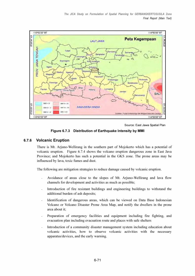
The JICA Study on Formulation of Spatial Planning for GERBANGKERTOSUSILA Zone
Final Report (Main Text)
6-71
Source: East Jawa Spatial Plan
Figure 6.7.3 Distribution of Earthquake Intensity by MMI
6.7.6 Volcanic Eruption
There is Mt. Arjuno-Wellirang in the southern part of Mojokerto which has a potential of
volcanic eruption. Figure 6.7.4 shows the volcano eruption dangerous zone in East Java
Province; and Mojokerto has such a potential in the GKS zone. The prone areas may be
influenced by lava, toxic fumes and dust.
The following are mitigation strategies to reduce damage caused by volcanic eruption.
₋ Avoidance of areas close to the slopes of Mt. Arjuno-Wellirang and lava flow
channels for development and activities as much as possible;
₋ Introduction of fire resistant buildings and engineering buildings to withstand the
additional burden of ash deposits;
₋ Identification of dangerous areas, which can be viewed on Data Base Indonesian
Volcano or Volcano Disaster Prone Area Map, and notify the dwellers in the prone
area about it;
₋ Preparation of emergency facilities and equipment including fire fighting, and
evacuation plan including evacuation route and places with safe shelters
₋ Introduction of a community disaster management system including education about
volcanic activities, how to observe volcanic activities with the necessary
apparatus/devices, and the early warning.

The JICA Study on Formulation of Spatial Planning for GERBANGKERTOSUSILA Zone
Final Report (Main Text)
6-72
Source: RTRW (2009 – 2029) of East Java Province
Figure 6.7.4 Volcano Eruption Dangerous Zone in East Java Province

The JICA Study on Formulation of Spatial Planning for GERBANGKERTOSUSILA Zone
Final Report (Main Text)
7-1
7. PROGRAMS AND PROJECTS ON
SPATIAL UTILIZATION
7.1 Programming Concepts
Based on the development concepts and strategies in the GKS spatial plan, projects and
action plans were programmed to achieve the plan’s visions by 2030, as shown in Table 7.1.1.
The projects and action plans for the GKS and to be carried out in the long term are grouped
into the following major sectors:
• Economic development;
• Transportation development;
• Infrastructure and utilities (water and sanitation, drainage and wastewater, electricity,
telecommunications) development;
• Solid waste management;
• Housing supply;
• Environmental management; and
• Social services and urban facilities provision.
To promote the smooth implementation of the projects and action plans, the following
aspects were addressed in Chapter 10.
• Institutional and legal environment, and
• Development financing.

The JICA Study on Formulation of Spatial Planning for GERBANGKERTOSUSILA Zone
Final Report (Main Text)
7-2
Table 7.1.1 Projects and Action Plans for GKS Zone for 2010−2030 by Sector
1) Economic Development
No. Project/Action Plan Description
1 Strengthening of
Inter-industrial Linkages
� For better industrial development of the GKS Zone, industries with more
supporting linkages will be promoted.
� Agro-industrialization will contribute significantly to the growth of the
rural economy.
2 Strategic Industrial Estate
Development
� Land and infrastructure provision: The government should prepare land
and infrastructure such as power, water, wastewater treatment, road
network, and others.
� Eco-oriented operation: Industrial estates should be environment-
friendly, creating no any adverse impacts on neighboring areas.
� Incentives preparation: Such as tax exemptions and preferential
treatment.
3 Promotion of Small and
Medium-sized Enterprises
(SMEs)
� Rationale of project is that industrial estates are generally for large
enterprises focused on production rather than employment and that the
GKS has fewer employment opportunities and most businesses are
micro, small to medium in scale.
� To improve the employment situation in the GKS, SMEs should be
promoted. Provision of institutional financial support by the public
sector is a must together with favorable loan conditions.
4 Facilitation of Investment
into GKS
� To promote industrial development in the GKS and infuse investments,
incentives are needed. These incentives are not limited to tax
holidays, but include other government support and the creation of
reliable infrastructure as add-on incentives for investors.
� Promotional activities of the GKS are strongly needed to attract
investments, including one-window investment services. This will be
carried out by the Investment Board of East Java, Department of
Industry and Trade, East Java Province, and the Chamber of
Commerce and Industry, East Java Province and the like in cooperation
with each kabupaten and kota in the GKS.
5 Promotion of R&D for
Local Enterprises
� Investment incentives are not limited to the provision of tax incentives;
but should include other government support and reliable infrastructure.
In addition, promotional activities of the GKS are strongly needed to
attract investments.
6 Improvement of
Agricultural Productivity
� Provision of infrastructure (including irrigation, if necessary), technical
assistance, and market information.
7 Promotion of Non-farm
Business
� In order to create employment opportunities, not only in the agriculture
and fishery sectors, non-farm businesses should be enhanced to
alleviate rural unemployment and poverty.
8 Diversification and
Promotion of Market
oriented produce
� At this moment, the GKS is dominated by rice production.
Diversification should be pursued to add value to agriculture.
Diversification strategy involves crop diversification, development of
alternative farming systems, and market development.
� Crop diversification should be pursued based on the products’
competitiveness and their international and national market potentials.
� Such competitive products can be promoted through the “one-village
one-product” method to market local goods.
9 Promotion of Efficient
Post-harvest Activities
� Cooperatives are self-help organizations and can be viable options for
maintaining economies of scale in a sense, because individual farmers
or fishermen are usually weak in marketing.

The JICA Study on Formulation of Spatial Planning for GERBANGKERTOSUSILA Zone
Final Report (Main Text)
7-3
No. Project/Action Plan Description
� The establishment of an organization of farmers/fishermen like
cooperatives will give them more power to market their products and
give them stronger bargaining power in seeking better transportation
and storage means, better credit, more market information, better
production technologies, etc.
� Cooperatives should have management skills and financial means.
Accordingly, cooperatives should be enhanced in such aspects.
10 Promotion package of
the Tourism Business
� Various components should be introduced to promote tourism, such as:
- Formulation of touring circuits;
- Introduction of eco-tourism;
- Integration and agglomeration of tourism development; and
- Support for local participation in tourism promotion activities.
11 Promotion of Local
Production and Local
Consumption
� In order to vitalize the rural economy through the agropolitan concept,
rural self-ownership of the economic mechanism is needed. To
enhance the rural economy, the following measures should be
undertaken:
- Marketing of competitive products and their processing;
- Market information;
- Physical distribution facility including post harvest transportation;
- Provision of necessary Infrastructure, including road network and
other utilities, physical distribution facility, public-run marketplaces;
and
- Linking of producers and consumers of specific commodities.
12 Facilitation of Private
Sector Participation
� In order to respond to the huge amount of financial and managerial
demand for public services and infrastructure expected in the future, the
private sector’s proactive involvement is key.
� Several useful and effective models of PPP (public-private partnership)
scheme are being tested all over the world in both developing and
developed countries.
� Indonesia also has PPP experiences from some of its infrastructure
projects such as the Suramadu Bridge.
� The government needs to prepare new institutional setup and/or
facilitate institutional reform to pursue a more suitable mechanism for
this purpose.
2) Transportation Development
(1) Road Development
No. Projects/Action Plans Project Description
1 Toll Road Development
In Surabaya
� In Surabaya, the Suramadu Bridge needs to be connected to the
existing toll roads (Manyar–Gempol with Tg. Perak at 62.1 km and
Waru–Juanda at 13.6 km) to form a continuous toll road network. For
this, at least one of the following toll roads needs to be constructed:
- East Toll Ring Road (Suramadu Bridge–Juanda Airport);
- Extension of existing toll road (Tg. Perak–Suramadu Bridge); and
- Middle East Toll Ring Road.

The JICA Study on Formulation of Spatial Planning for GERBANGKERTOSUSILA Zone
Final Report (Main Text)
7-4
No. Projects/Action Plans Project Description
2 Surabaya Middle Toll
Road Development
� The plan for the Surabaya Middle Toll Road along Jl. Achmad Yani
needs to be further reviewed, because this area is well developed and
the toll road needs to be elevated which will cost more.
� A large amount of land acquisition on Jl. Achmad Yani will also be
required.
3 Development of Toll Road
outside Surabaya
� Other prospective toll road projects within and beyond GKS are listed
below.
- Gresik–Krian Toll Road;
- Krian–Gempol Toll Road; and
- Gempol–Malang Toll Road.
� The first two toll roads will form part of the SMA Semi-ring Corridor.
The viability of these toll road projects should be well examined in light
of future development plans of the GKS and East Java province to cope
with interregional traffic.
� As for the Krian–Gempol toll road, it may be given priority as an
alternative route for the current Surabaya–Gempol toll road, which is
disconnected in Porong due to the mud flows in Sidoarjo.
Reconstruction of the toll road to detour around the mud flows is still
pending due to the uncertainty of the mud flows.
4 Arterial Road
Development in SMA:
Primary Arterial Road
(N-S direction)
� The Middle East Ring Road (MERR) will be fully completed in 2010.
Other north–south trunk roads that need to be constructed soon are:
- Middle West Ring Road (MWRR);
- West Ring Road (WRR); and
- East Ring Road (ERR).
� With respect to the MWRR and WRR, a feasibility study (FS) has been
completed, and some existing roads could be utilized for their
development. The ERR may have o be constructed if a toll road (i.e.,
East Toll Ring Road) is not built.
5 Arterial Road
Development in SMA:
Secondary Arterial Road
(E-W direction)
� As listed in the ARSDS-GKS master plan (1997), secondary arterial
roads in the SMA should be developed mainly in the east–west direction
to connect primary arterial roads to form an efficient arterial road
network in the SMA.
� Existing roads are composed of secondary arterial roads for the most
part. Some road sections need to be widened and upgraded and some
missing links or flyovers/underpasses need to be constructed.
6 Arterial Road
Development in GKS
� Following the road planning of each kabupaten/kota, the roads that
were listed in the ARSDS-GKS master plan (1997) but have not been
developed yet are good candidates for prioritization to strengthen the
arterial road network in the GKS.
7 Flyover and Underpass in
SMA
� Many flyover and underpass projects are planned by the central and
local governments. These candidate projects should be reviewed based
on the survey results and analyses in this JICA study.
� Priority of implementation should be considered.
� Both land acquisition and environmental issues should be settled before
actual implementation starts.

The JICA Study on Formulation of Spatial Planning for GERBANGKERTOSUSILA Zone
Final Report (Main Text)
7-5
No. Projects/Action Plans Project Description
8 Traffic Control and
Management
� In terms of traffic control and management, the following action plans
and projects should be given priority:
- An efficient and inexpensive way of identifying traffic bottlenecks
using intelligent transportation systems (ITSs) and dispersing traffic
by guiding and regulating them through traffic signal controls and the
provision of traffic information;
- Extension of the bus- and motorcycle-only lanes where motorcycles
and public transportation are separated from other transportation
modes;
- Traffic demand management such as road pricing, enforcing parking
regulation, and raising parking fees in the CBD;
- Construction/Rehabilitation of pedestrian facilities such as pedestrian
overpasses and sidewalks; and
- Traffic safety education program for drivers, students, and the public.
(2) Public Transportation Development
No. Projects/Action
Plans Project Description
1 Bus Transportation
Improvement
� Categorization of bus route structures into line-haul bus services, CBD
circulator bus services, and suburban feeder bus services, in light of the
existing and future passenger demand patterns.
� Extension/Addition of bus- and motorcycle-only lanes and the provision of
dedicated bus lanes and new transit malls, where applicable.
2 Improvement of
Existing PT. KA
Railway
� Improvement in the existing PT. KA railway system, including key
improvements on frequency, compatibility, comfort, accessibility to stations,
and intermodality with bus and private transportation modes.
� Major improvement plans and projects for central stations and railway tracks
in Surabaya, as follows:
- Connection of Pasar Turi and Gubeng stations for continuous commuter
train operation between the north and south railway lines;
- Development of the new elevated Surabaya Kota station between Pasar
Turi and Gubeng stations;
- Development of the Pasar Turi commuter station as recommended in the
Surabaya Regional Rail Transportation System (SRRTS) study; and
- Development of the Sidotopo station to serve not only current freight
operations and locomotive maintenance of the trains on the south trunk
line and Malang line, but also passenger train services.
� As for improvements of the railway in the SMA and GKS, the following action
plans and projects can be prepared:
- Elevation of most of the existing railway sections in the SMA to avoid
grade crossings;
- Double-tracking the existing railway between Lamongan and Sidoarjo/
Mojokerto;
- Revitalization of the railway from Kandangan and Gresik (Indro), which is
now operated for freight transportation only (up to Indro), and provision of
commuter train services;
- Improvement/Development of station plazas and approach roads to
provide easier access to stations for all modes of transportation; and
- Provision of a new commuter railway station where the distance between

The JICA Study on Formulation of Spatial Planning for GERBANGKERTOSUSILA Zone
Final Report (Main Text)
7-6
No. Projects/Action
Plans Project Description
the existing stations is more than 2 km in the central area and more than 4
km in the suburbs.
3 Development of a
New Rail Mass
Transit System
� A new rail mass transit system may be recommended in the following new
corridors to supplement the existing PT. KA railway system:
- North–-south corridor running through the CBD;
- East–west corridor connecting Surabaya and southern Kabupaten Gresik;
and
- Branch line connecting Waru (on the existing railway line) and Juanda
Airport.
� However, whether to develop the new mass transit system as rail-based or
bus-based, such as BRT, will depend on the demand forecast and the
service distance on the corresponding transportation corridor(s).
4 Integration of Rail and
Bus Transportation
� In order to cover travel demands by public transportation in the SMA, bus
transportation is expected to supplement and coordinate with the rail-based
transportation system especially in areas outside walking distances from the
stations. Hence, the following action plans and projects are necessary for
the integration of rail and bus transportation:
- Reorganization of bus routes to provide feeder bus services for the
convenience of potential railway users who live beyond walking distances
from stations, and
- Introduction of a common fare system that allows free or discounted
transfers between different modes of public transportation.
5 Integration of Public
Transportation and
Land Use
� It is of great importance to make the urban structure convenient for public
transportation users through appropriate land use plans. In order to
enhance the integration between public transportation and land use under
the concept of a transit-oriented development (TOD), the following action
plans and projects are suggested:
- Provision of high floor area ratios and development of business and
commercial centers in the vicinities of railway stations and major
intermodal stations, and
- Housing development in areas along the railway corridor.
(3) Port and Harbor Development
No. Projects/Action
Plans Project Description
1 Feasibility Study on
Regional Strategic
Port Development
� “The Study for the Development of the Greater Surabaya Metropolitan Ports
in the Republic of Indonesia” was conducted by JICA in 2007. A comparative
study of the following six (6) candidate ports was undertaken: (i) Lamong
Bay in Surabaya City, (ii) Gresik South and (iii) Gresik North in Gresik, and
(iv) Socah, (v) Tanjung Bulupandan, and (vi) Tanjung Bumi in Bangkalan.
The study selected Tanjung Bulupandan as the highest priority port for
development.
� After the completion of the study, the Suramadu Bridge was opened on 10
June 2009, and socio-economic conditions have correspondingly changed.
Regional port development is one of the biggest issues to boost the region’s
economy with the support of Suramadu Bridge.
� A feasibility study should be conducted to determine a port development site
in the GKS Zone.

The JICA Study on Formulation of Spatial Planning for GERBANGKERTOSUSILA Zone
Final Report (Main Text)
7-7
3) Infrastructure and Utilities Development
(1) Water and Sanitation
No. Projects/Action
Plans Project Description
1 Proper Raw Water
Allocation Plan
� Proper raw water allocation will be possible through the formulation of an
water allocation plan consistent with the future land-use plan in the GKS:
Consistency shall be met through the following relevant plans:
- Land-use plan (urban, industrial and housing);
- Brantas River Basin Master Plan (flood control and water use);
- Solo River Basin Master Plan (flood control and water use);
- Groundwater and spring water management plan;
- PJT1 corporate plan;
- PDAM corporate plan; and
- PDAB corporate plan.
� This project will be conducted by provincial, kota, and kabupaten authorities,
as well as PJT1, PDAB, and PDAM.
2 Interregency Water
Export-Import Project
in East Java Province
� Water supply is critical in the development of the GKS because of uneven
distributed water resources. Consequently, within the GKS Zone, water,
sometimes, will be supplied beyond the local administrative territory. Such
water export-import project will be conducted to balance growth in the GKS
Zone.
� The following are highly related to this water export-import project:
- Groundwater and spring water management plan;
- Feasibility study for interregency water export-import project in East Java;
- PDAM corporate plan; and
- PDAB corporate plan.
� This project will be implemented by: provincial, kota, and kabupaten
authorities, as well as PJT1, PDAB, and PDAM
3 Water Supply Facility
Expansion Project in
Each PDAM
� Water supply will be planned based on the raw water allocation plan which
should be consistent with the water demand required by the land-use plan.
This project will include the following:
- Feasibility study for water supply facility expansion project, and
- PDAM corporate plan.
� This project will be implemented by provincial, kota, and kabupaten
authorities, as well as PDAM.
4 Non-Revenue Water
Reduction Project
� Non-revenue water (NRW) covers water leakage from the network and
water whose tariff is not collected properly. To reduce non-revenue water,
the following will be conducted:
- Feasibility study for NRW reduction in each PDAM, and
- PDAM corporate plan.
� This project will be implemented by kota and kabupaten authorities, as well
as PDAM.
5 Groundwater
Management Plan
� Since groundwater is important in the GKS, it must be managed
appropriately. This project will formulate groundwater management
through the following:
- Study of hydro-geological conditions in East Java, and
- Preparation of groundwater use and conservation plan.
� This project will be implemented by provincial, kota, and kabupaten
authorities, as well as PDAB and PDAM.
6 PI (Performance � Water industries’ performance should be appropriately monitored and

The JICA Study on Formulation of Spatial Planning for GERBANGKERTOSUSILA Zone
Final Report (Main Text)
7-8
No. Projects/Action
Plans Project Description
Indicator) System
Implementation
Program for Water
Industries
evaluated. However, such system has yet to be conducted in the GKS;
thus, this project will be conducted with the following objectives:
- To establish the performance indicator system to audit the accountabilities
of PDAM and other water entities, and
- To prepare legal document to effectuate the PI system.
� This project will be implemented by provincial, kota, and kabupaten
authorities.
7 Water Saving
Program in Each
Kabb./Kota
� Water should be supplied to meet demand; hence, besides the supply side
of water, demand side management should also be taken to conserve and
save the limited water resource. The following components will be
included:
- Public awareness campaign on water saving;
- Educational campaign on the scarcity of water; and
- Award system to water savers and recyclers.
� This project will be implemented by kabupaten and kota authorities as well
as PJT1 and PDAM.
8 River Water
Conservation
Program on
Monitoring,
Regulatory Provision
and Punitive Action
� River water is very important to meet water demand in the GKS. Thus, a
conservation action plan will be formulated. The following are relevant
components of the conservation plan:
- Brantas River Basin Master Plan (flood control and water use);
- Solo River Basin Master Plan (flood control and water use);
- Industrial development plan;
- Housing development plan; and
- PJT1 corporate plan.
� The implementing agencies are provincial, kota, and kabupaten authorities,
as well as PJT1.
9 Urban Drainage and
Wastewater Disposal
Master Plan in
Designated Urban
Areas in the GKS
Zone
� In order to ensure that the urban areas are clean from stormwater and
wastewater, a proper urban drainage and wastewater disposal system will
be established. For this purpose, a master plan for urban drainage and
wastewater disposal s will be drafted while maintaining consistency with the
following plans:
- Land-use plan;
- Urban development plan;
- Urban drainage plan;
- Industrial development plan;
- Housing development plan;
- PDAM corporate plan; and
- PDAB corporate plan.
� Based on these plans, the projects’ materialization will be formulated. The
implementing agencies will be kota and kabupaten authorities.
(2) Wastewater and Drainage
No. Projects/Action
Plans Project Description
1 River Water
Conservation
Program on
Monitoring,
� Conservation of river water is critical in the GKS Zone, because the zone
strongly depends on two major rivers, the Brantas River and the Bengawan
Solo. This project aims to conserve river water based on the following
plans:

The JICA Study on Formulation of Spatial Planning for GERBANGKERTOSUSILA Zone
Final Report (Main Text)
7-9
Regulatory Provision
and Punitive Action
- Brantas River Basin Master Plan (flood control and water use);
- Solo River Basin Master Plan (flood control and water use);
- Industrial development plan;
- Housing development plan; and
- PJT1 corporate plan.
� This project will be implemented by provincial, kota, and kabupaten
authorities, as well as PJT1.
2 Urban Drainage and
Wastewater Disposal
Master Plan in
Designated Urban
Area in the GKS
Zone
� Urban drainage and wastewater disposal is one of the critical issues in
specific urban areas in the GKS Zone; thus, countermeasures will be
planned based on future conditions of the urban settlements and they will be
designed consistent with the following plans:
- Land-use plan
- Urban development plan
- Urban drainage plan
- Industrial development plan
- Housing development plan
� This project will be implemented by: Province, Kota, Kabupaten and PJT1
3 Human Resources
Development for
Drainage
Administration
� Plans cannot be properly pursued without a competent staff; thus, human
resource development for drainage administration is quite important. This
human resource development project will include the following components:
- Information network;
- Standard operation and maintenance manual; and
- Public announcement system.
� This project will be implemented by kota and kabupaten authorities.
(3) Power Development
No. Projects/Action
Plans Project Description
1 Improvement and
Reinforcement of
Network
� In order to solve the above-mentioned problems and to meet increasing
electricity demand, the existing transmission and distribution network should
be improved and reinforced considering the following points:
- Extend transmission/distribution lines;
- Increase the number of substations or install additional transformers; and
- Reduce distribution loss (technical loss) by replacing with larger
conductors or high-efficiency transformers, or inserting capacitors.
2 Demand Side
Management
� In order to overcome power supply shortages, demand side management
(DSM) should also be considered to reduce overloads on the network
through the following measures:
- Socialization of and campaign on the use of lights and energy-saving
equipment;
- Load shifting from nighttime peak to low-consumption time in the
morning/afternoon with incentives to customers; and
- Tightening control on non-technical losses (irregular/illegal connections,
revamping kWh meters, etc.).
3 Stabilization of Power
Supply In Surabaya
� A stable power supply is necessary for the smooth development of the GKS
Zone, especially for the largest urban area, Surabaya.
� The first priority is to complete a 150-kV transmission line between the edge
of the existing line in Ujung Substation and Perak Substation, forming a loop,
so that the supply system for Surabaya City will be more reliable.
4 Provision of Reliable � Participation of power plants owned by private electricity providers to ensure

The JICA Study on Formulation of Spatial Planning for GERBANGKERTOSUSILA Zone
Final Report (Main Text)
7-10
Backup Power Supply backup supply in case of a PLN power shortage, or to supply power to rural
or remote areas in addition to the PLN’s national grid.
5 Diversification of
Renewable Energy
Source
� Because of energy issues and global warming, the diversification of energy
sources should be considered.
� Renewable energy sources, such as photovoltaic (solar), wind, biomass, and
conversion of garbage to energy especially for Surabaya, are considered by
PLN and other international/domestic organizations.
(4) Telecommunications
No. Projects/Action
Plans Project Description
1 Coordination with
Private Operators
� Telecommunications sector is privatized and highly competitive, which leads
to the nondisclosure of development plans of the operators, thereby
lessening coordination or collaboration in the supply services to customers.
For the development of the telecommunication system from the regional
development viewpoint, private operators should be involved and
coordinated.
2 Provision of
Affordable
Telecommunications
Services
� In order to meet the telecoms needs of communities and their desire to
utilize telecommunications facilities, the government through the Department
of Communication and Information (DOCI) should institute affordable and
accessible telecommunications services.
� This program is an implementation of the policy of Telecommunications
Universal Service (Universal Service Obligation/USO) in Indonesia in
implementing the ITU Information Society Declaration. The program is
implemented in the villages by allocating telecommunications universal
service areas (WPUT).
4) Solid Waste Management
No. Projects/Action
Plans Project Description
1 Renovation of
Existing Landfill for
Creating a Sanitary
Environment
� The lifespan of landfills should go beyond their prescribed end-points. Thus,
the improvement of their operation and conditions is required. The action
plans thus include infrastructure rehabilitation and reduction of negative
environmental impact. In addition, securing landfill sites will be necessary.
2 Improvement of 3Rs
Activity
� The function of landfills will be reduced and the 3Rs practice (reduction,
reuse, and recycling) should increase. It is necessary to establish the relative
regulations and appropriate provision of equipment. Actions for 3Rs should
include:
For Reduction:
- Improvement of retribution system;
- Adoption of an award and monitoring systems; and
- Other activities to promote waste reduction.
For Reuse:
- Stimulus measures for home composting;
- Service coverage promotion;
- Establishment of business model for compost products; and
- Other activities to promote waste reuse.
For Recycling:
- Preparation of a source separation plan;

The JICA Study on Formulation of Spatial Planning for GERBANGKERTOSUSILA Zone
Final Report (Main Text)
7-11
No. Projects/Action
Plans Project Description
- Establishment of a recycling society;
- Public awareness-raising program on recycling;
- Introduction and compliance of “Extended Producer Responsibility
(EPR)” and
- Other activities to promote waste recycling.
� Furthermore, the following are also taken:
- Infrastructure arrangement: regulation, institutional capacity, hardware, etc.
- Model project for recycling, etc
3 Service Quality
Improvement
� Garbage generation is estimated to increase from 3 million tons/year in 2007
to 5.4 million tons/year by 2030, or 1.8 times. At present, only Kota Surabaya
and Mojokerto have a 100% garbage collection rate, and Surabaya is faced
with problems regarding the final dumping site.
� Garbage collection, transportation, and final disposal site should be improved.
4 Formulation of
Integrated Solid
Waste Management
& Regionalization
Program
� This aims to develop interregional partnership on SWM. Interregional
cooperation will be highlighted because of limited capacities of municipalities
and avoidance of stakeholder friction. Regarding SWM, landfill site
acquisition will become difficult to achieve, thus partnerships will be required.
� This strategy will include the following plan components:
- Recycle center and landfill site selection;
- Multiregional disposal system; and
- Education, enlightenment, and implementation.
5) Environmental Management
No. Projects/Action
Plans Project Description
1 Capability Building
and Strengthening of
the Environment
Department in the
GKS Zone
� This project is to enhance the ability of the Environment Department to
evaluate environmental impacts of various development projects in the GKS
Zone. It hopes to develop the department’s technical and analytical skills,
knowledge, and orientation which will support the implementation of
environmental programs and projects.
� The project has two phases: Phase 1 involves an analysis of the training
needs, program design, curriculum development, and pre-test of training
programs. Phase 2 includes local GKS training, as well as national and
international networking, post-training documentation, implementation, and
evaluation.
2 Development and
Strengthening of the
Environmental
Awareness Program
for Each Kabupaten in
the GKS Zone
� This project will promote environmental awareness and action plans on
environmental conservation and sustainable development in a holistic
manner.
3 Establishment of a
GKS Council for
Environment
� This project aims to promote and facilitate, as well as forge, linkages with the
private sector, government, and the community in the GKS Zone. It hopes to:
- Enable sharing of expertise and resources;
- Provide a channel for exchanges of ideas;
- Establish links among various environment-related stakeholders; and
- Conduct and coordinate programs and projects on environmental
protection.

The JICA Study on Formulation of Spatial Planning for GERBANGKERTOSUSILA Zone
Final Report (Main Text)
7-12
No. Projects/Action
Plans Project Description
4 Establishment of an
Environmental Policy
for the GKS Zone
� This project aims to provide direction on environmental protection and
management in the GKS Zone. It will include a program seeking a genuine
commitment of related agencies and the society. It hopes to provide some
measurable indicators of sustainability and environmental quality that could
be used over time to assess the progress in achieving environmental goals.
5 Study on the
Conservation Status
of Biodiversity in the
GKS Zone
� This is a research project which aims to conduct a comprehensive
documentation of all the conservation status of fauna and flora across the
GKS Zone. This documentation is important to understand the diversity in
the area and provide policy makers needed information for any relevant
conservation effort.
6 Establishment of a
GKS Protected Area
and Management
Plan
� This project aims to respond to the concerns regarding the preservation and
conservation of environmentally valuable and sensitive areas in the GKS
Zone.
� This project involves the designation of parks, nature reserves, wildlife
sanctuaries, and other areas especially dedicated to the protection and
maintenance of biological diversity, as well as of natural and associated
cultural resources within the GKS Zone.
� An integral part of this project is the development of management plans for
each protected area. As a dynamic instrument, the management plan will
provide general guidelines on conservation and zoning uses of the natural
space. It hopes to achieve the following objectives:
- Ensure protected areas are managed to achieve the objectives of
conservation management;
- Ensure public involvement in protected area management;
- Develop a shared understanding and vision of protected areas; and
- Promote public accountability.
6) Housing Supply
No. Projects/Action
Plans Project Description
1 Implementation of a
Comprehensive KIP
Program
� C-KIP is being replicated in other slum areas in the GKS with learning from
the Surabaya experience to relieve each local government’s budget woes,
alleviate poverty, and improve basic infrastructure through sustainable,
community-based development programs as part of an incentives program
from provincial and local governments.
2 Promotion of Housing
Development for
Lower Income
Families
� This project aims to motivate local governments to provide lower land prices
and land-banking schemes to developers and low-income families for the
long term, as well as to encourage both actors to provide multistory housing
rather than one-story houses.
� It aims to assist local governments to improve research and applied
technology for environmentally friendly, low-cost housing construction.
3 Improvement of Living
Environment
(residential areas)
� A national standard for housing and environmental quality should be
introduced and implemented using more technical and local resources
through technical assistance directly for developers and community groups.
� Encourage local government to involve developers and communities in
infrastructure planning and implementation and minimize disaster impact.
4 Establishment of
Local Institution for
� Each local housing planning and development guideline (RP4D) is targeted
to be finished in a couple of years. This is followed by the establishment of a
Housing Development and Management Institution in each Kabb./Kota and

The JICA Study on Formulation of Spatial Planning for GERBANGKERTOSUSILA Zone
Final Report (Main Text)
7-13
No. Projects/Action
Plans Project Description
Housing
Development and
Management
municipality. This institution’s availability is also very important to enable the
National Housing Agency to distribute housing program incentives and
subsidies for low income group to overcome the problem of substandard
housing and housing backlog.
� This institution is expected to control the use of land for housing
development and to guarantee abundant supply of land and housing stock
and to facilitate the revitalization of the housing program, land consolidation,
settlements renewal, and relocation due to disaster impact.
5 Improvement of
Funding Alternatives
and Mechanisms
� This aims to identify funding alternatives for the low income group and
provide them access to funding through formal funding institutions (banks)
or/and the creation of community self-help groups which will provide equal
opportunity to all in the GKS Zone.
6 Encouragement of
Community Groups to
Establish Their Own
Housing System
through Self-help and
“Tridaya” Concept
� Motivating each local government and provincial government to provide
incentives to low income community groups to encourage self-help housing
by developing basic infrastructure (streets, drainage, water connection,
sanitation, and electricity) and providing technical assistance to enhance
their skills and build capacity, increase their income, and improve their
environment.
7) Social Services and Urban Facilities Provision
No. Projects/Action
Plans Project Description
1 Development of
Urban Facilities
based on Residential
Neighborhood Units
� Urban facilities, such as schools, hospitals, and worship facilities, are
planned based on the standards for improving urban public facilities in the
RTRWs of the GKS kabupaten/kota. The planning standard will revolve
around the concept of residential neighborhood units, which is popularly
used in developed countries to plan and develop urban facilities.
2 Development of a
Hierarchical Park
System and Green
Network
� Parks should be planned in a hierarchical manner, according to the sizes of
service areas:
City Level:
- City parks: Recreation for citizens;
- Special parks: Parks with special purposes (zoos, botanical gardens,
historical parks, etc.); and
- Sports parks: Sports activities for citizens.
District and Community Level
- District parks: Residents of the same residential area (approx. 4 ha);
- Neighborhood parks: Neighboring community (approx. 2 ha); and
- Community parks (approx. 1 ha).

The JICA Study on Formulation of Spatial Planning for GERBANGKERTOSUSILA Zone
Final Report (Main Text)
7-14
No. Projects/Action
Plans Project Description
3 Introduction of
Housing
Development
Guidelines
� The development guidelines will provide certain design standards to create
good, healthy living environments with a well-planned land use and orderly
formation of urbanized areas in cooperation with developers.
� In the development of public facilities, responsibilities and roles among the
government, the developer, and the land owners based on the design
standard stipulated in the guideline should be deterimined.
� To this end, in addition to the design standards, development finance is also
needed, which is called “development financial cooperation” from the
developers. It is meant for the development of infrastructure and public
facilities like roads, parks, water, power, heating, etc.
� In financing the development of infrastructure and public facilities, the
responsibilities and roles among the government, developer, and land
owners should be demarcated clearly.
� Developers and land owners will bear the financial burden, sourcing it from
the increased value of their property as a result of the development.
4 Human Resource
Development Project
� Regardless of whether it is the urban or rural area, the capacity of human
resources has an effect on employment. Education level, skills level, and
health are all strongly related to employment.
� Highly educated and skilled people have more chances in landing formal
jobs in the urban areas, while those with less education and skills are likely
to settle for informal jobs which will have lower wages, or remain/become
unemployed.
Source: JICA Study Team

The JICA Study on Formulation of Spatial Planning for GERBANGKERTOSUSILA Zone
Final Report (Main Text)
7-15
7.2 Key Development Projects for GKS Zone for 2010–2030
Based on the list of projects and action plans discussed in the preceding section, a number of
key projects included in the GKS Spatial Plan 2030 are listed and shown in Table 7.2.1. This
list includes the selected projects/programs proposed by each kabupaten/kota spatial plan
(2008–2030) and those proposed in the GKS spatial plan. This list is still indicative and
therefore is subject to further clarification and coordination among relevant authorities.
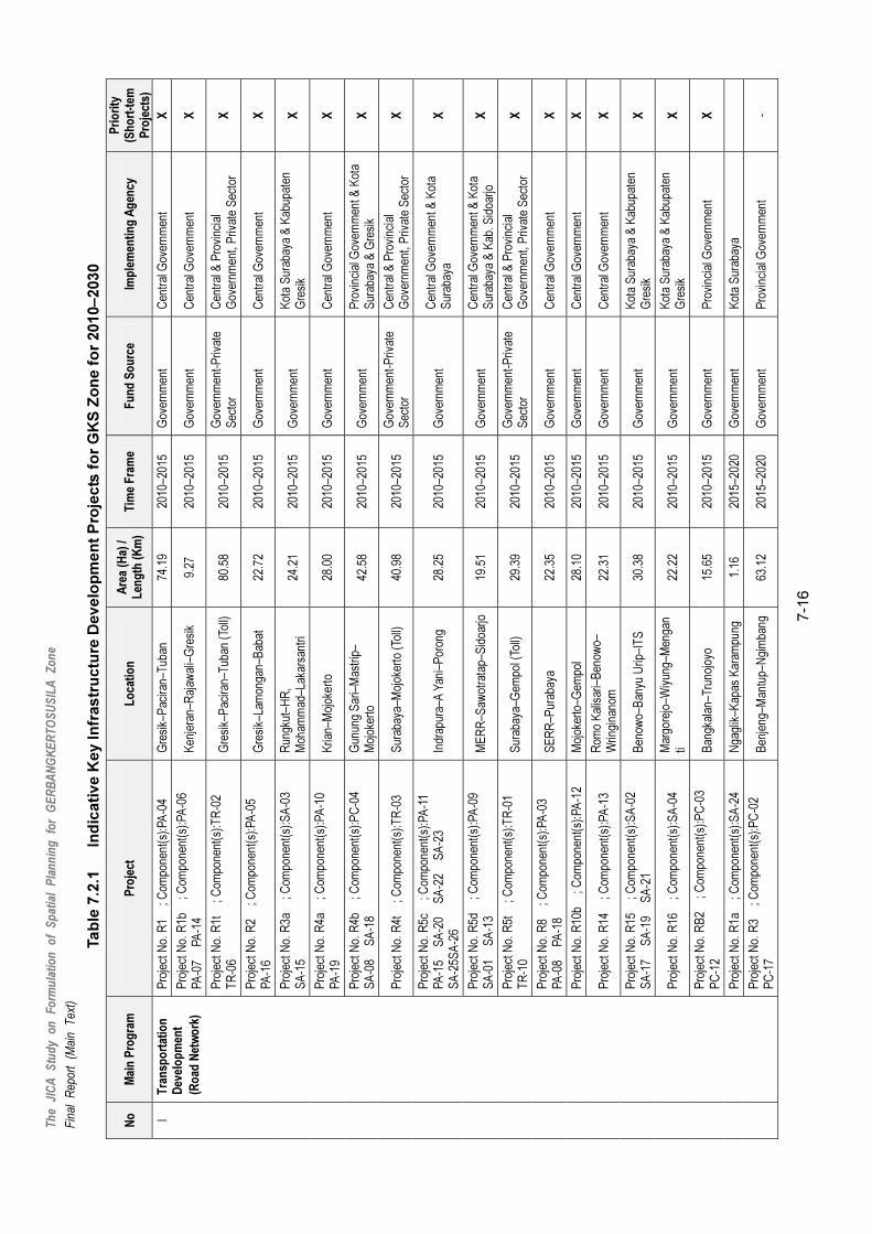
Th
e JI
CA
S
tud
y o
n
Fo
rmu
lati
on
o
f S
pat
ial
Pla
nn
ing
fo
r G
ER
BA
NG
KE
RT
OS
US
ILA
Z
on
e
Fin
al
Rep
ort
(Mai
n T
ext)
7-1
6
Ta
ble
7.2
.1 In
dic
ati
ve
Ke
y In
fra
str
uc
ture
De
ve
lop
me
nt
Pro
jec
ts f
or
GK
S Z
on
e f
or
20
10–
203
0
No
M
ain
Pro
gra
m
Pro
ject
L
oca
tio
n
Are
a (H
a) /
Len
gth
(K
m)
Tim
e F
ram
e F
un
d S
ou
rce
Im
ple
men
tin
g A
gen
cy
Pri
ori
ty
(Sh
ort
-tem
P
roje
cts)
Pro
ject
No.
R1
; C
ompo
nent
(s):
PA
-04
G
resi
k–P
acira
n–T
uban
74
.19
2010
–201
5 G
over
nmen
t C
entr
al G
over
nmen
t X
Pro
ject
No.
R1b
; Com
pone
nt(s
):P
A-0
6
PA
-07
P
A-1
4
K
enje
ran–
Raj
awal
i–G
resi
k 9.
27
2010
–201
5 G
over
nmen
t C
entr
al G
over
nmen
t X
Pro
ject
No.
R1t
; Com
pone
nt(s
):T
R-0
2
TR
-06
G
resi
k–P
acira
n–T
uban
(To
ll)80
.58
2010
–201
5 G
over
nmen
t-P
rivat
e S
ecto
r C
entr
al &
Pro
vinc
ial
Gov
ernm
ent,
Priv
ate
Sec
tor
X
Pro
ject
No.
R2
; C
ompo
nent
(s):
PA
-05
P
A-1
6
Gre
sik–
Lam
onga
n–B
abat
22
.72
2010
–201
5 G
over
nmen
t C
entr
al G
over
nmen
t X
Pro
ject
No.
R3a
; Com
pone
nt(s
):S
A-0
3
SA
-15
R
ungk
ut–H
R,
Moh
amm
ad–L
akar
sant
ri 24
.21
2010
–201
5 G
over
nmen
t K
ota
Sur
abay
a &
Kab
upat
en
Gre
sik
X
Pro
ject
No.
R4a
; Com
pone
nt(s
):P
A-1
0
PA
-19
K
rian–
Moj
oker
to
28.0
0 20
10–2
015
Gov
ernm
ent
Cen
tral
Gov
ernm
ent
X
Pro
ject
No.
R4b
; Com
pone
nt(s
):P
C-0
4
SA
-08
S
A-1
8
G
unun
g S
ari–
Mas
trip
– M
ojok
erto
42
.58
2010
–201
5 G
over
nmen
t P
rovi
ncia
l Gov
ernm
ent &
Kot
a S
urab
aya
& G
resi
k X
Pro
ject
No.
R4t
; Com
pone
nt(s
):T
R-0
3
Sur
abay
a–M
ojok
erto
(To
ll)
40.9
8 20
10–2
015
Gov
ernm
ent-
Priv
ate
Sec
tor
Cen
tral
& P
rovi
ncia
l G
over
nmen
t, P
rivat
e S
ecto
r X
Pro
ject
No.
R5c
; Com
pone
nt(s
):P
A-1
1
PA
-15
S
A-2
0
SA
-22
S
A-2
3
SA
-25S
A-2
6 In
drap
ura–
A Y
ani–
Por
ong
28.2
5 20
10–2
015
Gov
ernm
ent
Cen
tral
Gov
ernm
ent &
Kot
a S
urab
aya
X
Pro
ject
No.
R5d
; Com
pone
nt(s
):P
A-0
9
SA
-01
S
A-1
3
M
ER
R–S
awot
rata
p–S
idoa
rjo19
.51
2010
–201
5 G
over
nmen
t C
entr
al G
over
nmen
t & K
ota
Sur
abay
a &
Kab
. Sid
oarjo
X
Pro
ject
No.
R5t
; Com
pone
nt(s
):T
R-0
1
TR
-10
S
urab
aya–
Gem
pol (
Toll)
29
.39
2010
–201
5 G
over
nmen
t-P
rivat
e S
ecto
r C
entr
al &
Pro
vinc
ial
Gov
ernm
ent,
Priv
ate
Sec
tor
X
Pro
ject
No.
R8
; C
ompo
nent
(s):
PA
-03
P
A-0
8
PA
-18
SE
RR
–Pur
abay
a 22
.35
2010
–201
5 G
over
nmen
t C
entr
al G
over
nmen
t X
Pro
ject
No.
R10
b
; Com
pone
nt(s
):P
A-1
2
M
ojok
erto
–Gem
pol
28.1
0 20
10–2
015
Gov
ernm
ent
Cen
tral
Gov
ernm
ent
X
Pro
ject
No.
R14
; Com
pone
nt(s
):P
A-1
3
R
omo
Kal
isar
i–B
enow
o–
Wrin
gina
nom
22
.31
2010
–201
5 G
over
nmen
t C
entr
al G
over
nmen
t X
Pro
ject
No.
R15
; Com
pone
nt(s
):S
A-0
2
SA
-17
S
A-1
9
SA
-21
B
enow
o–B
anyu
Urip
–IT
S
30.3
8 20
10–2
015
Gov
ernm
ent
Kot
a S
urab
aya
& K
abup
aten
G
resi
k X
Pro
ject
No.
R16
; Com
pone
nt(s
):S
A-0
4
M
argo
rejo
–Wiy
ung–
Men
gan
ti 22
.22
2010
–201
5 G
over
nmen
t K
ota
Sur
abay
a &
Kab
upat
en
Gre
sik
X
Pro
ject
No.
RB
2
; Com
pone
nt(s
):P
C-0
3
PC
-12
B
angk
alan
–Tru
nojo
yo
15.6
5 20
10–2
015
Gov
ernm
ent
Pro
vinc
ial G
over
nmen
t X
Pro
ject
No.
R1a
; Com
pone
nt(s
):S
A-2
4
N
gagl
ik–K
apas
Kar
ampu
ng
1.16
20
15–2
020
Gov
ernm
ent
Kot
a S
urab
aya
I T
ran
spo
rtat
ion
D
evel
op
men
t
(Ro
ad N
etw
ork
)
Pro
ject
No.
R3
; C
ompo
nent
(s):
PC
-02
P
C-1
7
Ben
jeng
–Man
tup–
Ngi
mba
ng63
.12
2015
–202
0 G
over
nmen
t P
rovi
ncia
l Gov
ernm
ent
-

Th
e JI
CA
S
tud
y o
n
Fo
rmu
lati
on
o
f S
pat
ial
Pla
nn
ing
fo
r G
ER
BA
NG
KE
RT
OS
US
ILA
Z
on
e
Fin
al
Rep
ort
(Mai
n T
ext)
7-1
7
No
M
ain
Pro
gra
m
Pro
ject
L
oca
tio
n
Are
a (H
a) /
Len
gth
(K
m)
Tim
e F
ram
e F
un
d S
ou
rce
Im
ple
men
tin
g A
gen
cy
Pri
ori
ty
(Sh
ort
-tem
P
roje
cts)
Pro
ject
No.
R5a
; Com
pone
nt(s
):S
A-0
7
SA
-16
S
imog
unun
g–S
idoa
rjo
20.3
8 20
15–2
020
Gov
ernm
ent
Kot
a S
urab
aya
& K
abup
aten
S
idoa
rjo
-
Pro
ject
No.
R6a
; Com
pone
nt(s
):P
A-1
7
SA
-12
N
gage
l Jay
a–P
utro
Agu
ng
Wet
an–K
edun
g C
owek
18
.14
2015
–202
0 G
over
nmen
t C
entr
al G
over
nmen
t & K
ota
Sur
abay
a -
Pro
ject
No.
R6a
t
; Com
pone
nt(s
):T
R-1
1
La
bang
–Bur
neh–
Aro
sbay
a 26
.08
2015
–202
0 G
over
nmen
t-P
rivat
e S
ecto
r C
entr
al G
over
nmen
t, P
rovi
ncia
l G
over
nmen
t, P
rivat
e In
vest
or
-
Pro
ject
No.
R7
; C
ompo
nent
(s):
PA
-01
P
C-0
1
Kam
al–M
odun
g–B
lega
90
.04
2015
–202
0 G
over
nmen
t C
entr
al G
over
nmen
t &
Pro
vinc
ial G
over
nmen
t -
Pro
ject
No.
R8s
t
; Com
pone
nt(s
):T
R-0
4
P
erak
–Sur
amad
u (T
oll)
7.94
20
15–2
020
Gov
ernm
ent-
Priv
ate
Sec
tor
Cen
tral
Gov
ernm
ent,
Pro
vinc
ial
Gov
ernm
ent,
Priv
ate
Inve
stor
-
Pro
ject
No.
R9
; C
ompo
nent
(s):
SA
-09
G
resi
k–K
rian
27.0
3 20
15–2
020
Gov
ernm
ent
Kab
upat
en G
resi
k &
K
abup
aten
Sid
oarjo
-
Pro
ject
No.
R11
; Com
pone
nt(s
):P
C-0
8
PC
-11
P
C-1
8
M
ojok
erto
–Bab
at–P
acira
n 10
2.16
20
15–2
020
Gov
ernm
ent
Pro
vinc
ial G
over
nmen
t -
Pro
ject
No.
R12
; Com
pone
nt(s
):P
C-1
4
SA
-11
M
argo
mul
yo–T
aman
–Sid
oarj
o 21
.90
2015
–202
0 G
over
nmen
t P
rovi
ncia
l Gov
ernm
ent &
Kot
a S
urab
aya
& K
abup
aten
S
idoa
rjo
-
Pro
ject
No.
R13
; Com
pone
nt(s
):S
A-1
0
La
mon
g B
ay–L
akar
sant
ri–
Driy
orej
o 18
.10
2015
–202
0 G
over
nmen
t K
ota
Sur
abay
a &
Kab
upat
en
Gre
sik
& K
abup
aten
Sid
oarjo
-
Pro
ject
No.
R17
; Com
pone
nt(s
):S
A-0
5
SA
-06
R
ungk
ut–S
umur
W
elut
–Men
gant
i 24
.77
2015
–202
0 G
over
nmen
t K
ota
Sur
abay
a &
Kab
upat
en
Gre
sik
-
Pro
ject
No.
RG
2
; Com
pone
nt(s
):S
A-1
4
G
resi
k R
ing
Roa
d 20
.48
2015
–202
0 G
over
nmen
t K
abup
aten
Gre
sik
-
Pro
ject
No.
R6
; C
ompo
nent
(s):
PA
-02
K
amal
–Ban
gkal
an–T
g.B
umi
59.3
6 20
20-2
030
Gov
ernm
ent
Cen
tral
Gov
ernm
ent
-
Pro
ject
No.
R8a
t
; Com
pone
nt(s
):T
R-0
5
S
ER
R
16.4
9 20
20–2
030
Gov
ernm
ent-
Priv
ate
Sec
tor
Cen
tral
& P
rovi
ncia
l G
over
nmen
t, P
rivat
e S
ecto
r -
Pro
ject
No.
R8t
; Com
pone
nt(s
):T
R-1
2
Juan
da T
oll R
oad–
War
u 8.
28
2020
–203
0 G
over
nmen
t-P
rivat
e S
ecto
r C
entr
al &
Pro
vinc
ial
Gov
ernm
ent,
Priv
ate
Sec
tor
-
Pro
ject
No.
R9t
; Com
pone
nt(s
):T
R-0
7
TR
-09
D
riyor
ejo–
Kria
n–P
oron
g 56
.99
2020
–203
0 G
over
nmen
t-P
rivat
e S
ecto
r C
entr
al &
Pro
vinc
ial
Gov
ernm
ent,
Priv
ate
Sec
tor
-
Pro
ject
No.
R10
a
; Com
pone
nt(s
):P
C-0
7
PC
-10
S
iday
u–La
mon
gan–
Moj
oker
to
64.9
6 20
20–2
030
Gov
ernm
ent
Pro
vinc
ial G
over
nmen
t -
Pro
ject
No.
RB
1
; Com
pone
nt(s
):P
C-0
5
PC
-06
Ta
nah
Mer
ah–S
epul
u
T
g.B
umi–
Ble
ga
53.0
8 20
20–2
030
Gov
ernm
ent
Pro
vinc
ial G
over
nmen
t -
I T
ran
spo
rtat
ion
D
evel
op
men
t
(Ro
ad N
etw
ork
)
Pro
ject
No.
RG
1
; Com
pone
nt(s
):P
C-2
1
PC
-22
S
iday
u–U
jung
P
angk
ah-P
ance
ng
26.9
5 20
20–2
030
Gov
ernm
ent
Pro
vinc
ial G
over
nmen
t -

Th
e JI
CA
S
tud
y o
n
Fo
rmu
lati
on
o
f S
pat
ial
Pla
nn
ing
fo
r G
ER
BA
NG
KE
RT
OS
US
ILA
Z
on
e
Fin
al
Rep
ort
(Mai
n T
ext)
7-1
8
No
M
ain
Pro
gra
m
Pro
ject
L
oca
tio
n
Are
a (H
a) /
Len
gth
(K
m)
Tim
e F
ram
e F
un
d S
ou
rce
Im
ple
men
tin
g A
gen
cy
Pri
ori
ty
(Sh
ort
-tem
P
roje
cts)
Pro
ject
No.
RL1
; Com
pone
nt(s
):P
C-1
9
PC
-20
P
ucuk
–Pac
iran
42.6
1 20
20–2
030
Gov
ernm
ent
Pro
vinc
ial G
over
nmen
t -
Pro
ject
No.
RM
1
; Com
pone
nt(s
):P
C-0
9
PC
-23
M
ojos
ari–
Tra
was
–Soo
ko
47.2
4 20
20–2
030
Gov
ernm
ent
Pro
vinc
ial G
over
nmen
t -
Pro
ject
No.
RS
2
; Com
pone
nt(s
):P
C-1
5
PC
-16
K
rian–
Won
oayu
–Cem
eng
Kal
ang
18.4
9 20
20–2
030
Gov
ernm
ent
Pro
vinc
ial G
over
nmen
t -
Tanj
ung
Bul
upan
dan
Inte
rnat
iona
l Por
t Hub
D
evel
opm
ent
Kla
mpi
s +
sur
roun
ding
s,
Ban
gkal
an
1,00
0.00
20
12–2
015
Gov
ernm
ent &
P
rivat
e B
PW
S
X
Lam
ong
Bay
Con
tain
er T
erm
inal
Dev
elop
men
tLa
mon
g B
ay, S
urab
aya
55.5
0 20
10–2
012
Gov
ernm
ent
Gov
ernm
ent E
nter
pris
e X
Tra
nsp
ort
atio
n
Dev
elo
pm
ent
(Ro
ad N
etw
ork
)
Tra
nsp
ort
atio
n
Dev
elo
pm
ent
(Po
rt &
Har
bo
r)
Soc
ah In
dust
ry P
ort D
evel
opm
ent
Soc
ah, B
angk
alan
?
2012
–201
5 P
rivat
e S
ecto
r B
angk
alan
Gov
ernm
ent,
Priv
ate
Sec
tor
X
(Air
po
rt)
Exp
ansi
on o
f Jua
nda
II In
tern
atio
nal A
irpor
t D
evel
opm
ent
Sed
ati,
Sid
oarjo
10
.00
2011
–201
5 G
over
nmen
t P
rovi
nce
Gov
ernm
ent
X
Fea
sibi
lity
Stu
dy fo
r C
omm
uter
Tra
in O
pera
tor
for
Sur
abay
a-M
ojok
erto
and
Sur
abay
a-K
rian
Sec
tions
G
KS
2012
C
entr
al G
over
nmen
tM
inis
try
of T
rans
port
atio
n X
Rai
lway
and
Com
mut
er T
rain
Pla
nnin
g an
d D
evel
opm
ent c
onne
ctin
g W
aru
to J
uand
a S
awot
rata
p–Ju
anda
2012
–201
4 C
entr
al G
over
nmen
tM
inis
try
of T
rans
port
atio
n X
Tra
nsp
ort
atio
n
Dev
elo
pm
ent
(Rai
lway
Sys
tem
)
Juan
da-W
aru-
Won
okro
mo-
Gub
eng
Com
mut
er
Tra
in C
onne
ctio
n P
lann
ing
and
Impl
emen
tatio
n W
aru–
Won
okro
mo–
Gub
eng
20
15–2
017
Cen
tral
Gov
ernm
ent
Min
istr
y of
Tra
nspo
rtat
ion
-
Inte
rmod
al G
atew
ay C
ente
r C
onne
ctin
g S
idoa
rjo-S
urab
aya
War
u, S
urab
aya
20
15–2
016
Cen
tral
Gov
ernm
ent
Min
istr
y of
Tra
nspo
rtat
ion
-
Inte
rmod
al G
atew
ay C
ente
r C
onne
ctin
g La
mon
gan-
Sur
abay
a B
enow
o, S
urab
aya
20
17–2
018
Cen
tral
Gov
ernm
ent
Min
istr
y of
Tra
nspo
rtat
ion
-
Inte
rmod
al G
atew
ay C
ente
r C
onne
ctin
g M
ojok
erto
-Sur
abay
a S
epan
jang
, Sid
oarjo
2019
–202
0 C
entr
al G
over
nmen
tM
inis
try
of T
rans
port
atio
n -
I
Tra
nsp
ort
atio
n
Dev
elo
pm
ent
(In
term
od
al
Sys
tem
)
Inte
rmod
al G
atew
ay C
ente
r C
onne
ctin
g G
resi
k-S
urab
aya
Tam
bak
Oso
Wila
ngun
, S
urab
aya
20
21–2
022
Cen
tral
Gov
ernm
ent
Min
istr
y of
Tra
nspo
rtat
ion
-
Bun
gah,
Gre
sik
64.0
0 20
10–2
012
Cen
tral
, Pro
vinc
ial
Gov
ernm
ents
M
inis
try
of P
ublic
Wor
k,
Pro
vinc
e &
Kab
b./K
ota
Gov
er’t
X
Sem
baya
t Bar
rage
Dev
elop
men
t
Lare
n, L
amon
gan
10.0
0 20
10–2
012
Cen
tral
, Pro
vinc
ial
Gov
ernm
ents
M
inis
try
of P
ublic
Wor
k,
Pro
vinc
e &
Kab
b./K
ota
Gov
er’t
X
Ble
ga R
eser
voir
Dev
elop
men
t G
alis
, Ban
gkal
an
966.
30
2012
–201
5 C
entr
al a
nd L
ocal
G
over
nmen
ts
Min
istr
y of
Pub
lic W
ork,
Kab
b./K
ota
Gov
ernm
ent
X
II W
ater
-rel
ated
In
fras
tru
ctu
re
Dev
elo
pm
ent
Inte
r-pr
ovin
ce W
ater
Div
ersi
on P
roje
ct
(Um
bula
n W
ater
Tra
nsfe
r P
roje
ct &
Sol
o R
iver
W
ater
Tra
nsfe
r P
roje
ct))
Gre
sik,
Sid
oarjo
, Sur
abay
a,
Ban
kala
n, L
amon
gan,
P
asur
uan
- 20
12-2
015
Gov
ernm
ent-
Priv
ate
Sec
tor
Min
istr
y of
Pub
lic W
ork,
P
rovi
nce
& K
abb.
/Kot
a G
over
’tX

Th
e JI
CA
S
tud
y o
n
Fo
rmu
lati
on
o
f S
pat
ial
Pla
nn
ing
fo
r G
ER
BA
NG
KE
RT
OS
US
ILA
Z
on
e
Fin
al
Rep
ort
(Mai
n T
ext)
7-1
9
No
M
ain
Pro
gra
m
Pro
ject
L
oca
tio
n
Are
a (H
a) /
Len
gth
(K
m)
Tim
e F
ram
e F
un
d S
ou
rce
Im
ple
men
tin
g A
gen
cy
Pri
ori
ty
(Sh
ort
-tem
P
roje
cts)
Wat
er S
uppl
y F
acili
ty E
xpan
sion
and
N
on-r
even
ue W
ater
(N
RW
) R
educ
tion
Pro
ject
E
ach
PD
AM
-
2015
-202
0 G
over
nmen
t-P
rivat
e S
ecto
r P
rovi
ncia
l, K
abb.
/Kot
a G
over
nmen
ts, P
DA
M
-
Wat
er S
avin
g P
rom
otio
n P
rogr
am
A
ll G
KS
Zon
e
- 20
12-2
015
Pro
vinc
ial a
nd lo
cal
gove
rnm
ents
P
rovi
ncia
l, K
abb.
/Kot
a G
over
nmen
ts, P
DA
M
X
III
Was
te W
ater
T
reat
men
t an
d
Urb
an D
rain
age
Dev
elo
pm
ent
Urb
an D
rain
age
and
Was
te W
ater
Dis
posa
l M
aste
r P
lan
(Inc
ludi
ng C
apac
ity D
evel
opm
ent P
rogr
am)
Sel
ecte
d ur
ban
area
s in
G
KS
Zon
e
2012
-201
5 C
entr
al &
Pro
vinc
ial
Gov
ernm
ent
Min
istr
y of
Pub
lic W
ork,
P
rovi
ncia
l and
Kab
b./K
ota
Gov
ernm
ents
, PJT
1 X
ER
P (
Eco
logi
cal R
ecyc
ling
Par
k) D
evel
opm
ent
for
Gre
sik-
Sid
oarjo
-Sur
abay
a K
edam
ean,
Gre
sik
12
0.00
20
11–2
015
Gov
ernm
ent-
Priv
ate
Sec
tor
Pro
vinc
e an
d Lo
cal P
ublic
W
ork
Age
ncy,
Priv
ate
Sec
tor
X
Impr
ovem
ent a
nd E
xpan
sion
of E
xist
ing
SW
M
Fac
ilitie
s
(Inc
ludi
ng c
losu
re p
roje
ct o
f lan
dfill
site
s)
GK
S
- 20
11-2
015
Gov
ernm
ent-
Priv
ate
Sec
tor
Pro
vinc
e an
d Lo
cal P
ublic
W
ork
Age
ncy,
Priv
ate
Sec
tor
X
IV
So
lid W
aste
In
fras
tru
ctu
re
Dev
elo
pm
ent
Dis
posa
l Cap
acity
Dev
elop
men
t Pro
gram
(incl
udin
g 3R
s fa
cilit
ies,
Inte
rmed
iate
Tra
nsfe
r S
yste
m, T
echn
olog
y In
nova
tion
for
SW
M, e
tc)
GK
S
- 20
12-2
015
Gov
ernm
ent-
Priv
ate
Sec
tor
Pro
vinc
e an
d Lo
cal P
ublic
W
ork
Age
ncy,
and
Priv
ate
Sec
tor
X
Pow
er S
uppl
y E
nhan
cem
ent P
rogr
am to
war
ds
2020
(incl
udin
g: C
apac
ity e
nhan
cem
ent o
f Pea
k Lo
ad, D
istr
ibut
ion
Net
wor
k an
d T
rans
form
ers)
GK
S a
nd O
ther
Par
ts o
f E
ast J
ava
- 20
10-2
020
PLN
Eas
t Jav
a P
LN E
ast J
ava
-
V
Po
wer
Alte
rnat
ive
and
Ren
ewab
le E
nerg
y S
yste
m
Dev
elop
men
t Pro
gram
Eas
t Jav
a an
d ov
er th
e N
atio
n -
2010
-203
0 P
LN, P
rivat
e S
ecto
r,
Inte
rnat
iona
l O
rgan
izat
ions
Cen
tral
Gov
ernm
ent,
PLN
, P
rivat
e S
ecto
r X
Agr
o-in
dust
ry Z
one
Dev
elop
men
ts
Uju
ng P
angk
ah, G
resi
k 4,
984
2010
–201
5 G
over
nmen
t-P
rivat
e S
ecto
r Lo
cal G
over
nmen
t-P
rivat
e S
ecto
r X
Indu
stria
l Zon
e D
evel
opm
ent
Man
yar,
Gre
sik
1,48
9 20
15–2
020
Pub
lic a
nd P
rivat
e E
nter
pris
e P
ublic
and
Priv
ate
Ent
erpr
ise
-
Sid
ayu
Indu
stria
l Par
k S
iday
u, G
resi
k 1,
000
2020
-203
0 P
ublic
and
Priv
ate
Ent
erpr
ise
Pub
lic a
nd P
rivat
e E
nter
pris
e -
Ngo
ro In
dust
rial P
ark
Ngo
ro, M
ojok
erto
44
0 20
10-2
015
Priv
ate
Sec
tor
Priv
ate
Sec
tor
X
Pus
pa A
gro
Reg
iona
l Mar
ket D
evel
opm
ent
Jem
undo
, Sid
oarjo
50
20
10–2
015
Gov
ernm
ent-
Priv
ate
Sec
tor
Pub
lic a
nd P
rivat
e E
nter
pris
e X
Sib
oria
n In
dust
rial E
stat
e an
d Z
one
Dev
elop
men
t S
idoa
rjo–K
rian
1,50
0 20
12–2
025
Gov
ernm
ent-
Priv
ate
Sec
tor
Pub
lic a
nd P
rivat
e E
nter
pris
e X
Pen
gem
bang
an In
dust
ri G
emop
olis
S
edat
i, S
idoa
rjo
300
2015
–201
7 G
over
nmen
t-P
rivat
e S
ecto
r P
ublic
and
Priv
ate
Ent
erpr
ise
-
VI
Co
ntr
olle
d
Ind
ust
rial
Zo
ne
Dev
elo
pm
ent
Lam
onga
n In
tegr
ated
Sho
re-b
ase
Pac
iran,
Lam
onga
n 10
0 20
10–2
012
Priv
ate
Sec
tor
Priv
ate
Sec
tor
X

Th
e JI
CA
S
tud
y o
n
Fo
rmu
lati
on
o
f S
pat
ial
Pla
nn
ing
fo
r G
ER
BA
NG
KE
RT
OS
US
ILA
Z
on
e
Fin
al
Rep
ort
(Mai
n T
ext)
7-2
0
No
M
ain
Pro
gra
m
Pro
ject
L
oca
tio
n
Are
a (H
a) /
Len
gth
(K
m)
Tim
e F
ram
e F
un
d S
ou
rce
Im
ple
men
tin
g A
gen
cy
Pri
ori
ty
(Sh
ort
-tem
P
roje
cts)
Moj
oany
ar In
dust
rial E
stat
e M
ojan
yar,
Moj
oker
to
555
2015
–202
0 P
rivat
e S
ecto
r P
rivat
e S
ecto
r -
R&
D C
ente
r fo
r A
gro-
proc
essi
ng a
nd F
ishe
ry
Pro
duct
s an
d M
arke
t Dev
elop
men
t M
ojok
erto
, Sid
oarjo
E
ach
50
2012
-201
5 G
over
nmen
t-P
rivat
e S
ecto
r P
ublic
and
Priv
ate
Ent
erpr
ise
X
GK
S T
ouris
m C
ircui
ts D
evel
opm
ent,
netw
orki
ng h
isto
rical
and
nat
ural
ass
ets
(incl
udin
g: to
uris
m s
pots
, inf
orm
atio
n ce
nter
s,
eco-
tour
ism
site
dev
elop
men
t)
Sur
abay
a, M
ojok
erto
, S
idoa
rjo, G
resi
k -
2012
-201
5 G
over
nmen
t-P
rivat
e S
ecto
r P
ublic
and
Priv
ate
Ent
erpr
ise
X
VII
To
uri
sm
New
Tou
rism
Are
a D
evel
opm
ent i
n S
uram
adu
Brid
ge F
oot A
rea
Pro
ject
S
urab
aya,
Ban
gkal
an
- 20
15-2
00
Gov
ernm
ent-
Priv
ate
Sec
tor
BP
WS
, Pro
vinc
ial a
nd
Kab
//Kot
a G
over
nmen
ts
-
Tar
ik R
iver
side
City
T
arik
, Sid
oarjo
30
0 20
15-
Priv
ate
Sec
tor
Kab
./Kot
a G
over
nmen
t, P
rivat
e S
ecto
r -
Wat
erfr
ont R
esid
entia
l Set
tlem
ent
Dev
elop
men
t T
eluk
Lam
ong,
Pan
tai
Tim
ur, S
urab
aya
400
2015
- P
rivat
e S
ecto
r K
ab./K
ota
Gov
ernm
ent,
Priv
ate
Sec
tor
-
VIII
L
arg
e-sc
ale
Set
tlem
ents
D
evel
op
men
t
New
Hou
sing
Com
plex
Dev
elop
men
t D
riyor
ejo,
Ked
amea
n,
Men
gant
i, C
erm
e 4,
000
2020
- P
rivat
e S
ecto
r K
ab./K
ota
Gov
ernm
ent,
Priv
ate
Sec
tor
-
Sur
amad
u B
ridge
Foo
t for
Ban
gkal
an Z
one
Dev
elop
men
t La
bang
, Ban
gkal
an
600
2011
–203
0 B
PW
S-P
rivat
e S
ecto
rB
PW
S, P
rovi
ncia
l and
K
ab//K
ota
Gov
ernm
ents
X
IX
S
ura
mad
u B
rid
ge
Fo
ot
Zo
ne
Dev
elo
pm
ent
Sur
amad
u B
ridge
Foo
t for
Sur
abay
a Z
one
Dev
elop
men
t T
amba
k W
edi,
Sur
abay
a 60
0 20
11–2
030
BP
WS
-Priv
ate
Sec
tor
BP
WS
, Pro
vinc
ial a
nd
Kab
//Kot
a G
over
nmen
ts
X
X
En
viro
nm
enta
l M
anag
emen
t C
ompr
ehen
sive
Pro
gram
for
Cap
abili
ty
Bui
ldin
g an
d S
tren
gthe
ning
of t
he
Env
ironm
enta
l Man
agem
ent i
n th
e G
KS
Zon
e,
incl
udin
g:1)
Est
ablis
hmen
t of a
GK
S C
ounc
il fo
r E
nviro
nmen
t; 2)
Env
ironm
enta
l Pol
icy
Bui
ldin
g; 3
) R
esea
rch
of b
iodi
vers
ity s
tatu
s; 4
) E
stab
lishm
ent o
f a G
KS
Pro
tect
ed A
rea
and
Man
agem
ent P
lan.
GK
S
20
11-2
020
Cen
tral
and
Loc
al
Gov
ernm
ents
P
rovi
ncia
l and
Kab
//Kot
a G
over
nmen
ts
X
Exp
andi
ng Im
plem
enta
tion
of th
e C
ompr
ehen
sive
KIP
Pro
gram
Sel
ecte
d K
ab/K
ota
othe
r th
an S
urab
aya
20
12-2
020
Gov
ernm
ents
-Priv
ate
Sec
tor
Pro
vinc
ial a
nd K
ab//K
ota
Gov
ernm
ents
X
Est
ablis
hmen
t of L
ocal
Inst
itutio
n an
d F
undi
ng
Mec
hasn
ism
for
Hou
sing
Dev
elop
men
t and
M
anag
emen
t, in
clud
ing
com
mun
ity-d
riven
se
lf-he
lp a
ctiv
ities
bas
ed o
n a
“Trid
aya”
co
ncep
t.
GK
S, E
ast J
ava
20
12-2
015
Cen
tral
and
P
rovi
ncia
l G
over
nmen
t-P
rivat
e S
ecto
r
Pro
vinc
ial a
nd K
ab//K
ota
Gov
ernm
ents
, Priv
ate
Sec
tor
X
XI
Ho
usi
ng
an
d
So
cial
Ser
vice
s
Dev
elop
men
t of a
Hie
rarc
hica
l Par
k S
yste
m
and
Gre
en N
etw
ork
Eac
h K
ab/K
ota
20
15-2
030
Pro
vinc
ial a
nd
Kab
/Kot
a G
over
nmen
ts,
Priv
ate
Sec
tor
Pro
vinc
ial a
nd K
ab/K
ota
Gov
ernm
ents
-

Th
e JI
CA
S
tud
y o
n
Fo
rmu
lati
on
o
f S
pat
ial
Pla
nn
ing
fo
r G
ER
BA
NG
KE
RT
OS
US
ILA
Z
on
e
Fin
al
Rep
ort
(Mai
n T
ext)
7-2
1
No
M
ain
Pro
gra
m
Pro
ject
L
oca
tio
n
Are
a (H
a) /
Len
gth
(K
m)
Tim
e F
ram
e F
un
d S
ou
rce
Im
ple
men
tin
g A
gen
cy
Pri
ori
ty
(Sh
ort
-tem
P
roje
cts)
Est
ablis
hmen
t of “
the
GK
S D
evel
opm
ent
Coo
pera
tion
Boa
rd”
for
inte
r-re
genc
y co
ordi
natio
n of
dev
elop
men
t G
KS
2011
–201
2 B
KS
P G
KS
B
KS
P G
KS
, Pro
vinc
e G
over
nmen
t X
Tra
inin
g of
Spa
tial P
lann
ing
and
Dev
elop
men
t of
GK
S Z
one
Man
agem
ent
GK
S
20
11–2
015
BK
SP
GK
S
BK
SP
GK
S, P
rovi
nce
Gov
ernm
ent,
Uni
vers
ity
X
Tra
inin
g fo
r H
uman
Res
ourc
e C
apac
ity
Bui
ldin
g of
GK
S In
stitu
tion
Man
agem
ent t
o Im
prov
e C
arrie
r La
dder
G
KS
2011
–203
0 B
KS
P G
KS
B
KS
P G
KS
, Per
guru
an T
ingg
i, P
empr
ov J
atim
XII
Inst
itu
tio
nal
D
evel
op
men
t
Tra
inin
g fo
r C
oope
ratio
n D
evel
opm
ent
Cap
acity
(ev
ery
two
year
s)
GK
S
20
11–2
030
BK
SP
GK
S
BK
SP
GK
S
X
Soc
io-c
ultu
ral R
ehab
ilita
tion
for
Com
mun
ity
impa
cted
by
Pro
ject
E
ach
loca
tion
impa
cted
by
proj
ect
20
11–2
030
Gov
ernm
ent-
Priv
ate
Sec
tor
BK
SP
GK
S; C
entr
al, P
rovi
nce
and
Kab
/Kot
a G
over
nmen
ts
X
XIII
C
om
mu
nit
y-
bas
ed E
con
om
ic,
So
cial
& C
ult
ura
l D
evel
op
men
t E
cono
mic
Reh
abili
tatio
n fo
r C
omm
unity
im
pact
ed b
y P
roje
ct
Eac
h lo
catio
n im
pact
ed b
y pr
ojec
t
2011
–203
0 G
over
nmen
t-P
rivat
e S
ecto
r B
KS
P G
KS
; Cen
tral
, Pro
vinc
e an
d K
ab/K
ota
Gov
ernm
ents
X
Eco
nom
ic C
apac
ity Im
prov
emen
t for
Loc
al
Gov
ernm
ent t
hrou
gh C
oope
ratio
n E
ach
Kab
b./K
ota
20
11–2
030
Gov
ernm
ent-
Priv
ate
Sec
tor
Gov
ernm
ent-
Priv
ate
Sec
tor
X
XIV
C
apac
ity
Dev
elo
pm
ent
of
the
Go
vern
ance
D
evel
opm
ent A
ctiv
ity M
onito
ring,
Eva
luat
ion
and
Con
trol
E
ach
proj
ect
20
11–2
030
BK
SP
GK
S
Insp
ecto
r, P
ublic
X
Sou
rce:
JIC
A S
tudy
Tea
m a
nd S
patia
l Pla
nnin
g D
ocum
ent o
f eac
h K
abup
aten
/Kot
a in
GK
S Z
one
(200
8–20
30)
and
The
Stu
dy o
f Spa
tial P
lann
ing
for
GK
S Z
one
2010
–203
0

The JICA Study on Formulation of Spatial Planning for GERBANGKERTOSUSILA Zone
Final Report (Main Text)
8-1
8. DIRECTION OF SPATIAL
UTILIZATION CONTROL
8.1 Zoning Regulations on Spatial Utilization
According to Law No.26, 2007 on spatial planning, zoning regulations serve guidelines used
to enforce spatial utilization control. The law also stipulates that regulatory policies should
be based on the detailed plans of each spatial utilization zone. Zoning regulatory directions
for the GKS Zone should comply with those of East Java’s zoning policies. The province’s
zoning regulations include those for spatial structure, spatial pattern, as well as strategic
sectors and zones which consist of the following:
• Urban system;
• Transportation network;
• Energy network;
• Telecommunications network;
• Water system;
• Protection zone;
• Cultivation zone; and,
• Strategic zone.
From these sectors, two were reviewed in this Study: (1) urban system and 2) transportation
network. Since all the aspects and sectors were assessed to be relevant to the GKS Zone,
they.were included in the GKS spatial plan.
1) Urban System Regulations
The considerations that are considered in formulating zoning regulations for urban systems
are indicated below.
(1) National Activity Centers (PKN)
� Spatial utilization should be on the international and national scale, and urban
economic activities should be supported by appropriate facilities and urban
infrastructure, and
� The development of urban areas into settlements should have medium to high
intensity space use with vertical development.
(2) Area Activity Centers (PKW)
� Spatial utilization of the provincial-scale urban economic activities, supported by
appropriate urban infrastructure and facilities, and
� Development of urban areas as settlement centers, with medium spatial utilization,
and with controlled horizontal development.

The JICA Study on Formulation of Spatial Planning for GERBANGKERTOSUSILA Zone
Final Report (Main Text)
8-2
(3) Local Activity Centers (PKL)
� Spatial utilization for regency/municipal-scale economic activities, supported by
appropriate urban facilities and infrastructure.
2) Transportation Network
The considerations that are considered in formulating zoning regulations for urban systems
are indicated below and on succeeding pages.
(1) Road Networks
� Restriction on medium to high spatial utilization of areas along the roads;
� Prohibition of the conversion of roadside areas, especially those with protection
function;
� Determination of building setbacks along roadsides to meet road control space;
� Permission on complementary road infrastructure development in accordance with
the road class; and
� Prohibition of utilization of designated road space (Right of Way).
(2) Railway Networks
� Spatial utilization of medium to high intensity along railway networks and
limitation on areas being developed;
� Restriction on land uses around railway networks that could interfere with railway
operation and safety;
� Control of spatial utilization along railway lines which can create adverse
environmental impacts on railway traffic;
� Limitation on the number of grade crossings between railway lines and roads; and,
� Determination of building setbacks from railway lines based on environmental
impacts and the development needs of the railway network.
(3) Inland Waterway and Maritime Transportation
� Safety and security of shipping;
� Prohibition on air space activities that would impact on existing navigation
channels for river, lake, and maritime transportation;
� Prohibition on underwater activities with adverse impacts on river, lake, and
maritime transportation; and,
� Limitation on water use which impacts on navigation channels for river, lake, and
maritime transportation.
(4) Public Ports
� Spatial utilization for the operational needs and development of port areas;
� Ban on developments in water bodies that obstruct marine transportation routes;
and,
� Restriction on spatial utilization of port areas and their surroundings and the
issuance of permits for such use in accordance with existing laws and regulations.

The JICA Study on Formulation of Spatial Planning for GERBANGKERTOSUSILA Zone
Final Report (Main Text)
8-3
(5) Public Airports
� Need to use the space for airport operations;
� Spatial utilization around airports in accordance with airport development needs
under current laws and policies;
� Identification of safety zones for flight operations and noise zones; and
� Adoption of international air space standards to ensure safe flight operations.
3) Protection Zones
The considerations for formulating regulations for various protection zones include the
following:
(1) Forest Protection Zones
� Utilization for nature tourism with the condition that it will not change the
landscape;
� Utilization for educational and research activities with the condition that they will
not change the landscape;
� Prohibition on activities that will reduce forest areas;
� Prohibition on activities that will disturb the following: landscape, soil fertility,
durability, hydrologic functions, preservation of flora and fauna, and
environmental sustainability;
� Prohibition on activities that will change or destroy the area, its ecosystem, or
engender forest encroachment, land clearing, logging, and poaching of protected
animals;
� Strict supervision of cultivation of fixed areas by indigenous peoples and
preservation of the function of protected areas;
� Utilization for very low-intensity building and forest protection and its related
activities; and
� Strict supervision by relevant provincial institutions of space for cultivation.
(2) Water Infiltration Zones
� Prohibition on all types of activities that disrupt water absorption;
� Utilization for community forest activities;
� Limitation on permits for cultivation activities in non-built-up areas and which
have strong ability to hold rainwater runoffs;
� Utilization for nature tourism with the condition that it will not change the
landscape.
� Utilization for educational and research activities with the condition they will not
change the existing landscape;
� Utilization to provide absorption wells and/or construct reservoirs on existing
lands; and
� Application of the Zero Delta Q Policy on proposed permits for cultivation
activities in built-up areas.

The JICA Study on Formulation of Spatial Planning for GERBANGKERTOSUSILA Zone
Final Report (Main Text)
8-4
(3) Karst Zones
� Utilization for land reforestation activities, and
� Restriction on activities in absolute protection zones of karst resources.
(4) Coastal Areas
� Prohibition within a 100-meter distance from the high water line on all activities
that will reduce coastal quality;
� Prohibition on all activities that will damage coastal ecosystems, mangroves, coral
reefs, sea grass beds, and estuaries;
� Prohibition on activities that will lead to the reduction of the areas’ ecological
value and zone aesthetics;
� Prohibition on activities that will disturb the landscape, coastal preservation
functions, and/or access to shoreline areas;
� Utilization for mangrove plantation and other conservation activities.
� Utilization for construction of wharf infrastructure;
� Utilization for visitor safety guard tower infrastructure;
� Utilization for the development of natural and/or built-up structures to prevent
abrasion;
� Utilization for the provision of green open spaces; and
� Prohibition on new-building construction except for those supporting coastal
recreational activities.
(5) River Boundaries
� Prohibition on all activities and building construction on river boundaries;
� Prohibition on all activities and buildings that damage and degrade river quality;
� Utilization for adventure tourism that they will not degrade river water quality;
� Permission for tourism activities with the condition that the safety of tour users is
ensured;
� Utilization for the provision of green open spaces;
� Prohibition on new buildings except for those with water resource management
purposes;
� Restriction on building construction except those to support recreation parks; and
� Determination of river boundaries in accordance with existing laws.
(6) Water Springs
� Prohibition on all types of activities that degrade water quality, the physical
condition of the area, and catchments;
� Prohibition on all activities that disturb the landscape, soil fertility, durability,
hydrology, preservation of flora and fauna, and environmental functions;
� Prohibition on the use of non-irrigated rice fields;

The JICA Study on Formulation of Spatial Planning for GERBANGKERTOSUSILA Zone
Final Report (Main Text)
8-5
� Utilization for tourism and other cultivation activities with the condition that they
do not damage water quality; and
� Utilization for preservation and conservation activities such as land reforestation.
(7) Reservoirs and Lakes
� Prohibition on all types of activities that endanger protected areas and degrade
water quality;
� Utilization for tourism and cultivation activities with the condition that they do not
cause water degradation;
� Utilization for preservation and conservation activities such as land reforestation;
� Utilization for low-density building and those related to protection purposes; and
� Utilization for infrastructure to conserve reservoirs.
(8) Urban Green Open Spaces
� Prohibition on land-use conversion of all green open space;
� Utilization for expanding the areas for green open space exceeding 30% of urban
land use;
� Utilization on spatial utilization for recreation activities.
� Restriction on building construction except for recreation facilities and other public
facilities.
� Prohibition on permanent building construction, except for recreation and other
public facilities.
� Strict government control related to cultivation activities that affect green open
space functions and conversion.
(9) River Boundaries
� Prohibition on all cultivation activities within a 15-meter distance from river
boundaries;
� Utilization for land reforestation activities; and
� Prohibition on all activities causing land-use conversion of protected areas and
degradation of water quality.
(10) Mangroves and Forested Coastal Zones
� Utilization for land reforestation;
� Utilization for research, education, and natural attractions;
� Prohibition on the harvest and use of mangrove wood;
� Prohibition on activities that reduce or contaminate the mangrove ecosystem; and
� Prohibition on activities that disturb mangrove landscape and ecosystems, fauna
and flora, and biodiversity.

The JICA Study on Formulation of Spatial Planning for GERBANGKERTOSUSILA Zone
Final Report (Main Text)
8-6
(11) Forest Parks
� Utilization for educational and research activities, and ecotourism;
� Prohibition on activities that destroy or disrupt flora and fauna;
� Prohibition on activities that disturb the landscape, ecosystems, fauna and flora,
and biodiversity;
� Restriction on building construction except for educational, research, and
ecotourism purposes; and
� Prohibition on other building construction.
(12) Nature and Marine Parks
� Utilization of space for ecotourism that will not change the landscape;
� Prohibition on other activities except ecotourism;
� Conditional permission for building construction that support ecotourism;
� Prohibition on building construction except for the above;
� Prohibition on activities not suitable with the zone’s function and that of
ecotourism parks; and
� Prohibition on activities that change the landscape and ecosystem, as well as those
not in accordance with the zone’s function and that of other natural attractions.
(13) Cultural Heritage and Science Zones
� Utilization for educational activities, research, and tourism;
� Conditional permission for building construction that support education, research,
and tourism;
� Prohibition on activities that disturb cultural properties;
� Prohibition on activities that change specific geological formations beneficial to
science and research;
� Prohibition on activities that disturb the environment of historical and
archaeological sites/buildings, national monuments, and specific geology of certain
zones; and
� Prohibition on activities that disrupt the preservation of local cultures.
(14) Landslide- and Tidal-wave-prone Zones
� Utilization of space based on zonal characteristic, type, and disaster vulnerability;
� Determination of location and evacuation routes from the residential areas; and
� Limitation on new buildings, except for those that monitor disasters and promote
public interest.
(15) Flood-prone Zones
� Determination of flood-plain boundaries;
� Utilization of flood plains as green open spaces and construction of low-density

The JICA Study on Formulation of Spatial Planning for GERBANGKERTOSUSILA Zone
Final Report (Main Text)
8-7
public facilities; and
� Prohibition on the use of the areas as sites for settlements and public facilities.
(16) Natural-disaster-prone and Geological Protection Zones
� Prohibition on the use of the areas as sites for settlements and major infrastructure;
� Utilization for cultivation using high technology in accordance with the area’s
characteristics except in absolute protection zones; and
� Implementation of soil drainage, rock netting, shotcrete, block pitching, stone
pitching, retaining wall, gabion wall, installation of geotextile, terracing, retaining
embankments, mitigation / evacuation route, disaster information systems, early
warning systems, and disaster procedure operation standards.
4) Cultivation Zones
The following are the considerations in formulating regulations for cultivation zones:
(1) Community and Production Forests
� Utilization for sustainable forest development activities;
� Prohibition on cultivation development activities that reduce the forest area;
� Utilization for reforestation and forest rehabilitation;
� Limitation on forest products utilization permits to maintain balance in forestry
resources;
� Limitation on new building permits to support the utilization of forest products;
and.
� Prohibition on building construction.
(2) Agriculture Zones
� Prohibition on cultivation activities that reduce irrigated areas;
� Prohibition on cultivation that reduce or destroy the function of the land and soil
quality;
� Utilization for agricultural support activities;
� Prohibition on building construction in the affected irrigation channels of the
paddy fields;
� Utilization for the construction of farmer settlements with the condition that they
do not interfere with agricultural functions and have low density;
� Utilization for the implementation of agro-processing facilities and technical
training halls for farmers;
� Utilization for facilities and infrastructure for agricultural product development;
� Utilization for the development of irrigation channels;
� Utilization for the development of reservoirs and ponds;
� Utilization for the development of modern village barns; and
� Prohibition on the merging of irrigation and drainage canals..

The JICA Study on Formulation of Spatial Planning for GERBANGKERTOSUSILA Zone
Final Report (Main Text)
8-8
(3) Plantation Zones
� Utilization for house construction on the condition that they do not interfere with
the land use;
� Prohibition on farming activities that reduce, or destroy, the function of land and
the soil quality of the plantations; and
� Utilization for plantation support activities, such as organizing seeding activities.
(4) Fishery and Animal Husbandry Zones
� Utilization as farmers’ and/or fishermen’s settlements with low density;
� Utilization as spawning ground and/or green belts;
� Utilization of sustainable resources;
� Prohibition on all farming activities that interfere with the quality of
rivers/reservoirs and the water for aquaculture;
� Utilization for activities that support animal husbandry and fishery; and
� Utilization for the operation of fish processing buildings, fishermen’s training
centers, development facilities, and fisheries product development infrastructure,
and breeding centers.
(5) Mining Zones
� Utilization for the development of agriculture or forestry, especially for
post-mining;
� Utilization for residential development outside the core mining zones;
� Utilization for industrial development related to mining processing outside the core
zones for mining;
� Utilization for low-density building;
� Utilization for port development;
� Setting mining areas with due consideration given to cost–benefit and risk–benefit
balance; and
� Setting of other building arrangements around mining installations and equipment
locations that will potentially cause disasters, by taking into account local
concerns.
(6) Industrial Zones
� Utilization for the development of industrial support activities;
� Utilization of areas outside the buffer zones designated with medium-density
building for the development of small-scale residential stock ;
� Utilization of areas outside the industrial buffer zone for cultivation activities.
� Implementation of local scale workers/employees housing, social and public
facilities to support industrial activities;
� Utilization for the operation of wastewater treatment plants (WWTP);
� Provision of government incentives for the industrial zones’ increased integration

The JICA Study on Formulation of Spatial Planning for GERBANGKERTOSUSILA Zone
Final Report (Main Text)
8-9
with other productive cultivation zones without affecting the main function of each
zone;
� Utilization for industrial activities using appropriate technologies and are related to
natural resources and local human resources; and
� Limitation on new housing development around industrial zones.
(7) Tourism Zones
� Utilization for the development of commercial activities in accordance with the
scale of tourism attractions;
� Utilization for limited housing and settlement developments outside the main
tourism zones with the condition that they will not disturb the landscape;
� Prohibition on large-scale industrial and mining activities that will disrupt the land
use;
� Utilization of space by tailoring the building site coverage ratio (BCR) and floor
area ratio (FAR) to the type and characteristics of the tourist attraction;
� Development of tourism information service systems;
� Establishment of souvenir shops, cafeterias, restaurants, other commercial places,
etc. according to the scale of the tourist attraction;
� Utilization of natural and cultural potentials based on environmental carrying
capacities;
� Protection of cultural heritage sites; and
� Limitation on new buildings only to support tourism development.
� Prohibition on new buildings other than those supporting tourism in the tourism
core zones.
(8) Urban Settlement Zones
� Utilization for single houses, apartments, and/or cluster housing development;
� Utilization for low-, medium- to high-density buildings;
� Medium-density residential zones should be served by at least one public mass
transit, and a minimum of two public mass transit modes in high-density zones;
� Utilization for the development of trade and service areas in accordance with the
housing scale;
� Utilization for public and social facilities development according to the appropriate
scale;
� Prohibition on cultivation;
� Determination of the building conditions in terms of the building coverage ratio;
floor area ratio; and set-back from the limit of frontage road.
� Determination of the architectural themes; and
� Determination of the type and terms of permitted building use.

The JICA Study on Formulation of Spatial Planning for GERBANGKERTOSUSILA Zone
Final Report (Main Text)
8-10
(9) Rural Settlement Zones
� Utilization for single housing, cluster housing, and flat development;
� Intensification from low- to medium-density buildings;
� Allowing the development of trade and services in accordance with the settlement
scale.
� Utilization for the development of appropriate social and public facilities in
accordance with the settlement scale;
� Prohibition on cultivation;
� Determination of the building envelope;
� Determination of the architectural themes;
� Determination of housing completeness and its environment; and
� Determination of the type and terms of permitted building use.
5) Strategic Zones
The following are the considerations in formulating regulations for strategic zones.
(1) Economic Zones
� Development of large-scale economic support zones in urban development zones,
especially those with functions for: housing, commerce, business services, industry,
and transport, that support economic development;
� Minimization of spatial function changes for built-up areas through compact
vertical development in accordance with each zonal conditions;
� Completion of green open spaces to provide freshness in the middle of
high-intensity activities, and preservation of these spaces;
� Allowing for spatial changes in non-core zones (for trade, services, and industrial),
but continuing to support the zone’s main functions as an economic driver which
can be done without changing the main function of a predetermined zone;
� Change in or addition of specific spatial functions of open spaces provided these
are within the carrying capacity of the open spaces (but not allowed for urban
green space);
� Development of high-tech industrial parks through high-tech industries and
research, technology transfer center, and patents development center with
developed industry types such as biotechnology, pharmaceutical industry,
information technology, etc., supported by transportation and communication
infrastructure and green open spaces;
� Development of eco-estates with ecotourism and gift centers;
� Development of trade/commercial zones with commercial centers, office buildings,
convention centers, and other services such as banking and finance, with
high-density and compact buildings; and
� Development of free trade zones with industrial, warehousing, and port activities,
as well as container and distribution terminals, lots for lease, public service
facilities, national training centers, hospitals, schools, and industrial areas; along
with access to highways, primary arteries, and airport/port, international standard

The JICA Study on Formulation of Spatial Planning for GERBANGKERTOSUSILA Zone
Final Report (Main Text)
8-11
facilities, flood prevention system, green open spaces, high-tech communication
systems, and an EDI system.
(2) Defense and Security Zones
� Securing of defense and security zones and ensuring that they will not attract
community activities, especially high-intensity activities;
� Development of adequate environmental infrastructure and facilities to boost
defense and security;
� Support for direct or indirect activities with the condition that they do not disrupt
the land use; and
� Prohibition on activities undermining defense and security functions, i.e.,
development of industries that require huge amounts of labor and those that could
potentially interfere with the mobilization of defense and security; and
� Development of a core zone, enclave, or a closed space with buffer zones between
respective zones and the surrounding areas.
(3) Environmental Preservation Zones
� Guarantee of protection functions of core zones;
� When both core and supporting zones are damaged, these should be returned to
their initial condition to protect rare and endangered species;
� Support for the preservation of zones and prevention of damage in the long term
and acceleration of land rehabilitation;
� Utilization for ecotourism activities;
� Utilization for the construction of infiltration wells for zones with water infiltration
capacity;
� Restriction on land use conversion that interferes with the zone’s protection
function, especially if there are rare wildlife; and,
� Restriction on further development of core and supporting zones through
cultivation, especially in tandem with the development of settlements and the
cultivation of seasonal crops, or provision of gradual conversion of the zone to a
protected zone.
(4) High Control Zones
� Requirement for an impact assessment of cultivation in high control zones to
determine the allowable scale of activity;
� Strict control on cultivation that interferes with the zone’s primary function; and
� Utilization for allowed activities should comply with the zoning division.

The JICA Study on Formulation of Spatial Planning for GERBANGKERTOSUSILA Zone
Final Report (Main Text)
8-12
8.2 Administrative Measures on Spatial Control
8.2.1 Basic Concepts
Law No.26, 2007 mandates the streamlining of all zoning regulations, stipulating them to be
based on the detailed plan of each spatial zone. Although, the zoning regulations in the
GKS Zone is coherent with those of East Java’s, the need for a unique regulatory framework
is still present, taking into account the following requirements expected of the GKS Zone:
• Enhancement of a guided urban growth toward the development of a compact city;
• Enforcement of regulations on land-use zoning for urbanized or urbanizing areas,
stipulating the guidelines on land use, land development, and physical conditions of
buildings and facilities to be newly constructed; and
• Preparation of physical regulations for building construction in accordance with
building standards codes such as height, FAR, BCR, and setback.
As discussed in Chapter 6, a land-use zoning system has been proposed for the GKS Zone
spatial plan. In the zoning system, 10 categories of land uses were indicated, and the most
crucial is the effective management of environmentally sensitive areas against disorderly
development and land conversion. For this purpose, the following actions are particularly
essential:
(1) Establishment of a legal enforcement system for protecting “protection zones” and to
strictly control inappropriate actions in these zones;
(2) Provision of a detailed management mechanism for “forest areas,” wherever they have
been designated by law, in terms of permissible social, commercial, and industrial
activities in forest conservation and production;
(3) Establishment of guidelines for permissible and impermissible conversion of irrigated
agricultural land, taking into account existing relevant laws/regulations;
(4) Provision of housing development guidelines which should be complied with in “urban
development zones” (in terms of building and design standards, utilities, and other
facilities to be provided) and official engineering inspections; and
(5) Provision of industrial development guidelines for factories to be located in “industrial
zones,” including environmental quality standards for emissions, wastewater discharges,
drainage system, truck access, vibration and noise generation, as well as greenery
within the zones’ territories.
8.2.2 Administrative Framework for Spatial Management
A basic framework for the tools for land development and spatial control should be prepared
together with the spatial plan. The effective administrative tool should be double-edged, say,
promotion and restriction; incentive and disincentive; favor and fear; reward and
punishment; or carrot and stick. Using this tool, three aspects are addressed in terms of (1)
permission issuance, (2) provision of incentives and disincentives, and (3) imposition of
sanctions on land use, land development, and use of spatial resources that result in financial
loss or environmental degradation.

The JICA Study on Formulation of Spatial Planning for GERBANGKERTOSUSILA Zone
Final Report (Main Text)
8-13
1) Issuance of Permits
Utilization permits are regulated by the provincial and local governments in compliance with
related laws. All development activities should obtain such permits in accordance with the
detailed spatial plan and zoning permits given by the respective local governments.
2) Provision of Incentives and Disincentives
Incentives and disincentives should be provided in accordance with the laws and regulations
on spatial use and spatial plan.
Incentives or disincentives can be given by:
• Central government to local government;
• Government to private/community group;
• Local government to local government; and
• Local government to private/community group.
Tax holidays, subsidies, and prestigious usage of public services are typical incentives, while
taxes and surcharges on activities and physical restrictions on buildings and development
activities are forms of disincentives.
3) Imposition of Sanctions
Sanctions are determined by the central government and the respective local governments
based on their authority and are dependent on the amount of loss caused by the activity.
Sanctions are imposed on activities which intentionally violate the approved spatial structure
plan and spatial pattern plan for the GKS Zone.
Table 8.2.1 Administrative General Framework for Spatial Management
Source: JICA Study Team
Permit Direction Incentive and Disincentive
Direction
Sanction Direction
All spatial utilization should obtain
the Spatial Utilization Permit in accordance with Detail of Spatial Plan and Zoning Permit in
respective Local Government.
Spatial Utilization Permit is regulated by Government and Local Government in accordance
with each government authority as stipulated in related Law.
Incentives and disincentives can
be applied in accordance with the stipulation of laws and regulations for the utilization of spatial
activities in line with spatial planning.
Incentive and disincentive can be given by:
• Central Government to Local Government;
• Government to Private/Community Group;
• Local government to Local
Government; and• Local Government to
Private/Community Gr.oup
.
Sanction direction is determined by
Government and respective Local Government based on their authority and depend on the
financial loss value suffered by the activity.
Sanction is applied for the spatial utilization activity violate Spatial
Structure Plan and Spatial Pattern Plan of GKS Zone.