Biyagama Development Plan 2020 – 2030
338
Biyagama Development Plan 2020 – 2030 Ministry of Urban Development & Housing Urban Development Authority
-
Upload
khangminh22 -
Category
Documents
-
view
0 -
download
0
Transcript of Biyagama Development Plan 2020 – 2030

Biyagama Development Plan
2020 – 2030
Ministry of Urban Development & Housing Urban Development Authority

Biyagama Development Plan 2020 - 2030
© Urban Development Authority - Sri Lanka - 2020
All rights reserved. This publication is published by the Urban Development Authority. Duplication, Trade, Distribution, Copying or otherwise without the prior consent of the Authority, either entirely or partially or transmitted without written permission, or for the dissemination or commercialization of such a publication through modern techniques.
Published by
Urban Development Authority-Sri Lanka 6th, 7th & 9th Floors, “Sethsiripaya Stage I”, Battaramulla, Colombo, Sri Lanka Web Site : www.uda.gov.lk Email : [email protected] Tele : No: +94112873637 Published Date - 2020, December
Biyagama Development Plan 2020-2030 mainly consists of Three parts as Part I, II and III. The part I consists of the background study, preliminary studies, need of development plan, the Planning Framework, the SWOT analysis & the plan. The Part II consists of the Planning and Building Regulations and zoning regulations pertaining to the planning boundary for the period of 2020 – 2030. The Part III consist of the zoning boundaries with the coordinates and all the annexures. Biyagama Development Plan 2020 - 2030 has been prepared by the Gampaha District Office - Western Province Division, Urban Development Authority.
Supervision:
Archt. Harshan De Silva, Chairman – UDA, Plnr. N.P.K.Ranaweera, Director General – UDA, Plnr. H.A.Dayananda, Additional Director General – UDA, Plnr. M.P.Ranatunga, Deputy Director General (Planning) – UDA, Plnr. N.A.S.N. Nishsanka Director (Western Province Division) – UDA, Attorney at Law C. Jayawardena, Consultant (Legal) – UDA, Plnr. Priyani Nawarathne, Director (Strategic Planning) – UDA. Planning Team:
Plnr. J. Somasiri Deputy Director (Planning), Plnr. M.L.M. Yehiya Deputy Director (Planning), Pabasara Sathkumara Asst.Director (Planning), J.P.U.Wimalarathne Former Asst.Director (Planning), B.B.N.W. Kuruneru Planning Officer (Former), Y.S. Senarathne Planning Officer, G.R. Kumari Planning Officer, Udari Hettiarachchi Town Planner, Harshani Jayawardena Town Planner of the Gampaha District Office : Western Province Division - UDA, Sujeevi Meegahawatta GIS Officer - GIS Division – UDA, Maneesha Kumarasinghe Town Planner of Strategic Planning Division - UDA, Dinesh Gamage Environmental Officer Environmental & Landscape Division - UDA
Supportive Team
Environment and Landscape Division – UDA (Preparation of the PORS, DRR, Conservation Plans) GIS Division – UDA (Providing Arc GIS Spatial data layer & technical assistants) Strategic Planning Division – UDA (Supervision, monitoring and gazetting) Research & Development Division – UDA (Conduct awareness programs to introduce new techniques)

III
Acknowledgment
Western Province Division has taken the lead to provide the supervision for the preparation of the Biyagama
Development Plan 2020 – 2030. The objective of this plan is to identifying future development trends incorporating
physical, economic, social and environment sectors in the Biyagama Pradeshiya Sabha (PS) area. The vision of the
Biyagama Development Plan 2020 – 2030 is in line with the ‘Vistas of Prosperity and splendour’ the government policy
direction of the His Excellency the President Gotabaya Rajapaksa.
It is our proud privilege to Honorable Mahinda Rajapaksa subject Minister of Urban Development & Housing for
approving the Biyagama Development Plan 2020 – 2030 under the provision of Urban Development Authority Act No.
41 of 1978 as amended by the Act No. 04 of 1982. Further, it is our privilege to Dr. Nalaka Godahewa, State Minister of
Urban Development, Coast Conservation, Waste Disposal and Community Cleanliness and Mr. Sirinimal Perera,
Secretary to Ministry of Urban Development & Housing for their guidance and supports in this process.
Special gratitude offered on behalf of the planning team and the UDA, to the Chairman, Biyagama Pradeshiya Sabha
(Biyagama PS), members of the PS and the staff. Secretary Biyagama Divisional Secretariat and the staff for their
generous support given for the successful completion of this development plan.
Also, special appreciation on behalf of the UDA offered to all institutions representors and people who live in this area
for giving data and directives required for the preparation of this plan.
Appreciatively thankful to Chairman of UDA Archt. Harshan De Silva, Director General of UDA Plnr. N.P.K. Ranaweera,
Additional Director General of UDA Plnr. H.A. Dayananda, Deputy Director General (Planning) of UDA Plnr.
M.P.Ranatunga, Director Western Province Division of UDA Plnr. N.A.S.N.Nishsanka, Consultant (Legal) of UDA
Attorney at Law C. Jayawardena, Director (Strategic Planning) of UDA Plnr. Priyani Nawarathne on behalf of the
planning team for their incomparable courage, guidance and welcoming support.
In the end, Director – Environment & Landscape division L.Arct. C.K.E. Kalupahana and the staff of the division and
Director - Geographical Information System & ITS Plnr. J.P.S. Somasekara and the staff of the division and the staff of
the division, Gampaha District office of the UDA and staff members of all divisions are gratefully appreciating on
behalf of the planning team for their support to the successful completion of this task.

Hon. Minister’s Foreword
The Urban Development Authority was established under the Urban Development
Authority Act No. 41 of 1978, for the systematic planned urban development in
the declared urban areas and continue to actively contribute towards it.
Steps have been taken to formulate comprehensive development plans for each
urban development area, based on the efficient and effective use of physical
space so that all areas of Sri Lanka make an equal contribution to the
development process of the country.
The Biyagama area provide services to a large population. Accordingly, Biyagama Pradeshiya Sabha Planning Area
has the potential to become a town that continues to provide industrial, residential and commercial services.
This development plan aims to develop the Biyagama PS Area by utilizing the industrial potential of the area by
incorporating the eco industrial practices.
For the realization of His Excellency the president’s vision “Vistas of Prosperity” the new Re-urbanization
Programme has been formulated in wide consultation with Professionals, Specialists, Stakeholders &
communities with strategies having an excellent technological methodology and innovative approach.
Accordingly, I commend the Chairman of the Urban Development Authority, the Director General, the planning
teams and all the officers of the Urban Development Authority who assisted in making this work a success.
Further, I also appreciate and believe through the support and contribution of the relevant Local Government
Institutions, Public and Private Sector Institutions and the general public, Biyagama Development plan would be
successfully implemented.
Hon. Mahinda Rajapaksa (M.P)
Minister of Urban Development & Housing

V
Hon. State Minister’s Foreword
As a pioneer in Sri Lanka in achieving modern sustainable
development goals, the Urban Development Authority has a great
responsibility. Accordingly, it is essential to prepare development
plans for the Urban Development Areas declared by the Hon. Minister
in charge of the subject in terms of the Urban Development Authority
Amendment Act No. 04 of 1982 (Part II, Section 8A (1)).
The development plans thus formulated are primarily aimed at building a productive citizen,
a happy family, a dignified society and a prosperous nation, which are the core aspirations
of the vistas of prosperity. I also believe that these development plans will go a long way in
achieving the objectives of urban development and regulation through a formal re-
urbanization plan that will bring economic stability to the urban population.
Therefore, I would like to express my heartfelt gratitude to the planning team and to all
those who have played a very responsible role in preparing this plan and I hope that you will
all contribute to the expectations of the vision of prosperity.
Dr. Nalaka Godahewa (M.P) State Minister of Urban Development, Coast Conservation, Waste Disposal and Community Cleanliness

Hon. Chairman’s Foreword (UDA)
Throughout the last four decades, Urban Development Authority has
been serving as the apex planning authority in Sri Lanka having the
statutory powers to prepare and enforce urban development plans.
Urban Development Plans cover a number of fields including optimum,
effective and efficient use of land and managing the quality of its
environment. These development plans are prepared for the promotion
and regulation of public well-being in urban areas and the people.
According to the present government’s manifesto, it is compulsory to prepare development plans
for areas which have been declared as urban development areas by the subject minister as per
section 8 A (1) under part II of Urban Development Authority Act No. 04 of 1982 (Amendment).
The Development Plan for Biyagama Pradeshiya Sabha area has been prepared for the period 2020 -
2030 considering the physical, economic, social and environmental factors, while successfully
overcoming the challenges in preparing the development plan through tools and methodologies
with which the Urban Development Authority is equipped.
Therefore, I extend my heartfelt gratitude to the planning teams who dedicatedly worked for
ensuring successful completion of this plan and to those who contributed in numerous ways. At the
same time, I also expect that all parties who contributed for the preparation of this plan will also
effectively contribute in future as well for successful implementation of the plan.
Archt. Harshan De Silva Chairman, Urban Development Authority

VII
Hon. Chairman’s Foreword (Biyagama Pradeshiya Sabha)
The Urban Development Authority, which has been a pioneer in the
development of Sri Lanka's urban development for four decades, joined hands
with local authorities and aligned to create benevolent towns to live in all
urban areas with a proper land use pattern. More weight for quality & balance
development in the physical, economic, social and environmental sectors have
been added to the UDA due to the declaration of Biyagama PS area in 2001 as
an urban development area.
Presently the Biyagama PS area belongs to the Core area of the Metro Colombo Development Region from
2017. The Pradeshiya Sabha also plays a significant role in this development process as administrative
institution and completely accomplished their responsibilities for general welfare of the public.
Accordingly, Biyagama Development Plan for the period of 2020 - 2030, has been prepared by the Gampaha
District Office of the UDA and further, development intensity of the area has been focusing in to better
direction under the legal framework. It targets the future residential community as well as the urban
commuting population coming for their daily needs and integrates economic & social benefits through
existing development potentials.
Moreover, the Public representatives of Biyagama PS and myself have been dedicated to become Biyagama PS
area as environment friendly industrial city in the Western Province and richest industrial economy through
this Urban Development Plan. It is hoped to fulfil its responsibilities and duties in the pursuit of this ultimate
goal.
Ananda Ganepola
Chairman,
Biyagama Pradeshiya Sabha

Preface Biyagama PS area declared by the UDA under the Gazette Notification No. 1771/10 on 13.02.2001 as “Urban Development Area” and Biyagama PS area belonged to “Core area of the Metro Colombo Development Region”. under the gazette notification No. 2049/11 dated 11th of 2017. Accordingly, attention was drawn to prepare a new development plan for the Biyagama PS area by considering the urgent need of planning intervention.
The basis for the preparation of development plan can be identified as the data collection in relation to the years 2011 – 2019 and the data collected from the field surveys carried out. And analysis of collected data by using the scientific methods of analyzing and coming to the conclusions upon them. Accordingly, the new development plan for Biyagama PS area has been prepared for the 2020-2030 period, by utilizing the results and the decisions have been taken at various times in the development planning process and with the practical process and mixing of the same with the practical aspects of the Biyagama PS area.
Accordingly, Biyagama Development Plan has been prepared for the time period of 2020 -2030 and that has consisted with three parts. Part I includes Background of the development plan, Preliminary Survey & Need of the development, The Planning Framework, Detail SWOT Analysis & The Plan. The Part II consists of the Planning and Building Regulations and zoning regulations pertaining to the planning boundary for the period of 2020 – 2030. The Part III consist of the zoning boundaries with the coordinates and all the annexures.
Chapter one, Background of the development plan describes the introduction, stakeholders of the plan, scope of the development plan and the planning process. Second chapter of preliminary survey includes the study area, planning and situational context and the delineating the planning boundary. Chapter three describes the two main planning needs that proven scientific studies and logical base. Fourth chapter that describes the planning framework which giving the sustainable development direction through the vision, goals & objectives while promoting industrial development and protecting sensitive wetland environmental system to achieve the vision of ‘Tranquilized Industrial City’. Chapter five includes the summarized & detailed SWOT analysis done based on the two main goals of the development plan.
Chapter six consist with the plan that strengthen the proposed future vision of the area and describes the concept plan, proposed land use plan and the strategic plans. In here social and physical infrastructure development, industrial economic and environmental management and conservation plans are three major strategic plans of the development plan and under that describes the proposed strategic projects and institutional setting.
Similarly, Part Two - Chapter seven of the Biyagama Development Plan has been dedicated to describe planning & Building regulations and in chapter 8 described the identified zones and zoning regulations and Chapter 9 included proposed road width, building line and reservations.
Thus, the intention of this Authority and the Government of Sri Lanka is to implement the Biyagama Development Plan 2020-2030 in near future.

IX
Approving the Development Plan of the Biyagama Pradeshiya Sabha Area (2020 - 2030)
I, Mahinda Rajapaksa, Minister of Urban Development & Housing do hereby approve the Development
plan for the Urban Development Area of Biyagama (2020-2030), constituted of the Pradeshiya Sabha
of Biyagama, having considered the recommendation made by the Board of Management of the Urban
Development Authority on 24 September, 2020 by virtue of the powers vested in me under Section 8E
of the Urban Development Authority law, No. 41 of 1978 as amended by the Act No. 4 of 1982.
……………………………………………………………… Hon. Mahinda Rajapaksa Minister of Urban Development and Housing
Ministry of Urban Development and Housing 17th and 18th Floors “Suhurupaya“ Battaramulla
2020…….


XI
Gazette Notification


XIII
Content
Acknowledgment III Hon. Minister's Foreword IV Hon. State Minister's Foreword V Hon. Chairman's Foreword (UDA) VI Hon. Chairman’s Foreword (Biyagama Pradeshiya Sabha) VII Preface VIII Approving the Development Plan of the Biyagama Pradeshiya Sabha Area (2020 - 2030) IX Content XIII
Part I Chapter 01 BACKGROUND OF THE DEVELOPMENT PLAN 1 1.1 Introduction 2 1.2 Stakeholders of the Plan 3 1.3 Scope of the Development Plan 4 1.4 The Planning Process 5 Chapter 02 PRELIMINARY SURVEY 7 2.1 The Study Area 8 2.2 Planning and Situational Context 9 2.3 Delineation of the Planning Boundary 13 Chapter 03 NEED OF THE DEVELOPMENT PLAN 15 3.1 Conflict between environmental sensitivity and current industrial development 16 3.2 Socio-Economic impact due to Kelani River Flood 19 Chapter 04 THE PLANNING FRAMEWORK 23 4.1 The Vision 24 4.2 The Vision Statement 24 4.3 Goals 25 4.4 Objectives 26

Chapter 05 SWOT ANALYSIS 27 5.1 Summarized SWOT Analysis 28 5.2 Detailed SWOT Analysis 32 Chapter 06 THE PLAN 59 6.1 Concept Plan 60 6.2. Proposed Land use plan 61 6.3. Infrastructure Development Strategies 64
6.3.1. Service Management Plan 64 6.3.2. Proposed Road & Transportation Strategic Plan 81 6.3.3. Water Supply Plan 87 6.3.4. Electricity Supply Plan 91 6.3.5. Sewerage & Waste Water Management Plan 93 6.3.6. Solid Waste Management Plan 95
6.4. Economic Development Strategies 97
6.4.1. Industrial Economic Plan 97 6.5. Environmental Sustainable Strategies 102
6.5.1. Wetland Conservation Plan 102 6.5.2. Landscape Plan 105 6.5.3. Disaster Risk Reduction Plan 108 6.5.4. Public Outdoor Recreational Space Plan 110
6.6. Implementation Strategies 113
6.6.1. Strategic Projects and Other Projects 113 6.6.2. Responsible Institutional Framework 141

XV
Part II
Chapter 07 DEVELOPMENT ZONES AND ZONING REGULATIONS 147 7.1 Introduction 148 7.2 Development Zones 148 7.2.1. Proposed Zoning Plan 2020 -2030 149 7.3 Zoning Factor 150 7.4 Common Regulations for Planning Area 153 Chapter 08 PROPOSED ZONING REGULATIONS OF DEVELOPMENT ZONES 160 8.1. High Dense Urban Transit Zone 160
8.1.1. Regulations and Permissible Uses for High Dense Urban Transit Zone 160 8.2. High Dense Commercial Zone 164
8.2.1. Regulations and permissible uses for High Dense Commercial Zone 164 8.3. High Dense Urban Service Zone 168
8.3.1. Regulations and permissible uses for High Dense Urban Service Zone 168 8.4. Moderate Dense Industrial Zone - I 172
8.4.1. Regulations and permissible uses for Moderate Dense Industrial Zone - I 172 8.5. Moderate Dense Industrial Zone - II 177
8.5.1. Regulations and permissible uses for Moderate Dense Industrial Zone - II 177 8.6. Moderate Dense Urban Service Zone 182
8.6.1. Regulations and permissible uses for Moderate Dense Urban Service Zone 182 8.7. Moderate Dense Local Business Zone 186
8.7.1. Regulations and permissible uses for Moderate Dense Local Business Zone 186 8.8. Low Dense Special Development Zone 191
8.8.1. Regulations and permissible uses for Low Dense Special Development Zone 191 8.9. Wetland Nature Conservation Zone 194
8.9.1. Regulations and permissible uses for Wetland Nature Conservation Zone 194 8.10. Paddy Cultivation & Wetland Agriculture Zone 196
8.10.1. Regulations and permissible uses for Paddy Cultivation & Wetland Agriculture Zone
196
Chapter 09 PROPOSED ROAD WIDTH, BUILDING LINE AND RESERVATIONS 199 9.1. Road Reservations 200 9.2. Railway & Expressway Reservations 202 9.3 Reservations of Canals, Rivers & Reservoirs
204

Part III List of Maps 208 List of Figures 208 List of Tables 209 List of Annexures 211 Definitions 321 Abbreviations 322 References 323

XVII


01
Chapter
Background of the
Development Plan

2
Biyagama Development Plan 2020 - 2030 Western Province Division - Urban Development Authority
Chapter 01 Background of the Development Plan
1.1. Introduction
The UDA Act No. 41 of 1978 stipulates one of the core activities as promoting integrated planning in urban areas
declared by the Minister in charge of the organization and preparation of development plans, regulations and
enforcement are critical activities that need the highest priority in the organization. Thus, the authority has a
regulatory power to prepare the integrated development plans for all urban declared areas under the UDA
(amendment) Act. No. 04 of 1982 Part II - section 8 A (I).
Under the tenfold key policies contained in the current Government National Manifesto discussed the “New
approach in National Spatial System” as eighth policy. It will restructure the entire urban environment, introduce a
C-shaped economic corridor that connects all intermediate cities and physical areas which giving the access to major
ports and airports is expedited. Among the four multi-dimensional commercial cities, connecting cities, national
cities & cluster cities, Biyagama can be identified as an intermediate city with industrial economic value centered
on the Port of Colombo. Accordingly, steps have been taken to formulate plans in the Biyagama Development Plan
taking into account the new approach of spatial system through the National Manifesto.
Cooperate plan of UDA prepared for the year period of 2020-2024 focus 5 main principles & first three principles
are directly linked with the development plan preparation process & its importance. That emphasized “We Plan”,
“We Enforce” & “We Implement” as the first three principles which derives the integrated developments within the
urban declared area, effective & efficient regulations & the strategic projects with community, economic &
environmental aspects. Accordingly, the Biyagama Development Plan preparation was guided under the principles
& aspects of the UDA - Cooperate plan 2020 – 2024.
Biyagama PS area declared as an “Urban Development Area” on 13.02.2001 under the gazette notification no 1771/10
and current development practices pressured to identify Biyagama as an area for urgently needed planning
intervention. There is no gazette urban development plan for Biyagama PS area and from 2017, March onwards
preparation of strategic development plan has been started and completed within two years. Biyagama
development plan is a local level development plan that will be valid from 2020 -2030 time period and that expects
to address critical issues and harnessing the recent potentials of Biyagama PS area.

3
1.2. Stakeholders of the plan Preparation of the Biyagama development plan makes a common platform for all government and private
responsible authorities, relevant agencies, communities and their suggestions, proposals were included to the
development plan preparation process.
Main Stakeholders
1. Biyagama Pradeshiya Sabha 2. Biyagama Divisional Secretariat Office
Main Consultancy Agencies
1. Board of Investment
2. Biyagama Agrarian Services Office
3. Export Agriculture Department
4. Ceylon Petroleum Corporation
5. Central Environmental Authority
6. Land Use Policy Planning Department
7. National Housing Development Authority
8. National Water Supply & Drainage Board
9. Road & Passenger Transport Authority
10. Provincial Road Development Authority (PRDA - WP)
11. Ceylon Electricity Board / LECO
12. Railway Department
13. RDA - Gampaha
14. Kachcheriya, Gampaha
15. Irrigation Department, Gampaha
16. Zonal Education Office, Kelaniya
17. Police Station - Biyagama / Meegahawatta
Stakeholder Groups 1. Trade unions - Delgoda/ Kadawatha / Mawaramandiya /Biyagama
2. Three Wheeler’s Association - Makola / Kadawatha
(Annexure Table 1. Stakeholder Participation - Group wise)

4
Biyagama Development Plan 2020 - 2030 Western Province Division - Urban Development Authority
1.3 Scope of the Development Plan
According to the UDA Act No. 41 of 1978, has given legal provisions to promote integrated planning, preparation
of Development Plans, preparation and implementation of regulations for urban areas declared by the Minister
in charge of the Authority and Biyagama PS area has been declared by the Authority under the gazette
notification No. 1771/10 of 13.02.2002. Due to the development relationship with Colombo and the
development intensity of the area, Biyagama PS area included to the “Core Area of the Metro Colombo
Development Region” under the gazette notification No. 2049/11 dated 11th of 2017. With this legal framework,
it is expected to launch the Biyagama Urban Development Plan as a local area development plan incorporating
the physical, economic, environmental and social sectors
As per the current government National Manifesto discussed the “New approach in National Spatial System” in
eighth policy & that lead to restructure the entire urban environment. This “New approach in National Spatial
System” introduced city structure as follow, Multi-dimensional commercial cities, connecting cities, national
cities & cluster cities. Considering the national spatial structure guidance, Biyagama can be identified as an
intermediate city with industrial economic value centered on the Port of Colombo. Accordingly, steps have been
taken to formulate plans in the Biyagama Development Plan taking into account the new approach of spatial
system through the National Manifesto.
Strategic planning approach focused the urban development of Biyagama as model industrial city, that will be
the idol for western region industrial development which giving the major concern for the sensitive wetland
environment and cater variety of industrial needs. Also, expecting the sustainable development of the
environment through physical, economic and social development and proper wetlands management. The
proposed industrial economic plan and the social and physical infrastructure management plan envisages the
upgrading and improvement of the lands, water, electricity, transportation and other physical infrastructure
facilities to cater industrial development. The proposed service plan provides the needs of the urban
community, creating small clusters with urban services. Environmental Conservation and Management Plan
will also be developed to create an environmentally sensitive wetland system while controlling the flooding of
the area in suitable manner and develop the Biyagama as an industrial city without a negative impact on the
environment.
These separate sectoral plans letting to develop Biyagama PS area as an industrial city by targeting ten years
with a comprehensive land use management. In local level context, Biyagama development plan stipulates
cluster development approach which promotes industrial and residential clusters that harmonize the green
and brownfield developments. Strategic projects related to this industrial development will guide to meet the
long-term vision as an industrial city with a sustainable urban form.

5
1.4. The Planning Process Biyagama development plan was prepare under the strategic planning process with the following steps. Figure 1. 1 Strategic Planning Process
Source: Gampaha District Planning Team, 2020

6
Biyagama Development Plan 2020 - 2030 Western Province Division - Urban Development Authority
Conducting background studies to cover the Biyagama development plan was carried out by covering various
aspects. The primary - secondary data was collected on the basics of history of Biyagama, current
demographic composition and growth factors, economic and environmental factors, previous planning
attempts and proposed projects of the area. Also, field surveys, interviews, satellite images, google map and
media reviews, resource profile prepared by Biyagama Divisional Secretariat (DS), Gampaha District
Statistical Handbook prepared by Department of Census and Statistics and research articles were used for
this study.
Findings of the follow-up studies highlighted that, Biyagama PS area has been expanded with industrial
development and the development has been enhanced by previous planning interventions and the
promotion of further development with proposed projects. These findings are confirmed by the results of
Development Pressure Index, Normalized Difference Vegetation Index (NDVI), Environmental Sensitivity
Index and Critical wetland analysis that directed for two main planning needs. After that, planner’s
perspective of problem framing has been presented to the public stakeholders on 2017.11.23 and merged
their proposals for identified problems.
Preparation of vision and goals of the Biyagama PS area was formulated under two main themes of industrial
development and environmental management based on the ideas of public stakeholders by using NVIVO
software and analytical findings of the planning team. Detail SWOT analysis was done base on two goals that
includes the core ideas of industrial development and environment management. This will create
opportunity for development in the area by using the strengths, opportunities of the Biyagama area and
exploits weaknesses and threats.
Industrial economic, Environment management and Infrastructure development plans which include
strategic projects developed through the objectives under the above goals-based SWOT analysis. The
Biyagama Development Plan will be strengthened with the strategic projects of each plan and managed for
a comprehensive land use plan for the period 2020-2030. After the preparation of density zoning plan &
building regulations the plan presented to the general public, stakeholders, consultations & local authority
consent for 60-day time period. With the comments, the updated final draft plan submitted to the Main
Planning Committee of the UDA and got the approval for publish the development plan.

7
02 Chapter
Preliminary
Survey

8
Biyagama Development Plan 2020 - 2030 Western Province Division - Urban Development Authority
Chapter 02 Preliminary Survey
2.1. The Study Area
Biyagama PS area is located in Eastern suburb of Western region, 21 km away from Colombo and 18 km from
Gampaha. In term of access, Biyagama located in between a strategic location in the National and Regional Road
Network, and located between the Colombo-Kandy and Low level - Avissawella Road which are two main road
corridors out of seven main corridors in Sri Lanka.
Biyagama is one of the twenty sub basins of Kelani River and belongs to the wetland zone as per the geographical
location. Biyagama recorded a temperature of 27 0C and 2500 mm of rainfall and having well connected tributaries
and canal system with Kelani river, sensitive wetlands and paddy fields. Annexure 03 indicates the above wetlands
distribution. Most spread soil type is Red-Yellow Podzolic soils with soft or hard laterite; rolling and undulating
terrain and close to Kelani river spread with Alluvial soils of variable drainage and texture; flat terrain.
As per the Annexure 04, current land use composition in Biyagama PS area, it is comprised with 72% of area
physically developed as residential, commercial & industrial, 19% with environmental characters such marshy
lands, wetlands and paddy lands and 9% of developable lands.
Figure 2. 1 Location of Biyagama PS area
Source: Open Street Map/ Gampaha District Planning Team, 2020

9
2.2. Planning & Situational Context The history of Biyagama is revealed through folk heritage and the war history of Sri Lanka and it is mentioned that
the Biyagama area was a protected area for the Sinhala army and the military camp of the king Rajasingha - I was
placed at Biyagama. Also recorded that the Royal Palace was built on Rakshapana rock plain. In the year 1587, when
the Portuguese Army from Goa arrived in the country, the Sinhala army was afraid and retreating, then the Sinhala
wording of "Baagama" was later called as Biyagama. Malwana fort was built by the Portuguese in right bank of the
Kelani river flows from the Seethawaka kingdom and in 1590 shown by the following figure 2.2. Malwana had been
selected for the home with headquarters of Captain Asawedu of the Portuguese Army at that time. In the Dutch era,
it is said that the Malwana fort was used for protection of soldiers and the four large buildings were used as
warehouses.
Figure 2.2 Malwana Fortress
Source: Amazing Lanka Webpage, 2017
Past information analysis confirmed that a number of traditional industries providing their primary products for the
kingdoms from the history have been popular throughout the Biyagama area and even the names of the area have
been conveying accordingly. It should be specially mentioned that some villages were popular for different aspects
such as Daranagama for fire wood, Heiyanthuduwa for Gold & Silver, Yabaraluwa for weapons, Mabima & Pattiwila
famous for the clay industry. Similarly, the ancestral community are living in the Biyagama, Mabima area for the Clay
Industry and Sri Lankan first Clay Museum and the Training center are located in this area.

10
Biyagama Development Plan 2020 - 2030 Western Province Division - Urban Development Authority
After the colonial era, the socio-political and economic background of the country decided to locate state running
manufacturing companies in Biyagama area. The first attempt was set up the Local Bottling Plant of Pure Beverages
in 1955 at Thalwatta area. (Later Coca-cola Beverages Sri Lanka). In 1969, the Sapugaskanda Refinery was established
as the first oil refinery in Sri Lanka, originally it was designed with capacity of 38,000 barrels per day, which then
increased up to 50,000 barrels per day in 1979.
Construction of Kaduwela bridge in 1982, created a link between Biyagama - Colombo road and Low-level road which
made a new road corridor called “New Kandy corridor”. That connects to Kandy Road (A 01) via Mudungoda at
Balummahara Junction. As a result of this road, the present city development pressure at Kaduwela will be extended
to the Biyagama - Bandarawatta junction and the Colombo- Biyagama road could be seen as a new commercial
corridor. Samurdhi Mawatha which has been built by the Greater Colombo Economic Commission (GCEC-Later BOI) is
the main port link road corridor lies through middle part of the area via Kiribathgoda. The construction of the Samurdhi
Mawatha increased the attractiveness of industrial investment in the area and have a better access to many industrial
areas and also the direct connection was built between the Sapugaskanda Oil Refinery Centre and the Biyagama Export
Processing Zone. Annexure 05 displaying the main & internal road network of the Biyagama PS area.
With the open economy, the second Export Processing Zone was established in Biyagama in 1985 due to strengthen
the private sector intervention for industrial sector and the CMRSP that guided free trade zone developments for
balanced regional development. Small scale commercial sub town centers and junctions were spread out
concentrating on the Export Processing Zone and value of land has been increased with the infrastructure
development in the area. A major residential area, including temporary occupants, was added to the area due to the
employment-based manufacturing industry expansion and community attracted by job opportunities.
Figure 2. 3 Biyagama Export Processing Zone
Source: Bloomberg - Getty images, 2015

11
According to the Annexure 06 of CMRSP, Biyagama has been concerned as a peri-urban area which was significantly
influenced by the increase of industrial establishments and attraction of employments. The plan identified
Biyagama as one of the “Growth center” of Gampaha district. It has been planned to promote industrial land use by
40% and decrease the residential land use upto 15%. The plan estimated and expected 285,000 population by 2010.
But, according to the 2011 census conducted by the Department of Census and Statistics, the recorded population
in the Biyagama Divisional Secretariat is 186,862 and by 2017 it has increased to 192,000. From this population, it
represents 92% of the population are Sinhalese, 7% are Muslims, 1% are Sri Lankan Tamil and other nations. In
Biyagama, the total number of families are 48,151 with 47,636 housing units. The housing density of Grama Niladhari
Divisions of Sapugaskanda, Makola Ihala, Gonawala West, Pamunuwila and Mawaramandiya which are closer to the
Colombo-Kandy main road recorded as high dense when compared with the other GN Divisions of the area. This has
been shown by the Annexure 07, Population density according to the GN Divisions based on census 2011.
The current natural population growth rate is 1.4%, and if this growth rate continues further, the total residential
population is expected to reach approximately 247,000 by 2030. Population growth rates recorded as 2.08% on the
basis of industrial development trends that occurred in Biyagama during 1981-1999 period. According to the current
population, the population density is 32 persons per hectare of and daily commuting populations of approximately
150,000 in the region due to direct impact of industrial establishments.
Figure 2. 4 Fonterra Manufacturing Plant Figure 2. 5 Dimo Siyabalape - Utility Vehicle Workshop
Source: Fonterra Story, Fonterra Website, 2017 Source: Dimo Lanka Website, 2018 In spatially, there are three distinctive industrial clusters in Biyagama namely, Biyagama EPZ, Sapugaskanda
Lindel industrial estate, Dimo and other industrial enterprises cluster. This has been shown in the Annexure 08 of
the industrial distribution density. Establishment of Lindel Industrial Estate in 1995 agglomerated oil refinery
supporting industries and Biyagama was preferred location for multi-national manufacturing companies. Figure
2.4 displays the Fonterra Brands Lanka Pvt Ltd- 1995, figure 2.5 displays the 1996- Dimo commercial vehicle
workshop and Lion Brewery etc.

12
Biyagama Development Plan 2020 - 2030 Western Province Division - Urban Development Authority
Along with the industrial development intensity of the area, in 2004 the CESMA Plan identified Biyagama as
industrial development area and included to inner ring township. Annexure 09 indicates this plan. Due to modern
changes of the transport sector, the current industrial sector has gained more value from the Outer Circular
Highway which lying through the Biyagama area as well as Kaduwela and Kadawatha two interchanges. As per
the figure 2.7, The Kelani river right bank water treatment plant at Pattiwila in the Biyagama area, fulfil the water
requirement of Colombo North, has also contributed to the increase in the value of the infrastructure facilities
including the road network
Figure 2. 6 Outer Circular Highway Figure 2. 7 Kelani River Right Bank Water Treatment Plant
.Source: Trip to Sri Lanka Website-2017 Source: NWSDB -2018
Moreover, with the advent of technological advancements, there is a tendency to take place industrial parks with small
business model around the area with new industrial infrastructure. Under these circumstances, industrial sector had
a major impact on the social, economic and physical development of the Biyagama area over the past and that led a
unique sequence of Biyagama industrial development and the development transformation process as following
figure 2.8 describes.
Export Processing Zone
Traditional Industrial Villages
Rural Stage
Larger-scale private Industrial Parks
Peri- Urban Stage
Industrial Parks with a small business model Urban Stage
Establishment of Biyagama investment Promotion Zone Establishment of Road Connecting Harbor in 1985
Mabima, Pattiwila-Clay Daranagama- Wood Heiyanthuduwa-Gold and Silver Yabaraluwa- Weapon
In 1995, established the Sapugaskanda Lindel Industrial zone and the Increasingly attracting multinational Manufacturing Industries.
In 2010, the Ranmutugala- Kadawatha Flinth Industrial Park was established
Figure 2. 8 Sequence of Industrial trends and Area transformation
Source: Gampaha District Planning Team, 2020

13
2.3 Delineation of the Planning Boundary
Delineation of the planning boundary has varied into initial and detail planning areas with the findings of Biyagama and surroundings. Importance of the area due to second largest labour based free trade zone, preferred location of multi- national manufacturing plants, and the strategic location within inter - regional transport corridors influence to consider Biyagama with national and regional context. Therefore, initial study area was in broader terms with the data collection and comparison.
The hierarchical node-based development and no main town center cause to define the detail study area which is beyond the natural and administrative boundaries of Biyagama PS. Three main town centers of Kaduwela, Kadawatha and Kiribathgoda which are locate at the edge of the Biyagama PS boundary was the main fact to identify the functional boundary.
Development pressure of outside town centers captured parts of Biyagama into their accounts by exceeding the administrative limits and therefore some parts of Biyagama include to threshold of outer town centers. Connectivity analysis, locations of industrial clusters and network of small junctions are other considering factors refine the detail study area with functional aspect. The existing south and east bounds of Biyagama PS area demarcated with natural geographical boundaries of waterway features: Kelani river and Malwana streams. Mahara and Kelaniya PS boundaries demarcate the northern and western boundaries respectively. Considering the evolution of administrative boundary, current Biyagama PS area was under the Kelaniya Divisional Secretariat until 1977 and later it was administrated by the Greater Colombo Economic Commission (Later BOI) due to the special reason regarding the establishment of Sri Lanka’s second export processing zone in 1985. Under the sections of 20, 21, 22 in Greater Colombo Economic Commission Law No. 04 of 1978 and the laws of schedule “C” cause to endued Biyagama PS area into Greater Colombo Economic Commission. After this power delegation all development activities done under the Municipal Council Ordinance except the sections I, II, III, IX, X, XI, & XIV. In 1995.04.02 under the gazette notification no 877/27, constituted Biyagama PS within Biyagama divisional secretariat area. Therefore, from 1995.06.01 onwards all the powers and functions delegated to the Biyagama pradeshiya sabha by BOI.
Biyagama PS area declared as an Urban Development Area on 2001.02.13 under the gazette notification No. 1771/10 by considering the rapid physical and urban development. Not only, 2017.12.11 under the gazette notification No. 2049/11 Biyagama PS included to Core area of the Metro Colombo Development Region. At present 192,000 population lived within 60.2 (sq.km) land area of Biyagama PS and it is consisting with 49 GN divisions.
According to evolution of present administrative boundary delineation proves the specific reason of industrial development promotion within the area from 1977 onwards. Even though the functional boundary beyond the administrative limits in current context this specific administrative boundary delineation and its included reason can’t be depreciated. Therefore, for the sake of administrative convenience and based on national, western regional level planning interventions, the Biyagama development plan prepared for 49 GN divisions of Biyagama PS area locality that covering total land extent as 60.2 sq.km.

14
Biyagama Development Plan 2020 - 2030 Western Province Division - Urban Development Authority
Map 2.1: The Planning Area
Biyagama Developm
ent Plan (2020 – 2030)
Prepared By: Gampaha District Office, WP-UDA, 2020

03
Chapter
Need of the
Development Plan

16
Biyagama Development Plan 2020 - 2030 Western Province Division - Urban Development Authority
Chapter 03 Need of the Development Plan
3.1. Conflict between environmental sensitivity and current industrial development Land use composition of Biyagama Urban Development Area blends with 13% productive agro wetlands and 6% of
marsh and waterbodies. This has been clearly indicated by Annexure 04 of Land use composition of Biyagama PS
area.
According to the wetland classification of Sri Lanka Land Development Corporation (SLLDC) for Biyagama Urban
Development Area, 47% of wetlands belong to Wetland Nature Conservation Zone and 42% of wetlands include to
Special Paddy Cultivation Zone. 8% of the wetlands coming under the Wetland Agricultural Zone. In this area, only
1% (Delgoda Paddy Field) has been identified as a Low-lying Potential Development Zone and this composition
indicates that Biyagama PS area is inheriting a sensitive wetland environment.
Figure 3.1 Wetland Composition - Categories based on SLLRDC
Special paddy cultivation zone
Waterbodies
Wetland agricultural zone
Low-lying potential development zone
Wetland nature conservation zone
Source: Wetland -SLLDC 2017
With the rapid growth of industrial development, the demand for low-lying development has increased and this has caused to fill many low-lying areas in an unauthorized manner. As a result, many problems such as interruption of water flow, increase of abandoned paddy fields and flash flood situations was occurred.
23.89
Area (HA)
84.53
Area (HA)
467.58
Area (HA)
509.83
Area (HA)
9.39
Area (HA)

17
According to the statistics of Agrarian Services Office of Biyagama, there are 455.91 ha. of abandoned paddy lands out of total extent of 965.81 ha. As a percentage it is 47% and 306.08 ha. of such abandoned paddy lands identified as potential lands for development promotion which cannot be used for any other productive agriculture. In the Annexure 10, this analysis has been displayed and confirms that the productive agricultural lands are decaying gradually. Based on this situation, the analysis of the green cover density of the area has been done (Normalized Difference Vegetation Index - NDVI) and the analysis shows changed green patches in different periods of time and the transformation with area development. Figure 3.2 NDVI Analysis
Sapugaskanda Oil Refinery & BEPZ Industrial Enterprises Expansion
Outer Circular Highway Development Road Corridors / Residential-Industrial
Source: Landsat Images ,1992/2004/2015/2018 Further, it is identified that industries associated activities have been gathered in areas such as Mahena, Pattiwila, and
Mabima through the consideration of analysis of the data, observations and recent trends. Sri Lanka Land Reclamation
and Development Corporation has been identified that most of the wetlands in the surrounding area are coming under
Natural Wetland Conservation Zone. Other important fact is that Raggahawatta canal which is tributary of Kelani River
falls within this area. Industrial effluent discharge into Kelani river through Raggahawatta canal which is located
upstream of water intakes of Ambathale and Kelani River Right Bank Water Treatment Plants.
1992 2004
2015 2018

18
Biyagama Development Plan 2020 - 2030 Western Province Division - Urban Development Authority
“The worst, very poor ecological condition is reported from the sampling sites at Raggahawatte which flows
contaminated industrial waste water. Most of parameters were exceeded the standard value during the total
monitoring period which implies the industrial pollution.
Source: Central Environmental Authority, 2014
According to the figure 3.2, Lindel industrial estate including Sapugaskanda Oil Refinery centre and Biyagama Export
Processing Zone have been identified as two main industrial clusters through the Normalized Difference Vegetation
Index (NDVI). Later, the satellite images of 2004-2015-time period has illustrated that how those two clusters
expanded with other industrial enterprises and OCH development in 2014 has been clearly indicated by NDVI. At
present, road corridors like Kandy corridor, New Kandy corridor, Samurdi Mawatha and residential development in
Makola and Malwana can be identified by the satellite images of 2018.
Issues related to water pollution were raised from the public stakeholder meeting which is held to get suggestions
and ideas for the development plan preparation through participatory planning approach. From the environmental
side, it was mentioned that incidence of fish deaths in the Raggawatta canal and it was led to question the water
quality in Kelani River. Waste water discharge in to river has been increased due to rapidly growing of industries
around in the Kelani river. It is emphasized that more attention should be required regarding the future water
consumption of people in the North Colombo as well as the environmental values.
According to the results of the various environmental researches carried out for the Kelani river basin and the
Environmental Sensitivity Index emphasized that strategic direction should be focused on better management for
current industrial development trends and environmental sensitivity. Various environmental factors and recent flood
data have been used to identify critical environmental sensitive areas in the Biyagama area. Annexure 11 indicates
those results. Results of the Environmental Sensitivity Index (ESI) displayed the southern part of the area has high
sensitivity wetlands when compared with the northern part. At the same time, the current industrial trends and
expansion are also concentrated on same direction. Hence, there have been many sub issues, such as industrial
pollution, reclamation of wetlands, flash floods, canal depletion, disposal of waste water into paddy fields, impact for
ground water catchments. Future water consumption of the Western region as well as in the Biyagama has become
decisive situation due to these reasons.
These closely interconnected environment related problems directed to the need of preventive actions, emergency
responses in planning intervention of Biyagama PS area. It is further emphasised through the studies carried out and
emphasized the balance of the industrial development and environmental management of the area in future planning
attempts

19
3.2 Socio-economic impact due to Kelani river flood
The other main problem faced by the Biyagama PS area is the socio - economic impact of the annual flood in the Kelani
River. With the high level of precipitation to up-streams, Kelani river fills with water beyond its capacity and let the
surplus water overflows the banks and runs into adjoining low-lying lands through Ragghawatta, Malwana tributaries.
Adjoining low- lying lands are paddy lands that indicates 13% from the landuse composition and this situation can be
clearly identify by the Annexure 12 of elevation and the flood inundation area of 2016 flood event.
When compared with the past and recent flood situations of the area, the impact of the affected population is
increasing mainly due to unauthorised construction within the river reservation as well as filling wetlands. According
to data and statistics indicates by the following figure 3.3, it is proved that, Malwana, Yabaraluwa, Bollegala and
Mabima areas were strongly influenced by 2016 flood event when compared with other GN divisions.
Figure 3.3 2016 Flood Affected Households - GN Division wise
Source: Biyagama Divisional Secretariat, 2016
Number of families Number of Households

20
Biyagama Development Plan 2020 - 2030 Western Province Division - Urban Development Authority
Figure 3.4 Mabima & Biyagama South Area - Impacts to the Industrial Sector & Livelihood
Source: DailyMirror NEWS Paper,2016 Figure 3.5 Bandarawatta - Flood Inundation
Source: https://www.ucanews.com/, 2018/05/23 The floods that occurred in May of 2016 were around 4-7 days and affected areas were changed day by day. The satellite
images of Disaster Management Centre have confirmed that 9 sq. km of flooded area has been reported on 16th May
and it is increased up to 12 sq.km by 19th May and later it was gradually decreased. This fact has been further described
as a weakness of the area in Chapter 05 of Detail SWOT analysis.
21
According to the data records of Biyagama Divisional Secretariat, about 1100 families have constructed unauthorized
constructions along Kelani river reservations. Unauthorized land filling, absence of drainage system, covering by
boundary walls will caused to increase the flood impacts. Some areas including Malwana experiences flash floods
even in a slight rain. In the 2016 flood situation, the main junctions connecting New Kandy Road, Malwana - Dekatana
Road was obstructed and this has been indicated by Annexure 13.
The obstructions due to the flood situation in the area is directly affecting the industrial sector as well as the livelihood
of the people. This situation affects the employees in factories as well as many labourers from outside. Also, industrial
economy has been disrupted and directly affected due to break down of transportation system of industrial
production and raw material.
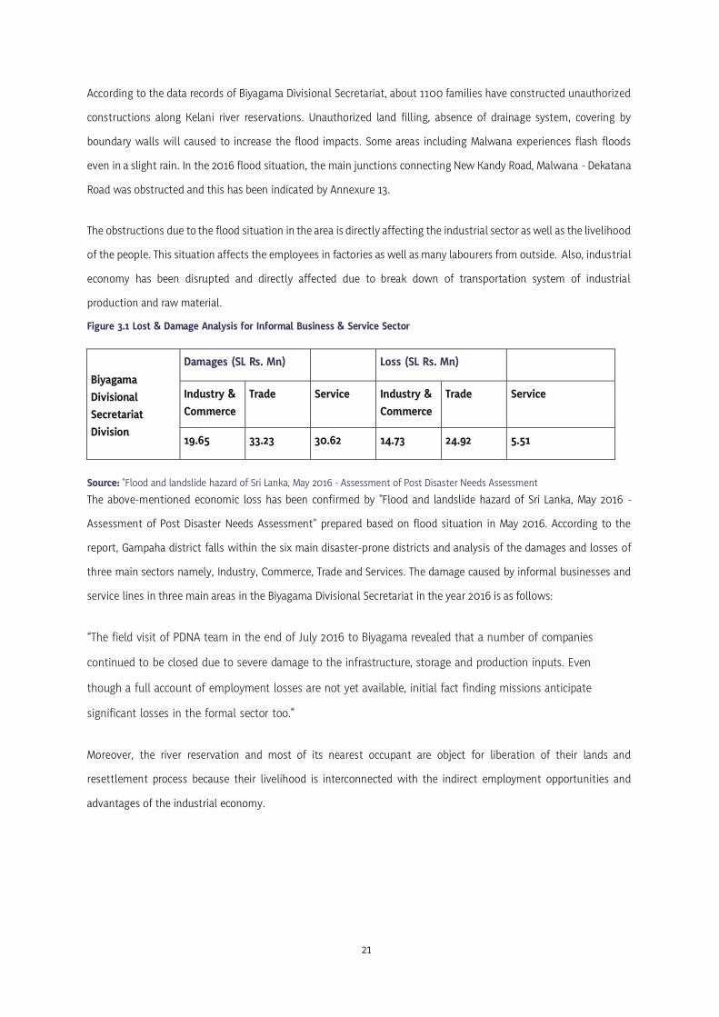
Figure 3.1 Lost & Damage Analysis for Informal Business & Service Sector
Biyagama Divisional Secretariat Division
Damages (SL Rs. Mn) Loss (SL Rs. Mn)
Industry & Commerce
Trade Service Industry & Commerce
Trade Service
19.65 33.23 30.62 14.73 24.92 5.51
Source: "Flood and landslide hazard of Sri Lanka, May 2016 - Assessment of Post Disaster Needs Assessment The above-mentioned economic loss has been confirmed by "Flood and landslide hazard of Sri Lanka, May 2016 -
Assessment of Post Disaster Needs Assessment" prepared based on flood situation in May 2016. According to the
report, Gampaha district falls within the six main disaster-prone districts and analysis of the damages and losses of
three main sectors namely, Industry, Commerce, Trade and Services. The damage caused by informal businesses and
service lines in three main areas in the Biyagama Divisional Secretariat in the year 2016 is as follows:
“The field visit of PDNA team in the end of July 2016 to Biyagama revealed that a number of companies
continued to be closed due to severe damage to the infrastructure, storage and production inputs. Even
though a full account of employment losses are not yet available, initial fact finding missions anticipate
significant losses in the formal sector too.”
Moreover, the river reservation and most of its nearest occupant are object for liberation of their lands and
resettlement process because their livelihood is interconnected with the indirect employment opportunities and
advantages of the industrial economy.

22
Biyagama Development Plan 2020 - 2030 Western Province Division - Urban Development Authority

04
Chapter
The Planning
Framework

24
Biyagama Development Plan 2020 - 2030 Western Province Division - Urban Development Authority
Chapter 04 The Planning Framework
4.1. The Vision
“The Tranquilized Industrial City” “A Greenscape Industrial City Idol of Western arena by hosting an interaction space to cater a variety of industrial needs”
4.2 The Vision Statement
The vision developed for the future development direction of the Biyagama PS area consists with the two main themes
of Environmental and Industrial Economic Development as well as the key issues studied in the area. The word
Tranquilized refers the management of magnificent landscape with sensitive green wetlands and waterways of
Biyagama. Through this wording, it hopes to create an Industrial City, where harmonize the future brownfield
developments with its greenery wetlands. And that will lead industrial city idol for the Western region to minimize
negative scenarios through the contemporary sustainable development practices with integrated layers of compatible
land uses.
As a preferred location for industrial investments due to the availability of factors of production, Biyagama will be an
Industrial City idol which guidance to all industrial cities of Sri Lanka that caters variety of industrial needs and
expected to contribute to uplifting the country's economy as well as the socio-economic environment of the country,
under the sustainability approach and eco principles, practices.
The core idea of “Tranquilized Industrial City” means the attempt for enhancing the resilience of socio-ecological
systems through a creation of industrial city idol. Through this, future Biyagama PS area will be experience the
balanced eco industrial interaction spaces with contemporary industrial economic growth and managing the green
landscape.

25
4.3 Goals
Goal
Above first goal aims to create clusters of different industrial services that fulfil the needs and requirements of
the industrial sector and attract industrial investments with basic productive factors in the area. In order to
develop Biyagama PS area as an industrial city based on the vision, meaning of multi-sectoral clusters are based
on different industrial services which are available in those industrial clusters. It aims to promote industrial
development through the development of physical infrastructure and establish urban service clusters with the
target of commuting and residential population.
Goal
Biyagama as the Tranquilized Industrial City, it is expected to create closeknit of greenery wetlands network and
sustained brownfield development. This is closely link with promotion of sustainable industrial development with
this sensitive environment of Biyagama. Control of the emergence of Shocking city means, the urban
development with sustainable eco-social strategies that controls the irregular and informal urban development.
02 Control the emergence of shocking city with negative environment and social scenarios.
01 Create multifaceted clusters while promoting unified industrial economic needs.

26
Biyagama Development Plan 2020 - 2030 Western Province Division - Urban Development Authority
4.4 Objectives
Goal
Objectives
1. To open up 13% from the total land area through collector road pattern for
industrial investments by 2030.
2. To promote industrial oriented business zone around central investment corridor by
2025.
3. To facilitate 30% of manufacturing sector employment contribution by the end of
2030
4. To facilitate 3 multi- nodal neighborhood clusters by 2030.
Goal Control the emergence of shocking city with negative environment and social scenarios.
1. To conserve 100% of critical wetlands that tolerate the surplus flood water of the
area by 2030.
2. To introduce wetland stewardships for 130 ha of abandoned agro wetlands with CER
by 2030.
3. To minimize the flood impact by restorative flood protective and treatment areas by
the end of 2025.
01 Create multifaceted clusters while promoting unified industrial economic needs.
02

05
Chapter
SWOT
Analysis

28
Biyagama Development Plan 2020 - 2030 Western Province Division - Urban Development Authority
5.1. Summarized SWOT Analysis
Goal 01
Create multifaceted clusters while promoting unified industrial economic needs
98% of the land area of Biyagama EPZ reached to its maximum carrying capacity
70% of the roads in the area are narrow local roads.
Kelani river seasonal flooding blocked 07 major transport nodes.
Absence of industrial oriented business and financial area
Not allocated spaces for service line maintenance.
Inadequate health facilities in relation to the residential and commuting population.
7 % from the housing categories indicates the improper and informal line houses.
Maintain a solid waste sorting centre in prime location which could be used for urban service and utilities in Delgoda Town
Having the basic production factors such as land, capital, labor and entrepreneurship. (Refer Table 5.1
Industrial Suitability Index displayed the 84% from the total land extent as high and moderate suitability level for industrial investment promotions.
Sub towns and nodes based spatial setting of the area.
Recorded 69% of rapid commercial development.
S W

29
National & Regional level planning direction
CMRSP & CESMA plans stressed the industrial
development
Upcoming flood mitigation projects of CRIP –DBIP
3K Area project proposed to develop Delgoda & Malwana town centers
Trend of establishing small scale multi - tenant business model industrial parks
Manufacturing sector investment opportunities from the structured proposed projects by BOI
Up - coming transport development projects (Biyagama – Kosgama Railway Project/Kadawatha - Light Railway Project)
Megapolis directives for logistic corridor / Science & Tech City Development
Main port access roads discouraging freight transportation
- Traffic congestion in Kiribathgoda town centre - Peliyagoda 4th Mile’s post railway
bridge restricts vehicles more than 3.5 m height.
Proposed Millawa industrial estate with 780 acres in Kaluthara district
O T

30
Biyagama Development Plan 2020 - 2030 Western Province Division - Urban Development Authority
Goal 0
Control the emergence of shocking city with negative environment and social scenarios
Present industrial establishments distributed close to sensitive wetlands.
Biyagama sub basin recorded 73 of industries from the A, B, & C types of pollution potentials of respectively 14, 58 & 1
47 % of abandoned paddy lands out of total paddy lands distributed in southern part of the area.
1100 families recorded as encroached the Kelani river reservation and canal banks, encroachments
Approximately 20,000 people affect to flood annually & inundation time period varies into 4 -7 days
6% of the land use composition belongs to environmental features (365 Ha -Marsh/ Water bodies /Scrubs)
13% of productive agro-wetlands act as natural buffer zones and water retention areas
Availability of public and private open spaces of 11.7 ha
Availability of 08 minor flood protection structures
S W
02

31
WRSP-2030 identified an eco-conservation zone of 100m buffer along Kelani river
Upcoming flood mitigation projects of CRIP –DBIP
Regulations related environment protection
Current Industrial Policy & Sustainable Approach
2842 industries are recorded with different pollution potentials in Kelani river basin
O T
National Manifesto Guidance through Eco Industrial Zones
•

32
Biyagama Development Plan 2020 - 2030 Western Province Division - Urban Development Authority
5.2. Detailed SWOT Analysis
Goal 01
STRENGTHS | Goal 01 Table 5.1 : Detailed facts for factors of production
1- Having the basic production factors such as land, capital, labor and entrepreneurship.
Land • Availability 9% of developable
and suitable land for industrial investment.
• Low land value varying from Rs. 100,000 to Rs. 400,000 per perch when compared with Colombo and adjacent areas.
Capital
• Strategic location close to sea port and airport to reach within 1 hour
• OCH lying through the area and having 2 interchanges (Kadawatha /Kaduwela)
• Located in between 2 major inter - regional transport corridors
• Well placed at the heart of national oil energy and gas - Sapugaskanda
• Availability of 3.3% of import cargo and 2.8% of export cargo facilities
• Kelani River Right Bank Water Treatment Plant with the capacity of 360,000m3 per day
• Biyagama(220kv) & Sapugaskanda (132kv) grid substations
• Multi-purpose gamma irradiator (MGIF) facility at Biyagama EPZ
Entrepreneur
• Present industrial establishments and growth
• Present multi - national network of industrial investments
• Hereditary Industrial base and village based modern small scale industrial trends
Labor • Recorded remarkable growth of
labor force after 1985
• 23% from the employment sectors directly contribute to manufacturing industries
• 12% from the employment sectors directly contribute to accommodation and food catering
• 66% of working age population from the total population
• Recorded 150,000 commuting population and identified as an employment generation centre
Source : Gampaha District Planning Team
Create multifaceted clusters while promoting unified industrial economic needs

33
First goal aims to promote unified industrial economic needs with cluster development approach. The following
discussed facts and figures strengthened the potentials of industrial development under the factors of production
which are shortlisted in the above table 5.1.
Land is the basic factor of production, from the landuse composition 72% of the lands identified as built-up lands and
excluding environmental features 9% of developable lands area available within Biyagama. According to the
Annexure 15, Land values of Biyagama area displayed comparatively very low variation that having positive impact for
attraction of industrial investments.
Capital includes the all man-made resources, therefore present infrastructure facilities included to capital factor.
Under the transport and mobility, sea port and airport accessibility are basic needs of industrial development of a
country. Therefore, located in between the Kandy and Low level inter regional transport corridors and current
expressway development maximize the strategic location of Biyagama. New Kandy Road and Colombo - Kandy Road
(A 01) giving the accessibility as most connected corridor to all over the country. Outer Circular Highway (OCH) is lying
through the area and both Kaduwela & Kadawatha expressway interchanges are located within Biyagama PS area. This
OCH links to Southern expressway network from Kottawa which connects southern part of the country within 1 hour.
The proposed third phase of the OCH towards Kerawalapitiya which link with Katunayake expressway giving the
Katunayake international airport accessibility within 15-30 minutes.
Sapugaskanda oil refinery which is one and only oil refinery in Sri Lanka located near Colombo and with the capacity
to refine around 2.12 million metric tons per year (or 52,500 barrels per day - bpd). That implies the well placed at the
heart of national oil energy and gas. Availability of 3.3% of import cargo and 2.8% of export cargo facilities implies
the present logistic facilities due to the industrial agglomeration of Biyagama. 360,000 m3 designed Kelani River
Right Bank Pattiwila water treatment plant fulfilled the water demand of northern part of western province. That
covers 1 million consumers of Biyagama, Kelaniya, Kiribathgoda, Kadawatha, Ragama, Wattala, Kandana, Ja-Ela,
Seeduwa and Ganemulla areas and present production is (m3/d) 175,000.
According to the Electricity supply, Biyagama having 220 kV Grid substation and 132 kV Grid substation at
Sapugaskanda. Also, Biyagama PS area having two power generating plants at Lindel Industrial Estate - Lakdhanavi
Ltd (21MW) and Asia Power Pvt Ltd (51MW) with 220 Kv transmission network. Biyagama EPZ consisted with the
facility of Multi-Purpose Gamma Irradiator (MGIF) which support for the pharmaceutical, chemical and food
manufacturing plants. This proves the industrial sector-oriented infrastructure facilities proves that Biyagama as a
city of having industrial economic needs.
Under the labor factor, Biyagama recorded remarkable growth due to the highest industrial labor agglomeration after
the introduction of Biyagama EPZ. From 1981 – 2001 time period 2.08% population growth rate was recorded due to
the employment attraction of BEPZ. This fact has been proved by DSD wise comparison of industrial establishments

34
Biyagama Development Plan 2020 - 2030 Western Province Division - Urban Development Authority
and labour in Annexure 17. According to the economic sector wise employments in Annexure 18, 23% of the
employment sector directly contributes to manufacturing industries of Biyagama and 12% directly contributes to
accommodation and food catering. As following figure 5.1, Biyagama PS area is consists with 66% of working age
population from the total population and recorded 150,000 commuting population per day and identified as an
employment generation center.
5.1 : Age Composition of Biyagama PS area - 2017
Figure Source : Gampaha District Statistical Handbook,2017
Last factor of production as entrepreneur discussed with the present industrial establishments, growth of the
industrial sector and homebased industries with a hereditary industrial base. As well as Biyagama having strong and
prestigious international linkages due to the multi-national industrial establishments network. As examples, Anchor
- Fonterra Brands Lanka, Lion brewery Ceylon PLC and Coca-Cola Beverages Sri Lanka Ltd.
Three industrial clusters could be identified in the area according to the spatial distribution pattern of the industrial
establishments and that has been displayed through the Annexure 08. Biyagama EPZ, Sapugaskanda Lindel industrial
Estate and Dimo utility vehicles workshop and the surrounded industries are the identified major clusters.
In 1995, establishment of Lindel industrial estate at Sapugaskanda in 125 acres was first Sri Lankan privately owned
industrial park and it was the significant change of the Sri Lankan industrial development. The industrial trend was
changed into the joint ventures with leasable land and buildings and out of the 100 acres of leasable land, about 90
acres are already occupied by well-known industries of which five of them are joint ventures with fortune 500
companies. Lindel is a private company with BOI status. 49% of its shares are held by the DFCC Bank, 2% by Lanka
Ventures Limited and the remainder by the Treasury of Sri Lanka.

35
This second wave of liberalization resulted to attract multi - national manufacturing companies namely, in 1995
Fonterra Brands Lanka (Pvt) Limited, in 1996 Lion Brewery Ceylon PLC and DIMO Siyambalape - commercial vehicle
workshop. This industrial development intensity of Biyagama could be further expected and confirmed through
records of preliminary planning clearances as approximately 50 per year. At present there is a tendency of
constructing private ware houses and lending can be seen along Mahena road and Mabima road for logistic facilities.
Figure 5.2 Comparison of Industrial growth 2016 -2017 with industrial categories
Comparison of Industrial growth 2016 -2017 with industrial categories
Source: Gampaha District Statistical Handbook, 2017
Statistics comparison of the industrial categories by year wise, it shows rapid increase of basic metal industries, other
manufacturing and textile, apparel and leather sector industries within Biyagama PS area. Textile and apparel sector
are the highest contribution to the country’s foreign direct investments and Biyagama PS area having a rapid
increment of textile and apparel sector.
According to the historic evidences, Biyagama is not a newer to industrial development activities and there were
hereditary industrial villages in past. As historical industrial base, clay industry is mostly spread the areas where very
closer to the Kelani river like Mabima, Pattiwila, Bollegala, and Yabaraluwa, Gold and Silver works spread in Biyanvila,
Mawaramandiya, Meegahawatta, Siyambalape and Heiyanthuduwa areas. Makola for Brassware and Kanduboda,
Yabaraluwa and Heiyanthuduwa are famous for granaite works.
2015-2016 2016-2017

36
Biyagama Development Plan 2020 - 2030 Western Province Division - Urban Development Authority
At present the area has developed with the homebased industries that mixed with new technology. As examples,
Pamunuwila area is famous for fireworks industries, Biyanwila area for rubber mix coir industry while Makola,
Kammalwatte and Heiyanthuduwa for aluminum works and Siyambalape North for printing industry. Meegahawatta
and Delgoda areas are well known for the interior works and the cushioning works for the vehicles.
2- Industrial Suitability Index displayed the 84% from the total land extent as high and moderate suitability level for industrial investment promotions.
The analysis of industrial suitable areas has been carried out using data from the physical, environmental and social
factors to identify the most suitable environment for future investments. Analytical results indicate that Samurdhi
Mawatha, Dimo Junction, Heiyanthuduwa, Walgama and Malwana are the most suitable areas and this has been
indicated in Annexure 18.
3- Sub towns and nodes based spatial setting of the area.
Biyagama having a node based spatial setting that merge with the different industrial clusters of the area. As per the figure 5.3, using Gephi-network analysis software this sub cluster composition identified through modularity class tool. Through this output Biyagama PS area has been divided into six clusters based on the linkages and confirmed that it has been divided over specialized land use and includes three industrial clusters and three urban service clusters. According to that planning area having hierarchical order of sub towns and nodes, that can be prove by the Annexure 19 of most connected nodes of the area. Figure 5.3 Gephi Network Analysis of Sub Clusters
Source: Gampaha District Planning Team, 2020

37
4- Recorded 69% of rapid commercial development.
Industrial and institutional development simultaneously influence to increase the commercial spaces and lead to develop commercial nodes around the industrial cluster entrances. As per the annexure 20, series of satellite images from 2004 to 2017 of Siyambalape junction proved that scenario.
In annexure 21, Development pressure index also proved this situation and Kadawatha, Makola, Malwana, Gonahena and Mawaramandiya areas identified as high pressure of development. According to the records of commercial spaces registrations in Gampaha district statistical handbook, year 2017 recorded rapid registration of commercial spaces in relation to year 2016. The following figure 5.4 displays that variation.
Figure 5.4 Comparison of Registered Commercial Spaces of Biyagama PS area 2016-2017
Comparison of Registered Commercial Spaces of Biyagama PS area 2016-2017
Source: Gampaha District Statistical Handbook, 2017
2015-2016 2016-2017

38
Biyagama Development Plan 2020 - 2030 Western Province Division - Urban Development Authority
WEAKNESSES | Goal 01
1- 98% of the land area of Biyagama EPZ reached to its maximum carrying capacity.
57 factories are currently operation at the Biyagama Export Processing Zone, which are spread over 180 acres of
land. Industrial and Commerce team of the stakeholder meeting has mentioned that there are no spaces for new
factories in the Biyagama EPZ and that has reach to its maximum carring capacity. As per the following figure 5.5,
there are 25 manufacturing industries operating under the BOI - Biyagama EPZ have been established outside of
the zone but within the Biyagama Divisional Secretariat limits.
Figure 5.5 Comparison of BOI based Industrial establishments DSD wise
Maharagama Kesbawa Dompe Mahara
Source: HR Division - Biyagama EPZ, Board of Investment, 2018 2- 70% of the roads in the area are narrow local roads.
Width of the internal roads that connect main arteries of Colombo-Kandy Road, New Kandy Road & Samurdhi
Mawatha are less than 9m and road bends discouraging the freight transportation. According to the Annexure 22,
less road widths of the internal road network of Biyagama negatively impact to the newer industrial investments
and rejecting approvals. This context has been studied through the space syntax - spatial integration analysis and
that have indicated as Annexure 23.
32
22
82
27
Kelaniya Kaduwela Biyagama

39
3- Kelani river seasonal flooding blocked 07 major transport nodes.
When flood occurred and its duration time period cause to make the disturbance to transportation system of the area
and major junctions of New Kandy road, Colombo- Biyagama Road, and Malwana Dekatana road blocked with flood.
Bandarawatta Junction, Nagahamulla Junction, Siyabalape Junction, Malwana, Pattiwila & Mabima Junctions are
affected in every flood event it is displayed through the Annexure 13. This flood scenario caused to disturb passengers
who used following bus routes - Panadura-Kandy (17), Karabugas Junction -Fort bus route (356), Dekatana-Fort (226),
Pugoda-Colombo (224), Malwana-Colombo (225), Gampaha-Kaduwela (228) and Kiribathgoda-Pettah (230).
Figure 5.6 Flood Inundation- 2018 Gonawala Figure 5.7 Flood Inundation-2018 Pattiwila
Source: Captured by Udari Hettiarachchi, 2018.05.26
4- Absence of industrial oriented business and financial area.
Even though the southern part of the Biyagama PS area represent as an industrial employment center, there is no
separate area or a center for financial and banking purposes. To fulfil the needs & wants of the people related to the
banking and financial activities, people have to travel sub urban centers and these sub towns also not agglomerate
the type of commercial banks.
5- Not allocated spaces for service line maintenance.
At the meeting of the stakeholders, a major problem relating infrastructure was the lack of space for the services on
both sides of the road. As a result, it was highlighted that the road network has become dilapidated by various
institutions to break down the roads on several occasions.

40
Biyagama Development Plan 2020 - 2030 Western Province Division - Urban Development Authority
6- Inadequate health facilities in relation to the residential and commuting population.
Biyagama PS area having a Type C - divisional hospital. But as an area of labour agglomeration due to the industrial
establishments and the location of second largest EPZ in terms of the labour participation, highlighted the need of
improved health facilities. According to the international standards of four hospital beds per 1000 people, that proves
it can’t be account with the Biyagama PS area threshold population and following data table describes comparison
with surrounding hospitals.
Table 5. 2 Comparison of Hospital types & Beds - Biyagama & Surroundings
Hospital /Type No of Beds Population _DSD wise
Biyagama, Type C - Divisional Hospital 33 192,000
Kiribathgoda, Type B - Base Hospital 100 112,797
Dompe, Type A - Divisional Hospital 104 158,493
Udupila, Type C - Divisional Hospital 24 213,837
Source: Gampaha District Statistical Handbook, 2017 7- 7% from the housing categories indicates the improper and informal line houses.
Provision of accommodation facilities for the employees of the Biyagama zone is one of main income source of local
community. According to the recorded housing data from census of 2011, most of the accommodation in Malwana,
Walgama, Yabaraluwa, Siyambalape, Yatihena area are located as improper and informal line houses. Biyagama North
and Walgama East GN divisions recorded highest line houses distribution of 718 and 731 respectively. The line houses
density of the area is displayed as Annexure 24.
Figure 5. 8 Line houses around Biyagama EPZ Area
Source: Sundaytimes Newspaper, 2009

41
8- Maintain a solid waste sorting center in prime location which could be used for urban service and
utilities in Delgoda Town.
Solid waste sorting site of the Biyagama PS area is located in a land that having high commercial value adjoins to the
existing Delgoda bus terminal. This bus terminal is not connected to Delgoda junction directly and the solid waste
sorting site close to this bus terminal cause to decrease the optimum use of urban lands and impact to the highest
and best use. At present this bus terminal used only for bus parking and the commercial spaces of the building are
not functioning.
Figure 5.9 Solid Waste Sorting Site- Delgoda
Source: Captured by Udari Hettiarchchi, 2018.01.08
Figure 5.10 Delgoda Bus Terminal with vacant commercial spaces
Source: Captured by Udari Hettiarchchi, 2018.01.08

42
Biyagama Development Plan 2020 - 2030 Western Province Division - Urban Development Authority
OPPORTUNITIES | Goal 01
1. National and Regional Level Planning Direction
As per the following figure 5.11, the National Physical Plan 2050, Biyagama PS area is located in East-West Economic Corridor which proposed to increase 20 - 25% population. Planning direction from the national level already guided and stressed the economic development. Therefore, Biyagama can contribute to the national economy via industrial sector as a part of the East-West Economic Corridor. Also, Biyagama EPZ is a significant contributor to the national economy with an export value estimated at Rs. 134 billion ($ 849 million) and importing Rs. 58 billion ($ 368 million) worth of raw materials in 2017.
Following figure 5.12, Western Region Structure Plan - 2030 identified Biyagama area as the industrial potential area and regional level planning direction emphasized the industrial development. According to these recent national and regional planning decisions will be main opportunity for future industrial development of the area.
Figure 5.11 NPP Proposed Economic Corridors
Source: National Physical Planning Department, 2017

43
Figure 5.12 Draft Western Region Structure Plan-2030
Source: Western Province Division, UDA, 2017
2. CMRSP & CESMA plans stressed the industrial development
CMRSP in 1998 identified Biyagama as one of the “Growth center” in Gampaha district. It has been planned to promote
industrial land use by 40% and decrease the residential land use upto 15%. The plan estimated and expected 285,000
population by 2010 and that has displayed through the Annexure 06. CESMA Plan in 2004, identified Biyagama as an
industrial development areas and included to inner ring township of the Western region.
3. Upcoming flood mitigation projects of CRIP-DBIP
Climate Resilient Improvement Project by the Department of Irrigation will be introduced for flood mitigation wall
from Kelani river mouth up to Hanwella. With this wall flood impact from the Kelani river will be mitigate and that
will be added opportunity for physical developments of the area.
4. 3K Area project for Delgoda & Malwana urban redevelopment
From the 3K Area Project (Kottawa, Kaduwela & Kadawatha), Biyagama PS area belongs to the Kaduwela and
Kadawatha Zones. 3K Project area is displayed in Annexure 25 and project proposed to redevelop Delgoda and
Malwana as minor urban centres.

44
Biyagama Development Plan 2020 - 2030 Western Province Division - Urban Development Authority
5. Trend of establishing small scale multi - tenant business model industrial parks
The recent trend of industrial development is establishment of small-scale business model industrial parks which
cater to diverse requirements of different organizations. As one central multi-tenant server set up that meets the
requirements of all tenants and improved security, high level of service availability reduce the impact of disruptions
to their missions, critical production processes and to ensure business continuity. Also, high technology usage able to
reduce their carbon footprint which is an important criterion for their business model. In addition, it creates a
simplified platform that can enhance the efficiency and effectiveness of servers used by tenant companies of the park.
Through this demand for high quality labor will be increased and this is boost for the country’s talent pool.
Figure 5.13 Flinth Industrial Park -Ranmuthugala Estate, Kadawatha
Source: Cablesoul Web site, 2010
The present example for this kind of business model is Ranmuthugala estate - Flinth industrial park at Kadawatha as
per the following figure 5.13. The park extent upto 10 acres and 8 companies which are primarily involved in
production and in exporting to various parts of the world such as Aero Sense, Cable Solutions, Harness Solutions,
Prime Packaging, Quality Floors, CaviTool, Swedlanka and Metal Component Services.
6. Manufacturing sector investment opportunities from the structured proposed projects by BOI
According to the BOI- Project proposals of 2017, it has been identified manufacturing sector projects: Healthcare
supplements/Cosmetic products/Value added rubber industry, Textile accessories/Woven fabric manufacturing plant
cluster. These identifications are important for the attraction investment opportunities for the Biyagama PS area
lands.

45
7. Up - coming transport development projects
The proposed Biyagama-Kosgama Railway Project, LRT Developments and Kadawatha LRT Station, OCH Phase III
Development with Kerawalapitiya Interchange, Central Expressway Development and Kadawatha Interchange
becoming a gateway to Kandy are up- coming transport development projects that added value for the area in terms
of accessibility. According to the Annexure 26 of future expressway development in Sri Lanka shows the importance
of the Outer Circular Highway and its connections regarding the industrial sector promotions in near future.
8. Megapolis directives for logistic corridor / Science & Tech City Development
Western Region Megapolis Structure Plan proposed a logistic corridor from Peliyagoda up to Katunayake. This will be
an added advantage for logistic facilities for industries and following figure 5.14 indicates the proposed corridor.
Science and Tech city development also indirect opportunity for skilled labor for the manufacturing industrial sector
and following figure 5.15 shows the Megapolis directives with planning area divisions.
Figure 5.14 Proposed Logistic Corridor- WRMP Figure 5.15 Western Region Megapolis Directives
Source: Peliyagoda Draft Development Plan, 2017 / Western Region Megapolis Plan, 2016

46
Biyagama Development Plan 2020 - 2030 Western Province Division - Urban Development Authority
THREATS | Goal 01
1. Main port access roads discouraging freight transportation (Traffic congestion in Kiribathgoda town center/ Peliyagoda 4th mile’s post railway bridge restricts vehicles more than 3.5 m in height)
Samurdhi Mawatha and Colombo-Biyagama roads are main port access road corridors of the area. Port links with the
average distance and time are major concern of locating and investing industries. But these two main port access
corridors discourage the freight transportation due to the traffic and height restriction. Samurdhi mawatha via
Kiribathgoda is the minimum distance road to the port, but Kiribathgoda town centre located within main inter-
regional transport corridor that often occur huge traffic congestion. As per the following figure 5.16, around peak
hours’ average travel speed of the Kiribathgoda area is 10-15 km/h around peak hours.
Figure 5.16 Traffic Congestion-Kiribathgoda
Source: Google Maps, 2017

47
Figure 5.17 Height Restriction Area- 4th Mile’s Post
Source: Google Street View, 2017 Biyagama – Colombo road (B 214) is traffic free road corridor when compare to the Kandy corridor. But, the road where
link to the Kandy corridor (4th mile’s post) having a height restriction barrier due to the Kelani valley railway bridge
as per the above figure 5.17. Container freight transportation restrict from that location. Therefore, should take turns
to Waragoda road and Station road for link Kandy corridor to access the port.
2. Proposed Millawa industrial estate with 780 acres in Kaluthara district
At present, infrastructure facilities development in proposed Millawa industrial estate with 780 acres in Horana,
Kaluthara district is supervising by the UDA. This newer industrial estate can be identified as a threat to attract large
scale industrial investments to the Biyagama PS area due to the large land extents for proposed industrial investments
and under the goal 01 related to the industrial economic needs.
Figure 5.18 Lands for industrial investments in Millawa Industrial estate
Source: UDA - Investment Potentials Summit, 2017

48
Biyagama Development Plan 2020 - 2030 Western Province Division - Urban Development Authority
STRENGTHS | Goal 02
1. 6% of the landuse composition belongs to environmental features of Marsh/ Water bodies /Scrubs. (365 Ha)
2. 13% of productive agro-wetlands act as natural buffer zones and water retention areas.
Southern part of the Biyagama PS area consists with most environmental sensitive wetlands and tributaries that
closely connected with Kelani river. The water retention capacity of these environmental features support to storm
water management. Raggahawatta, Malwana - Sambawela, Pattiwila and Pahuru oya can be identified as tributaries
and canals of the planning area, Kanduboda - Yatihena, Kottunna and Heladeniya tanks are water resources of the
area. Existing environmental and agricultural features can be listed as follows according to the landuse composition.
Green and Blue environmental features of the planning area display from the Annexure 04.
Table 5.3 Green & Blue Spaces from Land use Composition
Main Category Sub Category Area (Ha) %
Environmental Features Marsh / Water Bodies / Scrub 365.75 6
Agricultural Lands Paddy 811.63 13
Commercial crops (Coconut/Rubber) 265.38 4
Other Plantation 295.35 5
Developed Lands Residential 3470.29 58
Industrial 385.84 7
Commercial 87.41 2
Public Utilities 113.71 2
Road & Transport 224.88 3
Total 6020.24 100%
Source: Gampaha District Planning Team, 2020
Goal 02
Control the emergence of shocking city with negative environment and social scenarios

49
13% of the land use indicates the 811.63 hectares of paddy lands and 523.4 hectares paddy lands are continuously
cultivated as per the Agrarian statistics of Biyagama. These productive paddy lands support to environmental balance
of the area and these agro wetlands make natural buffers for the residential neighborhoods and reduce conflict with
industrial land uses.
Figure 5.19 Yatihena Tank and surrounding paddy lands
Source: Captured by - Udari Hettiarachchi, 2017/12/30 3. Availability of public and private open spaces of 11.7 ha.
Biyagama PS area having public and private open spaces that blends with the natural and built environment.
According to the statistics, there are 18 playgrounds, 6 volley ball courts and two public parks of Siyabalape walking
path, Al Mubarak children park at Malwana. There are two privately owned leisure parks: Water world and Rainbow
paradise. Locations of public and private open spaces are displayed from the Annexure 27.
4. Availability of 08 minor flood protection structures.
Due to the connected waterways of the major water body of Kelani river there are minor flood protection structures
that obtained by the Department of Irrigation and locations of those structures displayed in Annexure 28. As per the
following table 5.4, availability of the minor flood protection structures reduces the flood vulnerability of the area.
Table 5.4 Minor Flood Protection Structures of Biyagama PS area
Location Gate Type Protected Area (Ha)
Yabaraluwa Flap Gate 80.2
Kakulawala Lifting Gate 75.3
Raggahawatta Flap Gate 22.1
Pattiwila Flap Gate/ Lifting Gate 111.4
Bollegala - Pelawatta Flap Gate 8.5
Seethawala Flap Gate -
Source: JICA Planning Team, 2009

50
Biyagama Development Plan 2020 - 2030 Western Province Division - Urban Development Authority
WEAKNESSES | Goal 02
1. Present industrial establishments distributed close to sensitive wetlands.
Southern part of the Biyagama PS area consists with environmental sensitive wetlands and industrial clusters where
most environment related problems occurs such as low-lying lands filling, industrial solid waste dumping, waste
water discharging. This context is displayed from the Annexure 29 and Annexure 30 displayed the result of analysis
regarding the identification of critical wetlands within the planning area.
2. Biyagama sub basin recorded 73 of industries from the A, B, & C types of pollution potentials of respectively 14, 58 and 1.
According to the inventory of industries by Environmental Pollution Control Division and Research and Development
Unit of the Central Environment Authority identified 4520 of total industries in Gampaha district that involved to the
process of Environmental Protection Licenses and 10% or 418 of industries belongs to Biyagama PS area.
Categorization of those industries under the A, B & C types of pollution potentials recorded as 113, 119 & 176
respectively.
Further, Natural resource profile of Kelani River, Biyagama sub basin recorded 73 of total of A, B, and C categories
which contains 14, 58, and 1 pollution potentials respectively. As per their study, the sampling site at Raggahawatta
receives contaminated industrial waste water from Biyagama Industrial Zone. The parameters frequently exceeded
during the last three years are COD (36% times), BOD (7% times), Dissolved Oxygen (27% times) and Heavy metals
(7% times).
This situations and incidents can be accepted due to the following research findings by different responsible
institutions. The international journal of “Analysis of Variation of Water Quality in Kelani River, Sri Lanka” focused
only seven sampling sites belong to Biyagama PS area at a stretch of 8 km along the Kelani River. These 07 samples
tested with six parameters using the data measure the Water Quality Index (WQI) through mathematical model and
concluded as below table 5.5.
The highest WQI (72.90) was reported near the Water Treatment Plant in Biyagama, while the lowest WQI (62.98) was
achieved near the Water board pump in Ambathale. Water quality of five of the samples were in good quality range
and the other two samples were in medium quality range.

51
Table 5.5 Water Quality Index
Source: Analysis of Variation of Water Quality in Kelani River, Sri Lanka – N.M.D.A. Abeysinghe, M.B Samarakoon, 2017
3. 47% of abandoned paddy lands from the total paddy extent distributed southern part of the area.
Most of paddy lands are abandoned which are distributed within the southern part of the Biyagama PS area. According
to the statistics of the Biyagama Agrarian office, 455.91 ha of abandoned paddy lands from the total of 965.81 ha of
total paddy extent and as a percentage it is 47%. From that abandoned paddy 306.08 ha lands (32% from the total
paddy lands) identified as potential development promotion lands which can’t use for any other productive
agriculture. Therefore, it seems with the time productive agro - wetlands are reducing and this situation displaying
from the Annexure 31.
Parameter Sample Site Locations
1 Close to Hela Clothing Factory
2 Close to Ambatale Water Treatment Plant
3 Pattiwila Area
4 Close to Kelani River Right Bank (BWTP)
5 Close to Kaduwela Highway Interchange
6 Close to Lion Brewery Factory
7 Malwana Area
Dissolved Oxygen (% sat) 19.63 19.91 34.47 41.45 36.61 27.47 29.77
pH Value 5.95 6.07 6.34 6.52 6.68 6.62 6.52
Turability -NTU 8.13 4.54 9.27 9.41 6.16 11.84 9.31
Temperature ( ̊ C ) 28.32 28.28 28.44 28.36 26.14 27.96 26.66
Total Phosphate-mg/L 0.09 0.36 0.08 0.17 0.46 0.14 0.09
Nitrate(mg/L 0.7 1.28 0.58 0.6 0.46 0.34 0.56
Water Quality Index 65.24 62.98 70.4 72.9 70.22 70.03 70.37

52
Biyagama Development Plan 2020 - 2030 Western Province Division - Urban Development Authority
4. 1100 families recorded as encroachers of the Kelani river bank reservation and canal banks encroachments
According to the statistics of resource profile prepared by the Biyagama Divisional Secretariat recorded 1100 families
within 15 m river reservation. Also 6.5m tributary reservations also encroached and these illegal constructions let to
worst the flood impact. River reservation and canal banks encroachments mostly spread in Mabima, Bollegala, and
Malwana areas.
Figure 5.20 Sambawela Canal Reservations Encroachments
Source: Captured by Udari Hettiarachchi, 2018/06/21 Figure 5.21 Kelani River Reservation Encroachments - Malwana
Source: Captured by Udari Hettiarachchi, 2018/06/21

53
5. Approximately 20,000 people affect to flood annually & inundation time period vary into 4 -7 days.
According to the statistics of flood affected population in year 2016 from field officer of Disasters in Biyagama
Divisional Secretariat, recorded high impact for Malwana, Yabaraluwa, Bollegala, and Mabima compare to other GN
divisions. In the 2016 flood event, inundation period varies into 4-7 days and day by day the affected area was changed.
Kelani river seasonal flood caused to impact 20,000 of the livelihoods of the people and that impact to the industrial
related activities also.
Figure 5.22 Flood duration (Number of days)
Source: Disaster Management Centre, 2016

54
Biyagama Development Plan 2020 - 2030 Western Province Division - Urban Development Authority
OPPORTUNITIES | Goal 02
1. National Manifesto Guidance through Eco Industrial Zones
Vistas of Prosperity and Splendour - Chapter VIII (Sustainable Environmental Policy) mentioned about the industrial
sector that leads to a Green Economy by creating Eco Industrial Zones.
“The Linear Economy in which manufacturers produce goods using the existing raw materials and dispose of waste
into the environment will be replaced with the Circular Economy in which waste in one industry can be used as raw
material in another. (Re-use, Recycle, Re-purpose). This will create eco-industrial zones and pave the way for a green
economy.”
Under the section of “Atmosphere” & “Bio Diversity” mentioned as follow,
“Guidelines will be provided to reduce and control carbon emissions and other forms of air pollution. Industrial
establishments will be encouraged to plant trees, establish urban forests, green paths, green roofs and agroforestry
systems.”
“Measures will be taken to increase national forest cover by establishing parks in urban and semi-urban areas,
developing urban vegetation by establishing tree lines along express ways and implementing tree planting
programmes in industrial premises.” (Page 62 - 64)
Figure 5.23 Industries - National Manifesto Guidance
Source: Sri Lanka Podujana Peramuna Manifesto - English,2019

55
2. Western Regional Structure Plan of 2030 identified an eco-conservation zone of 100m buffer along Kelani river
Proposed eco-conservation zone of 100m buffer which has been identified in the Western Region Structure Plan-2030
could be an opportunity for environment sense to the area. This qualitative development will help to reduce the
adverse impacts on the Kelani river as well as a good opportunity to reduce the flood impacts. Kelani river considered
as the administrative boundary of the Gampaha & Colombo districts and this project will be a great opportunity for
creating water front related public open spaces and investments for special development projects.
3. Upcoming flood mitigation projects of CRIP –DBIP
Climate Resilient Improvement Project under the World Bank funds by the Irrigation Department proposed flood
mitigation wall from Kelani river mouth upto Hanwella. With this wall, flood impact from the Kelani river will be
mitigate and that will be an added opportunity for physical developments of the area. As well as this project
considered the tributaries of Kelani river, Malwana and Raggahawatta canals also included to that.
Figure 5.24 Proposed Cross Section of Flood Mitigation Wall
Source: Protection of Kelani River Basin from Flood- Video Clip - CRIP, 2018

56
Biyagama Development Plan 2020 - 2030 Western Province Division - Urban Development Authority
4. Regulations related environment protection
Sri Lanka Land Reclamation & Development (No 1662/17 -2010 July 14 –Part I: Section I)
Sri Lanka Land Reclamation & Development Corporation act, no 15 of 1968, As amended by act No.27 of 1976, No 52 of
1982 & Sri Lanka Land Reclamation & Development Corporation (amended) act, No.35 of 2006.
“Surface width of the canal & reservations from the canal banks are declared under this act & any sort of building or
filling shall not be done according to the law.”
Kelani River -15m Reservation / Raggahawatta & Malwana Streams – 6.5 m Reservations
• 1979 No 58 Agrarian Services Act
• Under the No 62 Sentence - Not be allowed filling paddy lands without permission from the Agrarian
Services Commissioner
• Under No 12.4 Sentence - Can be stopped development activities performed
on paddy lands if regulations are violated according the zoning plan.
5. Current Industrial Policy & Sustainable Approach
BOI industrial enterprises lead in establishing green factories with sustainable approach. By this approach BOI creating
a new image for industrial productions will be harmonize the environment. From each of the BOI zones a land area
had been allocated to tree planting with the idea of creating a forest within the zone. This will be an opportunity to
minimize the negative scenarios to environment through industrial development.

57
THREATS | Goal 02
1. 2842 industries are recorded with different pollution potentials in Kelani river basin
According to the Natural Resource Profile of Kelani River, about 2,842 industries are recorded in the CEA database with
different pollution potentials (Type A, B and C). The 2,842 industries are divided into 862 (30%); 1,220 (43%); and 760
(27%). Also the research of Industrial pollution and the management of river water quality: A Model of Kelani River,
Sri Lanka has also identified the spatial distribution of point sources of daily wastewater discharge and pollution loads.
With these findings, there will be a threat to control the emergence of shocking city.
Figure 5.25 Spatial Distribution of Point sources and demarcation of zones - Kelani River Basin
Source: Asha Gunawardena & Research Team, 2017

58
Biyagama Development Plan 2020 - 2030 Western Province Division - Urban Development Authority

06
Chapter
The Plan

60
Biyagama Development Plan 2020 - 2030 Western Province Division - Urban Development Authority
Chapter 06 The Plan
6.1 Concept Plan
Figure 6.1 Concept Plan
Source: Gampaha District Planning Team, 2020
The Proposed future vision depicts the spatial changes of the area through a conceptual design to develop Biyagama
as Tranquilized Industrial City of affiliated green wetland network. It is primarily linked to the "Central Investment
Corridor" that is integrated with all industrial utilities and services and industrial promotional tracts are expected to
be developed along the southern border of the region, and the northern part of it as a mixed residential zone.
The main industrial promotional tracts get the access with Biyagama - Colombo Road via Peliyagoda and the lands
which have been proposed for industrial development will open up for investments by development of local road
network of the area.
Industrial promotional tracts of afflicted greenery wetlands getting the main access from the two main industrial
nodes namely, Nagahamula & Karabugas junctions and sub industrial nodes that connects to the proposed central
investment corridor. This fulfils the accessibility factor related to industrial investments with improved infrastructure
facilities. Outer Circular Highway and interchanges within the planning area and in between location of inter-regional
transport corridors will be an added advantage to promote Biyagama as a well-connected industrial city.
One of the main ideas of vision is to promote sustainable industrial development by maintaining the highly sensitive
agro wetland network of the area which highly contributes to manage the flood situations, urban heat control and

61
natural aesthetics. In that context, Siyambalape junction and the surrounding area will be a wetland integrated
development zone that facilitates for pubic greenery spaces.
The northern part of the area promoting mixed residential development with four major zones and facilitate for nodal
development projects including urban services. High dense residential promotion areas and the high development
pressure areas will be protected through the promotion of open wetland parks where having the major consideration
of the sensitive wetland network.
As per the conceptual plan, there will be sub town centres that provide urban and industrial services and commonly
the upper part of the planning area will be promote the residential mixed commercial development. The lower part
of the planning boundary will be guided to the sustainable industrial development with handing hand the protection
of sensitive green wetland network and this will lead to achieve the future vision of Biyagama, The Tranquilized
Industrial City.
6.2 Proposed Land use Plan
Proposed Land use plan displayed the composite image of future Tranquilized Industrial City with the proposed
strategic projects under the different sectoral plans of industrial economic, environmental and infrastructure
development strategies.
The entire land use plan is divided into two main parts: industrial and mixed residential. Southern part of the planning
boundary promotes the horizontal development with two industrial zones that integrating the unique green wetland
network of the area. Under this Samurdhi Mawatha & Gonawala road will be the Central Investment Corridor which
agglomerate the industrial related utilities and services. This will greatly enhance the utilization of industrial lands of
the southern part of Biyagama PS area. Nagahamula and Karabugas junctions will be the main industrial nodes of the
area and improved internal road network let the open lands for industrial investments.
Figure 6.2 Proposed Urban Structure - Cross Section I
Source: Gampaha District Planning Team, 2020

62
Biyagama Development Plan 2020 - 2030 Western Province Division - Urban Development Authority
Since most of the lands in the planning area are interconnected with roads as well as highly sensitive wetland
ecosystem, with this context it is expected to promote the area for industrial development in a sustainable
manner in accordance to the future vision via Proposed Land use Plan. Further it is expected a vertical
development in Central Investment Corridor with commercial spaces that cater for industrial sector. In addition,
it is proposed to develop the areas beyond the industrial zone and wetland areas as a moderate dense residential
zone and above figure 6.2 displayed the cross section of the proposed urban structure.
Proposed Land use Plan expected to promote three major urban centers, from high dense to moderate dense
within the mix residential promotion tracts. Kadawatha, Mawaramandiya and Delgoda respectively will be
highlighted as the main urban service centers of the mix residential tracts of the area.
Figure 6.3 Proposed Urban Structure – Cross Section II
Source: Gampaha District Planning Team, 2020 Mankada road which starts from Kadawatha town center and Makola Road which starts from Kiribathgoda town
center act as a main commercial corridor which bring development pressure to the area. Makola junction is the
main urban center that promotes the commercial development of the area while Mawaramandiya and Delgoda
urban centers provide urban services for the residents as well as the commuting population of the area.
It is expected to attract the population that migrate to the area due to future transport facilities like proposed
light railway for Colombo-Kandy Road and Outer Circular Highway which connects to Kadawatha-
Kerawalapitiya. With this context, it will be attracting high residential community for High Dense Urban Transit
Zone and the High Dense Urban Services Zones and above-mentioned urban form of Figure 6.3 will automatically
originate for that areas.

63
Map 6.1 Proposed Land use Plan
Prepared By: Gampaha District Office, WP-UDA, 2020

64
Biyagama Development Plan 2020 - 2030 Western Province Division - Urban Development Authority
6.3 Infrastructure Development Strategies
6.3.1. Service Management Plan Under the Service Plan, it is discussed about the availability and proposed social and physical infrastructure and
relevant analysis that have done for the social infrastructure such as housing, service centres, education, health
services, public market service and public recreational activities. Under the physical infrastructure, it is discussed
the transport, water supply, electricity supply, road development, sewerage & drainage systems, solid waste
management and other facilities.
6.3.1.1. Proposed Housing Density & Distribution Plan
Population forecast for the year 2030 has been carried out in three main ways. The expected future vision as well as
the tendency of population increase in Biyagama PS area in terms of national, regional and local levels has been
identified. According to the National Physical Plan, the Biyagama PS area belongs to the East-West Economic Corridor
and that expected to increase the population by 20% - 25% in 2050. Under this, the expected population density of
Biyagama PS area will be 3001-6000 persons per sq. km. According to the National Physical Plan, if population
increase at a highest density as 6000 persons per sq.km., the forecasted population by 2050 will be 360,000.
The proposed Western Region Structure Plan - 2030, Biyagama PS area is coming under the Core area of Metro
Colombo Region and that region identified as high-density development promotional area. As per the Urban
Development Plan, Biyagama is expected to developed as an industrial city and thereby the area will attract the
residential and commuting population will be increase due to employment opportunities.
Under these scenarios, the forecasted population and housing density and distribution of the area will be changed
according to the zones as well as the promotional uses stipulate for such zones.

65
6.3.1.1. Part A – Forecasted Population & Population Density
Table 6.1 Forecasted Population & Population Density
Source: Gampaha District Planning Team, 2020 As per the above table 6.1, the predicted population and its associated housing density distributed according to the
density zones mainly based on the future vision of the development plan, results of environmental analysis and the
developmental perceptions. The population growth rates have been considered based on the assumptions of the
promotional use of proposed density zones. Annexure 32 describes the distribution of forecasted population by GN
division and density zone wise with the related assumptions.
Based on these calculations, the expected residential population of the Biyagama PS area is 246,137. Considering the
standard of minimum number of householders in a family, the housing distribution and housing density are calculated
according to the zone wise and following table 6.2 describes the same. And the Annexure 33 displays the proposed
population density by GN wise.
Assumptions of Population Growth
Growth Rate
2011 2017 2030 Proposed Population Density Range by NPP (Sq.km per Person))
Forecasted Population Density under the Assumed Growth Rates (Sq. km per Person)
Natural Growth Rate
1.4%
186,585 203,669
246,243
3000-6000
4090
Average Growth Rate
1.6% 254,589 4129
Growth rate according to Clusters
251,504 4178
Residential Clusters Industrial Clusters
1.8% 1.3%
Population distribution based on the proposed zoning plan
Growth rate assumed according to the promotional use of the zone
246,137 4088

66
Biyagama Development Plan 2020 - 2030 Western Province Division - Urban Development Authority
6.3.1.1. Zone Wise Population, Population Density & Housing units
Table 6.2 Zone Wise Population, Population Density & Housing units
Source: Gampaha District Planning Team, 2020
Zone Proposed Name Extent (Ha) Forecast Population -2030
Proposed Population Density – 2030 (Persons per Ha)
Proposed Housing Units
Zone I High Dense Urban Transit Zone 419.12 23940 57 5985
Zone II High Dense Commercial Zone 455.69 25145 55 6286
Zone III High Dense Urban Service Zone 805.05 38766 48 9692
Zone IV Moderate Dense Industrial Zone -I 1378.69 52908 29 13227
Zone V Moderate Dense Industrial Zone -II 1309.52 38495 38 9624
Zone VI Moderate Dense Urban Service Zone 946.82 29489 31 7372
Zone VII Moderate Dense Local Business Zone 318.55 17567 55 4392
Zone VIII Low Dense Special Development Zone 398.31 19827 28 4957
246,137 61,535

67
Map 6.2 : Proposed Housing Density
Biya
gam
a De
velo
pmen
t Pla
n (2
020
– 20
30)
Prepared By: Gampaha District Office, WP-UDA, 2020

68
Biyagama Development Plan 2020 - 2030 Western Province Division - Urban Development Authority
6.3.1.1. Part C - Proposed Hostel Facility for Temporary Occupants
In addition to the residential population, it is expected to provide accommodation facilities for temporary occupants
who will attract to the area based on the industries will also be discussed under the housing plan. For this, a research
hypothesis based on the employees of the Biyagama Export Processing Zone has been used.
According to the research report, 25% of those employed in the Export Processing Zone are temporary occupants from
outside the region and 75% of the population are daily commuters who are living at a distance of 5-10 km. Therefore,
based on these implied assumptions, temporary occupants in the Biyagama area of the future have been calculated.
The expected total number of industrial workers is 308,356, of which 25% that is 77,089 are temporary occupants. By
now there are two hostels managed by the Biyagama Export Processing Zone and there is a need to provide new hostel
facilities for the future increasing community.
People of the area earn more income by providing accommodation facilities and there is a tendency of increasing line
houses in the future due to the growth of new industrial enterprises and increasing temporary occupants. It is
environmentally and socially negative due to the expectation of control the emergence of shocking city. This fact leads
to develop required hostel facilities in a regular manner and mix residential zones that closer to the industrial
promotional zones will be encourages to hostel facilities developments.
6.3.1.2. Proposed Urban Service Centers Priority Plan
Identification of urban service centers of the Biyagama area based on the Connectivity Analysis which has been done
considering the major town centers, sub town centers and local nodes. Similarly, absence of a main town center (CBD)
as well as a unique node based spatial setting including sub centers and junctions along with the identified industrial
zones have been proved through the Gephi-Network analysis and modularity class feature.
Existing towns, sub towns and junctions considered in accordance with the priority levels and derived priority urban
service centers which will be facilitated for residential and commuting population through the intervention of
strategic projects. Proposed Urban Service Centers Priority Plan will discuss the objective of “To facilitate 3 multi-
nodal neighborhood clusters” under the goal of Create multifaceted clusters while promoting unified industrial
economic needs.
For the preparation of Density zoning, Development Pressure Index and Environmental Sensitivity Index has been
considered. Also based on the promotional uses of the zones, it has been identified three mix residential promotion
zones and one commercial development promotion zone. The high priority urban service centres have been identified
through the analysis related to the superimposed image 0f the potential index, industrial density, cluster analysis,
critical wetlands and livability index. Accordingly, existing town centers classified with priority levels and Annexure
34 indicates those node hierarchies.

69
Based on this prioritization and the concept and density zoning plan, from Kadawatha to Mawaramandiya stretch will
be develop as a high dense zone with mix residential uses. Nodal development with urban services of the
Mawaramandiya town center will be cater to the expected high population for the area. Delgoda town center will be
second priority node and it will cater to the population of Moderate Dense Urban Service Zone with a nodal
development. From the SWOT analysis, it is identified that a prime land of the Delgoda town center has been used for
solid waste sorting purposes and further, bus stand is also not combined with the urban services. Therefore, through
the strategic project it is expected to develop Delgoda town center. As well as Makola “Y” Junction expected to
develop as second priority node with integrating the strategic project of nodal development by extracting the
advantage of commercial strip form Kiribathgoda area.
Table 6.3 : Hierarchy of Urban Centers by Priority Levels
Town Center / Junction Priority level
Kadawatha First Priority
Mawaramandiya
Second Priority Makola
Delgoda
Siyambalape
Nagahamula
Third Priority
Karabugas Junction
Dimo Junction
Sapugaskanda
Malwana
Peragas Junction
Mabima
Fourth Priority
Pattiwila
Bandarawaththa
Kanduboda
Meegahawaththa
Waduwegama
Source : Gampaha District Planning Team, 2020 Above mentioned table 6.3 & the Map of 6.3 indicates the hierarchy of urban centers by priority levels in Biyagama PS area.

70
Biyagama Development Plan 2020 - 2030 Western Province Division - Urban Development Authority
Map 6.3 : Hierarchy of Urban Centers by Priority Levels
Biyagama Developm
ent Plan (2020 – 2030)
Prepared By: Gampaha District Office, WP-UDA, 2020

71
6.3.1.3. Education Services According to the facilities related to the education sector in the Biyagama PS area, there are 27 of National and
Provincial schools within planning area. Administrative activities of all these schools are handled by the Kelaniya
Zonal Education Division. There are 25 mixed schools and 2 girl schools, but there are no boy schools. Based on the
medium of study, there are 20 Sinhala medium schools, 3 Tamil medium schools, 1 English medium school. In addition,
there are well known international schools in the area at present.
130 early childhood development centers have already been registered at the Biyagama PS limits and it is clear that
the present and future requirements have already been fulfilled in the area according to the international standard as
one center for 2500 persons of the resident population. In Biyagama PS area, the number of children for primary
education per year is around 1762 and availability of primary schools to cater this requirement can be identified as
optimum level based on the service area analysis of primary schools. The analysis covers a service area of a primary
school as one-kilometer radius.
The service area analysis of secondary schools used the three-kilometer radius and the result implies the secondary
education facilities are also in optimum level and can be facilitate to the whole Biyagama PS area. The current
population of the Biyagama PS area recorded as 192,022 while the school education population has recorded as 23,788.
It is a percentage of 12% of the residential population of the area and by 2030, the expected school education
population will be 29,700. As per the following Map 6.4, available primary and secondary educational facilities are at
an optimum level for current and future requirement of the Biyagama PS area under prevailing primary and secondary
educational facilities and their service areas.

72
Biyagama Development Plan 2020 - 2030 Western Province Division - Urban Development Authority
Map 6.4 : Service Area of Existing Education Facilities
6.3.1.4. Health Facilities
Biyagama Developm
ent Plan (2020 – 2030)
Prepared By: Gampaha District Office, WP-UDA, 2020

73
According to the existing health facilities of the Biyagama PS area, Biyagama Divisional Hospital is coming under the
“Type C” in the Divisional hospital’s categorization. There are 3 wards and 30 beds capacity. According to the statistical
data of the Regional Director’s Office of Health Service, Biyagama Divisional Hospital has been provided health
services for 99,263 outdoor patients and 7,672 indoor patients during the past year.
Malawana Central Dispensary and Medical Officer of Health (MOH) are other public health related institutions that
located within Biyagama. The Biyagama Medical Officer of Health (MOH) covers the service of maternal and infant
clinics at Biyagama, Heiyanthuduwa, Mawaramandiya, Gonawala, Makola, Free Trade Zone, Pahala Biyanwila,
Kanduboda and Walgama areas. Moreover, at present small-scale private hospitals are growing and private medical
centres are located within small neighborhoods of the area. Even the location of Udupila Divisional Hospital beyond
the Biyagama PS area, that also cater to the population of Biyagama PS area.
Considering the major facts like, Biyagama as the second largest employment-based EPZ, distribution of
manufacturing plants and the employed commuting population consolidates that only the small-scale divisional
hospital is not sufficient to bear the health service requirement. It is necessary to have a hospital with well improved
health facilities due to the future vision of Biyagama as an industrial city, where there will be industrial hazards and
accidents. Existing Biyagama Divisional Hospital also identified to upgrade with modern health facilities. The
following Map 6.5 displays the service area analysis of the existing and proposed health facilities of Biyagama PS area.
Considering the Ayurveda treatment, the Kanduboda Ayurvedic Hospital in the Biyagama PS area has provided services
to 235 indoor patients and 3070 outdoor patients in the past year and the Provincial Ayurveda Department has
confirmed this as a hospital with 2 wards and 22 bed capacity hospital. Biyagama is popular for traditional medicine
and Makola Sapugaskanda, Delgoda, Biyagama Malwana and the Mabima U.C.C. Ayurveda treatments are famous
examples.

74
Biyagama Development Plan 2020 - 2030 Western Province Division - Urban Development Authority
Map 6.5: Service Area of Health Facilities
Biyagama Developm
ent Plan (2020 – 2030)
Prepared By: Gampaha District Office, WP-UDA, 2020

75
6.3.1.6. Public Market Facilities
Analysis of the public market facilities and the service areas has proved that the Biyagama PS area is presently at an
optimum level in relation to the above requirements. Weekly fairs in Kadawatha, Pattiwila, Mawaramandiya, Malwana
and Waduwegama can be identified as public markets belongs to the Biyagama PS area. The functional boundary of
the area is beyond the administrative limits and that cause to becoming Biyagama residential population into the
thresholds of the outer area public markets like Udupila, Kaduwela and Kiribathgoda that are located very closer to
Biyagama PS area.
In addition, there are private super markets and service area analysis proved that Biyagama PS area is at an optimum
level regarding the availability of existing public market facilities. In that sense, it is a positive fact for cater the current
and expected population in the future and following Map 6.6 indicated the service area coverage of public markets
within Biyagama PS area.

76
Biyagama Development Plan 2020 - 2030 Western Province Division - Urban Development Authority
Map 6.6 : Service Area of Public Market Facilities
Biyagama Developm
ent Plan (2020 – 2030)
Prepared By: Gampaha District Office, WP-UDA, 2020

77
6.3.1.6. Proposed Open Spaces & Recreation Facilities
Part A – Public Playgrounds & Recreational Parks
In the context of public open spaces & recreation facilities, as per the following Map 6.7 displayed the service area
analysis of the public playgrounds and recreational parks of the Biyagama PS area. The analysis considered 1.6 Km
radius for existing public playgrounds and recreational parks and that figure out the minimum level of facilities
compare to the current population.
Malwana Al-Mubarak Kid’s Park & Siyambalape walking path belongs to Biyagama PS area and those are under the
existing public and recreational parks of the area. Kiribathgoda - Mahara walking path & recently built Suwatha uyana
are located beyond the Biyagama PS boundary, but part of the Biyagama PS area included its service area also. There
are two private children & recreational parks, namely Kanduboda Rainbow Paradise and Bollegala Water World. For
the sport facilities, there is a private owned institution at Siyambalape Panda Multi Sport Arena. Also, private fitness
centers are spreading all over the area.
Part B – Public Libraries
Considering the public library facilities of the Biyagama PS, there are four public libraries, namely Mawaramandiya,
Delgoda, Malwana and Biyagama. Service area of the public library considered as the 3 km radius and the results of
the analysis displayed 90% of the total area covered by the public libraries service area. Most of these libraries are
located in the areas with more residential population. When consider the present and future requirements, it is proved
that public library facilities are at an optimum level.
Part C – Cinema Halls & Theatres
Part of the Kadawatha town center belongs to the Biyagama administrative boundary and if Kadawatha considered as
main urban node, the two cinema halls located in the Kadawatha town comprised into Biyagama PS area. As well as
Kiribathgoda & Kaduwela town centers also located close proximity to the Biyagama administrative boundary and the
cinema halls located within these towns also captured the threshold population from Biyagama PS area also. Based
on this context, the proposed high-density development promotion emphasized the need of open spaces & recreation
facilities in order to cater the expected population for these zones.

78
Biyagama Development Plan 2020 - 2030 Western Province Division - Urban Development Authority
Map 6.7: Service Area of Open Spaces & Recreation Facilities
6.3.1.7. Proposed Accident & Fire Rescue Facilities
Biyagama Developm
ent Plan (2020 – 2030)
Prepared By: Gampaha District Office, WP-UDA, 2020

79
Future vision of the Biyagama Development plan directed to an industrial city that promote industrial development
and industrial cities essentially considered the location of accident and fire rescue units under the service plan. In this
section describes the proposed accident and fire rescue facilities and the service area analysis of the Biyagama &
surroundings. Since the Sapugaskanda Oil Refinery is located within Biyagama PS area, the Emergency Storage
(Emergency Storage Zone) has been introduced according to the Public Security Ordinance No. 1499/24 of 30 May
2017. These legal conditions are described in the annexure 35. The land of the Sapugaskanda Oil Refinery has been
ordered to provide public security under the three zones of 100m to 300m as a High Security Zone.
At present, Biyagama EPZ with 57 manufacturing industries, Lindel Industrial Estate and Multi-national manufacturing
companies are located within Biyagama PS area. However, there are no fire rescue unit in and around the Biyagama
area. Hence, emergency services should be obtained from the fire rescue units located in Colombo and Gampaha. It is
also confirmed that the service area of the above-mentioned fire rescue units can’t cover the Biyagama PS area
according to the relevant standards and emphasized the need of a fire rescue unit for any area. The following Map 6.8
implies the need of fire rescue unit for the moderate dense zones that having the promotional use of industrial
development.

80
Biyagama Development Plan 2020 - 2030 Western Province Division - Urban Development Authority
Map 6.8: Service Area of Accident & Fire Rescue Facilities
Biyagama Developm
ent Plan (2020 – 2030)
Prepared By: Gampaha District Office, WP-UDA, 2020

81
6.3.2. Proposed Road & Transportation Strategic Plan
6.3.2.1. The Importance of Road & Transportation Strategic Plan
Biyagama located in between a strategic location in the National and Regional Road Network, and located between
the Colombo-Kandy and Low level - Avissawella Roads which are two main road corridors out of seven main corridors
in Sri Lanka. Similarly, road network improvements and development in the past and current periods have made a
significant difference in commercial, industrial and other urban service sectors. New Kandy Road Corridor, Samurdhi
Mawatha & recently built Outer Circular Highway can be identified as prime examples for this. The need for a strategic
road & transport plan emerges on Biyagama PS area through the future development trends and also the integrating
the advantage of two main interchanges of Kaduwela & Kadawatha.
Although there are several main road corridors emerged in the area, narrow internal road network displaying the
weakness of the thoroughfare development. It has been proved through spatial integration and road development is
an integral part of achieving the future vision as a future industrial city. In order to promote industrial activities, the
priority of opening 13% of the land area for industrial investment opportunities is mainly based on the development
of internal road network. Accordingly, the existing and proposed road developments will be categorizing as priority
levels and that will derive a road hierarchy for area.
Through the proposed Biyagama - Kosgama Railway Project, Biyagama PS area will have two new railway stations,
namely Sapugaskanda & Siyambalape. As an industrial city, Biyagama can get the value of this railway project by
labour & freight transportation. In order to develop the surrounding area of the proposed railway stations in a planned
manner as well as to resettlement of the people in these areas, proper action is required.
Biyagama PS area include to the service areas of Kadawatha, Mahara & Kiribathgoda LRT Stations of the Proposed Light
Railway Project. Proposed LRT stations will be located in the eastern part of the Biyagama PS area and Road & Transport
Strategic Plan should be incorporate the expected attraction of residential uses and “Park & Ride” multi-storied car
parks to cater the future requirements.
6.3.2.2. Proposed Road Development Corridors & Road Hierarchy The entire road network of the Biyagama and the proposed road developments has been included in the road plan,
with a priority basis. Initially, provision of central investment corridor and local industrial collector strategies are
considered which are coming under the Industrial Economic Plan.

82
Biyagama Development Plan 2020 - 2030 Western Province Division - Urban Development Authority
Accordingly, the road network of the area has been included into a road hierarchy and following table 6.4 indicates
the proposed road developments in order to promote industrial and mix residential uses in Biyagama PS area limits.
Table 6.4: Hierarchy of Road Developments by Priority Levels
First Priority
Name of the Road Proposed Road Width
Colombo – Kandy Road 4 lanes, including Center line and Service line in both sides.
(One lane is 3.5 m and 14 m are allocated for carriage ways. 6 m are allocated for light rail and centre line. 4.75 m for one side is allocated for service line and landscaping area and total width is 30 m.)
Figure 6.4 displays the proposed cross section.
Second Priority
Name of the Road Proposed Road Width
New Kandy Road 4 lanes, including Centre line and Service line in both sides.
(One lane is 3.5 m and 14 m are allocated for carriage ways. 3 m are allocated for Centre line and 4.75 m for one side is allocated for service line and landscaping area and total width is 26.5 m.
Figure 6.5 displays the proposed cross section.
Samurdhi Mawatha
Yatihena- Karabugas Junction Road
Sapugaskanda - Gonawala Road
Biyagama - Colombo Road
Makola - Udupila Road
Kadawatha - Mawaramandiya Road
Third Priority
Name of the Road Proposed Road Width
Delgoda - Pugoda Road 4 lanes, including Centre line and Service line in both side
(One lane is 3.5 m and 14 m are allocated for carriage ways. 3 m are allocated for Centre line and 3 m for one side is allocated for Service line and landscaping area and total width is 22 meters.
lanes, including Centre line and Service line in both side
(One lane is 3.5 m and 14 m are allocated for carriage ways. 3 m are allocated for Centre line and 3 m for one side is allocated for Service line and landscaping area and total width is 22 meters.
Figure 6.6 displays the proposed cross section.
Biyagama- Dompe Road
Pattiwila - Makola Road
Mabima Road
Gonawala - Koholwila Road
Waduwegama - Yatihena Road

83
Source: Gampaha District Planning Team, 2020
Fourth Priority
Name of the Road Proposed Road Width
Mabima - Ganewela Road 2 lanes including Service line.
(One lane is 3.5 m and 7 m are allocated for carriage ways. 1.5m for center line ,2.25 m for service belt and landscaping area and total width is 13 meters.)
Figure 6.7 displays the proposed cross section.
Power House Road (Near Biyagama Sub Station
Waduwegama - Kanduboda Road
Bollegala - Wijerama Road
Daranagama - Meegahawaththa Road
Gonahena - Ranmuthugala Road
Meegahawaththa - Golummahara Road
Sri JayathilakaMawatha- Kolamabahenawaththa Road
Ihala Biyanwila Road
Malwaththa Road
Dikwela Road
Alubowila Road
Ulhitiwala Road
Maguruwila Road
Pushparama Mawatha – Dewala Road
Gunarathna Mawatha
Siri Mangala Road
Siriketha Road
Gonahena Road
Heyiyanthuduwa - Obawaththa Road
Fifth Priority
Apart from the proposed fourth priority, all the local roads must be at least 7 meters wide. Figure 6.8 displays the proposed cross section.

84
Biyagama Development Plan 2020 - 2030 Western Province Division - Urban Development Authority
According to the above-mentioned table 6.4 and the following Map 6.9 displaying the proposed road widths and the
priority levels. Also, existing and proposed road developments will create a hierarchical road pattern and that will lead
the attraction of industrial, commercial and residential developments to the Biyagama PS area.
Figure 6.4 : Cross Section of First Priority Road Corridor
Source : Gampaha District Planning Team, 2020
Figure 6.5 : Cross Section of Second Priority Road Corridor
Source : Gampaha District Planning Team, 2020
Figure 6.6 : Cross Section of Third Priority Road Corridor
Source : Gampaha District Planning Team, 2020

85
Figure 6.7 : Cross Section of Fourth Priority Road Corridor
Source : Gampaha District Planning Team, 2020
Figure 6.8 : Cross Section of Fifth Priority Road Corridor
Source : Gampaha District Planning Team, 2020

86
Biyagama Development Plan 2020 - 2030 Western Province Division - Urban Development Authority
Map 6.9: Hierarchy of Road Developments by Priority Level
Biyagama Developm
ent Plan (2020 – 2030)
Prepared By: Gampaha District Office, WP-UDA, 2020

87
6.3.3. Water Supply Plan
Under the physical infrastructure facilities, the water supply plan including proposed actions and projects for future
water consumption in the Biyagama PS area. Data of 2011, Census & Statistics Department related to the population
and housing shows that 51% of the housing units in the Biyagama PS area depend on the well water. 47% of the
population is depend on piped born water and the water is obtained from the Kelani river. At present, Kelani River
Right Bank Water Treatment Plant treated and distributed 180,00o cubic meters per day by covering the areas of North
Colombo (TNC Area). As well as Lindel Water Treatment Plant administrate by BOI treated and consumed 9000 cubic
meters of water.
Western Region Water Supply Plan in 2013 identified the water demand will be multiple in two over the next 10 years.
With the increase of population in Gampaha District, 1,356,089 in 2015 to 1,689,370 in 2030, the water demand of
224,742 cubic meters (2015) will increase into 489,056 cubic meters per day by 2030. The proposed water supply
proposals for the increasing water demand has been considered the time periods and divided into 3 main stages. Also,
Biyagama PS area considered under the three main stages and there is a new proposal of water treatment plant for
Biyagama - Mabima area.
Table 6.5 : Existing and Proposed Water Supply Centers and Capacity
Time Period Water Treatment Plant Present Capacity (Per day/ Cubic Meter)
Proposed Capacity (Per day/ Cubic Meter)
Immediate Phase (2013-2020)
Kelani River Right Bank Water Treatment Plant (Biyagama- Pattiwila)
180,000 360,000
Intermediate Phase (2020-2030)
Proposed Mabima New Water Supply Treatment Plant
- 180,000
Ultimate Phase (2030-2040)
Proposed Mabima Water Treatment Plant
180,000 260,000
Source : Western Region Water Supply Plan, 2013 From the proposed water treatment plant of Mabima, the coverage area of the Biyagama - Pattiwila Water Treatment
Plant will be reducing and that will expect to cover other high demanding areas of Colombo North. At present,
Biyagama PS area having ground water reservoir with the capacity of 4950 cubic meter and there will be three main
systems for water distribution under the proposed Mabima Water treatment palnt. The following table 6.6 describes
the proposed projects and the water distribution capacity increment details of the existing & proposed new water
treatment palnt of Mabima.

88
Biyagama Development Plan 2020 - 2030 Western Province Division - Urban Development Authority
Table 6.6: Proposed projects and the increase the water distribution capacity
Source: Western Region Water Supply Plan, 2013
Considering the proposed projects and capacity increments, the calculations of future water demand by 2030 for
Biyagama PS area has been done. As an industrial city, Biyagama expected two sectors of commuting population,
namely industrial employees and service seekers. Predicted residential population was also considered and the
following table 6.7 implies the computed future water demand with the basis of international standards.
Table 6.7 : Daily Water Demand within Biyagama PS area – 2030
Classification Expected Population-2030
International Standard (lpcd)
Future Water De-mand (Per Day/ Cubic meter)
Residential 246137 120 29536.4
Industrial - employed 308356 45 13876.0
Industrial - temporary occupants 77089 120 9250.6
Commercial - employed 16299 20 325.9
Institutional - employed 9127 10 91.2
Commercial - Service seekers 216544 5 1082.72
Institutional – Service seekers 121260 5 606.3
Lindel Industrial Estate 9000
Biyagama EPZ 20000
Total Water Demand - 2030 83769.38
Source : Gampaha District Planning Team, 2020
Kelani River Right Bank (Biyagama- Pattiwila) Water Treatment Plant
Time Period 2015-2025
mm DI- Establishment of water distribution system for Biyagama junction to Biyagama Ground Reservoir and Ground Reservoirs of Biyagama EPZ
Establishment of water distribution system with a capacity of 600 mm DI from the Biyagama Ground Reservoir to the existing water tower of Delgoda.
Establishment of new water distribution system with a capacity of 315 mm DI from the Biyagama Ground Reservoir to the existing water tower of Malwana. (For existing 225mm PVC system)
Proposed Mabima Water Treatment Plant
Time Period 2020-2025
Establishment of new water distribution system with a capacity of 900mm DI from Biyagama Junction to Mabima New Water Treatment Plant.
Establishment of new water distribution system with 900mm DI capacity from Mabima Water Treatment Plant to the Weliweriya underground reservoir.

89
Accordingly, the current distribution of the 43,000 cubic meters from the Biyagama, Pattiwila Water Treatment Plant
will not be sufficient with the daily water requirement of 83,629.38 by 2030. It is about shortage of 40,769 cubic
meters of water and the proposed Mabima New Water Treatment Plant will have 56,000 cubic meters of water
covering the Biyagama, Delgoda and Malwana areas by the year 2030 and 45,000 cubic meters covering Biyagama and
Dompe area. Accordingly, proposed Mabima water treatment plant can be fulfilling the future water demand of
Biyagama & following table 6.8 is indicate that context.
Table 6.8 : Daily water demand and proposed water supply capacity-2030
Water Treatment Plant Maximum Design Capacity
Current Distribution Capacity
Future Distribution Capacity
Future Water Demand (Per day cubic meters)
Difference of present supply & Future demand
The future Water Supply & Water Demand
Kelani River Right Bank Biyagama- Pattiwila (1st Stage- 2015)
180,000 43,000 -
83769.38 - 40769 26230.60
Kelani River Right Bank Biyagama- Pattiwila (Proposed 2nd Stage- 2025)
360,000 39,000 -
Proposed Mabima Water Treatment Plant (Proposed 1st&2nd Stage- 2025/2040)
260,000 101,000
Source : Gampaha District Planning Team, 2020

90
Biyagama Development Plan 2020 - 2030 Western Province Division - Urban Development Authority
Map 6.10: Water Supply & Distribution Plan
Biyagama Developm
ent Plan (2020 – 2030)
Prepared By: Gampaha District Office, WP-UDA, 2020

91
6.3.4. Electricity Supply Plan
Electricity Supply Plan coming under the physical infrastructure sector and discussed the proposed methodologies to
cater the future electricity demand of Biyagama PS area. To promote Biyagama as an industrial city, this electricity
supply plan is in the forefront. With the existing facilities, the gap between the existing and future requirements and
new projects has been considered in this plan. According to the electricity distribution zoning, Gampaha District is
coming under Northern part of the Western Province and the Biyagama Urban Development Area comes under the
Kelaniya sub-region.
Records of the principal type of lighting in the Census of Population and Housing in 2012, 98% of the housing units
in the Biyagama PS area depend on the electricity service. In order to discuss the physical resources for providing
electricity supply to the Biyagama and surrounding area, it should be mentioned mainly the Biyagama Grid sub-
station. It is a major power station of the Sri Lanka Electrical Transmission System which has been built through the
Mahaweli Transmission System in the year 1984. The transmit power from Mahaweli Complex hydro plants to main
load centers around Colombo, this GSS is having the connection of Biyagama - Kotmale transmission line.
According to the short-term project plan prepared by the Ceylon Electricity Board for the period of 2016- 2025, the
following figure 6.9 & the table 6.9 indicates the projects have been introduced to provide electricity to Biyagama PS
area.
Figure 6.9: Proposed Electricity Supply Projects
Source: Short Term Project Plan-CEB, 2016

92
Biyagama Development Plan 2020 - 2030 Western Province Division - Urban Development Authority
Table 6.9: Existing & Proposed new power transmission stations in the Biyagama
Source: Short Term Project Plan - CEB, 2016
Table 6.10 : New power supply lines and reform proposals
Classification of Power Transmission
Suggested Project Area Codes
Existing and Proposed Areas
Electrical lines systems
LT/L/WPN/08 From Sapugaskanda GSS to Sapugaskanda Lindel Industrial Estate gantry (33kV SC Lynx Pole - Length 0.45 Km)
LT/CV/WPN/52 From Biyagama GSS to Wee Mola Junction (33kV SC Raccoon Pole into 33kV SC Lynx Pole)
LT/CV/WPN/35 From Biyagama GSS to Kiribathgoda, Gala Junction (33kV DC Cockroach Pole line into 33kV DC Lynx Pole (1.6 Km)/ Tower- Length 6 Km)
LT/CV/WPN/02 From Lindel Industrial Estate PSS to All outgoing electrical line systems (11kV SC Raccoon Pole into 33kV SC Raccoon Pole - Length - 2.5 Km)
LT/L/WPN/26 From Proposed Biyagama EPZ - GSS to Gantry of Sees Lanka (33kV DC Lynx Pole - 0.6 Km)
LT/L/WPN/27 From Proposed Biyagama EPZ - GSS to Gantry of Biyagama Police Circle (33kV DC Lynx Pole – 1.7 Km)
LT/L/WPN/28 From Proposed Biyagama EPZ - GSS to Gantry of Ansel Lanka (33kV DC Lynx Pole - 2 Km)
LT/L/WPN/29 From Proposed Biyagama EPZ GSS to Gantry of Biyagama EPZ (33kV DC Lynx Pole – 1.5 Km)
Source : Short Term Project Plan - CEB, 2016
Classification of Power Transmission Station
Suggested Project Area Codes
Existing and Proposed Areas
Grid Sub Station - GSS -
Grid Sub Station at Biyagama, Samurdhi Mawatha
Sapugaskanda
LT/N_GSS/WPN/03 Proposed Biyagama EPZ - Grid Sub Station
Primary Sub Station -PSS - Sapugaskanda Lindel Industrial Estate
Gantry
-
Mawaramandiya
Dekatana
Biyagama Police Circle
Ansel Lanka
Sees Lanka
LT/N_GSS/WPN/03 Proposed Biyagama EPZ Gantry
LT/G/WPN/19 Proposed Ganewaththa Gantry

93
Accordingly, the above-mentioned table 6.10 describes the projects fulfill the electricity requirement for industrial
and mixed residential development, which will meet the electricity needs of the whole area through the new power
transmission lines and reforms.
6.3.5 Sewerage & Waste Water Management Plan
The Sewerage & Waste Water Management of the Biyagama area is discussed under the Sewerage & Waste Water
Management Plan. Accordingly, there is no sewerage and waste water management system with the coverage of total
urban declared area of Biyagama. Since the minimum plot size for residential development is 10 perches, the waste
water of the residential units are managed within the sites itself.
However, there are industrial waste water discharging methods for Biyagama EPZ and Sapugaskanda Lindel Industrial
Estate. The daily water consumption of the Biyagama EPZ is 20,000 cubic meters and daily 16,000 cubic meters of
waste water is discharged to the Kelani river through the Raggahawaththa canal after the waste water treatments.
Water Treatment Plant located at Lindel Industrial Estate consumed 9000 cubic meters of water to the factories in
Sapugaskanda Oil Refinery Centre, Lindel Industrial Estate and the Gas production centers nearby and it is calculated
that 80% is discharge as waste water. It is about 7200 cubic meters of waste water.
It has been assumed that by 2030, the region would have to discharge as much as 80% of the waste water based on
the future water demand. The calculations of total amount of waste water discharge considered the present waste
water discharges have been done considering the present waste water discharges such as also, 16,000 cubic meters
of waste water from Biyagama EPZ & 7200 cubic meters of waste water from Lindel Industrial Estate. With this
context, the two zones with industrial promotional use implies the need of proper waste water management system
for the Biyagama area. The table 6.11 displaying the calculations related to waste water discharge.
Especially under the need of the plan, highlighted the fact of water quality in Kelani river that used for the Biyagama
Pattiwila & Ambathale water treatment plants to fulfil the water demand of the people in Colombo North and South
area. The Biyagama Pattiwila Water Treatment Plant, which distributes water to the North Colombo water supply
system, has been severely inconvenienced due to the industrial waste water in Biyagama. There are several complaints
regarding the waste water of Biyagama EPZ, which is being released after the treatments for Alavinna and
Raggahawatta canals and those are examined by the Biyagama Agrarian Service Centre of Biyagama, Divisional
Secretariat of Biyagama and responsible offices and institutions.

94
Biyagama Development Plan 2020 - 2030 Western Province Division - Urban Development Authority
Table 6.11 : Calculated Total Amount of Waste Water
Source : Gampaha District Planning Team, 2020 Due to the problem arising out of the supply of drinking water to the people of the North Colombo, the convential
methodology for waste water treatments should be changed into modern waste water treatment methods and
guidelines must be arisen. Considering this situation, it is expected to provide a stable solution by Western Region
Water Supply Plan for the water pollution caused by the oil leakage with Pattiwila canal. Also, it is proposed to
introduce Interceptor Sewer system to dispose refined waste water from the Biyagama EPZ through the Raggahawatta
canal. As per the figure 6.10, the proposed industrial promotional density zones indicate the high waste water
discharge values when compared with the other density zones and that ensure the need of modern technology-based
waste water treatment plant for Biyagama.
The vision of the Biyagama as an industrial city which handing hand with wetlands & environmental management
emphasized the value of modern waste water treatment methodologies to control the arrival of shocking city.
Proposed Density Zone
Expected amount of Total waste water by 2030 Volume of
waste water
disposal by zone
Residential Industry
employed
Commercial service
employed
Institutional & Administration
service Employed
Commercial &
Institutional Administration-
Commuting
High Dense Urban Transit Zone 2362.92 44.93 54.81 6.47 225.04 2694.16
High Dense Urban Service Zone 2362.92 0.43 56.39 10.18 254.92 2684.84
High Dense Commercial Zone 3780.67 56.36 61.13 5.96 242.67 4146.79
Moderate Dense Industrial Zone-I 3780.67 4834.79 33.27 19.61 240.78 8909.12
Moderate Dense Industrial zone-II 4962.12 5053.73 18.49 12.73 146.01 10193.09
Moderate Dense Local Business Zone 2835.50 609.73 12.42 7.59 91.70 3556.95
Moderate Dense Urban Service Zone 1654.04 6.81 4.60 2.32 30.72 1698.50
Low Dense Special Development Zone 189.03 494.03 19.65 8.14 119.37 830.23
The amount of waste water discharged in different sectors 21927.86 18501.3 260.78 73.02 1351.22 42114.2
Biyagama Export Processing Zone 16000
Lindell Industrial Estate 7200
Expected amount of total waste water by 2030 (m3) 65314.2

95
Figure 6.10 : Proposed & Existing Waste water treatment plants & the mechanism
Source : Gampaha District Planning Team, 2020
6.3.6. Solid Waste Management Plan
Solid waste management is key section of physical infrastructure and the procedures for solid waste management
and the proposed projects have been discussed in this Solid Waste Management Plan.
Biyagama PS is primarily responsible for the management of solid waste in the Biyagama PS area. Garbage collection
is carried out for two days a week at the housing unit level in the area. The amount of garbage collection is about 15
to 16 tons of degradable garbage and 3 to 4 tons of non-degradable garbage. This garbage is sorted out in a land closer
to Delgoda Bus terminal and Biyagama PS building as degradable and non-degradable waste. Then, these sorted
degradable waste send to Muthurajawela - Kerawalapitiya solid waste dumping yard and power generation project
land and non-degradable waste to Dompe sanitary landfilling site.
However, the Biyagama PS is expected to relocate this solid waste sorting plant at a different location considering as
a weakness of locating such a service in a valuable land with public utility service area. According to the physical
utilities, Biyagama PS has one compacter, one tipper, 10 tractors and 35 handcarts as well as human resources, there
are 44 workers and 10 drivers for the purpose of collecting garbage.

96
Biyagama Development Plan 2020 - 2030 Western Province Division - Urban Development Authority
Table 6.12 : Calculated Daily Solid Waste Generation
Name of the Zone Present Population (Residential and Commuting)
Expected Population by 2030 (Residential and Commuting)
Standard of Solid waste generated in a DS Area (Kg / person)
Amount of solid waste generation at Present - per day (Ton)
Amount of solid waste generation in Future - 2030 - per day (Ton)
High Dense Urban Transit Zone
39689 85682 0.4 15.9 34.3
High Dense Urban Service Zone
42916 93684 0.4 17.2 37.5
High Dense Commercial Zone
53208 105565 0.4 21.3 42.2
Moderate Dense Industrial Zone-I
102,398 237521 0.4 41.0 95.0
Moderate Dense Industrial zone-II
103828 232541 0.4 41.5 93.0
Moderate Dense Local Business Zone
37703 71076 0.4 15.1 28.4
Moderate Dense Urban Service Zone
17018 26014 0.4 6.8 10.4
Low Dense Special Development Zone
47925 65639 0.4 19.2 26.3
Total 177.9 367.1
Source : Gampaha District Planning Team, 2020 Accordingly, the daily collection of solid waste has been calculated considering the current residential population and
commuting population. Further it is calculated that it will be increased up to 367.1 tons by 2030 and it is given in the
following table 6.12.
Although the amount of solid waste generated in proposed zones of industrial activities are used for the calculations.
The Biyagama PS does not collect solid waste from industrial enterprises. Until recent times in the Biyagama EPZ, the
management of solid waste has been done within their own land, and a new solid waste management program
introduced in 2018 has been taken to manage the solid waste. In the new procedure, it is proposed to manufacture
electricity using non-hazardous waste, which is identified as a sustainable environmental development strategy in
the BEPZ.

97
6.4. Economic Development Strategies
6.4.1. Industrial Economic Plan
According to the Current National Manifesto: Vistas of Prosperity & Splendour - Chapter VIII (Sustainable
Environmental Policy) discussed the national guidance of the industrial sector based on the Green Economy by
creating Eco Industrial Zones. That specifically mentioned about the way of creating “Eco Industrial Zones” through
promoting linear economy in which manufacturers produce goods using the existing raw materials and dispose of
waste into the environment will be replaced with the Circular Economy in which waste in one industry can be usedas
raw material in another. (Re-use, Recycle, Re-purpose). Under the section of “Atmosphere” & “Bio Diversity”
mentioned the guidelines & measures that reduce carbon emissions, air pollution & increasing the greenery
environment within the industrial premises. Above facts emphasized the national level guidance to the industrial
sector & how those facts are in cooperating with the Biyagama Development Plan.
The vision of the Biyagama as “The Tranquilized Industrial City " has mainly based on the industrial development to
uplift the local economy of the area and also the national & regional economy. Accordingly, the main goal under that
vision was to Create multifaceted clusters while promoting unified industrial economic needs. The background for
industrial promotion has been formed through provision of basic needs such as economic and physical requirements
for industrial development. Under this goal, it is expected to open up 13% from the total land area through collector
road pattern for industrial investments, to promote industrial oriented business zone around central investment
corridor and to facilitate 30% of manufacturing sector employment contribution.
Accordingly, proposed industrial economic plan with four main strategies will be provided to achieve the above-
mentioned objectives. The current job market focusing manufacturing industries of the area will be further developed
and the daily commuting industrial workers will be increased up to two lakhs. According to the calculations, it will be
200,996. Based on the research hypothesis regarding the Biyagama EPZ workers, it is estimated that 25% employees
are temporary occupants who prefer to reside closer to the employment centres. Using that the predicted temporary
occupants will be 77,089 in Biyagama area by 2030. Further, it is confirmed through calculations that there will be
308,356 daily commuter workers based on the industrial enterprises in 2030.
Following sections will describe the proposed four main strategies of Industrial Economic Plan that proposed to
develop Biyagama as a place where 300,000 daily commuters for industrial sector works.

98
Biyagama Development Plan 2020 - 2030 Western Province Division - Urban Development Authority
6.4.1.1 Central Investment Corridor Strategy
The Central Investment Corridor Strategy is expected to promote the Samurdhi Mawatha and Gonawala-
Sapugaskanda road as a connected road stretch where agglomerates basic industrial needs and services. With this
proposal it will be a main priority road corridor that connects to the Biyagama - Colombo Road via Nagahamulla
junction. This road will connect with proposed Kelani Temple access road via Gonawala - Koholvila road and later it
will join with the proposed crescent road (Biyagama – Colombo Road) which will demarcate the outer sacred boundary
of Kelani Temple. Also, it will give the access for Colombo port through the proposed Elevated Port Highway from
Peliyagoda.
In order to develop the accessibility for Biyagama industrial promotional area, Nagahamula junction will be developed
as the first main industrial access from Colombo port side. Karabugas junction will be developed as the second main
industrial access to the Biyagama industrial promotional area through the country side such as Dompe, Dekatana
areas. With this nodal development, Central Investment Corridor will be a well-integrated road stretch by
incorporating these two main industrial nodes and internal road network of the area. Establishing a center for
industrial oriented banking & financing is a key strategic project in the Central Investment Corridor & Dimo junction
was the most suitable location for this purpose as a well-connected node of the area. This is particularly beneficial to
industrial investors and employees, who have fulfilled their needs from the banks that located in outer areas.
It has also been identified to allocate a site for a skill up-gradation centre in the Central Investment Area as a strategic
project to generate the labour force for manufacturing industries and creating a skilled workforce for the future
requirements. From this it will expect to reduce the unemployment rate of 3.6 % in the Gampaha District and reduce
the total youth unemployment rate to 20.29 by 2020. Also, this will be a plus point for future industrial sector which
handing hand with the new technology to get the advantage of talented youth labour pool.
As per the service area analysis of existing health facilities under the social infrastructure category, it is necessary to
have a hospital with well improved health facilities within Central Investment Corridor due to the major facts like,
Biyagama as the second largest employment-based EPZ, distribution of manufacturing plants and the employed
commuting population who always in a risk with industrial hazards and accidents. And also, existing Biyagama
Divisional Hospital should upgrade with modern health facilities which can link with the new hospital to cater the
basic health needs for future industrial related commuting population.
The Central Investment Corridor is lying through three sensitive wetland eco systems and with the face of increased
development pressure, developments should be allowed by protecting the wetland network character of the area.
For the purpose of this, it is expected to develop wetland park which integrating the Siyambalape walking path,
Raggahawatta canal and the surrounded agro wetlands. From these environmental positive impacts, it is expecting to
lead the Biyagama PS area as “Tranquilized Industrial City” which will be “A Greenscape Industrial City Idol” that
incorporates the unique wetland network of Biyagama.

99
6.4.1.2 Local Industrial Collector Strategy
Under this strategy, it is expected to cover the Objective of open up 13% from the total land area through collector
road pattern for industrial investments and identification of major internal road corridors to develop with four
lanes. Accordingly, the developable lands in the Mabima and Pattiwila will be open for industrial investments
through Mabima & Pattiwila -Makola Road developments. It is also proposed to connect Jayanthi Mawatha, which
connects with the Kaduwela Interchange, with the Mahena road and develop Malwana - Dompe Road up to
Biyagama -Thotupola junction. Similarly, the road runs from Waduwegama junction up to Biyagama Zone and
Gonawala - Kohalwila road coming under the category of proposed internal road development proposals.
It is expected to attract the industrial investments to the southern part of Biyagama planning area and upgrade the
value with the promotion of manufacturing industries. Mabima - Ganawela Road, Power house road which runs near
the Biyagama Grid station, Kottunna - Mahena road, Manguruwila road and Bollagala - Wijerama road are the other
proposed road developments with two lanes plus service lines.
The internal road network will be connected to Central investment corridor on the north direction and Biyagama -
Colombo road on the south direction. It is also proposed to develop the junctions that connecting to the Central
Investment Corridor as sub industrial nodes of the area. It is proposed to construct Biyagama - Kosgama Railway line
according to the Master Plan of Railway Department and to construct two new railway stations for Sapugaskanda and
Siyambalape. Therefore, it is expected to provide transport facilities for the employees of the industrial areas linking
the respective stations through the internal road network. Similarly, construction of this railway line facilitates the
freight transportation and that can facilitate the future transport requirements also.
6.4.1.3 Plug & Play Industrial Parks Strategy
The third strategy under the Industrial Development Plan is to create industrial parks with all required infrastructure
facilities. It has been identified that the southern part of the planning area that link with Central Investment Corridor
as the most suitable locations for promotion of industrial development with the considerations of economic, physical,
social and accessibility. This can be referred in the Annexure 18 of industrial suitability analysis.
At the same time, it is proposed to develop access of the Dimo junction and the area of Dimo utility vehicle workshop
cluster with basic infrastructure facilities to attract the large-scale manufacturing industries. There are about 20 acres
of land that can be considered as developable land & it is expect to create Plug & Play industrial park as a catalyst for
investment opportunities.
Accordingly, three lands associated with wetland environment have been identified in Heiyanthuduwa area and it is
expected to open up these lands for value added industrial investment with wetland associated conservation
requirements. It is expected that the three industrial parks will provide a model for industries in the surrounding area

100
Biyagama Development Plan 2020 - 2030 Western Province Division - Urban Development Authority
as well as the industries which are to be attracted to the area in the future or otherwise to design as a sustainable
industrial model under the strategic projects.
6.4.1.4. Riverfront Productive Tracts Strategy
The Walgama and Malwana area has already been developed for by products of textile and fabric related businesses
due to the influence of the Biyagama EPZ. This businesses character which is related to fabric and related raw material
are expanded from the Karabugas junction to Malwana Town area. Considering this situation, River front Productive
Tracts Strategy is proposed to develop the local business of the area under the Industrial Economic Plan.
It is expected to create textile related raw material-based business stretch by taking the advantage of scenic view in
Kelani River as a plus point to the business promotion. As the first step, there should be a relocation of unauthorized
sales outlets which become the backyards for Kelani river. Also, this strategy will incorporate the CRIP-Project that
mitigate the flood impact through a flood mitigation wall and Malwana town area will be develop by integrating the
natural landscape view of Kelani river for the local business development as per this strategy.
The following Map 6.11 displaying the proposed four strategies under Biyagama Industrial Economic Plan.

101
Map 6.11 : Proposed Industrial Economic Plan
Biya
gam
a De
velo
pmen
t Pla
n (2
020
– 20
30)
Prepared By: Gampaha District Office, WP-UDA, 2020

102
Biyagama Development Plan 2020 - 2030 Western Province Division - Urban Development Authority
6.5. Environmental Sustainable Strategies Landuse composition of the Biyagama PS area indicates the 19% of environmental features and it is emphasized
achievement of economic development from the promotion of industrial sector should be balance growth by
integrating the sustainable development principles. The proposed sustainable environment development
strategies have been identifying to conserve the sensitive wetland ecosystem of the area with the ambition of
developing the Biyagama as the Tranquilized Industrial City with wetlands. Through this, it can be address to the
planning need of the Biyagama development plan in order to minimize the conflict between the industrial
development & sensitive wetlands and also the protection of water retention areas to mitigate the flood impact.
6.5.1. Wetland Conservation Plan The need for a Wetland Conservation Plan for Biyagama is to minimize the negative impacts for wetland eco system
on the promotion of industrial development of the Biyagama area. Density of green spaces are decreased with the
intensity of industrial and residential development and furthermore, that gradually reduced the sensitive wetland
ecosystem of the area. At this context the proposed wetland conservation plan will lead the physical development of
the area in sustainable way.
6.5.1.1 Conservation Area - Wetlands Classification
i. Structural and natural canals between Kelani River Reserves and Centers, fresh waterways including
streams and their overflow plains.
ii. Deep freshwater marshes including freshwater shallow wetland lands less than 01 or 01 m deep
and marsh forests more than 1 m deep.
iii. Freshwater reservoirs and waterways including reservoirs, canals etc.
iv. Paddy lands, subsidiary low lying lands such as Deniya, Ovita, etc. belonging to the local land
classification associated with paddy lands.
v. Non-paddy agricultural lowland areas.
vi. Abandoned paddy lands

103
6.5.1.2 Goals & Objectives Western Province Wetland Zoning
(a) The Goal
To facilitate environmentally & economically sustainable use of low-lying areas, considering their intrinsic
potential while maintaining essential flood storage capacity and other environmental benefits.
(b) The Objectives
• Establishment of eco-friendly cities by reducing the impact of natural and human activities on floods in the Biyagama PS area.
• Wetland use for scientific research and educational awareness.
• Wetlands use to enhance ecological, tourism and recreational opportunities while increasing biodiversity
. 6.5.1.3 Wetlands Zoning in Biyagama PS area
I. Wetland Nature Conservation Zone
II. Paddy Cultivation & Wetland Agriculture Zone
i. Wetland Nature Conservation Zone
This zone includes wetland areas with high biodiversity and areas that should be subjected to flood
hazard reduction and control, as well as areas with water retention and drainage.
II. Paddy Cultivation & Wetland Agriculture Zone
This area includes the existing cultivated paddy fields, abandoned paddy fields and associated areas such as Deniyaya and Ovita.

104
Biyagama Development Plan 2020 - 2030 Western Province Division - Urban Development Authority
Map 6.12 : Wetland Conservation Plan
Prepared By: Gampaha District Office, WP-UDA / Environmental & Landscape Division - UDA, 2020

105
6.5.2 Landscape Plan
The future vision of the Biyagama emphasized the industrial city development with associating the unique wetland
network highlight the need of landscape plan and that is a combination of the environmental sustainable strategies
in wetland conservation plan and the industrial economic plan. With that basis, it is expected to promote the Co-
operate Environmental Responsibility (CER) in industrial enterprises and expected to facilitate the future industrial
development and the environment management with the base of Wetland Conservation Plan.
According to the zones described in the Wetland Conservation Plan, 127 hectares of wetland areas identified for
Wetland Environment Conservation Zone and these wetlands will be taken into wetland stewardship mechanism for
the purpose of creating public outdoor recreation spaces and wetland parks for the area.
Wetland Stewardship means, "Long-term conservation of ecosystems in wetlands using purchasing, donations, conservation conciliation "(this can provide direct eco-ecological, social and economic benefits).”
Figure 6.11 : Responsible Implementation Mechanism of the Wetland Stewardship
Source : Gampaha District Planning Team, 2020
Industrial investors who willing to invest in Biyagama and industrial employers who already established in the area
are committed to investing in the wetland stewardship for 127 hectares of wetlands with co-operate environmental
responsibilities. Under this strategy, industrial enterprises are involving with the institutional contribution to achieve
this “Tranquilized Industrial City” vision.
Local Authority
Urban Services and Industrial
Biyagama Pradeshiya Sabha
Corporate Environment Responsibility (CER)
Stakeholders
Abandoned paddy fields owners / UDA SLLDC
Irrigation Department Department / BOI /Sri Lanka Industrial
Development Board / Department of Agrarian Services
Joint Negotiation of Wetland Conservation & Management
Protected Wetlands – 492.1 ha Conservation Scrubs – 70.3 ha
Abandoned Paddy lands – 127 ha
Industrial Investors
Environmental Infrastructure

106
Biyagama Development Plan 2020 - 2030 Western Province Division - Urban Development Authority
Wetlands that connecting with proposed Central Investment Corridor will be promote as wetland parks which
enhance the public outdoor recreation and that will indirectly minimize the unauthorized wetland fillings.
Siyambalape wetland park, Yatihena tank & surrounding area development are the examples for these wetland park
developments. As well as, small wetland parks, linear parks will be developing in High Dense Urban Service Zone for
the purpose of integrating wetland based industrial environment with the residential development. Landscape plan
with these wetland parks development will be guide to the future vision of “Tranquilized Industrial City” and the
responsible implementation mechanism of the wetland stewardship displaying from the figure 6.11.
Local industrial collectors’ development strategy under the proposed industrial economic plan expected to develop
internal road network of the industrial promotional area. These road developments will be integrating the strategic
project of tree strips development which is under the sustainable environment strategies. This will provide
an opportunity for relief of environmental problems, such as air pollution, noise pollution and urban heat resulting
from industrial development and this tree strips development will add a landscape value to the area. It is proposed to
provide landscaping and service line maintenance area for road corridors and 4.75-meter-wide corridor for first &
second priority road corridors, 2.5-meter-wide corridor for third priority roads and 2.25m wide corridor for fourth
priority roads. The following map 6.13 displays the proposed landscape plan of the area.

107
Map 6.13 : Landscape Plan
Prepared By: Gampaha District Office, WP-UDA / Environmental & Landscape Division - UDA, 2020

108
Biyagama Development Plan 2020 - 2030 Western Province Division - Urban Development Authority
6.5.3. Disaster Risk Reduction Plan The socio-economic impact of the Kelani river flood can be identified as the key issue under the planning need of the
Biyagama development plan. This has been proved with rational base in the discussions of key planning issues related
to the economic loss of local and national level. The livelihood of the people also disturbed and Malwana, Yabaraluwa,
Mabima, Pattiwila & Biyagama South GN divisions highly affected due to the floods. Even today, Sri Lankan
government spends billions of money every year to manage & risk reduction actions for Kelani river flooding. As per
the National Manifesto: Vistas of Prosperity & Splendour discussed about the National level influence to disaster risk
reduction actions within the “Disaster Management Component”. In that section, utilizing the money to proactively
manage these situations by developing a flood control mechanism with prevention and forewarning systems and
water storage and pumping methods to dry areas through drainage and canals systems.
As local context, Biyagama Development Plan identifies the urgent need of actions to Disaster Risk Reduction for the
Biyagama PS area & Disaster Risk Reduction Plan is indirectly linked to the proposed environmental conservation plan
under the sustainable environmental strategies. In here, the sensitive wetland network will be managing through the
identification of critical wetlands that retain the flood water in high capacity. The reservations of the Kelani river and
connected tributaries, canals will strengthen the legal framework for unauthorized constructions as well as the
mitigation of the flood impact.
As the physical development interventions in local level aspect, Malwana Samba Wela canal which is frequently
affected by the floods has been identified to restore and conserve the associated wetland system. This restorative
work is based on the study in a sequence of flood events and that will cause to identify five major impact zones by
using flood affected GN divisions as per the following Map 6.4.
Under that categorization, the very high flood impact zone was the Malwana GN division. In order to minimize the
negative environmental impacts, the current commercial and residential development pressure and the promotion of
existing development potentials also considered. The need of restoration of the minor flood protection structures due
to damage from the 2016 flood event has also been identified under the Disaster Risk Reduction Plan.

109
Map 6.14: Flood Impact Zones and DRR Plan
Biya
gam
a De
velo
pmen
t Pla
n (2
020
– 20
30)
Prepared By: Gampaha District Office, WP-UDA / Environmental & Landscape Division - UDA, 2020

110
Biyagama Development Plan 2020 - 2030 Western Province Division - Urban Development Authority
6.5.4 Public Outdoor Recreational Space Plan
According to accepted standards of the UDA, 1.0 hectare of open space should be provided for 1000 people. The
current recorded population is 192,022 and the population projections in the Biyagama Development Plan, it is
expected to reach approximately 248,000 by the year 2030. With this fact, Biyagama PS area need 247 ha of Public
Outdoor & Recreation Spaces for cater to the total expected population in the future.
6.5.4.1 Details of Public Outdoor & Recreation Spaces Biyagama PS area
At present, 11.7 ha of total public outdoor & recreation spaces are located in the Biyagama PS area. These public
outdoor & recreation spaces are listed in following table 6.14 and the Annexure 36 with the categorization standards
followed by UDA.
Table 6.13 : Existing Public Outdoor & Recreation Spaces in Biyagama - 2018
No Type of Park Extent (ha)
1. Pocket Parks (EPP) 1.2
2. Mini Park (EMP) 4.0
3. Local Parks (ELP) 5.5
4. Linear Park (ELiP) 1.0
Total 11.7
Source : Landscape & Environment Division - UDA, 2017 The analysis of the public outdoor & recreation spaces for future requirement has been indicated through the
annexure 37.
Table 6.14: Proposed Public Outdoor Recreation Space Plan for Biyagama - 2020 - 2030
No Type of Park Extent (ha)
1. Pocket Parks (EPP) 1.1
2. Mini Park (EMP) 1.4
3. Linear Park (ELiP) 215.9
Total 218.4
4. Existing Public Outdoor Recreation Space 11.7
Total 230.1
Source: Landscape & Environment Division - UDA, 2017

111
In addition, the Public Outdoor Recreation Space Plan also incorporates the following suggestions:
1. Reconstruction of existing parks and play grounds.
The existing parks and gardens should be developed according to a proper landscape plan under the guidance of the
qualified persons. The 10% land from the land subdivisions should be developed as Pocket Park. Annexure 37 indicated
the details of 10% land from the subdivisions
2. Developing the Linear park concept.
The Kelani River and the canal reservations should be developed as Linear park concept. Under that it is expected to
minimize the flood impact of the Kelani River, improve the public outdoor facilities for people and minimize
unauthorized constructions in the river and canals reservations.
3. Flood prevention, retention and paddy cultivation
Considering the Kelani River flood impact, it is necessary to protect the existing paddy lands & abandoned paddy lands
for flood prevention and retention in the area. The development activities should be structured in accordance with
the relevant laws, regulations and guidelines with regard to the recommendations of the relevant institutions.

112
Biyagama Development Plan 2020 - 2030 Western Province Division - Urban Development Authority
Map 6.15 : Proposed Public Outdoor Recreationa Space Plan
Biyagama Developm
ent Plan (2020 – 2030)

113
6.6. Implementation Strategies
6.6.1 Strategic Projects & Other Projects As the future vision of the Biyagama “The Tranquilized Industrial City” under the Biyagama Urban Development plan, it is expected
to integrate physical, social, environmental and economic aspects all together by implementing the identified strategic projects on
the real ground. In that, all the strategic projects have been categorizing under four sections to identify the priority levels of each
projects and Annexure 34 indicate that mechanism.
First Priority Projects
1. Central Investment Corridor Development Project • Develop Gonawala – Sapugaskanda Road with four lanes • Develop Karabugas Junction – Yatihena Road with four lanes
2. Main Industrial Nodal Development in Central Investment Corridor • Nagahamula Junction Industrial Nodal Development • Karabugas Junction Industrial Nodal Development
3. Major Local Industrial Collector Development Project • Develop Biyagama - Colombo Road with four lanes • Develop Malwana - Dompe Road with four lanes • Develop Mabima Road with four lanes
4. Plug & Play Industrial Parks Development Project • Develop Sapugaskanda Plug & Play Industrial Park – I • Develop Sapugaskanda Plug & Play Industrial Park – II
5. Malawana Fabric & Commercial Riverfront Corridor Development Project
6. Malawana Sambawela Canal Restoration Project & Riverfront Park Development Project
7. Siyambalape Wetland Park Development Project
8. Mawaramandiya Linear Park Development Project
9. Yatihena Tank & Surroundings Park Development Project
10. Biyagama Technological Waste Water Treatment Plant Project
11. Industrial Oriented Smart Business Centre Development Project
12. Delgoda Town Centre Development Project
13. Mawaramandiya Town Centre Development Project
14. Makola Town Centre Development Project

114
Biyagama Development Plan 2020 - 2030 Western Province Division - Urban Development Authority
Second Priority Projects 1. Sub Local Industrial Collector Development Project
• Develop Pattiwila - Makola Road with four lanes
• Develop Thai Temple Road with two lanes
• Develop Dimo Road with four lanes
• Develop Mankada Road with four lanes
• Develop Mawaramandiya - Makola Road with four lanes
• Develop Jayanthi Mawatha with two lanes
• Develop Kanduboda Tank Road with two lanes
2 Develop Plug & Play Industrial Park in Dimo Industrial Cluster Area
3 Tree strips development along the local industrial collector roads
4 Establish a Solid Waste Sorting Centre
5 Develop the Mabima Water Treatment Plant
6 Sapugaskanda Waste Water Treatment Project
7 Kadawatha Public Market Development Project
Third Priority Projects
1. Biyagama - Kosgama Railway Project
2. Siyambalape Hospital Development Project
3. Siyambalape Skill Up-gradation Centre Development Project
4. Biyagama Hostel Facilities Development Project
5. Develop Gonawala - Koholvila Road with two lanes
6. Makola Middle Income Housing Project

115
Project Brief for First Priority Projects
Project : 01 Name of the Project
Central Investment Corridor Development Project
Division of the Project
Improvement of Infrastructure facilities for Industrial Promotion
Project Description
Province District DS Division GN Division
Western Gampaha Biyagama Walgama West & East, Biyagama North, Siyambalape South, Hei-yanthuduwa North, West & East, Sapugaskanda, Gonawala West, East & Central
Location
Current Status / Land Use in the Surrounding
Industries and related commercial activities are agglomerated in & around Samurdhi Mawatha and Gonawala area with mixed residential development.
Land Ownership
RDA & Private Owners

116
Biyagama Development Plan 2020 - 2030 Western Province Division - Urban Development Authority
Expected Status
Type of Project New Improvment Extension Land Improvement only
X
Project Category Conservation (Environment or Archaelogical)
Commercial Landscape &Recreational Activities
Relocation Infrastructure Development
Others
X
Rational of the Project
Samurdhi Mawatha which built by the Board of Investment & Biyagama - Colombo Main Road provide more potential for industrial promotion within Biyagama area. The distance to the port is a considerable factor of attaraction of industrial investments. However, Samurdhi Mawatha which getting access to the Colombo habour through Makola, Kiribathgoda via the Colombo - Kandy main road is facing a 10-15 km/h heavy traffic congestion every day. Also, vehicles below 3.5m are not allowed to enter from the Peliyagoda 4th mile post in the Colombo - Biyagama Road. Therefore, they have to use the Waragoda Road to enter the Colombo - Kandy Road & this situation leads to discourage the freight transportation. According to the industrial economic plan, it is proposed to connect Samurdhi Mawatha, Gonawala - Sapugaskanda road each other and develop as a Central Investment Corridor with the basic infrastructure facilities. Accordingly, this road develops as a priority lane via Nagahamula junction and connect to the Biyagama Colombo road. According to the Kelani-ya Development Plan Koholvila - Gonawala road via proposed Kelani temple access road and Creasant road connected to each other. And It will give the access to Colombo harbour via proposed elevated port access highway.
Project Objectives
• To provide basic facility corridor to enhance the industrial economy.
• To improve the efficiency of freight transportation through connecting to the harbour within a short time.
Imaginary Situation
Project Period Short term (1> Year) Medium term (1-3 Years) X Long term
(3< Years)
Project Related Zone
Moderate Dense Industrial Zone I and II, Moderate Dense Local Business Zone, Low Dense Special Development Zone

117
Project : 02 Project Main Industrial Nodal Development in Central Investment Corridor
Division of the Project Improvement of Infrastructure facilities for Industrial Promotion
Project Description
Province District DS Division GN Division
Western Gampaha Biyagama Gonawala West & Walgama West
Location
Current Status / Land use of the Commercial uses are developed in the surrounding area of Nagahamula and Karabugas junction.
Surrounding
Land Ownership RDA & Private Owners
Expected Status
Type of Project New Improvement Extension Land Improvement only
X
Project Category Conservation (Environment or Archaeological)
Commercial Landscape & Recreational Activities
Relocation Infrastructure Development
Others
X
Nodal Point 1- Nagahamula Junction Existing Situation
Nodal Point 2- Karabugas Junction- Existing Situation

118
Biyagama Development Plan 2020 - 2030 Western Province Division - Urban Development Authority
Rational of the Project
As per the future vision of Biyagama Development Plan, “Tranquilized Indus-trial City”, it is proposed to promote industrial based economy within Biyagama. In order to achieve this, it is expected to develop the Central Investment Corridor which will be constructed by connecting Sapugaskanda-Gonawala Road and Samurdhi Mawatha as agglomerated industrial related ser-vices into a main corridor.
Nagahamulla Junction is providing the access to the Moderate Dense Industrial Zone - II from the Colombo side & Karabugas Junction giving access for Moderate Dense Industrial Zone – I from the internal areas of country side like Dompe, Dekatana.
Project Objectives • Provision of efficient transportation for export and import goods of the manufacturing plants as well as the employees from the internal areas
Imaginary Situation
Project Period Short term (1> Year) Medium term (1-3 Years) X Long term
(3< Years)
Project Related Zone Moderate Dense Local Business Zone and Low Dense Special Development Zone

119
Project : 03 Name of the Project Major Local Industrial Collector Development Project
Division of the Project Improvement of Infrastructure Facilities for Industrial Promotion
Project Description
Province District DS Division GN Division
Western Gampaha Biyagama Walgama West & East, Biyagama North, Siyambalape South, Heiyanthuduwa North, West & East, Sapugaskanda, Gonawala West, East & Central
Location
Current Status / Land use of the Surrounding -
Along both sides of these roads represent the commercial, industrial and residential mixed land use pattern.
Land Ownership RDA & Private Sector
Expected Status
Type of Project New Improvement Extension Land Improvement only
X
Project Category Conservation (Environment or Archaelogical)
Commercial Landscape &Recreational Activities
Relocation Infrastructure Development
Others
X

120
Biyagama Development Plan 2020 - 2030 Western Province Division - Urban Development Authority
Rational of the Project
As per the future vision of Biyagama Development Plan, “Tranquilized Industrial City”, it is proposed to promote industrial based economy within Biyagama. Under this, it is proposed to open up 13% from the total land area through collector road pattern for industrial investments. Improvement of the internal road pattern giving the access for proposed moderate dense industrial zones and indirectly this project supports to the industrial investments by opening the suitable lands for industrial promotions.
The Main Port Access Road and the Biyagama - Colombo Road which is a part of as the New Kandy Road and the Mabima Road that gives access to the inner lands are expected to develop with 4 lanes. Further it is proposed to widen Malwana - Dompe Road up to 4 lanes which provide access to Malwana where industrial related business activities as well as homestead industries are expanded.
Project Objectives • Open up internal lands for industrial investment opportunities in the area.
• Promote industrial related commercial uses through improving the main access roads associated with the Central Investment Corridor.
Imaginary Situation
Project Period Short term (1> Year) Medium term (1-3 Years) X Long term (3< Years)
Project Related Zone
Moderate Dense Industrial Zone I and II, Moderate Dense Local Business Zone, Low Dense Special Development Zone.

121
Project : 04 Name of the Project
Development of Sapugaskanda Industrial Park - I & II
Division of the Project
Improving the Infrastructure for Industrial Promotion
Project Description
Province District DS Division GN Division
Western Gampaha Biyagama Sapugaskanda and Heiyantuduwa West
Location
Current Status / Land use of the Surrounding
The Area number 3 is located very close to the Sapugaskanda Oil Refinery Centre and Lindel Industrial Estate & the access is provided through the Mabima Road. Sri Seelarathana Nahimi Mawatha provides access to the area 1 & 2 and the proposed land is located very close to the Central Investment Corridor. Industry related storage facilities, Warehouse facilities as well as commercial uses are also located near the proposed land.
Land Ownership Private
Land Extent Area 01 - 7.5 Acre Area 02 – 5.5 Acre Area 03 - 30.3 Acre
Expected Status
Type of Project New Improvement Extension Land Improvement only
X
Project Category Conservation (Environment or Archaelogical)
Commercial Landscape & Recreational Activities
Relocation Infrastructure Development
Others
X

122
Biyagama Development Plan 2020 - 2030 Western Province Division - Urban Development Authority
Rational of the Project
As per the future vision of Biyagama Development Plan, “Tranquilized Industrial City”, it is proposed to promote industrial based economy with sustainable environment principles. Through this process the wetlands which are distributed throughout the area will be harmonizing to the brownfield development by minimizing the negative impacts to create sustainable industrial environment. Also, this project will be guided model industrial park for Western region with the development of economic and environment values.
Project Objectives
• Regularization of Industrial Development under Sustainable Environmental Principles
• Minimizing the negative impacts on sensitive wetlands
Imaginary Situation
Project Period Short term (1> Year) X Medium term (1-3 Years) Long term
Project Related Zone
Moderate Dense Industrial Zone II

123
Project : 05 Name of the Project Malwana Fabric & Commercial Riverfront Corridor Development Project
Division of the Project
Promotion of small-scale industries related to large scale industries
Project Description
Province District DS Division GN Division
Western Gampaha Biyagama Malwana
Location
Current Status / Land use of the Surrounding
There are some unauthorized commercial and business activities developed along the Right Bank of Kelani River reservation. Most of the businesses are fabric related industries which are inter connected with the Biyagama EPZ.
Land Ownership Reservations of Irrigation Department and Private Owners
Expected Status
Type of Project New Improvement Extension Land Improvement only
X
Project Category Conservation (Environment or Archaeological)
Commercial Landscape & Recreational Activities
Relocation Infrastructure Development
Others
X

124
Biyagama Development Plan 2020 - 2030 Western Province Division - Urban Development Authority
Rational of the Project
Malwana town is a sub town located in the Biyagama PS area and closer to the Biyagama EPZ. Fabric related subindustries and commercial activities are spread along the Biyagama – Dompe Road. Under the current development pressure, these commercial uses are also being expanded, covering the Kelani River Reservation and always this commercial strip affected by Kelani River seasonal flood events. Accordingly, the project will be introduced on the basis of the local business promotion & development with proper regulatory framework by making the advantage of aesthetic value of the Kelani River. Further it is proposed the Recreational Park Development Project along the canal bank of Malwana Sambawela in order to promote the land use of the area as a Moderate Dense Local Business Zone in the future as well as base on sustainable economy and environmental values.
Project Objectives • Combine the Kelani River Reservation with its natural landscape to economic value generations.
• Reduce the impact of flood situations to the local economy and people. Imaginary Situation
Project Period Short term (1> Year) X Medium term (1-3 Years) Long term (3 Years)
Project Related Zone
Moderate Dense Local Business Zone

125
Project : 06
Name of the Project
Malawana Sambawela Canal Restoration Project & Riverfront Park Development Project
Division of the Project
Public Open Space & Environmental Management
Project Details
Province District DS Division GN Division
Western Gampaha Biyagama Malwana
Location
Current Status / Land use of the Surrounding
Biyagama EPZ and its solid waste dumping area located in north of Sambawela Canal. Commercial and mix residential environment can be seen in that area. The Sambawela Canal flows into the Kelani river through an abandoned paddy field and Dompe main road. Due to recent floods, the canal is eroded. Also, Commercial uses are widely used as unauthorized constructions on both sides of the canal reservation.
Land Ownership Canal Reservation and Private

126
Biyagama Development Plan 2020 - 2030 Western Province Division - Urban Development Authority
Expected Status
Type of Project New Improvement Extension Land Improvement only
X
Project Category Conservation (Environment or Archaelogical)
Commercial Landscape & Recreational Activities
Relocation Infrastructure Development
Other
X
Rational of the Project
Biyagama Development Plan identified Malwana town as sub town center within Biyagama PS area which is having current high development pressure and also as the highest flood affected GN division. Accordingly, it is expected to protect river and canal reservation with a proper environmental management, while regulating the pressure of local economy and mixed residential development based on indirect economic benefits from the Biyagama EPZ. Further it is proposed to develop Malwana - Sambawela Canal and its surrounding as a river front recreational park through sustainable economic and environmental considerations. Also, this project proposed to promote this area as a Moderate Dense Local Business Zone in the future.
Project Objectives
• Combine the Kelani River Reservation with its natural landscape to economic value generations.
• Reduce the impact of flood situations to the local economy and people.
Imaginary Situation
Project Period Short term (1> Year) X Medium term (1-3 Years) Long term (3 Years)
Project Related Zone
Moderate Dense Local Business Zone

127
Project : 07 Name of the Project
Siyambalape Wetland Park Development Project
Division of the Project
Public Open Spaces & Environmental Management
Project Description
Province District DS Division GN Division
Western Gampaha Biyagama Biyagama North & Siyambalape South
Location
Current Status / Land use Surroundings
Commercial activities are concentrated at the main junction linking Samurdhi Mawatha which is the main access to the Biyagama EPZ & New Kandy Road. In addition, Technical Training Institutions, warehouses and logistic facilities are located in the surrounding area. Also, the Siyambalape Walking Path and playgrounds are available public spaces of this project area.
Land Ownership Canal Reservation and Private Owners
Expected Status
Type of Project New Improvement Extension Land Improvement only
X
Project Category Conservation (Environment or Archaeological)
Commercial Landscape & Recreational Activities
Relocation Infrastructure Development
Others
X

128
Biyagama Development Plan 2020 - 2030 Western Province Division - Urban Development Authority
Rational of the Project
In order to balance the sensitive wetland ecosystem and industrial development, it is proposed in the Biyagama Development Plan to promote wetland park development with sensitive wetland systems that are mostly exposed to the negative impact of development pressure. Due to the future expectation of agglomerating industrial and commercial uses for the Central Investment Corridor, this project has been proposed on the basis of protection of aesthetic and ecological importance of the Siyambalape paddy field and the Raggahawatta canal ecosystem.
Project Objectives
• To balance the Industrial development and wetland environmental values.
• To create a resting place within the Central Investment Corridor.
Imaginary Situation
Project Period
Short term (1> Year) X Medium term (1-3 Years) Long term (3 years)
Project Related Zone
Moderate Dense Industrial Zone - I

129
Project : 08 Name of the Project
Mawaramandiya Linear Park Development Project
Division of the Project
Public Open Spaces & Environmental Management
Project Description
Province District DS Division GN Division
Western Gampaha Biyagama Mawaramandiya
Location
Current Status / Land use of the Surrounding
Most of the residential uses are spread over the area between Sudarshi Mawatha, Priyankara Mawatha and Dikwela Road of the Mawaramandiya sub town center. Multipurpose building of Biyagama PS, Public Library & Pre - Childhood Development Centre are located closer to that area.
Land Ownership Canal Reservation and Private Land
Expected Status
Type of Project New Improvement Extension Land Improvement only
X
Project Category Conservation (Environment or Archaelogical)
Commercial Landscape & Recreational Activities
Relocation Infrastructure Development
Others
X

130
Biyagama Development Plan 2020 - 2030 Western Province Division - Urban Development Authority
Rational of the Project
Under the density zoning, it has been proposed a High Dense Urban Service Zone centralizing Mawaramandiya Sub town center in the Biyagama Urban Development Plan. The project has been proposed to minimize the unauthorized filling of the abandoned paddy lands as well as to promote recreation and public spaces within this zone. This will also lead to attract the vertical developments with residential complexes and mix development for undeveloped lands in the area.
Project Objectives • Establishment of a resting place in the High dense urban area
• Promotion of mixed residential uses in the undeveloped lands.
Project Period Short term (1> Year) X Medium term (1-3 Years) Long term (3 Years)
Project Related Zone
High Dense Urban Service Zone

131
Project : 09
Name of the Project Yatihena Tank & Surroundings Park Development Project
Division of the Project Public Open space & Environmental Management
Project Description
Province District DS Division GN Division
Western Gampaha Biyagama Kanduboda West, Yatihena
Location
Current Status / Land use of the Surrounding
Located in close proximity to the Biyagama EPZ. Hostels for temporary employees, mixed residential and industrial land uses are commonly identified & well connected agro - wetland system also around this area
Land Ownership Tank Reservation and Private Owners
Expected Status
Type of Project New Improvement Extension Land Improvement only
X
Project Category Conservation (Environment or Archaeological)
Commercial Landscape & Recreational Activities
Relocation Infrastructure Development
Others
X

132
Biyagama Development Plan 2020 - 2030 Western Province Division - Urban Development Authority
Rational of the Project
The Biyagama Urban Development Plan attempts to balance the wetland environment and industrial development through developing wetland systems as wetland parks, which are most exposed to negative impacts on development pressure. Under the Density Zoning, Moderate Dense Urban Service Zone and the Moderate Dense Industrial Zone I connected through Wawa Road or else Yatihena road. Accordingly, it is expected to develop the Yatihena tank and the surrounding environment as a recreational area. This project will also contribute to the flood control as well as agricultural activities while aesthetic and important ecological system will be protected in the face of emerging residential and industrial development.
Project Objectives • To balance the Industrial, mixed residential and wetland environmental protection
Imaginary Situation
Project Period Short term (1> Year) X Medium term (1-3 Years) Long term (3 Years)
Project Related Zone
Moderate Dense Urban Service Zone

133
Project : 10 Name of the Project Biyagama Technological Waste Water Treatment Plant Project
Division of the Project Development of Infrastructure for promotion of industries
Project Description
Province District DS Division GN Division
Western Gampaha Biyagama Siyambalape South
Location
Current Status / Land use of the Surrounding
Multi- national manufacturing companies, Industrial related infrastructure facilities, Container yards, Commercial enterprises & residential developments are common land uses of the area. Biyagama EPZ, Dimo industrial cluster are the two main industrial clusters within this area & scrublands are identified as developable lands in this zone.
Land Ownership Private Land Extent 6.5 Acre
Expected Status
Type of Project New Improvement Extension Land Improvement only
X
Project Category Conservation (Environment or Archaeological)
Commercial Landscape & Recreational Activities
Relocation Infrastructure Development
Others
X

134
Biyagama Development Plan 2020 - 2030 Western Province Division - Urban Development Authority
Rational of the Project
Kelani River Right Bank Water Treatment Plant which is located in the Pattiwila area in Biyagama fulfil the drinking water requirement of the North Colombo area. The treated industrial waste water discharge into the Kelani river through the canals & waterways of the area and during the flood situations this situation led many issues related to the quality of water in Kelani river.
The Biyagama Development Plan envisages further development under a sustainable eco principles by the vision of the Tranquilized Industrial City. Proposed Waste Water Treatment Project identified by the Biyagama Development Plan will focus to protect the water quality of the Kelani River which is the main drinking water source of Colombo. Also, according to the predicted waste water discharging calculations in industrial uses in promotional zones, it is higher in this zone in relation to other density zones.
Project Objectives
• Protection of the quality of drinking water of the people of North Colombo.
• Promote industries under the sustainable environmental principles. Imaginary Situation
Project Period Short term (1> Year) Medium term (1-3 Years) X Long term (3 Years)
Project Related Zone
Moderate Dense Industrial Zo ne - I

135
Project : 11
Name of the Project Industrial Oriented Smart Business Centre Development Project
Division of the Project Modern Infrastructure Development related to Industries
Project Description
Province District DS Division GN Division
Western Gampaha Biyagama Heiyanthuduwa East
Location
Current Status / Land use of the Surrounding
Both sides of the Samurdhi Mawatha having industries & its related land uses as well as residential & commercial uses. Dimo industrial cluster located close proximity to this proposed site & access getting from the Mahena Road.
Land Ownership Private
Land Extent 0.4 Acre
Expected Status
Type of Project New Improvement Extension Land Improvement only
X
Project Category Conservation (Environment or Archaeological)
Commercial Landscape & Recreational Activities
Relocation Infrastructure Development
Others
X

136
Biyagama Development Plan 2020 - 2030 Western Province Division - Urban Development Authority
Rational of the Project
Biyagama Development Plan is expected to promote basic infrastructure required for the industrial development & direct Biyagama as Tranquilized Industrial City. All the financial & business sector related banks are not located in Delgoda, Makola and Mawaramandiya in the Biyagama sub town centers. Therefore, people have to fulfill those services from the banks of Kiribathgoda, Kaduwela and Kadawatha which are located outside the city limits. Proposed Smart Banking Centre targeting mainly the manufacturing industries and employment centers as well as Biyagama residential community. With this, it is expected to provides an efficient service through a combination of modern technology in order to fulfil all banking activities, financial institutions and commercial facilities at one place.
Project Objectives • Creating a financing chain with efficient services for promoting industrial economy
Imaginary Situation
Project Period Short term (1> Year) Medium term (1-3 Years) X Long term (3 Years)
Project Related Zone
Moderate Dense Industrial Zone - I

137
Project : 12
Name of the Project Delgoda – Udupila Integrated Township Development Project
Division of the Project Nodal Development
Project Description
Province District DS Division GN Division
Western Gampaha Biyagama Delgoda
Location Current Status/Land use of the Surrounding
Delgoda Sub town center creates by the connection of Delgoda - Pugoda Road and New Kandy Road. At present several commercial and administrative requirements are concentrated around this junction.
Land Ownership Private
Land Extent 1.79 Ha (4.4 Acres) 128 perches (Low lying land – 61.5/High Land - 66.5)
Expected Status
Type of Project New Improvement Extension Land Improvement only
X
Project Category Conservation (Environment or Archaeological)
Commercial Landscape & Recreational Activities
Relocation Infrastructure Development
Others
X

138
Biyagama Development Plan 2020 - 2030 Western Province Division - Urban Development Authority
Rational of the Project
Delgoda town center could be identified as the main urban center in the Moderate Dense Urban Service Zone, according to the proposed density zoning of Biyagama Development Plan. Delgoda town center which is located in close proximity to Biyagama EPZ & with a rapid development pressure of the area lead the need of planned manner nodal development. This project aims to link the existing bus terminal and the commercial development with improved urban services. With this nodal development, it serves over 6,000 housing units and getting benefits about 24,000 residential community. Through this project, that will facilitate the urban service nodes as an integrated service-oriented urbanity through the blends of agro - landscape.
Project Objectives
• Expansion of commercial & urban services in the Moderate Dense Urban Service Zone. • Reduce the congestion of the main artery • Encourage the safe, linked & effective walkability within the urbanity
Imaginary Situation
Project Period
Short term (1> Year) Medium term (1-3 Years) X Long term (3 Years)
Project Related Zone
Moderate Dense Urban Service Zone

139
Project : 13

140
Biyagama Development Plan 2020 - 2030 Western Province Division - Urban Development Authority

141
6.6.2 Responsible Institutional Framework Table 6.15: Responsible Institutional Framework
Plan/Sub Plans & Action projects Relevant Institutions Responsibilities of the Institute for Implementing the project
A. Industrial Economic Plan
1. Central Investment Corridor Development Project - Develop Gonawala-Sapugaskanda Road with four lanes - Develop Karabugas Junction- Yatihena Road with four lanes
RDA Ministry of Urban Development and Housing and UDA
Consultation for the Road design works, Planning and Implementation of the project
2. Main Industrial Nodal Development in Central Investment
Corridor - Nagahamula Junction Industrial Nodal Development - Karabugas Junction Industrial Nodal Development
RDA Ministry of Urban Development and Housing and UDA
Consultation for the Road design works. Planning and Implementation of the project
3. Major Local Industrial Collector Development Project - Develop Biyagama - Colombo Road with four lanes - Develop Malwana - Dompe Road with four lanes
RDA Ministry of Urban Development and Housing and UDA
Consultation for the Road design works, Planning and Implementation of the project
4. Sub Local Industrial Collector Development Project - Develop Pattiwila - Makola Road with four lanes - Develop Thai Temple Road with two lanes - Develop Dimo Road with four lanes - Develop Jayanthi Mawatha with two lanes - Develop Gonawala - Koholvila Road with two lanes
RDA Ministry of Urban Development and Housing and UDA
Consultation for the Road design works, Planning and Implementation of the project
5. Biyagama - Kosgama Railway Project Sri Lanka Railway Department National Housing Development Authority
Planning and Implementation of the project
6. Plug & Play Industrial Parks Development Project - Develop Sapugaskanda Plug & Play Industrial Park – I - Develop Sapugaskanda Plug & Play Industrial Park – II - Develop Plug & Play Industrial Park in Dimo Industrial Cluster Area
Ministry of Urban Development and Housing and UDA Board of Investments Sri Lanka Central Environment Authority
Planning and Implementation of the project and Preparing environmental assessment reports
7. Industrial Oriented Smart Business Centre Development Project
Ministry of Urban Development and Housing and UDA Board of Investments Sri Lanka
Planning and Implementation of the project
8. Malwana Fabric & Commercial Riverfront Corridor Development Project
Ministry of Urban Development and Housing and UDA Irrigation Department SLLDC
Funding, Redevelopment of streams, removing unauthorized uses, Planning and Implementation of the project

142
Biyagama Development Plan 2020 - 2030 Western Province Division - Urban Development Authority
Plan/Sub Plans & Action projects Relevant Institutions Responsibilities of the Institute for Implementing the project
B. Environmental Conservation & Management plan
9. Malawana Sambawela Canal Restoration Project & Riverfront
Park Development Project
Ministry of Urban Development and Housing and UDA Irrigation Department SLLDC
Redevelopment of streams, removing unauthorized uses, Planning and Implementation of the project
10. Tree strips development along the local industrial collector roads
Ministry of Urban Development and Housing and UDA RDA Biyagama PS
Planning and Implementation of the project
11. Siyambalape Wetland Park Development Project Ministry of Urban Development and Housing and UDA SLLDC Biyagama PS
Planning and Implementation of the project
12. Mawaramandiya Linear Park Development Project
13. Yatihena Tank & Surroundings Park Development Project
C. Infrastructure Development Plan
C.1 Road and Transportation Plan
14. Develop Mankada Road with four lanes Ministry of Urban Development and Housing and UDA RDA
Planning and Implementation of the project
15. Develop Mawaramandiya - Makola road for four lanes
16. Develop Kanduboda Tank Road with two lanes
C.2 Sewerage & Waste Water Management Plan
17. Biyagama Technological Waste Water Treatment Plant Project
Central Environment Authority Planning and Implementation of the project
18. Sapugaskanda Waste Water Treatment Project
C.3 Solid Waste Management Plan
19. Establish a Solid Waste Sorting Centre Biyagama PS Planning and Implementation of the project
C.4 Water Supply Plan
20. Develop the Mabima Water Treatment Plant National Water Supply and Drainage Board
Planning and Implementation of the project

143
C.5 Service Management Plan
21. Siyambalape Hospital Development Project Ministry of Health Planning and Implementation of the project
22. Siyambalape Skill Up-gradation Centre Development Project
Sri Lanka Vocational Training Authority Board of Investments Sri Lanka
Planning and Implementation of the project
23. Makola Middle Income Housing Development Project National Housing Development Authority
Planning and Implementation of the project
24. Biyagama Hostel Facilities Development Project Board of Investments Sri Lanka National Housing Development Authority
Planning and Implementation of the project
C.6 Urban Services Improvement Plan
25. Mawaramandiya Town Centre Development Project Ministry of Urban Development and Housing and UDA Biyagama PS
Planning and Implementation of the project
26. Delgoda Town Centre Development Project
27. Makola Town Centre Development Project
28. Kadawatha Public Market Development Project
Source: Gampaha District Planning Team, 2020

144
Biyagama Development Plan 2020 - 2030 Western Province Division - Urban Development Authority

145

146
Biyagama Development Plan 2020 - 2030 Western Province Division - Urban Development Authority

147
07 Chapter
Development Zones & Zoning Regulations

148
Biyagama Development Plan 2020 - 2030 Western Province Division - Urban Development Authority
Chapter 07 Development Zones & Zoning Regulations
7.1 Introduction
The Biyagama Development Plan (2020-2030) is based on the vision of the “Tranquilized Industrial City”, which is aimed at the next ten years with formulated goals & objectives. Three strategic plans are
introduced to achieve the above visionary base and formulated development zones and zoning regulations are the prime mechanism for implement those strategies in the real ground. Specifically, proposed zoning methodology goes beyond the traditional land use zoning plans and provides a great opportunity for density-based development which aims to create the proposed city model through the vision.
This chapter describes the development zones and zoning regulations that have been prepared and mainly on the development zones, zone specific regulations, zone factor, boundaries of the development zones with geo- coordinates, permitted uses of the development zones and the common regulations applicable
to them.
The formulation and determination of this zoning plan was a result of scientific & logical analytical base. This is mainly directed with the concept plan of the Biyagama Development Plan, anticipated city model and the key practices that are intended to be promoted. It also incorporates the goals and objectives set out to achieve that conceptual plan. As per the preliminary study & base of environmental sensitivity index emphasized the fact of harmonized
development promotion with sensitive wetland eco system of Biyagama. As well as Livability index, Development potential index which based on the distance of major town centers, and availability of infrastructure are some of the factors that decided the development zones. Accordingly, the superimposed layer of the above mentioned three analytical findings and the other factors directed the introduction of
the development zones, their priority use & the density promotion. This was displayed through the Annexure 39.
7.2 Development Zones
The proposed development zones area:
1. High Dense Urban Transit Zone
2. High Dense Commercial Zone
3. High Dense Urban Service Zone
4. Moderate Dense Industrial Zone - I
5. Moderate Dense Industrial Zone - II
6. Moderate Dense Local Business Zone
7. Moderate Dense Urban Service Zone
8. Low Dense Special Development Zone
Proposed zoning Plan is shown in Map 7.1.

149
7.2.1 Proposed Zoning Plan 2020 - 2030
Map 7.1 Proposed Zoning Plan
Prepared By: Gampaha District Office, UDA, 2020

150
Biyagama Development Plan 2020 - 2030 Western Province Division - Urban Development Authority
7.3 Zone Factor
The zonal factor is calculated to determine the density of the proposed development zones in accordance with the density-based zoning plan. This will take into account the total commuting population of each zone within permitted built-up land use, existing residential population, expectable commuting and residential
population in 2030. Identification of the way how managing the available developable space of the area will be determine based on total forecasted population of the area.
Existing commercial, residential, institutional, vacant & other plantation lands considered as “Developable space” and environmental reservations area, water bodies, religious & archeological sites, road & reservations that considered as “Un -developable lands” that was neglected from developable space.
The zone factors for proposed density zones were carried out in five complex steps, as shown in Annexure 39. The following table displays the zone factors of each density zones with developable space in 2030 which is a combination of total permitted space & vacant lands.
Table 7.1: Zone factor for development zones
Zone
Total Required Space for 2030 (m2)
Total Developable Space (m2)
Zone Factor
High Dense Urban Transit Zone 7768709 3372552 2.3 High Dense Commercial Zone 7884351 3621879 2.1 High Dense Urban Service Zone 9853997 6646718 1.5 Moderate Dense Industrial Zone - I 11966320 9944471 1.2 Moderate Dense Industrial Zone - II 12203816 10321314 1.1 Moderate Dense Urban Service Zone 6907676 7395944 0.9 Moderate Dense Local Business Zone 1928801 2319413 0.8 Low Dense Special Development Zone 2262608 2946635 0.7
Source: Gampaha District Planning Team, 2020
As per the above table, the proposed Zoning Plan of the Biyagama Development Plan has introduced a relevant zoning factor for each zone. The zone factor variations of above zones, implies how city form & land uses will be promote using three high dense development zones, two moderate dense industrial promotion zones, two moderate dense urban service & local business zones & 1 low dense special development promotional zone. The relationship between the zone factor and the permissible floor ratio determined in accordance with the Biyagama Development Plan 2020 -2030 is stated in the schedule 1 and is referred to as “Form A, B, and C”. All development activities related to the Biyagama PS area should be in accordance with Schedule 1.

151
Schedule 1 Table 7.2 Form A, B & C
Land extent (Sq.m)
Zone factor = 0.50 - 0.74
Zone factor = 0.75-0.99
Zone factor = 1.00-1.24
Zone factor = 1.25-1.49
Minimum Road Width
Minimum Road Width
Minimum Road Width
Minimum Road Width
7m 9m 12m or
above 7m 9m 12m or
above 7m 9m 12m or
above 7m 9m 12m or
above
150 less than 250 0.8 0.9 0.9 1.3 1.3 1.4 1.6 1.7 1.9 2.0 2.2 2.4 250 less than 500 0.9 1.0 1.3 1.3 1.6 2.0 1.7 2.2 2.7 2.2 2.7 3.3 500 less than 750 1.0 1.1 1.5 1.4 1.7 2.2 1.9 2.3 3.0 2.4 3.0 3.7 750 less than 1000 1.0 1.2 1.7 1.5 1.8 2.5 2.1 2.4 3.3 2.6 3.0 4.2 1000 less than 1500 1.1 1.3 1.8 1.6 1.9 2.7 2.1 2.5 3.6 2.7 3.1 4.5 1500 less than 2000 1.1 1.4 2.0 1.7 2.1 3.0 2.2 2.7 4.0 2.9 3.4 5.0 2000 less than 2500 1.2 1.5 2.1 1.8 2.3 3.1 2.3 2.8 4.2 3.0 3.5 5.2 2500 less than 3000 1.2 1.6 2.4 1.8 2.4 3.6 2.4 3.2 4.7 3.1 3.8 5.9 3000 less than 3500 1.2 1.7 2.5 1.9 2.5 3.7 2.5 3.4 5.0 3.2 4.0 6.2 3500 less than 4000 1.3 1.8 2.6 2.0 2.6 3.9 2.6 3.6 5.3 3.3 4.4 6.6
More than 4000 1.3 1.8 2.8 2.0 2.7 4.1 2.7 3.7 5.5 3.4 4.6 7.0
Land extent (Sq.m) Zone factor = 1.50-1.74
Zone factor = 1.75-1.99
Zone factor = 2.00-2.24
Zone factor = 2.25-2.49
Minimum Road Width
Minimum Road Width
Minimum Road Width
Minimum Road Width
7m 9m 12m or
above 7m 9m 12m or
above 7m 9m 12m or
above 7m 9m
12m or
above
150 less than 250 2.4 2.6 2.8 2.8 3.0 3.3 3.2 3.5 3.8 3.6 3.9 4.2 250 less than 500 2.6 3.3 4.0 3.4 4.0 4.7 3.6 4.5 5.3 3.9 4.9 6.0 500 less than 750 2.8 3.4 4.5 3.5 4.1 5.2 3.8 4.6 6.0 4.3 5.2 6.6 750 less than 1000 3.1 3.6 5.0 3.6 4.3 5.8 4.2 4.8 6.7 4.7 5.4 7.5 1000 less than 1500 3.2 3.7 5.4 3.7 4.5 6.3 4.3 5.0 7.2 4.8 5.6 8.1 1500 less than 2000 3.4 4.1 6.0 4.1 5.0 7.0 4.7 5.5 8.0 5.3 6.2 9.0 2000 less than 2500 3.5 4.2 6.3 4.2 5.1 7.3 4.8 5.6 8.5 5.4 6.3 10.0 2500 less than 3000 3.6 4.7 7.1 4.3 5.5 8.3 4.9 6.3 9.5 5.5 7.1 10.7 3000 less than 3500 3.7 4.8 7.5 4.4 5.6 8.7 5.0 6.4 10.0 5.7 7.2 11.2 3500 less than 4000 4.0 5.3 7.9 4.6 6.2 9.2 5.3 7.1 10.5 5.9 8.0 11.8
More than 4000 4.0 5.5 8.3 4.7 6.4 9.5 5.4 7.3 11.0 6.0 8.2 12.0 Source: UDA,2020

152
Biyagama Development Plan 2020 - 2030 Western Province Division - Urban Development Authority
Table 7.3 Number of Floors for 03m & 4.5m Wide Roads
Source: UDA,2020 Table 7.4 Setbacks
Source: UDA,2020

153
7.4 Common Regulations for Planning Area This chapter describes the general regulations for the planning area, in addition to that, the permissible uses and zoning regulations that have been introduced in each zone of the proposed zoning plan as outlined in Chapter 8.
7.4.1 The planning and building regulations applicable to any development work is regulated by the Gazette Notification dated 2020 and No……. The said legalized development regulations also apply to the Biyagama PS area. 7.4.2 As per the zoning plan, the UDA is the final decision-making authority the approval for any use not mentioned in permissible uses category.
7.4.3 In determining the proposed uses for the first plot of land adjoining the boundaries of the two zones
or for plots of land within 100 m on either side of the boundary, it should be limited to one of the two
proposed uses in the existing zone or adjacent zone. And also, Authority has the power to determine the
proposed development according to the zone category.
7.4.4 All planning zones are subject to the Acts, Gazette Notifications and Circulars issued by other state
agencies.
7.4.5 When conserving, rehabilitating or modernizing any of the buildings or places with archaeological
importance, such developments should be in accordance with the recommendations given by a committee
appointed by UDA with the representation of other stakeholder agencies.
7.4.6 Boundary walls exceeding 3 feet height are not allowed within these areas, & any construction
which at as visual or physical barricade between access roads and waterfronts will not be approved.
7.4.7 Any building which will use solar power as energy solutions, additional 5% of either relevant FAR
or of plot coverage will be granted as decided by the Authority.
7.4.8 Any development activity within the area which has identified by the Department of Archelogy as
an Archaeological Sites, clearance and recommendation should be obtain by the Department of Archelogy.

154
Biyagama Development Plan 2020 - 2030 Western Province Division - Urban Development Authority
7.4.9 All low-lying lands & paddy lands, water retention and detention areas included in proposed
Wetland Management Plan should be in accordance with the planning & building regulations of Western
Province Wetland Management Plan Accordingly when referring the regulations in every sub zone.
7.4.10 When a particular land plot is located adjacent to a certain waterfront, if the remaining open space
left excluding the built-up plot coverage is open and used to provide public access to the particular
waterfront, the developer will be granted with an additional 10% of relevant FAR as a development
promotional provision.
7.4.11 The facades and backyards of all buildings should be well-maintained as it suits with particular
waterfront development.
7.4.12 All developments adjoining waterfronts should be accompanied with waste water management
plan and waste water management should be in compliance with Regulations of Central Environmental
Authority.
7.4.13 When constructing buildings in waterfront development projects, ¼ of land width should be
arranged as the waterfront can be viewed from the access road. Where there are several land plots with the
access road & waterfront areas; buildings on other lands should be designed in order to maintain ¼ of open
space above the width of the land. (ground floor)
7.4.14 If the water from open space of any development activity is open for the public, permission for the
maximum 20% of floor area will be granted with the relevant inspections.
7.4.15 Landscape Plans should be submitted when submitting building plans which are in association with
waterfronts for approval.
7.4.16 Buildings coming under waterfront developments should be designed & constructed as it suits with
the surrounding environment. The building colors & materials (non-reflective materials) should be carefully
selected with the surrounding environment.
7.4.17 Regarding a building adjoining a particular street dominated fully or partially with shopping and
commercial buildings, the façade of the building should be designed with specified characteristics and should
have an arcade of specified width that will be bound to the edge of the façade and shall be exceeding four

155
stories as specified by the Authority. Regarding such development approval, the Authority has the power to
release any of the other regulations and requirements.
7.4.18 The special development project areas and special development guide plans areas will have
separate regulations as per the relevant plans and projects.
7.4.19 The authority has a power to release and decide the building regulation for low-income settlements
regarding the relevant planning area.
7.4.20 General Conditions & Guidelines for Wetland Zones of Biyagama PS area
7.4.20.1 Flood storage capacity shall be maintained as specified by the Sri Lanka Land Reclamation
& Development Corporation (SLLR & DC) in co-ordination with the other relevant agencies of the
schedule 02. Increased storm water run-off owing to increase in built-up areas and owing to
expected extreme climatic events as a result of global warming and climate change shall be taken
into account.
7.4.20.2 Clearance shall be obtained from the agencies of No. 01, 03, 04, 05 and 09 mentioned in
schedule 02 prior to development of low-lying lands/ abandoned paddy lands. Where necessary
clearance or approval of the other relevant agencies mentioned in schedule 02 shall also be
obtained when the ownership of wetland is delegated to them by an act.
7.4.20.3 The environmental clearance or Environmental Protection License (EPL) shall be obtained
for any development which effects wetland environment from no.03, 05 agencies of the schedule
02 and shall be renewed annually.
7.4.20.4 Recommendation / Approval (final clearance certificate) of No. 01 agency of schedule 02
shall be annually renewed as per the decision of planning committee.
7.4.20.5 Canal reservation of no.1662/17 published by the gazette notification dated 14.01.2010 of
the agency No.01 and reservation of reservoirs of agency No.02 at the schedule 02 shall be
maintained.

156
Biyagama Development Plan 2020 - 2030 Western Province Division - Urban Development Authority
7.4.20.6 In general, there shall not be any construction within water bodies and waterways which
disturbs the water retention and water flow. But exceptions may be made for focal
features/buildings, piers, picnic shelters, cabanas on stilts, fishing decks, boardwalks, etc. in
keeping with a project masterplan or design guide plan approved by the UDA, not compromising
drainage or flood detention capacity. Recommendation and Approval shall be obtained from
relevant agencies of No. 01 & 02-22 of the schedule 02.
7.4.20.7 Areas of special ecological interest shall be preserved and in such areas no vegetation or
animals except invasive species of plants and animals shall be removed.
7.4.20.8 All permitted buildings shall be designed according to the Green Building Concept.
7.4.20.9 Alternative places shall be established for decrease flood storage capacity and the other
impacts of environmental services when practicing Permitted uses in wetland where flood storage
capacity is important. Approval shall be obtained from the relevant agencies of the schedule 02.
7.4.20.10 In any wetland areas permitted for filling under the no. 01 agency of schedule 02,
sustainable storm water drainage systems should be used. Approval shall be obtained from the
CEA for materials to be used for wetland filling.
7.4.20.11 Areas of outstanding landscape/cultural/historical value shall be conserved.
7.4.20.12 Legal public footpaths and public bathing wells shall be preserved or replaced in suitable
nearby locations.
7.4.20.13 The services of relevant qualified professionals shall be obtained by developers for
planning, design and supervision, as necessary.
7.4.20.14 All areas shall be preserved where fish and other aquatic animals breed.
7.4.20.15 In general, waste dumping shall not be permitted (Residential, Institutional, Commercial,
Industrial, E-waste and Clinical waste) in to wetlands.
7.4.20.16 Release of waste water to wetlands is not allowed. Treated water with the approval of CEA
shall only be permitted to release to the wetland areas.

157
These guidelines should be included as conditions in the licenses issued by the institutions mentioned in
the schedule 02 regarding the development activities in the wetland areas and the violation of those
conditions will lead to the cancellation or imposition of penalties.
02. Schedule
01. Sri Lanka Land Reclamation & Development Cooperation 02. Irrigation Department 03. Central Environment Authority 04. UDA 05. Biyagama PS 06. Forest Conservation Department 07. Wildlife Conservation Department 08. National Building Research Organization 09. Agrarian Development Department 10. Archeological Department 11. National Aquatic Resource Research & Development Agency 12. Geological Survey & Mines Bureau 13. Western Provincial Council 14. Water Resources Board 15. National Aquaculture Development Authority of Sri Lanka 16. Sri Lanka Electricity Board 17. Department of Buildings Sri Lanka 18. RDA 19. Fisheries Department 20. Sri Lanka Navy 21. Gampaha District Secretariat 22. Biyagama Divisional Secretariat

158
Biyagama Development Plan 2020 - 2030 Western Province Division - Urban Development Authority

159
08
Chapter
Proposed Zoning Regulations of Development Zones

160
Biyagama Development Plan 2020 - 2030 Western Province Division - Urban Development Authority
Chapter 08 Proposed Zoning Regulations
The zoning plan of the Biyagama Development Plan has identified 10 development zones and the development regulations
applicable to each zone in as follows.
8.1 High Dense Urban Transit Zone
Expected to incentivize a rapid vertical development within the High Dense Urban Transit Zone by taking the maximum
advantage of the proposed transport related development opportunities based in Kadawatha. Basically, Kadawatha
Interchange which links the Outer Circular Highway & proposed Central Expressway, the proposed Light Railway line &
the Kadawatha light railway station, and the Kadawatha Multi - modal transport station is considered as transport related
development opportunities.
8.1.1. Regulations & Permissible Uses for High Dense Urban Transit Zone
The Regulations and Permissible Uses of High Dense Urban Transit Zone of proposed zoning plan listed below in Table
8.1 and 8.2
Table 8.1 Regulations in High Dense Urban Transit Zone
Zone boundaries (Coordinates) Mentioned in annexure 40
Zoning Factor 2.3
Approved plots coverage’s If the height is not restricted by the zoning, building height determined with the extent of the land proposed for development and other regulations of the UDA
Permissible maximum plot coverage Residential 65% Non - Residential 80%
General Terms Related to the Zone I. At least four floors or more must be designed for commercial purposes in this area.
II. The building constructions should be allocated a width of 2.5 m front shaded archways for roads corridors belonging to the RDA that lying within 1 Km of Kadawata town center, the additional share (Fare Share) will be given to the building for two times base on the amount that allocated. III. Develop the necessary guidance to promote newer technological infrastructure facilities and the planning and building regulations are being relaxed at the discretion of the Authority to encourage these commercial industries.

161
(f.) General Terms Related to the Zone IV. More space will provide for land amalgamation processes & projects to Achieve the quality commercial development. V. The Green Building Concept is in force for all buildings in the zone. VI. Minimum Land subdivision plot sizes are as follows;
▪ Residential - 10 Perches ▪ Non - Residential - 20 Perches
VII. Wetlands of this Zone comply with regulations and guidelines of the Western Province Wetland Master Plan. VIII. The Outer Circular Expressway which runs through the Biyagama PS area, have to maintain a green belt of 5m from the boundary of the RDA reservation as planned.
Table 8.2 Permissible uses in High Dense Urban Transit Zone
Permissible uses Minimum Extent of the land (Perches)
Achievable Maximum Floor Area
Residential Housing Units 10 Achievable maximum
floor area is according to the schedule 01 & that is apply to all permitted uses.
Housing Complexes 20
Hostels 10
Quarters 10
Child Care Centers 20 Health Medical Centers 10
Medical Consulting & Channeling Service Centers 20
Animal Hospitals 40
Veterinary Clinics and Treatment Centers 20
Educational Early Childhood Development Centers 20
Tertiary Education Centers 40
Technical Colleges/Vocational Training Centers 40
Research & Development Centers 40
Private Tuition Classes 20
Art Centre / Dance Academy 20

162
Biyagama Development Plan 2020 - 2030 Western Province Division - Urban Development Authority
Institutional
Offices 10
Office Complexes 40
Professional Offices 10
Banks, Insurance & Financial Institutions 20
Auto Mated Money Transfer Centers (ATM) Decisions are made subject to the recommendations of the relevant institutions.
Social services & public amenities
Community Development Centers 20
Commercial
Shops 10
Super Markets 20
Shopping Malls 20
Restaurants /Cafeterias 10
Open Markets 40
Pharmacies 10
Laboratory Services & Collection Centers 10
Wholesale stores 12
Customer Service Centers 10
Meat & Fish Stalls 10
Liquor /Wine Stores 10
Funeral Hall 20
Funeral Hall with Reception Halls 40
Hardware Stores 40
Filling stations 40, Decisions are made subject to the recommendations of the relevant institutions.
Filling stations with vehicle service centers
60, Decisions are made subject to the recommendations of the relevant institutions.
Filling stations with shopping complexes 60, Decisions are made subject to the recommendations of the relevant institutions.
Gas stations & Electric Charging Stations 40
Communication towers on buildings 10, Permits are issued under Development Regulation No 19.
Communication towers 12, Permits are issued under Development Regulation No 19.
Multi-storied Vehicle Parks 20
Open Vehicle Parks 40
Vehicle Showrooms 20

163
Tourism
Holiday Resorts 40
Guest Houses 10
Lodges 20
Tourist Hotels 40
City Hotels 20
Tourist Information Centers 10
Ayurvedic Panchakarma Center 20
Cabana Hotels 20
Manufacturing Industries
Homestead Industries 10 - Permission is granted only for crafts and traditional industries that are not harmful to the environment.
Service Industries
Vehicle Service Centers 20 - Permission is only granted for light vehicles.
Taxi Service Centers 20
Electronic Equipment Repair Centers 10
Utility Services
Railway & Bus Terminals Decisions are made subject to the recommendations of the relevant institutions.
Public Open Spaces & Recreational Facilities
Pocket Park
Decisions are made subject to the relevant project.
Mini Park
Local Park
Community Park
Town Park
Central Urban Park/City Park
Linear Park
Indoor Sports Complexes 40
Cinema Halls/Theaters 40
Clubs 20
Art Galleries / Museums 20
Open Air Theaters 10

164
Biyagama Development Plan 2020 - 2030 Western Province Division - Urban Development Authority
8.2 High Dense Commercial Zone Makola is a sub town center closely linked with Kiribathgoda & its development pressure caused to create a
commercial corridor towards Makola area. That influence having positive impacts on further developed and
incentivized the industrial commercial services and financing activities within Makola area. Therefore, the area
surrounding the Makola sub town center has been identified as High Dense Commercial Zone.
8.2.1 Regulations & Permissible Uses for High Dense Commercial Zone
Table 8.3 Regulations in High Dense Commercial Zone
Zone boundaries (Coordinates) Mentioned in annexure 40
Zoning Factor 2.1
Approved height limits
If the height is not restricted by the zoning, building height determined with the extent of the land proposed for development and other regulations of the UDA.
Approved plots coverage’s Residential 65% Non - Residential 80%
General Terms Related to the Zone I. At least four floors or more must be designed for commercial
purposes in this area.
II. Develop the necessary guidance to promote newer
technological infrastructure facilities and the planning and
building regulations are being relaxed at the discretion of the
Authority to encourage these commercial industries.
III. More space will provide for land amalgamation processes &
projects to achieve the quality commercial development.
IV. The Green Building Concept is in force for all buildings in the
zone.
V. Minimum Land subdivision plot sizes are as follows;
▪ Residential - 10 Perches
▪ Non - Residential - 20 Perches
VI. Wetlands of this Zone comply with regulations and guidelines
of the Western Province Wetland Master Plan.

165
Table 8.4 Permissible Uses in High Dense Commercial Zone
Permissible uses Minimum Extent of the land (Perches)
Achievable Maximum Floor Area
Residential Housing Units 10 Achievable maximum
floor area is according to the schedule 01 & that is apply to all permitted uses.
Housing Complexes 20
Hostels 10
Quarters 10
Child Care Centers 20
Health Medical Centers 10
Medical Consulting & Channeling Service Centers 20
Child and Maternity Clinics 20
Animal Hospitals 40
Veterinary Clinics and Treatment Centers 20
Ayurvedic Medical Centers 20 Educational Early Childhood Development Centers 20
Tertiary Education Centers 40
Technical Collages/ Vocational Training Centers 40
Research & Development Centers 40
Private Tuition Classes 20
Art Centre / Dance Academy 20
Institutional
Office 10
Office Complexes 40
Professional Offices 10
Banks, Insurance & Financial Institutions 20
ATM Decisions are made subject to the recommendations of the relevant institutions.
Social services & public amenities
Community Development Centers 20
Auditoriums and Conference Halls 60
Commercial
Shops 10
Super Markets 20
Shopping Malls 20
Restaurants /Cafeterias 10
Open Markets 40
Pharmacies 10
Laboratory Services & Collection Centers 10

166
Biyagama Development Plan 2020 - 2030 Western Province Division - Urban Development Authority
Wholesale stores 12
Customer Service Centers 10
Meat & Fish Stalls 10
Liquor /Wine Stores 10
Funeral Hall 20
Funeral Hall with Reception Halls 40
Hardware Stores 40
Filling stations 40, Decisions are made subject to the recommendations of the relevant institutions.
Filling stations with vehicle service centers
60, Decisions are made subject to the recommendations of the relevant institutions.
Filling stations with shopping complexes
60, Decisions are made subject to the recommendations of the relevant institutions.
Gas stations & Electric Charging Stations
40
Communication towers on buildings 10, Permits are issued under Development Regulation No 19.
Communication towers 12, Permits are issued under Development Regulation No 19.
Multi-storied Vehicle Parks 20
Open Vehicle Parks 40
Vehicle Showrooms 20
Tourism
Holiday Resorts 40
Guest Houses 10
Lodges 20
Tourist Hotels 40
City Hotels 20
Tourist Information Centers 10
Ayurvedic Panchakarma Center 20
Cabana Hotels 20
Manufacturing Industries
Homestead Industries 10 - Permission is granted only for crafts and traditional industries that are not harmful to the environment.

167
Service Industries Vehicle Service Centers 20 - Permission is only granted for light vehicles.
Vehicle Repair Centers / Spray Painting Centers 40 - Permission is granted subject to the recommendations of the CEA.
Taxi Service Centers 20
Laundries 10 - Permission is granted subject to the recommendations of the CEA.
Grinding & Rice Mills 10
Welding Shops/ Lathe workshops 10
Electronic Equipment Repair Centers 10
Utility Services
Bus Terminals Decisions are made subject to the recommendations of the relevant institutions.
Public Open Spaces & Recreational Facilities
Pocket Park
Decisions are made subject to the relevant project.
Mini Park
Local Park
Community Park
Town Park
Linear Park
Indoor Sports Complexes 40
Cinema Halls/Theaters 40
Clubs 20
Art Galleries / Museums 20
Open Air Theaters 10
Agricultural
Livestock/ Agricultural farms with construction 40

168
Biyagama Development Plan 2020 - 2030 Western Province Division - Urban Development Authority
8.3 High Dense Urban Service Zone
Mawaramandiya is a sub town center close proximity to Kadawata & Kiribathgoda towns & development
pressure of those towns influences to attract residential population to the area. With this development, it is
expected the harmonize the agricultural wetlands of the area in environmental conservation aspect to achieve
the well-mannered development. Therefore, the area surrounding the Mawaramandiya sub town center has
been identified as High Dense Urban Service Zone which cater the required urban services for future demand.
8.3.1 Regulations & Permissible Uses for High Dense Urban Service Zone Table 8.5 Regulations in High Dense Urban Service Zone
Zone boundaries (Coordinates) Mentioned in annexure 40
Zoning Factor 1.5
Approved height limits If the height is not restricted by the zoning, building height determined with the extent of the land proposed for development and other regulations of the UDA.
Approved plots coverage’s Residential 65% Non - Residential 80%
General Terms Related to the Zone
I. At least four floors or more must be designed for commercial
purposes in this area.
II. Develop the necessary guidance to promote newer
technological infrastructure facilities and the planning and
building regulations are being relaxed at the discretion of the
Authority to encourage these commercial industries.
III. More space will provide for land amalgamation processes &
projects to achieve the quality commercial development.
IV. Minimum Land subdivision plot sizes are as follows;
▪ Residential - 10 Perches ▪ Non - Residential - 20 Perches
V. Wetlands of this Zone comply with regulations and guidelines
of the Western Province Wetland Master Plan.
VI. The Outer Circular Expressway which runs through the
Biyagama PS area, have to maintain a green belt of 5m from the
boundary of the RDA reservation as planned.

169
Table 8.6 Permissible Uses in High Dense Urban Service Zone
Permissible uses Minimum Extent of the land (Perches) Achievable Maximum Floor Area
Residential Housing Units 10
Achievable maximum floor area is according to the schedule 01 & that is apply to all permitted uses.
Housing Complexes 20
Hostels 10
Quarters 10
Adult / Disabled Homes 20
Children’s Home 20
Child Care Centers 20
Health Hospitals 80
Medical Centers 10
Medical Consulting & Channeling Service Centers 20
Child & Maternity Clinics 20
Animal Hospitals 40
Veterinary Clinics and Treatment Centers 20
Ayurvedic Medical Centers 20
Educational Early Childhood Development Centers 20
Primary Education Centers Ha. 0.5
Secondary Education Centers Ha. 1.5
Tertiary Education Centers 40
Technical Schools/Vocational Training Centers 40
Research & Development Centers 40
Private Tuition Classes 20
Art Centre / Dance Academy 20
Institutional
Office 10
Office Complexes 40
Professional Offices 10
Banks, Insurance and Financial Institutions 20
ATM Decisions are made subject to the recommendations of the relevant institutions.
Social services & public amenities
Community Development Centers 20
Social and Cultural Centers 20
Religious Centers 80 (As per the recommendation of the Divisional Coordinating Committee.)

170
Biyagama Development Plan 2020 - 2030 Western Province Division - Urban Development Authority
Auditoriums and Conference Halls 60
Rehabilitation centers 40
Crematoriums 40 (Decisions are made subject to the recommendations of the relevant institutions.)
Libraries 20
Crematoriums 40 (Decisions are made subject to the recommendations of the relevant institutions.)
Commercial
Shops 10
Super Markets 20
Shopping Malls 20
Restaurants /Cafeterias 10
Open Markets 40
Pharmacies 10
Laboratory Services and Collection Centers 10
Wholesale stores 12
Customer Service Centers 10
Meat & Fish Stalls 10
Liquor /Wine Stores 10
Funeral Hall 20
Funeral Hall with Reception Halls 40
Hardware Stores 40
Filling stations 40, Decisions are made subject to the recommendations of the relevant institutions.
Filling stations with vehicle service centers 60, Decisions are made subject to the recommendations of the relevant institutions.
Filling stations with shopping complexes 60, Decisions are made subject to the recommendations of the relevant institutions.
Gas stations & Electric Charging Stations 40
Communication towers on buildings 10, Permits are issued under Development Regulation No 19.
Multi-storied Vehicle Parks 20
Open Vehicle Parks 40
Vehicle Showrooms 20

171
Tourism
Holiday Resorts 40 Guest Houses 10 Lodges 20 Tourist Hotels 40 City Hotels 20
Tourist Information Centers 10
Ayurvedic Panchakarma Center 20
Cabana Hotels 20
Manufacturing Industries
Homestead Industries 10 - Permission is granted only for crafts and traditional industries that are not harmful to the environment.
Service Industries
Vehicle Service Centers 20 - Permission is only granted for light vehicles. Vehicle Repair Centers / Spray Painting Centers
40 - Permission is granted subject to the recommendations of the CEA.
Taxi Service Centers 20 Laundries 10 - Permission is granted subject to the recommendations of the CEA.
Grinding & Rice Mills 10 Welding Shops/ Lathe workshops 10
Electronic Equipment Repair Centers
10
Utility Services
Bus Terminals Decisions are made subject to the recommendations of the relevant institutions.
Public Open Spaces & Recreational Facilities
Pocket Park
Decisions are made subject to the relevant project.
Mini Park
Local Park
Community Park
Town Park
Linear Park
Indoor Sports Complexes 40 Cinema Halls/Theaters 40
Clubs 20
Art Galleries / Museums 20
Open Air Theaters 10
Agricultural
Livestock/ Agricultural farms with construction
40

172
Biyagama Development Plan 2020 - 2030 Western Province Division - Urban Development Authority
8.4 Moderate Dense Industrial Zone – I
It is expected to focus on new industrial investments through the promotion of industry-related infrastructure, and
the adoption of planning and building regulations that targeting the sustainable eco - industrial practices align with
the existing industrial zones & sensitive wetland ecosystems of the area. Therefore, the area surrounding the
Biyagama EPZ & Siyambalape has been identified as Moderate Dense Industrial Zone - I which cater the required
industrial & commercial related activities & services for future demand.
8.4.1 Regulations & Permissible Uses for Moderate Dense Industrial Zone – I
Table 8.7 Regulations in Moderate Dense Industrial Zone - I
Zone boundaries (Coordinates) Mentioned in annexure 40
Zoning Factor 1.2
Approved height limits If the height is not restricted by the zoning, building height determined with the extent of the land proposed for development and other regulations of the UDA.
Approved plots coverage’s Industrial 80% Commercial 80% Other 65%
General Terms Related to the Zone
I. For all constructions of industries and warehouses, three-meter buffer
zone should be kept as tree strip with a suitable landscape plan & that should
be submitted to the Authority.
II. If any industrial investment is made in close proximity (100m -200m)
to a water source or wetland, the wastewater management plan must be
submitted and accordance to the CEA regulations.
III. Permission will not be granted to the boundary walls, if the industrial-
based constructions borders with any kind of water source or wetland & will be
granted only for fences that fit with the environment.
IV. Encourage the industrial related residential facilities through the
promotion of hostel developments when improving the existing residential
spaces of the zone.

173
General Terms Related to the Zone V. 50% of the space for light vehicles (Cars / Motorcycles) that are in
force for industrial use (Warehouses/Stores) is exempted from the existing
traffic parking regulations as per the vehicle parking regulations of UDA.
VI. For industrial uses, the minimum access width should be 30 ft (9 m)
and when the width of the existing roadway is not less than 7 meters, the land
may be considered for disposal to meet the proposed road width.
VII. Wetlands of this Zone comply with regulations and guidelines of the
Western Province Wetland Master Plan.
VIII. The Outer Circular Expressway which runs through the Biyagama PS
area, have to maintain a green belt of 5m from the boundary of the RDA
reservation as planned.
Table 8.8 Permissible Uses in Moderate Dense Industrial Zone - I
Permissible uses Minimum Extent of the land (Perches)
Achievable Maximum Floor Area
Residential
Housing Units 10 Achievable maximum floor area is according to the schedule 01 & that is apply to all permitted uses.
Housing Complexes 20
Hostels 10
Quarters 10
Health Hospitals 80
Medical Centers 10
Medical Consulting & Channeling Service Centers 20 Educational Technical Collages/ Vocational Training Centers 40
Research & Development Centers 40
Institutional
Office 10
Office Complexes 40
Professional Offices 10
Banks, Insurance and Financial Institutions 20
ATM Decisions are made subject to the recommendations of the relevant institutions.

174
Biyagama Development Plan 2020 - 2030 Western Province Division - Urban Development Authority
Commercial
Shops 10
Super Markets 20
Shopping Malls 20
Restaurants /Cafeterias
10
Pharmacies 10
Wholesale stores 12
Warehouses 40
Customer Service Centers
10
Meat & Fish Stalls 10
Liquor /Wine Stores 10
Hardware Stores 40
Filling stations 40, Decisions are made subject to the recommendations of the relevant institutions.
Filling stations with vehicle service centers
60, Decisions are made subject to the recommendations of the relevant institutions.
Filling stations with shopping complexes
60, Decisions are made subject to the recommendations of the relevant institutions.
Gas stations & Electric Charging Stations
40
Communication towers
12, Permits are issued under Development Regulation No 19.
Communication towers on buildings
10, Permits are issued under Development Regulation No 19.
Multi-storied Vehicle Parks
20
Open Vehicle Parks 40 Vehicle Showrooms 20 Tourism
Guest Houses 10 City Hotels 20 Cabana Hotels 20

175
Manufacturing Industries
Mining & Excavation related extraction Industries 40
Metal Products & foundries related extraction industries
40
Oil refineries, petroleum-based chemicals & distillation industries
40
Chemicals, polythene, plastics, rubber & glass-based industries
40
Cement, concrete & ceramic based products industries 40
Clay products industries 20
Natural fiber-based manufacturing industries 20
Textile, Clothing & Leather Products Industries 40
Electrical & Electronics goods related industries 40
Heavy Machinery & Assembly industries 40
Paper Products and Printing Industries 40
Wood / Wood Products & Furniture Manufacturing Industries
40
Food and non-alcoholic beverage industries 40
Alcohol / local pharmaceuticals, spirits & extracts 40
Recycling activities related industries 40
Industrial Infrastructure Facilities Centers 40
Permits are granted subject to the recommendations of the CEA for the above-mentioned industrial practices.
Homestead Industries 10 - Permission is granted only for crafts and traditional industries that are not harmful to the environment.
Service Industries
Vehicle Service Centers 20 - Permission is only granted for light vehicles.
Vehicle Repair Centers / Spray Painting Centers 40
Taxi Service Centers 20 Laundries 10 - Permission is granted subject to the recommendations of
the CEA.
Grinding & Rice Mills 10 Welding Shops/ Lathe workshops 10
Electronic Equipment Repair Centers 10

176
Biyagama Development Plan 2020 - 2030 Western Province Division - Urban Development Authority
Utility Services
Railway & Bus Terminals Decisions are made subject to the recommendations of the relevant institutions.
Public Open Spaces & Recreational Facilities
Pocket Park
Decisions are made subject to the relevant project.
Mini Park
Local Park
Community Park
Town Park
Linear Park
Open Air Theaters 10
Agricultural
Livestock/ Agricultural farms with construction
40

177
8.5 Moderate Dense Industrial Zone – II It is expected to focus on new industrial investments through the promotion of industry-related infrastructure, and
the adoption of planning and building regulations that targeting the sustainable eco industrial practices align with
the existing industrial zones & sensitive wetland ecosystems of the area. Therefore, the area surrounding the
Sapugaskanda Oil Refinery & Gonawala has been identified as Moderate Dense Industrial Zone - II which cater the
required industrial & commercial related activities & services for future demand.
8.5.1 Regulations & Permissible Uses for Moderate Dense Industrial Zone – I Table 8.9 Regulations in Moderate Dense Industrial Zone - II
Zone boundaries (Coordinates)
Mentioned in annexure 40
Zoning Factor 1.1
Approved height limits If the height is not restricted by the zoning, building height determined with the extent of the land proposed for development and other regulations of the UDA.
Approved plots coverage’s Industrial 80% Commercial 80% Other 65%
General Terms Related to the Zone
I. For all constructions of industries and warehouses, three-meter buffer zone
should be kept as tree strip with a suitable landscape plan & that should be submitted
to the Authority.
II. If any industrial investment is made in close proximity (100m -200m) to a
water source or wetland, the wastewater management plan must be submitted and
accordance to the CEA regulations.
III. Permission will not be granted to the boundary walls, if the industrial-based
constructions borders with any kind of water source or wetland & will be granted only
for fences that fit with the environment.
IV. Encourage the industrial related residential facilities through the promotion
of hostel developments when improving the existing residential spaces of the zone.
V. 50% of the space for light vehicles (Cars / Motorcycles) that are in force for
industrial use (Warehouses/Stores) is exempted from the existing traffic parking
regulations as per the vehicle parking regulations of UDA

178
Biyagama Development Plan 2020 - 2030 Western Province Division - Urban Development Authority
General Terms Related to the Zone VI. For industrial uses, the minimum access width should be 30 ft (9 m) and
when the width of the existing roadway is not less than 7 meters, the
land may be considered for disposal to meet the proposed road width.
VII. Regulations set forth accordance with the Public Safety Ordinance
Emergency Regulations - Gazette Notification 1499/24 of Fuel Storage
in relation to the development activities in & around (100m-300m) of
the Sapugaskanda Oil Refinery. (Refer Annexure 35)
VIII. Wetlands of this Zone comply with regulations and guidelines of
the Western Province Wetland Master Plan.
IX. The Outer Circular Expressway which runs through the Biyagama PS
area, have to maintain a green belt of 5m from the boundary of the RDA
reservation as planned.
Table 8.10 Permissible Uses in Moderate Dense Industrial Zone – II
Permissible uses Minimum Extent of the land (Perches)
Achievable Maximum Floor Area
Residential Housing Units 10 Achievable maximum
floor area is according to the schedule 01 & that is apply to all permitted uses.
Housing Complexes 20
Hostels 10
Quarters 10
Health Hospitals 80
Medical Centers 10
Medical Consulting & Channeling Service Centers
20
Educational Technical Collages/ Vocational Training Centers 40
Research & Development Centers 40
Institutional
Office 10
Office Complexes 40
Professional Offices 10
Banks, Insurance and Financial Institutions 20
ATM Decisions are made subject to the recommendations of the relevant institutions.

179
Commercial
Shops 10
Super Markets 20
Shopping Malls 20
Restaurants /Cafeterias 10
Pharmacies 10
Wholesale stores 12
Warehouses 40
Customer Service Centers 10
Meat & Fish Stalls 10
Liquor /Wine Stores 10
Hardware Stores 40
Filling stations 40,Decisions are made subject to the recommendations of the relevant institutions.
Filling stations with vehicle service centers
60, Decisions are made subject to the recommendations of the
relevant institutions.
Filling stations with shopping complexes
60, Decisions are made subject to the recommendations of the
relevant institutions. Gas stations & Electric Charging Stations
40
Communication towers 12, Permits are issued under Development Regulation No 19.
Communication towers on buildings
10, Permits are issued under Development Regulation No 19.
Multi-storied Vehicle Parks 20
Open Vehicle Parks 40
Vehicle Showrooms 20
Tourism
Guest Houses 10
City Hotels 20
Cabana Hotels 20

180
Biyagama Development Plan 2020 - 2030 Western Province Division - Urban Development Authority
Manufacturing Industries
Mining & Excavation related extraction Industries 40
Metal Products & foundries related extraction industries
40
Oil refineries, petroleum-based chemicals & distillation industries
40
Chemicals, polythene, plastics, rubber & glass-based industries
40
Cement, concrete and ceramic based products industries
40
Clay products industries 20
Natural fiber-based manufacturing industries 20
Textile, Clothing & Leather Products Industries 40
Electrical & Electronics goods related industries 40
Heavy Machinery & Assembly industries 40
Paper Products and Printing Industries 40
Wood / Wood Products & Furniture Manufacturing Industries
40
Food and non-alcoholic beverage industries 40
Alcohol / local pharmaceuticals, spirits & extracts 40
Recycling activities related industries 40
Industrial Infrastructure Facilities Centers 40
Permits are granted subject to the recommendations of the CEA for the above-mentioned industrial practices. Homestead Industries 10 - Permission is granted only for crafts and traditional
industries that are not harmful to the environment.
Service Industries
Vehicle Service Centers 20 - Permission is only granted for light vehicles. Vehicle Repair Centers / Spray Painting Centers 40
Taxi Service Centers 20 Laundries 10 - Permission is granted subject to the recommendations
of the CEA. Grinding & Rice Mills 10 Welding Shops/ Lathe workshops 10
Electronic Equipment Repair Centers 10

181
Utility Services
Railway & Bus Terminals
Decisions are made subject to the recommendations of the relevant institutions.
Public Open Spaces & Recreational Facilities
Pocket Park
Decisions are made subject to the relevant project.
Mini Park
Local Park
Community Park
Town Park
Linear Park
Open Air Theaters 10
Agricultural
Livestock/ Agricultural farms with construction
40

182
Biyagama Development Plan 2020 - 2030 Western Province Division - Urban Development Authority
8.6 Moderate Dense Urban Service Zone
Delgoda is a sub town center which getting the positive impact of development through New Kandy Road Corridor &
the Biyagama EPZ. Therefore, the area surrounding Delgoda town center has been identified as Moderate Dense Urban
Service Zone which cater the required urban services for future residential & commuter demand.
8.6.1 Regulations & Permissible Uses for Moderate Dense Urban Service Zone Table 8.11 Regulations in Moderate Dense Urban Service Zone
Table 8.12 Permissible Uses in Moderate Dense Urban Service Zone
Permissible uses Minimum Extent of the land (Perches)
Achievable Maximum Floor Area
Residential Housing Units 10
Achievable maximum floor area is according to the schedule 01 & that is apply to all permitted uses.
Housing Complexes 20
Hostels 10
Quarters 10
Adult / Disabled Homes 20
Children’s Homes 20
Child Care Centers 20 Health Hospitals 80
Medical Centers 10
Medical Consulting & Channeling Service Centers
20
Child and Maternity Clinics 20
Animal Hospitals 40
Veterinary Clinics and Treatment Centers 20
Ayurvedic Medical Centers 20
Zone boundaries (Coordinates) Mentioned in annexure 40
Zoning Factor 0.9 Approved height limits If the height is not restricted by the zoning, building height
determined with the extent of the land proposed for development and other regulations of the UDA.
Approved plots coverage’s Residential 65% Non-Residential 80%
General Terms Related to the Zone I. Minimum Land subdivision plot sizes is as follows;
Residential - 10 Perches
II. Wetlands of this Zone comply with regulations and guidelines
of the Western Province Wetland Master Plan.

183
Educational
Early Childhood Development Centers 20
Tertiary Education Centers 40
Technical Collages/ Vocational Training Centers 40
Research & Development Centers 40
Private Tuition Classes 20
Art Centre / Dance Academy 20
Institutional
Office 10
Office Complexes 40
Professional Offices 10
Banks, Insurance and Financial Institutions 20
ATM Decisions are made subject to the recommendations of the relevant institutions.
Social services & Public amenities
Community Development Centers 20
Social and Cultural Centers 20
Religious Centers 80 (As per the recommendation of the Divisional Coordinating Committee.)
Auditoriums and Conference Halls 60
Libraries 20
Rehabilitation Centers 40
Crematoriums 40 (Decisions are made subject to the recommendations of the relevant institutions.)
Commercial
Shops 10
Super Markets 20
Shopping Malls 20
Restaurants /Cafeterias 10
Open Markets 40
Pharmacies 10
Laboratory Services and Collection Centers 10
Wholesale stores 12
Customer Service Centers 10
Meat & Fish Stalls 10
Liquor /Wine Stores 10 Funeral Hall 20 Funeral Hall with Reception Halls 40 Hardware Stores 40

184
Biyagama Development Plan 2020 - 2030 Western Province Division - Urban Development Authority
Filling stations 40, Decisions are made subject to the recommendations of the relevant institutions.
Filling stations with vehicle service centers
60, Decisions are made subject to the recommendations of the relevant institutions.
Filling stations with shopping complexes
60, Decisions are made subject to the recommendations of the relevant institutions.
Gas stations & Electric Charging Stations
40
Communication towers on buildings
10, Permits are issued under Development Regulation No 19.
Communication towers 12, Permits are issued under Development Regulation No 19.
Multi-storied Vehicle Parks 20
Open Vehicle Parks 40
Vehicle Showrooms 20
Tourism
Holiday Resorts 40
Guest Houses 10
Lodges 20
Tourist Hotels 40
City Hotels 20
Tourist Information Centers 10
Ayurvedic Panchakarma Center 20
Cabana Hotels 20
Manufacturing Industries
Natural fiber-based manufacturing industries
20, Permits only for industries that are not harmful to the environment by using natural fiber materials and should have a maximum of 10 employees.
Recycling activities related industries
40, Considered only for solid waste recycling / Recycling or processing industries, Compost manufacturing centers using solid waste & permission is granted subject to the recommendations of the CEA.
Homestead Industries 10 - Permission is granted only for crafts and traditional industries that are not harmful to the environment.

185
Service Industries
Vehicle Service Centers 20 - Permission is only granted for light vehicles.
Vehicle Repair Centers / Spray Painting Centers
40
Taxi Service Centers 20
Laundries 10 - Permission is granted subject to the recommendations of the CEA.
Grinding & Rice Mills 10
Welding Shops/ Lathe workshops
10
Electronic Equipment Repair Centers
10
Utility Services
Bus Terminals/Bus Bays Decisions are made subject to the recommendations of the relevant institutions.
Public Open Spaces & Recreational Facilities
Pocket Park
Decisions are made subject to the relevant project.
Mini Park
Local Park
Community Park
Town Park
Linear Park
Indoor Sports Complexes 40
Cinema Halls/Theaters 40
Clubs 20
Art Galleries / Museums 20
Open Air Theaters 10
Agricultural
Livestock/ Agricultural farms with construction
40

186
Biyagama Development Plan 2020 - 2030 Western Province Division - Urban Development Authority
8.7 Moderate Dense Local Business Zone Malwana is a closely connected sub town center with Biyagama EPZ. Therefore, the area surrounding Malwana town
center has been identified as Moderate Dense Local Business Zone, that expected to expand the by-product
industries & commercial developments associated with Biyagama EPZ. And also, promote homestead & service
industries through the planning & building regulations of the zone. It also envisages sustainable development
through a combination of ecological conservation practices including wetlands and water resources spread
throughout the area.
8.7.1 Regulations & Permissible Uses for Moderate Dense Local Business Zone
Table 8.13 Regulations in Moderate Dense Local Business Zone
Zone boundaries (Coordinates) Mentioned in annexure 40
Zoning Factor 0.8 Approved height limits If the height is not restricted by the zoning, building height
determined with the extent of the land proposed for development and other regulations of the UDA.
Approved plots coverage’s Residential 65% Non-Residential 80%
General Terms Related to the Zone I. Minimum Land subdivision plot sizes is as follows;
Residential - 10 Perches
II. This zone is granted for homestead by -product industries that
are not less than 100 sq.m
III. The Authority shall determine the minimum access width of 7
meters for such industries.
IV. 100m reservation of Kelani River from the riverine area
consists with two sections, the 40m and the 60m, and no new
construction is permitted within that 40m reserve.
V. But permission will be considered for industrial and
commercial uses only for lands within the 40-meter reserve area that
facing the Malwana - Dekatana main road.
VI. Constructions should be carried out on pillars in accordance
with flood control procedures and the ground floor should be used
only for parking.

187
General Terms Related to the Zone
VII. Approvals for constructions are granted only with the base
of environmental compatibility within 60-meter reserve.
VIII. No boundary walls are allowed and only a natural fence is
allowed to fit the environment.
IX. All developments should be authorized through the relevant
agencies (Irrigation Department / Central Environmental
Authority).
X. Wetlands of this Zone comply with regulations and
guidelines of the Western Province Wetland Master Plan.
Table 8.14 Permissible Uses in Moderate Dense Local Business Zone
Permissible uses Minimum Extent of the land (Perches)
Achievable Maximum Floor Area
Residential Housing Units 10 Achievable maximum
floor area is according to the schedule 01 & that is apply to all permitted uses.
Housing Complexes 20
Hostels 10
Quarters 10
Child Care Centers 20 Health Medical Centers 10
Medical Consulting & Channeling Service Centers
20
Veterinary Clinics and Treatment Centers 20
Ayurvedic Medical Centers 20
Educational Early Childhood Development Centers 20
Technical Colleges/Vocational Training Centers
40
Research & Development Centers 40
Private Tuition Classes 20
Art Centre / Dance Academy 20

188
Biyagama Development Plan 2020 - 2030 Western Province Division - Urban Development Authority
Institutional
Office 10
Office Complexes 40
Professional Offices 10
Banks, Insurance and Financial Institutions 20
ATM Decisions are made subject to the recommendations of the relevant institutions.
Social services & public amenities
Community Development Centers 20
Auditoriums and Conference Halls 60
Commercial
Shops 10
Super Markets 20
Shopping Malls 20
Restaurants /Cafeterias 10
Open Markets 40
Pharmacies 10
Laboratory Services and Collection Centers 10
Wholesale stores 12
Customer Service Centers 10
Meat & Fish Stalls 10
Liquor /Wine Stores 10
Funeral Hall 20
Funeral Hall with Reception Halls 40
Hardware Stores 40
Filling stations 40, Decisions are made subject to the recommendations of the relevant institutions.
Filling stations with vehicle service centers 60, Decisions are made subject to the recommendations of the relevant institutions.
Filling stations with shopping complexes 60, Decisions are made subject to the recommendations of the relevant institutions.
Gas stations & Electric Charging Stations 40
Communication towers on buildings 10, Permits are issued under Development Regulation No 19.
Communication towers 12, Permits are issued under Development Regulation No 19.
Multi-storied Vehicle Parks 20
Open Vehicle Parks 40
Vehicle Showrooms 20

189
Tourism
Holiday Resorts 40
Guest Houses 10
Lodges 20
Tourist Hotels 40
City Hotels 20
Tourist Information Centers 10
Ayurvedic Panchakarma Center
20
Cabana Hotels 20
Manufacturing Industries
Pottery & Clay Products Industries
20, permission is granted for pottery and clay related industries will be considered subject to CEA recommendations.
Natural fiber-based manufacturing industries
20, Permits only for industries that are not harmful to the environment by using natural fiber materials and should have a maximum of 10 employees.
Textile, Clothing and Leather Products Industries
40, permission is granted for textile & fabric related by-products industries which are associated with Biyagama EPZ & will be considered subject to CEA recommendations.
Recycling activities related industries
40, Considered only for solid waste recycling / Recycling or processing industries, Compost manufacturing centers using solid waste & permission is granted subject to the recommendations of the CEA.
Homestead Industries 10 - Permission is granted only for crafts and traditional industries that are not harmful to the environment.
Service Industries
Vehicle Service Centers 20 - Permission is only granted for light vehicles.
Vehicle Repair Centers / Spray Painting Centers
40
Taxi Service Centers 20
Laundries 10 - Permission is granted subject to the recommendations of the CEA.
Grinding & Rice Mills 10
Welding Shops/ Lathe workshops
10
Electronic Equipment Repair Centers
10

190
Biyagama Development Plan 2020 - 2030 Western Province Division - Urban Development Authority
Utility Services
Bus Terminals/Bus Bays
Decisions are made subject to the recommendations of the relevant institutions.
Public Open Spaces & Recreational Facilities
Pocket Park
Decisions are made subject to the relevant project.
Mini Park
Local Park
Community Park
Town Park
Linear Park
Art galleries/museums
20
Open Air Theaters 10
Boat jetty / ferries -
Agricultural
Livestock/ Agricultural farms with construction
40

191
8.8. Low Dense Special Development Zone It is expected to promote special development activities within the zone by associating the Kelani river
environmental conservation practices and also adapt to prevention methods of annual flood scenarios. It also
envisages sustainable development through a combination of ecological conservation practices including wetlands
and water resources spread throughout the area. Therefore, the strip along the Bandarawatta & Nagahamula
Junctions has been identified as Low Dense Special Development Zone, that expected to promote special
developments in cooperating the Kelani river & surrounding environmental features in sustainable manner.
8.8.1 Regulations & Permissible Uses for Low Dense Special Development Zone Table 8.15 Regulations in Low Dense Special Development Zone
Zone boundaries (Coordinates)
Mentioned in annexure 40
Zoning Factor 0.7
Approved height limits If the height is not restricted by the zoning, building height determined with the extent of the land proposed for development and other regulations of the UDA.
Approved plots coverage’s Residential 55% Non-Residential 70%
General Terms Related to the Zone
I. Minimum Land subdivision plot sizes is as follows;
Residential - 10 Perches
II. Wetlands of this Zone comply with regulations and guidelines of the
Western Province Wetland Master Plan.
III. 100m reservation of Kelani River from the riverine area consists with
two sections, the 40m and the 60m, and no new construction is permitted
within that 40m reserve.
IV. But permission will be considered for industrial and commercial uses
only for lands within the 40-meter reserve area that facing the Biyagama -
Colombo & New Kandy main road.
V. Constructions should be carried out on pillars in accordance with
flood control procedures and the ground floor should be used only for
parking.
VI. Approvals for constructions are granted only with the base of
environmental compatibility within 60-meter reserve.

192
Biyagama Development Plan 2020 - 2030 Western Province Division - Urban Development Authority
General Terms Related to the Zone
VII. The non-residential plot coverage in this zone is 70%, and
the land should be maintained with a green cover of 30%.
VIII. The Kelani riverine area should be open for public access
and all land adjacent to the Kelani river reserve along the
Biyagama - Colombo road should be allocated a minimum
of 10 feet of road & lands should be disposal for that reason.
IX. No boundary walls are allowed and only a natural fence is
allowed to fit the environment.
X. All developments should be authorized through the
relevant agencies (Irrigation Department / Central
Environmental Authority).
XI. The Outer Circular Expressway which runs through the
Biyagama PS area, have to maintain a green belt of 5m from
the boundary of the RDA reservation as planned.

193
Table 8.16 Permissible Uses in Low Dense Special Development Zone
Permissible uses Minimum Extent of the land (Perches) Achievable Maximum Floor Area
Residential
Housing Units 10 Achievable maximum floor area is according to the schedule 01 & that is apply to all permitted uses.
Housing Complexes 20
Commercial
Open Markets 40
Multi-storied Vehicle Parks 20
Open Vehicle Parks 40
Permission for commercial uses considered (Commercial uses that mentioned within the Moderate Dense Local Business Zone) only for the lands that facing to the Biyagama – Colombo road, Malwana - Dekatana Road & New Kandy Road Corridor within the 40- & 60-meter reservation area.
Tourism
Holiday Resorts 40
Guest Houses 10
Lodges 20
Tourist Hotels 40
City Hotels 20
Tourist Information Centers 10
Ayurvedic Panchakarma Center
20
Cabana Hotels 20
The above-mentioned tourist-related uses within the 40- & 60-meter reservation area is considered only with the base of environmental compatibility. Also, all developments should be authorized through the relevant agencies.
Manufacturing Industries
Pottery & Clay Products Industries
40, Permission is granted for clay bricks, pottery and clay related industries will be considered subject to CEA recommendations.
Public Open Spaces & Recreational Facilities
Pocket Park
Decisions are made subject to the relevant project.
Mini Park
Local Park
Community Park
Town Park
Linear Park
Art galleries/museums 20
Open Air Theaters 40
Boat jetty / ferries -

194
Biyagama Development Plan 2020 - 2030 Western Province Division - Urban Development Authority
8.9 Wetland Nature Conservation Zone This zone includes wetland areas with high biodiversity and areas that should be subjected to flood hazard
reduction and control, as well as areas with water retention and drainage.
8.9.1 Regulations & Permissible Uses for Wetland Nature Conservation Zone
Table 8.17 Regulations & Permissible Uses in Wetland Nature Conservation Zone
Zone boundaries (Coordinates) GPS coordinates relevant to the Biyagama PS area mentioned in Western Province Wetland Master Plan.
General Terms & Conditions Related to the Zone
Flood storage capacity Shall be maintained in accordance with a Master Plan approved by the SLLR & DC and where relevant, the ID as well
Minimum plot size for the purpose of any building construction.
4 ha (10 acres) In smaller plots the permitted uses are the same but no buildings shall be allowed.
Maximum area where filling permitted.
2% of the site area (if needed for roads, vehicle parking, toilets and sewage disposal/treatment required for site management).
Maximum plot coverage (area covered by buildings).
1% of the total project area; all buildings on stilts excepting toilets, which may be on filled land.
Maximum permitted ground floor area of an individual building.
100 sq. m.
Maximum permitted building height. 7 m from the natural ground level (except in the case of a few look-out posts/observation towers/tower hides which are compatible with the overall concept)
Building type. All buildings except toilets shall be on stilts in wetland (not filled area). They shall be isolated or in aesthetically pleasing clusters, with visually compatible, attractive “roof-scapes”. They shall not block views of the open area from adjoining public roads and other public areas and they should be environmentally friendly.
Sub-division Not permitted
Boundary demarcation.
Boundary walls not permitted. Visually compatible boundary fencing which does not hamper storm water flow may be permitted only along the boundary with adjoining existing high land. Any other boundaries may be demarcated only by visually compatible boundary markers at minimum intervals of 10m. Both the above will be subject to approval of the UDA, on a site-specific basis.
Relaxation of above conditions in exceptional cases.
In the rare event of having to accommodate a vital public infrastructure project, the above conditions may be relaxed.
All buildings shall be on stilts in wetlands All other activities prohibited
Source : Environmental & Landscape Division,2020

195
Table 8.18 Permissible Uses in Wetland Nature Conservation Zone
Permitted Uses • Wetlands Nature Parks • Eco-friendly Restaurants- 1200 sq.ft.(on still) • Mini Conference Centers – (on still) -1500 sq.ft. Seating Capacity – 75, Stage – 30’« 50’ • Outdoor fitness/exercise facilities • Wetland museums – sq.ft. 1000 (on still) • Cabanas – (on still) • Dry weather Playgrounds • Traditional Fishing • Flower collection • Water-transport • National infrastructure projects • New Irrigation constructions /flood protection structures. • Educational & Research activities.
Source : Environmental & Landscape Division,2020

196
Biyagama Development Plan 2020 - 2030 Western Province Division - Urban Development Authority
8.9 Paddy Cultivation & Wetland Agriculture Zone
This area includes the existing cultivated paddy fields, abandoned paddy fields and associated areas such as Deniyaya and Ovita.
8.10.1 Regulations & Permissible Uses for Paddy Cultivation & Wetland Agriculture Zone
Table 8.19 Regulations for Paddy Cultivation & Wetland Agriculture Zone
Zone boundaries (Coordinates)
GPS coordinates relevant to the Biyagama PS area mentioned in Western Province Wetland Master Plan.
Conditions subject to the implementation of approved uses in the above zones
(a) In the rare case where it is necessary to implement an important common infrastructure project, the above conditions can be relaxed. (Maximum Permitted Infrastructure Projects - Electricity, Water Supply, Telephone, Highways, Railways etc.)
(b) Approval for the proposed development work subject to the recommendations of the organization mentioned in the schedule before obtaining clear certificates for other development activities as the pattern of land use in the wetlands may change according to the new program of re-cultivation of abandoned paddy lands under the new program of creating a people centered economy in the “Vision of Prosperity” policy statement for the year 2019.
(c) Survey Plan should be considered to determine the boundaries before approving the proposed development activities in the vicinity of a wetland or in the presence of highland areas in a wetland.
(d) According to wetland aggregation, a distance of about 20m from the boundary of a wetland zone belongs to the approximate wetland zone and must be implemented in accordance with the relevant laws, regulations and approved practices in that zone (to avoid existing erroneous conditions in determining location according to the geographical location system).
N.B. (a) Additional work site special status of institutions such as the Central Environmental
Authority, Sri Lanka Land Development Corporation, UDA, Agrarian Services Development Department and Department of Irrigation, for "specific projects" under the Environment Act when required. Violation of the above conditions in the development of any wetland may result in legal action under the powers vested in the Scheduled Castes.
Source : Environmental & Landscape Division,2020

197
Table 8.20 Permissible Uses in Wetland Nature Conservation Zone
Permitted uses matrix of each development zones & Definitions of the permitted uses are attached as annexure 41 & 42
Permitted Uses • Only permitted activities in accordance with the Agrarian Development Act can be done in the Subsidiary areas such as the existing cultivated paddy fields and abandoned paddy fields and the adjoining areas such as Deniyaya and Ovita.
• Wetland Agriculture industry • Arboriculture • Mining in accordance with (GS & MB) and CEA guidelines, conditions
and regulations, including irregular site rehabilitation (Clay Pits and Soil mining)
• Environment friendly aquaculture ponds All other activities & any other construction are prohibited
Source : Environmental & Landscape Division,2020

198
Biyagama Development Plan 2020 - 2030 Western Province Division - Urban Development Authority

199
09
Chapter
Proposed Road Width, Building Line & Reservations

200
Biyagama Development Plan 2020 - 2030 Western Province Division - Urban Development Authority
Chapter 09 Proposed Road Width, Building Line & Reservations
The Biyagama Development Plan provides for proposed road widths for roads to be widened on a priority basis
in road network development. And also, this chapter describes the railway, expressway & reservation areas
for Canals, Streams, Rivers, and Tanks have been declared by the SLLDC under the Gazette Notification No.
1662/17 of 14.07.2010.
9.1 Road Reservations
According to the Biyagama Development Plan, the proposed road width has been allocated for the roads
identified on priority basis in the area. The cross sections with the relevant service lines for the proposed road
developments under the priority road hierarchy are displays under the transportation plan in chapter 06.
Considering the road widening restrictions and proposals made by the RDA and other agencies, this authority
has imposed building restrictions on the width of the proposed road and must comply with its restrictions &
regulations.
Table 9.1 Hierarchy of Road Developments by Priority Levels
First Priority
Name of the Road Proposed Road Width
Colombo - Kandy Road
4 lanes, including Centre line and Service line in both sides.
(One lane is 3.5 m and 14 m are allocated for carriage ways. 6 m are allocated for light rail and centre line. 4.75 m for one side is allocated for service line and landscaping area and total width is 30 m.)
Second Priority
Name of the Road Proposed Road Width
New Kandy Road
4 lanes, including Centre line and Service line in both sides.
(One lane is 3.5 m and 14 m are allocated for carriage ways. 3 m are allocated for Centre line and 4.75 m for one side is allocated for service line and landscaping area and total width is 26.5 m.
Samurdhi Mawatha
Yatihena- Karabugas Junction Road Sapugaskanda - Gonawala Road
Biyagama - Colombo Road
Makola - Udupila Road
Kadawatha - Mawaramandiya Road

201
Source: Gampaha District Planning Team, 2020
Third Priority
Name of the Road Proposed Road Width
Delgoda - Pugoda Road 4 lanes, including Centre line and Service line in both side (One lane is 3.5 m and 14 m are allocated for carriage ways. 3 m are allocated for Centre line and 3 m for one side is allocated for Service line and landscaping area and total width is 22 meters.
Biyagama- Dompe Road
Pattiwila - Makola Road
Mabima Road
Gonawala - Koholwila Road
Waduwegama - Yatihena Road
Fourth Priority Name of the Road Proposed Road Width Mabima - Ganewela Road
2 lanes including Service line.
(One lane is 3.5 m and 7 m are allocated for carriage ways. 1.5m for center line ,2.25 m for service belt and landscaping area and total width is 13 meters.)
Power House Road (Near Biyagama Sub Station
Waduwegama - Kanduboda Road
Bollegala - Wijerama Road
Daranagama - Meegahawaththa Road
Gonahena - Ranmuthugala Road
Meegahawaththa - Golummahara Road
Sri JayathilakaMawatha- Kolamabahenawaththa Road
Ihala Biyanwila Road
Malwaththa Road
Dikwela Road
Alubowila Road
Ulhitiwala Road
Maguruwila Road
Pushparama Mawatha – Dewala Road
Gunarathna Mawatha
Siri Mangala Road
Siriketha Road
Gonahena Road
Heyiyanthuduwa - Obawaththa Road
Mabima - Ganewela Road
Power House Road (Near Biyagama Sub Station)
Fifth Priority
Apart from the proposed fourth priority, all the local roads must be at least 7 meters wide.

202
Biyagama Development Plan 2020 - 2030 Western Province Division - Urban Development Authority
9.1.1 Building line
As per the below table of 9.2. proposed building line for the road corridors mentioned separately: RDA, PRDA
& Local authority roads.
Table 9.2 Proposed building lines for road corridors
RDA Roads
Name of the Road Proposed Building Line
Colombo – Kandy Road (A 01)
15 meters (50ft) from the centre line
Approach Road to Kaduwela Bridge (AB 4)
Delgoda – Dompe – Giridara Road (B 95)
Kadawatha – Mawaramandiya Road (B 169)
Kelaniya – Mudungoda Road (B 214)
Kiribathgoda – Oil Refinery – Sapugaskanda Road (B 221)
Makola – Udupila Road (B 262)
Pattiwila – Makola Road (B 362)
Sapugaskanda Oil Refinery Junction – Biyagama Free Trade Zone
(Samurdhi Mawatha - B 362)
PRDA Roads
Name of the Road Proposed Building Line
Biyagama – Kottunna Road
7.5 meters (25 ft) from the centre line
Biyagama – Malwana Road
Biyagama – Bollegala – Wijerama Mawatha
Daranagama – Meegahawatta Road
Gonawala – Koholwila Road
Heiyanthuduwa – Minipitiya Road
Kanduboda Pansala Road
Kanduboda – Walgama Road
Mabima – Gonawala Road
Makola – Koholwila Road
Sapugaskanda – Pattiwila – Makola Road
Sapugaskanda – Thalwatta Road
Siyambalape – Daranagama Road
Siyambalape – Heiyanthuduwa Road
Udupila – Akurumulla Road

203
Walgama – Malwana Road
Walgama – Pansala Road
Walgama – Ulahitiwala Road
Yatihena – Dekatana Road
Local Authority Roads
Name of the Road Proposed Building Line
All local authority owned roads should be maintained the 6 meters (20ft) building line. If that local
authority road is a dead-end street, authority has the power to decide the building line reservation
according to the situation.
Source : Gampaha District Planning Team,2020 & RDA/PRDA
9.2 Railway & Expressway Reservations
9.2.1 Railway Reservations
Although the railway line for the Biyagama PS area is not yet established, the regulations relating to the railway
reserves are applicable due to the proposed Biyagama - Kosgama railway project. There are lands that have
been acquired within the abandoned railway line area from Kelaniya to Sapugaskanda, but some areas having
illegal encroachments.
However, any development work on the abandoned and proposed railway project and adjoining lands should
be obtain the clearance from the railway department before the development activities.
9.2.2 Expressway Reservations
The Outer Circular Expressway which runs through the Biyagama PS area, have to maintain a green belt of 5m
from the boundary of the RDA reservation as planned.

204
Biyagama Development Plan 2020 - 2030 Western Province Division - Urban Development Authority
9.3 Reservations of Canals, River & Reservoirs
Accordance to the gazette of 1662/17 in 14th of July 2010 by Act No.15 of 1968 (Amended Act No 27 of 1976) /
Sri Lanka Land Development Corporation (SLLDC) (Amendment) Act No 52 of 1982, No. 35 of 2006 that
displayed as per the Annexure 08, allocation of reserve area for all the open & closed canals mentioned. Under
that reservations related regulations all the rivers, tributaries, canals, dams, anicuts & all other natural or
artificially created waterways for drainage within Biyagama PS area should be continue enforced.
Table 9.3 Canal Reservation Regulations Source: SLLDC,2010
Accordingly, the following reservations should be reserved for the canals in the area.
Table 9.4 Proposed Canal Reservation Regulations Source: SLRDC Corporation (Amendment) Act No. 35 of 2006/ Gampaha District Planning Team, 2020
Reservation areas of the canals should be according to the surface widths & those reservations should be develop as tree strips & only for green reserves.
Surface Width (m) Reservation from the Canal Bank For open canals (m) For surface covered
canals (m) 1.0 - 1.2 1.0 0.3 1.3 - 3.0 2.0 1.0 3.1 – 4.5 2.75 1.0 4.6 – 6.0 3.5 1.5 6.1 – 9.0 4.5 1.5
More than 9 6.5 2.0
River/Canal Name Width of the River/Canal (m)
Reservation width of the River/Canal For open canals (m)
For surface covered canals (m)
Kelani River - 40 -
Malwana Sambawela Canal/Pahuru Ela/Pattivila Canal/ Raggahawatta Canal
Less than 9
6.5 2.0
Tanks & Reservoirs Reservation Kottunna, Kanduboda (Yatihena)Tank 10-meter reservation should be reserved
around the lake.

205
03

206
Biyagama Development Plan 2020 - 2030 Western Province Division - Urban Development Authority
List of Maps Map 2.1 The Planning Area 14 Map 6.1 Proposed Land Use Plan 63 Map 6.2 Proposed Housing Density 67 Map 6.3 Hierarchy of Urban Centers by Priority Levels 70 Map 6.4 Service Area of Existing Education Facilities 72 Map 6.5 Service Area of Health Facilities 74 Map 6.6 Service Area of Public Market Facilities 76 Map 6.7 Service Area of Open Spaces & Recreation Facilities 78 Map 6.8 Service Area of Accident & Fire Rescue Facilities 80 Map 6.9 Hierarchy of Road Developments by Priority Level 86 Map 6.10 Water Supply & Distribution Plan 90 Map 6.11 Proposed Industrial Economic Plan 101 Map 6.12 Wetland Conservation Plan 104 Map 6.13 Landscape Plan 107 Map 6.14 Flood Impact Zones Categorization of Biyagama area 109 Map 6.15 Public Open Spaces & Recreation Plan - 2030 112 Map 7.1 Zoning Plan 2030 147
List of Figures
Figure 1.1 Strategic Planning Process 5
Figure 2.1 Location of Biyagama PS area 8 Figure 2.2 Malwana Fortress 9 Figure 2.3 Biyagama Export Processing Zone 10 Figure 2.4 Fonterra Manufacturing Plant 11 Figure 2.5 Dimo Siyambalape - Utility Vehicle Workshop 11 Figure 2.6 Outer Circular Highway 12 Figure 2.7 Kelani River Right Bank Water Treatment 12 Figure 2.8 Sequence of Industrial trends and Area transformation 12 Figure 3.1 Wetland Composition - Categories based on SLLRDC 16 Figure 3.2 NDVI Analysis 17 Figure 3.3 2016 Flood Affected Households - GN Division wise 19 Figure 3.4 Mabima & Biyagama South Area - Impacts to the Industrial Sector & Livelihood 20 Figure 3.5 Bandarawatta - Flood Inundation 20 Figure 5.1 Age Composition of Biyagama PS - 2017 34 Figure 5.2 Comparison of Industrial growth 2016 - 201 7 with industrial categories 35 Figure 5.3 Gephi Network Analysis of Sub Clusters 36 Figure 5.4 Comparison of Register ed Commercial Spaces 2016 - 2017 37 Figure 5.5 Comparison of BOI based Industrial establishments DSD wise 38 Figure 5.6 Flood Inundation - 2018 Gonawala 39 Figure 5.7 Flood Inundation - 2018 Pattiwila 39 Figure 5.8 Line houses around Biyagama EPZ Area 40 Figure 5.9 Solid Waste Sorting Site – Delgoda 41 Figure 5.10 Delgoda Bus Terminal with vacant commercial spaces 41 Figure 5.11 NPP Proposed Economic Corridors 42

207
Figure 5.12 Draft Western Region Structure Plan - 2030 43 Figure 5.13 Flinth Industrial Park - Ranmuthugala Estate, Kadawatha 44 Figure 5.14 Proposed Logistic Corridor – WRMP 45 Figure 5.15 Western Region Megapolis Directives 45 Figure 5.16 Traffic Congestion - Kiribathgoda 46 Figure 5.17 Height Restriction Area - 4 th Mile’s Post 47 Figure 5.18 Lands for industrial investments in Millawa Industrial estate 47 Figure 5.19 Yatihena Tank and surrounding paddy lands 49 Figure 5.20 Sambawela Canal Reservations Encroachments 52 Figure 5.21 Kelani River Reservation Encroachments - Malwana 52 Figure 5.22 Spatial variation of flood duration in 2016 Flood 53 Figure 5.23 Industries - National Manifesto Guidance 54 Figure 5.24 Proposed Cross Section of Flood Mitigation Wall 55 Figure 5.25 Spatial Distribution of Point sources and demarcation of zones - Kelani River Basin 57 Figure 6.1 Concept plan 60 Figure 6.2 Proposed Urban Structure – Cross Section I 61 Figure 6.3 - Proposed Urban Structure – Cross Section II 62 Figure 6.4 Cross Section of First Priority Road Corridor 84 Figure 6.5 Cross Section of Second Priority Road Corridor 84 Figure 6.6 Cross Section of Third Priority Road Corridor 84 Figure 6.7 Cross Section of Fourth Priority Road Corridor 85 Figure 6.8 Cross Section of Fifth Priority Road Corridor 85 Figure 6.9 Proposed Electricity Supply Projects 91 Figure 6.10 Proposed & Existing Waste water treatment plants & the mechanism 95 Figure 6.11 Responsible Implementation Mechanism of the Wetland Stewardship 105
List of Tables
Table 3.1 Lost & Damage analysis for Informal Business & Service Sector 21 Table 5. 1 Detailed fact for factors of production 32 Table 5. 2 Comparison of Hospital types & Beds 40 Table 5 .3 Green & Blue Spaces from Land Use Composition 48 Table 5.4 Minor Flood Protection Structures of Biyagama PS area 49 Table 5.5 Water Quality Index 51 Table 6.1 Forecasted Population & Population Density 65 Table 6.2 Zone Wise Population, Population Density & Housing units 66 Table 6.3 Hierarchy of Urban Centers by Priority Levels 69 Table 6.4 Hierarchy of Road Developments by Priority Levels 82 Table 6.5 Existing and Proposed Water Supply Centers and Capacity 87 Table 6.6 Increase the proposed projects and the water distribution capacity 88 Table 6.7 Daily Water Demand within the Biyagama PS area - 2030 88 Table 6.8 Daily water demand and proposed water supply capacity-2030 89

208
Biyagama Development Plan 2020 - 2030 Western Province Division - Urban Development Authority
Table 6.9. Existing & Proposed new power transmission sites in the Biyagama 92 Table 6.10 New power supply wiring systems and reform proposals 92 Table 6.11 Calculated total amount of Waste Water 94 Table 6.12 Calculated Daily Solid Waste Generation 96 Table 6.13 Existing public outdoor entertainment Spaces in Biyagama - 2018 110 Table 6.14 Proposed Public Outdoor Recreation Space Plan for 110 Table 6.15 Responsible Institutional Framework 141 Table 7.1: Zone factor for development zones 150 Table 7.2 Form A,B & C 151 Table 7.3 Number of Floors for 03m & 4.5m Wide Roads 152 Table 7.4 Setbacks 152 Table 8.1 Regulations in High Dense Urban Transit Zone 160 Table 8.2 Permissible uses in High Dense Urban Transit Zone 161 Table 8.3 Regulations in High Dense Commercial Zone 164 Table 8.4 Permissible Uses in High Dense Commercial Zone 165 Table 8.5 Regulations in High Dense Urban Service Zone 168 Table 8.6 Permissible Uses in High Dense Urban Service Zone 169 Table 8.7 Regulations in Moderate Dense Industrial Zone - I 172 Table 8.8 Permissible Uses in Moderate Dense Industrial Zone – I 173 Table 8.9 Regulations in Moderate Dense Industrial Zone – II 177 Table 8.10 Permissible Uses in Moderate Dense Industrial Zone – II 178 Table 8.11 Regulations in Moderate Dense Urban Service Zone 182 Table 8.12 Permissible Uses in Moderate Dense Urban Service Zone 182 Table 8.13 Regulations in Moderate Dense Local Business Zone 186 Table 8.14 Permissible Uses in Moderate Dense Local Business Zone 187 Table 8.15 Regulations in Low Dense Special Development Zone 191 Table 8.16 Permissible Uses in Low Dense Special Development Zone 193 Table 8.17 Regulations in Wetland Nature Conservation Zone 194 Table 8.18 Permissible Uses in Wetland Nature Conservation Zone 195 Table 8.19 Regulations in Paddy Cultivation & Wetland Agriculture Zone 196 Table 8.20 Permissible Uses in Wetland Nature Conservation Zone 197 Table 9.1 Hierarchy of Road Developments by Priority Levels 200 Table 9.2 Proposed building line for road corridors 202 Table 9.3 Canal Reservation Regulations 204 Table 9.4 Proposed Canal Reservation Regulations 204

209
List of Annexures Annexure 01. Stakeholder Participation - Group wise 212 Annexure 02. Gazette Notification of Core Area of Metro Colombo Development Region 213 Annexure 03. Wetland Composition of Biyagama PS area 216 Annexure 04. Land use of Biyagama PS area 217 Annexure 05. Road Network of Biyagama PS area 218 Annexure 06. Greater Colombo Structure Plan - 1998 219 Annexure 07. Population Density by GN division - 2011 Population & Statistic Data 220 Annexure 08. Industrial Distribution Density 221 Annexure 09. Western Region Structure Plan (CESMA) – 2004 222 Annexure 10. Abandoned Paddy Analysis - Biyagama Agrarian Services Department 223 Annexure 11. Environment Sensitivity Index 225 Annexure 12. Low Lands & 2016 Flood Inundation Areas 226 Annexure 13. Affected Junctions, Low Lands & 2016 Flood Inundation areas 227 Annexure 14. Stakeholder Meeting – Analysis Report 228 Annexure 15. Land Values of Biyagama & Surrounding areas 234 Annexure 16. Comparison of increasement of labor force & industries by DS Divisions 235 Annexure 17. Economic sector wise employment distribution - Biyagama PS area 235 Annexure 18. Industrial Land Suitability Index 236 Annexure 19. Analysis of Connective Nodes of Biyagama PS area 237 Annexure 20. Growth of the Siyambalape Junction 237 Annexure 21. Development Pressure Index 238 Annexure 22. Existing Roads & Widths of Biyagama PS area 239 Annexure 23. Spatial Integration of Road Network in Biyagama PS area 240 Annexure 24. Line House Distribution Density of Biyagama PS area 241 Annexure 25. 3K Area Development Project 242 Annexure 26. Proposed Expressway Network of Sri Lanka 243 Annexure 27. Public Open Recreation Spaces of Biyagama PS area 244 Annexure 28. Locations of Kelani River Minor Flood Protection Structures in Biyagama & Surroundings 245 Annexure 29. Industrial Distribution & Wetland Composition 246 Annexure 30. Critical Wetland Identification - GIS Multi Criteria Analysis 247 Annexure 31. GN Division Wise Abandoned Paddy Composition 248 Annexure 32. Assumptions of Population Prediction in 2030 249 Annexure 33. Proposed Population Density of 2030 252 Annexure 34. Overlapped Result of the Livability Index, Potential Development Analysis & 253 Environmental Sensitivity Index Annexure 35. Emergency Regulations under the Public Security Ordinance 254 Annexure 36. Public Outdoor Recreational Spaces of Biyagama PS area 256 Annexure 37. Proposed Public Outdoor Recreational Spaces Plan – 2030 257 Annexure 38. Strategic Projects & Priority Mechanism 259 Annexure 39. Zone factor calculation Method 262 Annexure 40. Zoning boundaries & Geo Coordinates 278 Annexure 41. Permitted uses matrix 306 Annexure 42. Definitions of the permitted uses 310

210
Biyagama Development Plan 2020 - 2030 Western Province Division - Urban Development Authority

211
Annexures
—

212
Biyagama Development Plan 2020 - 2030 Western Province Division - Urban Development Authority
Annexure 01: Stakeholder Participation – Group wise
Group Category Name Designation
Industry & Commerce
A.K. Jayasinghe Director, (Biyagama EPZ), BOI
Nalaka Jayasundara Director, Export Agriculture Department
P.F.W. Dayanath Engineer, Management, Ceylon Petroleum Corporation
Ananda Ganepola Chairman, Mawaramandiya Trade Association
Saman Liyanage Chairman, Delgoda Trade union
Sumaeda Bandara Deputy Chairman, Kadawatha Trade Union
P.H.Chinthaka Deputy Secretary, Biyagama Trade Union
U.A. Sanjeewa Lakmal Executive Officer, Free Trade Union
Pradeep Kumara Secretary, Makola Three wheeler’s Association
B.M. Susil Prasanna Chairman, Kadawatha Three Wheeler’s Association
Administrative & Infrastructure
R. P. Hettiarachchi Deputy Director, Kachcheriya, Gampaha
Thamara Herath Deputy Director, Biyagama Divisional Secretariat Office
G.D.C Fonseka Director Zonal Education, Kelaniya
P.H.S. Bandara Director Divisional Education, Biyagama
K.M.G.U. Jayathilaka Senior District Manager, National Housing Development Authority
R.A.P.W. Wickramasinghe Secretary, Biyagama PS
N.N. Lokuge Engineer, RDA,Gampaha
Champika Ranasinghe Senior Engineer, Biyagama Water Treatment Plant
L.W. Halgahawatta Engineer (P&D), National Water Supply & Drainage Board
R.A.N.K. Ranathunga Work Officer, Biyagama, National Water Supply & Drainage Board
J.M.K Jayasundara Transport – Assistant, Road & Passenger Transport Authority
R.P.L Padmasiri Engineer Assistant, PRDA (WP)
T.M. Pushapakumara Ceylon Electricity Board
B.S. Madhushanka Electrical Engineer, LECO
S. Godage Engineer, Railway Department
D.Padmasiri PHI, Biyagama PS
J.S. Gunawardhana Sub Police Inspector, (Motor Traffic Division) - Meegahawatta Police Station
W.V. Wasantha Sub Police Inspector, Biyagama Police Station
Danushka Rachinda Development Officer, Biyagama Divisional Secretariat Office
Environmental & Agriculture
B.W.S. Priyadarshani Senior Environmental Officer, Central Environment Authority
T.D. Wijesooriya District Irrigation Engineer’s Office
W.R.D. Weerakkodi District Irrigation Engineer’s Office
W.J.M. Dayarathana Assistant Director, Land Use Policy Planning Department
Athula Weerasinghe Land Use Officer, Biyagama Divisional Secretariat Office
W.M.P. Kumari
Agrarian Research & Production Assistant, Biyagama Agrarian Office
S.A.L. Chandana
L.W.P.I. Karunasena
K.Y. Jayasinghe
Sharmila Rajakaruna

213
Annexure 02: Gazette Notification of Core Area of Metro Colombo Development Region

214
Biyagama Development Plan 2020 - 2030 Western Province Division - Urban Development Authority

215

216
Biyagama Development Plan 2020 - 2030 Western Province Division - Urban Development Authority
Annexure 03: Wetland Composition of Biyagama PS area
Biyagama Developm
ent Plan (2020 – 2030)

217
Annexure 04: Land use of Biyagama PS area
Biya
gam
a De
velo
pmen
t Pla
n (2
020
– 20
30)

218
Biyagama Development Plan 2020 - 2030 Western Province Division - Urban Development Authority
Annexure 05: Road Network of Biyagama PS area
Biyagama Developm
ent Plan (2020 – 2030)

219
Annexure 06: Colombo Metropolitan Regional Structure Plan

220
Biyagama Development Plan 2020 - 2030 Western Province Division - Urban Development Authority
Annexure 07: Population Density by GN division- 2011 Population and statistic Data
Biyagama Developm
ent Plan (2020 – 2030)

221
Annexure 08: Industrial Distribution Density
Biya
gam
a De
velo
pmen
t Pla
n (2
020
– 20
30)

222
Biyagama Development Plan 2020 - 2030 Western Province Division - Urban Development Authority
Annexure 09: Western Region Structure plan (CESMA)- 2004
Source : Western Region Megapolis Plan,2016

223
Annexure 10: Abandoned Paddy Analysis - Biyagama Agrarian Services Department
GN Division Total Paddy Land Extent (Ha)
Continuously Cultivated (Ha)
Abandoned Paddy - Can be Cultivated again (Ha)
Abandoned Paddy - Short term use (Ha)
Other Abandoned Paddy (Ha)
Total Paddy - Cultivated 2017/2018 (Ha)
Siyabalape South 44.96 34.92 10. 04 0 0 28. 45
Delgoda 41. 68 30. 78 10. 9 0 0 26. 23
Siyabalapewatta 1.8.54 18.04 0 0. 5 0 18. 04
Daranagama 46. 21 44. 44 0. 59 0 1. 18 26. 77
Kammalwatta 34. 86 32. 43 1. 34 1. 09 0 17.99
Meegahawatta East 20. 13 20.13 0 0 0 17.41
Yatihena 29. 29 24. 08 2. 09 1.21 1. 91 19. 15
Kanduboda West 11. 33 10. 34 0. 8 0. 19 0 4. 66
Walgama East 34.01 25. 06 8. 05 0 0. 9 11.47
Walgama West 5. 61 0 1. 5 4. 11 0 0. 6
Ulahitiwala 8.89 8. 39 0. 45 0.05 0 8.59
Malwana 3. 45 0.1 0 0 3. 35 3. 45
Yabaraluwa South 8. 24 0 0 0 8. 24 0
Yabaraluwa North 4 0 0 0 4 0
Biyagama South 19. 34 1. 1 0 0 18. 24 1. 1
Biyagama West 24. 7 0 0 0 24.7 0
Biyagama East 6. 86 0 0 0 6. 86 0
Biyagama North 27.26 15. 92 3 3 5. 34 3. 2
Mabima East 24.38 4. 13 14. 18 2. 03 4. 04 4. 53
Mabima West 31. 43 3. 69 12. 56 4. 26 10.92 4. 09
Heiyanthuduwa South 43. 34 0 6. 48 0 36. 86 0
Heiyanthuduwa West 27. 04 9. 43 3.63 0 13. 97 0.91
Pattivila North 8. 34 0 0 1 7. 34 0
Pattivila South 7. 89 0 0 1 6. 89 0
Meegahawatta West 18.33 17. 07 0 1.26 0 13. 12
Siyabalape North 17. 6 15. 88 1. 72 0 0 8.3 6
Heiyanthuduwa East 15.18 11. 84 0 3. 34 0 7. 69
Heiyanthuduwa North 14. 17 12. 15 0. 2 1. 82 0 5. 8
Thalwatta 11.74 0 . 02 0 11.74 5. 26
Bollegala 17. 01 0 0 0 17.01 0

224
Biyagama Development Plan 2020 - 2030 Western Province Division - Urban Development Authority
GN Division Total Paddy Land Extent (Ha)
Continuously Cultivated (Ha)
Abandoned Paddy - Can be Cultivated again (Ha)
Abandoned Paddy - Short term use (Ha)
Other Abandoned Paddy (Ha)
Total Paddy - Cultivated 2017/2018 (Ha)
Makola North Ihala 8. 71 6.36 1. 94 0 0. 41 5. 05
Mawaramandiya 11.69 8. 13 3. 46 0 0. 1 3. 77
Sapugaskanda 13.09 9.68 1. 31 0 2. 1 6
Makola South Ihala 18. 44 14.92 2. 59 0. 55 0. 38 6. 49
Ihala Biyanvila North 2. 4 0 0 0 2. 4 0
Pahala Biyanvila East 16.67 11. 23 5. 44 0 0 12. 85
Pahala Biyanvila Central 3.3 2. 9 0. 4 0 0 1. 4
Pahala Biyanvila West 23. 67 21. 17 2. 5 0 0 8
Makola North Pahala 24. 53 18. 48 5. 59 0 0. 46 . 6.93
Makola North Central 25. 97 20. 01 5. 29 0. 17 0.5 10.3
Gonawala East 6. 88 0 0 2 4. 88 0
Gonawala Middle 32.91 0 0 4. 67 28. 24 0
Gonawala West 20. 45 0 0 2. 67 17. 78 0
Pamunuwila 46. 58 0 0 0 46.58 0
Galedanda 16. 6 0 0 0 16.6 0
Makola South Pahala 15. 72 7. 94 5. 26 0 2.52 5. 71
Akurumulla 20.8 19. 15 1. 65 0 0 16.69
Kanduboda East 12. 96 12.08 0.88 0 0 9. 41
Ihala Biyanvila Central 22 19. 3 2. 7 0 0 20. 3
Total 969.18 523.42 116.74 36.74 294.7 349.77
Source : Biyagama Agrarian Services Department, 2018

225
Annexure 11. Environment Sensitivity Index
Biya
gam
a De
velo
pmen
t Pla
n (2
020
– 20
30)

226
Biyagama Development Plan 2020 - 2030 Western Province Division - Urban Development Authority
Annexure 12. Low Lands & 2016 Flood Inundation Areas
Biyagama Developm
ent Plan (2020 – 2030)

227
Annexure 13. Affected Junctions, Low Lands & 2016 Flood Inundation areas
Biya
gam
a De
velo
pmen
t Pla
n (2
020
– 20
30)

228
Biyagama Development Plan 2020 - 2030 Western Province Division - Urban Development Authority
Annexure 14. Stakeholder Meeting - Analysis Report
Stakeholder Meeting – Biyagama PS area
Urban Development Authority
2017/11/23 NVIVO Analysis
Development Planning Division

229
Stakeholder Meeting – Implementation Mechanism
Presenting the basic facts & issued identified by the planning team in Biyagama PS Area
Introduction of Stakeholder Meeting & Workshop
Presenting the prombles and issued group wise
Summarize the discussed issue of the workshop ) Recording (
Word Cloud Analysis (NVIVO)
Guide the planning direction for future vision, goals and objectives
Industry and Commerce
Group Discussion
Environmental and Agriculture
Group Discussion
Administrative and Infrastructure
Group Discussion

230
Biyagama Development Plan 2020 - 2030 Western Province Division - Urban Development Authority
Group 01. Industry & Commerce
• All the land parcels of Biyagama EPZ accomadated with industrial enterprises & no spaces for new investors. • Establish a new industrial estate for small scale & minor industries. • Delaying the recommendations of industrial related developments. • Establish a separate expressway access road for Biyagama EPZ. • Expand the industrial related financial & banking facilities. • Establish multi-purpose buildings for all the sub town centers of the area. • Create new industrial areas for export crops with facilities. • Improve the existing road network for freight transportation. • Reconstruct the Biyagama – Kelaniya Rail track. • Recommand the warehouses closer to the access roads & separate from the residential areas. • Create a zoning mechanism for industrial areas. (Mabima Area) • Create a pipe system for treated industrial waste water discharge. • Create a proper mechanisam for industrial waste management. • Discourage the residential developments closer to the industrial areas.
Industry & Commerce group mainly highlighted the economic background the industrial related issues of the area

231
Group 02. Administrative & Infrastructure facilities
01. Water Supply
• Declare a service line either sides of main roads. • Water conservation mechanism should be deriving from the planning stage. • Improvement of pipe - born water system. • Create a proper waste water discharge system. • Establish a sewerage disposal system for high commercial activities distributed area.
02. Electricity & Telecommunication
• Need the information of the projects within the planning stage. • Declare a service line either sides of main roads.
03. Road Network
• Development of main road network of the area. • Develop main nodes of the area. (Delgoda, Makola, Udupila, Waduwegama) • Introduce drainage system for all roads & create a mechanism to dispose the water into Kelani river. • Declare the regulations for canal reservations of the area. • Road developments of Mabima - Makola, Udupila-Makola & Sapugaskanda - Pattiwila. • Develop Pahuruwela road as an alternative road. • Develop the railway line from the Sapugaskanda to Biyagama EPZ area.
04. Education Facilities
• Establish an auditorium with all facilities.
05. Health Facilities
• Establish a hospital complex with all the facilities. • Establish maternity clinic centers with facilities • Establish a recycling center of solid waste in Biyagama PS area.
06. Law & Peace
• Establish a new police complex for Meegahawatta. • Facilitate parking areas.
07. Housing
• Facilitate middle income housing. • Increase the hostel facilities of Biyagama EPZ. • Resettlements for river & railway reservations areas.

232
Biyagama Development Plan 2020 - 2030 Western Province Division - Urban Development Authority
Group 03. Environment & Agriculture
• Create a zoning mechanism for environmental sensitive areas & agricultural areas • Development promotion without blocking the canal network. • Create a proper mechanism for decrease the sub divisions of other plantation lands. • Construct walls for river flood mitigation. • Remove the settlements & industries from the 15m Kelani river reservation. • Identify the water retention areas & discourage to use those areas for other purposes.
Ex: Highly sensitive area of Raggahawatta canal area. • Discourage the industrial developments within residential areas. • Separate the industrial uses with special zones. • Discourage the industrial developments within sensitive environmental areas. • Establish green buffers within industrial zones. Ex: Sapugaskanda oil refinery area & Biyagama EPZ. • Establish a waste water treatment plant Inco-operating with responsible government agencies. • Establish open recreation spaces & linear parks. • Use granite extraction & bricks making pits for inland fishing. • Create special agro-industrial areas. Ex: Pine apple/Rambutan • Consideration of mix residential areas for small scale & minor industrial development promotions. • Low land fillings should be following the regulations & proper mechanism to avoid the flood scenarios. • Present industrial developments are not based on a proper zoning mechanism & that led to the more public
complaints. • Issues related to the treated industrial waste water discharge mechanisms. • Ex: Raggahawatta Canal • Waste water discharge mechanism for residential areas.
Administrative & Infrastructure group mainly highlighted the public urban services & its related issues.

233
In first step group wise explanations & discriptions are considered separately & later those three ideas got under a one analysis. The following figure implied the result of that. Overall World Cloud Analysis Node Analysis
According to the results of overall word cloud analysis & node analysis derive the two basic facts for the preparation of Biyagama Development Plan.
• Improve the urban infrastructure for industrial development promotion • Environment Management
With the base of these two facts from the analysis of the ideas in stakeholder workshop, Biyagama development direction will align promotion of industries to achieve the economic development & create Biyagama town which protect its sensitive eco system with environment management principles.
Environment and Agricultural Group mainly highlighted the issues related to the sensitive environment of the area

234
Biyagama Development Plan 2020 - 2030 Western Province Division - Urban Development Authority
Annexure 15. Land Values of Biyagama & Surrounding areas
Biyagama Developm
ent Plan (2020 – 2030)

235
Annexure 16. Comparison of increment of labor force & industries by DS Divisions
DSD 1998 (Status)
Number of Industrial units (1985)
No of People employed (1985)
No of Industrial units (1993)
No of People employed (1993)
Gampaha PU 10 802 72 3488
Minuwangoda R 12 2025 9 1054
Ja Ela C 34 3776 136 22672
Wattla C 24 1646 121 13531
Weke (Dompe) R 10 270 8 2108
Mahara PU 122 2250 31 3534
Kelaniya C 19 1763 104 13997
Divulapitiya R 25 2140 12 250
Katana C 18 1450 149 71289
Mirigama R 8 589 23 379
Attanagalle R 13 818 37 4735
Negombo C 16 2501 62 6839
Biyagama PU 7 522 60 34059 C - Core / PU- Peri Urban / R – Rural Source: UDA,1998 / The Peri-Urban Interface -Approaches to Sustainable Natural and Human Resource Use (Chapter 12 - Peri-Urban Development in Gampaha District, Sri Lanka by Nimal Dangalle, Anders Narman)
Annexure 17. Economic sector wise employment distribution - Biyagama PS area
Source : Draft Resource Profile -2017, Biyagama PS area

236
Biyagama Development Plan 2020 - 2030 Western Province Division - Urban Development Authority
Annexure 18. Industrial Land suitability Index
Biyagama Developm
ent Plan (2020 – 2030)

237
Annexure 19. Analysis of Connective Nodes of Biyagama PS area
Source : Gampaha District Planning Team, 2020 Annexure 20. Growth of the Siyambalape Junction
Source : Google Earth – Satellite Images 2004/2010/2013/2017

238
Biyagama Development Plan 2020 - 2030 Western Province Division - Urban Development Authority
Annexure 21. Development Pressure Index
Biyagama Developm
ent Plan (2020 – 2030)

239
Annexure 22. Existing Road Network & Internal Road Widths of Biyagama PS area
Biya
gam
a De
velo
pmen
t Pla
n (2
020
– 20
30)

240
Biyagama Development Plan 2020 - 2030 Western Province Division - Urban Development Authority
Annexure 23. Spatial Integration of Road Network in Biyagama PS area
Biyagama Developm
ent Plan (2020 – 2030)

241
Annexure 24. Line House Distribution Density of Biyagama PS area
Biya
gam
a De
velo
pmen
t Pla
n (2
020
– 20
30)

242
Biyagama Development Plan 2020 - 2030 Western Province Division - Urban Development Authority
Annexure 25. 3K Area Development Project
Source : CoMTrans - Urban Transport Master Plan ,2004

243
Annexure 26. Proposed Expressway Network of Sri Lanka
Source : Civil Engineering Design & Construction Website, 2012

244
Biyagama Development Plan 2020 - 2030 Western Province Division - Urban Development Authority
Annexure 27. Public Open Recreation Spaces of Biyagama PS area
Biyagama Developm
ent Plan (2020 – 2030)

245
Annexure 28. Locations of Kelani River Minor Flood Protection Structures in Biyagama & Surroundings
Biya
gam
a De
velo
pmen
t Pla
n (2
020
– 20
30)

246
Biyagama Development Plan 2020 - 2030 Western Province Division - Urban Development Authority
Annexure 29. Industrial Distribution & Wetland Composition
Biyagama Developm
ent Plan (2020 – 2030)

247
Annexure 30. Critical Wetland Identification – GIS Multi Criteria Analysis
Biya
gam
a De
velo
pmen
t Pla
n (2
020
– 20
30)

248
Biyagama Development Plan 2020 - 2030 Western Province Division - Urban Development Authority
Annexure 31. GN Division Wise Abandoned Paddy Composition
Biyagama Developm
ent Plan (2020 – 2030)

249
Annexure 32. Assumptions of Population Prediction in 2030
1. Assumed the population growth rate of these zones as 1.7% which is based on the median growth rate of following GN divisions & will expect the positive impact from the proposed transport sector related projects within & closer to these density zones.
Zone number
Zone GN Division Population 2001
Population 2012
Natural growth rate
Population 2017
Population 2030
Expected population within zone
Zone 1
High Dense Urban Transit Zone
Biyanwila Central 4359 5003 0.01378 5434 6808
23940
Ihala Biyanwila North
3718 3407 -0.008735 3233 4051
Pahala Biyanwila Central
2072 2375 0.013648 2578 3229
Pahala Biyanwila North
2551 2758 0.007802 2890 3621
Pahala Biyanwila West
4297 4708 0.009135 4973 6231
Zone 2
High Dense Urban Service Zone
Heiyanthuduwa North
4285 5516 0.025253 6418 8041
38766
Makola North Ihala
3108 3519 0.01242 3791 4750
Makola south Ihala
4690 4856 0.003478 4958 6212
Mawaramandiya 4887 5733 0.015966 6309 7905
Meegahawatta West
2006 2787 0.032882 3395 4253
Siymbalape North
4499 5425 0.018716 6070 7605
Zone 3 High Dense Commercial Zone
Makola North Central
5841 6682 0.013452 7244 9075
25145
Makola North Pahala
4837 5591 0.014486 6099 7641
Makola South Pahala
2651 3109 0.015936 3421 4286
Sapugaskanda 1 2929 3160 0.007592 3307 4143
Makola North Pahala
4837 5591 0.014486 6099 7641

250
Biyagama Development Plan 2020 - 2030 Western Province Division - Urban Development Authority
02. Moderate Dense Industrial Zone - I have considered the median growth rate of that zone & Moderate Dense Industrial Zone - II has considered the 1.4% growth rate. GN Divisions that having minus growth rate continues as it is.
Zone number
Zone GN Division Population 2001
Population 2012
Natural growth rate
Population 2017
Population 2030
Expected population within zone
Zone 4
Moderate Dense Industrial Zone - I
Biyagma North_1 1870 2011 0.007253 2100 2414
38494
Biyagama North 5705 5277 -0.007799 5036 4550
Biyagama South _1 1488 1656 0.010731 1766 2031
Biyagama West 1996 2879 0.03663 3587 4124
Daranagama _1 801 1370 0.053671 1890 2173
Heiyanthuduwa North
3678 4649 0.023428 5351 6152
Siyambalape South 4707 6119 0.026235 7162 8234
Walgama West 6195 5025 -0.020932 4432 3376
Yatihena 4272 4554 0.006392 4732 5440
Zone 5 Moderate Dense Industrial Zone - II
Sapugaskanda_1 2929 3160 0.007592 3307 4018
52908
Galedanda 2251 2550 0.012472 2748 3339
Gonawala Central 3963 5097 0.025165 5928 7202
Gonawala North 3369 4081 0.019173 4579 5563
Gonawala 3822 3990 0.004302 4094 4974
Heiyanthuduwa South
1565 2342 0.040312 2983 3624
Heiyanthuduwa West
2199 2180 -0.000868 2169 2144
Mabima North_1 1781 2220 0.022015 2533 3078
Maabima West_1 1747 2180 0.022123 2489 3025
Pamunuwila 4815 5593 0.014978 6119 7434
Pattiwila North 1808 2048 0.012464 2207 2681
Thalwatta I 1249 1632 0.026716 1915 2327
Pattiwila West 2411 2694 0.011099 2880 3498

251
03. Proposed moderate dense urban service & commercial development promotion zones based on the 1.6% of average growth rate for the population predictions.
Zone number
Zone GN Division Population 2001
Population 2012
Natural growth rate
Population 2017
Population 2030
Expected population within zone
Zone 6
Moderate Dense Urban Service Zone
Akurumulla 1421 1755 0.021111 1992 2464
29489
Daranagama_II 801 1370 0.053671 1890 2338
Delgoda 2098 2516 0.018169 2806 3471
Kammalwatta 1967 2627 0.028933 3125 3865
Kanduboda south 1708 2829 0.05046 3829 4737
Kanduboda west 1860 2309 0.021624 2629 3252
Meegahawatta east 2048 2679 0.026858 3147 3893
Siyambalapewatta 3306 3965 0.018177 4422 5470
Zone 7
Moderate Dense Local Business Zone
Malwana town 4771 5361 0.011659 5749 7112
17567 Ulahitiwala 2001 2705 0.030145 3241 4009
Walgama south 2915 4191 0.036307 5211 6446
04. High environmental sensitive areas are expecting to develop as low dense development areas & this zone considered the natural growth rate of 1.4% for the population predictions.
Zone number
Zone GN Division Population 2001
Population 2012
Natural growth rate
Population 2017
Population 2030
Expected population within zone
Zone 8
Low Dense Special Development Zone
Biyagama South _II
1488 1656 0.010731 1766 2135
19827
Bollegala 3242 3920 0.01899 4393 5311
Gonawala West_II
1911 1995 0.004302 2047 2475
Mabima East_II 891 1110 0.022015 1267 1532
Mabima West_II 874 1090 0.022123 1245 1505
Thalwatta_II 1249 1632 0.026716 1915 2315
Yabaraluwa North
2315 1860 -0.021883 1631 1227
Yabaraluwa South
2086 2076 -0.000481 2070 2057
Biyagama East _II 935 1005 0.00722 1049 1269

252
Biyagama Development Plan 2020 - 2030 Western Province Division - Urban Development Authority
Annexure 33. Proposed Population Density of 2030
Biyagama Developm
ent Plan (2020 – 2030)

253
Annexure 34. Overlapped Result of the Livability Index, Potential Development Analysis & Environmental Sensitivity Index
Biya
gam
a De
velo
pmen
t Pla
n (2
020
– 20
30)

254
Biyagama Development Plan 2020 - 2030 Western Province Division - Urban Development Authority
Annexure 35. Emergency Regulations under the Public Security Ordinance

255

256
Biyagama Development Plan 2020 - 2030 Western Province Division - Urban Development Authority
Annexure 36. Existing Public Open Recreation Spaces of Biyagama PS area
Source : Environment and Landscape Division, 2018
No Category of Park /Playground
Extent (ha)
Existing Use GN Division/ Location
Existing Pocket Parks (EPP)
1. EPP1 0.1 Play Ground Malwana
2. EPP2 0.1 Play Ground Yabaraluwa
3. EPP3 0.2 Colombahenawatta Play Ground Biyagama North
4. EPP4 0.2 Lovely Play Ground Biyagama North
5. EPP5 0.1 Open Space Meegahawatta
6. EPP6 0.1 Open Space Meegahawatta
7. EPP7 0.1 Open Space Siyambalape North
8. EPP8 0.1 Open Space Peragashandiya
9. EPP9 0.1 Open Space Bandarawatta
10. EPP10 0.1 Open Space Biyagama
Sub Total 1.2
Existing Mini Park (EMP)
11. EMP1 0.7 Colombahenawatta Play Ground Malwana
12. EMP2 0.2 Play Ground (Pattiwila Housing Complex) Pattiwila
13. EMP3 0.6 Mahawatta Play Ground Bollegala
14. EMP4 0.6 Siyambalape School Playground - Kammalwatta Mabima West
15. EMP5 0.4 Play Ground Mawaramandiya
16. EMP6 0.4 Al –Musthapa Play Ground Yatihena
17. EMP7 0.5 Biyagama EPZ Play Ground Walgama
18. EMP8 0.4 Play Ground Pradeegama
19. EMP9 0.2 Play Ground Biyanwila
Sub Total 4.0
Existing Local Parks (ELP)
20. ELP1 1.6 Biyagama EPZ Play Ground Malwana
21. ELP2 1.2 Rakshapana Mosque Play Ground Malwana
22. ELP3 1.4 Delgoda Public Ground Delgoda
23. ELP4 1.3 Wakkadawela Play Ground Mabima West
Sub Total 5.5
Existing Linear Park (ELiP)
12. ELiP1 1.0 Siyambalape Walking Path Siyambalape
Sub Total 1.0
Total 11.7

257
Annexure 37. Proposed Public Open Recreation Spaces of Biyagama PS area
No Category of Park / Playground
Extent (ha)
Existing Use Proposed Use
GN Division/Location
Proposed Pocket Parks (PPP)
1. PPP1 0.08 From Land 10%
Pocket Park
Kanduboda
2. PPP2 0.10 From Land 10% Ranwimana
3. PPP3 0.08 From Land 10% Delgoda
4. PPP4 0.09 From Land 10% Siyambalape West
5. PPP5 0.03 From Land 10%
6. PPP6 0.02 From Land 10%
7. PPP7 0.08 From Land 10% Bandarawaththa
8. PPP8 0.15 From Land 10% Gonawala West
9. PPP9 0.10 From Land 10% Heritage City – Play ground of Land Sale site
10. PPP10 0.10 From Land 10% Makola
11. PPP11 0.16 From Land 10% Makola
12. PPP12 0.15 From Land 10% Makola
Total 1.1
Proposed Mini Parks (PMP)
13. PMP1 0.2 Open Land Mini Park Akurumulla
14. PMP2 0.3 Open Land Makola
15 PMP3 0.37 Open Land Makola North Central
16 PMP4 0.51 Open Land Heiyanthuduwa North
Total 1.4
Proposed Linear Parks (PLi.P)
17. PLi.P1 0.1 Yatihena Tank Reservation Linear Park
18. PLi.P2 71.0 Kelani River Reservation (60m) Linear Park
19. PLi.P3 57.0 Raggahawatta Canal Reservation (40m)
Linear Park
20. PLi.P4 46.0 Raggahawatta Canal Reservation (20m)
Linear Park
21. PLi.P5 15.0 Biyanwila Canal Reservation (20m) Linear Park
22. PLi.P6 13.6 Gonawala Wetland Environs Linear Park
Gonawala Eastern Central

258
Biyagama Development Plan 2020 - 2030 Western Province Division - Urban Development Authority
23. PLi.P7 0.43 Meegahawatta Paddy Field Linear Park
Meegahawatta West
24. PLi.P8 12 Siyambalape Paddy Field Linear Park
Siyambalape South, Biyagama North, Daranagama
25. PLi.P9 0.73 Paddy Land and Canal Reservation Linear Park
Heiyanthuduwa North
Total 215.9
Sub Total 218.4
Source : Environment and Landscape Division, 2018

259
Annexure 38. Strategic Projects & Priority Mechanism
Category Project Title Concept Plan
Social Value
Environmental Value
Time & Funding
Total Priority Level
A. Industrial Economy Plan
Central Investment Corridor Development Strategy
Road Development & Improvement
1. Develop Gonawala-Sapugaskanda Road with four lanes
9 7 5 9 30 1
2. Develop Karabugas Junction- Yatihena Road with four lanes
9 7 5 9 30 1
3. Nagahamula Junction Industrial Nodal Development
9 7 5 9 30 1
4. 04.Karabugas Junction Industrial Nodal Development
9 7 5 9 30 1
5. Develop Gonawala - Koholvila Road with two lanes
3 5 5 7 20 3
Local Industrial Collector Development Strategy
6. Develop Biyagama - Colombo Road with four lanes
9 7 5 9 30 1
7. Develop Pattiwila - Makola Road with four lanes
7 7 5 7 26 2
8. Develop Mabima Road with four lanes 9 7 5 9 30 1
9. Develop Thai Temple Road with two lanes
7 7 5 7 26 2
10. Develop Dimo Road with four lanes 9 7 5 7 28 2
11. Develop Jayanthi Mawatha with two lanes
9 9 5 7 30 1
12. Develop Malwana - Dompe Road with four lanes
9 9 5 7 30 1
13. Biyagama - Kosgama Railway Project 9 7 5 3 24 3
Investment Attraction & Economic Development
Plug & Play Industrial Parks Strategy
14. Develop Sapugaskanda Plug & Play Industrial Park – I
9 7 5 9 30 1
15. Develop Sapugaskanda Plug & Play Industrial Park – II
9 7 5 9 30 1
16. Develop Plug & Play Industrial Park in Dimo Industrial Cluster Area
9 7 5 7 28 2
17. Industrial Oriented Smart Business Centre Development Project
9 9 5 5 28 2

260
Biyagama Development Plan 2020 - 2030 Western Province Division - Urban Development Authority
Environment & Social Benfits with Local Economy Enhancement
Riverfront Productive Tracts Strategy
18. Malawana Fabric & Commercial Riverfront Corridor Development Project
9 9 9 3 30 1
B. Environment Conservation & Management Plan
19. Malawana Sambawela Canal Restoration
Project & Riverfront Park Development Project
9 9 9 3 30 1
20. Tree strips development along the local industrial collector roads
7 5 9 7 28 2
21. Siyambalape Wetland Park Development Project
9 7 9 5 30 1
22. Mawaramandiya Linear Park Development Project
9 7 9 5 30 1
23. Yatihena Tank & Surroundings Park Development Project
9 7 9 5 30 1
C. Infrastructure Development Plan
C.1 Road and Transpotation Plan
24. Develop Mankada Road with four lanes
9 7 5 7 28 2
25. Develop Mawaramandiya - Makola road for four lanes
9 7 5 7 28 2
26. Develop Kanduboda Tank Road with two lanes
9 9 5 5 28 2
C.2 Swerage & Waste Water Management Plan
27. Biyagama Technological Waste Water Treatment Plant Project
9 7 9 5 30 1
28. Sapugaskanda Waste Water Treatment Project
9 5 9 3 26 2
C.3 Solid Waste Management Plan
29. Establish a Solid Waste Sorting Centre 5 7 7 7 26 2
C.4 Water Supply Plan
30. Develop the Mabima Water Treatment Plant
9 9 5 3 26 2
C.5 Service Management Plan
31. Siyambalape Hospital Development Project
7 7 3 3 20 3

261
32. Siyambalape Skill Up-gradation Centre Development Project
7 7 3 3 20 3
33. Biyagama Hostel Facilities Development Project
7 9 5 3 24 3
C.6 Urban Services Improvement Plan
Urban Service Centers Improvement for Residential & Commuting Population
34. Mawaramandiya Town Centre Development Project
9 9 5 7 30 1
35. Delgoda Town Centre Development Project
9 9 5 7 30 1
36. Makola Town Centre Development Project
9 9 5 7 30 1
37. Makola Middle Income Housing Project
7 9 5 3 24 3
38. Kadawatha Public Market Development Project
9 9 5 3 26 2
Source : Gampaha District Planning Team, 2020

262
Biyagama Development Plan 2020 - 2030 Western Province Division - Urban Development Authority
Annexure 39. Zone Factor Calculation Method
The 'Zone Factor' is a new concept which has been introduced for concept of floor area ratios which have been
implemented under previous planning & design regulations. It determines the maximum level of development
that can be given within a given land lot. The land owner has a fair opportunity to carry out his development &
"Fair Share" concept, which works with this zone factor, determines that the land owner’s fair chance of
development. According to the "Fare share" concept, any land owner who allocate the land extent for access road,
public space purposes and not for development & maintain as open space makes the justification for the amount
of space calculated relative to the permitted developable space & that amount can be developed in his land.
Often the extra space is added to the height of the building that wish to build.
In order to determine the maximum intensity of development in a given area, it is necessary to identify the
appropriate areas for development promotion. To determine the high-density, moderate-density and low-density
development zones must be done through a combination of practical situation and analysis of the area of
conclusions drawn from a detailed analysis. This is because these developments must be balanced across the
physical, social, environmental and economic aspects.
These development promotion zones are based on the environmental sensitivity of the land, the intensity of the
development and its direction, the distribution & availability of the infrastructure, the extent of the development
in the land, the geographical conditions and the density of the population. If the zone factor of a given zone is
higher than the other zone, it makes the idea that zone having strong infrastructure network, high commercial
development and high population attractiveness. If the zone factor is low that implies the zone having high
environmental sensitive areas, lack of land for development, insufficient infrastructure, and the lower level of
the expected urban structure.
According to the Biyagama Development Plan (2020 - 2030), density-based development is expected by the year
2030 and future development activities will be carried out using zone factor confirmed by calculations for each
zone. The density-based zonning plan of the Biyagama Development Plan is primarily divided into two main
categories: industrial and mixed residential, while the southern portion of the area is proposed to combine with
the green wetland system, with two industrial promotion zones. Under this, the Central Investment Corridor will
combine Samurdhi Mawatha and Gonawala Road to create a strip of industrial utilities and services, thereby
intensifying the industrial land use in the southern part of the area. It is proposed to promote vertical
development with commercial facilities providing services to industries in the central investment corridor and to
promote the moderate dense residential development with open spaces beyond the industrial zone and green
wetland buffers.

263
Proposed Landuse Plan expected to promote three major urban centres, from high dense to moderate dense
within the mix residential promotion tracts. Kadawatha, Mawaramandiya and Delgoda respectively will be
highlighted as the main urban service centres of the mix residential tracts of the area. Mankada road which starts
from Kadawatha town center and Makola Road which starts from Kiribathgoda town center act as a main
commercial corridor which bring development pressure to the area. Makola junction is the main urban centre
that promotes the commercial development of the area while Mawaramandiya and Delgoda urban centres
provide urban services for the residents as well as the commuting population of the area. It is expected to attract
the population that migrate to the area due to future transport facilities like proposed light railway for Colombo-
Kandy Road and Outer Circular Highway which connects to Kadawatha-Kerawalapitiya. With this context,
proposed density-based zoning plan will guide the area to attract high residential community for High Dense
Urban Transit and the High Dense Urban Services Zones.
The implementation of the proposed density-based zoning paln in Biyagama area will have a positive impact on
the development with its zone factors of each zone. Zones with high zone factor are the areas of high intensity
development & it is expected to promote high level of physical development within those zones. Also, zones
with low zone factor are promoted physical development with maximizing the protection of sensitive ecosystems
and resources.
Basis of Zone Factor Determination
The zone factor is calculated to determine the densities for each zone in accordance with the density-based
zoning plan. This will take into account the total population of each zone currently in use or developed area, total
residential population and the total estimated commuting & residential population in each zone & then identifies
the total developable space within the area.
Commercial, residential, institutional, vacant and other plantation lands considered as “Developable Space” of
the area & environmental conservation areas, reservoirs, religious and archaeological sites, road corridors,
highway & reservation areas considered as “Un-developable lands” & were deemed to have been removed.
The zone factor was computed in five complex steps according to the proposed densities of each zone.
1. Identify the current resident population by region and forecasted population for 2030.
Based on the 2011 census, the growth rate of 1.4% was identified based on the GN Divisions and identified the
residential population of proposed zones as 203,669. The national, regional and regional level planning decisions
provide further evidence that future residential populations may increase due to the positive impacts of the
proposed projects & the development potentials of the area.
As per the following figure 39..1 in National Physical Plan, the Biyagama PS area belongs to the East-West
Economic Corridor and that expected to increase the population by 20% - 25% in 2050. Under this, the expected
population density of Biyagama PS area will be 3001-6000 persons per sq. km. According to the National Physical
Plan, if population increase at a highest density as 6000 persons per sq.km., the forecasted population by 2050

264
Biyagama Development Plan 2020 - 2030 Western Province Division - Urban Development Authority
will be 360,000. The proposed Western Region Structure Plan - 2030, Biyagama PS area is coming under the Core
area of Metro Colombo Region and that region identified as high-density development promotional area.
According to the Urban Development Plan, Biyagama is expected to developed as an industrial city and thereby
the area will attract the residential and commuting population will be increase due to employment opportunities.
Figure 39.1: Proposed Population Density of National Physical Plan Source: Draft National Physical Plan, 2019-2050
Under these conditions, the Biyagama residential population is predicted in four main ways and as a final step,
the future residential population is calculated based on the assumptions of the proposed density zones. Table 2.1
below illustrates this.
1. Forecasting Resident Population for 2030 - Assumptions
▪ Assumed the population growth rate of these zones as 1.7% which is based on the median growth rate of
following GN divisions & will expect the positive impact from the proposed transport sector related projects
within & closer to these density zones.
▪ Moderate Dense Industrial Zone - I have considered the median growth rate of that zone & Moderate Dense
Industrial Zone - II has considered the 1.4% growth rate. GN Divisions that having minus growth rate continues
as it is.
▪ Assumed for proposed moderate dense urban service & commercial development promotion zones based on
the 1.6% of average growth rate for the population predictions.

265
▪ High environmental sensitive areas are expecting to develop as low dense development areas & this zone
considered the natural growth rate of 1.4% for the population predictions.
Zone number Zone GN Division
Population 2012
Natural growth rate
Population 2017
Population 2030
Expected population within zone
Zone 1 High Dense
Urban Transit Zone
Ihala Biyanwila Central
5003 0.01378 5434 6808
23940
Ihala Biyanwila North
3407 -0.008735 3233 4051
Pahala Biyanwila Central
2375 0.013648 2578 3229
Pahala Biyanwila North
2758 0.007802 2890 3621
Pahala Biyanwila West
4708 0.009135 4973 6231
Zone 2 High Dense
Urban Service Zone
Heiyanthuduwa North
5516 0.025253 6418 8041
38766
Makola North Ihala
3519 0.01242 3791 4750
Makola south Ihala
4856 0.003478 4958 6212
Mawaramandiya 5733 0.015966 6309 7905
Meegahawatta West
2787 0.032882 3395 4253
Siymbalape North 5425 0.018716 6070 7605
Zone 3 High Dense Commercial
Zone
Makola North Central
6682 0.013452 7244 9075
25145
Makola North Pahala
5591 0.014486 6099 7641
Maakola South Pahala
3109 0.015936 3421 4286
Sapugaskanda 1 3160 0.007592 3307 4143
Maakola North Pahala
5591 0.014486 6099 7641

266
Zone number
Zone GN Division Population 2012
Natural growth rate
Population 2017
Population 2030
Expected population within zone
Zone 4
Moderate
Dense Industrial Zone
- I
Biyagama East_1 2011 0.007253 2100 2414
38495
Biyagama North 5277 -0.007799 5036 4550
Biyagama South _1 1656 0.010731 1766 2031
Biyagama West 2879 0.03663 3587 4124
Daranagama _1 1370 0.053671 1890 2173
Heiyanthuduwa North 4649 0.023428 5351 6152
Siyambalape South 6119 0.026235 7162 8234
Walgama West 5025 -0.020932 4432 3376
Yatihena 4554 0.006392 4732 5440
Zone 5
Moderate
Dense Industrial Zone
- II
Sapugaskanda_1 3160 0.007592 3307 4018 52908
Galedanda 2550 0.012472 2748 3339
Gonawala Central 5097 0.025165 5928 7202
Gonawala North 4081 0.019173 4579 5563
Gonawala West 3990 0.004302 4094 4974
Heiyanthuduwa South 2342 0.040312 2983 3624
Heiyanthuduwa West 2180 -0.000868 2169 2144
Mabima North_1 2220 0.022015 2533 3078
Maabima West_1 2180 0.022123 2489 3025
Pamunuwila 5593 0.014978 6119 7434
Pattiwila North 2048 0.012464 2207 2681
Thalwatta_1 1632 0.026716 1915 2327
Pattiwila West 2694 0.011099 2880 3498

267
Table 39.1: Forecasted Residential Population of Density Zones
Source : Gampaha District Planning Team, 2020
Zone number
Zone GN Division Population 2012
Natural growth rate
Population 2017
Population 2030
Expected population within zone
Zone 6 Moderate
Dense Urban Service Zone
Akurumulla 1755 0.021111 1992 2464
29489
Daranagama_II 1370 0.053671 1890 2338
Delgoda 2516 0.018169 2806 3471
Kammalwatta 2627 0.028933 3125 3865
Kanduboda south 2829 0.05046 3829 4737
Kanduboda west 2309 0.021624 2629 3252
Meegahawatta east
2679 0.026858 3147 3893
Siyambalapewatta 3965 0.018177 4422 5470
Zone 7 Moderate Dense Local Business Zone
Malwana town 5361 0.011659 5749 7112
17567 Ulahitiwala
2705 0.030145 3241 4009
Walgama south 4191 0.036307 5211 6446
Zone 8
Low Dense Special Development Zone
Biyagama South _II
1656 0.010731 1766 2135
19827
Bollegala 3920 0.01899 4393 5311
Gonawala West_II 1995
0.004302 2047 2475
Mabima East_II 1110 0.022015 1267 1532
Mabima West_II 1090 0.022123 1245 1505
Thalwatta_II 1632 0.026716 1915 2315
Yabaraluwa North 1860
-0.021883 1631 1227
Yabaraluwa South
2076
-0.00048
1 2070 2057
Biyagama East _II 1005 0.00722 1049 1269

268
2. Forecasting the expected commuting population for 2030
The commuting population is identified under two main categories, as shown in Figure 39.2: It is comprised of
working population and service seekers, calculations have been carried out considering the service seekers
who are residents of the area & outside commuters. In addition, the three main uses of industrial, institutional,
and commercial counting in daily circulation populations are separately identified based on the hypothesized
and available numerical data.
Figure 39.2 Classification of Commuting Population Source : Gampaha District Planning Team, 2020
▪ Calculation of current industry daily circulation population based on assumptions
Based on a hypothesis implied by a research report based on the employees of Koggala and Biyagama
Investment Promotion Zones, the number of industrial workers in Biyagama area was identified daily. The
implied assumption is as follows:
Hypothesis - More than 75% of employees in investment promotion zones report to work within a five-km
radius.
Table 39.2 Daily Circulation of Biyagama EPZ Employees Source : HR Division – Biyagama EPZ / Gampaha District Planning Team, 2020
Accordingly, the current number of employees in the Biyagama EPZ is estimated to be 5km from the area and
employees who are daily moving in and out of the area are to be temporary settlers. It is illustrated in Table
39.2.
Number of employees present in Biyagama EPZ 27084
As Temporary Settlers 25% Employees who travel daily, 5 km from the area and outside the area as 75%
6771 20313
Maximum Circulation Population
Working Population
Service Seekers
Residents
Commuters

269
Using the same assumption, the present Biyagama Industrial Employees have been calculated by dividing the
land use area by industry per capita (industrial use - 60 sqm per worker) in the Biyagama PS area. It is
illustrated in Table 39.3
Industrial Land use of Biyagama PS area 3837700.55 sq.m Industrial Land use Within Biyagama EPZ 1415372.4 sq.m
Reducing Biyagama EPZ industrial area from the Total Industrial Land use area
2422328.15 sq.m
Industrial Land use - Per Capita space 2422328.15 / 60 Other Industrial Employees excluding Biyagama EPZ 40372 Present – All Industrial Employees 67456 25% as Temporary Settlers 16864 Daily commuting population within 5km radius in & out from the area
50592
Table 39.3 Calculation of Daily industrial commuting population of Biyagama PS Area Source: Gampaha District Planning Team, 2020 ▪ Calculating the current commercial and institutional daily circulation population based on
assumptions
In the Biyagama area, there is no written evidence for the quantity of commercial and institutional employees
data currently available. The statistical data used in the post-disaster assessment report released in 2016 was
used here.
Gampaha District
Agricultural *1000 Industrial *1000 Service *1000
Formal Sector
17.33 17330 146.14 146140 213.18 213180
Informal Sector
26.58 26580 224.19 224190 327.03 327030
Total 43.91 43910 370.33 370330 540.21 540210
Table 39.4 Total employees in Gampaha District in 2016 Source: Post Disaster Need Assessment – 2016
According to the Gampaha District Statistical Handbook - Department of Census and Statistics, the percentage of
total commercial and institutional distribution in the Biyagama Divisional Secretariat was calculated as a
percentage of the total number of commercial and institutional areas in the Gampaha District. Based on the
percentage of commercial and institutional expansion found, the number of employees working in the Biyagama
Divisional Secretariat was calculated based on the total number of employees in the Gampaha District.

270
Registered Commercial Spaces of Gampaha District - 2016 27298 Ratio %
Present Total Commercial Institutional workers
Registered Commercial Spaces of Biyagama DSD - 2016
503 0.018426 1.84 9954
Table 39.5 Number of Registered Commercial Institutions of Gampaha District & Biyagama DSD & Number of Employees Employers Source: Gampaha District Planning Team, 2020/ Gampaha District Statistical Handbook – 2016
Accordingly, there are 9954 commercial and institutional e in the area and 67456 industrial clients. To calculate the
number of current employees attracted to the area, assumptions are made based on the number of employees
identified above. They are as follows
01. Considering that only 20% of the industrial employees will be servicing to service seekers as considered 1: 3
ratio, that is, one employee serving three clients a day.
02. Commercial and institutional total clients are treated at a ratio of 1: 3, that is, one employee serving three clients
a day.
Thus the total daily circulation population of the country is as follows.
Present Total Industrial Workers 67456
Service Seekers – Industrial Sector (1 :3 Ratio)
13491 * 3 = 40473
Present Total Commercial Institutional Workers
9954
Service Seekers – Commercial Institutional Sector
(1 :3 Ratio)
9954 * 3 = 29, 862
Present Total Commuting Population 147,745
Table 39.6 Calculation of Present Total Commuting Population Source: Gampaha District Planning Team, 2020
Based on the above assumptions and numerical data, the current circulation population is re-examined on the
basis of the prevailing land use pattern and the per capita land use norms applicable to different uses. Below
are the per capita land use standards applicable to the different uses used for that calculation.

271
Land use Per Capita Space (Sq.m) Whole sale & Retail 20 Tourism 40 Private Office 30 Industrial 60 Institutional 25 Residential 50
Table 39.7 Per capita land use standards applicable to different uses Source: Engineering Tool Box, (2001). [online] Available at: https://www.engineeringtoolbox.comPer Capita Activity Space Standards for City of London It is computed separately for the density zones of the area and provides a comprehensive representation of
the daily circulation population according to the different uses of each density zone. Below is the calculation.
Density Zone Commercial Space
Permitted Commercial Space
Assumed Height class
Total Permitted Commercial Space
Daily commuting population
High Dense Urban Transit Zone 101955.5 81564.4 4 326257.6 16313 High Dense Commercial Zone 139862.90 111890.32 3 335670.96 16784 High Dense Urban Service Zone 227427.87 181942.30 2 363884.60 18194 Moderate Dense Industrial Zone-I 123790.12 99032.09 2 198064.19 9903 Moderate Dense Industrial Zone-II 68797.12 55037.69 2 110075.39 5504 Moderate Dense Urban Service Zone 46219.06 36975.24 2 73950.49 3698 Moderate Dense Local Business Zone 17120.45 13696.36 2 27392.73 1370 Low Dense Special Development Zone 146240.29 116992.23 2 233984.47 11699
Table 39.8 Present Daily commuting population of Commercial Space Source: Gampaha District Planning Team, 2020 Density Zone Industrial
Space Permitted Industrial Space
Assumed Height class
Total Permitted Industrial Space
Daily commuting population
High Dense Urban Transit Zone 31200 24960 1 24960 416
High Dense Commercial Zone 297.18 237.74 1 237.749 4.0
High Dense Urban Service Zone 39140.45 31312.36 1 31312.36 522
Moderate Dense Industrial Zone-I 1678745.13 1342996.10 2 2685992.21 44767
Moderate Dense Industrial Zone-II 1754766.18 1403812.95 2 2807625.9 46794
Moderate Dense Urban Service Zone 423425.04 338740.03 1 338740.03 5646
Moderate Dense Local Business Zone 4731.53 3785.23 1 3785.23 63
Low Dense Special Development Zone 343073.60 274458.88 2 548917.77 9149

272
Table 39.9 Present Daily commuting population of Industrial Space Source: Gampaha District Planning Team, 2020 Density Zone Institution
al Space Permitted Institutional Space
Assumed Height class
Total Permitted Institutional Space
Daily commuting population
High Dense Urban Transit Zone 49382.84 32098.85 3 96296.55 3852
High Dense Commercial Zone 116517.28 75736.23 2 151472.47 6059
High Dense Urban Service Zone 68274.53 44378.44 2 88756.89 3550
Moderate Dense Industrial Zone-I 224466.71 145903.36 2 291806.73 11672
Moderate Dense Industrial Zone-II 145768.96 94749.82 2 189499.65 7580
Moderate Dense Urban Service Zone 86909.37 56491.09 2 112982.19 4519
Moderate Dense Local Business Zone 26596.45 17287.69 2 34575.39 1383
Low Dense Special Development Zone 186408.51 121165.53 2 242331.06 9693
Table 39.10 Present Daily commuting population of Institutional Space Source: Gampaha District Planning Team, 2020
▪ Future Commuting population prediction
Depending on the proposed land use, per capita land use according to different uses - density zones
Assumptions
1. The commercial migrant population in all regions of high and medium density is assumed to be three times
the current immigrant population.
2. It is assumed that about one-third of the current immigrant population will increase, reducing the incentive
to commercial use in low-density species.
3. The industrial migration population of all high and medium density regions is assumed to be three times the
current migrant population.
4. It is assumed that about 1 / 3rd of the current immigrant population will increase, as industry practices in
low-density special development zones are not encouraged.
5. The institutionalized migrant population in all regions of high and medium density is assumed to be three
times the current migrant population.
6. Institutional uses of low-density special development zones are not encouraged, so it is assumed that only
about one-third of the current immigrant population will increase.

273
Density Zone
Assumed Total Daily Commuting Population - Commercial
Assumed Total Daily Commuting Population - Industrial
Assumed Total Daily Commuting Population - Institutional
Assumed Total Daily Commuting Population - 2030
High Dense Urban Transit Zone 48939 1248 11556 61742 High Dense Commercial Zone 50351 12 18177 68539 High Dense Urban Service Zone 54583 1566 10651 66799 Moderate Dense Industrial Zone-I 29710 134300 35017 199026 Moderate Dense Industrial Zone-II 16511 140381 22740 179633 Moderate Dense Urban Service Zone
11093 16937 13558 41587
Moderate Dense Local Business Zone
4109 189 4149 8447
Low Dense Special Development Zone
17549 13723 14540 45812
232,843 308,356 130,387 671,586
Table 39.11 Assumed Total Daily Commuting Population – 2030 accordance to commercial, industrial & institutional space Source: Gampaha District Planning Team, 2020
▪ Calculation of Developable Space
1. Developable space considered under the density zones including four types of commercial, industrial,
institutional and vacant lands based on current land use, ignoring the wetlands and undeveloped areas in
the area.
2. It is envisaged that all vacant lands will be developed by 2030.
Density Zone Commercial %
High Dense Urban Transit Zone 101955.50 3
High Dense Commercial Zone 139862.90 4
High Dense Urban Service Zone 227427.88 3
Moderate Dense Industrial Zone-I 123790.12 1
Moderate Dense Industrial Zone-II 68797.12 1
Moderate Dense Urban Service Zone 46219.06 1
Moderate Dense Local Business Zone 17120.46 1
Low Dense Special Development Zone 146240.30 5
Table 39.12 Commercial Developable space based on Density Zones Source: Gampaha District Planning Team, 2020

274
Density Zone Industrial %
High Dense Urban Transit Zone 31200.00 1
High Dense Commercial Zone 297.19 0.oo
High Dense Urban Service Zone 39140.46 1
Moderate Dense Industrial Zone-I 1678745.13 17
Moderate Dense Industrial Zone-II 1754766.19 17
Moderate Dense Urban Service Zone 46219.06 1
Moderate Dense Local Business Zone 17120.46 1
Low Dense Special Development Zone 146240.30 5
Table 39.13 Industrial Developable space based on Density Zones Source: Gampaha District Planning Team, 2020
Table 39.14 Residential Developable space based on Density Zones Source: Gampaha District Planning Team, 2020
Table 39.15 Institutional Developable space based on Density Zones Source: Gampaha District Planning Team, 2020
Density Zone Residential %
High Dense Urban Transit Zone 2988560.74 89
High Dense Commercial Zone 3235524.57 89
High Dense Urban Service Zone 5664054.46 85
Moderate Dense Industrial Zone-I 6353423.90 64
Moderate Dense Industrial Zone-II 7736761.40 75
Moderate Dense Urban Service Zone 5128232.70 69
Moderate Dense Local Business Zone 1880090.51 81
Low Dense Special Development Zone 1712574.76 58
Density Zone Institutional %
High Dense Urban Transit Zone 49382.85 1
High Dense Commercial Zone 116517.29 3
High Dense Urban Service Zone 68274.54 1
Moderate Dense Industrial Zone-I 224466.72 2
Moderate Dense Industrial Zone-II 145768.96 1
Moderate Dense Urban Service Zone 86909.38 1
Moderate Dense Local Business Zone 26596.46 1
Low Dense Special Development Zone 186408.51 6

275
Density Zone Vacant Land Total Developable Space
High Dense Urban Transit Zone 201453.14 3372552.22
High Dense Commercial Zone 129677.34 3621879.29
High Dense Urban Service Zone 647821.11 6646718.44
Moderate Dense Industrial Zone-I 1564045.59 9944471.47
Moderate Dense Industrial Zone-II 615220.44 10321314.11
Moderate Dense Urban Service Zone 1711157.95 7395944.13
Moderate Dense Local Business Zone 390874.42 2319413.38
Low Dense Special Development Zone 558337.38 2946634.56
Table 39.16 Vacant lands within Developable space based on Density Zones Source: Gampaha District Planning Team, 2020
▪ Predicting the need for developmental space for residential and circulating populations
Depending on the proposed land use, per capita land use according to different uses - density zones
Assumptions
1. Based on the positive impact of the proposed transport-based projects on all high-density zones, it is
assumed that 30% of the future population of those zones will be temporary residents in the area.
2. Use of Moderate Density Industries Based on limiting the incentives for residential use in the proposed zones,
it is assumed that 10% of the future population of those zones will be temporary residents in the area.
3. Based on limiting the incentives for residential use in the low-density special development zone, it is
assumed that 10% of the future population of those zones will be temporary residents in the area.

276
Density Zone Total
Expected
Housing
Units
Required
space for
residential
use (Sq.
m)
Total Daily
Commuting
Population
Temporary
Settlers
Required
space for
temporary
settlers (Sq.
m)
Total
required
space for
residential
use
High Dense Urban
Transit Zone
5985 1795500 61742 18523 4630667 6426167
High Dense
Commercial Zone
6286 942900 71049 21315 5328701 6271601
High Dense Urban
Service Zone
9692 3392200 66799 20040 5009935 8402135
Moderate Dense
Industrial Zone-I
9624 1443600 199026 19903 995130 2438730
Moderate Dense
Industrial Zone-II
13227 1984050 179633 17963 898163 2882213
Moderate Dense
Urban Service Zone
7372 2211600 41587 12476 3119058 5330658
Moderate Dense
Local Business Zone
4392 1098000 8447 2534 633541 1731541
Low Dense Special
Development Zone
4957 495700 45812 4581 229058 724758
Table 39.17 Total required space for residential use based on density zones Source: Gampaha District Planning Team, 2020

277
▪ Forecasting future development space requirement
Calculations have been carried out on per capita land use norms for different uses, based on resident &
commuting population predictions for density zones.
Dens
ity Z
one
Requ
ired
Spac
e fo
r Co
mm
ercia
l Spa
ce
Req
uire
d Sp
ace
for I
ndus
trial
Sp
ace
Requ
ired
Spac
e fo
r In
stitu
tiona
l Spa
ce
Req
uire
d Sp
ace
for
Resid
entia
l Spa
ce
Requ
ired
futu
re D
evel
opab
le
Spac
e
Avai
labl
e De
velo
pabl
e Sp
ace
Zone
Fac
tor
Zone
Col
or
Inte
nsity
High Dense Urban Transit Zone 978773 74880 288890 6426167 7768709 3372552 2.3
High Intensity
High Dense Commercial Zone 1007013 151320 454417 6271601 7884351 3621879 2.1
High Intensity
High Dense Urban Service Zone 1091654 93937 266271 8402135 9853997 6646718 1.5
High Intensity
Moderate Dense Industrial Zone-I 594193 8057977 875420 2438730 11966320 9944471 1.2
Medium Intensity
Moderate Dense Industrial Zone-II 330226 8422878 568499 2882213 12203816 10321314 1.1
Medium Intensity
Moderate Dense Urban Service Zone 221851 1016220 338947 5330658 6907676 7395944 0.9
Average Intensity
Moderate Dense Local Business Zone 82178 11356 103726 1731541 1928801 2319413 0.8
Average Intensity
Low Dense Special Development Zone 350977 823377 363497 724758 2262608 2946635 0.7
Average Intensity
Table 39.18 Zone Factor & Total developable space accordance to the commercial, industrial, institutional & residential spaces of density zones Source: Gampaha District Planning Team, 2020

278
Annexure 40. Zoning boundaries & Geo Coordinates
Zone 01 - High Dense Urban Transit Zone
North: The last point of the Western boundary of the Biyagama DS area which is starting at the culvert 14/2 on the
Colombo-Kandy main road and passing through the Northern boundary of the Biyagama DS area to geo point 43
(6°59'34.85" N, 79°56'35.17" E) from northern boundary of Ihala Biyanwila North GN Division via central point of
10 (7° 0'18.68" N, 79°57'23.78" E) in Colombo- Kandy Road to Northern boundary of Ihala Biyanwila Central GN
Division via central point of 20 (6°59'53.59" N, 79°58'10.82"E) across the point of 21 (6°59'51.39" N, 79°58'17.42"
E) in Northern boundary of Mawaramandiya GN Division.
East:
From the last-mentioned geo point along the Western boundary of Mawaramandiya GN Division to 23
(6°59'45.67"N, 79°58'16.48" E) and towards Nandungaha paddy field boundary; Manaka Road (Kadawatha -
Mawaramandiya Main Road) which links to the Bridge over the OCH and then 32 (6°59'30.36"N, 79°57'24.39" E)
geo point of which laying on the Southern boundary of Ihala Biyanwila Central GN Division and then across the
Mankada Maha Welyaya to Southern boundary of Pahala Biyanwila West GN Division.
West :
Starting from the last-mentioned geo point on the Mankada Maha Welyaya 40 (6°59'4.27"N , 79°56'25.02" E) and
towards Western boundary of Pahala Biyanwila West GN Division or the Western Boundary of Kelaniya- Biyagama
DS Division Areas up to the starting point of Northern boundary in the Zone.

279
Zone 01 - High Dense Urban Transit Zone – Geo Coordinates
Point No.
X coordinate Y coordinate Point No.
X coordinate
Y coordinate Point No.
X coordinate Y coordinate
1 79°56'43.73"E 6°59'39.68"N
19 79°58'4.84"E 7° 0'2.10"N 37 79°56'49.57"E 6°59'8.51"N
2 79°56'51.09"E 6°59'46.88"N
20 79°58'10.82"E
6°59'53.59"N 38 79°56'41.30"E 6°59'5.70"N
3 79°56'54.16"E 6°59'52.75"N
21 79°58'17.42"E
6°59'51.39"N 39 79°56'31.49"E 6°59'3.97"N
4 79°56'54.43"E 6°59'57.47"N
22 79°58'15.44"E
6°59'49.80"N 40 79°56'25.02"E 6°59'4.27"N
5 79°56'57.88"E 7° 0'2.19"N
23 79°58'16.48"E
6°59'45.67"N 41 79°56'25.48"E 6°59'15.30"N
6 79°57'2.83"E 7° 0'4.83"N
24 79°58'13.08"E
6°59'40.78"N 42 79°56'26.94"E 6°59'24.78"N
7 79°57'7.70"E 7° 0'7.79"N
25 79°58'6.63"E 6°59'35.41"N 43 79°56'35.17"E 6°59'34.85"N
8 79°57'13.48"E 7° 0'12.41"N
26 79°57'58.84"E
6°59'34.08"N
9 79°57'19.05"E 7° 0'17.11"N
27 79°57'55.23"E
6°59'34.92"N
10 79°57'23.78"E 7° 0'18.68"N
28 79°57'51.88"E
6°59'29.23"N
11 79°57'29.28"E 7° 0'17.65"N
29 79°57'49.83"E
6°59'24.38"N
12 79°57'31.74"E 7° 0'16.93"N
30 79°57'38.05"E
6°59'23.40"N
13 79°57'36.39"E 7° 0'20.35"N
31 79°57'29.19"E
6°59'28.00"N
14 79°57'40.20"E 7° 0'18.06"N
32 79°57'24.39"E
6°59'30.36"N
15 79°57'41.10"E 7° 0'13.56"N
33 79°57'16.88"E
6°59'23.59"N
16 79°57'44.04"E 7° 0'10.50"N
34 79°57'9.59"E 6°59'21.55"N
17 79°57'52.05"E 7° 0'11.82"N
35 79°57'1.64"E 6°59'15.57"N
18 79°58'0.47"E 7° 0'9.44"N 36 79°56'57.26"
E 6°59'9.96"N

280

281
Zone 02 - High Dense Commercial Zone North: Starting from the 40 (6°59'4.27" N, 79°56'25.02" E) of Northern boundary in Makola North Pahala GN Division and
across the Manakada Mahawelyaya which run down the Mahara Mudun Ela & towards the Mankada Road
(Kadawatha- Mawaramandiya Main Road) via Northern boundary of Makola North Central GN Division.
East:
From the last mentioned geo point along the eastern boundary of the Makola North Central GN Division through
the Wellamura Angarayaya 2.30 (6°59'22.54"N, 79°57'26.19"E) to central point along the Gunarathna Mawatha
2.27 (6°59'5.49"N, 79°57'25.12"E) & come up to the point where the Rankethayaya link road connects the Makola-
Udupila main road & along the Keenagaha paddy land which is the northern boundary of Sapugaskanda GN
Division to the point of 2.19 (6°58'12.97"N, 79°57'58.14"E)
South
From the last mentioned point along the fictitious line drawn from the Keenagaha paddy land intersecting the
Kiribathgoda - Sapugaskanda main road 2.15 (6°58'5.02" N, 79°56'53.22"E) to central point of the Sirimangala
road along the Waadoluwa yaya boundary to the point of 2.6 (6°58'31.19"N, 79°56'9.26"E) which is located on the
Pamunuwila GN Division, Western boundary of the Kelaniya Biyagama DS Divisions.
West :
From the last-mentioned point along the western boundary of the Makola South Pahala GN Division across the
Kiribathgoda - Sapugaskanda Main Road along the Makada Maha Welyaya to the Western boundary of the
Kelaniya Biyagama DS Divisions.

282
Zone 02 - High Dense Commercial Zone – Geo Coordinates
Point No. X coordinate Y coordinate Point No. X coordinate Y coordinate 31 79°57'29.19"E 6°59'28.00"N 2.11 79°56'25.19"E 6°58'21.32"N
32 79°57'24.39"E 6°59'30.36"N 2.12 79°56'33.45"E 6°58'17.71"N
33 79°57'16.88"E 6°59'23.59"N 2.13 79°56'39.68"E 6°58'11.33"N
34 79°57'9.59"E 6°59'21.55"N 2.14 79°56'45.47"E 6°58'8.64"N
35 79°57'1.64"E 6°59'15.57"N 2.15 79°56'53.22"E 6°58'5.02"N
36 79°56'57.26"E 6°59'9.96"N 2.16 79°57'7.81"E 6°58'11.44"N
37 79°56'49.57"E 6°59'8.51"N 2.17 79°57'23.79"E 6°58'14.83"N
38 79°56'41.30"E 6°59'5.70"N 2.18 79°57'40.22"E 6°58'6.24"N
39 79°56'31.49"E 6°59'3.97"N 2.19 79°57'58.14"E 6°58'12.97"N
40 79°56'25.02"E 6°59'4.27"N 2.20 79°57'51.47"E 6°58'22.19"N
2.1 79°56'21.67"E 6°58'55.43"N 2.21 79°57'47.15"E 6°58'29.05"N
2.2 79°56'21.80"E 6°58'52.78"N 2.22 79°57'31.59"E 6°58'35.07"N
2.3 79°56'23.87"E 6°58'45.03"N 2.23 79°57'28.30"E 6°58'41.09"N
2.4 79°56'19.67"E 6°58'40.16"N 2.24 79°57'40.44"E 6°58'49.24"N
2.5 79°56'13.94"E 6°58'34.08"N 2.25 79°57'36.31"E 6°58'56.55"N
2.6 79°56'9.26"E 6°58'31.19"N 2.26 79°57'30.57"E 6°59'1.75"N
2.7 79°56'11.20"E 6°58'28.32"N 2.27 79°57'25.12"E 6°59'5.49"N
2.8 79°56'12.08"E 6°58'25.74"N 2.28 79°57'28.03"E 6°59'12.62"N
2.9 79°56'15.31"E 6°58'25.49"N 2.29 79°57'27.01"E 6°59'19.56"N
2.10 79°56'17.93"E 6°58'24.33"N 2.30 79°57'26.19"E 6°59'22.54"N

283

284
Zone 03 - High Dense Urban Service Zone North:
Starting from the point of 31 (6°59'28.00" N, 79°57'29.19"E) which is the northern boundary of the Makola
North Ihala GN Division to bridge over the OCH or the point which intersect the Kadawatha - Mawaramandiya
main road & along the Nadungaha paddy land which is the northern boundary of Mawaramandiya GN Division
to central point of Ranmuthugala road 39(6°59'31.78" N, 79°58'53.00" E) & across the western boundary of the
Meegahawatta west GN Division upto the central point of the Meegahawatta paddy land’s canal that located
closer to the Gonahena road.
East:
From the last-mentioned point up to the central line of the Meegahawatta paddy land’s canal & along the eastern
boundary of Meegahawatta West GN Division to Bandarakumbura Godawella paddy land & the 3.26
(6°58'31.21"N, 79°59'36.94"E) in central point of Madarawa canal.
South
From the last-mentioned point up to southern boundary of Siyambalape North GN Division & along the Liyanage
yaya to central point of Dikwela road 3.30 (6°58'30.16"N, 79°59'1.29"E) & along the southern boundary of
Heiyanthuduwa North GN Division t0 the point of 3.35 (6°58'29.81"N, 79°58'38.97"E) & then upto the point of
3.42 (6°58'8.10"N, 79°58'8.26"E) at Andiya paddy land.
West :
Starting from the last-mentioned point to the northern boundary of Sapugaskanda GN Division & through the
Playground road up to the point of 2.23 (6°58'41.09"N, 79°57'28.30"E) which connects with Makola - Udupila
road.

285
Zone 03 - High Dense Urban Service Zone – Geo Coordinates
Point No.
X coordinate Y coordinate Point No.
X coordinate Y coordinate Point No.
X coordinate Y coordinate
21 79°58'17.42"E 6°59'51.39"N 2.28 79°57'28.03"E 6°59'12.62"N 3.18 79°59'36.63"E 6°59'27.55"N
22 79°58'15.44"E 6°59'49.80"N 2.29 79°57'27.01"E 6°59'19.56"N 3.19 79°59'34.75"E 6°59'20.01"N
23 79°58'16.48"E 6°59'45.67"N 2.30 79°57'26.19"E 6°59'22.54"N 3.20 79°59'32.05"E 6°59'13.99"N
24 79°58'13.08"E 6°59'40.78"N 3.1 79°58'21.78"E 6°59'47.43"N 3.21 79°59'32.22"E 6°59'7.79"N
25 79°58'6.63"E 6°59'35.41"N 3.2 79°58'23.99"E 6°59'40.64"N 3.22 79°59'34.85"E 6°58'59.59"N
26 79°57'58.84"E 6°59'34.08"N 3.3 79°58'26.98"E 6°59'33.98"N 3.23 79°59'38.12"E 6°58'56.57"N
27 79°57'55.23"E 6°59'34.92"N 3.4 79°58'30.91"E 6°59'27.86"N 3.24 79°59'40.24"E 6°58'52.06"N
28 79°57'51.88"E 6°59'29.23"N 3.5 79°58'34.71"E 6°59'28.13"N 3.25 79°59'39.12"E 6°58'40.92"N
29 79°57'49.83"E 6°59'24.38"N 3.6 79°58'39.52"E 6°59'33.71"N 3.26 79°59'36.94"E
6°58'31.21"N
30 79°57'38.05"E 6°59'23.40"N 3.7 79°58'40.80"E 6°59'37.03"N 3.27 79°59'24.49"E 6°58'31.16"N
31 79°57'29.19"E 6°59'28.00"N 3.8 79°58'45.45"E 6°59'32.33"N 3.28 79°59'13.26"E 6°58'30.73"N
2.19 79°57'58.14"E 6°58'12.97"N 3.9 79°58'53.00"E 6°59'31.78"N 3.29 79°59'5.66"E 6°58'31.20"N
2.20 79°57'51.47"E 6°58'22.19"N 3.10 79°58'58.48"E 6°59'36.22"N 3.30 79°59'1.29"E 6°58'30.16"N
2.21 79°57'47.15"E 6°58'29.05"N 3.11 79°59'2.65"E 6°59'40.80"N 3.31 79°58'53.05"E
6°58'32.60"N
2.22 79°57'31.59"E 6°58'35.07"N 3.12 79°59'5.32"E 6°59'36.48"N 3.32 79°58'47.50"E
6°58'32.72"N
2.23 79°57'28.30"E 6°58'41.09"N 3.13 79°59'8.82"E 6°59'38.33"N 3.33 79°58'46.11"E 6°58'30.37"N
2.24 79°57'40.44"E 6°58'49.24"N 3.14 79°59'15.76"E 6°59'39.66"N 3.34 79°58'42.56"E
6°58'29.17"N
2.25 79°57'36.31"E 6°58'56.55"N 3.15 79°59'22.77"E 6°59'37.04"N 3.35 79°58'38.97"E
6°58'29.81"N
2.26 79°57'30.57"E 6°59'1.75"N 3.16 79°59'26.79"E 6°59'32.34"N 3.36 79°58'33.49"E 6°58'27.05"N
2.27 79°57'25.12"E 6°59'5.49"N 3.17 79°59'30.37"E 6°59'28.56"N 3.37 79°58'28.04"E
6°58'23.36"N
3.38 79°58'21.78"E 6°58'19.19"N 3.39 79°58'17.08"E 6°58'15.50"N
3.40 79°58'14.22"E 6°58'14.04"N
3.41 79°58'11.16"E 6°58'11.02"N 3.42 79°58'8.26"E 6°58'8.10"N 3.43 79°58'2.97"E 6°58'10.16"N

286

287
Zone 04 - Moderate Dense Industrial Zone-I North: Starting from the 4.42 (6°58'16.41" N, 79°58'18.23"E) point that located at the bridge over the OCH and along
with the Gorakagaha paddy land and intersecting the Galwala road to western boundary of Heiyanthuduwa East
GN Division & up to the boundary of Liyanage paddy land to the point of 3.30 (6°58'30.16"N, 79°59'1.29"E) that
links the western boundary of Siyambalape South GN Division & the 3.26 (6°58'31.21"N, 79°59'36.94"E) point
that located as the central point in Madarawa canal of Madarawa paddy land to the central point of 4.1
(6°58'31.06"N, 79°59'49.75"E) intersecting the Daranagama road lying in Daranagama GND across the
Daranagama & Yatihena Mahayaya up to the northern boundary of Yatihena GN Dvision along the Waduwegama
tank & Heladeniya paddy land to the point of 4.9 (6°58'0.36"N, 80° 0'36.75"E) up to the 4.10 (6°58'6.17"N, 80°
0'51.43"E) of northern boundary in Walgama West GN Division..
East:
From the last-mentioned point along the western boundary of the Ulahiwala GND to the point of 4.14
(6°57'48.51"N, 80° 0'60.00"E) & up to the central point of 4.15 (6°57'40.77"N, 80° 1'0.90"E) of Ulahitiwala road
& across the southern boundary of WWalagama West GND up to the point of 4.23 (6°56'59.30"N, 80° 0'31.31"E)
of the road which run as a boundary closer to the Biyagama EPZ
South
Starting from the last-mentioned point to the 4.25 (6°57'1.13"N, 80° 0'10.63"E) which is the central point of Sri
Jayathilake Mawatha up to central point of Sri Nandasiri Mawatha & across the Biyagama East GND to point of
4.30 (6°56'40.97"N, 79°59'31.47"E) which closer to the boundary of Biyagama Divisional Hospital & along the
boundary of Kokkalu paddy land in Biyagama South GND to the central point of 4.35 (6°56'31.21"N, 79°58'27.90"E)
in Raggahawatta canal up to the point of 4.36 (6°56'31.02"N, 79°58'22.28"E) in southern boundary of OCH
interchange.
West :
Starting from the last-mentioned point & along the left side reservation of OCH to the northern boundary of the
zone. Annex 05 displaying the geo points with geo - coordinates.

288
Zone 04 - Moderate Dense Industrial Zone -I – Geo Coordinates
Point No.
X coordinate Y coordinate Point No.
X coordinate Y coordinate Point No.
X coordinate Y coordinate
3.26 79°59'36.94"E 6°58'31.21"N 4.8 80°
0'30.99"E 6°58'10.20"N 4.28 79°59'44.68"E 6°56'49.86"N
3.27 79°59'24.49"E 6°58'31.16"N 4.9 80° 0'36.75"E 6°58'0.36"N 4.29 79°59'39.20"E 6°56'44.53"N
3.28 79°59'13.26"E 6°58'30.73"N 4.10 80° 0'51.43"E 6°58'6.17"N 4.30 79°59'31.47"E 6°56'40.97"N
3.29 79°59'5.66"E 6°58'31.20"N 4.11 80° 0'56.83"E 6°58'1.47"N 4.31 79°59'22.74"E 6°56'39.04"N
3.30 79°59'1.29"E 6°58'30.16"N 4.12 80° 0'57.88"E 6°57'56.10"N 4.32 79°59'14.35"E 6°56'39.12"N
3.31 79°58'53.05"E 6°58'32.60"N 4.13 80° 1'0.26"E 6°57'53.19"N 4.33 79°58'59.55"E 6°56'35.68"N
3.32 79°58'47.50"E 6°58'32.72"N 4.14 80°
0'60.00"E 6°57'48.51"N 4.34 79°58'45.02"E 6°56'36.23"N
3.33 79°58'46.11"E 6°58'30.37"N 4.15 80° 1'0.90"E 6°57'40.77"N 4.35 79°58'27.90"E 6°56'31.21"N
3.34 79°58'42.56"E 6°58'29.17"N 4.16 80° 0'59.21"E 6°57'34.15"N 4.36 79°58'22.28"E 6°56'31.02"N
3.35 79°58'38.97"E 6°58'29.81"N 4.17 80° 0'55.45"E 6°57'27.50"N 4.37 79°58'29.61"E 6°56'48.10"N
3.36 79°58'33.49"E 6°58'27.05"N 4.18 80° 0'52.05"E 6°57'21.11"N 4.38 79°58'34.96"E 6°57'10.57"N
3.37 79°58'28.04"E 6°58'23.36"N 4.19 80°
0'48.49"E 6°57'15.92"N
4.39 79°58'33.86"E 6°57'30.82"N
3.38 79°58'21.78"E 6°58'19.19"N 4.20 80°
0'48.58"E 6°57'12.01"N
4.40 79°58'30.20"E 6°57'47.75"N
4.1 79°59'49.75"E 6°58'31.06"N 4.21 80° 0'41.37"E 6°57'9.06"N 4.41 79°58'24.80"E 6°58'2.88"N
4.2 79°59'59.45"E 6°58'29.88"N 4.22 80° 0'41.37"E 6°57'4.08"N 4.42 79°58'18.23"E 6°58'16.41"N
4.3 80° 0'8.37"E 6°58'24.86"N 4.23 80° 0'31.31"E 6°56'59.30"N
4.4 80° 0'9.15"E 6°58'19.08"N 4.24 80° 0'15.96"E 6°56'57.14"N
4.5 80° 0'14.66"E 6°58'19.24"N 4.25 80° 0'10.63"E 6°57'1.13"N
4.6 80° 0'19.90"E 6°58'16.54"N 4.26 80° 0'2.37"E 6°56'59.09"N
4.7 80° 0'24.80"E 6°58'16.63"N 4.27 79°59'54.75"E 6°56'54.12"N

289

290
Zone 05 - Moderate Dense Industrial Zone-II North:
Starting from the 5.6 (6°58'21.60"N, 79°55'43.69"E) point that located across the Mudiyansewatta paddy land
in Pamunuwila GND of Kelaniya & Biyagama DS boundary to the point of 2.6 (6°58'31.19"N, 79°56'9.26"E) at
southern boundary of Makola South Pahala GND & along the Wadoluwa paddy land across the Sapugaskanda
GND & through the line which intersecting the Kiribathgoda - Sapugaskanda main road to the point of 2.17
(6°58'14.83"N, 79°57'23.79"E) up to 2.19 (6°58'12.97"N,79°57'58.14"E) across the Keenagaha paddy land & the
point of 3.42 (6°58'8.10"N,79°58'8.26"E) along the southern boundary of Makola South GND to the main
junction that intersect the over the OCH & Samurdhi Mawatha.
East:
From the last-mentioned point along the left boundary of the OCH to the point of 4.36 (6°56'31.02"N,
79°58'22.28"E) at the western boundary of Biyagama South GND.
South
From the last-mentioned point to the line which drawn through the Mabima East & West GNDs to the point
of 5.39 (6°56'42.19"N, 79°57'28.03E) at the Pattiwila - Kelaniya RBWTP located land & Pattiwila canal area and
along the Manelwatta sacred area to the paddy land of western boundary in Bollegala GND through the central
point of 5.24 (6°57'11.16"N, 79°55'44.26"E) at Ranaviru Mawatha in Colombo- Biyagama main road & along the
fiction line up to the western boundary of Biyagama - Kelaniya DS divisions.
West :
From the last-mentioned point along the western boundary of Biyagama - Kelaniya DS divisions to the western
boundary of Gonawala & Galedanda GNDs to the central point of 5.11 (6°57'58.69"N, 79°55'41.56"E) at
Gonawala – Koholvila road through the Mudiyansewatta paddy land of Pamunvila GND up to the starting point
of northern boundary of the zone.

291
Zone 05 - Moderate Dense Industrial Zone-II – Geo Coordinates
Point No.
X coordinate Y coordinate Point No.
X coordinate Y coordinate Point
No.
X coordinate Y coordinate
2.6 79°56'9.26"E 6°58'31.19"N 4.37 79°58'29.61"E 6°56'48.10"N 5.15 79°55'42.15"E 6°57'44.70"N
2.7 79°56'11.20"E 6°58'28.32"N 4.38 79°58'34.96"E 6°57'10.57"N 5.16 79°55'41.85"E 6°57'40.82"N
2.8 79°56'12.08"E 6°58'25.74"N 4.39 79°58'33.86"E 6°57'30.82"N 5.17 79°55'41.01"E 6°57'36.23"N
2.9 79°56'15.31"E 6°58'25.49"N 4.40 79°58'30.20"E 6°57'47.75"N 5.18 79°55'39.88"E 6°57'33.42"N
2.10 79°56'17.93"E 6°58'24.33"N 4.41 79°58'24.80"E 6°58'2.88"N 5.19 79°55'39.71"E 6°57'29.08"N
2.11 79°56'25.19"E 6°58'21.32"N 4.42 79°58'18.23"E 6°58'16.41"N 5.20 79°55'40.39"E 6°57'26.21"N
2.12 79°56'33.45"E 6°58'17.71"N 5.1 79°56'5.15"E 6°58'28.99"N 5.21 79°55'40.69E 6°57'22.55"N
2.13 79°56'39.68"E 6°58'11.33"N 5.2 79°56'0.70"E 6°58'26.91"N 5.22 79°55'41.21"E 6°57'18.38"N
2.14 79°56'45.47"E 6°58'8.64"N 5.3 79°55'54.74"E 6°58'25.63"N 5.23 79°55'42.88"E 6°57'14.35"N
2.15 79°56'53.22"E 6°58'5.02"N 5.4 79°55'52.60"E 6°58'24.45"N 5.24 79°55'44.26"E 6°57'11.16"N
2.16 79°57'7.81"E 6°58'11.44"N 5.5 79°55'47.49"E 6°58'23.81"N 5.25 79°55'51.09"E 6°57'13.03"N
2.17 79°57'23.79"E 6°58'14.83"N 5.6 79°55'43.69"E 6°58'21.60"N 5.26 79°55'57.12"E 6°57'14.31"N
2.18 79°57'40.22"E 6°58'6.24"N 5.7 79°55'41.68"E 6°58'17.48"N 5.27 79°56'2.56"E 6°57'12.49"N
2.19 79°57'58.14"E 6°58'12.97"N 5.8 79°55'41.25"E 6°58'10.94"N 5.28 79°56'2.56"E 6°57'12.49"N
3.39 79°58'17.08"E 6°58'15.50"N 5.9 79°55'40.99"E 6°58'4.61"N 5.29 79°56'12.80"E 6°57'7.69"N
3.40 79°58'14.22"E 6°58'14.04"N 5.10 6°58'1.49"N 79°55'42.71"E 5.30 79°56'18.86"E 6°57'3.30"N
3.41 79°58'11.16"E 6°58'11.02"N 5.11 79°55'41.56"E 6°57'58.69"N 5.31 79°56'23.21"E 6°56'59.06"N
3.42 79°58'8.26"E 6°58'8.10"N 5.12 79°55'43.25"E 6°57'56.78"N 5.32 79°56'28.33"E 6°56'54.79"N
3.43 79°58'2.97"E 6°58'10.16"N 5.13 79°55'42.71"E 6°57'52.61"N 5.33 79°56'32.90"E 6°56'51.33"N
4.36 79°58'22.28"E 6°56'31.02"N 5.14 79°55'42.35"E 6°57'47.96"N 5.34 79°56'35.69"E 6°56'49.39"N
5.35 79°56'45.29"E 6°56'47.17"N 5.38 79°57'17.09"E 6°56'43.66"N 5.41 79°57'55.69"E 6°56'34.28"N
5.36 79°56'54.03"E 6°56'44.97"N 5.39 79°57'28.03"E 6°56'42.19"N 5.42 79°58'9.87"E 6°56'31.76"N
5.37 79°57'7.78"E 6°56'45.42"N 5.40 79°57'41.69"E 6°56'38.20"N

292

293
Zone 06 - Moderate Dense Urban Service Zone
North:
Starting from the point of 6.4 (6°59'51.43"N, 79°59'36.70"E) which becoming the starting point of northern
boundary in Meegahawatta East GND to the central point of 6.31 (6°59'22.21"N,80° 0'17.39"E) in Makola -
Udupila main road through the point of 6.35 (6°59'21.90"N,80° 0'40.51"E) northern boundary of the
Kammalwatta GND to the starting point of the northern boundary of Delgoda GND to the point of 6.39
(6°59'21.90"N, 80° 0'51.26" ) through the central canl of Alubowila paddy land to the point of 6.43 (
6°59'30.12"N, 80° 1'13.12"E) or through the western boundary of Akurumulla GND to the 6.46 (6°59'52.20"N,
80° 1'13.59"E) & along the central canal of Naranwala paddy land up to the point of 6.50 (6°59'49.49"N, 80°
1'46.17"E).
East:
From the last-mentioned point along the Naranwala paddy land to the central point of 6.55 (6°59'25.62"N, 80°
1'43.10"E) of link road of Naranwala - Mookalana junction & along the eastern boundary of Akurumulla GND
through the fiction line of Alubowila paddy land & along the eastern boundary of Kanduboda East GND to the
point of 6.75 ( 6°58'8.69"N, 80° 1'18.78" E) which located on the central line of the Heelbathgala – Ulahitiwala
main road.
South
From the last-mentioned point to 4.8 (6°58'10.20"N, 80° 0'30.99"E) point of southern boundary in Kanduboda
West GND through the paddy land closer to the Waduwegama tank & intersecting the Kanduboda Tank road
& along the canal of Welekade paddy land and southern boundary of the Siyambalapewatta GND &
intersecting the central point of the 4.3 (6°58'24.86"N,80° 0'8.37"E) of New Kandy road to the central point of
3.26 (6°58'31.21"N, 79°59'36.94"E) in Madarawa Maha Ela at Daranagama paddy land which closer to the
Daranagama Road.
West :
From the last-mentioned point through the Madarawa Maha Ela & Madarawa paddy land up to the starting
point of the northern boundary of the zone.

294
Zone 06 - Moderate Dense Urban Service Zone – Geo Coordinates Point No.
X coordinate
Y coordinate Point No.
X coordinate Y coordinate Point No.
X coordinate Y coordinate
3.18 79°59'36.63"E
6°59'27.55"N 6.2 79°59'39.88"E
6°59'40.42"N 6.22 80° 0'1.74"E 6°59'30.93"N
3.19 79°59'34.75"E
6°59'20.01"N 6.3 79°59'36.88"E
6°59'48.03"N 6.23 80° 0'2.11"E 6°59'29.78"N
3.20 79°59'32.05"E
6°59'13.99"N 6.4 79°59'36.70"E
6°59'51.43"N 6.24 80° 0'2.48"E 6°59'27.86"N
3.21 79°59'32.22"E
6°59'7.79"N 6.5 79°59'38.55"E
6°59'52.29"N 6.25 80° 0'3.04"E 6°59'27.29"N
3.22 79°59'34.85"E
6°58'59.59"N 6.6 79°59'40.21"E
6°59'55.05"N 6.26 80° 0'4.32"E 6°59'27.82"N
3.23 79°59'38.12"E
6°58'56.57"N 6.7 79°59'44.35"E
6°59'56.95"N 6.27 80° 0'5.60"E 6°59'28.86"N
3.24 79°59'40.24"E
6°58'52.06"N 6.8 79°59'46.47"E
6°59'58.50"N 6.28 80° 0'7.62"E 6°59'28.13"N
3.25 79°59'39.12"E
6°58'40.92"N 6.9 79°59'51.19"E 6°59'57.66"N 6.29 80° 0'9.93"E 6°59'26.71"N
3.26 79°59'36.94"E
6°58'31.21"N 6.10 79°59'51.22"E 6°59'56.79"N 6.30 80° 0'12.31"E 6°59'25.12"N
4.1 79°59'49.75"E
6°58'31.06"N 6.11 79°59'52.14"E 6°59'54.37"N 6.31 80° 0'17.39"E
6°59'22.21"N
4.2 79°59'59.45"E
6°58'29.88"N 6.12 79°59'54.48"E
6°59'51.04"N 6.32 80° 0'24.30"E
6°59'22.39"N
4.3 80° 0'8.37"E 6°58'24.86"N 6.13 79°59'59.05"E
6°59'51.76"N 6.33 80° 0'31.40"E
6°59'27.85"N
4.4 80° 0'9.15"E 6°58'19.08"N 6.14 79°59'59.98"E
6°59'51.44"N 6.34 80° 0'36.82"E
6°59'24.25"N
4.5 80° 0'14.66"E
6°58'19.24"N 6.15 80° 0'0.23"E 6°59'48.98"N 6.35 80° 0'40.51"E
6°59'21.90"N
4.6 80° 0'19.90"E
6°58'16.54"N 6.16 79°59'59.85"E
6°59'47.60"N 6.36 80° 0'43.21"E
6°59'25.97"N
4.7 80° 0'24.80"E
6°58'16.63"N 6.17 79°59'59.87"E
6°59'45.17"N 6.37 80° 0'44.62"E
6°59'25.95"N
4.8 80° 0'30.99"E
6°58'10.20"N 6.18 80° 0'0.83"E 6°59'42.39"N 6.38 80° 0'49.08"E
6°59'30.27"N
4.9 80° 0'36.75"E
6°58'0.36"N 6.19 80° 0'2.23"E 6°59'39.01"N 6.39 80° 0'51.26"E
6°59'32.76"N
4.10 80° 0'51.43"E
6°58'6.17"N 6.20 80° 0'2.31"E 6°59'37.20"N 6.40 80° 0'59.23"E
6°59'33.39"N

295
Point No.
X coordinate
Y coordinate Point No.
X coordinate Y coordinate Point No.
X coordinate Y coordinate
6.1 79°59'38.46"E
6°59'32.90"N 6.21 80° 0'1.82"E 6°59'33.74"N 6.41 80° 1'2.24"E 6°59'28.86"N
6.42 80° 1'10.57"E
6°59'26.77"N 6.53 80° 1'43.04"E 6°59'31.64"N 6.64 80° 1'42.33"E 6°58'50.69"N
6.43 80° 1'13.12"E
6°59'30.12"N 6.54 80° 1'41.96"E 6°59'27.49"N 6.65 80° 1'42.44"E 6°58'45.93"N
6.44 80° 1'11.60"E
6°59'38.08"N 6.55 80° 1'43.10"E 6°59'25.62"N 6.66 80° 1'40.15"E 6°58'41.74"N
6.45 80° 1'9.39"E 6°59'46.27"N 6.56 80° 1'37.60"E 6°59'22.02"N 6.67 80° 1'37.13"E 6°58'38.60"N
6.46 80° 1'13.59"E
6°59'52.20"N 6.57 80° 1'35.85"E 6°59'17.54"N 6.68 80° 1'35.07"E 6°58'35.68"N
6.47 80° 1'21.00"E
6°59'53.44"N 6.58 80° 1'36.07"E 6°59'12.69"N 6.69 80° 1'34.18"E 6°58'31.62"N
6.48 80° 1'31.97"E
6°59'50.85"N 6.59 80° 1'37.32"E 6°59'7.39"N 6.70 80° 1'34.08"E 6°58'26.65"N
6.49 80° 1'40.60"E
6°59'49.70"N 6.60 80° 1'37.98"E 6°59'4.70"N 6.71 80° 1'31.02"E 6°58'22.52"N
6.50 80° 1'46.17"E
6°59'49.49"N 6.61 80° 1'40.35"E 6°59'1.80"N 6.72 80° 1'28.52"E 6°58'19.18"N
6.51 80° 1'47.25"E
6°59'44.31"N 6.62 80° 1'41.82"E 6°58'58.88"N 6.73 80° 1'25.84"E 6°58'18.09"N
6.52 80° 1'45.65"E
6°59'38.38"N 6.63 80° 1'42.50"E 6°58'55.07"N 6.74 80° 1'22.28"E 6°58'13.99"N

296
Point No. X coordinate Y coordinate
6.75 80° 1'18.78"E 6°58'8.69"N
6.76 80° 1'14.08"E 6°58'11.07"N
6.77 80° 1'10.19"E 6°58'10.86"N
6.78 80° 1'7.20"E 6°58'8.63"N
6.79 80° 1'3.72"E 6°58'8.27"N
6.80 80° 1'0.60"E 6°58'7.87"N
6.81 80° 0'57.70"E 6°58'6.92"N
6.82 80° 0'55.04"E 6°58'10.20"N
6.83 80° 0'52.10"E 6°58'9.90"N

297

298
Zone 07 - Moderate Dense Local Business Zone
North:
Starting from the point of 6.83 (6°58'9.90"N,80°0'52.10"E) which is bordered to the Pradeepagama link road
to the point of 6.82 (6°58'10.20"N,80° 0'55.04"E) along the paddy land to the point of 6.76 (6°58'11.07"N,80°
1'14.08"E) through a fiction line & up to the point of 6.75 (6°58'8.69"N,80° 1'18.78"E) at Heelbathgala -
Ulahitiwala road.
East:
Starting from the point last mentioned point of the northern boundary to the point of 7.37 (6°57'52.98"N,7.37
80° 1'22.86"E) at the central line on the Rajahena road & up to the last point mentioned on the southern
boundary.
South :
Starting from the point of 7.5 (6°56'42.46"N,80° 0'27.24"E) along the Kelani river bank up to the point of 7.21
(6°56'54.93"N,80° 1'29.87"E) along the Kelani river right bank & Pahuru Ela.
West :
Starting from the point of 4.10 (6°58'6.17N,80° 0'51.43E)at the central line of the Pradeepagama link road to
the point of 4.16 (6°57'34.15"N,80° 0'59.21"E) along the western boundary of Ulahitiwala & Walagama East &
to the point of 4.17 (6°57'27.50"N,80° 0'55.45"E) on the northern boundary of Malawana GND up to the point
of 4.23 (6°56'59.30”N,80° 0'31.31"E) which going as a fiction line along the Kolambahenawatta road &
Biyagama EPZ.

299
Zone 07 - Moderate Dense Local Business Zone – Geo Coordinates
Point No.
X coordinate Y coordinate Point No.
X coordinate Y coordinate Point No.
X coordinate Y coordinate
4.10 80° 0'51.43"E 6°58'6.17"N 6.81 80° 0'57.70"E 6°58'6.92"N 7.18 80° 1'14.10"E 6°56'49.55"N
4.11 80° 0'56.83"E 6°58'1.47"N 6.82 80° 0'55.04"E 6°58'10.20"N 7.19 80° 1'20.12"E 6°56'49.64"N
4.12 80° 0'57.88"E 6°57'56.10"N 6.83 80° 0'52.10"E 6°58'9.90"N 7.20 80° 1'26.97"E 6°56'53.56"N
4.13 80° 1'0.26"E 6°57'53.19"N 7.1 80° 0'23.22"E 6°56'58.44"N 7.21 80° 1'29.87"E 6°56'54.93"N
4.14 80°
0'60.00"E 6°57'48.51"N 7.2 80° 0'25.70"E 6°56'53.47"N 7.22 80° 1'28.60"E 6°57'1.78"N
4.15 80° 1'0.90"E 6°57'40.77"N 7.3 80° 0'27.20"E 6°56'49.81"N 7.23 80° 1'29.71"E 6°57'6.36"N
4.16 80° 0'59.21"E 6°57'34.15"N 7.4 80° 0'27.33"E 6°56'46.44"N 7.24 80° 1'32.59"E 6°57'8.10"N
4.17 80° 0'55.45"E 6°57'27.50"N 7.5 80° 0'27.24"E 6°56'42.46"N 7.25 80° 1'33.91"E 6°57'10.00"N
4.18 80° 0'52.05"E 6°57'21.11"N 7.6 80° 0'32.18"E 6°56'43.33"N 7.26 80° 1'34.97"E 6°57'10.16"N
4.19 80°
0'48.49"E 6°57'15.92"N 7.7 80° 0'39.22"E 6°56'46.95"N 7.27 80° 1'39.65"E 6°57'15.78"N
4.20 80° 0'48.58"E 6°57'12.01"N 7.8 80° 0'48.30"E 6°56'50.58"N 7.28 80° 1'44.01"E 6°57'23.48"N
4.21 80° 0'41.37"E 6°57'9.06"N 7.9 80° 0'52.07"E 6°56'47.16"N 7.29 80° 1'44.80"E 6°57'29.88"N
4.22 80° 0'41.37"E 6°57'4.08"N 7.10 80° 0'57.16"E 6°56'50.46"N 7.30 80° 1'41.19"E 6°57'33.87"N
4.23 80° 0'31.31"E 6°56'59.30"N 7.11 80° 1'1.04"E 6°56'50.91"N 7.31 80° 1'37.60"E 6°57'37.46"N
6.75 80° 1'18.78"E 6°58'8.69"N 7.12 80° 1'5.34"E 6°56'51.62"N 7.32 80° 1'33.37"E 6°57'40.31"N
6.76 80° 1'14.08"E 6°58'11.07"N 7.13 80° 1'9.62"E 6°56'52.46"N 7.33 80° 1'31.10"E 6°57'42.20"N
6.77 80° 1'10.19"E 6°58'10.86"N 7.14 80° 1'10.35"E 6°56'51.61"N 7.34 80° 1'29.39"E 6°57'44.15"N
6.78 80° 1'7.20"E 6°58'8.63"N 7.15 80° 1'10.51"E 6°56'50.49"N 7.35 80° 1'26.83"E 6°57'46.09"N
6.79 80° 1'3.72"E 6°58'8.27"N 7.16 80° 1'10.10"E 6°56'48.92"N 7.36 80° 1'26.04"E 6°57'48.76"N
6.80 80° 1'0.60"E 6°58'7.87"N 7.17 80° 1'12.29"E 6°56'48.15"N 7.37 80° 1'22.86"E 6°57'52.98"N
7.38 80° 1'20.54"E 6°57'58.22"N 7.39 80° 1'18.72"E 6°58'4.57"N

300

301
Zone 08 - Low Dense Special Development Zone
North:
Starting from the central point of 5.24 (6°57'11.16"N,79°55'44.26"E) at Ranaviru Mawatha in Biayagama -
Colombo main road along the western boundary of Biyagama - Kelaniya DSDs & along the western boundary
of Gonawala West GND to paddy land & canal that closer to western boundary of Thalwatta GND & across the
paddy land & Manelwatta sacred land of Bollegala GND to the point of 5.39 (6°56'42.19"N,79°57'28.03E) &
along the land of Pattiwila- Kelaniya RBWTP located & the point closer to pattiwila canal & going through the
fiction line of Mabima West & East GNDs to the southern boundary point of 4.36
(6°56'31.02"N,79°58'22.28"E)at OCH entrance & then along the central point of 4.35
(6°56'31.21"N,79°58'27.90"E) Raggahawatta canal & along the Kokkalu paddy land boundary of Biyagama
South GND to the point of 4.30 (6°56'40.97"N,79°59'31.47"E) that bordered to Biyagama Divisional hospital
land & through a fiction line across the Biyagama East GND to the central point of Sri Nandasiri Mawatha & to
the central point of 4.25 (6°57'1.13"N,80° 0'10.63"E) at Sri Jayathilake Mawatha & up to the point of 7.1
(6°56'58.44"N,80° 0'23.22"E) at Sri Jayathilaka road which connect to Biyagama-Dompe road or the eastern
boundary of the Yabaraluwa GND.
East:
From the last-mentioned point along the eastern boundary of Yabaraluwa South GND to central point of Sri
Jayathilaka road that connects Biyagama-Dompe road & through Biyagama-Dompe road up to the point of
7.5(6°56'58.44" 6°56'42.46N,80° 0'27.24"E)at Kelani river reservation.
South
From the last-mentioned point along the central line of Kelani river which is the southern boundary of
Biyagama DSD & to the demarcation point of Kelaniya - Biyagama DSDs.
West :
From the last-mentioned point to western boundary of Biyagama-Kelaniya DSD or western boundary of
Gonawala West GND up to the point which starts the northern boundary of the zone.

302
Zone 08 - Low Dense Special Development Zone – Geo Coordinates Point No.
X coordinate Y coordinate Point No.
X coordinate Y coordinate Point No.
X coordinate Y coordinate
4.24 80° 0'15.96"E 6°56'57.14"N 5.31 79°56'23.21"E 6°56'59.06"N 8.9 79°56'17.19"E
6°56'46.07"N
4.25 80° 0'10.63"E 6°57'1.13"N 5.32 79°56'28.33"E 6°56'54.79"N 8.10 79°56'23.19"E
6°56'42.47"N
4.26 80° 0'2.37"E 6°56'59.09"N 5.33 79°56'32.90"E 6°56'51.33"N 8.11 79°56'27.82"E 6°56'39.82"N
4.27 79°59'54.75"E 6°56'54.12"N 5.34 79°56'35.69"E 6°56'49.39"N 8.12 79°56'32.19"E 6°56'37.74"N
4.28 79°59'44.68"E 6°56'49.86"N 5.35 79°56'45.29"E 6°56'47.17"N 8.13 79°56'35.05"E
6°56'35.90"N
4.29 79°59'39.20"E 6°56'44.53"N 5.36 79°56'54.03"E 6°56'44.97"N 8.14 79°56'36.36"E 6°56'31.25"N
4.30 79°59'31.47"E 6°56'40.97"N 5.37 79°57'7.78"E
6°56'45.42"N 8.15 79°56'35.45"E
6°56'28.48"N
4.31 79°59'22.74"E 6°56'39.04"N 5.38 79°57'17.09"E
6°56'43.66"N 8.16 79°56'35.55"E 6°56'26.31"N
4.32 79°59'14.35"E 6°56'39.12"N 5.39 79°57'28.03"E 6°56'42.19"N 8.17 79°56'35.29"E
6°56'23.67"N
4.33 79°58'59.55"E 6°56'35.68"N 5.40 79°57'41.69"E 6°56'38.20"N 8.18 79°56'36.65"E 6°56'21.21"N
4.34 79°58'45.02"E 6°56'36.23"N 5.41 79°57'55.69"E 6°56'34.28"N 8.19 79°56'39.05"E
6°56'20.04"N
4.35 79°58'27.90"E 6°56'31.21"N 5.42 79°58'9.87"E 6°56'31.76"N 8.20 79°56'44.04"E 6°56'19.77"N
4.36 79°58'22.28"E 6°56'31.02"N 8.1 79°55'46.39"E 6°57'6.14"N 8.21 79°56'50.25"E 6°56'21.56"N
5.24 79°55'44.26"E 6°57'11.16"N 8.2 79°55'49.16"E 6°57'1.14"N 8.22 79°56'56.04"E 6°56'23.95"N
5.25 79°55'51.09"E 6°57'13.03"N 8.3 79°55'53.99"E 6°57'2.96"N 8.23 79°57'4.59"E 6°56'29.36"N
5.26 79°55'57.12"E 6°57'14.31"N 8.4 79°55'56.30"E 6°57'3.84"N 8.24 79°57'10.56"E 6°56'33.74"N
5.27 79°56'2.56"E 6°57'12.49"N 8.5 79°56'2.57"E 6°57'1.99"N 8.25 79°57'16.48"E 6°56'36.49"N

303
Point No.
X coordinate Y coordinate Point No.
X coordinate
Y coordinate Point No.
X coordinate Y coordinate
5.28 79°56'2.56"E 6°57'12.49"N 8.6
79°56'7.14"E
6°56'58.93"N 8.26 79°57'28.84"E 6°56'33.98"N
5.29 79°56'12.80"E 6°57'7.69"N 8.7
79°56'10.37"E
6°56'54.19"N 8.27 79°57'38.71"E 6°56'30.75"N
5.30 79°56'18.86"E 6°57'3.30"N 8.8
79°56'12.94"E
6°56'49.89"N 8.28 79°57'54.16"E 6°56'26.93"N
8.29 79°58'6.75"E 6°56'20.45"N 8.35
79°59'11.11"E 6°56'8.35"N 8.41 79°59'58.43"E 6°56'33.91"N
8.30 79°58'14.98"E 6°56'16.83"N 8.36 79°59'18.03"E 6°56'23.62"N 8.42 80° 0'3.22"E 6°56'33.33"N
8.31 79°58'28.69"E 6°56'19.76"N 8.37
79°59'25.33"E 6°56'32.96"N 8.43 80° 0'9.82"E 6°56'36.96"N
8.32 79°58'45.36"E 6°56'22.07"N 8.38 79°59'34.34"E 6°56'38.32"N 8.44 80° 0'18.32"E 6°56'40.14"N
8.33 79°58'57.66"E 6°56'20.28"N 8.39
79°59'42.77"E 6°56'41.12"N
8.34 79°59'6.21"E 6°56'15.22"N 8.40 79°59'51.43"E 6°56'37.61"N

304

305

306
Annexure 41. Checklist of permissible uses
Use
High
Den
se U
rban
Tra
nsit
Zone
High
Den
se C
omm
ercia
l Zon
e
High
Den
se U
rban
Ser
vice
Zone
Mod
erat
e De
nse
Indu
stria
l Zon
e-I
Mod
erat
e De
nse
Indu
stria
l Zon
e-II
Mod
erat
e De
nse
Urba
n Se
rvice
Zon
e
Mod
erat
e De
nse
Loca
l Bus
ines
s Zo
ne
Low
Den
se S
pecia
l Dev
elop
men
t Zon
e
Resid
entia
l
Housing units ✓ ✓ ✓ ✓ ✓ ✓ ✓ ✓ Housing complexes ✓ ✓ ✓ ✓ ✓ ✓ ✓ ✓ Hostels ✓ ✓ ✓ ✓ ✓ ✓ ✓ × Quarters ✓ ✓ ✓ ✓ ✓ ✓ ✓ × Adult / Disabled Homes × × ✓ × × ✓ × × Children's Homes × × ✓ × × ✓ × × Child Care Centers ✓ ✓ ✓ × × ✓ ✓ ×
Heal
th
Hospitals × ✓ ✓ ✓ ✓ ✓ × × Medical Centers ✓ ✓ ✓ ✓ ✓ ✓ ✓ ×
Medical Consulting & Channeling Service Centers
✓ ✓ ✓ ✓ ✓ ✓ ✓ ×
Child & Maternity Clinics × ✓ ✓ × × ✓ × × Animal Hospital × ✓ ✓ × × ✓ × × Veterinary Clinics and Treatment Centers
✓ ✓ ✓ × × ✓ ✓ ×
Ayurvedic Medical Centers × ✓ ✓ × × ✓ ✓ ×
Educ
atio
nal
Early Childhood Development Centers
✓ ✓ ✓ × × ✓ × ×
Primary Education Centers × × ✓ × × × × ×
Secondary Education Centers
× × ✓ × × × × ×
Tertiary Education Centers ✓ ✓ ✓ × × ✓ × × Technical Schools / Vocational Training Centers
✓ ✓ ✓ ✓ ✓ ✓ ✓ ×
Research & Development Centers
✓ ✓ ✓ ✓ ✓ ✓ ✓ ×
Private tuition classes ✓ ✓ ✓ × × ✓ ✓ × Art Centre / Dance Academy
✓ ✓ ✓ × × ✓ ✓ ×

307
Inst
itutio
nal
Offices ✓ ✓ ✓ ✓ ✓ ✓ ✓ ×
Office complex ✓ ✓ ✓ ✓ ✓ ✓ ✓ × Professional Offices ✓ ✓ ✓ ✓ ✓ ✓ ✓ × Banks, Insurance and Financial Institutions
✓ ✓ ✓ ✓ ✓ ✓ ✓ ×
Automated Money Transfer Centers (ATM)
✓ ✓ ✓ ✓ ✓ ✓ ✓ ×
Soc
ial
Serv
ices
& Pu
blic
Utili
ties
Community Development Centers
✓ ✓ ✓ × × ✓ ✓ ×
Social and cultural centers
× × ✓ × × ✓ × ×
Religious centers × × ✓ × × ✓ × × Auditoriums and conference rooms
× ✓ ✓ × × ✓ ✓ ×
LibrarIES × × ✓ × × ✓ × × Rehabilitation centers × × ✓ × × ✓ × × Crematoriums × × ✓ × × ✓ × × Cemeteries × × × × × × × ×
Com
mer
cial
ShopS ✓ ✓ ✓ ✓ ✓ ✓ ✓ × Supermarkets ✓ ✓ ✓ ✓ ✓ ✓ ✓ × Shopping malls ✓ ✓ ✓ ✓ ✓ ✓ ✓ × Restaurants /Cafeterias ✓ ✓ ✓ ✓ ✓ ✓ ✓ × Open Markets ✓ ✓ ✓ × × ✓ ✓ ✓
Pharmacies ✓ ✓ ✓ ✓ ✓ ✓ ✓ × Laboratory Services & Collection Centers
✓ ✓ ✓ × × ✓ ✓ ×
Wholesale stores ✓ ✓ ✓ ✓ ✓ ✓ ✓ × Warehousing × × × ✓ ✓ × × × Customer Service Centers
✓ ✓ ✓ ✓ ✓ ✓ ✓ ×
Meat and fish stalls ✓ ✓ ✓ ✓ ✓ ✓ ✓ × Liquor / Wine stores ✓ ✓ ✓ ✓ ✓ ✓ ✓ × Funeral hall ✓ ✓ ✓ × × ✓ ✓ × Funeral halls with reception halls
✓ ✓ ✓ × × ✓ ✓ ×
Hardware Stores ✓ ✓ ✓ ✓ ✓ ✓ ✓ ×
Filling stations ✓ ✓ ✓ ✓ ✓ ✓ ✓ ×
Filling stations with vehicle service centers
✓ ✓ ✓ ✓ ✓ ✓ ✓ ×
Filling stations with shopping complexes
✓ ✓ ✓ ✓ ✓ ✓ ✓ ×
Gas stations & electric charging stations
✓ ✓ ✓ ✓ ✓ ✓ ✓ ×
Communication towers on buildings
✓ ✓ ✓ ✓ ✓ ✓ ✓ ×
Communication towers ✓ ✓ ✓ ✓ ✓ ✓ ✓ × Multi-storied vehicle parks
✓ ✓ ✓ ✓ ✓ ✓ ✓ ✓
Open Vehicle Park ✓ ✓ ✓ ✓ ✓ ✓ ✓ ✓ Vehicle Showrooms ✓ ✓ ✓ ✓ ✓ ✓ ✓ ×

308
Tour
ism
Holiday Resorts ✓ ✓ ✓ × × ✓ ✓ ✓ Guest houses ✓ ✓ ✓ ✓ ✓ ✓ ✓ ✓ Lodges ✓ ✓ ✓ × × ✓ ✓ ✓ Tourist hotels ✓ ✓ ✓ × × ✓ ✓ ✓ City hotels ✓ ✓ ✓ ✓ ✓ ✓ ✓ ✓ Tourist Information Centers
✓ ✓ ✓ × × ✓ ✓ ✓
Ayurvedic Panchakarma Centers
✓ ✓ ✓ × × ✓ ✓ ✓
Cabana Hotels ✓ ✓ ✓ ✓ ✓ ✓ ✓ ✓
Man
ufac
turin
g In
dust
ries
Mining & foundries related extraction industries
× × × ✓ ✓ × × ×
Metal Products and Casting Extraction Industries
× × × ✓ ✓ × × ×
Oil refineries and petroleum-based chemicals and distillation industries
× × × ✓ ✓ × × ×
Chemicals, polythene, plastics, rubber and glass-based industries
× × × ✓ ✓ × × ×
Cement, concrete and ceramic based products
× × × ✓ ✓ × × ×
Clay Products Industries × × × ✓ ✓ × ✓ ✓ Natural fiber-based manufacturing industries
× × × ✓ ✓ ✓ ✓ ×
Textile, Clothing and Leather Products Industries
× × × ✓ ✓ × ✓ ×
Electrical & electronics goods related industries
× × × ✓ ✓ × × ×
Heavy Machinery and Assembly Industries
× × × ✓ ✓ × × ×
Paper Products and Printing Industries
× × × ✓ ✓ × × ×
Wood / Wood Products & Furniture Manufacturing Industries
× × × ✓ ✓ × × ×
Food and non-alcoholic beverage industries
× × × ✓ ✓ × × ×
Alcohol / local pharmaceuticals, spirits and extracts
× × × ✓ ✓ × × ×
Recycling activities related industries
× × × ✓ ✓ ✓ ✓ ×
Industrial Infrastructure Facilities Centers
× × × ✓ ✓ × × ✓
Homestead Industries ✓ ✓ ✓ ✓ ✓ ✓ ✓ ×

309
Serv
ice In
dust
ries
Vehicle Service Centers ✓ ✓ ✓ ✓ ✓ ✓ ✓ × Vehicle Repair Centers / Spray Painting Centers
× ✓ ✓ ✓ ✓ ✓ ✓ ×
Taxi Service Centers ✓ ✓ ✓ ✓ ✓ ✓ ✓ × Laundries × ✓ ✓ ✓ ✓ ✓ ✓ × Grinding & Rice mills × ✓ ✓ ✓ ✓ ✓ ✓ × Lathe Workshops/ welding workshops
× ✓ ✓ ✓ ✓ ✓ ✓ ×
Electronic Equipment Repair Centers
✓ ✓ ✓ ✓ ✓ ✓ ✓ ×
Utili
ty S
ervi
ces
Railway and bus terminals ✓ ✓ ✓ ✓ ✓ ✓ ✓ ×
Leisu
re &
Rec
reat
ion
Pocket Park ✓ ✓ ✓ ✓ ✓ ✓ ✓ ✓ Mini Park ✓ ✓ ✓ ✓ ✓ ✓ ✓ ✓ Local Park ✓ ✓ ✓ ✓ ✓ ✓ ✓ ✓ Community Park ✓ ✓ ✓ ✓ ✓ ✓ ✓ ✓ Town Park ✓ ✓ ✓ ✓ ✓ ✓ ✓ ✓ Central Urban Park/City Park
✓ × × × × × × ×
Linear Park ✓ ✓ ✓ ✓ ✓ ✓ ✓ ✓ Indoor Sports Centers ✓ ✓ ✓ × × ✓ × × Cinema halls/ Theaters ✓ ✓ ✓ × × ✓ × × Clubs ✓ ✓ ✓ × × ✓ × × Art galleries / museums ✓ ✓ ✓ × × ✓ ✓ ✓ Open Air Theater ✓ × ✓ ✓ ✓ × ✓ ✓ Boat jetty / ferries × × × × × × ✓ ✓
Agric
ultu
re Livestock / Farms with
construction × ✓ ✓ ✓ ✓ ✓ × ×
✓ Permitted × Not Permitted. Source: Gampaha District Planning Team, 2020

310
Annexure 42. Definitions of the Permitted Uses
Use Definition
Residential
Housing units Sleeping, Cooking and Sanitary Complete Unit for Independent Residence, A building or part of a building that contains a room or room cluster.
Housing complexes Buildings with a horizontal or vertical extension of a unit or unit of residence in a permanently occupied area
Hostels Vertical or horizontal extension buildings that provide residential facilities for a limited time
Quarters Vertical or horizontal extension buildings that provide residential accommodation to a particular workplace
Adult / Disabled Homes
Horizontal or vertical extension buildings with basic residential facilities for the care of the aged and disabled.
Children's Homes Buildings with horizontal or vertical extension with basic residential facilities for children under 18 years
Child Care Centers Buildings with temporary residential care for children (less than 24 hours)
Health
Hospitals Laboratories, pharmacies, nursing care, rehabilitation, surgical services, outpatient and internal patient care, training centers, administrative and staffing facilities, with all or several buildings providing treatment for outpatient and inpatient
Medical Centers At least one physician serving a pharmacist and an outpatient center Medical Consulting & Channeling Service Centers
Buildings to provide specialized consultancy services
Child & Maternity Clinics
Centers that provide basic health care and counseling services for children and pregnant mothers
Animal Hospital Veterinary Service Centers that conduct outpatient and inpatient treatment / clinics
Veterinary Clinics and Treatment Centers
OPD care and veterinary service centers
Ayurvedic Medical Centers
Centers served by a registered doctor or a few doctors in the Government Ayurvedic Medical Council who treat traditional indigenous medicine.
Educational
Early Childhood Development Centers
Buildings to provide a formal education including early childhood development activities before admitting children to grade one
Primary Education Centers
School buildings with facilities to provide a formal education from grade one to grade five
Secondary Education Centers
School buildings with facilities to provide formal education from grade one to grade thirteenth and sixth to thirteenth
Tertiary Education Centers
Higher Education Facilities, Any Universities, Open Universities and Higher Education Centers recognized by Government, Semi-Governmental, Private or International

311
Technical Schools / Vocational Training Centers
Centers to provide vocational / technical training based on employment
Research & Development Centers
Centers to conduct research and development work in various fields using modern techniques
Private tuition classes
Buildings with teaching facilities for individual or group of children by one teacher or group of teachers
Art Centre / Dance Academy
Buildings for study purposes with a view to providing aesthetics
Institutions
Offices Centers with utilities and administrative services
Office complex two buildings with utility and administrative service facilities Or Buildings with allied facilities for more
Professional Offices Career Based Service Centers
Banks, Insurance and Financial Institutions
Insurance and Financial Institutions
Automated Money Transfer Centers(ATM)
Centers for machine trading without a person
Social services and
public amenities
Community Development Centers
Centers to facilitate community gatherings, community and development activities in general
Social and cultural centers
Centers for public and cultural activities
Religious centers Places used for religious purposes Auditoriums and conference rooms
Buildings used for events, seminars or meetings
Libraries Buildings used for reading and related studies
Rehabilitation centers
Centers for reintegration of persons engaged in anti-social activities
Crematoriums Buildings in a cemetery with a gas or electric fountain to burn dead bodies run by a local authority
Cemeteries Places used for burial and cremation
Commercial
Shops Places where retail or wholesale goods are sold Supermarkets A self-contained large-scale building with one roof for selling consumer
goods Shopping malls Large Sales Centers with a wide variety of goods and services Restaurants /Cafeterias
Places to buy and consume food with minimal facilities
Open Markets Places where consumer goods are generally sold with or without cover Pharmacies Pharmacies registered under State Pharmaceutical Corporation Laboratory Services & Collection Centers
Centers that run chemical service facilities affiliated to a hospital
Wholesale stores Places where merchandise or business is in bulk storage

312
Warehousing It is a building or part of a building that is mainly used for storing raw materials, commodities or merchandise for sale locally or overseas using containers.
Customer Service Centers
Centers for systematic acquisition of customer service needs by competent persons
Meat and fish stalls - Liquor/Wine Stores - Funeral hall Centers for funeral arrangements Funeral halls with reception halls
-
Hardware Stores -
Filling stations Buildings with facilities for sale in Petrol, Fuel, Lubricant and Liquid Petroleum Gas Retail
Filling stations with vehicle service centers
Facilities for retail sale of petrol, fuel, lubricant and liquefied petroleum gas for automobiles, Buildings such as vehicle service garages etc
Filling stations with shopping complexes
Buildings with luxury trading facilities for retail sale of petrol, fuel, lubricant and liquefied petroleum gas for automobiles
Gas stations and electric charging stations
Gas stations for vehicles and electricity charging stations
Communication towers on buildings
Towers erected on buildings for communication under the approval of the Telecommunications Regulatory Commission
Communication towers
Communication tower build under the approval of the Telecommunications Regulatory Commission
Multi-storied vehicle parks
Two floors or buildings to accommodate more parking
Open Vehicle Parks - Vehicle Showrooms Buildings for sale in vehicles
Tourism
Holiday Resorts Locations, restaurants, sports and recreational activities for tourists to relax or enjoy as a vacation destination.
Guest houses A building or part of it that accommodates guests is covered under this. Lodgings Rent amenities Tourist hotels All-inclusive accommodation for travelers City hotels Locations used for business services that facilitate short stay in urban
areas Tourist Information Centers
Information centers for the convenience of tourists
Ayurvedic Panchakarma Centers
Ayurvedic Councils Registered Local Ayurvedic Medical Centers
Cabana hotels For tourism and leisure activities for tourists temporarily or Small-sized unit with lodging room and sanitary ware using permanent materials

313
Manufacturing industries
Mining & Mining Extraction Industries
Buildings that support mining and mining-related industries, primarily for activated carbon powder or carbon powder / coal / block stone or fabrication industries (flooring, blasting, fragmentation, polishing) / stone grinding or processing industries.
Metal Products and foundries related extraction Industries
Iron and steel, Foundry Industries, Secondary processes, Non-ferrous metal processing industries with melting and metal retrieval, Metal processing industries, electroplating and metal or plastic surface treatment industries, including galvanizing, or powder coating, Machinery, Machinery Parts, Buildings that facilitate the manufacture of metal products and tools
Oil refineries and petroleum-based chemicals and distillation industries
Manufacturing or combining oil refineries (petroleum or petroleum), fuel, lubricant, grease and petroleum-based chemicals (basic or intermediate products), material petroleum gas products, industrial gas production or processing or refueling industries, Asphalt processing plants, pigments and pigment intermediate products Pādanaya or combination of industry, paints (emulsion and enamel) Paints, varnishes, dyes, polish building facilities for the manufacture of, or in combination with the industry
Chemicals, polythene, plastics, rubber & glass-based industries
Manufacture, synthesis or re-packaging of chemicals, soaps, detergents, softeners or other cleaning agents, industrial rubber, natural rubber manufacture or fabrication or rubber based industries, chemical fertilizer manufacturing or amalgamation Processing, processing or re-packing industries Fabrics, insecticides, fungicides and herbicides, manufacturing or combining or re-packing industries, polymeric (polymer) manufacturing or polymeric (polymer) industries, all types of fiber glass raw materials, all types of tires, Tube making or tire refueling, asbestos fiber raw materials, batteries Facilitate the manufacturing or reforming industries, the manufacture or extraction of Western pharmaceuticals or cosmetics, including the intermediate effects of the drug, the batik industry, the manufacture of combustible materials, the furnace and explosive industries. Buildings and buildings using wax Neither the industry.
Cement, concrete and ceramic based products
Cement industries (cleanser grinding or manufacturing or re-packing), cement block making industries, concrete pre-mixing plants, glass or glass based manufacturing industries, limestone, ceramic manufacturing industries, non-metallic minerals (limestone, Dolomite, apatite, rock phosphate, sandstone, peldspar, quartz, ilmenite, Uṭayil, zircon, mica, graphite talatu, ceramics, etc.), grinding or processing industries, concrete tire industry, plaster of Paris production industry, ceramic building facilities for the production of industrial goods
Clay Products Industries Buildings for tile, clay brick and clay related industries
Natural fiber-based manufacturing industries
Fiber based industries using natural materials

314
Manufacturing industries
Textile, Clothing and Leather Products
Apparel industries, textile processing (including bleaching, coloring, printing) or garment washing or sand-based textile processing, handloom textile or weaving or embroidery industries, high power toiletries and call-in processes, Leather Finishing Industries, Leather Industries, Flax Fabrics Building facilities for the industry
Electrical and Electronics goods related industries
Electrical or electronic goods and equipment manufacturing or assembly industries
Heavy Machinery and Assembly Industries
Container Terminals for the Car or Bicycle Manufacturing and Assembly Industry
Paper Products and Printing Industries
Pulp and Paper Manufacturing Industries, Corrugated Cardboard Manufacturing Industries, Lead Heat Printing or Newspaper Printing or Wastewater Generating Printing Activities or Color Processing Centers, Printing and Fabric Printing Facilities and Facilities for Industries
Wood / Wood Products & Furniture Manufacturing Industries
Materials other than wood mills, boron treatment, chemical treatment and protection industries, multifamily carpentry industries
Food and non-alcoholic beverage industries
Buildings for Facilities of Food manufacturing, processing and packaging industries, instant tea or coffee processing industries, including bakery and confectionery industries, non-alcoholic beverages, sugar cane industries, ice factories, tea factories, desiccated coconut processing industries or coconut processing industries.
Alcohol / local pharmaceuticals, spirits and extracts
Engaged in the manufacture or extraction or amalgamation of alcoholic fermentation industries (breweries, breweries) or bottling industries with alcoholic beverage bottling and bottling operations, tobacco smoking, sugar production and sugar refining industries, ayurvedic, local pharmaceuticals Industry, coconut oil extraction or cinnamon oil extraction industry Cinnamon smoke (sulfur emission) legit industry, plants and animal oil / fats building facilities for the extraction industries
Recycling activities related industries
Solid waste recycling / recycling / recycling industries, toxic and hazardous / hazardous / hazardous waste recycling / recycling / recycling industries, municipal and other solid waste manufacturing centers
Industrial Infrastructure Facilities Centers
Electricity generating units, high-capacity water treatment plants, high-input-capacity burners, buildings with facilities for high-efficiency (industrial or dead) refineries, except those used only in hydro or solar or wind power plants and in general power outages. And construction
Homestead Industries Handicrafts and non-traditional industries

315
Service industries
Vehicle Service Centers
Places of service provided for vehicle maintenance
Vehicle Repair Centers / Spray Painting Centers
Accidental / Impaired vehicles are repaired
Taxi Service Centers Places where the Owned or Leased Vehicles are hired for the needs of others
Laundry / clothes cleaning places
Locations for machine washing, drying and processing
Grinding mill / pad mill
Places where machine grinding and grinding is done
Writing racks, welding workshops
Locations for machining iron sharpening, cutting and grafting
Electronic Equipment Repair Centers
-
Utility Services
Railway and bus terminals
-
Leisure and recreation
Pocket Park
The areas of high density residential development, popular industrial and commercial development areas are covered by small areas, leisure areas and park areas where there is no proper maintenance or administration.
Mini Park It covers a small sports area, a rest area and a garden area with minimum accessibility of about 2 1/2 minutes walking distance to a residential community of 200 meters.
Local Park These include a small sports area (senior or junior soccer pitch, irregular running training grounds, leisure areas, cricket turf, and park areas) within a 400-meter area, within a five-minute walk of the residential community
Community Park These include a wide range of Active & Passive play areas, ie turf fields and playgrounds, with a variety of facilities, within a 10-minute walk distance to the residential community of 800m. For example, a 2 hectare soccer field with athletics and running training tracks, a small cricket field between 1.0 hectares, a handball of 0.25-0.5 hectares, a netball or a basketball court, and a special children's field of about 0.25 ha. Play areas, ornamental gardens, ha. Natural environments for leisure and study of about 0.5
Town Park Multiple variations accessible by public and private vehicles covering a community of over 1600 meters, with a wide range of Active & Passive play areas, ie a variety of sports, combined with separate play area and playgrounds.
Central Urban Park/City Park
These include public recreational and recreational areas spread over nearly 100 hectares which are accessible by public and private vehicles such as international level stadiums, tournaments, swimming pools, nature parks, small zoos.
Regional Park These include public recreational and recreational areas with all facilities or special activities, special natural environment.

316
Leisure
& Recreation
Linear Park Depending on the existing river / stream / canal reserves, linear parks will be decided. This includes mainly walking lanes, exercise lanes, bicycle lanes and parallel lanes.
Indoor Sports Centers Playing areas within a building with facilities for play Theaters Buildings with auditorium facilities for watching movies for
entertainment Clubs Other social amenities with local and foreign liquor outlets for
entertainment Art galleries / museums
A building where a large number of interesting and valuable objects, such as works of art or artefacts, are kept, studied and displayed to the public.
Outdoor Theater Seats with open platform Boat jetty / ferry accommodation
lease is a permanent or temporary built-in platform connected to a landfill built for landing, evacuation and other services when the boat is parked in the water
Anchorage ports A medium-sized boat with a fixed support (anchor) stop in the water near or near the land.
Agriculture
Livestock / farm farms with construction
Places used for cultivating crops or raising animals for human consumption within or outside buildings erected on a particular site
Fishing ports This is often a naturally built place and stops both traditional and small boats for landing and launching into the water.
Source: Western Province Division, - UDA,2020

317
Definitions Working Age Population
The working age for Sri Lanka is defined as age 15 years and above. The total working age population who are employed or unemployed during the reference week is identified as the economically active population or labor force.
Source: Quarterly Report of the Sri Lanka Labor Force Survey, Department of Census & Statistics Ministry of National Policies and Economic Affairs, 2016
Carrying Capacity - Industrial Sense
“The maximum level of industrial activity that can be supported by the environment without causing serious or irreversible damage to its natural environment”
Source: Defined by the International Journal of Sustainable Future for Human Security J-Sustain Vol. 1, No. 1 (2013) 30-34 -http://www.j-sustain.com
Wetland Stewardship
“Wetlands stewardship can include: Long-term preservation using purchase or donations, and conservation easements.” Non-compensatory enhancement, restoration, or establishment. Improved management through use of best management practices, management plans or agreements, and partnership contracts. Incentives such as current use taxation, transfers of development rights, etc.
Source: Defined by the Exploring Wetlands Stewardship -A Guide for Washington Landowners and Communities, Washington State Department of Ecology Shore lands and Environmental Assistance Program Olympia, Washington, 2008

318
Abbreviations BOD Bio-Chemical Oxygen Demand
BOI Board of Investments
BWTP Biyagama Water Treatment Plant
CBD Central Business District
CEB Ceylon Electricity Board
CER Co-operate Environmental Responsibility
COD Chemical Oxygen Demand
CRIP Climate Resilience Improvement Project
DBIP - Development of Basin Investment Plan
DS Divisional Secretariat
ESI Environmental Sensitivity Index
GSS Grid Sub Station
Ha Hectares
PDNA Post Disaster Need Assessment
Kv Kilo Vott
KW Kilo Watt
LRT Light Railway Transit
Lpcd Liters per Capita per Day
Mw Megawatt
MGIF Multi-Purpose Gamma Irradiation Facility
NDVI Normalized Differences Vegetation Index
OCH Outer Circular Highway
PS Pradeshiya Sabha
PRDA Provincial Road Development Authority
RDA Road Development Authority
SLLDC Sri Lanka Land Development Cooperation
SWOT Strengths, Weaknesses, Opportunities, Threats
TNC Towns North of Colombo
UDA Urban Development Authority
WPN Western Province North
WQI Water Quality Index
3K Kottawa,Kaduwela,Kadawatha Urban Area
-

319
References Agrarian Officers Team. (2018 March 20) Biyagama Aggrain Office – Abandoned Paddy Analysis & Canal systems Details. (Udari Hettiarachchi, Interviewed by)
A.K. Jayasinghe. (2018 January 08). Biyagama Export Processing Zone. (Udari Hettiarachchi, Interviewed by)
Asha Gunawardena & E. M. S. Wijeratne & Ben White & Atakelty Hailu & Ram Pandit. (2017). Industrial pollution and the management of river water quality: a model of Kelani River, Sri Lanka. ResearchGate.
Astroika. (n.d.). www.Astrolika.com: https://www.astrolika.com/monuments/malwana-fort.html Census & Statistic Department. (2017) Gampaha District Statistical Handbook Central Environmental Authority. (2016). Directory of the Prescribed Industries/Activities under the National Environmental Act. Colombo: Central Environmental Authority, Ministry of Mahaweli Development and Environment.
Civil Engineering Design & Construction. (2012, February 22). Civil Engineering Design & Construction.blogspot.com. Retrieved from http://civilengineeringconstruction.blogspot.com/2012/02/colombo-outer-circular-express-highway.html
Climate Resilience Improvement Project. (2018 August 19). CRIP. Climate Resilience Improvement Project, Ministry of Irrigation and Water Resources & Disaster Management: http://crip.lk/?page_ id=2975 CRIP Planning Team (2018). Video Clip of “Protection of Kelani River Basin from Flood”
CoMTrans Study Team. (2014). URBAN TRANSPORT MASTER PLAN. Colombo: Ministry of Transportation, Sri Lanka.
Daily FT. (2012, December 17). Retrieved from http://www.ft.lk/article/125652/Flinth-IndustrialPark-creates-a-robust-private-cloud-based-on-Microsoft-virtualisation-solution
Disaster management Officer, Details of Flood affected families Officer. (2018 January 08). Biyagama Divisional Secretariat (Udari Hettiarachchi, Interviewed by) Hettiarachchi, K. (2009 May 17). THE SUNDAY TIMES. Wijeya Newspapers Ltd. Colombo: http://www. sundaytimes.lk/090517/Plus/sundaytimesplus_10.html
H. Thilak Rohitha. (2018 January 08). Human Resources Division & Employment Data. Biyagama EPZ (Udari Hettiarachchi, Interviewed by)
JAPAN INTERNATIONAL COOPERATION AGENCY. (2009). Comprehensive Study on Disaster Management in Sri Lanka. Colombo: Ministry of Disaster Management & Human Rights & Department of Irrigation of the Ministry of Irrigation & Water Management. Lanka Industrial Estates Ltd. (2017). LINDEL. LINDEL: http://lindel.biz/
Ministry of Megapolis & Western Development. (2016). Western Region Megapolis Master Plan. Colombo: Ministry of Megapolis & Western Development.
Ministry of National Policies and Economic Affairs, M. o. (2016, September). Sri Lanka Post-Disaster Needs Assessment. Colombo: Ministry of Disaster Management.
N. Dangalle, A. Narman. (2006). Peri Urban Development in Gampaha District, Sri Lanka. In In D. S. Duncan McGregor (Ed.), Peri Urban Interface (pp. 165-178). London: Sterling VA: Earthscan.

320
N.M.DE.A. Abeysinghe, M.B. Samarakoon. (2017). Analysis of Variation of Water Quality in Kelani River, Sri Lanka. International Journal of Environment, Agriculture & Bio -Technology, 2770-2775.
N.M.DE.A. Abeysinghe, M.B. Samarakoon. (2017). Analysis of Variation of Water Quality in Kelani River, Sri Lanka. International Journal of Environment, Agriculture and Biotechnology (IJEAB , 2770-2775.
National Water Supply & Drainage Board. (2018). www.waterboard.lk. Retrieved from http://www.waterboard.lk/web/index.php?option=com_content&view=article&id=45&Itemid=205&lang= en#4-biyagama-water-treatment-plant
Natural Resource Profile. (2016). Natural Resource Profile - Medium to Long-term Multi-Stakeholder Strategy and Action Plan for Management and Conservation of the Kelani River Basin 2016-2020. Colombo: International Union for Conservation of Nature Sri Lanka.
Nihon soido Consultants Co.Ltd. Japan, NJS Consultants Co.Ltd. Japan & Ceywater Consultants (Pvt) Ltd. (2013). Western Province Metropolitan Area - Water Supply Master Plan Update. Colombo
Ministry of Water Supply & Drainage -National Water Supply & Drainage Board. Peiris, K. (2015, June). Explore Sri Lanka. Retrieved from http://exploresrilanka.lk/2015/06/ malwana-fort-back-to-life/ Planning Division, (2017) Resource Profile. Biyagama, Divisional Secretariat
Sri Lanka Electricity Board - Gampaha. (2016). Gampaha District - MV Plan 2016-2025. Colombo: Sri Lanka Electricity Board.
Subasinghe, S. I. (2017). Urban Process and Future Development of Colombo Metropolitan Area, Sri Lanka an Application of Geospatial Techniques.
Sumanaweera, M. S. (2015). Kelani Right Bank Water Treatment Plant - Sri Lanka. Biyagama: National Water Supply & Drainage Board, Sri Lanka.
Trip to Sri Lanka. (2017, 05). Triptolanka.com. Retrieved from http://trip2lanka.com/2017/05/ outer-circular-highway-e02-from-colombo-to-kadawatha/ Upali Vidanapathirana and Anton Piyarathne. (2008). Irresponsible Behavior Of Factory Workers At Koggala And Biyagama IPZs: Facts And Fantasies. Urban Development Authority. (2017). uda. Retrieved from uda.gov.lk: www.uda.gov.lk/ attachments/invest/PPP%20&%20Lands.pdf
Urban Development Authority - Cooperate Plan: 2020 – 2024 Retrieved from https://www.uda.gov.lk/strategic-plan.html
Vistas of Prosperity & Splendor - Manifesto of Government Retrieved from https://gota.lk/sri-lanka-podujana-peramuna-manifesto-english.pdf
Wisumperuma, D. (n.d.). Amazing Lanka. Retrieved from www.amazinglanka.com: https:// amazinglanka.com/wp/malwana-fort/