Kalutara Development Plan 2021–2030
402
Kalutara Development Plan 2021–2030 Kalutara Development Plan 2021–2030 Urban Development Authority Ministry of Urban Development & Housing
-
Upload
khangminh22 -
Category
Documents
-
view
0 -
download
0
Transcript of Kalutara Development Plan 2021–2030

Kalutara Development Plan 2021–2030
Kalutara Development Plan 2021–2030
Urban Development Authority
Ministry of Urban Development & Housing

Kalutara Development Plan
2021–2030
Urban Development AuthorityMinistry of Urban Development & Housing

II
Kalutara Development Plan 2021–2030
Urban Development Authority
Kalutara Development Plan 2021–2030© Urban Development Authority - Sri Lanka 2021
All Right Reserved. This publication is published by the Urban Development Authority. Duplication, Trade, Distribution, Copying or otherwise without the prior consent of the Authority, either entirely or partially or transmitted without the prior consent of the Authority, either entirely or partially or transmitted without written permission, or for the dissemination or commercialization of such a publication through modern techniques.
Published by
Urban Development Authority – Sri Lanka6th, 7th & 9th floors, “Sethsiripaya Stage I”, Battaramulla, Sri Lanka
Website – www.uda.gov.lkEmail – [email protected] - +94112873637Published date – 2021
Kalutara Development Plan 2021–2030 mainly consists of three parts as Part I, II and III. The Part I consists of the background study, preliminary studies, the need of the plan, the planning framework, the SWOT analysis and the plan. The Part II consists of the Planning and Building Guidelines and Zoning Guidelines pertaining to the planning boundary for the period of 2021–2030. The part III consists of the zoning boundaries with the coordinates and all the annexures.
Kalutara Development Plan 2021–2030 has been prepared by the Kalutara District Office/Western Province Division.
Supervision
Archt. Harshan De Silva Chairman–UDA, Plnr. N. P. K. Ranaweera Director General–UDA, Plnr. H. A. Dayananda Additional Director General–UDA, Plnr. M. P. Ranatunga Deputy Director General (Planning)–UDA, Plnr. N. A. S. N. Nissanka Director (planning) - Western Province Division–UDA, Attorney at Law C. Jayawardena Consultant (Legal)–UDA, Plnr. Priyani Nawarathne, Director (Strategic Planning)–UDA,
Planning Team
Plnr. B.A.R. Ajith Kumara Former Deputy Director (Planning) Kalutara District Office / Western Province Division–UDA, Plnr. M. Hemanthi Former Deputy Director (Planning) Kalutara District Office - Western Province Division –UDA, Plnr. A. H. M. Ruwan Udaya Kumara -Assistant Director (Planning) Kalutara District Office / Western Province Division–UDA, Imali Herath Planning Officer - Kalutara District Office / Western Province Division–UDA, Chamindra Hettiarachchi Planning Officer - Kalutara District Office /Western Province Division–UDA, Thanuja Imbulagoda Planning Officer Kalutara District Office / Western Province Division–UDA, A. G. D. D. Rathnayake Former Town Planner-Kalutara District Office / Western Province Division–UDA, G. D. S. Kulasooriya Town Planner- Kalutara District Office / Western Province Division–UDA, C. L. Jayasekara - Town Planner, Kalutara District Office / Western Province Division–UDA, Plnr. S. D. U. Jayampath Town Planner - Strategic Planning Division–UDA, Chanaka Jayasinghe Environmental Planner, Environment and Landscape Division – UDA
Supportive divisions of the UDA
Strategic Planning Division – UDA (Supervision, monitoring and gazetting)Environment and Landscape Division – UDA (Preparation of the PORS, DRR, Conservation, Cultural & Heritage Plans) GIS Division – UDA (Providing Arc GIS Spatial data layer & technical assistants)Research and Development Division – UDA (Conduct awareness programs to introduce new techniques)

III
Acknowledgement
The Western Province Division has taken the lead to provide the supervision for the preparation of the Kalutara Development Plan 2021–2030. The objective of this plan is to develop Kalutara area as the prime caesura of the south west coast. The vision of Kalutara Development Plan 2021–2030 is in line with the ‘Vistas of Prosperity and splendour’ the government policy direction of the His Excellency the President Gotabaya Rajapaksa.
It is our proud privilege to Honourable Mahinda Rajapaksa subject Minister of Urban Development & Housing for approving the Kalutara Development Plan 2021–2030 under the provision of Urban Development Authority Act No. 41 of 1978 as amended by the Act No. 04 of 1982. Further, it is our privilege to Dr. Nalaka Godahewa, State Minister of Urban Development, Coast Conservation, Waste Disposal and Community Cleanliness and Mr. Sirinimal Perera, Secretary to Ministry of Urban Development & Housing for their guidance and supports in this process.
Special gratitude offered on behalf of the planning team and the UDA, to the Chairman (Kalutara Urban Council and Kalutara Pradeshiya Sabha) members of the UC, PS and the staff. Secretary, Kalutara Divisional Secretariat and the staff for their generous support given for the successful completion of this development plan.
Also, special appreciation on behalf of the UDA offered to all stakeholders both government and private sector and the public for giving data and directives required for the preparation of this plan. Appreciatively thankful to Chairman of UDA Archt. Harshan De Silva, Director General of UDA Plnr. N.P.K. Ranaweera, Additional Director General of UDA Plnr. H.A. Dayananda, Deputy Director General (Planning) of UDA Plnr. M.P.Ranatunga , Director (Planning)- Western Province of UDA, Plnr. N.A.S.N. Nissanka , Consultant (Legal) of UDA Attorney at Law C. Jayawardena, Director (Strategic Planning) of UDA Plnr. Priyani Nawarathne on behalf of the planning team for their incomparable courage, guidance and welcoming support.
In the end, Director – Environment & Landscape division L.Arct. C.K.E. Kalupahana and the staff of the division and Director - Geographical Information System & ITS Plnr. J.P.S. Somasekara and the staff of the division and Director – Research and Development Plnr.Janak Ranaweera and the staff of the division and Assistant director (Planning)- Kalutara district office Plnr. A.H.M.Ruwan Udaya Kumara and staff members are gratefully appreciated on behalf of the planning team for their support to the successful completion of this task.

IV
Kalutara Development Plan 2021–2030
Urban Development Authority
Hon. Minister’s Message
The Urban Development Authority was established under the Urban Development Authority Act No. 41 of 1978, for the systematic planned urban development in the declared urban areas and continue to actively contribute towards it.
Steps have been taken to formulate comprehensive development plans for each urban development area, based on the efficient and effective use of physical space so that all areas of Sri Lanka make an equal contribution to the development process of the country.
The Kalutara town provides services to a large population. Accordingly, Kalutara Divisional Secretariat Division Planning Area has the potential to become a town that continues to provide commercial, administrative and residential services. This potential is further enhanced by the natural ecosystem of the surrounding area and the locations of archeological sites of value. These development plans aim to develop the Kalutara area, by utilizing the potential of the area.
For the realization of His Excellency the president’s vision “Vistas of Prosperity” the new Re-urbanization Programme has been formulated in wide consultation with Professionals, Specialists, Stakeholders & communities with strategies having an excellent technological methodology and innovative approach.
Accordingly, I commend the Chairman of the Urban Development Authority, the Director General, the planning teams and all the officers of the Urban Development Authority who assisted in making this work a success. Further, I also appreciate and believe through the support and contribution of the relevant Local Government Institutions, Public and Private Sector Institutions and the general public, Kalutara Development plan would be successfully implemented.
Hon.Mahinda Rajapaksa (M.P)Minister of Urban Development & Housing

V
Hon. State Minister’s forward
As a pioneer in Sri Lanka in achieving modern sustainable development goals, the Urban Development Authority has a great responsibility. Accordingly, it is essential to prepare development plans for the Urban Development Areas declared by the Hon. Minister in charge of the subject in terms of the Urban Development Authority Amendment Act No. 04 of 1982 (Part II, Section 8A (1)).
The development plans thus formulated are primarily aimed at building a productive citizen, a happy family, a dignified society and a prosperous nation, which are the core aspirations of the vistas of
prosperity. I also believe that these development plans will go a long way in achieving the objectives of urban development and regulation through a formal reurbanization plan that will bring economic stability to the urban population.
Therefore, I would like to express my heartfelt gratitude to the planning team and to all those who have played a very responsible role in preparing this plan and I hope that you will all contribute to the expectations of the vision of prosperity.
Dr. Nalaka Godahewa (M.P)State Minister of Urban Development, Coast Conservation,Waste Disposal and Community Cleanliness

VI
Kalutara Development Plan 2021–2030
Urban Development Authority
Hon. Chairman’s forward – Urban Development Authority
Throughout the last four decades, Urban Development Authority has been serving as the apex planning authority in Sri Lanka having the statutory powers to prepare and enforce urban development plans.
Urban Development Plans cover a number of fields including optimum, effective and efficient use of land and managing the quality of its environment. These development plans are prepared for the promotion and regulation of public well-being in urban areas and the people. According to the present government’s manifesto, it is compulsory to prepare development plans for areas which have been declared as
urban development areas by the subject minister as per section 8 A (1) under part II of Urban Development Authority Act No. 04 of 1982 (Amendment).
The Development Plan for Kalutara Divisional Secretariat Division area has been prepared for the period 2021–2030 considering the physical, economic, social and environmental factors, while successfully overcoming the challenges in preparing the development plan through tools and methodologies with which the Urban Development Authority is equipped.
Therefore, I extend my heartfelt gratitude to the planning teams who dedicatedly worked for ensuring successful completion of this plan and to those who contributed in numerous ways. At the same time I also expect that all parties who contributed for the preparation of this plan will also effectively contribute in future as well for successful implementation of the plan.
Archt. Harshan De SilvaChairmanUrban Development Authority

VII
The Message of the Local Authority Heads
It is with great pleasure we record our sincere appreciation for the Urban Deve-lopment Authority of the Ministry of Urban Development & Housing for preparing an integrated development plan for the Kalutara Urban Council and Pradesheeya Sabha area.
The Kalutara Divisional Secretatriat area is a landmass with full of scenic beauty. The wider estuary of Kalu Ganga flowing from
Sri pada hills and the nearby white color great stupa have created a unique landmark for the town. The Kalutara town has been developed with modern urban features from the ancient time. And now it is turning to achieve a fast development.
By taking into account the commercial development taking place in and around Kalutara town and the resident population growth in the Kalutara Pradesheeya Sabha area, it has become necessary to achieve a rapid development in the Kalutara Divisional Secretatriat area. We have identified the requirement of managing the said development in a sustainable manner.
The UDA is expected to carry out the urban development activities in the entire Divisional Secretatriat area of Kalutara in a sustainable manner by preparing this plan for 2019 -2030. It is a great pleasure to see that some strategic projects have been identified through this plan to accomplish the objectives of this plan. This would pave the way for the resident population of the Kalutara urban area and all others to have better services through these projects in the future.
Finally, on behalf of the political representatives of the Kalutara urban council and Pradesheeya Sabha and also the general public in the area, we express our sincere appreciation for all the officials of UDA for taking initiative to prepare this plan.
Ameer Nazeer Sanjeewa AriyaratneChairman ChairmanKalutara Urban Council Kalutara Pradesheeya Sabha

VIII
Kalutara Development Plan 2021–2030
Urban Development Authority
Preface
The entire Kalutara UC and PS area has been declared under the UDA Act No.41 of 1978 by a special gazette bearing no. Kalutara UC 38/16 dated 1979.06.01, Kalutara PS 1239/27 dated 2020.06.07 and 1393/6 dated 2005.05.18 by the Minister incharge of the subject of Urban Development as an urban area. Accordingly, attention was drawn to prepare a new development plan for the Kalutara area on the need of updating the Kalutara Development Plan of 2005–2020, prepared for the entire Kalutara DSD area.
The basis for the preparation of development plan can be identified as the data collection in relation to the years 2001–2019 and the data collected from the field surveys carried out. And analysis of collected data by using the scientific methods of analyzing and coming to the conclusions upon them. Accordingly, the new development plan for Kalutara DSD area has been prepared for the 2021–2030 period, by utilizing the results and the decisions have been taken at various times in the development planning process and with the practical process and mixing of the same with the practical aspects of the Kalutara DSD area.
Kalutara Development Plan 2021–2030 consists of three main parts such as part I, part ll, and part III. The part I consists of the Background Study, Preliminary Studies, Need of The Plan, The Planning Framework, the SWOT Analysis and The Plan. Part II consists of the Planning and Building Regulations and Zoning Regulations pertaining to the planning boundary for the period of 2021–2030. The Part III consist of the zoning boundaries with the coordinates and all the annexures.
Part I - Chapter 1 of the plan detailed out the meaning of the term development plan, its legal context, the stakeholders of the plan, its context and the planning process followed. Chapter 2 & Chapter 3 respectively include the planning area, history of the area, boundary delineation of the area and need of the plan in detail. Chapter 4 consists of Vision, Goals and Objectives and strategic Plans while Chapter 5 Include the detailed description on the baseline SWOT analysis for each Goal. Further, Chapter 6 of the plan describe the conceptual plan and proposed land use development plan. Under that the main strategic plans of the Kalutara Development Plan such as Infrastructure Development, Economic Development, Sustainable Environmental Management, Cultural Heritage Management and Project Implementation has been detailed out as sub sections.
Similarly, Part II - Chapter 7 has been dedicated to describe planning & Building regulations and in chapter 8 described the identified zones and zoning regulations and Chapter 9 included proposed road width, building line and reservations.
Thus, the intention of this authority and the Government of Sri Lanka is to implement the Kalutara Development Plan 2021–2030 in near future.

IX

X
Kalutara Development Plan 2021–2030
Urban Development Authority

XI
I fldgi ( ^I& fPoh - YS% ,xld m%cd;dka;s%l iudcjd§ ckrcfha w;s úfYI .eiÜ m;%h - 2021'07'13PART I : SEC. (I) - GAZETTE EXTRAORDINARY OF THE DEMOCRATIC SOCIALIST REPUBLIC OF SRI LANKA - 13.07.2021
1A
w;s úfYI
wxl 2236$25 - 2021 cQ,s ui 13 jeks wÕyrejdod - 2021'07'13No. 2236/25 - TUESDAY, JULY 13, 2021
EXTRAORDINARYThe Gazette of the Democratic Socialist Republic of Sri Lanka
(Published by Authority)
PART I : SECTION (I) — GENERAL
Government Notifications
Y%S ,xld m%cd;dka;%sl iudcjd§ ckrcfha .eiÜ m;%h
This Gazette Extraordinary can be downloaded from www.documents.gov.lk
1A- G 34652— 60 (07/2021)
APPROVAL OF THE DEVELOPMENT PLAN FOR THE KALUTHARA URBAN COUNCILAND KALUTHARA PRADESHIYA SABHA AREAS
I, Mahinda Rajapaksa, Minister of Urban Development and Housing do hereby approve the development plan for theKaluthara Urban Council and Kaluthara Pradeshiya Sabha Areas, having considered the recommendation made by theBoard of Management of the Urban Development Authority on 24th September, 2020 by virtue of the powers vested in meunder Section 8 “F” of the Urban Development Authority (Amendment) Act, No. 4 of 1982.
MAHINDA RAJAPAKSA (M. P.),Minister of Urban Development and Housing.
Ministry of Urban Development and Housing,17th and 18th Floors,“Suhurupaya”,Sri Subhuthipura Road,Battaramulla,30th March, 2021.
07 - 587/1

XII
Kalutara Development Plan 2021–2030
Urban Development Authority
I fldgi ( ^I& fPoh - YS% ,xld m%cd;dka;s%l iudcjd§ ckrcfha w;s úfYI .eiÜ m;%h - 2021'07'13PART I : SEC. (I) - GAZETTE EXTRAORDINARY OF THE DEMOCRATIC SOCIALIST REPUBLIC OF SRI LANKA - 13.07.2021
2A
APPROVAL OF THE DEVELOPMENT PLAN FOR THE URBAN COUNCIL OF KALUTHARAAND THE PRADESHIYA SABHA LIMIT OF KALUTHARA
PUBLIC are hereby informed that the Development Plan prepared for the Urban Council of Kaluthara and the PradeshiyaSabha Limit of Kaluthara under Section 8(A) of the Urban Development Authority Law No. 41 of 1978 as amended by theAct, No. 4 of 1982, has been approved on 30th March 2021, by Hon. Mahinda Rajapaksa, Minister of Urban Development& Housing by virtue of powers vested on him under Section 8(F) of the said Act.
Archt. HARSHAN DE SILVA,Chairman,
Urban Development Authority.
12th July, 2021.
07 - 587/3
PRINTED AT THE DEPARTMENT OF GOVERNMENT PRINTING, SRI LANKA.
NOTICE OF APPROVAL OF THE DEVELOPMENT PLAN FOR THE URBAN COUNCIL OFKALUTHARA AND THE PRADESHIYA SABHA LIMIT OF KALUTHARA
NOTICE is hereby given to the General Public of the Democratic Socialist Republic of Sri Lanka under Section 8(G) ofthe Urban Development Authority Law No. 41 of 1978 as amended by the Act, No. 4 of 1982 that I, Mahinda Rajapaksa,the Minister in charge of the subject of Urban Development & Housing by virtue of the powers vested in me under Section8(F) of the said Act, have approved the Development Plan for the Urban Council of Kaluthara and the Pradeshiya SabhaLimit of Kaluthara, prepared under Section 8(A) of the said Act, on the 30th day of March, 2021.
MAHINDA RAJAPAKSA (M.P.),Minister of Urban Development & Housing.
Ministry of Urban Development & Housing,17th and 18th Floors,“Suhurupaya”,Subhuthipura Road,Battaramulla,12th July, 2021.
07 - 587/2

XIII
Content
Acknowledgement III Hon. Minister’s Message IVHon. State Minister’s Message VHon.Chairman’s Message VIMessage of the Local Authority Heads VIIPreface VIIIApproving the Development Plan of the Beruwala Divisional Secretariat Division (2021–2030) IXGazette Notification XIContent XIIIPart I XIX
Chapter 01 : Background of the Study 01
1.1. Introduction 02 1.2. Stakeholders of the Plan 03 1.3. Scope of the development plan 04 1.4. Planning Process 07 1.4.1. Background study 08 1.4.2. Scope 08 1.4.3. Identification of development potentials and problems 08 1.4.4. Vision targets and formulation of objectives 09 1.4.5. Detailed analysis 09 1.4.6. Strategic plans and formulation of projects 09 1.4.7. Rules and regulations 10 1.4.8. Consent for the draft development plan 10 1.4.9. Presentation of draft development plan 10 1.4.10. Approval of the plan and its declaration 10
Chapter 02 : Preliminary Study 11
2.1. Study area 12 2.2. Planning and situational context 12 2.3. Delineation of planning boundary 23 2.3.1. Functional region 23 2.3.2. Geographical region 23 2.3.3. Administrative region 23
Chapter 03 : Need of the Development Plan 27
3.1. Problem 01 28 3.2. Problem 02 29

XIV
Kalutara Development Plan 2021–2030
Urban Development Authority
3.3. Problem 03 31 3.4. Problem 04 31 3.5. Problem 05 31
Chapter 04 : Framework of the Development Plan 35
4.1. Vision of the development plan 36 4.2. Vision statement 36 4.3. Goals of the development plan 37 4.4 Objectives of the development plan 38
Chapter 05 : Strengths, Weaknesses, Opportunities and Threats Analysis (SWOT Analysis) 39 5.1. SWOT Analysis summery 40 5.2. Detailed SWOT analysis 46
Chapter 06 : The Plan 69 6.1. Planning concept 70 6.2. Proposed landuse plan 72 6.3. Strategic plan for infrastructural development 77
6.3.1. Service management plan 77 6.3.2. Road and transport plan 78 6.3.3. Water supply plan 80 6.3.4. Electricity supply plan 82 6.3.5. Sewerage and waste water management plan 83 6.3.6. Solid waste management plan 85
6.4. Strategic plan for economic development 90
6.4.1. Economic development plan 90 6.4.2. Tourism development plan 91
6.5. Strategic plan for sustainable environment development 94
6.5.1. Environmental conservation plan 94 6.5.2. Landscape plan 99 6.5.3. Disaster management plan 100 6.5.4. Spatial plan for public open spaces and recreational activities 104 6.5.5. Agriculture plan 108
6.6. Strategic plan for cultural, religious and heritage management 109
6.6.1. Buddhist religious centers in the area 109 6.6.2. Cultural events 109 6.6.3 Conservation areas 111

XV
6.7. Strategic plan for housing density and distribution 111 6.8. Strategic plan for project implementation 115
6.8.1. Strategic projects 121 6.8.2. Institutional setting 148
Part II – Land & Building Development Strategic Plan 157
Chapter 07 : Development Zones and Zoning Guidelines 159
7.1. Introduction 160 7.2. Development Zones 160
7.2.1. Proposed Zoning Plan 163
7.3. Zoning Factor 164
7.3.1. Height limitations for preserving the vision of the Kalutara Stupa 170
7.4. General Guidelines for Development Zones 173
7.4.1. Special Development guidelines for Wetlands in Kalutara Urban Development Area 175 7.4.2. Areas affected by Katukurunda internal aircraft landing 177 7.4.3. Coastal zones and coastal reservations 178 7.4.4. Rules and Guidelines for Canals 179 7.4.5. Standards for hostel facilities 180
Chapter 08 : Proposed Zoning Guidelines of Development Zones 181
8.1. Guidelines affecting proposed development zones 182 8.2. Zoning guidelines for specific zones 182
8.2.1. High Density Commercial Zone (Downtown Kalutara) 182 8.2.2. Moderate Density Commercial zone I (Wadiya mankada, Nagas Junction, Katukurunda, Central Junction) 187 8.2.3. High Density Health Promotion Zone 193 8.2.4. High Density Tourism Zone I 196 8.2.5. Industrial Zone 200 8.2.6. Moderate Density Commercial Zone II 202 8.2.7. High Density High Controlled Residence Zone (Around Katukurunda Airport) 206 8.2.8. High Density Residential Zone 210 8.2.9. Moderate density residential zone (Morontuduwa, Gonaduwa, Poddaramulla) 214 8.2.10. High Density Tourist Zone-II (from Tangerine Hotel to Pothupitiya and Ethagama, Kalutara) 219

XVI
Kalutara Development Plan 2021–2030
Urban Development Authority
8.2.11. Low density residential zone (Uggalbada, Elamodara, Malwatta junction, Millagas junction) 221 8.2.12. Low Density Tourism Zone 226 8.2.13. Special Sacred Zone 229
8.3. Permitted Uses in Wetland Zones 231 8.3.1. Wetland Protection Zone - Permitted Uses 231 8.3.2. Wetland Nature Conservation Zone - Permitted Uses 232 8.3.3. Paddy Cultivation and Wetland Agricultural Zone - Permitted Uses 234
Chapter 09 : Proposed Road Width / Building Limits and Reserves (Canal, Rivers) 239
9.1. Proposed road widening 240
9.1.1. Expanded Category A Road with 4 lanes (Map No. 9.1) 240 9.1.2. Type B roads with double lanes and service lanes 240 9.1.3. C Type Road with Proposed Double Lane 241 9.1.4. Roads where the building limits are operating 243 9.2. Railway reservation 245 9.3. Canal Reservation and Building Limits 245
9.3.1. Special guidelines to be followed in approving land subdivisions and building plans along the Bolgoda River 247
Part III 249
Annexures – Part I 250
Annexure 1. Colombo Master Plan (1978) 250Annexure 2. Colombo Metropolitan Regional Structure Plan (CMRSP) – 1998 251Annexure 3. Colombo Megapolice Plan (CESMA) -2004 252Annexure 4. National Physical Plan (2011-2030) 253Annexure 5. Kalutara Development Plan (2005-2020) prepared by the U.D.A. 254Annexure 6. Plan prepared by the National Physical Planning Department (2018-2050) 255Annexure 7. Proposed Western Region Structure Plan prepared by the U.D.A.– 2018 256Annexure 8. Historical evolution of Kalutara town 257Annexure 9. Population growth in Kalutara Divisional Secretariat area (2001-2011) 258Annexure 10. Population density change in planning area from 2001 to 2030 259Annexure 11. Land use (2018) 260Annexure 12. Land value in planning area (2018) 261Annexure 13. Distribution of health facilities (2018) 262Annexure 14. Distribution of educational facilities (2018) 263Annexure 15. Waste water Management plan for Kuda Waskaduwa and Maha Waskaduwa (2015) 264Annexure 16. Direct and indirect recreational facilities plan for Kalutara Divisional Secretariat area (2019-2030) 265Annexure 17. Details about existing open spaces in Kalutara Divisional Secretariat area 266

XVII
Annexure 18. Analysis of residential compatibility in Kalutara Divisional Secretariat area 268Annexure 19. Analysis of Service Facilities 269Annexure 20. Analysis of Noddle Priorities 270Annexure 21. Projects which are identified under the Kalutara Development Plan (2019-2030) 271
Annexures – Part II 274
Annexure 01. How to calculate the zoning factor? 274Annexure 02. Road list 282Annexure 03. Permissible uses 306Annexure 04. Coordinating Agencies 311Annexure 05. Definitions 312Annexure 06. High Density Commercial Zone -Zoning Boundaries 319Annexure 07. Moderate density commercial zone I - Zoning boundaries 321Annexure 08. High Density Health Promotion Zone - Zoning Boundaries 327Annexure 09. High Density Tourism Zone - Zoning boundaries 329Annexure 10. Industrial Zone - Zoning boundaries 331Annexure 11. Moderate Density Commercial Zone II - Zoning Boundaries 335Annexure 12. High Density Height Controlled Residential Zone - Zoning Boundaries 341Annexure 13. High Density Residential Zone - Zoning Boundaries 343Annexure 14. Moderate density residential zone - Zoning boundaries 352Annexure 15. High Density Tourism Zone II- Zoning Boundaries 358Annexure 16. Low Density Residential Zone - Zoning Boundaries 362Annexure 17. Low Density Tourism Zone – Zoning Boundaries 372Annexure 18. Special Sacred Zone - Zoning boundaries 374
List of maps 376List of tables 377List of figures 378List of annexures 379References 380

XVIII
Kalutara Development Plan 2021–2030
Urban Development Authority

XIX
Part I

XX
Kalutara Development Plan 2021–2030
Urban Development Authority

1
Chapter 01Background of the Study

2
Kalutara Development Plan 2021–2030
Urban Development Authority
1.1. Introduction
Urban Development Authority (UDA) was set up by the Act No 41 of 1978 as the key agency responsible for urban development in the country. With an amendment Act bears No 4 of 1982, it was empowered to prepare development plans for the areas declared by the authority as “urban development areas” with a view to make balance development by taking into account the physical, socio economic and environmental aspects of such areas and it was the main responsibility of the UDA. The requirement of updating the present development plan (2005-2020) of the Kalutara area was identified due to expiry of its validity period by the year 2020 and also to incorporate the newly added areas into the planning jurisdiction by taking into account the physical, economical, social and environmental changes that have taken place recently in the area.
Thus, the region covered as the “planning area” in preparation of this plan (2019-2030) is the Divisional Secretatriat area of Kalutara which includes both the Urban Council area and the Pradesheeya Shabha area. The legal background in declaration of the planning area, Under UDA law as “urban development area” is recorded as the Kalutara Urban Council area by the Gazette (Extra Ordinary) bearing No. 38/16, dated 01.06.1979, a part of the Kalutara Pradesheeya Sabha area by Gazette (Extra Ordinary) bearing No.1239/27 dated 07.06.2002, the remaining area by Gazette (Extra Ordinary) bearing No. 1393/06 dated 18.05.2005 and the 1 Km area from the beach line by the Gazette (Extra Ordinary) bearing No. 223/16 dated 17.12.1982.
The objective of this plan is to convert the Kalutara town as the most comfortable place for the inhabitants, commuters who come for daily needs and pilgrims without any hassles in 2030. And also it is expected to take strategic measures to mitigate the disastrous threats of flooding and landslides prevalent in the town to make it an attractive place for both locals and foreigners by taking into account the socio economic and physical conditions of the town based on the values of environmental, cultural, archeological and transport sectors. Accordingly, Kalutara Development plan has been prepared for 11 years as regional level.
Chapter 01Background of
the Study
Introduction

3
1.2. Stakeholders of the Plan
When preparing the urban development plan for Kalutara Divisional Secretatriat area for a period of eleven years; 2019- 2030, a stakeholders meeting was held on 04.12.2017 which was attended by the following officials representing all relevant sections and institutions of the planning area in addition to the staff of the Urban Development Authority, for identification of problems and potentials in the planning area.
Main stakeholder agencies
1. Kalutara Urban Council2. Kalutara Pradesheeya Sabha
Other Stakeholder agencies
1. District Secretariat – Kalutara 2. Divisional Secretatriat – Kalutara 3. Disaster Management Centre 4. Central Environmental authority 5. Sri Lanka Land Reclamation and Development Corporation6. Coast Conservation Department7. Provincial Road Development Authority 8. Provincial Irrigation Department 9. Kalutara Bodhi Trust 10. Local Government Assistant Commissioner’s office 11. Road Development Authority 12. “Mihisaru” Project office – Kalutara 13. National Water Supply and Drainage Board 14. National Community Water Supply Department 15. District Oceanic Environmental Authority – Kalutara 16. Airforce camp Katukurunda17. MOH Office 18. Deputy Inspector General’s Office 19. Police Station Kalutara North20. Police Station Kalutara South21. Police Station Kalutara (Traffic section) 22. Ceylon Electricity Board23. Geological and Mines bureau 24. Lanka Electricity Company Pvt Ltd 25. Road Passenger Transport Authority 26. Sri Lanka Telecom27. Regional Engineers Office – Kalutara28. Ceylon Transport Board
Chapter 01Background of the Study
Stakeholders of the Plan

4
Kalutara Development Plan 2021–2030
Urban Development Authority
29. Postmaster General’s office 30. National Housing Development Authority31. Agrarian services Assistant Commissioner’s office 32. Project officers’ office of Export Agriculture project 33. Industrial Development Board34. District Valuer’s office 35. District Fisheries office36. Superintendent of Surveyors’ office 37. Department of Railway (CGR) 38. Coconut Development Board 39. Distilleries Company of Sri Lanka PLC – Kalutara 40. “Pulerton” industrial zonal office – Kalutara41. National Teachers Training School – Pasdunrata42. National Health Institute 43. Sri Lanka Police Training Collage 44. Provincial Education office45. Technical Collage Kalutara 46. National Youth Council 47. Navy camp - Kalutara48. STF Training School – Kalutara49. Trade Association – Kalutara
Resource Persons
Prof. Rangika Umesh Halwathura (Faculty of Civil Engineering – University of Moratuwa
1.3. Scope of the Development Plan
The Kalutara town situated closer to the estuary of Kalu Ganga is a central location on the Colombo Galle (A2) Road.
As per the National Physical Plan for 2018-2040, the Kalutara town falls within the economic zone and was identified as a coastal town situated in a coastal environmentally sensitive zone.
According to the Western province structure plan prepared by the UDA (2018 - 2030), the Kalutara town is falling within the tourism zone earmarked from Aluthgama to Negombo.
Based on these national level plans, the entire Kalutara district was taken into account as the study area. But due to practical difficulties in preparing a plan covering the entire district and due to inadequacy of the area belonging to the Urban council limit, and also
Chapter 01Background of
the Study
Stakeholders of the Plan
Scope of the Development Plan

5
considering the fact that the Pradesheeya Sabha area is falling adjoining to the Urban council boundary having direct link, it was decided to cover the area of Kalutara Divisional Secretatriat comprising the Urban Council and Pradesheeya Sabha areas as planning jurisdiction.
In preparation of this development plan, all other sectoral plans such as the, strategic plan for Economic development (Console Caesura), Strategic plan for infrastructure development (Conjoined Caesura), strategic plan for Sustainable environment development (Cyan Caesura), strategic plan for housing density and distribution( Cushy Caesura ) and Strategic plan for Cultural, religious and heritage management etc are also to be prepared to make proposals to uplift the physical, social, Economic and environmental aspects of the area to achieve the expected development for 2030.
Thus, under the strategic plan for lands and buildings, the Kalutara Divisional Secretatriat area has been divided into 13 planning sub zones. When preparing the zoning plan, on the said planning sub zone, the existing landuse pattern and the population density were considered. Accordingly, it is expected to promote the zones where the development activities required to be encouraged and to discourage the developments in environmentally sensitive and disastrous areas and also to regulate the developments in the manner that the population distribution to take place in inequitable manner.
The Strategic plan for economic development includes two sections such as Economic development plan and Tourism development plan. Under the tourism development plan, it is expected to develop the tourism areas and also the potential areas for the tourism promotions and thereby to gain the maximum contribution to the economy of the Divisional Secretatriat area by integrating those tourism zones. It has aimed to develop the tourist attraction locations such as Kalutara Bodhiya, Kelidor beach, Richmond Castle etc to extract increasing revenue to the area. Through the administrative and Health promotional program of the Economic development plan, it is expected to improve the facilities for the commuters who mainly come to get 02 main requirements fulfilled such as the administrative and health and thereby to improve the economic conditions of the town. By developing the administrative and health sectors, it is expected to achieve an agglomerated economic development in the area.
In addition, under the Strategic plan for infrastructure development the existing main roads by roads and other infrastructure facilities are to be developed in line with the proposed development to open up the avenues for further development of the area. In this context, it is proposed to develop the Kalutara town as a multimodal transport hub by integrating railway station and the bus terminal. This would facilitate to improve the public utilities for the pilgrims, daily commuters, and the inhabitants of the area. This would also pave the way to approach investors to Kalutara town from other main commercial centers. The requirement of water, electricity lines, waste management and sewerage system etc for the targeted population by the year 2030 will also be looked into by this plan.
Chapter 01Background of the Study
Scope of the Development Plan

6
Kalutara Development Plan 2021–2030
Urban Development Authority
By the strategic plan for housing density and distribution, it is expected to control the residential density in the areas vulnerable for inundations, landslides, coastal erosion and to create only dispersed settlement patterns in those areas while increasing the residential density in other areas through introducing new regulations.
Through the strategic plan for sustainable environment development, it is expected to formulate guidelines for waste management, wetland conservation and coastal protection etc. The planning proposals for open spaces, a leisure area etc for the targeted population by the year 2030 is also described.
The objective of this plan is to achieve a balance development in Socio economic, physical and environmental sectors in the planning area. Although some of the problems identified through the development plan could not be directly addressed by the UDA and therefore the planning limitations were identified. The mixing of salt to the drinking water is an issue faced by over 56% of the population of the area was identified as a main issue in this plan but that cannot be resolved directly by the UDA. At the same time, the erosion of Kelido beach line was also identified as a planning limitation. In addition, some proposals were made to construct water retention ponds to minimize the inundations, but there is practical difficulty in implementing such proposals and also it was pointed out some shortcomings in the feasibility studies of certain projects which were found to be some of the planning limitations.
Chapter 01Background of
the Study
Scope of the Development Plan

7
Background studyCollection of Data (Field inspections, “Google Maps”, satellite images, and collection of primary and secondary data through other means.)
Scope Analyzing data by using analysis methods Ex: Exel, Arc GIS and Evolving a catalogue of data and
Identification of Development Potentials and Problems
Identification of various problems and potentials through the stakeholder’s ideas and confirm by using planning related theories and different analysis methods
Identification of Vision, Goals and Objectives
Preparation of future Vision, Goals and Objectives by prioritizing the problems
Analysis of Detailed Information
Identification of Strengths, Weakness, Opportunities and Threats related to goals identified and analyse them through various technical methods such as Connectivity Analysis, Development Pressure Index, Sensitivity Index Analysis etc.
Planning strategies and formulation of projects
Preparation of different sectoral strategic plans and projects to achieve the expected goals.
Preparation of Rules and Regulations
Preparation of Zoning plan based on the conceptual development plan for the development area and to make rules and regulations to enforce the said zoning plan.
Presentation of draft development plan
Submission of draft development plan to stakeholders and to arrive at consensus.
Approval for the development plan
Submission of development plan to the Main Planning Committee of UDA.
Declaration and approval Declaration of plan prepared in accordance with the legal framework.
1.4. Planning Process

8
Kalutara Development Plan 2021–2030
Urban Development Authority
1.4.1. Background Study
At the initial stage in preparation of the Kalutara Development plan for Kalutara Divisional Secretatriat area, a different method was used in collecting information and data through various sources. Mainly the data was collected through primary and secondary sources.
Accordingly, the status of Kalutara town and its potentials was identified compared to national level. Provincial level, and district level etc. The primary data was also collected through field investigations. It was also paid attention to the development plans prepared for the Kalutara town by the UDA and other organizations and accordingly the Colombo Master Plan Project 1998, Colombo Metropolitan Regional Structure Plan -1998, (CMRSP-1998), Colombo Megapolis Plan -CESMA-2004, National Physical Plan 2011-2030, Kalutara development plan prepared by the UDA 2005-2020, National Physical Plan 2018-2050, Proposed Western Region Structure Plan 2018-2030 prepared by the UDA etc.
Further, the secondary data was collected from the government and non-government organizations. Some of such organizations include, Kalutara Divisional Secretatriat, Disaster Management Centre, Central Environment Authority, Department of Irrigation, Road Development Authority, National Water Supply and Drainage Board and Department of Coast Conservation etc. By using this information, a preliminary study was carried out with regard to the history of the area, location, landuses, road network, infrastructure facilities, economy, socio cultural background etc to determine the present status of the area.
1.4.2. Scope
The data that was collected through the primary and secondary sources were put into different analysis and prepared a data profile for the convenience. By evaluating the aforesaid data, the physical, social, economic and environmental aspects were further studied, and based on which a geographical map was prepared.
1.4.3. Identification of Problems and Potentials
A meeting was held on 04.12.2017 in participation with different stakeholder agencies, State and private sector institutions and relevant unions and societies where the stakeholders were categorized into three groups
1. The Group represents Environmental Industrial and commercial fields2. The Group represents administrative fields3. The Group represents infrastructure field
By taking into account the analysis and ideas expressed therein, the problems and development potentials were identified and the priorities were set according to the sequential order of those problems and development potentials. Accordingly, the requirement of a plan was identified and the sectors that need much attention were identified.
Chapter 01Background of
the Study
Planning Process
Background Study
Scope
Identification of Problems and Potentials

9
1.4.4. Formulation of Vision, Targets and Objectives
By taking into account the problems identified by sequential order, the Vision statement was prepared for future development of the Kalutara town. And also, conceptual plan was prepared with a view to resolve the problems identified therein.
Further, in relation to the Vision, three goals were identified and under each goal, the objectives were formulated. Its prime objective was to focus the Kalutara development plan to a correct order and thereby to achieve the UDA’s Vision through the Kalutara development plan by orienting its development “towards a planned, sustainable and adored urbanization”.
1.4.5. Detailed Analysis
A detailed analysis was done for each three goals through which strengths to reach the goals, weakness to be faced with and the opportunities and threats were identified separately. In order to confirm such findings a detailed analysis was carried out. In order to evaluate the identified targets, a detailed analysis was carried out by using following technological tools.
1. Development Pressure2. Environmental sensitivity analysis3. Connectivity analysis4. Space syntax5. Node analysis
Finally, each parameter; strengths, weakness, opportunities and threats were scien-tifically analyzed.
1.4.6. Formulation of Planning Strategies and Projects
The main purpose was to formulate Planning strategies and projects to achieve the goals and objectives which were identified in this development plan using the available resources in the area by minimizing the problems and constrain that were noted in this study. Accordingly, five sub sectoral plans were formulated ie;
Accordingly, five sub sectoral plans were formulated ie;
1. Strategic plan for infrastructure development- Service management plan (Health and Education facilities) - Road and Transport plan
• Road development plan• Transport development plan
- Water supply plan- Electricity supply plan- Swage and drainage management plan- Solid waste management plan
Chapter 01Background of the Study
Planning Process
Formulation of Vision Targets and Objectives
Detailed analysis
Formulation of Planning Strategies and Projects

10
Kalutara Development Plan 2021–2030
Urban Development Authority
2. Strategic plan for economic development- Economic development plan- Tourism development plan
3. Strategic plan for sustainable environmental development- Environmental conservation plan - Landscape management plan- Disaster management plan- Common open space and recreational activities plan- Agricultural plan
4. Strategic plan for settlement distribution5. Strategic plan for cultural and heritage management plan
The suitable projects were identified by studying the feasibility reports and different analysis.
1.4.7. Preparation of Rules and Regulations
The main objective was to formulate a legal framework and a set rules and regulations pertaining to all building constructions and all other landuses with a view to enforce the development plan and also to address and minimize the issues prevailing at present and the issues that may arise when implementing the plan to achieve the vision and goals therein.
A conceptual plan was drawn and based on which a zoning plan was prepared by demarcating few zones in the area identified to be developed. Thereafter the building regulations were formulated pertaining to each zone in order to guide and regulate all future development activities in the area.
1.4.8. Approval for Draft Development Plan
After preparation of the draft development plan, it is expected to get views and comments from the stakeholders and to arrive at consensus to proceed with further.
1.4.9. Submission of Plan to the Planning Committee
The Draft development plan will be submitted to the UDA main planning committee to obtain its views and advice for further amendments at this stage.
1.4.10. Approval and Declaration of the Plan
After obtaining the views of stakeholders and the main Planning Committee, the amended plan will be submitted for the approval of the subject Minister and thereafter declared in public for implementation of the same.
Chapter 01Background of
the Study
Planning Process
Formulation of Planning Strategies and Projects
Preparation of Rules and Regulations
Approval for Draft Development Plan
Submission of Plan to the Planning Committee
Approval and Declaration of the Plan

11
Chapter 02Preliminary Study

12
Kalutara Development Plan 2021–2030
Urban Development Authority
2.1. Study Area
The area of jurisdiction pertaining to this development plan is the Divisional Secretatriat area of Kalutara of which the boundaries have been demarcated adding two local authority areas such as Kalutara Urban Council and Pradesheeya Sabha areas. The Kalutara Urban Council Area comprised with 7.85 Sq Km and the Pradesheeya Sabha area comprised with 63.85 Sq Km and total land area includes in the entire Divisional Secretatriat area is 71.7Sq Km.
As shown in Map No. 2.1, it is bounded from the North by the Panadura Divisional Secretatriat area, from the East by Bandaragama and Dodangoda Divisional Secretatriat areas, from the South by the Beruwela Divisional Secretatriat area and from West by the Indian Ocean and is situated on the Colombo Galle main road, Coastal railway line and bordering the scenic view of Kalu Ganga.
2.2. Planning and Situational Context
When preparing the Kalutara development plan, the regional and national linkages and the previous plans that were drawn up connected to the Kalutara area were considered. Accordingly, the attention was drawn to the Colombo Master Plan Project 1978, Colombo Metropolitan Regional Structure Plan -1998, (CMRSP-1998) ,Colombo Megapolis Plan -CESMA-2004, National Physical Plan 2011-2030, Kalutara development plan prepared by the UDA 2005-2020, National Physical Plan 2018-2050, Proposed Western Region Structure Plan 2018 prepared by the UDA etc. Based on which the priority sectors were identified for development of Kalutara region and proposals made therein are indicated as follows.
When demarcating the planning area of Colombo Master Plan 1978 (Annexure 01), Colombo district, Gampaha district and part of Kalutara district have been included. The total planning area had been divided into two zones such as central sub region and outer region and accordingly, the Kalutara town falls into Outer region.
As per the Colombo metropolitan Reginal structure plan -1998 (Annexure 02), the hierarchy of the towns in the western province has been determined where the Kalutara town has been identified as a second order town with potential for tourist attraction, regional center and denoted as an area subjected to coastal erosions.
The Western Megapolis plan- CESMA-2004 (Annexure 03) prepared with the concepts; ie Decentralization concept, Garden city concept & Green finger Concept, Live, Play and work concept. In addition to that it has identified the Kalauthara town as the Outer Ring Township and also as a regional center.
Chapter 02 Preliminary Study
Study Area
Planning and Situational Context

13
December 2020
Kalutara Development Plan (2021–2030)
Map 2.1 : Kalutara Divisional Secrateriat jurisdiction (2018)

14
Kalutara Development Plan 2021–2030
Urban Development Authority
According to the National Physical planning policy (2011-2030) (Annexure 04) declared by the gazette notification no 1729/15 dated 07th October 2011, the proposed urban metro regions of the entire country has been earmarked and out of which the Kalutara town has been identified as one of the main towns in the western metro region. Based on the nearby scenic beach and the ocean, an environmental sensitive development could be done in the area. The Katukurunda airport was also identified as a developable area. However, the coastal area has been identified as one of the most sensitive areas subjected to coastal erosion.
The plan prepared for Kalutara urban council area with 9 zones by the UDA for the period 2005-2020 (Annexure 05) was to create a balance development in economic social, physical and environmental sectors but its enforceable period is nearing expiry and therefore it has become necessary to amend the plan taking into account the present conditions and requirements of the town.
The national physical plan prepared by the National Physical Planning department for 2018-2050 (Annexure 06) has identified that Kalutara town falls within the economic zone closer to environmentally sensitive coastal area.
As per the Western region structure plan 2018 (Annexure 07), the Kalutara has been identified as a town falls within the tourism development zone from Aluthgama to Negombo. Based on the potential for tourism development, the requirement to promote that industry has been identified.
As shown in the Map No 2.2, the regional linkages of the Kalutara town are such that it is located on the Colombo - Wellawaya main road within a distance of 40km to the capital city of Colombo. And also, the distance to other secondary towns such as Panadura, Bandaragama, Horana, Neboda, Mathugama and Beruwela is 15Km, 17.5Km, 28Km, 20Km, 23km and 14Km respectively. In addition to that Kalutara town is connected to Colombo - Wellawaya road by proper road network such as Kalutara-Horana,Kalutara-Bandaragama,Kalutara-Mathugama and Kalutara-Nebada road.The linkages to other regions are further enhanced due to connectivity to Gelanigama interchange of Southern Highway from Kalutara with a short distance of 18Km and Dodangoda interchange with a distance of 13 Km. In addition, the Kalutara railway station situated on the coastal railway line from Maradana to Beliaththa operates for express trains which gain significant status to the Kalutara town in terms of transport facilities in the town. Thus, the Kalutara town as the main city in the district is provides much better services in terms of commercial, administrative, educational and cultural sectors.
Chapter 02 Preliminary Study
Planning and Situational Context

15
December 2020
Kalutara Development Plan (2021–2030)
Map 2.2 : National and regional linkages of Kalutara Divisional Secrateriat Area (2018)

16
Kalutara Development Plan 2021–2030
Urban Development Authority
As stated in the resource profile 2018, maintains in the Kalutara Divisional Secretatriat, sailing ships have arrived in this area from ancient time up to 18th century. Because of that reason it has been denoted as “Kalathitha” and later it has been converted as Kalutara.
The sacred Bo tree in the upper compound of Kalutara is believed to be a branch of the Sri Mahabodhi in Anuradhapura. In the country’s old map drawn by the Ptolemy in 2nd century BC, the place denoted as “Nukharatha” is believed as the area of Kalutara. In the inscription belonging to 5th century BC written in Brahmee letters closer to Palunugala in the middle of Kalu Ganga which is presently conserved by the Archeological department reveals that the people had lived there at that time engaged in agricultural activities as their main livelihood. It revealed that at the time of 5th century BC, the people have lived there engaging in agricultural and commercial activities with religious background. At that time there had been two small fishery villages in the area of north and south of the Kalutara lagoon and foot paths were also created. It is said that some traders in Beruwala has exchanged goods from Sabaragamuwa area across the Kalu Ganga.
Kalutara area has been under the colonial rule for hundreds of years. During the Portuguese period (1505-1655) in 1505, Portuguese has built a fortress in Kalutara due to its natural protective location and a church was said to be built for religious activities. Thereafter during Dutch period (1655-1796) in 1655, it is said that they have put up a gravel road to Colombo having its width just sufficient for 8 soldiers to march with guns as a horizontal line parallel to the coastal line. Also, the canlas have been used for exchange of goods internally.
Prior to English era 1796-1877, the administrative functions were said to be spread near the fortress area while commercial activities had been spread in linear shape in the vicinity of the habor. Subsecuently in the post English era (1877-1948) in 1887, a new bridge has been constructed across the Kalu Ganga through which some trade and service activities have taken place in the area. At the same time, administrative functions have been decentralized, an indigenous health board established in year 1878, Government agents post established in 1915, Urban Council set up in year 1923, electricity supply and water supply in years 1933 and 1940 respectively were some of the progress taken place in the area in subsequent years. Further when considered about the distribution of urban centers, some sub centers were developed in and around Kalutara North, South and Katukurunda area and the middle-class people have chosen the Kalutara North as their homeland.
After independence, (19th and 20th century) the struggle for protecting the Bodhiya in 1910, and erection of stupa in year 1980, created a renaissance in Buddhist religion. Also, having constructed the new bridge an internal road network like a grid was said to be created in the Kalutara North and south up to internal canal system in year 1990. Some of the old images pertaining to the historical evolution of the Kalutara town can be identifed in Figure 2.2. In addition, the historical evolution of the Kalurata is shown in the Map in annexure 08.
Chapter 02 Preliminary Study
Planning and Situational Context

17
Thereafter, Kalutara UC area has been declared by a gazette notification number 38/16, dated 01.06.1979, as an urban development area by the UDA and part of that area has been declared as a sacred area by the Town and Country planning department on 29.01.1988. A part of the Kalutara Pradesheeya Sabha area has been declared by the gazette (Extra Ordinary) bearing number 1239/27 dated 07.06.2002 and the remaining part has been declared by the Gazette (Extra Ordinery) bearing No 1393/06 dated 18.05.2005. The 1 Km area from beach line has been declared by a gazette notification number 223/16 dated 17.12.1982 and thus the Kalutara Divisional Secrateriat area has been declared as an urban development area and is functioning to date. Some of the pictures showing the present and historical condition of the Kalutara town is given in Figure 2.2 and 2.3 (Page 24 and 25).
When considered about climatic condition and topography of the Kalutara area, it is falling within the low country wet zone. The average rainfall is 2500mm-3000mm and dally average temperature is 24-26°c and relative humidity is 80-85%. Sun light prevails constantly throughout the year but there is no heavy windy season.
As identified through the Map No 2.3, the main water source in the entire Kalutara Divisional Secretatriat area is the Kalu Ganga flowing across the area which has originated from the top of the Samanala Kanda (Adam’s Peak) with small waterfalls and springs added it to its way through and becoming a river and flowing to the sea from the Kalutara estuary. A large number of water canals are flowing across this area connected to the Kalu Ganga. The Heenatiyangala canal, Moren ela at southern boundary and the new canal at northern boundary are the main canals within the planning boundary. In addition, a part of the Bolgoda Lake is falling within the northern boundary of the planning area and because of that the entire northern side is filled with water throughout the year. Since this planning area generally remains as flat terrain with marshy lands, it has a balance climatic condition throughout the year.
Chapter 02 Preliminary Study
Planning and Situational Context

18
December 2020
Kalutara Development Plan (2021–2030)
Map 2.3 : Natural water flowing system in the Kalutara Divisional Secretatriat Area (2018)

19
Source : Department of Census and Statistics (2001 - 2011)
Area 2001 2011 Population growth rate 2001-2011
2019 Forecast for 2030
Urban Council 37,946 31,987 -1.69 27,959 26,214
Pradesheeya Sabha 104,740 127,710 2.0 151,518 173,640
Div. Sec 142,686 159,697 1.13 179,477 199,854
As per the census carried out by the department of census and statistics, a gradual decrease in population and the population growth rate can be identified compared to the years 2001 and 2011. The population in this urban area in year 2001 was 37,946 and in the year 2011, it was 31,987 this number has gradually decreased to 29,626 in the year 2017. During the period 2001 to 2011 the population growth rate has fallen to -1.69%. But when compared to the Kalutara Pradesheeya Sabha area, the population growth rate as per the census carried out during the period from 2001 to 2011, it was 2.0%. The population growth rate in the Kalutara Divisional Secretatriat area during the same period was 1.13%. The population growth is seen towards hinterland from the coastal area which is shown in annexure 09. Accordingly, the population growth in the Kalutara Urban Council area and the Pradesheeya Sabha area can be summerised and shown in table 2.1.
As per above, the GN Divisions where the highest population growth can be seen are the Pulartan West 7.7%, and Kithulawa 6.3%, Thekkawaththa 3.3%. The reason to record higher growth was found to be due to relocation of people affected from Tsunami disaster and sub divisions of lands. According to the data published by the department of census and statistics, the housing stock in the Kalutara Divisional Secretatriat area, in the years 2001, 2011, and 2017 were 34,391, 39,876 and 43,591 respectively. The gradual increase of the number of housing units has occurred corresponding to the population growth. The maximum population density in year 2017 was recorded as 18,722 persons per sq Km in Mahawaththa GN division and the minimum density was 487 per sq Km in Kuda Gonaduwa GN Division. The difference in population density in years 2001 and 2030 could be identified in annexure 10.
As per the census report in year 2011, 52% of the total population were female and 48% represents male population. According to the age group 0-14 years represenst 24% and 15-59 group represents 63% over 60 represents 13%. Thus, the labor force in Kalutara Divisional Secretatriat area is little high which is 63% of the total population. The population composition is such that the majority is Sinhalese and it is 91%.
The Kalutara town is the capital city of Kalutara district which is acting as the administrative center of the district. At the same time, it has acquired a significant place in terms of religious, cultural, environment and transport sectors. Because of this reason, the commuter population has also been increased.
Table 2.1 : Population Growth in the Kalutara Divisional Secretatriat area 2001-2030
Chapter 02 Preliminary Study
Planning and Situational Context

20
Kalutara Development Plan 2021–2030
Urban Development Authority
As per the data of department of Railway that it is recorded that around 6500 numbers of daily commuters are coming to the Kalutara due to the railway station permitted for stopping express trains. As per the data gathered from Kalutara educational division and from the trade association, 20,000 and 25,000 persons are coming for educational and commercial purposes respectively. As per the data collected from Nagoda hospital, around 5800 commuters are coming for health services and over 5000 persons are also coming for administrative purposes. Further data collected from Bodhi trust and public trustee, a considerable number of persons are coming as daily travelers to the town to visit Kalutara Bodhiya, Calido beach and Richmond castle building. This number is changing periodically during the year. Mainly, the population attract for the town because of the Kalutara Bodhiya which is as follows table 2.2.
Normal days 1000 - 1500
Normal Poya days 3500 - 4000
Special poya days Over 8000 or more
Source : Bodhi Trust (2018)
The commuter population is also depending on the availability of number of hotel facilities. As per the resource profile data in 2018, 5 hotels are available in the area at star grade and 50 numbers of normal hotels are available. The number of hotel rooms available in the area is 900 which are mainly concentrated in the coastal area. The 5-star hotels are identified as Tangerin, Avani, Anantara, Turyaa and Citrus.
It has been revealed that around 80,000 commuters are daily concentrated in the commercial area of the Kalutara town center.
From the ancient period, the economic background of the Kalutara area constituted predominantly with agricultural and commercial activities but according to the resource profile in 2018, service sector contributes 70% to the economy of the area. The contribution from private sector for service sector in the Divisional Secretatriat area is recorded as 39% of higher figure. The contribution from fisheries sector to the economy in the planning area is only a 7% of a low figure.
The Bio degradable solid waste generated per day in the Divisional Secretariat area is recorded as 26 Metric tons and Non-Bio degradable solid waste quantity is 4 metric tons. The solid waste collection and disposal is carried out daily by the urban council and the Pradesheeya Sabha based on a plan. It is revealed that there is no proper sewage disposal mechanism in the entire Divisional Secretatriat area and as a result of that lot of environmental the health issues have arisen and as such the requirement to have a proper sewage disposal system especially for the urban council area has been identified.
Table 2.2 : Population attracted for Kalutara Bodhi premises
Chapter 02 Preliminary Study
Planning and Situational Context

21
As per the resource Profile 2018, the pipe borne water is distributed in the area by the National Water Supply and Drainage Board and its main source is from the Kalu Ganga. Around 99% of families in the urban council area obtain pipe borne water. In addition, the number of families and the water sources from where they obtain water in the Pradesheeya Sabha area is given in table 2.3.
The government schools available in the entire Divisional Secretatriat area are recorded as 34 and the total students as at year 2017 was 37,310. The main schools in the area are the Kalutara Maha Vidyalaya, Kalutara Ladies' School, Thissa Central School, Gnanodaya Maha Vidyalaya and Kalutara Muslims Collage. In addition to the government schools, there are few private educational institutions such as Nur Private School, Vidura collage, and two other schools run by the Cardinals fund of Sirikurusa Vidyalaya and Holy family convent. In addition to these schools, there are few high educational institutions such as national collage of education at Pasdunrata and a branch of Open University is available in the area.
In addition to above, the national level defense educational training institutions such as, Police training collage, STF training Centre, Navy training camp, Airforce training camp located within the planning area. And also vocational training institutions also located in this area such as technical college, Nurses training school and institutions connected to Marin University etc.
The Nagoda base hospital is the main health Centre of the planning area where 1,865 numbers of staff including 258 doctors are working in this hospital. The number of daily patients attended in OPD is recorded as 1,900 and clinical patients per week are around 6,980. The number of beds in the hospital is 859. In addition, 02 private hospitals, 01 midwives' office including its primary healthcare units of 08 numbers are available in the area.
In addition to the details described in this planning and situational context section, some important data connected to the planning area is given in summery form in figure 2.1.
Source : Resource profile –(2018)
Water source Number of families
Pipe borne water 24,274
Tube wells 2510
Shallow wells 9992
Water stream and river 49
Table 2.3 : Drinking water sources
Chapter 02 Preliminary Study
Planning and Situational Context

22
Buddhist 85%8%6%1%
Islamic
Roman Catholic
Hindu
Educational Composition
Landuse
Economic Contribution of the Population
Govt.Sector
0.4
0.3
0.2
0.1
0PrivateSector
OtherCultivation
Agri ForeignService
Daily Wages
Female / Male Population
Religiuos Composition
Female81986
Male77239
Average Maximum and Minimum Temperature
Jan Mar JunMay Dec
Jan 788 'F
Mar 2790 'F
May 789 'F Jun 23
87 'FDec 1387 'F
Jan 774 'F
Mar 2777 'F
May 779 'F
Jun 2380 'F Dec 13
75 'F
High
Low
Feb 141.8 in
May 136.2 in
Jul 292.4 in
Nov 39.2 in
0 in
5 in
10 in
15 in
Average Monthly Rainfall
272.65214.26
1419.05
4.39
1922.55
12.49
214.58
4.37
2820.21
42.32
Agriculture
Beach
Paddy Fiedls
Residential
Rock
Scrubs
Playgrounds & Open Spaces
Water
Wetlands
Commercial
Source : Resource Profiles (2019)
Figure 2.1 : Summery of data related to planning area
40%
17%
2%
3%
18%
20%
Primary
Secondary
Ordinary Level
Avanced Level
Higher Educated
Non Educated

23
2.3. Delineation of Planning Boundary
Three factors were considered in delineation of the planning boundary for preparation of Kalutara urban development plan.
2.3.1. Functional Region
Kalutara town is the main commercial center and service provider in the area. The town area is expanded around the bus stand and various other services such as religious administrative, health, educational institutions at national level are concentrated along the main roads.
Although the faculties for tourists (hotels and restaurants etc) are located closer to the coastal area, the tourist attraction places are situated all over the area.
When overlays both, the Development pressure and Sensitivity index together, it can clearly be identified the increasing trend of Sensitivity index flowing through the main roads towards hinterland. It was the reason why the present administrative boundary ofthe Divisional Secretatriat area of functional region was taken as the base in delineating the planning area with a view to protect the sensitive areas.
2.3.2. Geographic Region
Kalutara town located closer to the most largest estuary of Kalu Ganga is bounded by the sea. At the same time the all the branches of Kalu Ganga are spread in a vast area of the Kalutara Divisional Secretatriat limit. Thus, the geographical factors such as marshy lands, water streams and environmentally sensitive areas were taken into account in delineation of boundaries of the planning area including entire Divisional Secretatriat jurisdiction.
2.3.3. Administrative Boundaries
The Kalutara Divisional Secretatriat area include two administrative zones. Such as;
• Kalutara Urban Council area• Kalutara Pradesheeya Sabha area.
Since these two areas are declared as “urban development areas” by the UDA, these two zones a were included in delineating the planning jurisdiction.
Chapter 02 Preliminary Study
Delineation of Planning Boundary
Functional Region
Geographic Region
Administrative Boundaries

24
Kalutara Development Plan 2021–2030
Urban Development Authority
The fort of Kalutara during the Dutch period - 1700
Kalutara Bridge (Around in year 1840) While constructing the Kalutara Stupa (Around in year 1970)
Kalutara Police Station - 1915
Wearing pinnacle of the Kalutara stupaA Buddhist religious festival in Kalutara - 1950
Scout team of Kalutara Vidyalaya while in sea scouting - 1950
Kalutara Stupa & Kalutara Bridge - 1980
Kalutara South Railway Station - 1910
Nuga tree on either side of Galle Road at Wettumankada Junction - 1870
The fort of Kalutara during the Dutch period - 1700
Kalutara Bridge
Statue of the British King (Around in year 1930)
Figure 2.2 : Historical images of Kalutara Source : lankapura.com

25
The fort of Kalutara during the Dutch period - 1700
While constructing the Kalutara Stupa (Around in year 1970)
Kalutara Police Station - 1915
Wearing pinnacle of the Kalutara stupa
Scout team of Kalutara Vidyalaya while in sea scouting - 1950
Figure 2.3 : Present Kalutara Town Source : google.com

26
Kalutara Development Plan 2021–2030
Urban Development Authority

27
Chapter 03Need of the Development Plan

28
Kalutara Development Plan 2021–2030
Urban Development Authority
When preparing this development plan for Kalutara Divisional Secretatriat area, the data collected from the preliminary study and the data collected through the stakeholders meeting held on 04.12.2017 were analyzed by using various planning related analytical methods, and those problems and potentials were priotised based with those analysis outputs, the problems and potentials were identified. Thus, the based on those problems and the potentials, the requirement for a development plan was identified mainly based on the 05 factors and those can be prioritized as follows.
3.1 Problem 01 : Existence of inappropriate landuses in and around the highly populated areas
As a town adjoining to a main river bay with an attractive scenic beauty is acted as a center of interchange having attraction for tourism industry connected to hotel industry which is more conducive for local pilgrims and tourists.
The landuses in the areas attractive for commuters are found to be inappropriate and are not fulfilling the requirement of the people and are not making income generation in the economy of the Kalutara area. The mainly three such places were considered such as Kalutara Bodiya and place of interchange (around Kalutara bus stand and railway station), the road leading to Calido beach and the parallel road to Calido beach upto tanjerin hotel.
When considered the landuses in 20 meters zone from the main road around the Kalutara Bodhi premises and place of interchange (around Kalutara bus stand and railway station), it was found that a 24% of the lands are used for public institutions, 26% for commercial uses, 15% for religious places and 06% for flower stalls and 19% for transport sector purposes and balance 10% is presently being used for various constructions. Although the highest landuse is meant for public institutions, these landuses are not compatible for the area. Also 10-meter zone from the center line of the road leading to Calido beach and the parallel road of Calido beach line upto Tangerine Hotel are utilized 78% and 60% respectively for residential purposes which are not appropriate uses. These inappropriate landuses are obstacle to promote tourism sector development.
Because of these inappropriate landuses in and around the prominent places it has become an obstacle to develop for tourist attraction and also to provide facilities and thereby to enhance the economy of the area. This has become an issue to attract people into these areas and to slow down the development and therefore the there is a requirement of a plan to address those issues
Chapter 03 Need of the
Development Plan
Problem 01 : Existence of inappropriate
uses in and around the highly populated areas

29
3.2 problem 02 :Environmental degradation prevailing in the Kalutara area
As a solution to the environmental degradation, the requirement of preparing a plan was recognized. Accordingly, the main environmental degradation factors can be identified as follows.
• Adding of salt to the Kalu Ganga during the dry season (January, February, March, August, and September) has affected 56% of the total population who use the pipe born water in the area and has been identified as the most crucial issue as per the data collected by the National Water Supply and Drainage Board.
• Gradual deterioration of most attractive scenic Calido beach for many local and overseas tourists.
• Identification of vulnerable areas for flooding and landslides areas.
The mixing of salt into the Kalu Ganga during the dry season has become an acute problem for 56% of the people in Kalutara Divisional Secretatriat area and 99% of the urban council area. The Kalu Ganga is the main source of drinking water in this area. The electrical conductivity in the water during this period remains at 750 ms/cm and if this figure increased beyond 750 ms/cm, it would not be suitable for drinking purpose as disclosed by the National Water Supply and Drainage Board. Although the National Water Supply and Drinage Board use to deploy water bousers for distribution of drinking water to the people during the time of mixing salt water to the Kalu Ganga, which is not sufficiently hapanning.
Therefore, mixing of salt water to the Kalu Ganga as the main water source of the planning area, has been identified as an acute problem to be addressed .This issue has also become a reason to prepare a development plan for the Kalutara Divisional Secretatriat area.
The Calido beach area the most attractive location for local and foreign travelers is subjected to deterioration has been identified as a problem and it has become a threat to the scenic environment in the area affecting the bio diversity of the Kalu Ganga and its sand extraction. It would also aggravate the drinking water issue prevailing at present because of the Kalu Ganga is connected to the sea at the same level. The Kalutara town was protected from the “Tsunami” occurred in in year 2004 due to existence of Calido beach and its sand dune. And therefore the deterioration of this beach line and its sand dune have become a threat to the Kalutara town from disasters like Tsunami. This Calido beach line and changes of its sand dune could be identified in Figure 3.1 In order to resolve these issues prevailing over the years and to maintain an environmental balance, some rules and regulations needs to be enforced as preventive measures for which a necessity has arisen to have a development plan.
Chapter 03 Need of the Development Plan
Problem 02 : Environmental degradation prevailing in the Kalutara area

30
Kalutara Development Plan 2021–2030
Urban Development Authority
The flood that occurs almost annually is a major threat to the livelihood of the area. As per the data collected from the Irrigation department at Kalutara, it has been disclosed that there is a danger of occurring minor flood annually and major flood almost once a five years in the planning area. When the river level rises to 2.5 figure, it can cause a minor flood and if it rises over level 5, there will be a major flood. As per the prevailing records, the major floods in the Kalutara area have occurred as in year 2003 (6.2 feet) in 2008, (7.1 feet) and 2017 (6.8 feet). The record from Disaster management center reveals that 11,854 families in 43 numbers of GN divisions have been affected in the Kalutara Divisional Secretatriat area due to the flood that occurred in year 2017.
The National Building Research Organization has identified that a small land mass in Kithulawa GN division and Bolgoda areas are vulnerable for landslide. But these landslides can be identified as small scale earthslips by this National Building Research Organization. These issues may directly affect the livelihood of the people more frequently and if a proper solution has not been given the entire town area of Kalutara town may undergo a disastrous situation. Therefore, the necessity to prepare a development plan for Kalutara Divisional Secretatriat area was identified with a view to make a comfortable place for the inhabitants to live without any environmental issues.
Source : Google images
Figure 3.1 : Change of sand dune in Calido beach
Previous Condition- 2005 Present Condition - 2018
Chapter 03 Need of the
Development Plan
Problem 02 : Environmental
degradation prevailing in the Kalutara area

31
3.3. Problem 03 :Non availability of linkages to travel between tourist attraction sites spread in the entire town area.
It has been identified that there is a potential to create a linkage of travelling path connecting all the tourist attraction points such as Kalutara Bo tree, Calido beach, Diyagama Pelunugala and Richmond castle building etc. It has been revealed that there is no such an environment created with required facilities for the tourists and lack of information and route map for travelers and lack of popularity has become an obstacle for development of tourism industry. Even at today, the travelers for other locations except for the Kalutara Bo tree, are very few and this issue needs to be addressed through a development plan.
3.4. Problem 04 :Diminishing of threshold population of the Kalutara town due to development of peripheral areas
It has been revealed that the threshold population of the Kalutara town has gone down due to development of surrounding areas. For example, the development of Horana Industrial estate Mathugama urban forest development and southern expressway development etc have created a potential for development of outer regions and it has made an avenue to reduce the threshold population of the Kalutara town. This development trend may course to attract more people into those areas creating a threat to the Kalutara town. In order to control such situations, it has become necessary to make strategic plans and required rules and regulations through a development plan for the Kalutara Divisional Secretatriat area.
3.5. Problem 05 :The tendency of spreading the development intensity into the environmental sensitive areas out side the existing planning jurisdiction
The existing development plan (2005-2020) is confined only to the urban council area. As per the evaluation carried out regarding development pressure as shown in the map no 3.1, the development pressure flowing along the main roads towards hinterland in the Pradesheeya Sabha area. Also, as per the evaluation done regarding environmental sensitivity as shown in map 3.2 the development is flowing towards the environmentally sensitive areas. At the same time, when considered about the landuse in year 2018, 54% is covered with coconut cultivation, paddy, rubber, wetland, water bodies and scrub jungles and the landuse pattern of the planning area is shown in Annexture no 11.
Chapter 03 Need of the Development Plan
Problem 03 : Non availability of linkagesto travel between tourist attraction sites spread in the entire town area
Problem 04 :Diminishing of threshold population of the Kalutara town due to development of surrounding areas
Problem 05 :The trend of moving the development pressure towards the environmental sensitive

32
Kalutara Development Plan 2021–2030
Urban Development Authority
According to the population forecast for 2030, the GN divisions having a high population growth rate is found in Thekkawaththa (3.3%), Kithulawa (6.3%), Pulartan West (7.7%) and Delduwa (6.5%) and out of which Thekkawaththa and Kithulawa GN divisions are subjected to inundation and the Kithulawa is subjected to landslides as reported by the Disaster Management Center and the National Building Research Organization. Also, it has been revealed that there is a tendency for occupying people towards the hinterland areas due to land value. The higher land values are prevailing in coastal areas and towards either side of Galle road and comparatively low land values are recorded in hinterlands. The land value of this area is shown in Annexure 12.
Thus, the development of the area is moving beyond the planning boundary of existing plan towards the environmentally sensitive areas and flood and landslide prone areas towards Pradesheeya Sabha area. Because of this reason, the requirement of having a development plan for the entire Divisional Secretatriat area comprising of both the Urban Council and the Pradesheeya Sabha areas.
Chapter 03 Need of the
Development Plan
Problem 05 :The trend of moving the
development pressure towards the environmental
sensitive

33
December 2020
Kalutara Development Plan (2021–2030)
Map 3.1 : Development Pressure (2018)

34
December 2020
Kalutara Development Plan (2021–2030)
Map 3.2 : Environment Sensitivity (2018)

35
Chapter 04Framework of the Development Plan

36
Kalutara Development Plan 2021–2030
Urban Development Authority
4.1. Vision of the Development Plan
“The prime caesura of south west coast”
An enshrined autarchic city rising by the estuary of Kalu Ganga as a midway haven for all journeyers
4.2. Vision Statement Kalutara town with a distinctive landscape is located between the vast Indian Ocean and the Kalu Ganga flowing with gushing waters from venerated Adams Peak. Kalutara is a sacred city blessed by the prominent landmark of gigantic chaitya and the sacred Bo tree. The sanctity of the town is thus depicted by the term “enshrined”
Kalutara town contained with full of physical, social and economic resources. The backbone of the city’s economy is the service sector which is sustained by the daily commuter population of over 81,700 persons. The reason for attracting such a large commuter population is due to existence of administrative, educational, tourism, religious and transport facilities concentrated in the town. Since these settings have become a reason for its sustainability and self-sufficiency and is depicted by the term ”Autarchic city”.
The Kalutara town is located with a short distance of about 43km to the capital city of Colombo on the Colombo -Wellawaya (A2) road. It is also a main station of the Maradana - Mathara railway line. Since this railway station and the bus stand are located close by, which act as a multi model transport center (TOD Center) and acquired a prominent status in the Sri Lanka’s transport system and because of that identity, the term “Midway haven” is denoted.
Because of it is located at the Kalu Ganga estuary an as a river-based town, it has acquired a distinct geographic identity attracting a large number of commuter population. The population of such four categories; local and foreign travelers, pilgrims, pedestrians and residents are denoted by the term “All Journeyers”.
Accordingly, the main goal of this plan is to create town with a full of facilities for the public by eliminating the disaster threat to make it as the “Prime caesura of south west coast” by utilizing the physical, social, economic and environmental resources in a fruitful manner.
Chapter 04 Framework of the development plan
Vision of the Development Plan
Vision Statement

37
4.3. Goals of the Development Plan Chapter 04 Framework of the development plan
Goals of theDevelopment Plan
Goal 01 To Make the Kalutara town situated in South Western beach line abutting estuary of Kalu Ganga as the best destination for pilgrims as well as tourists.
Goal 02 To make a comfortable and convenient town livable for the residents occupying in permanent and temporary houses near the Kalu Ganga.
Goal 03 To make a conducive service center for the commuters of the Kalutara town situated at Kalu Ganga estuary

38
Kalutara Development Plan 2021–2030
Urban Development Authority
Goal
Goal
Goal
4.4 Objectives of the Development Plan
01
02
03
To Make the Kalutara town situated in South Western beach line abutting estuary of Kalu Ganga as the best destination for tourist as well as pilgrims.
To make a comfortable and convenient town livable for the residents occupying in permanent and temporary houses near the Kalu Ganga.
To make a conducive service center for the commuters of the Kalutara town situated at Kalu Ganga estuary
Objectives
Objectives
Objectives
1. Diversification of the tourism industry based on ancient heritage, beach line and green eco systems by the year 2030.
2. Making a link interconnecting Kalutara Bo tree, Calido beach and Richmond castle building for comfortable journey by the year 2030
1. Provision of 100% cleaned and hygienic drinking water for the entire planning area by the year 2030.
2. To minimize the coastal erosion in the beach line of about 13km from the Dhreerakanda Mawatha at the western boundary of the planning area up to Payagala south by the year 2030.
3. Creation of an environment conducive for living by controlling the vulnerability threat for flooding of 21 GN divisions through the management of 1925 ha. Of environmental sensitive areas.
4. Creation of 04 residential zones in different densities by providing required urban services and transport facilities having 02 residential nodes, 01 Health promotion node and 06 neighborhood nodes by the year 2030.
1. To develop some road sections identified in the central area of the Kalutara town (2.3 Km) for the pedestrian to be able to walk safely.
2. Aiming to bring economic benefits to the town by establishing all the administrative functions in a one location, it is planned to setup 80% of the administrative services within 2oo m radius from the Kalutara District Secretariat building by the year 2030.
3. To provide 80% of the secondary and tertiary level health services with a 1km distance surrounding the Kalutara general hospital by the year 2030.
Chapter 04 Framework of the development plan
Objectives of the Development Plan

39
Chapter 05Strengths, Weaknesses, Opportunities and Threats Analysis (SWOT Analysis)

40
Kalutara Development Plan 2021–2030
Urban Development Authority
5.1. SWOT analysis summery
• Existence of inappropriate landuse patterns surrounding the main attractive places (area surrounding the Bo Tree, Abru road leading to Calido beach (Only the section parallel to the calido beach up to Tanjerin hotel -2km) and beach Road (Calido Road - 600m)
• Disintegration of main tourism places
• Existence of large number of tourists and pilgrim’s attraction places (Kalutara Bo tree, Richmond castle, Calido beach and tourist hotels)
• Existence of all the tourism sites in close proximity to each other (within 1 – 3 km)
• Location of tourist destinations Closer to main road network (RDA roads such as Kalutara-Horana, Kalutara -Bandaragama and Kalutara -Mathugama)
• When compared to the development taken place within 1km distance from river basins of many major towns that are located in river valleys, Kalutara comes to first place
S W
Goal 01
To Make the Kalutara town situated in South Western beach line abutting estuary of Kalu Ganga as the best destination for tourist as well as pilgrims.

41
• Coastal development projects carried out along the calido beach line from Tangerine hotel to calido beach (within 2 km distance).
• Identification of the planning area as tourism zone under the Proposed Western Province Structure plan 2018 prepared by Urban Development Authority (The identified tourism area is from Aluthgama to Negombo)
• As per the National physical planning policy prepared for 2040, the Kalutara town belonging to Economic corridor.
• Identification of Kalutara as Regional center, place which has tourist attraction and also as a second order town consider-ing the hierarchical order of the towns in western province by the Colombo Metro-politan Regional Structure plan (1998).
• Declaration of 10 Acre land around the Kalutara Bo Tree by Gazette notification dated 29.01.1988 by the Department of Town and Country Planning
• Destruction of Calido beach
• Difficulty to attract population in to Kalutara town due to development taking place in peripheral areas of Kalutara
O T

42
Kalutara Development Plan 2021–2030
Urban Development Authority
• Existence of higher population growth rate in flood prone areas (Thekkawaththa, Kitulawa, Pulertan west).
• 56% of the population in the planning area face with the drinking water problem due to mixing of salt water into river during the dry season (January, February, March, August and September)
• Functioning as the main town providing Administrative and Health service in the Kalutara district.
• Usefulness of having low-lying land containing 55% of the total land area for flood control purpose.
• Having a high population growth rate (2%) in Pradesheeya Sabha area within the area of planning jurisdiction.
• Having a strong interconnection with the commercial hub of Colombo through multi transport mode of railway and highways.
• Identification of Kalutara Divisional Secretatriat area as the place where most of the national level training institutions in the Kalutara district are located.
S W
Goal 02
To make comfortable and convenient town livable for the residents occupying in permanent and temporary houses near the Kalu Ganga.

43
• Ability to reduce travel time from the commercial capital of Colombo to Kalutara due to commencement of electrified railway from Colombo to Panadura.
• Proposal to erect a salinity barrier in Kalu Ganga to prevent salt mixing to river by the department of Irrigation in Kalutara district.
• Sea erosion in the coastal line of about 13 km from the location closer to Dhirakkanda road in the western border of the planning area up to Payagala south.
• Sea level rises as identified by the Disaster management center in their forecast for 2025.
O T

44
Kalutara Development Plan 2021–2030
Urban Development Authority
• Non-availability of pedestrian walkways in the roads (2.3km) in the middle of the town
• Existence of the Kalutara as express railway station.
• Existence of Kalutara south railway station closer to main bus stand (100m)
• Having a proper road linkage with peripheral areas with main roads.
S W
Goal 03
To make a conducive service center for the commuters of the Kalutara town situated at Kalu Ganga estuary

45
• Proposal already been made to electrify the railway from Colombo to Panadura and the Potential to extend the same to Kalutara.
• Proposal made to setup a new road interchange of Southern express way at Pelpola and the possibility to have a connection to Kalutara - Horana road.
• Possibility to create problems to attract threshold population to the Kalutara town due to development taken place in pheripharal areas with the construction of Southern express way.
O T

46
Kalutara Development Plan 2021–2030
Urban Development Authority
5.2. Detailed SWOT Analysis Chapter 05 SWOT Analysis
Detailed SWOT Analysis
Availability of many places which are much attractive for tourists and pilgrims (Kalutara Bodiya, Richmond Castle, Calido beach, Tourist Hotels)
Availability of many places that are much attractive to tourists and pilgrims is an important strength to the Kalutara town. Due to the existence of the Kalutara Bo-tree, Richmond building, Calido beach, and tourist hotels as shown in picture 5.1, that tourist attraction has taken place to the Kalutara town. Among them a large number of pilgrims are coming to the Kalutara Bo Tree. The fluctuations of the number of visitors in different time range are as follows.
• In normal days - 1000-1500• Normal Poya days - 3500-4000• Special Poya days - 7000-8000
As per the annual Report in 2016 of Tourism Development Authority, 40,993 numbers of local tourists and 371,104 numbers of foreign tourists are coming to the Kalutara town. The Richmond castle building at Palathota road is also an attractive place for both local and foreign travelers. It is also used as scenic site for photography of wedding events and earning revenue of around Rs.4.5 lacks per month.
Existence of all tourism sites near each other (within 1km – 3km)
All tourist sites are located around the Kalutara town is a strength (within 1-3 km area). As shown in picture 5.1 Kalutara Bo Tree, Richmond Castle building, Diyagama Palunu rock, Calido Beach and tourist hotels are located close by which make an opportune to arrange an integrated urban tour.
Location of tourism destinations closer to main road network (RDA roads such as Kalutara-Horana, Kalutara -Bandaragama and Kalutara –Mathugama)
Existence of tourist destinations closer to main road network such as Colombo Wellawaya (A2), Kalutara – Horana, Kalutara -Bandaragama, Kalutara -Mathugama and Kalutara - Palathota has increased the attraction of both local pilgrims and the foreign travelers.
To Make the Kalutara town situated in South Western beach line abutting estuary of Kalu Ganga as the best destination for tourists as well as pilgrims.
Goal 01
Strengths | Goal 01

47
Figure 5.1 : Locations of tourist attraction sites in Kalutara
Diyagama Palunu Gala
Richmond Castle
Calido Beach
Kalutara Bodhiya
When compared to the development taken place within 1km buffer /distance from river basins of many major towns that are located in river valleys, Kalutara comes to first place
As the town developed in river basins, Trincomalee town closer to Mahaweli River, Colombo closer to Kelani River, Ambalangoda closer to Walawe River and Kalutara closer to Kalu Ganga can be identified. The functional activities within 1 km distance in these towns are given in Table 5.1.
Chapter 05 SWOT Analysis
Detailed SWOT Analysis
River basin Town Activities
Mahaweli river Trincomalee Commercial, Agriculture
Kelani ganga Colombo Educational, Commercial, Agriculture
Walawe ganga Ambalanthota Educational, Commercial, Agriculture
Kalu Ganga Kalutara Institutional, educational, commercial, agricultural tourism
Source : Urban development authority 2018
Source : Urban Development Aurhority (2018)
Thus, when compared to the developments taken place in the towns located closer to river basins, the Kalutara town comes to first and which will have an impact to increase the attraction of tourists and pilgrims.
Table 5.1 : Developments closer to main river basins

48
Kalutara Development Plan 2021–2030
Urban Development Authority
Existence of inappropriate landuse patterns surrounding the main attractive places (The area surrounding the Bo Tree, Abru road leading to Calido beach, (Only from the Tanjerin hotel up to the edge of the Calido beach line - 2km and beach road, (Calido Road -600m)
Kalutara is a scenic town contained with many attractive features. But landuse patterns around these locations are inappropriate and it has become a constraint for the economic development of the town.
As shown in Figure 5.2, number 3 shows that out of total land extent, 24% of the lands around the Kalutara Bo- Tree are used for administrative functions. It is only limited space of about 6% is occupied for religious and connected commercial uses. Therefore, it has become an obstacle in promoting of tourism activities.
Also, as shown in Figure 5.2., number 01 and 02 shows that the access road leading to Calido beach (Only from the Tangerine hotel up to the edge of the Calido beach line -2km) and beach road, (calido Road -600m). From the centerline of those roads, either side 50m distance was considered for this analysis. And the output shows that the most of the lands are used for residential uses such as 78% and 60% respectively while the tourism industry and related uses are in a limited space that is around 10% and 28% and that is also an obstacle for promotion of tourism activities.
Weakness | Goal 01
Source : Images of “Open Street” (2018)
Figure 5.2 : Distribution of inappropriate landuse patterns
Chapter 05 SWOT Analysis
Detailed SWOT Analysis

49
Coastal development projects carried out along the calido beach line from Tangerine hotel to calido beach (within 2 km distance)
Projects already commenced and proposed to be commenced are the opportunities available for upliftment of the Kalutara town. For example, Calido beach development project under which summer huts, walking paths, boat jetties, sport grounds, beach football grounds, balling grounds walkways to parks of pine trees, leisure huts along the beach, toilets, security huts are proposed for upliftment of tourism sector.
Identification of the planning area as tourism zone under the Proposed Western Province Structure plan 2018 prepared by Urban Development Authority (The identified tourism area is from Aluthgama to Negombo) as shown in Figure 5.3
As per the national physical planning policy prepared for 2040, as shown in Figure 5.4, Kalutara is belonging to Kalutara economic corridor
As per the Colombo Metropolitan Structure plan -1998, Kalutara has been identified as an attractive place for tourism, regional service center and also as a second order town compared to the western province urban hierarchy as shown in Figure 5.5.
Declaration of 10-acre area closer to Kalutara Bodhi premises has been declared as a sacred area by the Town and Country Planning department on 1988.01.29.
Opportunities | Goal 01
Disintegration of main tourism areas
There is no inter-connection between all tourism attraction sites and also the signboards or even road maps are not available. Because of this reason these sites are not unveiled to the travelers and it has become a constraint for the development of the area and also to the tourism industry.
Chapter 05 SWOT Analysis
Detailed SWOT Analysis

50
Kalutara Development Plan 2021–2030
Urban Development Authority
Source : Urban Development Aurhority (2018)
Source : National Physical Planning Department (2018)
Figure 5.4 : National physical planning policy -2040
Chapter 05 SWOT Analysis
Detailed SWOT Analysis
Figure 5.3 : Proposed structure plan for western province

51
Source : Urban Development Aurhority (2018)
Figure 5.5 : Colombo Metropolitan Structure plan -1998
Destruction of Calido beach
The sea erosion in the area is the main constraint to make the Kalutara town as the best place for tourists and the pilgrims. Presently the Calido beach is subjected adverse destruction. As shown in satellite images of 2005 and 2018 in Figure 5.6 and the Figure in 5.7, this destruction can be identified. This destruction is a major problem for the scenic beauty of the town and for the development of the tourism industry.
Difficulty to attract population into Kalutara town due to development taking place in peripheral areas of Kalutara.
With the new development activities taking place around Kalutara town, there is a tendency to decrease the threshold population in the town area. For example, after the development of the southern highway, integration of the roads in the town area has got reduced and that may cause to slow down the development in the town area. The reason is that, all development activities in the Kalutara area were mainly based on railway and the road system and after development of southern highway and its interchanges in high distance to the Kalutara town, the development trend shifted to the peripheral areas.
Threats | Goal 01
Chapter 05 SWOT Analysis
Detailed SWOT Analysis

52
Kalutara Development Plan 2021–2030
Urban Development Authority
Source : Images of Google Earth (2018)
Figure 5.6 : Previous condition of Calido beach (2005)
Source : Images of Google Earth (2018)
Figure 5.7 : Presant condition (2018) of Calido beach
Thus, Development of industrial zones around the Kalutara town, and development of Mathugama town, and electrification of railway up to Panadura etc would reduce the threshold population in the Kalutara town.
Chapter 05 SWOT Analysis
Detailed SWOT Analysis

53
Source : Urban development Authority -2018
Functioning as the main town providing Administrative and Health services in the Kalutara district
The main service providing institutions in the Kalutara district are located in the Kalutara Divisional Secretatriat area and out of which Administrative and health institutions are the main institutions. Daily population coming to the Divisional Secretatriat area to get these services is estimated to about 80,000 people. As shown in map No 5.1 Kalutara district office and many other administrative institutions are concentrated in this location. It is acted as the administrative hub of the Kalutara district. The base hospital is also located within the Divisional Secretatriat area.
Usefulness of having low-lying land containing 55% of the total land area for control flood control purpose.
The paddy field, marshy lands and wetlands located in the planning area are acting as water retention areas for controlling of the flood. Due to low gradian in the land terrain, the storm water discharge is somewhat problematic in this area. However, these low-lying lands are useful for water retention purposes.
The distribution of low-lying lands in the Divisional Secretatriat area is shown in the Map No 5.3 and its extent is given in table 5.2.
To make a comfortable and convenient town livable for the residents occupying in permanent and temporary houses near the Kalu Ganga.
Goal 02
Strengths | Goal 02
Chapter 05 SWOT Analysis
Detailed SWOT Analysis
Table 5.2 : Classification of low-lying lands
Landuse Land extent (Ha)
Paddy cultivated area 471.72
Normal wetland conservation areas 1484.74
Wetland reserves 75.87

54
Kalutara Development Plan 2021–2030
Urban Development Authority
Having a high population growth rate (2%) in Pradesheeya Sabha area within the area of planning jurisdiction
Specially, the population growth rate is some GN divisions such as 3.3% in Thekkawaththa, 6.3% in Kithulawa, 7.7% in Pulertan West and 6.5% in Delduwa which are shown in map No. 5.2. As per this trend the Kalutara town can grow as live and functional town Because of this increasing population, employment avenues will also get increased.
Having a strong interconnection with the commercial hub of Colombo through multi transport mode of Railway and highways
The country’s commercial hub of Colombo is located in short distance of 43km having connection with railway and number of other roads. Also, in close proximity to Kalutara Divisional Secretatriat area, there some entry points to Southern highway such as Galanigama(14km), Dodangoda (18km) and proposed Palpola entrance 15km. Thus, the Kalutara town is connected with the city of Colombo through the southern highway.
Identification of Kalutara Divisional Secretatriat area as the place where most of the national level training institutions in the Kalutara district are located
When compared with other Divisional Secretatriat areas, the most important feature is that a number of national level training institutions are located within the Kalutara Divisional Secretatriat division which is as follows.
• National Nurses Training School • National Teachers Training Institute• Paddy Research Institute• Internal Airforce Camp• STF Traning Institute• Police Training College
Chapter 05 SWOT Analysis
Detailed SWOT Analysis

55
December 2020
Kalutara Development Plan (2021–2030)
Map 5.1 : Administrative building density (2018)

56
December 2020
Kalutara Development Plan (2021–2030)
Map 5.2 : Population growth rate (2011–2019)

57
December 2020
Kalutara Development Plan (2021–2030)
Map 5.3 : Distribution of Low-lying lands (2018)

58
Kalutara Development Plan 2021–2030
Urban Development Authority
Existence of higher population growth rate in flood prone areas (Thekkawaththa, Kitulawa, Pulartan west)
Kalutara town is subjected to flooding mostly in the months of May, September, and October. The GN divisions where the high population growth rate is found such as Thekkawaththa, Kitulawa and Pulartan west are highly vulnerable for flood and as such there is a risk of affecting a large number of people due to floods and that would cause to jeopardize the development activities of the entire planning area.
56% of the population in the planning area to face with drinking water problem due to mixing of salt water into river during the dry season (January, February,March, August and September)
Kalu Ganga is the main drinking water source in the planning area and therefore increase of salty level of the Kalu Ganga would create drinking water issue in the entire area. Since 100% of the people in UC area use pipe borne water and 56% of the people in Divisional Secretatriat area use pipe borne water and as such the entire families are to face with the impact of drinking water issue. When the water level goes down in dry season especially in January, February, March, August and September the salt water flowing in to river through the lagoon and salty level rises in the river. As shown Figure 5.8, the high rate of electrical conductivity is found in water during dry season which reflects the high salty level of the water. This would affect the environmental sensitive eco system and specially damaging the food chain and systems affecting fauna. This would cause to reduce the biodiversity and break its balance.
Weakness | Goal 02
Source : National Water Supply and Drinage Board (2018)
Figure 5.8 : Electrical conductivity in water in dry season
Chapter 05 SWOT Analysis
Detailed SWOT Analysis

59
Ability to reduce travel time from Commercial Capital of Colombo to Kalutara due to commencement of electrified railway from Colombo to Panadura
Transport facilities will increase with the implementation of proposed electrification of the railway from Colombo and it is expected to attract 80,000 of daily commuter population by the year 2030 and they would fulfill their transport requirements efficiently without much hazel. Further it would facilitate for the people from the Kalutara Divisional Secretatriat area to go for daily work in the commercial capital of Colombo to reach the destinations easily.
This new transport system will also increase the interconnection from the Commercial capital of Colombo with other main urban centers. Presently it takes about ½ hour to reach to Kalutara from Colombo by express train and 1 ½ hours from a normal train. There is a possibility to extend electrified railway up to Kalutara and therefore this travel time may further get reduced as shown in Figure 5.9.
Proposal to erect a salinity barrier in Kalu Ganga to prevent salt mixing to river by the department of Irrigation in Kalutara district
The Kalutara district Irrigation department has decided to erect a barrier closer Kalutara bridge to prevent sault water flowing towards the upper stream of the land side. It is estimated at Rs 300 million and a feasibility study is being carried out on the same.
The Kalutara district Irrigation department has decided to erect a salinity barrier closer to Kalutara bridge to prevent salt water flowing towards the upper stream of the land side. It is estimated at Rs 300 million and feasibility study is being carried out on the same. This is also an important project to make the Kalutara town comfortable for the inhabitants
Opportunities | Goal 02
Source : Urban Development Authority
Figure 5.9 : Proposed electrified railway up to Panadura
Chapter 05 SWOT Analysis
Detailed SWOT Analysis

60
Kalutara Development Plan 2021–2030
Urban Development Authority
Sea erosion in the coastal line of about 13 km from the location closer to Dhirakkanada road in the western border of the planning area up to Payagala South.
Sea erosion is the main barrier for the development of the Kalutara town among all other constraints. Calido beach has already been subjected to devastation. The destruction of most attractive Calido beach will badly reduce the tourist attraction and the scenic value. It also will affect to the coastal eco system. As shown in the Map No 5.4 the Coastal Conservation Department by taking into accounts the risk levels and has categorized the Kalutara beach coastal area into three zones.
I. High risk Zone From the Tangerine hotel up to Avani hotel
II. Medium risk zone From Avani hotel up to Payagala South
III. Less risk zone From Pinwaththa railway station up to Tangerine hotel
Sea level rises as identified by the Disaster management center in their forecast for 2025.
Sea level rises and its impact to the Kalutara district and its risk level as per the study carried out by the Disaster Management Center can be identified in Map No 5.5.
Threats | Goal 02Chapter 05 SWOT Analysis
Detailed SWOT Analysis

61
December 2020
Kalutara Development Plan (2021–2030)
Map 5.4 : Vulnerable zones in Kalutara coast line (2018)

62
December 2020
Kalutara Development Plan (2021–2030)
Map 5.5 : Danger zones in sea level rises (2025)

63
Remaining the Kalutara as an express railway station
Kalutara is one of the main railway stations in Sri Lanka, Both the express and normal speed trains are stopped in the Kalutara station and it has become a facility for the passengers who travel in Colombo south railway line. It is also a double line railway station.
As shown in Figure No 5.11, 6500 passengers are daily coming to Kalutara town as stated in the annual data of CGR. Also, there are four stations located within the Kalutara Divisional Secretatriat area. Such as Station No 01, Kalutara North, Kalutara South, and Katukurunda.
The people living in the Kalutara Divisional Secretatriat area could fulfill their transport requirements easily is strength for development of the Kalutara town as the transit point.
Existence of Kalutara south railway station closer to main Bus stand (100m)
As shown in the Figure 5.10, Kalutara South Railway station and bus stand are located closer to each other and as such people can get their transport facilities conveniently and efficiently. Because of this potential, there is a possibility to set up a Transport oriented development hub based on the transport facility.
Having a proper road linkage with peripheral areas with main roads.
As shown in the Map No. 5.6, the Kalutara town has a strong connection with peripheral areas through the main road linkages such as Kalutara - Bandaragama, Kalutara - Horana and Kalutara - Mathugama.
To make a conducive service center for the commuters of the Kalutara town situated at Kalu Ganga estuary
Goal 03
Strength | Goal 03
Chapter 05 SWOT Analysis
Detailed SWOT Analysis

64
Kalutara Development Plan 2021–2030
Urban Development Authority
Source : Images of “Open Street” (2018)
Figure 5.10 : Location of Railway Station and Bus stand in Kalutara
Source : Department of Town and Country planning, University of Moratuwa (2005)
Figure 5.11 : Details about Trains
Railway StationBus Stand
Chapter 05 SWOT Analysis
Detailed SWOT Analysis

65
December 2020
Kalutara Development Plan (2021–2030)
Map 5.6 : Distribution of Railway and road sytem (2018)

66
Kalutara Development Plan 2021–2030
Urban Development Authority
Non availability of pedestrian walkways in the roads in the middle of the town (2.3km)
Due to haphazard landuse pattern in the town area and non availability of pedestrian walkways in the central area of the town, there is no any conducive environment for the walkability. The roads that were identified are given in the Figure No 5.12 and are as follows.
From Kalutara Clock towere to Three way junction - 853 mStation road - 180 mGoodshed road - 338 mSarananda road - 270 mChamli Gunawardena Mawatha - 190 mGnanodaya Mawatha - 180 mGregory road - 348 m
Weakness | Goal 03
Source : Images of “Open Street” (2018)
Figure 5.12 : Roads which are not having pedestrian walkways
1. Station Road
2. Good Shed Road
3. Park Road
4. Gregory Road
5. Chamli Gunawardhana
Mawatha
6. Gnanodaya Mawatha
7. Galle Road
8. Old Galle Road
Chapter 05 SWOT Analysis
Detailed SWOT Analysis

67
Source : Images of “Google” (2018)
Figure 5.13 : Connection of Pelpola road interchange with Kalutara town through Kalutara-Horana road
Proposal already been made to electrify the railway from Colombo to Panadura and the Potential to extend the same to Kalutara
The proposed electrification of railway up to Panadura town can be made use to develop Kalutara town as people friendly town.
Proposal made to setup a new road interchange of Southern express way at Pelpola and the possibility to have a connection to Kalutara - Horana road.
As per the figure 5.13, there is potential to make new road linkage to the Kalutara town via new road interchange of southern expressway at pelpola and Kalutara-Horana road.
Opportunities | Goal 03 Chapter 05 SWOT Analysis
Detailed SWOT Analysis

68
Kalutara Development Plan 2021–2030
Urban Development Authority
Possibility to create problems to attract threshold population to the Kalutara town due to development taken place in peripheral areas with the construction of Southern express way
Because of the Southern expressway, a rapid development has taken place in the peripheral areas of the Kalutara town. As shown in the Figure no 5.14, as a result of Gelanigama and Dodangoda road interchanges, those areas are being developed with high concentration of population and because of that Kalutara town may lose the threshold population required for the proper functioning of the town.
Threats | Goal 03
Source : Urban Development Authority (2018)
Figure 5.14 : Changes taken place in spatial integration after construction of Southern Highway
Chapter 05 SWOT Analysis
Detailed SWOT Analysis

69
Chapter 06The Plan

70
Kalutara Development Plan 2021–2030
Urban Development Authority
6.1. Conceptual Plan
Under the conceptual plan, a basic figurative analysis is done with a view to determine the future development scenario of the planning area. Accordingly, a planning concept was developed to achieve a sustainable development in the planning area by resolving the problems identified through the analysis done for the plan prepared for the year 2030.
Based on the conceptual plan, it is expected to develop the area by developing basically 05 sectors to reach to the vision of the plan. Those sectors include the development of diversified zones, revival of tourism industry based on the opportunity of facing the western boundary of the planning area to the sea. Creation of environmental friendly tourism industry by making use of the potential of facing a northern part of the planning area to the Bolgoda Lake. Based on the historically important heritage sites with the natural setting of the Kalu Ganga, it is expected to develop the tourism industry while developing the Nagoda area as health promotion zone.
In addition, it is proposed to develop 04 residential zones with different densities making the environment comfortable and safe living by minimizing the disasters through protection of the environmental sensitive areas.
To provide services to these 04 residential zones, it has been proposed to develop a main commercial hub in the middle of the town, 06 neighborhood nodes, 02 residential nodes, and another node for providing health services. It is proposed to develop the Kalutara town as the main commercial node of the town. The Palathota, Kolaniya, Malwaththa, Uggalbada, Millagas junction and Elamodara are proposed to be developed as the neighborhood nodes. The Central junction and Moronthuduwa are to be developed as residential nodes. The Nagoda junction was identified as the health promotion node ultimately; all these nodes are to be connected into the central business area through the road system.
By taking into account the divers of activities in the middle of the town closer to Kalu Ganga, that area is to be developed as Central Business District (CBD). These divers of activities include four types of functions such as administrative, religious, commercial, and transport.
Also, three sub urban centers such as Waskaduwa, Nagas junction and Katukurunda are to be connected to the central business area through Galle road.
Upliftment of tourism sector is one of the strategies to develop the economic condition of the planning area. Accordingly, it is proposed to develop the western coast line as high-density tourism Zone without letting it to cause any environmental damage and also to develop the Bolgoda environmental friendly tourism promotion zone in a sustainable manner by protecting its environmental sensitivity. Based on the natural setting of the Kalu Ganga and the area where the historical and heritage sites are located
Chapter 06 The Plan
Conceptual Plan

71
is proposed to convert as a tourism promotion zone focusing with Kalutara Bo tree, Richmond castle building. The development of health sector is also proposed with a view to facilitate for the public for which the Nagoda area was identified as high density health zone considering the availability of existing hospital with other facilities.
In addition, the roads and other infrastructure development is also proposed under this conceptual plan to facilitate for tourists, commuters who are coming for various services, and the residents of the area. The conceptual plan was thus prepared based on all the above mentioned factors which includes the strategic plan for economic development (Console Caesura ) ,strategic plan for Infrastructure development (Conjoined Caesura ), strategic plan for Housing density and distribution ( Cushy Caesura ), strategic plan for sustainable environment Development ( Cyan Caesura ) and finally strategic plan for cultural,Religious and heritage management.
Thus, the ultimate out come which is expected is to make the town ‘as the prime caesura” of south west coast by providing all facilities through implementation of above mentioned strategic plans ensuring disaster free comfortable environment for the inhabitants, commuters, tourists and pilgrims. This conceptual plan is given in figure.6.1
Source : Urban Development Authority (2018)
Figure 6.1 : Conceptual plan
Chapter 06 The Plan
Conceptual Plan
1.
2.
3.
Sub Commecial Nodes
Neighbourhood Nodes
Residential Nodes
Highway
Main Road
Railway
CBD
Coastal Tourism Promotion Zone
Cultural Tourism Promotion Zone
Eco Tourism Promotion Zone
Health Promotion Node
1
2
3

72
Kalutara Development Plan 2021–2030
Urban Development Authority
6.2. Proposed Landuse Plan It is the expectation of this plan to develop the planning area as “the prime caesura” of south west coast by achieving the vision, goals and objectives of this plan through the zoning plan for Kalutara Divisional Secretatriat area. The identical character of the area will have to be preserved as it is when implementation of this plan.
The urban form of the Kalutara Divisional Secretatriat area is expected to be maintained with different perspectives with different densities and different building heights to maintain its attractiveness. In addition, it is proposed to create a scenic and divers of urban design perspective through development of open spaces, roads and all other identified sectors. What is stressed here is to ensure the compatibility of the building density and shapes with the natural environment in introducing proposed landuse plan in the spatial setting of the area.
The Kalutara town which is located at the Kalu Ganga estuary is identified in this plan as a special nodle town on the Colombo - Wellawaya road and Maradana -Mathara railway line. In addition, its central area contained with various activities such as religious, administrative, and transport activities. Kalu Ganga estuary point where the Kalu Ganga connected to Indian Ocean is also an identical character inherited to this town with divers of landuses, with buildings and with different height ranges.
When considered about the landuse in Kalutara planning area, 55% of the land or half of the total land area was identified as greeneries mixed with the water bodies such as Kalu Ganga, lagoon and other natural water areas bringing a high natural beauty with full of scenic views.
Despite all these potentials, there are some constrains for extracting those potentials to town development.
Although the commercial, administrative, religious and educational activities are concentrated in the, commercial area in the middle of the town and religious zone at the estuary point of Kalu Ganga, those activities are not properly planned out making a way to get maximum contribution to the city economy. A proper linkage is also not seen among scenic beach, kalu lagoon, historical places (Kalutara Bodhi premises, Richmond castle building), Bolgoda environmental zone which are attractive for tourists. Due to existence of flat terrain and lower elevation, the area is subjected to inundation all most in every year. The population density in those areas is increased as predicted for 2030. Therefore, the proposed landuse strategy was identified to create an environment conducive for the inhabitants, commuters and tourists by resolving all the constraints to achieve the vision of the plan the “prime caesura” of south west coast. Accordingly, while protecting the natural environment, the proposed landuse distribution pattern was identified as follows.
Chapter 06 The Plan
Proposed Landuse Plan

73
As the western part of the planning area is bounded to the sea and existence of Kalutara Bo -tree and Kalu Ganga estuary, is an identical feature to attract tourists. By protecting and developing linkages with central business area, it was proposed to be developed as Religious zone.
As per the cross section shown in Figure 6.2, if a traveler starts his journey at Calido beach could see the natural river and nearby Bo tree and from that point onwards, high density commercial zone can be seen where within a radius of 300 metersfrom Kalutara bo-tree, the building heights are to be maintained less than the height of Kalutara stupa. After this zone moderate density commercial zone I, wetland protection zone and thereafter high-density residential zone and again high density health zone can be identified. Thus, it is proposed to develop the area as different functional zones in different densities as follows.
Source : Urban Development Authority (2018)
Figure 6.2 : Cross Section 1 (A–A)
In order to create some diversified urban landuses, regulations parameters like zoning factor and plot coverage are identified to be used. The regulations have to be enforced to achieve different density areas. By using the advantage of falling the western boundary into coastal line of the sea, the area starting from Tangerine hotel towards the calido beach is identified as high density tourism zone 1 and from there onwards was identified as moderate density commercial zone 1. The next zone, high density residential zone is to be maintained by controlling the building heights strategically making the conserved reservations of the Kalu Ganga to be visible for the people. The next zone is to be maintained as low density residential zone by considering the overflow of Kalu Ganga. This development zones can be identified by cross section Figure No 6.3 .
Chapter 06 The Plan
Proposed Landuse Plan
Calido Beach Strip and Kalutara Bodhi Premises
Seneviratne Place
Nagoda GanimaMaha HeenatiyangalaKalutara Town

74
Kalutara Development Plan 2021–2030
Urban Development Authority
Source : Urban Development Authority (2018)
Figure 6.4 : Cross Secrion 3 (C–C)
Since district level institutions such as Pasdunrata Teachers' Training School, Nurses' Training School, Police Training School, STF Training Camp, District Branch of Open University, Katukurunda airport etc, this area has become attractive for the people. The existence of motor race track has become much popular attraction and is strength to the area. Accordingly, it is proposed to develop the surroundings of this internal airport area as high density height controlled residential zone. When considered about the cross section of the development in this area, firstly, the observer can identify the Kalu Ganga lagoon as starting point and secondly moderate density commercial zone 1 and thereafter he could identify the height controlled high density residential cluister. The cross section of this zone is given in Figure 6.4.
Chapter 06 The Plan
Proposed Landuse Plan
The Moronthuduwa area is proposed to be developed as residential node. The Moronthuduwa area is accessible from Wadduwa – Moronthuduwa and Kalutara – Bandaragama road and is located within a short distance of 8 km to Galanigama highway interchange and that high potential is to be utilized for its developments.
Source : Urban Development Authority (2018)
Figure 6.3 : Cross Section 2 (B–B)
Ocean Calido Beach Strip
Kalutara North
Kalu Ganga AdhikarigodaRichmond Castle
Ocean Katukurunda EthagamaLagoonSaint Sebatian Place

75
Source : Urban Development Authority (2018)
Figure 6.5 : Cross Section 4 (D–D)
Thus, the future basic landuse scenario and the urban design perspective in the planning area is described in this chapter which is given in Map No 6.1 and thereby it is the final goal to be achieved as to develop the town the “prime caesura” of south west coast by introducing different activities spread in the area through proposed landuse plan representing urban design layout and economic development strategies,
Chapter 06 The Plan
Proposed Landuse Plan
When paying attention to the development of Moronthuduwa residential node, an observer can first witness the environmentally protected high density tourism zone II, moderate density Commercial zone 1, wetland protection zone, Moderate density residential zone, low density residential zone and finally, low density tourism zone in environmental friendly Bolgoda area can be seen. The cross section relevant to this is given as Figure No. 6.5.
Waskaduwa Wetlands BolgodaWadiyamankada & Pothupitiya
Kuda Gonaduwa

76
December 2020
Kalutara Development Plan (2021–2030)
Map 6.1 : Proposed Landuse Plan (2030)

77
6.3. Strategic Plan for Infrastructure Development Provision of all physical, social and infrastructure facilities required for the expected residential population and commuter population in the planning area is described in detail as follows.
6.3.1. Service management plan
When considered about the service facilities connected to planning area, it is important to identify the availability of health facilities, hospital facilities, educational and also school facilities etc.
6.3.1.1. Health facilities
Kalutara area is presently having health facilities at a higher standard. The Kalutara base hospital is the main hospital in the district and presently about 1900 peoples are daily receiving services from this hospital. The number of persons coming to the hospital such as hospitalized patients, visitors those who are coming for clinical treatments are estimated to around 5767 persons per day. At the same time, some clinical services and sub clinical services are provided by the MOH office. Two private hospitals are also available in the area (Philip, Family Care). In addition, two dispensaries and 5 other medical centers under the district hospital are in operation in the area. Nurses’ training school is also located in the area. One of the main medical facility centers presently under construction is the childcare and maternity hospital (400 Beds) and ENT hospital which could be identified as the main facility among the proposed projects.
Thus, the medical facilities presently available in the planning area are found to be adequate to cater to the present population as well as future increasing population as well.
The details about hospitals available in the planning area and considering the maximum walkability distance as 500m, an analysis has been done to see whether the health service is adequate for the planning area and found that the facilities are distributed in the planning area in the manner which is sufficient to meet the requirement and is given in annexure 13.
Therefore, there is no much requirement to further increase the institutions for health services but need only the improvement of the present health facilities.
6.3.1.2. Education facilities
When considered about the education facilities in the planning area, identification of schools belongs to Kalutara educational division is important. Accordingly, Category 1AB schools 08 numbers, 1C schools 06 numbers, T2 (6-11) schools 17 numbers and T3 schools 03 numbers can be identified. Also there are 03 schools having special educational sections (Thissa Vidyalaya, Delduwa Vidyalaya and Welapura Central colladge) are available in the area.
Chapter 06 The Plan
Strategic Plan for Infrastructure Development
Service management plan
Health facilities
Education facilities

78
Kalutara Development Plan 2021–2030
Urban Development Authority
When considered about the education facilities to identify the schools, an analysis was done taking into account the availability of schools in the area with a maximum walkability distance as 500m and found that the educational facilities are also adequately available to fulfill the educational requirements of the entire planning area. Distribution of these schools can be identified in annexre 14.
This aducational facility fulfills the present educational requirement and it will be suffcient for the future edicational requirements as well. Therefore, it is worth while to improve the facilities of these schools with available infrastructure and maintain the same for future rather than constructing new schools.
6.3.2. Roads and transport development plan.
Kalutara town provides an important service as a transport center in the district. Specially the passengers who use public transport facilities to travel to Colombo not only within the Divisional Secretatriat area but also from the divisional secretary areas of Mathugama and Walallawita are also have to go through the Kalutara town. The main factor for the passengers to travel across the Kalutara town is the availability of transport facilities through the Colombo- Galle- Wellawaya road (A2) and the Railway from Maradana to Mathara. Attraction of passengers to the Kalutara town has been increased especially due to usage of Kalutara south station as an express train operating point. The location of Kalutara bus stand closer to the Kalutara South railway station has become convenient for the peoples to fulfill their transport facilities. Transport oriented development (TOD) taking place at present at this location.
It is expected to provide transport facilities to the high-density residential Zones through the development of roads that were identified in the Divisional Secretatriat area under this plan. It would further improve the direct linkages between Kalutara town and identified residential Zones. Under the proposed transport plan, it is also proposed to develop pedestrian walkways within the town area.
As stated in the Volume one of this plan, the daily commuters to the town is estimated to over 80,000 people and high percentage of these people are moving from the location of Clock tower in the town center and the area up to three - way junction on the Galle road in order to fulfill their transport, administrative and commercial requirements. Under the proposed plan for 2030, the pavements of the roads in the middle area of the town are to be developed to facilitate the daily commuter population. By implementing the transport plan, following objectives are to be achieved.
1. To develop some road sections identified in the central area of the Kalutara town (2.3km) for the pedestrian to be able to walk with safety.
2. Creation of 04 residential zones in different densities by providing required urban services and transport facilities having 02 residential nodes, 01 Health promotion node and 06 neighborhood nodes by the year 2030.
Chapter 06 The Plan
Strategic Plan for Infrastructure Development
Education facilities
Roads and transport development plan

79
In order to achieve these objectives, there is a requirement to implement a transport plan. In this plan it is expected to improve the linkages between the residential zones identified under the strategic plan for Housing density and distribution and the development of urban centers in the Kalutara south area while improving the linkages with other towns at regional level. Accordingly, the proposed transport plan comprised with two sectors.
1. Road development plan2. Transport development plan
01. Road development plan
The spatial form of the Kalutara planning area could be built up through the road development plan identified under the Kalutara development plan 2019 - 2030. Accordingly, the area falling between Indian Ocean from left side and Kalutara Palathota road (Gangabada road) and from there onwards up to Nagoda junction in southern side has been identified to be developed as development promotional zone. From that point onwards Galle road, Kalutara -Bandaragama road, Kalutara -Horana road, Kalutara- Mathugama road have been identified as development corridors. Accordingly, it is expected to develop the road system in such a way that it could promote the high density commercial zone and development corridors and also to improve the linkages between the zones identified under the strategic plan for Housing density and distribution and with the Kalutara central area. Under the road development plan, 03 main actions need to be taken as follows.
I. Widening of identified roads.Under this, it is proposed to increase of the traffic lanes and to introduce facility providing lanes.
II. Making linkages between roads.Making linkages between roads that were identified after analyzing through Space syntax. (Roads that are not connected at present) It is expected to build up spatial configuration. This strategy is to be adopted specially in development of promotional zone.
III. Creation of pedestrian walkways in some identified roads.Pedestrian walkways in some identified roads under road development plan are to be developed under which central area of the town is proposed to be covered.
The roads developable under this plan are described under the Strategic plan for project implementation
Chapter 06 The Plan
Strategic Plan for Infrastructure Development
Roads and transport development plan

80
Kalutara Development Plan 2021–2030
Urban Development Authority
02. Transport Development Plan
The interconnection between Kalutara town and residential nodes are to be improved under which following two actions are to be taken.
I. Development of passenger bus terminalsII. Introduction of new passenger routes
It is proposed to develop the linkage between residential zones identified under strategic plan for housing density and distribution with the Kalutara town and also to develop passenger bus terminals in the residential zones. In addition to that, Requirement of developing bus terminals in the identified road junctions in the residential zones were identified under the identified nodes development projects.
Also, in addition to the existing bus routes, some new bus routes have been identified through which the linkage to the Kalutara town (Kalutara south) from residential areas identified under this plan will be improved. The new bus routes thus identified include;
• Bus service between Kalutara and Neboda via Hill Street. (In addition to the Kalutara Neboda existing bus service)
• Kalutara- Bus service at the Duwa temple junction (From Kalutara town to Duwa Temple road junction via Duwa temple road)
• Kalutara – pelpola bus service up to proposed new highway interchange
6.3.3. Water supply plan The population forecasted by the National Water Supply and Drainage Board for Kalutara Divisional Secretatriat area is 196,556. This number is almost similar to the forecasted population used for the preparation of this Kalutara development plan 2019-2030. (Forecasted population by the UDA is 199,000)
According to the National Water Supply and Drainage Board, they have the capacity to provide water for 93% of the population in the Kalutara Divisional Secretatriat area by the year 2030. The balance 7% could be managed with other sources such as tube wells and wells. As identified in the map No 6.2 different water sources are used for obtaining water to the planning area. The National Water Supply and Drainage Board has the capacity to provide water to the newly identified high density residential zones. The main issue connected to the drinking water in the Kalutara area is the mixing of salt water to the main source of Kalu Ganga during few months in every year. This issue has been identified under the detailed analysis of weaknesses in objective 02.
As a solution, a salinity water barrier is proposed by the National Water Supply and Drainage Board along with Irrigation department for which feasibility study is being carried out. A detail about this project is given under the Strategic plan for sustainable environment development.
Chapter 06 The Plan
Strategic Plan for Infrastructure Development
Roads and transport development plan
Water supply plan

81
December 2020
Kalutara Development Plan (2021–2030)
Map 6.2 : Water sources in the planning area (2018)

82
Kalutara Development Plan 2021–2030
Urban Development Authority
6.3.4. Electricity supply plan
Electricity for the Kalutara Divisional Secretatriat area is provided by both, the Ceylon Electricity Board as well as Lanka Electricity Company Ltd. Electricity for the Kalutara urban area is provided by the Electricity Company while other areas are provided by the Ceylon Electricity Board which is shown in Figure no 6.6. 100% electricity supply is available in the Divisional Secretatriat area. These two institutions have the capacity to provide forecasted population of 199,000 by the year 2030.
Source : Electricity Board (2018)
Figure 6.6 : Areas covered for supplying electricity by the CEB and LECO in Sri Lanka
Chapter 06 The Plan
Strategic Plan for Infrastructure Development
Electricity supply plan

83
implement a waste water project for which the identified GN divisions are as follows.
1. Kalutara North2. Deshastra3. Deshastra West 4. Vidyasara5. Thotupola6. Kalutara South7. Kalutara South- A8. Welapura9. Mahawaththa10. Kudaheenetiyangala11. Kurunduwaththa12. Akkaragoda13. Nagoda West14. Wettumankada15. Kalapuwa16. Katukurunda17. Pohaddaramulla West18. Pohaddaramulla East19. Pothupityya North20. Pothupitiya South21. Pothupitiya West22. Meda Pothupitiya
23. Kudawaskaduwa North24. Kudawaskaduwa West25. Kudawaskaduwa East26. Kudawaskaduwa South 27. Mahawaskaduwa North28. Dediyawela29. Mahawaskaduwa South30. Wilegoda North 31. Malwaththa 32. Botnicwaththa33. Jawaththa 34. Ethanamadala35. palathota36. Vilegoda South37. Illukwaththa38. Atawila39. Waththamulla40. Mahaheenetiyangala41. Alubogahalanda42. Kajuduwaththa43. Kalamulla North 44. Kalamulla East 45. Kalamulla South46. Ethanamadala East 47. Ethenamadala West48. Uswaththa
6.3.5. Waste water management plan
Because of the development pressure in the Kalutara urban area, land sub divisions are increased tremendously. Due to high building density in the areas of Kalutara north and south, present swage system of using septic tanks would no longer hygienic for the area. Using of septic tanks for sewerage disposal is not practical and therefore as shown in Map No:6.3, the National Water Supply and Drainage Board has a proposal for the Kalutara urban area and for some selected GN divisions in the Pradesheeya Sabha area to
Chapter 06 The Plan
Strategic Plan for Infrastructure Development
Waste water management plan

84
Map 6.3 : Areas coverd by the waste water management plan (2018)
December 2020
Kalutara Development Plan (2021–2030)

85
6.3.6. Solid waste management plan
The non-liquid material which is generated from the various human activities such as domestic, trade, commercial, industrial, agriculture and other common activities are defined as solid waste. Food related waste, left out packing waste such as papers, metallic, plastic, glass, cloths, left out material from home gardens industrial waste etc are the type of waste identified. Solid waste generations, storage, collection, transport and disposal etc are the activities involved in management of solid waste.
Present condition in the Kalutara urban council area.
Out of the above quantity, the degradable solid waste generated in urban council area per day is estimated to around 21 tons and non-degradable waste is around 3 tons. In Kalutara Praseshiya Sabha area, the daily generated solid waste quantity is aroud 7 tons and out of which 5.5 tons are degrable waste and 1.5 tones are non-degradable waste. It is shown in figure 6.8.
Chapter 06 The Plan
Strategic Plan for Infrastructure Development
Solid waste management plan
Source : Kalutara Urban Council and Pradesheeya Sabha (2018)
Figure 6.7 : Daily Generation of Solid Waste
The Kalutara plannig area is copmprised with Kalutara urban council area and Kalutara Pradesiya Sabha area. As shown in the figure 6.7, the daily generation of solid waste in Kalutara planning area is around 30 Tons.
Source : Kalutara Pradesheeya Sabha (2018)
Figure 6.8 : Generated Solid Waste
7 tons
1.5 tons
55 tons
24 tons
Urban Council Area
Degradeable
Generated Solid Waste by Type (tons)
Pradesheeya Sabha Area
Non - degradable

86
Kalutara Development Plan 2021–2030
Urban Development Authority
The waste generated from this area is disposed into Pohorawaththa dumping yard. The western province waste management authority is running this Pohorawaththa waste management center in an area of 6 acres belonging to the Kalutara Urban Council. This solid waste management center has been started in year 2011 where 5 to 6 tons of compost production is taking place daily and it is 150-160 tons per month.
One Kg of compost is sold at Rs 11 and it earns a revenue of Rs 8 lacks per month. In this Pohorawaththa Resource Management Center, a bio gas unit has also been set up and bio gas generated there, are used for the requirement of this center. The Pohorawaththa solid waste disposal yard is shown in Map No 6.4. As per the forecasted residential population for 2030, the population growth in the urban council are shows a minus figure and as such generation of solid waste quantity may go down and it may be around 21 Tons in the year 2030. According to the residential population in the planning area by the year 2030, the quantity of solid waste that could be forecasted to about 30 Tons per day.
According to the forecasted commuter population in the urban council area, the waste that could be generated is estimated to 84 tons and in Pradesheeya Sabha area around 7 tons can be forecasted by the year 2030. As per this estimation, forecasted quantity of waste in Kalutara planning area by the year 2030 would be around 121 Tons per day. The planning strategies to reduce the generation of this quantity in coordination with the urban council, Pradesheeya Sabha as the responsible agencies and with participation of public are as follows.
Strategies for Solid waste management
Strategy 01 – Minimizing the generation of solid waste
I. Introduction of methods to encourage people in domestic, trade, industrial sectors to minimize the solid waste generation.
Conducting of awareness program and educational program in public places, school etc and also to introduce “10R” systems, a concept of minimizing the generation of waste. ie; preveting from usage, refusing, reduction, reusing, repairing, converting, recycling, re- thinking, remembering, repeting.
Strategy 02 – Separation of waste at the points where it generates.
I. Conducting of awareness programs in residential and commercial areas through the local authority.
- Conducting of educational and awareness programs to enlighten the public not to mix up the Non-degradable bio waste with degradable waste and also to inform the public that non separated waste would not be collected by introducing “No separation-No collection” policy to motivate the people about the importance of separation.
Chapter 06 The Plan
Strategic Plan for Infrastructure Development
Solid waste management plan

87
Example - to maintain separate waste dustbins for different waste types generated as domestic, institutional, trade and industrial origins.
(a) Compost - Green colour (b) Papers - Blue colour (c) Plastic - Orange colour (d) Metal - Brown colour (e) Glass - Red colour
Strategy 03 – Promotion of making compost through degradable waste and motivation of people, introduction of profitable market to sell compost.
I. To make compost through degradable waste at the location where it generates like residential and institutional premises. Example: Compost bin, compost pit, Bio- tank, etc.
II. To make available space from the compost yards managed by the local authority for the large-scale degradable waste generators to make compost by using simple methods.
Example - Making of compost by using simple technical methods in an area manged by the local authority for the hotels, hospitals and the residential areas where the normal composting is not done,
III. To encourage every house holder to maintain a compost bin by using easy technology and to motivate them to use it for cultivation of organic vegetables and fruits and to promote the market for organic vegetables.
Strategy 04 – Setting up of bio gas units in state organizations, hospitals
I. Food waste and agricultural waste can easily be converted into bio gas which can be used for cooking and lighting etc.
Strategy 05 – Arranging a program to use degradable food wastes for piggery farms
I. Provision of biodegradable food waste for piggery farms as animal food
Strategy 06 – Usage of suitable technology for recycling of non-degradable waste.
I. Organizing of workshop in schools and institutions to change attitudes regarding reuse of the waste material
II. Setting up of purchasing centers of reusable waste, (glass, papers, metal) motivation of people, introducing markets and entrepreneurs to collect such material
III. Registration of buyers who are ready to purchase recyclable waste from local authorities and keeping contact with them and proving information to the public
Chapter 06 The Plan
Strategic Plan for Infrastructure Development
Solid waste management plan

88
Kalutara Development Plan 2021–2030
Urban Development Authority
IV. Introduction of waste fairs to sell reusable metal, plastics, discarded electrical parts etc collected from solid waste yards.
Strategy 07 – Setting up of institutional structure to prevent discharging of clinical waste from hospitals.
I. Making compulsory for separation of clinical waste II. Making compulsory to ensure that the clinical waste is not infective before
disposing the same.III. Setting up of a suitable system within the hospital premises to dispose the
clinical solid waste.
Strategy 08 – Making an efficiency system for collection and transport of solid waste.
I. Implementation of door to door collection II. Introduction of dates and the type of solid waste collected in those dates
(Plastics, Coconut Shells ,glass) by relavant local authorityIII. Ringing a bell when waste collecting trucks are coming IV. Provision of equipment and facilities to the compost yards run by the local
authoritiesV. Keeping separate compartments for solid waste in collecting trucks VI. To collect waste by using hand carts in the places where collation trucks
cannot move in.
Strategy 09 – Setting up of sanitary filling sites.
I. The non degradable material and non recyclable material are suitable for filling of lands. Setting up of a sanitary filling site by a single local authority is financially not practical and therefore to do it collectively by few local authorities.
Strategy 10 – Setting up of an electronics waste (E – Waste) management center.
Discarded computers, keyboards, televisions, mobile phones etc should not be disposed together with other urban solid wastes and those material to be kept separately to hand over to the buyers registered in the CEA.
Strategy 11 – Appointment of follow-up committee
To make follow up action through setting up of a committee representing relevant institutions.
Chapter 06 The Plan
Strategic Plan for Infrastructure Development
Solid waste management plan

89
December 2020
Kalutara Development Plan (2021–2030)
Map 6.4 : Location of Pohorawatta solid waste management center (2018)

90
Kalutara Development Plan 2021–2030
Urban Development Authority
6.4. Strategic Plan for Economic Development
Under this plan strategies have been worked out to uplift the economic condition of the area by making use of the potentials and this plan comprised with two parts such as tourism development and health promotion plan.
6.4.1. Economic development plan
It is important to pay attention regarding various sectors in development of economic condition of the Kalutara Divisional Secretatriat area. Basically, commercial activities are concentrated around the Kalutara town and commercial nodes are located in Moronthuduwa, Uggalboda junction and Palathota junction. The service sector is the main contributor in the economic composition of the Divisional Secretatriat area. Kalutara being the main administrative center in the district, a large number of population attracted to the town for commercial, transport and other purposes.
As described in chapter one, around 80,000 people are daily coming to the Kalutara town for administrative, educational, health and various other purposes. The religious importance and tourism industry connected to Kalutara town are the main reason to attract many people to the town. This commuter population makes a positive impact to the economic activities of the town. However, with the construction of southern highway and various other national level investments around other areas in the district make negative effects to the commuter population to the town.
Accordingly, by taking into account strength, weaknesses opportunities and threats, this economic plan was prepared. The objectives to be achieved through the economic development plan are as follows.
1. Aiming to bring economic benefits to the town by establishing all the administrative functions in a one location, it is planned to setup 80% of the administrative services within 2oo m radius from the Kalutara District Secretariat building by the year 2030.
2. To provide 80% of the secondary and tertiary level health services with a 1km distance surrounding the Kalutara general hospital by the year 2030
In order to reach to this target, two strategies are to be adopted.
1. District level administrative functions spread all over in the Divisional Secretatriat area to be setup within the District Secretariat premises.
2. Increase of interconnection between tertiary level health institutions establish within and around the Kalutara base hospital premises.
In order to achieve this target administrative and health development plan has been prepared.
Chapter 06 The Plan
Strategic Plan for Economic Development
Economic development plan

91
6.4.1.1 Administrative and health zone development plan.
Out of the commuter population who come to Kalutara town, the majorities are coming for administrative and health services because of the fact that the Kalutara is the main administrative center of the Kalutara district and the base hospital to be one of main hospital in the western province. As per the main development presently taking place, the number of people seeking treatment will also be increased in future. To facilitate for all those who are coming to the town and also to uplift the economic condition of the town, the plan for administrative and health services zones have been prepared through which it is expected to achieve an agglomeration economic benefit to the town. Thus, the objectives 02 and 03 of the economic plan can be achieved. It is described under Strategic plan for project implementation.
6.4.2. Tourism Development Plan
As explained above Kalutara town is an attractive place for pilgrims and tourists. Because of the tourist attraction the private sector has moved into construct tourist hotels related to tourism sector in the area. Accordingly, a tourism development plan has been prepared to improve the contribution of the tourism sector to the economy of Divisional Secretatriat area by taking into account potentials and constrains. Arrival of pilgrims to the town is seen throughout the year and as most of them are local travelers, they also contribute to the economy of the Kalutara town. The places of tourist attraction are proposed to be developed by recognizing the potentials. Tourism development plan as shown in the Map no.6.5 has been prepared by improving the linkages between such places.
Accordingly, the most attractive location of Kalutara Bo tree premises and surrounding area is proposed to be developed as heritage tourism for which a separate zone is identified. A Richmond castle premise is also to be developed as heritage tourism zone. The area abutting Kalu Ganga between Kalutara Bo-Tree and Richman castle premises is to be developed as River front tourism promenade. The area abutting Calido beach is to be developed as sea front tourism promenade. Also, the area like Moronthuduwa, Gonaduwa is proposed to be developed as low density tourism zone for which the area where the Keppu ela connecting point to Kalu Ganga and Bolgoda lake can be developed in traveling in water ways to improve the tourist attraction. Accourting to these strategies, the tourism activities in the Kalutara area are proposed to be diversified. Thus, cultural tourism activities, environmental tourism activities, and beach related tourism activities can be promoted, and tourists have the opportunity get different experience within a short distance. This would help to attract both local and foreign travelers to this area. As per above the tourism development plan its oblectives and strategies can be identified as follows.
Chapter 06 The Plan
Strategic Plan for Economic Development
Economic development plan
Tourism Development Plan

92
Kalutara Development Plan 2021–2030
Urban Development Authority
Objectives
01. Making a link interconnecting Kalutara Bo tree, Calido beach and Richmond castle building for comfortable journey by the year 2030
Strategies
I. To create a cultural tourism zones based on both the Kalutara Bo Tree premises and Richmond Castle premises.
II. Creation of two tourism zones based on Kalu Ganga and Calido beach line
The development projects to take place under this plan are described under Strategic plan for project implementation.
Chapter 06 The Plan
Strategic Plan for Economic Development
Tourism Development Plan

93
December 2020
Kalutara Development Plan (2021–2030)
Map 6.5 : Tourism Development Plan

94
Kalutara Development Plan 2021–2030
Urban Development Authority
6.5. Strategic Plan for Sustainable Environment Development
In Kalutara planning area is having a several distinct environmental features inherited to that area. The environmental setting of the Kalutara planning area is determined due to integration of the factors such as location of the town closer to Kalu Ganga estuary, remaining of 55% of the land area as wetlands and locating the town abutting to sea etc. At the same time, this area is subjected to disaster at national level and by taking into above factors the sustainable environmental development strategies mentioned in this chapter are adopted in order to create a sustainable environmental condition in this area. Accordingly, it is expected to achieve following objectives through Strategic plan for sustainable environment development.
a. Provision of 100% cleaned and hygienic drinking water for the entire planning area by the year 2030.
b. To minimize the coastal erosion in the beach line of about 13km from the Dhreerakanda Mawatha at western boundary of the planning area up to Payagala south by the year 2030.
c. Creation of an environment conducive for living by controlling the vulnerability threat for flooding of 21 GN divisions through the management of 1925 ha. Of environmental sensitive areas
6.5.1. Environmental conservation plan
The main objective of the environmental conservation strategy is to protect the wetlands and environmentally sensitive areas located in the planning area, protection of blue network and coastal environmental system, management of salty level of water, and management of disasters. By protecting the wetland, water retention capacity can be increased while preventing the flood risk level and that will protect the bio diversity.
6.5.1.1. Strategy for protection of wetland and environmental sensitive areas
To protect the wetland and environmental sensitive areas, mainly it has been identified a wetland zoning under the wetland and sensitive areas protection strategies. According to the western province wetland management plan it is described as follows. Since the main canals and sub canal are not properly maintained, drainage system is not functioning properly. Also, due to growing of inversive plants, the free flow of water is disturbed. Also due to unauthorized constructions in low-lying areas in haphazard manner and all these issues are to be addressed under the above strategy. Accordingly, the wetlands identified in the Kalutara planning area can be zoned in the following manner.
Chapter 06 The Plan
Strategic Plan for Sustainable Environment
Development
Environmental conservation plan

95
Wetlands, located in Kalutara DSD area can be classified into three categories as mentioned below.
I. Wetland Protection zoneII. Wetland Nature Conservation ZoneIII. Paddy Cultivation and Wetland Agricultural Zone
1. Wetland Protection zone
Bolgoda Lake - Environmental Protection zone Bolgoda Lake is located in the form of a semi-closed lagoon between the Kalu and Kelani river valleys. It consists of two interconnected tank systems (North and South) as well as the Weras River, Bolgoda River, Panape Canal, Rambana Canal, Maha Oya and Thalpitiya Canal. The Bolgoda Lake area is rich in biodiversity and is threatened by industrial effluent disposal, unplanned development activities, unauthorized land acquisition and the spread of invasive plants. The Authority has gazetted this area as an environment protection area under No. 1634/23 dated 30.12.2009. (Source: Environmentally Sensitive Zones in Sri Lanka - Central Environmental Authority)
Among the vertebrates recorded in the southern part of Bolgoda Lake are 45 species of fish, 16 species of amphibians, 40 species of reptiles, 97 species of birds and 31 species of mammals. (Source: National Wetland Directory of Sri Lanka by CEA - 2006)There are two Grama Niladhari Divisions in the southern part of Bolgoda Wewa which belong to the Kalutara Municipal Area and they are Maha Gonaduwa and Kuda Gonaduwa Grama Niladhari Divisions.
2. Wetland Nature Conservation Zone
There is a system of canals such as Aluth Ela, Heenatiyangala Ela and Keppu Ela along the Kalu Ganga and Bolgoda Lake which are the main sources of water flowing through the area and the adjoining lowland wetlands belong to the Natural Conservation Zone.
3. Paddy Cultivation and Wetland Agricultural Zone
Active paddy lands, abandoned paddy lands as well as other important areas related to agriculture and related areas such as Deniya and Ovita within the Kalutara Municipal Area fall under this zone. These areas should be maintained as water retention and drainage areas.
Identified Problems
(a) Water flowing is not Main canals and tributaries are not properly maintained and drainage is blocked due to the presence of invasive plants.
(b) Illegal unauthorized construction and reclamation in lowland areas.
Chapter 06 The Plan
Strategic Plan for Sustainable Environment Development
Environmental conservation plan

96
December 2020
Kalutara Development Plan (2021–2030)
Map 6.6 : Wetland Zoning Plan (2019–2030)

97
6.5.1.2. Strategy for protection of existing Natural Water Flowing system
Under this, existing water sources spread in the planning area of 444.78 ha is to be protected for which actions to be taken are given below.
Action 01Introduction of environmental protection zone.
Under the Kalutara development plan for 2005-2020 declared by the Gazette notification dated 7th Jun 2005, reservation zone identified for the canals and the river are given in table 6.1 and same reservations are included into this plan as well. Details regarding this are stated in regulation in Volume II.
In addition to the above, the reservations declared by the Sri Lanka Land Reclamation and Development Corporation by the Gazette notification bearing no 1662/17 dated 14.07.2016 are expected to be used for other canals in the Divisional Secretatriat area.
6.5.1.3. Coastal environmental management strategy
The sea erosion is one of the main constrains for development of Kalutara town. Already the Calido beach line is subjected to devastations. Destruction of this most attractive beach is much detrimental to its scenic beauty and to reduce the tourist attraction. Also, it has caused swear damage to the coastal environmental system. To minimize the damages the actions identified in this plan are as follows.
Action 01Rules and regulations introduced as per the coastal conservation and coastal resources management Act for regulating the coastal development activities are proposed to be adopted as it is.
Protection of coastal areas and coastal resource management is regulated by using the gazette notification bearing no 58 of 1981. It is proposed to use the same regulation under this Kalutara development plan as well. The Coastal area of Kalutara DS division has been classified as three risk categories according to the risk ranging trend. That is,
Source : UDA (2018)
Chapter 06 The Plan
Strategic Plan for Sustainable Environment Development
Environmental conservation plan
Name of the water way Width of the reservation (meter) In feet
Kalu Ganga 20 m from the bank 66 feet
Bolgoda lake 12 m from the bank 40 Feet
Heenetiyangala ela and aluth ela 06 m from the bank 20 feet
Table 6.1 : reservations for the river, canals and other water streams in the planning area

98
Kalutara Development Plan 2021–2030
Urban Development Authority
I. High Coastal Risk Area (from Tangerine hotel up to Avani hotel)
55m from the boundary where the permanent plants are grown is included as a reservation into this zone.
- In the region up to 20 m from the boundary of permanent plants is not allowed for any development
- From there, permission for limited developments will be allowed up to 35 meters.
II. Moderate Coastal Risk Area (from Avani hotel -Payagala South)
50m from the boundary where the permanent plants are grown is included as a reservation into this zone.
- Of which 20 m closer to sea is not allowed for any development activity. And from that point onwards up to 30m development activities are limited.
III. Low Coastal Risk Area (from Pinwaththa railway station - Tangerine hotel)
35m from the boundary where the permanent plants are grown is included as a reservation into this zone.
- Of which 10 m closer to sea is not allowed for any development activity. And from that point onwards up to 25m development activities are controlled.
Action 02 To re erect the sand dune remains in the area.
Following issues have been identified due to devastation of sand dune
• As a result of mixing salt water in to river, drinking water issue has arisen • Damages caused to the bio diversity in the eco system of the river as it would
break its eco balance• Direct impact caused to sand extraction in Kalu Ganga• Creation of a vulnerability for natural disaster like Tsunami
As a solution to these issues, the sand dune which was there in 1.7 km coastal line is proposed to be re erected by nourishment method and to make it as permanent sand dune by the year 2030.
Chapter 06 The Plan
Strategic Plan for Sustainable Environment
Development
Environmental conservation plan

99
Action 03Mangrove planting project for identified areas.
It is proposed to plant mangrove plants in an area of about 10 acres in the area between railway station and lagoon and thereby to minimize the sea erosion and wind distraction.
Action 04Implementation of a project to plant some bushes plants in High Coastal Risk Area for a distance of 2 km from Tangerine hotel to Calido beach
It is expected to protect the coastal line without any damages to the scenery and expected to maintain as a natural environment maintaining the scenery.
6.5.2 Landscape plan
Since the Kalutara planning area is situated in the landmass of Kalu Ganga basin, it has an identical landscape inherited from the ancient time blending with Kalu Ganga, sea, Calido beach, internal canal system and wetland areas. It is expected to implement the strategic developments in the identified locations to create the landscape scenario of the planning area with a view to achieve the vision of the development plan for 2019-2030 “The prime caesura of south west coast”. Those locations are as follows.
The projects that were identified in order to enhance the aesthetic value in some of the locations in Kalutara planning area include;
1. Landscape development in Nagoda Junction2. Landscape developement in the Richmond building premises3. Landscaping in front of the court complex premises4. Landscape developement in Calido Beach5. Setting up of a leaner park based on the part of the Kuda Heenetiyangala
canal in the high density residential zone.6. Landscape improvements in front of the Child and maternity hospital
premises 7. Landscaping at the Moronthuduwa Junction8. Development of urban park9. Landscape developement in Children Park10. Landscaping in the land strip (Thalawa) between railway line and Galle
road located in the middle part of twin bridges at Kalutara.
Further details are given under the Tourism Development plan, Strategic plan for sustainable environment development and strategic plan for project implementation.
Chapter 06 The Plan
Strategic Plan for Sustainable Environment Development
Environmental conservation plan
Landscape plan

100
Kalutara Development Plan 2021–2030
Urban Development Authority
6.5.3. Disaster management plan
Identification of disaster prone areas and actions to be taken to minimize those disasters are described under this plan.
Existing disaster situation
The disaster types in Kalutara planning area include;
I. FloodII. Drinking water issueIII. Existence of vulnerable places for Landslide IV. TsunamiV. Storm water discharge
i. Flood
Kalutara planning area is subjected to major floods almost in every five years. The flood level is measured at the Palathota measurement point. GN divisional areas on either side of the Kalu Ganga area basically subjected to flooding. In addition, inundation is also taking place due to overflow of drainage lines during heavy rainy days. Flood situation in years 2014-2018 is given in table 6.2.
ii. Drinking water issue
Kalu Ganga is the main drinking water resource in the Kalutara planning area. Due to mixing of salt water into Kalu Ganga during the dry season (January, February, March, August and September) the people who are using pipe borne water are affected. Water distribution is carried out by the Kethhena water purification plant. In dry season electrical conductivity of the water is increased and if the figure increased beyond 750ms/c, the water is not suitable for drinking purpose as stated by the National Water Supply and Drainage Board.
Source : National disaster resilient center disaster incidents report -Kalutara district (2018)
Chapter 06 The Plan
Strategic Plan for Sustainable Environment
Development
Disaster management plan
Table 6.2 : Details about the disaster condition due to floods in the Kalutara Divisional Secretatriat area during the years 2014-2018
Year Number of families affected
Number of persons affected
From 02.06.2014 to 06.06.2014 1224 4054
2015.09.29 160 689
2015.11.15 178 809
From 16.05.2016 to 28.05.2016 241 993
26.05.2017 to 24.06.2017 2942 11854

101
56% of the population in the Kalutara Divisional Secretatriat area 99% of the population in urban council area is faced with this issue. During the period of this issue, the drinking water is distributed but it is said to be not adequate. To resolve this issue, short-term and long-term solutions to be found.
As a short-term solution, it has been planned out to pump the water from Kuda Ganga into Kethhena purification plant at Polathumodara and to distribute for the area. As long-term solution, it has been proposed to erect a salinity water barrier in the Kalu Ganga.
iii. Areas vulnerable for landslides
Data related to landslide disasters were obtained from National Building Research Organization. As per the land slide Hazard Zoning mapping report 2012, the GN divisions identified as vulnerable are given below.
a. Mahagonaduwa (701)b. Kithulawa (723)c. Pulerton West (729C)
iv. Tsunami
During the 2002 Tsunami disaster, 8491 families affected in the Kalutara planning area and house damages reported as 1891. The affected GN divisions were ;
Source : National disaster resilient center disaster incidents report -Kalutara district (2018)
IV. Deshstra Kalutara west (717D)V. Ethagama West (732A) VI. Kalamulla North (731)VII. Kalamulla South (731A)VIII. Kalapuwa(730A)IX. Kalutara North (717)X. Kalutara South (725)XI. Kalutara South A (725A)
XII. Kudawaskaduwa West (710B) XIII. Maha waskaduwa North(714A)XIV. Maha waskaduwa South (714)XV. Pohoddaramulla West (707A)XVI. Pothupitiya West (708C)XVII. Thotupola (717B)XVIII. Vidyasara (717C)XIX. Wettumakada (730)
Source : preliminary report-2, 2004 census on persons and buildings affected due to Tsunami, Kalutara Divisional Secretatriat Division, Kalutara District- Department of Census and Statistics - 2005.
Chapter 06 The Plan
Strategic Plan for Sustainable Environment Development
Disaster management plan
Year No of families affected No of persons affected
17.03.2016 to 28.03.2016 1978 8383
29.09.2015 to 13.02.1017 17,332 75,017
Table 6.3 : Details about the drinking water issue in the Kalutara Divisional Secretatriat area during the period from 2014 to 2918

102
Kalutara Development Plan 2021–2030
Urban Development Authority
v. Storm water issue
Kudawaskaduwa and Maha waskaduwa areas have been identified under the Storm water drainage management plan. Storm water drainage project has been worked out covering an area of 1.15 Sq km and is proposed to be constructed between railway line and Gale road. The Sri Lanka land Reclamation and Development Corporation has already prepared a plan which is given in annexure No 15.
6.5.3.1 Zoning under the disaster management plan
As per the disaster condition of the Kalautara urban area, basically this area can be categorized into three zones
I. Green belt zoneII. Low density residential zone III. Coastal protection zone
i. Green belt zone
Kalu Ganga reservation (20meters), Heenetiyangala reservation (20 Meters), Aluth ela reservation (20Meters),
Bolgoda lake reservation (20Meters) Keppu ela reservation (20Meters) is included into this zone and is incorporated in to the various zones under the zoning plan. These green belts are to be reserved for water retention purpose and as open spaces
ii. Low density residential zone
The GN divisions affected due to floods and the vulnerable areas for landslides as identified by the NBRO are included into this zone. This zone has been incorporated into low density residential zone and low density tourism zone in the zoning plan. All marshy lands, paddy lands and low-lying areas are to be protected to minimize the flood and the existing forest cover needs to be protected to minimize the landslides.
iii. Costal protection zone
Keeping 100 meters of beach line as a conservation zone. (As per the Coast conservation amended Act No 49 of 2011), Mangrove planting, seating arrangements, recreational and leisure activities can be set up in this zone. The zoning map identified under the disaster management plan is given in Map No. 6.7 and related rules and regulations are given in Volume II.
Chapter 06 The Plan
Strategic Plan for Sustainable Environment
Development
Disaster management plan

103
December 2020
Kalutara Development Plan (2021–2030)
Map 6.7 : Disaster Mitigation Zoning Plan for Kalutara Planning Area (2019 - 2030)

104
Kalutara Development Plan 2021–2030
Urban Development Authority
6.5.4. Spatial plan for public open spaces and recreational activities
Assessment of open space requirements for the projected population in the planning area is described under this plan. Accordingly, the existing land area available for the active and passive recreational activities and future requirements were assessed while paying attention its’ environmental beauty.
As per the UDA planning standard, 1Ha per every 1000 population has to be provided as public open spaces in the development plan. As recorded in the census report, the population in the planning jurisdiction of the Kalutara in the year 2017 was 170,835. As per the analysis of data in the development plan, forecasted population for the year 2030 would be 199,854. Accordingly, a minimum of 200 Ha of land area needs to be provided as public open spaces and for recreational facilities.
Active and passive recreational facilities presently available in the Kalutara planning area.
The recreational facilities in the Kalutara planning area is considered under two types such as active and passive recreational facilities. Under the active recreational facilities there should be facilities for the public to get actively involved such as
• Sports• Swimming • Athletics • Walking • Boating• Traditional fishing
The facilities for fulfilling above mentioned requirements in the Kalutara planning area is limited and is described in Table 6.4. The rules and regulation/guidelines connected to same is given in volume II of this Kalutara development plan.
Source : Urban Development Authority (2018)
Chapter 06 The Plan
Strategic Plan for Sustainable Environment
Development
Spatial plan for public open spaces and
recreational activities
Table 6.4 : Direct recreational areas in the Kalutara Urban area
Ser.No Park type Extent (Ha)
1. Smallest parks (poket parks (EPP)) 1.06
2. Small parks (Mini Parks ELP) 18.54
3. Middle level parks (Local parks (ELP)) 1.45
4. Beach parks (EBP) 19.47
Total 40.52

105
As per the information given in table 6.4, 40.52 ha. of land extent is available as open areas in the Kalutara planning area. For the existing population of 170,835 an area of 170 Ha. is required to be kept as open spaces. But the available open space in the Kalutara planning area as shown in Table 6.4, is not adequate for the existing population and also the facilities in the existing open areas is also not adequate.
The recreational areas and places for knowledge improvements are as follows.
1. Public libraries - 6a. No of libraries belonging to Pradesheeya Sabha -3b. No of libraries belonging to Urban Council -2c. No of Libraries belonging to Kalutara Bodhi Trust - 1
2. Town hall - 13. Cinema halls - 4
a. Priscob. Chithrac. New Minarwad. Don Plaza
4. Reading room - 35. Community hall - 37
Forecasted population for the year 2030 is 199,854. To cater for this population a minimum of 200 ha needs to be provided as open spaces. Further details about the Spatial Plan for Public Outdoor Recreational Space in the Kalutara planning area is given in Map No 6.8, Table No 6.5 and annexure 16 & 17.
Source : Urban Development Authority (2018)
Chapter 06 The Plan
Strategic Plan for Sustainable Environment Development
Spatial plan for public open spaces and recreational activities
Table No 6.5 : Spatial plan for proposed recreational and open areas in the Kalutara planning area by 2019-2030
Ser.no Park type Extent (Ha)
1. Proposed local parks 1.08
2. Proposed linear parks 118
3. Beach parks 45.01
Total 164.28
4. Existing Public Open & Recreation Space 40.51
Grand Total 204.79

106
Kalutara Development Plan 2021–2030
Urban Development Authority
6.5.4.1. Strategies for proposed Public Outdoor Recreational Space plan
Attention will be paid to the following factors
• Using, rehabilitating and classifying of all existing playgrounds and other vacant areas usable as open space and recreational purposes in maximum possible level.
• Rehabilitation of all existing playgrounds with facilities • Development of existing open spaces and vacant land areas as parks and
playgrounds in an environmentally friendly manner.• Controlling of unauthorized construction through enforcement of rules
and regulations related to open spaces • Improvement of the mechanism of maintenance and management of
existing playgrounds and parks• Enhancing the landscape quality through tree planting stretches
• Suitable plant types can be used to suit with the available space. Trees may be selected to bring an identical feature to the town.
• Landscaping and tree planting to be done in road development activities as per the planning concept
• Establishment of high-end sport societies, holiday homes, bungalows, tourist hotels etc suitable for fulfilling the requirements of the local and foreign tourists as a social and recreational facilities.
6.5.4.2. Strategies for reducing the temperature by the year 2030
• All government and semi government buildings are to be built according to the standard of Green Building Council of Sri Lanka.
• When constructing offices and residential buildings proposed to introduce Green roof with water sprinklers
• To direct the house builders to apply light colors in painting of buildings • Introduction of green parking concept for all proposed parking areas
and rehabilitation of existing car parks as green parking areas.• Interlock paving to be allowed if the water absorption capability is
ensured and allowed only light colour material. • To do maintenance of existing playgrounds, parks, open spaces and
proposed open spaces to be planned out and implemented according to the green concept
Detail about existing open spaces are given in annexure 17.
Chapter 06 The Plan
Strategic Plan for Sustainable Environment
Development
Spatial plan for public open spaces and
recreational activities

107
December 2020
Kalutara Development Plan (2021–2030)
Map 6.8 : Public Outdoor Recreational Space Plan in the Kalutara Planning Area (2019 - 2030)

108
Kalutara Development Plan 2021–2030
Urban Development Authority
6.5.5. Agriculture plan
As per the data of Nagoda agrarian service center, the main agricultural activities in the planning area include paddy, rubber, coconut and Cinnamon. Out of the total land extent of the planning area the extent of land utilized for Rubber - 10.5%, Coconut- 5.22%, Cinnamon -0.4 % and paddy -30.7%.
The contribution from agricultural sector to the entire economy of the Kalutara Divisional Secretatriat area is very low and is recorded as 4.59% and it is proposed to protect the existing low-lying areas and to maintain its contribution to the economy. Further details are described in wetland agriculture zone under the environmental conservation plan and the relevant regulations are given in volume II.
Rubber cultivation is mainly spread in Kithulawa GN division and is 10.5% of the total land extent. According to the Rubber development authority data, the numbers of small rubber land holders are 85. The main issues connected to rubber cultivation are as follows.
1. Using of rubber lands for industrial uses 2. Price dropping in rubber market converting rubber land for cultivation
of another crops 3. Shortage of trained labors4. Using of rubber land for residential purposes through sub division of
rubber lands
To improve the productivity, the proposal made by the rubber Research institute at Agalawaththa and Rubber development department is required to be implemented. According to that the proposals of rubber development department are as follows.
1. Taking action to encourage the tenants of state lands and private land owners to cultivate rubber plantation as natural forest cover in order to prevent soil erosion and landslides in watershed areas.
2. Recommending to increase rubber subsidy amount making it dabble for small rubber land holders.
3. Encouraging of farmers through agricultural extension programs by introducing intercrops in certain intervals with rubber plantation as well as putting rain covers to increase the productivity.
The coconut cultivation is basically spread in Waththamulla GN division and is 5.2% of the total land extent. The Coconut development board has given some subsidies and it is proposed under this plan to continue the said program.
Chapter 06 The Plan
Strategic Plan for Sustainable Environment
Development
Agriculture plan

109
6.6. Strategic plan for Cultural, Religious and Heritage Management
Since the Kalutara planning area is having a diver of cultural features, the cultural heritage is proposed to be managed by protecting its identity.
The strategy is to take appropriate action to protect the areas of cultural importance in the Divisional Secretatriat area.
Accordingly, the area around the Kalutara Bodhi premises has been declared as sacred area and special regulations to control the developments such as height of the buildings, building front colour, and permissible uses etc within a distance of 300m from Bo Tree are introduced in regulations specified in volume ii.
Kalutara Divisional Secretariat area is a mix cultured area and as such different religious and cultural heritage feature can be seen.
Among religious places majority are the Buddhist centers as the majority of the population is belonging to Buddhist.
6.6.1. Buddhist religious centers in the area
1. Historical Kalutara Bodhi premises 2. Ashokarama Maha Viharaya Kalutara North3. Sri Sudharmakara Purana Viharaya4. Valukarama Maha Viharaya5. Maheegarjanarama Purana Sri maha Viharaya6. Pulinathalarama Maha Viharaya7. Kande Purana Viharaya8. Sri Negrodarama Maha Viharaya9. Rajguru Sri subhuthi Maha Viharaya10. Purana Vivekarama vajrakoth Viharaya11. Ganewaththa Purana Viharaya12. Mal Asne Rajamaha Viharaya
6.6.2 Cultural events
Numerous cultural events are held based on these temples. Mihindu Maha Perahera is a main event. Out of the above temples, Kalapugama Sri Sumangalaramaya, Uggalboda Malasne Rajamaha Viharaya, Ethagama Wijayarama Viharaya are mainly conducting a procession of Mihindu Perahera. In addition to the following cultural events enhance the cultural heritage in the area.
Chapter 06 The Plan
Strategic plan for Cultural, Religious and Heritage Management
Some Buddhist religious centers in the area
Cultural events

110
Kalutara Development Plan 2021–2030
Urban Development Authority
1. Henawaththa Munasinghe Vijayaraja Viharaya- Annual Binara Maha Perahera
2. Kalutara south Deeparama viharaya- Sambuddha jayanthi Maha Perahera.3. Kithulawa Mihikathawaththa Sri Sambodhi Viharaya- Annual Esala Perahera
In addition to above mentioned Buddhist temples, other religious places are in existence in the Kalutara Divisional Secretatriat area.
Muslim religious centers
1. Mosque at De Silva road Kalutara south 2. Mosque at Wettumakada road Kalutara south3. Nakkhandia Mosque Kalutara south4. Mosque at Maha heenetiyangala Eladoru Pathul Hasanya Mosque5. Aldoru Pathul Hasanya Mosque, John street, Kalutara 6. Mosque, No 269, Galle road, Kalutara
Catholic Churches
1. Deva Sabhawa, Thotupla road, Kalutara North2. St. Johns church, Thotupola road, Kalutara Nort3. Most Eden church, Thekkawaththa, Kalutara south4. Sirikurusa Church, Kalutara south 5. Methodist church, No 220, Galle road, Kalutara6. St. Winaya Agradhutha Church, STF road, Nagoda7. Phillip Nery church, No 17, Phillip Neri road, Karukurunda, Kalutara8. St. Anthony's church, Kalamulla, Kalutara 9. Infant Jesus church,Kalamulla,Kalutara10. St. Mary’s Church (Gallen Church) Kalamulla Road, Kalutara11. St. Sabastian Church
Others
1. Kalutara Sri Amman Kovil2. Old Katharagama Devalaya 3. St. Yohana Church 4. Uggalboda Maha Devalaya
Out of these religious places, Annual Weal perahera in Kalutara Amman Kovil, annual perahera in Katukurunda old katharagama devalaya are identified as another two main cultural events. In addition, annual processions are held in almost all the churches.
Chapter 06 The Plan
Strategic plan for Cultural, Religious and Heritage Management
Cultural events
Conservation areas

111
Cultural Historical
1. Richmond Castle building2. Diyagama Pelunugala
1. Urban council building2. Gnanodaya Vidyalaya3. Office of the Supd. of Police4. District court building5. Kalutara clock tower
Source : Urban Development Authority (2017)
The measures to be taken for conservation of these places are described under the tourism development plan and related regulations are given in volume ii.
Special cultural area has not been proposed under this plan to protect the said cultural places and events. Also, a separate plan for cultural and heritage has also not been prepared but necessary strategic actions to protect and conserve those important sites have been considered. Further conservation sites are monitored by the Archeological department.
6.7. Strategic Plan for Housing Density and Distribution
The residential zones to be developed by the 2030, residential promotional nodes and density and distribution area described under this plan.
Based on the vision of the plan, the Kalutara town to be developed as a disaster free town comfortable for the inhabitants and this plan was prepared for achieving of this vision.
The reason for preparing this Strategic plan for Housing density and distribution was to disperse the population due to the fact that the Divisional Secretatriat area is vulnerable for natural disasters and having environmental sensitive areas and therefore concentration in one place may cause issues in providing facilities. Therefore, it is proposed to provide services in disperse manner. Accordingly, the way that the distribution of increasing population by the year 2030 was analyzed through Residential compatibility analyses to determine the dense areas and lesser dense areas. Annexure 18.
Accordingly, the target which needs is to be achived under this plan is to set up 4 residential zones comprising with 06 neighbourhood nodes, 02 residential nodes and a health service node.
Chapter 06 The Plan
Strategic plan for Cultural, Religious and Heritage Management
Conservation areas
Strategic Plan for Housing Density and Distribution
Table 6.6 : Historically and culturally important places in Kalutara planning area
6.6.3 Conservation areas
In addition to above, some culturally or historically important places are located in the planning areas which are given in table 6.6.

112
Kalutara Development Plan 2021–2030
Urban Development Authority
To reach to this objective two strategies to be adopted.
1. Controlling the population in disaster prone areas and environmental sensitive areas subjected to water retention by using zoning regulations.
2. Creation of four residential zones in different densities by providing urban facilities and infrastructure in a disperse manner and also by using zoning regulations.
To provide services for dispersing the population, the easy accessibility to the services, road linkages to Nodes and vision of the plan was considered in identifying Nodes for providing service to the settlement zones. Firstly, the existing services and the accessibility to those services was analyzed by using “easiness to achieve services” method as shown in annexure 19. Secondly the weightage for each node based on the road linkages was identified through “nodal point priority analysis” as shown in annexure 20. Base on above analysis outputs, developable residential nodes were identified as follows.
• Residential Nodes – Central Junction, Moronthuduwa• Neighborhood Nodes- Palathota, kolaniya, Malwaththa, Uggalboda,
Millagas junction, Elamodara• Health Promotion Nodes – Nagoda
Thus, the distribution of 199,854 numbers of people as forecasted for 2030 among different density zones is as follows.
It was assumed that the forecasted population in commercial area will remain unchanged and is 29626. Accordingly balance forecasted population to be distributed in other areas is 170228 which is to be distributed among four residential zones in three densities. For this purpose, existing densities in Kalutara Divisional Secretatriat the maximum and minimum were considered. It was done so because of the fact that those densities remained unchanged even in present development conditions and there is a probability to remain that density with future development conditions as well.
The maximum residential density in Kalutara Divisional Secretatriat area is 21426.6 persons per Sq. Km. This density was applied for high density residential zone and high-density height control zone. The minimum density of 903.88 persons per sq.km was applied to the low-density residential zone. The medium value of above two was applied to moderate density residential zone. Thus, the maximum population that can be distributed among these four zones was calculated.
Chapter 06 The Plan
Strategic Plan for Housing Density and Distribution

113
Maximum population = maximum population density x land area
Thus, the population distribution in residential zones identified in different densities are given in table 6.7.
As per maximum population ratio, the balance population (170,228) was distributed among four residential zones thereby the suitable population for those zones were counted.
Balance population density ratio = proposed population related to zone.
Residential zone Population Proposed density
High density residential zone 91568 6324.61
High density height control residential zone 15895 6297.27
Moderate density residential zone 57599 3281.40
Low density residential zone 5166 3281.90
Total population 170228 265.62
The forecasted population in the planning area under the residential plan thus distributed among four residential zones is shown in map No.6.9.
Source: : Urban Development Authority (2018)
Chapter 06 The Plan
Strategic Plan for Housing Density and Distribution
Table 6.7 : The population distribution in residential zones identified in different densities

114
December 2020
Kalutara Development Plan (2021–2030)
Map 6.9 : Housing Density and Distribution in Kalutara Planning Area (2019 - 2030)

115
6.8. Strategic Plan for Project Implementation
Five strategic plans have been identified to reach to the vision and objectives of the development plan prepared for Kalutara Divisional Secretatriat area. As explained above, these 05 plans include Strategic plan for infrastructure development, Strategic plan for economic development, Strategic plan for sustainable environment development, Strategic plan for cultural and heritage management plan, strategic plan for housing density and distribution plan under which 72 projects have been identified. The Prioritized list of these 72 projects are described under this implementation plan.
Prioritizing of strategic projects
As first step in prioritizing these projects, the importance to reach to the vision was taken into account as the base and also the social and environmental impacts were considered. Thus, fair wise comparison was done. Thereafter, based on the possibility to reach to the target through these prioritized projects, were lined up under 03 Goals of this plan under the weighted check list method. The projects thus worked out and the implementing agencies are given as follows.
The time duration for implementation of these projects in years starting from 2019 is given with the details as follows. In addition to that the projects which are identified under this Kalutara Development plan (2019-2030) can be identified in annexure 21.
Strategic project Project fall under Implementing agency In 5 years
In 10 years
1. Relocation of Court complex to “Saralakwatta” land at Vettumakada area in Galle road, Kalutara south
Tourism Development Plan
Ministry of Justice
2. Old bungalow use as officials residence of GA closer to court complex in Kalutara south to be converted as “Laksala”
-do- UDA.
3. Existing court complex premises to be converted as luxury commercial complex
-do- UDA
4. Implementation of waste water drainage plan for selected GN divisions in Div. Sec. area
Sewage And Waste Water Management Plan
NWS &DB
5. Landscaping of land area between Galle Road and Railway line at the location of Kalutara twin bridge
Tourism Development Plan
Kalutara UC, UDA
Chapter 06 The Plan
Strategic Plan for Project Implementation

116
Kalutara Development Plan 2021–2030
Urban Development Authority
Strategic project Project fall under Implementing agency In 5 years
In 10 years
6. Tree planting in either side of road in Palathota Rd from clock tower to Ayurvedic center of the Kalutara UC, up to Kalutara town hall and up to the connecting point of Gregory road.
-do- Kalutara UC, UDA
7. Development of Abru Mawatha and Sri Sumanjala Mawatha -South as access Rd to Calido beach
Road and Transport Plan Kalutara UC, PRDA.
8. Development of a leaner park in the area identified in either side of Heenetiyangala canal
Tourism Development Plan
Kalutara UC, UDA
9. Erection of floating trade stalls in identified locations in Kalu Ganga
Tourism Development Plan
Kalutara UC, UDA
10. Development of new road project to incorporate Child care and Maternity hospital with Kalutara base hospital
Road and Transport Plan Kalutara UC, UDA,SLLR&DC
11 Refurbishment of flower stalls line belonging to Kalutara Bo-Tree premises
Tourism Development Plan
Kalutara Bodhi Trust
12. Rehabilitation of Drainage system for flood controlling in Kalutara Divisional Secretatriat Division.
Road and Transport Plan Kalutara UC,UDA
13. Controlling of building heights and colors in frontages in an area of 300 meters from the Kalutara stupa
Tourism Development Plan
UDA, Kalutara UC, Kalutara PS
14. Protection water stream reservation Environmental Conservation Plan
UDA,Kalutara UC,Kalutara PS,Irrigation Department
15. Creation of a permanent estuary for Kalu Ganga and conservation of sand bar
Environmental Conservation Plan
C.C.D., Department of Irrigation, Coastal project section of Mega police project
16 Planting of Mangrove in Kalu Ganga reservation
Environmental Conservation Plan
C.E.A., Dept of Irrigation
17 Erection of breakwaters in Calido Beach in Kalutara south
Environmental Conservation Plan and Water Supply Plan
C.C.D., Irrigation Dept., Coastal project section of Mega police project

117
Strategic project Project fall under Implementing agency In 5 years
In 10 years
18 Errection of salinity barrier for in Kalu Ganga
strategic plan for Sustainable environment development and water supply plan
Department of Irrigation,NWS&DB
19 Flood management project- Duwa temple Road, Kalutara south
Environmental conservation plan
Department of Irrigation
20 Flood management project- Nagoda junction Kalutara south
Environmental Conservation Plan
Department of Irrigation
21 Conservation of areas vulnerable for landslide in Kalutara planning area
Environmental Conservation Plan
NBRO
22 Waskaduwa -Storm water drainage Management plan
Disaster Management Plan
Department of Irrigation
23 Development of Nagas handiya- Wadduwa road as a 4 lane road
Road And Transport Plan RDA
24 Development of Wadiyamankada- Bandaragamaroad as a 4 lane road
Road And Transport Plan RDA
25 Development of Kalutara-Horana road as a 2 lane road with service facility lane.
Road And Transport Plan RDA
26 Development of Katukurunda- Daluwaththa road as a 4 lane road
Road And Transport Plan RDA
27 Calido beach development project - Kalutara south
Tourism Development Plan
UDA
28 project for planting of bushes towords suthern side about 02 km distance along the Calido beach from the Tanjerin hotel
strategic plan for Sustainable environment development and water supply plan
Kalutara UC,
29 U.D.A . Road and transport plan RDA
30 Development of Old road (Sir, Siril de Soysa Mawatha) as a 2 lane road
Road and Transport Plan RDA
31 Development of hilweediya as a 2 lane road
Road and Transport Plan RDA
32 Development of user-friendly pedestrian walkways in Galle Road
Road and Transport Plan RDA

118
Kalutara Development Plan 2021–2030
Urban Development Authority
Strategic project Project fall under Implementing agency In 5 years
In 10 years
33 Development of user-friendly pedestrian walkways in Station Road
Road and Transport Plan RDA
34 Development of user-friendly pedestrian walkways in Good shed road
Road and Transport Plan RDA
35 Development of user-friendly pedestrian walkways in Sarananda road
Road and Transport Plan RDA
36 Development of user-friendly pedestrian walkways in Chamli Gunawardena road
Road and Transport Plan RDA
37 Development of user-friendly pedestrian walkways in Gnanodaya Mawatha
Road and Transport Plan RDA
38 Development of user-friendly pedestrian walkways in Gregory road
Road and Transport Plan RDA
39 Development of user-friendly pedestrian walkways in Old road
Road and Transport Plan RDA
40 Construction of Market complex and Multistoried car park in Good shed road
Road and Transport Plan UDA
41 Construction of underground Pedestrian walk way near Clock tower in Kalutara town
Road and Transport Plan RDA
42 Construction of administrative complex at Sarananda Mawatha, Kalutara South
Economic Develoment plan
UDA
43 Development of Beach parallel road as access Road to star class hotels
Road and Transport Plan Kalutara PS
44 Pohoddaramulla Beach park development project - Kalutara North
Tourism Development Plan
UDA, Kalutara PS
45 Landscaping in Richmon castle building premises – Kalutara South
Tourism Development Plan
Ministry of Justice
46 Development of Gonaduwa Eco tourism zone
Tourism Development Plan
Sri lanka Tourism Development Authority,UDA
47 Development of road from Elamodara junction up to Pelpola interchange as 02 lane road together with a service providing lane
Road and Transport Plan RDA

119
Strategic project Project fall under Implementing agency In 5 years
In 10 years
48 Rehabilitation of Kalutara urban park including Kalutara UC, Playground, Urban council auditorium
Tourism Development plan
Kalutara UC
49 Development of Kalutara public playground
Tourism Development plan
Kalutara UC, Ministry of Sports
50 Development of Kalutara south Railway station
Tourism Development plan
C.G.R., S.L.T.D.A.
51 Rehabilitation of Kalutara Bus stand Tourism Development plan
Kalutara UC, UDA
52 Construction of Proposed Carpark near Sarananada road, Kalutara South
Tourism Development plan
Kalutara UC ,UDA
53 Development of Katukurunda- Mathugama road from Nagoda junction up to ganima as 02 land road together with a service providing lane.
Road and Transport Plan Kalutara UC ,UDA
54 Development of Duwa temple road up to Gemunu mawatha as 2 lane road - Kalutara south
Road and Transport Plan RDA
55 Development of Gemunu Mawatha up to kolaniya junction as a 2 lane road - Kalutara south
Road and Transport Plan RDA
56 Development of Gangabada road from Kalutara south Clock tower up to panwila junction as a 2 lane road
Road and Transport Plan RDA
57 Development of police training collage road from Kalutara south Palathota Junction up to Nagoda junction as a 2 lane road
Road and Transport Plan RDA
58 Development of Kalutara south Gallassa road (Upali Sahabandu Mawatha) as 2 lane road
Road and Transport Plan RDA
59 Development of Wadduwa- Moronthuduwa road as a 2 lane road
Road and Transport Plan RDA
60 Development of Kalutara south Wilegoda road together with New road as a 2 lane road
Road and Transport Plan RDA

120
Kalutara Development Plan 2021–2030
Urban Development Authority
Strategic project Project fall under Implementing agency In 5 years
In 10 years
61 Development of Pothupitiya -Panapitiya road as a 2 lane road
Road and Transport Plan Kalutara PS
62 Development of Atawila road as a 2 lane road
Road and Transport Plan Kalutara PS
63 Kalutara base hospital square Development project
Economic Development plan
SLLR&DC
64 Erection of a Seema malakaya adjoining Kalutara Bo-Tree in the Kalu Ganga
Tourism Development Plan
Kalutara Bodhi Trust
65 Development of alternative road for proposed Pelpola Interchange as a 2 lane road (Starting point-Millagas junction)
Road and Transport Plan RDA
66 Protection of View of the Kalutara Stupa
Tourism Development Plan
Kalutara UC,UDA
67 Development of Moronthuduwa junction
Strategic plan for Housing Density and Distribution
UDA
68 Development of nagoda junction Strategic plan for Housing Density and Distribution
UDA
69 Development of Commercial center at Malwaththa junction in Kalutara -Horana road
Strategic plan for Housing Density and Distribution
UDA
70 Development of public building with libry and commercial complex at Uggalboda at Kalutara -Horana road
Strategic plan for Housing Density and Distribution
Kalutara PS
71 Erection of two Boat yards closer to Richmond Building premises and the Car park premises belonging to Kalutara Bodhi trust
Tourism Development Plan
SLTDA
72 Development of Nagoda Bombuwala road as a two-lane road with service facility lane
Road and Transport Plan RDA

121
6.8.1. Strategic projects
Identification of project
Project Heading
Luxury Commercial complex - Kalutara
Project Redevelopment of existing Court complex as luxury Commercial complex
Project proposal
The Vision of the Kalutara development plan 2019-2030 is the “prime caesura of south west coast” This plan has recognized the requirement of providing services to the inhabitants, commuters, tourists and the travelers passing across the town. As per the tourism development plan prepared under the Kalutara development plan for 2019-2030, it is expected to develop the Kalutara Bo-Tree area as a cultural tourism zone.
Also, Kalutara Railway station and bus stand are also located in this locality. All these landuses are concentrated in central part of the town. There is a high commercial value and demand for lands in the area closer Kalutara Bo-Tree premises on the Colombo Galle road area, Railway station and bus stand area, But some incompatible landuses can be seen in this area like court complex. Therefore, such lands need to be utilized for competitive commercial uses to uplift the economy of the town. Therefore, it is proposed to relocate the existing court complex to the identified alternative land at Sarawak waththa at Katukurunda area. The existing two court complex buildings are proposed to be refurbished to use as luxury shopping promenade.
Location of the project
Location Province Western District Kalutara
Div.Sec area Kalutara Local Authority Kalutara UC
North East South West
Town club road Colombo Galle Rd Kalutara Bus stand Kalutara public playground
Access Colombo Galle road (A2)
Location map
Boundaries

122
Kalutara Development Plan 2021–2030
Urban Development Authority
Landuse plan
Justification of the Project
Nature of the Project
New √ To be developed To be dispersed Only to develop the land
Project Category
Conservation Commercial Landscaping Heritage Residential Reestablishment Others
√
Targets of the Project Environmental Economical √ Social
Project target
1. Obtaining of investments for luxury commercial activities 2. Development status of commercial activities to be used for tourism developments3. Establishment of common public space in the middle of the town area 4. Beatification of the town dur to landscaping of the project area5. Relief to the parking issue in the town due to provision of parking facilities in the project site
Rationale of the project
Kalutara being the main town in the district, around 80,000 people daily come to the town for various purposes such as administrative, health, transport etc. Further due to existence of tourist attraction sites and 5 star hotels, a considerable number of travelers local and foreign are attracted to the town. Also, being a town located on the Colombo Galle main road a large number of commuters are daily crossing across the town.
This project would enable the them to fulfill their commercial requirements while increasing the attraction of tourist to the town. This project was identified aiming on the vision of the Kalutara development plan for 2019-2030. Accordingly, the Kalutara Bo-tree area was identified under the tourism development plan as a Cultural tourism zone. Tourist attraction will increase in this area and the proposed luxury commercial complex is a requirement to cater to the increasing population. Further, the existence of Railway station and Bus stand in the near by area and that would facilitate this project to become success.
Legend

123
Zone High density commercial zone Zoning compatible Yes
Layout Plan
Details about the land
Land owned by UDA Private State √ other
Present status of the land
Where the Kalutara high court exists Description about relocation
land ownership Land belongs to the Judiciary Service Commission
Survey plan No Surveyor Date Land extent
Acres Rood Perch.
Project Implementation
Implementation method
By the UDA Institutions responsible
UDA Funding source Treasury funds thro.UDA

124
Kalutara Development Plan 2021–2030
Urban Development Authority
Identification of project
Project heading
Commercial complex Stage II
Project Construction of Commercial complex and Multistoried car park
Project proposal
Shopping complex at Good shed road belongs to UC has been constructed about decade ago. Building constructed to suit with the economic condition prevailed at that time is now at dilapidated condition. There is a possibility to develop this for much valuable use than todays use which is located in the town center. This building comprised with ground floor and upper floor is situated facing Galle road and good shed road. Due to congestion in these two roads parking facilities are not adequate for its customers. By considering all these facts it was decided to construct new commercial building with multistoried carpark in lieu of existing building.
Because of this building, parking facilities would be available for all commuters who come to the town for various requirements. Since this is located closer to District Secretariat those vehicles also could be parked in this new remises and it would also facilitate for the existing customers to park their vehicles
Project location
Location Province Western District Kalutara
Div. Secretariat Kalutara Local authority Kalutara UC
Boundaries North East South West
Goodshed road Galle road Private shops New commercial complex of UC
Access Colombo Galle road (A2)
Location Map

125
Landuse plan
Justification
Nature of the Project
New √ Developable To disperse Land development only
Project Category
Conservation Commercial Landscaping Heritage Residential Re erection Others
√
Project Targets Environmental Economical √ Social
Project target
1. To solve the parking issue in the town 2. To make commercial development through the project
Rationale of the project
Market complex belonging to Kalutara UC located at Good shed road in Kalutara south presently remain at dilapidated condition. This premise closer to Galle road is having a high commercial value at present. But exsiting building comprised with only ground floor and upper floor only. The maximum potential has not been extracted. Therefore, it is appropriate to use this premises for construction of commercial complex with multistoried car par.
The way that the Galle road is existence in Kalutara town (middle road,) the customers who come by private vehicles are facing with inconvenience. Because of this project it would facilitate to provide parking facilities for those customers and they could park private vehicles and do the marketing in the town.
This project is connected with pedestrian walkways plan. It is expected to provide pedestrian walkways in either side of Galle road with tree planting and therefore the people could park their vehicles in this car park in the middle of the town and fullfil there requirements. Because of the tree planting along pedestrian walkways, people can walk into their destinations easily.
With the implementation of this project, the traffic congestion in the town may get resolved to considerable extent while adding a New shopping complex to the town.
Legend

126
Kalutara Development Plan 2021–2030
Urban Development Authority
Details about the land
Land owned by UDA Private State √ Other
Present status of the land
Old market building owned by Kalutara UC
Description about relocation
Land ownership Land belongs to Kalutara UC
Survey plan No Surveyor Date Land extent
Acres රූ. Perch.
Project Implementation
Implementation method
By the UDA Institutions responsible
UDA Funding source Treasury funds thro.UDA
Zone High density commercial zone Zoning compatible Yes
Layout Plan

127
Identification of project
Project heading
Kalutara Hospital Square development project
Project New project to incorporate Child care and Maternity hospital with Kalutara base hospital
Project proposal
One of the main reasons to attract commuter population to the town is to get health services. The existence of Nagoda hospital as the main government hospital of the Kalutara district, is the reason for coming to the commuter population. Presently a major investment on health sector is taking place around Kalutara base hospital. The child care hospital and Maternity hospital presently under construction at Nagoda hospital premises can be cited as example. Under this project, the Kalutara base hospital premises is expected to be developed as hospital square project. This health square project would facilitate the public to get their health requirements fulfilled from the required places. The sub projects to be implemented under this program are as follows.
1. Construction of new road connecting base hospital premises and Child care and Maternity hospital premises2. Expansion of the Kalutara hospital premises under the low-lying developments.3. Implementation of flood management project under the low-lying developments.
Project location
Location Province Western District Kalutara
Div. Secretariat Kalutara Local authority Kalutara UC
Boundaries North East South West
Private land Private land Sarananda Mawatha Private land
Access
Location Map

128
Kalutara Development Plan 2021–2030
Urban Development Authority
Landuse plan
Justification
Nature of the Project
New Developable To disperse Land development only √
Project Category
Conservation Commercial Landscaping Heritage Residential Re erection Others
√
Project Targets Environmental Economical Social √
Project target
1. Creation of a compacted economy based on health focusing with base hospital child care and maternity hospital2. People who come for obtaining health service could also be able to reach to child care and maternity hospital as well.3. Creation of an opportunity to expand the hospital premises4. Ability to make solution for flood situation
Rationale of the project
Kalutara town is one of the main health service providing centers in the Kalutara district as well as in the entire western region. Nagoda hospital is one such main hospital. Presently a rapid development is taking place in health sector because of the big investment made for this area.
Out of the commuter population, a considerable number is coming for health service and with the large investment made in this section this population may further increased. The development that is taking place can be made use in fruitful manner for economic development which was identified under the administrative and health sector development in the Kalutara development plan for 2019-2030. Thus, 1km area focusing on hospital premises has been proposed to set up tertiary level health facilities.
Obtaining the benefit of agglomerated economy was the very reason as to why this proposal was made. When all services connected to health sector is concentrated into one location there should be a threshold population and thereby an opportunity would be created to extract the economic benefit to the town.
The hospital premises development in Kalutara is one such projects. A new road connecting hospital premises and Child care and Maternity hospital is to be constructed. Further the low-lying area between hospital and the road is to be developed. Under this low-lying area development, it is expected to expand the hospital premises, medical hostel and retention lake for flood control etc.
Legend

129
Zone High density Health promotion zone Zoning compatible Yes
Layout Plan
Details about the land
Land owned by UDA Private State √ Other
Present status of the land
Abundant paddy field Description about relocation
Land ownership
Survey plan No Surveyor Date Land extent
Acres රූ. Perch
Project Implementation
Implementation method
By the UDA Institutions responsible
SLLR & DC /Health Ministry
Funding source SLLR & DC /Health Ministry

130
Kalutara Development Plan 2021–2030
Urban Development Authority
Identification of project
Project heading
Nagoda junction development project
Project Development of infrastructure facilities at Nagada junction
Project proposal
As per the Kalutara development plan 2019-2030, it is expected to devlop the Nagoda junction as health service nodes. With the development of health service, the commuter population to get health service will also increase and in order to provide the facilities for the increasing population this location needs to be developed. The requirement to reduce traffic congestion, land availability and the requirement of developing infrastructure have been identified.
Further the people living in surrounding areas are getting their basic needs fulfilled from this junction. Population is also increasing around this area and therefore there is a threshold population for the expected development of its sustainability. Accordingly, the projects to be implemented at this location are as follows.
1. Proposed pedestrian walkways and drainage improvements 2. Development of alternative roads.3. Bus stand development4. Circular road development (Planned by RDA)5. Canal development6. Walkways for physical exercise
Project location
Location Province Western District Kalutara
Div. Secretariat Kalutara Local authority Kalutara PS
Boundaries North East South West
Private land Private land Sarananda Mawatha Private land
Access
Location Map

131
Landuse plan
Justification
Project Category
Conservation Commercial Landscaping Heritage Residential Re erection Others
√
Project Targets Environmental Economical Social √
Project target
1. Development of Nagoda junction as most active junction2. Creation of Nagoda junction as a facility center for the people coming to Nagoda hospital3. To solve the traffic problem in the Nagoda junction area.
Rationale of the project
All government institutions, district level institutions and administrative institutions and also the public utility providing agencies like health, and education etc are located within the town limit, the daily commuter population is recorded as 80,000. A large number of commuter population is seen in Nagoda junction but infrastructure facilities are still at a poor state. Since the nagoda is a four way junction, RDA has proposed to provide a roundabout. The Nagoda area is some what highly populated residential zone, this plan has proposed to develop it as health promotion zone. Because of this development there will be high population and in order to cater to them a bus stand, pavements and drainage improvements needs to be done.
As common facilities for the public, a community hall is expected to be set up and in order to ease the traffic congestion necessity has arisen to construct a by road. In terms of health facilities Kalutara town has already been come to a satisfactory state and it is proposed under this development plan to develop the Nagoda as health promotion zone. At the same time, it is expected to develop as high-density residential zone and as such there will high demand for health service due to population increase. Since Nagoda junction is at low elevation in mean sea level due to existence of large number of low-lying areas, the area is some what vulnerable for flooding and therefore necessity has arisen to rehabilitate the storm water canals enabling to enhance the environmental conditions. There is also possibility to create urban parks in some low-lying areas along with walking paths.
Legend

132
Kalutara Development Plan 2021–2030
Urban Development Authority
Zone High density Health promotion zone Zoning compatible Yes
Layout Plan
Details about the land
Land owned by UDA Private State √ Other
Present status of the land
Abundant paddy field Description about relocation
Land ownership
Survey plan No Surveyor Date Land extent
Acres රූ. Perch.
Project Implementation
Implementation method
By the UDA Institutions responsible
SLLR & DC /Kalutara PS
Funding source SLLR & DC Kalutara PS

133
Identification of project
Project heading
Moronthuduwa junction development project
Project Development of infrastructure facilities at Moronthuduwa junction
Project proposal
Under the Kalutara development plan 2019-2030, Moronthuduwa junction is proposed to be developed as a residential node. The Moronthuduwa junction is having direct linkage with Kalutara town as well as Wadduwa and Bandaragama town. Because of it is located on the Kalutara Bandatagama road, a rapid development is taking place. Since the Kalutara- Bandaragama road is being used as an access road to get into Southern high way and as it is used for reaching to Sri Jayawardenpura capital a rapid development is seen. Because of this population increase, it can reach to the threshold level to activate its economic activities. Accordingly, it has become necessary to develop the Moronthuduwa junction to suit with the present and future socio-economic conditions of the area under which following sub projects are to be implemented.
1. Development of Bus stand, commercial building and community building 2. Recreational zone
Project location
Location Province Western District Kalutara
Div. Secretariat Kalutara Local authority Kalutara PS
Boundaries North East South West
Access
Location Map

134
Kalutara Development Plan 2021–2030
Urban Development Authority
Landuse plan
Justification
Project Category
Conservation Commercial Landscaping Heritage Residential Re erection Others
√
Project Targets Environmental Economical √ Social
Project target
1. Development of Moronthuduwa junction as residential zone by providing basic facilities
Rationale of the project
The infrastructure development presently taking place and proposed to take place as residential zone of the Moronthuduwa can be introduced as most attractive residential area in future. For these increasing population the existing commercial development may not adequate and as such a necessity has arisen to set up a new commercial canter. Also, there is a requirement to build a community center. It is also important to provide walkways recreational and leisure areas and it will inprove the environmental conditions of the area while minimizing the threat of flooding the area.
The because of the developemnts proposed under the development plan and the developement of infrastructure of the area (its proximity to Galanigama interchange within 8km, and the development taking place along the Wadduwa -Morronthuduwa road and due to proposed commercial complex, there will be high concentration of population to this area. For the population who come for commercial requirements and for other purposes, parking facilities have to be provided with enhancing the scenic beauty of the location. Transport facilities with proper bus halts are to be provided. Because of these infrastructure developments along with bus stand and other development this location can be congested and to address that issue, it may require a byroad to be constructed.
Due to infrastructure and other development activities, and the proposal to develop a residential zone, it has been proposed to construct a commercial center and a community hall. It is also necessary to reduce the threat of flooding while developing the parks with walkways for beautification as proposed.
For the increasing population and also for the customers come to this location a car park and a bus stand to fulfill transport facilities, and to avoid the congestion it is proposed to construct a by road.
Legend

135
Zone Moderate density commercial zone ii Zoning compatible Yes
Layout Plan
Project Implementation
Implementation method
By the UDA Institutions responsible
SLLR & DC /Kalutara PS
Funding source SLLR & DC Kalutara PS
Survey plan No Surveyor Date Land extent
Acres රූ. Perch.
Present status of the land
Abundant paddy field Description about relocation
Land ownership
Details about the land
Land owned by UDA Private √ State Other

136
Kalutara Development Plan 2021–2030
Urban Development Authority
Identification of project
Project heading
Malwaththa junction development project
Project Development of infrastructure facilities around Malwaththa junction
Project proposal
Malwaththa junction is located on the Kalutara - Horana road is 4.6 km distance from Kalutara town. This junction is used to get access to Kalutara -hoarana road from the areas such as Wijerathna waththa, Jawaththa and Ethnamadala areas. With the land developments taken place in Jawaththa and Ethnamadala area, there is high population growth in this area and as such by taking into these facts, a project proposal was worked out to develop the Malwaththa junction under the Kalutara development plan 2029-2030 and accordingly the following sub projects have been identified.
1. Construction of commercial building 2. Widening of Malwaththa road as 30ft wide road3. Widening of Adirikele road as 30ft wide road
Project location
Location Province Western District Kalutara
Div. Secretariat Kalutara Local authority Kalutara PS
Boundaries North East South West
Access
Location Map

137
Landuse plan
Justification
Project Category
Conservation Commercial Landscaping Heritage Residential Re erection Others
√
Project Targets Environmental Economical √ Social
Project target
1. Construction of Commercial complex at Malwaththa junction located on the Kalutara- Horana road2. Solution for the parking issue that may require in future at the Malwaththa junction located on the Kalutara- Horana road
Rationale of the project
Kalutara -Horana road is a “A” grad road. The proposed Pelpola interchange is to be linked in to Kalutara Horana road and this will become an access road to Highway. Therefore, it is proposed to develop the Kalutara Horana road as two-lane road under the Kalutara development plan for 2019-2030. Presently lot of land sales are going on along this road and there is a tendency to develop new residential zones along the Kalutara Horna road. By taking into account these factors, the Malwaththa junction was identified to be developed under this plan.
Under this New commercial building is to be developed to fulfill the needs of the public along with development of roads in this area.
Details about the land
Land owned by UDA Private √ State √ Other
Present status of the land
Abundant paddy field Description about relocation
land ownership
Legend

138
Kalutara Development Plan 2021–2030
Urban Development Authority
Zone Moderate density commercial zone ii Zoning compatible Yes
Layout Plan
Survey plan No Surveyor Date Land extent
Acres රූ. Perch.
Project Implementation
Implementation method
By the UDA Institutions responsible
UDA /Kalutara PS Funding source SLLR & DC Kalutara PS

139
Identification of project
Project heading
Uggalboda junction development project
Project Development of infrastructure facilities around Uggalboda junction
Project proposal
Under the neighborhood plan,the Uggalboda junction has been identified to be developed as Neighborhood Node. The residents living in the surrounding areas of Uggalboda junction get their commercial requirements fulfilled from the Uggalboda junction which is located on the Kalutara Horana road. Due to rapid land development taking place around this junction there is tendency to increase the population into the threshold level.Accordingly, under the Uggalboda junction development project following sub projects have been identified for implementation.
1. Construction of a Community hall including a library2. Construction of Commercial building
Project location
Location Province Western District Kalutara
Div. Secretariat Kalutara Local authority Kalutara PS
Boundaries North East South West
Access
Location Map

140
Kalutara Development Plan 2021–2030
Urban Development Authority
Landuse plan
Justification
Project Category
Conservation Commercial Landscaping Heritage Residential Re erection Others
√
Project Targets Environmental Economical Social
Project target
1. Construction of Commercial complex at Uggalboda junction located on the Kalutara- Horana road with basic facilities for the people
2. Construction of Community hall with a library as social infrastructure for the people living in the area.
Rationale of the project
Under the neighborhood plan, the Uggalboda junction has been identified to be developed as Neighborhood Node. Kalutara -Horana road is a “A” grade road and which is to be linked into the proposed Pelpola interchange.
Accordingly, Kalutara -Horana road will be an access road to Southern highway in near future . Therefore, under the Kalutara urban development plan 2019-2030, Kalutara-Horana road was proposed to be developed as 2 lane road with service walkways.
Presently a lot of land sales are taking place around the Kalutara Horana road and therefore new neighborhood zones are being developed.
Considering all these factors, Uggalboda junction was identified for development under which social infrastructure development to be provided which include a Community hall and commercial complex.
Details about the land
Land owned by UDA Private √ State √ Other
Present status of the land
Abundant paddy field Description about relocation
Legend

141
Zone Moderate density commercial zone ii Zoning compatible Yes
Layout Plan
Project Implementation
Implementation method
By the UDA Institutions responsible
UDA /Kalutara PS Funding source SLLR & DC Kalutara PS
Survey plan No Surveyor Date Land extent
Acres රූ. Perch.
land ownership

142
Kalutara Development Plan 2021–2030
Urban Development Authority
Identification of project
Project heading
Richmond castle premises development project
Project Development of a botanical garden in the Richmond castle premises
Project proposal
Richmond castle building premises presently in the custody of public Trustee is one of the most tourist attraction sites located at Palathota road Kalutara. This building has been constructed in a land area of 42 acres abutting to Kalu Ganga and presently around 100- 150 travelers are visiting the site daily. Under the Kalutara urban development plan for 2019- 2030, a tourism development plan was prepared for the area covering Richmond Castle building premises, Kalutara Bo-tree and Calido beach. Accordingly, Richmond castle building is to be developed as tourist attraction site under which 8 acres of land is proposed to be landscaped from the car park at Kalutara Bo Tree up to Richmond castle building. it is expected to operate a boat service in the Kalu Ganga.
Project location
Location Province Western District Kalutara
Div. Secretariat Kalutara Local authority Kalutara PS
Boundaries North East South West
Kalu Ganga Private land Kalutara Kethhena road Land belonging all Ceylon Buddhist Society
Access Kalutara -Kethhena road
Location Map

143
Landuse plan
Project Category
Conservation Commercial Landscaping Heritage Residential Re erection Others
√
Project Targets Environmental Economical Social √
Project target
1. establishment of Cultural tourism zone in and around Richmond castle building premises.2. To make Commercial development around Richmond castle building premises (Specially at Palathota junction, around the
area at Kalutara-Palathota road)
Rationale of the project
Under the Tourism development plan of Kalutara urban development plan 2019-2030, it was identified to diversify the tourism activities in the Kalutara Divisional Secretatriat area. Accordingly, in the areas surrounding the Kalutara Bo-Tree and at the Richmond castle building, it has been proposed to setup two tourism cultural tourism zones.
Richmomd castle building is situated within 3 km distance from the Kalutara town on the Thekkawaththa road. The building is presently in the custody of Public Trustee. About 100 visitors are coming daily to visit the building. Under the tourism development plan of the Kalutara development plan for 2019-2030, it is expected to set up cultural tourism zone around Richment castle building and it is expected to develop the premises targeting to attract 500 to 800 tourist per day. Around 1000 to 1500 travelers are coming to Kalutara Bo-tree premises and it is expected to attract the same travelers to this promises as well. Thus, it would create an opportunity to for the tourist to visit all these site within one day stay at Kalutara town
Details about the land
Land owned by Under the custody of Public Trustee
Private State √ Other
Present status of the land
Tourism attraction site Description about relocation
Justification of the project
Legend

144
Kalutara Development Plan 2021–2030
Urban Development Authority
Zone Moderate density commercial zone ii Zoning compatible Yes
Layout Plan
Survey plan No Surveyor Date Land extent
Acres රූ. Perch..
Project Implementation
Implementation method
By the UDA Institutions responsible
UDA /Kalutara PS Funding source SLLR & DC Kalutara PS

145
Identification of project
Project heading
Kalutara New Administrative complex
Project Proposed new administrative complex at Sarananda Mawatha Kalutara
Project proposal
Kalutara is the main administrative center of the Kalutara district. The most of the government institutions in the district are located in Kalutara town. Presently these administrative institutions are scattered in the town. Out of daily commuters, a considerable number is coming for administrative purposes. The main administrative centre of the town is the District Secretariat where a new administrative building is under construction at present. In addition, a new administrative building is being constructed on Gregory road in Kalutara south. These new buildings are to be used to relocate all government institutions.
These new buildings are not adequate to house all the government institutions. Due to in adequacy of parking facilities in these administrative complexes, a parking issue have arisen at the district Secretariat area.
Due to existence of administrative institutions in isolation, it has caused inconvenient to the public and specially the district labor office, land registry, department of valuation, and inland revenue department can be cited as examples. The location of the department of Agriculture and Excise department at Nagoda area is also can be cited as examples. By taking into all these factors, the plan prepared as administrative and health zone developments under the Kalutara development plan2019-2030 has identified the necessity of deriving the benefit of having compacted economy. Therefore, as identified under the Kalutara development plan 2019-2030, all administrative functions at district level needs to be setup within 500 distance from District Secretariat. The proposed project can be introduced as one such project formulated to achieve the above mentioned objective.
Project location
Location Province Western District Kalutaraa
Div. Secretariat Kalutara Local authority Kalutara UC
Boundaries North East South West
Private land Private land Sarananda Mawatha Private land
Access Sarananda Mawatha
Location Map

146
Kalutara Development Plan 2021–2030
Urban Development Authority
Landuse plan
Justification
Nature of the Project
New √ Developable To disperse Land development only
Project Category
Conservation Commercial Landscaping Heritage Residential Re erection Others
√
Project Targets Environmental Economical √ Social
Project target
1. There will be an economic benefit to the town due to concentration of all administrative functions in one location (Compacted economy)
2. The project would facilitate the people to fulfill their administrative requirements conveniently
Rationale of the project
The main administrative functions in the Kalutara district are located in the Kalutara town in dispersed manner. By concentrating all these institutions into one location, it would facilitate the people to get their services done conveniently and it would help to uplift the economy of the town. Due to concentration of administrative activities in one location, it would gain benefit to the town because of the agglomeration of activities.
The main theme of the Health and administrative zones development proposed under the economic development plan of the Kalutara Urban development plan for 2019-2030 was to extract the benefits from compacted economy by concentrating administrative and health services into one location. As per the economic development plan, all administrative functions at district level to be setup within 500 distance from District Secretariat.
This is one of the projects at Sarananda Mawatha at Kalutara south to achieve the above mentioned objectives. This project to be implemented at the Building material corporation site at Sarananda Mawathaa. It is propposed to construct this administrative complex with multistoried car park. This would also facilitate to ease the traffic congestion at this location.
Legend

147
Zone High density commercial zone Zoning compatible Yes
Details about the land
Land owned by UDA Private State √ Other
Present status of the land
Building material corporation in Kalutara is presently in ooperation
Description about relocation
Land ownership Building material corporation
Survey plan No Surveyor Date Land extent
Acres රූ. Perch.
Project Implementation
Implementation method
By the UDA Institutions responsible
UDA Funding source Treasury funds thro.UDA

148
Kalutara Development Plan 2021–2030
Urban Development Authority
No.
Mai
n Pl
anSu
b pl
anSu
b pl
an a
nd th
e pr
ojec
tRe
leva
nt A
genc
yRe
spon
sibili
ty o
f eac
h ag
ency
01.
Stra
tegi
c pla
n fo
r In
frast
ruct
ure
deve
lopm
ent
Road
and
Tra
nspo
rt
Deve
lopm
ent p
lan
Cons
truc
tion
of 0
4 la
nd ro
ad b
etw
een
Nag
as H
andi
ya
and
Wad
duw
a
• RD
A •
Proj
.impl
emen
tatio
n
Cons
truc
tion
of 0
4 la
nd ro
ad b
etw
een
Wad
iyam
anka
da
and
Band
arag
ama
• RD
A•
Proj
.impl
emen
tatio
n
Deve
lopm
ent o
f by
road
conn
ectin
g N
agod
a ba
se
hosp
ital p
rem
ises a
nd C
hild
care
and
mat
erni
ty h
ospi
tal
pres
ently
und
er co
nstr
uctio
n
• Ka
luta
ra U
C•
UDA
• M
inist
ry o
f hea
lth.
• Di
v.Sec
. Offi
ce•
SLLR
& D
C
• Fe
asib
ility
stud
y •
Fund
ing
arra
ngem
ent
• Pr
oj.im
plem
enta
tion
Cons
truc
tion
of 0
2 la
ne ro
ad w
ith a
serv
ice
lane
bet
wee
n Ho
rana
and
Ela
mod
ara
• RD
A•
Proj
.impl
emen
tatio
n
Cons
truc
tion
of 0
4 la
ne ro
ad K
atuk
urun
da –
Dal
uwat
ta
• RD
A•
Proj
.impl
emen
tatio
n
Deve
lopm
ent o
f ol
d ro
ad (S
ir.Si
ryl d
e So
ysa
Maw
atha
) as
a 02
lane
road
• Ka
luta
ra U
C •
Proj
.impl
emen
tatio
n
Deve
lopm
ent o
f Maw
ala-
Mah
arek
ma
road
as 0
2 la
ne
road
•
Kalu
tara
PS
• PR
DA•
Proj
.impl
emen
tatio
n
Deve
lopm
ent o
f Hill
stre
et a
s 02
lane
road
• RD
A Ka
luta
ra U
C•
Plan
pre
para
tion
• Pr
oj.im
plem
enta
tion
Deve
lopm
ent o
f use
r frie
ndly
ped
estr
ian
way
alo
ng
Stat
ion
road
•
RDA
Kalu
tara
UC
• Pr
oj.im
plem
enta
tion
Deve
lopm
ent o
f use
r frie
ndly
ped
estr
ian
way
s alo
ng
Galle
road
•
RDA
Kalu
tara
UC
• Pl
an p
repa
ratio
n•
Proj
.impl
emen
tatio
n
Deve
lopm
ent o
f use
r frie
ndly
ped
estr
ian
way
alo
ng
Good
shed
road
• RD
A Ka
luta
ra U
C •
Plan
pre
para
tion
• Pr
oj.im
plem
enta
tion
6.8.
2.In
stitu
tiona
l Set
ting

149
No.
Mai
n Pl
anSu
b pl
anSu
b pl
an a
nd th
e pr
ojec
tRe
leva
nt A
genc
yRe
spon
sibili
ty o
f eac
h ag
ency
01St
rate
gic p
lan
for
Infra
stru
ctur
e de
velo
pmen
t
Road
and
Tra
nspo
rt
Deve
lopm
ent p
lan
Deve
lopm
ent o
f use
r frie
ndly
ped
estr
ian
way
alo
ng
Sara
nand
a ro
ad•
Kalu
tara
UC
• Pl
an p
repa
ratio
n•
Proj
.impl
emen
tatio
n
Deve
lopm
ent o
f use
r frie
ndly
ped
estr
ian
way
alo
ng
Cham
li Gu
naw
arde
na M
awat
ha
• Ka
luta
ra U
C •
Plan
pre
para
tion
• Pr
oj.im
plem
enta
tion
Deve
lopm
ent o
f use
r frie
ndly
ped
estr
ian
way
alo
ng
Gnan
oday
a M
awat
ha
• Ka
luta
ra U
C •
RDA
• Pl
an p
repa
ratio
n•
Proj
.Impl
emen
tatio
n
Deve
lopm
ent o
f use
r frie
ndly
ped
estr
ian
way
alo
ng
Greg
ory
road
•
Kalu
tara
UC
• R.
D.A
• Pl
an p
repa
ratio
n•
Proj
.Impl
emen
tatio
n
Deve
lopm
ent o
f use
r frie
ndly
ped
estr
ian
way
alo
ng o
ld
road
•
Kalu
tara
UC
• R.
D.A
• Pl
an p
repa
ratio
n•
Proj
.Impl
emen
tatio
n
Pede
stria
n un
derp
ass n
ear K
alut
ara
Cloc
k to
wer
•
RDA
• Fe
asib
ility
stud
y •
Plan
pre
para
tion
• Fu
ndin
g ar
rang
emen
t •
Proj
.impl
emen
tatio
n
Deve
lopm
ent o
f Bea
ch p
aral
lel r
oad
as 0
2 la
ne ro
ad•
RDA
• Pl
an p
repa
ratio
n•
Fund
ing
arra
ngem
ent
• Pr
oj.im
plem
enta
tion
Deve
lopm
ent o
f by-
road
as 0
2 la
ne ro
ad b
etw
een
Elam
odar
a ju
nctio
n -P
elpo
la h
ighw
ay in
terc
hana
ge
• RD
A•
Fund
ing
arra
ngem
ent
• Pr
oj.im
plem
enta
tion
Deve
lopm
ent o
f Duw
a te
mpl
e ro
ad a
t Kal
utar
a so
uth
as
02 la
ne ro
ad•
RDA
• Fu
ndin
g ar
rang
emen
t •
Proj
.impl
emen
tatio
n
Deve
lopm
ent o
f Gem
unu
Maw
atha
in K
alut
ara
sout
h as
02
lane
road
• RD
A•
Fund
ing
arra
ngem
ent
• Pr
oj.im
plem
enta
tion
Deve
lopm
ent o
f Gan
gaba
da R
oad
from
Clo
ck to
wer
at
Kalu
tara
sout
h to
Pan
wila
Junc
ton
as 0
2 la
ne ro
ad•
RDA
• Fu
ndin
g ar
rang
emen
t •
Proj
.impl
emen
tatio
n

150
Kalutara Development Plan 2021–2030
Urban Development Authority
No.
Mai
n Pl
anSu
b pl
anSu
b pl
an a
nd th
e pr
ojec
tRe
leva
nt A
genc
yRe
spon
sibili
ty o
f eac
h ag
ency
01St
rate
gic p
lan
for
Infra
stru
ctur
e de
velo
pmen
t
Road
and
Tra
nspo
rt
Deve
lopm
ent p
lan
Deve
lopm
ent o
f roa
d be
twee
n fro
m P
alat
ota
Junc
tion
at
Kalu
tara
sout
h an
d N
agod
a Ju
ncto
n (P
olic
e tra
inin
g co
llege
road
) as 0
2 la
ne ro
ad
• RD
A•
Fund
ing
arra
ngem
ent
• Pr
oj.im
plem
enta
tion
Deve
lopm
ent o
f Gal
lass
a ro
ad (U
pali
Saha
band
u M
awat
ha) a
s 02
lane
road
• RD
A•
Fund
ing
arra
ngem
ent
• Pr
oj.im
plem
enta
tion
Deve
lopm
ent o
f roa
d be
twee
n w
addu
wa
at K
alut
ara
sout
h an
d M
oron
thud
uwa
as 0
2 la
ne ro
ad•
RDA
• Fu
ndin
g ar
rang
emen
t •
Proj
.impl
emen
tatio
n
Deve
lopm
ent o
f Wile
goda
road
at K
alut
ara
with
Alu
th
para
as 0
2 la
ne ro
ad•
RDA
• Fu
ndin
g ar
rang
emen
t •
Proj
.impl
emen
tatio
n
Deve
lopm
ent o
f Pot
hupi
tiya-
pan
apiti
ya ro
ad a
s 02
lane
ro
ad•
RDA
• Fu
ndin
g ar
rang
emen
t •
Proj
.impl
emen
tatio
n
Deve
lopm
ent o
f Eta
vila
road
as 0
2 la
ne ro
ad•
RDA
• Fu
ndin
g ar
rang
emen
t •
Proj
.impl
emen
tatio
n
Deve
lopm
ent o
f Al
tern
ativ
e ro
ad to
Pel
pola
hig
hway
in
terc
hang
e as
02
lane
road
( Fr
om M
illag
as Ju
nctio
n)•
RDA
• Fu
ndin
g ar
rang
emen
t •
Proj
.impl
emen
tatio
n
Deve
lopm
ent o
f 02
lane
road
from
Nag
oda
junc
tion
to
Bom
buw
ala
with
a se
rvic
e la
ne
• RD
A•
Fund
ing
arra
ngem
ent
• Pr
oj.im
plem
enta
tion
Sew
age
and
Was
te
wat
er M
anag
emen
t pla
nIm
plem
enta
tion
of w
aste
wat
er m
anag
emen
t pla
ns fo
r so
me
sele
cted
GN
div
ision
s in
Kalu
tara
Div
ision
al
Secr
etat
riat a
rea
• N
WS&
DB
• Ka
luta
ra U
C•
Div.S
ec.
• Ka
luta
ra P
S
• La
nd a
cqui
sitio
n fo
r sew
age
plan
ts
• Fe
asib
ility
stud
y•
Fund
ing
arra
ngem
ent
• Pr
oj.im
plem
enta
tion
Solid
was
te
man
agem
ent p
lan
Min
imiz
ing
of so
lid w
aste
gen
erat
ion
• Ka
luta
ra U
C •
Kalu
tara
PS
• Pr
oj.im
plem
enta
tion
Sepa
ratio
n of
Sol
id w
aste
at t
he g
ener
atio
n po
int i
tsel
f•
Kalu
tara
UC
• Ka
luta
ra P
S •
Proj
.impl
emen
tatio
n

151
No.
Mai
n Pl
anSu
b pl
anSu
b pl
an a
nd th
e pr
ojec
tRe
leva
nt A
genc
yRe
spon
sibili
ty o
f eac
h ag
ency
01St
rate
gic p
lan
for
Infra
stru
ctur
e de
velo
pmen
t
Solid
was
te
man
agem
ent p
lan
Prom
otio
n of
com
post
mak
ing
from
fas
t bio
deg
rada
ble
solid
was
te a
nd m
otiv
atio
ns o
f pub
lic fo
r the
sam
e by
in
trodu
cing
pro
fitab
le m
arke
ts
• Ka
luta
ra U
C •
Kalu
tara
PS
• Pr
oj.im
plem
enta
tion
Esta
blish
ing
bio-
gas m
akin
g pl
ants
at t
he h
ospi
tal a
nd
gove
rnm
ent o
ffice
pre
mise
s. •
Kalu
tara
UC
• Ka
luta
ra P
S •
Proj
.impl
emen
tatio
n
Mak
e ar
rang
emen
ts to
pro
vide
bio
-deg
rada
ble
food
w
aste
s to
pigg
ery
farm
s. •
Kalu
tara
UC
• Ka
luta
ra P
S •
Proj
.impl
emen
tatio
n
Intro
duct
ion
of su
itabl
e te
chni
cal m
etho
ds fo
r rec
yclin
g of
non
-bio
-deg
rada
ble
solid
was
te
• Ka
luta
ra U
C •
Kalu
tara
PS
• Pr
oj.im
plem
enta
tion
Esta
blish
men
t of i
nstit
utio
nal s
etup
to p
reve
nt m
ixin
g of
ho
spita
l clin
ical
was
te w
ith o
ther
was
te co
llect
ed in
ur
ban
area
s.
• Ka
luta
ra U
C •
Kalu
tara
PS
• Pr
oj.im
plem
enta
tion
Mak
ing
an e
ffici
ent m
echa
nism
for c
olle
ctio
n an
d tra
nspo
rt o
f sol
id w
aste
. •
Kalu
tara
UC
• Ka
luta
ra P
S •
Proj
.impl
emen
tatio
n
Sett
ing
up o
f San
itary
land
filli
ng si
tes
• Ka
luta
ra U
C •
Kalu
tara
PS
• Pr
oj.im
plem
enta
tion
Esta
blish
men
t of E
lect
roni
c was
te m
anag
emen
t yar
d •
Kalu
tara
UC
• Ka
luta
ra P
S •
Proj
.impl
emen
tatio
n
Sett
ing
up o
f a m
onito
ring
com
mitt
ee
• Ka
luta
ra U
C •
Kalu
tara
PS
• Pr
oj.im
plem
enta
tion
02.
Stra
tegi
c pla
n fo
r ec
onom
ic d
evel
opm
ent
Econ
omic
dev
elop
men
t pl
anKa
luta
ra h
ospi
tal s
quire
dev
elop
men
t pro
ject
• Ka
luta
ra U
C •
Kalu
tara
PS
• Pr
oj.im
plem
enta
tion
Relo
catio
n of
Cou
rt co
mpl
ex to
Sar
alak
wat
ta la
nd in
W
ettu
mak
ada
area
at G
alle
road
Kal
utar
a so
uth
• Ju
dici
al S
ervi
ce C
omm
issio
n•
Kalu
tara
Div.
Sec
• Ka
luta
ra U
C•
UDA
• Fu
ndin
g ar
rang
emen
t •
Land
acq
uisit
ion
• Pr
oj.im
plem
enta
tion

152
Kalutara Development Plan 2021–2030
Urban Development Authority
No.
Mai
n Pl
anSu
b pl
anSu
b pl
an a
nd th
e pr
ojec
tRe
leva
nt A
genc
yRe
spon
sibili
ty o
f eac
h ag
ency
02.
Stra
tegi
c pla
n fo
r ec
onom
ic d
evel
opm
ent
Econ
omic
dev
elop
men
t pl
anRe
deve
lopm
ent o
f old
GA’
s ban
glow
loca
ted
near
Cou
rt
com
plex
at K
alut
ara
sout
h fo
r a “L
aksa
la” s
ale
out l
et
• Ju
dici
al S
ervi
ce C
omm
issio
n•
Arch
y. de
pt•
UDA
• Di
v.sec
/Kal
utar
a
• Ob
tain
ning
reco
mm
enda
tion
from
Ar
ch.d
ept
• Fu
ndin
g ar
rang
emen
t •
Land
acq
uisit
ion
Proj
.im
plem
enta
tion
Rede
velo
pmen
t of e
xist
ing
cour
t com
plex
pre
mise
s for
lu
xury
Com
mer
cial
com
plex
• Bo
dhi T
rust
• UD
A•
Land
acq
uisit
ion
• Pl
an p
repa
ratio
n•
Fund
ing
arra
ngem
ent
• Pr
oj.im
plem
enta
tion
Cons
truc
tion
of C
omm
erci
al co
mpl
ex w
ith m
ultis
torie
d ca
r par
k at
Goo
d sh
ed ro
ad, K
alut
ara
sout
h •
Kalu
tara
UC
• UD
A•
Land
acq
uisit
ion
• Pl
an p
repa
ratio
n•
Fund
ing
arra
ngem
ent
• Pr
oj.im
plem
enta
tion
Cons
truc
tion
of a
dmin
istra
tive
com
plex
at S
aran
anda
M
awat
ha, K
alut
ara
Sout
h•
UDA
• La
nd a
cqui
sitio
n •
Plan
pre
para
tion
• Fu
ndin
g ar
rang
emen
t•
Proj
.impl
emen
tatio
n
Rede
velo
pmen
t of K
alut
ara
publ
ic p
layg
roun
d •
Kalu
tara
UC
• Sp
ort M
y.•
UDA
• Pl
an p
repa
ratio
n•
Fund
ing
arra
ngem
ent
• Su
pply
of c
onsu
ltanc
y se
rvic
e •
Proj
.impl
emen
tatio
n
Rede
velo
pmen
t of K
alut
ara
Bus s
tand
•
Kalu
tara
UC
• UD
A•
Plan
pre
para
tion
• Fu
ndin
g ar
rang
emen
t •
Proj
.impl
emen
tatio
n
Stra
tegi
c pla
n fo
r ec
onom
ic d
evel
opm
ent
Econ
omic
dev
elop
men
t pl
anRe
deve
lopm
ent o
f rai
lway
stat
ion
in K
alut
ara
Sout
h•
C.G.
R.•
Tour
ism d
ev.A
utho
rity
• Pl
an p
repa
ratio
n•
Fund
ing
arra
ngem
ent
• Pr
oj.im
plem
enta
tion
Cons
truc
tion
of V
ehic
uler
par
k at
Sar
anan
da M
awat
ha
• Ka
luta
ra U
C•
UDA
• Pr
oj.im
plem
enta
tion

153
No.
Mai
n Pl
anSu
b pl
anSu
b pl
an a
nd th
e pr
ojec
tRe
leva
nt A
genc
yRe
spon
sibili
ty o
f eac
h ag
ency
02.
Stra
tegi
c pla
n fo
r ec
onom
ic d
evel
opm
ent
Tour
ism d
evel
opm
ent
plan
Erec
tion
of tw
in b
oat y
ards
at t
he V
ehic
uler
par
k be
long
ing
to K
alut
ara
Bodh
i tru
st a
nd n
ear t
he R
ichm
ond
cast
le b
uild
ing
prem
ises b
orde
ring
Kalu
Gan
ga
• To
urism
Dev
.Aut
horit
y•
Dep.
Of I
rriga
tion
Serv
ice
• UD
A
• Pl
an p
repa
ratio
n Fe
asib
ility
stud
y•
Fund
ing
arra
ngem
ent
• Pr
oj.im
plem
enta
tion
Deve
lopm
ent o
f Abr
u M
awat
ha a
nd S
outh
Sri
Sum
anga
la
road
as a
cces
s roa
d to
Cal
ido
beac
h •
Kalu
tara
UC
• UD
A•
Proj
.impl
emen
tatio
n
Erec
tion
of fl
oatin
g tra
de st
alls
in se
lect
ed lo
catio
ns in
Ka
lu G
anga
•
Kalu
tara
UC
• UD
A•
Irrig
atio
n De
part
men
t
• Fe
asib
ility
stud
y•
Proj
.impl
emen
tatio
n
Rede
velo
pmen
t of fl
ower
stal
ls a
t Kal
utar
a Bo
dhi
prem
ises
• Ka
luta
ra U
C•
UDA
• Bo
dhi T
rust
• Pr
oj.im
plem
enta
tion
Calid
o Be
ach
Deve
lopm
ent p
roje
ct in
Kal
utar
a so
uth
• UD
A•
Coas
t con
s. de
pt•
Tour
ism d
ev. A
utho
rity
• Ka
luta
ra U
C
• Fe
asib
ility
stud
y •
Proj
.impl
emen
tatio
n
Deve
lopm
ent p
roje
ct o
f Poh
odda
la b
each
at K
alut
ara
sout
h •
Coas
t con
s. de
pt•
UDA
• Ka
luta
ra P
S
• La
nd a
cqui
sitio
n•
Plan
pre
para
tion
• Fu
ndin
g ar
rang
emen
t •
Proj
.impl
emem
tatio
n
Deve
lopm
ent o
f lan
dsca
ping
wor
k at
Ric
hmon
d ca
stle
bu
ildin
g pr
emise
s •
Just
ice
min
istry
• Ka
luta
ra P
S•
Plan
pre
para
tion
• Fu
ndin
g ar
rang
emen
t •
Proj
.impl
emem
tatio
n
02St
rate
gic p
lan
for
econ
omic
dev
elop
men
tTo
urism
dev
elop
men
t pl
anDe
velo
pmen
t of G
onad
uwa
eco
-tou
rism
zon
e •
Tour
ism d
ev. a
utho
rity
• UD
A•
Irrig
atio
n de
pt•
Kalu
tara
PS
• SL
LR&
DC
• Pl
an p
repa
ratio
n•
Fund
ing
arra
ngem
ent
• Fe
asib
ility
stud
y •
Proj
.impl
emem
tatio
n

154
Kalutara Development Plan 2021–2030
Urban Development Authority
No.
Mai
n Pl
anSu
b pl
anSu
b pl
an a
nd th
e pr
ojec
tRe
leva
nt A
genc
yRe
spon
sibili
ty o
f eac
h ag
ency
02St
rate
gic p
lan
for
econ
omic
dev
elop
men
tTo
urism
dev
elop
men
t pl
anEr
ectin
g of
See
mam
alak
aya
in K
alu
Gang
a at
the
Kalu
tara
Bo
dhi p
rem
ises
• Ka
luta
ra B
odhi
Tru
st•
SLLR
&DC
• Irr
igat
ion
dept
• UD
A
• Pl
an p
repa
ratio
n•
Fund
ing
arra
ngem
ent
• Fe
asib
ility
stud
y •
Proj
.impl
emem
tatio
n
03St
rate
gic p
lan
for
sust
aina
ble
envi
ronm
ent
deve
lopm
ent p
lan
Envi
ronm
enta
l co
nser
vatio
n pl
anDe
velo
pmen
t of l
inea
r par
k in
the
iden
tified
land
strip
in
eith
er si
de o
f Kud
a he
enet
iyan
gala
cana
l•
Kalu
tara
UC
• UD
A•
Depa
rtm
ent o
f Agr
aria
n Se
rvic
e•
SLLR
&DC
• Fe
asib
ility
stud
y •
Plan
pre
para
tion
• Fu
ndin
g ar
rang
emen
t •
Proj
.impl
emem
tatio
n
Wet
land
cons
erva
tion
• UD
A•
SLLR
&DC
• Ka
luta
ra U
C•
Depa
rtm
ent o
f Agr
aria
n Se
rvic
e•
Kalu
tara
PS
• En
forc
emen
t of z
onin
g re
gula
tions
pe
rtai
ning
to W
et la
nds
Prot
ectio
n of
rese
rvat
ions
of w
ater
way
s•
UDA
• Ka
luta
ra U
C•
Depa
rtm
ent o
f Agr
aria
n Se
rvic
e•
Kalu
tara
PS
• En
forc
emen
t of z
onin
g re
gula
tions
pe
rtai
ning
to ri
ver a
nd ca
nal
rese
rvat
ions
proj
ect f
or p
lant
ing
of b
ushe
s tow
ards
sout
hern
side
ab
out 0
2 km
dist
ance
alo
ng th
e Ca
lido
beac
h fro
m th
e Ta
njer
in h
otel
• Ka
luta
ra U
C•
UDA
• Co
ast c
onse
rvat
ion
dept
.•
Tour
ism d
ev. a
utho
rity
• Pl
an p
repa
ratio
n•
Fund
ing
arra
ngem
ent
• Fe
asib
ility
stud
y •
Proj
. im
plem
enta
tion
Stra
tegi
c pla
n fo
r su
stai
nabl
e en
viro
nmen
t de
velo
pmen
t pla
n
Land
scap
e m
anag
emen
t Pl
anLa
ndsc
apin
g in
the
land
strip
bet
wee
n ra
ilway
line
and
Ga
lle ro
ad fa
lling
in th
e m
iddl
e of
Kal
utar
a tw
in b
ridge
s. •
CGR
• Ka
luta
ra U
C•
UDA
• RD
A•
Bodh
i Tru
st
• Fe
asib
ility
stud
y •
Plan
pre
para
tion
• Fu
ndin
g ar
rang
emen
t •
Proj
.impl
emem
tatio
n
Tree
pla
ntin
g in
eith
er si
de o
f roa
d in
Pal
atho
ta R
d fro
m
cloc
k to
wer
to A
yurv
edic
cent
er o
f the
Kal
utar
a UC
, up
to
Kalu
tara
kal
utha
ra to
wn
hall
and
up to
the
conn
ectin
g po
int o
f Gre
gory
road
.
• Ka
luta
ra U
C•
RDA
• UD
A
• En
forc
emen
t of z
onin
g re
gula
tions
pe
rtai
ning
to W
et la
nds
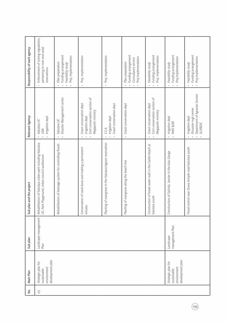
155
No.
Mai
n Pl
anSu
b pl
anSu
b pl
an a
nd th
e pr
ojec
tRe
leva
nt A
genc
yRe
spon
sibili
ty o
f eac
h ag
ency
03St
rate
gic p
lan
for
sust
aina
ble
envi
ronm
ent
deve
lopm
ent p
lan
Land
scap
e m
anag
emen
t Pl
anRe
habi
litat
ion
of K
alut
ara
urba
n pa
rk in
clud
ing
Kalu
tara
UC
, Par
k Pl
aygr
ound
, Urb
an co
unci
l aud
itoriu
m
• Ka
luta
ra U
C•
UDA
• Irr
igat
ion
dept
• En
forc
emen
t of z
onin
g re
gula
tions
pe
rtai
ning
to ri
ver a
nd ca
nal
rese
rvat
ions
Reha
bilit
atio
n of
dra
inag
e sy
stem
for c
ontro
lling
floo
ds
• Ka
luta
ra U
C•
Disa
ster
Man
agem
ent c
ente
r•
Plan
pre
para
tion
• Fu
ndin
g ar
rang
emen
t •
Feas
ibili
ty st
udy
• Pr
oj. i
mpl
emen
tatio
n
Cons
erva
tion
of sa
nd d
une
and
mak
ing
a pe
rman
ent
estu
ary
• Co
ast c
onse
rvat
ion
dept
.•
Irrig
atio
n de
pt•
Cost
cons
erva
tion
sect
ion
of
Meg
apol
is m
inist
ry
• Pr
oj. i
mpl
emen
tatio
n
Plan
ting
of m
angr
ove
in th
e Ka
luta
ra la
goon
rese
rvat
ion
• C.
E.A.
• Irr
igat
ion
dept
• Co
ast c
onse
rvat
ion
dept
• Pr
oj. i
mpl
emen
tatio
n
Plan
ting
of m
angr
ove
alon
g th
e be
ach
line
• Co
ast c
onse
rvat
ion
dept
• Pl
an p
repa
ratio
n •
Fund
ing
arra
ngem
ent
• Co
nsul
tanc
e se
rvic
e •
Proj
.impl
emen
tatio
n
Cons
truc
tion
of b
reak
wat
er w
all i
n th
e Ca
lido
beac
h at
Ka
luta
ra so
uth
• Co
ast c
onse
rvat
ion
dept
• Co
st co
nser
vatio
n se
ctio
n of
M
egap
olis
min
istry
• Fe
asib
ility
stud
y •
Fund
ing
arra
ngem
ent
• Pr
oj. i
mpl
emen
tatio
n
Stra
tegi
c pla
n fo
r su
stai
nabl
e en
viro
nmen
t de
velo
pmen
t pla
n
Land
scap
e m
anag
emen
t Pla
nCo
nstr
uctio
n of
Sal
inity
bar
rier i
n th
e Ka
lu G
anga
•
Irrig
atio
n de
pt•
NW
S &
DB•
Feas
ibili
ty st
udy
• Fu
ndin
g ar
rang
emen
t•
Proj
.impl
emen
tatio
n
Floo
d co
ntro
l nea
r Duw
a te
mpl
e ro
ad K
alut
ara
sout
h •
Irrig
atio
n de
pt•
Diss
aste
r mgt
cent
er•
Depa
rtm
ent o
f Agr
aria
n Se
rvic
e•
SLLR
&DC
• Fe
asib
ility
stud
y•
Fund
ing
arra
ngem
ent
• Pr
oj.im
plem
enta
tion

156
Kalutara Development Plan 2021–2030
Urban Development Authority
No.
Mai
n Pl
anSu
b pl
anSu
b pl
an a
nd th
e pr
ojec
tRe
leva
nt A
genc
yRe
spon
sibili
ty o
f eac
h ag
ency
03St
rate
gic p
lan
for
sust
aina
ble
envi
ronm
ent
deve
lopm
ent p
lan
Land
scap
e m
anag
emen
t Pl
anFl
ood
cont
rol a
t Nag
oda
junc
tion
at K
alut
ara
sout
h
• Irr
igat
ion
dept
• Di
ssas
ter m
gt ce
nter
• De
part
men
t of A
grar
ian
Serv
ice
• SL
LR&
DC
• Fe
asib
ility
stud
y•
Fund
ing
arra
ngem
ent
• Pr
oj.im
plem
enta
tion
Cons
erva
tion
of a
reas
vul
nera
ble
for l
ands
lides
in
plan
ning
are
a •
NBR
O•
Enfo
rcem
ent o
f reg
ulat
ions
pe
rtai
ning
to la
nd sl
ide
area
s
Was
kadu
wa
Stor
m w
ater
dra
inag
e pr
ojec
t •
SLLR
&DC
• Co
ast c
onse
rvat
ion
dept
• C.
G.R.
• Irr
igat
ion
dept
• Pr
oj.im
plem
enta
tion
Publ
ic O
utdo
or
Recr
eatio
nal S
pace
pla
n
04st
rate
gic p
lan
for
Hous
ing
dens
ity a
nd
dist
ribut
ion
plan
Deve
lopm
ent o
f Mor
onth
uduw
a Ju
nctio
n•
UDA
• Ka
luta
ra P
S•
SLLR
&Dc
• Irr
igat
ion
dept
• Pl
an p
repa
ratio
n•
Feas
ibili
ty st
udy
• Fu
ndin
g ar
rang
emen
t •
Proj
.impl
emen
tatio
n
Deve
lopm
ent o
f Nag
oda
Junc
tion
• UD
A•
Kalu
tara
PS
• SL
LR&
DC•
Irrig
atio
n de
pt.
• Pl
an p
repa
ratio
n•
Feas
ibili
ty st
udy
• Fu
ndin
g ar
rang
emen
t •
Proj
.impl
emen
tatio
n
Deve
lopm
ent o
f Com
mer
cial
cent
er a
t Mal
wat
ta ju
nctio
n at
Kal
utar
a Ho
rana
road
•
UDA
• Ka
luta
ra P
S•
Plan
pre
para
tion
• Fe
asib
ility
stud
y•
Fund
ing
arra
ngem
ent
• Pr
oj.im
plem
enta
tion
Deve
lopm
ent o
f pub
lic b
uild
ing
at U
ggal
boda
at K
alut
ara
Hora
na ro
ad
• UD
A•
Kalu
tara
PS
• Pl
an p
repa
ratio
n•
Feas
ibili
ty st
udy
• Fu
ndin
g ar
rang
emen
t •
Proj
.impl
emen
tatio
n
05st
rate
gic p
lan
for
Cultu
ral,
relig
ious
and
he
ritag
e m
anag
emen
t pl
an
Prot
ectio
n of
vie
win
g pa
ths o
f Kal
utar
a St
hupa
• UD
A•
Kalu
tara
PS
• En
forc
emen
t of r
egul
atio
ns
pert
aini
ng to
pro
tect
ion
of v
iew
ing
path
s of K
alut
ara
Stup
a

157
Part II
Land & Building Development Strategic Plan

158
Kalutara Development Plan 2021–2030
Urban Development Authority

159
Chapter 07Development Zones & Zoning Guidelines

160
Kalutara Development Plan 2021–2030
Urban Development Authority
7.1. Introduction
The Kalutara Town Development Plan (2021–2030) is a development plan based on the development vision of "The Prime Caesura of South West Coast.“ In order to achieve the vision of this development plan prepared for the next 10 years, the objectives and goals have been introduced and five strategic plans have been introduced for implementation within area. Zoning is a key factor in the implementation of the Strategic Plan and it is the legal basis for the development of the Regional Regulation Plan.
The plan opens the way for a predominantly density-based development and aims to create a proposed city model.
The development zones and zoning guidelines set out in this chapter have been analyzed and mainly include the development zones, zoning factor, boundary coordinates of the development zones, the applied uses of the development zones and the general guidelines applicable to them.
The preparation of the Zoning plan and its limitations can be attributed to several specific analyzes. This is mainly based on the design concept of the Kalutara Development Plan (2021–2030), livability analysis, spatial feasibility analysis, sensitivity analysis and development intensity analysis and determination of distance from major cities, infrastructure Distribution
Accordingly, the Zoning Plan will accomplish the proper planning of the city by consolidating the applicable uses and providing the necessary infrastructure for such uses.
According to the Urban Development Plan of Kalutara, 54% of the environmentally sensitive areas are densely populated and the densities of vulnerable areas will be increased. These Planning Guidelines aim to ensure sustainable development by ensuring that environmental equality is achieved by 2030 as much as possible.
7.2. Development Zones
According to the vision of the Kalutara Development Plan, new guidelines will be introduced through a new building specification equation with the aim of directing the development of the area towards that vision.
In this development plan, new guidelines for encouraging practices will be relaxed and the use of permissions for these 13 zones has been introduced. Accordingly, these 13 zones and 3 environmentally sensitive zones are as follows.
Chapter 07Development Zones & Zoning Guidelines
Introduction
Development Zones

161
Chapter 07Development Zones & Zoning Guidelines
Development Zones
The proposed zoning plan is shown in Map No. 7.1
1. High Density Commercial Zone2. Moderate Density Commercial Zone I3. High Density Health Promotion Zone4. High Density Tourism Zone5. Industrial Zone6. Moderate Density Commercial Zone II7. High Density Height Controlled Residential Zone8. High Density Residential Zone9. Moderate Density Residential Zone10. High Density Tourism Zone II11. Low Density Residential Zone12. Low Density Tourism Zone13. Special Sacred Zone14. Wetland Protection Zone15. Wetland Nature Conservation Zone16. Paddy Cultivation and Wetland Agricultural Zone

162
Map 7.1 : Proposed Zoning Map
December 2020
Kalutara Development Plan (2021–2030)

163
Chapter 07Development Zones & Zoning Guidelines
Development Zones
Proposed Zoning Plan
7.2.1. Proposed Zoning Plan
The main consideration here is the zoning of the overall planning area. The zones are allocated to the zones based on analysis of land use patterns in the area.
"Regional density refers to areas where development control is restricted to land use intensity by legislative and legal systems."
The following analyzes are based on the determination of this density.
1. Development pressure
Development pressure Analysis is used to determine the orientation of development in the area using the existing road density, building density, population growth rate and land use pattern in the area.
2. Road integration
The analysis is based on the relationship between the road density and the road connection across the design area.
3. Sensitive Analysis
The key is to identify areas where development should be restricted throughout the region. Environmentally sensitive areas such as water sources, sensitive green areas such as paddy fields, marshes, forests, areas that are prone to disasters, religious, historical and archaeological sites. The end result of this analysis is the identification of protected areas that should be restricted to development within the Plan area. Version 5.7 of Volume 1 shows the sensitivity analysis in the Planning area.
4. Serviceability Analysis
When considering service delivery, it was analyzed whether there are sufficient network facilities in the area to provide the basic needs of the people such as health, education and other services. The analysis also considered the maximum distance a person can travel to obtain services. A detailed analysis of this is included in part 1 of the Residential Development Plan.
5. Land use Pattern
Zoning of land use patterns in the design area was considered.
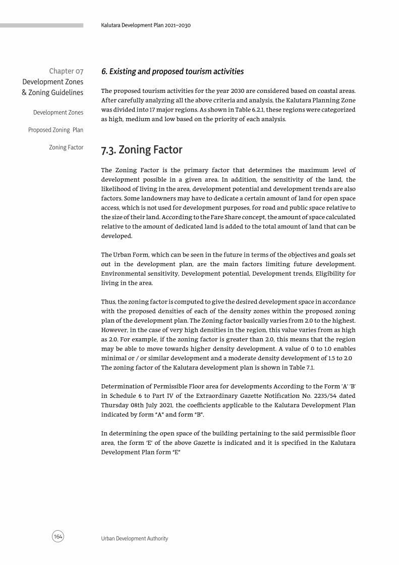
164
Kalutara Development Plan 2021–2030
Urban Development Authority
6. Existing and proposed tourism activities
The proposed tourism activities for the year 2030 are considered based on coastal areas. After carefully analyzing all the above criteria and analysis, the Kalutara Planning Zone was divided into 17 major regions. As shown in Table 6.2.1, these regions were categorized as high, medium and low based on the priority of each analysis.
7.3. Zoning Factor
The Zoning Factor is the primary factor that determines the maximum level of development possible in a given area. In addition, the sensitivity of the land, the likelihood of living in the area, development potential and development trends are also factors. Some landowners may have to dedicate a certain amount of land for open space access, which is not used for development purposes, for road and public space relative to the size of their land. According to the Fare Share concept, the amount of space calculated relative to the amount of dedicated land is added to the total amount of land that can be developed.
The Urban Form, which can be seen in the future in terms of the objectives and goals set out in the development plan, are the main factors limiting future development. Environmental sensitivity, Development potential, Development trends, Eligibility for living in the area.
Thus, the zoning factor is computed to give the desired development space in accordance with the proposed densities of each of the density zones within the proposed zoning plan of the development plan. The Zoning factor basically varies from 2.0 to the highest. However, in the case of very high densities in the region, this value varies from as high as 2.0. For example, if the zoning factor is greater than 2.0, this means that the region may be able to move towards higher density development. A value of 0 to 1.0 enables minimal or / or similar development and a moderate density development of 1.5 to 2.0The zoning factor of the Kalutara development plan is shown in Table 7.1.
Determination of Permissible Floor area for developments According to the Form 'A' 'B' in Schedule 6 to Part IV of the Extraordinary Gazette Notification No. 2235/54 dated Thursday 08th July 2021, the coefficients applicable to the Kalutara Development Plan indicated by form “A” and form “B”.
In determining the open space of the building pertaining to the said permissible floor area, the form ‘E’ of the above Gazette is indicated and it is specified in the Kalutara Development Plan form “E”
Chapter 07Development Zones & Zoning Guidelines
Development Zones
Proposed Zoning Plan
Zoning Factor

165
Form
A -
Perm
issib
le F
loor
Are
a Ra
tio
Land
ext
ent (
Sq.M
)Zo
ne fa
ctor
= 0
.50
- 0.7
4Zo
ne fa
ctor
= 0
.75-
0.99
Zone
fact
or =
1.00
-1.2
4Zo
ne fa
ctor
= 1.
25-1
.49
Zone
fact
or =
1.50
-1.7
4Zo
ne fa
ctor
= 1.
75-1
.99
Min
imum
Roa
d W
idth
M
inim
um R
oad
Wid
th
Min
imum
Roa
d W
idth
M
inim
um R
oad
Wid
th
Min
imum
Roa
d W
idth
M
inim
um R
oad
Wid
th
**6m
9m
12m
15m or above
**6m
9m
12m
15m or above
**6m
9m
12m
15m or above
**6m
9m
12m
15m or above
**6m
9m
12m
15m or above
**6m
9m
12m
15m or above
150
less
than
250
0.8
0.9
0.9
0.9
1.31.3
1.41.4
1.61.7
1.81.9
2.0
2.2
2.3
2.4
2.4
2.6
2.7
2.8
2.8
3.0
3.2
3.3
250
less
than
375
0.9
1.01.2
1.31.3
1.61.8
2.0
1.82.
22.
42.
72.
22.
73.
03.
32.
63.
23.
64.
03.
03.
44.
34.
7
375
less
than
500
0.9
1.01.2
1.41.3
1.61.9
2.1
1.92.
22.
52.
82.
32.
83.
23.
42.
73.
33.
84.
23.
23.
54.
55.
0
500
less
than
750
1.01.1
1.31.5
1.41.7
2.0
2.2
2.0
2.3
2.7
3.0
2.4
3.0
3.4
3.5
2.8
3.4
4.0
4.5
3.4
3.6
4.7
5.5
750
less
than
1000
1.01.2
1.41.7
1.51.8
2.2
2.5
2.1
2.4
2.9
3.3
2.6
3.0
3.6
4.0
3.1
3.6
4.3
5.0
3.5
3.8
5.1
6.0
1000
less
than
1500
1.11.3
1.51.8
1.61.9
2.3
2.7
2.2
2.5
3.0
3.6
2.7
3.1
3.8
4.5
3.2
3.8
4.6
5.5
3.6
4.0
5.4
6.5
1500
less
than
200
01.1
1.41.7
2.0
1.72.
12.
53.
02.
32.
73.
44.
02.
93.
44.
25.
03.
44.
05.
06.
03.
74.
25.
87.0
2000
less
than
250
01.2
1.51.8
2.1
1.82.
32.
73.
12.
42.
83.
54.
23.
03.
54.
45.
43.
54.
25.
26.
53.
84.
46.
27.5
2500
less
than
300
01.2
1.62.
02.
41.9
2.4
3.0
3.6
2.5
3.2
4.0
4.7
3.1
3.8
4.7
5.8
3.6
4.4
5.5
7.03.
94.
66.
58.
0
3000
less
than
350
01.3
1.72.
12.
52.
02.
53.
13.
72.
63.
44.
25.
03.
24.
05.
06.
23.
74.
66.
07.5
4.0
4.8
6.9
8.5
3500
less
than
400
01.4
1.82.
22.
62.
22.
63.
33.
92.
83.
64.
35.
33.
34.
35.
56.
63.
84.
86.
37.7
4.0
5.0
7.39.
0
Mor
e th
an 4
000
1.51.9
2.3
2.8
2.5
2.8
3.5
4.0
3.0
3.8
4.5
5.5
3.5
4.5
6.0
7.04.
05.
06.
58.
04.
05.
27.5
9.5
Sch
edul
e 01
, sch
edul
e 02
an
d sc
hed
ule
03 p
rep
ared
acc
ordi
ng
to th
e zo
ne
fact
or a
re a
s fo
llow
s.
Shed
ule
01

166
Form A - Perm
issible Floor Area Ratio
Land extent (Sq.M)
Zone factor = 2.00-2.24Zone factor = 2.25-2.49
Zone factor = 2.50-2.74Zone factor = 2.75-2.99
Zone factor = 3.00-3.24Zone factor = 3.25-3.49
Minim
um Road W
idth M
inimum
Road Width
Minim
um Road W
idth M
inimum
Road Width
Minim
um Road W
idth M
inimum
Road Width
**6m
9m
12m
15m or above
**6m
9m
12m
15m or above
**6m
9m
12m
15m or above
**6m
9m
12m
15m or above
**6m
9m
12m
15m or above
**6m
9m
12m
15m or above
150 less than 2503.0
3.43.6
3.83.0
3.43.6
4.03.0
3.43.6
4.03.0
3.43.6
4.03.0
3.43.6
4.03.0
3.43.6
4.0
250 less than 3753.2
3.64.5
4.53.5
3.84.5
5.03.5
4.05.0
5.53.5
4.25.0
5.53.5
4.45.0
5.53.5
4.65.0
5.5
375 less than 5003.4
3.74.8
5.23.6
4.54.7
5.53.6
4.65.2
6.03.6
4.75.2
6.03.6
4.85.2
6.03.6
4.95.2
6.0
500 less than 7503.5
4.05.0
6.03.7
5.05.0
6.03.7
5.15.5
6.53.7
5.25.5
6.53.7
5.35.5
6.53.8
5.45.5
6.5
750 less than 10003.6
4.55.7
6.53.8
5.16.0
6.53.8
5.26.5
7.03.8
5.37.0
7.53.8
5.47.0
7.54.0
5.57.5
8.0
1000 less than 15003.7
5.06.1
8.03.9
5.36.5
8.53.9
5.47.0
9.03.9
5.57.5
9.03.9
5.67.5
9.04.0
5.78.0
9.0
1500 less than 20003.8
5.16.7
9.04.0
5.47.0
*104.0
5.57.5
*10.54.0
5.67.5
*10.54.0
5.78.0
*10.54.0
5.88.0
*11
2000 less than 25003.9
5.27.1
*104.0
5.57.5
*10.54.0
5.67.5
*114.0
5.78.0
*114.0
5.88.0
*114.0
5.98.0
*11.5
2500 less than 30004.0
5.37.4
*10.54.0
5.67.5
*114.0
5.78.0
*11.54.0
5.88.0
*11.54.0
5.98.0
*11.54.0
6.08.0
*12
3000 less than 35004.0
5.47.6
*114.0
5.78.0
*11.54.0
5.88.0
*124.0
5.98.0
*124.0
6.08.0
*124.0
6.08.0
*12
3500 less than 40004.0
5.57.8
*11.54.0
5.88.0
*124.0
5.98.0
*124.0
6.08.0
*124.0
6.08.0
*124.0
6.08.0
*12
More than 4000
4.05.6
8.0*12
4.05.9
8.0*UL
4.06.0
8.0*UL
4.06.0
8.0*UL
4.06.0
8.0*UL
4.06.0
8.0*UL
UL - Unlimited
Floor area allocated for parking facilities are not calculated for FARAbove Floor Area Ratio shall not be applicable for the zones w
here number of floors or FAR indicated under the zoning regulations
Above Permissible FAR m
ay be restricted under the development plan based on the slope of the land
Clearance shall be taken from N
ational Building Reserach Organization for the lands having slope morethan 110
* FAR m
ore than or equal to 10.0 shall be permitted only for the roads having m
inimum
of 12m ( from
road center) Building Line, if not maxim
um FAR shall be lim
ited to 9.0**M
inimum
road width of 7m
shall be considered for the roads identified as 7m w
ide road in the particular development Plan

167
Schedule 02
Schedule 03
Form B - Number of Floors for 3.0m & 4.5m wide Roads
Minimum Road Width
Minimum Site Frontage
Plot Coverage*
Maximum Number of Floors
Zone Factor 0.5 - 0.74
Zone Factor 0.75 - 1.24
Zone Factor 1.25 - 3.49
Zone Factor 3.50 - 4.00
3.0m 6m 65% 1 (G) 2 (G+1) 3 (G+2) 3 (G+2)
4.5m 6m 65% 1 (G) 2 (G+1) 3 (G+2) 4 (G+3)
Number of floors are indicated including parking areas Number of units allowed for each road shall not be changed * Where no plot coverage specified under the zoning regulations
Form E - Setbacks & Open Spaces
Build
ing
Cate
gory
Build
ing
Heig
ht (m
)
Min
imum
Site
Fron
tage
(m) Plot Coverage* Rear Space (m) Side Space (m) Light Well for NLV
Non
Resid
entia
l
Resid
entia
l
Whe
n no
NLV
is ta
king
th
is en
d
Whe
n NL
V is
taki
ng
this
end
Whe
n no
NLV
is ta
king
th
is en
d
Whe
n NL
V is
taki
ng
this
end
Min
imum
wid
th
Min
imum
Are
a
Low Riseless than 7 6 80%** 65% 2.3m 2.3m - 2.3m 2.3m 5 Sq.m
7 less than 15 6 65% 65% 3.0m 3.0m - 3.0m 3.0m 9 Sq.m
Inter Mediate Rise 15 less than 30 12 65% 65% 4.0m 4.0m 1.0m and 3.0m 4.0m 4.0m 16 Sq.m
Middle Rise 30 less than 50 20 65% 65% 4.0m 5.0m 3.0m both side 5.0m 5.0m 25 Sq.m
High Rise50 less than 75 30 50%*** 50%*** 5.0m 6.0m 4.0m both side 6.0m 6.0m 36 Sq.m
75 and above Above 40m 50%*** 50%*** 5.0m 6.0m 5.0m both side 6.0m 6.0m ****
NLV - Natural Light & Ventilation Building Height - Height between access road level to roof top or roof level (Including parking floors) * Where no Plot Coverage specified under the zoning regulations ** The entire development is for non-residential activities *** 65% plot coverage can be allowed only for the podium level not exceeding 20% of the tower height or 12 floors which ever is less **** Minimum area shall be increased by 1 Sq.m for every additional 3m height

168
Map 7.2 : Zone Factor Map
December 2020
Kalutara Development Plan (2021–2030)

169
Number Zone Factor Extent Km2
1. High Density Commercial Zone 3.42 0.47
2. Moderate Density Commercial Zone I 3.2 8.88
3. High Density Health Promotion Zone 3.2 1.72
4. High Density Tourism Zone 3.1 3.14
5. Industrial Zone 2.8 0.35
6. Moderate Density Commercial Zone II 1.91 3.70
7. High Density Height Controlled Residential Zone 1.8 2.52
8. High Density Residential Zone 1.8 14.35
9. Moderate Density Residential Zone 1.4 17.27
10. High Density Tourism Zone II 1.2 1.81
11. Low Density Residential Zone 1.2 19.44
12. Low Density Tourism Zone 1.04 3.14
13. Special Sacred Zone 1.1 0.09
According to these figures, the highest zoning Factor of 3.42 has been assigned for the purpose of attracting the highest development for commercial expansion in Kalutara and its high density commercial zone. Parallel to this, high-density commercial zone I was assigned a higher zoning Factor, ie 3.2, centered on the combined urban centers (Wadiyamankada Junction, Nagas Junction, Katukurunda and Nagoda Junction). In the High Density Health Promotion Zone, the zoning Factor is 3.2 in the High Density Health Zone and 3.1 in the High Density Tourism Zone, centered around and around the Nagoda main hospital premises.
In addition to these zones, the industrial zone Pullerton-based region has a zoning Factor of 2.8.
In addition to these four zones, the zoning factor was 1.8 in the high density residential zone, 1.8 in the high density residential zone ie Katukurunda airport and 1.4 in the moderate density residential zone. In the low-density residential area, which includes sensitive areas, the zoning factor is given as 1.2.
The zoning Factor is given as 1.1, especially in the Kalutara sacred area. Height control in the identified areas, according to the visual analysis of the region. The zoning Factor is given as 1.04 in the low density tourist zone including the Bolgoda River and its associated areas.
Table 7.1 : Zone factor table Chapter 07Development Zones & Zoning Guidelines
Zoning Factor

170
Kalutara Development Plan 2021–2030
Urban Development Authority
Chapter 07Development Zones & Zoning Guidelines
Zoning Factor
Height limitations for preserving the vision of
the Kalutara Stupa
7.3.1. Height limitations for preserving the vision of the Kalutara Stupa
The Kalutara Stupa is visible on both sides of the Galle Road, from the coast of Calido, to the North of Kalutara, Kalutara Vidyalaya, Katukurunda and many more. Plans and building guidelines will be developed to protect the scenery by limiting the building height of the sights identified by the visual analysis. Accordingly, the height of the building should be limited to a height of 300 m from the height of the chaitya and the color of the buildings should be used in a range of shades of white to suit the chaitya.
According to visibility analysis: The height of the stupa is 61m with the base of the 2/3 of the stupa

171
Chapter 07Development Zones & Zoning Guidelines
Zoning Factor
Height limitations for preserving the vision of the Kalutara Stupa

172
Kalutara Development Plan 2021–2030
Urban Development Authority
Visiting point Latitude Longitude
P1 6°35'46.68"N 79°57'31.82"E
P2 6°35'36.13"N 79°57'33.31"E
P3 6°35'23.02"N 79°57'48.33"E
P4 6°35'19.96"N 79°57'44.75"E
P5 6°35'12.63"N 79°57'39.62"E
P6 6°35'12.68"N 79°57'41.02"E
P7 6°35'12.44"N 79°57'42.20"E
P8 6°35'17.73"N 79°57'20.04"E
P9 6°35'18.16"N 79°57'18.53"E
P10 6°35'9.41"N 79°57'34.96"E
P11 6°35'3.20"N 79°57'32.93"E
P12 6°35'2.51"N 79°57'32.63"E
P13 6°35'6.68"N 79°57'38.25"E
P14 6°35'2.32"N 79°57'39.35"E
P15 6°34'49.61"N 79°57'43.47"E
P16 6°34'37.24"N 79°57'46.98"E
P17 6°34'22.87"N 79°57'51.87"E
Chapter 07Development Zones & Zoning Guidelines
Zoning Factor
Height limitations for preserving the vision of
the Kalutara Stupa
Table 7.2 : Visibility points

173
7.4. General Guidelines for Development Zones
This chapter describes the general guidelines applicable to all those zones, in addition to the practices and guidelines introduced for each zone in the proposed zoning plan.
I. These guidelines apply to the entire area within the administrative limits of the Kalutara Divisional Secretariat area which has been declared as an Urban Development Area in the Extraordinary Gazette Notification No. 1983/31 and 09.09.2016 under Section 3 of the Urban Development Authority Act No. 41 of 1978.
II. In addition to the provisions of this zoning plan, the Planning and Development Guidelines applicable to any development work is regulated by the Gazette Notification No 2236/25 dated 13th of July 2021. The said legalized Planning and Development Guidelines also apply to Kalutara Divisional Secretariat area.
III. When approving building plans under development, a formula has been introduced to determine the maximum floor area allowed in each area. It is mentioned in Chapter 2 of the Planning and Building Guidelines. The Urban Development Authority (UDA) has the final decision in determining the total area of the land to be approved for development. These guidelines do not apply to areas where development is controlled.
IV. When approving a block of land for a particular development project, the minimum floor area of a plot of land should be 150 square meters, unless the minimum area is specified in the zoning guidelines. However, if there is no pipe-borne water in those areas, there should be at least 250 square meters for approval. Identified special guidelines for controlling development based on site specificities
V. All lowlands and paddy fields, water retention and water control areas in the Kalutara Wetland Zoning Plan (excluding the areas identified by the UDA for projects) must comply with that plan
VI. Wastewater management plans must be submitted with the recommendation of the CEA for non-residential constructions exceeding 371.612 sq.ft. Also, the UDA can request that the building plans be submitted with a landscape plan.
VII. In the case of development near to water source, building plans should be to suit the surrounding environment. Here the color of the building, the materials used for the building (non-reflective materials) should be used. In the case of water source development, Preliminary plan clearance must be taken from the UDA.
VIII. Where a particular plot of land and property is reserved for a specific use, it should only be used for that purpose.
IX. For a plot of land within the boundary separating the two zones within the Kalutara Plan, each plot can be applied to the use of the adjacent zone to the
Chapter 07Development Zones & Zoning Guidelines
General Guidelines for Development Zones

174
Kalutara Development Plan 2021–2030
Urban Development Authority
owner's discretion and to the zoning factor. It should be limited to 50 meters. If there is any remaining plot of land, it should be in accordance with the existing zoning. This Does not apply to the zones where development is controlled.
X. The authority has the power to decide on the number of people to be represented in the construction of a new religious building should obtain the approval of the relevant Ministry of Religious Affairs and the Divisional Secretary. Religious exhibitions should also be organized with the approval of the Divisional Secretary. The construction of religious monuments, crosses and other signs within the boundaries and the reserves of the roads in the design area is not permitted. When constructing a religious building, 66% of the people within a radius of 0.5 km from the ground of such a building do not oppose the development work. The consent of the people of the area should be obtained by the Grama Niladhari of the area and certified by the Divisional Secretary.
XI. After Goda Vali excavation Clay ball excavation should be filled with soil so that it can be re-developed. In the absence of such a project report should be submitted for approval for the proposed development. Unless otherwise specified by the Geological Survey and Mines Bureau, deforestation should be limited to ground level.
XII. If the building is equipped with solar panels or other eco-friendly means of energy, 5% additional floor area will be considered for such development. If these conditions are not met at the time of issuing the Certificate of Conformity, an additional service charge will be levied at twice the service charge for the unauthorized construction.
XIII. Where the Authority deems appropriate, any area within a development area may be declared a Special Project Area, Reconstruction Area, Special Housing Project Area, Central Commercial Area, Visionary Area, Conservation Area, Cultural Area or Other. The guidelines and guidelines introduced in those areas will be enforced in the said areas. The authority may use, restrict or prohibit the use of the land for the construction of any particular building in such area, ease the prohibitions imposed by these bylaws, or impose any other bylaws for the purposes of the area and for the purpose thereof.
XIV. In the case of a boundary change, the physical boundary of the zone must be taken in the event that the boundaries shown in the zoning plan are defined by both the geographical coordinates of the Google Earth.
XV. The issuance of guidelines, gazette notifications and circulars issued by other government agencies will continue to take effect in the development of these design zones.
XVI. Roads owned by Local Authorities, Road Development Authority and Provincial Road Development Authority in these areas are not permitted to construct boundary walls within the boundaries of the building. Approval will be considered for plans that are designed with a transparent mesh or some other means of
Chapter 07Development Zones & Zoning Guidelines
General Guidelines for Development Zones

175
replacing the boundary walls with minimal space required to widen access.
XVII. Where a given area is shown to fall into two zones, the area that falls within that area is determined by the region from which the main access is to that land.
XVIII. If a plot of land falls between two local government areas, this area is considered to belong to the local government that has access to it.
XIX. Also, if any plot of land is accessed by means of two local government areas, This block of land belongs to the main road. If both routes have the same width. the high frontage access road The local government road, which covers most of the land, should be applied.
XX. Religious sites and schools must be located at least 500 meters away from liquor shops for issue the permit
XXI. Excluding areas identified for control of development activities Public Leisure and Recreation Spaces Plan (PORS) or the Zoning Plan, when approving the low lands, marshy lands, paddy fields or other lands in other zones, the UDA's preliminary planning clearance must be taken.
XXII. The designated area for public outdoor parks, sports and recreation space (PORS) should be used only for that purpose.
7.4.1. Special Development Guidelines for Wetlands in Kalutara Urban Development Area
I. This zoning is valid for all the wetlands in Kalutara DSD.
II. Flood storage capacity shall be maintained as specified by the Sri Lanka Land Development Corporation (SLLDC) in co-ordination with the other relevant agencies mentioned in appendix 01. Increased storm water run-off owing to increase in built-up areas and expected extreme climatic events as a result of global warming and climate change shall be taken into account.
III. Clearance, shall be obtained from the agencies of No. 01, 03, 04, 06 and 10 mentioned in appendix 01, prior to development of low-lying lands/ abandoned paddy lands and paddy lands. Where necessary clearance or approval of the other relevant agencies mentioned in appendix 01 shall also be obtained when the ownership of wetland is delegated to them by an act.
IV. For any development which effects wetland environment the environmental clearance or Environmental Protection License (EPL) shall be obtained from no.03, 06 agencies of the appendix 01.This shall be renewed annually.
Chapter 07Development Zones & Zoning Guidelines
General Guidelines for Development Zones
Special Development Guidelines for Wetlands in Kalutara Urban Development Area

176
Kalutara Development Plan 2021–2030
Urban Development Authority
V. As per the decision of the UDA Planning Committee, a recommendation / Approval (final clearance certificate) shall be taken from No. 01 agency of appendix 01, shall be annually renewed.
VI. Recommendation / Approval / Permit should be obtained from No. 05, 12 agencies of appendix 01 before development of any low-lying lands within the “Costal Zone”.
VII. Canal reservation of no.1662/17 published by the gazette notification dated 14.07.2010 of the agency No.01 and reservation of reservoirs of agency No.02 at the appendix 01 shall be maintained
VIII. In general, there shall not be any construction within water bodies and waterways which will disturb the water retention and water flow. But exceptions may be made for focal features/buildings on stilts, piers, picnic shelters, cabanas on stilts, fishing decks, boardwalks, etc. in keeping with a project master plan or design guide plan approved by the UDA, they not compromise with drainage or flood detention capacity. Recommendation and Approval shall be obtained from relevant agencies of No. 01 & 02-22 of the appendix 01.
IX. Areas of special ecological interest shall be preserved and in such areas no vegetation or animals except invasive species of plants and animals shall be removed.
X. All permitted buildings shall be designed according to the Green Building Concept.
XI. Alternative water retention areas shall be established if the approved development would decrease the flood storage capacity and make other impacts for environmental services when practicing Permitted uses in wetland where flood storage capacity is important. Approval shall be obtained from the relevant agencies of the appendix 01.
XII. Except traditional fishing activities, Motor boats, fishing vessels, fuel or other gears shall not be used in fishery or other aquatic animal catching process. In places where motor boats are permitted approval shall be obtained from the No. 03, 05, 06, 12, 21, 22 agencies of the appendix 01 for the use of fishing gear and fuel in above said places where motor boats are permitted.
XIII. In any wetland area owned by the No. 01 agency mentioned in appendix 01 are recommended for filling, sustainable storm water drainage systems should be used. Approval shall be obtained from the CEA for materials to be used for filling the wetland.
XIV. Areas of outstanding landscape/cultural/historical and biodiversity value shall be conserved
Chapter 07Development Zones & Zoning Guidelines
General Guidelines for Development Zones
Special Development Guidelines for Wetlands
in Kalutara Urban Development Area

177
XV. Public footpaths and public bathing wells which are legally approved shall be preserved or replaced in Suitable nearby locations.
XVI. The services of relevant qualified professionals shall be obtained by developers for planning, design and supervision, as necessary
XVII. All areas where fish and other aquatic animals breed shall be preserved.
XVIII. Waste dumping (Residential, Institutional, Commercial, Industrial, E-waste and Clinical waste) shall not be permitted in to wetlands.
XIX. Release of waste water to wetlands is not allowed. Treated water shall only be permitted to release to the wetland areas with the approval of CEA.
7.4.2. Areas affected by Katukurunda internal aircraft landing
From the center line of the runway, these guidelines are applicable to a limit of six km.
All construction work within a distance of 300 m from the center line of the runway should obtain clearance from the Civil Aviation Authority.
For "A" type buildings constructed between 300 km and 4 km from the center line of the runway and for all constructions exceeding the maximum height of 45 meters of the building, relative to the ground level of the runway, clearance certificates must be obtained from the Civil Aviation Authority. (Figure 1)
High-rise buildings constructed between the boundaries of the 4 km to 6 km range from the center line of the runway can be maintained at a slope of 1:20 with a maximum height of 150 m. If the Planning Committee determines to exceed these values, such high-rise buildings should obtain a clear certificate from the Civil Aviation Authority.
Chapter 07Development Zones & Zoning Guidelines
General Guidelines for Development Zones
Special Development Guidelines for Wetlands in Kalutara Urban Development Area
Areas affected by Katukurunda internal aircraft landing
Maintain the maximum heaight of the affected area of an airstrip
1:7
1:20
150m
4km300m
Maximum Heaight - 45m
The center line of airstrip
Figure 7.1 : Maintain the maximum heaight of the affected area of an airstrip

178
Kalutara Development Plan 2021–2030
Urban Development Authority
No Area Coastal Reservation (m)
1 The northern boundary of the Calido Valley, Kalutara from the Pinwatta Thalpitiya estuary
40
2 Katukurunda Avani Hotel from proposed northern boundary of Calido Valley, Kalutara (proposed Calido Valley Range of Conservation Area, Kalutara South))
The restricted zone
3 Katukurunda Avani Hotel (Kalu Ganga estuary South Limit to South Payagala Railway Crossing)
50
7.4.3 Coastal zones and coastal reservations
No. 2072/58 Dated 2018-05-25 Coastal Conservation and Coastal Resources Management Act No 57 of 1981, the Sri Lanka Coastal Zone and Coastal Resource Management Plan 2018, prepared under Section 12. And also, should practice according to the table number 1.3
7.4.3.1 Development activities that should be permitted in the coastal zone
The following are the permissible practices under the Coast Conservation and Coastal Resources Management Act.
• Condominium property, apartments, apartment complexes and other dwellings and boundary walls and associated structures.
• Industry and other commercial construction• Travel, recreational swimming pools and waterfront construction. Ports and
Fisheries Ports and Construction• Highways, Bridges, Railways and Tunnels• Public or religious construction
- Shoreline protection constructions by individuals or groups.• Wastewater disposal, sewage treatment facilities and ocean discharges
- Aquaculture facilities- Solid waste disposal (on both sides of the water table)
• Excavation, filling, unloading and sand blasting.• Coastal park development and landscaping• Excavation and diversion of minerals.• Power generation.• Removal of sand, shellfish, seaweed.• Creating reclamation islands and building additional security structures.• Construction of carriageways.
Chapter 07Development Zones & Zoning Guidelines
General Guidelines for Development Zones
Coastal zones and coastal reservations Table 7.3 : Coastal reservation

179
7.4.4. Rules and Guidelines for Canals
1. Without the written consent of the CEO of Sri Lanka Land Reclamation and Development Corporation No buildings or structures shall be erected or (or) reclaimed within protected areas declared as a canal reservoir.
2. Without any approval of the Corporation, within these declared canal reservations should not disposal any pollutant or industrial waste or should not be made to do so.
3. the canal reservation may be used as an access road only when there is no alternate route; If it is used as a legal means, Must submit the written permission of the relevant institutions to which the reservation area belongs. And also doo’t Asphalt or concrete or lay any stone on the road.
4. In the reservations of such a canal Giving lease for residential or any other purpose Shall not be made by an individual, association, institution or local authority.
5. Land lots shall not be used for parking areas within the area declared as canal reservoirs.
Other Factors
In any case above reservoir / building limits Commercial use is not permitted. Considering the construction of a boundary fence, mesh gate (without foundations) for the protection of the above reservation.
Chapter 07Development Zones & Zoning Guidelines
General Guidelines for Development Zones
Rules and Guidelines for Canals

180
Kalutara Development Plan 2021–2030
Urban Development Authority
7.4.5 Standards for hostel facilities
It recommends minimum requirements for accommodations of three or more persons.
Bedrooms - The minimum floor area for every three residents should be 8 square meters. There should be a minimum of 2.4 meters on each side. There should be sleeping facilities and personal clothing shelves.
Common room - Should not be less than 10 square meters.one in every nine people should have guest accommodation, Facilities for laundry, leisure, writing and reading facilities should be provided. In addition, if the kitchen does not provide dining facilities, it should also be allowed.
Kitchen - There should be space for cooking and storage of cooking Equipment’s. It should also facilitate the preparation and consuming of food.
Toilets and - One toilet and bathing facilities should be provided for 06 members.
Bathroom facilities
- • Electricity - Provide sufficient electricity to every residential building.
• Water - If drinking water and drinking water is not provided through a main pipeline, the place where the water is obtained must be approved by the Municipal Council.
• All building construction shall Complied with the guidelines of the UDA.
50% of the space required for light and ventilation should be fixed windows and glass.
Chapter 07Development Zones & Zoning Guidelines
General Guidelines for Development Zones
Standards for hostel facilities
Table 7.4 : Standards for hostels

181
Chapter 08Proposed Zoning Guidelines of Development Zones

182
Kalutara Development Plan 2021–2030
Urban Development Authority
8.1. Guidelines affecting proposed development zones
The zoning plan of the Kalutara Urban Development Plan has been divided into 17 zones and the development guidelines applicable to each zone are as follows.
8.2. Zoning guidelines for specific zones
8.2.1. High Density Commercial Zone (Downtown Kalutara)
This region includes the core city of Kalutara district and the core areas of the main transport hub. Priority for commercial development is given in this region. The urban form is aimed at obtaining the desired urban form through developments that depend on the road and its width.
The coordinate boundaries for the physical boundaries of this region are given below.
8.2.1.2. Guidelines and practices applicable to a high density commercial zone
Guidelines and Practices in the High Density Commercial Zone of the Kalutara Zoning Plan the Following Table 8.1. And 8.2.
Chapter 08Proposed Zoning
Guidelines of Development Zones
Guidelines affecting proposed development
zones
Zoning guidelines for specific zones
High Density Commercial Zone
(Downtown Kalutara)

183
Table 8.1 : Guidelines of High Density Commercial Zone
Zone boundaries (coordinates)
Noted under annexure 6
Zoning factor 3.42
Approved height limit
The new building specification is determined by the equation.
Approved maximum plot area
Residential - 65%Non residential - 80 %
Other matters pertaining to the region
1. 10 meter reserve for the lagoon should be maintained2. The height of the building should be subject to the height limit
identified by the analysis of the scenery carried out in accordance with the Kalutara Chaithya. The boundaries shall be in accordance with the respective 02 numbers of the coordinates.
3. Building height should conform to the Kalutara Chaitya Height Limitation Guidelines
4. If the reservoir is used in some another uses, the recommendation of the Department of Railways should be obtained.
5. Recommendation of the Coast Conservation Department to obtain for development work within the 300m zone of the Coast Conservation Department.
6. According to the Gazette Notification No. 1662/17 dated 14.07.2010 issued by the Sri Lanka Land Reclamation and Development Corporation for Canals, the building limits shall be maintained in accordance with Table 9.5.1 and 9.5.2.
• Proposed expansion Roads
I. Old Road (Sir Cyril de Zoysa Mawatha) ( Proposed Width 9m )
II. Gangabada Road (Proposed Width 9m)
Chapter 08Proposed Zoning Guidelines of Development Zones
Zoning guidelines for specific zones
High Density Commercial Zone (Downtown Kalutara)

184
Kalutara Development Plan 2021–2030
Urban Development Authority
Serial No
Permissible uses Minimum Size of the Land (sq.m.)
commercial
1. Shop 150
2. Supermarkets 1000
3. Shopping complex 500
4. Restaurants 250
5. Open stores 1000
6. Pharmacies 150
7. Laboratory Services and Collection Centers 150
8 Wholesale stores 375
9 Customer Service Centers 150
10 Meat and fish outlets 150
11 Liquor outlets 300
12 Building Materials Sales 375
13 Fuel stations 1000(The frontage of the land should be 30 meters.)
14. Filling stations and malls 2,000
15. Gas stations and electric charging stations 500
16. Communication towers on buildings Compliance certificate must be obtained for the building and certified by a structural engineer.
17. Communication towers 250
18. Multi-storey parking 500
19. Open car park 250
20. Vehicle Showrooms 500
Residential
1. Housing units 150
2. Apartment complexes 500
Table 8.2 : Guidelines of High Density Commercial ZoneChapter 08Proposed Zoning
Guidelines of Development Zones
Zoning guidelines for specific zones
High Density Commercial Zone
(Downtown Kalutara)

185
Serial No
Permissible uses Minimum Size of the Land (sq.m.)
3. Hostels 500
4. Quarters / quarters 250
5. Adult / Disabled Homes 500
6. Child Care Centers 250
Health
1. Medical treatment centers 250
2. Medical Consulting Service Centers 500
3. Child and Maternity Clinics 375
4. Animal Clinics and Treatment Centers 250
5. Ayurvedic Treatment Centers 250
Educational
1. Early Childhood Development Centers 250
2. Private tuition classes (up to 50 students)More than 50 students
5001000(width of the access road should be 7m)
3. Other Education Centers (Kalayatana / Theater) 500
4. Primary Education Institutions 4000
5. Secondary Education Institutions
6. Tertiary Education Institutions
Institutions
1. Offices 250
2. Office complex 1000
3. Professional Offices 150
4. Bank Insurance and Financial Institutions 500
5. Automated Transaction Centers 150
Social services and public amenities
1. Community Development Centers 500
2. Social and cultural centers 500
Chapter 08Proposed Zoning Guidelines of Development Zones
Zoning guidelines for specific zones
High Density Commercial Zone (Downtown Kalutara)

186
Kalutara Development Plan 2021–2030
Urban Development Authority
Serial No
Permissible uses Minimum Size of the Land (sq.m.)
3. Auditoriums and conference rooms 1000
4. Library 250
5. Rehabilitation centers(Children’s homes, Elder’s homes)
1000
Tourism
1. Resorts 375
2. Guest houses 250
3. Lodgings 500
4. Urban hotels 500
5. Travel Information Centers 150
6. Ayurvedic Panchakarma Center 500
Service industries
1 Vehicle Service Centers 1000
2 Vehicle Repair Centers / Spray Painting Centers
3. Motor bicycle and three wheeler service centers 500
4. Taxi Service Centers 250
5. Laundry / Clothing Cleaning Centers 150
6. Electronics repair centers
7. ‘Liyawanapattal’ and welding workshops 250
Utility Services
1 Rail and bus terminal 1000
Leisure and recreation
1. cinema 1000
2. Night club 500
3. Art Museums / Museum
4. Outdoor Theater 1000
Chapter 08Proposed Zoning
Guidelines of Development Zones
Zoning guidelines for specific zones
High Density Commercial Zone
(Downtown Kalutara)

187
Serial No
Permissible uses Minimum Size of the Land (sq.m.)
5. Poket gardens Depends on the project proposal.
6. Mini gardens
7. Linear gardens
8. Boat jetties / anchors / ferry lodging
Please note - in the case of any request for permissible use, the UDA will have the final decision on permitting according to the zoning plan.
8.2.2. Moderate Density Commercial zone I (Wadiya Mankada, Nagas Junction, Katukurunda, Central Junction)
This is a moderately dense zone combined with the secondary urban centers - Wadiyamankada, Nagashandiya, Katukurunda, Central Junction and Nagoda Junction.It aims to provide affordable commercial and service facilities in downtown areas that are less accessible and less dense. It is aimed at obtaining the expected urban form through a balanced development based on Roada and zoning factor. The coordinate boundaries corresponding to the physical boundaries of this region are given below.
8.2.2.1 Guidelines and practices applicable to a Moderate Density Commercial Zone I
Guidelines and Practices in the Moderate Density Commercial Zone I of the Kalutara Zoning Plan the Following Table 8.3. And 8.4.
Chapter 08Proposed Zoning Guidelines of Development Zones
Zoning guidelines for specific zones
High Density Commercial Zone (Downtown Kalutara)
Moderate Density Commercial zone I (wadiya mankada, Nagas Junction, Katukurunda, Central Junction)

188
Kalutara Development Plan 2021–2030
Urban Development Authority
Table 8.3 : Guidelines of Moderate Density Commercial Zone I
Zone boundaries (coordinates)
Noted under annexure 7
Zoning factor 3.2
Approved height limit
The new building specification is determined by the equation.
Approved plots of land
Residential - 65%Non Residential - 70%Schools and Hospitals - 50%
General Terms Related to the Zone
1. Recommendations of the Irrigation Department for lands affected by the flood this zone should be obtained.
2. The height of the building should be subject to the height limit identified by the visibility analysis carried out in accordance with the Kalutara Chaithya.
3. The Kalu Ganga reserve should be maintained at 20 m. It should be maintained as a green belt.
4. xisting wetlands, paddy fields and low lying areas should not be reclaimed.
5. According to the Gazette Notification No. 1662/17 dated 14.07.2010 issued by the Sri Lanka Land Reclamation and Development Corporation for Canals, the building limits shall be maintained in accordance with Table 9.5.1 and 9.5.2.
6. If the railway track is used on a railway line or any other way, the recommendation of the Department of Railways should be obtained
7. General guidelines applicable to the development periods specified in 7.4 apply.
• Proposed Roads
I. 04 lane of Galle RoadII. (Pothupitiya - Panapitiya road (up to 9.0 m)III. Hill Street (up to 9 meters)IV. Attawila road (up to 09 meters)
Chapter 08Proposed Zoning
Guidelines of Development Zones
Zoning guidelines for specific zones
Moderate Density Commercial zone I (wadiya mankada,
Nagas Junction, Katukurunda,
Central Junction)

189
Table 8.4 : Zoning practices of Moderate Density Commercial Zone I
No Permissible uses Minimum extent of the land (sqm)
commercial
1. Shop 150
2. Supermarkets 1000
4. Shopping malls 500
5. Restaurants 250
6. Open stores 1000
7 Pharmacies 150
8. Laboratory Services and Collection Centers 150
9. Wholesale stores 375
10. Customer Service Centers 150
11. Meat and fish outlets 150
12. Liquor outlets 300
13. Funeral hall 500
14. With funeral parlors 1000
15. Fuel stations 1000
16. Filling stations and vehicle service centers 2000
17. Filling stations and malls 2000
18. Gas stations and electric charging stations 500
19. Communication towers on buildings The building should have a Certificate of Compliance and the recommendation of a Structural Engineer.
20. Multi-storey parking 500
21. Open car park 250
22. Vehicle Showrooms 500
23. Communication towers 250
24. Building material outlets 500
Chapter 08Proposed Zoning Guidelines of Development Zones
Zoning guidelines for specific zones
Moderate Density Commercial zone I (wadiya mankada, Nagas Junction, Katukurunda, Central Junction)

190
Kalutara Development Plan 2021–2030
Urban Development Authority
No Permissible uses Minimum extent of the land (sqm)
Residential
1. Housing units 150
2. Apartment complexes 500
3. Hostels 500
4. Quarters / quarters 250
5. Adult / Disabled Homes 250
6. Children's Homes 1000
7. Child Care Centers 250
health
1. Hospitals 2000
2. Medical treatment centers 250
3. Medical Consulting Service Centers 500
4. Child and Maternity Clinics 375
6. Animal Clinics and Treatment Centers 250
7. Ayurvedic Treatment Centers 250
Tourism
1. Resorts 375
2. Guest houses 250
3. Lodgings 500
4. Travel Information Centers 150
5. Ayurvedic Panchakarma Center 250
6 Tourist hotels 1000
Educational
1. Early Childhood Development Centers 500
2. Primary Education Institutions 1000
3. Secondary Education Institutions
4. Tertiary Education Institutions
5. Technical Schools / Vocational Training Centers
6. Research and Development Centers
Chapter 08Proposed Zoning
Guidelines of Development Zones
Zoning guidelines for specific zones
Moderate Density Commercial zone I (wadiya mankada,
Nagas Junction, Katukurunda,
Central Junction)

191
No Permissible uses Minimum extent of the land (sqm)
7. Private tuition classes (50 students)More than 50 students
5001000(Width of the access road must be 7m)
8. Other Education Centers (Kalayatana and Theater) 250
Institutions
1. Offices 250
2. Office complex 1000
3. Professional Offices 150
4. Bank Insurance and Financial Institutions 500
5. Automated Transaction Centers 150
Manufacturing industry
1 Natural fiber based industries 1000
2. Textile, Clothing and Leather Industries 1000
Domestic Industries
1. Dairy products 500
2. Ornamental fish
3. Production of candles
4. Joss stick
5. Ornaments
6. Food products
7. Natural fiber manufacturing industries
8. Textiles, Clothing and Leather Products
9. Clay Products
10. Non-alcoholic beverage products
Service industries
1. Vehicle Service Centers 1000
2. Vehicle Repair Centers / Spray Painting Centers 1000
3. Taxi Service Centers 150
4.. Motor Cycles and Three Wheeler Repair Centers 500
Chapter 08Proposed Zoning Guidelines of Development Zones
Zoning guidelines for specific zones
Moderate Density Commercial zone I (wadiya mankada, Nagas Junction, Katukurunda, Central Junction)

192
Kalutara Development Plan 2021–2030
Urban Development Authority
No Permissible uses Minimum extent of the land (sqm)
5. Laundry / Clothing Cleaning Centers 150
6. Mills / vimol 250
7. Writing screws / welding workshops 250
8. Electronic Equipment Repair Centers 150
Social services and public amenities
1. Community Development Centers 250
2. Religious centers 1000
3. Library 250
4. Cemetery /Crematoriums 1000
6. Rehabilitation centers
7. Auditoriums and conference rooms
8 Social and cultural Centers 250
Leisure and recreation
1 Mini gardens Depends on the project proposal
2 Linear gardens
3 Indoor Sports Centers 500
4 Film Halls 1000
5 Clubs 500
6 Art Museums / Museum 1000
7 Informal recreation facilities 150
8 Forest
9 Parks and dry weather grounds Depends on the project proposal
Agriculture
1. Ornamental Floriculture and Sales Centers 150
Please note - in the case of any request for permissible use, the UDA will have the final decision on permitting according to the zoning plan.
Chapter 08Proposed Zoning
Guidelines of Development Zones
Zoning guidelines for specific zones
Moderate Density Commercial zone I (wadiya mankada,
Nagas Junction, Katukurunda,
Central Junction)

193
8.2.3 High Density Health Promotion Zone
As part of the development plan of the Kalutara Development Plan (2019 - 2030), priority has been given to the Nagoda main hospital area and to the Central Junction Zone, Health Education Institute and new hospital research institutes. It is aimed at obtaining the expected urban form through a balanced development based on road width and Zoning factor.
The coordinate boundaries corresponding to the physical boundaries of this region are given below.
8.2.3.1 Guidelines and practices applicable to the High Density Health Promotion Zone
Tables 8.5 and 8.6 show the guidelines and practices applicable in the High Density Health Promotion Zone of the Kalutara Urban Development Plan.
Table 8.5 : Guidelines of High Density Health Promotion Zone
Zone boundaries (coordinates)
Noted under annexure 8
Zoning factor 3.2
Approved height limit
The new building specification is determined by the equation.
Approved plots of land
Non Resident - 70%Residential - 65%Hospitals / Schools - 60%
General Terms Related to the Zone
1. Ecosystems of paddy lands and low lying areas should be maintained in the same manner.
2. Recommendation of the Irrigation Department for lands affected by floods in this region.
3. According to the Gazette Notification No. 1662/17 dated 14.07.2010 issued by the Sri Lanka Land Reclamation and Development Corporation for Canals, the building boundaries should be maintained in accordance with Table 9.5.1 and 9.5.2.
4. General guidelines applicable to development zones in addition to 7.4 apply.
5. Must comply with 7.4.5 when constructing hostels.
Chapter 08Proposed Zoning Guidelines of Development Zones
Zoning guidelines for specific zones
High Density Health Promotion Zone

194
Kalutara Development Plan 2021–2030
Urban Development Authority
Table 8.6 : Zoning Practices of High Density Health Promotion Zone
No Permissible uses Minimum extent of the land (sqm)
Health
1. Hospitals 1000
2. Medical treatment centers 250
3. Medical Consulting Service Centers 500
4. Ayurvedic Hospitals 1000
5. Child and Maternity Clinics 375
6. Animal Clinics and Treatment Centers 250
7. Animal Hospital 500
8. Ayurvedic Treatment Centers 150
Residential
1. Housing units 150
2. Apartment complexes 500
3. Hostels 500
4. Quarters / Employee Homes 250
5. Adult / Disabled Homes 500
6. Children's Homes 1000
7. Child Care Centers 250
commercial
1 Shop 150
2 Supermarkets 1000
3 Shopping malls 500
4 Restaurants 250
5 Open stores 1000
6 Pharmacies 150
7 Laboratory Services and Collection Centers 150
8 Wholesale (zone appropriate) 500
9 Customer Service Centers 150
10 Meat and fish outlets 150
Chapter 08Proposed Zoning
Guidelines of Development Zones
Zoning guidelines for specific zones
High Density Health Promotion Zone

195
No Permissible uses Minimum extent of the land (sqm)
11. Fuel stations 1000
12. Multi-storey parking 500
13. Open car park 250
14. Gas stations and electric charging stations 500
Educational
1 Early Childhood Development Centers 500
2 Primary Education Centers 1000
3 Secondary Education Centers
4 Tertiary Education Centers
5 Technical Schools / Vocational Training Centers
6 Research and Development Centers
7 Private tuition classes 500
8. Other Education Centers (Kalayatana / Theater 250
Institution
1 Offices 250
2 Office Complex 1000
3 Professional Offices 150
4 Bank Insurance and Financial Institutions 500
5 Automated Transaction Centers 150
Social services and public amenities
1. Community Development Centers 500
2. Social and cultural centers 500
3. Religious centers 1000
4. Auditoriums and conference rooms 1000
5. Library 375
6. Rehabilitation centers 1000
Tourism
1. Resorts 375
2. Guest houses 250
Chapter 08Proposed Zoning Guidelines of Development Zones
Zoning guidelines for specific zones
High Density Health Promotion Zone

196
Kalutara Development Plan 2021–2030
Urban Development Authority
No Permissible uses Minimum extent of the land (sqm)
3. Lodgings 500
4. Ayurvedic Panchakarma Center 250
Service industries
1. Taxi Service Centers 150
2. Laundry / Clothing Cleaning Centers 150
3. Electronic Equipment Repair Centers 150
Leisure and recreation
1 Mini gardens Depends on the project proposal
2 Linear gardens
3 Indoor Sports Centers 500
Please note - in the case of any request for permissible use, the UDA will have the final decision on permitting according to the zoning plan
8.2.4. High Density Tourism Zone I
Calido Beach, a popular beach among local and foreign tourists in the Kalutara District, promoting tourism in the region and contributing to the city's essential open spaces
The objective of the proposed city model is to achieve a coherent development based on the zoning Factor of the width and zones of the existing roadways for leisure and recreation, to protect the coastline and to be open to the public.
The coordinate boundaries corresponding to the physical boundaries of this region are given below.
8.2.4.1. Guidelines and practices applicable to the High Density Tourism Zone 1
Tables 8.7 and 8.8 show the guidelines and practices applicable to the High Density Tourism Zone 1 of the Kalutara Urban Development Plan.
Chapter 08Proposed Zoning
Guidelines of Development Zones
Zoning guidelines for specific zones
High Density Health Promotion Zone
High Density Tourism Zone I

197
Table 8.7 : Guidelines of High Density Tourism zone I
Zone boundaries (coordinates)
Referred to annexure 9
Zoning factor 3.1
Approved height limit
The new building specification must be in accordance with the equation.
Approved plots of land
Residential - 65%Non Resident - 80%
General Terms Related to the Zone
1. According to the Gazette Notification No. 1662/17 dated 14.07.2010 issued by the Sri Lanka Land Reclamation and Development Corporation for Canals, the building limits shall be maintained in accordance with the Table 9.5.1 and the Building Limits Water Reserve Table 9.5.2.
2. Recommendation of the Irrigation Department for lands affected by floods in this zone.
3. Recommendation of the Coast Conservation Department for coastal development within 300 m of the coastal area.
4. Must comply with 7.4.5 when constructing hostels.
Chapter 08Proposed Zoning Guidelines of Development Zones
Zoning guidelines for specific zones
High Density Tourism Zone I

198
Kalutara Development Plan 2021–2030
Urban Development Authority
Table 8.8 : Zoning Practices of High Density Tourism Zone I
No Permissible uses Minimum extent of the land (sqm)
Tourism
1 Resorts 250
2 Guest houses 250
3 Lodgings 250
4 Tourist hotels 1000
5 Urban hotels 250
6 Travel Information Centers 150
7 Ayurvedic Panchakarma Center 250
8 Cabana hotels 500
Residential
1 Housing units 150
2 Hostels 250
3 Quarters / quarters 250
Health
1. Medical treatment centers 250
Institutions
1 Banks, Insurance and Financial Institutions 500
2 Automated Transaction Centers 150
commercial
1 Shop 250
2 Supermarkets 1000
4 Restaurants 250
5 Pharmacies 150
6 Customer Service Centers 150
7 Meat and fish outlets 150
8 Liquor outlets 300
Chapter 08Proposed Zoning
Guidelines of Development Zones
Zoning guidelines for specific zones
High Density Tourism Zone I

199
No Permissible uses Minimum extent of the land (sqm)
9 Multi-storey parking (Non-mechanical (500)(Mechanical - 250)
10 Open car park 250
11 Gas stations and electric charging stations 500
Service industries
1. Taxi Service Centers 250
2. Laundry / Clothing Cleaning Centers 150
3. Boat repair equipment repair centers 500
4. Grinding Mills, Vimol 500
5. Writing racks, welding workshops 250
6. Electronic Repair Center 150
7. Motor Cycles and Three Wheel Repair Centers 150
Leisure and recreation
1 Beach gardens Depends on the project proposal
2 Linear gardens
3 Night club 500
4 Boat anchors, ferries / ferry accommodations Depends on the project proposal
5 Indoor playgrounds 500
6 mini gardens Depends on the project proposal
Please note - in the case of any request for permissible use, the UDA will have the final decision on permitting according to the zoning plan
Chapter 08Proposed Zoning Guidelines of Development Zones
Zoning guidelines for specific zones
High Density Tourism Zone I

200
Kalutara Development Plan 2021–2030
Urban Development Authority
8.2.5. Industrial Zone
Priority has been given for the development of new technology based industries in the Pullerton Industrial Area. The development of the existing road width and Zoning factor will be based on the development of the proposed urban form through a balanced development. The coordinate boundaries corresponding to the physical boundaries of this region are given below.
8.2.5.1 Guidelines and practices applicable to the industrial zone
Tables 8.9 and 8.10 show the guidelines and practices applicable to the industrial zone in the Kalutara Urban Development Plan.
Table 8.9 : Guidelines of Industrial Zone
Zone boundaries (coordinates)
Referred to under annexure 10
Zoning factor 2.8
Approved height limit
The new building specification must be in accordance with the equation.
Approved maximum plot area
Residential - 65%Non Resident - 80%
Other matters pertaining to the region
1. The UDA and Central Environmental Authority (CEA) have to obtain preliminary plans for construction of new industries.
2. Ecosystems of paddy lands and low lying areas should be maintained in the same manner.
3. General guidelines applicable to development zones in addition to 7.4 apply.
4. According to the Gazette Notification No. 1662/17 dated 14.07.2010 issued by the Sri Lanka Land Reclamation and Development Corporation for Canals, the building limits shall be maintained in accordance with the Table 9.5.1 and the Building Limits Water Reserve Table 9.5.2.
5. Must comply with 7.4.5 when constructing hostels.
Chapter 08Proposed Zoning
Guidelines of Development Zones
Zoning guidelines for specific zones
Industrial Zone

201
Table 8.10 : Zoning Practices of Industrial Zone
No Permissible uses Minimum extent of the land (sqm)
Manufacturing industry
1 Clay Products Industry 1000
2 Natural fiber based industries
3 Textiles, Clothing and Leather Products
4 Electrical and Electronics related industries
5 Wood / Wood Products & Furniture Manufacturing Industries
6 Food and non-alcoholic beverage industries
7 Alcohol / local pharmaceuticals, spirits and extracts
8 Cabana hotels 1000
Service industries
1. Vehicle Service Centers 1000
2. Vehicle Repair Centers / Spray Painting Centers
3. Three Wheeler Repair Centers 500
4. Taxi Service Centers 150
5. Electronics repair centers
6. Writing racks, welding workshops
Residential
1. Hostels 500
Health
1 Medical treatment centers 150
Institutions
1 Automated Transaction Centers 150
2 Bank Insurance and Financial Institutions 500
3 Offices 250
Please note - in the case of any request for permissible use, the UDA will have the final decision on permitting according to the zoning plan
Chapter 08Proposed Zoning Guidelines of Development Zones
Zoning guidelines for specific zones
Industrial Zone

202
Kalutara Development Plan 2021–2030
Urban Development Authority
8.2.6. Moderate Density Commercial Zone II
The 100-meter zone is from Kalutara to Horana, Wadiyamankada - Bandaragama and Wadduwa - Morontuduwa. In particular, the 100-meter zone will be developed linear and the proposed urban model will be achieved through a balanced development based on the width and the zoning factor of the existing roads, while protecting environmentally sensitive areas such as wetlands with green cover. The coordinate boundaries corresponding to the physical boundaries of this region are given below.
8.2.6.1 Guidelines for Moderate Density Commercial Zone II
Tables 8.11 and 8.12 show the guidelines and practices applicable to Moderate Commercial Zone II of the Kalutara Urban Development Plan.
Table 8.11 : Guidelines of Moderate Density Commercial Zone II
Zone boundaries (coordinates)
Noted under annexure 11
Zoning factor 1.91
Approved height limit
The new building specification is determined by the equation.
Approved plots of land
Residential 65%80% non-resident50% Schools and Hospitals
General Terms Related to the Zone
1. To comply with the Southern Expressway Planning and Development Guidelines. The Urban Development Authority's preliminary plans must be met in other consolidated development activities.
2. The minimum floor area for a resident is 10 perches.3. The Kalu Ganga reserve should be maintained at 20 m. These areas
should be maintained as a green screen to increase flood retention capacity and provide public open space.
4. Ecosystems of paddy lands and low lying areas should be maintained in the same manner.
• Proposed RoadsI. Bandaragama - Kalutara road (up to 22.0 meters)II. Horana - Kalutara road (up to 12.0 m)III. Wadduwa - Morontuduwa Road (up to 09.0 m)IV. Mawala - Maharakma Road (up to 9.0 m)
Chapter 08Proposed Zoning
Guidelines of Development Zones
Zoning guidelines for specific zones
Moderate Density Commercial Zone II

203
Table 8.12 : Zoning Practices of Moderate Density Commercial Zone II
No Permissible uses Minimum extent of the land (sqm)
Commercial
1 Shop 250
2 Supermarkets 1000
3 Shopping malls 500
4 Restaurants 250
5 Open Market (Weekly) 1000
6 Pharmacies 150
7 Laboratory Services and Collection Centers 150
8 Wholesale stores 375
9 Customer Service Centers 150
10 Meat and fish outlets 150
11 Liquor outlets 300
12 Funeral Home 250
13 Funeral Home with funeral parlors 1000
14 Fuel stations 1000 (The frontage of the land should be 30 m)
15 Filling stations and vehicle service centers 2000
16 Filling stations and malls 2000
17 Gas stations and electric charging stations 500
18 Communication towers on buildings The building should have a Certificate of Compliance and the recommendation of a Structural Engineer.
19 Communication towers 250
• General guidelines applicable to development zones in addition to 7.4 apply.
• • A 1.5 meter reserve should be maintained for water drainage.• • Must comply with 7.4.3 when constructing hostels.
Chapter 08Proposed Zoning Guidelines of Development Zones
Zoning guidelines for specific zones
Moderate Density Commercial Zone II

204
Kalutara Development Plan 2021–2030
Urban Development Authority
No Permissible uses Minimum extent of the land (sqm)
20 Multi-storey parking 250
21 Open car park 250
22 Vehicle Showrooms 250
Residential
1 Housing units 250
2 Apartment complexes 500
3 Hostels 500
4 Quarters / quarters 250
5 Adult / Disabled Homes 500
6 Children's Homes 1000
7 Child Care Centers 250
Health
1 Medical treatment centers 250
2 Medical Consulting Service Centers 500
3 Child and Maternity Clinics 375
4 Veterinary Clinics and Treatment Centers 250
5 Ayurvedic Treatment Centers 250
Educational
1 Early Childhood Development Centers 500
2 Private tuition classes 500
3 Other Education Centers (Kalayatana / Theater ) 250
Institutions
1 Offices 250
2 Professional Offices 150
3 Bank Insurance and Financial Institutions 500
4 Automated Transaction Centers 150
Social services and public amenities
1 Community Development Centers 500
2 Social and cultural centers 500
Chapter 08Proposed Zoning
Guidelines of Development Zones
Zoning guidelines for specific zones
Moderate Density Commercial Zone II

205
No Permissible uses Minimum extent of the land (sqm)
3 Library 375
4 Rehabilitation centers 1000
Tourism
1 Resorts 375
2 Guest houses 250
3 Lodgings 500
4 Ayurvedic Panchakarma Center 250
Service industries
1 Vehicle Service Centers 1000
2 Vehicle Repair Centers / Spray Painting Centers 1000
3 Taxi Service Centers 150
4. Motor Bikes / Three Wheelers Repair Center 500
5 Laundry / clothes cleaning places 150
6 Mills 250
7 Writing racks, welding workshops 250
8 Electronics repair centers 150
Manufacturing Industries
1. Natural fiber related manufacturing industries 1000
2. Textile, clothing and leather industries 1000
Domestic Industries
1. Dairy products 500
2. Ornamental fish
3. Production of candles
4. Joss stick
5. Ornaments
6. Food products
7. Natural fiber manufacturing industries
8. Textiles, Clothing and Leather Products
Chapter 08Proposed Zoning Guidelines of Development Zones
Zoning guidelines for specific zones
Moderate Density Commercial Zone II

206
Kalutara Development Plan 2021–2030
Urban Development Authority
No Permissible uses Minimum extent of the land (sqm)
Leisure and recreation
1. Pocket gardens Depends on the project proposal
2. Mini gardens
3. Linear gardens
Agriculture
1 Ornamental Floriculture and Sales Centers 150
Please note - in the case of any request for permissible use, the UDA will have the final decision on permitting according to the zoning plan
8.2.7. High Density Height Controlled Residential Zone (Around Katukurunda Airport)
This includes the area around the Katukurunda airport. The Urban Form is aimed at encouraging high-density horizontal residential developments and for achieving residential urban development in the Health Promotion Zone based on the width and zoning Factor of existing roads.
8.2.7.1. Guidelines and Practices
Tables 8.13 and 8.14 show the guidelines and practices applicable in the High Density Controlled Residential Area of the Kalutara Urban Development Plan's Zoning Plan.
Chapter 08Proposed Zoning
Guidelines of Development Zones
Zoning guidelines for specific zones
Moderate Density Commercial Zone II
High Density Height Controlled Residential
Zone (Around Katukurunda Airport)

207
Table 8.13 : Guidelines of High Density Height Controlled Residential Zone
Zone boundaries (coordinates)
Provided under annexure 12
Zoning factor 1.8
Approved height limit
The new building specification is determined by the equation.
Approved plots of land
Residential - 65%Non Resident - 70%Schools / Hospitals - 50%
General Terms Related to the Zone
1. Conditions pertaining to the Katukurunda runway should be as per 7.4.2.
2. Minimum floor area is 10 perches.3. Ecosystems of paddy lands and low lying areas should be
maintained in the same manner.4. must be take recommendation of the Irrigation Department for
lands affected by floods in this zone.5. The foundation level should be above the normal flood level in
building construction.6. According to the Gazette Notification No. 1662/17 dated 14.07.2010
issued by the Sri Lanka Land Reclamation and Development Corporation for Canals, the building limits shall be maintained in accordance with the Table 9.5.1 and the Building Limits Water Reserve Table 9.5.2.
7. General guidelines applicable to the development zones shown in Section 7.4 apply.
8. Must comply with 7.4.5 when constructing hostels.
Chapter 08Proposed Zoning Guidelines of Development Zones
Zoning guidelines for specific zones
High Density Height Controlled Residential Zone (Around Katukurunda Airport)

208
Kalutara Development Plan 2021–2030
Urban Development Authority
Table 8.14 : Zoning practice of High Density Height Controlled Residential Zone
No Permissible uses Minimum extent of the land (sqm)
Residential
1 Housing units 250
2 Apartment complexes 500
3 Hostels 250
4 Quarters / Employee homes 250
5 Adult / Disabled Homes 500
6 Children's Homes 1000
7 Child Care Centers 250
health
1 Medical treatment centers 250
2 Medical Consulting Service Centers 500
3 Child and Maternity Clinics 375
4 Veterinary Clinics and Treatment Centers 250
5 Ayurvedic Treatment Centers 250
Educational
1 Early Childhood Development Centers 500
2 Primary Education Centers 2000
3 Private tuition classes 500
4 Technical Schools / Vocational Training Centers 2000
5 Other Education Centers (Kalayatana / Theater) 250
Institutions
1 Offices 250
2. Professional Offices 150
3. Bank Insurance and Financial Institutions 500
4. Automated Transaction Centers 150
Social services and public amenities
1 Community Development Centers 500
Chapter 08Proposed Zoning
Guidelines of Development Zones
Zoning guidelines for specific zones
High Density Height Controlled Residential
Zone (Around Katukurunda Airport)

209
No Permissible uses Minimum extent of the land (sqm)
2 Social and cultural centers 500
3 Religious centers 1000
4 Library 375
5 Cemetery/Crematorium 1000
Commercial
1 Shop 250
2 Super markets 1000
3 Shopping malls 500
4 Restaurants 250
5 Open stores 1000
6 Pharmacies 150
7 Laboratory Services and Collection Centers 150
8 Customer Service Centers 150
9 Meat and fish outlets 150
10 Vehicle Showrooms 500
11 Gas stations and electric charging stations 500
Tourism
1 Resorts 375
2 Lodgings 500
3 Guest houses 250
4 Ayurvedic Panchakarma Center 250
Domestic Industries
1. Dairy products 500
2 Ornamental fish
3. Production of candles
4. Joss stick
5. Ornaments
6. Food products
7. Natural fiber manufacturing industries
Chapter 08Proposed Zoning Guidelines of Development Zones
Zoning guidelines for specific zones
High Density Height Controlled Residential Zone (Around Katukurunda Airport)

210
Kalutara Development Plan 2021–2030
Urban Development Authority
No Permissible uses Minimum extent of the land (sqm)
8. Textiles, Clothing and Leather Products 500
9. Clay Products
10. Production of non-alcoholic beverages
Service industries
1 Taxi Service Centers 150
2 Laundry / Clothing Cleaning Centers 150
3 Mills / vīmōl 300
4 Electronic Equipments 150
5 Vehicle Service Centers 1000
6 Vehicle Repair / Spray Painting Centers 1000
7. Motor Cycles and Three Wheel Repair Centers 500
Leisure and recreation
1. Community parks Depends on the project proposal
2. Linear gardens
3. Indoor Sports Centers 500
Agriculture
1. Ornamental Floriculture and Sales Centers 150
Please note - in the case of any request for permissible use, the UDA will have the final decision on permitting according to the zoning plan
8.2.8. High Density Residential Zone (Pothupitiya, Waskaduwa, Pohaddaramulla, Wilegoda and Nagoda)
Priority has been given for the development of the Wetland, Paddy fields and canals in the areas such as Pothupitiya, Waskaduwa, Pohodaramulla, Wilegoda and Nagoda. The urban form is aimed at obtaining the expected urban form through a balanced development based on the width and zoning Factor of existing roads.
The coordinate boundaries corresponding to the physical boundaries of this region are given below.
Chapter 08Proposed Zoning
Guidelines of Development Zones
Zoning guidelines for specific zones
High Density Height Controlled Residential
Zone (Around Katukurunda Airport)
High Density Residential Zone
(Pothupitiya, Waskaduwa, Pohaddaramulla,
Wilegoda and Nagoda)

211
Table 8.15 : Guidelines of High Density Residential Zone
Zone boundaries (coordinates)
Noted under annexure 13
zoning Factor 1.8
Approved height limit
The new building specification is determined by the equation.
Approved plots of land
Residential - 65%Non Resident - 80%Schools and Hospitals - 50%
General Terms Related to the Zone
1. Soil and sand and ‘Ball clay’mining industries are permitted based on location.
2. Kalu Ganga reserve should be maintained at 20 m. These areas should be made a green belt to increase and increase flood retention capacity and provide public open space.
3. According to the Gazette Notification No. 1662/17 dated 14.07.2010 issued by the Sri Lanka Land Reclamation and Development Corporation for Canals, the building limits shall be maintained in accordance with the Table 9.5.1 and the Building Limits Water Reserve Table 9.5.2.
4. Must be take recommendation of the Irrigation Department for lands affected by floods in this zone.
5. Ecosystems of paddy lands and low lying areas should be maintained in the same manner.
6. General guidelines applicable to development zones in addition to 7.4 apply.
• Proposed roadsI. Pothupitiya - Panapitiya road (up to 09.0 m)II. Heenatiyangala road (up to 9.0 m)III. Gangabada Road (9.0 m)IV. Wilegoda Road (9.0 m)
8.2.8.1 Guidelines and Practices of High Density Residential Zone
Tables 8.15 and 8.16 show the guidelines and practices applicable in the High Density Residential Area of the Kalutara Regional Management Plan.
Chapter 08Proposed Zoning Guidelines of Development Zones
Zoning guidelines for specific zones
High Density Residential Zone (Pothupitiya, Waskaduwa, Pohaddaramulla, Wilegoda and Nagoda)

212
Kalutara Development Plan 2021–2030
Urban Development Authority
Table 8.16 : Zoning practices of High Density Residential Zone
No Permissible Uses Minimum Land Extent M2
Residential
1 Housing units 250
2 Apartment complexes 500
3 Quarters / Employee Homes 250
4 Adult / Disabled Homes 500
5 Children's Homes 1000
6 Child Care Centers 250
health
1 Medical treatment centers 250
2 Child and Maternity Clinics 300
3 Medical Consulting Service Centers 500
4 Veterinary Clinics and Treatment Centers 250
5 Ayurvedic Treatment Centers 150
Educational
1 Early Childhood Development Centers 300
2 Primary Education Centers 2000
3 Secondary Education Centers
4 Tertiary Education Centers
5 Technical Schools / Vocational Training Centers
6 Private tuition classes 500
7 Other Education Centers 500
Institutions
1 Offices 250
2 Professional Offices 150
3 Bank Insurance and Financial Institutions 500
Social services and public amenities
1 Community Development Centers 500
Chapter 08Proposed Zoning
Guidelines of Development Zones
Zoning guidelines for specific zones
High Density Residential Zone
(Pothupitiya, Waskaduwa, Pohaddaramulla,
Wilegoda and Nagoda)

213
No Permissible Uses Minimum Land Extent M2
2 Social and cultural centers 500
3 Religious centers 1000
4 Library 250
5 Cemeteries/ Crematoriums 1000
Commercial
1 Shop 250
2 Supermarkets 1000
3 Shopping malls 500
4 Restaurants 250
5 Pharmacies 150
6 Laboratory Services and Collection Centers 150
7 Customer Service Centers 150
8 Meat and fish outlets 150
9 Communication towers 250
10 Open stores 1000
11 Gas stations and electric charging stations 500
Tourism
1 Resorts 375
2 Lodgings 500
3 Guest houses 250
4 Ayurvedic Panchakarma Center 250
Domestic Industries
1. Dairy products 500
2 Ornamental fish
3. Production of candles
4. Joss stick
5. Ornaments
6. Food products
7. Natural fiber manufacturing industries
Chapter 08Proposed Zoning Guidelines of Development Zones
Zoning guidelines for specific zones
High Density Residential Zone (Pothupitiya, Waskaduwa, Pohaddaramulla, Wilegoda and Nagoda)

214
Kalutara Development Plan 2021–2030
Urban Development Authority
No Permissible Uses Minimum Land Extent M2
8. Textiles, Clothing and Leather Products 500
9. Clay Products
10. Production of non-alcoholic beverages
Service industries
1 Taxi Service Centers 250
2 Laundry / Attendance Cleaning Centers 150
3 Grinding mill / pad mol 250
4 Electronic Repair Center 150
Leisure and recreation
1 Community parks Depends on the project proposal.
2 Linear gardens
3 Outdoor Theater 1000
Agriculture
Ornamental Floriculture and Sales Centers 150
Please note - in the case of any request for permissible use, the UDA will have the final decision on permitting according to the zoning plan
8.2.9. Moderate density residential zone (Morontuduwa, Gonaduwa, Poddaramulla)
This is the largest residential area in Kalutara. It is aimed at obtaining the expected urban form through a balanced development based on the width and zoning factor of existing roads and Residential developments have been given high priority in this region.The physical boundaries and coordinates of this character are given below.
8.2.9.1 Guidelines and Practices of Moderate Density Residential Zone
Tables 8.17 and 8.18 show the guidelines and practices applicable to the moderate density residential zone of the Kalutara Urban Development Plan's zoning plan.
Chapter 08Proposed Zoning
Guidelines of Development Zones
Zoning guidelines for specific zones
High Density Residential Zone
(Pothupitiya, Waskaduwa, Pohaddaramulla,
Wilegoda and Nagoda)
Moderate Density Residential Zone
(Morontuduwa, Gonaduwa, Poddaramulla)

215
Table 8.17 : Guidelines of Moderate Density Residential Zone
Zone boundaries (coordinates)
Are provided under annexure 14
Zoning factor 1.4
Approved height limit
The new building specification is determined by the equation.
Approved plots of land
Residential - 65%Non Resident - 80%
General Terms Related to the Zone
1. Minimum floor area of 10 perches
2. Recommendations must be taken of the Irrigation Department for lands affected by floods in this zone should be obtained.
3. Soil and sand and Ball clay mining industries are permitted based on location.
4. According to the Gazette Notification No. 1662/17 dated 14.07.2010 issued by the Sri Lanka Land Reclamation and Development Corporation for Canals, the building limits shall be maintained in accordance with the Table 9.5.1 and the Building Limits Water Reserve Table 9.5.2.
5. Ecosystems of paddy lands and low lying areas should be maintained in the same manner.
6. General guidelines applicable to development zones in addition to 7.4 apply.
7. Must comply with 7.4.5 when constructing hostels.
• Proposed roadsI. Pothupitiya - Panapitiya road (up to 9.0 m)II. Mawala - Maharakma road (up to 9.0 m)
Chapter 08Proposed Zoning Guidelines of Development Zones
Zoning guidelines for specific zones
Moderate Density Residential Zone (Morontuduwa, Gonaduwa, Poddaramulla)

216
Kalutara Development Plan 2021–2030
Urban Development Authority
Table 8.18 : Zoning practices of Moderate Density Residential Zone
No Permissible Uses Minimum Land Extent M2
Residential
1 Housing units 250
2 Apartment complexes 250
3 Hostels 500
4 Quarters / Employee Homes 250
5 Adult Homes / Disabled Homes 250
6 Children's Homes 1000
7 Child Care Centers 250
health
1 Medical treatment centers 250
2 Medical Consulting Service Centers 1000
3 Child and Maternity Clinics 375
4 Veterinary Clinics and Treatment Centers 250
5 Ayurvedic Treatment Centers 250
Educational
1 Early Childhood Development Centers 500
2 Primary Education Centers 2000
3 Private tuition classes (50 students)More than 50 students
5001000 (Width of the access road must be 7m)
4 Other Education Centers (Kalayatana / Theater) 250
Institutions
1 Offices 250
2 Professional Offices 150
3 Banks, Insurance and Financial Institutions 500
Social services and public amenities
1 Community Development Centers 500
2 Social and cultural centers 500
Chapter 08Proposed Zoning
Guidelines of Development Zones
Zoning guidelines for specific zones
Moderate Density Residential Zone
(Morontuduwa, Gonaduwa, Poddaramulla)

217
No Permissible Uses Minimum Land Extent M2
3 Religious centers 1000
4 Library 250
5 Cemetery / Crematorium 1000
commercial
1 Shop 250
2 Supermarkets 1000
3 Shopping malls 500
4 Restaurants 250
5 Open stores 1000
6 Pharmacies 150
7 Laboratory Services and Collection Centers 150
8 Wholesale stores 500
9 Customer Service Centers 150
10 Meat and fish outlets 150
11 Fuel stations 1000
12 Vehicle Showrooms 500
13 Open car park 250
14 Gas stations and electric charging stations 250
15. Building material outlets 500
Tourism
1 Resorts 375
2 Guest houses 250
3 Lodgings 500
4 Ayurvedic Panchakarma Center 150
5 Cabana hotels 1000
Domestic Industries
1. Dairy products 500
2 Ornamental fish
3. Production of candles
Chapter 08Proposed Zoning Guidelines of Development Zones
Zoning guidelines for specific zones
Moderate Density Residential Zone (Morontuduwa, Gonaduwa, Poddaramulla)

218
Kalutara Development Plan 2021–2030
Urban Development Authority
No Permissible Uses Minimum Land Extent M2
4. Joss stick 500
5. Ornaments
6. Food products
7. Natural fiber manufacturing industries
8. Textiles, Clothing and Leather Products
9. Clay Products
10. Production of non-alcoholic beverages
Service industries
1 Taxi Service Centers 250
2 Grinding mill / pad mol 375
3 Laundry / Clothing Cleaning Centers 150
4 Vehicle repair centers / painting centers 1000
5. Repair of motorbikes and three wheelers 500
6 Writing screws / welding workshops 250
Leisure and recreation
1 Community parks Depends on the project proposal.
2 Linear gardens
3 mini gardens
4 Indoor Sports Centers 500
Agriculture
1 Livestock / farm farms with construction 1000
2 Ornamental floriculture 150
Please note - in the case of any request for permissible use, the UDA will have the final decision on permitting according to the zoning plan
Chapter 08Proposed Zoning
Guidelines of Development Zones
Zoning guidelines for specific zones
Moderate Density Residential Zone
(Morontuduwa, Gonaduwa, Poddaramulla)

219
8.2.10. High Density Tourist Zone-II (from Tangerine Hotel to Pothupitiya and Ethagama, Kalutara)
Nagas Junction, Tangerine Hotel, Pothupitiya Sehona Road to the South and Avani Hotel in Kalutara South to Ithagama. To promote tourism while preserving an extensive coastline and to contribute to open spaces and It aims to obtain the expected city model through a balanced development based on the width and zoning factor of roads that are open to the public for leisure and recreation.
The coordinate boundaries corresponding to the physical boundaries of this region are given below.
8.2.10.1 Guidelines and Practices of High Density Tourism Zone II
High Density Tourism Zone II - Effective Guidelines and Practices are shown in Tables 8.19 and 8.20
Table 8.19 : Guidelines of High Density Tourism Zone II
Zone boundaries (coordinates)
Are provided under annexure 15
Zoning factor 1.2
Approved height limit
The new building specification is determined by the equation.
Approved plots of land
Non Residential - 80%Residential - 65%
General Terms Related to the Zone
1. Should be obtained Recommendations of the Coast Conservation Department when doing construction within a 1.0 km zone for coastal development.
2. According to the Gazette Notification No. 1662/17 dated 14.07.2010 issued by the Sri Lanka Land Reclamation and Development Corporation for Canals, the building limits shall be maintained in accordance with the Table 9.5.1 and the Building Limits Water Reserve Table 9.5.2.
3. General guidelines applicable to zones in addition to 7.4 apply.
Chapter 08Proposed Zoning Guidelines of Development Zones
Zoning guidelines for specific zones
High Density Tourist Zone-II (from Tangerine Hotel to Pothupitiya and Ethagama, Kalutara)

220
Kalutara Development Plan 2021–2030
Urban Development Authority
Table 8.20 : Zoning practices of High Density Tourism Zone II
No Permissible Uses Minimum Land Extent m2
Tourism
1 Resorts 375
2 Guest houses 150
3 Lodgings 150
4 Tourist hotels 1000
5 Urban hotels 500
6 Cabana 250
7 Travel Information Center, 150
8 Ayurvedic Panchakarma Center 150
Residential
1 Housing units 250
2 Apartment complexes 500
3 Quarters / Employee Homes 500
Health
1 Medical treatment centers 150
2 Ayurvedic Treatment Centers 250
Commercial
1 Shop 250
2 Supermarkets 1000
3 Shopping malls 500
4 Restaurants 250
5 Pharmacies 150
6 Laboratory Services and Collection Centers 150
7 Customer Service Centers 150
Institutions
1 Automated Transaction Centers 150
Chapter 08Proposed Zoning
Guidelines of Development Zones
Zoning guidelines for specific zones
High Density Tourist Zone-II (from Tangerine Hotel
to Pothupitiya and Ethagama, Kalutara)

221
No Permissible Uses Minimum Land Extent m2
Educational
1 Hotel schools 500
Service industries
1 Taxi Service Centers 150
2 Laundry / Clothing Cleaning Centers 150
Leisure and recreation
1 Linear gardens Depends on the project proposal.
2 Mini gardens
3 Beach gardens
4 Indoor Sports Centers 500
5 Nightclub 500
6 Boat jetties / anchors / ferry lodging Depends on the project proposal.
Please note - in the case of any request for permissible use, the UDA will have the final decision on permitting according to the zoning plan
8.2.11 Low density residential zone (Uggalbada, Elamodara, Malwatta junction, Millagas junction)
Residential development has been given priority in these areas, which are located in the Fourth Level Junctions at Malwatta, Uggalboda, Ela Modara and Millagas Junction. The urban form is aimed at obtaining the expected urban form through a balanced development based on the width and Zoning Factor of the existing roads. The coordinate boundaries corresponding to the physical boundaries of this region are given below.
8.2.11.1 Guidelines and Practices of low density residential zon
The guidelines and practices applicable to the Low Density Residential Area of the Kalutara Regionalization Plan are given in Tables 8.21 and 8.22.
Chapter 08Proposed Zoning Guidelines of Development Zones
Zoning guidelines for specific zones
High Density Tourist Zone-II (from Tangerine Hotel to Pothupitiya and Ethagama, Kalutara)
Low Density Residential Zone (Uggalbada, Elamodara, Malwatta junction, Millagas junction)

222
Kalutara Development Plan 2021–2030
Urban Development Authority
Table 8.21 : Guidelines of Low Density Residential Zone
Zone boundaries (coordinates)
Have noted under annexure 16
Zoning factor 1.2
Approved height limit
The new building specification is determined by the equation.
Approved plots of land
60% for all uses
General Terms Related to the Zone
1. Minimum floor area is 10 perches.2. Comply with Southern Highway Planning and Development
Guidelines. Soil excavation for commercial purposes with changing the landscape in the 100m zone on either side of that road,Sand mining, stone cutting and Related industries are not permitted. In other consolidated development activities, the UDA needs to obtain priliminary planning clearance.
3. According to the Gazette Notification No. 1662/17 dated 14.07.2010 issued by the Sri Lanka Land Reclamation and Development Corporation for Canals, the building limits shall be maintained in accordance with the Table 9.5.1 and the Building Limits Water Reserve Table 9.5.2.
4. Minimizing construction activities in lowland areas and should be developed system of rain water drainage.
5. Ecosystems of paddy lands and low lying areas should be maintained in the same manner.
6. General guidelines applicable to development zones in addition to 7.4 apply.
7. 1.5 meter reserve should be maintained for water drainage.8. Must comply with 7.4.5 when constructing hostels.
Chapter 08Proposed Zoning
Guidelines of Development Zones
Zoning guidelines for specific zones
Low Density Residential Zone
(Uggalbada, Elamodara, Malwatta junction, Millagas junction)

223
Table 8.22 : Zoning Practice of Low Density Residential Zone
No Permissible Uses Minimum Land Extent m2
Residential
1 Housing units 250
2 Hostels 500
3 Adult / Disabled Homes 250
4 Children's Homes 1000
5 Child Care Centers 250
Health
1 Medical treatment centers 250
2 Medical Consulting Service Centers 500
3 Animal Clinics and Treatment Centers 250
4 Child and Maternity Clinics 375
5 Ayurvedic Treatment Centers 250
Educational
1. Early Childhood Development Centers 500
2. Private tuition classes (50 students)More than 50 students
5001000 (Width of the access road must be 7m)
3 Other Educational Institutions (Kalayatana / Theater Arts)
250
Institutions
1 Offices 250
2 Professional Offices 150
3 Bank Insurance and Financial Institutions 500
Social services and public amenities
1 Community Development Centers 500
2 Social and cultural centers 500
3 Religious centers 1000
4 Library 250
Chapter 08Proposed Zoning Guidelines of Development Zones
Zoning guidelines for specific zones
Low Density Residential Zone (Uggalbada, Elamodara, Malwatta junction, Millagas junction)

224
Kalutara Development Plan 2021–2030
Urban Development Authority
No Permissible Uses Minimum Land Extent m2
5 Cemetery / crematorium 1000
Commercial
1 Shop 250
2 Supermarkets 1000
3 Shopping malls 500
4 Pharmacies 250
5 Fair 1000
6 Restaurants 250
7 Meat and fish stalls 150
8 Customer Service Centers 150
9 Communication towersOn roof (The building should have a Certificate of Compliance
250150
10 Gas stations and electric charging stations 500
Tourism
1 Resorts 375
2 Guest houses 250
3 Lodgings 500
4 Ayurvedic Panchakarma Center 150
5 Cabana hotels 1000
Domestic Industries
1. Dairy products
2. Ornamental fish
3. Production of candles
4. Joss stick
5. Ornaments
6. Food products
7. Natural fiber manufacturing industries
8. Textiles, Clothing and Leather Products
9. Clay Products
Chapter 08Proposed Zoning
Guidelines of Development Zones
Zoning guidelines for specific zones
Low Density Residential Zone
(Uggalbada, Elamodara, Malwatta junction, Millagas junction)

225
No Permissible Uses Minimum Land Extent m2
10. Production of non-alcoholic beverages
Service industries
1. Vehicle repair centers 500
2. Motor bicycle and three-wheeler repair centers 500
3. Taxi Service Centers 250
4. Laundry / Clothing Cleaning Centers 150
5. Mills 300
6. Writing board, welding workshops 250
7. Electronics repair centers 150
Leisure and recreation
1. Linear gardens Depends on the project proposal
2 Small gardens
3 Parks nearby
4 Indoor Sports Centers 500
5 Community parks Depends on the project proposal
6 Boat jetties, / anchors / ferries / ferry accommodation
Agriculture
1. Livestock / farm farms with construction 1000
2. Ornamental Floriculture Gardens and Sales Centers 150
3. Fish business centers 150
Please note - in the case of any request for permissible use, the UDA will have the final decision on permitting according to the zoning plan
Chapter 08Proposed Zoning Guidelines of Development Zones
Zoning guidelines for specific zones
Low Density Residential Zone (Uggalbada, Elamodara, Malwatta junction, Millagas junction)

226
Kalutara Development Plan 2021–2030
Urban Development Authority
8.2.12 Low Density Tourism Zone
These areas, which are located around the environmentally sensitive areas of the country, have been given priority for low density tourism development with a focus on the Kuda Gonaduwa, Maha Gonaduwa and Bolgoda environmental protection zones. It aims to obtain the expected urban form through a balanced development based on the existing road width and zoning Factor
The coordinate boundaries corresponding to the physical boundaries of this region are given below
8.2.12.1 Guidelines and Practices of Low Density Tourism Zone
Tables 8.23 and 8.24 show the guidelines and practices applicable in the Low Density Tourism Zone of the Zoning Plan of the Black Town Development Plan.
Table 8.23 : Guidelines of Low Density Tourism Zone
Zone boundaries (coordinates)
Have noted under annexure 17
Zoning factor 1.04
Approved height limit
The new building specification is determined by the equation.
Approved plots of land
Non Residential - 60%Residential - 60%
Other matters pertaining to the region
1. Minimum floor area is 10 perches.2. To comply with the approved procedures in the Gazette Notification
No. 1634/23 dated 30.12.2009 relating to Bolgoda Environmental Protection Zone. Compliance with Bolgoda River Development Guidelines No. 9.3.1
3. According to the Gazette Notification No. 1662/17 dated 14.07.2010 issued by the Sri Lanka Land Reclamation and Development Corporation for Canals, the building limits shall be maintained in accordance with the Table 9.5.1 and the Building Limits Water Reserve Table 9.5.2.
4. If construction work is done in landslide hazardous areas of this area, approval of Building Research Organization should be obtained.
5. Recommendations must be obtained of the Irrigation Department and Govijana sewa for lands affected by floods in this region.
Chapter 08Proposed Zoning
Guidelines of Development Zones
Zoning guidelines for specific zones
Low Density Tourism Zone

227
Table 8.24 : Zoning practices of Low Density Tourism Zone
No Permissible Uses Minimum Land Extent m2
Tourism
1 Resorts 500
2 Guest houses 250
3 Lodgings 250
4 Tourist hotels 1000
5 Travel Information Centers 150
6 Ayurvedic Panchakarma Center 150
7 Cabana hotels 250
Residential
1 Housing units 250
2 Hostels 500
3 Quarters / quarters 250
4 Child Care Centers 250
Health
1 Medical treatment centers 250
2 Ayurvedic Treatment Centers 250
3 Veterinary Clinics and Treatment Centers 250
Institutions
1 Automated Transaction Centers 150
2 Bank Insurance and Financial Institutions 500
Commercial
1 Supermarkets 1000
6. Ecosystems of paddy lands and low lying areas should be maintained in the same manner.
7. General guidelines applicable to development zones in addition to 7.4 apply.
8. Must comply with 7.4.5 when constructing hostels.
Chapter 08Proposed Zoning Guidelines of Development Zones
Zoning guidelines for specific zones
Low Density Tourism Zone

228
Kalutara Development Plan 2021–2030
Urban Development Authority
No Permissible Uses Minimum Land Extent m2
2 Restaurants 250
3 Shop 250
4 Customer Service Centers 150
5 Liquor outlets 300
6 Open car park 250
7 Meat and fish outlets 150
8 Gas stations and electric charging stations 1000
9 Communication towers0n roof (The building should have a Certificate of Compliance
250150
Educational
1 Early Childhood Development Centers 500
2 Hotel schools 500
Service industries
1 Laundry / Clothing Cleaning Centers 150
2 Electronics repair centers 150
3 Taxi Service Centers 150
Leisure and recreation
1 Linear gardens Depends on the project proposal.
2 Small gardens
3 Very small gardens
4 Nightclub 500
5 Boat jetties / anchors / ferry lodging Depends on the project proposal.
6 Indoor Sports Centers 500
Agriculture
1 Farms without construction 1000
2 Ornamental Floriculture Gardens and Sales Centers 150
3. Fishing business 150
Please note - in the case of any request for permissible use, the UDA will have the final decision on permitting according to the zoning plan
Chapter 08Proposed Zoning
Guidelines of Development Zones
Zoning guidelines for specific zones
Low Density Tourism Zone

229
8.2.13. Special Sacred Zone
This includes the area around Kalutara Bodhi which is a unique feature of Kalutara city. The main objective of this is to grant permission for development activities which are not harmful to the identity of the Bodhi Tree in Kalutara and to provide facilities for the local foreign devotees who visit the Bo Tree. The coordinate boundaries corresponding to the physical boundaries of this region are given below.
8.2.13.1 Guidelines and Practices
Tables 8.25 and 8.26 below show the guidelines and practices applicable to the Special Sacred Area of the Regional Plan of the Kalutara Urban Development Plan.
Table 8.25 : Guidelines of Special Sacred Zone
Zone boundaries (coordinates)
Have noted under annexure 18
Zoning factor 1.1
Approved height limit
The new building specification is determined by the equation.
Approved plots of land
50% non-resident
General Terms Related to the Zone
1. 1. Developments in this area must comply with the Guidelines Plan set out in the Special Guidelines.
2. 2. Non-compliant uses other than existing practices in the Sacred Area are not permitted.
3. 3. Must be obtain The Urban Development Authority Preliminary Planning Clearance for all development work in this area.
4. 4. Kalu Ganga reserve should be maintained at 20 m. These areas should be maintained as a green screen to meet the flood retention capacity and to provide public open space.
5. 5. Nagas should be placed on either side of the roads belonging to the sacred area.
• Proposed RoadsI. Gangabada Road (up to 9.0 m).
Chapter 08Proposed Zoning Guidelines of Development Zones
Zoning guidelines for specific zones
Special Sacred Zone

230
Kalutara Development Plan 2021–2030
Urban Development Authority
Table 8.26 : Zoning practices of Special Sacred Zone
No Permissible Uses Minimum Land Extent m2
Commercial
1 Pooja outlets 150
2 Ornamental outlets 150
3 Shop 150
4 Restaurants 150
5 Flower stalls 150
Social services and public amenities
1 Library 500
2 Art galleries / museums 1000
3 Religious centers 1000
4 Meditation Centers 1000
5 Social and cultural centers 500
6 Auditorium and Conference Seminars 1000
Leisure and recreation
1 Linear gardens Depends on the project proposal
2 pocket gardens
3 mini gardens
Utility Services
1 Bus terminal 150
Please note - in the case of any request for permissible use, the UDA will have the final decision on permitting according to the zoning plan
Chapter 08Proposed Zoning
Guidelines of Development Zones
Zoning guidelines for specific zones
Low Density Tourism Zone

231
8.3. Permitted Uses in Wetland Zones
8.3.1. Wetland Protection Zone - Permitted Uses
Only the approved uses Mentioned in the gazette notification which published for Bolgoda lake as an Environmental Protection Area (Gazette No. 1634/23 dated 30.12.2009) can be proceed.
Conditions subject to implementation of approved uses
No Zone specific development conditions Wetland Protection Zone
1. Flood retention capacity Development conditions applicable only for permissible uses as stated in the Gazette Notification which published for Bolgoda Lake as an Environmental Protection Area(Gazette Notification No. 1634/23 dated 30.12.2009)
2. Minimum plot size of land for construction of buildings
3. Ground limits allowed for maximum filling
4. Maximum plot Coverage ( Areas covered by building)
5. Permitted maximum Infrastructure Projects (Electricity, Water Supply, Telephone, Highways etc.)
6. Maximum ground floor size approved for separate buildings
7. Maximum building height allowed
8. Building type
9. Sub-division
10. Boundary demarcation
11. Relaxation of above conditions in exceptional cases
Chapter 08Proposed Zoning Guidelines of Development Zones
Permitted Uses in Wetland Zones
Wetland Protection Zone Permitted uses

232
Kalutara Development Plan 2021–2030
Urban Development Authority
8.3.2. Wetland Nature Conservation Zone - Permitted Uses
a. Wetlands Nature Parksb. Eco-friendly Restaurants- 1200 sq.ft.(on stilts)c. Mini Conference Centers – (on stilts) -1500 sq.ft. Seating Capacity – 75, Stage – 30’« 50’d. Outdoor fitness/exercise facilities e. Wetland museums – sq.ft. 1000 (on stilts)f. Cabanas – (on stilts) g. Dry weather Playgroundsh. Traditional Fishing i. Flower collection j. Water-transport k. National infrastructure projects l. New Irrigation constructions /flood protection structures. m. Educational & Research activities.
Development conditions for Permitted Uses
No Zone specific development conditions
Wetland Protection Zone
1. Flood storage capacity shall be maintained in accordance with a Master Plan approved by the SLLR & DC and where relevant, the ID as well Bolgoda lake should be in accordance with the plans of the Irrigation Department.
2. Minimum plot size for the purpose of any building construction.
4 ha (10 acres)
In smaller plots the permitted uses are the same but no buildings shall be allowed.
3. Maximum area where filling permitted.
2% of the site area (if needed for roads, vehicle parking, toilets and sewage disposal/treatment required for site management).
4. Maximum plot coverage (area covered by buildings).
1% of the total project area; all buildings on stilts excepting toilets, which may be on filled land.
5. Maximum area permitted for project infrastructure, i.e. Electricity/Water Supply/ Telecommunication/Roads.
4% of the total project area.
6. Maximum permitted ground floor area of an individual building.
100 sq. m.
Chapter 08Proposed Zoning
Guidelines of Development Zones
Permitted Uses in Wetland Zones
Wetland Nature Conservation Zone
Permitted uses

233
No Zone specific development conditions
Wetland Protection Zone
7. Maximum permitted building height. 7 m from the natural ground level (except in the case of a few look-out posts/observation towers/tower hides which are compatible with the overall concept)
8. Building type All buildings except toilets shall be on stilts in wetland (not filled area). They shall be isolated or in aesthetically pleasing clusters, with visually compatible, attractive “roof-scapes”. They shall not block views of the open area from adjoining public roads and other public areas and they should be environmentally friendly.
9. Sub-divisions Not permitted
10. Boundary demarcation. Boundary walls not permitted. Visually compatible boundary fencing which does not hamper storm water flow may be permitted only along the boundary with adjoining existing high land. Any other boundaries may be demarcated only by visually compatible boundary markers at minimum intervals of 10m. Both the above will be subject to approval of the UDA, on a site specific basis.
11. Relaxation of above conditions in exceptional cases.
In the rare event of having to accommodate a vital public infrastructure project, the above conditions may be relaxed.
All buildings shall be on stilts in wetlands All other activities prohibited
Chapter 08Proposed Zoning Guidelines of Development Zones
Permitted Uses in Wetland Zones
Wetland Nature Conservation ZonePermitted uses

234
Kalutara Development Plan 2021–2030
Urban Development Authority
8.3.3. Paddy Cultivation and Wetland Agricultural Zone - Permitted Uses
• Only approved uses in accordance with the Agrarian Development Act can be made in existing cultivated paddy fields, abandoned paddy fields and the adjoining areas such as Deniyaya and Ovita.
• Wetland related agriculture• Arboriculture• Mining Subject to irregular site rehabilitation (Clay Pits and Soil mining) in
accordance with (GS & MB) and CEA guidelines, conditions and guidelines, • Environment friendly aquaculture ponds
All other activities & any other construction are prohibited
Conditions subject to the implementation of approved uses in the above zones
a. In the rare case where it is necessary to implement an important common infrastructure project, the above conditions can be relaxed. (Maximum Permitted Infrastructure Projects - Electricity, Water Supply, Telephone, Highways, and Railways etc.)
b. Approval for the proposed development work subject to the recommendations of the organization mentioned in the schedule, before obtaining clear certificates for other development activities. The pattern of land use in the wetlands may change according to the new program of re-cultivation of abandoned paddy lands under the new program of creating a people centered economy in the “Vision of Prosperity” policy statement for the year 2019.
c. Survey Plan should be considered to determine the boundaries before approving the proposed development activities in the vicinity of a wetland or in the presence of highland areas in a wetland.
d. According to wetland zoning, a distance of about 20m from the identified boundary of a wetland zone belongs to the adjacent wetland zone, and the relevant laws, guidelines and approved practices in that zone must be implemented (to avoid existing erroneous conditions in determining location according to the geographical location system).
N.B.In the case of “prescribed” projects under the Environment Act, additional site – specific conditions shall be imposed by the Central Environmental Authority, Sri Lanka Land Development Corporation, Urban Development Authority, Agrarian Services Department, Department of Coast Conservation and Coastal Resource Management and Department of Irrigation.
Chapter 08Proposed Zoning
Guidelines of Development Zones
Permitted Uses in Wetland Zones
Paddy Cultivation & Wetland Agricultural Zone
Permitted uses

235
In case of any violation of the above conditions during the development of any wetland, legal action will be taken under the powers of the Central Environmental Authority, Agrarian Services Department, Sri Lanka Land Development Corporation, Department of Coast Conservation and Coastal Resource Management and Urban Development Authority.
Guidelines for Wetland Zones
I. This zoning is valid for all the wetlands in Kalutara DSD.
II. Flood storage capacity shall be maintained as specified by the Sri Lanka Land Development Corporation (SLLDC) in co-ordination with the other relevant agencies mentioned in appendix 01. Increased storm water run-off owing to increase in built-up areas and expected extreme climatic events as a result of global warming and climate change shall be taken into account.
III. Clearance, shall be obtained from the agencies of No. 01, 03, 04, 06 and 10 mentioned in appendix 01, prior to development of low-lying lands/ abandoned paddy lands and paddy lands. Where necessary clearance or approval of the other relevant agencies mentioned in appendix 01 shall also be obtained when the ownership of wetland is delegated to them by an act.
IV. For any development which effects wetland environment the environmental clearance or Environmental Protection License (EPL) shall be obtained from no.03, 06 agencies of the appendix 01.This shall be renewed annually.
V. As per the decision of the UDA Planning Committee, a recommendation / Approval (final clearance certificate) shall be taken from No. 01 agency of appendix 01, shall be annually renewed.
VI. Recommendation / Approval / Permit should be obtained from No. 05, 12 agencies of appendix 01 before development of any low-lying lands within the “Costal Zone”.
VII. Canal reservation of no.1662/17 published by the gazette notification dated 14.07.2010 of the agency No.01 and reservation of reservoirs of agency No.02 at the appendix 01 shall be maintained
VIII. In general, there shall not be any construction within water bodies and waterways which will disturb the water retention and water flow. But exceptions may be made for focal features/buildings on stilts, piers, picnic shelters, cabanas on stilts, fishing decks, boardwalks, etc. in keeping with a project master plan or design guide plan approved by the UDA, they not compromise with drainage or flood detention capacity. Recommendation and Approval shall be obtained from relevant agencies of No. 01 & 02-22 of the appendix 01.
IX. Areas of special ecological interest shall be preserved and in such areas no vegetation or animals except invasive species of plants and animals shall be removed.
Chapter 08Proposed Zoning Guidelines of Development Zones
Permitted Uses in Wetland Zones
Paddy Cultivation & Wetland Agricultural ZonePermitted uses

236
Kalutara Development Plan 2021–2030
Urban Development Authority
X. All permitted buildings shall be designed according to the Green Building Concept.
XI. Alternative water retention areas shall be established if the approved development would decrease the flood storage capacity and make other impacts for environmental services when practicing Permitted uses in wetland where flood storage capacity is important. Approval shall be obtained from the relevant agencies of the appendix 01.
XII. Except traditional fishing activities, Motor boats, fishing vessels, fuel or other gears shall not be used in fishery or other aquatic animal catching process. In places where motor boats are permitted approval shall be obtained from the No. 03, 05, 06, 12, 21, 22 agencies of the appendix 01 for the use of fishing gear and fuel in above said places where motor boats are permitted.
XIII. In any wetland area owned by the No. 01 agency mentioned in appendix 01 are recommended for filling, sustainable storm water drainage systems should be used. Approval shall be obtained from the CEA for materials to be used for filling the wetland.
XIV. Areas of outstanding landscape/cultural/historical and biodiversity value shall be conserved
XV. Public footpaths and public bathing wells which are legally approved shall be preserved or replaced in Suitable nearby locations.
XVI. The services of relevant qualified professionals shall be obtained by developers for planning, design and supervision, as necessary
XVII. All areas where fish and other aquatic animals breed shall be preserved.
XVIII. Waste dumping (Residential, Institutional, Commercial, Industrial, E-waste and Clinical waste) shall not be permitted in to wetlands.
XIX. Release of waste water to wetlands is not allowed. Treated water shall only be permitted to release to the wetland areas with the approval of CEA.
When carrying out development activities in the wetland areas these guidelines should be included as conditions in the licensing of the institutions mentioned in the schedule and the violation of those conditions will lead to the revocation or imposition of penalties.
Chapter 08Proposed Zoning
Guidelines of Development Zones
Permitted Uses in Wetland Zones
Paddy Cultivation & Wetland Agricultural Zone
Permitted uses

237
Schedule no – 01
1. Sri Lanka Land Development Cooperation 2. Department of Irrigation3. Central Environmental Authority4. Urban Development Authority5. Department of Coast Conservation and Coastal Resource Management6. Kalutara Pradeshiya sabhawa, Kalutara Urban Council7. Department of Forest Conservation8. Department of Wildlife Conservation9. National Building Research Organization10. Department of Agrarian Development11. Department of Archaeology12. Marine Environment Protection Authority13. National Aquatic Resources Research and Development Agency14. Geological Survey and Mines Bureau15. Western Provincial Council16. National Water Supply & Drainage Board17. National Aquaculture Development Authority18. Ceylon Electricity Board of Sri Lanka19. Building Department of Sri Lanka20. Road Development Authority21. Department of Fisheries and Aquatic Resources22. Sri Lanka Navy23. District Secretary/Divisional Secretary
Chapter 08Proposed Zoning Guidelines of Development Zones
Permitted Uses in Wetland Zones
Paddy Cultivation & Wetland Agricultural ZonePermitted uses

238
Kalutara Development Plan 2021–2030
Urban Development Authority

239
Chapter 09Proposed Road Width / Building Limits and Reserves (Canal, Rivers)

240
Kalutara Development Plan 2021–2030
Urban Development Authority
Five strategic plans have been identified to achieve the "Vision" and the objective of the Development Plan prepared for the Kalutara Divisional Secretariat. Under the Strategic Plan for Infrastructure Development. The proposed road width has been given to the proposed expansion roads which have been identified on priority basis. Introduction of building restrictions for other roads has been introduced. Similarly, the Gazette Notification No. 1662/17 dated 14.07.2017 by the Sri Lanka Land Reclamation and Development Corporation applies to canals, rivers, rivers and tanks. Introduced by table no 9.5.1 and 9.5.2
9.1. Proposed Road Widening
9.1.1. Expanded Category A Road with 4 Lanes (Map No. 9.1)
9.1.2. Type B Roads with Double Lanes and Service Lanes
N0 Proposed road to expansion
Proposed section to expand The proposed width (m)
Additional space in front (m)
Building line (m)
from To
1. Galle Road Nagas Junction wadduwa 22.0 04.0 15
2. Bandaragama - Kalutara road
Wadiyamankada Bandaragama 22.0 04.0 15
3. Galle Road Katukurunda Daluwatta 22.0 04.0 15
N0 Proposed road to expansion
Proposed section to expand The proposed width (m)
Additional space in front (m)
Building line (m)
from To
1. Kalutara - Horana road
Nagas Junction Horana 12 9.5 15
2. Katukurunda - Matugama
Nagoda junction Gan ima 12 9.5 15
3. Naboda road Nagoda Bombuwala Junction
12 9.5 15
4 Pelpola interchange route
elamodara Junction
Pelpola exchange centers
12 9.0 6
Chapter 09Proposed Road
Width / Building Limits and Reserves
(Canal, Rivers)
Proposed road widening
Expanded Category A Road with 4 lanes
Type B roads with double lanes and
service lanes

241
9.1.3. C Type Road with Proposed Double Lane
N0 Proposed road to expansion
Proposed section to expand The proposed width (m)
Building line (m)
from To
1. Old Road (Cyril de Zoysa Mawatha)
Gangabada Road Galle Road 09 9
2. Hill Street Galle Road Central junction 09 9
3. Duwa Temple Road
Old road Gemunu Mawatha
09 9
4. Heenatiyangala Road
Gemunu Mawatha
Colony Junction 09 6
5. Gagabada Road From the clock tower at Kalutara South
Panvila Junction 09 15
6. Palathota Road Palathota Junction
Nagoda junction 09 9
7. Gallessa Road Institute of Health Sciences - Gallessapura Junction
09 15
8. Wadduwa - Morontuduwa road
Morontuduwa Junction
Wadduwa 09 15
9. Maharakma Road, Mawala
Mawala Junction Kurunda Junction
09 9
10 Combined development of Wilegoda road and new road
Seneviratne Place
Gangabada Road 09 6
11. Pothupitiya - Panapitiya
Waskaduwa Diyadiyala junction
09 9
12. Attawila road Heenatiyangala Junction
Police Training College
09 9
13. Interchange of Palpola interchange
Millagas Junction
Up to Pelpola 09 6
Chapter 09Proposed Road Width / Building Limits and Reserves (Canal, Rivers)
Proposed road widening
C Type Road with Proposed Double Lane

242
Map 9.1: Road network
December 2020
Kalutara Development Plan (2021–2030)

243
9.1.4. Roads where the building limits are operating
Under the strategic plan to develop the infrastructure of the Kalutara Urban Development Plan, building restrictions have been introduced for existing roads in addition to the identified roads to be developed on priority basis. Accordingly, building limits will be imposed for the following roads.
1. The following boundary lines belonging to the Provincial Road Development Authority which are not included in the Category B road should be placed 9 meters from the center of the road.
1. District Engineer's Office Road2. District Court House Road3. Kalutara Hospital Road4. South of the station and the Goodshed Road5. Kalutara North Railway Station Road6. Katukurunda Railway Station Road7. Railway Station 01 Access Road8. Sri Sumangala (South) Road9. Sri Sumangala (North) Road10. Dheerakanda Road11. Diyagama - Gangabada Road12. Ethanamadala Jawatta Road13. Godewaththa Nelligasmulla Road14. Gonaduwa Kawatayagoda Road15. Kalapugama Hidiyawatta Road16. Kalapugama Paraduwa Road17. Pitagoliya Road in Kalutara18. Kandepansala Road19. Kithulawa Colony Road20. Molligoda Korosduwa Road21. Kudu Gonaduwa Thuduwamulla Road22. Malwatta Jawatta Road23. Mastia Road24. Palathota Sri Gangarama Road25. Kethena Road, Palathota26. Panapitiya Morontuduwa Road27. Pothupitiya roundabout28. Thalarukkarama Road - Waskaduwa29. Uggalbada - Kuda Duwegama Road (Uggalbada - Kuda Gonaduwa)30. Wilegoda - Jawatta Road31. Waskaduwa - Dediyawala Road32. Waskaduwa Managala Mawatha
2. The building limits for C and D roads or other roads belonging to the local government authority should be kept at least 6 meters. (Should be as Annexure 02)
Chapter 09Proposed Road Width / Building Limits and Reserves (Canal, Rivers)
Proposed road widening
Roads where the building limits are operating

244
Kalutara Development Plan 2021–2030
Urban Development Authority
9.1.4.1. Maintain building limits for private roads
Maintaining Building Limits for Private Roads It is not necessary to maintain building limits when private roads are present and a building limit of 1.5 meters from the boundary of the road should be maintained.
9.1.4.2. Road Width open for development
When considering the proposed road width for development, the access to the development site shall be 6 meters or more in width of the surrounding road and in the case of an approved proposed road width, the land allocated by the developer to extend the proposed road by a deed without obtaining funds from the relevant local authority. Road Development Authority or Provincial Road Development Authority If released. The Authority is considering the development by replacing the proposed width of the proposed road with the physical width under consideration. For the A, B, C and D types of roads Procedures are as follows.
1. A and B type roads
When developing a plot of land mainly facing A and B roads it is not necessary to leave the plot of width of the proposed road to the developer. but if it is developing in the high density commercial zone and moderate density commercial zone No. 1, The width of the proposed road should be kept open from the middle of the road to the road without any obstruction.
if at any time you want to take advantage of the proposed road width, the portion of the development land from the center of the road should be transferred to the relevant institution by a gift deed.
If you want to take advantage of the size of the proposed road width from the plots facing the A and B road in other zones, the portion of the development land from the center of the road should be handed over to the relevant institution by a gift deed.
2. C type roads
When developing a block facing a C type road, the width of the proposed road is not required to be omitted from the plot and Only if there is a non-residential development in the moderate density commercial zone I and moderate density residential zone, the width of the proposed road should be transferred from the center of the road to the development site at no additional cost to the relevant institution.
Chapter 09Proposed Road
Width / Building Limits and Reserves
(Canal, Rivers)
Proposed road widening
Roads where the building limits are
operating

245
Even if residential development is done, the width of the road from the center of the road to the extent of the development land should be allocated for the widening of the road. However, when a block facing a C route belongs to other zones. The minimum width of the access road should be 7 meters and the land should be allotted to the relevant institution at no additional cost.
3. D type roads
In the case of development of a land facing a D type road, the space required to be at least 7 meters in width of the road should be allocated from the center of the access road to widen the access road.
9.2. Railway reservation
The proposed new railway line and existing railway line will be decided according to the recommendations of the relevant railway reservation of railway department.
9.3. Canal Reservation and Building Limits
In addition to Table 9.5.1 of the Kalutara Town Development Plan is specially mentioned the reservation for canals, streams, rivers and tanks. For canals, drains or rain gutters in the area Canal reservation / building boundaries should be kept at a distance from either side of the bank as shown in the table below.
Table 9.5.1 : Canal Reservation and Building Limits
Source : Sri Lanka Land Reclamation & Development Corporation.
Canal Surface Width (m) Reservetion from the edge of the canal bank
For open canal (m) Surface covered canal (m)
1.0 – 1.2 1.0 0.3
1.3 – 3.0 2.0 1.0
3.1 – 4.5 2.75 1.0
4.6 – 6.0 3.5 1.5
6.1 – 9.0 4.5 1.5
More than 9.0 6.5 2.0
Chapter 09Proposed Road Width / Building Limits and Reserves (Canal, Rivers)
Proposed road widening
Roads where the building limits are operating
Railway reservation
Canal Reservation and Building Limits

246
Kalutara Development Plan 2021–2030
Urban Development Authority
1. The distance stated by the Irrigation Department, Central Environmental Authority, Mahaweli Authority, Agrarian Services Department and Local Government Institutions in relation to the above reser-vations. In case of increase in reservation amount of the said statement, the reservations declared by the institution should be kept.
2. In case of a reservation for water drains less than 1 meter in addition to the above reservation Place a reservation / building limit of 0.5 m from the boundary of the drain.
3. Table 9.5.2 especially the rivers, streams and lagoons where building boundaries / water reserves should be maintained.
Table 9.5.2 : Rivers, streams and lagoons where building boundaries / water reserves should be maintained
No Name of the canal Reserve (from the bank)
1 The Kalu River 20m
2 Bolgoda River 12m
3 Heenatiyangala Canal 6.10m
4 Wilegoda Ela 6.10m
5 Lagoon of Kalutara 12 m
6 Dummalamodara Ela 15.0 m
7 Aluth Ela 6.5m
8 The capu canal 10.0m
9 Hein Canal 6m
Chapter 09Proposed Road
Width / Building Limits and Reserves
(Canal, Rivers)
Canal Reservation and Building Limits

247
9.3.1. Special guidelines to be followed in approving land subdivisions and building plans along the Bolgoda River
When implementing development projects in this area this environment needs special attention therefore When approving development applications and issuing licenses please follow the following facts.
40 ft stretch of river from the Bolgoda should be maintained as a river reservation without construction. Natural vegetation should be protected. This 40ft. reservation boundary should be marked in the relevant Survey Plan when approving the land.
• The boundary wall is not permitted to be built facing the river. A wire mesh fence or a fence of such finish is permitted. Its maximum height should not exceed 2 meters.
• The following development work done within 40-120 ft from the bank of the river, should obtain a preliminary planning clearance from the UDA before approving the land subdivision or building plans.
- Applications for land subdivision more than one (1) letter- Applications for all industries- Applications for Development of Paddy and Low Lands- Applications for Tourism Industry- Residential and other building applications exceeding 3000 square feet
The land area and the height of the building shall be Permitted within 40-120 feet from the bank of the river as follows
Building height
From the edge of the bank From the floor at the maximum height of the building
Up to 40 feet Not allowed
40 to 80 feet There are two height levels that can be maintained within this limit.
1. Height 17 feet - When the river reserve is allocated from its land, other guidelines and requirements for construction on the outer part of the reserve will not be affected by the minimum restrictions on open space.
2. Height 27 feet - If the building guidelines and other requirements are fulfilled and the land is parallel to the Bolgoda river, 1/3 of the width of the land boundary shall be constructed on the one side of the land so it not to disturb the view of the Bolgoda river
To 80-120 feet 27 ft
More than 120 feet The UDA's general guidelines are in effect.
Chapter 09Proposed Road Width / Building Limits and Reserves (Canal, Rivers)
Canal Reservation and Building Limits
Special regulations to be followed in approving land subdivisions and building plans along the Bolgoda River

248
Kalutara Development Plan 2021–2030
Urban Development Authority
In these cases, the planning committee has the ability to control the height, considering the physical condition of the site.
Floor are of the Lots
lot Minimum Land Area (Perches)
First and second lots facing the river 15
The third block of land facing the river 10
For other Lots Should practice guidelines of the relevant Local Authority.
• In accordance with the recommendations of the relevant Local Authorities for the disposal of garbage and waste, a proper procedure should be followed and should not be dumped into the river or river reserves
• land filling or excavation should not be made in the ground and the building should be designed in accordance with the existing topography.
• All development work on site must comply with the UDA's planning guidelines.
• Except for residential developments of less than 3000 sq. Ft., Done between 40-120 by the river bank.
Chapter 09Proposed Road
Width / Building Limits and Reserves
(Canal, Rivers)
Canal Reservation and Building Limits
Special regulations to be followed in approving
land subdivisions and building plans along the
Bolgoda River

249
Part III
Annexures

250
Kalutara Development Plan 2021–2030
Urban Development Authority
Annexures -Part IAnnexure 01: Colombo Master plan (1978)
Source : Urban Development Authority (1978)

251
Annexure 02: Colombo Metropolitan Regional Structure plan (1998)
Sour
ce :U
rban
Dev
elop
men
t Aut
horit
y (1
998)

252
Kalutara Development Plan 2021–2030
Urban Development Authority
Annexure 03: Colombo Megapolice Plan (CESMA) - (2004)
Source : Urban development Authority (2004)

253
Annexure 04: National Physical planning policy (2011-2030)
Source : National Physical Planning Department (2011)

254
Kalutara Development Plan 2021–2030
Urban Development Authority
Annexure 05: Kalutara Development Plan (2005-2020) prepared by the UDA
Source : Urban Development Authority (2005)

255
Annexure 06: Plan prepared by the National Physical Planning Department (2018-2050)
Source : National Physical Planning Department (2018)

256
Kalutara Development Plan 2021–2030
Urban Development Authority
Annexure 07: Proposed Western Region Structure Plan - 2018
Source : Urban Development Authority (2018)

257
Annexure 08: Historical evolution of Kalutara town
Source : Evolutionary process of Kalutara by Chethika Abenayake (2005)

258
Kalutara Development Plan 2021–2030
Urban Development Authority
Annexure 09: Population growth in Kalutara Divisional Secretatriat area (2011-2019)

259
Annexure 10: Population density change in planning area from 2001 to 2030
December 2020
December 2020
December 2020
December 2020
Kalutara Development Plan (2021–2030)
Kalutara Development Plan (2021–2030)
Kalutara Development Plan (2021–2030)
Kalutara Development Plan (2021–2030)

260
Kalutara Development Plan 2021–2030
Urban Development Authority
Annexure 11: Landuse (2018)
December 2020
Kalutara Development Plan (2021–2030)

261
Annexure 12: Land value in planning area (2018)
December 2020
Kalutara Development Plan (2021–2030)

262
Kalutara Development Plan 2021–2030
Urban Development Authority
Annexure 13: Distribution of Health facilities (2018)
December 2020
Kalutara Development Plan (2021–2030)

263
Annexure 14: Distribution of educational facilities (2018)
December 2020
Kalutara Development Plan (2021–2030)

264
Kalutara Development Plan 2021–2030
Urban Development Authority
Annexure 15: Waste water Management plan for Kuda Waskaduwa and Maha Waskaduwa (2015)
Source : Sri Lanka land reclamation and development corporation (2015 October)

265
Source : Environmental and landscape Division- UDA (2018)
Serno Type Existing use Extent (Ha) Proposed use GN.division
01 Proposed Community Parks(PCP)
PCP Marshy land 1.08 Middle level lower grade
Moronthuduwa North
02 Proposed Beach Parks (PBP)
PBP 01 Beach 2.23 Beach park Maha Waskaduwa South,Maha waskaduwa North, Kuda waskaduwa west, pothupitiya West, Pohoddramulla South
PBP 02 Beach 1.08 Beach park Lagoon, kalamulla North,Kalamulla South
03 Proposed linear parks (PLiP)
PLiP 01 Kalu Ganga reservation 20m
36.07 linear park
PLiP 02 Heenetiyangala canal reservation
6.87 linear park
PLiP 03Aluth ela reservation
14.33 linear park
PLiP 04 Bolgoda reservation
5.35 linear park
PLiP 05Keppu Ela reservation
20.96 linear park
PLiP 06Ela reservation 20m
8.48 linear park
PLiP 07Kalu Ganga lagoon reservation
25.94 linear park
Total 204.79 Hac.
Annexure 16: Direct and indirect recreational facilities plan for Kalutara Divisional Secretatriat area (2019-2030)

266
Kalutara Development Plan 2021–2030
Urban Development Authority
Ser No Type Open space Extent (Ha) GN Division
01 Playgrounds
EPP 02 Tennis ground 0.13 Kalutara North
EPP 03 Weniwelketiya playground 0.18 Weniwelketiya
EPP 04 Mananduwa Estate playground 0.18 Nugagoda
EPP 06 Melagama Uthurakanda udawaththa playground 0.08 Melagama North
EPP 07 Blumountant land sale 0.11 Ethanamadala
EPP 08 Blumountant land sale Blumountant land sale 0.08 Ethanamadala
EPP 09 Open space near Kalutara North railway station 0.16 Widyasara
EPP 10 Kalutara UC open space 0.08 Kalutara South
EMP 01 Alubogahalanda Playground 0.21 Alubogahalanda
EMP 02 Nimthere aspuwa playground 0.24 Waththamulla
EMP 03 Katulowigaha playground 0.25 Kajuduwawaththa
EMP 04 Bothuwawththa playground 0.3 Kalutara South
EMP 05 Mawella Sithumsevena Playground 0.36 Maharekma
EMP 06 Jubili Playground 0.4 Deshathra
EMP 07 Nugagoda Playground 0.43 Nugagoda
EMP 08 Galvivwaththa Playground 0.45 Pothupitiya East
EMP 09 Kurunda Playground 0.46 Maharekma
EMP 10 Malwaththa Galwaththa Playground 0.48 Wijeratnewaththa
EMP 11 Ethanamadala school Playground 0.48 Botnicwaththa
EMP 12 Wijayagama Playground 0.5 Thekkawaththa
EMP 13 Renjas Playground 0.53 Katukurunda
EMP 14 Kithulawa Playground 0.54 Kithulawa
EMP 15 Gonaduwa Playground 0.56 Maha Gonaduwa
EMP 16 Kaleel Place Playground 0.58 Kurunduwaththa
EMP 17 Samagipura Playground 0.63 Kudawaskaduwa East
EMP 18 Ethanamadala Playground 0.63 Ethanamadala
EMP 19 Keththerama Playground 0.66 Wettumakada
EMP 20 Delduwawaththa Playground 0.67 Kalpugama West
EMP 21 Ariyagama Playground 0.68 Ariyagama
EMP 22 Kaluganwila Playground 0.7 Kalutara North
EMP 24 Isuruuyana Playground 0.73 Alwiswaththa
EMP 25 Mihikathawaththa Playground 0.78 Kithulawa
EMP 26 Panwila Ternce Playground 0.79 Thekkawaththa
EMP 27 Luwis silva Playground 0.88 Galassa
EMP 28 Rajawaththa Playground 0.91 Pulerton west
Annexure 17: Details about existing open spaces in Kalutara Divisional Secretatriat area

267
EMP 29 Wadiyawaththa Playground 0.92 Kudawaskaduwa North
EMP 30 Winros land sale 0.21 Mawala South
EMP 31 Pulerton land sale 0.43 Pilerton West
EMP 32 Blumounten land sale 0.47 Ethnamadala
EMP 33 Isuruuyana land sale 0.48 Ariyagama
EMP 34 Matlife land sale 0.50 Waththamulla
ELP 01 Kalutara UC Playground 1.45 Kalutara West
02 Children Parks
EPP 01 Children park near Doowa temple 0.04 Kuda Henetiyangala
EPP 05 Karukurunda Children park 0.02 Uswaththa
EMP 23 Kalutara UC Children park 0.7 Kalutara South
03 Beach parks
EBP 01 Celido beach 19.47 Deshathra west, Kalutara North
Total - 40.52 Hac.
Source : Environmental and landscape Division-UDA (2018)

268
Kalutara Development Plan 2021–2030
Urban Development Authority
Annexure 18: Analysis of Residential compatibility in Kalutara Divisional Secretatriat area
December 2020
Kalutara Development Plan (2021–2030)

269
Annexure 19 : Analysis of Service facilities
December 2020
Kalutara Development Plan (2021–2030)

270
Kalutara Development Plan 2021–2030
Urban Development Authority
Annexure 20: Analysis of Noddle priorities
Source : Urban Development Authority (2018)

271
Annexure 21 : Projects which are identified under the Kalutara Development plan (2019-2030)
December 2020
Kalutara Development Plan (2021–2030)

272
Kalutara Development Plan 2021–2030
Urban Development Authority
December 2020
Kalutara Development Plan (2021–2030)

273
December 2020
Kalutara Development Plan (2021–2030)

274
Kalutara Development Plan 2021–2030
Urban Development Authority
Annexures - Part IIAnnexure 01: How to calculate the zoning factor?
• How to calculate the zoning factor?
• Step 1 - Identify the areas that are expected to be reached through the development plan and the areas that will be promoted.
• Identifying the zoning areas that are expected to be reached through the development plan and the density that will be promote mainly consider factors such as ease of living, environmental sensitivity, level of potential.
No Density Propose development use zone
1 high Commerce high density commercial zone
2 Moderate Commerce Moderate density commercial zone I
3 high Health Initiatives High Density Health Promotion Zone
4 high Tourism High Density Tourism Zone I
5 high Industries Industry zone
6 Moderate Commerce Moderate Density Commerce Zone II
7 high Residential High density height controlled residential zone
8 high Residential High density residential zone
9 Moderate Residential Moderate density residential zone
10 high Tourism High Density Tourism Zone II
11 Under Residential Low density residential zone
12 Under Tourism Low density tourist zone
13 Under Religious Affairs Special sacred area
Step 2- Calculation of Developed and Developable Lands by the Present (2019)
take the sum of the possible land uses for any improvement identified by the land use pattern. and it Multiplying the percentage of land cover currently practically in the design area. from that present (2019), the developed and developed land area in the planning area was calculated.

275
NoZo
neco
mm
erci
al (S
q. m
.)to
urism
(Sq.
m.)
resid
entia
l(S
q. m
.)In
stitu
anal
(Sq.
m.)
Indu
sty
(Sq.
m.)
Relig
ious
(Sq.
m.)
Bare
land
(Sq.
m.)
Tota
l lan
d ex
tent
(Sq.
m.)
Perc
enta
ge
of la
nd
cove
r
Tota
l Dev
elop
ed a
nd
Deve
lopa
ble
Land
s by
Pres
ent (
2019
) (Sq
. M.)
1Hi
gh d
ensit
y co
mm
erci
al z
one
1338
4603
.83
1361
01.4
335
1234
2455
.7112
0274
78.11
041
9970
.1377
5755
14.6
332
3888
6123
.86
0.8
3240
5103
.22
2M
oder
ate
dens
ity
com
mer
cial
zon
e I
1555
429.
8912
803.
643
4599
813.
331
2002
01.9
8733
221.7
5310
7513
.116
2514
9.53
865
3413
3.25
80.
852
2730
6.60
6
3M
oder
ate
Dens
ity
Com
mer
ce Z
one
II59
172.
527
018
0030
6.73
788
166.
103
00
9550
.02
1957
195.
387
0.8
1565
756.
31
4Hi
gh d
ensit
y re
siden
tial z
one
1734
647.5
7246
32.6
647
6951
5.33
168
9085
.299
2195
21.0
6995
24.2
512
540.
4574
3946
6.63
10.
6548
3565
3.31
5M
oder
ate
dens
ity
resid
entia
l zon
e32
2017
.269
061
2813
4.97
824
11.2
90
6200
.25
5426
.32
6464
190.
107
0.65
4201
723.
57
6Lo
w d
ensit
y re
siden
tial z
one
6144
14.8
920
5259
892.
8524
1583
.697
065
34.0
240
52.3
561
2647
7.809
0.65
3982
210.
576
7Hi
gh d
ensit
y he
ight
co
ntro
lled
resid
entia
l zo
ne
2114
19.9
630
8782
37.9
2960
0922
.016
966.
162
281.5
2185
30.79
1700
358.
381
0.65
1105
232.
948
8Hi
gh D
ensit
y To
urism
Zon
e II
1287
48.3
5639
2503
.328
9223
60.5
5530
33.3
680
8524
.25
1852
0.04
1473
689.
897
0.8
1178
951.9
18
9Hi
gh D
ensit
y To
urism
Zo
ne I
3743
.751
4668
1.89
2774
04.74
516
542.
681
065
95.3
852
56.0
6535
6224
.512
0.65
2315
45.9
328
10Lo
w d
ensit
y to
urist
zon
e0
020
1892
.175
00
018
25.3
520
3717
.525
0.65
1324
16.3
913
11Hi
gh D
ensit
y He
alth
Pr
omot
ion
Zone
7369
6.88
092
9204
.753
1496
98.6
1520
45.6
939
51.9
4228
02.11
311
6139
9.99
30.
892
9119
.994
4
12Sp
ecia
l sac
red
area
2738
.669
040
2.20
711
17.5
840
3189
6.03
910
92.5
6937
247.0
680.
6524
210.
5942
13In
dust
ry z
one
9305
.27
00
033
775.
499
014
526.
5257
607.2
890.
846
085.
8312

276
Step
3- I
dent
ify th
e pe
rcen
tage
of l
and
use
patt
erns
pre
vaili
ng in
Kal
utar
a Pl
anni
ng A
rea
by th
e ye
ar 2
019
and
its ch
ange
by
2030
.
Base
d on
the
vert
ical
an
d h
oriz
onta
l by
2030
, th
e p
erce
nta
ge
chan
ge
in th
e to
tal l
and
area
that
can
be
used
for
dev
elop
men
t in
the
Kal
utar
a de
sig
n a
rea
was
cal
cula
ted.
.
• U
se a
nd
den
sity
exp
ecte
d to
be
pro
mot
ed b
y th
e fu
ture
(203
0)•
Tren
ds c
han
ger
s in
lan
d us
e p
atte
rns
• V
erti
cal a
nd
hor
izon
tal d
evel
opm
ent t
hat
is o
ccur
ied
an
d a
bili
ty to
occ
ur in
the
area
acc
ordi
ng
to th
e cu
rren
t lan
d tr
ansf
orm
atio
n p
atte
rn•
En
viro
nm
enta
l sen
siti
vity
NoRe
gion
Prop
osed
deve
lopm
ent
com
mer
cial
2030
tour
ism20
30Re
siden
tial
2030
Insit
utin
al20
30In
dust
y20
30Re
ligio
us20
30
1.Hi
gh d
ensit
y co
mm
erci
al z
one
Com
mer
ce34
.42
40.5
70.
350.
3531
.7423
.00
30.9
335
.00
0.00
0.00
1.08
1.08
2.M
oder
ate
dens
ity
com
mer
cial
zon
e I
Com
mer
ce23
.80
42.6
40.
200.
270
.40
50.0
03.
065.
000.
510.
511.6
51.6
5
3.M
oder
ate
Dens
ity
Com
mer
ce Z
one
IICo
mm
erce
3.02
30.0
00.
000.
2191
.98
59.79
4.50
10.0
00.
000.
000.
000
4.Hi
gh d
ensit
y re
siden
tial z
one
Resid
entia
l23
.32
24.8
10.
060.
0664
.1170
.00
9.26
4.00
2.95
1.00
0.13
0.13
5.M
oder
ate
dens
ity
resid
entia
l zon
eRe
siden
tial
4.98
5.00
0.00
094
.80
94.8
60.
040.
040.
000.
000.
100.
1
6.Lo
w d
ensit
y re
siden
tial z
one
Resid
entia
l10
.03
10.0
90.
000
85.8
685
.86
3.94
3.94
0.00
0.00
0.11
0.11
7.Hi
gh d
ensit
y he
ight
co
ntro
lled
resid
entia
l zon
e
Resid
entia
l12
.43
14.9
20.
000
51.6
565
.00
35.3
420
.00
0.06
0.06
0.02
0.02

277
NoRe
gion
Prop
osed
deve
lopm
ent
com
mer
cial
2030
tour
ism20
30Re
siden
tial
2030
Insit
utin
al20
30In
dust
y20
30Re
ligio
us20
30
8.Hi
gh D
ensit
y To
urism
Zon
e II
Tour
ism8.
7410
.00
26.6
347
62.5
942
.31
0.21
0.11
0.00
0.00
0.58
0.58
9.Hi
gh D
ensit
y To
urism
Zon
e I
Tour
ism1.0
52.
0013
.1030
77.8
762
.90
4.64
3.25
0.00
0.00
1.85
1.85
10.
Tour
ism0.
002.
000.
0019
99.10
79.0
00.
000.
000.
000.
000.
000
11.
Low
den
sity
tour
ist
zone
Heal
th
Initi
ativ
es6.
3514
.43
0.00
080
.01
50.19
12.8
935
.00
0.18
0.04
0.34
0.34
12.
High
Den
sity
Heal
th P
rom
otio
n Zo
ne
Relig
ious
Af
fairs
7.35
0.00
0.00
01.0
80.
003.
002.
000.
000.
0085
.63
98
13.
Indu
st16
.150.
000.
000
0.00
0.00
0.00
0.00
58.6
310
0.00
0.00
0

278278
Step
4- C
alcu
late
the
tota
l am
ount
of l
and
that
can
be a
lloca
ted
for e
ach
use
sepa
rate
ly, b
ased
on
the
perc
enta
ge
impr
ovem
ent o
f eac
h la
nd u
se fo
r the
year
203
0.
Her
e th
e p
rop
osed
lan
d us
e p
atte
rn c
alcu
late
d fo
r th
e ye
ar 2
030
in s
tep
III a
bove
is c
alcu
late
d se
par
atel
y fo
r ea
ch u
se b
ased
on
the
per
cen
tag
e im
pro
vem
ent
iden
tifi
ed f
or e
ach
lan
d us
e.A
ccor
din
gly
, Th
e to
tal a
mou
nt o
f la
nd
that
cou
ld b
e al
loca
ted
for
each
use
was
cal
cula
ted
for
eac
h o
f th
e de
nsi
ty z
ones
.
NoRe
gion
Com
mer
cial
%
203
0ln
ad e
xten
t fo
r Co
mm
erci
al
(Sq.
m.)
Tour
ism
% 2
030
land
ext
ent
forT
ouris
m
(Sq.
m.)
Resid
entia
l %
203
0la
nd e
xten
t fo
r Re
siden
tial
(Sq.
m.)
Insit
utio
n %
203
0la
nd e
xten
t fo
r in
stitu
tions
(S
q. m
.)
Indu
try
%
2030
land
ext
ent
for i
ndus
ty
(Sq.
m.)
Relig
ious
%
203
0la
nd e
xten
t fo
r rel
igio
us
(Sq.
m.)
Tota
l la
nd
exte
nt(S
q. m
.)
Perc
enta
ge
of la
nd
cove
r
Tota
l lan
d ar
ea
excl
udin
g la
nd co
ver
perc
enta
ge
(Sq.
m.)
1Hi
gh d
ensit
y co
mm
erci
al z
one
40.5
716
4334
37.9
70.
3514
1772
.326
623
.00
9316
467.1
7635
.00
1417
7232
.66
0.00
01.0
843
7468
.893
540
5063
79.0
30.
832
4051
03.2
2
2M
oder
ate
dens
ity
com
mer
cial
zon
e I
42.6
427
8615
4.42
10.
213
068.
2665
250
.00
3267
066.
629
5.00
3267
06.6
629
0.51
3332
4.07
962
1.65
1078
13.19
8865
3413
3.25
80.
852
2730
6.60
6
3M
oder
ate
Dens
ity
Com
mer
ce Z
one
II30
.00
5871
58.6
161
0.21
4110
.1103
1359
.7911
7020
7.122
10.0
019
5719
.538
70.
000
00
1957
195.
387
0.8
1565
756.
31
4Hi
gh d
ensit
y re
siden
tial z
one
24.8
118
4573
1.671
0.06
4463
.679
979
70.0
052
0762
6.64
24.
0029
7578
.665
21.0
074
394.
6663
10.
1396
71.3
0662
7439
466.
631
0.65
4835
653.
31
5M
oder
ate
dens
ity
resid
entia
l zon
e5.
0032
3209
.505
40
094
.86
6131
930.
736
0.04
2585
.676
043
0.00
00.
164
64.19
0107
6464
190.
107
0.65
4201
723.
57
6Lo
w d
ensit
y re
siden
tial z
one
10.0
961
8161
.610
90
085
.86
5260
193.
847
3.94
2413
83.2
257
0.00
00.
1167
39.12
559
6126
477.8
090.
530
6323
8.90
5
7Hi
gh d
ensit
y he
ight
co
ntro
lled
resid
entia
l zo
ne
14.9
225
3693
.470
40
065
.00
1105
232.
948
20.0
034
0071
.676
20.
0610
20.2
1502
90.
0234
0.07
1676
217
0035
8.38
10.
6511
0523
2.94
8
8Hi
gh D
ensit
y To
urism
Zo
ne II
10.0
014
7368
.989
747
6926
34.2
516
42.3
162
3518
.1954
0.11
1621
.058
887
0.00
00.
5885
47.4
0140
314
7368
9.89
70.
811
7895
1.918
9Hi
gh D
ensit
y To
urism
Zo
ne I
2.00
7124
.490
2430
1068
67.3
536
62.9
022
4065
.218
3.25
1157
7.296
640.
000
1.85
6590
.1534
7235
6224
.512
0.8
2849
79.6
096
10Lo
w d
ensit
y to
urist
zo
ne2.
0040
74.3
505
1938
706.
3297
579
.00
1609
36.8
448
0.00
00.
000
00
2037
17.5
250.
510
1858
.7625

279
NoRe
gion
Com
mer
cial
%
203
0ln
ad e
xten
t fo
r Co
mm
erci
al
(Sq.
m.)
Tour
ism
% 2
030
land
ext
ent
forT
ouris
m
(Sq.
m.)
Resid
entia
l %
203
0la
nd e
xten
t fo
r Re
siden
tial
(Sq.
m.)
Insit
utio
n %
203
0la
nd e
xten
t fo
r in
stitu
tions
(S
q. m
.)
Indu
try
%
2030
land
ext
ent
for i
ndus
ty
(Sq.
m.)
Relig
ious
%
203
0la
nd e
xten
t fo
r rel
igio
us
(Sq.
m.)
Tota
l la
nd
exte
nt(S
q. m
.)
Perc
enta
ge
of la
nd
cove
r
Tota
l lan
d ar
ea
excl
udin
g la
nd co
ver
perc
enta
ge
(Sq.
m.)
11Hi
gh D
ensit
y He
alth
Pr
omot
ion
Zone
14.4
316
7566
.791
00
50.19
5829
06.6
565
35.0
040
6489
.997
60.
0446
4.55
9997
20.
3439
48.75
9976
1161
376.
765
0.8
9291
01.4
12
12Sp
ecia
l sac
red
area
0.00
00
00.
000
2.00
744.
9413
60.
000
9836
502.
1266
437
247.0
680.
518
623.
534
13In
dust
ry z
one
0.00
00
00.
000
0.00
010
0.00
5760
7.289
00
5760
7.289
0.7
4032
5.10
23

280
Step
5 -
Estim
atin
g th
e to
tal a
rea
of la
nd th
at ca
n be
use
d fo
r ver
tical
and
hor
izon
tal d
evel
opm
ent i
n th
e pl
anni
ng a
rea
by 2
030
Her
e ba
sed
the
foll
owin
g a
ssum
pti
ons
• V
erti
cal a
nd
hor
izon
tal d
evel
opm
ent t
hat
is o
ccup
ied
and
abil
ity
to o
ccur
in th
e ar
ea a
ccor
din
g to
the
curr
ent l
and
tran
sfor
mat
ion
pat
tern
• Pe
rcen
tag
e im
pro
vem
ent f
or e
ach
sit
e us
e in
the
pro
pos
ed la
nd
use
pat
tern
cal
cula
ted
for
the
year
203
0•
Use
an
d de
nsi
ty e
xpec
ted
to b
e p
rom
oted
by
the
futu
re (2
030)
• En
viro
nm
enta
l sen
siti
vity
NoZo
neDe
velo
ped
and
deve
lopa
ble
land
ext
ent
(sq.
m) i
n pr
esen
t (20
19)
Sing
le st
ory
(%)
in p
rese
nt
(201
9)
Sing
le st
ory
(%)
by 2
030
2-4
stor
y (%
) in
pres
ent (
2019
)2-
4 st
ory
(%) b
y 20
304-
10 st
ory
(%)
in p
rese
nt
(201
9)
4-10
stor
y (%
) by
203
0To
tal L
and
Exte
nt(s
q.m
) by
2030
1Hi
gh d
ensit
y co
mm
erci
al z
one
3240
5103
.22
0.05
0.02
0.85
0.9
0.06
0.1
110,
825,
453.
02
2M
oder
ate
dens
ity co
mm
erci
al z
one
I52
2730
6.60
60.
20.
10.
750.
80.
050.
116
,727,3
81.14
3M
oder
ate
Dens
ity C
omm
erce
Zon
e II
1565
756.
310.
60.
490.
40.
450
0.01
2,99
0,59
4.55
4Hi
gh d
ensit
y re
siden
tial z
one
4835
653.
310.
90.
60.
10.
40
08,
704,
175.
96
5M
oder
ate
dens
ity re
siden
tial z
one
4201
723.
570.
950.
80.
050.
20
05,
882,
413.
00
6Lo
w d
ensit
y re
siden
tial z
one
3982
210.
576
0.98
0.9
0.02
0.1
00
4,77
8,65
2.69
7Hi
gh d
ensit
y he
ight
cont
rolle
d re
siden
tial
zone
1105
232.
948
0.4
0.6
0.6
0.4
00
1,989
,419
.31
8Hi
gh D
ensit
y To
urism
Zon
e II
1178
951.9
180.
050.
020.
940.
980.
010.
023,
654,
750.
94
9Hi
gh D
ensit
y To
urism
Zon
e I
2315
45.9
328
0.8
0.9
0.2
0.1
00
277,8
55.12
10Lo
w d
ensit
y to
urist
zon
e13
2416
.391
30.
50.
980.
020.
020
013
7,713
.05
11Hi
gh D
ensit
y He
alth
Pro
mot
ion
Zone
9291
19.9
944
0.3
0.1
0.67
0.8
0.03
0.1
2,97
3,18
3.98
12Sp
ecia
l sac
red
area
2421
0.59
420.
990.
950.
010.
050
026
,631
.65
13In
dust
ry z
one
4608
5.83
120.
90.
30.
10.
60
0.1
129,
040.
33

281
Step 6 - Calculate the zoning Factor
No Zone Developed and Developable Lands (Sq. M.) Present (2019).
Total land area to be developed by 2030 (Sq. M.)
Zoning factor
1 High density commercial zone 32405103.22 110,825,453.02 3.42
2 Moderate density commercial zone I 5227306.606 16,727,381.14 3.2
3 Moderate Density Commerce Zone II 1565756.31 2,990,594.55 1.91
4 High density residential zone 4835653.31 8,704,175.96 1.8
5 Moderate density residential zone 4201723.57 5,882,413.00 1.4
6 Low density residential zone 3982210.576 4,778,652.69 1.2
7 High density height controlled residential zone
1105232.948 1,989,419.31 1.8
8 High Density Tourism Zone II 1178951.918 3,654,750.94 3.1
9 High Density Tourism Zone I 231545.9328 277,855.12 1.2
10 Low density tourist zone 132416.3913 137,713.05 1.04
11 High Density Health Promotion Zone 929119.9944 2,973,183.98 3.2
12 Special sacred area 24210.5942 26,631.65 1.1
13 Industry zone 46085.8312 129,040.33 2.8

282
Kalutara Development Plan 2021–2030
Urban Development Authority
Annexure 02: Road list
No Name of the Road Proposed Road Width (m)
1 * Galle Road The proposed road width is in effect
2 * Horana Road, Kalutara (Tissa Vidyalaya Road) The proposed road width is in effect
3 * Gangabada Road The proposed road width is in effect
4 * Katukurunda - Neboda Road The proposed road width is in effect
5 * Gallessa Colony Road The proposed road width is in effect
6 Railway Station Kalutara North 9
7 North of Sri Sumangala Mawatha 9
8 South of Sri Sumangala Mawatha 9
9 Leslie Perera Mawatha 9
10 South Station Road 9
11 Hill Street 9
12 Katukurunda Railway Station Road 9
13 Temple Road 9
14 Old road 9
15 The Abrew Road 9
16 First road 6.15
17 Nigrodarama Road 6.15
19 Welfare Road 6.15
20 Wijemanna Mawatha 6.15
21 Railway road 6.15
22 Major Emil Bandula Mawatha 6.15
23 elabadawatta Road 6.15
24 tharunaweera Mawatha 6.15
25 Pemananda Mawatha 6.15

283
No Name of the Road Proposed Road Width (m)
26 New Nigrodarama Road 6.15
27 Kumaratunga Mawatha 6.15
28 Sri Niwasa Mawatha 6.15
29 Gnanavilasa Road 6.15
30 Gemunu Mawatha 6.15
31 vivekarama Road 6.15
32 Asokarama Road 6.15
34 Abeysekera Road / Second Cross Street 6.15
35 Fonseka Road 6.15
36 Fonseka Road 6.15
37 Daham Mawatha 6.15
38 Thotuola road 6.15
39 Kiyanawaththa Road 6.15
40 First Cross Road 6.15
41 Mangala Road 6.15
42 Gangarama Road 6.15
43 Peiris Avenue 6.15
44 Deewara para 6.15
45 Deewra mawatha 6.15
46 sagara Road 6.15
47 Beach Road 6.15
48 Park Road 6.15
49 Sarananda Mawatha 6.15
50 C Vipulasiri Road 6.15
51 Seneviratne Road 6.15
52 Dharmavijaya Pirivena 6.15
53 Wijesekara Mawatha 6.15
54 Gregory's Road 6.15
55 Hospital Road 6.15

284
Kalutara Development Plan 2021–2030
Urban Development Authority
No Name of the Road Proposed Road Width (m)
56 Cross roads 6.15
57 The Silva Road 6.15
58 Goodshed Road 9
59 Welapura Road 6.15
60 Gnanodaya Mawatha 6.15
61 The Zoysa Road 6.15
62 Dua Temple Road 9
63 Saddharmarama Mawatha 6.15
64 The Alwis Place 6.15
65 Marikkar Street 6.15
66 Mupur Crescent 6.15
67 Samaranayake Mawatha 6.15
68 College Road 6.15
69 Galey Road 6.15
70 Wickremasinghe Place 6.15
71 Moore Street 6.15
72 Kettarama Road 6.15
73 Jeffrey Maulana Avenue 6.15
74 Church Road 6.15
75 Hijra Mawatha 6.15
76 Cooray Road 6.15
77 Khalil Place 6.15
78 Sebastian Road 6.15
79 Dharmaraja Mawatha 6.15
80 Sheikh Noordin Road 6.15
81 Patrick Peris Avenue 6.15
82 Lake Road 6.15
83 Wijeratne Road 6.15
84 Cardinal Cooray Road 6.15

285
No Name of the Road Proposed Road Width (m)
85 Rengers Road 6.15
86 Philip Neri Road 6.15
87 St. Sebastian's Road 6.15
88 First lane 6.15
89 Second Lane 6.15
90 Third Avenue 6.15
91 Fourth Lane 6.15
92 Airport Road 6.15
93 Daham Mawatha 6.15
94 Sixth Lane 6.15
95 Seventh Lane 6.15
96 Eighth Lane 6.15
97 Ninth Lane 6.15
98 Major Ruwanjith Maddumage 6.15
99 Fifth Avenue 6.15
100 Parakum Mawatha 6.15
101 Suradutha Convent Road 6.15
102 People's Lane 6.15
103 Dharmapala College Road 6.15
104 Bodhiyawatta Road 6.15
105 Airway Road 6.15
106 Naripalam Road 6.15
107 Urban Council 01 6.15
108 02 Municipal Councils 6.15
109 03 Urban Councils 6.15
110 04 Urban Councils 6.15
111 05 Municipal Councils 6.15
112 06 Urban Councils 6.15
113 07 Municipal Councils 6.15

286
Kalutara Development Plan 2021–2030
Urban Development Authority
No Name of the Road Proposed Road Width (m)
114 08 Municipal Council 6.15
115 09 Municipal Councils 6.15
116 10 Municipal Councils 6.15
117 Municipal Council 11 6.15
118 Municipal Council 12 6.15
119 13 Municipalities 6.15
120 Municipal Council 14 6.15
121 Municipal Council 15 6.15
122 16 Municipalities 6.15
123 Pathanarama Road 6.15
124 Estate Road 6.15
125 PULINTHARARAMA ROAD 6.15
127 Basket Hall Road 6.15
128 Jayasundara Mawatha 6.15
129 Vijitha Mawatha 6.15
130 By pass road 01 6.15
131 Zoysa Avenue 6.15
132 Intersection 02 / Wickramarachchi Mawatha 6.15
133 Kajuduwawatta Road 6.15
134 Lower IDH Road 6.15
135 Cemetery Road 6.15
136 Namal Mawatha 6.15
137 By pass road 03 6.15
138 By pass road 04 6.15
139 By pass road 05 6.15
140 Interchange 06 6.15
141 Weniwelketiya Road 6.15
142 By-pass 07 6.15
143 Suhada mawatha 6.15

287
No Name of the Road Proposed Road Width (m)
144 Weniwelketiya by road 6.15
145 Gunathilakawatta 01 6.15
146 Gunathilakawatta 02 6.15
147 Gunathilakawatta 03 6.15
148 The path of reconciliation 6.15
149 Jayawardene Road 6.15
150 Vijitha Mawatha by road 6.15
151 Ranaviru Mawatha 6.15
152 The auction house 6.15
153 Suwajati Mulla Road 6.15
154 School Road 6.15
155 Temple Road 6.15
156 Temple Road by road 6.15
157 Technical Road 6.15
158 Jayawardene Road 6.15
159 Sri Sudharshanarama Road 6.15
160 Janapraboda Mawatha 6.15
161 Janapraboda Mawatha by road 01 6.15
162 Dahampura Road 6.15
163 LC Vergil Anton Road 6.15
164 Convent Road 6.15
165 Cemetery Road 6.15
166 St. Mary's Road 6.15
167 Ridi Road 6.15
168 Sri Sangakichi Thero Mawatha 6.15
169 Uswatta Road 6.15
170 Kawatayagoda Road 6.15
171 Kiriwallagahawatta Road 6.15
172 Tikiriwatta Mawatha 6.15

288
Kalutara Development Plan 2021–2030
Urban Development Authority
No Name of the Road Proposed Road Width (m)
173 Nagahawatta Road 6.15
174 Ambagahaowita Road 6.15
175 Road near the hospital 6.15
176 Ambagahahota Road 6.15
177 Wimalapala Hathurusinghe Mawatha 6.15
178 Cemetery Road 6.15
179 Kudaduwa Temple Road 6.15
180 Thalaheenthuduwa Road 6.15
181 Malagahawatta Road 6.15
182 Verulugas Ovita Road 6.15
183 Nirmala way 6.15
184 Sri Sudharshanarama Road 6.15
185 Ganga road 6.15
186 LC Nuwan Dhananjaya Road 6.15
187 Mirikaduwa Road 6.15
188 Temple Road 6.15
189 Delgahawatta Road 6.15
190 Wendesi edama Road 6.15
191 Pihimbiyawatta Road 6.15
192 thotupola road 6.15
193 Great Mastia Road 9
194 Mahawatta Road 6.15
195 By pass road 08 6.15
196 By pass road 09 6.15
197 Kandewatta by road 6.15
198 Kandewatte Circular Road 6.15
199 Kandewatta Temple Road 6.15
200 By pass road 10 6.15
201 Kosmade Road 6.15

289
No Name of the Road Proposed Road Width (m)
202 New road 6.15
203 Gunagoda road 6.15
204 Kapumulla road 6.15
205 Kajuduwa watta road 6.15
206 Wella road 6.15
207 Paraduwa road 6.15
208 Dodammulla road 6.15
209 Gangabada road 6.15
210 Wella by pass road 01 6.15
211 Wella by pass road 02 6.15
212 Karadahena road 6.15
213 Gamunu Mawatha 6.15
214 Hediyawaththa mullegedara road 6.15
215 L.C Sampath madushanka Mawatha 6.15
216 Moronthuduwa kanaththa road 6.15
217 Waththemulla road /thihibiriya road 6.15
218 Badahena raod 6.15
219 Chamlipura road 6.15
220 Waskaduwa bandaragama by pass road 6.15
221 Tharunasewa Mawatha 1st lane 6.15
222 Tharunasewamawatha 2nd lane 6.15
223 Tharunasewamawatha 3rd lane 6.15
224 Tharunasewamawatha 4th lane 6.15
225 Tharunasewamawatha 5th lane 6.15
226 Tharunasewamawatha 6th lane 6.15
227 Delduwa watta road 6.15
228 Delduwa watta road 02 6.15
229 Mawala temple road 6.15
230 Eluk katiya road 6.15

290
Kalutara Development Plan 2021–2030
Urban Development Authority
No Name of the Road Proposed Road Width (m)
231 Kurunduwaththa by pass road 6.15
232 Sohona para 6.15
233 Kurunduwaththa road 6.15
234 Old temple road 6.15
235 By pass road 12 6.15
236 Maha watta road 6.15
237 Veniwalgaha road 6.15
238 By pass road 14 6.15
239 Sikum sewana wendesi edam road 6.15
240 By pass road 15 6.15
241 By pass road 16 6.15
242 By pass road 17 6.15
243 Navinna by pass road 01 6.15
244 By pass road 18 6.15
245 Melagoda temple road 6.15
246 K.D sirinath Mawatha 6.15
247 Bypass road 19 6.15
248 Garment road 6.15
249 Jayathilaka watta road 6.15
250 Mahawaththa road 6.15
251 Kakunagahathuduwe road 6.15
252 Bypass road 20 6.15
253 By pass road 21 (koongaswatta road) 6.15
)254 Bypass road 22 6.15
255 Bypass road 23 6.15
256 Namal uyana road 6.15
257 By pass road (kopiyawatta road) 6.15
258 Kopiyawatta road 6.15
259 Bypass road 25 6.15

291
No Name of the Road Proposed Road Width (m)
260 Ariyagama road 6.15
261 Bypass road 26 6.15
262 Bypass road 27 6.15
263 Bypass road 28 6.15
264 Bypass road 29 6.15
265 Usgodallawatta wendesi edam road 6.15
266 Kethsiri Mawatha 6.15
267 Sooriyapura wendesi edam road 6.15
268 Wendesi edam road 6.15
269 Central city landsale road 6.15
270 Usgodallawatta road 6.15
271 Sudarshanarama vihara road 6.15
272 Goldern gate land sale park 6.15
273 Waddegoda road(wella road) 6.15
274 By pass road 31 6.15
275 Janajaya Mawatha 6.15
276 By pass road 32 6.15
277 Duwegama road 6.15
278 Galkade road 6.15
279 Sandun pedesa road 6.15
280 Ranhungala road (by pass road 33) 6.15
281 By pass ros 34( grama sanwardena road 6.15
282 Paha Mawatha 6.15
283 Ranaviru prasad Mawatha 6.15
284 Light road 6.15
285 Bypass road 35 6.15
286 Athurupara 36(uggalboda pagala road) 6.15
287 Kapuhena road 6.15
288 Sahana land sale road 6.15

292
Kalutara Development Plan 2021–2030
Urban Development Authority
No Name of the Road Proposed Road Width (m)
289 Primrose garden road 6.15
290 Randiya land sale road 6.15
291 Adirikale road 6.15
292 By pass road 37 6.15
293 Bypass road 38 6.15
294 Kurunduwatta land sale road 6.15
295 Ibbangala road 6.15
296 Bypass road 39 6.15
297 Koboduwa road 6.15
298 Cyril Mawatha 6.15
299 Wele temple road 6.15
300 Rathnajothi Mawatha 6.15
301 Sri subuthi Mawatha 6.15
302 Thala rukkarama road 6.15
303 Waskaduwa road 6.15
304 Sri deerananda Mawatha 6.15
305 Kanda pansal road 9
306 Kandekuruduwatta road 6.15
307 Temple road 6.15
308 Rosawatta Road 6.15
309 By pass Road 40 6.15
310 By pass Road 41 6.15
311 By pass Road 42 6.15
312 Ranaviru Dhammika Thushara Mawatha 6.15
313 By pass Road 43 (Jawatta Road) 6.15
314 Ranaviru Dhammika Thushara Mawatha 6.15
315 By pass Road 44 6.15
316 Sandhidapura Landsale Road 6.15
317 Gorakagahawatta Landsale Road 6.15

293
No Name of the Road Proposed Road Width (m)
318 Bluewater Paradise Road 6.15
319 Riverview Landesale Road 6.15
320 Gunaratne Mawatha 6.15
321 Leslie Perera Mawatha 6.15
322 Miriswatta Road 6.15
323 Pond Road 6.15
324 Kumbukgaha thotupola road 6.15
325 Leisure Road 6.15
326 The road behind the school 6.15
327 Kajuduwa Watta Road 6.15
328 Millagahawatta Road 6.15
329 Kongahawatta Road 6.15
330 Side road 45 6.15
331 Richmond Castle Road 6.15
332 Kandewatta Road 6.15
333 Quarry land road 6.15
334 Wataraum Road 6.15
335 By pass Road 46 6.15
336 Pushparama Road 6.15
337 Samanala Mawatha 6.15
338 Dheerakanda Mawatha 9
339 By pass Road 47 (1st lane) 6.15
340 Samanthara road 6.15
341 Uswatta Road 6.15
342 Aruna Mawatha 6.15
343 Suhada mawatha 6.15
344 Cinnamon Gardens Road 6.15
345 Cinnamon Garden Road 6.15
346 ranaviru Supun Sadisha Mawatha 6.15

294
Kalutara Development Plan 2021–2030
Urban Development Authority
No Name of the Road Proposed Road Width (m)
347 Sri Sobhitharama Mawatha 6.15
348 Sri Sobhitharama Road 6.15
349 Ketawila Road 6.15
350 Pragathi mawatha 6.15
351 Kekunagahathuduwa road 6.15
352 Isuru Uyana Road 6.15
353 Wendesi watta Road 6.15
354 Wattamulla Road 6.15
355 First lane 6.15
356 Namal Uyana Road / Mayura Place 6.15
357 Emerald Park Road 6.15
358 Sisila uyana road 6.15
359 Kochchikade Road 6.15
360 Mosque Road 6.15
361 Polwatta Road 6.15
362 Suwaseva Mawatha 6.15
363 Gemunu Mawatha / Heenatiyangala Road 6.15
364 Saumaya road 6.15
365 Thekka watta Road 6.15
366 Kithsiri Mawatha 6.15
367 Sooriyapura wendesi Land Road 6.15
368 Wendesi edama Road A 6.15
369 Alwiswatta Road 6.15
370 Temple Road 6.15
371 Jaya Mawatha 6.15
372 Wendesi edama Road 01 / Isuru Uyana Road 07 6.15
373 Wendesi edama Road 02 / Isuru Uyana 06 6.15
374 Wendesi edama Road 03 6.15
375 Wendesi edama Road 04 6.15

295
No Name of the Road Proposed Road Width (m)
376 Wendesi edama Road 05 6.15
377 Wendesi edama Road 06 / Isuru Uyana 02 6.15
378 Wendesi edama Road 07 / Isuru Uyana 01 6.15
379 By pass road 50 6.15
380 By pass road 51 6.15
381 Sarath mawatha 6.15
382 Panwila Henawatta Road 6.15
383 Sayanwaththa Road 6.15
384 Lagos Estate Road 6.15
385 Mihikathawatta Road 6.15
386 Sambodhivihara Road 6.15
387 By pass road 52 6.15
388 Sethsiri uyana road 6.15
389 Pomrockwatta road 6.15
390 Pilatan main street – pain factory road 6.15
391 Pulatran street/ by road 6.15
392 Kanaththa road 6.15
393 Rajawaththa sama vihara road 6.15
394 Sama vihara by pass road 01 6.15
395 Bhikkshu Nikethanaya Road 6.15
396 Pathmarama Road 6.15
397 Richmond Estate Road 6.15
398 New road 6.15
399 By pass road 53 6.15
400 New Vijaya Road 6.15
401 Palathotawatta main road 6.15
402 Beach Road 6.15
403 Sri Sangananda Road 6.15
404 Railroad 6.15

296
Kalutara Development Plan 2021–2030
Urban Development Authority
No Name of the Road Proposed Road Width (m)
406 Jawatta Road 9
407 Malwatta Road 9
408 Sandun pedesa road 6.15
409 Silva road 6.15
410 Town club road 6.15
411 Mahendra road 6.15
412 Abbru road 9
413 Kahatagahawatta road 6.15
414 * Pothupitiya panapitiya road 9
415 Station road 6.15
416 M.H.D Sugathasada Mawatha 6.15
417 Saju Mawatha 6.15
418 Maha pansala road 6.15
419 Piriwena road/ molligoda road/kande kade road 6.15
420 Grama sanwardena road 6.15
421 Vijaya road 6.15
422 Upasikarama road 6.15
423 Mahavihara road 6.15
424 * moronthuduwa wadduwa road 15
425 Habaralagaslanda road 6.15
426 Sandakalum Mawatha 6.15
427 * mawala maharakma road 9
428 Miri kaduwa road 6.15
429 Nuwan dhananjaya road 6.15
430 Elukketiya road 6.15
431 Kurunduwatta road 6.15
432 Pradeshiya Sabha Road 01 6.15
433 Real Garden Avenue 6.15
434 Morontuduwa Cemetery Road 6.15

297
No Name of the Road Proposed Road Width (m)
435 Morontuduwa sohana Road 15
436 Thuduwe road 6.15
437 Kalapugama Morontuduwa Road 9
438 * Waskaduwa Bandaragama Road 22
439 vivekarama Road 6.15
440 Sea Beach Road 6.15
441 Wijemanna Mawatha 6.15
442 Pradeshiya Sabha Road 02 6.15
443 Gunaratana Road 6.15
444 Prison Road 6.15
445 * Kethena Road in the province The proposed road width is in effect
446 Dediyawala Road 9
448 Playground Road 6.15
449 Saranathissa Mawatha 6.15
450 Fonseka watta Road 6.15
451 * Nagoda Road, Kalutara The proposed road width is in effect
452 sayanwatta road 6.15
453 Gamagoda Road 6.15
454 * Attawila Road The proposed road width is in effect
455 Mihikatha Road 6.15
456 Dhananjayapura Road 6.15
458 Karmanthapura Road 6.15
459 Samagi mawatha 6.15
460 Palathotawatta Road 6.15
461 Tholkawaththa Road 6.15
462 Richmond watta road 6.15
463 Nagoda / Kalawellawa / Ballapitiya Road 6.15

298
Kalutara Development Plan 2021–2030
Urban Development Authority
No Name of the Road Proposed Road Width (m)
464 Second Lane 6.15
465 Cemetery Road 6.15
466 Jayaratne Road 6.15
467 Sethsiri Uyana Road 6.15
468 Airport Road 6.15
469 Railway Station No. 01 9
470 Pradeshiya Sabha Road 03 6.15
471 Molligoda Samagi Mawatha 6.15
472 2nd Street 6.15
473 Third Street 6.15
474 Dheerakanda Mawatha, first road 6.15
475 Vallukarama Road 6.15
476 Ranjith Rupasinghe Mawatha 6.15
477 Panapitiya by road 01 6.15
478 Panapitiya by road 02 6.15
479 Panapitiya by road 03 6.15
480 Panapitiya by road 04 6.15
481 Katuwangoda Road 6.15
482 Panapitiya by road 05 6.15
483 Karadagaha Road 6.15
484 Ranaviru Tudor Karunaratne Mawatha 6.15
485 Gorakagahawatta Road 6.15
486 Gorakagahawatta by road 01 6.15
487 Gorakagahawatta by road 02 6.15
488 Gorakagahawatta by road 03 6.15
489 Gorakagahawaththa by Road 04 6.15
490 Gorakagahawatta by road 05 6.15
491 Ranaviru Chandana Gunasekara Mawatha 6.15
492 Pushpa Kumara Fonseka Mawatha 6.15

299
No Name of the Road Proposed Road Width (m)
493 Waskaduwa Bandaragama by-road 01 6.15
494 Waskaduwa Bandaragama by-road 02 6.15
495 Waskaduwa Bandaragama by-road 03 6.15
496 Navinna Road 6.15
497 Corosduwa Road 9
498 Wataraum Road 6.15
499 First lane 6.15
500 Second Lane 6.15
501 Fourth Lane 6.15
502 Third lane 6.15
503 Sapumal Gardens Road 6.15
504 Sepali Park Road 6.15
505 Kurunda Road 6.15
506 Wendesi edam road 6.15
507 Sunil Park Road 6.15
508 Mawala vidyala Road 6.15
509 Salmal Mawatha 6.15
510 Second Lane 6.15
511 Third Lane 6.15
512 Fourth Lane 6.15
513 Fifth Lane 6.15
514 Sixth Lane 6.15
515 Praja shalawa Road 6.15
516 Third lane 6.15
517 Sirimal Estate Road 6.15
518 First lane 6.15
519 Second Lane 6.15
520 Sirimalwatta Road 6.15
521 sarabhumi 6.15

300
Kalutara Development Plan 2021–2030
Urban Development Authority
No Name of the Road Proposed Road Width (m)
522 Gunathilakawatta Second Lane 6.15
523 Gunatillekawatta First Lane 6.15
524 Abdul Saleem Mawatha 6.15
525 Sri Dharmarama Road 6.15
526 Cinnamon Gardens Central Road 6.15
527 Sri Sobhitha Mawatha 6.15
528 Heenatiyangala Mawatha 9
529 family Care Road 6.15
530 valaw watta Road 6.15
531 Nagoda Kalawellawa by road 01 6.15
532 Kandewatta Road 6.15
533 Sadaham Mawatha 6.15
534 Nagoda Ambagaha Road 6.15
535 Bhikkshu Nikethanaya Road 6.15
536 Pulaton Estate Road 6.15
537 CEAT Road 6.15
538 Karmanthashala Road 6.15
539 Karmanthashala by-road 6.15
540 Araliya Uyana Jaya Mawatha 6.15
541 Sisil uyana by road 6.15
542 MetLife wendesi edama Road 6.15
543 Sama uyana Road 6.15
544 Nagoda Katukurunda by road 02 6.15
545 Nagoda Katukurunda by road 03 6.15
546 Guwangama road 6.15
547 Third lane 6.15
548 Fourth Lane 6.15
549 Third Lane / Fonseka Mawatha 6.15
550 Suhada Mawatha 6.15

301
No Name of the Road Proposed Road Width (m)
551 Ranaviru Sujith Fernando Mawatha 6.15
552 Kosala Mawatha 6.15
553 Shiva Mawatha 6.15
554 Gallessa Vidyalaya Mawatha 6.15
555 Super City Road 6.15
556 Gayana watta Road 6.15
557 Asiri Mawatha 6.15
558 Weniwelketiyagama Road 6.15
559 Nihal Jayantha Ranaviru Mawatha 6.15
560 Sri Sudharshanarama Road 6.15
561 St. Anthony's Road 6.15
562 St meris Avenue 6.15
563 vidyala Road 6.15
564 kanaththa Road 6.15
565 Nāmal pedesa 6.15
566 Cinnamon Gardens Road 6.15
567 Jawatte by road 01 6.15
568 wendesi land road 6.15
569 Randiya Uyana Road 6.15
570 Kalutara Horana by-road 01 6.15
571 Third Avenue 6.15
572 Uggalbada Wimalasiri Road 6.15
573 Silva Range Road 6.15
574 Usgodellawatta Vidyalaya Mawatha 6.15
575 Kalapugama Road 6.15
576 Panapitiya Technical College Road 6.15
577 Tharuna sewa Road 6.15
578 Nugagadawatta Road 6.15
579 Mahawatta Road 02 6.15

302
Kalutara Development Plan 2021–2030
Urban Development Authority
No Name of the Road Proposed Road Width (m)
580 Mahawatta Road 6.15
581 Samagipura Road 6.15
582 Wadiyawatta Road 6.15
583 Dheerananda Mawatha 6.15
584 Kanda Temple Road 6.15
585 S .A Eden de Silva Mawatha 6.15
586 Weerawardenarama Road 6.15
587 Temple Road 6.15
588 Fourth Lane 6.15
589 Dediyawala Road 6.15
590 Ramya Temple Road 6.15
591 Sri Sudharshanarama Road 6.15
593 Pelpola Kalapugama Road 6.15
594 Thekka Bangalawatta Road 6.15
595 Temple Road 6.15
596 Palathota Kethena by road 01 6.15
597 Sanstha Road 6.15
598 Panwilahenawatta Road 6.15
599 Pelothota Kethena by road 02 6.15
600 Godakelewatta Road 6.15
601 Hill View Road 6.15
602 Adhirigoda Road 6.15
604 Lanciyawatta Road 6.15
605 Panvila Terrace Road 6.15
606 Panvila Terrace 1st Stage 6.15
607 Panvila Terrace 1st Phase First Lane 6.15
608 Panvila Terrace Phase 2 6.15
609 Third Avenue 6.15
610 Fourth Lane 6.15

303
No Name of the Road Proposed Road Width (m)
611 Vijayagama By Road 01 6.15
612 Wijeyagama by road 02 6.15
613 Wijeyagama by Road 03 6.15
614 Wijeyagama by Road 04 6.15
615 Kitulawala Road 6.15
616 Paradise Gate First Lane 6.15
617 Paradise Gate Second Lane 6.15
618 Paradise Gate Third Avenue 6.15
619 Nalandagama (Lagoswatta 01) 6.15
620 Lagos Estate 02 6.15
621 Janajapura Estate Road 6.15
622 Mihikathawatta by road 01 6.15
623 Mihikathawatta by road 02 6.15
625 Arogya Wedamadura Road 6.15
626 First lane 6.15
627 Second Lane 6.15
628 Third Avenue 6.15
629 Fourth Lane 6.15
630 Fifth Avenue 6.15
631 Sixth Lane 6.15
632 Rubber Estate Road 6.15
633 Illukwatta Road 6.15
634 First lane 6.15
635 Wendesi land Road 6.15
636 Udumulla First Lane 6.15
637 Second Lane, Udumulla 6.15
638 Wanamaliwatta Road 6.15
639 Dhananjayapura First Lane 6.15
640 Minarethenna Kithulawa Road 6.15

304
Kalutara Development Plan 2021–2030
Urban Development Authority
No Name of the Road Proposed Road Width (m)
641 Jayanandana Road 6.15
642 Horaduwawatta Gamagoda by road 01 6.15
643 Horaduwawatta Gamagoda by road 02 6.15
644 Horaduwa Watta Gamagoda by road 03 6.15
645 Ranaviru Ruwan Saranga Perera Mawatha 6.15
646 Temple Road by road 01 6.15
647 Rosawatta Road 01 6.15
648 Rosawatta by road 02 6.15
649 Roswaththa by road 03 6.15
650 Road near Rosawatte Stadium 6.15
651 Near Rosawatte Stadium by road 01 6.15
652 Rosawatte Stadium by road 02 6.15
653 Fifth Avenue 6.15
654 Moragahakanda Temple Road 6.15
655 Moragahakandagala Road 6.15
656 Botnikwatte Fourth Lane 6.15
657 Botnikwatte Third Lane 6.15
658 Botnikwatte Second Lane 6.15
659 Botnikwatte First Lane 6.15
662 Sindhupura wendesiwatta By Road 02 6.15
663 Sandhidapura wendesiwatta By Road 03 6.15
664 Sandhidapura wendesiwatta By Road 04 6.15
665 Sandhidapura wendesiwatta By Road 05 6.15
666 Sandhidapura wendesiwatta By Road 06 6.15
667 Sandhidapura wendesiwatta By Road 07 6.15
668 Sandhidapura wendesiwatta By Road 01 6.15
669 Park by-pass road 6.15
670 Temple Road 6.15
671 Pahala Thotawatta main road - by road 01 6.15

305
No Name of the Road Proposed Road Width (m)
672 Pahala Thotawatta main road - by road 02 6.15
673 Pahala Thotawatte main road - by road 03 6.15
674 Linton Estate Road 6.15
675 Godaparagaha Henepara 6.15
676 Godaparagaha Heena by road 01 6.15
677 Godaparagaha Heena by road 6.15
678 Godaparagaha Helena by Road 03 6.15
679 Godaparagaha Heena by road 04 6.15
680 Godaparagaha Heena by road 05 6.15
681 Isuru Uyana 2nd Lane 6.15
682 Police Training College Road 6.15
683 Gamagoda by road 01 6.15
684 Gamagoda by road 02 6.15
685 Gamagoda by road 03 6.15
686 Gamagoda by road 04 6.15
687 Gamagoda by road 05 6.15
688 -2297 By-road 01 -1648 4.5
2298 Railway -
* Is indicated by the sign, This paths are shown in Table 1.6.1.

306
Kalutara Development Plan 2021–2030
Urban Development Authority
Annexure 03: Permissible uses
USE(K
alut
ara
tow
n ce
nter
)Hi
gh D
ensit
y Co
mm
erci
al C
lust
er
(Kat
ukur
unda
, Cen
tral
Junc
tion)
Mod
erat
e de
nsity
com
mer
cial
clus
ter I
High
dens
ity H
ealth
Pro
mot
ion
Clus
ter
High
Den
sity
Tour
ism Z
one
I
Indu
stria
l Zon
e
Mod
erat
e De
nsity
Com
mer
ce Z
one
II
High
Den
city
Hig
h Co
ntro
l Res
iden
tial
Zone
High
dens
ity R
esid
entia
l Zon
e
Mod
erat
e De
nsity
Res
iden
tial Z
one
High
dens
ity To
urism
Zon
e
Low
Den
sity
Resid
entia
l Zon
e
Low
Den
sity
Tour
ism Z
one
Spec
ial S
ecre
d Zo
ne
Resid
entia
l
Housing units √ √ √ √ √ √ √ √ √ √ √ √
Apartment complexes √ √ √ √ √ √ √ √
Hostels √ √ √ √ √ √ √ √ √ √
Quarters / quarters √ √ √ √ √ √ √ √ √ √
Adult / Disabled Homes √ √ √ √ √ √ √ √
Children's Homes √ √ √ √ √ √ √
Child Care Centers √ √ √ √ √ √ √ √ √
Heal
th
Medical treatment centers √ √ √ √ √ √ √ √ √ √ √ √
Medical Consulting Service Centers
√ √ √ √ √ √ √ √
Child and Maternity Clinics √ √ √ √ √ √ √ √
Hospitals √ √
Animal Clinics and Treatment Centers
√ √ √ √ √ √ √ √ √
Ayurvedic Treatment Centers √ √ √ √ √ √ √ √ √ √
Ayurvedic Hospitals √
Animal Hospital √
Educ
atio
nal
Early Childhood Development Centers
√ √ √ √ √ √ √ √ √
Private tuition classes √ √ √ √ √ √ √ √
Other Education Centers (Kalayatana / Theater Theater)
√ √ √ √ √ √ √ √
Primary Education Institutions √ √ √ √ √ √
Secondary Education Institutions
√ √ √ √
Tertiary Education Institutions √ √ √ √

307
USE
(Kal
utar
a to
wn
cent
er)
High
Den
sity
Com
mer
cial
Clu
ster
(Kat
ukur
unda
, Cen
tral
Junc
tion)
Mod
erat
e de
nsity
com
mer
cial
clus
ter I
High
dens
ity H
ealth
Pro
mot
ion
Clus
ter
High
Den
sity
Tour
ism Z
one
I
Indu
stria
l Zon
e
Mod
erat
e De
nsity
Com
mer
ce Z
one
II
High
Den
city
Hig
h Co
ntro
l Res
iden
tial
Zone
High
dens
ity R
esid
entia
l Zon
e
Mod
erat
e De
nsity
Res
iden
tial Z
one
High
dens
ity To
urism
Zon
e
Low
Den
sity
Resid
entia
l Zon
e
Low
Den
sity
Tour
ism Z
one
Spec
ial S
ecre
d Zo
ne
Educ
atio
nal
Technical Schools / Vocational Training Centers
√ √ √ √
Research and Development Centers
√ √
Hotel schools √ √
Inst
itutio
ns
Offices √ √ √ √ √ √ √ √ √
Office complex √ √ √
Professional Offices √ √ √ √ √ √ √ √
Bank Insurance and Financial Institutions
√ √ √ √ √ √ √ √ √ √ √
Automated Transaction Center √ √ √ √ √ √ √ √ √
Soci
al se
rvic
es
Community Development Centers
√ √ √ √ √ √ √
Social and cultural centers √ √ √ √ √ √ √ √
Auditoriums and conference rooms
√ √ √ √
Library √ √ √ √ √ √ √ √
Religious centers √ √ √ √ √ √
Rehabilitation centers √ √ √ √
Cemeteries and crematoriums √ √ √
Art galleries / museums √
Meditation Centers √
Leisu
re a
nd re
crea
tion
Film hall √ √
Nightclub √ √ √ √ √
Art Museums / Museum √ √ √
Outdoor Theater √ √
Poket i gardens √ √ √ √ √ √ √
Mini gardens √ √ √ √ √ √ √
Linear gardens √ √ √ √ √ √ √ √ √ √ √ √

308
Kalutara Development Plan 2021–2030
Urban Development Authority
USE
(Kal
utar
a to
wn
cent
er)
High
Den
sity
Com
mer
cial
Clu
ster
(Kat
ukur
unda
, Cen
tral
Junc
tion)
Mod
erat
e de
nsity
com
mer
cial
clus
ter I
High
dens
ity H
ealth
Pro
mot
ion
Clus
ter
High
Den
sity
Tour
ism Z
one
I
Indu
stria
l Zon
e
Mod
erat
e De
nsity
Com
mer
ce Z
one
II
High
Den
city
Hig
h Co
ntro
l Res
iden
tial
Zone
High
dens
ity R
esid
entia
l Zon
e
Mod
erat
e De
nsity
Res
iden
tial Z
one
High
dens
ity To
urism
Zon
e
Low
Den
sity
Resid
entia
l Zon
e
Low
Den
sity
Tour
ism Z
one
Spec
ial S
ecre
d Zo
ne
Leisu
re a
nd re
crea
tion
Community parks √ √ √ √
Boat anchors, ferries / ferry accommodations
√ √ √ √
Beach gardens √ √
Indoor Sports Centers √ √ √ √ √ √ √ √
Parks and dry weather grounds √
Informal recreation facilities √
Parks nearby √
Com
mer
cial
Shop √ √ √ √ √ √ √ √ √ √ √
Supermarkets √ √ √ √ √ √ √ √ √ √
Shopping complex √ √ √ √ √ √ √ √
Restaurants √ √ √ √ √ √ √ √ √ √ √
Open Market (Sathi Pola) √ √ √ √ √ √
Pharmacies √ √ √ √ √ √ √ √ √
Laboratory Services and Collection Centers
√ √ √ √ √ √ √
Wholesale stores √ √ √ √
Customer Service Centers √ √ √ √ √ √ √ √ √ √
Meat and fish stalls √ √ √ √ √ √ √ √ √
Liquor outlets √ √ √ √ √
Building Materials Sales √ √
Fuel stations √ √ √ √
Filling stations and malls √ √ √
Gas stations and electric charging stations
√ √ √ √ √ √ √ √ √
Communication towers on buildings
√ √ √
Communication towers √ √ √ √ √ √
Multi-storey parking √ √ √ √

309
USE
(Kal
utar
a to
wn
cent
er)
High
Den
sity
Com
mer
cial
Clu
ster
(Kat
ukur
unda
, Cen
tral
Junc
tion)
Mod
erat
e de
nsity
com
mer
cial
clus
ter I
High
dens
ity H
ealth
Pro
mot
ion
Clus
ter
High
Den
sity
Tour
ism Z
one
I
Indu
stria
l Zon
e
Mod
erat
e De
nsity
Com
mer
ce Z
one
II
High
Den
city
Hig
h Co
ntro
l Res
iden
tial
Zone
High
dens
ity R
esid
entia
l Zon
e
Mod
erat
e De
nsity
Res
iden
tial Z
one
High
dens
ity To
urism
Zon
e
Low
Den
sity
Resid
entia
l Zon
e
Low
Den
sity
Tour
ism Z
one
Spec
ial S
ecre
d Zo
ne
Com
mer
cial
Open car park √ √ √ √ √ √
Vehicle Showrooms √ √ √ √ √
florist √ √
Funeral rooms with ceremony halls
√ √
Filling stations and vehicle service centers
√ √
Flower Selling Centers √
Pooja outlets √
Tour
ism
Resorts √ √ √ √ √ √ √ √ √ √
Guest houses √ √ √ √ √ √ √ √ √ √
Lodgings √ √ √ √ √ √ √ √ √ √
Urban hotels √ √ √
Travel Information Centers √ √ √ √ √
Cabanas √ √ √ √ √
Ayurvedic Panchakarma centers √ √ √ √ √ √ √ √ √ √
Tourist hotels √ √ √
Utili
ty S
ervi
ces Rail and bus yard parking areas √ √ √ √ √ √
Man
ufac
turin
g in
dust
ry
Natural fiber based industries √ √
Textile / Textile & Leather Industries
√ √
Clay Products Industry √
Electrical and Electronics related industries
√
Woodworking & Furniture Manufacturing Industrie
√

310
Kalutara Development Plan 2021–2030
Urban Development Authority
USE
(Kal
utar
a to
wn
cent
er)
High
Den
sity
Com
mer
cial
Clu
ster
(Kat
ukur
unda
, Cen
tral
Junc
tion)
Mod
erat
e de
nsity
com
mer
cial
clus
ter I
High
dens
ity H
ealth
Pro
mot
ion
Clus
ter
High
Den
sity
Tour
ism Z
one
I
Indu
stria
l Zon
e
Mod
erat
e De
nsity
Com
mer
ce Z
one
II
High
Den
city
Hig
h Co
ntro
l Res
iden
tial
Zone
High
dens
ity R
esid
entia
l Zon
e
Mod
erat
e De
nsity
Res
iden
tial Z
one
High
dens
ity To
urism
Zon
e
Low
Den
sity
Resid
entia
l Zon
e
Low
Den
sity
Tour
ism Z
one
Spec
ial S
ecre
d Zo
ne
Man
ufac
turin
g in
dust
ry
Food and non-alcoholic beverage industries
√
Alcohol / local pharmaceutical spirits and essence based manufacturing industries
√
Industry friendly with recycling activities
√
Dom
estic
Indu
strie
s
Dairy products √ √ √ √ √ √
Ornamental fish √ √ √ √ √ √
Production of candles √ √ √ √ √ √
Joss stick √ √ √ √ √ √
Ornaments √ √ √ √ √ √
Food products √ √ √ √ √ √
Natural fiber manufacturing industries
√ √ √ √ √ √
Textile Clothing and Leather Products
√ √ √ √ √ √
Clay Products √ √ √ √ √ √
Non-alcoholic beverage products
√ √ √ √ √ √
Agric
ultu
re
Ornamental Floriculture and Sales Centers
√ √ √ √ √ √ √
Medicinal plantations √
Livestock / farm farms with construction
√ √
Fish Business Centers √ √
Farms without construction √

311
Annexure 04: Coordinating Agencies
1. Sri Lanka Land Reclamation and Development Corporation2. Department of Irrigation3. Central Environmental Authority4. Urban Development Authority5. Coast Conservation and Coastal Resources Conservation Department6. Relevant Local Authority / Institutions7. Department of Forest Conservation8. Department of Wildlife Conservation9. National Building Research Institute10. Department of Agrarian Development11. Department of Archeology12. Marine Environment Protection Authority13. National Aquatic Resources Research and Development Authority14. Geological Survey and Mines Bureau15. Western Provincial Council16. Water Resources Board17. Aquaculture Development Authority18. Ceylon Electricity Board19. Department of Buildings of Sri Lanka20. Road Development Authority21. Department of Fisheries22. Navy23. District Secretary and Divisional Secretary24. Tourism Development Board

312
Kalutara Development Plan 2021–2030
Urban Development Authority
Annexure 05: Definitions
Uses Definition
Resid
entia
l
Housing unitsSleeping, Cooking and Sanitary Complete Unit for Independent Residence, A building or part of a building that contains a room or room cluster
Apartment complexesBuildings with a horizontal or vertical extension of a unit or unit of residence in a permanently occupied area
HostelsVertical or horizontal extension buildings that provide residential facilities for a limited time
Quarters / quartersVertical or horizontal extension buildings that provide residential accommodation to a particular workplace
Adult / Disabled HomesHorizontal or vertical extension buildings with basic residential facilities for the care of the aged and disabled.
Children's HomesBuildings with horizontal or vertical extension with basic residential facilities for children under 18 years
Child Care Centers Buildings with temporary residential care for children (less than 24 hours)
Heal
th
HospitalsLaboratories, pharmacies, nursing care, rehabilitation, surgical services, outpatient and internal patient care, training centers, administrative and staffing facilities, with all or several buildings providing treatment for out patient and inpatient
Medical treatment centers At least one physician serving a pharmacist and an outpatient center
Buildings to provide specialized consultancy services
Medical Consulting Service Centers
Centers that provide basic health care and counseling services for children and pregnant mothers
Child and Maternity Clinics Veterinary Service Centers that conduct outpatient and inpatient treatment / clinics
Animal Hospital OPD care and veterinary service centers
Veterinary Clinics and Treatment Centers
Centers served by a registered doctor or a few doctors in the Government Ayurvedic Medical Council who treat traditional indigenous medicine.
Educ
atin
al
Early Childhood Development Centers
Buildings to provide a formal education including early childhood development activities before admitting children to grade one
Primary Education CentersSchool buildings with facilities to provide a formal education from grade one to grade five
Secondary Education CentersSchool buildings with facilities to provide formal education from grade one to grade thirteenth and sixth to thirteenth
Tertiary Education CentersHigher Education Facilities, Any Universities, Open Universities and Higher Education Centers recognized by Government, Semi-Governmental, Private or International

313
Uses Definition
Educ
atin
al
Technical Schools / Vocational Training Centers
Centers to provide vocational / technical training based on employment
Research and Development Centers
Centers to conduct research and development work in various fields using modern techniques
Private tuition classesBuildings with teaching facilities for individual or group of children by one teacher or group of teachers
Institutions / Rangayathanaya Buildings for study purposes with a view to providing aesthetics
Inst
itutio
ns
Offices Centers with utilities and administrative services
Office complex two buildings with utility and administrative service facilities Or Buildings with allied facilities for more
Professional Offices Career Based Service Centers
Banks, Insurance and Financial Institutions
Insurance and Financial Institutions
Automated Money Transfer Centers
Centers for machine trading without a person
Soci
al se
rvic
es a
nd p
ublic
am
eniti
es
Community Development Centers
Centers to facilitate community gatherings, community and development activities in general
Social and cultural centers Centers for public and cultural activities
Religious centers Places used for religious purposes
Auditoriums and conference rooms
Buildings used for events, seminars or meetings
Library Buildings used for reading and related studies
Rehabilitation centers Centers for reintegration of persons engaged in anti-social activities
CrematoriumsBuildings in a cemetery with a gas or electric fountain to burn dead bodies run by a local authority
Cemeteries Places used for burial and cremation
Com
mer
cial
Shop Places where retail or wholesale goods are sold
Supermarkets A self-contained large scale building with one roof for selling consumer goods
Shopping malls Large Sales Centers with a wide variety of goods and services
Bōjanāgāra Places to buy and consume food with minimal facilities
Open stores Places where consumer goods are generally sold with or without cover
Pharmacies Pharmacies registered under State Pharmaceutical Corporation

314
Kalutara Development Plan 2021–2030
Urban Development Authority
Uses Definition
Com
mer
cial
Laboratory Services and Collection Centers
Centers that run chemical service facilities affiliated to a hospital
Wholesale stores Places where merchandise or business is in bulk storage
WarehousingIt is a building or part of a building that is mainly used for storing raw materials, commodities or merchandise for sale locally or overseas using containers.
Customer Service Centers Centers for systematic acquisition of customer service needs by competent persons
Meat and fish stalls -
Liquor outlets -
Funeral halls Centers for funeral arrangements
Funeral halls with ceremony halls
-
Building Materials Sales -
Fuel stationsBuildings with facilities For sale in Petrol, Fuel, Lubricant and Liquid Petroleum Gas Retail
Filling stations and vehicle service centers
Facilities for retail sale of petrol, fuel, lubricant and liquefied petroleum gas for automobiles, Buildings such as vehicle service garages etc
Filling stations and mallsBuildings with luxury trading facilities for retail sale of petrol, fuel, lubricant and liquefied petroleum gas for automobiles
Gas stations and electric charging stations
Gas stations for vehicles and electricity charging stations
Communication towers on buildings
Towers erected on buildings for communication under the approval of the Telecommunications Regulatory Commission
Communication towerscommunication tower build Under the approval of the Telecommunications Regulatory Commission
Multi-storey parking Two floors or buildings to accommodate more parking
Open car park -
Vehicle Showrooms Buildings for sale in vehicles
ResortsLocations, restaurants, sports and recreational activities for tourists to relax or enjoy as a vacation destination.
Guest houses A building or part of it that accommodates guests is covered under this.
Lodgings Rent amenities

315
Uses Definition
Tour
ism
Tourist hotels All-inclusive accommodation for travelers
Urban hotels Locations used for business services that facilitate short stay in urban areas
Travel Information Centers Information centers for the convenience of tourists
Ayurvedic Panchakarma Center Ayurvedic Councils Registered Local Ayurvedic Medical Centers
Cabana hotelsFor tourism and leisure activities for tourists temporarily or Small-sized unit with lodging room and sanitary ware using permanent materials
Man
ufac
turin
g in
dust
ry
Mining & Mining Extraction Industries
Buildings that support mining and mining-related industries, primarily for activated carbon powder or carbon powder / coal / block stone or fabrication industries (flooring, blasting, fragmentation, polishing) / stone grinding or processing industries.
Metal Products and Casting Extraction Industries
Iron and steel, Foundry Foundry Industries, Secondary processes, Non-ferrous metal processing industries with melting and metal retrieval, Metal processing industries, electropletin And metal or plastic surface treatment industries, including galvanizing, or powder coating, Machinery, Machinery Parts,Buildings that facilitate the manufacture of metal products and tools
Oil refineries and petroleum-based chemicals and distilleries
Manufacturing or combining oil refineries (petroleum or petroleum), fuel, lubricant, grease and petroleum-based chemicals (basic or intermediate products), material petroleum gas products, industrial gas production or processing or refueling industries, Asphalt processing plants, pigments and pigment intermediate products Pādanaya or combination of industry, paints (emulsion and enamel) Paints, varnishes, dyes, polish building facilities for the manufacture of, or in combination with the industry
Chemicals, polythene, plastics, rubber and glass based industries
Manufacture, synthesis or re-packaging of chemicals, soaps, detergents, softeners or other cleaning agents, industrial rubber, natural rubber manufacture or fabrication or rubber based industries, chemical fertilizer manufacturing or amalgamation Processing, processing or re-packing industries Fabrics, insecticides, fungicides and herbicides, manufacturing or combining or re-packing industries, polymeric (polymer) manufacturing or polymeric (polymer) industries, all types of fiber glass raw materials, all types of tires, Tube making or tire refueling, asbestos fiber raw materials, batteries Facilitate the manufacturing or reforming industries, the manufacture or extraction of Western pharmaceuticals or cosmetics, including the intermediate effects of the drug, the batik industry, the manufacture of combustible materials, the furnace and explosive industries. Buildings and buildings using wax Neither the industry.

316
Kalutara Development Plan 2021–2030
Urban Development Authority
Uses Definition
Man
ufac
turin
g in
dust
ry
Cement, concrete and ceramic based products
Cement industries (cleanser grinding or manufacturing or re-packing), cement block making industries, concrete pre-mixing plants, glass or glass based manufacturing industries, limestone, ceramic manufacturing industries, non-metallic minerals (limestone, Dolomite, apatite, rockphosphate, sandstone, peldspar, quartz, ilmenite, Utayil, zircon, mica, graphite talatu, ceramics, etc.), grinding or processing industries, concrete tire industry, plaster of Paris production industry, ceramic building facilities for the production of industrial goods
Clay Products Industry Buildings for tile, clay brick and clay related industries
Natural fiber based manufacturing industries
Fiber based industries using natural materials
Textile, Clothing and Leather Products
Apparel industries, textile processing (including bleaching, coloring, printing) or garment washing or sand-based textile processing, handloom textile or weaving or embroidery industries, high power toiletries and call-in processes, Leather Finishing Industries, Leather Industries, Flax Fabrics Building facilities for the industry
Electrical and Electronics related industries
Electrical or electronic goods and equipment manufacturing or assembly industries
Heavy Machinery and Assembly Industries
Container Terminals for the Car or Bicycle Manufacturing and Assembly Industry
Paper Products and Printing Industries
Pulp and Paper Manufacturing Industries, Corrugated Cardboard Manufacturing Industries, Lead Heat Printing or Newspaper Printing or Wastewater Generating Printing Activities or Color Processing Centers, Printing and Fabric Printing Facilities and Facilities for Industries
Wood / Wood Products & Furniture Manufacturing Industries
Materials other than wood mills, boron treatment, chemical treatment and protection industries, multifamily carpentry industries
Food and non-alcoholic beverage industries
Buildings for Facilities of Food manufacturing, processing and packaging industries, instant tea or coffee processing industries, including bakery and confectionery industries, non-alcoholic beverages, sugar cane industries, ice factories, tea factories, desiccated coconut processing industries or coconut processing industries.
Alcohol / local pharmaceuticals, spirits and extracts
Engaged in the manufacture or extraction or amalgamation of alcoholic fermentation industries (breweries, breweries) or bottling industries with alcoholic beverage bottling and bottling operations, tobacco smoking, sugar production and sugar refining industries, ayurvedic, local pharmaceuticals Industry, coconut oil extraction or cinnamon oil extraction industry Cinnamon smoke (sulfur emission) legit industry, plants and animal oil / fats building facilities for the extraction industries
Recycling activities related industries
Solid waste recycling / recycling / recycling industries, toxic and hazardous / hazardous / hazardous waste recycling / recycling / recycling industries, municipal and other solid waste manufacturing centers

317
Uses Definition
Man
ufac
turin
g in
dust
ry
Industrial Infrastructure Facilities Centers
Electricity generating units, high-capacity water treatment plants, high-input-capacity burners, buildings with facilities for high-efficiency (industrial or dead) refineries, except those used only in hydro or solar or wind power plants and in general power outages. And construction
Home Industries Handicrafts and non-traditional industries
Serv
ice
indu
strie
s
Vehicle Service Centers Places of service provided for vehicle maintenance
Vehicle Repair Centers / Spray Painting Centers
Accidental / Impaired vehicles are repaired
Taxi Service Centers Places where the Owned or Leased Vehicles are hired for the needs of others
Laundry / clothes cleaning places
Locations for machine washing, drying and processing
Grinding mill / pad mill Places where machine grinding and grinding is done
Writing racks, welding workshops
Locations for machining iron sharpening, cutting and grafting
Electronic Equipment Repair Centers
-
Utili
ty
Serv
ices
Railway and bus terminals -
Leisu
re a
nd re
crea
tion
Pocket ParkThe areas of high density residential development, popular industrial and commercial development areas are covered by small areas, leisure areas and park areas where there is no proper maintenance or administration.
Mini ParkIt covers a small sports area, a rest area and a garden area with minimum accessibility of about 2 1/2 minutes walking distance to a residential community of 200 meters.
Local ParkThese include a small sports area (senior or junior soccer pitch, irregular running training grounds, leisure areas, cricket turf, and park areas) within a 400-meter area, within a five-minute walk of the residential community
Community Park
These include a wide range of Active & Passive play areas, ie turf fields and playgrounds, with a variety of facilities, within a 10-minute walk distance to the residential community of 800m. For example, a 2 hectare soccer field with athletics and running training tracks, a small cricket field between 1.0 hectares, a handball of 0.25-0.5 hectares, a netball or a basketball court, and a special children's field of about 0.25 ha. Play areas, ornamental gardens, ha. Natural environments for leisure and study of about 0.5

318
Kalutara Development Plan 2021–2030
Urban Development Authority
Uses Definition
Leisu
re a
nd re
crea
tion
Town ParkMultiple variations accessible by public and private vehicles covering a community of over 1600 meters, with a wide range of Active & Passive play areas, a variety of sports, combined with separate play area and playgrounds.
Central Urban Park/City ParkThese include public recreational and recreational areas spread over nearly 100 hectares which are accessible by public and private vehicles such as international level stadiums, tournaments, swimming pools, nature parks, small zoos.
Regional ParkThese include public recreational and recreational areas with all facilities or special activities, special natural environment.
Linear ParkDepending on the existing river / stream / canal reserves, linear parks will be decided. This includes mainly walking lanes, exercise lanes, bicycle lanes and parallel lanes.
Beach Park Coastal Recreation Parks
Indoor Sports Centers Playing areas within a building with facilities for play
Theaters Buildings with auditorium facilities for watching movies for entertainment
Clubs Other social amenities with local and foreign liquor outlets for entertainment
Art galleries / museumsA building where a large number of interesting and valuable objects, such as works of art or artefacts, are kept, studied and displayed to the public.
Outdoor Theater Seats with open platform
Boat jetty / ferry accommodation
lease is a permanent or temporary built-in platform connected to a landfill built for landing, evacuation and other services when the boat is parked in the water
Agric
ultu
re
Livestock / farm farms with construction
Places used for cultivating crops or raising animals for human consumption within or outside buildings erected on a particular site
The Seaport PortFisheries Harbor is an area designated by the fishermen within the Sri Lankan territorial waters and is one of the most designated fishing areas within the Sri Lankan waters.
Fishing portsThis is often a naturally built place and stops both traditional and small boats for landing and launching into the water.
Lellamalellama is Fish auction, Selling Landing And permanent buildings adjacent to the water screen for collection.

319
Annexure 06: High Density Commercial Zone -Zoning Boundaries
North :
East :
South :
West :
From the starting point railway boundary point at L 14 (6.5857040 – 79.9589380) a line drawn eastward along the Railway Station Cross Road until it meets New Galle Road point at L 12 (6.5856500 - 79.9603550), thence, a line drawn until it meets the Gangabada Road, thence, a line drawn along the Gangabada Road until it meets the junction at Cyril De Zoysa Road point at coordinates A9(X-6.5897750 - Y-79.9634400).
From the last mentioned point at coordinate A9 (6.5897750 - 79.9634400) a line drawn southward along the Cyril De Zoysa Mawatha point at A 1 (6.5777270 - 79.9628800) of same road.
From the last mentioned point a line drawn westward until it meets the point at A 20 (6.5775670 - 79.96246100).
From the last mentioned point a line drawn northward along the landward side of railway reservation until it meets the starting point at railway station cross road.The boundary map described above shows the number.

320
Map 6 : High Density Commercial Zone
December 2020
Kalutara Development Plan (2021–2030)

321
Annexure 07: Moderate density commercial zone I - Zoning boundaries
Part I
North :
East :
From the starting point where Northern boundary of Kalutara Divisional Secretariat Division intersect parallel road I 71 (6.6506300 – 79.9341360) a line drawn northeastward until it meets point of first cross road D 152 (6.6523740 - 79.9371530).
From the last mentioned point a line drawn southward along the First Cross Road until it meets Saranathissa Road point at D 154 (6.6500720 - 79.9377860), thence, a line drawn southward along same road until it meet point at D 158 (6.6475170 - 79.9391750), thence, a line drawn eastward to point at D 159 (6.6474760 - 79.9407090), thence a line drawn southward along Pushparama Mawatha until it meet point at D 163 (6.6446240 - 79.9414220), and point at D 164 (6.644660 - 79.9418660), thence, a line drawn southward until it meet Pothupitiya Road point at D 165 (79.9424510 - ), thence, a line drawn along points, D166 (6.431630 - 79.9424510), D 167 (6.6429510 - 79.9418230), D 168 (6.6420380 - 79.9419090) until it meet Circular Road, thence, a line drawn southward along Circular road passing Walukarama Road, Ranjith Shantha Rupasinghe Road, Panapitiya Road and Karandagaha Road until it meet point at D 176 (6.6348040 - 79.9436760), thence, a line drawn westward until meet point at D 178 (6.6347490 - 79.94346610), thence, a line drawn southward until it meet point at D 179 (6.6341620 - 79.94333860), thence, a line drawn southward until it meet point at D 180 (6.633337600 - 79.9434160), thence, a line drawn again southward until it meet point at D 181 (6.6334540 - 79.943520), thence, a line drawn southeastward until it meet point at D 182 (6.6334480 - 79.9436670), thence, a line drawn southward until it meet point at D 186 (6.6322120 - 79.94339470), thence, a line drawn eastward until it meet point at D 187 (6.6330520 - 79.9454180), thence, a line drawn southward point at north 100 m distance to Waskaduwa - Bandaragama parallel to same road to the point D 188 (6.6317730 - 79.9461750), thence, a line drawn southward until it meet point at 100 m distance to Waskaduwa - Bandaragama Road parallel to same road, point at P 146 (6.6301650 - 79.9481140), thence, a line drawn southward along boundary of Wetland Agriculture Zone until it meet boundary of Special Paddy Cultivation Zone point at D 142 (6.6290940 - 79.9499320), thence, a line drawn along Special Paddy Cultivation Zone until it meet Northern boundary of Kuda-Waskaduwa Grama Niladhari Division point at D 139 (6.6276550 - 79.9510050), thence, a line drawn southward along boundary of same Grama Niladhari Division until it meet boundary of Special Paddy Cultivation Zone point at D 126 (6.6200480 - 79.9508990), thence, a line drawn southward along boundary of Special Paddy Cultivation Zone until it meet boundary of Maha-Waskaduwa Grama Niladhari Division point at D 125 (6.6189450 - 79.9516490), thence, a line drawn southward

322
Kalutara Development Plan 2021–2030
Urban Development Authority
and westward along Eastern boundary of Maha-Waskaduwa Grama Niladhari Division until it meet point at D 123 (6.6169520 - 79.9517060), thence, a line drawn southward until it meet point at D 122 (6.6166350 - 79.9519190), thence, a line drawn southward along Kandy Temple Road until it meet point at 100 m north parallel to Kalutara - Horana Road point at D 120 (6.6097120 - 79.9552450), thence, a line drawn southward point at 100 m distance parallel to Horana - Kalutara Road point at D 111 (6.6084440 - 79.9567020), thence, a line drawn southwestward until it meet Eastern boundary Deshasthra Grama Niladhari Division point at D 112 (6.6078480 - 79.9566590), thence, a line drawn southward southeastward along the Eastern boundary of until it meet point at D 115 (6.6136240 - 79.9595060), thence, a line drawn along the centre line of Wilegoda Ela until meet Eastern boundary of Ferry Grama Niladhari Division point at G 112 (6.5968120 - 79.9638880), thence, a line drawn until it meet Northern boundary of Green Strip Zone of Kalu Ganga reservation (66’ from river edge) point at G 12 (6.5941900 - 79.9635880).
From the last mentioned point a line drawn westward along the Green Strip of Kaluganga Reservation 66’ from Kaluganga Edge until it meets intersecting point of Galle Road point at, H 22 (6.5921010 - 79.9592820) thence, a line drawn northward along boundary of Galle Road until it meet Kalido Beach Road point at H 23 (6.5931410 - 79.9591730), thence, a line drawn southwest ward along the Kalido Beach Road until it meet Peiris Mawatha point at H 2 (6.5901150 - 79.95593300).
From the last mentioned point a line drawn northward along the Peiris Mawatha until it meet the South Sri Sumangala Mawatha, thence, a line drawn northward along the Peiris Mawatha until it meets the point at H 5 (6.5968710 - 79.953020) and North Sri Sumangala Mawatha, thence, a line drawn eastward along the North Sri Sumangala Mawatha until it meets point at H 6 (6.5971080 - 79.9536100), thence, a line drawn northward along the Negrodharama Temple Road point to H 7 (6.6044580 - 79.9511210), thence, a line drawn eastward along Negrodharama Temple Road until it meets the point at H 8 (6.6046390 - 79.9520310), thence, a line drawn northward along same point and Fonseka Piyasa Road until it meet point at 184 (6.6077100 - 79.9503770), thence, a line drawn along parallel road until it meets the starting point at 171 (6.6506300 - 79.9341360).
South :
West :

323
Map 7(A) : Moderate Density Commercial Zone I (Part 1)
December 2020
Kalutara Development Plan (2021–2030)

324
Kalutara Development Plan 2021–2030
Urban Development Authority
Part II
North :
East :
From the starting point at 20 m distance parallel to Kalu Ganga Southern half of Green Strip Zone B 21 (6.5877180 - 79.9613260), a line drawn northeastward along south half of Green Strip Zone until it meets the Eastern boundary of Palatota Grama Niladhari Division to point at G 377 (6.5949230 - 79.9682430).
From the last mentioned point a line drawn eastward along the Eastern boundary Palatota Grama Niladhari Divisionuntil it meet Wetland Conservation Zone point at D 106 (6.5928600 - 79.9712080), thence, a line drawn along the Wetland Nature Conservation Zone until it meet point at D 104 (6.5910640 - 79.9703000), thence, a line drawn southward until it meets the New Road point at D 103 (6.5900640 - 79.9698120), thence, a line drawn northwestward until it meet boundary of Wetland Nature Conservation Zone point at D 98 (6.5913370 - 79.96644960), thence, a line drawn along Wetland Conservation Zone boundary point at D 78 (6.5887980 - 79.9649100), thence, again line drawn southward along the Wetland Nature Conservation Zone until it meets the Duwa - Temple Road point at D 67 (6.5798450 - 79.9660500), thence, a line drawn eastward along Duwa - Temple Road until it meets the Heenatiyangala Ela point at D 66 (6.5806580 - 79.9685190), thence, a line drawn southward along the boundary of Heenatiyangala Ela until it meets the point at 100 m distant parallel to Hill Street point at D 61 (6.5752110 - 79.5711880), thence, a line drawn southward from the eastern boundary 100 m parallel to Hill Street until it meeting point of Pragathi Mawatha point at D 57 (6.5632250 - 79.9800460), thence, a line drawn eastward along the Pragathi Mawatha until it meets the point at D 53 (6.5635690 - 79.9815730), thence, a line drawn eastward until it meets the boundary of Wetland Nature Conservation Zone point at D 52 (6.5635010 - 79.9822470), thence, a line drawn eastward along the Southern boundary of Wetland Nature Conservation Zone until it meets the Nagoda Junction meet the point at Kalutara - Naboda Road point at D 34 (6.5687350 - 79.9895170), thence, a line drawn westward until it meets the point at K 1 (6.5686910 - 79.9891840), thence, a line drawn westward passing Central Junction along the Matugama Road until it meets Dharmapala Vidyala Mawatha point to K 9 (6.5602360 - 79.9730840), thence, a line drawn southward along the Dharmapala Mawatha until it meets the eastern boundary of Kalamulla East Grama Niladhari Division point at K 13 (6.5567170 - 79.9725170), thence, a line drawn westward along the Northern boundary of Kalamulla East Grama Niladhari Division until it meets the Heenatiyangala Ela point at E 7 (6.5589330 - 79.9703180), thence, a line drawn southward along the Heenatiyangala Ela until it meets the Southern boundary of Kalutara Divisional Secretary Division.

325
From the last mentioned point a line drawn westward along the Southern boundary of Kalutara Divisional Secretary Division until it meets the railway line point at I 1 (6.5431290 - 79.9701140).
From the last mentioned point a line drawn northward along the Eastern boundary of railway line until it meets the Northern boundary of Kalamulla North Grama Niladhari Division point at 159 (6.5592680 - 79.9658800), thence, a line drawn along the Western boundary of Katukurunda Grama Niladhari Division until it meets the end point of Northern boundary of Katukurunda Grama Niladhari Division, thence, a line drawn northward along the reservation of lagoon until it meets the railway line point at A 20 (6.5775670 - 79.9624610), thence, a line drawn eastward until it meets the Galle Road point at A 1 (6.5777270 - 79.9628800), thence, a line drawn northward along the Cyril De Silva Mawatha until it meets the Gangabada Road at point A 9 (6.5897750 - 79.9634400), thence, a line drawn southwestward along the same road and thence northward until it meets the starting point.
South :
West :

326
Map 7(B) : Moderate Density Commercial Zone I (Part 2)
December 2020
Kalutara Development Plan (2021–2030)

327
Annexure 08: High Density Health Promotion Zone - Zoning Boundaries
North :
East :
South :
West :
From the starting point where Dharmapala Mawatha intersecting Katukurunda - Matugama Road, a line drawn eastward along the Matugama Road passing Central Junction and Nagoda Junction until it meets the Gallassa Colony Road point at K 31 (6.5653870 - 79.9996400).
From the last mentioned point a line drawn southward along the Gallassa Colony Road until it meets the point at K 27 (6.5653870 - 79.9997470).
From the last mentioned point westward along the Gallassa Colony Road until it meets the Air Port Road point at K 17 (6.5591020 - 79.9786730), thence, a line drawn southward along the Air Port point at K 16 (6.5574890 - 79.9780210), thence, a line drawn westward point at K 15 (6.5577970 - 79.9767120), thence, a line drawn along Bodhiyawatta Road until it meets the Dharmapala Mawatha point at K 13 (6.3571820 - 79.9735030).
From the last mentioned point a line drawn northward along the Dharmapala Vidyala Mawatha Road until it meets the starting point at K 9 on Katukurunda - Matugama Road.

328
Map 8 : High Density Health Promotion Zone
December 2020
Kalutara Development Plan (2021–2030)

329
Annexure 09: High Density Tourism Zone - Zoning boundaries
North :
East :
South :
West :
From the starting point where Western boundary of Kalutara Divisional Secretary Division intersect the Abroo Mawatha point at 185 (6.6072090 - 79.949483910), a line drawn along Abroo Mawatha until it meets the railway line point at 184 (6.6077100 - 79.9503770).
From the last mentioned point a line drawn southward along the Fonseka Mawatha until it meets Negrodharama Mawatha point at H 8 (6.6046390 - 79.9520310), thence, a line drawn westward along the Negrodharama Mawatha until it meets the Sri Niwasa Mawatha, thence, a line drawn southward along the Siri Nivasa Mawatha until it meets the Sri Sumangala Mawatha until it meets the Siri Niwasa Mawatha point at H 6 (6.5971080 - 79.9536100), thence, a line drawn westward along Siri Niwasa Mawatha until it meets the Peiris Mawatha, thence, a line drawn southward until it meets the Sri Sumangala South Road, thence, a line drawn along the same road until it meets the Peiris Mawatha, thence, a line drawn southward along the Peiris Mawatha until it meets the Kalido Beach Road point at H 2 (6.5901150 - 79.9559330), thence, a line drawn northeastward along Kalido Beach Road until it meets the Galle Road point at H 23 (6.5931410 - 79.9591730), thence, a line drawn southward along the Galle Road until it meets the Kalu Ganga Green Belt point at H 22 (6.5921010 - 79.9592820).
From the last mentioned point a line drawn westward along the Kalu Ganga Green Belt until it meets the Western boundary of Kalutara Divisional Secretary Division point at H 14 (6.5869240 - 79.9546700).
From the last mentioned point a line drawn northward until it meets the starting point at Western boundary of Kalutara Divisional Secretary Division.

330
Map 9 : High Density Tourism Zone I
December 2020
Kalutara Development Plan (2021–2030)

331
Annexure 10: Industrial Zone - Zoning boundaries
Part I
North :
East :
South :
West :
From the starting point located at Rajawatta Sama Vihara Mawatha coordinates M 8 (6.5754160 - 79.99295100), aline drawn along coordinates M 9 (6.57598400 - 79.9930510), M 10 (6.57628900 - 79.99332800), M 11 (6.57598400 - 79.9930510), M 12 (6.5762130 - 79.99417800), M 13 (6.57778200 - 79.99458400), M 14 (6.57853700 - 79.9946910), M 15 (6.5787960 - 79.9947900), M 16 (6.5788400 - 79.9946910), M 17 (6.5789980 - 79.9946660), M 18 (6.5793310 - 79.99465560), up to M 19 (6.5795050 - 79.9947960).
From the last mentioned point a line drawn until it meets where Pulatanwatta Main Road intersect Cemetery Road point at M 22 (6.57920100 - 79.99564500), thence, a line drawn southward crossing Pulatanwatta Main Road until it meets the intersecting point of Naboda Road point at M 1 (6.5713960 - 79.9980940).
From the last mentioned point a line drawn westward along Katukurunda - Naboda Road until it meets the point at same road M 1 (6.5713960 - 79.99370900).
From the last mentioned point a line drawn northward along coordinate M2 (6.57276600 - 79.9935100), M3(6.57361800 - 79.99311900), M4(6.57389800 - 79.99328100),M 6 (6.57459200 - 79.99306200), up to M 7 (6.5752320 - 79.993990).

332
Map 10(A) : Industrial Zone (Part 1)
December 2020
Kalutara Development Plan (2021–2030)

333
Part II
North :
East :
South :
West :
From the starting point at Gamunu Mawatha point at M 37 (6.5813540 - 79.9836710), a line drawn eastward along Gamunu Mawatha up to the point at M 32 (6.5821200 - 79.9851820).
From the last mentioned point a line drawn southward until it meets the point at M 34 (6.5778530 - 79.98450500).
From the last mentioned point a line drawn westward until it meets the point at M 35 (6.57734100 - 79.98450500).
From the last mentioned point a line drawn northward to the through point at M 36 (6.5786810 - 79.98401500) to starting point at M 37.

334
Map 10(B) : Industrial Zone (Part 2)
December 2020
Kalutara Development Plan (2021–2030)

335
Annexure 11: Moderate Density Commercial Zone II - Zoning Boundaries
Part I
North :
East :
South :
West :
From the starting point where intersecting point of Galle Road and Waskaduwa - Bandaragama Road 100 m distance northward parallels to same road point at P 188 (6.6317730 - 79.9461750), a line drawn northeastward to a point 100 m distance southward parallel to starting point of Wadduwa - Morantuduwa Road point at F 76 (6.6623130 - 79.9710240), thence, a line drawn northward passing point at F 51 (6.6641120 - 79.9713200), until it meets the Eastern boundary of Kalutara Divisional Secretary Division point at J 1 (6.6871130 - 79.9794510) 100 m distance parallel to Waskaduwa - Bandaragama Road.
From the last mentioned point a line drawn southward along Eastern boundary of Kalutara Divisional Secretary Division point at G 1 (6.6824490 - 79.9823370).
From the last mentioned point 100 m distance southward parallel to Waskaduwa - Bandaragama Road a line drawn southeastward point at D 146 (6.6305280 - 79.9475980).
From the last mentioned point a line drawn starting point at 100 m distance northward to centre line of Waskaduwa - Bandaragama Road point at D 188.

336
Map 11(a) : Moderate Density Commercial Zone II (Part 1)
December 2020
Kalutara Development Plan (2021–2030)

337
Part II
North :
East :
South :
West :
From the starting point 100 m distance northward parallel to from the intersecting point of Kalutara - Horana Road and Kanda Temple Road point at D 120 (6.6097120 - 79.9532430), a line drawn northeastward passing Southern Expressway parallel to Kalutara - Horana Road until it meets the Eastern boundary of Kalutara Divisional Secretary Division point at G 33 (6.6369570 - 80.0104700).
From the last mentioned point a line drawn southward from point 100 m distance parallel point at G 344 (6.6352720 - 80.0105510).
From the last mentioned point a line drawn southward to point at 100 m parallel distance to centre line of Kalutara - Horana Road point at D 111 (6.6084440 - 79.9567020).
From the last mentioned point a line drawn northward until it meets the Kalutara - Horana Road and thence, a line drawn westward and northward along same road until it meets the starting point.

338
Map 11(B) : Moderate Density Commercial Zone II (Part 2)
December 2020
Kalutara Development Plan (2021–2030)

339
Part III
North :
East :
South :
West :
From the starting point 100 m northward of Wadduwa - Morathuduwa Road point at F 64 (6.67086300 - 79.94455800), a line drawn southeastward until it meets the point 100 m distance parallel to Waskaduwa - Bandaragama Road point at F 51 (6.6641120 - 79.9713200).
From the last mentioned point a line drawn 100 m southward parallel to Waskaduwa - Bandaragama Road point at F 76 (6.66231300 - 79.97102400).
The line drawn to the midpoint of the F65(6.6692560-79.9414490) from the last point parallel to the Wadduwa-Morontuduwa road, 100 meters parallel to the center point of the Waskaduwa-Bandaragama road.
From the last mentioned point a line drawn northeastward along the Northern boundary of Kalutara Divisional Secretary Division until it meets the starting point (F 64).

340
Map 11(C) : Moderate Density Commercial Zone II (Part 3) Source : Urban Development Authority
Map 11(C) : Moderate Density Commercial Zone II (Part 3)
December 2020
Kalutara Development Plan (2021–2030)

341
Annexure 12: High Density Height Controlled Residential Zone - Zoning Boundaries
From the starting point at where Upali Sahabandu Mawatha intersect Kalutara Domestic Air Port point at R 17 (6.5591020 - 79.9786730) a line drawn eastward along the Upali Sahabandu Mawatha until it meets the Eastern boundary of Special Paddy Cultivation Zone point at D 27 (6.5551870 - 79.9966900).
From the last mentioned point a line drawn southward along the Eastern boundary of Special Paddy Cultivation Zone until it meets the Southern boundary of Kalutara Divisional Secretary Division point at D 27 (6.5551870 - 79.9966900).
From the last mentioned point a line drawn westward along the Southern boundary of Kalutara Divisional Secretary Division until it meets the Western boundary of Dummalamodara Ela point at E 19 (6.5447250 - 79.9751460).
From the last mentioned point a line drawn northwards along the Western boundary of Dummalamodara Ela until it meets the Northern boundary of Kalamulla East Grama Niladhari Division point at E 16 (6.5589330 - 79.9703180), thence, a line drawn southward along the Eastern boundary of Kalamulla East Grama Niladhari Division until it meets the Dharmapala Vidyala Road point at K 13 (6.5571820 - 79.9735030), thence, a line drawn southward along the Dharmapala Vidyala Mawatha until it meets the Bodhiyawatta Road, thence, a line drawn eastward along Bodhiyawatta Road point at K 15 and further until it meets the point at K 16 (6.5574890 - 79.9780210), thence, a line drawn along the Air Port Road until it meets the starting point.
North :
East :
South :
West :

342
Map 12 : High Density Height Controlled Residential Zone
December 2020
Kalutara Development Plan (2021–2030)

343
Annexure 13: High Density Residential Zone - Zoning Boundaries
Part I
North :
East :
South :
West :
From the starting point where Northern boundary of Kalutara Divisional Secretary Division intersect the 1st Cross Road point at D 152 (6.6523740 - 79.9371530), a line drawn eastward along the Northern boundary of Kalutara Divisional Secretary Division until it meets the coordinates point at F 26 (6.6525680 - 79.9444640).
From the last mentioned point a line drawn southward along the Eastern boundary of Pohoddaramulla Grama Niladhari Division until it meets the Wetland Nature Conservation Zone until it meets the Special Paddy Cultivation Zone point at F 18 (6.6451450 - 79.9474270), thence, a line drawn southward along Western boundary of Special Paddy Farming Zone until it meets the point at 100 m distance northward parallel to Waskaduwa - Bandaragama Road point at F 89 (6.3948380 - 79.9526700).
From the last mentioned point a line drawn southwestward to the point 100 m distant parallel to Waskaduwa - Bandaragama Road.
From the last mentioned point a line drawn westward point at D 187 (6.63302500 - 79.94511800), thence, eastward up to point D 186 (6.6322120 - 79.9439470), thence, northward passing point D 182 (6.6334480 - 79.9436670), D 181 (6.6334540 - 79.943520), D 180 (6.6337600 - 79.9434160), D 179 (6.6341620 - 79.9433860), D 178 (6.6347490 - 79.9434660), D 176 (6.6348040 - 79.9436760) line drawn northward along Circular Road passing Karandagaha Road, Panapitiya Road, Ranjith Shantha Rupasinghe Road, Valukarama Road D 168 (6.6420830 - 79.9419090), D 167 (6.6429510 - 79.9418230), D 166 (6.6431630 - 79.9424510), again northward passing Pothupitiya Road point at D 164 (6.6446660 - 79.9418660) and westward until it meets point at D 163 (6.6446240 - 79.9414220), thence, a line drawn northward along Pushparama Road point at D 159 (6.6474760 - 79.9414220), thence, a line drawn westward along 1st Cross Road to the point at D 158 (6.6475170 - 79.9391750), thence, a line drawn northward along the same 1st Cross Road passing point at D 154 (6.6500720 - 79.9377860) until it meets the starting point.

344
Map 13(A) : High Density Residential Zone (part 1)
December 2020
Kalutara Development Plan (2021–2030)

345
Part II
North :
East :
South :
West :
From the starting point 100 m distance south where Galle Road and Waskaduwa - Bandaragama Road intersect, a line drawn 100 m distance parallel to same road to boundary of Kuda - Waskaduwa East Grama Niladhari Division until it meets the point at F 106 (6.6321390 - 79.9495760).
From the last mentioned point a line drawn southward along the Eastern boundary of Kuda Waskaduwa Grama Niladhari Division until it meets the boundary of Dediyawala Grama Niladhari Division point at F 114 (6.6217600 - 79.9565280), thence, a line drawn along same boundary until it meets the point at 100 m parallel to Kalutara - Horana Road point at D 119 (6.6126040 - 79.9579130).
From the last mentioned point a line drawn 100 m distance parallel to Kalutara - Horana Road point at D 120 (6.6097120 - 79.9579130).
From the last mentioned point a line drawn northward along the Kanda Temple Road passing point at D 122 (6.166350 - 79.9519190) again northward until it meets the Southern boundary of Maha - Waskaduwa North Grama Niladhari Division point at D 123 (6.6169520 - 79.9514060), thence, a line drawn eastward and northwestward along the Southern boundary of Waskaduwa North Grama Niladhari Division until it meets the Southern boundary of Kuda - Waskaduwa Grama Niladhari Division point at D 125 (6.6189450 - 79.9516490), thence, a line drawn northward until it meets the boundary of Special Paddy Cultivation Zone point at D 126 (6.6200480 - 79.9508990), thence, a line drawn northward along wetlands until it meets the Eastern boundary of Kuda - Waskaduwa Grama Niladhari Division point at D 137 (6.6258680 - 79.9513460), thence, a line drawn northward along the Eastern boundary of same Grama Niladhari Division until it meets the boundary of Special Paddy Cultivation Zone point at D 139 (6.6276550 - 79.9510050), thence, a line drawn along Special Paddy Cultivation Zone point at D 142 (6.6290940 - 79.9499230), to point at D 143 (6.6297800 - 79.9493040), thence, a line drawn northwestward along Wetland Agriculture Zone until it meets starting point.

346
Map 13(B) : High Density Residential Zone (part 2)
December 2020
Kalutara Development Plan (2021–2030)

347
Part III
North :
East :
South :
West :
From the starting point 100 m distance southward parallel to Kalutara - Horana Road point at D 111 (6.6084400 - 79.9567020), a line drawn northeastward until it meets the point at G 87 (6.613700 - 79.9620400).
From the last mentioned point a line drawn southward along the Eastern boundary of Vilegoda North Grama Niladhari Division until it meets the Eastern boundary of Botanikawatta Grama Niladhari Division, thence, a line drawn along the Eastern boundary of Botanikawatta Grama Niladhari Division until it meets the point at G 104 (6.6043120 - 79.9704950).
From the last mentioned point a line drawn southwestward along the Southern boundary of Botanikawatta Grama Niladhari Division point at G 112 (6.5968120 - 79.9633880).
From the last mentioned point a line drawn northward along the centre line of Vilegoda Ela until it meets the Eastern boundary of Deshasthra Grama Niladhari Division point at (6.60362400 - 79.95950600), thence, a line drawn northward along the Eastern boundary of Deshasthra Grama Niladhari Division point at D 112 (6.60784800 - 79.95665900), thence, a line drawn northeastward until it meets the starting point.

348
Map 13(C) : High Density Residential Zone (part 3)
December 2020
Kalutara Development Plan (2021–2030)

349
Part IV
North :
East :
South :
West :
From the starting point meeting point of boundary of Wetland Nature Conservation Zone and Heenatiyangala Ela point at D 78 (6.5887980 - 79.9649100), a line drawn northeastward along the boundary of Wetland Nature Conservation Zone until it meets the New Road point at D 98 (6.5914180 - 79.9665260), thence, a line drawn southeastward along the New Road until it meets the boundary of Nature Conservation Zone point at D 104 (6.5910640 - 79.9703000), thence, a line drawn boundary of same zone until it meets the Nagoda - Palatota Road, thence, a line drawn southward along the Nagoda - Palatota Road until it meets the Western boundary of Godaparagashena Grama Niladhari Division point at D 107 (6.5919800 - 79.9730800), thence, a line drawn along the Northern boundary of Godaparagashena Grama Niladhari Division until it meets the Western boundary of Kitulawa Grama Niladhari Division point at G 396 (6.5964530 - 79.9848990).
From the last mentioned point a line drawn along the Western boundary of Kitulawa Grama Niladhari Division until it meets Eastern boundary of Alwiswatta Grama Niladhari Division point at G 398 (6.5903630 - 79.9848990), thence, a line drawn southward along the Eastern boundary of Alwiswatta Grama Niladhari Division until it meets the Eastern boundary of Pulaton West Grama Niladhari Division point at (6.5871920 - 79.9881740) G 408 (6.5871920 - 79.9881740), thence, a line drawn southward along the Eastern boundary of Pulaton West Grama Niladhari Division until it meets the Eastern boundary of Wetland Nature Conservation Zone point at 408 (6.5871920 - 79.9881740), thence, a line drawn along Eastern boundary of Wetland Nature Conservation Zone point at G 423 (6.59030000 - 79.99002300), thence, a line drawn along zone boundary until it meets the Eastern boundary of Kalutara Pradeshiya Sabha point at G 482 (6.5932280 - 80.0034890).
From the last mentioned point a line drawn southward along the Eastern boundary of Kalutara Pradeshiya Sabha point at D 23 (6.5586040 - 80.0064320).
From the last mentioned point a line drawn along the Southern boundary of Kalutara Pradeshiya Sabha until it meets the boundary of Special Paddy Cultivation Zone point at D 27 (6.55518700 - 79.99669000), thence, a line drawn northward along same Special Paddy Cultivation Zone until it meets the Gallassa Road point at D 33, thence, a line drawn along the Gallassa Road until it meets the Katukurunda - Matugama Road point at K 31, thence, a line drawn northward along Katukurunda - Matugama Road, until Nagoda Junction point at K 1, again to the point meets the Wetland Nature Conservation Zone D 34, thence, up to north point at

350
Kalutara Development Plan 2021–2030
Urban Development Authority
(6.5698080 - 79.988820250), thence, westward end of Southern boundary Special Paddy Cultivation Zone point at D 57 (6.56495760 - 79.97704500), thence, a line drawn northward 100 m parallel to Hill Street until it meets the boundary Wetland Nature Conservation Zone point at D 61 (6.57521100 - 79.97118800), thence, a line drawn along Heenatiyangala Ela until it meets the Duwa Pansala Road point at D 66 (6.58056900 - 79.96859000), thence, a line drawn westward along the Duwa Pansala Road until it meets the boundary of Wetland Nature Conservation Zone point at D 67 (6.57984500 - 79.96605000), thence, a line drawn northward along the Wetland Zone until it meets the Heenatiyagala Ela, thence, a line drawn northward along Heenatiyagala Ela until it meets starting point at D 75 (6.58352400 - 79.9662560). (It is being mentioned that Industrial Zone separated from this zone)
Please note that the area under the Industrial Zone denotes this

351
Map 13(D) : High Density Residential Zone (part 4)
December 2020
Kalutara Development Plan (2021–2030)

352
Kalutara Development Plan 2021–2030
Urban Development Authority
Annexure 14: Moderate density residential zone - Zoning boundaries
Part I
North :
East :
South :
West :
From the starting point where Western boundary of Kalutara Divisional Secretary Division meeting the Northern boundary of Mastiya Grama Niladhari division point at J 38 (6.6800050 - 79.9564190), a line drawn southeastward along Mastiya Grama Niladhari Division until it meets point at J 23 (6.6756280 - 79.9623420).
From the last mentioned point a line drawn until it meets the boundary of Mawala Grama Niladhari Division, thence, a line drawn southeastward along the same Grama Niladhari Division until it meets the Northern boundary of Moronthuduwa Grama Niladhari Division, thence, a line drawn Northern boundary of Moronthuduwa Grama Niladhari Division until it meets the Eastern boundary of same Grama Niladhari Division until it meets the point at 100 m distance parallel to Waskaduwa - Bandaragama Road point at F 49 (6.6671010 - 79.9722010).
From the last mentioned point a line drawn southwestward point at 100 m distance parallel to Waskaduwa - Bandaragama Road point at F 51 (66441120 - 79.9713200), thence, a line drawn westward parallel to Wadduwa - Moronthuduwa Road until it meets the Northern boundary of Kalutara Divisional Secretary point at F 64 (6.6708630 - 79.9425580).
From the last mentioned point a line drawn northeastward until it meets the starting point located at Northern half of Kalutara Divisional Secretary Division.

353
Map 14(A) : Moderate Density Residential Zone (part 1)
December 2020
Kalutara Development Plan (2021–2030)

354
Kalutara Development Plan 2021–2030
Urban Development Authority
Part II
North :
East :
South :
West :
From the starting point parallel to Wadduwa - Moronthuduwa Road lower half of Kalutara Divisional Secretary Division point at F 65 (6.66692560 - 79.4114490), a line drawn southward 100 m parallel to Wadduwa - Moronthuduwa Road until it meets the Habaralagaslanda Road point at F 68 (6.6640700 - 79.9510860).
From the last mentioned point a line drawn 100 m parallel to southward of Wadduwa - Moronthuduwa Road until it meet point at 100 m parallel to Wadduwa - Moronthuduwa Road point at F 76 (6.6623130 - 79.9710240).
From the last mentioned point a line drawn southeastward 100 m parallel to Wadduwa - Moronthuduwa Road point at F 89 (6.6394830 - 79.9524670).
From the last mentioned point a line drawn northward along the boundary of Special Paddy Cultivation Zone until it meets the boundary of Wetland Nature Conservation Zone point at F 18 (6.64514500 - 79.94742700), thence, a line drawn northward boundary of Wetland Nature Conservation Zone until it meets the Eastern boundary of Ponoddaramulla East Grama Niladhari Division point at F 25 (6.5098100 - 79.94740000), thence, a line drawn northward along the Eastern boundary of Ponoddaramulla East Grama Niladhari Division until it meets the Northern boundary of Kalutara Divisional Secretary Division point at F 26 (6.6525680 - 79.944640), thence, a line drawn northward along the boundary of Kalutara Divisional Secretary Division until it meets the starting point.

355
Map 14(B) : Moderate Density Residential Zone (part 2)
December 2020
Kalutara Development Plan (2021–2030)

356
Kalutara Development Plan 2021–2030
Urban Development Authority
Part III
North :
East :
South :
West :
From the starting point 100 m distance westward parallel to Waskaduwa - Bandaragama Road from the boundary of Kuda - Waskaduwa East Grama Niladhari Division point at F 106 (6.6353420 - 79.9499690), a line drawn northeastward 100 m distance south parallel to Waskaduwa - Bandaragama Road until it meets the Northern boundary of Moronthuduwa Grama Niladhari Division point at G 11 (6.6678910 - 79.9738360).
From the last mentioned point a line drawn eastward along Northern boundary Moronthuduwa Grama Niladhari Division until it meets the Eastern boundary of Kalutara Divisional Secretary Division point at G 11 (6.66730000 - 79.98658000).
From the last mentioned point a line drawn southward along the Eastern boundary of Moronthuduwa North Grama Niladhari Division until it meets the Southern boundary of same Grama Niladhari Division, thence, a line drawn southwestward along the Southern boundary of Moronthuduwa North Grama Niladhari Division until it meets the boundary of Moronthuduwa South Grama Niladhari Division point at F 167 (6.65590600 - 79.9777200), thence, a line drawn southward along the Eastern boundary of Moronthuduwa South Grama Niladhari Division until it meets the Eastern boundary of Kalapugama West Grama Niladhari Division, thence, a line drawn southward along the Eastern boundary of Kalapugama West Grama Niladhari Division until it meets the Southern boundary of Wetland Nature Conservation Zone, thence, a line drawn northwestward along the Southern boundary of Wetland Nature Conservation Zone until it meets the boundary of Special Paddy Cultivation Zone, thence, a line drawn along the boundary of Special Paddy Cultivation Zone until it meets the Northern boundary of Panapitiya North Grama Niladhari Division, thence, a line drawn northwestward along the Northern boundary of Panapitiya Grama Niladhari Division, thence, a line drawn southward along Western boundary of same Grama Niladhari Division until it meets the point 100 m distance parallel to Kalutara - Horana Road point at F 131 (6.63025600 - 79.97357000) and thence 100 m distance north parallel to Kalutara - Horana Road a line drawn southwestward until it meets the boundary of Dediyawala Grama Niladhari Division point at 119 (6.612604000 - 79.95791300).
From the last mentioned point east boundary of the Dediyawala Gn Division To North untill find the Kuda waskaduwa Gn Divison F114(6.6217610 – 79.9565280) and south boundary of that Gn Divison to the east and East Boundary of the Gn Division to the North until found the starting point F106.

357
Map 14(C) : Moderate Density Residential Zone (part 3) Source : Urban Development Aurhority
Map 14(C) : Moderate Density Residential Zone (part 3)
December 2020
Kalutara Development Plan (2021–2030)

358
Kalutara Development Plan 2021–2030
Urban Development Authority
Annexure 15: High Density Tourism Zone II- Zoning Boundaries
Part I
North :
East :
South :
West :
From the starting point where Northern boundary of Kalutara Divisional Secretary are commenced point at I 92 (6.6493110 - 79.9320420), a line drawn along the Northern boundary of Kalutara Divisional Secretary area until it meets the parallel road point at I 71 (6.6506300 - 79.9441360).
From the last mentioned point a line drawn southward along the parallel road until it meets the Abroo Mawatha point at I 84 (6.6077100 - 79.9503770).
From the last mentioned point a line drawn westward along the Abroo Mawatha until it meets the Western boundary of Kalutara Divisional Secretary area point at I 85 (6.6072090 - 79.948390).
From the last mentioned point a line drawn northward along the Western boundary of Kalutara Divisional Secretary area until it meets the starting point.

359
Map 15(A) : High Density Tourism Zone II (Part 1)
December 2020
Kalutara Development Plan (2021–2030)

360
Kalutara Development Plan 2021–2030
Urban Development Authority
Part II
North :
East :
South :
West :
From the starting point at I 33 (6.56998700 - 79.958880) on Western boundary of Kalutara Divisional Secretary area a line drawn until it meets the boundary of Kalutara Lagoon Green Strip point at I 34 (6.5709480 - 79.9595120).
From the last mentioned point a line drawn southward along the boundary of Lagoon Green Strip until it meets the boundary of Katukurunda Grama Niladhari Division point at I 57 (6.56193000 - 79.96584600), thence, a line drawn southward along the Western boundary of Katukurunda Grama Niladhari Division point at I 59 (6.5592800 - 79.9663620), thence, a line drawn southward along reservation of railway line (except reservation) until it meets the point at I 1 (6.55592800 - 79.9663620).
From the last mentioned point a line drawn westward along the Southern boundary of planning area until it meets the point at I 2 (6.54310460 - 79.96998300).
From the last mentioned point a line drawn northward along the Western boundary of planning area until it meets the starting point.

361
Map 15(B) : High Density Tourism Zone II (Part 2)
December 2020
Kalutara Development Plan (2021–2030)

362
Kalutara Development Plan 2021–2030
Urban Development Authority
Annexure 16: Low Density Residential Zone - Zoning Boundaries
Part I
North :
East :
South :
West :
From the starting point where Northern boundary of Mastiya Grama Nildhari Division meets the New Canal (Aluth Ela) point at J 23 (6.67562800 - 79.96234200), a line drawn northward along the New Canal (Aluth Ela) until it meets the boundary of Wetland Nature Conservation Zone point at J 22 (6.6766000 - 79.9633180), thence a line drawn eastward along the boundary of Wetland Nature Conservation Zone until it meets the Sri Sankichcha Thero Mawatha point at J 7 (6.6803010 - 79.9705210).
From the last mentioned point a line drawn southeastward along the Sri Sankichcha Thero Mawatha until it meets the point J 4 (6.6761350 - 79.9735050) 100 m distance parallel to Waskaduwa - Bandaragama Road.
From the last mentioned point a line drawn 100 m parallel to Waskaduwa - Bandaragama Road until it meets the Western boundary of Maha Gonaduwa Grama Niladhari Division point at J 4 (6.6761350 - 79.9735050).
From the last mentioned point a line drawn northward along the Western boundary of Mahagonaduwa Grama Niladhari Division until it meets the starting point.

363
Map 16(A) : Low Density Residential Zone (Part 1)
December 2020
Kalutara Development Plan (2021–2030)

364
Kalutara Development Plan 2021–2030
Urban Development Authority
Part II
North :
East :
South :
West :
From the starting point where Western boundary of Kuda Gonaduwa Grama Niladhari Division meets parallel line drawn 100 m distance to Waskaduwa - Bandaragama Road point at G 14 (6.6751680 - 79.9750770), aline drawn northeastward until it meets the Eastern boundary of Kalutara Divisional Secretary Area point at G 1 (6.6825520 - 79.9823110).
From the last mentioned point a line drawn southward along the Eastern boundary of Kalutara Divisional Secretary Area until it meets the Southern boundary of Kuda Gonaduwa Grama Niladhari Division point at G 7 (6.66730200 - 79.98658000).
From the last mentioned point a line drawn westward along the Southern boundary of Kuda Gonaduwa Grama Niladhari Division passing Maha Gonaduwa Grama Niladhari Division point G 11 (6.6678910 - 79.9738360) located 100 m distance parallel to Waskaduwa - Bandaragama Road.
From the last mentioned point a line drawn eastward 100 m distance parallel to Waskaduwa - Bandaragama Road until it meets the starting point at G 14 (6.6751680 - 79.9750770).

365
Map 16(B) : Low Density Residential Zone (Part 2)
December 2020
Kalutara Development Plan (2021–2030)
366
Kalutara Development Plan 2021–2030
Urban Development Authority
Part III
North :
East :
South :
West :
From the starting point where Northern boundary of Nanduwa Grama Niladhari Division intersect the Western boundary of Moronthuduwa North Grama Niladhari Division a line drawn along the Northern boundary of Nanduwa Grama Niladhari Division until it meets the Eastern boundary of Kalutara Divisional Secretary Area point at F 178 (6.6615130 - 79.9867640).
From the last mentioned point a line drawn along Kalutara Divisional Secretary Area passing Nanduwa - Kalapugama, Poraduwa and Dodanmulla Grama Niladhari Division until it meets the point 100 m distance parallel to Kalutara - Horana Road point at G 33 (6.639570 - 79.9735700).
From the last mentioned point a line drawn westward 100 m ward distance north parallel to Kalutara - Horana Road until it meets the Eastern boundary of Usgoddalla Grama Niladhari Division point at F 131 (6.6302560 - 79.9735700).
From the last mentioned point a line drawn northward along the Western boundary of Panapitiya North Grama Niladhari Division until it meets the boundary of Special Paddy Cultivation Zone, thence, a line drawn until it meets the Southern boundary of Wetland Agriculture Zone, thence, a line drawn along the same boundary until it meets the Western boundary of Kalapugama Grama Niladhari Division, thence, a line drawn northward along the Western boundary of Kalapugama Grama Niladhari Division until it meets the Southern boundary of Nanduwa Grama Niladhari Division point at F 152 (6.6352320 - 79.9799460), thence, a line drawn north and east along the Western boundary of Nanduwa Grama Niladhari Division until it meets the starting point.

367
Map 16(C) : Low Density Residential Zone (Part 3)
December 2020
Kalutara Development Plan (2021–2030)

368
Kalutara Development Plan 2021–2030
Urban Development Authority
Part IV
North :
East :
South :
West :
From the starting point where 100 m distance southward parallel to Kalutara - Horana Road meets the boundary of Jawatte Grama Niladhari Division point at G 87 (6.6132900 - 79.9614760), a line drawn eastward along the 100 m southward distance parallel to Kalutara - Horana Road until it meets the Eastern boundary of Kalutara Divisional Secretary Division Area point at F 344 (6.6352720 - 80.0105510).
From the last mentioned point a line drawn southward along the Eastern boundary of Kalutara Divisional Secretary Division Area until it meets the Green Strip Zone of Kalu Ganga 20 m parallel to Kalu Ganga point at G 35 (6.6351790 - 80.0105290).
From the last mentioned point a line drawn southwestward along the boundary of Kaluganga Green Strip Zone, 20 m parallel to Kaluganga until it meets the Western boundary of Ferry (Thotupala) Grama Niladhari Division.
From the last mentioned point a line drawn northward along the Eastern boundary of Ferry (Thotupala) Grama Niladhari Division until it meets the Western boundary of Athanamadala Grama Niladhari Division point at G 112 (6.59681200 - 79.96388800), thence, a line drawn northeastward along the Western boundary of Athanamadala Grama Niladhari Division, thence, a line drawn along the same boundary until it meets the Northern boundary of Jawatte Grama Niladhari Division, thence, a line drawn westward along the Western boundary of Jawatte Grama Niladhari Division until it meets the starting point 100 m distance parallel to Kalutara - Horana Road point at G 87 (6.61329000 - 79.9614760).

369
Map 16(D) : Low Density Residential Zone (Part 4)
December 2020
Kalutara Development Plan (2021–2030)

370
Kalutara Development Plan 2021–2030
Urban Development Authority
Part V
North :
East :
South :
West :
From the starting point where Kalu Ganga reservation 66’ parallel to Kalu Ganga Edge meets the Western boundary of Thekkawatte Grama Niladhari Division point at G 377 (6.5949230 - 79.9682430), a line drawn along the northeastward 20 m distance parallel to Kaluganga Green Strip Zone until it meets the Eastern boundary of Kalutara Divisional Secretary Area at point at G 345 (6.6120470 - 79.9792400).
From the last mentioned point a line drawn southward along the Eastern boundary of Kalutara Divisional Secretary Area until it meets the Eastern boundary of Thekkawatte Grama Niladhari Division, thence, a line drawn Eastern boundary of Kitulawa Grama Niladhari Division until it meets the MNorthern boundary of Rajawatte Old Section Grama Niladhari Division point at G 482 (6.5921120 - 80.30033650).
From the last mentioned point a line drawn southwestward along the Northern boundary of Rajawatte Old Section Grama Niladhari Division until it meets the Northern boundary of Wetland Nature Conservation Zone, thence, a line drawn westward along the Northern boundary of Wetland Nature Conservation Zone until it meets the Eastern boundary of Alwiswatte Grama Niladhari Division, thence, a line drawn northward along the Eastern boundary of Alwiswatte Grama Niladhari Division until it meets the Eastern boundary of Godaparagahahena Grama Niladhari Division point at G 482 (6.5921120 - 80.30033650).
From the last mentioned point a line drawn northward along the Eastern boundary of Godaparagahahena Grama Niladhari Division until it meets the Southern boundary of Thekkawatte Grama Niladhari Division point at G 396 (6.5964930 - 79.9809700), thence, a line drawn northwestward along the Western boundary of Thekkawatte Grama Niladhari Division until it meets the starting point.

371
Map 16(E) : Low Density Residential Zone (Part 5)
December 2020
Kalutara Development Plan (2021–2030)

372
Kalutara Development Plan 2021–2030
Urban Development Authority
Annexure 17: Low Density Tourism Zone – Zoning Boundaries
North :
East :
South :
West :
From the starting point where Western boundary of Maha Gonaduwa Grama Niladhari Division meets the Western boundary of Kalutara Divisional Secretary Division Area point at J 36 (6.6876880 - 79.9573070), a line drawn eastward along the Kalutara Divisional Secretary Division Area until it meets point at J 40 (6.6924280 - 79.9750070).
From the last mentioned point a line drawn southward along the Eastern boundary of Kalutara Divisional Secretary Division until it meets the point at 100 m distance parallel from Waskaduwa - Bandaragama Road point at J 1 (6.68771130 - 79.9794510).
From the last mentioned point a line drawn southwestward along the 100 m parallel distance to Waskaduwa - Bandaragama Road until it meets the Sri Sankichcha Thero Mawatha, thence, a line drawn northwestward along the same road until it meets the boundary of Wetland Nature Conservation Zone point at J 7 (6.6803010 - 79.9705210), thence, a line drawn boundary of Wetland Nature Conservation Zone until it meets the New Canal (Aluth Ela) point at J 22 (6.6766600 - 79.9633180), thence, a line drawn southwestward along the New Canal (Aluth Ela) until it meets the Eastern boundary of Mastiya Grama Niladhari Division point at K 9 (6.5602390 - 79.97308140).
From the last mentioned point a line drawn northward along the Eastern boundary of Mastiya Grama Niladhari Division until it meets the Northern boundary of planning are point at J 33 (6.6800050 - 79.9564190), thence, a line drawn further same boundary until it meets the starting point.

373
Map 17 : Low Density Tourism Zone
December 2020
Kalutara Development Plan (2021–2030)

374
Kalutara Development Plan 2021–2030
Urban Development Authority
Annexure 18: Special Sacred Zone - Zoning boundaries
North :
East :
South :
West :
From the starting point where Southern boundary of Kalutara Railway Bridge meets the lagoon reservation point at L 17 (6.5873260 - 79.9592530), a line drawn eastward crossing Galle Road to the point at L 7 (6.58747800 - 79.96132600).
From the last mentioned point a line drawn southeastward to point at A 10 (6.58725590 - 79.9621350).
From the last mentioned point a line drawn southwestward along the Gangabada Road crossing the Galle Road point at L 12 (6.58565000 - 79.96035500), thence, a line drawn Crossing Railway Line until it meets the point at L 15 (6.58580610 - 79.9584450).
From the last mentioned point a line drawn northward along the lagoon reservation until it meets the starting point at L 17 (Inner area line drawns).

375
Map 18 : Special Sacred Zone
December 2020
Kalutara Development Plan (2021–2030)

376
Kalutara Development Plan 2021–2030
Urban Development Authority
List of Maps
Part I
Map 2.1. Kalutara Divisional Secrateriat jurisdiction (2018) 13Map 2.2. National and regional linkages of Kalutara Divisional Secrateriat Area (2018) 15Map 2.3. Natural water flowing system in the Kalutara Divisional Secretatriat Area (2018) 18Map 3.1. Development pressure (2018) 33Map 3.2. Environmental sensitivity (2018) 34Map 5.1. Administrative Building Density (2018) 55Map 5.2. Population Growth Rate (2011–2019) 56Map 5.3. Distribution of Low-Lying Lands (2018) 57Map 5.4. Vulnerable Zones in Kalutara Coast Line (2018) 61Map 5.5. Sea Level rising Impact Area (2025) 62Map 5.6. Distribution of Railway and Road System (2018) 65Map 6.1. Proposed Land Use Plan (2030) 76Map 6.2. Drinking Water Sources in the Kalutara DSD (2018) 81Map 6.3. Waste Water Management Areas (2018) 84Map 6.4. Location of Pohorawatta Solid Waste Management Center (2018) 89Map 6.5. Tourism Development Plan (2018) 93Map 6.6. Wetland Zonning Plan (2019-2030) 96Map 6.7. Disaster Mitigation Zoning Plan for Kalutara DSD (2019- 2030) 103Map 6.8. Public Outdoor Recreational Space Plan in the Kalutara Planning Area (2019-2030) 107Map 6.9. Housing Density and Distribution in Kalutara DSD (2019-2030) 114
Part II
Map 7.1. Proposed Zoning Map 162Map 7.2. Zone Factor Map 168Map 9.1. Road network 242

377
List of Tables
Part I
Table 2.1. Population Growth in the Kalutara Divisional Secretariat Area 2001-2030 19Table.2.2 Population Attracted for Kalutara Bodhi Premises 20Table 2.3 Drinking Water Sources 21Table 5.1. Developments Closer to Main River Basins 47Table 5.2. Classification of Low-Lying Lands 53Table 6.1. Reservations for the River, Canals and Other Water Streams in the Planning Area 97Table 6.2. Details about the Disaster Condition due to Floods in the Kalutara Divisional Secretariat Area during the Years 2014-2018 100Table 6.3. Details about the Drinking Water issue in the Kalutara Divisional Secretariat area during the Period from 2014 to 2018 101Table 6.4 Direct Recreational areas in the Kalutara Urban Area 104Table 6.5. Spatial Plan for Public Outdoor Recreational Space in the Kalutara Planning Area by 2019-2030 105Table 6.6. Historically and Culturally Important Places in Kalutara Planning Area 111Table 6.7. The Population Distribution in Residential Zones Identified in Different Densities 113
Part II
Table 7.1. Zone factor table 168Table 7.2. Visibility points 172Table 7.3. Coastal reservation 178Table 7.4. Standards for hostels 180Table 8.1. Regulations of High Density Commercial Zone 183Table 8.2. Zonning practices of High Density Commercial Zone 184Table 8.3. Regulations of Moderate Density Commercial Zone 188Table 8.4. Zonning practices of Moderate Density Commercial Zone 189Table 8.5. Regulations of High Density Health Promotion Zone 193Table 8.6. Zonning practices of High Density Health Promotion Zone 194Table 8.7. Regulations of High Density Tourism zone I 197Table 8.8. Zonning practices of High Density Tourism zone I 198Table 8.9. Regulations of Industrial Zone 200Table 8.10. Zoning practices of Industrial Zone 201Table 8.11. Regulations of Moderate Density Commercial Zone II 202Table 8.12. zoning practices of Moderate Density Commercial Zone II 203Table 8.13. Regulations of High Density Height Controlled Residential Zone 207Table 8.14. Zoning practice of High Density Height Controlled Residential Zone 208Table 8.15. Regulations of High Density Residential Zone 211Table 8.16. Zoning practices of High Density Residential Zone 212Table 8.17. Regulations of Moderate Density Residential Zone 215Table 8.18. Zoning practices of Moderate Density Residential Zone 216Table 8.19. Regulations of High Density Tourism Zone II 219Table 8.20. Zoning practices of High Density Tourism Zone II 220Table 8.21. Regulations of low density residential zone 222Table 8.22. Zoning practice of low density residential zone 223Table 8.23. Regulations of Low Density Tourism Zone 226Table 8.24. Zoning practices of Low Density Tourism Zone 227Table 8. 25. Regulations of Special Sacred Zone 229Table 8.26. Zoning practices of Special Sacred Zone 230

378
Kalutara Development Plan 2021–2030
Urban Development Authority
List of Figures
Part I
Figure 2.1 Summery of Data Related to Planning Area 22Figure 2.2. Historical images of Kalutara 24Figure 2.3. Present Kalutara town 25Figure 3.1 Change of Sand dune which belongs to Calido Beach 30Figure 5.1. Locations of Tourist Attraction Sites in Kalutara 47Figure 5.2. Distribution of inappropriate Land Use Patterns 48Figure 5.3. Proposed Structure Plan for Western Province (2018) 50Figure 5.4. National Physical Planning Policy -2040 50Figure 5.5. Colombo Metropolitan Regional Structure Plan -1998 51Figure 5.6. Previous Condition of Calido Beach (2005) 52Figure 5.7. Present Condition (2018) of Calido Beach 52Figure 5.8. Electrical Conductivity in Water in Dry Season 58Figure 5.9. Proposed Electrified Railway up to Panadura 59Figure 5.10. Location of Railway Station and Bus Stand in Kalutara 64Figure 5.11. Details about trains 64Picture 5.12. Roads which are not having Pedestrian walk ways 66Picture 5.13. Connection of Pelpola Road interchange with Kalutara Town through Kalutara-Horana Road 67Picture 5.14. Changes Taken Place in Spatial Integration after Construction of Southern Highway 68Figure 6.1. Conceptual Plan 71Figure 6.2. Cross Section 1 (A-A) 73Figure 6.3. Cross Section 2 (B-B) 74Figure 6.4. Cross Section 3 (C-C) 74Figure 6.5. Cross Section 4 (D-D) 75Figure 6.6. Areas Covered for Supplying Electricity by the CEB and LECO in Sri Lanka 82Figure 6.7. Daily Generation of Solid Waste (Ton) 85Figure 6.8. Solid Waste Types 85
Part II
Figure 1. Maintaining maximum height of the affected area of an airstrip 177

379
List of Annexures
Part I
Annexure 1. Colombo Master Plan (1978) 250Annexure 2. Colombo Metropolitan Regional Structure Plan (CMRSP) – 1998 251Annexure 3. Colombo Megapolice Plan (CESMA) -2004 252Annexure 4. National Physical Plan (2011-2030) 253Annexure 5. Kalutara Development Plan (2005-2020) prepared by the U.D.A. 254Annexure 6. Plan prepared by the National Physical Planning Department (2018-2050) 255Annexure 7. Proposed Western Region Structure Plan prepared by the U.D.A.– 2018 256Annexure 8. Historical evolution of Kalutara town 257Annexure 9. Population growth in Kalutara Divisional Secretariat area (2011–2019) 258Annexure 10. Population density change in planning area from 2001 to 2030 259Annexure 11. Land use (2018) 260Annexure 12. Land value in planning area (2018) 261Annexure 13. Distribution of health facilities (2018) 262Annexure 14. Distribution of educational facilities (2018) 263Annexure 15. Waste water Management plan for Kuda Waskaduwa and Maha Waskaduwa (2015) 264Annexure 16. Direct and indirect recreational facilities plan for Kalutara Divisional Secretariat area (2019-2030) 265Annexure 17. Details about existing open spaces in Kalutara Divisional Secretariat area 266Annexure 18. Analysis of residential compatibility in Kalutara Divisional Secretariat area 268Annexure 19. Analysis of Service Facilities 269Annexure 20. Analysis of Noddle Priorities 270Annexure 21. Projects which are identified under the Kalutara Development Plan (2019-2030) 271
Part I
Annexure 01. How to calculate the zoning factor? 274Annexure 02. Road list 282Annexure 03. Permissible uses 306Annexure 04. Coordinating Agencies 311Annexure 05. Definitions 312Annexure 06. High Density Commercial Zone -Zoning Boundaries 319Annexure 07. Moderate density commercial zone I - Zoning boundaries 321Annexure 08. High Density Health Promotion Zone - Zoning Boundaries 327Annexure 09. High Density Tourism Zone - Zoning boundaries 329Annexure 10. Industrial Zone - Zoning boundaries 331Annexure 11. Moderate Density Commercial Zone II - Zoning Boundaries 335Annexure 12. High Density Height Controlled Residential Zone - Zoning Boundaries 341Annexure 13. High Density Residential Zone - Zoning Boundaries 343Annexure 14. Moderate density residential zone - Zoning boundaries 352Annexure 15. High Density Tourism Zone II- Zoning Boundaries 358Annexure 16. Low Density Residential Zone - Zoning Boundaries 362Annexure 17. Low Density Tourism Zone – Zoning Boundaries 372Annexure 18. Special Sacred Zone - Zoning boundaries 374

Kalutara Development Plan 2021–2030
Layout and design by: Mooniak <mooniak.com>
References
Part I
• Evolutionary Process of Kalutara Town By Chethika Abenayake,2005• Census and Statistic Department (http://www.statistics.gov.lk/)• Coast Conservation and Coastal Resource Management Department
(http://www.coastal.gov.lk/index.php?lang=en)• Planning guidelines for urban and Natural Disaster Mitigation prepared by UDA in associated
with Disaster Management Center ,2013• Sri Lanka Urban Multi Hazard Disaster Mitigation Project, January 2000 (SLUMDMP)• Urban Public outdoor Recreation Space Planning in Sri Lanka Book prepared by Environment
& Landscape Division,UDA• Annual Statistic Report - 2016, Sri Lanka Tourism Development Authority
(http://www.sltda.lk/sites/default/files/annual-statical-report-2016.pdf) • Bhodi Trust, Kalutara • Disaster Management Plan, Kalutara District 2014 November• Landslide Hazard Zoning Mapping Report,2012• Resource Profile - 2018• Wetland Management Plan of Western Provincve, Urban Development Authority,2006• Guideline for Building a Safe House, National Building and Resaerch Organization,2016• Disaster Report of National Disaster Relief Services Centre, Kalutara District
Part II
• Kalutara Town Development Plan 2005 - 2020• Planning and Building Regulations 1986• Gazette Notification No. 1662/17 of the Sri Lanka Land Reclamation Corporation and dated
14.07.2010.• Criteria, Guidelines and Practices for Western Province Wetland Zoning (2006)• Resource Profile 2016/2017• Planning Circulars of UDA• Bolgoda River Regulation Circular No.17• Gazette Extraordinary dated 1533/16 dated 25.01.2018 under the CEA Act• Gazette Extraordinary Gazette Notification No. 2072/58 dated 25.05.2018 (Sri Lanka Coastal
Zone & Coastal Resource Management Plan, prepared by the Coast Conservation and Coastal Resources Management Act, No. 57 of 1981)
• Gazette Notification No. 772/22 dated 18.06.1993 and 1104/22 dated 27.10.1999 referred to under Section 4 (c) of the National Environmental Act.
• Circular No. 18 of the Southern Expressway

Ka
luta
ra D
ev
elo
pm
en
t P
lan
20
21
–2
03
0
Urb
an
De
ve
lop
me
nt A
uth
orit
y
Urban Development Authority
Ministry of Urban Development & Housing