Horsham District Local Plan 2021 – 38
206
Horsham District Local Plan 2021 – 38 Regulation 19 Draft Copy APPENDIX 1
-
Upload
khangminh22 -
Category
Documents
-
view
2 -
download
0
Transcript of Horsham District Local Plan 2021 – 38

Horsham District
Local Plan
2021 – 38
Regulation 19 Draft Copy
APPENDIX 1

Contents
Contents
1 Introduction ........................................................................................................................ 1
2 Planning Context ................................................................................................................ 4
Chapter 3: Spatial Vision and Objectives ........................................................................... 8
Chapter 4 - Policies for Growth and Change.................................................................... 16
Strategic Policy 1 - Sustainable Development .............................................................. 23
Strategic Policy 2 - Development Hierarchy ................................................................. 23
Strategic Policy 3 - Settlement Expansion .................................................................... 27
Strategic Policy 4 - Horsham Town .............................................................................. 29
Strategic Policy 5: Broadbridge Heath Quadrant ......................................................... 30
Chapter 5 – Economic Development ............................................................................... 33
Strategic Policy 6 - New Employment .......................................................................... 36
Strategic Policy 7 – Enhancing Existing Employment ................................................... 40
Policy 8 - Rural Economic Development ...................................................................... 43
Policy 9: Conversion of Agricultural and Rural Buildings to Commercial, Community and
Residential Uses .......................................................................................................... 45
Policy 10: Equestrian Development.............................................................................. 47
Strategic Policy 11: Tourism Facilities and Visitor Accommodation ............................. 47
Strategic Policy 12 – Town Centre Hierarchy and Sequential Approach ...................... 52
Strategic Policy 13 - Town Centre Uses ....................................................................... 54
Chapter 6: Housing.......................................................................................................... 57
Strategic Policy 14 - Housing Provision ........................................................................ 62
Strategic Policy 15 – Meeting Local Housing Needs .................................................... 64
Policy 16: Affordable Housing ..................................................................................... 66
Policy 17: Improving Housing Standards in the District ................................................ 69
Policy 18 – Rural Exception Homes ............................................................................. 71
Policy 19: Retirement Housing and Specialist Care ..................................................... 72
Strategic Policy 20: Gypsies and Travellers ................................................................. 74
Policy 21: Rural Workers Accommodation ................................................................... 78
Policy 22 - Replacement Dwellings and House Extensions in the Countryside ............ 79
Policy 23: Ancillary Accommodation ............................................................................ 79
Chapter 7: Conserving and Enhancing the Natural Environment ..................................... 81
APPENDIX 1

Strategic Policy 24: Environmental Protection .............................................................. 83
Strategic Policy 25: Air Quality ..................................................................................... 85
Strategic Policy 26: The Natural Environment and Landscape Character .................... 86
Strategic Policy 27: Countryside Protection .................................................................. 88
Strategic Policy 28: Settlement Coalescence ............................................................... 90
Strategic Policy 29: Protected Landscapes .................................................................. 91
Strategic Policy 30 - Green Infrastructure and Biodiversity ........................................... 92
Policy 31: Local Green Space ...................................................................................... 99
Chapter 8: Development Quality, Design and Heritage .................................................. 101
Strategic Policy 32: Development Quality................................................................... 102
Strategic Policy 33: Development Principles .............................................................. 102
Policy 34: Heritage Assets and Managing Change within the Historic Environment ... 104
Policy 35: Shop Fronts and Advertisements .............................................................. 106
Chapter 9 – Climate Change and Flooding .................................................................... 108
Strategic Policy 36: Climate Change .......................................................................... 111
Policy 37: Appropriate Energy Use............................................................................. 113
Strategic Policy 38: Sustainable Design and Construction ......................................... 115
Strategic Policy 39 - Flooding ..................................................................................... 118
Chapter 10 - Infrastructure, Transport and Healthy Communities .................................. 121
Strategic Policy 40: Infrastructure Provision ............................................................... 122
Strategic Policy 41: Sustainable Transport ................................................................ 123
Policy 42: Parking ...................................................................................................... 126
Policy 43 - Gatwick Airport Safeguarding ................................................................... 127
Strategic Policy 44 - Inclusive Communities, Health and Wellbeing ........................... 129
Policy 45 - Community Facilities, Leisure and Recreation .......................................... 131
Chapter 11: Housing Allocations .................................................................................... 137
Strategic Policy HA1 - Strategic Site Development Principles .................................... 137
Strategic Site Allocations ............................................................................................... 139
Strategic Policy HA2: Land West of Ifield ................................................................... 139
Strategic Policy HA3: Land West of Southwater ......................................................... 145
Strategic Policy HA4: Land East of Billingshurst ......................................................... 148
Strategic Policy HA5: Land at Buck Barn ................................................................... 152
Settlement Site Allocations ............................................................................................ 157
Strategic Policy HA6: Ashington ................................................................................. 159
Strategic Policy HA7: Barns Green ............................................................................ 160
Strategic Policy HA8: Broadbridge Heath ................................................................... 161
Strategic Policy HA9: Christ’s Hospital ....................................................................... 162
APPENDIX 1
Strategic Policy HA10: Cowfold .................................................................................. 163
Strategic Policy HA11: Henfield ................................................................................. 165
Strategic Policy HA12: Horsham ................................................................................ 165
Strategic Policy HA13: Kilnwood Vale ........................................................................ 167
Strategic Policy HA14: Lower Beeding ....................................................................... 168
Strategic Policy HA15: Pulborough ............................................................................ 169
Strategic Policy HA16: Rudgwick and Bucks Green ................................................... 171
Strategic Policy HA17: Rusper ................................................................................... 172
Strategic Policy HA18: Small Dole ............................................................................. 172
Strategic Policy HA19: Steyning ................................................................................. 173
Strategic Policy HA20: Storrington & Sullington ......................................................... 174
Strategic Policy HA21: Thakeham (The Street and High Bar Lane) ........................... 175
Strategic Policy HA22: Warnham ............................................................................... 176
Strategic Policy HA23: West Chiltington and West Chiltington Common .................... 177
List of Figures ................................................................................................................ 179
List of Tables ................................................................................................................. 180
Glossary ........................................................................................................................ 181
APPENDIX 1

1
1 Introduction
The Horsham District Local Plan 2021-2038
1.1 The Horsham District Local Plan 2021-2038 has been prepared as the main planning
document for Horsham District, outside the South Downs National Park (SDNP). The
aim of the plan is to help bring forward the social, economic and environmental needs
for the land in Horsham District that is outside the South Downs National Park. The
West of Bewbush Joint Area Action Plan 2009 and a growing number of ‘Made’
Neighbourhood Plans also form part of the Development Plan, together with the Joint
Minerals Local Plan and Waste Local Plan prepared by West Sussex County Council.
In addition, Policies SD1 to SD11 set out in the Horsham District Planning Framework
2015 -2031 are saved and will remain part of the Development Plan until such time as
these proposals are built out.
The Horsham District Local Plan Regulation 19 Document
1.2 The new Local Plan will cover the period from 2021 to 2038. The plan aims to deliver
the social, economic and environmental needs of Horsham District, as well as looking
beyond our boundaries. The new Local Plan will also set the framework that allows
local communities to prepare Neighbourhood Development Plans.
1.3 This document sets out the draft vision, objectives and strategy for the District over the
coming years and contains a number of Strategic Policies and general planning polices
which identify development locations to meet employment, housing, retail and other
needs in the District. It also sets out the framework for the protection and enhancement
of the natural and built environment.
1.4 This document does not apply to land inside the South Downs National Park. The
planning policies for the National Park are set out in the South Downs Local Plan
(SDLP). For the avoidance of doubt, any reference in this document to Horsham
District'/'the District', does not include the land within the South Downs National Park.
1.5 The Local Plan does not exist in isolation and should be read in conjunction with the
National Planning Policy Framework (NPPF) and the National Planning Practice
Guidance (NPPG) or other relevant national and local guidance. Other local
documents will also form part of the Local Plan, including the Community Infrastructure
Levy (CIL) charging schedule, Supplementary Planning Documents, Masterplans and
design guidance for Strategic sites and Neighbourhood Plans.
1.6 All policies are related to one another and the document should be read as a whole,
including the vision, spatial objectives and spatial strategy. The document has a
number of Strategic Policies. Once the Local Plan is adopted, any Neighbourhood Plan
that is prepared will be expected to be in general conformity with these Strategic
Policies.
Strategy Development
APPENDIX 1

2
1.7 This Plan has been positively prepared in accordance with National Policy and
Guidance to deliver the needs of the District and, where possible, the wider area
beyond our boundary. The plan preparation was undertaken during a very challenging
period, with the backdrop of the Covid-19 Pandemic, and the publication of two
Government consultations proposing changes the planning system both in the shorter
and longer term. This included proposed changes to the national ‘standard
methodology’ for calculating the District’s local housing need. It is however important
to note that the minimum amount of housing to be delivered within the Local Plan
period is now set by national government. In this context, we recognise that meeting
future housing and economic needs, together with providing environmental protection
and maintaining healthy and happy communities, presents enormous challenges.
1.8 In order to understand the needs and issues facing the District in the future the Plan
has taken account of the outcome of a collection of studies is known as our evidence
base, and includes topics such as housing and employment needs, flooding and
infrastructure. The preparation of the plan involves testing strategy and policy options
against environmental, social and economic objectives using the Sustainability
Appraisal process. The evidence base takes account of the impacts of the Covid-19
Pandemic as far as possible. Our evidence base documents can be viewed on the
Council’s website www.horsham.gov.uk/localplan.
1.9 The preparation of this document has been informed by feedback on the ‘Issues and
Options – Employment, Tourism and Sustainable Rural Development’ document which
was published for consultation in Spring 2018, and the Horsham District Local Plan
2019-36 Regulation 18 Consultation which was held in February and March of 2020.
1.10 In addition to formal consultation there has been extensive ongoing discussion during
the preparation of the plan. This has included consultation with the community, Parish
and Neighbourhood Councils, businesses, services providers and adjoining authorities
as part of the legal Duty to Co-operate, in order to understand the needs and best way
forward for the District. These have included face to face discussions and, following
the Covid-19 pandemic, online meetings.
Next Steps
1.11 This document will be published for a formal ‘period of representation’ from Friday 10
September 2021 to Friday 22 October 2021. The document will be available to view
on the Council’s website www.horsham.gov.uk/localplan. Subject to any Covid-19
restrictions, hard copies will also be available in local libraries and at the Council office.
1.12 This is a formal stage of Local Plan preparation. All correspondence which is submitted
to the Council during the representation period will be passed on to an Independent
Planning Inspector who will be appointed to conduct a formal Examination of the plan.
If you wish to send in your views, it will be important that you make clear whether you
support or object to the plan. If you are objecting to the plan you will need to set out
what changes to the plan would resolve your objection.
APPENDIX 1

3
1.13 For details and guidance on how to make representations and to sign up for Local Plan
updates please visit the Horsham District Council website
www.horsham.gov.uk/localplan. If you require further advice on how to submit
comments please email [email protected] or telephone 01403 215100.
1.14 Any comments submitted at the Regulation 19 consultation will be formally submitted
to an independent Planning Inspector, together with the Local Plan and supporting
evidence base. The Planning Inspector will then conduct an independent examination
of the Plan. If the Planning Inspector concludes that the plan is ‘Sound’ it will be
formally adopted and will replace the Horsham District Planning Framework as the
main planning document for the District.
APPENDIX 1

4
2 Planning Context
2.1 The Horsham District Local Plan is informed by a number of other documents and
strategies. Each of these documents is discussed in the following section, in order to
fully explain the context of the new Local Plan.
National Planning Policy Framework and National Planning
Practice Guidance
2.2 The National Planning Policy Framework (NPPF) sets out the Government's planning
policies for England. The document provides a framework within which Local Plans
should be produced. In addition to the NPPF, further guidance on the preparation of
Local Plans is set out in National Planning Guidance (NPPG). The key requirements
of the NPPF for the preparation of a Local Plan for Horsham District are as follows:
Achieving Sustainable Development
2.3 The need to achieve sustainable development is a core principle of the NPPF. This
means balancing the need for economic growth with social and environmental
requirements and ensuring that the ability of future generations to meet their needs is
not compromised. Key provisions are:
the need to support economic growth by ensuring that sufficient land is available
at the right time and right place
to support communities, including by ensuring that a sufficient number and range
of homes can be provided
the provision of accessible services, facilities and open spaces to support the
health, social and cultural wellbeing of communities
protecting and enhancing the natural built and historic environment, including
improving biodiversity, using natural resources prudently and minimising and
adapting to impacts of climate change, and the provision of high-quality design
the provision of infrastructure including for transport and telecommunications
Plan Led
2.4 The NPPF sets out that the starting point for making planning decisions is the
'development plan'. The development plan is any up-to-date Local Plan along with any
‘Made’ Neighbourhood Plans. Local Plans are a key document for making decisions
about the scale and location of development, providing an effective means of involving
communities in decisions about the future of their areas, and providing a strategic
framework for the preparation of Neighbourhood Plans.
Duty to Co-operate
2.5 The NPPF requires that local planning authorities and county councils are under a
'Duty to Co-operate' with each other and other key bodies, on strategic matters that
APPENDIX 1
5
cross administrative boundaries. This can include a range of issues from infrastructure
provision, economic and housing growth to strategic recreation routes. Where
appropriate, this Local Plan takes into account the needs and requirements of other
authorities, as well as taking account of other development plans which cover the
District.
Evidence Base
2.6 The preparation and review of all policies in the Local Plan should be underpinned by
relevant, proportionate, and up-to-date evidence. This means we must carry out a
Sustainability Appraisal and Habitats Regulation Assessment that meets the relevant
legal requirements. The Sustainability Appraisal process has been carried out during
the process of plan preparation. The Sustainability Appraisal, including the non-
technical summary, is available alongside this document, together with other
supporting evidence base documents.
The Gatwick Diamond and Coast to Capital Local
Enterprise Partnership
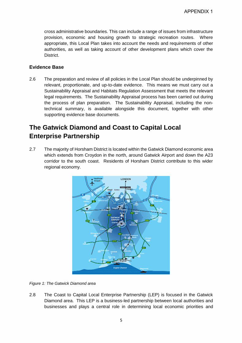
2.7 The majority of Horsham District is located within the Gatwick Diamond economic area
which extends from Croydon in the north, around Gatwick Airport and down the A23
corridor to the south coast. Residents of Horsham District contribute to this wider
regional economy.
Figure 1: The Gatwick Diamond area
2.8 The Coast to Capital Local Enterprise Partnership (LEP) is focused in the Gatwick
Diamond area. This LEP is a business-led partnership between local authorities and
businesses and plays a central role in determining local economic priorities and
APPENDIX 1
6
undertaking activities to drive economic growth, investment and the creation of local
jobs. The LEP have produced a strategic economic plan known as Gatwick 360˚,
which identifies eight economic priorities ranging from the delivery of prosperous urban
centres, developing skills and improvements to digital networks. This Council will work
with the LEP to ensure that the Local Plan can contribute to the delivery of these
objectives. This will include supporting the sub-regional economy as it emerges from
the Covid-19 Pandemic.
The South Downs National Park
2.9 Some of the land in Horsham District is located in the South Downs National Park.
Horsham District Council is not the planning authority for this area, and a separate
Local Plan has been prepared for this landscape. It is however recognised that there
is potential for any development and change that takes place outside the National Park
to have an impact on this area. The Council has therefore been mindful of the duty to
have regard to the two purposes of the National Park, namely to conserve and
enhance its natural beauty, wildlife and cultural heritage and to promote the
opportunities for public understanding and enjoyment of its special qualities. This
extends to decisions about development and infrastructure that could affect areas
within the National Park.
Minerals and Waste
2.10 West Sussex County Council has worked in partnership with the South Downs
National Park Authority to produce the Waste Local Plan and the Joint Minerals Local
Plan. Within the Minerals Plan policies M9 and M10 which relate to the safeguarding
of mineral resources for the future are of particular relevance.
The Horsham District Corporate Plan 2019-2023
2.11 The Horsham District Corporate Plan provides a focus for the Council's activities and
sets out clear priorities for the Council in the period to 2023. There are five key goals:
1. A great place to live: Continue creating well-balanced communities that meet
residents’ needs.
2. A thriving economy: Work to increase economic growth and create new local
jobs.
3. A strong, safe and healthy community: Ensure Horsham District remains one of
the best places in Sussex to live.
4. A cared for environment: Prioritise the protection of our environment as we move
to a low carbon future.
5. A modern and flexible council: Make it easy for our residents to access the
services that they need.
2.12 The Corporate Plan influences all areas of the Council's work. In relation to the Local
Plan, it provides a clear direction when setting the future planning objectives for this
area.
APPENDIX 1

7
2.13 In June 2019, the Council approved the Notice of Motion below. This provides a clear
steer for the Council to ensure that it actively contributes to achieving a net zero carbon
target through its activities.
“We agree that there is growing public concern in the face of recent dire warnings from
the World Scientific community that we are facing a wide range of environmental issues
including a climate emergency. These concerns include matters such as pollution of
the oceans, climate change, single-use plastics, disposal of waste, air pollution,
deforestation and biodiversity loss and we support action to tackle these matters.
This council has an excellent record of dealing with environmental matters, particularly
in the area of waste, recycling and biodiversity and we shall be developing and auditing
the council’s activities to see what further practical changes we can implement in the
form of a plan to reflect best environmental practice and work towards a net zero
carbon target.
We acknowledge that we shall need to continue with public engagement and
involvement and that resources will be required to underpin and support new initiatives
that we undertake".
Neighbourhood Plans
2.14 This Local Plan will also set the framework for the preparation or review of existing
Neighbourhood Plans. Neighbourhood Plans provide local communities with a means
to help shape where new development will go and what it will look like. Although not
all parishes in Horsham District have opted to prepare a Neighbourhood plan, many
communities have chosen to do so. Within Horsham District, a number of
Neighbourhood Plans have already been 'made' and form part of the development
plan, and others are well advanced. Where these plans identify sites for economic or
housing development they will contribute to the overall delivery of the identified
development needs for the District. Neighbourhood Plans also identify other, more
locally specific, issues and objectives such as the identification of ‘Local Greenspaces’
or key views of importance.
APPENDIX 1

8
Chapter 3: Spatial Vision and Objectives
Spatial Context
3.1 Horsham District is located in West Sussex, within the South East of England. It covers
an area of 530km2 (205 square miles) and is predominantly rural in character,
containing a number of smaller villages and towns. The largest urban area is the
market town of Horsham, situated in the north-east of the District. 95km2 (36.49 square
miles) of the District falls within the South Downs National Park. Although not covered
by the policies in this Plan, this nationally important landscape provides a key visual
backdrop from locations across the plan area.
3.2 The District is close to both central London (around 1 hour by train from Horsham
station), and towns on the south coast, including Worthing and Brighton. There are
also connections globally, with Gatwick Airport located on the northern boundary of
the District. Road and rail links and proximity to nearby ports on the south coast also
ensures the area is connected to the rest of the UK and mainland Europe. It is
recognised that there is an existing transport infrastructure deficit, which requires wider
infrastructure investment to reduce unresolved and ongoing congestion issues, rail
overcrowding and slow journey times.
3.3 Horsham town is the main urban area in the District, and currently supports a wide
range of jobs including a number of creative and knowledge based industries. Other
smaller towns and villages in the District also provide a range of employment
opportunities more locally. An example is the high-quality design and manufacturing
company Tesla, based in Storrington. The rural nature of the District also supports a
thriving rural economy, including businesses such as brewing and viticulture. In
addition to more office or industrial based jobs, other businesses also generate
employment including leisure, tourism and retail. It is recognised that the impact of
changing travel and retail patterns, including as a result of Covid-19, together with
recent planning reforms such as permitted development rights have the potential to
change the character of the District’s towns, villages and high streets.
3.4 60% of the residents of Horsham District live and work within the District, with 40%
commuting beyond the District boundaries. Many of these people are employed locally
in Crawley and Mid Sussex, which together with Horsham District forms part of the
wider North West Sussex market area. The labour force in Horsham District is highly
educated and contributes to the 45,000 businesses and 500 international businesses
within the Gatwick Diamond as a whole. Central London is also an important
employment destination for a number of residents. There is potential for some changes
to these travel patterns as a result of the Covid-19 pandemic with the potential for
increased home working in the future. Covid-19 may also have impacted travel
patterns due to concerns about the safety of crowded public transport. It is however
too early to determine any definitive changes to long term working and travel patterns.
APPENDIX 1

9
3.5 The towns and villages in the District are very attractive, with many historic buildings.
The character of the settlements is varied, and each has a unique identity, with
different sizes, building types and relationship with the surrounding landscape. There
are a range of building materials seen across the District, from tile hanging and flint to
the particularly distinctive Horsham stone, which is used as a roofing material in a
number of towns and villages. The historic character and high-quality built
environment, and the surrounding rural landscape make the District’s villages and
towns a very appealing place to live, work and visit which is backed up by a number
of surveys which have repeatedly identified Horsham District as a desirable place to
live and work. It is therefore important that this high-quality built environment is
retained in the future.
3.6 Residents of Horsham District generally comprise a mix of young families and older
retired households. Younger individuals often move away from the area during their
twenties and return in their 30s and 40s when they start a family. However, the cost
of housing is high which means it is increasingly hard for people to stay in or move
back to the District.
3.7 The District falls within two main housing market areas. The North West Sussex
Housing Market area, which also includes Crawley Borough and Mid Sussex District.
A small area in the south east of the District also falls within the Sussex coast housing
market area. The latter housing market area primarily covers the south coast
authorities of Worthing, Adur and Brighton and Hove. There are therefore population
flows in and out of the District from these two areas, with some smaller population
flows between the District and south London boroughs.
3.8 Many of the local authorities within the wider housing market area have not been able
to identify land to meet their own housing needs. Horsham District has historically
made a significant contribution to meeting unmet needs for the wider sub region,
meeting needs for Crawley Borough, with the development of new neighbourhood at
Crawley - Kilnwood Vale - which falls within Horsham’s administrative area. The
Horsham District Planning Framework (HDPF) adopted in 2015, also made provision
for 150 homes per year to meet unmet housing needs for Crawley.
3.9 The countryside of the District is very attractive, comprising a network of predominantly
small fields bounded by thick hedgerows and interspersed by areas of woodland.
Together with other districts, these woodland areas combine to make West Sussex
one of the most wooded counties in the UK. Two landscapes in the District are of
national importance; the High Weald Area of Outstanding Natural Beauty and the
South Downs National Park. The District is also home to an abundance of wildlife,
some of which is noted for its importance internationally and / or nationally.
3.10 It is recognised that environments and habitats are under increasing threat from a
range of factors. In common with the rest of the UK, biodiversity is, overall,
deteriorating as a result of changing land management practices and increased
pressure for development. Any growth and development which takes place will need
to deliver biodiversity net gains and contribute towards the provision of a nature
recovery network.
APPENDIX 1

10
3.11 Compared with many other areas within the south-east, Horsham District has a smaller
proportion of land which is subject to environmental or other designations such as
green-belt. It is however important to recognise that the land which is not designated
for its environmental importance is still highly valued, particularly by local communities.
These areas also perform critical environmental services, such as preventing flooding,
noise attenuation, air quality enhancement and carbon sequestration. These areas
often form part of a wider network of green spaces which provide space for informal
leisure and recreation, which contributes to healthy lifestyles and mental health and
wellbeing.
3.12 Whilst the District does have a high-quality environment it is facing many challenges
in addition to habitat loss. Public transport provision within the District is poor and there
is a high reliance on the car. In addition to traffic congestion, this also contributes to
emissions of air pollutants. There are two Air Quality management areas in Cowfold
and Storrington. Climate change is one of the biggest challenges facing Horsham
District, including increased risk from flooding, and impacts to health and the natural
environment from a warming climate and changing weather patterns. Transport
emissions are also one of our highest contributors to carbon emissions. Any growth
and change which takes place will need to consider impacts of changing weather and
climate and contribute to net zero carbon targets.
3.13 The key challenge for the District is how it can balance the pressures for development
and growth whilst maintaining a high quality of life for its residents. It is recognised that
the District must consider the extent to which it can continue meet housing and other
development needs for both its own population and those in districts and boroughs
who have unmet development needs. Whilst superficially unconstrained
environmentally, there are still physical, environmental and practical limits to the level
of growth which can be accommodated sustainably both now and in the future. This
includes the need to ensure the timely delivery of sufficient new infrastructure that
meets the needs of new development and ensuring there are benefits to existing as
well as future communities.
The vision for the Horsham District Local Plan is therefore:
“A place where people from all backgrounds can choose to live and work, with
access to high-quality jobs, services and facilities that are close to home, in a low
carbon economy and high-quality natural environment."
By 2038 Horsham District will have become a place where:
Economy
3.14 There is a vibrant economy that has recovered from the economic challenges of the
Covid-19 pandemic. Economic growth fits within the wider context of the Gatwick
Diamond and the nearby South Downs National Park and builds upon the existing
APPENDIX 1
11
market offer within Horsham District, including creative and knowledge based
industries, as well as employment which contributes to a low carbon economy.
3.15 There is a diverse, resilient and flexible range of business premises which provide
high-quality jobs that match housing growth and offer the opportunity of working close
to home. This includes support for the retention and growth of existing employment
land and ensuring there are high quality modern communications and connections in
place. New employment floorspace will include both high-quality offices and
commercial development. A range of employment requirements will be catered for,
including starter units and larger ‘moving on’ accommodation to nurture and support
growth of smaller businesses and retain inward investment.
Horsham Town
3.16 Horsham Town has retained its unique historical and cultural market town character
Horsham Town will be a highly accessible destination of choice in the Northern West
Sussex area, retaining and enhancing the high quality experience it offers for shopping
and leisure time. It will also be attracting investment and growing positively with mixed-
use development of high-quality that enhances the town’s status as a hub for the whole
District for both employment and key services.
Villages and Small Towns
3.17 The District has retained its rural identity maintaining a settlement pattern of separate
villages and smaller towns, each with their own distinctive and historic character.
Settlements have been able to meet local housing, economic and community needs,
through appropriate development, investment in village centres and supporting local
services and facilities and schools to help meet day to day needs. Local communities
will continue to have a say in how their communities evolve and consider the need for
local growth and design through the preparation and review of Neighbourhood Plans.
Housing
3.18 New housing has been provided that helps contribute towards the Government’s step
change in housing growth. This will meet the needs of the District’s residents, and so
far as it is possible, contribute towards the provision of unmet needs from other
authorities.
3.19 Where new housing is delivered, it provides homes which local people can afford. The
homes are a range of sizes, types and tenures that ensure that the needs of families,
young people and older residents alike are met, and include opportunities for
homeworking. Alongside new homes will be enhanced and new community facilities
and services to create vibrant places and communities, with high levels of walking,
cycling and public transport and contribute to net zero carbon targets.
The Natural Environment and District Character
APPENDIX 1

12
3.20 The rich heritage and high-quality natural environment, and the significant contribution
this makes to the overall attractiveness, economic competitiveness and identity of the
District is recognised and promoted, developing the close links with the South Downs
National Park area. The historical and cultural character of the built environment will
also be protected and enhanced as will ecological resources. This will include
contributing to the wider nature recovery network and delivering biodiversity net gain
within and outside areas of new development. Green spaces and the landscape are
valued, enhanced, and promoted, ensuring an attractive place for communities,
business and welcoming additional visitors.
Environmental Quality and Climate Change
3.21 The environmental resources and environmental quality, (such as air quality) of the
area have been maintained or enhanced. There will be a zero-carbon economy with
energy efficient development, including District heating and renewable energy together
with new development that has been designed to meet net zero carbon targets and is
flexible to ensure than new technologies can be incorporated as they become
available. Development will be adaptable to the impact of climate change and will
mitigate these effects.
Transport Infrastructure
3.22 Opportunities for non-car-based transport including walking, cycling and community
transport services are prioritised to help reduce the reliance on private vehicles and
contribute to low carbon based futures and healthy lifestyles. The transport
infrastructure, especially public transport, is continually improved to offer high-quality,
reliable and frequent services. IT and communication facilities are developed to
support a sustainable, resilient economy, including opportunities for people to live
close to where they work. Transport networks will be designed with electric vehicles
and other changes in technology in mind.
Community Services and Facilities
3.23 There are inclusive, vibrant communities with a greater quality and range of services
and facilities which are close to homes and areas of work. There will be significant
investment in the leisure offer and community facilities to provide choice for all, thereby
sustaining the high-quality of life and making Horsham District a destination of choice
and promoting health and wellbeing. There will be a focus on healthy communities that
provide green spaces alongside opportunities for exercise as part of day to day living,
in order to improve general health.
Design
3.24 Development which takes place delivers high quality buildings and places. The form
and function of new development will provide attractive, safe, welcoming and vibrant
environment with a clear ‘sense of place’ that are desirable place to live, work and visit.
Development will make a positive contribution to the health and wellbeing of residents
APPENDIX 1

13
and visitors alike, catering for young and old, and those with additional needs.
Development will be attractive, using high quality materials and landscaping.
Spatial Objectives
3.25 In order that the vision for Horsham District can be met, the detailed objectives for the
plan are set out in table 1. They have equal weight and are not set out in any order of
preference.
Table 1: Spatial Objectives for Horsham District
Corporate Plan Themes
A Great Place to
Live
A Thriving
Economy
Strong, Safe and
Healthy
Community
A cared for
Environment
Objectives
1 Ensure that future development in the District is based on
sustainable development principles that strike the correct
balance between economic, social and environmental
priorities and deliver thriving communities with a strong sense
of place.
2 To meet employment needs and create opportunities to foster
economic growth and regeneration, including a low carbon
economy. Employment growth will provide high-quality local
jobs that maintain high employment levels in the District, help
reduce commuting distances and facilitate and promote
innovation in business with support for technological upgrades
and change, including full-fibre broadband.
3 To protect and promote the economic viability and vitality of
Horsham Town, the smaller market towns and the rural
centres and promote development which is appropriate within
the existing hierarchy and diversity of settlements in the
District, including the appropriate re-use of brownfield land.
4 To recognise and promote the role of Horsham Town as the
primary focus for the community and business whilst
preserving the unique ambience that contributes to the
District’s attractiveness. The smaller market towns will be
recognised as secondary hubs and encouraged to meet local
needs and act as a focus for a range of activities, including
employment, retail, leisure and recreation.
5 Provide a range of housing developments across the District
that: deliver the target number of new homes; respect the
scale of existing places; and deliver a range of housing sizes
APPENDIX 1

14
and types to meet the needs of young people, families and
older people and provide of a range of affordable housing.
6 Brings forward well designed development that is supported
by the timely provision of necessary infrastructure, that
promotes walking, cycling and public transport, provides
accessible community services and open spaces that meet
local and wider District requirements and contributes to
healthy lifestyles.
7 To safeguard and enhance the character and built heritage of
the settlements in and adjoining the District and ensure that
the distinct characters of these settlements are retained and
enhanced, and amenity is protected.
8 Identify and preserve the unique landscape character and the
contribution that this makes to the setting of rural villages and
towns in and adjoining the District whilst ensuring that new
development minimises the impact on the countryside
9 To safeguard and enhance the environmental quality of the
District, maintaining and enhancing ecosystem services, and
delivering biodiversity net gain and building the nature
recovery and green infrastructure networks. Development will
minimise any impact on, and where appropriate, enhance
environmental quality including air, soil, water quality and the
risk of flooding.
10 Ensure that new development minimises carbon emissions
and contributes to local and national net zero targets of 2030
and 2050 respectively. There will be adaptation to the changes
to the climate, and reductions in climate emissions including
through measures such as renewable, low carbon and
decentralised energy.
3.26 The remaining chapters in this Local Plan set out the planning policies which will
deliver the Council’s vision and objectives. Different policies and chapters in the plan
have clearer linkages to certain objectives which are identified for clarity below.
However, individual policies and chapters do not exist in isolation and in meeting the
vision for the District the Local Plan must be read as a whole.
Local Plan Chapter Most relevant Local Plan
Objective
Chapter 4 – Policies for Growth and Change Objective 1
Chapter 5 – Economic Development Objectives 2, 3 and 4
Chapter 6 – Housing Objectives 3 and 4
Chapter 7 –Conserving and Enhancing the Natural
Environment
Objective 8 and 9
Chapter 8 – Development Quality, Design and
Heritage
Objective 6 and 7
Chapter 9 - Climate Change and Flooding Objective 9 and 10
APPENDIX 1

15
Chapter 10 - Infrastructure, transport and healthy
communities
Objective 6
Chapter 11 – Housing allocations Objective 5
APPENDIX 1

16
Chapter 4 - Policies for Growth and Change
4.1 This chapter sets out the overarching strategy to meet the development needs of the
District before setting out the approach by which development proposals will be
considered within the context of delivering sustainable development. In particular, they
take account of the following issues:
The national agenda is to bring forward a ‘step change’ in housing growth. There
is a wider need to ensure that the houses we provide are high quality and
available to everyone.
Our high-quality environment makes Horsham District an attractive place to live
and work, and is why many people and businesses want to move here. There is,
however, a need to continue to protect the character of the District, ensure that
it meets zero carbon targets and delivers biodiversity net gain to make sure the
area continues to remain desirable.
Ongoing population growth is likely to place increasing pressure on local,
neighbourhood, district and strategic level services and facilities. There is a need
to ensure that these can respond to these changing demands.
The amount of brownfield land in the District is relatively limited, but there is still
a need to prioritise this land for development where possible.
Building new settlements, urban extensions and expanding existing small
settlements may affect the character and community balance.
4.2 It should be noted that West Sussex County Council is responsible for preparing
statutory land use plans for minerals and waste. Any proposals for development
should have regard to the defined County Minerals Safeguarding Area and Minerals
Consultations Area guidance and policy produced by West Sussex County Council.
Preparation of site plans will require liaison with West Sussex County Council at an
early stage to ensure that any potential minerals and waste interests are fully
considered in planning development.
Horsham District Local Plan Strategy
4.3 The spatial strategy for the District to 2038 focuses on the positive management of
change, in accordance with the principles of the National Planning Policy Framework
(NPPF). The strategy has been tested through the sustainability appraisal process
including the assessment of a range of alternative options for delivering growth and
change in the District. The strategy seeks to be relevant and reflect the needs of the
District, delivering economic growth and housing whilst also ensuring that its rural
environment and historic character is protected, enhanced and delivers environmental
net gains. A key strand of the strategy is to ensure that the Plan also meets the
Government’s agenda of delivering a step change in housing growth and the District’s
APPENDIX 1

17
wider Duty to Co-operate requirements as far is realistically possible. It also seeks to
deliver economic growth and protect and enhance the high-quality environment in a
manner which brings forward environmental net gains. The strategy has to
accommodate change, but the emphasis is on respecting the distinctive local character
wherever possible. This plan also provides a basis for communities to develop their
own, more detailed Neighbourhood Plans where they choose to do so. The key
principles for this strategy are outlined below, and are also illustrated on the Key
Diagram on page 21.
Meeting Development needs
4.4 As outlined in Chapter 3 of this document, Horsham District is rural in character,
containing a number of attractive and historic villages and towns. This ‘leafy’ character
is an economic asset in its own right as attracts people to live and work in the area.
Despite the high quality countryside setting of the area, the District has relatively few
designations such as Green Belt or Site of Special Scientific Interest that provide
outright constraints to the scale, type or distribution of development.
4.5 The District is located close to central London and the south coast. Forming part of
the Gatwick Diamond, the District’s housing market and economy is functionally linked
to wider northwest Sussex encompassing both Crawley Borough and Mid Sussex
District. There are also linkages to the settlements on the south coast, particularly in
the south eastern corner of the District. Beyond Sussex, London and Surrey greenbelt
authorities also generate pressure for housing development.
4.6 These development pressures place a unique challenge to this authority, with the need
for the development strategy to balance the pressures for growth to meet the District’s
needs and those of other more constrained areas against the need to protect and
enhance the District’s own high-quality rural and historic character. Given that the
environment is an economic draw in its own right, this needs to be protected to ensure
that high quality lifestyles and economic investment can be maintained over the longer
term.
4.7 The starting point for the local plan strategy is to ensure that the District’s own housing
and other development needs can be met in full. Consideration was then given as to
what extent the unmet needs of other areas could be accommodated in this plan.
Given the very high level of unmet housing need in the wider sub-region, Horsham
District is not able to meet all these numbers in addition to its own. Therefore, as well
as considering the quantity of homes which the Council can realistically contribute
towards meeting unmet needs, consideration has been given to the geographical
relationship Horsham District has with the wider sub region, to establish how the unmet
needs from these areas can be most effectively met in the context of Horsham District.
The Council has therefore prioritised its consideration of meeting unmet needs
focussing on areas with the strongest economic and housing links to the District as
follows:
APPENDIX 1

18
a) Northwest Sussex (Crawley)1
b) Coastal West Sussex (Worthing)
c) Surrey greenbelt /other authorities (Mole Valley).
4.8 Although Horsham District has relatively few ‘outright’ development constraints, it is
important that the development strategy can bring forward genuinely plan-led
development. In addition to environmental considerations, it is necessary for the local
plan strategy to ensure that development can be accommodated at a rate that does
not place undue pressure on existing infrastructure and / or provides new infrastructure
that supports any new development which does take place. Development that comes
forward must also be capable of being supported within the housing market through a
range of development types, sizes and affordability. The strategy for growth has
therefore taken account of these factors and follows an identified development
hierarchy.
Development Hierarchy
4.9 The historic pattern of development in Horsham District has traditionally focused on
the growth of existing towns and villages. Most growth has taken place in and around
the largest settlements. These towns and villages have more services and facilities
and have traditionally been able to accommodate a larger level of growth. Smaller
settlements have tended to grow more organically, with growth in these settlements
enabling local services and facilities to remain viable.
4.10 This pattern of growth has been supported by planning policies that set out a
development hierarchy which identify the settlements most able to support growth.
This hierarchy approach has been revisited as part of the preparation of this Local
Plan. This work has concluded that it remains the case that larger settlements
generally have more ability to accommodate larger scale growth.
4.11 This strategy therefore seeks to continue to support development that takes place in
and adjoining the most sustainable villages and towns of our District, including through
the re-use of previously developed land (brownfield land), and ensuring that
development makes efficient use of land. These policies seek to give priority to
locating new homes, jobs, facilities and services within Horsham Town, but also
ensure that the investment which has and is taking place in smaller towns / larger
villages, such as Southwater, Billingshurst and Storrington, Henfield, Steyning and
Broadbridge Heath can continue, allowing these settlements to evolve to meet their
needs (Policy 2).
4.12 In addition to focussing growth in and around larger settlements, the development
hierarchy also seeks to ensure that more organic growth to meet local needs can
continue in smaller settlements. It is recognised that some small scale hamlets could
1 Settlements in brackets indicate authorities where direct requests to accommodate unmet needs have been received at the time of publication
APPENDIX 1

19
potentially accommodate a very small-scale level of infill development to help maintain
the longer-term vitality of these locations. There remains a role for local communities
who wish to do so to help identify locations for such development through the
preparation and review of Neighbourhood Plans.
Strategic Sites
4.13 The level of growth that is required to meet the national housebuilding aspirations
requires the strategic scale expansion of existing settlements as well as a new
settlement within the District. Over time, this strategic scale growth will need to ensure
that it delivers a complete range of jobs, services, schools open spaces and high-
quality community facilities commensurate with its size.
4.14 In considering potential locations for strategic scale housing growth, the Council has
taken account of the settlement hierarchy, but has also had regard for the wider sub
regional geography. Whilst Horsham Town is the main settlement within the District, it
is also recognised that the town of Crawley (which adjoins the District boundary to the
north east) is also a higher order settlement. The town offers a high level of services
and facilities and is a key focus for employment within the wider northwest Sussex
area. Land around Crawley has also been considered as a location for potential
development, particularly within the context of meeting Crawley’s unmet housing
needs.
4.15 Taking account of the infrastructure capacity of the existing towns and villages to
accommodate new development, together with the housing market’s ability to
accommodate growth within the plan period, the provision of a new settlement also
forms part of the Council’s development strategy. As shown on the Key diagram and
detailed in Policy 14 and the strategic allocation policies (Chapter 11), the key
allocations for strategic scale growth are:
Land West of Ifield (Crawley)
Land West of Southwater
Land East of Billingshurst
Land at Buck Barn (new settlement).
Chapter 11 also identifies the location for smaller scale development in accordance
with the development hierarchy, to ensure that the vitality and viability of more local
services and facilities can be maintained.
4.16 The level of development which the District is seeking to provide to meet Government
requirements far exceeds the scale of growth which has taken place in the District
historically. There are therefore significant challenges in ensuring that the
development which does take place brings forward the necessary infrastructure
enhancements. This is expected to include the provision of additional schools and
health-care facilities, together with road and public transport enhancements, and new
wastewater treatment facilities. These are complex requirements and will therefore
impact the speed at which larger scale strategic growth can come forward, particularly
in the short to medium term.
APPENDIX 1
20
Delivery Timescales
4.17 In addition to the challenges to delivery in the short to medium term, it is recognised
that there are likely to remain significant challenges to meeting housing needs in the
longer term for both Crawley and the South Coast. In future, the requirement to review
Local Plans on a five yearly basis will ensure that the plan remains up to date and will
continue to reflect the identified development needs for our District. It will also provide
further opportunity to consider how the long term sub-regional needs can be met. It is
anticipated that the longer term needs for the South Coast will be determined as part
of the ongoing work on Local Strategic Statement 3. It is also envisaged that Crawley
will be unlikely to meet their own housing needs within their own tight administrative
boundaries. Whilst the need and location for any future development in this location
will need to take account of the wider ‘at Crawley’ context, the most likely location for
future expansion within Horsham District continues to be to the west of the town. In
recognition of this fact, The Key diagram identifies a broad ‘area of search’ West of
Crawley for future reviews of the local plan.
Economic Development
4.18 The District has a successful economy with a range of highly skilled workers and
general service sector employers. Whilst Horsham Town is a key employment centre,
businesses and jobs are located in many of the more rural settlements and within more
rural areas. The strategy seeks to recognise what makes the area successful and
build on our location in the Gatwick Diamond. The strategy seeks to support existing
employers and nurture local businesses to maintain and enhance economic prosperity,
but will also seek to ensure that new high-quality jobs are provided, with an overall
aspiration to provide one new job for every new home that is constructed in the District.
There is an ageing population and in the long term, this may increase the number of
retired people living in the District. It is therefore essential that policies encourage
people to continue to live and work in the District and maintain the size of our
workforce.
4.19 Although there are currently challenges to the Gatwick area as we emerge from the
Covid-19 pandemic, this strategy is mindful of the incentive for growth generated by
the Crawley/Gatwick area, which is at the centre of the ‘Gatwick Diamond’, and the
potential implications for the northern and eastern parts of the District. In the longer-
term Gatwick Airport is still expected to be one of the main generators of economic
growth and more widely it is anticipated that there will be a continuing emphasis on
delivering economic growth in the Gatwick Diamond area. This includes protecting
existing business locations, including Horsham Town centre, and having flexible
policies that allow future proof developments which incorporate technological
improvements such as gigabit capable broadband and support transition to a zero-
carbon economy. The need to expand local employment provision, enable the
enhancement and regeneration of existing sites and provide jobs that shorten the
distance travelled to work is also encouraged, which will lower CO2 emissions. This
growth will be delivered in a manner which complements the wider employment offer
within Northwest Sussex as a whole.
APPENDIX 1

21
4.20 In addition to supporting economic growth in the Crawley and Gatwick area, there is
also a strong rural economy across the District. It is important that this strategy
provides support to rural businesses which allows them to grow and thrive whilst
protecting and enhancing the District’s essential character.
Protection of the District Character and Environmental Net Gain
4.21 The countryside, villages and towns of Horsham District are very attractive and varied
in character. The rural, leafy environment and historic villages are a key reason that
individuals and businesses choose to locate to the District, and protecting this
character will help ensure the health of the economy and environment of the District
into the future. The natural environment also supports the District's economy through
the provision of ecosystem services, which include carbon sequestration, flood, air
quality and noise attenuation as well as land for food production. The District also
provides ecosystem services for the more urbanised areas in the wider Gatwick
Diamond, including Crawley. It is therefore critical that this strategy ensures that the
character of the District is conserved and enhanced but is also integrated with the need
to accommodate change in order to address social or economic objectives and meet
the needs of communities.
4.22 Whilst Covid-19 and economic adjustment following the exit from the European Union
will provide economic challenges, in the long term it will not be possible to support the
economic and housing growth that is required to meet the needs of our children and
grandchildren if the environment at local, national and the global scale continues to be
degraded. This strategy therefore sets out the expectation that any growth which takes
place in Horsham District must bring about environmental improvements. This includes
delivering net gains to biodiversity and the transition to a net zero carbon economy.
This will need to be delivered through high-quality design and master-planning which
embeds these enhancements into the fabric and layout of the development from the
outset, and therefore support carbon neutral lifestyles. It is also expected that linkages
to the wider environment are provided, contributing to a wider nature recovery network
which will extend beyond our District’s boundaries.
APPENDIX 1

22
Figure 2: Horsham District Key Diagram
APPENDIX 1

23
Strategic Policy 1 - Sustainable Development
4.23 This is the model policy that is recommended to be included in all Local Plans to ensure
that they are compliant with the National Planning Policy Framework (NPPF). It should
be noted that the final bullet point of this policy relates to development which could
impact the setting of the South Downs National Park and the High Weald AONB.
Strategic Policy 1: Sustainable Development
When considering development proposals, the Council will take a positive approach that
reflects the presumption in favour of sustainable development contained in the National
Planning Policy Framework. It will always work pro-actively with applicants to find solutions
which mean that proposals can be approved wherever possible, and to secure development
that improves the economic, social and environmental conditions in the area.
Planning applications that accord with the policies in this Local Plan (and where relevant,
with policies in Neighbourhood Plans) will be approved without delay, unless material
considerations indicate otherwise.
Where there are no relevant development plan policies, or the policies which are most
important for determining the application are out-of-date, then the Council will grant
permission unless material considerations indicate otherwise taking account of whether:
1. Specific Policies in that Framework indicated that development should be
restricted; or
2. Any adverse impacts of granting permission would significantly and demonstrably
outweigh the benefits, when assessed against the policies in the National Planning
Policy Framework taken as a whole.
Strategic Policy 2 - Development Hierarchy
4.24 The District has a distinctive settlement pattern. Horsham Town is the main settlement
and is surrounded by a network of smaller towns and villages and the rural countryside.
As the main town in the District, Horsham Town acts as a hub for services and facilities.
It offers employment, a number of primary and secondary schools, a range of retail,
cultural and leisure facilities such as cinemas, leisure centres and the most
comprehensive access to public transport in the District, together with a number of
health care centres and small hospital. As well as being used by residents of Horsham
Town, those living in other towns and villages across the District use some of these
services. Given the good provision of these facilities, Horsham is therefore considered
to be the most sustainable settlement within the District in terms of its ability to
APPENDIX 1

24
accommodate additional growth and development. As outlined in para 4.14, it is also
recognised that Crawley is a higher order settlement and has been considered as a
location for growth. Further details are set out in policy 14 and HA2.
4.25 There are a number of smaller towns and villages within Horsham District. Some of
the other settlements, such as Southwater and Billingshurst also have a good range
of services. These settlements are able to meet the day to day needs of their own
residents and also some of the day to day needs of residents in other smaller
settlements. Where towns and villages are very close together, such as Steyning,
Bramber and Upper Beeding residents may live in one settlement, but still be within
walking distance of the shops, schools or a doctor’s surgery in another. The individual
character and appearance of these settlements varies, but in sustainability terms their
services and facilities are shared beyond village boundaries. Cumulatively, there is
therefore the potential for these villages to accommodate some additional growth and
development.
4.26 Medium and smaller towns and villages have the potential to address identified local
needs. Limited development to meet these needs and support rural services and
infrastructure will be supported, subject to local character being retained and any
environmental constraints.
4.27 The land outside the built-up areas within Horsham District is not uniformly
undeveloped farmland and contains a number of small hamlets and villages. These
settlements lack a significant level of services and facilities, and are therefore not a
sustainable location for large scale development. They have nevertheless been
recognised as having potential for some limited development when compared with
entirely undeveloped countryside. The identification of ‘secondary settlements’ which
have a more limited level of services and facilities seeks to allow for some very small-
scale organic growth within these settlements, to help retain the vitality and viability of
the existing facilities or services in the future.
4.28 It is important that future growth which takes place does so in a manner that protects,
retains and enhances the rural landscape character of the District, but still enables
settlements to grow and thrive. Whilst it is recognised that there is considerable
pressure for development in Horsham District, that will require the expansion of
existing settlements and the provision of a new settlement, this must be carefully
managed. The mechanism by which this will be achieved is through the designation
of built-up area boundaries (sometimes referred to as ‘BUAB').
4.29 Within built-up area boundaries and secondary settlement boundaries (‘SSB’),
development is accepted in principle, whereas land outside these boundaries is
considered to be in the countryside and development will be more strictly controlled.
The designation of built-up area boundaries and secondary settlement boundaries is
based on an assessment of the role of a settlement and how it functions. It
incorporates a range of factors including access to employment, the presence of
services and facilities including schools, shops and health care, accessibility (including
public transport) and community cohesiveness, including local clubs and
APPENDIX 1

25
organisations. For secondary settlements, it also takes account of settlement
characteristics such as form, density and historic character.
4.30 The priority will be to locate appropriate development, including infilling,
redevelopment, (including densification proposals), and conversion within the built-up
area boundaries for towns, larger villages and smaller villages, with a focus on
previously developed (or ‘brownfield’) land. All development proposals will need to be
of a scale and nature that can retain the character and role of the settlement in terms
of the range of services and facilities and community cohesion. It should be noted that
whilst Billingshurst and Southwater do not perform the same role as Horsham, they
have been identified as having potential for some strategic scale growth.
Strategic Policy 2: Development Hierarchy
1. Development will be permitted within towns and villages that have defined built-up
area boundaries, as defined on the Policies Map, including on any suitable
previously developed land. Any infilling and redevelopment will be required to
demonstrate that it is of an appropriate nature and scale to maintain the
characteristics and function of the settlement in accordance with the settlement
hierarchy below.
2. Development will be permitted in secondary settlements, provided also that it falls
entirely within the secondary settlement boundary as defined on the Policies Map,
and meets all of the following criteria:
a) the site is infilling a gap or plot within an otherwise built-up or cohesive
settlement form;
b) the proposal is limited in scale to reflect the existing scale and character of the
settlement function and form;
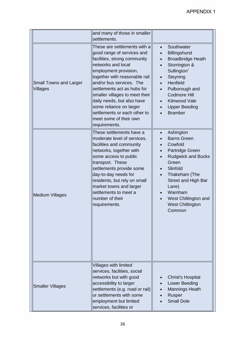
Table 2: Settlement Hierarchy
Settlement Type
Settlement
Characteristics and
Function
Settlements
Main Town
Settlement with a large
range of employment,
services and facilities and
leisure opportunities,
including those providing a
district function. Strong
social networks, with good
rail and bus accessibility.
The settlement meets the
majority of its own needs
Horsham
APPENDIX 1
26
and many of those in smaller
settlements.
Small Towns and Larger
Villages
These are settlements with a
good range of services and
facilities, strong community
networks and local
employment provision,
together with reasonable rail
and/or bus services. The
settlements act as hubs for
smaller villages to meet their
daily needs, but also have
some reliance on larger
settlements or each other to
meet some of their own
requirements.
Southwater
Billingshurst
Broadbridge Heath
Storrington &
Sullington*
Steyning
Henfield
Pulborough and
Codmore Hill
Kilnwood Vale
Upper Beeding
Bramber
Medium Villages
These settlements have a
moderate level of services,
facilities and community
networks, together with
some access to public
transport. These
settlements provide some
day-to-day needs for
residents, but rely on small
market towns and larger
settlements to meet a
number of their
requirements.
Ashington
Barns Green
Cowfold
Partridge Green
Rudgwick and Bucks
Green
Slinfold
Thakeham (The
Street and High Bar
Lane)
Warnham
West Chiltington and
West Chiltington
Common
Smaller Villages
Villages with limited
services, facilities, social
networks but with good
accessibility to larger
settlements (e.g. road or rail)
or settlements with some
employment but limited
services, facilities or
Christ's Hospital
Lower Beeding
Mannings Heath
Rusper
Small Dole
APPENDIX 1

27
accessibility. Residents are
reliant on larger settlements
to access most of their
requirements.
Secondary settlements
Very small villages and
hamlets that generally have
some limited local
employment, services or
facilities (which may include
primary schools, allotments,
village halls, playing fields,
or a church) and/or evidence
of a defined local
community. Proximity and
access to other services,
facilities and employment is
also taken into account.
Additionally, settlement
character is material, for
example form, density, age
and historic character of
dwellings, and the overall
sense that one has left the
open countryside and
entered a defined village
community.
Adversane
Ashurst
Blackstone
Colgate
Coolham
Crabtree
Dial Post
Faygate
Five Oaks
Ifield
Jolesfield
Kingsfold
Littleworth
Maplehurst
Monks Gate
Nutbourne
Nuthurst
Shermanbury
Shipley
Unclassified Settlements
Settlements with few or no
facilities or social networks
and limited accessibility, that
are reliant on other villages
and towns to meet the needs
of residents.
All other settlements
*This does not include the hamlet of Sullington, which is located entirely within the South
Downs National Park
Strategic Policy 3 - Settlement Expansion
4.31 In addition to built-up areas, it is recognised that in order for some communities to
continue to be able to grow and develop it will be necessary for them to be able to
expand beyond their current built form. The UK planning system is plan-led. The
expectation is therefore that development is delivered through allocations, which
provide certainty and assists planning for wider infrastructure provision. Ad-hoc
development outside settlement boundaries would undermine the overall strategy and
has the potential to generate pressures for long term infrastructure planning.
APPENDIX 1

28
4.32 When considering the expansion of existing settlements, the principles set out in the
policy below have been followed in identifying local plan allocations. It is however
recognised that additional development sites may come forward through allocations in
Neighbourhood Plans. Furthermore, all allocations will ultimately be considered as part
of a planning application and this policy provides the framework against which
proposals to expand existing villages and towns can be assessed.
4.33 In conjunction with Policy 2, this policy will ensure that the overall settlement function
and pattern of the District is retained, retaining the rural character of the District. By
allocating sites in the Local Plan or in Neighbourhood Plans, it will be possible to meet
the identified local needs of these settlements and provide an appropriate level of
affordable and market housing, as well as maintaining the viability of the smaller
villages and towns, for example supporting local schools and local shops.
4.34 It is recognised that to meet the government's step change in housing numbers, a new
settlement and the expansion of other settlements adjoining the District boundary is
required. The detailed allocation and policy principles for any such development will
be set out separately under the relevant policy allocation.
Strategic Policy 3: Settlement Expansion
The growth of existing settlements across the District will continue to be supported in order
to meet identified local housing, employment and community needs. Outside built-up area
boundaries, the expansion of existing settlements will be supported where all of the
following criteria are met:
1. The site is allocated in the Local Plan or in a Neighbourhood Plan and adjoins an
existing settlement edge;
2. The level of expansion is appropriate to the scale and function of the settlement type;
3. The development is demonstrated to meet the identified local housing needs and/or
employment needs or will assist the retention and enhancement of community
facilities and services;
4. The impact of the development individually or cumulatively does not prejudice
comprehensive long-term development, in order not to conflict with the development
strategy; and
5. The development is contained within an existing defensible boundary and the
landscape and townscape character features are maintained and enhanced.
APPENDIX 1

29
Strategic Policy 4 - Horsham Town
4.35 Horsham Town is the main town in the District. It offers a fusion of heritage and quality
modern living, and provides an excellent place for businesses, a highly educated
workforce and a good employment offer. As the main centre for the District, Horsham
acts as a ‘hub’ for a number of smaller towns and villages in the surrounding area. It
also serves the area beyond the District as a shopping destination and an attractive
place to visit and do business.
4.36 Whilst the town has many assets and attractive features, there are some parts of the
town where there are opportunities for improvement, enhancement and regeneration.
This policy seeks to provide a framework in which proposals in Horsham Town are
considered in their wider context and are delivered to retain the attractive
characteristics of the town, whilst enabling it to grow positively and remain vibrant into
the future. Proposals will need to take account of the Horsham Town Centre Vision
and other associated plans and documents, such as the Horsham Town Public Realm
Strategy, or any updates to these documents.
Strategic Policy 4 - Horsham Town
To promote the prosperity of Horsham Town and maintain and strengthen its role as the
primary economic and cultural centre in the District, and the wider economic area,
development will be allowed within the built-up area of Horsham where it:
1. Retains the town's key position as the main settlement within the District whilst
protecting the unique characteristics of the town, including the historic character and
high-quality environment.
2. Contributes to the provision of a range of services and facilities, including those in
arts, heritage and leisure that make the town self-sustaining.
3. Contributes to the economy of the town to support a vibrant high street and town
centre that meets local and business demands, as well as supporting the wider
economy including the Gatwick Diamond, and the economy of the south east
including;
a) the provision of a wide range of employment;
b) retaining and enhancing the unique retail mix to meet both independent and
national retailers requirements;
c) contributes to the evening economy through the provision of a range of leisure
uses;
d) supports in principle town enhancements or regeneration proposals.
4. Promotes high-quality transport infrastructure which enables excellent pedestrian,
cycling, bus, rail and vehicle accessibility for residents, visitors and business
employees.
5. Delivers a mix of residential properties that meets the needs of the population and
contributes to quality modern living that is compatible with a town centre setting.
APPENDIX 1
30
6. Maintains or enhances the network of existing formal and informal green spaces
within the town, and contributes to biodiversity net gain and net zero carbon targets.
Strategic Policy 5: Broadbridge Heath
Quadrant
4.37 This policy recognises Broadbridge Heath Quadrant as a redevelopment opportunity
area with the potential to complement recent and future development in and around
Horsham Town. Redevelopment should benefit Horsham District and secure the
vitality and vibrancy of Horsham Town.
4.38 Broadbridge Heath Quadrant is formed of the existing Broadbridge Heath Retail Park
and land north of this. It includes the West Sussex County Council Depot, Tesco
Superstore, Horsham Indoor Bowls Centre and The Bridge Leisure Centre.
4.39 The area sits adjacent to two strategic scale development sites: Wickhurst Green,
which is now complete and Highwood Village, where development is ongoing.
Development within the Broadbridge Heath Quadrant should take account of the
important relationship with this area of new residential development and should aim to
meet these additional local needs as well as those of the wider area.
4.40 The Quadrant is identified as a strategically significant area of opportunity where
regeneration proposals will be brought forward in conjunction with community
aspirations. It is, however, important that any development that does take place does
not detract from the primacy of Horsham Town centre as the main centre for the District
as a whole. Given the strategic importance of this area, and taking account of changing
retail habits it is considered that a threshold of 1,000sqm for assessment of impacts
on Horsham Town is appropriate in this location. A smaller threshold for assessment
will remain in place in other locations in the District.
4.41 Early engagement with stakeholders including the Parish Council, landowners and
users of the Quadrant should take place. This policy should be read alongside any
policies relating to Horsham Town centre.
APPENDIX 1
31
Strategic Policy 5: Broadbridge Heath Quadrant
Broadbridge Heath Quadrant is an Opportunity Area where redevelopment will be required
to reinforce its role as a successful out of town retail location:
General
1. Development on this site will provide a mix of uses, which could include retail,
leisure, residential, hotel and food and drink uses, to provide for local needs,
complement the provisions for the new communities in Wickhurst Green and
Highwood Village and enhance and complement the primacy of the existing and
future offer of Horsham Town centre.
2. Development will enhance provision for local needs and accessibility by improving
connectivity and achieving better integration between new and existing communities
in the area.
3. Development should embrace the highest standards of sustainable design and
construction in relation to local and national sustainability policies and guidance.
Development must also make best use of significant existing environmental features
and include innovative sustainable design solutions, utilising best practice in
renewable or low-carbon energy and green infrastructure.
4. Broadbridge Heath Quadrant should be enhanced as an attractive, enjoyable,
convenient and well laid out setting. Development should create a high-quality and
sustainable environment with a positive public realm, strong, legible connections
particularly for pedestrians and cyclists, and high-quality architectural and landscape
design.
Retail development and other uses
5. Retail development will be permitted providing it does not adversely affect the
current and future vitality and viability of Horsham town centre, and contributes
towards achieving the wider objectives for the regeneration of this opportunity area.
6. Any proposed development for main town centre uses within Broadbridge Heath
Quadrant which on its own, or cumulatively, reach a threshold of an additional
1,000sqm will need to demonstrate that it will not have an adverse impact on the
vitality and viability of Horsham town centre. This should include an assessment of
the impact on existing, committed and planned public and private investment in the
town centre.
7. Expansion of the ground floorplate of the existing food store and other
enhancements may be acceptable, provided that convenience floorspace remains
the predominant use (together with supporting comparison floorspace and retail
distribution facilities).
8. Redevelopment for larger retail units with extended floorplates selling convenience
goods, where appropriate provision cannot be made in or immediately adjacent to
Horsham town centre, may be acceptable subject to meeting criterion 5 above.
Accessibility, connectivity and circulation
APPENDIX 1

32
9. To maximise the site’s accessibility by a range of alternative means of travel to the
car, development must improve existing, and create new, pedestrian and cycle
connections both within the site and from the surrounding area. Development
should support the use of public transport including improvements to reinforce
linkages locally and improve connectivity by sustainable means into Horsham town
centre.
10. It will remain important to maintain and enhance the accessibility of Broadbridge
Heath Quadrant from the surrounding area by car, and to rationalise the circulation
of car and delivery vehicles to maximise the economic potential and the efficiency
of the site.
APPENDIX 1

33
Chapter 5 – Economic Development
The District has a strong, resilient and diverse economy, which it is important to retain and
enhance. A key objective of the Council’s Economic Strategy is to make the District a first
choice business destination. The following issues have been identified that will be
addressed through the policies in this document:
There is a shortage of business floorspace in terms of both the types and sizes
needed. Much of the business accommodation stock is low grade. This means
existing or new businesses that wish to grow or expand cannot find sites in Horsham
District and have to look elsewhere.
Some of the office stock is outdated and is unsuitable for modern business needs.
Recent changes to permitted development rights have resulted in a number of often
higher-grade offices, particularly in Horsham town centre, being converted to
residential uses. There is aneed to retain and expand high-quality offices.
40% of the working age population commute outside the District to work. There is a
need to provide suitable high-quality space for businesses that wish to move into the
District: this will help existing businesses to expand as well as providing
opportunities for residents to live and work locally and reduce commuting distances
and help reduce carbon emissions.
New strategic-scale development will need to help provide local employment
opportunities for new residents.
There need to be opportunities for all types of businesses to grow, expand and
change to meet modern business demands. This includes the expansion of existing
sites.
Opportunities for small and medium businesses and business start-ups need to be
provided in locations across the District.
There is a need to ensure that communications and technologies in the District (e.g.
full-fibre, gigabit capable broadband) are present in order to meet business demands
and that they are flexible enough to accommodate technological upgrades over the
Plan period.
Whilst Covid-19 will have an impact on the economy, there is a need to ensure that
Horsham District contributes to the role of the Coast to Capital area in the short and
longer term.
Although the workforce in the District is generally highly educated, it is important that
support is provided for development and training opportunities including
apprenticeships. This will ensure that the workforce can retain and develop a wide
range of skills.
There is an ongoing need to enhance the rural economy. There are diverse
businesses within the rural parts of the District. It is important that these businesses
are supported and are able to grow and expand.
The visitor economy is an important element of the District’s economy – with
attractive villages, towns and countryside. The plan seeks to maximise visitor
spending through tourism across the District.
House prices are high. This makes it difficult to retain young people in the District
and for businesses to attract skilled employees.
APPENDIX 1

34
Social changes such as increased online shopping and home delivery have the
potential to change the role of town and village centres. It is important these town
and village centres retain their vitality and viability in light of these pressures.
Business in Horsham District
5.1 Horsham District is located mid-way between London and the south coast. The
majority of Horsham District lies within Gatwick Diamond, which reaches from Croydon
in the north, out around Gatwick Airport and down the A23 corridor to the south coast.
The District is an attractive place to live and work due to the appealing countryside,
excellent schools and the highly educated workforce; at least half of the workforce is
educated to degree level or above. This enables residents to contribute to the regional
economy, although there are some challenges, particularly in relation to transport
access and communications.
5.2 Gatwick Airport adjoins the north eastern boundary of the District and provides
international connections to the area as well as being a key driver for the sub regional
economy. Covid-19 has had a significant short term impact on the airport, and the
economy it supports.
5.3 More locally, rail services connect the District to both London and the south coast.
Recent challenges to rail services include both overcrowding and delayed journey
times. In terms of road access, the main road corridors in the District are the A24
(north-south) and the A272 (east-west). Although good quality, neither road forms part
of the strategic road network, however the A23, east of the District and the A27, which
runs along the south coast do. The A29 and A281 also provide north-south routes
through the District. Journey times on these routes are slower as neither are duelled
and often pass directly through settlements, including Pulborough and Henfield. A key
aim of the District Council is to attract more local inward investment to the District, to
help provide opportunities to live and work locally and in turn reduce pressure on the
transport network and reduce carbon emissions from transport.
5.4 Unemployment levels are lower than the South East and national average, which is a
consistent trend for the District. Within the District, the town of Horsham is a key
centre for employment and attracts workers from locations both within and beyond the
District. Other settlements, and in particular smaller market towns and villages such
as Billingshurst, Southwater and Storrington are also important employment centres,
many of which have one or more industrial estates. For example, Tesla Engineering
in Storrington offers high-quality design, engineering and manufacturing jobs and
High-quality offices such as the RSPCA headquarters are located in Southwater.
These opportunities need to be retained and enhanced where possible.
5.5 Businesses are not solely restricted to the urban parts of the District, and there are a
number of commercial enterprises in more rural parts of the District. Many of these are
linked to land-based industries including viticulture (the geology of the area is akin to
the champagne region of France, and is becoming increasingly well known for high-
APPENDIX 1

35
quality wine production) and brewing. Other businesses are located on farms as part
of diversification schemes. Tourism is also an important source of business and
employment in the District.
5.6 Many of the businesses in Horsham District are small in size with most businesses
employing between 1 and 4 employees, often based in the home. Larger employers
are also present but few businesses in the District employ more than 250 people. In
recent years, many of the existing businesses in the District have been unable to grow
and expand locally due to a lack of suitable accommodation (including existing stock)
to move in to.
5.7 At the current time, around 40% of residents commute beyond the District's
boundaries, mostly to destinations within northwest Sussex including Crawley and
Gatwick. Another commuting destination is London, and for residents in the southern
part of the District, the South Coast is also an important employment location. The lack
of business accommodation may have exacerbated out commuting rates.
Horsham’s Economic Future
5.8 The Council’s Economic Strategy and vision is to achieve long-term prosperity and
resilience. This approach seeks to ensure that investment is complementary with the
wider sub-regional economy within northwest Sussex, and contributes to the wider
economic health of the area as a whole. To achieve this the Local Plan:
Makes provision for inward investment and allows existing businesses to expand
as well as supporting business in recovering from the economic challenges
generated from Covid-19.
Seeks to augment the currently limited supply of office and industrial / warehouse
space.
Identifies and protects existing business areas for employment uses, allowing their
regeneration, intensification and smart-growth.
Allocates land for new commercial sites and premises, to allow existing businesses
to expand, and facilitate an increase in higher paid, higher skilled job opportunities,
which in turn will help reduce out-commuting.
Provide support for start-ups.
Supports business within both rural and urban sections of the District.
Seeks to facilitate social enterprises and green industries to achieve sustainable
development.
5.9 In seeking to secure increased business investment in the District, a further key aim
of the economic strategy for this plan is an aspiration to provide at least one 1 job per
new home. This will be achieved through a range of means, including new business
development and expansion, (E and B class uses) retail, leisure and increased
homeworking facilities.
APPENDIX 1

36
Strategic Policy 6 - New Employment
5.10 Horsham District falls within the North West Sussex Functional Economic Market Area,
which comprises the districts of Horsham and Mid Sussex and the borough of Crawley.
An Economic Growth Assessment Update (EGA) (January 2020) covering the
Northern West Sussex area has been prepared to inform this Local Plan. This is
supported by a supplementary Focused Update for Horsham (November 2020). The
findings indicate that Horsham District is in a strong position to support further
economic and employment growth despite the challenges of Covid-19 and the post
Brexit economy. The office market has been affected by national policy interventions,
such as the office to residential permitted development rights and more recently the
introduction of Use Class E. There remains a need for high-quality office floorspace as
well as land for commercial and industrial development.
5.11 Since 2015, progress has been made in bringing forward sites for employment growth
and investment. Planning permission for employment land has been granted on Land
north of Horsham, at Brinsbury College between Billingshurst and Pulborough, at
locations adjoining Billingshurst and at Nowhurst, near Broadbridge Heath (see Table
3). Horsham Enterprise Park (formerly Novartis), Broadlands Business Campus and
Land at North Horsham will be important to help satisfy the demand for high-quality
office space.
Table 3: Existing Commitments
Site Name Description
Land at North Horsham Strategic Allocation
46,450 square metres
B1 (Grade A office space), complementary
flexible commercial / community space
Former Novartis site, Horsham
25,000 square metres
B1 (Grade A office space)
Nowhurst Business Park
25,200 square metres
Flexible use (B1c/B2/B8)
Land at Brinsbury College
16,850 square metres
Flexible use (B1/B2/B8)
Land north of Hilland Farm, Billingshurst
19,375 square metres
Flexible use (B1c/B2/B8) Petrol Filling
Station with ancillary services
Land southwest of Platts roundabout,
Billingshurst
4,625 square metres
APPENDIX 1

37
Site Name Description
Flexible (B1b/B1c/B2/B8) Petrol Filling
Station with ancillary services
Broadlands Business Campus,
Langhurstwood Road, Horsham
10,000sqm office floorspace (B1 use)
(permitted May 2020).
5.12 After taking account of the current employment commitments, the EGA and
supplementary Focused Update report indicate that an intensification of existing sites
and / or additional employment land should be planned for to meet the District’s future
employment needs over the plan period to correspond to the planned number of
homes. Based on a ‘Labour Supply’ commensurate to 1,200 homes per annum, the
unmet requirement equates to at least 26,000sqm employment floorspace (around
6ha).
5.13 This figure does not take account of evidence which indicates that existing business
sites are often not fit for modern business needs, and that there is additional demand
for land with better access, or which can accommodate more modern buildings. This
is evidenced by regular enquiries to the Council (mainly but not exclusively prior to
Covid-19) from businesses seeking land and premises. The majority of enquiries have
been from existing businesses looking to expand. It is therefore considered
appropriate to allocate additional land over identified needs to meet this existing latent
demand and to stem the loss of businesses expanding into new sites outside the
District. This approach will also ensure that rates of commuting outside the District are
not exacerbated.
5.14 The Covid-19 pandemic has driven a change in commuting patterns with many
businesses speeding up the trend towards increased home working patterns. Whilst
new homes can be constructed to provide work from home areas, existing properties
may not provide this space. There is therefore likely to be a need to provide smaller
co-working spaces to support local working outside main work bases.
5.15 In order to deliver sustainable economic growth, it is important to ensure sufficient
supply and choice in employment floorspace across the District, both within the urban
and rural areas. The Government also seeks significant weight to be placed on the
need to support economic growth and productivity and a positive and proactive
encouragement of sustainable economic growth. This means the currently identified
need for employment floorspace should be applied as a ‘floor’, and not used to limit
further growth above these amounts.
5.16 Strategic Policy 6 seeks to achieve sustainable economic growth for Horsham District
to 2038 and allocates land for employment. As stated earlier in this document, all
allocations will be expected to have regard to the presence and avoid the sterilisation
of mineral resources, and must not prejudice waste sites, in accordance with both the
Joint Minerals Local Plan (JMLP)2 and the Waste Local Plan (WLP)3. For the purposes
2 Particularly Policies M9 and M10 3 Particularly Policies W2 and W10
APPENDIX 1

38
of this policy ‘employment’ means office, industrial, storage and distribution uses which
fall within B2, B8 and part E (those that were formerly B1) Use Classes. Other uses
that provide jobs are termed ‘employment generating uses’ and also form an important
part of economic growth, but are covered in greater detail in other policies in this plan,
including tourism and retail.
5.17 Strategic Policy 6 also recognises the important role and contribution that smaller
businesses, including home-based businesses and home working, and also
employment-generating uses such as tourism, land-based businesses, retail and
leisure, make towards the District’s economy. It seeks to support them by providing
suitable accommodation, whilst the Local Plan as a whole aims to maintain the
District’s attractiveness and secure supporting infrastructure, including provision
delivered by development.
Strategic Policy 6: New Employment
Sustainable economic growth will be supported through the provision of sufficient
employment land to meet the needs of existing businesses and the Council's identified
requirements for office, industrial, storage and distribution uses which fall within B2, and B8
and part E (formerly B1) Use Classes, together with other employment generating uses as
appropriate. This will be achieved through the following measures:
1. The allocation of the land identified in Table 4 and strategic allocation policies HA1
to HA5 for employment. In addition to meeting national and Local Plan requirements,
proposals should take account of the mitigation measures identified and incorporate
a range of unit sizes and flexibility of use with regard to floor to ceiling heights, floor
loading, power, servicing and loading facilities;
2. Within settlement centres defined on the Policies Map, office development
appropriate to its location will be permitted where this adds to the overall office stock;
3. Where suitable and viable town centre sites are not available, proposals for Grade
A offices will be supported where they are close to public transport hubs with good
connections to town and village centres;
4. Supporting proposals for small start-up businesses and home-based businesses,
including the provision of start-up / co-working space, and including within new
strategic scale housing development;
5. Supporting proposals for green industries, and social / community enterprises;
6. Supporting proposals that enable the retention of existing businesses within the
District, including move-on space;
APPENDIX 1

39
7. Development proposals will be expected to provide, as a minimum, gigabit-capable
broadband and other modern communication technologies that emerge;
8. Supporting proposals for business, manufacturing, storage and distribution uses
(B2, B8 and part E [formerly B1] use classes) in accordance with the spatial strategy
and the settlement hierarchy;
9. Supporting sustainable local economic growth through Neighbourhood
Development Plans; and
10. Supporting the expansion of further and higher education facilities related to
research and development and employment training activity.
Table 4: Employment Site Allocations:
Site Name Indicative employment floorspace sqm
(Use Classes B2/B8/part E [former B1])
Strategic Allocations 13ha is allocated in policies H2 to HA5. All strategic site
allocations are expected to provide opportunities for
employment and for people to live and work locally.
Site EM1- Land South of
Star Road Industrial Estate,
Partridge Green
3.9ha is allocated for B2 and B8 and office uses
(c.9,000sqm in total). A 15m buffer or greater, as
appropriate, adjacent the ancient woodland will be
required. An operational buffer must also be provided
around the sewage treatments works, as appropriate.
Site EM2 - Land to the West
of Graylands Estate,
Langhurstwood Road,
Horsham
3.2ha is allocated for B2 and B8 and office uses
(c.9,500sqm in total) as an expansion to the west of the
existing employment site, taking into account the proximity
of the allocation of Land to the North of Horsham. A 15m
buffer or greater, as appropriate, adjacent the ancient
woodland will be required. Appropriate regard must be
given to the nearby waste facilities and comply with Policy
2 of the Waste Local Plan.
Site EM3 - Land at
Broomers Hill Business
Park, Pulborough
2.7ha is allocated for B2, B8 and office uses (c. 7,000sqm
in total) as an expansion of the existing employment site.
Appropriate regard will need to be given to any potential
impacts from surface water and waste water on the Arun
SSSI.
Site EM4 - Land South West
of Hop Oast Roundabout
1ha is allocated for B2 and B8 uses and office uses
(c.3,000sqm in total). Appropriate regard will need to be
given to any potential impacts from surface water and
waste water on the Arun SSSI.
APPENDIX 1

40
Strategic Policy 7 – Enhancing Existing
Employment
5.18 This policy seeks to protect employment and commercial sites which contribute to local
employment opportunities that meet the needs of residents, whilst enabling sites that
are no longer economically viable to be considered for other appropriate uses. For the
purposes of this policy, ‘employment’ means office, industrial, storage and distribution
uses that fall within B2, B8 and part E (those that were formerly B1) Use Classes.
Other uses that provide jobs are termed ‘employment generating uses’ and are also
considered under this policy.
5.19 Key Employment Areas in Horsham District continue to accommodate a varied
portfolio of uses in locations across the District, contributing to sustainable
communities. There is a continued need for key locations to be protected for
employment uses to ensure that economic development in the District is not
undermined by a lack of suitable sites or premises. This policy identifies and protects
Key Employment Areas, which are identified on the Policies Map, and follows a review
of existing employment locations to ensure that a range of employment sites remain
available across the District. Trade counters can play an important role in employment
areas, and similarly some sui generis uses such as waste management facilities may
be acceptable. However this policy seeks to ensure that such uses do not undermine
the core employment uses. Future reviews of the Local Plan will enable the need for
the continued protection of such sites to be reviewed on a regular basis.
5.20 It is important that employment sites maintain a broad mix of employment uses to help
provide economic resilience in the longer term. It is however recognised that there
may be some uses on employment sites that support sustainable economic growth
and complement traditional commercial uses. In addition, it is important to note that
some changes of use may arise through permitted development rights. Where there
are proposals to change the use on employment sites (including subsequent proposals
for activities that have been converted as a result of permitted development), the ability
for existing operations to continue effectively will be taken into account. This includes
general industrial (B2 uses) which may impact on residential amenity, and light
industrial (former B1b/c) uses. It is important their operations are not unduly hindered,
and appropriate consideration given to the provision or retention of acoustic fencing /
glazing, commercial parking, service areas and amenity space.
5.21 Small and existing businesses play an integral role in creating a sustainable local
economy. This policy seeks to ensure that there is flexibility which allows businesses
to grow. This includes the expansion of existing sites (such as Maydwell Avenue in
Slinfold adjacent to Spring Copse Business Park, or Rosier Business Park in
Billingshurst), which can either provide move on space or expand the space of an
existing business. It is considered that this will assist businesses who cannot meet
their current requirements within the existing stock, and will also help to support small
and start-up units, as well as providing opportunities for businesses to move on to
larger premises in the District as they grow.
APPENDIX 1

41
5.22 In order to maintain and help meet the employment needs of the District during the
plan period, Policy 7 seeks to ensure that all employment premises and sites are
safeguarded as far as is possible. For avoidance of doubt, this includes sites where
employment development has been permitted but not yet commenced. Policy 7 also
supports appropriate proposals for upgrades and refurbishments to existing
employment sites.
Strategic Policy 7: Enhancing Existing Employment
Existing Employment Sites and Premises
1. Proposals for the upgrading and refurbishment of existing offices, industrial
/ business estates, premises and sites will be supported provided that:
a) they enable the facility to meet modern business standards and
demonstrably enhance the attractiveness of the District as a business
location;
b) they mitigate existing amenity, highway and access issues arising from
badly sited uses; and
c) potential new impacts on amenity and on the road network are mitigated.
2. The redevelopment, regeneration, intensification and expansion of existing
employment premises and sites for employment uses will be supported
where it facilitates the retention of existing businesses within the District, and
/ or creates or protects new jobs, including green industries and social
enterprises. Proposals must demonstrate that they meet all the following
criteria:
a) it is in keeping with the existing scale of provision and local area;
b) the proposal will not prejudice the operation of surrounding employment
uses;
c) it protects the amenity of existing and surrounding uses;
d) any adverse impacts would not significantly outweigh the benefits; and
e) it accords with the criteria 3-7 below, as applicable.
Key Employment Areas:
3. Key Employment Areas, as listed in the table below and defined in the
Policies Map, are protected for industrial, storage and distribution uses (B2
and B8 Use Classes).
Table 5: Key Employment Areas in Horsham District
Huffwood & Eagle Trading Estates, Brookers Road, Billingshurst
APPENDIX 1

42
Daux Road Industrial Estate, Billingshurst
Gillmans Industrial Estate, Natts Lane, Billingshurst
Lawson Hunt Industrial Park, Broadbridge Heath
Mackley Industrial Estate, Small Dole
Blatchford Road, Horsham
Foundry Lane, Horsham
Nightingale Road, Horsham
Station Approach, Pulborough
Oakhurst Business Park, Wilberforce Way, Southwater
Water Lane Trading Estate, Storrington
Huffwood Trading Estate, and Star Road Partridge Green
Wiston Business Park, London Road, Ashington
Henfield Business Park, Shoreham Road, Henfield
Graylands Estate, Langhurstwood Road, Horsham
North Heath Lane Industrial Estate, North Heath Lane, Horsham
Parsonage Business Park, Parsonage Way, Horsham
Spring Copse Business Park, Slinfold
The Business Park, Maydwell, Slinfold
Southwater Business Park, Worthing Road, Southwater
Rock Business Park, The Hollow, Washington
Rosier Business Park, Billingshurst
Oakendene Industrial Estate, Cowfold
4. All proposals within a Key Employment Area, including proposals for
alternative sui generis ‘employment’ uses and offices must demonstrate
they:
a) support the integrity and function of the Key Employment Area; and
APPENDIX 1

43
b) do not result in the overall net loss of employment floorspace unless it
can be demonstrated that the loss is not significant, and would lead to a
significant upgrade of the retained employment floorspace.
Other Existing Employment Sites:
5. Employment sites and premises outside Key Employment Areas are
protected for business, manufacturing, storage and distribution uses (B2, B8
and part E [formerly B1] Use Classes) and appropriate sui generis uses.
6. Proposals for indoor leisure uses will be supported provided that they do not
prejudice the operation of surrounding employment uses and are located to
minimise impact on amenity.
7. Proposals for other uses will only be supported where it is demonstrated that
both the premises and site are no longer needed and are no longer viable
for employment use. An assessment of these should be submitted and must
demonstrate:
a) Evidence of active marketing over the period of at least a year,
supported by
i. evidence of the condition of the estate and local economic market
within the terms of sale and, where applicable, rent; and
ii. written confirmation from the commercial agent(s) regarding the
redundancy and lack of viability of both the premises and site for
employment; and
b) Where relevant, vacancy, including the reasons for vacancy and the
length of time vacant.
Policy 8 - Rural Economic Development
5.23 Horsham District is predominantly rural in character and has a diverse urban and rural
economy. The main market town of Horsham is supported by a network of settlements
and small villages in rural surroundings.
5.24 The rural character of the District means that the wider rural economy is important.
This includes the economies of smaller villages and towns, agricultural and other land-
based businesses including brewing and winemaking, as well as tourism and leisure
developments. 72% of businesses in Horsham District are rurally based.
5.25 Over half of the Small Medium Enterprises (SMEs) in the UK are home-based and in
the District, many of these businesses are in rural areas, providing the only
employment in villages and hamlets. The Council wishes to retain this valued
employment by affording these businesses the opportunity to expand near their home.
Farms and rural estates are key custodians of the countryside and provide a valuable
contribution to the rural economy. In addition to this, the shift towards a low carbon
economy and the scope of green jobs is likely to affect the rural economy, for example,
APPENDIX 1

44
through an increase in energy crops, forestry, carbon sequestration and local food
production, and is to be supported.
5.26 Maintaining the rural economy through appropriate development will be considered
positively where it can be shown to support rural community needs, and enabling the
rural towns and villages in the District to remain self-sufficient and economically
vibrant.
5.27 There is an ongoing need to maintain and enhance the rural economy. This includes
the diversification of rural employment space and maximising visitor spending through
tourism across the District. The re-use of rural brownfield sites and farm diversification
provide opportunities for businesses to play a role in allowing local and rural
economies to continue to grow, expand, and change to meet modern demands. The
diversification and re-use of brownfield land also allows for the positive reuse of
buildings and sites, along with the sustainable use of resources, which has less impact
on the rural landscape.
5.28 Neighbourhood Planning should also play an important role in identifying and
promoting sustainable economic growth at the local level.
Policy 8 - Rural Economic Development
1. Sustainable rural economic development and enterprise within the District as a whole
will be supported where it is shown to generate local employment opportunities and
economic, social and environmental benefits for local communities.
2. Outside built-up area boundaries or secondary settlements, economic development,
which maintains the quality and character of the area whilst sustaining its varied and
productive social and economic activity, will be supported in principle. Any development
should be appropriate to the countryside location, and will be supported provided that:
a) It does not prejudice, and contributes to, the diverse and sustainable farming
enterprises within the District;
b) It contributes to the sustainable custodianship of the countryside; and
c) In the case of non-farming countryside-based enterprises and activities, it
contributes to the wider rural economy and/or promotes recreation in, and the
enjoyment of, the countryside, and complies with the following hierarchy:
i. As first preference, is contained within suitably located existing buildings
which are appropriate for conversion or, in the case of an established
rural industrial or commercial site, within the existing boundaries of the
site;
ii. Where i) is not feasible, proposals for new buildings or development will
be supported where it can be demonstrated that the proposal will
contribute to sustainable rural economic growth that supports balanced
living and working communities.
APPENDIX 1

45
3. Proposals will be supported provided that they:
a) Do not adversely affect the character, appearance or visual amenities and the
intrinsic character and beauty of the countryside and the location in question;
and
b) Demonstrate a net increase in biodiversity in and around the site.
4. Proposals will be supported provided that car parking requirements can be
accommodated satisfactorily within the immediate surroundings of the buildings or an
alternative logical solution is proposed.
Policy 9: Conversion of Agricultural and Rural
Buildings to Commercial, Community and
Residential Uses
5.29 Horsham District has a rural character, with a large number of farmsteads and other
rural activities such as equestrian businesses. The stock of buildings which are
suitable for conversion to other uses has fallen over time, or may be capable of
conversion under permitted development rights. It is however anticipated that there
will still be instances where proposals for the conversion of rural buildings come
forward. Applicants will be expected to provide evidence to demonstrate why the
current use is no longer necessary, and that the loss of the building will not result in a
foreseeable need for equivalent replacement buildings.
5.30 Not all existing agricultural buildings will be suitable for conversion to residential uses.
Buildings not necessarily suited to conversion to residential uses include those of
modern construction; buildings which may be subject to a condition requiring their
removal (following a cessation of use) through either a planning condition or prior
approval; or buildings which would require substantial reconstruction or structural
works.
5.31 Given that the proposals for development will be in the rural areas of the District, it is
expected that development may rely on the private car to reach most services and
facilities. It is therefore considered that any such proposals should be easily
accessible by road. The relationship of the development with other existing built
development will also need to be considered. Buildings within an existing buildings
complex are, for example, less likely to have an adverse impact on the character of
the surrounding landscape.
5.32 Applicants will need to properly assess the potential impact of any proposal on
biodiversity. Rural buildings may, for example, contain bat roosts or nest habitats for
protected species such as barn owls. It might be necessary to undertake an ecological
investigation and implement suitable mitigation as well as biodiversity
enhancements/net gain in accordance with the Council's biodiversity policies.
APPENDIX 1

46
5.33 In developing proposals, applicants are expected to pay particular attention to the local
and wider context and character, including its history and traditional uses, its
contribution to the landscape character and its sensitivity to change. This is especially
important in protected landscape areas such as the High Weald AONB and within the
setting of the South Downs National Park.
5.34 In order to preserve the rural character of the District, where a building is proposed for
conversion to residential use, the conversion works should not significantly alter the
character of the building such that it takes on an unduly domestic appearance, out of
character with its rural context. This typically means that large, modern, open-sided
metal framed barns will not be appropriate for conversion to residential use.
Policy 9: Conversion of Agricultural and Rural Buildings to
Residential Uses
Outside defined built-up areas and secondary settlements, conversion of redundant
agricultural and forestry buildings to residential use, will be supported where all of the
following criteria are met:
1. The building is in established agricultural or forestry use and it can be demonstrated
that:
a) the current use is no longer necessary, or
b) the proposal would secure the future of an existing heritage asset or a
building worthy of retention.
2. The building is appropriate for conversion given its existing scale, architectural merit,
character and setting, including its relationship with surrounding uses.
3. The existing building is not so derelict as to require substantial reconstruction,
significant alteration or extension.
4. The site is served by an existing metalled road or other suitable access to the local
road network.
5. The proposal would not result in a property with an overly domesticated or urban
character, nor adversely affect the character, appearance or visual amenities and
the intrinsic character and beauty of the countryside of the wider area.
6. It is demonstrated that the proposal will:
a) Enhance the immediate setting through its design and appearance,
landscape design and materials; and
b) enhance biodiversity in and around the site.
APPENDIX 1
47
Policy 10: Equestrian Development
5.35 Equestrian-related development is important to the rural economy of the District.
Development of this nature needs to be of high-quality and appropriate to its location,
particularly in designated landscape areas such as the High Weald Area of
Outstanding Natural Beauty (AONB).
5.36 Horses kept for recreation, sport and business are not classed as an agricultural
activity. Equine facilities therefore do not have any agricultural permitted development
rights, meaning that most development requires planning consent. To ensure that
equestrian facilities are located sustainably, proposals for new stables will be expected
to demonstrate how they will be managed without the need for new supporting
residential accommodation being provided on the site.
Policy 10 – Equestrian Development
Equestrian-related development will be supported provided that all of the following
are met:
1. It can be demonstrated that the re-use of existing buildings on sites for
related equestrian use is not feasible before new or replacement buildings
are considered;
2. The proposal is suited to its surroundings in scale and level of activity, and
is in keeping with its location and the landscape;
3. The proposal is well related to any existing buildings, utilities and transport
infrastructure, including vehicular and field access;
4. The proposal can demonstrate that the stables can be suitably managed
without the need for new on-site residential accommodation; and
5. The proposal should, where possible, provide safe access and connections
to the local bridleway network for equestrians using the facilities provided.
Strategic Policy 11: Tourism Facilities and
Visitor Accommodation
5.37 Tourism is an important source of local employment and promoting the tourism offer
of the District is one of five priorities set out in the Horsham District Economic Strategy
2017-2027. The Council's ‘Visitor Economy Strategy (2018-2023)’ highlights that the
visitor economy accounts for 6.1% of all jobs in the District and, if Horsham District
follows national predictions, could be set to grow by 3.8% per annum by 2025. The
performance of this sector could, however, be stronger, particularly when compared
to regional and national growth.
APPENDIX 1

48
5.38 Tourism plays an important role in our economy and tourism businesses adds to the
diversity of local employment opportunities. The Council aims to maximise the
potential of the visitor economy, most crucially by encouraging more overnight trips.
The District needs more visitor accommodation which should be linked to the
distinctive offer of the District, capitalising on the local gastronomy, the attractive
Sussex landscape, the vibrant market towns and villages including Horsham Town,
lively festivals and farmers' markets, the District's heritage assets and ease of access
to the South Downs National Park and the High Weald Area of Outstanding Natural
Beauty. The ‘Horsham District Hotel & Visitor Accommodation Study (2016)’ presents
key findings on the specific type of accommodation that is required in the District. This
document or any subsequent update can help to inform decision-making on
applications for tourist accommodation.
5.39 The promotion of tourism often provides a means of conserving heritage and enriching
quality of life. It is important to encourage the retention of existing facilities and new
development which meets the objective of facilitating sustainable tourism and
economic growth within the District.
5.40 The Council will aim to encourage tourism across the District according to the
characteristics of the local area. The emphasis is on:
supporting high-quality tourism facilities and visitor accommodation that enhance
the visitor economy with sensitively designed development that minimises any
adverse impacts on individual settlement characteristics, landscape character and
the environment;
supporting appropriate tourist facilities and attractions in towns and villages in the
District, including Horsham Town, and maximising the potential of settlements in
the southern part of the District arising from their proximity to the South Downs
National Park; and
supporting facilities that are in keeping with and complement the rural hinterland
that surround Horsham Town and other settlements.
5.41 In rural areas we will support initiatives that seek to develop the tourism opportunities
associated with rural diversification, including recreation-based farm diversification, if
they are of a scale and type appropriate to their location.
Strategic Policy 11 - Tourism Facilities and Visitor Accommodation
1. Proposals which enhance the visitor economy through the redevelopment of an
existing site, or the provision of new facilities for visitor accommodation and/or
tourism facilities will be supported where it can be demonstrated that proposals
demonstrates all of the following:
a) Reinforces local distinctiveness and demonstrates how the District's tourist
offer will be improved or enhanced. This should include, where relevant, the
APPENDIX 1
49
retention of heritage assets, and the return of historic properties to active
use;
b) Where relevant, retain and enhance existing visitor and tourist facilities;
c) Increase accessibility to the District's tourist facilities and/or visitor
accommodation through sustainable modes of travel; and
d) Relate well to their surroundings and are sensitively designed to avoid harm
to the townscape or landscape character and the wider environment, and to
the amenities of adjacent uses.
2. Outside defined settlement boundaries, proposals should also:
a) Seek to re-use existing buildings in the first instance, and.
b) Demonstrate rural diversification and support rural development initiatives,
particularly where they assist farm diversification projects, benefit the local
economy, or enable the retention of buildings contributing to the character of
the countryside.
3. Proposals that result in the loss of visitor accommodation, visitor attractions or
cultural facilities in the District will not be supported unless evidence of marketing
the existing operation as a ‘going concern’ with a reputable specialist agent at a
realistic price, for a minimum of 12 months, that reflects the value of the business is
provided. Evidence of the non-viability of the existing business will also be required.
APPENDIX 1
50
Town and Village Centres
The following issues have been identified and are addressed through the policies in this
section.
Horsham Town is the main town centre in the District. It serves as a hub for many
other settlements in the District and is a destination of choice for shopping for some
other parts of West Sussex and Surrey.
Areas of Horsham town centre such as East Street, Market Square and Piries Place,
together with the arrival of key stores such as John Lewis, have added to the
vibrancy and success of the town. There is a need to continue to build on this
success.
The Conservation Area, pedestrianisation, markets, outdoor events and
entertainment, cultural facilities and Horsham Park all contribute to the ambience
and visitor experience in Horsham Town. These matters all need to be taken into
account when considering development in Horsham town centre.
Shopping habits are changing, with the increasing use of online retail altering the
way people interact with town centres. In the longer term, Covid-19 may generate
further reliance on online retail. This is placing pressures on traditional retail uses
and on retail centres. Notwithstanding this change in shopping habits, Horsham town
centre and other centres across the District continue to play an important role in
supporting the resilience of communities and providing access to goods and
services.
Agility and adaptability are key to ensuring the ongoing success of the District’s
centres. There are a wide range of uses such as clinics or leisure uses, in addition
to retail that can potentially help to attract a wider range of people and contribute to
the social and economic health of a centre.
Independent retailers, markets, cafes and restaurants are distinctive features in both
Horsham and the District’s small market towns and villages, which will be supported.
Residential uses in the town centres can add to their vitality but the potential for
conflict between residential requirements and lively town centre activities will need
to be considered.
Business and employment units within town centres can provide much needed
footfall and should be balanced with uses which promote a healthy night-time
economy. It is important that the District’s centres are well used throughout the day
as well as in the evening, outside traditional working and shopping hours.
5.42 Town and village centres play a key role in the wider economy of Horsham District:
10% of employment in the District is in the retail sector. The North West Sussex EGA
2020 predicts that wholesale and retail and arts, entertainment and recreation will be
key drivers of employment growth in the District during the plan period. As well as
offering employment opportunities to local people, retail and other town centre
activities provide goods and services to residents and other businesses in the District.
Town and village centres provide an important function in contributing to well
connected, sustainable and healthy communities. They provide spaces for interaction
APPENDIX 1

51
and collaboration and meet a broad range of needs for both residents and
visitors. Successful town and village centres must seek to provide an enhanced range
of services, attractions and facilities in order to increase the time people want to spend
in these spaces. This is expected to become increasingly important as part of the
response to, and recovery from the Covid-19 pandemic.
5.43 Horsham is the main retail centre in the District. The town centre is an attractive and
welcoming centre which performs well and the Horsham Town Retail and Leisure
Study (2017) indicates that Horsham town centre is generally functioning well, with
capacity for some additional retail development. Horsham town centre benefits from a
high number of independent retailers, cafés and restaurants and an attractive historic
environment and has strong prospects for maintaining and enhancing its competitive
position in the sub-region. Redevelopment at the Bishopric and Piries Place have
helped to increase the scale, range and diversity of the offer within the town. Their
focus extends beyond retail, including leisure and recreation provision and contributing
to the visitor economy.
5.44 There are a number of other town and village centres within the District. Those in
Southwater, Billingshurst, Pulborough, Storrington, Steyning and Henfield are
secondary centres and meet the needs of residents within and beyond each
settlement. These centres have a range of services and retail activities which also
include independent retailers, cafés and restaurants and an attractive environment.
These help draw in visitors and retain the vitality and viability of these settlements. It
is important the role of these smaller settlements is supported and enhanced.
5.45 The continued promotion of a “Town Centre First” strategy will help to support the
popularity and economic health of our town and village centres and the longer-term
interests of town centre users. In smaller towns and villages, maintaining a retail offer
may present a greater challenge, given the requirement on both large and small
retailers to ensure physical outlets remain commercial and competitive, whilst
reflecting changes in the nature of demand and the pattern of supply in the delivery of
local goods and services (e.g. the increased role of online shopping). In these
instances, there is value in expanding the range of services and facilities permitted in
order to avoid empty units and subsequent harm to the viability of remaining
businesses.
5.46 These policies seek to promote an agile and positive approach to development in the
District’s town and village centres, ensuring they can continue to meet the evolving
needs of communities.
APPENDIX 1

52
Strategic Policy 12 – Town Centre Hierarchy
and Sequential Approach
5.47 This policy establishes a hierarchy of town and village centres in the District with the
intention of directing uses and activities that enhance their attractiveness as places to
visit, and support their economic health, towards these areas. It seeks to balance a
positive, flexible approach to development while ensuring communities can enjoy
convenient, safe access to a number of shops, services and facilities. Co-locating a
mix of uses in a defined area will minimise the need for multiple journeys by car and
promote the use of sustainable modes of transportation including public transport,
walking and cycling.
5.48 Horsham town centre is the District's primary centre and is the retail, commercial and
civic heart of the District as well as a sub-regional destination. Positive measures
which enhance Horsham town centre as the primary centre are encouraged. The
District’s other centres will be protected and enhanced through development which
promotes their function supporting District-wide as well as local communities. Locating
some appropriately sized uses, such as small convenience retail units, within local
centres can promote the use of active travel and public transport, reduce the reliance
on private car, and support the resilience of communities close to these smaller
centres.
5.49 Proposals for town centre uses will be assessed according to the hierarchy set out in
Policy 12. In all instances, convenience and comparison goods retail uses will normally
be expected to be located within the defined Town and Village Centre boundaries.
Exceptions to this policy may be permitted, where it can be demonstrated that specific
objectives would be met and where opportunities would be seized for enhanced
retailing and wider community benefits.
5.50 Applications for convenience or comparison retail development outside of a defined
Town or Village Centre will be required to include a retail impact assessment where
the total retail floorspace of the scheme would be 500m2 or more, as justified within
the evidence base. This assessment must demonstrate that the development will not
have a significant adverse impact on nearby Centres, either on their own or
cumulatively.
5.51 In order to meet these objectives, planning conditions and agreements may be used
to ensure that Town Centre First principles are maintained.
Policy 12: Strategic Policy – Town Centre Hierarchy
Centre Hierarchy
APPENDIX 1
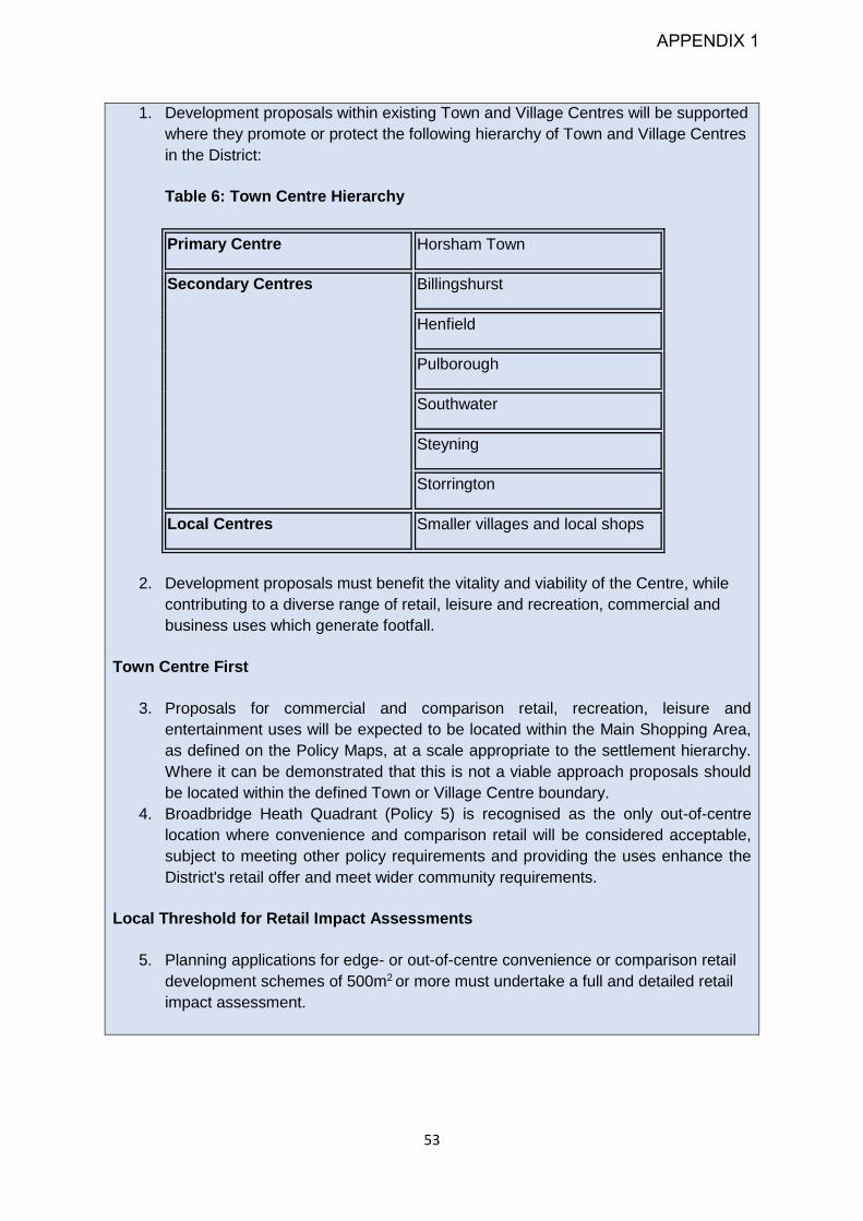
53
1. Development proposals within existing Town and Village Centres will be supported
where they promote or protect the following hierarchy of Town and Village Centres
in the District:
Table 6: Town Centre Hierarchy
Primary Centre Horsham Town
Secondary Centres Billingshurst
Henfield
Pulborough
Southwater
Steyning
Storrington
Local Centres Smaller villages and local shops
2. Development proposals must benefit the vitality and viability of the Centre, while
contributing to a diverse range of retail, leisure and recreation, commercial and
business uses which generate footfall.
Town Centre First
3. Proposals for commercial and comparison retail, recreation, leisure and
entertainment uses will be expected to be located within the Main Shopping Area,
as defined on the Policy Maps, at a scale appropriate to the settlement hierarchy.
Where it can be demonstrated that this is not a viable approach proposals should
be located within the defined Town or Village Centre boundary.
4. Broadbridge Heath Quadrant (Policy 5) is recognised as the only out-of-centre
location where convenience and comparison retail will be considered acceptable,
subject to meeting other policy requirements and providing the uses enhance the
District's retail offer and meet wider community requirements.
Local Threshold for Retail Impact Assessments
5. Planning applications for edge- or out-of-centre convenience or comparison retail
development schemes of 500m2 or more must undertake a full and detailed retail
impact assessment.
APPENDIX 1
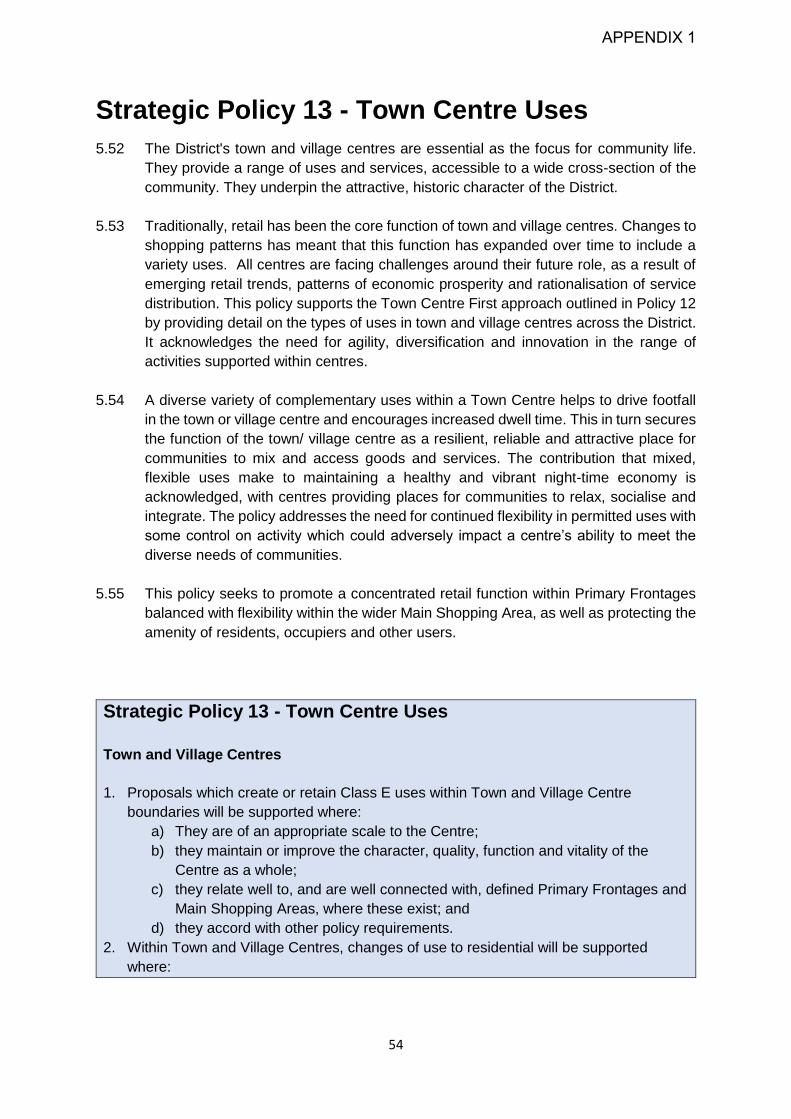
54
Strategic Policy 13 - Town Centre Uses
5.52 The District's town and village centres are essential as the focus for community life.
They provide a range of uses and services, accessible to a wide cross-section of the
community. They underpin the attractive, historic character of the District.
5.53 Traditionally, retail has been the core function of town and village centres. Changes to
shopping patterns has meant that this function has expanded over time to include a
variety uses. All centres are facing challenges around their future role, as a result of
emerging retail trends, patterns of economic prosperity and rationalisation of service
distribution. This policy supports the Town Centre First approach outlined in Policy 12
by providing detail on the types of uses in town and village centres across the District.
It acknowledges the need for agility, diversification and innovation in the range of
activities supported within centres.
5.54 A diverse variety of complementary uses within a Town Centre helps to drive footfall
in the town or village centre and encourages increased dwell time. This in turn secures
the function of the town/ village centre as a resilient, reliable and attractive place for
communities to mix and access goods and services. The contribution that mixed,
flexible uses make to maintaining a healthy and vibrant night-time economy is
acknowledged, with centres providing places for communities to relax, socialise and
integrate. The policy addresses the need for continued flexibility in permitted uses with
some control on activity which could adversely impact a centre’s ability to meet the
diverse needs of communities.
5.55 This policy seeks to promote a concentrated retail function within Primary Frontages
balanced with flexibility within the wider Main Shopping Area, as well as protecting the
amenity of residents, occupiers and other users.
Strategic Policy 13 - Town Centre Uses
Town and Village Centres
1. Proposals which create or retain Class E uses within Town and Village Centre
boundaries will be supported where:
a) They are of an appropriate scale to the Centre;
b) they maintain or improve the character, quality, function and vitality of the
Centre as a whole;
c) they relate well to, and are well connected with, defined Primary Frontages and
Main Shopping Areas, where these exist; and
d) they accord with other policy requirements.
2. Within Town and Village Centres, changes of use to residential will be supported
where:
APPENDIX 1

55
a) This does not lead to an over-concentration of residential uses which would
undermine the vitality and viability of remaining units under their current use
class;
b) it will not lead to a harmful break in active frontages; and
c) it is demonstrated that a Class E use is no longer viable, where this residential
use is proposed within a Main Shopping Area.
3. Non-Class E uses will be supported within Town and Village Centres where it can be
demonstrated that:
a) the proposal will support or enhance the vitality and viability of the centre;
b) the proposal will provide a balance of uses which increase daytime footfall and
/ or promote the evening economy of the Centre,
c) active frontages will be retained; and
d) the amenity of neighbouring occupiers will not be adversely affected.
Main Shopping Areas
4. Where units within a Main Shopping Area are demonstrated to be unviable in their
current form these should be retained for Class E uses in the first instance.
5. Changes of use within the Main Shopping Area will be required to retain active frontages
and contribute to a balance of uses which meet the needs of the community the Centre
serves.
Primary Frontages
6. Proposals which create or retain a comparison and convenience retail use within a
defined Primary Frontage will be supported.
Takeaways, Food and Drink
7. Applications for takeaways must be accompanied by evidence of adequate parking
facilities nearby to ensure vehicle movements associated with delivery and collection
do not cause harm or disruption to the amenity of nearby residents, business or other
occupiers.
8. Proposals for new restaurants, takeaways, pubs and bars, and other uses involving
the preparation and sale of ready to consume food and drink must be accompanied by
a statement detailing of means of:
a) control of emission of fumes,
b) storage and disposal of refuse, including measures to promote recycling and
other forms of sustainable waste management; and
c) acoustic insulation.
Marketing of Property for Change of Use
9. Where the loss of a unit currently under Class E is proposed in Primary Frontages
evidence must be submitted which demonstrates the property has been continually,
actively and effectively marketed for at least 12 months at an appropriate rent (based
APPENDIX 1

56
on three comparable shop rents within the same centre) to establish the use is no longer
of commercial interest.
Small Scale development
10. Outside the defined Town and Village Centre boundaries, proposals for small-scale
convenience retail or service uses, or extensions to existing village shops will be
permitted where:
a) it will not significantly undermine the vitality and viability of the nearest defined
Town and Village Centre; and
b) there is a demonstrable day to day need within the local community for the
proposed use or extension.
11. Loss of E, F1 or F2 uses within Local Centres will be permitted providing:
a) The unit is demonstrated to be unviable under its current use; or
b) the replacement use meets an identified need for a service or facility for the local
community; and
c) this does not lead to a break in the active frontage of the remaining units.
APPENDIX 1
57
Chapter 6: Housing
This document will address the following issues:
The Government is seeking to deliver a step change in housing growth. This means
that the District’s population will continue to rise over the next 20 years. There is a
need to ensure that everyone can access good quality housing to meet the needs
of a mixed population and support the economy.
There will be significant growth in the population of older people, and in particular,
the number of people aged 75 or over. There will also be growth in the number of
people with long-term health problems or disabilities. There is a need to plan for the
specific needs of an increasingly elderly population, including a growing requirement
for retirement homes, residential care homes and smaller units.
Although there is a high percentage of elderly residents, there are also a large
number of families. Housing that is provided must also meet the needs of families.
There is a higher than average proportion of 4-bedroom homes in Horsham District,
whereas the significant need for family and single-person homes is better met by
less expensive 1-3 bedroom homes. Therefore, more homes of a more modest size
are needed in future.
The median house price in Horsham District is around 13 times higher than average
annual earnings. The cost of private renting also remains high. This creates a high
demand for affordable housing, which is available at less than market value. This
includes providing higher levels of social/affordable rented housing whilst looking at
measures to ensure that housing is more generally affordable (e.g. to first time
buyers) and through other mechanisms including self and custom build.
The settlements of Horsham, Billingshurst, Broadbridge Heath and Southwater have
accommodated large developments in recent years, but pressure for housing
development remains. Care needs to be taken to ensure communities can absorb
changes that have taken place to allow stable, cohesive communities to thrive and
that development can be built out at a rate that is in keeping with market demand.
The Council is required to identify the accommodation needs of Gypsies and
Travellers and plan for these needs in accordance with national planning guidance.
In circumstances where there is a lack of authorised Gypsy and Traveller sites the
Council faces difficulty resisting application for windfall sites in less suitable or
desirable locations. The provision of sufficient sites will seek to ensure that the
number of illegal encampments and incursions of Gypsy/Traveller pitches which
occur across the District will reduce.
APPENDIX 1

58
Housing Need in Horsham District
6.1 In 2019, the population of Horsham District was estimated at 141,717 people. This
compares to 131,300 at the time of the 2011 Census. The Government is committed
to delivering a step change in the number of houses that will be built in the coming
years, and it is predicted that the population will grow by another 17,658 or 12.5% over
the 20-year period to 2039. The main elements that make up the changes to
population are natural changes (the number of births and deaths) and migration, where
people move both in and out of the District. Most of this movement is relatively local,
from within and around Sussex, followed by the south east / London but a smaller
amount is from further afield. The population estimates indicate that the population in
all age groups will grow, but by far the highest growth will be seen in the over-65
population (and especially in the over-75s). There will also be strong growth in
younger age groups including those of working age. This will mean that the District will
need to provide more jobs in future to ensure there are local employment opportunities
available for the growing population.
6.2 In 2018 national planning policy introduced a new method of calculating housing need.
All local planning authorities are required by the Government to calculate a ‘local
housing need’ figure, based on a 'standard methodology'.
6.3 It is a requirement of the NPPF that the Council provides a strategy which, as a
minimum, seeks to meet the District’s objectively assessed needs and is informed by
agreements with other authorities, so that unmet need from neighbouring areas is
accommodated where it is practical to do so and is consistent with achieving
sustainable development. The standard methodology calculation for Horsham District
is calculated as 897 dwellings per annum. This is equivalent to providing a minimum
of 15,640 homes in the 17-year period between 2021 and 2038.
Wider Housing Need and the Duty to Co-operate
6.4 The starting point for this Plan has been to ensure that the District can meet its own
housing requirement derived from the standard housing methodology. In addition, the
District has considered how much additional development can be accommodated to
help address the unmet housing need of other districts in the surrounding area. Given
the scale of unmet needs across the South East as a whole, the approach followed by
the Council has been to prioritise meeting the needs of authority areas with the closest
links to this District in the first instance.
North West Sussex (Crawley)
6.5 The vast majority of Horsham District falls within an area known as the North West
Sussex Housing Market Area. This area includes the whole of Crawley Borough, much
of Mid Sussex District and a small area of Reigate and Banstead Borough in Surrey.
The legal Duty to Co-operate requires the District to consider how much additional
development can be accommodated in a way that helps address the unmet housing
need of other districts in the surrounding area.
APPENDIX 1

59
6.6 The standard housing methodology calculation has resulted in increased housing
requirements not only in Horsham District, but also in Crawley Borough and in Mid
Sussex. This places an increased challenge on all three authorities in seeking to
accommodate these additional housing requirements. Due to the constrained nature
of Crawley Borough, which is built up to its administrative boundaries, Crawley will not
be able to meet a significant proportion of their identified housing need in their Plan
period.
6.7 Crawley Borough Council is also in the process of undertaking their local plan review,
and this has yet to be adopted. Current indications are that Crawley can meet almost
half of their needs in the plan period, with a total of 6,680 dwellings (414dpa) to be
accommodated within the wider housing market area, insofar as is consistent with the
National Planning Policy Framework and delivery of sustainable development.
6.8 Through a long history of joint working commencing prior to the legal 'Duty to Co-
operate' requirements, the authorities in this area have worked together to ensure that
the housing need in the housing market area has been met. In the previous local plan
(the Horsham District Planning Framework) this Council provided 150 homes a year
to meet housing needs that cannot be met within Crawley's administrative area. The
ongoing housing development at Kilnwood Vale to the west of Crawley was developed
in partnership with Crawley Borough Council as part of the Joint Area Action Plan
adopted in 2009.
6.9 Horsham District and Crawley Borough have continued these joint discussions through
the preparation of our respective Local Plan reviews with a view to considering the
extent to which Horsham could meet the unmet needs from Crawley. This has taken
account of a wide range of evidence including, but not limited to:
Identifying and testing a range of development proposals at different scales
and locations across the District. These assessments took account of
suitability, availability and deliverability of sites. This process identified the
potential for individual sites to contribute to meet housing requirements.
An assessment of the potential of the housing market to accommodate new
development in the District. In practical terms this demonstrates that there are
limits to the overall level of housing that would sell, including when considered
in combination with other potential and committed development locations in
and beyond the District.
An assessment of the Infrastructure requirements necessary to support
development. This process has identified that in many instances large
infrastructure upgrades are needed to support development. These again limit
the rate at which development can come forward both in practical terms limiting
build out rates, but also in terms of the environmental and sustainability
consequences should development proceed in advance of the necessary
infrastructure upgrades.
Testing alternative strategies and options for development to ascertain the
environmental, economic and social impacts of development through the
Sustainability Appraisal and Strategic Environmental Assessment Process.
APPENDIX 1

60
6.10 The outcome of this work has identified that market forces, the need to deliver
additional infrastructure and the physical availability of land for development mean that
it will not be possible for this District to accommodate all of the unmet needs that have
been identified for Crawley Borough. It is however considered that the District can
accommodate around 50% of the overall level of unmet needs.
6.11 Provision in the plan is made for 193 dwellings per annum to meet the needs of
Crawley Borough. The primary location for these needs to be met is the allocation of
Land to the West of Ifield. Beyond this local plan, it is however considered that it will
be necessary to continue discussions with Northwest Sussex authorities in terms of
meeting unmet needs ‘at Crawley’. Within this context however, the area of search
West of Crawley is expected to be a focus for these discussions within the context of
any further development that may be required in Horsham District.
Sussex Coastal Authorities (Worthing)
6.12 A small part of Horsham District also falls within the Coastal Housing Market Area.
This housing market area is primarily focused on the settlements of Brighton & Hove,
Shoreham and Worthing but extends northwards into the southern part of Mid Sussex
District, and covers the settlements of Steyning, Upper Beeding and Henfield in the
south east of Horsham District. The settlements on the south coast have in general
terms identified that they have unmet housing needs as they are constrained by the
coast to the south and the South Downs National Park to the north. Whilst the precise
level of unmet need will vary over time, reflecting changes to the Standard Housing
Methodology and varying local plan periods, the evidence suggests that there is an
overall unmet housing need of around 2,000 homes per year in the wider Coastal Area.
Worthing Borough Council have identified that their overall level of unmet need in the
period to 2036 is some 10,488 homes or 655 dpa.
6.13 As outlined above, the key functional economic links in Horsham District are with North
West Sussex and this plan actively makes a contribution to meet those requirements.
Whilst there are some housing and economic linkages to the coast, the District does
not directly adjoin the south coast towns, separated by the South Downs National Park.
Furthermore, the settlements in the south of the District which have the closest links
are also the most physically constrained in development terms. Land to the south of
these towns and villages directly adjoin the South Downs National Park, and in addition
to the national importance of this landscape, Horsham District Council is not the
planning authority for this area. To the north of Steyning, Bramber and Upper Beeding,
most of the land is at risk from flooding. Some land near Henfield also lies within
identified floodplains, albeit to a lesser extent.
6.14 The preparation of this plan has considered to what extent land may be available in
this part of the District to accommodate the unmet needs from the coast taking account
of the issues previously set out above. Whilst land has been allocated for development
around settlements in the south and south east of the District (Chapter 11 and in
Neighbourhood Plans) these only are sufficient to meet local housing needs.
APPENDIX 1

61
6.15 Detailed consideration has also been given as to whether new settlements may be a
solution to meeting the unmet needs for the South Coast. Land at Buck Barn has been
allocated for development. Given that this is an entirely new development, it is not
envisaged that sufficient homes can be delivered at this location within the plan period
to meet unmet needs from other Districts and boroughs. Notwithstanding this point, it
is however recognised that the location of the proposed development on the A24 has
the potential to provide a direct connection to the South Coast. The District is therefore
able to provide around 20 homes a year towards the unmet needs from Worthing.
6.16 In the longer term, the scale of unmet need is such that a comprehensive joint
response is required. An updated Local Strategic Statement (LSS3) is, to this purpose,
being prepared by the West Sussex and Greater Brighton Strategic Planning Board,
which will inform subsequent reviews of this Local Plan.
Surrey Greenbelt Authorities (Mole Valley)
6.17 In addition to meeting unmet needs for Crawley and considering the potential to meet
needs arising from the South Coast, requests to meet the unmet needs in Mole Valley
have also been identified. Although adjoining Horsham District, Mole Valley is not
within the same housing or functional market areas. The needs from this area have
therefore been considered after those with direct connections. Taking into account the
unmet needs from Crawley and the South Coast, it is not possible for the District to
accommodate these unmet needs and those which extend more widely into the South
East and into London at this time. The ability of the District to meet these unmet needs
will need to be revisited as part of any future local plan review.
House sizes, types and affordability
6.18 In addition to understanding the number of homes that are required in the District, it is
important that the homes are the right size, type and price. To understand more about
the housing needs of our District, a study known as a Strategic Housing Market
Assessment (SHMA) has been undertaken.
6.19 The SHMA has assessed the level of affordable housing need in the District. The
median house price in Horsham District is around 13 times higher than average annual
earnings. The cost of private renting is also high. It is considered that the high cost of
housing in the District is a significant barrier to younger people and families being able
to work and live in the District. There is therefore a high need for a range of different
types of affordable housing. There is also a need to ensure that the types of homes
that come forward are a mix of sizes and include smaller dwellings.
6.20 Horsham District has a relatively high proportion of the population aged over 65. In
2017, the percentage of over 65s was estimated to be 18.4%. This is likely to increase
to just under 30% by 2039. As we age, there is an increased chance of a long-term
health problem or disability, and the number of older people who have mobility
difficulties and /or conditions such as dementia will rise. It is therefore important that
housing provision meets the needs of the older population. Some of these homes will
APPENDIX 1

62
need to provide specialist support. For example, sheltered housing has an on-site
warden, and extra-care housing has tailored clinical services on-site. Others may
simply be designed to be smaller or suited to those with limited mobility.
Strategic Policy 14 - Housing Provision
6.21 This policy sets out how the Council will meet the housing needs for this District and
contribute to the delivery of unmet housing needs from other areas. The Council’s
evidence base work has identified a total of 19,860 homes which are considered to be
deliverable in the plan period. Taking account of the need for flexibility of supply, this
equates to an annualised target of 1,100 homes each year.
6.22 Within the plan period, some 8,063 homes already have planning permission or are
otherwise identified for development. It is also expected that a small amount of windfall
development will take place each year.
6.23 Many of the 8,063 homes already identified for development include strategic
allocations identified in previous Local Plans including land at Kilnwood Vale, Land
West of Horsham and Land North of Horsham where development is ongoing. In
addition, some smaller scale sites have been identified as development locations
within Neighbourhood Plans.
6.24 As development at land North of Horsham is still within the early stages of construction,
it is proposed that the Horsham District Planning Framework policies relating to land
North of Horsham are saved over the period of this plan to allow for the consideration
of reserved matter applications. This policy makes provision for at least 2,500 homes.
To date some 2,750 homes have outline planning permission. It is however considered
that there is potential for an additional 500 homes within the boundary of the allocation
in order to make the best use of the available land. Provision for this additional 500
homes is therefore set out in Policy 14 below for completeness.
6.25 The remaining housing needs will be met through additional strategic allocations
together with smaller scale development allocations which will help meet more local
housing requirements and ensure a consistent housing supply over the plan period.
The starting point for strategic scale growth has been general conformity with the
District’s settlement hierarchy as set out below.
Land West of Ifield, Crawley. Development in this location recognises the role
of Crawley at the centre of the Gatwick Diamond and reflects the unmet
housing needs arising from this town.
Additional intensification of Land at North Horsham.
Land West of Southwater
Land East of Billingshurst
6.26 In addition, a new settlement is also identified at Buck Barn, on the A272 and A24
corridors. This central location in the District, with good road connections provides links
to both the northern settlements within the Gatwick diamond, and connections to the
APPENDIX 1

63
south coast. As part of any development, the necessary infrastructure and community
facilities must be provided in a timely manner in order to support new development.
6.27 The Council will be reliant on a high number of homes which are to be delivered
through the allocation of larger strategic sites. These take time to come forward as
they progress through the application and preparatory stages of development works
on the site. The Council is therefore not able to demonstrate a uniform delivery of
homes over the plan period. A stepped trajectory is therefore proposed with a housing
target of 900 homes in the first five years of the plan, with a target of 1,180 homes per
year for the remaining 12 years of the plan.
Figure 3: Indicative housing trajectory illustrating delivery over the plan period4.
Strategic Policy 14: Housing Provision
Provision is made for the development of at least 18,700 homes associated infrastructure
within the period 2021-2038 at an average delivery rate of 1,100 homes per year. The
target for the first five years of the plan will be 900 homes a year, rising to 1,180 for the
remainder of the plan period. This figure will be achieved by
1. Housing completions for the period 2021-2022
2. Homes that are already permitted or agreed for release, including previously
allocated strategic sites at Land North of Horsham (2,750) and Land West of
Southwater (600), Land at Kilnwood Vale (2,500) and Land South of Billingshurst;
3. Strategic Sites:
a) At least 3,250 homes on Land West of Ifield
b) At least 1,200 homes on Land West of Southwater
c) At least 650 homes on Land East of Billingshurst
d) At least 2,100 homes at Land at Buck Barn
4 A 10% buffer has been applied to the five-year supply of deliverable sites in the submitted Local Plan and that
the Council intends to rely on the annual position statement process referred to in NPPF paragraph 73b) and 74 to cover the period following the expiration of the “recently adopted” provisions in NPPF 73b) and 74.
0200400600800
1,0001,2001,4001,600
20
21
/ 2
02
2
20
22
/ 2
02
3
20
23
/ 2
02
4
20
24
/ 2
02
5
20
25
/ 2
02
6
20
26
/ 2
02
7
20
27
/ 2
02
8
20
28
/ 2
02
9
20
29
/ 2
03
0
20
30
/ 2
03
1
20
31
/ 2
03
2
20
32
/ 2
03
3
20
33
/ 2
03
4
20
34
/ 2
03
5
20
35
/ 2
03
6
20
36
/ 2
03
7
20
37
/ 2
03
8
Strategic Site Allocations
Additional Smaller Sites
Smaller Site Allocations
Windfalls
APPENDIX 1

64
4. At least 2,200 homes from smaller scale allocations to be allocated in this Local
Plan or in Neighbourhood Plans
5. An additional 500 homes within the existing Land North of Horsham allocation and
6. 1,875 windfall units, including 10% provision on land less than 1ha.
Strategic Policy 15 – Meeting Local Housing
Needs
6.28 This policy seeks to achieve a mix of housing sizes, types and tenures to meet the
District's housing needs as identified in the Strategic Housing Market Assessment
(SHMA) 2019 or any future updates. This will ensure that we can create sustainable
and balanced communities.
6.29 There is a particular need to meet the housing needs of an increasingly elderly
population, and a continuing need to provide homes suitable for specialist
needs. Policy 17 sets requirements for adaptable and accessible homes, and Policy
19 sets requirements for housing development to provide specialist older people’s
accommodation.
6.30 Table 7 sets out an appropriate strategic mix of home sizes for different tenure housing
which should be used when planning new development, as evidenced in the SHMA
2019. If this is updated during the plan period, the most recent evidence base should
be used.
Table 7: Appropriate strategic mix of homes sizes based on tenure
Rented affordable
housing
Affordable home
ownership
Open market
housing
Overall mix
1 bedroom
home 35% 25% 5%
22%
2 bedroom
home 30% 40% 30%
33%
3 bedroom
home 25% 25% 40%
30%
4 bedroom
home 10% 10% 25%
15%
APPENDIX 1

65
6.31 ‘Rented affordable housing’ means social rented, affordable rented and affordable
private rented homes. ‘Affordable home ownership’ means shared ownership homes,
low-cost market homes and starter homes. (See the Glossary for more information).
‘Open market housing’ is homes sold at full market value on the open market.
6.32 The Council also recognises that future development should respond appropriately to
local character and local needs. Evidence of local needs will normally be in the form
of a local housing needs assessment prepared specifically for that parish or ward, or
a Neighbourhood Plan that has successfully passed examination.
6.33 A range of different housing types and tenures will need to be provided by developers
to respond to both strategic and local housing needs, and also to maintain the delivery
of homes over the plan period. This may include build to rent homes, apartments/flats,
smaller ‘downsizing’ units such as bungalows, and opportunities for self and custom
build.
6.34 The Self Build and Custom Housebuilding Act 2015 requires the Council to keep a
register of people who are interested in self build and custom build projects in the
District in order to assess demand for this type of housing. These statistics take
account of the overall level of demand with the District as a whole and in different
parishes. The Self-Build and Custom Housebuilding Regulations 2016 requires Local
Authorities to grant suitable development permissions in respect of enough serviced
plots of land to meet the demand on the register within a three year period. This does
not mean that the Council itself must provide self-build or custom build plots for this
purpose.
6.35 Policy 17 sets a requirement for larger housing sites to provide a proportion of overall
open market tenure housing plots as self or custom-build. The Council will also support
appropriate proposals on smaller scale sites and in Neighbourhood Plans, which can
come forward in the same way as general market housing subject to appropriate
conditions.
Strategic Policy 15 – Meeting Local Housing Needs
1. Residential development will be supported where it provides a mix of housing sizes
and types to meet the needs of the District's communities as evidenced in the latest
Strategic Housing Market Assessment or any subsequent updates in order to create
sustainable and balanced communities. Where relevant, a made or referendum
stage Neighbourhood Plan may provide an appropriate local mix. Other factors that
may be taken into account include the established character and density of the
neighbourhood, the viability of the scheme, and locally and robustly prepared
evidence such as a local (parish) housing needs assessment.
2. The Council will support schemes being brought forward through Neighbourhood
Plan allocations, provided they are in general conformity with the relevant Local
Plan.
APPENDIX 1
66
3. Residential developments will be supported where homes are provided as either
self-build or custom-build serviced plots in accordance with the latest demand on
the Self and Custom build register. A level of provision that differs from the Council’s
register may be accepted if supported by robust evidence of local need.
Policy 16: Affordable Housing
6.36 This policy sets out the Council’s thresholds and targets for affordable housing.
Affordable housing is subsidised to enable the purchase or rental price to be
substantially lower than the prevailing market prices, and where mechanisms exist to
ensure the housing continues to remain affordable for those who cannot compete in
the housing market. All qualifying residential developments will be subject to affordable
housing requirements, including any retirement or assisted living accommodation
within this use class as set out in Policy 19.
6.37 A Local Plan Viability Assessment has informed the affordable housing targets and
thresholds. This has shown that, for most developments, the provision of 45% of
homes on non-strategic greenfield sites, and of 10% on brownfield sites, is viable.
Strategic greenfield sites are required to bear far greater infrastructure costs than
smaller sites, and 35% affordable housing is therefore considered appropriate in these
locations. Specific affordable housing targets are also given for Build to Rent housing
and elderly persons’ housing, taking account of viability evidence.
6.38 Development is expected to provide 70% of the total as social rented and/or affordable
rented properties, 25% as First Homes as defined in nationally set policies and
guidance, and the remaining 5% as other intermediate or shared ownership properties.
Given the high cost of rented properties in the District, and an ongoing shortage of
supply, the Council will support and encourage a proportion of these homes to be
provided as social rented homes in appropriate locations as informed by local need.
The discount on open market value applied to First Homes will be 40%. A Local
Connections test will be applied to all rented affordable homes and First Homes as set
out in the Glossary. Advice should, in all cases, be sought at an early stage from the
Council’s Housing Service as to the delivery of social rented homes. Affordable rented
homes must be genuinely affordable and must not exceed Local Housing Allowance.
Policy 15 sets out the expected mix of dwelling sizes, including for affordable housing.
6.39 The Council will be alert to situations where the number of dwellings proposed on a
site falls below the relevant thresholds, but where there is capacity to provide the
number of dwellings that would trigger affordable housing contributions. If there are
instances where a development site is sub-divided so as to create two or more
separate development schemes that fall below the affordable housing threshold, the
APPENDIX 1

67
Council will require an appropriate level of affordable housing to reflect the capacity of
the site or sites as a whole, were it come forward as a single scheme.
6.40 On sites where a mix of uses or types (classes) of residential development is proposed,
or it is deemed that the site is part-brownfield and part-greenfield, a ‘blended’ overall
proportion of affordable housing will be expected, which pro-rata’s the requirement
applicable to each element of development.
6.41 The Council is actively pursuing alternative and innovative ways to deliver a range of
housing tenures in partnership with local registered providers including market,
affordable and social rent. The Council also delivers affordable housing through its
affordable housing company, Horsham District Homes. In exceptional circumstances,
such as where there are overriding site constraints which inhibit the provision of
affordable housing, or where it is agreed with the Council that provision can be better
met on an alternative site in the District, contributions for off-site provision may be
accepted as an alternative.
6.42 Community Land Trusts (CLTs) provide an opportunity for local community ownership
of land for long-term affordable housing provision. Affordable housing provided by
CLTs and most housing associations are exempt from the “Right to Buy”, allowing
affordable housing to remain affordable in perpetuity. The involvement of CLTs in the
delivery of new affordable homes, whether as part of a mixed tenure housing
development or as an appropriately sited rural exception site (see Policy 18 –
Exceptions Housing Schemes), will be supported in principle.
6.43 The Council will support schemes for suitably located affordable housing being brought
forward through Neighbourhood Plans, including those being delivered through CLTs.
Strategic Policy 16: Affordable Housing
Residential development will only be supported provided that:
1. On self-contained residential developments (C2 and C3, including retirement and
other specialist care housing) that are proposed for, or have a capacity for, 10 or
more homes (gross*) or exceed 0.5 hectares, a proportion of the homes or units
shall be provided as affordable homes (as defined in the Glossary). The proportions
will be as follows:
a) On greenfield sites** providing self-contained dwellings (houses and/or flats), a
minimum 45% of the total (gross*);
b) On previously developed (brownfield) sites self-contained dwellings (houses
and/or flats), a minimum 10% of the total (gross*);
c) On strategic sites, a minimum 35% of the total (gross*);
d) On sites providing continuing care retirement housing, retirement housing and
other specialist care housing, a minimum 40% of the total (gross*) as applies in
accordance with Policy 19;
APPENDIX 1

68
e) On providing Build to Rent accommodation, a minimum 40% of the total (gross*)
where the site is greenfield**, or a minimum 20% (gross*) where the site is
previously developed (brownfield).
2. At least 70% of the affordable homes are provided as social rented and affordable
rented homes, 25% are provided as First Homes with a 40% discount compared
with the open market value, and the remaining proportion (5%) provided as other
intermediate /shared ownership homes. Social rented provision will be strongly
supported in appropriate locations. Alternative tenure mixes (including any reduction
in the overall proportion of homes delivered on-site) will only be considered if
evidence is provided to justify this on the basis of proven local need or, in exceptional
circumstances, risk of non-delivery (which may include where abnormal site
constraints significantly impact on viability).
3. Future occupants of all rented affordable and First Homes are required to
demonstrate a local connection. , as defined in the Glossary.
4. Affordable homes must be integrated throughout the development and be of visually
indistinguishable design. They should be located throughout the site in a manner
that supports integration but can also be managed efficiently by the relevant housing
associations.
5. It is expected that affordable housing will be delivered on-site. In exceptional
circumstances where it can be demonstrated that this is not viable, the Council will
seek equivalent off-site provision, or financial contributions in lieu to provide for the
full cost of the same number of units.
Gross: *The proportion of affordable housing will apply to all new residential units, and any
demolished properties will not be ‘netted off’. A vacant building credit may however apply,
as required by national policy. Any residential units left materially unaltered and in-situ can
be discounted from the calculation.
Greenfield: **Any site or part of a site that does not meet the nationally set definition of
‘previously developed land’ (‘brownfield land’) will be deemed ‘greenfield land’. A greenfield
site includes any smallholdings, nurseries and farms.
Implementation
6.44 The mechanisms for calculating financial contributions in lieu of on-site provision will
be set out in separate guidance. A Local Plan Viability Study has been undertaken,
and, in line with national policy and guidance, it is expected that all development
proposals will comply with this policy together with other requirements in this chapter
and the Local Plan more generally. The Council will only accept a reduced amount of
affordable housing, non-policy compliant mix of sizes or tenures, or financial
contributions for off-site provision due to lack of viability if exceptional circumstances
have been demonstrated through a viability appraisal at the application stage.
Exceptional circumstances will only relate to unforeseeable abnormal site costs. The
APPENDIX 1

69
price paid for land is not a relevant justification for failing to accord with relevant Local
Plan policies. It is expected that affordable housing will be delivered as units built on
development sites and will normally be in conjunction with Horsham District Homes or
other Registered Provider(s). It is expected that Registered Providers will have been
engaged at an early stage of development planning and prior to application
submission.
Policy 17: Improving Housing Standards in the
District
Internal Space Standards
6.45 There is a mandate from Government to build more homes. However, the Council is
clear that the requirement to build more homes should not be at the expense of
providing fit for purpose, good quality housing for local residents. There is strong
evidence identified through the Council’s monitoring to suggest that whilst many
homes currently being built or created meet or exceed the standards there are also a
significant number of properties that do not.
6.46 Ensuring there is sufficient internal space within new dwellings will mean that residents
will be able to enjoy everyday activities in their homes and have the flexibility and
adaptability required for any potential future needs. These minimum space standards
will apply to all new dwellings within the District, including new dwellings provided
through subdivision and conversion, and across all tenures.
Providing accessible, adaptable and wheelchair user dwellings
6.47 The National Planning Policy Framework requires local planning authorities to plan by
size, type and tenure for the housing needs of different groups in the community,
including older people and people with disabilities.
6.48 According to the Office for National Statistics (ONS), 18% of the UK population was
over the age of 65 in 2017 and by 2066 a quarter of the UK’s population would be aged
65 or over, with a rise from just 2% of the population being aged 85 or over in 2016 to
over 7% by 2066.
6.49 The English Housing Survey found that 93% of UK homes do not meet a design that
allows anyone using a wheelchair or mobility device to visit a dwelling. Many
developers are not building new homes that are suitable for people as they age. The
SHMA indicates that there is a higher proportion of older people in Horsham District
when compared with the wider West Sussex region and nationally. Over the plan
period it is predicted that the proportion of elderly people in Horsham District will rise
significantly and a number of these people will have disabilities.
APPENDIX 1
70
6.50 It is therefore important that homes are able to meet the changing needs of the
District’s residents, enabling them to remain independent and stay in their homes
longer. This policy therefore requires that optional standards set out in Building
Regulations Approved Documents M are applied in relation to Accessible and
Adaptable Dwellings and Wheelchair user dwellings. The standards will be used to
ensure that homes that are accessible and adaptable and homes suitable for
wheelchair users are provided and ensure future development within the District
provides homes suitable for life. They will also offer greater choice for disabled people
and those with mobility difficulties.
Policy 17: Improving Housing Standards in the District
Residential development will only be supported provided that:
Internal Space Standards
1. All dwellings meet the Nationally Described Space Standards (or any subsequent
Government update) for internal floor areas and storage space. These standards
will apply to all open market dwellings and affordable housing, including those
created through subdivision and conversion.
Adaptable and Accessible Homes
2. All new dwellings meet the Optional Standards for Accessible and Adaptable
dwellings as set out in the Building Regulations Approved Document M4(2) (or any
subsequent Government update).
3. On sites providing 20 or more units (gross) and where there is an identified need on
the Housing Register, a minimum of 5% of dwellings provided as affordable housing
will be required to meet the Optional Standards for Wheelchair User dwellings as
set out in the Building Regulations Approved Document M4(3) (or any subsequent
Government update).
4. Where new dwellings are being provided through a change of use or conversion,
and as a result it is not feasible for the development to comply with the standards
referred to in parts 2 and 3 of this policy, an equivalent off-site contribution (which
may be a financial contribution) will be required.
Exemptions to compliance with the above requirements will only be considered in
exceptional circumstances, where the applicant can robustly demonstrate that there are
exceptional site-related reasons, in which case it must be demonstrated that the maximum
possible has been achieved.
Implementation
APPENDIX 1
71
6.51 The mechanisms for calculating financial contributions in lieu of on-site provision will
be set out in separate guidance. Exceptions to meeting the requirements set out in
Policy 17 will only be considered in exceptional circumstances, which may (but not
necessarily) include heritage constraints, vulnerability to flooding or site topography.
Policy 18 – Rural Exception Homes
6.52 The NPPF enables the provision of affordable housing by means of an 'exceptions
policy' in rural areas.5 This allows the Council to grant planning permission where
residential development would not normally be permitted to address a specific and
proven affordable housing need.
6.53 Policy 18 sets out the criteria that must be met for a rural exception site to be approved.
The Council considers the appropriate way of demonstrating this need will usually be
through a Local Housing Needs Survey which should have a robust methodology,
agreed upon by stakeholders, including the Council.
6.54 The Council expects rural exception sites to be progressed though partnership working
with Registered Providers and the relevant parish council. Community-led schemes
will primarily be delivered through Community Land Trusts. There will be an
expectation for both rural exception and community-led schemes to demonstrate there
is local support. Parish Councils, Registered Providers and developers are strongly
encouraged to engage in early discussions with the Council if they wish to explore the
possibility of progressing a rural exception site or a community-led scheme.
6.55 The occupancy of properties will be restricted to those with a strong local connection
and must adhere to Horsham District Council's Housing Strategy. The new homes will
also be secured as affordable in perpetuity through Section 106 Legal Agreement.
Policy 18: Rural Exception Homes
In exceptional circumstances, small-scale development of new affordable homes will be
supported on land outside existing settlement boundaries that would not otherwise be
released for general market housing provided that:
5 This is distinct from the support in the NPPF for entry level exception sites set out in paragraph 71 of
the NPPF, and also distinct from First Homes exception sites as defined in Planning Practice Guidance, and are to be delivered on sites adjoining existing settlements
APPENDIX 1

72
1. There is an identified local need for such homes as demonstrated by an up to date
housing needs survey and, and there are no other more suitable alternatives exist
within the locality to meet that need;
2. The development would solely meet the particular needs of the parish (or that parish
plus its immediately adjoining parishes within Horsham District), and that the needs
identified comprise housing for at least one of the following:
a) Existing residents of the parish who currently live in unsuitable accommodation
as their sole or main place of residence, including concealed households who
are in need of separate accommodation in the area (but excluding existing owner
occupiers);
b) People whose work provides a locally important service in that parish (or an
immediately adjacent parish) which cannot be provided elsewhere and who need
to live close to their work;
c) People who are no longer resident in the parish but can provide evidence of
having longstanding or family links with the local community;
d) People with the offer of a job in the parish who cannot take up the offer because
of a lack of affordable housing that suits their reasonable needs.
3. It can be demonstrated that all reasonable site options in or adjoining a built-up area
boundary have been considered;
4. Proposals are either adjacent, or well related, to an existing settlement*;
5. Proposals demonstrate good design, have regard to local character and are of a scale
proportionate to existing development;
6. All homes are secured as affordable in perpetuity, through a Legal Agreement; and
7. Occupancy adheres to Horsham District Council's housing strategy, Housing Register
and Nomination policy.
Delivery of community led developments that provide 100% affordable housing via
Community Land Trust (CLTs) and equivalent community-led legally constituted bodies, will
be supported on suitable small sites subject to meeting the criteria set out above.
*For the purposes of this policy, an existing settlement means a settlement in Horsham District that
is a Secondary Settlement or higher in the settlement hierarchy set out in Strategic Policy 2.
Policy 19: Retirement Housing and Specialist
Care
6.56 The need to provide suitable housing for older people in the District is very important.
The Strategic Housing Market Assessment (SHMA) has identified that the number of
elderly people in the District will increase during the plan period. The Study also
acknowledges older people are more likely to have a long-term health problem or
disability. The SHMA sets out that, given the ageing population and higher levels of
disability and health problems among older people, there is likely to be an increased
APPENDIX 1

73
requirement for specialist housing options. There is also a need to consider the needs
of people with other specialist care requirements who are not necessarily elderly. The
Council will aim to ensure that the right type of housing is brought forward to
appropriately meet the needs of the District's residents.
6.57 This policy sets criteria to ensure that such developments are not only in the most
suitable location, close to shops and amenities, but also accessible for those with
impaired mobility. Residents of retirement housing schemes are often still very mobile
but may not have access to a car. Proximity to services within walking distance or on
bus routes is therefore important.
6.58 Policy 19 includes reference to retirement living (also known as sheltered housing),
which comprises a self-contained home plus limited communal facilities and some
support (not care). Extra-care housing (also known as assisted living) offers a higher
level of care than retirement living and more extensive communal areas. Unlike
sheltered housing, extra-care housing is regulated by the Care Quality Commission
(CQC). Residential care is generally not self-contained for residents and comprises
individual rooms within a wider residential setting and a high level of care, including
the provision of nursing care.
6.59 Continuing care retirement communities usually combine independent living, extra-
care housing and nursing care. These sites are often more 'self-contained' compared
with a standard residential neighbourhood, and therefore typically provide most of the
facilities and services required by the residents. Housing options for younger people
with care needs can include adapted properties, sheltered housing schemes for young
people, supported housing in the community and supported living. These housing
types are not intended to be definitive but provide an indication of the different housing
options covered by this policy.
6.60 Proposals that are deemed to provide self-contained dwellings or retain the essential
characteristics of a self-contained dwelling, whether C2 or C3 use class, will be
expected to provide affordable housing in accordance with Policy 16, regardless of
whether or not an element of care is provided or the type of care provision unless it
can be robustly demonstrated that meeting this requirement would make the scheme
unviable. It is however recognised that in some instances the form and level of
contribution may differ from general mixed tenure development schemes.
Policy 19: Retirement Housing and Specialist Care
1. Proposals for development which provides continuing care retirement housing,
retirement housing and other specialist care housing will be supported provided that:
a) It is located within or adjoining defined built-up areas, or as part of strategic
housing allocations, and is accessible by foot or public transport to local shops,
services, community facilities and the wider public transport network; and
APPENDIX 1

74
b) All units deemed self-contained dwellings provided as part of the development
will, regardless of use class, comply with Policy 16 – Affordable Housing, such
that:
i. For the retirement homes and extra-care housing element, the proposal
will provide C3 self-contained affordable homes suited to specialist older
people’s needs; and
ii. For elements of the proposal delivering self-contained units as part of a
residential care scheme (C2 use class), the proposal will provide
specialist on-site affordable housing tailored for occupation by C2
residents; and
iii. All phases or parts of the development are considered as a whole when
determining the affordable housing requirements.
2. Where development is proposed in a rural location which is poorly related to any larger
settlement, it must be demonstrated that alternative sites within or adjoining a defined
built up area are not available or are unsuitable.
3. Continuing care retirement communities will also be required to:
a) Provide accommodation for a full range of care needs, including on-site care
provision alongside self-contained and supported living accommodation; and
b) Include provision of services and facilities, including transport, to meet the
needs of residents/staff and which contribute to the wider economy.
Strategic Policy 20: Gypsies and Travellers
Definition
6.61 The Housing Act 2004 places a duty on local authorities to produce assessments of
accommodation need for Gypsies, Travellers and Travelling Showpeople (GTTS), and
outline how their needs will be met. However, there is no requirement for local
authorities to provide sites on land which they may own.
6.62 The main planning policy document relating to GTTS is the ‘Planning Policy for
Traveller Sites’ document (PPTS) that was first published by the Government in March
2012 and updated in August 2015. This document provides a definition of both
‘Gypsies and Travellers’ and ‘Travelling Showpeople’ for the purposes of planning
policy. Horsham District Council has therefore used these definitions for the purposes
of this document.
Gypsies and Travellers:
“Persons of nomadic habit of life whatever their race or origin, including such persons
who on grounds only of their own or their family’s or dependents’ educational or health
needs or old age have ceased to travel temporarily, but excluding members of an
APPENDIX 1

75
organised group of Travelling Showpeople or circus people travelling together as
such”;
Travelling Showpeople:
“Members of a group organised for the purposes of holding fairs, circuses or shows
(whether or not travelling together as such). This includes such persons who on the
grounds of their own or their family’s or dependants’ more localised pattern of trading,
educational or health needs or old age have ceased to travel temporarily, but excludes
Gypsies and Travellers as defined above.”
Gypsy, Traveller & Travelling Showpeople Sites in Horsham District: Estimate
of Future Needs
6.63 Horsham Council employed specialist Gypsy, Traveller and Travelling Showpeople
consultants6 to carry out an updated needs assessment for Gypsies, Travellers and
Travelling Showpeople in Horsham District for the new Horsham Local Plan period.
6.64 In total, a need for 93 pitches for Gypsy and Traveller households in Horsham District
has been identified over the Plan period, and for which it will be necessary to identify
land in the Local Plan to meet this need. The breakdown of need by five-year intervals
over the Plan period is set out in table 8.
Table 8: Gypsy and Traveller Need requirements
Years 0-5 6-10 11-15 16-17 Total
50 15 17 11 93
Other Needs
6.65 Under the Duty to Co-operate, the need for additional pitches in the South Downs
National Park (SDNP) area was considered, as there is one site in Horsham District
which extends over the South Downs boundary. It was determined that these
caravans were not occupied by Gypsies or Travellers and there is no need for
additional pitches in the SDNP area of Horsham District. No additional needs for
transit or temporary sites have been identified due to the historic low number of
unauthorised encampments and the transit site in Chichester which meets needs on a
county wide basis.
6.66 There were a few instances where it was not possible to conclude whether families
met the Gypsy and Traveller and Travelling Showpeople definition with a potential
6 (Opinion Research Services, based at Swansea University)
APPENDIX 1

76
need for an additional 6 pitches for these ‘undetermined’ households. Criteria set out
in policy 20 are to be used in considering these potential needs, including evidence
that the Gypsy or Traveller definition is met.
6.67 The Gypsy and Traveller and Travelling Showpeople needs assessment identified a
need for 19 additional pitches for households that did not meet the revised planning
definition for Gypsies and Travellers. The need for these households will be addressed
through the general housing provision policies in the Horsham Local Plan.
Travelling Showpeople
6.68 The Gypsy and Traveller Needs Assessment has identified that there are no current
needs for existing Travelling Showpeople in the District. Should future needs arise,
there is currently capacity on existing sites. Criteria set out in Policy 20 are to be used
in considering these potential needs, including evidence that the Travelling
Showperson definition is met.
Meeting Future Gypsy and Traveller Needs
6.69 Provision for future Gypsy and Traveller needs for the first 10 years of the plan can be
met through the intensification of existing sites, and through the allocation of new sites.
These will be provided as part of the strategic land allocations.
Strategic Policy 20: Gypsy, Traveller and Travelling Showpeople
Accommodation
1. The Council will meet the identified current and future accommodation needs of
Gypsies, Travellers and Travelling Showpeople in Horsham District by:
a) Safeguarding existing authorised sites for Gypsies, Travellers and Travelling
Showpeople in the District, unless it can be demonstrated that the site is no longer
required to meet identified needs;
b) Allocating the following sites for Gypsy & Traveller accommodation, as shown on
the Proposals Map, to meet the identified 10-year need:
Table 9: Gypsy and Traveller Site Allocations
Site
Existing
Authorised
Gypsy &
Traveller
Pitches
Proposed
Additional
Net
Pitches
Total Gross
Pitches (Total
Net Pitches)
1. Land at Junction of Hill Farm Lane
and Stane Street, Codmore Hill
(Existing Site)
2 2 4 (2)
2. Lane Top/ Oak Tree View, Pulborough
(Existing Site) 2 5 7 (5)
APPENDIX 1

77
3. Northside Farm, Rusper Road
(Existing site) 1 3 4 (3)
4. Southview, The Haven, Slinfold
(Existing Site) 1 4 5 (4)
5. Sussex Topiary, Rudgwick (Existing
Site) 4 8 12 (8)
6. Plot 3, Bramblefield, Crays Lane,
Thakeham (Existing Site) 1 3 4 (3)
7. Land West of Ifield (Strategic Site
Allocation) 0 15 15 (15)
8. Land East of Billingshurst (Strategic
Site Allocation) 0 5 5 (5)
9. Land at Girder Bridge, Gay Street
Lane, North Heath Pulborough 0 5 5 (5)
10. Land West of Southwater (Strategic
Site Allocation) 0 5 5 (5)
11. Land at Buck Barn, West Grinstead
(Strategic Site Allocation) 0 15 15 (15)
TOTAL 11 pitches 70
pitches
81 pitches (70
pitches)
2. Proposals brought forward for Gypsy and Traveller pitches and Travelling Showpeople
plots will be required to demonstrate all of the following:
a) evidenced need for the accommodation in accordance with the relevant planning
definitions for Gypsies, Travellers or Travelling Showpeople;
b) the site has safe and convenient access to the highway and public transport
services;
c) there is provision within the site for parking, turning and servicing;
d) the site is situated within a reasonable distance of local services and community
facilities, such as healthcare, schools and shops;
e) the development will not result in significant adverse impacts on the amenity of
occupiers of neighbouring sites;
f) the development will not have an unacceptable impact on the character and
appearance of the landscape and is sensitively designed to mitigate any impact on
its surroundings;
g) the site is not located in an area at high risk of flooding;
h) the site has or will have a supply of essential services, such as mains gas and
electricity, water, sewerage, drainage and waste disposal;
i) the layout of the site, its associated facilities and landscaping will be designed to a
high standard, including pitches, hardstanding, amenity blocks, play spaces and
boundary treatments.
APPENDIX 1
78
Policy 21: Rural Workers Accommodation
6.70 Rural accommodation helps to support the rural economy by enabling people to live
close to where they work. In some circumstances it will be appropriate to allow for the
development of accommodation to house workers in the rural economy. To prevent
sporadic development, the reuse or redevelopment of existing buildings will be
encouraged to bring redundant buildings back into use. Where a building of heritage
value would be reused or renovated for rural workers' accommodation this will be
viewed positively.
6.71 New isolated houses in the countryside will normally be resisted. There may
sometimes however be special circumstances where it is essential for a rural worker
to live permanently at or near their place of work. In these instances it may therefore
be appropriate to allow for the development of accommodation to house rural workers.
Where such situations arise, the occupation of the dwelling will be restricted by
condition.
6.72 The rural economy is evolving and is not necessarily limited to solely farm-based
activities. Applications for rural worker’s accommodation can be considered in this
context, but the applicant will be expected to set out the special justification that exists
to support residential development in the countryside.
Policy 21: Rural Workers' Accommodation
1. Outside the defined built-up area new housing for rural workers will be supported
provided that all of the following criteria are met:
a) There is a functional need for the dwelling and the occupation of the dwelling is to
support an established business use.
b) Evidence is submitted to demonstrate the viability of the rural business for which the
housing is required.
c) An assessment of all existing buildings is submitted to demonstrates that no suitable
accommodation exists and that no existing buildings can be adapted on site or
elsewhere in the locality to meet the need.
d) The size of the dwelling is proportionate to the essential need of the business.
e) the new dwelling is well related to existing buildings, and its siting and design is
appropriate to the rural character and landscape of the locality.
2. Where applications are received to remove occupancy conditions associated with rural
workers' accommodation, evidence will be required to demonstrate why the condition is
no longer required. This evidence should include details of a suitable period of
marketing the property at a realistic market price, taking into account average incomes
and the existence of the occupancy condition.
APPENDIX 1

79
Policy 22 - Replacement Dwellings and House
Extensions in the Countryside
6.73 This policy seeks to ensure that any replacement dwellings, house extensions and
outbuildings are of an appropriate scale, siting and design, and have due regard to the
countryside setting and the existing dwelling. Extensions to dwellings need to ensure
that they can be "read" as an extension and do not dominate the existing dwelling.
This ensures that a mix of rural housing types and sizes remains in the District. Without
this policy all rural dwellings may be extended to become large homes that are beyond
the reach of rural residents.
6.74 Applicants should also consider the potential requirement for ecological investigation
to establish the presence of protected species in rural buildings and to provide suitable
mitigation and biodiversity net gain, in accordance with the Council’s biodiversity
policies.
Policy 22: Replacement Dwellings and House Extensions in the
Countryside
1. Outside defined built-up areas, house extensions, replacement dwellings and
outbuildings will be supported if the development can be accommodated appropriately
within the curtilage of the existing dwelling. In addition:
a) Replacement dwellings will only be supported on a one-for-one basis and where it
can be demonstrated that the property is still in lawful residential use.
b) Replacement dwellings and extensions should be in keeping with the scale and
character of the existing dwelling and of the surrounding area. This will have regard
to the cumulative impact alongside existing extensions.
c) Garages and any new outbuildings will be required to meet with all other
appropriate policies, particularly design principles and should be grouped with the
house, having regard to the dwelling they serve.
d) Subsequent extensions to converted agricultural buildings which detract from the
original form and character will be resisted.
Policy 23: Ancillary Accommodation
6.75 Residential annexes can provide a desirable form of additional accommodation for
families alongside an existing residential dwelling. For example, there may be
APPENDIX 1

80
occasions where annexes can provide accommodation for a dependant or elderly
family member or for staff supporting a dependant or elderly family member.
6.76 This policy provides guidance for proposals that seeks to provide additional
accommodation beyond that which can be provided through the use of permitted
development rights. This policy is particularly relevant where planning permission for
ancillary accommodation is being sought outside of defined settlements in countryside
locations, although the principles can also be applied to those instances where
annexes are sought within built-up areas.
6.77 To be considered as ancillary the additional accommodation must be supplementary
to, and modest in scale compared with, the main residence. Whilst the Council
recognises that ancillary accommodation can provide additional accommodation in
certain circumstances, the use of annexes as a separate dwelling will not be
supported. Where permission is granted for ancillary accommodation it will be subject
to a condition requiring the additional accommodation to remain ancillary to the main
residence and is not used as a separate planning unit. It may also be necessary to
remove certain permitted development rights relating to the erection of gates, fences
and walls, to ensure there is no future sub-division of any approved ancillary building
from the host dwelling and the clear functional link between the two remains in
perpetuity.
Policy 23: Ancillary Accommodation
Proposals for ancillary accommodation will be supported provided that;
1. The existing dwelling is in lawful residential use and a genuine need for the
accommodation can be demonstrated;
2. There is no boundary demarcation or sub-division of the garden area between the
annexe and the host dwelling within the curtilage of the property;
3. There is a clear functional link between the annexe and the host dwelling including
shared access arrangements;
4. The scale, massing and appearance of the proposed annexe relates sympathetically
to the host dwelling and the surrounding area;
5. Annexes are attached to the host dwelling unless this is demonstrated to be
unfeasible; and
6. The residential annexe is not to be used as a separate dwelling.
APPENDIX 1
81
Chapter 7: Conserving and Enhancing the Natural Environment
The policies in this document will address the following issues:
The high-quality environment makes Horsham District an attractive place to live
and work. As well as contributing to the high quality of life, it plays an important
role in attracting and retaining businesses. It is therefore important to ensure that it
is maintained and enhanced.
Increased traffic has led to a reduction in air quality in the District. There are Air
Quality Management Areas in Storrington and Cowfold. The impact of increased
traffic on air quality in the rest of the District will need to be considered and
mechanisms to improve air quality should be put into place.
Opportunities to redevelop and clean up any sites which have become
contaminated through past uses should be investigated.
Water quality in the District is overall, moderate to good. New development will
need to ensure that increased levels of wastewater are treated to ensure that there
is no deterioration in these levels and that enhancements are made where
possible.
There is a continued need to protect and enhance nationally and locally
designated landscapes, habitats, species and ancient woodland.
In addition to protecting designated sites, other habitats and species should be
protected and enhanced to maintain a functional ecological network within and
beyond the District boundaries. This includes contributing to biodiversity net gain
and working to develop a wider nature recovery network.
The population should be given the opportunity to access a high-quality natural
environment without damaging it.
Environmental Quality
7.1 Overall, the environmental health of the District is good. At the present time, a key area
of concern is the recent decline in air quality. Monitoring of air quality in the District has
revealed that some areas have high levels of nitrogen dioxide, which can cause health
problems. In Storrington and Cowfold the level of this air pollutant has been high
enough to require the designation of Air Quality Management Areas (AQMAs). The
primary cause of high nitrogen dioxide levels in the District is from vehicle emissions,
and the impact of development on transport levels and air quality is therefore a key
consideration for this plan.
7.2 Overall, water quality in the District is good, although there are some parts of the Adur
where water quality needs to be improved. There is a need to accord with the Water
Framework Directive and other regional plans to ensure that water quality is
maintained or enhanced. There is the potential for water quality to be adversely
APPENDIX 1

82
affected as a result of development. Climate change may also impact on water quality
by increasing demand for water, and create more extreme river flows, with lower flows
limiting the ability of rivers to respond to polluted runoff, and high flows leading to flood
events.
7.3 The land in the District is predominantly agricultural, but there is potential for a small
number of sites to be contaminated as a result of past uses. Development proposals
which would be impacted by contamination would need to ensure that remediation of
the land takes place.
District Character and the Natural Environment
7.4 Horsham District is predominantly rural in character and is varied in nature. The
Horsham District Landscape Character Assessment 2003 identified 32 separate
landscape character areas across the District. This unique character depends on the
combination of natural features such as the field size, amount of woodland cover, hills
and river valleys; built features, including settlements of different sizes and building
style; and historical features. The range of different building materials includes
sandstone and flint tile hanging, and the distinctive Horsham stone, which is used as
a roofing material in many villages across the District.
7.5 Many of the features that contribute to the overall character of Horsham District have
been recognised for their important contribution to the landscape and nature
conservation. Around 8% of the land has been designated as of importance for nature
conservation. The land in the District supports a number of protected species including
bat species, snakes, great crested newts, dormice and badgers. Much of the north
eastern part of the District has been designated as a nationally important Area of
Outstanding Natural Beauty (AONB), and the southernmost section of the District
(including the land not covered by this plan) is within the South Downs National Park.
7.6 Areas that are outside nature conservation designations are still important to the
overall character of Horsham District, and this environment is highly valued by those
who live and work here. The recently updated Landscape Capacity Assessment (2020)
demonstrates that although much of the District is not a designated protected
landscape, it has a limited capacity for development due to its rural and relatively
unspoilt qualities. The landscape in some areas also acts as an important visual break,
separating smaller and larger settlements. The natural environment is also important
to the economy, as it provides 'services' such as flood protection, fuel sources, food,
and helps reduce the impact of climate change. It is therefore important that the
attractive qualities of the District are retained, whilst accommodating change to meet
the District's wider social and economic objectives, through landscape led development
that truly understands the existing landscape character and uses it as an asset to design
and place making.
APPENDIX 1
83
Strategic Policy 24: Environmental Protection
7.7 In order to maintain, and improve, the quality of the environment in Horsham District,
the potential for development to generate pollution will need to be considered, both
individually and cumulatively, and appropriately mitigated if necessary.
7.8 The Council will seek to ensure that surface water flooding is managed to prevent the
contamination of water courses and contaminated land should be remediated in
accordance with the relevant regulatory framework.
7.9 Light pollution can have a significant impact upon health and wellbeing, natural
habitats and cultural heritage. Appropriate types and locations of lighting should be
used, so as not to give rise to unnecessary light pollution, particularly in rural areas.
Where Lighting Assessments are undertaken reference should be made to relevant
guidance produced by the Institution of Lighting Professionals. The South Downs
National Park is a designated International Dark Sky Reserve (IDSR) which the
southern boundary of Horsham District directly adjoins and development proposals will
need to take the impact on this designation into account.
7.10 Noise pollution can also significantly impact on the quality of life and health of
individuals and communities. To help avoid adverse noise impacts from development,
authorities in East and West Sussex have jointly produced Planning Noise Advice
Document. Applicants should therefore address the issues raised in this document
prior to making an application. Impacts on existing residents will also be a particular
consideration.
7.11 Air quality in Horsham District is of particular concern and has deteriorated in some
parts of the District. Poor air quality has an adverse impact on living conditions, the
natural environment and health, including cardiovascular and respiratory diseases.
When air quality falls below certain thresholds, councils must declare an Air Quality
Management Area (AQMA) and prepare an Air Quality Action Plan to address the air
quality issues in this area. Two AQMAs have been declared in the District, in
Storrington and Cowfold, both due to the exceedance of the annual mean objective for
nitrogen dioxide. Development proposals are required to give particular consideration
to their impact on air quality both individually and cumulatively. Further detail is
provided in Policy 25.
APPENDIX 1
84
Policy 24: Strategic Policy: Environmental Protection
The high quality of the District's environment will be protected through the planning
process and the provision of local guidance documents. Taking into account any
relevant Planning and Technical Guidance Documents, developments will be expected
to minimise exposure to, and the emission of, pollutants including noise,
odour, vibration, air and light pollution arising from all stages of development.
Development proposals must ensure that they:
1. Address land contamination by promoting the appropriate re-use of sites and
deliver the required remediation. Proposals where contamination is known or
suspected, or the site is within the vicinity of contaminated land, must be
accompanied by a Land Contamination Assessment.
2. Are appropriate to their location, taking account of ground conditions and land
instability.
3. Maintain or improve the environmental quality of any watercourses,
groundwater and drinking water supplies, and prevent contaminated run-off to
surface water sewers, taking into account the Water Framework Directive and
South East River Basin Management Plan or any subsequent updates.
4. Minimise the impact of lighting on neighbouring uses, the wider landscape and
biodiversity, including potential glare and spillage, particularly with regard to the
South Downs International Dark Sky Reserve designation. Proposals where
illumination is to be installed must be accompanied by a Lighting Assessment.
5. Demonstrate that users of residential and other noise sensitive development
will not be exposed to unacceptable noise disturbance from existing or future
users. Development proposals which are known or suspected to be noise
generators, or to be sensitive to noise from nearby sites, must be
accompanied by a Noise Assessment.
6. Minimise air pollution and greenhouse gas emissions in order to protect
human health and the natural environment.
7. Contribute to the implementation of local Air Quality Action Plans and do not
conflict with their objectives.
8. Maintain or reduce human exposure to odour and poor air quality, with
specific consideration given to development that will result in new public
exposure, particularly vulnerable people (e.g. the elderly, care homes or
schools); and
9. Ensure that the cumulative impact of all relevant permitted and allocated
developments, is appropriately assessed.
Proposals for new development within the vicinity of an existing business or community
facility will not be supported where it is considered that the current use could have a
significant adverse environment impact on the new development, unless it can be
demonstrated that suitable mitigation will be implemented prior to the occupation or
use of the new proposal.
APPENDIX 1

85
Strategic Policy 25: Air Quality
7.12 The main source of air pollution in Horsham District is from vehicle emissions, although
industrial, commercial and domestic emissions such as biomass boilers also
contribute. The existing areas of poor air quality, together with the potential for traffic
increases arising from new development across the District have led the Council taking
the decision to declare the whole of the District an 'Emission Reduction
Area'. Therefore, all developments in Horsham District must be appropriate to their
location, taking into account the likely effects of air pollution on health, living conditions,
the natural environment and biodiversity. Proposals should make reasonable
endeavours to minimise emissions and, where necessary, offset the impact of that
development on the environment.
7.13 The Council, along with other local authorities located in West and East Sussex, is
a member of the Sussex Air Quality Partnership, which seeks to ensure that a
consistent approach is taken towards the management of air pollution across the two
Counties. They have produced guidance Air Quality and Emissions Mitigation
Guidance for Sussex (2020) which outlines the steps required to assess and mitigate
the impact that new development may have on local air quality for a number of air
pollutants. This document sets out the mechanisms for calculating the additional
transport emissions associated with development and the method for determining the
estimated monetary value of damage from proposed development caused by
pollutants including small particulate matter (PM10s) and nitrogen oxides (NOx).
Applicants will be expected to refer to this guidance, or any future updates, screening
checklist and where appropriate, enter into pre-application discussions with the
Council's Air Quality Officer, to discuss site-specific considerations.
7.14 A number of other policies in this document will also help to contribute to reducing
adverse impacts on air quality. This includes incorporating sustainable design and
construction principles in accordance with Policy 38 and taking account of the District
and County Electronic Vehicle Strategies and Policy 41.
7.15 Poor air quality can also harm the natural environment through the deposition of
nitrogen. Ancient woodland, including The Mens (which is of international importance
for nature conservation) is particularly sensitive to such changes. Proposals for all
developments sensitive to nitrogen deposition including The Mens will be required to
undertake a Nitrogen Impact Assessment and consider relevant mitigation measures.
Enhancements to biodiversity and green infrastructure will also need to be considered
as set out in Policy 30.
APPENDIX 1

86
Strategic Policy 25: Air Quality
The Council recognises the direct effects air quality has on public health, natural
habitats and biodiversity, including its contribution to climate change, and the
importance of the management of air quality. Taking into account any relevant
Planning Guidance Documents and / or policies within this plan, proposals will be
required to:
1. Adhere to the Air Quality and Emissions Mitigation Guidance for Sussex
(2020), or any future updates, to identify if an Air Quality Impact Assessment
and / or an Emissions Mitigation Statement is required;
2. Contribute to the implementation of local Air Quality Action Plans, and not
conflict with the set objectives;
3. Minimise traffic generation and congestion through access to sustainable
transport modes, maximising the provision for cycling and pedestrian
facilities;
4. Encourage the use of cleaner transport fuels, including through the provision
of electric car charging points.
5. Take into account habitats or biodiversity designations that are sensitive to
air quality changes, including ancient woodland. Habitats identified as
sensitive to such changes, including proposals within 7km of The Mens, will
require a relevant impact assessment and appropriate mitigation measures
to be put in place.
6. Mitigate the impact on the amenities of users of the site and surrounding land
to an appropriate level, where development creates or results in pollution
including particulates, dust, smoke, pollutant gases or odour, as outlined in
the Air Quality and Emissions Mitigation Guidance for Sussex (2020), or any
future updates; and
7. Ensure that the cumulative impact of all relevant permitted and allocated
developments, including associated traffic impacts is appropriately
assessed.
Strategic Policy 26: The Natural Environment
and Landscape Character
7.16 The Council is seeking to maintain and enhance the beauty and amenity of both the
natural and built-up areas of the District. The potential for development to result in
small changes that cumulatively impact on landscape, settlement character and the
natural environment will be a key consideration, particularly in terms of the impact on
smaller scale and local features. It is recognised that there may be circumstances
where development is necessary in rural areas to help retain efficient and sustainable
farming operations. Other forms of rural development may include the redevelopment
of rural brownfield sites, required to sustain social and economic needs of rural
APPENDIX 1

87
communities, such as business uses, community, leisure, cultural and tourism
facilities, or necessary upgrades to infrastructure, such as water supplies, or gigabit
capable broadband and renewable energy.
7.17 In addition to protected landscapes, Neighbourhood Plans and development proposals
will need to demonstrate that proposals conserve and enhance the character of the
wider District as identified in documents such as the Horsham District Landscape
Character Assessment 2003. Proposals should also demonstrate that development is
located in areas with the greatest landscape capacity to accommodate development,
as indicated in the Landscape Capacity Assessment 2020, or other subsequent
updates to this documentation. Where appropriate, Local Green Space designations
may also have a role in conserving and enhancing the District, where it can be
demonstrated that they are special to the local community in accordance with national
guidance.
7.18 Consideration of the townscape character of settlements will be informed by broad
based studies of historic character, Conservation Area Appraisals, Village or Parish
Design Statements and any emerging Neighbourhood Plans. Maintenance of the
existing settlement pattern and character is a key objective for the Council, and in
particular maintaining the separation between settlements (see Policy 28). Planting
schemes within new developments will contribute to this character. This may require
the use of semi mature plants to ensure this character can be provided.
7.19 Neighbourhood Plans and development proposals will need to demonstrate that
proposals contribute to the multi-functional network of green spaces, water and other
environmental features in urban and rural areas known as Green Infrastructure. Green
Infrastructure includes trees, parks, road verges, allotments, cemeteries, woodlands,
rivers, wetlands, and Public Rights of Way which provide green corridors. Applicants
will need to take account of the Council's Green Infrastructure Strategy and contribute
to the strategic scale Nature Recovery Network as it emerges.
7.20 The provision of Sustainable Urban Drainage Systems (SUDS) must be given early
consideration, and incorporated into development proposals at the outset, taking
account of issues relating to their management, long term adoption and maintenance,
and to enhancing biodiversity and the landscape.
7.21 In addition to this policy, applicants should also take account of all relevant policies,
particularly Strategic Policy 24 Environmental Protection, Strategic Policy 27
Countryside Protection, Strategic Policy 29 Protected Landscapes, Strategic Policy 30
Green Infrastructure and Biodiversity, Policy 39 Flooding, and Strategic Policy 36
Climate Change when considering environmental and landscape impacts of their
development.
APPENDIX 1

88
Strategic Policy 26: The Natural Environment and Landscape
Character
The Natural Environment and landscape character of the District, including the landscape,
landform and development pattern, together with protected landscapes and habitats, will be
protected against inappropriate development. The Council will expect development
proposals to be landscape led from the outset so that they clearly inform the design and
layout. Proposals will also be required to:
1. Protect, conserve and enhance the landscape and townscape character, taking into
account areas identified as being of landscape importance, the individual settlement
characteristics, and maintain settlement separation;
2. Maintain and enhance the Green Infrastructure Network, the emerging Nature
Recovery Network and, where practicable, help to address any identified
deficiencies in these networks across the District;
3. Maintain and enhance the existing network of geological sites and biodiversity,
including safeguarding existing designated sites and species, and secure
measurable net gains in biodiversity; and
4. Incorporate SUDS into a scheme in an optimal location for their purpose whilst also
securing landscape and biodiversity enhancements and delivering high-quality
green spaces. Proposals will be expected to provide details to demonstrate that the
whole life management and maintenance of the SUDS are appropriate,
deliverable and will not cause harm to the natural environment and/or landscape.
Strategic Policy 27: Countryside Protection
7.22 Horsham District covers a large area and contains a diverse range of landscapes, from
the heavily wooded character in the north, to more open river floodplains in the south.
The Council is seeking to identify the most valued parts of the District for protection,
and to maintain and enhance this natural beauty and the amenity of the District's
countryside. It is considered important that the unique characteristics of the District's
landscapes are retained and where practicable, enhanced. It will be necessary to
ensure that development proposals take into account the key characteristics of the
landscape character areas. The South Downs National Park has been designated an
International Dark Skies Reserve which is a material landscape consideration, and
non-designated dark night sky characteristics may also be considered to form part of
the landscape character.
7.23 As part of the requirement to deliver a step change in housing growth, the Council is
allocating several urban extensions and a new settlement as part of a plan-led
approach. Areas outside new allocations and other designated settlement boundaries
will be expected to retain their predominantly rural character. However, it is important
APPENDIX 1

89
not to unduly restrict rural communities and to maintain some flexibility to enable
organic growth of existing appropriately located enterprises, such as rural businesses,
forestry and horticultural farming practices, rural housing exception sites and rural
worker’s accommodation.
7.24 For the purposes of this policy, sustainable development of rural areas includes the
diversification of activities on existing farm units which facilitate and do not prejudice
the agricultural use. It also includes the suitably scaled expansion of existing
appropriately located uses (premises and / or site) and the re-use / redevelopment of
brownfield sites for equestrian, business or tourism use. The policy enables
appropriate regard to be given to new development often located within the
countryside such as equestrian facilities / stables; small scale camping facilities
especially where linked to existing premises; green energy generating facilities
ancillary to an existing premises or demonstrated to be of regional or wider
importance; and petrol filling / electric charging stations located on an 'A' road. Where
appropriate, the Council may seek evidence as to why a proposed use cannot be
located within a built-up area boundary.
Policy 27: Strategic Policy: Countryside Protection
1. Outside built-up area boundaries and secondary settlements, the rural character and
undeveloped nature of the countryside will be protected against inappropriate
development. Any proposal must be essential to, and justify, its countryside location,
and must meet one of the following criteria:
a) Support the needs of agriculture or forestry
b) Enable the extraction of minerals or the disposal of waste;
c) Provide for quiet informal recreational use; or
d) Enable the sustainable development of rural areas.
2. In addition, all proposals must be appropriately integrated within the landscape and be of
a scale appropriate to its countryside character and location. Development will be
considered acceptable where it does not lead, either individually or cumulatively, to a
significant increase in the overall level of activity in the countryside, and
protects, conserves, and seeks to enhance, the key features and characteristics of the
landscape character area in which it is located, including;
a) The development pattern of the area, its historical and ecological qualities,
tranquillity and sensitivity to change;
b) The pattern of woodlands, fields, hedgerows, trees, waterbodies and other
features;
c) The landform of the area; and
d) The protection of dark skies, in particular where it may impact on a designated
International Dark Sky Reserve (IDSR).
APPENDIX 1

90
Strategic Policy 28: Settlement Coalescence
7.25 Horsham District is characterised by rural countryside interspersed with a network of
market towns, villages and small hamlets. There is a need to retain this network of
rural settlements and their separate identities and maintain the sense of leaving one
place and arriving at another. There are places where further development in the gap
between settlements would result in the areas joining and losing their own individual
sense of place. Even where there is countryside between settlements, the presence
of buildings, signs and other development along roads prevents the sense of leaving
a settlement and passing through the countryside. At night, various forms of artificial
lighting can also lead to a sense of continuous urbanisation; a particular example of
this is the A264 between the north eastern edge of Horsham and Crawley.
Communities in the District have also raised concerns about the potential for other
settlements to merge, including Southwater and Horsham, and West Chiltington
Common with West Chiltington Village.
7.26 Whilst it is recognised that the need to plan for the step change in housing growth will
impact on the settlements for the District, this policy seeks to ensure that further
urbanisation can be resisted. This policy applies to all settlements and seeks to retain
their unique identity and safeguard the undeveloped nature of the landscape between
the towns and villages. The Council will consider how proposals fit within the wider
topography, and whether landscape features such as the network of fields, trees and
hedgerows are conserved. It will also seek to limit other urbanising impacts including
increased lighting, traffic movements and ribbon development along road corridors,
therefore maintaining the visual break between settlements. Particular regard will be
given when considering proposals located between Horsham and Crawley,
Southwater and Horsham, or West Chiltington Common and West Chiltington Village.
Taking account of the area of search which has been identified for larger scale
development to the west of Crawley in the longer term, it may be appropriate for future
local plans to consider whether a designation of Green Belt is required, in accordance
with the relevant NPPF criteria.
Strategic Policy 28: Settlement Coalescence
In order to protect local identity and an individual sense of place landscapes will be
protected from development which would result in the coalescence of settlements.
1. Development between settlements will be resisted unless it can be demonstrated
that the proposal meets all of the following criteria:
a) There is no significant reduction in the openness and 'break' between
settlements;
APPENDIX 1

91
b) The related urbanising effects within the retained 'break' between
settlements are minimised, including artificial lighting, development along
and / or the widening of the roads between the settlements, and increased
traffic movements.
c) Proposals respect the landscape and contribute to the enhancement of their
countryside setting, including, where appropriate, enhancements to the
Green Infrastructure Network, the Nature Recovery Network and / or provide
opportunities for quiet informal countryside recreation.
2. Redevelopment of existing sites that seek to reduce the existing urbanised
character and appearance of an area between settlements, particularly along road
corridors, will be supported.
Strategic Policy 29: Protected Landscapes
7.27 Horsham District contains sections of two nationally important landscapes. The High
Weald Area of Outstanding Natural Beauty (AONB) is located in the north east of the
District and the South Downs National Park lies in the south.
7.28 The purpose of AONBs is to conserve and enhance the natural beauty of the
designation. In the High Weald AONB, this includes the heavily wooded character, gill
streams, historic farmsteads and the locally distinctive hammer ponds. Horsham
District Council is the Planning Authority for the High Weald AONB in Horsham District.
7.29 Horsham District Council will seek to support the conservation and enhancement of
the AONB, taking into account the High Weald AONB Management Plan and any other
relevant documents, both within the AONB or in areas which affect its setting. The
NPPF identifies that major development within the AONB will only be supported in
exceptional circumstances. There may however be cases where small scale
development helps to maintain economic or social well-being in or adjoining the AONB
and such schemes would be supported.
7.30 The purposes of National Parks are to conserve and enhance their natural beauty,
wildlife and cultural heritage and to promote opportunities for public enjoyment and
understanding of their special qualities. The South Downs National Park features steep
scarp slopes which form a backdrop to many of the settlements in the south of the
District. The South Downs National Park Authority, rather than Horsham District
Council, is the Planning Authority for this landscape and its development policies are
contained in the South Downs Local Plan.
7.31 This policy, in common with all others in this plan does not apply to the land within the
South Downs National Park. It is however recognised that development close to the
South Downs National Park has the potential to harm its setting. Applicants will need
APPENDIX 1

92
to be mindful of this in relation to any proposals close to the South Downs National
Park boundary. The Council will have regard to the South Downs National Park Local
Plan, the South Downs Integrated Landscape Character Assessment, the South
Downs Partnership Management Plan and any other relevant documents and updates.
The Council will also seek to support the National Park’s status as an International
Dark Night Skies Reserve in its decision making.
Strategic Policy 29: Protected Landscapes
1. Development proposals within and adjacent to the High Weald AONB must demonstrate
how their development proposals conserve and enhance the natural beauty of the
AONB, having appropriate regard to the setting and views into and out of the AONB, the
High Weald AONB Management Plan, any updates and any other relevant documents.
Proposals will be required to set out any proposed mitigation or compensation measures
needed to address any harm.
2. Small scale development that helps to support the social and economic well-being of
the AONB will be supported, provided that the scheme is compatible with the purpose
of the designation.
3. Major development within the AONB will only be permitted in exceptional circumstances.
Applicants will be required to demonstrate why the proposal is in the public interest and
what alternatives to the proposal have been considered.
4. Proposals within land that contributes to the setting of the South Downs National Park
should be consistent with National Park purposes and have regard to the South Downs
Local Plan, the South Downs Integrated Landscape Character Assessment, the South
Downs Partnership Management Plan and any other relevant document and updates.
In particular, proposals should not cause harm to the special qualities (including dark
skies), local distinctiveness or sense of place, by negatively affecting views into and out
of the National Park. Proposals will be required to set out any proposed mitigation or
compensation measures needed to address any harm.
Strategic Policy 30 - Green Infrastructure and
Biodiversity
Green Infrastructure
7.32 Green Infrastructure is a term used to describe a multi-functional and connected
network of green spaces, water and other environmental features in urban and rural
areas. It includes trees, parks, road verges, allotments, cemeteries, woodlands, rivers,
wetlands, and green corridors including public rights of way. Green Infrastructure can
contribute to the provision of 'ecosystem services' and other benefits. This includes
biodiversity enhancements, flood protection, water purification, carbon storage and
climate change mitigation and/or adaptation, land for food production, places for
APPENDIX 1

93
recreation, improved health and wellbeing and landscape enhancement and nature
conservation. Without these services, life as we know it would not be possible, and
increased flooding or drought episodes would have severe economic consequences.
7.33 The Council has identified the key strategic Green Infrastructure assets and
opportunities in the District. These assets include SSSIs, Local Wildlife Sites7, Ancient
Woodland, river valleys and canals, long distance footpaths, allotments, village
recreation grounds, the South Downs National Park and the High Weald Area of
Outstanding Natural Beauty. Green Infrastructure extends beyond Council
boundaries; the Downs Link, for example, extends north to Guildford and south to
Shoreham-by-Sea. Green Infrastructure also exists at a smaller scale, in towns,
villages and neighbourhoods.
7.34 The network of Green Infrastructure within the District must be maintained and
enhanced. Further detail on the location of the key strategic Green Infrastructure
assets is available in the Council’s Green Infrastructure Strategy documentation, or
any future revisions and the Local Plan Policies Map. In addition to maintaining and
enhancing existing features such as woodland and rivers, there are also new
opportunity areas where new elements of green infrastructure could be provided in the
future. This should link to existing green infrastructure and could include open space
planted with native species, allowing natural regeneration, multifunctional sustainable
urban drainage systems, new recreation routes, and in small developments, biodiverse
green roofs or walls, buffers or amenity strips.
Nature Recovery Network
7.35 In addition to the identified Green Infrastructure, a strategic level Nature Recovery
Network (NRN) will be established to which the Green Infrastructure network will
contribute. This NRN will identify areas which have existing biodiversity value and
identify land with potential for biodiversity, considering where there may be
opportunities for these to be linked together in both rural and urban environments. The
NRN is aspirational in nature, and its delivery will be reliant on the good will and
expertise of landowners to enable it to be delivered. There is therefore a role for
development proposals to consider the extent they can help contribute to the NRN at
both small and strategic scale development. Features and areas which have potential
to contribute to the NRN will be made available on the Council’s website. The NRN will
be informed not only by the Green Infrastructure assets and opportunity areas but also
other relevant data including the following:
Statutory sites for nature conservation (including Natura 2000 sites, NNRs and
SSSIs), locally designated sites and areas of priority habitats, and their
catchments, functionally linked habitats, climate change adaption, wetland habitats
and strategic solutions in respect of water resources and resilience and carbon
storage and sequestration (nature based solutions) in consultation with Natural
England.
7 Local Wildlife Sites were formerly titled Sites of Nature Conservation Interest (SNCIs)
APPENDIX 1

94
The Sussex Local Nature Partnership’s Sussex Natural Capital Investment
Strategy for Sussex 2019 or any update. This provides a high-level Sussex wide
map of proposed core areas for a Nature Recovery Network which are similar to
the identified key Green Infrastructure assets.
The South Downs National Park Authority's People and Nature Network
documentation particularly the ‘Natural Capital Investment Areas’
The five year ‘Wilder Horsham District’ partnership between the District Council
and the Sussex Wildlife Trust approved on the 28 November 2019. The
partnership aims to reverse the decline in species and habitats and to contribute
to tackling and reducing the impacts of climate change. The Wildlife Trust will work
with landowners and the community to facilitate nature recovery within the
emerging Nature Recovery Network as referenced above.
Biodiversity
7.36 A key element of Green Infrastructure is retaining a rich biodiversity network. The
nature of the habitats and species found across the District is very varied. Key features
include the network of woodland habitats, which is particularly dense in the north of
the District, hedgerows and the flood plains of the Arun and the Adur. Farmland is
another key habitat across the District. The south-west of the District provides an
important feeding ground for the internationally important Barbastelle bats within the
habitats functionally linked to The Mens SAC and Ebernoe Common SAC.
7.37 The Policies Map shows the location of key nature conservation sites and further
information regarding the location of areas with potential for enhancing biodiversity
(biodiversity opportunity areas) is available in the Council's Green Infrastructure
Strategy and the Sussex Biodiversity Action Plan and the emerging Nature Recovery
Network documentation. This will be used by Horsham District Council to identify
nature-based solutions on development sites and the delivery of off-site biodiversity
net gain. Further information on habitats and species that have been recorded in the
District is available from the Sussex Biodiversity Record Centre.
7.38 Development has the potential to harm biodiversity both directly and indirectly. Direct
effects include loss of land to new development, whereas indirect effects include
increased traffic resulting in a decline in air quality, which can impact habitats and
species some distance from a development site. Development does however have
potential to create places for biodiversity. This can include habitat creation and
enhancement in open spaces which form part of strategic development sites, planting
native species as part of site landscaping, improving connectivity to the wider
environment, or incorporating features such as bat and bird boxes, hedgehog
accessible ‘boundary gaps’, and biodiverse green roofs/walls which provide better
insulation and help to reduce surface water run-off. Significant impacts can be made
by careful selection of plants, for example, through the planting of locally sourced and
relevant species.
7.39 Neighbourhood Plans and development proposals will be required to demonstrate that
existing biodiversity is protected and enhanced, including the hierarchy of designated
APPENDIX 1

95
sites indicated on the Policies Map and, where necessary, demonstrate the
requirements of the Habitats Regulations have been met.
7.40 In addition, there is an expectation in National Planning Policy (for at least 30 years)
that development will deliver net gains to biodiversity. In order to contribute to the
delivery of the emerging Nature Recovery Network, development proposals will
therefore be expected to consider how they can overcome habitat fragmentation and
build ‘bigger, better and more joined up’. Promoters will be expected to take particular
account of:
1. Hedgerows in the Low Weald (providing important connectivity between
fragmented habitats)
2. Woodland – new planting and allowing natural regeneration, important tools in
capturing more carbon and helping wildlife
3. The Adur catchment; improve freshwater and floodplain habitats, water quality
and flood resilience through working with natural processes
4. Join up key sites, such as the Knepp Estate with the woodland to the north-east
of Horsham Town and The Mens in the west of the District, creating the core of a
District wide ecological network.
5. Take action to support pollinating insects throughout the District, in both towns
and rural areas.
6. Provision of wildlife gaps / tunnels / bridges / boxes / bricks, green roofs,
and the impact of any lighting proposed.
7.41 To date, no NRN has been designated, and the mechanisms for doing so have not yet
been finalised in legislation, nor any guidance on this process finalised.
Notwithstanding this, the Council has sought to understand the potential for land in the
District to contribute to any designated NRN. A significant proportion of the District has
been identified as having potential to contribute to the NRN. Meeting the Government’s
aspirations to deliver both significant increases of housing and the enhancement of
biodiversity also must therefore be balanced. To meet these twin aims, the delivery of
biodiversity net gains, provision of the nature recovery network and new development
cannot be considered to be mutually exclusive. This recognises that new development
has the potential to be designed to incorporate habitat enhancements and attract
wildlife.
7.42 There is an expectation that the Core sites within any eventual NRN are retained for
nature conservation purposes but given the extent of the potential network outside of
these areas, it is envisaged that any built development will not automatically be
restricted. Applicants will however be expected to demonstrate how their proposals
contribute to the delivery of the NRN and biodiversity net gains, with particular focus
on land identified as having high and very high habitat potential. The potential to
deliver buffer zones or corridors that link habitats as part of new development should
also be considered.
7.43 This policy seeks to secure a minimum 10% net gain in biodiversity in addition to the
requirement to avoid and where necessary mitigate or compensate adverse impacts
on biodiversity. The Biodiversity Metric 3.0 (published jointly by Defra, Natural England
APPENDIX 1

96
and Imperial College), or any subsequent updates, should be used for measuring and
accounting for biodiversity losses and gains. In order to ensure the gains are delivered
and retained (for at least 30 years) a funded maintenance and management plan,
which should include monitoring, will be required.
7.44 Development proposals must provide sufficient information to assess the effects of
development on biodiversity, and should provide any necessary ecological /
geodiversity surveys and reports in line with best practice guidance from the Chartered
Institute for Ecology and Environmental Management (CIEEM). Appropriate regard
should be given to current and historical data, regeneration / re-population potential,
species’ adaptability to climate change, irreplaceability of habitats, the significance of
the site for the connectivity of habitats and species, and, where possible an
assessment of ‘natural capital’. Reports should include any proposed prevention,
mitigation or compensation measures, and include evidence that they have followed
the mitigation hierarchy set out in BS42020 Biodiversity: Code of Practice for Planning
and Development or any updates. Applicants will also need to be mindful of the
presence of any invasive species on the site and seek to remove these in accordance
with any relevant legislation and relevant biosecurity control measures.
7.45 Applicants will need to be particularly mindful of the impact development within
Horsham District could have on the Arun Valley Special Protection Area (SPA), The
Mens Special Area for Conservation (SAC) and Ebernoe Common SAC. These sites
are of international importance for nature conservation. Applicants will need to
demonstrate that development does not result in an adverse effect on the integrity of
any of these sites in accordance with relevant legislation.
7.46 In the case of Arun Valley, proposals must also have regard to the Arun Valley SAC
and Ramsar site and must demonstrate that they will avoid harm to the water quality
and water levels on site, and do not result in the loss of significant parcels of
functionally linked land that supports Berwick’s Swan.
7.47 In the case of The Mens SAC and Ebernoe Common SAC, development must not
impact on bat flight paths in the District. A 'bat sustenance zone' has been identified
and is shown on the Policies Map. Within this area, it may be necessary for
compensatory measures such as hedgerow enhancement to be undertaken prior to
the commencement of any development. Regard will also be given to the Sussex Bat
Protocol developed by Natural England and the South Downs National Park.
Specifically, proposals for the development of greenfield sites within 12km of either
SAC must evaluate whether there is a potential for the loss of suitable foraging habitat
and / or the severance of commuting flightlines, such as mature treelines, hedgerows
and watercourses. If so, such features must be preserved or compensated for, unless
bat surveys demonstrate that they are not used by barbastelle bats. Care must also
be taken through development design to ensure that such features are not subject to
unacceptable levels of artificial lighting.
APPENDIX 1

97
Trees and Woodland
7.48 A minimum 15m buffer around Ancient Woodland will be required. However, a greater
buffer may be necessary depending on canopy and root spread and potential risks
posed by a specific proposal. In addition to the wider importance of woodland and
Ancient Woodland, individual trees, including 'veteran trees' are also important
contributors to the character and biodiversity of the District, and many are protected
by Tree Preservation Orders. Traditional orchards are also important for biodiversity
and should be conserved and enhanced. Root protection zones around trees retained
within a development will need to be maintained.
7.49 It may sometimes be necessary to undertake work on or fell protected trees (e.g. due
to disease or storm damage). Applicants wishing to undertake work on protected trees
are advised to consult the available Government Guidance on this issue. Where
replacement planting is required, replanting with native species will be encouraged to
ensure that ecological networks remain functional and to prevent the isolation of trees
and woodland in the landscape. Some habitats such as a recognised lowland meadow
or heathland are not suitable for additional tree planting in order to retain a variety of
habitats across the District.
Policy 30: Strategic Policy: Green Infrastructure and Biodiversity
Green Infrastructure
1. Development will be supported where it can demonstrate that it maintains and enhances
the existing network of green infrastructure and contributes to the delivery of the
emerging Nature Recovery Network, natural capital and biodiversity.
2. Proposals that would result in any loss, degradation or harmful impacts to green
infrastructure, or Core Areas of the Nature Recovery Network will be resisted unless it
can be demonstrated that new opportunities will be provided that appropriately mitigates
and / or compensates for the respective harm and ensures that the ecosystem services
of the area are retained and enhanced. Development proposals will be expected to
remove invasive species.
3. Proposals will be expected to retain and enhance existing priority habitats. Habitat
enhancement including additional hedgerow and tree planting must take account of the
local landscape and habitat context. It should seek to optimise biodiversity, ecological
connectivity, and function and climate change resilience.
4. Development likely to affect a watercourse and its associated corridor should seek to
conserve and enhance its ecological, landscape and recreational value. This should
include providing adequate natural buffer zones to the watercourse.
Biodiversity
APPENDIX 1

98
5. Where the felling of a tree is necessary, for example due to disease, replacement
planting with a suitable tree species, age and location to retain the link with the wider
network of habitats and Green Infrastructure, will be required. Around Ancient Woodland
a minimum 15m buffer will be required and consideration should be given to the potential
for protected species, e.g. bats.
6. Major development proposals will be expected to submit a Biodiversity Net Gain report
to demonstrate a minimum 10% biodiversity net gain on application of the Defra Metric,
or subsequent updates. The net gain must be achieved through the delivery of
appropriate on-site biodiversity net gain or, where this is not practicable, through off-site
net gain within the emerging District’s Nature Recovery Network or as agreed by the
Council.
7. Proposals must give appropriate consideration to protected and notable species. They
will be expected to protect priority species and seek to aid their recovery, and must
conserve, restore and enhance priority habitats, and should create and manage
appropriate new habitats, taking into account pollination, where practicable.
8. The Council will support appropriate new development which:
a) Retains and enhances significant features of nature conservation value on
development sites;
b) Makes a positive contribution to biodiversity and where appropriate the emerging
Nature Recovery Network, through the creation of appropriate green spaces, that
provide linkages between habitats to create local and regional ecological networks
that enable the movement of wildlife through development sites; and / or
c) Following the principle of ‘right habitat in the right place’, significantly increases
woodland or other habitats for the purpose of appropriately enhancing biodiversity,
carbon sequestration, pollution control, and / or flood mitigation.
Protected Sites and Species
9. Particular consideration will be given to the hierarchy of sites and habitats within, or
functionally linked to, the District as follows:
a) Special Protection Areas (SPAs), Special Areas of Conservation (SACs) and
Ramsar sites;
b) Sites of Special Scientific Interest (SSSIs), National Nature Reserves (NNRs),
Ancient Woodland and Veteran Trees;
c) Local Wildlife Sites (LWS), Local Nature Reserves (LNRs) and any areas of priority
habitats including traditional orchards, local geodiversity, Core Sites in the emerging
NRN or other irreplaceable habitats not already identified in a & b above.
10. Where development is anticipated to have a direct or indirect adverse impact on sites
or features of importance to nature conservation, development will be refused unless it
can be demonstrated that:
a) The mitigation hierarchy has been applied and the objectives of a site’s designation,
where applicable, and integrity of the area will not be undermined;
b) The reason for the development clearly outweighs the likely impact to notified
features and / or the need to protect the value of the site; and
c) Appropriate mitigation and compensation measures will be provided.
APPENDIX 1

99
11. Any development with the potential to impact the Arun Valley SPA / SAC / Ramsar site,
The Mens SAC and / or Ebernoe Common SAC will be subject to a Habitats Regulation
Assessment to determine the need for an Appropriate Assessment. In addition,
development will be required to be in accordance with the necessary mitigation
measures for development set out in the HRA of this plan.
Policy 31: Local Green Space
7.50 Local Green Space provides a wide range of social, health and environmental benefits
and are a vital component of the District's green infrastructure. The purpose of local
green spaces is to protect green areas of particular importance to local communities
and provide special protection. Although individual spaces may not provide the
strategic functions of a designation such as Green Belt, they are nonetheless important
at a neighbourhood level and should be protected because of their special value to the
local community. This local plan does not identify any new Local Green Spaces, but a
number have been identified in Neighbourhood Plans. It is expected that local
communities may seek to review existing or identify new Local Green Spaces as part
of future Neighbourhood Plans or their reviews.
7.51 This policy therefore sets out how proposals for development on existing Local Green
spaces will be considered and sets out a framework for their designation as part of
Neighbourhood Plans. The NPPF ‘presumption in favour of sustainable development’
does not apply to designated local green spaces. However, national policy is clear
that designation of Local Green Gpace should be consistent with the wider planning
policy for the area. Proposals affecting the designated Local Green Space should be
consistent with national Green Belt Policy.
7.52 The provision of new or enhanced open space will be delivered through Policy 45.
Open space within Strategic allocations should be considered integral to the
masterplanning of development proposals.
Policy 31: Local Green Space
1. Local green and open spaces should be protected. Areas designated as Local
Green Space, as identified on the Policies Map, will be safeguarded from
development unless it can be demonstrated that:
a) Development is proposed to enhance Local Green Space functions, for example
through improvements to access, recreation and wildlife; or
b) It is required for a statutory utility infrastructure purpose, for example water, gas,
electricity or telecommunications provision.
APPENDIX 1
100
2. Within Neighbourhood Plans, the creation of new areas of Local Green Space will
be supported providing it is within reasonably close proximity to the community it
serves, is local in character and is not an extensive track of land. It must also meet
the relevant criteria, as set out in any relevant national planning guidance
documents, in relation to scale, beauty, historic significance, recreational value,
tranquillity and ecological value, and does not conflict with the strategic policies of
this Local Plan.
APPENDIX 1

101
Chapter 8: Development Quality, Design and Heritage
Horsham District has a mostly rural character, containing a network of towns,
villages and hamlets, each of which having their own identity. Development
proposals will need to consider how this can be maintained and where possible
enhanced.
In order to maintain the District’s high quality of life for existing and future residents,
development will need to be designed to ensure that it is of a high standard.
The District's rich and diverse cultural heritage and archaeology contributes to the
sense of place and character. These are not always protected by national
designations, but in combination they have a high local value.
Any proposals for development should consider the impact on the District’s history
and heritage.
The District has a number of significant heritage assets which need to be preserved
and enhanced in order for future generations to enjoy them.
8.1 The District has a rich history with archaeological finds dating back to the Palaeolithic
era, and has clear evidence of settlement in Roman times. Most of the settlements in
the District date back to Saxon and medieval times. Horsham became a market
borough in the 14th Century. The north of the District grew through the development
of the Wealden iron industry and the south grew through the wood trade. There was a
'boom' period for the District during the 15th and 16th centuries; the 17th to 19th
Century saw a comparative depopulation, with a reversal occurring from the late 20th
Century. This is reflected in the buildings in Horsham Town and the surrounding
villages.
8.2 Understanding the cultural heritage of the District is important as it guides settlement
patterns and historic landscape considerations, and also influences decisions about
the materials used in development. The historic environment also has a key role to
play in the local economy; historic buildings in town centres attract businesses and
shoppers, and stately homes and parks are often a tourist attraction.
8.3 For development to be sustainable, good design is essential. It will need to draw on
local, social and environmental characteristics alongside visual and functional
concerns. Good design will ensure that development enhances and complements local
character, landscape and open spaces, and ensure that environmental mitigation is
incorporated into development. Ultimately good design should achieve vibrant and
functional communities with a distinctive 'sense of place'.
APPENDIX 1

102
Strategic Policy 32: Development Quality
8.4 Good design is a key element in sustainable development. This policy seeks to ensure
that development in the District promotes a high standard of design, architecture and
landscape. Development will be required to enhance and protect locally distinctive
characters through good design, landscaping (both within a scheme and in terms of
the impact on surrounding landscapes), creating or contributing to the identity or 'sense
of place', and in ensuring that local, social and environmental characteristics are
considered.
Strategic Policy 32 - Development Quality
High-quality and inclusive design for all development in the District will be required based
on a clear understanding of the local, physical, social, economic, environmental and policy
context. In particular, development will be supported provided that it meets all the following
relevant criteria:
1. It provides an attractive, functional, accessible, safe and adaptable environment in
accordance with the principles of the National Design Guide, or any future updates;
2. It complements and responds to locally distinctive characters and heritage of the
District. In appropriate locations where context permits, contemporary architecture
can be considered;
3. It contributes a sense of place both in the buildings and spaces themselves, having
consideration to the built historic environment and townscape, and in the way they
integrate with their structural surroundings and the landscape in which they sit;
4. It makes efficient use of land and optimises the provision and use of buildings and
open space within a site, taking into account the character, appearance and needs
of the site itself, together with the appearance and needs of the surrounding area;
5. It contributes to, and enhances, the green and blue infrastructure that makes the
District a pleasant place to live. Existing landscape belts, trees, hedgerows and
watercourses that form the character of the landscape should be retained;
6. It helps secure a framework of high-quality open spaces which meets the identified
needs of the community, and where relevant to reflect the Neighbourhood Plan,
Design Statement and/or Character Statement for that area; and
7. If located within the High Weald Area of Outstanding Natural Beauty, proposals for
housing should have regard to the High Weald Housing Design Guide.
Strategic Policy 33: Development Principles
8.5 To ensure that all proposals for development are of high quality, well designed and
take account the existing character of the area, the following policy will apply to all new
development. Applicants must consider all of the criteria within this policy in relation to
APPENDIX 1
103
their proposal and will be required to justify why they do not consider a specific element
is relevant to their application. The NPPF is clear that development should achieve
appropriate densities and optimise use of land. This will require consideration of a
range of factors including an area’s prevailing character and setting and the potential
for regeneration or change.
Strategic Policy 33: Development Principles
In order to conserve and enhance the natural and built environment, proposals for
development will supported provided that it meets all of the following:
1. Makes efficient use of land, and prioritises the use of previously developed land and
buildings, whilst respecting any constraints that exist and meet the requirements of,
and accord with, other Local Plan policies and designations;
2. Provides or retains a good standard of amenity for all existing and future occupants
of land and buildings of the proposed site;
3. Is designed to avoid unacceptable harm to the amenity of existing and future
occupiers or users of nearby property and land, for example due to overlooking, over
dominance or overshadowing, light pollution, traffic generation, and general
activity, noise, odour and/or vibration, and having regard to the sensitivities/impact
of surrounding development;
4. Ensures that the scale, massing and appearance of the development is of a high
standard of design and layout and relates sympathetically with the built
surroundings, landscape, open spaces and routes within and adjoining the site,
including any impact on the skyline and important views;
5. Ensures that it is locally distinctive in character, respects and responds to the
character of the surrounding area (including the overall setting, townscape features,
views and green corridors) and, where available and applicable, takes account of
the guidance in relevant Council endorsed Supplementary Planning Documents,
Design Statements, Character Assessments and/or masterplans;
6. Uses high standards of building materials, finishes and landscaping and
demonstrates sustainable use of resources in design and construction, incorporating
best practice in resource management, energy efficiency and climate change
adaption;
7. Includes the provision of street furniture, public art and street scene improvements
where appropriate;
8. Relates sympathetically to the local landscape and nature. Any losses or harm to
landscape and natural features that may occur through the development will require
justification and evidence that new opportunities will be provided or that mitigation
or compensation for any loss will be provided;
9. Ensures buildings and spaces are orientated to gain maximum benefit from sunlight
and passive solar energy, unless this conflicts with the positive character features
of the surrounding townscape, landscape or topography or otherwise significantly
compromises other design principles;
10. Provides pedestrian, cycle and public transport priority over the use of private
vehicles, incorporating the provision of safe recreational/utility routes, public rights
of way and connectivity within the development and to the surrounding area;
APPENDIX 1

104
11. Incorporates convenient, safe and visually attractive areas for the parking of vehicles
and cycles, and the storage of bins/recycling facilities;
12. Incorporates measures to reduce actual or perceived opportunities for crime or
antisocial behaviour both on the site and in the surrounding area. Measures
expected include the creation of visually attractive active frontages with windows
and doors that provide informal surveillance of public areas by occupants of the site,
adjoining streets and public spaces; and
13. Make a clear distinction between the public and private spaces.
Policy 34: Heritage Assets and Managing
Change within the Historic Environment
8.6 The historic environment is one of the District's greatest assets. It is rich and varied in
both urban and rural areas, with many high-quality historic places that have formed
part of the landscape for thousands of years. In many places throughout the District,
the historic environment is the District's environment. Farms, hamlets, villages and
towns form the core of this District's historic development and character.
8.7 The Council recognises that the historic environment is an irreplaceable resource
which should be conserved for future generations. It provides a backdrop to
sustainable tourism and local economy by creating places that are unique to the
District.
8.8 Heritage assets may be classified as either 'designated' or 'non-designated' and both
are important to consider through the planning process. The aim of the historic
environment policy is to preserve and, where appropriate, enhance the significance of
the District's heritage assets, including where those qualities make the asset special
and historic. Significance is defined as the value of the heritage asset and setting as
illustrated by the archaeological, architectural, artistic and historic interest it
possesses.
8.9 The historic environment is recognised and conserved through local and statutory
designations. The District is home to around 1,500 Listed Buildings, 26 Conservation
Areas, 178 Archaeological Notification Areas, 29 Scheduled Monuments and a
number of Registered Parks and Gardens.
8.10 Local heritage is recognised through designated Sites of Archaeological Interest,
"Locally Listed" buildings as well as similar assets which come to light during the
course of development. Collectively, the District's historic environment are these
heritage assets and carry weight in the consideration of planning and development
matters.
APPENDIX 1

105
Horsham Roofing Stone
8.11 Of the local building materials used in the construction of buildings in the past,
Horsham roofing stone is the most difficult to obtain, but is also a locally distinctive
building material which makes a strong contribution to the character of the District.
Horsham Roofing Stone is a relatively scarce material and it is essential that
opportunities to extract the stone are taken to ensure the District’s historic roofs,
including those of listed buildings, can be repaired in the future. The availability of
Horsham roofing stone will also enable new development to reinforce the local
distinctiveness of the District.
8.12 In order to facilitate opportunities for extraction of Horsham Stone, the Council will
expect development proposals to include a proportionate minerals resource
assessment. Where a site is underlain by the safeguarded area for building stone as
illustrated in the West Sussex Joint Minerals Local Plan or contains a site of historic
Horsham stone extraction a minerals resource assessment must have regard to the
standards considered acceptable to the Minerals Planning Authority.
Strategic Policy 34: Heritage Assets and Managing Change in the
Historic Environment
1. The Council will preserve and enhance its historic environment through positive
management of development affecting designated and non-designated heritage assets,
and their settings. Applications for such development will only be supported if they:
a) Make reference to, and show an understanding of, the significance of the asset,
including drawing from research and documentation such as the West Sussex
Historic Environment Record;
b) Take account current best practice guidance produced by Historic England and
Conservation Area Character Statements, Appraisals and Management Plans;
c) Make a positive contribution to the character and distinctiveness of the area, and
ensure that development in conservation areas is consistent with the special
character of those areas;
d) Preserve, and ensure clear legibility of, locally distinctive vernacular building forms
and their settings, including traditional architectural form, proportion, detailing,
materials and, where appropriate, landscape features including trees;
e) Demonstrate that the use(s) proposed are consistent with the significance of the
heritage asset whilst securing its viable and sustainable future and continued
preservation. Changes of use must be compatible with, and respect, the special
architectural or historic interest of the asset and setting; and
f) Demonstrate that any proposal in the vicinity of a heritage asset with, or has the
potential to include, archaeological interest is accompanied by appropriate
archaeological research, including the investigation, recording and reporting of both
above and below-ground archaeology. This will, as a minimum, include a desk-
based assessment, and where deemed necessary by the Council, a field evaluation
APPENDIX 1

106
will also be required. If necessary, the Council will require assets to be preserved in
situ or excavated.
2. Proposals which affect a heritage asset, or the setting of a heritage asset, will only be
supported where accompanied by a Heritage Statement.
3. Proposals which would cause substantial harm to, or loss of, a heritage asset will not
be supported unless it can be demonstrated that the substantial public benefits gained
would outweigh the substantial harm or total loss of the asset and that any replacement
scheme makes an equal contribution to local character and distinctiveness. Applicants
must show an understanding of the significance of the heritage asset to be lost, either
wholly or in part, and demonstrate how the heritage asset has been recorded.
4. Proposals which would lead to less than substantial harm to the significance of the
heritage asset should be weighed against the public benefits of the proposal and will
only be supported where public benefit is considered to outweigh the harm.
Policy 35: Shop Fronts and Advertisements
8.13 Shop fronts, including temporary shop fronts and advertising help contribute to a
vibrant and successful economy. To enable shopping areas to remain vibrant whilst
protecting the often historic character of town and village centres across the District,
shop fronts and advertisements will be expected to be of high quality and will require
a particularly sensitive approach in Conservation Areas and to Listed Buildings.
8.14 When assessing the relationship of the shop front to the building the Council will
require details of the evaluation of the whole building frontage. In Conservation Areas
in particular, traditional materials of suitable colours or high-quality substitutes should
be used. Applicants should consult Horsham District Council: Design of Shopfronts
and Advertisements or any subsequent updates, as well as any other Council or local
Parish Design guidance.
Policy 35: Shop Fronts and Advertisements
1. Applications for new, replacement and temporary shop fronts, including fascias, will be
supported where the proposal respects the architectural style, character and form of the
buildings or location of which they form a part, including appropriate use of materials,
colour and illuminations.
2. Within Conservation Areas or on Listed Buildings or other designated heritage assets,
proposals will be expected to retain an existing traditional shop front and/or features of
architectural or historic interest, through retention or restoration. This will include the use
of traditional materials or high-quality substitutes, traditionally painted fascias and
hanging signs with muted colours. Externally illuminated signs must be discreet and
appropriate to their context.
3. Advertisements, including interactive advertisements, hoardings, illumination of
hoardings and illuminated fascia signs should be sensitively designed, of an appropriate
size and appropriately located.
APPENDIX 1

107
4. Advertisements should not be detrimental to the visual amenity of local residents,
buildings or the area by reason of scale, detail, character, design or illumination; impair
on pedestrian or highway safety including in respect of people with disabilities; or result
in, or compound, the perception of clutter on the street scene.
5. The cumulative impact of advertisements on the character and appearance of the
surrounding townscape and landscape will be considered as part of any such
application.
APPENDIX 1

108
Chapter 9 – Climate Change and Flooding
The following issues have been identified that will be addressed through the policies in this
document:
Horsham District Council aspires for its own emissions to be carbon neutral by
2030. The national target for carbon neutrality is 2050.
A key opportunity for the Council to address climate change in the Local Plan will
be to ensure that new developments are built to high sustainability standards, to
reduce the demand for energy and reduce emission of greenhouse gases.
Reduction in the demand for transport should also be incorporated wherever
possible to reduce the impacts of traffic on climate change.
Development needs to be designed to reduce reliance on carbon-based heat and
electricity sources to reach these targets. These include renewable technologies
such as heat pumps, district heating schemes or solar energy.
An increase in pressure for renewable energy provision may affect landscape and
townscape character.
Development needs to be designed to be adaptable to the impacts of a changing
climate and to reduce vulnerability to issues such as flood risk, drought and
heatwaves.
Development will place increased pressure on water resources. Changing weather
conditions as a result of climate change (such as hotter summers) may also
increase demand for water.
Any development proposals will need to consider the capacity on existing
wastewater treatment works and the ability of these sites to expand in the future.
Climate change has the potential to increase the area at risk of flooding.
Development will need to be located away from areas at risk of flooding and
incorporate measures to avoid increasing the risk of flooding downstream.
Development also has the potential to increase flood risk by increasing the speed
and quality of run-off into rivers and streams. Development must incorporate
appropriate flood attenuation measures to manage such runoff.
9.1 It is widely accepted that climate change is caused by increasing levels of carbon
dioxide (CO2) in the atmosphere. In Horsham District, these emissions arise from a
range of sources, including homes, businesses and transport. The largest sector for
carbon emissions is transport, (46%); with 30% for industry and commercial and 34%
for homes (Figure 4). The main sources of carbon emissions from both domestic and
business activities are the use of gas and electricity supplies.
APPENDIX 1
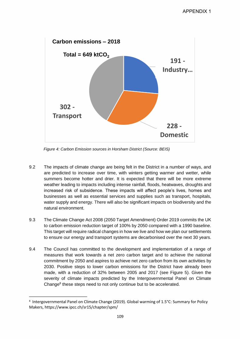
109
Figure 4: Carbon Emission sources in Horsham District (Source: BEIS)
9.2 The impacts of climate change are being felt in the District in a number of ways, and
are predicted to increase over time, with winters getting warmer and wetter, while
summers become hotter and drier. It is expected that there will be more extreme
weather leading to impacts including intense rainfall, floods, heatwaves, droughts and
increased risk of subsidence. These impacts will affect people’s lives, homes and
businesses as well as essential services and supplies such as transport, hospitals,
water supply and energy. There will also be significant impacts on biodiversity and the
natural environment.
9.3 The Climate Change Act 2008 (2050 Target Amendment) Order 2019 commits the UK
to carbon emission reduction target of 100% by 2050 compared with a 1990 baseline.
This target will require radical changes in how we live and how we plan our settlements
to ensure our energy and transport systems are decarbonised over the next 30 years.
9.4 The Council has committed to the development and implementation of a range of
measures that work towards a net zero carbon target and to achieve the national
commitment by 2050 and aspires to achieve net zero carbon from its own activities by
2030. Positive steps to lower carbon emissions for the District have already been
made, with a reduction of 32% between 2005 and 2017 (see Figure 5). Given the
severity of climate impacts predicted by the Intergovernmental Panel on Climate
Change8 these steps need to not only continue but to be accelerated.
8 Intergovernmental Panel on Climate Change (2019). Global warming of 1.5°C: Summary for Policy Makers, https://www.ipcc.ch/sr15/chapter/spm/
191 -Industry …
228 -Domestic
302 -Transport
Carbon emissions – 2018
Total = 649 ktCO2
APPENDIX 1

110
Figure 5: Carbon emission reductions in Horsham (2005 - 2018) and trends, against Climate Change
Act commitments (Source: UK local authority and regional carbon dioxide emissions national
statistics, BEIS)
9.5 The need to mitigate and adapt to climate change is therefore a key objective of this
plan. Carbon reduction will need to be delivered through a number of measures,
including indirectly through the provision, and increased level of, local employment,
thereby reducing commuting distances.
9.6 In order to demonstrate how proposals will minimise the impacts of and adapt to
climate change, planning proposals will need to be accompanied by information
proportionate to the scale of development proposed in the form of a Sustainability
Statement. This should set out how the development has taken measures to mitigate
and adapt to the effects of climate change (Policy 36), how the development has
considered the energy hierarchy (Policy 37), and how sustainable design and
construction measures have been incorporated into development design (Policy 38).
Positive weight will be given to low carbon and renewable energy schemes that have
clear evidence of local community involvement and to carbon emission reductions
resulting from renewable energy proposals. However, such schemes will also need to
ensure that they do not have significant adverse effect on landscape character,
biodiversity, heritage or cultural assets or amenity value.
9.7 A Climate Change Supplementary Planning Document, to support Policies 36, 37 and
38 will provide further guidance on these matters.
-400.0
-200.0
-
200.0
400.0
600.0
800.0
1,000.0
1,200.0Carbon emission trajectory for Horsham
UK wide
commitment
to net zero
emissions by
2050 - (Climate
Change Act
2008 as
amended)
APPENDIX 1
111
Strategic Policy 36: Climate Change
9.8 This policy is an overarching policy, designed to ensure the impacts of climate change
are fully considered from the onset of early design. This includes ensuring sustainable
and active modes of transport and forms of movement are actively promoted as an
alternative to private car use to reduce vehicle miles and transport related carbon
emissions (see Policy 41).
9.9 New development will ultimately need to be net zero carbon in construction and
operation. To work towards this, new development in Horsham District should
maximise the smart use of renewable energy, enable the decarbonisation of our
energy supply, use renewable or low carbon heat sources and be highly energy
efficient to minimise energy demand and heat losses.
9.10 Planning can have also a key role in shaping places to help minimise vulnerability and
provide resilience to the effects of climate change. Development should be adapted
for the climate it will experience over its lifetime, so that communities can live, work,
rest and play in a comfortable and secure environment in the face of inevitable climate
change.
9.11 Proposals should incorporate flexible climate change reduction and adaptation
technologies in order to accommodate technological advancements throughout the
plan period. New development should be designed to adapt to more intense rainfall,
the possibility of flooding, heatwaves and droughts. The design of development needs
to take account of matters such as shading, insulation, passive ventilation, storage and
surface water runoff and the use of appropriate tree and other planting. Future proofing
buildings now will result in reduced requirements for retrofitting in the future as
regulations tighten. Buildings with better environmental performance also have lower
energy costs thereby reducing fuel poverty.
9.12 Existing buildings contain embodied carbon (i.e. carbon that was emitted during the
construction process) and so it is important that that this already emitted carbon is not
wasted through the needless demolition of existing structures. Where demolition is
unavoidable, applications will be required to demonstrate how the onsite embedded
carbon has been retained.
Strategic Policy 36 - Climate Change
Carbon Reduction
1. Development proposals will only be supported where they include measures which
contribute to achieving net zero carbon emissions across the District by 2050 at the
latest. The Council will be supportive of a range of measures to achieve this target,
including but not limited to:
APPENDIX 1

112
a) Design which incorporates high standards of energy efficiency including optimal
levels of thermal insulation, passive ventilation and cooling and passive solar design;
b) The use of renewable and low carbon energy supply systems and connection to
renewable and low carbon heat networks;
c) The efficient use of natural resources used in new buildings to reduce the
environmental impacts of construction;
d) Design that influences the behaviour of occupants to reduce energy use;
e) Using patterns of development and providing sustainable transport infrastructure
which reduce the need to travel, encourage walking and cycling and include good
accessibility to public transport and other forms of sustainable transport and ensure
residents have access to services and facilities that are within walking distance;
f) Reduce whole life carbon emissions by retaining and reusing existing buildings,
components or materials, including onsite where possible.
Climate Change Adaptation
2. Development will only be supported if it includes site and building level measures to
adapt to the future impacts of climate change and reduce vulnerability, particularly in
terms of the comfort, health and wellbeing of current and future occupiers. Flood risk,
water supply, overheating and changes to the District's landscape should also be
considered. Measures should include but are not limited to:
a) Use of site and interior building layout: new buildings should be orientated to
maximise the opportunities for both natural heating and ventilation and to reduce the
exposure to wind and other elements, and the potential for overheating;
b) The conservation of water supplies to minimise the risk and impact of drought and
flooding;
c) The use of green/blue infrastructure and dual use Sustainable Urban Drainage
Systems (SUDS) to provide multifunctional benefits such as helping to absorb heat,
reduce surface water runoff, provide flood storage capacity and assist habitat
migration; and
d) Moderating external temperatures through the use of green walls and roofs, tree
planting or other nature-based solutions and landscaping for shade and drainage
design.
3. Development will be supported providing it avoids responses to climate impacts which
lead to increases in energy use and carbon dioxide emissions. In considering the likely
impact of climate change over the lifetime of the development reference should be made
to the most recent climate change projections.
Sustainability Statement
4. Development will be supported provided a Sustainability Statement is submitted which
demonstrates how the development has taken measures to mitigate and adapt to the
effects of climate change.
APPENDIX 1

113
Policy 37: Appropriate Energy Use
9.13 Without mitigation, there is potential for future development in Horsham District to have
a significant impact on the consumption of energy and resources, which in turn will
contribute to climate change, including global heating.
9.14 This policy seeks to ensure that developments consider the most appropriate energy
use as a means of improving efficiency into their design. There is an expectation that
developments will be constructed to energy performance standards that push beyond
Building Regulations in order to work towards achieving carbon neutrality by 2050 or
earlier. In order to reach net zero carbon, both supplies of electricity and heat to new
buildings will need to be decarbonised (i.e. not derived from fossil fuels such as coal,
oil or gas).
9.15 The Planning and Energy Act 2008 allows local planning authorities to impose
reasonable requirements for:
a) a proportion of energy used in development in their area to be energy from
renewable sources in the locality of the development;
b) a proportion of energy used in development in their area to be low carbon
energy from sources in the locality of the development;
c) development in their area to comply with energy efficiency standards that
exceed the energy requirements of building regulations.
9.16 The development of renewable and low carbon energy is a key means of reducing the
District's contribution to climate change. Renewable and low carbon energy can
encompass a wide range of technologies including combined heat and power (CHP);
combined cooling, heat and power (CCHP); district heating, energy from waste, wind
(large and small scale), biomass, solar (thermal and photovoltaics) and heat-pumps.
9.17 Achieving zero carbon by 2050 will require existing properties to be retrofitted to
reduce their energy demands and reliance on fossil fuels for heating and electricity.
Whilst much of this will need to be achieved outside the planning system, it should be
noted that due to the emissions performance standards required, the Future Homes
Standard effectively prohibits the installation of individual gas boilers in newly built
properties from 2025. To avoid unnecessary costs in the future, new homes
constructed prior to 2025 should be heated through zero or low carbon sources as
opposed to gas boilers.
9.18 Due to the variations in the suitability, type and scale of energy resources which could
be used throughout the District, a bespoke renewable/low-carbon sourced energy
target will be expected for individual proposals, which should be justified in the Energy
Statement that accompanies the planning application. This will ensure that
opportunities for greater carbon savings are maximised through renewable and low-
carbon sources. Horsham District Council will work proactively with developers to
APPENDIX 1

114
ensure these requirements are met. The Energy Statement should also consider how
the scheme’s energy performance will be monitored against targets.
9.19 Support will be given to community initiatives which are used to deliver renewable and
low carbon energy, especially when considered as part of a Neighbourhood Plan.9.20.
Renewable energy proposals will need to consider the impact that they may have on
protected landscapes. This includes the need to take into account views from
protected landscapes to proposals which lie outside the South Downs National Park
or High Weald AONB. Policy 29 sets out the Council’s further requirements.
Policy 37: Appropriate Energy Use
Energy Hierarchy
1. Development will be supported provided that it contributes to clean, efficient energy in
Horsham based on the following cascade:
a) Be Lean – use less energy – for example, by minimising energy demand through
energy efficiency measures such as fabric performance and passive design;
b) Be Clean – supply energy efficiently and exploit local energy resources such as
secondary heat and district energy networks where available. Preference must be
given to technologies with greater efficiencies and fuels with lower carbon emissions
to achieve the highest total lifecycle carbon emission savings, in accordance with
Part 2 of this policy;
c) Be Green – maximise the use of renewable energy sources.
Zero and Low Carbon Heating
2. Development proposals must demonstrate how they will provide zero and low carbon
heating in accordance with the following hierarchy. Evidence must be provided that
opportunities to meet each level of the hierarchy have been exhausted before cascading
to the next level:
a) Connect to local existing or planned heat networks*, in combination with on-site
renewable energy generation;
b) Maximise use of on-site renewable energy generation;
c) Use of the optimum means of low or zero-carbon heat supply is demonstrated, based
on the in order of preference below:
i. Use of waste heat sources;
ii. Electrically-driven ground, water or air source heat pumps;**
iii. Direct Electric Heating. **
Energy Statements
APPENDIX 1

115
3. Residential or commercial development will be supported provided that it includes an
Energy Statement, (which may be incorporated into the Sustainability Statement),
demonstrating how compliance with this policy has been achieved.
Renewable Energy Schemes
4. Stand-alone renewable energy schemes will be supported where they do not conflict
with other policies in this plan. Renewable and low carbon energy generation
developments that are led by, or meet the needs of, local communities will carry
significant weight.
*Where a local heat network is planned but not yet in existence or connection is not currently viable,
but may become viable in the future, the development should be designed to allow for the cost-
effective connection and supply at a later date. In this case the heat should be supplied according to
steps 2b and 2c of the above hierarchy.
**Electric heat pumps and direct electric heating are assumed to become zero-carbon when the
national grid decarbonises.
Strategic Policy 38: Sustainable Design and
Construction
Sustainable Design
9.20 Sustainable design has a key role to play in mitigating the environmental impact of
growth, during the both the construction phase and lifetime of the development. This
policy seeks to ensure that new development is designed and constructed in a way
that helps the District achieve zero carbon emissions by 2050, as well as enabling
flexibility in design to enable buildings to be easily adapted, to reflect changing lifestyle
needs and to mitigate against and/or adapt to the impacts of climate change.
9.21 Because of the UK’s carbon emission reduction target, no development should be
planned without demonstrating that it is fit to take its place in a net-zero emissions
future as this will avoid costly retrofitting at a later date.
9.22 In light of the Government’s agenda on climate change, and the key objectives of this
plan, a greater minimum reduction in regulated CO2 emissions is now sought as best
practice. The overall reduction, as outlined in this policy, shall be delivered through a
combination of energy efficiency measures and on-site renewable energy generation.
9.23 The Building Research Establishment Environmental Assessment Method (BREEAM)
is an accredited, independent method for assessing the environmental performance
of non-domestic development. Non-domestic development should be assessed
against the BREEAM standard and should achieve BREEAM ‘Excellent’ under this
APPENDIX 1
116
standard. The Council will require the BREEAM standard to be verified by an
independent assessor at the applicant’s cost.
9.24 Construction materials play a key role in reducing the environmental impact of all
development. The use of low-impact and biodegradable materials (natural, local and
reclaimed) with low whole life carbon emissions contributes to the national
commitment of becoming net-carbon zero. Applicants can source further information
in The Green Guide by the Building Research Establishment (BRE).
Retrofitting Existing Buildings
9.25 Retrofitting involves incorporating measures into existing buildings to reduce the
demand for energy and resources. Simple measures include insulation or double
glazing to reduce the amount of heat lost through the roof, walls and windows, and
introducing technologies to generate renewable energy on site. As 35% of Horsham
District’s carbon emissions comes from existing domestic properties and 30% from
commercial premises, improving the energy efficiency of existing buildings will be a
key factor in helping to achieve the net zero carbon emissions goal.
9.26 Much of this retrofitting will take place outside the planning process, or through
permitted development, but there are some occasions where planning consent is
required. This is particularly the case for heritage assets such as listed buildings, and
properties located within a Conservation Area. Applicants should therefore also refer
to Policy 34 of this document and Historic England’s suite of ‘Energy Efficiency and
Historic Buildings’ guidance or any relevant update.
Water Resources
9.27 Water is an essential resource and has a critical part to play in contributing to the
economy, ecosystems and overall health of the population. Much of the South East
has now been designated as an ‘area of serious water stress’ by the Environment
Agency, with demand for water exceeding supply. Water in Horsham District is
supplied from abstraction at Hardham (located in the South Downs National Park), and
over abstraction will lead to the loss of integrity of the Arun Valley SPA, SSSI and
Ramsar site. Climate change has the potential to place further stress this supply,
causing longer periods of drought and reducing river flow which could impact on the
quality of rivers and increase demand for water use. This is something which is
recognised in the Water Resource Management Plans (WRMP) produced by Southern
Water and Thames Water, and will in part need to be addressed through investment
and water saving measures outside the remit of planning.
9.28 In order to ensure that water supplies can be maintained and the environment be
protected, the Council propose that all new housing should meet a tighter level of water
efficiency and provide measures that contribute to the aim of water neutrality, and as
a minimum, does not increase demand for water over existing levels. This will include
designing new strategic scale development to incorporate measures such as
greywater recycling and rainwater harvesting from the outset. Measures may also
APPENDIX 1

117
include provision of garden water butts, low flush toilets, low volume baths, aerated
taps, and water efficient appliances. It is important to note that water efficiency
measures are not finite limits to water use within a property after which water supplies
are cut off but a means of providing measurable targets to lower water consumption
levels.
9.29 Other policies in this Local Plan further support sustainable design. Development will
be required to include electric vehicle charging points in accordance with Policy 42.
Policy 30 seeks enhancement of green infrastructure which will further benefit carbon
reduction and assist with ensuring the development is adapted to a changing climate.
Strategic Policy 38: Sustainable Design and Construction
1. Development will be supported where it is demonstrated that sustainable design,
including its construction and operation, is integrated into the development from the
design stage onwards. To deliver sustainable design, development will only be
supported where it meets all of the following requirements that are relevant:
a) New-build homes deliver a minimum 35% overall reduction on the Dwelling
Emission Rate (DER) against the Target Emission Rate (TER) based on the 2013
Edition of the 2010 Building Regulations (Part L), of which:
i. A minimum 10% reduction is through energy efficiency measures; and
ii. The residual additional reduction is achieved through on-site renewable
energy generation or connection to a heat network.
b) New non-domestic buildings to achieve a BREEAM rating of ‘Excellent’ unless it
can be demonstrated that this would make the scheme unviable;
c) New residential development achieves a water efficiency of 100 litres/person/day.
Development above 200 homes is expected to achieve 80 litres/person/day and
incorporate site wide measures to conserve and reduce water consumption,
including grey water recycling;
d) New non-domestic buildings to achieve the maximum credits in BREEAM category
Wat 01 Water Consumption;
e) Minimise construction and demolition waste, utilise recycled and low-impact
materials and incorporate measures that reduce the amount of biodegradable
waste sent to landfill;
f) Be designed flexibly to enable future modification of use or layout, facilitating future
adaption, refurbishment and retrofitting;
g) Include the provision of gigabit capable broadband access and enable provision of
future communication technologies;
2. Where permission is required to retrofit energy efficiency measures into existing
development, schemes will be supported in principle.
3. Development that involves the retrofitting of an existing historic building (heritage asset)
will be supported provided that the following criteria are met:
a) It does not result in detriment to the significance of the asset or damage to its
fabric;
b) A whole building approach to improving energy efficiency is taken as advocated by
Historic England;
APPENDIX 1

118
c) Micro-renewable technologies do not result in harm to the heritage asset or their
setting;
d) Where the proposal involves major development, it is demonstrated that
opportunities for the retention and retrofitting of existing historic buildings within the
site boundary have been included within the scheme.
4. In order to demonstrate compliance, proposals should be accompanied by a
Sustainability Statement to demonstrate how these measures will be incorporated into
development design.
Strategic Policy 39 - Flooding
9.30 This policy aims to ensure development adapts to the changes in the future climate
and that flood risk is not increased. It also accords with the ‘Wilder Horsham’ objective
to maximise opportunities to protecting and enhance wildlife.
9.31 Flooding is a natural process that can happen at any time, in a variety of locations. It
can arise from rivers, the sea, directly from rainfall on the ground’s surface or from
rising groundwater levels, overwhelmed sewers and drainage systems. In the future
the risk of flooding is expected to increase as a result of climate change, which is
predicted to bring more intense rainfall events that could lead to more frequent flooding
events occurring and new areas becoming vulnerable to flooding.
9.32 The Council has undertaken Strategic Flood Risk Assessments (SFRAs) which cover
the Adur, Arun and Upper Mole catchment areas, and a Gatwick Sub Region Water
Cycle Study with neighbouring local authorities. The recommendations arising from
these studies have informed this policy to ensure flood risk is appropriately managed
in the District.
9.33 Approximately 6% of the District is classed as flood zone 3a or 3b which is considered
the 'functional floodplain'. Development activity should be located away from these
areas and in addition will need to undertake site specific flood risk assessments (FRAs)
that:
Meet the recommendations of the latest Strategic Flood Risk Assessments;
Assess the risk of all forms of flooding;
Investigate groundwater flooding in detail either where located in the south of the
District, or where a site is located in groundwater emergence zone; and
Identify options for mitigation.
9.34 The impact that development can have on flood risk as a result of increased run-off or
changing drainage patterns must also be considered. To ensure development does
not increase flood risk, developments will be required to incorporate sustainable urban
drainage systems (SUDS) to help manage flood risk. SUDS manage surface water
and groundwater sustainably and help to reduce flood risk, minimise diffuse pollution,
maintain or restore natural flow regimes, improve water resources and enhance
APPENDIX 1

119
amenity. Sewer flooding is also an issue, and to minimise the risk of sewer overload,
development will not be allowed to drain to the foul sewer. It is important SUDS are
appropriate in scale and location. They should be incorporated into the Council's
Green Infrastructure network as much as possible.
9.35 The West Sussex County Council Local Flood Risk Management Strategy identifies
the responsibilities for flooding within the county and enables a range of organisations
to work together to improve the management of flood risk. Early discussion with the
appropriate flood risk management authority on SUDS for appropriate management
techniques will be required.
9.36 Where appropriate, development will be encouraged to look for ways to improve water
quality to ensure the objectives of the Water Framework Directive or any future
legislative updates can be met.
Strategic Policy 39: Flooding
1. Development proposals will only be supported where they follow a sequential approach
to flood risk management, so that priority is given to development sites with the lowest
risk of flooding, where shown to be safe, and shown not to increase flood risk elsewhere.
2. Development proposals will be supported provided that they meet all of the following
that are relevant:
a) Consider flood risk at an early stage in deciding the layout and design of the site;
b) Take a sequential approach to ensure most vulnerable uses are placed in lowest
risk areas;
c) Are not located on the functional floodplain (Flood Zone 3b), except for water-
compatible uses and essential infrastructure;
d) Where located in Flood Zone 2 and 3, have undergone a sequential test and, if
necessary, exceptions test, using a 1 in 100 annual probability flood level including
an appropriate allowance for climate change;
e) Not result in a net loss of flood storage capacity, and not adversely affect flood
routing and thereby increase flood risk elsewhere;
f) If over 1 hectare and in Flood Zone 1, or in Flood Zone 2 and 3, are accompanied
by a site-specific Flood Risk Assessment;
g) Comply with the tests and recommendations set out in the Horsham District
Strategic Flood Risk Assessments (SFRAs);
h) Where there is the potential to increase flood risk, incorporate the use of sustainable
urban drainage systems (SUDS) unless technically unfeasible, or incorporate water
management measures which reduce the risk of flooding and ensure flood risk is not
increased elsewhere;
i) Make appropriate provision for surface water drainage to ground, water courses or
surface water sewer. Development will not be allowed to drain to the foul sewer;
j) Where technically feasible, utilise drainage techniques that mimic natural drainage
patterns and manage surface water as close to the source as possible;
APPENDIX 1

120
k) Comply with the objective of the Water Framework Directive, and with the findings
of the Gatwick Sub Region Water Cycle Study, in order to maintain water quality and
water availability in rivers and wetlands and wastewater treatment requirements; and
l) Include a management plan to maintain the flood water assets in perpetuity.
3. New development which incorporates SUDS will be supported where it considers
amenity value, green infrastructure, local ecological resources including water quality
and biodiversity, natural flood management methods, and contributes towards
environmental net gain. An appropriately detailed assessment should be submitted to
demonstrate an appropriate SUDS strategy.
APPENDIX 1

121
Chapter 10 - Infrastructure, Transport and Healthy Communities
The following issues will be addressed through the policies in this chapter:
There are already infrastructure deficits within and around Horsham District. These
include a need to upgrade the transport infrastructure, wastewater treatment, health
care provision and to ensure there is sufficient provision of school places for all
children.
A key concern amongst existing and new residents is access to healthcare facilities.
There is a network of GP health centres across the District but some of these will
require expansion to meet future needs. A further concern of residents is the lack of
a nearby hospital with A & E facilities.
In addition to healthcare, the Local Plan will need to ensure that other key facilities
are provided, including primary and secondary schools. There is also a need to
make sure that special educational needs and disabilities (SEND) and alternative
provision (provision for children who have been excluded from mainstream
education) is delivered to make sure that all children can access the education that
they require.
There is a need to ensure development is designed to enable healthy lifestyles. This
includes incorporating walking and cycling into everyday life, and ensuring access
to green spaces, sport and recreation facilities.
There will still need to be a focus on providing health services for all sectors of the
population, including teenagers and young adults. The ageing structure of the
population of the District will increase the pressure for healthcare services for the
elderly and their carers. In the future, properties need to be designed to be
adaptable for all ages and the needs of the wider community.
At present, public transport services in much of the District are limited. There is no
direct rail service in many settlements and railway stations are often very busy during
peak travel times. Unless individuals have access to the private car, transport
access to GPs, hospitals and other services can be particularly difficult.
New development is likely to generate increased traffic on the wider road network
and the need for car parking facilities. It will be essential that the effect of increased
traffic generation from all new development, both individually and cumulatively, is
considered. The wider road network beyond the District (particularly the A23/ M23)
should be taken into account.
APPENDIX 1

122
Strategic Policy 40: Infrastructure Provision
10.1 Infrastructure is a term used to refer to a range of services such as roads, railways,
public transport, water supplies and sewerage capacity, electricity, education and
healthcare facilities, and sport and recreation and other community facilities as well as
green infrastructure (Policy 30). The delivery of this infrastructure is fundamental to
delivering great places to live that are self-sustaining communities. There are existing
infrastructure pressures facing Horsham District and in surrounding districts and
boroughs. It will be important to consider the cumulative impacts of any development
on current and existing infrastructure both within the District and in nearby
communities.
10.2 Much of the infrastructure needed to support development is not provided directly by
the Council. Horsham District has a strong track record of actively engaging with
infrastructure providers to ensure that the needs of the residents and businesses in the
District are met. This ranges from public sector partners such as the NHS on health
care, West Sussex County Council on matters such as education and transport, and
key utilities providers such as Southern Water, together with developers who are
promoting development. This ongoing work has helped to bring forward
enhancements and upgrades across the District, which have over the years included
the redevelopment and expansion of Piries Place car park in Horsham, The Bridge
leisure centre in Broadbridge Heath, an upgraded Health Care centre in Steyning.
10.3 Whilst it is not the role of new development to resolve existing deficiencies, any new
development will need to provide sufficient community facilities, services and
infrastructure to meet the needs of new development and ensure thriving healthy
communities and to not create additional burden. New development will also need to
be mindful of the existing deficit and consider whether there are opportunities for
existing communities to benefit from any new provision.
10.4 The required upgrades to infrastructure necessary to support development are set out
in the Council’s Infrastructure Delivery Plan. These will usually be funded through
Community Infrastructure Levy (CIL) payments. Some larger scale strategic scale
development will secure the required infrastructure upgrades and will be delivered
through S106 agreements as may be appropriate. In addition, delivery of key
infrastructure through other funding sources, including national government investment
schemes, will be investigated and bids will be made where this is appropriate.
10.5 It will be essential for infrastructure to be provided in a timely way that meets the needs
of the new development as it comes forward. Studies to determine whether the
proposed development will lead to overloading of existing infrastructure may be
required to support planning applications. It will also be necessary to understand from
key infrastructure providers the timing and delivery of any key new upgrades that may
be necessary, such as road upgrades or new water treatment facilities, and the level
of development that can come forward prior to the completion of these upgrades, as
this may impact on the speed at which the new development can come forward.
APPENDIX 1

123
10.6 With regard to wastewater treatment matters, developers are encouraged to contact
the water/wastewater infrastructure provider as early as possible to discuss their
development proposals and intended delivery programme to assist with identifying any
potential water and wastewater network reinforcement requirements. Where there is a
capacity constraint, the Local Planning Authority will where appropriate, apply phasing
conditions to any approval to ensure that any necessary infrastructure upgrades are
delivered ahead of the occupation of the relevant phase of development.
Strategic Policy 40: Infrastructure Provision
1. The release of land for development will be dependent on there being sufficient capacity
in the existing local infrastructure to meet the additional requirements arising from new
development, or suitable necessary mitigation arrangements for the improvement of the
infrastructure, services and community facilities caused by the development being
provided.
2. Where there is a need for extra capacity, this will need to be provided in time to serve
the development or the relevant phase of the development, in order to ensure that the
environment and amenities of existing or new local residents is not adversely affected.
3. To ensure required standards are met, arrangements for new or improved infrastructure
provision will be secured by Planning Obligations/Community Infrastructure Levy, or in
some cases contributions attached to a planning permission, so that the appropriate
improvement can be completed prior to occupation of the development, or the relevant
phase of the development.
Strategic Policy 41: Sustainable Transport
10.7 Access and ease of movement are important considerations in good place-making,
and therefore also in creating strong, safe and healthy communities. Efficiency of
movement is also critical to the local economy, enabling residents to travel to their
place of work, and also allowing the movement of goods and services.
10.8 A particular challenge for Horsham District is the high levels of car ownership and car
use. Around half of households in the District own two or more cars which is
significantly higher than the regional average. Outside the towns, bus services in the
District are often limited, and cuts in funding may affect this further in the future. The
Arun Valley railway line runs through the District and there are eight stations which
have relatively frequent services, with the exception of Faygate, at which very few
trains stop. The long-term impact of Covid-19 on travel patterns is not yet known, but
many of these stations are normally very well used in peak hours. However, many of
the settlements in the east of the District do not have direct access to a railway station.
10.9 There is a growing recognition of the challenge presented by climate change, and the
role that transport has to play in attaining net zero carbon. This will include the
transition to Electric Vehicles. There is also increasing levels of congestion on the
APPENDIX 1
124
District’s road networks and beyond, which is impacting more and more on people’s
quality of lives and the local environment. In line with national policies, this Local Plan
looks to more innovative and sustainable approaches to travel and movement,
reflecting the challenges and also the opportunities presented by people’s changing
lifestyle choices, driven by changes to technologies. This approach provides clear
benefits to people’s physical and mental health, and promotes social inclusion, for
example for the District’s growing elderly population.
10.10 Policy 42 supports the wider spatial strategy, which seeks to establish patterns of
strategic development that improves opportunities for home working, local journeys
within neighbourhoods, walking, cycling and the use of public transport. This includes,
where appropriate, supporting Demand Responsive Transport Services to connect our
rural communities, and supporting electric vehicle use wherever possible.
10.11 There is an expectation that this policy will seek to ensure that sustainable forms of
transport are considered in the first instance, with the provision of safe walking and
cycling facilities. Options for public transport including access to bus and rail services
will need to be considered, and for larger development proposals there is an
expectation that mechanisms to increase the uptake of this form of transport will be
provided at an early stage of operation. For developments that generate significant
amounts of movement, interventions should be documented in a Transport
Assessment or Statement submitted in support of the application, and a Travel Plan
produced to ensure measures are implemented and sustained. Impacts on the wider
strategic road network may also need to be considered.
10.12 The West Sussex Transport Plan 2011-2026 sets out the strategy for guiding future
investment in highways and transport infrastructure across West Sussex. It also sets
a framework for considering transport infrastructure requirements associated with
future development across the county. The Council will work with West Sussex County
Council and other transport and service providers and developers to improve
accessibility to key services and facilities and provide an improved and better
integrated transport network.
10.13 The following strategic improvements to transport networks are supported by the
Council in the medium to long term. All improvements should be designed to provide
safe and attractive passage for pedestrians and cyclists. These will be facilitated
primarily by the development of strategic sites, and supported as necessary through
further developer funding:
A ‘middle section’ Western Crawley Link Road, as part of the West of Ifield
development
A full Western Crawley Link Road (sections of which may be delivered beyond
the Plan period)
Major junction upgrade at Buck Barn (A24) and associated improvements to
the A24/B2135 Steyning Road junction
Main network junction upgrades at Washington Roundabout (A24/A283), Hop
Oast Roundabout (A24/B2237) and Moorhead Roundabout (A24/A264)
APPENDIX 1

125
Mitigation of junctions at Cowfold (A272/A281), Storrington (A283/B2139) and
Pulborough (A29/A283).
10.14 The Council has worked with partners to produce a Local Cycling and Walking
Infrastructure Plan (LCWIP). This sets out cycling and walking network plans, and a
prioritised programme of improvements for future investment. Policy 41 expects
development to have regard to this programme together with any relevant government
guidance including LTN120 – Cycle Infrastructure design, or any future updates.
Strategic Policy 41 - Sustainable Transport
1. Development will be supported provided the following is demonstrated:
a) For residential development, the need for travel is minimised through provision in all
homes for home working, including bespoke-design space within the home and
gigabit capable broadband connection;
b) The layout, design and location of facilities and infrastructure maximise the potential
for residents and workers to safely and conveniently walk and cycle to meet their
day-to-day work, shopping and leisure needs;
c) Walking and cycling routes are designed to be attractive, direct and legible, have
priority over motorised traffic, and integrated with the existing and wider network;
d) Where feasible, provision is made for bus travel and infrastructure within the
development, to include as appropriate the provision or improvement of bus stops
and weather-proof shelters, information on service schedules, and bus priority over
other motorised traffic movement;
e) All opportunities have been explored to maximise access to passenger rail services,
primarily by walking, cycling and bus, but if appropriate by private car including the
enhancement of rail station car parking where feasible;
f) Innovative approaches to sustainable movement and communication are fully
considered, including demand responsive rural transport services where scheduled
services are not feasible, on-demand cycle and scooter hire, and electric bus.
2. Development will be supported where it demonstrates how the priorities and principles
set out in the West Sussex Transport Plan 2011-26, LTN120, Cycle Infrastructure
design, and the Horsham Local Cycling & Walking Infrastructure Plan (LCWIP), or any
subsequent updates have been adhered to.
3. Proposals for major development shall be accompanied by a transport assessment or
statement. Where the potential impact of the development on the network is deemed to
be significant, or as a result of needing to address an existing local traffic problem, a
Travel Plan will need to be prepared. These should be prepared in line with advice from
the Local Highway Authority.
APPENDIX 1

126
Policy 42: Parking
10.15 Although it is important to reduce the reliance on the car as far as possible, Horsham
District is rural in character and there will still be a need to travel by this means. It will
therefore be important to ensure that sufficient car parking facilities are provided in
residential developments, at employment sites and in town centres whilst ensuring that
they are suitably located and do not conflict with other uses. In order to reduce reliance
on the car it is important to provide adequate bicycle storage in dwellings and
residential areas to encourage bicycle ownership and bicycle use.
10.16 The number of parking spaces provided should take into account any available
guidance, such as the West Sussex County Council Guidance on Parking at New
Developments, and any future District parking standards guidance adopted by the
Council.
10.17 The need to reduce vehicle emissions as a means of achieving net zero carbon and
improving air quality is recognised nationally, and the transition to electric vehicles will
take place over the plan period. Parking facilities will be expected to provide electric
charging points to ensure that the increasing number of electric vehicles can be
supported.
10.18 This policy also addresses the issue of off airport parking in relation to Gatwick Airport,
which is close to the District boundary with Horsham. It is the responsibility of the
Gatwick Airport operator to ensure that passenger access to the airport is managed
and controlled. Gatwick Airport Ltd provides facilities for airport related parking and is
responsible for meeting targets for a modal shift to sustainable modes of transport to
access the airport. There are also a number of well-established businesses with the
appropriate planning consents which provide long-stay airport related parking in off-
airport locations. Locations within the airport boundary will remain the most sustainable
places for airport parking, and in general additional off airport facilities will not be
considered acceptable.
Policy 42: Parking
1. Development should seek to improve parking in town centres so it is convenient,
safe and secure. Parking provision must ensure a balance between good urban
design, highway safety, residential amenity and promoting town centre
attractiveness and vitality.
2. Adequate parking facilities must be provided within developments to meet the
needs of anticipated users. Consideration should be given to the needs of
motorcycle parking, and vehicles for the mobility impaired.
APPENDIX 1

127
Policy 43 - Gatwick Airport Safeguarding
Safeguarding Land for Gatwick Airport
10.19 Land around Gatwick Airport is currently safeguarded to allow for the future expansion
of the airport if necessary. Most of this safeguarded area is located within the
administrative boundary of Crawley Borough, but a small area in the far north east of
the District is located in this area.
10.20 The National Planning Policy Framework sets out that planning policies should identify
and protect, where there is robust evidence, sites and routes which could be critical in
developing infrastructure to widen transport choice and realise opportunities for large
scale development. In December 2018, the Government published a consultation
document 'Aviation 2050: The future of UK aviation'. This Green Paper highlights the
importance of aviation to the UK economy.
10.21 This document also refers to the importance of the safeguarding of land for growth. It
advises that it is prudent to continue with a safeguarding policy to maintain a supply of
land for future national requirements and to ensure that inappropriate developments
do not hinder sustainable aviation growth.
10.22 Further details of the Government’s Aviation Strategy are anticipated. The Council
considers that until further clarification on this matter is provided by Government, it is
expected that the safeguarded land should continue to be safeguarded until a point at
which point the requirement for this policy is reviewed.
3. Adequate, safe and secure parking and overnight storage facilities for bicycles
must be provided within developments to encourage the use of sustainable
modes of transport.
4. Adequate parking and plug-in charging facilities must be provided to cater for
the anticipated increased use of electric, hybrid or other low emission vehicles.
5. Plug-in charging facilities for all new residential parking spaces must be provided
or at minimum the infrastructure to enable easy installation in future.
6. Where off street parking is not provided within a development proposal, the
design and layout should incorporate infrastructure to enable the on-street
charging of electric or other vehicles.
7. For residential development with communal off-street parking provision, at least
20% of spaces must have active charging facilities and the infrastructure to
enable easy activation of all spaces as demand increases.
8. Development which involves the loss of existing parking spaces will only be
allowed if suitable alternative provision has been secured elsewhere or the need
for the development overrides the loss of parking and where necessary
measures are in place to mitigate against the impact.
9. Proposals for additional or replacement airport related parking, including long-
and short-term parking for passenger vehicles, will not be permitted.
APPENDIX 1

128
Aerodrome Safeguarding
10.23 Aerodrome safeguarding is a legal requirement set out by the International Civil
Aviation Organisation (ICAO). Legal requirements are embedded into the Town &
Country Planning process through the DfT/ODPM Circular 01/2003 ‘Safeguarding of
Aerodromes, Technical Sites & Military Explosives Storage Areas: The Town &
Country Planning (Safeguarded Aerodromes, Technical Sites & Military Explosive
Storage Areas) Direction 2002. It seeks to ensure the continued safe operation of
airport related activity when new development proposals close to aerodromes come
forward.
10.24 This policy will ensure that the requirements of aerodrome safeguarding are taken into
account in the planning and design of development. The aerodrome safeguarding zone
is shown on the Planning Policies Map. The northern and eastern parts of the District,
including the whole of Horsham Town, lie within the safeguarded area, although it
should be noted that the safeguarded area is neither the responsibility nor the proposal
of the Council.
10.25 Gatwick Airport Ltd should be consulted by developers for advice on planning
applications within the aerodrome safeguarding area. Developers should also refer for
general awareness to the AOA (Airport Operators Association) technical aerodrome
safeguarding advice notes available at www.aoa.uk/policy-campaigns/operations-
safety. Where required, the Council will consult with the airport operator and/or the
operator of technical sites (e.g. radar stations) on relevant proposals in the aerodrome
safeguarded areas.
10.26 Proposals that cannot be mitigated to the satisfaction of the statutory consultee are
considered to be a hazard to aircraft safety and will be refused.
Policy 43 – Gatwick Airport Safeguarding
Safeguarding Land for Gatwick Airport
1. Land identified on the Local Plan Policies Map will be safeguarded from development
which would be incompatible with expansion of the airport to accommodate the
construction of an additional wide spaced runway (if required by national policy) together
with a commensurate increase in facilities that contribute to the safe and efficient
operation of the expanded airport.
2. Minor development within this area, such as changes of use and small-scale building
works, such as residential extensions, will normally be acceptable. Where appropriate,
planning permission may be granted on a temporary basis. The airport operator will be
consulted on all planning applications within the safeguarded area.
Aerodrome Safeguarding
APPENDIX 1

129
3. Development in identified aerodrome safeguarding areas will only be supported if it is
consistent with the continued safe operation of Gatwick Airport. Where required, the
airport operator and/or the operator of technical sites (e.g. radar stations) will be
consulted on relevant proposals in the aerodrome safeguarded areas.
4. Applicants will be required to ensure that development proposals adhere to any
restrictions that are placed on the height or detailed design of buildings, structures or
other development in order to avoid impacts on the airport aerodrome, including those
relating to navigational aids, Instrument Flight Procedures (IFPs) or on developments
which may increase bird strike risk, create building-induced turbulence or lighting that
could pose a hazard to the safe operation of the aerodrome.
5. Proposals that cannot be mitigated to the satisfaction of the statutory consultee are
considered to be a hazard to aircraft safety and will be refused.
Strategic Policy 44 - Inclusive Communities,
Health and Wellbeing
10.27 The design of a development has a direct impact on the health and wellbeing of the
people who live there. Having facilities and services within walking and cycling
distance, and thought given early on to the routes people will use to access schools,
shops and places of work, for example, can encourage active modes of travel, with
direct health benefits. The Covid-19 pandemic has highlighted that the design and
layout of our homes and community space is vital to both our physical and mental
health with access to open green spaces proving particularly vital.
10.28 All development in the District should contribute to the creation of inclusive, accessible
and safe places which encourage healthy, active lifestyles and facilitate social
cohesion. Development should seek, wherever possible and where appropriate, to
address identified needs within communities. Access to a good range of healthy,
affordable food, to open space, good quality accommodation and a range of community
spaces and facilities will help to ensure the physical and mental health and social
wellbeing of individuals and communities is supported.
10.29 Overall, the health of the people living in Horsham District is very good. Average life
expectancy reported by the Office for National Statistics is 82 years for men and 85
years for women, which is higher than the national average and has improved in the
last 15 years. The resident population has an older age profile than the national
average, with many people choosing to retire here.
10.30 Access to healthcare facilities, including hospitals, can be difficult for rural residents,
particularly for those without access to a car. The nature of healthcare provision is
changing, with a greater emphasis on larger medical GP practices and on local
networks of healthcare providers sharing responsibility for delivering a range of
services. The need for a hospital has not been identified as required in this plan. The
Council will continue to work with the local Clinical Commissioning Group (CCG) and
APPENDIX 1

130
Primary Care Networks (PCNs) to ensure healthcare needs in the District can be met
and will work to ensure residents can access the services they need.
10.31 The rising age structure for the District will have implications for long term health,
illnesses and disabilities, particularly in relation to social and healthcare facilities and
for the types of accommodation the District will require in the future. As well as levels
of physical inactivity and diabetes, key areas of concern relating to ill health in the
District are age-related health conditions, such a dementia, and hearing and sight loss.
10.32 Alongside the delivery of healthcare infrastructure, development plays an important
role in ensuring communities are physically and mentally healthy and resilient. The
role of development in encouraging people to make healthy choices is recognised, and
development schemes which deliver an environment which supports good mental and
physical wellbeing, while minimising the negative health impacts arising from
development, will be supported.
10.33 The District has a low level of deprivation overall, with few Local Authority areas less
deprived and some of the least deprived areas in the country sitting within the Horsham
District. There are some pockets of deprivation. These areas include certain parts of
Itchingfield, Shipley and Warnham, Forest and Roffey South wards. Access to safe,
appropriate housing with access to facilities and services, and as part of a diverse,
mixed community is an important element of healthy, inclusive communities and is
covered by other Local Plan policies.
10.34 The majority of the population in Horsham District (96.1%) described themselves as
White British, Irish or Other, with just 2.7% of residents describing themselves as of
Black or of Minority Ethnic origin. 1.4% are of Mixed Ethnic Origin (2011 census). While
many of these groups are well integrated into communities in the District, specific
provision needs to be made for Gypsies and Travellers. Their specific accommodation
need is addressed separately in Policy 20.
10.35 Christianity is the dominant religion in the District, (63.5% of residents at the 2011
census). A significant minority (26.9%) considered themselves to have no religion.
There is however a continued need to recognise the requirement of different faith
groups in the District.
10.36 Strategic Policy 44 aims to ensure that all aspects of inclusivity, health and wellbeing
are considered when planning for and designing new development. Specific
requirements relating to these principles are set out in other policies in this Local Plan.
Strategic Policy 44 - Inclusive Communities, Health and Wellbeing
1. Development proposals must take positive measures to create socially inclusive and
adaptable environments to meet the long-term needs of a range of occupiers and users
and to ensure they support mixed, sustainable communities.
2. New development must be designed to achieve healthy, inclusive and safe places,
which enable and support healthy lifestyles and address health and wellbeing needs. It
should be designed with mental and physical wellbeing in mind and seek to minimising
APPENDIX 1

131
the negative health impacts arising from development. Proposal will be supported
provided that they address requirements stemming from:
a) The needs of an ageing population, particularly in terms of accommodation and
health;
b) The requirements of people with additional needs including sensory or mobility
difficulties, including the physically disabled and/or those with learning disabilities,
and support Horsham's status as a dementia-friendly District;
c) The requirements of rural workers or essential workers in rural areas;
d) The co-ordination of services to fulfil the needs of children and young people;
e) The specific needs of minority groups within the District, including Gypsies and
Travellers;
f) The specific needs of faith and other community groups; and
g) The need to protect and enhance existing community facilities, services and open
spaces, and /or to provide new facilities to meet the needs of existing and new
communities.
3. Development proposals should demonstrate consideration of the following:
a) How design and layout will promote active transport (such as walking and cycling)
to local services and facilities, including public transport hubs;
b) How the development will incorporate measures for climate change mitigation and
adaptation to reduce health risks to future users;
c) Access to green space, community facilities, services and healthy food; and
d) Best practice and relevant, up to date national or local guidance on delivery of
development which supports health and wellbeing.
Policy 45 - Community Facilities, Leisure and
Recreation
10.37 The policy covers a variety of facilities and services that help fulfil the community’s
recreational, cultural and social needs, including health and emergency
services. Whilst not an exhaustive list, community facilities and services encompass
the following: open space (excluding private farmland and commercial woodland);
sports facilities; places of worship; museums; art galleries; libraries; cinemas; theatres;
music venues; meeting places; public houses; hospitals; health centres / GP surgeries;
dentists; and schools and educational/training facilities. Whilst national planning policy
includes local shops as a community facility, these are considered under the retail
policies in this document. The delivery of infrastructure such as schools or health care
to support new development is also addressed by Policy 40.
10.38 Overall, the District has a good quantity of good-quality and accessible leisure and
recreation sites, with a range of facilities including three public swimming pools, leisure
APPENDIX 1
132
centres, playing fields and parks, allotments and children’s play areas. The District also
has a theatre, cinema and a number of museums, libraries, restaurants and pubs.
10.39 In September 2019 the Council adopted a Playing Pitch Strategy and Built Sports
Facility Strategy for the period to 2031. The strategies provide guidance to assist with
determining what provision of outdoor sports pitches and built sports facilities are
required to respond to an increasing population and to large-scale infrastructure
requirements for new community housing developments. The strategies highlight key
findings and set out priority areas for the Council to help maximise future sporting and
recreation provision within the District. It therefore assists in the prioritisation of what
additional provision is required to meet future needs, some of which it is anticipated
can be met as part of development of strategic sites.
10.40 The Council recognises the importance and value of sport and recreation and leisure
pursuits to the health and well-being of people. This is set out in the Council’s Sport
and Physical Activity Strategy, which has an overall aim ‘to increase participation in
sport and physical activity and improve the health and wellbeing of people living,
working or visiting the Horsham District’.
10.41 A number of strategic recreation routes pass through the District, including the Downs
Link and the Wey and Arun Canal. These routes, together with the overall rights of way
network contribute to the health and wellbeing of communities.
10.42 Policy 45 seeks to retain and enhance existing facilities and services and ensure that
new facilities are provided at an appropriate level where a need is identified. The
provision of outdoor community leisure and recreation facilities will contribute to the
provision of Green Infrastructure, and where appropriate the Nature Recovery
Network, and this should be incorporated into development proposals.
10.43 The Open Space, Sport & Recreation Review 2021 assessed current provision and
recommends appropriate standards, after taking into account surrounding and national
standards. The Community Facilities Study 2020 sets the review and
recommendations in respect of community rooms and halls. The table within Policy
45 sets out the updated standards for open space and indoor community halls. In
respect of sports facilities regard should be given to the Playing Pitch Strategy and
Built Sports Facility Strategy which highlight a number of priorities including a need for
an additional swimming pool (4 lane 25m pool or equivalent), an unmet demand in
Horsham for Gymnastics facilities, a requirement for new ‘3rd Generation’ artificial
surface pitches, a deficit in youth football pitch provision, and Hockey facilities in and
around Horsham and in the Billingshurst sub area.
10.44 The needs of the community should be met without requiring the shared use of school
facilities, although such use is welcomed where additional to identified requirements.
Proposals for the dual use of new school facilities for community sporting or social use
will be expected to provide additional safe, lockable, readily accessible storage
facilities to facilitate and meet the needs of the community use and have a formal
community use agreement.
APPENDIX 1

133
10.45 Where proposals are submitted relating to the loss of a facility, and further detail on
marketing is sought, this should address the marketing of the site for the current lawful
community use, together with any other alternative community uses that may be
appropriate. It is recognised that marketing must have been undertaken for a minimum
of one year. Where proposals relate to public houses, proposals will be expected to
refer to appropriate established guidance such as the CAMRA ‘Public House Viability
Test’ (www.camra.org.uk).
Policy 45 - Community Facilities and Uses
1. The provision of new or improved community facilities or services will be supported,
where they meet the identified needs of local communities as indicated in the current
Open Space, Sport & Recreation Study, the Community Facilities Study, the Playing
Pitch and Built Facilities Strategies, the Infrastructure Delivery Plan and other relevant
studies or updates, and / or contribute to the provision of Green Infrastructure and the
Nature Recovery Network. Proposals for new or improved community facilities and
services will be required to meet all of the following criteria:
a) Be located within a defined built-up area boundary unless it can be demonstrated
an alternative location is the only practicable option for the use proposed, and the
site is suitable and well-related to an existing settlement;
b) Be of an appropriate scale and intensity of use for the location and not prejudice
adjoining and nearby uses or habitats, unless it can be demonstrated any harmful
impacts can be suitably mitigated;
c) Lighting proposals, including floodlighting, must minimise light pollution, help reduce
crime, and must not cause significant nuisance to surrounding occupants or highway
users, and not significantly harm habitats and species; and
d) unless convincingly demonstrated to be impracticable:
i. be accessible to the community it serves by walking, cycling and public
transport;
ii. improve access to existing open space; and
iii. provide accessible public toilets and drinking water refill facilities for the
occupants and the general public.
2. To facilitate community cohesion, integration, healthy and active living, all proposals for
additional dwellings will be required to contribute to the provision and improvement of
the quality, quantity, variety and accessibility of public open space and public indoor
meeting and sports halls to meet the needs generated in accordance with the local
minimum standards set out in Table 10. All open space and indoor provision will be
required to have an agreed funded maintenance and management plan. The community
use of school facilities will be supported but should be additional to that required to meet
generated needs.
3. Proposals that would result in the total or partial loss of sites and premises currently or
last used for the provision of community facilities or services will be resisted unless it
has been demonstrated that one of the following applies:
APPENDIX 1

134
a) the proposal will secure replacement facilities or services of equivalent or better
quality, with appropriate capacity, and in an equally accessible location within the
vicinity; or,
b) evidence is provided that demonstrates the continued use of the site as a community
facility or service is no longer feasible, taking into account factors such as;
appropriate active marketing, the demand for a community use within the site or
premises, the quality, usability, viability and the identification of a potential future
occupier.
Table 10: Local minimum standards of size for community spaces
Type of Provision Area per
resident
(sqm)
Distance
threshold
Min size
(excluding
buffer)
TOTAL MINIMUM
OPEN SPACE
STANDARD
All typologies as
shown below
46.6
(4.66ha per
1,000
population)
See below See below
The above total should be split in accordance with the following, unless there is a
more appropriate split within an area as agreed by the Council.
Quality should accord with the standards in the Open Space, Sport and Recreation
report, or subsequent amendments
Typology Sub-Typology Area per
resident
(sqm)
Distance
threshold
Min size
(excluding
buffer)
Allotments - 1.8 1km 0.04ha
Multi-Functional
Greenspace
(MFGS)
Split as shown in
italics below:
43.9
(see below for
recommended
split)
300m-1km
(see below)
0.05ha
(see below)
Natural & Semi-natural
Greenspace 24.3
300m for local;
1km for Sub-
district /
Strategic
0.05ha for
local;
otherwise
depends on
context
APPENDIX 1

135
(min length or
breadth 5m)
Amenity Green Space 5.8 480m
0.05ha
(min length or
breadth 20m)
Parks & Gardens 13.8 1km
Small: 0.05ha
Medium:
0.2ha
Large: 3.0ha
Children and
Young People
Split as shown in
italics below:
0.9
(see below for
recommended
split)
400m (children
- local)
1km (children -
neighbourhood
/ youth)
(see below)
0.01ha
(see below)
Children
(playgrounds /
landscaped areas of
play)
0.5
400m for local
1km for
neighbourhood
/ Sub-district
0.01ha
(for LAP - and
5m from
dwelling
boundary)
0.04ha
(for LEAP –
and 20m from
dwelling
boundary)
0.1ha
(for NEAP -
and 30m from
dwelling
boundary)
Youth areas and
facilities
(skate parks / bike
tracks / open access
ball courts)
0.4
(0.2 for small
settlements)
1km
25mX14m
for ball court
500sqm for
skate park –
and 60m
from dwelling
boundary
20mx30m or
0.8-1.5mX1-
APPENDIX 1

136
2km for Bike
track
Outdoor sports
Grass Pitches and
Artificial Pitches
See the Sport
England
Sport’s
Playing Pitch
Calculator
and also the:
Council’s
Playing
Pitch
Strategy,
FA
Horsham
Local
Football
Facility
Plan,
Council’s
Open
Space,
Sports and
Recreation
Review
(NB – the land
take is
included
within Parks
and Gardens)
In accordance
with Sport
England
guidance and
best practice
In accordance
with Sport
England
guidance and
best practice,
including
orientation
Tennis 1.6km (1 mile)
walk time
0.12ha
Bowling
1.6km (1 mile)
walk time & 20
min drive time
0.16ha
BUILT FACILITIES
Indoor facilities
Community Halls or
similar
0.055
(55sqm per
1,000
population)
3km ≥158sqm
Indoor Sports facilities
See the Sport
England
Sports Facility
Calculator
and also the
Council’s Built
Sport Facility
Strategy
In accordance
with Sport
England
guidance and
best practice
In accordance
with Sport
England
guidance and
best practice
APPENDIX 1

137
Chapter 11: Housing Allocations
11.1 Chapter 11 of this Local Plan sets out the housing allocations required to bring forward
the required level of housing delivery to meet the District’s needs. It covers both the
Strategic Scale allocations and the smaller housing allocations. The chapter sets out
the key principles for these developments.
11.2 This chapter does not repeat other policies in this plan, such as those relating to
affordable housing or flooding, which also apply to these allocations. The policies in
this section should be read in conjunction with the rest of the document and together
with other relevant development plans including those for Minerals and Waste. In
particular, development will be expected to have regard to the presence of, and avoid,
the sterilisation of mineral resources and must not prejudice waste sites, in accordance
with both the Joint Minerals Local Plan (JMLP)9 and the Waste Local Plan (WLP)10.
Strategic Policy HA1 - Strategic Site
Development Principles
11.3 It is important that any urban extensions or new communities which are allocated in
the new Local Plan bring forward vibrant and successful new communities, either as
part of the extension of an existing settlement or in their own right. It is therefore
expected that all new strategic sites which are allocated adhere to the following key
principles. These principles apply in addition to the detail provided in the individual
policy allocations.
11.4 The Horsham District Playing Pitch Strategy identifies a number of District wide
requirements for sport and leisure provision. These include new grounds for Horsham
Hockey club, additional 3G football pitches, land to support the expansion of Horsham
Gymnastics Club, upgrades to off-road cycling provision and Multi-use Games Areas
(MUGAs). There are opportunities to meet these needs as part of strategic allocations,
which will help to ensure that the needs of both existing and future leisure requirements
are met.
9 Particularly Policies M9 and M10 10 Particularly Policies W2 and W10
APPENDIX 1
138
Strategic Policy HA1: Strategic Site Development Principles
Where land is allocated in the Local Plan for strategic scale development, proposals will
be supported where it can be demonstrated that they adhere to the following principles:
1. The design and layout of the development is landscape-led, responding to, and
complementing, positive landscape characteristics and qualities of the site and
surrounding area. A strong landscape buffer shall be provided to any open
countryside beyond the allocation to provide a robust, long-term defensible
boundary to the development. Development will be designed to a high quality that is
locally distinctive, uses local materials and accords with garden community
principles. Proposals should also be designed to bring forward healthy communities
and lifestyles.
2. Masterplans will be expected to identify key areas of biodiversity enhancement,
demonstrating that a minimum of 10% biodiversity net gain can be achieved. It is
expected that development will avoid impacts on biodiversity through good design,
responding and complementing existing features, and that any SUDs features will
be incorporated into the provision of biodiversity gain.
3. Development shall be designed and laid out, incorporating character areas
exhibiting a range of appropriate densities and building heights and typologies, to
create a strong sense of place which respects the existing settlement and enhances
the landscape qualities of the area, and provide Green Infrastructure within the site
that provides functional links beyond the site, and contributes to the wider nature
recovery network.
4. Development will be expected to contribute to the achievement of net zero carbon
through a range of measures. Development will be expected to achieve this through
direct measures such as the design and construction of development and the
provision of alternative sources of energy such as combined heat and power,
together with indirect measures such as design of the development to minimise the
need to travel by car. Strategic Scale development must also be designed to
minimise water consumption and contribute to water neutrality.
5. Development will be expected to deliver high-quality mixed-use communities that
provide a range of housing types and tenures, including provision for young families,
older people and Gypsies and Travellers. Strategic Site allocations will be expected
to take into consideration the demand for self-build and custom build housing and
provide enough serviced plots of land to meet the identified need.
6. Provide sufficient new employment opportunities through new employment land and
through other opportunities to meet the principle of one new job per home. Homes
should be designed appropriately to accommodate home working.
7. Development will be expected to deliver the necessary services and facilities that
contribute to the development of a successful community. This will include, but is
not necessarily limited to, education facilities including SEND and alternative
provision, healthcare, community buildings, and leisure and recreational facilities
and new retail centres. Proposals will be expected to consider how they can
accommodate any District-wide leisure facilities that may have been identified.
8. Development should deliver the necessary new infrastructure to support the new
development, including provision of utilities, water supplies, waste water treatment
APPENDIX 1

139
and any necessary transport mitigation. The design of development should consider
the future direction of refuse collection and disposal. All developments will be
expected to provide full-fibre, gigabit-capable broadband infrastructure.
9. Be designed to minimise the need to travel in the first instance and prioritise
pedestrian and cycling opportunities. Development shall have a legible layout that
facilitates other modes of sustainable transport and minimises reliance on the private
car. It is expected that extensive provision for electric vehicle charging will be
incorporated into the development.
10. Identify long-term management mechanisms and/or arrangements to ensure the
long-term success of communities which are created.
Strategic Site Allocations
Strategic Policy HA2: Land West of Ifield
11.5 The settlement of Crawley directly adjoins the north eastern boundary of Horsham
District. The town plays a key economic role within North West Sussex and is at the
centre of the Gatwick Diamond with significant employment and a large range of
services and facilities. The town has tight administrative boundaries and constraints
including aircraft noise which has meant that in recent years that it has been unable to
meet the full housing need for the town. The settlement has identified infrastructure
issues, including education.
11.6 An area of land which sweeps in a broad arc around the western edge of Crawley,
from Faygate in the south west to Gatwick in the North east has been promoted as
having potential for up to 10,000 homes. It is suggested this area could be delivered
as three new neighbourhoods of Crawley in the medium to longer term. At this stage,
the longer term housing needs of Crawley are unknown, and would need to be
considered within the wider context of the town. Furthermore, the deliverability of a
10,000 home scheme site in the period to 2038 cannot be demonstrated at this time.
It will therefore be necessary to consider the need for and any future allocation of this
wider parcel of land as part of a subsequent Local Plan review.
11.7 Within the overall area promoted for 10,000 homes a parcel of land known as Land
West of Ifield, controlled by Homes England, is allocated for 3,250 homes. Although
a stand-alone allocation, it is considered this allocation would have the potential to
form part of any wider development of 10,000 homes should this be identified as part
of a future Local Plan review.
11.8 Once completed, development in this location will form part of the wider urban form of
Crawley. Whilst the starting point for any Local Plan is to meet the needs of the Local
Authority Area, it is envisaged that development in this location will also assist in
delivering unmet housing needs for Crawley. Therefore, any development which takes
place in this location will require close and ongoing discussions with Crawley Borough
Council. In addition to delivering housing (including self and custom build), there are
APPENDIX 1

140
strong opportunities to support economic growth in the area and deliver education
needs arising from Crawley. Development in this location will also need to ensure
infrastructure impacts in and around the town are considered cumulatively, taking
account of development within and around the town.
11.9 An Economic and Employment strategy is to be submitted and agreed by the Council,
to demonstrate the phased delivery of an appropriate number and diversity of jobs to
ensure a balance between population and jobs growth and promote economic growth
and prosperity for local communities.
11.10 Crawley differs from the rural and market town character which dominates Horsham
and West Sussex more generally. This is due to the population and economic profile
of the town, alongside the borough’s transport infrastructure, with two major rail
stations situated on the Brighton-London main line, an established Bus Rapid Transit
network (Fast-way network), and Gatwick Airport. As a result, a bespoke approach is
required to deal with the cross-boundary issues including existing character, urban
design and sustainable travel.
11.11 The Land West of Ifield is currently rural in character, although there are urban
influences including Gatwick Airport, which is located some 2km to the north east as
well as Crawley town itself. Although close to these urban influences, the rural
character takes in areas of Ancient Woodland, a section of the River Mole, and Ifield
Brook Meadows (a Local Wildlife Site). It also abuts the Ifield Conservation Area,
including the Grade 1 Listed St Margaret’s Church. Any development in this location
must respect the rural and natural environment and local heritage and be brought
forward in a sensitive way which generates net biodiversity gain and green
infrastructure that is functionally linked to the surrounding environment. Development
will also need to ensure access to the wider countryside for existing residents of
Crawley is retained.
11.12 A neighbourhood centre is proposed as the heart of the new community for Land West
of Ifield; this area will provide a mixture of higher density residential development
(compared with the neighbourhood as a whole), retail, community facilities and civic
public realm. The development will also deliver, in a timely manner, schools and
education, sports and open space, and necessary sewerage upgrades.
11.13 1A comprehensive masterplan is being developed to ensure that issues such as flood
risk, biodiversity net gain, carbon neutrality, air quality and noise impact are
comprehensively addressed ahead of any development taking place. The masterplan
will also ensure that the development is landscape-led, includes a Gypsy and Traveller
residential site, and provides excellent green infrastructure and recreational links
(including via public rights of way) to the wider countryside.
11.14 The site is of a scale which provides an opportunity to achieve a degree of self-
containment, with many day-to-day journeys being made locally, but will from the very
first phases, enjoy good quality bus, cycle and pedestrian links to key destinations
outside the site, including Crawley town centre, Manor Royal business park, Ifield train
stations, and Horsham Town. It will be important for the development to locate places
APPENDIX 1

141
of work, shops and community facilities to maximise convenience of travel within the
site. To promote sustainable and active travel modes, the scheme design will prioritise
movement within the site by walking and cycling, with motor vehicles being required
to give way to non-motorised traffic on most routes. Walking and cycling routes should
seek to include off-road provision and 5km exercise circuits to help promote healthy
lifestyles.
11.15 Evidence from strategic transport modelling shows that to deliver the Land West of
Ifield, significant mitigation will be necessary to mitigate the impacts on the local road
network. The proposals include as a minimum the development of a partial link road
to be delivered within the site. Its initial main purposes will be to provide the main
vehicular access to the development, and to facilitate new bus, cycling and walking
links through the site and integrating with the wider movement network. Delivery of the
road must be delivered ‘up front’ within the first phase of the development, in order to
ensure that the environment and amenities of existing or new local residents is not
adversely affected.
11.16 It is anticipated that a full Crawley Western Link Road and multi-modal corridor will be
required to mitigate the impact of wider traffic growth in and around Crawley in addition
to the development of additional homes in this location. Land is therefore safeguarded
in the plan to allow for the delivery of such a road as soon as is practicable and
deliverable. The full Link Road must connect the A264 at Faygate to the A23 south of
Gatwick Airport, north of County Oak. An indicative safeguarded area of search for the
full Link Road is shown on the Policies Map. Contribution towards transport mitigation
schemes on the A23 junctions may also be necessary.
Strategic Policy HA2: Land West of Ifield
1. Land West of Ifield, as shown on the Policies Map, is allocated as comprehensive
new neighbourhood to deliver the necessary infrastructure, services and facilities
to meet the longer-term development of 3,250 homes.
2. Development will be in accordance with a comprehensive masterplan to be agreed
with the Council which clearly shows the key elements of development, a
comprehensive site-wide Design Code, and a clear phasing plan and will provide
the following:
a) In the period to 2038, at least 3,250 homes (C2 and C3 Use Class), a minimum
35% of which will be affordable homes, together with the provision of a
permanent Gypsy and Traveller site of 15 pitches.
b) A new Neighbourhood Centre to provide a community, employment and
transport hub to include a library, community centre, and potentially café and/or
public house and indoor sports facilities
c) Approximately 3,300 sqm of retail space to cater for day-to-day shopping and
service needs delivered as part of the Neighbourhood Centre and/or
secondary neighbourhood centre and a medium size food store.
d) Around 2.0 ha of employment floorspace to incorporate an enterprise and
APPENDIX 1

142
innovation centre, and to include:
i. non-retail and restaurant E class employment uses (offices, research,
professional services and light industrial),
ii. B2/B8 uses (general industry and warehouse/distribution
iii. provision for improved home working facilities and desk space units
within the development.
e) Land and contributions to meet the education provision standards advised by
the Local Education Authority, (or any future updates) as follows:
i. Two 2-form entry primary schools, to incorporate support centres for
special educational needs (SEND);
ii. An 8-form entry secondary school, to incorporate support centres for
special educational needs (SEND) and meet existing education needs
in Crawley
iii. Two new full-day care nurseries; and
iv. An education, skills and innovation facility.
f) Through liaison with the Clinical Commissioning Group (CCG) or any updated
organisation with responsibility for health care provision, ensure that
development facilitates, the delivery of local healthcare facilities which as a
minimum, meet the needs of the new occupants of the development. This may
include the appropriate provision of land, buildings and/or financial
contributions.
g) Formal and informal open space, sport and recreation provision is provided to
meet the needs of the new community in accordance with standards and the
respective recommendations in the Playing Pitch Strategy and Open Space,
Sport & Recreation Review 2021. Informal open space provision shall include
(but not be limited to):
i. a network of nature paths throughout the development, integrating with
existing public rights of way,
ii. accessible natural green space,
iii. 3G football pitches & MUGAs
h) Comprehensive sustainable travel improvements, including the first phase of a
link road to connect the A264 at Faygate to the A23 north of Crawley alongside
high-quality bus service connections and sustainable travel options for first
residents.
3. The development is landscape-led, to reflect the landscape and townscape
context, and the pattern of development enhances identified landscape and
heritage features with particular attention given to:
a) Views from Hyde Hill to the south of the development along the River Mole
valley;
b) Ensuring good access to the open countryside from Crawley’s existing
communities is maintained and public rights of way across the site connect their
users with the landscape and retain some of their rural aspect
c) Preserving and enhancing all designated and non-designated heritage assets
and their settings, including the Ifield Conservation Area (which includes the
Grade I Listed St Margaret’s Church), and Ifield Court (Scheduled Ancient
Monument) and as far as possible historic field patterns.
APPENDIX 1

143
d) Maintains the sense of settlement separation between Horsham and Crawley.
4. Proposals must provide a comprehensive Ecology and Green Infrastructure
Strategy, incorporating a Biodiversity Gain Plan, to demonstrate how a minimum
10% net biodiversity gain will be achieved on the site, and in particular demonstrate:
a) that the Ifield Brook Meadows Local Wildlife Site is conserved and enhanced,
ensuring an appropriate buffer;
b) that the Ancient Woodlands at Ifield Mill Stream, Hyde Hill, The Grove and Ifield
Wood are protected and enhanced, ensuring an appropriate buffer;
c) the delivery of a biodiverse River Mole Linear Park, which protects and enhances
the riparian ecosystems along the River Mole corridor;
d) that other ponds, watercourses, wetlands, ecologically important hedgerows and
woodlands and veteran trees are in the first instance protected and enhanced in
situ, or else impacts appropriately mitigated to ensure the protection of protected
or vulnerable species.
e) ensure the retention and creation of wildlife corridors, and support delivery of
the emerging Nature Recovery Network
f) the proposals do not have an adverse impact on operations at Gatwick Area
through increased risk of bird strike, create building-induced turbulence or
lighting that could pose a hazard to the safe operation of the airport aerodrome.
5. An Air Quality Impact Assessment and comprehensive Air Quality Strategy is
submitted to, and agreed by the Council, to demonstrate that any impacts on the
Hazelwick Air Quality Management Area, and any impacts elsewhere, have been
assessed and mitigated.
6. A full noise impact assessment and mitigation strategy is submitted and agreed by
the Council, which demonstrates that aircraft noise has been assessed and its
impacts mitigated across the whole development. No residential or other noise
sensitive uses are permitted anywhere on the site considered to be exposed to
current or potential future aircraft noise level, which is above 60bB LAeq, 16hr;
7. The masterplan and Sustainability Statement must demonstrate the delivery of net
zero carbon, including demonstrating a fabric first approach to the construction of
built development, and maximum use of onsite renewable energy technologies. This
shall include a strategy to ensure that from 2025, all homes built on the site are
designed as net-zero carbon through their expected lifetime.
8. A comprehensive transport strategy is submitted as part of the masterplan with
development to include the following:
a) A walking and cycling strategy that demonstrates how attractive, direct and
legible routes that have priority over motorised traffic, and integrated with the
existing and wider network will be delivered and maintained;
b) A link road with segregated Fastway bus lanes initially connecting Charlwood
Road to the north with Rusper Road to the south (with southern access limited
to public transport and emergency and non-motorised vehicles);
c) Extensions to the Crawley Fastway bus rapid transit network to enable fast
APPENDIX 1

144
connections to (as a minimum) Crawley Town Centre and Manor Royal Business
District, and provide convenient bus access to key destinations within Horsham
District; and
d) Demonstrate how electric vehicle use for private car travel and, as far as
possible, for public transport are embedded in the strategy from the first phases
of development.
e) A comprehensive Travel Plan and Construction Travel Plan to be agreed by the
Council and Local Highway Authority is submitted, to cover the entire
construction period, which demonstrate the long-term embedment of the
transport strategy.
9. No development shall occur within a safeguarded area of search as shown on the
proposals map for a comprehensive Crawley Western Link Road and multi-modal
corridor from the A264 near Faygate to the A23 south of Gatwick, north of County
Oak that may prejudice development of a full Crawley Link Road.
10. Close liaison with water treatment utilities companies must be undertaken, including
clear agreements on the phasing of development, to ensure that a new or expanded
Wastewater Treatment Works (WwTW) is provided to provide timely additional
capacity for the sewerage network.
11. A comprehensive surface water drainage and flood risk strategy is required to
demonstrate that the development will reduce the potential for flood events in the
area
APPENDIX 1

145
Strategic Policy HA3: Land West of Southwater
11.17 Southwater is a large village located approximately 4 miles to the south of Horsham
and is classified as a small town / large village and a second-tier settlement. The
village has been identified in previous Local Plans as a suitable location for strategic
scale growth. This urban extension site, of around 44 hectares is therefore in a
sustainable location in terms of access to a good range of services and facilities,
including the village centre of Lintot Square, as well as road and bus access to
Horsham with particular proximity to the A24.
11.18 This policy therefore allocates the land area for at least 1,200 homes to come forward
in the period to 2038. Development of the site represents an opportunity to create a
new sustainable community adjacent to, and integrated with, Southwater village and
the newly created Broadacres development. It should be noted that this allocation
includes the area already identified by Southwater Parish Council within their
Neighbourhood Plan. Given the strategic nature of this site and the requirements this
generates for infrastructure delivery, the entirety of this land has been identified to
ensure that it can be considered on a comprehensive basis. It is expected that the
provisions for the land identified by Southwater parish in their Neighbourhood Plan be
adhered to insofar as it is applicable to the delivery of the strategic site as a whole.
11.19 The site will provide a range of homes including family, affordable housing and housing
for older people and key workers; a new school; employment and community facilities.
There is also the opportunity to enhance open space, and wildlife and provide
biodiversity improvements.
11.20 A key issue for the area is transport. This development provides the opportunity for
the provision of sustainable transport, in terms of promoting cycling and walking,
opening and improving links to adjacent settlements. There has been considerable
housing growth in Southwater in the last 20 years and this past growth, in addition to
the planned strategic site, needs to be considered cumulatively when master planning
the strategic site. Contribution towards transport mitigation schemes on the A23
junctions may also be necessary.
11.21 Development will also need to take account of the existing character areas in and
adjacent to the development site.
APPENDIX 1

146
Strategic Policy HA3: Land West of Southwater
1. Land West of Southwater, as identified on the Policies Map, is allocated for mixed-
use strategic development and associated infrastructure of at least 1,200 homes.
2. Development will be in accordance with a comprehensive masterplan to be agreed
with the Council which clearly shows the key elements of development, a
comprehensive site-wide Design Code, and a clear phasing plan and will provide
the following:
a) In the period to 2038, at least 1,200 homes (C2 and C3 use classes), a
minimum 35% of which will be affordable, together with the provision of a
permanent Gypsy and Traveller site of 5 pitches.
b) A community hub shall be provided, offering appropriate uses, including
leisure, sports facilities, and retail whilst retaining Lintot Square as the primary
centre of Southwater;
c) Subject to suitable access being demonstrated, around 4.0ha of employment
floorspace shall be provided (office, industrial, storage and /or distribution
including flexible desk space within one or both of the following locations:
i. the employment area identified to the north of the development site;
ii. the community hub
d) Land and contributions to meet the education provision standards advised by
the Local Education Authority, (or any future updates) as follows:
i. One form of entry primary school expandable to two forms of entry to
incorporate support centres for special educational needs (SEND)
ii. Up to 6 form entry secondary school expandable to 8 forms of entry,
to incorporate support centres for special educational needs (SEND)
iii. One new full-day care nurseries, to accommodate a minimum 60
places in total.
e) Formal and informal open space, sport and recreation provision to meet the
needs of the new community in accordance with standards and the
respective recommendations in the Playing Pitch Strategy Open Space,
Sport & Recreation Review 2021. Informal open space provision shall
include (but not be limited to):
i. incorporate a 5km safe circular route for pedestrians and cyclists and
a trim trail;
ii. MUGAs
f) Comprehensive sustainable travel improvements
3. Development proposals are required to demonstrate that they are landscape-led,
the pattern of development enhances identified landscape and heritage features,
and that:
a) The tranquil character and the setting of the Downs Link is preserved;
b) Public rights of way across the site connect their users with the landscape
and retain some of their rural aspect
c) A landscape buffer is provided along the western edge of the allocation
d) Important key views within the development towards the open countryside are
identified, including trees, heritage or other assets of special interest. The
APPENDIX 1

147
layout should also have regard and respond sensitively to key views into the
site
e) Create character areas through the development based on the existing
woodland and field character building in opportunities for leisure activities,
informal food growing and a mosaic of meadows, water bodies and tree cover
4. Proposals must provide a comprehensive Ecology and Green Infrastructure
Strategy, incorporating a Biodiversity Gain Plan, to demonstrate how a minimum
10% net biodiversity gain will be achieved on the site, and in particular
demonstrate:
a) The areas of Ancient Woodland (Courtland Wood) and Local Wildlife Site
(Smith’s Copse) and any other woodland, are protected and their setting
enhanced
b) that natural and semi-natural habitats, including woodland and ancient
woodland, hedgerows and ponds, are retained and protected wherever
possible;
c) the creation of native species rich hedges through the development; and
d) the retention and creation of wildlife corridors, and support for delivery of the
Nature Recovery Network
5. The masterplan and Sustainability Statement must demonstrate the delivery of net
zero carbon, including demonstrating a fabric first approach to the construction of
built development, and maximum use of onsite renewable energy technologies.
This shall include a strategy to ensure that from 2025, all homes built on the site
are designed as net-zero carbon through their expected lifetime.
6. The design and layout of the development will recognise and respect existing
heritage assets, particularly Great House Farm, and preserve those elements of
the heritage assets and their settings that are significant in illustrating their
historic and architectural interest. The masterplan should include consideration
of a sustainable future use for Great House Farm that is compatible with the
desire to preserve the special interest of the listed building.
7. A comprehensive transport strategy is submitted as part of the masterplan with
development to include the following:
a) A walking and cycling strategy that demonstrates how attractive, direct and
legible routes that have priority over motorised traffic, and integrated with the
existing and wider network, will be delivered and maintained. It should take
account of the West Sussex County Council schemes from their “Walking
and Cycling Strategy (2016-2026)”, including a direct route along the
Worthing road, connecting Horsham to Southwater.
b) Improved links shall be provided between the development and Christ’s
Hospital station to help promote sustainable travel. This will include:
i. enhancements to the Downs Link, provision of secure bicycle storage
and additional car parking (60 spaces) at the station
ii. Subject to suitable access and strong landscaping being provided, a
new link road connecting the development to Two Mile Ash road,
APPENDIX 1
148
together with a new crossing to connect with Christ’s Hospital Road.
A new footway will also be provided along Station Road at Christ’s
Hospital to complete the route and deter on-verge parking associated
with the station
iii. Exploring the options with Metrobus to provide a direct service
between the development and the station.
c) New road improvements shall be provided as part of the development,
including:
i. A new link road between the development and Hop Oast roundabout;
ii. Full signalisation of the Hop Oast roundabout to allow safe crossing
of pedestrians and cyclists north to Horsham, plus further
improvements to junctions on the A24 in consultation with, and as
required by West Sussex County Council.
iii. Four new accesses to the development, in consultation with West
Sussex County Council, in order to spread traffic evenly across the
development.
iv. improvements are proposed between Cedar Drive roundabout and
the new school.
v. The provision of a sustainable link for pedestrians and cyclists
between Southwater village and Horsham (a bridge, underpass, or
signal-controlled toucan crossing close to Hop Oast roundabout), in
consultation with and as agreed by, West Sussex County Council
Strategic Policy HA4: Land East of
Billingshurst
11.22 Billingshurst is located six miles to the south-west of Horsham and is designated a
small town / large village in the Council’s settlement hierarchy. The historic core of the
settlement is built around the crossroads of the A29 and A272, with more recent
development surrounding this. The village has been identified in previous Local Plans
as a suitable location for strategic scale growth. This urban extension site, of around
44 hectares, is therefore in a sustainable location in terms of access to a good range
of services and facilities and offers a railway service to Horsham and London as well
as good road access via the A29 and the A272.
11.23 Development of the site will form an urban extension adjacent the existing village and
connect to the current expansion of the village north of the A272. The site will provide
650 new homes, including family housing (including affordable homes), a new primary
school, employment and community facilities. There is also the opportunity to
conserve and enhance the Local Wildlife Site within the eastern part of the site, and
provide a minimum 10% biodiversity net gain, and to provide new public open space.
11.24 Development will need to be designed sensitively in order to reflect the semi-rural
character of the area whilst making efficient use of the available land. Particular
APPENDIX 1

149
consideration of impacts on The Mens Special Area of Conservation (SAC) in relation
to Barbastelle bats will also be required.
11.25 Development of this land will be required to deliver the necessary infrastructure,
facilities and services to meet the needs of the community. Development shall be
designed at an appropriate density and layout which relates to the existing settlement
and provides links to existing and new facilities. A key issue for the comprehensive
development of the land is to ensure the provision of improved sustainable transport
links to the wider area. In terms of promoting cycling and walking, improved links to
adjacent neighbourhoods will be required subject to regard to railway safety.
11.26 Policy HA4 requires submission of a comprehensive Travel Plan. It is especially
important at this location to reduce reliance on combustion engine motor traffic due to
the potential effects of nitrogen deposition on the nearby Mens SAC. Measures could
include (but are not limited to) provision of communal minibus and car club spaces;
high quality cycle parking and workplace shower facilities; on-site services and shops;
Personalised Journey Planning for residents; workplace Travel Plans, and high quality
information for residents on sustainable travel options (including easy availability of
bus timetables). If the transport assessment concludes that the development will
increase the number of HGVs using the A272 at The Mens to or above 200 HGVs per
day, measures should be taken to either reduce this to less than 200 or ensure Euro6
standard compliance.
11.27 There has been considerable housing growth in Billingshurst in the last 20 years and
this past growth, in addition to the planned strategic site, needs to be considered
cumulatively when master planning the strategic site. Contribution towards transport
mitigation schemes on the A23 junctions may also be necessary.
Strategic Policy HA4: Land East of Billingshurst
1. Land East of Billingshurst, as shown on the Policies Map, is allocated for
mixed use strategic development to accommodate at least 650 homes and
associated infrastructure, services and facilities.
2. Development will be in accordance with a comprehensive masterplan to be
agreed with the Council which clearly shows the key elements of
development, a comprehensive site-wide Design Code, and a clear phasing
plan and will provide the following:
a) In the period to 2038, at least 650 residential units (C2 and C3 Use Class),
including 35% as Affordable Housing, together with the provision of a
permanent Gypsy and Traveller site of 5 pitches.
b) A community hub shall be delivered providing facilities such as a
community hall, a shop, and a café facility, and designed to create a focus
and sense of place within the new community, and to facilitate social
APPENDIX 1
150
inclusion and integration;
c) Around 0.5ha employment floorspace to include office, including flexible
desk space, industrial, storage and / or distribution uses within one or both
of the following locations:
i. The community hub;
ii. Land adjacent and to the east of Rosier Business Park to provide
compatible employment floorspace.
d) Land and contributions to meet the education provision standards advised
by the Local Education Authority (or any future updates) as follows:
i. a 1 form of entry primary school designed to be expandable to two
forms of entry,
ii. provision for special educational needs (SEND); and
iii. early years facilities.
e) Formal and informal open space, sport and recreation provision shall be
provided to meet the needs of the new community in accordance with standards
and the respective recommendations in the Playing Pitch Strategy and Open
Space, Sport & Recreation Review 2021. Informal open space provision shall
include (but not be limited to):
i. a 5km safe circular route for pedestrians and cyclists and a trim trail;
ii. MUGAs
f) Comprehensive sustainable travel improvements.
3. Development proposals are required to demonstrate that they are landscape-led,
and that the pattern of development enhances identified landscape and heritage
features. Prior to any development a site-wide landscaping strategy shall be
submitted and agreed. It must demonstrate the design and layout of the scheme
minimises any adverse landscape impacts and conserves and enhances the
biodiversity and green infrastructure network and must address the following:
a) Existing trees and hedgerows shall be protected with appropriate
enhancements. Any felling or removal of hedgerow, along with any new
features including lighting, must demonstrate there will be no adverse
impact upon the foraging of bats (particularly from The Mens SAC) or any
other protected species;
b) The landscape character and value of the north-eastern field and its
borders shall be protected from development;
c) The design shall ensure that there is an appropriate landscape buffer
along the railway line to help secure public safety and appropriate wildlife
links throughout the site with a buffer / transition to beyond the allocation
to facilitate connectivity to the wider landscape and delivery of the
emerging Nature Recovery Network; and
d) The design and layout will recognise and respect existing heritage assets,
particularly the Grade II listed Little Daux Farmhouse and Rosier
Farmhouse, and preserve those elements of the heritage assets and their
settings that are significant in illustrating their historic and architectural
interest.
APPENDIX 1

151
4. Proposals must provide a comprehensive Ecology and Green Infrastructure
Strategy, incorporating a Biodiversity Gain Plan, to demonstrate how a minimum
10% net biodiversity gain will be achieved on the site, and in particular demonstrate:
a) how the Local Wildlife Site (Wilden’s Meadow) shall be conserved and
enhanced
b) the creation of native species rich hedges through the development; and
c) ensure the retention and creation of wildlife corridors and support the delivery
of the emerging Nature Recovery Network.
5. The masterplan and Sustainability Statement must demonstrate the delivery of net
zero carbon, including demonstrating a fabric first approach to the construction of
built development, and maximum use of onsite renewable energy technologies. This
shall include a strategy to ensure that from 2025, all homes built on the site are
designed as net-zero carbon through their expected lifetime;
6. The proposals must be accompanied by a comprehensive transport strategy with
development to include a legible layout which facilitates and supports all modes of
sustainable transport, and provides clear and safe linkages throughout the site and
to adjacent neighbourhoods, local services, facilities, the railway station, and the
countryside. Proposals should include:
a) a new station car park in the south-western corner of the site to facilitate
increased use of rail travel within the wider area, with the provision of electric
vehicle charging and the provision of safe, covered cycle parking;
b) Two primary vehicular access points shall be provided off the A272, one of which
shall be via the Amblehurst Green development to the north;
c) The road layout includes the ability for the introduction of a through bus route, in
accordance with bus operators’ guidance and requirements, and provide a safe
dropping off and pick up zone for the new primary school and community hub;
d) Safe pedestrian and dedicated off-road cycle routes through and around the site,
including an alternative to the use of the A272. There should be links to the
school and community hub, with the provision of safe covered cycle parking, to
facilitate healthy active lifestyles;
e) The design of the new road layout must be designed to make provision for a
secondary pedestrian and cycle and, (if required), emergency vehicles access
only point via Brooker’s Road to facilitate connectivity to the village centre.
f) The development must provide appropriate safety improvements in respect of
the railway line and the public right of way crossing in consultation with and
agreement from Network Rail and West Sussex County Council. Prior to formal
agreement, the layout shall safeguard land adjacent the railway around the
existing footpath level crossing to provide the ability for the provision of a future
footbridge or underpass to enable safe pedestrian and cyclist crossing of the
railway.
g) A comprehensive Travel Plan and Construction Travel Plan to be agreed by the
Council and Local Highway Authority is submitted, to cover the entire
construction period, which demonstrate the long-term embedment of the
transport strategy. Electric vehicle charging points must be provided for all car
parking spaces to mitigate air quality impacts on The Mens Woodland
APPENDIX 1

152
Strategic Policy HA5: Land at Buck Barn
11.28 This site lies to the immediate east of the A24 and immediate north of the A272 at the
point where these two major roads meet (referred to as the Buck Barn crossroads).
The land at Buck Barn Garden is allocated in this Local Plan as a new Garden Village.
11.29 This will be the first entirely new settlement developed in Horsham in living memory,
and will help deliver housing needs by providing a significant amount of affordable and
market housing in a relatively accessible part of Horsham District. It is of utmost
importance that, from the outset, new residents and workers have a sense of place
and community. The early delivery of community infrastructure including schools,
shops, community space and sports/open space facilities is a clear requirement for the
site allocation. Many of these will be focused around a new Village Centre. A
comprehensive masterplan will be in place to guide all future planning applications,
and ensure a strong place-making and community-building ethos from the outset.
11.30 In total, the new community has been promoted for some 3,000 to 3,500 homes.
Given that the site will be a new settlement, the lead in times necessary to bring
forward this development, together with delivery of the necessary infrastructure
requirements, mean that the level of housing that can be delivered within the plan
period is anticipated to be around 2,100 homes. The policy therefore allocates the
land for a settlement of at least 2,100 homes together with the necessary infrastructure
to support this scale of development. It will be a matter for future Local Plan reviews
to address future housing needs and additional development in this area. However,
recognising the overall scale of development proposed, this allocation seeks to
safeguard land for a period to enable future needs to be considered and provided for
if appropriate.
11.31 In order to provide new jobs and employment opportunities, an economic and
employment strategy will need to be submitted and agreed by the Council, to
demonstrate the phased delivery of an appropriate number and diversity of jobs to
ensure a balance between population and jobs growth, and promote economic growth
and prosperity for local communities. The strategy shall include provision for home
working facilities as standard for residential units.
11.32 It is recognised that this site is currently rural in nature and that the development of
this site will significantly alter the character of this area. It is however expected that
development in this location will respect the rural environment, and seek to ensure that
the development which takes place respects the natural environment and is brought
forward in a sensitive way which generates net biodiversity gain and green
infrastructure and is functionally linked to the surrounding environment. The
development also provides opportunity to establish new wildlife corridors and
APPENDIX 1

153
eventually form part of a Nature Recovery Network. Links to the Wilder Horsham
partnership and potential links to the Knepp Estate rewilding scheme should be
investigated.
11.33 At the current time the site comprises two distinct land parcels, to the south and north
of Bar Lane (a rural road which provides access to villages to the east). The area is
predominantly rural in character although there are some urban influences in and
around the site, including the power lines, the major roads, and Buck Barn Services.
Within the site, there are mature tree belts, some classed as ancient woodland, and
many mature hedgerows and treed areas. Some isolated mature trees are present
within some of the fields. There is also a listed 17th Century farmhouse (which would
be retained). High voltage power lines supported by pylons bisect the southern site.
The Downs Link (a strategic recreation route between Guildford and Shoreham-by-
Sea) adjoins the site to the east. It is expected that the development proposals will be
landscape led drawing on this existing character and retaining and enhancing the
setting of key landscape and heritage feature as far as possible.
11.34 The site is of a scale which provides an opportunity to achieve a degree of self-
containment, with a number of day-to-day journeys being made locally. It will be
important for the development to locate places of work, shops and community facilities
to maximise convenience of travel within the site. To promote sustainable and active
travel modes, the scheme design will prioritise movement within the site by walking
and cycling, with motor vehicles being required to give way to non-motorised traffic on
most routes. Walking and cycling routes should seek to include off-road provision and
5km exercise circuits to help promote healthy lifestyles. For longer journeys, fast bus
services will be established to larger nearby settlements (in particular Horsham and
Southwater). Bus access will be prioritised over private cars. For private car travel,
homes and businesses will be designed to facilitate electric vehicle use and ownership
as the norm.
11.35 Development of the site also brings opportunity for improvements to the A24 and wider
transport network, which can help address not just the impacts of the development
itself, but also address wider congestion issues on the A24 corridor. Bespoke junctions
will be needed south of Mill Straight Roundabout, at the A24/A272 crossroads, and to
improve safety at the B2135 Steyning Road junction. Collaboration with WSCC to bring
forward these upgrades will be required.
11.36 All stages and elements of the development will be designed to achieve zero-carbon
living, and incorporate on-site renewable energy technologies. Development will also
need to be designed to contribute to water neutrality, including rainwater harvesting
and greywater recycling.
11.37 The development will potentially have an impact on the Cowfold Air Quality
Management Area (AQMA). As part of the transport assessment, there will be a clear
strategy for mitigation of these impacts, with the aim of achieving a net improvement
in air quality at Cowfold, whilst also mitigating wider congestion. Transport mitigation
for east –west traffic at Cowfold, and potentially the A23 junctions on the strategic road
Network will need to be provided.
APPENDIX 1

154
Strategic Policy HA5: Land at Buck Barn
1. Land at Buck Barn, as shown on the Policies Map, is allocated as a new Garden
Village. The comprehensive development of this area will be required to deliver the
necessary infrastructure, services and facilities for at least 2,100 homes.
2. Development will be in accordance with a comprehensive masterplan to be agreed
with the Council which clearly shows the key elements of development, a
comprehensive site-wide Design Code, and a clear phasing plan and will provide
the following:
a) In the period to 2038, at least 2,100 homes (C2 and C3 use classes), a
minimum 35% of which will be affordable, together with the provision of a
permanent Gypsy and Traveller site of 15 pitches.
b) A new Village Centre co-located with a new Village Green, to provide a
community and employment hub, and will include a village hall, library,
community centre, a café and/or public house and indoor sports facilities.
c) Approximately 3,300 sqm of retail space to cater for day-to-day shopping and
service needs delivered as part of the Village Centre and/or secondary
neighbourhood centre and a medium size food store.
d) Around 6.5ha of employment floorspace to include:
i. non-retail/restaurant E class employment uses (offices, flexible
deskspace, research, professional services and light industrial);
ii. B2/B8 uses (general industry and warehouse/distribution), and
iii. Commercial floorspace in the village centre in the form of small to
medium business units, and offices providing flexible desk space.
e) Land and contributions to meet the education provision standards advised
by the Local Education Authority (or any future updates) as follows:
i. Two 2-form entry primary schools, to incorporate support centres for
special educational needs (SEND);
ii. Up to 6-form entry secondary school expandable to 8 forms of entry,
to incorporate support centres for special educational needs
(SEND); and
iii. Two new full-day care nurseries
f) Safeguarding of an appropriately sized and located area of land to 2032 in
order to ensure the future provision of primary health care provision.
g) Formal and informal open space, sport and recreation provision is provided
to meet the needs of the new community in accordance with standards and
the respective recommendations in the Playing Pitch Strategy and Open
Space, Sport & Recreation Review 2021. Informal open space provision
shall include (but not be limited to):
i. a Village Green, as part of the new Village Centre;
ii. a Green Route and Linear Park along the river on the site;
iii. a network of nature paths throughout the development, integrating with
existing public rights of way and the Downs Link;
APPENDIX 1
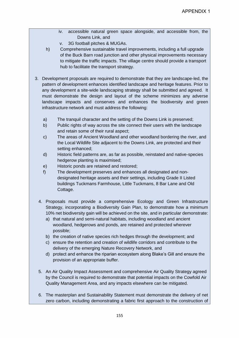
155
iv. accessible natural green space alongside, and accessible from, the
Downs Link, and
v. 3G football pitches & MUGAs.
h) Comprehensive sustainable travel improvements, including a full upgrade
of the Buck Barn road junction and other physical improvements necessary
to mitigate the traffic impacts. The village centre should provide a transport
hub to facilitate the transport strategy.
3. Development proposals are required to demonstrate that they are landscape-led, the
pattern of development enhances identified landscape and heritage features. Prior to
any development a site-wide landscaping strategy shall be submitted and agreed. It
must demonstrate the design and layout of the scheme minimizes any adverse
landscape impacts and conserves and enhances the biodiversity and green
infrastructure network and must address the following:
a) The tranquil character and the setting of the Downs Link is preserved;
b) Public rights of way across the site connect their users with the landscape
and retain some of their rural aspect;
c) The areas of Ancient Woodland and other woodland bordering the river, and
the Local Wildlife Site adjacent to the Downs Link, are protected and their
setting enhanced;
d) Historic field patterns are, as far as possible, reinstated and native-species
hedgerow planting is maximised;
e) Historic ponds are retained and restored;
f) The development preserves and enhances all designated and non-
designated heritage assets and their settings, including Grade II Listed
buildings Tuckmans Farmhouse, Little Tuckmans, 8 Bar Lane and Old
Cottage.
4. Proposals must provide a comprehensive Ecology and Green Infrastructure
Strategy, incorporating a Biodiversity Gain Plan, to demonstrate how a minimum
10% net biodiversity gain will be achieved on the site, and in particular demonstrate:
a) that natural and semi-natural habitats, including woodland and ancient
woodland, hedgerows and ponds, are retained and protected wherever
possible;
b) the creation of native species rich hedges through the development; and
c) ensure the retention and creation of wildlife corridors and contribute to the
delivery of the emerging Nature Recovery Network, and
d) protect and enhance the riparian ecosystem along Blake’s Gill and ensure the
provision of an appropriate buffer.
5. An Air Quality Impact Assessment and comprehensive Air Quality Strategy agreed
by the Council is required to demonstrate that potential impacts on the Cowfold Air
Quality Management Area, and any impacts elsewhere can be mitigated.
6. The masterplan and Sustainability Statement must demonstrate the delivery of net
zero carbon, including demonstrating a fabric first approach to the construction of
APPENDIX 1

156
built development, and maximum use of onsite renewable energy technologies. This
shall include a strategy to ensure that from 2025, all homes built on the site are
designed as net-zero carbon through their expected lifetime;
7. A comprehensive transport strategy is submitted as part of the masterplan with
development to include the following:
a) A walking and cycling strategy that demonstrates how attractive, direct and
legible routes that have priority over motorised traffic, and integrated with the
existing and wider network, will be delivered and maintained;
b) A bus strategy to demonstrate the feasibility of new and extended bus services
that, as a minimum, provide
i. upfront incentives to new residents to use new and existing bus services;
ii. convenient, frequent and direct bus connections to Southwater, Horsham
(town centre and rail station), Crawley and Worthing; and;
iii. convenient and regular bus services to other destinations such as
Burgess Hill, Billingshurst and Brighton.
c) Demonstrate how electric vehicle use for private car travel and, as far as
possible, for public transport are embedded in the strategy from the first
phases of development.
d) The following highways schemes or any others identified as necessary to
mitigate traffic impacts are delivered in partnership with the Local Highway
Authority:
i. New roundabout on A24 south of Mill Straight Roundabout providing the
primary vehicular access to the development;
ii. Conversion of the A24/A272 Buck Barn junction to a ‘through-about’
roundabout (or variant scheme as agreed with the Council appropriate to
mitigate impacts), incorporating a secondary vehicular access to the
development;
iii. Improvements to the A24/B2135 Steyning Road junction to improve
safety whilst also maintaining smooth traffic flow; and
iv. In partnership with Cowfold Parish Council, a Highways and Public
Realm Improvement Strategy, incorporating mitigation of impacts on the
Cowfold Air Quality Management Area.
e) A comprehensive Travel Plan and Construction Travel Plan to be agreed by
the Council and Local Highway Authority is submitted, to cover the entire
construction period, which demonstrate the long-term embedment of the
transport strategy.
APPENDIX 1
157
Settlement Site Allocations
11.38 In addition to the new, large scale strategic allocations that are necessary to help meet
the housing requirement in this Local Plan, it is recognised that additional growth in
and around towns and villages will be required. Smaller sites are usually quicker to
come forward than strategic sites and will help to maintain housing delivery across the
plan period. More importantly, these sites also help to sustain local communities,
including maintaining the vitality of community shops and services.
11.39 The National Planning Policy Framework 2019 has sought to diversify the housing
requirement to increase specific provision of small sites as part of the housing supply.
Alongside the key strategic and smaller scale site allocations, local planning authorities
will also need to identify further land to accommodate at least 10% of their housing
requirement on sites no larger than one hectare, unless it can be shown that there are
strong reasons why this cannot be achieved. At the current time, the vast majority of
Horsham District’s windfall development (over 100 homes each year) has been
delivered on these smaller sites and it is therefore envisaged that the need for smaller
sites will mainly be met through this mechanism. Other land which has been promoted
to the Council and is considered to be available and suitable for development is
however usually larger than 1 hectare, although some potential exists to make up the
remainder of this requirement through this route, including in Neighbourhood Plans.
Neighbourhood Plans
11.40 Neighbourhood Planning has been an important part of the planning system since it
was introduced through the Localism Act 2011. Horsham District Council takes a
positive approach to working with, and assisting, Parish and Neighbourhood Councils
in the District to prepare their Neighbourhood Plans. We now have a number of 'Made'
Neighbourhood Plans, with a number of other Parishes at Examination or in the later
stages of plan preparation. The sites that are identified in these locally prepared plans
will continue to contribute towards meeting housing needs in the period up to 2038.
11.41 In recent years, the preparation of Neighbourhood Plans has become increasingly
complex, with a greater level of evidence to support the allocation of sites and
demonstrate their deliverability being required. This has slowed the delivery of a
number of Neighbourhood Plans in this District. To ensure that the Council can
demonstrate that it can deliver housing sites in the period up to 2038, it has been
necessary to identify additional smaller sites for housing development in settlements
across the District.
11.42 Following adoption of this Local Plan, there remains opportunity for communities who
wish to do so to allocate additional sites in their new or revised Neighbourhood Plans.
Existing allocations in Neighbourhood Plans will also remain.
APPENDIX 1

158
APPENDIX 1
159
Settlement Site Allocations
11.43 The following Policies allocate land identified assessed as being suitable, available
and achievable for residential development in the plan period and being capable of
accommodating the level of growth in accordance with Policy 2. It is expected that
proposals will make efficient use of land. The total number of homes delivered on each
site is expected to be within 10% of the figure quoted in the policy.
11.44 The settlement site allocation policies do not repeat policy criteria that are set out in
other Local Plan policies. The Development Plan is to be read as a whole and all
allocations will be expected to come forward in accordance with the wider policy
provisions set out in this plan, including those set out in HA1. Where necessary,
specific policy criteria have been introduced to ensure that key, site-specific issues are
addressed in a proposal for development. This does not mean that such issues are
less or more important than those covered by other policies in this Local Plan. In
addition, all allocations will be expected to have regard to the presence of, and avoid
the sterilisation of, mineral resources and must not prejudice waste sites, in
accordance with both the Joint Minerals Local Plan (JMLP)11 and the Waste Local Plan
(WLP)12.
11.45 This Plan allocates sites that are also featured in emerging Neighbourhood Plans that
are not yet Made. Applicants will need to address policy requirements on certain sites
where Neighbourhood Plans progress through Examination, Referenda and become
‘Made’.
Strategic Policy HA6: Ashington
11.46 Ashington village lies approximately 10 miles to the South of Horsham. The A24 lies
to the east of the village and connects the village to both Horsham and the coastal
settlements of Worthing and Brighton.
11.47 Ashington is identified in the settlement hierarchy as a ‘Medium Village’. The village
has some local services to reflect its status in the hierarchy. There is a local shop
which services the village, a primary school and recreational facilities such as the scout
hut, Multi-Use Games Area, a community centre and a pub. Furthermore, the petrol
filling station located to the north of the village also provides an additional convenience
store for residents in Ashington. There is no doctors surgery located within the village
and for residents to access such services they are required to travel to larger
settlements such as Storrington or Steyning.
11.48 To ensure no adverse effect on the integrity of the Arun Valley SPA/ Ramsar site, the
applicant will be required to provide evidence that the development will not result in an
adverse effect on the integrity of the Arun Valley SPA/Ramsar. To achieve this,
surveys will be required to determine habitats and current use of the site to determine
11 Particularly Policies M9 and M10 12 Particularly Policies W2 and W10
APPENDIX 1

160
if it does support a significant population of qualifying species. Where habitats are
suitable, non-breeding bird surveys will be required to determine if the site and
neighbouring land constitute a significant area of supporting habitat. Surveys should
be required to be undertaken during autumn, winter and spring and more than 1 year
of surveys may be needed (to be agreed in consultation with the local planning
authority and Natural England). If habitat within the site is identified to support
significant populations of designated bird features, avoidance measures and mitigation
will be required, such as the creation of replacement habitat nearby, and the planning
application will likely need to be supported by a project specific Habitats Regulations
Assessment to ensure that the development does not result in adverse effects on
integrity.
Strategic Policy HA6: Ashington Housing Allocations
1. The following sites are allocated as shown on the Policies Map, for at least 75
homes:
ASN1: Land east of Mousdell Close, 2.24 hectares (75 homes)
2. To ensure no adverse effect on the integrity of the Arun Valley SPA / Ramsar site
any application will be supported by a HRA and a wintering bird survey.
3. In addition to meeting national and Local Plan requirements, development will be
supported where proposals demonstrate:
ASN1
a) There is connectivity from the site to key local amenities and services and that
these are enhanced through improvements to local pedestrian and cycling
networks.
Strategic Policy HA7: Barns Green
11.49 Barns Green is a village located approximately 5 miles (8km) to the south west of
Horsham Town and between Southwater and Billingshurst to the east and west,
respectively. The village is the largest settlement within the parish of Itchingfield. It is
identified as a medium village in the settlement hierarchy for its moderate range of
services and facilities.
Strategic Policy HA7: Barns Green Housing Allocations
APPENDIX 1

161
1. The following sites are allocated, as shown on the Policies Map, for the provision
of at least 105 homes:
BGR1: Land South of Smugglers Lane, 3.3 hectares (50 homes)
BGR2: Land South of Muntham Drive, 1.85 hectares (25 homes)
BGR3: Land at Slaughterford Farm (Sumners Pond), 1.5 hectares (30 homes)
2. In addition to meeting national and Local Plan requirements, development will be
supported where proposals:
BGR1
a) Demonstrate housing is carefully sited and include an appropriate buffer from
adjacent ancient woodland; and
b) Ensure that appropriate regard is had to the impact on the adjacent Grade II
Listed Buildings (Bennetts, Blacksmiths Cottage and The Queen’s Head Public
House).
BGR2
a) Shall be carefully sited and include an appropriate buffer from adjacent ancient
woodland.
BGR3
a) Comply with any policies, including site-specific policies, in a Made Itchingfield
Neighbourhood Plan
b) Deliver housing alongside seven new employment units (Use Class B2, B8 and
E) for a net gain in floorspace of around 500sqm;
c) Ensure that appropriate regard is had to the impact on the adjacent Grade II
Listed Building (Little Slaughterford).
Strategic Policy HA8: Broadbridge Heath
11.50 Broadbridge Heath is a settlement located immediately to the west of Horsham Town,
separated from the town by the A24. It is categorised as a small town/larger village in
the settlement hierarchy owing to its good range of facilities and services. Broadbridge
Heath has experienced substantial urban expansion since 2007, and whilst it is
considered there is potential for some additional growth, any new development during
this plan period will need to be mindful of the existing and new community and
contribute to wider community cohesion in this area. The current parish boundaries
are such that any further growth associated with Broadbridge Heath will be in the
neighbouring parishes of Itchingfield and Slinfold.
APPENDIX 1

162
Strategic Policy HA8 – Broadbridge Heath Housing Allocations
1. The following sites are allocated, as shown on the Policies Map, for the provision
of at least 150 homes:
BRH1: South of Lower Broadbridge Farm [Slinfold Parish], 6.3 hectares (150
homes)
2. In addition to meeting national and Local Plan requirements, development will be
supported where proposals:
BRH1
a) Retains the mature and semi-mature trees belts within and bounding the site;
b) Ensure that appropriate regard is had to the impact on the adjacent Grade II
Listed Buildings (Lower Broadbridge Farmhouse, Mill House and Mill Cottage);
c) Demonstrate that buildings are carefully sited and designed to minimise noise
impacts from adjoining uses;
d) Have regard in the design and setting of development to the high pressure gas
pipeline to the west of the site.
e) Provide formal and informal open space, sport and recreation provision to meet
the needs of the community in accordance with standards and the respective
recommendations in the Open Space, Sport & Recreation Review 2021
f) Provides safe access by non-car modes across the A281 to the services and
facilities in Broadbridge Heath/Wickhurst Green.
a)
Strategic Policy HA9: Christ’s Hospital
11.51 Christ’s Hospital is a small settlement in Southwater Parish, which is primarily known
for its historic independent school. It is categorised as a smaller village in the
settlement hierarchy as it has limited facilities and services, though it has a train station
with services that terminate in London and the south coast. The sports facilities
(Bluecoat Pond) are also available for public use.
Strategic Policy HA9 – Christ’s Hospital Housing Allocation
1. The following site is allocated, as shown on the Policies Map, for the provision of at
least 20 homes. Development is limited to the eastern part of the site, with the
remaining area left undeveloped;
APPENDIX 1

163
CH1 - Land at The Warren, 5.7 hectares (20 homes)
2. In addition to meeting national and Local Plan requirements, development will be
supported where proposals:
CH1
a) Are carefully sited and designed to prevent against any impact to the site’s
protected trees, and include an appropriate buffer from ancient woodland;
b) Ensure that existing rights of way within and adjacent to the site are unaffected,
or else provide replacement provision.
Strategic Policy HA10: Cowfold
11.52 Cowfold is village on the eastern side of Horsham District and is the largest settlement
in Cowfold Parish. The settlement lies on the intersection of the A272 and A281. The
settlement is identified as a medium village for its moderate range of services and
facilities and an Air Quality Management Area has been declared in Cowfold due to
nitrogen dioxide emissions exceeding legal limits levels, with emissions from vehicles
being the main cause. Any development in this location will therefore be required to
mitigate these impacts, taking account of any cumulative effects of growth in other
locations.
Strategic Policy HA10 – Cowfold Housing Allocations
1. The following sites are allocated, as shown on the Policies Map, for the provision
of at least 105 homes:
CW1: Land at Brook Hill & Cowfold Glebe, 4.8 hectares (35 homes)
CW2: Field West of Cowfold, North of A272, 2.9 hectares (35 homes)
CW3: Fields West of Cowfold, South of A272/Field West of Cowfold, South of
A272, West of Little Potters, 5.4 hectares (35 homes)
2. Any development proposals must be accompanied by an Air Quality Impact
Assessment and Emissions Mitigation Assessment
3. In addition to meeting national and Local Plan requirements, development will be
supported where proposals:
CW1
APPENDIX 1
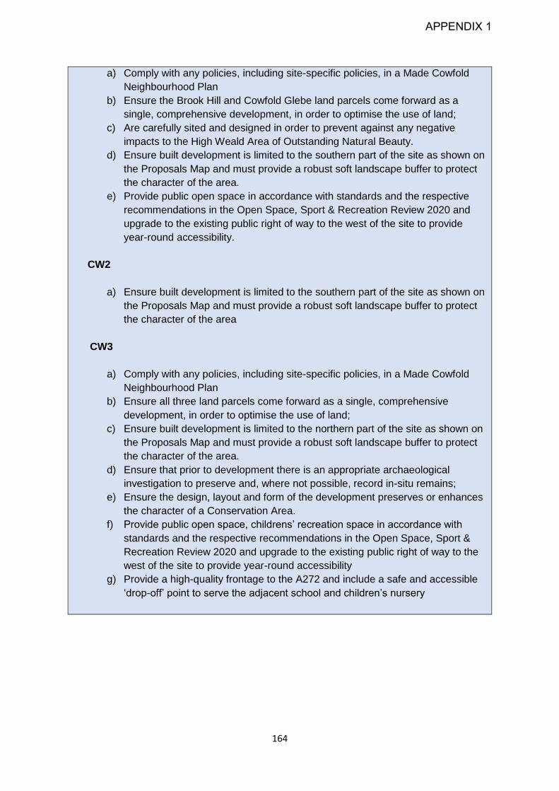
164
a) Comply with any policies, including site-specific policies, in a Made Cowfold
Neighbourhood Plan
b) Ensure the Brook Hill and Cowfold Glebe land parcels come forward as a
single, comprehensive development, in order to optimise the use of land;
c) Are carefully sited and designed in order to prevent against any negative
impacts to the High Weald Area of Outstanding Natural Beauty.
d) Ensure built development is limited to the southern part of the site as shown on
the Proposals Map and must provide a robust soft landscape buffer to protect
the character of the area.
e) Provide public open space in accordance with standards and the respective
recommendations in the Open Space, Sport & Recreation Review 2020 and
upgrade to the existing public right of way to the west of the site to provide
year-round accessibility.
CW2
a) Ensure built development is limited to the southern part of the site as shown on
the Proposals Map and must provide a robust soft landscape buffer to protect
the character of the area
CW3
a) Comply with any policies, including site-specific policies, in a Made Cowfold
Neighbourhood Plan
b) Ensure all three land parcels come forward as a single, comprehensive
development, in order to optimise the use of land;
c) Ensure built development is limited to the northern part of the site as shown on
the Proposals Map and must provide a robust soft landscape buffer to protect
the character of the area.
d) Ensure that prior to development there is an appropriate archaeological
investigation to preserve and, where not possible, record in-situ remains;
e) Ensure the design, layout and form of the development preserves or enhances
the character of a Conservation Area.
f) Provide public open space, childrens’ recreation space in accordance with
standards and the respective recommendations in the Open Space, Sport &
Recreation Review 2020 and upgrade to the existing public right of way to the
west of the site to provide year-round accessibility
g) Provide a high-quality frontage to the A272 and include a safe and accessible
‘drop-off’ point to serve the adjacent school and children’s nursery
APPENDIX 1
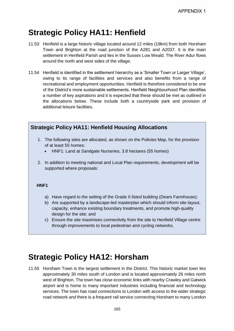
165
Strategic Policy HA11: Henfield
11.53 Henfield is a large historic village located around 12 miles (19km) from both Horsham
Town and Brighton at the road junction of the A281 and A2037. It is the main
settlement in Henfield Parish and lies in the Sussex Low Weald. The River Adur flows
around the north and west sides of the village.
11.54 Henfield is identified in the settlement hierarchy as a ‘Smaller Town or Larger Village’,
owing to its range of facilities and services and also benefits from a range of
recreational and employment opportunities. Henfield is therefore considered to be one
of the District’s more sustainable settlements. Henfield Neighbourhood Plan identifies
a number of key aspirations and it is expected that these should be met as outlined in
the allocations below. These include both a countryside park and provision of
additional leisure facilities.
Strategic Policy HA11: Henfield Housing Allocations
1. The following sites are allocated, as shown on the Policies Map, for the provision
of at least 55 homes:
HNF1: Land at Sandgate Nurseries, 3.8 hectares (55 homes)
2. In addition to meeting national and Local Plan requirements, development will be
supported where proposals:
HNF1
a) Have regard to the setting of the Grade II listed building (Dears Farmhouse);
b) Are supported by a landscape-led masterplan which should inform site layout,
capacity, enhance existing boundary treatments, and promote high-quality
design for the site; and
c) Ensure the site maximises connectivity from the site to Henfield Village centre
through improvements to local pedestrian and cycling networks.
Strategic Policy HA12: Horsham
11.55 Horsham Town is the largest settlement in the District. This historic market town lies
approximately 30 miles south of London and is located approximately 26 miles north
west of Brighton. The town has close economic links with nearby Crawley and Gatwick
airport and is home to many important industries including financial and technology
services. The town has road connections to London with access to the wider strategic
road network and there is a frequent rail service connecting Horsham to many London
APPENDIX 1

166
terminals. Horsham Town is identified in the settlement hierarchy as the ‘Main Town’.
Horsham has a large range of services and facilities offering both social, employment
and leisure opportunities for a large local population and is the most sustainable town
in the District, in respect of access to shops, services and sustainable transport
Strategic Policy HA12: Horsham Housing Allocations
1. The following sites are allocated, as shown on the Policies Map, for the provision of
at least 400 homes:
HOR1: Land at Hornbrook Farm, 10.45 hectares (100 homes)
HOR2: Land at Mercer Road, 14.3 hectares (300 homes)
2. In addition to meeting national and Local Plan requirements, development will be
supported where proposals:
HOR1
a) Have appropriate regard to the setting of the High Weald Area of Outstanding
Natural Beauty (AONB);
b) Undertake a Landscape and Visual Impact Assessment to inform site layout,
capacity and identify and safeguard key views to and from the High Weald
AONB.
HOR2
a) Complements the masterplan for, and does not prejudice the delivery of, the
adjacent Land North of Horsham strategic allocation;
b) Are designed to ensure that residents are not subject to any harmful impacts
from neighbouring uses.
c) Are designed to provide links to the northern and southern parcels of land on
the site.
d) Provide public open space, childrens’ recreation space in accordance with
standards and the respective recommendations in the Open Space, Sport &
Recreation Review 2020
e) Provide a temporary means of safe transport connection to Horsham Town
across the A264 for non-car modes until the Phase 3 connections to be
delivered by the North of Horsham development are complete.
f) Have appropriate regard to the Ancient Woodland on the northern boundary of
the site and retain existing trees on the site where practicable.
g) Provide around 50 parking spaces for Warnham Railway Station in the North
West part of the site.
APPENDIX 1
167
Strategic Policy HA13: Kilnwood Vale
11.56 Kilnwood Vale is an ongoing housing development to the west of Crawley and was
developed in partnership with Crawley Borough Council as part of the Joint Area Action
Plan, adopted in 2009. Permission has been granted for 2,500 dwellings (DC/10/1612)
and development is well underway. Following the Built-up Area Boundary review and
reflecting that this is a new settlement, Kilnwood Vale has been added to the
Settlement Hierarchy in Strategic Policy 2.
11.57 Kilnwood Vale is classified as a ‘Small Town/Larger Village’ because of its relationship
as a new neighbourhood of Crawley that is located within Horsham District. The
neighbourhood has a good range of services and facilities, strong community
networks, together with reasonable rail and/or bus services. Nevertheless, it is
acknowledged that, as the development of this neighbourhood is ongoing not all of the
planned services and facilities have been fully delivered, but will come forward during
the plan period.
11.58 In the 2009 Joint Area Action Plan, a primary objective for the development, was to
build on the Neighbourhood Principle that is seen across the rest of Crawley. This
Principle seeks to ensure that the new neighbourhood has a centre, providing local
self-sufficiency, is green, has its own identity and is sustainable. The Land West of
Kilnwood Vale should reflect these criteria and ensure the site complements the
adjacent Kilnwood Vale strategic allocation. The proximity to Crawley, which sits at the
centre of the Gatwick Diamond, also provides Kilnwood Vale with access to an
excellent range of services and facilities, transport links and employment opportunities.
The extended neighbourhood should integrate with the physical and social
infrastructure of Crawley, and with the landscape.
11.59 Land within the settlement site allocation has been safeguarded for a potential future
access for the Crawley Western Link Road and multi-modal corridor, which has been
identified as potentially being required to mitigate the impact of wider traffic growth in
and around Crawley.
APPENDIX 1

168
Strategic Policy HA13: West of Kilnwood Vale
1. The following site is allocated, as shown on the Policies Map, for the provision of at
least 350 homes:
WKV1: Land West of Kilnwood Vale, 15.6 hectares (350 homes).
2. In addition to meeting national and Local Plan requirements, development will be
supported where proposals:
WKV1
a) Provide an agreed landscape buffer to minimise landscape impacts and in
particular the potential coalescence of Horsham and Crawley;
b) Address noise impacts through an appropriate noise mitigation strategy;
c) Complement, and do not prejudice, the delivery of the adjacent Kilnwood Vale
strategic allocation;
d) Do not commence development of the site prior to the delivery of the local
services and amenities necessary to support the development within Phases 2
& 3 to ensure the delivery of the adjacent Kilnwood Vale strategic allocation;
e) Provide integrated walking, cycling and vehicular links and a seamless and
cohesive connection to Phase 6 of the adjacent Kilnwood Vale strategic
allocation;
f) Provide a logical and accessible continuation of the Kilnwood Vale green and
blue infrastructure;
g) Do not seek to provide a new access on to the A264 to serve the development;
and
h) Ensure the safeguarding of land for a potential future access for the Crawley
Western Relief Road
3. Land is reserved for are period of 10 years for a potential future access for the
Crawley Western Link Road should this be identified as being necessary.
Strategic Policy HA14: Lower Beeding
11.60 Lower Beeding is a settlement in a parish with the same name. It is located around 4
miles (6.5km) away from Horsham Town, centred around the junction of the B2110
and B2115. The character of the settlement is influenced by the Grade II Listed
Buildings of Holy Trinity Church and the Plough Inn together with the High Weald
AONB, which borders its southern and eastern boundaries. Lower Beeding is
categorised in the settlement hierarchy as a smaller village as it has limited facilities
and services.
APPENDIX 1
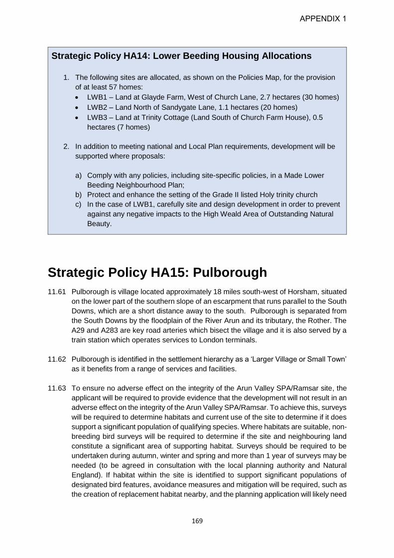
169
Strategic Policy HA14: Lower Beeding Housing Allocations
1. The following sites are allocated, as shown on the Policies Map, for the provision
of at least 57 homes:
LWB1 – Land at Glayde Farm, West of Church Lane, 2.7 hectares (30 homes)
LWB2 – Land North of Sandygate Lane, 1.1 hectares (20 homes)
LWB3 – Land at Trinity Cottage (Land South of Church Farm House), 0.5
hectares (7 homes)
2. In addition to meeting national and Local Plan requirements, development will be
supported where proposals:
a) Comply with any policies, including site-specific policies, in a Made Lower
Beeding Neighbourhood Plan;
b) Protect and enhance the setting of the Grade II listed Holy trinity church
c) In the case of LWB1, carefully site and design development in order to prevent
against any negative impacts to the High Weald Area of Outstanding Natural
Beauty.
Strategic Policy HA15: Pulborough
11.61 Pulborough is village located approximately 18 miles south-west of Horsham, situated
on the lower part of the southern slope of an escarpment that runs parallel to the South
Downs, which are a short distance away to the south. Pulborough is separated from
the South Downs by the floodplain of the River Arun and its tributary, the Rother. The
A29 and A283 are key road arteries which bisect the village and it is also served by a
train station which operates services to London terminals.
11.62 Pulborough is identified in the settlement hierarchy as a ‘Larger Village or Small Town’
as it benefits from a range of services and facilities.
11.63 To ensure no adverse effect on the integrity of the Arun Valley SPA/Ramsar site, the
applicant will be required to provide evidence that the development will not result in an
adverse effect on the integrity of the Arun Valley SPA/Ramsar. To achieve this, surveys
will be required to determine habitats and current use of the site to determine if it does
support a significant population of qualifying species. Where habitats are suitable, non-
breeding bird surveys will be required to determine if the site and neighbouring land
constitute a significant area of supporting habitat. Surveys should be required to be
undertaken during autumn, winter and spring and more than 1 year of surveys may be
needed (to be agreed in consultation with the local planning authority and Natural
England). If habitat within the site is identified to support significant populations of
designated bird features, avoidance measures and mitigation will be required, such as
the creation of replacement habitat nearby, and the planning application will likely need
APPENDIX 1

170
to be supported by a project specific Habitats Regulations Assessment to ensure that
the development does not result in adverse effects on integrity.
Strategic Policy HA15: Pulborough Housing Allocations
1. The following sites are allocated, as shown on the Policies Map, for the provision of
at least 255 homes:
PLB1: Land at Greendene, 3.7 hectares (60 homes).
PLB2: Land at New Place Farm, 17 hectares (170 homes)
PLB3: Land at Highfields, 1 hectare (25 dwellings)
2. To ensure no adverse effect on the integrity of the Arun Valley SPA / Ramsar site
any application is supported by a HRA and a wintering bird survey.
3. In addition to meeting national and Local Plan requirements, development will be
supported where proposals:
PLB1
a) Deliver a high quality, landscape led, sustainable extension to Pulborough,
which respects the character of the edge of settlement location and the
surrounding countryside, and which is comprehensively integrated with the
settlement so residents can access existing facilities.
b) Deliver upgraded site access together with pedestrian and road improvements
to the A29, including the pedestrian rail bridge.
PLB2
a) Comply with any policies, including site-specific policies, in a Made Pulborough
Neighbourhood Plan
b) Deliver publicly accessible open green space as part of any proposal as shown
on the Policies Map. This will be in accordance with standards and the
respective recommendations in the Open Space, Sport & Recreation Review
2020, to meet identified local requirements
c) Have regard to the setting of the South Downs National Park.
d) Undertake a full archaeological assessment and set out any necessary
mitigation measures that may be required
PLB3
a) Comply with any policies, including site-specific policies, in a Made Pulborough
Neighbourhood Plan
b) Have regard to the setting of the South Downs National Park.
APPENDIX 1

171
Strategic Policy HA16: Rudgwick and Bucks
Green
11.64 Rudgwick and Buck’s Green are two adjacent settlements located in Rudgwick Parish.
Rudgwick village is the larger settlement lying either side of the B2128/Church Street.
Rudgwick is a largely linear settlement on the A281/Guildford Road. Given their close
proximity, they share a number of services and collectively they are classified as a
medium village in the settlement hierarchy for their moderate range of services and
facilities.
Strategic Policy HA16: Rudgwick and Bucks Green Housing
Allocations
1. The following sites are allocated, as shown on the Policies Map, for the provision
of at least 66 homes:
RD1: Land North of Guildford Road, 4.9 hectares (60 homes)
RD2: The Former Pig Farm, 0.31 hectares (6 homes)
2. As adjacent sites, the Council would support RD1 and RD2 coming forward as a
comprehensive scheme.
3. In addition to meeting national and Local Plan requirements, development will be
supported where proposals:
RD1
a) Are limited to the southern part of the site as shown on the policy map, with an
agreed landscape treatment in the northern part of the site to minimise
landscape impacts.
RD2
a) Ensure that any access into the site does not interfere with the operation of the
adjacent bus stop.
APPENDIX 1

172
Strategic Policy HA17: Rusper
11.65 Rusper is the main settlement within a parish of the same name. It lies 4.1 miles
(6.6 km) north of the town of Horsham and 4.2 miles (6.8 km) west of Crawley. Gatwick
airport is located approximately 8 miles to the north east of the village and exerts an
influence over the parish. Rusper village is the focal point of the parish, with some
local facilities and services. Subsequently, Rusper is identified in the settlement
hierarchy as a ‘Smaller Village’ and would be suitable for some modest growth in
sustainable locations.
Strategic Policy HA17: Rusper Housing Allocations
1. The following sites are allocated, as shown on the Policies Map, for the provision of
at least 38 homes
RS1: Land at Rusper Glebe, 0.6 hectares (12 homes)
RS2: Land at East Street, 0.4 hectares (6 homes)
RS3: Land north of East Street, 0.9 hectares (20 homes)
2. In addition to meeting national and Local Plan requirements, development will be
supported where it can be demonstrated that residential and other noise sensitive
development will not be exposed to unacceptable noise levels emitted from
overhead planes on the flightpath from/to Gatwick Airport and;
RS1
a) Have regard to the setting and character of the Rusper Conservation Area and
for adjacent local heritage assets including the St Mary Magdalene Church
(Grade I), Ghyll Cottage (Grade II) and The Plough Inn (Grade II).
RS2 and RS3
a) Have regard to the setting and character of the Rusper Conservation Area to
the west and maintain the rural approach to the village.
Strategic Policy HA18: Small Dole
11.66 Small Dole is a largely linear village on the A2037. The village straddles the parish
boundaries of Henfield and Upper Beeding. It is around two miles (3.2 km) south of
Henfield and 2.5 miles (4km) from the villages of Henfield and Upper Beeding,
respectively. The South Downs National Park boundary is immediately to the east of
its built-up area.
APPENDIX 1

173
11.67 Small Dole is categorised as a Smaller Village in the settlement hierarchy as it has
some local services and facilities and it also benefits from employment opportunities
to its south.
Strategic Policy HA18: Small Dole Housing Allocations
1. The following sites are allocated, as shown on the Policies Map, for the provision of
at least 40 homes:
SMD1: Land west of Shoreham Road [Henfield], 5.5 hectares (40 homes)
2. In addition to meeting national and Local Plan requirements, development will be
supported where proposals:
SMD1
a) In accordance with the Policies Map, are restricted to eastern end of the site
with a significant proportion of the site (western end) given to public open
space and recreation use;
b) Deliver sustainable urban drainage systems (SUDS) along the southern
boundary;
c) Are designed to take account of the rural character around the site, and
incorporate measures to mitigate against any harm to the landscape character
Strategic Policy HA19: Steyning
11.68 Steyning is a historic town situated in the Low Weald within a parish of the same name.
It lies 13 miles to the south of Horsham and around 5 miles north of Shoreham-by-Sea
on the south coast. It is situated in the Adur gap, where the River Adur passes through
a break in the South Downs. The A283 bisects the town and connects the village with
larger settlements. The north and east of the settlement is defined by the floodplain of
the River Adur and its tributaries while the west and south is enveloped by the South
Downs National Park.
11.69 Steyning is identified in the settlement hierarchy as a Smaller Town/Larger Village
category and offers a good range of services and facilities and it also benefits from
close proximity to coastal settlements which provide the closest railway links to the
village.
Strategic Policy HA19: Steyning Housing Allocation
1. The following sites are allocated, as shown on the Policies Map, for the provision of
at least 240 homes:
STE1: Land at Glebe Farm, 14 hectares (240 homes).
APPENDIX 1

174
2. In addition to meeting national and Local Plan requirements, development will be
supported where proposals:
STE1
a) Provide safe vehicular access into the site from the A283,
b) Maximise and enhance connectivity from the site to Steyning Village centre
through improvements to local pedestrian and cycling networks;
c) Are landscape-led, supported by a Landscape and Visual Impact Assessment
to inform site layout and capacity, safeguard key views to and from the South
Downs, and protect all other elements of landscape character.
Strategic Policy HA20: Storrington & Sullington
11.70 Storrington is a village located in the south of the District, to the north of the South
Downs, located approximately 13 miles (21km) south of Horsham. The South Downs
National Park boundary abuts much of the southern edge of the village. The village is
identified in the settlement hierarchy as a Small Town/Larger Village, and acts as a
hub for smaller surrounding settlements, as it benefits from a good employment offer
and a range of services and facilities. The A283 bisects the village centre generating
high volumes of vehicular traffic and congestion, resulting in the deterioration of air
quality. This has led to the designation of an Air Quality Management Area (AQMA)
within the village centre. Due to the boundaries of Storrington Parish, some
development associated with Storrington village will come forward in Thakeham
Parish.
11.71 To ensure no adverse effect on the integrity of the Arun Valley SPA/Ramsar site. The
applicant will be required to provide evidence that the development will not result in an
adverse effect on the integrity of the Arun Valley SPA/Ramsar. To achieve this, surveys
will be required to determine habitats and current use of the site to determine if it does
support a significant population of qualifying species. Where habitats are suitable, non-
breeding bird surveys will be required to determine if the site and neighbouring land
constitute a significant area of supporting habitat. Surveys should be required to be
undertaken during autumn, winter and spring and more than 1 year of surveys may be
needed (to be agreed in consultation with the local planning authority and Natural
England). If habitat within the site is identified to support significant populations of
designated bird features, avoidance measures and mitigation will be required, such as
the creation of replacement habitat nearby, and the planning application will likely need
to be supported by a project specific Habitats Regulations Assessment to ensure that
the development does not result in adverse effects on integrity.
APPENDIX 1

175
Strategic Policy HA20– Storrington Village Housing Allocations
1. The following sites are allocated, as shown on the Policies Map, for the provision
of at least 145 homes:
STO1: Land to the north of Melton Drive, 4.7 hectares and Land South of
Northlands Lane, 6 hectares (70 homes).
STO2: Land at Rock Road [Thakeham parish], 3.66 hectares (75 homes).
2. Any development within Storrington must be accompanied by an Air Quality Impact
Assessment and Emissions Mitigation Assessment.
3. To ensure no adverse effect on the integrity of the Arun Valley SPA / Ramsar site
any application is supported by a HRA and a wintering bird survey.
4. In addition to meeting national and Local Plan requirements, development will be
supported where proposals:
STO1
a) Come forward as a single, comprehensive development, in order to optimise
the use of land;
b) Deliver vehicular access from Fryen Lane;
c) Have appropriate regard to the setting of West Wantley Farmhouse (Grade II*)
and East Wantley Farm (Grade II);
d) Are supported by a landscape-led masterplan which will inform site layout and
minimise coalescence between Storrington and West Chiltington village; and
e) Have regard to the setting of the South Downs National Park.
STO2
a) Have appropriate regard should be given to listed building Penfolds (Grade II);
and
b) Have regard to the setting of the South Downs National Park.
Strategic Policy HA21: Thakeham (The Street
and High Bar Lane)
11.72 Thakeham lies in the southern part of the Horsham District, lying approximately 2 miles
(3.2km) to the north east of Storrington. In recent times it has experienced growth,
noticeably on the eastern side of the B2139 and is now identified as a medium village
in the settlement hierarchy for its moderate range of services and facilities in the
settlement.
APPENDIX 1

176
Strategic Policy HA21: Thakeham (The Street and High Bar Lane)
Housing Allocations
1. The following sites are allocated, as shown on the Policies Map, for the provision
of at least 65 homes:
TH1 – Land North of High Bar Lane, 0.9 hectares (25 homes)
TH2 – Land West of Stream House, 1.9 hectares (40 homes)
2. In addition to meeting national and Local Plan requirements, development will be
supported where proposals:
TH1
a) Preserve and enhance the existing hedgerows on site.
TH2
a) Ensure that the existing rights of way and agreed bridleway within the site are
unaffected, or else provide replacement provision.
b) Are supported by a Noise Impact Assessment that takes into account the
activity on the neighbouring Thakeham Mushrooms site and appropriate
measures provided to mitigate against any negative impacts to future
residents.
Strategic Policy HA22: Warnham
11.73 Warnham village is located approximately 2 miles north west of Horsham, situated in
the central low weald. Warnham has a historic core, centred around a Conservation
Area with numerous listed buildings, and the A24 runs to the north and east of the
village with Broadbridge Heath to the south. Warnham is identified in the settlement
hierarchy as a ‘Medium Village’ as it has a number of services and facilities, while also
benefitting from a railway station approximately one mile to its east.
Strategic Policy HA22 – Warnham Housing Allocation
1. The following site is allocated as shown on the Policies Map, for the provision of at
least 20 homes:
WRN1: Land South of Bell Road, 1.4ha, (20 homes).
2. In addition to meeting national and Local Plan requirements, development will be
supported where proposals have regard to site layout and design to ensure
APPENDIX 1

177
development is sympathetic to local character and prevailing linear urban form on
Bell Road.
Strategic Policy HA23: West Chiltington and
West Chiltington Common
11.74 West Chiltington and West Chiltington Common are separate but closely linked
settlements in the Parish of West Chiltington located in the south west of the District.
West Chiltington is the smaller settlement and has a historic core covered by a
Conservation Area designation, which contain multiple listed buildings. West
Chiltington Common lies to the south and is characterised by large, detached,
residential properties. Together they share services and they are collectively classified
as medium village in the settlement hierarchy for their moderate range of services and
facilities.
Strategic Policy HA23: West Chiltington and West Chiltington
Common Housing Allocations
1. The following sites are allocated, as shown on the Policies Map, for the provision
of at least 36 homes:
WCH1 – Land at Hatches Estate, 0.89 hectares (15 homes)
WCH2 – Land West of Smock Alley, South of Little Haglands, 1.3 hectares (15
homes)
WCH3 – Land East of Hatches House, 0.5 hectares (6 homes)
2. In addition to meeting national and Local Plan requirements, development will be
supported where proposals:
WCH1
b) Take into account, through appropriate design and siting, the impact on trees
protected by Tree Preservation Orders on the eastern boundary of the site;
and
c) Mitigate any impacts to adjacent Conservation Area and Listed Buildings and
their settings.
WCH2
a) Are designed to be sympathetic to the character of the area;
b) Take into account, through appropriate design and siting, the impact on trees
protected by Tree Preservation Orders in the adjacent Haglands Copse.
WCH3
APPENDIX 1

178
a) Protect the rural character and rural approach to the settlement, including
through the retention and enhancement of the trees and hedgerows around the
site,
b) Retain the setting of the listed buildings at Naldrett’s Farm. – This includes
providing access to the site from Hatches Paddock.
c) Ensure that existing rights of way within and adjacent to the site are not
adversely affected, or else provide replacement provision.
APPENDIX 1

179
List of Figures
Figure Details Page
1 Gatwick Diamond 5
2 Key Diagram 22
3 Indicative housing trajectory over plan period 63
4 Carbon emission sources in Horsham District 109
5 Carbon emission trajectory for Horsham District 110
APPENDIX 1

180
List of Tables
Table Details Page
1 Spatial objectives for Horsham District 13
2 Settlement hierarchy 25
3 Existing commitments 36
4 Employment site allocations 39
5 Key Employment Areas in Horsham District 41
6 Town centre hierarchy 53
7 Appropriate strategic mix of home sizes based on tenure 64
8 Gypsy and traveller need requirements 75
9 Gypsy and traveller site allocations 76
10 Local minimum standards of size for community spaces 134
APPENDIX 1
181
Glossary
Accessible greenspace: Outdoor places, which may include bodies of water such as ponds,
that are available for the general public to use free of charge and without undue time
restrictions (although some sites may be closed to the public overnight and there may be fees
for parking a vehicle). The places should seek to be available to all, meaning that
every reasonable effort is made to comply with the requirements under the Equality Act 2010.
Ad-Hoc Development: This is unplanned development, a reactive rather than proactive
planning approach to development.
Adoption: The final confirmation of a Development Plan or Local Development Document as
having statutory status by a Local Planning Authority (LPA).
Aerodrome Safeguarding: The process used to ensure the safety of aircraft while taking off
and landing or flying in the vicinity of an aerodrome.
Affordable Housing: Housing provided to eligible households whose needs are not met by
the market, and complying firstly with the criteria for whichever of social rented, affordable
rented or intermediate housing is relevant (as defined below); or if none of these are relevant,
complying with the NPPF (Annex 2) definition of affordable housing.
Affordable Rented Housing: Housing that must be rented at no more than 80 per cent of the
local market rent (including service charges, where applicable); and where the landlord is a
Registered Provider (of affordable homes) except where it is included as part of a Build to
Rent scheme (which is purpose built rental housing that is typically 100% rented out, typically
owned by a single managing freeholder and offering tenancy agreements of three years or
more).
Air Quality Management Area (AQMA): A designation made by a local authority where air
quality standards are not being met, or are at risk of not being met, and people are regularly
present.
Amenity: A positive element or elements that contribute to the overall character or enjoyment
of an area. For example, open land, trees, historic buildings and the inter-relationship between
them, or less tangible factors such as tranquillity.
Amenity Greenspace (AGS): Are normally relatively small outdoor spaces (most are smaller
than 1 ha) which help enhance visual amenity by providing an attractive "green setting" for
buildings and offer space in which individuals and groups can take part in a wide variety of
informal activities such as dog walking, strolling, jogging, picnicking, kite flying and kick about
areas close to home. They may include bodies of water such as a pond.
Ancillary Use: A subsidiary or secondary use or operation closely associated with the main
use of a building or piece of land.
Appropriate Assessment (AA): See Habitat Regulations Assessment.
APPENDIX 1

182
Appeal: The process whereby a planning applicant can challenge an adverse decision,
indicating a refusal of permission. Appeals can also be made against the failure of the planning
authority to issue a decision, against conditions attached to permission, and against the issue
of an enforcement notice.
Aquifer: Underground rock layers that hold water, which are often an important source of
water for public water supply, agriculture and industry.
Arboriculture: Tthe management of trees where amenity is the prime objective.
Archaeological Assessment: A study of the extent and quality of any archaeological remains
that may exist within a site. The study and resulting report(s) must be performed by a suitably
qualified professional and will be examined by the District’s archaeological advisor, from whom
advice on the form and nature of the assessment may be sought.
Area Action Plan: See Joint Area Action Plan.
Area of Outstanding Natural Beauty (AONB): A statutory landscape designation, which
recognises that a particular landscape is of national importance. The primary purposed of the
designation is to conserve and enhance the natural beauty of the landscape.
Around: A guide figure that is plus or minus ten percent of the figure quoted.
Authority Monitoring Report (AMR): Produced by the Council annually to review the
progress made against targets and the performance of policies. The monitoring period is 1
April to 31 March each year.
Biodiversity (Biological Diversity): Whole range and variety of life on earth. It includes all
species of plants, animals and micro-organisms, the genetic diversity within and between
these species, and their habitats and the ecosystems of which they are part. It can be used
as a measure of the health of biological systems, and to see whether there is a danger that
too many species become extinct.
Biodiversity Action Plan (BAP): A strategy prepared for a local area aimed at conserving
biological diversity.
Biodiversity Net Gain: Relates to natural flora and fauna, and particularly the quality of
habitats for wildlife. Defra defines it as “an approach to development that aims to leave the
natural environment in a measurably better state than beforehand. This means protecting
existing habitats and ensuring that lost or degraded environmental features are compensated
for by restoring or creating environmental features that are of greater value to wildlife and
people.” Defra have produced a metric, which, with the aid of a calculation tool, assigns each
habitat a numerical value enabling an ecologist to estimate the biodiversity score after a
proposed development has been completed.
Blue Infrastructure: Network of water elements such as rivers, ponds, floodplains and water
treatment facilities which are essential to the quality of lives and the ecosystem.
APPENDIX 1
183
BREEAM: Standards laid down for the design and building of businesses and homes to be
more sustainable, including wildlife friendly design, use of recycled materials and energy,
heating and water conservation methods.
Brownfield Land Registers: Registers of previously developed land that local planning
authorities consider to be appropriate for residential development, having regard to criteria in
the Town and Country Planning (Brownfield Land Registers) Regulations 2017. Local planning
authorities will be able to trigger a grant of permission in principle for residential development
on suitable sites in their registers where they follow the required procedures.
Brownfield/Previously Developed Land (PDL): In the sequential approach this is preferable
to Greenfield land. It is land which is or was occupied by a permanent structure (excluding
agricultural or forestry buildings) and associated fixed surface infrastructure. The definition
covers the curtilage of the development. Previously developed land may occur in both built-
up and rural settings.
Build to Rent: Purpose built housing that is typically 100% rented out. It can form part of a
wider multi-tenure development comprising either flats or houses, but should be on the same
site and/or joining the main development. Schemes will usually offer longer tenancy
agreements of three years or more, and will typically be professionally managed stock in single
ownership and management control.
Built-up Area Boundaries (BUAB): These identify the areas in the District of primarily built
form, rather than countryside. They identify areas within which development of brownfield land
may normally be appropriate, including infilling, redevelopment and conversions in
accordance with Government Policy and Guidance (NPPF and NPPG). They do not include a
presumption for the development of greenfield land such as playing fields or other open space.
Identified built-up area boundaries do not necessarily include all existing developed areas.
Carbon Neutral: Offsetting or compensating for carbon emissions (for example from burning
fossil fuels) by schemes such as planting trees to absorb carbon or through careful use of
design to promote energy efficiency and to avoid carbon emissions.
Centre Hierarchy: An ordering of the town and village centres in the District into a hierarchy
in order to distinguish between major (Primary), minor (Secondary) and local or
neighbourhood centres. Previously defined by their retail activity, the definition has been
expanded to acknowledge the wider range of commercial and community uses taking place
in these areas alongside traditional retail activity.
Change of Use: A change in the way that land or buildings are used (see Use Classes Order).
Planning permission is usually necessary to change a "use class".
Character: A term relating to Conservation Areas or Listed Buildings, but also to the
appearance of any rural or urban location in terms of its landscape or the layout of streets and
open spaces, often giving places their own distinct identity.
APPENDIX 1

184
Climate Change: Long-term changes in temperature, precipitation, wind and all other aspects
of the Earth's climate exacerbated by human activity, particularly by the increase of
greenhouse gases in the earth’s atmosphere due to fossil fuel consumption.
Combined Heat and Power (CHP): The combined production of heat, usually in the form of
steam, and power, usually in the form of electricity.
Community Facilities: Facilities available for use by the community. Examples include
village halls, doctors' surgeries, pubs, churches and children play areas; may also include
areas of informal open space and sports facilities.
Community Infrastructure Levy (CIL): The Community Infrastructure Levy is a levy that local
authorities in England and Wales can choose to charge on new developments in their area.
The money can be used to support development by funding infrastructure that the council,
local community and neighbourhoods want - for example, new or safer road schemes, park
improvements or a new health centre. The Council adopted its CIL charging schedule in
October 2017.
Community Land Trusts (CLT): Community-controlled organisations that are set up to own
and manage land for the benefit of the community.
Community Right to Build Orders (CRBOs): A special type of Neighbourhood Development
Order (NDO). Unlike NDOs and NDPs, any local community organisation, not just a
Neighbourhood Forum, will be able to create CRBOs. To be eligible to develop a CRBO at
least one half of a community organisation's members must live in the neighbourhood area.
The organisation must also exist to further the economic, environmental and social well-being
of the area in question, and may also be required to make provision that any profits made as
a result of community right to build orders be distributed among the organisation's members.
Compulsory Purchase Order (CPO): An order issued by the Government or a local authority
to acquire land or buildings for public interest purposes.
Conservation Area: Areas of special architectural or historic interest, the character,
appearance or setting of which it is desirable to preserve or enhance.
Conversions: This usually refers to the change of use of a building from a particular use,
classified in the use classes order, to another use. It can also mean the sub-division of
residential properties into self-contained flats or maisonettes.
Core Indicators: Indicators measuring the direct effect of a policy. Used to assess whether
policy targets have been achieved using the available information.
Core Strategy: The Core Strategy, adopted by Horsham District Council in 2007, set out the
key elements of the planning framework for the area. It comprised a spatial vision and strategic
objectives; a spatial strategy, core policies and a monitoring and implementation framework
with clear objectives for achieving delivery. Once adopted, all other Development Plan
Documents must conform to it. The Core Strategy has been replaced by the Horsham District
APPENDIX 1

185
Planning Framework in 2015 and the Horsham District Local Plan, for land outside the South
Downs National Park.
Curtilage: The area occupied by a property and land closely associated with that building e.g.
in terms of a house and garden, the garden normally forms the curtilage of the property.
Custom Build: Custom-built homes are dwellings designed to the particular needs of an
individual. Self-build development is where an individual or group directly organises the design
and construction of their own home or homes.
Defensible Boundary: Examples of a defensible boundary might be a stream, road, or
hedgerow.
Demand Responsive Transport Services: Combination of public and private transportation
services. Vehicles typically pick-up and drop-off passengers in locations according to the
passenger’s needs rather than using a fixed route or timetable.
Derelict: A building so damaged by neglect that it is incapable of beneficial use without
rebuilding.
Department of Communities and Local Government (DCLG): See Ministry of Housing,
Communities and Local Government (MHCLG).
Development Plan: The statutory development plan is the starting point for the consideration
of planning applications for development or use of land.
Development Plan Documents (DPD): The local planning documents which made up the
Local Development Framework and now Local Plan.
Duty to Co-operate: Local authorities have a legal duty to co-operate with other bodies to
ensure that strategic priorities across local boundaries are properly co-ordinated and reflected
in their Local Plan. The Local Plan will be examined by an independent inspector whose role
is to assess whether the plan has been prepared in accordance with the duty to cooperate,
legal and procedural requirements, and whether it is sound. Although there is a legal duty to
co-operate, there is no legal requirement to agree.
Ecological (or Ecology): The interactions and relationships between plants, animals and
their environment.
Ecosystem Services: The benefits we get from the natural world or ‘ecosystems’ that
contribute to making human life both possible and worth living. They are grouped into four
broad categories: ‘provisioning’, such as the production of food, water and raw materials;
‘regulating’, such as the control of climate and disease; ‘supporting’, such as nutrient cycles
and crop pollination; and ‘cultural’, such as spiritual and recreational benefits.
Efficient Use of Land: Development having regard to the character of the surrounding
landscape, the density of built form, capacity of local infrastructure and principles of good
design.
APPENDIX 1

186
Enabling Development: A development that would normally be rejected as contrary to
established policy, but which may be permitted because the public benefit such as affordable
housing.
Environmental Net Gain: The Government promised to embed this as a principle for
development in the 25 Year Environment Plan. It is very broad in scope, taking in carbon
emissions, air, soil, water quality etc. It includes biodiversity net gain, which is that element
which concerns natural flora and fauna, and particularly the quality of habitats for wildlife.
Examination: Public discussion of selected issues raised by respondents at the Proposed
Submission/Publication stage of representations on the Local Plan document(s). The
examination takes place before an independent inspector appointed by the Secretary of State
reporting to the Council. For Development Plan Documents an examination is held even if
there are no representations.
Exception Site: A housing site which is permitted as an exception to the policies in the
Development Plan. Usually a site that is able to offer a considerable benefit such as affordable
housing.
Evidence Base: Collection of baseline specific data for the District which is used to inform the
development of all Local Plan policies and Supplementary Planning Documents.
Extra Care Housing: Usually consists of purpose-built or adapted flats or bungalows with a
medium to high level of care available if required, through an onsite care agency registered
through the Care Quality Commission (CQC). Residents are able to live independently with
24 hour access to support services and staff, and meals are also available. There are often
extensive communal areas, such as space to socialise or a wellbeing centre.
Farm Diversification: The introduction of non-agricultural enterprises (such as bed and
breakfast) to support an existing farm business.
First Homes: New build flats and houses, sold with a discount of at least 40% off the market
price. These are for first-time buyers only, but local authorities can to prioritise key workers
and people with a local connection. The same percentage discount applied at first purchase
is passed on with subsequent sales of the property.
Flood Zones: A term used by the Environment Agency in the planning process to determine
how likely somewhere is to flood. Flood Zone 1 is areas with the lowest risk of flooding where
there is 0.1% chance of flooding in any year, Flood Zone 2 areas have been shown to have
between 0.1%-1% chance of flooding in any year and Flood Zone 3 has the highest risk of
flooding. Flood Zone 3 is split into two areas of flood risk; 3a and 3b. Areas within Flood Zone
3 have been shown to be at a 1% or greater probability of flooding from rivers or 0.5% or
greater probability of flooding from the sea. Flood Zone 3b is classified as functional floodplain
and is deemed to be the land most at risk of flooding from rivers or the sea.
Functional Floodplain: This is land where water has to flow or be stored in times of flood.
Local planning authorities identify functional floodplain boundaries via a Strategic Flood Risk
Assessment (SFRA) in agreement with the Environment Agency.
APPENDIX 1

187
Gatwick Diamond: An economic area centred on Gatwick Airport which is situated between
London and Brighton. It is an important economic area for wealth generation in terms of GDP
makes it one of the first choices in the UK to set up, operate and grow businesses.
Gypsy and Traveller Accommodation Assessment (GTAA): An assessment that identifies
the amount of pitches and plots needed to accommodate the District’s travelling population.
Gypsy/Traveller: The government defines Gypsies and Travellers as persons of nomadic
habit of life whatever their race or origin, including such persons who on grounds only of their
own or their family’s or dependents’ educational or health needs or old age have ceased to
travel temporarily, but excluding members of an organised group of Travelling Showpeople or
circus people travelling together as such
Green Belt: A specific designation around certain towns and cities where there are greater
restrictions on development than land outside these areas. They are put in place to prevent
urban sprawl and settlement coalescence. There is no designated Green Belt in Horsham
District or West Sussex at the current time.
Green Corridor: An area of natural or semi-natural habitat providing easy access for species
of plants and animals to move from place to place. They often link areas of high wildlife value
such as woodland.
Greenfield Land: Land that has not been previously developed (or brownfield) land. This
applies to most sites outside built-up area boundaries.
Green Infrastructure: A term used to describe a multi-functional and connected network of
green spaces, water and other environmental features in urban and rural areas. It includes
trees, parks, road verges, allotments, cemeteries, woodlands, rivers, wetlands, and green
corridors including public rights of way. Green Infrastructure can contribute to the provision of
'ecosystem services'. This includes flood protection, water purification, carbon storage, land
for food production, places for recreation, benefits to health and wellbeing benefits, landscape
and nature conservation.
Greenhouse Gases: Gases including water vapour, carbon dioxide, methane and nitrous
oxide. Some human activities are increasing the amount of these gases, in the earth's
atmosphere, and is resulting in climate change.
Greenspace: Space that is covered with vegetation, for example grass, trees, wildflowers,
vegetables or ornamental plants. It may include ancillary elements of hard landscaping,
including car parking, and water features.
Green Travel Plan: A framework developed by businesses and organisations for changing
travel habits in order to provide an environment which encourages more sustainable travel
patterns and less dependence on single occupancy private car use. For example, an employer
may use the plan to introduce car sharing schemes or secure cycle parking facilities. Travel
Plans must have measurable outcomes and should be related to targets in West Sussex Local
Transport Plan.
APPENDIX 1

188
Greywater Recycling: Water conservation techniques involving the collection, storage,
treatment and redistribution of water from sources such as bathing, laundry washing, and
household cleaning.
Gross Internal Floorspace: The entire area inside the external walls of a building and internal
walls. The difference between gross internal floorspace and gross external area is typically
between 2.5 and 5%.
Habitat: The area or environment in which a species or group of species live.
Habitat Regulations Assessment (HRA) (Formally known as Appropriate
Assessment): The statutory process and documentation required by the Birds and Habitats
Directives of the European Union to assess the effects of a plan on a nature conservation site
of European importance. The aim is to enable a judgement to be made as to whether there
will be an adverse impact on the site's integrity.
High Weald Joint Advisory Unit: Organisation set up to manage the High Weald AONB. It
is overseen by the High Weald Joint Advisory Committee.
High Weald AONB Management Plan: The Plan sets out long term objectives for conserving
this nationally important landscape and how the High Weald will be looked after for the next 5
years. The Plan is formally adopted by the relevant local authorities as their policy for the
management of the AONB and how they carry out their functions in relation to it.
Historic Landscape Assessment: A study made of the impact of any proposal within or
adjacent to an historic park or garden on the character and quality of the site. The report should
include appropriate conservation and enhancement measures.
Horsham District Local Plan: The Local Plan will be the overarching planning document for
Horsham District. When adopted it will replace the Core Strategy and General Development
Control Policies documents which were adopted in 2007, and the Horsham District Planning
Framework (HDPF) adopted in 2015. The Local Plan will set out the planning strategy for the
years up to 2038 to deliver the social, economic and environmental needs of the whole District,
as well as looking beyond the District’s boundaries.
Horsham District Planning Framework (HDPF): The HDPF is the current overarching
planning document for Horsham District, and was adopted in 2015. The HDPF sets out the
planning strategy for the years up to 2031 to deliver the social, economic and environmental
needs of the whole District, as well as looking beyond the District's boundaries. The new Local
Plan will replace this document.
Housing Delivery Test: Measures net additional dwellings provided in a local authority area
against the homes required, using national statistics and local authority data. The Secretary
of State will publish the Housing Delivery Test results for each local authority in England every
November.
Housing Trajectory: A tool used to show the past and future housing delivery performance
by identifying the predicted provision of housing over the lifespan of a Local Plan.
APPENDIX 1
189
Independent Examination: Public discussion of selected issues raised by respondents at the
Proposed Submission/Publication stage of representations on the Local Plan document(s).
The examination takes place before an independent inspector appointed by the Secretary of
State reporting to the Council. For Development Plan Documents an examination is held even
if there are no representations.
Infilling: The use of vacant land and property within a built-up area for further development.
Information and Communications Technology (ICT): Infrastructure and systems including
devices, software and networks which form a wider telecoms or information field to allow
communication and interaction amongst users or stakeholders. It could include computers,
mobile phones, internet connectivity, servers and broadband services.
Infrastructure: A collective term for structures, services and facilities such as roads,
electricity, sewerage, water, education and health provision required for society and the
economy to function.
Infrastructure Delivery Plan (IDP): A document forming part of the evidence base in Local
Plan preparation that assesses the quality and capacity of infrastructure within a local planning
authority area and sets out what infrastructure is required to support development. The IDP
will be used to inform the funding of infrastructure as a result of CIL.
Intermediate Homes: Homes for sale provided at a cost below market levels complying with
the Affordable Housing definition above. These can include Starter homes, First Homes,
shared equity, shared ownership, discount market sales housing (sold at a discount of at least
20% below local market value), and Rent to Buy (which includes a period of intermediate rent).
See NPPF Annex 2 for further guidance.
International Dark Sky Reserve (IDSR): Land which possess an exceptional or distinguished
quality of starry nights and nocturnal environment that is specifically protected for its scientific,
natural, educational, cultural, heritage and/or public enjoyment. The southern boundary of
Horsham District directly adjoins this area.
Joint Area Action Plan (JAAP): Area Action Plans are used to provide the planning
framework for areas where significant change or conservation is needed. A key feature of Area
Action Plans will be the focus on implementation. They will deliver the planning 'growth' areas
and resolve conflicting objectives in the areas subject to the major development pressures.
Where more than one local authority is involved in the creation of an Area Action Plan due to
'cross-boundary' strategic development, it can become a jointly created plan. The West of
Bewbush JAAP was adopted by Horsham District Council and Crawley Borough Council on
31 July 2009.
Key Employment Areas: Commercial land/premises to be retained for employment use.
Key Worker: An employee, typically in the public sector, who provides an essential service to
the community, in areas including the police, health or education.
APPENDIX 1

190
Landscape Character Assessment: An assessment to identify different landscape areas
which have a distinct character based on a recognisable pattern of elements, including
combinations of geology, landform, soils, vegetation, land use and human settlement.
Landscape Led (design approach): A vision and masterplan that works with, rather than
against, the existing landscape components and which will root development firmly into the
landscape context providing a strong sense of local character to which people can relate and
create a sense of community. The starting point of development proposals is the
understanding of the characteristics that are unique to its specific location, it’s local landscape
character. These include the natural factors, such as landform, hydrology, biodiversity,
geology, soils and climate but also human influences such as historic and current land use
and the perceptions of the local community. Layout, form, open spaces, architecture and
choice of materials must reflect landscape context and must be integrated with the existing
green infrastructure as this will help create a distinctive character and a sense of identity for
the new communities but also give communities the development tools needed to become
more resilient.
Land Take: The total area of land needed for any given building or development.
Listed Building: A building of special architectural or historic interest, details of which is
included within The National Heritage List for England (NHLE).
Localism Act: Act of Parliament devolving greater power to local councils and giving local
communities greater overall control over housing decisions. The Act was given Royal Assent
on 15 November 2011.
Local connection: A demonstrable connection to the local area, usually Horsham District,
whether as an individual, couple, or family. For affordable rented tenures, this should meet the
local connections requirements set out in the Housing Strategy (or any future policy that
superseded this). For First Homes, the future occupier must meet one of the following criteria:
Immediately before taking up occupation of an affordable housing unit had their only
principal home in Horsham District for a continuous period of not less than two years;
or
Either themselves or a member of their household has a parent, adult child, brother or
sister whose only principal home is and has been for a continuous period of not less
than two years in Horsham District and wishes to be near that relative; or
Is and has been permanently employed in Horsham District for a continuous period of
not less than two years for a minimum of 16 hours per week.
Appropriate exceptions will apply where a formal agreement exists for a particular
development that the local connections test will also apply to other neighbouring
districts/boroughs/unitary authorities.
Local Development Document (LDD): The suite of documents prepared by Local Authorities
which made up the Local Development Framework, now Local Plan. These documents include
the Statement of Community Involvement, Development Plan Documents (the Local Plan or
Core Strategy, Site Allocations, Area Action Plans, Proposals Map, General Development
Control Policies) and Supplementary Planning Documents.
APPENDIX 1

191
Local Development Scheme (LDS): This is a public statement of the Council's programme
for the production of Local Development Documents. The scheme will be revised when
necessary. This may either be as a result of the Authority Monitoring Report which should
identify whether the Council has achieved the timetable set out in the original scheme or if
there is a need to revise and/or prepare new Local Development Documents.
Local Economic Partnership (LEP): A LEP is a business-led partnership between local
authorities and businesses that plays a central role in determining local economic priorities
and undertakes activities to drive economic growth, investment and the creation of local jobs.
The Coast to Capital LEP is focused in the Gatwick Diamond area.
Local Green Spaces: Green areas of particular importance to local communities that are
designated in Local and Neighbourhood Plans so that they are protected from development.
Local Housing Allowance (LHA): Rates used to calculate housing benefit for tenants renting
from private landlords. Rates are based on private market rents being paid by tenants in the
broad rental market area. The Valuation Office Agency Rent Officers determine LHA rates.
Local Housing Needs Survey: A local evidence gathering process to establish how many
people in a small area (e.g. a parish or neighbourhood) are in need of particular types of
housing (such as affordable housing for renting or to buy, smaller ‘downsizing’ properties,
small family-size homes, etc.). There should always be a carefully considered methodology
that has buy-in from relevant stakeholders.
Local Plan: Local Plans set out a vision and a framework for the future development of the
area, addressing needs and opportunities in relation to housing, the economy, community
facilities and infrastructure - as well as a basis for safeguarding the environment, adapting to
climate change and securing good design for the area they cover. They are a critical tool in
guiding decisions about individual development proposals as Local Plans (together with any
Neighbourhood Development Plans that have been made) are the starting point for
considering whether applications can be approved. It is important for all areas to put an up to
date Local Plan in place to positively guide development decisions.
Local Transport Plan (LTP): Strategies for transport provision prepared by County councils
and unitary authorities for their areas (See West Sussex Local Transport Plan).
Main Shopping Area: The area in a town or village centre where main town centre uses
should be concentrated.
Main Town Centre Uses: Retail development (including warehouse clubs and factory outlet
centres); leisure, entertainment and more intensive sport and recreation uses (including
cinemas, restaurants, drive-through restaurants, bars and pubs, nightclubs, casinos, health
and fitness centres, indoor bowling centres and bingo halls); offices; and arts, culture and
tourism development (including theatres, museums, galleries and concert halls, hotels and
conference facilities).
Market Housing: Housing either bought or rented on the open market without the involvement
of any registered social landlord.
APPENDIX 1

192
Market Signals: Evidence used to highlight the affordability pressures of an area, particularly
for younger people looking to form new households. Where there is evidence of worsening
affordability in an area, adjustments can be made to the overall housing target to improve the
ability of younger people to form new households.
Masterplan: A type of planning brief outlining the preferred use of land and the overall
approach to the layout in order to provide detailed guidance for subsequent planning
applications.
Material Consideration: A matter that should be taken into account in deciding a planning
application or on an appeal against a planning decision.
Mineral Safeguarding Area: An area designated by West Sussex County Council, the
Minerals Planning Authority, which covers known deposits of minerals which are desired to be
kept safeguarded from unnecessary sterilisation by non-mineral development.
Ministry for Housing Communities and Local Government (MHCLG): Formerly the
Department for Communities and Local Government (DCLG). Sets policy on local
government, housing, urban regeneration, planning and fire and rescue.
Mitigation: A measure which is carried out to reduce the impact of a certain
activity/development on the environment.
Move on Space: New or expanded buildings that allow existing businesses to expand.
Multi-use Games Area (MUGA): A hard-surfaced enclosed ball games court which can be
used for a variety of sports.
National Design Guide: Part of the Government’s collection of Planning Practice Guidance
(PPG) setting out the characteristics of well-designed places and demonstrates what good
design means in practice. Should be read alongside the Design: Process and Tools PPG.
Nationally Described Space Standards: Technical housing standards produced by the
Government which deal with internal space within new dwellings.
National Planning Policy Framework (NPPF): Part of the Government’s reforms to make
the planning system less complex, more accessible and to promote sustainable growth, it sets
out national planning policies. It was most recently updated in 2019.
Natural Greenspace (NGS): Outdoor places where human control and activities are not
intensive so that a feeling of naturalness is allowed to predominate. For the purposes of this
plan it includes both natural and semi-natural spaces including "blue" spaces such as
rivers. Natural and semi-natural greenspace exists as a distinct typology but also as discrete
areas within the majority of other greenspace typologies. These spaces allow people living in
urban areas and villages to experience nature close to home. Many if not most are managed
in ways which provide and protect habitats.
APPENDIX 1
193
Nature Recovery Network: A major commitment in the UK Government's 25-Year
Environment Plan, intended to improve, expand and connect habitats to address wildlife
decline and provide wider environmental benefits for people. The Wildlife Trusts promote the
NRN as a mechanism to deliver a ‘Wilder Britain’ to create joined-up habitats and help wildlife
and people to thrive. The Nature Recovery Network is as much a concept and approach rather
than just boundaries on maps. For example, all residential gardens and flat roofs can provide
wildlife habitats and facilitate movement of wildlife.
Neighbourhood Development Orders (NDOs): Grant planning permission for specific types
of development in a particular area. This could be either a particular development, or a
particular class of development. A number of types of development, such as Nationally
Significant Infrastructure Projects will be excluded from NDOs.
Neighbourhood Development Plans (NDP): Written by Parish Councils and Neighbourhood
Forums to guide land use planning issues. They set out policies and plans for an area, such
as the identification of new sites which are acceptable for new local shops. This should not
cover broader local concerns or strategic issues such as major development or major public
transport infrastructure.
Neighbourhood Plan: See Neighbourhood Development Plans.
Out of Centre: A location which is not in or on the edge of a centre but not necessarily outside
the urban area.
Parkway Station: Similar to that of a bus based 'Park and Ride' facility. It is a railway station
which has parking facilities allowing user to continue on with the rest of their journey by train.
Park and Ride: Facilities which seek to reduce urban congestion by encouraging motorists to
leave their vehicles at a car park on the edge of towns and travel into the centre by public
transport, usually buses direct from the parking area.
Park Home: A mobile home which cannot normally be towed by a motor vehicle and which is
carried, often in sections on a lorry before being assembled on a permanent or semi-
permanent basis in its location.
Passive Solar Energy: Energy provided by a simple architectural design to capture and store
the sun's heat. Examples include a garden greenhouse, or south-facing window in a dwelling.
Pitch: A site providing for one Gypsy/Traveller family. A single pitch may be occupied by more
than one caravan/mobile home to accommodate an extended family.
Permitted Development Rights: Rights which allow development to take place without
the need for obtaining planning permission.
Planning Condition: Limitation or requirement attached to a planning permission by the
planning authority when it is granted. Conditions can cover a wide range of aspects about the
development permitted and the process that must be followed to carry out the development.
In general, however, they are intended to make the development more acceptable.
APPENDIX 1

194
Planning Obligations: A legally binding agreement between the local planning authority and
persons with an interest in a piece of land. Planning Obligations will have been set out in an
agreement often known as a 'Section 106 Agreement' and may be used to prescribe the nature
of development, to compensate for loss or damage created by development or to mitigate a
development’s impact on surrounding built natural environment. Circular 5/2005 and
Community Infrastructure Levy Regulations set out the national policy that regulates these
agreements.
Planning Practice Guidance (PPG): Guidance which sets out national guidance on how the
Government expects the planning system to work.
Planning Policy for Traveller Sites (PPTS): Sets out national policy in relation to planning
for Gypsies/Travellers and Travelling Showpeople. The PPTS was most recently updated in
August 2015.
Plot: A site providing for one Travelling Showperson family.
Primary Frontage: An area within some settlements across Horsham District within which
retail uses are favoured over other uses.
Proposed Submission or Regulation 19: The last stage at which comments are sought on
the content of the Local Plan before Examination. The pre-submission Local Plan and
accompanying documents (including representations) are subsequently sent to the Secretary
of State and an independent Examination will be held. Following the successful completion of
this process, the DPD may be adopted by the Council.
Previously Developed Land: Land which is or was occupied by a permanent structure,
including the curtilage of the developed land (although it should not be assumed that the whole
of the curtilage should be developed) and any associated fixed surface infrastructure. This
excludes: land that is or was last occupied by agricultural or forestry buildings; land that has
been developed for minerals extraction or waste disposal by landfill, where provision for
restoration has been made through development management procedures; residential
gardens, parks, recreation grounds and allotments; and land that was previously developed
but where the remains of the permanent structure or fixed surface structure have blended into
the landscape.
Protected Habitats: For the purposes of this Local Plan these include Special Protection
Areas (SPAs), Special Areas of Conservation (SACs), Sites of Special Scientific Interest
(SSSIs), National Nature Reserves (NNRs), Ramsar Sites. Regard to these can extend further
than the designated sites, for example, the Bat Sustenance Zone which relates to The Mens
Special Area for Conservation.
Protected Landscapes: These include Areas of Outstanding Natural Beauty and National
Parks (regard to their settings is also required).
Protected Species: Plant and animal species afforded protection under certain Government
Acts and Regulations.
APPENDIX 1

195
Registered Park and Garden: Gardens, ground and other planned open spaces assessed
to be of particular significance and identified within the Historic England ‘Register of Parks and
Gardens of Special Historic Interest in England’.
Retail Frontage: A street frontage containing retail shops and services, found in town/village
centres.
Retirement Living (or Sheltered Housing): Housing often as a group of purpose-built flats
or bungalows, with limited communal facilities such as a lounge, laundry room and guest room.
It does not generally provide care services, but provides some support to enable residents to
live independently. This can include 24-hour on-site assistance (alarm) and a warden or house
manager.
Retail Hierarchy: An ordering of the town and village centres of an area into a hierarchy so
as to distinguish between major, minor and local or neighbourhood retail centres.
Riverine/Aquatic Environment: The natural environment found within or beside a river or
waterbody.
Rural Exception Site: Small sites used for affordable housing in perpetuity where sites would
not normally be used for housing. Rural exception sites seek to address the needs of the local
community by accommodating households who are either current residents or have an
existing family or employment connection.
Rural Hub: A central point of activity within the rural area which complements the functions of
larger surrounding settlements.
Rural Workers: Those who are employed in rural businesses who need to be in immediate
vicinity of their place of work to enable the proper functioning of the enterprise (e.g. agricultural
or forestry).
Scheduled Ancient Monument: A site of national importance that creates a representative
sample of sites from different eras. Only deliberately created structures, features and remains
are scheduled. The Schedule of Monuments is kept by the Secretary of State for Digital,
Culture, Media and Sport (See Ancient Monuments and Archaeological Areas Act 1979).
Secondary Settlements: Very small villages and hamlets that generally have some limited
local employment, services or facilities (which may include primary schools, allotments, village
halls, playing fields, or a church) and/or evidence of a defined local community.
Sense of Place: The strong identity of a particular place that is deeply felt by inhabitants and
visitors. Urban and rural areas have a different sense of place as do the different villages and
towns in Horsham District. It is the collection of qualities and characteristics - visual, cultural,
social and environmental - that provide meaning to a location and different from another.
Settlement Coalescence: The development of Greenfield land between two urban areas
which results in those two areas becoming 'joined' to form one large urban area.
APPENDIX 1

196
Settlement Hierarchy: Settlements are categorised in a hierarchy based on their
characteristics and functions e.g. level of facilities, accessibility and community networks.
Self-build: See Custom Build
Self-contained: Accommodation that has all the normal domestic facilities of a home
including bedrooms, lounge room, dining room, kitchen, bathroom, toilet and laundry within
one building.
SEND: An abbreviation for Special Educational Needs and Disabilities. A child or young
person has SEN if they have a learning difficulty or disability which requires special education
provision.
Sequential Approach: A planning principle that seeks to identify, allocate or develop certain
types of locations of land before others. For example, brownfield sites before greenfield sites,
or town centre retail sites before out-of-centre sites. In terms of employment a sequential
approach would favour an employment use over mixed used and mixed use over non-
employment uses.
Sheltered Housing: See Retirement Housing
Smaller Sites: These are site allocations which will contain fewer than 500 homes and
therefore not classified as Strategic Site Allocations.
Smart Growth: Redevelopment that would result in an intensification of use in the same area
that would not adversely impact on surrounding areas.
Social Rented Home: A home that is rented to a tenant by a Registered Provider (of
affordable homes) and that has a level of rent set in accordance with the Policy Statement on
Rents for Social Housing published by the Ministry of Housing, Communities and Local
Government (or equivalent superseding statement from HM Government).
Sound: A Development Plan Document is considered sound if it is based on evidence and
has been prepared in accordance with all the necessary legal and procedural requirements
including the measures set out in the authority's Statement of Community Involvement.
South Downs National Park: The South Downs National Park is England's newest National
Park, having become fully operational on 1 April 2011. The park, covering an area of 1,627
square kilometres (628 sq mi) in Southern England, stretches for 140 kilometres (87 mi) from
Winchester in the west to Eastbourne in the east through the countries of Hampshire, West
Sussex and East Sussex.
Spatial Planning: Spatial planning goes beyond traditional land use planning to bring
together and integrate policies and programmes for the development and use of land. Spatial
planning influences the nature of places and how they function. It includes policies which can
impact on land use - For example, influencing the demands on or needs for development that
are not capable of being delivered solely or mainly through the granting of planning permission
and may be delivered through other means.
APPENDIX 1
197
Spatial Strategy/Visions: A broad overview of how spatial planning objectives can be
achieved within the development plan.
Specialist Care Housing: Housing as an alternative provision to a care home for persons
from a range of age groups including for the frail elderly and requiring varying levels of direct
medical or other personal care by staff who are often site based.
Standard Housing Methodology (Standard Method): A formula set by Government and
used by all local authorities in England to identify the minimum number of homes expected to
be planned for, in a way which addresses projected household growth and historic under-
supply.
Statement of Community Involvement (SCI): Sets out the standards which the plan making
authority intend to achieve in relation to involving the community in the preparation, alteration
and continuing review of all Local Development Documents (LDDs) and detailing with planning
applications. It also sets out how the local planning authority intends to achieve those
standards. A consultation statement showing how the local planning authority has complied
with the Statement of Community Involvement will be required for all Local Development
Documents.
Strategic Environmental Assessment (SEA): See Sustainability Appraisal
Strategic Flood Risk Assessment (SFRA): An assessment of flood risk at a strategic level
across a local planning authority area. The National Planning Policy Framework requires local
planning authorities to undertake a strategic flood risk assessment to understand the risk of
flooding in their areas to help inform strategic policies.
Strategic Housing and Employment Land Availability Assessment (SHELAA): An
assessment required by national policy to identify land for housing and employment and
assess the deliverability and development of sites. The SHELAA is a key component of the
evidence base used to support the delivery of sufficient land for housing to meet the
community's need for more homes and for employment land in order to provide sufficient jobs
for residents in the District.
Strategic Housing Market Assessment (SHMA): Establishes the long-term aims for housing
supply and demand in West Sussex. It provides local authorities with a better understanding
of their housing markets and a robust evidence base for new planning and housing policies.
Strategic Site Allocation: A location for development which is required to ensure a continued
delivery of housing sites. The largest strategic sites are 800 homes or more. Site specific
details are specified within the draft Local Plan.
Strategic Road Network (SRN): A road network designated in the West Sussex Structure
Plan, comprising of the M23 motorway, the trunk roads, and some other class A roads of more
than local importance. These are the main routes which are best able to cater for trips starting
or ending outside West Sussex.
APPENDIX 1

198
Student Accommodation: this is accommodation provided on a campus to meet the needs
of a resident student population.
Submission Stage or Regulation 19: The final stage in preparation of Development Plan
Documents (DPDs). The documents are sent to the Secretary of State and an independent
Examination will be held. Following the successful completion of this process, the DPD may
be adopted by the Council.
Sui-Generis: Term given to specific uses of land or buildings, not falling into any of the use
classes identified by the Use Classes Order, for example, theatres, launderettes, car
showrooms and filling stations.
Supplementary Planning Documents (SPD): Supplementary Planning Documents may
cover a range of issues, both topic and site specific, which may expand policy or provide
further detail to policies contained in a Development Plan Document, where they can help
applicants make successful applications or aid infrastructure delivery.
Sustainable Development: Sustainable development is commonly defined as development
that meets the needs of the present without compromising the ability of future generations to
meet their own needs. Principles of sustainable development include social progress that
recognises the needs of everyone, effective protection of the environment, prudent use of
natural resources and high and stable levels of economic growth and employment. The
Planning definition of sustainable development is set out in the National Planning Policy
Framework (NPPF).
Sustainable Urban Drainage Systems – (SUDS): The landscape, if left untouched, naturally
adapts to the environment and finds ways to cater for sudden or heavy rainfall and consequent
surface water. Sustainable Urban Drainage Systems (SUDS) mimic these systems. They can
be both large and small in scale.
Sustainability: Defined by the World Commission on Environment and Development as
'development that meets the needs of the present, without compromising the ability of future
generations to meet their own need.'
Sustainability Appraisal (SA)/Strategic Environmental Assessment (SEA): It is a legal
requirement that certain documents (e.g. Local Development Documents) are assessed to
ensure that they maximise their contribution to Sustainable Development. This is achieved by
carrying out a process usually referred to as a Sustainability Appraisal. The process measures
the effect a document will have on a range of social, environmental and economic issues, and
suggests measures that would help improve the sustainability of a plan.
Total Access Demand (TAD): A method devised by the Council and District Councils in West
Sussex to calculate planning obligations for sustainable transport. TAD comprises two
interrelated elements: a Sustainable Access contribution in respect of per occupant or
employee without a parking space. The differential between the two elements is designed to
encourage the development of accessible site and to discourage the over provision of car
parking spaces so as to promote sustainable transport options. The TAD methodology and
APPENDIX 1
199
contribution levels are set out in the Council's Planning Obligations Supplementary Planning
Document.
Town and Village Centre: The defined area, usually at or close to the centre of a town or
village, where a community, commercial, retail, service and other main town centre uses would
usually be co-located.
Town Centre Management: A forum of traders, businesses and local authorities to agree and
undertake co-ordinated overseeing of the retail environment and funding improvements.
Trade Counters: Small element of retail operating from (generally) storage and distribution
businesses, which allow local customers to visit and purchase goods direct from a supplier.
Transport Assessment: A comprehensive and systematic process that sets out transport
issues relating to a proposed development. It identifies measures required to improve
accessibility and safety for all modes of travel, particularly for alternatives to the car such as
walking, cycling and public transport, and measures that will be needed deal with the
anticipated transport impacts of the development.
Transport Statement: A simplified version of a transport assessment where it is agreed the
transport issues arising from development proposals are limited and a full transport
assessment is not required.
Transport Node: An interchange point where passengers may transfer from one type of
transport to another, for example at a railway station or a park and ride.
Travel Plan: A long-term travel strategy or framework, to be agreed with the Council and
adopted by relevant organisation(s), that implements measures and incentives to significantly
change travel habits, and achieve a significant shift to sustainable travel modes (including
active forms of travel).
Travelling Showpeople: The Government defines Travelling Showpeople as members of a
group organised for the purposes of holding fairs, circuses or shows (whether or not travelling
together as such). This includes such persons who on the grounds of their own or their family’s
or dependants’ more localised pattern of trading, educational or health needs or old age have
ceased to travel temporarily, but excludes Gypsies and Travellers
Tree and Landscape Led (design approach): The starting point of development proposals
is the recording of the existing trees, landscape, their context and key features including
contours and orientation. This is then used to inform where best to plant additional trees,
hedgerows and retain as open landscape which then provides the framework for any future
development layout.
Tree Preservation Order (TPO): A mechanism for securing the preservation of single or
groups of trees of acknowledged amenity value which may be under threat.
Unstable Land: Land that may be unstable (due to a range of factors) for which planning
proposals should give due consideration.
APPENDIX 1

200
Urban Design: The art of making places. It involves the design of buildings, groups of
buildings, spaces and landscapes, in villages, towns and cities, and the establishment of
frameworks and processes, which facilitate successful development.
Urbanising: Making a location more urban in character, for example through a combination
of increased density of development, traffic flow and economic activity.
Urban Extension: Involves the expansion of a city or densely populated area, and can
contribute to creating more sustainable patterns of development when located in the right
place, with well-planned infrastructure including access to a range of facilities, and when
developed at appropriate densities.
Urban Regeneration: Making an urban area develop or grow strong again through means
such as job creation and environmental renewal.
Use Class E: A new Use Class defined under the Use Classes Order 1987 (as amended)
which was introduced on 1st September 2020. It covers uses previously defined under
revoked Use Classes A1 (shops), A2 (financial and professional), A3 (restaurants and cafes),
B1 (Business), D1 (non-residential institutions) (parts a-b) and ‘indoor sport’ previously under
D2. Planning permission is not required for changes of use within Class E.
Use Class Order: The Town and Country Planning (Use Classes) Order 1987 (As amended
in 1995, 2005, 2013 and 2020) puts uses of land and buildings into various categories.
Planning Permission is not needed for changes of use within the same use class.
Vacant Building Credit: Vacant building credit was introduced to promote development
on brownfield sites. It allows the floorspace of existing buildings that are to be
redeveloped to be offset against the calculations for section 106 affordable housing
requirements (whether financial contribution or provision). It applies to any building
that has not been abandoned and is brought back into any lawful use, or is demolished
to be replaced by a new building.
Viability (in context of development costs and deliverability): A development is
considered viable if, after taking account of all costs, including central and local government
policy and regulatory costs and the cost and availability of development finance, the scheme
provides a competitive return to the developer to ensure that development takes place and
generates a land value sufficient to persuade the landowner to sell the land for the
development proposed.
Village Design Statement: A document which describes the visual character of a village as
seen through the eyes of the inhabitants. Residents of an interested village volunteer to
undertake a study of their village and environment and through consultation and discussion
determine what they feel this to be.
Vitality and Viability: In terms of retailing, vitality is the capacity of a centre to grow or develop
a level of commercial activity. Viability is the capacity of a centre to achieve the commercial
success necessary to sustain the existence of the centre.
APPENDIX 1
201
Ward: A small sub-area of a local authority district.
Waterbody: A distinct and significant volume of fresh water.
Waste Collection Authority (WCA): The local authority that has a duty to collect household
waste. They also have a duty to collect commercial waste if requested to do so and may also
collect industrial waste. (The WCA may differ from the Waste Disposal Authority). HDC is the
WCA for this District.
Waste Disposal Authority (WDA): The local authority responsible for managing the waste
collected by the collection authorities and the provision of Household Waste Recovery
Centres. (The WDA may differ from the Waste Collection Authority). West Sussex is the WDA
for this district.
Waste Hierarchy: A framework for securing a sustainable approach to waste management.
Wherever possible, the level of waste produced should be reduced. Where this is not possible,
waste should be reused; and after this, the value recovered by recycling or composting; or
waste to energy; and finally landfill disposal.
Waste Minimisation/Reduction: The most desirable way of managing waste, by avoiding
the production of waste in the first place.
Waste Planning Authority (WPA): The local authority responsible for ensuring that an
adequate planning framework exists. They are required to prepare Local Development
Document(s), or Development Plans, relating to waste and are responsible for determining
planning applications for waste management facilities.
Waste Transfer Station: A site to which waste is delivered for sorting or baling prior to
transfer to another place for recycling, treatment or disposal.
Water Course: A channel through which a moving body of water will flow, above or below
ground. This includes rivers and streams as well as drainage ditches.
Water Framework Directive: European legislation designed to improve and integrate the way
water bodies are managed throughout Europe, translated into UK law by The Water
Environment (Water Framework Directive) (England and Wales) Regulations 2017.
West Sussex Historic Environment Record: Set of data managed by West Sussex County
Council, linked to a Geographical Information System (GIS). Contains a summary of known
historic assets in West Sussex.
West Sussex Local Transport Plan (LTP): A ten year plan setting out key strategic transport
objectives and outlining broad strategies that will be pursued to meet the objectives. The LTP
must tie-in with the broader strategic planning framework set out in local and national policies.
Wilder Horsham District: A five year partnership between Horsham District Council and
Sussex Wildlife Trust with the aim of improving nature networks across the District in order to
allow wildlife populations to thrive, habitats to grow and to increase community awareness of
APPENDIX 1

202
the local natural environment. The scheme is also intended to have benefits for climate change
adaptation and mitigation.
Windfall Sites: A site not specifically allocated for development in the Local Development
Framework which unexpectedly becomes available for development during the lifetime of a
plan. These sites are usually located within Built-up area boundaries. An allowance for
windfall sites is included in the Local Plan for monitoring purposes.
Written Statement: A documentary statement supplementing and explaining policy, forming
part of a development plan.
APPENDIX 1