Comprehensive Land Use Plan 2010-2030 - Sherburne County
176
Sherburne County Comprehensive Land Use Plan 2010-2030 Prepared by the Sherburne County Planning & Zoning Department Adopted by the Sherburne County Board of Commissioners on September 6, 2011
-
Upload
khangminh22 -
Category
Documents
-
view
6 -
download
0
Transcript of Comprehensive Land Use Plan 2010-2030 - Sherburne County

Sherburne County Comprehensive Land Use Plan 2010-2030 Prepared by the Sherburne County Planning & Zoning Department Adopted by the Sherburne County Board of Commissioners on September 6, 2011

2
Sherburne County Mission: To provide the necessary services in a cost effective manner
to support quality of life for Sherburne County citizens.
Cover: Briggs Lake, Palmer Township. (photo courtesy of Robin Tomaszewski)


4
County Commissioner’s Districts.
Sherburne County Board of Commissioners (2011)
Larry Farber, Vice-Chair District 1 Home: Elk River Occupation: Police Officer (ret) Elected: 2009 Term: 1st
Rachel Leonard District 5 Home: Livonia Township Occupation: Attorney, Teacher/
Administrator (retired),
Elected: 2001 Term: 3rd
Felix Schmiesing District 4 Home: Palmer Township Occupation: Business Owner
(motor carrier), Farmer
Elected: 2003 Term: 3rd
John Riebel District 3 Home: Becker Township Occupation: Business Owner
(hardware store) Elected: 2005 Term: 2nd
Ewald Peterson, Chair District 2 Home: Big Lake Township Occupation: Farmer (retired) Elected: 2007 Term: 2nd

5
Sherburne County Planning Advisory Board Bryan Lawrence* Baldwin Township Mike Hayes Big Lake Township Roger Nelson Blue Hill Township Roger Neils** Clear Lake Township Eric Meyer Haven Township Lila Spencer Livonia Township Julie Berg Orrock Township Cecil Peterson Palmer Township David Jehoich Santiago Township John Riebel County Board Liaison
Sherburne County’s jurisdiction for planning & zoning administration (areas in white).
* Chair (2011) ** Vice-Chair (2011)
Baldwin Township Jay Swanson* Tom Rush** Randy Atwood Kimberly Good Larry Handshoe Livonia Township Donald Sherper* Dave Hewitt** Gary Doebler Butch Hass Douglas Manthei
Big Lake Township Bob Hofer* Larry Alfords Mike Hayes Jim Stahlmann Norm Leslie Orrock Township Jeff Jones* Charles Gotzian Jerry Petersen Mike Christianson Wayne Chermack
Blue Hill Township William Andreson* Michael Thompson Roger Nelson Palmer Township Michael Ganz* Richard Larson Cecil Peterson
Clear Lake Township Jack Gallagher* Gary Gray Joseph Goenner Santiago Township Stuart Nelson* Jeffrey Pappenfus David Jehoich
Haven Township Jeffrey Schlingmann* Mark Knowles** Mike Pesch Kathi Sims-Kosloski Randy Linn
Elected Town Board Members (in townships which the County administers Planning & Zoning for)

6
Acknowledgements The 2010-2030 Comprehensive Land Use Plan was completed by the Sherburne County Planning & Zoning Department. The Department includes four divisions; Zoning, Building, Solid Waste, and Parks & Trails. The primary authors of the Comprehensive Plan are: Nancy Riddle Planning & Zoning Admin. Sherburne Co. Planning & Zoning Dept Jon Sevald, AICP County Planner Sherburne Co. Planning & Zoning Dept Lynn Waytashek Assistant Zoning Admin. Sherburne Co. Planning & Zoning Dept Marc Schneider Zoning Specialist Sherburne Co. Planning & Zoning Dept Joe St. Dennis Building Official Sherburne Co. Planning & Zoning Dept Brett Forbes GIS Coordinator Sherburne Co. Public Works Dept Jay Forstner GIS Specialist II Sherburne Co. Public Works Dept The County Board of Commissioners wishes to thank those who contributed information and/or provided comments for this Plan;
Source of aerial photos used for the chapter headings of pages 14, 18, and 94: Pictometry International Corp.
Chuck Nagel resident Baldwin Township Roger Nelson Blue Hill Town Board Bob Hofer Big Lake Town Board Larry Alfords Big Lake Town Board Jim Stahlmann Big Lake Town Board Norm Leslie Big Lake Town Board Don Sherper Livonia Town Board Jerry Petersen Orrock Town Board Wayne Chermack Orrock Town Board Katie Larsen, AICP Senior Planner City of Big Lake John Exner Environmental Specialist Sherburne Co. Planning & Zoning Dept David Katzner Environmental Specialist Sherburne Co. Planning & Zoning Dept Dave Lucas Solid Waste Officer Sherburne Co. Planning & Zoning Dept Jen Oknich Environmental Specialist Sherburne Co. Planning & Zoning Dept Judy Weber Office Manager Sherburne Co. Planning & Zoning Dept Brian Bensen Co Administrator Sherburne Co. Administration Dept Luci Botzek Deputy Co Administrator Sherburne Co. Administration Dept Diane Arnold Co Auditor/Treasurer Sherburne Co. Auditor/Treasurer Dept John Cullen, SAMA Chief Dep Co Assessor Sherburne Co. Assessor’s Dept J. Henderson, CMAS Agricultural Specialist Sherburne Co. Assessor’s Dept Beth Kautz, CMAS Residential Appraiser Sherburne Co. Assessor’s Dept Jerry Kritzeck, SAMA Co Assessor Sherburne Co. Assessor’s Dept Dick Corbin Co Traffic Engr. (retired) Sherburne Co. Public Works Dept Mike Juricich Traffic Engineer Tech III Sherburne Co. Public Works Dept Rhonda Lewis, PE County Engineer Sherburne Co. Public Works Dept
DeAnna Doran District Manager Sherburne Co. Soil & Water Conserv Dist Kurt Kragness Exec. Director (retired) Sherburne Co. Historical Society Scott Mareck, AICP Exec. Director St. Cloud Area Planning Organization Claudia Dumont Engineering Spec. MN Dept of Transportation, District 3 Barbara Ronningen Sr. Research Analyst Spec. MN Dept of Admin, Demographic Cent. Becky Balk Sr. Planner MN Dept of Agriculture Howard Rengo Sr. Warehouse Examiner MN Dept of Agriculture Jean Johnson Administrative Technician USDA Farm Services Agency Anne Sittauer Refuge Manager US Fish & Wildlife Serv., Sherburne NWR Michael Grover Community Affairs Mngr. Federal Reserve Bank of Minneapolis Ed Usset Grain Marketing Spec. Univ. of MN Dept of Applied Economics Mary Edwards Professor St. Cloud State Univ. Dept of Economics Tom Daniels Professor Univ. of Pennsylvania School of Design

7
Table of Contents Executive Summary…………………………………………………………………...…………………………………………….8 Chapter 1 Introduction…………………………………………………………………………………………………………………… ….14
Chapter 2 Population……………………………………………………………………………………………………………………….....18
Chapter 3 Natural Resources…………………………………………………………………………………………………..……………..32
Chapter 4 Land Use…………………………………………………………………………………………………….……………………..44
Chapter 5 Transportation…………………………………………………………………………………………………………………….68 Chapter 6 Economic Development…………………………………………………………………………………………………………...76 Chapter 7 Parks & Recreation………………………………………………………………………………………………………………...84
Chapter 8 Future Land Use……………………………………………………………………………………………………………….…..92
Sherburne County Comprehensive Plan map………………………………………………………………………………..…....95 Chapter 9 Township Land Use Plans……………………………………………………………………………………………………..…...96 Chapter 10 Goals & Policies…………………………………………………………………………………………………………………..140 Appendix A Town Board Survey Results………………………………………………………………………………………..…….………150
Appendix B Public Hearing Minutes…………………………………………………………………………………………………………...155 Appendix C Public Comments………………………………………………………………………………………………………………....160

8
1990-2010 Population of townships.
01,0002,0003,0004,0005,0006,0007,0008,000
1990 2000 2010
Baldwin township Becker townshipBig Lake township Blue Hill townshipClear Lake township Haven townshipLivonia township Orrock townshipPalmer township Santiago township
Various planning documents from townships and joint-ventures, completed between 2004-2011.
Executive Summary
Purpose The purpose of the Comprehensive Plan (Comp Plan) is to guide future land use through the year 2030 in areas within the County’s zoning authority. The Comp Plan is the legal basis for establishing Zoning and Subdivision ordinances which regulate current land use. Additionally, the intent of this update of the Comp Plan is to integrate when applicable, township planning efforts into the County’s plan that have occurred since it was last updated in 2004.
After the Comprehensive Plan is approved, the County intends to re-write the Zoning and Subdivision ordinances to implement this plan, address current land use issues, and remove inconsistent terminology. These ordinances were adopted in 1994, and have received numerous amendments since then.
Location Sherburne County is located about an hour northwest of Minneapolis. The eastern half of the County is economically oriented toward the Twin Cities, while the western half is oriented toward St. Cloud, which is partially located within the County.
Population Between 2000 and 2010, the County’s population increased 37% from 64,417 to 88,499. Total township population increased from 30,128 to 38,319 (27%). The 2nd, 3rd, and 4th most populous townships in Minnesota are; Big Lake (7,386), Baldwin (6,739), and Livonia (5,951) townships.
Planning Authority Sherburne County administers planning & zoning authority in townships, excluding Becker Township, and the Haven Township Orderly Annexation area, except the County does regulate Shoreland, Floodplain, and Wild & Scenic River zoning districts within both townships.
The County has Joint-Powers agreements with Baldwin, Big Lake, and Livonia townships to administer parallel zoning authority. Under this agreement, the County and each township maintain separate, but identical Zoning and Subdivision ordinances. The County administers the application and enforcement procedures assuming County Board and Town Board approval/denial of land use applications (i.e. subdivisions, conditional use permits, etc.) are identical. In the instance that County Board and Town Board action is not identical, the County will enforce the County Board’s actions, and the Township will enforce the Town Board’s actions.

9
Comprehensive Plan Policies Chapter 10 includes Goals, Policies, and Implementation Strategies. The Policies listed below are intended to summarize (not replace) Chapter 10.
Policy 1: Sherburne County’s natural resources (soil, water, and ecology) provide
unique opportunities and constraints. It is the County’s policy to consider these opportunities and constraints when making land use decisions.
Policy 2: Sherburne County includes 125 lakes, 493 miles of rivers & streams, and about 52,898 acres of wetlands (excluding lakes). Surface waters provide a significant scenic and recreational amenity to County residents in addition to filtering pollutants prior to reaching aquifers. Surface waters also provide habitat for birds, fish, and animals. It is the County’s policy to protect surface waters as required by Federal and Minnesota regulations, and to promote restoration efforts.
Policy 3: Sherburne County is located in the Anoka Sand Plain, which is a unique ecological environment in Minnesota. It is the County’s policy to promote native plant species, control noxious weeds as required by Minnesota laws, and to encourage the preservation of contiguous areas for the migration of native birds and animals.
Policy 4: Sherburne County’s waterways and aquifers are susceptible to pollution because of the County’s sandy permeable soils. It is the County’s policy to educate the public about the environment, and promote best management practices.
Policy 5: Sherburne County (in addition to Wright County along the I-94 corridor) connects the metropolitan areas of the Twin Cities and St. Cloud, and serves as one of the primary growth corridors of Minnesota. When comparing Sherburne County’s location, transportation access, and natural soil and water features (i.e. lack of physical constraints) to other counties within the larger region, Sherburne County is an attractive area for urban and rural growth. It is the County’s policy to continue to properly manage growth, and maintain the County’s autonomy from state agencies in regulating local land use decisions.
Policy 6: Sherburne County includes ten townships and seven cities. As of 2010, the cities of Becker, Big Lake, St. Cloud, and Zimmerman maintain Orderly Annexation (OA) agreements with neighboring townships.
2010-2030 Comprehensive Land Use map (future land use). See page 95 for a larger version.
Existing (2010) land use.
Natural Resources
Land Use

10
Presumably, each OA is designed to preserve land within a township. It is the County’s policy to remain neutral regarding city/township OA agreements, and to respect such agreements. In the case where no OA exists, it is the County’s policy to work with applicable cities and townships to zone land within a township.
Policy 7: Sherburne County is the planning & zoning authority in the townships of Blue Hill, Clear Lake, Haven (portions thereof), Orrock, Palmer, and Santiago. The County maintains a “Joint Powers Agreement Regarding Zoning” with the townships of Baldwin, Big Lake, and Livonia, in which the County administers and enforces the township’s Zoning and Subdivision ordinances. In portions of Becker and Haven townships, the County administers zoning and subdivision regulations within the Scenic River, Recreational River, Shoreland, and Floodplain zoning districts. It is the County’s policy to continue to work with townships to effectively regulate land use in a cost efficient manner.
Policy 8: Sherburne County farmers have made significant investments in irrigation systems for the cultivation of row crops. Agricultural corridors fragmented by development contribute to the rising cost of farming through increased land values, increased traffic, and non-compatible adjacent land uses. It is the County’s policy to preserve agricultural areas.
Policy 9: Sherburne County has experienced significant residential growth. The population of townships have increased from 19,874 in 1990 to 38,319 in 2010 (93%). During those 20 years, 747 subdivisions were approved, consisting of 25,905 acres within the ten townships. It is the County’s policy to manage residential growth while representing the best interests of property owners.
Policy 10: Sherburne County as a planning & zoning authority in townships maintains a limited role in the promotion of economic development within those townships. The commercial market in rural areas may be limited to those businesses which require high visibility from the traveling public, or provide convenience goods to local residents. It is the County’s policy to support local job creation and business expansion by allowing small businesses in appropriate areas, including home businesses. The County recognizes cities’ needs to reserve rural areas for future urban economic development, for the benefit of both cities and townships which may be home to those employees.
Policy 11: The Sherburne County Long-Range Transportation Plan (2007) identifies County roadway needs through the year 2030. It
is the County’s policy to implement the Sherburne County Long-Range Transportation Plan.
Policy 12: Sherburne County is in the early stages of park development. The first park (Oak Savanna Land Preserve) was established in 1997. The County manages four parks totaling 345 acres, holds three parcels for non-designated parkland totaling 110 acres, and is currently (2010) in the process of acquiring land to complete the Great Northern Trail connecting Elk River, Zimmerman, and Princeton. Within Sherburne County are the Sherburne National Wildlife Refuge (30,700 acres), Sand Dunes State Forest (6,000 acres of public land), Scientific & Natural Areas (1,162 acres), and Wildlife Management Areas (1,007 acres). These facilities are owned and managed by the U.S. Fish & Wildlife Service or the Minnesota Department of Natural Resources, and offer limited recreational uses. It is the County’s policy to provide passive recreational opportunities while minimizing duplication of facilities and activities provided by other agencies.
Parks & Recreation
Economic Development
Transportation

11
Approval and Recommendation for Approval of the Comprehensive Plan Below reflects a vote taken by Town Boards and the County Planning Commission as a recommendation to the County Board for approval of the Comprehensive Plan. A non-vote signifies that no recommendation was provided to the County. Townships were requested to provide a recommendation to the County by May 19, 2011.
County Board Larry Farber September 6, 2011 Ewald Peterson
John Riebel Felix Schmiesing Rachel Leonard
Approval Denial Denial Approval
Approval Denial Approval Denial Approval Denial
Baldwin Town Board Jay Swanson August 1, 2011 Tom Rush
Kimberly Good Randy Atwood Larry Handshoe
Big Lake Town Board Bob Hofer May 11, 2011 Larry Alfords
Mike Hayes Jim Stahlmann Norm Leslie
Blue Hill Town Board Bill Andresen May 9, 2011 Mike Thompson
Roger Nelson Clear Lake Town Board Jack Gallagher May 17, 2011 Gary Gray
Joe Goenner Haven Town Board Jeff Schlingmann Michael Pesch
Kathi Sims-Kosloski Randy Linn Mark Knowles
Approval Denial Denial Approval
Approval Denial Approval Denial Approval Denial
Approval Denial Denial Approval
Approval Denial
Approval Denial Denial Approval
Approval Denial
Approval Denial Denial Approval
Approval Denial Approval Denial Approval Denial
Approval Denial Denial Approval
Approval Denial Approval Denial Approval Denial
Livonia Town Board Don Sherper June 1, 2011 Dave Hewitt
Doug Manthei Gary Doebler Butch Hass
Orrock Town Board Charles Gotzian July 27, 2011 Jerry Petersen
Jeff Jones Mike Christianson Wayne Chermack
Palmer Town Board Mike Ganz Richard Larson
Cecil Peterson Santiago Town Board Stuart Nelson Jeff Pappenfus
David Jehoich
Approval Denial Denial Approval
Approval Denial
Approval Denial Denial Approval
Approval Denial
Approval Denial Denial Approval
Approval Denial Approval Denial Approval Denial
Approval Denial Denial Approval
Approval Denial Approval Denial Approval Denial
Planning Commission Bryan Lawrence July 21, 2011 Mike Hayes
Roger Nelson Roger Neils Jeff Schlingmann* Lila Spencer Julie Berg Cecil Peterson David Jehoich John Riebel *Alternate
Approval Denial Denial Approval
Approval Denial Approval Denial Approval Denial Approval Denial
Denial Approval Approval Denial Approval Denial Approval Denial

12
KEY ECONOMIC INDICATORSi 2010 Populationii 88,499 Up 37% from 2000 Census of 64,417 2010 Taxable Market Value $7,786,112,052 Up 114% from 2000 2010 New Construction $ 32,911,700 Compared to $132,095,816 in 2000 2010 Tax Parcels 41,048 Up 31% from 2000 2010 Business-Type Parcels 1,413 Up 35% from 2000
1st IN TOWNSHIP RESIDENTIAL GROWTH Between 2000 and 2010, the County’s township population grew from 30,128 to 38,319 (8,191 persons, or 27%) while our population of cities grew from 34,289 to 50,180 (15,891 persons, or 46%). Sherburne’s townships which experienced the most growth include Baldwin (+2,067), Livonia (+2,034), Blue Hill (+1,414), and Becker (+1,237) townships. The nearest county in terms of township growth was Beltrami County, which grew from 26,203 in 2000 to 29,606 in 2010 (3,403 persons, or 13%).
22ND IN JOB GROWTH IN U.S. Money Magazine (July 10, 2008 edition) ranked Sherburne County as the 22nd best county in the nation based on job growth between 2000-2007 (35.73%), citing “Capturing the runoff from nearby Minneapolis, Sherburne County is undergoing residential expansion and growth in the retail, food, hospitality and healthcare industries. Large companies are attracted to the area - Target and UnitedHealthcare have invested more than $250 million in data centers in the town of Elk River - while the county offers a cushy place for new companies to grow, with business development assistance and reasonably-priced commercial and industrial land.”
Facts about Sherburne County
photo courtesy of Robin Tomaszewski Briggs Lake, Palmer Township
Sherburne County is located between the metropolitan areas of Minneapolis/St. Paul, and St. Cloud.

13
51 MINUTES FROM BIG LAKE TO MINNEAPOLIS Northstar Commuter Rail service began in November, 2009 with six park & ride stations along 40-miles between Big Lake and downtown Minneapolis. Weekday service includes six commute and one reverse commute trips during each morning and evening peak travel periods. Northstar is estimated to have had 1,900-2,000 riders per weekday in 2010. Northstar is owned and operated by the Metropolitan Council through Metro Transit and operates on easements purchased from BNSF Railway. The funding partners for operation of the commuter rail line include; Sherburne County, Anoka, Hennepin, and Stearns counties along with the State of Minnesota (and the Federal Transit Administration for construction),
OVER 60,000 ACRES OF WETLANDS There are 60,432 acres of wetlands in Sherburne County, classified as a Type 1 through Type 8 wetland. Wetlands are identified by their hydric soils, are wet above ground or within 12” of the ground’s surface during all or part of the growing season, and have vegetation adapted to wet soil conditions. Between 1902 and the 1920’s, a 212 mile public ditch system was excavated to channel surface water. This included dredging rivers and creeks, as well as draining wetlands to convert into farmland. Additionally, there is an unknown length of privately owned and maintained drainage ditches.
OVER 36,000 ACRES OF RESTORED NATURAL HABITAT The Sherburne National Wildlife Refuge consists of 30,700 acres. Sherburne is one of 13 National Wildlife Refuges in Minnesota. Established in 1965 to protect and restore the habitats associated with the St. Francis River Valley for migratory birds and other wildlife purposes, the focus of the Refuge today is on the restoration of oak savanna, wetland and big woods habitats. The Sand Dunes State Forest consists of 8,934 acres. Of that, 5,767 acres are state owned. Sand Dunes is one of 58 State Forests in Minnesota. Prior to being a state forest, the area was largely farmed until the 1920’s and 1930’s. Local farms were affected by The Great Depression and a drought in 1933-1934 leading to the loss of top soil in some areas and the accumulation of sand dunes in others. In 1941, experimental tree planting took place to stabilize soils. The State Forest was established in 1943.
MANUFACTURERS AND PRODUCTS MADE IN SHERBURNE COUNTY Manufactures defined as North American Industry Classification System (NAICS) code 31,XXX - 33,XXX, and having ten or more employees as reported in the Minnesota Department of Employment & Economic Development’s MNPRO as of July, 2010 (number of employees in parentheses). Metal Craft Machine & Engr (90) Machine Shops Elk River Liberty Paper, Inc (98) Pulp, Paper & Paperboard Becker E & O Tool and Plastics (89) Resin, Synth. Rubber Elk River Darter Plastics (25) Resin, Synthetic Rubber Becker Elk River Machine Company (80) Machine Shops Elk River Remmele Engineering (225) Machine Shops Big Lake Sportech Inc. (77) Other Trans. Equip Elk River Whirl-Air-Flow (38) Machine Shops Big Lake J & J Machine (45) Other Elec. Equip. Elk River Wacker Stucco (31) All Other Misc. Nonmetal. Big Lake Dynetic Systems (35) Elec. Equip Mfg. Elk River Industrial Molded Rubber (30) All Other Rubber Prod Big Lake MN Fabrication & Machine (30) Electical Equip Mfg. Elk River Ultra Image Powder Coating (15) Electroplating, Plating Big Lake Crystal Cabinet Works (510) House & Inst. Furniture Princeton The Stone Company (14) Cut Stone & Stone Prod. Big Lake United States Distilled Prod (116) Beverage Manufacturing Princeton White Bear Clothing (12) Outerware Knitting mills Big Lake Kinsley Coach (38) Motor Home Mfg. Princeton Thompson Woodworking (11) Wood Kitchen Cabinet Big Lake Glen Metalcraft (37) Other Metalworking Princeton Cretex Companies (100) Cement & Concrete Elk River MyCull Fixtures (32) Other Wood Products Princeton

14
Chapter 1 Introduction
Chapter 1 Introduction
Long, Pickerel, and Fish lakes, Clear Lake Township
Sherburne County is located northwest of the Twin Cities and southeast of St. Cloud along one of the fastest growing corridors in the country. The County’s 2010 estimated population1 was 88,499 (cities: 50,180 & townships: 38,319), and is projected2 to grow 83% to 161,990 by the year 2030. The County is transforming from an agrarian based economy to more suburban and exurban in nature. The eastern half of the County is oriented toward the Twin Cities metro area, while the western half remains agriculturally based, and oriented toward St. Cloud. The County includes two U.S. highways: Highway 10 (east-west), and Highway 169 (north-south). The highways intersect in Elk River, the county seat. The County is ecologically diverse, bordered by the Mississippi River to the south (Objibwe for “great river”), and includes the Sherburne National Wildlife Refuge and Sand Dunes State Forest, together consisting of over 36,000 acres of federal and state owned land. The County includes ten unincorporated townships, and seven cities, two of which are partially located outside the County (St. Cloud and Princeton). The County Board of Commissioners retains zoning authority over the townships (excludes portions of Becker and Haven townships), and shares parallel zoning authority with three townships (Baldwin, Big Lake, and Livonia). These relationships are further explained on page 97.
What is a Comprehensive Plan? The purpose of the Comprehensive Land Use Plan is to establish goals and policies to guide land use within the unincorporated areas (i.e. nine townships) of Sherburne County between the years 2010 - 2030. These goals and policies are intended to be implemented through the Zoning and Subdivision ordinances. The Comprehensive Plan is the basis for these ordinances.
Figure 1.1: County’s jurisdiction for Planning & Zoning administration (white areas). Source: Sherburne County Planning & Zoning Dept.

15
Additionally, the Comprehensive Plan is intended to be used as a reference for information about local land use topics. The Comprehensive Plan is not intended to be all inclusive, thus the reader should not rely on the Comprehensive Plan alone, but should additionally refer to other land use reports, policies, and studies that may be applicable to the subject matter. A simpler way of thinking about what a comprehensive plan is, is what do we want the community to look like 20-years from now, and how can we get there? To do this, we must first take an inventory of what we have, then make some assumptions of what might occur over those 20-years, and then answer how we should guide land use regulations given these assumptions, in order to accomplish our goals by the year 2030. What a Comprehensive Plan is not The Comprehensive Plan is a guide, and is not a law (i.e. ordinance). It assumes that certain changes will happen (i.e. population growth), and guides how land should be used to accommodate these changes while accomplishing the Plan’s goals at the same time. The Plan does not guarantee that any changes will occur, and thus the Comprehensive Plan is a guide and not a law. There are several reasons why the Comprehensive Plan was updated, including; timing, growth pressures, economic conditions, evolving relationships between the County, townships, and cities, the adoption of the Parks, Trails, and Open Space Policy Plan (2005), Transportation Plan (2007), and a number of related city land use plans and regional studies, all of which require reconsideration of how we look at guiding land use into the future. The Comprehensive Plan was last updated in 2004, and has received several minor amendments since that time stemming from amendments to the Zoning Map (i.e. rezonings). When land is rezoned from one use to another, this often requires an amendment to the Comprehensive Land Use Map as well so that the two maps are compatible. The Zoning and Subdivision ordinances received major revisions in 1994 and have had several minor and major amendments since that time. Because of the number of amendments to these ordinances, there is a need for a major update of the Zoning and Subdivision ordinances. This process will be guided by the goals and policies of the Comprehensive Land Use Plan. The updating of the Comprehensive Land Use Plan may be thought of as a two-part process; (1) updating the plan itself, which will then be implemented through; (2) updating the Zoning and Subdivision ordinances. Legislative Authority MN Statute 394.23 The [County] [B]oard has the power and authority to prepare and adopt by ordinance, a comprehensive plan. A comprehensive plan or plans when adopted by ordinance must be the basis for official controls adopted under the provisions of sections 394.21 to 394.37. The commissioner of natural resources must provide the natural heritage data from the county biological survey, if available, to each county for use in the comprehensive plan. When adopting or updating the comprehensive plan, the board must, if the data is available to the county, consider natural heritage data resulting from the county biological survey. In a county that is not a greater than 80 percent area, as defined in section 103G.005, subdivision 10b,3 the board must consider adopting goals and objectives that will protect open space and the environment.

16
MN Statute 394.231 A county adopting or updating a comprehensive plan in a county outside the metropolitan area as defined by section 473.121, subd 2,4 and that is not greater than 80% [in] area, as defined in section 103G.005, subd 10b, shall consider adopting goals and objectives for the preservation of agricultural, forest, wildlife, and open space land, and minimizing development in sensitive shoreland areas. Within three years of updating the comprehensive plan, the county shall consider adopting ordinances as part of the county’s official controls that encourage the implementation of the goals and objectives. The county shall consider the following goals and objectives: [see pages 148-149] 1. Minimizing the fragmentation and development of agricultural, forest, wildlife, and open space lands,
including consideration of appropriate minimum lot sizes; 2. Minimizing further development in sensitive shoreland areas; 3. Minimizing development near wildlife management areas, scientific and natural areas, and
nature centers; 4. Identification of areas of preference for higher density, including consideration of existing and
necessary water and wastewater services, infrastructure, other services, and to the extent feasible, encouraging full development of areas previously zoned for non-agricultural uses;
5. Encouraging development close to places of employment, shopping centers, schools, mass transit, and other public and private service centers;
6. Identification of areas where other developments are appropriate; and other goals and objectives a county may identify.
7. Other goals and objectives a county may identify. MN Statute 396.24, Subd 1 Official controls [i.e. Zoning & Subdivision ordinances] which shall further the purpose and objectives of the comprehensive plan and parts thereof shall be adopted by ordinances. The comprehensive plan must provide guidelines for the timing and sequence of the adoption of official controls to ensure planned, orderly, and staged development and redevelopment consistent with the comprehensive plan.
2008 2009 2010 October P+Z Staff Review Committee outlines Comp Plan
January - April P+Z Staff meet with each Town Board to discuss survey re: preferences for zoning ordinance changes (see Appendix A)
September 2 County Board Workshop, review Township preference survey, Goals & Objectives (see pages 148-149)
October 21 Staff update at Association of Townships Quarterly Meeting
November - January Draft Comp Plan maps issued to each Town Board for comments
Chapter 1 Introduction
17
Footnotes: i Source of 2010 estimated population: US Census. Source of other Key Economic Indicators: Sherburne County Auditor/
Treasurer Department. 2010 Comprehensive Annual Financial Report p2. Elk River, 2011. ii 2010 Census
1 2010 Census 2 Office of the State Demographer. Extrapolated Population for Minnesota Cities and Townships Outside The Twin
Cities Region, 2006 to 2035. Minnesota Department of Administration, Geographic and Demographic Analysis Division. 2007.
NOTE: In 2007, the Minnesota Demographic Center projected the County’s 2010 population to be 101,560. In 2010, the Minnesota Demographic Center estimated the County’s 2009 population to be 88,122 (15% difference). Assuming that the most recent data is more accurate, the accuracy of the 2006-2035 population projections published in 2007 is doubtful. However, as of 2010, the 2007 report remains to be the most recent population projections from a credible source. The Minnesota Demographic Center intends to update population projections in 2011/2012.
3 MN Statute 103G.005, subd 10b: Greater than [80%] area means a county or watershed where [80%] or more of the pre-
settlement wetland acreage is intact and: (1) 10% or more of the current total land area is wetland; or (2) 50% or more of the current total land area is state or federal land.
In Sherburne County, 50% - 70% of the pre-settlement wetland acreage is intact, thus MN Statute 394.23 applies to Sherburne County (see Chapter 10: Goals & Policies).
4 MN Statute 473.121, subd 2: “Metropolitan area” or “area” means the area over which the Metropolitan Council has jurisdiction, including only the counties of Anoka; Carver; Dakota excluding the city of Northfield; Hennepin excluding the cities of Hanover and Rockford; Ramsey; Scott excluding the city of New Prague; and Washington.
Sherburne County is not within the “Metropolitan area.”
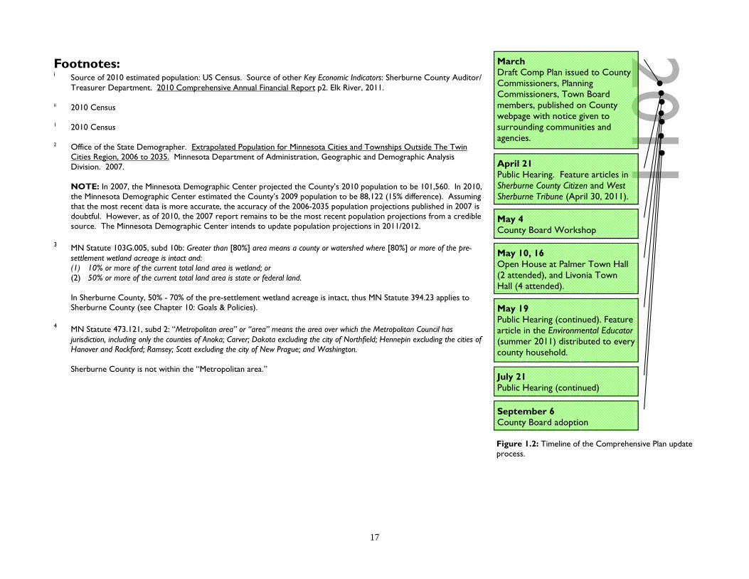
Figure 1.2: Timeline of the Comprehensive Plan update process.
2011 March Draft Comp Plan issued to County Commissioners, Planning Commissioners, Town Board members, published on County webpage with notice given to surrounding communities and agencies.
April 21 Public Hearing. Feature articles in Sherburne County Citizen and West Sherburne Tribune (April 30, 2011).
May 4 County Board Workshop
May 10, 16 Open House at Palmer Town Hall (2 attended), and Livonia Town Hall (4 attended).
May 19 Public Hearing (continued). Feature article in the Environmental Educator (summer 2011) distributed to every county household.
July 21 Public Hearing (continued)
September 6 County Board adoption

18
Chapter 2 Population
Summary Sherburne County’s settlement history can be seen as a series of transitions as industries, transportation, and technologies have changed, influencing how land is used. The Mississippi River corridor through Sherburne County was inhabited by the Ojibwe. During the 1600’s and 1700’s, French and British trading posts were established along the river, but did not prosper. After the Louisiana Purchase in 1803, much of the area was mapped. Treaties with the Ojibwe in 1837 and 1851 opened the area for logging and European settlement. By 1855, the Red River Ox-Cart Trail was replaced by a territorial/government road constructed between St. Paul and Fort Ripley, which today is U.S. Highway 10. Steamboats pushed logs downstream to local mills established in St. Cloud, Clearwater, Elk River, Anoka, and Champlin. The Homestead Act of 1862 attracted more European settlers increasing the County’s population from 725 in 1860 to 3,013 by 1870. A Railroad was established in 1865 along the territorial road. By 1879 the U.S. Army Corps of Engineers stopped maintaining a channel through the Mississippi River, and river towns re-orientated themselves becoming railroad towns, and agriculture replaced logging as the primary industry. Between 1902 and about 1920, a series of ditches were built to drain much of the County’s wetlands to convert into productive farmland. In the early 1970’s, mechanical irrigation pivots began to be widely used by farmers to irrigate crops on sandy soils. Between the 1920’s and 1950’s, weekend cottages and resorts were established along many of the lakeshores. By the 1960’s, the County’s township population surpassed city populations, only to reverse again during the 1980’s. As the metropolitan area expanded into the County, land values increased, resorts closed and cottages were replaced with year-around homes. Between the 1940’s and 1980’s, power plants were constructed in Becker and Elk River (2). Xcel Energy’s SHERCO plant in Becker is the largest coal plant in Minnesota, producing 15.8 million megawatt hours annually. Great River Energy’s Elk River Station was converted from coal to nuclear, reconverted to coal, and reconverted again to Refuse Derived Fuel. The County adopted a zoning ordinance in 1971 regulating land use within the townships. A housing boom occurred between 1985 - 2005.
Chapter 2 Population
Winding Trails subdivision, Baldwin Township

19
History The following is a brief timeline of events affecting land use in Sherburne County: 1853: Treaty of Traverse des Sioux ceding 24 million acres within the Minnesota Territory
to the U.S. Government. Chippewa and Mdwakanton Sioux tribes relocated. 1856: Sherburne County established, with five townships. 1857: First plat (map) approved (Town of Orono, now part of the City of Elk River). 1862: Federal Homestead Act approved, deeding 160-acres of federal land to citizens after
they have farmed, built and lived in a house on the land for a minimum of five years. 1865 - 1884: Railroad extended, connecting St. Cloud and Elk River, and Elk River and Princeton. 1920 - 1937: Highway 10 re-constructed from gravel road to a two-lane concrete trunk-highway. 1931 - 1932: Highway 169 re-constructed from gravel road to a two-lane concrete trunk-highway. 1938 - 1953: Highway 10 reconstructed from a two-lane to a four-lane divided trunk-highway. 1959: Minnesota Legislature adopts the County Planning Act, granting counties the
authority to appoint a planning commission and board of adjustment, and adopt a comprehensive plan and zoning ordinance to promote the “health, safety, moral and general welfare of the community.”
1964: County Planning & Zoning Commission appointed. 1965: County Interim Zoning Ordinance adopted 1965: Sherburne National Wildlife Refuge established. 1966: St. Cloud Area Planning Organization (APO) established, facilitating transportation
planning. 1968: County Economic Development Plan adopted. 1968 - 1974: Highway 169 reconstructed from a two-lane to a four-lane divided trunk-highway. 1970: County Transportation Plan adopted. 1970: County Comprehensive Plan adopted, guiding land use in townships. 1971: County Zoning Ordinance adopted regulating land use in townships. 1972: County adopted Uniform Building Code. 1973: County Solid Waste Ordinance adopted. 1976: County Economic Development Plan major revision. 1976: Mississippi Scenic Riverway Management Plan adopted by the Minnesota Department
of Natural Resources (DNR), regulating land use along the Mississippi River between St. Cloud and Anoka.
1976: Rail line between Elk River and Princeton discontinues regular service. 1976: St. Cloud Municipal Airport Zoning Ordinance adopted by Benton, Sherburne, and
Stearns counties, and St. Cloud. 1978: Elk River city and township consolidation 1978: County adopts Princeton Municipal Airport Zoning Ordinance.
Figure 2.1: Sherburne County Courthouse (1877 - 1980), 1981. Source: Minnesota Historical Society (used with permission).

20
1979: County adopted Wild & Scenic River ordinance. 1980: County adopts Minnesota Building Code. 1981: County Floodplain Ordinance adopted. 1982: DNR adopts the Cambridge Area Forest Resource Management Plan, which includes the Sand Dunes State Forest. 1986: County Solid Waste Management Plan adopted 1989: County Solid Waste Ordinance major revision. 1989: County Economic Development Plan major revision. 1991: Wetland Conservation Act adopted. 1991-1993: County Interim Zoning Ordinance in effect. 1992: County Comprehensive Plan revised. 1992: County Comprehensive Water Plan adopted. 1992-1994: County Shoreland Ordinance major revision. 1993: County Solid Waste Ordinance major revision. 1994: County Zoning and Subdivision ordinances major revision. 1997: County Transportation Plan major revision 1997: Community Based Planning Act established, creating the St. Cloud Area Joint Planning District. 1999, 2001: Community Based Planning Act repealed by MN Legislature. 2001: County Comprehensive Water Plan major revision. 2004: County Comprehensive Plan major revision. 2004: County Solid Waste Management Plan major revision. 2005: Joint County/Township parallel zoning and subdivision ordinances adopted by Baldwin and Big Lake townships. 2007: Joint County/Township parallel zoning and subdivision ordinances adopted by Livonia Township. 2007: County Comprehensive Water Plan major revision. 2007: County Transportation Plan major revision. 2009: County Road Right-of-Way ordinance adopted. 2009: Becker Township adopts Zoning and Subdivision ordinances. County continues to administer Floodplain, Wild & Scenic, Shoreland,
and Solid Waste ordinances. 2010: Haven Township adopts Zoning Ordinance within Orderly Annexation area. County continues to administer Floodplain, Wild &
Scenic, Shoreland, and Solid Waste ordinances. 2010: County Solid Waste Management Plan major revision. 2010: County Solid Waste Ordinance major revision. 2011: County Comprehensive Plan major revision.
Chapter 2 Population

21
Population Sherburne County has consistently been one of the fastest growing counties within the Twin Cities area. This has been primarily due to; The County’s proximity to employment centers in the Twin Cities; Easy access to State Highways 10, 101, 169, and Interstate 94; and Local land use policy has allowed rural residential development in the eastern half of the County. According to the U.S. Census, between 2000 - 2010, Sherburne County’s population grew from 64,417 to 88,499 (37%). Six other counties in Minnesota experienced more overall growth. But when it comes to township population growth, Sherburne County’s ten townships added 8,191 persons, more than twice as many as Beltrami (+3,408), Mille Lacs (+2,489), Scott (+2,309), and St. Louis (+2,083) counties. Chapter 9 includes population information specific to each township. Household Ethnicity According to the 2005-2009 American Community Survey; ethnically, almost half of the County’s residents are of German ancestry (45.1%), followed by Norwegian (16.7%), Irish (11.7%), Swedish (10.7%), and Polish (7.6%). The largest concentrations of residents claiming German heritage are in Clear Lake (62.4%), Clear Lake Township (60.6%), and Haven Township (57.4%). State-wide, 38.3% of residents are German, and 16.8% in the U.S. According to the 2010 Census, 94% of County residents are Caucasian (White), followed by Hispanics/Latinos (2.2%), and African American (Black) (1.9%). According to the 2005-2009 American Community Survey, 1,990 (2.3%) County residents were born in a foreign country. Those residents were most commonly from Europe, Asia, or Latin America. Of those foreign born, 364 residents entered the U.S. between 2000-2009. Social Characteristics According to the 2005-2009 American Community Survey, 64.9% of County households consist of a married couple, 52.1% in Minnesota, and 49.7% in the U.S. Communities with the highest percentage of married couples include; Becker (83.6%), Blue Hill (82.4%) and Livonia (77.4%) townships. Of residents 15 years of age and older, the divorce rate (i.e. current marital status is divorced) was 7.4% (male), and 9.2% (female) in the County, compared to 8.4% (male), and 10.2% (female) in Minnesota, and 9.2% (male), and 11.6% (female) in the U.S. Communities with the highest divorce rate (male % / female %) include; Clear Lake Township (15.3% / 4.8%), Clear Lake (14.7% / 7.5%), Zimmerman (13.8% / 18.4%), and Princeton (11.8% / 16.8%).
Figure 2.3: Population density by 2010 Census blocks. Source: U.S. Census Bureau.
Figure 2.2: Population density by 2000 Census blocks. Source: U.S. Census Bureau.

22
According to the 2005-2009 American Community Survey, 44.5% of County households have children under 18 years old, compared to 32.6% in Minnesota, and 34.2% in the U.S. Communities with the highest percentage of family households with children include; Clear Lake (64.7%), and Santiago (60%), Becker (55.8%), and Blue Hill (54.8%) townships. Communities with the lowest include; Princeton (22.3%), St. Cloud (24.1), and Clear Lake Township (28.2%). Communities with the highest percentage of households consisting of a single-parent with own children (_% male / _% female head of household) include; Clear Lake (12.7% / 0%), Zimmerman (4% / 14.3%), Princeton (0.5% / 6.9%), St. Cloud (1.8% / 6.2%), and Becker (6.1% / 4.6%). According to the 2005-2009 American Community Survey, 12.8% of County households include a person(s) 65-years old and older, compared to 21.2% in Minnesota, and 23.6% in the U.S. 4.1% of County households consist of a person 65 years old or older living alone, compared to 9.2% in Minnesota, and 9.3% in the U.S. Communities with the highest percentage include; Princeton (12.2%), Clear Lake (7.3%), and St. Cloud (6.8%). According to the 2005-2009 American Community Survey, there were an estimated 5,697 civilian veterans living in Sherburne County, or 9.4% of the population 18 years and older. This is compared to 10.2% in Minnesota, and 10.1% in the U.S. Communities with the highest percentage of veterans include Clear Lake Township (16% or 215), Baldwin Township (14% or 566), and Clear Lake (12.8% or 35). Other communities with a high number of veterans include St. Cloud (9.7% or 5,330), and Elk River (9.2% or 1,459). Health Behavioral Risks According to the Minnesota Department of Health, behavioral health risks of adult county residents are comparable (i.e. within 3%) to Minnesota county averages, except the percentage of adults with hypertension (high blood pressure) is 6.3% lower in Sherburne County (18.3%) compared to the state average (24.9%) between 2004 - 2007. According to the most recent estimates (2008), 24.5% of adults in Sherburne County are obese and 37.1% are overweight. 17.3% of adults do not exercise, and 20.2% of adults reported having limited activities due to physical, mental, or emotional problems.1 Births & Deaths According to the Minnesota Department of Health1, between 2003 - 2009 there was an average of 1,301 births per year by Sherburne County residents, while the County experienced an average of 416 deaths per year during this same time period. The leading causes of death of County residents was Cancer (22%) and Heart Disease (20%).
Figure 2.5: Natural Rate of Population Increase (the percentage change in the population due to the difference in the birth rate and death rate). Source: Minnesota Department of Health.1
Twp City Total Households (of all townships, cities) 12,347 14,200
Households with children under age 18 45.7% 52.9%
Family Households with children under age 18 43.9% 51.4%
Married couple-Family 75.3% 61.5% Householder living alone 14.1% 17.8% Householder living alone, age 65 or older 2.7% 4.6%
Households with individuals, age 65 or older 14.0% 11.8%
Average Household size 3.03 2.92 Average Family size 3.32 3.34 Figure 2.4: Social characteristics of households (average of townships and cities, excluding Princeton, St. Cloud). Source: 2005-2009 American Community Survey.
0.01.02.03.04.05.06.07.08.09.0
10.011.012.013.0
2003
2004
2005
2006
2007
2008
2009
Sherburne County7 County Twin Cities Metro4 Northwest Collar Counties
Chapter 2 Population

23
Between 2003 - 2009, Sherburne County’s average natural rate of population increase was 11.0, with a high of 11.6 in 2006 and a low of 9.6 in 2009, still well above the state average of 6.6. The natural rate of increase is the percentage change in population due to the difference in the birth rate and death rate. Sherburne’s decrease suggests the County’s population growth rate has steadily decreased from it’s peak in 2006, as have other fast growing counties. Net Migration Rate is the rate at which people migrate (move) from one area into another. According to US Census estimates, in 2002 Sherburne County had a net migration rate of 39.5 meaning that 2,771 more people moved into the county than moved out of it. But in 2009, the County had a net migration rate of –4.6 meaning 407 more people moved out of Sherburne County than moved into it.2
Healthcare Facilities Healthcare facilities within the County or in close proximity include; Hospitals: St. Cloud Hospital (St. Cloud), Level 2 Trauma Center, 489 licensed beds Fairview Northland Medical Center (Princeton), Level 4 Trauma Center, 54 licensed beds New River Medical Center (Monticello), Level 4 trauma Center, 39 licensed beds Healthcare Clinics: Within Sherburne County, healthcare clinics are located in most cities and are concentrated in Elk River (9 clinics). Clinics are operated by Allina, CentraCare, Fairview, HealthPartners, North Memorial, and independent providers.
Figure 2.7: Internal Migration Rate of Region 7W counties, 2001-2009. In 2009, 407 more people moved out of Sherburne County than moved into it. Source: US Census.2
-10
0
10
20
30
40
2001
2002
2003
2004
2005
2006
2007
2008
2009
Minnesota Benton CountySherburne County Stearns CountyWright County
Figure 2.6: Behavioral risk factors of adult Sherburne County and Minnesota residents. Source: Minnesota Department of Health; Behavioral Risk Factor Surveillance System.1
Obese or Overweight Current Smokers Acute Drinking Chronic Drinking Perceiving health
status as fair or poor
Reporting limitation in any activities because of any
impairment or health problem
No exercise Hypertension
MN Sherburne MN Sherburne MN Sherburne MN Sherburne MN Sherburne MN Sherburne MN Sherburne MN Sherburne
2003 60.4% 59.4% 21.2% 22.7% 20.0% 22.7% 5.6% 5.8% 11.1% 9.4% 23.6% 21.6% N/A N/A N/A N/A
2004 59.6% 57.9% 20.8% 22.1% 19.9% 22.3% 5.6% 5.9% 10.0% 8.6% 21.8% 19.6% 15.9% 15.1% 24.5% 20.3%
2005 59.9% 58.7% 20.0% 21.5% 18.8% 21.4% 5.0% 5.1% 11.3% 9.9% 26.0% 20.6% 17.8% 15.2% 28.6% 17.7%
2006 N/A N/A N/A N/A N/A N/A N/A N/A N/A N/A N/A N/A N/A N/A N/A N/A
2007 61.7% 60.7% 16.5% 17.4% 14.3% 16.0% 3.8% 3.8% 11.0% 9.7% 18.8% 16.5% 16.7% 15.7% 21.5% 17.8%
2008 62.7% 61.6% 17.5% 18.5% 19.7% 21.8% 4.7% 4.8% 11.4% 10.2% 22.5% 20.2% 19.5% 17.3% N/A N/A

24
Assisted Living: Minnesota licensed assisted living facilities within the County include St. Benedict’s Senior Community (St. Cloud - 222 beds), Guardian Angels by The Lake (Elk River - 120 beds), Talahi Care Center (St. Cloud - 77 beds) and Lange Board & Rooming Home (Santiago Township). Additionally, there are a number of local providers for home healthcare and home hospice care. Uninsured The U.S. Census estimates that as of 2007, 7,362 Sherburne County residents (9.1%) under age 65 do not have health insurance. Education Sherburne County is served by seven public school districts. According to the 2005-2009 American Community Survey, in Sherburne County 93% of adult residents are high school graduates (above state and U.S. averages), 24% have obtained a Bachelor’s degree, and 6% have obtained a Master’s or professional degree. Figure 2.12 shows the change in total school enrollment by district (pre-Kindergarten - 12th Grade). The graph shows that the Elk River district has grown substantially in numbers while St. Cloud has declined, and others have remained steady or have had gradual increases. The biggest percentage increases between the 1989/1990 - 2009/2010 school years were experienced by Big Lake (66%), Becker (65%), and Elk River (52%). Enrollment decreases were experienced by St. Cloud (-15%) and Foley (-0.5%). Globe University/Minnesota School of Business includes a campus in Elk River (opened in 2009 as 1 of 19 campuses), and offers certificate, associate, and bachelor degree programs primarily in the business and healthcare industries. The nearest traditional 4-year university is St. Cloud State University (about 17,000 students enrolled), located along the Mississippi River in Stearns County. SCSU offers more than 200 programs. Other nearby 4-year colleges include the College of St. Benedict in St. Joseph, and St. John’s University in Collegeville. Two-year colleges nearby include St. Cloud Technical College in St. Cloud, Anoka-Hennepin Technical College in Ramsey, and Anoka-Ramsey Community College in Cambridge and Coon Rapids. Employment The Census compiles employment data according to Industry and Occupation. According to the 2005-2009 American Community Survey, industries which employed a significantly higher percentage of local workers compared to state and U.S. averages included the manufacturing, and construction industries.
Figure 2.8: Area healthcare facilities. Source: Sherburne County Health & Human Services Department.
Figure 2.9: Public K-12 school districts and school locations serving primarily County residents (excludes charter schools and public specialty schools). Source: Sherburne County Public Works Dept.
Chapter 2 Population

25
District High
Schools Grades Served
Student Pop
School property tax paid on a
$200,000 house in a township
(2009)
Total Expenditure per Student (2008)
Limited English Proficiency Special Ed.
Free & Reduced
Priced Lunch
(2008) Minnesota Comprehensive Assessment Series II Scores
AYP Graduation Rate
Reading (grade 10) Math (grade 11)
Exceed or Meet Standard
Does Not Meet Standard
Exceed or Meet Standard
Does Not Meet Standard
Becker Becker 9-12 717 $394.68 $9,140 1% 14% 12% 74% 4% 38% 40% 99.4% Big Lake Big Lake 9-12 959 $732.48 $7,971 0% 13% 21% 66% 11% 36% 44% 97.4%
Elk River Elk River 9-12 1,694
$724.30 $8,490 3% 14% 10% 74% 7% 37% 40% 98.0%
Zimmerman 9-12 560 $8,873 1% 16% 16% 69% 9% 32% 46% 90.4% Foley Foley 9-12 517 $871.46 $8,440 0% 14% 29% 69% 9% 22% 55% 100.0% Princeton Princeton 9-12 1,084 $387.48 $8,534 0% 12% 20% 65% 15% 34% 46% 98.6% St. Cloud Technical 9-12 1,543 $269.84 $8,330 7% 13% 26% 68% 13% 42% 36% 97.3% Monticello Monticello 9-12 1,170 $521.66 $9,605 1% 15% 17% 75% 8% 36% 38% 95.6%
District Middle
Schools Grades Served
Student Pop
Total Expenditure per Student (2008)
Limited English Proficiency Special Ed.
Free & Reduced
Priced Lunch
(2008) Minnesota Comprehensive Assessment Series II Scores
AYP Attendance Rate
Reading (grade 7) Math (grade 7)
Exceed or Meet Standard
Does Not Meet Standard
Exceed or Meet Standard
Does Not Meet Standard
Becker Becker 6-8 608 $7,075 0% 13% 17% 67% 11% 65% 11% 96.3% Big Lake Big Lake 6-8 829 $6,583 2% 12% 21% 59% 18% 55% 19% 95.2%
Elk River Zimmerman 6-8 460 $7,351 2% 14% 20% 50% 20% 51% 21% 95.6% Vandenberg 6-8 546 $9,666 5% 17% 15% 67% 13% 65% 12% 96.5% Salk 6-8 651 $8,236 2% 13% 13% 61% 9% 69% 11% 96.2%
Foley Foley Intermed. 4-8 610 $7,244 0% 16% 29% 63% 14% 57% 16% 96.8% Princeton Princeton 6-8 794 $7,687 1% 13% 27% 60% 21% 52% 24% 94.5% St. Cloud South Junior 7-8 702 $8,212 8% 15% 34% 60% 21% 59% 15% 94.9% Monticello Monticello 6-8 906 $9,889 1% 16% 22% 65% 13% 49% 22% 96.0%
District Elementary
Schools Grades Served
Student Pop
Total Expenditure per Student (2008)
Limited English Proficiency Special Ed.
Free & Reduced
Priced Lunch
(2008) Minnesota Comprehensive Assessment Series II Scores
AYP Attendance Rate
Reading (grade 3) Math (grade 3)
Exceed or Meet Standard
Does Not Meet Standard
Exceed or Meet Standard
Does Not Meet Standard
Becker Becker Primary K-2 621 $7,185 2% 11% 15% N/A N/A N/A N/A 96.3% Becker Intermed, 3-5 696 $6,983 2% 11% 17% 84% 5% 85% 4% 96.5%
Big Lake Independence K-5 978 $6,411 2% 9% 22% 82% 11% 82% 4% 95.9% Liberty K-5 784 $7,567 3% 13% 21% 84% 8% 77% 4% 96.2%
Elk River
Zimmerman K-2 599 $8,085 2% 16% 21% N/A N/A N/A N/A 95.8% Westwood 3-5 556 $7,509 3% 13% 23% 85% 6% 80% 4% 95.6% Twin Lakes K-5 698 N/A 4% 10% 13% 86% 5% 88% 1% N/A Parker K-5 428 $8,168 2% 15% 21% 89% 7% 84% 3% 96.5% Meadowvale K-5 654 $7,618 1% 13% 9% 81% 10% 75% 2% 96.8% Lincoln K-5 522 $8,149 2% 14% 27% 86% 6% 89% 5% 96.5%
Foley Foley K-3 524 $7,511 0% 13% 31% 83% 9% 81% 2% 96.7%
Princeton North 3-5 801 $7,038 1% 12% 26% 76% 13% 72% 7% 95.8% South K-2 787 $7,282 1% 9% 23% N/A N/A N/A N/A 95.5%
St. Cloud Clearview K-6 389 $9,390 0% 20% 25% 66% 20% 75% 6% 96.2% Lincoln K-6 302 $10,710 0% 20% 64% 54% 14% 78% 10% 94.7% Talahi K-6 673 $9,743 25% 19% 70% 50% 22% 70% 5% 95.6%
Monticello Pinewood K-5 1014 $9,320 2% 15% 23% 87% 8% 83% 3% 95.8%
Figure 2.10: School District performance. Source: MN Department of Education, Sherburne County Auditor/Treasurer’s Dept. (tax rates).

26
Predominate industries Sherburne County residents are employed in include; Education, Health & Social Services (19.9%, up from 17.8% in 2000 Census), Manufacturing (16.8%, down from 21.3% in 2000), Retail Trade (12.7%, down from 13.3% in 2000), and Construction (9.8%, up from 9.5% in 2000). Of township residents 16 years and older, 17.5% were employed in Manufacturing compared to 15.3% in cities (excluding Princeton and St. Cloud), 14.2% in Minnesota, and 11.2% in the U.S. Communities with the highest percentage of workers in this industry include Blue Hill Township (21.7%), Livonia Township (21.4%), and Orrock Township (20.7%). Page 13 includes a list of major manufacturing companies and products made locally. Of township residents 16 years and older, 11.8% were employed in Construction compared to 12.3% in cities (excluding Princeton and St. Cloud), 6.4% in Minnesota, and 7.4% in the U.S. Communities with the highest percentage of workers in this industry include Clear Lake (21.9%), Blue Hill Township (17.5%), and Baldwin Township (15.8%). According to the MN Department of Employment and Economic Development, as of December 2010, the unemployment rate in Sherburne County was 8.1% compared to 6.5% in the 15-county Twin Cities Metropolitan Statistical Area (MSA), which Sherburne is included in. The U.S. unemployment rate was 9.1%. Sherburne County’s increased unemployment rate may be attributed to the loss of manufacturing jobs and seasonal fluctuation of construction jobs, as illustrated in Figure 2.11. According to the
Figure 2.12: Pre-K - 12 Public School Enrollment, 1989 - 2010, Source: MN Department of Education.
Figure 2.11: Monthly unemployment rate (not adjusted for seasonal employment), 1948 - 2010. Source: MN Department of Employment and Economic Development.
0%1%2%3%4%5%6%7%8%9%10%11%12%
Jan-
48Ja
n-49
Jan-
50Ja
n-51
Jan-
52Ja
n-53
Jan-
54Ja
n-55
Jan-
56Ja
n-57
Jan-
58Ja
n-59
Jan-
60Ja
n-61
Jan-
62Ja
n-63
Jan-
64Ja
n-65
Jan-
66Ja
n-67
Jan-
68Ja
n-69
Jan-
70Ja
n-71
Jan-
72Ja
n-73
Jan-
74Ja
n-75
Jan-
76Ja
n-77
Jan-
78Ja
n-79
Jan-
80Ja
n-81
Jan-
82Ja
n-83
Jan-
84Ja
n-85
Jan-
86Ja
n-87
Jan-
88Ja
n-89
Jan-
90Ja
n-91
Jan-
92Ja
n-93
Jan-
94Ja
n-95
Jan-
96Ja
n-97
Jan-
98Ja
n-99
Jan-
00Ja
n-01
Jan-
02Ja
n-03
Jan-
04Ja
n-05
Jan-
06Ja
n-07
Jan-
08Ja
n-09
Jan-
10Ja
n-11
Sherburne County Twin Cities MSA U.S.
01,0002,0003,0004,0005,0006,0007,0008,0009,000
10,00011,00012,00013,000
1989
- 19
90
1991
- 19
92
1993
- 19
94
1995
- 19
96
1997
- 19
98
1999
- 20
00
2001
- 20
02
2003
- 20
04
2005
- 20
06
2007
- 20
08
2009
- 20
10
Becker ISD 26 Big Lake ISD 27Elk River ISD 28 Foley ISD 51Princeton ISD 77 St. Cloud ISD 78Monticello ISD 82
Chapter 2 Population
27
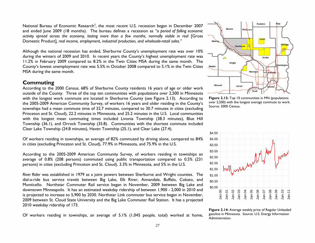
National Bureau of Economic Research3, the most recent U.S. recession began in December 2007 and ended June 2009 (18 months). The bureau defines a recession as “a period of falling economic activity spread across the economy, lasting more than a few months, normally visible in real [Gross Domestic Product], real income, employment, industrial production, and wholesale-retail sales.” Although the national recession has ended, Sherburne County’s unemployment rate was over 10% during the winters of 2009 and 2010. In recent years the County’s highest unemployment rate was 11.2% in February 2009 compared to 8.2% in the Twin Cities MSA during the same month. The County’s lowest unemployment rate was 5.5% in October 2008 compared to 5.1% in the Twin Cities MSA during the same month. Commuting According to the 2000 Census, 68% of Sherburne County residents 16 years of age or older work outside of the County. Three of the top ten communities with populations over 2,500 in Minnesota with the longest work commute are located in Sherburne County (see Figure 2.13). According to the 2005-2009 American Community Survey, of workers 16 years and older residing in the County’s townships had a mean commute time of 32.7 minutes, compared to 30.7 minutes in cities (excluding Princeton and St. Cloud), 22.2 minutes in Minnesota, and 25.2 minutes in the U.S. Local communities with the longest mean commuting times included Livonia Township (38.3 minutes), Blue Hill Township (36.1), and Orrock Township (35.8). Communities with the shortest commute included Clear Lake Township (24.8 minutes), Haven Township (25.1), and Clear Lake (27.4). Of workers residing in townships, an average of 82% commuted by driving alone, compared to 84% in cities (excluding Princeton and St. Cloud), 77.9% in Minnesota, and 75.9% in the U.S. According to the 2005-2009 American Community Survey, of workers residing in townships an average of 0.8% (208 persons) commuted using public transportation compared to 0.5% (231 persons) in cities (excluding Princeton and St. Cloud), 3.3% in Minnesota, and 5% in the U.S. River Rider was established in 1979 as a joint powers between Sherburne and Wright counties. The dial-a-ride bus service travels between Big Lake, Elk River, Annandale, Buffalo, Cokato, and Monticello. Northstar Commuter Rail service began in November, 2009 between Big Lake and downtown Minneapolis. It has an estimated weekday ridership of between 1,900 - 2,000 in 2010 and is projected to increase to 5,900 by 2030. Northstar Link commuter bus service began in November, 2009 between St. Cloud State University and the Big Lake Commuter Rail Station. It has a projected 2010 weekday ridership of 173. Of workers residing in townships, an average of 5.1% (1,045 people, total) worked at home,
Figure 2.13: Top 10 communities in MN (populations over 2,500) with the longest average commute to work. Source: 2000 Census.
Figure 2.14: Average weekly price of Regular Unleaded gasoline in Minnesota. Source: U.S. Energy Information Administration.
$0.00
$0.50
$1.00
$1.50
$2.00
$2.50
$3.00
$3.50
$4.00
$4.50
Jan-
00
Jan-
01
Jan-
02
Jan-
03
Jan-
04
Jan-
05
Jan-
06
Jan-
07
Jan-
08
Jan-
09
Jan-
10
Jan-
11

28
compared to 3.2% in cities (excluding Princeton and St. Cloud), 4.9% in Minnesota, and 4% in the U.S. Communities with the highest percentage of residents who worked from home include Becker (8% or 162 persons), Haven Township (7% or 102 persons), and Livonia Township (6.9% or 161 persons). Poverty The Minnesota Office of the Legislative Auditor defines Affordable Housing as: (1) Housing consumes no more than 30% of gross family income, and (2) Housing is affordable to those earning 50% of the local median income for rental housing, and 80% of the local median income for owner-occupied housing. According to the 2005-2009 American Community Survey, 6.5% of the County’s population has an income below the poverty level. 8.0% of the population over 65 years old live in poverty. 6.4% of families with children under 18 years old live in poverty. Communities with the highest percentage of family households living below the poverty level include; St. Cloud (10.2%), Big Lake (8.2%), and Zimmerman (5.9%). According to the 2005-2009 American Community Survey, the County’s median earnings for all workers was $35,611. The median household income was $71,228.
Figure: 2.17: Location of homes built by decade. City boundaries are as of 2009. Source: Sherburne County Assessor’s Dept.
Figure 2.15: Total housing units constructed in Cities and Townships, 1972 - 2010. Multi-family units include apartments, condominiums, nursing home units, townhomes, twin-homes, duplexes, and quadplexes. Source: Sherburne County Planning & Zoning Dept.
0100200300400500600700800
1972
1974
1976
1978
1980
1982
1984
1986
1988
1990
1992
1994
1996
1998
2000
2002
2004
2006
2008
2010
Multi-family units built in CitiesSingle-family units built in CitiesSingle-family units built in Townships
Figure 2.16: Comparison between the number of residential lots platted and the number of homes built on platted lots. Source: Sherburne County Planning & Zoning Dept.
0100200300400500600700800
1972
1974
1976
1978
1980
1982
1984
1986
1988
1990
1992
1994
1996
1998
2000
2002
2004
2006
2008
2010
Residential lots platted (Townships)
Homes built on platted lots(T hi )
Chapter 2 Population

29
Housing Figure 2.15 shows the number of housing units built per year in townships and cities. Township and city growth rates were comparable during the 1990’s. Then a housing boom occurred in the cities during the early 2000’s (high of 1,185 units in 2003), followed by a sharp decline beginning in 2005 (low of 52 units in 2008), presumably because the market was overbuilt. Figure 2.16 shows the correlation between the number of residential lots platted compared to the number of homes built on platted lots in townships. For larger subdivisions, it usually takes at least one year from the time a subdivision is approved by the County Board until a building permit for a new house is issued by the County Planning & Zoning Department. During that time, the subdivision plat is recorded, soil grading is completed, utilities are installed, roads are built, and lots are marketed and sold. Thus, changes in the number of homes built usually follows at least one year behind any change in the number of residential lots approved. Figure 2.16 also shows when the market may have been over developed with new lots compared to the demand to build new homes, such as in the early 1970’s and in the mid-2000’s. As of 2011, there were about 3,900 vacant residential platted lots county-wide. Home Ownership County-wide, according to the 2005-2009 American Community Survey, 86.4% of homes are owner occupied, while 13.6% are renter occupied. An average of 95.6% of households in townships are owner occupied, compared to an average of 83.8% in cities. The highest percentage of renter occupied households include; St. Cloud (45.6%), Princeton (28.8%), and Clear Lake (17.3%). According to the 2005-2009 American Community Survey, 58.7% of County residents moved into their current home between 2000-2009. 25.7% of residents moved in between 1990-1999. Average Home Sale Price According to the Sherburne County Assessor’s Department, the average sale price of a single-family home in the County in January 2000 was $149,935. Between 2000 - 2010, the average sale price peaked in November 2007 at $271,952 (81% increase since January 2000) before falling to $166,484 in November, 2010 (11% increase since January 2000). These figures represent “good sales” which exclude short sales, foreclosures, estate sales, etc. Data also excludes all home sales within the City of St. Cloud. The Standard & Poor/Case-Shiller Home Price Index (Figure 2.19) measures the percentage rate of change of the average sale price of homes in the 20 largest Metropolitan Statistical Areas (MSA). Sherburne County is included within the Minneapolis/St. Paul MSA. The Index is often referred to as
050
100150200
250300
Jan-
00
Jan-
01
Jan-
02
Jan-
03
Jan-
04
Jan-
05
Jan-
06
Jan-
07
Jan-
08
Jan-
09
Jan-
10
Jan-
11
Sherburne CountyMinneapolis / St. PaulLos AngelesMiamiDetroitAvg of 10 Largest Metro AreasAvg of 20 Largest Metro Areas
Figure: 2.19: “The Housing Bubble.” Percentage change in the average monthly sale price of single-family homes. 100 = 100% of the home value as of January 2000. Sherburne County’s data excludes non-traditional sales, and sales within the City of St. Cloud. The line representing the County zigzag’s because the fewer the monthly home sales, the more the average is affected by extreme high and low sale prices. Source: S&P/Case-Shiller Home Price Indices8, Sherburne County Assessor’s Dept.
Figure 2.18: Vacant residential platted lots (2011), Source: Sherburne County Assessor’s Dept.7

30
one measure of a local economy’s health. Providing an “apples-to-apples” comparison of a home valued at $200,000 as of January, 2000 (values rounded to the nearest $1,000): In Sherburne County, the home’s value would have peaked at $363,000 in November 2007, and
bottomed out at $222,000 in November 2010. In the Twin Cities, the home’s value would have peaked at $342,000 in June 2006, and bottomed
out at $217,000 in April 2009. In Los Angeles, CA the home’s value would have peaked at $548,000 in September 2006, and
bottomed out at $319,000 in April 2009. In Miami, FL, the home’s value would have peaked at $562,000 in December 2006, and bottomed
out at 286,000 in December 2010. In Detroit, MI, the home’s value would have peaked at $253,000 in November 2005, and
bottomed at $132,000 in December 2010. The fluctuation in home values initially contributed to the rise in home foreclosures. Home Foreclosures Sherburne County experienced a significant increase in the number of home foreclosures, beginning in 2005. The highest concentrations were in the cities of Elk River and Big Lake. About two-third’s of home foreclosures in the County were in cities compared to townships. In 2005 and 2010, Sherburne County had the highest residential foreclosure rate in Minnesota, and the second highest between 2006 through 2009. Figure 2.20 shows the regional residential foreclosure rate4 during this period.
Figure 2.20: Residential Foreclosure Rate, 2005-2010. Foreclosure Rate = the number of foreclosed mortgages as a percent of total residential parcels. Source: HousingLink5
Figure 2.21: Average monthly sale price of single-family detached homes in Sherburne County, 2000 - 2010. Excludes Princeton, St. Cloud, non-traditional sales. Source: Sherburne County Assessor’s Dept.
$0$25,000$50,000$75,000
$100,000$125,000$150,000$175,000$200,000$225,000$250,000$275,000$300,000$325,000
Jan-
00
Jan-
01
Jan-
02
Jan-
03
Jan-
04
Jan-
05
Jan-
06
Jan-
07
Jan-
08
Jan-
09
Jan-
10
City Avg Township Avg
Chapter 2 Population

31
Figure 2.23: Location of home foreclosures, 2006-2009. Source: Sherburne County Sheriff’s Dept.
Figure 2.22 Number of foreclosures, 2000-20010. Source: Sherburne County Sheriff’s Dept.
State-wide in 2010, the highest foreclosure rates in counties were experienced in; Sherburne (2.93%), Isanti (2.56%), Mille Lacs (2.47), Kanabec (2.45%), and Chisago (2.32%) counties. Four of these counties are known as the “collar counties” located north-northwest of the Twin Cities suburbs. Kanabec County is adjacent to Isanti and Mille Lacs counties. In Sherburne County, the average annual home value appreciation increased 8% - 10% between 2001 - 2005. But in 2006 it was 6%. In 2007 it was -1%. In 2008 it was -5%, and in 2009 it was -15%. Footnotes: 1 Minnesota Department of Health. Morbidity and Utilization, Minnesota Behavioral Risk Factors of Adults - County
Synthetic Estimates and State Estimates, 2003, 2004, 2005, 2007, 2009.
2 St. Cloud Area Economic Development Partnership. Comprehensive Economic Development Strategy. St. Cloud, MN, 2010 (Chapter 2, Figure 2). Source of data: http://www.census.gov/popest/estimates.html
3 The National Bureau of Economic Research is a private, nonprofit, nonpartisan research organization dedicated to promoting a greater understanding of how the economy works. Among other projects, the organization identifies contraction (recession) and expansion of business cycles, from 1854 to present. The Federal Reserve Bank does not officially determine the beginning and end of economic recessions, leaving this opinion to others.
4 Minnesota Home Ownership Center. Foreclosures in Minnesota: A Report Based on Sheriff's Sales. February 15, 2010. 5 Greater Minnesota Housing Fund. Foreclosures in Minnesota: A Report Based on County Sheriff’s Sale Data April 2008.
p12, 22. NOTE: Projected 2008 sheriff’s sales is an estimate based on the number of sheriff’s sales reported for Q1 2008. Data Source: HousingLink (Sheriff’s Sales by County), MN Demographic Center (2005 household projection), map created by Elissa Schloesser.
6 Federal Reserve Bank of St. Louis. A Word on the Economy for High School Students; The Financial Crisis: What
Happened? September, 2009 www.stlouisfed.org/education_resources/AWordontheEconomy/player.html June 18, 2010. 7 Residential vacant lots (2011), defined as; (1) property platted between January 1, 1971 and June 15, 2011; (2) lot is less
than 10-acres in size; (3) lot has a Residential tax classification (2011); and (4) has a building value of less than $10,000. 8 S&P / Case-Shiller Home Price Indices. U.S. Home Price Values, March 2010 (not seasonally adjusted)
http://www.standardandpoors.com/home/en/us June 23, 2010.
58 70115134144
210
342
675
912
704
830
0
100
200
300
400
500
600
700
800
900
1000
2000
2001
2002
2003
2004
2005
2006
2007
2008
2009
2010

32
Chapter 3 Natural Resources
Summary Minnesota is divided into four ecological providences; Laurentian Mixed Forest, Eastern Broadleaf Forest, Tallgrass & Aspen Parklands, and Prairie Parklands. Sherburne County is located within the Anoka Sand Plain subsection of the Eastern Broadleaf Forest. Within the Anoka Sand Plain, much of the peatlands have been drained for sod and vegetable crops, and much of the prairie and savanna have been urbanized. Of Minnesota counties, Sherburne is ranked 5th in vegetable production, and 2nd in population growth. Chapter 3 summarizes the County’s natural environment and its sensitivities to land use and human habitation. Much of the lake shorelands were developed prior to 1971, when the County adopted a Shoreland Ordinance. This ordinance is based on the Minnesota Department of Natural Resources (DNR) model county shoreland ordinance. Within the Shoreland District, the ordinance regulates land use, subdivision design, structure and septic system setbacks from shoreland. The ordinance also limits the addition and removal of soil, and the removal of vegetation. Bedrock Geology Igneous and metamorphic crystalline rocks underlie the western part of Sherburne County, including all of Clear Lake, Haven, and Palmer townships and most of Becker, Blue Hill, and Santiago townships. These rocks generally have very little, if any, porosity and may be difficult to produce water at amounts necessary for domestic or public water supply. The depth to bedrock in this region is generally zero to 100 feet. A few granite outcrops occur in Haven Township near St. Cloud.
Chapter 3 Natural Resources
Figure 3.1: The Anoka Sand Plain subsection (dark green area) of the Eastern Broadleaf Forest (green areas), Source: MN DNR.
Mississippi River, Big Lake Township

33
Sedimentary rocks underlie the eastern part of Sherburne County including all of the cities of Elk River and Big Lake, all of the townships of Livonia and Orrock; most of Baldwin Township; and parts of Becker, Blue Hill, and Santiago townships. These rocks generally produce water at amounts necessary for domestic and public water supply. The depth to bedrock in this region is generally 50’ to 300’. Surficial Geology Sherburne County lies almost completely within a geologic landform known as the Anoka Sand Plain. The Anoka Sand Plain is a broad sandy lake plain, which contains small dunes, kettle lakes, and tunnel valleys. The other important landform is a series of sandy terraces associated with historic levels of the Mississippi River and its major tributaries (see Figure 3.2). Surficial geology and pollution-sensitive areas are important to identifying the occurrence and movement of groundwater and the relation of groundwater to aquifers in the County. Surficial geology and pollution-sensitive areas are important factors when making land use decisions relating to agriculture, irrigation, and designing onsite sewage treatment systems. The surface geology in the County is dominated by two underlying features: Grantsburg Sublobe outwash and lake sand deposits, and Mississippi River terrace deposits. Less dominate is a small area of Superior Lobe outwash deposits at the east end of the County. The Grantsburg Sublobe outwash consists of sand and gravel, and the lake sand deposits consist of very fine to medium sand. The terrace deposits of the Mississippi River and Superior Lobe outwash consists of sand and gravel. Soils Soils in the County range from excessively well drained to very poorly drained, however, most of the County is dominated by excessively drained soils. This parallels the area where the pollution sensitivity of the aquifer contamination is the highest. Evaluation of soil suitability as it relates to onsite sewage treatment systems is also dependent upon the level of the water table in the area; a higher water table will accentuate the circumstances, whereas a lower water table could reduce the impact of less suitable soils on potential groundwater contamination. Organic soil associations are found in the County. These are very poorly drained soils, with primary uses being specialty crops, sod, pasture and wildlife land. These soils are also considered to have severe soil limitations for on-site sewage treatment systems because they typically have poor percolation rates and are susceptible to “ponding.” Pollution Sensitivity Pollution sensitivity is the potential due to surficial geology characteristics for surface contamination
Figure 3.3: Soil Survey, Drainage. Source: Natural Resource Conservation Survey.
Figure 3.2: Surficial Geology. Source: MN DNR.

34
to reach groundwater resources. Travel times are controlled by the permeability and thickness of geologic materials through which contaminants would move. Longer travel times are associated with both a greater degree of geologic protection and reduced sensitivity to groundwater pollution. Shorter travel times represent increased sensitivity and inability to protect groundwater from vertical contaminant movement. Figure 3.5 shows that Sherburne County is dominated by very high pollution sensitivity due to the presence of sand and gravel over much of the surface of the County. Water Use & Source The Minnesota Department of Natural Resources permits high volume wells drawing 10,000+ gallons per day or 1 million gallons per year (MN Dept of Health permits high volume wells for domestic use). As of 2010, there were 562 active high volume groundwater wells and 50 active high volume surface water wells in Sherburne County. Between 2000 and 2009, an average of 43 billion gallons of water was pumped annually, mostly from rivers & streams (21.7 billion gallons) and from groundwater (11.1 billion gallons). The primary use of water is for power generation plants and crop irrigation.1 During this same period, Power Generation Plants consumed an annual average of 20.6 billion gallons of water from rivers & streams, and 377 million gallons from groundwater. Major users include Xcel Energy (Sherco plant) and Great River Energy, both drawing primarily from the Mississippi River for steam power cooling.1
Figure 3.5: Pollution Sensitivity. Source: MN DNR.
Figure 3.4: What water is used for in Sherburne County. MN DNR Water Appropriation permits are required for withdrawals greater than 10,000 gallons per day or 1 million gallons per year. This graph does not include withdrawals less than this amount (i.e. residential wells). Source: MN DNR,1
05,000
10,00015,000
20,00025,000
30,00035,00040,00045,000
50,000
2009
2008
2007
2006
2005
2004
2003
2002
2001
2000
1999
1998
1997
1996
1995
1994
1993
1992
1991
1990
1989
1988
mill
ions
of g
allo
ns
Major Crop Irrigation
Non-Crop Irrigation
Special Categories
Water Level Maintenance
Temporary
Industrial
Air Conditioning
Power Generation
Waterworks (potable water)
Figure 3.6: Where water comes from in Sherburne County, via water appropriation permits. The spikes in Streams/Rivers can be attributed to increased use by Xcel Energy and Great River Energy, both drawing from the Mississippi River. Source: MN DNR.1
0
5,00010,000
15,000
20,00025,000
30,000
2009
2007
2005
2003
2001
1999
1997
1995
1993
1991
1989
mill
ion
gallo
ns
GroundwaterLakeStream / RiverDitchDug Pit / Holding PondQuarry / Mine / Gravel PitWetland
Chapter 3 Natural Resources

35
During this same period, Crop irrigation consumed an annual average of 37 million gallons of water from rivers & streams, and 8.5 billion gallons from groundwater. Rivers & streams commonly used include the St. Francis, Mississippi, and Elk rivers.1
In 2007, Sherburne County farmers produced about $64 million in agricultural products. Crop production in the County is dependent upon access to water for irrigation. If groundwater were no longer accessible, it is likely that most farmland in the County would be converted into other land uses. In 2009, 62,668-acres of cropland was irrigated by groundwater. Irrigated fields range in size between 12-acres (see Figure 4.1) and 395-acres, and averaged 110-acres in size. The depth of groundwater wells for crop irrigation ranged between 25’ and 585’ in depth (108’ average depth), and were permitted (2009) to withdraw an average of 36.2 million gallons per year (700 million gallons per minute) although the average well withdrew only 16 million gallons of groundwater in 2009.1 There are a number of known and unknown factors related to groundwater supply. Known data include; geology (Figure 3.2), precipitation amounts by location (Figure 3.21), depth to water table by location (Figure 3.7), and water usage (Figure 3.4). Unknown factors include infiltration rates (the time it takes water on the ground surface to reach aquifers). Thus it is unknown if groundwater is being pumped at a faster rate than its aquifers can be recharged, and the effects pumping has on surface waters such as lakes and wetlands, and ecology. The Minnesota Water Sustainability Framework (2011) suggests that state funding be increased to complete county geological atlases sooner. Sherburne County’s geological atlas is scheduled to be completed by 2013/2014. A geological atlas is a systematic study of the areas’ geologic and groundwater resources. The Framework also suggests that maximum volumes permitted be based on how the groundwater withdrawn affects the local ecology, whereas currently, permits are granted and then revoked or suspended if the amount withdrawn negatively affects other users. 2 The DNR and SWCD monitor a number of observation wells throughout the County, most installed in the 1970’s and 1980’s, and monitored monthly (see Figure 3.7). In 2010, eight observation wells were drilled, providing hourly data, but not enough time has elapsed to make historical comparisons of changes in water table depth. Nitrates Nitrate is a common contaminant found in many wells in Minnesota. Nitrate contamination of a well is often regarded as a first sign of deteriorating groundwater quality. Natural levels of nitrate in Minnesota groundwater are usually quite low (less than 1 milligram per liter [mg/L] of nitrate-nitrogen). Elevated nitrate levels in groundwater are often caused by run-off from barnyards or feedlots, excessive use of fertilizers, or septic systems. Wells most vulnerable to nitrate
-25-20-15-10
-50
Jan-
76Ja
n-78
Jan-
80Ja
n-82
Jan-
84Ja
n-86
Jan-
88Ja
n-90
Jan-
92Ja
n-94
Jan-
96Ja
n-98
Jan-
00Ja
n-02
Jan-
04Ja
n-06
Jan-
08Ja
n-10
Figure 3.7: Depth to water table (feet). The DNR and SWCD monitor observation wells throughout the County. Shown above are four wells monitored since the 1970’s. Source: MN DNR, Minnesota Climatology Working Group.

36
contamination include shallow wells, dug wells with casings which are not watertight, and wells with damaged, leaking casings or fittings. Too much nitrate in drinking water poses a risk to infants under six months of age. If an infant is fed water or formula made with water that is high in nitrate, a condition called "blue baby syndrome" (or "methemoglobinemia") can develop. Bacteria which are present in an infant's stomach can convert nitrate to nitrite (NO2), a chemical which can interfere with the ability of the infant's blood to carry oxygen. As the condition worsens, the baby's skin turns a bluish color, particularly around the eyes and mouth. If nitrate levels in the water are high enough and prompt medical attention is not received, death can result. The state Health Risk Limit for nitrate is 10 mg/L of nitrate-nitrogen, which provides newborns with reasonable protection against blue baby syndrome. This level is mandatory for all public water systems, and recommended for private wells. Wellhead Protection Areas MN Rule 4720 requires wellhead protection plans to protect public water supply wells. Such a well is defined as providing drinking water for human use; to 15 or more service connections, or 25 or more people for at least 60 days a year. In townships, existing (2010) land use within wellhead protection areas include; non-irrigated and irrigated agriculture (row crops), pasture (horses), rural residential use (10-acre parcels or greater in size), rural residential subdivisions (3/4-acre lots or greater in size), retail and light industrial businesses, including an auto salvage yard. Such areas are currently (2010) zoned Agriculture, Urban Expansion, and Industrial. Because of the County’s high soil pollution sensitivity and shallow aquifer, any proposed change in land use within wellhead protection areas should be reviewed by the County and the city or agency operating the public well. Watersheds Sherburne County is drained by two major watersheds. The Mississippi - St. Cloud watershed drains 89% of the County while the Rum River watershed drains 11%. Within each major watershed are a number of minor watersheds. Forty-six minor watersheds exist entirely or partially within the County. The size of watersheds and dominant land-use therein greatly impacts water quality in our streams, lakes and wetlands. Sherburne County Local Water Management Plan, 2007-2017 The Local Water Management Plan3 is administered by the Sherburne County Soil & Water Conservation District (SWCD). The plan identifies goals and objectives for three priority concerns:
Figure 3.9: Wellhead protection areas. Source: MN Dept of Health.
Figure 3.8: Nitrate levels tested from domestic wells, measured in parts per million (PPM). Source: Minnesota Department of Health.
Chapter 3 Natural Resources

37
Priority Concern 1: Impaired and degraded lakes and streams in the Elk River [minor] Watershed. Goal: Reduce pollutant levels for impaired lakes and streams and maintain water
quality where resources meet state standards. Objective A: Implement land use practices that reduce nutrient loading to surface water
resources. Objective B: Work with the MPCA to establish total maximum daily load’s (TMDL’s) for
impaired waters. Priority Concern 2: Increasing urban and residential land use replacing agriculture, forest and open
space creates a concern about water quantity and quality due to increased impervious areas.
Goal: Mitigate the quantitative and qualitative storm water impacts to surface water from urban and residential development.
Objective A: Retrofit stormwater treatment for developed areas with no or inadequate treatment.
Objective B: Use local controls and ordinances to reduce impacts from stormwater runoff. Objective C: Identify innovative practices to reduce stormwater runoff. Priority Concern 3: Quality and quantity of riparian and aquatic vegetation. Goal: Protect, improve and establish native riparian and aquatic vegetation. Objective A: Establish riparian buffers on agricultural land. Objective B: Preserve and establish buffers of native vegetation on lakes and streams in
urban and rural - residential areas. Lakes Sherburne County has 125 lakes and countless wetlands. In the early 1970’s the DNR classified lakes into three categories based on how susceptible they are to degradation of water quality and habitat.
General Development Lakes (8 lakes) exceed 15’ in depth, are large enough to show the highest resilience to water quality degradation, and have more than 25 homes per mile of shoreline.
Recreational Development Lakes (11 lakes) exceed 15’ in depth, and exhibit moderate resilience to degradation.
Natural Environment Lakes (84 lakes) are small and shallow, with few lakeshore homes. Of all our 125 lakes, only 11 are deeper than 20’. Shallow lakes are much more easily polluted by run-off, re-suspension of sediment (stirring by motors or waves) compared to deeper lakes. Rules for shoreland lots are designed with water quality and natural habitat in mind. Incidentally, a well regulated lake boasts higher property values.
Figure 3.11: Lake types. (Public Waters Index - PWI). Source: MN DNR
Figure 3.10: Major Watersheds. Source: MN DNR.

38
Streams (and Rivers) Sherburne County includes 493 miles of streams. Stream is a term for any flowing waterway including rivers, sloughs, creeks and brooks. The County’s streams are broken into five categories of protection.
Wild & Scenic Rivers: The Mississippi and Rum rivers are state designated Rivers of Outstanding Scenic and Recreational Significance. Land use is regulated by the Mississippi and Rum Scenic & Recreational River Ordinance, adopted in 1979.
Forested Rivers: Briggs Creek and the Snake River must be well forested to preserve their characteristically cool waters providing habitat for fish. Both waterways are state designated trout streams.
Agriculture Rivers: The Elk River flows through intensively cultivated areas. Transition Rivers: The St. Francis and its tributaries flow through a mix of cultivated and natural lands. Tributary Rivers: Battle Brook, Lilly Creek, Rice Creek, Stony Brook, and nine other unnamed waterways are tributaries of the Elk and St.
Francis rivers. Mississippi River The Mississippi River is about 2,350 miles in length from Lake Itasca, MN to the Gulf of Mexico. It’s watershed drains most of the U.S. between the Appalachian and Rocky mountains. The upper Mississippi basin was formed by glaciers of the Laurentide Ice Sheet. The most recent glacier (the Grantsburg Sublobe) receded about 11,000 years ago through what is now Sherburne County.4
The river downstream of the St. Cloud dam is characterized by the Beaver Islands (owned by the DNR), which consist of over 30 islands within a two mile stretch. Downstream of the islands, the river meanders to a width between about 350’ and 1,400’ with channel islands and backwaters. Between St. Cloud and Monticello, the adjacent land is largely wooded or agricultural. Between Monticello and Elk River, the adjacent land is largely residential. Power plants are located near the river in Becker, Monticello, and Elk River, and discharge warmingwater into the river. The DNR reports that one of the best areas in Minnesota to fish for smallmouth bass is on the Mississippi River between Monticello and the Elk River. Local areas along the river experience considerably less fishing pressure compared to area lakes. In 2007, the DNR charted depth maps between the St. Cloud dam and Coon Rapids dam (Anoka/Hennepin counties). Through Sherburne County, channel depth varies between about 2’ - 14’. The Mississippi River is a DNR designated water trail. Boat access is available in St. Cloud (Wilson Park), Clear Lake Township (MN Hwy 24 bridge), Becker (Snuffy’s Landing), and Elk River (Babcock Park). A canoe landing is planned at a regional County park in Clear Lake Township. Mississippi and Rum Wild & Scenic Riverways In 1973, the Minnesota Legislature adopted the Wild and Scenic Rivers Act (MN Statute 103F), requiring the DNR to conduct studies and adopt riverway management plans. In 1976, a 53 mile segment of the Mississippi River between St. Cloud and Anoka was designated for this program. In 1978, the Rum River was designated between Lake Mille Lacs and the Anoka dam (the portion within Sherburne County is about 7 miles in length). To be designated, a river must meet the following four categories:5
Historic Values: The corridor contains many sites that are important to the state’s exploration, settlement, and development history. Scenic Values: The wooded islands, bluffs, and shoreline contain many areas of outstanding scenic value.
Chapter 3 Natural Resources

39
Figure 3.13: Impaired Waterways (2008-draft). Source: MPCA.
Recreational Values: The corridor provides excellent fishing, canoeing, and boating opportunities. Natural/Scenic Values: The corridor contains areas of native vegetation, rare plant species, and
abundant wildlife. Land area within the Wild & Scenic Riverway program may consist of a total of 320 acres per river mile, including both sides of the river. The DNR’s Rum River Management Plan was adopted in 1978. The area of the river within the County’s zoning authority is zoned “Scenic River.” The DNR’s Mississippi Scenic Riverway Management Plan was adopted in 1976. The area of the river within the County’s zoning authority is zoned “Scenic River” north of the MN Highway 24 bridge in Clear Lake Township, and “Recreational River” south of the bridge. There is one exception in the area of the MN Highway 25 bridge across from downtown Monticello, which is zoned “Special Use.” The intent of the Special Use zoning district is similar to the adjacent Recreational River district, except permitted/conditional uses include certain commercial-type land uses pre-existing to 1979. The primary difference between Scenic River and Recreational River zoning designations is that the minimum platted lot size is 4-acres in the Scenic River, and 2-acres in the Recreational River and Special Use zoning districts. In 2010, the DNR proposed to merge the Mississippi Riverway regulations into the proposed Shoreland regulations amendments. In August 2010, Governor Pawlenty expressed concerns that the proposed amendments did not allow local governments enough flexibility, and did not balance the needs of private landowners vs. public use of waterways. The DNR was directed to revisit the proposed amendments in 2011. Impaired Waterways Impaired waterways are lakes, rivers, and streams which do not meet water quality standards for one or more pollutants, impairing that water body’s designated use, such as for drinking water, fishing, swimming, irrigation, or hydroelectricity. A water body’s designated use is determined by the Minnesota DNR and the Minnesota Pollution Control Agency (MPCA). The federal Clean Water Act of 1972 requires all states to assess all water bodies every two years for water quality. In Sherburne County, surface water quality is monitored by the Planning & Zoning Department, local government agencies, and volunteers. The County has received a number of grants through the MPCA and Minnesota Department of Health for funding, although limited funding does not allow for the testing of all water bodies in the County. Water samples are analyzed by the MPCA for
Figure 3.12: Mississippi and Rum Wild & Scenic Riverways. Source: MN DNR.

40
Figure 3.15: Wetlands Source: MN DNR.
pollutants. The MPCA determines if a water body is impaired, not impaired, or if more data is necessary. The MPCA’s determination is then approved by the U.S. Environmental Protection Agency (EPA). If a water body is impaired, the MPCA determines its Total Maximum Daily Load (TMDL), or the maximum amount of pollutants that water body can manage naturally without impairing its designated use. The MPCA also establishes goals to reduce pollutants and restore water quality. Impaired waters in Sherburne County include: Big Elk Lake, Birch Lake, Briggs Lake, Lake Julia, Lake Orono, Elk River, Mississippi River, Battle Creek, and Rice Creek (see Figure 3.13). All five lakes are impaired for Aquatic Recreation, such as fishing, swimming, and water sports. The specific reason is high fecal coliform. Fecal Coliform is a bacteria found in human and animal intestinal tracts. Common sources of fecal coliform in surface waters include failing septic systems and runoff from feedlots. The Elk River is impaired for Aquatic Recreation and Aquatic Life. Specifically, high fecal coliform, turbidity (poor water clarity commonly caused by storm water runoff), and aquatic macroinvertebrate bioassessments (insects and spineless water animals). The Mississippi River through most of Sherburne County is impaired for Aquatic Recreation, Aquatic Life, and Aquatic Consumption. Specifically, high fecal coliform, fish bioassessments, and polychlorinated biphenyls (PCB) in fish tissue. PCB’s are industrial chemicals commonly used prior to 1977, which can affect neurodevelopment and reproduction. Wetlands Wetlands are defined as having: (1) hydric soils; (2) standing water or saturated soil for at least part of the growing season; and (3) must support vegetation found in wet soils.7 Between 30% - 50% of the wetlands in Sherburne County have been filled or drained since European settlement. Currently there are 60,432 acres of wetlands, consisting of 20% of the County’s land area. In 1991, the Minnesota Legislature adopted the Wetland Conservation Act (WCA), enforced locally by Sherburne County. WCA regulates the draining, filling and excavation of wetlands. There are many benefits to preserving the wetlands in Sherburne County. Wetlands provide vegetation that prevent erosion around lakes and on streams by reducing the force of wave action; they provide protection and habitat for fish spawning; act as a natural filter that cleanse water before leaving the wetland and provide time for sediment to settle before the water is released; and they act as natural storage basins in times of flooding, reducing the impact during flood events.
Figure 3.14: Phosphorus levels (mg/L) measured at a depth of 0-2 meters on Big Elk Lake in Clear Lake and Palmer townships. Excess phosphorus causes algae blooms, reducing water clarity and quality. Sources of excess phosphorus include storm water runoff from failing septic systems, fertilizers, agricultural fields and feedlots. Source: MPCA.6
0.0000.0250.0500.0750.1000.1250.1500.1750.2000.2250.2500.2750.3000.3250.3500.3750.4000.4250.4500.4750.5000.5250.550
Jun-
82Ju
n-84
Jun-
86Ju
n-88
Jun-
90Ju
n-92
Jun-
94Ju
n-96
Jun-
98Ju
n-00
Jun-
02Ju
n-04
Jun-
06Ju
n-08
Jun-
10
Phosphorous level
NORMAL LEVEL 0.23 - 0.50 mg/L
Chapter 3 Natural Resources

41
Figure 3.16: Flood Zones (Preliminary 2010) representing areas in which there is a 1% and/or 0.5%chance of flooding in any given year (formally referred to as the 100-year and 500-year flood zones) Source: FEMA.
Figure 3.17: Original vegetation (pre-settlement). Source: MN DNR.
Floodplain Sherburne County has 2,300 acres of floodplain. The Sherburne County Floodplain Ordinance regulates not only how land in designated floodplain areas may be used or altered, but the location and types of structures that are permitted in those areas. The goal of the floodplain ordinance is to minimize the threat to life and property that may result from flooding. In 2006, Sherburne County entered into a cooperative agreement with the Federal Emergency Management Agency (FEMA) to update the County’s floodplain maps through a comprehensive analysis of the major water bodies in the County. This project is planned to be completed in 2011. As a result, the County will have new floodplain maps with more accurate data for planning and regulation. Along with the adoption of new maps, an updated floodplain ordinance will also be adopted. Ecosystems and Wildlife Sherburne County is within the Anoka Sandplain subsection of the Eastern Broadleaf Forest. The Eastern Broadleaf Forest traverses twelve states in the upper Mississippi and Ohio river valleys. The Anoka Sandplain subsection lies east of the Mississippi River, primarily in Anoka, Isanti, and Sherburne counties.
“This subsection is well-known for sandhill cranes, trumpeter swans, bald eagles, bobolinks, and lark sparrows. Other important species are badgers, Blanding’s turtles, and gopher snakes. Important habitats include dry prairie associated with scattered wetlands, rivers, and streams which provide excellent habitat for Blanding’s turtles, both species of hognose snakes, and bullsnakes. Some of the best examples of dry oak savanna in the state occur in this subsection. Carlos Avery WMA [Anoka County] and Sherburne NWR are important stopover sites for migratory birds.”9
The Minnesota DNR has identified 97 Species in Greatest Conservation Need (SGCN) known or predicted to inhabit the Anoka Sandplain, most commonly found in proximity of the Sherburne National Wildlife Refuge, Sand Dunes State Forest, and Carlos Avery Wildlife Management Area (Anoka County). Of these 97 species, 34 species within Sherburne County have been designated as; endangered (4), threatened (7), or of special concern (23). Endangered species include the insect; Uncas Skipper, and vascular plants; Tubercled Rein-Orchid, Cross-leaved Milkwort, and Tall Nut-rush. Endangered and threatened species have certain protections under state laws.10
Natural Resources Inventory A Natural Resource Inventory (NRI) identifies specific types of land cover (i.e. agriculture, forest, woodland, shrub, etc.). A more detailed NRI, known as the Minnesota Land Cover Classification

42
Figure 3.18: Biological Survey of Natural Communities. Source: DNR, MN Statute 394.23; “When adopting or updating the comprehensive plan, the board must, if the data is available to the county, consider natural heritage data resulting from the county biological survey. In a county that is not a greater than 80 percent area, as defined in section 103G.005, subdivision 10b,12 the board must consider adopting goals and objectives that will protect open space and the environment..”
System (MLCCS) further identifies the quality of “natural” land cover types on an A-D scale (A = excellent, D = poor). In 2011, Sherburne County completed an NRI/MLCCS of 22,417 acres in portions of the western County. The project was completed by Critical Connections Ecological Services, and funded through a grant from the Legislative-Citizens Commission on Minnesota Resources (LCCMR). The study areas were chosen because they contain contiguous corridors of undeveloped natural resources, and because the town boards of Palmer and Santiago requested the County’s assistance in developing zoning regulations to improve their town centers (hamlets) located within the project area. The intent of the NRI/MLCCS was to identify areas which should be preserved from development (if and when it occurs), based on the quality of natural features. Within the project area, the MLCCS identified 398 individual natural communities consisting of 6,173 acres. The MLCCS did not identify any plant communities in “excellent” (A) condition, although a number were identified being in “good” (B) condition. The NRI/MLCCS report recommends that the data, along with zoning ordinances, demographic and economic information be used to develop a rational for protection and recommended criteria to identify contiguous greenway corridors to be preserved from development, and by what means is most appropriate. As one example, in order to preserve and promote propagation of plant communities with a quality ranking of “excellent” (A) and “good” (B), an ordinance may be adopted requiring that if land containing such plant communities is developed, that the plant community be included within a conservation easement. A second example is for the County to pursue grants to purchase land or perpetual easements creating contiguous corridors of natural plant communities. Such a corridor would preserve higher quality communities (A-B) and promote restoration of lesser quality plant communities (C-D). Climatology There are four National Weather Service stations in Minnesota which provide official weather data, the nearest of which is at the St. Cloud Regional Airport. The DNR’s Minnesota Climatology Working Group collects unofficial data from 139 observation stations across the state, reported by volunteers. There are four stations in Sherburne County, located in St. Cloud, Becker Township, Santiago Township, and Elk River. The Santiago station has reported daily (with a few exceptions) temperature, precipitation, snowfall, and snow density readings since 1961. According to the Santiago station, since 1961 the warmest day (high-low temperature) was July 7, 1988 (105°- 80°). The coldest day was January 9, 1977 ( -10° - -43°). The largest snowfall event occurred January 17-23, 1982 (33”). The largest rainfall event occurred September 16-23, 1968
Figure 3.19: The NRI/MLCCS report recommends that the County preserve corridors connecting high to moderate quality (A ,B, C) natural plant communities. Source: Sherburne County Natural Resource Inventory / CCES.
Chapter 3 Natural Resources

43
-40
-20
0
20
40
60
80
100
Jan-
00
Jan-
01
Jan-
02
Jan-
03
Jan-
04
Jan-
05
Jan-
06
Jan-
07
Jan-
08
Jan-
09
Jan-
10
Monthly MEAN High Temperature
Monthly Extream High Temperature
Monthly MEAN Low Temperature
Monthly Extream Low Temperature
Figure 3.20: Monthly high and low temperature (degrees Fahrenheit) in Santiago Township (weather station), 2000-2010. Source: Minnesota Climatology Working Group.
0123456789
10
Jan-
00
Jan-
01
Jan-
02
Jan-
03
Jan-
04
Jan-
05
Jan-
06
Jan-
07
Jan-
08
Jan-
09
Jan-
10
Figure 3.21: Average monthly precipitation (inches) reported in various locations in Sherburne County,2000-2010. Source: Minnesota Climatology Working Group.
(7.28”) (“event” meaning multiple days of snowfall/rain reported with no more than one day of 0” reported within those days.). Footnotes
1 Minnesota Department of Natural Resources. Water Use Data 1988-2009. http://www.dnr.state.mn.us/waters/watermgmt_section/appropriations/wateruse.html
2 University of Minnesota, College of Food, Agriculture, and Natural Resource Sciences, Water Resource Center. Minnesota Water Sustainability Framework,. 2011. (p. 27-33)
3 Sherburne County Soil & Water Conservation District, Sherburne County Local Water Management Plan, 2007-2017 2007, (p 2-1, 2-7).
4 University of Minnesota, Minnesota Geological Survey. Minnesota at a Glance. 1997. 5 Minnesota Department of Natural Resources Division of Waters Mississippi Scenic Riverway Management Plan, July
2004. (p 10-11) 6 Minnesota Pollution Control Agency. EQuIS Data Base for 71-0141. 2010.
7 MN Statute 103G.005, Subd 19.
8 U.S. Fish and Wildlife Service Wetlands of the United States Circular 39 1956.
9 Minnesota Department of Natural Resources. Tomorrow’s Habitat for the Wild and Rare: Action Plan for Minnesota Wildlife.
10 MN Rule 6134.0150. 2006. p70.
11 Minnesota Department of Natural Resources. Rare Species Guide. Uncas Skipper. http://www.dnr.state.mn.us/rsg/profile.html June 29, 2010.
12 MN Statute 103G.005, subd 10b: Greater than [80%] area means a county or watershed where [80%] or more of the pre-settlement wetland acreage is intact and: (1) 10% or more of the current total land area is wetland; or (2) 50% or more of the current total land area is state or federal land.

44
Chapter 4 Land Use
Summary Chapter 4 provides a brief discussion of current land use topics. The purpose of this non-exclusive list is to invite discussion of how certain land use regulations may be improved. Green Acres In 2008 and 2009, state tax laws changed affecting about 1,400 properties in the County which no longer qualified for the agricultural property tax deferment program, otherwise known as “Green Acres.” Properties with Green Acres (class 2a/2b) qualified for a 0.5% tax rate, whereas the residential non-agricultural homestead rate is 1%. According to the Minnesota Department of Revenue;1 “The Green Acres Program provides property tax relief for owners of productive agricultural property in areas where the market value of land is being affected by development pressure, sales of recreational land, or other non-agricultural factors... ...In 2008, the Legislature amended the law to clarify that, going forward, only class 2a productive agricultural land can qualify for Green Acres.”
Prior to 2009, to qualify for Green Acres, the property must have had a minimum of 10 tillable acres in production (i.e. crops, Christmas trees, hay, livestock-excluding horses), providing a minimum annual income of $300 + $10 per tillable acre. To qualify for Rural Preserve on class 2b land, farmers must meet at least one of the following:1
Chapter 4 Land Use
Truman Sanford & Sons, Inc, Big Lake Township
Figure 4.1: Example of woodland that was cleared for cropland in order to qualify for the Green Acres tax deferment program. Source: Sherburne County Planning & Zoning Dept.

45
Figure 4.4: Crop Productivity Index (CPI) in the Twin Cities and St. Cloud areas. Source: NRCS.
Figure 4.2: Crop Productivity Index (CPI) of land in agricultural production (2008). CPI ranks soils on a 0-100 scale (100 = best) for corn production. CPI does not account for the use of irrigation. Source: NRCS, Sherburne County Assessor’s Dept.
Figure 4.3: Farmland Classification. Source NRCS.2
Have an agricultural homestead and have adjacent class 2a agricultural land enrolled in [the] Green Acres program; or
Have class 2b rural vacant land that was properly enrolled in Green Acres for taxes payable in 2008 and have adjacent class 2a agricultural land enrolled in the Green Acres program.
Prime Farmland Prime Farmland is land with a dependable water supply, favorable temperature and growing season, acceptable levels of certain nutrients in the soil, and few or no rocks2 (see Figure 4.3).

46
The Natural Resource Conservation Service (NRCS) developed the Crop Productivity Index (CPI) to create a classification system and database to compare soils and corn crop yields to be used in a number of Farm Service Agency programs. Additionally, a number of counties (not Sherburne) use CPI to determine agricultural land values. CPI ranks soil classifications on a 0-100 scale, 100 being the best soil for the production of corn. The CPI does not account for the use of irrigation, which is widely used in Sherburne County because of our sandy soils. Figure 4.4 compares CPI rankings in Sherburne County and surrounding areas. Generally, areas within the Anoka Sand Plain including most of Sherburne County are ranked as having marginal soil quality for non-irrigated crop production. Areas with a rank of 81-100 are concentrated along the Co Rd 3 corridor in Santiago and Blue Hill townships. There is a need to balance the preservation of prime farmland and residential development. While a goal of agricultural townships has been to preserve farmland by restricting development, a number of property owners have expressed frustration about not being able to develop on substandard land that is zoned agricultural. If Prime Farmland can be identified in Sherburne County, possibly by using CPI rankings while accounting for the use of irrigation, the highest and best land use of individual land parcels may be identified. Agricultural Production Agriculture remains the dominate land use in Sherburne County. Figure 4.7 illustrates how the estimated total number of acres harvested has decreased year to year, from 93,317 acres in 1921 to 59,000 acres in 2008.3 Although the number of acres harvested has decreased, the bushels yield per acre (productivity) has significantly increased3 (see Figure 4.8). For instance, corn (for grain) has increased from 36 bushels per acre in 1921 to 169 bushels per acre in 2008. The primary contributors to increased productivity has been the common use of irrigation beginning in the early 1970’s, improvements in machinery, and greater efficiencies in seed, fertilizer, pesticides applications, and soil management. According to the 2007 Census of Agriculture4, the top five crops by acres were; Corn for grain 29,025 acres Soybeans 16,509 acres Vegetables 10,450 acres Forage 7,880 acres Potatoes 6,609 acres
Figure 4.5: Clear Lake Farmers Elevator Company, Source: Sherburne County Planning & Zoning Dept.
Figure 4.6: Location of grain elevators, ethanol plants, and those elevators most likely used by local farmers. Between 2002-2007, grain storage capacity increased from a per-farm average of 31,268 to 35,270 bushels (12.8%) allowing farmers to sell more when prices are higher. Elevators in Savage and Shakopee accommodate barge traffic. Source: USDA, MN Dept of Agriculture.5
Chapter 4 Land Use

47
In Minnesota, Sherburne County is ranked 2nd in the production of potatoes, 5th in Vegetables, and 1st in pheasants (ranked 3rd in the U.S.).4
The family operated Oakwood Game Farm in Baldwin Township has raised game birds since the mid-1960’s. Oakwood hatches and ships up to 50,000 chicks each week, from April through July. The total market value of agricultural products sold in the County in 2007 was $63.9 million, ranking Sherburne County 61st out of Minnesota’s 87 counties.4 The average farm income was $27,967. The average farm production expenses was $96,498.4 According to the 2007 Census of Agriculture,5 the top five crops by value of sales by commodity were; Vegetables, melons, potatoes, and sweet potatoes $27,621,000 Grains, oilseeds, dry beans, and dry peas $14,897,000 Cattle and calves $ 7,946,000 Nursery, greenhouse, floriculture, and sod $ 5,582,000 Poultry and eggs $ 3,420,000 According to the 2007 Census of Agriculture,4 the estimated market value of farmland and buildings was an average of $2,816 per acre in 2002, and $3,848 in 2007 (36.6% increase). In Minnesota, the average was $1,513 in 2002 and $2,569 in 2007 (69.8% increase). Residential Development in Agricultural Areas When Sherburne County adopted its first zoning ordinance in 1971 the Mississippi River corridor was zoned A-1, requiring a Conditional Use Permit (CUP) to construct a non-farm house. Residential subdivisions were not permitted. The majority of the rest of the County (apart from cities and immediately surrounding areas, and commercial areas) was zoned A-2. The A-2 district permitted residential developments with a minimum lot size of 2.5-acres. In 1979, the County adopted a Wild & Scenic Riverway ordinance. In 1994, the County adopted a new zoning ordinance and zoning districts. Residential subdivisions in the Agricultural District were permitted only as a Cluster subdivision. In 1996, a number of town boards petitioned that land be rezoned from General Rural to Agricultural in applicable townships. These townships included Clear Lake, Haven, Palmer, and Santiago. Blue Hill7 (1997) and Becker8 (1999) townships petitioned the same, but were denied. The Agricultural District permits both farm and non-farm homes, and allows limited residential
Figure 4.7: Acres harvested in Sherburne County, 1921-2008 (data on potatoes not available for years 1953-1958). Source: USDA.3
010,00020,00030,00040,00050,00060,00070,00080,00090,000
100,000110,000120,000130,000
1920
1930
1940
1950
1960
1970
1980
1990
2000
2010
Corn, for Grain Soybeans
Potatoes (all) Total of all crops
Figure 4.8: Yield per acre for major commodities in Sherburne County, 1921 - 2008 (Corn & soybeans measured in bushels. Potatoes measured in hundredweight. Data on potatoes not available for years 1953-1958.). Source: USDA.3
050
100150200250300350400450
1920
1930
1940
1950
1960
1970
1980
1990
2000
2010
Corn, for Grain Soybeans
Potatoes (all)

48
Figure 4.11: Agricultural zoning districts in 1971 and 1996. Source: Sherburne County, Planning & Zoning Dept.
Figure 4.9: In order to subdivide land in the Agricultural District, each lot must be wooded, defined as “a tract of land that has a tree canopy over at least 75% of it” (2010 Zoning Ordinance). These lots were determined by a surveyor and confirmed by the Clear Lake Town Board to be (top to bottom): 99%, 100%, 90%, and 90% wooded. Source: Sherburne County Planning & Zoning Dept., Sanborn.
Figure 4.10: The preliminary plat of Mortenson Meadows in Clear Lake Township demonstrates the complexities of complying with the 75% wooded rule. This 78-acre parcel was proposed to be subdivided into two residential lots and one 40-acre metes & bounds parcel (hatched area = 1 contiguous parcel). Source: Sherburne County Planning & Zoning Dept, Sanborn.
Chapter 4 Land Use

49
Figure 4.12: How Transfer of Development Rights (TDR) can work. Source: Brandywine Conservancy.12
Farmer severs transferable development rights (TDR’s)
Funds generated for [County] or land trust to purchase TDR’s from
other farmers Farmer sells TDR’s
To [County] or land trust, who either:
Sells to developer, who uses TDR’s to
concentrate development on an appropriate site
Retires TDR’s
Development occurs where and how it is
planned
Land permanently protected, farming
operation stays intact and close to other
farms
outcome
outcome
TDR STEPS: Farmer to County/Land Trust
To Developer
subdivisions with 5-acre lots, where each lot is required to be at least 75% wooded in order to preserve farmland. The percentage of area wooded (tree canopy) is determined by the developer’s surveyor (see Figures 4.9 and 4.10), and agreed upon by the respective town board. Town boards have interpreted “wooded canopy” differently, resulting in inconsistencies. In preparation of the 2010-2030 Comprehensive Plan, a number of townships requested that ordinances be amended clarifying how land may be developed in agricultural areas (see Appendix A). At a minimum, clarifying the wooded requirement, but also exploring the use of a Land Evaluation Site Assessment (LESA) model and Transfer of Development Rights (TDR) as a replacement of the 75% wooded requirement. There are concerns that residential development in agricultural corridors increase the market value of adjacent farmland, and costs of maintaining existing roads and infrastructure leading to increased property taxes. Land Evaluation Site Assessment LESA was created by the U.S. Department of Agriculture (USDA) Natural Soil Conservation Service (NSCS) in 1981 as a tool to conserve farmland. Similar programs have existed since the 1930’s. LESA uses a two part analytical scoring system to evaluate the highest and best use of an individual land parcel. Land Evaluation (LE) is based on quantitative soil characteristics in support of crop production, while Site Assessment (SA) is based on qualitative community values such as the parcel’s proximity to services and non-compatible land uses. The characteristics of the property are scored for their LE and SA values. This score is then used to advise elected officials if the land parcel should be conserved as-is, or allowed to develop. In Minnesota, LESA is only used in Stearns County. Transfer of Development Rights Transfer of Development Rights (TDR) is another tool used to conserve agricultural and wildlife corridors, as explained by author Rick Pruetz in “Saved by Development”;12
“With TDR, a community identifies an area it wants to preserve as a ‘sending area.’ The owners of sending area properties typically have a choice: they can develop their land, or they can deed-restrict their properties against future development and sell only the development rights. (the concepts of ‘deed restrictions’ and ‘development rights’ are addressed below.) These development rights can be purchased by the owners or developers of receiving sites. Receiving sites are areas where a community would like to concentrate future growth; these typically are areas within or adjacent to existing development which would be easy to serve with transportation and other public services. By purchasing development rights, these receiving site owners are allowed to build at a higher density than the zoning ordinance would allow for a project that does not include TDR.”

50
“The goal of TDR is to create a ‘win-win-win’ outcome. The sending site owner is able to continue farming (or continue using a historic landmark) and also is able to benefit from the sale of development rights. The receiving site owner is able to achieve a greater density, and consequently greater profit, from the purchase of development rights. And the community wins by preserving farmland, environmental areas, or landmarks without having to spend any money to actually acquire these properties.”
Since 1996, TDR has been used in Blue Earth, Chisago, and Rice counties to preserve over 9,500 acres. In order for TDR to work well in Sherburne County, the Sending Area must consist of a valuable resource such as farmland, woodland, aggregate, or is adjacent to a city growth area, and the Receiving Area must be zoned such that development is very restrictive without the use of TDR (i.e. 1 home per 40-acres). Residential Conservation Developments Conservation Developments are often referred to as Open Space Developments, Low Impact Developments, and in Sherburne County as Cluster Developments and more recently as Residential Planned Unit Developments (R-PUD). Conservation developments typically allow smaller lots at the same or increased density compared to standard developments, but require that a portion of the development be left as open space and preserved under a conservation easement. The open space may be prohibited from being developed, or development may be allowed when access to municipal sewer is available. Conservation developments often require common septic systems, as opposed to individual septic systems used in standard developments. Between 1995 and 2006, the County approved 27 cluster developments (preliminary plats and/or final plats), totaling 908 lots. The cluster ordinance was amended a number of times in response to approved developments which when constructed, did not achieve the ordinance’s intent of preserving natural features and amenities. One of the challenges was that in order to preserve quality features such as existing woods and scenic farmland, those features needed to have already existed, and cannot be recreated. A number of cluster developments consisted of flat land with few features. In 2002, the County Board adopted a moratorium on cluster developments to allow time to address several concerns. Two public workshops were held in November and December, 2003. Concerns expressed at those workshops, and by County staff are summarized below;
Preserving open space in cluster developments (clusters) does not amount to preserving agricultural
land.
Figure 4.13: Savannah Meadows. Orrock Township. Approved in 2001, this 126-acre cluster development includes 61 single-family lots ranging in size from 1/2 acre to 1-acre, and includes 68-acres of open space (54% of the development). The common septic system is owned by Natural Systems Utilities and operated by EcoCheck. Source: Sherburne County Planning & Zoning Dept., Sanborn.
Figure 4.14: Savannah Meadows, Orrock Township. Source: Sherburne County Planning & Zoning Dept.
Chapter 4 Land Use

51
Residential development should not be allowed in agricultural areas. Townships should be able to review a sketch plan prior to a Preliminary Plat being submitted. Townships should not be forced to do clusters. There is a need for smaller more affordable lots, such as those found in clusters. Clusters should be
allowed in hamlet areas and designed to be retrofitted to a municipal sewer system (when one becomes available).
The open space is not usable, and is undevelopable. The County and townships have no interest in maintaining the open space. The practice of allowing the developer to determine how the open space is to be preserved is not
acceptable. Requiring that 50% of the development be open space is too much. Undevelopable land should not count towards the minimum requirement for open space. Unmaintained open space is an eyesore.
The workshops resulted in several suggestions of how to modify the cluster ordinance and improve the development review process to be more inclusive of the town boards, but it did not result in a consensus among the townships. In 2004 the County Board removed the provision for Cluster Developments from the ordinance. In 2006, the County adopted a provision for Residential Planned Unit Developments (R-PUD), replacing the cluster ordinance, in part. The new ordinance incorporated many of the suggestions made during the 2003 public workshops.
Figure 4.15: Example of four step process of designing a Conservation Development: (Step 1) Identify areas to be preserved (i.e. stream & woods); (Step 2) Select home locations to maximize views; (Step 3) Design roadways; and (Step 4) draw property lines. Conventional developments are often designed in the order of steps 3, 4, 2 without regard to preserving natural features. Source: Randall Arndt14
Figure 4.16: The Shores of Eagle Lake in Orrock Township. Approved in 2004 as a Shoreland Planned Unit Development (PUD). The 173-acre development includes 99 single-family lots ranging in size from 0.5 to 0.8 acres, and includes 95 acres of open space (55% of the development). As of 2010, the property has changed ownership a number of times, and has not been built upon. Source: Pictometry International Corp.
Figure 4.17: The Shores of Eagle Lake includes three roundabouts, each with a landscape feature. Source: Sherburne County Planning & Zoning Dept.

52
R-PUD’s are a conditional use (CUP) in the Agricultural, General Rural, and Urban Expansion zoning districts as an overlay zoning district. There are two types of R-PUD’s; (A) requires a minimum lot size of 1.5-acres with each lot using an individual septic system, and requires no open space; and (B) requires a minimum lot size of 1/2-acre with each lot using a common septic system, and requires that at least half the development be conserved as open space. In both cases, additional lots (a.k.a. density bonus) may be permitted if certain amenities are required beyond those required in a Standard Plat. R-PUD’s must be a minimum of 30-acres in size, and require a rezoning to an R-PUD Overlay District A or B, a Conditional Use Permit (CUP) is
Figure 4.18: Differing housing densities; (1) agricultural, (2) rural development, (3) conservation development, and (4) hamlet development. Most rural residential development in Sherburne County is similar to the pattern in image #2. Source: Brandywine Conservancy.13
1 2
3 4
Chapter 4 Land Use

53
required for the R-PUD, and they must be approved by the Town Board and County Board. The intent when the R-PUD ordinance was written was for town boards to identify conservation corridors (R-PUD Overlay District B) where R-PUD’s with open space would be encouraged resulting in contiguous open space corridors. In reality, those town boards interested in R-PUD’s preferred to review proposed R-PUD’s and their locations on a case by case basis. In order for the R-PUD ordinance to be acceptable, town boards were given the option of not allowing them in their township. Between 2006 - 2010, County Staff reviewed six R-PUD sketch plans with projects located in Baldwin, Big Lake (3), Clear Lake, and Santiago townships. None were submitted for Preliminary Plat approval. Of the four townships involved, two town boards did not feel that the proposed R-PUD’s were appropriate for the proposed locations. Non-conforming Shoreland Lots There are a number of lakes in Sherburne County which became populated with seasonal cabins prior to any zoning or building regulations. In 1971, the County adopted the Minnesota Department of Natural Resources (DNR) model Shoreland Ordinance, regulating land use and building setbacks within 1,000’ of lakes, and within 300’ of rivers and streams. This resulted in many lake homes becoming legal non-conforming structures because they were built too close to a water body, road, or property line, and often built on lots smaller than the minimum lot size for that zoning district. If the homeowner wishes to build a home improvement or replace a septic system (for example), a variance to the ordinance is often required so that the addition may encroach into the required setback distance. Variances require a public hearing, and are acted on by the County’s Board of Adjustment. To receive a variance from a building setback, the applicant must prove “practical difficulties” as defined under MN Statute 394.27. Another difficulty for older lakeshore homes is when their septic systems fail, and there is inadequate space on the lot in which to construct a replacement system. This may require the sole use of a holding tank which must be pumped on a regular basis. Minimum Residential Lot Sizes The Minnesota Pollution Control Agency (MPCA) has suggested15 a minimum lot size of two acres or larger if utilizing an individual sewage treatment system (ISTS). As of 2010, generally the eastern half of the county’s townships are zoned General Rural (GR), and the western townships are zoned Agricultural (Ag). The minimum standards for platted residential lots are as follows:
Figure 4:19: Example of non-conforming shoreland lots (outlined). Birch Lake Beach, 2nd Addition in Big Lake Township was platted in 1928. The individual lots are not large enough to accommodate a house, well and septic system, thus multiple lots have been combined to create one buildable lot. Source: Pictometry International Corp.
Figure 4.20: Location of variances approved by Sherburne County, 1976-2010. Source: Sherburne County Planning & Zoning Dept.

54
GR. Dist Ag. Dist Min lot size: 2.5-acres 5-acres Min lot width: 200’ 300’ Min lot depth: 300’ 300’ Generally, a township’s road & bridge fund may consist of 50% - 70% of their total budget. One solution to reducing this cost is to reduce the amount of roads built by allowing smaller lot sizes and lot widths. For instance, reducing the lot width from 200’ to 150’ could amount to a road 25% shorter assuming the same number of homes are built, or may allow additional lots thereby decreasing the per-lot assessment for road maintenance/replacement. In preparation of the 2010-2030 Comprehensive Plan, Clear Lake Township suggested that 5-acre lots in agricultural areas took too much land out of crop production. Cul-de-Sac Length The 1971 ordinance required that cul-de-sacs (dead-end roads) not exceed 600’ in business/industrial areas, 500’ in platted residential areas, and 1,320’ in non-platted residential areas (unless justified by topography). In 1994, temporary cul-de-sacs were amended to a maximum of 700’ in length. In 1995, temporary cul-de-sacs were amended to a maximum of 1,400’ in length in all areas. In 1997 temporary cul-de-sacs were amended to allow exceeding 1,400’ in length with approval of the County Board and the local road authority (“temporary cul-de-sac”, meaning it will be extended as a thru-road in the future). The National Fire Protection Association16 recommends that a cul-de-sac length not exceed the capabilities of the fire department’s equipment, and if exceeding 1,200’ that a turnaround be located at 1,200’ intervals. Townships have expressed concerns about the increased expense of snow removal in cul-de-sacs, as well as resident’s portable basketball hoops and other objects placed in cul-de-sacs. Accessory Dwelling Units The County has received several inquiries regarding if a second dwelling unit is permitted on a residential property. The typical request is from homeowners who would like to build a small house or garage apartment for their parents to live in during the summer months, or for an adult child who may not be able to afford to move out on their own. The County permits one residential housing unit per land parcel, with exceptions for temporary homes (mobile homes) occupied by; (1) disabled family members or caregivers, or; (2) farm laborers. In these instances an Interim Use Permit (IUP) is required.
Figure 4.21: The use of “coving” streets (bottom) can reduce the amount of right-of-way (ROW) in a development as demonstrated in these two sketch plans of the same property (22% reduction in linear feet of road). Source: Rick Harrison Site Design Studio.
Top Bottom Lots: 138 155 Avg: Lot Size .55-acres .50-acres ROW: 8,964 linear ft. 7,306 linear ft.
Chapter 4 Land Use

55
In other communities where accessory dwelling units are permitted, opposition is generally due to concerns about inadequate parking, the use of the secondary home as a rental unit rather than lived in by family members, and the overuse of septic systems designed for one home, not two. Allowing a second dwelling on a residential lot essentially increases the density. The dilemma comes in where to draw the line between single family homes, duplexes, and allowing an entire second dwelling on one parcel. Several cities have addressed these concerns, allowing these as a Conditional Use, requiring adequate parking, a minimum and maximum home size, and that the homeowner live on the property. This topic was discussed by the Planning Commission on July 17, 2008 during a non-related public hearing. At that time, the Commission expressed an interest in allowing Accessory Dwelling Units. However, at the May 21, 2011 Public Hearing regarding the Comprehensive Plan’s Goals & Policies, the Commission voted 3-3 (4 non-votes) to retain Implementation Strategy 9-3 to consider multi-generational housing, such as Accessory Dwelling Units. Commission members expressed concerns about the potential appearance of such homes in platted subdivisions and enforcement, assuming it were permitted as a Conditional Use. Other Commissioners wanted the option of approving such a use. Hamlets The term “Hamlet” is referred by planners and demographers as an unincorporated place with a population less than 250 residents. In this comprehensive plan, a hamlet is referred to as the commercial center(s) of Orrock, Palmer, and Santiago townships. The challenge to these hamlets have been to provide a population large enough for local businesses to be economically self-sustaining. Santiago’s hamlet is located on the north end of the Sherburne National Wildlife Refuge. It’s “Main Street” (20th Street) resembles Small Town America. But every storefront is vacant except for an auto repair shop. The more viable businesses are located at the intersection with County Road 11, anchored by Cetra Sota Co-op, a gas station, and a restaurant/bar. There are about 55 homes within one mile of the hamlet, including 11 homes on 20th Street in the hamlet’s core. The estimated population within the hamlet area is 173 persons (2009). Palmer is fortunate to have a number of lakes attracting a population large enough to support existing businesses, including two restaurants. A 13-lot industrial park was developed in 2007, but remains largely vacant. The industrial park is serviced by County Road 6 which has a weight restriction of 6-tons during spring road restrictions, limiting some potential businesses according to its developer. There are about 200 homes within one mile of the hamlet for an estimated population of 459 persons (2009).
Figure 4.22: Public auction held in Santiago Township, 1920. The auction included general goods brought by area residents. Many of the historic buildings remain, but their current use is unknown. Source of photo: courtesy of Sherburne County History Center.

56
Orrock’s hamlet is limited because of it’s location on a sliver of land (1/4 mile by 2 miles) in-between the Sherburne National Wildlife Refuge and Sand Dunes State Forest. There are about 60 homes within one mile of the hamlet for an estimated population of 174 persons (2009). The three hamlet’s core functions are to provide convenience goods to local residents and a sense of identity to the larger township. In each hamlet there is an opportunity to provide expansion space for local businesses such as Home Businesses, which may have grown beyond their permitted size. During the previous comprehensive plan update, a public hearing was held in April, 2004 for the adoption of the plan. The Comprehensive Plan Taskforce had recommended identifying a Hamlet District in Palmer and Santiago townships with the intention of adopting a hamlet mixed-use zoning district for these areas where they had been zoned Commercial. During the public hearing there were four residents who spoke; two in favor of hamlets and two against. All were residents of Santiago Township. A petition was signed by 126 Santiago residents in opposition, reading;
“We the undersigned of this petition are contesting the Township approving any Cluster Development in Santiago Township. The reason is because of safety issues, along with the added costs burden to the Township residents. Safety issues being added Police protection, Fire protection, and Emergency Medical Vehicle response. Added costs would be tax base increase which would result in higher property taxes for everyone in Santiago.”
The Planning Commission unanimously recommended approval of the comprehensive plan with the condition that “Hamlet Mixed Use be given special consideration by the County Board.” On May 4, 2004 the County Board approved the Comprehensive Plan update and Land Use Map eliminating the Hamlet Mixed Use designation from the map, but keeping the language in the plan itself for future consideration. The Board expressed that more discussion is needed with town boards and residents regarding hamlets. In 2002 and 2009 the Santiago Town Board requested that the County develop an alternative zoning district allowing a mix of commercial and residential uses (see page 138-139). Between 2005 and 2008, the Palmer Town Board appointed a taskforce to consider among other topics, mixed-use zoning, and a long-term growth plan. The Town Board concurred with the taskforce’s recommendation that if there is to be residential growth, that it radiate out from the township’s core commercial area. The taskforce and Town Board recommended in the short term that large scale residential development not be allowed in order to preserve the township’s current rural character. Conditional vs. Interim Uses The Zoning Ordinance includes a list of permitted, conditional, and interim land uses for each zoning district. Permitted uses are those land uses allowed without specific County Board approval. Conditional and Interim uses are allowed pending a Public Hearing and may include restrictions specific to the intended use, and to avoid disturbing surrounding neighbors. Conditional Use Permits (CUP) are permanent unless revoked by the County Board. Interim Use Permits (IUP) are temporary. An IUP may expire on a specific date or event, or when the property is sold. The expiration is defined when the IUP is approved. Interim uses are intended for temporary land uses which do not require a significant investment in permanent structures whose long-term use may be limited because of the short-term interim use. IUP’s are most commonly issued for Home Businesses in an Accessory Building.
Chapter 4 Land Use

57
Figure 4.23: County Road 5 in the Hamlet of Orrock Township. Source top: Pictometry International Corp., bottom: Sherburne County Planning & Zoning Dept.
Local Businesses: Gas Station Restaurant / Bar Liquor Store Contractors Yard
Orrock Hamlet
Figure 4.24: County Road 6 in the Hamlet of Palmer Township. Source: top: Pictometry International Corp., bottom: courtesy of Jean Johnson.
Local Businesses: Gas Station Restaurant (2) / Bar Liquor Store Contractors Yard Town Hall Township Park General Store Salvage Yard Mini-Storage Nursery / Kennel Manufacturing
Palmer Hamlet
Figure 4.25: 20th Street in the Hamlet of Santiago Township. Source top: Pictometry International Corp., bottom: Sherburne County Planning & Zoning Dept.
Local Businesses: Gas Station Restaurant / Bar Agricultural Cooperative Auto Repair Town Hall Township Park
Santiago Hamlet

58
IUP’s became a solution to the situation where a town board, Planning Commission, and/or the County Board felt comfortable issuing a CUP for a specific use to a specific landowner, but felt uncomfortable with the idea that over time, the character of the neighborhood may change such that the land use permitted through the CUP was no longer appropriate for the neighborhood. In 2008, the Planning & Zoning Department worked with local legislators to amend state statutes to allow counties to issue IUP’s whereas previously, IUP’s were only allowed in cities. Home Businesses Currently (2010), Home Businesses may fit into one of three categories; A Home Occupation is a business conducted in the house, consumes no more than 25% of the home’s square footage, and has no more than two employees (fulltime equivalent) other than the homeowner. A Home Business in an Accessory Building is a business conducted in a detached garage or outbuilding, which utilizes no more than 1,800 sq ft of one building, and has no more than two employees other than the homeowner. A Temporary Start-Up Business is a business conducted in a detached garage or outbuilding, which utilizes no more than 1,800 sq ft in one building. The business must be on a parcel that is at least 5-acres. The maximum number of employees is determined by the County Board. The business must be removed within three years (i.e. temporary). In each case, there are more details provided in the Zoning Ordinance. How each home business is permitted varies on which zoning district the property is located in. Within the Agricultural and General Rural districts, Home Occupations are a permitted use. Home Businesses in an Accessory Building, and Temporary Start-Up Businesses are an Interim Use, requiring an IUP. IUP’s for a Home Businesses in an Accessory Building is the most common request requiring a Public Hearing. The nature of the specific business and the surrounding area heavily impact the County Board’s decision of whether the proposed business is appropriate at that location. Prior to 2008, there was no provision for Interim Uses, or Temporary Start-Up Businesses. Home Businesses in an Accessory Building required a CUP in the Agricultural and General Rural districts. In 2008, this changed with the adoption of an Interim Use ordinance. Also in 2008, the County contacted 333 landowners who had received a CUP since 1971 to inquire
Figure 4.27: CUP for a Home Business in an Accessory Building (auto repair business) located in Big Lake Township. Source: Pictometry International Corp.
Figure 4.26: Location of “Home Businesses in Accessory Buildings” permitted as a CUP or IUP, 1971 - 2009, Source: Sherburne County Planning & Zoning Dept.
Chapter 4 Land Use

59
if the business was still active, and if the business was operating within the conditions of the CUP requirements when issued. 38% responded that the business was no longer active and consented to the County Board revoking their CUP. The Planning & Zoning Department intends to continue this program on a rotating yearly basis. Contractor Yards Applications for contractor yards are also a common zoning request. A Contractor’s Yard is a building or property used for storage of vehicles and equipment in the construction industry or similar industries. There are different sizes of contractor yards that have been permitted, from a pick-up truck and skid loader, to businesses with hundreds of pieces of equipment. Although defined the same, they may be permitted differently depending on size and location. Contractor Yards have been permitted as a Home Business in an Accessory Building, a Contractor’s Yard, and as a Highway Planned Unit Development (Hwy PUD). Aggregate Mining Sherburne County includes some of the largest aggregate deposits within undeveloped areas of the Twin Cities metropolitan area. The County requires Interim Use Permits (IUP) to excavate or fill 1,000 cubic yards or more (equivalent of about 100 dump trucks), within the County’s zoning jurisdiction. Sand and gravel operations are concentrated along two veins in Elk River / Livonia Township, and in Haven Township. Haven includes some areas of granite as well. One of the first commercial mining operations in Minnesota dating back to 1889 occurred on what became the Minnesota State Reformatory for Men (Minnesota Correctional Facility - St. Cloud). Mining operators pay a local gravel tax based on the amount of material removed from the site. The current (2009) tax is 21.5¢ per cubic yard, or 15¢ per ton. The tax is distributed as follows:
40.375% host city / township 40.375% Sherburne County Road & Bridge Fund 14.250% Sherburne County Gravel Tax Reserve Fund 5.000% Sherburne County, administrative costs
In 2009, $297,940 was collected in gravel taxes. A significant cost of aggregate is the cost to transport it from a mine to a construction site. For that reason, it is more economical to use local materials. Larger mining operations are distributed around the Twin Cities along the Minnesota River in Dakota and Scott counties, Maple Grove
Figure 4.28: Sand and gravel resources. Source: Minnesota Geological Survey.17
Figure 4.29: Comparison of where aggregate resources and homes are located. Source: MN DNR.

60
(Hennepin County), and in Elk River / Livonia Township. The operations in Sherburne County are farther away from developing urban areas compared to others, thus local mining is expected to continue for 30+ years before being depleted. In Haven Township, the aggregate area is located in a predominately agricultural area, and is within St. Cloud’s designated growth area. What is not currently mined is in farm production. Once the aggregate is removed, the land is likely to be reclaimed for urban development and parkland. This is likely to take place over the next 20 - 40 years. In Livonia Township, the aggregate area is located near residential developments. The Zoning Ordinance does require a 40’ buffer between aggregate operations and property lines, but there is concern that a residential backyard adjacent to a 50’ deep hole in the ground is not a compatible land use. Stormwater Management The term “Stormwater Management” means to control and filter water runoff caused by rain and snow melt before the runoff reaches water bodies and aquifers. Poorly managed stormwater runoff can flush toxic metals and chemicals into lakes, rivers and wetlands. The Federal Clean Water Act established the National Pollutant Discharge Elimination System (NPDES) program to manage non-agricultural sources of stormwater runoff. The NPDES program is administered through the Minnesota Pollution Control Agency, and includes three types of permits for Municipal Separate Storm Sewer Systems (MS4s), Construction Stormwater, and Industrial Stormwater. The primary requirement of NPDES permits is the development and implementation of a Storm Water Pollution Prevention Plan (SWPPP) which will be a permit holder’s guiding document for controlling stormwater runoff. Sherburne County is actively involved in Construction Stormwater permits, and Municipal Separate Storm Sewer Systems (MS4s) permits. Construction projects that disturb more than one-acre of land are required to obtain a Construction NPDES permit. Sherburne County is not the regulating authority over construction stormwater permits, but is involved in permitting and monitoring these sites for compliance with the requirements of the permit’s SWPPP. In Sherburne County there are seven communities classified as MS4’s; Sherburne County, Big Lake, Big Lake Township, Elk River, Haven Township, St. Cloud, and the Minnesota Correctional Facility (St. Cloud State Prison). All MS4’s are required to develop and implement a SWPPP to reduce the discharge of pollutants from their storm sewer system to the maximum extent practicable. The Sherburne County Planning & Zoning and Public Works departments are responsible for the development and implementation of the County’s SWPPP. The SWPPP must address:
Figure 4.30: Gravel pit adjacent to a residential development in Haven Township. Source: Pictometry International Corp.
Figure 4.31 Example of silt fencing used to control stormwater runoff from a construction site. Source: Sherburne County Planning & Zoning Dept.
Chapter 4 Land Use

61
• Public education and outreach; • Public participation/involvement; • Illicit discharge, detection and elimination; • Construction site runoff control; • Post-construction site runoff control; and Pollution prevention/good housekeeping. Solid Waste Facilities Due to the close proximity to the Twin Cities metropolitan area, Sherburne County is the host community to numerous solid waste facilities. Solid Waste facilities located in the County are currently permitted for the disposal and/or processing of; mixed municipal solid waste (MSW), municipal solid waste combustor ash, construction debris, demolition waste, industrial solid waste, yard waste, recyclables, problem materials, and/or source separated organics. The amount of solid waste generated within the County is a small fraction of the collective amount of solid waste generated outside of the County that is processed and/or disposed of within the County. Locally, the County is divided into east and west solid waste service districts. The western half is included in the Tri-County Solid Waste Commission’s service area. Beginning in 2011, 5,000 tons annually of County Municipal Solid Waste (MSW) originating mostly from the western half of the County will be delivered to the Pope-Douglas Waste Energy Facility located in Alexandria, MN. This facility is a mass burn incinerator with a front end recycling sort line. During the incineration process, 30 million lbs of steam at 170 lbs of pressure is generated. The steam is used by the facility for heating and electricity, and sold to the Douglas County Hospital, and a 3M manufacturing facility for heating purposes. In the eastern half of the County, several haulers have contracted directly with Great River Energy (GRE) to deliver MSW to the Elk River Resource Processing Facility. The County directly subsidizes the processing cost of the facility, and provides rebates to haulers who deliver waste to this more environmentally preferred disposal location. The waste delivered to this facility is first screened for metals, aluminum, and other items that cannot be burned. The waste is then processed into Refuse Derived Fuel (RDF) and delivered to GRE’s Elk River Energy Recovery Station where it is burned to generate high pressure steam needed to power the plant’s generators. Elk River Energy Recovery Station is able to supply enough energy to provide for up to 30,000 homes. Following the combustion process, approximately 20% of the RDF remains in the form of ash which is hauled to the Becker Ash Landfill in Becker. Creating RDF instead of disposing the waste in a landfill reduces methane that is generated when waste is burned. MSW that is not processed is disposed of at landfills. Landfills used by haulers within the County
Figure 4.32: Solid Waste Facilities in Sherburne County. Source: Sherburne County Planning & Zoning Dept.
Figure 4.33: Elk River Sanitary Landfill,, Elk River. Source: Sherburne County Planning & Zoning Dept.

62
include; Elk River Landfill; Pine Bend Landfill in Dakota County; and Lakes Area Landfill in Sarona, WI. The Elk River Landfill estimates that it will reach its MSW capacity by 2015 and its Demolition Debris capacity by 2080. The Vonco II Landfill in Becker Township estimates it will reach capacity by 2045. The Becker Ash Landfill in Becker estimates it will reach capacity by 2015. The SHERCO 3 Ash Disposal Facility in Becker Township estimates it will reach capacity by 2045. Recycling Facilities in Sherburne County are privately owned and operated. Four full service recyclers are located within the County; B & E Recycling Center in Elk River; BNG Services in Baldwin Township; Central Appliance Recyclers in Haven Township, and; the Elk River Landfill in Elk River. Product Recovery Inc. located in Haven Township recycles used pallets. There are also four private yard waste compost sites located within the County. Additionally, the cities of Becker, Big Lake, Elk River, and Zimmerman operate public compost facilities. Specific programs, objectives, goals, and County policies regarding solid waste management are referenced within the County’s Solid Waste Management Plan (2010). Enforcement is governed by the County’s Solid Waste Management Ordinance. Methane-to-Energy The Elk River Landfill is divided into open (operational) and closed cells. The closed cells include more than 30 wells used to relieve gas pressure including methane, carbon dioxide, and other byproducts of decay. These gases are collected, compressed to remove moisture, filtered, and separated before being piped to a small power plant at the landfill. The gases fuel generators producing electricity. The electricity is distributed through Elk River Municipal Utilities (ERMU) to about 1,600 homes. The power plant has the capacity to produce 26.7 million kilowatt hours of electricity per year (ERMU provides a total of about 180 million kilowatt hours per year). The facility includes an Environmental Learning Center used to educate students and adults about the methane-to-energy and landfill facilities. Airport Zoning Within the County, there are three permitted airports for public use. They are located in St. Cloud (St. Cloud Regional), Princeton (Princeton Municipal), and in Clear Lake Township (Leaders Clear Lake Airport). There are four permitted airports for private use. They are located in Becker (2), Clear Lake, and Haven townships. Additionally, there is one permitted seaplane base located on Rush Lake in Palmer Township. Land use adjacent to the St. Cloud and Princeton airports are regulated through airport zoning in addition to county and city zoning. Specifically, airport zoning limits population density and structure
Figure 4.35: In 2009, Great River Energy’s Resource Processing Facility in Elk River processed 276,006 tons from the following counties (above). Source: Great River Energy.
Anoka County,
56%
Hennepin County,
29%
eastern Sherburne County, 5%
Tri-County (Stearns, Benton, western
Figure 4.34: How Municipal Solid Waste generated in Sherburne County is processed. Source: Great River Energy.
Recycled, 40%
Landfilled, 39%
Processed, 21%
Chapter 4 Land Use
Figure 4.36: St. Cloud Regional Airport Terminal. Source: Shingobee Builders.

63
heights within a conical elevation and distance from existing and planned runways. MnDOT’s Airport Compatibility Manual18 suggests the following benefits of airport hazard area safety zoning:
Supplements federal airspace protections with state and local ground-based off airport land use protections, as intended;
Provides a transitional approach to land use development to stabilize land values by incorporation within municipal comprehensive plans;
Provides a clear visual approach to the runway within densely developed urban areas; Protects the future utility of the airport; Creates a fixed or readily ascertainable standard that may exempt public entities from
tort liability.
The Princeton Municipal Airport is governed by an airport advisory board, serving as a joint zoning board and is administered by the City of Princeton. Its zoning ordinance was adopted in 1978, and has never been updated. The ordinance includes provisions for two runways, although only one has been constructed (3,900’ in length). The advisory board is considering constructing a second runway, approximately in the same location identified in the 1978 plan. The St. Cloud Regional Airport is governed by an airport advisory board, serving as a joint zoning board and is administered by the City of St. Cloud. Its zoning ordinance was adopted in 1976. A Master Plan was adopted in 2007, and proposes that the 3,000’ cross-wind runway be extended to 5,000’ in length, thereby extending its conical zoning regulations. It’s main runway is 7,000’ in length and is capable of serving commercial jetliners. Delta Airlines (Mesaba Airlines/Northwest Airlink) discontinued regularly scheduled service in 2010. Sun Country Airlines offers chartered service. The airport continues to market itself to regional carriers, and is exploring options for a St. Cloud - Chicago community backed air service. In 2009, the Minnesota National Guard constructed a $37 million helicopter training and maintenance facility at the St. Cloud Airport, which provides 60-fulltime jobs, and trains over 300 guardsmen annually. The facility includes six Blackhawk and four Chinook helicopters. Emergency Management Emergency Management at the County level is coordinated through the Emergency Service Division within the Sheriff’s Department. Primary threats related to land use include; wildfires, flooding, and tornados/windstorms. To mitigate threats within the county’s planning & zoning jurisdiction, the County requires the following; Wildfires: The County requires a 30’ clear zone around homes located in areas of coniferous forests
Figure 4.37: Example of Airport Zones A, B, C. Source: MnDOT Airport Compatibility Manual (p. 24).18
Figure 4.38: 1.5 mile radius from siren locations. Source: Sherburne County Public Works Dept.
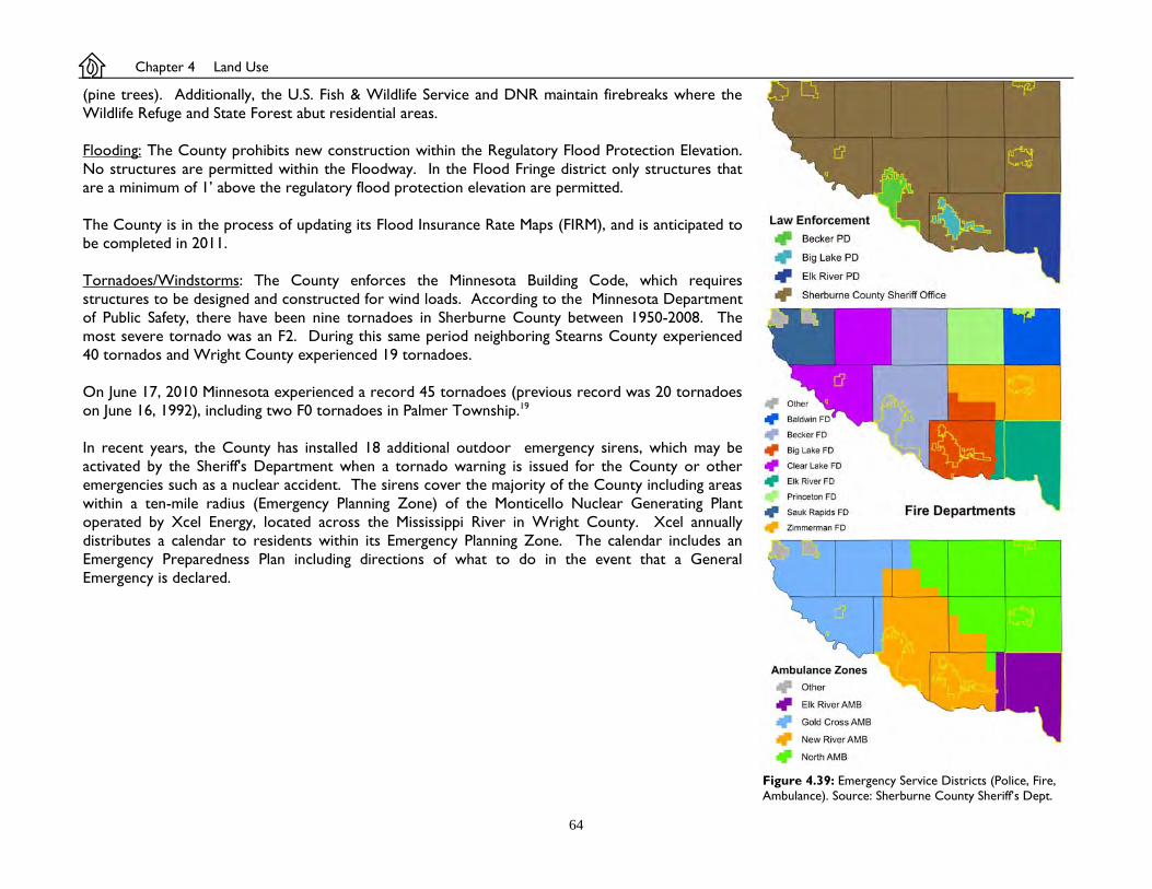
64
(pine trees). Additionally, the U.S. Fish & Wildlife Service and DNR maintain firebreaks where the Wildlife Refuge and State Forest abut residential areas. Flooding: The County prohibits new construction within the Regulatory Flood Protection Elevation. No structures are permitted within the Floodway. In the Flood Fringe district only structures that are a minimum of 1’ above the regulatory flood protection elevation are permitted. The County is in the process of updating its Flood Insurance Rate Maps (FIRM), and is anticipated to be completed in 2011. Tornadoes/Windstorms: The County enforces the Minnesota Building Code, which requires structures to be designed and constructed for wind loads. According to the Minnesota Department of Public Safety, there have been nine tornadoes in Sherburne County between 1950-2008. The most severe tornado was an F2. During this same period neighboring Stearns County experienced 40 tornados and Wright County experienced 19 tornadoes. On June 17, 2010 Minnesota experienced a record 45 tornadoes (previous record was 20 tornadoes on June 16, 1992), including two F0 tornadoes in Palmer Township.19 In recent years, the County has installed 18 additional outdoor emergency sirens, which may be activated by the Sheriff's Department when a tornado warning is issued for the County or other emergencies such as a nuclear accident. The sirens cover the majority of the County including areas within a ten-mile radius (Emergency Planning Zone) of the Monticello Nuclear Generating Plant operated by Xcel Energy, located across the Mississippi River in Wright County. Xcel annually distributes a calendar to residents within its Emergency Planning Zone. The calendar includes an Emergency Preparedness Plan including directions of what to do in the event that a General Emergency is declared. Figure 4.39: Emergency Service Districts (Police, Fire,
Ambulance). Source: Sherburne County Sheriff’s Dept.
Chapter 4 Land Use

65
Footnotes: 1 News Release April 21, 2011: Legislative changes streamline Rural Preserve Program enrollment. Minnesota Department of Revenue. http://taxes.state.mn.us/publications/pages
legislative_changes_streamline_rural_preserve_program_enrollment.aspx accessed May 23, 2011. 2 USDA Natural Resource Conservation Service. NSSH Part 622 Ecological Interpretive Groups. Prime Farmland Soils (622.04). http://soils.usda.gov/technical/handbook/contents/
part622.html 3 USDA National Agricultural Statistics Service - Quick Stats, Sherburne County, MN 1921 - 2008. www.nass.usda.gov/QuickStats 4 2007 Census of Agriculture. County Profile: Sherburne County, Minnesota. U.S. Department of Agriculture.
NOTE: Specific to Sherburne County, the 2007 Census of Agriculture had a response rate of 85.8% of farmers, covering 89.3% of farmland, and 95.5% of sales data. Data for non-responders were estimated by the USDA based on like-operations.
5 MN Department of Agriculture. License Type; Buy & Store Grain, Grain Bank. www2.mda.state.mn.us/webapp/lis/LisResults.jsp . Figure 4.9 compares Grain Storage Capacity between the 2002 and 2007 Census of Agriculture.
6 U.S. Department of Labor, Bureau of Labor Statistics. CPI Inflation Calculator. http://www.bls.gov/data/inflation_calculator.htm 7 [Blue Hill Township Meeting Minutes of December 6, 1996];
Rod Cook made a motion, seconded by Harold Nelson, that we get the petition out to the residents of Blue Hill Township for signatures either for or against changing the zoning.
December 19, 1996 a petition was submitted stating;
We, the citizens of Blue Hill Township, request that the Sherburne County Board of Commissioners change the zoning of Blue Hill from General Rural to Agricultural which would: (1) Decrease the density of the land until there are adequate services to provide for housing. (2) to control the growth until there is a balance between the commercial and residential growth. (3) To preserve the agricultural tracts and minimize the conflict between residential and agricultural uses.
The petition was signed by 137 persons.
Date unknown, a petition was submitted stating;
We, the citizens of Blue Hill Township, request that the Sherburne County Board of Commissioners not change the current zoning (General Rural) of Blue Hill.
The petition was signed by 51 persons.
Sherburne County Planning Advisory Board Meeting [Minutes of] January 23, 1997. (p 10-12);
Gallagher moved and Lichy seconded to recommend approval of an Amendment for a Zone Change for the following reasons: (a) The Zone Change would be in keeping with the goals of the Comprehensive Land Use Plan. The motion carried with a 6 to 3 vote and is recommended to the County Board for approval.
During the public hearing, 5 spoke in favor of the rezoning, and 9 spoke against. Sherburne County Board of Commissioners Regular Meeting Minutes of February 4, 1997. (p 3); Johnson/Friedl unanimous to deny the petition for an Amendment to the Sherburne County Zoning Map to zone change all “General Rural Districts” in Township 35 North, Range 27 West in Blue Hill Township to “Agricultural Districts.”

66
8 Becker Township Public Hearing Meeting [Minutes of] October 18, 1999;
Discussion held on growth and it’s effect on the tax structure for township residents. Concerns focused on the school excess levy referendum and school bond issues on the November 2nd ballot, and the amount taxes will be increased. G.Hammer moved to adopt an Interim Ordinance for one year, of a moratorium on platted residential developments in General Rural areas, excluding simple plats, to study the impact of growth in the township, contingent on the legality of the moratorium. J.Riebel seconded and motioned carried with all voting for. G.Hammer moved second L.Olson to change entire zoning of General Rural to Agricultural if moratorium is not legal. Motion carried all voting for G.Hammer moved to hold public hearing November 1, 1999 at 7:00 pm to consider adoption of Interim Ordinance as stated above. L.Olson seconded and motion carried all voting for.
Becker Township Public Hearing Meeting [Minutes of] November 1, 1999;
G.Hammer moved seconded J.Riebel to leave motion stand that was made at the board meeting of October 18, 1999, to change all General Rural Zoning in Becker Township to Agricultural Zoning if a moratorium is not legal. Motion carried with all members voting for.
At the November 18, 1999 Sherburne County Planning Advisory Board meeting, a petition was presented stating;
The citizens of Becker Township, request that the Sherburne County Board of Commissioners change the zoning of Becker Township [from] General Rural to Agricultural A-1 which would: (1) Decrease the density of the land until there are adequate services to provide for housing. (2) To control the growth until there is a balance between the commercial and residential growth. (3) To preserve the Agricultural tracts and minimize the conflict between residential and agricultural uses. (4) Allow one house per 40 acres of farm field, or one house per 5 acres per wooded lot.
The petition was signed by 137 persons. During the public hearing, 4 residents spoke in favor of the rezoning, and 5 spoke against (in addition to 2 developers not residing in Becker Township).
Sherburne County Planning Advisory Board Meeting Minutes [of] November 18, 1999, (p5-8);
Lichy moved and Wallin seconded to deny request to rezone based upon the testimony given at the public hearing this evening. The motion to deny carried with Peterson and Riebel in opposition. The motion carried and is recommended to the County Board for denial.
Sherburne County Board of Commissioners Regular Meeting Minutes of December 9, 1999, (p 5);
Wergin/Friedl to deny an amendment to the Comprehensive Land Use Plan and the Sherburne County Zoning Map to rezone the General Rural District of Becker Township to an Agricultural District, as recommended by the Planning Commission, based upon the testimony at the Planning Commission meeting and the fact that the General Rural lands are not predominated by intensive agricultural use as compared to the West side of the Township. [Motion carried.]
9 St. Cloud Area Economic Development Partnership. Comprehensive Economic Development Strategy. 2010. Chapter 6, Table 10. 10 Pease, James R., Robert E. Coughlin Land Evaluation and Site Assessment: A Guide Book for Rating Agricultural Lands, Second Addition. Soil and Water Conservation Society, , (p
14-15) 11 Pruetz, Rick, Saved by Development. Burbank, CA. Arge Press, 1997. pg 3. 12 The Lancaster County TDR Practitioner's Handbook, 2008, prepared by the Brandywine Conservancy for the Lancaster County Planning Commission, Lancaster, PA. 13 Brandywine Conservancy. 2003. Transfer of Development Rights: A Flexible Option for Redirecting Growth in Pennsylvania. Chadds Ford, PA: Brandywine Conservancy. 14 Arndt, Randall, Conservation Design in the Chesapeake Bay Watershed. Natural Lands Trust(p 5-7). NOTE: Figure 4.18 is a sketch of the original image from the referenced
source.
Chapter 4 Land Use

67
15 Ground Water Quality Beneath Twin Cities Metropolitan Communities Served by Individual Sewage Treatment Systems. Minnesota Pollution Control Agency and Metropolitan Council. February 2002. pg 4.
16 Standard for Fire Protection Infrastructure for Land Development in Suburban and Rural Areas. National Fire Protection Association, 2008 Edition. pg 1141-14, section 5.1.3 -
5.1.4. 17 Ad hoc Aggregate Committee. Minnesota’s Aggregate Resources; Road to the 21st Century. November, 1998. p. 4. 18 Airport Land Use Compatibility Manual. Minnesota Department of Transportation, 2006. pg 28. 19 National Weather Service Weather Forecast Office Minneapolis/Chanhassen. June 17, 2010: Historic Tornado Outbreak Across Minnesota. http://www.crh.noaa.gov/images/mpx/
StormReports/17June2010.pdf

68
Chapter 5 Transportation
Summary Chapter 5 summarizes the Sherburne County Long-Range Transportation Plan (Plan), adopted in 2007. The Plan does not specifically address township roads. Local road authorities (i.e. townships) are encouraged to develop their own long-range transportation plans. Of the ten townships, only Livonia has adopted such a plan (2005). The purpose of the County Transportation Plan is to help the County and other affected jurisdictions assess anticipated growth between the years 2007-2030, and to recommend a transportation system that addresses current and future needs. In relation to future land use, the 2007 Transportation Plan based its assumptions using the 2004 Comprehensive Plan. The Transportation Plan is used as a tool to guide major transportation investments and transportation policy decisions. The Transportation Plan addresses the following topics: existing conditions, analysis of future transportation needs, roadway system plan, modal plan, implementation plan, and financial plan. Please refer to the Transportation Plan for specific details. Transportation Planning Goals
Develop a long-range (2030) transportation plan to guide future transportation improvement decisions for the County. Obtain a better understanding of local needs, growth trends, and modal opportunities. Establish better coordination and cooperation among key stakeholders (cities, townships, adjoining counties, state and regional agencies). Identify transportation system improvements and future corridor preservation actions that will accommodate growth. Develop a cooperative investment plan to implement projects in a timely manner.
Chapter 5 Transportation
County Road 9, Blue Hill Township

69
Transportation Planning Objectives Identify a comprehensive long-term roadway classification system. Develop policies that facilitate the long-term goals of the County. Relate the transportation system to both existing and future land
use, and area-wide regional transportation plans. Identify improvements to existing transportation infrastructure and
identify future needs including new and/or improved east-west and north-south corridors through the County.
Evaluate right-of-way needs for each functional classification roadway, and update access and signal-spacing guidelines.
Identify the long-term construction and maintenance investments using a life-cycle cost approach.
Identify improvements that other agencies are contemplating that could be incorporated with Sherburne County projects.
Develop strategic plans of 5-year to 7-year increments that take into consideration pavement condition, traffic, safety concerns, future growth, etc.
Identify potential jurisdictional transfers, including the rationale for theses potential transfers, as well as issues and policies associated with these transfers.
Identify opportunities and needs for trails and transit in the overall Transportation Plan.
Train appropriate County Staff on the tools provided by the Plan to promote understanding, use, and implementation.
Existing Conditions Transportation related issues were identified by Focus Groups representing; cities, townships, emergency responders, transit providers, environmental agencies, aggregate mining, businesses, and agriculture. Issues identified were safety, efficient movement, multimodal, land use/development, jurisdictional coordination, economic development, and investment & use of funding. Regarding land use & development, focus groups identified the following issues;
Figure 5.2: Existing Congestion. Source Sherburne County Transportation Plan (Figure 3) / SRF Consulting.
Figure 5.1: Existing Traffic Volumes. Source Sherburne County Transportation Plan (Figure 2) / SRF Consulting.

70
Ensure that there is a way to preserve right-of-way for future roadways that are needed to serve planned development.
Relate the County transportation system to both existing and future city land use, area-wide and regional plans.
Identify growth areas within the County and evaluate the impacts of proposed land use on the transportation system.
Analysis of Future Transportation Needs The Transportation Plan includes three scenarios modeling future traffic congestion. A Technical Advisory Committee (TAC) felt Scenario One best reflected future needs of the County (see Figure 5.4). Scenario One assumes a number of improvements are completed prior to 2030, including:
Trunk Highway (TH) 10 Big Lake Bypass TH 10/I-94 Clear Lake/Clearwater river crossing TH 10 upgrades in Big Lake, Clear Lake - St. Cloud TH 10 Interchanges at bypass, County State-Aid Highway’s (CSAH)
3, 6, 16 TH 169 interchange at CSAH 4 (Zimmerman) TH 10 overpass at CoRd 65 (Haven Twp) TH 169 overpass at 277th Ave (Livonia & Baldwin townships) Connection between CSAH 33 (Elk River) & CSAH 22 (Anoka Co) Connection between CoRd 12 & TH 10/169 (Elk River)
Roadway System Plan Public roadways are classified into one of the following categories: Principal Arterials;
Connect major activity centers Have significant continuity at a state level Serve long, through-type trips Provide high-speed with limited access Serve very large travelsheds (regions)
Minor Arterials
Connect key activity centers Have significant continuity on county/multi-county area Serve longer to medium-length trips
Figure 5.3: Future Congestion. Assumes improvements are constructed, such as; new TH 24 river crossing between Clear Lake and Clearwater; TH 10 Big Lake bypass; connection between CSAH 33 and CSAH 22 (Anoka Co.) in Elk River, additional interchanges, overpasses, and various upgrades from highway to freeway. Source: Sherburne County Transportation Plan (Figure 7) / SRF Consulting.
Figure 5.4 Future Functional Class. Source Sherburne County Transportation Plan (Figure 12) / SRF Consulting.
Chapter 5 Transportation

71
Provide high-speed with limited access Serve large areas
Collectors
Connect local activity centers and/or connect to higher-order routes Have continuity on a local level Serve medium-length to short-length trips Serve a variety of uses, and can therefore have a variety of speeds Place equal emphasis on access and mobility Allows service to smaller or localized areas
Local Routes
Connect local neighborhoods, farms, small developments and higher-order streets/routes
Have a low degree of continuity Have closely spaced access Provide direct access (no access control) to property Serve limited travelsheds (very few through trips)
The Transportation Plan recommends that several roadways be reclassified to be consistent with Federal Highway Administration (FHWA) guidelines used by MnDOT. For rural areas, the Plan suggests that an amount of Collector roads be reclassified as Local Routes. Based on changes to a road’s functional classification, the Transportation Plan suggests that several roadways be transferred from the County to cities/townships, or vice versa (Figure 5.5). The Transportation Plan includes a table of proposed transfers (Table 11 in Transportation Plan). Each transfer is classified as definitely meets transfer guidelines, substantially meets, or marginally meets guidelines dependent on future growth. Proposed jurisdictional transfers would take place over time; short-range (2007-2014), medium-range (2015-2023), and long-range (2015-2023). If all roads identified as definitely meets the guidelines were transferred from MnDOT to the County (4.6 miles), and from the County to townships (20.3 miles), there would an estimated annual savings of $76,191 in costs for road maintenance paid by local tax payers (2004 dollars). The method of transferring road authority is described in the Transportation Plan (Section 6 in Transportation Plan).
Figure: 5.6: Comparison of road spring weight restrictions, and where businesses are located or planned to be located. Weight restrictions are placed on roads during spring freeze/thaw cycles (about two months). This map shows that existing and planned commercial/industrial areas are affected by these restrictions, which may limit the development of these areas. Source: Sherburne County Public Works Dept,
Figure 5.5: Jurisdictional Transfers. Source: Sherburne County Transportation Plan (Figure 13) / SRF Consulting.

72
Modal Plan Multimodal transportation users and services are summarized as follows; Trucking TH 10 and TH 169 are major thoroughfares for freight between the Twin Cities, and St. Cloud (TH 10), and the Brainerd lakes region (TH 169). Locally, major truck use is generated by the transfer of agricultural goods, commercial/industrial products, aggregate, landfill refuse, and fuel (i.e. propane). Several businesses contributing to heavy truck traffic are located along trunk highways. However, most of these areas do not include a frontage road system, which increases the danger associated with left turning trucks on/off the highway. Rail The Burlington Northern Santa Fe rail line (BNSF) parallels TH 10, and averages 38 freight trains per day with speeds up to 79 mph. All crossings except at TH 10 and TH 169 are at-grade crossings. Airports Within the County, there are four private landing strips located in Becker Township (2) Clear Lake Township, and Haven Township. Three public airports are located in Princeton, St. Cloud, and Clear Lake Township. The Princeton Airport is primarily used by private airplanes. The St. Cloud Regional Airport has capacity for daily passenger air service. In 2009, Delta/Northwest Airlink discontinued regular service. Charter passenger service is available through regional carriers, and the airport continues to market to other carriers. There is an opportunity for multimodal freight facilities (air-rail-ground) within the vicinity of the St. Cloud airport - TH 10 area. Transit Transit is available through local bus, commuter bus, and commuter rail. Options provides private van and bus service for special needs adults and seniors between their place of residence and adult day service centers, day training & habilitation centers, and employment programs contracted through Options. Destinations primarily include Options’ employment center in Big Lake, and area businesses and service centers in Sherburne and northern Wright counties. RiverRider provides a dial-a-ride local bus service to Sherburne and Wright county residents. Service is limited to weekdays between 7:00 am - 5:00 pm, and travels between Elk River, Big Lake (Sherburne County), and Monticello, Annandale, Buffalo, and Cokato (Wright County). RiverRider is governed by a six member Joint Powers Board consisting of four Sherburne and Wright county
Figure 5.7: Northstar Commuter Rail. Source: NCDA/Metro Transit.
Figure 5.8: 2010 Population densities, with fixed commuter & mass transit routes, and planned commuter routes. Source: MnDOT, Metropolitan Council, St. Cloud Metro Bus, Sherburne County Public Works Dept, US Census Bureau.
Chapter 5 Transportation

73
commissioners, and two city council representatives. Service began in the mid-1980’s. Northstar Link (The Link) provides scheduled commuter bus service between the east St. Cloud park & ride lot, and the Big Lake commuter rail station. The Link is intended to be used as an intermediary until funding is provided to expand commuter rail from Big Lake to St. Cloud. Scheduled service is provided on weekdays with 5 commute trips during peak travel times (4:00 am - 7:00 am, and 5:00 pm - 8:00 pm). The Link is operated by the St. Cloud Metro Bus, and governed by the Northstar Corridor Development Agency (see below). Service began in November, 2009. Northstar Commuter Rail (Northstar) provides scheduled commuter rail service between Big Lake and downtown Minneapolis (40-miles), with additional stations located in Elk River, Anoka, Coon Rapids, and Fridley. The Minneapolis station includes a connection to light rail, which travels between downtown Minneapolis and the Minneapolis/St. Paul airport and the Mall of America. Scheduled service is provided on weekdays with 5 commute and 1 reverse commute trips during peak travel times (5:00 am - 8:00 am, and 4:00 pm - 7:00 pm). Three trips are scheduled each day on weekends. The travel time from Big Lake to Minneapolis is 51 minutes. Northstar is operated by Metro Transit. Northstar is governed by a Joint Powers Board called the Northstar Corridor Development Authority (NCDA), representing 30 county, city, township, and regional rail authorities. The 58-member NCDA includes representatives from Sherburne County (2), Sherburne County Regional Rail Authority (2), the cities of Becker (2), Big Lake (2), Clear Lake (2), Elk River (2), St. Cloud (2), and the townships of Becker (1), Big Lake (3), Clear Lake (1), and Haven (3). Service began in November, 2009. Weekday ridership in 2010 averaged about 2,000 and is expected to increased to 5,900 by the year 2030. Northstar Commuter Rail stations include lighted surface parking accommodating 446 vehicles (Big Lake) and 754 vehicles (Elk River), covered shelters with in-demand heat, and bicycle lockers. The Big Lake station is located in a mixed agricultural and urban single-family residential area. The Elk River station is located in a mixed urban multi-family residential, and industrial area. Around both stations there is an opportunity for mixed use development and re-development to capitalize on the number of commuters traveling in and out of the areas. Both the cities of Big Lake (2008) and Elk River (2010) have developed Transit Oriented Development (TOD) design guidelines, and/or similar planning documents. Non-Motorized Trails There are no hard-surfaced pedestrian trails maintained by the County, as of 2010. The County does maintain unimproved (i.e. grass or dirt) non-motorized trails within the County park system. The County’s role is to partner with townships and cities to promote new recreational trails and their connectivity. One of the County Board’s adopted goals has been to complete acquisition of a former railroad bed connecting Elk River and Princeton for use as a regional trail. The County and cities have acquired about 2/3 of the land necessary, in non-contiguous segments. Please refer to Chapter 7 (pages 90-91) for more details.
Implementation Plan The Implementation section of the Transportation Plan addresses the criteria for turning back road authority from the County to a city/township; provides for Access Management guidelines (i.e. how far driveways and intersections are spaced); right-of-way guidelines and preservation; and, wetland protection associated with road construction.

74
Jurisdictional Realignment Process (Turn-backs) Please refer to the Sherburne County Transportation Plan (Section 6 in Transportation Plan) regarding the criteria and process used. Access Management Guidelines In 2009, the County adopted a Right-of-way ordinance. The ordinance requires compliance with the Access Management spacing guidelines identified in the Transportation Plan, unless granted an administrative variance by the Sherburne County Public Works Director. Access Management is the management of where driveways and roads intersect with other roads, with the goal of minimizing the chance of an accident. Reducing the number of access points on a road can reduce the frequency of accidents occurring involving vehicles turning into or out of that access. The Minnesota Local Road Research Board1 recommends the following practices in rural areas:
Establish an access policy - develop a formal policy that ensures that the agency has processes in place to determine the need for and evaluate the use, location, spacing and design characteristics of the request access points.
Encourage coordination during the zoning and platting process. Give access permits for specific use. Encourage adequate spacing of access points. Protect the functional area of intersections. Ensure adequate sight distance at entrances. Avoid offset or dogleg intersections and entrances. Consider consolidating access or relocating existing access. Encourage good driveway and intersection design characteristics such as:
- Proper driveway width and turning radii. - Proper grading of entrance in-slopes and culvert openings. - Proper corner clearance. - Keeping sight triangles and clear zones free of obstructions. - Adequate approach grade. - Alignment of intersections at right angles to maximize sight lines, minimize the time a vehicle is in the conflict area and
facilitate turning movements. Right-of-Way Guidelines and Preservation The Transportation Plan recommends the following minimum right-of-way (ROW) widths in rural areas;
100’ 2-lane Collector 100’ 2-land Minor Arterial 100’ 4-lane undivided Minor Arterial 120’ 4-lane divided Principal Arterial 150’ 4-lane divided Minor Arterial 150’ 5-6 lane divided Principal Arterial
Chapter 5 Transportation

75
Figure 5.4 shows where these road classifications are intended to be located. The Transportation Plan identifies three methods for preserving future right-of-way;
Restrictive zoning regulations in very low density areas (i.e. agricultural) to limit or prohibit uses which may increase traffic. Require that when land is platted (subdivided), that necessary land be dedicated from the landowner to the road authority as right-of-way,
including any road realignments necessary. Identify a future road location on the Official Zoning Map. “However, if a directly affected property owner requests to develop his/her property,
agencies have six months to initiate acquisition and purchase of the property to prevent its development. If the property is not purchased, the owner is allowed to develop it in conformance with current zoning and subdivision regulations. As a result, the official mapping process should only be used for preserving key corridors in areas with significant growth pressures.”1
These three methods may be applied to future projects identified as “future alignments” in Figure 5.4, such as service roads along TH 10 and TH 169, TH 10 Big Lake bypass, and future river crossings in Clear Lake and Big Lake townships The Comprehensive Plan Map identifies these future road corridors to be consistent with the Transportation Plan. However it is the intent for the Zoning Map (Official Map) to exclude future road corridors unless immediate funding is available to purchase right-of-way. Financial Plan The Transportation Plan includes a list of improvement projects needed within the 2007-2024+ timeframe (see Table 21 in Transportation Plan). These projects have a total estimated cost of $522 million (includes 4% annual inflation).1 Only $137 million has been identified through local property taxes ($4.6 million per year), State Aid ($1.8 million per year), and State/Federal assistance ($500,000 per year on average). This leaves a total funding gap of $385 million for County road and bridge projects. The Transportation Plan suggest that an additional $19 million is needed per year to plug the gap, and provides suggestions on various methods for additional funding (see Section 7.3 in Transportation Plan).
Footnotes: 1 Sherburne County Transportation Plan. Sherburne County, 2007. pg
66, 79, 81-82, Figure 19. Figure 5.9: 2007-2030 Transportation expenditure and revenue estimates. Source: Sherburne County Transportation Plan (Figure 19) / SRF Consulting.

76
Chapter 6 Economic Development
Chapter 6 Economic Development
Figure 6.1: Percentage of County workforce (population 16 years old or older) who commute to work outside of the County. Source: 2000 Census.
28%
3%
11%
8% 10%
32% STAY
Summary Chapter 6 summarizes recent economic studies and data for Sherburne County and the region. Although the County Board of Commissioners serving as the Economic Development Authority (EDA) establishes economic policies county-wide, its relation to zoning regulations are limited to those township areas for which the County administers planning and zoning. Zoning regulations are only one of many factors influencing industry growth and decline. To understand the potential for economic development in the townships, we must understand their place within the larger economic region. Sherburne County is within the 13-county Minneapolis-St. Paul-Bloomington Metropolitan Statistical Area (MSA). For simplicity, the Comp Plan refers to this as the “Twin Cities MSA.” MSA’s are established by the White House Office of Management and Budget based on Census data. The St. Cloud MSA consists of Benton and Stearns counties. One county cannot be located within multiple MSA’s. The purpose of MSA’s is for tabulating statistical data, and should not be confused with the 7-county Metropolitan Council, which Sherburne County is not part of. Sherburne County has developed primarily as a bedroom community with 68% of its workforce commuting to jobs outside of the County (Figure 6.1). The County’s primary competitors for commercial and industrial development are those communities along interstates and freeways with closer proximity to larger job corridors.
Minnesota Limited, Big Lake Township

77
To summarize the County’s Economic Work Plan, the primary economic goals for areas within the townships are to: (1) identify key rural areas, and preserve those areas for future urban commercial-industrial development (30-40 year inventory needed); and (2) identify areas for future permanent rural commercial-industrial development, and amend ordinances to streamline the approval process to encourage rural development and redevelopment 2005-2007 Economic Development Work Plan In May, 2005 the County Board adopted a three year work plan. The general goals include: 1. Preserve land for future industrial and commercial growth in key locations through planning,
zoning, and acquisition in cooperation with affected communities to ensure a strong and balanced tax base, a healthy employment base, and convenient access for residents to goods and services.
2. Advocate for transportation and other infrastructure critical to the County’s economic competitiveness.
3. Integrate consideration of economic development into other County planning and decision-making.
4. Support local government efforts to plan and implement economic development initiatives throughout Sherburne County.
5. Market the County for economic development. 6. Create the organizational capacity to effectively implement the 2005-2007 workplan. Comprehensive Economic Development Strategy (CEDS) The Minnesota Department of Economic Development divides the state into six economic regions. Each region is further broken down into sub-regions. Sherburne County is within the 13-county Central Planning Region, and the sub-region of 7W along with Benton, Stearns, and Wright counties. The St. Cloud Area Economic Development Partnership (the Partnership) consists of:
Benton County College of St. Benedict Initiative Foundation Sherburne County St. Cloud State University Bremer Bank Stearns County St. Cloud Tech. & Community Coll. St. Cloud Area Assoc of Realtors City of St. Cloud HealthPartners Central MN Clinics City of St. Joseph St. Cloud Area Chamber of Commerce City of Sartell St. Cloud Hospital CentraCare Clinic City of Sauk Rapids St. Cloud Opportunities
Stearns Electric Association Xcel Energy
Figure 6.2: Highest property taxpayers in the County (Net taxes paid, less Special Assessments). Property owners listed include those paying $200,000+ in 2011, listed alphabetically. Source: Sherburne County Auditor/Treasure’s Dept.
$0
$1,000,000
$2,000,000
$3,000,000
$4,000,000
$5,000,000
$6,000,000
$7,000,000
$8,000,000
$9,000,000
$10,000,000
2004
2006
2008
2010
Ann
ual P
rope
rty
Taxe
s Pa
id
BNSF Railway CompanyBradley Operating PartnershipCobornsGreat River EnergyHome Depot USAJPM Capital CorporationLiberty Paper, IncMenard, IncPhoenix EnterprisesRemmele Engineering, IncSouthern Minnesota Municipal PowerTarget CorporationWal-Mart Stores, IncXcel Energy, Inc.

78
In 2009 the Partnership received a grant from the U.S. Department of Commerce, Economic Development Administration to complete a Comprehensive Economic Development Strategy (CEDS). The purpose of a CEDS is to create a regional economic development plan. A CEDS is also required to qualify for certain federal funding for community development, infrastructure and disaster recovery projects. The following is a summary of the 2010 CEDS report as it relates to Sherburne County (Note: the CEDS report discusses a wide range of topics which directly and indirectly influence local economic development conditions. Many of these topics are discussed in other chapters of this comprehensive plan);1
Employment According to the 2005-2009 American Community Survey, industries which employed a significant percentage of Sherburne County residents include; education, health & social services (19.9%), manufacturing (16.8%), retail trade (12.7%), and construction (9.8%). Figure 6.3 shows how the number of jobs in these industries have changed between 2000 - 2009. According to the Minnesota Department of Employment & Economic Development (DEED), between 2000 - 2009, Minnesota gained 30,007 net-jobs, of which 4,541 were in Sherburne County. The seven-county Twin Cities lost about 30,000 net-jobs during this same period. Between 2000 - 2009 in Sherburne County, the Education & Health Services industry added 3,451 net-jobs while the Manufacturing industry lost 22 net-jobs, but added 28 manufacturing businesses. The industry increased by 998 jobs during 2004, however it is not known where these jobs were created, thus the data may be in error.
Figure 6.4: Total number of jobs by industry in Sherburne County, 2000 - 2009 (by quarter). Source: MN Department of Employment and Economic Development.
01,0002,0003,0004,0005,0006,0007,000
2000
Q1
2001
Q1
2002
Q1
2003
Q1
2004
Q1
2005
Q1
2006
Q1
2007
Q1
2008
Q1
2009
Q1
ManufacturingEducation & Health ServicesRetail TradeConstruction
Figure 6.5: Monthly Unemployment Rate (not seasonally adjusted), January 1990 - December 2010. Source: MN Department of Employment and Economic Development.
0%1%2%3%4%5%6%7%8%9%10%11%12%
Jan-
90Ja
n-91
Jan-
92Ja
n-93
Jan-
94Ja
n-95
Jan-
96Ja
n-97
Jan-
98Ja
n-99
Jan-
00Ja
n-01
Jan-
02Ja
n-03
Jan-
04Ja
n-05
Jan-
06Ja
n-07
Jan-
08Ja
n-09
Jan-
10
Sherburne CountyTwin Cities MSAU.S.
Chapter 6 Economic Development
Figure 6.3: Largest Employers in Sherburne County, 2003-2010 (total employees). Source: Elk River ISD 728, Sherburne County Comprehensive Annual Financial Report, 2003, 2004, 2005, 2006, 2007, 2008, 2009, 2010.
0200400600800
1,0001,200
2003 2004 2005 2006 2007 2008 2009 2010Big Lake ISD 727 Crystal Cabinet Works, Inc Elk River ISD 728Fairview Northland Clinics Guardian Angels Care Center Sherburne CountySt. Benedicts Care Center Wal-Mart Xcel Energy (NSP)

79
Between 2007 - 2009 (economic recession), Minnesota lost 57,081 net-jobs, of which 445 were in Sherburne County. The seven-county Twin Cities lost about 59,000 net-jobs during this same period. Of the four main industries in Sherburne County, Manufacturing lost 267 jobs, Education & Health Services gained 659 jobs, Retail Trade lost 420 jobs, and Construction lost 238 jobs. Figure 6.5 shows unemployment rates between January 1990 - December 2010. Through most of this period the County’s non-seasonally adjusted unemployment rate zigzags between those of U.S. and Twin Cities figures (13-county Metropolitan Statistical Area), indicating the County has a large number of residents who are seasonally employed. Despite the appearance of Figure 6.5, Sherburne County’s yearly average unemployment rate is lower than U.S. figures. The County’s yearly average rate over this 20-year period was 4.9% with a high of 9.3% in 2009 and a low of 2.6% in 1999. Nationally, the yearly average was 5.8% with a high of 9.3% in 2009 and a low of 4.0% in 2000. The Twin Cities yearly average was 4% with a high of 7.7% in 2009 and a low of 2.2% in 1998 and 1999.
Figure 6.7: Top ten industries with the highest long-term (2006-2016) projected growth rate in the 12-county Central Minnesota area (excludes industries whose employment projections are less than 1,000 new jobs). Source: MN Department of Employment & Economic Development.4
Industry % Growth 2006-2016 Projected Openings in 12-county Central MN Social Assistance 79.8% 4,635 Community Care Facility for the Elderly 73.5% 1,091 Ambulatory Health Care Services 49.9% 4,655 Residential Mental Health Facilities 49.5% 2,153 Health Care and Social Assistance 44.8% 17,024 Amusement, Gambling & Recreation 44.7% 1,333 Arts, Entertainment, & Recreation 44.4% 1,421 Other Amusement & Recreation Industry 41.3% 1,213 Offices of Physicians 39.7% 1,676 Hospitals 35.7% 4,116
Figure 6.6: Top ten occupations in current (2010) demand in Benton, Sherburne, Strearns, and Wright counties (Region 7W). Source: Minnesota Department of Employment & Economic Development.4
Median Est. Openings in Occupation Annual Wage 4-county Region 7W (2010) Education or training needed Retail Salespersons $19,691 4,740 Short-term on-the-job training Cashiers $17,740 3,740 Short-term on-the-job training Personal and Home Care Aides $25,352 3,492 Short-term on-the-job training Waiters and Waitresses $19,931 3,425 Short-term on-the-job training Combined Food Preparation and Serving Workers $17,721 3,142 Short-term on-the-job training Home Health Aides $22,524 2,828 Short-term on-the-job training Office Clerks, General $27,018 2,824 Short-term on-the-job training Registered Nurses $73,122 2,676 Associates degree Truck Drivers, Heavy and Tractor-Trailer Drivers $34,697 1,684 Short-term on-the-job training Janitors and Cleaners, Except Maids and Housekeepers $25,199 1,665 Short-term on-the-job training

80
Unemployment rates in Sherburne County have been consistently higher than in the Twin Cities except during the extended summers of 1998-2000, and 2003 (extended summer meaning spring-summer or summer-fall). Long-term employment projections are not available on a per-county basis. The fastest growing industries in Central Minnesota regardless of projected jobs are; Specialized Design Services (81.5% increase, 66 new jobs), Social Assistance (see Figure 6.7), Performing Arts & Sports Promoters (76.5% increase, 26 new jobs), Community Care Facility for the Elderly (see Figure 6.7), Insurance & Employee Benefit Funds (71.4% increase, 5 new jobs). Of the four major industries employing Sherburne County residents reported by the U.S. Census Bureau, DEED projects that between 2006 - 2016 Manufacturing will decline by 2.4% (loss of 1,018 jobs), Education & Health Services will grow by 32.8% (20,000 new jobs), Retail Trade will grow by 8.9% (3,149 new jobs), and Construction will grow by 10.3% (1,725 new jobs). Projected percentage growth and job creation is for the 12-county Central Minnesota area. The data suggests that although Manufacturing has traditionally been Sherburne County’s biggest industry, the future is in Healthcare. Chapter 2 includes information on local healthcare statistics and facilities.
$0$5,000
$10,000$15,000$20,000$25,000$30,000$35,000$40,000$45,000$50,000$55,000$60,000$65,000$70,000
2000
2001
2002
2003
2004
2005
2006
2007
2008
2009
Sherburne CountyTwin CitiesCentral MinnesotaMinnesota
Figure 6.8: Average annual wages in all industries, 2000 - 2009. Source: MN Department of Employment and Economic Development.
Manufacturing Wages
$0$5,000
$10,000$15,000$20,000$25,000$30,000$35,000$40,000$45,000$50,000$55,000$60,000$65,000$70,000
2000
2001
2002
2003
2004
2005
2006
2007
2008
2009
Sherburne CountyTwin CitiesCentral MinnesotaMinnesota
Education & Health Services Wages
$0$5,000
$10,000$15,000$20,000$25,000$30,000$35,000$40,000$45,000$50,000$55,000$60,000$65,000$70,000
2000
2001
2002
2003
2004
2005
2006
2007
2008
2009
Sherburne CountyTwin CitiesCentral MinnesotaMinnesota
Retail Trade Wages
$0$5,000
$10,000$15,000$20,000$25,000$30,000$35,000$40,000$45,000$50,000$55,000$60,000$65,000$70,000
2000
2001
2002
2003
2004
2005
2006
2007
2008
2009
Sherburne CountyTwin CitiesCentral MinnesotaMinnesota
Construction Wages
$0$5,000
$10,000$15,000$20,000$25,000$30,000$35,000$40,000$45,000$50,000$55,000$60,000$65,000$70,000
2000
2001
2002
2003
2004
2005
2006
2007
2008
2009
Sherburne CountyTwin CitiesCentral MinnesotaMinnesota
Figure: 6.9: Annual average wages per worker by industry, 2000 - 2009. Source: MN Department of Employment and Economic Development.
Chapter 6 Economic Development

81
Wages Among the four major industries noted (Manufacturing, Education & Health Services, Retail Trade, and Construction), jobs in Sherburne County pay significantly less on average compared to similar jobs in the Twin Cities and Minnesota, and in some cases less than jobs in Central Minnesota (see Figure 6.8. This suggests that given the choice, a County resident will choose a higher paying job in the Twin Cities over a lower paying job closer to home, supporting the notion that Sherburne County is a bedroom community. According to DEED, between 2000 - 2009, Manufacturing average wages increased 25% in Sherburne County (2009: $47,269) and 30% in the Twin Cities (2009: $62,285). Education & Health Services average wages increased 39% in Sherburne County (2009: $34,863) and 31% in the Twin Cities (2009: $45,605). Retail Trade average wages increased 15% in Sherburne County (2009: $22,653) and 16% in the Twin Cities (2009: $26,441). And Construction average wages increased 33% in Sherburne County (2009: $43,636) and 23% in the Twin Cities (2009: $58,479). Concentration of Industry The 2010 CEDS report2 (Ch. 4 Table 9 of CEDS report) suggests that industries concentrated in Sherburne County include fabricated metal product manufacturing, forest & wood products, chemicals & chemical based products, machinery manufacturing, and biomedical/biotechnical (life sciences). This data is based on employment figures between 2002 - 2008. Concentration of Retail Sales The 2010 CEDS report2 (Chapter 4, Table 19 of CEDS report) provides Pull Factors based on MN Department of Revenue 2003-2007 tax data. A Pull Factor is a measurement of how much “pull” industry sales have to or from a community. A Pull Factor of around 1.0 signifies that sales of a specific industry is limited to local buyers, while a Pull Factor greater than 1.2 signifies that buyers are coming in from other communities. Pull Factors are one means to identify the growth potential of a specific industry in a specific community The CEDS report provides data for industries in Elk River, Big Lake (limited data available), and other larger cities in the St. Cloud area (Region 7W). Elk River has strong pull factors for the following industries; Building (3.65), Food & Beverage Stores (2.74), Gas (3.68), and Vehicles & Parts (3.05), while local residents travel outside of the community for personal retail health (0.78), clothing (0.75), leisure goods (0.34), electronics (0.24), and furniture (0.18). Available industry data for Big Lake is limited to gas (0.65), electronics (0.05), and leisure goods (0.02). The CEDS report suggests that within the St. Cloud region, retail centers are concentrated in St.
Figure 6.10: Metal Craft, Elk River. Manufacturer of medical implants and devices. In 2009, Metal Craft opened a 78,000 sq ft corporate office and manufacturing facility. Source: Metal Craft, Sherburne County Planning & Zoning Dept.

82
Figure 6.12: SHERCO Plant in Becker, operated by Xcel Energy and Southern Minnesota Municipal Power. SHERCO is the largest coal-fired plant in Minnesota, and produced 18.8 million megawatt hours in 2007. Source: Minnesota Department of Commerce7, Sherburne County Planning & Zoning Dept.
Cloud-Waite Park which has a higher pull factor in every industry except Gas (1.80) compared to other area cities. Excluding St. Cloud, Building Goods are strongest in Elk River (3.65), and St. Michael (2.33). Food & Beverage Stores are strongest in Elk River (2.74), Sartell (2.19), and Monticello (2.02). Gas is strongest in Elk River (1.82) and Sauk Rapids (1.46). General [goods] are strongest in Elk River (3.68), and Buffalo (4.45). Vehicles and parts are strongest in Monticello (5.11), Elk River (3.05), and Buffalo (2.28). The data suggest that Elk River is a major regional retail center for goods related to construction, gas, and food. The fact that both U.S. Highways 10 and 169 traverse town is an advantage whereas of the other regional cities, only St. Cloud-Waite Park have more than one major highway. Energy In 2007, Sherburne County consumed 945,991 megawatt hours of electricity.5 Local Electricity Producers: Xcel Energy operates a three-unit coal/oil steam power plant on 4,500 acres in Becker constructed in 1976-1977 and 1987-1988 with an annual (2007) net-production of 15,869,463 megawatt hours of electricty.5 Unit 3 is partially owned by Southern Minnesota Municipal Power Agency. The Sherburne County Generating Plant (SHERCO) is the largest coal-fired plant in Minnesota. Great River Energy (GRE) operates a three-unit refuse derived fuel (RDF)/gas/oil steam power plant in Elk River. The coal plant was constructed in 1951 and 1959, converted to nuclear powered steam in 1963, converted back into coal in 1968, and reconverted to RDF in 1989. The plant has an annual (2007) net-production of 160,968 megawatt hours of electricity, and consumed 273,814 tons of RDF (i.e. garbage) in 2007.5 Elk River Municipal Utilities operates a four-unit diesel/gas internal combustion plant in Elk River constructed in 1948, 1962, and 1972 with an annual (2007) net-production of 114 megawatt hours.5
Broadband Internet Access Broadband refers to high speed internet access. According to Connect Minnesota, all of Sherburne County has access to mobile broadband. Areas with access to cable, fixed wireless, and DSL as of 2010 are shown in Figure 6.13. Reported areas without access to broadband (other than mobile) are concentrated in agricultural areas and within the Sherburne National Wildlife Refuge.
Figure 6.11: Major underground natural gas and crude oil pipelines, and overhead electrical lines. Source: National Pipeline Mapping System, Minnesota Land Management Information Center.
Chapter 6 Economic Development

83
Footnotes:
1 NOTE: The 2010 CEDS report is a comprehensive analysis of topics that directly and indirectly affect economic conditions in Region 7W. The majority of these topics are discussed in the 2010-2030 Comprehensive Land Use Plan in chapters 2 (Population), and 4 (Land Use) using the same sources used by the CEDS report, although not necessarily directly from the CEDS report itself. The CEDS report remains a valuable source for regional data.
2 St. Cloud Area Economic Development Partnership. Comprehensive Economic Development Strategy. St. Cloud, MN,
2010. 3 U.S. Census Bureau. 2006-2008 American Community Survey 3-Year Estimates, Sherburne County, MN. http://
factfinder.census.gov/home/saff/main.html?_lang=en Accessed: August 23, 2010. 4 Current Demand Rank; Displays all occupations ordered from those with more favorable current demand to those with less
favorable current demand conditions. A rank order of 1 corresponds to the most favorable demand conditions. Source: MN Department of Employment and Economic Development. http://www.positivelyminnesota.com/apps/lmi/oid/results.aspx?s=CDRank September 3, 2010.
5 Minnesota Department of Commerce. The Minnesota Utility Data Book; A reference Guide to Minnesota electric and
natural-gas utilities 1965-2007. p.50, 57-58, 60, 74, 94, 96, 113, 121
Figure 6.13: Broadband Internet Coverage (2010). Source: Connect Minnesota, ESRI.
Cable Broadband (salmon) Fixed Wireless Broadband (green) DSL Broadband (purple) Underserved areas (yellow, green)
Figure 6.14: In 2001 Xcel Energy constructed this wind turbine near the Elk River Landfill as a demonstration project. The turbine is 213’ tall with blades 154’ in diameter, and may produce 1,200 megawatt hours per year. The average annual wind speed is 12.5 mph. Source: Excel Energy, Sherburne County Planning & Zoning Dept.

84
Chapter 7 Parks & Recreation
Chapter 7 Parks & Recreation
Summary Chapter 7 summarizes the Sherburne County Parks, Trails, and Open Space Policy Plan (Parks Plan), adopted in 2005. This chapter includes additional information, as well as updates of projects or policy changes since 2005. Chapter 7 does not specifically address individual township parks or township park plans.
The role of Sherburne County is to concentrate its efforts on “passive recreational” facilities such as the preservation of public natural habitat areas, and to partner with townships and cities to promote new recreational trails and their connectivity. It is the role of the townships and cities to provide “active recreational” facilities such as playgrounds and athletic fields. It is the belief of Sherburne County that local governments are more aware of the needs for active recreational facilities in their local communities, and therefore should administer their creation, use, and maintenance with funding in part thru County Park Dedication Fees.1
Figure 7.1: Island View Regional Park, Clear Lake
Township.
Grams Regional Park, Livonia Township
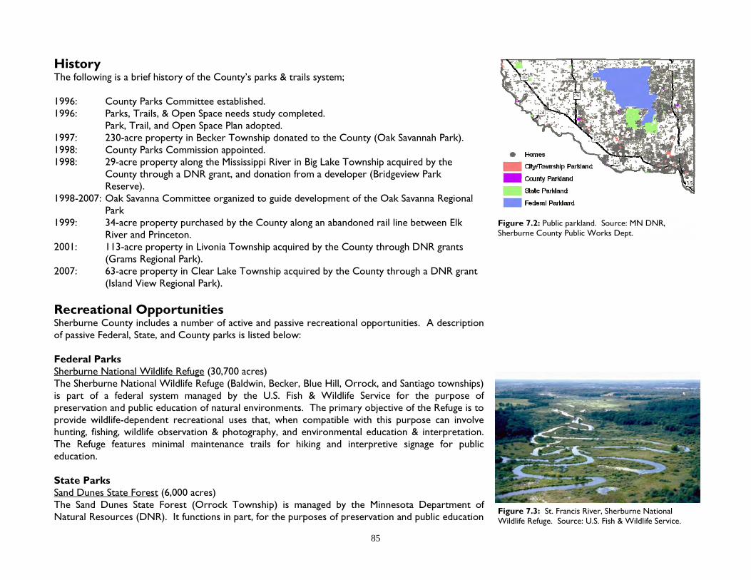
85
History The following is a brief history of the County’s parks & trails system; 1996: County Parks Committee established. 1996: Parks, Trails, & Open Space needs study completed. Park, Trail, and Open Space Plan adopted. 1997: 230-acre property in Becker Township donated to the County (Oak Savannah Park). 1998: County Parks Commission appointed. 1998: 29-acre property along the Mississippi River in Big Lake Township acquired by the
County through a DNR grant, and donation from a developer (Bridgeview Park Reserve).
1998-2007: Oak Savanna Committee organized to guide development of the Oak Savanna Regional Park
1999: 34-acre property purchased by the County along an abandoned rail line between Elk River and Princeton.
2001: 113-acre property in Livonia Township acquired by the County through DNR grants (Grams Regional Park).
2007: 63-acre property in Clear Lake Township acquired by the County through a DNR grant (Island View Regional Park).
Recreational Opportunities Sherburne County includes a number of active and passive recreational opportunities. A description of passive Federal, State, and County parks is listed below: Federal Parks Sherburne National Wildlife Refuge (30,700 acres) The Sherburne National Wildlife Refuge (Baldwin, Becker, Blue Hill, Orrock, and Santiago townships) is part of a federal system managed by the U.S. Fish & Wildlife Service for the purpose of preservation and public education of natural environments. The primary objective of the Refuge is to provide wildlife-dependent recreational uses that, when compatible with this purpose can involve hunting, fishing, wildlife observation & photography, and environmental education & interpretation. The Refuge features minimal maintenance trails for hiking and interpretive signage for public education. State Parks Sand Dunes State Forest (6,000 acres) The Sand Dunes State Forest (Orrock Township) is managed by the Minnesota Department of Natural Resources (DNR). It functions in part, for the purposes of preservation and public education
Figure 7.3: St. Francis River, Sherburne National Wildlife Refuge. Source: U.S. Fish & Wildlife Service.
Figure 7.2: Public parkland. Source: MN DNR, Sherburne County Public Works Dept.

86
of natural environments including plant and animal habitats. State Forests are managed with multiple-use in mind. The Sand Dunes State Forest attempts to place equal management emphasis on wildlife habitat, timber sales, and public recreational use including camping, swimming, boating, and a variety of designated trail use types such as horseback riding, groomed cross-country skiing, and snowmobiling. The state forest features minimal maintenance trails and well maintained trails, depending on use and season. Scientific and Natural Areas (SNA) Scientific and Natural Areas were established “to preserve natural features and rare resources of exceptional scientific and educational value. SNA’s are open to the public for nature observation and education, but are not meant for intensive recreational activities.”2 There are 5 SNA’s in Sherburne County, including;
Clear Lake SNA 62 acres, Clear Lake Township Harry W. Cater SNA 133 acres, Haven Township Mississippi River Islands SNA 142 acres, Big Lake Township, Elk River Rice Lake Savannah SNA 80 acres, Palmer Township Uncas Dunes SNA 745 acres, Orrock Township
Wildlife Management Areas (WMA) Wildlife Management Areas were established to protect areas that have a high potential for wildlife production, public hunting, trapping, fishing, and recreational uses. WMA’s are owned and managed by the DNR. There are five WMA’s in Sherburne County, including;
Fremont WMA 165 acres Livonia Township Kunkel WMA 43 acres (2,635 total) Blue Hill Township Sand Prairie WMA 650 acres Haven Township Santiago WMA 83 acres Santiago Township Vietnam Veterans WMA 66 acres Baldwin Township
Oliver H. Kelley Farm The Minnesota Historical Society has operated the 175-acre Kelley Farm in Elk River since 1961. This living history farm features interpreters and educators dressed in period clothing, providing interactive demonstrations of daily farm and household chores from the mid-1800’s. About 28,000 people visit the farm each year. The Kelley Farm is one of 23 National Historic Landmarks in Minnesota.
Figure 7.4: Scientific & Natural Areas (SNA), and Wildlife Management Areas (WMA) managed by the MN DNR. Source: MN DNR
Chapter 7 Parks & Recreation
Figure 7.5: Oliver H. Kelley Farm, (1982). Source: MN Historical Society (used with permission).

87
County Parks Oak Savanna Land Preserve (140 acres) The Oak Savanna Land Preserve (Becker Township) was acquired in 1997 as a gift from Willard and Margaret Cox. The site offers a variety of rare, natural plant communities, original sand dune blowouts from the 1940’s, and quality wildlife habitat. Currently there are several miles of trail maintained for multiple users including trails designated for hiking, cross country skiing, and horseback riding. The park is considered Sherburne County’s first regional-type park, and combined with Becker City Park, is expected to serve as a regional destination facility offering environmental education, recreation, and open space views.1 Within the regional park is the Sherburne History Center, which includes a museum, library/archives, community meeting rooms, and a gift shop. Grams Regional Park (113 acres) Grams Regional Park (Livonia Township) was acquired in 2001 through a combination of two state grants. Located on Fremont Lake with approximately 1,000 feet of lakeshore, the park features a
Figure 7.6: Grams Regional Park master plan, Livonia Township. Source: Sherburne County Planning & Zoning Dept. / Loucks Assoc.
Figure 7.7: Oak Savanna Land Preserve, Becker Township. Source: Sanborn.
Figure 7.8: Grams Regional Park, Livonia Township. Source: Sanborn.

88
wide range of landscape features. From the various wetlands that feature tamarack bogs and cattails to the open rolling hills that provide scenic vistas in different directions, the landscape of the park allows opportunity for future regional facilities as the area grows and demands increase.1
Island View Regional Park (63 acres) Island View Regional Park (Clear Lake Township) was acquired in 2007 through a state grant. Located on 1,300’ of shoreline along the Mississippi River, the park consists of former farmland, wetlands and wooded areas. It is planned for the farmland to be restored with native vegetation, and for trails to be constructed for hiking, biking, nature study, and picnicking, along with a canoe landing. A master plan for the park and its use was completed in 2011. Bridgeview Park Reserve (29 acres) Bridgeview Park Reserve (Becker & Big Lake townships) is located along the Mississippi River and features scenic river vistas, natural plant communities, and a mowed trail system. The land was acquired in 1998 through a Natural and Scenic Area State Grant. The primary goal of the park is to protect the ecological features of the site while providing educational and recreational opportunities for its’ users.1
Figure 7.11: Bridgeview Park Reserve, Becker, and Big Lake township. Source: Sanborn.
Figure 7.10: Island View Regional Park, Clear Lake Township. Source: Sanborn.
Figure 7.9: Island View Regional Park master plan, Clear Lake Township. Source: Sherburne County/Treeline.
Chapter 7 Parks & Recreation

89
Figure 7.12: Sherburne County Trail Corridor Routes (planned). Source: Sherburne County Parks, Trails, and Open Space Policy Plan (Figure 2).
Figure 7.13: Mowed Trail in Grams Regional Park, Livonia Township. Source: Sherburne County Planning & Zoning. Figure 7.14: Planned route of The Great Northern Trail. Source: Sherburne County Assessor’s Dept.

90
Non-Designated County Parkland Sherburne County owns three additional parcels of land acquired for the purpose of public recreation, education, or open space preservation. Rivercrest Landing consists of approximately 10 acres and is located along the St. Francis River in Big Lake Township. It was acquired for open space preservation and is intended to function as a future canoe access and/or resting area along the river. A 37-acre parcel along Goose Lake in Baldwin Township was acquired for open space preservation with limited park/trail use. In addition, a 63-acre parcel near County Road 4 in Becker Township was acquired for open space preservation with potential opportunities for environmental education and limited trail use.1 Regional Trail System As of 2010, there are no hard surfaced regional trials maintained by the County. The County is pursuing land and easement acquisition from private landowners for a regional trail between Elk River and Princeton, known as The Great Northern Trail, named after The Great Northern Railroad. About 3/4 of the land needed has been acquired by the County, cities, and townships. The trail route follows an abandoned railroad bed, with some segments planned along county roads, and on an existing township trail. The County has been actively seeking state grants for land acquisition. Once the County has acquired the necessary land, a paved trail will be designed and constructed. Figure 7.12 shows additional planned trail corridors. As land is developed within these corridors, the County will consider requiring park dedication of land for trail purposes. Goals The following goals were adopted as part of the Parks Plan (refer to the Parks Plan for objectives of each goal):1
Goal 1: Promote awareness, encourage use, and relate the distinctions of the existing facilities and open spaces available for public use in Sherburne County.
Goal 2: Identify, protect, and preserve Sherburne County’s parks, trails, natural areas, and open spaces.
Goal 3: Develop corridors and connections that will increase accessibility to existing and proposed facilities and open spaces.
Goal 4: Identify and develop a strategy for acquisition of critical areas. Goal 5: Develop diverse recreational facilities that offer multiple uses and opportunities
which meet the local and regional needs. Goal 6: Develop site specific plans for parks, trails, and open spaces that show interim and
projected uses, phases of planning and development, facilities, activities, natural resource management plans, acreages and boundaries, and access points. Figure 7.16: Park Planning Regions. Source: Sherburne
County Parks, Trails, and Open Space Policy Plan.
Figure 7.15: Great Northern Trail. This former rail corridor is planned to be constructed as a pedestrian trail. Source: Sherburne County Planning & Zoning Dept.
Chapter 7 Parks & Recreation

91
Figure 7.18: According to a 2003 survey of County residents, respondents were comfortable in paying an additional $13.50 in property taxes per year to fund County park facilities, When asked what the preferred means of paying for parkland acquisition, respondents “supported:” Rely on Gifts/Wills 64% Issue County-Backed Bonds 60% Assess All Residents 40% County Property Tax 37% Township Property Tax 29% Assess Only New Residents 22% Source: Sherburne County Comprehensive Land Use Plan (2004) / Decision Resources.
Goal 7: Develop a funding strategy for the acquisition, development, operation, and maintenance of Sherburne County parks, trails, and open space.
Goal 8: Identify a variety of mechanisms to assist in the implementation of this [Park] Plan.
Planning & Acquisition The Sherburne County Park Commission’s mission statement is; “To plan for the acquisition, preservation, restoration, and, when appropriate, the enhancement of the natural resources of Sherburne County.” The County is divided into five park planning regions (see Figure 7.16). The Parks Plan establishes criteria for acquiring County parkland. Regional County Parks should be a minimum of 100 acres in size and preferably 200 acres or more, are sustainable, provide high quality wildlife habitat, and feature opportunities for natural resources based recreation. Exceptions may be made for: (a) water access; (b) historic, cultural, or geologic significance to the site; (c) a special use that would not be otherwise available within a reasonable distance; (d) significant, sensitive, or unique natural resources; or (e) good potential for future expansion of parks or open space via adjacent property.1 Funding Primary funding for the County’s acquisition of park land and facilities is through a Park Dedication Fee ordinance. MN Statute 394.25, subd 7 provides specific details. For each new lot created as part of a subdivision, the County may require that the applicant dedicated up to 10% of the property, or pay a Park Dedication Fee, unless a township has adopted its own park dedication fee ordinance. This dedication must be used for new facilities as opposed to operation and maintenance of existing facilities. If a Park Dedication Fee is used, a minimum of 75% of those funds must be spent within the township of the development generating those fees, unless the township agrees otherwise. As of 2010, the County’s Park Dedication Fee was $800 per new residential lot. Other funding is provided through the property tax levy which generates about $70,000 per year (2010). In 2003, the County conducted a county-wide opinion survey in preparation of the 2004 Comprehensive Plan, and 2005 Parks, Trails, and Open Space Policy Plan. Question 47 was; “How much would you be willing to see your property taxes increase to fund acquisition, development and maintenance of County trails and parks in Sherburne County?” The average of responses was $13.50 per household (see Figure 7.18).
Footnotes: 1 Sherburne County. Sherburne County Parks, Trails, and Open Space Policy Plan. 2005. p 8-9, 11-21, 24 2 Minnesota Department of Natural Resources. Visiting a Scientific and Natural Area (SNA) http://www.dnr.state.mn.us/
snas/rules.html June 30, 2010.
Figure 7.17: Highest priority recreational needs according to residential survey. Source: Sherburne County Comprehensive Plan (2004) / Decision Resources.
Trails 39%Motorized Trails 5%Open Space Plan 5%Picnic / Camping Areas 2%Playground Facilities 2%Scattered 6%Unsure 20%None 7%Parks 14%

92
Chapter 8 Future Land Use
Chapter 8 Future Land Use
Summary Chapter 8 describes future land use designations used in the Comprehensive Plan Map (i.e. future land use map). The purpose of this map is to guide land use between the years 2010 - 2030. The Comprehensive Plan and Map may serve as justification for changes to the Zoning and Subdivision ordinances, and the Zoning Map (Official Map). Chapter 9 subdivides the County Comprehensive Plan map by individual townships. Future Land Use Categories & Descriptions The following future land use descriptions correspond to the Comprehensive Land Use Map: Agricultural Areas that primarily consist of contiguous corridors of land used for the production of crops, animals, nursery stock, and limited non-farm related housing. Conservation Corridor Overlay Areas primarily consisting of corridors of natural habitat or areas intended to be restored to natural habitat and/or private recreational use. Proposed subdivisions within these areas are intended to consist of conservation developments which preserve contiguous corridors of natural habitat and features through a conservation easement. Rural Residential Areas currently developed as low density residential, or intended to become developed for low density residential use.
20th Street, Santiago Township

93
Urban Reserve - Residential Areas reserved for urban sewered residential development, and included within an Orderly Annexation Agreement, or identified by the town board as likely to become annexed within the years 2010-2030. Urban Reserve - Transit Oriented Development (TOD) Areas reserved for urban sewered mixed residential and commercial use. Development within these areas are intended to comply with (or not impede) the City of Big Lake TOD Master Plan and Design Guidelines. Urban Reserve - Business & Industry Areas reserved for urban sewered commercial and industrial development, and included within an Orderly Annexation Agreement, or identified by the town board as likely to become annexed within the years 2010-2030, or identified by the County Board as a strategic economic development area compiling a 40-year supply (2010-2050) of land reserved for urban commercial and/or industrial development. Appropriate rural non-sewered commercial and industrial development may be permitted as an interim use. Hamlet Mixed Use Areas consisting of existing and future residential, commercial, and light industrial development in Palmer, Orrock, and Santiago townships. Business & Industry Areas consisting of current or planned commercial and/or light industrial land use. It is intended for such use to remain rural, non-sewered through the year 2030. Heavy Industry Areas which consist of approved or planned intensive uses which are not compatible with uses such as residential, public parks, schools, religious institutions, or other uses determined by the County Board. Example of uses that may be appropriate for this area include, but are not limited to; adult uses, salvage yards, processing or manufacturing of hazardous materials, and landfills. Highway Preserve The intent of these designated areas are to preserve rural scenic U.S. and MN highway corridors as undeveloped land uses. Wild, Scenic, & Recreational Riverway Areas identified by MN Statute 103F, as amended (Wild & Scenic Rivers Act), or identified by a town board and the County Board as containing similar natural qualities. Parks & Open Space Areas consisting of public or private active and passive recreational use, or intended to be reserved for public natural habitat. Such use may include, but are not limited to; Sherburne National Wildlife Refuge, Sand Dunes State Forest, wildlife management areas, scientific natural areas, County and township designated parks.

94
Aggregate Reserve Areas identified by the County Board based on the Minnesota Department of Natural Resources (Classification of Aggregate Resource, Sherburne County, Minnesota, 1987) as containing significant aggregate deposits and areas within proximity of such areas intended to be used as buffers from existing or planned residential subdivisions. Airport Impact Area Areas identified as Zone A, B, or C within the Princeton Municipal Airport zoning ordinance and St. Cloud Regional Airport Master Plan, and/or approved by the Sherburne County Board. Uses within these areas are intended to comply with Federal Aviation Administration regulations and the MnDOT Airport Land Use Compatibility Manual.
Figure 8.1: Future Land Use designations by acreage, and as a percentage of total acres county-wide. Source: Sherburne County Public Works Dept.
Chapter 8 Future Land Use
Agricultural (74,897 acres), 26%
Parks & Open Space (38,074 acres), 13%
Rural Residential (68,130 acres), 24%
City / Township Zoning Authority (85,767 acres), 30%
Aggregate Reserve (1,732 acres)
Agricultural (74,897 acres)
Airport Impact Overlay (13,054 acres)
Business & Industry (4,451 acres)
Hamlet Mixed-Use (705 acres)
Heavy Industry (212 acres)
Parks & Open Space (38,074 acres)
Rural Residential (68,130 acres)
Urban Reserve - Business & Industry (1,726 acres)
Urban Reserve - Residential (4,793 acres)
Urban Reserve - TOD (428 acres)
Wild & Scenic (7,774 acres)
City / Township Zoning Authority (85,767 acres)

95
Figure 8.2: Sherburne County Comprehensive Land Use Plan Map (future land use map). Source: Sherburne County Planning & Zoning Dept.

96
Chapter 9 Township Land Use Plans
Chapter 9 Township Land Use Plans
Summary Whereas the end of Chapter 8 describes future land use categories and includes the Comprehensive Plan Map on a county-wide scale, Chapter 9 compiles these categories into township future land use plans. These maps are to be used as a “guide” for how land is to be developed between the years 2010-2030. It is important to understand the difference between the Comprehensive Plan Map (future land use map) and the Zoning Map (official map). Whereas the Comprehensive Map “guides” land use, the Zoning Map is adopted by ordinance and is law. Where applicable, Chapter 9 briefly describes plans and studies completed by townships, cities, and regional planning organizations since 2004 (previous comprehensive plan update) or prior, when applicable. By referencing these plans, the County is not adopting them, but acknowledges their existence giving the reader a comprehensive understanding of how different agencies may view the same land area. This chapter includes a “Sherburne County Future Land Use Map” specific to each township. These maps are the “official” Comprehensive Plan maps of Sherburne County. It is common for city and township plans to contradict each other. These contradictions may be unintended in the case where one plan may be more current compared to the other. Contradictions may also be intentional. For example, if a township disagrees with a city’s future land use plan for an area within the township, but outside of an Orderly Annexation Agreement. Sherburne County recognizes township efforts to influence land use policy through township land use plans. However, the County cannot enforce plans or laws beyond those adopted by the County Board. In any case, this comprehensive plan reflects the recommendations made by the town boards whenever possible. The process of including town board recommendations in preparation of these maps is described in Chapter 1. Written comments regarding the draft future land use plans were solicited from each town board in November 2009 - January 2010. Of the nine townships, Clear Lake submitted a written
Orrock Town Hall
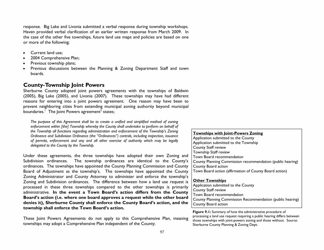
97
response. Big Lake and Livonia submitted a verbal response during township workshops. Haven provided verbal clarification of an earlier written response from March 2009. In the case of the other five townships, future land use maps and policies are based on one or more of the following; Current land use; 2004 Comprehensive Plan; Previous township plans; Previous discussions between the Planning & Zoning Department Staff and town
boards. County-Township Joint Powers Sherburne County adopted joint powers agreements with the townships of Baldwin (2005), Big Lake (2005), and Livonia (2007). These townships may have had different reasons for entering into a joint powers agreement. One reason may have been to prevent neighboring cities from extending municipal zoning authority beyond municipal boundaries.1 The Joint Powers agreement2 states;
The purpose of this Agreement shall be to create a unified and simplified method of zoning enforcement within [the] Township whereby the County shall undertake to perform on behalf of the Township all functions regarding administration and enforcement of the Township’s Zoning Ordinance and Subdivision Ordinance (the “Ordinances”) controls, including inspection, issuance of permits, enforcement and any and all other exercise of authority which may be legally delegated to the County by the Township.
Under these agreements, the three townships have adopted their own Zoning and Subdivision ordinances. The township ordinances are identical to the County’s ordinances. The townships have appointed the County Planning Commission and County Board of Adjustment as the township’s. The townships have appointed the County Zoning Administrator and County Attorney to administer and enforce the township’s Zoning and Subdivision ordinances. The difference between how a land use request is processed in these three townships compared to the other townships is primarily administrative. In the event a Town Board’s action differs from the County Board’s action (i.e. where one board approves a request while the other board denies it), Sherburne County shall enforce the County Board’s action, and the township shall enforce the Town Board’s action. These Joint Powers Agreements do not apply to this Comprehensive Plan, meaning townships may adopt a Comprehensive Plan independent of the County.
Figure 9.1: Summary of how the administrative procedure of processing a land use request requiring a public hearing differs between those townships with joint-powers zoning and those without. Source: Sherburne County Planning & Zoning Dept.
Townships with Joint-Powers Zoning Application submitted to the County Application submitted to the Township County Staff review Township Staff review Town Board recommendation County Planning Commission recommendation (public hearing) County Board action Town Board action (affirmation of County Board action) Other Townships Application submitted to the County County Staff review Town Board recommendation County Planning Commission Recommendation (public hearing) County Board action

98
Baldwin Township Baldwin Township is located in the northeast corner of Sherburne County, bordering (clockwise) the City of Princeton, Princeton Township (Mille Lacs County), Spencer Brook Township (Isanti County), Livonia Township, and Blue Hill Township. Baldwin Township was organized in 1858, named after F.E. Baldwin, a County Commissioner. In 1858 the township’s area included present-day Blue Hill and Santiago townships. In 1877, the two townships were divided from Baldwin.5 The County/Township share zoning authority as explained on page 97. Baldwin Township’s natural features include Little Elk Lake, Lake Diann, Cantlin Lake, Sandy Lake, Rum River, and Battle Brook. The township includes several wetland complexes, wooded areas, and farm fields. The township is divided east-west by U.S. Highway 169. About half of the township is built-out. Population Baldwin is the County’s second most populous township, and third most in Minnesota, behind White Bear (Ramsey County) and Big Lake townships. The 2010 Census estimates its population to be 6,739. Baldwin’s population grew 44.2% between 2000 - 2010. By comparison, the City of Princeton grew 19.5% during this same period to an estimated 2010 population of 4,698. According to the 2005-2009 American Community Survey, township residents’ median age was 36.3. 26.4% of residents were under 18 years of age, and 5.4% under 5 years of age. 5.4% of residents were age 65 or over. Households According to the 2005-2009 American Community Survey, Baldwin Township’s average household size was 2.72 persons. There were 2,025 total housing units, and 2,000 single-family homes. 98.6% of all housing units were owner occupied. Employment According to the 2005-2009 American Community Survey, of Baldwin Township residents 16 years and over, 75.4% were employed. The mean travel time to work was 35.5 minutes. Per capita income was $30,180. Median household income was $73,899. 3.3% of individuals (1.5% of families) lived below the poverty level. Figure 9.2: Total Population. Source: US Census.
0500
1,0001,5002,0002,5003,0003,500
4,0004,5005,0005,5006,0006,5007,000
1990 2000 2010
Baldwin township Princeton city (all)
Princeton township Blue Hill township
Livonia township Zimmerman city
Chapter 9 Township Land Use Plans

99
Figure 9.3: Sherburne County Future Land Use Map (Baldwin Township). Source: Sherburne County Planning & Zoning Dept.
Figure 9.4: Baldwin Township existing land use by acres (2008). Source: Sherburne County Assessor’s Dept.

100
Education According to the 2005-2009 American Community Survey, of Baldwin Township residents 25 years old or older, 94.4% were high school graduates (or higher), and 19.9% had received a bachelor’s degree or higher. Baldwin Township is within the Princeton ISD 477 school district. Existing Land Use (2008) Figure 9.4 shows existing (2008) land use. 9,458 acres are used residentially, while 8,056 acres remain in agricultural production. Residential developments are spread throughout the township, and primarily consist of 2.5 acre or larger single-family lots. Agricultural use is concentrated in the northern third of the township south of the City of Princeton, and along County Road 9. Future Land Use (2010-2030) Figure 9.3 shows future (2010-2030) land use. The majority of the township is guided for residential use. Non-developed portions of the U.S. Highway 169 corridor (2008 average daily traffic: 19,400) is guided for Business & Industrial land use. It is anticipated that not all of this corridor will become developed by the year 2030, resulting in non-developed land parcels to continue their existing use primarily as non-developed residential and agricultural uses, thereby preserving a scenic rural corridor along Highway 169. Areas south of Princeton are guided for Urban residential and commercial-industrial use. Previous Township Studies Highway 169 Taskforce In 1997-1998, a taskforce was formed with the following objectives: (1) to evaluate the options available to work with Princeton to provide services and possible tax revenue sharing, and; (2) to evaluate the current land uses, zoning and permitted uses within 1/4 mile adjacent to [Highway] 169 in Baldwin Township in order to make well planned long term land use recommendations for the local community. The taskforce made the following recommendations to the Baldwin Town Board: 1. To begin planning with Princeton on joint service agreements that would benefit both communities; issues
for discussion should include the following:
The proposed industrial by-pass connecting west from County Road 45 to Baldwin 136th Street, and to Highway 95 as referenced in the [1997] Sherburne County Transportation Plan.
Strategies to maintain, and or increase Baldwin’s commercial/industrial tax base. Prepare a feasibility study on cost sharing and tax revenue sharing for the possible extension of
utilities. Figure 9.5: 125th Street (frontage road), Baldwin Township. Source: Sherburne County Planning & Zoning Dept.
Chapter 9 Township Land Use Plans

101
The planning, working, service arrangements, joint power agreements, and cost/revenue sharing are intended to prevent annexation between Baldwin and Princeton.
2. The land south of 313th along both sides of Highway 169 in Baldwin Township should remain zoned
General Rural. The existing setbacks in the General Rural District for principal or accessory structure from Highway 169 should be increased from 100 feet for newly plated parcels to a minimum of 175 feet from the right of way of Highway 169.
Secondly, as part of the Subdivision Ordinance, Section 11 General Regulations, Subdivision 1: Design Standards add: “All newly created lots along Highway 169 should be screened from the freeway with natural means such as earth berms, and or trees and natural vegetation wherever possible without filling wetlands. All lots must also meet the minimum decibel standards for noise for residential homes recommended by the Minnesota Pollution Control Agency.
Findings of Fact:
1. The Task Force found that existing land uses vary and are scattered along the corridor. 2. The soils and wetlands will not allow efficient and feasible connections for contiguous building sites
and future sewer and water services needed for commercial highway uses. 3. Current permitted uses and Conditional Uses in the General Rural Zone allow landowners reasonable
use of the land. 4. Spot zoning individual properties in this area would be inconsistent with the [1992] Sherburne
County Land Use Plan and would require additional zoning regulations to ensure only the type of uses and structures that are desirable to the community are allowed.
5. The limited allowable accesses for businesses along 169 would require extensive service roads and utility extensions that would be costly to build in wet areas.
6. The Task Force wants to protect the integrity of the freeway visibility by preserving the natural appearance in the General Rural District.
7. The Task Force wants to protect future residents from noise and the public from bearing the cost of noise barriers after development of land.
8. The 175’ setback is based on preserving the aesthetic natural view of 169 and is a means at helping achieve MPCA noise standards.
Residential Survey In 2005, Baldwin Township adopted a township comprehensive plan, which was identical to the County’s comprehensive plan. Also in 2005, the town board distributed a non-scientific survey to 3,340 residential and business addresses. 96 residents responded (3% response rate). Questions and answers are as follows (number of responses in prentices);
Figure 9.6: Commercial development along US Highway 169 in Baldwin Township. Source: Pictometry International Corp.

102
Q: Should Baldwin Township have a Comprehensive Plan? A: Yes (68), No (9) Q: What do you like best about Baldwin Township? A: Keep it Rural (86), Personality (25), Government (21), Location (9)
Q: What do you like least about Baldwin Township? A: Planning/Goals (66), Public Services (44), Pride of Ownership (4) Q: If you could realistically change one thing about Baldwin Township what would it be? A: Needs: more business/industry; gas station on Co Rd 9 & Hwy 169; encourage diverse land use,
cluster, multiple housing; movie theater; restaurants; pave 133rd loop on east side of Lake Dianne; widen roads; provide water and sewer services for everyone; more citizen involvement, input; DSL; more better snowmobile trails.
Corrections: better/more walking/biking/workout trails, recreation; keep green spaces; no apartments,
low-rent housing, trailer parks; monitor home-businesses for pollution, taxing; lower speed limits; clean up after developments; better sight toward the east when exiting onto Co Rd 9 from the north.
Strategies: better, safer traffic control on Co Rd 9 & Co Rd 45, Co Rd 9 & Co Rd 1; more signage, “dead ends, no outlet, cul-de-sacs”; quotas for development; less outdoor lighting; have a limit of 2 dogs per household; lower taxes; township do their own zoning; no city sewer/water systems; support of new, better schools in District 477; start a community task force with vision that the board respects and can work with; additional taxation on new development to benefit our schools, parks, crime fighting; re-elect new board members.
Q: Baldwin Township has recently received a donation of 80 acres to be used as a township park. What would you like to have for recreation in this community park?
A: Athletics, exercise [activities] (134): Walking paths, trails, hiking (46) Athletic fields (13) Bicycling paths (12) Waterslide, water park, pool (9) Skating rink, warming house, winter activity (8) Basketball (6) Soccer (adult, youth) (5) Volleyball (5) Horseback riding trails (4) Horseshoes (4) Skateboard park (4) Rollerblading (4) Skiing (4) Frisbee golf (3) Golf driving range (affordable) (1) Tennis Courts (1) Animal archer hunt limited to township residents only (1) Family [activities] (32): Picnic area, pavilion, shelters, grills (29); Amphitheater, gazebo for entertainment (2) Figure 9.8: Baldwin Township park, Co Rd 38 & 108th Street.
Source: Pictometry International Corp.
Figure 9.7: Northeast Sherburne Fire Department (foreground), and Baldwin Town Hall & Public Works garage (background). Source: Sherburne County Plan-ning & Zoning Dept.
Chapter 9 Township Land Use Plans

103
Children/youth (29): playground; skateboard park; Jungle gym with rubber floor; summer programs.
Q: Infrastructure (23): A: Park is too costly, let the state manage it (11) Keep it natural, open for hunting (5)
Keep park safe (4) Improve ponds, don't cut trees (3) Community center/child activity center (3) Benches (1) Create prairie, wildflowers (1) Electricity/running water (1) Keep it mowed (1) Restrooms (1) Work toward no duplication or competition of Princeton park resources (1)
Q: Should Baldwin Township invest in a transportation plan? A: Yes (24); No (52) Q: Would you like to see an elementary school in Baldwin Township? A: Yes (20); No (69)
In 2008, the Town Board appointed a Strategic Planning Committee. In 2009, the township received a Healthy Communities Partnership (HCP) grant through the Initiative Foundation, providing the committee with extensive training and sponsoring a community visioning session in which 300 residents attended. The process received extensive media coverage by Minnesota Public Radio. The committee formed three task forces; (1) Parks, Environment and Social Capital; (2) Economic Development; and (3) Government Innovations. The task forces are exploring projects such as; comprehensive planning, park planning, long-range budgeting, and an annual business appreciation luncheon. City of Princeton Princeton’s current comprehensive plan (the plan) was adopted in 2008. As it pertains to Baldwin Township, the plan includes Goal 10 - Growth Management; “Support the expansion of the municipal boundary to growth areas in adjacent townships when development can adequately and efficiently be served by urban infrastructure. Oppose land use patterns that promote rural sprawl and prevent the logical extension of urban services.” Princeton’s comprehensive plan identifies a growth boundary, which includes portions of Baldwin Township. As of 2010, the city and township do not have an Orderly Annexation agreement (OA). Within the township, the city’s plan includes three “potential development districts” (see Figure 9.10), identified as #4 Airport Business Park, #5 South Gateway Area, and #6 Southeast Residential Area. In comparison to the County’s comprehensive plan, the Airport Business Park area is planned for future Urban Reserve - Business & Industry. The South Gateway area is planned for future Business
Figure 9.9: Princeton’s Comprehensive Plan identifies this area of the township for “Neighborhood Commercial.” To the left of Hwy 169 is 303rd Ave, with Co Rd 38 to the right. Source: Pictometry International Corp.

104
Figure 9.10: City of Princeton Urban Growth Boundary (2008). Source: City of Princeton/HKGI (Figure 2.2 in Princeton Comprehensive Plan).
Figure 9.11: City of Princeton Future Land Use Plan (2008) Source: City of Princeton/HKGI (Figure 2.3 in Princeton Comprehensive Plan).
Chapter 9 Township Land Use Plans

105
Figure 9.12: Comparison between the Princeton Municipal Airport Land Use Zoning map (1978) and the current (2010) location of the runway. Source: City of Princeton/Kirkham, Michael & Associates (Exhibit A in Princeton Municipal Zoning Ordinance, 1978), Sherburne County Public Works Dept.
& Industry, and the Southeast Residential Area is planned for future Rural Residential. The County and city comprehensive plans conflict in that the city’s South Gateway and Southeast Residential areas are not included within the County’s Urban Reserve areas because there is no existing (2010) Orderly Annexation agreement or other agreement between Baldwin Township and the City of Princeton that define rural areas to become urban serviced in the future. There is general agreement on the type of land use, but not urban vs. rural serviced. Thus without an OA, it is likely that within the 2010-2030 time period, the city’s planned South Gateway and Southeast Residential areas will develop rural, with well and septic systems. Princeton Municipal Airport Joint Zoning Board In 1978, an airport joint zoning board was created, consisting of representatives of the City of Princeton, Mille Lacs and Sherburne counties. Also in 1978, the Princeton Municipal Zoning Ordinance was adopted regulating land use within the Joint Zoning Board’s jurisdiction. The ordinance was approved by MnDOT, in compliance with MN Statute 360 of the Airport Zoning Act. The Joint Zoning Board’s jurisdiction includes land use within the Airport Hazard Area as defined in the ordinance, and within 2 miles of the airport boundary, and height restrictions within 1.5 miles of the airport boundary. The ordinance regulates land use and airspace in proximity of two planned runways. Runway 15-33 was planned for a length of 2,600’, and runway 04-22 was planned for a length of 2,133’. As of 2010, runway 15-33 is constructed at 3,900’ in length. Runway 04-22 was never constructed. The 1978 airport ordinance has not been updated to existing 2010 conditions. However the 1978 zoning regulations still apply but are not enforced by the Joint Planning Board, and are not consistent with other local zoning regulations. Instead, zoning is enforced by the applicable local government unit (i.e. City of Princeton, Sherburne County/Baldwin Township, and Princeton Township). The Joint Airport Planning Board (Princeton Airport Advisory Board) is active, with membership consisting of representatives from the City of Princeton, Princeton Township, and Baldwin Township. The Board reviews all land use applications within Airport Zones A, B, and C. The Board has submitted an Airport Layout Plan (ALP), to the FAA for approval (pending as of 2010), which includes a planned second runway. The ALP does not include an updated zoning ordinance. It is the intension for land use zoning to be left to applicable land use authorities (i.e. city, county/township).

106
Figure 9.13: Total Population. Source: US Census.
Big Lake Township Big Lake Township is located along U.S. Highway 10, and surrounds the City of Big Lake. The township borders (clockwise) Orrock Township, City of Elk River, City of Otsego (Wright County), Monticello Township (Wright County), City of Monticello (Wright County), and Becker Township. The township is characterized by Highway 10, which divides the township north-south, and by farm fields between the Mississippi and Elk rivers. Natural features include the Mississippi River (southern border), the confluence of the Elk and St. Francis rivers, Tibbits Brook, and 13 lakes. The township’s namesake and most of its lakes are located within the City of Big Lake. It’s first settlements3 were established in Big Lake (1848) and Bailey’s Station (1851), which included a hotel and stagecoach station. In 1857, the town of Liberty was platted in the southwest area of the township but was never developed. Big Lake Township was organized in 1858. The township maintains joint zoning authority with Sherburne County, where the two maintain parallel zoning and subdivision ordinances (see page 97). The city and township operate a joint Economic Development Authority which has resulted in a successful 90+ acre urban industrial park. The city and township also operate a joint fire district. Much of the growth in Sherburne County has been driven by access to US Highway 10 and Interstate 94, which run parallel north and south of the Mississippi River into the Twin Cities. The cities of Big Lake (Highway 10) and Monticello (I-94) are connected by a 3-mile segment of MN Highway 25 crossing through Big Lake Township. This segment of highway is primarily agricultural with a an average daily traffic (ADT) count of 12,400 - 16,500 vehicles (2008). The Highway 10 corridor in Big Lake (18,300 - 20,300 ADT) primarily consists of light industrial and commercial services, while the Interstate 94 (55,00 ADT) and MN Highway 25 (22,300 - 27,500 ADT) corridors in Monticello primarily consist of retail and commercial services. In 2009, Northstar Commuter Rail service began between Big Lake and downtown Minneapolis. The Big Lake station and maintenance facility are located near the intersection of U.S. Highway 10 and County Road 43 on land that previously was in the township. During the years 2010-2030, rural residential growth is expected to continue primarily north of the Elk River, while the City of Big Lake is expected to expand with a potential for transit oriented development around the Northstar Commuter Rail station. MnDOT has proposed a Highway 10 bypass (unfunded) south of the city. Urban growth pressure is expected to occur along US Highway 10, and MN Highway 25.
0
2,500
5,000
7,500
10,000
12,500
15,000
17,500
20,000
22,500
25,000
1990 2000 2010
Big Lake township Big Lake city
Monticello city Elk River city
Orrock township Becker township
Chapter 9 Township Land Use Plans

107
Population Big Lake Township is the County's most populous township and has the second highest township population in Minnesota, after White Bear Township in Ramsey County (2010 est. pop. 10,949). The US Census estimates Big Lake Township’s 2010 population to be 7,386. The township’s population has grown 34% between 2000-2010. By comparison, the City of Big Lake grew 66% to an estimated 10,060 (2010) and the City of Monticello grew 40% to an estimated 12,759 (2010) during this same period. According to the 2005-2009 American Community Survey, Big Lake Township residents’ median age was 37. 26.6% of residents were under 18 years of age, and 5.5% under 5 years of age. 2% of residents were age 65 and over. Households According to the 2005-2009 American Community Survey, Big Lake Township’s average household size was 3.1 persons. There were 2,545 total housing units, and 2,375 single-family owner-occupied homes. 93.3% of all housing units were owner occupied. Employment According to the 2005-2009 American Community Survey, of Big Lake Township residents 16 years and over, 82.5% were employed. The mean travel time to work was 35.4 minutes. Per capita income was $33,012. Median household income was $85,324. 3.1% of individuals (1.6% of families) lived below the poverty level. Education According to the 2005-2009 American Community Survey, of Big Lake Township residents 25 years old or older, 91.6% were high school graduates, and 20.5% had received a bachelor’s degree or higher. Big Lake Township is served by the Big Lake ISD 727, Elk River ISD 728, and Monticello ISD 882 school districts. Existing Land Use (2008) Figure 9.16 shows existing (2008) land use. 9,430 acres are used residentially, while 9,525 acres remain in agricultural production. Residential developments are concentrated north of the Elk River, and primarily consist of 2.5 acre or larger single-family lots. Agricultural use is concentrated south of US Highway 10. Future Land Use (2010-2030) Figure 9.15 shows future (2010-2030) land use. Areas north of the Elk River are guided for rural
Figure 9.14: Lions Park, Big Lake Township. Source: Sherburne County Planning & Zoning Dept.

108
Figure 9.16: Big Lake Township existing land use by acres (2008). Source: Sherburne County Assessor’s Dept.
Figure 9.15: Sherburne County Future Land Use Map (Big Lake Township). Source: Sherburne County Planning & Zoning Dept.
Chapter 9 Township Land Use Plans

109
Figure 9.18: City of Big Lake Comprehensive Land Use Plan (2009). Source: City of Big Lake/NAC.
residential as are areas along the Mississippi River. Areas south of the Elk River and north of US Highway 10 are guided for Urban Reserve-Residential, and Urban Reserve-Business & Industry. Other areas guided for Business & Industry include the interchange of US Highway 10 & CSAH 14/15, the planned interchange of US Highway 10 & US Highway 10 bypass west of the City of Big Lake, 1/4 mile on either side of MN Highway 25 between Monticello and Big Lake, and along County Road 17 which serves as a bypass of downtown Big Lake connecting Monticello to western neighborhoods of Big Lake. Areas south of the BNSF Railroad and north of CSAH 14 is guided for Agriculture with the exception of the area around the Northstar Commuter Rail station. Although guided for agriculture, it is likely that large tracts may be annexed into the city and developed prior to 2030. Previous Township Studies Big Lake Highway Corridor Taskforce In 1996 a 3-member taskforce was formed representing the Sherburne County Board of Commissioners, Big Lake Town Board, and Big Lake City Council. Its purpose was to make recommendations to the County regarding land use planning along highway corridors in the Big Lake community. During this period, the County Board adopted a one-year moratorium on residential development within the US Highway 10 and MN Highway 25 corridors. In 1996 following the taskforce’s recommendations, the County Board amended the Comprehensive Plan map in Big Lake Township (Figure 9.17);
1. Urban Expansion: areas immediately adjacent to the City of Big Lake along US Highway 10;
2. Industrial: areas west of the Urban Expansion area and east of Becker Township, and areas east of the Urban Expansion area and west of the US Highway 10 interchange with Co Rd 14/15;
3. Commercial: the area of the US Highway 10 & Co Rd 14/15 interchange, and east. 4. Commercial: the MN Highway 25 corridor between Big Lake and Monticello
City of Big Lake The City of Big Lake’s Comprehensive Plan (the plan) was adopted in 2000 and last amended in 2005. The plan’s Extra Territorial Land Use Plan (Figure 9.18) identifies all areas south of the Elk River to eventually become urban with the exception of existing rural residential
Figure 9.17: In 1996 the Big Lake Highway Corridor Taskforce recommended amendments to the county’s comprehensive plan map. Source: Sherburne County Planning & Zoning Dept.
Recreational Use Commercial Use General Rural Industrial Use
Agricultural Use Special Use Dist Urban Expansion City Limits
Heavy Industrial Use

110
developments along the Mississippi and Elk rivers. The plan includes the planned US Highway 10 bypass and guides land use along this corridor for Commercial, with Industrial and Light Industrial between the bypass and existing US Highway 10, east of County Road 43. Commercial land use is also planned along the MN Highway 25 corridor between Monticello and Big Lake. The plan includes a number of greenway corridors along rivers, streams, and wetland complexes. These corridors extend north of the Elk River into areas agreed to remain permanently within the township. In 2008, the city adopted a Transit Oriented Development (TOD) Master Plan, design guidelines, and ordinance for areas near the Northstar Commuter Rail station. Although much of this area is currently (2010) within the township, it is anticipated that prior to development, it will be annexed into the city. The County’s Comprehensive Plan and City’s Comprehensive Plan conflict in regards to future land use primarily in two areas; (1) along the US Highway 10 bypass corridor, and south of US Highway 10, east of County Road 43. The City guides this area for Commercial, Industrial, Light Industrial, and TOD, while the County guides this area for agriculture and TOD. Although the future land use designation conflicts, the preservation of land for agricultural use should not impeded the eventual urban development of this area. (2) Non-developed areas along the Mississippi and Elk rivers, the City guides as Low Density Residential, Rural Residential, and Estate Low Density Residential, while the County guides for Rural Residential (large lot single-family).
Figure 9.19: City of Big Lake TOD Master Plan. Source: City of Big Lake / LSA.
Figure 9.20: Northstar Commuter Rail, Big Lake Station. Source: MnDOT.
Chapter 9 Township Land Use Plans

111
Blue Hill Township Blue Hill Township is located in northeastern Sherburne County bordering (clockwise) Greenbush Township (Mille Lacs County), Baldwin Township, Orrock Township, and Santiago Township. It’s nearest cities are Princeton (1-mile) and Zimmerman (2-miles). In 1857, the town of Groton was platted along the St. Francis River, but was never developed.3 Blue Hill Township was organized in 1877, when it seceded from Baldwin Township. The township’s namesake is “Blue Hill,” (elevation: 1,090’) thought to be the highest point in Sherburne County (the highest natural elevation is 1,110’ near the St. Cloud state prison). About 3/4 of the township is within the Sherburne National Wildlife Refuge. Residential developments are common along the eastern border, while the northern border remains agricultural. Some of the best farmland in the County is located along the Co Rd 3 corridor. Between the years 2010-2030, residential development is expected to continue along the eastern township boundary, extending west. However, development in the northwestern area of the township may be constrained due to a high water table. Population The US Census estimates the township’s 2010 population to be 2,176. Blue Hill’s population has grown 185% since it’s 2000 population of 762. By comparison, the City of Princeton grew 19% during this same period to an estimated 2010 population of 3,719. According to the 2005-2009 American Community Survey, Blue Hill residents’ median age was 30.9. 31.3% of residents are under 18 years of age, and 10.7% are under 5 years of age. 3.5% of residents are 65 years old or over. Households According to the 2005-2009 American Community Survey, Blue Hill Township’s average household size was 2.93 persons. There were 685 total housing units, and 655 single-family owner-occupied homes. 95.6% of all housing units were owner occupied. Employment According to the 2005-2009 American Community Survey, of Blue Hill Township residents 16 years and over, 84.8% were employed. The mean travel time to work was 36.1 minutes. Per capita income was $26,232 Median household income was $66,168. 2.1% of individuals (1.8% of families) Figure 9.21: Total Population. Source: US Census
0500
1,000
1,5002,0002,5003,0003,500
4,0004,5005,0005,500
6,0006,5007,000
1990 2000 2010
Blue Hill township Baldwin township
Princeton city (all) Santiago township
Greenbush township Orrock township

112
Figure 9.23: Blue Hill Township existing land use by acres (2008). Source: Sherburne County Assessor’s Dept.
Figure 9.22: Sherburne County Future Land Use Map (Blue Hill Township). Source: Sherburne County Planning & Zoning Dept.
Chapter 9 Township Land Use Plans

113
lived below the poverty level. Education According to the 2005-2009 American Community Survey, of Blue Hill township residents 25 years old or older, 91.5% were high school graduates, and 14.3% had received a bachelor’s degree or higher. The township is served by the Princeton school district, ISD 477. Existing Land Use (2008) Figure 9.23 shows existing (2008) land use. 3,185 acres are used residentially, while 4,164 acres remain in agricultural production. 18,292 acres are classified as tax-exempt, primarily consisting of the Sherburne National Wildlife Refuge. Residential development primarily consisting of 2.5-acre single-family lots is concentrated along county roads 1 and 42 near the Baldwin Township line. Future Land Use (2010-2030) Figure 9.24 shows future land use. Residential development on non-public land is expected to continue, similarly to what was experienced during the 2000’s. Areas with restrictive soils (primarily along County Road 3) may be limited to agricultural use and non-platted residential uses.
Figure 9.25: Blue Hill Town Hall. Source: Sherburne County Planning & Zoning Dept.
Figure 9.24: “Blue Hill”, Sherburne National Wildlife Refuge. Source: Sherburne County Planning & Zoning Dept.

114
Clear Lake Township
Clear Lake Township is located in western Sherburne County, and encompasses the City of Clear Lake. The township borders (clockwise) Haven Township, Palmer Township, Becker Township, Silver Creek Township (Wright County), Clearwater Township (Wright County), the City of Clearwater (Wright County), Lynden Township (Stearns County), and the City of St. Cloud (Stearns County). The town of Clear Lake was platted in 1856 and located on Clear Lake, but never developed. Clear Lake Village was then organized in 1858.3 The township includes the most farmland in Sherburne County (18,646-acres in production as of 2008). In addition to farmland, the township may be characterized by US Highway 10 and County Road 8, both parallel to the Mississippi River. There are 25 lakes within the township, many of which have undeveloped shoreline. Only Long, Pickerel, and Big Elk lakes are classified by the DNR as “developed.” MN Highway 24 connects the cities of Clearwater (I-94) and Clear Lake (US Hwy 10). The cities are about two miles apart. Highway 24 had a 2008 average daily traffic (ADT) volume of 11,900 - 16,500 and is heavily used by passenger vehicles bypassing Big Lake and St. Cloud between the Twin Cities and the Brainerd lakes area. MnDOT project’s its ADT to grow to 34,500 by 2040. The ADT does not include weekend lake traffic whose numbers may double weekday ADT volumes. MnDOT plans to replace Highway 24 through the township tentatively in 2023 (unfunded), in which the existing highway would be turned-back to Sherburne County to become a county road.
Figure 9.27: Total Population. Source: US Census Figure 9.26: Clear Lake Town Hall. Source: Sherburne County Planning & Zoning Dept.
0
250
500
750
1,000
1,250
1,500
1,750
2,000
2,250
2,500
1990 2000 2010
Clear Lake township Clear Lake city
Clearwater city Clearwater township
Palmer township Haven township
Chapter 9 Township Land Use Plans

115
Between 2010 - 2030, Clear Lake Township is expected to remain largely agricultural. There may be additional pressure to allow lakeshore development on its many undeveloped lakes. There may be additional growth pressure along the MN Highway 24 corridor as the cities of Clear Lake and Clearwater grow. Population The US Census estimates Clear Lake Township’s 2010 population to be 1,539. The township’s population has decreased 5.6% since its 2000 population of 1,630. By comparison, during the same time period, the City of Clear Lake grew 105% to an estimated 2010 population of 545, and Clearwater grew 102% to an estimated population of 1,735. According to the 2005-2009 American Community Survey, Clear Lake Township residents’ median age was 47. 20.4% of residents are under 18 years of age, and 1.8% are under 5 years of age. 17.7% of residents are 65 years old or over. Households According to the 2005-2009 American Community Survey, Clear Lake Township’s average household size was 2.42 persons. There were 696 total housing units, and 667 single-family owner-occupied homes. 95.8% of all housing units were owner occupied. Employment According to the 2005-2009 American Community Survey, of Clear Lake Township residents 16 years and older, 66.4% were employed. The mean travel time to work was 24.8 minutes. Per capita income was $41,897. Median household income was $79,722. 1.8% of individuals (1% families) lived below the poverty level. Education According to the 2005-2009 American Community Survey, of Clear Lake Township residents 25 years old or older, 96.2% were high school graduates, and 31% had received a bachelor’s degree or higher. The Township is served by the Becker ISD 728 and St. Cloud ISD 742 school districts. Existing Land Use (2008) Figure 9.31 shows existing (2008) land use. 2,024 acres are used residentially, while 18,646 acres remain in agricultural production. Existing residential developments primarily consist of lakeshore developments platted in the 1950’s - 1970’s, and riverfront developments platted mostly in the 1970’s, 1990’s, and 2000’s.
Figure 9.28: Clear Lake. Source: Pictometry International Corp.
Figure 9.29: Clear Lake Township Park. Source: Pictometry International Corp.

116
Figure 9.31: Clear Lake Township existing land use by acres (2008). Source: Sherburne County Assessor’s Dept.
Future Land Use (2010-2030) Figure 9.30 shows future land use. The township is expected to remain largely agricultural. It is expected that there will be growth pressure to allow residential development along lakeshores, raising the possibility for Planned Unit Developments (PUD) and conservation developments, in which certain land characteristics may be preserved.
Chapter 9 Township Land Use Plans
Figure 9.30: Sherburne County Future Land Use Map (Clear Lake Township). Source: Sherburne County Planning & Zoning Dept.

117
Figure 9.32: City of Clear Lake Comprehensive Plan Map. Source: City of Clear Lake / Municipal Development Group (Map 4-2 in city comprehensive plan).
Previous Township Studies Clear Lake Land Use Taskforce In 2001, the County Board appointed a four-member taskforce representing the Clear Lake Town Board, Clear Lake City Council, and the County Board of Commissioners. The purpose of the taskforce was to recommend to the County any amendments necessary to the County’s comprehensive plan and zoning map related to Urban Expansion areas along the Highway 10 and 24 corridors. The taskforce considered extending the Urban Expansion zoning district east and west of the city, on the south side of US Highway 10, and south of the city along MN Highway 24. The taskforce chose not to make any recommendations pending the outcome of a MnDOT Inter-regional Corridor study (IRC completed in 2002). City of Clear Lake As of 2010, the City and Township do not maintain an Orderly Annexation agreement. The City of Clear Lake’s Comprehensive Plan (the plan) was last updated in 2006 (Figure 9.32). At the time the plan was written, the city’s most current (2004) population estimate was 369, or 0.47% of the County’s total population. The plan assumes that percentage to continue, resulting in a city population projection of 523 (2010), 787 (2015), 1,247 (2020), and 2,053 (2025). To accommodate projected growth between the years 2005 - 2025, the plan projects a need for;
Single-Family Residential: 664 units (235 net-acres, or 306 gross-acres) Multi-Family Residential: 51 units (12 net-acres, or 12 gross-acres) Commercial / Industrial: (27-net acres, or 35 gross-acres) TOTAL: 715 units (274-net acres, or 356 gross-acres)
These projections culminate in the city’s 2005-2025 future land use plan map (see Figure 9.32), which estimates a need for about 2,140 gross-acres to be added to the city. The County’s and city’s future land use maps are in conflict regarding projected population growth and the location of future urban land use. The Minnesota Demographic Center projects the city will grow by 109 persons between 2010 - 2025, whereas the city projects a growth of 1,530 persons. Between 2000 - 2009, the city averaged 7.6 residential units built per year. Between 2010 - 2025, the city projects an average growth of 28.6 residential units per year (Table 4-5 in city comprehensive plan). The County’s comprehensive plan guides 81 gross-acres for Urban Reserve-Residential, and 660 gross-acres for Urban Reserve-Business & Industry, although not in the same locations as the city’s comprehensive plan proposes.

118
Haven Township
Haven Township is located in western Sherburne County. The township is bordered by (clockwise); the City of St. Cloud, Minden Township (Benton County), Palmer Township, and Clear Lake Township. The township is named after John Haven, one of the first settlers in Big Lake. The first settlement was located in the northeast corner of the township and included a tavern (1846). In 1858, the town of Wheeler was platted, located five miles south of St. Cloud. Wheeler included a ferry, sawmills, and flour mills, but did not prosper. The township was organized in 1872.3 Haven Township may be characterized by farmland as seen from US Highway 10, along with sand and gravel operations, and deposits largely unexcavated. Whereas the eastern half of Sherburne County has developed as an extension of the Twin Cities, Haven Township located immediately adjacent to the regional City of St. Cloud, has purposefully remained agricultural and undeveloped with the exception of a handful of residential neighborhoods. In 2010, the township and city adopted a 2010-2025 Orderly Annexation agreement (OA). The Township additionally adopted Zoning and Subdivision ordinances administering land use within the OA area with the intention of enforcing land use restrictions defined in the OA. During 2010-2030, the township is expected to remain agricultural with little population growth. As development increases regionally, it is expected that aggregate deposits will be excavated and processed. These deposits are primarily located in west-central Haven, and include 2,000 - 3,000 acres. Industrial development is expected to occur in proximity to US Highway 10 and the St. Cloud Regional Airport. Population The US Census estimates its 2010 population to be 1,986 persons. Haven’s population has decreased 1.9% since its 2000 population of 2,024. By comparison, the City of St. Cloud grew 11.4% during this same period to an estimated 2010 population of 65,842. According to the 2005-2009 American Community Survey, township residents’ median age was 41. 21.8% of residents were under 18 years of age, and 5.6% under 5 years of age. 10.3% of residents were age 65 or over.
Figure 9.33: Total Population. Source: US Census
05,000
10,00015,00020,00025,00030,00035,00040,00045,00050,00055,00060,00065,00070,000
1990 2000 2010Haven township St. Cloud city (all)
Clear Lake township Palmer township
Minden township
Chapter 9 Township Land Use Plans

119
Households According to the 2005-2009 American Community Survey, Haven Township’s average household size was 3.01 persons. There were 949 total housing units, and 750 single-family owner-occupied homes. 86% of all housing units were owner occupied. Employment According to the 2005-2009 American Community Survey, of Haven residents 16 years and older, 73.5% were employed. The mean travel time to work was 25.1 minutes. Per capita income was $35,536. Median household income was $74,432. 5.9% of individuals (4.2% of families) lived below the poverty level. Education According to the 2005-2009 American Community Survey, of Haven residents 25 years old or older, 93.9% were high school graduates, and 28.6% had received a bachelor’s degree or higher. Haven Township is within the St. Cloud ISD 742 school district. Existing Land Use (2008) Figure 9.37 shows existing (2008) land use. 3,130 acres are used residentially, while 14,894 acres are in agricultural production. Residential developments are scattered, and primarily consist of 2.5 acre lots or greater in size, except for lakeshore lots which average about one acre in size. Future Land Use (2010-2030) Figure 9.36 shows future (2010-2030) land use. The majority of the township is expected to continue in agricultural use. Existing industrial corridors along US Highway 10 are guided for Business & Industry along with areas south of the St. Cloud Regional Airport. The Town Board’s intension is to limit development as much as possible in areas between the Mississippi River and Co Rd 8. Zoning and subdivision regulations along the river are regulated by the Wild & Scenic Rivers Act (MN Statute 103F). This Act does not pertain to comprehensive planning, however the comprehensive plan guides zoning and subdivision ordinances. Previous Township Studies Haven Township Citizen’s Committee In 2004 the town board appointed the Haven Township Citizen’s Committee to review Orderly Annexation Agreements, and land use and zoning regulations along the Mississippi River and within proximity of the airport. In March, 2009 the committee submitted recommendations to amend the zoning map and ordinances (see Figure 9.38). Recommendations included;
Figure 9.35: Areas identified by the DNR as having significant aggregate deposits. Source: MN DNR.
Figure 9.34: Haven Town Hall. Source: Sherburne County Planning & Zoning.

120
Figure 9.37: Haven Township existing land use by acres (2008). Source: Sherburne County Assessor’s Dept.
Figure 9.36: Sherburne County Future Land Use Map (Haven Township). The map excludes Tract 1 and 2 of the 2010-2020 Orderly Annexation Agreement. Source: Sherburne County Planning & Zoning Dept.
Chapter 9 Township Land Use Plans

121
Figure 9.38: Future land use map and descriptions created by the Haven Township Citizen’s Committee (2009). Source: Haven Township.
Promote gravel and granite extraction within the Aggregate Reserve area. Preserve rural isolation and restrict residential development in the Aggregate Reserve area. Prohibit landfills and limit retail and manufacturing in the Aggregate Reserve area. Provide notification to residents within the Airport Impact area of airport operations and
associated nuisances. Orderly Annexation Agreement The 2010-2025 Orderly Annexation agreement (OA) is a continuation of the 2005-2010 OA (affected areas are unchanged), with the addition of township zoning. The intention is to preserve the OA areas for future urban development by establishing Township Zoning and Subdivision ordinances to be administered and enforced by the Town Board. The County will continue to administer shoreland, floodplain, and Wild & Scenic Riverway zoning regulations within the OA areas, and all land use regulations outside of the OA areas within the township. City of St. Cloud The City of St. Cloud is located within Benton, Sherburne, and Stearns counties. The majority of the city is in Stearns County. Portions of the city within Sherburne County include the St. Cloud Regional Airport, Minnesota Correctional Facility-St. Cloud (established in 1889), Riverside Gardens (park), a number of residential neighborhoods, and highway oriented commercial and light industrial uses along US Highway 10. The portion of the city within Sherburne County has a 2009 population estimate of 6,701. St. Cloud’s current comprehensive plan was adopted in 2003. The plan includes two growth areas within the township; the Haven Township Growth Area Master Plan, and the Airport Area Master Plan (see Figure 9.39). The Haven Township Growth Area Master Plan includes two concept plans. The primary difference between the two is the alignment of the planned 33rd Street river crossing and land use adjacent to a planned interchange. The Sherburne County Transportation Plan (2007) does not identify a new river crossing (i.e. proposed 33rd Street bridge). The Transportation Plan does proposes to upgrade 37th Street from a local road to a major collector road connecting County Road 8 and US Highway 10. This new connection will be within the area of the proposed 33rd Street river crossing. A service road would also be established along US Highway 10. The Airport Area Master Plan includes about a 1-2 mile radius around the airport. The plan guides undeveloped land for agriculture, industrial, and parks & open space, and includes a realignment of CSAH 7.

122
Although the city and county comprehensive plan maps conflict, the overall intent is similar. The County’s plan does not recognize planned urban growth within the township beyond areas within the 2010-2025 Orderly Annexation agreement. Although the two future land use maps conflict, the city’s guiding principles for land use are similar to the County’s comprehensive plan. The County identifies more industrial development south of the airport than the city does but this land use should not conflict with current airport operations. St. Cloud Municipal Airport Zoning Board In 1976, the St. Cloud Municipal Airport Zoning Ordinance was adopted by the City of St. Cloud, Benton, Sherburne, and Stearns counties. The ordinance established an Airport Zoning Board, and regulates land use and structure height within the conical airport zones. The ordinance has not been updated or consistently enforced since its adoption. Currently (2010), land use outside of the airport is regulated and enforced by Sherburne County and Haven Township. The County complies with federal and state regulations in regards to population density of land use and height restrictions. Since the 1976 ordinance residential developments have been established east of the airport (12 lots platted in 1988, and 21 lots platted in 1994-1995), and west of the airport (15 lots platted in 1990-1993). Otherwise, land use near the airport has largely remained agricultural. Current (2010) zoning regulations do not allow for the size of residential developments previously approved in the immediate areas around the airport.
Figure 9.39: City of St. Cloud Haven Township Growth Area Master Plan, concept 1 & 2. Source: City of St. Cloud Comprehensive Plan, p. 7-45, 7-46).
Figure 9.40: 2010-2025 Haven Township - City of St. Cloud Orderly Annexation agreement (OA) area. Source: Haven Township.
Chapter 9 Township Land Use Plans

123
Figure 9.42: St. Cloud Area Joint Planning District Plan. Source: St. Cloud Area Joint Planning Board/DSU.
The St. Cloud Regional Airport Master Plan was updated in 2007. The plan includes the proposed extension of both runways and addition of a third runway, which also extends conical Zones A, B, and C. The County’s comprehensive plan map designation of Airport Impact Area is in compliance with the 2007 master plan. St. Cloud Area Joint Planning District Plan In 1997, the St. Cloud Area Joint Planning Board (the Board) was established, consisting of representatives from Benton, Sherburne, and Stearns counties, and the cities of Sartell, St. Cloud, St. Joseph, Sauk Rapids, and Waite Park. Individual townships were not represented. In 2000, the Board adopted the St. Cloud Area Joint District Plan (the plan), funded by the Minnesota Legislature. The plan identified primary and secondary urban growth areas within an Ultimate Serve Area. Areas within the District Plan included about 2/3’s of Haven Township, and a small portion of Clear Lake Township. In 2005, the Legislature funded a study to analyze how effectively the District Plan has been implemented by local governments. The study concluded that the St. Cloud region experienced more rapid growth than the plan anticipated, but that most growth areas were in compliance with the District Plan. The County’s Comprehensive Plan conflicts with the St. Cloud Area Joint District Plan in that the County’s plan does not identify the proposed Ultimate Service Area, nor does it identify the two proposed river crossings.
Figure 9.41: Land Use and Airspace zoning plan. Source: City of St. Cloud/SEH (Sheet 17 of Airport Layout Plan).
ZONING AGRICULTURE LOW DENSITY RESIDENTIAL LOW DENSITY MIXED HIGH DENSITY MIXED COMMERCIAL INDUSTRIAL PARK PUBLIC

124
Livonia Township
Livonia Township is located in eastern Sherburne County, bordering (clockwise) Baldwin Township, Stanford Township (Isanti County), City of St. Francis (Anoka & Isanti counties), City of Elk River, and Orrock Township. Livonia Township was organized in 1866, and formally had been part of Elk River Township. The origin of the township name is unknown.3 The township may be characterized by US Highway 169, and residential developments primarily consisting of 2.5-acre lots or larger. Residential developments are primarily located east and west of Zimmerman. Other features include; Fremont Lake, East and West Hunter lakes, a large wetland complex in the southwest quadrant of the township, significant aggregate deposits and gravel mining operations in the southern portion of the township, and a portion of the Elk River Landfill. The Minneapolis Girl Scout Council operates a facility in the southeastern corner of the township, 1,130-acres in size. In 2011, Livonia adopted a Township Comprehensive Plan including 15 goals and a 2010-2015 implementation plan. During the years 2010-2030, rural residential growth is expected to continue primarily east of US Highway 169. Zimmerman is expected to grow within its Orderly Annexation area, primarily north of the city. Excavation and processing of sand and gravel is expected to continue beyond 2030, to serve development in the northwest Twin Cities metro area. In 2008-2009, MnDOT conducted a study of the US Highway 169 corridor between the Highway 10-101-169 interchange in Elk River and the Livonia/Baldwin township line. The study identified a preferred layout for an interchange at County Road 4 in Zimmerman, as well as a service road along the highway with a number of interchanges and overpasses. The proposed County Road 4 interchange is estimated to cost $40 million (as of 2008) and remains unfunded. Construction of related overpasses and interchanges is likely to occur after 2030. New development along the corridor should accommodate MnDOT’s preferred layout plan for a future service road, overpasses, and interchanges. Service roads should be constructed concurrent with new development along the highway corridor, unless prior funding is provided by MnDOT. Population Livonia Township is the County’s third most populous township after Big Lake and Baldwin. The US Census estimates Livonia Township’s 2010 population to be 5,951. The township’s population grew 52% since its 2000 population of 3,917. By comparison, the City of Elk River grew 40% to an estimated 22,974, and the City of Zimmerman grew 83% to 5,228 during this same period.
Figure 9.43: Total Population. Source: US Census.
0
2,500
5,000
7,500
10,000
12,500
15,000
17,500
20,000
22,500
25,000
1990 2000 2010
Livonia township Baldwin township
Elk River city Orrock township
Stanford township Zimmerman city
Chapter 9 Township Land Use Plans
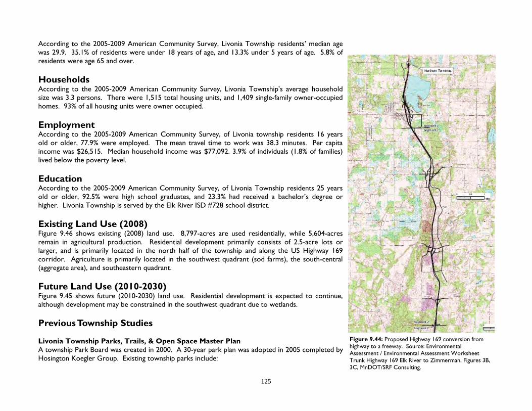
125
According to the 2005-2009 American Community Survey, Livonia Township residents’ median age was 29.9. 35.1% of residents were under 18 years of age, and 13.3% under 5 years of age. 5.8% of residents were age 65 and over. Households According to the 2005-2009 American Community Survey, Livonia Township’s average household size was 3.3 persons. There were 1,515 total housing units, and 1,409 single-family owner-occupied homes. 93% of all housing units were owner occupied. Employment According to the 2005-2009 American Community Survey, of Livonia township residents 16 years old or older, 77.9% were employed. The mean travel time to work was 38.3 minutes. Per capita income was $26,515. Median household income was $77,092. 3.9% of individuals (1.8% of families) lived below the poverty level. Education According to the 2005-2009 American Community Survey, of Livonia Township residents 25 years old or older, 92.5% were high school graduates, and 23.3% had received a bachelor’s degree or higher. Livonia Township is served by the Elk River ISD #728 school district. Existing Land Use (2008) Figure 9.46 shows existing (2008) land use. 8,797-acres are used residentially, while 5,604-acres remain in agricultural production. Residential development primarily consists of 2.5-acre lots or larger, and is primarily located in the north half of the township and along the US Highway 169 corridor. Agriculture is primarily located in the southwest quadrant (sod farms), the south-central (aggregate area), and southeastern quadrant. Future Land Use (2010-2030) Figure 9.45 shows future (2010-2030) land use. Residential development is expected to continue, although development may be constrained in the southwest quadrant due to wetlands. Previous Township Studies Livonia Township Parks, Trails, & Open Space Master Plan A township Park Board was created in 2000. A 30-year park plan was adopted in 2005 completed by Hosington Koegler Group. Existing township parks include:
Figure 9.44: Proposed Highway 169 conversion from highway to a freeway. Source: Environmental Assessment / Environmental Assessment Worksheet Trunk Highway 169 Elk River to Zimmerman, Figures 3B, 3C, MnDOT/SRF Consulting.

126
Figure 9.46: Livonia Township existing land use by acres (2008). Source: Sherburne County Assessor’s Dept.
Figure 9.45: Sherburne County Future Land Use Map (Livonia Township). Source: Sherburne County Planning & Zoning Dept.
Chapter 9 Township Land Use Plans

127
37-acre Sugarbush Preserve (natural area) with a trail, located in the SW quadrant. 15-acre parkland (undeveloped) located along the north shore of Fremont Lake. Livonia Township Transportation Plan A township transportation plan was adopted in 2006, completed by Hawkinson Anderson Engineering. The plan identifies future connections of local collector roads, including a service road along U.S. Highway 169. Livonia Township Community Vision for Land Use In 2005-2006, a plan was completed by the University of Minnesota, Center for Rural Design. Guided by a 17 member citizen’s steering committee, the plan priorities the community’s values as they relate to guiding future development (where, and at what densities). This plan was replaced by the Township’s Comprehensive Plan (2011) Livonia Township Comprehensive Plan In 2011, the Township adopted a comprehensive plan, written by the Community Growth Institute (CGI). The process was guided by a citizen’s steering committee, and included a series of public workshops, and a public opinion survey. The goals of this plan are number below: 1 Maintain the rural atmosphere and lifestyle enjoyed by the residents of Livonia Township. 2. New development should complement and enhance the beauty and character of the natural
landscape. 3. Protect the water resources within the township from pollution and degradation. 4. Support efforts to acquire significant natural areas, and provide recreational opportunities in
Livonia and the surrounding areas for the use and enjoyment of township residents. 5. Maintain a modest level of Taxation in the Township. 6. Plan and budget for future road maintenance expenses to ensure quality infrastructure and stable
property taxes. 7. Seek ways to work cooperatively with the City of Zimmerman, to the advantage of both city and
township. 8. Discourage unilateral annexations while working with adjacent municipalities to make intelligent
annexation decisions. 9. Work to establish a strong sense of community amongst the residents of Livonia Township and
Zimmerman. 10. Empower the citizens of Livonia Township to have influence over land use decisions. 11. Increase the level of influence that Livonia Township has on land-use related decisions made by
Sherburne County. 12. Strengthen the working relationship with Sherburne County in matters of land use and zoning. 13. Create an economic environment that encourages job retention and creation as well as
Figure 9.47: Sugarbush Preserve Township Park. Source: Livonia Township.

128
opportunity for business growth. 14. As a township, cooperatively seek to grow jobs in the local area for the benefit of everyone, but
do not compete with neighboring cities for commercial and industrial tax base. 15. Provide for aggregate mining that accesses the revenue potential of the resource while
protecting the character, environment and future land uses within the township. Livonia’s Comprehensive Plan does not include a future land use map to guide development. On January 10, 2011, County Staff met with the Livonia Town Board and their planning consultant (CGI) to discuss how the Township’s goals may be incorporated into the County’s Comprehensive Plan. After extensive discussion, it was the opinion of the Town Board that the County’s Comprehensive Plan Map represent current (2010) zoning designations (conflicts with Township Comprehensive Plan). The Town Board understood that continuing to allow residential development in proximity of Highway 169, and aggregate areas will not resolve current land use conflicts, and that these conflicts will need to be addressed at a later date, possibly as the Zoning and Subdivision ordinances are re-written. City of Zimmerman The City of Zimmerman is geographically surrounded by Livonia Township. The City’s comprehensive plan was last updated in 2001. Urban expansion is limited east, south, and west of the city because of Fremont Lake, wetland constraints, and existing rural residential developments. North of the city are a number of 5-acre and 10-acre residential properties, and a few larger parcels including 80-acres owned by the Elk River School District for consideration as a future school site. The city and township have an Orderly Annexation agreement (OA), valid through 2020. The OA identifies areas for voluntary annexation. Commercial land use is planned north of downtown, along U.S. Highway 169. Figure 9.49: City of Zimmerman / Livonia Township
Orderly Annexation Agreement map. Source: City of Zimmerman/EarthTech.
Figure 9.48: Zimmerman Future Land Use Plan (2001). Source: City of Zimmerman/EarthTech.
Chapter 9 Township Land Use Plans

129
Figure 9.50: Total Population. Source: US Census.
Orrock Township
Orrock Township is located in central Sherburne County, bordering (clockwise) Blue Hill Township, Livonia Township, Big Lake Township, and Becker Township. The nearest cities are Zimmerman (1/2 mile), and Big Lake (1 mile). Orrock was organized in 18753 and may be characterized by the inclusion of over 14,000 acres of public land (63% of township) including the Sherburne National Wildlife Refuge and Sand Dunes State Forest. Within the township lays Eagle Lake, Lake Ann and the St. Francis River. Residential development is concentrated in three areas of the township, along the southern and western borders, east of Zimmerman, and near Lake Ann within the State Forest. At the intersection of county roads 4 & 5 is a small commercial area (Hamlet) consisting of a gas station, bar/restaurant, liquor store, contractor’s yard, and a small number of homes. Between 2010-2030, Orrock Township is expected to continue to develop residentially on the remaining privately held land. It’s Hamlet is located about halfway between the cities of Becker, Big Lake, Elk River, and Zimmerman. Although the Hamlet primarily consists of retail services, its central location presents an opportunity for home businesses to transition into a rural commercial center. Population The US Census estimates Orrock Township’s 2010 population to be 3,451. The township’s population has grown 25% since its 2000 population of 2,764. By comparison, the City of Big Lake (city nearest to Orrock’s population center) grew 66% to an estimated 10,060 during this same period. According to the 2005-2009 American Community Survey, Orrock Township residents’ median age was 33.2. 32.6% of residents were under 18 years of age, and 9.1% under 5 years of age. 6.4% of residents were 65 years old or older. Households According to the 2005-2009 American Community Survey, Orrock Township’s average household size was 3.1 persons. There were 1,616 total housing units, and 1,091 single-family owner-occupied homes. 97.8% of all housing units were owner occupied. Employment According to the 2005-2009 American Community Survey, of Orrock Township residents 16 years
0
1,000
2,000
3,000
4,000
5,000
6,000
7,000
8,000
9,000
10,000
1990 2000 2010
Orrock township Big Lake township
Big Lake city Zimmerman city
Livonia township Blue Hill township

130
Figure 9.52: Orrock Township existing land use by acres (2008). Source: Sherburne County Assessor’s Dept.
Figure 9.51: Sherburne County Future Land Use Map (Orrock Township). Source: Sherburne County Planning & Zoning Dept.
Chapter 9 Township Land Use Plans

131
and over, 78.6% were employed. The mean travel time to work was 35.8 minutes. Per capita income was $28,614. Median household income was $80,000. 2% of individuals (0.8% of families) lived below the poverty level. Education According to the 2005-2009 American Community Survey, of Orrock Township residents 25 years old or older, 95.4% were high school graduates, and 19.1% received a bachelor’s degree or higher. Orrock Township is served by the Big Lake ISD 727 and Elk River ISD 728 school districts. Existing Land Use (2008) Figure 9.52 shows existing (2008) land use. 14,515-acres (63%) of land in the township is tax-exempt, primarily consisting of the Sherburne National Wildlife Refuge and Sand Dunes State Forest. 4,777-acres (21%) are residential. 905-acres remain in agricultural production. Residential developments primarily consist of 2.5-acre lot size or greater, although there are a number of lakeshore lots as small as 1/3 acre. The earliest lakeshore development dates back to 1923, almost 50 years prior to any zoning regulations. Future Land Use (2010-2030) Figure 9.51 shows future (2010-2030) land use. Residential development is expected to continue. The Comprehensive Plan identifies a mixed-use Hamlet in the area which currently consists of a mixture of commercial, industrial, and residential uses.
Figure 9.53: Commercial district (Hamlet) in Orrock Township. Source: Sherburne County Planning & Zoning Dept.
Figure 9.54: The Shores of Eagle Lake was platted in 2006 as a Shoreland PUD and Cluster plat. The development consists of 99 lots and 24 outlots. The development was planned to be an upscale neighborhood featuring a private clubhouse overlooking the lake. As of 2010, no homes have been built. Source: Sherburne County Planning & Zoning Dept, Sanborn.

132
Palmer Township
Palmer Township is located in western Sherburne County. The township is bordered by St. George Township (Benton County), Santiago Township, Becker Township, Clear Lake Township, and Haven Township. The nearest cities are Clear Lake (1 mile) and St. Cloud (2 miles to airport). Palmer Township was established in 1858, and originally named Briggs Township.3 The township may be characterized by the Briggs Lake chain, which includes Briggs Lake, Lake Julia, Rush Lake, and Big Elk Lake. Briggs, Julia, and Rush lakes are connected via navigable channels, while Big Elk Lake is connected to Rush Lake via Lilly Creek. The lakeshores were developed residentially primarily between the 1920’s and 1950’s, with the exception of the north half of Big Elk Lake, which remains undeveloped. In the center of the township is a viable commercial district (hamlet). Palmer includes a significant amount of agricultural land. In 1951, the Briggs Lake Chain Association was established to address water quality concerns. Activities have included educational seminars, water monitoring, fundraising to control lake weeds and invasive species, publication of a lake resident’s directory, and organization of a July 4th boat parade. In 2000, the association received an Outstanding Conservationist award from the Minnesota Association of Soil and Water Conservation Districts. During 2010-2030, the township is expected to remain primarily agricultural with limited growth in residential and the hamlet areas. Any significant development is expected to occur in the hamlet area. Population The US Census estimates its 2010 population to be 2,354 persons. Palmer’s population has declined 2.5% since its 2000 population of 2,414. By comparison, the City of Clear Lake grew 105% during this same period to an estimated 2010 population of 545. According to the 2005-2009 American Community Survey, township residents’ median age was 38.8. 24.3% of residents were under 18 years of age, and 6.4% under 5 years of age. 10.6% of residents were age 65 or older. Households According to the 2005-2009 American Community Survey, Palmer Township’s average household size was 2.72 persons. There were 1,405 total housing units, and 1,099 single-family owner-occupied homes. 78.2% of all housing units were owner occupied. Figure 9.55: Total Population. Source: US Census.
0
500
1000
1500
2000
2500
3000
3500
4000
4500
5000
1990 2000 2010
Palmer township Clear Lake township
Santiago township Haven township
Becker township St. George township
Chapter 9 Township Land Use Plans

133
Figure 9.57: Palmer Township existing land use by acres (2008). Source: Sherburne County Assessor’s Dept.
Figure 9.56: Sherburne County Future Land Use Map (Palmer Township). Source: Sherburne County Planning & Zoning Dept.

134
Employment According to the 2005-2009 American Community Survey, of Palmer residents 16 years and older, 78.5% were employed. The mean travel time to work was 30.6 minutes. Per capita income was $30,036. Median household income was $76,106. 2.3% of individuals (1.7% of families) lived below the poverty level. Education According to the 2005-2009 American Community Survey, of Palmer residents 25 years old and older, 95.1% were high school graduates, and 20.6% had received a bachelor’s degree or higher. Palmer is within the Foley ISD 61, St. Cloud ISD 742, and Becker ISD 726 school districts. Existing Land Use (2008) Figure 9.57 shows existing (2008) land use. 4,394 acres are used residentially, while 15,152 acres are in agricultural production (65% of township). Within the County, Palmer ranks 3rd in acres in production, behind Becker (20,021 acres, 58%) and Clear Lake (18,646 acres, 81%) townships. Residential developments are concentrated around the Briggs lake chain and include lakeshore lots between 1/2-acre and 1-acre. Non-lakeshore lots varies between one and five acres in size. Future Land Use (2010-2030) Figure 9.56 shows future (2010-2030) land use. The majority of the township is expected to continue in agricultural use. The Hamlet area includes the existing commercial-industrial area. The map identifies future expansion of the hamlet area to included undeveloped land parcels west and north of existing commercial developments. Previous Township Studies Palmer Long-term Advisory Team (PLAT) In 2005, the Town Board appointed a 12-member land use advisory committee representing the interests of farmers, rural residents, lakeshore residents, realtors, small business owners, and Town Board representatives. In 2006, PLAT conducted a three-day visioning workshop facilitated by the Minnesota Design Team. In preparation for the workshop, a survey was delivered to Palmer residents, resulting in a 5% response rate (81 respondents). The results may be see in Figure 9.60. In 2007, PLAT expanded into four sub-committees: Planning & Zoning, and Future Land Use Parks & Recreation, and Community Awareness Water Quality
Figure 9.58: In 2006, the township conducted a visioning workshop. As part of the workshop, participating residents were asked to individually answer five questions, and were then asked to identify the most important answer given to each question. Source: Palmer Township, Minnesota Design Team.
Chapter 9 Township Land Use Plans

135
Palmer Chamber of Commerce. The Planning & Zoning, and Future Land Use sub-committee continued to meet until 2009, culminating in a recommendation to the County regarding the 2010-2030 Comprehensive Plan. Generally, the recommendation was for Palmer to remain the same, but if development is to occur, it should radiate out from the Hamlet area to discourage leapfrog development and preserve the township’s agricultural character. The Parks & Recreation, and Community Awareness sub-committee led to the re-establishment of the Palmer Township Park Board. The Water Quality sub-committee continued to meet until 2008, facilitating a Water Quality Summit in February, 2008. The Palmer Chamber of Commerce was never organized due to a lack of interest among local business owners.
Figure 9.59: 42nd Street, Palmer Township. Photo courtesy of Robin Tomaszewski. Figure 9.60: “What’s important in Palmer Township?” (1 = low, 5 = high). 2006 township resident survey. Source: Palmer Township.
2.0
2.3
2.4
2.9
3.2
3.3
3.5
3.7
3.7
3.7
3.7
4.1
4.1
4.2
4.2
4.2
4.4
4.5
4.5
Multi-family housing
Public transportation
Community Center
Dow ntow n revitalization
Sew er and Water
High speed internet hookup
Cell phone antenna
Preserving agricultural land
Parks and Trails
Green space
Tow nship new s / communication
Controlled development
Safety / security
Land Use (zoning)
Environmental Concerns
Shoreland preservation
Surface w ater pollution
Water quality: lakes
Water quality: rivers / streams

136
Santiago Township
Santiago Township is located in northern Sherburne County, bordered by Glendorado Township (Benton County), Blue Hill Township, Becker Township, and Palmer Township. The nearest cities include Becker (3 miles), and Princeton (7 miles). Santiago Township was established in 1868. In the 1870’s, a saw mill was located along the St. Francis River manufacturing barrel staves and wagon fellies (wheels). In 1890, the Santiago Store opened. In 1891, the store and creamery suffered fire damage.3 The township may be characterized by its historic commercial district (hamlet), the Sherburne National Wildlife Refuge which consist of about 1/3 of the township, rich farmland north of the St. Francis River, and scattered wetlands and wooded areas in the southern half of the township. Between 2010 - 2030, Santiago is expected to experience limited residential growth, while the hamlet area presents an opportunity to attract small local businesses. Population The US Census estimates the township’s 2010 population to be 1,895 persons. Santiago’s population has grown 22% since its 2000 population of 1,555. By comparison, the cities of Becker grew 77% to a population of 4,538 and Princeton grew 19.5% to a population of 4,698 during this same period. According to the 2005-2009 American Community Survey, township residents’ median age was 31.3. 40.1% of residents were under 18 years of age, and 12.7% under 5 years of age. 3.4% of residents were aged 65 or over. Households According to the 2005-2009 American Community Survey, Santiago Township’s average household size was 3.44 persons. There were 612 total housing units, and 600 single-family owner-occupied homes. 98% of all housing units were owner occupied. Employment According to the 2005-2009 American Community Survey, of Santiago residents 16 years and over, 79.1% were employed. The mean travel time to work was 34.7 minutes. Per capita income was $21,189. Median household income was $70,938. 8.2% of individuals (3.8% of families) lived below the poverty level. Figure 9.61: Total Population. Source: US Census.
0
500
1,000
1,500
2,000
2,500
3,000
3,500
4,000
4,500
5,000
1990 2000 2010
Santiago township Glendorado township
Blue Hill township Palmer township
Becker township Becker city
Chapter 9 Township Land Use Plans

137
Figure 9.63: Santiago Township existing land use by acres (2008). Source: Sherburne County Assessor’s Dept.
Figure 9.62: Sherburne County Future Land Use Map (Santiago Township). Source: Sherburne County Planning & Zoning Dept.

138
Education According to the 2005-2009 American Community Survey, of Santiago residents 25 years old or older, 96.1% were high school graduates, and 15.9% had received a bachelor’s degree or higher. Santiago is within the Foley ISD 51, Princeton ISD 477 and Becker ISD 726 school districts. Existing Land Use (2008) Figure 9.63 shows existing (2008) land use. 4,427 acres are used residentially, while 10,183 acres are in agricultural production. Residential developments are scattered and primarily consist of 2.5 acre lots or larger, mostly developed in the late 1990’s. There are a number of non-platted 5-acre and 10-acre residential properties concentrated in the southeastern and western portions of the township. Future Land Use (2010-2030) Figure 9.62 shows future (2010-2030) land use. The majority of the township is expected to continue in agricultural use and public open space (i.e. Wildlife Refuge). There is a significant amount of wetlands within the refuge and scattered throughout the southern half of the township. Potential development within the southern area may be difficult if roads are required to weave around wetland pockets. Likewise, large scale crop production is challenging, thus the southern half of the township is likely to remain in non-developed residential use. The Comprehensive Plan identifies a Hamlet in areas currently occupied by a mixture of commercial, industrial, residential, agricultural, and township park land uses. The Hamlet is bordered by the St. Francis River, the refuge, and an existing residential development to the west.
...“When I was a kid in the 50’s I remember no less than 15 businesses in Santiago and I know there were more earlier. These included two road contractors, photography studio, a car dealership, and no less than 3 gas stations. In more than half those cases the owner or manager lived next to or in the same building. Other houses were interspersed among these business places. We seemed to get along fine. Most of us long time residents feel Santiago should have been the County Seat as we’re more centrally located than Elk River (but that’s another issue). Today, Santiago has four businesses. Several of the old buildings are still standing, but our little town is not what it was. Ironically, we are increasing in other ways such as population and socio-economic status. How can we address these issues? Tom Barthel, our former Chair, introduced us to the concept of a hamlet. Joe St. Dennis mentioned special use zones. Joe also encouraged our board to be pro-active and give [the County] our input.
Figure 9.64: Lakes and wetlands in Santiago Township. Source: Sherburne County Planning & Zoning Dept.
Figure 9.65: Santiago Hamlet. Source: Sherburne County Planning & Zoning Dept.
Chapter 9 Township Land Use Plans

139
We would like to explore both of these ideas (hamlet and special use zones) but need to know more. The bottom line is that we need to be able to make better use of our existing buildings, allow for growth without imposing on our residents. Years ago there were apartments above the store. Why not now? We used to have a bank in operation with an apartment above. We still could. We had a creamery that produced butter. Could that building produce something again? Our county is full of horses. Could someone sell saddles and tack? Is there a place for an insurance agent, a tax preparer, an artist, a plumbing shop? The answer to all these questions is yes. Santiago has the space available. However, we need to fit them in among the residents as we did before. Our town has made big steps in the last few years due in no small part to you folks at the county level. I don’t know for sure what our next step is, but we don’t want it to be backwards. Help us explore what we can make happen. We don’t want the town to grow uncontrolled like some wild west cow town, but we need to be more than a speed trap. In return, I promise not to pursue moving the County Seat, for now!”
Stuart Nelson, Chair
Santiago Town Board July 14, 2009
Footnotes: 1 The County-Township Joint Powers Agreement addresses applicable items in MN Statute 471.59. 2 MN Statute 462.357, Subd. 1 states; … “A city may by ordinance extend the application of its zoning regulations to unincorporated territory located within two miles
of its limits in any direction, but not in a county or town which has adopted zoning regulations’… …’Any city may thereafter enforce such regulations in the area to the same extent as if such property were situated within its corporate limits, until the county or town board adopts a comprehensive zoning regulation which includes the area”
3 The Minnesota Historical Records Survey Project, Division of Professional and Service Projects, Work Projects Administration. Inventory of the County Archives of Minnesota, No. 71 Sherburne County (Elk River). Saint Paul, MN. 1940
Figure 9.67: Santiago Hardware, and The General Store, date unknown. Source: Courtesy of Sherburne History Center.
Figure 9.66: Main Street (now 20th Street), 1910. Source: Courtesy of Sherburne History Center.
Figure 9.68: 20th Street, 2010. Source: Sherburne County Planning & Zoning Dept.

140
Chapter 10 Goals & Policies
Summary Chapter 10 establishes goals, policies, and their implementation strategies. A goal is a general statement relating to the County’s values. A policy statement provides the reasoning behind each goal. An Implementation strategy describes how the County intends to accomplish each goal. Goal statements are generally divided according to topics within the Comprehensive Plan. However, several policy and implementation statements may be applied to multiple goals. MN Statute 394.231 requires non-metro counties to consider adoption of seven goals and objectives “for the preservation of agricultural, forest, wildlife, and open space land, and minimizing development in sensitive shoreland areas.”. The County Board of Commissioners held a workshop on September 2, 2009 to consider the objectives recommended in MN Statute 394.231. Those objectives which the County Board agreed with1 have been incorporated into the following;
Goal 1 Natural Resources Protect and preserve the County’s natural resources for the benefit of County residents and the natural ecology.
Soil & Ground Water Policy 1: Sherburne County’s natural resources (soil, water, and ecology) provide unique opportunities and constraints.
It is the County’s policy to consider these opportunities and constraints when making land use decisions.
Chapter 10 Goals & Policies
Liberty Glen subdivision, St. Cloud

141
Implementation 1-1: Complete the Sherburne County Geological Atlas to provide a better understanding of local aquifers and their relationship to surface waters. The geological atlas will map bedrock and surficial geology, stratigraphy (layers), bedrock topography, depth-to-bedrock, subsurface geology, and mineral resources. The geological atlas will assist in identifying areas not appropriate for water intensive land uses, and those uses which may contaminate soil and groundwater.
Implementation 1-2: When a change of land use is proposed requiring a public hearing for a property within a Wellhead Protection Area
within the County’s zoning authority, the County will notify the applicable agency.2 Implementation 1-3: Heavy Industrial facilities shall be designed and constructed to prevent contamination of soils, surface water and ground
water. Implementation 1-4: The County will continue to require that a property’s Subsurface Sewage Treatment System (SSTS) meet minimum
standards when the property is sold or transferred by mortgage, contract for deed, or other transfer of ownership, and when a building permit is obtained from the County.
Implementation 1-5: The County will continue to provide well water testing kits to County residents.
Surface Waters Policy 2: Sherburne County includes 125 lakes, 493 miles of rivers & streams, and about 52,898 acres of wetlands (excluding
lakes). Surface waters provide a significant scenic and recreational amenity to County residents in addition to filtering pollutants prior to reaching aquifers. Surface waters also provide habitat for birds, fish, and animals.
It is the County’s policy to protect surface waters as required by Federal and Minnesota regulations, and to promote restoration efforts.
Implementation 2-1: Within the County’s zoning jurisdiction, continue to enforce applicable sections of the Federal Clean Water Act and State regulations, including but not limited to administration and enforcement of Shoreland regulations, the Wetland Conservation Act, and the National Pollutant Discharge Elimination System (NPDES).
Implementation 2-2: Collaborate with the Federal Emergency Management Agency (FEMA) through the National Flood Insurance Program
(NFIP) as a Cooperating Technical Partner (CTP), and amend and enforce the Floodplain Ordinance, as required by FEMA.
Implementation 2-3: Consider amending the Scenic and Recreational River ordinance in cooperation with the DNR, so that it is consistent
with the Zoning and Subdivision ordinances. Continue to enforce ordinances to protect the environment.

142
Ecology Policy 3: Sherburne County is located in the Anoka Sand Plain, which is a unique ecological environment in Minnesota.
It is the County’s Policy to promote native plant species, control noxious weeds as required by Minnesota laws, and to encourage the preservation of contiguous areas for the migration of native birds and animals.
Implementation 3-1: Consider requiring that new developments containing rare biological species and natural plant communities preserve
these features through a conservation easement, land dedication, or by other approved means. These features have been identified by the MN DNR on the “Natural Communities and Rare Species of Sherburne County, Minnesota” map, completed in 1993. Field verification would be necessary as part of the County’s development review process.
Implementation 3-2: Consider Natural Resource Inventory (NRI) data when reviewing land use applications (when available). An NRI is an
inventory of plant ecology (i.e. forest, woodland, shrubland, etc.). An NRI may include a more detailed inventory called a Minnesota Land Cover Classification System (MLCCS). An MLCCS grades the quality of ecological areas on an A-D scale. An NRI and MLCCS can identify key ecological areas for preservation. The County will continue to pursue grants to fund additional studies and conservation efforts.
Implementation 3-3: Continue to control and prevent the proliferation of noxious weeds as required under MN Statute 18.81. The County
Agricultural Inspector will continue to work with the public, township and city weed inspectors, and the Minnesota Department of Agriculture to implement this task.
Implementation 3-4: Support efforts to manage the spread of Oak Wilt, and other tree diseases and infestations.
Education & Promotion Policy 4: Sherburne County’s waterways and aquifers are susceptible to pollution because of the County’s sandy permeable
soils. It is the County’s policy to educate the public about the environment, and promote best management practices.
Implementation 4-1: Continue to provide public information on the County’s website, such as information about floodplains, shorelands,
domestic water and wells, and wetlands. Implementation 4-2: Continue to publish articles in the Environmental Educator (distributed county-wide). Implementation 4-3: Continue to facilitate educational workshops to inform residents of conservation efforts, including; the value of
waterways and wetlands; promote careful application of surface chemicals such as lawn fertilizers; and the status of impaired waterways.
Chapter 10 Goals & Policies

143
Implementation 4-4: Promote the Priorities, Goals and Objectives of the Sherburne County Local Water Management Plan.
Goal 2 Land Use Encourage development in appropriate areas, while preserving agricultural and urban interests.
Regional Planning Policy 5: Sherburne County (in addition to Wright County along the I-94 corridor) connects the metropolitan areas of the Twin
Cities and St. Cloud, and serves as one of the primary growth corridors of Minnesota. When comparing Sherburne County’s location, transportation access, and natural soil and water features (i.e. lack of physical constraints) to other counties within the larger region, Sherburne County is an attractive area for urban and rural growth.
It is the County’s policy to continue to properly manage growth, and maintain the County’s autonomy from state agencies in regulating local land use decisions.
Implementation 5-1: Continue to participate in regional planning workshops and conferences. Implementation 5-2: Continue to monitor legislative activities, and represent the County as directed by the County Board. Implementation 5-3: Continue regular communication with local government units (LGU’s) within the County concerning Planning & Zoning
Department projects, including distribution of the Department’s Annual Report.
Urban Expansion Policy 6: Sherburne County includes ten townships and seven cities. As of 2010, the cities of Becker, Big Lake, St. Cloud, and
Zimmerman maintain Orderly Annexation (OA) agreements with neighboring townships. Presumably, each OA is designed to preserve land within a township.
It is the County’s policy to remain neutral regarding city/township OA agreements, and to respect such agreements. In the case where no OA exists, it is the County’s policy to work with applicable cities and townships to zone land within a township.
Implementation 6-1: The County shall consider amending Zoning and Subdivision ordinances to accommodate Orderly Annexation
agreements. Proposed land uses within such areas should not impede future urban development or redevelopment of the area.
Implementation 6-2: In the instance that no Orderly Annexation agreement exist between a city and a township, and the city’s
Comprehensive Plan identifies future urban expansion within a township, the County will consider facilitating an

144
agreement (not an OA) between the applicable city and township to reserve land (through zoning regulations) within the township for future urban expansion needs.
Coordination with Townships Policy 7: Sherburne County is the planning & zoning authority in the townships of Blue Hill, Clear Lake, Haven (portions
thereof), Orrock, Palmer, and Santiago. The County maintains a “Joint Powers Agreement Regarding Zoning” with the townships of Baldwin, Big Lake, and Livonia, in which the County administers and enforces the township’s Zoning and Subdivision ordinances. In portions of Becker and Haven townships, the County administers zoning and subdivision regulations within the Scenic River, Recreational River, Shoreland, and Floodplain zoning districts. It is the County’s policy to continue to work with townships to effectively regulate land use in a cost efficient manner.
Implementation 7-1: Discuss with Town Boards how the County can address concerns regarding land use regulations, the land use
application review process, and administration and communication of records. Implementation 7-2: Consider amending land use application procedures to reduce the amount of time from when an application is
submitted to the County to the time the application is approved (including administrative and public hearing processes). Implementation 7-3: Amend the Zoning and Subdivision ordinances to remove inconsistent format and language, and address the specific
needs of each township. Implementation 7-4: Coordinate with townships to consider amending the Zoning Ordinance to reserve areas containing significant
aggregate deposits for existing and future extraction and processing, and facilitate reclamation land use planning. Implementation 7-5: Coordinate with townships to consider amending Zoning and Subdivision ordinances to create a Hamlet zoning
district, promoting the economic stability and pedestrian orientation of the town centers of Orrock, Palmer, and Santiago townships.
Implementation 7-6: Consider working with townships to identify land use maps.
Agricultural Zoning & Subdivision Regulations Policy 8: Sherburne County farmers have made significant investments in irrigation systems for the cultivation of row crops.
Agricultural corridors fragmented by development contribute to the rising cost of farming through increased land values, increased traffic, and non-compatible adjacent land uses. It is the County’s policy to preserve agricultural areas.
Implementation 8-1: Consider amending Zoning and Subdivision ordinances to limit the fragmentation of agricultural areas.
Chapter 10 Goals & Policies

145
Residential Zoning & Subdivision Regulations Policy 9: Sherburne County has experienced significant residential growth. The population of townships have increased from
19,874 in 1990 to 38,319 in 2010 (93%). During those 20 years, 747 subdivisions were approved, consisting of 25,905 acres within the ten townships. It is the County’s policy to manage residential growth while representing the best interests of property owners.
Implementation 9-1: Consider amending Zoning and Subdivision ordinances to discourage development in areas which are not adequately
served by public services, such as public roads and emergency services. “Adequate” public services shall be defined. Road access shall comply with access management guidelines (see Tables 15-19 of the Sherburne County Long-Range Transportation Plan, 2007).
Implementation 9-2: Consider amending the Subdivision Ordinance to address concerns related to the regulation of common property (i.e.
outlots and easements), such as community septic systems, community open space, and ingress/egress easements. Implementation 9-3: Consider amending Zoning and Subdivision ordinances to address the need for multi-generational housing, such as
allowing accessory dwelling units. Implementation 9-4: Encourage proposed developments to incorporate healthy active lifestyles, and amenities such as pedestrian trails
(public or private).
Goal 3 Economic Development Support Sherburne County’s efforts to retain, expand, and attract new businesses to the County.
Business Development Policy 10: Sherburne County as a planning & zoning authority in townships maintains a limited role in the promotion of economic
development within those townships. The commercial market in rural areas may be limited to those businesses which require high visibility from the traveling public and provide convenience goods to local residents.
It is the County’s policy to support local job creation and business expansion by allowing small businesses in appropriate areas, including home businesses. The County recognizes cities’ needs to reserve rural areas for future urban economic development for the benefit of both cities and townships, which may be home to those employees.
Implementation 10-1: Continue to support the efforts of the Sherburne County Economic Development Alliance, Housing & Redevelopment
Authority, and Regional Rail Authority.

146
Implementation 10-2: Consider reserving undeveloped U.S. and state trunk highway corridors for future commercial and industrial development. Allow appropriate commercial and industrial development within these corridors in areas accessible by local roads (i.e. no direct access onto U.S. and state trunk highways). Reserving these corridors for future development effectively preserves the area’s rural character in the near-term.
Implementation 10-3: Integrate consideration of economic development into County planning and decision-making, including facilitating a
chain of communication with the County Administration Department to follow through with economic development leads.
Implementation 10-4: Encourage cities and townships to partner in the development of municipal industrial parks, sharing costs and revenue.
Goal 4 Transportation The Sherburne County Planning & Zoning Department and Public Works Department shall collaborate efforts to implement the County’s Long-Range Transportation Plan.
Sherburne County Long-Range Transportation Plan Policy 11: The Sherburne County Long-Range Transportation Plan (2007) identifies County roadway needs through the year
2030. It is the County’s policy to implement the Sherburne County Long-Range Transportation Plan.
Implementation 11-1: County Staff will continue to recommend that the County require proposed developments, and proposed changes of land use (i.e. rezonings, CUP/IUP) to comply with access management guidelines (see Tables 15-19 in Transportation Plan).
Implementation 11-2: Continue to support the expansion of commuter rail from Big Lake to St. Cloud. Implementation 11-3: Continue to support transportation planning of local U.S. and Minnesota highway corridors.
Goal 5 Parks & Recreation Provide passive recreational opportunities to Sherburne County residents through County parks & trail systems.
Chapter 10 Goals & Policies

147
Sherburne County Parks System Policy 12: Sherburne County is in the early stages of park development. The first park (Oak Savanna Land Preserve) was
established in 1997. The County manages four parks totaling 345 acres, holds three parcels for non-designated parkland totaling 110 acres, and is currently (2010) in the process of acquiring land to complete the Great Northern Trail connecting Elk River, Zimmerman, and Princeton.
Within Sherburne County are the Sherburne National Wildlife Refuge (30,700 acres), Sand Dunes State Forest (6,000 acres of public land), Scientific & Natural Areas (1,162 acres), and Wildlife Management Areas (1,007 acres). These facilities are owned and managed by the U.S. Fish & Wildlife Service or the Minnesota Department of Natural Resources, and offer limited recreational uses.
It is the County’s policy to provide passive recreational opportunities while minimizing duplication of facilities and activities provided by other agencies.
Implementation 12-1: Implement the goals of the Sherburne County Parks, Trails, and Open Space Policy Plan (hereinafter; the Park Plan),
adopted in 2005. Implementation 12-2: Complete land acquisition for the Great Northern Trail, and construct the trail connecting Elk River, Zimmerman, and
Princeton. Implementation 12-3: Develop master park plans for Island View Regional Park, Bridgeview Park Preserve, and pursue funding to implement
master plans for all County parks and trails. Implementation 12-4: When a proposed development is located within a trail corridor identified in the Park Plan, consider requiring land
dedication for trail connections. Implementation 12-5: Continue to pursue opportunities to expand the County parks & trail system, including pursuing grants, state funding,
and donations. Implementation 12-6: Continue to promote the County parks & trail system through the Environmental Educator, County Fair booth, and
other promotional activities.

148
Footnotes: 1 The land use goals recommended in MN Statute 394.231 word-for-word are not applicable to Sherburne County’s townships in all cases. The statute’s
recommendations are listed below in bold italics with the County’s response following. The County’s response is based on comments made by the County Board during a September 2, 2009 workshop.
I. Minimizing the fragmentation and development of agricultural, forest, wildlife, and open space lands, including consideration of appropriate
minimum lot sizes; The County Board agrees, noting that Sherburne County has regulated minimum lot sizes since 1971.
II. Minimizing further development in sensitive shoreland areas;
The County Board agrees. However, the County does not intend to regulate shoreland areas more restrictive than current state regulations except in agricultural zoning and overlay zoning districts where applicable.
III. Minimizing development near wildlife management areas, scientific and natural areas, and nature centers;
The County Board disagrees. Development near WMA’s and SNA’s will not receive special consideration because of their proximity. However, development adjacent to the Sherburne National Wildlife Refuge, and Sand Dunes State Forest must comply with a 100’ building setback from public lands (i.e. boundaries) within the Refuge and State Forest.
IV. Identification of areas of preference for higher density, including consideration of existing and necessary water and wastewater
services, infrastructure, other services, and to the extent feasible, encouraging full development of areas previously zoned for non-agricultural uses;
The County Board agrees, in part. Sherburne County will respect Orderly Annexation agreements (OA) between cities and townships, and amend the Comprehensive Plan and Zoning Map when applicable. However, in the event a city and township disagree regarding future urbanization of township land where an OA does not apply, the County will remain neutral unless otherwise guided by this document. To the County’s knowledge, an engineered build-out scenario of each city does not exist which identifies a city’s water & wastewater capacity between the years 2010 - 2030. Furthermore, it is the County’s opinion that 2006-2035 population projections published by the Minnesota Demographic Center in 2007 (pre-recession) far exceed realistic population growth. Planning for long-term urban expansion in current township areas is difficult given the limited data available. As such, this Plan is dependent upon city/township OA’s to identify future urban areas. Agricultural corridors are concentrated along the Mississippi & Elk rivers in the southern and western portions of the County, and along County Road 3 in the northern portion of the County. These areas are predominately zoned to preserve agriculture, with the exception of areas in Blue Hill Township, which is guided and zoned for residential development. Blue Hill Township is within proximity of US Highway 169 and MN Highway 95 connecting residents to job centers.
V. Encouraging development close to places of employment, shopping centers, schools, mass transit, and other public and private service centers;
The County Board agrees, in part. The County’s interpretation of this recommendation is that the Statute’s intension is to encourage growth that is economically self-sustaining (i.e. new growth is not subsidized by existing tax payers). The County does not require the consideration of an economic impact analysis for new development. The County believes that such an analysis would be speculative at best given that assumptions must be made where facts are unknown. The allowance for new development in rural areas will continue to be
Chapter 10 Goals & Policies

149
based on the County Board’s and town board’s belief of what is best for the county and townships. Sherburne County is largely a bedroom community in which 68% of its workforce commute to jobs in other counties (2000 Census). The dominate local industries are manufacturing; education, health & social services; retail trade; and construction (2000 Census). The location of these industries are concentrated in the cities of Elk River, Big Lake, and Princeton (see pages 6, 7). Residential growth is projected to continue within these job corridors, which include the townships of Baldwin, Big Lake, and Livonia (MN Demographic Center population projections). Cities within Sherburne County face competition for retail centers with cities along the I-94 corridor in Hennepin County (Maple Grove, Rogers), Stearns County (St. Cloud), and Wright County (Albertville, Monticello). Within Sherburne County, regional retail centers are concentrated in Elk River along US Highway 169. The County’s access to roads, rail, and utilities present a continued opportunity to concentrate on attracting industry vs. retail. The operation of the Northstar commuter rail service and The Link commuter bus service has provided the option of mass-transit for County residents. Transit stations present a new market for convenience goods & services, and housing. However, transit stations are located within city limits and are not within the County’s zoning authority. The Comprehensive Plan identifies a need to develop or stabilize the hamlets in Orrock, Palmer, and Santiago townships so that they are economically self-sustaining, and function as a small village.
VI. Identification of areas where other developments are appropriate; and other goals and objectives a county may identify.
The County Board agrees, Chapters 8, 9, and 10 of the Comprehensive Plan address appropriate development, goals and objectives. VII. Other goals and objectives a county may identify.
Chapter 10 of the Comprehensive Plan addresses goals and objectives regarding land use. 2 MN Statute 394.26, Subd 2(c) requires that when a public hearing is required concerning a change of land use on property within two miles of a city’s zoning jurisdiction, that
the County notify the applicable City. It has been the County’s experience that when such notice has been given, the County often does not receive a response from the city. It is the intension that by explicitly drawing attention to the wellhead protection area, the applicable city is more likely to comment on a proposed land use change in a township.

150
Appendix A Town Board Survey
Between January and April, 2009, Planning & Zoning Department Staff met with each town board to discuss the comprehensive plan update process, and to ask a series of questions regarding updating the Zoning and Subdivision ordinances. The questions presented a series of “options” of how land use in agricultural, residential, and commercial & industrial areas should be regulated. The intention was for Staff to present several zoning options, and for town boards to narrow those options down. Zoning Staff would then develop those options into zoning ordinances. In the event that individual town board members gave differing opinions, the majority opinion was recorded. The results of the survey found distinct differences between townships, reiterating that “one-size-fits-all” zoning is no longer appropriate. One-size-fits-all zoning assumes that all residential areas, all commercial areas, etc. are equal resulting in a minimal number of zoning districts. Sherburne County has used this method since its first zoning ordinance in 1971. The survey finds that town boards want options, suggesting a need for multiple zoning districts of similar uses where the minimum standards are different (i.e. different lot sizes, architectural standards, etc.).
Appendix A Town Board Survey
Option 1 One home per 40-acres. No subdivisions and no exceptions.
Option 2 (current) One home per 40-acres. Land may be subdivided into a maximum of 3-lots, if all lots are at least 75% wooded, minimal lot size of 5-acres, and minimal lot width of 300’ along an existing public road.
X X X
Option 3 Same as Option 2, but remove the wooded requirement. X X
Option 4 Two agricultural districts; (A-1) 1 home per 40-acres (no subdivisions); and (A-2) minimum lot size of 10-acres (platted with a minimal lot width of 660’ on an existing public road (no wooded req).
Results of Town Board Survey re: acceptable options to be used to guide the Comprehensive Plan update and Zoning & Subdivision Ordinance revisions. The survey answers do not commit the townships into agreeing to anything, but provide Staff with direction needed to draft the Plan and ordinances. B
aldw
in T
owns
hip
(2-1
8-09
)
Hav
en T
owns
hip
(3-1
6-09
)
Sant
iago
Tow
nshi
p (4
-1-0
9)
Pal
mer
Tow
nshi
p (3
-24-
09)
Orr
ock
Tow
nshi
p (1
-28-
09)
Livo
nia
Tow
nshi
p (1
-26-
09)
Cle
ar L
ake
Tow
nshi
p (2
-17-
09)
Blu
e H
ill T
owns
hip
(2-9
-09)
Big
Lak
e T
owns
hip
(2-1
1-09
)
AGRICULTURAL AREAS

151
AGRICULTURAL AREAS (continued)
Option 5 Same as Option 4; but a proposed subdivision with 10-acre lots must be adjacent to parcels the same size or smaller. In other words, subdivisions would have to be located adjacent to each other, and not in the middle of farm fields.
Option 6 Two agricultural districts; (A-1) 1 home per 40-acres (no subdivisions); and (A-2) minimal lot size of 20-acres with minimal lot width of 660’ on an existing public road (no wooded requirement).
Option 7 Same as Option 6; but a proposed subdivision with 20-acre lots must be adjacent to parcels the same size or smaller. In other words, subdivisions would have to be located adjacent to each other, and not in the middle of farm fields.
Option 8 One home per 40-acres. Land could be subdivided using Transfer of Development Rights (TDR), with a minimum lot size of 2.5-acres.
X X X
Option 9 One home per 40-acres. Land could be subdivided based on a Land Evaluation Site Assessment (LESA) scoring system. Land is scored based on its soils, slope, neighboring land uses, proximity to such things like feed lots, paved roads, county road, fire station, schools, municipal water/sewer, etc. The idea is to establish a numerical value to land to determine its highest and best use. If its highest and best use is agriculture, then it cannot be subdivided. If it’s on a paved road, near services, and the surrounding land is not farmed, then maybe it could be subdivided.
X X X
Option 10 With approval of the Town Board, option to develop as a Residential Planned Unit Development (R-PUD). Property would be rezoned with an R-PUD Overlay District A, and/or R-PUD Overlay District B. R-PUD Overlay District A: minimum lot size of 1.5-acres with individual septic systems. Development must include specific amenities such as architectural and landscape standards, parks, trails, etc. R-PUD Overlay District B: minimum lot size of 1/2-acre with a shared septic system. Development must include specific amenities such as architectural and landscape standards, parks, trails, etc. 50% of the development must be preserved as Open Space. It could be used by residents, or retained for agriculture, etc.
X X X X X
Option 11 No Opinion. X X X
RESIDENTIAL AREAS (currently-2009 General Rural Zoning District) Option 1 (current) Minimum lot size of 2.5 acres, with options (requires approval of township); (1) minimum lot size of
1.5-acres if development includes certain architectural standards and amenities; and (2) minimum lot size of 1/2 acre with a shared septic system, if development includes certain architectural standards and amenities including preserving 50% of the development in a Conservation Easement that cannot be developed.
X X X X
Option 2 Minimum lot size of 5 acres. X

152
Bal
dwin
Tow
nshi
p (2
-18-
09)
Hav
en T
owns
hip
(3-1
6-09
)
Sant
iago
Tow
nshi
p (4
-1-0
9)
Pal
mer
Tow
nshi
p (3
-24-
09)
Orr
ock
Tow
nshi
p (1
-28-
09)
Livo
nia
Tow
nshi
p (1
-26-
09)
Cle
ar L
ake
Tow
nshi
p (2
-17-
09)
Blu
e H
ill T
owns
hip
(2-9
-09)
Big
Lak
e T
owns
hip
(2-1
1-09
)
Option 3 Minimum lot size of 2.5 acres. X X
Option 4 Minimum lot size of 1.5 acres. X X X
Option 5 Minimum lot size of 1 acre.
Option 6 Minimum lot size of 1/2 acre with a shared septic system, and require development to preserve 50% of land in a Conservation Easement, which cannot be developed.
Option 7 No opinion. X X X X X
COMMERCIAL & INDUSTRIAL AREAS (not home businesses)
Option 1 (current) No Architectural Design Standards in commercial/industrial districts. X X X X ARCHITECTURAL & SITE LAYOUT REQUIREMENTS
Option 2 Commercial/Industrial areas near city commercial/industrial developments shall have architectural and landscape design standards similar to those required in the neighboring city.
X
Option 3 Pole-barns permitted (i.e. stick framed with sheet steel siding). X X X X
ARCHITECTURAL & SITE LAYOUT REQUIREMENTS
Option 4 Combination of masonry on bottom portion of building with non-masonry on upper portions. X X X X
Option 5 All masonry construction. X X
Option 6 No pole-barns (i.e. 100% sheet steel siding). Other exterior finishes are optional (i.e. may be ma-sonry, vinyl, wood, stucco, or metal “accents,” etc.).
X X
RESIDENTIAL AREAS (currently-2009 General Rural Zoning District) (continued)
Appendix A Town Board Survey

153
Option 7 Require buildings to be farther from the road, with parking in front of the building (i.e. less green space between road and building).
X
Option 8 Require buildings to be closer to the road, with parking on the side or rear of the buildings (i.e. more green space between buildings).
X X
Option 9 No Opinion re: where building/parking is placed on lot. X X X X X X
Option 13 Require a minimum of 4” of topsoil over previous surface areas of the lot to support grass and other vegetation.
X X X X
LANDSCAPE REQUIREMENTS
Option 10 (current) No Landscape Design Standards in commercial/industrial districts. X X X
Option 11 Require commercial/industrial lots to establish and maintain a grass lawn (need to define “establish” and “grass lawn”).
X X
Option 12 Require commercial/industrial lots to establish and maintain a grass lawn, or a low-maintenance lawn approved by the County (i.e. prairie grass, desert rock garden, etc.).
? X X X X
Option 14 Require irrigation system in front and side yards. ?
ARCHITECTURAL & SITE LAYOUT REQUIREMENTS (continued)
Option 15 ? Require irrigation in all non-pervious areas of the yard.
Option 16 Require trees to be planted in front yard (i.e. 1 tree per 50’ of frontage, with credit for existing trees). X X X
PERMITTED, CONDITIONAL, & INTERIM USES
Question 1 If the townships could determine specifically what types of land uses could occur on which properties, and what that land use should look like, would your township be willing to have more Permitted Uses and fewer CUP’s & IUP’s? In other words, if the township said “if you’re willing to do X, Y & Z, you can build without a CUP/IUP.”
Y ? Y N Y Y Y N N
HIGHWAY PLANNED UNIT DEVELOPMENTS (Hwy PUD)
Y Y Y Y Y Y Y Y N/A Question 2 Do you think Highway Planned Unit Developments should be left as an option for areas adjacent to highways 10, 24, 25, & 169?
HIGHWAY PLANNED UNIT DEVELOPMENTS (Hwy PUD) (continued)
Y Y Y Y N Y Y Y Y Question 3 Do you think Highway Planned Unit Developments should be an option along county roads that meet a certain qualification (i.e. co Rd with the same or greater amount of traffic compared to Hwy 10, 24, 25, & 169)?

154
SAND & GRAVEL MINING
N N N/A Y Y Y N/A N/A N Question 4 Should a Mining zoning district or overlay district be established to limit the conflict between mining and non-compatible land uses such as residential, and work with landowners and the mining industry to develop a master plan for areas with significant deposits (Haven & Livonia townships)? A Yes vote would limit mining to certain areas of Haven and Livonia townships, and in turn would limit residential development in those areas. A no vote would continue to permit mining and residential development in many areas of the townships.
Bal
dwin
Tow
nshi
p (2
-18-
09)
Hav
en T
owns
hip
(3-1
6-09
)
Sant
iago
Tow
nshi
p (4
-1-0
9)
Pal
mer
Tow
nshi
p (3
-24-
09)
Orr
ock
Tow
nshi
p (1
-28-
09)
Livo
nia
Tow
nshi
p (1
-26-
09)
Cle
ar L
ake
Tow
nshi
p (2
-17-
09)
Blu
e H
ill T
owns
hip
(2-9
-09)
Big
Lak
e T
owns
hip
(2-1
1-09
)
Appendix A Town Board Survey

155
Appendix B

156
Appendix B Public Hearing Minutes

157

158
Appendix B Public Hearing Minutes

159

160
Appendix C Public Comments In March 2011, public comments were solicited from the following persons and local agencies, in addition to Sherburne County department heads: J. Shermak Becker Township M. Monte USDA NRCS J. Wothe City of Clearwater K. Hidde USDA Farm Services A. Schumann City of Monticello K. Neu City of Becker C. LaDoucer City of Nowthen J. Thares City of Big Lake A. Sittauer US Fish & Wild Life Service H. Nelson City of Ramsey K. Mechtel City of Clear Lake M. Robertson City of Otsego J. Barnhart City of Elk River R. Quady MnDNR Sand Dunes State Forest M. Hlen City of St. Francis J. Blake City of Princeton R. Stradal MnDNR Waters M. Glaesman City of St. Cloud S. Pfeifer MnDNR Regional Planning C. Benson Benton County B. Towle City of St. Cloud T. Anderson Isanti County R. Piasecki City of Zimmerman R. Patton Mn Dept of Agriculture M. McPherson Mille Lacs County D. Adams Stearns County D. Doran Sherburne County SWCD C. DuMont MnDOT District 3 T. Salkowski Wright County T. Determan Sherburne County SWCD M. Basiletti Sherburne County SWCD S. Mareck St. Cloud Area Planning Organization A. Arvidson Treeline J. King Economic Development Serives T. Moore St. Cloud Area Partnership J. Husveth Critical Connections Eco. Serv. M. Edwards St. Cloud State University The majority of the Public Comments are based on the DRAFT Comprehensive Plan, dated March, 2011.
Appendix C Public Comments

161
April 1, 2011 DeAnna Doran, Sherburne County Soil & Water Conservation District PUBLIC COMMENT: On page 43, under Green Acres; the paragraph discussing the covenant is incorrect. The SWCD doesn’t require nor administer the eight year covenant. The SWCD is only responsible to provide a Conservation Assessment Plan, which was originally required in order to enter into the Rural Preserve Property Tax Program. After the SWCD completes the Conservation Assessment Plan, the landowner than goes to the Sherburne County Assessor’s office and is required to enter into a covenant through the Assessor’s office, which is then recorded. The paragraph should be corrected as follows:
In 2009, state tax law was changed again, creating the Rural Preserve Property Tax Program. The intent is that properties which no longer qualify for Green Acres (i.e. class 2b rural vacant land) may qualify for Rural Preserve beginning in 2011. Rural Preserve uses a similar tax deferment plan and requires that the property be entered into an eight year covenant with the Sherburne County Assessor’s Office. If the covenant is violated, the property may be removed from the Rural Preserve Program by the County Assessor, requiring the payment of the previous three years property tax deferment. As of September, 2010, the Sherburne County Assessor’s office has administered 28 covenants totaling 1,360 acres, involving 8 landowners.
COUNTY’S RESPONSE: Paragraph removed per 2011 legislation, eliminating rural preserve covenants. April 5, 2011 Scott Mareck, St. Cloud Area Planning Organization PUBLIC COMMENT: From the APO’s perspective, two transportation projects that should be discussed further in the transportation element of Sherburne County’s Comprehensive Plan are the proposed Sherburne CSAH 7 realignment west of the St. Cloud Regional Airport and also the proposed 33rd Street South Mississippi River Crossing. The APO, Sherburne County, City of St. Cloud and others have been working with SRF Consulting Group over the last couple of years on a Corridor Study evaluating potential alternatives for realigning Sherburne CSAH 7. The need for realigning Sherburne CSAH 7 is primarily tied to a potential future extension of a St. Cloud Regional Airport runway. This project is also identified in the APO’s financially constrained 2035 Transportation Plan. Discussion of this Study is merited by the County in your Comprehensive Plan. Reference can be made to this potential project with a caveat that the County has not formally committed financially to the improvement at this point. With regard to the proposed 33rd Street South Mississippi River Crossing, Sherburne County and Stearns County signed an EIS Scoping Document prepared by the APO for this proposed project in 2005. The EIS Scoping Document summarizes social, economic, environmental and transportation analysis for a variety of local River Crossing alternatives extending from University Drive on the north end of the study area to I-94 on the south end of the study area. All alternatives are assumed to have connecting points of TH 15 and TH 10, with a future freeway connection to TH 10 in the vicinity of Sherburne CR 65/CSAH 3. An interchange will be under construction next year at 33rd Street South and TH 15 on the west end of the Corridor. Again, given the history of this project, its regional significance and the involvement by the County in this study process, discussion of this project and the completed analysis and planning is merited by the County in your

162
Comprehensive Plan. Reference can be made to this potential project with a caveat that the County has not formally committed to the improvement at this point. This project is an illustrative project in the APO’s 2035 Transportation Plan and is also identified in the Stearns County and City of St. Cloud Comprehensive Plans. COUNTY’S RESPONSE: Chapter 5 (Transportation) summarizes the County Transportation Plan (2007), and is not intended to replace this plan. Because the proposed CSAH 7 realignment and proposed 33rd Street River Crossing are APO projects (not County), and are not specifically addressed by the County Transportation Plan, they are not addressed in the County Comprehensive Plan. The County Planning & Zoning Department has had no involvement in the CSAH 7 realignment study, and two of the six realignment options are not located within the County’s zoning authority (Haven Township, and City of St. Cloud authority). Figure 9.39 (page 122) includes two maps from the St. Cloud Comprehensive Plan (2003) which show alternatives for a river crossing, and the CSAH 7 realignment. April 11, 2011 Blue Hill Town Board PUBLIC COMMENT: Page 52 – There are new rules for the [Board] of Adjustment. Don’t have to prove hardship. Page 88 – Regional trail systems are a pipe dream. Land acquisition & grants have been ongoing for over 10 years & nothing gets done. Time to abandon the idea of a trail system. Page 90 – Park fees are a redundant & regressive tax. Blue Hill has no plans for, nor no use for their park money at this time. What does implementation 7-2 mean? How much time? Chapter 11 – Eliminate or reduce 75% tree cover in Ag District. COUNTY’S RESPONSE: Variances: The term “Hardship” is removed on page [53]. State legislation was amended in 2011 (MN Statute 394.27, subd 7), deleting hardship, and adding practical difficulties.
“Variances shall only be permitted when they are in harmony with the general purposes and intent of the ordinance and when the variances are consistent with the comprehensive plan. Variances may be granted when the applicant for the variance establishes that there are practical difficulties in complying with the zoning ordinance. “Practical difficulties,” as used in connection with the granting of a variance, means that the property owner proposes to use the property in a reasonable manner not permitted by the zoning ordinance”
Appendix C Public Comments

163
Regional Trails: In 2003, the County conducted a scientific survey of 500 city and township residents. According to this survey: Q: Highest priority recreational need? A: Trails (39%); Parks (14%); Unsure (20%); None (7%). Q: Visit likelihood if more access trails? A: Much more likely (15%); Somewhat more likely (25%); No difference (58%). Q: Development of non-motorized trail system? A: Top priority (4%); High priority (16%); Medium priority (44%); Low priority (22%). Q: Rail Corridor for non-motorized trail? A: Strongly support (24%); Support (46%); Oppose (14%); Strongly oppose (9%). Since 2008, one of the County Board’s annual goals has been to complete land acquisition for the Great Northern Trail between Elk River and Princeton. Park Dedication Fees: Park Dedication Fees are not a “regressive tax.” MN Statute 394.25, subd 7 establishes “official controls” for counties concerning land development. When land is subdivided, a county may require land dedication or a park dedication fee. Park Dedication Fees may only be used “for the acquisition and development or improvement of parks, recreational facilities, playgrounds, trails, wetlands, or open space” and may not be used for “ongoing operation, maintenance, or redevelopment.” MN Statute 394.25, subd 7(m); The county must use at least 75 percent of the funds collected under this subdivision according to the plan required in paragraph (d) [referring to capital improvement plan and parks plan or parks component within comprehensive plan] in the township or city where the collection of funds occurs. However, the township board or city council may agree to allow the county to use these funds outside of the township or city in a manner consistent with the county parks, trails, and open space capital improvement plan or the county parks and open space component in its comprehensive plan. The remainder of the funds may be used by the county only for parks and trails connectivity and accessibility purposes. The county must annually report to cities and townships on where funds were collected and where funds were expended in the past year. [This language was added in 2003 to MN Statute 394.25, subd. 7 (l) by S.F. 484] Implementation 7-2 (page 144): Consider amending land use application procedures to reduce the amount of time from when an application is submitted to the County, to the time the application is approved (including administrative and public hearing processes). The intent of Implementation Strategy 7-2 is to further discuss with townships which land uses the town boards feel comfortable about allowing as Permitted Uses, and what specific requirements should those uses adhere to. Example: if an applicant applied to allow a retail sales business with outside storage on a property zoned for commercial/industrial use, and the specific use is a permitted use according to the Zoning Ordinance, County Staff should be able to review and approve the application within 5-business days vs. 2-3 months if a public hearing were required.

164
A common concern heard from landowners and business owners is that the approval process for subdivisions, conditional/interim use permits, etc. takes too long. It is common for this process to take two to three, or more months. There are two solutions to speed up the process; 1. Allow more permitted land uses and fewer conditional/interim uses (CUP/IUP).
CUP’s and IUP’s require public hearings. MN Rule 15.99 requires the County to approve or deny a complete application within 60-days. A complete CUP/IUP application requires the applicant to submit comments from the applicable Township (among other requirements). Most Town Boards, the County Planning Commission, and the County Board meet individually once per month regarding planning & zoning requests, thus when the County receives a complete application and when these boards meet, often affects how long it takes to receive approval.
In 2009, County Staff met with each Town Board to discuss the Comprehensive Plan and preferred options regarding zoning regulations (see Appendix A). Specifically, townships were asked;
“If the townships could determine specifically what types of land uses could occur on which properties, and what that land use should look like, would your township be willing to have more Permitted Uses and fewer CUP’s & IUP’s? In other words, if the township said “if you’re willing to do X, Y, & Z, you can build without a CUP/IUP.”
Of the nine Town Boards surveyed, five responded yes, three responded no, and one township was unsure. Blue Hill Township responded yes (Feb 9, 2009).
2. Have more frequent township, Planning Commission, and County Board meetings.
County Planning Commission meetings have a considerable expense (Staff time, Commissioner’s per diem and mileage), and can cost over $1,000 per meeting. Depending on the number of public hearings, application fees often do not cover these expenses. Because of these expenses, it is unlikely that the County would increase the frequency of public hearings unless application fees were increased to cover additional costs.
75% Tree Coverage: Blue Hill Township is zoned (2010) General Rural, except for areas within the Sherburne National Wildlife Refuge, which is zoned Agricultural. Within the Agricultural zoning district, for property to be subdivided into less than 40-acres, each lot must be a minimum of 75% wooded with a treed canopy. There is general agreement among the Town Boards with Agricultural Zoning that either the wooded requirement needs to be better defined, or that this requirement needs to be replaced (see Appendix A). County Staff will consult with townships regarding any proposal to clarify or replace the 75% wooded rule. April 12, 2011 Anne Sittauer, Sherburne National Wildlife Refuge PUBLIC COMMENT: Thank you for the opportunity to review the Sherburne County Comprehensive Plan. I have reviewed the plan and I have one comment. On page 10 of the draft
Appendix C Public Comments
165
plan it stated that “the number of National Wildlife Refutes in Minnesota is “10”. This statement is not accurate; rather there are 13 National Wildlife Refutes and 5 Wetland Management Districts in Minnesota. I am supportive of the 2005 Sherburne County Parks, Trails, and Open Space Policy Plan and the Sherburne County Comprehensive Land Use Plan. COUNTY’S RESPONSE: Corrected. April 15, 2011 Katie Larsen, City of Big Lake PUBLIC COMMENT: 1. Page [70], TH 10 Bypass: The City of Big Lake has not taken a formal position in regards to future planning around the proposed TH 10 Bypass since MnDOT
put the project on hold indefinitely in 2008. The City’s TOD Master Plan, for practical purposes, was designed without the TH Bypass going through. 2. Page [70]: The City of Big Lake and City of Monticello have had very preliminary discussion regarding the possibility of a second river crossing east of Highway
25. 3. The City adopted a Complete Streets Policy in 2010 and would encourage the County to consider such a policy especially along County roads abutting city limits
to promote pedestrian and bicycle connectivity. 4. The City has realized a greater need for code enforcement, screening and land use zoning along BNSF since the start of the Northstar Commuter Rail. 5. Page 73: The City officially adopted its TOD Design Guidelines and Zoning Ordinance in December 2008. 6. Economic Development: The City appreciates the County’s support in our efforts to develop an industrial rail park that could support 1,000 jobs+ and
significant increase in revenue generating tax base. We hope to develop this economic development relationship with the County. 7. Northstar Commuter Rail: The City appreciates the County taking the lead on facilitating discussions and meetings with all entities along the Northstar Corridor. 8. Page [89]: The City suggests including County Road 5 and/or 43 as a Trail Corridor Route to support bike enthusiasts interested in utilizing the Northstar from
the Cities to Big Lake. We receive several inquiries from bicyclists regarding the City and County trail systems. The Mississippi River, Wildlife Refuge and Sand Dunes are attractive destinations.
9. Page [110]: The Big Lake Comprehensive Plan was adopted in 2000 with major revision completed in 2005. Several minor amendments have occurred to
date. The City is hoping to start a new comprehensive plan in the near future. 10. The City’s Comp Plan guides land use along the Mississippi and Elk Rivers as Low Density Residential, Rural Residential and Estate Low Density Residential.

166
COUNTY RESPONSE: RE: comments 1, 2: This section (page 70) is a summary of the Sherburne County Transportation Plan (2007), and does not specifically address items not included within the Transportation Plan. RE: comment 3: Sherburne County has not adopted a Complete Streets policy other than what is included in the Transportation Plan (page 55-61 of Transportation Plan). The Planning Commission considered Complete Streets as an Implementation Strategy (Chapter 10: Goals & Policies), and recommended against it, stating that such a requirement would be “onerous, difficult, and impractical for builders.” RE: comment 4: In areas within the County’s zoning jurisdiction, existing (2010) land use along the Northstar Commuter Rail corridor includes; an auto salvage yard, light manufacturing, a lumber yard, farmland, and single family homes. Prior to Northstar (2009) these areas were not viewable to the public. The County enforces a solid waste (i.e. junk) ordinance on a complaint basis. No complaint has been filed, as of the adoption of this Comprehensive Plan. Screening and land use restrictions (unless in violation of solid waste ordinance) are addressed at the time an applicant requests a land use change (i.e. subdivision, CUP/IUP, etc). The County Planning & Zoning Department suggests three options to take care of the concern that the view from commuter rail cars inappropriately represents Sherburne County: 1. The NCDA can install screening (fence and/or trees) along the rail ROW, or work with adjacent property owners to install screening; 2. A person may file a complaint with the County concerning junk, etc. The County will investigate, and if the complaint is valid, the property owner
will be required to clean up the property in compliance with the Solid Waste Ordinance. However, based on previous cases where there was a large amount of refuse (junk) and an uncooperative landowner, resolving complaints can take years and considerable cost to the County.
3. Do nothing. When an adjacent property owner applies for a change in land use and there is a solid waste violation, the violation must be resolved prior to their application being approved. Additional screening may be required as a condition of their approval.
RE: comment 5: Corrected. RE: comment 8: Figure 7.12 (Planned trail corridor routes) is taken from the Sherburne County Parks, Trails, & Open Space Policy Plan (2005). This map is also included within the County Transportation Plan (2007). The City’s request to add a planned corridor connecting the Northstar Commuter Rail station and Sand Dunes State Forest (CSAH 43, TH 10, CSAH 5) was brought to the County Park Commission on June 2, 2011, who recommended that the Park Plan be amended to add this planned trail corridor. The County Board will consider this request prior to adoption of this Comprehensive Plan. RE: comment 9: Corrected. RE: comment 10: Corrected (page 110).
Appendix C Public Comments

167
May 5, 2011 Livonia Town Board PUBLIC COMMENT: 1. Supervisor Sherper, Hewitt and Manthei read the plan thoroughly; Supervisor Doebler had not completed reading the entire plan as of the Town Board meeting
on April 25, 2011 but intends to and may offer comment; Supervisor Hass skimmed the plan. 2. The Livonia Town Board discussed the Sherburne County Draft Comprehensive Plan at their April 25, 2011 Regular Board Meeting. 3. The Plan does not address the Township’s 20-year vision for growth because the growth is no longer there due to economic turndown. 4. Suggests a summarization of each chapter up front in the report followed by Chapter 8 Future Land Use, Goals and Policies followed by Township Plans and all
the informative County History, demographics, etc. Assuming the 2010 census data will be reflected in the final plan; not based off the 2000 census. On page 128 under Previous Township Studies in the first paragraph, eliminate the reference to a 20 acre athletic complex in the southeast quadrant-we are not sure where that came from. The plan feels like a boiler-[plate] document. The Board was expecting the County Plan to be in the front so as to highlight the County Plan then follow up with everything else-is all of the demographic info necessary for each Township? Is it necessary to provide all the detail for each Township-maybe summarize only as was done with the Cities. Eliminate previous studies, include only the current individual Town land use plan maps. This document should standout as being first and foremost a County Plan.
5. Because of the way the Plan is formatted and because the census/demographic information do not reflect current values, because of the “bulkiness” and
because this document does not say “This is a County Land Use Plan”, the Board would not recommend approval. COUNTY’S RESPONSE: An Executive Summary has been added. County Staff met with the Livonia Town Board in January and May, 2011 to discuss the Township’s and County’s comprehensive plans. The County’s Plan as it relates to Livonia, is based from the direction provided by the Town Board. 2010 Census figures were published in March, 2011 a few days prior to the County’s issuance of the Draft Comprehensive Plan. The County’s intent was always to distribute the Draft to the townships as soon as possible, so that townships could comment on the plan prior to the Planning Commission making a recommendation for approval (est. June, 2011). In the mean time, Staff would update population figures prior to the Planning Commission’s recommendation. This Comprehensive Plan is not a boiler-plate document. After the Comprehensive Plan was last adopted in 2004, County Staff heard a number of comments from townships that the Plan did not provide enough attention to individual townships. In response to that, Chapter 9 (Township Land Use Plans) addresses the uniqueness of each township.

168
May 11, 2011 Big Lake Town Board PUBLIC COMMENT Lots of info about Hwy 10 & 169, not much about east/west transportation corridor. Each Twp should have automatically been scheduled to sit with a county representative re: plan for their specific Twp. Lots of statistical info available, not much regarding planning. Question the population projection & if these are really feasible estimates for growth considering the housing & economic climate. Would like to see [Figure 9.14] changed to either a picture of the playground at Big Lake Lions Park, the Town Hall or the Big Lake Big Lake Town Hall & Park Marquee sign. Also noticed no mention of Big Lake Twp Lions Park in park section. COUNTY’S RESPONSE: Much of Chapter 5 (Transportation) is a summary of the Sherburne County 2007-2030 Transportation Plan, and is not intended to duplicate all information from the Transportation Plan. The County’s primary east-west corridor is US Hwy 10. Figure 5.4 (Future Functional Class) identifies CSAH 4 as a Minor Arterial (connects Becker and Zimmerman), and CSAH 3 as a Major Collector (connects St. Cloud and Princeton). County Staff met with each Town Board in 2009 to discuss the Comprehensive Plan update process, and township’s preferences for what to change in the Zoning and Subdivision ordinances (Appendix A). Because a number of Town Board’s meet on the same dates, it would take 3-4 months for Staff to meet with each Town Board at a regular township meeting, thus Staff is available to meet with townships, if the Town Board requests. The 2010-2030 population projections have been removed. The State Demographic Center published these projections (2006-2035) in 2007 (pre-recession). The State’s projection for 2010 (101,560) is significantly higher than the 2010 Census estimates (88,499). The State plans to revise projections in late 2011/2012. It is the County’s intent to amend the Comprehensive Plan once these projections are published. Figure 9.14 (photo of town sign) has been replaced with a photo of Lions Park. Chapter 7 (Parks & Recreation) does not describe in any detail township or city parks. Detailed descriptions of these parks would be more appropriate in the County’s Parks, Trails, & Policy Plan. The Comprehensive Plan map does identify township parkland as “Parks & Open Space.” May 17, 2011 Clear Lake Town Board PUBLIC COMMENT Map on page 116, property shown from the city limits following Hwy 24 down to Cty Rd 8 be left as shown but the property from Cty Rd 8 to river to remain as Agriculture.. Requirement 75% wooded, would like to see changed to 50% for platting purposes.
Appendix C Public Comments

169
COUNTY’S RESPONSE: Map corrected to show areas east of the proposed MN Hwy 24 interchange to be Urban Expansion-Business & Industry, and areas west to be Agricultural, except for areas within the Scenic & Recreational River zoning district, and property currently (2011) zoned Industrial on the SW corner of MN Highway 24 & Co Rd 8. The wooded requirement will be discussed during the Zoning & Subdivision ordinances update. May 17, 2011 Becky Balk, Minnesota Department of Agriculture PUBLIC COMMENT: I looked over the Sherburne County Draft Comprehensive Plan and made a couple of observations. But before I get to those. I want to compliment the County on its thoughtful and careful job examining the different approaches to protecting agricultural land. The draft plan looks like it will provide a good foundation for the subsequent zoning discussions. The only observations I have are in regard to Green Acres and agriculture’s contribution to the County’s economic development. No doubt you are aware that the Legislature just passed a new bill that revises Green Acres and the Rural Preserves Program. Perhaps you might want to add the latest changes to the program in the Land Use Chapter on [page 44].. Here is a link to the program descriptions provided by the Minnesota Department of Revenues Property Tax division www.taxes.state.rnn.us/property . In regard to the chapter on Economic Development, there isn’t any mention on how agriculture fits into the county’s economic development, nor. is it included in the economic development work plan. Since protecting agricultural land is economic development, the county may want to include that rationale in this chapter. More and more states, communities, organizations and producers are promoting investment in agriculture through loan and grant programs, the development of high-value agricultural products and services, direct marketing of farm products and diversification. Below is a list of a several strategies the county may want to consider:
• Planning for agricultural viability • Business planning and capital investment • Loan programs and economic development incentives • Farmers’ markets • Direct Marketing • Marketing to restaurants and food retailers • Community supported agriculture • Diversification • New products and marketing strategies • Agritourism • Grower Cooperatives

170
COUNTY’S RESPONSE: RE: Green Acres and Agricultural Preserve: Corrected. RE: Agriculture and Economic Development: Chapter 6 (Economic Development) does not specifically address agriculture. This chapter concentrates more on the four major employment industries in the County. According to the 2005-2009 American Community Survey, less than 1% of the County’s workforce is employed in agriculture (agriculture/forestry/fishing/hunting/mining). Agriculture and its economic impacts are discussed in Chapter 4 (Land Use). The Central Minnesota Region 7W Comprehensive Economic Development Strategy report (CEDS) discusses agriculture’s economic impact in greater detail than space will allow within the Comprehensive Plan. Of the strategies suggested by the MN Dept. of Agriculture, the County does not directly participate in these. However, some of these strategies operate independent of the County, such as; Elk River Farmer’s Market MN Historical Society’s Kelley Farm (agri-tourism) Community Supported Agriculture (CSA); Lacey “J” Ranch (Blue Hill Township) (vegetables, fruits, breads, eggs) USDA programs (i.e. conservation reserve program, farm loan programs, etc.)
There are a number of fruit & vegetable stands operating throughout the County, defined as a “Farm Related Business”, which is a Conditional Use within the Agricultural and General Rural zoning districts. May 18, 2011 Orrock Town Board PUBLIC COMMENT: 1. This plan contains many of the earmarks of “UN Agenda 21” and is but the local version of it, which every American who cherishes Liberty and freedom should
oppose with every fiber of his being. The vague clauses and statements of ‘policy’ contained in this plan leave the field wide open for future “NGO” regulations, being but a means to by pass constitutional restraints on infringements on private property and associated liberties dependent upon protection of private property rights. When fully implemented, “Agenda 21” will cede American sovereignty entirely to global government, and will do so without the consent of elected officials. It is not only a violation of the constitution of the United States but your vote to approve of it is violative of your oath of office.
http://www.freedomadvocates.org/articles/illegitimate_government/iclei%3a_local_governments_for_sustainability_and_the_u.n.connection_20100807421/ http://www.activistpost.com/2011/05/property-rights-under-attack-in-nj-re.html
Appendix C Public Comments

171
2. Orrock’s Hamlet line should extend east to 180th St. COUNTY’S RESPONSE: RE: Hamlet: The Hamlet Mixed-use designation has been extended east to 180th Street. RE: Agenda 21: Sherburne County is not aware of the “earmarks” within the United Nations’ Agenda 21, nor its relationship to the County’s Comprehensive Plan. The act of “planning and zoning activities” as authorized under MN Statute 394.21 does not constitute eminent domain. When property is zoned or re-zoned, it is often at the request of the property owner. The County as a zoning authority does have the ability to zone or re-zone land without a property owner’s consent, in compliance with the Public Hearing process. In most cases, this has been in response to major changes such as the County adopting a Zoning Ordinance in 1971, and significantly changing zoning district classifications in 1994. After the 2010-2030 Comprehensive Plan is adopted, the County’s intent is to significantly change (re-write) the zoning and subdivision ordinances. Any changes will be based on recommendations provided by townships and the County Planning Commission through the public hearing process. If there are specific concerns the Town Board has, it is important that those concerns be expressed to the County’s Planning & Zoning Department. The UN [United Nations] Agenda 21 and correlating webpage link refer to a Freedom Advocates blog entitled; “ICLEI: Local Government for Sustainability and the U.N. Connection”. Freedom Advocates’ mission “is to advance the principles of freedom to individuals and government through public discourse.” (http://www.freedomadvocates.org/about_us/ accessed May 19, 2011) ICLEI is an acronym for the “International Council for Local Environmental Indicatives.” ICLEI provides technical assistance to local governments in implementing sustainable development. ICLEI consists of over 1,200 local governments world-wide. Within Minnesota, member communities include; Blue Earth County, Duluth, Golden Valley, Hennepin County, Mahtomedi, Mankato, Minneapolis, Oakdale, Rochester, Roseville, St. Paul, and Virginia. Sherburne County is not a member community. Agenda 21 was published by the United Nations Department of Economic and Social Affairs, Division for Sustainable Development. “Agenda 21 is a comprehensive plan of action to be taken globally, nationally and locally by organizations of the United Nations System, Governments, and Major Groups in every area in which human impacts on the environment”. (http://www.un.org/esa/dsd/agenda21/index.shtm accessed May 19, 2011) The second webpage link refers to an Activist Post blog entitled “Property Rights Under Attack In NJ Re-zoning Land Grab.” “Activist Post is an Independent News blog for Activists challenging the abuses of the establishment” The blog article discusses Kingwood Township’s (New Jersey) proposed rezoning for a Scenic Corridor Overlay Zone along a highway, and the Township’s proposed amendment to a Solar Ordinance to include a deed restriction on private property. The blog article vaguely links zoning (i.e. government’s restriction of land use) to the use of Eminent Domain, and zoning restrictions as the taking of private property without just compensation. Eminent Domain is the condemnation of property by the government for “public use” (MN Statute 117.025) such as;
1. the possession, occupation, ownership, and enjoyment of the land by the general public, or by public agencies; 2. the creation or functioning of a public service corporation; or 3. mitigation of a blighted area, remediation of an environmentally contaminated area, reduction of abandoned property, or removal of a public nuisance.

172
“The public benefits of economic development, including an increase in tax base, tax revenues, employment, or general economic health, do not by themselves constitute a public use or public purpose.” (emphasis added).
The County’s Land Transaction Policy and Procedures (2006) states;
The Sherburne County Board of Commissioners has identified that economic development is a critical component of the planning strategy for the county and that the infrastructure of the communities within Sherburne County is essential to the maintenance of the county tax base. The Board has also identified that public parks and trails are an integral part of the quality standard of living in Sherburne County. It is therefore the policy of the County of Sherburne that voluntary land transactions shall be undertaken, to the extent practicable, in the best interests of all county residents and with consideration given to economic development and the potential impact on the infrastructure of political subdivisions located within the county. For purposes of this policy statement, voluntary land transactions include the sale of county owned land and purchases by the county of parcels either privately owned or under the control of other political jurisdictions.
June 1, 2011 Livonia Town Board PUBLIC COMMENT: Doebler/Hewitt unanimous to approve the County dratf comp Plan with the following amendment: Remove the reference to Livonia Township Community Vision for Land Use Plan on [page 127] and [corresponding map]; the information is outdated. Replace the picture on [Figure 9.47] with a picture of the Sugarbush Park. Supervisor Hass was absent from the meeting; all other supervisors indicated they read the Plan thoroughly. COUNTY’S RESPONSE: Corrected. A short description acknowledging the Livonia Township Community Vision for Land Use is included, noting that the plan was replaced by the Township’s Comprehensive Plan. July 16, 2011 Wayne Chermack, Orrock Town Board member PUBLIC COMMENT: Miss RIddle, May I respectfully suggest you present this link and the information contained on the website there, relating to the comprehensive land use plan that one of your employees will be discussing at the upcoming monthly meeting of the Orrock Town board. Please disregard the language in the comments section; the important parts of the basic contents of the page, including the videos; those in your administration are well advised to learn the truth about this plan they are promoting, and can draw their own conclusions from the information presented.
Appendix C Public Comments

173
http://kritterbox.com/showthread.php?tid=1126 COUNTY’S RESPONSE: See response to Orrock Township, page 169-171. July 22, 2011 Chuck Nagel, Baldwin Township resident PUBLIC COMMENT: Dear Mr. Sevald; I wish to provide a couple of specific observations concerning the comprehensive plan draft contents and then offer a couple of my personal ideas to consider. First let me say that I routinely hear comments that the county “one size fits all” zoning does not serve Baldwin Township all that well. While I may not share that opinion, perception is reality. Baldwin Township has recently formed a planning commission which some refer to as a planning and zoning commission. Does Sherburne County need another jurisdiction doing zoning administration? I think not. Accessory Dwelling Units – America’s population is aging and the numbers of our parents reaching the point where they can no longer live alone remotely are increasing. Will there be sufficient availability and will all residents be able to afford assisted living residences? Clearly the accessory dwelling concept should not be applied globally as it is dependent on local considerations. What is the harm with a two acre lot when the house is set well back and sometimes almost hidden from the road? Minimum Lot Sizes – The MPCA has apparently “recommended” a minimum two acre lot size to support a private septic system. Lafayette Township in Chippewa County, Wisconsin, like Baldwin Township being the second largest township in Wisconsin with many lake properties has a 30,000 square feet minimum lot size. A lot size of only one third the size of Sherburne seems to work well there and again I would suggest that there could be some local conditions that might be an exception. Townships are soon going to struggle with the long-term maintenance of sparsely populated roads built during the rapid development. To make matters worse, there is the plan to turnback responsibility of some county roads to the townships. Provide Planning & Zoning Services to Townships – One possible solution to these and other perceived local zoning issues is for the county to provide planning and zoning services to townships under contract. The City of Becker provides such services to Becker Township as does Cass County to the City of East Gull Lake. The county staff has the expertise, in depth knowledge of the county ordinances and local knowledge. A very high percentage of the current zoning ordinances work very well in all parts of the county. Is it possible that a township may only need to adopt a very small subset of zoning ordinances to meet local needs? Provide Additional Zoning Ordinance Opt-Out’s – Is townships enacting any zoning ordinances (excluding adoption for purposes of joint powers) in the best interest of the entire community? Possibly an even better solution may be to expand the use of township optional ordinances like the PUD’s. Consider my two issues above, accessory dwelling units and minimum lot sizes. Leave zoning administration centralized for the economies of scale. It is just possible that townships might find no need for even a planning commission much less a planning and zoning commission if they had

174
some zoning ordinance options? COUNTY’S RESPONSE: RE: Accessory Dwelling Units: Accessory Dwelling Units will be considered during the Zoning Ordinance update. RE: Minimum Lot Sizes: In short, minimum lot sizes were determined based on the even division of a section of land (640 acres). In recent years, scientific studies (see page 67, Footnote 15) have suggested that minimum residential lot sizes utilizing individual septic systems be based on soil conditions and ground water sensitivity to contamination. These studies offer more detailed analysis within the 7-county metro, which excludes Sherburne County. When the County’s geological atlas is completed (est. 2014), the atlas may identify areas where smaller or larger residential lots should be located based on scientific analysis, versus historical precedence. In discussion of lot sizes, there are two questions; how much land is needed, and how much land is wanted. The minimum lot size varies according to the Zoning District. No matter the minimum lot size, the Subdivision Ordinance (2011) requires that a developable residential lot utilizing an individual septic system include a minimum of 40,000 contiguous sq ft (1 acre = 43,560 sq ft), at least 3’ above the highest known water table, UNLESS a township with Joint Zoning Authority has adopted “Alternate Standards” (i.e. Big Lake Township), which requires a minimum of 10,000 contiguous sq ft 18” above mottled soils (for primary and alternate septic locations), and 5,000 contiguous sq ft 36” above mottled soils (for house). Soil mottling indicates the presence and depth of seasonally occurring water tables during dry periods. In 2006, the Subdivision Ordinance was amended to allow townships the option of adopting Alternate Standards to determine the developability of a lot based on additional soil testing above and beyond what is normally required. This does not affect the minimum lot size, but it has allowed development to occur on soils thought be marginal, prior to the additional soil testing. The geological atlas should assist in determining how much land is needed to sustain a residential home in specific areas (and under what conditions), but townships need to determine what lot sizes they are comfortable with. If on-going road maintenance is a concern, a better question is where should development be guided to best utilize existing roads that are underutilized? The answer may be found in the Comprehensive Plan map (page 95). However, this map broadly defines residential areas from non-residential areas, and does not address the density of development, affected by the minimum lot size. Those details will be discussed during the Zoning and Subdivision ordinance update. RE: Provide Planning & Zoning Services to Townships: As the County’s mission statement; “To provide the necessary services in a cost effective manner to support quality of life for Sherburne County citizens”, the County’s position is that it is more cost-efficient to tax payers for the County to continue providing zoning administration to the townships, versus for the townships to administer their own. Several townships share characteristics such as agricultural land, residential growth, and highway corridors, yet have different ideas about what is in their township’s best interest. An example of this is how the Highway 169 corridor is guided for Business & Industry through Baldwin Township, yet guided for Rural Residential through Livonia Township. During the winter months of 2009, Staff met with each Town Board to discuss what changes to the ordinances each Town Board was interested in considering. The results indicated that townships want options. The process of updating the ordinances will include many optional zoning regulations for which townships will be asked which ones are acceptable, and which are not. Those options will then be paired down into a workable ordinance. RE: Provide Additional Zoning Ordinance Opt-Out’s: See response above.
Appendix C Public Comments

175

176
Sherburne County Planning & Zoning Department 13880 Business Center Drive
Elk River, MN 55330
www.co.sherburne.mn.us
P: (763) 765-4450 F: (763) 765-4467