Workshop on Sustainable Development Goals (SDGs – 2030 ...
171
Overview of 2030 Agenda for Sustainable Development 5 February 2020 Lucknow, India Workshop on Sustainable Development Goals (SDGs – 2030) for ULBs in Uttar Pradesh
-
Upload
khangminh22 -
Category
Documents
-
view
0 -
download
0
Transcript of Workshop on Sustainable Development Goals (SDGs – 2030 ...

Overview of 2030 Agenda for Sustainable Development
5 February 2020Lucknow, India
Workshop on Sustainable Development Goals (SDGs – 2030)
for ULBs in Uttar Pradesh

From MDGs to SDGs – Agenda 2030
In September 2015, the world moved from MDGs – SDGs
PEOPLE PLANET PROSPERITY PEACE PARTNERSHIP
The “Agenda 2030” clearly defines the world we want – applying to all nations and leaving no one behind (LNOB)

• LNOB principle as a core component of the
SDGs
• Inequalities need to be highlighted and tackled as
central to the Agenda 2030.
• Important to identify those at risk of being left
behind by global development and explore
pathways to prioritize their progress.
• Identify key markers of social exclusion
2030 Agenda for Sustainable Development

1 Agenda 5 Main Areas 17 Goals 169 Targets 240 Indicators
2030 Agenda for Sustainable Development
• SDGs offer a ‘supremely ambitious and transformational vision’ for our common future till 2030.
People Prosperity Planet Peace Partnership
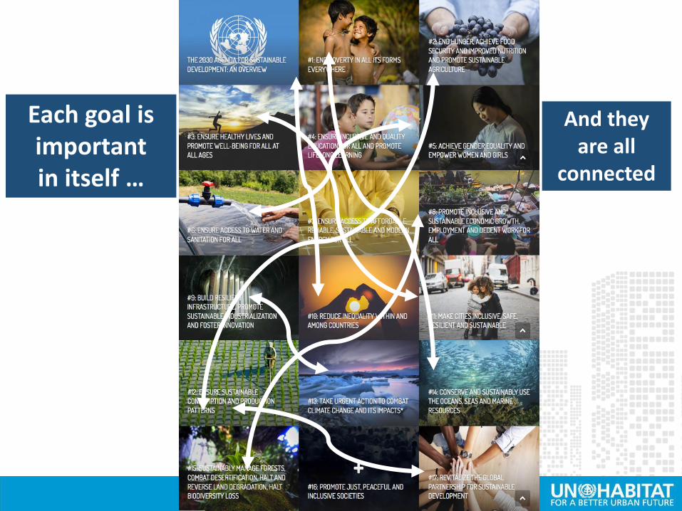
Each goal isimportantin itself …
And theyare all
connected

Urban Today:
• Are home to 56% of human settlements
• Consume 75% of the earth’s natural resources
• Produce 60% of global GHG emissions
• Produce 50% of global waste
• Produce 80% of Global GDP
• 70% of world population will be living in cities by 2050
Cities are at the centre of Sustainable Development

Cities and Sustainable Development
Goal 11, the Stand-alone goal on cities and human settlements affirmstheir importance for attainment of sustainable development
Make cities and Human Settlements inclusive, safe, resilient and sustainable
Success in achieving the targets under SDG 11 sets stagefor achieving targets in many other SDG goals.
Recognition that cities are a string that connects allother goals
Acknowledges importance of implementation at locallevels and the role of local governments

Outcome-oriented Process-Oriented
11.1: Housing and Slums 11.a: Urban-rural linkages
11.2: Sustainable transport 11.b: Risk reduction
11.3: Participatory planning 11.c: Sustainable buildings
11.4: Cultural heritage
11.5: Disaster Reduction
11.6: Air Quality and Waste Management
11.7: Public spaces
SDG 11 and its Role in City Planning
Cities require monitoring systems to: support urban visioning and long-term plans;track progress for informed policy and sustainable development.

SDG 11 connection to other SDGs

SDG Indicators with Urban Component
Around one third of them can be measured at the local level
Around 80
indicators
have an
urban
component
240 Indicators are part of the Global Monitoring Framework adopted by the
Statistical Commission
Direct connection to urban policies and clear impact on cities and human settlements
Indicator 1.4.2 Proportion of total adult population with secure tenure rights to land, with legally recognized documentation and who perceive their rights to land as secure, by sex and by type of tenure

In conclusion….
“Cities are where the battle for sustainable development will be won or lost.”

In conclusion……
Governments Private sector Civil society People like us
All partners have a role• Let us identify, connect and play our roles

Thank You
Overview of New Urban Agenda
5 February 2020Lucknow, India
Workshop on Sustainable Development Goals (SDGs – 2030)
for ULBs in Uttar Pradesh

Focuses on interventions required to ensure that cities and human settlements are planned, developed and managed in sustainable ways in supporting the implementation of the 2030 Agenda
First internationally agreed document detailing implementation of the urban dimension of the SDGs
The New Urban Agenda
Adopted in October 2016 in Quito, Ecuador

• Extension of the 2030 Agenda for Sustainable Development (complements SDGs processes)
• Builds on SDG 11, but addresses a wider range of urbanization and human settlements issues
• Enables implementation of SDG11 in a more expansive and integrated way • by addressing essential strategic spatial and governance
frameworks • National urban policies, legislation, spatial planning and local
finance frameworks.
• Provides spatial framework for the delivery of SDGs within urban areas by focusing on local level implementation.
• Places emphasis on the need to develop capacity of local authorities and other local actors for NUA and SDG implementation at the urban local level.
The New Urban Agenda

The New Urban Agenda
The 5 pillars of the New Urban Agenda
1. National Urban Policies (NUPs)
2. Rules and Regulations
3. Urban Planning and Design
4. Financing Urbanization
5. Local Implementation

Connecting SDGs and the NUA
There is a strong connection between the NUA and the SDGs indicators
1. National Urban Policies2. Urban Legislation and Governance Systems
3. Territorial Planning and Urban Design
4. Municipal Finance
11.a National Urban Policy11.b Disaster risk reduction11.3 Land consumption11.7 Open space8.1.1 City Product per Capita10.1.1 Growth Rate 40%

The New Urban Agenda
1. National Urban Policies (NUPs)
Indicator 11.a
National Urban Policy and Regional Development Plans
Indicator 11.b
Mitigation and adaptation to climate change, resilience to
disasters, in line with the Sendai Framework for Disaster
Risk Reduction 2015-2030
• Land Governance;
• Ministerial Coordination;
• The Attribution of the functions to Subnational (Regional or
Provincial) and Local Governments;
• The General Financial Framework for Subnational or Local
Governments

The New Urban Agenda
2. Rules and Regulations
Indicator 1.4.2 Proportion of total adult population with secure tenure rights to land
• Land legislation;
• Allocation of public space (streets and parks);
• Plotting of the buildable space;
• Acquisition of Public Space (Expropriation vs Land
Readjustment)

The New Urban Agenda
3. Urban Planning and Design
Indicator 11.1Affordable housing and basic services and upgrade slums
Indicator 11.7Inclusive and accessible, green and public spaces
The physical layout of the buildable plots,
public space, and their relationship

The New Urban Agenda
4. Financing Urbanization
Indicator 11.2Accessible and sustainable transport systems for all
Indicator 11.4Strengthen efforts to protect and safeguard the world's cultural and natural heritage
Core Urbanization Functions; Basic Urban Services; Complementary Services

The New Urban Agenda
5. Local Implementation
Indicator 11.3Participatory, integrated and sustainable human settlement planning and land efficiency
Planned City Extensions; Planned City In-fills; Urban Re-development
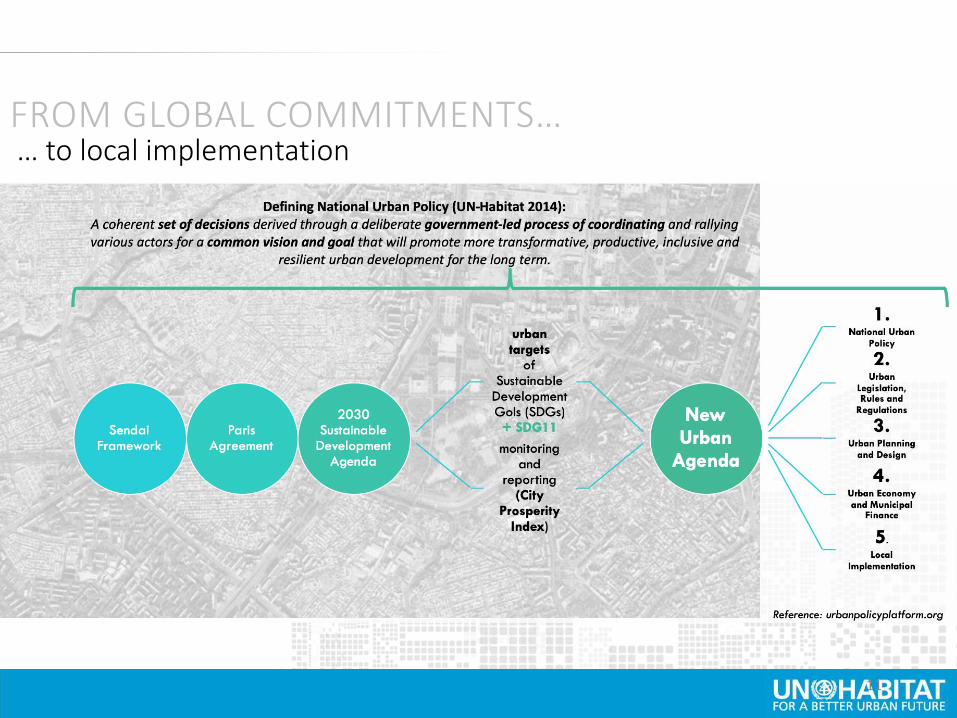
FROM GLOBAL COMMITMENTS…… to local implementation
11

Thank You
Workshop on Sustainable Development Goals (SDGs – 2030)
for ULBs in Uttar Pradesh
SDG 11: Global and National
Indicator Frameworks
5 February 2020Lucknow, India

Sustainable Development Agenda 2030
National - 10 Targets, 16 Indicators
Global - 10 Targets, 15 Indicators
17 Goals, 169 Targets, 240 Indicators
Global Urban Frameworks
“Leave No One Behind”

SDG 11: targets and indicators
Make cities and human settlements inclusive, safe, resilient and
sustainable
10 Targets
11.1 Housing and Slums
11.2 Sustainable Transport
11.3 Participatory Planning
11.4 Cultural Heritage
11.5 Disaster Reduction
11.6 Air Quality and Waste Managment
11.7 Public spaces
11.a Rural-urban and regional planning
11.b Mitigation of Climate Change, Resilience
11.c LDCs support – buildings
Ou
tpu
tP
roce
ss
11 Indicators
4 Indicators
7 indicators are to be
collected at local city
level, using spatial
data methods (11.2.1;
11.3.1; 11.3.2; 11.4.1; 11.6.1;
11.6.2; 11.7.1)
15 Indicators

Tier Classification Criteria/Definitions:Tier I: Indicator is conceptually clear, has an
internationally established methodology and standards
are available, and data are regularly produced by
countries
Tier II: Indicator is conceptually clear, has an
internationally established methodology and standards
are available, but data are NOT regularly produced by
countries.
Tier III: NO internationally established methodology or
standards are yet available for the indicator, but
methodology/standards are being (or will be) developed
or tested.

Tier Classification SDG 11 indicators – as of Dec 2019
Tier I: 2 indicators
11.1.1 11.6.2
Tier II: 11 indicators
11.2.1 11.3.1 11.3.2 11.4.1 11.5.1 11.5.2 11.6.1 11.7.1 11.7.2
11.b.1 11.b.2
Tier III: 2 indicators:
11.a.1 11.c.1

Goal 11 Targets and Indicators: Global vs. National Indicator Frameworks

Goal 11 Targets and Indicators: Global vs. National Indicator Frameworks

SDG 11: Global Indicators
11.1.1 Proportion of urban population living in slums, informal settlements
or inadequate housing
Tier I UN-Habitat UNEP
11.2.1 Proportion of population that has convenient access to public
transport, by sex, age and persons with disabilities
Tier II UN-Habitat UNEP,
UNECE
11.3.1 Ratio of land consumption rate to population growth rate Tier II UN-Habitat UNEP
11.3.2 Proportion of cities with a direct participation structure of civil
society in urban planning and management that operate regularly and
democratically
Tier II UN-Habitat
11.4.1 Total expenditure (public and private) per capita spent on the
preservation, protection and conservation of all cultural and natural
heritage, by type of heritage (cultural, natural, mixed and World Heritage
Centre designation
Tier II UNESCO IUCN
11.5.1 Number of deaths, missing persons and directly affected persons
attributed to disasters per 100,000 population
Tier II UNDRR UN-Habitat,
UNEP
11.5.2 Direct economic loss in relation to global GDP, damage to critical
infrastructure and number of disruptions to basic services, attributed to
disasters
Tier II UNDRR UNEP
11.6.1 Proportion of urban solid waste regularly collected and with
adequate final discharge out of total urban solid waste generated, by cities
Tier II UN-Habitat,
UNSD
UNEP
11.6.2 Annual mean levels of fine particulate matter (e.g. PM2.5 and
PM10) in cities (population weighted)
Tier I WHO UN-Habitat,
UNEP

11.7.1 Average share of the built-up area of cities that is open space for
public use for all, by sex, age and persons with disabilities
Tier II UN-Habitat
11.7.2 Proportion of persons victim of physical or sexual harassment, by
sex, age, disability status and place of occurrence, in the previous 12
months
Tier II UNODC UN Women,
UN-Habitat
11.a.1 Proportion of population living in cities that implement urban and
regional development plans integrating population projections and
resource needs
Tier III UN-Habitat UNFPA
11.b.1 Number of countries that adopt and implement national disaster
risk reduction strategies in line with the Sendai Framework for Disaster
Risk Reduction 2015–2030
Tier II UNDRR UN-Habitat,
UNEP
11.b.2 Proportion of local governments that adopt and implement local
disaster risk reduction strategies in line with national disaster risk
reduction strategies
Tier II UNDRR UNEP,
UN-Habitat
11.c.1 Proportion of financial support to the least developed countries that
is allocated to the construction and retrofitting of sustainable, resilient and
resource-efficient buildings utilizing local materials
Tier III UN-Habitat
SDG 11: Global Indicators

Data collection and monitoring activities on SDG 11 and/or urban related SDGs
11.1 11.2 11.3 11.4 11.5
11.1.1 : Percentage of s lums/Economical ly
Weaker Section (EWS) households covered
through formal/affordable hous ing.
11.3.1 : Proportion of
ci ties with
integrated
development plans .
11.1.2 : Percentage of Slum Area Covered
with bas ic Services
11.3.2 : Share of
Mixed Land Use Area
in overal l ci ty land
use
11.1.3 : Proportion of Urban Population
Living in Slums, informal Settlements or
Inadequate Hous ing.
11.3.3 : Net Dens ity
11.4.1 :
Restoration and
Reuse of Historic
Bui ldings
11.5.1 : Number of deaths
attributed to Extreme Cl imate
change per 100,000 population
11.2.1 : Proportion
of ci ties with
efficient urban
mobi l i ty and publ ic
transport
11.6 11.7 11.a.1 11.b
11.6.1 : Proportion of urban sol id
waste regularly col lected and with
adequate final discharge out of
tota l urban sol id waste generated,
by ci ties
11.b.1 : Whether the country has
adopted and implemented
national disaster risk reduction
strategies in l ine with the Sendai
Framework for Disaster Risk
Reduction 2015-2031
11.6.2 : Annual mean levels of fine
particulate matter (e.g. PM2.5 and
PM10) in ci ties (population
weighted)
11.6.3 : Number of days the levels of
fine particulate matter (PM 2.5 and
PM 10) above mean level
11.a.1 : Proportion of
population l iving in
ci ties that implement
urban and regional
development plans
integrating population
projections and resource
needs , by s ize of ci ty
11.b.2 : Proportion of State and
local governments that adopt and
implement local disaster risk
reduction strategies in l ine with
national disaster risk reduction
strategies
11.7.1 : Per Capita Avai labi l i ty of
Green Spaces
SDG 11: National Indicator Framework
by MoSPI

Conceptualizing prosperity…
… Ease of Living Index
• Tool to measure the sustainability of cities.
• Prosperous cities offer a profusion of public goods, allowing for equitable
access to ‘commons’ and the development of sustainable policies providing
opportunities for all.
Wheel of Urban Prosperity

Tool to measure sustainable urban development…
… CPI Framework for SDG Monitoring
Making desicions with the benefit of
international validated data and indices.

SDG11+ related Urban indicator under SDGs
… related Urban Indicators under SDGs and Targets
2.1
2.2
2.3
2.4
2.5
2.A
2.B
2.C
1.1
1.2
1.3
1.4
1.5
1.A
1.B
3.1
3.2
3.3
3.5
3.6
3.7
3.8
3.9
3.A
3.B
3.C
3.D
4.1
4.2
4.3
4.4
4.5
4.7
4.A
4.B
4.C
5.1
5.2
5.3
5.4
5.5
5.6
5.A
5.B
5.C
6.1
6.2
6.3
6.4
6.5
6.6
6.B
7.1
7.2
7.3
7.B
8.1
8.2
8.3
8.4
8.5
8.6
8.7
8.8
8.9
8.1
0
8.B
9.1
9.2
9.3
9.4
9.5
9.B
9.C
10.1
10.2
10.3
10.4
10.7
11.1
11.2
11.3
11.4
11.5
11.6
11.7
12.1
12.4
12.5
12.6
12.7
12.8
12.B
12.
C
13.2
13.3
15.1
15.2
15.3
15.4
15.5
15.7
15.8
15.9
15.A
16.1
16.2
16.3
16.4
16.5
16.6
16.7
16.10
16.A
17.1
17.3
17.4
17.6
17.13
17.14
17.17
17.18
17.19* SDG targets are designed to be integrated, indivisible and to balance the social, economic and
environmental dimensions of sustainable development. Governments have the primary responsibility
for follow-up and review, at the sub-national and national levels, in relation to the progress made in
implementing the Goals and targets.
80 % of all SDGs
indicators:
- have a local or
urban component
- can be measured at
the local level
- have a direct
connection to urban
policies
- have a clear impact
on cities and human
settlements

▪ Defining what a city or urban area
or human settlements is?
▪ How to deal with countries with many
cities/urban centers?
▪ How to manage spatial data needs ?
▪ Different reporting levels
▪ Coordination/Partnership
mechanisms
Several indicators require to
be collected locally:
11.2 11.3 11.4
Public Transport Land Consumption Cultural heritage
11.6 11.7
Solid waste and air quality
Public Space
Challenges

Challenges
•Limited data – especially for new indicators (including poor data sharing mechanisms among ministries/ agencies)
•Acceptability of non-conventional data into mainstream data structures
•Data disaggregation limitations
•Difficult levels of disaggregation e.gs gender, age, socio-economic status, location – which are beyond level of most data collection efforts
•High costs for local level data collection

Thank You

Workshop on Sustainable Development Goals (SDGs – 2030)
for ULBs in Uttar Pradesh
Roadmap for Implementation
5 February 2020Lucknow, India

1
Methodological
developments
2
Global methodologies
testing, piloting
3
Capacity building countries
for monitoring
4
Tools dissemination, advocacy for
accelerated monitoring in support of
sustainable urbanization
5
Exploring and testing usability of
emerging data products for local
and global monitoring
6
Data compilation and
reporting
UN-Habitat role and activities

Refining Urban SDGs Indicators • Definitions and Metadata
A Global Monitoring Tool• Guide to assist national and local
governments in their efforts to collect, analyze, validate data and information
• Metadata provides necessary definitions, method of computation and techniques to estimate indicators
• First Technical workshop held inFebruary 2017, Naivasha, Kenya.
• Geospatial Technical EGM held inBrussels, Belgium in April 2017
• Indicator-specific EGMs
1. Methodological Developments

Methodological Developments
• SDG 11+ metadata development
• Detailed, step-by-step indicator computation modules
• Highlights of required data inputs (more detailed guidance needed)
• Process automation scripts
Multiple partners and actors engaged
▪ Countries – NSOs, city
authorities, ministry
representatives, decision
makers
▪ Regional commissions
▪ EO partners
▪ Civil society, scientific and
academic partners

What methodology piloting entails – example of indicator 11.3.1
Country/ city level validation/ updates
National Sample of Cities to
select pilot cities/ countries
Check data availability, image quality
➢Pilots undertaken for EO&GI reliant indicators to showcase
methodology applicability across regions: 11.3.1, 11.3.2, 11.2.1, 11.7.1
Analytical map + computations
2. Global methodologies Testing, Piloting
➢ Data from 600+ cities across regions being compiled,
➢ Target for SDG 11 indicators is to compile data for at least 10,000 cities
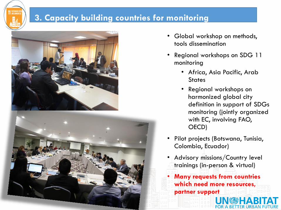
• Global workshop on methods, tools dissemination
• Regional workshops on SDG 11 monitoring
• Africa, Asia Pacific, Arab States
• Regional workshops on harmonized global city definition in support of SDGs monitoring (jointly organized with EC, involving FAO, OECD)
• Pilot projects (Botswana, Tunisia, Colombia, Ecuador)
• Advisory missions/Country level trainings (in-person & virtual)
• Many requests from countries which need more resources, partner support
3. Capacity building countries for monitoring

• Responsibility for SDGs monitoring and reporting is with countries (NSOs) –in line with the Fundamental Principles of Official Statistics
• Ability of countries to produce data, report and make data-informed decisions relies on existing, imparted capacities
3. Capacity building countries for monitoring

• Global workshop on methods, tools dissemination
• Regional workshops on SDG 11 monitoring
• Africa, Asia Pacific, Arab States
• Regional workshops on harmonized global city definition in support of SDGs monitoring (jointly organized with EC, involving FAO, OECD)
• Pilot projects (Botswana, Tunisia, Colombia, Ecuador)
• Advisory missions/Country level trainings (in-person & virtual)
• Many requests from countries which need more resources, partner support
3. Capacity building countries for monitoring

4. Tools dissemination, advocacy for accelerated monitoring in support
of sustainable urbanization
• Official UN-Habitat channels & trainings
• Partner networks activities
• Direct linkages, reviews, feedback from partners
• Participation in global forums, discussions (HLPF, regional SDG forums, national urban forums)

• Contribute to SG's global
progress report on the SDGs• Joint efforts from all UN-Habitat
branches and other UN agencies
• High Level Political Forum on SDGs• 2018 theme - Transformation
Towards Sustainable and Resilient
Societies: SDG 11 reviewed
• Synthesis report
https://unhabitat.org/sdg-11-
synthesis-report/
• SG Report of the United Nations
Human Settlements Programme on
Human Settlements Statistics (2019
SC)
4. Tools dissemination, advocacy for accelerated
monitoring in support of sustainable urbanization

• Dedicated website to UN-
Habitat approach,
involvement and support to
SDGs
• Focus on Goal 11 and
other urban related
indicators
• Provide information on:
• SDGs process
• Goal 11 indicators
• Tools, projects and
activities of UN-Habitat
4. Tools dissemination, advocacy for accelerated
monitoring in support of sustainable urbanization

5. Exploring and testing usability of emerging data products for local
and global monitoring
• Continuous identification, testing of available products that can support urban monitoring efforts / produce baseline analysis
• Imagery products – Landsat, Sentinel
• Global built-up layer products –GHSL, WSF, HRSL, GUF, Atlas of Urban Expansion ….
• Population datasets – GPW, WorldPop, GHS-Pop, HRSL, UNDESA population data
• Existing census and household surveys data (DHS, MICS, LSMS, etc.)
• Existing open data resources –OSM, GTFS, …
• Introducing and demonstrating to countries available products and their possible applications for monitoring

6. Data compilation and reporting
• Compiling data from countries, production of regional and global aggregates
• Progress reporting at global and regional levels
• Data dissemination, comparisons through the urban indicators database
• Support urban level decision making through local urban observatories
• Thematic reports
Multiple partners and actors involved/engaged in review, feedback
• Countries
• Regional commissions
• EO partners
• Civil society, academia

Thank You

–
Localizing and Leveraging SDG 11 and New Urban Agenda (NUA) for City Development
Presenter/ City
5th February 2020
Lucknow, India

–
City Background
City (key features and thresholds – Please add disaggregated population data- centered around the principles of leave no one behind. This would mean highlighting diversity, special interest groups, the poorest and most marginalized groups and so on.
Provide a summary table.

–
City performance and SDG11
City performance vis a vis SDG 11 targets. Provide city-level data.
Indicator Data
11.1: Proportion of urban population living in slums, informal settlements or inadequate housing (INSERT DATA)
11.2 Proportion of population that has convenient access to public transport, by sex, age and
persons with disabilities
(INSERT DATA)
11.6.1 Proportion of urban solid waste regularly collected and with adequate final discharge out
of total urban solid waste generated, by cities
(INSERT DATA)
11.6.2 Annual mean levels of fine particulate matter (e.g. PM 2.5 and PM10) in cities (population
weighted)
(INSERT DATA)
11.7.1: Average share of the built-up area of cities that is open space for public use for all, by
sex, age and persons with disabilities
(INSERT DATA)
11.b.2: HAS LOCAL GOVERNMENT adopt and implement local disaster risk reduction strategies
in line with the Sendai Framework for Disaster Risk Reduction 2015-2030
(INSERT DATA)

–
Key Projects/ Missions
Please list the major projects, campaigns, missions and their relation to SDG 11
Sector Project Expected Impact Department SDG 11 Target
Housing and Slums • PMAY• <Insert>
Improve living conditions, 11.1
Transport and Mobility • <Insert>
Participatory Planning • <Insert>• <Insert>
Cultural Heritage • <Insert>• <Insert>
Disaster Reduction • <Insert>• <Insert>
Air Quality • <Insert>• <Insert>
Waste Managment • Swachh Bharat Mission • <Insert>
Improve sanitation 11.3
Public spaces • <Insert>• <Insert>
Rural-urban and regional planning • <Insert>• <Insert>
Mitigation of Climate Change,
Resilience
• <Insert>• <Insert>
–
City performance and SDG11
OpportunitiesChallenges
Production of data for measuring City Performance with reference to SDG 11 (what are the challenges and opportunities, please list a few)

–
Regulations and Guidelines
Please add policies, plans, regulations and guidelines. Eg: City Master Plan or other tools for integrated planning
No. Policy/ Regulation Agency

–
Governance - Institutional Mapping
Please list agencies in charge as per sector/ target, their role and level of involvement
Sector Agency Level Role
City Parastatal State
Housing and Slums
Transport and Mobility
Participatory Planning
Cultural Heritage
Disaster Reduction
Air Quality
Waste Managment
Public spaces
Rural-urban and regional
planning
Lucknow Development Authority
Creating Master Plan, Perspective Plan, City Vision
Mitigation of Climate
Change, Resilience

–
Governance
OpportunitiesChallenges
Challenges and opportunities of government agencies for integrated planning

–
Financing
Please add City budgets allocated towards the SDG 11 targets, and challenges
Sector Budget
Housing and Slums
Mobility and Transportation
Participatory Planning
Cultural Heritage
Disaster Reduction
Air Quality
Waste Managment
Public spaces
Rural-urban and regional planning
Mitigation of Climate Change, Resilience
Challenges in budget allocation
–
Thank You

Sabarmati Riverfront, Ahmedabad
. 1
The Sabarmati Riverfront Development Project is an
environmental improvement, social development and
urban rejuvenation project with multiple objectives...
It creates a spectacular waterfront for the entire city....

Sabarmati has always been important
to Ahmedabad

As a place for recreation As a source for drinking water
As a place to gather As a place for the poor to build their
hutments

And yet, Sabarmati was
abused and neglected
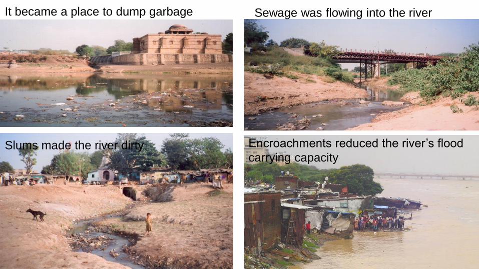
It became a place to dump garbage Sewage was flowing into the river
Slums made the river dirty Encroachments reduced the river’s flood
carrying capacity

Sabarmati River
Narmada River
Vasana BarrageFatehwadi Canal
Catchment Area
under controlDharoi Dam
Hatmati Dam
Guhai Dam
Ahmedabad


Inception of
SABARMATI RIVER FRONT DEVELOPMENT PROJECT :
▪ The Sabarmati Riverfront Development Project is a city level
intervention.
▪ It is conceived and being implemented as a pioneering multi-benefit
project with significant urban transformation potential.
▪ This project is to transform the historic but neglected river Sabarmati
into a vibrant urban Space.
▪ Vital focus to return the river back to the citizens of Ahmedabad.
▪ The riverfront development is to transform the Sabarmati into a major
asset, which will improve the efficiency of its infrastructure and the
quality life in Ahmedabad.
▪ Revitalize the river, which in fact was carrying significant sewage flow
and used as dumping yard for disposal of garbage.
▪ As a process in urban renewal, It was proposed to have the elements
like;
• Self Financing,
• Environmental improvement,
• Cultural and social sustainability
• Transform the non-perennial river stretch
Ahmedabad
Municipal
Corporation
(AMC)
Sabarmati River
Front Development
Corporation Ltd. in
1997
For implementation of
this Project:
A Company has been
set up by AMC in the
Year 1997.
8

• Ahmedabad Municipal Corporation (AMC) constituted a SPV in 1997 named
Sabarmati River Front Development Corporation Ltd (SRFDCL).
A Company under the Companies Act. with the Share capital as follows:
1) Equity Share Capital: 20 Cr
2) Preference Share Capital: 220 Cr
• The State Government has transferred 161.79 Hectare river land on 31-1-2003
for the development of Sabarmati River Front Development Project.
• After Finalization of Master Plan, Pilot Project was taken up in the Year 2004.
• Changes were carried out as per the lessons learnt from the pilot project.
• Main Project was taken up in the year 2005.
Project Implementation
9

• Physical Features of the River
• River Hydraulics
• Land Reclamation and Embankments
• Land Ownerships
• Water Retention
• Ground Water Recharge
• Land Use and Road Network
• Infrastructure Services
• Resettlement and Rehabilitation
• Implementation Strategy
• Project Costs and Revenue Potential
• Financing , Structure of the SRFDCL
• Development Management
Studies Carried Out between 1998 to 2004
10

SRFD Land Private
Interceptor Sewage Line
The Construction Process
Lower Promenade Retaining Wall Earth Fill
Diaphragm
Wall

Diaphragm Wall
12

Retaining Wall
13

Retaining Wall
14

Earth Fill

River Transformation at a glance
1997 – SRFDCL established
- Sewage from 42 outlets was flowing and accumulating in the
River stretch

2004 – Sabarmati riverfront project commencement

2009 – construction on the riverfront project underway

2015 – riverfront land development projects underway

The project has almost stemmed the flow of sewage into the
Sabarmati
…after recent river cleaning drive (May 2019)through public
participation.

Inclusive Development:
Rehabilitation of Slum DwellersThe riverfront project relocated 11000 slum households in pucca, new,
subsidized housing units...

The riverfront project has improved the lives of thousands of
erstwhile slum dwellers....

The riverfront project has improved the lives of thousands of
erstwhile slum dwellers....

Before
24
Inclusive Development: Rehabilitation of Gujari Bazar (1600 vendors)

Before
25
Inclusive
Development :
Rehabilitation of
Washermen
168 washing units

Businesses of the relocated dhobis are now prospering..

By adding new streets, the riverfront project has also improved the
city’s street network and made it more efficient
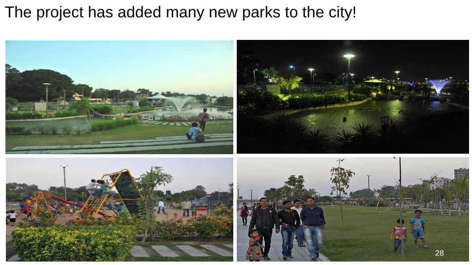
The project has added many new parks to the city!
28

There is now a large flower garden in the middle of the city!

Bio Diversity Park

Children park
31

The riverfront project has created opportunities for boating and
watersport!

This public realm has brought the river back to Ahmedabad and
Amdavadis back to the river!

The riverfront project has created a place for Amdavadis to
promenade

The riverfront project has created many places to hold National
and International level events!

Our mission is to
enhance the quality of life of the citizens, provide them economic
opportunities through a culturally refined world-class destination
that exudes a feeling of joy, happiness and well-being.

All great cities have gone through Transformations through
sensitive Urban Planning and investments in infrastructure
Undertaking comprehensive urban planning exercise to develop a
World-class Mixed-use Compact Urbanscape
Transformational Urbanism

San Francisco
Chicago
Sydney
1932 2016
Vancouver

Sabarmati in the early 1980s

Sabarmati today

Sabarmati in the early 1980s

Sabarmati today

Sabarmati river offers a unique opportunity to the city

The Sabarmati offers geographical centrality for city’s economic growth
It can help slow down the city’s dispersal and offer live and work options in the center

Dense mixed use, compact and high rise development has altered
the city-scape of all great cities – made them more livable

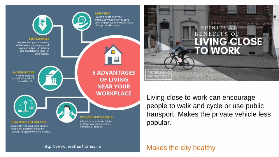
Living close to work can encourage
people to walk and cycle or use public
transport. Makes the private vehicle less
popular.
Makes the city healthy

The Sabarmati Riverfront Project has always
been intended to be a self-financing project
where 14.5% of the reclaimed land would be sold
for private development...

204 Ha. of land was reclaimed
Parks and Gardens
Sports Facilities
Open Space:
Plaza and Promenade
River Promenade
54.5 %
Public Utilities 11.0 %
Streets 19.0 %
Land for Development 14.5 %
Adjoining Residual Area 1.0 %
With Sabarmati Riverfront as its central economic engine

29.7 Ha. Land for Development
Approx 15 mn. Sq. ft. of development rights for saleLand for Development 14.5 %
Planning for high-quality Mixed-use dense Urbanscape

Making it an integrated and inclusive redevelopment strategy
that is both high-quality and compact

Wall City
Police Stadium
Pirana Water Works
Torrent Power
Cantonment
Calico Mills
Jagannath Temple
Water Works
Gandhi Ashram
Wadaj Gamtal
SVP Hospital
NID
Tagore Hall
Ambedkar Bridge
Sardar Bridge
Ellis Bridge
Nehru Bridge
Gandhi Bridge
DadhichiBridge
Subhash Bridge
Railway Bridge
…and influencing development on adjacent parcels

The original strategy has been aligned to the market realities
The Strategy is to:
1. Better synergize the development of the riverfront with adjacent areas
2. Realize larger city and state level ambitions
3. Position Ahmedabad globally

Sabarmati Riverfront is, therefore, developing two parcels on
model concepts, with public transport system that shall also
catalyze investments in the surrounding cityscape:
1.The West Bank between Nehru and Gandhi Bridges - Ahmedabad Waterside
2. East Bank between Dadhichi and Gandhi Bridge - Ahmedabad Innovation
Hub

Two Development Initiatives
1. Ahmedabad Waterside
Total built-up area: 1,41,226sqm
2. Ahmedabad Innovation Hub
Total built-up area: 5,33,537sqm

Ahmedabad Waterside - Vision
An international quality waterfront development for Ahmedabad
A unique and attractive investment opportunity
An iconic entertainment and retail destination for Ahmedabad
An anchor and catalyst for the redevelopment of Ahmedabad’s CBD

PLACEHOLDER
Located at the center of Ahmedabad

Well connected and serviced by infrastructure

Creating more access routes to the Riverfront

At the heart of AMC’s CBD Plan

Sabarmati Riverfront – 5 years from now?
61

Sabarmati Riverfront– 10 years from now?
62
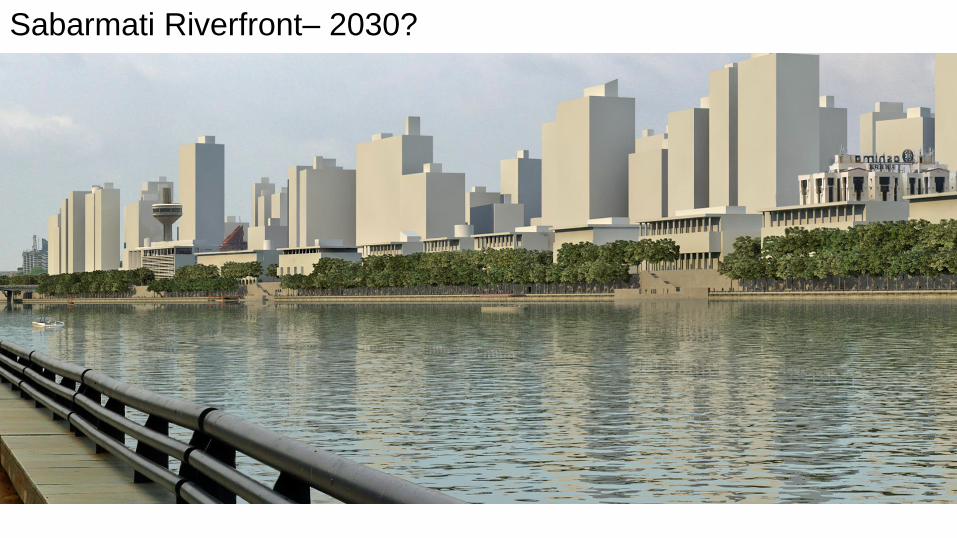
Sabarmati Riverfront– 2030?
63

Continuous public realm
Riverfront Development
(SRFDCL)
Street Ahmedabad CBD
(Private Development)

Ahmedabad’s Central Business District in future

The Riverfront shall have interactive public spaces that are enjoyable
Ahmedabad city is treading a similar path
Naroda
ST Workshop Odhav
Vastral
Gam
Express
Highway Junction
Rabari
Colony
Soni Ni
Chaali
Kankaria East
Jawahar
Chowk
Narol
Textiles
Chippa
Society
Anjali
Paldi
Shreyas
Gandhigram
Ghee
Kanta
Kalupur
Rly. Stn.
Sabarmati
Rly. Stn.
Motera
Stadium
Chandkheda
Pragati
Nagar
Gurukul
Thaltej
Sola
Bridge
Thaltej
Gam ISKCON
Cross Road
JivrajAPMC
Stadium
Vadaj
Usmanpura
Bopal
Science City
Airport
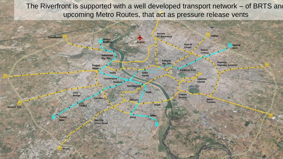
The Riverfront is supported with a well developed transport network – of BRTS and
upcoming Metro Routes, that act as pressure release vents

The planned development will be serviced by a dedicated mobility corridor along the
Riverfront (Street Car and Water Taxi) with integrating Bullet Train, BRTS & Metro
Shuttle Service of Street Car
Interchange locations

Street Cars have been successful the world over. They have helped boost economic
development

Water transport shall help in ferrying people across & along the banks and making
recreational and work trips on the Riverfront
Water Taxi to ferry people along the banks of Sabarmati river….

These initiatives are already spurring development
in the adjoining areas

Neel Kanth River View
Iscon Riverside
Aqua by Sheetal
Signature Luxuria
Kalp River View
Grand Riviera
Sai Status Tagore Residency
Sun West Bank
Yash Anant
Sakar IX
World Centre 3
Solitaire Sky`
Hyatt Regency
3
2
6
7
9
5
1
4
8
River Valley One
Commercial Complex
16
1518
20 2123
19
Ken Infrastructure
Tehjir 10
Varsha
Flats
11
Block 54A
12
Takshashila Air
14
17
Altimus
22
Vedanta
The renewed waterfront is attracting new developments in its adjacent areas

Sheetal AQUA
2. Sheetal
Aqua

Tehjir Residential & Commercial Complex, Khanpur
4. Tehjir

Altimus, Navrangpura

Land for Development 14.5 %29.7 Ha. of development opportunities
Sabarmati Riverfront Development – Land for Development

Land for Sale 14.5 %
Land for Sale: 29.7 Ha.
Development rights for sale: 13.45 m sqft. of
1.m sqft.
Rs. 3000/sqft.
2 m sqft.
4 m sqft.
Rs. 2500/sqft.
2.m sqft.
Rs. 2000/sqft.
1.5 m sqft.
Rs. 2000/sqft.
0.25m sqft.
1.2 m sqft.
Rs. 3000/sqft.
1.0m sqft.
Rs. 2000/sqft.
0.5m sqft.
Rs. 1000/sqft.
Revenue from
redevelopment initiatives within CBD

Wall City
Police Stadium
PiranaWater Works
Torrent Power
Cantonment
Calico Mills
JagannathTemple
Water Works
Gandhi Ashram
WadajGamtal
SVP Hospital
NID
Tagore Hall
Ambedkar Bridge
Sardar Bridge
Ellis Bridge
Nehru Bridge
Gandhi Bridge
DadhichiBridge
Subhash Bridge
Railway Bridge
Zone Base
FSI
Purchasable
FSI
Total
Permissible
FSI
Total
Area
(Ha)
Developable
Land Area (Ha)
Purchasable
Floor Area (sqm)
75% of Purchasable
Floor Area (sqm)*
Jantri Rate
(30,000 * 40%)
Revenue Potential
(Crores)
CBD West Area 1.8 3.6 5.4 122 66.9 24,08,400 18,06,300 12,000 2,168
CBD East Area 1.8 3.6 5.4 75 52 18,72,000 14,04,000 12,000 1,685
TOD Area 1.8 2.2 4 82 46.1 10,14,200 7,60,650 12,000 913
Residual Area 1.8 0.9 2.7 324 191.8 17,26,200 12,94,650 12,000 1,554
Total 6,319 Cr
Revenue Potential today

Future growth of the Riverfront

SRFDCL is continuing to develop and improve
Sabarmati riverfront in the years to come...
Projects that will soon commence include the
following.....

Foot Over Bridge: Work in Progress
• Location: Between Ellis & Sardar Bridge
• Length : 300 Meters
• Iconic Structural Steel Tubular Section
Truss Bridge
• Approach from upper and lower walkway
• Width: 10 m (at ends) and 14 m at centre83

MULTI LEVEL PARKING (1000 Cars capacity): Work in Progress
84

Int. Std. Sports Complex & Training Academy - West Bank
Skateboard Park
Jogging Track
Basket ball &
Volleyball
Courts
Skating Rink
Cricket PitchTennis Courts
Multi purpose
practice courts
Gym
Equipment
Children Play areaInteractive FountainChanging Rooms
Entry and
Admin
Facilities
Entry Amphitheater
SABARMATI RIVER
Cafe
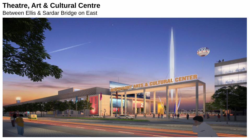
Theatre, Art & Cultural CentreBetween Ellis & Sardar Bridge on East
At plan & design stage
86

Indira Bridge Vasna BarrageRailway Bridge
Approx 11.2 Km
5.83 Km East Bank
5.26 Km West Bank 5.83 km East Bank & 5.26 km West Bank
Future Growth: Sabarmati Riverfront Development - Phase 2

Subhash BridgeIndira Bridge Railway Bridge
Proposed Bridge
cum Barrage
Duffnala
Torrent Power
Cantonment
• Proposed Bridge cum Barrage will connect Sabarmati & Airport Area through Cantonment
• The water stored by the proposed barrage can be used as a reliable drinking water source by the city – can
store 15 days of Ahmedabad’s water consumption promising water security
Bullet Train Terminal
Passenger Hub

Sabarmati Riverfront Development - Phase 2
Present View

Sabarmati Riverfront Development - Phase 2
Futuristic View

Thank You
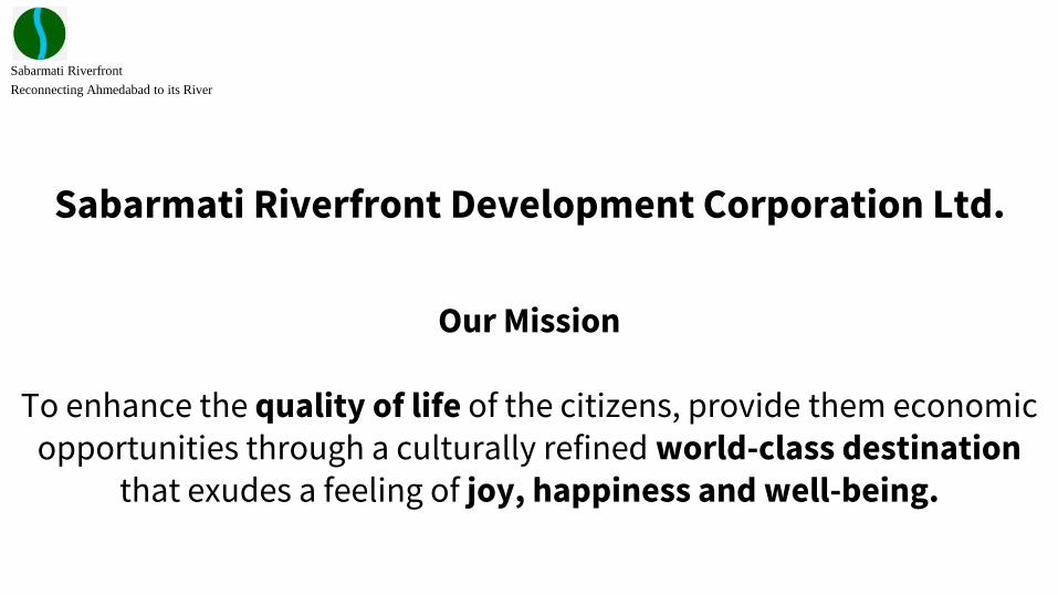
Sabarmati Riverfront Development Corporation Ltd.
Our Mission
To enhance the quality of life of the citizens, provide them economic opportunities through a culturally refined world-class destination
that exudes a feeling of joy, happiness and well-being.
Sabarmati Riverfront
Reconnecting Ahmedabad to its River

Sabarmati Riverfront
Reconnecting Ahmedabad to its River
The project aims to provide Ahmedabad with a meaningful waterfrontenvironment along the banks of the Sabarmati River and to redefine an identity ofAhmedabad around the river.
• The project has brought the river back to Ahmedabad and Amdavadis back to the river!
• The Sabarmati River offers geographical centrality for city’s economic growth offering live and work options in the center of the city
• This longest Riverfront ecosystem in the world is attracting thousands of people on its unique Promenades, Parks, Gardens, Ghats, Event Center, etc.
Project Objective

Sabarmati Riverfront
Reconnecting Ahmedabad to its River
1. Environmental Improvement:a) reduction in erosion and flood to safeguard the city;b) sewage diversion to keep the river clean;c) water retention and recharge.
2. Social Infrastructure:a) rehabilitation and resettlement of riverbed dwellers and activities;b) creation of parks and public spaces;c) provision of socio-cultural amenities for the city.
3. Sustainable Developmenta) Bring Iconic Developmentb) Revitalization of Neighbourhoods
Project Objective

Sabarmati Riverfront
Reconnecting Ahmedabad to its RiverExisting Developments
Development Objective
Riverfront Park at Subhash Bridge
A long green stretch of 1.5 Km which have many attractions like walking area, sun dial, Amphitheatre, Thought Garden, Children Play area, Street area along with food area and shopping plaza.
Riverfront Flower Park
More than 72 varieties of species in this garden full of flowers located near Ellisbridge.
Riverfront Children Park
To promote the holistic well-being through physical , mental and social development of children through play. Park have slides, swings, playground climbers, seesaw etc.
Tree Plantation through Miyawaki
Method
More than 67,000 tree samplings have been planted along the East & West side of the river. The Plantation has been done with Miyawaki method, a Japanese technique .

Sabarmati Riverfront
Reconnecting Ahmedabad to its RiverExisting Developments
Development Objective
Riverfront Event Park
The event ground has been planned to continue to offer a venue for local as well as international events and has a capacity of 10,000 people. Its includes stage with back-stage facilities, VIP lounge, designated parking, zones for event halls, lawn area and lighting provision.
Dr. VikramSarabhai Statue
Statue of Dr. Vikram Sarabhai has been built just outside residence in Usmanpura to pay tribute to the father of India’s Space Program.

Sabarmati Riverfront
Reconnecting Ahmedabad to its RiverUpcoming Developments
Development Objective
Biodiversity Park5 Ha Bio diversity park will serve as an ideal alternative habitat for migratory and resident bird species and has come up at the edge of Vasnabarrage and near to Ambedkar bridge.
Pedestrian Walkway Bridge
Rs. 75 crore iconic foot-over bridge is first of its kind in the country. It will connect west and east part of Sabarmati Riverfront.
Multi Level Car Parking
The smart MLCP with capacity of 1000 cars is under development opposite to the Event ground on the west side of Riverfront Also foot over bridge will be directly connected to the MLCP
Riverfront Sports park
Sports facilities have been proposed with reference to its location in the city and the surrounding context. These sports complex will encompass various sports like Tennis, Cricket, Football, Basket Ball, Skating Ring and Skate Board Park.

Sabarmati Riverfront
Reconnecting Ahmedabad to its River
Smart Commute and Transportation
• The planned development will be serviced by a dedicated mobility corridor along the Riverfront (Street Car and Water Taxi) with integrating Bullet Train, BRTS & Metro
• Street Cars have been successful the world over. They would be introduced to help boost economic development
• Public Information System – bus, water taxi, metro, etc. information on routes, timings, connectivity, etc.
• Smart Connectivity and Parking
• Smart Signaling• Smart Public Information• Smart Signage• Electric Vehicle based guided commute• Automated parking systems (MLPs) with app for booking of parking space
Smart Solutions at Sabarmati Riverfront

Sabarmati Riverfront
Reconnecting Ahmedabad to its River
Smart Commute and Transportation
• Water Transport
• Water Taxi / Electric powered Boats will connect banks to all other public transport modes.
• Water transport will help in ferrying people and making recreational and work trips on the Riverfront
• Pedestrianisation• Promenades Walkway
• Walkways giving access to River
• Walkways giving experience of walking on River - Pedestrian Bridge
• Smart Informative Signage
• Smart Shade Devices
Smart Solutions at Sabarmati Riverfront

Sabarmati Riverfront
Reconnecting Ahmedabad to its River
Smart Commute and Transportation
• Bicycle Infrastructure
• Exclusive Bicycle Track on Lower Promenades
• Bicycle sharing - Apps based Registration, Book and Use
• GPS tracking system and Bluetooth enabled smart locks
• Designated Parking docks
• Electric vehicle charging infrastructure
• Last mile connectivity via mini electric buses, battery operated vehicles, etc.
• Safety features on all transportation modes – GPS tracking, monitoring, emergency measures, etc.
Smart Solutions at Sabarmati Riverfront

Sabarmati Riverfront
Reconnecting Ahmedabad to its River
• Tourist/Visitor friendly smart interventions
• Smart Card offering single online ticketing/payment system integrating commute, visit and other services of the proposed development
• Smart Visitors App to guide the visitors with booking taxis (water and street), parking space, e-map, etc.
• Tourist/visitor interactive information kiosk reflecting history and information of the river, all points of interest, cafes’, amenities, etc.
• Public Information System – bus, metro, etc. information on routes, timings, connectivity, etc.
Smart Solutions at Sabarmati Riverfront

Sabarmati Riverfront
Reconnecting Ahmedabad to its River
• Tourist/Visitor friendly smart interventions
• Smart Card offering single online ticketing/payment system integrating commute, visit, shopping and other services of the proposed development
• State-of-the-art amenities • Smart Solid waste bins with volume, humidity senor, camera, and alert
system• Smart e-toilets with sensor based operations, on-site waste treatment tanks,
etc. • Solar powered phone charging stations
• Smart security features all along the riverfront – surveillance, emergency posts, first aid kiosks, etc.
Smart Solutions at Sabarmati Riverfront

Sabarmati Riverfront
Reconnecting Ahmedabad to its River
• Smart interventions – Built structures
• Building Automation• High Efficient and smart sensor based HVAC systems• Sensor based lighting systems• Security and surveillance
• Solar panels for lighting and water heating / Building Integrated Photovoltaics
• High performance Glazing
• Passive heating & Cooling systems - Radiant barriers for thermal insulation
• Rain water harvesting, recycling and re-use of grey water
Smart Solutions at Sabarmati Riverfront

Thank you
Sabarmati Riverfront
Reconnecting Ahmedabad to its River

Sabarmati Riverfront
Reconnecting Ahmedabad to its RiverEvent/Festival at Riverfront
Development Objective
Exhibition Centre
Exhibition Centre is a trade-fair facility proposed on the eastern bank of the river, between Ellis Bridge and Sardar Bridge. It has been envisioned as a multifaceted convention venue with adaptable spaces that will be equipped with the latest technological equipments and state-of-the-art facilities. With its strategic location in the heart of the city, the centre shall address the requirements of the exhibitors and visitors alike.
Annual Kite Festival
The International Kite Festival is an annual event that is held at the Riverfront every January. The festival is traditionally celebrated as 'Uttarayan' in Gujarat. The Kite Festival boasts of skies ablaze with colour and draws kite fliers from all around the world.
Flower Show"The Annual Flower Show” on the Sabarmati Riverfront at Sardar Bridge is inaugurated by Hon’ble Chief Minister of Gujarat Shri Vijay Rupani. The show will be a display space for more than 750 species of flowers, plants, bonsai, vegetable plants and trees — with more than 50 of these species marking a debut at the show."

Sabarmati Riverfront
Reconnecting Ahmedabad to its River
• STPs for treating 1210MLD of sewage have been planned• Diverted 180MLD of raw sewage to STPs• Regular removal of Floating waste• Elected representatives, officials and approx. 60,000 people of different
communities like NGO, Schools, Police, Corporates etc. have participated in the Swachchh Sabarmati Mahabhiyan and cleaned approximately 1000 Ton of solid waste
• Impact of river cleaning: Attracted a lot of birds on the Riverfront
Infrastructure support at Riverfront
Sabarmati Riverfront
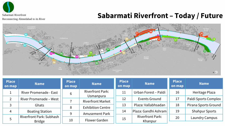
Reconnecting Ahmedabad to its RiverSabarmati Riverfront – Today / Future
Placeon map
Name
1 River Promenade - East
2 River Promenade – West
3 Ghats
4 Boating Station
5Riverfront Park: Subhash
Bridge
Placeon map
Name
6Riverfront Park:
Usmanpura
7 Riverfront Market
8 Exhibition Centre
9 Amusement Park
10 Flower Garden
Placeon map
Name
11 Urban Forest – Paldi
12 Events Ground
13 Plaza: Vallabhsadan
14 Plaza: Gandhi Ashram
15Riverfront Park:
Khanpur
Placeon map
Name
16 Heritage Plaza
17 Paldi Sports Complex
18 Pirana Sports Ground
19 Shahpur Sports
20 Laundry Campus