612 2010 - EPIC - Alfred-Wegener-Institut
66
The Expedition of the Research Vessel "Polarstern" to the Arctic in 2009 (ARK-XXIV/1) Edited by Gereon Budéus with contributions of the participants 612 2010 ALFRED-WEGENER-INSTITUT FÜR POLAR- UND MEERESFORSCHUNG In der Helmholtz-Gemeinschaft D-27570 BREMERHAVEN Bundesrepublik Deutschland ISSN 1866-3192
-
Upload
khangminh22 -
Category
Documents
-
view
0 -
download
0
Transcript of 612 2010 - EPIC - Alfred-Wegener-Institut
The Expedition of the Research Vessel "Polarstern" to the Arctic in 2009 (ARK-XXIV/1) Edited by Gereon Budéus with contributions of the participants
612 2010
ALFRED-WEGENER-INSTITUT FÜR POLAR- UND MEERESFORSCHUNG In der Helmholtz-Gemeinschaft D-27570 BREMERHAVEN Bundesrepublik Deutschland
ISSN 1866-3192

Hinweis Die Berichte zur Polar- und Meeresforschung werden vom Alfred-Wegener-Institut für Polar-und Meeresforschung in Bremerhaven* in unregelmäßiger Abfolge herausgegeben. Sie enthalten Beschreibungen und Ergebnisse der vom Institut (AWI) oder mit seiner Unterstützung durchgeführten Forschungsarbeiten in den Polargebieten und in den Meeren. Es werden veröffentlicht:
— Expeditionsberichte (inkl. Stationslisten und Routenkarten)
— Expeditionsergebnisse (inkl. Dissertationen)
— wissenschaftliche Ergebnisse der Antarktis-Stationen und anderer Forschungs-Stationen des AWI
— Berichte wissenschaftlicher Tagungen
Die Beiträge geben nicht notwendigerweise die Auffassung des Instituts wieder.
Notice The Reports on Polar and Marine Research are issued by the Alfred Wegener Institute for Polar and Marine Research in Bremerhaven*, Federal Republic of Germany. They appear in irregular intervals.
They contain descriptions and results of investigations in polar regions and in the seas either conducted by the Institute (AWI) or with its support.
The following items are published:
— expedition reports (incl. station lists and route maps)
— expedition results (incl. Ph.D. theses)
— scientific results of the Antarctic stations and of other AWI research stations
— reports on scientific meetings
The papers contained in the Reports do not necessarily reflect the opinion of the Institute.
The „Berichte zur Polar- und Meeresforschung” continue the former „Berichte zur Polarforschung”
* Anschrift / Address Alfred-Wegener-Institut für Polar- und Meeresforschung D-27570 Bremerhaven Germany www.awi.de
Editor in charge: Dr. Horst Bornemann Assistant editor: Birgit Chiaventone
Die "Berichte zur Polar- und Meeresforschung" (ISSN 1866-3192) werden ab 2008 aus-schließlich als Open-Access-Publikation herausgegeben (URL: http://epic.awi.de). Since 2008 the "Reports on Polar and Marine Research" (ISSN 1866-3192) are only available as web based open-access-publications (URL: http://epic.awi.de)

The Expedition of the Research Vessel "Polarstern" to the Arctic in 2009 (ARK-XXIV/1) Edited by Gereon Budéus with contributions of the participants Please cite or link this item using the identifier hdl: 10013/epic.34764 or http://hdl.handle.net/10013/epic.34764 ISSN 1866-3192
ARK-XXIV/1
20 June - 10 July 2009
Bremerhaven - Longyearbyen
Chief Scientist
Gereon Budéus
Coordinator
Eberhard Fahrbach

1
CONTENTS
1. Zusammenfassung und Fahrtverlauf 2
Summary and itinerary 4
2. Long-term variability of the hydrographic structure, convection and transports in the Greenland Sea (LOTEVA-GS) 7
3. Flow through Fram Strait and in the entrance to the Arctic Ocean 13
4. At-sea distribution of seabirds and marine mammals 26
5. Marine Mammal Perimeter Surveillance (MAPS) 31
6. Long-term passive acoustic monitoring of marine mammals and ocean noise levels in the Greenland Sea and the Fram Strait 35
7. Production, fate and aggregation of organic matter in a changing Arctic Ocean 39
APPENDIX
A.1 Teilnehmende Institute / participating institutions 42
A.2 Fahrtteilnehmer / cruise participants 44
A.3 Schiffsbesatzung / ship's crew 46
A.4 Station and mooring list PS 74 48
2
1. ZUSAMMENFASSUNG UND FAHRTVERLAUF
Gereon Budéus Alfred-Wegener-Institut
Der erste Fahrtabschnitt der 24. Polarstern Expedition in die Arktis begann am 20. Juni 2009. Das Schiff lief von Bremerhaven aus, um Forschungsarbeiten in der Grön-landsee und in der Framstraße durchzuführen. Das genannte Gebiet steht seit einigen Jahrzehnten verstärkt im Fokus des wissenschaftlichen Interesses, da sich dort Schlüsselprozesse im Ozean abspielen. Es ist selbstverständlich, dass die aktuellen großräumigen klimatischen Betrachtungen auf hochwertigen regionalen Beobachtungen lokaler Veränderungen aller Forschungsdisziplinen aufbauen müssen. Die hydrographischen Arbeiten auf diesem Fahrtabschnitt etablieren einen weiteren Mosaiksstein zweier Langzeit-Messreihen, wie sie für die klimabezogene Forschung unverzichtbar sind. Sowohl in der Grönlandsee als auch in der Framstraße hat das Alfred-Wegener-Institut bereits eine beachtliche Forschungshistorie aufzuweisen, welche die Quantifizierung solch wichtiger Vorgänge wie die des meridionalen Wärmeflusses, der winterlichen Konvektionstiefen, der Speicherung von Wärme und Salz im Ozean und dergleichen mehr gestattet, sowie die Variabilitäten und Trends der mit diesen verbundenen physikalischen Parametern bestimmbar macht. In den Projekten werden Stationsarbeiten durchgeführt, und es finden sowohl konventionelle als auch innovative autonome selbstprofilierende Verankerungen sowie autonome Unterwasserfahrzeuge Verwendung. In der Grönlandsee wurden CTD-Stationsmessungen auf einem Zonalschnitt bei 75°N zwischen 5°E und der Küste Grönlands durchgeführt und vier autonom profilierende Verankerungen gewechselt. Östlich von 5°E konnten aufgrund von Zeitmangel keine Messungen durchgeführt werden. Drei der Verankerungen profilieren täglich zwischen etwa 100 m Wassertiefe und dem Ozeanboden in 3700 m Tiefe, die vierte profiliert zwischen etwa 160 m und der Wasseroberfläche. Mit dieser letzteren Verankerung wurde die prinzipielle Schwierigkeit, bis hin zur Wasser-oberfläche zu messen, erfolgreich gemeistert. Diese Messungen sind für die Entwicklung des Süsswasseranteils in der Oberflächenschicht wesentlich. In der Framstraße wurden 6 Verankerungen gewechselt und CTD-Stations-messungen über den gesamten tiefen Bereich durchgeführt. Ein Sea-Glider, der sich messend autonom in den oberen 1000 m der Wassersäule bewegt, wurde ausgesetzt und kurzzeitig begleitet. Die Validation von Paläoproxies war ein weiteres Thema des Fahrtabschnitts. Hierzu wurden Foraminiferen und Coccolithophoren aus der Seewasserversorung des
1. Zusammenfassung und Fahrtverlauf
3
Schiffs auf dem gesamten Schiffsweg gesammelt und analysiert. Ein Hauptanliegen ist dabei, die Rekonstruktion der Temperaturen und der Eisbedeckung während des Holozäns in den existierenden klimatischen Szenarien zu verbessern. Des weiteren soll das Verständnis der Interaktionen zwischen Umwelt und Ökosystem verbessert werden sowie abgeschätzt werden, inwieweit spezielle Teile der arktischen Biota die zu erwartenden klimatischen Veränderungen überstehen. Mit dem vorliegenden Fahrtabschnitt wurde eine erfolgreiche und neuartige interannuelle Vergleichsstudie fortgesetzt. Es besteht kein Zweifel, dass die im globalen Kontext rapidesten Veränderungen der Umweltbedingungen in der Arktis auch Auswirkungen auf die marine Fauna haben werden. Die Forschungen zum arktischen Ökosystem auf diesem Fahrtabschnitt umfassten die gesamte Größenskala von der Mikrobiologie bis hin zu den welt-größten Lebewesen. Temperatur- und CO2-bedingte Effekte auf Produktion, Diagenese und Aggregation von organischem Material wurden mit Hilfe von Inkubationexperimenten untersucht. Ein wesentliches Ziel ist es dabei, zu einem besseren Verständnis von Richtung und Stärke der biogeochemischen und mikrobiologischen Rückkopplungsprozesse im Ozean der Zukunft beizutragen. Das Vorkommen und das Verhalten von marinen Säugern, insbesondere - aber nicht ausschließlich - von Walen, war Gegenstand zweier weiterer Projekte, in denen modernste akustische und optische Methoden Verwendung fanden. Die sich verändernde Eisbedeckungsstruktur in der Arktis führt bereits heute zu veränderten Vorkommen einiger Arten, und die zu erwartende Zunahme des Geräuschpegels im Ozean durch die Nutzung der nördlichen Schiffsrouten schon in der näheren Zukunft impliziert die Notwendigkeit, verlässliche Bestandsänderungsabschätzungen unverzüglich in Angriff zu nehmen. Zwei Verankerungen mit akustischen Empfängern wurden in Grönlandsee und Framstraße ausgelegt und verbleiben dort bis 2010. Ein IR-Linescanner zur Detektion von marinen Säugern vom Schiff aus wurde erfolgreich in Betrieb genommen. Aus logistischen Gründen wurde am 5. Juli vor Longyearbyen ein Kapitänswechsel per Helikopter vorgenommen. Der Fahrtabschnitt endete planmäßig am 10. Juli 2009 in Longyearbyen.
4
SUMMARY AND ITINERARY
The first leg of the 24th Polarstern expedition to the Arctic started on 20 June, 2009. The ship departed from Bremerhaven to do research in the Greenland Sea and in the Fram Strait. This region has attained increased scientific attention during the recent few decades due to the fact that it plays a key role in the subarctic ocean. Investigations of large scale climatic aspects must evidently be based on sound perceptions of local modifications. The hydrographic work during this cruise leg contributes to the establishment of long-term time series as they are indispensable to study climatic aspects in the ocean. Both in the Greenland Sea and in Fram Strait, the Alfred Wegener Institute already has a long research history which allows to quantify meridional heat fluxes, winter convection depths, heat and salt storage in the ocean, and the like, and to determine variability and trends of related physical parameters. The projects include station work, conventional moorings as well as innovative autonomously profiling moorings, and the use of autonomous underwater vehicles. In the Greenland Sea, CTD stations have been performed between 5°E and the Greenland coast on a zonal transect at 75°N and four autonomously profiling moorings have been exchanged. Due to time constraints, no work could be done east of 5°E. Three of the moorings perform daily profiles between about 100 m water depth and the ocean bottom at 3,700 m. The forth mooring profiles between 160 m and the water surface proper. This mooring overcomes successfully the general difficulty to reach the water surface with moored instruments. These measurements are important for the evaluation of the fresh water development in the near surface layer. In Fram Strait, six moorings have been exchanged and CTD stations have been performed across the entire deep part of the strait. A sea-glider, which moves autonomously through the upper 1,000 m of the ocean, was deployed and shortly accompanied. Proxy validation studies were another theme of the cruise. The sampling of foraminifera and coccolithophores used the ship's sea water supply to gain on-track samples across the main frontal systems. A major aim of this research is to contribute temperature and ice-cover reconstructions of the Holocene to the existing climate databases. A second aim is to improve current understanding of environment-ecosystem interactions and to estimate to which extent Arctic biota can absorb the currently predicted climate changes. With ARK-XXIV/1, a novel and successful interannual comparative proxy validation study has been continued.

Summary and itinerary
5
The Arctic Ocean is one of the fastest changing environments on earth, and there is no doubt that these changes will also affect the marine fauna. Studies of the Arctic ecosystem during this cruise leg covered the scale from microbiology to the largest species on earth. Temperature- and CO2-related effects on the production, fate, and aggregation of organic matter have been investigated by incubation experiments. The main intention is to further our understanding of the direction and strength of biochemical and microbiological feedback processes in the future ocean. The occurrence and behaviour of marine mammals, particularly but not exclusively whales, was studied by two projects using most modern acoustic and infrared methods. The changing ice cover in the Arctic leads to modified routes of many species already to date, and the expected increase in ocean noise as is related to the use of the northern routes by freight ships in the near future necessitates monitoring of its effects, so that action is requested now. Two moorings equipped with acoustic receivers have been deployed in the Greenland Sea and in Fram Strait. They will be serviced in 2010. An innovative IR-Line scanner for the shipborne detection of marine mammals has been installed and put into operation successfully. For logistic reasons an exchange of the captain was organised on 5 July while staying close to Longyearbyen. The cruise leg ended as scheduled on 10 July 2009 at Longyearbyen, Svalbard.
ARK-XXIV/1
6
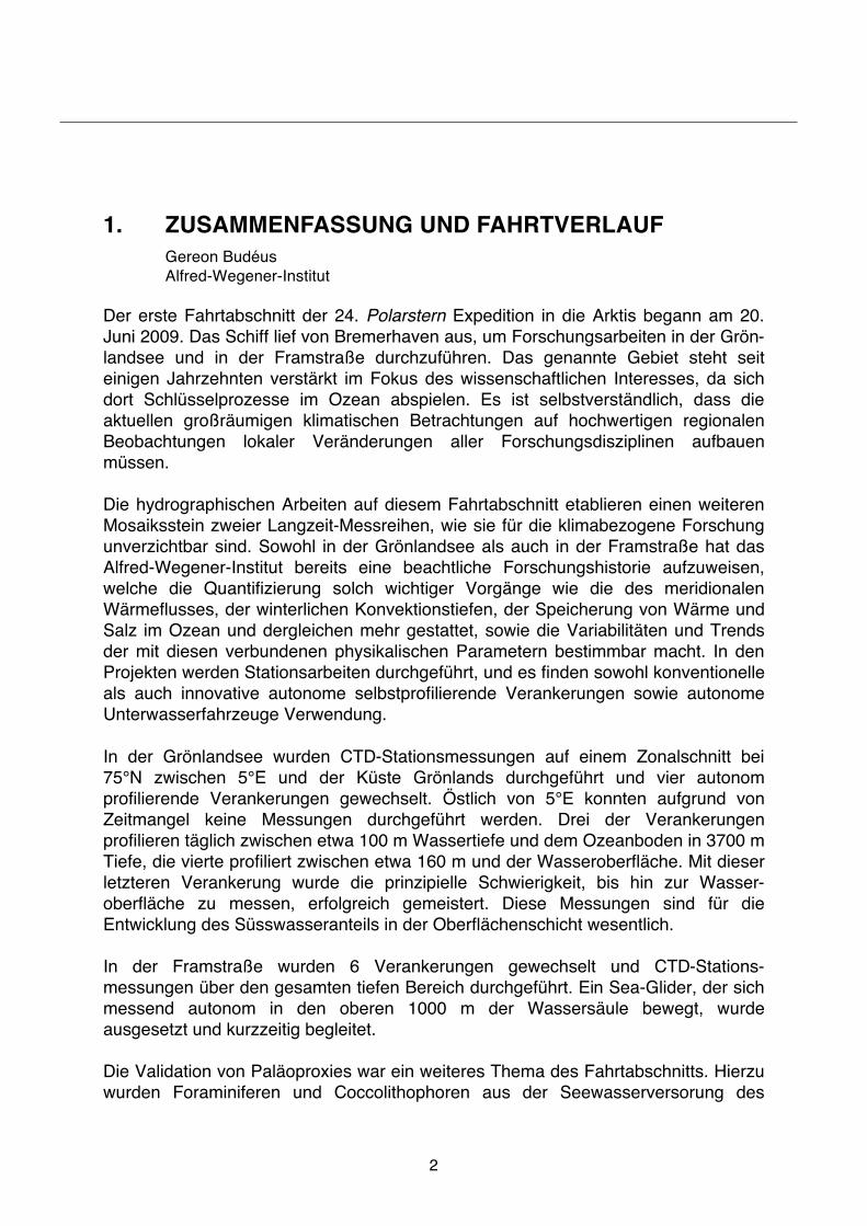
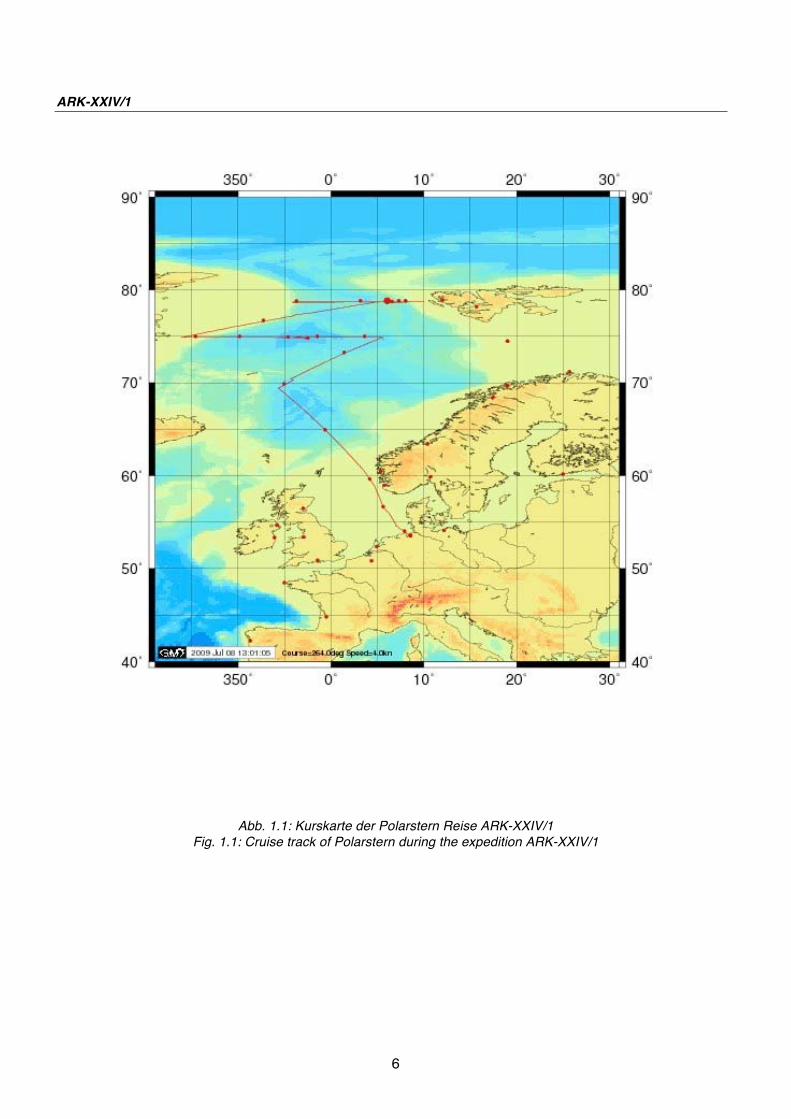
Abb. 1.1: Kurskarte der Polarstern Reise ARK-XXIV/1
Fig. 1.1: Cruise track of Polarstern during the expedition ARK-XXIV/1

7
2. LONG-TERM VARIABILITY OF THE HYDROGRAPHIC
STRUCTURE, CONVECTION AND TRANSPORTS IN
THE GREENLAND SEA (LOTEVA-GS)
G. Budéus1, B. Heinze1, F. Lehner1, J. Jacob1, M. Monsees3, G. Rohardt1, J. Saynisch1, A. Schneider2, J. Schnieders1, O. Strothmann1, A. Wisotzki1, S. Zakrzewski1, O. Zenk3, N. Zoch1
1Alfred-Wegener-Institut, Bremerhaven 2IPÖ, Kiel 3Optimare
Objectives
Physical processes in the entire Polar Oceans are regarded with increased attention because of their high sensibility against climatic changes. This includes the hydrographic development in the Greenland Sea. The changes here represent the first example of a basin wide structural modification as a reaction to an increased fresh water input, which took place in the early 90s. The doming structure of the 80s has subsequently been superseded by a marked two layer structure. The interface between these two layers is accompanied by a density step/stability maximum and is not static, but moves vertically with time. Between 1993 and the most recent years, a descent from about 900 m to almost 2,000 m has been observed. As up to date even modern numerical models include neither this structural change nor the interface movement, it is important to observe the hydrographic development carefully. In the present situation, the lower layer is apparently well isolated from atmospheric influences and effectively shielded against ventilation by winter convection. For years, bottom water properties change towards higher temperatures and salinities. This can to a large part be explained by a vertical displacement of the water column together with bottom water export. At the same time, lateral inputs do also modify deep water, as well as shallow water properties. At all depth levels, the Greenland Sea represents a highly dynamical environment with considerable temporal changes. Our present knowledge about the relevant hydrographic processes does not allow to predict the future hydrographic development (including convective activity and transports) and consequently most of the analysis relies on field measurements. In order to assess the changes correctly and to gain an adequate perception of the related processes, a longer time series is indispensable. It has to comprise continuous and consistent observations including the water mass end members on the shelves, and has to determine convection history reliably. As convection history is established by comparisons between subsequent years, a disruption of the time series is adverse to its analysis (a one year gap leading to a loss of convection determination of two years).

ANT-XXV/1
8
The present state of the hydrographic structure in the Greenland Basin leads to distinct difficulties with respect to the determination of ventilation depths and ventilation history. A precise determination of the convection depth over several years is however essential if one wants to be able to decide what processes are responsible for the observed changes from one year to another. There are a number of unambiguous indicators for convection, but the fact that these indicators are absent is by no means synonymous to the absence of convection activity. Therefore it is often not possible to determine convection depths and ventilated volumes by the development of the physical parameters alone. Measurements from oxygen sensors show that both around the border and in the middle of the ventilated central areas of the Greenland Basin considerable concentration fluctuations take place. With the use of bottle samples only there will be an uncertainty in the total amount of oxygen and exact depth of latest convection which may lead to considerable difficulties in interpretation as well as misinterpretation. Since the electrical oxygen sensor reproduces the fluctuations very well but doesn't have the necessary accuracy (due to hysteresis and drift), the adequate method is to combine electrically measured vertical profiles (which reveal the detailed vertical structure) with bottle sample Winkler titrations (which provide the ultimate accuracy). The combined use of electronic and chemical methods to measure oxygen concentration are used to evaluate the younger ventilation history of the upper part of the Greenland Sea Gyre on one hand and to examine the grade of isolation of the lower part on the other. Recently, suprisingly long lived submesosclae vortices (SCVs) have been detected in the Greenland Sea (diameter about 10 to 20 km). In the centre of these features, convection reaches depths that are about 1,000 m greater than in the background (some 2,600 m vs. 1,600 m). These eddies seem to survive a number of years by a repeated homogenisation during winter. It is in the centres of these eddies where winter convection is expected to meet the ocean bottom first. Within the IPY-legacy project LOTEVA-GS, a unique hydrographic time series is being established by an annually repeated zonal transect across the Greenland Gyre center and by measurements of autonomous profilers (EP/CC-Yoyo, daily profiles, full ocean depth, 1 year exchange cycle) which give unprecedented insight to winter convective activity as well as to advective modifications. The major aim of the project is to detect and quantify the interannual and seasonal physical/chemical changes in the Greenland Gyre interiour as well as in the surrounding large currents and to identify the responsible processes for the former.

2. LOTEVA-GS
9
Work at sea
Due to the large spatial gradients and relatively small spatial scales involved (Rossby radius about 20 km) it is indispensable to perform measurements with a comparatively small station spacing and in a sufficient number. Otherwise spatial and temporal differences, which are of the same order in this region, cannot be distinguished and any derived trend is most likely heavily biased. Furthermore, SCVs have to be identified, distinguished from the background, and skipped from the background trend analysis. According to this, the transects are performed with a station spacing of 10 nautical miles or less, what results in about 60 CTD stations on a zonal transect at 75°N using a Sea-Bird 911plus system. A double sensor set is used for temperature and conductivity and various additional sensors have been utilised. The most important of these is the electical oxygen sensor. In addition to the electrical measurements, water samples have been taken by a carousel water sampler. The water samples serve as in situ calibration material and are used to determine oxygen content according to the Winkler method. Three autonomously profiling EP/CC moorings have been exchanged. They are equipped with modified SBE-16 CTDs with Digiquartz pressure sensors. They deliver complete profiles every other day, travelling between the parking position at roughly 100 m and the ocean bottom at 3,700 m. In order to assess the annual fresh water cycle in the Greenland Gyre, a special profiling shallow water yoyo CTD has been installed in 2008 (NGK winch and Optimare/Sea-Bird instrument). This mooring reveals profiles between 160 m and the surface proper, and has been exchanged, too. Due to time constraints, the transect could not cover the region east of 5°E. Preliminary results
a) General
Today it is clear that the straightforward idea of regular, repeated bottom water renewal in winter is not correct at present. Previously proposed concepts for deep convection in the 80s do not adequately describe the actual processes in the Greenland Sea. E.g., there was not a single year during which bottom water has been ventilated by winter convection since regular field expeditions have been started during the end of the 1980s. Work during the recent years showed a.o. that even the seemingly simple identification of winter convection fails when using single criterions. In contrast to present knowledge, temperatures in a ventilated volume can be higher as well as lower after a convection phase. The same is true for salinities. The application of a more complex criterion catalogue shows that in the last decade winter convection penetrated to the density step (interface between the two vertial layers) in mid depth during many years. This density step is observed in increasing depths levels which allows for increasing convection depths. Consequently, these increasing depths are not synonymous with the ventilation of older water masses.

ANT-XXV/1
10
The interface between the two layers is situated at almost 2,000 m in the centre of the gyre today, as can be seen from the salinity distribution on the transect. This plot also shows that the interface forms a slight depression in the gyre centre now. This is combined with a massive inflow of Atlantic Waters into the gyre. These waters cross the two fronts between the major rim currents and the gyre in near surface layers of a few hundred metres thickness. Winter convection is needed, to distribute this salinity signal to greater depths. According to the high temperatures and salinities of the Atlantic Waters (they represent the high salinity and high temperature end member in the TS-space of the Arctic), they descend when cooled in winter. Due to their high salinities, the Atlantic Waters take over the role of ice formation in the previous regime with respect to deep ventilation. As these waters attain high enough densities to sink already far above the freezing point, they provide a heat input into the deeper layers and prevent ice formation effectively. Thus, when Atlantic Waters dominate the cross frontal input into the gyre, ice formation is inhibited and the ventilated waters increase in temperature and salinity. The salinity distribution in 2009 (Fig. 2.1) suggests a two parted ventilation scenario in the preceeding winter with fresh water input to deeper layers in one, and an input of more saline waters in the second part.
Fig.2.1: Salinity distribution on the zonal CTD-transect (west is left), preliminary values
b) Deep sea and shallow water autonomous profiling CTD system
The performance of the NGK/Optimare shallow water surface approaching underwater system deserves a special chapter, as the deployment is the first in Arctic waters, the first use outside Asia, and the first which was scheduled to operate over a time interval of such a length. Considerable redesign has been applied in order to meet the needed specifications.

2. LOTEVA-GS
11
The Automated Elevator System by NGK, Japan, consists of a sophisticated combination of an underwater winch, a control unit, multiple parallel power supplies, and a structure of frame and buoyancy. It is intended for the use in the open ocean where it has to reside in a depth smaller than 300 m and enables measurements right into the ocean surface. This important inclusion of the surface layer poses severe problems to mooring designs, and no commercially available operational alternative to the NGK solution is apparent. When the NGK system pays out rope, a buoyant instrument ascends until it reaches the water surface proper. The winch is halted then and reverses its rotational direction, thus moving the instrument back to its parking position close to the winch. A tension sensor in the elevator system detects the instrument s arrival at the surface. Our mooring in the Greenland Sea is the premier use of the NGK system in Europe. In our mooring, the Optimare/Sea-Bird Electronics CTD-logger is the buoyant instrument which is moved to the surface and back to the winch. It comprises a pumped SBE41 CTD module and a custom designed pressure case containing the special electronics and the electrical supply. The synchronisation of the Elevator System and the CTD is realised by their clocks only, there is no communication between them. This shallow water yoyo-mooring is added to a site where EP/CC Deep Sea Jojo moorings have been deployed for a number of years. These deep sea yoyos reside in a depth of roughly 100 m and measure daily profiles between this depth and the ocean bottom at about 4 km. The shallow water yoyo complements these measurements by covering the important upper part of the water column with daily measurements, too. The mooring which contains the NGK Automated Elevator System and the Optimare/Sea-Bird Electronics CTD-logger has been deployed in June 2008 during a cruise with Polarstern. Position is 76°56 N 4°37 E. Water depth at the mooring site is 3,680 m. The buoyancy of the NGK system is about 500 N. In order to carry the mooring rope and to apply a resonable tension to it, buoyancy must be added. We used a modular set of cylindric syntactic foam pieces, which have the same diameter as the NGK frame, for this purpose. Three slices of syntactic foam have been located just beneath the winch, and one has been mounted on it s top. Each of these four foam pieces provides a buoyancy of ca. 900 N, so the total buoyancy is ca. 4,000 N. The rope is an 8.6 mm Aramid rope by Lippmann, Hamburg. The Optimare/Sea-Bird Electronics CTD-logger has a buoyancy of about 20 N, a diameter of 160 mm and a length of 1.05 m. Its buoyancy does not suffice to keep the necessary tension on the winch s rope. Two plastic spheres with 30 N buoyancy each were therefore added to the logger. The mooring was adjusted so that the parking position of the CTD and the winch were at a nominal depth of 160 m. With the winch s 300 m rope length the surface could be securely reached from this depth. The winch was scheduled to perform one

ANT-XXV/1
12
cycle per day, whereas the CTD-logger was programmed to measure 30 min periods in time intervals of 12 hours. Hereby, CTD data sets are recorded alternatingly during an ascent/descent cycle and at the parking position. The Shallow Water Yoyo performed more than 300 casts and reached the surface routinely. Only few events of dives to greater depths have occurred, predominantly in the latest part of the record. Such dives are caused by ocean currents which lead to an inclination of the mooring rope. The record ends after 312 days. At this time, the instrument's memory had been used up, and the energy supply for the winch as well. The perfect operation of the NGK winch is particularly remarkable as it was in operation for a total of two years with only an exchange of batteries at sea after the first year. The performance of the Deep Sea Yoyo (EP/CC-yoyo), which is operational for numerous years but has been redesigned substantially for the present mooring period, is similarly good. Occasionally there are short pauses in the profiles, and after some time every forth profile is lacking. The pauses are caused by outstanding current events which prevent the vehicle from profiling due to increased friction between the instrument and the mooring rope. As soon as the current event has passed, the profiling is continued due to the self healing character of the design. The principal operation of the system is not affected by this. The two data sets overlap between 100 and 160 meters water depth. After correcting and despiking them, they were merged by slicing the related profiles at 130 meters. It turned out that despite the small distance between the two mooring locations (1.8 kilometers), the profiles do not combine seamlessly. This indicates that there exists small scale local variability in the ocean also far away from frontal regions, and this in summer as well as during winter. Water parcels do pass both mooring sites consecutively on occasion, but not necessarily nor always. No attempt has been made to artificially smooth the junction between the upper and lower yoyo profiles. The measurements show that cooling at the surface starts in October, but substantial deepening of the surface mixed layer (best seen in salinity) does not take place before January. Then, the subsurface salinity maximum is entrained in the deepening low saline mixed layer and the salt of this maximum helps to achieve densities high enough to let the water parcels sink to greater depths. It is immediately apparent that ventilation depths exceed 1,200 meters, but a more detailed analysis is needed for an exact determination. Temperatures stay way above the freezing point of roughly -1.8°C all over winter, thus providing adverse conditions for ice formation in this region. In contrast still to the 1990s, we regard the latter as normality nowadays. The mooring has been recovered on 28.6.2009. The NGK system came back on deck in an as-new optical condition, and so did the Optimare/Sea-Bird Electronics CTD-logger.

13
3. FLOW THROUGH FRAM STRAIT AND IN THE
ENTRANCE TO THE ARCTIC OCEAN
B. Heinze1, F. Lehner1, J. Jacob1, M. Monsees3, G. Rohardt1, J. Saynisch1, A. Schneider2, J. Schnieders1, O. Strothmann1, A. Wisotzki1, S. Zakrzewski1, O. Zenk3, N. Zoch1
not on board: A. Beszczynska-Möller1, C. M.
Cree4
1Alfred-Wegener-Institut, Bremerhaven 2IPÖ, Kiel 3Optimare 4APL
Scientific objectives
Exchanges between the North Atlantic and the Arctic Ocean result in the most dramatic water mass conversions in the World Ocean: warm and saline Atlantic waters, flowing through the Nordic Seas into the Arctic Ocean, are modified by cooling, freezing and melting to become shallow fresh waters, ice and saline deep waters. The outflow from the Nordic Seas to the south provides the initial driving of the global thermohaline circulation cell. Knowledge of these fluxes and understanding of the modification processes is a major prerequisite for the quantification of the rate of overturning within the large circulation cells of the Arctic and the Atlantic Oceans, and is also a basic requirement for understanding the role of these ocean areas in climate variability on interannual to decadal time scales. The Fram Strait represents the only deep connection between the Arctic Ocean and the Nordic Seas. Just as the freshwater transport from the Arctic Ocean is of major influence on convection in the Nordic Seas and further south, the transport of warm and saline Atlantic water affects the water mass characteristics in the Arctic Ocean which has consequences for the internal circulation and possibly influences also ice and atmosphere. The complicated topographic structure of the Fram Strait leads to a splitting of the West Spitsbergen Current carrying Atlantic Water northward into at least three branches. One current branch follows the shelf edge and enters the Arctic Ocean north of Svalbard. This part has to cross the Yermak Plateau which poses a sill for the flow with a depth of approximately 700 m. A second branch flows northward along the north-western slope of the Yermak Plateau and the third one recirculates immediately in Fram Strait at about 79°N. Evidently, the size and strength of the different branches largely determine the input of oceanic heat to the inner Arctic Ocean. The East Greenland Current, carrying water from the Arctic Ocean southwards has a concentrated core above the continental slope.

ARK-XXIV/1
14
It is our aim to measure the oceanic fluxes through Fram Strait and to determine their variability on seasonal to decadal time scales. Since 1997, year-round velocity, temperature and salinity measurements have been carried out in Fram Strait with moored instruments. Hydrographic sections exist since 1980. The estimates of mass and heat fluxes through the strait are provided through a combination of both data sets. From 1997 to 2000 intensive fieldwork occurred in the framework of the European Union project VEINS (Variability of Exchanges in Northern Seas). After the end of VEINS it was maintained under national programmes. From 2003 to 2005, the work was carried out as part of the international Programme ASOF (Arctic-Subarctic Ocean Flux Study) and was partly funded in the EU ASOF-N project. Since 2006 measurements in Fram Strait have been continued in the frame of the EU DAMOCLES (Developing Arctic Modelling and Observing Capabilities for Long-term Environment Studies) Integrated Project. The mooring line is maintained in close co-operation with the Norwegian Polar Institute. The results of the measurements will be used in combination with regional models, to investigate the nature and origin of the transport fluctuations on seasonal to decadal time scales. Work at Sea
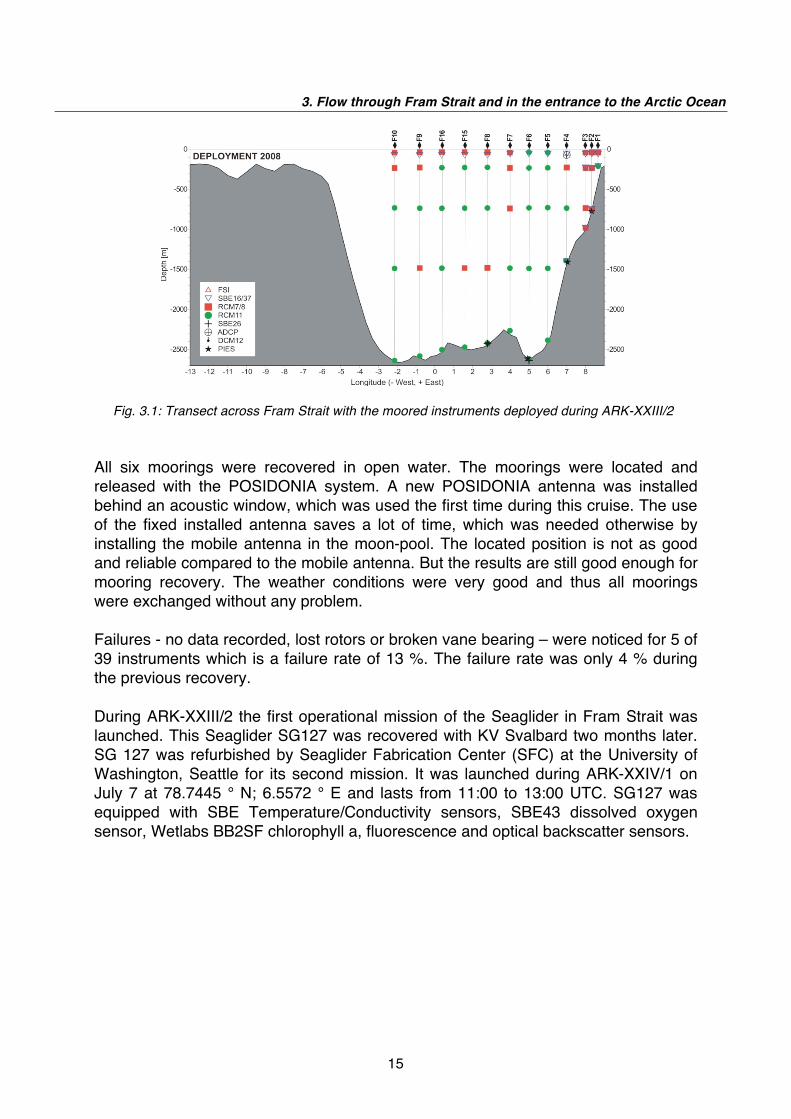
The oceanographic work at sea during ARK-XXIV/1 embraced three main activities: the recovery and redeployment of the array of moorings, the deployment of the Seaglider and measurements of CTD (Conductivity, Temperature, Depth) profiles. The standard section in Fram Strait at 78°50 N, which has been occupied regularly since 1997, was measured with high resolution coverage by 27 CTD stations, extending from 10°E to 4°13 W. The mooring array maintained by AWI consists of 12 moorings along a 78°50'N extending from 8°40 E to 2°W. These moorings were completely exchanged during Polarstern cruise ARK-XXIII/2 in 2008, see Fig. 3.1. Data from the recovered acoustic modems from F4 to F6 (HAM.NODE) were evaluated by "develogic" (manufacturer of the HAM.NODE) after the 2008 recovery. It was found that only very few data sets from F4 were transmitted by the HAM.NODE via F5 to F6 completely. The modems recorded the background noise and were equipped with tilt sensor to get information about the conditions during the transmission. "develogic" found out that the transmission has failed when the background noise and the tilt was too high. The modem could only transmit at a fixed time and therefore the message could only be received by modem at F6 during good transmission conditions. Because of these results "develogic" has modified the hard and software of the modems. The new version of HAM.NODE checks the background noise and tilt before it starts the transmission. The mooring exchange during ARK-XXIV/1 aims to verify the advantage of the new modified hard – and software. Therefore the mooring exchange confined on eastern part of the mooring array F1 to F6. The modem verification test was extended by an additional mooring (F22-1) placed at the middle between F5 and F6 with HAM.NODE in 750 m depth. This mooring carries a sound logger device too; see report by Holger Klinck.
3. Flow through Fram Strait and in the entrance to the Arctic Ocean
15
Fig. 3.1: Transect across Fram Strait with the moored instruments deployed during ARK-XXIII/2
All six moorings were recovered in open water. The moorings were located and released with the POSIDONIA system. A new POSIDONIA antenna was installed behind an acoustic window, which was used the first time during this cruise. The use of the fixed installed antenna saves a lot of time, which was needed otherwise by installing the mobile antenna in the moon-pool. The located position is not as good and reliable compared to the mobile antenna. But the results are still good enough for mooring recovery. The weather conditions were very good and thus all moorings were exchanged without any problem. Failures - no data recorded, lost rotors or broken vane bearing – were noticed for 5 of 39 instruments which is a failure rate of 13 %. The failure rate was only 4 % during the previous recovery. During ARK-XXIII/2 the first operational mission of the Seaglider in Fram Strait was launched. This Seaglider SG127 was recovered with KV Svalbard two months later. SG 127 was refurbished by Seaglider Fabrication Center (SFC) at the University of Washington, Seattle for its second mission. It was launched during ARK-XXIV/1 on July 7 at 78.7445 ° N; 6.5572 ° E and lasts from 11:00 to 13:00 UTC. SG127 was equipped with SBE Temperature/Conductivity sensors, SBE43 dissolved oxygen sensor, Wetlabs BB2SF chlorophyll a, fluorescence and optical backscatter sensors.

ARK-XXIV/1
16
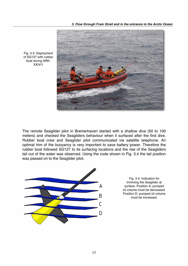
The first mission in 2008 has established serious problems with the Iridium connection between the Seaglider and the base station in Bremerhaven, which was operated by Optimare. (Optimare used the base station software package developed by APL group at the University of Washington in Seattle.) For this reason Optimare has changed to another Iridium provider providing RUDICS (Router Based Unrestricted Digital Interworking Connectivity Solution). SG127 was tested in Bremerhaven with the new RUDICS-SIM card installed before the cruise successfully. Several days before launching SG127 was placed on the helicopter deck to verify the connection with the base stations while running the deck dive test procedures. The tests performed well on both sides – base station and Seaglider. The morning before launch the pre-launch routine was performed without errors and thus it switched into the launch conditions . SG127 was launched from a rubber boat about 0.5 nautical miles leeward of Polarstern, see Fig. 3.3.
Fig. 3.2: Moorings deployed during cruise ARK-XXIV/1
3. Flow through Fram Strait and in the entrance to the Arctic Ocean
17
Fig. 3.3: Deployment of SG127 with rubber
boat during ARK-XXIV/1
The remote Seaglider pilot in Bremerhaven started with a shallow dive (50 to 100 meters) and checked the Seagliders behaviour when it surfaced after the first dive. Rubber boat crew and Seaglider pilot communicated via satellite telephone. An optimal trim of the buoyancy is very important to save battery power. Therefore the rubber boat followed SG127 to its surfacing locations and the rise of the Seagliders tail out of the water was observed. Using the code shown in Fig. 3.4 the tail position was passed on to the Seaglider pilot.
Fig. 3.4: Indication for trimming the Seaglider at
surface. Position A: pumped oil volume must be decreased. Position D: pumped oil volume
must be increased.

ARK-XXIV/1
18
In 2008 SG127 was profiling along transect between WP2 and WP3, see Fig. 3.5. Therefore SG127 was navigated towards WP3 to repeat the 2008 section. Afterwards a parallel transect south of the mooring transect should be performed. The deployment location northeast of WP3 was chosen because of safety reasons. After the deployment Polarstern can continue the station work at the 78°50'N transect. In case a failure was recognized by the Seaglider pilot in Bremerhaven the Seagilder was still not so far off Polarstern.
Fig. 3.5: Locations of the Seaglider surfacing positions between successive dives performed from
deployment until September 17 and vertically averaged currents measured during selected dives. The
deployment location is indicated as a red square and the arrow shows the first transect towards
waypoint WP3.
The same CTD equipment as mentioned in chapter 2 had been used. Underway measurements with a vessel-mounted narrow band 150 kHz ADCP from RD Instruments and a Sea-Bird SBE21 thermosalinograph measurements were conducted along the transect to supply temperature, salinity and current data at a much higher spatial resolution than given through the moorings. Two thermosalinographs were in use, one in 5 m depth in the bow thruster tunnel and one in 11 m depth in the keel. Both instruments are controlled by taking water samples, which are measured on board. The processed thermosalinograph measurements can
3. Flow through Fram Strait and in the entrance to the Arctic Ocean
19
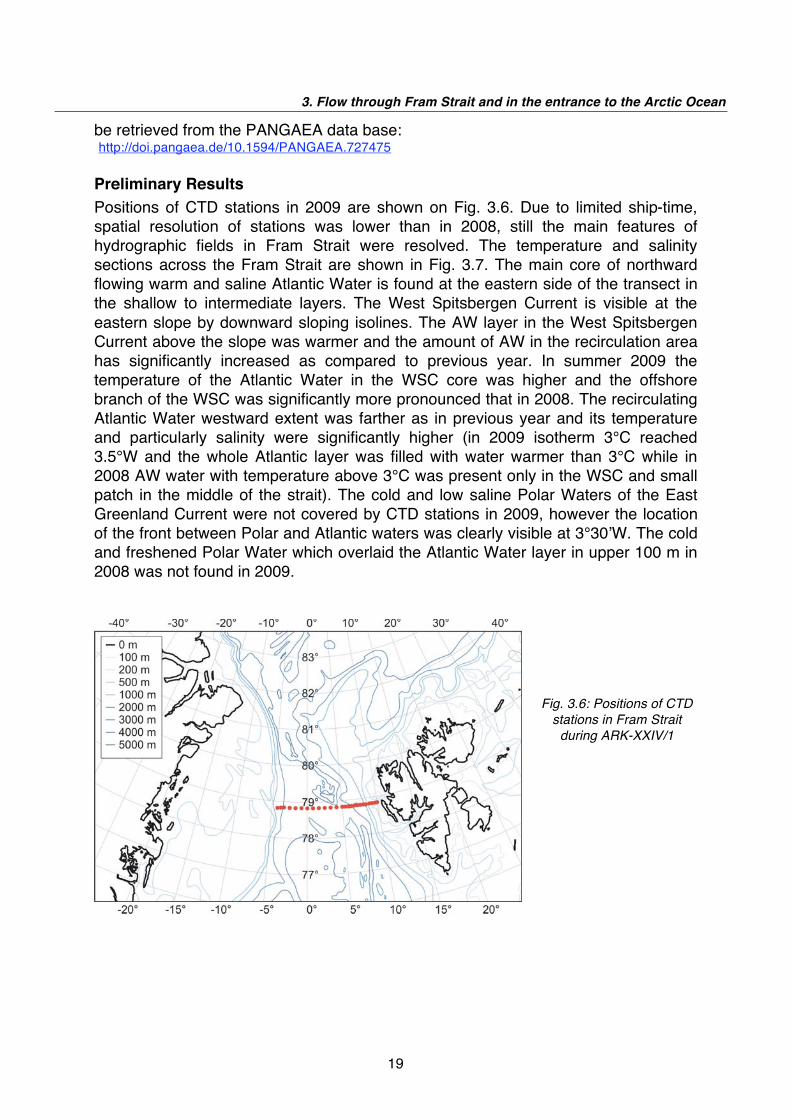
be retrieved from the PANGAEA data base: http://doi.pangaea.de/10.1594/PANGAEA.727475 Preliminary Results
Positions of CTD stations in 2009 are shown on Fig. 3.6. Due to limited ship-time, spatial resolution of stations was lower than in 2008, still the main features of hydrographic fields in Fram Strait were resolved. The temperature and salinity sections across the Fram Strait are shown in Fig. 3.7. The main core of northward flowing warm and saline Atlantic Water is found at the eastern side of the transect in the shallow to intermediate layers. The West Spitsbergen Current is visible at the eastern slope by downward sloping isolines. The AW layer in the West Spitsbergen Current above the slope was warmer and the amount of AW in the recirculation area has significantly increased as compared to previous year. In summer 2009 the temperature of the Atlantic Water in the WSC core was higher and the offshore branch of the WSC was significantly more pronounced that in 2008. The recirculating Atlantic Water westward extent was farther as in previous year and its temperature and particularly salinity were significantly higher (in 2009 isotherm 3°C reached 3.5°W and the whole Atlantic layer was filled with water warmer than 3°C while in 2008 AW water with temperature above 3°C was present only in the WSC and small patch in the middle of the strait). The cold and low saline Polar Waters of the East Greenland Current were not covered by CTD stations in 2009, however the location of the front between Polar and Atlantic waters was clearly visible at 3°30 W. The cold and freshened Polar Water which overlaid the Atlantic Water layer in upper 100 m in 2008 was not found in 2009.
Fig. 3.6: Positions of CTD
stations in Fram Strait
during ARK-XXIV/1

ARK-XXIV/1
20
Fig. 3.7: Temperature (upper fig.) and salinity (lower fig.) measured at the Fram Strait section
at 78°50 N during ARK-XXIV/1
The differences of temperature between observations in 2009 and 2008 are shown on Fig. 3.8. In summer 2009 significant warming was found in all areas occupied by the inflowing as well as by the recirculating Atlantic Water. The strongest difference as compared with 2008 was observed in upper 200 m, with the highest values in the central and western Fram Strait. Areas of the slight warming were also observed in deep waters.

3. Flow through Fram Strait and in the entrance to the Arctic Ocean
21
Fig. 3.8: Difference in temperature distribution measured at the Fram Strait section in 2008 and 2009
To identify the longer-term variability, time series of mean temperatures and salinities for typical water masses were derived for the depth interval from 50 to 500 m (Fig. 3.9). Three characteristic areas were distinguished in relation to the main flows: the West Spitsbergen Current (WSC) between the shelf edge and 5°E, the Return Atlantic Current (RAC) between 3°W and 5°E, and Polar Water in the East Greenland Current (EGC) between 3°W and the Greenland Shelf. In WSC and RAC domains, spatially averaged (in boxes defined by the longitude and depth ranges) temperatures and salinities were significantly higher than in 2008. Salinity and temperature in the RAC were the highest since the beginning of observation period. The mean values of temperature and salinity might be biased by the seasonal variability, facing the fact that the Fram Strait section in last 6 years was occupied in the late summer/early autumn as compared to July in 2008 and 2009. However, the observed differences in temperature and salinity are clearly larger than seasonal bias.

ARK-XXIV/1
22
Fig. 3.9: The variations of the mean temperatures (upper left) and salinities (upper right) and their
anomalies from long-term mean (lower figs) in the Fram Strait in the West Spitsbergen Current
(WSC), Return Atlantic Current (RAW) and East Greenland Current (EGC)
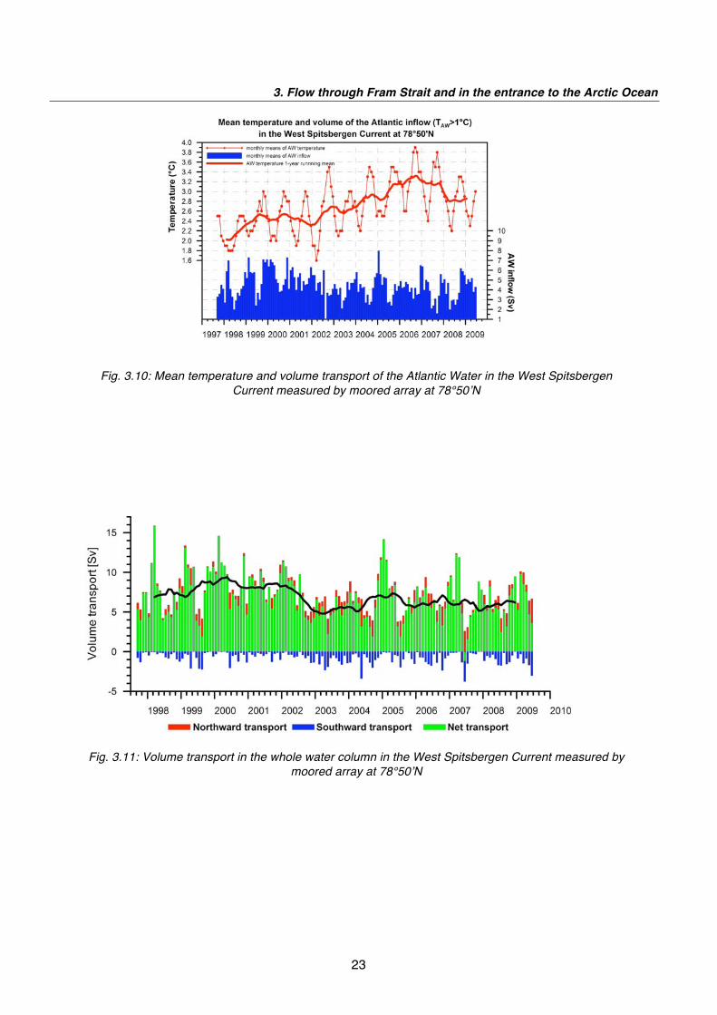
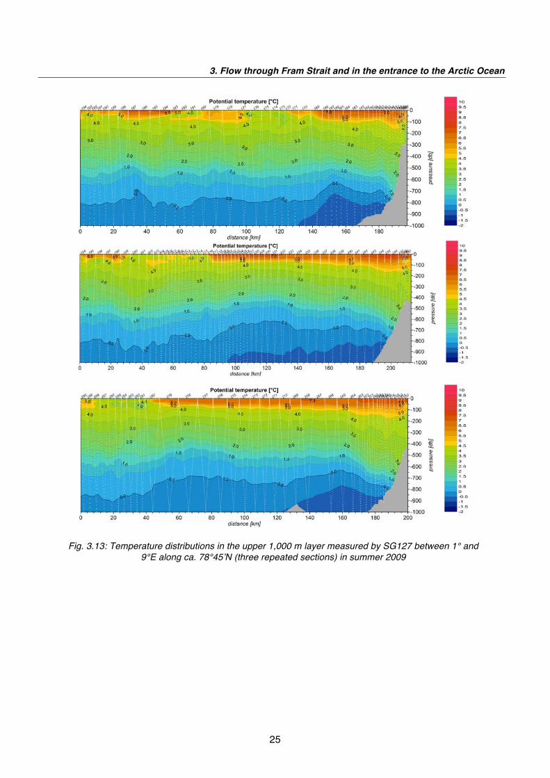
The preliminary results obtained by the moored array confirm finding from the hydrographic snapshot. Since in 2009 only moorings F1 to F6 were recovered, estimates of volume transport were done only for the West Spitsbergen Current, while estimations of total volume and heat fluxes were not possible. This will be done in 2010 after recovering of the complete array. The mean Atlantic Water temperature (defined as >1°C) and AW volume transport in the WSC are shown on Fig. 3.10, while the total net transport in the WSC is presented on Fig. 3.11. The total volume transport in the WSC in the deployment period 2008 - 2009 was similar to observed in the previous year with slightly higher monthly transports in late winter. However, volume transport of the AW warmer than 1°C was significantly higher through nearly all months of 2008 - 2009 than found in 2007 - 2008. This was due partially to larger coverage of the section by warmer AW as well as to significantly higher mean current in the AW in the WSC since winter 2008. Preliminary results from glider measurements are shown on Fig. 3.12 and 3.13. The vertically averaged currents in the layer measured by the glider (1,000 m in the deep water or ca 50 m above the bottom in shallower areas) clearly show the strong and stable northward flow in the WSC and strong and variable current in the recirculation area. At the repeated section between 1° and 9°E variations in spreading of the AW in the 100 m upper layer are pronounced. Spatial resolution of glider measurements allows to resolve structures with the horizontal scale of (5 - 10 km), providing an insight into mesoscale variability in Fram Strait.
3. Flow through Fram Strait and in the entrance to the Arctic Ocean
23
Fig. 3.10: Mean temperature and volume transport of the Atlantic Water in the West Spitsbergen
Current measured by moored array at 78°50 N
Fig. 3.11: Volume transport in the whole water column in the West Spitsbergen Current measured by
moored array at 78°50 N

ARK-XXIV/1
24
Fig. 3.12: Vertically averaged currents in the upper 1,000 m measured by the glider SG127 during its
summer mission in Fram Strait in 2009
3. Flow through Fram Strait and in the entrance to the Arctic Ocean
25
Fig. 3.13: Temperature distributions in the upper 1,000 m layer measured by SG127 between 1° and
9°E along ca. 78°45 N (three repeated sections) in summer 2009
26
4. AT-SEA DISTRIBUTION OF SEABIRDS AND
MARINE MAMMALS
X. Vandevyvre, F. Etienne, S. Viseur not on board: C. Joiris Laboratory for Polar Ecology
Objectives
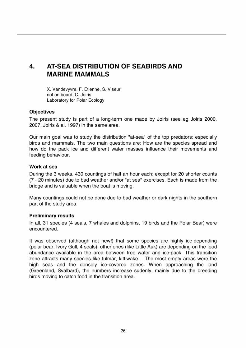
The present study is part of a long-term one made by Joiris (see eg Joiris 2000, 2007, Joiris & al. 1997) in the same area. Our main goal was to study the distribution "at-sea" of the top predators; especially birds and mammals. The two main questions are: How are the species spread and how do the pack ice and different water masses influence their movements and feeding behaviour. Work at sea
During the 3 weeks, 430 countings of half an hour each; except for 20 shorter counts (7 - 20 minutes) due to bad weather and/or "at sea" exercises. Each is made from the bridge and is valuable when the boat is moving. Many countings could not be done due to bad weather or dark nights in the southern part of the study area. Preliminary results
In all, 31 species (4 seals, 7 whales and dolphins, 19 birds and the Polar Bear) were encountered. It was observed (although not new!) that some species are highly ice-depending (polar bear, Ivory Gull, 4 seals), other ones (like Little Auk) are depending on the food abundance available in the area between free water and ice-pack. This transition zone attracts many species like fulmar, kittiwake… The most empty areas were the high seas and the densely ice-covered zones. When approaching the land (Greenland, Svalbard), the numbers increase sudenly, mainly due to the breeding birds moving to catch food in the transition area.
4. At-sea distribution of seabirds and marine mammals
27
a) Seabirds
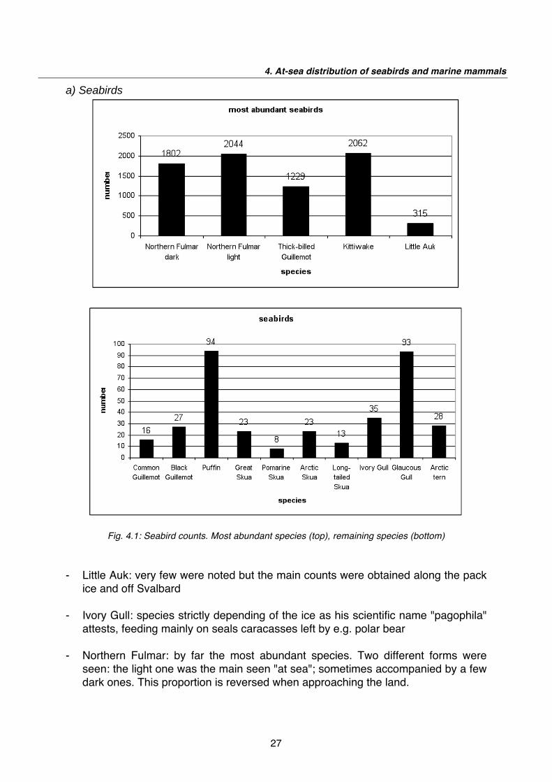
Fig. 4.1: Seabird counts. Most abundant species (top), remaining species (bottom)
- Little Auk: very few were noted but the main counts were obtained along the pack ice and off Svalbard
- Ivory Gull: species strictly depending of the ice as his scientific name "pagophila"
attests, feeding mainly on seals caracasses left by e.g. polar bear - Northern Fulmar: by far the most abundant species. Two different forms were
seen: the light one was the main seen "at sea"; sometimes accompanied by a few dark ones. This proportion is reversed when approaching the land.
ARK-XXIV/1
28
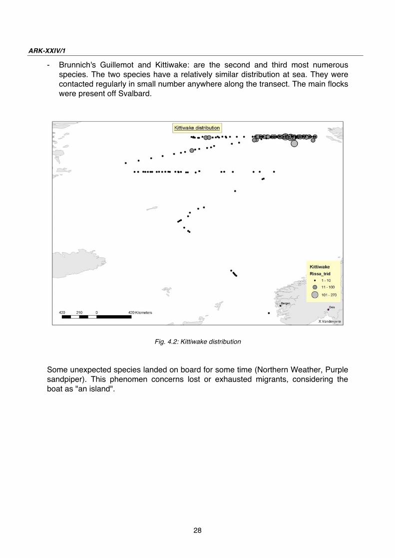
- Brunnich's Guillemot and Kittiwake: are the second and third most numerous species. The two species have a relatively similar distribution at sea. They were contacted regularly in small number anywhere along the transect. The main flocks were present off Svalbard.
Fig. 4.2: Kittiwake distribution
Some unexpected species landed on board for some time (Northern Weather, Purple sandpiper). This phenomen concerns lost or exhausted migrants, considering the boat as "an island".

4. At-sea distribution of seabirds and marine mammals
29
b) Whales and dolphins
Fig. 4.3: Counts of whales and dolphins
- Bowhead: one of the rarest whales. Seven contacts were obtained and 2
individuals together by two times. The very first one was seen at the edge of the pack ice at 77°N
- Whales: we had to wait reaching the 79°N to have significant contacts with
cetaceans! Between 2°E and 9°E, we had no less than 114 contacts. The most difficult thing was to avoid double counts as the boat made go back along this transect.
c) Seals and bears
Fig. 4.4: Counts of seals and bears
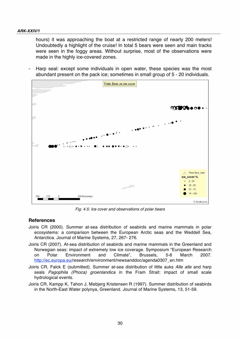
- Polar Bear (cfr map): we saw "only" adults. The first sight was made in an area
with very slight ice cover. The main observation was made during a CTD exercise. A bear was discovered far away but thanks to the length exercise (~2
ARK-XXIV/1
30
hours) it was approaching the boat at a restricted range of nearly 200 meters! Undoubtedly a highlight of the cruise! In total 5 bears were seen and main tracks were seen in the foggy areas. Without surprise, most of the observations were made in the highly ice-covered zones.
- Harp seal: except some individuals in open water, these species was the most
abundant present on the pack ice; sometimes in small group of 5 - 20 individuals.
Fig. 4.5: Ice cover and observations of polar bears
References
Joiris CR (2000). Summer at-sea distribution of seabirds and marine mammals in polar ecosystems: a comparison between the European Arctic seas and the Weddell Sea, Antarctica. Journal of Marine Systems, 27, 267- 276.
Joiris CR (2007). At-sea distribution of seabirds and marine mammals in the Greenland and Norwegian seas: impact of extremely low ice coverage. Symposium “European Research on Polar Environment and Climate”, Brussels, 5-6 March 2007. http://ec.europa.eu/research/environment/newsanddoc/agenda0307_en.htm
Joiris CR, Falck E (submitted). Summer at-sea distribution of little auks Alle alle and harp seals Pagophila (Phoca) groenlandica in the Fram Strait: impact of small scale hydrological events.
Joiris CR, Kampp K, Tahon J, Møbjerg Kristensen R (1997). Summer distribution of seabirds in the North-East Water polynya, Greenland. Journal of Marine Systems, 13, 51-59.

31
5. MARINE MAMMAL PERIMETER SURVEILLANCE
(MAPS)
E. Burkhardt1, L. Kindermann1, D. Paranhos- Zitterbart1, und A. Reimann2
1Alfred Wegener Institut für Polar- und Meeresforschung, 2Rheinmetall AG, Bremen
Introduction/Scientific background
The MAPS project focuses on the detection of marine mammals in the vicinity of the ship, both for acquiring abundance data and spatial temporal distribution patterns of species and to implement effective mitigation procedures in the context of seismic research. A reliable determination of cetacean abundances and habitat preferences depends on the acquisition of significant amounts of sighting data. Multiple approaches to gather such data continuously from ships of opportunity are currently being developed and tested. Both, human observers and automated detection systems are employed for these tasks. Methods include passive and active hydroacoustics as well as dedicated and opportunistic sighting surveys and video and infrared imaging. Sighting data may then be merged with environmental proxies such as sea-ice conditions, water depth and sea surface temperature in environmental suitability models to model and predict the distribution and abundance of cetaceans in a given area. To enhance the effectiveness of marine mammal detection for mitigation purposes, automated detection signals are to be generated by algorithms integrating all methods mentioned above.
Work at sea
The scientific programme comprises the implementation of the procedures of opportunistic sighting reports for the ships crew and the commissioning of a new infrared camera system. Opportunistic sightings of cetaceans are recorded by the nautical officers of Polarstern since 2005, using first paper log sheets and since 2008 an electronic logging programme "Wallog" (Fa. Werum). To alleviate this task and to interlink the sighting data with the ship-based data acquisition system "DSHIP", a new electronic log "WALOG" (Fig. 5.1) was developed by the Ocean Acoustics Group (AWI) prior to the cruise and installed and tested on the bridge during this expedition. A touch screen allows entering a sighting with just four taps. Additionally, photographs taken with a digital camera on the bridge are automatically transferred to the PC, referenced and stored in a database along with the sighting data, allowing for offline species verification.

ARK-XXIV/1
32
Fig. 5.1: Screen layout of the new WALOG programme
During this cruise, visual sightings were recorded both by the nautical officers and in parallel by a dedicated marine mammal observer (MMO). Nautical officers, who occupy the bridge 24 hrs and 7 days/week do not conduct dedicated observations, yet are instructed to systematically record every (opportunistic) cetacean observation. Dedicated observations were conducted by a single observer from the bridge and the crows nest (if weather permitted), with an average of 10 hours effort each day. However, as this study was not designed as distance sampling survey, no effort data was recorded. The main goals of the dedicated MMO were: a) to introduce the new electronic WALOG programme to the nautical officers of Polarstern b) to test the programme and arrange for necessary changes to assure unobstructed handling for future cruises and c) to log cetacean sightings with the necessary additional information for later comparison with video sequences recorded by the newly installed infrared imaging system. This system - "FIRST-Navy" - had been developed for defence applications by the company Rheinmetall Defence Electronics, Bremen. It consists of a state-of the art thermal imager, capable of taking five full 360° images per second with a resolution of 7200 x 576 pixels mounted on a stabilized platform providing a stable alignment under all weather conditions. The first operational unit of this series was installed on the crow's nest of Polarstern (Fig. 5.2.) during docktime before the expedition. The controlling computer system and the console for image acquisition, display and processing was installed in the lab on deck "A". An engineer of the company accompanied the cruise for the final commissioning. The main goal of the cruise regarding this camera was a comprehensive field test of the system and to fully integrate it into the ship's data network. The high resolution video data generated by the camera accumulates to about 4TB per day. The computer is capable of storing up to 10TB in total which are laid out as a ringbuffer which keeps the last two days. A trigger mechanism was implemented during the cruise, which automatically marks 10

5. Marine mammal perimeter surveillance (MAPS)
33
minute snippets, 5 minutes before to 5 minutes after an event, for permanent storage. Triggering can occur either locally by the operator or via the ship's network from other locations like the WALOG console on the bridge.
Preliminary results
a) Visual sightings A total of 105 sighting events, including 8 cetacean species and three seal species were recorded. Table 5.1 lists all cetacean sighting events by species. Here we preferred to use the term ‘sighting event’ instead of ‘sighting’ due to the fact that in some occasions (e.g. high animal encounters or while ship was on station) we could not clearly distinguish if consecutive sightings in a short period of time were two separate sightings or a possible re-sighting of the same animal.
Tab. 5.1: Cetacean sightings by species from the bridge of Polarstern during ARK- XXIV/1
Species number of sighting events
Blue whale 2
Bowhead whale 2
Fin whale 34
Humpback whale 2
Minke whale 5
Orcinus orca 4
Northern bottlenose whale 1
Dolphins Lagenorhynchus spp. 2
Dolphins, unidentified 1
Unidentified, large whale 13
Unidentified, blow only 10
unidentified 9
Fig. 5.2: FIRST Navy
camera and gimbal on
the crow's nest
ARK-XXIV/1
34
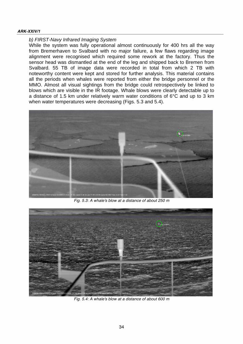
b) FIRST-Navy Infrared Imaging System While the system was fully operational almost continuously for 400 hrs all the way from Bremerhaven to Svalbard with no major failure, a few flaws regarding image alignment were recognised which required some rework at the factory. Thus the sensor head was dismantled at the end of the leg and shipped back to Bremen from Svalbard. 55 TB of image data were recorded in total from which 2 TB with noteworthy content were kept and stored for further analysis. This material contains all the periods when whales were reported from either the bridge personnel or the MMO. Almost all visual sightings from the bridge could retrospectively be linked to blows which are visible in the IR footage. Whale blows were clearly detectable up to a distance of 1.5 km under relatively warm water conditions of 6°C and up to 3 km when water temperatures were decreasing (Figs. 5.3 and 5.4).
Fig. 5.3: A whale's blow at a distance of about 250 m
Fig. 5.4: A whale's blow at a distance of about 600 m

35
6. LONG-TERM PASSIVE ACOUSTIC MONITORING
OF MARINE MAMMALS AND OCEAN NOISE
LEVELS IN THE GREENLAND SEA AND THE FRAM
STRAIT
Holger Klinck NOAA Pacific Marine Environmental Laboratory
Objectives
The Arctic Ocean is one of the fastest changing environments on earth, and there is no doubt that these changes will affect marine fauna in near future. However, continuous monitoring of changes in this remote and hostile area is difficult and expensive. Passive acoustic long-term recorders offer the possibility to perform this task effectively and at relatively low cost. The project s goal is to monitor changes in the ambient sound field associated with the melting of the Arctic icecap and to evaluate the impact the anticipated increased sound levels will have on marine mammals - especially the endangered north Atlantic right whales (Eubalaena
glacialis), bowhead whales (Balaena mysticetus) and walruses (Odobenus
rosmarus). (1) Whale acoustics: Estimates of the abundance and distribution of marine mammals in the high latitudes are burdened with large error estimates, sometimes of the same magnitude as the estimate itself. Improvements of the current estimates are difficult. Given the vast extent of the Arctic Ocean and its adjacent seas located above the Arctic Circle, dedicated surveys that visually scan the ocean surface for marine mammals are difficult to organize, as ship time - particularly in ice-covered regions - is costly and personnel are limited. In general most visual sightings are available for inshore waters as these can be obtained from shore or from small vessels on day trips. To gain knowledge on the distribution and abundance of marine mammals, offshore passive acoustic monitoring has become an important research tool. Due to the low attenuation of sounds, especially low frequency sounds, and the fact that most marine mammals vocalize regularly, passive acoustic devices allow scientists to monitor a large area efficiently. Several research institutions (mostly located in the US) have initiated passive acoustic research projects in the Arctic in recent years. These projects are focused primarily on endangered whales, including the North Atlantic and North Pacific right whales (Eubalaena glacialis and Eubalaena japonica), bowhead whale (Balaena mysticetus), and blue whale (Balaenoptera musculus). However, most of these projects have been conducted in the Bering Sea, Chukchi Sea, and Beaufort Sea (US waters). The project proposed here is intended to gain
ARK-XXIV/1
36
knowledge on marine mammal species inhabiting the Greenland Sea and the Fram Strait. The North Atlantic right whale is one of the world's most endangered cetaceans. The western North Atlantic population is estimated to number 300 - 350 animals, and the eastern population is extinct or nearly so. North Atlantic right whale populations do not appear to be increasing, with anthropogenic factors - notably ship strikes and net entanglement - responsible for significant numbers of deaths. North Atlantic right whales from the western stock inhabit areas off the coast of the United States and Canada from Florida to the Scotian Shelf. Surveys of these areas are conducted relatively often, but despite intensive survey effort, approximately one-third of this population is not found in these areas during the summer months. In addition, wintering grounds for much of the right whale population are unknown, and pelagic areas have received little dedicated survey effort. In 2007/2008 five hydrophones were deployed in a former whaling ground east of the southern tip of Greenland. The analysis of the recorded data revealed a significant number (>2000) of right whale vocalizations. Knowing that right whales occupy this area seasonally may guide conservation efforts aimed at reducing anthropogenic mortality. The proposed work further north will provide important information on the migration pattern of this and other species and provide baseline information for a future, more comprehensive passive acoustic study on this species as well as on other baleen whales in the area. The CIMRS bioacoustics group has developed algorithms for the detection of calls by many species of marine mammals, including right, bowhead, humpback, blue, fin, and sperm whales. We will use these algorithms to analyze the acoustic data collected by these instruments to study the seasonal occurrence of these species. (2) Ocean noise: Ocean noise is an increasing problem in our oceans. Currently > 80 % of global trade uses the sea for transportation. Thus it is not surprising that shipping is a dominant sound source in the oceans. The main impact of this noise occurs in the frequency range between a few Hertz to a few hundred Hertz. Because of the low attenuation of sounds in the ocean, marine mammals developed evolutionary navigation and long-range communication systems based on sound. Most baleen whales, for example, emit sounds at frequencies < 1 kHz and could be directly affected by the increase in the noise levels caused by shipping. The potential impacts of anthropogenic noise on marine mammals are numerous, including the masking of biological signals. The Arctic Ocean is one of the fastest changing environments on earth. Due to global warming the sea ice in the Northern hemisphere is dramatically shrinking. In 2007 the Northwest Passage was ice free for the first time in recorded history. The Northeast Passage was only blocked by a narrow strip of ice most of the summer, and was ice free in 2008. An ice-free Northeast Passage would change the global ship-based trade dramatically as this route is radically shorter than the normal trip through the Suez Canal. For example, from Hamburg, Germany (one of the busiest harbors in Europe) to the Japanese port city of Yokohama, the trip using the northern route is ~7,400 nautical miles - just 40 percent of the 11,500 nautical mile trip through the Suez. An increase in ship traffic in

6. Long-term passive acoustic monitoring of marine mammals and ocean noise levels
37
this area would significantly increase (1) ocean noise levels which will influence the behavior of marine mammals and (2) the likelihood of ship strikes. CIMRS is analyzing deep-ocean sound recordings from hydrophones deployed in the equatorial East Pacific (EEP), central Mid-Atlantic (CMA), northern Mid-Atlantic (NMA), Bering Sea (BS), Antarctic Peninsula (ANP), and Indian Ocean (IO). These datasets provide insight into the overall structure for the deep-water global sound field. The hydrophones are moored in the deep sound channel, taking advantage of the efficient propagation characteristics which enable the instruments to monitor effectively large sections of the global oceans. Although not always concurrent, the deployment of the hydrophone arrays from 1996 to present allows for an up-to-date assessment of the global scale distribution of ocean sound levels in discrete frequency bands. Comparisons of intra- and interannual time averaged ambient sound levels reveal strong latitudinal variations, where higher latitudes correspond with higher noise levels. Seismic and volcanic activities dominate the lower frequency bands (0 - 10 Hz) of all hydrophone arrays. Of interest is the periodic nature of broad band ice noise observed in the ANP acoustic data, suggesting a climate link for these signals related to ice breakup during seasonal warming events. In addition, the multi-species marine mammal vocalizations observed in all of our hydrophone datasets dominates sound energy levels at specific frequencies. The work in the Greenland Sea and Fram Strait will allow a more comprehensive study on a “global ocean noise budget”. The Arctic is of special interest as this area is heavily affected by global warming, and the shrinking of the ice cap will lead to more shipping traffic and oil exploration in this area in near future. For this reason it is very important to get baseline information on current noise levels in this area soon. Work at sea
Two hydrophones were deployed off the German research icebreaker Polarstern in the Fram Strait (M1) and the central Greenland Sea (M2). Details are given in Tab. 6.1 and Fig. 6.1. Tab. 6.1: Detailed information on hydrophone deployments Position: Mooring: Water depth [m]: Hydrophone depth
[m]:
M1 78° 50.03 N 05° 29.12 E AWI-F22-1 2549 488
M2 74° 56.00 N 04°
37.00'W AWI-JP37 3540 480
To our knowledge this is the first time that a hydrophone has been deployed in the Greenland Sea. The hydrophones will record the underwater soundscape continuously for one year. A turnaround of the instruments is planned for summer 2010.
ARK-XXIV/1
38
Preliminary results
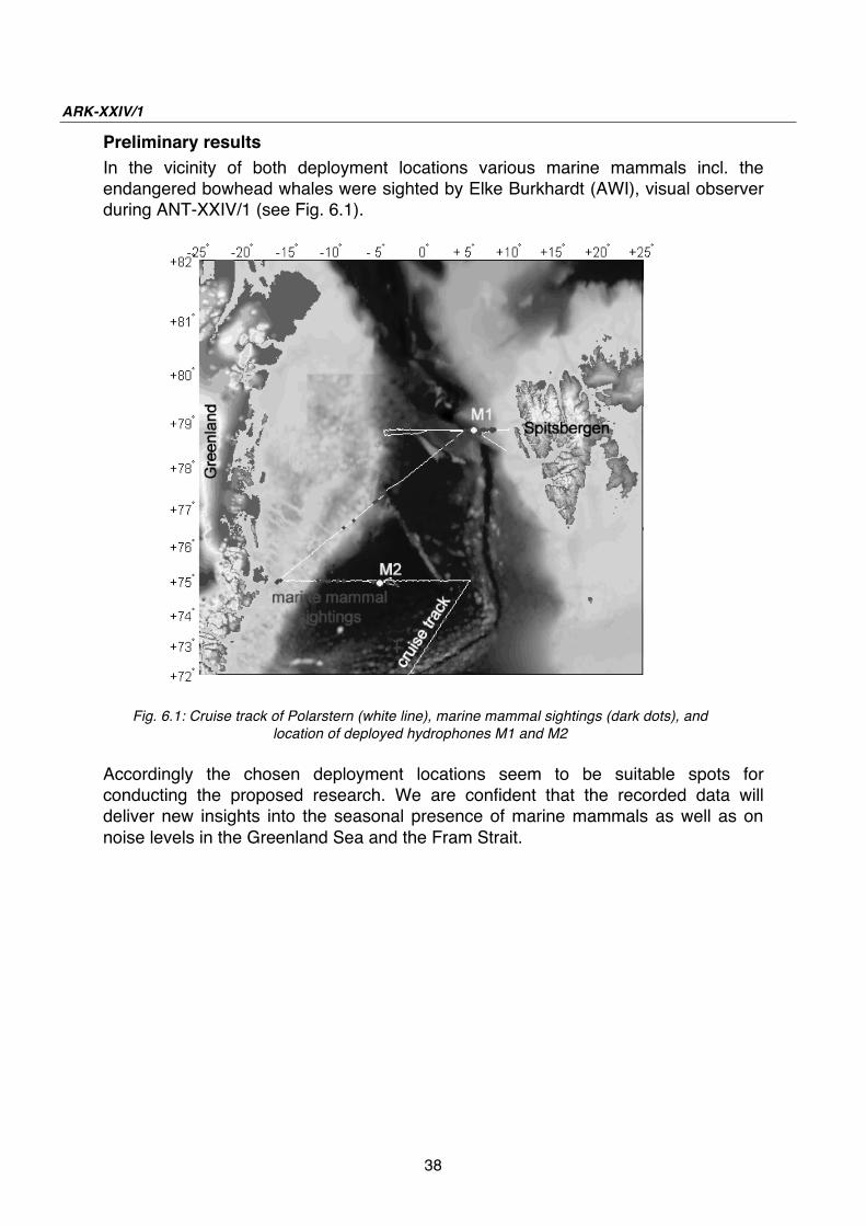
In the vicinity of both deployment locations various marine mammals incl. the endangered bowhead whales were sighted by Elke Burkhardt (AWI), visual observer during ANT-XXIV/1 (see Fig. 6.1).
Fig. 6.1: Cruise track of Polarstern (white line), marine mammal sightings (dark dots), and
location of deployed hydrophones M1 and M2
Accordingly the chosen deployment locations seem to be suitable spots for conducting the proposed research. We are confident that the recorded data will deliver new insights into the seasonal presence of marine mammals as well as on noise levels in the Greenland Sea and the Fram Strait.

39
7. PRODUCTION, FATE AND AGGREGATION OF
ORGANIC MATTER IN A CHANGING ARCTIC
OCEAN
Mascha Wurst, Nicole Händel AWI, Helmholtz Young Investigators Group GloCar
Objectives
Based on the awareness, that global change has increasingly changed marine ecosystems, we intend to determine the effects of higher temperature and CO2 on the production, fate and aggregation of extracellular organic matter in the Arctic Ocean. Incubation experiments with Arctic marine bacterioplankton communities will be performed to observe temperature- and CO2-related effects on the concentration and composition of exopolymer substances. Furthermore, secondary effects on the formation of organic aggregates will be investigated by bubble absorption onboard. Biogeochemical and microbiological measurements are necessary to determine future changes in the origin and the turnover of organic matter during production and decomposition processes in the Arctic Ocean. Our overarching goal is to contribute to a better understanding of the direction and strength of biogeochemical and microbial feedback processes in the future ocean. The investigations are conducted in close cooperation with E. Nöthig, I. Peeken, A. Bracher, K. Metfies, E. Bauerfeind and M. Klages (AWI) in the AWI HAUSGARTEN (ARK-XXIV/2), studying plankton ecology and sedimentation of organic matter in a changing Arctic ocean. Work at sea / preliminary results
During ARK-XXIV/1, two perturbation experiments with arctic marine bacterioplankton were performed to determine the impact of increasing temperature and CO2 on the microbial turn-over of exopolymer substances. Secondary effects on the formation of organic aggregates were investigated by bubble absorption. Seawater was collected by CTD/Rosette at 75°N, 5°30 E and at 75°N, 15°40 W in the peak of chlorophyll a (Chl a) concentration (30 m and 20 m depth, respectively). Before manipulation of temperature and pH, the seawater was filtrated (1.2 μm) and concentrated from 1 l to 5 l by ultrafiltration (>10 kDa). After manipulation of seawater chemistry (decreased pH), seawater was incubated for 4 days at in-situ and increased temperature. Subsequently the formation of organic aggregates was investigated by bubbling air into the seawater for 12 h. Subsamples were collected for biogeochemical parameters (total and dissolved organic carbon (TOC/DOC), total and dissolved nitrogen (TN/DN), dissolved and total polysaccharides (DCHO/CHO), dissolved and total amino acids (DAA/AA), nutrients, transparent exopolymer particles (TEP), Coomassie stainable particles (CSP)) and microbiological parameters (bacterial cell numbers, bacterial DNA, bacterial production (incorporation of 3H-Thymidine and 3H-
ARK-XXIV/1
40
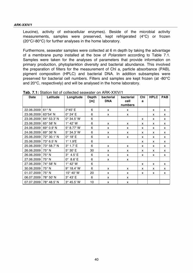
Leucine), activity of extracellular enzymes). Beside of the microbial activity measurements, samples were preserved, kept refrigerated (4°C) or frozen (20°C/-80°C) for further analyses in the home laboratory. Furthermore, seawater samples were collected at 6 m depth by taking the advantage of a membrane pump installed at the bow of Polarstern according to Table 7.1. Samples were taken for the analyses of parameters that provide information on primary production, phytoplankton diversity and bacterial abundance. This involved the preparation of filters for the measurement of Chl a, particle absorbance (PAB), pigment composition (HPLC) and bacterial DNA. In addition subsamples were preserved for bacterial cell numbers. Filters and samples are kept frozen (at -80°C and 20°C, respectively) and will be analysed in the home laboratory. Tab. 7.1: Station list of collected seawater on ARK-XXIV/1
Date Latitude Longitude Depth
[m]
bacterial
DNA
bacterial
cell
numbers
Chl
a
HPLC PAB
22.06.2009 61° N 2°45' E 6 x x x x
23.06.2009 63°54' N 0° 24' E 6 x x x x 23.06.2009 64° 53.3' N 0° 34.5' W 6 x x x
23.06.2009 65° 58' N 1° 42' W 6 x x x x x 24.06.2009 69° 0.9' N 5° 8.77' W 6 x x x x x
24.06.2009 69° 36' N 5° 34.3' W 6 x x x x x
25.06.2009 72° 30.1' N 0° 18' E 6 x x x x x
25.06.2009 73° 6.5' N 1° 1.9'E 6 x x x 25.06.2009 73° 58.7' N 3° 1.7' E 6 x x x x x
26.06.2009 75° N 5° 30' E 30 x x x x x 26.06.2009 75° N 3° 4.5' E 6 x x x x x
27.06.2009 75° N 0° 8.6' E 6 x x 27.06.2009 74° 58' N 1° 42' W 6 x x x
30.06.2009 75° N 9° 18.4' W 6 x x x x x 01.07.2009 75° N 15° 40' W 20 x x x x x
06.07.2009 78° 50' N 3° 43' E 6 x x
07.07.2009 78° 48.5' N 3° 45.5' W 10 x x

41
APPENDIX
A.1 PARTICIPATING INSTITUTIONS
A.2 CRUISE PARTICIPANTS
A.3 SHIP'S CREW
A.4 STATION AND MOORING LIST

42
A.1 TEILNEHMENDE INSTITUTE / PARTICIPATING
INSTITUTIONS
Adresse Address
AWI Alfred-Wegener-Institut für Polar- und Meeresforschung in der Helmholtz-Gemeinschaft Postfach 120161 27515 Bremerhaven
APL University of Washington Applied Physics Laboratory 1013 NE 40th St. Seattle, WA 98105-6698/USA
DWD Deutscher Wetterdienst Geschäftsbereich Wettervorhersage Seeschifffahrtsberatung Bernhard Nocht Str. 76 20359 Hamburg
Fielax Gesellschaft für wissenschaftliche Datenverarbeitung mbH Barkhausenstr. 4 27568 Bremerhaven
Heli Service Heli Service International GmbH Im Geisbaum 2 63329 Egelsbach
IPÖ Institut für Polarökologie Wischhofstr. 1-3, Geb.12 24148 Kiel
Laeisz Reederei F. Laeisz (Bremerhaven) GmbH Brückenstr. 25 27568 Bremerhaven
NOAA Oregon State University & NOAA Pacific Marine Environmental Laboratory Hatfield Marine Science Center 2030 Marine Science Drive Newport, OR 9736/USA

43
Adresse Address
Optimare OPTIMARE Am Luneort 15a 27572 Bremerhaven
PolE Laboratory for Polar Ecology Rue du Fodia 18 B-1367 Ramillies/Belgium
Rheinmetall Electronics Brueggeweg 54 28309 Bremen
UAB Institut de Ciència i Tecnologia Ambientals (ICTA) Universitat Autònoma de Barcelona (UAB) Edifici Cn, 4º, Campus Bellaterra 08193 Barcelona/Spain

44
A.2 FAHRTTEILNEHMER / CRUISE PARTICIPANTS
Name/ Last name
Vorname/ First name
Institut/ Institute
Beruf/ Profession
Baudorff Christian Heliservice Pilot
Brauer Jens Heliservice Technician
Budéus Gereon AWI Chief Scientist,Oceanographer
Büchner Jürgen Heliservice Pilot
Buldt Klaus DWD Technician
Burkhardt Elke AWI Technician, biology
El Naggar Saad AWI Physicist
Etienne Fabrice PoIE Biologist
Fietz Susanne UAB Biologist
Gall Fabian Heliservice Technician
Händel Nicole AWI Technician, biology
Heidemann Harald SAM Electronics Engineer
Heinze Birte AWI Student, oceanography
Jacob Juliane AWI Student, oceanography
Kindermann Lars AWI Physicist
Klinck Holger NOAA Biologist
Lehner Flavio AWI Student, physics
Monsees Matthias Optimare Technician
Paranhos Zitterbart Daniel AWI Physicist
Pardiñas Judit UAB Biologist
Reimann Andreas Rheinmetall Engineer
Rentsch Harald DWD Meteorologist
Rogenhagen Johannes Fielax Geophysicist
Rohardt Gerd AWI Oceanographer
Saynisch Jan AWI Oceanographer
Schneider Alice IPÖ Technician
Schnieders Jana AWI Student, oceanography
Spielke Steffen Laeisz Inspector
Strothmann Olaf AWI Technician, oceanography

45
Name/ Last name
Vorname/ First name
Institut/ Institute
Beruf/ Profession
Vandevyvre Xavier PoIE Biologist
Viseur Stephane PolE Biologist
Wisotzki Andreas AWI Oceanographer
Wurst Mascha AWI Biologist
Zakrzewski Svenja AWI Student, oceanography
Zenk Oliver Optimare Engineer, oceanography
Zoch Nico AWI Student, oceanography

46
A.3 SCHIFFSBESATZUNG / SHIP'S CREW No. Name Rank
1. Pahl, Uwe Master
2. Ettlin, Margrith 1. Offc.
3. Krohn, Günter Ch. Eng.
4. Fallei, Holger 2. Offc.
5. Peine, Lutz G. 2. Offc.
6. Dugge, Heike 3. Offc.
7. Heine, Werner Doctor
8. Hecht, Andreas R. Offc.
9. Minzlaff, Hans-Ulrich 2. Eng.
10. Sümnicht, Stefan 2. Eng.
11. Schaefer, Marc 3. Eng.
12. Scholz, Manfred Elec. Eng.
13. Dimmler, Werner ELO
14. Himmel, Frank ELO
15. Muhle, Helmut ELO
16. Winter, Andreas ELO
17. Loidl, Reiner Boatsw.
18. Reise, Lutz Carpenter
19. Bäcker, Andreas A.B.
20. Brickmann, Peter A.B.
21. Guse, Hartmut A.B.
22. Hagemann, Manfred A.B.
23. Scheel, Sebastian A.B.
24. Schmidt, Uwe A.B.
25. Wende, Uwe A.B.
26. Winkler, Michael A.B.
27. Preußner, Jörg Storek.
28. Elsner, Klaus Mot-man
29. Pinske, Lutz Mot-man

47
No. Name Rank
30. Schütt, Norbert Mot-man
31. Teichert, Uwe Mot-man
32. Voy, Bernd Mot-man
33. Müller-homburg, R.-D. Cook
34. Silinski, Frank Cooksmate
35. Völske, Thomas Cooksmate
36. Jürgens, Monika 1. Stwdess
37. Wöckener, Martina Stwdess/N.
38. Czyborra, Bärbel 2. Stwdess
39. Gaude, Hans-Jürgen 2. Steward
40. Huang, Wu-Mei 2. Stwdess
41. Möller, Wolfgang 2. Steward
42. Silinski, Carmen 2. Stwdess
43. Yu, Kwok Yuen Laundrym.
44. Junge, Johannes Apprent.
45. Schliffke, Banyamin Apprent.

48
A.4 STATION AND MOORING LIST PS 74 Station
PS74/
Date
Time Position
Lat
Position
Lon
Depth
[m]
Gear
Abbreviat-
ion
0001-1 24.06.2009 15:50:00 70° 30,39' N 4° 21,83'W 1296,8 CTD/RO
0001-1 24.06.2009 16:21:00 70° 30,40' N 4° 23,03'W 1314,2 CTD/RO
0001-1 24.06.2009 16:21:01 70° 30,40' N 4° 23,03'W 1314,2 CTD/RO
0001-1 24.06.2009 16:44:59 70° 30,38' N 4° 23,43'W 1317,1 CTD/RO
0001-2 24.06.2009 16:55:00 70° 30,39' N 4° 23,72'W 1323 TEST
0001-2 24.06.2009 16:57:00 70° 30,38' N 4° 23,82'W 1324,6 TEST
0001-2 24.06.2009 17:14:00 70° 30,32' N 4°24,53'W 1334,7 TEST
0001-2 24.06.2009 17:18:59 70° 30,30' N 4° 24,66'W 1340,3 TEST
0002-1 25.06.2009 15:07:00 73° 45,53' N 2° 28,53' E 3208,3 TD
0002-1 25.06.2009 15:15:00 73° 46,29' N 2° 30,33' E 3216 TD
0002-1 25.06.2009 15:16:59 73° 46,41' N 2° 30,74' E 3218,6 TD
0003-1 25.06.2009 23:32:00 74° 59,96' N 5° 30,53' E 3133,8 CTD/RO
0003-1 26.06.2009 0:34:00 74° 59,94' N 5° 29,97' E 3117,3 CTD/RO
0003-1 26.06.2009 1:32:59 74° 59,95' N 5° 30,00' E 3117,9 CTD/RO
0004-1 26.06.2009 3:14:00 74° 59,97' N 4° 51,62' E 3245,6 CTD/RO
0004-1 26.06.2009 4:24:00 74° 59,96' N 4° 51,86' E 3239,7 CTD/RO
0004-1 26.06.2009 5:20:59 75° 0,04' N 4° 52,20' E 3236,4 CTD/RO
0005-1 26.06.2009 6:46:00 75° 0,08' N 4° 13,53' E 3082,3 CTD
0005-1 26.06.2009 7:58:00 75° 0,13' N 4° 14,27' E 3083,7 CTD
0005-1 26.06.2009 8:48:59 75° 0,04' N 4° 14,00' E 3094,6 CTD
0006-1 26.06.2009 10:04:00 75° 0,00' N 3° 34,98' E 3479,2 CTD/RO
0006-1 26.06.2009 11:13:00 75° 0,03' N 3° 35,69' E 3488,5 CTD/RO
0006-1 26.06.2009 12:09:59 75° 0,01' N 3° 35,66' E 3488,4 CTD/RO
0007-1 26.06.2009 13:27:00 74° 59,92' N 2° 55,49' E 2529,5 CTD/RO
0007-1 26.06.2009 14:12:00 74° 59,81' N 2° 55,71' E 2540,9 CTD/RO
0007-1 26.06.2009 14:52:59 74° 59,47' N 2° 55,40' E 2601,5 CTD/RO
0008-1 26.06.2009 16:03:00 75° 0,07' N 2° 16,62' E 2950,5 CTD/RO
0008-1 26.06.2009 16:55:00 74° 59,69' N 2° 16,52' E 2961 CTD/RO
0008-1 26.06.2009 17:42:59 74° 59,81' N 2° 16,55' E 2978 CTD/RO
0009-1 26.06.2009 18:58:00 75° 0,02' N 1° 37,46' E 3156,1 CTD/RO
0009-1 26.06.2009 20:03:00 75° 0,01' N 1° 37,94' E 3129 CTD/RO
0009-1 26.06.2009 20:52:59 75° 0,04' N 1° 38,11' E 3122,8 CTD/RO
0010-1 26.06.2009 22:12:00 74° 59,98' N 0° 58,62' E 3775,5 CTD/RO
0010-1 26.06.2009 23:26:00 74° 59,93' N 0° 56,91' E 3775,4 CTD/RO
0010-1 27.06.2009 0:26:59 75° 0,01' N 0° 56,15' E 3775,5 CTD/RO
0011-1 27.06.2009 1:33:00 74° 59,93' N 0° 20,99' E 3773,1 CTD/RO
0011-1 27.06.2009 2:52:00 74° 59,79' N 0° 20,02' E 3772,7 CTD/RO
0011-1 27.06.2009 3:51:59 74° 59,79' N 0° 19,30' E 3772,5 CTD/RO
0012-1 27.06.2009 5:05:00 75° 0,04' N 0° 17,61'W 3764,8 CTD/RO
0012-1 27.06.2009 6:20:00 74° 59,72' N 0° 17,14'W 3764,7 CTD/RO
0012-1 27.06.2009 7:21:59 74° 59,61' N 0° 17,35'W 3764,2 CTD/RO
0013-1 27.06.2009 8:37:00 74° 59,96' N 0° 55,24'W 3747,4 CTD/RO
0013-1 27.06.2009 9:52:01 74° 59,92' N 0° 55,73'W 3738,4 CTD/RO

Station and mooring list PS 74
49
Station
PS74/
Date
Time Position
Lat
Position
Lon
Depth
[m]
Gear
Abbreviat-
ion
0013-1 27.06.2009 10:59:59 74° 59,92' N 0° 56,55'W 3739,6 CTD/RO
0014-1 27.06.2009 12:14:00 74° 59,95' N 1° 35,14'W 3729,2 CTD/RO
0014-1 27.06.2009 13:28:00 74° 59,79' N 1° 34,42'W 3730 CTD/RO
0014-1 27.06.2009 14:27:59 74° 59,62' N 1° 34,56'W 3730 CTD/RO
0015-1 27.06.2009 15:42:00 75° 0,03' N 2° 12,81'W 3631,1 CTD/RO
0015-1 27.06.2009 16:52:00 74° 59,55' N 2° 11,15'W 3706,4 CTD/RO
0015-1 27.06.2009 17:49:59 74° 59,01' N 2° 10,41'W 3717,4 CTD/RO
0016-1 27.06.2009 19:12:00 74° 59,96' N 2° 50,78' W 3692,6 CTD/RO
0016-1 27.06.2009 20:25:00 74° 59,77' N 2° 51,08' W 3692,5 CTD/RO
0016-1 27.06.2009 21:28:59 74° 59,90' N 2° 50,95' W 3692,3 CTD/RO
0017-1 27.06.2009 22:46:00 74° 60,00' N 3° 29,92' W 3671 CTD/RO
0017-1 27.06.2009 23:59:00 75° 0,08' N 3° 30,00' W 3667 CTD/RO
0017-1 28.06.2009 0:57:59 75° 0,22' N 3° 30,21' W 3667 CTD/RO
0018-1 28.06.2009 2:10:00 75° 0,06' N 4° 8,00' W 3643,3 CTD/RO
0018-1 28.06.2009 3:25:00 74° 59,95' N 4° 6,75' W 3644,2 CTD/RO
0018-1 28.06.2009 4:27:59 74° 59,81' N 4° 5,52' W 3645,7 CTD/RO
0019-1 28.06.2009 5:34:00 75° 5,15' N 3° 26,44' W 3668,2 MOR
0019-1 28.06.2009 5:37:00 75° 5,13' N 3° 26,26' W 3668,8 MOR
0019-1 28.06.2009 5:39:00 75° 5,11' N 3° 26,13' W 3668,4 MOR
0019-1 28.06.2009 5:53:00 75° 4,98' N 3° 26,45' W 3668,8 MOR
0019-1 28.06.2009 5:59:00 75° 4,98' N 3° 26,20' W 3668,7 MOR
0019-1 28.06.2009 6:03:00 75° 4,98' N 3° 26,00' W 3669 MOR
0019-1 28.06.2009 7:00:00 75° 5,37' N 3° 23,22' W 3670,3 MOR
0019-1 28.06.2009 7:01:00 75° 5,38' N 3° 23,16' W 3670,4 MOR
0019-1 28.06.2009 7:03:59 75° 5,39' N 3° 23,03' W 3670,3 MOR
0019-1 28.06.2009 7:08:00 75° 5,29' N 3° 22,52' W 3670,5 MOR
0020-1 28.06.2009 7:30:00 75° 5,04' N 3° 27,40' W 3667,6 MOR
0020-1 28.06.2009 7:31:00 75° 5,04' N 3° 27,39' W 3667,4 MOR
0020-1 28.06.2009 7:32:00 75° 5,04' N 3° 27,38' W 3667,5 MOR
0020-1 28.06.2009 7:33:00 75° 5,04' N 3° 27,37' W 3667,5 MOR
0020-1 28.06.2009 9:10:00 75° 5,02' N 3° 27,13' W 3667,5 MOR
0020-1 28.06.2009 9:18:00 75° 5,02' N 3° 27,09' W 3667,3 MOR
0020-1 28.06.2009 9:18:01 75° 5,02' N 3° 27,09' W 3667,3 MOR
0020-1 28.06.2009 9:20:00 75° 5,03' N 3° 27,07' W 3667,8 MOR
0020-1 28.06.2009 9:28:59 75° 5,02' N 3° 27,07' W 3667,8 MOR
0020-1 28.06.2009 9:33:00 75° 5,01' N 3° 27,07' W 3667,5 MOR
0021-1 28.06.2009 11:54:00 74° 50,02' N 2° 29,87' W 3695,4 MOR
0021-1 28.06.2009 11:55:00 74° 50,03' N 2° 29,85' W 3696,1 MOR
0021-1 28.06.2009 11:57:00 74° 50,03' N 2° 29,83' W 3696 MOR
0021-1 28.06.2009 12:15:00 74° 49,83' N 2° 30,54' W 3694,9 MOR
0021-1 28.06.2009 12:20:00 74° 49,84' N 2° 30,45' W 3695,5 MOR
0021-1 28.06.2009 12:24:00 74° 49,88' N 2° 30,35' W 3695,2 MOR
0021-1 28.06.2009 13:18:00 74° 50,10' N 2° 29,79' W 3696,6 MOR
0021-1 28.06.2009 13:18:01 74° 50,10' N 2° 29,79' W 3696,6 MOR
0022-1 28.06.2009 13:30:00 0° 0,00' N 0° 0,00' E 0 MOR
0022-1 28.06.2009 13:30:01 74° 49,98' N 2° 30,01' W 3696,2 MOR
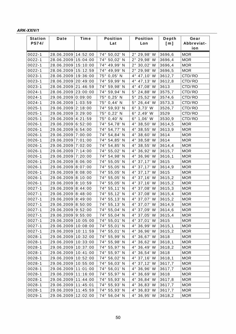
ARK-XXIV/1
50
Station
PS74/
Date
Time Position
Lat
Position
Lon
Depth
[m]
Gear
Abbreviat-
ion
0022-1 28.06.2009 14:52:00 74° 50,02' N 2° 29,98' W 3696,6 MOR
0022-1 28.06.2009 15:04:00 74° 50,02' N 2° 29,98' W 3696,4 MOR
0022-1 28.06.2009 15:10:00 74° 49,99' N 2° 30,02' W 3696,4 MOR
0022-1 28.06.2009 15:12:59 74° 49,99' N 2° 29,98' W 3696,5 MOR
0023-1 28.06.2009 19:36:00 75° 0,05' N 4° 47,10' W 3612,7 CTD/RO
0023-1 28.06.2009 20:49:00 74° 59,99' N 4° 47,13' W 3612,8 CTD/RO
0023-1 28.06.2009 21:46:59 74° 59,98' N 4° 47,08' W 3613 CTD/RO
0024-1 28.06.2009 23:00:00 74° 59,94' N 5° 24,88' W 3575,7 CTD/RO
0024-1 29.06.2009 0:09:00 75° 0,25' N 5° 25,52' W 3574,6 CTD/RO
0024-1 29.06.2009 1:03:59 75° 0,44' N 5° 26,44' W 3573,3 CTD/RO
0025-1 29.06.2009 2:18:00 74° 59,93' N 6° 3,73' W 3526,7 CTD/RO
0025-1 29.06.2009 3:29:00 75° 0,22' N 6° 2,49' W 3529 CTD/RO
0025-1 29.06.2009 4:21:59 75° 0,40' N 6° 1,06' W 3530,9 CTD/RO
0026-1 29.06.2009 6:52:00 74° 54,78' N 4° 38,50' W 3614,5 MOR
0026-1 29.06.2009 6:54:00 74° 54,77' N 4° 38,55' W 3613,9 MOR
0026-1 29.06.2009 7:00:00 74° 54,84' N 4° 38,60' W 3614 MOR
0026-1 29.06.2009 7:01:00 74° 54,85' N 4° 38,58' W 3614 MOR
0026-1 29.06.2009 7:02:00 74° 54,85' N 4° 38,55' W 3614,4 MOR
0026-1 29.06.2009 7:14:00 74° 55,02' N 4° 36,92' W 3615,7 MOR
0026-1 29.06.2009 7:20:00 74° 54,98' N 4° 36,96' W 3616,1 MOR
0026-1 29.06.2009 8:06:00 74° 55,05' N 4° 37,17' W 3615 MOR
0026-1 29.06.2009 8:07:00 74° 55,05' N 4° 37,17' W 3614,9 MOR
0026-1 29.06.2009 8:08:00 74° 55,05' N 4° 37,17' W 3615 MOR
0026-1 29.06.2009 8:10:00 74° 55,05' N 4° 37,16' W 3615,2 MOR
0026-1 29.06.2009 8:10:59 74° 55,05' N 4° 37,16' W 3615,2 MOR
0027-1 29.06.2009 8:44:00 74° 55,11' N 4° 37,08' W 3615,3 MOR
0027-1 29.06.2009 8:48:00 74° 55,12' N 4° 37,08' W 3615,4 MOR
0027-1 29.06.2009 8:49:00 74° 55,13' N 4° 37,07' W 3615,2 MOR
0027-1 29.06.2009 8:50:00 74° 55,13' N 4° 37,07' W 3614,9 MOR
0027-1 29.06.2009 9:52:00 74° 55,04' N 4° 37,09' W 3614,6 MOR
0027-1 29.06.2009 9:55:00 74° 55,04' N 4° 37,05' W 3615,4 MOR
0027-1 29.06.2009 10:05:00 74° 55,01' N 4° 37,01' W 3615 MOR
0027-1 29.06.2009 10:08:00 74° 55,01' N 4° 36,99' W 3615,1 MOR
0027-1 29.06.2009 10:11:59 74° 55,01' N 4° 36,96' W 3615,2 MOR
0028-1 29.06.2009 10:32:00 74° 55,99' N 4° 36,67' W 3618 MOR
0028-1 29.06.2009 10:33:00 74° 55,98' N 4° 36,62' W 3618,1 MOR
0028-1 29.06.2009 10:37:00 74° 55,97' N 4° 36,49' W 3618,2 MOR
0028-1 29.06.2009 10:41:00 74° 55,97' N 4° 36,54' W 3618 MOR
0028-1 29.06.2009 10:52:00 74° 56,02' N 4° 37,16' W 3618,1 MOR
0028-1 29.06.2009 10:55:00 74° 56,03' N 4° 37,12' W 3617,7 MOR
0028-1 29.06.2009 11:01:00 74° 56,01' N 4° 36,96' W 3617,7 MOR
0028-1 29.06.2009 11:16:00 74° 55,97' N 4° 36,69' W 3618 MOR
0028-1 29.06.2009 11:44:00 74° 55,93' N 4° 36,84' W 3617,8 MOR
0028-1 29.06.2009 11:45:01 74° 55,93' N 4° 36,83' W 3617,7 MOR
0028-1 29.06.2009 11:45:59 74° 55,93' N 4° 36,83' W 3617,7 MOR
0029-1 29.06.2009 12:02:00 74° 56,04' N 4° 36,95' W 3618,2 MOR
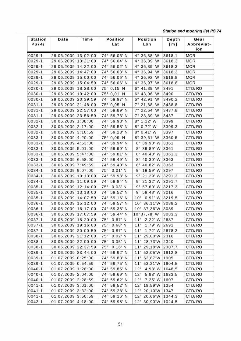
Station and mooring list PS 74
51
Station
PS74/
Date
Time Position
Lat
Position
Lon
Depth
[m]
Gear
Abbreviat-
ion
0029-1 29.06.2009 13:02:00 74° 56,05' N 4° 36,88' W 3618,1 MOR
0029-1 29.06.2009 13:21:00 74° 56,04' N 4° 36,89' W 3618,3 MOR
0029-1 29.06.2009 14:22:00 74° 56,02' N 4° 36,89' W 3618,3 MOR
0029-1 29.06.2009 14:47:00 74° 56,03' N 4° 36,94' W 3618,3 MOR
0029-1 29.06.2009 15:00:00 74° 56,06' N 4° 36,92' W 3618,8 MOR
0029-1 29.06.2009 15:04:59 74° 56,06' N 4° 36,97' W 3618,8 MOR
0030-1 29.06.2009 18:28:00 75° 0,15' N 6° 41,89' W 3491 CTD/RO
0030-1 29.06.2009 19:42:00 75° 0,01' N 6° 43,06' W 3490 CTD/RO
0030-1 29.06.2009 20:39:59 74° 59,97' N 6° 42,91' W 3490,2 CTD/RO
0031-1 29.06.2009 21:48:00 75° 0,05' N 7° 21,88' W 3438,8 CTD/RO
0031-1 29.06.2009 22:57:00 74° 59,89' N 7° 22,64' W 3437,8 CTD/RO
0031-1 29.06.2009 23:56:59 74° 59,73' N 7° 23,39' W 3437 CTD/RO
0032-1 30.06.2009 1:08:00 74° 59,98' N 8° 1,12' W 3399 CTD/RO
0032-1 30.06.2009 2:17:00 74° 59,58' N 8° 0,72' W 3399,3 CTD/RO
0032-1 30.06.2009 3:10:59 74° 59,23' N 8° 0,41' W 3397 CTD/RO
0033-1 30.06.2009 4:20:00 75° 0,09' N 8° 39,61' W 3360,5 CTD/RO
0033-1 30.06.2009 4:53:00 74° 59,94' N 8° 39,98' W 3361 CTD/RO
0033-1 30.06.2009 5:01:00 74° 59,90' N 8° 39,89' W 3361 CTD/RO
0033-1 30.06.2009 5:47:00 74° 59,81' N 8° 40,43' W 3361,3 CTD/RO
0033-1 30.06.2009 6:58:00 74° 59,49' N 8° 40,30' W 3363 CTD/RO
0033-1 30.06.2009 7:49:59 74° 59,40' N 8° 40,82' W 3363 CTD/RO
0034-1 30.06.2009 9:07:00 75° 0,01' N 9° 19,59' W 3297 CTD/RO
0034-1 30.06.2009 10:13:00 74° 59,93' N 9° 21,29' W 3291,3 CTD/RO
0034-1 30.06.2009 11:09:59 74° 59,84' N 9° 21,32' W 3291,7 CTD/RO
0035-1 30.06.2009 12:14:00 75° 0,03' N 9° 57,60' W 3217,3 CTD/RO
0035-1 30.06.2009 13:18:00 74° 59,52' N 9° 59,48' W 3216 CTD/RO
0035-1 30.06.2009 14:07:59 74° 59,16' N 10° 0,91' W 3219,5 CTD/RO
0036-1 30.06.2009 15:12:00 74° 59,57' N 10° 36,11'W 3088,2 CTD/RO
0036-1 30.06.2009 16:17:00 74° 59,35' N 10° 37,36'W 3089 CTD/RO
0036-1 30.06.2009 17:07:59 74° 59,44' N 10°37,78' W 3083,3 CTD/RO
0037-1 30.06.2009 18:20:00 75° 0,67' N 11° 2,22' W 2687 CTD/RO
0037-1 30.06.2009 19:16:00 75° 0,68' N 11° 1,79' W 2691 CTD/RO
0037-1 30.06.2009 20:00:59 75° 0,87' N 11° 1,72' W 2678,2 CTD/RO
0038-1 30.06.2009 21:12:00 75° 0,02' N 11° 29,00'W 2316 CTD/RO
0038-1 30.06.2009 22:00:00 75° 0,05' N 11° 28,73'W 2320 CTD/RO
0038-1 30.06.2009 22:37:59 75° 0,16' N 11° 29,18'W 2307,7 CTD/RO
0039-1 30.06.2009 23:44:00 74° 59,92' N 11° 52,05'W 1912,8 CTD/RO
0039-1 01.07.2009 0:25:00 74° 59,83' N 11° 52,87'W 1905 CTD/RO
0039-1 01.07.2009 0:54:59 74° 59,75' N 11° 53,21'W 1904,5 CTD/RO
0040-1 01.07.2009 1:28:00 74° 59,85' N 12° 4,98' W 1648,5 CTD/RO
0040-1 01.07.2009 2:04:00 74° 59,69' N 12° 5,98' W 1633,5 CTD/RO
0040-1 01.07.2009 2:28:59 74° 59,62' N 12° 7,25' W 1607 CTD/RO
0041-1 01.07.2009 3:01:00 74° 59,52' N 12° 18,59'W 1354 CTD/RO
0041-1 01.07.2009 3:32:00 74° 59,28' N 12° 20,10'W 1347 CTD/RO
0041-1 01.07.2009 3:50:59 74° 59,16' N 12° 20,66'W 1344,3 CTD/RO
0042-1 01.07.2009 4:18:00 74° 59,95' N 12° 30,90'W 1024,5 CTD/RO

ARK-XXIV/1
52
Station
PS74/
Date
Time Position
Lat
Position
Lon
Depth
[m]
Gear
Abbreviat-
ion
0042-1 01.07.2009 4:45:00 74° 59,69' N 12° 32,13'W 1012,2 CTD/RO
0042-1 01.07.2009 5:01:59 74° 59,56' N 12° 32,68'W 1007,5 CTD/RO
0043-1 01.07.2009 5:31:00 75° 0,09' N 12° 43,89'W 617,8 CTD/RO
0043-1 01.07.2009 5:47:00 75° 0,05' N 12° 44,31'W 613,3 CTD/RO
0043-1 01.07.2009 5:58:59 75° 0,06' N 12° 44,61'W 592,7 CTD/RO
0044-1 01.07.2009 7:00:00 75° 0,16' N 13° 9,38'W 239 CTD/RO
0044-1 01.07.2009 7:08:00 75° 0,11' N 13° 9,37'W 240 CTD/RO
0044-1 01.07.2009 7:16:59 75° 0,06' N 13° 9,37'W 241,8 CTD/RO
0045-1 01.07.2009 9:12:00 74° 59,87' N 13° 39,26'W 188 CTD/RO
0045-1 01.07.2009 9:21:00 74° 59,81' N 13° 39,17'W 187 CTD/RO
0045-1 01.07.2009 9:30:59 74° 59,75' N 13° 39,05'W 185 CTD/RO
0046-1 01.07.2009 11:03:00 75° 0,02' N 14° 19,37'W 151 CTD/RO
0046-1 01.07.2009 11:11:00 74° 59,95' N 14° 19,36'W 155 CTD/RO
0046-1 01.07.2009 11:15:59 74° 59,91' N 14° 19,27'W 151 CTD/RO
0047-1 01.07.2009 12:43:00 75° 0,03' N 15° 1,75'W 104 CTD/RO
0047-1 01.07.2009 12:51:00 74° 59,98' N 15° 1,94'W 105 CTD/RO
0047-1 01.07.2009 12:55:59 74° 59,92' N 15° 2,05'W 109 CTD/RO
0048-1 01.07.2009 14:19:00 74° 59,99' N 15° 39,96'W 202,7 CTD/RO
0048-1 01.07.2009 14:29:00 74° 59,99' N 15° 40,21'W 208 CTD/RO
0048-1 01.07.2009 14:36:59 74° 59,99' N 15° 40,38'W 207,3 CTD/RO
0049-1 01.07.2009 16:55:00 74° 58,20' N 16° 14,03'W 309,2 CTD/RO
0049-1 01.07.2009 17:08:00 74° 58,13' N 16° 14,02'W 309,5 CTD/RO
0049-1 01.07.2009 17:15:59 74° 58,06' N 16° 14,02'W 309,2 CTD/RO
0050-1 03.07.2009 5:19:00 78° 49,91' N 4° 59,90' E 2701,5 MOR
0050-1 03.07.2009 5:20:00 78° 49,92' N 4° 59,90' E 2702,1 MOR
0050-1 03.07.2009 5:31:00 78° 49,95' N 5° 0,15' E 2703 MOR
0050-1 03.07.2009 5:45:00 78° 49,91' N 5° 0,12' E 2702,5 MOR
0050-1 03.07.2009 6:06:00 78° 49,85' N 5° 1,05' E 2698,2 MOR
0050-1 03.07.2009 6:11:00 78° 49,86' N 5° 1,17' E 2697,9 MOR
0050-1 03.07.2009 6:18:00 78° 49,88' N 5° 1,37' E 2698,5 MOR
0050-1 03.07.2009 6:28:00 78° 49,93' N 5° 1,68' E 2696,2 MOR
0050-1 03.07.2009 6:40:00 78° 49,79' N 5° 1,68' E 2694,3 MOR
0050-1 03.07.2009 6:42:00 78° 49,78' N 5° 1,71' E 2692,3 MOR
0050-1 03.07.2009 7:02:59 78° 49,78' N 5° 14,51' E 2626,9 MOR
0051-1 03.07.2009 7:58:00 78° 49,77' N 5° 58,96' E 2477,5 MOR
0051-1 03.07.2009 8:02:00 78° 49,75' N 5° 58,92' E 2477,8 MOR
0051-1 03.07.2009 8:18:00 78° 49,71' N 6° 0,01' E 2468,2 MOR
0051-1 03.07.2009 8:22:00 78° 49,63' N 5° 59,94' E 2468,5 MOR
0051-1 03.07.2009 8:24:00 78° 49,60' N 5° 59,96' E 2468,2 MOR
0051-1 03.07.2009 8:34:00 78° 49,42' N 6° 0,14' E 2467,3 MOR
0051-1 03.07.2009 8:50:00 78° 49,15' N 5° 59,73' E 2470,8 MOR
0051-1 03.07.2009 9:00:00 78° 48,96' N 5° 59,54' E 2471 MOR
0051-1 03.07.2009 9:09:00 78° 48,81' N 5° 59,30' E 2471,7 MOR
0051-1 03.07.2009 9:10:00 78° 48,80' N 5° 59,26' E 2471,9 MOR
0051-1 03.07.2009 9:10:59 78° 48,80' N 5° 59,26' E 2471,9 MOR
0052-1 03.07.2009 10:31:00 78° 49,62' N 6° 58,36' E 1492,5 MOR

Station and mooring list PS 74
53
Station
PS74/
Date
Time Position
Lat
Position
Lon
Depth
[m]
Gear
Abbreviat-
ion
0052-1 03.07.2009 10:33:00 78° 49,76' N 6° 58,30' E 1492,6 MOR
0052-1 03.07.2009 10:45:00 78° 50,10' N 7° 0,32' E 1455,9 MOR
0052-1 03.07.2009 10:51:00 78° 50,24' N 7° 0,12' E 1455,3 MOR
0052-1 03.07.2009 10:56:00 78° 50,23' N 7° 0,02' E 1456,3 MOR
0052-1 03.07.2009 11:00:00 78° 50,18' N 7° 0,01' E 1457,1 MOR
0052-1 03.07.2009 11:06:00 78° 50,13' N 7° 0,10' E 1457,3 MOR
0052-1 03.07.2009 11:14:00 78° 50,19' N 7° 0,02' E 1456,7 MOR
0052-1 03.07.2009 11:21:00 78° 50,18' N 6° 59,96' E 1457,5 MOR
0052-1 03.07.2009 11:33:59 78° 50,16' N 6° 59,99' E 1458,3 MOR
0053-1 03.07.2009 12:51:00 78° 50,02' N 7° 58,70' E 1043,6 MOR
0053-1 03.07.2009 12:53:00 78° 50,04' N 7° 58,92' E 1042,6 MOR
0053-1 03.07.2009 13:06:00 78° 50,00' N 7° 59,86' E 1033,2 MOR
0053-1 03.07.2009 13:08:00 78° 50,00' N 7° 59,84' E 1033,1 MOR
0053-1 03.07.2009 13:13:00 78° 49,96' N 7° 59,87' E 1031,9 MOR
0053-1 03.07.2009 13:25:00 78° 49,88' N 7° 59,76' E 1032,3 MOR
0053-1 03.07.2009 13:35:59 78° 49,79' N 7° 59,92' E 1031,6 MOR
0054-1 03.07.2009 13:38:01 78° 49,75' N 7° 59,98' E 1030,6 BUOY
0054-1 03.07.2009 13:38:59 78° 49,75' N 7° 59,98' E 1030,6 BUOY
0055-1 03.07.2009 17:23:00 78° 49,96' N 5° 0,30' E 2704,2 CTD/RO
0055-1 03.07.2009 18:17:00 78° 49,81' N 4° 59,11' E 2697 CTD/RO
0055-1 03.07.2009 19:00:59 78° 49,85' N 4° 58,91' E 2697,5 CTD/RO
0056-1 03.07.2009 19:38:00 78° 49,93' N 5° 25,07' E 2619,5 CTD/RO
0056-1 03.07.2009 20:33:00 78° 50,00' N 5° 25,32' E 2620,2 CTD/RO
0056-1 03.07.2009 21:14:59 78° 49,99' N 5° 25,45' E 2620 CTD/RO
0057-1 03.07.2009 21:54:00 78° 49,95' N 5° 50,88' E 2527 CTD/RO
0057-1 03.07.2009 22:46:00 78° 50,05' N 5° 50,56' E 2529,3 CTD/RO
0057-1 03.07.2009 23:24:59 78° 50,18' N 5° 50,20' E 2532 CTD/RO
0058-1 03.07.2009 23:48:00 78° 49,84' N 5° 59,86' E 2470,5 CTD/RO
0058-1 04.07.2009 0:41:00 78° 49,87' N 5° 59,95' E 2469,7 CTD/RO
0058-1 04.07.2009 1:20:59 78° 49,97' N 6° 0,26' E 2468,3 CTD/RO
0059-1 04.07.2009 1:47:00 78° 49,94' N 6° 15,60' E 2283,5 CTD/RO
0059-1 04.07.2009 2:36:00 78° 49,76' N 6° 15,38' E 2288 CTD/RO
0059-1 04.07.2009 3:13:59 78° 49,84' N 6° 16,22' E 2272,3 CTD/RO
0060-1 04.07.2009 3:50:00 78° 50,01' N 6° 42,65' E 1738 CTD/RO
0060-1 04.07.2009 4:27:00 78° 50,25' N 6° 42,36' E 1741,8 CTD/RO
0060-1 04.07.2009 4:56:59 78° 50,33' N 6° 42,11' E 1746,6 CTD/RO
0061-1 04.07.2009 7:00:00 78° 50,27' N 8° 19,39' E 799,9 MOR
0061-1 04.07.2009 7:02:00 78° 50,29' N 8° 19,54' E 796,6 MOR
0061-1 04.07.2009 7:18:00 78° 50,16' N 8° 19,05' E 807,9 MOR
0061-1 04.07.2009 7:19:00 78° 50,16' N 8° 18,97' E 808,6 MOR
0061-1 04.07.2009 7:24:00 78° 50,13' N 8° 18,69' E 813,3 MOR
0061-1 04.07.2009 7:33:01 78° 50,09' N 8° 18,13' E 820,9 MOR
0061-1 04.07.2009 7:33:02 78° 50,09' N 8° 18,13' E 820,9 MOR
0061-1 04.07.2009 7:33:59 78° 50,09' N 8° 18,13' E 820,9 MOR
0062-1 04.07.2009 8:12:00 78° 49,93' N 8° 39,84' E 251,3 MOR
0062-1 04.07.2009 8:13:00 78° 49,94' N 8° 39,92' E 250,1 MOR
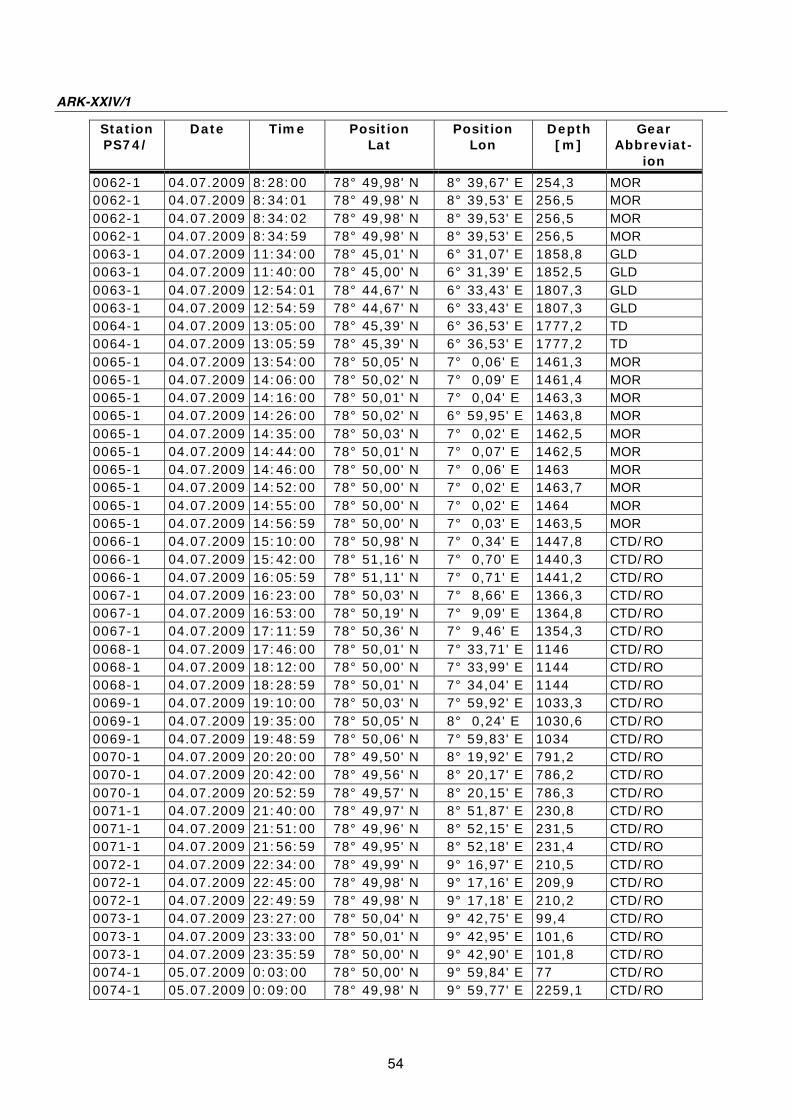
ARK-XXIV/1
54
Station
PS74/
Date
Time Position
Lat
Position
Lon
Depth
[m]
Gear
Abbreviat-
ion
0062-1 04.07.2009 8:28:00 78° 49,98' N 8° 39,67' E 254,3 MOR
0062-1 04.07.2009 8:34:01 78° 49,98' N 8° 39,53' E 256,5 MOR
0062-1 04.07.2009 8:34:02 78° 49,98' N 8° 39,53' E 256,5 MOR
0062-1 04.07.2009 8:34:59 78° 49,98' N 8° 39,53' E 256,5 MOR
0063-1 04.07.2009 11:34:00 78° 45,01' N 6° 31,07' E 1858,8 GLD
0063-1 04.07.2009 11:40:00 78° 45,00' N 6° 31,39' E 1852,5 GLD
0063-1 04.07.2009 12:54:01 78° 44,67' N 6° 33,43' E 1807,3 GLD
0063-1 04.07.2009 12:54:59 78° 44,67' N 6° 33,43' E 1807,3 GLD
0064-1 04.07.2009 13:05:00 78° 45,39' N 6° 36,53' E 1777,2 TD
0064-1 04.07.2009 13:05:59 78° 45,39' N 6° 36,53' E 1777,2 TD
0065-1 04.07.2009 13:54:00 78° 50,05' N 7° 0,06' E 1461,3 MOR
0065-1 04.07.2009 14:06:00 78° 50,02' N 7° 0,09' E 1461,4 MOR
0065-1 04.07.2009 14:16:00 78° 50,01' N 7° 0,04' E 1463,3 MOR
0065-1 04.07.2009 14:26:00 78° 50,02' N 6° 59,95' E 1463,8 MOR
0065-1 04.07.2009 14:35:00 78° 50,03' N 7° 0,02' E 1462,5 MOR
0065-1 04.07.2009 14:44:00 78° 50,01' N 7° 0,07' E 1462,5 MOR
0065-1 04.07.2009 14:46:00 78° 50,00' N 7° 0,06' E 1463 MOR
0065-1 04.07.2009 14:52:00 78° 50,00' N 7° 0,02' E 1463,7 MOR
0065-1 04.07.2009 14:55:00 78° 50,00' N 7° 0,02' E 1464 MOR
0065-1 04.07.2009 14:56:59 78° 50,00' N 7° 0,03' E 1463,5 MOR
0066-1 04.07.2009 15:10:00 78° 50,98' N 7° 0,34' E 1447,8 CTD/RO
0066-1 04.07.2009 15:42:00 78° 51,16' N 7° 0,70' E 1440,3 CTD/RO
0066-1 04.07.2009 16:05:59 78° 51,11' N 7° 0,71' E 1441,2 CTD/RO
0067-1 04.07.2009 16:23:00 78° 50,03' N 7° 8,66' E 1366,3 CTD/RO
0067-1 04.07.2009 16:53:00 78° 50,19' N 7° 9,09' E 1364,8 CTD/RO
0067-1 04.07.2009 17:11:59 78° 50,36' N 7° 9,46' E 1354,3 CTD/RO
0068-1 04.07.2009 17:46:00 78° 50,01' N 7° 33,71' E 1146 CTD/RO
0068-1 04.07.2009 18:12:00 78° 50,00' N 7° 33,99' E 1144 CTD/RO
0068-1 04.07.2009 18:28:59 78° 50,01' N 7° 34,04' E 1144 CTD/RO
0069-1 04.07.2009 19:10:00 78° 50,03' N 7° 59,92' E 1033,3 CTD/RO
0069-1 04.07.2009 19:35:00 78° 50,05' N 8° 0,24' E 1030,6 CTD/RO
0069-1 04.07.2009 19:48:59 78° 50,06' N 7° 59,83' E 1034 CTD/RO
0070-1 04.07.2009 20:20:00 78° 49,50' N 8° 19,92' E 791,2 CTD/RO
0070-1 04.07.2009 20:42:00 78° 49,56' N 8° 20,17' E 786,2 CTD/RO
0070-1 04.07.2009 20:52:59 78° 49,57' N 8° 20,15' E 786,3 CTD/RO
0071-1 04.07.2009 21:40:00 78° 49,97' N 8° 51,87' E 230,8 CTD/RO
0071-1 04.07.2009 21:51:00 78° 49,96' N 8° 52,15' E 231,5 CTD/RO
0071-1 04.07.2009 21:56:59 78° 49,95' N 8° 52,18' E 231,4 CTD/RO
0072-1 04.07.2009 22:34:00 78° 49,99' N 9° 16,97' E 210,5 CTD/RO
0072-1 04.07.2009 22:45:00 78° 49,98' N 9° 17,16' E 209,9 CTD/RO
0072-1 04.07.2009 22:49:59 78° 49,98' N 9° 17,18' E 210,2 CTD/RO
0073-1 04.07.2009 23:27:00 78° 50,04' N 9° 42,75' E 99,4 CTD/RO
0073-1 04.07.2009 23:33:00 78° 50,01' N 9° 42,95' E 101,6 CTD/RO
0073-1 04.07.2009 23:35:59 78° 50,00' N 9° 42,90' E 101,8 CTD/RO
0074-1 05.07.2009 0:03:00 78° 50,00' N 9° 59,84' E 77 CTD/RO
0074-1 05.07.2009 0:09:00 78° 49,98' N 9° 59,77' E 2259,1 CTD/RO

Station and mooring list PS 74
55
Station
PS74/
Date
Time Position
Lat
Position
Lon
Depth
[m]
Gear
Abbreviat-
ion
0074-1 05.07.2009 0:12:59 78° 49,99' N 9° 59,92' E 136 CTD/RO
0075-1 05.07.2009 4:04:00 78° 50,01' N 8° 40,07' E 246,1 MOR
0075-1 05.07.2009 4:05:00 78° 50,02' N 8° 40,11' E 245,4 MOR
0075-1 05.07.2009 4:16:00 78° 49,99' N 8° 40,10' E 244,9 MOR
0075-1 05.07.2009 4:19:00 78° 49,99' N 8° 40,07' E 245,9 MOR
0075-1 05.07.2009 4:20:00 78° 49,99' N 8° 40,09' E 245,3 MOR
0075-1 05.07.2009 4:22:00 78° 50,00' N 8° 40,15' E 244,3 MOR
0075-1 05.07.2009 4:22:59 78° 50,00' N 8° 40,15' E 244,3 MOR
0076-1 05.07.2009 5:03:00 78° 50,44' N 8° 20,11' E 783,4 MOR
0076-1 05.07.2009 5:18:00 78° 50,41' N 8° 19,96' E 786,2 MOR
0076-1 05.07.2009 5:29:00 78° 50,40' N 8° 19,97' E 786,2 MOR
0076-1 05.07.2009 5:33:00 78° 50,39' N 8° 20,01' E 786 MOR
0076-1 05.07.2009 5:36:00 78° 50,40' N 8° 20,02' E 785,4 MOR
0076-1 05.07.2009 5:38:59 78° 50,40' N 8° 20,00' E 785,7 MOR
0077-1 05.07.2009 6:36:00 78° 49,98' N 7° 59,93' E 1032 MOR
0077-1 05.07.2009 6:37:00 78° 49,98' N 7° 59,95' E 1031,9 MOR
0077-1 05.07.2009 6:39:00 78° 49,99' N 7° 59,99' E 1031,7 MOR
0077-1 05.07.2009 6:47:00 78° 49,99' N 8° 0,10' E 1031,4 MOR
0077-1 05.07.2009 7:02:00 78° 50,01' N 8° 0,04' E 1031,7 MOR
0077-1 05.07.2009 7:12:00 78° 49,99' N 7° 59,92' E 1032,6 MOR
0077-1 05.07.2009 7:15:00 78° 50,00' N 7° 60,00' E 1032,1 MOR
0077-1 05.07.2009 7:18:00 78° 50,01' N 8° 0,03' E 1031,8 MOR
0077-1 05.07.2009 7:20:00 78° 50,01' N 8° 0,04' E 1031,8 MOR
0077-1 05.07.2009 7:20:02 78° 50,01' N 8° 0,04' E 1031,8 MOR
0077-1 05.07.2009 7:20:59 78° 50,01' N 8° 0,04' E 1031,8 MOR
0078-1 05.07.2009 15:38:00 78° 50,01' N 6° 0,29' E 2467,7 MOR
0078-1 05.07.2009 15:38:01 78° 50,01' N 6° 0,29' E 2467,7 MOR
0078-1 05.07.2009 15:54:00 78° 49,97' N 6° 0,07' E 2468,7 MOR
0078-1 05.07.2009 16:10:00 78° 49,99' N 6° 0,09' E 2468,8 MOR
0078-1 05.07.2009 16:31:00 78° 50,01' N 6° 0,06' E 2469,3 MOR
0078-1 05.07.2009 16:47:00 78° 50,00' N 6° 0,08' E 2469,2 MOR
0078-1 05.07.2009 16:57:00 78° 50,00' N 6° 0,02' E 2469,5 MOR
0078-1 05.07.2009 16:59:00 78° 50,00' N 6° 0,01' E 2469,8 MOR
0078-1 05.07.2009 17:02:00 78° 50,00' N 6° 0,01' E 2469,7 MOR
0078-1 05.07.2009 17:04:59 78° 50,00' N 6° 0,01' E 2469,8 MOR
0079-1 05.07.2009 19:22:00 78° 50,00' N 4° 10,01' E 2415,2 CTD/RO
0079-1 05.07.2009 20:11:00 78° 50,01' N 4° 10,32' E 2415,2 CTD/RO
0079-1 05.07.2009 20:48:59 78° 50,01' N 4° 10,12' E 2415,3 CTD/RO
0080-1 05.07.2009 21:56:00 78° 50,02' N 3° 20,19' E 2388 CTD/RO
0080-1 05.07.2009 22:45:00 78° 50,06' N 3° 20,13' E 2388,2 CTD/RO
0080-1 05.07.2009 23:24:59 78° 50,07' N 3° 20,18' E 2388 CTD/RO
0081-1 06.07.2009 0:33:00 78° 50,09' N 2° 30,14' E 2522,5 CTD/RO
0081-1 06.07.2009 1:22:00 78° 50,15' N 2° 30,01' E 2521,3 CTD/RO
0081-1 06.07.2009 1:58:59 78° 50,11' N 2° 29,55' E 2520,7 CTD/RO
0082-1 06.07.2009 5:50:00 78° 50,04' N 5° 29,25' E 2613,5 MOR
0082-1 06.07.2009 5:55:00 78° 50,05' N 5° 29,14' E 2613,7 MOR
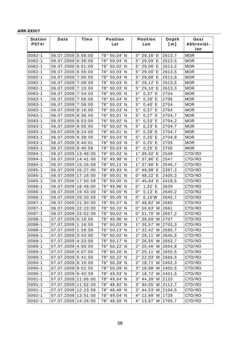
ARK-XXIV/1
56
Station
PS74/
Date
Time Position
Lat
Position
Lon
Depth
[m]
Gear
Abbreviat-
ion
0082-1 06.07.2009 5:58:00 78° 50,04' N 5° 29,16' E 2613,7 MOR
0082-1 06.07.2009 6:36:00 78° 50,04' N 5° 29,09' E 2613,5 MOR
0082-1 06.07.2009 6:51:00 78° 50,02' N 5° 29,06' E 2613,2 MOR
0082-1 06.07.2009 6:55:00 78° 50,03' N 5° 29,00' E 2613,5 MOR
0082-1 06.07.2009 7:06:00 78° 50,04' N 5° 29,08' E 2613,8 MOR
0082-1 06.07.2009 7:08:59 78° 50,03' N 5° 29,12' E 2613,5 MOR
0082-1 06.07.2009 7:10:00 78° 50,03' N 5° 29,10' E 2613,3 MOR
0083-1 06.07.2009 7:54:00 78° 50,05' N 5° 0,37' E 2704 MOR
0083-1 06.07.2009 7:56:00 78° 50,04' N 5° 0,39' E 2706 MOR
0083-1 06.07.2009 7:58:00 78° 50,03' N 5° 0,40' E 2704 MOR
0083-1 06.07.2009 8:16:00 78° 50,03' N 5° 0,37' E 2704 MOR
0083-1 06.07.2009 8:36:00 78° 50,01' N 5° 0,27' E 2704,7 MOR
0083-1 06.07.2009 8:53:00 78° 50,02' N 5° 0,33' E 2704,2 MOR
0083-1 06.07.2009 9:05:00 78° 50,02' N 5° 0,23' E 2704,7 MOR
0083-1 06.07.2009 9:24:00 78° 50,01' N 5° 0,28' E 2704,7 MOR
0083-1 06.07.2009 9:38:00 78° 50,03' N 5° 0,25' E 2704,8 MOR
0083-1 06.07.2009 9:40:01 78° 50,03' N 5° 0,25' E 2705 MOR
0083-1 06.07.2009 9:40:59 78° 50,03' N 5° 0,25' E 2705 MOR
0084-1 06.07.2009 13:49:00 78° 50,02' N 1° 39,92' E 2549 CTD/RO
0084-1 06.07.2009 14:41:00 78° 49,98' N 1° 37,96' E 2547 CTD/RO
0084-1 06.07.2009 15:26:59 78° 50,11' N 1° 37,66' E 2546,7 CTD/RO
0085-1 06.07.2009 16:27:00 78° 49,93' N 0° 49,98' E 2397,2 CTD/RO
0085-1 06.07.2009 17:16:00 78° 50,01' N 0° 48,22' E 2405,3 CTD/RO
0085-1 06.07.2009 17:50:59 78° 50,00' N 0° 45,84' E 2418,5 CTD/RO
0086-1 06.07.2009 18:48:00 78° 49,96' N 0° 1,32' E 2639 CTD/RO
0086-1 06.07.2009 19:43:00 78° 50,00' N 0° 0,13' E 2640,2 CTD/RO
0086-1 06.07.2009 20:20:59 78° 50,05' N 0° 0,15'W 2640,7 CTD/RO
0087-1 06.07.2009 21:30:00 78° 50,07' N 0° 48,82' W 2660 CTD/RO
0087-1 06.07.2009 22:23:00 78° 50,10' N 0° 50,63' W 2661 CTD/RO
0087-1 06.07.2009 23:02:59 78° 50,02' N 0° 51,70' W 2657,2 CTD/RO
0088-1 07.07.2009 0:19:00 78° 49,96' N 1° 39,69' W 2707 CTD/RO
0088-1 07.07.2009 1:16:00 78° 50,02' N 1° 35,57' W 2702,3 CTD/RO
0088-1 07.07.2009 1:59:59 78° 50,13' N 1° 32,42' W 2695,7 CTD/RO
0089-1 07.07.2009 3:43:00 78° 50,02' N 2° 29,11' W 2645,5 CTD/RO
0089-1 07.07.2009 4:33:00 78° 50,17' N 2° 26,55' W 2652,7 CTD/RO
0089-1 07.07.2009 4:50:00 78° 50,22' N 2° 25,46' W 2654,8 CTD/RO
0089-1 07.07.2009 4:57:00 78° 50,20' N 2° 25,11' W 2655,5 CTD/RO
0089-1 07.07.2009 5:41:59 78° 50,22' N 2° 22,03' W 2666,5 CTD/RO
0090-1 07.07.2009 8:10:00 78° 50,39' N 3° 18,71' W 2402,3 CTD/RO
0090-1 07.07.2009 9:02:00 78° 50,09' N 3° 18,98' W 2400,5 CTD/RO
0090-1 07.07.2009 9:40:59 78° 49,93' N 3° 18,72' W 2401,5 CTD/RO
0091-1 07.07.2009 11:06:00 78° 49,64' N 3° 44,39' W 2120 CTD/RO
0091-1 07.07.2009 11:52:00 78° 48,92' N 3° 44,55' W 2112,7 CTD/RO
0091-1 07.07.2009 12:23:59 78° 48,46' N 3° 44,53' W 2104,5 CTD/RO
0092-1 07.07.2009 13:51:00 78° 49,04' N 4° 12,98' W 1729 CTD/RO
0092-1 07.07.2009 14:26:00 78° 48,56' N 4° 13,87' W 1705,7 CTD/RO

Station and mooring list PS 74
57
Station
PS74/
Date
Time Position
Lat
Position
Lon
Depth
[m]
Gear
Abbreviat-
ion
0092-1 07.07.2009 14:54:59 78° 48,16' N 4° 14,53' W 1688,2 CTD/RO
0093-1 08.07.2009 6:04:00 78° 49,98' N 5° 59,81' E 0 TEST
0093-1 08.07.2009 8:00:00 78° 49,75' N 6° 1,25' E 0 TEST
0093-1 08.07.2009 8:26:59 78° 49,82' N 6° 1,60' E 0 TEST
0094-1 08.07.2009 10:55:00 78° 50,01' N 5° 59,90' E 0 TEST
0094-1 08.07.2009 11:25:00 78° 50,02' N 5° 60,00' E 0 TEST
0094-1 08.07.2009 11:58:59 78° 49,99' N 5° 59,31' E 0 TEST
0095-1 08.07.2009 12:29:00 78° 49,98' N 6° 0,16' E 0 TEST
0095-1 08.07.2009 13:13:00 78° 50,26' N 5° 59,68' E 0 TEST
0095-1 08.07.2009 13:55:59 78° 49,99' N 5° 59,91' E 0 TEST
0096-1 09.07.2009 6:06:00 78° 28,54' N 8° 51,71' E 1066 CTD/RO
0096-1 09.07.2009 6:35:00 78° 28,60' N 8° 51,46' E 1067,7 CTD/RO
0096-1 09.07.2009 6:54:59 78° 28,68' N 8° 50,93' E 1075,2 CTD/RO

58
Moorings recovered in Fram Strait
Mooring Latitude Longitude
Water Depth (m)
Date Time first Record last Record
Instrument Type
Serial Number
Instrument Depth (m)
F1-11 78° 50.00 N 241 07.07.2008 AVT 8395 61 08° 40.03 E 06:00 SBE37 225 771
04.07.2009 SBE37 226 227 08:00 RCM11 20 234 F2-12 78° 50.40 N 782 07.07.2008 AVT 10002 59 08° 20.00 E 12:00 SBE16 1973 80 04.07.2009 AVT 10004 251 06:00 SBE16-TR 2418 771 AVT 11613 7732
F3-11 78° 50.00 N 1011 07.07.2008 AVT 11889 62 07° 59.99 E 16:00 SBE37 239 80 03.07.2009 AVT 9213 254 12:00 SBE37 2723 255 AVT 9786 7552
AVT 10498 999 SBE17-TR 2419 1000 F4-11 78° 50.00' N 1432 07.07.2008 SBE37 236 741
07° 00.00 E 18:00 ADCP-up 1368 94 03.07.2009 AVT 11888 2493
10:00 RCM11 215 754 RCM11 26 1423 SBE16-TR 2421 1424 F5-11 78° 50.00 N 2412 12.07.2008 RCM11 474 63 06° 00.00 E 14:00 SBE37 2395 80 03.07.2009 RCM11 500 255 06:00 RCM11 512 751 RCM11 217 1507 RCM11 214 2403 F6-12 78° 50.02 N 2644 12.07.2008 RCM11 475 65 05° 00.25 E 18:00 SBE37 243 80 03.07.2009 RCM11 491 252 04:00 RCM11 469 748 RCM11 488 1504 RCM11 135 2635 AVT 9219 255 RCM11 462 752 RCM11 506 1507 RCM11 509 2654 SBE26 227 2644

Station and mooring list PS 74
59
Moorings recovered along 75° N transect
Mooring Latitude Longitude
Water Depth (m)
Date Time first Record last Record
Instrument Type
Serial Number
Instrument Depth (m)
AWI-J032 74° 50.00 N 3697 27.06.2008 SBE37 478 188 02° 29.93 W 00:00 SBE19 2378 190-3680 28.06.2009 11:00 AWI-J033 75° 05.00 N 3667 27.06.2008 SBE37 479 179 03° 27.00 W 00:00 SBE19 2639 181-3670 28.06.2009 05:00
AWI-J034 74° 55.03 N 3616 27.06.2008 SBE37 803 133 04° 37.01 W 00:00 SBE19 1889 135-3560 29.06.2009 07:00
AWI-JP34 74° 56.02 N 3618 27.06.2008 PROF 001 0-160 04° 36.90 W 00:00
29.06.2009 11:00
Moorings deployed along 75° N transect
Mooring Latitude Longitude
Water Depth (m)
Date Time first Record last Record
Instrument Type
Serial Number
Instrument Depth (m)
AWI-J035 74° 49.99 N 3698 28.06.2009 SBE37 802 120 02° 30.02 W 16:00 SBE19 2377 125-3685 AWI-J036 75° 05.00 N 3668 28.06.2009 AQD 1649 85 03° 27.10 W 10:00 SBE37 2817 90 SBE19 2639 181-3645 AWI-J037 74° 55.01 N 3615 29.06.2009 AQD 1958 85 04° 36.99 W 11:00 SBE37 2818 90 SBE19 2027 95-3600 AWI-JP37 74° 56.06 N 3618 29.06.2009 PROF 002 0-180 04° 36.92 W 15:00
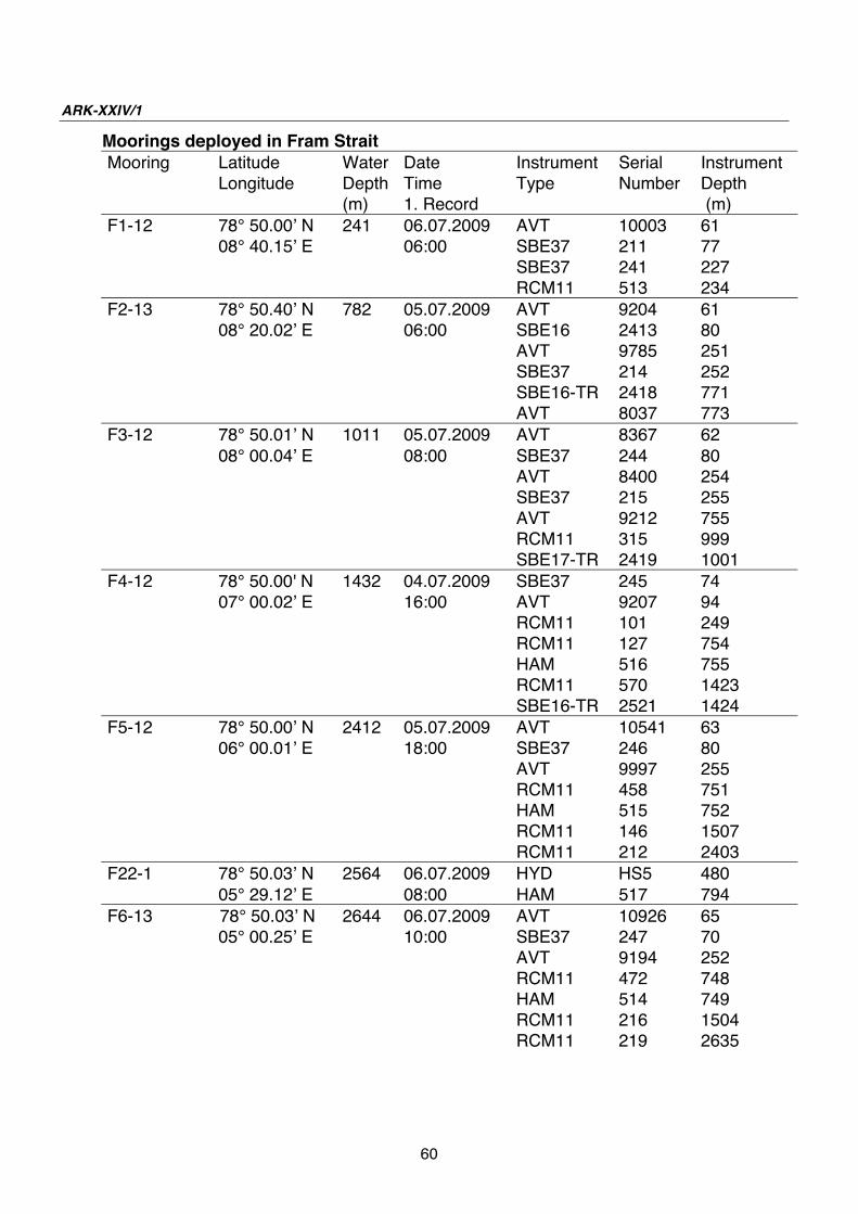
ARK-XXIV/1
60
Moorings deployed in Fram Strait
Mooring Latitude Longitude
Water Depth (m)
Date Time 1. Record
Instrument Type
Serial Number
Instrument Depth (m)
F1-12 78° 50.00 N 241 06.07.2009 AVT 10003 61 08° 40.15 E 06:00 SBE37 211 77 SBE37 241 227 RCM11 513 234 F2-13 78° 50.40 N 782 05.07.2009 AVT 9204 61 08° 20.02 E 06:00 SBE16 2413 80 AVT 9785 251 SBE37 214 252 SBE16-TR 2418 771 AVT 8037 773 F3-12 78° 50.01 N 1011 05.07.2009 AVT 8367 62 08° 00.04 E 08:00 SBE37 244 80 AVT 8400 254 SBE37 215 255 AVT 9212 755 RCM11 315 999 SBE17-TR 2419 1001 F4-12 78° 50.00' N 1432 04.07.2009 SBE37 245 74 07° 00.02 E 16:00 AVT 9207 94 RCM11 101 249 RCM11 127 754 HAM 516 755 RCM11 570 1423 SBE16-TR 2521 1424 F5-12 78° 50.00 N 2412 05.07.2009 AVT 10541 63 06° 00.01 E 18:00 SBE37 246 80 AVT 9997 255 RCM11 458 751 HAM 515 752 RCM11 146 1507 RCM11 212 2403 F22-1 78° 50.03 N 2564 06.07.2009 HYD HS5 480 05° 29.12 E 08:00 HAM 517 794 F6-13 78° 50.03 N 2644 06.07.2009 AVT 10926 65 05° 00.25 E 10:00 SBE37 247 70 AVT 9194 252 RCM11 472 748 HAM 514 749 RCM11 216 1504 RCM11 219 2635

Station and mooring list PS 74
61
Abbreviations:
ADCP RD-Instruments, Self Contained Acoustic Doppler Current Profiler AVT Aanderaa Current Meter with Temperature Sensor AQD Nortec Aquadropp Acoustic Current Meter RCM 11 Aanderaa Doppler Current Meter SBE16 SeaBird Electronics Self Recording CTD to measure Temperature,
Conductivity and Pressure SBE16-TR SeaBird Electronics Self Recording CTD to measure Temperature,
Conductivity and Pressure; with Transmissometer SBE19 SeaBird Electronics Self Recording CTD to measure Temperature,
Conductivity and Pressure; used with density controlled profiling vehicle SBE37 SeaBird Electronics, Type: MicroCat, to measure Temperature and
Conductivity HAM Hydro Acoustic Modem (data link between moorings) HYD Hydrophone; sound recorder PROF CTD-Profiler with Under Water Winch Remarks: Blank field: passive instrument with not data recording (1) No data recorded – battery low (2) Rotor lost during the deployment (3) Vane bearing broken – not clear whether it happened during the deployment

Die "Berichte zur Polar- und Meeresforschung" (ISSN 1866-3192) werden beginnend mit dem Heft Nr. 569 (2008) ausschließlich elektronisch als Open-Access-Publikation herausgegeben. Ein Verzeichnis aller Hefte einschließlich der Druckausgaben (Heft 377-568) sowie der früheren "Berichte zur Polarforschung (Heft 1-376, von 1982 bis 2000) befindet sich im Internet in der Ablage des electronic Information Center des AWI (ePIC) unter der URL http://epic.awi.de. Durch Auswahl "Reports on Polar- and Marine Research" auf der rechten Seite des Fensters wird eine Liste der Publikationen in alphabetischer Reihenfolge (nach Autoren) innerhalb der absteigenden chronologischen Reihenfolge der Jahrgänge erzeugt. To generate a list of all Reports past issues, use the following URL: http://epic.awi.de and select the right frame to browse "Reports on Polar and Marine Research". A chronological list in declining order, author names alphabetical, will be produced, and pdf-icons shown for open access download. Verzeichnis der zuletzt erschienenen Hefte: Heft-Nr. 601/2009 — "Analyse von Bathymetrie und akustischer Rückstreuung verschiedener Fächersonar- und Sedimentecholot-Systeme zur Charakterisierung und Klassifizierung des Meeresbodens am Gakkel-Rücken, Arktischer Ozean", by Jörn Hatzky Heft-Nr. 602/2009 — "Cumacea (Crustacea; Peracarida) of the Antarctic shelf – diversity, biogeography, and phylogeny", by Peter Rehm Heft-Nr. 603/2010 — "The Expedition of the Research Vessel 'Polarstern' to the Antarctic in 2009 (ANT-XXV/5)", edited by Walter Zenk and Saad El Naggar Heft-Nr. 604/2010 — "The Expedition of the Research Vessel 'Polarstern' to the Antarctic in 2007/2008 (ANT-XXIV/2)", edited by Ulrich Bathmann Heft-Nr. 605/2010 — "The Expedition of the Research Vessel 'Polarstern' to the Antarctic in 2003 (ANT-XXI/1)", edited by Otto Schrems Heft-Nr. 606/2010 — "The Expedition of the Research Vessel 'Polarstern' to the Antarctic in 2008 (ANT-XXIV/3)", edited by Eberhard Fahrbach and Hein de Baar Heft-Nr. 607/2010 — "The Expedition of the Research Vessel 'Polarstern' to the Arctic in 2009 (ARK-XXIV/2)", edited by Michael Klages Heft-Nr. 608/2010 — "Airborne lidar observations of tropospheric Arctic clouds", by Astrid Lampert Heft-Nr. 609/2010 — "Daten statt Sensationen - Der Weg zur internationalen Polarforschung aus einer deutschen Perspektive", by Reinhard A. Krause Heft-Nr. 610/2010 — "Biology of meso- and bathypelagic chaetognaths in the Southern Ocean", by Svenja Kruse Heft-Nr. 611/2010 — "Materialparameter zur Beschreibung des zeitabhängigen nichtlinearen Spannungs – Verformungsverhaltens von Firn in Abhängigkeit von seiner Dichte", by Karl-Heinz Bässler Heft-Nr. 612/2010 — "The Expedition of the Research Vessel 'Polarstern' to the Arctic in 2009 (ARK-XXIV/1)", edited by Gereon Budéus