Coo2007a.pdf - EPIC
121
This chapter was originally published in the book Developments in Earth and Environmental Sciences, published by Elsevier, and the attached copy is provided by Elsevier for the author’s benefit and for the benefit of the author’s institution, for non-commercial research and educational use including without limitation use in instruction at your institution, sending it to specific colleagues who know you, and providing a copy to your institution’s administrator. All other uses, reproduction and distribution, including without limitation commercial reprints, selling or licensing copies or access, or posting on open internet sites, your personal or institution’s website or repository, are prohibited. For exceptions, permission may be sought for such use through Elsevier’s permissions site at: http://www.elsevier.com/locate/permissionusematerial From Alan K. Cooper, Giuliano Brancolini, Carlota Escutia, Yngve Kristoffersen, Rob Larter, German Leitchenkov, Phillip O’Brien and Wilfried Jokat, Cenozoic Climate History from Seismic Reflection and Drilling Studies on the Antarctic Continental Margin. In: Fabio Florindo and Martin Siegert, editors: Developments in Earth and Environmental Sciences, Vol 8, Antarctic Climate Evolution, Fabio Florindo and Martin Siegert. The Netherlands: Elsevier, 2009, pp. 115–228. ISBN: 978-0-444-52847-6 r Copyright 2009 Elsevier BV. Elsevier Provided for non-commercial research and educational use only. Not for reproduction, distribution or commercial use.
-
Upload
khangminh22 -
Category
Documents
-
view
0 -
download
0
Transcript of Coo2007a.pdf - EPIC
This chapter was originally published in the book Developments in Earth and Environmental Sciences,published by Elsevier, and the attached copy is provided by Elsevier for the author’s benefit and for thebenefit of the author’s institution, for non-commercial research and educational use including withoutlimitation use in instruction at your institution, sending it to specific colleagues who know you, and
providing a copy to your institution’s administrator.
All other uses, reproduction and distribution, including without limitation commercial reprints, selling orlicensing copies or access, or posting on open internet sites, your personal or institution’s website orrepository, are prohibited. For exceptions, permission may be sought for such use through Elsevier’s
permissions site at:http://www.elsevier.com/locate/permissionusematerial
From Alan K. Cooper, Giuliano Brancolini, Carlota Escutia, Yngve Kristoffersen, Rob Larter, GermanLeitchenkov, Phillip O’Brien and Wilfried Jokat, Cenozoic Climate History from Seismic Reflection andDrilling Studies on the Antarctic Continental Margin. In: Fabio Florindo and Martin Siegert, editors:
Developments in Earth and Environmental Sciences, Vol 8, Antarctic Climate Evolution, Fabio Florindoand Martin Siegert. The Netherlands: Elsevier, 2009, pp. 115–228.
ISBN: 978-0-444-52847-6r Copyright 2009 Elsevier BV.
Elsevier
Provided for non-commercial research and educational use only.
Not for reproduction, distribution or commercial use.
Author's personal copy
Developments in Earth & Environmental Sciences, 8F. Florindo and M. Siegert (Editors)r 2009 Elsevier B.V. All rights reservedDOI 10.1016/S1571-9197(08)00005-0Chapter 5
Cenozoic Climate History fromSeismic Reflection and Drilling Studieson the Antarctic Continental Margin
Alan K. Cooper1,�, Giuliano Brancolini2, Carlota Escutia3,Yngve Kristoffersen4, Rob Larter5, German Leitchenkov6,Phillip O’Brien7 and Wilfried Jokat8
1Department of Geological and Environmental Sciences, Stanford University,Stanford, CA 94306, USA2Istituto Nazionale di Oceanografia e di Geofisica Sperimentale, B.go Grotta Gigante42/c, 34010 Sgonico, Trieste, Italy3Instituto Andaluz de Ciencias de la Tierra, CSIC-Univ. de Granada Campus deFuentenueva s/n, 18002 Granada, Spain4Department of Earth Science, University of Bergen, Allegaten 41, N-5007 Bergen, Norway5British Antarctic Survey, High Cross, Madingley Road, Cambridge CB3 0ET, UK6Research Institute for Geology and Mineral Resources of the World Ocean,VNIIOkeangeologia, 1 Angliysky Avenue, 190 121 St. Petersburg, Russia7Geoscience Australia, Cnr Jerrabomberra Avenue and Hindmarsh Drive,GPO Box 378, Canberra ACT 2601, Australia8Alfred-Wegener Institute, Am Handelshafen 12, D-27570 Bremerhaven, Germany
ABSTRACT
Seismic stratigraphic studies and scientific drilling of the Antarctic continentalmargin have yielded clues to the evolution of Cenozoic climates, depositionalpaleoenvironments and paleoceanographic conditions. This paper draws on studiesof the former Antarctic Offshore Stratigraphy Project and others to review thegeomorphic and lithostratigraphic offshore features that give insights into thelong-duration (m.y.) and short-term (k.y.) changes that document the greatvariability of Cenozoic Antarctic paleoenvironments. The lithologic drillingrecord documents non-glacial (pre-early Eocene) to full-glacial (late Pliocene toHolocene) times, and documents times of cyclic ice-sheet fluctuations at k.y.
E-mail: [email protected] (A.K. Cooper).
�Corresponding author. Tel.: þ01 650329 5157
116 A. K. Cooper et al.
Author's personal copy
scales (early Miocene to Pliocene and Holocene). Times of significant change intypes and/or amounts of glaciation are also seen in the offshore lithologic record(early Oligocene, mid-Miocene, early Pliocene). Seismic data illustrate large-scalegeomorphic features that point to massive sediment erosion and dispersal by icesheets and paleoceanographic processes (e.g. cross-shelf troughs, slope-fans, rise-drifts). The commonality of these features to East and West Antarctica since lateEocene time points to a continent that has been intermittently covered, partially tocompletely, by glaciers and ice sheets. The greatest advances in our understandingof paleoenvironments and the processes that control them have been achieved fromscientific drilling, and future progress depends on a continuation of such drilling.
Citation to regional-section information: Regional-section authors, 2008, InCooper et al., Cenozoic climate history from seismic-reflection and drillingstudies on the Antarctic continental margin, In: F. Florindo and M. Siegert(Eds). Antarctic Climate Evolution, Developments in Earth and Environ-mental Sciences, Vol. 8, Elsevier, 537p.
Citation to general summary: Cooper, A.K., G. Brancolini, C. Escutia, Y.Kristoffersen, R. Larter, G. Leitchenkov, P. O’Brien, W. Jokat, 2008,Cenozoic climate history from seismic-reflection and drilling studies on theAntarctic continental margin, In: F. Florindo and M. Siegert (Eds).Antarctic Climate Evolution, Developments in Earth and EnvironmentalSciences, Vol. 8, Elsevier, 537p.
5.1. Introduction
The Antarctic continental margin is a tectonic collage of former rifts andsubduction zones that are covered by sediments deposited when the adjacentcontinent was free of regional glaciers (i.e. ‘pre-ice-sheet’ times) and whenglaciers extended onto the margin (i.e. glacial times). Since the 1960s, manyseismic surveys and sea-floor cores and a few drill cores have been acquired onthe continental margin to decipher the Cenozoic and earlier history ofAntarctica’s paleoenvironments and paleoclimates – a history hidden onshorein sediments now unreachable beneath the Antarctic Ice Sheet. This chaptersummarizes principally key results of seismic and drilling studies for proximalparts of the continental margin done from 1989 to 2004 by the multinationalAntarctic Offshore Statigraphy project (ANTOSTRAT) to decipher AntarcticIce Sheet history. We include some findings of the successor Antarctic ClimateEvolution project (ACE) that includes the Cenozoic Antarctic Stratigraphyand Paleobathymetry project (CASP), to create a unified circum-Antarcticstratigraphy from all existing seismic and rock-core data (Davey and Cooper,
Cenozoic Climate History from Seismic Reflection and Drilling Studies 117
Author's personal copy
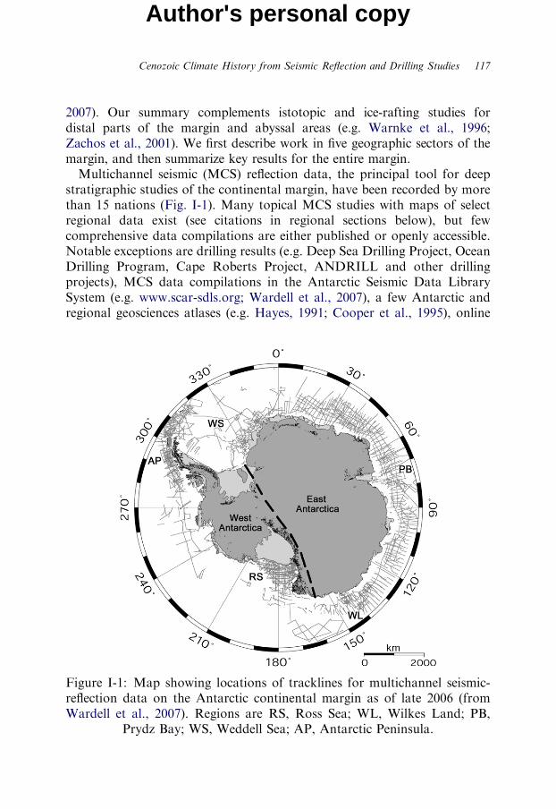
2007). Our summary complements istotopic and ice-rafting studies fordistal parts of the margin and abyssal areas (e.g. Warnke et al., 1996;Zachos et al., 2001). We first describe work in five geographic sectors of themargin, and then summarize key results for the entire margin.Multichannel seismic (MCS) reflection data, the principal tool for deep
stratigraphic studies of the continental margin, have been recorded by morethan 15 nations (Fig. I-1). Many topical MCS studies with maps of selectregional data exist (see citations in regional sections below), but fewcomprehensive data compilations are either published or openly accessible.Notable exceptions are drilling results (e.g. Deep Sea Drilling Project, OceanDrilling Program, Cape Roberts Project, ANDRILL and other drillingprojects), MCS data compilations in the Antarctic Seismic Data LibrarySystem (e.g. www.scar-sdls.org; Wardell et al., 2007), a few Antarctic andregional geosciences atlases (e.g. Hayes, 1991; Cooper et al., 1995), online
Figure I-1: Map showing locations of tracklines for multichannel seismic-reflection data on the Antarctic continental margin as of late 2006 (fromWardell et al., 2007). Regions are RS, Ross Sea; WL, Wilkes Land; PB,
Prydz Bay; WS, Weddell Sea; AP, Antarctic Peninsula.
118 A. K. Cooper et al.
Author's personal copy
data centres (e.g. World Data Center) and select discussions of Antarcticmargin databases (e.g. Anderson, 1999).In general, Antarctica had a relatively warm climate and normal-water-
depth continental shelf (i.e. like low-latitude continental shelves today) inearliest Cenozoic and Late Cretaceous times – conditions that differ from thepolar climate of the latest Cenozoic, with its thick ice sheet and anabnormally deep-water-depth and landward sloping shelf (e.g. Cooper et al.,1991b; Anderson, 1999). Ice has played an important role in continentalmargin evolution by eroding onshore areas (formerly with vegetation) anddischarging the debris into the sea, where ocean currents distribute it to thecontinental shelf, slope and rise. At times the ice has strongly eroded partsof the shelf. Tectonic processes, principally variable thermal and flexuralsubsidence and uplift, have also modified the margin morphology and hencestratigraphy (e.g. ten Brink et al., 1995).Offshore Antarctic stratigraphic studies have thus focused on mapping
geomorphology and seismic facies of characteristic features (e.g. shelf-edgefans/deltas, mound deposits, unconformities, etc.), and using the limited coreand downhole data to decipher their depositional paleoenvironments andrelation to nearby ice, if any. Such features help to infer and establish whereand when non-glacial and glacial processes acted (e.g. Cooper et al., 1991b).Drilling is the only way to ‘ground truth’ the regional seismic surveys (i.e. viaa direct tie of lithologic facies to seismic facies), and to provide the ageand biostratigraphic control needed to decipher depositional and climaticpaleoenvironments (e.g. Barker and Camerlenghi, 2002; Cooper andO’Brien, 2004). The following regional subchapters have been written bythe regional experts listed. Their bibliographic citations are augmented in a‘selected reference’ section that provides additional background on the priorstudies done by the Antarctic geoscience community.
5.2. Ross Sea (G. Brancolini and G. Leitchenkov)
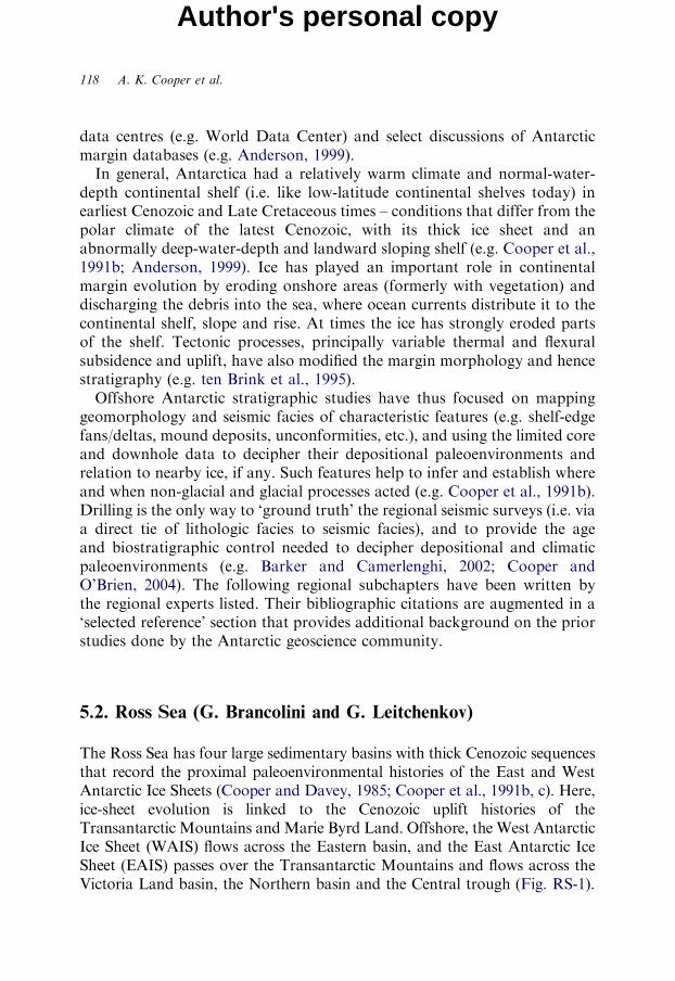
The Ross Sea has four large sedimentary basins with thick Cenozoic sequencesthat record the proximal paleoenvironmental histories of the East and WestAntarctic Ice Sheets (Cooper and Davey, 1985; Cooper et al., 1991b, c). Here,ice-sheet evolution is linked to the Cenozoic uplift histories of theTransantarctic Mountains andMarie Byrd Land. Offshore, the West AntarcticIce Sheet (WAIS) flows across the Eastern basin, and the East Antarctic IceSheet (EAIS) passes over the Transantarctic Mountains and flows across theVictoria Land basin, the Northern basin and the Central trough (Fig. RS-1).
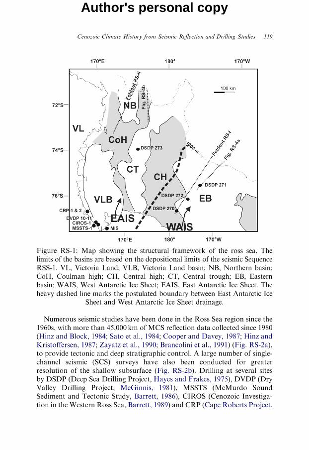
Figure RS-1: Map showing the structural framework of the ross sea. Thelimits of the basins are based on the depositional limits of the seismic SequenceRSS-1. VL, Victoria Land; VLB, Victoria Land basin; NB, Northern basin;CoH, Coulman high; CH, Central high; CT, Central trough; EB, Easternbasin; WAIS, West Antarctic Ice Sheet; EAIS, East Antarctic Ice Sheet. Theheavy dashed line marks the postulated boundary between East Antarctic Ice
Sheet and West Antarctic Ice Sheet drainage.
Cenozoic Climate History from Seismic Reflection and Drilling Studies 119
Author's personal copy
Numerous seismic studies have been done in the Ross Sea region since the1960s, with more than 45,000 km of MCS reflection data collected since 1980(Hinz and Block, 1984; Sato et al., 1984; Cooper and Davey, 1987; Hinz andKristoffersen, 1987; Zayatz et al., 1990; Brancolini et al., 1991) (Fig. RS-2a),to provide tectonic and deep stratigraphic control. A large number of single-channel seismic (SCS) surveys have also been conducted for greaterresolution of the shallow subsurface (Fig. RS-2b). Drilling at several sitesby DSDP (Deep Sea Drilling Project, Hayes and Frakes, 1975), DVDP (DryValley Drilling Project, McGinnis, 1981), MSSTS (McMurdo SoundSediment and Tectonic Study, Barrett, 1986), CIROS (Cenozoic Investiga-tion in the Western Ross Sea, Barrett, 1989) and CRP (Cape Roberts Project,
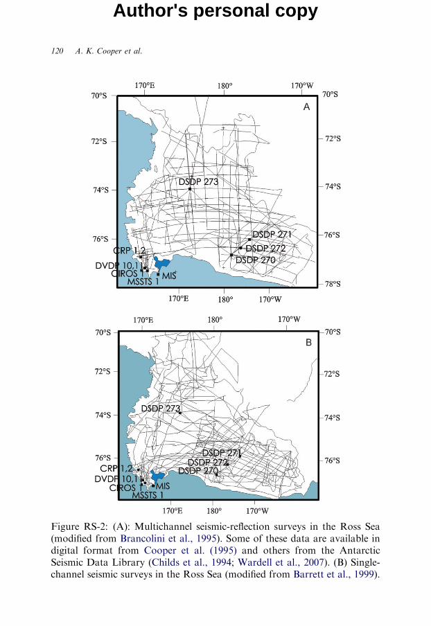
Figure RS-2: (A): Multichannel seismic-reflection surveys in the Ross Sea(modified from Brancolini et al., 1995). Some of these data are available indigital format from Cooper et al. (1995) and others from the AntarcticSeismic Data Library (Childs et al., 1994; Wardell et al., 2007). (B) Single-channel seismic surveys in the Ross Sea (modified from Barrett et al., 1999).
120 A. K. Cooper et al.
Author's personal copy

Figure RS-3: Correlation of Ross Sea area drilling and seismic stratigraphywith global oxygen isotope (Miller et al., 1987) and eustacy (Haq et al., 1987)curves (modified from Brancolini et al., 1995; Cooper et al., 1995). Regionalerosional unconformities in Oligocene and younger sections are interpreted to
be due in part to sub-ice erosion, especially in late Neogene time.
Cenozoic Climate History from Seismic Reflection and Drilling Studies 121
Author's personal copy
Cape Roberts Science Team, 1998, 1999, 2000, 2001) ANDRILL (Antarcticgeological Drilling, Naish et al., 2007; Florindo et al., 2008; Harwood et al.,2008) provides geologic ground truth data (Fig. RS-3). A regional seismicstratigraphy has been derived by the ANTOSTRAT project with seismicsequences and unconformities tied to drilling data (Fig. RS-3; Cooper et al.,1995).Ross Sea seismic data are used by many to infer glacial sedimentary
processes (e.g. Cooper et al., 1991b; Alonso et al., 1992; Anderson and
122 A. K. Cooper et al.
Author's personal copy
Bartek, 1992; Shipp et al., 1994; Brancolini et al., 1995; Cochrane et al., 1995;De Santis et al., 1995; Bartek et al., 1996; De Santis et al., 1999; Bart et al.,2000; Bart, 2003; Chow and Bart, 2003; Accaino et al., 2005). Characteristicfeatures and inferred processes in Oligocene and younger strata include:
1. Landward-deepening seafloor of the continental shelf with broad (up to100 km wide) cross-shelf troughs and banks formed by ice-stream erosionand deposition, respectively.2. Numerous regional seismic unconformities believed to result from erosionof the continental shelf by grounded ice sheets.3. Steep prograding sedimentary sequences (i.e. foreseest dips more than 51 anderoded topset strata) interpreted as ice-proximal till deltas from grounded ice.4. Wedge-shape, non-reflective units interpreted as ‘till tongues’ deposited bygrounded ice.5. Shallow sediment with high velocities, considered due to overcompactionby grounded ice.
The seismic stratigraphy and drilling help establish ice-sheet evolution inthe Ross Sea region, and are discussed below for four key intervals.
5.2.1. Pre-Ice-Sheet (Pre-Late-Oligocene Time)
This period includes seismic sequence RSS-1 between the acoustic basementand unconformity RSU-6 (Fig. RS-3, Foldouts RS-1 and RS-2) and, in theVictoria Land basin, acoustic units V4 and V5 (Cooper et al., 1987).Acoustic basement rocks have been sampled at two sites, and are
Palaeozoic Beacon Formation rocks at the CRP-3 site adjacent to the coast(Cape Roberts Science Team, 2000) and are inferred palaeozoic andCretaceous igneous and metamorphic rocks at DSDP Site 270 in the centreof the Ross Sea (Hayes and Frakes, 1975). The basins are believed to holdsedimentary rocks of Cretaceous and younger age (Hinz and Block, 1984;Cooper et al., 1991c), but Sedimentary rocks older than late Eocene have notbeen cored by drilling. Upper Eocene sediments have been cored in theCIROS-1 drillhole in McMurdo Sound (Coccioni and Galeotti, 1997;Fielding et al., 1997; Hannah et al., 1997; Monechi and Reale, 1997). Thepresence of ubiquitous lonestones (Barrett, 1989) testifies that glaciers(but not necessarily continent-size ice sheets) were calving at sea-level then.Eocene erratic rocks are found in coastal areas (Levy et al., 1995), and
have flora indicating cool, but not glacial, climates in the McMurdo area(Stillwell and Feldmann, 2000). Offshore basin analysis, mainly from MCS
Cenozoic Climate History from Seismic Reflection and Drilling Studies 123
Author's personal copy
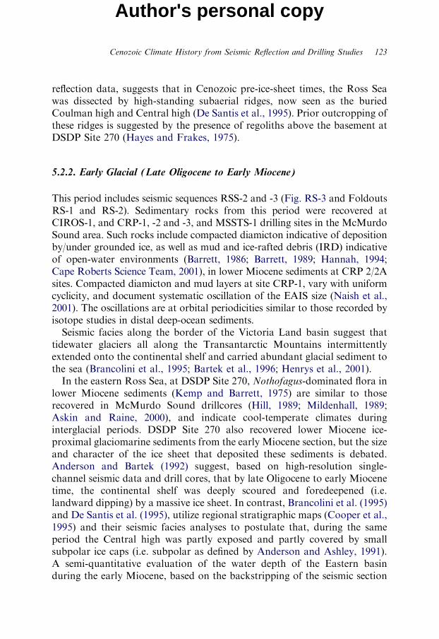
reflection data, suggests that in Cenozoic pre-ice-sheet times, the Ross Seawas dissected by high-standing subaerial ridges, now seen as the buriedCoulman high and Central high (De Santis et al., 1995). Prior outcropping ofthese ridges is suggested by the presence of regoliths above the basement atDSDP Site 270 (Hayes and Frakes, 1975).
5.2.2. Early Glacial (Late Oligocene to Early Miocene)
This period includes seismic sequences RSS-2 and -3 (Fig. RS-3 and FoldoutsRS-1 and RS-2). Sedimentary rocks from this period were recovered atCIROS-1, and CRP-1, -2 and -3, and MSSTS-1 drilling sites in the McMurdoSound area. Such rocks include compacted diamicton indicative of depositionby/under grounded ice, as well as mud and ice-rafted debris (IRD) indicativeof open-water environments (Barrett, 1986; Barrett, 1989; Hannah, 1994;Cape Roberts Science Team, 2001), in lower Miocene sediments at CRP 2/2Asites. Compacted diamicton and mud layers at site CRP-1, vary with uniformcyclicity, and document systematic oscillation of the EAIS size (Naish et al.,2001). The oscillations are at orbital periodicities similar to those recorded byisotope studies in distal deep-ocean sediments.Seismic facies along the border of the Victoria Land basin suggest that
tidewater glaciers all along the Transantarctic Mountains intermittentlyextended onto the continental shelf and carried abundant glacial sediment tothe sea (Brancolini et al., 1995; Bartek et al., 1996; Henrys et al., 2001).In the eastern Ross Sea, at DSDP Site 270, Nothofagus-dominated flora in
lower Miocene sediments (Kemp and Barrett, 1975) are similar to thoserecovered in McMurdo Sound drillcores (Hill, 1989; Mildenhall, 1989;Askin and Raine, 2000), and indicate cool-temperate climates duringinterglacial periods. DSDP Site 270 also recovered lower Miocene ice-proximal glaciomarine sediments from the early Miocene section, but the sizeand character of the ice sheet that deposited these sediments is debated.Anderson and Bartek (1992) suggest, based on high-resolution single-channel seismic data and drill cores, that by late Oligocene to early Miocenetime, the continental shelf was deeply scoured and foredeepened (i.e.landward dipping) by a massive ice sheet. In contrast, Brancolini et al. (1995)and De Santis et al. (1995), utilize regional stratigraphic maps (Cooper et al.,1995) and their seismic facies analyses to postulate that, during the sameperiod the Central high was partly exposed and partly covered by smallsubpolar ice caps (i.e. subpolar as defined by Anderson and Ashley, 1991).A semi-quantitative evaluation of the water depth of the Eastern basinduring the early Miocene, based on the backstripping of the seismic section
124 A. K. Cooper et al.
Author's personal copy
in Foldout RS-1, indicates that the foredeepeened profile of the Easternbasin was only attained after middle Miocene time (De Santis et al., 1999).The end of this early glacial period is marked by a change in reflection
geometries beneath the outer continental shelf (Foldouts RS-1 and RS-2)from principally aggrading (RSS-2 and -3) to principally prograding,(RSS-4). Cooper et al. (1991b) postulate that this change marks the startof grounded-glacier advances to the shelf edge and erosion of a normal-water-depth shelf by episodic grounded ice.
5.2.3. The Ice-Sheet Development (Mid-Early Miocene to Early Pliocene)
This period includes seismic sequences RSS-4, -5 and -6 (Fig. RS-3 andFoldouts RS-1 and RS-2). Sediment from these sequences was recoveredat DSDP Sites 271, 272 and 273, MSSTS-1 and DVDP 10/11.The early-middle Miocene is postulated to have been a time of major ice
buildup of ice in the Ross Sea region, and the carving of the first deeptroughs, similar in size to the present ice streams, across the continental shelf(Anderson and Bartek, 1992). Bart (2003) and Chow and Bart (2003)recognize at least two major WAIS expansions during the early part of themiddle Miocene and five in the entire Miocene. These expansions suggestthat either portions of the West Antarctic land elevation were above sea-leveland/or the air and water temperatures were sufficiently cold to support amarine-based ice sheet.Drill cores from the middle Miocene have been recovered at DSDP Sites 272
and 273 (Hayes and Frakes, 1975; Savage and Ciesielsky, 1983; Leckie andWebb, 1986), and consist of diatom-bearing sediments interpreted as waterlaintills and proximal- to distal-glacimarine deposits (Hambrey and Barrett, 1993).Upper Miocene rocks are missing from all continental shelf drill cores,
except in the McMurdo Sound region (MSSTS-1, DVDP-10 and -11 drillsites), where glaciomarine diamictites (tillites) and terrestrial strata arefound. These deposits are interpreted as having originated from glaciersflowing out of the Transantarctic Mountains (Powell, 1981; Barrett, 1986;Ishman and Webb, 1988; McKelvey, 1991).The recent ANDRILL drilling on the Ross Ice shelf, near McMurdo
Sound (MIS project; Naish et al., 2007), recovered a 1,284m long core thatrecords Antarctica’s history over the last 14 million years. The core indicatesperiods of ice-sheet growth, advancing over the drill site and then retreatingagain to allow the open-marine conditions to return. More than 60 of theseadvance-retreat cycles are present in the core.On the outer continental shelf and upper slope, well-stratified seismic
sequences inferred to be of late Miocene age (i.e. RSS-6) are present in the
Cenozoic Climate History from Seismic Reflection and Drilling Studies 125
Author's personal copy
Northern and Eastern basins, but the sequences are thin or absent onthe inner shelf (Cooper et al., 1995). In both basins, these sequences arecharacterized by steeply prograding clinoforms with relatively thin or erodedtopset beds and a major seaward shift of the palaeo-shelf edge (FoldoutsRS-1 and RS-2). The sequences are thought to have been deposited byintermittent grounded ice sheets carrying sediment to the continental shelfedge (Bartek et al., 1991; Cooper et al., 1991b; Anderson and Bartek, 1992).
5.2.4. The Polar Ice Sheet (Early Pliocene Through Quaternary)
This period includes seismic sequences RSS-7 and -8 (Fig. RS-3) andseismic units 1–7 of Alonso et al. (1992) and Anderson and Bartek (1992)(Fig. RS-4a and b). Pliocene sediment has been recovered at drill sites in theTaylor Valley (DVDP-10 and -11) and on the continental shelf at DSDPSites 271 and 273. DVDP drill cores contain sediments deposited by theTaylor Glacier, while the sparsely sampled Pliocene deposit at DSDP 271and 273 contains diatomaceous glaciomarine strata (Hayes and Frakes,1975). These rocks imply that warmer interglacial conditions than todayexisted at that time (Anderson and Ashley, 1991).Seismic sequences of inferred Pliocene through Quaternary age occur in the
EAIS drainage in the Northern basin, where they are up to 800m thick in thetill delta fan system (Cooper et al., 1995). In the Eastern basin, Pliocenethrough Quaternary age strata lie within the WAIS drainage and are more than1,000m thick (Cooper et al., 1995). Detailed seismic stratigraphic analysesfrom the Eastern basin margin (Fig. RS-4a; Alonso et al., 1992; Fig. RS-4b;Anderson and Bartek, 1992), recognize a major change in the seismic characterof the Pliocene deposits. Up-section, the seismic unit thicknesses decrease, thegeometry of the sequences changes from principally progradational toaggradational, and numerous widespread glacial erosion surfaces are seen.These features indicate more frequent grounding events on the continental shelfand increased subglacial till deposition relative to basal transport of sedimentsto the grounding line. Bart et al. (2000) and Anderson et al. (1992) suggest thaton at least eight occasions during Pliocene to Quaternary times, the East andWest Antarctic Ice Sheets were much larger than today. The frequent andextensive grounding events on the outer continental shelf contradict the widelyheld view that the land-based EAIS was relatively stable and the largelymarine-based WAIS was relatively dynamic (Bart and Anderson, 2000).The last glacial maximum (LGM) in the Ross Sea has been studied
using seafloor cores, subbottom and swath bathymetry data (Thomas andBentley, 1978; Kellogg et al., 1979; Denton et al., 1989; Leventer et al., 1993;Brambati et al., 1994; Hilfinger et al., 1995; Kellogg et al., 1996; Licht et al.,
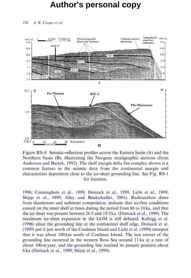
Figure RS-4: Seismic-reflection profiles across the Eastern basin (A) and theNorthern basin (B), illustrating the Neogene stratigraphic sections (fromAnderson and Bartek, 1992). The shelf margin delta fan complex shown is acommon feature in the seismic data from the continental margin andcharacterizes deposition close to the ice-sheet grounding line. See Fig. RS-1
for location.
126 A. K. Cooper et al.
Author's personal copy
1996; Cunningham et al., 1999; Domack et al., 1999; Licht et al., 1999;Shipp et al., 1999; Alley and Bindschadler, 2001). Radiocarbon datesfrom diamictons and sediment composition, indicate that ice-free conditionsexisted on the inner shelf at times during the period from 60 to 10ka, and thatthe ice sheet was present between 26.5 and 19.5 ka. (Domack et al., 1999). Themaximum ice-sheet expansion in the LGM is still debated: Kellogg et al.(1996) place the grounding line at the continental shelf edge, Domack et al.(1999) put it just north of the Coulman Island and Licht et al. (1999) interpretthat it was about 100 km south of Coulman Island. The last retreat of thegrounding line occurred in the western Ross Sea around 11ka at a rate ofabout 100m/year, and the grounding line reached its present position about6 ka (Domack et al., 1999; Shipp et al., 1999).
Cenozoic Climate History from Seismic Reflection and Drilling Studies 127
Author's personal copy
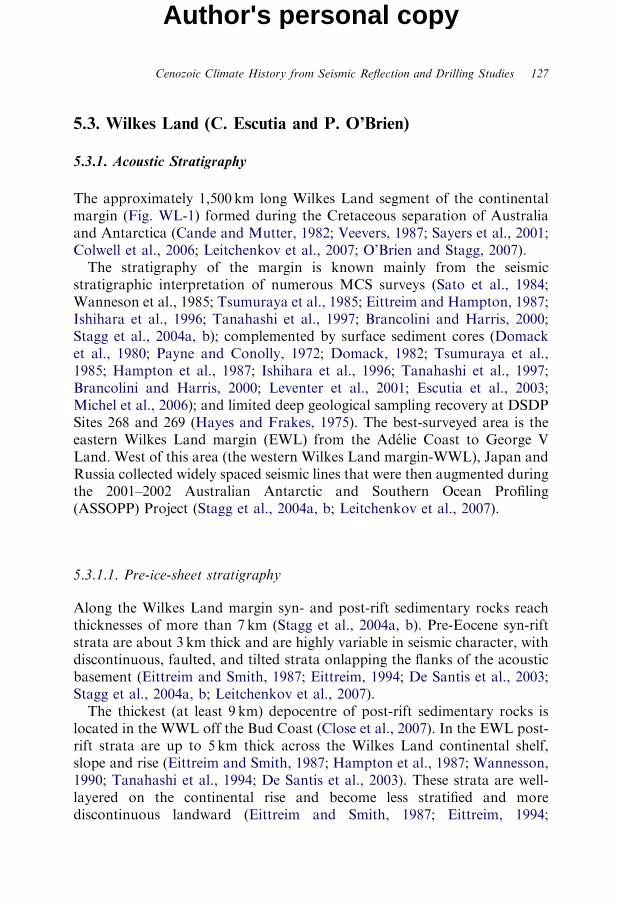
5.3. Wilkes Land (C. Escutia and P. O’Brien)
5.3.1. Acoustic Stratigraphy
The approximately 1,500 km long Wilkes Land segment of the continentalmargin (Fig. WL-1) formed during the Cretaceous separation of Australiaand Antarctica (Cande and Mutter, 1982; Veevers, 1987; Sayers et al., 2001;Colwell et al., 2006; Leitchenkov et al., 2007; O’Brien and Stagg, 2007).The stratigraphy of the margin is known mainly from the seismic
stratigraphic interpretation of numerous MCS surveys (Sato et al., 1984;Wanneson et al., 1985; Tsumuraya et al., 1985; Eittreim and Hampton, 1987;Ishihara et al., 1996; Tanahashi et al., 1997; Brancolini and Harris, 2000;Stagg et al., 2004a, b); complemented by surface sediment cores (Domacket al., 1980; Payne and Conolly, 1972; Domack, 1982; Tsumuraya et al.,1985; Hampton et al., 1987; Ishihara et al., 1996; Tanahashi et al., 1997;Brancolini and Harris, 2000; Leventer et al., 2001; Escutia et al., 2003;Michel et al., 2006); and limited deep geological sampling recovery at DSDPSites 268 and 269 (Hayes and Frakes, 1975). The best-surveyed area is theeastern Wilkes Land margin (EWL) from the Adelie Coast to George VLand. West of this area (the western Wilkes Land margin-WWL), Japan andRussia collected widely spaced seismic lines that were then augmented duringthe 2001–2002 Australian Antarctic and Southern Ocean Profiling(ASSOPP) Project (Stagg et al., 2004a, b; Leitchenkov et al., 2007).
5.3.1.1. Pre-ice-sheet stratigraphy
Along the Wilkes Land margin syn- and post-rift sedimentary rocks reachthicknesses of more than 7 km (Stagg et al., 2004a, b). Pre-Eocene syn-riftstrata are about 3 km thick and are highly variable in seismic character, withdiscontinuous, faulted, and tilted strata onlapping the flanks of the acousticbasement (Eittreim and Smith, 1987; Eittreim, 1994; De Santis et al., 2003;Stagg et al., 2004a, b; Leitchenkov et al., 2007).The thickest (at least 9 km) depocentre of post-rift sedimentary rocks is
located in the WWL off the Bud Coast (Close et al., 2007). In the EWL post-rift strata are up to 5 km thick across the Wilkes Land continental shelf,slope and rise (Eittreim and Smith, 1987; Hampton et al., 1987; Wannesson,1990; Tanahashi et al., 1994; De Santis et al., 2003). These strata are well-layered on the continental rise and become less stratified and morediscontinuous landward (Eittreim and Smith, 1987; Eittreim, 1994;
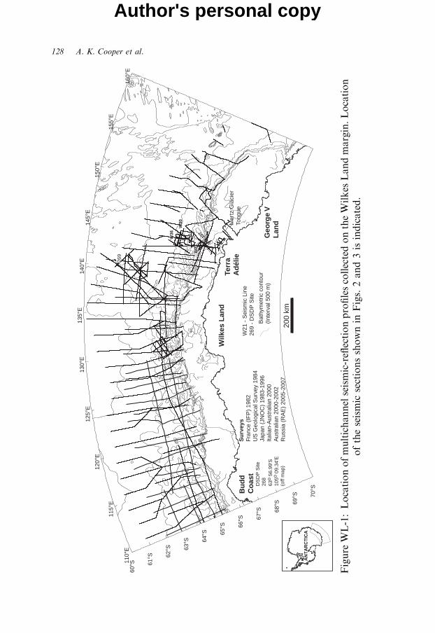
115°
E
120°
E
125°
E 13
0°E
135°
E 14
0°E
145°
E
150°
E
155°
E
69°S
68°S
67°S
66°S
65°S
64°S
63°S
62°S
61°S
70°S
60°S 11
0°E
160°
E
269
200
km
W36
W30
W21
IFP-1
07
Wilk
es L
and
Geo
rge
VL
and
Bu
dd
Co
ast
Terr
aA
dél
ieS
urv
eys
Fran
ce (
IFP
) 19
82U
S G
eolo
gica
l Sur
vey
1984
Japa
n (J
NO
C)
1983
-199
6Ita
lian-
Aus
tral
ian
2000
Aus
tral
ian
2000
-200
2R
ussi
a (R
AE
) 20
05-2
007
W21
- S
eism
ic L
ine
269
- D
SD
P S
ite
Bat
hym
etric
con
tour
(Int
erva
l 500
m)
Mer
tz G
laci
erTo
ngue
DS
DP
Site
268
63o 5
6.99
'S10
5o 0
9.34
'E(o
ff m
ap)
Figure
WL-1:Locationofmultichannelseismic-reflectionprofilescollectedontheWilkes
Landmargin.Location
oftheseismic
sectionsshownin
Figs.2and3isindicated.
128 A. K. Cooper et al.
Author's personal copy
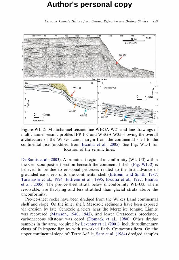
Figure WL-2: Multichannel seismic line WEGA W21 and line drawings ofmultichannel seismic profiles IFP 107 and WEGA W35 showing the overallarchitecture of the Wilkes Land margin from the continental shelf to thecontinental rise (modified from Escutia et al., 2005). See Fig. WL-1 for
location of the seismic lines.
Cenozoic Climate History from Seismic Reflection and Drilling Studies 129
Author's personal copy
De Santis et al., 2003). A prominent regional unconformity (WL-U3) withinthe Cenozoic post-rift section beneath the continental shelf (Fig. WL-2) isbelieved to be due to erosional processes related to the first advance ofgrounded ice sheets onto the continental shelf (Eittreim and Smith, 1987;Tanahashi et al., 1994; Eittreim et al., 1995; Escutia et al., 1997; Escutiaet al., 2005). The pre-ice-sheet strata below unconformity WL-U3, whereresolvable, are flat-lying and less stratified than glacial strata above theunconformity.Pre-ice-sheet rocks have been dredged from the Wilkes Land continental
shelf and slope. On the inner shelf, Mesozoic sediments have been exposedvia erosion by late Cenozoic glaciers near the Mertz ice tongue. Lignitewas recovered (Mawson, 1940, 1942), and lower Cretaceous brecciated,carbonaceous siltstone was cored (Domack et al., 1980). Other dredgesamples in the area, acquired by Leventer et al. (2001), include sedimentaryclasts of Paleogene lignites with reworked Early Cretaceous flora. On theupper continental slope off Terre Adelie, Sato et al. (1984) dredged samples
130 A. K. Cooper et al.
Author's personal copy
of locally derived Oligocene and Miocene limestone and undated sedimen-tary, metamorphic and igneous rocks of mostly ice-rafted origin.
5.3.1.2. Continental shelf glacial stratigraphy
Glacial sequences on the shelf thicken seaward in prograding wedges(Fig. WL-2). The sequences are deeply eroded by broad troughs that crossthe shelf. The troughs are interpreted as the erosional paths of ice streamsduring times of glacial maxima (Eittreim et al., 1995). Foreset strata arecommonly truncated at or near the seafloor beneath the troughs (Fig. WL-2).Topset strata form the banks adjacent to the troughs. Ice is inferred to havemoved slowly over bank areas and rapidly in the troughs. Geometry of stratain buried troughs on the shelf suggests to some (Eittreim et al., 1995; Escutiaet al., 2000) that the locations of ice streams and their erosional troughs andbanks have shifted during consecutive glacial advances.Regional glacial seismic sequences and unconformities defined by different
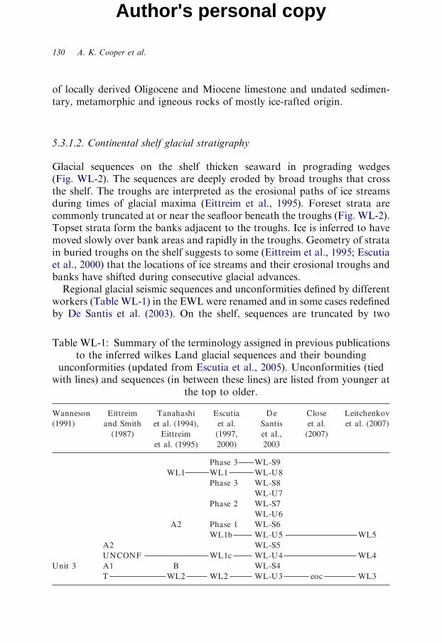
workers (Table WL-1) in the EWL were renamed and in some cases redefinedby De Santis et al. (2003). On the shelf, sequences are truncated by two
Table WL-1: Summary of the terminology assigned in previous publicationsto the inferred wilkes Land glacial sequences and their bounding
unconformities (updated from Escutia et al., 2005). Unconformities (tiedwith lines) and sequences (in between these lines) are listed from younger at
the top to older.
Cenozoic Climate History from Seismic Reflection and Drilling Studies 131
Author's personal copy
regional unconformities, WL-U3 and WL-U8 (Wannesson et al., 1985;Eittreim and Smith, 1987; Hampton et al., 1987; De Santis et al., 2003), andthe erosion is thought to result from grounded ice sheets moving across thecontinental shelf (Tanahashi et al., 1994; Eittreim et al., 1995; Escutia et al.,1997; Escutia et al., 2005). Eittreim et al. (1995) calculated erosion of 300 to600m of strata below WL-U3. Sequences below WL-U8 are dominantlyaggradational and sequences above are principally progradational. Forunconformity WL-U8, Eittreim et al. (1995) estimated erosional truncationof 350 to 700m of sediment. Unconformity WL-U8 marks changes in thegeometry of the outer shelf progradating wedges, from shallower dips belowWL-U8 to steeper dips above (foreset slopes up to about 101).During the open-marine Holocene, thick laminated diatom mud and oozes
were deposited in deep (W1,000m) inner shelf basins, such as for example theAdelie Drift (Costa et al., 2007). Based on AMS radiocarbon dates, this drifthas accumulation rates on the order of 20–21m/k.y. Opal, Ti and Ba time-series show decadal to century variance suggestive of solar forcing and ElNino Southern Oscillation (ENSO) forcing (Costa et al., 2007).
5.3.1.3. Continental slope glacial stratigraphy
Although partly obscured by seafloor multiples, the stratigraphy of thecontinental slope consists of seaward-dipping reflectors (Eittreim and Smith,1987; Hampton et al., 1987; Eittreim et al., 1995). Prograding strata abovethe WL-U8 unconformity downlap and pinch out at the base of thecontinental slope, but deeper units (i.e. between WL-U8 and WL-U3)continue across the margin (Hampton et al., 1987; Eittreim et al., 1995;Escutia et al., 1997; De Santis et al., 2003) (Fig. WL-2).Sediments forming prograding foresets were delivered directly to the outer
shelf and upper slope as deforming tills at the base of ice streams at times ofglacial maxima (Eittreim et al., 1995). Ice-stream delivery of a large volumeof unconsolidated sediment to the steep slope resulted in sediment failuresthat led to the development of large chaotic deposits at the base of thepaleoslope foresets (Eittreim et al., 1995; Escutia et al., 2000; De Santis et al.,2003; Escutia et al., 2007). More-recent slope strata are dissected byerosional submarine gullies (Eittreim et al., 1995) and slope canyons (Escutiaet al., 2000).Sea-floor sediment cores from the continental slope contain debris-flow
units and numerous hiatuses. The oldest sediment has been dated as lateMiocene in age, indicating that gravity flows have been a dominant slopeprocess since at least this time (Escutia et al., 2003).
132 A. K. Cooper et al.
Author's personal copy
5.3.1.4. Continental rise glacial stratigraphy
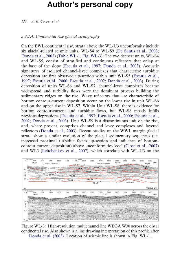
On the EWL continental rise, strata above the WL-U3 unconformity includesix glacial-related seismic units, WL-S4 to WL-S9 (De Santis et al., 2003;Donda et al., 2003) (Table WL-1, Fig. WL-3). The two deepest units, WL-S4and WL-S5, consist of stratified and continuous reflectors that onlap atthe base of the slope (Escutia et al., 1997; Donda et al., 2003). Acousticsignatures of isolated channel-levee complexes that characterize turbiditedeposition are first observed up-section within unit WL-S5 (Escutia et al.,1997; Escutia et al., 2000; Escutia et al., 2002; Donda et al., 2003). Duringdeposition of units WL-S6 and WL-S7, channel-levee complexes becamewidespread and turbidity flows were the dominant process building thesedimentary ridges on the rise. Wavy reflectors that are characteristic ofbottom contour-current deposition occur on the lower rise in unit WL-S6and on the upper rise in WL-S7. Within Unit WL-S8, there is evidence forbottom contour-current and turbidite flows, but WL-S8 mostly infillsprevious depressions (Escutia et al., 1997; Escutia et al., 2000; Escutia et al.,2002; Donda et al., 2003). Unit WL-S9 is a discontinuous unit on the rise,and, where present, comprises channel and levee complexes and layeredreflectors (Donda et al., 2003). Recent studies on the WWL margin glacialstrata show a similar evolution of the glacial sedimentary sequences (i.e.increased proximal turbidite facies up-section and influence of bottom-contour-current deposition) above unconformities ‘eoc’ (Close et al., 2007)and WL3 (Leitchenkov et al., 2007), which correlate with WL-U3 on the
5.0
6.0
7.0
PROFILE W30
WEST1600 1800 2200 2600 2800 3000 3200 34002000 2400600 1000 1200 1400800
EAST
5.0
6.0
7.0
WEST1600 1800 2200 2600 2800 3000 3200 34002000 2400600 10004.0
4.0
800EAST
10 km
W35
JUSSIEU CHANNEL WEGA CHANNEL
BasementWL-S4
WL-S5
WL-S6
WL-S7WL-S8
WL-U4
WL-U3
WL-U5
TW
T(s
)T
WT
(s)
WL-U6WL-U71200 1400
Figure WL-3: High-resolution multichannel line WEGAW30 across the distalcontinental rise. Also shown is a line drawing interpretation of this profile after
Donda et al. (2003). Location of seismic line is shown in Fig. WL-1.
Cenozoic Climate History from Seismic Reflection and Drilling Studies 133
Author's personal copy
EWL. Between 1101 and 1301 large debris-flow deposits are also reportedforming throughout the Miocene (Donda et al., 2007a, b).
5.3.2. Drilling on the Wilkes Land Margin
DSDP Leg 28 drilled Sites 268 and 269 on the continental rise and abyssalplain, respectively, to determine the geologic and climate history ofAntarctica and the Southern Ocean (Hayes and Frakes, 1975). The drillcores document that extensive Antarctic glaciation began at least byOligocene to early Miocene time, and that water temperatures were cool-temperate in the late Oligocene and early Miocene and cooled during theNeogene, presumably as glaciation intensified.DSDP Site 268 was drilled to a subbottom depth of 474.5m in 3,544m
water depth with total core recovery of 14% (Hayes and Frakes, 1975).Three units were described, based on lithologies and amounts of diatoms,nannofossil ooze and ice-rafted pebbles and granules (Hayes and Frakes,1975). Piper and Brisco (1975) interpreted the two deeper units to becontourites, based on the character of silt laminae. The shallowest of thethree units, dated as Pliocene and Quaternary, was interpreted as turbidites,based on a high content of silty clay with common silt laminae and fine-sandbeds 2–20 cm thick. Hayes and Frakes (1975) infer that the deepest lowerMiocene and Oligocene unit was deposited when the ice sheet first advancedonto the shelf. Water at that time was warm enough to support calcareousbiogenic sedimentation, but ice-rafting and contourites provide evidence fornearby ice on East Antarctica and for bottom currents, possibly generated bycold bottom water production associated with a limited ice shelf or tongue(Hayes and Frakes, 1975).DSDP Site 269 was drilled to a subbottom depth of 958m in a water depth
of 4,285m and with 42% recovery of Eocene to recent rocks (Hayes andFrakes, 1975). The section consists predominantly of silts and clays withvariable amounts of microfossils. Diatom oozes and diatom mud dominatethe upper half of the section, which is dated as Quaternary to Late Miocenein age (Hayes and Frakes, 1975). In the lower half, which is late Miocene toearly Miocene and Oligocene in age, diatoms are absent but calcareousnannofossils are found in trace amounts. Similar to DSDP Site 268, there is atransition in facies at DSDP Site 269 from more distal facies in the lower partof the core to more proximal facies near the surface. Piper and Brisco (1975)interpret this facies change as resulting from substantial increased supplyof sand and coarse silt and clay from the Antarctic continent, possibly inresponse to prograding of the continental margin.
134 A. K. Cooper et al.
Author's personal copy
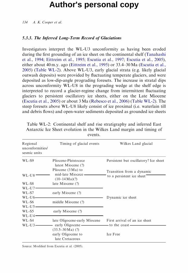
5.3.3. The Inferred Long-Term Record of Glaciations
Investigators interpret the WL-U3 unconformity as having been erodedduring the first grounding of an ice sheet on the continental shelf (Tanahashiet al., 1994; Eittreim et al., 1995; Escutia et al., 1997; Escutia et al., 2005),either about 40m.y. ago (Eittreim et al., 1995) or 33.4–30Ma (Escutia et al.,2005) (Table WL-2). Above WL-U3, early glacial strata (e.g. likely glacialoutwash deposits) were provided by fluctuating temperate glaciers, and weredeposited as low-dip-angle prograding foresets. The increase in stratal dipsacross unconformity WL-U8 in the prograding wedge at the shelf edge isinterpreted to record a glacier-regime change from intermittent fluctuatingglaciers to persistent oscillatory ice sheets, either on the Late Miocene(Escutia et al., 2005) or about 3Ma (Rebesco et al., 2006) (Table WL-2). Thesteep foresets above WL-U8 likely consist of ice proximal (i.e. waterlain tilland debris flows) and open-water sediments deposited as grounded ice sheets
Table WL-2: Continental shelf and rise stratigraphy and inferred EastAntarctic Ice Sheet evolution in the Wilkes Land margin and timing of
events.
Cenozoic Climate History from Seismic Reflection and Drilling Studies 135
Author's personal copy
extended intermittently onto the outer shelf – similar to sediments recoveredfrom ODP Site 1167 on the Prydz Trough fan (O’Brien et al., 2001).On the continental rise, the up-section increase in the energy of the
depositional environment in units WL-S5 to WL-S7 (i.e. seismic faciesindicative of proximal turbidites and of bottom-contour-current deposition)likely resulted from enhanced shelf progradation. Maximum rates ofsediment delivery to the rise appear to have occurred during the developmentof units WL-S6 and WL-S7, which is inferred to have been during theMiocene (Hayes and Frakes, 1975; De Santis et al., 2003; Escutia et al.,2005). During deposition of WL-S8 and WL-S9, sediment supply to thelower continental rise decreased and depocentres shifted landward to thebase of the slope and outer shelf (Escutia et al., 2002; De Santis et al., 2003;Donda et al., 2003; Escutia et al., 2005; Rebesco et al., 2006). Inferred age forUnits WL-S8 and WL-S9 is Pliocene to Recent (De Santis et al., 2003).Sequence WL-S9 was deposited under a polar regime with a persistentice sheet during the Pliocene–Pleistocene. At that time, most sedimentdelivered to the margin was trapped on the outer shelf and slope, formingsteep prograding wedges, with some sediment bypassing the slope inchannelized turbidity currents (Escutia et al., 2002; De Santis et al., 2003;Escutia et al., 2005).During the Holocene open-water interglacial thick sections of diatom mud
and oozes are deposited in deep inner shelf basins (Costa et al., 2007). Thesesediments hold an ultra-high-resolution record of climate variability likely bysolar and ENSO forcing.
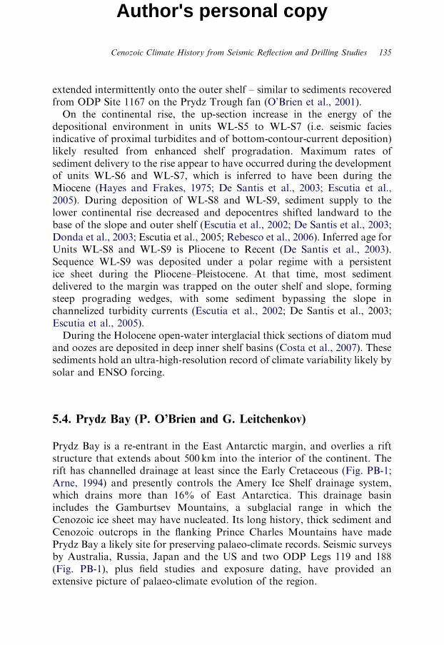
5.4. Prydz Bay (P. O’Brien and G. Leitchenkov)
Prydz Bay is a re-entrant in the East Antarctic margin, and overlies a riftstructure that extends about 500 km into the interior of the continent. Therift has channelled drainage at least since the Early Cretaceous (Fig. PB-1;Arne, 1994) and presently controls the Amery Ice Shelf drainage system,which drains more than 16% of East Antarctica. This drainage basinincludes the Gamburtsev Mountains, a subglacial range in which theCenozoic ice sheet may have nucleated. Its long history, thick sediment andCenozoic outcrops in the flanking Prince Charles Mountains have madePrydz Bay a likely site for preserving palaeo-climate records. Seismic surveysby Australia, Russia, Japan and the US and two ODP Legs 119 and 188(Fig. PB-1), plus field studies and exposure dating, have provided anextensive picture of palaeo-climate evolution of the region.
070° E 075° E
070° E 075° E
68° S
66° S
68° S
66° S
066° E 079° E70° S
64° S066° E 079° E
70° S
64° S200
002
2 00
002
004
004
4 00
004
40
0
600
0
0 6
600
006
600
008
8
00
0 08
80
0
12 0
0
01800
20
220 0 240 0
260
0
2600
0082
2800
3000
0 0 03
3000
320 0 0023
0023
0023
0 0 2 3
0 023
0 043
00
43
0043
3 600
3600
739
740
741
742
743
1165
1167
1166
A
A′ B′
BFig.PB-2
Fig.P
B-2
0
100 km
Amery IceShelf
Seismic lineSeismic line(Illustrated)
Bathymetriccontour
ODP Site
Fig. PB-3
Seismic line(single channel)
Figure PB-1: Map of Prydz bay showing seismic lines and ODP drill sites.Seismic lines illustrated in this chapter are in heavy black line. Foldouts are
sections for A-Au and B-Bu.
136 A. K. Cooper et al.
Author's personal copy
Cenozoic Climate History from Seismic Reflection and Drilling Studies 137
Author's personal copy
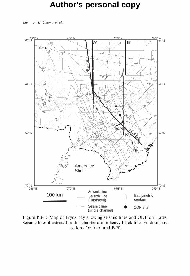
5.4.1. Pre-Ice-Sheet (Pre-Late Eocene)
The Lambert Graben and Prydz Bay basin formed during the Carboniferousor Permian (Arne, 1994; Lisker et al., 2005) and were depocentres in pre-ice-sheet times. Seismic data from the Prydz Bay shelf show pre-ice-sheetsequences of parallel, moderately continuous reflectors (Figs. PB-2 and PB-3).ODP Sites 740, 741 and 1166 penetrated pre-ice-sheet sediments that weredeposited in fluvial to fluvio-deltaic environments. ODP Site 740 intersectedinterbedded sandstone, siltstone and mudstone with reddish coloration(Shipboard Scientific Party, 1989), interpreted as fluvial flood plain deposits(Turner, 1991). The red coloration suggests a seasonal fluctuating rainfallregime but the age of this unit remains unknown (Truswell, 1991). It could beas old as Triassic, based on the presence of Triassic sediments in the northernPrince Charles Mountains (Leitchenkov, 1991; McLoughlin and Drinnan,1997a, b). However Leitchenkov (1991) identified a thick (up to 5 km),faulted and high-velocity (up to 5.2 km/s) unit on multichannel dataunderlying these red beds. This sequence predates the main phase ofbreakup-related crustal extension, leading him to correlate the deep unit withPermian-Triassic sediments of the northern Prince Charles Mountains(Leitchenkov, 1991). If so, then the red beds in ODP Site 740 are likely EarlyCretaceous or Late Jurassic in age.ODP Sites 741 and 1166 intersected Cretaceous sediments beneath the
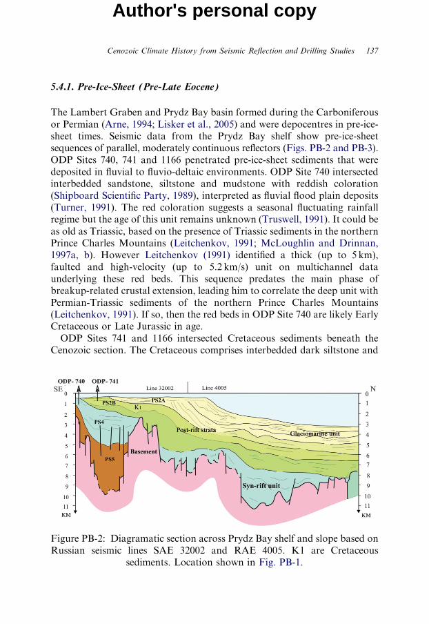
Cenozoic section. The Cretaceous comprises interbedded dark siltstone and
Figure PB-2: Diagramatic section across Prydz Bay shelf and slope based onRussian seismic lines SAE 32002 and RAE 4005. K1 are Cretaceous
sediments. Location shown in Fig. PB-1.
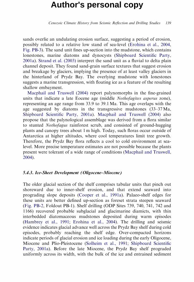
Figure PB-3: Seismic section between ODP sites 742 and 1166. SequencePS2A2 comprises fluvio-deltaic sands of late Eocene age. Sequence PS2A1overlies an erosion surface and comprises late Eocene marine muds withlonestones. Location shown in Fig. PB-1 (modified from Erohina et al., 2004).
138 A. K. Cooper et al.
Author's personal copy
sandstone with minor coal of probable delta plain to lagoonal origin. TheODP Site 1166 section is Turonian-Santonian(?), whereas ODP Site 741recovered an older section of middle Aptian sediment (Fig. PB-3). Macphailand Truswell (2004) describe the palynomorphs from ODP Site 1166, andinterpret the assemblage as indicating a conifer-dominated woodland vegeta-tion, consistent with a cool, humid climate.The continental rise seaward of Prydz Bay contains up to 5 km of post-rift
sediments (Figs. PB-2, Foldouts PB-1 and PB-2; Mizukoshi et al., 1986,Stagg et al., 2004a, b). The lowermost seismic stratigraphic unit has parallel,mostly continuous reflectors typical of deep-ocean deposition that probablyoccurred during pre-ice-sheet times (Mizukoshi et al., 1986; Kuvaas andLeitchenkov, 1992; Kuvaas et al., 2005).
5.4.2. Early Glacial (Late Eocene)
In Prydz Bay, ODP Sites 739, 742 and 1166 recovered sediments depositedimmediately before major glaciation (Barron et al., 1991; Cooper andO’Brien, 2004). The lithologies vary from dark siltstones to poorly sortedsands and bedded mudstone with lonestones. Seismic sections show that the
Cenozoic Climate History from Seismic Reflection and Drilling Studies 139
Author's personal copy
sands overlie an undulating erosion surface, suggesting a period of erosion,possibly related to a relative low stand of sea-level (Erohina et al., 2004,Fig. PB-3). The sand unit fines up-section into the mudstone, which containslonestones, marine diatoms and dynocysts (Shipboard Scientific Party,2001a). Strand et al. (2003) interpret the sand unit as a fluvial to delta plainchannel deposit. They found sand-grain surface textures that suggest erosionand breakage by glaciers, implying the presence of at least valley glaciers inthe hinterland of Prydz Bay. The overlying mudstone with lonestonessuggests a marine transgression, with floating ice as a feature of the resultingshallow embayment.Macphail and Truswell (2004) report palynomorphs in the fine-grained
units that indicate a late Eocene age (middle Nothofagites asperus zone),representing an age range from 33.9 to 39.1Ma. This age overlaps with theage suggested by diatoms in the transgressive mudstones (33–37Ma,Shipboard Scientific Party, 2001a). Macphail and Truswell (2004) alsopropose that the palynological assemblage was derived from a flora similarto stunted Nothofagus rainforest scrub, and consisted of ground-huggingplants and canopy trees about 1m high. Today, such floras occur outside ofAntarctica at higher altitudes, where cool temperatures limit tree growth.Therefore, the Prydz Bay flora reflects a cool to cold environment at sea-level. More precise temperature estimates are not possible because the plantspresent were tolerant of a wide range of conditions (Macphail and Truswell,2004).
5.4.3. Ice-Sheet Development (Oligocene–Miocene)
The older glacial section of the shelf comprises tabular units that pinch outshoreward due to inner-shelf erosion, and that extend seaward intoprograding slope deposits (Cooper et al., 1991a). Palaeo-shelf edges forthese units are better defined up-section as foreset strata steepen seaward(Fig. PB-2, Foldout PB-1). Shelf drilling (ODP Sites 739, 740, 741, 742 and1166) recovered probable subglacial and glacimarine diamicts, with thininterbedded diatomaceous mudstones deposited during warm episodes(Hambrey et al., 1991; Erohina et al., 2004). The drilling and seismicevidence indicates glacial advance well across the Prydz Bay shelf during coldepisodes, probably reaching the shelf edge. Over-compacted horizonsindicate periods of glacial erosion and ice loading during the early Oligocene,Miocene and Plio-Pleistocene (Solheim et al., 1991; Shipboard ScientificParty, 2001a). Before the late Miocene, the Prydz Bay shelf progradeduniformly across its width, with the bulk of the ice and entrained sediment
140 A. K. Cooper et al.
Author's personal copy
coming from the southern end of the bay (i.e. from the Lambert Graben).The Prydz Bay continental slope became progressively steeper from the earlyphase of glaciation in early Oligocene time, to reach angles of as much as 81on the present slope (Foldouts PB-1 and PB-2).On the continental rise, a pre-ice-sheet unit is overlain by one exhibiting
channel-levee geometries. The nature of the change in geometry and thetracing of reflectors to the shelf drilling suggest that this change originatedfrom the glacial expansion and increased sediment supply in the earlyOligocene (Kuvaas and Leitchenkov, 1992). Overlying the channel-leveecomplexes are sequences that include thick mounds and sediment wavessuggestive of contourite deposition, in addition to turbidite channels andassociated levees formed by intensified down-slope and along-slope currentsin the early Miocene (Fig. PB-2, Foldout PB-2).ODP Site 1165 (Leg 188) drilled 999m with 69% recovery into a thick
mound of lower Miocene and younger contourite sediments with turbiditesonly in the upper 5m (Cooper and O’Brien, 2004). The hole penetrated thebase of the mounded sequences, which was still of early Miocene age(Handwerger et al., 2004). The drilling confirmed the seismic interpretationthat deposition of the thick contourite mounds had commenced by at leastearly Miocene time, but sediments above and below the surface were typicalcontourites – fissile claystones with abundant silt laminae (Handwerger et al.,2004). Therefore, there was no obvious lithological change in the hole tosuggest a reason for the change from low relief submarine fans to highlymounded deposits, previously inferred to be mixed turbidite-contourites.ODP Site 1165 intersected a surface that can be mapped along the rise,
and that marks a middle Miocene (14–16Ma) change in sedimentationfrom laminated contourites to hemipelagic and pelagic facies (Cooper andO’Brien, 2004). Also, minerals and fossils recycled from shelf deposits firstappear, suggesting the start of intense erosion by ice and overdeepening ofthe shelf. At this time, sedimentation rates slow more rapidly at the drill site,falling from 100m/m.y. in the early Miocene to 37m/m.y. in the mid-Miocene to 10m/m.y. during the Plio-Pleistocene (Shipboard ScientificParty, 2001c; Florindo et al., 2003; Fig. PB-4).On shorter time scales, Grutzner et al. (2003) examine the proportions of
terrigenous sediment and biogenic opal in ODP Site 1165 between 3.4 and7.6Ma. They find high opal content from 5.8 to 5.2Ma, which they relate toreduced sea ice and increased productivity. They also identify terrigenousintervals with high sedimentation rates from 7.2–6.6Ma and 5.2–4.8Ma,which they interpret as indicating high erosion rates and a fluctuating ice sheetunder the influence of obliquity forcing. Grutzner et al. (2003) also reportcyclic variations in sediment composition and physical properties that have

Figure PB-4: Age-depth model for ODP Site 1165 from Shipboard ScientificParty (2001c) showing rapid sedimentation during the early Miocene,
reducing rapidly through the late Miocene to Pliocene.
Cenozoic Climate History from Seismic Reflection and Drilling Studies 141
Author's personal copy
142 A. K. Cooper et al.
Author's personal copy
spectral peaks atB94, 41, 31, 21, and 18k.y. cycles. Williams and Handwerger(2005) report that geophysical log parameters detect cycles of biogenic andterrigenous input at periods of B15–23 and B135k.y., probably representingMilankovich-scale forcing of paleoenvironmental processes. Uncertainty in theage model of the hole prevents them from exact matching of peaks.
5.4.4. The Polar Ice Sheet (Late Miocene(?)–Pleistocene)
In the early Pliocene, ice flow regimes changed and ice was focused into anice stream on the western side of the bay, cutting a cross-shelf trough, thePrydz Channel. The ice stream delivered basal debris to the shelf edge, wherethe debris built a trough mouth fan on the upper continental slope (PrydzChannel Fan, O’Brien and Harris, 1996; O’Brien and Leitchenkov, 1997;O’Brien et al., 2004). On the banks adjacent to Prydz Channel, verticalaggradation of subglacial debris produced tabular units while glacial erosionoverdeepened the inner shelf.Two ODP holes were drilled into the continental slope. ODP Site 743 was
drilled to 98 mbsf into the eastern, steep part of the slope, and recovereddiamict. ODP Site 1167 was drilled to 447.5 mbsf into the Prydz Fan, andrecovered muddy, pebbly sands and diamicts deposited by slumping ofsubglacial debris interpreted to have originated at the ice grounding lineat the shelf edge (Foldout PB-2, O’Brien et al., 2001; Passchier et al., 2003).ODP Site 1167 also recovered thin mudstone units deposited during periodsof reduced ice extent (Shipboard Scientific Party, 2001b, Passchier et al.,2003). More than 90% of the fan was deposited before the mid Pleistocene,and there were only three advances of the Amery Ice Shelf to the shelf edgein the late Pleistocene (O’Brien et al., 2004). Clay mineralogy, magneticproperties and clast composition at ODP Site 1167 show changes suggestingthat the Pleistocene peak of erosion and ice volume in the Lambert-Amerydrainage system occurred in the early Pleistocene (O’Brien et al., 2004).Oxygen isotope measurements on foraminifera from ODP Site 1167 alsosuggest that sedimentation was reduced after the mid-Pleistocene, withthe last ice advance to the shelf edge at about Marine Isotope Stage 16(612–698 ka; Lisiecki and Raymo, 2005). However, the stratal record isfragmentary because hiatuses are common, which leads to a tentativeidentification of isotope stages (Theissen et al., 2003). During the mid-to-latePleistocene, ice advances were less extensive. During the last glacial cycle, theAmery Ice Shelf grounded only 100 km north of the present ice shelf edgeand far from the continental shelf edge (Domack et al., 1998; O’Brien et al.,1999) (Fig. PB-1).
Cenozoic Climate History from Seismic Reflection and Drilling Studies 143
Author's personal copy
On the continental rise, sedimentation rates decreased through thePliocene and Pleistocene because less detritus was eroded from the continentand because sediment was deposited on the upper slope in front of the PrydzChannel. The inferred early Pliocene base of the Prydz Channel Fan is theprominent unconformity mapped by Mizukoshi et al. (1986, Reflector A)and O’Brien et al. (2004, Reflector PP-12).Drilling and seismic evidence indicate that glaciers advanced to the edge
of the Prydz Bay shelf in cold episodes during the Pliocene and earlyPleistocene, yet evidence of warm episodes also exists. Sediments in thePrince Charles Mountains indicate open-water fjordal environments in theMiocene to Pliocene (Hambrey and McKelvey, 2000; Whitehead et al., 2003,2004). Lower Pliocene marine diatomite in the Vestfold Hills, on the easternside of Prydz Bay, contains evidence of temperatures 41C warmer than today(Whitehead et al., 2001). ODP Site 1167 includes a thin mudstone horizon at217 mbsf with calcareous nannoplankton not presently found in Prydz Bay(Shipboard Scientific Party, 2001b), suggesting warmer conditions at about1.1Ma (Pospical 2004; Lavelle, personal communication, 2001). Theseoccurrences indicate warmer episodes when the Amery Ice Shelf edgeretreated several hundred kilometres inland from its present position, andwarmer water intruded Prydz Bay.
5.4.5. Prydz Bay Summary
Seismic interpretation and drilling data reveal that the glaciation of Prydz Baystarted in the latest Eocene. At that time, Prydz Bay was occupied by a fluvio-deltaic plain covered with stunted cool-temperate vegetation. Rivers flowingthrough the Lambert Graben were fed by glaciers in the hinterland. The seatransgressed across the plain and floating ice delivered dropstones to theshallow embayment. The embayment became glaciated in the early Oligocene,with ice-sheet-scale glaciers depositing subglacial till, and glacimarine diamictswhen the ice was not grounded. The ice was probably wet-based. In the earlyMiocene, a large temperate to polythermal ice sheet advanced and retreatedacross the embayment, supplying large quantities of detritus to the continentalrise, where the detritus was deposited in large mounds.The mid-Miocene was marked by the start of a cooling trend and the
development of a thicker, colder and more erosive ice sheet. Shelf over-deepening began, but progressively less detritus was delivered to thecontinental rise. In the early Pliocene, ice flow became concentrated on thewestern side of the bay in an ice stream that deposited sediment in a troughmouth fan. During warm phases, open-water extended landward as far as the
144 A. K. Cooper et al.
Author's personal copy
northern Prince Charles Mountains. Ice volumes and depths of erosionreached a peak in the mid Pleistocene and the cold, polar ice sheet wasestablished. The Amery Ice Shelf no longer grounded at the shelf edge inPrydz Channel during glacial episodes.
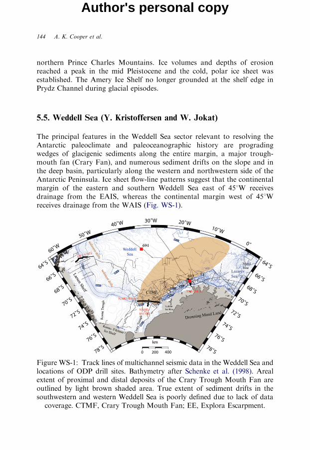
5.5. Weddell Sea (Y. Kristoffersen and W. Jokat)
The principal features in the Weddell Sea sector relevant to resolving theAntarctic paleoclimate and paleoceanographic history are progradingwedges of glacigenic sediments along the entire margin, a major trough-mouth fan (Crary Fan), and numerous sediment drifts on the slope and inthe deep basin, particularly along the western and northwestern side of theAntarctic Peninsula. Ice sheet flow-line patterns suggest that the continentalmargin of the eastern and southern Weddell Sea east of 451W receivesdrainage from the EAIS, whereas the continental margin west of 451Wreceives drainage from the WAIS (Fig. WS-1).
Figure WS-1: Track lines of multichannel seismic data in the Weddell Sea andlocations of ODP drill sites. Bathymetry after Schenke et al. (1998). Arealextent of proximal and distal deposits of the Crary Trough Mouth Fan areoutlined by light brown shaded area. True extent of sediment drifts in thesouthwestern and western Weddell Sea is poorly defined due to lack of data
coverage. CTMF, Crary Trough Mouth Fan; EE, Explora Escarpment.
Cenozoic Climate History from Seismic Reflection and Drilling Studies 145
Author's personal copy
5.5.1. The Regional Seismic and Geologic Database
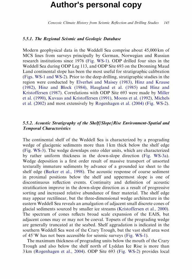
Modern geophysical data in the Weddell Sea comprise about 45,000 km ofMCS lines from surveys principally by German, Norwegian and Russianresearch institutions since 1976 (Fig. WS-1). ODP drilled four sites in theWeddell Sea during ODP Leg 113, and ODP Site 693 on the Dronning MaudLand continental slope has been the most useful for stratigraphic calibration(Figs. WS-1 and WS-2). Prior to the deep drilling, stratigraphic studies in theregion were conducted by Elverhøi and Maisey (1983), Hinz and Krause(1982), Hinz and Block (1984), Haugland et al. (1985) and Hinz andKristoffersen (1987). Correlations with ODP Site 693 were made by Milleret al. (1990), Kuvaas and Kristoffersen (1991), Moons et al. (1992), Michelset al. (2002) and most extensively by Rogenhagen et al. (2004) (Fig. WS-2).
5.5.2. Acoustic Stratigraphy of the Shelf/Slope/Rise Environment-Spatial andTemporal Characteristics
The continental shelf of the Weddell Sea is characterized by a progradingwedge of glacigenic sediments more than 1 km thick below the shelf edge(Fig. WS-3). The wedge downlaps onto older units, which are characterizedby rather uniform thickness in the down-slope direction (Fig. WS-3a).Wedge deposition is a first order result of massive transport of unsortedtexturally immature sediments by advance of a grounded ice sheet to theshelf edge (Barker et al., 1998). The acoustic response of coarse sedimentin proximal positions below the shelf and uppermost slope is one ofdiscontinuous reflection events. Continuity and definition of acousticstratification improve in the down-slope direction as a result of progressivesorting and increased relative abundance of finer material. The shelf edgemay appear rectilinear, but the three-dimensional wedge architecture in theeastern Weddell Sea reveals an amalgation of adjacent small discrete cones ofglacial sediments sourced by smaller ice streams (Kristoffersen et al., 2000).The spectrum of cones reflects broad scale expansion of the EAIS, butadjacent cones may or may not be coeval. Topsets of the prograding wedgeare generally truncated at the seabed. Shelf aggradation is indicated in thesouthern Weddell Sea west of the Crary Trough, but the vast shelf area westof 451W has not been accessible for seismic surveys (Fig. WS-1).The maximum thickness of prograding units below the mouth of the Crary
Trough and also below the shelf north of Lyddan Ice Rise is more than3 km (Rogenhagen et al., 2004). ODP Site 693 (Fig. WS-2) provides local
Figure WS-2: Stratigraphic summary column. Modified from Rogenhagenet al. (2004).
146 A. K. Cooper et al.
Author's personal copy
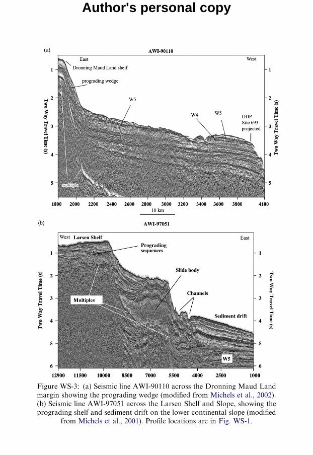
Figure WS-3: (a) Seismic line AWI-90110 across the Dronning Maud Landmargin showing the prograding wedge (modified from Michels et al., 2002).(b) Seismic line AWI-97051 across the Larsen Shelf and Slope, showing theprograding shelf and sediment drift on the lower continental slope (modified
from Michels et al., 2001). Profile locations are in Fig. WS-1.
Author's personal copy
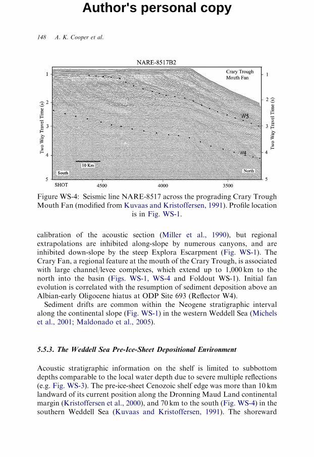
Figure WS-4: Seismic line NARE-8517 across the prograding Crary TroughMouth Fan (modified from Kuvaas and Kristoffersen, 1991). Profile location
is in Fig. WS-1.
148 A. K. Cooper et al.
Author's personal copy
calibration of the acoustic section (Miller et al., 1990), but regionalextrapolations are inhibited along-slope by numerous canyons, and areinhibited down-slope by the steep Explora Escarpment (Fig. WS-1). TheCrary Fan, a regional feature at the mouth of the Crary Trough, is associatedwith large channel/levee complexes, which extend up to 1,000 km to thenorth into the basin (Figs. WS-1, WS-4 and Foldout WS-1). Initial fanevolution is correlated with the resumption of sediment deposition above anAlbian-early Oligocene hiatus at ODP Site 693 (Reflector W4).Sediment drifts are common within the Neogene stratigraphic interval
along the continental slope (Fig. WS-1) in the western Weddell Sea (Michelset al., 2001; Maldonado et al., 2005).
5.5.3. The Weddell Sea Pre-Ice-Sheet Depositional Environment
Acoustic stratigraphic information on the shelf is limited to subbottomdepths comparable to the local water depth due to severe multiple reflections(e.g. Fig. WS-3). The pre-ice-sheet Cenozoic shelf edge was more than 10 kmlandward of its current position along the Dronning Maud Land continentalmargin (Kristoffersen et al., 2000), and 70 km to the south (Fig. WS-4) in thesouthern Weddell Sea (Kuvaas and Kristoffersen, 1991). The shoreward
Cenozoic Climate History from Seismic Reflection and Drilling Studies 149
Author's personal copy
shift in the western Weddell Sea is unknown. The deeper strata below thecontinental slope (i.e. below W4) appear unstructured throughout. The oldersediments are thickest (5–8 km) below the Larsen Shelf in the westernWeddell Sea (Rogenhagen and Jokat, 2000), and may be up to 15 km thickalong the front of the Ronne and Filchner Ice shelves (Leitchenkov andKudryavtzev, 2000). In the central Weddell Sea Basin, the pre-Oligocenesection of inferred turbidites is more than 1 km thick, and thins by basalonlap towards the margins to less than 0.5 km (Rogenhagen et al., 2004).High seasonal variations in sea-surface temperatures and a well-developedseasonal thermocline characterized the early Paleogene Weddell Sea(Kennett and Barker, 1990). On Maud Rise, siliceous biogenic facies beganto replace carbonate facies during the latest Eocene-earliest Oligocene(Kennett and Barker, 1990). A possible early Cenozoic seaway between Eastand West Antarctica could have been up to 700m deep, and may havepersisted into the Oligocene if no WAIS was present (Lawver and Gahagan,2003). At ODP Site 693 on the middle continental slope, middle lowerOligocene and younger glacial sediments are separated by a hiatus fromAlbian radiolarian diatomite and claystones (i.e. Reflector W4). Theunconformity may represent non-deposition and/or mild erosion (Kennettand Barker, 1990).
5.5.4. Change from Non-Glacial to Glacial Conditions
Sediment fluxes on high latitude continental margins are closely connected toclimate extremes. In the Weddell Sea, environmental change is manifestedby a basin-wide change in acoustic character within the sedimentary section(Reflector W4) at about 1 s TWT below the sea bed (Rogenhagen et al.,2004). Younger deposits in the basin have finely laminated continuousacoustic stratification, and geometries on the slope are in the form ofchannel/levee complexes over a wide range of spatial scales. The change indepositional environment is interpreted to have originated from an increasedsediment flux, caused by increased erosion of the continent and increaseddown-slope transport. At ODP Site 693 on the middle continental slope, theacoustic change correlates stratigraphically with resumed preservation oflower Oligocene sediments. The deposits include rounded dropstones inlower Oligocene (32–33Ma) diatom muds, a signal of the first presence ofglaciers on the adjacent parts of East Antarctica (Kennett and Barker, 1990).Subsequent early Miocene sedimentation rates at this site were low (7m/Ma).A more dramatic change in sediment flux to the margin is documented by athreefold increase in sedimentation rate (to 24m/m.y.), when sedimentation
150 A. K. Cooper et al.
Author's personal copy
resumed following a hiatus that spanned the middle Miocene. Increasedsediment input is related to expansion of ice on the East Antarctic continent.The hiatus at ODP Site 693 correlates with a regional acoustic reflectionevent (W5) identified below the continental slope and rise along the entireWeddell Sea margin (Rogenhagen et al., 2004). Shelf progradationaccelerated dramatically along the eastern and western margins of theWeddell Sea (Fig. WS-3), with grounded ice extending to the shelf edge inthe late Miocene (Michels et al., 2001; Michels et al., 2002). A range ofcontourite drifts formed on the slope and rise in the northwestern WeddellSea (Michels et al., 2001; Maldonado et al., 2005). Sedimentation rates atODP Site 693 reached 60m/m.y. in the early Pliocene, and subsequentQuaternary sedimentation rates were reduced to 16m/m.y. (Gersonde et al.,1990). Sediment input to the margin in the southeastern Weddell Sea wasfocused toward a trough mouth fan. The Crary Fan began to expand atthe time of change to a glacial environment (above Reflector W4, Fig. WS-4and Foldout WS-1), and major channel/levee complexes evolved in threephases. The last of these three phases (Reflector W5, Fig. WS-4 andFoldout WS-1) was from the late Miocene on (Kuvaas and Kristoffersen,1991; Moons et al., 1992).
5.5.5. The Glacial/Interglacial Environment
The change from a glacial to an interglacial environment was associated withmajor changes in sediment flux. Average sediment deposition on the easternWeddell Sea margin (101W) during the last two climatic cycles (300 k.y.)varies from 5 cm/k.y. on the upper slope to over 1 cm/k.y. on the lower slope(Grobe and Mackensen, 1992). Sedimentation was most rapid during thebeginning of interglacials, with rates on the middle slope four to five timeshigher than during glacials. We note, however, that the grounded EAIS onlyreached the mid-shelf in this area during the LGM (Kristoffersen et al.,2000). Sediment input in the southern Weddell Sea was focused in the CraryTrough Mouth Fan (Figs. WS-1, WS-4 and Foldout WS-1). The fancomprises large channel-levees on the flanks of deep-water channels, such asthe Cold Water Channel and the Deutschland Channel (Foldout WS-1).Grounded ice reached the shelf edge at the trough mouth during the lastglaciation (Bentley and Anderson, 1998), and deposition on the levees (inwater depths of 2,000–3,000m) ranged from 100–200 cm/k.y. during theLGM to a few cm/k.y. during the present interglacial (Weber et al., 1994).Episodic sediment transport into the basin also occurred by mass flowsduring interglacials, probably as partial collapse of the deposits on the upper
Cenozoic Climate History from Seismic Reflection and Drilling Studies 151
Author's personal copy
continental slope. A 90-m-thick sandy turbidite unit was depositedwithin 0.5m.y. during the early Gilbert Chron (4.8Ma) at ODP Site 694(Fig. WS-1), and may be the distal expression of mass wasting events on thecontinental slope in the southwestern Weddell Sea (Shipboard ScientificParty, 1988). Also, major early Pliocene drawdown of East Antarctic ice ispostulated to have triggered extensive mass flows that originated from theCrary Trough Mouth Fan (Bart et al., 1999).In the western Weddell Sea, upper Miocene and younger sediments (above
Reflector W5) are mostly drift deposits that reach a thickness of more than1 km below the middle slope, seaward of the Larsen Shelf (Rogenhagen andJokat, 2000; Michels et al., 2001; Maldonado et al., 2005). Present and pastbottom currents circulated in nearly the opposite direction to channeltransport, and cross-channel flow was in the same direction as the Coriolisforce acting on down-slope turbidity currents in the southern Weddell Sea.Sediments scavenged from turbid channel flow by cross-channel bottomcurrents sourced the benthic boundary layer and enhanced formation ofsediment drifts along the western and northern Weddell Basin. The actualdrift distribution was mainly controlled by the physiography of the basinand bottom current flow directions (Maldonado et al., 2005). These driftsrepresent a storehouse of paleoceanographic and climatic proxies not yetsampled by scientific drilling.
5.5.6. Continental Margin Sediments and Ice-Sheet History
The mass balance of the EAIS, the nature of the substratum and thecontinental topography, particularly in the coastal region, determinesediment input to the continental margin. Enhanced input of sediments tothe continental margin at ODP Site 693 in the eastern Weddell Sea anddevelopment of a prograding wedge started in the latest Miocene and peakedduring the earliest Pliocene (Gersonde et al., 1990). The seismic tie betweenODP Site 693 and the southern Weddell Sea is uncertain, but Kuvaas andKristoffersen (1991) suggest that fan development started in the southernWeddell Sea by the early Oligocene (above Reflector W4, Fig. WS-4 andFoldout WS-1), and that about two-thirds of the sediment thickness at themouth of the present Crary Trough was already in place by the late Miocene(i.e. below Reflector W5). Channel-levee complexes have migrated eastwardon the Crary Trough Mouth Fan, and late Miocene and younger depositionconstructed a third major channel-levee complex and deposited about 1 kmof sediments below the trough mouth (Fig. WS-4 and Foldout WS-1). Theseage relations imply that the principal input of sediments from East
152 A. K. Cooper et al.
Author's personal copy
Antarctica to the Weddell Sea margin from the early Oligocene to the lateMiocene originated from a glaciated interior of the continent via the CraryTrough, and that there was effectively no input along the Dronning MaudLand margin. At this point, the significance of a local thickness maximum ofglacial sediments north of Lyddan Ice Rise (Rogenhagen et al., 2004) isunclear. The EAIS expanded to the Dronning Maud Land margin during thelatest Miocene–earliest Pliocene and formed a prograding wedge belowthe continental shelf and slope. Sea ice cover has prevented acquisition of theseismic data from west of 451W and north of the Ronne Ice Shelf (Fig. WS-1)needed to study the depositional geometries of sediments originating fromthe catchment area of the WAIS. Data from this area also are needed tostudy the relation between eastern and western sediment source regions.Moraine complexes on the shelf in the eastern Weddell Sea suggest that the
EAIS was grounded on the mid-shelf and did not reach the shelf edge duringthe LGM (Kristoffersen et al., 2000), except at the mouth of the CraryTrough (Bentley and Anderson, 1998).
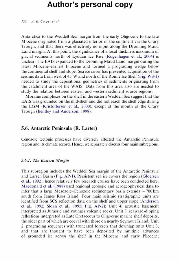
5.6. Antarctic Peninsula (R. Larter)
Cenozoic tectonic processes have diversely affected the Antarctic Peninsularegion and its climate record. Hence, we separately discuss four main subregions.
5.6.1. The Eastern Margin
This subregion includes the Weddell Sea margin of the Antarctic Peninsulaand Larsen Basin (Fig. AP-1). Persistent sea ice covers the region (Gloersenet al., 1992), hence relatively few research cruises have been conducted here.Macdonald et al. (1988) used regional geologic and aerogeophysical data toinfer that a large Mesozoic–Cenozoic sedimentary basin extends B700 kmsouth from James Ross Island. Four main seismic stratigraphic units areidentified from SCS reflection data on the shelf and upper slope (Andersonet al., 1992; Sloan et al., 1995; Fig. AP-2): Unit 4: acoustic basementinterpreted as Jurassic and younger volcanic rocks; Unit 3: seaward-dippingreflections interpreted as Late Cretaceous to Oligocene marine shelf deposits,the older part of which are coeval with those on nearby Seymour Island; Unit2: prograding sequences with truncated foresets that downlap onto Unit 3,and that are thought to have been deposited by multiple advancesof grounded ice across the shelf in the Miocene and early Pliocene;
Figure AP-1: (a) Track lines of multichannel (thick lines) and single-channel(thin lines) seismic data in the Antarctic Peninsula region, DSDP and ODPdrill sites (filled circles, annotated with site numbers) and SHALDRIL sites(open squares). SHALDRIL sites are only marked where either W10msubseafloor penetration was achieved or pre-quaternary sediments wererecovered. Bathymetric contours are at 1,000m intervals down to 4,000m,with 500m contours included locally on the shelf. Bathymetric data arebased on Smith and Sandwell (1997) east of the Peninsula and north of 621S.Bathymetry for most of the area west of the Peninsula is from Rebesco et al.(1998), the exception being the 500m contours in the southern Belling-shausen Sea, which are from O Cofaigh et al. (2005). To the east of thePeninsula, 500m contours south of James Ross Island (JRI) are based onfigures in Evans et al. (2005), and the 500m contour north of James RossIsland is based on multibeam echo sounding data maps produced from datacollected on RV Nathaniel B. Palmer Cruises 0003 and 0107. Bold line islocation of seismic profile in Fig. AP-2. SOM: South Orkney Microcontinent;JB: Jane Basin; PB: Powell Basin; BS: Bransfield Strait; RT: RobertsonTrough. (b) Expanded map of the northern Antarctic Peninsula withSHALDRIL site numbers labelled (I/II indicates first/second cruise). Samebathymetry contours shown as in (a), except 500m contours around JRI
omitted. SSI: South Shetland Islands.
Author's personal copy
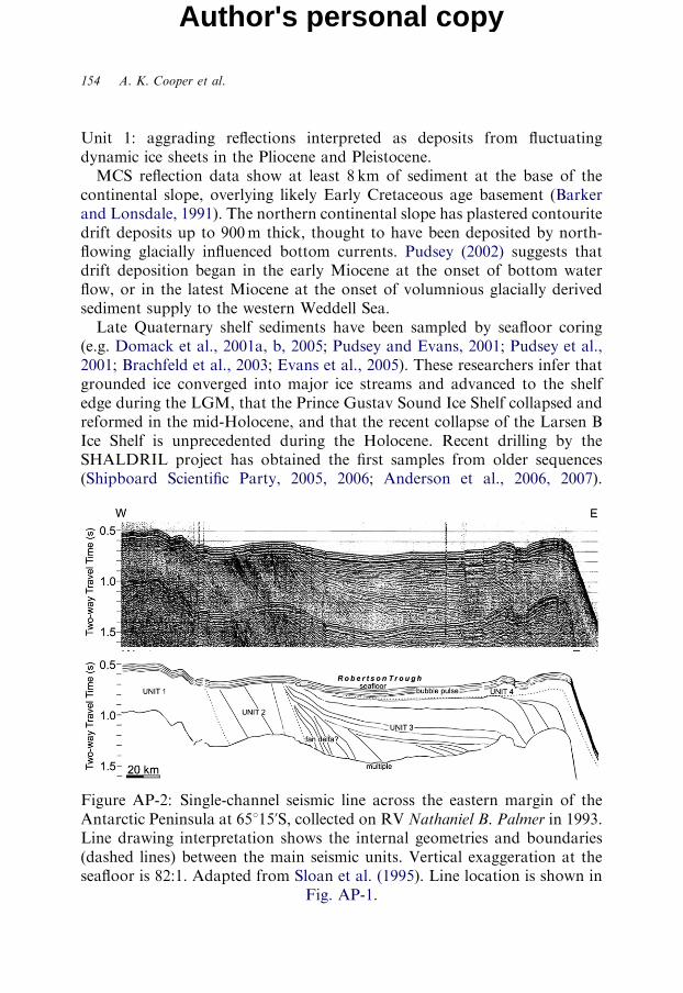
154 A. K. Cooper et al.
Author's personal copy
Unit 1: aggrading reflections interpreted as deposits from fluctuatingdynamic ice sheets in the Pliocene and Pleistocene.MCS reflection data show at least 8 km of sediment at the base of the
continental slope, overlying likely Early Cretaceous age basement (Barkerand Lonsdale, 1991). The northern continental slope has plastered contouritedrift deposits up to 900m thick, thought to have been deposited by north-flowing glacially influenced bottom currents. Pudsey (2002) suggests thatdrift deposition began in the early Miocene at the onset of bottom waterflow, or in the latest Miocene at the onset of volumnious glacially derivedsediment supply to the western Weddell Sea.Late Quaternary shelf sediments have been sampled by seafloor coring
(e.g. Domack et al., 2001a, b, 2005; Pudsey and Evans, 2001; Pudsey et al.,2001; Brachfeld et al., 2003; Evans et al., 2005). These researchers infer thatgrounded ice converged into major ice streams and advanced to the shelfedge during the LGM, that the Prince Gustav Sound Ice Shelf collapsed andreformed in the mid-Holocene, and that the recent collapse of the Larsen BIce Shelf is unprecedented during the Holocene. Recent drilling by theSHALDRIL project has obtained the first samples from older sequences(Shipboard Scientific Party, 2005, 2006; Anderson et al., 2006, 2007).
Figure AP-2: Single-channel seismic line across the eastern margin of theAntarctic Peninsula at 65115uS, collected on RV Nathaniel B. Palmer in 1993.Line drawing interpretation shows the internal geometries and boundaries(dashed lines) between the main seismic units. Vertical exaggeration at theseafloor is 82:1. Adapted from Sloan et al. (1995). Line location is shown in
Fig. AP-1.
Cenozoic Climate History from Seismic Reflection and Drilling Studies 155
Author's personal copy
Sequences drilled by SHALDRIL are principally shallow marine sands,sandy and silty muds, and pebbly muddy sands from neritic environments,with mollusc shells distributed throughout the cores. The cores are dated as:late Eocene to early Oligocene, Oligocene, middle Miocene, early Plioceneand Holocene.
5.6.2. The South Orkney Islands Region
This subregion includes the South Orkney Microcontinent (SOM) and theadjacent deep-water Jane and Powell basins (Fig. AP-1). The SOM extendsabout 350 km from east to west and 250 km from north to south, and isunderlain by Mesozoic metamorphic and sedimentary rocks (Thomson,1981; Dalziel, 1984). Offshore, the SOM includes four Cenozoic sedimentarybasins (King and Barker, 1988) with up to 5 km of sediment (Harringtonet al., 1972; Busetti et al., 2001, 2002). Powell Basin (up to 3,600m deep)formed as the SOM rifted and drifted away from the tip of the AntarcticPeninsula in late Eocene to late Oligocene time (King and Barker, 1988;Lawver et al., 1994; Coren et al., 1997; Eagles and Livermore, 2002).Opening of Jane Basin (up to 3,300m deep) probably began slightly later(Lawver et al., 1991, 1994), and may have continued until the middleMiocene according to Maldonado et al. (1998).From SCS data on the SOM, King and Barker (1988) defined pre-rift, syn-
rift, and post-rift units. The post-rift sediments are less than 1 km thick (e.g.Busetti et al., 2001, 2002) and were drilled at ODP Site 695 (1,300m waterdepth) and ODP Site 696 (600m water depth) (Fig. AP-3). They compriseOligocene or early Miocene to Quaternary terrigenous sediments, with rarecoarse-grained IRD until the late Miocene (B8.7Ma) and common IRDthereafter. Middle Miocene to Quaternary sediments are hemipelagic anddiatomaceous muds and oozes (Barker et al., 1988a, b). ODP Site 696 alsosampled syn-rift Eocene sandy mudstones (Sequence 2) that have nannofossilassemblages and clay minerals suggesting a relatively warm climate, andpalynoflora indicating temperate beech forests and ferns on West Antarctica.Drilling results suggest intermittent glaciation with little sea ice during mostof the Miocene and a persistent ice cap to sea-level on West Antarctica sincethe late Miocene. Herron and Anderson (1990) place the maximum lateQuaternary grounding line advance at the 300m isobath, and consider open-marine conditions to have existed over the SOM since 6,000 y. B.P. based onSCS and seafloor core data.In Powell Basin, post-early-rift sediments are up to 3 km thick. King et al.
(1997) identified two seismic units with low reflectivity below and high
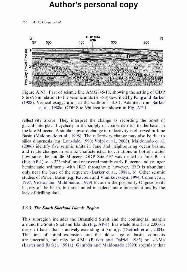
Figure AP-3: Part of seismic line AMG845-18, showing the setting of ODPSite 696 in relation to the seismic units (S1–S3) described by King and Barker(1988). Vertical exaggeration at the seafloor is 3.3:1. Adapted from Barker
et al., 1988a. ODP Site 696 location shown in Fig. AP-1.
156 A. K. Cooper et al.
Author's personal copy
reflectivity above. They interpret the change as recording the onset ofglacial–interglacial cyclicity in the supply of coarse detritus to the basin inthe late Miocene. A similar upward change in reflectivity is observed in JaneBasin (Maldonado et al., 1998). The reflectivity change may also be due tosilica diagenesis (e.g. Lonsdale, 1990; Volpi et al., 2003). Maldonado et al.(2006) identify five seismic units in Jane and neighbouring ocean basins,and relate changes in seismic characteristics to variations in bottom waterflow since the middle Miocene. ODP Site 697 was drilled in Jane Basin(Fig. AP-1) to B323mbsf, and recovered mainly early Pliocene and youngerhemipelagic sediments with IRD throughout; however, IRD is abundantonly near the base of the sequence (Barker et al., 1988a, b). Other seismicstudies of Powell Basin (e.g. Kavoun and Vinnikovskaya, 1994; Coren et al.,1997; Viseras and Maldonado, 1999) focus on the post-early Oligocene rifthistory of the basin, but are limited in paleoclimate interpretations by thelack of drilling data.
5.6.3. The South Shetland Islands Region
This subregion includes the Bransfield Strait and the continental marginaround the South Shetland Islands (Fig. AP-1). Bransfield Strait is a 2,000mdeep rift basin that is actively extending at 7mm/y. (Dietrich et al., 2004).The time of initial extension and the oldest age of basin sedimentsare uncertain, but may be 4Ma (Barker and Dalziel, 1983) or B6Ma(Larter and Barker, 1991a). Gamboa and Maldonado (1990) speculate that
Cenozoic Climate History from Seismic Reflection and Drilling Studies 157
Author's personal copy
Bransfield Strait may have opened earlier, during the early Miocene, andhave been continuous with mid-shelf basins to the southwest.From MCS data, Gamboa and Maldonado (1990) identify ‘rift’ and ‘drift’
sequences in Bransfield Strait. ‘Drift’ sequences prograde the shelf and areabout 1 km thick. In SCS data, Jeffers and Anderson (1990) define fourglacio-eustatic sequences within the ‘drift’ sequences, and interpret all foursequences as being younger than 3Ma. Prieto et al. (1999) use different SCSdata to define eight seismic units that comprise interfingering slope andbasinal deposits within the ‘drift’ sequences. They interpret the slope unitsas having been deposited directly from grounded ice during glacial periods,and interpret the basinal units as having been deposited by mass flowprocesses during deglaciations and interglacial periods.From SCS data, Banfield and Anderson (1995) identify sediment mound
features that they infer to be glacial grounding moraines in up to 1,000mwater depth on the southeastern flank of Bransfield Strait. They speculatethat mounds at B700m depth mark the maximum advance during theLGM. Deep troughs with mega-scale lineations are incised into the shelf andare interpreted as the paths of palaeo-ice streams (Banfield and Anderson,1995; Canals et al., 2002).MCS profiles across the continental slope NW of the South Shetland Islands
reveal a forearc basin, with more than 1.5 km sediments, that is bounded to theNW by a small accretionary prism (Maldonado et al., 1994a, b). The prismoverthrusts trench-fill sediments that may have been deposited rapidly and areup to 1km thick (Maldonado et al., 1994a, b; Kim et al., 1995).Other seismic-reflection surveys have been done in the region by British,
Polish, German, Spanish, US, Italian, Chinese and Korean research groups,but published results focus on the tectonic evolution of the region andtectonic processes (Barker, 1976; Guterch et al., 1985; GRAPE Team, 1990;Acosta et al., 1992; Henriet et al., 1992; Grad et al., 1993; Barker and Austin,1994, 1998; Bochu et al., 1995; Gracia et al., 1996; Jin et al., 1996; Jin andKim, 1998; Prieto et al., 1998; Jin et al., 2002), on gas hydrates (Lodolo et al.,1993, 2002; Tinivella et al., 1998, 2002; Jin et al., 2003), and on a largesubmarine slide (Imbo et al., 2003).Swath bathymetry data exist over most deep-water parts (W1,000m) of
Bransfield Strait (Lawver et al., 1996; Gracia et al., 1997). Along Boyd Strait,‘bundle structures’ and mega-scale glacial lineations occur and confirmpalaeo-ice stream flow during glacial periods (Canals et al., 2000;COHIMAR/SEDANO Scientific Party, 2003). MCS data along outer BoydStrait reveal glacial progradation of the margin (Maldonado et al., 1994a, b),and deep-tow boomer profiles reveal a glacier grounding zone wedge near theshelf edge (Vanneste and Larter, 1995).
158 A. K. Cooper et al.
Author's personal copy
The only scientific drilling in the South Shetland Islands region was doneat SHALDRIL-I Site 1 in Maxwell Bay (Fig. AP-1), where an expandedsequence of Holocene diatomaceous muds, B105m thick, overlying a clay-rich diamicton was sampled (Shipboard Scientific Party, 2005).
5.6.4. The Pacific Margin
The Pacific margin includes the region southwest from the South ShetlandIslands to 701S and 801W. This is a former active margin where ridge-crestsegments were progressively subducted (Larter and Barker, 1991a; Henrietet al., 1992), followed by 1–4m.y. of uplift and then long-term subsidence(Larter and Barker, 1989, 1991b; Anderson et al., 1990; Gamboa andMaldonado, 1990; Bart and Anderson, 1995, 1996, 2000; Larter et al., 1997).Seismic profiles show that outer shelf sequences are separated from NW-SEtrending mid-shelf basins by the Mid-shelf High (MSH) (Kimura, 1982;Anderson et al., 1990; Gamboa and Maldonado, 1990; Larter et al., 1997).Several research groups have conducted seismic studies in the area
(Kimura, 1982; Larter and Barker, 1989, 1991b; Anderson et al., 1990;Gamboa and Maldonado, 1990; Henriet et al., 1992; Bart and Anderson,1995, 1996, 2000; McGinnis and Hayes, 1995; Rebesco et al., 1996, 1997,2002, 2006; McGinnis et al., 1997; Larter et al., 1997; Jin et al., 2002; Jabaloyet al., 2003; Hernandez-Molina et al., 2006a). Cenozoic sequences have beendrilled at DSDP Site 325 (Hollister et al., 1976) and at multiple sites duringODP Leg 178 (Barker et al., 1999).Evidence of Oligocene glaciation exists on King George Island
(Birkenmajer, 1991; Dingle and Lavelle, 1998; Troedson and Smellie,2002), but offshore the first ice sheets on the Pacific margin are inferredfrom early Miocene IRD at DSDP Site 325 (Fig. AP-1). The oldest sedimentsfrom ODP Leg 178 are drift deposits at ODP Site 1095, dated at 9.6Ma,where all cores show glacial influence and sedimentation rates decreasesteadily from the late Miocene to the Quaternary. From seismic studies,Rebesco et al. (1996, 1997, 2002) suggest that sediment drift depositionbegan around the middle Miocene, with most growth in the late Miocene.However, Hernandez-Molina et al. (2004, 2006b) describe a buried sedimentdrift of early Miocene age (Fig. AP-1). Uenzelmann-Neben (2006) alsointerprets depositional patterns of early Miocene continental rise sedimentsas reflecting bottom current influence, but infers a different flow direction.A regular supply of both glacially derived terrigenous sediments and
Cenozoic Climate History from Seismic Reflection and Drilling Studies 159
Author's personal copy
interglacial biogenic sediments has reached the continental rise since at leastthe middle Miocene.The outer continental shelf is underlain by depositional sequences that
thicken seaward (Larter and Barker, 1989, 1991b; Anderson et al., 1990;Gamboa and Maldonado, 1990; Larter and Cunningham, 1993; Bart andAnderson, 1995; Table AP-1). Aggrading sequences (S3) without a distinctpaleo-shelf edge (PSE) are unconformably overlain by prograding sequences(S2, S1) with an abrupt PSE (Foldout AP-1). The change occurs at the S3/S2boundary of Larter and Barker (1989, 1991b) and is observed all along thePacific margin (Anderson et al., 1990; Bart and Anderson, 1995, Larter et al.,1997; Jin et al., 2002) and west along the margin of the Bellingshausen andAmundsen Seas (Nitsche et al., 1997). Drilling at ODP Sites 1097 and 1103,although with very poor recovery, suggests that the change occurred between8 and 6Ma (Iwai and Winter, 2002; Bart et al., 2005). Cores from S3 arediamictons with interbedded mudstones and graded sandstones, interpretedby Eyles et al. (2001) as continental slope deposits, although seismic profilessuggest a palaeo-shelf to slope transition further offshore. Cores from S1 andthe upper part of S2 show abundant evidence for having been depositedsubglacially (Eyles et al., 2001).Larter and Barker (1989, 1991b) and Larter et al. (1997) interpreted the
S3/S2 boundary as representing the onset of frequent advances of groundedice to the palaeo-shelf edge. However, Bart and Anderson (1995) and Bartet al. (2005, 2007) suggest that palaeo-ice streams cut erosional troughswithin S3 and hence existed earlier than the S3/S2 boundary. Althoughequivocal, the boundary could represent a change in the typical extent ofglacial advances, in the dynamic behaviour of ice sheets that advanced ontothe shelf, or in the way the ice transported sediments (Larter et al., 1997;Hernandez-Molina et al., 2006a).Going up-section above the S3/S2 boundary, foreset stratal dips
generally increase and PSE progradation in individual sequences decreases(Foldout AP-1). The regional S2/S1 boundary within the upper sedimentarysection may have been produced by ice-sheet erosion during glacial periodsand lower sea levels after the Late Pliocene increase in the volume ofNorthern Hemisphere ice sheets (Larter and Barker, 1989, 1991b). By seismiccorrelation acrossW100 km to ODP Site 1101, Rebesco et al. (2006) estimatean age of B3Ma for a boundary that they identify as S2/S1. However, thisboundary marks a change in stratal geometry that is generally characteristicof S3/S2, and Larter (2007) suggests that it probably corresponds to thisearlier unconformity.
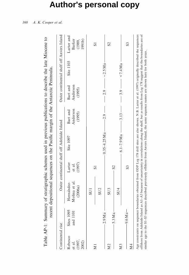
Table
AP-1:Summary
ofstratigraphic
schem
esusedin
previouspublicationsto
describethelate
Mioceneto
recentdepositionalsequencesonthePacificmargin
oftheAntarcticPeninsula.
160 A. K. Cooper et al.
Author's personal copy
Cenozoic Climate History from Seismic Reflection and Drilling Studies 161
Author's personal copy
Mid-shelf basins contain up to 2 km of sediment in a broad synform that istruncated at shallow depth beneath the seafloor (Kimura, 1982; Andersonet al., 1990; Gamboa and Maldonado, 1990; Larter et al., 1997), making thesuccession accessible to shallow drilling. However, these sediments have notbeen sampled, except for the thin Quaternary cover. Basin sediments areprobably all Tertiary and may be as young as early Miocene off AdelaideIsland, and middle Miocene off Anvers Island (Larter et al., 1997). The innershelf is mostly shallower than 200m, but has deep troughs, such as thePalmer Deep where ODP Sites 1098 and 1099 were drilled in 1,400m ofwater. Holocene successions B47 and B108m thick were recovered at ODPSites 1098 and 1099, respectively (Shipboard Scientific Party, 1999; Domacket al., 2001; Ishman and Sperling, 2002; Leventer et al., 2002; Shevenell andKennett, 2002).Swath bathymetric data show seafloor features of subglacial origin on the
shelf (O Cofaigh et al., 2002; Dowdeswell et al., 2004; Amblas et al., 2006),and confirm that a grounded ice sheet with ice streams extended to the shelfedge during the LGM (Pudsey et al., 1994; Larter and Vanneste, 1995).Seafloor core data indicate that retreat of the ice sheet from the outer andmiddle shelf after the LGM occurred between 18,500 and 13,000 cal. y. B.P.(Pudsey et al., 1994; Heroy and Anderson, 2005).
5.7. Other Sectors of the Antarctic Continental Margin
Other sectors of the Antarctic margin, than the five ANTOSTRATproject working areas discussed above, have been studied more fullythan previously during the past 5–7 years, in a time of renewed interest inMCS studies of the continental margin. These regions include similargeomorphic and stratigraphic features. Although we do not include themin the discussion below due to space considerations, we include hererepresentative citations to some of the studies published for the Belling-shausen and Amundsen seas (Hollister et al., 1976; Tucholke and Houtz,1976; Tucholke, 1977; Kimura, 1982; Yamaguchi et al., 1988; Cunninghamet al., 1994, 2002; Gohl et al., 1997, 2007; Nitsche et al., 1997, 2000;Wellner et al., 2001, 2006; Lowe and Anderson, 2002; O Cofaigh et al., 2005;Dowdeswell et al., 2006; Evans et al., 2006; Scheuer et al., 2006a, b;Larter et al., 2007; Uenzelmann-Neben et al., 2007) and for offshore areasof Queen Maud Land and Enderby Land (Kuvaas et al., 2004a, b, 2005;Hinz et al., 2005; Stagg et al., 2004a, b; Leitchenkov et al., 2007; Solli et al.,2007a, b, c).
162 A. K. Cooper et al.
Author's personal copy
5.8. Discussion
Our discussion focuses on integrating key observations and inferences fromthe Antarctic continental margin to summarize a Cenozoic glacial historyfrom the stratigraphic record. We recognize the limitations of the seismic anddrilling data sets used. Seismic data image regional and up-section changes,but only provide a relative history of inferred events and processes. Drillingdata provide a defined stratigraphic history, but one that is valid only at thelocal drilling site. There is an extensive published literature that illustratesthe large spatial and temporal variability of features and processes at variousscales, depending on the resolution and extent of data analysed. Weselectively discuss the widespread seismic stratigraphic variations and thelong- and short-period geologic transitions in cores, all of which point to avaried history of non-glacial and glacial events on the continental margin.The discussion is necessarily condensed due to the great breadth of the topicsand the limited space herein.We abbreviate offshore geographic regions as: Ross Sea (RS), Antarctic
Peninsula (AP), Weddell Sea (WS), Prydz Bay (PB) and Wilkes Land (WL),and prefix these abbreviations with east (E) and west (W), such as westernRoss Sea (WRS) (Fig. I-1).
5.8.1. Regional Seismic Stratigraphic Variations: Similarities and Differences
Stratigraphers have long recognized sedimentary sequences and boundingregional unconformities in seismic-reflection data across the Antarcticcontinental margin (e.g. Hinz and Block, 1984; Wannesson et al., 1985; Hinzand Kristoffersen, 1987; Cooper et al., 1995). These sequences, principally ofinferred Cenozoic age, commonly have similar seismic geometries aroundAntarctica (e.g. Cooper et al., 1991b; Anderson, 1999). Some geometries areunique to polar continental margins, whereas other geometries are like thoseof low-latitude non-polar margins (e.g. Hinz and Block, 1984; Bartek andAnderson, 1991; Table D-1). A unified circum-Antarctic seismic stratigraphydoes not exist, but an International effort to compile one via the CASP projectis in progress (Davey and Cooper, 2007). Numerous separate and sometimesdifferent seismic stratigraphies exist for various localities.Many seismic features have been cited to suggest intermittent ice on the
Antarctic margin (Table D-1), but those giving the strongest evidence for iceare the regional seismic unconformities, the broad erosional troughs anddepositional banks on the continental shelf, and the large-scale fans and
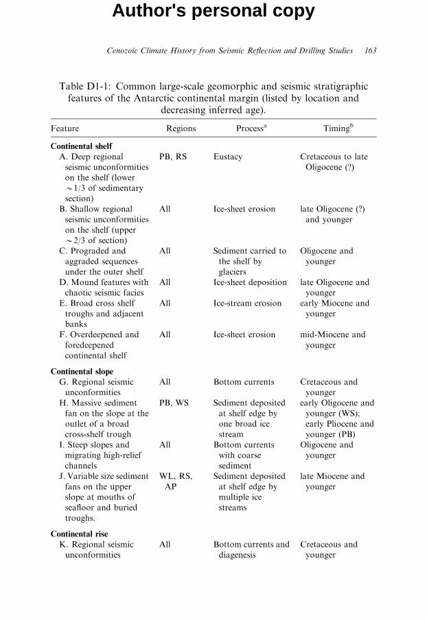
Table D1-1: Common large-scale geomorphic and seismic stratigraphicfeatures of the Antarctic continental margin (listed by location and
decreasing inferred age).
Feature Regions Processa Timingb
Continental shelf
A. Deep regional
seismic unconformities
on the shelf (lower
B1/3 of sedimentary
section)
PB, RS Eustacy Cretaceous to late
Oligocene (?)
B. Shallow regional
seismic unconformities
on the shelf (upper
B2/3 of section)
All Ice-sheet erosion late Oligocene (?)
and younger
C. Prograded and
aggraded sequences
under the outer shelf
All Sediment carried to
the shelf by
glaciers
Oligocene and
younger
D. Mound features with
chaotic seismic facies
All Ice-sheet deposition late Oligocene and
younger
E. Broad cross shelf
troughs and adjacent
banks
All Ice-stream erosion early Miocene and
younger
F. Overdeepened and
foredeepened
continental shelf
All Ice-sheet erosion mid-Miocene and
younger
Continental slope
G. Regional seismic
unconformities
All Bottom currents Cretaceous and
younger
H. Massive sediment
fan on the slope at the
outlet of a broad
cross-shelf trough
PB, WS Sediment deposited
at shelf edge by
one broad ice
stream
early Oligocene and
younger (WS);
early Pliocene and
younger (PB)
I. Steep slopes and
migrating high-relief
channels
All Bottom currents
with coarse
sediment
Oligocene and
younger
J. Variable size sediment
fans on the upper
slope at mouths of
seafloor and buried
troughs.
WL, RS,
AP
Sediment deposited
at shelf edge by
multiple ice
streams
late Miocene and
younger
Continental rise
K. Regional seismic
unconformities
All Bottom currents and
diagenesis
Cretaceous and
younger
Cenozoic Climate History from Seismic Reflection and Drilling Studies 163
Author's personal copy
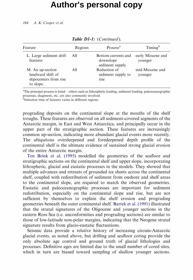
Table D1-1: (Continued ).
Feature Regions Processa Timingb
L. Large sediment drift
features
All Bottom currents and
downslope
sediment supply
early Miocene and
younger
M. An up-section
landward shift of
depocenters from rise
to slope.
All Reduction of
sediment supply to
rise
mid-Miocene and
younger
aThe principal process is listed – others such as lithospheric loading, sediment loading, paleoceanographic
processes, diagenesis, etc. are also commonly involved.bInitiation time of features varies in different regions.
164 A. K. Cooper et al.
Author's personal copy
prograding deposits on the continental slope at the mouths of the shelftroughs. These features are observed on all sediment-covered segments of theAntarctic margin, in East and West Antarctica, and principally occur in theupper part of the stratigraphic section. These features are increasinglycommon up-section, indicating more abundant glacial events more recently.The ubiquitous overdeepened and foredeepened depth profile of thecontinental shelf is the ultimate evidence of sustained strong glacial erosionof the entire Antarctic margin.Ten Brink et al. (1995) modelled the geometries of the seafloor and
stratigraphic sections on the continental shelf and upper slope, incorporatinglithospheric, glacial and eustatic processes in the models. They showed thatmultiple advances and retreats of grounded ice sheets across the continentalshelf, coupled with redistribution of sediment from onshore and shelf areasto the continental slope, are required to match the observed geometries.Eustatic and paleoceanographic processes are important for sedimentredistribution, especially on the continental slope and rise, but are notsufficient by themselves to explain the shelf erosion and progradinggeometries beneath the outer continental shelf. Bartek et al. (1991) illustratedthat the stratal signatures of the Oligocene and younger sections in theeastern Ross Sea (i.e. unconformities and prograding sections) are similar tothose of low-latitude non-polar margins, indicating that the Neogene stratalsignature results from glacio-eustatic fluctuations.Seismic data provide a relative history of increasing circum-Antarctic
glacial events, as noted above, but drilling and seafloor coring provide theonly absolute age control and ground truth of glacial lithologies andprocesses. Definitive ages are limited due to the small number of cored sites,which in turn are biased toward sampling of shallow younger sections.
Cenozoic Climate History from Seismic Reflection and Drilling Studies 165
Author's personal copy
The lithostratigraphic record from proximal drilling and dredging on theAntarctic margin ‘establishes’ a general history (at the drill sites) of noregional glaciers in Cretaceous and earlier times on the shelf (PB, RS, WL)and on the slope (WS). Evidence of glacial episodes is first seen in the lateEocene to early Oligocene as diamicts from grounded ice on the shelf(PB, RS) and from glacial erratics on the slope (WS). Upper Oligoceneglacial marine deposits are sampled on the shelf (RS) and slope (WS). LowerMiocene sections show increasing evidence of ice and deep-ocean currents,with IRD and sediment drifts on the rise (PB, WL, AP, WS?) and glacialmarine sediments and diamicts on the shelf (RS). The middle Miocene has anincreased glacial hemipelagic signature on the rise (PB), and glacial marinedeposits on the shelf (RS). The late Miocene and early Pliocene were times ofenhanced glacial activity, as recorded by: (1) shelf deposits of glacial diamicts(PB, AP) and glacial marine sediments (RS, AP); (2) glacial marine sedimentson the slope (WS, WL); and (3) rise deposits of glacial hemipelagics(PB, WL, RS, AP) and turbidites (WL, WS, AP). Upper Neogene depositsare principally glacial on the shelf (PB, RS, AP), slope (PB, WS) and rise(PB, WL, RS, AP, WS). Based on recovered drill cores and AntarcticPeninsula coastal geology, the general history of events for East and WestAntarctica is essentially the same since the early Oligocene. However, themiddle Miocene and Oligocene history for offshore West Antarctica isbased on only two Ross Sea DSDP cores (Hayes and Frakes, 1975) and twotentatively dated SHALDRIL cores from the western Weddell Sea(Anderson et al., 2006; Shipboard Scientific Party, 2006).The above general history at the sparse drill sites has been greatly expanded
by many investigators who have traced seismic unconformities and seismicstratigraphic units from core sites and rare onshore sedimentary sections up tohundreds of km to infer ages and lithofacies for key stratigraphic featureslisted in Table D-1. The expanded seismic stratigraphic history includesinferences of the following (although uncertainties about these inferences areinherently greater than the uncertainties about ages at drillsites):
� A pre-ice-sheet to early-glacial period (Cretaceous to early Oligocene): Onthe inner and mid shelf, variable seismic facies (WRS, PB), narrow channelgeometries (PB) and sea-floor dredged/cored rocks indicate the presence ofpre-ice-sheet subaerial, fluvial and shallow marine environments in theCretaceous. These are unconformably overlain (WRS, PB) by upper Eoceneto lower Oligocene early glacial sediments. This transition, from pre-ice-sheetto early glacial conditions, has not been sampled elsewhere on the shelf.Beneath the slope and upper rise, thick sediment sections are observed(all areas), but are not yet well imaged and mapped in most areas.
166 A. K. Cooper et al.
Author's personal copy
� Aggrading shelf period (Oligocene): On the shelf, stratal geometries indrilled Oligocene glaciomarine sections mostly aggrade the PSEs in PB andERS, but PSEs appear to prograde where the shelf is strongly uplifted anderoded (WWS). Aggrading PSE geometries occur in unsampled areas of theouter shelf (WL, AP). On the slope, geometries show high-relief paleo-slope-canyons (PB, WL, RS, WS), and in the WS, deposition of the massive CraryFan (WS) began. On the rise, seismic facies indicate higher energydepositional environments with paleo-channel-levee systems first developing(PB, WL, RS, AP, WS). Where drilled (PB, WL, RS), lithologies from thisperiod have glacial components indicating onshore glaciers. Backstrippingcalculations indicate normal shelf water-depths (PB, RS).
� Uniform prograding shelf (early and middle Miocene): In many regions,seismic sequences uniformly prograde the continental shelf edge, with anup-section increase in the dips of foreset-beds (glaciomarine deposits) andvariable erosion of topset strata (with diamicton) (PB, WL, RS, AP, WS).Sea-level stratigraphic control began to shift to ice-dominated stratigraphiccontrol, with documented cyclic shelf erosion by grounded ice sheets. Initialregional erosion and overdeepening of East Antarctic shelves commenced(PB, RS, WL). Slope geometries indicate canyon shifting and infilling(PB, WL, RS) and fan growth (WS), with rise geometries showing theconstruction of large drift mounds (WWS, PB, WL, AP) and channel-levees(WL, WS, AP, PB). Abundant contourite deposits (PB, AP) with someturbidites (AP, WL) are documented. Glacial and interglacialsediment volumes decreased on the rise (PB, AP), but increased on theslope (WS).
� Local and focused prograding shelf (late Miocene to Pleistocene): Aprominent regional unconformity occurs in the late Miocene to earlyPliocene across all margin segments (PB (A, PP12); WL (U8); RS (U2); AP(BGMS) WS (W5)). The unconformity marks a circum-Antarctic changefrom areas of uniform PSE progradation to local-arcuate and broadlyfocused PSE progradation into small and/or overlapping upper-slope fans(e.g. QML, WL, AP) and broad trough-mouth fans (e.g. PB, WS) lying at ornear the end of cross-shelf troughs. Strong regional shelf erosion, by bothnarrow and wide ice streams early in this period, was followed by regionaldeposition of topset banks composed principally of glacial diamicton(PB, AP, WL, WS?) and glacial marine (RS) sediment. Periods of pelagicsedimentation on the shelf indicate open water and sea ice. On the slope,foreset dips steepened as fans formed above the unconformity. On the rise,sedimentation rates decreased (PB, AP) and depocentres shifted progres-sively landward, moving from the rise to beneath the slope (PB, WL, AP,
Cenozoic Climate History from Seismic Reflection and Drilling Studies 167
Author's personal copy
WS, AP?). Stratigraphic control was dominated by episodic grounded ice,with sediment deposition by ice and sediment distribution by ocean-currents.
� Sediment drape (late Pleistocene and Holocene): Thin well-layered acousticunits commonly infill shelf depressions and drape across the slope and rise(All regions). These units provide a record of pelagic sedimentation fromthe last few interglacial and glacial periods. Deep inner-shelf basins, inparticular, trap Holocene biogenic sediments with that were deposited atvery high sedimentation rates; these biogenic sediments yield an ultra-high-to high-resolution (i.e. decadal to millennial) record of climate variability(AP, WL, PB).
5.8.2. Long- and Short-Period Transitions in the Geologic Record
The seismic stratigraphic record provides a regional framework thatillustrates distinct changes in the morphology of the Antarctic margin overthe last 60m.y. Drill cores provide the direct ‘ground truth’ geologic recordof both long-period (m.y.) and short-period (k.y.) transitions (Table D-2).Some of the transitions in drill cores are reflected in the seismic stratigraphicframework and others are not. All transitions, however, are important indeciphering Antarctic paleoenvironments. In this discussion, we focus onlithostratigraphic changes in drill cores, and leave the discussion of isotopic,biostratigraphic and other relevant variations to authors of other chapters ofthis book. Our intent is to use the proximal lithostratigraphic drilling recordfrom the continental margin to independently evaluate paleoenvironmentalhistory, where possible.Drill cores from two segments of the continental shelf provide a general
lithostratigraphic framework for the long-period systematic transition fromnon-glacial (Mesozoic) to fluctuating glacial and interglacial (late Cenozoic)paleo-depositional environments. At the mid-shelf of Prydz Bay, coresdocument the changes from subaerial non-glacial (Cretaceous) to fluvial/lagoonal early glacial (late Eocene) to shallow marine early glacial (earlyOligocene) to subglacial deep shelf (early Pliocene) to interglacial open-marine (Holocene) conditions. A similar transition is documented in theRoss Sea (McMurdo Sound), from subaerial non-glacial (Mesozoic) toshallow marine early glacial (early Oligocene) to fluctuating subglacial andmarine glacial (early Miocene to Holocene) to interglacial open-marine(Holocene) environments. Large hiatuses exist in the shelf cores.Improved resolution of the continuity and timing of changes is seen in drill
cores from the continental rise, where geologic continuity and core recovery
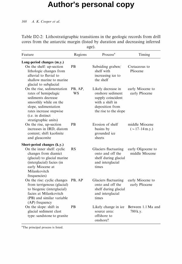
Table D2-2: Lithostratigraphic transitions in the geologic records from drillcores from the antarctic margin (listed by duration and decreasing inferred
age).
Feature Regions Processa Timing
Long-period changes (m.y.)
On the shelf: up-section
lithologic changes from
alluvial to fluvial to
shallow marine to marine
glacial to subglacial
PB Subsiding graben/
shelf with
increasing ice to
the shelf
Cretaceous to
Pliocene
On the rise, sedimentation
rates of hemipelagic
sediments decrease
smoothly while on the
slope, sedimentation
rates increase stepwise
(i.e. in distinct
stratigraphic units)
PB, AP,
WS
Likely decrease in
onshore sediment
supply coincident
with a shift in
deposition from
the rise to the slope
early Miocene to
early Pliocene
On the rise, up-section
increases in IRD, diatom
content; shift kaolinite
and glauconite
PB Erosion of shelf
basins by
grounded ice
sheets
middle Miocene
(B17–14m.y.)
Short-period changes (k.y.)
On the inner shelf: cyclic
changes from diamict
(glacial) to glacial marine
(interglacial) facies (in
early Miocene at
Milankovitch
frequencies)
RS Glaciers fluctuating
onto and off the
shelf during glacial
and interglacial
times
early Oligocene to
middle Miocene
On the rise: cyclic changes
from terrigenous (glacial)
to biogenic (interglacial)
facies at Milankovitch
(PB) and similar variable
(AP) frequency
PB, AP Glaciers fluctuating
onto and off the
shelf during glacial
and interglacial
times
early Miocene to
early Pliocene
On the slope: shift in
glacial sediment clast
type: sandstone to granite
PB Likely change in ice
source area:
offshore to
onshore?
Between 1.1Ma and
780 k.y.
aThe principal process is listed.
168 A. K. Cooper et al.
Author's personal copy
Cenozoic Climate History from Seismic Reflection and Drilling Studies 169
Author's personal copy
are greater than from the shelf or slope. On the rise, there is a distinctup-section change in seismic character from well layered below to channel-levy development above (all areas) that is widely inferred due to a large influxof sediment when onshore ice sheets initiated in late Eocene to earlyOligocene time. Here, the pre-ice to glacial transition has not yet beensampled by drilling. Yet, higher in the stratigraphic section of the rise, drillcores show a clear long-term parabolic decrease in the sedimentationrates within sediment drift deposits from the early Miocene (PB: 10-folddecrease) and the late Miocene (AP: 6-fold decrease) to the present. The largedecreases occurred when the PSEs were prograding over distances of severaltens of kilometres and aggrading up to several hundred metres, although thedetailed timing of the prograding and aggrading is unknown. Regardless, thedistinct changes in geometries of seismic sequences beneath the outerpaleoshelves in PB and AP are not seen as abrupt changes in sedimentdeposition rates on the rise. Drilling on the slope (WS) shows largeincremental increases in sedimentation rates for this same general period(i.e. early Miocene to early Pliocene), indicating that sediment coming fromthe shelf may not have reached the rise. The decreases in sedimentation rateson the rise may also reflect a decrease in the amount of sediment beingeroded from onshore and shelf areas.A notable long-term transition occurs in middle Miocene sediments
(17–14Ma) from the rise (PB). Up-section increases in IRD, diatom content,and recycled organic matter, along with changes in the types of clay and thefirst appearance of glauconite, point to greater ice nearby and initial erosionof shelf sedimentary basins. Evidence for strong erosion on the shelf isalso seen in truncated foreset strata beneath the outer PB paleo-shelf. RSshelf drill cores are marked by a long hiatus, from mid- to late-Miocene.The hiatus and truncated shelf reflectors point to an increase in shelf erosionand overdeepening in the RS, similar to the erosion recorded on the riseat PB.Short-period fluctuations in shelf and rise drill cores provide the strongest
evidence that erosion onshore and on the shelf by fluctuating grounded icesheets was the mechanism for sediment supply and distribution by glacialprocesses, as inferred from seismic-reflection data. On the RS shelf, cyclicfluctuations in glacial diamict and interglacial glaciomarine lithofacies atMilankovitch frequencies are documented for lower Miocene nearshorefacies at the front of the Transantarctic Mountains, and resulted from iceadvancing onto and retreating off the shelf at this time (Naish et al., 2001).On the rise (PB and AP), alternating dark- and light-coloured lithofacieswith varying amounts of terrigeneous (dark) and biogenic (light) componentsare described throughout the lower Miocene to lower Pliocene intervals from
170 A. K. Cooper et al.
Author's personal copy
visual observation of cores, downhole logging and physical propertiesmeasurements (PB); similar compositions variations are described fromupper Miocene to Pliocene intervals in the AP. The facies are inferred to beof glacial and interglacial origin, respectively, and occur at Milankovitchfrequencies in PB and similar order-of-magnitude frequencies in AP. Hence,drilling on the rise in East Antarctica and in West Antarctica has providedsimilar geologic evidence for fluctuating ice sheets on the shelves during theperiod of principal shelf progradation and aggradation – from the earlyMiocene to the early Pliocene.The geologic transition in the late Miocene to the early Pliocene is the
initiation of broad and narrow shelf troughs and widespread banks, lobesand upper-slope fans along the Antarctic margin (all areas); this transition isdifficult to see in drill cores, but has been imaged seismically. On the rise (AP,PB), sedimentation rates decrease uniformly during this period andlithologies (e.g. clays, IRD, etc.) do not show systematic long-term changes.However, seismic geometries beneath the adjacent continental shelves showabrupt changes to rapidly prograding sections (S2/S3 beneath AP; PP-12beneath PB). Elsewhere, drilling information is insufficient to explainwhy large geomorphic changes on the shelf, probably due to changes inglacial regime, are not reflected in the rates or types of sediment delivered tothe rise.
5.8.3. Sea-Level and Ice-Volume Changes
Lithostratigraphic data from Antarctic margin drill cores show clearevidence on the shelf (PB, RS) for linked sea-level and ice-volume changes.This is best shown in the Oligocene through early Miocene record of cyclicglacial and interglacial lithologies near the coast in Cape Roberts cores(WRS) (Barrett, 2007). Lithostratigraphic data from the slope (PB) and rise(PB, AP) show additional direct evidence for cyclic ice-volume changes.Seismic-reflection data provide indirect evidence across the entire margin forthe linked sea-level and ice-volume fluctuations that have been noted bymany investigators and have been modelled in the RS (Bartek et al., 1991)and presented conceptually for all margins (ten Brink et al., 1995). TheAntarctic drill cores are too limited, however, to establish the timing,magnitude and extent of individual ice sheet advances onto the continentalshelf, other than for the LGM.A comparison of the Antarctic margin proximal stratigraphic record with
the global record of sea-level variations (and linked ice-volume variations)from coastal onlap, backstripping, and isotopic records since the middle
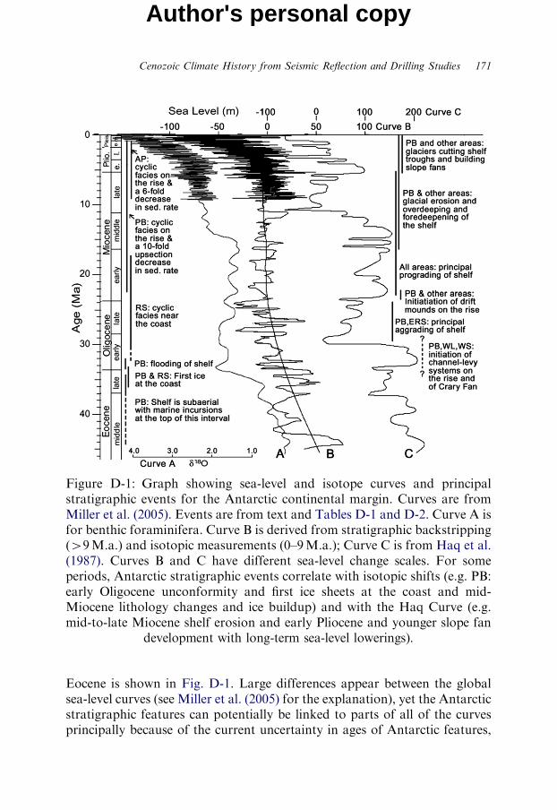
Figure D-1: Graph showing sea-level and isotope curves and principalstratigraphic events for the Antarctic continental margin. Curves are fromMiller et al. (2005). Events are from text and Tables D-1 and D-2. Curve A isfor benthic foraminifera. Curve B is derived from stratigraphic backstripping(W9M.a.) and isotopic measurements (0–9M.a.); Curve C is from Haq et al.(1987). Curves B and C have different sea-level change scales. For someperiods, Antarctic stratigraphic events correlate with isotopic shifts (e.g. PB:early Oligocene unconformity and first ice sheets at the coast and mid-Miocene lithology changes and ice buildup) and with the Haq Curve (e.g.mid-to-late Miocene shelf erosion and early Pliocene and younger slope fan
development with long-term sea-level lowerings).
Cenozoic Climate History from Seismic Reflection and Drilling Studies 171
Author's personal copy
Eocene is shown in Fig. D-1. Large differences appear between the globalsea-level curves (see Miller et al. (2005) for the explanation), yet the Antarcticstratigraphic features can potentially be linked to parts of all of the curvesprincipally because of the current uncertainty in ages of Antarctic features,
172 A. K. Cooper et al.
Author's personal copy
especially for the Paleogene. The closest links of Antarctic features with theglobal curves are:
� Late Eocene and early Oligocene lowering of sea-level (first glaciers into PBand RS), followed by sea-level rise in the early Oligocene (flooding of PB).� A long period from the Oligocene into the late Miocene of cyclic sea-level,seen in cyclic coastal deposits (WRS) and as glacial/interglacial rise-driftdeposits (PB, AP)� Abrupt sea-level lowering in the middle Miocene, seen in lithologies ofrise-drift deposits (PB), followed by further sea-level lowering (with icebuildup) and enhanced erosional deepening and prograding of continentalshelves by glaciers (as seen in seismic profiles from all areas).� The systematic decrease in sea-level (and increase in ice) from the mid-Miocene to the present that corresponds with the decrease in sedimentationrates on the rise and increase in sedimentation rates on the slope. This is mostpronounced since early Pliocene time, when an extensive system of shelferosional troughs and upper-slope fans developed.
Greater resolution of the link between ice-volume variations and sea-levelchanges requires further drilling on the Antarctic margin.
5.9. Summary
The Antarctic continental margin holds a thick Cenozoic sedimentarysection that is characterized by both long-period and short-periodlithostratigraphic transitions, which are seen locally in drill cores andregionally in seismic-reflection data. Age resolution is inadequate to linkindividual stratigraphic events, but is sufficient to make general statementsabout glacial history. The transitions point to the last 40m.y. being a periodof increasing glaciation and sediment distribution by glacial processes viashort-period fluctuations (e.g. Milankovitch frequencies) of grounded icesheets across the continental shelf and accompanying sea-level changes. Theproximal history is generally similar to that of distal proxy records fromisotopic studies in adjacent ocean basins (e.g. Zachos et al., 2001) and fromstratigraphic studies on low-latitude continental margins (e.g. Miller et al.,2005, 2000). Key inferences from the Antarctic margin for the Cenozoic,based on published data and inferences from extensive seismic-reflection andlimited drilling records, are:
� Although tectonic histories differ around the Antarctic margin, similargeomorphic features (e.g. overdeepened and foredeepened seafloor; broad
Cenozoic Climate History from Seismic Reflection and Drilling Studies 173
Author's personal copy
erosional troughs, sediment fans and drift mounds) are seen everywhere onthe margin, as a result of ubiquitous fluctuating glaciers eroding anddistributing sediments.� East and West Antarctic margin segments may have similar glacialhistories, based on similar geomorphologies and known ages offshore forglacial strata. Current differences result partly from lack of sufficient drillinginto likely Paleogene offshore sections beneath the margin.� Seismic geometries and facies from all segments of the continental marginshow evidence for up-section increases in the dynamic movement of sedimentacross the margin (e.g. shelf troughs, slope sediment fans, channel-leveesystems) and along the margin (e.g. rise-drift deposits), reflecting increasedglacial and ocean current activity from the Oligocene to the present.� Stratal geometries of the continental shelf and slope were controlledprincipally by eustatic changes (with ice fluctuations) from the Paleogene toabout the middle Miocene, and thereafter principally by fluctuatinggrounded glaciers (in tandem with sea-level changes) on the shelf, leadingto the overdeepening and foredeepening of the shelf.� Extensive prograding and aggrading of the continental shelf from the earlyMiocene to the latest Neogene is the principal result of sediment dispersal byice sheets during glacial and interglacial periods at near-Milankovitchperiodicities, as documented from drilling of drift deposits on the continentalrise in East Antarctica (PB) and West Antarctica (AP), and from near-coastal sequences (RS).� The principal locus of sediment deposition on the margin has shifted fromthe outer rise (and beyond) during the Paleogene, to the inner rise and slopein the early Miocene to early Pliocene, and to the mid slope thereafter. Thedepocentre shift reflects the increases in glacial activity (and increases inocean currents) and decrease in sediment being supplied due to erosion ofonshore and shelf areas.� Specific circum-Antarctic glacial events in the evolution of the margininclude: first glaciers at the coast and initiation of channel-levee systems onthe rise and the Crary Fan (early Oligocene); fluctuating glaciers, initial rapidprogradation of the continental shelf, and initial growth of drift mounds andlarge levees on the rise (early Miocene); onshore ice buildup and initialoverdeepening of the continental shelves (middle Miocene); dynamic icemovements and initial widespread development of cross-shelf troughs andupper-slope fans (early Pliocene); widespread deposition of biogenicinterglacial sediment in deep inner-shelf troughs (Holocene).
Additional advances in our understanding of Antarctica’s glacial historyand the varied effects of ice sheets on the paleoceanographic and

174 A. K. Cooper et al.
Author's personal copy
lithostratigraphic processes of the Antarctic continental margin can only beachieved through additional offshore deep stratigraphic drilling studies, suchas the current IODP, ANDRILL and SHALDRIL projects.
ACKNOWLEDGEMENTS
We thank many people who collaborated, by sharing data and ideas, ongeoscience research projects under the umbrella of the highly successfulANTOSTRAT project for nearly 15 years. This synthesis, which reflects ourviews, would not have been possible without the efforts of these manyinvestigators, most of whom continue their collaborative Antarctic studies,now under the successor ACE project. We appreciate the helpful reviewcomments by Larry Krissek and Peter Barrett on this chapter. We thankJohn Anderson for compiling and providing the supplementary references toprovide further historic perspective to community efforts partly summarizedin this chapter.
REFERENCES
The reference section includes many supplementary circum-Antarcticreferences to research studies that are directly related to the topic of thischapter. They are selected from a compilation provided by John Anderson tofurther assist colleagues in locating, using and citing prior collaborativeresearch data and interpretations.
Abelmann, A., Gersonde, R., & Spiess, V. (1990). Pliocene-Pleistocene paleoceano-graphy in the Weddell Sea – Siliceous microfossil evidence. In: U. Bleil, &J. Thiede (Eds). Geological History of the Polar Oceans: Arctic versus Antarctic.Kluwer Academic Publishers, Boston, MA, pp. 729–759.
Abreu, V. S., & Anderson, J. B. (1998). Glacial eustasy during the Cenozoic:Sequence stratigraphic implications. Am. Assoc. Petrol. Geol. Bull., 82,1385–1400.
Abreu, V. S., & Haddad, G. A. (1999). Glacioeustatic fluctuations: The mechanismlinking stable isotope events and sequence stratigraphy from the early Oligoceneto middle Miocene time. In: P. C. DeGraciansky, J. Hardenbol, T. Jacquin,P. R. Vail, & M. B. Farley (Eds). Sequence Stratigraphy of the European Basins.Society of Economic Paleontologists and Mineralogists, Tulsa, OK, SpecialPublication No. 60, pp. 245–259.
Abreu, V. S., Savini, R., & Barrocas, S. (1992). Paleoceanography and micro-biostratigraphy of the Moby Dick Group, Melville Peninsula, Northern King

Cenozoic Climate History from Seismic Reflection and Drilling Studies 175
Author's personal copy
George Island, Western Antarctica. In: Fourth International Conference on PaleoOceanography, Siena, Italy, p. 48.
Accaino, F., Boehm, G., & Brancolini, G. (2005). Analysis of Antarctic glaciationsby seismic reflection and refraction tomography. Mar. Geol., 216, 145–154.
Acosta, J., Herranz, P., Sanz, J. L., & Uchupi, E. (1992). Antarctic continentalmargin: Geological image of the Bransfield Trough, an incipient ocean basin.In: C. W. Poag, & P. C. Graciansky (Eds). Geological Evolution of the AtlanticContinental Rises. Van Nostrand Reinhold, New York, pp. 49–61.
Adamson, D., & Pickard, J. (1983). Late Quaternary ice movement across theVestfold Hills, East Antarctica. In: R. L. Oliver, P. R. James, & J. B. Jago (Eds).Antarctic Earth Science. Cambridge University Press, New York, pp. 465–469.
Adamson, D. A., & Pickard, J. (1986). Cainozoic history of the Vestfold Hills. In:J. Pickard (Ed.). Antarctic Oasis – Terrestrial Environments and History of theVestfold Hills. Academic Press, New York, pp. 63–97.
Alley, R. B. (1990). West Antarctic collapse – how likely? Episodes, 13, 231–238.Alley, R. B., & Bindschadler, R. A. (Eds). (2001). The West Antarctic Ice Sheet:
Behavior and Environment. American Geophysical Union, Antarctic ResearchSeries, Washington, DC, Vol. 77.
Alley, R. B., Blankenship, D. D., Bentley, C. R., & Rooney, S. T. (1987a). Tillbeneath ice stream B. 3. Till deformation: Evidence and implications. J. Geophys.Res., 92, 8921–8929.
Alley, R. B., Blankenship, D. D., Bentley, C. R., & Rooney, S. T. (1987b). Till beneathice stream B. 4. A coupled ice-till flow model. J. Geophys. Res., 92, 8931–8940.
Alley, R. B., Blankenship, D. D., Bentley, C. R., & Rooney, S. T. (1989). Sedimen-tation beneath ice shelves – the view from ice stream B. Mar. Geol., 85,101–120.
Alonso, B., Anderson, J. B., Diaz, J. I., & Bartek, L. R. (1992). Pliocene–PleistoceneSeismic Stratigraphy of the Ross Sea: Evidence for Multiple Ice Sheet GroundingEpisodes, Antarctic Research Series. American Geophysical Union, Washington,DC, Vol. 57, pp. 93–103.
Amblas, D., Urgeles, R., Canals, M., Calafat, A. M., Rebesco, M., Camerlenghi, A.,Estrada, F., De Batist, M., & Hughes-Clarke, J. E. (2006). Relationship betweencontinental rise development and palaeo-ice sheet dynamics, Northern AntarcticPeninsula Pacific margin. Quat. Sci. Rev., 25, 933–944.
Anderson, J. B. (1971). Marine origin of sands in the Weddell Sea. Antarct. J. U.S.,6, 168–169.
Anderson, J. B. (1972a). The Marine Geology of the Weddell Sea. Ph.D.Dissertation, Florida State University, Tallahassee, 222 pp.
Anderson, J. B. (1972b). Nearshore glacial-marine deposition from modernsediments of the Weddell Sea. Nat. Phys. Sci., 240, 189–192.
Anderson, J. B. (1975a). Ecology and distribution of foraminifera in the WeddellSea of Antarctica. Micropaleontology, 21, 69–96.
Anderson, J. B. (1975b). Factors controlling CaCO3 dissolution in the Weddell Seafrom foraminiferal distribution patterns. Mar. Geol., 19, 315–332.
176 A. K. Cooper et al.
Author's personal copy
Anderson, J. B. (1983). Ancient glacial-marine deposits: Their spatial and temporaldistribution. In: B. F. Molnia (Ed.). Glacial-Marine Sedimentation. Plenum Press,New York, pp. 3–92
Anderson, J. B. (1985). Antarctic Glacial Marine Sedimentation: A Core Workshop.Geological Society of America, Boulder, CO, 66 pp
Anderson, J. B. (1986). Critical evaluation of some criteria used to infer Antarctica’sglacial and climatic history from deep-sea sediments. S. Afr. J. Sci., 82, 503–505.
Anderson, J. B. (1990). Sediments. In: G. P. Glasby (Ed.). Antarctic Sector of thePacific. Elsevier Oceanography Series. New York, Vol. 51, pp. 187–206.
Anderson, J. B. (1991). The Antarctic continental shelf: Results from marinegeological and geophysical investigations. In: R. J. Tingey (Ed.). The Geology ofAntarctica. Clarendon Press, Oxford, pp. 285–334.
Anderson, J. B. (1999). Antarctic Marine Geology. Cambridge University Press,Cambridge, 289 pp.
Anderson, J. B., & Kurtz, D. (1985). The use of silt grain size parameters as apaleovelocity gauge: A critical review and case study. Geo Mar. Lett., 5, 55–59.
Anderson, J. B., & Molnia, B. F. (1989). Glacial-Marine Sedimentation. Short Coursein Geology. American Geophysical Union, Washington, DC, Vol. 9, 127 pp.
Anderson, J. B., & Smith, M. J. (1989). Formation of modern sand-rich facies bymarine currents on the Antarctic continental shelf. In: R. Morton, & D.Nummedal (Eds). Shelf Sedimentation, Shelf Sequences, and Related HydrocarbonAccumulation: Gulf Coast Section of the Society of Economic Paleontologists andMineralogists 7th Annual Research Conference Proceedings, Vol. 85, pp. 41–52.
Anderson, J. B., & Ashley, G. M. (Eds). (1991). Glacial Marine Sedimentation;Paleoclimatic Significance. The Geological Society of America, Boulder, Co,Special Paper 261.
Anderson, J. B., & Bartek, L. R. (1991). High resolution seismic record of Antarcticglacial history. Korean J. Polar Res., 2, 71–78.
Anderson, J. B., & Thomas, M. A. (1991). Marine ice-sheet decoupling as amechanism for rapid, episodic sea-level change: The record of such events andtheir influence on sedimentation. Sediment. Geol., 70, 87–104.
Anderson, J. B., & Bartek, L. R. (1992). Cenozoic Glacial History of the Ross SeaRevealed by Intermediate Resolution Seismic Reflection Data Combined withDrill Site Information. Antarctic Research Series. American Geophysical Union,Washington, DC, Vol. 56, pp. 231–263.
Anderson, J. B., & Andrews, J. T. (1999). Radiocarbon constraints on ice sheetadvance and retreat in the Weddell Sea, Antarctica. Geology, 27, 179–182.
Anderson, J. B., Balshaw, K., Domack, E., Kurtz, D., Milam, R., & Wright, R.(1979a). Geologic survey of the East Antarctic continental margin aboardUSCGC Glacier. Antarct. J. U.S., 14, 142–144.
Anderson, J. B., Kurtz, D. D., & Weaver, F. M. (1979b). Sedimentation on theAntarctic continental slope. In: L. J. Doyle, & O. Pilkey (Eds). Geology ofContinental Slopes. Society of Economic Paleontologists and Mineralogists,Tulsa, OK, Special Publication No. 27, pp. 265–283.
Cenozoic Climate History from Seismic Reflection and Drilling Studies 177
Author's personal copy
Anderson, J. B., Domack, E. W., & Kurtz, D. D. (1980a). Observations of sediment-laden icebergs in Antarctic waters: Implications to glacial erosion and transport.J. Glaciol., 25, 387–396.
Anderson, J. B., Kurtz, D. D., Domack, E. W., & Balshaw, K. M. (1980b). Glacialand glacial marine sediments of the Antarctic continental shelves. J. Geol., 88,399–414.
Anderson, J. B., Brake, C., Domack, E. W., Myers, N., & Singer, J. (1983a).Sedimentary dynamics of the Antarctic continental shelf. In: R. L. Oliver, P. R.James, & J. B. Jago (Eds). Antarctic Earth Science. Cambridge University Press,New York, pp. 387–389.
Anderson, J. B., Brake, C., Domack, E., Myers, N., & Wright, R. (1983b).Development of a polar glacial-marine sedimentation model from AntarcticQuaternary deposits and glaciological information. In: B. F. Molnia (Ed.).Glacial-Marine Sedimentation. Plenum Press, New York, pp. 233–264.
Anderson, J. B., Brake, C. F., & Myers, N. C. (1984). Sedimentation on the RossSea continental shelf, Antarctica. Mar. Geol., 57, 295–333.
Anderson, J. B., Wright, R., & Andrews, B. (1986). Weddell Fan and associatedabyssal plain, Antarctica: Morphology, sediment processes, and factors influen-cing sediment supply. Geo Mar. Lett., 6, 121–129.
Anderson, J. B., Pope, P. G., & Thomas, M. A. (1990). Evolution and hydrocarbonpotential of the northern Antarctic Peninsula continental shelf. In: B. St John(Ed.). Antarctica as an Exploration Frontier – Hydrocarbon Potential, Geology andHazards. American Association of Petroleum Geologists, Tulsa, OK, Studies inGeology, Vol. 31, pp. 1–12.
Anderson, J. B., Andrews, B. A., Bartek, L., & Truswell, E. M. (1991a). Petrologyand palynology of Weddell Sea glacial sediments: Implications for subglacialgeology. In: M. R. A. Thomson, J. A. Crame, & J. W. Thomson (Eds).Geological Evolution of Antarctica. Cambridge University Press, New York,pp. 231–235.
Anderson, J. B., Bartek, L. R., & Thomas, M. A. (1991b). Seismic andsedimentologic record of glacial events on the Antarctic Peninsula shelf. In:M. R. A. Thomson, J. A. Crame, & J. W. Thomson (Eds). Geological Evolution ofAntarctica. Cambridge University Press, New York, pp. 687–691.
Anderson, J. B., Reid, D. E., & Taviani, M. (1991). Compositional and geochemicalcharacteristics of recent biogenic carbonates from the Ross Sea (Antarctica). In:C. A. Ricci (Ed.). Earth Science Investigations in Antarctica. Memorie dellaSocieta Geologica Italiana, Vol. 46, pp. 561–562.
Anderson, J. B., Kennedy, D. S., Smith, M. J., & Domack, E. W. (1991c).Sedimentary facies associated with Antarctica’s floating ice masses. In: J. B.Anderson, & G. M. Ashley (Eds). Glacial Marine Sedimentation; PaleoclimaticSignificance. Geological Society of America, Boulder, CO, Special Paper 261,pp. 1–25.
Anderson, J. B., Shipp, S. S., Bartek, L. R., & Reid, E. D. (1992a). Evidence for aGrounded Ice Sheet on the Ross Sea Continental Shelf During the Late Pleistocene
178 A. K. Cooper et al.
Author's personal copy
and Preliminary Paleodrainage Recostruction. Antarctic Research Series. Amer-ican Geophysical Union, Washington, DC, Vol. 57, pp. 39–62.
Anderson, J. B., Shipp, S. S., & Siringan, F. P. (1992b). Preliminary seismicstratigraphy of the northwestern Weddell Sea continental shelf. In: Y. Yoshida,K. Kaminuma, & K. Shiraishi (Eds). Recent Progress in Antarctic Earth Science.Terra Scientific Publishing, Tokyo, pp. 603–612.
Anderson, J. B., Wellner, J. S., Bohaty, S., Manley, P. L., & Wise, S. W. (2006).Antarctic Shallow Drilling Project Provides Key Core Samples. Eos Trans. Am.Geophys. Union, 87, 402–408.
Anderson, J. B., Wellner, J., Wise, S., Bohaty, S., Manley, P., Smith, T., Weaver, F.,& Kulhanek, D. (2007). Seismic and chronostratigraphic results from SHAL-DRIL II, northwestern Weddell Sea. US Geological Survey and The NationalAcademies, USGS OF-2007-1047, doi:10.3133/of2007-1047.srp094.
Andrews, B. A. (1984). A Petrologic Study of Weddell Sea Sediments: Implicationsfor Provenance and Glacial History. M.A. Thesis, Rice University, Houston, TX,203 pp.
Angino, E. E., & Andrews, R. S. (1968). Trace element chemistry, heavy minerals, andsediment statistics of Weddell Sea sediments. J. Sediment. Petrol., 38, 634–642.
Arne, D. C. (1994). Phanerozoic exhumation history of northern Prince CharlesMountains (East Antarctica). Antarct. Sci., 6, 69–84.
Ashley, G. M., Shaw, J., & Smith, N. D. (Eds). (1985). Glacial SedimentaryEnvironments, Short Course No. 16. Society of Paleontologists and Mineralogists,Tulsa, OK, 246 pp.
Askin, R. A. (1988a). Campanian to Paleocene palynological succession of Seymourand adjacent islands, northeastern Antarctic Peninsula. In: R. M. Feldman, &M. O. Woodburne (Eds). Geology and Paleontology of Seymour Island, AntarcticPeninsula. Geological Society of America, Boulder, Co, Memoir, Vol. 169,pp. 131–153.
Askin, R. A. (1988b). The palynological record across the Cretaceous/Tertiarytransition on Seymour Island, Antarctica. In: R. M. Feldman, & M. O.Woodburne (Eds). Geology and Paleontology of Seymour Island, AntarcticPeninsula. Geological Society of America, Boulder, CO, Memoir, Vol. 169,pp. 155–162.
Askin, R. A. (1992). Late Cretaceous–early Tertiary Antarctic outcrop evidencefor past vegetation and climates. In: J. P. Kennett, & D. A. Warnke (Eds).The Antarctic Paleoenvironment: A Perspective on Global Change I. AmericanGeophysical Union, Washington, DC, Antarctic Research Series, Vol. 56,pp. 61–73.
Asking, R. A., & Raine, J. L. (2000). Oligocene and early Miocene terrestrialpalinology of the Cape Roberts drillhole CRP-2/21, Victoria Land Basin,Antarctica. Terra Antart., 7(4), 493–501.
Baegi, M. (1985). Turbidite Deposition on the Bellingshausen Abyssal Plain:Sedimentologic Implications. M.A. Thesis, Rice University, Houston, TX, 109 pp.
Cenozoic Climate History from Seismic Reflection and Drilling Studies 179
Author's personal copy
Balshaw, K. M. (1981). Antarctic glacial chronology reflected in the Oligocenethrough Pliocene sedimentary section in the Ross Sea. M.A. Thesis, RiceUniversity, Houston, TX, 140 pp.
Bandy, O. L., Casey, R. E., & Wright, R. C. (1971). Late Neogene planktoniczonation, magnetic reversals, and radiometric dates, Antarctic to the Tropics.In: J. L. Reid (Ed.). Antarctic Oceanology I. American Geophysical Union,Washington, DC, Antarctic Research Series, Vol. 15, pp. 1–26.
Banfield, L. A. (1994). Seismic Facies investigation of the Late Cenozoic GlacialHistory of Bransfield Basin, Antarctica. M.A. Thesis, Rice University, Houston,TX, 184 pp.
Banfield, L. A., & Anderson, J. B. (1995). Seismic facies investigation of the lateQuaternary glacial history of Bransfield Basin, Antarctica. In: A. K. Cooper,P. F. Barker, & G. Brancolini (Eds). Geology and Seismic Stratigraphy of theAntarctic Margin. American Geophysical Union, Washington, DC, AntarcticResearch Series, Vol. 68, pp. 123–140.
Bardin, V. I. (1982). Composition of East Antarctic moraines and some problems ofCenozoic history. In: C. Craddock (Ed.). Antarctic Geoscience. University ofWisconsin Press, Madison, WI, pp. 1069–1076.
Barker, P. F. (1976). The tectonic framework of Cenozoic volcanism in the ScotiaSea region: A review. In: O. Gonzalez-Ferran (Ed.). Symposium on Andean andAntarctic Volcanology Problems. Proceedings of the IAVCEI, Santiago, Chile,pp. 330–346.
Barker, P. F. (1982). The Cenozoic subduction history of the Pacific margin of theAntarctic Peninsula: Ridge crest-trench interactions. J. Geol. Soc. London, 139,787–801.
Barker, P. F., & Dalziel, I. W. D. (1976). The evolution of the southwest AtlanticOcean basin: Leg 36 data. In: P. F. Barker, & I. W. D. Dalziel (Eds). InitialReports of the Deep Sea Drilling Project. US Government Printing Office,Washington, DC, p. 993.
Barker, P. F., & Burrell, J. (1977). The opening of Drake Passage. Mar. Geol., 25,15–34.
Barker, P. F., & Dalziel, I. W. D. (1983). Progress in geodynamics in the Scotia Arcregion. In: R. Cabre (Ed.). Geodynamics in the Eastern Pacific Region, Caribbeanand Scotia Arcs. American Geophysical Union, Washington, DC, GeodynamicsSeries, Vol. 9, pp. 137–170.
Barker, P. F., & Lonsdale, M. J. (1991). A multichannel seismic profile across theWeddell Sea margin of the Antarctic Peninsula: Regional tectonic implications.In: M. R. A. Thomson, J. A. Crame, & J. W. Thomson (Eds). GeologicalEvolution of Antarctica. Cambridge University Press, Cambridge, UK,pp. 237–241.
Barker, D. H. N., & Austin, J. A. (1994). Crustal diapirism in Bransfield Strait, WestAntarctica: Evidence for distributed extension in marginal basin formation.Geology, 22, 657–660.

180 A. K. Cooper et al.
Author's personal copy
Barker, D. H. N., & Austin, J. A. (1998). Rift propagation, detachment faulting, andassociated magmatism in Bransfield Strait, Antarctic Peninsula. J. Geophys. Res.,103, 24017–24043.
Barker, P. F., & Camerlenghi, A. (2002). Glacial history of the Antarctic Peninsulafrom Pacific margin sediments. In: P. F. Barker, A. Camerlenghi, G. D. Acton, &A. T. S. Ramsay (Eds). Proceedings of the Ocean Drilling Program, ScientificResults, Vol. 178 [Online]. Available from World Wide Web: http://www-odp.tamu.edu/publications/178_SR/synth/synth.htm
Barker, P. F., Kennett, J. P., et al. (1988a). Proceedings of the Ocean DrillingProgram, Initial Reports. Ocean Drilling Program, Texas A&M University,College Station, TX, Vol. 113, 785 pp.
Barker, P. F., Kennett, J. P., et al., (1988b). Weddell Sea palaeoceanography:Preliminary results of ODP Leg 113. Palaeogeogr. Palaeoclimatol. Palaeoecol.,67, 75–102.
Barker, P. F., Barrett, P., Camerlenghi, A., Cooper, A., Dacey, F., Domack, E.,Escutia, C., Kristoffersen, Y., & O’Brien, P. E. (1998). Ice sheet history fromcontinental margin sediments: The ANTOSTRAT approach. Terra Antart., 5,737–760.
Barker, P. F., Camerlenghi, A., Acton, G. D., et al. (1999). Proceedings of the OceanDrilling Program, Initial Reports, Vol. 178 [CD-ROM]. Available from OceanDrilling Program, Texas A&M University, College Station, TX.
Barnes, P. W. (1987). Morphologic studies of the Wilkes Land continental shelf,Antarctica-glacial and iceberg effects. In: S. L. Eittreim, & M. A. Hampton (Eds).The Antarctic Continental Margin: Geology and Geophysics of Offshore WilkesLand. Circum-Pacific Council for Energy and Mineral Resources, Houston, TX,CPCEMR Earth Science Series, Vol. 5A, pp. 175–194.
Barnes, P. W., & Lien, R. (1988). Icebergs rework shelf sediments to 500 m offAntarctica. Geology, 16, 1130–1133.
Baroni, C., & Orombelli, G. (1991). Holocene raised beaches at Terra Nova Bay,Victoria Land, Antarctica. Quat. Res., 36, 157–177.
Barrera, E., & Huber, B. T. (1993). Eocene to Oligocene oceanography and tempera-tures in the Antarctic Indian Ocean. In: J. P. Kennett, & D. A. Warnke (Eds).The Antarctic Paleoenvironment; A Perspective on Global Change II.American Geophysical Union, Washington, DC, Antarctic Research Series,Vol. 60, pp. 49–65.
Barrett, P. J. (1975). Textural characteristics of Cenozoic preglacial and glacialsediments at Site 270, Ross Sea, Antarctica. In: D. E. Hayes, & L. A. Frakes(Eds). Initial Reports of the Deep Sea Drilling Project. US Government PrintingOffice, Washington, DC, Vol. 28, pp. 757–767.
Barrett, P. J. (1981). History of the Ross Sea region during the deposition of theBeacon Supergroup 400–180 million years ago. J. R. Soc. N. Z., 11, 447–459.
Barrett, P. J. (Ed.) (1986). Antarctic Cenozoic History from the MSSTS-1 Drillhole,McMurdo Sound. DSIR Bulletin 237. Science Information Publishing Centre,Wellington, New Zealand.
Cenozoic Climate History from Seismic Reflection and Drilling Studies 181
Author's personal copy
Barrett, P. J. (Ed.) (1989). Antarctic Cenozoic History from the CIROS-1 Drillhole,McMurdo Sound. DSIR Bullettin, N.Z., 245.
Barrett, P. J. (Ed.) (1991). Antarctica and global climate change: A geologicalperspective. In: C. Harris, & B. Stonehouse (Eds). Antarctica and Global ClimateChange. Belhaven Press, London, pp. 35–50.
Barrett, P. J. (1997). Antarctic paleoenvironment through Cenozoic times: A review.Terra Antart., 3, 103–119.
Barrett, P. J. (2007). Cenozoic climate and sea level history from glacimarine strataoff the Victoria Land coast, Cape Roberts Project, Antarctica. In: M. J.Hambrey, P. Christoffersen, N. F. Glasser, & B. Hubbart (Eds). Glacial Processesand Products. International Association of Sedimentologists, Oxford, SpecialPublication, Vol. 39, pp. 259–287.
Barrett, P. J., & McKelvey, B. C. (1986). Stratigraphy. In: P. J. Barrett (Ed.).Antarctic Cenozoic History from the MSSTS-1 Drillhole, McMurdo Sound.Science Information Publishing Centre, Wellington, New Zealand, DSIRBulletin, Vol. 237, pp. 9–52.
Barrett, P. J., Pyne, A. R., & Ward, B. L. (1983). Modern sedimentation inMcMurdo Sound, Antarctica. In: R. L. Oliver, P. R. James, & J. B. Jago (Eds).Antarctic Earth Science. Cambridge University Press, New York, pp. 550–554.
Barrett, P. J., Elston, D. P., Harwood, D. M., McKelvey, B. C., & Webb, P. N.(1987). Mid-Cenozoic record of glaciation and sea-level change on the margin ofthe Victoria Land basin, Antarctica. Geology, 15, 634–637.
Barrett, P. J., Hambrey, M. J., Harwood, D. M., Pyne, A. R., & Webb, P. N. (1989).Synthesis. In: P. J. Barrett (Ed.). Antarctic Cenozoic History from the CIROS-1Drillhole, McMurdo Sound. DSIR Bulletin 245. DSIR Publishing, Wellington, pp.241–251.
Barrett, P. J., Adams, C. J., McIntosh, W. C., Swisher, C. C. III, & Wilson, G. S.(1992). Geochronological evidence supporting Antarctic deglaciation threemillion years ago. Nature, 359, 816–818.
Barrett, P. J., Henrys, S. A., Bartek, L. R., Brancolini, G., Busetti, M., Davey, F. J.,Hannah, M. J., & Pyne, A. R. (1995). Geology of the margin of the Victoria LandBasin off Cape Roberts, southwest Ross Sea. In: A. K. Cooper, P. F. Barker, &G. Brancolini (Eds). Geology and Seismic Stratigraphy of the Antarctic Margin.American Geophysical Union, Washington, DC, Antarctic Research Series,Vol. 68, pp. 183–208.
Barrett, P. J., Davey, F. J., De Santis, L., Alonso, B., Bart, P. J., Bartek, L. R.,Brancolini, G., & Wise, S. W. Jr. (1999). Past Behavior of the West Antarctic IceSheet. IODP proposal 489/revision 3.
Barrie, C. Q., & Piper, D. J. W. (1982). Late Quaternary MarineGeology of Makkovik Bay, Labrador. Geological Survey of Canada Paper81–17, 37 pp.
Barron, J., Larsen, B., & Shipboard Scientific Party (Eds) (1989). Proceedingsof the Ocean Drilling Program, Initial Reports. College Station, TX, Vol. 119,942 pp.
182 A. K. Cooper et al.
Author's personal copy
Barron, J. A. (1996). Diatom constraints on the position of the Antarctic PolarFront in the middle part of the Pliocene. Mar. Micropaleontol., 27, 195–213.
Barron, J. A., Larson, B., & Baldauf, J. G. (1991). Evidence for for late Eocene toearly Oligocene Antarctic glaciation and observations on late Neogene glacialhistory of Antarctica: Results from Leg 119. In: J. A. Barron, B. Larsen, et al.(Eds). Proceedings of the Ocean Drilling Program, Scientific Results, Vol. 119,pp. 869–894.
Bart, P. J. (1993). Glacial and Tectonic Development of the Antarctic Peninsula. M.A.Thesis, Rice University, Houston, TX, 152 pp.
Bart, P. J. (1998). Seismic-Stratigraphic Analysis of Shelf-Margin Delta/Slope Fansand Basin Floor Fans on High-Latitude and Middle-Latitude Margins (Ross Seaand Alabama/West Florida Shelf): Paleoclimatic and Eustatic Implications. Ph.D.Dissertation, Rice University, Houston, TX, 236 pp.
Bart, P. J. (2003). Were West Antarctic Ice Sheet grounding events in the Ross aconsequence of East Antarctic Ice Sheet expansion during the middle Miocene?Earth Planet. Sci. Lett., 216, 93–107.
Bart, P. J., & Anderson, J. B. (1995). Seismic record of glacial events affecting thePacific margin of the northwestern Antarctic Peninsula. In: A. K. Cooper, P. F.Barker, & G. Brancolini (Eds). Geology and Seismic Stratigraphy of the AntarcticMargin. American Geophysical Union, Washington, DC, Antarctic ResearchSeries, Vol. 68, pp. 74–95.
Bart, P. J., & Anderson, J. B. (1996). Seismic expression of depositional sequencesassociated with expansion and contraction of ice sheets on the northwesternAntarctic Peninsula continental shelf. In: M. De Batist, & P. Jacobs (Eds).Geology of Siliciclastic Shelf Seas. Geological Society, London, SpecialPublication, Vol. 117, pp. 171–186.
Bart, P. J., & Anderson, J. B. (2000). Relative temporal stability of the Antarctic IceSheets during the late Neogene based on the minimum frequency of outer shelfgrounding events. Earth Planet. Sci. Lett., 182(3/4), 259–272.
Bart, P. J., De Batist, M., & Miller, H. (1994). Neogene collapse of glacially-deposited, shelf-edge deltas in the Weddell Sea: Relationships between depositionduring glacial periods and sub-marine fan development. In: A. K. Cooper, P. F.Barker, P. N. Webb, & G. Brancolini (Eds). The Antarctic Continental Margin.Geophysical and Geological Stratigraphic Records of Cenozoic Glaciation,Paleoenvironments and Sea-Level Change. Terra Antart., Vol. 1, pp. 317–318.
Bart, P. J., DeBatist, M., & Jokat, W. (1999). Interglacial collapse of Crary TroughMouth Fan, Weddel Sea, Antarctica: Implications for Antarctic glacial history.J. Sed. Res., 69, 1276–1289.
Bart, P. J., Anderson, J. B., Trincardi, F., & Shipp, S. S. (2000). Seismic data fromthe Northern basin, Ross Sea, record extreme expansion of the East Antarctic IceSheet during late Neogene. Mar. Geol., 166, 31–50.
Bart, P. J., Egan, D., & Warny, S. A. (2005). Direct constraints on AntarcticPeninsula Ice Sheet grounding events between 5.12 and 7.94Ma. J. Geophys. Res.,110, F04008, doi:10.1029/2004JF000254.
Cenozoic Climate History from Seismic Reflection and Drilling Studies 183
Author's personal copy
Bart, P. J., Hillenbrand, C. D., Ehrmann, W., Iwai, M., Winter, D., & Warny, S. A.(2007). Are Antarctic Peninsula Ice Sheet grounding events manifest insedimentary cycles on the adjacent continental rise? Mar. Geol., 236, 1–13.
Bartek, L. R., & Anderson, J. B. (1991). Facies distribution resultingfrom sedimentation under polar interglacial climatic conditions within ahigh-latitude marginal basin, McMurdo Sound, Antarctica. In: J. B. Anderson,& G. M. Ashley (Eds). Glacial Marine Sedimentation; PaleoclimaticSignificance. Geological Society of America, Boulder, CO, Special Paper 261,pp. 27–49.
Bartek, L. R., Vail, P. R., Andersonl, J. B., Emmet, P. A., & Wu, S. (1991). Effect ofCenozoic ice sheet fluctuations in Antarctica on the stratigraphic signature of theNeogene. J. Geophys. Res., 96, 6753–6778.
Bartek, L. R., Sloan, L. C., Anderson, J. B., & Ross, M. I. (1992). Evidence from theAntarctic continental margin of late Paleogene ice sheets: a manifestation of platereorganization and synchronous changes in atmospheric circulation over theemerging Southern Ocean. In: D. R. Prothero, & W. A. Berggren (Eds). Eocene-Oligocene Climatic and Biotic Evolution. Princeton University Press, Princeton,NJ, pp. 131–159.
Bartek, L. R., Anderson, J. B., & Henrys, S. A. (1994). Contributions of highresolution single-channel data to understanding sequence architecture of aglaciated continental margin, Ross Sea, Antarctica. In: A. K. Cooper, P. F.Barker, P. N. Webb, & G. Brancolini (Eds). The Antarctic Continental Margin.Geophysical and Geological Stratigraphic Records of Cenozoic Glaciation,Paleoenvironments and Sea-Level Change. Terra Antart., 1 (2), 329–332.
Bartek, L. R., Henrys, S. A., Anderson, J. B., & Barrett, P. J. (1996). Seismicstratigraphy of McMurdo Sound, Antarctica: Implication for glacially influencedearly Cenozoic eustatic change. Mar. Geol., 130, 79–98.
Barton, C. M. (1965). The Geology of the South Shetland Islands. III. TheStratigraphy of King George Island. British Antarctic Survey Scientific Reports,No. 44, 37 pp.
Behrendt, J. C., LeMasurier, W. E., Cooper, A. K., Tessensohn, F., Trehu, A., &Damaske, D. (1991). Geophysical studies of the West Antarctic Rift System.Tectonics, 10(6), 1257–1273.
Belknap, D. F., & Shipp, R. C. (1991). Seismic stratigraphy of glacial marine units,Maine inner shelf. In: J. B. Anderson, & G. M. Ashley (Eds). Glacial MarineSedimentation: Paleoclimatic Significance. Geological Society of America,Boulder, CO, Special Paper, Vol. 261, pp. 137–158.
Bentley, M. J., & Anderson, J. (1998). Glacial and marine geological evidence for theice sheet configuration in the Weddell Sea – Antarctic Peninsula region during thelast glacial maximum. Antarct. Sci., 10, 309–325.
Bialas, J., & GRAPE Team (1990). Seismic investigations along the AntarcticPeninsula. In: A. K. Cooper, & P. N. Webbs (Eds). International Workshop onAntarctic Offshore Seismic Stratigraphy (ANTOSTRAT). Overview andExtended Abstracts, pp. 72–78.
184 A. K. Cooper et al.
Author's personal copy
Bibby, J. S. (1966). The Stratigraphy of Part of North-East Graham Land and the JamesRoss Island Group. British Antarctic Survey Scientific Reports, No. 53, 37 pp.
Birkenmajer, K. (1980). Report on geological investigations of King George Island,South Shetland Islands (West Antarctica) in 1978/79. Stud. Geol. Pol., 64, 89–105.
Birkenmajer, K. (1981a). Geological relations at Lions Rump, King George Island(South Shetland Islands, Antarctica). Stud. Geol. Pol., 72, 75–87.
Birkenmajer, K. (1981b). Lithostratigraphy of the Point Hennequin Group(Miocene volcanics and sediments) at King George Island (South ShetlandIslands, Antarctica). Stud. Geol. Pol., 72, 59–73.
Birkenmajer, K. (1984). Pre-Quaternary glaciations of West Antarctica: evidencefrom the South Shetland Islands. Pol. Polar Res., 5, 319–329.
Birkenmajer, K. (1985). Onset of Tertiary continental glaciation in the AntarcticPeninsula sector (West Antarctica). Acta Geol. Pol., 35, 1–31.
Birkenmajer, K. (1987). Oligocene-Miocene glacio-marine sequences of KingGeorge Island (South Shetland Islands), Antarctica. Palaeontol. Pol., 49, 9–40.
Birkenmajer, K. (1988). Tertiary glacial and interglacial deposits, South ShetlandIslands, Antarctica: Geochronology versus biostratigraphy (a progress report).Bull. Pol. Acad. Sci. Earth Sci., 36, 133–145.
Birkenmajer, K. (1991). Tertiary glaciation in the South Shetland Islands, WestAntarctica: Evaluation of data. In: M. R. A. Thomson, J. A. Crame, &J. W. Thomson (Eds). Geological Evolution of Antarctica. Cambridge UniversityPress, Cambridge, UK, pp. 629–632.
Birkenmajer, K., & Gazdzicki, A. (1986). Oligocene age of the Pecten conglomerateon King George Island, West Antarctica. Bulletin of the Polish Academy ofSciences. Earth Sciences, 34, 219–226.
Birkenmajer, K., & Luczkowska, E. (1987). Early Miocene foraminiferal zonation,southeast Pacific Basin, Antarctic Peninsula sector. Bulletin of the Polish Academyof Sciences, Earth Sciences, 35, 1–10.
Birkenmajer, K., Soliani, E. Jr., & Kawashita, K. (1988). Early Miocene K-Ar age ofvolcanic basement of the Melville Glaciation deposits, King George Island,West Antarctica. Bulletin of the Polish Academy of Sciences. Earth Sciences, 36,25–34.
Birkenmajer, K., Soliani, E. Jr., & Kawashita, K. (1989). Geochronology of Tertiaryglaciations on King George Island, West Antarctica. Bulletin of the PolishAcademy of Sciences. Earth Sciences, 37, 27–48.
Blank, R. G., & Margolis, S. V. (1975). Pliocene climatic and glacial history ofAntarctica as revealed by Southeast Indian Ocean deep-sea cores. Geol. Soc. Am.Bull., 86, 1058–1066.
Blankenship, D. D., Bentley, C. R., Rooney, S. T., & Alley, R. B. (1987). Tillbeneath ice stream B, 1. Properties derived from seismic travel times. J. Geophys.Res., 92, 8903–8911.
Bochu, Y., Guangyu, W., Bangyan, C., & Shengyuan, C. (1995). The characteristicsof geophysical field and tectonic evolution in the Bransfield Strait. Antarct. Res.,6, 12–23.
Cenozoic Climate History from Seismic Reflection and Drilling Studies 185
Author's personal copy
Bohaty, S. M., & Harwood, D. M. (1995). Pliocene Silicoflagellate PaleotemperatureVariation from the Kerguelen Plateau, Abstracts of Programs. Geological Societyof America, Vol. 27, No. 3, p. 41.
Bornhold, B. D. (1983). Ice-rafted debris in sediments from Leg 71, southwestAtlantic Ocean. In: W. J. Ludwig, V. A. Krasheninnikov, et al. (Eds). InitialReports of the Deep Sea Drilling Project. US Government Printing Office,Washington, DC, Vol. 71, pp. 307–316.
Boulton, G. S. (1978). Boulder shapes and grain-size distributions of debris asindicators of transport paths through a glacier and till genesis. Sedimentology, 25,773–799.
Boulton, G. S. (1990). Sedimentary and sea level changes during glacial cycles andtheir control on glacimarine facies architecture. In: J. A. Dowdeswell, & J. D.Scourse (Eds). Glacimarine Environments: Processes and Sediments. GeologicalSociety, London, England, Special Publication No. 53, pp. 15–52.
Boulton, G. S., & Paul, M. A. (1976). The influence of genetic processes on somegeotechnical properties of glacial tills. Q. J. Eng. Geol., 9, 159–194.
Boulton, G. S., & Jones, A. S. (1979). Stability of temperate ice caps and ice sheetsresting on beds of deformable sediments. J. Glaciol., 24, 29–43.
Brachfeld, S., Domack, E., Kissel, C., Laj, C., Leventer, A., Ishman, S., Gilbert, R.,Camerlenghi, A., & Eglinton, L. B. (2003). Holocene history of the Larsen-A IceShelf constrained by geomagnetic paleointensity dating. Geology, 31, 749–752.
Brady, H. T. (1982). Late Cenozoic history of Taylor and Wright Valleys andMcMurdo Sound inferred from diatoms in Dry Valley Drilling Project cores.In: C. Craddock (Ed.). Antarctic Geoscience. University of Wisconsin Press,Madison, WI, pp. 1123–1131.
Brake, C. F., & Anderson, J. B. (1983). The bathymetry of the North Victoria Landcontinental margin. Mar. Geol., 6, 139–147.
Brambati, A., Ceccaroni, L., D’Onofrio, S., Fanzutti, G. P., Finocchiaro, F.,Frignani, M., Langone, L., Melis, R., & Ravaioli, M. (1994). Palaeoenviron-mental inferences from the Cora ANTA91-30 Drigalsky Basin, Ross Sea,Antarctica. Terra Antart., 1, 335–337.
Brancolini, G., Gantar, C., Lodolo, E., & Marchetti, A. (1991). Acquisition,processing and preliminary results of the 1988/89 Antarctic geophysical survey.Mem. Soc. Geol. It., 46, 543–560.
Brancolini, G., Cooper, A. K., & Coren, F. (1995). Seismic Facies and GlacialHistory in the Western Ross Sea (Antarctica), Antarctic Research Series.American Geophysical Union, Washington, DC, Vol. 68, pp. 209–234.
Brancolini, G., & Harris, P. T. (2000). Post-cruise report AGSO Survey 217: JointItalian/Australian marine geoscience expedition aboard the R.V. Tangaroa to theGeorge Vth Land region during February–March 2000. Australian GeologicalSurvey Organisation Record 2000/38.
Bruno, L. A., Baur, H., Graf, T., Schluchter, C., Signer, P., & Wieler, R. (1997).Dating of Sirius Group tillites in the Antarctic Dry Vallies with cosmogenic 3Heand 21Ne. Earth Planet. Sci. Lett., 147, 37–54.
186 A. K. Cooper et al.
Author's personal copy
Burckle, L. H. (1984). Diatom distribution and paleoceanographic reconstructionin the Southern Ocean; present and last glacial maximum. Mar. Micropaleontol.,9, 241–261.
Burckle, L. H., & Abrams, N. (1986). Diatom species diachrony in late Neogenesediments of the Southern Ocean. S. Afr. J. Sci., 82, 505–506.
Burckle, L. H., & Cirilli, J. (1987). Origin of diatom ooze belt in the SouthernOcean; implications for late Quaternary paleoceanography. Micropaleontology,33, 82–86.
Burckle, L. H., Robinson, D., & Cooke, D. (1982). Reappraisal of sea-icedistribution in Atlantic and Pacific sectors of the Southern Ocean at 18,000 yrBP. Nature, 299, 435–437.
Busetti, M., & Cooper, A. K. (1994). Possible ages and origins of unconformity U6.In: A. K. Cooper, P. F. Barker, P. N. Webb, & G. Brancolini (Eds). The AntarcticContinental Margin: Geophysical and Geological Stratigraphic Records ofCenozoic Glaciation, Paleoenvironments and Sea Level Change. Terra Antart., 1(2), 341–344.
Busetti, M., Zanolla, C., & Marchetti, A. (2001). Geological structure of the SouthOrkney microcontinent. Terra Antart., 8, 71–78.
Busetti, M., Marchetti, A., Zanolla, C., & De Cillia, C. (2002). Tectonic history ofthe South Orkney microcontinent from seismic structure and stratigraphy. In:J. A. Gamble, D. N. B. Skinner, & S. Henrys (Eds). Antarctica at the Close of aMillennium. Royal Society of New Zealand Bulletin. Royal Society of NewZealand, Wellington, Vol. 35, pp. 507–513.
Canals, M., De Batist, M., Baraza, J., Acosta, J., & the GEBRA Team. (1994).New reflection seismic data from Bransfield Strait, Preliminary Results of theGEBRA-93 Survey. In: A. K. Cooper, P. F. Barker, P. N. Webb, & G. Brancolini(Eds). The Antarctic Continental Margin: Geophysical and Geological Strati-graphic Records of Cenozoic Glaciation, Paleoenvironments and Sea Level Change.Terra Antart., 1 (2), 291–292.
Canals, M., Urgeles, R., & Calafat, A. M. (2000). Deep sea-floor evidence of past icestreams off the Antarctic Peninsula. Geology, 28, 31–34.
Canals, M., Casamor, J. L., Urgeles, R., Calafat, A. M., Domack, E. W., Baraza, J.,Farran, M., & De Batist, M. (2002). Seafloor evidence of a subglacial sedimentarysystem off the northern Antarctic Peninsula. Geology, 30, 603–606.
Cande, S. C., & Mutter, J. C. (1982). A revised identification of the oldest sea-floorspreading anomalies between Australia and Antarctica. Earth Planet. Sci. Lett.,58, 151–160.
Cande, S. C., & Kent, D. V. (1995). Revised calibration of the geomagneticpolarity timescale for the Late Cretaceous and Cenozoic. J. Geophys. Res., 100,6093–6095.
Cape Roberts Scientific Team (1998). Initial report and scientific results on CRP-1,Cape Roberts Project. Terra Antart., 5 (1), 1–187, 5 (3), 255–711.
Cape Roberts Scientific Team (1999). Initial report and scientific results on CRP-2,Cape Roberts Project. Terra Antart., 6(1/2), 1–173.
Cenozoic Climate History from Seismic Reflection and Drilling Studies 187
Author's personal copy
Cape Roberts Scientific Team (2000). Initial report and scientific results on CRP-2and CRP-3, Cape Roberts Project. Terra Antart., 7 (1/2, 3, 4), 1–654.
Cape Roberts Scientific Team (2001). Initial report and scientific results on CRP-3,Cape Roberts Project. Terra Antarct., 8 (3, 4), 121–621.
Carey, S. W., & Ahmad, N. (1961). Glacial marine sedimentation. Geol. Arctict., 2,865–894.
Carmack, E. C., & Foster, T. D. (1975). On the flow of water out of the Weddell Sea.Deep-Sea Res., 22, 711–724.
Carrara, P. (1981). Evidence for a former large ice sheet in the Orville Coast-RonneIce Shelf area, Antarctica. J. Glaciol., 27, 487–491.
Chase, T. E., Seekins, B. A., Young, J. D., & Eittreim, S. L. (1987). Marinetopography of offshore Antarctica. In: S. L. Eittreim, & M. A. Hampton (Eds).The Antarctic Continental Margin: Geology and Geophysics of Offshore WilkesLand. Circum-Pacific Council for Energy and Mineral Resources, Houston, TX,CPCEMR Earth Science Series, Vol. 5A, pp. 147–150.
Childs, J. R., Sliter, R. W., & Cooper, A. K. (1994). A progress report on theAntarctic Seismic Data Library System for Cooperative Research (SDLS). TerraAntart., 1(2), 243–246.
Chow, J. M., & Bart, P. J. (2003). West Antarctic Ice Sheet grounding events on theRoss Sea outer continental shelf during the middle Miocene. Palaeogeogr.Palaeoclimatol. Palaeoecol., 198, 169–186.
Chriss, T., & Frakes, L. A. (1972). Glacial marine sedimentation in the Ross Sea.In: R. J. Adie (Ed.). Antarctic Geology and Geophysics. Universitetsforlaget, Oslo,Norway, International Union of Geological Sciences, Series B, Vol. 1, pp. 747–762.
Ciesielski, P. F. (1975). Biostratigraphy and paleoecology of Neogene and Oligocenesilicoflagellates from cores recovered during Antarctic Leg 28, Deep Sea Project.In: D. E. Hayes, L. A. Frakes, et al. (Eds). Initial Reports of the Deep Sea DrillingProject. US Government Printing Office, Washington, DC, Vol. 28, pp. 625–664.
Ciesielski, P. F., & Weaver, F. M. (1974). Early Pliocene temperature changes in theAntarctic seas. Geology, 2, 511–515.
Ciesielski, P. F., Dinkelman, M. G., Ledbetter, M. T., & Ellwood, B. B. (1978). NewEvidence on the Timing of Late Miocene–Middle Pliocene Glacial Fluctuationsfrom the Southwest Atlantic Sector of the Southern Ocean, Abstracts of Programs.Geological Society of America, Vol. 10, p. 380.
Ciesielski, P. F., Ledbetter, M. T., & Ellwood, B. B. (1982). The development ofAntarctic glaciation and the Neogene paleoenvironment of the Maurice EwingBank. Mar. Geol., 46, 1–51.
Clapperton, C. M., & Sugden, D. E. (1982). Late Quaternary glacial history ofGeorge VI Sound area, West Antarctica. Quat. Res., 18, 243–267.
Clapperton, C. M., & Sugden, D. E. (1990). Late Cenozoic glacial history of theRoss Embayment, Antarctica. Quat. Sci. Rev., 9, 253–272.
Close, D. I., Stagg, H. M. J., & O’Brien, P. E. (2007). Seismic stratigraphy andsediment distribution on the Wilkes land and Terre Adelie margins, EastAntarctica. Mar. Geol., 239, 33–57.
188 A. K. Cooper et al.
Author's personal copy
Coccioni, R., & Galeotti, S. (1997). Foraminiferal biostratigraphy and palaeoecol-ogy of the CIROS-1 Core from McMurdo Sound (Ross Sea, Antarctica). TerraAntart., 4(2), 103–117.
Cochrane, G. R., De Santis, L., & Cooper, A. K. (1995). Seismic velocity expressionof glacial sedimentary rocks beneath the Ross Sea from sonobuoy seismic-refraction data In: Seismic Stratigraphic Atlas of the Ross Sea. Antarctic ResearchSeries. American Geophysical Union, Washington, DC, Vol. 68, pp. 261–270.
COHIMAR/SEDANO Scientific Party (2003). Uncovering the footprint of formerice streams off Antarctica. Eos Trans. Am. Geophys. Union, 84, 97–103.
Colhoun, E. A. (1991). Geological evidence for changes in the East Antarctic Ice Sheet(60 degrees–120 degrees E) during the last glaciation. Polar Rec., 27, 345–355.
Colhoun, E. A., Mabin, M. C. G., Adamson, D. A., & Kirk, R. M. (1992). Antarcticice volume and contribution to sea-level fall at 20,000 yr BP from raised beaches.Nature, 358, 316–319.
Colwell, J. B., Stagg, H. M. J., & Direen, N. G. (2006). Geology of deep-watermargin of East Antarctica between Queen Mary and George V Lands. In: D. K.Futterer (Ed.). Terra Nostra: Proceedings of the Ninth International Symposiumon Antarctic Earth Sciences IX. Springer, Amsterdam.
Cooke, D. W., & Hays, J. D. (1982). Estimates of Antarctic Ocean seasonal sea-icecover during glacial intervals. In: C. Craddock (Ed.). Antarctic Geoscience.University of Wisconsin Press, Madison, WI, pp. 1017–1025.
Cooper, A. K., & Davey, F. J. (1985). Episodic rifting of the Phanerozoic rocks ofthe Victoria Land Basin, Western Ross Sea, Antarctica. Science, 229, 1085–1087.
Cooper, A. K., & Davey, F. J. (Eds). (1987). The Antarctic Continental Margin:Geology and Geophysics of the Western Ross Sea. Circum-Pacific Council ofEnergy and Mineral Resouces, Houston, TX, pp. 27–76.
Cooper, A. K., & O’Brien, P. E. (2004). Leg 188 synthesis: Transitions in the glacialhistory of the Prydz Bay Region, East Antarctica, from ODP drilling. In: A. K.Cooper, P. E. O’Brien, & C. Richter (Eds). Proceedings of the Ocean DrillingProgram, Scientific Results. Available from Ocean Drilling Program, Texas A&MUniversity, College Station, TX, Vol. 188 [CD-ROM], pp. 1–42.
Cooper, A. K., Davey, F. J., & Behrendt, J. C. (1987). Seismic stratigraphy andstructure of the Victoria Land basin, western Ross Sea, Antarctica. In: A. K.Cooper, & F. J. Davey (Eds). The Antarctic Continental Margin: Geology andGeophysics of the Western Ross Sea. Circum-Pacific Council for Energy andMineral Resources, Houston, TX, CPCEMR Earth Science Series, Vol. 5B,pp. 27–76.
Cooper, A., Stagg, H., & Geist, E. (1991a). Seismic stratigraphy and structure ofPrydz Bay, Antarctica: Implictions from Leg 119 drilling. In: J. Barron, B.Larsen, et al. (Eds). Proceedings of the Ocean Drilling Program, Scientific Results,College Station, TX, Vol. 119, pp. 5–26.
Cooper, A. K., Barrett, P. J., Hinz, K., Traube, V., Leitchenkov, G., & Stagg, H. M.J. (1991b). Cenozoic prograding sequences of the Antarctic continental margin:A record of glacio-eustatic and tectonic events. Mar. Geol., 102, 175–213.
Cenozoic Climate History from Seismic Reflection and Drilling Studies 189
Author's personal copy
Cooper, A. K., Davey, F. J., & Hinz, K. (1991c). Crustal extension and origin ofsedimentary basin beneath the Ross Sea and Ross Ice Shelf, Antarctica. In: M. R.A. Thompson, J. A. Crame, & J. W. Thompson (Eds). Geological Evolution ofAntarctica. Cambridge University Press, pp. 285–291.
Cooper, A. K., Eittreim, S., ten Brink, U., & Zayatz, I. (1993). Cenozoic glacialsequences of the Antarctic continental margin as recorders of Antarctic Ice Sheetfluctuations. In: J. P. Kennett, & D. A. Warnke (Eds). The AntarcticPaleoenvironmant: A Perspective on Global Change II. American GeophysicalUnion, Washington, DC, Antarctic Research Series, Vol. 60, pp. 75–90.
Cooper, A. K., Brancolini, G., Behrendt, J. C., Davey, F. J., Barrett, P. J., &ANTOSTRAT Ross Sea Regional Working Group. (1994). A record of Cenozoictectonism throughout the Ross Sea and possible controls on the glacial record.In: A. K. Cooper, P. F. Barker, P. N. Webb, & G. Brancolini (Eds). TheAntarctic Continental Margin: Geophysical Stratigraphic Records of CenozoicGlaciation, Paleoenvironments and Sea Level Change. Terra Antart., Vol. 1,pp. 353–355.
Cooper, A. K., Barker, P. F., & Brancolini, G. (Eds). (1995). Geology and SeismicStratigraphy of the Antarctic Margin. American Geophysical Union, Washington,DC, Antarctic Research Series, Vol. 68.
Coren, F., Ceccone, G., Lodolo, E., Zanolla, C., Zitellini, N., Bonazzi, C., &Centonze, J. (1997). Morphology, seismic structure and tectonic developmentof the Powell Basin, Antarctica. J. Geol. Soc. London, 154, 849–862.
Costa, E., Dunbar, R. B., Kryc, K. A., Mucciarone, D. A., Brachfeld, S., Roark, E.B., Manley, P. L., Murray, R. W., & Leventer, A. (2007). Solar forcing and ElNino-Southern-Oscillation (ENSO) influences on productivity cycles interpretedfrom late-Holocene high-resolution marine sediment record, Adelie Drift, EastAntarctic Margin. In: A. K. Cooper, C. R. Raymond, et al. (Eds) Antarctica: AKeystone in a Changing World-Online Proceedings of the 10th InternationalSymposium on Antarctic Earth Sciencies. USGS Open-File Report 2007-1047,Short Research Paper 036, 6 pp.; doi:10.3133/of2007-1047.srp036.
Cunningham, A. P., Larter, R. D., & Barker, P. F. (1994). Glacially progradedsequences on the Bellingshausen Sea continental margin near 901W. TerraAntart., 1, 267–268.
Cunningham, A. P., Larter, R. D., Barker, P. F., Gohl, K., & Nitsche, F.-O. (2002).Tectonic evolution of the Pacific margin of Antarctica: 2. Structure of lateCretaceous–early Tertiary plate boundaries in the Bellingshausen Sea fromseismic reflection and gravity data. J. Geophys. Res., 107, 2346, doi:10.1029/2002JB001897.
Cunningham, W. L., Leventer, A., Andrews, J. T., Jennings, A. E., & Licht, K. J.(1999). Late Pleistocene–Holocene marine conditions in the Ross Sea, Antarctica:Evidences from diatom record. Holocene, 2(9), 129–139.
Dalziel, I. W. D. (1984). Tectonic evolution of a fore-arc terrane, southern ScotiaRidge, Antarctica. Geological Society of America, Boulder, CO, Special Paper,Vol. 200, 32 pp.
190 A. K. Cooper et al.
Author's personal copy
DaSilva, J. L., Anderson, J. B., & Stravers, J. (1997). Seismic facies changes alonga nearly continuous 24 degree latitudinal transect: The fjords of Chile and thenorthern Antarctic Peninsula. Mar. Geol., 103, 103–123.
Davey, F. J. (1987). Geology and structure of the Ross Sea region. In: A. K. Cooper,& F. J. Davey (Eds). The Antarctic Continental Margin: Geology and Geophysicsof the Western Ross Sea. Circum-Pacific Council for Energy and MineralResources, Houston, TX, CPCEMR Earth Science Series, Vol. 5B, pp. 1–16.
Davey, F. J., & Brancolini, G. (1995). The late Mesozoic and Cenozoic structuralsetting of the Ross Sea region. In: A. K. Cooper, P. F. Barker, & G. Brancolini(Eds). Geology and Seismic Stratigraphy of the Antarctic Margin. AmericanGeophysical Union, Washington, DC, Antarctic Research Series, Vol. 68,pp. 167–182.
Davey, F. J., Bennett, D. J., & Houtz, R. E. (1982). Sedimentary basins of the RossSea, Antarctica. N. Z. J. Geol. Geophys., 25, 245–255.
Davey, F. J., & Cooper, A. K. (Conveners). (2007). Circum-Antarctic Stratigraphyand Paleobathymetry (CASP) project: Report on a meeting held at the10th ISAES on September 1, 2007. In: A. K. Cooper, C. R. Raymond, et al.(Eds). Antarctica: A Keystone in a Changing World – Online Proceedings ofthe 10th ISAES. USGS Open-File Report 2007–1047, Extended Abstract 218,pp. 1–5.
De Batist, M., Bart, P., Kuvaas, B., Moons, A., & Miller, H. (1994). Detailedseismic stratigraphy of the Crary Fan, southeastern Weddell Sea. In: A. K.Cooper, P. F. Barker, P. N. Webb, & G. Brancolini (Eds). The AntarcticContinental Margin: Geophysical and Geological Stratigraphic Records ofCenozoic Glaciation, Paleoenvironments and Sea-Level Change. Terra Antart.,Vol. 1, pp. 321–323.
Debenham, F. (1919). A new mode of transportation by ice: The raised marine mudsof South Victoria Land. Q. J. Geol. Soc. London, 75, 51–76.
del Valle, R. A., Elliot, D. H., & Macdonald, D. I. M. (1992). Sedimentary basins onthe east flank of the Antarctic Peninsula: Proposed nomenclature. Antarct. Sci., 4,477–478.
del Valle, R. A., Fourcade, N. H., & Medina, F. A. (1982). The stratigraphy of CapeLamb and The Naze, Vega and James Ross islands, Antarctica. In: C. Craddock(Ed.). Antarctic Geoscience. University of Wisconsin Press, Madison, WI,pp. 275–280.
Denton, G. H., Armstrong, R. L., & Suiver, M. (1971). The late Cenozoic glacialhistory of Antarctica: The late Cenozoic glacial ages. Yale University Press,New Haven, CT, p. 267–306
Denton, G. H., Bockheim, J. G., Wilson, S. C., & Stuiver, M. (1989). LateWisconsin and early Holocene glacial history inner Ross embayment, Antarctic.Quat. Res., 31, 151–182.
Denton, G. H., Prentice, M. L., & Burckle, L. H. (1991). Cainozoic history of theAntarctic Ice Sheet. In: R. J. Tingey (Ed.). The Geology of Antarctica. ClarendonPress, Oxford, pp. 365–433.
Cenozoic Climate History from Seismic Reflection and Drilling Studies 191
Author's personal copy
Denton, G. H., Sugden, D. E., Marchant, D. R., Hall, B. L., & Wilch, T. I. (1993).East Antarctica Ice Sheet sensitivity to Pliocene climate change from a DryValleys perspective. Geogr. Ann., 75A, 155–204.
De Santis, L., Anderson, J. B., Brancolini, G., & Zayatz, I. (1995). Seismic Record ofLate Oligocene Through Miocene Glaciation on the Central and Eastern ContinetalShelf of the Ross Sea. Antarctic Research Series. American Geophysical Union,Washington, DC, Vol. 68, pp. 253–260.
De Santis, L., Prato, S., Brancolini, G., Lovo, M., & Torelli, L. (1999). The easternRoss Sea continental shelf during the Cenozoic: Implications for the WestAntarctic Ice Sheet development. In: F. M. Van der Wateren, & S. A. P. L.Cloetingh (Eds). Lithosphere dynamics and environmental change of theCenozoic West Antarctic Rift System. Global Planet. Change, 23 (Special Issue),173–196.
De Santis, L., Brancolini, G., & Donda, F. (2003). Seismic-stratigraphic analysis ofthe Wilkes Land continental margin (East Antarctica). Influence of glacially-driven processes on the Cenozoic deposition. Deep Sea Res. II, 50(8–9),1563–1594.
Dewar, G. J. (1970). The Geology of Adelaide Island. British Antarctic SurveyScientific Reports, No. 57, 66 pp.
Diester-Haass, L., Robert, C., & Chamley, H. (1993). Paleoceanographic andpaleoclimatic evolution in the Weddell Sea (Antarctica) during the middleEocene-late Oligocene, from a coarse sediment fraction and clay mineral data(ODP Site 689). Mar. Geol., 114, 233–250.
Dietrich, R., Rulke, A., Ihde, J., Lindner, K., Miller, H., Niemeier, W., Schenke,H.-W., & Seeber, G. (2004). Plate kinematics and deformation status of theAntarctic Peninsula based on GPS. Global Planet. Change, 42, 313–321.
Dingle, R. V., & Lavelle, M. (1998). Antarctic Peninsular cryosphere: EarlyOligocene (c. 30Ma) initiation and a revised glacial chronology. J. Geol. Soc.London, 155, 433–437.
Ditchfield, P. W., Marshall, J. D., & Pirrie, D. (1994). High latitude paleotempera-ture variation; new data from the Tithonian to Eocene of James Ross Island,Antarctica. Palaeogeogr., Palaeoclimatol. Palaeoecol., 107, 79–102.
Doake, C. S. M. (1982). State of balance of the ice sheet in the Antarctic Peninsula.Ann. Glaciol., 3, 77–82.
Doake, C. S. M. (1985). Antarctic mass balance: Glaciological evidence fromAntarctic Peninsula and Weddell Sea sector. In: Glaciers, Ice Sheets, and SeaLevel: Effect of a CO2
– induced Climatic Change. US National Research Council,Washington, DC, pp. 197–209.
Doake, C. S. M., Crabtree, R. D., & Dalziel, I. W. D. (1983). Subglacialmorphology between Ellsworth Mountains and Antarctic Peninsula: New dataand tectonic significance. In: R. L. Oliver, P. R. James, & J. B. Jago (Eds).Antarctic Earth Science. Cambridge University Press, New York, pp. 270–273.
Doake, C. S. M., & Vaughan, D. G. (1991). Rapid disintegration of the Wordie IceShelf in response to atmospheric warming. Nature, 350, 328–330.
192 A. K. Cooper et al.
Author's personal copy
Doktor, M., Gazdzicki, A., Marenssi, S. A., Porebski, S. J., Santillana, S. N., &Vrba, A. V. (1988). Argentine-Polish geological investigations on Seymour(Marambio) Island, Antarctica, 1988. Pol. Polar Res., 9, 521–541.
Domack, E. W. (1982). Sedimentology of glacial and glacial marine 1712 deposits onthe George V – Adelie continental shelf, East 1713 Antarctica. Boreas, 11, 79–97.
Domack, E. W. (1987). Preliminary stratigraphy from a portion of the Wilkes Landcontinental shelf: Evidence from till provenance. In: S. L. Eittreim, & M. A.Hapton (Eds). The Antarctic Continental Margin: Geology and Geophysics ofOffshore Wilkes Land. Circum-Pacific Council for Energy and MineralResources, Houston, TX, Vol. 5A, pp. 195–204.
Domack, E. W. (1988). Biogenic facies in the Antarctic glacimarine environment:Basis for a polar glacimarine summary. Palaeogeogr. Palaeoclimatol. Palaeoecol.,63, 357–372.
Domack, E. W. (1990). Laminated terrigenous sediments from the AntarcticPeninsula: The role of subglacial and marine processes. In: J. A. Dowdeswell, & J.D. Scourse (Eds). Glacimarine Environments: Processes and Sediments. GeologicalSociety, London, England, Special Publication No. 53, pp. 91–103.
Domack, E. W., & Anderson, J. B. (1983). Marine geology of the George Vcontinental margin: Combined results of Deep Freeze 79 and the 1911–14Australasian expedition. In: R. L. Oliver, P. R. James, & J. B. Jago (Eds).Antarctic Earth Science. Cambridge University Press, New York, pp. 402–406.
Domack, E. W., & Williams, C. R. (1990). Fine structure and suspended sedimenttransport in three Antarctic fjords. In: D. H. Elliot (Ed.). Contributions toAntarctic Research I. American Geophysical Union, Washington, DC, AntarcticResearch Series, Vol. 50, pp. 71–89.
Domack, E. W., & Ishman, S. (1993). Oceanographic and physiographic controlson modern sedimentation within Antarctic fjords. Geol. Soc. Am. Bull., 105,1175–1189.
Domack, E. W., & Ishman, S. (1994). Oceanographic controls on benthicforaminifers from the Bellingshausen margin of the Antarctic Peninsula. Mar.Micropaleontol., 24, 119–155.
Domack, E. W., & McClennen, C. E. (1996). Accumulation of glacial marinesediments in fjords of the Antarctic Peninsula and their use as late Holocenepaleoenvironmental indicators. In: R. Ross, E. E. Hofmann, & L. B. Quentin(Eds). Foundations for Ecological Research West of the Antarctic Peninsula.American Geophysical Union, Washington, DC, Antarctic Research Series,Vol. 70, pp. 135–154.
Domack, E. W., Fairchild, W. W., & Anderson, J. B. (1980). Lower Cretaceoussediment from the East Antarctic continental shelf. Nature, 287, 625–626.
Domack, E. W., Jull, A. J. T., Anderson, J. B., Linick, T. W., & Williams, C. R.(1989). Application of tandem accelerator mass-spectrometer dating to LatePleistocene-Holocene sediments of the East Antarctic continental shelf. Quat.Res., 31, 277–287.
Cenozoic Climate History from Seismic Reflection and Drilling Studies 193
Author's personal copy
Domack, E. W., Jull, A. J. T., & Donahue, D. J. (1991). Holocene chronologyfor the unconsolidated sediments at Hole 740A: Prydz Bay, East Antarctica.In: J. Barron, B. Larsen, et al. (Eds). Proceedings of the Ocean Drilling Program,Scientific Results. College Station, TX, Vol. 119, pp. 747–750.
Domack, E. W., Mashiotta, T. A., Burhley, L. A., & Ishman, S. E. (1993). 33-yearcyclicity in organic matter preservation in Antarctic fjord sediments. In: J. P.Kennett, & D. A. Warnke (Eds). The Antarctic Paleoenvironment: A Perspectiveon Global Change II. American Geophysical Union, Washington, DC, AntarcticResearch Series, Vol. 60, pp. 265–272.
Domack, E. W., Ishman, S. E., Stein, A. B., McClennen, C. E., & Jull, A. J. T.(1995). Late Holocene advance of the Muller Ice Shelf, Antarctic Peninsula:Sedimentological, geochemical and palaeontological evidence. Antarct. Sci., 7,159–170.
Domack, E., O’Brien, P. E., Harris, P. T., Taylor, F., Quilty, P. G., DeSantis, L., &Raker, B. (1998). Late Quaternary sedimentary facies in Prydz Bay, EastAntarctica and their relationship to glacial advance onto the continental shelf.Antarct. Sci., 10, 227–235.
Domack, E. W., Jacobson, E. A., Shipp, S., & Anderson, J. B. (1999). LatePleistocene–Holocene retreat of the West Antarctic Ice Sheet system in the RossSea: Part 2: Sedimentologic and stratigraphic signature. GSA Bull., 111,1517–1536.
Domack, E., Leventer, A., Dunbar, R., Taylor, F., Brachfeld, S., & Sjunneskog, C.,ODP Leg 178 Scientific Party. (2001a). Chronology of the Palmer Deep site,Antarctic Peninsula: A holocene palaeoenvironmental reference for the circum-Antarctic. Holocene, 11, 1–9.
Domack, E., Leventer, A., Gilbert, R., Brachfeld, S., Ishman, S., Camerlenghi, A.,Gavahan, K., Carlson, D., & Barkoukis, A. (2001b). Cruise reveals history ofHolocene Larsen Ice Shelf. Eos Trans. Am. Geophys. Union, 82, 13–17.
Domack, E., Duran, D., Leventer, A., Ishman, S., Doane, S., McCallum, S.,Amblas, D., Ring, J., Gilbert, R., & Prentice, M. (2005). Stability of the Larsen BIce Shelf on the Antarctic Peninsula during the Holocene epoch. Nature, 436,681–685.
Donda, F., Brancolini, G., De Santis, L., & Escutia, C. (2007a). Sedimentaryprocesses in the Wilkes Land margin: A record of the Cenozoic East Antarctic IceSheet evolution. J. Geol. Soc. Lond., 164, 243–256.
Donda, F., O’Brien, P. E., De Santis, L., Rebesco, M., & Brancolini, G. (2007b).Maga debris flow deposits on the western Wilkes Land margin, East Antarctica.In: A. K. Cooper, C. R. Raymond, et al. (Eds). Antarctica: A Keystone in aChanging World – Online Proceedings of the 10th International Symposium onAntarctic Earth Sciences. USGS Open-File Report 2007-1047, Short ResearchPaper 040, 4, doi:10.3133/of2007-1047.srp040.
Donda, F., Brancolini, G., De Santis, L., & Trincardi, F. (2003). Seismic faciesand sedimentary processes on the continental rise off Wilkes Land (East
194 A. K. Cooper et al.
Author's personal copy
Antarctica). Evidence of bottom current activity. Deep Sea Res. II, 50(8–9),1509–1528.
Dowdeswell, J. A., Evans, J., O Cofaigh, C., & Anderson, J. B. (2006). Morphologyand sedimentary processes on the continental slope off Pine Island Bay,Amundsen Sea, West Antarctica. Geol. Soc. Am. Bull., 118, 606–619.
Dowdeswell, J. A., O Cofaigh, C., & Pudsey, C. J. (2004). Thickness and extent ofthe subglacial till layer beneath an Antarctic paleo-ice stream. Geology, 32, 13–16.
Drewry, D. J. (1981). The record of late Cenozoic glacial events in East Antarctica(60 degrees–171 degrees E). In: M. J. Hambrey, & W. B. Harland (Eds). Earth’sPre-Pleistocene Glacial Record: IGCP Project No. 38. Cambridge UniversityPress, Cambridge, pp. 212–216.
Drewry, D. J. (1983). Antarctica: Glaciological and Geophysical Folio. Scott PolarResearch Institute, University of Cambridge, Cambridge, England, 9 pp
Drewry, D. J., & Cooper, A. P. R. (1981). Processes and models of Antarcticglaciomarine sedimentation. Ann. Glaciol., 2, 117–122.
Dunbar, R. B., Anderson, J. B., Domack, E. W., & Jacobs, S. S. (1985). Oceanographicinfluences on sedimentation along the Antarctic continental shelf. In: S. S. Jacobs(Ed.). Oceanology of the Antarctic Continental Shelf. American Geophysical Union,Washington, DC, Antarctic Research Series, Vol. 43, pp. 291–312.
Dunbar, R. B., Leventer, A. R., & Stockton, W. L. (1989). Biogenic sedimentationin McMurdo Sound, Antarctica. Mar. Geol., 85, 155–179.
Eagles, G., & Livermore, R. A. (2002). Opening history of Powell Basin, AntarcticPeninsula. Mar. Geol., 185, 195–205.
Edwards, B. D., Lee, H. J., Karl, H. A., Reimnitz, E., & Timothy, L. A. (1987).Geology and physical properties of Ross Sea, Antarctica, continental shelfsediment. In: A. K. Cooper, & F. J. Davey (Eds). The Antarctic ContinentalMargin: Geology and Geophysics of the Western Ross Sea. Circum-Pacific Councilfor Energy and Mineral Resources, Houston, TX, CPCEMR Earth ScienceSeries, Vol. 5B, pp. 191–216.
Edwards, D. S. (1968). The Detrital Mineralogy of Surface Sediments of the OceanFloor in the Area of the Antarctic Peninsula, Antarctica. M.A. Thesis, FloridaState University, Tallahassee, FL, 143 pp.
Ehrmann, W. U. (1991). Implications of sediment composition on the southernKerguelen Plateau for paleoclimate and depositional environment. In: J. Barron,B. Larsen, et al. (Eds). Proceedings of the Ocean Drilling Program, ScientificResults, Vol. 119. College Station, TX, pp. 185–210.
Ehrmann, W. V. (1995). Clay mineral assemblages in Cenozoic sediments of RossSea, Antarctica. In: Proceedings of the VII ISAES 1995, Siena, Italy, 118 pp.
Ehrmann, W. U., Melles, M., Kuhn, G., & Grobe, H. (1992). Significance of claymineral assemblages in the Antarctic Ocean. Mar. Geol., 107, 249–273.
Eittreim, S. L. (1994). Transition from continental to oceanic crust on the Wilkes-Adelie margin of Antarctica. J. Geophys. Res., 99, 24189–24205.
Eittreim, S. L., & Smith, G. L. (1987). Seismic sequences and their distribution onthe Wilkes Land margin. In: S. L. Eittreim, & M. A. Hampton (Eds). The
Cenozoic Climate History from Seismic Reflection and Drilling Studies 195
Author's personal copy
Antarctic Continental Margin: Geology and Geophysics of Offshore Wilkes Land.Circum-Pacific Council for Energy and Mineral Resources, Houston, TX, EarthSciences Series 5A, pp. 15–43.
Eittreim, S. L., & Hampton, M. A. (Eds). (1987). The Antarctic Continental Margin:Geology and Geophysics of Offshore Wilkes Land. Circum-Pacific Council forEnergy and Mineral Resources, Houston, TX, pp. 1–221.
Eittreim, S. L., Cooper, A. K., & Wannesson, J. (1995). Seismic stratigraphicevidence of ice-sheet advances on the Wilkes Land margin of Antarctica. Sed.Geol., 96, 131–156.
Elliot, D. H. (1965). Geology of north-west Trinity Peninsula, Graham Land. Brit.Antarct. Surv. Bull., 7, 1–24.
Elliot, D. H. (1966). Geology of the Nordenskjold Coast and a comparisonwith north-west Trinity Peninsula, Graham Land. Brit. Antarct. Surv. Bull., 10,1–43.
Elliot, D. H. (1988). Tectonic setting and evolution of the James Ross Basin,northern Antarctic Peninsula. In: R. M. Feldman, & M. O. Woodburne (Eds).Geology and Paleontology of Seymour Island, Antarctic Peninsula. GeologicalSociety of America, Boulder, CO, Memoir 169, pp. 541–555.
Elliot, D. H., & Trautman, T. A. (1982). Lower Tertiary strata on Seymour Island,Antarctic Peninsula. In: C. Craddock (Ed.). Antarctic Geoscience. University ofWisconsin Press, Madison, WI, pp. 287–297.
Elliot, D. H., Hoffman, S. M., & Rieske, D. E. (1992). Provenance of Paleocenestrata, Seymour Island. In: Y. Yoshida, K. Kaminuma, & K. Shiraishi (Eds).Recent Progress in Antarctic Earth Science. Terra Scientific Publishing Co.,Tokyo, Japan, pp. 347–355.
Elverhøi, A. (1984). Glacigenic and associated marine sediments in theWeddell Sea, fjords of Spitsbergen, and the Barents Sea: A Review. Mar. Geol.,57, 53–88.
Elverhøi, A., & Maisey, G. (1983). Glacial erosion and morphology of the easternand southeastern Weddell Sea Shelf. In: R. L. Oliver, P. R. James, & J. B. Jago(Eds). Antarctic Earth Science. Australian Academy of Science, Canberra, ACT,pp. 483–487.
Elverhøi, A. (1981). Evidence for a late Wisconsin glaciation of the Weddell Sea.Nature, 293, 641–642.
Elverhøi, A., & Roaldset, E. (1983). Glaciomarine sediments and suspendedparticulate matter, Weddell Sea Shelf, Antarctica. Polar Res., 1, 1–21.
Engelhardt, H., Humphrey, N., Kamb, B., & Fahnestock, M. (1990). Physicalconditions at the base of a fast moving Antarctic ice stream. Science, 248, 57–59.
Erohina, T., Cooper, A. K., Handwerger, D., & Dunbar, R. (2004). Seicmicstratigraphic correlations between ODP Sites 742 and 1166: Implicationsfor depositional paleoenvironments in Prydz Bay, Antarctica. In: A. K. Cooper,P. E. O’Brien, & C. Richter (Eds). Proceedings of the Ocean Drilling Program,Scientific Results, Vol. 188 [CD-ROM]. Available from Ocean Drilling Program,Texas A&M University, College Station, TX, pp. 1–21.
196 A. K. Cooper et al.
Author's personal copy
Escutia, C., Eittreim, S. L., & Cooper, A. K. (1997). Cenozoic glaciomarinesequences on the Wilkes Land continental rise, Antarctica. In: ProceedingsVolume-VII International Symposium on Antarctic Earth Sciences, pp. 791–795.
Escutia, C., Eittreim, S. L., Cooper, A. K., & Nelson, C. H. (2000). Morphology andacoustic character of the Antarctic Wilkes Land turbidite systems: Ice-sheetsourced versus river-sourced fans. J. Sed. Res., 70(1), 84–93.
Escutia, C., Nelson, C. H., Acton, G. D., Cooper, A. K., Eittreim, S. L., Warnke,D. A., & Jaramillo, J. (2002). Current controlled deposition on the Wilkes Landcontinental rise. In: D. Stow, et al. (Eds). Deep-Water Contourite Systems:Modern Drifts and Ancient Series, Seismic and Sedimentary Characteristics. TheGeological Society of London, Memoirs, Vol. 22, pp. 373–384.
Escutia, C., Warnke, D. A., Acton, G. D., Barcena, A., Burckle, L., Canals, M., &Frazee, C. S. (2003). Sediment distribution and sedimentary processes acrossthe Antarctic Wilkes Land margin during the Quaternary. Deep Sea Res. II, 50,1481–1508.
Escutia, C., De Santis, L., Donda, F., Dunbar, R. B., Brancolini, G., Eittreim, S. L., &Cooper, A. K. (2005). Cenozoic Ice Sheet history from east Antarctic Wilkes Landcontinental margin sediments. Global Planet. Change, 45, 1–3.
Escutia, C., Donda, F., Lobo, F. J., & Tanahashi, M. (2007). Extensive debris flowdeposits on the eastern Wilkes Land margin: a key to changing glacial regimes.In: A. K. Cooper, C. R. Raymond, et al. (Eds). Antarctica: A Keystone in aChanging World – Online Proceedings of the 10th International Symposium onAntarctic Earth Sciences. USGS Open-File Report 2007-1047, Short ResearchPaper 026, 4, doi:10.3133/of2007-1047.srp026.
Evans, J., Pudsey, C. J., O Cofaigh, C., Morris, P., & Domack, E. (2005). LateQuaternary glacial history, flow dynamics and sedimentation along the easternmargin of the Antarctic Peninsula Ice Sheet. Quat. Sci. Rev., 24, 741–774.
Evans, J., Dowdeswell, J. A., O Cofaigh, C., Anderson, J. B., & Benham, T. J.(2006). Extent and dynamics of the West Antarctic Ice Sheet on the outercontinental shelf of Pine Island Bay during the last glaciation. Mar. Geol., 230,53–72.
Eyles, N., Daniels, J., Osterman, L. E., & Januszczak, N. (2001). Ocean DrillingProgram Leg 178 (Antarctic Peninsula): Sedimentology of glacially influencedcontinental margin topsets and foresets. Mar. Geol., 178, 135–156.
Fechner, N., & Jokat, W. (1995). A seismic transect across the Ronne Shelf. In: VIIInternational Symposium on Antarctic Earth Sciences, Abstracts. TipografiaSenese, Siena, Italy, 25 pp.
Fielding, C. R., Woolfe, K. J., Purdon, R. G., Lavelle, M., & Howe, J. A. (1997).Sedimentological and stratigraphical re-evaluation of the CIROS-1 Core,McMurdo Sound, Antarctica. Terra Antart., 4(2), 149–160.
Fillon, R. H. (1972). Evidence from the Ross Sea for widespread submarine erosion.Nature, 238, 40–42.
Fisco, M. P. P. (1982). Sedimentation on the Weddell Sea Continental Margin andAbyssal Plain, Antarctica. M.A. Thesis, Rice University, Houston, TX, 170 pp.
Cenozoic Climate History from Seismic Reflection and Drilling Studies 197
Author's personal copy
Fitzgerald, P. G., & Stump, E. (1997). Cretaceous and Cenozoic episodic denudationof the Transantarctic Mountains, Antarctica; new constraints from apatite fissiontrack thermochronology in the Scott Glacier region. J. Geophys. Res. B. SolidEarth Planets, 102(4), 7747–7765.
Fitzsimons, S. J. (1990). Ice-marginal depositional processes in a polar maritimeenvironment, Vestfold Hills, Antarctica. J. Glaciol., 36, 279–286.
Flemming, R. F., & Barron, J. A. (1996). Evidence of Pliocene Nothofagus inAntarctica from Pliocene marine sedimentary deposits (DSDP site 274). Mar.Micropaleontol., 27, 227–236.
Florindo, F., Bohaty, S. M., Erwin, P. S., Richter, C., Roberts, A. P., Whalen, P. A.,& Whitehead, J. M. (2003). Magnetobiostratigraphic chronology andpalaeoenvironmental history of Cenozoic sequences from ODP sites 1165 and1166, Prydz Bay, Antarctica. Palaeogeogr. Palaeoclimatol. Palaeoecol., 198,69–100.
Florindo, F., Harwood, D., Levy, R., and SMS Project Science Team (2008).ANDRILL’s success during the 4th International Polar Year. Scientific Drilling,6, 29–31, doi:10.2204/iodp.sd.6.03.2008.
Flower, B. P., & Kennett, J. P. (1994). The middle Miocene climatic transition: EastAntarctic Ice Sheet development, deep ocean circulation and global carboncycling. Palaeogeogr. Palaeoclimatol. Palaeoecol., 108, 537–555.
Foldvik, A., & Gammelsrød, T. (1988). Notes on southern ocean hydrography, sea-iceand bottom water formation. Palaeogeogr. Palaeoclimatol. Palaeoecol., 67, 3–17.
Foster, T. D., & Carmack, E. C. (1976). Frontal zone mixing and Antarctic bottomwater formation in the southern Weddell Sea. Deep Sea Res., 23, 301–317.
Frakes, L. A. (1983). Problems in Antarctic marine geology: A Review. In: R. L.Oliver, P. R. James, & J. B. Jago (Eds). Antarctic Earth Sciences. CambridgeUniversity Press, New York, pp. 375–378.
Frakes, L. A., & Francis, J. E. (1988). A guide to Phanerozoic cold polar climatesfrom high-latitude ice-rafting in the Cretaceous. Nature, 333, 547–549.
Frezzotti, M. (1992). Fluctuations of ice tongues and ice shelves derived fromsatellite images in Terra Nova Bay Area, Victoria Land, Antarctica. In: Y.Yoshida, K. Kaminuma, & K. Shiraishi (Eds). Recent Progress in Antarctic EarthScience. Terra Scientific Publishing Co., Tokyo, Japan, pp. 733–739.
Futterer, D. K., & Melles, M. (1990). Sediment patterns in the southern WeddellSea: Filchner Shelf and Filchner Depression. In: U. Bleil, & J. Thiede (Eds).Geologic History of the Polar Oceans: Arctic versus Antarctic. Kluwer AcademicPublishers, Boston, MA, pp. 381–401.
Gamboa, L. A. P., & Maldonado, P. R. (1990). Geophysical investigations in theBransfield Strait and in the Bellingshausen Sea–Antarctica. In: B. St John (Ed.).Antarctica as an Exploration Frontier–Hydrocarbon Potential, Geology andHazards. American Association of Petroleum Geologists, Tulsa, OK, Studies inGeology, Vol. 31, pp. 127–141.
Gersonde, R., Abelman, A., et al. (1990). Biostratigraphic synthesis of Neogenesiliceous microfossils from the Antarctic Ocean, ODP Leg 113 (Weddell Sea).
198 A. K. Cooper et al.
Author's personal copy
In: P. F. Barker, J. P. Kennett, et al. (Eds). Proceedings of the Ocean DrillingProgram, Scientific Results, Vol. 113, pp. 915–936.
Gill, A. E. (1973). Circulation and bottom water production in the Weddell Sea.Deep Sea Res., 20, 111–140.
Glasby, G. P., Barrett, P. J., McDougall, J. C., & McKnight, D. G. (1975).Localized variations in sedimentation characteristics in the Ross Sea andMcMurdo Sound Regions, Antarctica. N. Z. J. Geol. Geophy., 18, 605–621.
Gloersen, P., Campbell, W. J., Cavalieri, D. J., Comiso, J. C., Parkinson, C. L., &Zwally, H. J. (1992). Arctic and Antarctic Sea Ice, 1978–1987: Satellite PassiveMicrowave Observations and Analysis, Special Publication, Vol. 511. NationalAeronautics and Space Administration, Washington, DC, 290 pp.
Gohl, K., Nitsche, F., & Miller, H. (1997). Seismic and gravity data reveal Tertiaryinterplate subduction in the Bellingshausen Sea, southeast Pacific. Geology, 25,371–374.
Gohl, K., Teterin, D., Eagles, G., Netzeband, G., Grobys, J. W. G., Parsiegla, N.,Schluter, P., Leinweber, V., Larter, R. D., Uenzelmann-Neben, G., & Udintsev,G. B. (2007). Geophysical Survey Reveals Tectonic Structures in the Amundsen SeaEmbayment, West Antarctica. US Geological Survey Open File Report, OF-2007-1047, doi:10.3133/of2007-1047.srp047.
Goodell, H. G., Watkins, N. D., Mather, T. T., & Koster, S. (1968). The Antarcticglacial history recorded in sediments of the Southern Ocean. Palaeogeogr.Palaeoclimatol. Palaeoecol., 5, 41–62.
Goodell, H. G., Houtz, R., Ewing, M., Hayes, D., Naini, B., Echols, R. J.,Kennett, J. P., & Donahue, J. G. (1973). Marine Sediments of the SouthernOceans. Antarctic Map Folio Series – Folio 17. American Geographical Society,New York, p. 18
Goodwin, I. D. (1993). Holocene deglaciation, sea-level change, and the emergenceof the Windmill Islands, Budd Coast, Antarctica. Quat. Res., 40, 70–80.
Gordon, A. L. (1971). Oceanography of Antarctic Waters. In: J. L. Reid (Ed.).Antarctic Oceanology I. American Geophysical Union, Washington, DC,Antarctic Research Series, Vol. 15, pp. 169–203.
Gordon, A. L., & Tchernia, P. (1972). Waters of the continental margin off AdelieCoast, Antarctica. In: D. E. Hayes (Ed.). Antarctic Oceanology II. AmericanGeophysical Union,Washington, DC, Antarctic Research Series, Vol. 19, pp. 59–69.
Gracia, E., Canals, M., Farran, M., Prieto, M. J., & Sorribas, J.GEBRA Team.(1996). Morphostructure and evolution of the central and eastern BransfieldBasins (NW Antarctic Peninsula). Mar. Geophys. Res., 18, 429–448.
Gracia, E., Canals, M., Farran, M., Sorribas, J., & Pallas, R. (1997). Central andeastern Bransfield basins (Antarctica) from high-resolution swath-bathymetrydata. Antarct. Sci., 9, 168–180.
Grad, M., Guterch, A., & Janik, T. (1993). Seismic structure of the lithosphereacross the zone of subducted Drake plate under the Antarctic plate, WestAntarctica. Geophys. J. Int., 115, 586–600.
Cenozoic Climate History from Seismic Reflection and Drilling Studies 199
Author's personal copy
GRAPE Team (1990). Preliminary results of seismic reflection investigations andassociated geophysical studies in the area of the Antarctic Peninsula. Antarct.Sci., 2, 223–234.
Griffith, T. W. (1988). A Geological and Geophysical Investigation of Sedimentationand Recent Glacial History in the Gerlache Strait Region, Graham Land,Antarctica. M.A. Thesis, Rice University, Houston, TX, 449 pp.
Griffith, T. W., & Anderson, J. B. (1989). Climatic control of sedimentation in baysand fjords of the northern Antarctic Peninsula. Mar. Geol., 85, 181–204.
Grinnell, D. V. (1971). Physiography of the continental margin of Antarctica from1251E to 1501E. Antarct. J. U.S., 6, 164–165.
Grobe, H., Fuetterer, D. K., & Spiess, V. (1990). Oligocene to quaternarysedimentation processes on the Antarctic continental margin, ODP Leg 113,Site 693. In: P. F. Barker, & J. P. Kennett, et al. (Eds). Proceedings of theOcean Drilling Program, Scientific Results, Vol. 113. College Station, TX,pp. 121–131.
Grobe, H., & Mackensen, A. (1992). Late Quaternary climatic cycles as recorded insediments from the Antarctic continental margin. In: J. P. Kennett, & D. Warnke(Eds). The Antarctic Paleoenvironment: A perspective on global change. AmericanGeophysical Union, Washington, DC, Antarctica Research Series Vol. 56,pp. 349–376.
Grobe, H., Huybrechts, P., & Futterer, D. K. (1993). Late Quaternary record of sea-level changes in the Antarctic. Geol. Rundsch., 82, 263–275.
Grutzner, J., Rebesco, M. A., Cooper, A. K., Forsberg, C. F., Kryc, K. A., &Wefer, G. (2003). Evidence for orbitally controlled size variations of the EastAntarctic Ice Sheet during the late Miocene. Geology, 31, 777–780.
Guterch, A., Grad, M., Janik, T., Perchuc, E., & Pajchel, J. (1985). Seismic studiesof the crustal structure in West Antarctica 1979–1980 – Preliminary results.Tectonophysics, 114, 411–429.
Haase, G. M. (1986). Glaciomarine sediments Along the Filchner/Rønne Ice Shelf,southern Weddell Sea – first results of the 1983/84 Antarktis-II/4 Expedition.Mar. Geol., 72, 241–258.
Hambrey, M. J., & Harland, W. B. (Eds). (1981). Earth’s Pre-Pleistocene GlacialRecord. Cambridge University Press, New York, p. 1004.
Hambrey, M. J., & Barrett, P. J. (1993). Cenozoic Sedimentary and Climatic Record,Ross Sea Region, Antarctica, Antarctic Research Series, Vol. 60. AmericanGeophysical Union, Washington, DC, pp. 91–124.
Hambrey, M. J., & McKelvey, B. (2000). Neogene sedimentation of the westernmargin of the Lambert Glacier. Sedimentology, 47, 577–607.
Hambrey, M. J., Larsen, B., & Ehrmann, W. U.ODP Leg 119 Shipboard ScientificParty. (1989). Forty million years of Antarctic glacial history yielded by Leg 119of the Ocean Drilling Program. Polar Rec., 25, 99–106.
Hambrey, M. J., Ehrmann, W. U., & Larsen, B. (1991). Cenozoic glacial record ofthe Prydz Bay continental shelf, East Antarctica. In: J. Barron, B. Larson, et al.
200 A. K. Cooper et al.
Author's personal copy
(Eds). Proceedings of the Ocean Drilling Program, Scientific Results, Vol. 119,pp. 77–132.
Hampton, M. A. (1972). The role of subaqueous debris flows in generating turbiditycurrents. J. Sediment. Petrol., 42, 775–793.
Hampton, M. A., Eittreim, S. L., & Richmond, B. M. (1987). Post-breakupsedimentation on the Wilkes Land Margin, Antarctica. In: S. L. Eittreim, &M. A. Hampton (Eds). The Antarctic Continental Margin: Geology andGeophysics of Offshore Wilkes Land. Circum-Pacific Council for Energy andMineral Resources, Houston, TX, Earth Sciences Series 5A, pp. 75–88.
Handwerger, D. A., Cooper, A. K., O’Brien, P. E., Williams, T., Barr, S. R.,Dunbar, R. B., Leventer, A., & Jarrard, R. D. (2004). Synthetic seismogramslinking ODP sites to seismic profiles, continental rise and shelf ofPrydz Bay, Antarctica. In: A. K. Cooper, P. E. O’Brien, & C. Richter (Eds).Proceedings of the Ocean Drilling Program, Scientific Results, Vol. 188[CDROM]. Ocean Drilling Program, Texas A&M University, College Station,TX, pp. 1–28.
Hannah, M. J. (1994). Eocene dinoflagellates from CIROS-1 drill-hole, McMurdoSound, Antarctica. Terra Antart., 1(2), 371–373.
Hannah, M. J., Cita, M. B., Coccioni, R., &Monechi, S. (1997). The Eocene/Oligoceneboundary at 701 South, McMurdo Sound, Antarctica. Terra Antart., 4(2), 79–87.
Hansom, J. D. (1983). Ice-formed intertidal boulder pavements in the sub-Antarctic.J. Sediment. Petrol., 53, 135–145.
Haq, B. U., Hardenbol, J., & Vail, P. R. (1988). Mesozoic and Cenozoic chrono-stratigraphy and cycles of sea-level change. In: C. K. Wilgus, B. S. Hastings,C. G. St. C. Kendall, H. W. Posamentier, C. A. Ross, & J. C. Van Wagoner (Eds).Sea Level Changes: An Integrated Approach. Society of Economic Paleontologistsand Mineralogists, Tulsa, OK, Special Publication, Vol. 42, pp. 71–108.
Haq, B. U., Harnderbol, J., & Vail, P. R. (1987). Chronology of fluctuating sea levelsince Triassic. Science, 235, 156–1167.
Harrington, P. K., Barker, P. F., & Griffiths, D. H. (1972). Continental structure ofthe South Orkney Islands area from seismic refraction and magnetic measure-ments. In: R. J. Adie (Ed.). Antarctic Geology and Geophysics. UniversitetsForlaget, Oslo, pp. 27–32.
Harris, P. T., O’Brien, P. E., Quilty, P. G., Taylor, F., Domack, E., DeSantis, L., &Raker, B. (1997). Vincennes Bay, Prydz Bay and Mac. Robertson Shelf, Post-Cruise Report: AGSO Cruise 186, Anare Voyage 5, 1996/97. AGSO, CanberraCity, Australia, 75 pp.
Harwood, D. M. (1991). Cenozoic diatom biogeography in the southernhigh latitudes: Inferred biogeographic barriers and progressive endemsim.In: M. R. A. Thomson, J. A. Crame, & J. W. Thomson (Eds). GeologicalEvolution of Antarctica. Cambridge University Press, New York, pp. 667–673.
Harwood, D. M., Florindo, F., Talarico, F., & Levy, R. (2008). Studies from theANDRILL, Southern McMurdo Sound Project, Antarctica – Initital ScienceReport on AND-2A. Terra Antartica.
Cenozoic Climate History from Seismic Reflection and Drilling Studies 201
Author's personal copy
Haugland, K. (1982). Seismic reconnaissance survey in the Weddell Sea. In:C. Craddock (Ed.). Antarctic Geoscience. University of Wisconsin Press,Madison, WI, pp. 405–413.
Haugland, K., Kristoffersen, Y., & Velde, A. (1985). Seismic investigations in theWeddell Sea embayment. Tectonophys, 114, 293–313.
Hayes, D. E. (Ed.) (1991). Marine Geological and Geophysical Atlas of the Circum-Antarctic to 301S. American Geophysical Union, Washington, DC, AntarcticResearch Series, Vol. 54.
Hayes, D. E., & Davey, F. J. (1975). A geophysical study of the Ross Sea, Antarctica.In: D. E. Hayes, & L. A. Frakes (Eds). Initial Reports of the Deep Sea DrillingProject Leg 28. US Government Printing Office, Washington, DC, Vol. 28,pp. 887–907.
Hayes, D. E., & Frakes, L. A. (Eds). (1975). Initial Reports of the Deep Sea DrillingProject Leg 28. US Government Printing Office, Washington, DC, 28, 1017.
Hays, J. D., & Opdyke, N. D. (1967). Antarctic radiolaria, magnetic reversals, andclimatic change. Science, 158, 1001–1011.
Heezen, B. C., Tharp, M., & Bentley, C. R. (1972). Morphology of the Earth in theAntarctic and Sub-Antarctic. Antarctic Map Folio Series – Folio 16. AmericanGeographical Society, New York, 16 pp.
Henriet, J. P., Meissner, R., & Miller, H.GRAPE Team. (1992). Active marginprocesses along the Antarctic Peninsula. Tectonophysics, 201, 229–253.
Henrys, S. A., Bartek, L. R., Anderson, J. B., & Barrett, P. J. (1994). Seismicstratigraphy in McMurdo sound: Correlation of high resolution data sets. In:A. K. Cooper, P. F. Barker, P. N. Webb, & G. Brancolini (Eds). The AntarcticContinental Margin: Geophysical and Geological Stratigraphic Records of CenozoicGlaciation, Paleoenvironments and Sea-Level Change. Terra Antart., 1, 373–374.
Henrys, S. A., Bucker, C. J., Niessen, F., & Bartek, L. R. (2001). Correlation ofseismic reflectors with the CRP-3 Drillhole, Victoria Land Basin, Antarctica.Terra Antart., 8(3), 127–136.
Hernandez-Molina, F. J., Larter, R. D., Rebesco, M., & Maldonado, A. (2004).Miocene changes in bottom current regime recorded in continental rise sedimentson the Pacific margin of the Antarctic Peninsula. Geophys. Res. Lett., 31, L22606,doi: 10.1029/2004GL020298.
Hernandez-Molina, F. J., Larter, R. D., Maldonado, A., & Rodrıguez-Fernandez, J.(2006a). Evolution of the Antarctic Peninsula Pacific margin offshore fromAdelaide Island since the Late Miocene: An example of a glacial passive margin.Terra Antart. Rep., 12, 81–90.
Hernandez-Molina, F. J., Larter, R. D., Rebesco, M., & Maldonado, A. (2006b).Miocene reversal of bottom water flow along the Pacific Margin of the AntarcticPeninsula: Stratigraphic evidence from a contourite sedimentary tail. Mar. Geol.,228, 93–116.
Herron, M. J. (1988). Marine Geology and Geophysics of the Western South OrkneyPlateau, Antarctica: Implications for Quaternary Glacial History Tectonics andPaleoceanography. M.A. Thesis, Rice University, Houston, TX, 256 pp.
202 A. K. Cooper et al.
Author's personal copy
Herron, M. J., & Anderson, J. B. (1990). Late Quaternary glacial history of theSouth Orkney Plateau, Antarctica. Quat. Res., 33, 265–275.
Heroy, D. C., & Anderson, J. B. (2005). Ice-sheet extent of the Antarctic Peninsularegion during the last glacial maximum (LGM) – Insights from glacialgeomorphology. Geol. Soc. Am. Bull., 117, 1497–1512.
Hilfinger, M., Franceschini, J., & Domack, E. W. (1995). Chronology of glacialmarine lithofacies related to the recession of the West Antarctic Ice Sheet in theRoss Sea, Antarctica. Antarct. J. U.S., 30, 82–84.
Hill, R. S. (1989). Fossil leaf. In: P. J. Barrett (Ed.). Antarctic CenozoicHistory from the CIROS-1 Drillhole, McMurdo Sound. DSIR Bullettin, N.Z.,pp. 143–144.
Hinz, K., & Krause, W. (1982). The continental margin of Queen Maud Land/Antarctica: Seismic sequences, structural elements and geological development.Geol. Jahrbuch, E23, 17–41.
Hinz, K., & Block, M. (1984). Results of geophysical investigations in the WeddellSea and in the Ross Sea, Antarctica. In: Proceedings of the 11th World PetroleumCongress, London 1983. Wiley, New York, Vol. 2, pp. 79–91.
Hinz, K., & Kristoffersen, Y. (1987). Antarctica, Recent Advances in theUnderstanding of the Continental Shelf. Geol. Jahrbuch, E37, 3–54.
Hollister, C. D., Craddock, C., et al. (1976). Initial Reports of the Deep SeaDrilling Project. US Government Printing Office, Washington, DC, Vol. 35,930 pp.
Hollister, C. D., & Elder, R. B. (1969). Contour Currents in the Weddell Sea. Deep-Sea Res., 16, 99–101.
Houtz, R. E., & Davey, F. J. (1973). Seismic profiler and sonobuoy measurementsin the Ross Sea, Antarctica. J. Geophys. Res., 78, 3448–3468.
Houtz, R. E., & Meijer, R. (1970). Structure of the Ross Sea Shelf from profilerdata. J. Geophys. Res., 75, 6592–6597.
Igarashi, A., Harada, N., & Moriwaki, K. (1995). Marine fossils of 30–40 ka raisedbeach deposits and the late Pleistocene glacial history around Lutzow-Holm Bay,East Antarctica. In: Proceedings of NIPR Symposium on Antarctic Geosciences.National Institute of Polar Research, pp. 219–229.
Imbo, Y., De Batist, M., Canals, M., Prieto, M. J., & Baraza, J. (2003). The GebraSlide: A submarine slide on the Trinity Peninsula Margin, Antarctica. Mar. Geol.,193, 235–252.
Ishihara, T., Tanahashi, M., Sato, M., & Okuda, Y. (1996). Preliminary report ofgeophysical and geological surveys of the west Wilkes Land margin. Proc. NIPRSymp. Antarct. Geosci., 9, 91–108.
Ishman, S. E., & Sperling, M. R. (2002). Benthic foraminiferal record of Holocenedeep-water evolution in the Palmer Deep, western Antarctic Peninsula. Geology,30, 435–438.
Ishman, S. E., & Webb, P. N. (1988). Late Neogene foraminifera from the VictoriaLand basin margin: Application to glacio-eustatic and tectonic events. Rev.Paleobiol., 2, 523–551.
Cenozoic Climate History from Seismic Reflection and Drilling Studies 203
Author's personal copy
Ivanov, V. L. (1983). Sedimentary basins of Antarctica and their preliminary structuraland morphological classification. In: R. L. Oliver, P. R. James, & J. B. Jago (Eds).Antarctic Earth Science. Cambridge University Press, New York, pp. 539–541.
Iwai, M., & Winter, D. (2002). Data report: Taxonomic notes of neogene diatomsfrom the western Antarctic Peninsula: Ocean Drilling Program Leg 178. In:P. F. Barker, A. Camerlenghi, G. D. Acton, A. T. S. Ramsay (Eds). Proceedingsof the Ocean Drilling Program, Scientific Results, Vol. 178 [CD-ROM]. Availablefrom Ocean Drilling Program, Texas A&M University, College Station, TX.
Jabaloy, A., Balanya, J. C., Barnolas, A., Galindo-Zaldivar, J., Hernandez-Molina,F. J., Maldonado, A., Martınez-Martınez, J. M., Rodrıguez-Fernandez, J., Sanzde Gardeano, C., Somoza, L., Surinach, E., & Vasquez, T. (2003). The transitionfrom an active to a passive margin (southwestern end of the South ShetlandTrench, Antarctic Peninsula). Tectonophysics, 366, 55–81.
Jacobs, S. S., Amos, A. F., & Bruchhausen, P. M. (1970). Ross Sea oceanographyand Antarctic bottom water formation. Deep Sea Res., 17, 935–962.
Jahns, E. (1994). Evidence for a fluidized till deposit on the Ross Sea continentalshelf. Antarct. J. U.S., 29, 139–141.
Jeffers, J. D. (1988). Tectonics and Sedimentary Evolution of the Bransfield Basin,Antarctica. M.A. Thesis, Rice University, Houston, TX, 142 pp.
Jeffers, J. D., & Anderson, J. B. (1990). Sequence stratigraphy of the BransfieldBasin, Antarctica: Implications for tectonic history and hydrocarbon potential.In: B. St. John (Ed.). Antarctica as an Exploration Frontier–HydrocarbonPotential, Geology and Hazards. American Association of Petroleum Geologists,Tulsa, OK, Studies in Geology, Vol. 31, pp. 13–29.
Jeffers, J. D., Anderson, J. B., & Lawver, L. A. (1991). Evolution of the Bransfieldbasin, Antarctic Peninsula. In: M. R. A. Thomson, J. A. Crame, & J. W. Thomson(Eds). Geological Evolution of Antarctica. Cambridge University Press, New York,pp. 481–485.
Jin, Y. K., & Kim, Y. (1998). A Crustal Model and its Tectonic Implication on theEvolution of the Pacific Margin of the Northern Antarctic Peninsula. Memoirsof NIPR Special Issue. National Institute of Polar Research, Tokyo, Vol. 53,pp. 203–213.
Jin, Y. K., Kim, Y., Kim, H.-S., & Nam, S. H. (1996). Preliminary results of seismicsurvey in the Central Bransfield Strait, Antarctic Peninsula. In: Proceedings ofNIPR Symposium on Antarctic Geosciences, Vol. 9. National Institute of PolarResearch, Tokyo, pp. 141–149.
Jin, Y. K., Larter, R. D., Kim, Y., Nam, S. H., & Kim, K. J. (2002). Post-subduction margin structures along Boyd Strait, Antarctic Peninsula. Tectono-physics, 346, 187–200.
Jin, Y. K., Lee, M. W., Kim, Y., Nam, S. H., & Kim, K. J. (2003). Gas hydratevolume estimations on the South Shetland continental margin, AntarcticPeninsula. Antarct. Sci., 15, 271–282.
Johnson, G. L., Vanney, J.-R., Elverhøi, A., & LaBrecque, J. L. (1981). Morphologyof the Weddell Sea and southwest Indian Ocean. Dtsch. Hydrogr. Z., 34, 263–272.
204 A. K. Cooper et al.
Author's personal copy
Johnson, G. L., Vanney, J. R., & Hayes, D. (1982). The Antarctic continental shelf:review paper. In: C. Craddock (Ed.). Antarctic Geoscience. University ofWisconsin Press, Madison, WI, pp. 995–1002.
Kagami, H., Kuramochi, H., & Shima, Y. (1991). Submarine canyons in theBellingshausen and Riiser-Larsen Seas around Antarctica. In: Proceedings of theNIPR Symposium on Antarctic Geosciences, No. 5, pp. 84–98.
Kaharoeddin, F. A., Eggers, M. R., Graves, R. S., Goldstein, E. H., Hattner, J. G.,Jones, S. C., & Ciesielski, P. F. (1979). ARA Islas Orcadas Cruise 1277 SedimentDescriptions. Sedimentology Research Laboratory Contribution, Vol. 47. FloridaState University, Tallahassee, 108 pp.
Kaharoeddin, F. A., Eggers, M. R., Goldstein, E. H., Graves, R. S., Watkins, D. K.,Bergen, J. A., Jones, S. C., & Cassidy, D. S. (1980). ARA Islas Orcadas Cruise1578; Sediment Descriptions. Sedimentology Research Laboratory Contribution,Vol. 48. Florida State University, Tallahassee, 162 pp.
Kamenev, E. N., & Ivanov, V. L. (1983). Structure and outline of geologic historyof the southern Weddell Sea Basin. In: R. L. Oliver, P. R. James, & J. B. Jago(Eds). Antarctic Earth Science. Cambridge University Press, New York,pp. 194–196.
Kaul, N. (1992). High resolution seismics and stratigraphy off Kapp Norvegia,Antarctica. Z. Geomorphol., 86, 105–112.
Kavoun, M., & Vinnikovskaya, O. (1994). Seismic stratigraphy and tectonics of thenorthwestern Weddell Sea (Antarctica) inferred from marine geophysical surveys.Tectonophysics, 240, 299–323.
Keany, J. (1978). Paleoclimatic trends in early and middle Pliocene deep-seasediments of the Antarctic. Mar. Micropaleontol., 3, 35–49.
Kellogg, D. E., & Kellogg, T. B. (1987). Microfossil Distributions in ModernAmundsen Sea Sediments. Mar. Micropaleontol., 12, 203–222.
Kellogg, T. B. (1987). Glacial-interglacial changes in global deepwater circulation.Paleoceanography, 2, 259–271.
Kellogg, T. B., & Kellogg, D. E. (1988). Antarctic cryogenic sediments: Biotic andinorganic facies of ice shelf and marine-based ice sheet environments.Palaeogeogr. Palaeoclimatol. Palaeoecol., 67, 51–74.
Kellogg, T. B., Truesdale, R. R. S., & Osterman, L. E. (1979). Late Quaternaryextent of the West Antarctic Ice Sheet: New evidence from Ross Sea cores.Geology, 7, 249–253.
Kellogg, T. B., Kellogg, D. E., & Stuiver, M. (1990). Late Quaternary history of thesouthwestern Ross Sea: Evidence from debris bands on the McMurdo Ice Shelf,Antarctica. In: D. H. Elliot (Ed.). Contributions to Antarctic Research I.American Geophysical Union, Washington, DC, Antarctic Research Series,Vol. 50, pp. 25–56.
Kellogg, T. B., Hughes, T., & Kellogg, D. E. (1996). Late Pleistocene interactions ofEast and West Antarctic Ice Flow regimes: Evidence from the McMurdo IceShelf. J. Glaciol., 42(142), 486–500.
Cenozoic Climate History from Seismic Reflection and Drilling Studies 205
Author's personal copy
Kemp, E. M., & Barrett, P. J. (1975). Antarctic glaciation and early Tertiaryvegetation. Nature, 258, 507–508.
Kemp, E. M., Frakes, L. A., & Hayes, D. E. (1975). Paleoclimatic significance ofdiachronous biogenic facies, Leg 28. In: D. E. Hayes, L. A. Frakes, et al. (Eds).Initial Reports of the Deep Sea Drilling Project. US Government Printing Office,Washington, DC, Vol. 28, pp. 909–917.
Kennedy, D. S. (1988). Modern Sedimentary Dynamics and Quaternary GlacialHistory of Marguerite Bay, Antarctic Peninsula. M.A. Thesis, Rice University,Houston, TX, 203 pp.
Kennedy, D. S., & Anderson, J. B. (1989). Glacial-Marine sedimentation andQuaternary glacial history of Marguerite Bay, Antarctic Peninsula. Quat. Res.,31, 255–276.
Kennett, J., & Barker, P. (1990). Latest Cretaceous to Cenosoic climate andoceanographic developments in the Weddell Sea, Antarctica: An ocean-drillingperspective. In: P. F. Barker, J. P. Kennett, et al. (Eds). Proceedings of the OceanDrilling Program, Scientific Results, Vol. 113, pp. 937–960.
Kennett, J. P. (1966). Foraminiferal evidence of a shallow calcium carbonatesolution boundary, Ross Sea, Antarctica. Science, 153, 191–193.
Kennett, J. P. (1977). Cenozoic evolution of Antarctic Glaciation, the Circum-Antarctic ocean, and their impact on Global paleoceanography. J. Geophys. Res.,82, 3843–3860.
Kennett, J. P. (1978). Cenozoic microfossil datums in Antarctic–sub-Antarctic deep-sea sedimentary sequences and the evolution of southern ocean planktonicbiogeography. In: N. Ikebe (Ed.). Correlation of Tropical Through High LatitudeMarine Neogene Deposits of the Pacific Basin. Stanford University Publications.Geol. Sci., 14, 30–31.
Kennett, J. P., & Vella, P. (1975). Late Cenozoic planktonic foraminifera andpaleoceanography at DSDP Site 284 in the cool subtropical South Pacific.In: J. P. Kennett, R. E. Houtz, et al. (Eds). Initial Reports of the Deep SeaDrilling Project. US Government Printing Office, Washington, DC, Vol. 29,pp. 769–799.
Kennett, J. P., & Shackleton, N. J. (1976). Oxygen Isotopic evidence for thedevelopment of the Psychrosphere 38 Myr ago. Nature, 260, 513–515.
Kennett, J. P., & Hodell, D. A. (1993). Evidence for relative climatic stability ofAntarctica during the Early Pliocene: A marine perspective. Geogr. Ann., 75A,205–220.
Kim, Y., Kim, H.-S., Larter, R. D., Camerlenghi, A., Gamboa, L. A. P., &Rudowski, S. (1995). Tectonic deformation in the upper crust and sediments atthe South Shetland Trench. In: A. K. Cooper, P. F. Barker, & G. Brancolini (Eds).Geology and Seismic Stratigraphy of the Antarctic Margin. American GeophysicalUnion, Washington, DC, Antarctic Research Series, Vol. 68, pp. 157–166.
Kimura, K. (1982). Geological and geophysical survey in the Bellingshausen Basin,off Antarctica. Antarct. Rec., 75, 12–24.
206 A. K. Cooper et al.
Author's personal copy
King, E. C., & Barker, P. F. (1988). The margins of the South Orkneymicrocontinent. J. Geol. Soc. London, 145, 317–331.
King, E. C., & Bell, A. C. (1996). New seismic data from the Ronne Ice Shelf,Antarctica. In: B. C. Storey, E. C. King, & R. A. Livermore (Eds). Weddell SeaTectonics and Gondwana Break-Up. Geological Society of London, London, UK,Geological Society Publication No. 108, pp. 213–226.
King, E. C., Leitchenkov, G., Galindo-Zaldivar, J., Maldonado, A., & Lodolo, E.(1997). Crustal structure and sedimentation in Powell Basin. In: P. F. Barker, &A. K. Cooper (Eds). Geology and Seismic Stratigraphy of the Antarctic Margin, 2.American Geophysical Union, Washington, DC, Antarctic Research Series,Vol. 71, pp. 75–93.
Klepikov, V. V. (1963). Weddell sea hydrology; works of the Soviet Antarcticexpedition. Hydrol. Antarct. Waters, 16, 45–93.
Klepikov, V. V., & Grigor’yev, Y. A. (1966). Water circulation in the Ross Sea. Sov.Antarct. Expedition Rep., 6, 52–54.
Kolobov, D. D., & Savatyugin, L. M. (1982). Bottom sediments under theNovolazarevskiy Ice Shelf. Polar Geog. Geol., 6, 267–271.
Kristjansson, L., Gudmundsson, M. T., Smellie, J. L., McIntosh, W. C., & Esser, R.(2005). Palaeomagnetic, 40Ar/39Ar, and stratigraphical correlation of Miocene-Pliocene basalts in the Brandy Bay area, James Ross Island, Antarctica. Antarct.Sci., 17, 409–417.
Kristoffersen, Y., Winterhalter, B., & Solheim, A. (2000). Shelf progradation on aglaciated continental margin, Queen Maud Land, Antarctica. Mar. Geol., 165,109–122.
Kuhn, G., Melles, M., Ehrmann, W. U., Hambrey, M. J., & Schmiedl, G. (1993).Character of clasts in glaciomarine sediments as an indicator of transport anddepositional processes, Weddell and Lazarev seas, Antarctica. J. Sediment.Petrol., 63, 477–487.
Kuhn, G., & Weber, M. E. (1993). Acoustical characterization of sediments byParasound and 3.5 kHz Systems; related sedimentary processes on the south-eastern Weddell Continental Slope, Antarctica. Mar. Geol., 113, 201–217.
Kurtz, D. D., & Anderson, J. B. (1979). Recognition and sedimentologic descriptionof recent debris flow deposits from the Ross and Weddell Seas, Antarctica.J. Sediment. Petrol., 49, 1159–1170.
Kuvaas, B., & Kristoffersen, Y. (1991). The Crary Fan: A trough-mouth fan on theWeddell Sea continental margin, Antarctica. Mar. Geol., 97, 345–362.
Kuvaas, B., & Leitchenkov, G. (1992). Glaciomarine turbidite and currentcontrolled deposits in Prydz Bay, Antarctica. Mar. Geol., 108, 365–381.
Kuvaas, B., Kristoffersen, Y. K., Guseva, J., Leitchenkov, G., Gandjukhin, V.,Løvas, O., Sand, M., & Brekke, H. (2004a). Input of glaciomarinesediments along the East Antarctic continental margin: depositional processeson the Cosmonaut Sea continental slope and rise and a regionalacoustic stratigraphic correlation from 401W to 801E. Mar. Geophys. Res., 25,247–263.
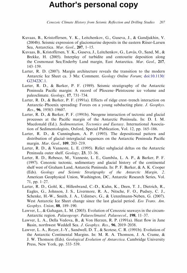
Cenozoic Climate History from Seismic Reflection and Drilling Studies 207
Author's personal copy
Kuvaas, B., Kristoffersen, Y. K., Leitchenkov, G., Guseva, J., & Gandjukhin, V.(2004b). Seismic expression of glaciomarine deposits in the eastern Riiser-LarsenSea, Antarctica. Mar. Geol., 207, 1–15.
Kuvaas, B., Kristoffersen, Y. K., Guseva, J., Leitchenkov, G., Løvas, O., Sand, M., &Brekke, H. (2005). Interplay of turbidite and contourite deposition alongthe Cosmonaut Sea/Enderby Land margin, East Antarctica. Mar. Geol., 217,143–159.
Larter, R. D. (2007). Margin architecture reveals the transition to the modernAntarctic Ice Sheet ca. 3 Ma: Comment. Geology Online Forum; doi:10.1130/G23422C.1.
Larter, R. D., & Barker, P. F. (1989). Seismic stratigraphy of the AntarcticPeninsula Pacific margin: A record of Pliocene–Pleistocene ice volume andpaleoclimate. Geology, 17, 731–734.
Larter, R. D., & Barker, P. F. (1991a). Effects of ridge crest–trench interaction onAntarctic–Phoenix spreading: Forces on a young subducting plate. J. Geophys.Res., 96, 19583–19607.
Larter, R. D., & Barker, P. F. (1991b). Neogene interaction of tectonic and glacialprocesses at the Pacific margin of the Antarctic Peninsula. In: D. I. M.Macdonald (Ed.). Sedimentation, Tectonics and Eustasy. International Associa-tion of Sedimentologists, Oxford, Special Publication, Vol. 12, pp. 165–186.
Larter, R. D., & Cunningham, A. P. (1993). The depositional pattern anddistribution of glacial–interglacial sequences on the Antarctic Peninsula Pacificmargin. Mar. Geol., 109, 203–219.
Larter, R. D., & Vanneste, L. E. (1995). Relict subglacial deltas on the AntarcticPeninsula outer shelf. Geology, 23, 33–36.
Larter, R. D., Rebesco, M., Vanneste, L. E., Gamboa, L. A. P., & Barker, P. F.(1997). Cenozoic tectonic, sedimentary and glacial history of the continentalshelf west of Graham Land, Antarctic Peninsula. In: P. F. Barker, & A. K. Cooper(Eds). Geology and Seismic Stratigraphy of the Antarctic Margin, 2.American Geophysical Union, Washington, DC, Antarctic Research Series, Vol.71, pp. 1–27.
Larter, R. D., Gohl, K., Hillenbrand, C.-D., Kuhn, K., Deen, T. J., Dietrich, R.,Eagles, G., Johnson, J. S., Livermore, R. A., Nitsche, F. O., Pudsey, C. J.,Schenke, H.-W., Smith, J. A., Udintsev, G., & Uenzelmann-Neben, G. (2007).West Antarctic Ice Sheet change since the last glacial period. Eos Trans. Am.Geophys. Union, 88, 189–190.
Lawver, L., & Gahagan, L. M. (2003). Evolution of Cenozoic seaways in the circum-Antarctic region. Palaeogeogr. Palaeoclimatol. Palaeoecol., 198, 11–37.
Lawver, L. A., Della Vedova, B., & Von Herzen, R. P. (1991a). Heat flow in JaneBasin, northwest Weddell Sea. J. Geophys. Res., 96, 2019–2038.
Lawver, L. A., Royer, J.-Y., Sandwell, D. T., & Scotese, C. R. (1991b). Evolution ofthe Antarctic Continental Margins. In: M. R. A. Thomson, J. A. Crame, &J. W. Thomson (Eds). Geological Evolution of Antarctica. Cambridge UniversityPress, New York, pp. 533–539.
208 A. K. Cooper et al.
Author's personal copy
Lawver, L. A., Gahagan, L. M., & Coffin, M. F. (1992). The development ofpaleoseaways around Antarctica. In: J. P. Kennett, & D. A. Warnke (Eds).The Antarctic Paleoenvironment: A Perspective on Global Change 1. AmericanGeophysical Union, Washington, DC, Antarctic Research Series, Vol. 56,pp. 7–30.
Lawver, L. A., Williams, T., & Sloan, B. (1994). Seismic stratigraphy and heat flowof Powell Basin. Terra Antart., 1, 309–310.
Lawver, L. A., Sloan, B. J., Barker, D. H. N., Ghidella, M., Von Herzen, R. P.,Keller, R. A., Kinkhammer, G. P., & Chin, C. S. (1996). Distributed, activeextension in Bransfield Basin, Antarctic Peninsula: Evidence from multibeambathymetry. GSA Today, 6(11), 1–6.
Lazarus, D., Pallant, A., & Hays, J. D. (1987). Database of Antarctic Pre-PleistoceneSediment Cores. Woods Hole Oceanographic Institution, Woods Hole, 42 pp.
Lazarus, D., & Caulet, J. P. (1993). Cenozoic southern ocean reconstructions fromsedimentologic, radiolarian, and other microfossil data. In: J. P. Kennettm, &D. A. Warnke (Eds). The Antarctic Paleoenvironment: A Perspective on GlobalChange II. American Geophysical Union, Washington, DC, Antarctic ResearchSeries, Vol. 60, pp. 145–174.
Leckie, R. M., & Webb, P. N. (1983). Late Oligocene–early Miocene glacial recordof the Ross Sea, Antarctica: Evidence from DSDP Site 270. Geology, 11, 578–582.
Leckie, R. M., & Webb, P. N. (1986). Late Paleogene and early Neogeneforaminifers of deep sea drilling project site 270, Ross Sea, Antarctica.In: J. P. Kennett, C. C. von der Borch, et al. (Eds). Initial Reports of the DeepSea Drilling Project. Leg 90. US Government Printing Office, Washington, DC,pp. 1093–1118.
Ledbetter, M. T. (1981). Palaeooceanographic significance of bottom-currentfluctuations in the Southern Ocean. Nature, 294, 554–556.
Ledbetter, M. T., & Ciesielski, P. F. (1986). Post-Miocene disconformities andpaleoceanography in the Atlantic sector of the Southern Ocean. Palaeogeogr.Palaeoclimatol. Palaeoecol., 52, 185–214.
Ledbetter, M. T., & Ellwood, B. B. (1982). Variations in particle alignment and sizein sediments of the Vema channel record antarctic bottom-water velocity changesduring the last 400,000 years. In: C. Craddock (Ed.). Antarctic Geoscience.University of Wisconsin Press, Madison, WI, pp. 1033–1038.
Ledbetter, M. T., Ciesielski, P. F., Osborn, N. I., & Allison, E. T. (1983). Bottom-current erosion in the Southeast Indian and Southwest Pacific Oceans during thelast 5.4 million years. In: R. L. Oliver, P. R. James, & J. B. Jago (Eds). AntarcticEarth Science. Cambridge University Press, New York, pp. 379–383.
Ledford-Hoffman, P. A., DeMaster, D. J., & Nittrouer, C. A. (1986). Biogenic-Silicaaccumulation in the Ross Sea and the importance of Antarctic continental-shelfdeposits in the Marine silica budget. Geochim. Cosmochim. Acta, 50, 2099–2110.
Leitchenkov, G. L. (1991). Structure and evolution of the Prydz Bay. In: Abstractsof Sixth International Symposium on Antarctic Earth Sciences. National Instituteof Polar Research, Japan, pp. 346–351.
Cenozoic Climate History from Seismic Reflection and Drilling Studies 209
Author's personal copy
Leitchenkov, G. L., & Kudryavtzev, G. A. (2000). Structure and origin of theEarthus crust in the Weddel Sea embayment (beneath the front of the Filchnerand Ronne ice shelves) from deep seismic sounding. Polarforschung, 67, 143–154.
Leitchenkov, G. L., Guseva, Y. B., & Gandyukhin, V. V. (2007). Cenozoicenvironmental changes along the East Antarctic continental margin inferred fromregional seismic stratigraphy. In: A. K. Cooper, C. R. Raymond, et al. (Eds).Antarctica: A Keystone in a Changing World – Online Proceedings of the 10thInternational Symposium on Antarctic Earth Sciences. USGS Open-File Report2007-1047, Short Research Paper 055, 4, doi:10.3133/of2007-1047.srp005.
LeMasurier, W. E., Melander, O., Grindley, G. W., & McIntosh, W. C. (1979).Tillite, Glacial Striae, and Hyaloclastite Associations on Hobbs Coast, MarieByrd Land. Antarct. J. U.S., 14, 48–50.
Lepley, L. K. (1966). Submarine Geomorphology of Eastern Ross Sea and SulzbergerBay, Antarctica. Ocean Surveys Division Technical Report, No. 172. US NavalOceanographic Office, Washington, DC, 34 pp.
Leventer, A., Dunbar, R. B., & De Master, D. J. (1993). Diatom Evidence for AlteHolocene Climatic Events in Granite Harbor, Antarctica. Paleoceanography, 8,373–386.
Leventer, A., Domack, E. W., Ishman, S. E., Brachfeld, S., McClennen, C. E., &Manly, P. (1996). Productivity cycles of 200–300 years in the Antarctic PeninsulaRegion: Understanding linkages among the Sun, Atmosphere, Oceans, Sea Ice,and Biota. Geol. Soc. Am. Bull., 108, 1626–1644.
Leventer, A., et al. (2001). Coring Holocene Antarctic Ocean Sediments. NBP1-1Report, 190 pp.
Leventer, A., Domack, E., Barkoukis, A., McAndrews, B., & Murray, J. (2002).Laminations from the Palmer Deep: A diatom-based interpretation. Paleoceano-graphy, 17, 8002, doi:10.1029/2001PA000624.
Levy, R. H., Stillwell, J. D., Harwood, D. M., Francis, J., & Pole, M. (1995). Eocenepalaeobiology of East Antarctica – A report on evidence from fossiliferous glacialerratics in McMurdo Sound. In: Abstracts, Seventh International Symposium onAntarctic Earth Science, Siena, Italy, p. 243.
Licht, K. J., Jennings, A. E., Andrews, J. T., & Williams, K. M. (1996). Chronologyof late Wisconsin ice retreat from the western Ross Sea, Antarctica. Geology, 24,223–226.
Licht, K. J., Dunbar, N. W., Andrews, J. T., & Jennings, A. E. (1999).Distinguishing subglacial till and glacial marine diamictons in the western RossSea, Antarctica: Implications for last glacial maximum grounding line. Geol. Soc.Am. Bull., 111, 91–103.
Lien, R. (1981). Sea bed features in the Blaaenga area, Weddell Sea, Antarctica. In:Proceedings of the Sixth International Conference on Port and Ocean Engineeringunder Arctic Conditions, No. 6. Universite Laval, Quebec, pp. 706–716.
Lisiecki, L. E., & Raymo, M. E. (2005). A Pliocene-Pleistocene stack of 57 globallydistributed benthic d18O records. Palaeoceanography, 20, PA1003, doi:10.1029/2004PA001071.
210 A. K. Cooper et al.
Author's personal copy
Lisitsyn, A. P. (1962). Bottom sediments of the Antarctic. In: H. Wexler (Ed.).Antarctic Research. American Geophysical Union Monograph No. 7, pp. 81–88.
Lisker, F., Belton, D. X., & Kroner, U. (2005). Thermochronological investigationaround the Lambert Graben: Review of pre-existing data and field work duringPCMEGA. Terra Antart., 12, 45–50.
Livermore, R. A., Balanya, J. C., Maldonado, A., Martınez, J. M., Rodrıguez-Fernandez, J., Sanz de Galdeano, C., Galindo Zaldıvar, J., Jabaloy, A.,Barnolas, A., Somoza, L., Hernandez-Molina, J., Surinach, E., & Viseras, C.(2000). Autopsy on a dead spreading centre: The Phoenix Ridge, Drake Passage,Antarctica. Geology, 28, 607–610.
Lodolo, E., Camerlenghi, A., & Brancolini, G. (1993). A bottom simulating reflectoron the South Shetland margin, Antarctic Peninsula. Antarct. Sci., 5, 201–210.
Lodolo, E., Camerlenghi, A., Madrussani, G., Tinivella, U., & Rossi, G. (2002).Assessment of gas hydrate and free gas distribution on the South Shetland margin(Antarctica) based on multichannel seismic reflection data. Geophys. J. Int., 148,103–119.
Lonsdale, M. J. (1990). The relationship between silica diagenesis, methane, andseismic reflections on the South Orkney Microcontinent. In: P. F. Barker, &J. P. Kennett (Eds). Proceedings of the Ocean Drilling Program, Scientific Results.Ocean Drilling Program, Texas A&M University, College Station, TX, Vol. 113,pp. 27–37.
Lowe, A. L., & Anderson, J. B. (2002). Reconstruction of the West Antarctic IceSheet in Pine Island Bay during the last glacial maximum and its subsequentretreat history. Quat. Sci. Res., 21, 1879–1897.
Lozano, J. A., & Hayes, J. D. (1976). Relationship of radiolarian assemblages tosediment types and physical oceanography in the Atlantic and western IndianOcean sectors of the Antarctic Ocean. Geol. Soc. Am. Mem., 145, 303–336.
Lyra, C. S. (1986). Tertiary sediment palynology at Fildes Peninsula, King GeorgeIsland, South Shetland Islands, and some paleoenvironmental considerations.Anais Acad. Brasil. Ciencias, 58, 137–147.
Macdonald, D. I. M., Barker, P. F., Garrett, S. W., Ineson, J. R., Pirrie, D.,Storey, B. C., Whitham, A. G., Kinghorn, R. R. F., & Marshall, J. E. A. (1988).A preliminary assessment of the hydrocarbon potential of the Larsen Basin,Antarctica. Mar. Petrol. Geol., 5, 34–53.
MacDonald, S. E., & Anderson, J. B. (1986). Paleoceanographic implications ofterrigenous deposits on the Maurice Ewing Bank, southwest Atlantic Ocean.Mar. Geol., 71, 259–287.
Macellari, C. E. (1988). Stratigraphy, sedimentology, and paleoecology of UpperCretaceous/Paleocene shelf-deltaic sediments of Seymour Island. In: R. M.Feldman, & M. O. Woodburne (Eds). Geology and Paleontology of SeymourIsland, Antarctic Peninsula. Geological Society of America, Boulder, CO,Memoir, Vol. 169, pp. 25–53.
Macphail, M. K., & Truswell, E. M. (2004). Palynology of Site 1166. In:A. K. Cooper, P. E. O’Brien, & C. Richter (Eds). Proceedings of the Ocean
Cenozoic Climate History from Seismic Reflection and Drilling Studies 211
Author's personal copy
Drilling Program, Scientific Results. Available from Ocean Drilling Program,Texas A&M University, College Station, TX, Vol. 188 [CD-ROM], pp. 1–43.
Maldonado, A., Aldaya, F., Balanya, J. C., Galindo-Zaldivar, J., Jabaloy, A.,Larter, R. D., Rodriguez-Fernandez, J., Roussanov, M., & Sanz de Galdeano, C.(1994a). Cenozoic continental margin growth patterns in the northern AntarcticPeninsula. In: A. K. Cooper, P. F. Barker, P. N. Webb, & G. Brancolini (Eds).The Antarctic Continental Margin: Geophysical and Geological StratigraphicRecords of Cenozoic Glaciation, Paleoenvironments, and Sea-Level Change. TerraAntart., 1 (2), 311–314.
Maldonado, A., Larter, R. D., & Aldaya, F. (1994b). Forearc tectonicevolution of the South Shetland margin, Antarctic Peninsula. Tectonics, 13,1345–1370.
Maldonado, A., Zitellini, N., Leitchenkov, G., Balanya, J. C., Coren, F., Galindo-Zaldıvar, J., Lodolo, E., Jabaloy, A., Zanolla, C., Rodrıguez-Fernandez, J., &Vinnikovskaya, O. (1998). Small ocean basin development along the Scotia–An-tarctica plate boundary and in the northern Weddell Sea. Tectonophysics, 296,371–402.
Maldonado, A., Barnolas, A., Bohoyo, F., Escutia, C., Galindo-Zaldivar, J.,Hernandez-Molina, J., Jabaloy, A., Lobo, F., Nelson, H., Rodrıguez-Fernandez, J.,Somoza, L., & Vazquez, J.-T. (2005). Miocene to Recent contourite driftsdevelopment in the northern Weddell Sea, Antarctica. Global Planet. Change, 45,99–129.
Maldonado, A., Bohoyo, F., Galindo-Zaldıvar, J., Hernandez-Molina, J., Jabaloy, A.,Lobo, F. J., Rodrıguez-Fernandez, J., Surinach, E., & Vasquez, J. T. (2006). Oceanbasins near the Scotia–Antarctic boundary: Influence of tectonics and paleoceano-graphy on the Cenozoic deposits. Mar. Geophys. Res., 27, 83–107.
Margolis, S. V., & Kennett, J. P. (1971). Cenozoic paleoglacial history of Antarcticarecorded in sub-Antarctic deep-sea cores. Am. J. Sci., 271, 1–36.
Mawson, D. (1940). Sedimentary rocks. Australasian Antarctic Expedition 1911-14.Scientific Rep. Ser. A, 4, 347–367.
Mawson, D. (1942). Geographical Narrative and Cartography. Australian AntarcticExpedition 1911-14. Scientific Reports, Series A, Vol. 1, pp. 1–364.
Mazzullo, J., & Anderson, J. B. (1987). Grain shape and surface texture analysis oftill and glacial-marine sand grains from the Weddell and Ross seas, Antarctica.In: J. R. Marshall (Ed.). Clastic Particles: Scanning Electron Microscopy andShape Analysis of Sedimentary and Volcanic Clasts. Van Nostrand Reinhold Co.,New York, pp. 314–327.
McCoy, F. W. (1991). Southern ocean sediments; Circum-Antarctic to 30 degrees S.In: D. E. Hayes (Ed.). Marine Geological and Geophysical Atlas of the Circum-Antarctic to 30 degrees S. American Geophysical Union, Washington, DC,Antarctic Research Series, Vol. 54, pp. 37–46.
McGinnis, J. P., & Hayes, D. E. (1994). Sediment drift formation along the AntarcticPeninsula. In: A. K. Cooper, P. F. Barker, P. N. Webb, & G. Brancolini (Eds).The Antarctic Continental Margin: Geophysical and Geological Stratigraphic
212 A. K. Cooper et al.
Author's personal copy
Records of Cenozoic Glaciation, Paleoenvironments, and Sea-Level Change. TerraAntart., 1 (2), 275–276.
McGinnis, J. P., & Hayes, D. E. (1995). The roles of downslope and along-slope depositional processes: Southern Antarctic Peninsula continental rise.In: A. K. Cooper, P. F. Barker, & G. Brancolini (Eds). Geology and SeismicStratigraphy of the Antarctic Margin. American Geophysical Union, Washington,DC, Antarctic Research Series, Vol. 68, pp. 141–156.
McGinnis, J. P., Hayes, D. E., & Driscoll, N. W. (1997). Sedimentary processes acrossthe continental rise of the southern Antarctic Peninsula. Mar. Geol., 141, 91–109.
McGinnis, L. D. (Ed.) (1981). Dry Valley Drilling Project. American GeophysicalUnion, Washington, DC, Antarctic Research Series, Vol. 33.
McKelvey, B. C. (1991). The Cenozoic glacial record in South Victoria Land: Ageological evaluation of the McMurdo Sound drilling projects. In: R. J. Tingey(Ed.). The Geology of Antarctica. Oxford Monographs on Geology andGeophysics 17, pp. 434–454.
McKelvey, B. C., & Stephenson, N. C. N. (1990). A geological reconnaissance ofthe Radok Lake area, Amery Oasis, Prince Charles Mountains. Antarct. Sci., 2,53–66.
McKelvey, B. C., Webb, P.-N., Harwood, D. M., & Mabin, M. C. G. (1991). TheDominion Range Sirius Group: A record of the late Pliocene-early PleistoceneBeardmore glacier. In: M. R. A. Thomson, J. A. Crame, & J. W. Thomson (Eds).Geological Evolution of Antarctica. Cambridge University Press, New York,pp. 675–682.
McLoughlin, S., & Drinnan, A. N. (1997a). Fluvial sedimentology and revisedstratigraphy of the Triassic Flagstone Bench Formation, northern Prince CharlesMountains, East Antarctica. Geol. Mag., 134, 781–806.
McLoughlin, S., & Drinnan, A. N. (1997b). Revised stratigraphy of the PermianBainmedart Coal Measures, northern Prince Charles Mountains, East Antarc-tica. Geol. Mag., 134, 335–353.
Melles, M., & Kuhn, G. (1993). Sub-bottom profiling and sedimentological studiesin the southern Weddell sea, Antarctica; evidence for large-scale erosional/depositional processes. Deep Sea Res. I, 40, 739–760.
Mercer, J. H. (1981). Tertiary terrestrial deposits of the Ross Ice Shelf area,Antarctica. In: M. J. Hambrey, & W. B. Harland (Eds). Earth’s Pre-PleistoceneGlacial Records. Cambridge University Press, Cambridge, pp. 204–207.
Michel, E., Crosta, X., & Shipboard Scientific Party, Les rapport de campagne a lamer a bord du Marion Dufresne-MD130/MD131. (2006) CADO/OISO/AUSCAN/SOCOZA (IMAGES X). Institut Polaire Francais Paul-Emile Victor(IPEV).
Michels, K. H., Rogehnagen, J., & Kuhn, G. (2001). Recognition of contour currentinfluence in mixed contourite-turbidite sequences of the Western Weddell Sea.Mar. Geophys. Res., 22, 465–485.
Michels, K. H., Kuhn, G., Hillenbrand, C.-D., Diekmann, B., Futterer, D. K.,Grobe, H., & Uenzelmann-Neben, G. (2002). The southern Weddell Sea:
Cenozoic Climate History from Seismic Reflection and Drilling Studies 213
Author's personal copy
Combined contourite-turbidite sedimentation at the southeastern margin of theWeddell Gyre. In: D. A. V. Stow, C. J. Pudsey, J. A. Howe, J. C. Faugeres, &A. R. Viana (Eds). Deep-Water Contourite Systems: Modern Drifts and AncientSeries, Seismic and Sedimentary Characteristics. Memoirs. Geological. Society,London, Vol. 22, pp. 305–323.
Milam, R. W., & Anderson, J. B. (1981). Distribution and ecology of recentbenthonic foraminifera of the Adelie-George V continental shelf and slope,Antarctica. Mar. Micropaleontol., 6, 297–325.
Mildenhall, D. C. (1989). Terrestrial palinology. In: P. J. Barrett (Ed.). AntarcticCenozoic History from the CIROS-1 Drillhole McMurdo Sound. DSIR Bulletin245. Science Information Publishing Centre, Wellington.
Miller, H., Henriet, J.-P., Kaul, N., & Moons, A. (1990). A fine-scale stratigraphy ofthe eastern margin of the Weddell Sea. In: U. Bleil, & J. Thiede (Eds). GeologicalHistory of the Polar Oceans: Arctic versus Antarctic. Kluwer AcademicPublishers, Amsterdam, pp. 131–161.
Miller, K. E., Fairbanks, G., & Mountain, G. S. (1987). Tertiary oxygen isotopesynthesis, sea level history, and continental margin erosion. Paleoceanography, 2,1–19.
Miller, K. G., Kominz, M. A., Browning, J. V., Wright, J. D., Mountain, G. S.,Katz, M. E., Sugarman, P. J., Cramer, B. S., Christie-Blick, N., & Pekar, S. F.(2005). The Phanerozoic record of sea-level change. Science, 310, 1293–1298.
Miller, K. G., Wright, J. D., Katz, M. E., Browning, J. V., Cramer, B. S., Wade, B. S.,& Mizintseva, S. F. (2008). A view of Antarctic Ice Sheet evolution fromsea-level and deep-sea isotope changes during the Late Cretaceous-Cenozoic. In:A. K. Cooper, et al. (Eds). Antarctica: A Keystone in a Changing World. TheNational Academies Press, Washington, DC.
Mizukoshi, T., Sunouchi, H., Saki, T., & Tanahshi, M. (1986). Preliminary reportof the geological and geophysical surveys of Amery Ice Shelf, East Antarctica.Mem. Natl. Inst. Polar Res. Spec. Issue Jpn., 43, 48–62.
Monechi, S., & Reale, V. (1997). Calcareous nannofossil assemblages of the CIROS-1 Core (Ross Sea): Further assessments on age. Terra Antart., 4(2),
Moons, A., De Batist, M., Henriet, J. P., & Miller, H. (1992). Sequence stratigraphyof the Crary Fan, southeastern Weddell Sea. In: Y. Yoshida, et al. (Eds). RecentProgress on Antarctic Earth Science. Terra Scientific Publishing Company,Toyko, pp. 613–618.
Moriwaki, K. (1979). In: T. Nagata (Ed.). Submarine Topography of the Central Partof Lutzow-Holm Bay and around Ongul Islands, Antarctica. Memoirs of NationalInstitute of Polar Research, Special Issue, No. 14. National Institute of PolarResearch, Tokyo, pp. 194–209.
Mortlock, R. A., Charles, C. D., Froelich, P. N., Zibello, M. A., Saltzman, J.,Hays, J. D., & Buckle, L. H. (1991). Evidence for lower productivity in theAntarctic Ocean during the last glaciation. Nature, 351, 220–223.
Naish, T. R., Powell, R. D., & Levy, R. H. (2007). Initial science results from AND-1B,ANDRILL McMurdo Ice Shelf Project, Antarctica. Terra Antart., 14 (3), 111–328.
214 A. K. Cooper et al.
Author's personal copy
Naish, T. R., et al., (2001). Orbitally induced oscillations in the East Antarctic IceSheet at the Oligocene/Miocene boundary. Nature, 413, 719–723.
Nayudu, Y. R. (1971). Lithology and chemistry of surface sediments in sub-Antarctic regions of the Pacific Ocean. In: J. L. Reid (Ed.). Antarctic OceanologyI. American Geophysical Union, Washington, DC, Antarctic Research Series,Vol. 15, pp. 247–282.
Nitsche, F. O., Gohl, K., Vanneste, K., & Miller, H. (1997). Seismic expression ofglacially deposited sequences in the Bellingshausen and Amundsen Seas, WestAntarctica. In: P. F. Barker, & A. K. Cooper (Eds). Geology and SeismicStratigraphy of the Antarctic Margin, 2. American Geophysical Union,Washington, DC, Antarctic Research Series, Vol. 71, pp. 95–108.
Nitsche, F. O., Cunningham, A. P., Larter, R. D., & Gohl, K. (2000). Geometry anddevelopment of glacial continental margin depositional systems in the Belling-shausen Sea. Mar. Geol., 162, 277–302.
O Cofaigh, C., Pudsey, C. J., Dowdeswell, J. A., & Morris, P. (2002). Evolution ofsubglacial bedforms along a paleo-ice stream, Antarctic Peninsula continentalshelf. Geophys. Res. Lett., 29, 1199, doi:10.1029/2001GL014488.
O Cofaigh, C., Larter, R. D., Dowdeswell, J. A., Hillenbrand, C.-D., Pudsey, C. J.,Evans, J., & Morris, P. (2005). Flow of the West Antarctic Ice Sheet on thecontinental margin of the Bellingshausen Sea at the last glacial maximum.J. Geophys. Res., 110, B11103, doi:10.1029/2005JB003619.
O’Brien, P. E., Truswell, E. M., & Burton, T. (1994). Morphology and late glacialhistory of Prydz Bay, Antarctica based on echo sounder data. In: A. K. Cooper,P. F. Barker, P. N. Webb, & G. Brancolini (Eds). The Antarctic ContinentalMargin: Geophysical and Geological Stratigraphic Records of Cenozoic Glaciation,Paleoenvironments and Sea Level Change. Terra Antart., 1 (2), 403–405.
O’Brien, P. E., Harris, P. T., Quilty, P. G., Taylor, F., & Wells, P. (1995). Post-cruisereport, Antarctic CRC marine geoscience, Prydz Bay, MacRobertson Shelf, andKerguelen Plateau. Australian Geological Survey Record, 1995/29.
O’Brien, P. E., & Harris, P. T. (1996). Patterns of glacial erosion and depositionin Prydz Bay and the past behaviour of the Lambert Glacier. Pap. Proc. R. Soc.Tas., 130, 79–86.
O’Brien, P. E., & Leitchenkov, G. (1997). Deglaciation of Prydz Bay, EastAntarctica, based on echo sounding and topographic features. In: P. F. Barker, &A. K. Cooper (Eds). Geology and Seismic Stratigraphy of the Antarctic Margin.American Geophysical Union, Washington, DC, Antarctic Research SeriesVol. 71, pp. 109–125.
O’Brien, P. E., De Santis, L., Harris, P. T., Domack, E., & Quilty, P. G. (1999). Iceshelf grounding zone features of western Prydz Bay, Antarctica: Sedimentaryprocesses from seismic and sidescan images. Antarct. Sci., 11, 78–91.
O’Brien, P. E., Cooper, A. K., Richter, C., et al. (2001). Initial reports, Prydz Bay-Cooperation Sea, Antarctica: Glacial history and paleoceanography. In:Proceedings of the Ocean Drilling Program, Scientific Results. Texas A & MUniversity, College Station, TX, Vol. 188 [CD-ROM].
Cenozoic Climate History from Seismic Reflection and Drilling Studies 215
Author's personal copy
O’Brien, P. E., Cooper, A. K., Florindo, F., Handwerger, D. A., Lavelle, M.,Passchier, S., Pospichal, J. J., Quilty, P. G., Richter, C., Theissen, K. M., &Whitehead, J. M. (2004). Prydz Channel Fan and the history of extreme iceadvances in Prydz Bay. In: A. K. Cooper, P. E. O’Brien, & C. Richter (Eds).Proceedings of the Ocean Drilling Program, Scientific Results. Available fromOcean Drilling Program, Texas A&M University, College Station, TX, Vol. 188[CD-ROM], pp. 1–32.
O’Brien, P. E., Stanley, S., & Parums, R. (2006). Post-rift continental slope and risesediments from 381E to 1641E, East Antarctica. In: D. K. Futterer, D. Damaske,G. Kleinschmidt, H. C. H. Miller, & F. Tessensohn (Eds). Antarctica;Contributions to Global Earth Sciences, Proceedings of the IX InternationalSymposium on Antarctic Earth Sciences, pp. 341–348.
O’Brien, P. E., & Stagg, H. M. J. (2007). Tectonic elements of the continentalmargin of East Antarctica, 381–1641. In: A. K. Cooper, C. R. Raymond, et al.(Eds). Antarctica: A Keystone in a Changing World – Online Proceedings of the10th International Symposium on Antarctic Earth Sciences. USGS Open-FileReport 2007-1047, Short Research Paper 085, 4, doi:10.3133/of2007-1047.srp085.
Orsi, A. H., Nowlin, W. D. Jr., & Whitworth, T., III. (1993). On the circulation andstratification of the Weddell Gyre. Deep-Sea Res. 1, 40, 169–203.
Park, B.-K., Lee, M.-S., Yoon, H.-I., & Nam, S.-H. (1989). Marine geology andpetrochemistry in the Maxwell Bay area, South Shetland Islands. In: H. T. Huh,B.-K. Park, & S.-H. Lee (Eds). Antarctic Science: Geology and Biology. SeoDeung Co. Ltd., Seoul, Korea, pp. 85–120.
Passchier, S., O’Brien, P. E., Damuth, J. E., Janusczak, N., Handwerger, D. A., &Whitehead, J. M. (2003). Pliocene-Pleistocene glaciomarine sedimentation ineastern Prydz Bay and development of the Prydz trough-mouth fan, ODP Sites1166 and 1167, East Antarctica. Mar. Geol., 199, 279–305.
Payne, R. F., Conolly, J. R., & Abbott, W. H. (1972). Turbidite muds within diatomooze off Antarctica: Pleistocene sediment variaton defined by closely spacedpiston cores. Geol. Soc. Am. Bull., 83, 481–486.
Payne, R. R., & Conolly, J. R. (1972). Turbidite sedimentation off the Antarcticcontinent. Antarct. Res. Ser., 19, 349–364.
Pezzetti, T. F., & Krissek, L. A. (1986). Re-evaluation of the Eocene LaMeseta Formation of Seymour Island, Antarctic Peninsula. Antarct. J. U.S.,21, 75.
Pickard, J., Adamson, D. A., Harwood, D. M., Miller, G. H., Quilty, P. G., &Dell, R. K. (1988). Early Pliocene marine sediments, coastline, and climate ofEast Antarctica. Geology, 16, 158–161.
Piper, D. J. W., & Brisco, C. D. (1975). Deep-water continental marginsedimentation, DSDP LEG 28, Antarctica. In: D. E. Hayes, L. A. Frakes,et al. (Eds). Initial Reports of the Deep Sea Drilling Project. US GovernmentPrinting Office, Washington, DC, Vol. 28, pp. 727–755.
Piper, D. J. W., Swint, T. R., Sullivan, L. G., & McCoy, F. W. (1985). ManganeseNodules, Seafloor Sediment, and Sedimentation Rates of the Circum-Pacific
216 A. K. Cooper et al.
Author's personal copy
Region. Circum-Pacific Council for Energy and Mineral Resources. AmericanAssociation of Petroleum Geologists, Tulsa, OK [Chart].
Pirrie, D., Whitham, A. G., & Ineson, J. R. (1991). The role of tectonics and eustasyin the evolution of a marginal basin: Cretaceous-Tertiary Larsen Basin,Antarctica. In: D. I. M. MacDonald (Ed.). Sedimentation, Tectonics, andEustasy: Sea Level Changes at Active Margins. International Association ofSedimentologists, Special Publication, Oxford, Vol. 12, pp. 293–305.
Pirrie, D., Crame, J. A., Riding, J. B., Butcher, A. R., & Taylor, P. D. (1997).Miocene glaciomarine sedimentation the northern Antarctic Peninsula region:The stratigraphy and sedimentology of the Hobbs Glacier Formation, JamesRoss Island. Geol. Mag., 134, 745–762.
Pope, P. G., & Anderson, J. B. (1992). Late Quaternary glacial history of thenorthern Antarctic Peninsula’s western continental shelf: Evidence from themarine record. In: D. H. Elliot (Ed.). Contributions to Antarctic Research III.American Geophysical Union, Washington, DC, Antarctic Research Series,Vol. 57, pp. 63–91.
Porebski, S. J., Meischner, D., & Gorlich, K. (1991). Quaternary mud turbiditesfrom the South Shetland trench (West Antarctica): Recognition and implicationsfor turbidite facies models. Sedimentology, 38, 691–715.
Pospichal, J. J. (2004). Calcareous nannofossils from continental rise Site 1165, ODPLeg 188, Prydz Bay, Antarctica. In: A. K. Cooper, P. E. O’Brien, & C. Richter(Eds). Proceedings of the Ocean Drilling Program, Scientific Results. Availablefrom Ocean Drilling Program, Texas A&M University, College Station, TX,Vol. 188 [CD-ROM], pp. 1–14.
Powell, R. D. (1981). Sedimentation conditions in Taylor valley, Antarctica,inferred from textural analysis of DVDP cores. Antarct. Res. Ser., 33,331–350.
Prieto, M. J., Gracia, E., Canals, M., Ercilla, G., & de Batist, M. (1997).Sedimentary history of the central Bransfield Basin (NW Antarctic Peninsula).In: C. A. Ricci (Ed.). The Antarctic Region. Geological Evolution and Processes,Special Publication, Issue VII. ISAES.
Prieto, M. J., Canals, M., Ercilla, G., & De Batist, M. (1998). Structure andgeodynamic evolution of the Central Bransfield Basin (NW Antarctica) fromseismic reflection data. Mar. Geol., 149, 17–38.
Prieto, M. J., Ercilla, G., Canals, M., & De Batist, M. (1999). Seismic stratigraphy ofthe Central Bransfield Basin (NW Antarctic Peninsula): interpretation of depositsand sedimentary processes in a glacio-marine environment. Mar. Geol., 157,47–68.
Pudsey, C. J. (1992). Late Quaternary changes in Antarctic bottom water velocityinferred from sediment grain size in the northern Weddell Sea. Mar. Geol., 107,9–33.
Pudsey, C. J. (2002). The Weddell Sea: Contourites and hemipelagites at thenorthern margin of the Weddell Gyre. In: D. A. V. Stow, C. J. Pudsey,J. A. Howe, J.-C. Faugeres, & A. R. Viana (Eds). Deep-Water Contourite

Cenozoic Climate History from Seismic Reflection and Drilling Studies 217
Author's personal copy
Systems: Modern Drifts and Ancient Series, Seismic and Sedimentary Character-istics. Memoirs. Geological Society, London, Vol. 22, pp. 289–303.
Pudsey, C. J., & Evans, J. (2001). First survey of Antarctic sub-ice shelf sedimentsreveals mid-Holocene ice shelf retreat. Geology, 29, 787–790.
Pudsey, C. J., Barker, P. F., & Hamilton, N. (1988). Weddell Sea abyssal sediments;a record of Antarctic bottom water flow. Mar. Geol., 81, 289–314.
Pudsey, C. J., Barker, P. F., & Larter, R. D. (1994). Ice sheet retreat from theAntarctic Peninsula shelf. Cont. Shelf Res., 14, 1647–1675.
Pudsey, C. J., Evans, J., Domack, E. W., Morris, P., & Del Valle, R. (2001).Bathymetry and acoustic facies beneath the former Larsen-A and Prince GustavIce Shelves, NW Weddell Sea. Antarct. Sci., 13, 312–322.
Quilty, P. G. (1991). The geology of Marine Plain, Vestfold Hills, East Antarctica.In: M. R. A. Thomson, J. A. Crame, & J. W. Thomson (Eds). GeologicalEvolution of Antarctica. Cambridge University Press, New York, pp. 683–686.
Rathburn, A. E., Pichon, J. J., Ayress, M. A., & Deckker, P. (1997). Microfossil andstable–isotope evidence for changes in Late Holocene paleo productivity andpaleoceanographic conditions the Prydz Bay region of Antarctica. Palaeogeogr.Palaeoclimatol. Palaeoecol., 131, 485–510.
Rebesco, M., Larter, R. D., Barker, P. F., Camerlenghi, A., & Vanneste, L. E.(1994). A history of sedimentation on the continental rise west of the AntarcticPeninsula. In: A. K. Cooper, P. F. Barker, P. N. Webb, & G. Brancolini (Eds).The Antarctic Continental Margin. Geophysical and Geological StratigraphicRecords of Cenozoic Glaciation, Paleoenvironments and Sea Level Change. TerraAntart., 1 (2), 277–280.
Rebesco, M., Larter, R. D., Camerlenghi, A., & Barker, P. F. (1996). Giantsediment drifts on the continental rise west of the Antarctic Peninsula. Geo Mar.Lett., 16, 65–75.
Rebesco, M., Larter, R. D., Barker, P. F., Camerlenghi, A., & Vanneste, L. E.(1997). The history of sedimentation on the continental rise west of the AntarcticPeninsula. In: P. F. Barker, & A. K. Cooper (Eds). Geology and SeismicStratigraphy of the Antarctic Margin, 2. American Geophysical Union,Washington, DC, Antarctic Research Series, Vol. 71, pp. 29–49.
Rebesco, M., Camerlenghi, A., & Zanolla, C. (1998). Bathymetry and morphogen-esis of the continental margin west of the Antarctic Peninsula. Terra Antart., 5,715–725.
Rebesco, M., Pudsey, C., Canals, M., Camerlenghi, A., Barker, P., Estrada, F., &Giorgetti, A. (2002). Sediment drift and deep-sea channel systems, AntarcticPeninsula Pacific margin. In: D. A. V. Stow, C. J. Pudsey, J. A. Howe, J. C.Faugeres, & A. R. Viana (Eds). Deep-Water Contourite Systems: Modern Driftsand Ancient Series, Seismic and Sedimentary Characteristics.Memoirs. GeologicalSociety, London, Vol. 22, pp. 353–371.
Rebesco, M., Camerlenghi, A., Geletti, R., & Canals, M. (2006). Marginarchitecture reveals the transition to the modern Antarctic Ice Sheet ca. 3Ma.Geology, 34, 301–304.
218 A. K. Cooper et al.
Author's personal copy
Rex, R. W., Margolis, S. V., & Murray, B. (1970). Possible interglacial dune sandsfrom 300 meters water depth in the Weddell Sea, Antarctica. Geol. Soc. Am. Bull.,81, 3465–3472.
Robert, C., & Kennett, J. P. (1994). Antarctic subtropical humid episode at thePaleocene-Eocene boundary; clay-mineral evidence. Geology, 22, 211–214.
Robert, C. M., & Maillot, H. (1990). Paleoenvironments in the Weddell Sea areaand Antarctic climates, as deducted from clay mineral associations andgeochemical data, ODP Leg 113. In: P. F. Barker, J. P. Kennett, et al. (Eds).Proceedings of the Ocean Drilling Program, Scientific Results. College Station,TX, Vol. 113, pp. 51–70.
Robin, G. D. Q. (1988). The Antarctic Ice Sheet, its history and response to sea leveland climactic changes over the past 100 million years. Palaeogeogr. Palaeocli-matol. Palaeoecol., 67, 31–50.
Robinson, P. H., Pyne, A. R., Hambrey, M. J., Hall, K. J., & Barrett, P. J. (1987).Core log, Photographs and Grain Size Analyses from the CIROS-1 Drillhole,Western McMurdo Sound, Antarctica. Antarctic Data Series, Vol. 14, AntarcticResearch Centre Publication, Research School of Earth Sciences, VictoriaUniversity of Wellington, Wellington, New Zealand, 241 pp.
Rogenhagen, J., & Jokat, W. (2000). The sedimentary structure in the westernWeddell Sea. Mar. Geol., 168, 45–60.
Rogenhagen, J., Jokat, W., Hinz, K., & Kristoffersen, Y. (2004). Improved seismicstratigraphy of the Mesozoic Weddell Sea. Mar. Geophys. Res., 25, 265–282.
Rooney, S. T., Blankenship, D. D., Alley, R. B., & Bentley, C. R. (1987). Till beneathice stream B, 2. Structure and continuity. J. Geophys. Res., 92, 8913–8920.
Roqueplo-Brouillet, C. (1982). Seismic Stratigraphy of the Eastern Continental Shelf ofthe Weddell Sea, Antarctica. M.A. Thesis, Rice University, Houston, TX, 132 pp.
Rutford, R. H., Craddock, C., & Bastien, T. W. (1968). Late Tertiary glaciation andsea-level changes in Antarctica. Palaeogeogr. Paleoclimatol. Paleoecol., 5, 15–39.
Sadler, I. (1988). Geometry and stratification of uppermost Cretaceous andPaleogene units on Seymour Island, northern Antarctic Peninsula. In:R. M. Feldmann, & M. O. Woodburne (Eds). Geology and Paleontology ofSeymour Island, Antarctic Peninsula. Geological Society of America, Boulder,CO, Memoir, Vol. 169, pp. 303–320.
Sato, S., Asakura, N., Saki, T., Oikawa, N., & Kaneda, Y. (1984). Preliminary resultsof geological and geophysical survey in the Ross Sea and in Dumont D’urville Sea,off Antarctica. Mem. Natl. Inst. Polar Res. Spec. Issue Jpn., 33, 66–92.
Savage, M. L., & Ciesielsky, P. F. (1983). Revised history of glacial sedimentation inthe Ross Sea region. In: R. L. Oliver, P. R. James, & J. B. Jago (Eds). AntarcticEarth Science. Cambridge University Press, New York, pp. 555–559.
Sayers, J., Symonds, P. A., Direen, N. G., & Bernardel, G. (2001). Nature of thecontinent-ocean transition on the non-volcanic rifted margin of the central GreatAustralian Bight. In: R. C. L. Wilson, R. B. Whitmarsh, & N. Froitzheim (Eds).Non-volcanic rifting of continental margins: A comparison of evidence from landand sea. Geological Society of London, Special Publication 187, pp. 51–76.
Cenozoic Climate History from Seismic Reflection and Drilling Studies 219
Author's personal copy
Schenke, H. W., Dijkstra, S., Niederjasper, F., Schone, T., Hinze, H., & Hoppmann,B. (1998). In: S. Jacobs, & R. Weiss (Eds). The New Bathymetric Charts of theWeddell Sea: AWI BCWS. American Geophysical Union, Washington, DC,Antarctic Research Series, Vol. 75.
Scheuer, C., et al., (2006a). Gridded isopach maps from the South Pacific and theiruse in interpreting the sedimentation history of the West Antarctic continentalmargin. Geochem. Geophys. Geosyst., 7, Q11015, doi:10.1029/2006GC001315.
Scheuer, C., Gohl, K., Larter, R. D., Rebesco, M., & Udintsev, G. (2006b).Variability in Cenozoic sedimentation along the continental rise of theBellingshausen Sea, West Antarctica. Mar. Geol., 227, 279–298.
Scherer, R. (1991). Quaternary and Tertiary microfossils from beneath Ice Stream B:Evidence for a dynamic West Antarctic Ice Sheet. Palaeogeogr. Palaeoclimatol.Palaeoecol., 90, 395–412.
Scherer, R. P., Aldahan, A., Tulaczyk, S., Possnert, G., Engelhardt, H., &Kamb, B. (1998). Pleistocene collapse of the West Antarctic Ice Sheet. Science,281, 82–85.
Scott, D. P. D. (1981). Cartographie du fond des oceans: La carte generalebathymetrique des oceans (GEBCO) (Cartography of ocean floors; the generalbathymetric map of the oceans (GEBCO). Canadian Hydrographic Service.Nat. Res., 17, 6–10.
Scott, K. M. (1965). Geology of the southern Gerlache Strait region, Antarctica.J. Geol., 73, 518–527.
Seabrook, J. M., Hufford, G. L., & Elder, R. B. (1971). Formation of Antarcticbottom water in the Weddell Sea. J. Geophys. Res., 76, 2164–2178.
Shabtaie, S., & Bentley, C. R. (1982). Tabular icebergs: Implications fromgeophysical studies of ice shelves. J. Glaciol., 28, 413–430.
Shackleton, N. J., & Kennett, J. P. (1975). Paleotemperature History of the Cenozoic andthe Initiation of Antarctic Glaciation: Oxygen and Carbon Isotope Analysis in DSDPSites, 277, 279, and 281. Initial Reports of the Deep Sea Drilling Project. USGovernment Printing Office, Washington, DC, Vol. 29, pp. 743–755.
Shevenell, A. E., & Kennett, J. P. (2002). Antarctic Holocene climate change:A benthic foraminiferal stable isotope record from Palmer Deep. Paleoceano-graphy, 17(2), 1019, doi:10.1029/2000PA000596.
Shevenell, A. E., Domack, E. W., & Kerman, G. M. (1996a). Record of Holocenepaleoclimate change along the Antarctic Peninsula: Evidence from glacial marinesediments, Lallemand Fjord. Pap. Proc. R. Soc. Tas., 130, 55–64.
Shevenell, A. E., Lopiccolo, M. H., Straten, B. T., & Domack, E. W. (1996b).Holocene Paleoenvironmental Studies within Antarctic Fjords along the WesternSide of the Antarctic Peninsula; Understanding Hypsithermal and NeoglacialFluctuations, Abstracts of Programs. Geological Society of America, Vol. 28,p. 99.
Shipboard Scientific Party (1988). Site 694. In: P. F. Barker, J. P. Kennett, et al.(Eds). Proceedings of the Ocean Drilling Program, Initial Results, Vol. 13,pp. 449–526.
220 A. K. Cooper et al.
Author's personal copy
Shipboard Scientific Party (1989). Site 740. In: J. Barron, B. Larson, et al. (Eds).Proceedings of the Ocean Drilling Program, Initial Results, Vol. 119,pp. 345–376.
Shipboard Scientific Party (1999). Palmer Deep (Sites 1098 and 1099). In:P. F. Barker, A. Camerlenghi, G. D. Acton, et al. (Eds). Proceedings of theOcean Drilling Program, Initial Reports. Available from Ocean Drilling Program,Texas A&M University, College Station, TX, Vol. 178 [CD-ROM].
Shipboard Scientific Party (2001a). Site 1166. In: P. E. O’Brien, A. K. Cooper,C. Richter, et al. (Eds). Proceedings of the Ocean Drilling Program, Initial Reports.Ocean Drilling Program, College Station, TX, Vol. 188 [CD-ROM], pp. 1–110.
Shipboard Scientific Party (2001b). Site 1167. In: P. E. O’Brien, A. K. Cooper,C. Richter, et al. (Eds). Proceedings of the Ocean Drilling Program, InitialReports. Ocean Drilling Program, College Station TX, Vol. 188 [CD-ROM],pp. 1–97.
Shipboard Scientific Party (2001c). Site 1165. In: P. E. O’Brien, A. K. Cooper,C. Richter, et al. (Eds). Proceedings of the Ocean Drilling Program, InitialReports. Ocean Drilling Program, College Station TX, Vol. 188, [CD-ROM],pp. 1–191.
Shipboard Scientific Party (2005). SHALDRIL 2005 Cruise Report. http://shaldril.rice.edu/PDFs/total.pdf, 189 pp.
Shipboard Scientific Party (2006). SHALDRIL II 2006 NBP0602A Cruise Report.http://shaldril.rice.edu/PDFs/NBP0602A.pdf, 369 pp.
Shipp, S., & Anderson, J. B. (1994). High-resolution seismic survey of the Ross Seacontinental shelf: Implications for ice-sheet retreat behavior. Antarct. J. U.S., 29,137–138.
Shipp, S., & Anderson, J. B. (1997). Lineations of the Ross Sea continental shelf,Antarctica. In: T. A. Davies, H. Josenhans, L. Polyak, A. Solheim, M. S. Stoker,& J. A. Stravers (Eds). Glaciated Continental Margins, An Atlas of AcousticImages. Chapman and Hall, London, pp. 54–55.
Shipp, S., & Anderson, J. B. (1998a). Grounding zone wedges on the Antarcticcontinental shelf, Ross Sea. In: T. A. Davies, H. Josenhans, L. Polyak,A. Solheim, M. S. Stoker, & J. A. Stravers (Eds). Glaciated Continental Margins,An Atlas of Acoustic Images. Chapman and Hall, London, pp. 104–105.
Shipp, S., & Anderson, J. B. (1998b). Drumlin field on the Ross Sea continentalshelf, Antarctica. In: T. A. Davies, H. Josenhans, L. Polyak, A. Solheim,M. S. Stoker, & J. A. Stravers (Eds). Glaciated Continental Margins, An Atlas ofAcoustic Images. Chapman and Hall, London, pp. 52–53.
Shipp, S., & Anderson, J. B. (1998c). Paleo-ice streams and ice stream boundaries,Ross Sea, Antarctica. In: T. A. Davies, H. Josenhans, L. Polyak, A. Solheim,M. S. Stoker, & J. A. Stravers (Eds). Glaciated Continental Margins: An Atlas ofAcoustic Images. Chapman and Hall, London, pp. 106–109.
Shipp, S., & Anderson, J. B. (1998d). Till sheets on the Ross Sea continental shelf,Antarctica. In: T. A. Davies, H. Josenhans, L. Polyak, A. Solheim, M. S. Stoker, &
Cenozoic Climate History from Seismic Reflection and Drilling Studies 221
Author's personal copy
J. A. Stravers (Eds). Glaciated Continental Margins: An Atlas of Acoustic Images.Chapman and Hall, London, pp. 235–237.
Shipp, S., Anderson, J., De Santis, L., Bartek, L. R., Alonso, B., & Zayatz, I. (1994).High to intermediate resolution seismic stratigraphic analysis of mid-late-Miocene to Pleistocene strata in eastern Ross Sea: Implications for changingglacial/climatic regime. Terra Antart., 1(2), 381–384.
Shipp, S., Anderson, J. B., & Domack, E. (1999). Late Pleistocene–Holocene retreatof the West Antarctic Ice Sheet system in the Ross Sea: Part 1: Geophysicalresults. GSA Bull., 111(10), 1486–1516.
Singer, J. K. (1987). Terrigenous, Biogenic, and Volcaniclastic Sedimentation Patternsof the Bransfield Strait and Bays of the Northern Antarctic Peninsula: Implicationsfor the Quaternary Glacial History. Ph.D. Dissertation, Rice University, Houston,TX, 342 pp.
Sloan, B. J., Lawver, L. A., & Anderson, J. B. (1995). Seismic stratigraphy of theLarsen Basin, eastern Antarctic Peninsula. In: A. K. Cooper, P. F. Barker, &G. Brancolini (Eds). Geology and Seismic Stratigraphy of the Antarctic Margin.American Geophysical Union, Washington, DC, Antarctic Research Series,Vol. 68, pp. 59–74.
Smellie, J. L. (1999). Lithostratigraphy of Miocene–Recent, alkaline volcanic fieldsin the Antarctic Peninsula and eastern Ellsworth Land. Antarct. Sci., 11, 362–378.
Smith, M. J. (1985). Marine Geology of the Northwestern Weddell Sea and AdjacentCoastal Fjords and Bays: Implications for Glacial History. M.A. Thesis, RiceUniversity, Houston, TX, 157 pp.
Smith, W. H. F., & Sandwell, D. T. (1997). Global sea floor topography fromsatellite altimetry and ship depth soundings. Science, 277, 1956–1962.
Solheim, A., Forsberg, C. F., Pittenger, A. (1991). Stepwise consolidation ofglaciogenic sediments related to the glacial history of Prydz Bay. In: J. Barron,B. Larson, et al., Proceedings of the Ocean Drilling Program, Scientific Results,Vol. 119, pp. 169–184.
Solli, K., Kuvaas, B., Kristoffersen, Y. K., Leitchenkov, G., Guseva, J., &Gandjukhin, V. (2007a). Seismic morphology and distribution of inferredglaciomarine deposits along the East Antarctic continental margin, 201E–601E.Mar. Geol., 237, 207–223.
Solli, K., Kuvaas, B., Kristoffersen, Y. K., Leitchenkov, G., Guseva, J., &Gandjukhin, V. (2007b). A seismo-stratigraphic analysis of glaciomarine depositsin the eastern Riiser-Larsen Sea (Antarctica). Mar. Geophys. Res., 28, 43–57.
Solli, K., Kuvaas, B., Kristoffersen, Y. K., Leitchenkov, G., Guseva, J., &Gandjukhin, V. (2007c). The Cosmonaut Sea Wedge. In: A. K. Cooper, C. R.Raymond, et al. (Eds). Antarctica: A Keystone in a Changing World – OnlineProceedings of the 10th ISAES. USGS Open-File Report 2007-1047, ShortResearch Paper 009, 4, doi:10.3133/of2007-1047.srp009.
Stagg, H. M. J. (1985). Structure and origin of Prydz Bay and MacRobertson Shelf,East Antarctica. Tectonophysics, 114, 315–340.
222 A. K. Cooper et al.
Author's personal copy
Stagg, H. M. J., Ramsay, D. C., & Whitworth, R. (1983). Preliminary reportof a marine geophysical survey between Davis and Mawson Stations, 1982.In: R. L. Oliver, P. R. James, & J. B. Jago (Eds). Antarctic Earth Science.Cambridge University Press, New York, pp. 527–532.
Stagg, H. M. J., Colwell, J. B., Direen, N. G., O’Brien, P. E., Bernardel, G.,Borissova, I., Brown, B. J., Ishihara, T. (2004a). Geology of the continentalmargin of Enderby and Mac. Robertson Lands, East Antarctica: insights from anew dataset. In: W. Jokat (Ed.). East-west Antarctic tectonics and Gondwanabreak-up 60W to 60E. Mar. Geophys. Res., 25, 183–218.
Stagg, H. M. J., Colwell, J. B., Direen, N. G., O’Brien, P. E., Brown, B. J.,Bernardel, G., Borissova, I., Carson, L., & Close, D. B. (2004b). GeologicalFramework of the Continental Margin in the Region of the Australian AntarcticTerritory. Geoscience Australia Record, 2004/25.
Stetson, H. C., & Upson, J. E. (1937). Bottom deposits of the Ross Sea [Antarctic].J. Sediment. Petrol., 7, 55–66.
Stillwell, J. D., & Feldmann, R. M. (Eds). (2000). Paleobiology and Paleoenviron-ments of Eocene Rocks, McMurdo Sound, East Antarctica. AmericanGeophysical Union, Washington, DC, Antarctic Research Series, Vol. 76,pp. 161–181.
Strand, K., Passchier, S., & Nasi, J. (2003). Implications of quartz grainmicrotextures for onset of Eocene/Oligocene glaciation in Prydz Bay, ODP Site1166, Antarctica. Palaeogeogr. Palaeoclimatol. Palaeoecol., 198, 101–112.
Stroeven, A. P., Prentice, M. L., & Kleman, J. (1996). On microfossil transport andpathways in Antarctica during the Neogene: Evidence from the Sirius Group atMount Fleming. Geology, 24, 727–730.
Sugden, D. E., & Clapperton, C. M. (1977). The maximum ice sheet extent on islandgroups in the Scotia Sea, Antarctica. Quat. Res., 7, 268–282.
Sugden, D. E., & Clapperton, C. M. (1981). An ice-shelf moraine, George VI Sound,Antarctica. Ann. Glaciol., 2, 135–141.
Sugden, D. E., Marchant, D. R., & Denton, G. H. (1993). The case for a stable EastAntarctic Ice Sheet; the background. Geogr. Ann., 75A, 151–155.
Tanahashi, M., Eittreim, S., & Wanneson, J. (1994). Seismic stratigraphic sequencesof the Wilkes Land margin. Terra Antart., 1(2), 391–393.
Tanahashi, M., Ishihara, T., Yuasa, M., Murakami, F., & Nishimura, A. (1997).Preliminary report of the TH95 geological and geophysical survey results in theRoss Sea and the Dumont d’Urville Sea. Proc. NIPR Symp. Antarct. Geosci., 10,36–58.
Tanahashi, M., Saki, T., Oikawa, N., & Sato, S. (1987). An interpretation of themultichannel seismic reflection profiles across the continental margin of theDumont d’Urville Sea, off Wilkes Land, East Antarctica. In: S. L. Eittreim, &M. A. Hampton (Eds). The Antarctic Continental Margin: Geology andGeophysics of Offshore Wilkes Land. Circum-Pacific Council for Energy andMineral Resources, Houston, TX, CPCEMR Earth Science Series, Vol. 5A,pp. 1–14.
Cenozoic Climate History from Seismic Reflection and Drilling Studies 223
Author's personal copy
Tanner, P. W. G., & Macdonald, D. I. M. (1982). Models for the deposition andsimple shear deformation of a turbidite sequence in the South Georgia portion ofthe southern Andes back-arc basin. J. Geol. Soc. London, 139, 739–754.
Taviani, M., Reid, D. E., & Anderson, J. B. (1993). Skeletal and isotopiccomposition and paleoclimatic significance of Late Pleistocene carbonates, RossSea, Antarctica. J. Sediment. Petrol., 63, 84–90.
ten Brink, U. S., & Cooper, A. K. (1992). Modeling the bathymetry of the Antarcticcontinental shelf. In: Y. Yoshida, K. Kaminuma, & K. Shiraishi (Eds). RecentProgress in Antarctic Earth Science. Terra Scientific Publishing Co, Tokyo,Japan, pp. 763–771.
ten Brink, U. S., Schneider, C., & Johnson, A. H. (1995). Morphology andstratal geometry of the Antarctic Continental Shelf: Insights from models.In: A. K. Cooper, P. F. Barker, & G. Brancolini (Eds). Geology and SeismicStratigraphy of the Antarctic Margin. American Geophysical Union, Washington,DC, Antarctic Research Series, Vol. 68, pp. 1–24.
Theissen, K. M., Dunbar, R. B., Cooper, A. K., Mucciarone, D. A., & Hoffman, D.(2003). The Pleistocene evolution of the East Antarctic Ice Sheet in the Prydz Bayarea: stable isotope evidence from ODP Site 1167. Global Planet. Change, 39,227–256.
Thomson, M. R. A. (1981). Late Mesozoic stratigraphy and invertebratepalaeontology of the South Orkney Islands. Br. Antarct. Surv. Bull., 54,65–83.
Thomas, M. A., & Anderson, J. B. (1994). Sea-level controls on the faciesarchitecture of the Trinity/Sabine incised-valley system, Texas continental shelf.In: R. W. Dalrymple, R. Boyd, & B. A. Zaitlin (Eds). Incised-Valley Systems:Origin and Sedimentary Sequences. Society of Economic Petrologists andMineralogists, Special Publication No. 51, pp. 63–82.
Thomas, R. H., & Bentley, C. R. (1978). A model for Holocene retreat of the WestAntarctic Ice Sheet. Quat. Res., 2, 150–170.
Tinivella, U., Lodolo, E., Camerlenghi, A., & Boehm, G. (1998). Seismictomography study of a bottom simulating reflector off the South ShetlandIslands (Antarctica). In: J.-P. Henriet, & J. Mienert (Eds). Gas Hydrates:Relevance to World Margin Stability and Climate Change. Geological Society,London, Special Publication, Vol. 137, pp. 141–151.
Tinivella, U., Accaino, F., & Camerlenghi, A. (2002). Gas hydrate and free gasdistribution from inversion of seismic data on the South Shetland margin(Antarctica). Mar. Geophys. Res., 23, 109–123.
Tomlinson, J. S., Pudsey, C. J., Livermore, R. A., Larter, R. D., & Barker, P. F.(1992). Long-range sidescan sonar (GLORIA) survey of the Antarctic PeninsulaPacific margin. In: Y. Yoshida, K. Kaminuma, & K. Shiraishi (Eds). RecentProgress in Antarctic Earth Science. Terra Scientific Publishing Co., Tokyo,Japan, pp. 423–429.
Traube, V., & Rybnikov, A. (1990). Preliminary Results of the First MarineGeophysical Investigations in the North-Western Weddell Sea. International
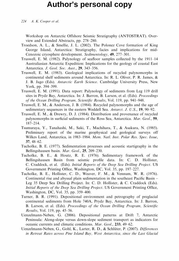
224 A. K. Cooper et al.
Author's personal copy
Workshop on Antarctic Offshore Seismic Stratigraphy (ANTOSTRAT). Over-view and Extended Abstracts, pp. 278–280.
Troedson, A. L., & Smellie, J. L. (2002). The Polonez Cove formation of KingGeorge Island, Antarctica: Stratigraphy, facies and implications for mid-Cenozoic cryosphere development. Sedimentology, 49, 277–301.
Truswell, E. M. (1982). Palynology of seafloor samples collected by the 1911–14Australiasian Antarctic Expedition: Implications for the geology of coastal EastAntarctica. J. Geol. Soc. Aust., 29, 343–356.
Truswell, E. M. (1983). Geological implications of recycled palynomorphs incontinental shelf sediments around Antarctica. In: R. L. Oliver, P. R. James, &J. B. Jago (Eds). Antarctic Earth Science. Cambridge University Press, NewYork, pp. 394–399.
Truswell, E. M. (1991). Data report: Palynology of sediments from Leg 119 drillsites in Prydz Bay, Antarctica. In: J. Barron, B. Larson, et al. (Eds). Proceedingsof the Ocean Drilling Program, Scientific Results, Vol. 119, pp. 941–948.
Truswell, E. M., & Anderson, J. B. (1984). Recycled palynomorphs and the age ofsedimentary sequences in the eastern Weddell Sea. Antarct. J. U.S., 19, 90–92.
Truswell, E. M., & Drewry, D. J. (1984). Distribution and provenance of recycledpalynomorphs in surficial sediments of the Ross Sea, Antarctica. Mar. Geol., 59,187–214.
Tsumuraya, Y., Tanahashi, M., Saki, T., Machihara, T., & Asakura, N. (1985).Preliminary report of the marine geophysical and geological surveys offWilkes Land, Antarctica, in 1983–1984. Mem. Natl. Inst. Polar Res. Spec. Issue,37, 48–62.
Tucholke, B. E. (1977). Sedimentation processes and acoustic startigraphy in theBellingshausen basin. Mar. Geol., 25, 209–230.
Tucholke, B. E., & Houtz, R. E. (1976). Sedimentary framework of theBellingshausen Basin from seismic profile data. In: C. D. Hollister,C. Craddock, et al. (Eds). Initial Reports of the Deep Sea Drilling Project. USGovernment Printing Office, Washington, DC, Vol. 35, pp. 197–227.
Tucholke, B. E., Hollister, C. D., Weaver, F. M., & Vennum, W. R. (1976).Continental rise and abyssal plain sedimentation in the southeast Pacific Basin –Leg 35 Deep Sea Drilling Project. In: C. D. Hollister, & C. Craddock (Eds).Initial Reports of the Deep Sea Drilling Project. US Government Printing Office,Washington, DC, Vol. 35, pp. 359–400.
Turner, B. R. (1991). Depositional environment and petrography of preglacialcontinental sediments from Hole 740A, Prydz Bay, Antarctica. In: J. Barron,B. Larson, et al. (Eds). Proceedings of the Ocean Drilling Program, ScientificResults, Vol. 119, pp. 45–56.
Uenzelmann-Neben, G. (2006). Depositional patterns at Drift 7, AntarcticPeninsula: Along-slope versus down-slope sediment transport as indicators foroceanic currents and climatic conditions. Mar. Geol., 233, 49–62.
Uenzelmann-Neben, G., Gohl, K., Larter, R. D., & Schluter, P. (2007). Differencesin Retreat Rates across Pine Island Bay, West Antarctica, since the Last Glacial
Cenozoic Climate History from Seismic Reflection and Drilling Studies 225
Author's personal copy
Maximum: Indications from Multichannel Seismic Data. US Geological SurveyOpen File Report, OF-2007-1047, doi:10.3133/of2007-1047.srp084.
Vanneste, L. E., & Larter, R. D. (1995). Deep-tow boomer survey on theAntarctic Peninsula Pacific margin: An investigation of the morphology andacoustic characteristics of late Quaternary sedimentary deposits on the outercontinental shelf and upper slope. In: A. K. Cooper, P. F. Barker, &G. Brancolini (Eds). Geology and Seismic Stratigraphy of the Antarctic Margin.American Geophysical Union, Washington, DC, Antarctic Research Series, Vol.68, pp. 97–121.
Vanney, J. R., & Johnson, G. L. (1976). Geomorphology of the Pacific Continentalmargin of the Antarctic Peninsula. In: C. D. Hollister, & C. Craddock (Eds).Initial Reports of the Deep Sea Drilling Project. US Government Printing Office,Washington, DC, Vol. 35, pp. 279–289.
Vanney, J. R., & Johnson, G. L. (1979). Wilkes Land continental marginphysiography, East Antarctica. Polarforschung, 49, 20–29.
Vanney, J. R., Falconer, R. K. H., & Johnson, G. L. (1981). Geomorphology of theRoss Sea and adjacent oceanic provinces. Mar. Geol., 41, 73–102.
Veevers, J. J. (1987). The conjugate continental margin of Antarctica and Australia.In: S. L. Eittreim, & M. A. Hampton (Eds). The Antarctic ContinentalMargin: Geology and Geophysics of Offshore Wilkes Land. Circum-Pacific Councilfor Energy and Mineral Resources, Houston, TX, Earth Sciences Series 5A,pp. 45–74.
Viseras, C., & Maldonado, A. (1999). Facies architecture, seismic stratigraphyanddevelopment of a high-latitude basin: The Powell Basin (Antarctica). Mar. Geol.,157, 69–87.
Volpi, V., Camerlenghi, A., Hillenbrand, C.-D., Rebesco, M., & Ivaldi, R. (2003).The effects of biogenic silica on sediment compaction and slope stability on thePacific margin of the Antarctic Peninsula. Basin Res., 15, 339–363.
Wannesson, J. (1990). Geology and petroleum potential of the Adelie Coast margin,East Antarctica. In: B. St. John (Ed.). Antarctica as an Exploration Frontier. Am.Assoc. Petrol. Geol. Stud. Geol., 31, 77–88.
Wannesson, J., Pelras, M., Petitperrin, B., Perret, M., & Segoufin, J. (1985).A geophysical transect of the Adelie Margin, East Antarctica. Mar. Petrol. Geol.,2, 192–201.
Wardell, N., Childs, J. R., & Cooper, A. K. (2007). Advances through collaboration:Sharing seismic reflection data via the Antarctic Seismic Data Library System forCooperative Research (SDLS). In: A. K. Cooper, C. R. Raymond, et al. (Eds).Antarctica: A Keystone in a Changing World – Online Proceedings of the 10thISAES. USGS Open-File Report 2007–1047, SRP 001, 4, doi:10.3133/of2007-1047.srp001.
Warnke, D. A., Marzo, B., & Hodell, D. A. (1996). Major deglaciation of EastAntarctica during the early late pliocene? Not likely from a marine perspective.In: R. Z. Poore, & L. C. Sloan (Eds). Climates and Climate Variability of thePliocene. Mar. Micropaleontol., 27, 237–251.
226 A. K. Cooper et al.
Author's personal copy
Watkins, N. D., & Kennett, J. P. (1972). Regional sedimentary disconformitiesand Upper Cenozoic changes in bottom water velocities between Australasiaand Antarctica. In: D. E. Hayes (Ed.). Antarctic Oceanology II: The Australian–New Zealand Sector. American Geophysical Union, Washington, DC,pp. 273–294.
Watkins, N. D., Keany, J., Ledbetter, M. T., & Huang, T. (1974). Antarctic glacialhistory from analyses of ice-rafted deposits in marine sediments: New model andinitial tests. Science, 186, 533–536.
Watkins, N. D., & Kennett, J. P. (1977). Erosion of deep-sea sediments in theSouthern Ocean between longitudes 70E and 190E and contrasts in manganesenodule development. Mar. Geol., 23, 103–111.
Watkins, N. D., Ledbetter, M. T., & Huang, T. C. (1982). Antarctic glacial historyusing spatial and temporal variations of ice-rafted debris in abyssal sediments ofthe Southern Ocean. In: C. Craddock (Ed.). Antarctic Geoscience. University ofWisconsin Press, Madison, WI, pp. 1013–1016.
Webb, P. N. (1991). A review of the Cenozoic stratigraphy and paleontology ofAntarctica. In: M. R. A. Thomson, J. A. Crane, & J. W. Thomson (Eds).Geological Evolution of Antarctica. Cambridge University Press, New York,pp. 599–607.
Webb, P. N., & Harwood, D. M. (1991). Late Cenozoic glacial history of the Rossembayment, Antarctica. Quat. Sci. Rev., 10, 215–223.
Webb, P. N., & Wrenn, J. H. (1982). Upper Cenozoic micropaleontology andbiostratigraphy of eastern Taylor Valley, Antarctica. In: C. Craddock (Ed.).Antarctic Geoscience. University ofWisconsin Press, Madison,WI, pp. 1117–1122.
Webb, P. N., Ronan, T. E. Jr., Lipps, J. H., & Delata, T. E. (1979). Mioceneglaciomarine sediments from beneath the southern Ross Ice Shelf, Antarctica.Science, 203, 435–437.
Webb, P. N., Leckie, R. M., & Ward, B. L. (1986). Foraminifera (late Oligocene):Antarctic Cenozoic history from the MSSTS-1 drillhole, McMurdo Sound. ScienceInformation Publishing Centre, Wellington, pp. 115–125
Weber, M. E., Bonani, G., & Futterer, D. K. (1994). Sedimentation processes withinchannel-ridge systems, southeastern Weddell Sea, Antarctica. Paleoceanography,9, 1027–1048.
Wellner, J. S., Lowe, A. L., Shipp, S. S., & Anderson, J. B. (2001). Distribution ofglacial geomorphic feature on the Antarctic continental shelf and correlation withsubstrate: Implications for ice behavior. J. Glaciol., 47, 397–411.
Wellner, J. S., Anderson, J. B., & Wise, S. W. (2005). The inaugural SHALDRILexpedition to the Weddell Sea, Antarctica. Sci. Drill., 1, 40–43.
Wellner, J. S., Heroy, D. C., & Anderson, J. B. (2006). The death mask of theAntarctic Ice Sheet: Comparison of glacial geomorphic features across thecontinental shelf. Geomorphology, 75, 157–171.
Whitehead, J. M., Quilty, P. G., Harwood, D. M., & McMinn, A. (2001). EarlyPliocene paleoenvironment of the Sørsdal Formation, Vestfold Hills, based ondiatom data. Mar. Micropaleontol., 41, 125–152.
Cenozoic Climate History from Seismic Reflection and Drilling Studies 227
Author's personal copy
Whitehead, J. M., Harwood, D. M., & McMinn, A. (2003). Ice-distal UpperMiocene marine strat in inland Antarctica. Sedimentology, 50, 531–552.
Whitehead, J. M., Harwood, D. M., McKelvey, B. C., Hambrey, M. J., &McMinn, A.(2004). Diatom biostratigraphy of the Cenozoic fjordal Pagodroma Group,northern Prince Charles Mountains, East Antarctica. Aust. J. Earth Sci., 51,521–547.
Williams, T., & Handwerger, D. (2005). A high-resolution record of early MioceneAntarctic glacial history from ODP Site 1165, Prydz Bay. Paleoceanography, 20,doi:10.1029/2004PA001067.
Wilson, G. S., Roberts, A. P., Verosub, K. L., Florindo, F., & Sagnotti, L. (1998).Magnetobiostratigraphic chronology of the Eocene–Oligocene transition in theCIROS-1 core, Victoria Land margin, Antarctica: Implications for Antarcticglacial history. Geol. Soc. Am. Bull., 110, 35–47.
Wise, S. W., Gombos, A. M., & Muza, J. P. (1985). Cenozoic evolution of polarwater masses, southwest Atlantic Ocean. In: K. J. Hsue, & H. J. Weissert (Eds).South Atlantic Paleoceanography. Cambridge University Press, Cambridge,pp. 283–324.
Wise, S. W., Jr., Breza, J. R., Harwood, D. M., & Wei, W. (1991). Paleogeneglacial history of Antarctica. In: D. W. Muller, J. A. McKenzie, & H. Weissert(Eds). Controversies in Modern Geology; Evolution of Geological Theories inSedimentology, Earth History and Tectonics. Academic Press, London,pp. 133–171.
Wise, S. W. J., Breza, J. R., Harwood, D. M., Wei, W., & Zachos, J. C. (1992).Paleogene glacial history of Antarctica in light of Leg 120 drilling results.In: S. W. Wise. Jr., R. Schlich, et al. (Eds). Proceedings of the Ocean DrillingProgram, Scientific Results, Vol. 120: College Station, TX, pp. 1001–1030.
Wordie, J. M. (1921). Depths and deposits of the Weddell Sea, Shackleton AntarcticExpedition 1914–1917. Trans. R. Soc. Edinburgh, 52, 781–793.
Wright, R. (1980). Sediment Gravity Transport on the Weddell Sea ContinentalMargin. M.A. Thesis, Rice University, Houston, TX, 96 pp.
Wright, R., & Anderson, J. B. (1982). The importance of sediment gravity flow tosediment transport and sorting in a glacial marine environment: Eastern WeddellSea, Antarctica. Geol. Soc. Am. Bull., 93, 951–963.
Wright, R., Anderson, J. B., & Fisco, P. P. (1983). Distribution and association ofsediment gravity flow deposits and glacial/glacial-marine sediments aroundthe continental margin of Antarctica. In: B. F. Molnia (Ed.). Glacial-MarineSedimentation. Plenum Press, New York, pp. 265–300.
Wright, J. D., & Miller, K. G. (1992). Miocene stable isotope stratigraphy, site 747,Kerguelen Plateau. In: S. W. Wise Jr., & R. Schlich, et al. (Eds). Proceedings ofthe Ocean Drilling Program, Scientific Results. College Station, TX, Vol. 120,pp. 855–866.
Wright, J. D., & Miller, K. G. (1993). Southern Ocean influences on late Eoceneto Miocene deepwater circulation. In: J. P. Kennett, & D. A. Warnke (Eds).The Antarctic Paleoenvironment: A Perspective on Global Change II. American
228 A. K. Cooper et al.
Author's personal copy
Geophysical Union, Washington, DC, Antarctic Research Series, Vol. 60,pp. 1–25.
Yamaguchi, K., Tamura, Y., Mizukoshi, I., & Tsuru, T. (1988). Preliminary reportof geophysical and geological surveys in the Amundsen Sea, West Antarctica.In: Proceedings of NIPR Symposium on Antarctic Geosciences. National Instituteof Polar Research, Tokyo, Vol. 2, pp. 55–67.
Yoon, H. I., Han, M. W., Park, B. K., Oh, J. K., & Chang, S. K. (1994).Depositional environment of near-surface sediments, King George Basin,Bransfield Strait, Antarctica. Geo Mar. Lett., 14, 1–9.
Zachos, J. C., Breza, J. R., & Wise, S. W. (1992). Early Oligocene ice-sheetexpansion on Antarctica: Stable isotope and sedimentological evidence fromKerguelen Plateau, southern Indian Ocean. Geology, 20, 569–573.
Zachos, J. C., Pagani, M., Sloan, L., Thomas, E., & Billups, K. (2001). Trends,rhythms, and aberrations in global climate 65 Ma to present. Science, 292,686–693.
Zayatz, I., Kavun, M., & Traube, V. (1990). The Soviet geophysical research inthe Ross Sea. In: A. K. Cooper, & P. N. Webb (Conveners). InternationalWorkshop on Antarctic Offshore Seismic Stratigraphy (ANTOSTRAT), Overviewand Extended Abstracts. US Geological Survey Open-File Report 90-309,pp. 283–290.
Zhivago, A. V., & Lisitsin, A. P. (1957). New data on the bottom and submarinedeposits in the eastern Antarctic. Izvestiya Akad. Nauk SSSR, 1, 19–35.
Zinsmeister, W. J. (1982). Review of the Upper Cretaceous-Lower Tertiary sequenceon Seymour Island, Antarctica. J. Geol. Soc. London, 139, 779–785.
Foldout RS-1: ‘Type section’ from the Eastern basin (modified from Cooper et al., 1995). The section is a compilation of seismic lines BGR-7 and IFP-208. RSS-1 are inferred pre-ice deposits, RSS-2 and -3 are early-glacial glaciomarine deposits, RSS-4, -5 and -6 are glaciomarine deposits of the ice-sheet growth phase,and RSS-7 and -8 are glaciomarine deposits of the polar ice-sheet phase. See Fig. RS-1 for location.
Author's personal copy
Foldout RS-2: ‘Type section’ from the Northern basin (modified from Cooper et al., 1995). The stratigraphy and origin of sediments are similar to those for the ‘type section’ in the Eastern basin (Foldout RS-1). RSS-1 is a basin-fill sequence, RSS-2 and -3 mostly aggrade, RSS-4, -5 and -6 mostly prograde and have with eroded topset beds,RSS-7 and -8 have aggrading geometries. See Fig. RS-1 for location.
Author's personal copy
NS
Two-
way
time
Sec
onds
Basement
Line TH99-35 Line TH99-35-1 Line GA 229/2950 km
ODP 742
B B’
Basement
Fault?
Mixed turbidite-contouritesequence
Turbidites?
K
Foldout PB-1: Seismic sections from eastern Prydz Bay (Section B-Bu). In the bay, Cenozoic sediments overlie Cretaceous (Surface K) and older sequences resting on basement. The shelf edge and upper slope prograded seaward through time becoming steeper. The slope and rise overlie a thick post-rift section, the latest parts of which are turbidite(inferred) and contourite (drilled) sequences deposited since the onset of glaciation. Location shown in Fig. PB-1.
Author's personal copy
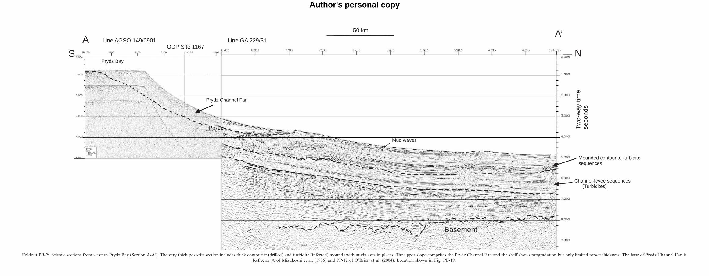
ODP Site 1167S
Line AGSO 149/0901 Line GA 229/31
N
Pp-12
Basement
Prydz Channel Fan
Mounded contourite-turbiditesequences
50 km
A A’
Prydz Bay
Mud waves
Channel-levee sequences(Turbidites)
Two-
way
time
seco
nds
Foldout PB-2: Seismic sections from western Prydz Bay (Section A-Au). The very thick post-rift section includes thick contourite (drilled) and turbidite (inferred) mounds with mudwaves in places. The upper slope comprises the Prydz Channel Fan and the shelf shows progradation but only limited topset thickness. The base of Prydz Channel Fan isReflector A of Mizukoshi et al. (1986) and PP-12 of O’Brien et al. (2004). Location shown in Fig. PB-19.
Author's personal copy
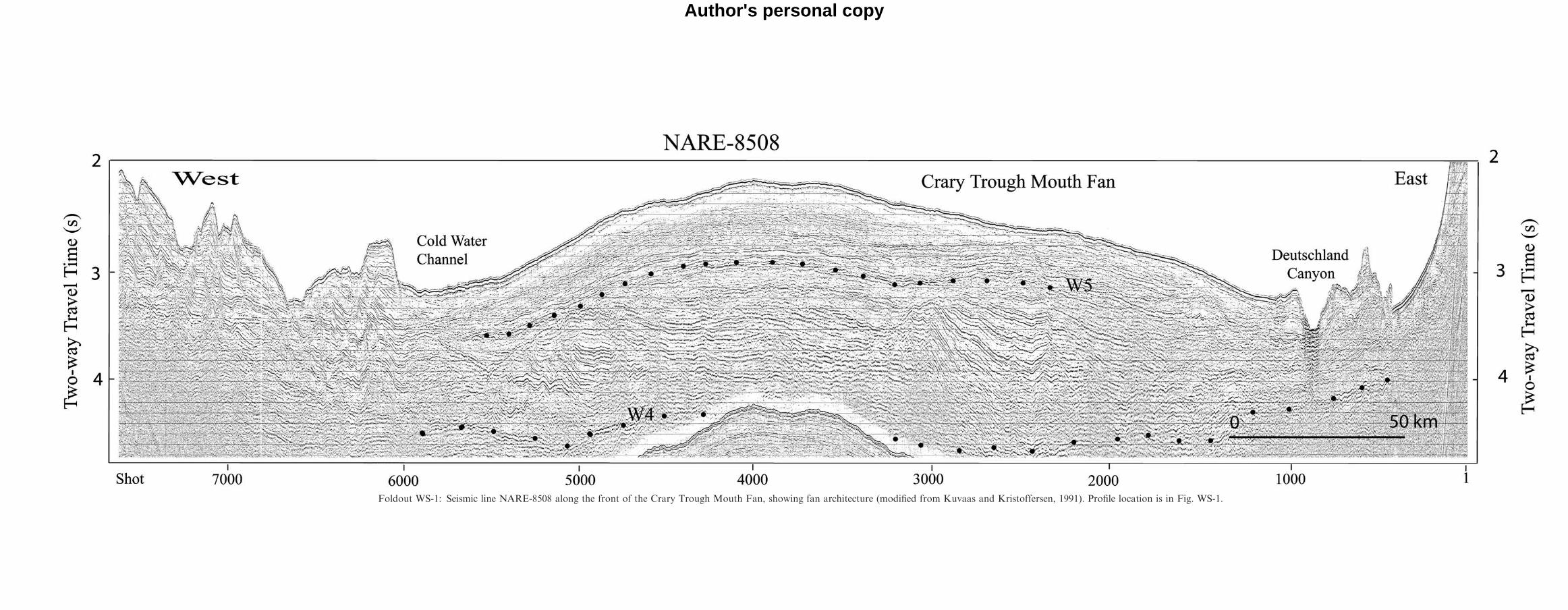
Foldout WS-1: Seismic line NARE-8508 along the front of the Crary Trough Mouth Fan, showing fan architecture (modified from Kuvaas and Kristoffersen, 1991). Profile location is in Fig. WS-1.
Author's personal copy
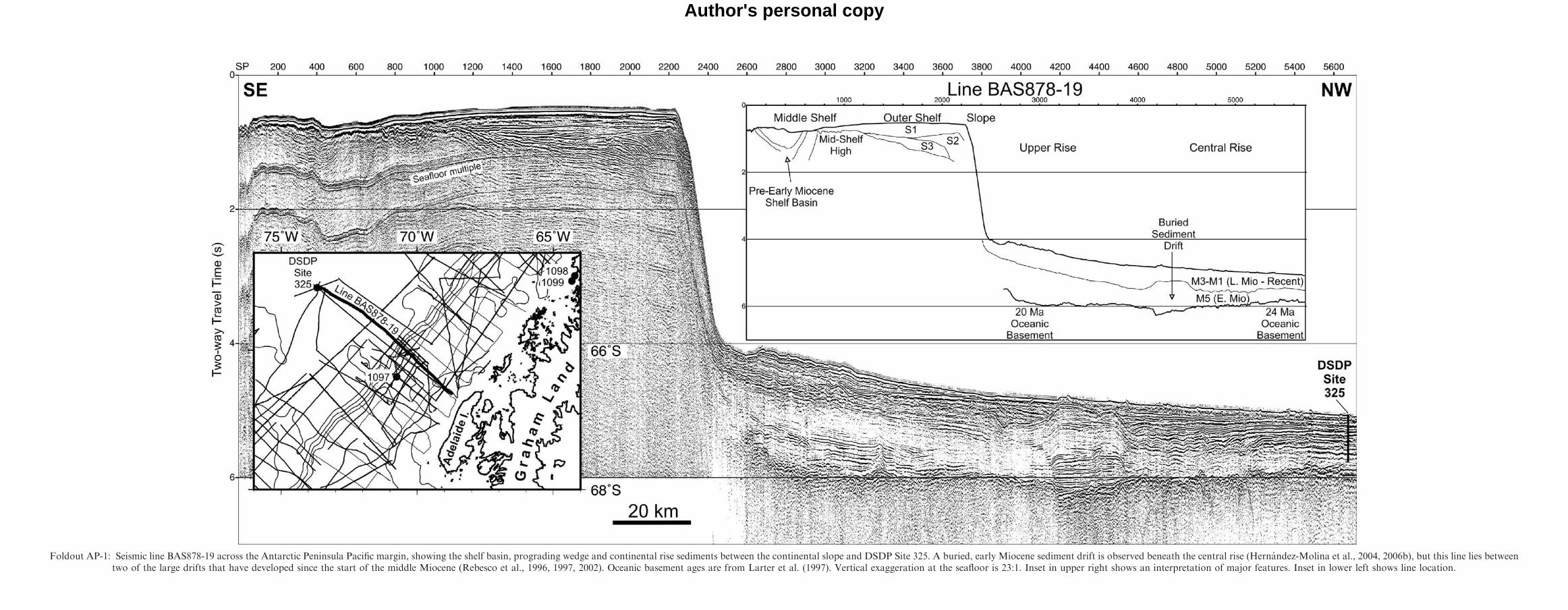
Foldout AP-1: Seismic line BAS878-19 across the Antarctic Peninsula Pacific margin, showing the shelf basin, prograding wedge and continental rise sediments between the continental slope and DSDP Site 325. A buried, early Miocene sediment drift is observed beneath the central rise (Hernandez-Molina et al., 2004, 2006b), but this line lies betweentwo of the large drifts that have developed since the start of the middle Miocene (Rebesco et al., 1996, 1997, 2002). Oceanic basement ages are from Larter et al. (1997). Vertical exaggeration at the seafloor is 23:1. Inset in upper right shows an interpretation of major features. Inset in lower left shows line location.
Author's personal copy