
49125-001: Initial Environmental Examination
227
Initial Environmental Examination March 2015 IND: Second Jharkhand State Road Project Prepared by State Highways Authority of Jharkhand, Government of Jharkhand for the Asian Development Bank.
-
Upload
khangminh22 -
Category
Documents
-
view
0 -
download
0
Transcript of 49125-001: Initial Environmental Examination

Initial Environmental Examination
March 2015
IND: Second Jharkhand State Road Project
Prepared by State Highways Authority of Jharkhand, Government of Jharkhand for the Asian
Development Bank.

CURRENCY EQUIVALENTS (as of 03 December 2014)
Currency unit – Indian rupee (INR) INR1.00 = $ 0.01616
$1.00 = INR 61.8760
ABBREVIATIONS AAQ - Ambient Air Quality AAQM - Ambient Air Quality Monitoring ADB - Asian Development Bank APHA - American Public Health Association BDL - Below Detection Limit BGL - Below Ground Level BOD - Biological Oxygen Demand BIS - Bureau of Indian Standard CO - carbon monoxide COD - chemical oxygen demand CPCB - Central Pollution Control Board CSC - Construction Supervision Consultant CWLW - Chief Wild Life Warden DO - Dissolved Oxygen DoE - Department of Environment DPR - Detailed Project Report DFO - Divisional Forest Officer EA - Executing Agency EIA - Environmental Impact Assessment EMP - Environmental Management Plan EMoP - Environmental Monitoring Plan EO - Environmental Officer GDP - Gross Domestic Product GHG - Green House Gas GIS - Geographic Information System GoI - Government of India GoJH - Government of Jharkhand GRC - Grievnce Redress Committee GRM - Grievance Redressal Mechanism HFL - Highest Flood Level IEE - Initial Environmental Examination IMD - Indian Meteorological Department IRC - Indian Road Congress IS - Indian Standard JSRP - Jharkhand State Roads Project LPG - Liquified Petroleum Gas Max - Maximum Min - Minimum MDRs - Major District Roads MoEFCC - Ministry of Environment, Forests and Climate Change MoRT&H - Ministry of Road Transport and Highways MSL - MeanSea Level MW - Mega Watt NGO - Non Government Organization NH - National Highway NHAI - National Highway Authority of India

NOx - Oxides of Nitrogen NTPC - National Thermal Power Corporation PHC - Primay Health Centre PIC - Project Implementation Cell PIU - Project Implementation Unit PMC - Project Management Consultant PF - Protected Forest RF - Reserve Forest RCD - Road Construction Department ROW - Right of Way SJSRP - Second Jharkhand State Road Project SEIAA - State Environment Impact Assessment Authority SEZ - Special Economic Zone SH - State Highway SPCB - State Pollution Control Board SPM - Suspended Particulate Matter SO2 - Sulphur Dioxide SSI - Small Scale Industries SPS - Safeguard Policy Statement SPCB - State Pollution Control Board PPTA - Project Preparatary Technical Assistance TDS - Total Dissolved Solids UNDP - United Nation Development Program TSS - Total Suspended Solid
WEIGHTS AND MEASURES
dB (A) – A-weighted decibel ha – Hectare km – Kilometer km2 – square kilometer KWA – kilowatt ampere Leq – equivalent continuous noise level μg – Microgram m – Meter MW – Megawatt PM 2.5 or 10 – Particulate Matter of 2.5 micron or 10 micron size
This initial environmental examination is a document of the borrower. The views expressed herein do not necessarily represent those of ADB's Board of Directors, Management, or staff, and may be preliminary in nature. Your attention is directed to the “terms of use” section of this website. In preparing any country program or strategy, financing any project, or by making any designation of or reference to a particular territory or geographic area in this document, the Asian Development Bank does not intend to make any judgments as to the legal or other status of any territory or area.

TABLE OF CONTENTS
EXECUTIVE SUMMARY ............................................................................................................ I IINTRODUCTION ...................................................................................................................... 1
A. Background .................................................................................................................... 1 B. Project Objectives .......................................................................................................... 2 C. IEE Objectives ................................................................................................................ 2 D. Extent of IEE .................................................................................................................. 2 E. Approach and Methodology ............................................................................................ 3 F. Structure of the report ..................................................................................................... 5
IIDESCRIPTION OF THE PROJECT ......................................................................................... 6 A. Location of the Project .................................................................................................... 6 B. Need of the Project ......................................................................................................... 7 C. Project Category ............................................................................................................. 8 D. Characteristics of Existing Sub-project Roads ................................................................ 8 E. Traffic projection ............................................................................................................. 9 F. Design Parameters ........................................................................................................10 G. Improvement/Strengthening Components .....................................................................11 H. Construction Material and Sourcing ...............................................................................14 I. Cost and Implementation Schedule ...............................................................................15
IIIPOLICY AND LEGAL FRAMEWORK.....................................................................................16 A. International Agreements and Committments ................................................................16 B. Country’s Legal Framework and Regulatory Requirements ...........................................17 C. Procedure for Forest Clearance.....................................................................................19 D. ADB's Safeguard Requirement ......................................................................................20
IV.DESCRIPTION OF EXISTING ENVIRONMENT ...................................................................23 A. Physical Environment ....................................................................................................23 B. Ecological Resources ....................................................................................................33 C. Economic Development .................................................................................................40 D. Social and Cultural Resources ......................................................................................42
V.ANTICIPATED ENVIRONMENTAL IMPACTS AND MITIGATION MEASURES ....................45 A. Potential Beneficial Impacts ...........................................................................................45 B. Potential Adverse Impacts .............................................................................................45 C. Pre-construction phase Impacts ....................................................................................45 D. Construction phase........................................................................................................49 E. Operational Phase .........................................................................................................60 F. Climate Change Impacts and Risks ...............................................................................75 G. Cumulative and Induced Impacts ...................................................................................80
VI.ENVIRONMENTAL MANAGEMENT PLAN, INSTITUTIONAL REQUIREMENTS AND GRIEVANCE REDRESS MECHANISM ....................................................................................82
A. Environment Management Plan.....................................................................................82 B. Environment Monitoring Program ..................................................................................82 C. Organizational Set-up of Implementing Agency: ............................................................84 D. Proposed Institutional Arrangement: ..............................................................................85 E. Institutional / Capacity Building ......................................................................................88 F. Grievance Redress Mechanism .....................................................................................90 G. Environment Management Budget ................................................................................91
VII.PUBLIC CONSULTATION AND INFORMATION DISCLOSURE .........................................95 A. Meaningful consultation .................................................................................................95 B. Objectives of the Public Consultations ...........................................................................95 C. Methodology ..................................................................................................................95

D. Project Stakeholders .....................................................................................................95 E. Consultations with Government Agencies .....................................................................96 F. Consultations with Local People/Beneficiaries ...............................................................97 G. Consultations with Women and Vulnerable Groups .......................................................97 H. Disclosure of information ...............................................................................................98
VIII.CONCLUSION AND RECOMMENDATIONS .................................................................... 105
APPENDICES Appendix 1: Rapid Environmental Assessment (REA) Checklist 107 Appendix 2: Certification from Forest Department about Ecologically Sensitive Area and Protected Corridor within 10 Km Radius 113 Appendix 3: List of Bridges with Increased Waterways (Venti Size and Height) 117 Appendix 4: Road Sections Proposed for Raising of Embankment 118 Appendix 5: National Ambient Air Quality Standards 120 Appendix 6: National Ambient Noise Standards 121 Appendix 7: Drinking Water Quality Standards (As Per IS: 10500-1991) 122 Appendix 8: Water Quality Criteria and Standards For Freshwater Classification (CPCB,1979)123 Appendix 9: Plant Species Found on Both Sides of Khunti-Tamar Road 124 Appendix 10: Plant Species Found on Both Sides of Govindpur-Tundi-Giridih Road 127 Appendix 11: Sensitive Receptors in the Project Area 131 Appendix 12: List of Tree/Grass Species Preferred by Elephants 134 Appendix 13: Environmental Management Plan for Dumka-Hansdiha Road 135 Appendix 14: Environmental Management Plan for Pachamba-Jamua-Sarwan Road 155 Appendix 15: Environmental Management Plan for Govindpur-Tundi-Giridih Road 174 Appendix 16: Environmental Management Plan for Khunti-Tamar Road 194 Appendix 17: Environmental Monitoring Plan 215
LIST OF TABLES Table 1: Road Sections under SJSRP ....................................................................................... 1 Table 2: Salient Features of Existing Roads ............................................................................... 8 Table 3: Projected Traffic ..........................................................................................................10 Table 4: Design Parameters ......................................................................................................10 Table 5: Details of Bridges and Culverts under Project Scope ..................................................12 Table 6: Details of Bridges and Culverts under Project Scope ..................................................12 Table 7: Proposed Pavement Composition ...............................................................................13 Table 8: Project Facilities ..........................................................................................................13 Table 9: Quantity and Source of Construction Material .............................................................14 Table 10: Applicable National Laws and Regulations for the Investment Project .......................17 Table 11: Ambient Air Quality in the Project Area ......................................................................30 Table 12: Noise Level in the Project Area .................................................................................31 Table 13: Groundwater Quality in the Project Area ...................................................................32 Table 14: Surface Water Quality in the Project Area .................................................................32 Table 15: List of waterways/ Water Bodies ................................................................................33 Table 16: IUCN status and Protected Status of Faunal Species as per Wild Life Act ................34 Table 17: Forest Cover in Project Districts ................................................................................34 Table 18: Floral Species in the Forests along the Khunti-Tamar Road ......................................36 Table 19: Floral Species in the Forests along the Govindpur-Tundi-Giridih Road ......................37 Table 20: Demography of the Project Districts ..........................................................................42 Table 21: Sensitive Structures along RD 01: Dumka - Hansdiha ...............................................43 Table 22: Sensitive Structures along RD 02: Pachamba – Jamua - Sarwan .............................44

Table 23: Sensitive Structures along RD 03: Govindpur – Tundi - Giridih ..................................44 Table 24: Sensitive Structures along RD 04: Khunti – Tamar ....................................................44 Table 25: Summary of impacts on land and assets ...................................................................46 Table 26: Location for rumble strips ..........................................................................................47 Table 27: Location for informatory and cautionary sign boards .................................................48 Table 28: Number and location of solar street lamps ................................................................48 Table 29: Number and communities for supply of solar dragon lights ........................................48 Table 30: Emission Factors for Criteria Pollutants .....................................................................61 Table 31: Sensitive Structures along RD 01: Dumka - Hansdiha ...............................................69 Table 32: Sensitive Structures along RD 02: Pachamba – Jamua - Sarwan .............................69 Table 33: Sensitive Structures along RD 03: Govindpur – Tundi - Giridih ..................................70 Table 34: Sensitive Structures along RD 04: Khunti – Tamar ....................................................70 Table 35: Predicted Noise Levels along the Project Roads .......................................................73 Table 36: Noise levels within the location of sensitive structures along the project roads ..........74 Table 37:CO2 Emission Factors ...............................................................................................76 Table 38: Emission Standards of Fleet (%) ...............................................................................76 Table 39: Estimated Total CO2 Emissions during Road Construction .......................................77 Table 40: Section-wise Project CO2 Emissions Intensity Indicators ..........................................77 Table 41: Project CO2 Emissions Intensity Indicators ...............................................................78 Table 42: Details of Climate Adaptation Measures with Cost Implications .................................80 Table 43: Responsibilities for Environmental Safeguards Implementation.................................85 Table 44: Training/Workshop Budget for EMP Implementation .................................................89 Table 45: Estimated Environment Management Cost................................................................92 Table 46: Summary of Consultation Held with Government Departments .................................96 Table 47: Summary of key points discussed in FGDs conducted during June-August, 2014. ....99
LIST OF FIGURES Figure 1: Typical Cross section .................................................................................................11 Figure 2: Procedure and Work Flow for Forest Clearance .........................................................19 Figure 3 Land Utilisation (in %) of Jharkhand ............................................................................25 Figure 4: Landuse/Landcover of RD 01 (Dumka-Hansdiha) ......................................................26 Figure 5: Landuse/Landcover of RD 03 (Pachamba-Jamua-Sarwan) ........................................27 Figure 6: Landuse/Landcover Map of RD Govindpur-Tundi-Giridih ...........................................28 Figure 7: Landuse/Landcover Map of RD 04 (Khunti-Tamar) ....................................................29 Figure 8: Elephant Crossing Locations along/across Dumka-Handiha Road .............................38 Figure 9: Predicted Pollutants Concentration with respect to distance from Project Road (RD-01: Dumka to Hansdia) ...................................................................................................................63 Figure 10: Predicted Pollutants Concentration with respect to distance from Project Road (RD-02: Giridih to Jamua section) .....................................................................................................64 Figure 11: Predicted Pollutants Concentration with respect to distance from Project Road (RD-02: Jamua to Sarwan section) ...................................................................................................65 Figure 12: Predicted Pollutants Concentration with respect to distance from Project Road (RD-03: Govindpur to Tundhi section) ..............................................................................................66 Figure 13: Predicted Pollutants Concentration with respect to distance from Project Road (RD-03: Tundhi to Giridih section) ....................................................................................................67 Figure 14: Predicted Pollutants Concentration with respect to distance from Project Road (RD-04: Khunti to Tamar) .................................................................................................................68 Figure 15: Existing Organizational Set-up of Implementing Agency ..........................................84 Figure 16: Flow Diagram Illustrating Proposed Implementation Arrangment for SJSRP ............88 Figure 17 : Flow Diagram Showing Grievance Redressal Mechanism ......................................91

i
EXECUTIVE SUMMARY
1. The Project: Second Jharkhand State Road Project (SJSRP) project includes widening and improvement of three existing State Highways (SH-17: Dumka - Hansdiha, SH-13: Govindpur-Tundi - Giridih, SH-3: Khunti- Tamar) and Major District Roads (MDR 83; Pachamba-Jamua & MDR 86; Jamua-Sarwan) totaling 176.643 km located in Dumka, Godda, Giridih, Dhanbad, Khunti and Saraikela districts of Jharkhand state. State Highways of Jharkhand (SHAJ) is the executing agency of the project. Existing roads are mostly of intermediate lane with poor horizontal and vertical profile, degraded shoulder, inadequate CD structures, side drains, safety installations, protection works and road furniture etc. Project improvement components involve (i) widening from the existing intermediate lane to 2-lane of 7.0m carriageway with of 1.5 m and 1.0 mpaved shoulder and earthen shoulders on either side (ii) improvement in pavement conditions and road geometry (iii) reconstruction/ widening and additional CD structures, (iv) provision of service roads, lined drains in built-up sections, junction improvement, protection works, bus bays/truck lay byes and installation of safety measures etc. Project also addresses the climate change impacts and risks. 2. Environmental Sensitivity and Project Categorization: Project road is not passing through any wildlife sanctuary, national park, tiger reserve, protected area or any other similar eco-sensitive areas. Few sections of some sub-projects pass through protected or reserved forests1. However,approximately a total of only 1.85 ha of diversion of forest land is required under the project. No loss of rare/threatened/endangered species of flora is envisaged. Elephant crossings are reported in Govindpur-Giridih, Dumka-Hansdiha and Khunti-Tamar sub-projects. These elephants are recent migrants and not the resident populations of the project districts. Their movement in the study region is often controlled by their encounter with human settlements, provoking chase by villagers to avoid the damages of their crops and property. As a result, the elephants are not able to follow or chart their normal movement course. Thus, the movement patterns of elephants are erratic in nature and difficult to predict their route. Further, none of their movement track is either in eco-sensitive areas or in protected area network. All other impacts are site-specific and can be addressed through proven mitigation measures. Hence, the project is classified as Category B warranting an initial environmental examination (IEE) which has been conducted in consistent to Safeguard Policy Statement (SPS),2009. 3. Existing Environment: The state falls under the Tropical to Sub-tropical climatic region with three distinct seasons; winter, summer, and monsoon. Minimum and maximum temperature varies from as low as 30C in winter and 400C in summer. Average rainfall of the state is 1300 mm. Relative humidity is as low as 30% in summer and 90% during monsoon. Physiographically, major portion of the project area is part of Chotanagpur plateau with elevation from mean sea level ranging from 150 to 600m. Topography is predominantly rolling Geologically, Jharkhand is an integral part of peninsular highland formed of rock formation ranging from Archeans to Post-tertiary period. Project area mostly lies in seismic Zone III denoting moderate damage risk zone. Project area in general is not liable to flood. Overtopping of road is uncommon except at some isolated bridge locations. State is not affected by any other natural hazard except drought which is very common in all districts. Abutting landuse is predominantly agricultural with some commercial establishments in semi-urban/built-up areas. Intermittent Forest patches are present along Govindpur-Tundi-Giridh and Khunti-Tamar road.
1Reserved Forest: an area notified under the provision of Indian Forest Act having full degree of protection. In
Reserved Forests, all activities are prohibited unless permitted. Protected Forest: an area notified under the Indian
Forest Act having limited degree of protection. In Protected Forests, all activities are permitted unless prohibited.

ii
Landuse of the study area (10 km radius) largely replicates the landuse/land-cover of the state depicting predominance of vegetation, fallow/barren/non-agricultural areas followed by arable land. Air quality and noise level mostly conform the national standard except near industrial centers like and intersecting national highways with high traffic density. Groundwater largely meets the prescribed limit corresponding to drinking water standard. Project area is drained by a No. of rivers and also intersecting the project roads. Important rivers are Barakar, Khudia, Usri (Govindpur-Tundi-Giridih Road), Tajna/Kharkai (Khunti-Tamar Road), Usri and its tributaries (Pachamba-Jamua-Sarwan Road) and Murkhoi and Hardiya (Dumka-Hansdiha). Rivers banks are well defined/confined and consolidated in Govindpur-Tundi-Giridih and Khunti-Tamar hence reducing the possibility of erosion. They are also some ponds which are partially affected due to widening. River water is not used for drinking/domestic use. Water quality of these rivers in the project area is expected to be fit for outdoor bathing and propagation of aquatic life. 4. Anticipated Environmental Impacts and Mitigation Measures: Main pre-construction impacts are: (i) loss of livelihood due to acquisition of land and assets (ii) submergence of roads and CD structures due to inadequate waterways (iii) disruption in elephant movement (iv) cutting of 8808 trees and (iv) accident risk due to poor horizontal and vertical profile. Adequate compensation and rehabilitation assistance will be extended as per national Act2and ADB involuntary resettlement policy. All CD structures have been designed for 50yr return period with anticipated risk of rarer flood of next higher frequency. Waterway and elevation of most of the bridges are increased. Embankment heights have also been increased where overtopping is anticipated. Compensatory afforestation on 1:2 basis and additional plantation on same ration will improve the micro climate of the region in long term.To facilitate elephant movement in the project area several meausres have been recommended viz: informatory sign boards on the presence of elephants will be placed to inform traffic users; speed limits will be enforced through sign boards, rumble strips, speed breakers in specific areas where elephants usually cross the the road; plantation of elephant preferred plants etc.Provision of any civil structure at this stagehas notbeen made since in the present landscape, seasonal movement pattern of elephant herds are quite erratic.
5. Significant impacts anticipated during construction phase are: (i) increase of local air pollution and noise level due to construction and site clearance activities, earthworks, borrowing and quarrying, operation of hot mix plants etc; (ii) deterioration of surface water quality due to silt run-off, spillage from vehicles and discharge from labour camps; (iii) health impacts from labour camps; (iv) disruption to access/traffic; (v) occupational health and community safety. Mitigation measures includes: (i) utilizing least noisy equipment and regulating time of construction near settlements and sensitive receptors; (ii) sprinkling of water on earthworks, active construction sites, material storage locations and haulage roads; (iii) installation of silt and oil traps along waterbodies; (iv) slope stabilization to control erosion and protection work for ponds; (v) camp siting and management as per IRC guidelines and best practices (vi) traffic management to avoid congestion and maintain access of local residents; (vii) implementing 1:2 compensatory plantation to off-set impacts from tree cutting and additional plantation at 1:2 to enhance the micro-climate; (ix) no camp, materials storage, hot mix plant near forest areas; (x) no construction in the stretches of potential elephant’s crossings during months of frequent sightings. 6. Operation stage impacts anticipated are road accidents, accidental spillage, submergence/overtopping of CD structures, water logging due to blockade of side drains, increased air pollution and noise level, survival of compensatory afforestation and avenue
2The Right to Fair Compensation and Transparency in Land Acquisition, Rehabilitation And Resettlement Act, 2013

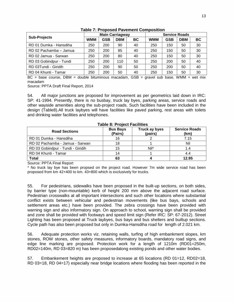
iii
plantation and elephant-traffic collision etc. All these are mainly associated with maintenance and monitor of effectiveness of mitigation measures taken during design and construction stage. Executing agency is mandated to undertake regular maintenance of the road conditions and itsappurtenances.
7. Greenhouse Gas Emissions and Addressing Risk of Climate Change. Total annual emission is estimated to be less than the 100,000 tons per year threshold3 set by ADB.The projected variations in temperature and precipitation the project roads indicated vulnerability to, flooding (increased storminess), which can affect road, bridge and embankments. Key engineering measures taken to address these risks in the design are: i) increase in embankment height, ii) construction of new side and lead away drains, iii) construction of new culverts or widening of existing ones and iv) increase in waterway including vertical clearance of bridges which amounts to Rs. 112 crores,approximately 10% of the total civil works costs.
8. Public Consultations: Extensive consultations were made with local communities and government agencies like Forests and Wildlife, State Pollution Control Board, Jharkhand Space Application Center, Economics and Statistics to incorporate their views and suggestions. Local community strongly support the project. They disseminated many important informations and made several suggestions and demands. Main demands include adequate compensation and assistance for loss of land and assets, employement in road construction and petty contract provision of safety measures, side drains in built-up areas, avenue plantation, provision of water harvesting/ponds and road furnitures. Most of their demand have been integrated in design.
9. Environmental Management Plan: Sub-project specific Environmental Management Plan (EMP) has been formulated with an intend to set out action required to avoid or mitigate all impacts and the responsibility for taking each action. Responsibility is made legally binding when actions are subsequently specified in contracts. Environmental Monitoring Plan (EMoP) has been prepared to ensure that the intended environmental mitigations are realized and these results in desired benefits to the target population causing minimal deterioration to the environmental parameters. All costs for implementing the mitigation measures and monitoring plan will be included in the Bill of Quantities (BOQ) by the contractor as implementation of the EMP will be the responsibility of the contractor.
10. SHAJ, through its Project Implementation Unit (PIU), will ensure the effective implementation of the environmental management plan. SHAJ will be assisted by a Project Management Consultant (PMC). There is a need for the PIU to organize its environmental unit to ensure that contractors maintain environmental safeguard compliance. To provide regular monitoring information and technical advice to the PIU a Construction Supervision Consultant will be engaged who will be responsible to examine environmental compliances and suggest corrective actions.
11. Conclusion: This initial environmental examination (IEE) ascertains that upgrading is unlikely to cause any significant environmental impacts. Few impacts were identified attributable to the proposed subproject, all of which are localized and temporary in nature and can be easily mitigated with minor to negligible residual impacts. Need of undertaking detailed EIA is not envisaged at this stage. However a detailed study on elephants has been recommended which will be carried out by the CSC Wildlife Specialist. Additional wildlife conservation activities may
3 Page 38, Appendix I, footnote 10 of SPS 2009

iv
be recommended by the specialist for implementation during construction. A lumpsum budget provision for each of the three roads with elephant crossings has been made for this under the civil works costs. Guidance on design and implementation of these measures will be made by the Wildlife Specialist and Environment Specialist under the CSC. The Executing Agency shall ensure that EMP and EMoP are included in Bill of Quantity (BOQ) and forms part of bid document and civil works contract. The same shall be revised if necessary during project implementation or if there is any change in the design and with prior approval of ADB.

1
I. INTRODUCTION
A. Background 12. Jharkhand, the land of forests, is located in eastern part of India and covers an area of 79,714 sq km. It was carved out of southern Bihar to form a separate statein the year 2000. Ranchi is its capital. The total population is 329.66 million which accounts for 2.72% of the country. It has sizeable tribal population of 26.3%.Despite its rich mineral wealth with over 40% of the country's total reserve and extensive forest resources (29% of the total area), Jharkhand is one of the least developed states in Indiawith a poverty incidence of above 40% and has the highest rural poverty incidence in the country. As per National Sample Survey Organization (NSSO), about 12.5% of households do not get two square meals a day. The poverty ratio in India has fallen down from 37.2% in 2004-05 to 21.9% in 2011-12, but decline in poverty ratio in Jharkhand is only 8%, from 45.3% in 2004-05 to 37.0% in 2013-14.
13. The deficient network and quality of the road infrastructure is an important deterrent factor constraining the development of major part of the state. Jharkhand has 21.4 km of roads per 100 sq.km against country’s 74.2km. Only 36% of the state’s villages have immediate access to all-weathered road compared to all India average of 57%. Less than 25% of the villages are connected with metalled roads compared to national figure of 45%. More than 50% of the roads are of intermediate lane configuration and the pavement condition is not good in 80% of the cases (vision document, Jharkhand Infrastructure Development Corporation, 2013). 14. Recognizing the importance of road in providing momentum for accelerating economic development, Government of Jharkhand (GoJH) has initiated several road improvement projects in its 12th five year plan including externally aided projects. In this series GoJHhas requested Asian Development Bank (ADB) for second loan4 for Second Jharkhand State Road Project (SJSRP)for improvement of four existing roads totaling176.643 km. State Highways Authority of Jharkhand (SHAJ)5 is the executing agency (EA) for the project. List of road sections under projects is given in Table 1.
Table 1: Road Sections under SJSRP
Sl. No. ID. Name of Sub-Project Road Length (km) District
1 RD 01 SH-17 (Dumka- Hansdiha) 44.221 Dumka, Godda 2 RD 02 MDR-86& 83 (Pachamba-Jamua-
Sarwan) 45.175 Giridih
3 RD 03 SH-13 (Govindpur-Tundi-Giridih) 43.550 Dhanbad, Giridih 4 RD 04 SH-3 (Khunti-Tamar) 43.697 Khunti, Saraikela
Total 176.643 Source: Draft Final Report, Project Preparatory Technical Assistance (PPTA) SJSRP.
4 ADB extended first loan amounting US$ 200 million under Jharkhand State Road Project (JSRP) in
2010 for construction of a 310 km long state road from Govindpur to Sahebganj. Project is under implementation under four construction packages. Road Construction Department is the executing agency for the project. 5 State Highways Authority of Jharkhand has been constituted byAct 11 (i),2008 for the development,
maintenance and management of state highway or any other stretch and matters concerned therewith or incidental thereto. Key objective also includes to develop models for bringing private and institutional and international funding for the state road sector.

2
B. Project Objectives 15. Project aims to improve transport efficiency of the state road network, which will contribute to expansion of economic opportunities and poverty reduction. This will be realized by (i) improving the state highway network, (ii) facilitating safe and appropriate road usage, (iii) increasing efficiency of transport services and (iv) enhancing GoJH capacity for road asset development and management. Project immediate outcome will be improved accessibility to social services and markets, increased fuel efficiency, reduced travel time, accidents, vehicle emissions and better employment opportunities outside agriculture, both through improved access to economic centers and increased industrial activities in the project area. 16. To achieve the above objectives, candidate roads will be improved to 2-lane with paved shoulders largely in consistent to Indian Road Congress (IRC) guidelines. Widening and improvement components will include (i) improvement in pavement conditions and road geometry (ii) reconstruction/ widening and provision of additional cross drainage (CD) structures, (iii) provision of service roads, lined drains in built-up sections, junction improvement, protection works, bus bays/truck lay byes and installation of safety measures etc
C. IEE Objectives
17. The project is categorized as category ‘B’in accordance with ADB’s Safeguard Policy Statement (SPS), 2009warranting an initial environmental examination (IEE). IEE identifies the environmental issues to be considered at project planning and design stage.The IEE report covers the general environmental profile of the study area and includes an overview of the potential environmental impacts and their magnitude on physical, ecological, economic, and social and cultural resources within the project’s influence area during design, construction, and operation stages. An Environmental Management Plan (EMP) is also proposed as part of this report which includes mitigation measures for significant environmental impacts during implementation of the project, environmental monitoring program, and the responsible entities for mitigation and monitoring. IEE has four basic objectives; (i) identify the environmental issues that should be taken into account due to project interventions (ii) determine the magnitude of potential environmental concerns and to ensure that environmental considerations are given adequate weight at planning/design stage (iii) identify need for further environmental studies or Environmental Impact Assessment (EIA) and (iv) suggest enhancement measures, if any.
D. Extent of IEE
18. IEE extent has been decided considering all likely Impacts and risks analyzed in the context of the project’s area of influence. It encompasses (i) the primary project site(s) and related facilities (ii) associated facilities whose viability and existence depend exclusively on the project (iii) areas and communities potentially affected by cumulative impacts from further planned development of any existing project or condition, and other project-related developments that are realistically defined at the time of assessment; and (iv) areas and communities potentially affected by impacts from unplanned but predictable developments caused by the project that may occur later or at a different location. The core zone of impact is
taken as proposed right of way and its immediate vicinity. The assessment also considers the areas and activities related to associate facilities viz. quarry operation, borrow areas, construction camp, transportation/haulage routes etc. The study area is considered up to 10 km on either side of road alignment for larger analysis of landuse and other environmental features. Assessment is carried out for all components of environment covering terrestrial and aquatic ecology, soil, water, noise and socio economic aspects.

3
E. Approach and Methodology
19. Since the project scope is limited to reconstruction/rehabilitation and widening of existing stretches without any new bypasseswith more or less similar environmental setting viz. climate, terrain, landuse and temporal extent, one consolidated IEE has been prepared highlighting the road specific environmental issues. This IEE report has been prepared on the basis of detailed engineering design further reviewed and updated by project preparatory technical assistance (PPTA) team, field investigations and stakeholder consultations to meet the requirements for environmental assessment process and documentation as per ADB’s Safeguard Policy Statement (SPS), 2009.The core zone of impact is taken as proposed right of way (ROW) of the alignment and its immediate vicinity. However, the study area is considered up to 10 km on either side of road alignment for larger analysis of landuse and other environmental features. 20. IEE commenced with the review of legal requirements for the project. In next step, technical details were collected compiled by the design team which was further reviewed and updated by PPTA consultants. This was followed by a discussion with the implementing agency to reconfirm the technical details and detailed project scope/intervention.Further steps followed for IEE has been concisely described in following paragraphs.
1. Reconnaissance Survey and Initial Consultations
21. Reconnaissance survey and initial consultationsfacilitated in designing the nature of the environmental survey and extent of consultationsto be carried out along the road alignment. It helped to identify data gaps, decide valued environment components, key stakeholders and key informants who can further substantiate the collected informations. Reconnaissance survey and initial consultations also recognized the need to conductrapid bio-diversity assessment and wild-life movement study for the stretches where forest patches are present and elephant movementsarereported.
2. Primary Data Collection
22. Environmental resource inventory was prepared of all environmental features viz. terrain, landuse, waterways/water bodies, road side vegetation, sensitive receptors, common property resources, utilities, drainage, flooding/water logging, industries, accident prone areas etc. within the area of interest/core zone. Key informationsabout elephant crossings viz. location, route, herd size, frequency, season of movement etc. were also collected. This was done by trained persons under the supervision of an expert team comprised of university researchers. Similarly, floral survey was also carried out. Baseline monitoring was conducted at the locations for which data was not available in environmental assessment report conducted by detailed design team.
3. Secondary Data Collection
23. Secondary sources included environmental assessments done by DPR team,publishedgovernment reports, environmental impact assessments conducted in the similar region, government websites, recognized institutions and relevant government departments (forest, irrigation, pollution control board, fisheries, statistics, Indian Meteorological Department (IMD) and Jharkhand Space Application Centre (JSAC) etc.Recent Google images were capturedto view environmental features at regional scale.References made to the secondary sources have been mentioned in the text and tables throughout the length of the report.

4
4. Public Consultations
24. Meaningful consultations were organized with the government agencies, local people/beneficiary population to know the level of project acceptability, understand their concerns, apprehensions, and overall opinion. Informations were gathered about existing baseline environmental condition viz. ambient levels and its effects on health, water resources, water logging/flooding, flora and fauna, socio-economic standing of local people, impact due to loss of land other assets and common property resources, accident risk during construction and operation stage, perceived benefits and losses, etc.Information thus gathered was used to integrate it in project design and formulate mitigation measures and environmental management plan.
5. Other Tools, Additional Surveys and Studies 25. The Transport Emissions Evaluation Model for Projects (TEEMP)6 developed by Clean Air Asia7 was utilized to assess the CO2 gross emissions.Required input data-set viz. road length and configuration, traffic, road roughness, emission factors etc were collected from different sources. 26. Assessment of landuse/land cover map of larger area beyond the project site helps in better planning and decision-making before creating any physical infrastructure in the region.Remote sensing and Geographic Information System (GIS) based landuse map of the study area (10 km buffer) has been prepared through recent satellite imagery. Unsupervised classification was done using ERDAS Imagine software supported by ground verifications. 27. Climate risk screening identified flood as major risk which may adversely impact the road components like, pavement, embankment and cross drainage structures during design life. To avoid flood induced impact on road components it is essential to incorporate various measures in design. Details of structures, history of floods, water logging/low lying areas, road stretches and bridge liable to submergence along the sub-project roads were collected during field visit and the same was corroborated with informations available with design and PPTA team.. 28. A detailed survey within available resources and time frame was done for biodiversity and elephant movement assessment. Methodology adopted to identify potential locations for elephant crossings was mainly based on:
(i) Review of existing literature (ii) Consultation with forest/wildlife experts (iii) Interviews of Local villagers (iv) Study of landscape level concerns of elephant population & key movement
corridors (v) Identification of potential habitats along and near the proposed highway, as key
refuge areas for elephants and assess their extent and habitat quality and (vi) Collection of data on elephant-human conflict and spatio-temporal shift of
elephant
6 TEEMP is an excel-based, free-of-charge spreadsheet models to evaluate emissions impacts of
transport projects. 7A network of 250 organizations in 31 countries established by the Asian Development Bank, World Bank,
and USAID to promote better air quality and livable cities by translating knowledge to policies and actions that reduce air pollution and greenhouse gas emissions from transport, energy and other sectors.

5
6. Assessment of Potential Impacts
29. The assessment of the type, nature, direct, indirect, cumulative or induced impacts and their significance to the physical, biological, and socio-economic components of the environment has been done to ascertain whether the project is environmentally sustainable or not. Nature of impacts has been classified as significant, insignificant, short-term, long-term, reversible, irreversible etc. After identification of nature and extent of impacts, mitigation measures have been suggested.
7. Preparation of the Environment Management Plan
30. The project specific Environment Management plan has been formulated with an aim to avoid, reduce, mitigate, or compensate for adverse environmental impacts/risks and propose enhancement measures. This includes (i) mitigation of potentially adverse impacts (ii) monitoring of impacts and mitigation measures during project implementation and operation (iii) institutional capacity building and training (iii) compliance to statutory requirements (iv) integration of EMP with Project planning, design, construction and operation.
F. Structure of the report
31. IEE has been structured in accordance with SPS, 2009. Executive Summary describing critical facts, significant findings, and recommended actions has been presented in the beginning of the report. The report has been compiled and presented as follows.
Executive Summary Chapter 1 - Introduction Chapter 2- Policy, Legal and Administrative Framework Chapter 3- Description of Project Chapter 4- Description of the Environment Chapter 5- Anticipated Impacts and Mitigation Measures Chapter 6- Information Disclosure, Consultation, and Participation Chapter 7- EMP and Grievance Redress Mechanism Chapter 8 - Conclusion and Recommendation

6
II. DESCRIPTION OF THE PROJECT
A. Location of the Project
32. Location and spatial extent of each candidate road is described in following paragraphs and location map is enclosed as Map 1.
Map 1: SJSRP Location Map

7
33. RD 01,Dumka-Hansdiha:Major portion of the road section is in Dumka district barring 4 km which lies in Godda District. It starts from a 3-legged intersection named as MaharoChowk at existing km 7.000 of SH-17 and terminates at Bihar border near Bhaljore, 4 km beyond Hansdiha covering total length44.221 km. Important settlement enroute areLakrapahari, Sirsa, Gajambha,Nayachowk,Nunihat, Lakratand,Sahajana,Kumarahat, Barahatand Hansdiha. 34. RD 02, Pachamba-Jamua-Sarwan: Sub-project is entirely located in Giridih district and divided in two sections. First section; Pachamba-Jamua starts at existing km 1.2 of MDR 86 at intersecting point of proposed Giridih bypassand ends near Jamua traversing through villages like Parsatand, Ranidih, Gharanja, Nawadih and Batti. Second section;Jamua-Sarwanstretch starts from Jamuaat existing Km 35.370 of MDR-83and ends near Sarwanroad at existing Km58.735 of MDR-83 after passing throughfew built-up areas of Mirjagunj, Panjdiha, Kharagdiha, andChatro. The length of the sub-project road is 45.175 km.
35. RD 03, Giridih-Tundi-Govindpur: Sub-project road is located in Dhanbad (length=28.0 Km) and Giridih(length=15.55 km) district.It takes off at its junction with NH-2 near Govindpur and terminates at km 43.550 of SH-13 near Chatro village which is also the start point of proposed Giridihbyepass. Important settlements enroute are Mahrajganj, Kamardih, Sangramdih, Lodharia, Tundi, Kolhar, Tarantarn, Pandri and Hardiya.
36. RD 04, Khunti-Tamar: The project road starts at km 40.200 on NH 75[E] near Khunti town.and ends at km 44.200 at Dodiya village near Tamar before meeting NH 33 at km 178+800 from Ranchi. The total length of the stretch under this project is about 44.200 km (w.r.t. existing km stone). However the design length works out to be 43.697 km. Important villages along road are Arki, Serenghatu, Jojohatu, Jaranga, Sindari and Tamar.
B. Need of the Project
37. Poor road infrastructure ofJharkhand, both in terms of its network connectivity and riding quality, is an important factor constraining the development of the state despite its vast reserves of minerals and forests. In the stride of road development programs by the state government, project roads under consideration achieves greater significance due to following reasons: 38. RD 01, Dumka-Hansdiha: Sub-project road is an arterial road connecting Jharkhand with neighboring state of Bihar. It caters not only to traffic from Dumka (in Jharkhand), Siuri, Asansol and Durgapur (in West Bengal) travelling to Bihar and North Bengal via Bhagalpur, but also to traffic from Godda, Deoghar and other major places in Eastern Jharkhand. It is prudent to mention that presence of a bridge over river Ganges in Bihar increases its importance as traffic to North Bihar and North Bengal can avail this road as alternative road link for NH-34. 39. RD 02, Pachamba-Jamua-Sarwan: This road provides important linkage between two industrial/mineral richdistricts (Koderma and Giridih) and directlyconnects with Bihar. After construction of proposed Giridih bypass and Koderma –Jamua section in future, it will contribute to a high speed corridor like development for through traffic originating from Koderma and Bihar boarder and joining NH-2 near Gopvindpur via Giridih. 40. RD 03, Giridih-Tundi-Govindpur:It connectsDhanbad, one of the most industrialized district of the state with another major mineral rich district of Giridihvia NH-2 which is apart of the core national transport network called the “golden quadrilateral.”Traffic load (mostly multi-

8
axle commercial vehicles) on this road has already outstripped the present intermediate lane configuration causing increased travel time, decreased fuel efficiency
41. RD 03, Khunti-Tamar: Sub-project road is located in Khunti and Saraikela districts linking national highways at both ends (NH-75E at Khunti and NH-33 at Tamar) and mostly aligned along tribal villages. Due to its proximity to capital city of Ranchi (approximately 30 km), employement and other economic opportunity outside agriculture is likely to increase significantly. Accessibility to quality health and educational services will also improve. With increased `mobility, problems related to permanent migration to capital city will also be reduced.
C. Project Category
42. Project categorisationhas been done using Rapid Environment Assessment (REA) checklist (Appendix 1) after screening survey and initial consultations.Project interventionis limted to improvement and widening of existing roads without any bypass/new alignment.The sub-project road does not pass through or located near wildlife sanctuary, national park, protected area network or any other similar eco-sensitive areas. 43. Few sections of the project roads except Dumka-Hansdiha pass through forest areas. Elephant movement is reported in three sub-project roads except Pachamba-Jamua- Chatro-Sarwan road. These elephants are not the resident populations of the project area. Their movements are mainly driven by their encounter with human settlements, provoking chase by villagers to avoid the damages of their crops and property. As a result, the elephants are not able to follow or chart their normal movement course. Thus, the movement patterns of elephants are erratic in nature and difficult to predict their route. Further, none of these undefined paths are included either in eco-sensitive areas or protected area network (Appendix 2). Other impacts are mainly temporary and localized in nature which can be mitigated by effective implementation of Environmental Management Plan (EMP) included with the IEE. Hence, the project has been categorised as Category ‘B’as per SPS, 2009. 44. As per environmental impact assessment Notification 2006 and its amendments of Ministry of Environment, Forests and Climate Change (MOEFCC), the project is not under purview of environmental clearance8.
D. Characteristics of Existing Sub-project Roads
45. Existing roads are mostly of intermediate lanewith deficient horizontal and vertical alignment, degraded earthen or no shoulder in most stretches, inadequate and damaged cross drainage structures, absence of side drains, safety installations, protection works and road furnitures. Traffic load has already outstripped the present road configuration in most of the sections. Salient features of existing sub-projects has been summarized in Table 2.
Table 2: Salient Features of Existing Roads
Particulars Dumka-Hansdiha Pachamba-
Jamua-Sarwan Govindpur-Tundi-
Giridih Khunti-Tamar
Terrain Plain & rolling. Landuse is predominantly unirrigated Agricultural land.
8 Environmental clearance is required for state highways passing through environmentally sensitive areas
and/or located at 1000m above mean sea level. Environmental clearance is not applicable for any MDR.

9
Particulars Dumka-Hansdiha Pachamba-
Jamua-Sarwan Govindpur-Tundi-
Giridih Khunti-Tamar
ROW 20-30m = 30.7 km >30m = 13.5 km
< 20m = 21.653 km 20-30m = 23.556
20-22m 27.6-32.4m, in general 30 m
Carriageway Configuration
7.00-7.50 m with earthen shoulder of 0.0 – 1.20 m
Mostly intermediate lane with earthen shoulder of 1 - 2 m
5.5m with 1.0m – 1.5m of earthen shoulder
5.1-5.9m. with. earthen shoulder of 1.25 m (avg.)
Embankment height
0.5 to 3.0 m 0.0 m to 8.0 m 94% stretch < 2m,high near bridges.
0.5 to 5.0 m
Geometry
Generally straight except at some major bridge locations
Sharp curves in 1st
section, 2nd
section is generally straight
fair, some reaches with poorgeometrynear bridges and built-up sections
generally poor with sub-standard curves and inadequate sight distance
Pavement Condition
Mostly fair to poor, some stretches are damaged. Crust: Avg. 230 to 350mm
Good in 1st section
since overlay done recently but poor in 2
nd section.
fair except from km 33.000 to 44.000 where it is poor.
fair to good except on the approaches of submersible bridges.
Traffic (ADT) in PCUs in Homogenous sections
(km. 7+700 to km. 52+000) = 5845
0.0 to km. 23.6 of MDR 86 = 7399 35.37 to km.58.765 of MDR 83 = 6054
km. 0+000 to km. 23+000 = 8815 km. 23+000 to km. 51+100 = 7956
Km 0.00 to Km.44.200 = 4447
Bridge9/Culver
ts
Major Bridge = 3 Minor Bridge = 18 Culvert = 62
Major Bridge = 3 Minor Bridge = 5 Culvert = 77
Major Bridge = 3 Minor Bridge = 6 Culvert = 36
Major Bridge = 1 Minor Bridge= 11 Culvert = 92
Side Drains Exists in some built-up stretches. Mostly choked
Intersections/ Junctions
Major =11 Minor =78 Imp. Junctions: Km 7.8 (Maharomore), Km 25.95,Km 27.45 (Nonihat), and Km 42.100 (Handiha
Major=2, Minor=16 Imp. Junctions: 4- legged Junction at Jamua (MDR-86 with MDR-83)
Major=5 Minor=95 Imp. Junctions: start with NH2, Km 2.450, Km.20.790 (to sahebganj) and Km 41.170 (to Usri Fall)
Major=2, Minor = 37 Imp. Junctions: at Khunti with NH 75 (E) and Near Dodiya with NH 33
Road Facility/ Safety Feature
There is no bus bays/Truck laybye, service road, underpass or any other road side furnitures.
Safety installations are limited to speed breakers and signages at very few location. Source: Detailed ProjectReport further updated by PPTA Consultants,2014
E. Traffic projection
46. In 2012, normal traffic10 (AADT, PCUs /day) are in the range of 4,447 to 8,815. Traffic
projection is done considering likely generated traffic due to proposed widening and improvement. It is estimated that generated traffic11 will be typically 20% of normal traffic. A
9 Bridge with total length up to 60 m is termed as minor bridge and greater than 60 m is called major
bridge. 10
This represents the existing traffic which would in any event continue to use the road even if no improvement is made for the road (in case of existing roads). This being the result of the general increase in the number and usage of motor vehicles. 11
This represents the increase in traffic, if any, that may arise from improvements and development of adjacent land uses due to added accessibility and mobility and associated new policy and decisions to

10
lower value of 10% is adopted for Khunti - Tamar Road which is in good condition. Annual growth rates adopted range between 6% to 8% for cars and 2-wheelers, 5% for buses, and 5% to 7% for trucks. The traffic growth rates based on the latest socio-economic and vehicle registration data. The projected traffic has been summarized in Table 3.
Table 3: Projected Traffic
Year
RD 01: Dumka-Hansdiha
RD 02: Pachamba-Jamua-Sarwan
RD 03: Govindpur-Tundi-Giridih
RD 04: Khunti-Tamar
Homogenous Sections
km. 7.7 to km.52.0
km. 0.0 to km.23.6 of
km. 35.37 to km. 58+765
km. 0.0 to km. 23.0
km.23.0 to km. 51.1
Km 0.0 to Km 44.0
2012 5845 7399 6054 8815 7956 4447
2018 10237 13266 10842 15738 14421 6886
2023 14412 18870 15436 22297 20624 9562
2028 19910 26374 21580 31088 28943 13013
2033 26752 35779 29402 42038 39331 17412
2037 33974 45732 37738 53596 50297 22071
47. From the above table, it is established that out of existing roads, RD 01 and RD 02 will require four laning towards middle of the study horizon (2027-28). While RD 03 having maximum truck traffic will require four laning within 5 years after construction of two lane road.
F. Design Parameters
48. Project road improvement will broadly follow special codal provisions relevant to state highways prescribed by Indian Road Congress (IRC:SP:73-2007)and Ministry of Road Transport and Highways (MoRTH) Guidelines. In case of any compromise with these guidelines, has been specifically mentioned with reasons. All efforts have been made to maintain the consistency of design criteria for all sub-projects barring few exceptional cases due to limiting factors for the reason that of ground conditions. Design criteria adopted for the project is summarised in Table 4.
Table 4: Design Parameters S. No Parameters Detail
1 Geometric design standards IRC 73-1980 for ‘rolling and mountainous’ terrain
2 Design Speed (Km/hr) Ruling -100 Km/Hr, Minimum 80 except RD 04 (65 Kmph). It further reduces near settlements, intersections, bridge approaces, horizontal curves etc.
3 Roadway Elements Carriageway: 2x7.0m Paved shoulder- 2x1.5m Unpaved Shoulder: 2x1.0m
4 Service Road Width 5.5 m
5 Embankment Slope In filling- 1V: 2 H In cutting- 1V:1H
6 Ditch Slopes (H:V) 1:1 (Fore slope or back slope)
7 Camber Carriageway/Paved Shoulder- 2.5%, Unpaved Shoulder- 3.5%
8 Super-elevation Maximum 7% except RD 02 where it is limited to 5.5%
locate development activities within the influence area of the project road. This is generally considered to be over and above the development, which would have taken place, had the new or improved road not been constructed.

11
S. No Parameters Detail
9 Min Radii for Horizontal Curves 400 m for 100 km/hr, 260 m for speed of 80 km/hr, 170 m for speed of 65 km/hr, 100 m for speed of 50 km/hr
10 Gradient(rolling/mountainous) Ruling: 3.3/6.0%, Limiting:5.0/7.0%, Exceptional 6.7/8.0%
11 Design Flood Frequency Bridges: 50 years, with anticipated risk of rarer flood of next higher frequency i.e. 100 yr return period flood on the structure
12 Free board 0.6m to 1.5 m depending on discharge
Source: Detailed Project Report further updated by PPTA Consultants,2014
G. Improvement/Strengthening Components
49. Widening of road from the existing intermediate/2-lane without paved shoulder to 2-lane of 7.0m carriageway with 1.5 m paved and 1.0 m earthen shoulder on either side. Total formation width in general is 12 m.Proposed ROW varies in each sub-project. All efforts have been made to accommodate the improvement work within available ROW. No bypass or major realignment is proposed except in Dumka-Hansdiha road for 1.3 km (Km 10.0 to Km 10.9 and 11.150 to Km 11.550) in any of the sub-project. ProjectTypical cross-section is givenas Fig 1.
Figure 1: Typical Cross section
L OF PROPOSED
CARRIAGE WAY
2.5%
1:2
TURFING WITH SODS
C
2.5%
3500 1500
SHOULDERCARRIAGEWAY
2.5%
1:2
TURFING WITH SODS
2.5%
35001500
SHOULDER
PAVED
SHOULDER
1000
EARTHEN SHOULDER
a mm BC
c mm WMM (in two layers)
b mm DBM
d mm GSB) - Top Layer d1 mm GSB) - Drainage Layer
1000
EARTHEN SHOULDER
PAVED
SHOULDER
SELECTED EARTH
100 Thk. Filter Media
500 mm Subgrade
Embankment Fill
50. The horizontal curves have been eased to the extent feasible considering the ground constraints. Horizontal geometry will be based on IRC: 38-1988 “Guidelines for Design of Horizontal Curves for Highways (First Revision)” and vertical geometry will be based on IRC: SP 23-1993 “.Generally, absolute minimum radius of 230 -250 m is to be provided for horizontal curves (80kmph). However, there are locations where speed reduction is inevitable owing to site constraints. For Khunti-Tamar section, absolute minimum radius of 155 m is to be provided for horizontal curves (65 kmph). 51. Several damaged bridges are already proposed for reconstruction by RCD and hence not covered in the scope of this project. A total of 8 major bridges, 24 minor bridges and 189

12
culverts are included in the project scope. Waterway and elevation of many structures have been increased (Appendix 3) considering 50 year return period with anticipated risk of rarer flood of next higher frequency i.e. 100 yr return period flood on the structure. Major bridge at Khudia river in Govindpur-Giridih sub-project needs to be demolished. Design modifications may be required later on at some potential elephant crossing locations. Road sectionwise summary of bridges is provided in Table 5.
Table 5: Details of Bridges and Culverts under Project Scope
Sub-Projects Type of Cross Drainage Structure
Major Bridge Minor Bridge Culvert
RD 01 1, remaining being
reconstructed by RCD 5, remaining being
reconstructed by RCD 62 to be reconstructed/raised, 19
new box culverts proposed
RD 02 4 (1 exsiting minor to
be upgraded to major) 4 (reconstruction)
17 to be reconstructed, remaining being upgraded by RCD
RD 03 3 (reconstruction) 6 (reconstruction) 30 to be reconstructed/raised,
remaining retained
RD 04 0 (one existing being
reconstructed by RCD) 9, remianing being
reconstructed by RCD 51 to be reconstructed/raised
remaining retained
Total 8 24 189
Source: Detailed Project Report and Source: PPTA Final Report, 2014
52. Existing road is largely devoid of side drain. In some urban stretches where drains were observed, are blocked and choked. Effective drainage systems are provided for entire project highway including structures and facilities to avoid water logging.The water from road and adjacent areas shall be intercepted and carried through road side drains to natural outfalls. Three types of drains (rectangular covered, open unlined trapezoidal, open unlined trapezoidal) of varying width have been proposed along the project roads. Length and type of roadside drains provided for each project road is summarised in Table 6.
Table 6: Details of Bridges and Culverts under Project Scope
Source: PPTA Final Report, 2014
53. All sub-projects are proposed for reconstruction due to gross deficiency in existing pavement composition and very poor pavement condition except Khunti-Tamar which qualify for being “strengthened by overlay”on existing pavement.The total pavement thickness will be 570 - 610mm for main carriageway and 480-.540mm for service roads. Pavement composition proposed in different sections is given inTable 7.
Sub-Projects
Length (in Km both sides together) of Roadside Drains
Total Rectangular Covered
Drain
Open Unlined Trapezoidal Drain
Open Lined Trapezoidal
Drain
RD 01 Dumka-Handiha 28.106 46.246 12.734 87.086
RD 02 Pachamba-Jamua-Sarwan 24.766
65.534 - 90.3
RD 03 Govindpur-Tundi-Giridih 4.6 82.5 - 87.1
RD 04 Khunti-Tamar 8.4 79.0 - 87.4
Total 65.872 273.28 12.734 351.886
13
Table 7: Proposed Pavement Composition
Sub-Projects Main Carriagway Service Roads
WMM GSB DBM BC WMM GSB DBM BC
RD 01 Dumka - Hansdiha 250 200 90 40 250 150 50 30
RD 02 Pachamba – Jamua 250 200 85 40 250 150 50 30
RD 02 Jamua - Sarwan 250 200 80 40 250 150 50 30
RD 03 Gobindpur - Tundi 250 200 110 50 250 200 50 40
RD 03Tundi - Giridih 250 200 90 50 250 200 50 40
RD 04 Khunti - Tamar 250 200 50 40 250 150 50 30
BC = base course, DBM = double bituminous macadam, GSB = gravel sub base, WMM = wet mix macadam Source: PPTA Draft Final Report, 2014
54. All major junctions are proposed for improvement as per geometrics laid down in IRC: SP: 41-1994. Presently, there is no busbay, truck lay byes, parking areas, service roads and other wayside amenities along the sub-project roads. Such facilities have been included in the design (Table8).All truck laybyes will have facilities like paved parking, rest areas with toilets and drinking water facilities and telephones.
Table 8: Project Facilities
Road Sections Bus Bays
(Pairs) Truck ay byes
(pairs) Service Roads
(km)
RD 01 Dumka - Hansdiha 16 2 7.15
RD 02 Pachamba - Jamua - Sarwan 18 1 Nil
RD 03 Gobindpur - Tundi - Giridih 15 Nil* 1.4
RD 04 Khunti - Tamar 14 1 4.4
Total 63 4 12.95
Source: PPTA Final Report * No truck lay bye has been propsed on the project road. However 7m wide service road has been proposed from km 42+400 to km. 43+800 which is exclusively for trucks.
55. For pedestrians, sidewalks have been proposed in the built-up sections, on both sides, by barrier type (non-mountable) kerb of height 200 mm above the adjacent road surface. Pedestrian crosswalks at all important intersections and such other locations where substantial conflict exists between vehicular and pedestrian movements (like bus bays, schools and settlement areas etc.) have been provided. The zebra crossings have been provided with warning sign and also informatory sign. On approach to school, warning sign shall be provided and zone shall be provided with footways and speed limit sign (Refer IRC: SP: 67-2012). Street Lighting has been proposed at Truck laybyes, bus bays and bus shelters and builtup sections. Cycle path has also been proposed but only in Dumka-Hansdiha road for length of 2.021 km. 56. Adequate protection works viz. retaining walls, turfing of high embankment slopes, km stones, ROW stones, other safety measures, informatory boards, mandatory road signs, and edge line marking are proposed. Protection work for a length of 1210m (RD01=250m, RD02=140m, RD 03=820 m) has been proposedalong existing ponds and other water bodies. 57. Embankement heights are proposed to increase at 65 locations (RD 01=12, RD02=18, RD 03=18, RD 04=17) especially near bridge locations where flooding has been reported in the

14
past. Total length of raised reaches is 17.915 kms (RD 01=4.33 km, RD 02=5.785 km, RD 03=3.70 km, RD 04=4.1 km). Chainage wise list of raised sections is appended as Appendix 4.
58. The project roads have been provided with all safety features such as elaborate system of signs and markings, cat’s eyes, delineators, object markers, hazard markers, safety barriers at hazardous locations, pedestrian guardrails, etc. Guidelines given in IRC:8, IRC:25, IRC:26, IRC:35, IRC:67, IRC:103 and Section 800 of MoRTH Specifications have been used for providing these items.
59. A proper traffic diversion plan during construction shall be prepared as per IRC:SP:55-2014 for the entire project roads . Separate traffic diversion plan shall be prepared for structures and CD works. The execution of the project road should be planned such that inconvenience to road users is minimum. The width of temporary diversion should be equal to the width of existing carriageway but not less than 5.5 m. Typical Traffic Control Zone based on IRC:SP:55-2014.
60. As project enhancement measures (i) rain water harvesting structures will be constructed along roads to collect surface runoff.(ii) most of the borrow areas will also be converted in ponds. This will directly meet the various water requirements of local people and also augment the groundwater condition and (iii) addition plantation is proposed at 1:2 basis on top of conpensatory afforestation.
H. Construction Material and Sourcing
61. Due to favorable topography (rolling/undulating), earth material for the project is available in abundant close to the sub-project roads. Soil samples of identified borrows areas mostly conforms to MoRTH specifications and will be operated and rehabilitated as per IRC: 10-1961. Stone aggregates will be sourced from existing licensed quarries. However, contractor may use any source other than identified in DPR subject to compliance of statutory/legal requirements. Sand is also available in plenty in beds of rivers being crossed by the project road. Water requirement for construction will be met through combination of ground water and surface water. 62. All four sub-projects are located within 100 km distance from operational thermal power plants and hence fly-ash utilization is mandatory as per Fly-ash Notification 2003. However, due to technical constraint12fly-ash utlilization is not proposed.Quantity and sources of key construction materials have been summarized in Table 9.
Table 9: Quantity and Source of Construction Material Quantity
and Source Dumka - Hansdiha Giridih - Jamua -
Sarwan Gobindpur -
Tundi–Giridih Khunti - Tamar
Earth (Cum) and its Source
Cut = 290,000.00 Fill = 390,000.00 28 borrow near near project road<1 km
Cut = 292,000.00 Fill = 715,000.00 28 borrow area near project road<1 km
Cut = 165,000.00 Fill = 331,000.00 28 borrow area near project road<1 km
Cut =180,000.00 Fill =182,700.00 9borrow area near project road<1 km
12
As per IRC SP 58 2001, a cushion of 0.5 m between fly-ash and granular material is required. Additionally, 1 to 3 m thick cushion of selected earth cover on embankment slopes is required where fly-ash is to be used. Embankementheight of the proposed sub-projects are generally less than desired height for fly-ash utilization.

15
Quantity and Source
Dumka - Hansdiha Giridih - Jamua - Sarwan
Gobindpur - Tundi–Giridih
Khunti - Tamar
Sand (Cum) and Its Source
250,000.00 River Mayurkashi, Bhurbhuri, Fusar,Tepra, Murkhoi and Hardiya (0.3 Km)
186,000.00 River Usri intersecting the
project road at km 16 on MDR 86
150,000.00 River Baraker intersecting the
road at km 28
112,000.00 River Baraker intersecting the
road at km 28
Aggregates (Cum) and Source
370,000.00 Haripur - 45 km Surichuwa- 51 km Pakur- 96 km
278,000.00 Gobindpur of Giridih district = 11 km Maheshmunda=14 Km Karma = 10 Km
220,000.00 Gobindpur = 20 km Gobindpur in Dhanbad = 9 km Maheshmunda=7km
167,000.00 Tupudana=26Km Hutar = 10 km Tamar = 3 km Bhundu = 20 km Chandil = 55 km
Cement ( MT)
3,300.00 8,200.00 9,900.00 5,100.00
Traders/ Local Dealers of repute cement companies from project district’s Head Quarters
Bitumen (MT)
8,600.00 9,000.00 6,200.00 5,000.00
Baraunai, Haldia and also packed bitumen from upcountry locations like Bokaro
Source: Detailed Project Report
I. Cost and Implementation Schedule
63. Project construction period will be approximately 36months followed by a 5 year performance based maintenance. Different contractors will be recruited for the construction and maintainence related works. Estimated civil cost is approximately INR 978 crores or $163 million.

16
III. POLICY AND LEGAL FRAMEWORK
64. Thischapter presents a review of the international agreements and commitments, existing institutions and legislations relevant to the project at the National and State level. The environmental assessment process needs to adopt environmental regulations and guidelines of Government of India (GoI) and ADB’s safeguard requirements.
A. International Agreements and Committments
65. India is party to various international agreements/conventions/treaties for conservation of environment at global level. Important among them have briefly described and analysed vis- a- visthe project development. 66. Ramsar Convention on Wetlands, 1971: The Convention on Wetlands, signed in Ramsar, Iran, in 1971, is an inter-governmental treaty, which provides the framework for national action and international cooperation for the conservation and wise use of wetlands and their resources. Out of 19 designated wetlands of International Importance in India, none of them is located in project influence area. 67. Convention on Protection of the World Cultural and Natural Heritage, 1972: The United Nations Educational, Scientific and Cultural Organization (UNESCO), which seeks to encourage the identification, protection and preservation of cultural and natural heritage around the world considered to be of outstanding value to humanity has embodied these objectives in an international treaty called the Convention concerning the Protection of the World Cultural and Natural Heritage in 1972. There are Twenty-six world cultural heritage and natural sites in India. None of them is located in project influence area. 68. Vienna Convention for Protection of the Ozone layer, 1985 and Montreal Protocol on Substances Depleting the Ozone layer, 1987: The Vienna Convention outlines states responsibilities for protecting human health and the environment against the adverse effects of ozone depletion, and established the framework under which the Montreal Protocol was negotiated. The Montreal Protocol stipulates that the production and consumption of compounds that deplete ozone in the stratosphere chlorofluorocarbons (CFCs), halons, carbon tetrachloride, and methyl chloroform) are to be phased out by 2010. The project does not envisage production and consumption of ODS. 69. United Nations Framework Convention on Climate Change (UNFCC), 1994: As per the convention the reduction/limitation requirements of Green House Gases (GHG) apply only to developed countries. The only reporting obligation for developing countries relates to the construction of a GHG inventory (GHG sources and sinks, potential vulnerability to climate change, adaptation measures and other steps being taken to address climate change). India acceded to the Kyoto Protocol but has not ratified it and hence the carbon emission limits are not binding upon India. 70. Convention on Biological Diversity (CBD) 1992: The Convention on Biological Diversity (CBD) is dedicated to promoting sustainable development and came into force in 1992 Rio Earth Summit. India signed the CBD in 1994. Member Parties have committed themselves to achieve by 2010, a significant reduction of the current rate of biodiversity loss at the global, regional and national level as a contribution to poverty alleviation and to the benefit of all life on earth.

17
B. Country’s Legal Framework and Regulatory Requirements
71. The Government of India has laid out various policy guidelines, acts and regulations for the safeguard and conservation environment. The Environment (Protection) Act, 1986 provides umbrella legislation for the protection of environment. As per this Act, the responsibility to administer the legislation has been jointly entrusted to the Ministry of Environment and Forests (MoEF) and the Central Pollution Control Board (CPCB)/Jharkhand State Pollution Control Board (JSPCB) in the present context. Table10 presents all relevant policies/acts/rules and regulations and its applicability to the project.
Table 10: Applicable National Laws and Regulations for the Investment Project S. No
Act / Rules
Purpose Applicable
Reason for Applicability
Authority
1 Environment Protection Act-1986
To protect and improve overall environment
Yes It is umbrella legislation and notifications, rules and schedules are promulgated under this act.
MoEF. Gol; Jharkhand State Gov. SPCB
2 Environmental Impact Assessment Notification,14th Sep-2006
13
To accord environmental clearance to new development activities listed in schedule of EIA notification.
No
None of the sub-projects are located either in eco-sensitive areas or 1000m above mean sea level.
MoEF. SEIAA
3 Fly Ash Notification, 1999 as amended upto 17th August 2003:
Reuse large quantity of fly ash discharged from thermal power plant to minimize land use for disposal
Yes All sub-projects are located within 100 km from Thermal Power Plants. However, due to technical constraints flyash utilization has not been proposed
MoEF
4 Office memorandum dated 18.05.12,by MoEF in view of Apex Court order dated 27.2.2012
Conserve top soil, aquatic biodiversity, hydrological regime etc. by haphazard and unscientific mining of minor minerals
Yes In case of renewal of quarries and opening of new borrow areas
SEIAA
5 National Environment Appellate Authority Act (NEAA) 1997
Address Grievances regarding the process of environmental clearance.
Yes Grievances if any will be dealt with, within this act.
NEAA
13
Category A-i) New National High ways; and ii) Expansion of National High ways greater than 100 KM, involving additional right of way greater than 40m in existing alignment and 60 m in bypass and realignment section. Category B-i) All new state High ways; and ii) Expansion projects in hilly terrain (above 1000 m above mean sea level and/or ecologically sensitive areas. Note: A general condition applies to both of the above category: “Any project or activity specified in Category ‘B’ will be treated as Category A, if located in whole or in part within 10 km from the boundary of: (i) Protected Areas notified under the Wild Life (Protection) Act, 1972, (ii) Critically Polluted areas as notified by the Central Pollution Control Board from time to time, (iii) Notified Eco-sensitive areas, (iv) inter-State boundaries and international boundaries”.

18
S. No
Act / Rules
Purpose Applicable
Reason for Applicability
Authority
6 Forest Conservation Act (1980)
14
To check deforestation by restricting conversion of forested areas into non- forested areas
Yes Diversion of forest land is required in RD 02 and RD 03 Permission for tree felling are required for all sub-project roads in non notified forest areas.
Tree removal will be guided as per state government rules.
7 Air (Prevention and Control of Pollution) Act, 1981
To control air pollution by & Transport controlling emission of air Department. Pollutants as per the prescribed standards.
Yes For construction; for obtaining NOC for establishment of hot mix plant, workers' camp, construction camp, etc.
SPCB
8 Water Prevention and Control of Pollution) Act1974
To control water pollution by controlling discharge of pollutants as per the prescribed standards
Yes This act will be applicable during construction for (establishments of hot mix plant, construction camp, workers' camp, etc.
SPCB
9 Noise Pollution (Regulation and Control Act) 1990
The standards for noise for day and night have been promulgated by the MoEF for various land uses.
Yes This act will be applicable as vehicular noise on project routes required to assess for future years and necessary protection measure need to be considered in design.
SPCB
10 Public Liability and Insurance Act 1991
Protection form hazardous materials and accidents.
Yes Contractor need to stock hazardous material like diesel, Bitumen, Emulsions etc.
----
11 Explosive Act 1984
Safe transportation, storage and use of explosive material
Yes Blasting is involved in package III and IV
Chief Controller of Explosives
12 Minor Mineral and concession Rules
For opening new quarry.
Yes Regulate use of minor minerals like stone, soil, river sand etc.
District Collector
13 Central Motor Vehicle Act 1988 and Central Motor Vehicle Rules1989
To check vehicular air and noise pollution.
Yes These rules will be applicable to road users and construction Machinery.
Motor Vehicle Department
14 National Forest Policy1952 National Forest Policy(Revised) 1988
To maintain ecological stability through consservation and restoration of biological diversity.
Yes This policy will be applicable as project intervention requires forest land to be acquired.
Forest Department, Gol and GoB
15 The Mining Act The mining act has been notified for safe and sound mining activity.
Yes The construction of project road will require aggregate through mining from riverbeds and quarries
Department of mining. State Gov.
14
Project districts are identified as Left wing Extremist (LWE) affected districts by Government of India. There is relaxation under Section-2 of Forest (Conservation) Act-1980 for construction of 2-lane public roads that such projects will be considered at state level and permission will be accorded by nodal officer irrespective of areas.

19
S. No
Act / Rules
Purpose Applicable
Reason for Applicability
Authority
16. The Building and Other Construction Workers (regulation of employment and conditions of service) Act, 1996
To regulate the employment and conditions of construction workers and to provide for their safety, health and welfare measure and for other matter incidental thereto
Yes A large number of construction workers skilled, semiskilled or unskilled will be employed temporarily during Construction Phase of the project
Ministry of Labor and Employment
C. Procedure for Forest Clearance
72. MOEFCC has initiated online submission and disposal of forest clearance cases. The detail procedure is available on ministry website http://forestsclearance.nic.in/ . However, the work-flow is unchanged which has been illustrated in Figure 2.
Figure 2: Procedure and Work Flow for Forest Clearance
Online Application by
user Agency to Nodal Officer
in Prescribed Form A
Forwarded to DFO
Scrutiny, joint verification and recommendation in Part II of the Application
to CF
Scrutiny, verification and recommendation of CF and Forwarded to Nodal Officer
Nodal Officer to PCCF for recommendation
PCCF to State Environment & Forest
Regional Office of MoEF
(If diversion is upto 40 Ha) MoEF
(If diversion is above 40 Ha)
State Advisory Group
Site Inspection in case of > 100 Ha
Forest Advisory Committee
Meeting& Recommendation
Recommendation
Issuance of Stage I Clearance
State Govt.
State Govt. Compliance to
MOEF
Formal Approval Order by MOEF
Monitoring by Regional Office
Issue of Order byState Govt.

20
D. ADB's Safeguard Requirement 73. The Asian Development Bank has defined its environmental safeguard requirements under its “Safeguard Policy Statement, 2009‟ (SPS 2009). The SPS 2009 key requirements include screening for significant impacts and categorization, consultation, and disclosure. Proposed projects are screened according to type, location, scale, and sensitivity and the magnitude of their potential environmental impacts, including direct, indirect, induced, and cumulative impacts. 74. Projects are classified into the following categories:
Category A. The proposed project is likely to have significant adverse environmental impacts that are irreversible, diverse, or unprecedented; impacts may affect an area larger than the sites or facilities subject to physical works. A full-scale environmental impact assessment (EIA) including an environmental management plan (EMP), is required.
Category B. The proposed project’s potential environmental impacts are less adverse and fewer in number than those of category A projects; impacts are site-specific, few if any of them are irreversible, and impacts can be readily addressed through mitigation measures. An initial environmental examination (IEE), including an EMP, is required.
Category C. The proposed project is likely to have minimal or no adverse environmental impacts. No EIA or IEE is required although environmental implications need to be reviewed.
Category FI. The proposed project involves the investment of ADB funds to, or through, a financial intermediary (see section L of this chapter for additional information on safeguard requirements for FI projects).
75. Project categorization has been done using REA checklist following the guidance provided above and the project is categorized as B. As per SPS 2009, Category B projects warrants preparation of an IEE. 76. The SPS includes 11 policy principles on environment safeguards as given in the following:
i) Use a screening process for each proposed project, as early as possible, to
determine the appropriate extent and type of environmental assessment so that appropriate studies are undertaken commensurate with the significance of potential impacts and risks.
ii) Conduct an environmental assessment for each proposed project to identify potential direct, indirect, cumulative, and induced impacts and risks to physical, biological, socioeconomic (including impacts on livelihood through environmental media, health and safety, vulnerable groups, and gender issues), and physical cultural resources in the context of the project’s area of influence. Assess potential transboundary and global impacts, including climate change. Use strategic environmental assessment where appropriate.
iii) Examine alternatives to the project’s location, design, technology, and components and their potential environmental and social impacts and document the rationale for selecting the particular alternative proposed. Also consider the no project alternative.

21
iv) Avoid, and where avoidance is not possible, minimize, mitigate, and/or offset adverse impacts and enhance positive impacts by means of environmental planning and management. Prepare an environmental management plan (EMP) that includes the proposed mitigation measures, environmental monitoring and reporting requirements, related institutional or organizational arrangements, capacity development and training measures, implementation schedule, cost estimates, and performance indicators. Key considerations for EMP preparation include mitigation of potential adverse impacts to the level of no significant harm to third parties, and the polluter pays principle.
v) Carry out meaningful consultation with affected people and facilitate their informed participation. Ensure women’s participation in consultation. Involve stakeholders, including affected people and concerned nongovernment organizations, early in the project preparation process and ensure that their views and concerns are made known to and understood by decision makers and taken into account. Continue consultations with stakeholders throughout project implementation as necessary to address issues related to environmental assessment. Establish a grievance redress mechanism to receive and facilitate resolution of the affected people’s concerns and grievances regarding the project’s environmental performance.
vi) Disclose a draft environmental assessment (including the EMP) in a timely manner, before project appraisal, in an accessible place and in a form and language(s) understandable to affected people and other stakeholders. Disclose the final environmental assessment, and its updates if any, to affected people and other stakeholders.
vii) Implement the EMP and monitor its effectiveness. Document monitoring results, including the development and implementation of corrective actions, and disclose monitoring reports.
viii) Do not implement project activities in areas of critical habitats, unless (i) there are no measurable adverse impacts on the critical habitat that could impair its ability to function, (ii) there is no reduction in the population of any recognized endangered or critically endangered species, and (iii) any lesser impacts are mitigated. If a project is located within a legally protected area, implement additional programs to promote and enhance the conservation aims of the protected area. In an area of natural habitats, there must be no significant conversion or degradation, unless (i) alternatives are not available, (ii) the overall benefits from the project substantially outweigh the environmental costs, and (iii) any conversion or degradation is appropriately mitigated. Use a precautionary approach to the use, development, and management of renewable natural resources.
ix) Apply pollution prevention and control technologies and practices consistent with international good practices as reflected in internationally recognized standards such as the World Bank Group’s Environmental, Health and Safety Guidelines. Adopt cleaner production processes and good energy efficiency practices. Avoid pollution, or, when avoidance is not possible, minimize or control the intensity or load of pollutant emissions and discharges, including direct and indirect greenhouse gases emissions, waste generation, and release of hazardous materials from their production, transportation, handling, and storage. Avoid the use of hazardous materials subject to international bans or phase outs. Purchase, use, and manage pesticides based on integrated pest management approaches and reduce reliance on synthetic chemical pesticides.

22
x) Provide workers with safe and healthy working conditions and prevent accidents, injuries, and disease. Establish preventive and emergency preparedness and response measures to avoid, and where avoidance is not possible, to minimize, adverse impacts and risks to the health and safety of local communities.
xi) Conserve physical cultural resources and avoid destroying or damaging them by using field-based surveys that employ qualified and experienced experts during environmental assessment. Provide for the use of “chance find” procedures that include a pre-approved management and conservation approach for materials that may be discovered during project implementation.

23
IV. DESCRIPTION OF EXISTING ENVIRONMENT
77. Candidate roads to be upgraded under SJSRP are located within Giridih, Dumka, Dhanbad and Khunti districts with very small stretches in Godda and Saraikela district.Geographically, project area is a part of Chotanagpur plateu. Further, agro-climatically also all the sub-project roads are in same zone i.e Central and North Eastern Plateau Zone except few portion of Khunti-Tamar road. Therefore in this chapter, existing environment is generally described with respect to the corresponding project districts. Project area specific informations have been provided for all facets of environment sequentially after describing regional/state level, district level and study area level informations.
A. Physical Environment
1. Climate
78. The state falls under the Tropical monsoon climatic region. The arc of Cancer cuts across the state passing through the middle of the Ranchi City.The climate of Jharkhand can be divided into three distinct seasons; winter, summer, and monsoon. Winter commences from late November to end of February and characterized by heavy dew, thick fog and associated cold wave. Summer extends from March to middle of June The rainy season commences from the middle of June and continues till the end of September. 79. Temperature: The average temperature of the state is 25oC, which varies greatly because of varying heights of different plateaus. The average temperature of the Pat region(flat topped plateaux spread in western part of the state) is below 23o C while rest of the state records average annual temperature between 23oC and 26oC except the eastern part of Santhal Pargana region, East Singhbhum, Garhwa, Palamu and the northern part of Chatra districts where it is above 26o C. There are extremities in climate in the state in two seasons- summer and winter. The hottest areas are found towards the north western part of the state (Daltonganj), around Jamshedpur and Dhanbad cities having more than 40o C temperatures. Similarly, the state gets affected by the cold waves with less than 5o C temperature and reeling cold. 80. Rainfall: The average annual rainfall in the state is 1300-1400 mm against national average of 1000 mm with more than 4/5th rainfall between June to September by the south west monsoon during the rainy season. It also gets rainfall from the branch of monsoon from the Arabian Sea. 81. Relative Humidity and Wind: Relative humidity is the lowest during the summer when it is as low as 30% in the afternoon. In the night humidity is relatively high. Light north westerlies prevail during the winter and summer months. Towards the end of the summer season wind begins to blow more and more from directions between northeast and south-east. These winds strengthen predominantly during monsoon.
2. Topography/Landforms and Drainage
82. Topography: Dhanbad district is part of lower plateau having relatively little undulations. The district consists of two distinct physical units. Northern area is hilly with forest while southern area provides appearance of plain.Dumka district is an upland tract with a hilly backbone running from north to south. A narrow but long strip of alluvial soil which is between the Ganga and Rajmahal hills, flank the north east side. Giridih has three types of topographical

24
areas viz. central plateau having moderate elevation, lower plateau having lower elevation and the trough basin of Damodar. The lower plateau area has relatively rough terrain having an elevation of 390 metres. In the north and north west there is a table land having an elevation of 250 metres, where steep scarp is found. Areas of Damodar trough basin lies in the south. 83. Relief and Slope: The existing sub-project roads traverse mainly through undulating/rolling terrain with varying ground elevation from mean sea level. It varies from 155 – 190 m in Dumka- Hansdiha, 300-370 m in Pachamba-Jamua-Sarwan, 250-300m in Govindpur-Tundi-Giridih and 280-600m in Khunti Tamar Road. General slope is north-west to south-east for Pachamba-Jamua-Sarwan and Govindpur-Tundi-Giridih roads and north to south for Dumka-Hansdiha. Khunti-Tamar road is sloping from west to east.
84. Drainage: Project area is drained by a numbe of rivers and also intersecting the project roads. Important rivers are Barakar, Khudia, Usri (Govindpur-Tundi-Giridih Road), Tajna/Karkari (Khunti-Tamar Road), Usri and its tributaries (Pachamba-Jamua-Chatro-Sarwan Road), Murkhoi and Hardiya (Dumka- Hansdiha).
3. Geology and Soil
85. Geology: Jharkhand is known for its diversified geological set up with varying stratigraphy and lithology. Geologically, Jharkhand is an integral part of peninsular highlandwhich is stable cratonic block of the earth’s crust formed of rock formation ranging from Archeans to Post-tertiary period. Dhanbad and Giridih districts are underlain by the Precambrian crystalline metamorphic rocks, intrusives, Gondwana sedimentaries, and recent to sub-recent alluvium occurring as thin and discontinuous patches on a limited scale along prominent drainage channels. The semi-consolidated rocks of the Gondwana formation occur in pockets. Major rock groups are sandstone shale, limestone and gneiss, coal ,mica, fireclay and china clay. Geology of Dumka district is characterized by basaltic trap and sedimentary beds. Quartz and gneisses are found in some places.Khunti district is mainly comprised of Archean lava, laterite and pre-cambrian fold mountains.Predominant geological formations of Khunti district is Chotanagpur granite, quartzite schist, alluvium and laterites. 86. Soil:Texturally Jharkhandsoilsare classified into;(i) stony and gravelly soils;low-grade soils having a large admixture of cobbles, pebbles and gravels generally found at the base of the hills;(ii) sandy soils; found generally near the river and streambeds. They contain more than 60 percent sand and poor in plant nutrients;(iii) loamy soils, consist mostly detritus of decomposed rocks and vegetable matter and contain between 30 to 60 percent sand; and (iv) clayey soils,sticky when wet and very hard and difficult to break when dry.The soil of Jharkhand shown increased multi nutrient deficiencies in all the agro climatic zones in recent pastThe soils of project districts are mostly residual type. High temperature and high rainfall have led to the formation of lateritic type soils from rocks of Archean metamorphic complex exposed in the greater part of the district and also from the lower Gondwana rocks.
87. The soil of Dhanbad district is infertile lateritic type of no great depth having a general tendency towards continual deterioration. The soil of Giridih district varies from deep sandy loam to shallow infertile coarse sand with occasional out crop of rock. Infertility in the soil is generally proportional to the slope and on steep slopes bare rocks are present. The soil in the area is likely to be slightly acidic in nature. Soils of the Dumka district are sandy loam to clay loam, non-calcareous, slightly to moderately acidic and have location exchange capacity. The soils are generally shallow on the ridges and plateaus and deep in the valleys. The fertility of soil is poor due to extensive erosion, acidic character and low retaining capacity. Red soil with
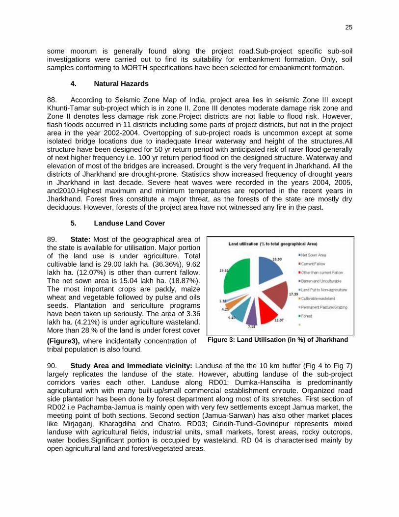
25
some moorum is generally found along the project road.Sub-project specific sub-soil investigations were carried out to find its suitability for embankment formation. Only, soil samples conforming to MORTH specifications have been selected for embankment formation.
4. Natural Hazards
88. According to Seismic Zone Map of India, project area lies in seismic Zone III except Khunti-Tamar sub-project which is in zone II. Zone III denotes moderate damage risk zone and Zone II denotes less damage risk zone.Project districts are not liable to flood risk. However, flash floods occurred in 11 districts including some parts of project districts, but not in the project area in the year 2002-2004. Overtopping of sub-project roads is uncommon except at some isolated bridge locations due to inadequate linear waterway and height of the structures.All structure have been designed for 50 yr return period with anticipated risk of rarer flood generally of next higher frequency i.e. 100 yr return period flood on the designed structure. Waterway and elevation of most of the bridges are increased. Drought is the very frequent in Jharkhand. All the districts of Jharkhand are drought-prone. Statistics show increased frequency of drought years in Jharkhand in last decade. Severe heat waves were recorded in the years 2004, 2005, and2010.Highest maximum and minimum temperatures are reported in the recent years in Jharkhand. Forest fires constitute a major threat, as the forests of the state are mostly dry deciduous. However, forests of the project area have not witnessed any fire in the past.
5. Landuse Land Cover
89. State: Most of the geographical area of the state is available for utilisation. Major portion of the land use is under agriculture. Total cultivable land is 29.00 lakh ha. (36.36%), 9.62 lakh ha. (12.07%) is other than current fallow. The net sown area is 15.04 lakh ha. (18.87%). The most important crops are paddy, maize wheat and vegetable followed by pulse and oils seeds. Plantation and sericulture programs have been taken up seriously. The area of 3.36 lakh ha. (4.21%) is under agriculture wasteland. More than 28 % of the land is under forest cover
(Figure3), where incidentally concentration of tribal population is also found. 90. Study Area and Immediate vicinity: Landuse of the the 10 km buffer (Fig 4 to Fig 7) largely replicates the landuse of the state. However, abutting landuse of the sub-project corridors varies each other. Landuse along RD01; Dumka-Hansdiha is predominantly agricultural with with many built-up/small commercial establishment enroute. Organized road side plantation has been done by forest department along most of its stretches. First section of RD02 i.e Pachamba-Jamua is mainly open with very few settlements except Jamua market, the meeting point of both sections. Second section (Jamua-Sarwan) has also other market places like Mirjaganj, Kharagdiha and Chatro. RD03; Giridih-Tundi-Govindpur represents mixed landuse with agricultural fields, industrial units, small markets, forest areas, rocky outcrops, water bodies.Significant portion is occupied by wasteland. RD 04 is characterised mainly by open agricultural land and forest/vegetated areas.
Figure 3: Land Utilisation (in %) of Jharkhand

26
Figure 4: Landuse/Landcover of RD 01 (Dumka-Hansdiha)

27
Figure 5: Landuse/Landcover of RD 03 (Pachamba-Jamua-Sarwan)

28
Figure 6: Landuse/Landcover Map of RD Govindpur-Tundi-Giridih

29
Figure 7: Landuse/Landcover Map of RD 04 (Khunti-Tamar)

30
6. Air Quality
91. Project area is characterized mainly by rural/open areas and intermittently traversed by few semi-urban settlements/built-up areas. Sources of air pollution in the project area are mainly vehicular emission, dust emanation due touse of unpaved shoulders/deteriorated roadsby vehicles and domestic fuel burning. Industrial units are concentrated mainly near Giridih and Govindpur. As the project area is rich in vegetation, all such emissions will be very well dissipated. 92. Monitored parameters of ambient air quality largely meet the prescribed limit (Appendix 5)of National Ambient Air Quality Standard (NAAQS) and Central Pollution Control Board (CPCB) except particulate matter (PM10) at Giridih and Govindpur. All data are 24hourly except that of Govindpur which is annual average. Increased level can be attributed to proximity to industrial area, poor road conditions and high traffic density. Air quality data is presented in Table 11.
Table 11: Ambient Air Quality in the Project Area
S. No
Parameters Locations
PM 10 µg/m3
PM 2.5 µg/m3
Sox µg/m3
NOx µg/m3
NAAQS Limit 100 60 80 80
RD 01 (Dumka – Hansdiha)
1. National Inter College Dumka 57 24 15 20
2. Near Nunihat Market 54 31 14 18
3. Near Hansdiha 60 35 16 21
RD 02 Pachamba- Jamua - Sarwan
1. Dumri Road, Giridih 72 42 17.3 24.5
2. Km 20/000 (Bati) 68 38 16.7 22.6
3. Km 52/000 (Chatro) 71 40 18.2 24.8
RD 03 Govindpur-Tundi-Giridih
1. Giridih Town 118.5 47.27 17.44 28.53
2. Dhanbad (Govindpur Ind. Area) 164 NA 17 41
RD 03 Khunti-Tamar
1. Khunti at Patratoli (residential) 41 38 20 27
2. Tamar at NH-33 (Commercial) 95.6 54.23 19.12 33.56
Source: Detailed Project Report, data.gov.in, Primary Monitoring and EIA study for NH-33 (Ranchi-Rargaonsection)
7. Noise Level
93. Traffic noise is the principal source of noise in the project area. The area mostly includes rural open areas with a good vegetation cover and therefore the noise levels are relatively low. Rich vegetation in the project area acts as an efficient noise absorbent. Noise level monitoring indicates that the noise level mostly meets the prescribed noise standards (Appendix 6) for all land use categories viz. commercial, industrial as well as residential zonesexceptatGiridih and Govindpur. Increased noise level may be attributed to high traffic density, low maintenance of vehicles, frequent honking due to congestion, and use of low grade fuel. There is no continuous sound frequency of impulsive nature near industries.It is anticipated that noise level will decrease significantly after road expansion and improvement work enabling decongestion at existing built up areas.Noise level in the project area has been summarized in Table 12.

31
Table 12: Noise Level in the Project Area
S. No Locations Leq - Day in dB (A) Leq – NightdB
(A)
RD 01 (Dumka – Hansdiha)
1. Beyond Dumka (Residential) 48 38
2. Near Nonihat Market (Commercial) 51 40
3. Near Hansdiha (Commercial) 53 42
RD 02 Pachamba- Jamua - Sarwan
1. Pachamba (Commercial) 61.2 41.5.
2. Bati (Commercial) 51.7 41.2
3 Chatro (Residential) 51.5 42.3
RD 03 Govindpur-Tundi-Giridih
1 Govindpur (junction with NH-2)-Commercial 71.4 64.2
2 Lodharia (Residential) 44.5 39.0
3 Giridih- Industrial 62.9 52.4
RD 04 Khunti-Tamar
1 Khunti near Patratoli (Residential) 37.5 33.2
2 Tamar (Commercial) 53.82 41.3
Source: Detailed Project Report, Primary Monitoring and EIA study for NH-33 (Ranchi-Rargaonsection)
8. Groundwater
94. Availability, Occurrence and Yield: Groundwater constitutes a major and widely used resource in Jharkhand for drinking and domestic purposes. However, it is not uniformly distributed due to the varied hydrogeology of the state.The annual replenishable ground water resource in the state has been established at 5.58 bcm (billion cubic meters) and net annual ground water availability is estimated to be 5.25 bcm (Central Ground Water Board, 2006). Altogether, the state puts to use 21% of its ground water resources.The natural process of ground water recharging in the state is slow, also artificial ground water recharging facilities are undeveloped.Over-exploitation has rendered several areas devoid of ground water in peak summer, resulting in drying up of dug wells and tube wells. Excessive withdrawal of ground water by industrial units has created adverse effect. 95. Groundwater in Dhanbad and Dumka district occurs in unconfined condition in the weathered zones at shallow depths in most of the litho units in the Achaeans and in the Gondwanas. Groundwater occurs under confined to semi-confined condition where the fractures are deep seated and are unconnected with the top weathered zone. Yield of the tube well is poor to moderate (1-20 m /hr). Depth to water table varies from 8-10m during pre-monsoon and 4-6m in post-monsoon. In granitic gneiss terrain of Khunti district, ground water occurs in fractured zones. First fracture occurs between 50-70 m and second fracture is found between 100-120 m depth. Discharge of borewells varies between 10 to 30 m3 / hr in these areas. None of the project district is notified by Central Ground Water Authority (CGWA). 96. GroundwaterQuality: Monitored parameters(Table 13) largely conforms to the drinking water standards (IS:10500-1991)prescribed by Bureau of Indian Standard (Appendix7) except.This was also ascertained by the study done by Central Ground Water Board (CGWB) in the project districts. Some of the parameters like total dissolved solids (TDS), total hardness and alkalinity exceeds the desirable limit but are well within maximum permissible limt.

32
Table 13: Groundwater Quality in the Project Area
S. No
Parameters and Unit
Nunihat Hansdiha Pachamba Giridih Dhanbad khunti Tamar
2 Odour Unobjectionable/Odourless
3 Taste Agreeable
4 pH 7.8 7.2 7.73 7.18 7.1-8.66 8.3 8.2
5 TDS (mg/l) 494 664 512 484 96-1088 - -
7 Turbidity (NTU) 3 6 <2 <2 <2 <2 <2
8 Total Hardness (mg/l) 260 324 318 220 55-525 227 113
9 Alkalinity (mg/l ) 324 196 378 210 - - -
10 Fluoride (mg/l) ND ND 0.4 <0.02 0.06-1.2 1.1 0.7
11 Sulphate (mg/l) 62 22 23 12.5 4.2-229 31 2.2
13 Chlorides(mg/l) 42 106 37 39.01 7.1-273 127 8
14 Iron as Fe (mg/l) 0.6 <0.1 (ND) 0.48 - 1.1 -
15 Calcium as Ca (mg/l) - - 78 51.3 22-156 62 27
16 Magnesium - - 30 22.08 24 -79 27 11
19 Nitrate as NO3, Mg/l 8 6 ND (1.0) 20.02 3.1-190 31 4.1
No Trace of Heavy Metals was detected in any of the water Sample
Source: Detailed Project Report, CGWB and EIA study for NH-33 (Ranchi-Rargaon Section),
9. Surface water Quality
97. Surface water is not used for drinking or domestic purpose in the project area except for outdoor bathing in some rivers. Therefore surface water samples from rivers and ponds have been analysed to confirm its suitability for different classes prescribed for freswater classification by CPCB (Appendix 8). Analysed samples as summarised in Table 14 confirm the prescribed limits.
Table 14: Surface Water Quality in the Project Area Parameters and Unit Prescribed
limits SW1 SW2 SW3 SW4 SW5 SW6
pH 6.5 – 8.5 8.2 8.1 7.32 7.16 7.2 7.7
Dissolved Oxygen (mg/l) ≥4.0 5.2 4.8 6 6.3 4.5 6.7
BOD (mg/l) --- 1.4 16.8 8.0 4.0 4.0 <2.0
Boron as B (mg/l) --- BDL BDL BDL BDL BDL BDL
Electrical Conductivity (
mhos/cm)
---- 280 560 - 129 104 189
Total Coliforms (MPN)/100ml ---- 20 27 850 - 20 15
Oil and Grease ≤0.1 BDL BDL BDL BDL BDL BDL
Source: Detailed Project Report , IEE of JSRP-1 and EIA study for NH-33 (Ranchi-Rargaon Section) SW1- Murkhoi River SW2-Hardiya River, SW3-Usri River, SW4-Baraker River, SW5-Pond at Tamar, SW6- Kharkhai/Tajna River, BDL- Below Detection Limit
10. Waterways and Water Bodies
98. Project area is drained by a number. of rivers like Barakar, Khudia, Usri (Govindpur-Tundi-Giridih Road), Tajna/Karkari (Khunti-Tamar Road), Usri and its tributaries (Pachamba-Jamua-Chatro-Sarwan Road), Murkhoi and Hardiya (Dumka- Hansdiha). Besides there are a number of ponds/stagnant water bodies. All waterways and waterbodies has been listed in Table 15.

33
Table 15: List of waterways/ Water Bodies Ch. Km Side Water Body/Waterway Ch. Km Side Water Body/Waterway
RD 01: Dumka-Hansdiha RD 02: Pachamba-Jamua-Chatro-Sarwan
10.77 Crossing Tapra River 3.2 Crossing Nala
10.12 RHS Pond 4.2 Crossing Nawadih/Kubri River
11.4 Crossing Ranga River 6.7 LHS Pond
16.15 LHS Pond 8.1 Crossing Gadhari/Pathra River
18.285 Crossing Nala 17.5 Crossing Nala
22.35 Crossing Nala 38.3 LHS Pond
24.93 Crossing Nala 42.3 RHS Pond
27.8 LHS Pond 42.6 Crossing Usri River
29.57 Crossing Murkhoi River 45 Crossing Godavari River
30.45 Crossing Nala 46.3 Crossing Karma River
32.765 Crossing Hardiya River 55.2 RHS Pond
33.65 Crossing Nala 56.3 Crossing Lajoria River
36.8 Crossing Nala 56.5 LHS Pond
37.95 Crossing Nala RD 03: Govindpur-Tundi-Giridih
40.667 Crossing Dhobi River 0.7 RHS Pond
40.95 RHS Pond 1.7 Crossing Khudia River
42.9 Crossing Nala 2.3 LHS Pond
48.5 Crossing Nala 4.8 RHS Pond
50.45 Crossing Nala 8.2 RHS Pond
RD 04: Khunti-Tamar 9.8 Both Sides Pond
5.895 Crossing Tajna River 10.5 LHS Pond
10.427 Crossing Nala 13.1 RHS Pond
15.18 Crossing Nala 18.5 LHS Pond
16 Crossing Nala 20.4 Crossing Stream
24.1 Crossing Nala 20.9 LHS Pond
30.53 Crossing Nala 24.9 RHS Pond
31.21 Crossing Nala 28.0 Crossing Baraker River
37.6 Crossing Nala 33.25 Crossing Maladi Stream
40.4 Crossing Usri River
B. Ecological Resources
1. State Profile
99. Forest Resources: The state ranks 10th among all the states and union territories as regards to abundance of area under forest. The recorded forest area in the state is 23,605 sq. km, which is 29.61% to its total geographical area. As per the legal classification, there are three types of forests in the state: reserved, protected, and unclassified15 covering
4,387 Sq. km (18.59%), 19,185 sq. km (81.28%) and 33 sq. km (0.14%) respectively. 100. Floral Species: The forest vegetation of the state varies from rich sal forest to miscellaneous forests and sparsely covered grassland. Shorea robusta (Sal) dominates with 55% of the total growing stalk. Main species of Jharkhand forests are Sal (Shorea robusta), Asan (Terminalia tomentosa), Gamhar (Gmelina arborea), Bijasal (Pterocarpus marsupium), Karam (Adina cordifolia), Salai (Boswellia serrata), Khair (Acacia catechu), Dhawra (Anogeissuslatifolia, Semul (Bombaxceiba), Jamun (Syzygiumcumini), Mahua (Madhuca
15
Reserved Forest: an area notified under the provision of Indian Forest Act having full degree of protection.In reserved forests, all activities are prohibited unless permitted. Protected Forest: an area notified under the provision of Indian Forest Act having limited degree protection. In Protected Forests, all activities are permitted unless prohibited. Unclassified Forest: Area recorded as forest but not included in reserved or protected forests

34
Indica), and Palash (Beuteamonosperma).Amongst these species only bijasal (Pterocarpus marsupium) is vulnerable as per Red Data List published by International Union for Conservation of Nature (IUCN). 101. Faunal Species: The forest of Jharkhand harbour rich and varied wildlife. Some of the important animals are Indian elephant (Elephas maximus), Tiger (Panthera tigris), Leopard (Panthera pardus), Bison (Bos gaurus), Wolf (Canis lupus pallipes), Sloth Bear (Lelur susursinus), Common Langur (Presbytis entellus), Monkey (Rhesus macaque), Wild dog (Cuon alpines), Cheetal (Axis axis), Sambhar (Cervus unicolor), Nilgai (Boselaphus tragecamelus), Wild boar(Sus scrofa), Barking Deer (Muntiacus muntijak), and Hyaena (Hyaena hyaena). Besides a large variety of avifauna, reptiles and amphibians are also found.The IUCN status and protected status as per Wild Life Act (WPA) is provided in Table 16 below.
Table 16: IUCN status and Protected Status of Faunal Species as per Wild Life Act Sl. No.
Common Name/ English Name
Scientific Name IUCN Red list WPA 1972
1 Sloth Bear Melursus ursinus Vulnerable Sch.-II
2 Bison, Indian or Gaur Bos gaurus Vulnerable Sch.-I
3 Indian Wild Boar Sus scrofa Least Concern Sch.-III
4 Barking Deer or Muntjac Muntiacus muntjak Least Concern Sch.-III
5 Spotted Deer or Chital Axis axis Least Concern Sch.-III
6 Indian Wild Dog Cuon alpinus Endangered Sch.-II
7 Indian Elephant Elephas maximus Endangered Sch.-I
8 Hyena, Striped Hyaena hyaena Near Threatened
Sch.-III
9 Common Langur Presbytis entellus/Semnopithecus entellus
Least Concern Sch.-II
10 Leopard or Panther Panthera pardus Near Threatened
Sch.-I
11 Macaque, Rhesus Macaca mulatta Least Concern Sch.-II
12 Nilgai or Blue Bull Boselaphus tragocamelus Least Concern Sch.-III
13 Sambhar Cervus(Rusa) unicolor Vulnerable Sch.-III
14 Tiger Panthera tigris Endangered Sch.-I
15 Wolf Canis lupus Least concern Sch.-I
102. Protected area Network: Jharkhand has 1 National Park and 11 Wildlife Sanctuaries under protected area network. None of these protected areas are located within 10 km radius of the project site.
2. Forest in the Project Districts
103. Project districts other than Khunti and Saraikela16 have very less forest cover
compared to state. E Singhbhum has highest forest area with 31.56 % followed by Ranchi (28.42%),Godda (19.34%), Giridih (18.72%), Dumka (10.83%) and Dhanbad (6.74%), Proportion of open forest is highest followed by moderately dense and very dense forest. Forest cover in different canopy classes of the project districts is given in Table 17.
Table 17: Forest Cover in Project Districts Project District
Geographical Area (sq. km
VeryDense Forest
Moderately Dense Forest
Open Forest
Total Forest Area (sq. Km)
% to TotalArea
Dumka 6212 0 279 384 663 10.83
16
Erstwhile, Khunti and Saraikela districts were part of Ranchi and East Singhbhum orest divisions respectively.

35
Project District
Geographical Area (sq. km
VeryDense Forest
Moderately Dense Forest
Open Forest
Total Forest Area (sq. Km)
% to TotalArea
Godda 2110 13 268 127 408 19.34
Giridih 4963 77 339 469 885 18.72
Dhanbad 2996 0 44 158 202 6.74
Ranchi 7698 139 712 1233 2084 28.42
E Singhbhum 3533 52 587 430 1069 31.56
Source: Forest Survey of India; state of Forest, 2013
3. Forest along the Project Corridors
104. There is no forest along RD01:Dumka-Hansdiha road. Roadside plantations notified as protected forest is present sporadically in few stretches of RD02:Pachamba-Jamua-Sarwan road requiring diversion of about 1.354 ha of forest land. Protected and Reserved forest patches are also present along RD03:Govindpur-Tundi-Giridih and RD:04 Khunti Tamar road. Diversion of forest land is not involved in RD:04 Khunti-Tamar road, whileapproximately 0.5 ha of diversion of forest land is required for RD03:Giridih-Tundi-Govindpur road for construction of bridge approach at Usri river. All forests along RD02, RD03 and RD04 are modified habitat as opening of the road approximately 15 years ago has brought changes in the composition of the natural vegetation. No loss of rare endangered or threatened species of flora is envisaged due to road side tree clearance.
4. Trees within Right of Way
105. The road side plantation is mixed type and natural regeneration is seen. A total of 8808 treeshas been enumerated within right of way. Highest number of trees are along Khunti – Tamar (3050) followed by Dumka - Hansdia(2457), Govindpur-Tundi-Giridih (1957) and Pachamba-Jamua-Sarwan (1344). Majority of trees are of girth size between 0-90cm. All efforts will be made to restrict the tree cutting to toe line of the formation width considering the safety issue.
5. Floral Elementsin the Project Area
106. Rapid floral assessment was carried for RD 03 and RD 04 due to presence of forest areas next to right of way. There is no natural forest along RD 01 and RD 02. Findings have been described briefly in following paragraphs. 107. Khunti- Tamar:A total of 122 plant species were recorded on both sides of sub-project roadbelonging to 55 families.Dominancy of the families is Apocyanaceae and Euphorbiaceae which cover 8 plant species, Caesalpiniaceae 7 species, Asteraceae 6 species and other families ranging from one species of Mimoaceae and five species of, Moraceae. Vegetation contains herb, shrub, tree, climber and grass. Dominant category is tree which covers 59 species in a shrubby mode due to regeneration of the plant in rainy season. No endangered species was observed. A total of 45 plant species having medicinal property was found. Butea monosperma isabundantly found in the study area the most dominant species and second isZiziphus mauritiana Ber. A detailed checklist of plant species recorded are enclosed with their significance (Appendix 10).Quadrate analysis was also done in immediate vicinity. Out of 4 selected quadrates, total number of species recorded was 36 (Table 18). None of them are under IUCN list. However one species i.e Costus specious (Betlori) is included in convention oninternational trade in endangered species (CITES) and Wlid Life Protection Act 1972.

36
Table 18: Floral Species in the Forests along the Khunti-Tamar Road Sl.No. Botanical name Common
Name Location of Quadrates
23.04774 N 85.34681 E
23.01025N 85.40093E
23.01245N 85.52066E
23.05104N 85.71450E
1 Acacia catechu Khair - - - +
2 Achyrenthus aspera Apamarg + - + -
3 Adiantum lunulatum Kalijhant - - + -
4 Albizia odoratissima ----- + - - +
5 Alstonia scholaris Chatin - + + -
6 Ampelocissus latifolia Jungle angur
- - + -
7 Azadirachta indica Neem + + - +
8 Butea monosperma Palash + - + +
9 Casearia tomentosa Berry + - - +
10 Cassia tora Chakod + + + -
11 Celastrus paniculatus Kujri - + - +
12 Clerodendron infortunatum
Ghato + - - -
13 Costus specious Betlori + - - +
14 Croton oblongifolia Masondha + - - -
15 Cyanodon dactylon Dubra - + + -
16 Cyprus rotundus Motha - + - -
17 Eupatorium odorum Amruii + + - -
18 Ficus benghalensis Bargad + + - +
19 Heliotropium indicum Hathi sur - + + _
20 Hetropogon controtus Choranth + - - +
21 Hyptis suaveolens Bantulsi + + - +
22 Ichnocarpus frutescens
Dhudhilata - + + +
23 Lantana camara Putush + _ _ +
24 Lygodium flexuosum Valipanna - - + -
25 Madhuca indica Mahua - + + -
26 Mallotus philippensis Rori + _ - -
27 Oxalis curniculata ---- - + + -
28 Phoenix sylvestris Khajur + + _ +
29 Ricardia hispid ---- + - - -
30 Scoparia dulsis Ban dhania - + - -
31 Sida acuta Bala + + - +
32 Smilax zeylanica Ramdatun + + - +
33 Terminalia arjuna Arjun - - - +
34 Triumfetta rhomboidea
Chikki + + + -
35 Urena senuata Bachiata + - + -
36 Woodfordia fruticosa Ghabai - - + -
Source: Floral Assessment during IEE Preparation, + denotes presence of that species in
corresponding quadrate.
108. Govindpur-Tundi-Giridih: Sal is the pioneer in the forests of Dhanbad division. A total of 128 plant species (Appendix 11) belonging to 59 families were recorded on both sides of project road. 46 plant species are having some medicinal property. 6 quadrate surveyswere done along the forests of the project road. Of total 53 plant species, quadrate-1 and 6 have 34 species, quadrate-2 has 29, quadrate-3 has 9, quadrate-4 has 22 and 5 has
18 species (Table 19).Of these only Acorus calamus is included in CITES and Wildlife
Protection Act 1972.

37
Table 19: Floral Species in the Forests along the Govindpur-Tundi-Giridih Road S. No
Botanical Name 24.11079 N 86.38051 E
24.10181N 86.38176E
24.05441N 86.38555E
23.58815N 86.27945E
23.97813N 86.47410E
23.97612N 86.48013E
1 Achyranthes aspera L. _ + _ + _ _
2 Acorus calamus _ + _ + _ _
3 Adiantum lunulatum _ _ _ + _ _
4 Adina cordifolia _ _ + + + _
5 Albizia odoratissima + + _ _ + +
7 Ampelocissus latifolia _ + _ + _ _
8 Andrographis paniculata + _ _ _ + +
9 Asparagus racemosus Willd. + + _ _ _ +
10 Azadirachta indica _ _ + _ + +
11 Boraria hispid _ + _ _ + _
12 Butea monosperma + + + + - _
13 Carissa opaca + _ _ _ + _
14 Casearia tomentosa + _ _ _ _ +
15 Cassia alata + _ _ _ _ +
16 Cheilanthes farinosa + _ _ _ _ _
17 Clitoria ternetia _ _ + _ + _
18 Croton oblongifolia + + _ _ _ +
19 Curcilago orchiodes + _ _ _ + +
20 Cynodon dactylon + + + _ + +
21 Dioscorea bulbifera + _ _ + _ _
22 Diospyros embryopteris + _ _ + _ _
23 Diospyrosmelanoxylon Roxb. + _ + _ _ +
24 Eupatorium sps + _ _ + _ _
25 Euphorbia hirta + + _ + _ +
26 Evolvulus nummularius + + _ _ _ +
27 Ficus hispid _ _ _ _ + +
28 Flacourtia ndica _ + _ + _ +
29 Hemidesmus indicus _ _ _ _ + +
30 Heteropogon contortus + + _ + _ +
31 Holarrhena antidysenterica + + + _ _ +
32 Hyptis suaveolens (L.) Poit. + _ _ + + -
33 Ichnocarpus frutescens + _ + _ _ +
34 Lantana camara _ + _ + _ +
35 Madhuca longifolia + + _ + _ +
36 Oxalis corniculata L. + + _ + + _
37 Phoenix sylvestris _ + _ + _ _
38 Phyllanthus nuriri _ _ _ _ + +
39 Pongamia pinnata _ + _ + _ +
40 Schleichera oleosa + + _ + _ +
41 Semacarpus anacardium + + _ _ _ +
42 Shorea robusta + + _ + _ +
43 Sida cordifolia L + + _ _ + +
44 Smilax zeylanica L. _ _ _ _ _ +
45 Syzygiurn cumini + + _ _ + +
46 Tephrosia purpuria _ + _ + _ _
47 Terminalia arjuna _ _ + + _ +
48 Terminalia tomentosa + + _ _ + +
49 Triumfetta rhomboidea + + _ _ _ +
50 Urena lobata + + _ _ _ _
51 Urena senuata + _ _ _ - +
52 Woodfordia fruticosa _ _ _ _ + +
53 Ziziphus mauritiana + + _ _ _ +
Source: Floral Assessment during IEE Preparation, + denotes presence of that species in corresponding quadrate
6. Elephant Movement in the Project Area
109. Elephant crossings are reported in three sub-project roads (Govindpur-Giridih, Dumka-Hansdiha and Khunti Tamar). These elephants are not resident populations. Movements in the region are controlled by encounter with human settlements, provoking

38
chase by villagers to avoid the damages of their crops and property. As a result, the elephants are not able to follow or chart their normal movement course. The movement patterns of elephants are erratic in nature and difficult to predict their route. However it was found that elephants mainly pass the project area during late night or early morning hours. Based onhuman-elephant conflicts derivedfrom elephant compensation information, field observations and consultations with forest department and local villagers, following elephant crossings locations were identified along/across the road. 110. RD 01: Dumka-Hansdiha: According to the forest department, the elephant are not the residents of the district but regular movement is reported at several places(Figure 8) in Dumka Forest Division. As reported by Range Forest Officer, elephants stay at Jama, Maharo, Masalia, Lathipahar, Nunihat, Masdiha, Amarpur, Amru, Burhijhilua, Khaparokoraiaya for few days to a week during October-November and July-August. One elephant always stay at Burhijhilua. Elephants cross the project road near Amarpur (Segatola) and Sirsanath More near Bara Palasi. At Sirsanath, they enter from Pipra Pahar (on the right while going towards Hansdiha) cross the road and enters Dumka Damin Range and further moves to Pakur. At Amarpur-Segatola, elephants cross the road between the two bridge present at Segatola (near road towardsKarbindha Village) and goes to Lathi Pahar. They enter during October-November from Deoghar, cross the road and either moves to Godda or enters into Dumka-Damin Range and further to west Bengal. These two locations coincides with the informations available with forest department and consultations held with local people. Other locations where elephants crossings were reported by local people are Loha Bridge near Bhandaroand Lakara Dwani.
Figure 8: Elephant Crossing Locations along/across Dumka-HandihaRoad
111. RD 03; Govindpur-Tundi-Giridih: Project road traverses through 2 forest divisions i.e Dhanbad (upto Barakar River and Giridih upto end point). In the stretch falling in Dhanbad Forest Division, elephants enters from Jamtara (east) and goes to Parasnath Forest Range

39
via Tundi Reserved forest (adjacent to the project road), using it as a transit camp for 1-2 months. Sometimes they move beyond Parasnath Hillsupto Barkatta, Hazaribagh range. As per forest department, there is no specific location of their crossing. They have crossed the road at many locations in the past between Sangramdih and Barakar river stretch but more frequently near Domunda, Kolhar and Kamalpur/Gadi-Tundi. Herd size varies from 10-14 and sometimes 18-22 and movement is common during standing paddy crops (Oct-Nov) and its harvesting. Elephants are new entrants and seen since the past 5 to6 yrs. 112. Movement of elephants is restricted to western side of the road in the stretches falling in Giridih Forest Division as confirmed by forest department. However, local people also reported crossing of road by elephantsnear Pandri village and Usri River. These locations does not appear in the forest department list since there is either no damage to any house/structure or minor damage which are not reported by local people to forest department and hence unrecorded. Figure 9 shows the locations of elephant Crossings.
Figure 9: Elephant Crossing Locations along/Across Giridih-Tundi-Gobindpur Road
113. RD 04; Khunti-Tamar: Stray groups of elephants from West Bengal enters the district into Tamar , Barukande , Sumandih, Barenda, Relaidih, Barlanga, Parasi, Birgam, goes to Saraikela- Kharsawa and then to Odisha. They sometimes enter from Saranda forest into Torpa and further moves to Gumla. Movement in Tamar area (near the project road) is restricted to north-eastern side not crossing the project road. Anti-depredation list of villages affected by elephant movement provided by Forest department confirmed that only two village Bhuruhatu and Serenghatu are affected along/across the project roadas per anti-depredation list. As per local people, a small separated group or sometimes a male tusker crosses the project road in the Jaranga, Seranghatu/Arki and Sindri area using different crossing paths within the area. Frequency is maximum once in year or no movement One incident of elephant crossing was also reported in 2011 near R. C. Mission at Dondiya more (Tamar).Figure 10 denotes reported elephant crossing locations.

40
Figure 10: Elephant Crossing Locations along/Across Khunti-Tamar Road
C. Economic Development
114. Jharkhand is one of the poorest states in India with a sharp contrast between rural and urban poverty. The incidence of poverty at the State level is 44 % compared with 26 % for all-India. UNDP’s recent Human Development Report (HDR) for 2010 uses a Multidimensional Poverty Index (MPI) that has been devised by the Oxford Poverty and Human Development Initiative (OPHDI) uses variables that are based on access to education, health, electricity, sanitation, drinking water, cooking fuel and assets. This shows that 77% of Jharkhand’s population is poor, rural poverty was 49% 1999-00 and urban value is only 23 %. The State has made considerable progress in reducing poverty. In 2004-05 per capita income was Rs. 20,848/yr which has increased to Rs. 34,096 in 2011-12. The agricultural economy of the Jharkhand state is characterized by dependence on nature, low investment, low productivity, mono cropping with paddy as the dominant crop, inadequate irrigation facilities and small and marginal holdings. The dependence of agriculture on the vagaries of the rain can be gauged from the fact that as much as 92% of the total cultivated area is un-irrigated.
1. Agriculture, Forestry and Fisheries
115. Agriculture forms the backbone of the national economy and despite resolute industrialization in the last five decades; agriculture holds a place of pride in Jharkhand State. Besides the strong mineral base, the mainstay of economy is agriculture and allied activities. About80% of its population residing in 32,620 villages depend mainly on agriculture and allied activities for their livelihood The State’s total geographical area is 79.7 hectares. Total cultivable land is 29.00 lakh ha. (36.36%). 9.62 lakh ha. (12.07%) is other than current fallow. The net sown area is 15.04 lakh ha. (18.87%). The most important crops are paddy, maize wheat and vegetable followed by pulse and oils seeds. Plantation and sericulture programs have been taken up seriously. The total area occupied by various

41
plantation and horticulture crop in the state is about 2.57 lakh hectares with an estimated total production of 37.85 lakh tones. There are three diary plants at Jamshedpur, Bokaro and Ranchi and 13 milk-chilling plants in different districts of the State. 116. The State has potential for fisheries by enhancement of ponds, irrigation reservoirs, and rivers. The important fishes commonly found in the region’s plain and river basins are Catla catla, Labeo rohita, Labeio calbase, Cirrihinus mirigale, L. Bata, W.attu, B. bagrius, Heteropneuptus fonilis, Notopterus nontopterus, and C. striatus,etc Density of fish production is 1,600 Kg. /ha. against national avg. of 2150kg./ha. Per Capita availability of fish is 14 gm against the national average of 24 gm. The fish production is low because most of the tanks are small, seasonal, rainfed, old and having low carrying capacity for fish culture. Big ponds have become shallow due to silting and weed infestation.
2. Industries and Mineral Resources
117. Industries: Because of its large mineral reserves, mining and mineral extraction is the major industry in the state. The manufacturing industry accounted for the largest share of investments (61.8 per cent), followed by electricity (32.7 per cent).An Special Economic Zone (SEZ) has been notified at Adityapur, adjoining Jamshedpur, for the automotive industry. A private sector consortium has been selected for developing the SEZ. The major growth drivers of engineering industry in Jharkhand are availability of raw material (iron and steel, aluminium, copper and other metals and non-metals), power, water and industrial labour. A number of heavy-engineering companies located in the state produce equipment and provide turn-key and consulting services to the existing metal and mining. There is ample scope for development and promotion of artisan-based activity such as manufacturing cane and bamboo products metal ware, stone carving, handlooms, wood works, and leaf plate making activities. 118. Minerals: The State of Jharkhand has an enormous potential for exploitation of coal, mica, and other minerals particularly in Singhbhum, Dhanbad, Bokaro, Ranchi, Hazaribagh, and Koderma. The State accounts for 32.09 per cent of India’s coal reserves, 25.94 per cent of copper, 31.84 per cent of iron ore, 90 percent of pyrite and 57.47 percent of graphite and huge deposits of other minerals.Because of its large mineral reserves, mining and mineral extraction is the major industry in the state. Mining and quarrying activities contribute over 11 per cent to the state’s GSDP and support downstream industries. Jharkhand’s extensive mineral resources make mining, metals and related sectors, a naturally strong sector of the state. Several other industrial areas have been developed in the state based on the location of mineral reserves and related down-stream industries.
3. Infrastructure Facility
119. Roads: Jharkhand has a road network of around 33,000 kms comprising of 1,844 kms of national highways, 6880 kms of State Highways and PWD Roads including Major District roads (including urban roads)and 24300 kms of rural roads including classified rural roads andminor district roads. Jharkhand has less than 20 kms of roads per 100 sq.km. Only 36% of villages are connected by all weather-roads and less than 25% villages with metalled roads which are significantly deficient compared to corresponding figures of India. 120. Railway: The total railway-route length in Jharkhand is 1,955 km. The rail density is 26.7 km per 1,000 sq km.The state has extensive goods-handling facilities available at Ranchi, Bokaro, Dhanbad, and Jamshedpur stations. The proposed dedicated freight corridor (Eastern corridor-extension to Kolkata; under the Dedicated Freight Corridor

42
Corporation of India) will pass through the state and is expected to benefit the industry significantly.
121. Aviation: A domestic airport is located in the state capital, Ranchi. Direct links are available from Ranchi to prominent cities such as Delhi, Patna, Kolkata and Mumbai. Jamshedpur, Dumka, Bokaro, Giridih, Deoghar, Hazaribagh, Daltonganj and Noamundi also have airstrips. Chartered flights are available between the steel city of Jamshedpur and Kolkata.Department of Civil Aviation of the state government plans to acquire land to develop 12 airstrips in Chatra, Simdega, Lohardaga, Godda, Pakur, Latehar, Sahebganj, Jamtara, Saraikela, Garhwa, Koderma and Khunti district. 122. Power: As of March 2010, Jharkhand had a total installed power generation capacity of 1,942.9 MW, which comprised 1,324.1 MW under state utilities, 360.0 MW under the private sector and 258.8 MW under central utilities. Backed by large coal reserves in the state, about 90 per cent of the installed power capacity in the state is coal-based thermal power (1,737.8 MW). Besides, the state has 200.1 MW of installed hydropower capacity and 4.1 MW from renewable sources. In 2009, the Central Government handed over the construction of the 4,000 MW, ultra-mega power project (UMPP) at Tilaiya to the Anil Dhirubhai Ambani Group after completing the competitive bidding process.
D. Social and Cultural Resources
123. Demography: According to the 2011 Census, the state has a population of over 32.97 million consisting of 16.93 million males and 16.03 million females. The sex ratio is 947 females to 1000 males. Of the total 28 percent is tribal while 12 percent belong to scheduled castes. The population density of the state is 414 persons per sq km; it varies from as low as 148 per sq km in Gumla district to as high as 1167 per sq km in Dhanbad district. Decadal growth rate during 2001-2011 was 22.34. Total area of Jharkhand is 79,716 sq. km. Density of Jharkhand is 414 per sq km which is higher than national average 382 per sq km. Sex ratio in Jharkhand is 948 i.e. for each 1000 male, which is below national average of 940 as per census 2011. Facts and figures about demography of the project district is Summarized below in Table 20.
Table 20: Demography of the Project Districts Indicators Dhanbad Giridih Dumka Khunti Godda Saraikela
Area Sq. Km 2,040 4,962 4,404 2,535 2,266 2,657
Actual Population 2,684,487 2,445,474 1,321,096 531,885 1,313,551 1,065,056
Male 1,405,956 1,258,098 669,240 266,335 677,927 544,411
Female 1,278,531 1,187,376 651,856 265,550 635,624 520,645
Population Growth 11.99% 28.41% 19.39% 22.32% 25.35% 25.47%
Density/km2 1,316 493 300 210 580 401
Sex Ratio (Per 1000) 909 944 974 997 938 956
Child Sex Ratio (0-6 ) 916 942 957 964 960 943
Average Literacy 74.52 63.14 62.54 63.86 56.40 67.70
Male Literacy 83.81 76.76 75.17 74.08 67.84 79.03
Female Literacy 64.29 48.72 49.60 53.69 44.14 55.88
Child Proportion (0-6) 13.91% 18.82% 16.12% 16.22% 18.41% 14.98%
Boys Proportion (0-6) 13.86% 18.84% 16.26% 16.50% 18.20% 15.08%
Girls Proportion (0-6 Age)
13.96% 18.80% 15.97% 15.95% 18.63% 14.88%
Source: Census of India, 2011
124. Educational Facility: The literacy rate in the state is about 67%. The state has 25,379 primary schools, 13,418 upper primary schools, 2,425secondary schools, 66 govt. colleges, 46 affiliated colleges, and 6 universities. Started in March 2009, the Central University has started offering courses in mass communication, business administration,

43
mathematics and English. The University Grants Commission (UGC) granted recognition to the Kolhan University (Chaibasa) in 2009-2010. Birla Institute of Technology (Ranchi), National Institute of Technology (Jamshedpur) and Indian School of Mines (Dhanbad) are among well-known engineering colleges of the country. The Xavier Labour Relations Institutes in Jamshedpur is one of the premier business schools in India. The state has five research institutes of repute involved in fields of iron and steel, mining and metallurgy. 125. Health Infrastructure: Jharkhand has 330 primary health centers (PHCs), 3,958 sub-centers, 24 district-level hospitals, 10 sub-division hospitals, and three medical college hospitals. The broad objectives of the state’s Department of Health include enhancing maternal-and child-healthcare, stabilizing population growth and improving nutritional status. s. The Jharkhand Government has drafted a policy for establishment of super-specialty hospitals, medical and nursing colleges, and paramedical institutes. The State Government is constructing a 500 bed hospital at Ranchi and proposes to construct hospitals at district, divisional and sub-divisional headquarters. 126. Tourism: Jharkhand has a good potential for tourism development. In order to boost tourism, various tourist and religious places such as Neta Rajarappa, Parasnath, Tarapeeth, Deoghar, Basukinath etc. are proposed to be connected by a two lane road. Some of the important tourist attractors in the State are Betla National Park, Daltonganj, Zoological Garden, Ormajhi, Ranchi, Hazaribagh National Park, Hazaribagh, Mahuadaur National Park, Ranchi, and Topchachi National Park, Topchachi, Dhanbad and many more. The state also has waterfalls i.e. Hundru Fall, Johna Fall, Dassam Fall, Panch Garh fall, Hirni Falls and important religious places like Ranchi hill and pahari mandir, Jagannathpur temple, Sun Temple, AmreshwarDham. 127. Archaelogical and Historical Monuments and Sensitive Receptors:There are no archeological or historical monuments along the project roads. However, there are a number of religious structures and other community property resources (CPR)17 including sensitive receptors like schools and health centres. According to the Resettlement Plans (RP) the numbers of CPRs that will be directly affected are 84 for RD01, 18 for RD02, 24 for RD03 and 59 for RD04. Further details on the type of CPRs and impacts are given in the respective RPs.Table 21 to 24lists out the sensitive structures (only schools, temples, mosques and health centers) and the distance of each structure from the centerline of the road.Only those structures for which Y is mentioned under the Physical Impact column will be completely shifted or partly dismantled. Sample pictures of the sensitive structures are provided in Appendix 11.
Table 21: Sensitive Structures along RD 01: Dumka - Hansdiha
Ch.Km. Structure Distance from C/L Side L/R Physical Impact Y/N
8.2 School BW 8.5 R Y
33.5 Middle School 12.5 L N
36.4 Middle School 13.5 L N
42 Navoday School 12.5 L N
45.1 Adarsh School 23 R N
47.8 Middle School 13 R N
45.5 Madarsa BW 9.2 R Y
26.95 Ashram BW 8.0 R Y
17
In India CPRs are structures or facilities that belong to a community such as hand pumps, wells, schools, health centers, temples, grave yards etc. Some Physical Cultural Resources (PCR) such as temples can also be a CPR if it belongs to the community

44
Table 22: Sensitive Structures along RD 02: Pachamba – Jamua - Sarwan
Ch.Km. Structure Distance from C/L Side L/R Physical Impact Y/N
7.042 School 8.7 R N
10.092 School BW 5.5 R Y
17.65 School BW 9.1 L N
18.22 School 11 R N
20.6 School 5.5 R N
21.47 School Toilet 6.7 L Y
39.6 School 16.5 R N
42.1 School 11.5 L N
42.175 School BW 9 L y
43.195 School 14 L N
47.65 School 17.5 L N
56.7 School 19.1 L N
Table 23: Sensitive Structures along RD 03: Govindpur – Tundi - Giridih
Ch.Km. Structure Distance from C/L Side L/R Physical Impact Y/N
0.65 St. Paul Academy 5.5 L Y
3.3 Educational Inst. 13 L Y
3.94 Health Center 11 R Y
8.42 Mahrajganj School 5.5 L Y
11.18 School 13 L N
14.2 School 15.5 L N
23.75 Kolhar School 9 R y
26.4 School 15 R N
29.58 School 13 L N
30.7 School 11 R N
36.35 School 6 L N
Table 24: Sensitive Structures along RD 04: Khunti – Tamar Ch.Km. Structure Distance from C/L Side L/R Physical Impact
Y/N
0.2 College 15.5 L N
0.92 School 16 R N
0.93 School 15.8 L N
1.6 Health Center 16.6 R N
1.7 School 13 R N
9.17 School 18.8 R N
17.12 School 17.6 L N
17.55 School 17 L N
17.65 School 16.7 L N
25.9 Health Center 17 R N
28.725 School 18.8 R N
128. In addition to the specific sensitive structures enlisted in the tables above there are a few residential areas or towns (residential cum commercial areas) along the project roads. As can be seen in the landuse maps given in figures 4 to 7, built up areas (towns and residential areas) comprise 6.28%, 12%, 6.5% and 3.7% respectively for RD01, RD02, RD03 and RD 04.

45
V. ANTICIPATED ENVIRONMENTAL IMPACTS AND MITIGATION MEASURES
129. Road improvement projects are likely to bring several changes in the local environment both beneficial and adverse. This section of IEE identifies nature, extent and magnitude of all such likely changesvis-a-vis project activities for all stage of project cycle i.e. pre-construction, construction and operation. Beneficial impacts are mostly long-term and permanent whereas adverse impacts are localized and temporary in nature and are likely to occur mostly during construction stage.
A. Potential Beneficial Impacts
130. The immediate benefits of road construction and improvement will come in the form of direct employment opportunities during construction for the roadside communities and specially those who are engaged as wage labourers, petty contractors and suppliers of raw materials. 131. During operation stage, road-side economic activities supporting transport like gasoline stations, automotive repair shops, lodging, and restaurants will increase due to increased number of vehicles. Increase in agro-industrial activities are also expected to take advantage of improved access to urban centers where there are higher demands and better prices for agricultural products. Project area is rich in mineral reserves. Project will accelerate the industrial activities and induced development significantly. Increased industrial activities will significantly reduce migration. One important project specific benefit is avoidance of flooding or water logging by increasing waterway of bridges and provision of side drains. Other generic benefits of road improvement projects are: (i) reduction in travel time (ii) better mode and frequency of transport (iii) access to quality health care, educational and other infrastructural facilities (iv)improved quality of life of rural tribal population (v) reduced accident events and (vi) better investment climate for industries creating more employment opportunities to local people.
B. Potential Adverse Impacts
132. Major anticipated impacts arising from the project road improvement are: (i) acquisition of private land and other assets impacting livelihood of local population, (ii) cutting of 8808 trees, (iv) borrowing and quarrying, (iv) impact on water bodies due to partial filling in some cases, (v) increased risk of accident due to faster vehicular movement (iv) increase in air pollution and noise pollution due to increased traffic. Except for land acquisition, all impacts are reversible, temporary, localized in nature, and can be easily mitigated/minimized/avoided by effective implementation of environment management plan (EMP).
C. Pre-construction phase Impacts
1. Land and Assets
133. The total area of land required to be acquired under the project is approximately 74ha. About 2,377 private structures (residential + commercial) will be affected. Overall the total number of affected households (title holder +non titleholder) is 4,024 and affected persons are 37,855. Total number of common property resources that will be affected (schools, temples, grave years, well, health facility etc.) is 185. Roadwise information on is given in Table 25.

46
Table 25: Summary of impacts on land and assets
Particulars RD 01 RD 02 RD03 RD 04 Total
Land Acquisition (ha) 10.30 ha 46.95 ha 5.63 ha 10.71 ha 74 ha
Agriculture Land 1 ha 18 ha 0 ha 29 ha 48 ha
No. of Affected Private Structures 350 1073 820 134 2,377
No. of Affected CPRs 84 18 24 59 185
Total No. of Affected HHs 611 1942 1119 352 4024
Total No. of Affected Persons 4,025 19,895 11,671 2,264 37,855
134. Adequate compensation and rehabilitation assistance has been proposed for affected households in consistent to ADB and GOI policies. Income restoration measures/livelihood options for vulnerable group/resource poor sections and other affected persons as recommended RP shall be implemented.All impacted CPRs will be relocated and reconstructed in consultation with the respective local communities under the project. Further details on these can be seen in the RP.
2. Diversion of Forest Land and Tree Cutting
135. There is no forest along Dumka-Hansdiha road. Roadside plantations notified as protected forest are present sporadically in few stretches of Pachamba-Jamua-Sarwan road requiring diversion of approximately 1.35 Ha of forest land for widening. Protected and Reserved forest patches are also present along Govindpur-Tundi-Giridih and Khunti Tamar road. Diversion of forest land is not involved in Khunti-Tamar road. Only. 0.5 haforest land is required in Giridih- Tundi-Govindpur road. No loss of rare endangered or threatened species of flora is envisaged due to road side tree clearance. Design consideration has been made to reduce tree cutting. A total of 8808 trees have been enumerated in proposed ROW. However, the need for tree cutting has been restricted to toe line of the formation width and reduced to a total of 8808 trees. The mandatory compensatory plantation will be done on 1: 2 basis by the Forestry Department. Additional plantation at 1:2 basiswill be done under the project by the contractor in partnership with the local village Joint Forest Management (JFM) Committees.
3. Natural Hazards
136. As described inproject description chapter, project roads in general are not liable to flooding. However, overtopping was reported at isolated bridge locations due to inadequate waterways. Absence of side drains are also causing water logging in built-up stretches during monsoon. Three sub-projects (RD 01, RD 02 and RD 03) are in earthquake zone III. All CD structures have been designed for 50yr return period with anticipated risk of rarer flood of next higher frequency i.e. 100 yr return period flood on the designed structure. Waterway and elevation of most of the bridges are increased. Embankment height along potential flood affected areas have been increased. Lined and unlined side drains have been included in the design to avoid water-logging.Relevant IS codes have been adopted in designing the structures to sustain the magnitude of earthquake corresponding to Seismic zone III.
4. Elephant Movement
137. Elephants in the project area are new entrants.Consultations with elephant experts suggest that they are not residents of the project areaand are rather splinter groups whose movement patterns are mainly driven by people’s chasing away from their area. Consequently elephant – human conflict is a common occurrence in the project area. Various studies on the subject establish that civil engineering measures like underpass overpass etc. are pertinent to elephant bearing landscape of the country where the seasonal movement pattern of elephant herds are quite fixed. In the present context, since the

47
elephant movements in the project area are quite erratic, it is prudent to propose high cost measures such as underpasses or any other civil structure only after long-term monitoring and a clear understanding of their movement path.Within the scope of the project the following measures are recommended to facilitate the elephants to cross the road without any accident risksin view of projected increase in traffic.Additonal measures for addressing elephant – human conflict are also recommended. All these measures will be taken in cordination with forest department during implementation of the project.
Installation of rumble strips, informatory sign boards, cautionary sign boards for speed limits up to 30 Kmph on both sides with gentle side slope and turfing for easy movement of Elephant. Details on the numbers and locations of these measures are provided in Tables 26 and 27.
Habitat enhancement through plantation of elephant preferred plants/grasses/trees (Appendix 12) in forests near the project roads, but not immediately beside the roadsas part of the additional compensatory plantation.
Conduction of a study by Wildlife Specialist proposed under the Construction Supervision Consultant’s (CSC’s) team to further study the habitat range, behavior, number of elephants coming to the project area etc. The findings of the study will provide further guidance on the location of mitigation measures (rumble strips, sign boards etc.) to be taken under the project. It will also help to identify additional mitigation and enhancement measures to support elephant populations in the project area
To help keep away elephants from the habitation areas especially at night, solar street lamps will be installed in the road section passing through communities frequented by elephants. Details on the location and numbers of the solar street lamps are provided in Table 28.
To facilitate chasing away of elephants from community areas at night solar dragon light sets will be provided to appropriate Joint Forest Management (JFM) Committee (see para 152 for further details on JFM). Details on the numbers of solar dragon lights and communities where they should be supplied is provided in Table 29.
Table 26: Location for rumble strips
Road Locations Length of Habitation
(m)
No. of sign
boards
Remarks
RD
01
Dum
ka
-
Hansdih
a
Amarpur -Segatola-Sirsa 300 2 Speed breaker to be installed 100m before and
after each village. Bhandaro 150 2
Barapalasi 600 2
Lakradwani 150 2
RD
03
Govin
dp
ur-
Tundi
Sangramdih 200 2
Kolhar 200 2
Lodharia 250 2
Tundi 600 2
Domunda/Bhandradih 200 2
Pandri 300 2
RD
04
Khu
nti-
Tam
ar Serenghatu-Baruhatu-Arki 300 2
Sindri 300 2
Jaranga 300 2
Dondiya More 150 2
TOTAL 28

48
Table 27: Location for informatory and cautionary sign boards
Road Locations Length of Habitation (m)
No. of sign boards
Remarks R
D 0
1
Dum
ka-
Hansdih
a Amarpur -Segatola-Sirsa 300 4 1 warning sign
board and 1 informatory sign board on elephants to be installed 100m before and after each village.
Bhandaro 150 4
Barapalasi 600 4
Lakradwani 150 4
RD
03
Govin
dp
ur-
Tundi
Sangramdih 200 4
Kolhar 200 4
Lodharia 250 4
Tundi 600 4
Domunda/Bhandradih 200 4
Pandri 300 4
RD
04
Khu
nti-
Tam
ar
Serenghatu-Baruhatu-Arki 300 4
Sindri 300 4
Jaranga 300 4
Dondiya More 150 4
TOTAL 56
Table 28: Number and location of solar street lamps
Road Locations Length of Habitation (m)
No. of Light Post
Remarks
RD
01
Dum
ka-
Hansdih
a Amarpur -Segatola-Sirsa 300 10 Solar Lightings have
been provided with an intent to avoid human-elephant conflict near habitated areas where elephant movements are reported by forest department and local people. These will installed at a distance of 30m along the road and inside the villages beyond the road .
Bhandaro 150 5
Barapalasi 600 20
Lakradwani 150 5
RD
03
Govin
dp
ur-
Tundi
Sangramdih 200 7
Kolhar 200 7
Lodharia 250 8
Tundi 600 20
Domunda/Bhandradih 200 7
Pandri 300 10
RD
04
Khu
nti-
Tam
ar
Serenghatu-Baruhatu-Arki 300 10
Sindri 300 10
Jaranga 300 10
Dondiya More 150 5
TOTAL 133
Table 29: Number and communities for supply of solar dragon lights
Road Locations Length of Habitation (m)
No. of Light Sets
Remarks
RD
01
Dum
ka-
Hansdih
a Amarpur -Segatola-Sirsa 300 2 Solar Dragon light
sets to be provided to Joint Forest Management (JFM) Committee with an intent to avoid human-elephant conflict near habitated areas where elephant movements are reported by forest department and local people.
Bhandaro 150 2
Barapalasi 600 2
Lakradwani 150 2
RD
03
Govin
dp
ur-
Tundi
Sangramdih 200 2
Kolhar 200 2
Lodharia 250 2
Tundi 600 2
Domunda/Bhandradih 200 2
Pandri 300 2
RD
04
Khu
nti-
Tam
ar
Serenghatu-Baruhatu-Arki 300 2
Sindri 300 2
Jaranga 300 2
Dondiya More 150 2
TOTAL 28

49
D. Construction phase
1. Topography and Geology
138. Since project scope is limited to expansion of existing roads without any bypasses, there is no substantial cut-and-fill operations required. The surplus soil from cut operations, which is unsuitable for selected sub grade, will be used to reinstate the borrow areas. Topography along the road will change a little on account of cutting, filling, and construction of project related structures. The overall impact on the physiography of the area will be limited along the RoW and therefore the impacts are categorized as low. Likely impact on the geological resources will occur from the extraction of materials (borrow of earth, granular sub base and aggregates for base courses and bridges). Boulders will be procured from the authorized suppliers and prevalent rules will be followed for borrowing of soil, sand and aggregates.
Mitigation Measures
Sources/sites of construction material sites have been identified within the immediate vicinity of the road. No new quarry has been proposed for the project.Only licensed quarries will be used as sources of coarse and fine aggregates.
The CSC will ensure that the quarries have all appropriate licenses and being operated as per conditions of mine lease and pollutional control board norms.
Cut slopes should be re-vegetated immediately after widening activities
Borrow areas should be rehabilitated and brought back as far as possible to their previous appearance. Some borrow areaswill be converted into ponds to compensate loss of water bodies. This will also enhance the local aesthetics
Cut off material should be used to widen the road or disposed of at proper sites
2. Air Quality
139. The specific locations affected by the air pollutant during construction are working areas, construction plant sites, quarries, and construction machinery and construction vehicles. Activities which generate air pollutants are: (i) dust generation from the construction zone during different stages of the construction such as clearing and grubbing, materials dumping, drying of materials, brushing of the surface;(ii) dust generation from the access roads to the soil borrow areas, aggregate quarries construction plants and construction camp sites; (iv) operation of the construction plants such as hot mix plants, Crushers, WMM plants and concrete batching plants; and (iv) material storage, transportation and handling (loading/unloading) of different construction materials such as sand, earth from borrow pits and aggregates. Some of the pollution control measures have been incorporated in the design stage by relieving congestion in built-up stretches at critical sections, improving road geometry, widening of road to smooth the traffic flow. The specific measures to control air pollution during construction are:
Mitigation Measures
Vehicles delivering loose and fine materials are covered.
Loading and unloading of construction materials in covered area or provisions of water fogging around these locations.
Storage areas are located downwind of the habitation area.
Water will be sprayed on earthworks periodically

50
Regular maintenance of machinery and equipment. Vehicular pollution check will be made mandatory.
Hot mix plants to belocated at least 1.5 km from the nearest habitation, school, hospital, forest, rivers, 500 m from ponds, and national highway, 250 m from state highway, unless otherwise required by statutory requirements after securing a No-Objection Certificate (NOC) from the SPCB. Hot mix plant will be fitted with stack of adequate height as prescribed by SPCB to ensure dispersion of exit gases.
Bitumen emulsion and bitumen heaters should be used to extent feasible.
Only crushers licensed by PCB will be used.
LPG should be used as fuel source in construction camps instead of wood.
Regular water sprinkling of unpaved haulage roads.
Mask and other PPE will be provided to the construction workers
DG sets will be fitted with adequate height as per CPCB/MoEF guidelines.
Contractor should submit a dust suppression and control programme to the RCD prior to construction.
3. Noise and Vibration
140. Increase in noise due to construction activities (land clearing, site preparation, material movement, establishment of camps /site offices) are expected. The impacts of noise exposure on the community residing near the work zones will be significant and intensity of the exposure to different receptors will also vary widely. These impacts are temporary in nature as the construction site moves along different road stretches. Due to modern construction activities, most of the activities are being carried out by machinery. For these operations the noise levels will increase during the construction period. The machinery involved in the construction operation are; dozer, roller, grader, paver, tractors, brooms/ rotary brushing, tippers, generators, excavators etc. produce noise levels in the range of 80 – 95 dB(A) (at a distance of about 5 m from the source). Although this level of noise is higher than permissible limit, it will occur intermittently and temporary. This noise level will attenuate fast with increase in distance from noise source. There is a number of noise sensitive facilities especially schools close to the alignment. Adequate mitigations have been proposed for the remaining structures near the road.
Mitigation Measures
All equipment will be timely serviced and properly maintained to minimize its operational noise. Noise level will be one of the considerations in equipment selection which will favour lower sound power levels. Construction equipment and machinery will be fitted with silencers and maintained properly.
Stationary noise making equipment will be placed along un-inhabited stretches.
Timing of noisy construction activities will be regulated near residential areas and sensitive receptors. Maximum construction activities will be undertaken during night time and weekends when sensitive receptors such as schools are not functioning. Alternatively, construction work will be executed during day time near residential areas. The health centres along the project roads are of primary level with first aid outdoor treatment facility and hence is anticipated not to require any permanent noise barrier.
Noisy operations willbe separated to reduce the total noise generated, and where feasible traffic will be re-routed during construction to avoid the accumulation of noise beyond standards.

51
If the above mentioned schemes prove to be inadequate, the provision of temporary noise barrier will be made near identified sensitive locations or near the noise source during construction.
Protection devices (ear plugs or ear muffs) will be provided to the workers operating in the vicinity of high noise generating machines.
Noise monitoring will be carried out to ensure the effectiveness of mitigation
Complaints on noise from local community will be received and addressed through the grievance redress mechanism system discussed in chapter VI.
4. Impact on Land and Soil
141. Loss of Productive Soil and Change in Land use: Acquistion of agricultural land is unavoidable in few sections due to non-availability of sufficient right of way to accommodate the proposed cross-sections In these areas, top soil will not be used in the road embankment formation except in side slopes where turfing is proposed.Some temporary loss of topsoil may also be envisaged during construction stage, if construction plant, offices, workers camps, stockyards, and borrow areas are located on fertile areas and if haul roads and traffic detours during construction are routed through agricultural land.
Mitigation Measures
The topsoil will be stripped to a maximum of 1.5m depth and stored in stockpiles. At least 10% of the temporarily acquired area will be earmarked for storing topsoil.
The stockpile will be designed such that the slope does not exceed 1:2 (vertical to horizontal), and the height of the pile will be restricted to 2m.
Stockpiles will not be surcharged or otherwise loaded and multiple handling will be kept to a minimum and stock pile will be covered with gunny bags or tarpaulin.
It will be ensured that the topsoil will not be trafficked either before stripping or when in stockpiles.
To prevent any compaction of soil in the adjoining productive lands, the movement of construction vehicles, machinery and equipment will be restricted to project corridor as far as possible.
The stored topsoil will be utilized for; covering all disturbed areas including for the redevelopment of borrow areas after filling and dressing of the slopes of road embankment.
142. Soil Erosion/Silt Runoff: Slopes of the project roads are relatively stable as the embankments of the roads are not high compared to the adjacent lands. Soil erosion may take place near cutting areas, at steep and un-compacted embankment slope, bridge locations and wherever vegetation is cleared. Soil erosion may have cumulative effect like siltation, embankment damage, drainage problem etc. Loss of soil due to run off from earth stock-piles may also lead to siltation.
Mitigation Measures
Bank protection measures will be taken at erosion prone areas.
Provision of side drain to guide the water to natural outfalls.
Retaining walls and breast walls have been included in the design to check erosion.
Covering the slope surface with grass and bushes, by simple planting of grass roots and saplings;

52
In conditions where simple planting and seeding is not effective, the slopes are covered with open mesh of natural fibres such as coir or jute, or of geo-synthetics, followed by planting of grass and bushes. This is often termed slope reinforcement method of vegetation; and,
Where slopes are of highly erodible materials or other adverse conditions prevail, the vulnerable slope surface is covered with protective surfacing. Stone or brick pitching are most commonly used in India for this purpose.
Side slopes of the embankment will not be steeper than 2H: 1V. Turfing of embankment slopes will be done along the stretch.
IRC: 56 -1974 recommended practice for treatment of embankment slopes for erosion control will be taken into consideration.
143. Borrow Areas and Quarries: Extraction of the soil from borrow area and boulders/ aggregates/ granular sub base from the river beds can result in some direct and indirect impacts on the local and regional environment. Impacts may be positive or negative and vary from case to case. Borrow areas may cause some adverse impacts if left un-rehabilitated. It may pose risk to people, particularly children and animals of accidentally falling into it as well as become potential breeding ground for mosquitoes and vector born disease. Illegal quarrying may lead to unstable soil condition; destroy the landscape of the terrain, air and noise pollution.
Mitigation Measures
Borrow areas will not be located near habitation and forest areas. The edges of borrow sites will be no closer than 3 metres from any fence line or boundary.
Adequate clearance will be provided for the construction of catch drains. Borrow sites will have adequate drainage outlets unless the relevant landowner has agreed that the borrow area is to create a permanent tank or dam. Written clearance from the land owner/village head will be obtained before leaving a site
Obtain environmental clearance from SEIAA for opening of any new borrow area and renewal of quarries.
Borrow pits will be selected from barren land/wasteland to the extent possible. The top soil will be preserved and depth will be restricted to 1.5 m to comply IRC guidelines.
Borrow areas should be excavated as per the intended end use by the owner. The Indian Road Congress (IRC):10-1961 guideline should be used for selection of borrow pits and amount that can be borrowed.
The depths in borrow pits to be regulated as per IRC guidelines. Borrow areas will be levelled with salvaged material or other filling materials which do not pose contamination of soil.
Transportation of fine aggregates and earth material by covered trucks.
Sprinkling of water near loading/downloading and stockpile locations.
The contractor will evolve site-specific redevelopment plans for each borrow area, which will be implemented after the approval of the Supervision Consultant.
Opening of new quarries only after NOC from Mines Department and PCB.
144. Compaction and Contamination of Soil: Soil of the haulage roads and construction camp area may be compacted due to movement of construction vehicles, machineries and equipment, and due to sitting of construction camps and workshops. Soil may get contaminated due to inappropriate disposal of liquid waste, (lubricating oil and fuel spills, waste oil and lubricant and vehicle/equipment washing effluent) and solid waste (fuel filters,

53
oily rags) likely to be generated from repair and maintenance of transport vehicles, construction equipment and machinery.Soil may also get contaminated due to inappropriate disposal of domestic solid waste and sewage from construction camps. Sub-soil contamination may also be attributed to: scarified bitumen wastes, operation of the emulsion sprayer and laying of hot mix, storage and stock yards of bitumen and emulsion, excess production of hot mix and rejected materials
Mitigation Measures
Fuel and lubricants will be stored at the predefined storage location. The storage area will be paved with gentle slope to a corner and connected with a chamber to collect any spills of the oils.
Unavoidable waste will be stored at the designated place prior to disposal. To avoid soil contamination at the wash-down and re-fuelling areas, “oil interceptors” will be provided. Oil and grease spill and oil soaked materials are to be collected and stored in labelled containers and sold off to SPCB/ MoEF authorized re-refiners.
Movement of construction vehicles, machinery and equipment will be restricted to the designated haulage route.
Approach roads will be designed along the barren and hard soil area to reduce the compaction induced impact on soil.
The productive land will be reclaimed after construction activity.
Septic tank/mobile toilets fitted with anaerobic treatment will be provided at camp.
Domestic waste at construction camp will be segregated into biodegradable and non-biodegradable waste. Non-biodegradable wastewill be given or sold to relevant agents for recycling or buried in nearby waste land following environmentally friendly practices.
5. Loss of Water Bodies/Sources
145. There will be several impacts to water resources due to the activities during the construction stage. The impacts are due to relocation of hand pumps, wells, filling of small parts of water ponds, use of water for the construction and construction facility operations and accident spills during operation stage. According to the survey conducted on site, it is estimated that some ponds, large numer of hand pumps, and few wells are likely to be affected due to the proposed widening.
Mitigation Measures
All efforts have been taken in while finalising the alignment to minimise the impact on ponds/other water sources.
Most of the borrow area are proposed to be converted in ponds. This area will be much larger than impacted/fill due to widening.
All hand pumps and wells are proposed for relocation at suitable locations in consultation with local community.
Water harvesting structures have been proposed along the project road subject to technical feasibility as per guidelines of CGWB. These measures will significantly augment the ground water/surface water availability in the area.
6. Siltation and Deterioration in Surface Water Quality

54
146. Construction activities may increase turbidity level increasing the sediment load. Sometimes contamination of surface water may take place due to accidental spills of construction materials, oil, grease, fuel, and paint. Degradation of water quality is also possible due to accidental discharges into watercourses from drainage of workers camps and from spillages from vehicle parking and/or fuel and lubricant storage areas.During construction phase, care would be exercised to control silt so that the water available in the ponds and wells especially those located very near to the ROW may not be contaminated. 147. Extraction of sand from the river bed will increase turbidity and affect propagation of fishes and other aquatic life mainly benthic organisms. The macro-benthic life which remains attached to the river bed material may get dislodged and carried away downstream by turbulent flow. Mining and dredging activities, poorly planned stockpiling and uncontrolled dumping of overburden, and chemical/fuel spills from equipments and machinery involved in dredging may cause deterioration of water quality for downstream users, and poisoning of aquatic life. However, the river bed sand quarries identified for the project have no density and diversity of benthic fauna. No fishing was observed or reported. This is mainly because all river beds are dry for most part of the year. Moreover, any extraction of river bed material is regulated by different authorities like State Environmental Impact Assessment Authority, State Pollution Control Board and State Mining Department with an objective of to conserve top soil, avoid impact on aquatic biodiversity, hydrological regime etc. by haphazard and unscientific mining of minor minerals. The project will utilize river bed materials from existing licensed quarries with all stipulated conditions of above mentioned authorities.
Mitigation Measures
Construction works near waterways/water bodies will not be undertaken during the monsoon season
Retaining wallsand breast wallshave been proposedto prevent erosion
Install temporary silt traps or sedimentation basins along the drainage leading to the water bodies;
No construction camp within 500m of any water body
Locate all parking, repair and fuel and hazardous material storage area away from any water body. Vehicle parking and maintenance areas will have waterproof floors from which drainage is collected and treated to legal standards.
Refuel vehicles only in dedicated areas with waterproof floors from which drainage flows to an oil/water separator before discharge
Collect all waste oil, store in sealed damage-proof containers and dispose it to recyclers.
All equipment operators, drivers, and warehouse personnel will be trained in immediate response for spill containment and eventual cleanup.
temporary retention ponds, interception drains, and silt traps are installed to prevent silt laden water from entering adjacent water bodies/waterways;
The slopes of embankments leading to water bodies should be modified and rechannelised to prevent entry of contaminants.
Comply with requirements of the clearance issued by the relevant state authority for mining in rivers
7. Hydrology and Drainage
148. Large number of river/streams/nallahs drains the project area. Although most of them are seasonal in nature water logging/flood situation may arise due to construction of road embankment which may act as impediment to flow of water to its outfall in absence of adequate cross drainage/side drain. Water logging along the road will also have ill effects on

55
the stability of embankment especially in the area of shallow water table. As per hydrological study conducted by the Detail Design Team, riverbanks of main rivers are largely firm, stable and well defined. Meandering has not been noticed in recent past. Diversion of water channels during construction of cross drainage structures or otherwise is not envisaged. Substructure construction should be limited to the dry season and cofferdams may be constructed and utilized to lift the spoil directly out of it and carried to the river bank for land disposal.
Mitigation Measures
Adequate cross drainage structures will be provided to avoid natural flow of water. Additional balancing culverts will be provided in flood prone areas. The embankment height will be designed consistent with the existing topography of the region.
Effective drainage system will be provided to drain the storm water from the roadway and embankment and to ensure minimum disturbance to natural drainage of surface and subsurface water of the area.
The design of drainage system such as surface and sub-surface drainage will be carried out as per IRC: SP: 42 and IRC: SP: 50. Surface runoff from the main highway, embankment slopes and the service roads will be discharged through longitudinal drains, designed for adequate cross section, bed slopes, invert levels and the outfalls. If necessary, the walls of the drains will be designed to retain the adjoining earth.
The design discharge will be evaluated for flood of 50-year return period for calculation of waterway and design of foundations. Proposed water way will not be reduced from existing one. Linear waterways of the most of the major rivers are bank to bank. Therefore, proposed bridge length will be bank to bank.
8. Impact on Groundwater
149. Water for construction purpose will be sourced preferablyfrom nearby surface water bodies if there are any nearby. . In absence of surface water availability, groundwater abstraction shall be abstracted after permission and used judiciously. Suitable arrangement for drinking in the campsite will be managed by contractor without affecting availability to local community. The area is not classified as critical semi-critical or overexploited by CGWB. However, uncontrolled abstraction can deteriorate the drinking water situation. Contamination of groundwater is not envisaged since all construction camps will have septic tanks or mobile toilets depending on the number of workers in each camp.
Mitigation Measures
Requisite permission will be obtained for abstraction of groundwater.
The contractor will make arrangements for water required for construction in such a way that the water availability and supply to nearby communities remain unaffected.
Water harvesting structures are proposed for groundwater augumentation in the project area.
No change in groundwater regime is envisaged hence no mitigation is proposed.
9. Impact due to Construction Debris/Waste

56
150. Debris can be generated by dismantling of pavement, though involved for few kilometres. One of the major bridge at Khudia river in Govindpur-Tundi-Giridih section needs to be dismantled. Quarry dust and unused iron bars or damaged support structures constitute significant wastes. Mitigation for solid waste from construction camp has been given in construction camp section.
Mitigation Measures
The existing bitumen surface can be utilized for paving of cross roads, access roads, and paving works in construction sites and camps, temporary traffic diversions, haulage routes etc.
All excavated materials from roadway, shoulders, verges, drains, cross drainage and the like will be the property of the EA and will be used for backfilling embankments, filling pits, and landscaping.
Unusable debris material should be suitably disposed at pre-designated disposal locations to the satisfaction of CSC. The bituminous wastes will be disposed in secure landfill sites only in environmentally accepted manner.
Unusable and surplus materials, as determined by the Project Engineer, will be removed and disposed off-site.
Following consideration will be made during selection of dumping sites.
1.5 km from habitation and forest areasand 500 m from ponds.
Dumping sites do not contaminate any water sources, rivers etc, and
Consent from the village council has to be obtained before finalizing the location.
Form works will be re-used to the extent possible. All stripped formworks will be examined for any damage and rectified in the workshop for re-use.
10. Ecological Resources
151. Terrestrial: There are no national parks, wildlife sanctuaries or any other similar eco-sensitive areas in the project area. Project road, passes through some forest patches. The cutting of 8808 trees will impact the local environment but will be compensated through panting of large number of trees along the road that will improve the local climatie in long term. No loss of any rare/endangered species is envisaged. Risk of forest fire cannot be ruled out due to uncontrolled burning of grasses/shrubs for clearance of ROW, fuel accumulation due to accidental spillage.
Mitigation Measures
Requisite permission from Forest Department will be secured for cutting of roadside trees.
Mandatory compensatory plantation will be done by forest department after depositing requisite money by SHAJ to the Compensentaory Afforestation Fund Management Authority (CAMPA).
Additional compensatory afforestation on 1:2 basis will be carried out under the project through the contractor. Under this provision, firstly multi-layered plantation will be done near sensitive receptors and other community property resources. Trees preferred by elephants (Appendix 12)shall be planted on the forest land near the project roads where elephant movements have been reported in consultation with forest department.Planting of elephant fodder trees immediately beside the road will be avoided to discourage elephants from coming to the road. Remaining trees may be planted and along rivers and canals preferably intersecting project roads. The additional plantationwill

57
be carried out by the contractor in partnership with the local village JFM committee.
For safe traffic operation, vertical clearance between the crown of the carriageway and lowest part of overhang of the tree available across the roadway will conform to to IRC: SP: 21-2009. The pit size, fencing, watering, and manuring requirements will also conform to the above standard. Use of pesticides will be restricted.
Immediate removal of fuel accumulations near forest areas;
Clearance of vegetation will not be done by burning along forested/vegetated areas.
Planting and management of fire-resistant species adjacent to and within ROW.
Provision of fire lines to avoid further spread over of fire.
152. JFM Committee’s exist at the village level. Each JFM committee has 15 members of which 3 to 5 members are mandated to be women. The member secretary of each committee is the local Forester or Beat Officer who oversees the accounts and activities of the JFM committee. Respective JFM committee’s will be identified and confirmed by the contractor under the guidance of the Environmental Specialist of the CSC during construction. Local people from the village or villages under each JFM committee will be employed for carrying out the activities listed above. Preference will be given to employment of women to the extent possible 153. Establishment of invasive species: Soil brought into the project area from outside may contain seeds of alien invasive species. Also, the construction machinery and vehicles can accidentally introduce seeds of such plants if used without proper cleaning. Temporary facilities such as labour camps, dumping sites, soil storage sites are potential locations where invasive plant species can get established in quick succession. This will negatively affect both the natural and manmade habitats.Securing soil from locations close to the project area will reduce the chances of transporting any seeds of alien invasive species to the project area. Land area of labour camps, dumping sites and soil storage sites should be frequently checked for any growth of invasive plant species. If found they should be burned and destroyed within the premises which they were found. 154. Aquatic Ecology: Temporary sedimentation and water quality deterioration is expected during the construction stage. Increase in turbidity due to erosion will lead to reduction of light penetration and make it an undesirable place for aquatic fauna and flora. Further due to the reduced light penetration to the water body, the primary productivity of the biota in the water body will be reduced resulting in increased mortality. In addition, when these particles settle on the bottom it will affect the breeding ground of aquatic animals. Improvement of existing embankments particularly along the waterways may increase silt while accidental spill of materials, chemicals, and fuels will deteriorate receiving water quality. However, siltation of perennial waterways is not envisaged since river banks are mostly consolidated/hardrock. Siltation will be avoided by measures suggested above in impact on surface water resource section.
11. Impacts due to Construction Camp and Immigration of Workers
155. Poor sitting and improper management of construction camp may lead to several adverse impacts on environment like: (i) loss of vegetation due to use of wood as fuel source for cooking, (ii) deterioration in nearby surface water bodies’ quality, (iii) compaction and contamination of soil due to uncontrolled disposal of solid waste, and (iv) poor sanitation may result to transmission of communicable diseases among the workers and the host

58
communities. This include the possible spread of sexually transmitted disease, diseases from improper handling and supply of foodstuffs, poor water supply, insect-borne diseases, and alcoholic and drug.
Mitigation Measures
No productive land will be utilised for camp. All sites must be graded and rendered free from depressions to avoid water stagnation. Accommodation and ancillary facilities will be erected and maintained to standards and scales approved by the resident engineer. All camps will be sited at 500 m from habitation and water bodies.
All construction camps will be provided sanitary toilet with provision of septic tanks attached with soak pits. Storm water drains will be provided for the flow of used water outside the camp. Drains and ditches will be treated with bleaching powder on a regular basis. Garbage bins must be provided in the camp and regularly emptied and disposed in a hygienic manner. LPG cylinders will be provided as fuel source for cooking to avoid any tree cutting.
At every workplace, the Contractor will ensure that a readily available first-aid unit. Workplaces away from regular hospitals will have indoor health units. Suitable transport will be provided to approach the nearest hospital. At every workplace an ambulance containing the prescribed equipment and nursing staff will be provided.
The Contractor will ensure the good health and hygiene of all workers to prevent sickness and epidemics. These include the HIV/AIDS prevention program to reduce the risk and transfer of HIV virus. Activities under the program include monthly information, education, and communication campaigns to workers, drivers, delivery crew, and communities on the risk.
The Contractor will provide adequate and safe water supply for workers. No alcoholic liquor or prohibited drugs will be imported to, sell, give, and barter to the workers of host community.
Migrant workers may be the potential carriers of various diseases. Regular health check-up and immunization camps will also be organized for the workers and nearby population.
12. Safety of Construction Workers and Accident Risk to Local Community
156. The following safety aspects will be observed: (i) safety of construction workers, (ii) safety of road users including pedestrians, (iii) safety to cattle, (iv) safety of local community, (iv) unsafe/ hazardous traffic conditions due to construction vehicle movement need to be considered during design and construction stage, and (v) conduct of safety audit. Impact and mitigations due to blasting operation as already been detailed in Noise and Vibration section.
Mitigation Measures
During the construction phase, contractors will be required to adopt and maintain safe working practices. Internationally accepted and widely used safety procedures should be followed during: (i) road works (ii) handling of large construction equipment and machineries, (iii) handling of chemicals and hazardous materials and inflammable substances, (iii) welding, and(iv) electrical works etc.
Contractor will arrange all PPEs for workers, first aid and fire fighting equipment at construction sites. An emergency plan will be prepared duly approved by engineer in charge to respond to any instance of safety hazard.

59
To avoid disruption of the existing traffic due to construction activities, comprehensive traffic management plan will be drawn up by the concessionaire. Traffic in construction zones will be managed as per the provisions of IRC SP 55.
After construction is completed in a particular zone, it will be opened for normal operation. All diversions should be closed before start of normal operation.
Use of retro-reflectorized traffic signs, and cantilever/gantry type’s overhead signs, thermoplastic road marking paints, delineators, traffic cones, empty bitumen drums, barricades, and flagmen will be used to ensure traffic management and safety. Conduct of regular safety audit on safety measures adopted during construction.
13. Obstruction and Disruption of Traffic
157. Disruption of access to infrastructure or social resource due to construction activity will cause nuisance and to a certain extent additional cost to the public in terms of longer travel period due to diversion or heavier traffic. It will also pose risk of accident to motorist at night if these blockages and disruption are not clearly demarcated.
Mitigation Measures
The contractor will submit a traffic plan to the Project Engineer before the construction.This Plan will recommend for approval, the safe and convenient temporary diversion of traffic during construction, design of barricades, delineators, signs, markings, lights, and flagmen, among others.
For widening of existing carriageway and part of it will be used for passage of traffic, paved shoulder will be provided on one side of the existing road by the contractor
At least one 3.5 m lane to remain to traffic at all times
The surface used by the through traffic will be firm bituminous compacted surface free of defect
The maximum continuous length over which construction under traffic may take place is limited to 750 meters.
Construction activity will be restricted to only one side of the existing road.
On stretches where it is not possible to pass the traffic on the part width of existing carriageway, temporary paved diversions will be constructed..
158. Transportation of quarry material to the construction sites through heavy vehicles will be done through existing major roads to the extent possible. This will restrict wear and tear to the village/minor roads. Small vehicles/un-motorised vehicle can also be used for its further transportation to the construction sites from temporary storage areas.
14. Transports and Storage of Materials
159. The construction material primarily will consist of aggregate, sand, cement, bitumen, and lubricating oil and fuel for vehicle and construction equipment. These will be primarily stored temporarily at construction camps. The oils, fuels and chemicals will be stored on concreted platform with spills collection pits. The cement will be stored under cover. All these temporary storage areas will be located at least 150 M away from the habitat. The likely impacts due to transportation and storage including fugitive emission have already been covered under different sections above.

60
15. Chance find of Cultural or Archaeological significance
160. During construction activities sites, structures or artifacts of archaeological, cultural or religious importance may be found. In such instances all construction work must immediately be stopped in the respective construction area and the contractor and CSC environmental specialist must immediately inform the PIU. The PIU will thencoordinate with the concerned local agency on procedures for recovering the artifacts or restoring and maintaining the site.
E. Operational Phase
161. Road aesthetics will be improved after tree plantation, landscaping of embankment slopes, improving the road cross sections providing more bus bays, side drains installation of safety signages, crash barriers, and road markings. The aesthetics will further be improved due to the enhancements/creation of new ponds as a rehabilitation measures for borrow areas. However, due to lack of proper maintenance may deteriorate the road condition over the years resulting into numerous problems such as rise in accidents, disruption of transportation services, tree survival, and functioning of side drains. SHAJ will allocate adequate resources and logistics to ensure that the road and its furnitures is being maintained and intended benefits are generated thereof.
1. Soil Erosion and its Cumulative Impacts:
162. The consequences of soil erosions are far wider than repair and maintenance of the road. Along the project road, the inflow of water into ponds during rains causes erosion of the embankment besides seepage of water into embankment and sub-grade resulting in softening of the sub grade. This may also increase siltation in water bodies. Project design includes provisions of retaining walls for the protection. Regular checks will be made to check its effectiveness.
2. Impacts on water resources
163. Improvements to the road drainage will result in improved storm water flows, and reduce the tendency of blockages to occur in roadside drains. Risks to the public health caused by such stagnant water bodies by acting as disease vector breeding places will be reduced. By designing the drains to withstand appropriate storm events and regular maintenance will further reduce the chances of drainage system failure.Accidental oil spillage, washing of vehicles, used engine oils,paints used in maintenancecan contaminate the water bodies.Proper handling of such chemicals under strict supervision will help to minimize the water pollution during the maintenance period. Rejuvenation of the drainage system by removing encroachments/ congestions will be regularly conducted
3. Pedestrian and commuter safety
164. Improvements to the road surface will be conducive to safe vehicle travel at higher speeds. Such speeds may increase the incidences of accidents. Incorporating the following measures could offset this negative impact;
Provision of centreline road marking where possible, edge delineation etc.
Provision of clearly marked signing at townships, sensitive areas such as potential, elephant crossings, schools, temples
Enforcement of speed limits and other traffic rules, especially near potential elephant crossings and built-up sections.
Safety of road users could be ensured during repairing of carriageway and hydraulic structures byplacing standard sign boards, barricading of the repairing site etc.

61
4. Impacts on air quality
165. Vehicular emission will be the principle source of pollution during operation stage. Quantitative assessment for predicted level of pollutants concentration has been done using ISC-AERMOD, a recommended model by USEPA for prediction of air quality from point, area and line sources. It is based on Gaussian dispersion which incorporates the Pasquile-Gifford (P-G) dispersion parameters for estimating horizontal cross wind and vertical dispersion. In ISC-AERMOD View software, the line sources are characterized as volume sources. After drawing the road alignment and putting the information related to carriageway width, vertical dimension, source elevation, base elevation and release height, the model converts the road alignment to the number of volume sources. The model, then simulates the effect of emissions from continuous/variable volume sources on neighborhood air quality and identified discrete receptors. The model is an hour-by-hour steady state Gaussian model which takes into account special features like Terrain adjustments, Gradual plume rise, Buoyancy-induced dispersion, Complex terrain treatment, etc. The total road alignment has been taken into consideration for the prediction of vehicular exhaust emission including re-suspension of dust from paved surface. Various input parameters for the prediction of pollutant concentrations have been considered as given below: 166. Emission Rate. To assess the contribution of the vehicles, which will ply on the project road sections, the emission factors developed for Indian road conditions has been used. The emission factors (Table30) developed by "The Automotive Research Association of India (ARAI)", Pune in its study for "Emission Factor Development for Indian Vehicles" as a part of Ambient Air Quality Monitoring and Emission Source Apportionment Studies under Air Quality Monitoring Project - Indian Clean Air Programme (ICAP) has been used for the air dispersion modelling study.
Table 30: Emission Factors for Criteria Pollutants
S. No. Pollutant Emission Factor (g/km/PCU)
1. CO 3.01
2. NOx 0.84
3. SO2 0.33
4. PM 0.19
167. Meteorological Data: The primary factors affecting transport and dispersion of pollutants are wind and stability. The winds are caused by differences in pressure between areas of the atmosphere. Differences in pressure cause air to move from high-pressure areas to low-pressure areas. Wind speed can affect the pollutant concentration in a selected area. In general, the higher the wind speeds, the lower the pollutant concentration. The winds dilute pollutants and rapidly disperse them throughout the near areas. In the present case, meteorological data of summer season (March – May 2014) has been used for prediction of the impacts. 168. Receptors: The complete road alignment has been drawn with respect to UTM co-ordinates. A set of link receptors were taken at various receptor locations within each section at a distance of 10 m, 30 m, 50 m, 100 m, 150 and 200 m both sides from edge of the carriageway to know the dispersion of pollutant from the road. 169. Predicted Ground Level Concentrations: The prediction of maximum ground level concentration on each road section has been carried out. The prediction for CO was conducted for 1-hourly and 8-hourly concentrations, whereas for NOx, SO2 and PM10, it was conducted for 24 hourly concentrations. Predicted concentrations on each homogenous section of the Project (covering 4 sub-projects and a total of 6 homogenous sections) for CO,

62
NOx, SO2 and PM10 and their spread around the road sections have been presented in Figure 9 to Figure 14.

63
Figure 9: Predicted Pollutants Concentration with respect to distance from Project Road (RD-01: Dumka to Hansdia)

64
Figure 10: Predicted Pollutants Concentration with respect to distance from Project Road (RD-02: Giridih to Jamua section)

65
Figure 11: Predicted Pollutants Concentration with respect to distance from Project Road (RD-02: Jamua to Sarwan section)
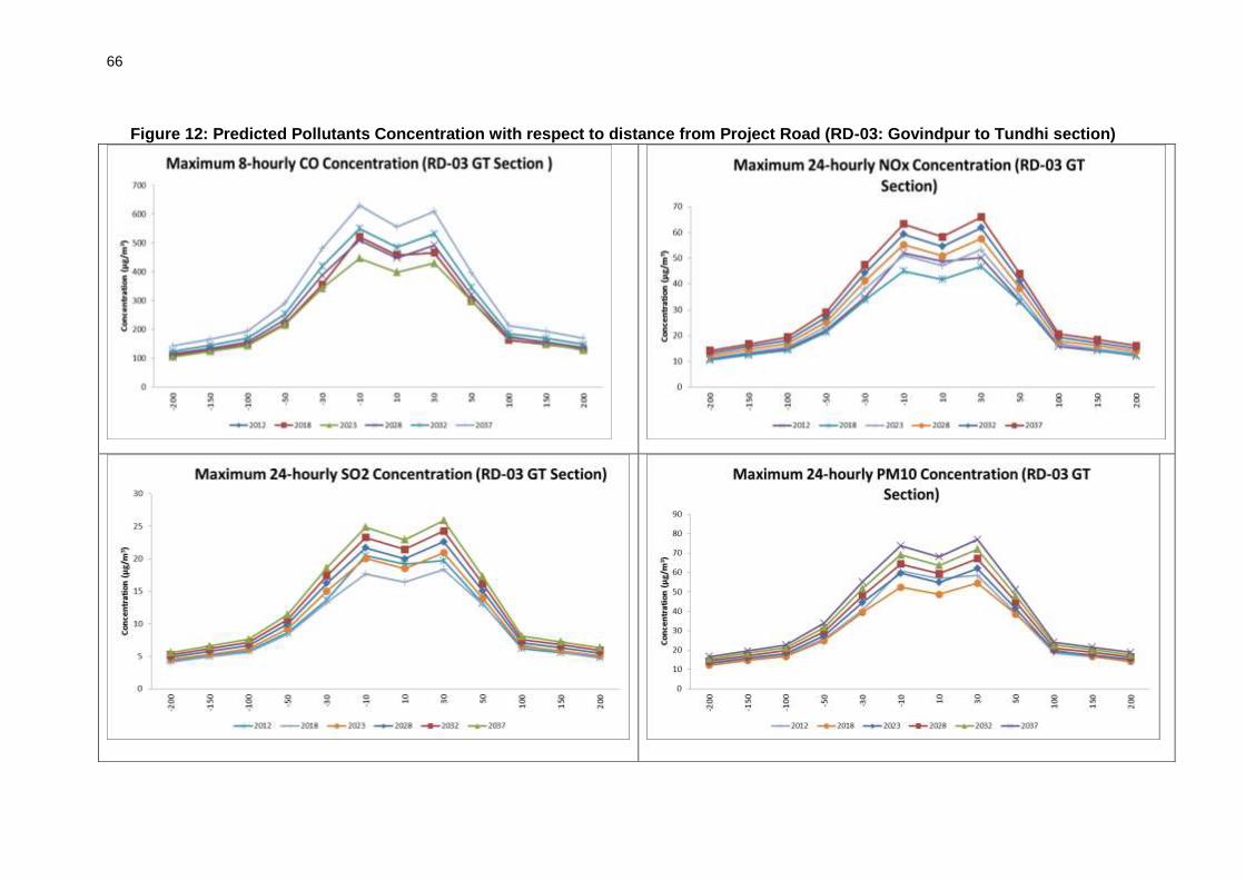
66
Figure 12: Predicted Pollutants Concentration with respect to distance from Project Road (RD-03: Govindpur to Tundhi section)

67
Figure 13: Predicted Pollutants Concentration with respect to distance from Project Road (RD-03: Tundhi to Giridih section)

68
Figure 14: Predicted Pollutants Concentration with respect to distance from Project Road (RD-04: Khunti to Tamar)

69
170. Prediction results: Analysis of modeling results ascertain that the predicted level of concentrations for all parameters along RD 03 and RD 04 are well within the permissible limit for entire project horizon. CO and SO2 concentrations for all roads will also be within prescribed range. However, NOX and PM10 are estimated to increase along RD 01 and RD 02 after 2028 within 30 m from the road edge. The tree plantation and habitat improvement activities included in the project scope will help to check air pollution. Road signs to to remind motorists to maintain their vehichles and minimize fuel consumption maybe posted. Raising awareness amongst drivers on good driving practices to reduce fuel consumption and promote road safety may also be carried out. As part of the routine maintenance works good riding conditions of the road surface will be maintained to reduce dust and vehicular pollution. 171. Conclusions: In the existing scenario, due to lesser carriageway width, the average vehicle speed is low, which results in traffic congestions causing more exhaust gas emissions. In the post-project scenario, improved road conditions and congestion free traffic movement will reduce emissions. It is also expected that over the period, the fleet/fuel type will significantly improve contributing significantly in emission reduction.
5. Noise impacts 172. The significance of operational noise impacts commensurates with the number of sensitive structures and sensitive areas that exist along the project roads. As stated in chapter IV, only 6.28%, 12%, 6.5% and 3.7% of the alignment passes through built up areas (residential and/or commercial areas) for RD01, RD02, RD03 and RD 04 respectively. The rest of the alignment passes through agricultural fields, barren land and forests. Tables 22 to 25 in Chapter IV show the sensitive structures comprising schools, temples, mosques and health centers that are located along the project roads. Some of these sensitive structures are located within the built up areas mentioned above. After removal and shifting of the directly impactedsensitive structures, the sensitive structures that will be remaining on either side of the road which will be exposed to noise generated by future traffic plying on the improved road is given in the following Tables 31 to 34.
Table 31: Sensitive Structures along RD 01: Dumka - Hansdiha
Ch.Km. Structure Distance from center line of the road (meters)
Side L/R
33.5 Middle School 12.5 L
36.4 Middle School 13.5 L
42 Navoday School 12.5 L
45.1 Adarsh School 23 R
47.8 Middle School 13 R
TOTAL 5
Table 32: Sensitive Structures along RD 02: Pachamba – Jamua - Sarwan
Ch.Km. Structure Distance from center line of the road (meters)
Side L/R
7.042 School 8.7 R
17.65 School BW 9.1 L
18.22 School 11 R
20.6 School 5.5 R
39.6 School 16.5 R
42.1 School 11.5 L

70
Ch.Km. Structure Distance from center line of the road (meters)
Side L/R
43.195 School 14 L
47.65 School 17.5 L
56.7 School 19.1 L TOTAL 9
Table 33: Sensitive Structures along RD 03: Govindpur – Tundi - Giridih
Ch.Km. Structure Distance from center line of the road (meters)
Side L/R
11.18 School 13 L
14.2 School 15.5 L
26.4 School 15 R
29.58 School 13 L
30.7 School 11 R
36.35 School 6 L
TOTAL 6
Table 34: Sensitive Structures along RD 04: Khunti – Tamar Ch.Km. Structure Distance from center line of
the road (meters) Side L/R
0.2 College 15.5 L
0.92 School 16 R
0.93 School 15.8 L
1.6 Health Center 16.6 R
1.7 School 13 R
9.17 School 18.8 R
17.12 School 17.6 L
17.55 School 17 L
17.65 School 16.7 L
25.9 Health Center 17 R
28.725 School 18.8 R
TOTAL 11
Note: At the sections where sensitive receptors listed in the tables above are located less than 10m from the centerline of the road, the road width will not be increased.
173. During the operational phase, movement of traffic, traffic congestion, pedestrian interferences and increase in use of hornswill be the prime source of noise. The noise levels at nearby schools, religious place may cause nuisance and irritation. 174. Prediction of Impact: Long-term noise level increase was assessed with respect to distance from the project road for the years 2018, 2023, 2028, 2032 and 2037 using the Federal Highway administration's Traffic Noise Model (FHWA’s) Traffic Noise Model (TNM). TNM computes incremental highway traffic noise at nearby receivers. As sources of noise, it includes noise emission levels for the following vehicle types:
Automobiles: all vehicles with two axles and four tyres primarily designed to carry nine or fewer people (passenger cars, vans) or cargo (vans, light trucks) -- generally with gross vehicle weight less than 4,500 kg (9,900 lb);
Medium trucks: all cargo vehicles with two axles and six tires -- generally with gross vehicle weight between 4,500 kg (9,900 lb) and 12,000 kg (26,400 lb);

71
Heavy trucks: all cargo vehicles with three or more axles -- generally with gross vehicle weight more than 12,000 kg (26,400 lb);
Buses: all vehicles designed to carry more than nine passengers; and
Motorcycles: all vehicles with two or three tires and an open-air driver / passenger compartment.
175. The procedure for prediction of noise levels involved the following steps:
Identification of various receivers,
Determination of land uses and activities which may be affected by the noise generated,
Assemble input parameters, and
Application of the model.
176. Input Parameters: Traffic volume for the projected period is obtained from the traffic projections. The total number of vehicles passing per hour by type - light, medium and heavy along with their average speed is used for predictions. During the pre-project scenario (Year 2012), average speed was considered as 40 km/hr, whereas after the completion of the project, minimum design speed of 80 km/hr was considered for operation phase. 177. Average Noise Level: All vehicles produce noise, which is taken as the base, and the cumulative noise at the receiver distance due to the whole traffic is estimated. The average noise level varies depending on the type of vehicle. In order to assess the impact of noise due to the change in traffic density and speed, a small road section of each project road has been selected to develop noise projection for base year (2012) as well as future years (2018, 2023, 2028, 2032 and 2037).To assess the impact of traffic, receptor locations were set at 20m, 30 m, 50m, 70m, 100m, 150m and 200m from the centre line of the road.
178. The outputs of the assessment arepresented in Table36. The table shows the noise levels that will be generated by traffic at the respective distance from the centerline of the road without mitigation and with mitigation. The “with mitigation” column assumes attenuation of noise due to: i) requirement for reduction in speed of traffic from 80km/hour to 20 km/hour in sensitive locations, ii) existing fencing walls around the sensitive structure compound if any and iii) wall of the house for residents staying inside the house.In accordance with the Federal Highway administration's Traffic Noise Model (FHWA’s) Traffic Noise Model (TNM) there will be a reduction in approximately 6dB of noise when speed is reduced from 80km/hour to 20 km/hour. In addition walls such as boundary walls and the wall of a house (for a resident sitting inside the house) can cause a reduction of noise of atleast 3 dB. Literature18 reviewed on this subject also provides similar numbers. Accordingly it has been assumed that there will be reduction of noise by approximately 9dB due to the combination of reduction in speed and existence of a house wall in residential and commercial areas.
179. It can be seen that without mitigation measures the noise levels increase by 8dB already within the first year of operations of the road. However, implementation of the mitigation measures will significantly help to reduce the noise levels and infact help to even lower the noise levels in comparison to the baseline conditions. It is only in 2037 that the noise levels even with mitigation become higher than the baseline levels.
18
http://www.nonoise.org/resource/trans/highway/spnoise.htm)

72
180. It is the impacts on sensitive receptors and residential areas that is of most concern and needs mitigation. Table 35 to 36 shows that majority of the sensitive structures that are located along the road all exist within 20m from the centerline. Hence, to analyse the impacts on the sensitive structures it is the noise levels within 20m from the centerline of the road that needs to be considered. Noise barriers have been proposed to be constructed in front of the identified sensitive structures to reduce noise impacts in consultation with the local community. Literature19 shows that noise barriers can reduce noise by 5 to 10 dB. Hence with construction of a noise barrier it has been assumed that there will be a further reduction in noise by approximately 7 dB (assuming an average reduction in noise of 7dB) in addition to 9dB reduction (from speed reduction and the barrier created by the wall of a house), hence a total reduction of approximately 16dB of noise. Calculations made with this assumption as given in 37show that noise barriers will be very effective in lowering noise levels. Infact the noise levels will remain below baseline levels even with the traffic increases expected in 2037.
19
http://www.fhwa.dot.gov/environment/noise/noise_barriers/design_construction/keepdown.cfm

73
Table 35: Predicted Noise Levels along the Project Roads
RD 01: Dumka-Hansdiha
Distance from Road center
line (m)
2012 Baseline level
2018 without mitigation
2018 with mitigation
2023 without mitigation
2023 with mitigation
2037 without mitigation
2037 with mitigation
Day Night Day Night Day Night Day Night Day Night Day Night Day Night
20 53.1 51.1 61.1 58.9 52.1 49.9 62.8 60.6 53.8 51.6 68 65.3 59 56.3
30 52.2 50.2 60.2 58 51.2 49 61.9 59.7 52.9 50.7 67 64.4 58 55.4
50 50.1 48.1 58.1 55.9 49.1 46.9 59.8 57.5 50.8 48.5 65 62.3 56 53.3
70 48.2 46.2 56.4 54.2 47.4 45.2 58.1 55.9 49.1 46.9 63 60.6 54 51.6
100 45.7 43.6 53.8 51.6 44.8 42.6 55.5 53.3 46.5 44.3 60 58 51 49
150 42.4 40.4 50.3 48.1 41.3 39.1 51.9 49.7 42.9 40.7 57 54.5 48 45.5
200 39.3 37.3 47.1 44.9 38.1 35.9 48.8 46.6 39.8 37.6 54 51.3 45 42.3
Distance from Road center
line (m)
RD 02 Jamua-Sarwan Section
2012 Baseline level
2018 without mitigation
2018 with mitigation
2023 without mitigation
2023 with mitigation
2037 without mitigation
2037 with mitigation
Day Night Day Night Day Night Day Night Day Night Day Night Day Night
20 52 50 60 57.8 51 48.8 64.2 62 55.2 53 73 70.5 64 61.5
30 51.1 49.1 59.1 56.9 50.1 47.9 63.3 61.1 54.3 52.1 72 69.6 63 60.6
50 49 47 57 54.8 48 45.8 61.2 58.9 52.2 49.9 70 67.5 61 58.5
70 47.1 45.1 55.3 53.1 46.3 44.1 59.5 57.3 50.5 48.3 68 65.8 59 56.8
100 44.6 42.5 52.7 50.5 43.7 41.5 56.9 54.7 47.9 45.7 65 63.2 56 54.2
150 41.3 39.3 49.2 47 40.2 38 53.3 51.1 44.3 42.1 62 59.7 53 50.7
200 38.2 36.2 46 43.8 37 34.8 50.2 48 41.2 39 59 56.5 50 47.5
Distance from Road center
line (m)
RD 03 Govindpur-Tundi Section
2012 Baseline level
2018 without mitigation
2018 with mitigation
2023 without mitigation
2023 with mitigation
2037 without mitigation
2037 with mitigation
Day Night Day Night Day Night Day Night Day Night Day Night Day Night
20 59.6 57.6 63.8 61.6 54.8 52.6 65.5 63.3 56.5 54.3 70 68 61 59
30 58.7 56.7 62.9 60.7 53.9 51.7 64.6 62.4 55.6 53.4 69 67.1 60 58.1
50 56.6 54.6 60.8 58.6 51.8 49.6 62.5 60.2 53.5 51.2 67 65 58 56
70 54.7 52.7 59.1 56.9 50.1 47.9 60.8 58.6 51.8 49.6 66 63.3 57 54.3
100 52.2 50.1 56.5 54.3 47.5 45.3 58.2 56 49.2 47 63 60.7 54 51.7
150 48.9 46.9 53 50.8 44 41.8 54.6 52.4 45.6 43.4 59 57.2 50 48.2
200 45.8 43.8 49.8 47.6 40.8 38.6 51.5 49.3 42.5 40.3 56 54 47 45
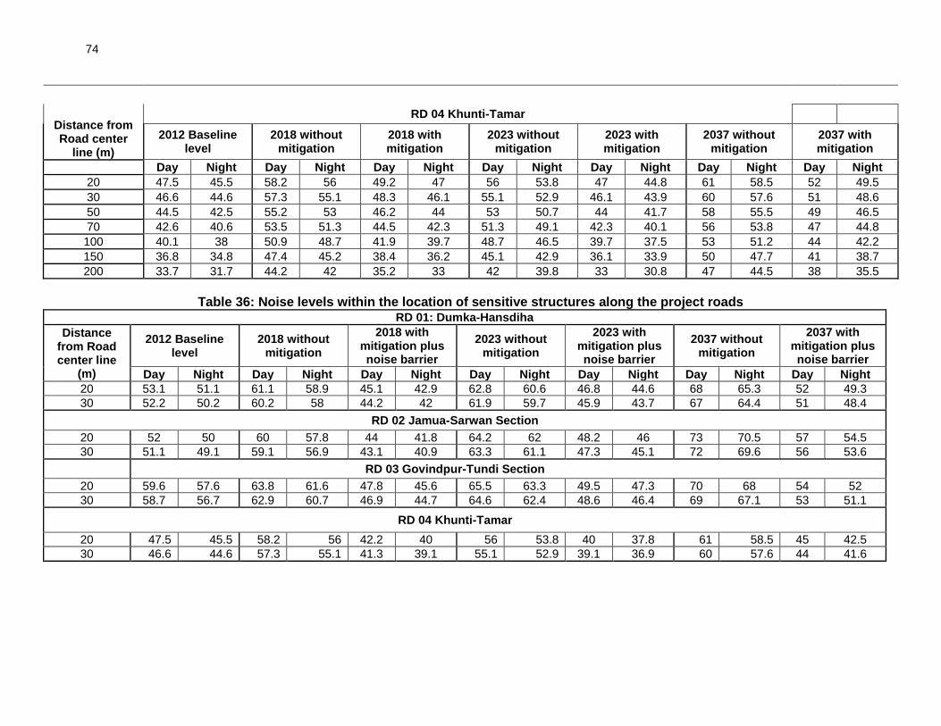
74
Distance from Road center
line (m)
RD 04 Khunti-Tamar
2012 Baseline level
2018 without mitigation
2018 with mitigation
2023 without mitigation
2023 with mitigation
2037 without mitigation
2037 with mitigation
Day Night Day Night Day Night Day Night Day Night Day Night Day Night
20 47.5 45.5 58.2 56 49.2 47 56 53.8 47 44.8 61 58.5 52 49.5
30 46.6 44.6 57.3 55.1 48.3 46.1 55.1 52.9 46.1 43.9 60 57.6 51 48.6
50 44.5 42.5 55.2 53 46.2 44 53 50.7 44 41.7 58 55.5 49 46.5
70 42.6 40.6 53.5 51.3 44.5 42.3 51.3 49.1 42.3 40.1 56 53.8 47 44.8
100 40.1 38 50.9 48.7 41.9 39.7 48.7 46.5 39.7 37.5 53 51.2 44 42.2
150 36.8 34.8 47.4 45.2 38.4 36.2 45.1 42.9 36.1 33.9 50 47.7 41 38.7
200 33.7 31.7 44.2 42 35.2 33 42 39.8 33 30.8 47 44.5 38 35.5
Table 36: Noise levels within the location of sensitive structures along the project roads
RD 01: Dumka-Hansdiha
Distance from Road center line
(m)
2012 Baseline level
2018 without mitigation
2018 with mitigation plus noise barrier
2023 without mitigation
2023 with mitigation plus noise barrier
2037 without mitigation
2037 with mitigation plus noise barrier
Day Night Day Night Day Night Day Night Day Night Day Night Day Night
20 53.1 51.1 61.1 58.9 45.1 42.9 62.8 60.6 46.8 44.6 68 65.3 52 49.3
30 52.2 50.2 60.2 58 44.2 42 61.9 59.7 45.9 43.7 67 64.4 51 48.4
RD 02 Jamua-Sarwan Section 20 52 50 60 57.8 44 41.8 64.2 62 48.2 46 73 70.5 57 54.5
30 51.1 49.1 59.1 56.9 43.1 40.9 63.3 61.1 47.3 45.1 72 69.6 56 53.6
RD 03 Govindpur-Tundi Section 20 59.6 57.6 63.8 61.6 47.8 45.6 65.5 63.3 49.5 47.3 70 68 54 52
30 58.7 56.7 62.9 60.7 46.9 44.7 64.6 62.4 48.6 46.4 69 67.1 53 51.1
RD 04 Khunti-Tamar 20 47.5 45.5 58.2 56 42.2 40 56 53.8 40 37.8 61 58.5 45 42.5
30 46.6 44.6 57.3 55.1 41.3 39.1 55.1 52.9 39.1 36.9 60 57.6 44 41.6

75
181. Conclusions: It is evident from the above tables that there will be significant increase in the noise levels due to increase in traffic intensity as well as average speed of vehicles over the road’s design life. However, with appropriate mitigation measures such as lowering of speed from 80km/hour to 20km/hour in residential and commercial areas which has already been included in the project design, the natural barrier effect from the wall of houses, and the provision for noise barriers near sensitive receptors the noise levels will be kept even below the baseline levels. Further it must be noted that most of the road alignment passes through agricultural fields and forests with very small proportions (3.7% to 12%) of the road alignment passing through commercial or residential areas. The numbers of the sensitive structures along the roads are also very few. Hence, it is expected that overall noise impacts on sensitive receptors will be insignificant.
6. Ecological Impacts
182. With the improved road surfaces number of vehicles and the speed will be increased. Further, certain number of animals will attract to tarred road surfaces (e.g., especially the snake's cold blood attracts them to warm road surfaces during the night).. There will be frequent animal movement including elephants. This will result in the increase number of collision and run over of animals.This impact could be reduced by placing warning and information sign boards at least 1km ahead of approaching such areas and installing speed breakers. Several mitigation measures recommended in design stage will reduce if not totally avoid collisions with elephants. Further, SHAJ will support jurisdictional forest departments to monitor the effectivity and adequacy of these mitigation measures.
F. Climate Change Impacts and Risks
1. Climate Change Mitigation
183. The Transport Emissions Evaluation Model for Projects (TEEMP)20 developed by Clean Air Asia21 was utilized to assess the CO2 gross emissions with and without the project improvements. The main improvement from the project that was considered for the model are better surface roughness with initially 2m/km which may deteoriate over a period but not less than 3.5 m/km and widening of roads from 1.5 lane to 2.0 lane. These were translated into impacts on traffic speed and hence fuel consumption. The model also allows for the inclusion of impacts related to traffic congestion with and without project through provisions for inserting data on the traffic numbers, lane width, number of lanes and volume/capacity saturation limit. 184. Information that was fed into the model for projecting the CO2 emissions were:
(i) The project will rehabilitate and widen approximately 174 km of the State Highways, which will have four different sections: RD-01, RD-02, RD-03 and RD-04.
(ii) The road configuration will change from 1.5 lane to 2.0 lane with carriageway width of 7.0 m and will have an asphalt concrete surface.
20
TEEMP is an excel-based, free-of-charge spreadsheet models to evaluate emissions impacts of transport projects. 21
A network of 250 organizations in 31 countries established by the Asian Development Bank, World Bank, and USAID to promote better air quality and livable cities by translating knowledge to policies and actions that reduce air pollution and greenhouse gas emissions from transport, energy and other sectors.

76
(iii) Existing road roughness is mostly 6.0 m/km and will be improved to 2.0 m/km, which may further reach upto 3.5 m/km during 7 years of road operations and hence will be resurfaced after every 7 years.
(iv) Construction will take place over a period of 36 months in 2015-17 and roadoperations will begin in 2018.
(v) The design life of the road is 20 years. (vi) Other improvements include the repair or reconstruction of damagedculverts,
introduction of lined longitudinal and cross drains for the road andremoval of irregularities on the existing vertical profile and road safetyappurtenances.
185. Traffic forecasts were taken from the detailed project report. Maximum PCU for 1.5 lanes and 2.0 lanes were considered as 12,000 and 36,000 respectively in consistent to IRC guidlines. The volume/capacity saturation limit was taken at 2.0 for optimum travel speed and fuel consumption. Emission factors were mostly taken from the CBCP/MOEF (2007) Draft Report on Emission Factor Development for Indian Vehicles, the Automotive Research Association of India, and C. Reynolds et.al (2011) Climate and Health Relevant Emissions from in-Use Indian for three-wheelers rickshaw as follows:
Table 37:CO2 Emission Factors Vehicle Type Gasoline Diesel
2-Wheel 2.28 kg/l
3-Wheel 2.63 kg/l
Cars/ Jeeps 2.59 kg/l 2.68 kg/l
LCV 3.21 kg/l
Bus 3.61 kg/l
HCV 3.50 kg/l
186. It was assumed that the 2-wheelers and 3-wheelers have average trip distance of 1/4th of the total road length in each section, whereas all other vehicles do use the entire length as average trip distance. Furthermore, 2-wheelers and 3-wheelers constitute 100% and 90%, respectively of the total local traffic. 187. It has also been assumed that over the time, the fleet composition will change and the assumptions taken for the same are as follows:
Table 38: Emission Standards of Fleet (%) Vehicle Type Current Scenario Year 2037
Pre-Euro Euro I Euro II Euro III Euro I Euro II Euro III
2-Wheel 50% 50% 30% 70% -
3-Wheel 80% 20% 40% 60%
Cars/ Jeeps 40% 40% 20% 40% 60%
LCV/Bus/HCV 70% 20% 10% 10% 40% 50%
188. Emissions from road construction were estimated by using the emission factor for rural/ urban roads, by using ADB - Carbon footprint 4 (http://www.adb.org/documents/reports/estimating-carbon-footprints-road-projects/default.asp), which is equivalent to 109,600 kg CO2/km of road construction. , 189. Estimated carbon emissions. The proposed road upgrading resulting to surface roughness and road capacity improvements have implications in CO2 emissions. Improved

77
roughness results to higher speed and lesser emissions while increase road users increases emissions. These factors are further affected by traffic congestion once the volume/capacity saturation limit.
190. CO2 emissions will also result from the processing and manufacturing of raw materialsneeded to upgrade the project road and in the case of project, to upgrade and strengthen the road length of approximately 174 km, total CO2 emissions will be of the order of 18,988 tons.
Table 39: Estimated Total CO2 Emissions during Road Construction Road Section Length (km) Emission Factor (ton CO2/km) CO2 Emission (tons)
RD-01 44.00 109.6 4,822
RD-02 42.00 4,603
RD-03 43.55 4,773
RD-04 43.70 4,790
Total 173.25 18,988
191. The design life of roads is 20 years. Total CO2 emission at business-as-usual scenario was estimated at 67,645 tons/year and without- and with- induced traffic are 60,217 tons/yearand 63,199 tons/year, respectively. These values are below the 100,000 tons per year threshold22 set in the ADB SPS 2009. Therefore it is not necessary to implement options to reduce or offset CO2 emissions under the project. The project’s section-wise CO2 emission intensity indicators are provided below:
Table 40: Section-wise Project CO2 Emissions Intensity Indicators Road
Sections Particular CO2 emission
Business-As-Usual Project (without Induced Traffic)
Project (with Induced Traffic)
RD-01 tons/km 74,621.87 10,377.11 10,976.89
tons/year 96,635.33 13,438.35 14,215.07
tons/km/year 3,731.09 518.86 548.84
g/t km 1,102.31 149.11 148.35
g/tkm 539.87 73.13 72.75
RD-02 tons/km 43,093.31 7,063.65 7,658.62
tons/year 101,269.29 16,599.59 17,997.77
tons/km/year 2,154.67 353.18 382.93
g/pkm 1,153.90 162.23 165.41
g/tkm 483.86 67.59 68.91
RD-03 tons/km 78,023.30 12,833.01 14,202.36
tons/year 169,895.74 27,943.89 30,925.64
tons/km/year 3,901.17 641.65 710.12
g/pkm 1,741.39 211.43 220.04
g/tkm 546.19 67.24 69.97
RD-04 tons/km 11,703.98 3,738.77 3,832.27
tons/year 25,573.20 8,169.20 8,373.52
tons/km/year 585.20 186.94 191.61
g/pkm 529.80 169.24 168.13
g/tkm 170.35 54.42 54.05
22
Page 38, Appendix I, footnote 10 of SPS 2009

78
192. Overall Project’s CO2 emission intensity indicators are provided below:
Table 41: Project CO2 Emissions Intensity Indicators Particular CO2
Business-As-Usual Project (without Induced Traffic)
Project (with Induced Traffic)
tons/km 207,442.46 34,012.54 36,670.14
tons/year 393,373.56 66,151.03 71,512.00
tons/km/year 10,372.13 1700.63 1833.5
g/t km 4,527.40 692.01 701.93
g/tkm 1,740.27 262.38 265.68
193. The above tables clearly indicate that the Business As Usual scenario will have higher CO2 emissions due to the higher roughness and lowercapacity. However, the with project scenarios will be have significantly lower CO2 emissions due to the improvement in road roughness as well as capacity enhancement. The Business As Usual scenario indicates that without increase in traffic and with changes in fleet composition at the later stages of the project, there will be some reduction from the current levels. Furthermore, with project scenarios (both without and with induced traffic), there will be increase in the CO2 emission levels over the time due to the increase in the traffic volume, however, the emissions will be controlled by maintaining the road roughness below 3.0 m/km during the entire project life as well as enhanced capacity of the road (from 1.5 lanes to 2.0 lanes). This will result in annual CO2 emissions of the entire road below threshold limit of 100,000 tons/year.
2. Climate Risks and Adaptation needs
194. Sector specific climate risks screening has been done to analyse impact on road components due to likely changein climaticvariables, mainly temperature and precipitation. Projections have been made for 2050s. Given the projected variations of temperature23 and precipitation24 the project roads were screened for different types of climate risks and impact on road components.Increased temperature and precipitation will have following impacts: 195. High Precipitation Impacting Roads/Bridge/Embankment:Heavy rains can cause disruption of the road networks, decreased accessibility, erosion of roads and embankments, surface water drainage problems, slope failures, landslides, among others. Increased river flow resulting from precipitation and storminess may result in damages to bridges, pavements, and other road structures. Bridge / culvert capacities are reduced or exceeded, causing upstream flooding to occur. 196. HighTemperature Impacting Road Stability: Extreme heat, combined with traffic loading, speed and density can soften asphalt roads, leading to increased wear and tear. It is likely that there would be concerns regarding pavement integrity such as softening, traffic-related rutting, embrittlement, migration of liquid asphalt. Additionally, thermal expansion in bridge expansion joints and paved surfaces may be experienced.
23
Annual mean temperature within Jharkhand State is projected to increase by 2.430 Celsius against the
baseline period (1960-1990). Monthly mean temperature during January-May period is projected to experience a higher rise (>2.5
0C). Average monthly maximum temperature is projected to increase by
2.040C. Maximum temperature of May is projected to reach 41.2
0C.
24Annual precipitation is projected to increase by 39mm, or 3.2%. Precipitation is projected to become
more varied, with increase in June (9.8mm), August (8.2mm), and September (>11mm), and decrease in January, March, and July

79
197. Climate risk maps referred from different sources25 were superimposed onsub-project’s road alignment maps.Low to highrisks identified for the project roads were earthquake, Drought, fire, cyclone and flooding. This was further corroborated by consultations at various levels to find out information on history of flooding, forest fire, cyclone and any other climatic risk in the project area. 198. Earthquake: Three sub-projects (RD 01, RD 02 and RD 03) are in earthquake zone III which is medium risk zone. Relevant IS codes have been adopted in designing the structures to sustain the magnitude of earthquake corresponding to Seismic zone III.
199. Forest Fire: As per disaster management plan of Jharkhand,2011 none of the project district is prone to forest fire risk presently. However rising temperatures and reduced top soil moisture due to increased evapotranspiration, the forest fire risk will escalate in the future. 200. Drought: All the project districts of the state is affected by drought. Soil moisture loss through evapotranspiration is projected to increase as a result of projected increase in annual mean temperature (2.40 Celsius by 2050s). Increased drought frequency may lead to increased susceptibility to consolidation of the substructure with (unequal) settlement, more generation of smog, and unavailability of water for compaction work.
201. Cyclone: The state is affected by cyclones originating from the Bay of Bengal mainly in April-May and October-November. Strong winds can cause damage to roadside infrastructure (e.g., signs, lighting fixtures and supports, etc.). Cycle impact is likely to be medium to low.
202. Flood: The study area being predominantly rolling does not have flood problem. However, flash floods occurred in 11 districts including some parts of project districts in 2004. However, entire asian monsoon region is likely to witness more extreme rainfall events in future due to global warming impact. All structure have been designed for 50 yr return period with anticipated risk of rarer flood generally of next higher frequency i.e. 100 yr return period flood on the designed structures. 203. Key engineering measures taken to address flood risks in the design are: i) increase in embankment height, ii) construction of new side and lead away drains, iii) construction of new culverts and widening of existing ones and iv) widening of bridges.As shown in Table 42, costs for taking these measures add up to a total of Rs. 112 crores. This is approximately 10% of the total civil works costs. It must be pointed out that these measures would have been considered anyway in the conventional design as the issue of flooding is a threat to the sustainability of the road. However, these measures also contribute to adaptation of the roads for future increases in precipitation. This risk screening and risk identification exercise has helped to ensure that all roads with climate risks have adequate risk mitigation or adaptation measures. The detailed list of roads with climate risks, specific engineering measures taken and the costs of those measures are provided in Table 42. Provisions have also been made in the bidding documents for the contractor to prepare contract package specific EMP’s based on the final detailed design to address a range of issues including climate related risks and vulnerabilities and accordingly incorporate required costs in the BOQ.
25
Earthquake Hazard Map of India, BMTPC: Vulnerability Atlas – 2nd Edition; http://www.ipcc.ch/publications_and_data/ar4/wg1/en/faq-10-1.html. .

80
Table 42: Details of Climate Adaptation Measures with Cost Implications
Roads/Details Dumka-Hansdiha
Giridih-Jamua-Sarwan
Gobindpur-Tundi-Giridih
Khunti-Tamar
Total
A. Cross-drainage structures
Culvert Nos. 58 77 NA 83 221
Culvert Length (m)
Existing 161 74.4 NA NA 241
Proposed 189 134 NA NA 323
Cost Impact (Rs. Cr) 1.00 1.95 - - 2.96
Bridge Nos. 6 4 9 9 28
Bridge Length (m)
Existing 142 167 555 196 1060
Proposed 172 218 755 212 1357
Cost Implication (Rs. Cr) 1.76 2.95 11.58 0.93 17.21
B. Embankment Raising
No. of reaches 12 18 18 17 65
Length raised (m) 4,330 5,785 3,700 4,100 17915
Cost Implication (Rs. Cr) 10.83 14.46 9.25 10.25 44.79
C. Roadside drains
Lined built-up (m) 21,060 26,366 4600 4000 56,026
Lined open (m) 4,042 0 4,042
Unlined open (m) 62,540 66,452 82500 83400 294,892
Cost Implication (Rs. Cr) 19.08 22.81 4.69 4.19 50.78
Total Cost 112.78
G. Cumulative and Induced Impacts
204. According to the ADB Environment Safeguards Sourcebookcumulative impact is described as: “The combination of multiple impacts from existing projects, the proposed project, and anticipated future projects that may result in significant adverse and/or beneficial impacts that cannot be expected in the case of a stand-alone project.” The sourcebook also describes induced impacts as: “Adverse and/or beneficial impacts on areas and communities from unintended but predictable developments caused by a project, which may occur at later or at a different location. 205. Economic activities supporting transport like fuel stations, automotive repair shops, lodging, and restaurants are expected to increase with increase of traffic and induce development in the project area. Increase in agro-industrial activities are also expected to take advantage of improved access to urban centers where there are higher demand and better prices for agricultural products. The project area is rich in mineral reserves. Hence the project will accelerate industrial activities and induce development significantly. Further the increased industrial activities will significantly reduce migration.The improved road will provide better connectivity and result in (i) Reduction in travel time (ii) better mode and frequency of transport (iii) access to quality health care facilities, educational and other infrastructural facilities (iv) enhanced tourism activities in the area and state which in many terms will boost the local economy (v) better investment climate for industries creating more employment opportunities to local people.
206. In terms of environment safeguard issues the improved road surface is expected to result in less dust and noise due to traffic plying on the damaged roads. However, the increased traffic due to the improved road will generate more air pollution due to vehicle

81
exhaust and noise. The smoother road conditions will also result in increase of traffic speeds, hence creating more risks for accidents amongst traffic users as well as the local communities in the project area. Improvement in local economic conditions can also result in unorganized and illegal establishment of settlements and businesses along the roads creating new problems of waste and pollution. To address these potential problems relevant local authorities will have to monitor developments and strictly enforce rules on
207. For addressing the impacts of air pollution and noise, regular maintenance of the road surface, maintenance and monitoring of newly planted trees have been included in the EMP for implementation during operation stage. For addressing safety related impacts, regular maintenance of the road furniture including safety related furniture, has been included in the EMP for implementation during operation stage. Relevant local authorities will need to monitor developments locally and strict enforce rules on location for establishment of new business and houses along the improved road. SHAJ will also monitor this as the road is expected to require four laning after 10 years or so. 208. Information on other development projects in and around the project area was not available. Hence, it is difficult to assess cumulative impacts from other projects which may get implemented in the project area

82
VI. ENVIRONMENTAL MANAGEMENT PLAN, INSTITUTIONAL REQUIREMENTS AND GRIEVANCE REDRESS MECHANISM
A. Environment Management Plan
209. Environmental Management Plan (EMP) is intended to set out clearly and unambiguously the likely negative impacts of construction and/or operation of the project, the action that is required to avoid or mitigate each impact and the responsibility for taking each action. Responsibility is made legally binding when actions are subsequently specified in contracts. The EMP (Appendix 14)also ensures that the positive impacts are conserved and enhanced. It addition, it provides measures for institutional strengthening and effectiveness assessment through defined monitoring plan, reporting and corrective & preventive action planning.More specifically the objectives of the EMP are:
To ensure compliance with Asian Development Bank’s applicable safeguard policies, and regulatory requirements of Jharkhandand the Government of India;
To formulate avoidance, mitigation and compensation measures for anticipated adverse environmental impacts during construction and maintenance and ensure that environmentally sound, sustainable and good practices are adopted;
To stipulate monitoring and institutional requirements for ensuring safeguard compliance; and
210. The EMP has been prepared based on all foreseen impacts at the time of preparing this IEE. It is a living document. If any new or unforeseen impacts occur during project implementation, the EMP will be updated by the CSC Environmental Specialist. The new impacts maybe due to design changes or changes in project situation or other reasons. If the new or unforeseen impacts are deemed significant SHAJ will immediately notify ADB to agree on the need for revising the IEE report as well.
B. Environment Monitoring Program
211. The monitoring and evaluation are critical activities in implementation of the project. Monitoring involves periodic checking to ascertain whether activities are going according to plan or not. It provides the necessary feedback for project management to ensure project objectives are met and on schedule. The reporting system is based on accountability to ensure that the environmental mitigation measures are implemented. Environmental monitoring program has the underlying objective to ensure that the intended environmental mitigations are realized and these results in desired benefits to the target population causing minimal deterioration to the environmental parameters. Such program targets proper implementation of the EMP. The broad objectives are:
To evaluate the performance of mitigation measures proposed in the EMP.
To evaluate the adequacy of environmental assessment.
To suggest ongoing improvements in management plan based on the monitoring and to devise fresh monitoring on the basis of the improved EMP.
To enhance environmental quality through proper implementation of suggested mitigation measures.
To meet the requirements of the existing environmental regulatory framework and community obligations.

83
1. Performance Indicators
212. The significant physical, biological and social components affecting the environment at critical locations serve as wider/overall performance Indicators. However, the following specific environmental parameters can be quantitatively measured and compared over a period of time and are, therefore, selected as specific Performance Indicators (PIs) for monitoring because of their regulatory importance and the availability of standardized procedures and relevant expertise. A comprehensive monitoring plan for all performance indicators has been prepared for all stages appended as(Appendix 17).This includes parameters to be measured, methods to be used, sampling locations, frequency of measurements, detection limits, cost and responsibility for implementation and supervision. Performance indicators requiring quantitative measurements are:
Air quality with respect to PM2.5, PM10, CO, NOx and SO2 at selected location.
Water quality with reference to DO, BOD, Oil and grease, COD, Suspended Solids and Turbidity, Alkalinity rivers/streams and water bodies at selected points.
Noise levels at sensitive receptors (schools, hospitals, community/religious places).
Survival rates of trees planted as compensatory plantation to compensate for lost forestlands and compensatory plantation raised for removal of roadside trees.
213. Ambient Air Quality (AAQ) Monitoring: Ambient air quality parameters recommended for monitoring road development projects are PM2.5, PM10, Carbon Monoxide (CO), Oxides of Nitrogen (NOx) and Sulphur Dioxide (SO2). These are to be monitored, right from the commencement of construction activity at selected locations of plants and machinery, crushers on sites, excavation works etc. Data should be generated once in a season excluding monsoon in accordance with the National Ambient Air Quality Standards as per CPCB recent notification of 2009 (Appendix 5). 214. Water Quality Monitoring: The physical and chemical parameters recommended for analysis of water quality relevant to road development projects are pH, total solids, total dissolved solids, total suspended solids, oil and grease, COD, Chloride, Lead, Zinc and Cadmium. The location, duration and the pollution parameters to be monitored and the responsible institutional arrangements are given in the Environmental Monitoring Plan. The monitoring of the water quality is to be carried out at locations identified along the project road during construction and operation phase. The Indian Standard Specifications – IS10500: 1991 is given in Appendix 7. Surface water quality will be monitored as per fresh water classification of CPCB (Appendix 8). 215. Noise Level Monitoring: The measurements for monitoring noise levels would be carried out at sensitive receptors and construction sites along the project roads. The Ambient Noise Standards formulated by Central Pollution Control Board (CPCB) in 1989 or the standards by State Pollution Control Board if such standards are stringent than those of the CPCB are to be complied. The CPCB standards are given in Appendix 6. Sound pressure levels would be monitored on twenty-four hour basis. Noise should be recorded at “A” weighted frequency using a “slow time response mode” of the measuring instrument.

84
216. Success of Re-vegetation: Additional compensatory plantationwill be carried out by the civil works contractor in partnership with the local Joint Forest Management (JFM) Committee. SHAJ through the PMC will seek necessary support and guidance from the local Forestry Department for getting plantation activities carried out through the JFMs. Suggested plantation locations are multi-layered plantation near sensitive receptors and other community property resources. Furrther, trees preferred by elephants (Appendix 12)could be planted on the forest land along the project roads where elephant movements have been reported in consultation with forest department. Remaining trees can be planted rivers and canals intersecting project roads. Survival rate till construction period will be monitored by supervision consultant. Later on it can be handed over to forest department.Survival rate of a minimum of 75% shall be ensured. 217. Records of Accidents: Contractors to keep records of all types (construction sites/road accident) of accidents during construction period. During the operation stage monitoring, SHAJ will maintain recordsof traffic accidentsincluding those caused due to vehicle-elephant collisions through their field offices with support from forest department and local people.
C. Organizational Set-up of Implementing Agency
218. State Highways Authority of Jharkhand is the implementing agency for the project. SHAJ is an independent agency under the ambit of RCD and mandated with construction and maintenance of state highways and other roads and bridges with its own resources, private funding or external funding. Presently, it is having a lean organizational set-up in comparison to its mandate. It is headed by Chief Executive Officer (CEO). The CEO has joint charge as, under the Act, the position is held by the Principal Secretary, Road Construction Department. Technical wing is headed by Member Technical supported by General Managers, Deputy General Managers and Managers for different cells. The organizational structure of implementing agency has been illustrated in Figure 15. .
Figure 15: Existing Organizational Set-up of Implementing Agency

85
D. Proposed Institutional Arrangement
219. SHAJ, as the Project Executing Agency, shall be responsible for overall implementation of the project, and shall perform, or cause to be performed, its obligations as set forth herein and the Project Agreement through Government of Jharkhand. 220. A dedicated safeguards team for implementation of safeguards for all projects under SHAJ including thie current project, shall be appointed. The team will be headed by the Member (Administration) and supported by a Deputy General Manager (DGM) and Manager at the headquarter level and an engineer from each Project Implementation Unit (PIU) at the field level. 221. SHAJ shall establish 4 field Project Implementation Unit (PIUs) for implementing all projects which come under the purview of SHAJ. Of the 4 PIUs, 3 PIUs will oversee works for roads under the project. One of the engineers in each PIU will be appointed as the safeguards focal person and be responsible for overseeing implementation of EMP and RP. 222. A construction supervision consultant (CSC) firm will be recruited to supervise and administer civil works contracts and to ensure the works are executed in accordance with the drawings, technical specifications and contract conditions including implementation of EMP. The CSC team will include one environmental specialist and one wildlife specialist. Roles and responsibilities of all four groups involved in implementation of EMP have been outlined in Table 43. Proposed institutional arrangement for SJSRP has been illustrated through a flow diagram (Figure 16).
Table 43: Responsibilities for Environmental Safeguards Implementation S. No Agency Responsibility
1. State Highways Authority of Jharkhand (SHAJ) - HQ Level, Member (Administration), Deputy General Manager (DGM), Manager
Ensure that project complies with ADB's SPS,2009 and GOI laws and regulations
Ensure that contract documents include all relevant parts of the environmental assessment and project agreements.
Ensure that sufficient funds are available to properly implement all agreed environmental safeguards measures
Obtain all statutory clearances and permissions
Review and approve the Contractor’s Implementation Plan with Supervision Consultant for the environmental measures, as per the EMP
Review the environmental performance of the project through an assessment of the periodic environmental monitoring reports submitted by the Supervision Consultants
overall project coordination and management through PIU supported by PMC and CSC
Formation of Grievance Redress Mechanism
Submit annual safeguards monitoring reports to ADB and its closure
Ensure updating of the EMP if any new or unanticipated environmental impacts occur during project implementation due to design change or other reasons
If there are significant new or unforeseet impacts, immediately inform ADB to make a decision on the need

86
S. No Agency Responsibility
for also updating the IEE report
2. Project Management Consultant (PMC)
Assistance in delivering all responsibilities of SHAJ
Develop Project Management Manual
Contract administration of CSC and contractors
Capacity building of SHAJ including PIUs for effective implementation of EMP
Assisting SHAJ in obtaining requisite clearances
Review of checklists and reporting formats prepared by CSC for EMP implementation
Monitoring of compliance with ADB policy requirements and loan covenants (environment clauses)
Prepare safeguards manual on preparation and implementation of social and environment safeguards
Using the safeguards manual conduct trainings for SHAJ
3. Project Implementation Unit (PIU) – Field Level
Ensure that Project complies with ADB's SPS and GoI laws and regulations
Ensure that the environment checklist is completed on time by contractor, reviewed by CSC and submitted to SHAJ
Participating in State and District level meetings to facilitate LA and R&R activities
Periodic appraisal of progress and reporting to the HQ on monthly basis,
Facilitating the contractor to obtain necessary permissions/ approvals and its submission to HQ and further to ADB
Directly interact with project affected persons and record their views and grievances and transmit the same to HQ
Settle grievances if any at field level. Review and approve the package specific EMP’s and
EMOP’s and make necessary modifications if required.
Facilitate the establishment of a grievance redress mechanism, to receive and facilitate resolution of affected peoples' concerns, complaints, and grievances related to environment safeguards
Ensure that all mitigation measures as given in the EMP are implemented properly
Ensure proper conduction of environmental monitoring during pre-construction, construction and operation phases
Verify the monitoring checklists/reports prepared by the CSC
Ensure annual environmental monitoring reports are prepared and submitted to ADB for disclosure on their website on an annual basis
Identify environmental corrective actions and prepare a corrective action plan, as necessary, for submission to ADB during project implementation
4. Environment Specialist, Construction Supervision Consultant (CSC)
Review and approve the contract package specific EMAP’s prepared by the contractor
Daily on site supervision for implementation of environmental safeguards
Completion of monitoring checklists
Close coordination and communication with the contractor to facilitate implementation of all mitigation measures identified in EMP
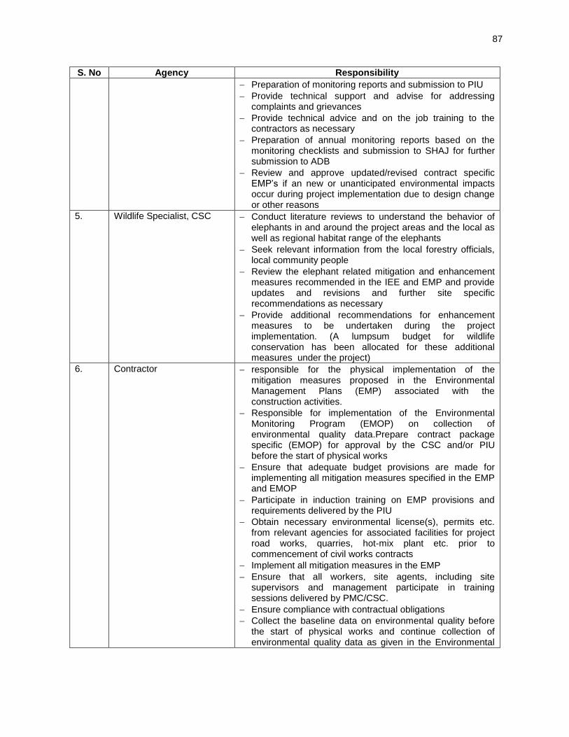
87
S. No Agency Responsibility
Preparation of monitoring reports and submission to PIU
Provide technical support and advise for addressing complaints and grievances
Provide technical advice and on the job training to the contractors as necessary
Preparation of annual monitoring reports based on the monitoring checklists and submission to SHAJ for further submission to ADB
Review and approve updated/revised contract specific EMP’s if an new or unanticipated environmental impacts occur during project implementation due to design change or other reasons
5. Wildlife Specialist, CSC Conduct literature reviews to understand the behavior of elephants in and around the project areas and the local as well as regional habitat range of the elephants
Seek relevant information from the local forestry officials, local community people
Review the elephant related mitigation and enhancement measures recommended in the IEE and EMP and provide updates and revisions and further site specific recommendations as necessary
Provide additional recommendations for enhancement measures to be undertaken during the project implementation. (A lumpsum budget for wildlife conservation has been allocated for these additional measures under the project)
6. Contractor responsible for the physical implementation of the mitigation measures proposed in the Environmental Management Plans (EMP) associated with the construction activities.
Responsible for implementation of the Environmental Monitoring Program (EMOP) on collection of environmental quality data.Prepare contract package specific (EMOP) for approval by the CSC and/or PIU before the start of physical works
Ensure that adequate budget provisions are made for implementing all mitigation measures specified in the EMP and EMOP
Participate in induction training on EMP provisions and requirements delivered by the PIU
Obtain necessary environmental license(s), permits etc. from relevant agencies for associated facilities for project road works, quarries, hot-mix plant etc. prior to commencement of civil works contracts
Implement all mitigation measures in the EMP
Ensure that all workers, site agents, including site supervisors and management participate in training sessions delivered by PMC/CSC.
Ensure compliance with contractual obligations
Collect the baseline data on environmental quality before the start of physical works and continue collection of environmental quality data as given in the Environmental

88
High Level Project Coordinating
Committee Chaired by Chief
Secretary (GoJH)
Chief Executive Officer (CEO)
(State Highways Authority of
Jharkhand)
Asian Development Bank
S. No Agency Responsibility
Monitoring Plan during construction
Participate in resolving issues as a member of the GRC
Respond promptly to grievances raised by the local community or and implement corrective actions
Figure 16: Flow Diagram Illustrating Proposed Implementation Arrangement for SJSRP
E. Institutional / Capacity Building
223. To enhance the capacity of officials for effective implementation of proposed mitigation measures and monitoring the resultant effects, as well as create awareness amongst workers and public, the training and awareness programme is planned and is given in Table 44. The institutions/agencies like regional office of MoEF, SPCB/CPCB, and Indian Institute of Technologies can be consulted for such trainings. Independent subject’s experts/consultants

89
(e.g., for the environmental awareness program, impact assessment specialist will be the resource person) can also be the resource persons to impart trainings. These experts /agencies shall be appointed based on specific need for the training. A separate budget for training has been allocated under the CSC budget.
Table 44: Training/Workshop Budget for EMP Implementation S.No Target group Subject(s) Method Time Frame
1 All staffs of SHAJ including PIU project staff involved in implementation of the project
Environmental Overview: Environmental Regulations, sub-project related provisions of various Acts/ Guidelines, Procedures of EC and FC, process and methodology for IEE, EMPs
Lectures cum interaction
Before beginning of the implementation of the subproject.
2 Managers (Env) at PIU, Supervision Consultant’s Environmental Specialists and Select NGOs
Implementation of EMPs: Basic features of an EMP, Planning, designing and execution of environmental mitigation and enhancement measures, monitoring and evaluation of environmental conditions – during construction and operation
Workshops and Seminars
Before the construction begins
3 Environmental officer, design team, Supervision Consultant Construction Contractors’ staff
Environmentally Sound Construction Practices: Clean construction technology, alternatives materials and techniques for construction, Waste Management and minimization in construction, pollution control devices and methods for construction sites and equipment, Environmental clauses in contract documents and their implications, protection of flora and fauna Environmental monitoring during construction
Workshops and Site visits
Before the construction
4 PIU and Supervision Consultant, NGOs and community representatives
Monitoring Environmental Performance during Construction: Air, Water, Soil and Noise, tree survival Monitoring requirement and techniques, Evaluation and Review of results, Performance indicators and their applicability, possible corrective actions, reporting requirements and mechanisms
Lectures, Workshop and site visits
During initial phases of construction
5 -do- Long-term Environmental Issues in Project Management: Designing and implementing environmental surveys for ambient air, noise, biological and water quality surveys, data storage, retrieval and analysis, contract documents and environmental clauses, risk assessment and management, contingency planning and management and value addition
Workshops and seminars
During implementation of the Subproject
6 Public /contractors workers
Awareness programmeson environmental protection and measures being implemented by SHAJ and their role in sustaining the measures taken including for noise pollution, air pollution, safety, soil conservation, and agricultural productivity enhancement
Workshops During construction and initial phase say 3 years of operation

90
S.No Target group Subject(s) Method Time Frame
7 SHAJ Staff, Supervision Consultant, Engineering Staff of Contractor.
Restoration of sites viz borrow areas, construction Camps, Crushing units, HMP etc. And Reporting Formats/procedure
Lecture/Presentations
before Contractor Demobilization
F. Grievance Redress Mechanism
224. All the three parties involved in this project implementation i.e. Contractor, CSC and executing agency will maintain complaint registers at their following respective offices:
Contractor’s main site offices i.e. office of the Project Manager;
CSC’s main site office i.e. office of the Engineer’s Representative; and
PIU DGM office i.e. Employer’s field office
225. Level 1 – PIU level: All public complaints regarding environmental issues received by any of the above mentioned offices will be entered into the register with specific details such as name and address of the person or representative of the community registering a complaint, the details of complaint, and time. The Executive Engineer and Engineer’s Representative will immediately communicate the details of the complaint to the Contractor. The environment and safety officer of the contractor will promptly investigate and review the environmental complaint and implement appropriate corrective actions to arrest or mitigate the cause of the complaints within 3 days time of receiving the complaint. The contractor will report to CSC environment expert about the action taken on the complaint, also within 3 days time of receiving the complaint, for his further intimation to DGM PIU. The person making the complaint will also be intimated by the complaint receiving person or his representative, about the action taken, within 3 days. 226. Level 2 – State level: Grievances not redressed by the PIU level will be brought to the State level Grievance Redress Committee (GRC). The State level GRC will be headed and chaired by Executive Engineer. The state level GRC will comprise of the following:
i) Member (Administration), SHAJ
ii) Environmental Specialist, CSC
iii) A representative from the respective local community or JFM committee member
iv) Representative of concerned agency such as Forestry Department or State
Pollution Control Board depending on the nature of the complaint/issue
227. The main responsibilities of the GRC will be to: (i) record grievances, categorize, and prioritize grievances and resolve them as soon as possible; (ii) immediately inform the EA of serious cases; and (iii) report to complainants on decisions made regarding their grievances within three weeks of receiving the grievance from the PIU level. The decision must include the agreed timeline for addressing the grievance. Grievances related to resettlement benefits, compensation, relocation, replacement cost and other assistance will be addressed by following the grievance redress system provided in the RP. 228. The Grievance Redress Mechanism has also been illustrated through a flow chart given as Figure 17.

91
Figure 17: Flow Diagram Showing Grievance Redressal Mechanism
G. Environment Management Budget
229. Most of the measures have been addressed as part of good engineering practices, the costs for which have been accounted for in the engineering/cost. All costs towards pre-construction clearances/permission will be borne by executing agency. These costs are indicative. The environmental budget for the various environmental management measures proposed under the project is presented in Table 45. A total budget amount of Rs. 139,974,720.00 or $ 2,332,912.00 has been allocated for implementation of environment safeguards under the project. This amount to approximately 1.6% of the total civil works cost under the project.
3.5
Weeks
Complaints by individuals,
Groups, or institutions
Complaints by People’s
representatives: political,
religious,community
Level 1 - PIU Level
Level 2 - State Level
GRC
(Complaints forwarded to GRC in
writtenform)
Response/action
to be taken
within 3 days of
receipt of
complaint
Decision to be
taken within 3
week of receipt
of complaint
GRC process ends
Simple issues
Complex issues
Decision of state level GRC – Convey the
decision to the complainant

92
Table 45: Estimated Environment Management Cost No. Activity RD 01
Dumka - Hansdia
RD 02 Pachamba -
Jamua - Sarwam
RD 03 Govindpur -
Tundi - Giridih
RD 04 Kunti - Tamar
Total To be included in
budget under
Remarks
1 Wildlife conservation activities
1.1 Warning sign boards (small)
40,000.00
60,000.00 40,000.00 140,000.00 BOQ of civil work cost
In both directions of Elephant Crossing Stretches @Rs. 5000 each sign Boards
1.2 Informatory sign boards (big)
200,000.00 300,000.00 200,000.00 700,000.00 BOQ of civil work cost
In both directions of Elephant Crossing Stretches @Rs. 25000 each sign Boards
1.3 Rumble Strips 80,000.00 120,000.00 80,000.00 280,000.00 BOQ civil works cost
In both directions of Elephant Crossing Stretches @Rs. 10,000 each rumble strip
1.4 Habitat enhancement
500,000.00 500,000.00 500,000.00 1,500,000.00 Provisional Sum of civil works cost
Lumpsump basis for planting Fodder Trees in forest Areas. Could be assigned to the JFM committee together with additional tree plantation
1.5 Solar Street Lighting
1,400,000.00 2,065,000.00 1,225,000.00 4,690,000.00 Provisional sum of civil works cost
for 300 length at 30m interval @ Rs. 35000/light post at elephant crossing locations
1.6 Solar Dragon Light
200,000.00 300,000.00 200,000.00 700,000.00 BOQ of civil works cost
one set at each locations @Rs. 25000/set. To be supplied to the respective JFM Committee
1.7 Check Dams 2,500,000.00 2,500,000.00 2,500,000.00 2,500,000.00 10,000,000.00 Provisional sum of civil works cost
1 check dam per road for communities. Details of location and design to be prepared by the CSC.

93
No. Activity RD 01 Dumka - Hansdia
RD 02 Pachamba -
Jamua - Sarwam
RD 03 Govindpur -
Tundi - Giridih
RD 04 Kunti - Tamar
Total To be included in
budget under
Remarks
1.8 Additional wildlife conservation activities
10,000,000.00 10,000,000.00 10,000,000.00 30,000,000.00 Provisional Sum of civil works cost
Details to be identified under the elephant study to be carried out by the CSC Wildlife Specialist
2 Tree Cutting and Compensatory Afforestation activities
2.1 Compensatory afforestation (1:2 basis by forestry department)
9,828,000.00 5,376,000.00 7,828,000.00 12,200,000.00 35,232,000.00 SHAJ No. Trees to be planted (1:2 basis)@2000/tree including maintainance for 5 Years
2.3 Additional afforestation (1:2 basis by contractor through JFM committee)
9,828,000.00 5,376,000.00 7,828,000.00 12,200,000.00 35,232,000.00 Provisional Sum of civil works costs
Contractor to assign the JFM Committee for carrying out the additional 1:2 plantation.
2.4 Payment of Net Present Value (NPV) to Forestry Department for diversion of forest land
-
920,720.00 340,000.00 - 1,260,720.00 SHAJ NPV payment @Rs.680000 per ha. 1.354 ha for RD02 and 0.5 ha for RD03
3 Studies and Monitoring activities
3.1 Studies for identifying and designing elephant habitat enhancement measures
450,000.00 500,000.00 450,000.00 1,400,000.00 CSC
3.2 Monitoring (air, water, noise, soil)
760,000.00 760,000.00 760,000.00 760,000.00 3,040,000.00 BOQ of Civil Works Cost

94
No. Activity RD 01 Dumka - Hansdia
RD 02 Pachamba -
Jamua - Sarwam
RD 03 Govindpur -
Tundi - Giridih
RD 04 Kunti - Tamar
Total To be included in
budget under
Remarks
4. Noise Barriers
4.1 Construction of noise barriers near sensitive structures
2,500,000 5,000,000 2,500,000 5,000,000 15,000,000 Provisional Sum of civil works cost
Detailed Design of noise barriers to be prepared by the CSC. Noise barrier to be constructed with consent of local community
5 Training 200,000.00 200,000.00 200,000.00 200,000.00 800,000.00 CSC
TOTAL (INR) 40,986,000.00 15,132,720.00 38,301,000.00 45,555,000.00 139,974,720.00 2332912.00
TOTAL (US$) 683,100.00 252,212.00 638,350.00 759,250.00 2,332,912.00 $1 = Rs.60

95
VII. PUBLIC CONSULTATION AND INFORMATION DISCLOSURE
A. Meaningful consultation
230. Meaningful consultations were carried out during detailed design and IEE preparation. All the five principles of information dissemination, information solicitation, integration, co-ordination, and engagement into dialogue were incorporated in the consultation process. A framework of mitigating different environmental impacts likely from the project was strengthened and modified based on opinions of all those consulted, especially at the micro level by setting up a dialogue with the village people from whom information on site facts and prevailing conditions were collected. This will be continued during the implementation of the project through grievance redress mechanism.
B. Objectives of the Public Consultations
231. Public consultations were held to allow the incorporation of relevant views of the stakeholders in the final project design, mitigation measures, implementation issues, and enhance the distribution of benefits. Stakeholder’s consultations were held with intent to understand their concerns, apprehensions, overall opinion and solicit recommendations to improve project design and implementation. Informal meetings, interviews were organized covering the entire project design stage. Consultations provide affected public a platform to ensure incorporation of their concerns in the decision making process and foster co-operation among officers of SHAJ, the community and the stakeholders to achieve a cordial working relationship for smooth implementation of the project. It inculcates the sense of belongingness in the public about the project. 232. The discussions were designed to receive maximum inputs from the participants regarding their acceptability and environmental concerns arising out of the sub-project. They were given the brief outline of the project to which their opinions was sought particularly in identifying and mitigating any potential adverse impact.
C. Methodology
233. Consultation with the stakeholders, beneficiaries, and community leaders were carried out using standard structured questionnaires as well as unstructured questionnaires. Questionnaire survey/ discussions were designed to obtain background information and details of general environmental issues that concern people in the project area. In addition, environmental issues were discussed with relevant organizations, government officials, beneficiaries, community leaders and experts. In addition, personal discussions with officials, on site discussion with affected stakeholders, and reconnaissance visits have also been made to the project area.
D. Project Stakeholders
234. All types of stakeholders were identified to ensure as wide coverage as possible like Residents, shopkeepers and businesspeople who live and work along the road specially the project affected persons, road users/commuters, executing agency, government institutions whose remit includes areas or issues affected by the project (state environment and forest department, Pollution Control Board (PCB), Irrigation Department, Public Health Engineering (PHED) Department and most importantly the beneficiary community in general.

96
E. Consultations with Government Agencies
235. The list of officials from various government departments contacted during IEE preparation and issues discussed is summarised in Table 46.
Table 46: Summary of Consultation Held with Government Departments
S. No Person Designation Issues Discussed
1 Mrs. RajbalaVerma Principal Secretary, Road Construction Department
Apprised her about environment safeguard requirement of ADB. Need of various clearances and permit for the project.
2 Mr. S. K. Sinha Member Technical Collected technical informations and detailed design reports of sub-projects. Discussion about proposed institutional arrangement for implementation of EMP. Procedures and time frame for securing environmental and forest clearance and other permits required at pre-construction stage.
3 Mr. Arvind Pandey Dy. General Manager, SHAJ
4 Mr. Avinandan Kumar
Assistant Engineer, SHAJ
5 Mr. Upendra Sharma
Dy. General Manager, SHAJ
6 Mr. Amber Akhouri Executive Engineer, GiridihDivn. Information collected about alignment details. Status of existing ROW, Overtopping sections, water-logging stretches along project road. Also enquired about potential borrow areas and licensed quarries in and around the project area
7 Mr. Brahmdeo Pd. Assistant. Engineer, Giridih Div.
8 Mr. Madan Prasad Executive Engineer, DumkaDivn
9 Mr. Ravindra Singh Assistant Engineer, DhanbadDivn.
10 Mr. M. Mishra Executive Engineer, KhuntiDivn.
11 Mr. Satyendra Singh Assistant Engineer, KhuntiDivn.
12 Mr. S.C.Rai DFO, Dhanbad Forest Division Discussed about elephant movement in the project area viz, their spatial and temporal distribution, incidence of human-elephant conflict, movement pattern, herd-size,etc. Also enquired about legal status of the forest and forest types, along the project roads, rate of compensatory afforestation etc. DFO recommended that SHAJ closely coordinate with the Forestry Department during project implementation when finalizing wildlife related mitigation and enhancement measures
13 Smt. Smita Pankaj DFO, Giridih Forest Division (East)
14 Mr. ArunKeshpotta ACF, Giridih Forest Division
15 Mr. Rajendra Ram RFO, Tundi Range, Dhanbad
16 Mr. Parmeswar Amin, Giridih Forest Division
17 Mr. K.K.Tripathi DFO, Khunti Division
18 Mr. Sajjad Ansari Forest Staff, Khunti Division
19 Mr. A. K. Pandey Chief Conservator of Forest, wild life
Enquired if there is any state level study available about elephant movement corridors and forest map of the state with legal status of forest.
20 Mr. Vijay Chaudhary RFO, Working Plan
21 Mr. Rajeev Ranjan CCF, Ranchi, Working plan
22 Mr. SarveshSinghal, Director, Jharkhand Space Application Centre
Visited to collect information about available thematic maps prepared by JSAC.
23 R. N Kashyap Board Analyst, Jharkhand State Pollution Control Board
Enquired about availability of environmental quality data of the project areas, List of Industries within 10 km radius.
24 Sudhir Kumar Environmental Engineer, Jharkhand State Pollution Control Board
Dy.: Deputy, DFO: Divisional Forest Officer, RFO: Range Forest Office, CF, Conservator of Forests, CCF: Chief
Conservator of Forests Divn: Division

97
F. Consultations with Local People/Beneficiaries
236. The informal consultation generally started with explaining the project, followed by an explanation to potential impacts. Participant’s views were gathered with regard to all aspects of the environment which may have direct or indirect impact on local people. Table VII-2summarizes the details of consultation with local people. Keyissues discussed are:
Awareness and extent of the project and development components;
Benefits of the project for the economic and social upliftment of community;
Labour availability in the project area or requirement of outside labour;
Local disturbances due to project construction work;
Necessity of tree felling etc. at project sites;
Impact on water bodies, water logging and drainage problem if any;
Environment and health
Flora and fauna of the project area
Socio-economic standing of the local people and
237. Consultations were held along all sub-projects. Local community welcomed the decision of road widening and improvement proposal They perceived several benefits like faster and cheaper connectivity, improved accessibility to better infrastructure facilities, reduction in migration, increased economic activitiesand appreciation in value of land and many others. But at the same time they apprehended that the risk of accident, air and noise pollution will increase due to high traffic density after widening. Main demand and suggestions made by the participants are;
Adequate compensation and rehabilitation assistance to affected households
Employment and petty contracts during construction
Curve improvement especially in Pachamba-Jamua-Sarwan road
provision of side drains
Provision of adequate culverts
Road safety measures.
Extensive plantation
Protection of Ponds and creation of new ponds
Restriction on honking near built-up areas and sensitive receptors
Lighting in built-up areas and sensitive receptors
Measures to minimize air and noise pollution
Water harvesting structures
Bus Shelters
Parking areas in markets and truck lay-byes near industries.
238. Design considerations have been made to incorporate most of the suggestions and demands of the local people except those which are beyond the scope of project like improvement of already deteriorated water quality, Drinking water facility, electricity facility etc.
G. Consultations with Women and Vulnerable Groups
239. Further consultations with only women and vulnerable households (female headed households, households below poverty line etc.) were conducted as part of the social safeguards studies. Numbers of women consulted in each road were 37 for RD01: Dumka Hansdia, 55 for RD02: Giridih Jamua Sarwan, 53 for RD03: Govindpur Tundi Giridih and 17 for

98
RD04: Khunti – Tamar. The purpose of these exclusive discussions was to ensure women were aware about the project and understand their concerns and expected benefits out of the project. 240. There were various concerns that were raised by the women during the consultations.The women expressed a number of both key benefits and concerns that they perceive out of this subproject. The improvement of the road network will have positive impact as it will increase the frequency and quality of the transportation which will not only improve the accessibility issue but will also increase the value of land. They were also of opinion that the augmentation of the road network would help in creating employment opportunities for the local people. 241. However, the women participants did voiced their concerns regarding the safety of them and their children as they were of opinion that the widening of the road would increase the frequency of the vehicles which would lead to the risk regarding accidents. They were informed that adequate provisions for road safety and have been integrated in the road design by the technical design team to address the accident risks. The other negative impacts that they raised was the increase in the level of air and noise pollution as a result of the project. In response they were informed that air and noise issues will be minimal. And necessary measures to reduce noise levels such as speed control, tree plantation and noise barriers will be installed in locations with sensitive receptors. Further details on the discussions held with women are provided in the RPs.
H. Disclosure of information
242. IEE report will be made available at SHAJ HQ and respective PIUs. The same will be posted on SHAJ’s website. Based on ADB disclosure requirements, it will be posted on its website.

99
Table 47: Summary of key points discussed in FGDs conducted during June-August, 2014. Location of FGD Informations/Demands/Suggestions ofParticipants File photo
RD 01 Dumka-Hansdiha Maharo 18Persons (mostly Male)
Information shared and Suggestions made: Local people informed about elephant movement in the area. Elephant movement is reported since 4-5 years though it is infrequent.Maharo junction and Deoghar road intersections are high accident prone areas. They demanded for Junction improvement and safety measures.They also demanded for shifting of bus stand with improved facilities. Integration of Suggestions in Design: Design has included improvement of all major junctions including MaharoChowk and proposal for safety installations especially near accident prone areas.Shifting of bus stand is under the mandate of the of the local municipal authority, hence it is out of the project’s scope.
Plate 1
Lakrapahara-Lakradwani 14 Persons-(mostly male)
Information and Suggestions: Elephants movement (20-25 in number) reported very recently in August 2014. They come from NatakiSitawa, crossed the road and went to Silamdah village. Area witnessed flood in 1999-2002. Water-logging is very common during monsoon especially near Nirmal saw mill. .
Integration of Suggestions in Design: Roadside drains and widening of most of the CD structures has been included in the design to check water-logging/flooding. Various measures like speed limitation, high level bridges, signages, rumble strip etc. have been proposed to avoid accident risk to elephants and road users.
Plate 2
Bhandaro Near Amarpur 18 Persons (5 females and 13 malea)
Information and Suggestions: Water has high iron content. CPR like temples and schoolsshould be shifted before start of civil works. Flooding reportedsince 3 yrs. Elephants cross near loha bridge. Water logging between Godjama and Bhandaro. Accident prone areas near Sarangpani. Demanded for side drains and safety measures.
Integration of Suggestions in Design: Adequate safety measures, floodand water logging protection measures have been proposed. CPRs will be relocated in consultation with local community. Design has covered necessary safety measures.
Plate 3

100
Hansdiha 33 persons-(mostly male)
Information shared and Suggestions made: Air pollution and nuisance due to noise. Participants suggested for improvement in Municipal water supply,.barrier on both sides of market, zebra crossings at Jawahar Navoday Vidyalaya. Adequate compensation and rehabilitation for shopkeepers losing their livelihood.Improvement of HansdihaJunction and prohibition of pressure horn.
Integration of Suggestions in Design: Hansdiha junction will be improved as per IRC guidelines that would include all safety measures and signage for no honking etc. Adequate compensation and rehabilitation assistance will be extended as per GOI and ADB policy. The zebra crossings have been provided at all built-up locations/imprtant intersections and schools with warning sign and also informatory sign. Plate 4
Besides, FGDs at above locations, individual interactions were made with key informants at Bara Palashi, Pipara,Sirsanath,.Kumarhat and Khilkinari. They informed that elephants mainly cross the project road near Sirsanath Gate and sometimes between PiparaPahar and Jamamore. 2 elephant came from ParniaPahar crossed the road between Hasia village and Chandrip village and went to LagawaPahar..
RD 02 Pachamba-Jamua-Sarwan Road
Berhabad 21 persons-(mostly male)
Information shared and Suggestions made: Reported about flooding near Arwatand in 2004 and 2008 and near Karodih in 2008 and 2013. Accident prone areas near Arwatand and Berhabad Suggested, tree plantation, creation of ponds, improvement of sharp curves, proper sanitation. Air Pollution is a problem due to sand mining. Demanded to minimize impacts on roadside graveyard and other CPRs. Integration of Suggestions in Design: Project has provision of water harvesting pits along project roads, conversion of some of the borrow areas into community ponds, tree plantation on top of compensatory plantation and improvement of curves as per IRC guidelines. CPRs will be suitable relocated in consultation with local community.Provision of Roadside drains and increased waterways of bridges and culverts will restrict flooding and water-logging.
Plate 5
Dewpahadi and Nekpura-3 persons (mostly male)
Information shared and Suggestions made: Participants informed about deteriorated water quality. Water logging near Dewpahari. Market area is accident prone. Suggested to minimize impact on CPRs, provision of check dams and rumble strip in market areas and conducting environmental awareness programs during all phase of project Integration of Suggestions in Design: Most of the suggestions already included in the design. Demands like improvement of water quality is beyond project scope. However, it will be ensured that no pollution/contamination is caused due to the project activities. Environmental awareness and training component will be included in supervision consultant’ scope of work.
Plate 6

101
Dharampur 9 Persons-(mostly male)
Information shared and Suggestions made: Local community informed that water-logging in agricultural field is very common. Important suggestion and demands includes protection of ponds,.curve Improvement. Lighting along road at least near built-up areas, and side drains. Integration of Suggestions in Design: Additional balancing culverts has been proposed. Retaining walls have been proposed for ponds. Geometric improvement has been done as per IRC guidelines. Street-lighting is recommended for built-up areas and other sensitive locations.
Plate 7
Jhalkhariodih and Parsatand (Chatro) 31 persons(mostly male)
Information shared and Suggestions made: Air pollution and nuisance due to noise in market areas. Safety is also a major concern. Mainly demanded zebra crossings, yatri-shed, water harvesting and creation of new ponds and no honking near settlement areas. Integration of Suggestions in Design: Proposed measures in IEE and improved road conditions will check air pollution significantly. No honking sign boards will be installed near settlement areas. Bus bays and bus shelters have been proposed near Chatro market. Water harvesting pits have been included in BOQ item. Some of the borrow areas will be converted into ponds to augument water availability in the project area. Safety measures like traffic sign, overhead signage, road delineater illumination near market area have been proposed.
Plate 8
RD 03 Govindpur-Tundi-Giridih Govindpur- mostly male
Information shared and Suggestions made: Very congested market area causing air and noise pollution. Significant Impact on business community. Roadside drains are choked. No parking space for customers.Suggested for pucca drains with foot-paths, safety measures,separate lanes for slow-moving and non motorized vehicles and parking areas. Integration of Suggestions in Design: Separate lanes for slow moving vehicles not proposed due to restricted ROW. Covered side drains with foot path on both sides have been proposed. Junction (with NH-2) will also be improved.Adequate resettlement and rehabilitation assistance for affected shop-owners as per GOI norms and ADB policy. Parking area being explored. There will be restriction on honking in built-up area.
Plate 9

102
Maharajganj 22 Persons- (mostly male)
Information shared and Suggestions made: Congested market area with sharp curve, water logging and frequent accidents. Participants demanded for covered drains with foot-paths, curve improvement, adequate compensation to both title-holders and non-title-holder shop keepers and kiosks. Integration of Suggestions in Design: All the above suggestions like safety measures, geometric improvements, lined drains in built-up sections and resettlement and rehabilitation compensation and assistance have been proposed under project.
Plate 10
Pandari (covering Pandeypur, Palkia, Pratapur and Dhadhkitand village)-24 persons
Information shared and Suggestions made: Elephants regularly seen since 4-5 year in 17-18 numbers also cross near Usri River Bridge recently seen in June 2014. Houses damaged at Palkia. Movement was also reported at Pratapur. At Dhadhakitand, elephants crossed the road before 6 Month. Every year comes from Tundi Forest and go to Pirtand and Barakar river side. Integration of Suggestions in Design: Various measures like speed limitation, high level bridges, signages, rumble strip etc. have been proposed to avoid accident risk to elephants and road users. Regular monitoring has been proposed in co-ordination with forest department to fix the exact location of underpass etc. in future.
Plate 11
Tundi 20 Persons-all males
Information shared and Suggestions made: The elephantscomefrom TundiPahar,drink water in Rajabandh and move to Barakar River Side. No. of elephant-18 to 22. At Lodharia- they have been coming regularly for the past 5-6 years. The elephants live in GaditundiPahar and Bhalpahari (Lodhariya Forest), cross the road. At Domundathe elephants come every year. No. of elephant: 19-20, the elephants are regularly seen in Jamkhor Village. The elephants move in an east - west direction. Integration of Suggestions in Design: Due to close proximity to Tundi Reserved forest, long term elephant movement can be ensured through this stretch and thus connecting them with larger landscape. Since the elephant movements in the project area are quite erratic, it is not prudent to propose any other civil structure without long-term monitoring of movement path. However, precautionary measures like rumble strips, speed limitation, creation of trenches, informatory sign-boards etc. have been proposed.
Plate 12

103
RD 04 Khunti-Tamar
Jaranga 33 persons- All Males
Information shared and Suggestions made: Mainly tribal population depended on small scale agriculture or wage earning. Unemployment is high. Occasional elephant movement reported. Recently seen Nov-Dec.2013. Coming since three years.Demanded government jobs for project affected households. Integration of Suggestions in Design: Necessary measureslike rumble strip, informatory sign boards, speed restriction etc.will be included to avoid adverse impact due to elephant crossings. Land acquisition has been avoided for the project road. Local people mainly of poorsections will be employed in construction activities according to availability and eligibility.This will be ensured by including a clause in contract agreement.
Plate 13
Simbhukel 20 persons-all males
Information shared and Suggestions made: Participants informed about high Iron content in ground water, water logging at Riddadih more.Demanded government jobs for project affected households and preference in employment during construction phase. Integration of Suggestions in Design: Longitudinal drains with suitable out falls has been proposed. Local people mainly of poor-sections will be employed in construction activities according to availability and eligibility. Also preference in petty contract will be given to local people.This will be ensured by including similar clause in the contract agreement. Plate 14
Sindri 25 Persons
Information shared and Suggestions made: Herd of 14 elephants crossed the road very recently in march 2014.Manhidih more and Sindriupermore are accident prone areas. Demanded for bus shelter near Sindri. Integration of Suggestions in Design: Necessary measures like rumble strip, informatory sign boards speed restrictions etc. have been included in design to avoid adverse impact due to elephant crossings. Adequate safety measures proposed in design. Bus bays and bus shelter proposed at Sindri.
Plate 15

104
243. Further focused consultations with women and vulnerable groups was carried out as part of the social safeguards studies.
Seranghatu Village 18 persons
Information shared and Suggestions made: 7-8 elephants came in 2011 and 2012 and damaged the houses of local residents.High iron content in groundwater. Water logging near Madhukampidhi, Araghati,Chaurangi more, rainkat more and Aradih more. Demanded for employment opportunity in construction work and petty contracts for local people. Integration of Suggestions in Design: Necessary measures like rumble strip, informatory sign boards, speed restrictions etc have been included to avoid adverse impact due to elephant crossings. Longitudinal drains with suitable out falls has been proposed. Preference will be given to local people in construction employment and petty contracts.
Plate 16
Tamar (Dondiya more) 12 person
Information shared and Suggestions made: Elephant crossed the road near R. C Mission in 2011.Local community demanded for avoidance on any impact on Vishnumandir. If inevitable, it should be shifted at suitable locations prior to civil work.They also demanded for speed breaker/rumble strip at Dondiya more. Integration of Suggestions in Design: All widening and improvement work for this road section is proposed to be accommodated within available right of way. Hence there is no impact on Vishnu Mandir. Necessary measures like rumble strip, informatory sign boards speed restrictions etc have been included to avoid adverse impact due to elephant crossings
Plate 17

105
VIII. CONCLUSION AND RECOMMENDATIONS
244. Second Jharkhand State Road Project has been categorized as Category ‘B’ based on environmental screening and assessment of likely impacts.Initial environmental examination ascertains that it is unlikely to cause any significant environmental impacts. Few impacts were identified attributable to the project, most of which are localized and temporary in nature and easy to mitigate. Widening and improvement will be mostly accommodated within available land. Land acquisition is restricted for geometric corrections and in the stretches with inadequate right of way. 245. Project road is not located inside or adjacent to any environmentally sensitive areas. Diversion of forest land is required for two sub-projects (RD 02 and RD 03). However, it limited to less than 1.35 and 0.5 ha respectively.. Elephant crossings are reported in Govindpur-Giridih, Dumka-Hansdiha and Khunti-Tamar sub-projects. These elephants are recent migrants and not the resident populations of the region. Their movement ismainly controlled by their encounter with human settlements, provoked chasing by villagers to avoid damageto their crops and property. As a result, the elephants are not able to follow or chart their normal movement course. Further, none of their movement track is either in eco-sensitive areas or in protected area network. 246. Other than potential disturbance to elephant crossings, significant environmental impacts attributable to the project pertains to tree cutting (8808), temporary deterioration of environmental attributes/ambient conditions due toconstruction and site clearance activities, earthworks, borrowing and quarrying, operation of hot mix plants, deterioration of surface water quality due to silt run-off and spillage from vehicles and discharge from labour camps,health impacts from labour camps;, disruption to access/traffic and occupational health and community safety. These impacts can be mitigated by adopting good construction practices and effective implementation of Environmental Management Plan (EMP).To facilitate elephant movement in the project area several meausreshave been recommended viz: informatory sign boards on the presence of elephants will be placed to inform traffic users; speed limits will be enforced through sign boards, rumble strips, speed breakers in specific areas where elephants usually cross the the road; plantation of elephant preferred plants etc.Provision of any civil structure at this stagehas notbeen made since in the present landscape, seasonal movement pattern of elephant herds are quite erratic. Long-term monitoring has been recommended tofinalise such structure. During operation stage, the main impacts are increase in mobile emissions, noise level, accident risk to motorist, pedestrian and animals. Road safety measures are proposed as per IRC: SP: 44-1996 like road delineators, signage, metal beam crash barriers and guide posts etc. Retaining walls has been proposed where ponds are abutting to avoid seepage into sub grade and erosion of road embankment. 247. Climate risk assessment indicates that the project is at medium risk and it is mainly flooding (increased storminess), which can affect the roads, bridges and embankments. Key engineering measures taken to address these risks in the design are: i) increase in embankment height, ii) construction of new side and lead away drains, iii) construction of new culverts or widening of existing ones and iv) increase in waterway including vertical clearance of bridges which amounts to Rs. 112 crores,approximately 10% of the total civil works costs. 248. In general, the subproject received immense support from local people. The local people appreciated that improved connectivity will bear out several socio-economic positive benefits resulting to improved quality of life.

106
249. The initial environmental examination ascertains that the project is unlikely to cause any significant environmental impacts. Need of undertaking detailed EIA is not envisaged at this stage. However, a detailed study on elephants has been recommended which will be carried out by the CSC Wildlife Specialist. Additional wildlife conservation activities may be recommended by the specialist for implementation during construction. A lumpsum budget provision for each of the three roads with elephant crossings has been made for under the civil works costs. Guidance on design and implementation of these measures will be made by the Wildlife Specialist and Environment Specialist under the CSC. The Executing Agency shall ensure that EMP and EMoP are included in Bill of Quantity (BOQ) and forms part of bid document and civil works contract. The same shall be revised if necessary during project implementation or if there is any change in the project design and with approval of ADB

Appendix 1 107
APPENDIX1: RAPID ENVIRONMENTAL ASSESSMENT (REA) CHECKLIST
Instructions:
(i) The project team completes this checklist to support the environmental classification of a project. It is to be attached to the environmental categorization form and submitted to the Environment and Safeguards Division (RSES), for endorsement by Director, RSES and for approval by the Chief Compliance Officer.
(ii) This checklist focuses on environmental issues and concerns. To ensure that social dimensions are adequately considered, refer also to ADB's (a) checklists on involuntary resettlement and Indigenous Peoples; (b) poverty reduction handbook; (c) staff guide to consultation and participation; and (d) gender checklists.
(iii) Answer the questions assuming the “without mitigation” case. The purpose is to identify potential
impacts. Use the “remarks” section to discuss any anticipated mitigation measures.
Country/Project Title:
Sector Division:
Screening Questions Yes No Remarks
A. project siting is the project area adjacent to or within any of the following environmentally sensitive areas?
Cultural heritage site x
No cultural heritage site is located within the road ROW or vicinity.
Protected area
x
None of the project road is inside or adjacent to any notified protected area. However, protected and reserved forest patches are present in few stretches along project roads except Dumka-Hansdiha road.
Wetland x None.
Mangrove x None
Estuarine x None
Buffer zone of protected area x None
Special area for protecting Biodiversity
x No special biodiversity area is located within the project area.
B. potential environmental impacts will the project cause…
Encroachment on historical/cultural areas; disfiguration of landscape by road embankments, cuts, fills, and quarries?
x
No encroachment of historical places. However, some religious structures exist along the project road which may get partially impacted. Disfiguration of landscape is not envisaged since it is expansion/reconstruction of existing roads without any new bypass hence involving large
Second Jharkhand State Road Project
Roads and Highways
ROADS AND
HIGHWAYS

108 Appendix 1
Screening Questions Yes No Remarks
scale cut and fill. Quarry material will be procured from existing licensed quarries. Opening and operation of new quarry, if needed will follow consent conditions of Pollution Control Board.
Encroachment on precious ecology (e.g. sensitive or protected areas)?
x
No National Parks, wildlife sanctuaries or similar eco-sensitive areas along the project road However, forest land diversion is required for road widening in Govindpur-Giridih and Pachamba-Jamua-Chatro-Sarwan road but less than 1 ha. Elephant movement is reported in 3 project roads except Pachamba-Jamua- Chatro-Sarwan road. They are not the resident populations. Their movements are often driven by their encounter with human settlements, provoking chase by villagers to avoid the damages of their crops and property. As a result, the elephants are not able to follow or chart their normal movement course. Thus, the movement patterns of elephants are erratic in nature and difficult to predict their route. Necessary mitigation measures will be recommended in IEE to avoid accident risk to elephant by traffic and vice versa.
Alteration of surface water hydrology of waterways crossed by roads, resulting in increased sediment in streams affected by increased soil erosion at construction site?
x
Project area is drained by a No. of rivers and also intersecting the project roads. Important rivers are Barakar, Khudia, Usri (Govindpur-Tundi-Giridih Road), Tajna/Karkari (Khunti-Tamar Road), Usri and its tributaries (Pachamba-Jamua-Chatro-Sarwan Road), Murkhoi and Hardiya (Dumka- Hansdiha) Bridge construction on perennial rivers will be done during lean flow period. In some cases minor channels may be diverted for a very short period and will be bring back to its original course immediately after construction.
Partial loss of some ponds is also envisaged. Large numbers of borrow areas are proposed to be converted into ponds. Adequate measures like retaining walls/breast walls have been proposed to avoid/reduce siltation in the water bodies/ponds close to the alignment.
Deterioration of surface water quality due to silt runoff and sanitary wastes from worker-based camps and chemicals used in construction?
x
Adequate sanitary facilities and drainage in the workers camps will help to avoid this possibility. as the construction activity in this project will not contain any harmful ingredients, no impact on surface water quality is anticipated.
Increased local air pollution due to rock crushing, cutting and filling works, and chemicals from asphalt processing?
x
Air pollution level is likely to be increased for short duration during construction period. Appropriate distance from settlement area and wind direction may be taken into account to locate air polluting facility like stone crushing unit etc. use of

Appendix 1 109
Screening Questions Yes No Remarks
environment friendly equipments/machineries will help to reduce air pollution.
Risks and vulnerabilities related to occupational health and safety due to physical, chemical, biological, and radiological hazards during project construction and operation?
x
Workers may get exposed to dust and noise during construction activities. However the exposure levels are likely to be short and insignificant. Workers will be provided requisite PPEs to minimise such exposure and associated harmful occupational health effects. Traffic on roads is expected to be low and as such, no occupational health hazard is anticipated during operation phase.
Noise and vibration due to blasting and other civil works?
x
Blasting is not involved. Ambient noise level is expected to increase in the range of 80-90 db (a) due to various construction activities, maintenance workshops, and earthmoving equipment. Although this level of noise exceeds national standards, their occurrence will be intermittent and co-terminus with the project construction.All stationary noise making equipment will be installed with acoustic enclosures. Timings of noise construction activities will be regulated near sensitive receptors. Multi-layered plantation proposed.
dislocation or involuntary resettlement of people
x Extent of impact being assessed
Dislocation and compulsory resettlement of people living in right-of-way?
x
Extent of impact being assessed
Disproportionate impacts on the poor, women and children, indigenous peoples or other vulnerable groups?
x
Extent of impact being assessed
Other social concerns relating to inconveniences in living conditions in the project areas that may trigger cases of upper respiratory problems and stress?
x
Deterioration in ambient air quality will be localized and temporarily during construction activity. The project area is largely located in open areas except some air pollution units at Giridih and Govindpur urban area. Extensive plantation along the highway and improved road conditions will improve the air quality of the area.
Hazardous driving conditions where construction interferes with pre-existing roads?
x
Suitable traffic management plan will be designed and implemented by the contractor to prevent any hazardous driving condition in above situations.
Poor sanitation and solid waste disposal in construction camps and work sites, and possible transmission of communicable diseases from workers to local populations?
x
Proper provisions for sanitation, health care and solid waste disposal facilities will be available in the contract documents to avoid such possibility. workers will be made aware about communicable diseases

110 Appendix 1
Screening Questions Yes No Remarks
Creation of temporary breeding habitats for diseases such as those transmitted by mosquitoes and rodents?
x
No such condition is anticipated. Most of borrow areas are likely to be converted into ponds. Fish culture will be promoted in these ponds which will naturally restrict mosquito breeding.
Accident risks associated with increased vehicular traffic, leading to accidental spills of toxic materials?
x
Adequate safety measures will be adopted to avoid such conditions.
Increased noise and air pollution resulting from traffic volume?
x
Increase in noise and air pollution is expected during construction phase. Adequate mitigation measures will be adopted to minimise them.During operation phase, the main source of noise and air will be traffic. Improved road conditions, extensive plantation will help reduce the noise and air impact. Moreover, the alignment mostly passes through open agricultural land which will provide adequate dispersion of gaseous emission.If measures suggested for noise sensitive receptors prove inadequate, solid noise barrier will be placed.
Increased risk of water pollution from oil, grease and fuel spills, and other materials from vehicles using the road?
x
This is expected from accidental spillage. Adequate safety provisions have been proposed to avoid such situation.
Social conflicts if workers from other regions or countries are hired?
x Most of the workers will be from local areas and hence such conflict is not anticipated.
Large population influx during project construction and operation that causes increased burden on social infrastructure and services (such as water supply and sanitation systems)?
x
Workers will be mostly from local villages. Worker from remote places will be provided with adequate facility. The ratio of local and outside workers will be such balanced that there is minimum burden on existing social infrastructures and services.
Risks to community health and safety due to the transport, storage, and use and/or disposal of materials such as explosives, fuel and other chemicals during construction and operation?
x
IEE will outline such anticipated risks and recommend necessary mitigative measures to avoid them.
Community safety risks due to both accidental and natural causes, especially where the structural elements or components of the project are accessible to members of the affected community or where their failure could result in injury to the community throughout project construction, operation and decommissioning.
x
Adequate measures have been adopted to mitigate such risks.
Adequate awareness will be created amongst people and workers through information disclosure, safety signage and public consultation about safety aspects.
Based on the above assessment the project may becategorized as ‘B’ as per SPS, 2009

Appendix 1 111
Climate Change and Disaster Risk Questions The following questions are not for environmental categorization. They are included in this checklist to help identify potential climate and disaster risks.
Yes No REMARKS
Is the Project area subject to hazards such as earthquakes, floods, landslides, tropical cyclone winds, storm surges, tsunami or volcanic eruptions and climate changes
X Project area is located in moderate damage risk zone w.r.t seismicity (Zone III). All civil structures have been designed as per relevant IS Codes corresponding to seismic zones. The study area being predominantly rolling does not have flood problem. However, flash floods occurred in 11 districts including some parts of project districts in 2004. All structure have been designed for 50 yr return period with anticipated risk of rarer flood generally of next higher frequency i.e. 100 yr return period flood on the designed structure. Project Area is not vulnerable to landslides, tropical cyclone winds, storm surges, tsunami or volcanic eruptions. However, Many studies for the state show that the Jharkhand is tending towards precarious situation due to climate sensitivity and vulnerability, combined with low adaptive capacity. The state is already suffering due to its high dependence on mineral resources. Further the forest and water resources in the State are facing threat due to industrial and urban growth and being uneven in distribution both temporally and spatially. Hence the challenge of climate change calls for appropriate, evidence based and coherent policy response, followed by the adequate action that can help reduce its vulnerability and build resilience of the various sectors of the state in the context of climate change impacts. (Source: Jharkhand- Action Plan for Climate Change, Govt. of Jharkhand, 2013)
Could changes in temperature, precipitation, or extreme events patterns over the Project lifespan affect technical or financial sustainability (eg. increased erosion or landslides could increase maintenance costs, permafrost melting or increased soil moisture content could affect sub-grade).
X All provisions as per IRC codes and international best practices have been made in the road design to avoid erosion and damage to sub grade based on historical climatic data.

112 Appendix 1
Are there any demographic or socio-economic aspects of the Project area that are already vulnerable (eg. high incidence of marginalized populations, rural-urban migrants, illegal settlements, ethnic minorities, women or children)?
X Increase in marginalization is not envisaged. High rate of urbanization is witnessed and it has outpaced the population growth trend in the state due to migration from rural to urban centers. During 2001-2011, the urban population expanded by 32%, this is in line with the decadal national urban population growth rate of 31.8% (Census of India 2011). However, migration in the project area is comparatively low due to proximity to industrial township of Giridih, Dhanbad and Ranchi and religious tourist centers like Deoghar.
Could the Project potentially increase the climate or disaster vulnerability of the surrounding area (e.g., by encouraging settlement in areas that will be more affected by floods in the future, or encouraging settlement in earthquake zones)?
X Displaced persons will be resettled at nearby places which are in moderate earthquake and no flood zone.

Appendix 2 113
APPENDIX 2: CERTIFICATION FROM FOREST DEPARTMENT ABOUT ECOLOGICALLY
SENSITIVE AREA AND PROTECTED CORRIDOR WITHIN 10 KM RADIUS

114 Appendix 2

Appendix 2 115

116 Appendix 2
Key points mentioned in the letter are: 1. This road does not pass through any protected corridor under Wild Life Act 1972. 2. This road does not pass through Ecologically Sensitive Area. 3. There is no Eco-sensitive Area within 10 km radius from the project road

Appendix 2 117
APPENDIX 3: LIST OF BRIDGES WITH INCREASED WATERWAYS (VENTI SIZE AND
HEIGHT)
DUMAK-HANDIHA
S. No
Existing structure Existing
span Proposed structure
Proposed span
Length of bridge (m)
Raised height
Vent size increased
1 T-Beam Bridge 3X10.6 T-Beam Bridge 3X10.00 30 Yes
No
2 Slab Culvert 2X5.25 Minor Bridge 2X6.0 12 Yes Yes
3 Steel Composite 2X4.2 Minor Bridge 1X10 10 Yes Yes
4 Slab Culvert 9X8.2 T-Beam Bridge 4X24 96 Yes Yes
5 Arch 2X4.1 Slab 2X7.0 14 Yes Yes
6 Arch 2X4.5 Slab 1x10 10 Yes Yes
Note: All other Bridges being reconstructed by RCD also have been designed for 50 yr return period with anticipated risk of rarer flood generally of next higher frequency.
PACHAMBA-JAMUA-SARWAN
Sl no Existing chainage
Design chainage
Existing span Proposed span Length of bridge (m)
Raised height
Vent size increased
Pachamba Jamua
1 17+813 17+500 11X5.5 6X16.60 96 Yes Yes
Jamua Sarwan
1 45+181 45+020 15X3.7 4X16 64 Yes Yes
2 46+485 46+345 11X3.7 4X11 44 Yes Yes
3 56+445 56+300 1X10 1X10 10 Yes No
GOVINDPUR-TUNDI GIRIDIH
Sl no Existing chainage
Design chainage
Existing structure Existing span
Proposed span (length in m)
Raised height
Vent size increased
1 1+650 1+700 Khudia Major Bridge 5 120 Yes Yes
2 28+350 28+000 Barakar Major Bridge 12 309 Yes Yes
3 43+550 40+510 Major Bridge 13 141.4 Yes Yes
4 15+900 15+775 Minor Bridge 3 33 Yes Yes
5 20+700 20+375 Minor Bridge 2 25.2 Yes Yes
6 23+450 23+215 Minor Bridge 3 25.2 Yes Yes
7 27+350 27+065 Minor Bridge 4 33.2 Yes Yes
8 33+900 33+250 Minor Bridge 10 55.8 Yes Yes
KHUNTI-TAMAR
Sl no Existing chainage
Design chainage Existing structure
Existing span
Proposed span (length in m)
Raised height
Vent size creased
1 10+492 10+427 Minor Bridge 21.6 25.2 Yes Yes
2 10+574 10+550 Minor Bridge 10.5 10.6 Yes Yes
3 15+263 15+180 Minor Bridge 28.7 37.8 Yes Yes
4 22+887 22+780 Minor Bridge 8.2 10 Yes Yes
5 30+710 30+320 Minor Bridge 25.7 25.2 Yes No
6 30+960 30+530 Minor Bridge 32.8 37.8 Yes Yes
7 31+372 31+240 Minor Bridge 47 43.8 Yes No
8 38+063 38+490 Minor Bridge 11.2 12 Yes Yes
9 40+163 39+959 Minor Bridge 10.7 10 Yes No

118 Appendix 4
APPENDIX 4: ROAD SECTIONS PROPOSED FOR RAISING OF EMBANKMENT
DUMKA-HANSDIHA
Sl No CHAINAGES Length (m) FROM TO
1 9450 9830 380
2 13575 13850 275
3 14575 15125 550
4 19450 19900 450
5 20700 20975 275
6 22975 23375 400
7 24400 24775 375
8 26575 27025 450
9 31725 31950 225
10 37875 38150 275
11 40125 40525 400
12 42750 43025 275
Total Length 4330
PACHAMBA-JAMUA-SARWAN
Sl No CHAINAGES
FROM TO Length (m)
Pachamba Jamua (MDR 86)
1 1200 1350 150
2 1950 2600 650
3 3250 4000 750
4 4600 4900 300
5 5430 5600 170
6 7120 7420 300
7 7640 8030 390
8 10200 10400 200
9 10670 10870 200
10 13630 14070 440
11 15670 15800 130
12 16150 16800 650
13 17820 18120 300
4630
Jamua Sarwan (MDR 83) Length (m)
1 39100 39150 50
2 39325 39670 345
3 40800 41100 300
4 55040 55300 260
5 55700 55900 200
1155
Total Length Including MDR 86 & 83 5785

Appendix 4 119
GOVINDPUR-GIRIDIH-TUNDI
Sl No
CHAINAGES
Length (m) FROM TO
1 2850 3050 200
2 4300 4450 150
3 6150 6650 500
4 9450 9550 100
5 15000 15200 200
6 19150 19300 150
7 24000 24200 200
8 24500 24650 150
9 24800 24950 150
10 25250 25500 250
11 29000 29200 200
12 31500 31600 100
13 31850 32000 150
14 34500 34650 150
15 37000 37300 300
16 38050 38250 200
17 39650 40000 350
18 42800 43000 200
Total Length 3700
KHUNTI-TAMAR
Sl No
CHAINAGES
Length (m) FROM TO
1 7000 7300 300
2 7500 8050 550
3 10900 11000 100
4 11250 11500 250
5 18300 18650 350
6 19000 19250 250
7 19950 20100 150
8 25050 25300 250
9 26300 26650 350
10 27500 27700 200
11 32500 32700 200
12 33650 33850 200
13 34150 34300 150
14 34400 34600 200
15 34850 35000 150
16 35850 36100 250
17 41500 41700 200
Total Length 4100

120 Appendix 5
APPENDIX 5: NATIONAL AMBIENT AIR QUALITY STANDARDS
Source: Gazette of India, Part II-Section -3-Subsection (i)
* Annual Arithmetic Mean of minimum 104 measurements in a year taken twice a week 24-hourly at uniform interval.
** 24-hourly / 8-hourly values or 0.1 hourly monitored values will be complied with 98% of the time in the year. However, 2% of the time, it may exceed but not on two consecutive days.
Pollutant Concentration in ambient Air
Average Industrial, Residential and other rural area
Ecologically Sensitive Area
(Notified by Central
Government)
Methods of Measurement
SO2 ug/m3
Annual*
24 hours**
50
80
20
80
- Improved West and Geake - Ultraviolet Fluorescence
NOx ug/m3
Annual*
24 hours**
40
80
30
80
- Modified Jacob and Hochheiser - Chemiluminescence
PM10 ug/m3
Annual*
24 hours**
60
100
60
100
- Gravimetric - TEOM - Beta Attenuation
PM2.5 ug/m3
Annual*
24 hours**
40
60
40
60
- Gravimetric - TEOM - Beta Attenuation
Ozone (O3) ug/m
3
8 Hours**
1 Hour**
100
180
100
180
- UV Photometric - Chemiluminescence - Chemical Method
Lead ug/m3
Annual*
24 hours**
0.50
1.0
0.50
1.0
- AAS/ICP Method after sampling on EPM 2000 or equivalent filter paper
- ED-XRF using Teflon filter
CO ug/m3
8 Hours**
1 Hour**
2000
4000
2000
4000
- Non Dispersive Infra Red Spectroscopy
NH3 ug/m3
Annual*
24 hours**
100
400
100
400
- Chemiluminescence - Indophenol blue method
Benzene (C6H6) ug/m
3
Annual* 05 05 - Gas Chromatography based
Continuous Analyzer - Adsorption followed by GC Analysis
Benzo Pyrene-Particulate Phase only ug/m
3
Annual* 01 01
- Solvent extraction followed by HPLC/GC analysis
Arsenic ng/m3 Annual* 06 06
- AAS/ICP Method after sampling on EPM 2000 or equivalent filter paper
Nickel ng/m3 Annual* 20 20
- AAS/ICP Method after sampling on EPM 2000 or equivalent filter paper

Appendix 6 121
APPENDIX 6: NATIONAL AMBIENT NOISE STANDARDS
Area Code Category of Zones Limits of Leq in dB(A)
Day time* Night time*
A Industrial 75 70
B Commercial 65 55
C Residential 55 45
D Silence Zone ** 50 40
Gazette Notification dated 26th December 1989. It is based on the weighted equivalent noise level (Leq).
* Day time is from 6 am to 9 pm whereas night time is from 9 pm to 6 am
** Silence zone is defined as area up to 100 meters around premises of hospitals, educational institutions and courts. Use of vehicles horns, loud speakers and bursting of cracking are banned in these zones
These noise standards have been given the status of statutory norms vide Noise Pollution (Regulation and Control)
Rules, 2000. However, these rules have changed the periods for ‘Day Time’ and ‘Night Time’ to 6 a.m. to 10 p.m. and
10 p.m. to 6 am respectively.
Permissible Exposure in Case of Continuous Noise for Work Zone Area [as per Model Rules of Factories Act, 1948]
Total Time of Exposure (continuous or a number of short term exposures) per day, in hr
Permissible Sound Pressure Level indB(A)
8 90
6 92
4 95
3 97
2 100
1 102
1&1/2 105
1/2 107
1/4 110
1/8 115 Notes: 1.No exposure in excess of 115 dB (A) is to be permitted.
2. For any period of exposure falling in between any figure and the next higher or lower figure as indicated in column 1, the permissible sound pressure level is to be determined by extrapolation on a proportionate basis.

122 Appendix 7
APPENDIX 7: DRINKING WATER QUALITY STANDARDS (AS PER IS: 10500-1991)
Sl. No.
Parameter and Unit Desirable Limit Permissible Limit in Absence of
Alternate Source
1. Colour (Hazen units) 5 25
2. Odour Unobjectionable -
3. Taste Agreeable -
4. Turbidity (NTU) 5 10
5. pH 5-8.5 No relaxation
6. Total Coliforms (MPN/100 mL) nil -
7. Pathogenic Organisms or Virus nil -
8. TDS (mg/L) 500 2000
9. Mineral Oil (mg/L) 0.01 0.03
10. Free Residual Chlorine (mg/L) 0.2 -
11. Cyanide (mg/L as CN) 0.05 No relaxation
12. Phenol (mg/L C6H5OH) 0.001 0.002
13. Total Hardness (mg/L as CaCO3) 300 600
14. Total Alkalinity (mg/L as CaCO3) 200 600
15. Chloride (mg/L as Cl) 250 1000
16. Sulphate (mg/L as SO4) 200 400
17. Nitrate (mg/L as NO3) 45 100
18. Fluoride (mg/L as F) 1 1.5
19. Calcium (mg/L as Ca) 75 200
20. Magnesium (mg/L as Mg) 30 100
21. Copper (mg/L as Cu) 0.05 1.5
22. Iron (mg/L as Fe) 0.3 1
23. Manganese (mg/L as Mn) 0.1 0.3
24. Zinc (mg/L as Zn) 5 15
25. Boron (mg/L as B) 1 5
26. Aluminium (mg/L as AL) 0.03 0.2
27. Arsenic (mg/L as As) 0.05 No relaxation
28. Mercury (mg/L as Hg) 0.001 No relaxation
29. Lead (mg/L as Pb) 0.05 No relaxation
30. Cadmium (mg/L as Cd) 0.01 No relaxation
31. Chromium (VI) (mg/L as Cr) 0.05 No relaxation
32. Selenium (mg/L as Se) 0.01 No relaxation
33. Anionic Detergents (mg/L MBAS) 0.2 1
34. PAH (mg/L) nil -
35. Pesticides (g/L) Absent 0.001
36. Alpha Emitters (10-6c/mL) nil 0.0001
37. Beta Emitters (10-6c/mL) nil 0.001

Appendix 8 123
APPENDIX 8: WATER QUALITY CRITERIA AND STANDARDS FOR FRESHWATER
CLASSIFICATION (CPCB, 1979)
Parameters BOD mg/l
pH D.O. in mg/l
Oil & Grease mg/l
CPCB standard Class A (drinking water without conventional treatment but after disinfections)
≤2.0 6.5 – 8.5 ≥6.0 --
CPCB standard Class B (for outdoor bathing)
≤3.0 6.5 – 8.5 5.0 --
CPCB standard Class C (drinking water after conventional treatment and disinfections)
≤2.0 6 – 9 ≥4.0 --
CPCB standard Class D (for propagation of wild life, fisheries)
-- 6.5 – 8.5 ≥4.0 ≤0.1
CPCB standard Class E (for irrigation) -- 6.0-8.5 -- -- ‘ --‘ Indicates not applicable/relevant

124 Appendix 9
APPENDIX 9: PLANT SPECIES FOUND ON BOTH SIDES OF KHUNTI-TAMAR ROAD
S. No. Botanical name Family Habit Local name Remarks
1. Ichnocarpus frutescens (L.) R.Br. Apocynaceae Climber Dudhilata
2. Celastrus paniculata Willd. Celastraceae Climber Kujri Medicinal
3. Cascuta reflexa Convolvulaceae Climber Ajarbel Parasitic
4. Dioscorea bulbifera L. Dioscoreaceae Climber Ganteel
5. Asparagus racemosus Willd. Liliaceae Climber Satawar Medicinal
6. Smilax zeylanica L. Smilacaceae Climber Ramdatun Medicinal
7. Cyperus rotundus L. Cyperaceae Grass Motha
8. Bambosa balcoa Poaceae Tree Barabans
9. Cynodon dactylon (L.) Pers. Poaceae Grass Dubra Medicinal
10. Heteropogon contortus Poaceae Grass Choranth
11. Andrographis paniculata (Burm.f.) Wall. Ex
Acanthaceae Herb Kalmegh Medicinal
12. Acorus calamus Acoraceae Herb Bach Medicinal
13. Achyranthes aspera L. Amaranthaceae Herb Apamarg Medicinal
14. Gomphrena serrata L. Amaranthaceae Herb Bogdha banti
15. Amarenthes spinosus Amarenthaceae Herb Cholai
16. Colocasia esculenta (L.) Schott Araceae Herb Yaru
17. Ageratum cozoides Asteraceae Herb Uchanti
18. Parthenium hysterophorus Asteraceae Herb Gajarghas
19. Tridex procumbens Asteraceae Herb Jayanti Medicinal
20. Vernonia cinerea (L.)Less Asteraceae Herb
21. Xanthium stramorium Asteraceae Herb Ban dhatura
22. Cassia tora L. Caesalpiniaceae Herb Chakod
23. Commelina benghalensis L. Commelinaceae Herb Kankawa
24. Evolvulus nummularius (L.) L. Convolvulaceae Herb Sankhpuspi Medicinal
25. Croton sparsiflorus Euphorbiaceae Herb
26. Euphorbia hirta Euphorbiaceae Herb Dudhi Medicinal
27. Phyllanthus nuriri Euphorbiaceae Herb Bhui awala Medicinal
28. Curcilago orchiodes Hypoxidaceae Herb Talmuli Medicinal
29. Hyptis suaveolens (L.) Poit. Lamiaceae Herb Bantulsi
30. Ocimum americanum L. Lamiaceae Herb Babui tulsi Medicinal
31. Eupatorium odorum Lamiacee Herb
32. Sida acuta Burm.f. Malvaceae Herb Bala
33. Sida cordifolia L. Malvaceae Herb Bajramuli
34. Urena lobata L.subsp. lobata Mast
Malvaceae Herb Lapetwa
35. Leucaena leucocephala Mimosaceae Herb Subabul
36. Boerhavia diffusa L. Nyctaginaceae Herb Punarnawa Medicinal
37. Vanda tessellata (Roxb.) Hook. ex G.Don
Orchidaceae Herb Rasna
38. Oxalis corniculata L. Oxalidaceae Herb Amruii
39. Argemone mexicana L. Papavaraceae Herb Shailkanta
40. Martynia annua Pedaliaceae Herb Bhagnochuwa
41. Polygonum glabrum Polygonaceae Herb
42. Scoparia dulsis Scurphularaceae Herb Bandhania Medicinal
43. Solanum torvum Solanaceae Herb Regni Medicinal
44. Triumfetta rhomboidea Jacq. Tiliaceae Herb Chikki
45. Costus speciosus (Koenig)Sm. Zingiberaceae Herb Betlouri Medicinal
46. Curcurma angustifolia Zingiberaceae Herb Ban haldi Medicinal
47. Adathoda vasica Acanthaceae Shrub Basak Medicinal
48. Agave americana Agavaceae Shrub Murraba

Appendix 9 125
S. No. Botanical name Family Habit Local name Remarks
49. Mirabiish jalapa Apocyanceae Shrub
50. Carissa opaca Apocynaceae Shrub Kanoda
51. Holarrhena antidysenterica Apocynaceae Shrub Korrya Medicinal
52. Raulfolia serpentine Apocynaceae Shrub Sarpgandha Medicinal
53. Phoenix sylvestris Arecaceae Shrub Khajur
54. Calotropis gigantea (L.) R.Br. Asclepiadaceae Shrub Madar Medicinal
55. Nyctanthes arborrtristis Asteraceae Shrub Harsinghar Medicinal
56. Ipomoea fistulosa Convolvulaceae Shrub Thetar
57. Ricinus communis Linn Euphorbiaceae Shrub Arand
58. Tephrosia purpuria Fabaceae Shrub Nilkanta
59. Casearia tomentosa Flacourtiaceae Shrub Berry
60. Flacourtia ndica Flacourtiaceae Shrub Katai
61. Woodfordia fruticosa Lythraceae Shrub Ghabai Medicinal
62. Dendrocalamus strictus (Roxb.) Nees
Poaceae Shrub Lathibans Medicinal
63. Clerodendrum infortunatum Vent Verbenaceae Shrub Ghato
64. Lantana camara L. var. aculeata (L.) Mold.
Verbenaceae Shrub Putush
65. Bauhinia retusa Ceasalpinaceae Tre e Kathmouli
66. Mangifera indica L. Anacardiaceae Tree Aam
67. Semacarpus anacardium Anacardiaceae Tree Bhelwa Medicinal
68. Annona squamosa Anonaceae Tree Saripha Medicinal
69. Polyalthia longifolia Anoniaceae Tree Drooping ashok
70. Thevetia peruviana Apocyanaceae Tree Kanel
71. Alstonia scholaris (L.) R.Br. Apocynaceae Tree Chatin
72. Plumeria rubra Apocynaceae Tree Gulanchi
73. Bombax ceiba L. Bombacaceae Tree Simul
74. Ceiba petendra Bombaceae Tree Madras simal
75. Bauhinia variegata L. Caesalpiniaceae Tree Kachnar
76. Cassia fistula L. Caesalpiniaceae Tree Amaltas
77. Cassia saimea Caesalpiniaceae Tree Chakundi
78. Delonix regia Caesalpiniaceae Tree Radhachur
79. Tamarindus indica Caesalpiniaceae Tree Imli
80. Carica papaya Caricaceae Tree Papita Medicinal
81. Terminalia arjuna (Roxb. ex DC.) Combretaceae Tree Arjun Medicinal
82. Terminalia bellirica (Gaertn.) Roxb.
Combretaceae Tree Bahera Medicinal
83. Terminalia tomentosa Combretaceae Tree Asan
84. Shorea robustaGaertn.f. Dipterocarpaceae Tree Sal
85. Diospyros embryopteris Ebenaceae Tree Makarkend
86. Diospyros melanoxylon Roxb. Ebenaceae Tree Kend Medicinal
87. Jatropha curcus Euphorbiaceae Tree Ratanjot
88. Bridelia retusa(L.) Spreng. Euphorbiaceae Tree Kajhi
89. Croton oblongifolia Euphorbiaceae Tree Masondha
90. Phyllanthus officinalis Euphorbiaceae Tree Awala Medicinal
91. Butea monosperma (Lam.) Taub. Fabaceae Tree Palash
92. Dalbergia sissoo Roxb. Fabaceae Tree Sisham
93. Peltoforum teretocornis Fabaceae Tree Couper tree
94. Pongamia pinnata (L.) Pierre Fabaceae Tree Karanj Medicinal
95. Lagerstroemia parviflora Roxb. Lythraceae Tree Sidha
96. Michelia champaca Magnoliaceae Tree Swarnchampa

126 Appendix 9
S. No. Botanical name Family Habit Local name Remarks
97. Melia azadirachta Mekiaceae Tree Bakain
98. Azadirachta indica Meliaceae Tree Neem Medicinal
99. Toona celiata Meliaceae Tree Toond
100. Acacia auriculiformis Mimosaceae Tree Sonajhuri
101. Acacia nilotica Mimosaceae Tree Babul Medicinal
102. Albizia odoratissima (L.f.) Benth. Mimosaceae Tree Kiachalon
103. Albizia procera (Roxb.) Benth. Mimosaceae Tree Siris
104. Artocarpus heterophyllus Moraceae Tree Kathal
105. Artocarpus lakoocha Moraceae Tree Dahu Medicinal
106. Ficus benghalensis L. Moraceae Tree Bargad Medicinal
107. Ficus glomerata Moraceae Tree Gular Medicinal
108. Ficus racemosa L. Moraceae Tree Pipal Medicinal
109. Moringa olerifera Moringaceae Tree Sahjan Medicinal
110. Eucalyptus globules Myrtaceae Tree Eucalyptus
111. Syzygiurn cumini Myrtaceae Tree Jamun
112. Ziziphus mauritiana Lam. Rhamnaceae Tree Ber Medicinal
113. Adina cordifolia Rubiaceae Tree Karm Medicinal
114. Gardenia latifolia Ait. Rubiaceae Tree Papra
115. Anthocephalus cadamba Rubiaceae Tree Kadamba Medicinal
116. Aegle marmelos (L.) Correa Rutaceae Tree Bel Medicinal
117. Schleichera oleosa (Lour.) Oken Sapindaceae Tree Kusum
118. Madhuca longifolia (Koen.) Sapotaceae Tree Mahua Medicinal
119. Ailanthus excelsa Roxb. Simaroubaceae Tree Mahaneem
120. Holoptelea integrifolia (Roxb.) Planch.
Ulmaceae Tree Chilbil
121. Gmelina arborea Roxb. Verbenaceae Tree Gamhar
122. Tectona grandis Verbenaceae Tree Sagwan

Appendix 10 127
APPENDIX 10: PLANT SPECIES FOUND ON BOTH SIDES OF GOVINDPUR-TUNDI-
GIRIDIH ROAD
Sl. No. Botanical name Family Habit Local name Remarks
1. Antigonon leptopus Polygonaceae Climber Railway
creeper
2. Ampelocissus latifolia (Roxb.)
Planch.
Vitiaceae Climber Banangur
3. Asparagus racemosus Willd. Liliaceae Climber Satawar Medicinal
4. Abrus precatorius Papilionaceae Climber Ratti Medicinal
5. Celastrus paniculata Willd. Celastraceae Climber Kujri Medicinal
6. Dioscorea bulbifera L. Dioscoreaceae Climber Ganteel
7. Ichnocarpus frutescens (L.)
R.Br.
Apocynaceae Climber Dudhilata
8. Smilax zeylanica L. Smilacaceae Climber Ramdatun Medicinal
9. Ziziphus oenoplia (L.) Mill. Rhamnaceae Climber Banber
10. Adiantum lunulatum Adiantaceae Fern Kalijhant Medicinal
11. Cheilanthes farinosa (Forssk.)
Kaulf.
Cheilanthaceae Fern Nilu
12. Heteropogon contortus Poaceae Grass Choranth
13. Cynodon dactylon (L.) Pers. Poaceae Grass Dubra Medicinal
14. Cyperus rotundus L. Cyperaceae Grass Motha
15. Urena senuata Malvaceae Her b Bachaita
16. Achyranthes aspera L. Amaranthaceae Herb Apamarg Medicinal
17. Acorus calamus Acoraceae Herb Bach Medicinal
18. Amarenthes spinosus Amarenthaceae Herb Cholai
19. Andrographis paniculata
(Burm.f.) Wall. Ex
Acanthaceae Herb Kalmegh Medicinal
20. Argemone mexicana L. Papavaraceae Herb Shailkanta
21. Ageratum cozoides Asteraceae Herb Uchanti
22. Boerhavia diffusa L. Nyctaginaceae Herb Punarnawa Medicinal
23. Cassia tora L. Caesalpiniaceae Herb Chakod
24. Cassia alata Caesalpiniaceae Herb Banchakod
25. Colocasia esculenta (L.) Schott Araceae Herb Yaru
26. Commelina benghalensis L. Commelinaceae Herb Kankawa
27. Costus speciosus (Koenig)Sm. Zingiberaceae Herb Betlouri Medicinal
28. Curcurma angustifolia Zingiberaceae Herb Ban haldi Medicinal
29. Curcilago orchiodes Hypoxidaceae Herb Talmuli Medicinal
30. Crotalaria albida Heyne ex Roth Fabaceae Herb Rattelpod
31. Croton sparsiflorus Euphorbiaceae Herb
32. Evolvulus nummularius (L.) L. Convolvulaceae Herb Sankhpuspi Medicinal
33. Euphorbia hirta Euphorbiaceae Herb Dudhi Medicinal
34. Gomphrena serrata L. Amaranthaceae Herb Bogdha banti
35. Hyptis suaveolens (L.) Poit. Lamiaceae Herb Bantulsi
36. Ipomoea quamoclit Convolvulaceae Herb Cyprus vine
37. Leucaena leucocephala Mimosaceae Herb Subabul

128 Appendix 10
Sl. No. Botanical name Family Habit Local name Remarks
38. Martynia annua Pedaliaceae Herb Bhagnochuwa
39. Ocimum americanum L. Lamiaceae Herb Babui tulsi Medicinal
40. Oxalis corniculata L. Oxalidaceae Herb Amruii
41. Parthenium hysterophorus Asteraceae Herb Gajarghas
42. Phyllanthus nuriri Euphorbiaceae Herb Bhui awala Medicinal
43. Sida acuta Burm.f. Malvaceae Herb Bala
44. Sida cordifolia L. Malvaceae Herb Bajramuli
45. Sida rhombifolia L. Malvaceae Herb Bariar
46. Solanum torvum Solanaceae Herb Regni Medicinal
47. Tridex procumbens Asteraceae Herb Jayanti Medicinal
48. Triumfetta rhomboidea Jacq. Tiliaceae Herb Chikki
49. Urena lobata L.subsp. lobata
Mast
Malvaceae Herb Lapetwa
50. Vanda tessellata (Roxb.) Hook.
ex G.Don
Orchidaceae Herb Rasna
51. Vernonia cinerea (L.)Less Asteraceae Herb
52. Xanthium stramorium Asteraceae Herb Ban dhatura
53. Opuntia stricta Cactaceae Seculent Nagphani
54. Agave americana Agavaceae Shrub Murraba
55. Calotropis gigantea (L.) R.Br. Asclepiadaceae Shrub Madar Medicinal
56. Clerodendrum infortunatum
Vent
Verbenaceae Shrub Ghato
57. Casearia tomentosa Flacourtiaceae Shrub Berry
58. Carissa opaca Apocynaceae Shrub Kanoda
59. Dendrocalamus strictus (Roxb.)
Nees
Poaceae Shrub Lathibans Medicinal
60. Desmodium gangeticum (L.) DC. Fabaceae Shrub Salpani
61. Flacourtia ndica Flacourtiaceae Shrub Katai
62. Holarrhena antidysenterica Apocynaceae Shrub Korrya Medicinal
63. Ipomoea fistulosa Convolvulaceae Shrub Thetar
64. Lantana camara L. var. aculeata
(L.) Mold.
Verbenaceae Shrub Putush
65. Nyctanthes arborrtristis Asteraceae Shrub Harsinghar Medicinal
66. Phoenix sylvestris Arecaceae Shrub Khajur
67. Raulfolia serpentine Apocynaceae Shrub Sarpgandha Medicinal
68. Ricinus communis Linn Euphorbiaceae Shrub Arand
69. Solanum xanthocarpun Solanaceae Shrub Kathbaigun
70. Tephrosia purpuria Fabaceae Shrub Nilkanta
71. Woodfordia fruticosa Lythraceae Shrub Ghabai Medicinal
72. Eucalyptus globules myrtaceae Tree Eucalyptus
73. Acacia nilotica Mimosaceae Tree Babul Medicinal
74. Acacia auriculiformis Mimosaceae Tree Sonajhuri
75. Adina cordifolia Rubiaceae Tree Karm Medicinal
76. Aegle marmelos (L.) Correa Rutaceae Tree Bel Medicinal
77. Ailanthus excelsa Roxb. Simaroubaceae Tree Mahaneem
78. Albizia odoratissima (L.f.) Benth. Mimosaceae Tree Kiachalon

Appendix 10 129
Sl. No. Botanical name Family Habit Local name Remarks
79. Albizia procera (Roxb.) Benth. Mimosaceae Tree Siris
80. Alstonia scholaris (L.) R.Br. Apocynaceae Tree Chatin
81. Annona squamosa Anonaceae Tree Saripha Medicinal
82. Anthocephalus cadamba Rubiaceae Tree Kadamba Medicinal
83. Artocarpus lakoocha Moraceae Tree Dahu Medicinal
84. Artocarpus heterophyllus Moraceae Tree Kathal
85. Azadirachta indica Meliaceae Tree Neem Medicinal
86. Bauhinia variegata L. Caesalpiniaceae Tree Kachnar
87. Bombax ceiba L. Bombacaceae Tree Simul
88. Bridelia retusa(L.) Spreng. Euphorbiaceae Tree Kajhi
89. Butea monosperma (Lam.)
Taub.
Fabaceae Tree Palash
90. Cassia fistula L. Caesalpiniaceae Tree Amaltas
91. Cassia saimea Caesalpiniaceae Tree Chakundi
92. Carica papaya Caricaceae Tree Papita Medicinal
93. Croton oblongifolia Euphorbiaceae Tree Masondha
94. Dalbergia sissoo Roxb. Fabaceae Tree Sisham
95. Delonix regia Caesalpiniaceae Tree Radhachur
96. Diospyros melanoxylon Roxb. Ebenaceae Tree Kend Medicinal
97. Diospyros embryopteris Ebenaceae Tree Makarkend
98. Ficus benghalensis L. Moraceae Tree Bargad Medicinal
99. Ficus glomerata Moraceae Tree Gular Medicinal
100. Ficus racemosa L. Moraceae Tree Pipal Medicinal
101. Gmelina arborea Roxb. Verbenaceae Tree Gamhar
102. Holoptelea integrifolia (Roxb.)
Planch.
Ulmaceae Tree Chilbil
103. Lagerstroemia parviflora Roxb. Lythraceae Tree Sidha
104. Mallotus philippensis euphorbiaceae Tree Rori Medicinal
105. Madhuca longifolia (Koen.) Sapotaceae Tree Mahua Medicinal
106. Mangifera indica L. Anacardiaceae Tree Aam
107. Moringa olerifera Moringaceae Tree Sahjan Medicinal
108. Melia azadirachta Mekiaceae Tree Bakain
109. Psidium guajava Myrtaceae Tree Amrud
110. Peltoforum teretocornis Fabaceae Tree Couper tree
111. Plumeria rubra Apocynaceae Tree Gulanchi
112. Pinus roxburghii Pinaceae Tree Chir pine
113. Polyalthia longifolia Anoniaceae Tree Drooping
ashok
114. Pongamia pinnata (L.) Pierre Fabaceae Tree Karanj Medicinal
115. Schleichera oleosa (Lour.) Oken Sapindaceae Tree Kusum
116. Shorea robustaGaertn.f. Dipterocarpaceae Tree Sal
117. Swetinia mahogany Meliaceae Tree Mahogany
118. Semacarpus anacardium Anacardiaceae Tree Bhelwa Medicinal
119. Syzygiurn cumini Myrtaceae Tree Jamun
120. Tectona grandis Verbenaceae Tree Sagwan

130 Appendix 10
Sl. No. Botanical name Family Habit Local name Remarks
121. Tamarindus indica Caesalpiniaceae Tree Imli
122. Terminalia tomentosa Combretaceae Tree Asan
123. Toona celiata Meliaceae Tree Toond
124. Terminalia arjuna (Roxb. ex DC.) Combretaceae Tree Arjun Medicinal
125. Terminalia bellirica (Gaertn.)
Roxb.
Combretaceae Tree Bahera Medicinal
126. Thevetia peruviana Apocyanaceae Tree Kanel
127. Vitex negundo Verbenaceae Tree Sindhwar Medicinal
128. Ziziphus mauritiana Lam. Rhamnaceae Tree Ber Medicinal

Appendix 11 131
APPENDIX 11: SENSITIVE RECEPTORS IN THE PROJECT AREA
SCHOOLS ALONG THE PROJECT CORRIDORS
Dumka-Hansdiha
Pachamba-Jamua-Sarwan
Govindpur-Giridih-Tundi

132 Appendix 11
Khunti-Tamar
RELIGIOUS STRUCTURES ALONG THE PROJECT CORRIDORS
Dumka-Hansdiha
Pachamba-Jamua-Sarwan
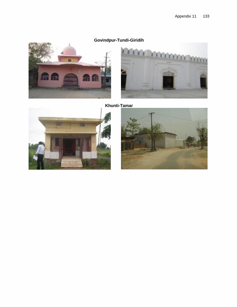
Appendix 11 133
Govindpur-Tundi-Giridih
Khunti-Tamar
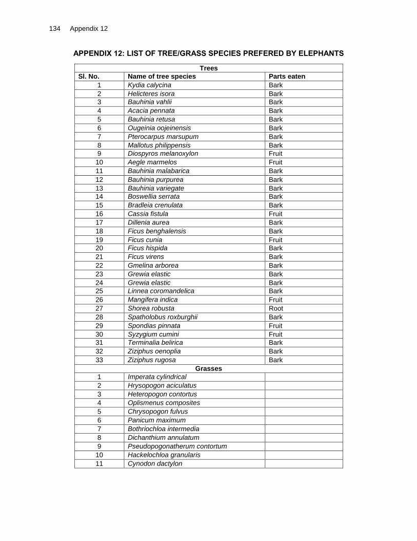
134 Appendix 12
APPENDIX 12: LIST OF TREE/GRASS SPECIES PREFERED BY ELEPHANTS
Trees
Sl. No. Name of tree species Parts eaten
1 Kydia calycina Bark
2 Helicteres isora Bark
3 Bauhinia vahlii Bark
4 Acacia pennata Bark
5 Bauhinia retusa Bark
6 Ougeinia oojeinensis Bark
7 Pterocarpus marsupum Bark
8 Mallotus philippensis Bark
9 Diospyros melanoxylon Fruit
10 Aegle marmelos Fruit
11 Bauhinia malabarica Bark
12 Bauhinia purpurea Bark
13 Bauhinia variegate Bark
14 Boswellia serrata Bark
15 Bradleia crenulata Bark
16 Cassia fistula Fruit
17 Dillenia aurea Bark
18 Ficus benghalensis Bark
19 Ficus cunia Fruit
20 Ficus hispida Bark
21 Ficus virens Bark
22 Gmelina arborea Bark
23 Grewia elastic Bark
24 Grewia elastic Bark
25 Linnea coromandelica Bark
26 Mangifera indica Fruit
27 Shorea robusta Root
28 Spatholobus roxburghii Bark
29 Spondias pinnata Fruit
30 Syzygium cumini Fruit
31 Terminalia belirica Bark
32 Ziziphus oenoplia Bark
33 Ziziphus rugosa Bark
Grasses
1 Imperata cylindrical
2 Hrysopogon aciculatus
3 Heteropogon contortus
4 Oplismenus composites
5 Chrysopogon fulvus
6 Panicum maximum
7 Bothriochloa intermedia
8 Dichanthium annulatum
9 Pseudopogonatherum contortum
10 Hackelochloa granularis
11 Cynodon dactylon

Appendix 13 135
APPENDIX 13: ENVIRONMENTAL MANAGEMENT PLAN FOR DUMKA-HANSDIHA ROAD
Environmental Issue/Component
Remedial Measure
Reference to laws/guideline
Location Monitoring indicators (MI)/ Performance Target (PT)
Monitoring Methods
Mitigation Costs
Institutional Responsibility
Implementation
Supervision
A. Design and Pre-construction Stage
1. Alignment
1.1 Pavement damage and inadequate drainage provisions in habitat areas
Soaked CBR value of sub grade is recommended to be 12 %.
Overloading to be checked
Raised embankment and provision of roadside drainage to prevent damage to pavement due to water logging on the road and also inconvenience caused to
Provision of adequate no. of cross drainage structures.
Increase (vent and height) in waterway of existing structures.
Roadside drains have been proposed with suitable outfalls.
Additional 19 culverts proposed
Design requirement
Entire stretch Embankment raised at 12 locations for a length of 4.33 km (Refer Appendix 4) Roadside drains (both sides together) Covered=28.106 km Lined=46.246 km Unlined=12.734 km For list of bridges with increased waterway Pls refer Appendix 3.
MI: Design and number of cross and side drains, slab/box culverts, and Hume pipes PT: Design and numbers are in accordance with site needs
Review of detail design documents & drawings and comparison with site conditions
Covered under costs for DPR consultants and PPTA consultants
Design Consultant
SHAJ

136 Appendix 13
Environmental Issue/Component
Remedial Measure
Reference to laws/guideline
Location Monitoring indicators (MI)/ Performance Target (PT)
Monitoring Methods
Mitigation Costs
Institutional Responsibility
Implementation
Supervision
1.2 Safety along the proposed alignment
Provision of crash barriers at accident prone areas and high embankments.
Rumble strips in habitat areas, schools, junction and curves to regulate speed.
Provision of retro-reflective warning signboards near school, hospital ,religious places and forests
Provision of sidewalks in the built-up sections, on both sides.
Signs and marking viz., cat’s eyes, delineators, object markers, hazard markers, safety barriers at hazardous locations, pedestrian guardrails, etc
Design requirement IRC:SP:84-2014 IRC:8, IRC:25, IRC:26, IRC:35, IRC:67, IRC:103 and Section 800 of MoRTH Specifications Horizontal geometry will be based on IRC: 38-1988 and vertical geometry will be based on IRC: SP 23-1993 “. IRC: SP: 67-2012
At embankment, height >3.0 m total length = 5.29 km Rumble strip = 40 locations ( 27 built-up areas, 1 school, 12 junctions) Total 854 road delineators/chevron/object markers Pedestrian Guard Rails=7.1 km Service Road for 7.1 km length at 13.800 to 14.800, 26.150 to 27.700 41.500 to 45.500 Total no. of street lights=534
MI: number and location of crash barriers, rumble strips, warning sign boards, sidewalks PT: numbers and location are in accordance with site needs :
Review of design documents and drawings and comparison with site conditions
Covered under costs for DPR consultants and PPTA consultants
Design Consultant
SHAJ
Pedestrian cross-walks at all Junctions and where conflict exists between vehicular and pedestrian movements (bus bays, schools and habitation.
Safety kerb at all bridge s
Service roads in densely habitated areas
Horizontal and vertical geometry as per IRC Specification
Zebra crossing with informatory warning sign on approach to school, warning sign with footways and speed limit sign
Street Lighting in built-up sections
Ambulance and medical aid posts
2. Natural Hazards

Appendix 13 137
Environmental Issue/Component
Remedial Measure
Reference to laws/guideline
Location Monitoring indicators (MI)/ Performance Target (PT)
Monitoring Methods
Mitigation Costs
Institutional Responsibility
Implementation
Supervision
2.2 Flooding/Water-Logging
Provision of adequate number of CD structures. Additional culverts have been proposed.
All CD structures designed for 50year HFL return period and bridges designed for 100 year HFL return period
Water ways of bridges and culverts have been increased.
Roadside drains also provided
Embankment height raised along low lying/ potential water logged areas
Improvement in existing culverts/ Bridges to increase their carrying capacity.
IRC:34 Recommendations for road construction in waterlogged area and IRC: 75 and MORT&H guidelines for Design of High Embankments
Entire stretch. Embankment raised at 12 locations for a length of 4.33 km (Refer Appendix 4) Roadside drains (both sides together) Covered=28.106 km Lined=46.246 km Unlined=12.734 km For list of bridges with increased waterway Refer Appendix 3)
MI: Design and numbers of cross & side drains, slab/box culverts Hume pipes, road embankment height, design and number of bridges PT: Design and numbers are in accordance with site needs
Review of design documents and drawings and comparison with site conditions
Covered under costs for DPR consultants and PPTA consultants
SHAJ
3. Loss of Land and Assets
3.1 livelihood loss to affected persons
Road improvement work to be accommodated within available ROW to the extent possible.
Social Impact Assessment and Resettlement Plan to be undertaken as per national policy and ADB’ guidelines.
Complete all necessary land and property acquisition procedures prior to the commencement of civil work.
Adhere to the Land Acquisition procedures in accordance to RP’s Entitlement Framework.
Compensation and assistance as per project Resettlement Plan
Income restoration as per RP
Preference in employment and petty
The Right to Fair Compensation and Transparency in Land Acquisition, Rehabilitation And Resettlement Act, 2013 and ADB’s involuntary resettlement policy. Contract Clause for preference to local people during employment.
Throughout the corridor
MI: Payment of compensation and assistance to DPs as per RP Number of complaints/grievances related to compensation and resettlement PT: Minimal number of complaints/grievances. All cases of resettlement and rehabilitation if any are
Check LA records; design drawings vs land plans; Interview with affected persons Check status of employment given to local people during construction
Part of administrative and resettlement costs
SHAJ and implementing NGO
SHAJ

138 Appendix 13
Environmental Issue/Component
Remedial Measure
Reference to laws/guideline
Location Monitoring indicators (MI)/ Performance Target (PT)
Monitoring Methods
Mitigation Costs
Institutional Responsibility
Implementation
Supervision
contracts during construction to APs
Constitute GRC as per RP
resolved at GRC level. No case referred to arbitrator/court.
4. Diversion of Forest Land and Cutting of Trees
4.1 Need for cutting of trees.
Geometric adjustments made to minimize tree cutting.
Obtain tree cutting permission from forest department
Provision for mandatory compensatory afforestation (1:2) for deposit of payment to Forestry Department
Provision for additional compensatory plantation on 1: 2 basis to be implemented by contractor through village Joint Forest Management (JFM) Committee
Forest Conservation Act, 1980
Throughout the corridor Total number of affected trees=2457 Additional Plantation near sensitive receptors, river banks, borrow areas
MI: Number and location of geometric adjustments made to avoid forestland and tree cutting, budget amount allocated for compensatory afforestation and additional plantation PT: Unnecessary tree felling on forest land avoided. Budget allocation is adequate,
Review final design. Check budget provision for compensatory afforestation and additional plantation.
Covered under costs for DPR consultants and PPTA consultants
SHAJ, Design consultants forest department
SHAH/Forest department
5. Elephant Movement

Appendix 13 139
Environmental Issue/Component
Remedial Measure
Reference to laws/guideline
Location Monitoring indicators (MI)/ Performance Target (PT)
Monitoring Methods
Mitigation Costs
Institutional Responsibility
Implementation
Supervision
5.1 Road design causing disruption in elephant movement/ Vehicle- Elephant collision and Human-Elephant Conflict
Provision for rumble strip, cautionary sign boards for speed limits up to 30 Kmph on both sides with gentle side slope and turfing for easy movement of Elephant.
Provision for solar Street Lights in communities near elephant crossing areas to keep the elephants away
Provision for supply of solar dragon light to local Joint Forest Management Committees in villages near elephant crossing areas for use to chase away elephants
Provision for habitat enhancement viz. plantation of fodder plants in forest areas, through Joint Forest Management (JFM).
Provision for additional conservation measures to be taken after elephant study that will be conducted by the CSC Wildlife Specialist.
Project Requirement
Sirsanath gate near Barapalasi, bridge near Amarpur-Segatola, Loha bridge near Bhandaro and LakraDwani; No of Solar lights=40 Rumble Strips =8 Informatory sign boards=8 Cautionary Sign boards=8
MI: budget allocation for rumble strips, cautionary and informatory sign boards, solar street lamps, solar dragon lamps, habitat enhancement and conservation activities
PT: Budget amount is enough to fulfill the installation and construction of recommended facilities and structures
Review of bid documents and project budget
plan
Covered under costs for DPR consultants and PPTA consultants
SHAJ, Design Consultant
SHAJ/CSC in coordination with Forest Department
6. Shifting of Utilities
3.1 Disruption of utility services to local community
All telephone and electrical poles/wires and underground cables should be shifted before start of construction
Necessary permission and payments should be made to relevant utility service agencies to allow quick shifting and restoration of utility services
Local people must be informed through appropriate means about the time of shifting of utility structures and potential disruption of services if any
Project requirement
Throughout the corridor
MI: Number of complaints from local people, number, timing and type of notifications issued to local people, time taken to shift utilities PT: No. of complaints should be 0. Effective and timely notification. Minimal time for utility shifting
Interaction with concerned utility authorities and local public
Included under SHAJ’s costs
Contractor/ SHAJ/utility company
SHAJ /CSC
B. Construction Stage

140 Appendix 13
Environmental Issue/Component
Remedial Measure
Reference to laws/guideline
Location Monitoring indicators (MI)/ Performance Target (PT)
Monitoring Methods
Mitigation Costs
Institutional Responsibility
Implementation
Supervision
1. Air Quality
1.1 Dust Generation due to construction activities and transport, storage and handling of construction materials
Contractor to submit location and layout plan for storage areas of construction materials approved by CSC
Transport, loading and unloading of loose and fine materials through covered vehicles.
Paved approach roads.
Storage areas to be located downwind of the habitation area.
Water spraying on earthworks, unpaved haulage roads and other dust prone areas.
Provision of PPEs to workers.
MORT&H Specifications for Road and Bridge works Air (P and CP) Act 1974 and Central Motor and Vehicle Act 1988 General Conditions of Bid Document
Throughout project corridor
MI: PM10 level measurements Complaints from locals due to dust PT: PM10 level < 100 ug/m
3Number of
complaints should be 0.
Standards CPCB methods Observations Public consultation Review of monitoring data maintained by contractor
Included in civil works cost
Contractor
SHAJ /CSC
1.2 Emission of air pollutants (HC,SO2,NOX,CO etc)
from vehicles due to traffic congestion and use of equipment and machinery
Regular maintenance of machinery and equipment.
Batching, asphalt mixing plants and crushers at downwind (1km) direction from the nearest settlement.
Only crushers licensed by the PCB shall be used
DG sets with stacks of adequate height and use of low sulphur diesel as fuel.
LPG should be used as fuel source in construction camps instead of wood
Ambient air quality monitoring Contractor to prepare traffic
management and dust suppression plan duly approved by SHAJ
The Air (Prevention and Control of Pollution) Act, 1981 (Amended 1987) and Rules 1982
Asphalt mixing plants, crushers, DG sets locations
MI: Levels of HC, SO2, NO2, and CO. Status of PUC certificates PT: SO2 and NO2 levels are both less than 80ug/m
3. PUC
certificate of equipment and machinery is upto date
Standards CPCB methods Review of monitoring data maintained by contractor
Included in civil works cost
Contractor
SHAJ /CSC
2. Noise
2.1 Disturbance to local residents and sensitive receptors due to excessive noise from construction activities and operation of equipment and machinery
All equipment to be timely serviced and properly maintained.
Construction equipment and machinery to be fitted with silencers and maintained properly.
Only IS approved equipment shall be used for construction activities.
Timing of noisy construction activities shall be done during night time and weekend near schools,
Implement noisy operations intermittently to reduce the total
Legal requirement Noise Pollution (Regulation and Control) Rules, 2000 and amendments thereof + Clause No 501.8.6. MORT&H Specifications for Road and Bridge
Throughout project section especially at construction sites, residential and identified sensitive locations. Refer Table 21 of IEE for information on sensitive receptors.
MI: day and night Noise levels. Number of complaints from local people PT: Zero complaints or no repeated complaints by local people. Average day and
As per Noise rule, 2000 Consultation with local people Review of noise level monitoring data maintained by contractor Observation of
Included in civil works costs
Contractor SHAJ /CSC

Appendix 13 141
Environmental Issue/Component
Remedial Measure
Reference to laws/guideline
Location Monitoring indicators (MI)/ Performance Target (PT)
Monitoring Methods
Mitigation Costs
Institutional Responsibility
Implementation
Supervision
noise generated
Manage existing traffic to avoid traffic jams and accumulation of noise beyond standards.
Restrict construction near residential, built up and forest areas construction today light hours.
Initiation of multi-layered plantation, to serve as mitigation option for operation phase
Honking restrictions near sensitive areas
PPEs to workers
Noise monitoring as per EMoP.
works
night time noise levels are within permissible limits for work zone areas
construction site
3. Land and Soil
3.1 Landuse Change and Loss of productive / topsoil
Non-agricultural areas to be used as borrow areas to the extent possible.
If using agricultural land, top soil to be preserved and laid over either on the embankment slope for growing vegetation to protect soil erosion.
Land for temporary facilities like construction camp, storage areas etc. shall be brought back to its original landuse
Project requirement
Throughout the project section and borrow areas Land identified for camp, storage areas etc.
MI: Borrow pit locations/Top soil storage area PT: Zero complaints or disputes registered against contractor by land owner
Review borrow area plan, site visits
Included in civil works cost
Contractor
SHAJ /CSC
3.2 Slope failure and Soil erosion due to Construction activities, earthwork, and cut and fill, stockpiles etc.
Bio-turfing of embankments to protect slopes.
Slope protection by providing frames, dry stone pitching, masonry retaining walls, planting of grass and trees.
Side slopes of all cut and fill areas will be graded and covered with stone pitching, grass and shrub as per design specifications. Care should be taken that the slope gradient shall not be greater than2:1.
The earth stockpiles to be provided with gentle slopes to soil erosion.
IRC: 56 -1974 recommended practice for treatment of embankment slopes for erosion control Clause No. 306 and 305.2.2 MORT&H Specifications for Road and Bridge works Guidelines IX for Soil erosion
Throughout the entire project road
MI: Occurrence of slope failure or erosion issues PT: No slope failures. Minimal erosion issues
Review of design documents and site observation
Included in civil works cost
Design consultant and Contractor,
SHAJ /CSC

142 Appendix 13
Environmental Issue/Component
Remedial Measure
Reference to laws/guideline
Location Monitoring indicators (MI)/ Performance Target (PT)
Monitoring Methods
Mitigation Costs
Institutional Responsibility
Implementation
Supervision
3.3 Borrow area management
Obtain EC from SEIAA before opening any new borrow area.
Comply to EC conditions of SEIAA
Non-productive, barren lands, upland shall be used for borrowing earth with the necessary permissions/consents.
Depths of borrow pits to be regulated and sides not steeper than 25%.
Topsoil to be stockpiled and protected for use at the rehabilitation stage.
Transportation of earth materials through covered vehicles.
Follow IRC recommended practice for borrow pits (IRC 10: 1961) for identification of location, its operation and rehabilitation
Borrow areas not to be dug continuously.
To the extent borrow areas shall be sited away from habitated areas.
Borrow areas shall be leveled with salvaged material or other filling materials which do not pose contamination of soil. Else, it shall be converted into fish pond.
IRC Guidelines on borrow areas and for quarries (Environmental protection Act and Rules, 1986; Water Act, Air Act)+Clause 305.2.2 MORTH Specifications for Road and Bridgeworks Guidelines for Borrow Areas management
Borrow sites location
MI: Existence of borrow areas in inappropriate unauthorized locations. Poor borrow area management practices. Number of accidents. Complaints from local people. PT: No case of non-compliance to conditions stipulated by SEIAA in clearance letter. Zero accidents. Zero complaints.
Review of design documents and site observations Compare site conditions with EC conditions by SEIAA
Included in civil works cost
Contractor
SHAJ /CSC
3.4 Quarry Operations Aggregates will be sourced from existing licensed quarries.
Copies of consent/ approval / rehabilitation plan for a new quarry or use of existing source will be submitted to SHAJ.
The contractor will develop a Quarry Redevelopment plan, as per the Mining Rules of the state and submit a copy of the approval to EA.
Obtain environmental clearance from SEIAA in case of opening new quarry
Clause No.111.3 MORT&H Specifications for Road and Bridge works Guidelines VI for Quarry Areas Management Environmental Protection Rules
Quarry area locations
MI: Existence of licenses quarry areas from which materials to be sourced and Existence of a quarry redevelopment plan PT: Quarry license is valid.: No case of non-compliance to consent conditions and air quality meets the prescribed limit
Review of design documents, contractor documents and site observation Compliance to EC conditions in case of opening new quarries
Included in civil works cost
Contractor
SHAJ /CSC

Appendix 13 143
Environmental Issue/Component
Remedial Measure
Reference to laws/guideline
Location Monitoring indicators (MI)/ Performance Target (PT)
Monitoring Methods
Mitigation Costs
Institutional Responsibility
Implementation
Supervision
3.5 Compaction of soil and impact on quarry haul roads due to movement of vehicles and equipment
Construction vehicles, machinery, and equipment to be stationed in the designated ROW to avoid compaction.
Approach roads/haulage roads shall be designed along the barren and hard soil area to reduce the compaction.
Transportation of quarry material to the dumping site through heavy vehicles shall be done through existing major roads to the extent possible to restrict wear andtear to the village/minor roads.
Land taken for construction camp and other temporary facility shall be restored to its original conditions
Design requirement
Parking areas, Haulage roads and construction yards.
MI: Location of approach and haulage roads Presence of destroyed/compacted agricultural land or land which has not be restored to its original condition PT: Zero occurrence of destroyed/compacted land and undestroyed land
Site observation Included in civil works cost
Contractor
SHAJ /CSC
3.6 Contamination of soil due to leakage/ spillage of oil, bituminous and non bituminous debris generated from demolition and road construction
Construction vehicles and equipment will be maintained and refueled in such a fashion that oil/diesel spillage does not contaminate the soil.
Fuel storage and refueling sites to be kept away from drainage channels.
Unusable debris shall be dumped in ditches and low lying areas.
To avoid soil contamination Oil-Interceptors shall be provided at wash down and refueling areas.
Waste oil and oil soaked cotton/ cloth shall be stored in containers labeled ‘Waste Oil’ and ‘Hazardous’ sold off to MoEF/SPCB authorized vendors
Non-bituminous wastes to be dumped in borrow pits with the concurrence of landowner and covered with a layer of topsoil conserved from opening the pit.
Bituminous wastes will be disposed off in an identified dumping site approved by the State Pollution Control Board
Design requirement
Fuelling station,constructionsites, andconstructioncampsanddisposallocation.
MI: Quality of soil near storage area Presence of spilled oil or bitumen in project area PT: Soil test conforming to no –contamination. No sighting of spilled oil or bitumen in construction site or camp site
Site observation Included in civil work cost.
Contractor
SHAJ /CSC

144 Appendix 13
Environmental Issue/Component
Remedial Measure
Reference to laws/guideline
Location Monitoring indicators (MI)/ Performance Target (PT)
Monitoring Methods
Mitigation Costs
Institutional Responsibility
Implementation
Supervision
4. Water Resources
4.1 Sourcing of water during Construction
Requisite permission shall be obtained for abstraction of groundwater fromCentral Groundwater Authority.
Arrangements shall be made by contractor that the water availability and supply to nearby communities remain unaffected.
Water intensive activities not to be undertaken during summer season.
Provision of water harvesting structure to augment groundwater condition in the area
CGWA Guidelines
Throughout the Project section Check Dam at suitable locations
MI: Approval from competent authority Complaints from local people on water availability PT: Valid approval from competent authority. Zero complaints from local people.
Checking of documentation Talk to local people
Included incivil workscost
Contractor
SHAJ /CSC
4.2 Disposal of water during construction
Provisions shall be made to connect road side drains with existing nearby natural drains.
Clause No.1010 EP Act 1986 MORT&H Specifications for Road and Bridgeworks
Throughout the Project section
MI: Condition of drainage system in construction site.Presence/absence of water logging in project area. PT: Existence of proper drainage system. No water logging in project area
Standards methods Site observation and review of documents
Included incivil workscost
Contractor
SHAJ /CSC
4.3 Alteration in surface water hydrology
Existing drainage system to be maintained andfurther enhanced.
Provision shall be made for adequate size and number of cross drainage structures esp. in the areas where land is sloping towards road alignment.
Road level shall be raised above HFL level wherever road level is lesser than HFL.
Culverts reconstruction shall be done during lean flow period. In some cases these minor channels may be diverted for a very short period (15-30 days) and will be bring back to its original course immediately after construction.
Design requirement, ClauseNo 501.8.6. MORT&H Specifications for Road and Bridge
Near all drainage channels, river/ nallah crossings etc.
MI: Proper flow of water in existing streams and rivers PT: No complain of water shortage by downstream communities. No record of overtopping/ water logging
Review of design documents Site observation
Included incivil workscost
Contractor
SHAJ /CSC

Appendix 13 145
Environmental Issue/Component
Remedial Measure
Reference to laws/guideline
Location Monitoring indicators (MI)/ Performance Target (PT)
Monitoring Methods
Mitigation Costs
Institutional Responsibility
Implementation
Supervision
4.4 Siltation in water bodies due to construction activities /earthwork
Embankment slopes to be modified suitably to restrict the soil debris entering water bodies.
Provision of Silt fencing shall be made at water bodies.
Silt/sediment should be collected and stockpiled for possible reuse as surfacing of slopes where they have to be re-vegetated.
Earthworks and stone works to be prevented from impeding natural flow of rivers, streams and water canals or existing drainage system.
Retaining walls at water bodies /ponds to avoid siltation near ponds
Design requirement, ClauseNo501.8.6.MORT&H
Specifications forRoadandBridgeworks
Worldwidebestpractices
Near all water bodies /waterway Refer Table 15. Retaining wall=250m
MI: Presence /absence of siltation in rivers, streams, ponds and other water bodies in project area. Turbidity test levels PT: No records of siltation due to project activities. Surface water quality tests confirm to turbidity and TSS limit
Field observation Included incivil works cost
Contractor
SHAJ /CSC
4.5 Deterioration in Surface water quality due to leakage from vehicles and equipments and waste from construction camps.
No vehicles or equipment should be parked or refueled near water-bodies, so as to avoid contamination from fuel and lubricants.
Oil and grease traps and fuelling platforms to be provided at re-fuelling locations.
All chemicals and oil shall be stored away from water and concreted platform with catchment pit for spills collection.
All equipment operators, drivers, and warehouse personnel will be trained in immediate response for spill containment and eventual clean-up. Readily available, simple to understand and preferably written in the local language emergency response procedure, including reporting, will be provided by the contractors.
Construction camp to be sited away from water bodies.
Wastes must be collected, stored and taken to approve disposal site only.
Water quality shall be monitored
The Water (Prevention and Control of Pollution) Act, 1974 and amendments thereof.
Water bodies, refueling stations, construction camps.
MI: Water quality of ponds, streams, rivers and other water bodies in project
Presence of oil floating in water bodies in project area
PT: Surface water quality meets freshwater quality standards prescribed by CPCB
Conduction of water quality tests as per the monitoring plan Field observation
Included in civil works cost
Contractor
SHAJ /CSC

146 Appendix 13
Environmental Issue/Component
Remedial Measure
Reference to laws/guideline
Location Monitoring indicators (MI)/ Performance Target (PT)
Monitoring Methods
Mitigation Costs
Institutional Responsibility
Implementation
Supervision
5. Flora and Fauna
5.1 Vegetation loss due to site preparation and construction activities
Restrict tree cutting upto toe line considering safety to road users.
Roadside trees to be removed with prior approval of competent authority.
Mandatory compensatory plantation at 1:2 basis by Forestry Department
Additional compensatory plantation 1:2 as per the IRC by contractor in partnership with respective village JFM Committee. Local villagers to be employed for afforestation activities. Employment preference to women
Regular maintenance trees planted.
Provision of LPG in construction camp as fuel source to avoid tree cutting.
Plantation of trees on both sides of the road where technically feasible. Trees should be offset 1m back from the ultimate edge of the roadway to prevent safety hazard and provide adequate sight distance.
Integrate vegetation management (IVM) with the carriage way completely clear of vegetation.
Additional plantation near sensitive receptors, river banks to minimize noise & air pollution, and to check erosion.
Controlled use of pesticides/ fertilizers
Forest Conservation Act1980 + IRC:SP:21 and IRC:SP:66
Throughout project corridor Estimated No. of affected tree=2457 Additional Plantation near Sensitive receptors, river banks, borrow areas
MI: ROW width Number of trees for felling Compensatory plantation plan Number of trees replanted. PT: Additional compensatory afforestation done on a 1:2 basis by contractor through JFM. Number of trees planted is double the number of trees removed. Tree survival rate is at least 70%.
Review of relevant documents – tree cutting permit, compensatory plantation plan. Meeting with JFM Committee members Field observations
Mandatory Compensatory afforestation cost is included in project costs under SHAJ. Additional compensatory afforestation costs included in civil works costs
Mandatory Compensatory plantation by forest Department and Additional plantation by contractor in partnership with respective local JFM Committee
SHAJ /CSC
6. Construction Camps
6.1 Impact associated with location
All camps should be established with prior permission from PCB. Camps to maintain minimum distance from following: # 500 m from habitation # 500 m from forest areas where possible # 500 m from water bodies where possible # 500 m from through traffic route # 500 m from identified elephant movement locations
Design Requirement The Water (Prevention and Control of Pollution) Act,1974and its amendments thereof
All construction camps
MI: Location of campsites and distance from habitation, forest areas, water bodies, through traffic route and construction camps PT: Distance of campsite is less than 500m from listed locations
On site observation
Interaction with workers and local community
Included incivil works cost
Contractor and EO
SHAJ /CSC

Appendix 13 147
Environmental Issue/Component
Remedial Measure
Reference to laws/guideline
Location Monitoring indicators (MI)/ Performance Target (PT)
Monitoring Methods
Mitigation Costs
Institutional Responsibility
Implementation
Supervision
6.2 Worker’s Health in construction camp
The location, layout and basic facility provision of each labor camp will be submitted to CSC and approved b EA. The contractor will maintain necessary living accommodation and ancillary facilities in hygienic manner.
Adequate water and sanitary latrines with septic tanks with soak pits shall be provided.
Preventive medical facilities in camp
Waste disposal facilities such as dust bins must be provided in the camps and regular disposal of waste The Contractor will take all precautions to protect the workers from insect and pest to reduce the risk to health. This includes the use of insecticides which should comply with local regulations.
No liquor or prohibited drugs will be imported to, sell, give and barter to the workers of host community.
Awareness raising to immigrant workers/local community on communicable and sexually transmitted diseases.
The Building and Other Construction workers (Regulation of Employment and Conditions of service) Act 1996 and The Water (Prevention and Control of Pollution) Act,1974 and amendments thereof
All construction camps
MI: Camp health records Existence of proper first aid kit in camp site Complaints from workers. PT: No record of illness due to unhygienic conditions or vectors. Zero cases of STD. Clean and tidy camp site conditions.
Camp records Site observation Consultation with contractor workers and local people living nearby
Part of the civil works costs
Contractor
SHAJ /CSC
7. Management of Construction Waste/Debris 7.1 Selection of
Dumping Sites
Contractor to submit a waste/spoil disposal plan and get it approved by CSC and EA.
Create controlled dumping sites with a non-permeable lining incorporated in the pit design to avoid leachate seepage into the soil, which may later affect ground water quality
Unproductive/wastelands shall be selected for dumping sites away from residential areas and water bodies
Dumping sites must be having adequate capacity equal to the amount of debris generated.
Public perception and consent from the village Panchayats has to be obtained before finalizing the location.
Design Requirement, MORT&H guidelines and General Conditions of Contract Document
At all Dumping/Disposal Sites
MI: Location of dumping sites Number of public complaints. PT: No public complaints. Consent letters for all dumping sites available with contractor
Field survey and interaction with local people. Review of consent letter
Included in civil works cost.
Contractor.
SHAJ /CSC

148 Appendix 13
Environmental Issue/Component
Remedial Measure
Reference to laws/guideline
Location Monitoring indicators (MI)/ Performance Target (PT)
Monitoring Methods
Mitigation Costs
Institutional Responsibility
Implementation
Supervision
7.2 Reuse and disposal of construction and dismantled waste
The existing bitumen surface shall be utilized for paving of cross roads, access roads, and paving works in construction sites and camps, temporary traffic diversions, and haulage routes.
All excavated materials from roadway, shoulders, verges, drains, cross drainage will be used for backfilling embankments, filling pits, and landscaping.
Unusable and non-bituminous debris materials should be suitably disposed off at pre-designated disposal locations, with approval of the concerned authority.
The bituminous wastes shall be disposed in secure landfill sites only in environmentally accepted manner. For removal of debris, wastes and its disposal, MORTH guidelines should be followed.
Unusable and surplus materials, as determined by the Project Engineer, will be removed and disposed off-site.
Design Requirement, MORT&H guidelines and General Conditions of Contract Document
Throughout the project corridor
MI: Percentage of reuse of existing surface material
Method and location of disposal site of construction debris
PT: No public
complaint and
consent letters for
all dumping sites
available with
contractor or CSC
Contractor records
Field observation
Interaction with local people
Included in civil works cost.
8. Traffic Management and Safety
8.1 Management of existing traffic and safety
Traffic Management Plan shall be submitted by the contractor and approved by the CSC.
The traffic control plans shall contain details of diversions; traffic safety arrangements during construction; safety measures for night time traffic and precautions for transportation of hazardous materials. Timing and scheduling to be done so that transportation of dangerous goods is done during least number of people and other vehicles on the road.
The Contractor will ensure that the diversion/detour is always maintained in running condition, particularly during the monsoon to avoid disruption to traffic flow.
Design requirement and IRC: SP: 27 -1984, Report Containing Recommendation of IRC Regional Workshops on Highway Safety IRC:SP: 32 -1988 Road Safety for Children (5-12 Years Old) in Construction Zones IRC:SP:55-2014
Throughout the project corridor especially at intersections.
MI: Traffic management plan. Presence/ absence of safety signs, traffic demarcations, flag men etc. on site. Complaints from road users. No of accidents PT: No complaints. No accidents due to poor traffic management. Traffic signs, demarcation lines etc. present in appropriate locations on site
Review traffic management plan Field observation of traffic management and safety system
Interaction with people in vehicles using the road
Included in civil works cost.
Contractor
SHAJ /CSC

Appendix 13 149
Environmental Issue/Component
Remedial Measure
Reference to laws/guideline
Location Monitoring indicators (MI)/ Performance Target (PT)
Monitoring Methods
Mitigation Costs
Institutional Responsibility
Implementation
Supervision
On stretches where it is not possible to pass the traffic on the part width of existing carriageway, temporary paved diversions will be constructed.
Restriction of construction activity to only one side of the existing road
The contractor shall inform local community of changes to traffic routes, and pedestrian access arrangements with assistance from “Engineer”.
Use of adequate signage’s to ensure traffic management and safety. Conduct of regular safety audit on safety measures.
The Building and other Construction workers Act 1996 and Cess Act of 1996 Factories Act 1948+Section 6 of Employer’s Requirement of Bid Document
8.2 Pedestrians, animal movement
Temporary access and diversion, with proper drainage facilities.
Access to the schools, temples and other public places must be maintained when construction takes place near them.
Fencing wherever cattle movement is expected.
Large number of box culverts has been proposed. .All structures having vertical clearance above 3m and not catering to perennial flow of water may serve as underpass for animals
Same as above Near habitation on both sides of schools, temples, hospitals, graveyards, construction sites, haulage roads, diversion sites.
MI: Presence/ absence of access routes for pedestrians. Road signage Number of complaints from local people PT: Easy access to schools, temples and public places. Zero complaints
Field observation Interaction with local people
Included in civil works cost.
Contractor SHAJ /CSC

150 Appendix 13
Environmental Issue/Component
Remedial Measure
Reference to laws/guideline
Location Monitoring indicators (MI)/ Performance Target (PT)
Monitoring Methods
Mitigation Costs
Institutional Responsibility
Implementation
Supervision
8.3 Safety of Workers and accident risk from construction activities
Contractors to adopt and maintain safe working practices.
Usage of fluorescent and retro refectory signage, in local language at the construction sites
Training to workers on safety procedures and precautions.
Mandatory appointment of safety officer.
All regulations regarding safe scaffolding, ladders, working platforms, gangway, stair wells, excavations, trenches and safe means of entry and egress shall be complied with.
Provision of PPEs to workers.
Provision of a readily available first aid unit including an adequate supply of dressing materials.
The contractor will not employ any person below the age of 18years
Use of hazardous material should be minimized and/or restricted.
Emergency plan (to be approved by engineer) shall be prepared to respond to any accidents or emergencies.
Accident Prevention Officer must be appointed by the contractor.
Same as above Construction sites MI: Availability of Safety gears to workers Safety signage Training records on safety Number of safety related accidents PT: Zero fatal accidents. Zero or minor non-fatal accidents.
Site observation Review records on safety training and accidents Interact with construction workers
Included in civil works cost
Obligation of Contractor
SHAJ /CSC
8.4 Accident risk to local community
Restrict access to construction sites only to authorized personnel.
Physical separation must be provided for movement of vehicular and human traffic.
Adequate signage must be provided for safe trafficmovement
Provision of temporary diversions and awareness to locals before opening new construction fronts.
Same as above Construction sites MI: Safety signs and their location Incidents of accidents Complaints from local people PT: Zero incident of accidents. Zero complaints.
Site inspection Consultation with local people
Included in civil works cost
Contractor SHAJ /CSC

Appendix 13 151
Environmental Issue/Component
Remedial Measure
Reference to laws/guideline
Location Monitoring indicators (MI)/ Performance Target (PT)
Monitoring Methods
Mitigation Costs
Institutional Responsibility
Implementation
Supervision
9. 9. Site restoration and rehabilitation
9.1 Clean-up Operations, Restoration and Rehabilitation
Contractor will prepare site restoration plans, which will be approved by the ‘Engineer’.
The clean-up and restoration operations are to be implemented by the contractor prior to demobilization.
All construction zones including river-beds, culverts, road-side areas, camps, hot mix plant sites, crushers, batching plant sites and any other area used/affected by the project will be left clean and tidy, to the satisfaction of the Environmental officer.
All the opened borrow areas will be rehabilitated and ‘Engineer’ will certify
Project requirement
Throughout the project corridor, construction camp sites and borrow areas
MI: Condition of camp, borrow areas and construction sites, Presence/ absence of construction material/debris after completion of construction works on site. PT: Clean and tidy sites. No trash or debris left on site. Site restored and leveled.
Site observation Interaction with locals Issue completion certificate after restoration of all sites are found satisfactory
Included in civil works cost.
Contractor
SHAJ /CSC
C. Operation and Maintenance stage
1. 1. Elephant Movement
1.1 Anticipated risk of vehicle-elephant collision and human-animal conflict
Effectiveness of mitigative measures (rumble strips, informatory /cautionary signage, solar street lighting, solar dragon lights etc.) recommended in design stage shall be monitored.
Effectiveness of habitat enhancement measures shall be evaluated
SHAJ to keep record of all accidents.
If it is observed after the study that elephants establish a defined movement path and cross the road at specific locations, provision of civil structure shall be made in consultation with forest department.
Fresh assessment in case of future widening
Project Requirement
At identified elephant crossing locations
MI: No. of vehicle - elephant collision. Time (day or night, season/month and location of collision. Cause of collision. No of incidence of human – elephant conflict. PT: Zero vehicle - elephant collisions. Reduced number of human-elephant conflicts. Improvement in elephant habitat coverage and quality
Site Observation Discussion with local People Collection of information from Forestry Department
Included in Operation / Maintenance cost
SHAJ field offices/Forest Department

152 Appendix 13
Environmental Issue/Component
Remedial Measure
Reference to laws/guideline
Location Monitoring indicators (MI)/ Performance Target (PT)
Monitoring Methods
Mitigation Costs
Institutional Responsibility
Implementation
Supervision
2. 2. Air Quality
2.1 Air pollution due to due to vehicular movement
Roadside tree plantations shall be maintained at least with 70% survival rate.
Regular maintenance of the road will be done to ensure good surface condition
Ambient airqualitymonitoring. If monitored parameters exceeds prescribed limit, suitable control measures must be taken.
Signages shall be provided reminding them to properly maintain their vehicles to economize on fuelconsumption.
Enforcement of vehicle emission rules in coordination with transport department or installing emission checking equipments
Environmental Protection Act, 1986; The Air (Prevention and Control of Pollution) Act, 1981
Throughout the Corridor
MI: Ambient air quality (PM10, CO,SO2 NO2) PT: Levels are equal to or below baseline levels given in the IEE report
As per CPCB requirements Site inspection
Included in Operation / Maintenance cost
SHAJ
3. 3. Noise
3.1 Noise due to movement of traffic
Effective traffic management and good riding conditions shall be maintained
Speed limitation to 20 km/hour and honking restrictions near sensitive receptors and elephant movement areas
Construction of noise barriers near sensitive receptors with consent of local community
The effectiveness of the multilayered plantation should be monitored and if need be, solid noise barrier shall be placed.
Create awareness amongst the residents about likely noise levels from road operation at different distances, the safe ambient noise limits and easy to implement noise reduction measures while constructing a building near road.
Noise Pollution (Regulation and Control) Rules,2000 and amendments thereof
Sensitive receptors as identified in IEE locations.
MI: Noise levels PT: Levels are equal to or below baseline levels given in the IEE report
Noise monitoring as per noise rules ,2000 Discussion with people at sensitive receptor sites
Included in Operation / Maintenance cost
SHAJ

Appendix 13 153
Environmental Issue/Component
Remedial Measure
Reference to laws/guideline
Location Monitoring indicators (MI)/ Performance Target (PT)
Monitoring Methods
Mitigation Costs
Institutional Responsibility
Implementation
Supervision
4. Land and Soil
4.1 Soil erosion at embankment during heavy rainfall.
Periodic checking to be carried to assess the effectiveness of the stabilization measures viz. turfing, stone pitching, river training structures etc.
Necessary measures to be followed wherever there are failures
Project requirement
At bridge locations and embankment slopes and other probable soil erosion areas.
MI: Existence of soil erosion sites Number of soil erosion sites PT: Zero or minimal occurrences of soil erosion
On site observation
Included in Operation / Maintenance cost
SHAJ
5. Water resources/Flooding and Inundation
5.1 Siltation
Regular checks shall be made for soil erosion and turfing conditions of river training structures for its effective maintenance.
Project requirement
Near surface Water bodies
MI: Water quality PT: No turbidity of surface water bodies due to the road
Site observation Included in Operation / Maintenance cost
SHAJ
5.2 Water logging due to blockage of drains, culverts or streams
Regular visual checks and cleaning (at least once before monsoon) of drains to ensure that flow of water is maintained through cross drains and other channels/streams.
Monitoring of water borne diseases due to stagnant water bodies
Project requirement IRC: SP:21-2009
Near surface Water bodies/cross drains/side drains
MI: Presence/ absence of water logging along the road
PT: No record of overtopping/ Water logging
Site observation Included in Operation / Maintenance cost
SHAJ
6. Flora
6.1 Vegetation
Planted trees, shrubs, and grasses to be properly maintained.
The tree survival audit to be conducted at least once in a year to assess the effectiveness
Forest Conservation Act 1980
Project tree plantation sites
MI: Tree/plants survival rate PT: Minimum rate of 70% tree survival
Records and field observations. Information from Forestry Department
Included in Operation / Maintenance cost
SHAJ/JFM/Forest Department
7. Maintenance of Right of Way and Safety
7.1 Accident Risk due to uncontrolled growth of vegetation
Maintain shoulder completely clear of vegetation.
Minimum offset as prescribed in IRC:SP:21-2009 to be maintained
Regular maintenance/trimming of plantation along the road side
No invasive plantation near the road.
Project requirement IRC: SP:21-2009
Throughout the Project route
MI: Presence and extent of vegetation growth on either side of road. Number of accidents. PT: No accidents due to vegetation growth
Visual inspection Check accident records
Included in Operation / Maintenance cost
SHAJ

154 Appendix 13
Environmental Issue/Component
Remedial Measure
Reference to laws/guideline
Location Monitoring indicators (MI)/ Performance Target (PT)
Monitoring Methods
Mitigation Costs
Institutional Responsibility
Implementation
Supervision
7.2 Accident risks associated with traffic movement.
Traffic control measures, including speed limits, will be enforced strictly.
Further encroachment of squatters within the ROW will be prevented.
No school or hospital will be allowed to be established beyond the stipulated planning line as per relevant local law
Monitor/ensure that all safety provisions included in design and construction phase are properly maintained
Highway patrol unit(s) for round the clock patrolling. Phone booth for accidental reporting and ambulance services with minimum response time for rescue of any accident victims, if possible.
Tow-way facility for the breakdown vehicles if possible.
IRC:SP:55-2014
Throughout the Project route
MI: Number of accidents Conditions and existence of safety signs, rumble strips etc. on the road Presence/absence of sensitive receptor structures inside the stipulated planning line as per relevant local law PT: Fatal and non fatal accident rate is reduced after improvement
Review accident records Site observations
Included in Operation / Maintenance cost
SHAJ
7.3.Transport of Dangerous Goods
Existence of spill prevention and control and emergency responsive system
Emergency plan for vehicles carrying hazardous material
- Throughout the project stretch
MI: Status of emergency system – whether operational or not PT: Fully functional emergency system
Review of spill prevention and emergency response plan Spill accident records
Included in Operation / Maintenance cost
SHAJ
EA: Executing Agency, SHAJ: State Highways Authority of Jharkhand, EO: Environmental Officer, IRC: Indian Road Congress, CSC: Construction Supervision Consultant, JFM: Joint Forest Management Committee, CPCB: Central Pollution Control Board,
The “Project engineer” or “the engineer” is the team of Construction Supervision Consultants (CSC) responsible for approving the plans, engineering drawing,
release of payments to contractor etc. on behalf of the employer (SHAJ). It is usually the team leader of the CSC that takes the responsibility of signing approval
documents on behalf of the CSC team. The “environmental officer” is the environmental specialist under the CSC who is respons ible for providing
recommendations to the CSC team leader for approving activities specific to environment safeguards on behalf of “the engineer
JFM Committee’s exist at the village level. Each JFM committee has 15 members of which 3 to 5 members are mandated to be women. The member secretary
of each committee is the local Forester or Beat Officer who oversees the accounts and activities of the JFM committee. Respec tive JFM committee’s will be
identified and confirmed by the contractor under the guidance of the Environmental Specialist of the CSC during construction.

Appendix 14 155
APPENDIX14: ENVIRONMENTAL MANAGEMENT PLAN FOR PACHAMBA-JAMUA-SARWAN ROAD
Environmental Issue/Component
Remedial Measure
Reference to laws/guideline
Location Monitoring indicators (MI)/ Performance Target (PT)
Monitoring Methods
Mitigation Costs
Institutional Responsibility
Implementation
Supervision
A. Pre-construction and Design Stage
1. Alignment
1.1 Pavement damage and inadequate drainage provisions in habitat areas
Soaked CBR value of sub grade is recommended to be 12 %.
Overloading to be checked
Raised embankment and provision of roadside drainage to prevent damage to pavement due to water logging on the road and also inconvenience caused to
Adequate no. of cross drainage structures.
Increase (vent and height) in waterway of existing structures.
Roadside drains have been proposed with suitable outfalls.
Additional 19 culverts have been proposed
Design requirement
Entire stretch Embankment raised at 18 locations for a length of 5.785 km ( Appendix 4) Roadside drains (both sides together) Covered=24.766 km unlined=65.534 km For list of bridges with increased waterway Pls refer Appendix 3
MI: Design and number of cross and side drains, slab/box culverts, and Hume pipes PT: Design and numbers are in accordance with site needs
Review of detail design documents & drawings and comparison with site conditions
Covered under costs for DPR consultants and PPTA consultants
Design Consultant
SHAJ
1.2 Safety along the proposed alignment
Provision of crash barriers at accident prone areas and high embankments.
Rumble strips in habitat areas, schools, junction and curves to regulate speed.
Provision of retro-reflective warning sign boards near school, hospital, religious places and forests
Provision of sidewalks in the built-up sections, on both sides.
Signs and marking viz., cat’s eyes, delineators, object markers, hazard markers, safety barriers at hazardous locations, pedestrian guardrails, etc
Design requirement IRC:SP:84-2014 IRC:8, IRC:25, IRC:26, IRC:35, IRC:67, IRC:103 and Section 800 of MoRTH Specifications Horizontal geometry will be based on IRC: 38-1988 and vertical geometry will be based on IRC: SP 23-1993 “.
At embankment height >3.0 m total length = 1.76 km Rumble strip = 14 locations ( 13 built-up areas, 1 junction) Signs and marking viz., cat’s eyes, delineators, object markers, hazard markers, safety barriers at hazardous locations, pedestrian guardrails, etc Total 507 road delineators/chevron/object markers Length of Guard Rails=4.280 km
MI: number and location of crash barriers, rumble strips, warning sign boards, sidewalks PT: numbers and location are in accordance with site needs :
Review of design documents and drawings and comparison with site conditions
Covered under costs for DPR consultants and PPTA consultants
Design Consultant
SHAJ

156 Appendix 14
Environmental Issue/Component
Remedial Measure
Reference to laws/guideline
Location Monitoring indicators (MI)/ Performance Target (PT)
Monitoring Methods
Mitigation Costs
Institutional Responsibility
Implementation
Supervision
Pedestrian cross-walks at all Junctions and where conflict exists between vehicular and pedestrian movements (bus bays, schools and habitation.
Safety kerb at all bridge s
Service roads in densely habitated areas
Horizontal and vertical geometry as per IRC Specification
Zebra crossing withinformatory warning sign on approach to school, warning sign with footways and speed limit sign
Street Lighting in built-up sections
Ambulance and medical aid posts
IRC: SP: 67-2012 Total no. of street lights=704
2. Natural Hazards
2.2 Flooding / Water-Logging
Provision of adequate number of CD structures. Additional culverts have been proposed.
All CD structures designed for 50yr return period with anticipated risk of rarer flood of next higher frequency i.e. 100 yr return period flood on the designed structure
Water ways of bridges and culverts have been increased.
Roadside drains also provided
Embankment height raised along low lying/ l water logged areas
Improvement in existing culverts/ Bridges to increase their carrying capacity.
IRC:34 Recommendations for road construction in waterlogged area and IRC: 75 and MORT&H guidelines for Design of High Embankments
Embankment raised at 18 locations for a length of 5.785 km (Refer Appendix 4) and for list of bridges with increased waterway Pls refer Appendix 3.
MI: Design and numbers of cross & side drains, slab/box culverts Hume pipes, road embankment height, design and number of bridges PT: Design and numbers are in accordance with site needs
Review of design documents and drawings and comparison with site conditions
Covered under costs for DPR consultants and PPTA consultants
Design Consultant
SHAJ

Appendix 14 157
Environmental Issue/Component
Remedial Measure
Reference to laws/guideline
Location Monitoring indicators (MI)/ Performance Target (PT)
Monitoring Methods
Mitigation Costs
Institutional Responsibility
Implementation
Supervision
3. Loss of Land and Assets
3.1 livelihood loss to affected persons
Road improvement work to be accommodated within available ROW to the extent possible.
Social Impact Assessment and Resettlement Plan to be undertaken as per national policy and ADB’ guidelines.
Complete all necessary land and property acquisition procedures prior to the commencement of civil work.
Adhere to the Land Acquisition procedures in accordance to RP’s Entitlement Framework.
Compensation and assistance as per project Resettlement Plan
Income restoration as per RP
Preference in employment and petty contracts during construction to APs
Constitute GRC as per RP
The Right to Fair Compensation and Transparency in Land Acquisition, Rehabilitation And Resettlement Act, 2013. and ADB’s involuntary resettlement policy. Contract Clause for preference to local people during employment.
Throughout the corridor
MI: Payment of compensation and assistance as per RP Number of complaints/grievances related to compensation and resettlement PT: Minimal No. of complaints /grievances. All cases of resettlement and rehabilitation if any are resolved at GRC level. No case referred to arbitrator or court.
Check LA records; design drawings vs land plans; Interview with affected persons Check status of employment given to local people during construction
Part of administrative and resettlement costs
SHAJ and implementing NGO
SHAJ
4. Diversion of Forest Land and Cutting of Trees
4.1 Need for cutting of trees.
Geometric adjustments made to minimize tree cutting.
Obtain tree cutting permission from forest department
Provision for mandatory compensatory afforestation (1:2) for deposit of payment to Forestry Department
Provision for additional compensatory plantation on 1: 2 basis to be implemented by contractor through village Joint Forest Management (JFM) Committee
Forest Conservation Act, 1980
Throughout the corridor Total number of affected trees=1344 Diversion of Forest Land=1.354 Ha Forest land=1.354 ha
MI: Number and location of geometric adjustments made to avoid forestland and tree cutting, budget amount allocated for compensatory afforestation and additional plantation PT: Unnecessary tree felling on forest land avoided. Budget allocation is adequate,
Review final design. Check budget provision for compensatory afforestation and additional plantation.
Covered under costs for DPR consultants and PPTA consultants
SHAJ, Design consultants forest department
SHAH/Forest department

158 Appendix 14
Environmental Issue/Component
Remedial Measure
Reference to laws/guideline
Location Monitoring indicators (MI)/ Performance Target (PT)
Monitoring Methods
Mitigation Costs
Institutional Responsibility
Implementation
Supervision
5. Shifting of Utilities
5.1 Disruption of utility services to local community
All telephone and electrical poles/wires and underground cables should be shifted before start of construction
Necessary permission and payments should be made to relevant utility service agencies to allow quick shifting and restoration of utility services
Local people must be informed through appropriate means about the time of shifting of utility structures and potential disruption of services if any
Project requirement
Throughout the corridor
MI: Number of complaints from local people, number, timing and type of notifications issued to local people, time taken to shift utilities PT: No. of complaints should be 0. Effective and timely notification. Minimal time for utility shifting
Interaction with concerned utility authorities and local public
Included under SHAJ’s costs
Contractor/ SHAJ
SHAJ /CSC
B. Construction Stage
1. Air Quality
1.1 Dust Generation due to construction activities and transport, storage and handling of construction materials
Contractor to submit location and layout plan for storage areas and get approved by CSC
Transport, loading and unloading of loose and fine materials through covered vehicles.
Paved approach roads.
Storage areas to be located downwind of the habitation area.
Water spraying on earthworks, unpaved haulage roads and other dust prone areas.
Provision of PPEs to workers.
MORT&H Specifications for Road and Bridge works ,Air (P and CP) Act 1974 and Central Motor and Vehicle Act 1988 General Conditions of Bid Document
Throughout project corridor
MI: PM10 level measurements Complaints from locals due to dust PT: PM10 level< 100 ug/m
3
Number of complaints should be 0.
Standards CPCB methods Observations Public consultation Review of monitoring data maintained by contractor
Included in civil works cost
Contractor
SHAJ /CSC
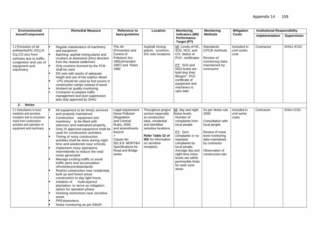
Appendix 14 159
Environmental Issue/Component
Remedial Measure
Reference to laws/guideline
Location Monitoring indicators (MI)/ Performance Target (PT)
Monitoring Methods
Mitigation Costs
Institutional Responsibility
Implementation
Supervision
1.2 Emission of air pollutants(HC,SO2,N
OX,CO etc) from
vehicles due to traffic congestion and use of equipment and machinery
Regular maintenance of machinery and equipment.
Batching, asphalt mixing plants and crushers at downwind (1km) direction from the nearest settlement.
Only crushers licensed by the PCB shall be used
DG sets with stacks of adequate height and use of low sulphur diesel
LPG should be used as fuel source in construction camps instead of wood
Ambient air quality monitoring Contractor to prepare traffic
management and dust suppression plan duly approved by SHAJ
The Air (Prevention and Control of Pollution) Act, 1981(Amended 1987) and Rules 1982
Asphalt mixing plants, crushers, DG sets locations
MI: Levels of HC, SO2, NO2, and CO. Status of PUC certificates PT: SO2 and NO2 levels are both less than 80ug/m
3. PUC
certificate of equipment and machinery is upto date
Standards CPCB methods Review of monitoring data maintained by contractor
Included in civil works cost
Contractor
SHAJ /CSC
2. Noise
2.1 Disturbance to local residents and sensitive receptors due to excessive noise from construction activities and operation of equipment and machinery
All equipment to be timely serviced and properly maintained.
Construction equipment and machinery to be fitted with silencers and maintained properly.
Only IS approved equipment shall be used for construction activities.
Timing of noisy construction activities shall be done during night time and weekends near schools,
Implement noisy operations intermittently to reduce the total noise generated
Manage existing traffic to avoid traffic jams and accumulation ofnoisebeyondstandards.
Restrict construction near residential, built up and forest areas construction to day light hours.
Initiation of multi-layered plantation, to serve as mitigation option for operation phase
Honking restrictions near sensitive areas
PPEstoworkers
Noise monitoring as per EMoP.
Legal requirement Noise Pollution (Regulation and Control) Rules, 2000 and amendments thereof + Clause No 501.8.6. MORT&H Specifications for Road and Bridge works
Throughout project section especially at construction sites, residential and identified sensitive locations. Refer Table 22 of IEE for information on sensitive receptors.
MI: day and night Noise levels. Number of complaints from local people PT: Zero complaints or no repeated complaints by local people. Average day and night time noise levels are within permissible limits for work zone areas
As per Noise rule, 2000 Consultation with local people Review of noise level monitoring data maintained by contractor Observation of construction site
Included in civil works costs
Contractor SHAJ /CSC

160 Appendix 14
Environmental Issue/Component
Remedial Measure
Reference to laws/guideline
Location Monitoring indicators (MI)/ Performance Target (PT)
Monitoring Methods
Mitigation Costs
Institutional Responsibility
Implementation
Supervision
3. Land and Soil
3.1 Landuse Change and Loss of productive/topsoil
Non-agricultural areas to be used as borrow areas to the extent possible.
If using agricultural land, top soil to be preserved and laid over either on the embankment slope for growing vegetation to protect soil erosion.
Land for temporary facilities like construction camp, storage areas etc. shall be brought back to its original landuse
Project requirement
Throughout the project section and borrow areas Land identified for camp, storage areas etc.
MI: Borrow pit locations Top soil storage area PT: Zero complaints or disputes registered against contractor by land owner
Review borrow area plan, site visits
Included in civil works cost
Contractor
SHAJ /CSC
3.2 Slope failure and Soil erosion due to Construction activities, earthwork, and cut and fill, stockpiles etc.
Bio-turfing of embankments to protect slopes.
Slope protection by providing Frames, dry stone pitching, masonry retaining walls, planting of grass and trees.
Side slopes of all cut and fill areas will be graded and covered with stone pitching, grass and shrub as per design specifications. Care should be taken that the slope gradient shall not be greater than 2:1.
The earth stockpiles to be provided with gentle slopes to soil erosion.
IRC: 56 -1974 recommended practice for treatment of embankment slopes for erosion control Clause No. 306 and 305.2.2 MORT&H Specifications for Road and Bridge works Guidelines IX for Soil erosion
Throughout the entire project road especially along hilly areas
MI: Occurrence of slope failure or erosion issues PT: No slope failures. Minimal erosion issues
Review of design documents and site observation
Included in civil works cost
Design consultant and Contractor,
SHAJ /CSC
3.3 Quarry Operations Aggregates will be sourced from existing licensed quarries.
Copies of consent/ approval / rehabilitation plan for a new quarry or use of existing source will be submitted to SHAJ.
The contractor will develop a Quarry Redevelopment plan, as per the Mining Rules of the state and submit a copy of the approval to EA.
Obtain environmental clearance from SEIAA in case of opening new quarry
Clause No.111.3 MORT&H Specifications for Road and Bridge works Guidelines VI for Quarry Areas Management Environmental Protection Rules
Quarry area locations
MI: Existence of licenses for all quarry areas from which materials are being sourced Existence of a quarry redevelopment plan PT: Quarry license is valid.: air quality meets the prescribed limit
Review of design documents, contractor documents and site observation Compliance to EC conditions in case of opening new quarries
Included in civil works cost
Contractor
SHAJ /CSC
Appendix 14 161
Environmental Issue/Component
Remedial Measure
Reference to laws/guideline
Location Monitoring indicators (MI)/ Performance Target (PT)
Monitoring Methods
Mitigation Costs
Institutional Responsibility
Implementation
Supervision
3.4 Borrow area management
Obtain EC from SEIAA before opening any new borrow area.
Comply to EC conditions
Non-productive, barren lands, upland shall be used for borrowing earth with the necessary permissions/consents.
Depths of borrow pits to be regulated and sides not steeper than 25%.
Topsoil to be stockpiled and protected for use at the rehabilitation stage.
Transportation of earth materials through covered vehicles.
Follow IRC recommended practice for borrow pits (IRC 10: 1961) for identification of location, its operation and rehabilitation
Borrow areas not to be dug continuously.
To the extent borrow areas shall be sited away from habitated areas. Borrow areas shall be leveled with salvaged material or other filling materials which do not pose contamination of soil. Else, it shall be converted into fishpond.
IRC Guidelines on borrow areas and for quarries (Environmental protection Act and Rules, 1986;Water Act, Air Act) +Clause 305.2.2MORTH Specifications for Road and Bridge works Guidelines for Borrow Areas management
Borrow sites location
MI: Existence of borrow areas in inappropriate unauthorized locations. Poor borrow area management practices. Number of accidents. Complaints from local people. PT: No case of non-compliance to conditions stipulated by SEIAA in clearance letter. Zero accidents. Zero complaints.
Review of design documents and site observations Compare site conditions with EC conditions by SEIAA
Included in civil works cost
Design consultant and Contractor,
SHAJ /CSC
3.5 Compaction of soil and impact on quarry haul roads due to movement of vehicles and equipment
Construction vehicles, machinery, and equipment to be stationed in the designated ROW to avoid compaction.
Approach roads/haulage roads shall be designed along the barren and hard soil area to reduce the compaction.
Transportation of quarry material to the dumping site through heavy vehicles shall be done through existing major roads to the extent possible to restrict wear and tear to the village/minor roads.
Land taken for construction campand other temporary facility shall be restored to its original conditions.
Land taken for construction camp and other temporary facility shall be restored to its original conditions.
Design requirement
Parking areas, Haulage roads and construction yards.
MI: Location of approach and haulage roads Presence of destroyed/compacted agricultural land or land which has not be restored to its original condition PT: Zero occurrence of destroyed/compacted land and undestroyed land
Site observation Included in civil works cost
Contractor
SHAJ /CSC

162 Appendix 14
Environmental Issue/Component
Remedial Measure
Reference to laws/guideline
Location Monitoring indicators (MI)/ Performance Target (PT)
Monitoring Methods
Mitigation Costs
Institutional Responsibility
Implementation
Supervision
3.6 Contamination of soil due to leakage/ spillage of oil, bituminous and non bituminous debris generated from demolition and road construction
Construction vehicles and equipment will be maintained and refueled in such a fashion that oil/diesel spillage does not contaminate the soil.
Fuel storage and refueling sites to be kept away from drainage channels.
Unusable debris shall be dumped in ditches and low lying areas.
To avoid soil contamination Oil-Interceptors shall be provided at wash down and refueling areas.
Waste oil and oil soaked cotton/ cloth shall be stored in containers labeled ‘Waste Oil’ and ‘Hazardous’ sold off to MoEF/SPCB authorized vendors
Non-bituminous wastes to be dumped in borrow pits with the concurrence of landowner and covered with a layer of topsoil conserved from opening the pit.
Bituminous wastes will be disposed off in an identified dumping site approved by the State Pollution Control Board
Land taken for construction camp and other temporary facility shall be restored to its original conditions
Design requirement
Fuelling station, construction sites, and construction camps and disposal location.
MI: Quality of soil near storage area Presence of spilled oil or bitumen in project area PT: Soil test conforming to no –contamination. No sighting of spilled oil or bitumen in construction site or camp site
Site observation Included in civil works cost.
Contractor
SHAJ /CSC
4. Water Resources
4.1 Sourcing of water during Construction
Requisite permission shall be obtained for abstraction of groundwater fromCentral Groundwater Authority.
Arrangements shall be made by contractor that the water availability and supply to nearby communities remain unaffected.
Water intensive activities not to be undertaken during summer season.
Provision of water harvesting structure to augment groundwater condition in the area
CGWA Guidelines
Throughout the Project section Check Dam at suitable locations
MI: Approval from competent authority Complaints from local people on water availability PT: Valid approval from competent authority. Zero complaints from local people.
Checking of documentation Talk to local people
Included incivil workscost
Contractor
SHAJ /CSC
Appendix 14 163
Environmental Issue/Component
Remedial Measure
Reference to laws/guideline
Location Monitoring indicators (MI)/ Performance Target (PT)
Monitoring Methods
Mitigation Costs
Institutional Responsibility
Implementation
Supervision
4.2 Disposal of water during construction
Provisions shall be made to connect road side drains with existing nearby natural drains.
ClauseNo.1010 EPAct1986 MORT&H Specifications for Road and Bridge works
Throughout the Project section
MI: Condition of drainage system Presence/absence of water logging in project area. PT: Existence of proper drainage system. No water logging in project area
Standards methods Site observation and review of documents
Included incivil works cost
Contractor
SHAJ /CSC
4.3 Alteration in surface water hydrology
Existing drainage system to be maintained andfurther enhanced.
Provision shall be made for adequate size and number of cross drainage structures esp. in the areas where land is sloping towards road
Road level shall be raised above HFL level wherever road level is lesser than HFL.
Culverts reconstruction shall be done during lean flow. In some cases these minor channels may be diverted for a very short period (15-30 days) and will be bring back to its original course immediately after construction.
Design requirement, ClauseNo 501.8.6. MORT&H Specifications for Road and Bridge
Near all drainage channels, river/nallah crossings etc.
MI: Proper flow of water in existing streams and rivers PT: No complain of water shortage by downstream communities. No record of overtopping/ water logging
Review of design documents Site observation
Included in civil works cost
Contractor
SHAJ /CSC
4.4 Siltation in water bodies due to construction activities / earthwork
Embankment slopes to be modified suitably to restrict the soil debris entering water bodies.
Provision of Silt fencing shall be made at water bodies.
Silt/sediment should be collected and stockpiled for possible reuse as surfacing of slopes where they have to be re-vegetated.
Earthworks and stone works to be prevented from impeding natural flow of rivers, streams and water canals or existing drainage system.
Retaining walls at water bodies /ponds to avoid siltation near ponds
Design requirement, Clause No 501.8.6. MORT&H Specifications for Road and Bridge works Worldwide best practices
Near all water bodies /waterway Refer Table 15. Retaining wall=140m
MI: Presence /absence of siltation in rivers, streams, ponds and other water bodies in project area. Turbidity test levels PT: No records of siltation due to project activities. Surface water quality tests confirm to turbidity and TSS limit
Field observation Included in civil works cost
Contractor
SHAJ /CSC

164 Appendix 14
Environmental Issue/Component
Remedial Measure
Reference to laws/guideline
Location Monitoring indicators (MI)/ Performance Target (PT)
Monitoring Methods
Mitigation Costs
Institutional Responsibility
Implementation
Supervision
4.5 Deterioration in Surface water quality due to leakage from vehicles and equipments and waste from construction camps.
No vehicles or equipment should be parked or refueled near water-bodies, so as to avoid contamination from fuel and lubricants.
Oil and grease traps and fuelling platforms to be provided at re-fuelling locations.
All chemicals and oil shall be stored away from water and concreted platform with catchment pit for spills collection.
All equipment operators, drivers, and warehouse personnel will be trained in immediate response for spill containment and eventual clean-up. Readily available, simple to understand and preferably written in the local language emergency response procedure, including reporting, will be provided by the contractors
The Water (Prevention and Control of Pollution) Act, 1974 and amendments thereof.
Water bodies, refueling stations, construction camps.
MI: Water quality of ponds, streams, rivers and other water bodies in project
Presence of oil floating in water bodies in project area
PT: Surface water quality meets freshwater quality standards prescribed by CPCB
Conduction of water quality tests as per the monitoring plan Field observation
Included in civil works cost
Contractor
SHAJ /CSC
Construction camp to be sited away from water bodies.
Wastes must be collected, stored and taken to approve disposal site only.
Water quality shall be monitored
5. Flora and Fauna
5.1 Vegetation loss due to site preparation and construction activities and
Restrict tree cutting upto toe line considering safety to road users.
Roadside trees to be removed with prior approval of competent authority.
Mandatory compensatory plantation at 1:2 basis to be done by Forestry Department
Additional compensatory plantation 1:2 as per the IRC guidelines to be carried out by contractor in partnership with respective village JFM Committee. Local villagers to be employed for afforestation activities. Employment preference to be given to women
Forest Conservation Act1980 + IRC SP:21 and IRC SP:66
Throughout project corridor Estimated No. of affected tree=1344 Additional Plantation near Sensitive receptors, river banks, borrow areas
MI: ROW width Number of trees for felling Compensatory plantation plan Number of trees replanted. PT: Additional compensatory afforestation done on a 1:2 basis by contractor through JFM.
Review of relevant documents – tree cutting permit, compensatory plantation plan. Meeting with JFM Committee members Field observations
Mandatory Compensatory afforestation cost is included in project costs under SHAJ. Additional compensatory afforestation costs included in civil works costs
Compensatory plantation by forest Department and Additional plantation by contractor
SHAJ /CSC

Appendix 14 165
Environmental Issue/Component
Remedial Measure
Reference to laws/guideline
Location Monitoring indicators (MI)/ Performance Target (PT)
Monitoring Methods
Mitigation Costs
Institutional Responsibility
Implementation
Supervision
Regular maintenance of all trees
Provision of LPG in construction camp as fuel source to avoid tree cutting.
Plantation of trees on both sides of the road where technically feasible. Trees should be offset 1m back from the ultimate edge of the roadway to prevent safety hazard and provide adequate sight distance.
Integrate vegetation management (IVM) with the carriage waycompletely clear of vegetation.
Additional plantation near sensit ive receptors, river banks to minimize noise, air pollution, and check erosion.
Controlled use of pesticides/ fertilizer
Number of trees planted is double the number of trees removed. Tree. Survival rate is at least 70%.
6. Construction Camps
6.1 Impact associated with location
All camps should be established with prior permission from PCB. Camps to maintain minimum distance from following: # 500 m from habitation # 500 m from forest areas where possible # 500 m from water bodies where possible # 500 m from through traffic route # 500 m from identified elephant movement locations
Design Requirement The Water (Prevention and Control of Pollution) Act,1974 and its amendments thereof
All construction camps
MI: Location of camp and distance from habitation, forest, water bodies, through traffic route and construction camps PT: Distance of campsite is less than 500m from listed locations
On site observation
Interaction with workers and local community
Included in civil works cost
Contractor and EO
SHAJ /CSC

166 Appendix 14
Environmental Issue/Component
Remedial Measure
Reference to laws/guideline
Location Monitoring indicators (MI)/ Performance Target (PT)
Monitoring Methods
Mitigation Costs
Institutional Responsibility
Implementation
Supervision
6.2 Worker’s Health in construction camp
The location, layout and basic facility of each labor camp will be submitted to CSC and approved b EA. The contractor will maintain necessary living accommodation and ancillary facilities in hygienic manner.
Adequate water and sanitary latrines with septic tanks with soak pits shall be provided.
Preventive medical facilities in camp.
Waste disposal facilities such as dust bins must be provided in the camps and regular disposal of waste must be carried out.
The Contractorwilltake all precautions to protect the workers from insect and pest to reduce the risk to health. This includes the use of insecticides which should comply with local regulations.
No liquor or prohibited drugs will be imported to, sell, give, and barter to the workers of host community.
Awareness raising to immigrant workers/local community on communicable and sexually transmitted diseases.
The Building and Other Construction workers (Regulation of Employment and Conditions of service) Act 1996 and The Water (Prevention and Control of Pollution) Act,1974 and amendments thereof
All construction camps
MI: Camp health records Existence of proper first aid kit in camp site Complaints from workers. Performance Standard: No record of illness due to unhygienic conditions or vectors. Zero cases of STD. Clean and tidy camp site conditions.
Camp records Site observation Consultation with contractor workers and local people living nearby
Part of the civil works costs
Contractor
SHAJ /CSC
7. Management of Construction Waste/Debris
7.1 Selection of Dumping Sites
Contractor to submit a waste/spoil disposal plan and get it approved by CSC and EA.
Create controlled dumping sites with a non-permeable lining incorporated in the pit design to avoid leachate seepage into the soil, which may later affect ground water quality.
Unproductive/wastelands shall be selected for dumping sites away from residential areas and water bodies
Dumping sites must be having adequate capacity equal to the amount of debris generated.
Public perception and consent from the village Panchayats has to be obtained before finalizing the location.
Design Requirement and MORT&H guidelines General Conditions of Contract Document
At all Dumping Sites
MI: Location of dumping sites Number of public complaints. PT: No public complaints. Consent letters for all dumping sites available with contractor
Field survey and interaction with local people. Review of consent letter
Included in civil works cost.
Contractor.
SHAJ /CSC

Appendix 14 167
Environmental Issue/Component
Remedial Measure
Reference to laws/guideline
Location Monitoring indicators (MI)/ Performance Target (PT)
Monitoring Methods
Mitigation Costs
Institutional Responsibility
Implementation
Supervision
7.2 Reuse and disposal of construction and dismantled waste
The existing bitumen surface shall be utilized for paving of cross roads, access roads, and paving works in construction sites and camps, temporary traffic diversions, and haulage routes.
All excavated materials from roadway, shoulders, verges, drains, cross drainage will be used for backfilling embankments, filling pits, and landscaping.
Unusable and non-bituminous debris materials should be suitably disposed off at pre-designated disposal locations, with approval of the concerned authority. The bituminous wastes shall be disposed in secure landfill sites only in environmentally accepted manner. For removal of debris, wastes and its disposal MOSRTH guidelines should be followed.
Unusable and surplus materials, as determined by the Project Engineer, will be removed and disposed off-site.
MORT&H guidelines
Throughout the project corridor
MI: Percentage of reuse of existing surface material Method and location of disposal site of construction debris PT: No public
complaint and
consent letters
for all dumping
sites available
with contractor or
CSC
Contractor records Field observation Interaction with local people Contractor records
Included in civil works cost.
Contractor.
SHAJ /CSC
8. Traffic Management and Safety
8.1 Management of existing traffic and safety
Traffic Management Plan shall be planned by the contractor and approved by the ‘Engineer’.
The traffic control plans shall contain details of diversions; traffic safety arrangements during construction; safety measures for night time traffic and precautions for transportation of hazardous materials. Timing and scheduling to be done so that transportation of dangerous goods is done during least number of people and other vehicles on the road. Traffic control plans shall be prepared in line with requirements of IRC’s SP 55 document’.
Design requirement and IRC: SP: 27 -1984,Report Containing Recommendation of IRC Regional Workshops on Highway Safety IRC:SP: 32 -1988 Road Safety for Children (5-12 Years Old) IRC:SP: 44 -1994 Highway Safety Code IRC: SP: 55 -2001Guidelines for Safety in Construction Zones The Building and other Construction workers Act 1996 and Cess Act of 1996 Factories Act 1948+Section 6 of Employer’s Requirement of Bid Document
Throughout the project corridor especially at intersections.
MI: Traffic management plan. Presence/ absence of safety signs, clear traffic demarcations, flag men etc. on site. Complaints from road users. Number of traffic accidents PT: No complaints. No accidents due to poor traffic management. Traffic signs, demarcation lines etc. present in appropriate locations on site
Review traffic management plan Field observation of traffic management and safety system Interaction with people in vehicles using the road
Included in civil works cost.
Contractor
SHAJ /CSC

168 Appendix 14
Environmental Issue/Component
Remedial Measure
Reference to laws/guideline
Location Monitoring indicators (MI)/ Performance Target (PT)
Monitoring Methods
Mitigation Costs
Institutional Responsibility
Implementation
Supervision
The Contractor will ensure that the diversion/detour is always maintained in running condition, particularly during the monsoon to avoid disruption to traffic flow of existing carriageway, temporary paved diversions will be constructed.
Restriction of construction activity to only one side of the existing road.
The contractor shall inform local community of changes to traffic routes, and pedestrian access arrangements with assistance from “Engineer”.
Use of adequate signages to ensure traffic management and safety. Conduct of regular safety audit
8.2 Pedestrians, animal movement
Temporary access and diversion, with proper drainage facilities.
Access to the schools, temples and other public places must be maintained when construction takes place near them.
Fencing wherever cattle movement is expected.
Large number of box culverts with has been proposed. .All structures having vertical clearance above 3m and not catering to perennial flow of water may serve as underpass for animals
Same as above Near habitation on both sides of schools, temples, hospitals, graveyards, construction sites, haulage roads, diversion sites.
MI: Presence/ absence of access routes for pedestrians. Road signage Number of complaints from local people PT: Easy access to schools, temples and public places. Zero complaints
Field observation Interaction with local people
Included incivil workscost.
Contractor SHAJ /CSC

Appendix 14 169
Environmental Issue/Component
Remedial Measure
Reference to laws/guideline
Location Monitoring indicators (MI)/ Performance Target (PT)
Monitoring Methods
Mitigation Costs
Institutional Responsibility
Implementation
Supervision
8.3 Safety of Workers and accident risk from construction activities
Contractors to adopt and maintain safe working practices.
Usage of fluorescent and retro refectory signage, in local language at the construction sites
Training to workers on safety procedures and precautions.
Mandatory appointment of safety officer.
All regulations regarding safe scaffolding, ladders, working platforms, gangway, stairwells, excavations, trenches and safe means of entry and egress shall be complied with.
Provision of PPEs to workers.
Provision of a readily available first aid unit including an adequate supply of dressing materials.
The contractor will not employ any person below the age of 18years
Use of hazardous materials should be minimized and/or restricted.
Emergency plan (to be approved by engineer) shall be prepared to respond to any accidents or emergencies.
Accident Prevention Officer must be appointed by the contractor.
Same as above Construction sites MI: Availability of Safety gears to workers Safety signage Training records on safety Number of safety related accidents PT: Zero fatal accidents. Zero or minor non-fatal accidents
Site observation Review records on safety training and accidents Interact with construction workers
Included in civil works cost
Obligation of Contractor
SHAJ /CSC
8.4 Accident risk to local community
Restrict access to construction sites only to authorized personnel.
Physical separation must be provided for movement of vehicular and human traffic.
Adequate signage must be provided for safe trafficmovement
Provision of temporary diversions and awareness to locals before opening new construction fronts.
Same as above Constructionsites MI: Safety signs and their location Incidents of accidents Complaints from local people PT: Zero incident of accidents. Zero complaints.
Site inspection Consultation with local people
Included in civil works cost
Contractor SHAJ /CSC

170 Appendix 14
Environmental Issue/Component
Remedial Measure
Reference to laws/guideline
Location Monitoring indicators (MI)/ Performance Target (PT)
Monitoring Methods
Mitigation Costs
Institutional Responsibility
Implementation
Supervision
9. 9. Site restoration and rehabilitation
9.1 Clean-up Operations, Restoration and Rehabilitation
Contractor will prepare site restoration plans, which will be approved by the ‘Engineer’.
The clean-up and restoration operations are to be implemented by the contractor prior to demobilization.
All construction zones including river-beds, culverts, road-side areas, camps, hot mix plant sites, crushers, batching plant sites and any other area used/affected by the project will be left clean and tidy, to the satisfaction of the Environmental officer.
All the opened borrow areas will be rehabilitated and ‘Engineer’ will certify
Project requirement
Throughout the project corridor, construction camp sites and borrow areas
MI: Condition of camp sites, construction sites and borrow areas. Presence/absence of construction material/debris after completion of construction works on construction site.
Site observation Interaction with locals Issue completion certificate after restoration of all sites are found satisfactory
Included in civil works cost.
Contractor
SHAJ /CSC
C. Operation and Maintenance stage
8. 1. Air Quality
1.1 Air pollution due to due to vehicular movement
Roadside tree plantations shall be maintained at least with 70% survival rate.
Regular maintenance of the road will be done to ensure good surface condition
Ambient airqualitymonitoring. Ifmonitoredparameters exceeds prescribedlimit,suitablecontrol measuresmustbetaken.
Signages shall be provided reminding them to properly maintain their vehicles to economize on fuel consumption.
Enforcement of vehicle emission rules in coordination with transport department or installing emission checking equipments
Environmental Protection Act, 1986; The Air (Prevention and Control of Pollution) Act, 1981
Throughout theCorridor
MI: Ambient air quality (PM10, CO,SO2 NO2) PT: Levels are equal to or below baseline levels given in the IEE report in IEE
As per CPCB requirements Site inspection
Included in Operation/ Maintenance cost
SHAJ

Appendix 14 171
Environmental Issue/Component
Remedial Measure
Reference to laws/guideline
Location Monitoring indicators (MI)/ Performance Target (PT)
Monitoring Methods
Mitigation Costs
Institutional Responsibility
Implementation
Supervision
9. 2. Noise
2.1 Noise due to movement of traffic
Effective traffic management and good riding conditions shall be maintained
Speed limitation to 20 km/hour and honking restrictions near sensitive receptors and elephant movement areas
Construction of noise barriers near sensitive receptors with consent of local community
The effectiveness of the multilayered plantation should be monitored and if need be, solid noise barrier shall be placed.
Create awareness amongst the residents about likely noise levels from road operation at different distances, the safe ambient noise limits and easy to implement noise reduction measures while constructing a building near road.
Noise Pollution (Regulation and Control) Rules,2000 and amendments thereof
Sensitive receptors as identified in IEE locations.
MI: Noise levels PT: Levels are equal to or below baseline levels given in the IEE report
Noise monitoring as per noise rules ,2000 Discussion with people at sensitive receptor sites
Included in Operation/ Maintenance cost
SHAJ
3. Land and Soil
3.1 Soil erosion at embankment during heavy rainfall.
Periodic checking to be carried to assess the effectiveness of the stabilization measures viz. turfing, stone pitching, river training structures etc.
Necessary measures to be followed wherever there are failures
Project requirement
At bridge locations and embankment slopes and other probable soil erosion areas.
MI: Existence of soil erosion sites Number of soil erosion sites PT: Zero or minimal occurrences of soil erosion
On site observation
Included in Operation/ Maintenance cost
SHAJ
4. Water resources/Flooding and Inundation
4.1 Siltation
Regular checks shall be made for soil erosion and turfing conditions of river training structures for its effective maintenance.
Project requirement
Near surface Water bodies
MI: Water quality PT: No turbidity of surface water bodies due to the road
Site observation Included in Operation/Maintenance cost
SHAJ

172 Appendix 14
Environmental Issue/Component
Remedial Measure
Reference to laws/guideline
Location Monitoring indicators (MI)/ Performance Target (PT)
Monitoring Methods
Mitigation Costs
Institutional Responsibility
Implementation
Supervision
4.2 Water logging due to blockage of drains, culverts or streams
Regular visual checks and cleaning (at least once before monsoon) of drains shall be done along the alignment to ensure that flow of water is maintained through cross drains and other channels/streams.
Monitoring of water borne diseases due to stagnant water bodies
Project requirement
Near surface Water bodies
MI: Presence/ absence of water logging along the road PT: No record of overtopping/ Water logging
Site observation Included in Operation/Maintenance cost
SHAJ
SHAJ will ensure that all drains (side drains and all cross drainages) are periodically cleared especially before monsoon season to facilitate the quick passage of rainwater and avoid flooding.
5. Flora 5.1 Vegetation
Planted trees, shrubs, and grasses to
be properly maintained. The tree survival audit to be
conducted at least once in a year to assess the effectiveness
Forest Conservation Act1980
Project tree plantation sites
Performance Standard: Minimum 70% tree survival
Records and fields observations
Operation/ Maintenance Cost
SHAJ/JFM/Forest Department
6. Maintenance of Right of Way and Safety
6.1 Accident Risk due to uncontrolled growth of vegetation
Efforts shall be made to make shoulder completely clear of vegetation.
Minimum offset as prescribed in IRC:SP:21-2009 to be maintained
Regular maintenance of plantation along the roadside
No invasiveplantation neartheroad.
Project requirement
Throughout the Project route
MI: Tree/plants survival rate PT: Minimum rate of 70% tree survival
Records and field observations. Information from Forestry Department
Included in operation/ Maintenance cost
SHAJ

Appendix 14 173
Environmental Issue/Component
Remedial Measure
Reference to laws/guideline
Location Monitoring indicators (MI)/ Performance Target (PT)
Monitoring Methods
Mitigation Costs
Institutional Responsibility
Implementation
Supervision
6.2 Accident risks associated with traffic movement.
Traffic control measures, including speed limits, will be enforced strictly.
Further encroachment of squatters within the ROW will be prevented.
No school or hospital will be allowed to be established beyond the stipulated planning line as per relevant local law
Monitor/ensure that all safety provisions included in design and construction phase are properly maintained
Highway patrol unit(s) for round the clock patrolling. Phone booth for accidental reporting and ambulance services with minimum response time for rescue of any accident victims, if possible.
Tow-way facility for the breakdown vehicles if possible.
IRC:SP:55
Throughout the Project route
MI: Number of accidents Conditions and existence of safety signs, rumble strips etc. on the road Presence/absence of sensitive receptor structures inside the stipulated planning line as per relevant local law PT: Fatal and non fatal accident rate is reduced after improvement.
Review accident records Site observations
Included in operation/Maintenance cost
SHAJ
6.3.Transport of Dangerous Goods
Existence of spill prevention and control and emergency responsive system
Emergency plan for vehicles carrying hazardous material
- Throughout the project stretch
MI: Status of emergency system – whether operational or not PT: Fully functional emergency system
Review of spill prevention and emergency response plan Spill accident records
Included in operation/Maintenance cost.
SHAJ
EA: ExecutingAgency, SHAJ:State Highways Authority of Jharkhand,EO: Environmental Officer, IRC:IndianRoadCongress, CSC: Construction Supervision Consultant, JFM: Joint Forest Management Committee, CPCB: Central Pollution Control Board,
The “Project engineer” or “the engineer” is the team of Construction Supervision Consultants (CSC) responsible for approving the plans, engineering drawing,
release of payments to contractor etc. on behalf of the employer (SHAJ). It is usually the team leader of the CSC that takes the responsibility of signing approval
documents on behalf of the CSC team. The “environmental officer” is the environmental specialist under the CSC who is respons ible for providing
recommendations to the CSC team leader for approving activities specific to environment safeguards on behalf of “the engineer
JFM Committee’s exist at the village level. Each JFM committee has 15 members of which 3 to 5 members are mandated to be women. The member secretary
of each committee is the local Forester or Beat Officer who oversees the accounts and activities of the JFM committee. Respective JFM comm ittee’s will be
identified and confirmed by the contractor under the guidance of the Environmental Specialist of the CSC during construction.

174 Appendix 15
APPENDIX15: ENVIRONMENTAL MANAGEMENT PLAN FOR GOVINDPUR-TUNDI-GIRIDIH ROAD
Environmental Issue/Component
Remedial Measure
Reference to laws/guideline
Location Monitoring Indicators (MI)/ Performance Target (PT)
Monitoring Methods
Mitigation Costs
Institutional Responsibility
Implementation
Supervision
A. Design and Pre-construction Stage
1. Alignment
1.1 Pavement damage and inadequate drainage provisions in habitat areas
Soaked CBR value of sub grade is recommended to be 12 %.
Overloading to be checked
Raised embankment and provision of roadside drainage to prevent damage to pavement due to water logging on the road and also inconvenience caused to
Adequate no. of cross drainage structures.
Increase (vent and height) in waterway of existing structures.
Roadside drains have been proposed with suitable outfalls.
Additional 19 culverts have been proposed
Design requirement
Embankment raised at 18 locations for a length of 3.700 km (Refer Appendix 4) Roadside drains (both sides together) Covered=4.6 km Unlined=82.5 km For list of bridges with increased waterway Pls refer Appendix 3
MI: Design and number of cross and side drains, slab/box culverts, and Hume pipes PT: Design and numbers are in accordance with site needs
Review of detail design documents & drawings and comparison with site conditions
Covered under costs for DPR consultants and PPTA consultants
Design Consultant
SHAJ
1.2 Safety along the proposed alignment
Provision of crash barriers at accident prone areas and high embankments.
Rumble strips in habitat areas, schools, junction and curves to regulate speed.
Provision of retro-reflective warning sign boards near school, hospital, religious places and forests
Provision of sidewalks in the built-up sections, on both sides.
Signs and marking viz., cat’s eyes, delineators, object markers, hazard markers, safety barriers at hazardous locations, pedestrian guardrails, etc
Design requirement IRC:SP:84-2014 IRC:8, IRC:25, IRC:26, IRC:35, IRC:67, IRC:103 and Section 800 of MoRTH Specifications Horizontal geometry will be based on IRC: 38-1988 and vertical geometry will be based on IRC: SP 23-1993 “.
At embankment height >3.0 m total length = 3.0 km Rumble strip = 31 locations ( 19 built-up areas, 8 school, 4 junctions) Total 1863 road delineators/chevron/object markers Length of Guard rails=3.155 Km Service Road for 1.4 km length at 42+400 to 43+800 on LHS
MI: number and location of crash barriers, rumble strips, warning sign boards, sidewalks PT: numbers and location are in accordance with site needs :
Review of design documents and drawings and comparison with site conditions
Covered under costs for DPR consultants and PPTA consultants
Design Consultant
SHAJ

Appendix 15 175
Environmental Issue/Component
Remedial Measure
Reference to laws/guideline
Location Monitoring Indicators (MI)/ Performance Target (PT)
Monitoring Methods
Mitigation Costs
Institutional Responsibility
Implementation
Supervision
Pedestrian crosswalks at all Junctions and where conflict exists between vehicular and pedestrian movements (bus bays, schools and habitation.
Safety kerb at all bridge s
Service roads in densely habitated areas
Horizontal and vertical geometry as per IRC Specification
Zebra crossing withinformatory warning sign on approach to school, warning sign with footways and speed limit sign
Street Lighting in built-up sections
Ambulance and medical aid posts
IRC: SP: 67-2012 Total no. of street lights=776
2. Natural Hazards
2.2 Flooding/Water-Logging
Provision of adequate number of CD structures. Additional culverts have been proposed.
All CD structures designed for 50yr return period with anticipated risk of rarer flood of next higher frequency i.e. 100 yr return period flood on the designed structure
Water ways of bridges and culverts have been increased.
Roadside drains also provided
Embankment height raised along low lying/ potential water logged areas
Improvement in existing culverts/ Bridges to increase their carrying capacity.
IRC:34 Recommendations for road construction in waterlogged area and IRC: 75 and MORT&H guidelines for Design of High Embankments
Entire stretch.
Embankment raised at 18 locations for a length of 3.700 km (Refer Appendix 4 Roadside drains (both sides together) Covered=4.6 km Unlined=82.5 km For list of bridges with increased waterway Pls Refer Appendix 3
MI: Design and numbers of cross & side drains, slab/box culverts Hume pipes, road embankment height, design and number of bridges PT: Design and numbers are in accordance with site needs
Review of design documents and drawings and comparison with site conditions
Covered under costs for DPR consultants and PPTA consultants
Design Consultant
SHAJ
3. Loss of Land and Assets
3.1 livelihood loss to affected persons
Road improvement work to be accommodated within available ROW to the extent possible.
Social Impact Assessment and Resettlement Plan to be undertaken as per national policy and ADB’
The Right to Fair Compensation and Transparency in Land Acquisition, Rehabilitation And Resettlement Act,
Throughoutthecorridor
MI: Payment of compensation and assistance to DPs as per RP
Check LA records; design drawings vs land plans; Interview with
Part of administrative and resettlement costs
SHAJ and implementing NGO
SHAJ

176 Appendix 15
Environmental Issue/Component
Remedial Measure
Reference to laws/guideline
Location Monitoring Indicators (MI)/ Performance Target (PT)
Monitoring Methods
Mitigation Costs
Institutional Responsibility
Implementation
Supervision
guidelines.
Complete all necessary land and property acquisition procedures prior to the commencement of civil work.
Adhere to the Land Acquisition procedures in accordance to RP’s Entitlement Framework.
Compensation and assistance as per project Resettlement Plan
Income restoration as per RP
Preference in employment and petty contracts during construction to APs
Constitute GRC as per RP
2013. and ADB’s involuntary resettlement policy. Contract Clause for preference to local people during employment.
Number of complaints/grievances related to compensation and resettlement PT: Minimal number of complaints/grievances. All cases of resettlement and rehabilitation if any are resolved at GRC level. No case referred to arbitrator or court.
affected persons Check status of employment given to local people during construction
4. Diversion of Forest Land and Cutting of Trees
4.1 Need for cutting of trees.
Geometric adjustments made to minimize tree cutting.
Obtain tree cutting permission from forest department
Provision for mandatory compensatory afforestation (1:2) for deposit of payment to Forestry Department
Provision for additional compensatory plantation on 1: 2 basis to be implemented by contractor through village Joint Forest Management (JFM) Committee
Forest Conservation Act, 1980
Throughout the corridor Total number of affected trees=1957 Additional Plantation near sensitive receptors, river banks, borrow areas Forest Land 0.5 Ha
MI: Number and location of geometric adjustments made to avoid forestland and tree cutting, budget amount allocated for compensatory afforestation and additional plantation PT: Unnecessary tree felling on forest land avoided. Budget allocation is adequate,
Review final design. Check budget provision for compensatory afforestation and additional plantation.
Covered under costs for DPR consultants and PPTA consultants
SHAJ, Design consultants forest department
SHAH/Forest department

Appendix 15 177
Environmental Issue/Component
Remedial Measure
Reference to laws/guideline
Location Monitoring Indicators (MI)/ Performance Target (PT)
Monitoring Methods
Mitigation Costs
Institutional Responsibility
Implementation
Supervision
5. Elephant Movement
5.1 Road design causing disruption in elephant movement/ Vehicle- Elephant collision and Human-Elephant Conflict
Provision for rumble strip, cautionary sign boards for speed limits up to 30 Kmph on both sides with gentle side slope and turfing for easy movement of Elephant.
Provision for solar Street Lights in communities near elephant crossing areas to keep the elephants away
Provision for supply of solar dragon light to local Joint Forest Management Committees in villages near elephant crossing areas for use to chase away elephants
Provision for habitat enhancement viz. plantation of fodder plants in forest areas, through Joint Forest Management (JFM).
Provision for additional conservation measures to be taken after elephant study that will be conducted by the CSC Wildlife Specialist.
Project Requirement
Sangramdih village, Domunda village, Kolhar village, pond on RHS near Kamalpur/Gadi-Tundi and Tundi petrol pump, Barakar River, Pandri village and Usri River No of Solar street lights=59 Rumble Strips =12 Informatory sign boards=12 Cautionary Sign boards=12
MI: budget allocation for rumble strips, cautionary and informatory sign boards, solar street lamps, solar dragon lamps, habitat enhancement and conservation activities
PT: Budget amount is enough to fulfill the installation and construction of recommended facilities and structures
Review of bid documents and project budget
plan
Covered under costs for DPR consultants and PPTA consultants
Contractor through JFM
SHAJ/CSC in coordination with Forest Department
6. Shifting of Utilities
3.1 Disruption of utility services to local community
All telephone and electrical poles/wires and underground cables should be shifted before start of construction
Necessary permission and payments should be made to relevant utility service agencies to allow quick shifting and restoration of utility services
Local people must be informed through appropriate means about the time of shifting of utility structures and potential disruption of services if any
Project requirement
Throughout the corridor
MI: Number of complaints from local people, number, timing and type of notifications issued to local people, time taken to shift utilities PT: No. of complaints should be 0. Effective and timely notification. Minimal time for utility shifting
Interaction with concerned utility authorities and local public
Included under SHAJ’s costs
Contractor/ SHAJ
SHAJ /CSC

178 Appendix 15
Environmental Issue/Component
Remedial Measure
Reference to laws/guideline
Location Monitoring Indicators (MI)/ Performance Target (PT)
Monitoring Methods
Mitigation Costs
Institutional Responsibility
Implementation
Supervision
B. Construction Stage
1. Air Quality
1.1 Dust Generation due to construction activities and transport, storage and handling of construction materials
Contractor to submit location and layout plan for storage areas of construction materials approved by CSC
Transport, loading and unloading of loose and fine materials through covered vehicles.
Paved approach roads.
Storage areas to be located downwind of the habitation area.
Water spraying on earthworks, unpaved haulage roads and other dust prone areas.
Provision of PPEs to workers.
MORT&H Specifications for Road and Bridge works Air (P and CP) Act 1974 and Central Motor and Vehicle Act 1988 General Conditions of Bid Document
Throughout project corridor
MI: PM10 level measurements Complaints from locals due to dust PT: PM10 level< 100 ug/m
3Number of
complaints should be 0.
Standards CPCB methods Observations Public consultation Review of monitoring data maintained by contractor
Included in civil works cost
Contractor
SHAJ /CSC
1.2 Emission of air pollutants (HC,SO2,NOX,CO etc)
from vehicles due to traffic congestion and use of equipment and machinery
Regular maintenance of machinery and equipment.
Batching, asphalt mixing plants and crushers at downwind (1km) direction from the nearest settlement.
Only crushers licensed by the PCB shall be used
DG sets with stacks of adequate height and use of low sulphur diesel as fuel.
LPG should be used as fuel source in construction camps instead of wood
Ambient air quality monitoring Contractor to prepare traffic
management and dust suppression plan duly approved by SHAJ
The Air (Prevention and Control of Pollution) Act, 1981(Amended 1987) and Rules 1982
Asphalt mixing plants, crushers, DG sets locations
MI: Levels of HC, SO2, NO2, and CO. Status of PUC certificates PT: SO2 and NO2 levels are both less than 80ug/m
3. PUC
certificate of equipment and machinery is upto date
Standards CPCB methods Review of monitoring data maintained by contractor
Included in civil works cost
Contractor
SHAJ /CSC
2. Noise
2.1 Disturbance to local residents and sensitive receptors due to excessive noise from construction activities and operation of equipment and machinery
All equipment to be timely serviced and properly maintained.
Construction equipment and machinery to be fitted with silencers and maintained properly.
OnlyISapprovedequipmentshallbeusedforconstructionactivities.
Timing of noisy construction activities shall be done during night time and weekends near schools,
Legal requirement Noise Pollution (Regulation and Control) Rules, 2000 and amendments thereof + Clause No 501.8.6. MORT&H
Throughout project section especially at construction sites, residential and identified sensitive locations. Refer Table 23 of IEE for information on sensitive
MI: day and night Noise levels. Number of complaints from local people PT: Zero complaints or no repeated complaints by
As per Noise rule, 2000 Consultation with local people Review of noise level monitoring data maintained by contractor
Included in civil works costs
Contractor SHAJ /CSC

Appendix 15 179
Environmental Issue/Component
Remedial Measure
Reference to laws/guideline
Location Monitoring Indicators (MI)/ Performance Target (PT)
Monitoring Methods
Mitigation Costs
Institutional Responsibility
Implementation
Supervision
Implement noisy operations intermittently toreducethetotalnoisegenerated
Manage existing traffictoavoid traffic jams and accumulation of noise beyond standards.
Restrict construction near residential, built up and forest areas construction today light hours.
Initiation of multi-layered plantation, to serve as mitigation option for operation phase
Honking restrictions near sensitive areas
PPEs to workers
Noise monitoring as per EMoP.
Specifications for Road and Bridge works
receptors. local people. Average day and night time noise levels are within permissible limits for work zone areas
Observation of construction site
3. Land and Soil
3.1 Landuse Change and Loss of productive/topsoil
Non-agricultural areas to be used as borrow areas to the extent possible.
If using agricultural land, top soil to be preserved and laid over either on the embankment slope for growing vegetation to protect soil erosion.
Land for temporary facilities like construction camp, storage areas etc. shall be brought back to its original landuse
Project requirement
Throughout the project section and borrow areas Land identified for camp, storage areas etc.
MI: Borrow pit locations Top soil storage area PT: Zero complaints or disputes registered against contractor by land owner
Review borrow area plan, site visits
Included in civil works cost
Contractor
SHAJ /CSC

180 Appendix 15
Environmental Issue/Component
Remedial Measure
Reference to laws/guideline
Location Monitoring Indicators (MI)/ Performance Target (PT)
Monitoring Methods
Mitigation Costs
Institutional Responsibility
Implementation
Supervision
3.2 Slope failure and Soil erosion due to Construction activities, earthwork, and cut and fill, stockpiles etc.
Bio-turfing of embankments to protect slopes.
Slope protection by providing Frames, dry stone pitching, masonry retaining walls, planting of grass and trees.
Side slopes of all cut and fill areas will be graded and covered with stone pitching, grass and shrub as per design specifications. Care should be taken that the slope gradient shall not be greater than 2:1.
The earth stock piles to be provided with gentle slopes to soil erosion.
IRC: 56 -1974 recommended practice for treatment of embankment slopes for erosion control Clause No. 306 and 305.2.2 MORT&H Specifications for Road and Bridge works Guidelines IX for Soil erosion
Throughout the entire project road
MI: Occurrence of slope failure or erosion issues PT: No slope failures. Minimal erosion issues
Review of design documents and site observation
Included in civil works cost
Design consultant and Contractor,
SHAJ /CSC
3.3 Borrow area management
Obtain EC from SEIAA before opening any new borrow area.
Comply to EC conditions
Non-productive, barren lands, upland shall be used for borrowing earth with the necessary permissions/consents.
Depths of borrow pits to be regulated and sides not steeper than 25%.
Topsoil to be stockpiled and protected for use at the rehabilitation stage.
Transportation of earth materials through covered vehicles.
Follow IRC recommended practice for borrow pits (IRC 10: 1961) for identification of location, its operation and rehabilitation
Borrow areas not to be dug continuously.
To the extent borrow areas shall be sited away from habitated areas. Borrow areas shall be leveled with salvaged material or other filling materials which do not pose contamination of soil. Else, it shall be converted into fishpond.
IRC Guidelines on borrow areas and for quarries (Environmental protection Act and Rules, 1986; Water Act, Air Act) +Clause305.2.2MORTH Specifications for Road and Bridge works Guidelines for Borrow Areas management
Borrow sites location
MI: Existence of borrow areas in inappropriate unauthorized locations. Poor borrow area management practices. Number of accidents. Complaints from local people. PT: No case of non-compliance to conditions stipulated by SEIAA in clearance letter. Zero accidents. Zero complaints.
Review of design documents and site observations Compare site conditions with EC conditions by SEIAA
Included in civil works cost
Contractor
SHAJ /CSC

Appendix 15 181
Environmental Issue/Component
Remedial Measure
Reference to laws/guideline
Location Monitoring Indicators (MI)/ Performance Target (PT)
Monitoring Methods
Mitigation Costs
Institutional Responsibility
Implementation
Supervision
3.4 QuarryOperations Aggregates will be sourced from existing licensed quarries.
Copies of consent/ approval / rehabilitation plan for a new quarry or use of existing source will be submitted to SHAJ.
The contractor will develop a Quarry Redevelopment plan, as per the Mining Rules of the state and submit a copy of the approval to EA.
Obtain environmental clearance from SEIAA in case of opening new quarry
Clause No.111.3 MORT&H Specifications for Road and Bridge works Guidelines VI for Quarry Areas Management Environmental Protection Rules
Quarry area locations
MI: Existence of licenses for all quarry areas from which materials are being sourced Existence of a quarry redevelopment plan PT: Quarry license is valid.: No case of non-compliance to consent /permit conditions and air quality meets the prescribed limit
Review of design documents, contractor documents and site observation Compliance to EC conditions in case of opening new quarries
Included in civil works cost
Contractor
SHAJ /CSC
3.5 Compaction of soil and impact on quarry haul roads due to movement of vehicles and equipment
Construction vehicles, machinery, and equipment to be stationed in the designated ROW to avoid compaction.
Approach roads/haulage roads shall be designed along the barren and hard soil area to reduce the compaction.
Transportation of quarry material to the dumping site through heavy vehicles shall be done through existing major roads to the extent possible to restrict wear and tear to the village/minor roads.
Land taken for construction camp and other temporary facility shall be restored to its original conditions.
Design requirement
Parking areas, Haulage roads and construction yards.
MI: Location of approach and haulage roads Presence of destroyed/compacted agricultural land or land which has not be restored to its original condition
Site observation Included in civil works cost
Contractor
SHAJ /CSC
Land taken for construction camp and other temporary facility shall be restored to its original conditions.
Land taken for construction camp and other temporary facility shall be restored to its original conditions
PT: Zero occurrence of destroyed/compacted land and undestroyed land

182 Appendix 15
Environmental Issue/Component
Remedial Measure
Reference to laws/guideline
Location Monitoring Indicators (MI)/ Performance Target (PT)
Monitoring Methods
Mitigation Costs
Institutional Responsibility
Implementation
Supervision
3.6 Contamination of soil due to leakage/ spillage of oil, bituminous and non bituminous debris generated from demolition and road construction
Construction vehicles and equipment will be maintained and refueled in such a fashion that oil/diesel spillage does not contaminate the soil.
Fuel storage and refueling sites to be kept away from drainage channels.
Unusable debris shall be dumped in ditches and low lying areas.
To avoid soil contamination Oil-Interceptors shall be provided at wash down and refueling areas.
Waste oil and oil soaked cotton/ cloth shall be stored in containers labeled ‘Waste Oil’ and ‘Hazardous’ sold off to MoEF/SPCB authorized vendors
Non-bituminous wastes to be dumped in borrow pits with the concurrence of landowner and covered with a layer of topsoil conserved from opening the pit.
Bituminous wastes will be disposed off in an identified dumping site approved by the State Pollution Control Board
Design requirement
Fuelling station, construction sites, and construction camps and disposal location.
MI: Quality of soil near storage area Presence of spilled oil or bitumen in project area PT: Soil test conforming to no –contamination. No sighting of spilled oil or bitumen in construction site or camp site
Site observation Included in civil works cost.
Contractor
SHAJ /CSC
4. Water Resources
4.1 Sourcing of water during Construction
Requisite permission shall be obtained for abstraction of groundwater from Central Groundwater Authority.
Arrangements shall be made by contractor that the water availability and supply to nearby communities remain unaffected.
Water intensive activities not to be undertaken during summer season.
Provision of water harvesting structure to augment groundwater condition in the area
CGWA Guidelines
Throughout the Project section Check Dam at suitable locations
MI: Approval from competent authority Complaints from local people on water availability PT: Valid approval from competent authority. Zero complaints from local people.
Checking of documentation Talk to local people
Included in civil works cost
Contractor
SHAJ /CSC

Appendix 15 183
Environmental Issue/Component
Remedial Measure
Reference to laws/guideline
Location Monitoring Indicators (MI)/ Performance Target (PT)
Monitoring Methods
Mitigation Costs
Institutional Responsibility
Implementation
Supervision
4.2 Disposal of water during construction
Provisions shall be made to connect road side drains with existing nearby natural drains.
ClauseNo.1010EPAct1986 MORT&H Specifications for Road and Bridge works
Throughout the Project section
MI: Condition of drainage system in construction site. Presence/absence of water logging in project area. PT:Existence of proper drainage system. No waterloggingin project area
Standards methods Site observation and review of documents
Included incivil workscost
Contractor
SHAJ /CSC
4.3 Alteration in surface water hydrology
Existing drainage system to be maintained andfurther enhanced.
Provision shall be made for adequate size and number of cross drainage structures esp. in the areas where land is sloping towards road alignment.
Road level shall be raised above HFL level wherever road level is lesser than HFL.
Culverts reconstruction shall be done during lean flow period. In some cases these minor channels may be diverted for a very short period (15-30 days) and will be bring back to its original course immediately after construction.
Design requirement, ClauseNo 501.8.6. MORT&H Specifications for Road and Bridge
Near all drainage channels, river/nallah crossings etc.
MI: Proper flow of water in existing streams and rivers PT: No complain of water shortage by downstream communities. No record of overtopping/ water logging
Review of design documents Site observation
Included incivil workscost
Contractor
SHAJ /CSC
4.4 Siltation in water bodies due to construction activities/earthwork
Embankment slopes to be modified suitably to restrict the soil debris entering water bodies.
Provision of Silt fencing shall be made at water bodies.
Silt/sediment should be collected and stockpiled for possible reuse as surfacing of slopes where they have to be re-vegetated.
Earthworks and stone works to be prevented from impeding natural flow of rivers, streams and water canals or existing drainage system.
Retaining walls at water bodies /ponds to avoid siltation near ponds
Design requirement, Clause No 501.8.6. MORT&H
Specifications for Road and Bridge works
Worldwide best practices
Nearallwaterbodies/waterway Refer Table 15. Retaining wall=820m
MI: Presence /absence of siltation in rivers, streams, ponds and other water bodies in project area. Turbidity test levels PT: No records of siltation due to project activities. Surface water quality tests confirm to turbidity and TSS limit
Field observation Included incivil works cost
Contractor
SHAJ /CSC

184 Appendix 15
Environmental Issue/Component
Remedial Measure
Reference to laws/guideline
Location Monitoring Indicators (MI)/ Performance Target (PT)
Monitoring Methods
Mitigation Costs
Institutional Responsibility
Implementation
Supervision
4.5 Deterioration in Surface water quality due to leakage from vehicles and equipments and waste from construction camps.
No vehicles or equipment should be parked or refueled near water-bodies, so as to avoid contamination from fuel and lubricants.
Oil and grease traps and fuelling platforms to be provided at re-fuelling locations.
All chemicals and oil shall be stored away from water and concreted platform with catchment pit for spills collection.
All equipment operators, drivers, and warehouse personnel will be trained in immediate response for spill containment and eventual clean-up. Readily available, simple to understand and preferably written in the local language emergency response procedure, including reporting, will be provided by the contractors
Construction camp to be sited away from water bodies.
Wastes must be collected, stored and taken to approve disposal site only.
Water quality shall be monitored
The Water (Prevention and Control of Pollution) Act, 1974 and amendments thereof.
Water bodies, refueling stations, construction camps.
MI: Water quality of ponds, streams, rivers and other water bodies in project
Presence of oil floating in water bodies in project area
PT: Surface water quality meets freshwater quality standards prescribed by CPCB
Conduction of water quality tests as per the monitoring plan Field observation
Included in civil works cost
Contractor
SHAJ /CSC
5. Flora and Fauna
5.1 Vegetation loss due to site preparation and construction activities and
Restrict tree cutting upto toe line considering safety to road users.
Roadside trees to be removed with prior approval of competent authority.
Mandatory compensatory plantation at 1:2 basis to be done by Forestry Department
Additional compensatory plantation 1:2 as per the IRC guidelines to be carried out by contractor in partnership with respective village JFM Committee. Local villagers to be employed for afforestation activities. Employment preference to be given to women
Forest Conservation Act1980 + IRC SP:21and IRC SP:66
Throughout project corridor Estimated No. of affected tree=1957 Additional Plantation near Sensitive receptors, river banks, borrow areas
MI: ROW width Number of trees for felling Compensatory plantation plan
Number of trees replanted.
Review of relevant documents – tree cutting permit, compensatory plantation plan. Meeting with JFM Committee members Field observations
Mandatory Compensatory afforestation cost is included in project costs under SHAJ. Additional compensatory afforestation costs included in civil works costs
Mandatory Compensatory plantation by forest Department and Additional plantation by contractor in partnership with respective local JFM Committee
SHAJ /CSC

Appendix 15 185
Environmental Issue/Component
Remedial Measure
Reference to laws/guideline
Location Monitoring Indicators (MI)/ Performance Target (PT)
Monitoring Methods
Mitigation Costs
Institutional Responsibility
Implementation
Supervision
Regular maintenance of all trees
Provision of LPG in construction camp as fuel source to avoid tree cutting.
Plantation of trees on both sides of the road where technically feasible. Trees should be offset 1m back from the ultimate edge of the roadway to prevent safety hazard and provide adequate sight distance.
Integrate vegetation management (IVM) with the carriage way completely clear of vegetation.
Additional plantation near sensitive receptors, river banks to minimize noise & air pollution, and to check erosion.
Controlled use of pesticides/ fertilizers
PT: Additional compensatory afforestation done on a 1:2 basis by contractor through JFM. Number of trees planted is double the number of trees removed. Tree survival rate is at least 70%.
6. Construction Camps
6.1 Impact associated with location
All camps should be established with prior permission from PCB. Camps to maintain minimum distance from following: # 500 m from habitation # 500 m from forest areas where possible # 500 m from water bodies where possible # 500 m from through traffic route # 500 m from identified elephant movement locations
Design Requirement The Water (Prevention and Control of Pollution) Act,1974 and its amendments thereof
All construction camps
MI: Location of campsites and distance from habitation, forest areas, water bodies, through traffic route and construction camps PT: Distance of campsite is less than 500m from listed locations
On site observation
Interaction with workers and local community
Included in civil works cost
Contractor and EO
SHAJ /CSC

186 Appendix 15
Environmental Issue/Component
Remedial Measure
Reference to laws/guideline
Location Monitoring Indicators (MI)/ Performance Target (PT)
Monitoring Methods
Mitigation Costs
Institutional Responsibility
Implementation
Supervision
6.2 Worker’s Health in construction camp
The location, layout and basic facility provision of each labor camp will be submitted to CSC and approved b EA. The contractor will maintain necessary living accommodation and ancillary facilities in functional and hygienic manner.
Adequate water and sanitary latrines with septic tanks with soak pits shall be provided.
Preventive medical care facilities in camp.
Waste disposal facilities such as dust bins must be provided in the camps and regular disposal of waste must be carried out.
The Contractor will take all precautions to protect the workers from insect and pest to reduce the risk to health. This includes the use of insecticides which should comply with local regulations.
No alcoholic liquor or prohibited drugs will be imported to, sell, give, and barter to the workers of host community.
Awareness raising to immigrant workers/local community on communicable and sexually transmitted diseases.
The Building and Other Construction workers (Regulation of Employment and Conditions of service) Act 1996 and The Water(PreventionandControlofPollution)Act,1974andamendments thereof
All construction camps
MI: Camp health records Existence of proper first aid kit in camp site Complaints from workers. PT: No record of illness due to unhygienic conditions or vectors. Zero cases of STD. Clean and tidy camp site conditions.
Camp records Site observation Consultation with contractor workers and local people living nearby
Part of the civil works costs
Contractor
SHAJ /CSC
7. Management of Construction Waste/Debris
7.1 Selection of Dumping Sites
Contractor to submit a waste/spoil disposal plan and get it approved by CSC and EA.
Create controlled dumping sites with a non-permeable lining incorporated in the pit design to avoid leachate seepage into the soil, which may later affect ground water quality
Unproductive/wastelands shall be selected for dumping sites away from residential areas and water bodies
Dumping sites must be having adequate capacity equal to the amount of debris generated.
Public perception and consent from the village Panchayats has to be obtained before finalizing the location.
Design Requirement and MORT&H guidelines General Conditions of Contract Document
At all Dumping Sites
MI: Location of dumping sites Number of public complaints. PT: No public complaints. Consent letters for all dumping sites available with contractor
Field survey and interaction with local people. Review of consent letter
Included in civil works cost.
Contractor.
SHAJ /CSC

Appendix 15 187
Environmental Issue/Component
Remedial Measure
Reference to laws/guideline
Location Monitoring Indicators (MI)/ Performance Target (PT)
Monitoring Methods
Mitigation Costs
Institutional Responsibility
Implementation
Supervision
7.2 Reuse and disposal of construction and dismantled waste
The existing bitumen surface shall be utilized for paving of cross roads, access roads, and paving works in construction sites and camps, temporary traffic diversions, and haulage routes.
All excavated materials from roadway, shoulders, verges, drains, cross drainage will be used for backfilling embankments, filling pits, and landscaping.
Unusable and non-bituminous debris materials should be suitably disposed off at pre-designated disposal locations, with approval of the concerned authority. The bituminous wastes shall be disposed in secure landfill sites only in environmentally accepted manner. For removal of debris, wastes and its disposal MOSRTH guidelines should be followed.
Unusable and surplus materials, as determined by the Project Engineer, will be removed and disposed off-site.
MORT&H guidelines
Throughout the project corridor
MI: Percentage of reuse of existing surface material Method and location of disposal site of construction debris Performance
Indicators: No
public complaint
and consent
letters for all
dumping sites
available with
contractor or
CSC
Contractor records Field observation Interaction with local people Contractor records
Included in civil works costs.
Contractor.
SHAJ /CSC
8. Traffic Management and Safety
8.1 Management of existing traffic and safety
Traffic Management Plan shall be planned by the contractor and approved by the ‘Engineer’.
The traffic control plans shall contain details of diversions; traffic safety arrangements during construction; safety measures for night time traffic and precautions for transportation of hazardous materials. Timing and scheduling to be done so that transportation of dangerous goods is done during least number of people and other vehicles on the road.
Traffic control plans shall be prepared in line with requirements of IRC’s SP 55 document’.
Design requirement and IRC: SP: 27 -1984,Report Containing Recommendation of IRC Regional Workshops on Highway Safety IRC:SP: 32 -1988 Road Safety for Children IRC:SP: 44 -1994 IRC:SP:55-2014
Throughout the project corridor especially at intersections.
MI: Traffic management plan. Presence/ absence of safety signs, clear traffic demarcations, flag men etc. on site. Complaints from road users. Number of traffic accidents
Review traffic management plan Field observation of traffic management and safety system Interaction with people in vehicles using the road
Included in civil works cost.
Contractor
SHAJ /CSC

188 Appendix 15
Environmental Issue/Component
Remedial Measure
Reference to laws/guideline
Location Monitoring Indicators (MI)/ Performance Target (PT)
Monitoring Methods
Mitigation Costs
Institutional Responsibility
Implementation
Supervision
The Contractor will ensure that the diversion/detour is always maintained in running condition, particularly during the monsoon to avoid disruption to traffic flow.
On stretches where it is not possible to pass the traffic on the part width of existing carriageway, temporary paved diversions will be constructed.
Restriction of construction activity to only one side of the existing road.
The contractor shall inform local community of changes to traffic routes, and pedestrian access arrangements with assistance from “Engineer”.
Use of adequate signages to ensure traffic management and safety. Conduct of regular safety audit onsafety measures.
(5-12 Years Old) Highway Safety Code IRC: SP: 55 -2001Guidelines for Safety in Construction Zones The Building and other Construction workers Act 1996 and Cess Act of 1996 Factories Act 1948+Section 6 of Employer’s Requirement of Bid Document
PT: No complaints. No accidents due to poor traffic management. Traffic signs, demarcation lines etc. present in appropriate locations on site
8.2 Pedestrians, animal movement
Temporary access and diversion, with proper drainage facilities.
Access to the schools, temples and other public places must be maintained when construction takes place near them.
Fencing wherever cattle movement is expected.
To avoid the need for cattle underpasses, some of the proposed culverts near habitations may be widened to facilitate cattle movement.
Same as above Near habitation on both sides of schools, temples, hospitals, graveyards, constructionsites, haulage roads, diversionsites.
MI: Presence/ absence of access routes for pedestrians. Road signage Number of complaints from local people PT: Easy access to schools, temples and public places. Zero complaints
Field observation Interaction with local people
Included in civil works cost.
Contractor SHAJ /CSC

Appendix 15 189
Environmental Issue/Component
Remedial Measure
Reference to laws/guideline
Location Monitoring Indicators (MI)/ Performance Target (PT)
Monitoring Methods
Mitigation Costs
Institutional Responsibility
Implementation
Supervision
8.3 Safety of Workers and accident risk from construction activities
Contractors to adopt and maintain safe working practices.
Usage of fluorescent and retro refectory signage, in local language at the construction sites
Training to workers on safety procedures and precautions.
Mandatory appointmentofsafetyofficer.
All regulations regarding safe scaffolding, ladders, working platforms, gangway, stairwells, excavations, trenches and safe means of entry and egress shall be complied with.
Provision of PPEs to workers.
Provision of a readily available first aid unit including an adequate supply of dressing materials.
The contractor will not employ any person below the age of 18years
Use of hazardous material should be minimized and/or restricted.
Emergency plan (to be approved by engineer) shall be prepared to respond to any accidents or emergencies.
Accident Prevention Officer must be appointed by the contractor.
Same as above Construction sites MI: Availability of Safety gears to workers Safety signage Training records on safety Number of safety related accidents PT: Zero fatal accidents. Zero or minor non-fatal accidents
Site observation Review records on safety training and accidents Interact with construction workers
Included in civil works cost
Obligation of Contractor
SHAJ /CSC
8.4 Accident risk to local community
Restrict access to construction sites only to authorized personnel.
Physical separation must be provided for movement of vehicular and human traffic.
Adequate signage must be provided for safe trafficmovement
Provision of temporary diversions and awareness to locals before opening new construction fronts.
Same as above Construction sites Safety signs and their location Incidents of accidents Complaints from local people PT: Zero incident of accidents. Zero complaints
Site inspection Consultation with local people
Included in civil works cost
Contractor SHAJ /CSC

190 Appendix 15
Environmental Issue/Component
Remedial Measure
Reference to laws/guideline
Location Monitoring Indicators (MI)/ Performance Target (PT)
Monitoring Methods
Mitigation Costs
Institutional Responsibility
Implementation
Supervision
9. 9. Site restoration and rehabilitation
9.1 Clean-up Operations, Restoration and Rehabilitation
Contractor will prepare site restoration plans, which will be approved by the ‘Engineer’.
The clean-up and restoration operations are to be implemented by the contractor prior to demobilization.
All construction zones including river-beds, culverts, road-side areas, camps, hot mix plant sites, crushers, batching plant sites and any other area used/affected by the project will be left clean and tidy, to the satisfaction of the Environmental officer.
All the opened borrow areas will be rehabilitated and ‘Engineer’ will certify
Project requirement
Throughout the project corridor, construction camp sites and borrow areas
MI: Condition of camp sites, construction sites and borrow areas. Presence/absence of construction material/debris after completion of construction works on construction
Site observation Interaction with locals Issue completion certificate after restoration of all sites are found satisfactory
Included in civil works cost.
Contractor
SHAJ /CSC
C. Operation and Maintenance stage
1. Elephant Movement
1.1 Anticipated risk of vehicle-elephant collision and human-animal conflict
Effectiveness of mitigative measures (rumble strips, informatory /cautionary signage, solar street lighting, solar dragon lights etc.) recommended in design stage shall be monitored.
Effectiveness of habitat enhancement measures shall be evaluated
SHAJ to keep record of all accidents.
If it is observed after the study that elephants establish a defined movement path and cross the road at specific locations, provision of civil structure shall be made in consultation with forest department.
Fresh assessment in case of future widening
Project Requirement
At identified elephant crossing locations
MI: No. of vehicle - elephant collision. Time (day or night, season/month) and location of collision. Cause of collision. Number of incidents of human – elephant conflict. PT: Zero vehicle - elephant collisions. Reduced number of human-elephant conflicts. Improvement in elephant habitat coverage and quality
Site Observation Discussion with local People Collection information from Forestry Department
Included in Operation /Maintenance cost
SHAJ field offices/Forest Department

Appendix 15 191
Environmental Issue/Component
Remedial Measure
Reference to laws/guideline
Location Monitoring Indicators (MI)/ Performance Target (PT)
Monitoring Methods
Mitigation Costs
Institutional Responsibility
Implementation
Supervision
2. Air Quality
2.1 Air pollution due to due to vehicular movement
Roadside tree plantations shall be maintained at least with 70% survival rate.
Regular maintenance of the road will be done to ensure good surface condition
Ambient airqualitymonitoring. If monitored parameters exceeds prescribed limit, suitable control measures must be taken.
Signages shall be provided reminding them to properly maintain their vehicles to economize on fuelconsumption.
Enforcement of vehicle emission rules in coordination with transport department or installing emission checking equipments
Environmental Protection Act, 1986; The Air (Prevention and Control of Pollution) Act, 1981
Throughout the Corridor
MI: Ambient air quality (PM10, CO,SO2 NO2) PT: Levels are equal to or below baseline levels given in the IEE report
As per CPCB requirements Site inspection
Included in Operation/Maintenance cost
SHAJ
3. Noise
3.1 Noise due to movement of traffic
Effective traffic management and good riding conditions shall be maintained
Speed limitation to 20 km/hour and honking restrictions near sensitive receptors and elephant movement areas
Construction of noise barriers near sensitive receptors with consent of local community
The effectiveness of the multilayered plantation should be monitored and if need be, solid noise barrier shall be placed.
Create awareness amongst the residents about likely noise levels from road operation at different distances, the safe ambient noise limits and easy to implement noise reduction measures while constructing a building near road.
Noise Pollution (Regulation and Control) Rules, 2000 and amendments thereof
Sensitive receptors as identified in IEE locations.
MI: Noise levels PT: Levels are equal to or below baseline levels given in the IEE report
Noise monitoring as per noise rules ,2000 Discussion with people at sensitive receptor sites
Included in Operation /Maintenance cost
SHAJ

192 Appendix 15
Environmental Issue/Component
Remedial Measure
Reference to laws/guideline
Location Monitoring Indicators (MI)/ Performance Target (PT)
Monitoring Methods
Mitigation Costs
Institutional Responsibility
Implementation
Supervision
4. Land and Soil
4.1 Soil erosion at embankment during heavy rainfall.
Periodic checking to be carried to assess the effectiveness of the stabilization measures viz. turfing, stone pitching, river training structures etc.
Necessary measures to be followed wherever there are failures
Project requirement
At bridge locations and embankment slopes and other probable soil erosion areas.
MI: Existence of soil erosion sites Number of soil erosion sites PT: Zero or minimal occurrences of soil erosion
On site observation
Included in Operation /Maintenance cost
SHAJ
5. Water resources/Flooding and Inundation
5.1 Siltation
Regular checks shall be made for soil erosion and turfing conditions of river training structures for its effective maintenance.
Project requirement
Near surface Water bodies
MI: Water quality PT: No turbidity of surface water bodies due to the road
Site observation IncludedinOperation/Maintenancecost
SHAJ
5.2 Water logging due to blockage of drains, culverts or streams
Regular visual checks and cleaning (at least once before monsoon) of drains shall be done along the alignment to ensure that flow of water is maintained through cross drains and other channels/streams.
Monitoring of water borne diseases due to stagnant water bodies
Project requirement
Near surface Water bodies
MI: Presence/ absence of water logging along the road PT: No record of overtopping/ Water logging
Site observation Included in Operation /Maintenance cost
SHAJ
6. Flora 6.1 Vegetation
Planted trees, shrubs and grasses to
be properly maintained. The tree survival audit to be
conducted at least once in a year to assess the effectiveness
Forest Conservation Act 1980
Project tree plantation sites
MI: Tree/plants survival rate PT: Minimum rate of 70% tree survival
Records and field observations. Information from Forestry Department
Operation/ Maintenance Cost
SHAJ/JFM/Forest Department
7. Maintenance of Right of Way and Safety
7.1 Accident Risk due to uncontrolled growth of vegetation
Efforts shall be made to make shoulder completely clear of vegetation.
Minimum offset as prescribed in IRC:SP:21-2009 to be maintained
Regular maintenance of plantation along the road side
No invasive plantation near the road.
Project requirement
Throughout the Project route
MI: Presence and extent of vegetation growth on either side of road. Number of accidents. PT: No accidents due to vegetation growth
Visual inspection Check accident records
Included in operation/Maintenance cost
SHAJ

Appendix 15 193
Environmental Issue/Component
Remedial Measure
Reference to laws/guideline
Location Monitoring Indicators (MI)/ Performance Target (PT)
Monitoring Methods
Mitigation Costs
Institutional Responsibility
Implementation
Supervision
7.2 Accident risks associated with traffic movement.
Traffic control measures, including speed limits, will be forced strictly.
Further encroachment of squatters within the ROW will be prevented.
No school or hospital will be allowed to be established beyond the stipulated planning line as per relevant local law
Monitor that all safety provisions included in design and construction phase are properly maintained
Highway patrol unit(s) for round the clock patrolling. Phone booth for accidental reporting and ambulance services with minimum response time for rescue of any accident victims, if possible.
Tow-way facility for the break down vehicles if possible.
IRC:SP:55
Throughout the Project route
MI: Number of accidents Conditions and existence of safety signs, rumble strips etc. on the road Presence/absence of sensitive receptor structures inside the stipulated planning line as per relevant local law PT: Fatal and non fatal accident rate is reduced after improvement
Review accident records Site observations
Included in operation/Maintenance cost
SHAJ
7.3.Transport of Dangerous Goods
Existence of spill prevention and control and emergency responsive system
Emergency plan for vehicles carrying hazardous material
- Throughout the project stretch
MI: Status of emergency system – whether operational or not PT: Fully functional emergency system
Review of spill prevention and emergency response plan Spill accident records
Included in operation/Maintenance cost.
SHAJ
EA: ExecutingAgency, SHAJ: State Highways Authority of Jharkhand,EO: Environmental Officer, IRC:IndianRoadCongress, CSC: Construction Supervision Consultant, JFM: Joint Forest Management Committee, CPCB: Central Pollution Control Board, The “Project engineer” or “the engineer” is the team of Construction Supervision Consultants (CSC) responsible for approving the plans, engineering drawing,
release of payments to contractor etc. on behalf of the employer (SHAJ). It is usually the team leader of the CSC that takes the responsibility of signing approval
documents on behalf of the CSC team. The “environmental officer” is the environmental specialist under the CSC who is respons ible for providing
recommendations to the CSC team leader for approving activities specific to environment safeguards on behalf of “the engineer
JFM Committee’s exist at the village level. Each JFM committee has 15 members of which 3 to 5 members are mandated to be women. The member secretary
of each committee is the local Forester or Beat Officer who oversees the accounts and activities of the JFM committee. Respective JFM committee’s will be
identified and confirmed by the contractor under the guidance of the Environmental Specialist of the CSC during construction.

194 Appendix 16
APPENDIX 16: ENVIRONMENTAL MANAGEMENT PLAN FOR KHUNTI-TAMAR ROAD
Environmental Issue/Component
Remedial Measure
Reference to laws/guideline
Location Monitoring indicators (MI)/ Performance Target (PT)
Monitoring Methods
Costs Institutional Responsibility
Implementation
Supervision
A. Design and Pre-construction Stage
1. Alignment 1.1 Pavement damage and inadequate drainage provisions in habitat areas
Soaked CBR value of sub grade is recommended to be 12 %.
Overloading to be checked
Raised embankment and provision of roadside drainage to prevent damage to pavement due to water logging on the road and also inconvenience caused to
Provision of adequate no. of cross drainage structures.
Increase (vent and height) in waterway of existing structures.
Roadside drains have been proposed with suitable outfalls.
Additional 19 culverts have been proposed
Design requirement
Entire stretch Embankment raised at 17 locations for a length of 4.1 km (Refer Appendix 4) Roadside drains (both sides together) Covered=8.4 km Unlined=79.0 km For list of bridges with increased waterway Pls refer Appendix 3
MI: Design and number of cross and side drains, slab/box culverts, and hume pipes PT: Design and numbers are in accordance with site needs
Review of detail design documents & drawings and comparison with site conditions
Covered under costs for DPR consultants and PPTA consultants
Design Consultant
SHAJ
1.2 Safety along the proposed alignment
Provision of crash barriers at accident prone areas and high embankments.
Rumble strips in habitat areas, schools, junction and curves to regulate speed.
Provision of retro-reflective warning sign boards near school, hospital, religious places and forests
Provision side walks in the built-up sections, on both sides.
Signs and marking viz., cat’s eyes, delineators, object markers, hazard markers, safety barriers at hazardous locations, pedestrian guardrails, etc
Design requirement IRC:SP:84-2014 IRC:8, IRC:25, IRC:26, IRC:35, IRC:67, IRC:103 and Section 800 of MoRTH Specifications Horizontal geometry will be based on IRC: 38-1988 and vertical geometry will be based on IRC: SP 23-1993 “.
At embankment height >3.0 m total length = 1.4 km Rumble strip = 20 locations ( 17 built-up areas, 1 school, 2 junctions) Total 573 road delineators/chevron/object markers Pedestrian Guard Rails=6.120 km Service Road Length= 4.4 km. (km 0+000 to Km 2+200 on Both sides Total no. of street lights=629
MI:number and location of crash barriers, rumble strips, warning sign boards, sidewalks PT: numbers and location are in accordance with site needs :
Review of design documents and drawings and comparison with site conditions
Covered under costs for DPR consultants and PPTA consultants
Design Consultant
SHAJ
Appendix 16 195
Environmental Issue/Component
Remedial Measure
Reference to laws/guideline
Location Monitoring indicators (MI)/ Performance Target (PT)
Monitoring Methods
Costs Institutional Responsibility
Implementation
Supervision
Pedestrian crosswalks at all Junctions and where conflict exists between vehicular and pedestrian movements (bus bays, schools and habitation.
Safety kerb at all bridge s
Service roads in densely habitated areas
Horizontal and vertical geometry as per IRC Specification
Zebra crossing with informatory warning sign on approach to school, warning sign with footways and speed limit sign
Street Lighting in built-up sections
Ambulance and medical aid posts
IRC: SP: 67-2012
2. Natural Hazards
2.2 Flooding/Water-Logging
Provision of adequate number of CD structures.
All CD structures designed for 50 year HFL return period and bridges designed for 100 year HFL return period
Water ways of bridges and culverts have been increased.
Roadside drains also provided
Embankment height raised along low lying/ potential water logged areas
Improvement in existing culverts/ Bridges to increase their carrying capacity.
IRC:34 Recommendations for road construction in waterlogged area and IRC: 75 and MORT&H guidelines for Design of High Embankments
Entire stretch Embankment raised at 17 locations for a length of 4.1 km (Refer Appendix 4) Roadside drains (both sides together) Covered=8.4 km Unlined=79.0 km For list of bridges with increased waterway Pls refer Appendix 3
MI: Design and numbers of cross & side drains, slab/box culverts Hume pipes, road embankment height, design and number of bridges PT: Design and numbers are in accordance with site needs
Review of design documents and drawings and comparison with site conditions
Covered under costs for DPR consultants and PPTA consultants
Design Consultant
SHAJ
3. Loss of Land and Assets

196 Appendix 16
Environmental Issue/Component
Remedial Measure
Reference to laws/guideline
Location Monitoring indicators (MI)/ Performance Target (PT)
Monitoring Methods
Costs Institutional Responsibility
Implementation
Supervision
3.1 livelihood loss to affected persons
Road improvement work to be accommodated within available ROW to the extent possible.
Social Impact Assessment and Resettlement Plan to be undertaken as per national policy and ADB’ guidelines.
Complete all necessary land and property acquisition procedures prior to the commencement of civil work.
Adhere to the Land Acquisition procedures in accordance to RP’s Entitlement Framework.
Compensation and assistance as per project Resettlement Plan
Income restoration as per RP
Preference in employment and petty contracts during construction to APs
Constitute GRC as per RP
The Right to Fair Compensation and Transparency in Land Acquisition, Rehabilitation And Resettlement Act, 2013. and ADB’s involuntary resettlement policy. Contract Clause for preference to local people during employment.
Throughout the corridor
MI: Payment of compensation and assistance to DPsas per RP Number of complaints/grievances related to compensation and resettlement PT: Minimal number of complaints/grievances. All cases of resettlement and rehabilitation if any are resolved at GRC level. No case referred to arbitrator or court.
Check LA records; design drawings vs land plans; Interview with affected persons Check status of employment given to local people during construction
Part of administrative and resettlement costs
SHAJ and implementing NGO
SHAJ
4. Diversion of Forest Land and Cutting of Trees
4.1 Need for cutting of trees.
Geometric adjustments made to minimize tree cutting.
Obtain tree cutting permission from forest department
Provision for mandatory compensatory afforestation (1:2) for deposit of payment to Forestry Department
Provision for additional compensatory plantation on 1: 2 basis to be implemented by contractor through village Joint Forest Management (JFM) Committee
Forest Conservation Act, 1980
Throughout the corridor Total number of affected trees=3050 Additional Plantation near sensitive receptors, river banks, borrow areas
MI: Number and location of geometric adjustments made to avoid forest and tree cutting,budget allocation for compensatory afforestation and additional plantation PT: Unnecessary tree felling on forest land avoided. Budget allocation is adequate,
Review final design. Check budget provision for compensatory afforestation and additional plantation.
Covered under costs for DPR consultants and PPTA consultants
SHAJ, Design consultants forest department
SHAJ

Appendix 16 197
Environmental Issue/Component
Remedial Measure
Reference to laws/guideline
Location Monitoring indicators (MI)/ Performance Target (PT)
Monitoring Methods
Costs Institutional Responsibility
Implementation
Supervision
5. Elephant Movement
5.1 Road design causing risruption in elephant movement/ Vehicle- Elephant collision and Human-Elephant Conflict
Provision for rumble strip, cautionary sign boards for speed limits up to 30 Kmph on both sides with gentle side slope and turfing for easy movement of Elephant.
Provision for solar Street Lights in communities near elephant crossing areas to keep the elephants away
Provision for supply of solar dragon light to local Joint Forest Management Committees in villages near elephant crossing areas for use to chase away elephants
Provision for habitat enhancement viz. plantation of fodder plants in forest areas, through Joint Forest Management (JFM).
Provision for additional conservation measures to be taken after elephant study that will be conducted by the CSC Wildlife Specialist.
Project Requirement
Serenghatu, Jaranga, Sindri village and Dodya More No of Solar lights=35 Rumble Strips =8 Informatory sign boards=8 Cautionary Sign boards=8
MI: budget allocation for rumble strips, cautionary and informatory sign boards, solar street lamps, solar dragon lamps,habitat enhancement and conservation activities PT: Budget amount is enough to fulfill the installation and construction of recommended facilities and structures
Review of bid documents and project budget
plan
Covered under costs for DPR consultants and PPTA consultants
SHAJ, Design Consultant
SHAJ Forest Department
6. Shifting of Utilities
6.1 Disruption of utility services to local community
All telephone and electrical poles/wires and underground cables should be shifted before start of construction
Necessary permission and payments should be made to relevant utility service agencies to allow quick shifting and restoration of utility services
Local people must be informed through appropriate means about the time of shifting of utility structures and potential disruption of services if any
Project requirement
Throughout the corridor
MI:Number of complaints from local people, number, timing and type of notifications issued to local people, time taken to shift utilities PT: No. of complaints should be 0. Effective and timely notification. Minimal time taken for shifting of utilities
Interaction with concerned utility authorities and local public
Included under SHAJ’s costs
Contractor/ SHAJ/utility company
SHAJ /CSC

198 Appendix 16
Environmental Issue/Component
Remedial Measure
Reference to laws/guideline
Location Monitoring indicators (MI)/ Performance Target (PT)
Monitoring Methods
Costs Institutional Responsibility
Implementation
Supervision
B. Construction Stage
1. Air Quality
1.1 Dust Generation due to construction activities and transport, storage and handling of construction materials
Contractor to submit location and layout plan for storage areas of construction materials approved by CSC
Transport, loading and unloading of loose and fine materials through covered vehicles.
Paved approach roads.
Storage areas to be located downwind of the habitation area.
Water spraying on earthworks, unpaved haulage roads and other dust prone areas.
Provision of PPEs to workers.
MORT&H Specifications for Road and Bridge works Air (P and CP) Act 1974 and Central Motor and Vehicle Act 1988 General Conditions of Bid Document
Throughout project corridor
MI: PM10 level measurements Complaints from locals due to dust PT: PM10 level < 100 ug/m
3
Number of complaints should be 0.
Standards CPCB methods Observations Public consultation Review of monitoring data maintained by contractor
Included in civil works cost
Contractor
SHAJ /CSC
1.2 Emission of air pollutants (SO2,NOX)from
vehicles due to traffic congestion and use of equipment and machinery
Regular maintenance of machinery and equipment.
Batching, asphalt mixing plants and crushers at downwind (1km) direction from the nearest settlement.
Only crushers licensed by the PCB shall be used
DG sets with stacks of adequate height and use of low sulphur diesel as fuel.
LPG should be used as fuel source in construction camps instead of wood
Ambient air quality monitoring Contractor to prepare traffic
mangement and dust supression plan duly approved by SHAJ.
The Air (Prevention and Control of Pollution) Act, 1981(Amended 1987) and Rules 1982
Asphalt mixing plants, crushers, DG sets locations
MI: Levels of HC, SO2, NO2, and CO. Status of PUC certificates PT: SO2 and NO2 levels are both less than 80 ug/m
3. PUC
certificate of equipment and machinery is upto date
Standards CPCB methods Review of monitoring data maintained by contractor
Included in civil works cost
Contractor
SHAJ /CSC
Appendix 16 199
Environmental Issue/Component
Remedial Measure
Reference to laws/guideline
Location Monitoring indicators (MI)/ Performance Target (PT)
Monitoring Methods
Costs Institutional Responsibility
Implementation
Supervision
2. Noise
2.1 Disturbance to local residents and sensitive receptors due to excessive noise from construction activities and operation of equipment and machinery
All equipment to be timely serviced and properly maintained.
Construction equipment and machinery to be fitted with silencers and maintained properly.
Only IS approved equipment shall be used for construction activities.
Timing of noisy construction activities shall be done during night time and weekends near schools,
Implement noisy operations intermittently to reduce the total noise generated
Manage existing traffic duringto avoid traffic jams and accumulation of noise beyond standards.
Restrict construction near residential, built up and forest areas construction to daylight hours.
Initiation of multi-layered plantation, to serve as mitigation option for operation phase
Honking restrictions near sensitive areas
PPEs to workers
Noise monitoring as per EMoP.
Legal requirement Noise Pollution (Regulation and Control) Rules, 2000 and amendments thereof + Clause No 501.8.6. MORT&H Specifications for Road and Bridge works
Throughout project section especially at construction sites, residential and identified sensitive locations. Refer Table 24 of IEE for information on sensitive receptors.
MI: day and night Noise levels . Number of complaints from local people PT: 0 complaints or no repeated complaints by local people. Average day and night time noise levels are within permissible limits for work zone areas
As per Noise rule, 2000 Consultation with local people Review of noise level monitoring data maintained by contractor Observation of construction site
Included in civil works costs
Contractor
SHAJ /CSC
3. Land and Soil
3.1 Landuse Change and Loss of productive/topsoil
Non-agricultural areas to be used as borrow areas to the extent possible.
If using agricultural land, top soil to be preserved and laid over either on the embankment slope for growing vegetation to protect soil erosion.
Land for temporary facilities like construction camp, storage areas etc. shall be brought back to its original landuse
Project requirement
Throughout the project section and borrow areas Land identified for camp, storage areas etc.
MI: Borrow pit locations, Top soil storage area PT: Zero complaints or disputes registered against contractor by land owner
Review borrow area plan, site visits
Included in civil works cost
Contractor
SHAJ /CSC

200 Appendix 16
Environmental Issue/Component
Remedial Measure
Reference to laws/guideline
Location Monitoring indicators (MI)/ Performance Target (PT)
Monitoring Methods
Costs Institutional Responsibility
Implementation
Supervision
3.2 Slope failure and Soil erosion due to Construction activities, earthwork, and cut and fill, stockpiles etc.
Bio-turfing of embankments to protect slopes.
Slope protection by providing frames, dry stone pitching, masonry retaining walls, planting of grass and trees.
Side slopes of all cut and fill areas will be graded and covered with stone pitching, grassand shrub as per design specifications. Care should be taken that the slope gradient shall not be greater than 2:1.
The earth stock piles to be provided with gentle slopes to soil erosion.
IRC: 56 -1974 recommended practice for treatment of embankment slopes for erosion control Clause No. 306 and 305.2.2 MORT&H Specifications for Road and Bridge works Guidelines IX for Soil erosion
Throughout the entire project road
MI: Occurrence of slope failure or erosion issues PT: No slope failures. Minimal erosion issues
Review of design documents and site observation
Included in civil works cost
Contractor
SHAJ /CSC
3.3 Borrow area management
Obtain EC from SEIAA before opening any new borrow area.
Comply to EC conditions
Non-productive, barren lands, upland shall be used for borrowing earth with the necessary permissions/consents.
Depths of borrow pits to be regulated and sides not steeper than 25%.
Topsoil to be stockpiled and protected for use at the rehabilitation stage.
Transportation of earth materials through covered vehicles.
Follow IRC recommended practice for borrow pits (IRC 10: 1961) for identification of location, its operation and rehabilitation
Borrow areas not to be dug continuously.
To the extent borrow areas shall be sited away from habitated areas.
Borrow areas shall be leveled with salvaged material or other filling materials which do not pose contamination of soil. Else, it shall be converted into fish pond.
IRC Guidelines on borrow areas and for quarries (Environmental protection Act and Rules,1986; Water Act, Air Act)+ Clause 305.2.2MORTH Specifications for Road and Bridge works Guidelines for Borrow Areas management
Borrow sites location
MI: Existence of borrow areas in inappropriate unauthorized locations. Poor borrow area management practices. Number of accidents. Complaints from local people. PT: No case of non-compliance to conditions stipulated by SEIAA in clearance letter . Zero accidents. Zero complaints.
Review of design documents and site observations Compare site conditions with EC conditions by SEIAA
Included in civil works cost
Contractor
SHAJ /CSC

Appendix 16 201
Environmental Issue/Component
Remedial Measure
Reference to laws/guideline
Location Monitoring indicators (MI)/ Performance Target (PT)
Monitoring Methods
Costs Institutional Responsibility
Implementation
Supervision
3.4 Quarry Operations Aggregates will be sourced from existing licensed quarries.
Copies of consent/ approval / rehabilitation plan for a new quarry or use of existing source will be submitted to SHAJ.
The contractor will develop a Quarry Redevelopment plan, as per the Mining Rules of the state and submit a copy of the approval to EA.
Obtain environmental clearance from SEIAA in case of opening new quarry
Clause No.111.3MORT&H Specifications for Road and Bridge works Guidelines VI for Quarry Areas Management Environmental Protection Rules
Quarry area locations
MI: Existence of licenses of all quarry areas from which materials are being sourced Existence of a quarry redevelopment plan PT: Quarry
license is valid.
No case of non-
compliance to
consent /permit
conditions and
air quality meets
the prescribed
limit
Review of design documents, contractor documents and site observation Compliance to EC conditions in case of opening new quarries
Included in civil works cost
Contractor
SHAJ /CSC
3.5 Compaction of soil and impact on quarry haul roads due to movement of vehicles and equipment
Construction vehicles, machinery, and equipment to be stationed in the designated ROW to avoid compaction.
Approach roads/haulage roads shall be designed along the barren and hard soil area to reduce the compaction.
Transportation of quarry material to the dumping site through heavy vehicles shall be done through existing major roads to the extent possible to restrict wear and tear to the village/minor roads.
Land taken for construction camp and other temporary facility shall be restored to its original conditions.
Design requirement
Parking areas, Haulage roads andconstruction yards.
MI: Location of approach and haulage roads Presence of destroyed/ compacted agricultural land or land which has not be restored to its original condition PT: Zero occurrence of destroyed/compacted land and unrestored land
Site observation Included in civil works cost
Contractor
SHAJ /CSC

202 Appendix 16
Environmental Issue/Component
Remedial Measure
Reference to laws/guideline
Location Monitoring indicators (MI)/ Performance Target (PT)
Monitoring Methods
Costs Institutional Responsibility
Implementation
Supervision
3.6 Contamination of soil due to leakage/ spillage of oil, bituminous and non bituminous debris generated from demolition and road construction
Construction vehicles and equipment will be maintained and refueled in such a fashion that oil/diesel spillage does not contaminate the soil.
Fuel storage and refueling sites to be kept away from drainage channels.
Unusabledebrisshallbe dumped in ditches and low lying areas.
To avoid soil contamination Oil-Interceptors shall be provided at wash down and refueling areas.
Waste oil and oil soaked cotton/ cloth shall be stored in containers labeled ‘Waste Oil’ and ‘Hazardous’ sold off to MoEF/SPCB authorized vendors
Non-bituminous wastes to be dumped in borrow pits with the concurrence of landowner and covered with a layer of topsoil conserved from opening the pit.
Bituminous wastes will be disposed off in an identified dumping site approved by the State Pollution Control Board
Design requirement
Fuelling station, construction sites, and construction camps and disposal location.
MI: Quality of soil near storage area Presence of spilled oil or bitumen in project area PT: Soil test conforming to no –contamination. No sighting of spilled oil or bitumen in construction site or camp site
Site observation Included in civil works cost.
Contractor
SHAJ /CSC
4. Water Resources
4.1 Sourcing of water during Construction
Requisite permission shall be obtained for abstraction of groundwater from Central Groundwater Authority.
Arrangements shall be made by contractor that the water availability and supply to nearby communities remain unaffected.
Water intensive activities not to be undertaken during summer season.
Provision of water harvesting structure to augment groundwater condition in the area
CGWA Guidelines
Throughout the Project section Check Dam at suitable locations
MI: Approval from competent authority Complaints from local people on water availability PT: Valid approval from competent authority. Zero complaints from local people.
Checking of documentation Talk to local people
Included in civil works cost
Contractor
SHAJ /CSC

Appendix 16 203
Environmental Issue/Component
Remedial Measure
Reference to laws/guideline
Location Monitoring indicators (MI)/ Performance Target (PT)
Monitoring Methods
Costs Institutional Responsibility
Implementation
Supervision
4.2 Disposal of water during construction
Provisions shall be made to connect roadside drains with existing nearby natural drains.
ClauseNo.1010EPAct1986 MORT&H Specifications for Road and Bridge works
Throughout the Project section
MI: Condition of drainage system in construction site. Presence/absence of water logging in project area. PT: Existence of proper drainage system. No water logging in project area
Standards methods Site observation and review of documents
Included in civil works cost
Contractor
SHAJ /CSC
4.3 Alteration in surface water hydrology
Existing drainage system to be maintained and further enhanced.
Provision shall be made for adequate size and number of cross drainage structures esp. in the areas where land is sloping towards road alignment.
Road level shall be raised above HFL level wherever road level is lesser than HFL.
Culverts reconstruction shall be done during lean flow period. In some cases these minor channels may be diverted for a very short period (15-30 days) and will be bring back to its original course immediately after construction.
Design requirement, Clause No 501.8.6. MORT&H Specifications for Road and Bridge
Near all drainage channels, river/nallah crossings etc.
MI: Proper flow of water in existing streams and rivers PT: No complain of water shortage by downstream communities. No record of overtopping/ water logging
Review of design documents Site observation
Included in civil works cost
Contractor
SHAJ/CSC
4.4 Siltation in water bodies due to construction activities/earthwork
Embankment slopes to be modified suitably to restrict the soil debris entering water bodies.
Provision of Silt fencing shall be made at water bodies.
Silt/sediment should be collected and stockpiled for possible reuse as surfacing of slopes where they have to be re-vegetated.
Design requirement, Clause No501.8.6.MORT&H
Specifications for Road and Bridgeworks
Near all water bodies/ waterway Refer Table 15
MI: Presence/ absence of siltation in rivers, streams, ponds and other water bodies in project area. Turbidity test levels
Field observation Included in civil works cost
Contractor
SHAJ /CSC

204 Appendix 16
Environmental Issue/Component
Remedial Measure
Reference to laws/guideline
Location Monitoring indicators (MI)/ Performance Target (PT)
Monitoring Methods
Costs Institutional Responsibility
Implementation
Supervision
Earthworks and stone works to be prevented from impeding natural flow of rivers, streams and water canals or existing drainage system.
Retaining walls at water bodies /ponds to avoid siltation near ponds
Worldwide best practices
PT: No records of siltation due to project activities. Surface water quality tests confirm to turbidity and TSS limit
4.5 Deterioration in Surface water quality due to leakage from vehicles and equipments and waste from construction camps.
No vehicles or equipment should be parked or refueled near water-bodies, so as to avoid contamination from fuel and lubricants.
Oil and grease traps and fuelling platforms to be provided at re-fuelling locations.
All chemicals and oil shall be stored away from water and concreted platform with catchment pit for spills collection.
All equipment operators, drivers, and warehouse personnel will be trained in immediate response for spill containment and eventual clean-up. Readily available, simple to understand and preferably written in the local language emergency response procedure, including reporting, will be provided by the contractors
The Water (Prevention and Control of Pollution) Act, 1974 and amendments thereof.
Waterbodies, refueling stations, construction camps.
MI: Water quality of ponds, streams, rivers and other water bodies in project
Presence of oil floating in water bodies in project area
PT: Surface water quality meets freshwater quality standards prescribed by CPCB
Conduction of water quality tests as per the monitoring plan Field observation
Included in civil works cost
Contractor
SHAJ /CSC
Construction camp to be sited away from water bodies.
Wastes must be collected, stored and taken to approve disposal site only.
Water quality shall be monitored
5. Flora and Fauna

Appendix 16 205
Environmental Issue/Component
Remedial Measure
Reference to laws/guideline
Location Monitoring indicators (MI)/ Performance Target (PT)
Monitoring Methods
Costs Institutional Responsibility
Implementation
Supervision
5.1 Vegetation loss due to site preparation and construction activities and
Restrict tree cutting upto toe line of the alignment considering safety to road users.
Roadside trees to be removed with prior approval of competent authority.
Mandatory compensatory plantation at 1:2 basis to be done by Forestry Department
Additional plantation 1:2 as per the IRC guidelines to be carried out by contractor in partnership with respective village JFM Committee. Local villagers to be employed for afforestation activities. Employment preference to be given to women
Regular maintenance of all trees
Provision of LPG in construction camp as fuel source to avoid tree cutting.
Plantation of trees on both sides of the road where technically feasible. Trees should be offset 1m back from the ultimate edge of the roadway to prevent safety hazard and provide adequate sight distance.
Integrate vegetation management (IVM) with the carriage way completely clear of vegetation.
Additional plantation near sensitive receptors, river banks to minimize noise & air pollution, and to check erosion.
Controlled use of pesticides/ fertilizers
ForestConservationAct1980 + IRC: SP:21 and IRC:SP:66
Throughout project corridor Estimated No. of affected tree=3050 Additional Plantation near Sensitive receptors, river banks, borrow areas
MI: ROW width Number of trees for felling Compensatory plantation plan Number of trees replanted. PT: Additional compensatory afforestation done on a 1:2 basis by contractor through JFM. Number of trees
planted is double
the number of
trees removed.
Tree survival
rate is atleast
70%.
Review of relevant documents – tree cutting permit, compensatory plantation plan. Meeting with JFM Committee members Field observations
Mandatory Compensatory afforestation cost is included in project costs under SHAJ. Additional compensatory afforestation costs included in civil works costs
Mandatory Compensatory plantation by forest Department and Additional plantation by contractor in partnership with respective local JFM Committee
SHAJ /CSC

206 Appendix 16
Environmental Issue/Component
Remedial Measure
Reference to laws/guideline
Location Monitoring indicators (MI)/ Performance Target (PT)
Monitoring Methods
Costs Institutional Responsibility
Implementation
Supervision
6. Construction Camps
6.1 Impact associated with location
All camps should be established with prior permission from PCB. Camps to maintain minimum distance from following: # 500 m from habitation # 500 m from forest areas where possible # 500 m from water bodies where possible # 500 m from through traffic route # 500 m from identified elephant movement locations
Design Requirement The Water (PreventionandControlofPollution)Act,1974and its amendments thereof
All construction camps
MI: Location of campsites and distance from habitation, forest areas, water bodies, through traffic route and other construction camps PT: Distance of campsite is less than 500m from listed locations
On site observation
Interaction with workers and local community
Included in civil works cost
Contractor and EO
SHAJ /CSC
6.2 Worker’s Health in construction camp
The location, layout and basic facility provision of each labor camp will be submitted to CSC and approved b EA. The contractor will maintain necessary living accommodation and ancillary facilities in functional and hygienic manner.
Adequate water and sanitary latrines with septic tanks with soak pits shall be provided.
Preventive medical care facilities in camp.
Waste disposal facilities such as dust bins must be provided in the camps and regular disposal of waste must be carried out .
The Contractor will take all precautions to protect the workers from insect and pest to reduce the risk to health. This includes the use of insecticides which should comply with local regulations.
No alcoholic liquor or prohibited drugs will be imported to, sell, give, barter to the workers of host community.
Awareness raising to immigrant workers/local community on communicable and sexually transmitted diseases.
The Building and Other Construction workers (Regulation of Employment and Conditions o service) Act 1996 and The Water (Prevention and Control of Pollution) Act,1974 and amendments thereof
All construction camps
MI: Camp health records. Existence of proper first aid kit in camp site Complaints from workers. PT: No record of illnesses due to unhygienic conditions or vectors. Zero cases of STD. Clean and tidy camp site conditions.
Camp records Site observation Consultation with contractor workers and local people living nearby
Part of the civil works costs
Contractor
SHAJ /CSC

Appendix 16 207
Environmental Issue/Component
Remedial Measure
Reference to laws/guideline
Location Monitoring indicators (MI)/ Performance Target (PT)
Monitoring Methods
Costs Institutional Responsibility
Implementation
Supervision
7. Management of Construction Waste/Debris
7.1 Selection of Dumping Sites
Contractor to submit a waste/spoil disposal plan and get it approved by CSC and EA.
Create controlled dumping sites with a non-permeable lining incorporated in the pit design to avoid leachate seepage into the soil, which may later affect ground water quality. Unproductive/wastelands shall be selected for dumping sites away from residential areas and water bodies
Dumping sites must be having adequate capacity equal to the amount of debris generated.
Public perception and consent from the village Panchayats has to be obtained before finalizing the location.
Design Requirement and MORT&H guidelines General Conditions of Contract Document
At all Dumping Sites
MI: Location of dumping sites Number of public complaints. PT: No public complaints. Consent letters for all dumping sites available with contractor/ CSC
Field survey and interaction with local people. Review of consent letter
Included in civil works cost.
Contractor.
SHAJ /CSC
7.2 Reuse and disposal of construction and dismantled waste
The existing bitumen surface shall be utilized for paving of cross roads, access roads, and paving works in construction sites and camps, temporary traffic diversions, and haulage routes.
All excavated materials from roadway, shoulders, verges, drains, cross drainage will be used for backfilling embankments, filling pits, and landscaping.
Unusable and non-bituminous debris materials should be suitably disposed off at pre-designated disposal locations, with approval of the concerned authority. The bituminous wastes shall be disposed in secure landfill sites only in environmentally accepted manner. For removal of debris, wastes and its disposal MOSRTH guidelines should be followed.
Unusable and surplus materials, as determined by the Project Engineer, will be removed and disposed off-site.
MORT&H guidelines
General Conditions of Contract Document
Throughout the project corridor
MI: Percentage of reuse of existing surface material Method and location of disposal site of construction debris
PT: No public complaints. Consent letters for all dumping sites available with contractor or CSC
Contractor records Field observation Interaction with local people Contractor records
Included in civil works cost.
Contractor.
SHAJ /CSC

208 Appendix 16
Environmental Issue/Component
Remedial Measure
Reference to laws/guideline
Location Monitoring indicators (MI)/ Performance Target (PT)
Monitoring Methods
Costs Institutional Responsibility
Implementation
Supervision
8. Traffic Management and Safety
8.1 Management of existing traffic and safety
Traffic Management Plan shall be planned by the contractor and approved by the ‘Engineer’.
The traffic control plans shall contain details of diversions; traffic safety arrangements during construction; safety measures for night time traffic and precautions for transportation of hazardous materials. Timing and scheduling to be done so that transportation of dangerous goods is done during least number of people and other vehicles on the road. Traffic control plans shall be prepared in line with requirements of IRC’s SP 55 document’.
The Contractor will ensure that the diversion/detour is always maintained in running condition, particularly during the monsoon to avoid disruption to traffic flow.
On stretches where it is not possible to pass the traffic on the part width of existing carriageway, temporary paved diversions will be constructed.
Restriction of construction activity to only one side of the existing road.
The contractor shall inform local community of changes to traffic routes, and pedestrian access arrangements with assistance from “Engineer”.
Use of adequate signages to ensure traffic management and safety. Conduct of regular safety audit on safety measures.
Design requirement and IRC: SP: 27 -1984,Report Containing Recommendation of IRC Regional Workshops on Highway Safety IRC:SP: 32 -1988 Road Safety for Children (5-12 Years Old) IRC:SP: 44 -1994 Highway Safety Code IRC: SP: 55 -2001Guidelines for Safety in Construction Zones The Building and
other Construction
workers Act 1996
and Cess Act of
1996 Factories Act
1948 + Section 6
of Employer’s
Requirement of
Bid Document
Throughout the project corridor especially at intersections.
MI: Traffic management plan. Presence/ absence of safety signs, clear traffic demarcations, flag men etc. on site. Complaints from road users. Number of traffic accidents PT: No
complaints. No
accidents due to
poor traffic
management.
Traffic signs,
demarcation
lines etc. present
in appropriate
locations on site.
Review traffic management plan Field observation of traffic management and safety system Interaction with people in vehicles using the road
Included in civil works cost.
Contractor
SHAJ /CSC

Appendix 16 209
Environmental Issue/Component
Remedial Measure
Reference to laws/guideline
Location Monitoring indicators (MI)/ Performance Target (PT)
Monitoring Methods
Costs Institutional Responsibility
Implementation
Supervision
8.2 Pedestrians, animal movement
Temporary access and diversion, with proper drainage facilities.
Access to the schools, temples and other public places must be maintained when construction takes place near them.
Fencing wherever cattle movement is expected.
To avoid the need for cattle underpasses, some of the proposed culverts near habitations may be widened to facilitate cattle movement.
Same as above Near habitation on both sides of schools, temples, hospitals, graveyards, construction sites, haulage roads, diversion sites.
MI: Presence/ absence of access routes for pedestrians. Road signage Number of complaints from local people PT: Easy access to schools, temples and public places. Zero complaints.
Field observation Interaction with local people
Included in civil works cost.
Contractor SHAJ /CSC
8.3 Safety of Workers and accident risk from construction activities
Contractors to adopt and maintain safe working practices.
Usage of fluorescent and retro refectorysignage, in local language at the construction sites
Training to workers on safety procedures and precautions.
Mandatory appointment of safety officer.
All regulations regarding safe scaffolding, ladders, working platforms, gangway, stairwells, excavations, trenches and safe means of entry and egress shall be complied with.
Provision of PPEs to workers.
Provision of a readily available first aid unit including an adequate supply of dressing materials.
The contractor will not employ any person below the age of 18 years
Use of hazardous material should be minimized and/or restricted.
Emergency plan (to be approved by engineer) shall be prepared to respond to any accidents or emergencies.
Accident Prevention Officer must be appointed by the contractor.
Same as above Construction sites MI: Availability of Safety gears to workers Safety signage Training records on safety Number of safety related accidents PT: Zero fatal accidents. Zero or minor non-fatal accidents.
Site observation Review records on safety training and accidents Interact with construction workers
Included in civil workscost
Contractor
SHAJ /CSC

210 Appendix 16
Environmental Issue/Component
Remedial Measure
Reference to laws/guideline
Location Monitoring indicators (MI)/ Performance Target (PT)
Monitoring Methods
Costs Institutional Responsibility
Implementation
Supervision
8.4 Accident risk to local community
Restrict access to construction sites only to authorized personnel.
Physical separation must be provided for movement of vehicular and human traffic.
Adequate signage must be provided for safe traffic movement
Provision of temporary diversions and awareness to locals before opening new construction fronts.
Same as above Construction sites MI: Safety signs and their location Incidents of accidents Complaints from local people PT: Zero incident of accidents. Zero complaints.
Site inspection Consultation with local people
Included in civil works cost
Contractor SHAJ /CSC
9. 9. Site restoration and rehabilitation
9.1 Clean-up Operations, Restoration and Rehabilitation
Contractor will prepare site restoration plans, which will be approved by the ‘Engineer’.
The clean-up and restoration operations are to be implemented by the contractor prior to demobilization.
All construction zones including river-beds, culverts, road-side areas, camps, hot mix plant sites, crushers, batching plant sites and any other area used/affected by the project will be left clean and tidy, to the satisfaction of the Environmental officer.
All the opened borrow areas will be rehabilitated and ‘Engineer’ will certify
Project requirement
Throughout the project corridor, construction camp sites and borrow areas
MI: Condition of camp sites, construction sites and borrow areas. Presence/ absence of construction material/debris after completion of construction works on construction site. PT: Clean and tidy sites. No trash or debris left on site. Site restored and levelled.
Site observation Issue completion certificate after restoration of all sites are found satisfactory
Included in civil works cost.
Contractor
SHAJ /CSC
C. Operation and Maintenance stage
1. Elephant Movement

Appendix 16 211
Environmental Issue/Component
Remedial Measure
Reference to laws/guideline
Location Monitoring indicators (MI)/ Performance Target (PT)
Monitoring Methods
Costs Institutional Responsibility
Implementation
Supervision
1.1 Anticipated risk of vehicle-elephant collision and human-animal conflict
Effectiveness of mitigative measures (rumble strips, informatory /cautionary signage, solar street lighting, solar dragon lights etc.) recommended in design stage shall be monitored.
Effectiveness of habitat enhancement measures shall be evaluated
SHAJ to keep record of all accidents.
If it is observed after the study that elephants establish a defined movement path and cross the road at specific locations, provision of civil structure shall be made in consultation with forest department.
Fresh assessment in case of future widening
Project Requirement
At identified elephant crossing locations
MI: No. of vehicle - elephant collision. Time (day or night, season/month) and location of collision. Cause of collision. Number of incidents of human – elephant conflict. PT: Zero vehicle - elephant collisions. Reduced number of human-elephant conflicts. Improvement in elephant habitat coverage and quality
Site Observation Discussion with local People Collection information from Forestry Departmen
Included in Operation/ Maintenancecost
SHAJ field offices/Forest Department
2. Air Quality
2.1 Air pollution due to due to vehicular movement
Roadside tree plantations shall be maintained at least with 70% survival rate..
Regular maintenance of the road will be done to ensure good surface condition
Ambient air quality monitoring. If monitored parameters exceeds prescribed limit, suitable control measures must be taken.
Signages shall be provided reminding them to to properly maintain their vehicles to economize on fuel consumption.
Enforcement of vehicle emission rules in coordination with transport department or installing emission checking equipments
Environmental Protection Act, 1986; The Air (Prevention and Control of Pollution) Act, 1981
Throughout the Corridor
MI: Ambient air quality (PM10, CO,SO2 NO2) PT: Levels are equal to or below baseline levels given in the IEE report
As per CPCB requirements Site inspection
Included in Operation/ Maintenancecost
SHAJ

212 Appendix 16
Environmental Issue/Component
Remedial Measure
Reference to laws/guideline
Location Monitoring indicators (MI)/ Performance Target (PT)
Monitoring Methods
Costs Institutional Responsibility
Implementation
Supervision
3. Noise
3.1 Noise due to movement of traffic
Effective traffic management and good riding conditions shall be maintained
Speed limitation to 20 km/hour and honking restrictions near sensitive receptors and elephant movement areas
Construction of noise barriers near sensitive receptors with consent of local community
The effectiveness of the multilayered plantation should be monitored and if need be, solid noise barrier shall be placed.
Create awareness amongst the residents about likely noise levels from road operation at different distances, the safe ambient noise limits and easy to implement noise reduction measures while constructing a building near road.
Noise Pollution(Regulation and Control)Rules,2000andamendments thereof
Sensitive receptors as identified in IEE locations.
MI: Noise levels PT: Levels are equal to or below baseline levels given in the IEE report
Noise monitoring as per noise rules ,2000 Discussion with people at sensitive receptor sites
Included in Operation/ Maintenancecost
SHAJ
4. Land and Soil
3.1 Soil erosion at embankment during heavy rainfall.
Periodic checking to be carried to assess the effectiveness of the stabilization measures viz. turfing, stone pitching, river training structures etc.
Necessary measures to be followed wherever there are failures
Project requirement
At bridge locations and embankment slopes and other probable soil erosion areas.
MI: Existence of soil erosion sites Number of soil erosion sites PT: Zero or minimal occurrences of soil erosion
On site observation
Included in Operation/ Maintenancecost
SHAJ
5. Water resources/Flooding and Inundation
5.1 Siltation
Regular checks shall be made for soil erosion and turfing conditions of river training structures for its effective maintenance.
Project requirement
Near surface Water bodies
MI: Water quality PT: No turbidity of surface water bodies due to the road
Site observation Included in Operation/ Maintenance cost
SHAJ

Appendix 16 213
Environmental Issue/Component
Remedial Measure
Reference to laws/guideline
Location Monitoring indicators (MI)/ Performance Target (PT)
Monitoring Methods
Costs Institutional Responsibility
Implementation
Supervision
5.2 Water logging due to blockage of drains, culverts or streams
Regular visual checks and cleaning (at least once before monsoon) of drains shall be done along the alignment to ensure that flow of water is maintained through cross drains and other channels/streams.
Monitoring of water borne diseases due to stagnant water bodies
SHAJ will ensure that all drains (side drains and all cross drainages) are periodically cleared especially before monsoon season to facilitate the quick passage of rainwater and avoid flooding.
Project requirement
Near surface Water bodies, Flood prone/low lying sections
MI: Presence/ absence of water logging along the road PT: No record of overtopping/ Water logging
Site observation. Interaction with local community
Included in Operation/Maintenancecost
SHAJ
6. Flora
5.1 Vegetation
Planted trees, shrubs, and grassesto be properly maintained.
The tree survival audit to be conducted at least once in a year to assess the effectiveness
Forest Conservation Act 1980
Project tree plantation sites
MI: Tree/plants survival rate PT: Minimum rate of 70% tree survival
Records and field observations. Information from Forestry Department
Operation/ Maintenance Cost
SHAJ/JFM/Forest Department
7. Maintenance of Right of Way and Safety
6.1 Accident Risk due to uncontrolled growth of vegetation
Efforts shall be made to make shoulder completely clear of vegetation.
Minimum offset as prescribed in IRC:SP:21-2009 to be maintained
Regular maintenance of plantation along the roadside
No invasive plantation near the road.
Project requirement
Throughout the Project route
MI: Presence and extent of vegetation growth on either side of road. Number of accidents. PT: No accidents due to vegetation growth
Visual inspection Check accident records
Included in operation/Maintenance cost
SHAJ

214 Appendix 16
Environmental Issue/Component
Remedial Measure
Reference to laws/guideline
Location Monitoring indicators (MI)/ Performance Target (PT)
Monitoring Methods
Costs Institutional Responsibility
Implementation
Supervision
6.2 Accident risks associated with traffic movement.
Traffic control measures, including speed limits, will beenforced strictly.
Further encroachment of squatters within the ROW will be prevented.
No school or hospital will be allowed to be established beyond the stipulated planning line as per relevant local law
Monitor/ensurethatallsafetyprovisionsincludedindesignandconstructionphaseareproperlymaintained
Highway patrol unit(s)forround the clock patrolling. Phone booth for accidental reporting and ambulance services with minimum response time for rescue of any accident victims, if possible.
Tow-way facility for the breakdown vehicles if possible.
IRC:SP:55
Throughout the Project route
MI: Number of accidents Conditions and existence of safety signs, rumble strips etc. on the road Presence/absence of sensitive receptor structures inside the stipulated planning line as per relevant local law PT: Fatal and non fatal accident rate is reduced after improvement.
Review accident records Site observations
Included in operation /Maintenance cost
SHAJ
6.3.Transport of Dangerous Goods
Existence of spill prevention and control and emergency responsive system
Emergency plan for vehicles carrying hazardous material
- Throughout the project stretch
MI: Status of emergency system – whether operational or not PT: Fully functional emergency system
Review of spill prevention and emergency response plan Spill accident records
Included in operation/Maintenance cost.
SHAJ
EA: Executing Agency, SHAJ: State Highways Authority of Jharkhand, EO: Environmental Officer, IRC: Indian Road Congress, CSC: Construction Supervision Consultant, JFM: Joint Forest Management Committee, CPCB: Central Pollution Control Board, The “Project engineer” or “the engineer” is the team of Construction Supervision Consultants (CSC) responsible for approving the plans, engineering drawing, release of
payments to contractor etc. on behalf of the employer (SHAJ). It is usually the team leader of the CSC that takes the responsibility of signing approval documents on behalf of the
CSC team. The “environmental officer” is the environmental specialist under the CSC who is responsible for providing recommendations to the CSC team leader for approving
activities specific to environment safeguards on behalf of “the engineer
JFM Committee’s exist at the village level. Each JFM committee has 15 members of which 3 to 5 members are mandated to be women. The member secretary of each committee
is the local Forester or Beat Officer who oversees the accounts and activities of the JFM committee. Respective JFM committee ’s will be identified and confirmed by the
contractor under the guidance of the Environmental Specialist of the CSC during construction.

Appendix 17 215
APPENDIX17: ENVIRONMENTAL MONITORING PLAN
Env. Indicators
Project Stage
Parameters Method/ Guidelines
Location Frequency and Duration
Standards Approximate cost (Rs)
Implementation Supervision
Air Quality Construction stage
PM 10 PM2.5 SO2, NOX, CO
High volume sampler to be located 50 m from the selected locations in the downwind direction. Use method specified by CPCB
Active construction site and representative sample each for residential, commercial and industrial area (Total 4 Locations)- Each Road
24 hr continuous, 3/year for 3 years
Air quality standard by CPCB
4x9000x3x3 =Rs 3,24,000 (per road)
Contractor through approved monitoring agency
SHAJ /CSC
Operation stage
Representative sample each for residential, commercial and industrial area (4 Locations)- Each Road
24 hr continuous, 3/year for 1 year
Air quality standard by CPCB
3X9000x3X1 =Rs 81,000 (per road)
SHAJ through approved monitoring agency
SHAJ
Water Quality Construction stage
Ground water: (IS: 10500:1991) and Surface water criteria for freshwater classification
Grab sample collected from source and analyse as per Standard Methods for Examination of Water and Wastewater
Groundwater at Construction Camps and Surface water of Perennial Rivers/Ponds (3 Samples) - Each Road
3/year for 3 years Water quality standard by CPCB
3x 5000x3X3 =Rs 135, 000 (per road)
Contractor through approved monitoring agency
SHAJ /SC
Operation stage
Groundwater at 1 locations and surface water at 2 locations and pond developed due to Borrows areas - Each Road
3/year for 1 year Water quality standard by CPCB
3X3x5000 =Rs 45, 000 (per road)
SHAJ through approved monitoring agency
SHAJ
Noise levels Construction stage
Equivalent Noise levels on dB (A) scale for day and night
IS:4954-1968 as adopted by CPCB for Identified Study Area CPCB/IS:4954-1968Using Noise level meter
Construction site, and 1each at residential, commercial and sensitive locations along the alignment. (4 Locations) - Each Road
24 hr continuous, 3*/year for 3 years
National Ambient Noise Standard specified in Environment Protection Act, 1986
4x3000x3x3 =Rs.108,000 (per road)
Contractor through approved monitoring agency
SHAJ/CSC
Operation stage
Near Sensitive locations and residential areas (4 Locations)
3 / year for 1 year 4x3000x3X1 =Rs 36, 000 (per road)
SHAJ through approved monitoring agency
SHAJ
Soil Quality Construction Stage
NPK (ICAR standard ) and heavy metals
As specified by the site engineer SHAJ / supervision
Camp, Dumping and HMP sites Each Road
Once during whole construction stage
ICAR standard
15,000 (per road)
Contractor through approved monitoring agency
SHAJ/CSC

216 Appendix 17
Env. Indicators
Project Stage
Parameters Method/ Guidelines
Location Frequency and Duration
Standards Approximate cost (Rs)
Implementation Supervision
Operation stage
Oil and grease consultant At oil spillage locations and other probable soil contamination location
Once for the first year of operation
CPCB standard
15,000 (per road)
SHAJ through approved agency
SHAJ
Soil Erosion Construction Stage
Visual check for Soil erosion and siltation
Throughout the Project Corridor especially at River banks, bridge locations and river training structures
After first rain Visual Checks
Included in Engineering Cost
Contractor SHAJ/CSC
Operation Stage
Once during operation of 1st year
Visual Checks
Routine Engineering Work
Engineering Team of SHAJ
Drainage Congestion
Construction stage
Visual Checks Throughout the Project Corridor especially Probable drainage congestion areas
Once in a year before rainy season
None Specific
Included in Engineering Cost
Contractor' SHAJ/CSC
Operation Stage
Once in a year before rainy season
None Specific
Routine Engineering Work
SHAJ
Borrow Areas
Construction Stage
Visual Checks IRC guidlines Borrow areas to be operated
Once in a month IRC guidelines + Compliance conditions of SEIAA
Part of the Contractor’s quote
Contractor with approval from SHAJ, SHAJ
SHAJ/CSC
Operation Stage
Visual Checks Rehabilitation asper IRC guidlines
Closed Borrow Areas Quarterly for 1 year
SHAJ
Construction Sites and Labour Camp
Construction stage
Hygiene, drainage Medical Facilities Etc.
Rapid audit as per reporting format
Construction Sites and Camp
Quarterly during construction period
IRC guidelines
Part of the regular monitoring
Contractor with approval from SHAJ, SHAJ
SHAJ/CSC
Tree Plantation
Construction Stage
Surveillance monitoring of trees felling
Throughout the Project Section
During site clearance in construction phase
As suggested by Forest Dept.
Compensatory: SHAJ Additional Plantation: Provisional sum under Civil Cost
Compensatory: SHAJ/Local Forest Departments Additional Plantation: Contractor through JFM
Operation stage
Audit for survival rate of trees plantation
Throughout the Project Section
Once in a year for years
The Engineer will be responsible for monitoring up to the Defect Liability Period in any particular stretch. After this period SHAJ through maintainance contractor will be responsible for monitoring involving JFM
Record of Accident
Construction Stage
Type, nature and cause of accidents. Methodology as suggested by CSC and approved by SHAJ
Throughout the stretch including construction sites, crusher, diversions, HMP, earthwork, demolition site etc.
occurrence of accidents
As suggested by PMC/SC
Part of the regular monitoring
Contractor SHAJ/CSC
Operation stage
Throughout the stretch occurrence of accidents
- - Road Safety unit of SHAJ with
support from local police

Appendix 17 217
Env. Indicators
Project Stage
Parameters Method/ Guidelines
Location Frequency and Duration
Standards Approximate cost (Rs)
Implementation Supervision
Elephant- Vehicle Collisions*
Construction Stage
Nature and cause of collision, season, Month and time of collision.
Elephant Crossing Locations as identified in IEE
occurrence of collision
As suggested by forest department
Civil Cost Contractor SHAJ/CSC
Operation stage
1. Success of road furnitures viz. rumble strip, cautionary signages etc. designed for safe movement 2. Nature and cause of collision, season, Month and time of collision 3. Monitoring of movement path based on informations available with forest department and local people.
Elephant Crossing Locations as identified in IEE
Continous during Oct- Nov and Jul-Aug and random visits during remaining months
Operation and Maintenance Cost
SHAJ in cordination with forest department or through an
specialised wildlife expert team
Monitoring Costs: INR 0.76 Million/per road, Total monitoring cost for SJSRP = 30.04 Million
* Not Applicable for RD 02 Pachamba-Jamua-Sarwan Road since no elephant movement reported along this section SHAJ: State Highways Authority of Jharkhand, NPK: Nitrogen, Phosphorous and Potassium, CSC: Construction Supervision Consultant, PMC: Project Management Consultant, IEE: Initial Environmental Examination, IRC: Indian Road Congress, SEIAA: State Environmental Impact Assessment Authoritty, CPCB: Central Pollution Control Board, IS: Indian Standard