41220-013: Integrated Natural Resources and Environmental ...
79
1 Initial Environmental Examination November 2018 PHI: Integrated Natural Resources and Environmental Management Project Rehabilitation of Dilausan – Mapantao Access Road, Saguiaran, Lanao del Sur Prepared by Local Government of Saguiaran Province of Lanao del Sur for the Asian Development Bank.
-
Upload
khangminh22 -
Category
Documents
-
view
1 -
download
0
Transcript of 41220-013: Integrated Natural Resources and Environmental ...

1
Initial Environmental Examination
November 2018
PHI: Integrated Natural Resources and Environmental Management Project Rehabilitation of Dilausan – Mapantao Access Road,
Saguiaran, Lanao del Sur
Prepared by Local Government of Saguiaran Province of Lanao del Sur for the Asian
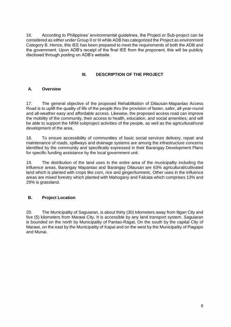
Development Bank.
i
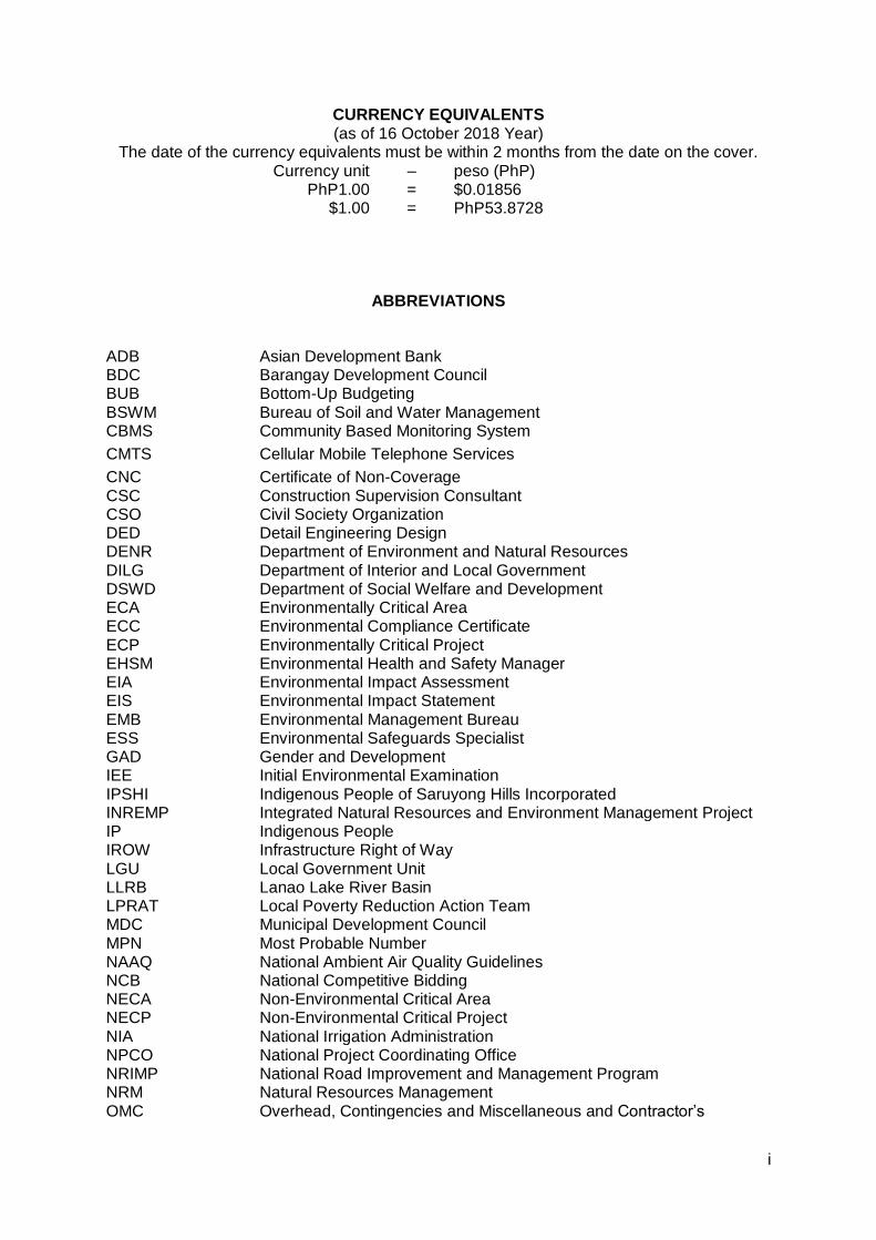
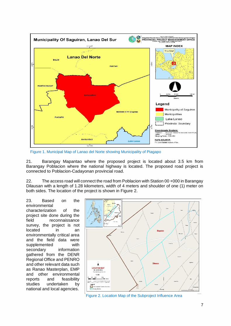
CURRENCY EQUIVALENTS (as of 16 October 2018 Year)
The date of the currency equivalents must be within 2 months from the date on the cover. Currency unit – peso (PhP)
PhP1.00 = $0.01856 $1.00 = PhP53.8728
ABBREVIATIONS
ADB Asian Development Bank BDC Barangay Development Council BUB BSWM
Bottom-Up Budgeting Bureau of Soil and Water Management
CBMS Community Based Monitoring System
CMTS Cellular Mobile Telephone Services
CNC Certificate of Non-Coverage CSC Construction Supervision Consultant CSO Civil Society Organization DED Detail Engineering Design DENR Department of Environment and Natural Resources DILG Department of Interior and Local Government DSWD Department of Social Welfare and Development ECA Environmentally Critical Area ECC Environmental Compliance Certificate ECP Environmentally Critical Project EHSM Environmental Health and Safety Manager EIA Environmental Impact Assessment EIS Environmental Impact Statement EMB ESS
Environmental Management Bureau Environmental Safeguards Specialist
GAD Gender and Development IEE Initial Environmental Examination IPSHI Indigenous People of Saruyong Hills Incorporated INREMP Integrated Natural Resources and Environment Management Project IP Indigenous People IROW Infrastructure Right of Way LGU LLRB
Local Government Unit Lanao Lake River Basin
LPRAT Local Poverty Reduction Action Team MDC Municipal Development Council MPN Most Probable Number NAAQ National Ambient Air Quality Guidelines NCB National Competitive Bidding NECA Non-Environmental Critical Area NECP Non-Environmental Critical Project NIA National Irrigation Administration NPCO National Project Coordinating Office NRIMP National Road Improvement and Management Program NRM Natural Resources Management OMC Overhead, Contingencies and Miscellaneous and Contractor’s
ii
PAGASA Philippine Atmospheric Geophysical and Astronomical Services Administration
PCCP PDR
Portland Cement Concrete Pavement Project Description Report
PMIC Project Management Implementation Consultant PPCO Provincial Project Management Offices PMO Project Management Office PMU Project Management Unit POs Peoples’ Organizations PSA Philippine Statistics Authority PWD Persons with Disability RC Reinforced Concrete RCPC Reinforced Concrete Pipe Culvert RPCO Regional Project Coordinating Offices REA Rapid Environmental Assessment ROW Right of Way SB Sangguniang Bayan SBD Standard Bidding Document
SEMS Social and Environmental Management Systems SPMU Subproject Management Unit SPS SSS
Safeguard Policy Statement Social Safeguards Specialist
TA Technical Assistance TDS Total Dissolved Solids TOR Terms of Reference TSP Total Suspended Particulates WMA Watershed Management Area WMPCO Watershed Management and Project Coordination Offices
iii
WEIGHTS AND MEASURES
˚C – degree centigrade ha – hectare km – kilometer m – meter
m asl – meter above sea level mm – millimeter
mg/L – milligram per liter mg/Nm3 – milligram per normal cubic meter
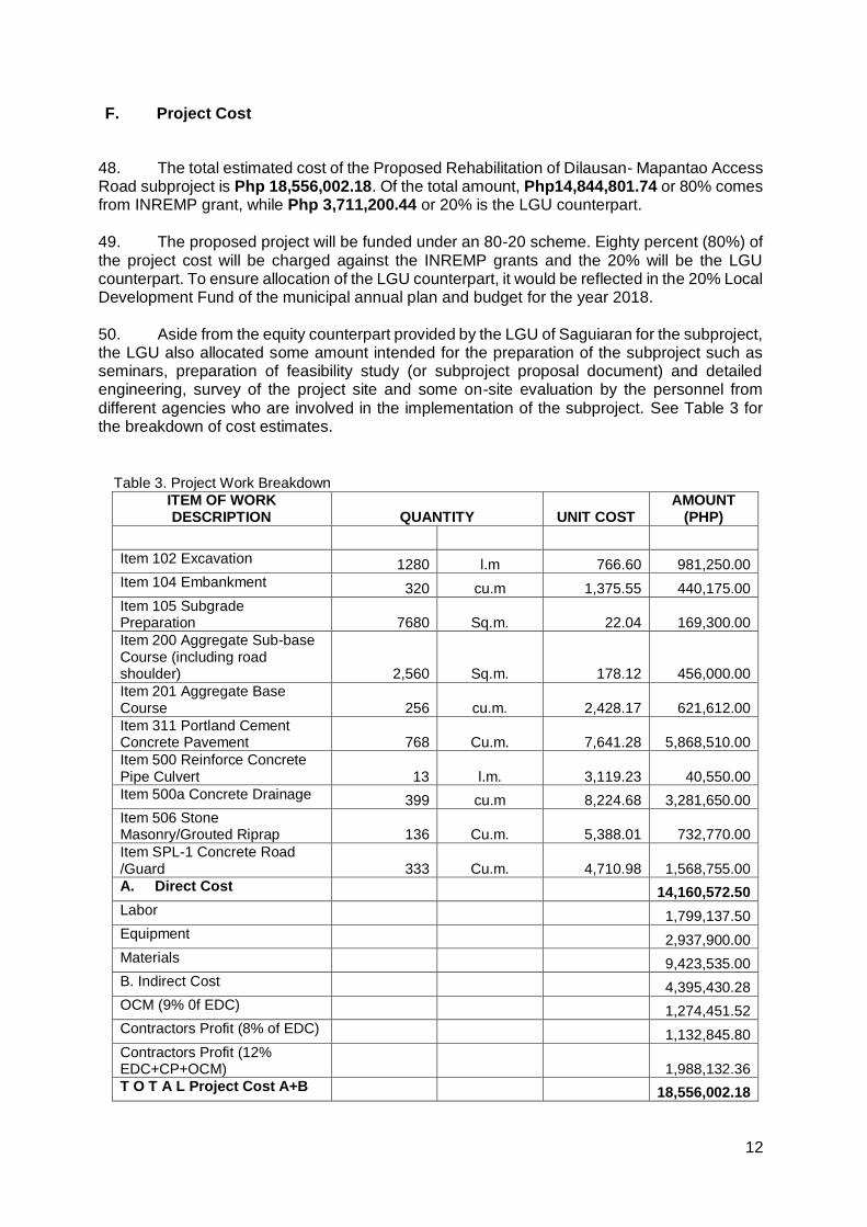
ppt – parts per thousand μg/Nm3 – microgram per normal cubic meter
µS/cm – microsiemens/cm % – Percent
NOTE
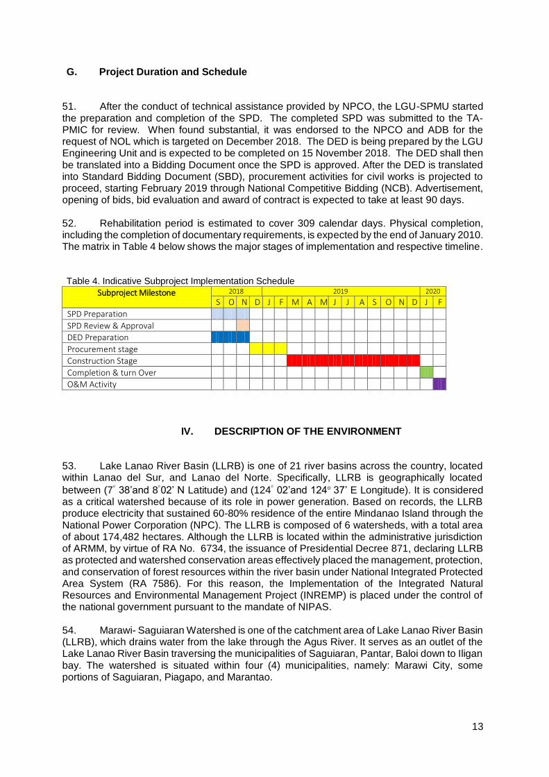
In this report, "$" refers to US dollars unless otherwise stated.
This initial environmental examination is a document of the borrower. The views expressed herein do not necessarily represent those of ADB's Board of Directors, Management, or staff, and may be preliminary in nature. In preparing any country program or strategy, financing any project, or by making any designation of or reference to a particular territory or geographic area in this document, the Asian Development Bank does not intend to make any judgments as to the legal or other status of any territory or area.
iv
Table of Contents
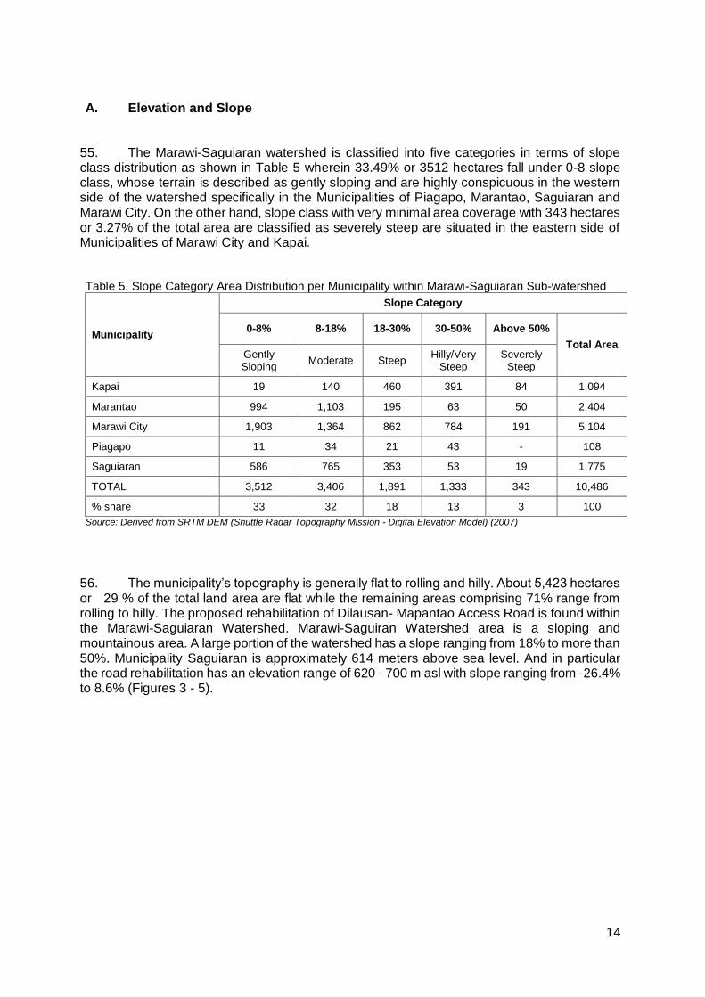
I. EXECUTIVESUMMARY .................................................................................................... 1 II. POLICY, LEGAL, AND ADMINISTRATIVE FRAMEWORK ............................................ 2
A. Environmental Clearance Requirements ........................................................................... 2 1. Government Environmental Laws, Regulations and Guidelines ................................................ 2 2. ADB Environmental Assessment Requirements ....................................................................... 5
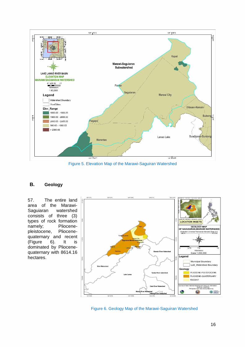
III. DESCRIPTION OF THE PROJECT .................................................................................. 6 A. Overview ............................................................................................................................. 6 B. Project Location .................................................................................................................. 6 C. Project Rationale ................................................................................................................ 8 D. Project Development Plan .................................................................................................. 8
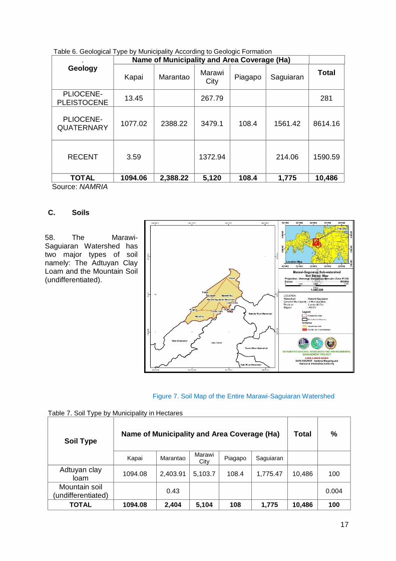
1. General Objective ..................................................................................................................... 8 2. Specific Objectives .................................................................................................................... 9 3. Project Components .................................................................................................................. 9 4. Description of the Project Phases ........................................................................................... 10
E. Manpower Requirements ................................................................................................. 11 F. Project Cost ...................................................................................................................... 12 G. Project Duration and Schedule ........................................................................................ 13 IV. DESCRIPTION OF THE ENVIRONMENT ....................................................................... 13 A. Elevation and Slope .......................................................................................................... 14 B. Geology............................................................................................................................. 16 C. Soils .................................................................................................................................. 17 D. Water Quality .................................................................................................................... 18 E. Land Classification ........................................................................................................... 18 F. Land Cover and Land Use ............................................................................................... 19 G. Climate .............................................................................................................................. 21
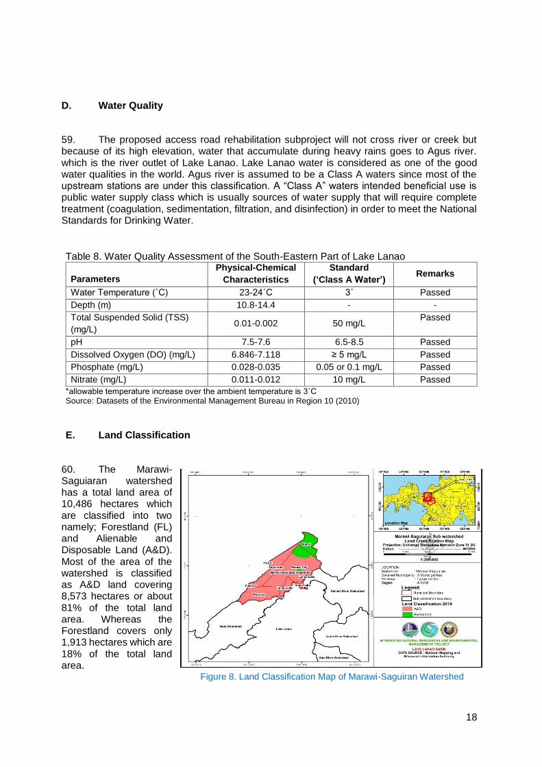
1. Atmospheric Temperature ....................................................................................................... 21 2. Relative Humidity .................................................................................................................... 21 3. Rainfall .................................................................................................................................... 21
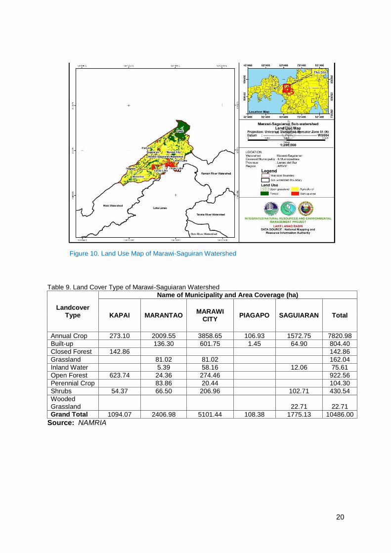
H. Hydrology .......................................................................................................................... 21 I. Natural Hazards ................................................................................................................ 22 J. Biological Environment ..................................................................................................... 23
1. Flora and Fauna ...................................................................................................................... 23 K. Socio-Economic Conditions ............................................................................................. 24
1. Population ............................................................................................................................... 24 2. Population Density .................................................................................................................. 24 3. Education ................................................................................................................................ 24 4. Health and Sanitation .............................................................................................................. 25 5. Housing ................................................................................................................................... 25 6. Income and Expenditure ......................................................................................................... 25 7. Commerce and Industry .......................................................................................................... 26 8. Electricity ................................................................................................................................. 26 9. Communication ....................................................................................................................... 26 10. Road and Transportation ..................................................................................................... 27
V. ANTICIPATED ENVIRONMENTAL IMPACTS AND MITIGATION MEASURES .......... 27 A. Pre-Construction ............................................................................................................... 29
1. Confirmation of no required resettlement, relocations, and compensation .............................. 29 2. Identification and prioritization of road section where re-gravelling will be done ..................... 29 3. Preparation of detailed engineering designs and programs of work ........................................ 29 4. Recruitment of workers ........................................................................................................... 30
B. Construction ...................................................................................................................... 30 1. Construction materials acquisition, transport access, and storage system ............................. 30 2. Clearing and removal of obstructions ...................................................................................... 30 3. Soil erosion ............................................................................................................................. 30 4. Ground surface leveling and gravelling of existing road .......................................................... 31

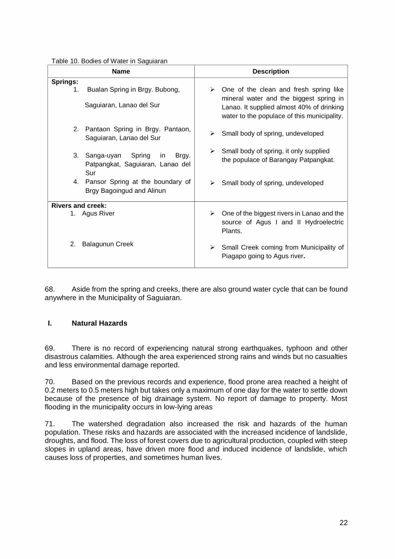
v
5. Civil works ............................................................................................................................... 31 6. Implementation of noise and dust control measure ................................................................. 31 7. Dust and noise from borrow pits .............................................................................................. 32 8. Implementation of spoil management and control measure .................................................... 32 9. Solid and liquid construction waste management system ....................................................... 32 10. Water quality ....................................................................................................................... 32 11. Construction drainage system ............................................................................................. 33 12. Workers health, safety and hygiene .................................................................................... 33 13. Traffic safety and management ........................................................................................... 33 14. Ecological environment ....................................................................................................... 33 15. Damaged to properties ........................................................................................................ 34 16. Concrete washout ............................................................................................................... 34 17. Use of Hazardous Substances ............................................................................................ 34 18. Public safety ........................................................................................................................ 34
C. Operation and Maintenance (O&M) Phase ...................................................................... 35 1. Operation of upgraded access road ........................................................................................ 35
VI. INFORMATION DISCLOSURE, CONSULTATION, ANDPARTICIPATION .................. 35 A. Stakeholder Consultations ............................................................................................... 35 B. Information Disclosure ...................................................................................................... 37 VII. GRIEVANCE REDRESS MECHANISM .......................................................................... 37 VIII. ENVIRONMENTAL MANAGEMENT PLAN ................................................................... 39 A. Implementation Arrangements ......................................................................................... 39 B. Environmental Mitigation .................................................................................................. 40 C. Environmental Monitoring ................................................................................................. 49 IX. CONCLUSION AND RECOMMENDATION .................................................................... 53 A. Conclusion ........................................................................................................................ 53 B. Recommendation ............................................................................................................. 53 LIST OF TABLES Table 1. Summary List of ECP Types and ECA Categories ..................................................... 3 Table 2. Revised Guidelines for Coverage Screening and Standardized Requirements ........ 4 Table 3. Project Work Breakdown ........................................................................................... 12 Table 4. Indicative Subproject Implementation Schedule ....................................................... 13 Table 5. Slope Category per Municipality within Marawi-SaguiaranSub-watershed .............. 14 Table 6. Geological Type by Municipality According to Geologic Formation ......................... 17 Table 7. Soil Type by Municipality in Hectares ....................................................................... 17 Table 8. Water Quality Assessment of the South-Eastern Part of Lake Lanao ..................... 18 Table 9. Land Cover Type of Marawi-Saguiaran Watershed.................................................. 20 Table 10. Bodies of Water in Saguiaran.................................................................................. 22 Table 11. Population density of the influence Barangays year 2015 ..................................... 24 Table 12. Showing the distribution of number of students in different grade level ................. 25 Table 13. Inventory of Commercial Establishment by Economic Activities ............................ 26 Table 14. Assessment of Potential Environmental Impacts.................................................... 28 Table 15. Summary of Stakeholder Views of the Road Rehabilitation in Saguiaran Lanao del
Sur ........................................................................................................................... 36 Table 16. Responsibilities for EMP Implementation ............................................................... 39 Table 17. Environmental Impact Mitigation Plan ..................................................................... 40 Table 18. Community Level Construction Monitoring Form .................................................... 49 Table 19. Environmental Monitoring Plan ............................................................................... 50
vi
LIST OF FIGURES Figure 1. Municipal Map of Lanao del Norte showing Municipality of Piagapo ........................ 7 Figure 2. Location Map of the Subproject Influence Area ......................................................... 7 Figure 3. Elevation and Slope of the Proposed Road Rehabilitation Project ......................... 15 Figure 4. Slope Map of Marawi-Saguiaran Watershed ........................................................... 15 Figure 5. Elevation Map of the Marawi-Saguiran Watershed ................................................. 16 Figure 6. Geology Map of the Marawi-Saguiran Watershed................................................... 16 Figure 7. Soil Map of the Entire Marawi-Saguiaran Watershed ............................................. 17 Figure 8. Land Classification Map of Marawi-Saguiran Watershed........................................ 18 Figure 9. Land Cover Map of Marawi-Saguiran Watershed ................................................... 19 Figure 10. Land Use Map of Marawi-Saguiran Watershed ..................................................... 20 LIST OF APPENDICES Appendix 1. A Copy of CNC Application (Payment) ............................................................... 55 Appendix 2. Stakeholder Consultations .................................................................................. 56 Appendix 3.Barangay Resolution Endorsing the Rural Infra Project ...................................... 64 Appendix 4.PO Resolutions ..................................................................................................... 65 Appendix 5.Municipal Council Resolution Affirming the interest of LGU in the Rural Infra
Project ................................................................................................................... 67 Appendix 6.Grievance Intake Form ......................................................................................... 69
1
I. EXECUTIVESUMMARY
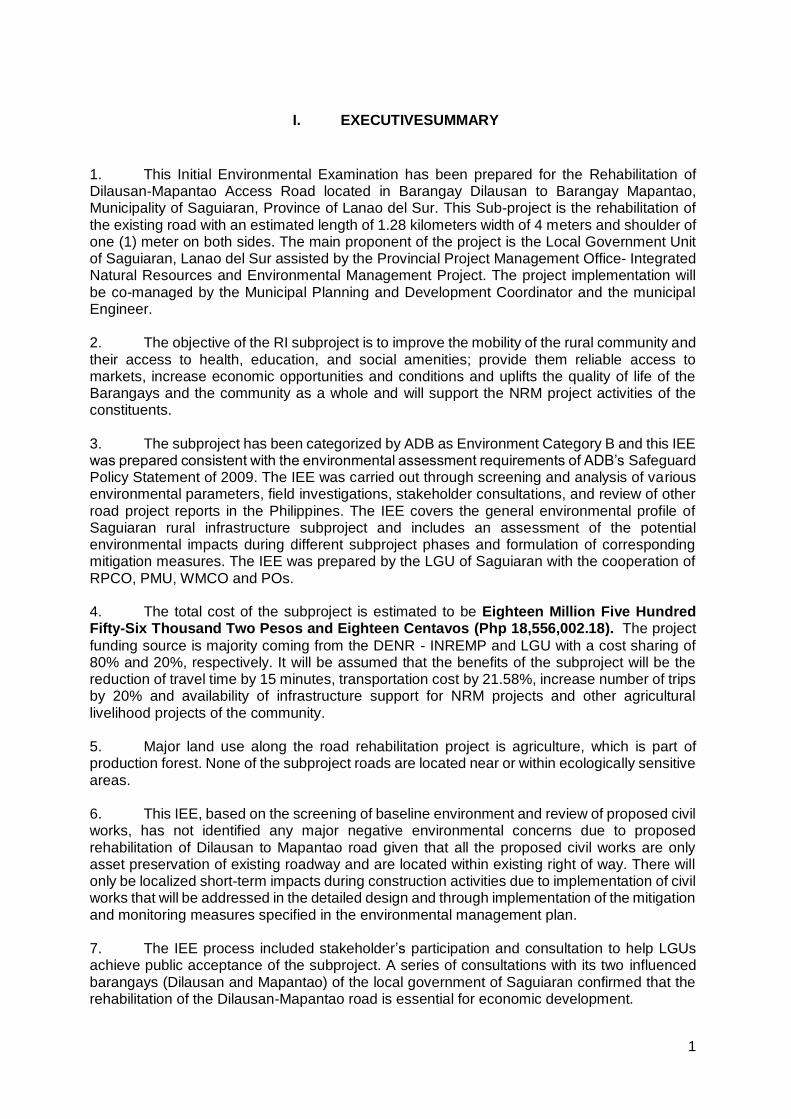
1. This Initial Environmental Examination has been prepared for the Rehabilitation of Dilausan-Mapantao Access Road located in Barangay Dilausan to Barangay Mapantao, Municipality of Saguiaran, Province of Lanao del Sur. This Sub-project is the rehabilitation of the existing road with an estimated length of 1.28 kilometers width of 4 meters and shoulder of one (1) meter on both sides. The main proponent of the project is the Local Government Unit of Saguiaran, Lanao del Sur assisted by the Provincial Project Management Office- Integrated Natural Resources and Environmental Management Project. The project implementation will be co-managed by the Municipal Planning and Development Coordinator and the municipal Engineer.
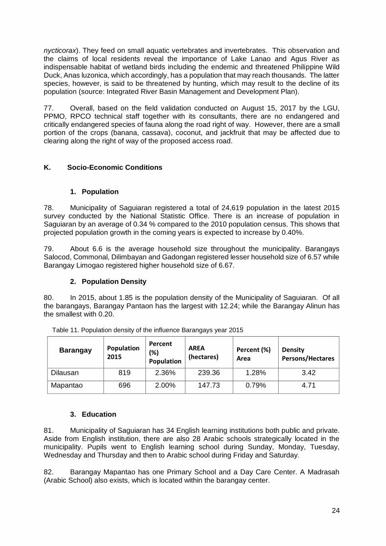
2. The objective of the RI subproject is to improve the mobility of the rural community and their access to health, education, and social amenities; provide them reliable access to markets, increase economic opportunities and conditions and uplifts the quality of life of the Barangays and the community as a whole and will support the NRM project activities of the constituents.
3. The subproject has been categorized by ADB as Environment Category B and this IEE was prepared consistent with the environmental assessment requirements of ADB’s Safeguard Policy Statement of 2009. The IEE was carried out through screening and analysis of various environmental parameters, field investigations, stakeholder consultations, and review of other road project reports in the Philippines. The IEE covers the general environmental profile of Saguiaran rural infrastructure subproject and includes an assessment of the potential environmental impacts during different subproject phases and formulation of corresponding mitigation measures. The IEE was prepared by the LGU of Saguiaran with the cooperation of RPCO, PMU, WMCO and POs.
4. The total cost of the subproject is estimated to be Eighteen Million Five Hundred Fifty-Six Thousand Two Pesos and Eighteen Centavos (Php 18,556,002.18). The project
funding source is majority coming from the DENR - INREMP and LGU with a cost sharing of 80% and 20%, respectively. It will be assumed that the benefits of the subproject will be the reduction of travel time by 15 minutes, transportation cost by 21.58%, increase number of trips by 20% and availability of infrastructure support for NRM projects and other agricultural livelihood projects of the community.
5. Major land use along the road rehabilitation project is agriculture, which is part of production forest. None of the subproject roads are located near or within ecologically sensitive areas.
6. This IEE, based on the screening of baseline environment and review of proposed civil works, has not identified any major negative environmental concerns due to proposed rehabilitation of Dilausan to Mapantao road given that all the proposed civil works are only asset preservation of existing roadway and are located within existing right of way. There will only be localized short-term impacts during construction activities due to implementation of civil works that will be addressed in the detailed design and through implementation of the mitigation and monitoring measures specified in the environmental management plan.
7. The IEE process included stakeholder’s participation and consultation to help LGUs achieve public acceptance of the subproject. A series of consultations with its two influenced barangays (Dilausan and Mapantao) of the local government of Saguiaran confirmed that the rehabilitation of the Dilausan-Mapantao road is essential for economic development.
2
8. A grievance redress mechanism will be established by the LGU of Saguiaran prior to commencement of site works to ensure that complaints of affected persons and other stakeholders regarding the project’s environmental performance are promptly addressed.
9. This IEE includes an environmental management plan which details the mitigation measures, environmental monitoring activities, institutional responsibilities, and environmental management capacity building. The LGU, through its Municipal Planning and Development Coordinator and the Municipal Engineer will ensure that relevant EMP provisions are included in bid and contract documents for detailed design, project supervision and civil works. During construction, they will closely conduct monitoring of the contractor’s environmental performance and over-all EMP implementation. Semi-annual environmental monitoring reports will be submitted by LGU to ADB and such reports will be posted on ADB’s website for public disclosure.
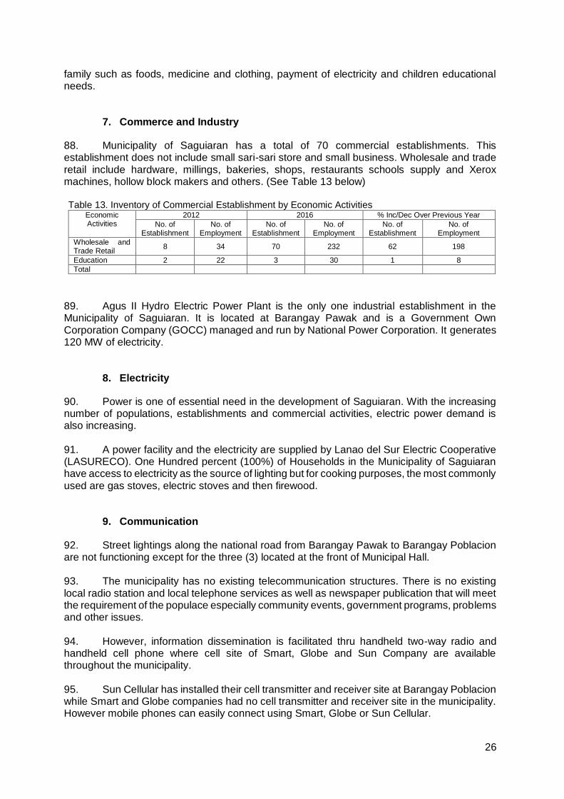
10. The major positive impact of the project will be economic and better accessibility. The subproject will directly benefit people located within the two barangays providing improved access and economic development. The subproject would also benefit the environment in terms of reduced soil erosion and landslides through slope stabilization measures and construction of retaining structures. Dust generation from the damaged roads will be reduced by the improvement of pavement. Health risk to the roadside communities and damage to the biological environment will be reduced due to pavement improvement and soil erosion control measures.
11. The subproject gives hope to the community to gain more opportunities environmentally wise, socially and economically. The economic analysis with this subproject shows with a positive result in benefit-cost ratio (BCR) and economic internal rate of return (EIRR) computation that makes the subproject technically feasible and economically viable. The subproject is eco-socio acceptable since the subproject will uplift the social, political, cultural and economic status of the people. Other factors are also considered from pre to post phase of the construction period to make it environmentally sound.
II. POLICY, LEGAL, AND ADMINISTRATIVE FRAMEWORK
A. Environmental Clearance Requirements
1. Government Environmental Laws, Regulations and Guidelines
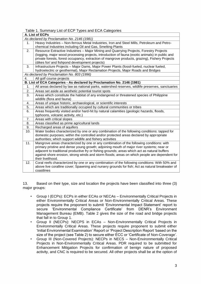
12. According to the EMB Memorandum Circular 005 - 2014, the environmental category of a project is decided based on the type of the project (whether it falls into ‘Environmental Critical Project’, ECP type), location of the project (whether it falls into ‘Env ironmental Critical Areas’, ECA category), and size of the project. A summary list of ECPs and ECA categories are presented in Table 1.
3
Table 1. Summary List of ECP Types and ECA Categories A. List of ECPs
As declared by Proclamation No. 2146 (1981)
1. Heavy Industries – Non-ferrous Metal Industries, Iron and Steel Mills, Petroleum and Petro-chemical Industries including Oil and Gas, Smelting Plants
2. Resource Extractive Industries – Major Mining and Quarrying Projects, Forestry Projects (logging, major wood processing projects, introduction of fauna (exotic animals) in public and private forests, forest occupancy, extraction of mangrove products, grazing), Fishery Projects (dikes for/ and fishpond development projects)
3. Infrastructure Projects – Major Dams, Major Power Plants (fossil-fueled, nuclear fueled, hydroelectric or geothermal), Major Reclamation Projects, Major Roads and Bridges
As declared by Proclamation No. 803 (1996)
4. All golf course projects
B. List of ECA Categories - As declared by Proclamation No. 2146 (1981)
1. All areas declared by law as national parks, watershed reserves, wildlife preserves, sanctuaries
2. Areas set aside as aesthetic potential tourist spots
3. Areas which constitute the habitat of any endangered or threatened species of Philippine wildlife (flora and fauna)
4. Areas of unique historic, archaeological, or scientific interests
5. Areas which are traditionally occupied by cultural communities or tribes
6. Areas frequently visited and/or hard-hit by natural calamities (geologic hazards, floods, typhoons, volcanic activity, etc.)
7. Areas with critical slopes
8. Areas classified as prime agricultural lands
9. Recharged areas of aquifers
10. Water bodies characterized by one or any combination of the following conditions: tapped for domestic purposes; within the controlled and/or protected areas declared by appropriate authorities; which support wildlife and fishery activities
11. Mangrove areas characterized by one or any combination of the following conditions: with primary pristine and dense young growth; adjoining mouth of major river systems; near or adjacent to traditional productive fry or fishing grounds; areas which act as natural buffers against shore erosion, strong winds and storm floods; areas on which people are dependent for their livelihood.
12. Coral reefs characterized by one or any combination of the following conditions: With 50% and above live coralline cover; Spawning and nursery grounds for fish; Act as natural breakwater of coastlines
13. Based on their type, size and location the projects have been classified into three (3) major groups:
• Group I (ECPs): ECPs in either ECAs or NECAs – Environmentally Critical Projects in either Environmentally Critical Areas or Non-Environmentally Critical Areas. These projects require the proponent to submit ‘Environmental Impact Statement’ report to secure ‘Environmental Compliance Certificate’ from DENR’s Environment Management Bureau (EMB). Table 2 gives the size of the road and bridge projects that fall in to Group 1.
• Group II (NECPs): NECPS in ECAs – Non-Environmentally Critical Projects in Environmentally Critical Areas. These projects require proponent to submit either ‘Initial Environmental Examination’ Report or ‘Project Description Report ‘based on the size of the project (see Table 2) to secure either ECC or ‘Certificate of Non-Coverage’.
• Group III (Non-Covered Projects): NECPs in NECS – Non-Environmentally Critical Projects in Non-Environmentally Critical Areas. PDR required to be submitted for Enhancement Mitigation Projects for confirmation of benign nature of proposed activity, and CNC is required to be secured. All other projects shall be at the option of
4
the proponent to prepare a PDR as a basis for CNC, should the proponent opt to secure one.
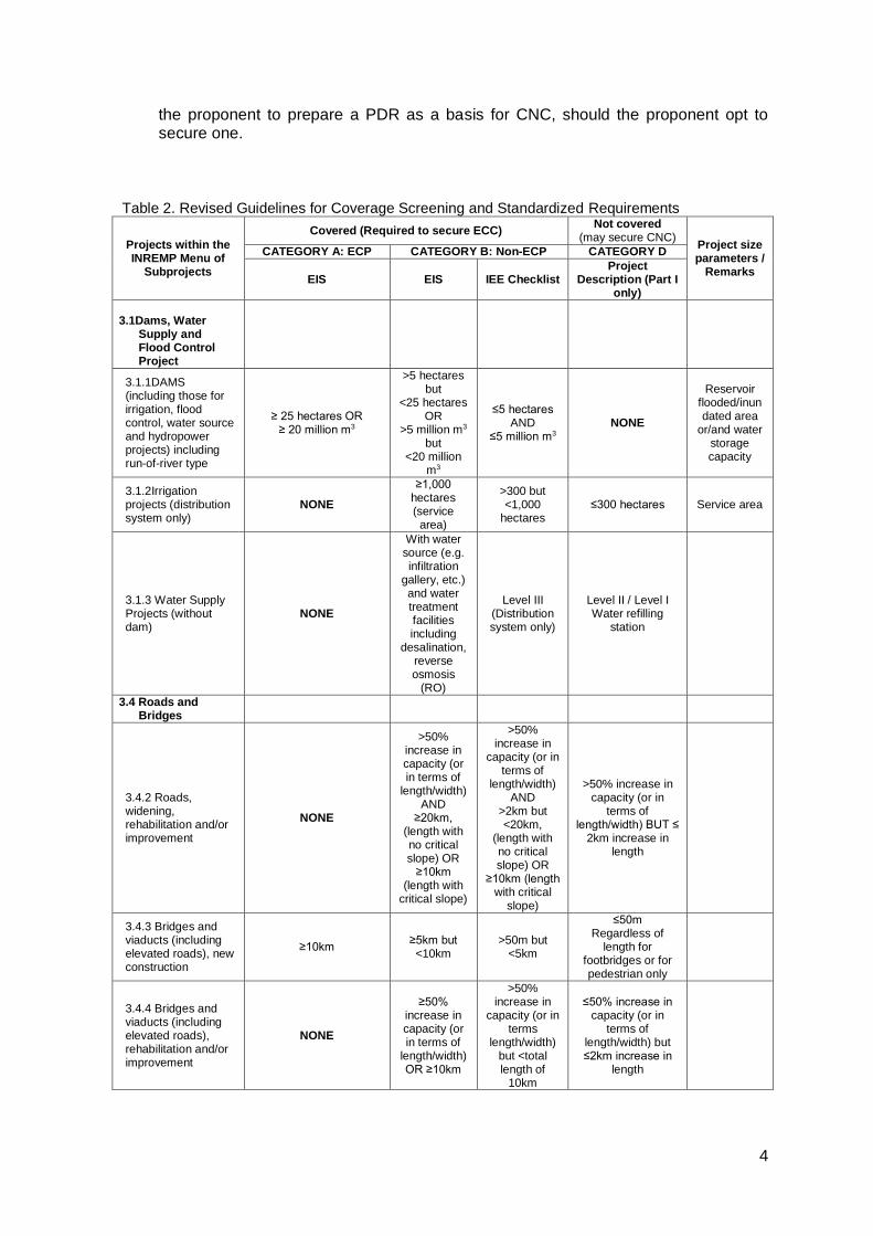
Table 2. Revised Guidelines for Coverage Screening and Standardized Requirements
Projects within the INREMP Menu of
Subprojects
Covered (Required to secure ECC) Not covered
(may secure CNC) Project size parameters /
Remarks
CATEGORY A: ECP CATEGORY B: Non-ECP CATEGORY D
EIS EIS IEE Checklist Project
Description (Part I only)
3.1Dams, Water
Supply and Flood Control Project
3.1.1DAMS (including those for irrigation, flood control, water source and hydropower projects) including run-of-river type
≥ 25 hectares OR ≥ 20 million m3
>5 hectares but
<25 hectares OR
>5 million m3 but
<20 million m3
≤5 hectares AND
≤5 million m3 NONE
Reservoir flooded/inundated area
or/and water storage capacity
3.1.2Irrigation projects (distribution system only)
NONE
≥1,000 hectares (service
area)
>300 but <1,000
hectares ≤300 hectares Service area
3.1.3 Water Supply Projects (without dam)
NONE
With water source (e.g. infiltration
gallery, etc.) and water treatment facilities including
desalination, reverse osmosis
(RO)
Level III (Distribution system only)
Level II / Level I Water refilling
station
3.4 Roads and Bridges
3.4.2 Roads, widening, rehabilitation and/or improvement
NONE
>50% increase in capacity (or in terms of
length/width) AND
≥20km, (length with no critical slope) OR
≥10km (length with
critical slope)
>50% increase in
capacity (or in terms of
length/width) AND
>2km but <20km,
(length with no critical slope) OR
≥10km (length with critical
slope)
>50% increase in capacity (or in
terms of length/width) BUT ≤
2km increase in length
3.4.3 Bridges and viaducts (including elevated roads), new construction
≥10km ≥5km but <10km
>50m but <5km
≤50m Regardless of
length for footbridges or for pedestrian only
3.4.4 Bridges and viaducts (including elevated roads), rehabilitation and/or improvement
NONE
≥50% increase in capacity (or in terms of
length/width) OR ≥10km
>50% increase in
capacity (or in terms
length/width) but <total length of
10km
≤50% increase in capacity (or in
terms of length/width) but ≤2km increase in
length
5
Projects within the INREMP Menu of
Subprojects
Covered (Required to secure ECC) Not covered
(may secure CNC) Project size parameters /
Remarks
CATEGORY A: ECP CATEGORY B: Non-ECP CATEGORY D
EIS EIS IEE Checklist Project
Description (Part I only)
3.6 Buildings
including Housing, Storage facilities and Other Structures
3.6.2 Storage facilities with no hazardous or toxic materials.
NONE ≥ 5 hectares >1 hectare
but <5 hectare
≤ 1 hectare
Total/gross floor area including parking,
open space and other
areas
14. This subproject is an improvement of existing barangay road which falls under the
group of Non-ECP. Given that the subproject is rehabilitation of access road with no more than
50% increase in capacity and no increase in length, a Certificate on Non-Coverage (CNC) was
granted to the LGU Danao on February 1, 2017 (Appendix 01). Environmental considerations
of the proposed subproject are incorporated in the Environmental Management Plan where
possible adverse impacts are identified including the corresponding mitigating measures and
following the DENR.
2. ADB Environmental Assessment Requirements
15. According to ADB guidelines, the process of determining a project’s environment category is to prepare a Rapid Environmental Assessment (REA) screening checklist, considering the type, size, and location of the proposed project. Based on ADB’s Safeguard Policy Statement 2009 (SPS 2009), a project is classified as one of the four (4) environmental categories (A, B, C or FI) as follows:
• Category A: Projects with potential for significant adverse environmental impacts that
are irreversible, diverse or unprecedented. These impacts may affect an area larger than the sites or facilities subject to physical works. An environmental impact assessment is required.
• Category B: Projects judged to have some adverse environmental impacts, but of
lesser degree and/or significance than those for category A projects. Impacts are site-specific, few if any of them are irreversible, and in most cases mitigation measures can be designed more readily than for Category A projects. An initial environmental examination (IEE) is required.
• Category C: Projects likely to have minimal or no adverse environmental impacts. No
environmental assessment is required although environmental implications are still reviewed.
• Category FI: Projects are classified as category FI if they involve investment of funds to or through a financial intermediary. Where the FI’s investment have minimal or no adverse environmental risks. The FI project will be treated as Category C. All other FI’s must establish and maintain an environmental and social management system and must comply with the environmental safeguards requirements specified in SPS 2009 if the FI’s subprojects have the potential for significant adverse environmental impacts.
6
16. According to Philippines’ environmental guidelines, the Project or Sub-project can be considered as either under Group II or III while ADB has categorized the Project as environment Category B. Hence, this IEE has been prepared to meet the requirements of both the ADB and the government. Upon ADB’s receipt of the final IEE from the proponent, this will be publicly disclosed through posting on ADB’s website.
III. DESCRIPTION OF THE PROJECT
A. Overview
17. The general objective of the proposed Rehabilitation of Dilausan-Mapantao Access Road is to uplift the quality of life of the people thru the provision of faster, safer, all-year-round and all-weather easy and affordable access. Likewise, the proposed access road can improve the mobility of the community, their access to health, education, and social amenities; and will be able to support the NRM subproject activities of the people, as well as the agricultural/rural development of the area.
18. To ensure accessibility of communities of basic social services delivery, repair and maintenance of roads, spillways and drainage systems are among the infrastructure concerns identified by the community and specifically expressed in their Barangay Development Plans for specific funding assistance by the local government unit.
19. The distribution of the land uses in the entire area of the municipality including the influence areas, Barangay Mapantao and Barangay Dilausan are 63% agricultural/cultivated land which is planted with crops like corn, rice and ginger/turmeric. Other uses in the influence areas are mixed forestry which planted with Mahogany and Falcata which comprises 13% and 29% is grassland.
B. Project Location
20. The Municipality of Saguiaran, is about thirty (30) kilometers away from Iligan City and five (5) kilometers from Marawi City. It is accessible by any land transport system. Saguiaran is bounded on the north by Municipality of Pantao-Ragat, On the south by the capital City of Marawi, on the east by the Municipality of Kapai and on the west by the Municipality of Piagapo and Munai.
7
21. Barangay Mapantao where the proposed project is located about 3.5 km from Barangay Poblacion where the national highway is located. The proposed road project is connected to Poblacion-Cadayonan provincial road.
22. The access road will connect the road from Poblacion with Station 00 +000 in Barangay Dilausan with a length of 1.28 kilometers, width of 4 meters and shoulder of one (1) meter on both sides. The location of the project is shown in Figure 2.
23. Based on the environmental characterization of the project site done during the field reconnaissance survey, the project is not located in an environmentally critical area and the field data were supplemented with secondary information gathered from the DENR Regional Office and PENRO and other relevant data such as Ranao Masterplan, EMP and other environmental reports and feasibility studies undertaken by national and local agencies.
Figure 1. Municipal Map of Lanao del Norte showing Municipality of Piagapo
Figure 2. Location Map of the Subproject Influence Area
8
C. Project Rationale
24. The existing Dilausan-Mapantao Access Road was built by a logging company more than one hundred years ago. It was established to transport volumes of cut trees and other items. Through time, population increased in the area and improvements were made that led to the recent condition of the road. The road now can accommodate four (4) meters of carriage intended for light vehicles up to 6-wheel transport utility. Due to the lack of funds the road was not maintained making it impassable especially during heavy rains.
25. Based on information from the Municipal Planning and Development Office and Municipal Engineering Office, no involuntary resettlement happened nor any compensation made during the abovementioned period.
26. The main livelihood of the community within the influenced barangay is farming. However, these activities are very much affected by the poor condition of the road. During rainy season, the road becomes muddy and hardly passable. Other public services such as health services are also affected because of the current road condition. The transport condition also makes the fare rates high that affects the prices of basic commodities. Lack of access also deprives them of the ability to take advantage of job opportunities.
27. During a series of consultations with the municipal and barangay officials, the major problem identified by the community was the poor access road. The farmers were forced to sell their agricultural products to the traders who came into the area at low price they dictate to the farmers and deal with higher cost of transportation and hauling if they sell them to the market. 28. There will be many opportunities that this rehabilitated access road will bring foremost of which will be the ease of access. There will be additional income of the farmers brought by less time in transporting their produce and finish products, the decrease of maternal and infant mortality rate due to the increase of frequency of health personnel going to the area, and the decrease of transportation fare rates due to the reduction of vehicular operating cost. Farmer’s produce (corn, rice, ginger and turmeric) will surely increase because the production area will be maximized due to easy access of production inputs. These mentioned potentials will result to increase of family income by 15%.
29. Direct employment during the construction will increase. Labor, skilled and unskilled, will be from the two (2) barangays and women can also be employed. It may address some of the poverty situation as it decreases costs and prices and enhances trade and employment opportunities. Transportation indirectly alleviates poverty. The lack of access deprives them of the ability to take advantage of job opportunities and even of very basic social services. Reliable access to schools and health services for the poor contributes directly to their accumulation of human capital, which is a key factor in sustainable poverty alleviation in as much as jobs and basic social services are relatively highly valued by the poor. Thus, improvements in road transport, public or private, in Dilausan to Mapantao road would have powerful positive effects on the poorer parts of the population.
D. Project Development Plan
1. General Objective
30. The general objective of the Proposed Rehabilitation/Improvement of Dilausan-Mapantao Road is to improve the mobility of the rural community, and their access to health,
9
education, and social amenities; provide them reliable access to markets; and support agricultural and rural development.
2. Specific Objectives
31. The following are the specific objectives of the proposed subproject:
to reduce maintenance cost of vehicles by 20%;
to reduce fare by about 30%;
to reduce travel time by 50%;
to maximize production area by 20%;
to reduce transportation cost of cargo by 30%; and
to support NRM project sites.
3. Project Components
32. The scope of works of the road rehabilitation are the following:
Roadway and Excavation/ Structural Excavation;
Embankment;
Sub-grade Preparation;
Aggregate sub base course;
Aggregate base course
Provision of RCPC cross drains; and open drainage
Provision of concrete pavement with a total length of 1,280 m.
Stone masonry/ riprap
Reinforced concrete road guard
33. The proposed subproject is the Rehabilitation of Dilausan- Mapantao Access Road with a total length of 1.28 km and a width of 4 m carriage way with 1.0 m shoulder at both sides, RCP cross drainage, road guard, slope protection/riprap and open drainage system. The proposed subproject will start at station 0+000 to station 1+280. The scope of works includes the following: Roadway and excavation; Embankment; Subgrade preparation; Aggregate sub base course; Aggregate base coursed; provision of Portland Cement Concrete Pavement (PCCP); road guard; slope protection/riprap; RCP cross drainage and open drainage on identified critical portions of the road. The subproject will also commission equipment such as Bulldozer, Road Grader, Backhoe, Pay Loader, Road Roller and Dump Trucks and other road construction equipment to complete the design road.
34. The detailed engineering designs of the proposed road will be in accordance with the practices, procedures, guidelines and criteria of DPWH. It outlines the procedures in preparing the construction drawings/ plans and cost estimates of the subproject. It involves the conduct of preliminary survey of the area up to the preparation of program of works.
35. The proposed subproject, the Rehabilitation of Dilausan- Mapantao Access Road will have a total length of 1.28 kilometers (km). The provision of PCCP will be 150 mm thick concrete pavement on 100 mm thick aggregate base coarse with 1-meter width mixed earth & gravel at both sides. Portland concrete cement pavement (PCCP) has a design width of 4 meters (m) carriageway. The route will start at Brgy Dilausan or station 0+000 and end at sta. 1 + 280 at Brgy Mapantao. Sta. 0 + 000 to sta. 0 + 120 require drainage system and reinforce concrete pipe culvert while sta. 0 +150 to sta 0 +700 require concrete road guard. There will be earth cutting and slope protection at sta. 0 +250 to Sta 0 +500. (Refer to Road Location Map attached as for the overlay of road network).
10
36. Roadway and excavation works will include more than 2,000 cubic meters (cum) of cut and excavation works, embankment of selected borrow (or mixed earth and gravel), and 7,680 square meters of Sub-grade preparation, 2,560 square meters aggregate sub base course and spreading of 56 cubic meters of crushed aggregate base course intended for the provision of concrete pavement.
37. The provision of RPC drains will primarily be made of 750 mm diameter size of fabricated reinforced concrete pipe culvert. It will be placed 600 mm underground from the finished road surface line. Likewise, the provision of grouted riprap will be constructed at sta. 0+ 250 to 0 + 600 to prevent earth erosion and land slide.
38. The following are the major technical specifications of the project:
Clearing and removal of obstructions This item shall consist of clearing, grubbing, removing and disposing all vegetables and debris, except those objects that are designated to remain in place, or are to be removed in consonance with other provisions of this Specification. The work shall also include the preservations from injury or defacement of all objects designated to remain. Concrete pavement This item shall consist of Pavement of Portland Cement Concrete (PPCC). With or without reinforcement, this should be constructed on the prepared base in accordance with the specification and in conformity with the lines, grades, thickness and typical cross-section as reflected in the plan. Tie bars shall be 16mmø. Joint fillers shall be provided in the pavement, joint fillers shall be paved with mixed asphalt and mineral or rubber filler. Embankment works This item consists of the construction of embankment from selected filling materials in accordance with the specification and conformity with the lines, grades and dimension shown in the plan. The full width of the embankment shall be well compacted using compaction equipment (Roller) with a minimum of three (3) complete passes for each layer of embankment. Provision of RCPC Cross Drains This item shall consist of the construction or reconstruction of pipe culverts, hereinafter referred to as cross drains/conduits in accordance with this Specification and in conformity with the lines and grades shown on the plans or as established by the Engineer. 4. Description of the Project Phases
i. Pre-Construction Phase/Pre-Development Phase
39. The pre-construction phase involves the social preparation (to include organizational strengthening, planning, identification and prioritization of community needs) of the community for the entry of the project to the site, conduct of pre-engineering activities covering detailed survey works to determine alignment of roads and canal systems, preparation of the detailed engineering plans and programs of work, ROW negotiation, recruitment of work force and initial
11
sourcing and procurement of construction materials. These activities will be conducted by the proponent technical staff, partner line agencies, NGO service providers, community beneficiaries especially the Peoples’ organizations and contractors.
40. Additionally, Municipality of Saguiaran accomplished the Environmental Impact Assessment Management and Monitoring Plan (EIAMMP) and has acquired the corresponding Certificate of Non-Coverage from EMB Region 10.
ii. Construction/Development Phase
41. The construction phase involves the mobilization of construction equipment, construction workers and materials to the specific project site after which the longer period of actual construction work will commence. The construction phase will end with the demobilization of construction equipment, workers and other construction paraphernalia from the construction site. Majority of these activities will be undertaken by the contractor and community residents under the close supervision of the Subproject Management Unit.
iii. Operation Phase and Maintenance Phase
42. The operation and maintenance phase involve the actual maintenance of the rehabilitated access road during its expected economic life. This will involve the designation a spoils storage area of at least 25 meters away from water bodies for proper disposal of excavated materials, wetting areas of dust sources along vehicle route, and regular removal of debris, logs and other materials along drainage canals.
iv. Abandonment Phase
43. This phase is included in the project demobilization. The proponent does not intend to abandon any facilities and unserviceable equipment used during construction. The project location will not be abandoned in disorderly condition but instead restored for functional use. Following the completion of the construction, the proponent will dismantle temporary shelters and the construction yard including unserviceable vehicles and equipment.
44. Wastes arising from the abandonment are expected to be minimal. These wastes could include small volumes of left-over sand and gravel, re-bars and other steel materials (i.e., nails and welding roads) and lumber.
E. Manpower Requirements
45. Construction activities will require hiring of skilled and unskilled manpower. It is assumed that some skilled, semi-skilled and unskilled manpower will be available in the area. Skilled manpower not available in the locality may be sourced from other nearby localities. Technical manpower will be a complementation of specialists to be provided by locally known engineering firms.
46. During the construction phase, a workforce consisting of contractual and regular laborers will be employed to carry out the construction of the proposed project.
47. The Contractor shall employ qualified and sufficient staff to carry out inspections, testing and monitoring for the project.
12
F. Project Cost
48. The total estimated cost of the Proposed Rehabilitation of Dilausan- Mapantao Access Road subproject is Php 18,556,002.18. Of the total amount, Php14,844,801.74 or 80% comes from INREMP grant, while Php 3,711,200.44 or 20% is the LGU counterpart.
49. The proposed project will be funded under an 80-20 scheme. Eighty percent (80%) of the project cost will be charged against the INREMP grants and the 20% will be the LGU counterpart. To ensure allocation of the LGU counterpart, it would be reflected in the 20% Local Development Fund of the municipal annual plan and budget for the year 2018.
50. Aside from the equity counterpart provided by the LGU of Saguiaran for the subproject, the LGU also allocated some amount intended for the preparation of the subproject such as seminars, preparation of feasibility study (or subproject proposal document) and detailed engineering, survey of the project site and some on-site evaluation by the personnel from different agencies who are involved in the implementation of the subproject. See Table 3 for the breakdown of cost estimates. Table 3. Project Work Breakdown
ITEM OF WORK DESCRIPTION QUANTITY UNIT COST
AMOUNT (PHP)
Item 102 Excavation 1280 l.m 766.60 981,250.00
Item 104 Embankment 320 cu.m 1,375.55 440,175.00
Item 105 Subgrade Preparation 7680 Sq.m. 22.04 169,300.00
Item 200 Aggregate Sub-base Course (including road shoulder) 2,560 Sq.m. 178.12 456,000.00
Item 201 Aggregate Base Course 256 cu.m. 2,428.17 621,612.00
Item 311 Portland Cement Concrete Pavement 768 Cu.m. 7,641.28 5,868,510.00
Item 500 Reinforce Concrete Pipe Culvert 13 l.m. 3,119.23 40,550.00
Item 500a Concrete Drainage 399 cu.m 8,224.68 3,281,650.00
Item 506 Stone Masonry/Grouted Riprap 136 Cu.m. 5,388.01 732,770.00
Item SPL-1 Concrete Road /Guard 333 Cu.m. 4,710.98 1,568,755.00
A. Direct Cost 14,160,572.50
Labor 1,799,137.50
Equipment 2,937,900.00
Materials 9,423,535.00
B. Indirect Cost 4,395,430.28
OCM (9% 0f EDC) 1,274,451.52
Contractors Profit (8% of EDC) 1,132,845.80
Contractors Profit (12% EDC+CP+OCM) 1,988,132.36
T O T A L Project Cost A+B 18,556,002.18
13
G. Project Duration and Schedule
51. After the conduct of technical assistance provided by NPCO, the LGU-SPMU started the preparation and completion of the SPD. The completed SPD was submitted to the TA-PMIC for review. When found substantial, it was endorsed to the NPCO and ADB for the request of NOL which is targeted on December 2018. The DED is being prepared by the LGU Engineering Unit and is expected to be completed on 15 November 2018. The DED shall then be translated into a Bidding Document once the SPD is approved. After the DED is translated into Standard Bidding Document (SBD), procurement activities for civil works is projected to proceed, starting February 2019 through National Competitive Bidding (NCB). Advertisement, opening of bids, bid evaluation and award of contract is expected to take at least 90 days.
52. Rehabilitation period is estimated to cover 309 calendar days. Physical completion, including the completion of documentary requirements, is expected by the end of January 2010. The matrix in Table 4 below shows the major stages of implementation and respective timeline.
Table 4. Indicative Subproject Implementation Schedule
Subproject Milestone 2018 2019 2020
S O N D J F M A M J J A S O N D J F
SPD Preparation
SPD Review & Approval
DED Preparation
Procurement stage
Construction Stage
Completion & turn Over
O&M Activity
IV. DESCRIPTION OF THE ENVIRONMENT
53. Lake Lanao River Basin (LLRB) is one of 21 river basins across the country, located within Lanao del Sur, and Lanao del Norte. Specifically, LLRB is geographically located
between (7 38’and 802’ N Latitude) and (124 02’and 124 37’ E Longitude). It is considered as a critical watershed because of its role in power generation. Based on records, the LLRB produce electricity that sustained 60-80% residence of the entire Mindanao Island through the National Power Corporation (NPC). The LLRB is composed of 6 watersheds, with a total area of about 174,482 hectares. Although the LLRB is located within the administrative jurisdiction of ARMM, by virtue of RA No. 6734, the issuance of Presidential Decree 871, declaring LLRB as protected and watershed conservation areas effectively placed the management, protection, and conservation of forest resources within the river basin under National Integrated Protected Area System (RA 7586). For this reason, the Implementation of the Integrated Natural Resources and Environmental Management Project (INREMP) is placed under the control of the national government pursuant to the mandate of NIPAS.
54. Marawi- Saguiaran Watershed is one of the catchment area of Lake Lanao River Basin (LLRB), which drains water from the lake through the Agus River. It serves as an outlet of the Lake Lanao River Basin traversing the municipalities of Saguiaran, Pantar, Baloi down to Iligan bay. The watershed is situated within four (4) municipalities, namely: Marawi City, some portions of Saguiaran, Piagapo, and Marantao.
14
A. Elevation and Slope
55. The Marawi-Saguiaran watershed is classified into five categories in terms of slope class distribution as shown in Table 5 wherein 33.49% or 3512 hectares fall under 0-8 slope class, whose terrain is described as gently sloping and are highly conspicuous in the western side of the watershed specifically in the Municipalities of Piagapo, Marantao, Saguiaran and Marawi City. On the other hand, slope class with very minimal area coverage with 343 hectares or 3.27% of the total area are classified as severely steep are situated in the eastern side of Municipalities of Marawi City and Kapai. Table 5. Slope Category Area Distribution per Municipality within Marawi-Saguiaran Sub-watershed
Municipality
Slope Category
0-8% 8-18% 18-30% 30-50% Above 50%
Total Area Gently Sloping
Moderate Steep Hilly/Very
Steep Severely
Steep
Kapai 19 140 460 391 84 1,094
Marantao 994 1,103 195 63 50 2,404
Marawi City 1,903 1,364 862 784 191 5,104
Piagapo 11 34 21 43 - 108
Saguiaran 586 765 353 53 19 1,775
TOTAL 3,512 3,406 1,891 1,333 343 10,486
% share 33 32 18 13 3 100
Source: Derived from SRTM DEM (Shuttle Radar Topography Mission - Digital Elevation Model) (2007)
56. The municipality’s topography is generally flat to rolling and hilly. About 5,423 hectares or 29 % of the total land area are flat while the remaining areas comprising 71% range from rolling to hilly. The proposed rehabilitation of Dilausan- Mapantao Access Road is found within the Marawi-Saguiaran Watershed. Marawi-Saguiran Watershed area is a sloping and mountainous area. A large portion of the watershed has a slope ranging from 18% to more than 50%. Municipality Saguiaran is approximately 614 meters above sea level. And in particular the road rehabilitation has an elevation range of 620 - 700 m asl with slope ranging from -26.4% to 8.6% (Figures 3 - 5).

15
Figure 4. Slope Map of Marawi-Saguiaran Watershed (Source: Derived from SRTM DEM (Shuttle
Radar Topography Mission - Digital Elevation Model) (2007))
Figure 3. Elevation and Slope of the Proposed Road Rehabilitation Project
16
Figure 5. Elevation Map of the Marawi-Saguiran Watershed
B. Geology
57. The entire land area of the Marawi-Saguiaran watershed consists of three (3) types of rock formation namely; Pliocene-pleistocene, Pliocene-quaternary and recent (Figure 6). It is dominated by Pliocene-quaternary with 8614.16 hectares.
Figure 6. Geology Map of the Marawi-Saguiran Watershed
17
Table 6. Geological Type by Municipality According to Geologic Formation
. Geology
Name of Municipality and Area Coverage (Ha)
Kapai Marantao Marawi
City Piagapo Saguiaran
Total
PLIOCENE-PLEISTOCENE
13.45 267.79 281
PLIOCENE-QUATERNARY
1077.02 2388.22 3479.1 108.4 1561.42 8614.16
RECENT 3.59 1372.94 214.06 1590.59
TOTAL 1094.06 2,388.22 5,120 108.4 1,775 10,486
Source: NAMRIA
C. Soils
58. The Marawi-Saguiaran Watershed has two major types of soil namely: The Adtuyan Clay Loam and the Mountain Soil (undifferentiated). Table 7. Soil Type by Municipality in Hectares
Soil Type Name of Municipality and Area Coverage (Ha) Total %
Kapai Marantao Marawi
City Piagapo Saguiaran
Adtuyan clay loam
1094.08 2,403.91 5,103.7 108.4 1,775.47 10,486 100
Mountain soil (undifferentiated)
0.43 0.004
TOTAL 1094.08 2,404 5,104 108 1,775 10,486 100
Figure 7. Soil Map of the Entire Marawi-Saguiaran Watershed
18
D. Water Quality
59. The proposed access road rehabilitation subproject will not cross river or creek but because of its high elevation, water that accumulate during heavy rains goes to Agus river. which is the river outlet of Lake Lanao. Lake Lanao water is considered as one of the good water qualities in the world. Agus river is assumed to be a Class A waters since most of the upstream stations are under this classification. A “Class A” waters intended beneficial use is public water supply class which is usually sources of water supply that will require complete treatment (coagulation, sedimentation, filtration, and disinfection) in order to meet the National Standards for Drinking Water. Table 8. Water Quality Assessment of the South-Eastern Part of Lake Lanao
Parameters
Physical-Chemical
Characteristics
Standard
(‘Class A Water’) Remarks
Water Temperature (˚C) 23-24˚C 3˚ Passed
Depth (m) 10.8-14.4 - -
Total Suspended Solid (TSS)
(mg/L) 0.01-0.002 50 mg/L
Passed
pH 7.5-7.6 6.5-8.5 Passed
Dissolved Oxygen (DO) (mg/L) 6.846-7.118 ≥ 5 mg/L Passed
Phosphate (mg/L) 0.028-0.035 0.05 or 0.1 mg/L Passed
Nitrate (mg/L) 0.011-0.012 10 mg/L Passed
*allowable temperature increase over the ambient temperature is 3˚C Source: Datasets of the Environmental Management Bureau in Region 10 (2010)
E. Land Classification
60. The Marawi-Saguiaran watershed has a total land area of 10,486 hectares which are classified into two namely; Forestland (FL) and Alienable and Disposable Land (A&D). Most of the area of the watershed is classified as A&D land covering 8,573 hectares or about 81% of the total land area. Whereas the Forestland covers only 1,913 hectares which are 18% of the total land area.
Figure 8. Land Classification Map of Marawi-Saguiran Watershed

19
F. Land Cover and Land Use
61. Marawi-Saguiaran watershed is composed of nine (9) vegetative cover types namely: Annual Crop, Built-up, Closed Forest, Grassland, Inland Water, Open Forest, Perennial Crop, Shrubs and Wooded Grassland.
62. The landcover type of Marawi-Saguiaran watershed is presented in Table below with corresponding area coverage. It must be noted that along the existing road are patches of annual and perennial crops that include farmers’ major crops (cassava, corn, pineapple, banana, and vegetables), and commercial fruit trees (lanzones, marang, jackfruit). The access road will pass through four (4) Coconut palms from station 1+100 to station 1+150 and two (2) Jackfruit at station 1+190. The LGU of Saguiran will facilitate the execution of the owners’ waivers to those crops that will be affected by the road access rehabilitation. Pertinent cutting permit from the DENR-CENRO in Marawi City and the coconut cutting permit to the Philippine Coconut Authority in Lanao del Sur province will also be secured before felling these trees and coconuts.
Figure 9. Land Cover Map of Marawi-Saguiran Watershed
20
Table 9. Land Cover Type of Marawi-Saguiaran Watershed
Landcover Type
Name of Municipality and Area Coverage (ha)
KAPAI MARANTAO MARAWI
CITY PIAGAPO SAGUIARAN Total
Annual Crop 273.10 2009.55 3858.65 106.93 1572.75 7820.98
Built-up 136.30 601.75 1.45 64.90 804.40
Closed Forest 142.86 142.86
Grassland 81.02 81.02 162.04
Inland Water 5.39 58.16 12.06 75.61
Open Forest 623.74 24.36 274.46 922.56
Perennial Crop 83.86 20.44 104.30
Shrubs 54.37 66.50 206.96 102.71 430.54
Wooded Grassland 22.71 22.71
Grand Total 1094.07 2406.98 5101.44 108.38 1775.13 10486.00
Source: NAMRIA
Figure 10. Land Use Map of Marawi-Saguiran Watershed
21
G. Climate
63. The climate of Marawi-Saguiaran watershed falls under 3rd Type of Coronas Climatic Classification characterized by season are not very pronounced, relatively dry from November to April, and wet during the rest of the year. The watershed is generally out of the typhoon belt therefore it is seldom hit by typhoon. It is sheltered from the full effect of air masses by the adjacent municipalities.
1. Atmospheric Temperature
64. Municipality of Saguiaran has an average temperature ranges from 25 in the morning and 30 Celsius in the noontime. The entire area is below typhoon belt as it is lies along the earth’s equatorial zone.
2. Relative Humidity
65. Relative humidity is a term used to describe the quantity of water vapor that exists in a gaseous mixture of air and water. There is no recorded percentage level of relative humidity but cool weather enhances higher relative humidity. Temperature and relative humidity are inversely proportional.
3. Rainfall
66. It has an average of 175 rainy days a year with an average rainfall of 2,286.20 millimeter. H. Hydrology
67. Municipality of Saguiaran has several springs, rivers/creeks and shallow and deep well strategically located in the barangays and could be utilized for water potable water supply and consumption. However, in spite of several source of fresh water, many of the household have no access to potable water. Resident in the north-western side of Saguiaran have to walk kilometers to get their supply of potable water. In addition to the time involved, they also have to spare hundreds of pesos for transportation. These bodies of water are found in the Table below.
22
Table 10. Bodies of Water in Saguiaran
Name Description
Springs: 1. Bualan Spring in Brgy. Bubong,
Saguiaran, Lanao del Sur
2. Pantaon Spring in Brgy. Pantaon,
Saguiaran, Lanao del Sur
3. Sanga-uyan Spring in Brgy.
Patpangkat, Saguiaran, Lanao del
Sur
4. Pansor Spring at the boundary of
Brgy Bagoingud and Alinun
One of the clean and fresh spring like
mineral water and the biggest spring in
Lanao. It supplied almost 40% of drinking
water to the populace of this municipality.
Small body of spring, undeveloped
Small body of spring, it only supplied
the populace of Barangay Patpangkat.
Small body of spring, undeveloped
Rivers and creek: 1. Agus River
2. Balagunun Creek
One of the biggest rivers in Lanao and the
source of Agus I and II Hydroelectric
Plants.
Small Creek coming from Municipality of
Piagapo going to Agus river.
68. Aside from the spring and creeks, there are also ground water cycle that can be found anywhere in the Municipality of Saguiaran. I. Natural Hazards
69. There is no record of experiencing natural strong earthquakes, typhoon and other disastrous calamities. Although the area experienced strong rains and winds but no casualties and less environmental damage reported.
70. Based on the previous records and experience, flood prone area reached a height of 0.2 meters to 0.5 meters high but takes only a maximum of one day for the water to settle down because of the presence of big drainage system. No report of damage to property. Most flooding in the municipality occurs in low-lying areas
71. The watershed degradation also increased the risk and hazards of the human population. These risks and hazards are associated with the increased incidence of landslide, droughts, and flood. The loss of forest covers due to agricultural production, coupled with steep slopes in upland areas, have driven more flood and induced incidence of landslide, which causes loss of properties, and sometimes human lives.
23
J. Biological Environment
1. Flora and Fauna
72. The area exhibits high floral diversity despite its limited forest. Disturbed second growth forests are concentrated along the steep areas within 100 meters from the banks of the Agus river, while the adjacent moderately sloping to flat areas are planted with agricultural crops and fruit bearing trees. In lowland evergreen rain forests, members of the Dipterocarpaceae are most notable. They are ecologically major components of the lowland rain forests. The family includes the following species: Apitong (Dipterocarpus grandifloras), Hagakhak (Dipterocarpus validus); Manggachapui (Hopea acuminate); Guisok-guisok (Hopea philippinensis); Saplungan (Hopea plagata), Yakal-saplungan; Almon (Shorea almon); Manggasinoro (Shorea assamica subsp. Philippinensis); White Lauan (Shorea contorta); Guijo (Shorea guiso); Guisok (Shorea malibato); Yakalmalibato; Mayapis (Shorea palosapis); Malaanonang (Shorea polita); and Vatica mangachapoi subsp. Mangachapoi; narig. Non-dipterocarps include Bangkal (Nauclea orientalis), Tangisang bayawak (Ficus variegate) and Alagasi (Leucosyke capitellata).
73. In limestone forests, below 1000 m asl, the keystone species are Molave (Vitex parviflora), Lingo-lingo (Viticipremna philippinensis), Alagao (Premna odorata), and Batete (Kingiodendron alternifolium).
74. In the PASA (2012) report, a section on Habitat-Wildlife Species Association is presented. Despite that the forested areas were limited to 100 m from both sides of the Agus River Watershed, data gathered on floral composition exhibit high diversity. Timber species with commercial size belonging to families Sapotaceae, Fabaceae, Sapindaceae, Bombacaceae and Pistaciaceae, lianas, epiphytes and other ground dwelling plants of potential ornamental use were noted to be abundant. Consequently, these plants that form a forest cover have provided good habitat for certain fauna observed in the area. Some notable species found in the secondary forests along the stretch of Agus River Watershed include the Philippine Falconet (Microheirax erythrogonys), Philippine Hanging Parakeet (Loriculus philippensis), Philippine Trogon (Harpactes ardens), Rufous Hornbill (Buceros hydrocorax), Bluecapped Kingfisher (Halcyon lindsai), Tarictic Hornbill (Penelopides affinis) and the Black-headed Tailorbird (Orthotomus nigriceps). These avian species are endemic and worth to mention are
three species which are range-restricted or endemic to Mindanao faunal region. These are the Blue-capped Kingfisher, Tarictic Hornbill and the Black-headed Tailorbird, hence, considered as habitat-specialists where they survive and perpetuate only in areas suitable or appropriate for their reproductive, feeding and other biological behavior as dictated by the habitat. Since these species are sensitive to environmental stress (i.e., habitat degradation and/or destruction), they make good “indicator species” must be protected and conserved because they are an ecologically vital part of the environment.
75. A most recent faunal survey was conducted in May 2014 at four sampling sites along the Ranao (Agus) River Basin. Among the observed bird fauna, three species are endemic to the country, which include the Red-keeled flowerpecker (Dicaeum australe), Philippine Bulbul (Ixos philippinus), and Phil Lowland Whiteeye (Zosterops meyeni). All the bird species occurs
in the area either common to fairly common. In terms of feeding habits, most species prey on insects and other invertebrates. Other species prey on small vertebrates, and few feeds on fruits, nectar and flowers. The reptile Philippine Sailfin Lizard (Hydrosaurus pustulatus), which is an endemic species and classified as vulnerable to environmental threats, was sighted.
76. In Agus River located near Lake Lanao, five species of migratory or partly-migratory wetland birds were sighted and these are the White-breasted Waterhen (Amaurornis phoenicurus), Javan Pond Heron (Ardeola speciosa), Common Moorhen (Gallinula chloropus), Common Bittern (Ixobrychus cinnamomeus), and Black-crowned Night Heron (Nycticorax
24
nycticorax). They feed on small aquatic vertebrates and invertebrates. This observation and the claims of local residents reveal the importance of Lake Lanao and Agus River as indispensable habitat of wetland birds including the endemic and threatened Philippine Wild Duck, Anas luzonica, which accordingly, has a population that may reach thousands. The latter species, however, is said to be threatened by hunting, which may result to the decline of its population (source: Integrated River Basin Management and Development Plan). 77. Overall, based on the field validation conducted on August 15, 2017 by the LGU, PPMO, RPCO technical staff together with its consultants, there are no endangered and critically endangered species of fauna along the road right of way. However, there are a small portion of the crops (banana, cassava), coconut, and jackfruit that may be affected due to clearing along the right of way of the proposed access road.
K. Socio-Economic Conditions
1. Population
78. Municipality of Saguiaran registered a total of 24,619 population in the latest 2015 survey conducted by the National Statistic Office. There is an increase of population in Saguiaran by an average of 0.34 % compared to the 2010 population census. This shows that projected population growth in the coming years is expected to increase by 0.40%.
79. About 6.6 is the average household size throughout the municipality. Barangays Salocod, Commonal, Dilimbayan and Gadongan registered lesser household size of 6.57 while Barangay Limogao registered higher household size of 6.67.
2. Population Density
80. In 2015, about 1.85 is the population density of the Municipality of Saguiaran. Of all the barangays, Barangay Pantaon has the largest with 12.24; while the Barangay Alinun has the smallest with 0.20. Table 11. Population density of the influence Barangays year 2015
3. Education
81. Municipality of Saguiaran has 34 English learning institutions both public and private. Aside from English institution, there are also 28 Arabic schools strategically located in the municipality. Pupils went to English learning school during Sunday, Monday, Tuesday, Wednesday and Thursday and then to Arabic school during Friday and Saturday.
82. Barangay Mapantao has one Primary School and a Day Care Center. A Madrasah (Arabic School) also exists, which is located within the barangay center.
Barangay Population 2015
Percent (%) Population
AREA (hectares)
Percent (%) Area
Density Persons/Hectares
Dilausan 819 2.36% 239.36 1.28% 3.42
Mapantao 696 2.00% 147.73 0.79% 4.71

25
Table 12. Showing the distribution of number of students in different grade level
Name of School
Location
Grade Level
Kinder Grade 1 Grade 2
male female male female male female
Mapantao Primary School
Mapantao
17 19 11 17 10 15
4. Health and Sanitation
83. Municipality of Saguiaran has one Phil Health accredited Rural Health Unit equipped with 3 beds, and delivery room. It has also 6 Barangay Health Unit located at Barangay Batangan, Pawak, Bagoingud, Dilausan, Cadayonan, and Comonal. Two (2) Barangay Health Unit has 3 beds while the rest has 1 bed each. Primary health services are free medical check- up services, maternity services, immunization, TB program and other basic health services.
84. There are no existing health facilities within Barangay Mapantao, however, the residents could access the medical consultation in the nearby Rural Health Unit (RHU) in Barangay Poblacion and Dilausan which is located about three (3) kilometers away from the barangay. The lack of health facilities has added burden to the residents of the community. For those residents who can afford, they go directly to Iligan City for consultation and check-up. The medicines available in the RHU are only limited to common diseases like fever and flu; maintenance for diabetic and hypertensive patients.
5. Housing
85. The site of the proposed 1.280 kilometers Rehabilitation of Dilausan-Mapantao Access Road will not affect any houses or dwellings; therefore, no relocation is needed. During a joint site validation conducted with the INREMP and participated by the Barangay representatives, it was noted in all segments of the proposed rehabilitation of roads that residential structures scattered are located farther away from the existing road. Agricultural plots are located farther and only grass and shrubs surround the stretches of the existing roads, hence no crops and fixed assets will be affected. Moreover, the entire sections of the proposed road rehabilitation were inventoried and validated for possible resettlement and land acquisition impacts. The proposed rehabilitation project identified specific scope of works and had been initially screened.
6. Income and Expenditure
86. The municipality has an agricultural-based economy. Farming remains as dominant economic activity among the people of Saguiaran. Generally, the people in Saguiaran are dependent in farming for their livelihood. Majority are having income below subsistence level. Due to lack of capital investment, most of the farmers depend from local financier for their needs and agricultural inputs for their farm production. There are also other permanent crops like coconuts that are grown in Saguiaran which help augment the family income of the farmers. Majority of the resident of Saguiaran has an average monthly income ranging from Php 5,000.00 to Php 20,000.00. Only those who engage in business and professional employees earned more than Php 20,000.00 a month.
87. The same in Barangay Mapantao where 87% of the household falls to Php 5,000 to Php 10,000.00 average monthly income and the remaining 13% has an average monthly income of Php 10,000.00 to Php 25,000.00. Major expenditure is the basic necessity of the
26
family such as foods, medicine and clothing, payment of electricity and children educational needs.
7. Commerce and Industry
88. Municipality of Saguiaran has a total of 70 commercial establishments. This establishment does not include small sari-sari store and small business. Wholesale and trade retail include hardware, millings, bakeries, shops, restaurants schools supply and Xerox machines, hollow block makers and others. (See Table 13 below) Table 13. Inventory of Commercial Establishment by Economic Activities
Economic Activities
2012 2016 % Inc/Dec Over Previous Year
No. of Establishment
No. of Employment
No. of Establishment
No. of Employment
No. of Establishment
No. of Employment
Wholesale and Trade Retail
8 34 70 232 62 198
Education 2 22 3 30 1 8
Total
89. Agus II Hydro Electric Power Plant is the only one industrial establishment in the Municipality of Saguiaran. It is located at Barangay Pawak and is a Government Own Corporation Company (GOCC) managed and run by National Power Corporation. It generates 120 MW of electricity.
8. Electricity
90. Power is one of essential need in the development of Saguiaran. With the increasing number of populations, establishments and commercial activities, electric power demand is also increasing.
91. A power facility and the electricity are supplied by Lanao del Sur Electric Cooperative (LASURECO). One Hundred percent (100%) of Households in the Municipality of Saguiaran have access to electricity as the source of lighting but for cooking purposes, the most commonly used are gas stoves, electric stoves and then firewood.
9. Communication
92. Street lightings along the national road from Barangay Pawak to Barangay Poblacion are not functioning except for the three (3) located at the front of Municipal Hall.
93. The municipality has no existing telecommunication structures. There is no existing local radio station and local telephone services as well as newspaper publication that will meet the requirement of the populace especially community events, government programs, problems and other issues.
94. However, information dissemination is facilitated thru handheld two-way radio and handheld cell phone where cell site of Smart, Globe and Sun Company are available throughout the municipality.
95. Sun Cellular has installed their cell transmitter and receiver site at Barangay Poblacion while Smart and Globe companies had no cell transmitter and receiver site in the municipality. However mobile phones can easily connect using Smart, Globe or Sun Cellular.
27
10. Road and Transportation
96. Road network in the Municipality of Saguiaran has a total length of 55.21 km and is classified into four categories namely: National Road which is 7.43%, Provincial Road which is 31.95%, Municipal Road which is 37.24% and Barangay Road which is 23.38%.
97. The Municipality of Saguiaran needs at least 131.75 kilometers of road based on the planning standard of one (1) kilometer per 100 hectares road density. Another way of determining the road network is the population-road network relationship (3.9 kilometers per 1,000 of the population for rural areas and 2.4 times of the number of populations divided by 100).
98. Land Transportation System is the only available mode of transportation in the Municipality. It is either via a ten-wheeler, a six-wheeler, a four-wheeler, tricycles, Motorcycle, Habal-habal or bicycles.
99. There is no government-owned area for terminal and parking space. Jeepney and multicabs usually park along the national highway or the vacant barangay roads at Barangay Pawak while tricycles park in front of old market in Barangay Poblacion.
V. ANTICIPATED ENVIRONMENTAL IMPACTS AND MITIGATION MEASURES
100. The IEE, based on the screening of baseline environment and review of proposed civil works, has not identified any major environmental concerns due to proposed Rehabilitation of Dilausan-Mapantao Access Road given that all the proposed civil works are only asset preservation of existing roadway and are located within existing right of way. There will only be localized short-term impacts during construction activities due to implementation of civil works that will be addressed in the detailed design and through implementation of the mitigation and monitoring measures specified in the environmental management plan. These construction related impacts can be mitigated by 1) the contractors’ work practices, especially those related to the systematized demolition procedure consistent with approved standard safety requirements; 2) cooperation by the local authorities with the contractor in terms of use of public space and utilities; 3) project management’s strict enforcement of the correct construction practices and standards; 4) the incorporation of the mitigation measures identified in the IEE into the bid documents and specifications; and 5) close monitoring of the contractor’s implementation of the required mitigation measures.
101. The potential environmental impacts resulting from implementation of civil works are expected to be minor and likely short-term since the improvement works will not involve widening and alignment adjustments. Detailed environmental mitigation measures have been prepared for all the identified impacts and presented in the environmental management plan under Chapter VIII.
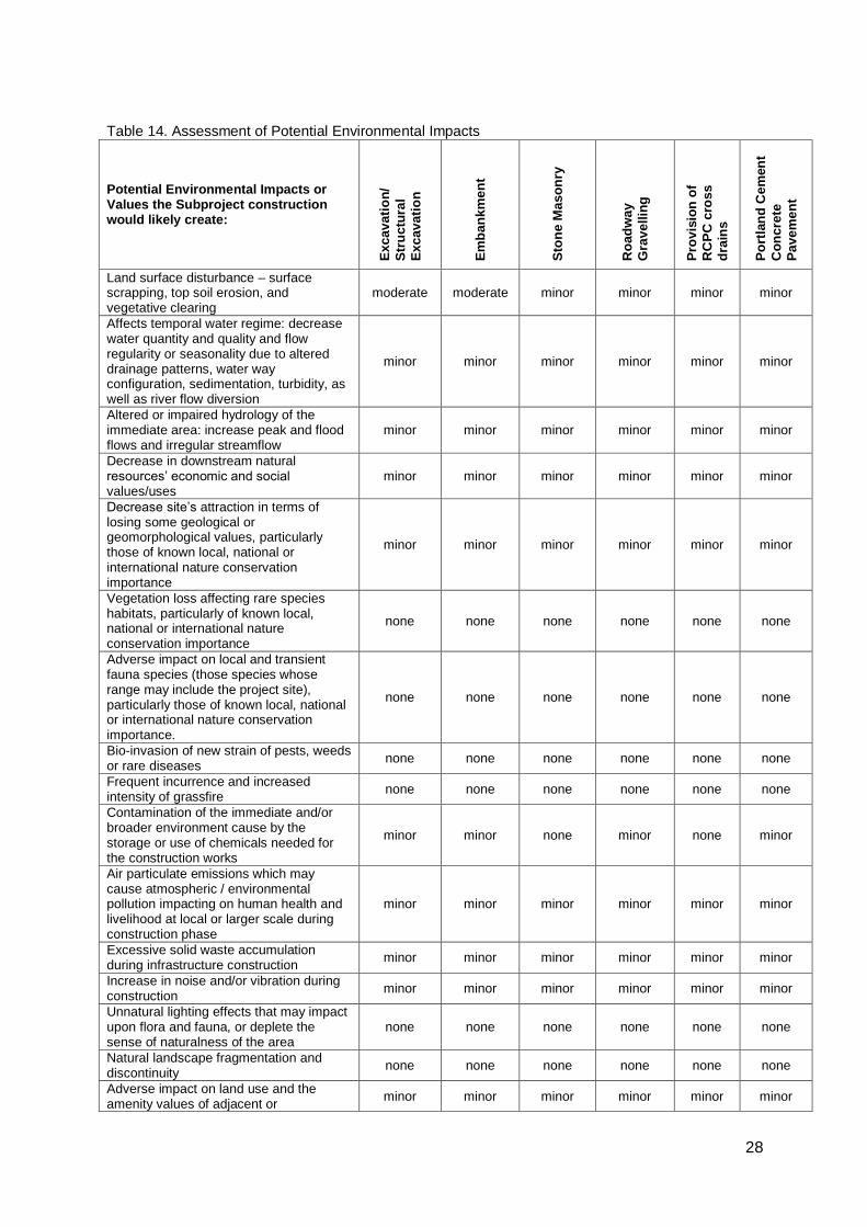
28
Table 14. Assessment of Potential Environmental Impacts
Potential Environmental Impacts or Values the Subproject construction would likely create:
Excavati
on
/
Str
uc
tura
l
Excavati
on
Em
ba
nk
me
nt
Sto
ne
Ma
so
nry
Ro
ad
wa
y
Gra
ve
llin
g
Pro
vis
ion
of
RC
PC
cro
ss
dra
ins
Po
rtla
nd
Ce
men
t
Co
nc
rete
Pa
ve
me
nt
Land surface disturbance – surface scrapping, top soil erosion, and vegetative clearing
moderate moderate minor minor minor minor
Affects temporal water regime: decrease water quantity and quality and flow regularity or seasonality due to altered drainage patterns, water way configuration, sedimentation, turbidity, as well as river flow diversion
minor minor minor minor minor minor
Altered or impaired hydrology of the immediate area: increase peak and flood flows and irregular streamflow
minor minor minor minor minor minor
Decrease in downstream natural resources’ economic and social values/uses
minor minor minor minor minor minor
Decrease site’s attraction in terms of losing some geological or geomorphological values, particularly those of known local, national or international nature conservation importance
minor minor minor minor minor minor
Vegetation loss affecting rare species habitats, particularly of known local, national or international nature conservation importance
none none none none none none
Adverse impact on local and transient fauna species (those species whose range may include the project site), particularly those of known local, national or international nature conservation importance.
none none none none none none
Bio-invasion of new strain of pests, weeds or rare diseases
none none none none none none
Frequent incurrence and increased intensity of grassfire
none none none none none none
Contamination of the immediate and/or broader environment cause by the storage or use of chemicals needed for the construction works
minor minor none minor none minor
Air particulate emissions which may cause atmospheric / environmental pollution impacting on human health and livelihood at local or larger scale during construction phase
minor minor minor minor minor minor
Excessive solid waste accumulation during infrastructure construction
minor minor minor minor minor minor
Increase in noise and/or vibration during construction
minor minor minor minor minor minor
Unnatural lighting effects that may impact upon flora and fauna, or deplete the sense of naturalness of the area
none none none none none none
Natural landscape fragmentation and discontinuity
none none none none none none
Adverse impact on land use and the amenity values of adjacent or
minor minor minor minor minor minor
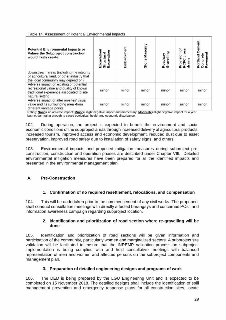
29
Table 14. Assessment of Potential Environmental Impacts
Potential Environmental Impacts or Values the Subproject construction would likely create:
Excavati
on
/
Str
uc
tura
l
Excavati
on
Em
ba
nk
me
nt
Sto
ne
Ma
so
nry
Ro
ad
wa
y
Gra
ve
llin
g
Pro
vis
ion
of
RC
PC
cro
ss
dra
ins
Po
rtla
nd
Ce
men
t
Co
nc
rete
Pa
ve
me
nt
downstream areas (including the integrity of agricultural land, or other industry that the local community may depend on)
Adverse impact on existing or potential recreational value and quality of known traditional experience associated to site natural setting
minor minor minor minor minor minor
Adverse impact or alter on-sites’ visual value and its surrounding area -from different vantage points
minor minor minor minor minor minor
Rating: None= no adverse impact; Minor= slight negative impact and momentary; Moderate=slight negative impact for a year but not damaging enough to cause ecological, health and economic disturbance.
102. During operation, the project is expected to benefit the environment and socio- economic conditions of the subproject areas through increased delivery of agricultural products, increased tourism, improved access and economic development, reduced dust due to asset preservation, improved road safety due to installation of safety signs, and others.
103. Environmental impacts and proposed mitigation measures during subproject pre-construction, construction and operation phases are described under Chapter VIII. Detailed environmental mitigation measures have been prepared for all the identified impacts and presented in the environmental management plan. A. Pre-Construction
1. Confirmation of no required resettlement, relocations, and compensation
104. This will be undertaken prior to the commencement of any civil works. The proponent shall conduct consultation meetings with directly affected barangays and concerned POs’, and information awareness campaign regarding subproject location.
2. Identification and prioritization of road section where re-gravelling will be done
105. Identification and prioritization of road sections will be given information and participation of the community, particularly women and marginalized sectors. A subproject site validation will be facilitated to ensure that the INREMP validation process on subproject implementation is being complied with and hold consultative meetings with balanced representation of men and women and affected persons on the subproject components and management plan.
3. Preparation of detailed engineering designs and programs of work
106. The DED is being prepared by the LGU Engineering Unit and is expected to be completed on 15 November 2018. The detailed designs shall include the identification of spill management prevention and emergency response plans for all construction sites, locate
30
aggregate borrow pits and rock supply areas away from human settlements with fencing and access barriers, and specific plan to notify and provide them schedule to minimize disruption to normal commercial and residential activities.
107. The LGU with assistance from TA-PMIC will ensure that relevant provisions of the EMP in terms of implementation of environmental mitigation measures, monitoring activities, supervision and reporting are included for civil works and construction supervision.
4. Recruitment of workers
108. The potential impact of the subproject will be hiring of skilled local workers and other unskilled jobs. A robust “local first” hiring policy will be designed and be implemented in coordination with local officials and community leaders especially at the barangay and municipal levels. The Contractor will be required to follow the “local first” hiring policy.
B. Construction
1. Construction materials acquisition, transport access, and storage system
109. The contractors will source construction materials under their own arrangements. Uncontrolled sourcing of such materials could lead to environmental impacts such as the loss of topsoil or the disfigurements of the landscape from borrow pits. Earthen embankments and material stockpiles will be susceptible to erosion, particularly during the rains and re-suspension of dust during the dry seasons.
110. Local roads will be damaged during transportation of borrow materials and by the construction equipment. These roads include those which are leading to the project site. In order to reduce impact on all borrow sites, contractors will water the local roads close to the settlements used by the borrow trucks. As much as possible, contractors will not make use of productive agricultural land. In case this is unavoidable, the contractor will obtain consent from the land owner and will restore the site to its original condition after completion of civil works.
2. Clearing and removal of obstructions
111. The contractors will initiate clearing and removal of obstructions on the existing road that would result to damaged landscape. It must be noted that there are no affected trees on the proposed access road rehabilitation project. However, vegetation (mostly grasses) in the site is common and will recover after the construction. The contractors will not use or permit the use of wood as a fuel for the execution of any part of the works. The contractor will be required to minimize damage and cutting of surrounding vegetation during slope formation, and prevent erosion and protect the cut slope with temporary or permanent drainage as soon as practicable after cutting. If new erosion occurs accidentally, back fill immediately to restore original contours. .
3. Soil erosion
112. Soil erosion and unstable side slopes susceptible to landslides are noticed along subproject road. The impact of soil erosion and unstable side slope are increased run off and sedimentation causing a greater flood hazard to the downstream, loss of topsoil affects the growth of vegetation that causes ecological imbalances, and development of unsightly cuts and
31
fills that have been riddled by uncontrolled erosion and gullying. Construction activities should be taken up only during dry season.
113. During operation, silt load in the river is expected to be minor due to slope protection structures installed. The contractor will also be required to make additional measures to minimize erosion and landslides during construction phase such as 1) minimize damage and cutting of surrounding vegetation during slope formation, 2) prevent erosion and protect the cut slope with temporary drainage as soon as practicable after cutting, and 3) If new erosion occurs accidentally, back fill immediately to restore original contours.
4. Ground surface leveling and gravelling of existing road
114. During ground surface leveling and gravelling of existing road, the potential impacts would be minor and short-termed to the terrestrial resources as well as to the quality of surface water in the river. The contractor will be required to do the following: 1) the construction site should be located away from forested or plantation areas, 2) all construction fluids such as oils, and fuels should be stored and handled away from forested and plantation areas, 3) no waste of any kind is to be discarded on land or in forests/plantations, 4) erosion channels must be built around aggregate stockpile areas to contain rain-induced erosion, 5) earthworks should be conducted during dry periods, 6) no waste of any kind is to be thrown in surface waters, 7) no washing or repair of machinery near surface waters, 8) pit latrines to be located away from surface waters, 9) no unnecessary earthworks in or adjacent to water courses, 10) no aggregate mining from rivers or lakes, and 11) minimize the use of heavy equipment at steep slopes.
5. Civil works
115. Since the subproject will mainly involve concrete pavement (with no road widening and realignments), main impacts on land during construction are from air pollution, land and water contamination, and traffic and access problems. The contractor will apply stated mitigating measures during concrete pavement and stone masonry activities such as 1) piling of aggregates at sites should be used/or removed promptly, or covered and placed in non-traffic areas, and 2) all spills should be cleaned immediately and handled as per hazardous waste management plan, and according to government regulations.
6. Implementation of noise and dust control measure
116. During construction, air quality will certainly decrease by exhaust emissions from construction equipment, dust generated from haul roads, unpaved roads, exposed soils and material stock piles.
117. To mitigate the declining air quality problem during construction, the following will be implemented: 1) regularly apply wetting agents to exposed soil and construction roads, 2) cover or keep moist all stockpiles of construction aggregates, and all truckloads of aggregates, 3) minimize the time for excavations and exposed soil are left open or exposed, 4) backfill immediately after work is completed, 5) restrict working time between 7:00 am and 5:00 pm, 6) maintain equipment in proper working condition, 7) replace unnecessarily noisy vehicles and machinery, 8) vehicles and machinery to be turned off when not in use, and 9) construct temporary noise barriers around excessively noisy activity areas if possible.
32
7. Dust and noise from borrow pits
118. Noise and dust may be generated from borrow pits. The contractor will ensure the following mitigating measures: 1) provision of noise control measures to comply with national standards, watering of the earth roads close to the settlements, use covered truck, 2) secure appropriate environmental permits, 3) the borrow and material dumping sites must be access controlled to keep away unauthorized entry of people, grazing cattle and any other stray animals, and 4) protective gear like ear plugs will be provided to operating personnel if they are exposed to noise levels beyond threshold limits.
8. Implementation of spoil management and control measure
119. The contractor will ensure that there will be no contamination of land and surface waters from excavated spoils, and construction wastes. The uncontaminated spoils will be disposed of in municipal or provincial designated sites, which must never be in or adjacent surface water. On the other hand, suspicious contaminated soil will be tested, and disposed of in designated sites identified as per government regulations.
9. Solid and liquid construction waste management system
120. Solid and liquid construction wastes management system will be facilitated to avoid contamination of land and surface water from the construction wastes. The management of general solid and liquid wastes of construction will follow government regulations to include covering, collecting, handling, transporting, recycling, and disposing waste created from construction activities and the work force. A schedule of solid and liquid waste pickup and disposal will be established and followed to ensure construction sites are as clean as possible. All solid wastes will be separated and recyclables be donated to the barangay. There will be no site specific landfills established by the contractors. All solid waste will be collected and removed from the work camps and disposed in local waste disposal sites.
10. Water quality
121. The subproject has potential impacts on water quality due to washing of equipment (i.e. vehicles and concrete mixers), and leakage and spills from discharge from worker camps to the water resources. To mitigate, there should be : 1) set up proper and adequate sanitary facilities, 2) ensure strict observance of proper waste handling and disposal and proper sanitation including by the contractors and its workers, 3) provide wastewater treatment facility (e.g., septic tank), and 4) trucks and other vehicle maintenance should be strictly controlled to prevent the discharge of waste into the river system. Wastewater from the construction works containing high concentration of suspended solids should be treated through sedimentation tanks. 5) The discharge of cement-laden water and slurry during concrete mixing may contaminate water resources and damage productive land in the surrounding areas. To mitigate possible effects of cement-laden water and slurry, the Contractor shall i) collect and retain all the concrete washout water and solids in leak proof containers, so that this does not reach the soil surface and then migrate to surface waters or into the ground water, ii) recycle the collected concrete washout water and solids, and/or iii) use of a wash outpit made with a plastic lining that can be dug into the ground or built above grade.
33
11. Construction drainage system
122. The contractor shall construct drainage systems to facilitate drainage and rain water natural channels. The contractor will also provide adequate short-term drainage away from construction sites to prevent ponding and flooding.
12. Workers health, safety and hygiene
123. Construction sites are likely to have public health impacts. Contractors will ensure that no untreated wastewater is discharged in the river and that no site-specific landfills will be established at the construction camps. There will be a potential for diseases to be transmitted, exacerbated by inadequate health and safety practices. The contractor will therefore be required to recruit or designate a health and safety officer to address such concerns in the work sites and liaise/work with the nearby communities.
124. Mitigation measures include: 1) proper fencing, protective barriers, and buffer zones should be provided around all construction sites, 2) sufficient signage and information disclosure, and supervisors and night guards should be placed, 3) worker and public safety guidelines should be followed, 4) provide adequate sanitation and waste disposal at construction sites, 5) the contractor will not hire children and pregnant women, 6) standing water suitable for disease vector breeding should be filled in, 7) worker education and awareness seminars for construction hazards should be given at the beginning of the construction phase. A construction site safety program should be developed and distributed to workers, 8) appropriate safety clothing, footwear, gloves, hard hats, eye protection and other PPE should be mandatory for all construction workers, 9) adequate medical services must be on site or nearby all construction site, 10) drinking water must be provided at all construction sites, 11) sufficient lighting be used during necessary night work, and 12) all construction sites should be examined daily to ensure unsafe conditions are removed.
13. Traffic safety and management
125. Throughout the construction period, the contractor should ensure that affected people are provided adequate and safe access to properties (structures, land, etc.). During construction, the contractor is responsible for ensuring that all construction vehicles observe speed limits on the construction sites and to provide adequate signage, barriers, and flag persons for traffic control. Sign postings such as ‘men working’, ‘Keep left/right’, ‘construction ahead’, and ‘speed limit’, should be used for traffic management and road safety. As much as possible, road works will be confined to one half of the road width at each section to provide access to pedestrian and vehicles during construction works.
14. Ecological environment
126. Rehabilitation work will directly cause minor degradation of the local ecology through the clearance of small areas of vegetation (mainly grasses) at major work sites. A short-term impact on ecology along the rehabilitated road is likely to occur in worksites during the construction period due to minor vegetation clearance (mainly grasses, not trees). Vegetative cover stripped from the locations described above will be kept for slope protection.
127. Meanwhile, the potential impacts from construction worker camps are poaching of edible animals and birds of the locality in spite of prohibitions. The contractors’ will be responsible for providing adequate knowledge to the workers regarding the protection of fauna. In short, all workers will be prohibited from hunting wild animals.
34
15. Damaged to properties
128. Another potential impact during construction is damaged to properties (structures, irrigation, farmland) and access roads due to civil works, transport of materials and other project-related activities. To address this impact, the contractor will immediately repair and/or compensate for any damage that it causes to properties (houses, farmlands, aquaculture ponds, irrigation canals, and others), community facilities such as water supply, power supply, communication facilities and the like. Access roads used for transport of construction materials and other construction-related activities will be maintained by the Contractor in at least in their pre-project condition for the duration of construction.
16. Concrete washout
129. The discharge of cement-laden water and slurry during concrete mixing may contaminate water resources and damage productive land in the surrounding areas. To mitigate possible effects of cement-laden water and slurry, the Contractor shall 1) collect and retain all the concrete washout water and solids in leak proof containers, so that this does not reach the soil surface and then migrate to surface waters or into the ground water, 2) recycle the collected concrete washout water and solids, and/or 3) use of a washout pit made with a plastic lining that can be dug into the ground or built above grade.
17. Use of Hazardous Substances
130. Storage and use of fuel, lubricant and other toxic and hazardous chemicals will have potential impacts on soil surface and groundwater contamination. To address this impact, vehicle maintenance and refueling will be confined to areas in construction sites designed (with concrete flooring, drainage leading to oil and water separator, etc.) to contain spilled lubricants and fuels. Spill waste will be disposed to sites approved by the concerned government agency and following national regulations. Adequate precaution will be taken to prevent oil/lubricant/ hazardous substances contamination of channel beds. Spillage if any will be immediately cleared with utmost caution to leave no traces. All areas intended for storage of hazardous materials will be quarantined and provided with adequate facilities to combat emergency situations such as fire, spills, etc. in compliance with all the applicable statutory stipulation. The personnel in-charge of these sites will be properly trained and these areas will be access controlled and entry will be allowed only under authorization. Hazardous wastes will be collected, stored, transported and disposed consistent with national regulations to ensure that these will not cause pollution of surrounding areas.
18. Public safety
131. Some of the mitigation measures that should be implemented are as follows: To mitigate this impact, the following should be addressed by the Contractor: 1) installation of sturdy fencing around excavation areas and construction sites, 2) provision of proper signage and lighting at night at the periphery of the construction site to warn and direct traffic and pedestrians, 3) deployment of security personnel in hazardous areas to restrict public access, 4) imposition of speed limits for construction vehicles along residential areas and where there are other sensitive receptors, and 5) orientation of drivers on safe driving practices to minimize accidents and to prevent spill of hazardous substances and other construction materials during transport.
35
C. Operation and Maintenance (O&M) Phase
1. Operation of upgraded access road
132. The rehabilitation of Dilausan-Mapantao road will directly increase delivery of agricultural products, access to natural resources management project sites, and opportunity for tourism businesses. On the other hand, the potential negative impacts include increased risk of accident or injury, exploitation of natural resources in the area, and unplanned urbanization.
VI. INFORMATION DISCLOSURE, CONSULTATION, ANDPARTICIPATION
A. Stakeholder Consultations
133. The IEE process included stakeholder participation and consultation to help LGUs achieve public acceptance of the Subproject. In April 2016, the Team arrived at the municipality of Saguiaran and initiated a meeting with the LGU/SPMU and FIUs to discuss the objectives of the visit (Appendix 2). After the meeting, site or ocular inspection was conducted to validate the scope of works and location. A writeshop was also conducted which was attended by the LCE, SPMU and INREMP project persons. The consultation with barangay officials, residents, and local government unit of Saguiaran confirmed that the rehabilitation of the access road is essential for economic development. 134. Another consultation was conducted with the influenced barangay last November 9, 2017 (Appendix 3 and Appendix 4). They presented the subproject describing the objective of the consultation, project description, proposed civil works, and anticipated negative environmental impacts and their mitigation measures. The consultation was effective and successful. The results were positive, with the local people expecting the road to bring significant economic benefits and increase trade flows in the barangays. Concerns on the subproject mainly revolved on the construction phase. These, however, can be mitigated. No long-term negative environmental impact was assessed by the participants. On the other hand, Majority of the respondents cited ease of transport as one of the direct benefits of the road; majority of them as well are not anticipating any negative impact of the subproject to the environment though one of the respondents mentioned that the road might be a corridor for illegal loggers to access the forest land so he suggested an intensified barangay patrolling during the operation phase of the access road. The discussions during the consultations were documented.
135. Furthermore, the influenced barangay endorsed the proposed road rehabilitation of Dilausan-Mapantao Access Road for inclusion to INREMP rural infrastructure component with the involvement of the LGU in the subproject activities of INREMP particularly in the implementation of rural infrastructure support facilities, they dedicated time and effort in participating with orientation, consultation, planning and training activities. Indeed, The Sangguniang Bayan (SB) or Municipal Council passed a Resolution affirming support to INREMP and authorizing the Local Chief Executive (Mayor) to enter into contract for the rehabilitation of Dilausan-Mapantao Access Road (Appendix 5).
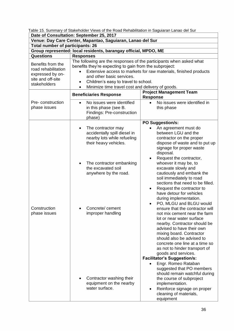
36
Table 15. Summary of Stakeholder Views of the Road Rehabilitation in Saguiaran Lanao del Sur
Date of Consultation: September 25, 2017
Venue: Day Care Center, Mapantao, Saguiaran, Lanao del Sur
Total number of participants: 26
Group represented: local residents, barangay official, MPDO, ME
Questions Responses
Benefits from the road rehabilitation expressed by on-site and off-site stakeholders
The following are the responses of the participants when asked what benefits they’re expecting to gain from the subproject:
Extensive access to markets for raw materials, finished products and other basic services.
Children’s easy to travel to school.
Minimize time travel cost and delivery of goods.
Pre- construction phase issues
Beneficiaries Response Project Management Team Response
No issues were identified in this phase (see B. Findings: Pre-construction phase)
No issues were identified in this phase
Construction phase issues
The contractor may accidentally spill diesel in nearby lots while refueling their heavy vehicles.
The contractor embanking the excavated soil anywhere by the road.
Concrete/ cement improper handling
Contractor washing their equipment on the nearby water surface.
PO Suggestion/s:
An agreement must do between LGU and the contractor on the proper dispose of waste and to put up signage for proper waste disposal.
Request the contractor, whoever it may be, to excavate slowly and cautiously and embank the soil immediately to road sections that need to be filled.
Request the contractor to have detour for vehicles during implementation.
PO, MLGU and BLGU would ensure that the contractor will not mix cement near the farm lot or near water surface nearby. Contractor should be advised to have their own mixing board. Contractor should also be advised to concrete one line at a time so as not to hinder transport of goods and services.
Facilitator’s Suggestion/s:
Engr. Romeo Rataban suggested that PO members should remain watchful during the course of subproject implementation.
Reinforce signage on proper cleaning of materials, equipment

37
Operation and maintenance phase issues
Improper waste disposal on the road as there will be increase of people passing by
Possible increase of vehicles utilizing the road, that may result to incidence because vehicle riders may increase their speed since the road would already be in a good condition.
Improved condition of road provides opportunity for illegal loggers to access forestry resources
PO member suggested that maintenance activities should be regularly conducted. Canals should also be cleaned regularly
Another PO member suggested that road safety signs such as speed limits should be put up along the road.
Plant trees along the road to provide shade
Barangay to monitor activities within its jurisdiction which is easier because of improved road facility.
Facilitator’s Suggestion/s:
Engr. Romeo Rataban suggested that LGU should look over the concerns that A & D area could be possible to rehabilitate.
Suggested impact mitigation measures
Aside from the anticipated issues and its corresponding mitigations/ responses mentioned on the previous table, the TA-PMIC also identified potential issues and mitigation measures that the subproject might face. These issues and measures are all captured on the Environmental Impact Mitigation Plan of Saguiaran, Lanao del Sur.
B. Information Disclosure
136. After study completion, the IEE documenting the mitigation measures and consultation process will be submitted to ADB for posting on their website, DENR-FMB, the Municipality of Saguiaran, Lanao del Sur and the one affected Barangay office, DENR regional office, which will make them available to the public. More informal and vigorous level of disclosure and consultation will be done during implementation through:
- The preparation and dissemination of a brochure in local languages, explaining the affected peoples’ entitlements and the procedures for obtaining compensation for temporary disturbances, trees, crops, and land for construction camps and recording grievances; and
- Setting up a formal grievance redress committee with a representation from the affected people. Field consultant in association with the Contractor will be responsible for managing the effective grievance redress program.
VII. GRIEVANCE REDRESS MECHANISM
137. The Local Government Unit of Saguiaran has properly conducted the consultations with the different stakeholders of the subproject site. However, it still has to make room for possible issues, concerns, or grievances and disputes arising from the communities in relation

38
to the project implementation. Thus, it sets up a Grievance Redress Mechanism to provide a venue for resolving grievances and disputes even at the lowest level. This will be done to resolve disputes as early and as quickly as possible before it escalates to an unmanageable level.
138. Since, the community consultations were conducted smoothly and no adverse or violent reactions have been noted, there are only minor grievances that are anticipated which may arise. These are listed below: A subproject-specific grievance redress mechanism will be established at the PPCO to receive, evaluate and facilitate the complaints/grievances of affected persons on the sub-project’s environmental performance. This mechanism will be disclosed to the host communities before start of civil works.
1) Road accessibility related grievances – This may include complaints from
communities using the roads under repair or construction due to temporary obstruction, which may cause delay in travel time and other inconveniences of the travelling public.
2) Construction related grievances – Community members may demand to be hired
as part of the labor force in the project construction/implementation. This may also include complaints of community members regarding noise, drainage, and etc.
139. A subproject-specific grievance redress mechanism will be established at the PPCO to receive, evaluate and facilitate the complaints/grievances of affected persons on the sub-project’s environmental performance. This mechanism will be disclosed to the host communities before start of civil works. 140. The grievance redress committee (GRC) will be chaired by the PPCO head. Members will include the following: (i) designated GRM officer of PPCO, (ii) contractor’s highest official at the site such as the Construction Manager or the Construction Superintendent; and (iii) Barangay Chairperson. For the quick filing of complaints, the GRC will use the attached grievance intake form (Appendix 06). The PPCO's GRM officer will be responsible for registration of grievances and communication with the aggrieved party.
141. The steps to be followed in filing complaints and the procedures for redress are the following:
(i) complainant will provide the background and file the complaint verbally or in
writing to the PPCO, and the PPCO's GRM officer will assist the complainant in filling-up the grievance intake form;
(ii) within 2 working days, the GRM Officer, contractor’s representative, and complainant will discuss if the complaint can be resolved without calling for a GRC meeting;
(iii) within 3 days of lodging the complaint, the PPCO's GRM officer will provide the complainant a written feedback on the process, steps and timeframe for resolving the complaint.
(iv) if the complaint cannot be resolved, a GRC meeting with the complainant will be called within 5 working days;
(v) the GRC will have 15 working days to resolve the complaint; (vi) the complainant will receive feedback from the PPCO's GRM officer within 5
working days after the various steps of the GRM are completed; and (vii) if unsatisfied with the decision, the existence of the GRC will not impede the
complainant's access to the Government's judicial, administrative remedies or through concerned government agencies (e.g., Community Environment and Natural Resources Office and Provincial Environment and Natural Resources Office of DENR, Regional offices of the Environmental Management Bureau,
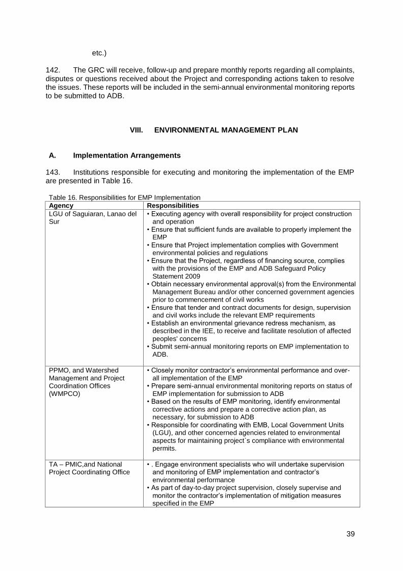
39
etc.)
142. The GRC will receive, follow-up and prepare monthly reports regarding all complaints, disputes or questions received about the Project and corresponding actions taken to resolve the issues. These reports will be included in the semi-annual environmental monitoring reports to be submitted to ADB.
VIII. ENVIRONMENTAL MANAGEMENT PLAN
A. Implementation Arrangements
143. Institutions responsible for executing and monitoring the implementation of the EMP are presented in Table 16. Table 16. Responsibilities for EMP Implementation
Agency Responsibilities
LGU of Saguiaran, Lanao del Sur
• Executing agency with overall responsibility for project construction and operation
• Ensure that sufficient funds are available to properly implement the EMP
• Ensure that Project implementation complies with Government environmental policies and regulations
• Ensure that the Project, regardless of financing source, complies with the provisions of the EMP and ADB Safeguard Policy Statement 2009
• Obtain necessary environmental approval(s) from the Environmental Management Bureau and/or other concerned government agencies prior to commencement of civil works
• Ensure that tender and contract documents for design, supervision and civil works include the relevant EMP requirements
• Establish an environmental grievance redress mechanism, as described in the IEE, to receive and facilitate resolution of affected peoples' concerns
• Submit semi-annual monitoring reports on EMP implementation to ADB.
PPMO, and Watershed Management and Project Coordination Offices (WMPCO)
• Closely monitor contractor’s environmental performance and over-all implementation of the EMP
• Prepare semi-annual environmental monitoring reports on status of EMP implementation for submission to ADB
• Based on the results of EMP monitoring, identify environmental corrective actions and prepare a corrective action plan, as necessary, for submission to ADB
• Responsible for coordinating with EMB, Local Government Units (LGU), and other concerned agencies related to environmental aspects for maintaining project`s compliance with environmental permits.
TA – PMIC,and National Project Coordinating Office
• . Engage environment specialists who will undertake supervision and monitoring of EMP implementation and contractor’s environmental performance
• As part of day-to-day project supervision, closely supervise and monitor the contractor’s implementation of mitigation measures specified in the EMP
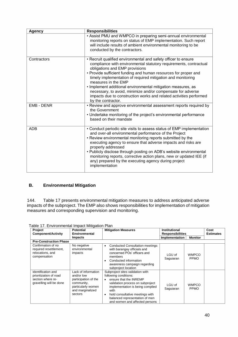
40
Agency Responsibilities
• Assist PMU and WMPCO in preparing semi-annual environmental monitoring reports on status of EMP implementation. Such report will include results of ambient environmental monitoring to be conducted by the contractors.
Contractors • Recruit qualified environmental and safety officer to ensure compliance with environmental statutory requirements, contractual obligations and EMP provisions
• Provide sufficient funding and human resources for proper and timely implementation of required mitigation and monitoring measures in the EMP
• Implement additional environmental mitigation measures, as necessary, to avoid, minimize and/or compensate for adverse impacts due to construction works and related activities performed by the contractor.
EMB - DENR • Review and approve environmental assessment reports required by the Government
• Undertake monitoring of the project’s environmental performance based on their mandate
ADB • Conduct periodic site visits to assess status of EMP implementation and over-all environmental performance of the Project
• Review environmental monitoring reports submitted by the executing agency to ensure that adverse impacts and risks are properly addressed
• Publicly disclose through posting on ADB’s website environmental monitoring reports, corrective action plans, new or updated IEE (if any) prepared by the executing agency during project implementation
B. Environmental Mitigation
144. Table 17 presents environmental mitigation measures to address anticipated adverse impacts of the subproject. The EMP also shows responsibilities for implementation of mitigation measures and corresponding supervision and monitoring.
Table 17. Environmental Impact Mitigation Plan
Project Component/Activity
Potential Environmental Impacts
Mitigation Measures Institutional Responsibilities
Cost Estimates
Implementation Monitor
Pre-Construction Phase
Confirmation of no required resettlement, relocations, and compensation
No negative environmental impacts
Conducted Consultation meetings with barangay officials and concerned POs’ officers and members
Conducted information awareness campaign regarding subproject location
LGU of Saguiaran
WMPCO PPMO
Identification and prioritization of road section where re-gravelling will be done
Lack of information and/or low participation of the community, particularly women and marginalized sectors
Subproject sites validation with following conditions:
ensure that the INREMP validation process on subproject implementation is being complied with
hold consultative meetings with balanced representation of men and women and affected persons
LGU of Saguiaran
WMPCO PPMO
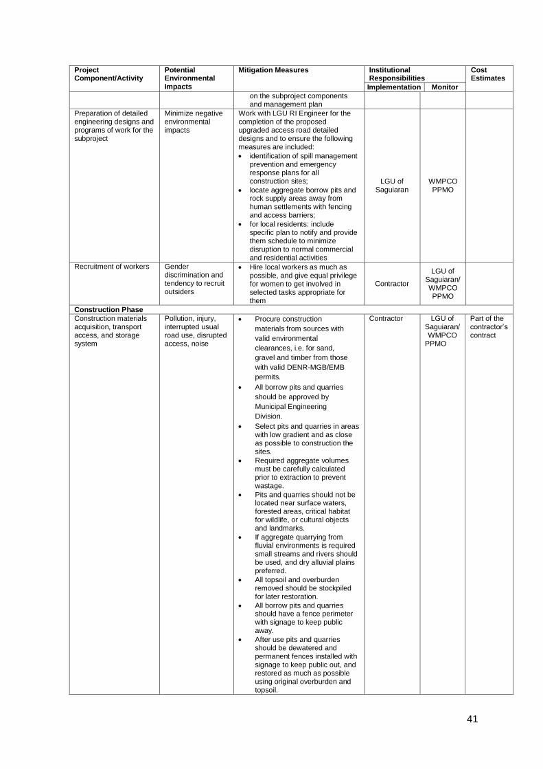
41
Project Component/Activity
Potential Environmental Impacts
Mitigation Measures Institutional Responsibilities
Cost Estimates
Implementation Monitor
on the subproject components and management plan
Preparation of detailed engineering designs and programs of work for the subproject
Minimize negative environmental impacts
Work with LGU RI Engineer for the completion of the proposed upgraded access road detailed designs and to ensure the following measures are included:
identification of spill management prevention and emergency response plans for all construction sites;
locate aggregate borrow pits and rock supply areas away from human settlements with fencing and access barriers;
for local residents: include specific plan to notify and provide them schedule to minimize disruption to normal commercial and residential activities
LGU of Saguiaran
WMPCO PPMO
Recruitment of workers Gender discrimination and tendency to recruit outsiders
Hire local workers as much as possible, and give equal privilege for women to get involved in selected tasks appropriate for them
Contractor
LGU of Saguiaran/ WMPCO PPMO
Construction Phase
Construction materials acquisition, transport access, and storage system
Pollution, injury, interrupted usual road use, disrupted access, noise
Procure construction
materials from sources with
valid environmental
clearances, i.e. for sand,
gravel and timber from those
with valid DENR-MGB/EMB
permits.
All borrow pits and quarries
should be approved by
Municipal Engineering
Division.
Select pits and quarries in areas with low gradient and as close as possible to construction the sites.
Required aggregate volumes must be carefully calculated prior to extraction to prevent wastage.
Pits and quarries should not be located near surface waters, forested areas, critical habitat for wildlife, or cultural objects and landmarks.
If aggregate quarrying from fluvial environments is required small streams and rivers should be used, and dry alluvial plains preferred.
All topsoil and overburden removed should be stockpiled for later restoration.
All borrow pits and quarries should have a fence perimeter with signage to keep public away.
After use pits and quarries should be dewatered and permanent fences installed with signage to keep public out, and restored as much as possible using original overburden and topsoil.
Contractor LGU of Saguiaran/ WMPCO
PPMO
Part of the contractor’s contract
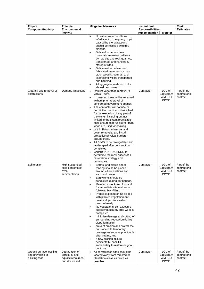
42
Project Component/Activity
Potential Environmental Impacts
Mitigation Measures Institutional Responsibilities
Cost Estimates
Implementation Monitor
Unstable slope conditions in/adjacent to the quarry or pit caused by the extractions should be rectified with tree planting.
Define & schedule how materials are extracted from borrow pits and rock quarries, transported, and handled & stored at sites.
Define and schedule how fabricated materials such as steel, wood structures, and scaffolding will be transported and handled.
All aggregate loads on trucks should be covered.
Clearing and removal of obstructions
Damage landscape Restrict vegetation removal to within RoWs.
In case, no trees will be removed without prior approval of concerned government agency.
The contractor will not use or permit the use of wood as a fuel for the execution of any part of the works, including but not limited to the extent practicable shall ensure that fuels other than wood are used for cooking.
Within RoWs, minimize land cover removals, and install protective physical barriers around trees.
All RoWs to be re-vegetated and landscaped after construction completed.
Consult PENRO/CENRO to determine the most successful restoration strategy and techniques.
Contractor LGU of Saguiaran/ WMPCO PPMO
Part of the contractor’s contract
Soil erosion High suspended solid contents of river, sedimentation.
Berms, and plastic sheet fencing should be placed around all excavations and earthwork areas.
Earthworks should be conducted during dry periods.
Maintain a stockpile of topsoil for immediate site restoration following backfilling.
Protect exposed or cut slopes with planted vegetation and have a slope stabilization protocol ready.
Re-vegetate all soil exposure areas immediately after work is completed.
minimize damage and cutting of surrounding vegetation during slope formation,
prevent erosion and protect the cut slope with temporary drainage as soon as practicable after cutting, and
If new erosion occurs accidentally, back fill immediately to restore original contours.
Contractor LGU of Saguiaran/ WMPCO PPMO
Part of the contractor’s contract
Ground surface leveling and gravelling of existing road
Degradation of terrestrial and aquatic resources, and decreased
All construction sites should be located away from forested or plantation areas as much as possible.
Contractor LGU of Saguiaran/ WMPCO PPMO
Part of the contractor’s contract
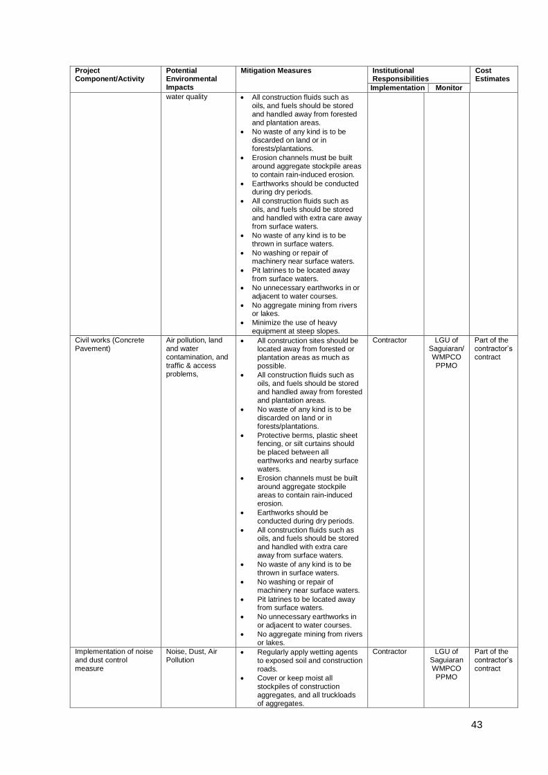
43
Project Component/Activity
Potential Environmental Impacts
Mitigation Measures Institutional Responsibilities
Cost Estimates
Implementation Monitor
water quality All construction fluids such as oils, and fuels should be stored and handled away from forested and plantation areas.
No waste of any kind is to be discarded on land or in forests/plantations.
Erosion channels must be built around aggregate stockpile areas to contain rain-induced erosion.
Earthworks should be conducted during dry periods.
All construction fluids such as oils, and fuels should be stored and handled with extra care away from surface waters.
No waste of any kind is to be thrown in surface waters.
No washing or repair of machinery near surface waters.
Pit latrines to be located away from surface waters.
No unnecessary earthworks in or adjacent to water courses.
No aggregate mining from rivers or lakes.
Minimize the use of heavy equipment at steep slopes.
Civil works (Concrete Pavement)
Air pollution, land and water contamination, and traffic & access problems,
All construction sites should be located away from forested or plantation areas as much as possible.
All construction fluids such as oils, and fuels should be stored and handled away from forested and plantation areas.
No waste of any kind is to be discarded on land or in forests/plantations.
Protective berms, plastic sheet fencing, or silt curtains should be placed between all earthworks and nearby surface waters.
Erosion channels must be built around aggregate stockpile areas to contain rain-induced erosion.
Earthworks should be conducted during dry periods.
All construction fluids such as oils, and fuels should be stored and handled with extra care away from surface waters.
No waste of any kind is to be thrown in surface waters.
No washing or repair of machinery near surface waters.
Pit latrines to be located away from surface waters.
No unnecessary earthworks in or adjacent to water courses.
No aggregate mining from rivers or lakes.
Contractor LGU of Saguiaran/ WMPCO PPMO
Part of the contractor’s contract
Implementation of noise and dust control measure
Noise, Dust, Air Pollution
Regularly apply wetting agents to exposed soil and construction roads.
Cover or keep moist all stockpiles of construction aggregates, and all truckloads of aggregates.
Contractor LGU of Saguiaran WMPCO PPMO
Part of the contractor’s contract
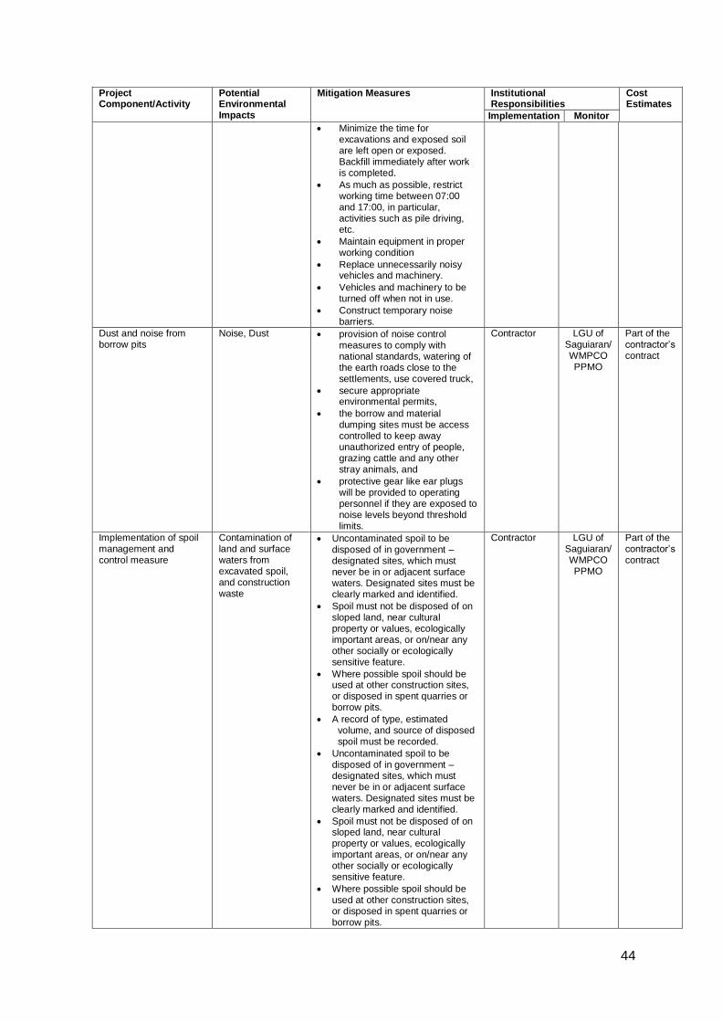
44
Project Component/Activity
Potential Environmental Impacts
Mitigation Measures Institutional Responsibilities
Cost Estimates
Implementation Monitor
Minimize the time for excavations and exposed soil are left open or exposed. Backfill immediately after work is completed.
As much as possible, restrict working time between 07:00 and 17:00, in particular, activities such as pile driving, etc.
Maintain equipment in proper working condition
Replace unnecessarily noisy vehicles and machinery.
Vehicles and machinery to be turned off when not in use.
Construct temporary noise barriers.
Dust and noise from borrow pits
Noise, Dust provision of noise control measures to comply with national standards, watering of the earth roads close to the settlements, use covered truck,
secure appropriate environmental permits,
the borrow and material dumping sites must be access controlled to keep away unauthorized entry of people, grazing cattle and any other stray animals, and
protective gear like ear plugs will be provided to operating personnel if they are exposed to noise levels beyond threshold limits.
Contractor LGU of Saguiaran/ WMPCO PPMO
Part of the contractor’s contract
Implementation of spoil management and control measure
Contamination of land and surface waters from excavated spoil, and construction waste
Uncontaminated spoil to be disposed of in government –designated sites, which must never be in or adjacent surface waters. Designated sites must be clearly marked and identified.
Spoil must not be disposed of on sloped land, near cultural property or values, ecologically important areas, or on/near any other socially or ecologically sensitive feature.
Where possible spoil should be used at other construction sites, or disposed in spent quarries or borrow pits.
A record of type, estimated volume, and source of disposed spoil must be recorded.
Uncontaminated spoil to be disposed of in government –designated sites, which must never be in or adjacent surface waters. Designated sites must be clearly marked and identified.
Spoil must not be disposed of on sloped land, near cultural property or values, ecologically important areas, or on/near any other socially or ecologically sensitive feature.
Where possible spoil should be used at other construction sites, or disposed in spent quarries or borrow pits.
Contractor LGU of Saguiaran/ WMPCO PPMO
Part of the contractor’s contract

45
Project Component/Activity
Potential Environmental Impacts
Mitigation Measures Institutional Responsibilities
Cost Estimates
Implementation Monitor
A record of type, estimated volume, and source of disposed spoil must be recorded.
Contaminated spoil disposal must follow government regulations including handling, transport, treatment (if necessary), and disposal.
Suspected contaminated soil must be tested, and disposed of in designated sites identified as per government regulations.
Before treatment or disposal contaminated spoil must be covered with plastic and isolated from all human activity.
Solid and liquid construction waste management system
Contamination of land and surface waters from construction waste
Management of general solid and liquid waste of construction will follow government regulations to include covering, collecting, handling, transporting, recycling, and disposing waste created from construction activities and the work force.
Disposal areas for solid and liquid waste must be determined by the government.
Disposal of waste should be catalogued for type, estimated weigh, and source.
Construction sites should have large garbage bins.
A schedule of solid and liquid waste pickup and disposal must be established and followed that ensures construction sites are as clean as possible.
Solid waste should be separated and recyclables be sold to buyers in the community.
Hazardous Waste
Collection, storage, transport, and disposal of hazardous waste such as used oils, gasoline, paint, and other toxics must follow government regulations.
Wastes should be separated (e.g., hydrocarbons, batteries, paints, organic solvents)
Wastes must be stored above ground in closed, well labeled, ventilated plastic bins in good condition, away from construction activity areas, all surface water, water supplies, and cultural and ecological sensitive receptors.
All spills must be cleaned up completely with all contaminated soil removed and handled with by contaminated spoil sub-plan.
Contractor LGU of Saguiaran/ WMPCO PPMO
Part of the contractor’s contract
Construction drainage system
Loss of drainage and rain water natural channels
Provide adequate short-term drainage away from construction sites to prevent ponding and flooding.
Prevent borrow pits and quarries to be filled with water. Pump periodically to infiltration areas or nearby water courses.
Install temporary storm drains or ditches for construction sites
Contractor LGU of Saguiaran/ WMPCO PPMO
Part of the contractor’s contract
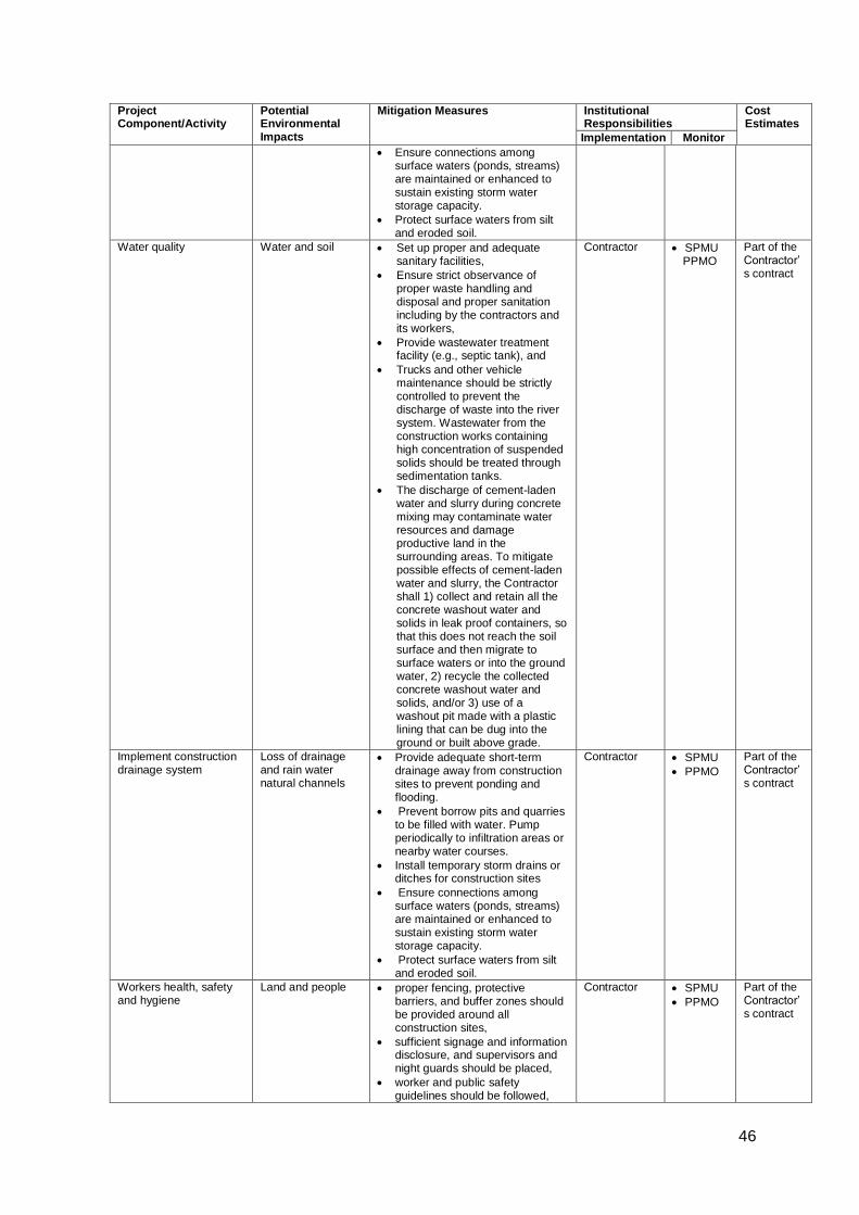
46
Project Component/Activity
Potential Environmental Impacts
Mitigation Measures Institutional Responsibilities
Cost Estimates
Implementation Monitor
Ensure connections among surface waters (ponds, streams) are maintained or enhanced to sustain existing storm water storage capacity.
Protect surface waters from silt and eroded soil.
Water quality Water and soil Set up proper and adequate sanitary facilities,
Ensure strict observance of proper waste handling and disposal and proper sanitation including by the contractors and its workers,
Provide wastewater treatment facility (e.g., septic tank), and
Trucks and other vehicle maintenance should be strictly controlled to prevent the discharge of waste into the river system. Wastewater from the construction works containing high concentration of suspended solids should be treated through sedimentation tanks.
The discharge of cement-laden water and slurry during concrete mixing may contaminate water resources and damage productive land in the surrounding areas. To mitigate possible effects of cement-laden water and slurry, the Contractor shall 1) collect and retain all the concrete washout water and solids in leak proof containers, so that this does not reach the soil surface and then migrate to surface waters or into the ground water, 2) recycle the collected concrete washout water and solids, and/or 3) use of a washout pit made with a plastic lining that can be dug into the ground or built above grade.
Contractor SPMU PPMO
Part of the Contractor’s contract
Implement construction drainage system
Loss of drainage and rain water natural channels
Provide adequate short-term drainage away from construction sites to prevent ponding and flooding.
Prevent borrow pits and quarries to be filled with water. Pump periodically to infiltration areas or nearby water courses.
Install temporary storm drains or ditches for construction sites
Ensure connections among surface waters (ponds, streams) are maintained or enhanced to sustain existing storm water storage capacity.
Protect surface waters from silt and eroded soil.
Contractor SPMU
PPMO
Part of the Contractor’s contract
Workers health, safety and hygiene
Land and people proper fencing, protective barriers, and buffer zones should be provided around all construction sites,
sufficient signage and information disclosure, and supervisors and night guards should be placed,
worker and public safety guidelines should be followed,
Contractor SPMU
PPMO
Part of the Contractor’s contract
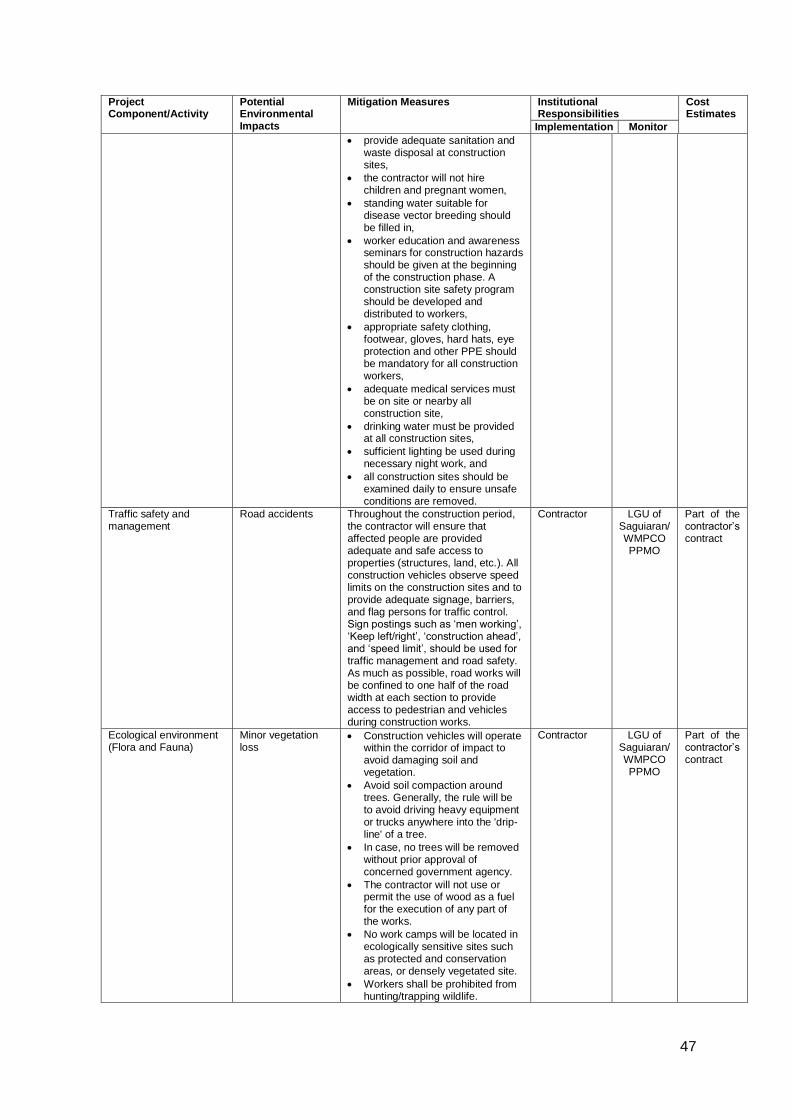
47
Project Component/Activity
Potential Environmental Impacts
Mitigation Measures Institutional Responsibilities
Cost Estimates
Implementation Monitor
provide adequate sanitation and waste disposal at construction sites,
the contractor will not hire children and pregnant women,
standing water suitable for disease vector breeding should be filled in,
worker education and awareness seminars for construction hazards should be given at the beginning of the construction phase. A construction site safety program should be developed and distributed to workers,
appropriate safety clothing, footwear, gloves, hard hats, eye protection and other PPE should be mandatory for all construction workers,
adequate medical services must be on site or nearby all construction site,
drinking water must be provided at all construction sites,
sufficient lighting be used during necessary night work, and
all construction sites should be examined daily to ensure unsafe conditions are removed.
Traffic safety and management
Road accidents Throughout the construction period, the contractor will ensure that affected people are provided adequate and safe access to properties (structures, land, etc.). All construction vehicles observe speed limits on the construction sites and to provide adequate signage, barriers, and flag persons for traffic control. Sign postings such as ‘men working’, ‘Keep left/right’, ‘construction ahead’, and ‘speed limit’, should be used for traffic management and road safety. As much as possible, road works will be confined to one half of the road width at each section to provide access to pedestrian and vehicles during construction works.
Contractor LGU of Saguiaran/ WMPCO PPMO
Part of the contractor’s contract
Ecological environment (Flora and Fauna)
Minor vegetation loss
Construction vehicles will operate within the corridor of impact to avoid damaging soil and vegetation.
Avoid soil compaction around trees. Generally, the rule will be to avoid driving heavy equipment or trucks anywhere into the 'drip-line' of a tree.
In case, no trees will be removed without prior approval of concerned government agency.
The contractor will not use or permit the use of wood as a fuel for the execution of any part of the works.
No work camps will be located in ecologically sensitive sites such as protected and conservation areas, or densely vegetated site.
Workers shall be prohibited from hunting/trapping wildlife.
Contractor LGU of Saguiaran/ WMPCO PPMO
Part of the contractor’s contract
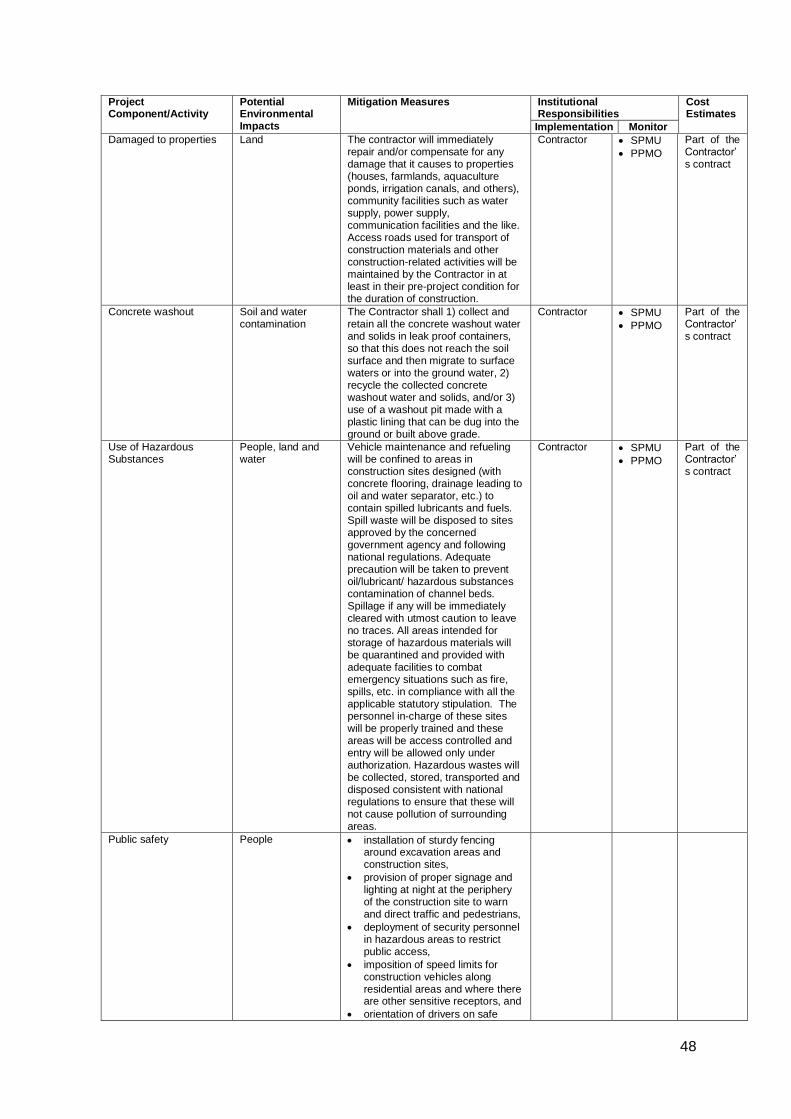
48
Project Component/Activity
Potential Environmental Impacts
Mitigation Measures Institutional Responsibilities
Cost Estimates
Implementation Monitor
Damaged to properties Land The contractor will immediately repair and/or compensate for any damage that it causes to properties (houses, farmlands, aquaculture ponds, irrigation canals, and others), community facilities such as water supply, power supply, communication facilities and the like. Access roads used for transport of construction materials and other construction-related activities will be maintained by the Contractor in at least in their pre-project condition for the duration of construction.
Contractor SPMU
PPMO
Part of the Contractor’s contract
Concrete washout Soil and water contamination
The Contractor shall 1) collect and retain all the concrete washout water and solids in leak proof containers, so that this does not reach the soil surface and then migrate to surface waters or into the ground water, 2) recycle the collected concrete washout water and solids, and/or 3) use of a washout pit made with a plastic lining that can be dug into the ground or built above grade.
Contractor SPMU
PPMO
Part of the Contractor’s contract
Use of Hazardous Substances
People, land and water
Vehicle maintenance and refueling will be confined to areas in construction sites designed (with concrete flooring, drainage leading to oil and water separator, etc.) to contain spilled lubricants and fuels. Spill waste will be disposed to sites approved by the concerned government agency and following national regulations. Adequate precaution will be taken to prevent oil/lubricant/ hazardous substances contamination of channel beds. Spillage if any will be immediately cleared with utmost caution to leave no traces. All areas intended for storage of hazardous materials will be quarantined and provided with adequate facilities to combat emergency situations such as fire, spills, etc. in compliance with all the applicable statutory stipulation. The personnel in-charge of these sites will be properly trained and these areas will be access controlled and entry will be allowed only under authorization. Hazardous wastes will be collected, stored, transported and disposed consistent with national regulations to ensure that these will not cause pollution of surrounding areas.
Contractor SPMU
PPMO
Part of the Contractor’s contract
Public safety People installation of sturdy fencing around excavation areas and construction sites,
provision of proper signage and lighting at night at the periphery of the construction site to warn and direct traffic and pedestrians,
deployment of security personnel in hazardous areas to restrict public access,
imposition of speed limits for construction vehicles along residential areas and where there are other sensitive receptors, and
orientation of drivers on safe
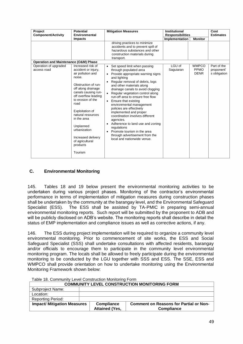
49
Project Component/Activity
Potential Environmental Impacts
Mitigation Measures Institutional Responsibilities
Cost Estimates
Implementation Monitor
driving practices to minimize accidents and to prevent spill of hazardous substances and other construction materials during transport.
Operation and Maintenance (O&M) Phase
Operation of upgraded access road
Increased risk of accident or injury, air pollution and noise. Obstruction of run-off along drainage canals causing run-off overflow leading to erosion of the road Exploitation of natural resources in the area Unplanned urbanization Increased delivery of agricultural products Tourism
Set speed limit when passing through populated area
Provide appropriate warning signs and lighting
Regular removal of debris, logs and other materials along drainage canals to avoid clogging
Regular vegetation control along run-off area to ensure free flow
Ensure that existing environmental management policies are effectively implemented and proper coordination involves different agencies.
Adherence to land use and zoning regulations
Promote tourism in the area through advertisement from the local and nationwide venue.
LGU of Saguiaran
WMPCO PPMO DENR
Part of the proponent’s obligation
C. Environmental Monitoring
145. Tables 18 and 19 below present the environmental monitoring activities to be undertaken during various project phases. Monitoring of the contractor’s environmental performance in terms of implementation of mitigation measures during construction phases shall be undertaken by the community at the barangay level, and the Environmental Safeguard Specialist (ESS). The ESS shall be assisted by TA-PMIC in preparing semi-annual environmental monitoring reports. Such report will be submitted by the proponent to ADB and will be publicly disclosed on ADB’s website. The monitoring reports shall describe in detail the status of EMP implementation and compliance issues as well as corrective actions, if any.
146. The ESS during project implementation will be required to organize a community level environmental monitoring. Prior to commencement of site works, the ESS and Social Safeguard Specialist (SSS) shall undertake consultations with affected residents, barangay and/or officials to encourage them to participate in the community level environmental monitoring program. The locals shall be allowed to freely participate during the environmental monitoring to be conducted by the LGU together with SSS and ESS. The SSE, ESS and WMPCO shall provide orientation on how to undertake monitoring using the Environmental Monitoring Framework shown below: Table 18. Community Level Construction Monitoring Form
COMMUNITY LEVEL CONSTRUCTION MONITORING FORM
Subproject Name:
Location:
Reporting Period:
Impact/ Mitigation Measures Compliance Attained (Yes,
Comment on Reasons for Partial or Non-Compliance
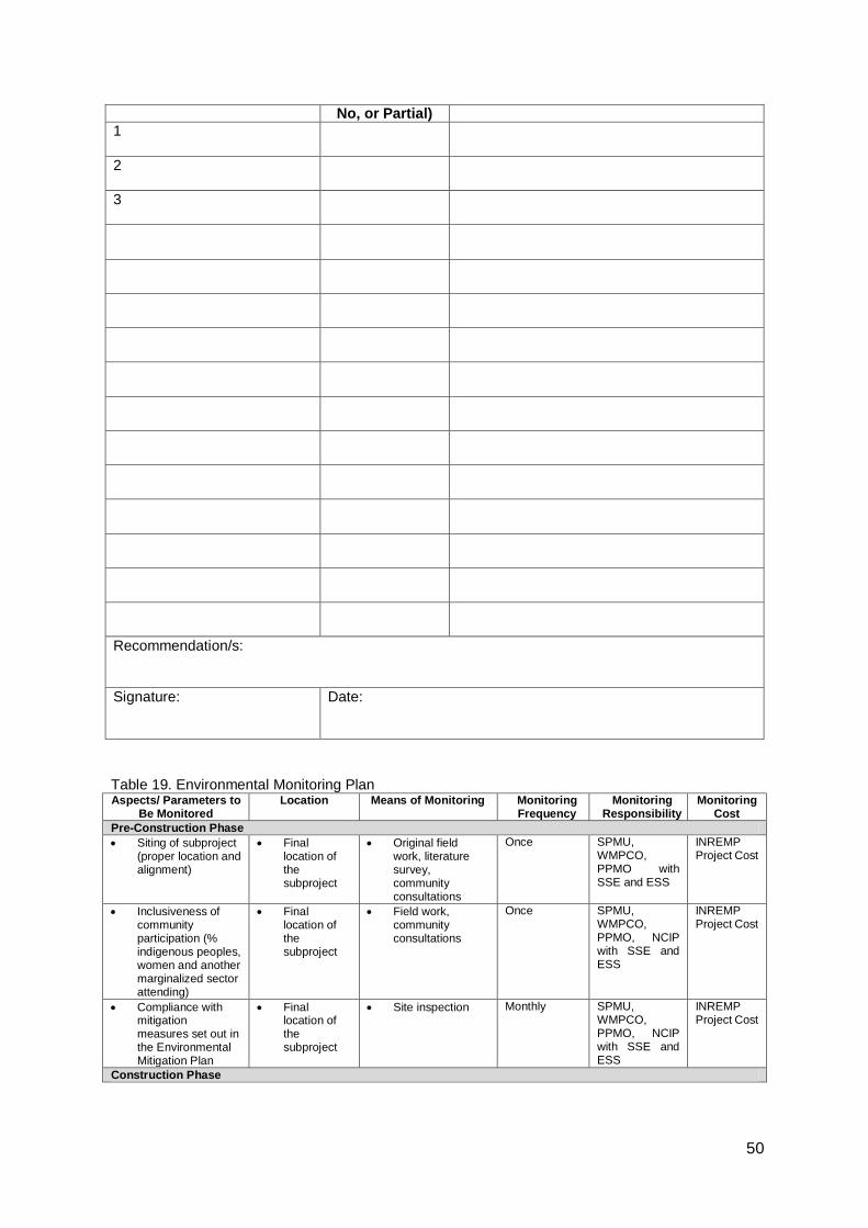
50
No, or Partial)
1
2
3
Recommendation/s:
Signature:
Date:
Table 19. Environmental Monitoring Plan Aspects/ Parameters to
Be Monitored Location Means of Monitoring Monitoring
Frequency Monitoring
Responsibility Monitoring
Cost
Pre-Construction Phase
Siting of subproject (proper location and alignment)
Final location of the subproject
Original field work, literature survey, community consultations
Once SPMU, WMPCO, PPMO with SSE and ESS
INREMP Project Cost
Inclusiveness of community participation (% indigenous peoples, women and another marginalized sector attending)
Final location of the subproject
Field work, community consultations
Once SPMU, WMPCO, PPMO, NCIP with SSE and ESS
INREMP Project Cost
Compliance with mitigation measures set out in the Environmental Mitigation Plan
Final location of the subproject
Site inspection Monthly SPMU, WMPCO, PPMO, NCIP with SSE and ESS
INREMP Project Cost
Construction Phase
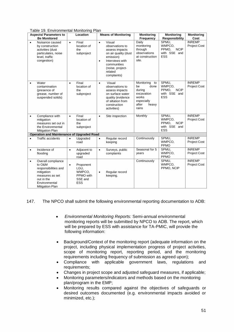
51
Table 19. Environmental Monitoring Plan Aspects/ Parameters to
Be Monitored Location Means of Monitoring Monitoring
Frequency Monitoring
Responsibility Monitoring
Cost
Nuisance caused by construction activities (dust particulates, noise level, traffic congestion)
Final location of the subproject
Visual observations to assess impacts on air quality (dust emission)
Interviews with communities (noise, project-related complaints)
Daily monitoring through observations at construction site.
SPMU, WMPCO, PPMO, NCIP with SSE and ESS
INREMP Project Cost
Water contamination (presence of grease, number of suspended solids)
Final location of the subproject
Visual observations to assess impacts on surface water quality (evidence of siltation from construction activities)
Monitoring to be done during excavation works especially after heavy rains
SPMU, WMPCO, PPMO, NCIP with SSE and ESS
INREMP Project Cost
Compliance with mitigation measures set out in the Environmental Mitigation Plan
Final location of the subproject
Site inspection Monthly SPMU, WMPCO, PPMO, NCIP with SSE and ESS
INREMP Project Cost
Operation and Maintenance of Upgraded Road
Traffic accidents Upgraded road
Regular record keeping
Continuously SPMU, WMPCO, PPMO
INREMP Project Cost
Incidence of flooding
Adjacent to upgraded road
Surveys, public complaints
Seasonal for 5 years
SPMU, WMPCO, PPMO
INREMP Project Cost
Overall compliance to O&M responsibilities and mitigation measures as set out in the Environmental Mitigation Plan
Proponent LGU, WMPCO, PPMO with SSE and ESS
Regular record keeping.
Continuously SPMU, WMPCO, PPMO, NCIP
INREMP Project Cost
147. The NPCO shall submit the following environmental reporting documentation to ADB:
Environmental Monitoring Reports: Semi-annual environmental
monitoring reports will be submitted by NPCO to ADB. The report, which will be prepared by ESS with assistance for TA-PMIC, will provide the following information:
Background/Context of the monitoring report (adequate information on the project, including physical implementation progress of project activities, scope of monitoring report, reporting period, and the monitoring requirements including frequency of submission as agreed upon);
Compliance with applicable government laws, regulations and requirements;
Changes in project scope and adjusted safeguard measures, if applicable;
Monitoring parameters/indicators and methods based on the monitoring plan/program in the EMP;
Monitoring results compared against the objectives of safeguards or desired outcomes documented (e.g. environmental impacts avoided or minimized, etc.);
52
If noncompliance or any major gaps identified, include a corrective action plan;
Records on disclosure of monitoring information to affected communities;
Summary of environmental mitigations and compensation measures implemented;
Identification of key issues, or complaints from affected people, or recommendations for improvement;
Monitoring adjustment measures recommended based on monitoring experience/trends and stakeholder’s response;
Information about actual institutional arrangement for implementing the monitoring program/plan provided or adjusted, as may be required;
Proposed items of focus for the next report and due date.
Project Completion Report: One (1) year after completion of the
construction, the NPCO through its ESS shall submit a Project Completion Report which will include the overall environmental performance of the Subproject.
53
IX. CONCLUSION AND RECOMMENDATION
A. Conclusion
148. The present IEE reviewed the general environmental profile of the subproject, covering about 1.28 km. roads with width of 4m carriage way with 1.0m for shoulder at both side including drainage for this purpose and screened them to assess potential impacts. The IEE reveals that no major negative environmental impacts are likely to occur due to the construction activities and normal operations after the proposed rehabilitation. Implementation of appropriate mitigation measures during construction and operation phases will minimize the negative impacts of the Project to acceptable levels. To ensure that these mitigation measures are implemented and negative impacts avoided, the measures will be included in the civil works bid and contract specifications of the Project.
149. Rural infrastructures like roads and water supply projects arguably are vital structures needed to spur economic development in Barangay Mapantao and Dilausan, Saguiaran, Lanao del Sur, with full potentials and opportunities owing to its varied development zones and natural resources.
150. The Rehabilitation of Dilausan- Mapantao Access Road project for one shall be a crucial infrastructure for uplifting the quality of life of the people by providing an all-year-round easy and affordable access, improving the prompt delivery of basic services, increasing economic opportunities, and supporting the NRM project activities of the constituents, thus supporting the developing economy of Barangay Dilausan and Mapantao, Saguiaran, Lanao del Sur cascading benefits to the entire municipality.
151. Hence, the Project will have overall beneficial impact and will have minor negative impacts that will be carefully monitored and adequately mitigated through implementation of the EMP.
B. Recommendation
. 152. It is recommended as priority over the other proposed project in the municipality giving due importance to the area which is lagging behind due to poor accessibility. Further, the realization of the project will spur economic opportunities and social activities in the vicinity and in the municipality as a whole.
153. The main goal of the project is to support the NRM activities of POs. However, the end goal of the subproject is to provide an all-year-round easy and affordable access thereby improving the prompt delivery of basic services, increasing economic opportunities and conditions and uplifts the quality of life of the inhabitants, especially the constituents.
154. The project will enhance the social status of the people, especially the IPs, women, children, and other vulnerable sectors of the influence area, through better health services and employment opportunities due to more investments in agriculture and livelihood. There will be better access to the business centers leading to economic prosperity. This will also result to better education and more educational institutions established. The project will encourage investment of agri-business due to safe and economical travel. Its effect would be an increase in production with lower prices of agricultural products.

54
155. The Proposed rehabilitation of Dilausan- Mapantao Access Road will boost the economic activities of the influence area which is currently experiencing stagnation due mainly to inaccessibility. With the project, socio-economic services will be easier not only for the public sector but also to private and semi-private providers. This will entice the community to gradually eliminate economic activities in the Forest Protection Zone, and instead, concentrating their activities in the Forest Production Zone of the WMA. In this way, the people will become the guardian of the natural resources of the upper slopes of the WMA guaranteeing stable supply of water and other natural resources in the lower portion of the watershed.

55
Appendix 1. A Copy of CNC Application (Payment)
56
Appendix 2. Stakeholder Consultations
57
58

59
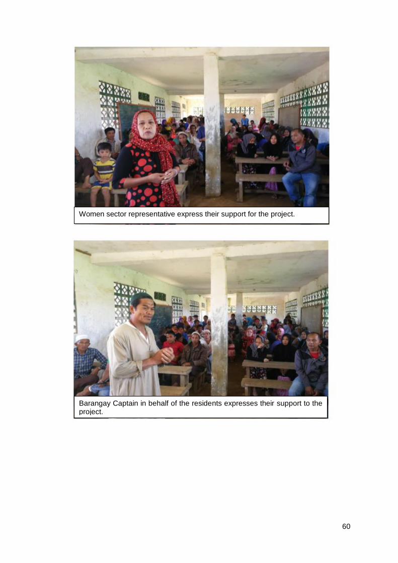
60
Women sector representative express their support for the project.
Barangay Captain in behalf of the residents expresses their support to the project.
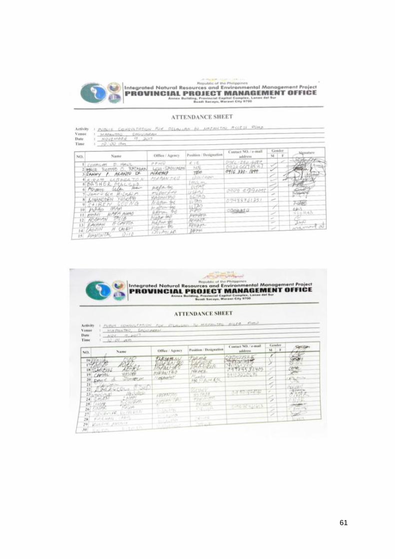
61
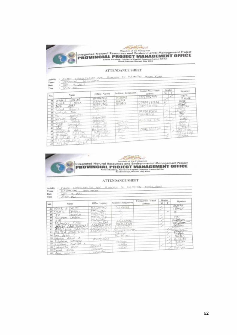
62
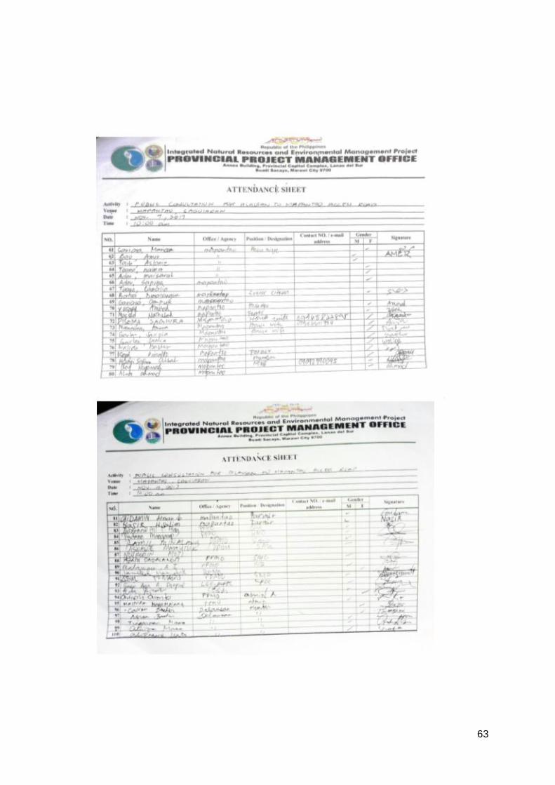
63
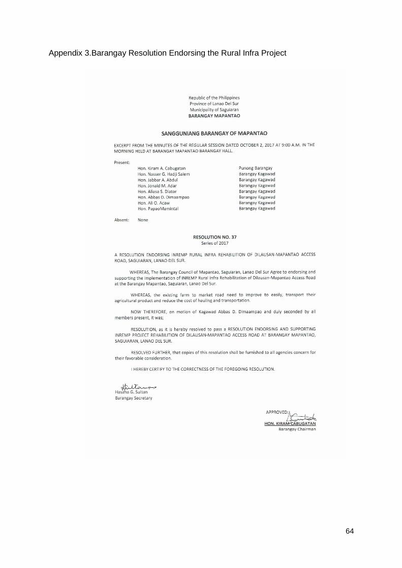
64
Appendix 3.Barangay Resolution Endorsing the Rural Infra Project
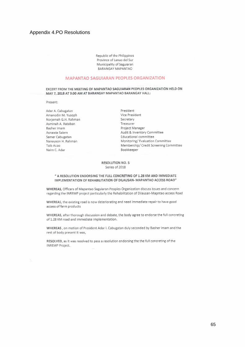
65
Appendix 4.PO Resolutions

66
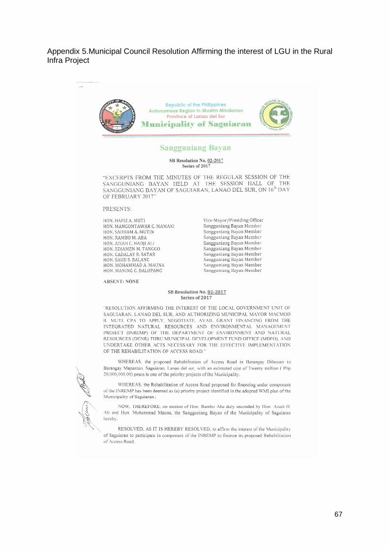
67
Appendix 5.Municipal Council Resolution Affirming the interest of LGU in the Rural Infra Project
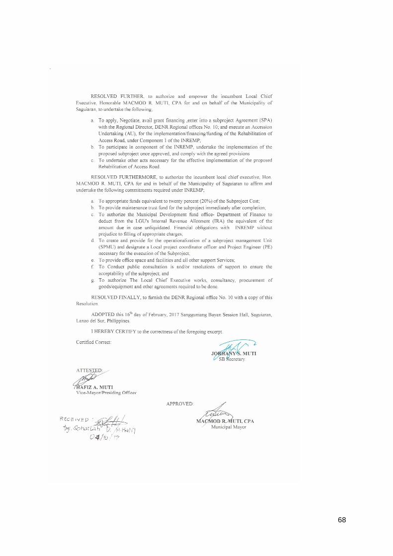
68
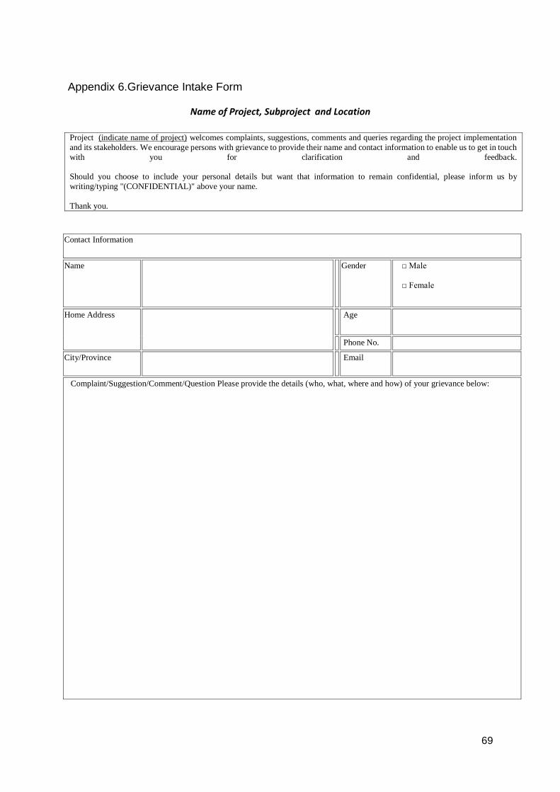
69
Appendix 6.Grievance Intake Form
Name of Project, Subproject and Location
Project (indicate name of project) welcomes complaints, suggestions, comments and queries regarding the project implementation
and its stakeholders. We encourage persons with grievance to provide their name and contact information to enable us to get in touch
with you for clarification and feedback.
Should you choose to include your personal details but want that information to remain confidential, please inform us by
writing/typing "(CONFIDENTIAL)" above your name.
Thank you.
Contact Information
Name
Gender □ Male
□ Female
Home Address
Age
Phone No.
City/Province
Complaint/Suggestion/Comment/Question Please provide the details (who, what, where and how) of your grievance below:

70
How do you want us to reach you for feedback or update on your comment/grievance?
Portion to be filled in by PPCO staff (designated Grievance Redress Mechanism Officer):
Date received:
Received through:
__ In person __ mail __ email __ fax __ phone __ sms
Name of staff who
received comment/
complaint
Position of staff:
Type of Grievance:
Remarks

71
Signature of staff
Updates on the case: Date: Update Updated by (Name, Signature and Designation)

81