2019-2023 Fort Hood Integrated Natural Resources ...
265
Final Update 2019-2023 Fort Hood Integrated Natural Resources Management Plan Directorate of Public Works Environmental Division Fort Hood, Texas
-
Upload
khangminh22 -
Category
Documents
-
view
2 -
download
0
Transcript of 2019-2023 Fort Hood Integrated Natural Resources ...

Final Update
2019-2023
Fort Hood Integrated Natural Resources Management Plan
Directorate of Public
Works Environmental
Division Fort Hood, Texas

This page intentionally left blank.

This Integrated Natural Resources Management Plan (INRMP) has been prepared and reviewedby the following:
Prepared by:
Tonya Smith, Senior BiologistWhitetail Environmental, LLC
Reviewed by:
Timi Dutchuk, P.E.Chief, Environmental ProgramsDirectorate of Public WorksFort Hood, Texas
Administrative and Civil LawOffice of the Staff Judge Advocate
Fort Hood, Texas
Brian L. DosaDirector of Public WorksFort Hood, Texas
DUTCHUK.TIMI.MARIE.1146509637
Digitally signed by DUTCHUK.TIMI.MARIE.1146509637Date: 2019.02.22 09:48:22 -06'00'
SANCHEZ.NANCY.1070741977
Digitally signed by SANCHEZ.NANCY.1070741977Date: 2019.02.27 10:49:36 -06'00'
DOSA.BRIAN.LAWRENCE.1045276682
Digitally signed by DOSA.BRIAN.LAWRENCE.1045276682Date: 2019.02.27 17:59:58 -06'00'


Fort Hood Integrated Natural Resources Management Plan
ES-1
Executive Summary
This Integrated Natural Resources Management Plan (INRMP) is for Fort Hood and the U.S.Department of the Army in accordance with the Sikes Act Improvement Act, as amended; Department of Defense (DoD) Instruction 4715.03 (Natural Resources Conservation Program);Army Regulation (AR) 200-1, (Environmental Protection and Enhancement); and the most recentDepartment of the Army and DoD Sikes Act and INRMP guidance memoranda. The purposeof an INRMP is to provide guidance for the implementation and management of naturalresources on Fort Hood during the 5-year period from 2019 through 2023. This INRMP usesan integrated, adaptive, ecosystem management approach for sustainability and consistency with the military missions on Fort Hood. The DoD with the assistance of the U.S. Fish andWildlife Service (USFWS) and the Texas Parks and Wildlife Department (TPWD) areresponsible under the Sikes Act (16 U.S.C. 670a-670f, as amended) for carrying out programsand implementing management strategies to conserve and protect biological resources onFort Hood lands. INRMP implementation is imperative for increasing mission capabilities,minimizing military training constraints, and maintaining maximum flexibility.
Integrated natural resources management in an ecosystem framework promotes overall environmental quality and provides for recreational uses while protecting biological diversity andallowing military training access to the resources needed to maintain a high degree ofcombat readiness at Fort Hood. Effective sustainable use of natural resources accomplishes no netloss in the capability of the installation to support the military mission.
This INRMP provides a description of Fort Hood and its surrounding environments and presents various management practices designed to mitigate potential negative impacts and enhancethe positive effects of the installation’s mission on the regional ecosystem. Thesemanagement practices complement the requirements of Fort Hood to accomplish missionrequirements at the highest possible level of efficiency. To obtain an accurate assessment ofFort Hood’s environmental impact, environmental analyses were completed to determine thephysical and biotic nature of the installation and to determine the potential impacts of operational activities upon the natural environment.
This INRMP is a practical guide for the management, sustainment, and stewardship of all naturalresources present on Fort Hood, thus helping to ensure no net loss in mission capabilities.This INRMP uses an interdisciplinary approach whereby scientific information is compiledfrom a variety of sources.
This INRMP represents a major revision of the 2013-2017 INRMP, reviews the natural resourcesactivities undertaken at Fort Hood since implementation of the 2013 INRMP, and proposes newprojects and initiatives for the years 2019 through 2023. This revised INRMP includes theprocedural requirements of the National Environmental Policy Act (NEPA) and DoD Instruction 4715.03 and strives to fully integrate and coordinate the natural resources program with otherFort Hood plans and activities.
This INRMP establishes goals that represent a long-term vision for the health and quality of FortHood’s natural resources. From these goals, objectives and management actions have been

Fort Hood Integrated Natural Resources Management Plan
ES-2
identified that follow DoD and USFWS guidance. The INRMP goals and management actionsare revised over time to reflect changing missions and environmental conditions. Actionsproposed in this INRMP are subject to NEPA compliance.
This INRMP undergoes internal, NEPA, and interagency review on a regular basis toensure compliance and integration with other installation management plans including Armyguidance and regulations and State and Federal natural resources conservation plans. ThisINRMP was developed in cooperation with the USFWS and the TPWD. These agencies arepartners with the U.S. Army and Fort Hood for the conservation of the natural resources thatoccur on Fort Hood. These agencies are stakeholders and signatories for this INRMP along withInstallation Command and indicate their consent for the natural resources management program as outlined herein on Fort Hood.

Fort Hood Integrated Natural Resources Management Plan
i
Table of Contents
Chapter 1 Management Overview........................................................................ 1-1
1.1 PURPOSE AND SCOPE .................................................................................. 1-1 1.2 MANAGEMENT PHILOSOPHY ........................................................................ 1-1 1.3 MISSION AND NATURAL RESOURCES MANAGEMENT HISTORY ........................ 1-2 1.4 GOALS AND OBJECTIVES ............................................................................. 1-3 1.5 REVIEW, REVISION AND REPORTING............................................................. 1-7
Chapter 2 Installation Overview.......................................................................... 2-1
2.1 MAPS ........................................................................................................ 2-1 2.2 GENERAL INSTALLATION INFORMATION ....................................................... 2-1
2.2.1 Location ............................................................................................ 2-1 2.2.2 Training Facilities and Ranges............................................................. 2-5 2.2.3 Management Units .............................................................................. 2-5
2.3 REGIONAL LAND USE AND SETTING ............................................................. 2-9 2.4 NATURAL ENVIRONMENT ............................................................................ 2-9 2.5 INSTALLATION HISTORY ........................................................................... 2-10
2.5.1 Pre-Military Land Use ....................................................................... 2-10 2.5.2 Installation Military History ............................................................... 2-10
2.6 CURRENT MILITARY MISSIONS .................................................................. 2-12 2.7 PUBLIC AND AFFILIATES ACCESS ............................................................... 2-14
Chapter 3 Integration Overview .......................................................................... 3-1
3.1 AUTHORITIES AND RESPONSIBILITIES ........................................................... 3-1 3.2 EXTERNAL STAKEHOLDERS ......................................................................... 3-7 3.3 INTERNAL INTEGRATION ............................................................................. 3-9
3.3.1 Installation Plans ................................................................................ 3-9 3.3.2 Internal Coordinating Offices ............................................................. 3-10
Chapter 4 Program Elements............................................................................... 4-1
4.1 GEOSPATIAL INFORMATION SYSTEMS........................................................... 4-1 4.2 CONSERVATION LAW ENFORCEMENT............................................................ 4-4 4.3 CLIMATE CHANGE ...................................................................................... 4-6 4.4 SOIL, EROSION, AND SEDIMENTATION .......................................................... 4-9 4.5 GEOLOGY ................................................................................................ 4-18 4.6 WATER RESOURCES.................................................................................. 4-20 4.7 SENSITIVE SPECIES................................................................................... 4-28
4.7.1 Threatened and Endangered Species .................................................... 4-28 4.7.2 Species of Concern ............................................................................ 4-35
4.8 MIGRATORY BIRDS .................................................................................. 4-42 4.8.1 Bald and Golden Eagle Protection Act Species ..................................... 4-49
4.9 FISH AND WILDLIFE ................................................................................. 4-50 4.9.1 Recreation ........................................................................................ 4-51 4.9.2 Fisheries Management ....................................................................... 4-53

Fort Hood Integrated Natural Resources Management Plan
ii
4.9.3 Game Management ............................................................................ 4-56 4.9.4 Non-Game Management ..................................................................... 4-61
4.10 VEGETATION ........................................................................................... 4-68 4.10.1 Flora and Habitat ............................................................................ 4-68 4.10.2 Forest/Woodland Management ........................................................ 4-75 4.10.3 Wildland Fire Management ............................................................. 4-77 4.10.4 Grounds Maintenance ..................................................................... 4-81 4.10.5 Agricultural Leases......................................................................... 4-86
4.11 INTEGRATED PEST MANAGEMENT .............................................................. 4-92 4.12 NOXIOUS WEEDS AND INVASIVE SPECIES ................................................... 4-94 4.13 WILDLIFE AIRCRAFT STRIKE HAZARD ........................................................ 4-98 4.14 COMPATIBLE USE BUFFERS AND CONSERVATION EASEMENTS .................... 4-101 4.15 OTHER PROGRAMS ................................................................................. 4-103
4.15.1 Integrated Training Area Management (ITAM) ............................... 4-103 4.15.2 ITLM Program ............................................................................. 4-107 4.15.3 Cultural Resources ....................................................................... 4-108
Chapter 5 Implementation ................................................................................... 5-1
5.1 ENVIRONMENTAL AWARENESS .................................................................... 5-1 5.2 NATURAL RESOURCES STAFF AND TRAINING ................................................ 5-3 5.3 KNOWLEDGE AND INFORMATION GAPS......................................................... 5-5
5.3.1 Pending Issues.................................................................................... 5-5 5.3.2 Unresolved Issues............................................................................... 5-5
5.4 FUNDING ................................................................................................... 5-6
Chapter 6 Five-Year Implementation Plan .......................................................... 6-1
Chapter 7 National Environmental Policy Act Compliance and Integration........ 7-1
7.1 INTRODUCTION .......................................................................................... 7-1 7.2 INRMP AND NEPA INTEGRATION ............................................................... 7-1 7.3 PURPOSE OF AND NEED FOR THE PROPOSED ACTION ...................................... 7-2 7.4 SCOPE OF THE ENVIRONMENTAL ASSESSMENT .............................................. 7-3 7.5 DESCRIPTION OF THE PROPOSED ACTION AND ALTERNATIVES ........................ 7-4
7.5.1 Proposed Action ................................................................................. 7-4 7.5.2 No Action .......................................................................................... 7-4 7.5.3 Alternatives Eliminated from Further Consideration .............................. 7-4
7.6 STATEMENT OF PREFERRED ALTERNATIVE ................................................... 7-8 7.7 AFFECTED ENVIRONMENT AND ENVIRONMENTAL CONSEQUENCES .................. 7-8
7.7.1 Land Use .......................................................................................... 7-10 7.7.2 Soils ................................................................................................. 7-10 7.7.3 Water Resources................................................................................ 7-10 7.7.4 Sensitive Species ............................................................................... 7-11 7.7.5 Fish and Wildlife................................................................................ 7-12 7.7.6 Vegetation ........................................................................................ 7-12 7.7.7 Cultural Resources ............................................................................ 7-13 7.7.8 Cumulative Effects ............................................................................ 7-13
7.8 COMPARISON OF ALTERNATIVES AND CONCLUSIONS ................................... 7-14

Fort Hood Integrated Natural Resources Management Plan
iii
7.9 INTERAGENCY COORDINATION AND REVIEW ............................................... 7-15
Appendix A. References ..................................................................................... A-1
A1. LIST OF ACRONYMS ..................................................................................... A-1 A2. LIST OF LITERATURE CITED .......................................................................... A-4 A3. SUMMARY OF CHANGES TO INRMP................................................................ A-7
Appendix B. Associated and Component Plans .................................................. B-1
Appendix C. Native Species on Fort Hood ......................................................... C-1
C1. BIRD SPECIES .............................................................................................. C-1 C2. FISH SPECIES ............................................................................................... C-9 C3. AMPHIBIANS AND REPTILES ........................................................................ C-12 C4. MAMMAL SPECIES...................................................................................... C-15 C5. VASCULAR PLANTS .................................................................................... C-18
Appendix D. Agency and Public Correspondence .............................................. D-1
Appendix E. Finding of No Significant Impact .................................................. E-1
LIST OF TABLESTable 1-1. Mission Activities and Potential Effects ..................................................................1-3Table 1-2. Goals and Objectives Aligned with Sikes Act Requirements .................................1-5Table 2-1. Fort Hood Land Uses ..............................................................................................2-5Table 2-2. Physical Characteristics of Management Units.......................................................2-5Table 2-3. Installation Users and Primary Missions ............................................................. 2-12Table 3-1. Authorities and Responsibilities .............................................................................3-4Table 3-2. External Stakeholders ..............................................................................................3-7Table 3-3. Installation Plan Integration.....................................................................................3-9Table 3-4. Additional Internal Coordination.......................................................................... 3-10Table 4-1. GIS Data to Date .....................................................................................................4-1Table 4-2. Goals and Objectives for the GIS Program ............................................................4-3Table 4-3. Goals and Objectives for Conservation Law Enforcement .....................................4-5Table 4-4. Goals and Objectives for Climate Change ...................................................4-9Table 4-5. Summary of Measured Variables in Western Training Area............................. 4-14Table 4-6. Goals and Objectives for Soil, Erosion, and Sedimentation ............................... 4-16Table 4-7. Goals and Objectives for Water Resources.......................................................... 4-27Table 4-8. Federally Listed Threatened and Endangered Species ........................................ 4-29Table 4-9. Goals and Objectives for Threatened and Endangered Species Management..... 3-34Table 4-10. Species of Concern............................................................................................... 4-35Table 4-11. Goals and Objectives for Species of Concern ..................................................... 4-39Table 4-12. Migratory Bird Future Research Goals and Timeframes.................................... 4-43Table 4-13. DoD Species Ranking and Occurrence on Fort Hood......................................... 4-43Table 4-14. Goals and Objectives for Migratory Birds........................................................... 4-49Table 4-15. Goals and Objectives for Recreation ................................................................... 4-53Table 4-16. Fish Stocking Record (FY 2017) ............................................................. 4-55Table 4-17. Goals and Objectives for Fisheries Management ................................................ 4-55

Fort Hood Integrated Natural Resources Management Plan
iv
Table 4-18. Goals and Objectives for Game Management ...................................................... 4-60Table 4-19. Results of Milkweed Stem Count Survey ................................................. 4-62Table 4-20. Goals and Objectives for Non-Game Management ............................................. 4-66Table 4-21. Goals and Objectives for Vegetation Monitoring ................................................ 4-72Table 4-22. Goals and Objectives for Forest/Woodland Management ................................... 4-76Table 4-23. Goals and Objectives for Wildland Fire Management ......................................... 4-79Table 4-24. Native Plant List for Landscaping on Fort Hood ................................................. 4-82Table 4-25. Goals and Objectives for Grounds Maintenance ................................................. 4-86Table 4-26. Animal Unit Equivalents ...................................................................................... 4-87Table 4-27. Stocking Rates and Calculations for each Fort Hood GMU .............................. 4-88Table 4-28. Grazing Management Units by Training Area and Acreage .............................. 4-90Table 4-29. Goals and Objectives for Agricultural Leases (Grazing) ..................................... 4-90Table 4-30. Goals and Objectives for Pest Management ......................................................... 4-93Table 4-31. Goals and Objectives for Invasive Species Management .................................... 4-97Table 4-32. Goals and Objectives for WASH Prevention .................................................... 4-100Table 4-33. Goals and Objectives for the ACUB Program .................................................. 4-103Table 5-1. Fort Hood Natural Resources Management Staff ................................................... 5-4 Table 7-1. Road Map Indicating NEPA Analysis and Corresponding INRMP Section ......... 7-2 Table 7-2. Potential Environmental Effects of the Alternatives ........................................... 7-15
LIST OF FIGURESFigure 2-1. Installation Map ..................................................................................... 2-2 Figure 2-2. Constraints Map ..................................................................................... 2-3 Figure 2-3. Region Map .......................................................................................... 2-4 Figure 2-4. Management Units .................................................................................................. 2-6 Figure 4-1. Soil Types ............................................................................................................. 4-10Figure 4-2. Water Erosion Potential ....................................................................................... 4-12Figure 4-3. Topography ........................................................................................................... 4-19Figure 4-4. Watersheds ........................................................................................................... 4-22Figure 4-5. Endangered Species Habitat ................................................................................. 4-30Figure 4-6. Hunting Areas ....................................................................................................... 4-58Figure 4-7. Military Monarch Initiative NFH Proposed Area ................................................ 4-63Figure 4-8. Vegetative Cover Types ....................................................................................... 4-69Figure 4-9. Forest Cover Change (2000-2016) ........................................................................ 4-74Figure 4-10. Grazing Management Units................................................................... 4-89

Fort Hood Integrated Natural Resources Management Plan
1-1
Chapter 1 Management Overview1.1 Purpose and ScopeThe purpose of this Integrated Natural Resources Management Plan (INRMP) is to guidethe natural resources management program at Fort Hood, Texas, from fiscal year (FY) 2019 to2023, in accordance with the Sikes Act Improvement Act (SAIA), as amended through 2003;Department of Defense (DoD) Instruction 4715.03 (Natural Resources Conservation Program, 1996); Army Regulation (AR) 200-1, (Environmental Protection and Enhancement, 2007); andthe most recent Department of the Army and DoD Sikes Act and INRMP guidance memoranda.This INRMP is the principle guiding document for land management activities on Fort Hood, is amajor revision of the 2013-2017 INRMP, and has been restructured based on the INRMP Template issued by the U.S. Army Environmental Command. This INRMP allows Fort Hood to achieve itsgoal of ensuring the sustainability of desired future conditions while maintainingecosystem viability. In addition, this INRMP ensures that natural resources conservationmeasures and Army activities on Fort Hood lands are integrated and consistent with Federalstewardship requirements.
This INRMP addresses the geographic area associated with the contiguous properties of FortHood, with particular emphasis on the training areas. It provides management measures that weredeveloped through consideration of various alternatives for meeting resource-specific goalsand objectives at Fort Hood. This INRMP also provides rationale for why certainmanagement measures have been selected for implementation and others have not, whichare supported by analysis of resource-specific screening criteria. This INRMP is based onthe philosophy of ecosystem management with the intent of demonstrating theinterdependency between the military mission and natural resources management.
1.2 Management PhilosophyThe management measures and strategies that will be implemented at Fort Hood have beendeveloped with consideration for the interrelationships between the individual components of theecosystem, the requirements of the military mission, and other land use activities. The focus ison maintaining the structure, diversity, and integrity of biological communities, whilerecognizing that the Soldiers and military mission are a vital component of the ecosystem.An adaptive management strategy has been incorporated into this INRMP to monitor the temporal and spatial dynamics of the ecosystem and to adjust the management measuresand strategies based on improved knowledge and data. Monitoring programs will generatethe data needed to determine whether the management measures and strategies are effective inachieving their intended goals and objectives. This management approach will preserve andenhance the natural resources while providing the optimum environmental conditions requiredto sustain the military mission and realistic training conditions at Fort Hood. Managementmeasures in this INRMP were developed based on current conditions of the resources, the military mission, and activities as they are anticipated.

Fort Hood Integrated Natural Resources Management Plan
1-2
1.3 Mission and Natural Resources Management HistoryThe Army recognizes that a healthy and viable natural resources base is required to support themilitary mission. Areas that are deemed unusable for training affect the military mission. ThisINRMP ensures that environmental considerations are an integral part of planning activities atFort Hood and that natural resources are protected in accordance with Army regulations andpolicies.
Military operations performed at Fort Hood have the potential to alter the environmental settingand condition of the natural resources. The absence of long-term, collaborative managementmeasures to properly conserve and restore natural resources could potentially impede Fort Hood’sability in continuing to adequately train Soldiers. Environmental damage can place other artificialconstraints on training, such as the following:
• Loss of training acreage,• Decreased tactical maneuverability,• Increased land and natural resources maintenance costs,• Increased safety hazards, and• Civil or criminal liability.
The Soldiers who utilize Fort Hood are trained to be aware of the environmental effects of theiroperations and to recognize that their actions in the field directly affect the long-termsustainability of the training lands and their ability to continue training. Training the Soldiers tounderstand their environmental stewardship responsibilities assists in preventing environmentaldegradation during training activities.
The primary mission of Fort Hood is to conduct readiness training, promote survivability ofSoldiers, and provide combat-ready forces for worldwide deployment. Environmental initiativesand plans are typically considered secondary and should not inhibit military mission requirements.In most instances, environmental initiatives and plans are in agreement with military requirementsand are generally transparent to commanders in the field. For instances with apparentdisagreement, discussion amongst trainers, commanders, and subject-matter-experts oftenresolves differences. It is important to consider limitations due to the presence of naturallyoccurring resources that cannot be altered, as well as limitations resulting from natural resourcesthat have already been affected.
Existing natural resources on Fort Hood can influence the manner in which the military mission isexecuted. Not only is proper management of natural resources and their use by the militarya sound environmental practice, but it also directly supports the Fort Hood mission toprovide sustainable training opportunities. This INRMP considers the effects of such naturalresources on the mission. Examples of training activities and their effects on the environment,as well as examples of how degradation to natural resources adversely affects the militarymission, are provided in Table 1-1.
Fort Hood Regulation 200-1, Environment and Natural Resources, dated April 2014, prescribespolicies, assigns responsibilities, and establishes procedures for protecting the environment whilepreserving natural and cultural resources. Commanders are responsible for integrating

Fort Hood Integrated Natural Resources Management Plan
1-3
environmental management principles and environmental protection activities and programs, tothe fullest extent possible, into the planning and execution of the mission.
Table 1-1. Mission Activities and Potential Effects
Activity/Use
Potential Effects on:Natural Resources Training/Combat Readiness
Vehicles operated off-road Degradation of soil, water, and vegetation
Loss of training realism
Erosion gullies Safety hazards in eroded areas
Soil compaction Contamination of soils could limit availability of trainingareas
Soil and water contamination from field maintenance
Increased maintenance costs
FoxholesDefilades
Soil displacement Loss of training realism
Erosion; eroded soils unable to support vegetation
Safety hazards in eroded areas
Bivouac areas Soil compaction and/or erosion Loss of training realism
Loss of vegetation understory andoverstory
Loss of camouflaging forvehicles and troop locations
Limit usable training areasRange firing Soil compaction, erosion, and
inversionImmobilized vehicles mired in mud
Loss of vegetation understory andoverstory
Loss of training realism
Potential administrative restrictions as a result of disturbance to Federally protected species or habitat
Wildfires from pyrotechnics, tracer ammunition, or shell detonation
Accidental fires result in loss of usable training areas
Artillery training produces a heavy metals residue
May result in administrative restrictions
1.4 Goals and ObjectivesThe strategic goals of this INRMP conform to the goal of the Conservation Program of theDoD, which is to support the military mission by:
Providing for sustained use of its land and air resources,Protecting valuable natural and cultural resources for future generations,Meeting all legal requirements, and

Fort Hood Integrated Natural Resources Management Plan
1-4
Promoting compatible multiple uses of those resources.
Fort Hood’s Natural and Cultural Resources Management Branch (NCRMB) has identified anumber of objectives necessary to achieve these goals. Table 1-2 aligns Sikes Act requirementswith Fort Hood’s objectives and program elements.
The ability to achieve these goals depends directly on the health and condition of the naturalresources. Protecting the ecological and biological integrityof the training lands ensures that thoselands will continue to provide the vegetation, soil, and water resources necessary for sustainable military training. Such protection will also preserve popular outdoor recreational activities at FortHood, such as hunting, fishing, birding, boating, and hiking. Implementation of ecosystemmanagement principles will provide the quantity and diversity of fish and game for enjoyable hunting and fishing experiences. Proper management of the ecosystem will maintain waterquality at a level that can support quality fisheries and presents no potential risks to humanhealth.

1-5
Fort Hood Integrated Natural Resources Management Plan
Table 1-2. Goals and Objectives Aligned with Sikes Act RequirementsGoal Objectives INRMP
1. No net loss in the capability of military installationlands to support the military mission of theinstallation.
Manage all resources to support long-term sustainment of the installation’straining mission.
Chapters 1-6
2. Establishment of specific natural resourcesmanagement goals and objectives and time frames for proposed action.
Implement a natural resources management program that reflects theprinciples of ecosystem management.
Chapters 1, 4,and 6
3. Integration of, and consistency among, thevarious activities conducted under the plan.
Use adaptive techniques to provide flexibility of management strategiesbased on increased knowledge and data gained from monitoring programsand scientific literature.
Chapter 3
4. Provide for fish and wildlife management, landmanagement, forest management, and fish and wildlife-oriented recreation.
a. Seek to maintain or increase the level of biodiversity of native species.
b. Protect sensitive and ecologically significant habitats located on FortHood.
c. Protect woodland resources from unacceptable damage and degradationresulting from insects and disease, animal damage, non-native invasivespecies, and wildfire; and manage the resources in a manner that supportsthe military mission.
d. Protect soil resources from erosion and destabilization throughprevention and restoration efforts.
e. Protect and preserve cultural resources.
Chapter 4
5. Provide for fish and wildlife habitat enhancement or modification.
Manage wildlife and fisheries resources within the principles andguidelines of ecosystem management to maintain productive habitats andviable populations of native species.
Section 4.9
6. Wetland protection, enhancement, andrestoration where necessary for support of fish and
Prevent the degradation of water quality, protect aquatic and riparianhabitats, and identify and restore degraded habitats.
Sections 4.6 &4.9
7. Public access to the military installation that isnecessary or appropriate subject to requirementsnecessary to ensure safety and military security.
a. Provide quality consumptive and non-consumptive recreationalopportunities while avoiding impacts on training and maintaining abalanced and diverse ecosystem.
b. Provide a positive contribution to the community byoffering informative and educational instruction and opportunities.
Section 4.9

1-6
Fort Hood Integrated Natural Resources Management Plan
Goal Objectives INRMP8. Sustainable use by the public of natural resourcesto the extent such use is not inconsistent with theneeds of fish and wildlife resources management.
Monitor outdoor recreational opportunities to ensure they do not conflictwith natural resources or the military mission on the installation.
Section 4.9
9. Enforcement of applicable natural resources lawsand regulations.
Maintain an adequate number of Conservation Law Enforcement Officersto protect the natural resources of Fort Hood by enforcing laws andregulations.
Section 4.2
10. Review of INRMP as to operation and effect by theparties on a regular basis, but not less often than every5 years.
a. Allocate funds for INRMP review and update.
b. Continue coordination with U.S. Fish and Wildlife Service and TexasParks and Wildlife Department.
Section 1.5
11. Protect and provide a benefit to threatenedand endangered species.
a. Provide special protection and management that leads to the recovery ofthreatened and endangered species and conserves species of concern andtheir habitats so that new species are not listed.
b. Protect rare and unique plant species identified as state or locally rare,but without legal protection status, to the extent practical withoutrestrictions on operations.
Section 4.7 &Appendix B

Fort Hood Integrated Natural Resources Management Plan
1-7
1.5 Review, Revision and ReportingThe Sikes Act specifies that a formal review by the stakeholders must be completed no less often than every five years; however, DoD policy (specifically DODI4715.05) requires installations to review INRMPs with regard to operation and effect annually. These reviews are intended to determine whether the existing INRMP is being implemented to meet the requirements of the Sikes Act and contributing to the conservation and rehabilitation of natural resources on Fort Hood. In accordance with these regulations and AR200-1, this INRMP will be reviewed and updated as appropriate in concert with installation needs to obtain mutual agreement in coordination with the U.S. Fish and Wildlife Service (USFWS), Texas Parks and Wildlife Department (TPWD), and other internal and external stakeholders. A 5-year update will not be required if circumstances have not changed.
Interagency Coordination. In June 2015, the USFWS published Guidelines for Coordination onIntegrated Natural Resources Management Plans. In July 2015, the DoD released Guidelines forStreamlined INRMP Review. Additionally, The INRMP Implementation Manual (DOD Manual4715.03) was published in December 2017. These documents clarify and describe a streamlinedprocess for reviewing and updating existing INRMPs. The goal of using a streamlined approachfor updating INRMPs is to reduce the workload for all parties, ensure INRMPs are current, andsustain mission flexibility. This guidance calls for all proposed changes be outlined in a text, table,or matrix format so that reviewing agencies may expedite review times. A table outlining theupdates in this INRMP is included as Appendix A3.
Annual reviews will be conducted between Fort Hood, the USFWS field offices (Austin andArlington, TX), and the TPWD. Annually, formal agency consultation letters are e-mailed to theUSFWS and the TPWD. These letters officially notify USFWS and TPWD of Fort Hood’s intentto prepare an INRMP and associated National Environmental Policy Act (NEPA) documentation (ifneeded). Fort Hood distributes the draft update to the USFWS and TPWD for review andcomment. Once comments are incorporated, Fort Hood distributes the final update to the TPWDand to both the USFWS field offices (Austin and Arlington, TX) and the USFWS Regional SikesAct Coordinator (Austin, TX). Any additional comments are incorporated into the final version ofthe INRMP. Once signed by all parties, the updated INRMP is considered reviewed foroperation and effect and will restart the 5-year window for compliance. Previous NEPAdocumentation is assessed to ensure that the effects of the natural resources management practicesin future INRMP updates have been adequately addressed. A Draft Finding of No SignificantImpact (FNSI) is prepared, if appropriate. Applicable notes and written records documentingconsultations is maintained in the official Administrative Record.

Fort Hood Integrated Natural Resources Management Plan
1-8
This page intentionally left blank.

Fort Hood Integrated Natural Resources Management Plan
2-1
Chapter 2 Installation Overview2.1 MapsFigure 2-1 depicts the installation boundary with major landmarks and features, including theimpact area, training areas, cantonment and recreation areas, and leased areas.
Figure 2-2 depicts the impact and surface danger zone areas, restricted areas, parks and openspaces, and major wetlands/waters that are considered (or are likely considered) “waters of theU.S” by the U.S Army Corps of Engineers (USACE).
Figure 2-3 depicts the installation in relation to other land uses, Army Compatible Use Buffer(ACUB) priority areas, parcels in easements, and other regional opportunities or constraints.
Note: All maps in this INRMP were prepared by NCRMB GIS staff utilizing 2018 data.
2.2 General Installation Information2.2.1 LocationFort Hood Military Reservation is located in central Texas within Bell and Coryell Countiesadjacent to the City of Killeen. Fort Hood lies between the major cities of Waco, 39 miles to thenortheast, and Austin, 60 miles to the south. Food Hood is bounded on the east by Belton Lakeand on the south by the cities of Copperas Cove, Killeen, and Harker Heights. The City ofGatesville is located north of the installation.
The installation has three cantonment areas (designated the Main Cantonment Area, West FortHood, and North Fort Hood), two instrumented airfields, and maneuver and live-fire training areas(see Figure 2-1). The Main Cantonment Area is at the southern edge of the large, centralportion of the installation and is adjacent to the City of Killeen. West Fort Hood cantonment area is between the Cities of Copperas Cove and Killeen, in the center of the southern extension of the installation (south of Highway 190 / Interstate 14). North Fort Hood (NFH)cantonment area is near the City of Gatesville, in the northernmost part of the installation.
Fort Hood is one of the Army’s premier installations, providing training facilities for the full rangeof mission requirements, including maneuver exercises for units up to brigade level, firing of live weapons, and aviation training. Fort Hood’s mission is to provide an efficient and effectivepower projection platform—training, mobilization, deployment, and sustainment support—toproduce the world’s best trained and most effective Soldiers. Fort Hood provides state-of-the-art facilities to support the full spectrum of training requirements of today's modern armed forces.Installation lands and ranges provide excellent training opportunities for mechanized maneuver and small unit exercises, combined arms training, and live-fire training. Many different typesof military units conduct a variety of training on Fort Hood. Representative units and theirsubsequent missions are outlined in Section 2.6.

£¤190Killeen
CopperasCove
Belton
Flat
Main Cantonment
WestFort Hood
NorthFort Hood
§̈¦14
§̈¦14HarkerHeights
§̈¦35
UV36
UV116
UV195
UV317
UV121
Belton Lake
Stillhouse Hollow Lake
BellCorye
ll
Owl Creek
Cowhouse Cre ek
South Nolan Creek
House Creek
Leo
n River
Henson Creek
Clear Creek North Nolan Creek
Bul l
Run
Nolan Creek
Reese Creek
Browns Cre ek
Table Rock Creek
LongBranch
S hoa l Cre
ek
Bear Creek
Oak Branch
Turk
eyRun
Creek
Riggs Run
Taylor Branch
Preacher's Creek
Stam
pede
Cre
ek
Bull Branch
Leon River
PD94
TA25
LF82
TA51LF85
TA42
TA41LF90
TA22
TA52
TA50
LF91
TA8
TA35
LF83
TA45
TA65
LF92
LF93
LF84
LF88
TA53
TA44
TA75
TA60
LF89
TA46
LF81
TA23
TA16
TA64
TA48
TA73
TA61
TA30
TA47
TA34
TA21
TA36
TA70
TA62
TA32
TA43TA33
TA72
LF80
TA63
TA31
TA15
TA13
TA20
TA74
TA66
TA40
LF86
TA71
TA12
FH37
LF87
TA14
TA24
BLORA
TA11
FH104
TA10
TA110
TA111
FH102
FH118FH103
FH105
FH106
TA112
FH109
FH108
FH117
FH107
FH101EITF FH116
0 2 4Miles
±
Installation
Installation Boundary
Impact Area
Training Areas
Cantonment / Recreation
Leased Areas
Municipal Areas

£¤190Killeen
CopperasCove
Belton
Flat
Main Cantonment
WestFort Hood
NorthFort Hood
§̈¦14
§̈¦14HarkerHeights
§̈¦35
UV36
UV116
UV195
UV317
UV121
Belton Lake
Stillhouse Hollow Lake
BellCorye
ll
Owl Creek
Cowhouse Cre ek
House Creek
South Nolan Creek
Henson Creek
Leo
n River
Clear Creek
North Nolan Creek
Browns Creek
Flint Creek
Bul l
Run
Reese Creek
Wolf Creek
Shoal Creek
Bear Creek
Nolan Creek
Oak Branch
Stam
pede
Cree
k
Turk
eyRu
nCr
eek
Hay Branch
ShawBranch
Table Rock Creek
Taylor Branch
Turnover Creek
R iley Bra
nch
Preacher's Creek
Nort
hRe
ese
Cre
ek
LongBranch
Metheglin
Creek
Cottonwood Creek
StephensonBranch
Bull Branch
Clabber Creek
Har
grov
e Cre
ek
Ripstein Creek
Bee House Creek
Two
Year
Old
Cre
ek
Buttermilk Creek
Clark Creek
Riggs Run
Tanyard Branch
Trimmier Creek
Leon River
Owl Creek
Clear Creek
Cotto
nwoo
d Creek
0 2 4Miles
±
Constraints
Installation Boundary
Impact Area
Training Area
Stream
Lake / Pond
Wetland
Restricted Area
Surface Danger Zone
Park / Open Space
Cantonment / Recreation
County Boundary
Municipal Area

£¤190 Killeen
CopperasCove
Belton
Flat
Main Cantonment
WestFort Hood
NorthFort Hood
Lampasas
Burnet
§̈¦14
§̈¦14HarkerHeights
Gatesville
Temple
Pidcoke
Kempner
McGregor
Nolanville
Oglesby
§̈¦35
UV36
UV116
UV195
UV317
UV121
Belton Lake
Stillhouse Hollow Lake
BellCoryell
0 2 4Miles
±
Region
Installation Boundary
Impact Area
Training Areas
ACUB Priority Areas
Parcels in Easement
Parks / Open Space
Cantonment / Recreation
County Boundaries

Fort Hood Integrated Natural Resources Management Plan
2-5
2.2.2 Training Facilities and RangesFort Hood encompasses just over 218,823 acres (342 square miles) of land, consisting of132,525 acres of maneuver training area and 64,272 acres of range Live-Fire Area (LFA).Maneuver training land comprises roughly 61 percent of the installations total land acreage.Table 2-1 lists the breakdown of current land use on Fort Hood.
Table 2-1. Fort Hood Land UsePrimary Land Uses Acreage Percent
Training and Live-Fire Areas 196,797 89.9Maneuver Land 132,525 60.6Live-Fire Areas 64,272 29.4
Cantonment Areas and Belton LakeOutdoor Recreation Area
22,026 10.1
Total Acreage 218,823 100.0Source: USAG Fort Hood Fact Sheet (5 January 2018)
2.2.3 Management UnitsFor ease of allocating resources (staff and funding) for this INRMP, Fort Hood’s NCRMB hasdivided the installation into functional management units (MUs). The MUs are listed in Table2-2, and a map of the MUs is included as Figure 2-4.
Table 2-2. Physical Characteristics of Management UnitsLand Cover Streams Water Bodies Habitat
Management Units Bare Ground* Vegetation StreamMiles Acres Percent
Area Acres PercentAreaAcres Acres Percent Acres Percent
Live-Fire Area 62,882 3,210 5.1 58,841 93.6 307.9 9.1 0.01 15,578.0 24.8
North Fort Hood 5,885 156 2.7 4,645 78.9 38.8 22.9 0.39 530.0 9.0
Northeast 27,062 366 1.4 26,673 98.6 142.0 4.5 0.02 19,269.0 71.2
Northwest 36,298 1,621 4.5 34,593 95.3 184.9 52.6 0.14 14,702.6 40.5
South 17,528 467 2.7 15,117 86.2 76.2 61.4 0.35 5,919.4 33.8
Southeast 23,514 787 3.3 22,139 94.2 92.2 134.1 0.57 11,847.9 50.4
Southwest 31,697 1,754 5.5 29,511 93.1 198.9 220.6 0.70 5,928.9 18.7
ALLMANAGEMENTUNITS
204,866 8,361 4.1 191,519 93.5 1040.9 505.2 0.25 73,775.8 36.0
*Bare Ground is defined as areas devoid of vegetation. Source: NCRMB GIS Data 2018
Live-Fire AreaThe LFA and impact areas do not host much maneuver training and traffic is limited primarilyto vehicles moving to and from the ranges. Access to the impact area is restricted due to dangerfrom direct and indirect fire from active ranges and unexploded ordnances.
The LFA has the second-largest acreage of endangered species habitat of any MU. In addition,the LFA MU has 252 miles of streams, including Cowhouse Creek, which empties into BeltonLake, the drinking water supply for Fort Hood and surrounding municipalities.

£¤190Killeen
CopperasCove
Belton
Flat
Main Cantonment
NorthFort
Hood
§̈¦14
§̈¦14HarkerHeights
Northeast
Southeast
South
Southwest
Northwest
Live Fire
§̈¦35
UV36
UV116
UV195
UV317
UV121
Belton Lake
Stillhouse Hollow Lake
BellCorye
ll
PD94
TA25
LF82
TA51LF85
TA42
TA41
TA22
LF90
TA52
TA50
LF91TA8
TA35
LF83
TA45
TA65
LF92
LF93
LF84
LF88
TA53
TA44
TA75
TA60
LF89
TA46
LF81
TA23
TA16
TA64
TA48
TA73
TA61
TA30
TA47
TA34
TA21
TA36
TA70
TA62
TA32
TA43TA33
TA40
TA72
LF80
LF86
TA63
TA31
TA71
TA15
TA13
TA20
TA74
TA66
FH37
TA14
TA24
BLORA
TA12
LF87
TA11
FH104
TA10
TA110
TA111
FH102
FH118FH103
FH105
FH106
TA112
FH109
FH108
FH117
FH107
FH101
EITF FH116
0 2 4Miles
±
ManagementUnits
Management Units
Installation Boundary
Training Areas

Fort Hood Integrated Natural Resources Management Plan
2-7
Because very little maneuvering occurs in the LFA, this MU is not subjected to the same potentialdegradation as other areas, such as the Northwest and Southwest MUs in the Western ManeuverArea (discussed below). Although the restricted nature of the area precludes access to a significantportion of the LFA MU, most of the high-priority management activities are implemented tothe highest practical extent.
SouthThe South MU includes the West Fort Hood cantonment. West Fort Hood consists of Robert GrayArmy Airfield (AAF), the Ammunition Supply Point, research and administrative facilities for theOperation Testing Command, support facilities, and housing for military personnel, whichaccommodates both families and unaccompanied troops. The South MU is used primarily bysmall mechanized units, dismounted infantry training, and for logistical training.
The low-impact training that occurs in the South MU results in minimal potential degradationof the resources in the area. Habitat management is a key activity in this location due to theamount of endangered species habitat.
SouthwestThe Southwest MU constitutes the southern portion of the Western Maneuver Area. Training inthis MU consists of battalion- and brigade-level training, which is conducted year-round. Of allthe MUs on the installation, the Southwest MU has the greatest percentage of area receivingtraining disturbance. The level of training and associated disturbance causes the Southwest MUto have the largest number of acres and percentage of bare ground of any of the MUs.
Because of the large amount of bare ground, management activities focus on stabilizing the soils,increasing the vegetative cover, minimizing erosion, and improving the sustainability of thetraining area. The Southwest MU contains many streams; therefore, aquatic habitat, fisheries, andwater quality are at risk from sedimentation. The endangered species habitat in the SouthwestMU is minimal in comparison to other MUs.
NorthwestThe Northwest MU constitutes the northern portion of Fort Hood’s Western Maneuver Area, andtraining in this area is similar to the training that occurs in the Southwest MU. The Northwest MUhas the most extensive gully network of all the MUs on the installation. Sediment from sheetand rill erosion in the Northwest MU is transported into the various streams associated withCowhouse Creek and eventually settle into Belton Lake.
The degradation of the vegetative cover in the Northwest MU has resulted in an extensive gullynetwork that requires significant resources for repair, as well as to prevent further erosion andsediment loading in streams. Gully plugs have significantly reduced gully erosion in these areas.A primary focus for the Northwest MU is revegetation of bare areas and increasing the densityof the vegetative cover.
Furthermore, the Northwest MU contains the largest area of black-capped vireo habitat onthe installation. Management activities have and will continue to focus on maintaining the

Fort Hood Integrated Natural Resources Management Plan
2-8
ecological integrity of the habitat to ensure that Fort Hood continues to monitor the speciesin accordance with the post-delisting monitoring plan.
North Fort HoodActivities at NFH are similar to those of the main cantonment area. Nearly a third of the MUis cantonment area; the remaining area consists of deciduous forest and woodlands. The LeonRiver forms the northern border, and there are potential jurisdictional wetlands within thefloodplain.
The NFH MU receives relatively little disturbance from training and therefore degradation isminimal. Endangered species habitat is found in this area and represents less than 1 percent ofthe total endangered species habitat on the installation. The primary focus for management onthe NFH MU is to maintain ecological integrity.
NortheastThe Northeast MU is heavilyvegetated and cross-compartmentalized by terrain features, providinglimited value as a mechanized maneuver area. The area is used year-round primarily for vehiclemaneuvering, dismount operations, and military police training. The Northeast MU contains asignificant amount of endangered species habitat. It has restrictive terrain and vegetation, andtherefore training is normally conducted on roads and trails.
The Northeast MU has the most contiguous and the greatest quantity of, golden-cheeked warbler(Setophaga chrysoparia) habitat. In addition, the Northeast MU has the highest knownconcentration of karst habitat and features compared to any other MU on Fort Hood. Significanteffort is expended to protect these sensitive habitats and the species inhabiting them. In addition,surveys will continue for additional caves and the endemic karst/cavernicole species inhabitingthem. Invasive species identification/control will continue in the Northeast MU in order tominimize their impact on the sensitive habitats and species within the area.
A significant portion of this MU is bordered by water, including Belton Lake. As a result, itis important to maintain vegetated watersheds and riparian buffers to protect water quality,aquatic habitat, and biological communities, including fisheries.
SoutheastThe southeast MU is used year-round for tracked-vehicle maneuver and dismounted training. ThisMU is heavily vegetated and contains a significant amount of endangered species habitat, themajority of which is golden-cheeked warbler habitat. The northern border consists of CowhouseCreek and Belton Lake. The Belton Lake Outdoor Recreation Area (BLORA), Fort Hood’spremier outdoor recreation area, is within the Southeast MU.
The majority of the habitat within the Southeast MU is golden-cheeked warbler habitat. TheSoutheast MU contains some karst habitat, which will continue to be monitored and protected.Surveys for additional caves and species will continue in this area.

Fort Hood Integrated Natural Resources Management Plan
2-9
Cowhouse Creek and Belton Lake compose the northern border of this MU. As with theNortheast MU, it is important to maintain vegetated watersheds and riparian buffers to protectwater quality, aquatic habitat, and biological communities, including fisheries.
2.3 Regional Land Use and SettingBoth urban and rural areas surround Fort Hood. Urban land uses are primarily residential,commercial, and industrial. The rural areas surrounding Fort Hood support agricultural land usessuch as farming, ranching, and hunting. Nearby Belton and Stillhouse Hollow reservoirs provideexcellent recreational opportunities for surrounding communities and Fort Hood residents. FortHood supports a population of 382,722 people (Fort Hood 2018), and seven surrounding citiesare partnered with, and provide substantial quality of life support, to Fort Hood.
2.4 Natural EnvironmentClimateFort Hood's climate is characterized by long, hot summers and short, mild winters. The averageannual temperature is 67 degrees Fahrenheit (°F). The temperature ranges from the mid-30s inthe winter to the high 90s in July and August. Most of the summer days have temperaturesover 84°F and are a combination of stiflingly high temperatures and humidity, which commonlyoccurs for extended periods of time. Winters are generally mild with occasional winds thatbring ice and short periods of snow. Snow is infrequent and remains on the ground for verylimited periods. Annual precipitation averages 33 inches and is heaviest in May and Septemberand lighter during the winter months. (Fort Hood 2016)
TopographyThe topography of Fort Hood is defined by remnant mesas separated by wide valleys and rollinglowlands with steep canyon breaks, and it includes karst topographic features such as caves,sinkholes, rockshelters, and springs. Fort Hood is located northwest of the Balcones Fault Zone,a region of numerous geologically small faults. Over geologic time the area surrounding this faultzone, including Fort Hood, has elevated as much as 500 feet in certain areas. The subsequenterosion of these areas has created an irregular and steeply sloping terrain (USACE 2003).
Elevations range from 561 feet above sea level near the shores of Belton Lake in the northeasternportion of the installation, to 1,231feet above sea level in the Seven Mile Mountain area inthe southern portion of the installation. Slopes generally range from level in the floodplainsof Cowhouse Creek to as much as 33 percent on tributary valley walls. The average slope ofthe installation is between 5 and 8 percent. The area north of Highway 190 generally slopeseast, while the area south of Highway 190 generally slopes south and east.
HydrologyAs defined by the U.S. Geological Survey (USGS), Fort Hood lies within three major watershedstrending from northwest to southeast: Leon (#12070201), Cowhouse (#12070202), and Lampasas(#12070203) (USGS 2018). Cowhouse Creek and the Lampasas River are both tributaries ofthe Leon River. The Leon River begins approximately 60 miles northwest of Fort Hood and

Fort Hood Integrated Natural Resources Management Plan
2-10
roughly parallels the installation’s northern boundary. Tributaries of the Leon River, includingShoal and Henson Creeks, drain northern portions of NFH, the Western Maneuver Area, theLFA, and the Eastern Training Area. Owl Creek drains northern portions of the LFA and theEastern Training Area and merges with the Leon River to form the northern arm of BeltonLake. Nolan Creek, which drains the southern portion of the Eastern Training Area and themain cantonment area, is also part of the Leon River Watershed and merges with this riverdownstream of Belton Lake. The western arm of Belton Lake is formed by Cowhouse Creek.The Cowhouse Creek watershed includes several tributaries within Fort Hood and drains mostof the Western Maneuver Area and LFA along with the northern portion of West Fort Hood. Avery small portion of the Lampasas River Watershed lies within the southern portion of WestFort Hood.
EcoregionsFort Hood is situated in the northeastern reaches of the Edwards Plateau, the southernmostextension of the Cross Timbers and Prairies, and just west of the Blackland Prairie ecologicalregions. Woody and shrub-dominant communities, which typify much of the land area onFort Hood, are most closely representative of Edwards Plateau vegetative associations. Thegrasslands are representative primarily of the mid-grass associations of the Cross Timbers andPrairies areas, with inclusions of species more commonly associated with tall-grass associationsof the Blackland Prairie. Historically, frequent natural and man-made fires confined woodyvegetation to riparian areas and rocky slopes and hills. As a result of human activities includinggrazing, reduction and suppression of fires, and training activities, the current vegetationstructure and mix of species differ from those historically associated with the region.
2.5 Installation History2.5.1 Pre-Military Land UseBefore pioneer settlement, Fort Hood was likely a mixture of grasslands, shrublands, oak-juniper forests, and riparian corridors. These vegetation communities reflect Fort Hood’s locationat the intersection of the Edwards Plateau and Cross Timbers and Prairies ecoregions. Oak-juniper forests occurred on mesa slopes and tops, canyons, rolling uplands, and lowlandcanyons. Deciduous shrublands nested in a grassland matrix were interspersed on mesas androlling uplands; these shrublands were the result of wildland fire and storm disturbances.Grassland valleys and riparian corridors separated forested mesas and rolling lowlands. Thehistoric extent of these vegetation communities is unknown. The landscape remained largelyagricultural with extensive grasslands until Fort Hood was established in the 1950s (Fort Hood1999).
2.5.2 Installation Military HistoryFort Hood was named for the famous Confederate General John Bell Hood. The original site wasselected in 1941 in preparation for World War II, and construction of South Camp Hood began in 1942. North Camp Hood was established shortly after the first land acquisition and thefounding of the cantonment area. Camp Hood formally opened for troop training in September1942 and, at peak population, provided training grounds for over 130,000 troops. Over theyears, Camp Hood expanded in size through a series of land acquisitions to accommodate new

Fort Hood Integrated Natural Resources Management Plan
2-11
equipment and training needs. In 1951, South Camp Hood was designated as a permanentinstallation and officially renamed Fort Hood.
North Camp Hood became NFH and what is now West Fort Hood was formerly Gray Air ForceBase. The U.S. Air Force ran both the airfield and the base from 1947 to 1952. From 1952to 1969, the U.S. Army under the Defense Atomic Support Agency managed the facilitieswhich became part of Fort Hood in 1969.

Fort Hood Integrated Natural Resources Management Plan
2-12
2.6 Current Military MissionsMany different types of military units conduct a variety of training on Fort Hood. Representative units and their subsequent missionsare outlined in the following table.
Table 2-3. Installation Users and Primary MissionsInstallation Users Primary Mission Garrison Resources
UtilizedHeadquarters III Corps A major subordinate command of U.S. Armed Forces Command, provides command and
staff oversight of all assigned units at five installations, including Fort Hood.All resources includingcantonment building space,maneuver lands, range
III Corps"The Phantom Corps"
Prepared to rapidly deploy and conduct the full range of military operations to seize, retain andexploit the initiative, in order to deter or defeat any adversary.
All resources
1st Cavalry Division"America's First Team"
Prepares lethal, flexible, agile Division HQ and Brigades competent in Combined Arms Maneuverand Wide Area Security to execute missions to prevent, shape, win as directed.
All resources
1st Army Division West Conducts training readiness, oversight, and mobilization of designated active and reservecomponent forces in the western area of responsibility in order to provide trained and ready forcesto regional combatant commanders.
All resources
13th ExpeditionarySustainment Command"Phantom Support"
The logistical backbone of III Corps, providing supply, maintenance, transportation, field services,medical, engineering construction, smoke generation, and decontamination services.
All resources
1st Medical Brigade “Silver
Provides command and control, administrative assistance, and technical supervision of assignedand attached medical units, while providing combat health support.
All resources
36th Engineer Brigade Rapidly deploys trained and ready engineer forces to seize, retain, and exploit the initiative acrossthe range of military operations.
All resources
89th Military PoliceBrigade
Supports the III Corps as a subordinate command in peace and war. All resources
504th ExpeditionaryMilitary IntelligenceBrigade
Supports the III Corps and combatant commanders with multidisciplinary intelligence collection,analysis and dissemination.
All resources
11th Signal Brigade Integrates tactical, strategic and sustain base communications, information processing andmanagement systems into a seamless global information network that supports knowledgedominance for the Army, joint and coalition operations.
All resources
418th Contracting SupportBrigade
Enhances installation and operational contracting support to Army commands. All resources
Carl R. Darnall ArmyMedical Center
Provides service members, families and veterans quality, patient–centered care to promotea medically ready force and a healthy, resilient community.
Cantonment building space

Fort Hood Integrated Natural Resources Management Plan
2-13
Installation Users Primary Mission Garrison ResourcesUtilized
15th Military IntelligenceBattalion
Aerial intelligence, surveillance and reconnaissance fleet that provides aerial imagery and signalsintelligence support to warfighters.
All resources
1st Army DivisionWest Headquarters
Conducts training readiness oversight and mobilization of designated active and reservecomponent forces in the western area of responsibility to provide trained and ready forces toregional combatant commanders.
All resources
Operational TestCommand
Provides training, doctrine, and combat development of the products that Soldiers use daily andwill use on the future battlefield.
Cantonment building space,maneuver lands
Fort Hood U. S.Army Garrison
Provides service with a proactive workforce to ensure combat ready Soldiers and providecomprehensive family support.
All resources
48th Chemical Brigade Deploys and conducts operations in support of combatant commanders or other governmentalagencies to counter chemical, biological, radiological and nuclear threats.
All resources
79th Ordnance Battalion Provides 24-hour explosive ordinance disposal support to all military, local, State, and Federalagencies.
All resources
69th Air Defense ArtilleryBrigade
Conducts air and missile defense operations in support of global strategic contingencies to deter,and then defeat Tactical Ballistic Missile and Air Breathing Threat attacks.
All resources
7th Mobile Public AffairsDetachment
Gathers and distributes media to both internal and external audiences. All resources
85th Civil Affairs Brigade Organizes, trains, equips and deploys forces worldwide, in any environment, to conduct CivilAffairs operations to mitigate civil vulnerabilities to advance U.S. goals and policies withinrelevant foreign populations, in support of combatant commanders and US ambassadors.
All resources
13th ExpeditionarySustainment Command
Provides command and control of assigned, attached and operational control units, and plans andprovides sustainment, distribution, and health service support for full spectrum operations.
All resources
11th Military PoliceBattalion (CID)
Provides criminal investigative services to the U.S. Army within Texas, New Mexico, andArizona.
All resources
36th Infantry Division(Texas ARNG)
The ARNG has a partnership with Fort Hood that prioritizes their training during the summermonths of June and July, plus the unit has training priority on weekends throughout the year, ifscheduled.
All resources
Reserve Components Numerous U.S. Army Reserve and Army National Guard Soldiers are mobilized, trained,equipped, and deployed from Fort Hood.
All resources
Source: Fort Hood 2017.

Fort Hood Integrated Natural Resources Management Plan
2-14
2.7 Public and Affiliates AccessFort Hood allows public recreation, provided those activities do not conflict with the militarymission. The Directorate of Plans, Training, Mobilization, and Security (DPTMS) RangeOperations Branch and Directorate of Morale, Welfare, and Recreation (MWR) controlrecreational access to all training areas and may close training areas to public recreation atany time for safety or training purposes. The live-fire training area may be accessed onlyafter authorization is received from both Range Operations Branch and the Area Access ControlCenter (AACC). Activities that are not allowed in the training areas are described inFort Hood Regulation 210-3 and 210-25.
Except for special situations, road entrance points at installation perimeters are unmanned. Thepublic is responsible for adhering to all Fort Hood regulations and restrictions placed onrange access by DPTMS Range Operations Branch and the Army. Joint use of trainingareas is authorized daily as long as it does not interfere with military training requirements.
In accordance with Fort Hood Regulation 210-3 and 210-25, all persons desiring to conductany recreational activity within the Fort Hood training areas must register with the AreaAccess Program; minors 16 years of age or younger are registered under a parent or guardian.Hunting permits are valid from the date of purchase through 31 August. Fishing and AreaAccess Permits are valid for one year from the date of purchase. Persons must contact theAACC for recreational access to any training area. Registration requires a person to providepicture identification, vehicle registration, and other personal information, and all persons mustsign FHT Form 210-9-1, which affirms that the applicant has received the AACC briefing,understands the policies, and assumes all responsibility while in the training areas.
Entry for recreational activities into contaminated impact areas, temporary or permanent, is strictlyprohibited, without exception. Central Texas Cattlemen’s Association (CTCA) provides a list ofits members who use the Fort Hood training areas for their livestock to DPTMS RangeOperations Branch. The list is validated annually and revised as necessary.

Fort Hood Integrated Natural Resources Management Plan
3-1
Chapter 3 Integration OverviewThis chapter describes how this INRMP is coordinated and integrated into the installation’s realproperty master plan, range complex master plan, and any other strategic installations planningand outlines who is responsible as it relates to natural resources.
3.1 Authorities and ResponsibilitiesThe roles of the organizations at Fort Hood that are directly responsible for, or are aiding in, theimplementation of this INRMP are described in the following paragraphs. Table 3-1 outlines theconservation laws and regulations that are applicable to natural resources management at FortHood and identifies the responsible Directorate and personnel for those laws/regulations.
Commanding General. The Commanding General has the overall responsibility for sustaining readiness training and complying with all laws and regulations associated with the protection of the installation’s natural resources.
Garrison Commander. The Garrison Commander has the overall responsibility for implementation of the INRMP and conducts base operations in support of Fort Hood and tenant activities.
Directorate of Public Works (DPW). DPW develops coordinated master plans for futuredevelopment and allied construction programs, coordinates utility and environmental programs, conducts high-visibility and command-interest studies to evaluate the effectiveness ofcurrent operations, and ensures that construction projects comply with the terms of the INRMP.
Environmental Division (ENV). ENV is responsible for the conservation, restoration,protection, and enhancement of the environment at Fort Hood. This includes themanagement and oversight of the natural resources (land, fish and wildlife), water pollutionabatement, pest management, cultural resources, recycling, hazardous waste management,NEPA, and energy programs, as outlined in the INRMP.
Environmental Management Branch (EMB). The EMB manages, coordinates, andmonitors a variety of environmental plans and programs, requests and maintains certainState and Federal operating permits or exemptions for solid waste, hazardous waste, airemissions, water use, and storm water and wastewater discharges. The EMB reviews theINRMP for correctness in the areas related to their functional areas of expertiseand provides data on an annual basis.
Natural and Cultural Resources Management Branch (NCRMB). ENV’s NCRMB ischarged with managing all aspects of the INRMP, including the review of information,the addition of data as required, and the collection of comments from other agenciesand directorates, both on and off post. NCRMB manages, coordinates, and monitorsnatural resources, fish and wildlife, land, and pest management. It also protects andimproves fish and wildlife habitats; establishes and recommends protective measuresand practices in construction and maintenance activities to avoid pollution, burning,

Fort Hood Integrated Natural Resources Management Plan
3-2
and unnecessary destruction of habitat; monitors, investigates, and recommendsmanagement and procedures related to game and non-game animals, birds, and fish;surveys and recommends improvements for food, cover, and water sources for wildlife;develops and monitors fish and wildlife inventories and population indices; maintainsliaison with State land grant colleges and other local, State, and Federal wildlifemanagement agencies; recommends, implements, and inspects fish and wildlifedevelopment and rehabilitation contracts; prepares reports, interagency agreements, andlong-range plans related to program development and future planning; coordinates with the Directorate of Family, Morale, Welfare, and Recreation (DFMWR), and otherelements to ensure healthy management of animal populations while allowing recreational hunting and fishing activities; collects and analyzes biological data duringannual deer and turkey harvests; manages the funds and budget for fish and wildlifeactivities; performs the function of staff agronomist and entomologist; develops, prepares,and monitors long-range plans for the use and improvement of natural resourcesprograms; develops, manages, and coordinates pest management plans; prepares andreviews plans for service projects and in-house landscape, natural resources, and pestcontrol projects; operates a geographic information system for the collection and analysisof automated natural resources databases; monitors projects and coordinates withproponent and regulatory agencies to ensure compliance with Section 404 of the CleanWater Act (CWA); coordinates and consults with the USFWS to ensure compliancewith the Endangered Species Act; conducts endangered species monitoring and researchand provides oversight and approval for all endangered species research conducted byuniversity personnel, students or other researchers; and coordinates the clearance ofexcavation activities in unimproved grounds.
Directorate of Plans, Training, Mobilization, and Security (DPTMS). DPTMS is the approvalauthority for entry onto range and maneuver areas and the central point for control andcoordination for all activities conducted within the installation live-fire and maneuver training landto ensure safety and unified operations. DPTMS is responsible for establishing procedures for therecreational use of Range and Training Land to support NCRMB and DFMWR activities. TheDPTMS is responsible for the Range Complex Master Plan and the Integrated Training AreaManagement (ITAM) Workplan for training area repair and maintenance in close coordinationwith the NCRMB. The DPTMS also provides awareness training to the troops on theimportance of protecting natural resources when in the field. The ITAM program providesthe means to understand how the Army’s training impacts land management practices andwhat the impact of training is on the land, how to minimize and/or mitigate and repair theimpacts and communicate the ITAM message to Soldiers and the public.
Directorate of Family, Morale, Welfare, and Recreation (DFMWR). DFMWR is responsiblefor administration of the outdoor recreation program, including the sale of hunting and fishing permits and licenses through the Sportsmen’s Center, and the guided hunt program.
Directorate of Emergency Services (DES). The DES provides natural resources lawenforcement on the installation, including enforcement of hunting, fishing, archaeological, andenvironmental statutes and regulations. The DES has the responsibility to investigate animalneglect and animal cruelty reports. The DES documents endangered species habitat violations and

Fort Hood Integrated Natural Resources Management Plan
3-3
works with NCRMB to ensure compliance with wildlife harvest quotas, disposes of deadwildlife resulting from motor vehicle operations, and provides a portion of the training requiredfor hunter safety briefings as requested. The DES also serves as fire marshal, providing fireprevention and protection for the installation.

Fort Hood Integrated Natural Resources Management Plan
3-4
Table 3-1. Authorities and ResponsibilitiesLaw/Regulation/MOU # Law/Regulation/MOU Title Responsible/ Administering Agency(s) Responsible Directorate & Personnel
Position Title(s)DoD FinancialManagement Regulation7000.14-R, Vol. 11A,Ch.16
Accounting for Production and Sale ofForest Products, August 2002. Department of Defense Directorate of Public Works, Wildlife
Management Supervisor
16 U.S.C § 742j-l Airborne Hunting Act U.S. Fish & Wildlife Service Directorate of Public Works, WildlifeManagement Supervisor
7 U.S.C.§ 426-426b Animal Damage Control Act U.S. Department of Agriculture Directorate of Public Works, WildlifeManagement Supervisor
16 U.S.C. §§668-668d Bald & Golden Eagle Protection Act U.S. Fish & Wildlife Service Directorate of Public Works, EndangeredSpecies Supervisor
42 U.S.C. § 7401-7642 Clean Air Act Environmental Protection Agency Directorate of Public Works, Air ProgramSupervisor
16 U.S.C. 4301 et. seq. Cave Resource Protection Act Department of Defense Directorate of Public Works, EndangeredSpecies Supervisor
33 U.S.C. §1251 et. seq. Clean Water Act Environmental Protection Agency Directorate of Public Works, multiple
40 C.F.R. Parts 1500- 1508
CEQ Regulations - Council on EnvironmentalQuality (CEQ) Regulations for Implementingthe Procedural Provisions of the NEPA
All Federal Agencies (As Applicable) Directorate of Public Works, NEPA Program
42 U.S.C. §9601-9675 Comprehensive Environmental Response,Compensation and Liability Act (CERCLA) Environmental Protection Agency Directorate of Public Works, Waste Program
Manager
DoDI 4715.03 Conservation Program for Natural Resources, March 18, 2011 Department of Defense Directorate of Public Works, Natural
and Cultural Resources Branch Chief
DoDI 5525.17 Conservation Law Enforcement Program (CLEP),October 17, 2013 Department of Defense Directorate of Emergency Services, Chief
Game Warden
DoD & USFWS MOU Conservation of Migratory Birds MOU (Partnersin Flight)
Department of Defense & U.S. Fish &Wildlife Service
Directorate of Public Works, WildlifeManagement Supervisor
DoD & thePollinator Conservation of Pollinators MOU Department of Defense & The
Pollinator PartnershipDirectorate of Public Works, WildlifeManagement Supervisor
DoDI 6055.06 DoD Fire and Emergency ServicesProgram, December 21, 2006 Department of Defense Directorate of Emergency Services, multiple
DoD 5400.7-R DoD Freedom of Information ActProgram, September 4, 1998 Department of Defense Directorate of Public Works, multiple
16 U.S.C. §1531-1543 Endangered Species Act of 1973, as amended U.S. Fish & Wildlife Service Directorate of Public Works, EndangeredSpecies Supervisor
32 C.F.R. § 651 Environmental Impact Analysis Department of Defense Directorate of Public Works, NEPA Program
16 U.S.C § 3901-3932 Emergency Wetlands Resources Act of 1986 Secretary of the Interior Directorate of Public Works, WildlifeManagement Supervisor
40 C.F.R. 149 EPA Sole Source Aquifers Environmental Protection Agency Directorate of Public Works, Water ProgramSupervisor

Fort Hood Integrated Natural Resources Management Plan
3-5
Law/Regulation/MOU # Law/Regulation/MOU Title Responsible/ Administering Agency(s) Responsible Directorate & PersonnelPosition Title(s)
7 U.S.C. §4201 et. seq. Farmland Protection Act Natural Resource Conservation Service Directorate of Public Works, WildlifeManagement Supervisor
7 U.S.C. §136 et. seq. Federal Insecticide, Fungicide, and Rodenticide Act(FIFRA), as amended Environmental Protection Agency Directorate of Public Works, Wildlife
Management Supervisor
43 U.S.C. §1701 Federal Land Policy and Management Act of 1976 Department of Defense Directorate of Public Works, Natural and Cultural Resources Branch Chief
Executive Order 13514 Federal Leadership in Environmental, Energy, andEconomic Performance, October 5, 2009 Department of Defense Directorate of Public Works, Environmental
Chief
7 U.S.C. § 2801 Federal Noxious Weed Act of 1974 Secretary of Agriculture Directorate of Public Works, WildlifeManagement Supervisor
33 U.S.C. § 1251-1376 Federal Water Pollution Control Act of 1977(Clean Water Act), as amended Environmental Protection Agency Directorate of Public Works, multiple
16 U.S.C. §2901 – 2911 Fish and Wildlife Conservation Act of 1980 U.S. Fish & Wildlife Service Directorate of Public Works, Natural and Cultural Resources Branch Chief
Executive Order 11988 Floodplain Management, May 24, 1977 Department of Defense Directorate of Public Works, multiple
16 U.S.C. §1601 et. seq. Forest and Rangeland Renewable ResourcesPlanning Act of 1974 Secretary of Agriculture Directorate of Public Works, Natural
and Cultural Resources Branch Chief
Executive Order 13148 Greening the Government through Leadership in Environmental Management, April 21, 2000 Department of Defense Directorate of Public Works, Environmental
Chief10 U.S.C. §2671 Hunting, Fishing and Trapping on Military Lands Department of Defense DFMWR Sportsmen’s Center General
Executive Order 13112 Invasive Species, February 3, 1999 Department of Defense, State DNR, & otherFederal Agencies (As Applicable) Directorate of Public Works, multiple
16 U.S.C. §701, 702 Lacey Act of 1900 Secretary of the Interior Directorate of Public Works, WildlifeManagement Supervisor
U.F.C. 3-210-10 Low Impact Development Department of Defense Directorate of Public Works, Water ProgramSupervisor
P.L. 94-265, as amendedat P.L. 109-479
Magnuson-Stevens Fishery Conservationand Management Act
Regional Fishery Management Councils (both Federal and State Agencies)
Directorate of Public Works, WildlifeManagement Supervisor
16 U.S.C. §718-718k Migratory Bird Hunting Stamp Act U.S. Fish & Wildlife Service Directorate of Public Works, WildlifeManagement Supervisor
16 U.S.C. §703 et. seq. Migratory Bird Treaty Act, as amended U.S. Fish & Wildlife Service Directorate of Public Works, WildlifeManagement Supervisor
Public Law 91-190, 42U.S.C. §4321-4347
National Environmental Policy Act (NEPA) of 1969, as amended Department of Defense Directorate of Public Works, NEPA Program
32 C.F.R. 190 Natural Resource Management Program for the Department of Defense Department of Defense Directorate of Public Works, Natural
and Cultural Resources Branch ChiefExecutive Order 11989 Off-Road Vehicles on Public Lands, May 24, 1977 Department of Defense Directorate of Emergency Services, multiple
16 U.S.C. §460l Outdoor Recreation on Federal Lands Department of Defense DFMWR Outdoor Recreation Director & General Manager Sportsmen’s
10 U.S.C. §2667(d)(4) Outleasing for Grazing and Agriculture onMilitary Lands Department of Defense Directorate of Public Works, Real Property
Branch Chief

Fort Hood Integrated Natural Resources Management Plan
3-6
Law/Regulation/MOU # Law/Regulation/MOU Title Responsible/ Administering Agency(s) Responsible Directorate & PersonnelPosition Title(s)
50 C.F.R. 13 para 12-4 Permit Procedures of the USFWS U.S. Fish & Wildlife Service Directorate of Public Works, multiplePublic Law 106-224, 7U.S.C. §7702 Plant Protection Act U.S. Department of Agriculture Directorate of Public Works, Wildlife
Management Supervisor43 U.S.C. § 1701 et. Seq.,18 U.S.C. §641, and 18U.S.C. §1361
Protection of Fossils on Federal Lands Department of Defense Directorate of Public Works, CulturalResources Team Lead
DoD & USFWS MOU Promote the Conservation of Migratory Birds Department of Defense Directorate of Public Works, WildlifeManagement Supervisor
Executive Order 11990 Protection of Wetlands, May 24, 1977 Department of Defense, U.S. Fish &Wildlife Service, & U.S. Army Corps of
Directorate of Public Works, WildlifeManagement Supervisor
Executive Order 12962 Recreational Fisheries, June 7, 1995 Department of Defense & State DNR Directorate of Public Works, WildlifeManagement Supervisor
42 U.S.C. 6901-6992 k Resource Conservation and Recovery Act Environmental Protection Agency Directorate of Public Works, Waste ProgramManager
Executive Order 13186 Responsibilities of Federal Agencies to Protect Migratory Birds, January 10, 2001 U.S. Fish & Wildlife Service Directorate of Public Works, Wildlife
Management Supervisor
33 U.S.C. §401 et. seq. Rivers and Harbors Act of 1899 U.S. Army Corps of Engineers Directorate of Public Works, WildlifeManagement Supervisor
16 U.S.C. §670a-f Sikes Act U.S. Fish & Wildlife Service, State DNR Directorate of Public Works, Natural and Cultural Resources Branch Chief
Sikes Act Tripartite MOU Cooperative Integrated Natural ResourceManagement Program on MilitaryLands
Department of Defense, U.S. Fish &Wildlife Service, & Association of Fish &Wildlife Agencies
Directorate of Public Works, Natural and Cultural Resources Branch Chief
16 U.S.C. §2001 Soil and Water Conservation Act Secretary of Agriculture Directorate of Public Works, Natural and Cultural Resources Branch Chief
Executive Order 13423 Strengthening Federal Environmental, Energy, andTransportation Management, January 24, 2007 Department of Defense Directorate of Public Works, Energy Branch
Chief
50 C.F.R. 10-16Taking, Possession, Transportation, Sale, Purchase,& Barter, Exportation & Importation of Wildlife & Plants
U.S. Fish & Wildlife Service Directorate of Public Works, Natural and Cultural Resources Branch Chief
Title I of P.L. 102-440,signed October 23,1992
Wild Bird Conservation Act U.S. Fish & Wildlife Service Directorate of Public Works, Natural and Cultural Resources Branch Chief
AR 200-1 Environmental Protection and Enhancement Department of Army Directorate of Public Works, EnvironmentalChief

Fort Hood Integrated Natural Resources Management Plan
3-7
3.2 External StakeholdersSeveral Federal and State agencies, in addition to DoD and Fort Hood, have an interest or a rolein the management of natural resources at Fort Hood. The involvement of these agencies is basedon signatory responsibilities, cooperative agreements, regulatory authority, and technicalassistance as required by Federal laws and regulations. In addition, several universities areactive participants in projects at Fort Hood. The following table identifies the external relationships and a brief description of their responsibilities on the installation.
Table 3-2. External StakeholdersExternalStakeholder Type Document/Agreement Brief Description
USFWS (Austin andArlington, TX)
Required Partnership Species Recovery Plans,Endangered SpeciesManagement Component, Biological Opinion(2015)
Assists in INRMPdevelopment and updates toaddress recovery goals wheremutually agreed.
TPWD Required Partnership Texas ConservationAction Plan (2012)
Assists in INRMPdevelopment and updates toaddress Texas ConservationAction Plan goals wheremutually agreed. TPWD alsoplays an important role ininstallation fish and wildlifemanagement.
Natural ResourcesConservation Service(NRCS)
Cooperative Agreement RTLA Program (2015) ITAM funds NRCS to assessthe impact of maneuvertraining on soil/vegetationand the ability of the westerntraining areas to sustaincontinuous training.
USACE Regional Partner Fort Hood ForestryMarket Study (2016)
Prepared a market analysisthat addressed existing forestproducts currently found onthe training areas.
Texas Commission onEnvironmentalQuality (TCEQ)
Regulator Stormwater PollutionPrevention Plan (2016);Stormwater ManagementProgram (2017)
Partners with Fort Hood inseveral areas, such as waterquality and waste, and issuespermits.
Texas A&MAgriLife Research - Blackland Research Center (BREC)
Cooperative Agreement RTLA Program (2015) ITAM funds BREC todocument off post, ongoingsediment monitoring, gullyplug erosion monitoring, andthe installation flood warningsystem.
Texas A&MUniversity
Cooperative Agreement Research and Studies Conducts an annual forageinventory to provideinformation necessary fordetermining grazingallotments.

Fort Hood Integrated Natural Resources Management Plan
3-8
ExternalStakeholder Type Document/Agreement Brief Description
University of Illinois(U of I)
Cooperative Agreement Research and Studies Provides support to theendangered speciesmanagement program andAdaptive and IntegratedManagement (AIM) program.Provides support in thefollowing areas: black-cappedvireo annual and seasonalstaff; golden-cheeked warblerannual and seasonal staff;brown-headed cowbirdseasonal staff; migratory birdmanagement, annual, andseasonal staff; pollinatorseasonal staff; karstmanagement and survey; andinvasive species management.Also collaborates with USA- CERL on a number ofprojects. Past investigationsinclude a radio telemetricstudy of the rat snake andresearch on a new species ofPlethodontid salamander.
University of Texas Cooperative Agreement Research and Studies Provides expertise for karstinvertebrate taxonomy.
University of NorthTexas
Cooperative Agreement Research and Studies Assists with projects related towhite-tail deer, includingimplementation of a deerpopulation and migrationstudy, which includes netting,collaring, and tagging.
Stephen F.Austin StateUniversity
Cooperative Agreement Research and Studies Assists NCRMB staff to studyand better understand karstgeology and hydrogeology.
Central TexasCattlemen’sAssociation
Lessee Grazing Lease Leases approximately 197,000acres of the installation forcattle grazing purposes.
Inks Lake NationalFish Hatchery(USFWS)
Cooperative Agreement Fish Stocking Provides fish for stockingseveral ponds throughout theyear.
USFWS – BalconesCanyonlands NWR
Cooperative Agreement Prescribed Burning Provides resources for burningyear-round.
Engineer Researchand DevelopmentCenter (ERDC)
Cooperative Agreement Research and Studies Assists with projects related towild pigs and rodent density.
Compatible LandsFoundation (CLF)
Regional Partner Conservation, restoration,and preservation activities
Monarch habitat restorationand partner in the ACUBProgram.

Fort Hood Integrated Natural Resources Management Plan
3-9
3.3 Internal IntegrationThis INRMP is the planning document for the management of natural resources on theinstallation. Other documents, primarily included in Appendix B of this document, are required to be integrated and mutually supportive of one another, and each document reflects theobjectives and planning outlined in the INRMP. Should conflict in management practices,management tools, objectives, planning tools, or in other areas arise, the notions outlined inthis document supersedes other documents that identify natural resource practices.
3.3.1 Installation PlansTable 3-3 provides a comprehensive list of Fort Hood’s plans that are utilized and integratedinto this INRMP.
Table 3-3. Installation Plan IntegrationResponsibleDirectorate Installation Plan (Date of Approval) Personnel Position Title(s)
DES Conservation Law Enforcement Plan Lead Game WardenDPW Endangered Species Management Component Endangered Species SupervisorDPTMS US Army Garrison Strategic Plan (2017,
ongoing)Plans Specialist, PAI
DPW Installation Compatible Use Zone Study (2017) Air PMDPW Installation Karst Management Plan (2012) Natural Resource SpecialistDPW Installation Master Plan (ongoing) Master Planner
Sustainability Component Plan (ongoing) Master PlannerDPW Integrated Cultural Resources Management
Plan (2015-2020)Cultural Resources Team Lead
DPW Integrated Pest Management Plan (2016) EntomologistDPTMS Integrated Training Area Management
Work Plan (FY18-FY23)ITAM Manager
DES Integrated Wildland Fire Management Plan(2012)
Chief, Fire Department
DPTMS Range Complex Master Plan (2017) Range PlannerDPW Real Property Master Plan (ongoing) Master Planner

Fort Hood Integrated Natural Resources Management Plan
3-10
3.3.2 Internal Coordinating OfficesTable 3-4 describes the integration of regular or daily operations, not fully addressed in theabove- listed plan integration. This table outlines the Division or Department that the naturalresources team coordinates with on a regular basis to effectively implement the INRMP andensure compliance with natural resources laws and regulations.
Table 3-4. Additional Internal CoordinationResponsibleDirectorate
Personnel PositionTitle(s) Contact
DPTMS Range Officer Eric HarmonDPTMS Scheduler Mitchell SheppardDPTMS Range Planner Rey NavarroDPTMS Range Safety Officer Alvis PerryDPTMS ITAM Training Area
PlannerCharles Stanfill
DPW Master Planning Kris Manning, Jill MartinDPW Environmental. Dale FrederickDES Fire Chief Sergio CamposDES CLEO Al LangfordDFMWR General Manager,
Sportsman’s CenterJudy Johnson

Fort Hood Integrated Natural Resources Management Plan
4-1
Chapter 4 Program Elements4.1 Geospatial Information SystemsA Geographic Information System (GIS) is a particularly useful tool for evaluating the relationshipbetween various natural resources management activities and the military mission. Global Positioning System (GPS) technology allows the field staff to accurately map features and todelineate various habitats in the field or to mark the exact location of a resource, such as a cave opening.
GIS databases and map feature classes serve as a powerful management tool for facilitating theintegration and implementation of the resource-specific management measures presented in thisINRMP. An overlay of the feature classes for the natural and cultural resources areas graphicallyillustrates the complexity of the environment and provides the means to readily identify andresolve potential conflicts between natural resources issues and mission requirements. Due to thesensitive nature of natural and cultural resources, these GIS datasets are shared by the NCRMB ona need-to-know basis. All requests of such datasets are directed to the NCRMB personnel using the “Terms of Use and Disclaimer of Fort Hood DPW GIS Data” form and further distribution ofthese datasets is prohibited without express written permission from NCRMB. This form maybe obtained at the NCRMB office, or via email.
Fort Hood natural and cultural GIS feature classes are maintained in the Fort Hood InstallationGeospatial Information & Services (IGI&S) Spatial Database Engine (SDE) by the NCRMBgeographer. The SDE is the Database of Records for Installation GIS data. It is managed andmaintained by the DPW IGI&S team. The IGI&S Manager for Fort Hood grants access permissionand editing privileges to the database. The NCRMB geographer and a cultural resourcesspecialist update the natural and cultural GIS feature classes as needed based on fieldconditions and SME input, and review these datasets at a minimum quarterly for upload to theOffice of Assistant Chief of Staff for Installation Management (OACSIM) IGI&S Headquartersgeospatial data repository. All natural and cultural feature classes meet current Spatial DataStandards for Facilities, Infrastructure, and Environment (SDSFIE) 3.1 Army Adaptation standards and Army IGI&S Standard Geospatial Data Layer Quality Assurance Plans (QAP),including metadata requirements.
Program Data ManagementThe following table outlines NCRMB IGI&S data gathered under the GIS program to date.
Table 4-1. GIS Data
Data Description/Program Information Frequency ofCollection
LastUpdate
Polygon feature class of ACUB priorityareas.ACUB Program
ACUB Priority Area One-time; modify asneeded
07/17
Polygon feature class of ponds and lakeswith fishing access.Hunting and Fishing Program
Fishing Location A One-time; modify asneeded
07/17

Fort Hood Integrated Natural Resources Management Plan
4-2
Data Description/Program Information Frequency ofCollection
LastUpdate
Polygon feature class of Training Areas and their corresponding hunting areadesignation.Hunting and Fishing Program
Recreation Area Hunting A Yearly update based onMWR/DPW directive
07/17
Polygon Feature class of ESA listedspecies habitat as delineated by SME inthe field and using ancillary desktop data.Endangered Species Program
Fauna ERT A As needed based onhabitat take, and fieldsurveys
02/18
Point feature class of ESA listed speciesobservations for species other than theGolden-cheeked Warbler.Endangered Species Program
Fauna ERT P As needed when sightingsoccur
07/17
Polygon feature class of fauna study site.Endangered Species Program
Fauna Study Site A Yearly 02/18
Polygon feature class of land that isplanted with vegetation and is maintainedby NCRMB personnel.Outreach Program
Flora Planting A As needed when new plantings occur
02/18
Polygon feature class of ponds and lakes.Waters Program
Water Feature A As needed 07/17
Polygon feature class of vegetationcommunities, alliances, and associations.Flora Program
Vegetation Classification As needed when surveysindicate vegetation changes
07/17
Line feature class of streams and rivers.Waters Program
Water Feature L As needed 03/18
Polygon feature class of wetland areas.Wetlands Program.
Wetland As needed based ondelineations and other fieldsurveys
02/18
Polygon feature class of both wild firesand prescribed burns.Endangered Species Program
Wildland Fire As needed when new firesoccur
03/18
Point feature class of recreational feature.NCRMB is only responsible formaintaining hunting stands in this dataset.Hunting and Fishing Program
Recreation Feature P Yearly 10/17
Polygon feature class of lands held bynon- DoD entities in which the DoD hasinterests.ACUB program
External Property Interest As needed when neweasements are acquired
02/18
Polygon feature class of each watershedlocated within the installation boundary.Waters Program
Watershed Area One-time; modify asneeded
07/17
Polygon feature class of specificareas where fire is managed orexcluded.
Fire Management Area As needed when newprescribed fire plans arecreated
02/18
Program HistoryNCRMB began utilizing GIS technology in the mid-1990s primarily as a means of trackingprescribed burning acreages and locations as well as mapping endangered species habitat. Overthe years the volume of managed natural resources related GIS data has increased considerably.GIS data is obtained, created, edited, and maintained for the endangered species management

Fort Hood Integrated Natural Resources Management Plan
4-3
program, the wildlife management program, the prescribed fire program, other natural resourcesprograms, as well as for the karst resources management program. The geographer conducts routine as well as complex GIS analyses in support of NCRMB programs and producesquality mapping products for use by staff and partners.
Current ConditionFort Hood meets the Common Installation Picture (CIP) requirements for natural resources GISdatasets. Current condition of the GIS datasets listed in Table 4-1 are up-to-date and meet currentSDSFIE Army Adaptation Standards. Shells exist for a few other natural resources GIS datasetsthat have not yet been populated, not for lack of data, but for lack of time. These shells areFlora Species Site, Nuisance Species, and Tree Point. The geographer will work on thesedatasets as time allows.
Program Goals and ObjectivesEfficient data collection, storage, management, and analysis are essential for conducting a comprehensive natural resources management program, especially at Fort Hood given the sizeof the installation and the scope of activities. The following table outlines the goals andobjectives of the NCRMB’s GIS program.
Table 4-2. Goals and Objectives for the GIS ProgramGoals Objectives
Maintain installation naturalresources GIS data, ensuring allinformation is current and up-to-date
Adhere to current Army OACSIM QAPs and SDSFIE Army Adaptationstandards for official natural resources feature classes.
Continue data collection using aerial photography, GPS location,contracting of services, and field reconnaissance.
Continue to update layers as new data become available.
Manage and merge data from surveys and studies to support GIS users.
Ensure that all GIS information is available to biologists, planners,contractors, and others in a quick and timely manner.
Ensure accurate and usable GIS deliverables from NCRMB contracts.Provide analytical and technical GISproducts
Conduct complex and routine spatial data analyses in support of naturalresources management objectives.
Leverage emerging GIS technologies to enhance field data collectionand desktop analysis practices.
Interpret results and products as they relate to the NCRMB mission.
Produce high quality cartographic products for internal use and externaldistribution.
GIS coordination Provide GIS expertise to NCRMB staff and its internal andexternal partners.
Provide GIS technical support and customer service to NCRMB staff.
Share and distribute GIS data as needed.

Fort Hood Integrated Natural Resources Management Plan
4-4
Goals ObjectivesMaintain one or more operationalGPS units to quickly andaccurately map natural resources.
Ensure equipment (GPS, printers, and plotters) are ready to use.
Program Management UnitsAll MUs (refer to Figure 2-4).
MonitoringGIS data layers are reviewed regularly, and pertinent or applicable changes are incorporated intothe datasets. The NCRMB geographer continues to update the natural GIS feature classes as new information is received.
4.2 Conservation Law EnforcementDODI 5525.17 establishes policy, assigns responsibilities, and provides direction for the Conservation Law Enforcement Program (CLEP) in accordance with the authority in DoD Directive (DoDD) 5124.02 (Reference (a)). On Fort Hood, the DES is responsible for the enforcement of the laws and regulations pertaining to natural resources, including enforcement of hunting, fishing, area access, archeological, and environmental statutes and regulations. The DESdocuments endangered species habitat violations and works with DPW and NCRMB to ensurecompliance with wildlife harvest quotas, and to dispose of dead wildlife resulting frommotor vehicle/wildlife accidents. Conservation Law Enforcement Officers (CLEOs – also known as Game Wardens) enforce the laws and regulations pertaining to natural resources on theinstallation, including those pertaining to threatened and endangered species, historical andarcheological sites, fish and wildlife laws, and established harvest quotas. CLEOs also enforcerequirements related to access to the training lands and are available to provide briefings to new arrivals.
CLEOs proactively enforce provisions of Federal/State laws to ensure compliance and help reduceviolations by authorized military personnel and recreational users of the land. CLEOs activelypatrol habitat areas, waterways, nesting sites, and culturally sensitive areas, as well as activelypatrol ranges and enforce hunting, fishing, and area access rules to prevent conflict and ensuresafety. CLEOs conduct Federal and State license/permit compliance checks to ensure recreatorson the installation are in compliance with all related laws and regulations.
CLEOs assist DPW and NCRMB staff with the management of nuisance wildlife in thecantonment areas and provide educational classes (as requested) to the public concerning natural resources, recreation on Fort Hood, wildlife encounters and environmental concerns.
Program Data ManagementNot applicable.
Program HistoryAll CLEO’s have completed basic Law Enforcement training and annually attend in-servicetraining with Federal and local agencies. CLEOs receive at least 40 hours of training annually.Newly hired CLEOs are trained using a Conservation Law Enforcement Field Training Program

Fort Hood Integrated Natural Resources Management Plan
4-5
under the supervision of a senior Conservation Law Enforcement Field Training Officer. The U.S.Army Military Police School is developing a CLEO training academy (80-hours) at theInstallation
Management Command level for newly hired CLEO’s. In addition, CLEOs conduct periodic training on a host of law enforcement skills and techniques. CLEOs must qualify with apersonal sidearm twice annually and familiarize themselves with shotguns and predator weapons annually.
Current ConditionCurrently, the DES table of distribution and allowances provides for an authorization of sevenCLEOs assigned to Fort Hood. Maintaining the authorized seven CLEOs is critical to continuedenforcement of natural and cultural resource laws, statutes and regulations. Given the large patrolarea, consideration should be given to increase CLEO authorizations on the table of distributionsand allowances.
Program Goals and ObjectivesThe goal of the Conservation Law Enforcement Program is to help ensure the safety and securityof the installation by enforcing natural resources laws, statutes and regulations. The objectivesthat have been implemented to ensure this goal is achieved are presented in Table 4-3. CLEOssupport Fort Hood’s mission by conducting proactive law enforcement patrolling, providing for the safety of recreational and military users; maintaining a wildlife education program todeter violations; and assist the installation’s requirement to meet natural resources goals andobjectives as outlined in the INRMP.
Effective enforcement of laws and regulations applicable to natural resources enhances the overallnatural resources program, protects the natural and cultural resources, and provides public safetyby enforcing off-limit areas and providing protection from criminal destruction of naturalresources (e.g., activities such as trespassing and poaching).
Table 4-3. Goals and Objectives for Conservation Law EnforcementGoals Objectives
Protect the natural and culturalresources of Fort Hood by enforcinglaws and regulations.
Ensure that laws and regulations pertaining to natural and culturalresources at Fort Hood are in accord with the laws and regulations ofthe United States and the State of Texas.
Adopt additional laws and regulations that adequately protect thenatural and cultural resources of Fort Hood.
Maintain staffing levels of trained and capable law enforcementpersonnel sufficient to effectively monitor and enforce natural andcultural resources laws and regulations. Ensure that law enforcement personnel meet the requirements for training and weapons qualification according to their experience and rank and receive appropriate continuing education to enhance understanding of natural and cultural resources and ecosystem management.

Fort Hood Integrated Natural Resources Management Plan
4-6
Goals ObjectivesEnforce the natural and cultural resources laws and regulations of FortHood; conduct patrols adequate to cover the installation and prioritizethem to ensure protection of sensitive resources; educate militarypersonnel and the public about natural and cultural resourcesprotection and how to report violations; file reports for all known violations and law enforcement actions.
Provide education and training to the installation populace, workforce, and general public to prevent inadvertent violation of natural resource and cultural resource laws.
Report non-compliance with laws and regulations in accordance with Military Service criminal data reporting procedures.
Report and track natural and cultural resources crimes and their disposition (both military and civil).
Coordinate with other federal and state agencies to address specific relevant conservation law enforcement issues
Program Management UnitsAll MUs (refer to Figure 2-4).
MonitoringFederal and State natural resources laws should be reviewed regularly, and pertinent or applicablechanges should be considered for incorporation into Fort Hood’s regulations. In addition, incidentreports should be reviewed to ensure that adequate actions have been taken in each instance andenforcement activities should be evaluated to determine their adequacy in protecting Fort Hood’s natural resources. All law enforcement personnel should have their training and qualificationsreviewed annually or semiannually to ensure that training and performance consistently meetcurrent requirements.
4.3 Climate ChangeDepartment of Defense Manual 4715.03 (March 2011) requires installations to address potentialimpacts of climate change on natural resources and the training mission. Global climate models increasingly predict warming temperatures and changes in the timing and amount ofprecipitation in the southwestern U.S. These changes can permanently alter ecosystems. Atthe ecosystem level, effects will likely be gradual and challenging to assess.
Program Data ManagementAccording to the U.S. Forest Service Climate Change Resource Center (2018), changes in theclimate and in the ecosystems observed across the United States include increasing temperatures;changes in precipitation; increasing drier episodes in the West, Southwest, and Southeast;increasing invasive species, pests, and diseases; and changes in wildfire activity. The averageannual temperature in the United States has increased over the last century. Increasingtemperatures have wide-ranging effects, including streamflow, precipitation patterns, snowpack, insects, and invasive plant species, and influencing drought, heat waves, and wildfire.

Fort Hood Integrated Natural Resources Management Plan
4-7
Based on the National Climate Change Data Viewer, forecasted trends of climate change for2025- 2049 versus 1981-2010 for Bell and Coryell counties include (USDA 2016):
A 3.2° F increase in annual mean maximum temperatureA 2.8° F increase in annual mean minimum temperatureNo change in annual mean precipitationNo change in annual mean runoffNo change in annual mean snow accumulationA decrease of 0.45 inches in annual mean soil storageAn increase of 0.5 inches per month in annual mean evaporation deficit
Overall, the model predicts warming temperatures and changes in the timing and amount ofprecipitation in central Texas. Fort Hood’s efforts to assess potential impacts should be predictivein planning for probable changes.
Program HistoryMany of the potential factors of climate change driving habitat conversion cannot be manipulatedon an installation scale (e.g., decreased precipitation, increased annual mean temperatures).However, human-imposed stressors on habitats can be managed. Some of the actions Fort Hoodis already taking to manage natural resources is likely helping ecological systems adapt tochanging conditions, even though climate change was not a specific consideration indeveloping those actions. These actions include prescribed burning, planting native species,thinning of unwanted vegetation, promoting habitat connectivity, and controlling invasive species.
Threatened, endangered, and sensitive plant and animal species populations are continuously monitored by Fort Hood. The survey data from monitoring reports is used to inform and supportthe installation leaders in planning locations and timing of training events to help protectand sustain these species.
Road degradation and erosion from repeated vehicular use is mitigated by improving roads withcrowning, paving or gravel. Control structures are minimizing erosion. The Fort Hood ITAMprogram along with the DPW, monitor and maintain roads throughout the installation, whichis instrumental in decreasing impacts from erosion and dust.
The prescribed burning program at Fort Hood ensures that training lands are sustained.Firebreaks are a protective measure for cultural and natural resources. Prescribed burningis a useful management tool for controlling shrub encroachments and reducing fuel loads,and thereby reducing the potential for large, destructive wildfires.
Current ConditionChanges in the temperature and moisture regimes of central Texas could alter ecosystemcomposition. More drought-tolerant species and growth forms may be favored in the long-term, with shrublands likely replacing grasslands and mature woodlands, which are importantresources on Fort Hood. Both add to training land diversity; mature woodlands provide nesting

Fort Hood Integrated Natural Resources Management Plan
4-8
habitat for the golden-cheeked warbler, and grasslands provide grazing opportunities forlivestock and wildlife.
The golden-cheeked warbler is a climax community species and is overwhelmingly reliant uponthat special Hill Country habitat association of mature juniper-hardwood forests, typically withhigh levels of canopy cover, a diverse deciduous component, and occurring along moderateto steep slopes. Hotter, drier weather could increase wildfires and the susceptibility of oaks tooak wilt and other pests, which would reduce mature woodlands and expand arid shrublands. These disturbances can impact birds directly by destroying nest sites and altering habitats. Forexample, in the Texas Hill Country, the effects of drought on fire regimes is compounded bythe invasion of broomweed (Xanthocephalum texanum), Ashe juniper (Juniperus ashei), andmesquite (Prosopis glandulosa and Prosopis juniflora). These species are highly flammable, andas drought conditions increase, fire frequency and severity increase. Native plant species areultimately replaced by these highly flammable species, which further increases extreme firebehavior.
In general, plant and animal species with small distributions such as karst species are moresusceptible to changes in climate. Although long-term models predict increasing drought conditions, they also predict an increase in intense, single-day, precipitation events. These events could increase soil erosion rates into Fort Hood’s caves, which could alter the food chain,change habitat conditions, or eliminate habitat by completely or near completely filling caves.If these species lose habitat and decrease in numbers due to factors predicted with climatechange, their status designations may change. If they become listed as threatened or endangered, it could result in a decrease of the amount of land available for military training due to criticalhabitat designation within Fort Hood boundaries.
Drought can negatively affect the installation mission. A reduction in precipitation may increasebare ground, which can lead to greater dust production and soil erosion. Down-wind vegetationbecomes covered by dust. Dust can cause mechanical damage to military vehicles, clogging filters,and can also become a safety hazard as convoys become unable to see the vehicle in front ofthem or helicopters are unable to land. A significant loss of top soil would alter the type ofvegetation that an area can support.
Increased drought frequency and severity can also negatively affect riparian habitats, which arescarce on Fort Hood, relative to other habitat types. Prolonged drought that results in reducedwater availability for both plant and animal communities would likely be detrimental to somespecies.
With a loss of vegetative ground cover comes an increased amount of overland water flow. Waterflowing along bare tire tracks and roads picks up sediment and carries it away, eroding the soiland affecting the nutrient properties of the remaining soil. Road pathways can become ruttedor pockmarked with holes to the extent that they become impassable, thus affecting the training mission. Soil particles carried by runoff can contribute to sedimentation of ponds,lakes, and other water catchments, filling them gradually and reducing their storage capacityas well as their value to wildlife and recreation.

Fort Hood Integrated Natural Resources Management Plan
4-9
The CTCA manages livestock grazing and stocking rates on Fort Hood through a lease agreement.If drought effects persist, stocking rates may need to be reduced and pastures may need to berested to help sustain the grasslands.
Program Goals and ObjectivesIncorporating information about the vulnerabilities and risks associated with a changing climate isan important first step. From there, emphasizing actions that maintain flexibility and addressthe greatest risks may preserve the most choices for future managers, even as they help meetcurrent management goals. Specific goals and objectives to protect against climate change arelisted in Table 4-4.
Table 4-4. Goals and Objectives for Climate ChangeGoals Objectives
Determine the installation’s sensitivity and ability to adapt to climate change.
Develop Climate Change Vulnerabilities Assessments for priority natural resources (e.g., golden-cheeked warbler, karst species).
Determine thresholds where climate change actions will be required.
Program funds at the installation level to manage for future stormdamages and wildfire events.
Fort Hood will continue to consult and collaborate with many entities to mitigate anticipatedeffects of climate change. These partners could include, but are not limited to, the USFWS,U.S. Forest Service, U.S. Environmental Protection Agency (USEPA) Region 6, TPWD, TexasCommission on Environmental Quality (TCEQ), local Native American Tribes, Texas A&MUniversity, and the University of Texas.
Program Management UnitsAll Fort Hood lands.
MonitoringMonitoring for climate change should be included in the Climate Change VulnerabilityAssessments (see Table 4-4).
4.4 Soil, Erosion, and SedimentationThere are over 30 unique soil series on Fort Hood (Figure 4-1). In general, these soil seriesare well drained and moderately permeable, but they can vary widely in other characteristicssuch as depth, parent material, and slope. Five soils that occur on Fort Hood are partiallyhydric soils, covering approximately 2.5% of the installation and are generally located alongthe stream banks of Cowhouse Creek, Nolan Creek, and Leon Creek and their tributaries(Natural Resources Conservation Service [NRCS] 2017). However, other soils can become hydric, exhibiting anaerobic conditions, as a result of periodic or permanent saturation or inundation. Seventeen soils that occur on Fort Hood are prime farmland soils, coveringapproximately 19% of the installation and are generally located near the main cantonment area,West Fort Hood, NFH, and on floodplains (NRCS 2017).

£¤190Killeen
CopperasCove
Belton
Flat
Main Cantonment
WestFort Hood
NorthFort Hood
§̈¦14
§̈¦14HarkerHeights
§̈¦35
UV36
UV116
UV195
UV317
UV121
Belton Lake
Stillhouse Hollow Lake
BellCorye
ll
Owl Creek
Cowhouse Cre ek
South Nolan Creek
House Creek
Leo
n River
Henson Creek
Clear Creek North Nolan Creek
Bul l
Run
Nolan Creek
Reese Creek
Browns Cre ek
Table Rock Creek
LongBranch
S hoa l Cre
ek
Bear Creek
Oak Branch
Turk
eyRun
Creek
Riggs Run
Taylor Branch
Preacher's Creek
Stam
pede
Cre
ek
Bull Branch
Leon River
0 2 4Miles
±
SoilBatsil Fine Sandy Loam
Bolar Gravelly Clay Loam
Bosque Clay Loam
Brackett Association
Cho Clay Loam
Cisco Fine Sandy Loam
Crawford Silty Clay
Denton Silty Clay
Doss-Real Complex
Eckrant Cobbly Silty Clay
Eckrant-Rock Outcrop Complex
Evant Silty Clay
Frio Silty Clay
Georgetown Clay Loam
Krum Silty Clay
Lewisville Clay Loam
Lewisville Silty Clay
Lewisville-Altoga Complex
Minwells Fine Sandy Loam
Nuff Very Stony Silty Clay Loam
Purves Silty Clay
Real-Rock Outcrop Complex
San Saba Clay
Seawillow Clay Loam
Slidell Silty Clay
Speck Soils
Tarrant-Purves Association
Topsey Clay Loam
Topsey-Pidcoke Association
Venus Clay Loam
Whitewright Clay Loam
Wise Clay Loam
Other
Water

Fort Hood Integrated Natural Resources Management Plan
4-11
Many of the soils on Fort Hood are naturally susceptible to water erosion (Figure 4-2). Fivesoils are categorized as having very high-water erosion potential, covering approximately 68,128 acres, or 31% of the installation. Nine soils are categorized as having a high tomoderate water erosion potential, covering approximately 82,504 acres, or 38% of theinstallation. The remainder of the installation has a low to very low water erosion potential (NRCS 2017).
Severe erosion areas are defined as areas with erosion rates exceeding tolerance limits establishedby the NRCS for each soil type according to its capability to maintain vegetative cover. Soiltolerance levels on Fort Hood range from 1 to 5 tons per acre (USACE 2003). Soils with highertolerance values can hold soil or withstand erosion better than those with lower values. Soil lossexceeding the tolerance levels results in sheet, rill, and gully erosion, potentially limitingland availability for military training maneuvers. Erosion in areas already bare from previous activities, lack of ground cover, lack of woody vegetation, or overgrazing is exacerbated bycontinued effects from military vehicle tracks or wheels. Several areas of the installation,particularly training areas, have extremely high soil erosion rates due to high use by trackedvehicles and cattle grazing, resulting in high sheet, rill, and gully erosion. Loss of perennialvegetative cover (herbaceous and woody vegetation) has resulted in these high erosion rates andincreased bare soil and annual plants in some areas.
Sedimentation is the most prevalent water quality threat at Fort Hood. Training exercises and landpractices (e.g., cattle grazing) have resulted in erosion and sediment deposition in water bodiesacross the installation. To combat this erosion, Fort Hood has created 33 sediment retentionstructures to limit soil loss into Belton Lake, the installation’s supply for drinking water.Construction and maintenance activities can also contribute to erosion and sedimentation. Stormwater runoff transports eroded soils into nearby water bodies. Erosion and sedimentationadversely affect the water quality of streams and lakes and reduce the capacity of lakes andponds.
Program Data ManagementInventories have been conducted for forage levels, soil erosion rates, and sedimentation rates toidentify priority areas for restoration, including the following:
Annual ITAM Range and Training Land Assessment (RTLA) report, ongoingFort Hood Erosion and Sedimentation Reduction Project (in cooperation with theNRCS), September 1993Fort Hood Vegetative Resource Inventory (in cooperation with the NRCS), May 1998Fort Hood Vegetation Survey Project (in cooperation with the NRCS), May 2002Fort Hood Rangeland Health Study (in cooperation with the NRCS) as part of the2004 Land Condition Report to Fort Hood ITAMSoil migration/herbicide study (2015-ongoing)

£¤190Killeen
CopperasCove
Belton
Flat
Main Cantonment
WestFort Hood
NorthFort Hood
§̈¦14
§̈¦14HarkerHeights
§̈¦35
UV36
UV116
UV195
UV317
UV121
Belton Lake
Stillhouse Hollow Lake
BellCorye
ll
Owl Creek
Cowhouse Cre ek
South Nolan Creek
House Creek
Leo
n River
Henson Creek
Clear Creek North Nolan Creek
Bul l
Run
Nolan Creek
Reese Creek
Browns Cre ek
Table Rock Creek
LongBranch
S hoa l Cre
ek
Bear Creek
Oak Branch
Turk
eyRun
Creek
Riggs Run
Taylor Branch
Preacher's Creek
Stam
pede
Cre
ek
Bull Branch
Leon River
0 2 4Miles
±
WaterErosionPotential
Extremely High
High to Very High
Extremely Low toModerately High
Not Rated

Fort Hood Integrated Natural Resources Management Plan
4-13
Program HistoryFort Hood employs various erosion and sedimentation mitigation practices including, butnot limited to, the following:
Maneuver Access Structures (MAS): Also known as “gully plugs”, this is theconstruction of a series of rock check dams in gullies to reduce erosion, containsediment, and provide maneuver access across gullies. It has been shown that MASnot only slows erosion but has a positive impact by allowing soil deposition andvegetation re-growth within the gully. To date, over 5,000 MAS have been installedacross the Western training areas.Riparian Buffers: Maintain riparian vegetative zones to reduce erosion along drainagesas well as filter and/or catch sediment before it enters the drainage system.Tank Trail Improvement: Over the last five years, about 150 miles of tank trails havebeen repaired or improved. This reduces concentrated erosion by hardening surfacesand channeling water to established runoff areas.Critical Area Treatment (CAT): CAT is a combination of best management practices(BMPs) and any or all may be required to ensure serviceability of the landscape.This combination of conservation practices is required on severely degraded areas andincludes MAS, mulch on bare ground, vegetation establishment, maneuver trail maintenance, hillside access trails, pipeline crossing repair, and stream crossing repair.Seeding: Seeding of areas where adequate vegetative cover is lacking. This is notcurrently ongoing in training areas but may be used in future projects. It is usedon cantonment projects and smaller construction projects. Seed mixes must be anative seed mix and approved by the NCRMB.Maneuver Damage Program: Program under which training units file a maneuverdamage report following training activities and repair damage incurred within theirresponsibility and capability.Sediment retention: Construction and maintenance of more than 30 sediment catchmentbasins to reduce sediment loads into Belton Lake.Training Restricted Area Program (TRAP): Supports maintenance of training land and specifies work areas for training avoidance and safety. As a component of ITAM, Training Requirements Integration (TRI) utilizes the TRAP as an operational program that provides locations for DPW and ITAM work areas and timeframes of work for unit planning and avoidance. (see Section 4.15.1 for further information).
Fort Hood has an active Construction Site Storm Water Compliance Inspection Program thatinspects construction sites for compliance with TCEQ Construction General Permit TXR150000.The areas of inspection include the main cantonment, NFH, West Fort Hood, and all training/live-fire areas.
Training area storm water management BMPs include the aforementioned MAS structures,silt fencing, ripping and seeding, check dams, and right-of-way clearing to ensure trackedvehicles remain in established lanes.
Current ConditionSince 1989, ITAM personnel have refined their annual RTLA survey to the current 100 reference

Fort Hood Integrated Natural Resources Management Plan
4-14
plots located in the Western Training Area (which is approximately 67,000 acres) in order to provide a means of ongoing land condition assessment. In 2012, the focus began to shiftfrom erosion monitoring to vegetation cover and type monitoring in response to Woody Species Management (WSM) projects. Previously, soil erosion had been the single biggestdetriment to military training. However, due to a lack of regularly occurring fires and thespread of woody vegetation due to cattle grazing, the major detriment to training is nowvegetation encroachment. Therefore, the monitoring emphasis has shifted to vegetation typeand cover to assess current WSM practices that are occurring as well as identifying problem areas that impede heavy and light maneuver and non-live fire training. It is anticipated thaterosion monitoring will occur periodically (approximately every 5 years) to ensure BMPs remaineffective.
The results of the 2017 RTLA report indicate that training activity has increased slightly from2016 to 2017, visual signs of training activity (amber and red) have increased from 22% to33% indicating that training is increasing overall. In 2017, training disturbance increased from19% to 24% of plots with at least 25% of the plot showing ground disturbance (amber or red status) from military training. Training activity and training disturbance are expected tocontinue to increase in the future. The metric categories (training and vegetation) are presentedby year as the percent of training area affected (Table 4-5).
Table 4-5. Summary of Measured Variables in Western Training AreasMetric Percent of training area affectedTraining Action level (criteria) 2015 2016 2017
Activity Red (> 50% of plot affected) 0 7 6Amber (25-50% of plot affected) 4 15 27Green (< 25% of plot affected) 20 39 37No Activity 76 39 30
Disturbance Red (> 50% of plot affected) 0 9 3Amber (25-50% of plot affected) 4 10 21Green (< 25% of plot affected) 20 23 34No Activity 76 58 42
VegetationBare ground (cover) Red (> 50% of plot bare) 2 2 2
Amber (25-50% of plot bare) 38 12 13Green (< 25% of plot bare) 60 86 85
Historically, an expansive network of gullies has developed across the Western ManeuverArea. Heavy mechanized maneuver across the land produces bare soil, void of vegetative cover, which increases water and wind erosion. Much of the gully network is cumulative damagethat has occurred over the past 60 years. The damage has accelerated during the past 20 yearsbecause the vehicles used for military training have become greater in number, heavier, andfaster, causing increased damage to soils. Decades of continuous training with minimal landrepair efforts resulted in compacted soils in some areas that did not permit rainfall infiltrationneeded to sustain perennial vegetative growth. In addition, cattle grazing and inadequate landrepair funding have contributed to the problem. However, over the past 20 years, gully damagehas been minimized by MAS structures to support readiness training and reduce sedimentmovement.

Fort Hood Integrated Natural Resources Management Plan
4-15
Efforts are ongoing to reduce sedimentation by installing MAS structures across the traininglandscape. This effort has significantly decreased erosion rates on the installation. As part of the2015 RTLA report, the Texas A&M AgriLife Research – Blackland Research Center (BREC)measured 38 storm runoff events in 2013-2014. Sediment yield ranged from 0.002 to0.046 ton/acre/year. Mean sediment yield for all stations combined was 0.018 ton/acre/year.Although very low, sediment yields were higher at the Cowhouse Creek outflow (0.016ton/acre/year) than the Cowhouse Creek inflow (0.002 ton/acre/year). Further monitoring effortswill need to occur to determine the cause (e.g., maneuver training erosion vs. natural stream bank erosion).
Soil erosion and sedimentation is a problem at Fort Hood and has resulted in impaired training anddegradation of the water resources. It also represents a threat to the long-term sustainability of the training lands. Impacts from training, cattle grazing, and vegetation removal have reduced, andin some cases, eliminated vegetative cover. However, BMPs such as the use of MAS andthe improvement of stream crossings are beginning to slow the sedimentation rate across theinstallation. DPTMS implements both gully plugs and stream crossing repairs to the ITAMWorkplan annually, significantly decreasing the soil loss on the installation.
In addition, soil erosion appears to have historically affected several caves and sinks on FortHood. Many caves containing species of concern are blocked by black topsoil. Many additional sinkholes currently filled with sediment are likely habitat for troglobitic species. It is likely thatthick black sediment deposits in many caves are a result of soil erosion related to livestock grazing, construction projects (tank trails, borrow pits), and military activities. Thick soil depositsin some caves appear to reflect continued soil erosion in their drainage areas (Fort Hood 2012).
Program Goals and ObjectivesThe primary goals of soil conservation and erosion control management on Fort Hood areto identify eroded soils, protect soil resources, and prevent soil erosion and its potential impacts on water quality, habitat, and mission objectives. Approximately 87 percent of thesoil series that occur on the installation are considered highly or potentially highly erodible. Most of the problems associated with soil erosion on the installation occur in areas wherevegetation has been removed or disturbed on steep slopes or on long, moderately steep slopes.
The objective of soil conservation and management on Fort Hood is to avoid disturbance ofsoils that are considered moderately or severely susceptible to erosion. Where these areas aredisturbed by anthropogenic activities or natural causes, they will be stabilized and repairedin a timely manner to avoid the development of excessively eroded sites. Installation sourcesof erosion and sedimentation, runoff, and dust will also be controlled to prevent damage to land,water resources, equipment, and facilities on the installation and adjacent properties.
Specific goals and objectives to protect soil resources are listed and discussed in Table 4-6.

Fort Hood Integrated Natural Resources Management Plan
4-16
Table 4-6. Goals and Objectives for Soil, Erosion, and SedimentationGoals Objectives
Protect soil resources and prevent soil erosion and its potential impacts onwater quality, habitat, and the militarymission.
Minimize erosion, reduce the sediment load to streams and other waterbodies, protect fertile soils, and revegetate bare ground, includingplowing and seeding.
Continue reduction of sheet, rill, andgully erosion to acceptable limits.
Continue to use of the Revised Universal Soil Loss Equation (RUSLE)model or other Army-approved erosion model to estimate soil erosionand use of soil tolerance levels and other factors to determineacceptable limits.
Continue to develop a standardized, coordinated system forrecording and mapping significant erosion damage and gully sites.
Investigate the use of pavers to reduce runoff in improved areas, suchas parking lots, staging areas, firing points and range travel lanes, and other areas subject to heavy traffic.
Continue to minimize, where possible,impacts from vehicle trainingmaneuvers that increase soil erosion.
Maximize vehicle flow traffic on established trails.
Limit cross-country non-tactical traffic.
Conduct maintenance activities following training exercises to themaximum extent possible.
Harden high-use staging areas.
Design criteria and specifications for wet- and low-maintenance conditions.
Repair trails with significant erosion problems.Conduct erosion and sedimentationinventory and monitoring.
Continue ITAM RTLA monitoring.
Evaluate and prioritize a list of active erosion sites.
Conduct new soil loss inventory via IMCOM-funded project.Minimize erosion and degradation oftraining lands resulting from cattlegrazing
Manage cattle grazing on training lands.
Reduce stocking rates as necessary or recommended by vegetationinventories.
Maintain, and where possible, increase native vegetative cover on traininglands to reduce soil erosion and facilitate maintenance, restoration, and revegetation in training areas.
Use NCRMB-approved seed mixes for stabilization of bare areas.
Supply installation-generated organic matter and nutrients through the addition of mulch or other organic biodegradable material to enhance soil quality and promote vegetative growth to reduce soil erosion where practical and in keeping with overall NCRMB land management goals.
Use installation-generated organic matter (e.g., grass clippings, landscape trimmings, leaves, mulch, wood chips) for application to training lands to enhance soil quality and promote native vegetative growth. Caution should be taken to ensure organic matter depth does not exceed 2 inches.
Continue to maintain riparian vegetation buffers along streams.Continue forage inventory monitoring at transects to estimate changes in biomass, ground cover, and erosion rates.

Fort Hood Integrated Natural Resources Management Plan
4-17
Goals ObjectivesContinue RTLA site monitoring for changes in BMP effectiveness, erosion, and maneuver damage
Continue prescribed burning to help restore and maintain the ecological health of the soils.
Continue to implement designationfree excavation sites and restrictionsfor military training.
Continue to restrict excavation sites within 50 meters of trails, streams, and karst features, and within 10 meters of trees.
Develop and implement acomprehensive plan on themanagement of borrow sites.
Prohibit the use of non-permitted and unregulated borrow sitesand develop a program for rehabilitating / reclaiming borrow areas.
Encourage the reuse of construction “spoil” material.
Eliminate illegal dumping sites to include construction/deconstructionmaterials.
Continue to implement existingBMPs, assess their effectiveness, andcontinue to search for new BMPsapplicable to Fort Hood.
Continue to implement the following BMPs to minimizeerosion, conserve soil resources and protect vegetation.
Critical Area Planting (NRCS Code 342)Early Successional Habitat Development/Management (NRCSCode 647)Fences (NRCS Code 382)Grazing Land Mechanical Treatment (NRCS Code 548)Heavy Use Area Protection (NRCS Code 561)Land Reconstruction, Currently Mined Land (NRCS Code 544)Mulching (NRCS Code 484)Prescribed Burning (NRCS Code 338)Prescribed Grazing (NRCS Code 528 and 528A)Prescribed Grazing: Acceptable Grazing Use on Rangeland,Native Pasture, Grazed Forestland, Grazed Wildlifeland andPastureland (NRCS Code 528)Prescribed Grazing: Resting or Deferring Grazing Landfor a Prescribed Period (NRCS Code 528)Restoration and Management of Declining Habitats (NRCSWetland Code 643)Rock Barriers (NRCS Code 555)Sediment Basins (NRCS Code 350)Stream Crossings (NRCS Code 578)Use Exclusion (NRCS Code 472)Water and Sediment Control Basins (NRCS Code 638)Wildlife Habitat Management (NRCS Code 644)Wetland Wildlife Habitat Management, Texas Supplement(NRCS Code 644)Gully Plugs
Monitor effectiveness of hardened stream crossings and continue to construct new ones as appropriate.
Monitor effectiveness of diversion terraces and grassed waterwaysand continue to construct new ones as necessary.

Fort Hood Integrated Natural Resources Management Plan
4-18
Goals ObjectivesMonitor effectiveness of hardened hillside access points andcontinue to construct new ones as appropriate. Use existing roads and openings to the maximum extent possible.
Program Management UnitsAll MUs (refer to Figure 2-4).
MonitoringMost of the current or planned projects are designed to address problems resulting from erosionon training areas and concerns with realistic maneuver training. Because of the erosion potentialof disturbed areas on Fort Hood, it is necessary that a comprehensive soil resource managementapproach be followed. The current policy of addressing problem erosion areas as theyoccur through the Integrated Training Land Management (ITLM) program will becontinued (see Section 4.15.2). In addition, a management approach designed to avoidthe disturbance of potential problem erosion areas will be implemented, when possible, in a manner consistent with mission objectives.
A comprehensive monitoring program involving both the NCRMB and the ITAM programhas been incorporated into the objectives to ensure the effectiveness of the soil conservation and erosion control measures that will be implemented as part of this INRMP.
4.5 GeologyThe topography of Fort Hood is defined by remnant mesas which are separated by wide valleys,rolling lowlands, and steep canyon breaks, and it includes karst topographic features such as caves,sinkholes, rockshelters, and springs. Fort Hood is located northwest of the Balcones Fault Zone, a region of many faults. Over geologic time, the area surrounding this fault zone, including Fort Hood, became elevated as much as 500 feet. The subsequent erosion and weathering ofthose elevated areas created an irregular, steeply sloping terrain (USACE 2003).
Elevations range from 561 feet above sea level near the shores of Belton Lake in the northeasternportion of the installation, to 1,231feet above sea level in the Seven Mile Mountain area inthe southern portion of the installation. Slopes generally range from level in the floodplainsof Cowhouse Creek to as much as 33 percent on valley and canyon walls. The average slope ofthe installation is between 5 and 8 percent. The area north of Highway 190 generally slopeseast, while the area south of Highway 190 generally slopes south and east. Figure 4-3 shows the topographic relief on Fort Hood.
Several geologic formations from the Cretaceous and Quaternary Periods are exposed on FortHood. These formations are, from oldest to youngest: Glen Rose, Paluxy Sand, Walnut Clay,Comanche Peak Limestone, Edwards Group Limestone, Kiamichi Clay, Duck Creek Limestone,Fort Worth Limestone, and Denton Clay formations.

£¤190Killeen
CopperasCove
Belton
Flat
Main Cantonment
WestFort Hood
NorthFort Hood
§̈¦14
§̈¦14HarkerHeights
§̈¦35
UV36
UV116
UV195
UV317
UV121
Belton Lake
Stillhouse Hollow Lake
BellCorye
ll
Owl Creek
Cowhouse Cre ek
South Nolan Creek
House Creek
Leo
n River
Henson Creek
Clear Creek North Nolan Creek
Bul l
Run
Nolan Creek
Reese Creek
Browns Cre ek
Table Rock Creek
LongBranch
S hoa l Cre
ek
Bear Creek
Oak Branch
Turk
eyRun
Creek
Riggs Run
Taylor Branch
Preacher's Creek
Stam
pede
Cre
ek
Bull Branch
Leon River
0 2 4Miles
±
Topography
Elevationin Meters
394
265
133

Fort Hood Integrated Natural Resources Management Plan
4-20
In general, these formations and groups are composed of limestone, sandstone, calcareous clay,shale, sand, and/or sandy marl (USACE 2003). Cretaceous strata exposed on Fort Hood strikegenerally in a north-northeasterly direction, and dip in an east, southeasterly direction. Due tothe composition and differential erosion of the formations, terraced or ‘stair step’ configurationis expressed on the surface when traveling from mesa top down to creek benthic. Formations from the Quaternary Period can be found near Leon River, Cowhouse Creek, and theirtributaries. These formations are Pleistocene terrace remnants and Holocene flood plainsediments, composed of gravel, sand, silt and clay size sediment eroded from upstream uplands (USACE 2003).
Fort Hood lies within the Lampasas Cut-Plains region, which includes the Edwards Plateau andCross Timbers and Prairies regions. The southern and eastern boundary of the Edwards Plateauis defined by the Balcones Escarpment, which is an area of normal faults that rises abruptly fromthe Gulf Coast Plains. Erosion of the escarpment by east, south, and southeast-flowing streamshas created areas of high relief along the southeast margin of the plateau commonly referred toas the Texas Hill Country. The bedrock of the Edwards Plateau consists primarily of CretaceousPeriod limestone. The dissolution of fractured limestone and fossiliferous reefs has formedthe karst topographic features (caves, sinkholes, rockshelters, and springs) that are foundthroughout Fort Hood (Reddell and Veni 2012).
The NCRMB’s primary goal for geologic resources on Fort Hood is to provide adequate andsufficient protective measures to karst features, karst fauna habitat, and cave cricket foraging areas,thus protecting karst-adapted species of concern. Because of this overlap, details regarding karstmanagement, past surveys, program history, current conditions, and a list of goals andobjectives can be found in Section 4.7.2, Species of Concern.
4.6 Water ResourcesThe water resources of Fort Hood can be classified into two main categories—groundwater andsurface water. Each of these water resources has its own physical and chemical characteristics,uses, and potential issues. Fort Hood’s major uses of water resources primarily involve surfacewater and include municipal water supply, training, recreation, vehicle maintenance, and aquatichabitat.
Groundwater – The major aquifer that underlies Fort Hood is the Trinity Aquifer. Parts of boththe outcrop and the downdip are deeply buried below Fort Hood. The Trinity Aquifer extendsthrough parts of 55 counties of central Texas. The stratigraphic column units from oldest toyoungest includes the Glen Rose, Paluxy, Walnut Clay, Comanche Peak, Edwards, andGeorgetown limestones. The Paluxy and Walnut Clay units are exposed in wide valleys separatingmesa ridges and on the rolling lowlands and associated canyons above major creeks, and theGlen Rose unit is exposed in the benthic along major creeks (USACHPPM 2001; CharlesPekins, personal communication 2014). The Comanche Peak, Edwards, and Georgetown unitsare exposed on mesa tops, slopes, and canyons.
The Travis Peak formation, which does not outcrop at the surface in Fort Hood, is the deepestand hydrologically the most important stratigraphic unit in the Fort Hood Region. No major

Fort Hood Integrated Natural Resources Management Plan
4-21
groundwater resources outside the installation are affected by recharge from within Fort Hood, and recharge that occurs within the installation affects only the small, shallow groundwater supplies that mostly remain on the installation (USACHPPM 2001, Charles Pekins, personal communication 2014).
Potentially sensitive groundwater areas of the Fort Hood region are the outcrop areas of thePaluxy formation and recent alluvial materials within and adjacent to Cowhouse Creek, HensonCreek, and the Leon River, as well as the karst systems developed over thousands of years inthe Edwards Group on mesas throughout the installation. The aquifers recharged by these areasare relatively shallow, and therefore they could be affected by hazardous material spills andseepage. However, these waters are not used for municipal purposes (USACHPPM 2001).Surface water, not groundwater, is the primary water supply for Fort Hood. Groundwater resurgesfrom many springs and seeps and generally flows along short runs into surface creeks orponds. These springs and runs are critically important sources of water for Fort Hood’s flora andfauna, including stygobitic and troglobitic invertebrates. Pollutants which enter groundwater arepassed through karst conduits unfiltered, which could negatively affect wildlife, as well asmunicipal supply because some groundwater eventually discharges into Belton Lake via creeks.
Surface Water – Fort Hood is in the Brazos River Basin. Surface water resources consist ofnumerous small to moderate sized streams, which generally flow in a southeasterly direction. FortHood has approximately 200 miles of named intermittent and perennial streams with numerousadditional tributaries associated with these features. Fort Hood contains more than 200 waterimpoundments constituting approximately 692 surface-acres. Most of these are used for floodcontrol, sediment retention, wildlife and livestock water, and fish habitat.
The installation is located directly upstream of two man-made reservoirs—Belton Lake (a solesource water supply for approximately 200,000 people in Fort Hood and the surroundingcommunities) and Stillhouse Hollow Lake (a water supply for several surrounding communities).Both reservoirs function as fish and wildlife habitat and provide flood control and recreationopportunities for the public.
Fort Hood can be divided into portions of six watersheds and several smaller sub-watersheds. Thesix main watersheds are Belton Lake, Cowhouse Creek, Lampasas River, Leon River, NolanCreek, and Owl Creek (Figure 4-4). These watersheds can be further divided into minor sub- watersheds, which include portions of the main stems and tributaries of the major water bodieslisted above. The Leon River and Cowhouse Creek form the two arms of Belton Lake, while OwlCreek flows directly into the Leon River arm. Reese Creek and its tributaries flow south towardthe Lampasas River which feeds Stillhouse Hollow Lake. Overviews of the main watersheds onFort Hood are described in the following paragraphs.
Belton Lake is a man-made reservoir that is owned and operated by the USACE for flood control,conservation, storage, and recreation. Most of Fort Hood drains to this water body, and it is the primary water supply for Fort Hood and surrounding areas. The area classified as the BeltonLake watershed comprises the eastern portion of the installation, just below the point where theLeon River drains into Belton Lake. It includes those areas with shoreline along Belton Lakewhere all waters drain directly into the lake. This watershed includes tributaries such as Taylor

!.
!. !.
!.
!.
!.
!.
!.
!.
!.
!.
!.
!.
!.
!.
!.
!.!.
!.
!.!.!.
!.
!.
!.!.
!.!.!.
!.!.
!.
!.
!.!.
!.
!.
!.!.
!.
£¤190Killeen
CopperasCove
Belton
Flat
Main Cantonment
WestFort Hood
NorthFort Hood
§̈¦14
§̈¦14HarkerHeights
§̈¦35
UV36
UV116
UV195
UV317
UV121
Belton Lake
Stillhouse Hollow Lake
BellCorye
llCowhouse Creek
LeonRiver
OwlCreek
Nolan Creek
Belton Lake
LampasasRiver
Owl Creek
Cowhouse Cre ek
House Creek
South Nolan Creek
Henson Creek
Leo
n River
Clear Creek
North Nolan Creek
Browns Creek
Flint Creek
Bul l
Run
Reese Creek
Wolf Creek
Shoal Creek
Bear Creek
Nolan Creek
Oak Branch
Stam
pede
Cree
k
Turk
eyRu
nCr
eek
Hay Branch
ShawBranch
Table Rock Creek
Taylor Branch
Turnover Creek
R iley Bra
nch
Preacher's Creek
Nort
hRe
ese
Cre
ek
LongBranch
Metheglin
Creek
Cottonwood Creek
StephensonBranch
Bull Branch
Har
grov
e Cre
ek
Ripstein Creek
Bee House Creek
Two
Year
Old
Cre
ek
Buttermilk Creek
Clark Creek
Riggs Run
Tanyard Branch
Trimmier Creek
Leon River
Owl Creek
C lear
Cree
k
Cotto
nwoo
d Creek
0 2 4Miles
±
Watersheds
!.
TCEQ WaterQualityMonitoringStationImpairedStreamSegment
StreamPerennial
Intermittent
Ephemeral
Watershed
FloodZone
Additional Data Source: Texas Commissionon Environmental QualityWater Quality Monitoring Stations, 2017Surface Water Quality (Segments), 2014https://www.tceq.texas.gov/gis/download-tceq-gis-data/

Fort Hood Integrated Natural Resources Management Plan
4-23
Branch, Bear Creek, Bull Branch, and several unnamed tributaries. The BLORA is located inthis watershed.
Belton Lake was impounded in 1954 and has a surface area of 12,300 acres. In addition to servingas a municipal water supply, the lake is a major site for recreation. It is estimated that nearly threemillion people visit the lake annually for recreational purposes. Designated uses for the lakeinclude contact recreation, high aquatic life support, and use as a public water supply. In2013, zebra mussel (Dreissena polymorpha) populations were discovered in Belton Lake.
The Cowhouse Creek watershed is the largest at Fort Hood, draining more than 50 percent of thesurface runoff of the installation. The watershed is close to the center of Fort Hood and extendsfrom the western to the eastern installation boundaries. Cowhouse Creek and its tributaries flowin an easterly direction and drain into Belton Lake. Tributaries to Cowhouse Creek include Beehouse Creek, Browns Creek, Bull Run, Buttermilk Creek, Clear Creek, Cottonwood Creek,House Creek, Oak Branch, Riggs Run, Ripstein Creek, Stampede Creek, Stephenson Creek, TableRock Creek, Two Year Old Creek, Wolf Creek, and several other unnamed tributaries. Upstreamportions of the Cowhouse Creek watershed extend far to the northwest outside Fort Hood’s boundaries.
The Cowhouse Creek watershed contains combat training areas where maneuver and live-fireoperations occur. This area is heavily affected by these operations in terms of soil disturbance anddestruction of vegetation, which results in surfaces prone to erosion and surface water runoff.In turn, sedimentation affects surrounding water resources. There is also a possibility of influence on water resources due to the receipt of surface water runoff that might containresidue from explosives and artillery use in high-explosive-impact areas in the Cowhouse Creekdrainage basin.
A very small portion of the Lampasas River watershed lies within the southern portion of the FortHood installation. This watershed contains tributaries to the Lampasas River, including ReeseCreek, North Reese Creek, and Clear Creek. These waters drain to Stillhouse Hollow Lake just outside Fort Hood.
Portions of the Leon River watershed are in NFH. The tributaries in this watershed include HensonCreek, Shoal Creek, Turnover Creek, and Cottonwood Creek. At various points, the Leon River coincides with the boundaries of the installation. Several tributaries feed directly into the LeonRiver, which drains to Belton Lake. The Leon River watershed includes urban areas, as well astraining areas where maneuver and live-fire occur. The Leon River’s designated uses include contact recreation, high aquatic life use support, and use as a public water supply. SegmentID 1221, Leon River (below Proctor Lake), was first listed as impaired for bacteria in 1996,and portions remain on the approved 2014 Texas 303(d) list. The portions affected aredescribed as “from confluence with Stillhouse Creek, upstream to confluence with Plum Creek”and “from confluence with South Leon Creek upstream to confluence with Walnut Creek”.The affected segment portions are upstream of Gatesville and do not receive runoff from FortHood.

Fort Hood Integrated Natural Resources Management Plan
4-24
Upstream portions of the Nolan Creek watershed lie in the southeastern portion of FortHood. Most of the headwaters of Nolan Creek originate within the installation and flow in asoutheasterly direction into the creek. Eventually, Nolan Creek flows into the Leon River belowBelton Lake. The portion of the Nolan Creek watershed that is within Fort Hood containsseveral tributaries, including North Nolan Creek, South Nolan Creek, Shaw Branch, HayBranch, and several unnamed tributaries. In addition to training areas, this watershed containsmost of the urban areas on Fort Hood. Segment ID 1218, Nolan Creek/South Nolan Creek was first listed as impaired for bacteria in 1996 and remains on the approved 2014 Texas 303(d)list. The portion affected is described as the “portion of South Nolan Creek from theconfluence with North Nolan/Nolan Creek fork upstream to confluence with Liberty Ditch in thecity of Killeen in Bell County”. Water quality monitoring, data inventory, public participationactivities, and watershed analyses are currently ongoing. This segment receives runoff from asmall portion of Fort Hood’s southeastern training areas, Airfield Lake and its tributaries, and aportion of Robert Gray AAF.
The Owl Creek watershed is almost entirely within Fort Hood. The watershed is just south ofNFH, and the creek drains directly into Belton Lake. The Owl Creek main stem, as well asnumerous unnamed tributaries, flows through Fort Hood before its confluence with PreachersCreek and Belton Lake.
Floodplains – Although precipitation varies from year to year at Fort Hood, most precipitationoccurs during May through June and October. January is the driest month of the year. Installation-wide flooding is usually of short duration, occurring only after heavy downpours. However,flooding can be a safety concern to Soldiers and equipment. Flood zone areas are shown on Figure4-4.
Wetlands – Wetlands exist across the installation and range from small emergent wetlandsassociated with ephemeral streams to large, forested wetland complexes adjacent to perennialchannels. Wetlands in central Texas and at Fort Hood are most common on floodplains alongrivers and streams (riparian wetlands), along the margins of lakes and ponds, and in otherlow- lying areas where the groundwater intercepts the soil (springs). There are numerous naturalsprings on Fort Hood, but many of their locations have not been mapped.
Most of the surface water features located on the installation are classified as waters of the U.S.as defined by the USACE under Section 404 of the CWA. Approximately 30% of theinstallation has been delineated, primarily in areas associated with range and cantonment areaconstruction projects. During the planning phase of construction projects, these delineations areutilized to assist in the avoidance and minimization of impacts to waters of the U.S, asrequired by Section 404. The delineations are also used to calculate the amount of unavoidableimpacts, which is used to determine permitting requirements and any appropriate compensatorymitigation.
It has been the practice of Fort Hood, in accordance with Executive Order 11990, to avoidor minimize impacts to wetland areas from construction; however, these areas might beindirectly affected by ongoing installation activities such as military training activities,livestock grazing, hydrologic alterations, and urban and training area storm water runoff.

Fort Hood Integrated Natural Resources Management Plan
4-25
Program Data ManagementVarious water quality studies have been conducted to monitor the condition of the water resourcesacross the installation. Through these studies, water quality sampling has taken place at severallocations throughout the Fort Hood area. These locations are shown on Figure 4-4.
Water quality studies at Fort Hood include sedimentation and erosion studies; storm waterdata collection (conducted quarterly by Fort Hood); Texas Pollutant Discharge EliminationSystem (TPDES) permit monitoring (conducted weekly and quarterly by Fort Hood); studiesof metals, explosives, and perchlorates in the groundwater, surface water, and sediment in theCowhouse Creek drainage basin (conducted by USCHPPM in 2001 and 2004); and a limitedfocus investigation of the potential overall impact of munitions constituents resulting fromlive-fire training operations that occurred at select ranges on the installation (conducted byUSCHPPM in 2007).
In addition, Fort Hood monitors industrial sites identified in the Fort Hood Industrial StormwaterPollution Prevention Plan (SWPPP) in accordance with the Multi-Sector General PermitTXR050000. Sites are monitored annually and/or semi-annually. Typical pollutants sampled areheavy metals, total suspended solids, and chemical oxygen demand. Site specific pollutants are determined by the type of operation. Most sites meet regulatory requirements; however, thefollowing sites have a history of exceeding permit benchmark parameters: DPW ClassificationUnit, Defense Logistics Agency Disposition Services, Landfill, and the Recycle Center.
Program HistoryCurrently, Fort Hood operates industrial, construction, and municipal storm water programs. Specific industrial activities are managed under an industrial storm water permit (TPDES PermitNo. TXR05P855) that comes from the general permit, TXR050000. These industrial activitiesinclude aircraft maintenance, bulk fuel storage, watercraft maintenance, landfill operation, andrecycling activities. These activities are inspected on at least a quarterly basis. Depending on the specific industrial activity, annual or semi-annual storm water sampling is also conducted.
Fort Hood also operates various sites under the TCEQ Construction General Permit TXR150000 for construction activities that occur on the installation. Such sites with land disturbance greaterthan one acre or within a Common Plan of Development that exceeds the one-acre limitare required to obtain coverage under this permit. At some time in the future, the USEPA mayrequire sites with greater than 10 or 20 acres of disturbance to monitor storm water discharges forturbidity.
Fort Hood's Storm Water Management Program ensures the installation complies with all Federal,State, and local storm water regulations. Fort Hood is required to comply with the rules andregulations established in Section 402 of the CWA and Chapter 26 of the Texas Water Code. FortHood has been granted permission by the TCEQ to discharge storm water to surface waters inthe State under TPDES General Permit No. TXR040000 for small Municipal Separate StormSewer Systems (MS4). Fort Hood developed a Storm Water Management Plan (SWMP) thatoutlines all requirements of the permit and summarizes the work plan that will be conducted. Fort Hood has been approved by TCEQ for their SWMP, which includes the following fiveminimum control measures:

Fort Hood Integrated Natural Resources Management Plan
4-26
Public Outreach Education and InvolvementIllicit Discharge Detection and EliminationConstruction Site Storm Water RunoffPost Construction Storm Water Management in New Development and RedevelopmentPollution prevention/good housekeeping for municipal operations.
Fort Hood has a TPDES wastewater permit (Permit No. TX0002313). This permit coversindustrial wastewater discharges from various vehicle washing and maintenance activities locatedin the main cantonment. Various BMPs and innovations are employed to limit the potentialfor pollutants to enter water resources. These include the use of wastewater and storm waterdetention ponds and four tactical vehicle wash facilities which treat and re-circulate wash waterso that no discharges occur. Water quality samples are collected weekly at TPDES permit outfalllocations, when discharging, to ensure compliance with permit requirements.
Current ConditionGroundwater studies conducted at Fort Hood do not show any critical issues attributable to theinstallation; however, there are there are a host of hazards to nearby waterbodies thatrequire monitoring. These include:
Storm water runoff from training areasStorm water runoff from agricultural operations in the agriculture outlease areasSanitary sewer overflowsFats, oils, and grease in the waste water collection systemPortable latrines, mobile kitchens and showers, and hand-washersZebra mussel populations in Belton LakeElevated MCOC concentrations from munitions impacts
Program Goals and ObjectivesThe primary goal of water resources management at Fort Hood is to identify and restoredegraded aquatic habitats, protect aquatic and riparian habitats, and prevent degradation ofwater quality. Fort Hood’s goals and objectives for water resources are presented in Table 4-7 and described below.

Fort Hood Integrated Natural Resources Management Plan
4-27
Table 4-7. Goals and Objectives for Water ResourceGoals Objectives
GroundwaterProtect groundwater resources andprevent degradation of water quality.
Continue to develop an inventory and characterization of karst featuresand groundwater hydrologic flow characteristics on Fort Hood.
Locate refueling activities and other training activities with the potentialfor generating pollutants away from karst features.
Disseminate information on proper spill prevention and controltechniques to be implemented in karst areas.
Develop adequate understanding of hydrologic environment sufficient todetermine wells or springs to be quarantined if spills occur in karst areas.
Continue to maintain protective zones around spring resurgences andspring runs.
Surface WaterIdentify and restore degraded aquatichabitats, protect aquatic and riparianhabitats, and prevent degradation ofwater quality.
Design and implement a comprehensive sampling and assessment plan.
Identify areas of high erosion and sediment input through stream andwatershed assessments.
Develop a database to assess status and trends in water quality andhabitat suitability.
Repair and maintain aquatic resource infrastructure such as dams andspillways to maintain safety and established aquatic habitat.
Reduce erosion and sedimentation inwater resources.
Continue evaluation of effectiveness of existing BMPs to reducesedimentation and erosion of streams and assess possibilities of newones.
Establish and maintain sufficient vegetative buffers (stream bank andshoreline vegetation) around water bodies to minimize the flow ofnonpoint source pollution, particularly sediment, into the streams.
Limit activities within the buffer zone to those causing little or no impacton water quality and aquatic habitats.
Continue revegetation of disturbed lands.Protect, maintain, and enhancewaters of the U.S., and ensure no netloss of wetland habitats.
Identify, delineate, and characterize the waters of the U.S. on Fort Hood.
Develop an installation-wide wetlands delineation, increase wetlandsmanagement activities and use GIS to track wetlands and otherenvironmentally sensitive areas.
Continue evaluating potential impacts of current mission activitieson waters of the U.S. and determining need for permits.
Establish a database to monitor habitat quality and ecological integrity.
Maintain a GIS data layer with available attributes.

Fort Hood Integrated Natural Resources Management Plan
4-28
Goals ObjectivesContinue environmental awarenessand outreach programs.
Develop Sustainable Range Awareness (SRA) materials to disseminateinformation to Soldiers and commanders.
Program Management UnitsAll MUs (refer to Figure 2-4).
MonitoringTo gain a thorough understanding of the current state of water resources at Fort Hood and identify water quality issues, it is necessary to maintain a comprehensive water monitoring program. Ideally, the program should include routine water and sediment sampling across theinstallation, in addition to assessments of the stream habitat and biological communities.
It is also necessary to monitor the integrity of waters of the U.S., including wetlands, following their identification, delineation, and characterization. The development of a database to monitortheir status and trends not only will enable NCRMB staff to determine future management effortsbut also will facilitate the decision-making process on future training and range activities.Activities occurring in or adjacent to wetlands, karst features, and spring runs that would result in impacts will be avoided, when possible, in a manner consistent with mission objectives.Where impacts on waters of the U.S, including wetlands are not avoidable, mitigation of theimpacts will be implemented.
4.7 Sensitive Species4.7.1 Threatened and Endangered SpeciesThe Endangered Species Act of 1973 (ESA; 16 U.S.C. § 1531 et seq.) requires all Federal agenciesto conserve listed species. Conservation, as defined by the ESA, means the use of all methodsand procedures necessary to bring any listed species to the point where protections pursuant to theESA are no longer necessary. The ESA specifically requires agencies not to “take” or“jeopardize” the continued existence of any endangered or threatened species, or to destroyor adversely modify habitat critical to any endangered or threatened species. Under Section 9 of the Act, take means to “harass, harm, pursue, hunt, shoot, wound, kill, trap, capture, orcollect”; under Section 7, jeopardize means to engage in any action that would be expectedto “reduce appreciably the likelihood of both the survival and recovery of a listed speciesin the wild by reducing the reproduction, numbers, or distribution of that species.”
On 28 September 1994 the Acting Assistant Secretary of the Army (Civil Works) signed a multi- agency Memorandum of Understanding (MOU) on implementing the ESA. The purpose of theMOU was to establish a general framework for greater cooperation and participation among theagencies exercising their responsibilities under the ESA. The MOU states that the departmentswill work together to achieve the common goals of (1) conserving listed species, (2) using existing Federal authorities and programs to further the purposes of the ESA, and (3)improving the efficiency and effectiveness of interagency consultations conducted pursuant toSection 7(a) of the ESA. Each signatory agreed to (1) use its authorities to further the purposes ofthe ESA by carrying out programs for the conservation of Federally listed species, including

Fort Hood Integrated Natural Resources Management Plan
4-29
implementing appropriate recovery actions that are identified in recovery plans; (2) identifyopportunities to conserve Federally listed species and the ecosystems on which they depend within existing programs and authorities; (3) determine whether its respective planningprocesses effectively help conserve threatened or endangered species; and (4) use existingprograms, or establish a program, to evaluate and reward the performance of personnel whoare responsible for planning or implementing programs to conserve or recover listed speciesor the ecosystems on which they depend.
Army policy on listed species includes the following elements: balancing mission requirementswith endangered species protection, cooperating with regulatory agencies, and conserving biological diversity within the context of the military mission. As required by AR 200-1, theArmy must ensure that it carries out mission requirements in harmony with the requirements ofthe ESA. All Army land uses, including military training and testing, recreation, and grazing, are subject to ESA requirements for the protection of listed species and critical habitat. Infulfilling its conservation responsibilities, the Army is required to work closely andcooperatively with the USFWS and National Marine Fisheries Service, the two Federal agenciesresponsible for enforcing the act. Installations are encouraged to engage in informalconsultation with the USFWS and National Marine Fisheries Service during the planning ofprojects or activities to ensure ESA compliance. In conserving biological diversity, installationcommanders and Army natural resources managers are required to develop and implementpolicies and strategies to maintain viable populations of native plants and animals, maintainnatural genetic variability within and among populations, maintain functioning representationsof the full spectrum of ecosystems and biological communities, and integrate human activitieswith the conservation of biological diversity.
The following table lists the Federally-listed threatened and endangered species that occur or mayoccur on Fort Hood. Figure 4-5 shows the extent of endangered species habitat on Fort Hood.
Table 4-8. Federally Listed Threatened and Endangered Species
Scientific Name Common Name FederalStatus
StateStatus
InstallationStatus*
Existing USFWSConsultation
Setophaga chrysoparia Golden-cheekedwarbler
E E A USFWS BO forFort Hood(30 June 2015)
Vireo atricapilla Black-capped vireo DL E A USFWS BO forFort Hood(30 June 2015)
Grus americana Whooping crane E E B Endangered SpeciesManagement Component
Cyclonaias houstonensis Smooth pimplebackmussel
C T C
Legend: E – Endangered; T – Threatened; C – Candidate for listing; DL – Delisted*Status refers to population status on Fort Hood according to these definitions: (A) Population established on FortHood. Recent information documents an established breeding population or regular occurrence on theinstallation. (B) Recently recorded on Fort Hood, but there is no evidence of an established population. Thisincludes species considered to be transient, accidental, or migratory (e.g., some migrating birds may use theinstallation as a stopover site during migration to and from their wintering grounds). For some species in thiscategory, further inventory may reveal breeding populations. (C) Known small population immediately adjacent

£¤190Killeen
CopperasCove
Belton
Flat
Main Cantonment
WestFort Hood
NorthFort Hood
§̈¦14
§̈¦14HarkerHeights
§̈¦35
UV36
UV116
UV195
UV317
UV121
Belton Lake
Stillhouse Hollow Lake
BellCorye
ll
Owl Creek
Cowhouse Cre ek
South Nolan Creek
House Creek
Leo
n River
Henson Creek
Clear Creek North Nolan Creek
Bul l
Run
Nolan Creek
Reese Creek
Browns Cre ek
Table Rock Creek
LongBranch
S hoa l Cre
ek
Bear Creek
Oak Branch
Turk
eyRun
Creek
Riggs Run
Taylor Branch
Preacher's Creek
Stam
pede
Cre
ek
Bull Branch
Leon River
0 2 4Miles
±
EndangeredSpecies
Endangered Species Habitat
Golden-cheekedWarbler
Installation Boundary
Impact Area
Training Area
Cantonment /Recreation

Fort Hood Integrated Natural Resources Management Plan
4-31
Program Data ManagementIn accordance with the ESA, the Army must assist in the recovery of all Federally listed threatenedand endangered species and their habitats under the installation’s management authority. TheArmy requires installations to prepare an Endangered Species Management Component of the INRMP addressing each species, each species proposed for listing, and the critical habitat presenton the installation, including areas used by tenant organizations. The ESMC is used as a toolto achieve conservation objectives for populations of listed and proposed species while minimizingimpacts on the training mission. The ESMC must prescribe area-specific measures necessaryto meet the installation’s conservation goals for the subject species and critical habitats.
The ESMC for Fort Hood is under revision and provides management and monitoring guidelines for the next 5 years. Following completion and approval, it will be included in Appendix B1. The 2015 programmatic Biological Opinion (BO) for Fort Hood (see Appendix B2) provides requirements and guidance for endangered species management. The ESMC is writtenspecifically for use by natural resources managers and leaders of training operations on FortHood to accomplish military training objectives while meeting conservation objectives for thesespecies.
Data gathered on the primary endangered species and a recently delisted species known to occuron the installation is as follows:
Golden-cheeked Warbler – Research and conservation efforts for this species on Fort Hoodhave been numerous. Research projects have included nest survival rates, forest coverand its impacts on density, and nest predation to name a few. Current ongoing researchincludes a breeding range wide geolocator study to determine migration corridors andover- wintering site fidelity; impacts of geolocators on reproductive success, sitefidelity, and survival; and source-sink population dynamics. Monitoring and researchactivities for the warbler on Fort Hood were initiated in 1991 and continue throughthe present.
Past monitoring (1991-2015) efforts include point count surveys to determinedetection rate and trends, while current monitoring efforts employ distance samplingto determine population estimates and trends. Current and past research includesdemographic monitoring in selected study sites, research in habitat selection, studiesto determine the effects of habitat fragmentation and wildfire on warblerdemographics, and population viability analyses.
Black-capped Vireo – Research and conservation efforts for this species on Fort Hoodhave been numerous. Recent research projects have included studies of nestdepredation, conspecific attraction, the relation between nest success and snake activity,nest parasitism and cowbird management, selection of nest sites, demography inrelation to habitat, survival, age and sex determination, adrenocortical responses,habitat selection by juveniles, longevity, habitat suitability models, habitat restoration,source-sink population dynamics, and juvenile behavior. Monitoring activitiesinclude distance sampling to determine population estimates and demographicmonitoring in selected study sites.

Fort Hood Integrated Natural Resources Management Plan
4-32
As a part of the endangered species population monitoring program, Fort Hood employs the use of helicopter over-flights to map wildfires in endangered species habitat and control wildpigs. Fort Hood’s use of helicopter surveillance is an effective means of monitoring availablehabitat.
Program HistoryFort Hood’s past actions of prescribed burning, juniper removal, and cowbird control continues to the present. The prescribed burn policy emphasizes reduction of fuel loads in grasslandssurrounding endangered species habitats which reduces the threat of wildfire damage.Prescribed burn policies emphasize use of preventative prescribed fire to maintain blacklinesnear habitat areas annually. Fort Hood also employs firebreaks in association with endangeredspecies habitats to reduce fire risk. Prescribed burns are managed through the Fort HoodNCRMB (see Section 4.10.3).
From 2005 to 2010, juniper was removed from approximately 22,598 acres on the installation.Of this acreage, approximately 5,700 acres was black-capped vireo habitat and 372 acres wasgolden- cheeked warbler habitat. The USFWS has determined that juniper removal in vireohabitat typically does not adversely affect the species. In many instances juniper removal improves vireo habitat by thinning out the density of the shrubland, providing more sunlight for otherspecies of woody shrubs, and maintaining the openness of the habitat preferred by vireos.Juniper removal within warbler habitat does adversely affect the warbler, therefore incidental takemust be authorized by the USFWS for this activity.
Fort Hood conducts extensive operations to reduce numbers of brown-headed cowbirds(Molothrus ater) on the installation. The program consists of trapping and shooting activitiesthat target feeding concentrations of cowbirds throughout the installation and cowbird individuals in endangered species nesting habitat. The objective of the control program isto maintain the incidence of cowbird parasitism of vireo nests below 10 percent annually inmanaged study sites.
Current ConditionGolden-cheeked Warbler – The golden-cheeked warbler, which was Federally listed as endangeredin December 1990, occurs on Fort Hood from March through July. Warbler habitat includes mature Ashe juniper with peeling bark and a variety of oak species. Known distribution ofpotential warbler habitat on Fort Hood is based on vegetation mapping, visual interpretationof aerial photography, and ground surveys. Currently, it is estimated that approximately 50,343acres of suitable warbler habitat occur on Fort Hood (see Figure 4-5). Warbler occurrence iswidespread and has been documented in all training areas with suitable habitat on theinstallation.
Estimated abundance from 491 point counts conducted in 2008 was 4,482-7,236 malewarblers not including extrapolation to the LFA. In 2015, a pilot survey using distance samplingmethodology was conducted. In 2018, the distance survey and analysis resulted in an estimatedinstallation-wide density of 0.29 per ha, with 95% confidence interval of 0.23-0.37, calculatedwith 1,833 points on a grid system. The best model has a calculated installation-wide

Fort Hood Integrated Natural Resources Management Plan
4-33
population estimated at 5,962 males, with 95% confidence interval of 4,727-7,520 (Macey andGrigsby 2017).
Prior to the 2015, BO, approximately 9,541 acres of golden-cheeked warbler habitat wascategorized as “core habitat” on the eastern portion of the installation. This core habitat wassubject to training restrictions year-round, with additional restrictions applicable to the breeding season. The implementation of restrictions in core habitat was previously included as a Conservation Measure in past consultations with the USFWS. However, due in large part tosuccessful endangered species management at Fort Hood, the 2015 BO eliminated all golden- cheeked warbler core habitat designation on Fort Hood.
Black-capped Vireo – The black-capped vireo was listed as endangered in November 1987 andwas delisted in 2018. It nests on Fort Hood from March through July each year. Vireo habitatat Fort Hood typically is shrubby with a “clumped” vegetation structure. Known distributionof potential vireo habitat on Fort Hood is based on ground surveys (see Figure 4-5). Mosthabitat patches were caused by accidental fires or mechanical clearing related to militarytraining and operations. The current estimate of suitable vireo habitat on Fort Hood is 23,481 acres. Distance sampling based on surveys at 300–850 points has been used to estimate theabundance of vireos at Fort Hood. The estimate for 2017 was 8,432 male vireos with a 95%confidence interval of 6,651– 10,691. An increasing trend in vireo abundance was evident from 2007 to 2017. The delisted black-capped vireo is subject to a 12-year, post-delistingmonitoring plan. Despite delisting, the black-capped vireo is included in this section becausethe post-delisting monitoring requirements are a consequence of its prior status as an endangered species.
Whooping Crane – The whooping crane is a rare migrant. Three whooping cranes were sighted in2017, and this species was previously documented on Fort Hood. They may fly over or near Fort Hood during spring and fall migration. They may stop at Belton Lake during migrationand have been observed at other wetland areas on Fort Hood.
Smooth Pimpleback – A baseline freshwater mussel survey of Fort Hood streams was conductedin 2011. The smooth pimpleback mussel was observed in a segment of the Leon River whichborders the northern installation boundary. Freshwater mussel surveys are ongoing and occuron an annual basis.
Management actions and minimization measures for endangered species are outlined in the 2015BO (see Appendix B2). Currently, construction and range improvement projects on Fort Hood, as well as habitat loss due to wildfire, have been authorized under the BO for a five-yearperiod ending in 2020. Currently, there are no restrictions on training in designated threatenedand endangered species habitat areas, and there is no habitat on Fort Hood designated as criticalhabitat by the USFWS (per ESA (4)(a)(3)(B)(i) and DoDM 4715.03, Enclosure 4(2)).
Program Goals and ObjectivesThe management goals for threatened and endangered species on Fort Hood are to preserve thesespecies on the installation in accordance with the ESA, Endangered Species Recovery Plans, U.S.Army regulations and guidance, and BO. Table 4-9 lists the goals and objectives for the

Fort Hood Integrated Natural Resources Management Plan
4-34
management of threatened and endangered species.
Table 4-9. Goals and Objectives for Threatened and Endangered SpeciesGoals Objectives
Manage all identified rare,threatened, and endangered speciesin accordance with the ESA, U.S.Army regulations and guidance,State wildlife regulations/laws, andapproved site-specific managementplans.
Continued ongoing monitoring of intensive study areas to assess criticaldemographic parameters of golden-cheeked warblers. Provide approval and oversight for research conducted by universities, graduate students,and other researchers.
Actively manage black-capped vireo habitat in accordance with theprovisions of the ESMC.
Continue freshwater mussel surveys.Protect and enhance the habitat andpopulations of those plant and animalspecies listed as threatened, andendangered or those with thepotential to be listed in the future.
Continue to provide aerial support to monitor land use impactsin endangered species habitat.
Continue cowbird control through anactive trapping and shooting programbased on recovery/research needs.
Maintain parasitism levels in black-capped vireo nests below 10% withinintensive study sites.
Continue support and encouragementof research programs with potentialto improve knowledge concerningthe status and management ofendangered bird populations.
Continued monitoring to determine population trends, demographicparameters, and effectiveness of management initiatives.
Continue support for range-widepopulation and habitat conservationand protection measures.
Assess the feasibility and desirability of participating in regional surveysof selected species and habitat types to contribute to the understanding ofthe ecology of the black-capped vireo and golden-cheeked warbler, orother sensitive species.
Continue to collaborate and cooperate with agencies and organizationsconducting monitoring and conservation of listed species on thewintering grounds, including collaborative training and data-sharing.
Ensure that scientifically sound andcommonly accepted data collectionmethods and sampling techniques areused.
Continue to develop and assess new and innovative survey techniques forendangered species. Provide recommendations that might improve orenhance research projects conducted by universities, graduate students,or other researchers and provide oversight for the implementation ofthese projects.
Program Management UnitsAll MUs (refer to Figure 2-4). Golden-cheeked warbler habitat is shown on Figure 4-5.
MonitoringThe BO includes provisions for monitoring. The reasonable and prudent measures outlined inthe BO include (1) continuing to implement monitoring and research programs for the golden-cheeked warbler; (2) managing vegetation- clearing projects to minimize fire hazard from slashand to avoid impacts on residual stands; (3) emphasizing the use of prescribed burning tosupport protection and maintenance of endangered species habitat and to support ecosystemmanagement principles; (4) implement management options to reduce nest losses and habitatdegradation; (5) monitoring the quality and quantity of available endangered species habitat;(6) incorporating preventive measures to avoid future uncontrolled burns similar to the

Fort Hood Integrated Natural Resources Management Plan
4-35
February 1996 fires; (7) develop management options through the adaptive management process for actions located within endangered species habitat.
Additional recommended conservation practices are outlined in the BO (see Appendix B2).
4.7.2 Species of ConcernTable 4-10 includes species, not identified in the previous section, that are declining and appearto need conservation in order to sustain Fort Hood’s military mission in the near-term orforeseeable future. Species of Concern is an informal term used to refer to species that need proactive protection, but for which insufficient information is available to indicate a need to list the species as endangered. The term is not defined in the ESA.
For the purposes of this INRMP, Species of Concern include Texas state-listed species. DoD and Department of the Army policy requires Fort Hood to provide for the protection and conservation of state-listed species when practicable. Fort Hood will provide similar conservation measures for state-listed species as are provided to species listed under the ESA, as long as such measures are not in direct conflict with the military mission. When conflicts do occur, consultations will be conducted with TPWD to determine if any conservation measures can be feasibly implemented to mitigate impacts.
Table 4-10. Species of Concern
Scientific Name Common Name Federal Status StateStatus
Status onFort Hood*
Various species Cave invertebrates Not currently listed -- ADanaus plexippus Monarch Butterfly Under review -- ASpilogale putorius interrupta Plains Spotted Skunk Under review -- APlethodon albagula Slimy salamander Not currently listed -- AMyotis velifer Cave myotis Not currently listed -- APerimyotis subflavus Tri-colored bat Under review -- ACroton alabamensis var.texensis
Texabama croton Not currently listed -- A
Phrynosoma cornutum Texas horned lizard Not currently listed Threatened AColinus virginianus Northern Bobwhite Not currently listed -- AHaliaeetus leucocephalus Bald eagle DL 28 June 2007 Threatened BFalco peregrinus anatum American peregrine falcon DL 1999 Threatened BFalco peregrinus Peregrine falcon Delisted 1999 Threatened BFusconaia mitchelli False spike Under review -- CTruncilla macrodon Texas fawnsfoot Candidate Threatened CEurycea chisolmensis Salado springs salamander Threatened -- CSternula antillarum athalassos Interior least tern Endangered Endangered CCanis rufus Red wolf Endangered Endangered CCrotalus horridus Timber rattlesnake Not currently listed Threatened C*Status refers to population status on Fort Hood according to these definitions: (A) Population established on Fort Hood.Recent information documents an established breeding population (even if small) or regular occurrence on the installation.This includes those species for which research and management is ongoing and several endemic cave invertebrates. (B)Recently recorded on Fort Hood, but there is no evidence of an established population. This includes species considered tobe transient, accidental, or migratory (e.g., some migrating birds may use the installation as a stopover site during migration toand from their wintering grounds). For some species in this category, further inventory may reveal breeding populations. (C)Not known to occur on Fort Hood.

Fort Hood Integrated Natural Resources Management Plan
4-36
One of the objectives of the ESMC is to provide adequate and sufficient protective measuresto avoid listing karst-adapted species found on Fort Hood under the ESA. Karst-adapted species are identified as Species of Concern at Fort Hood. Such listings would add restrictions tomilitary training. Therefore, the primary focus of much of this section of the INRMP is on karstand karst-dependent species management.
Karst Program Data ManagementStudies of caves on Fort Hood were conducted in the 1960’s; however, no other studies wereconducted on Fort Hood until 1991 when the U.S. Army Construction Engineering ResearchLaboratory (USACERL) contracted a biological study. All previously known caves and karst features on Fort Hood were examined. The studies entailed surveys of the caves’ layout fromwhich all other research could be overlain for meaningful analysis. Biological collections wereconducted, and specimens sent to taxonomists specializing in those animals for authoritativeidentification.
Between 1991 and 1998 many new features were found. Although no transect surveys have been conducted on Fort Hood, areas already known to contain caves were covered fairlycompletely as incidental efforts in collecting, mapping, and locating those caves.
The 1998-1999 field season was largely devoted to conducting searches for new features in areasnot yet visited or poorly known. A total of 58 new karst features were documented. From2000 to the present, additional karst surveys have resulted in the discovery of many new karstfeatures and caves, including several containing endemic species. Continued excavation hasalso resulted in the opening of new caves containing endemic species. At present 329 caves,862 sinks, 192 springs, and 639 rockshelters are documented and recorded. Important partsof the study for the last few years have been searching for unknown karst features and thetaxonomic description of the new species discovered on Fort Hood.
Fort Hood prepared a Karst Management Plan (June 2012) designed to eliminate, mitigate,and prevent harm to the species of concern. A copy of this plan can be found in AppendixB3. By proposing a plan for all species of concern, not just those proposed for endangeredlisting, Fort Hood can take a broader and more effective ecosystem-based approach to speciesmanagement, similar to habitat conservation plans. Standard Operating Procedures havebeen developed between Cultural Resources and Natural Resources Branches to coordinate research at karst features that may contain cultural remains, significant resources, or have spiritual significance.
Karst Program HistoryFort Hood covers several karst fauna regions. Karst landscape identifies the caves, sinks, and thenetwork of dendritic fissures and cracks that supply nutrients to the features. The regions aredefined based on geologic and hydrologic continuity and the distribution of karst adapted anddependent species. Sub-regions are zones within karst fauna regions that have differentfaunal assemblages.
Karst fauna regions and sub-regions can be further divided into “karst fauna areas.” USFWS(1994) described the karst fauna area as “known to support one or more locations of the listed

Fort Hood Integrated Natural Resources Management Plan
4-37
species [species of concern at Fort Hood] and is distinct in that it acts as a system that isseparated from other karst fauna areas by geologic and hydrologic features and/or processesthat create barriers to the movement of water, contaminants, and troglobitic fauna.” The purposeof the karst fauna areas in managing the species of concern is to establish areas such that if a catastrophic event that might kill species or destroy habitat occurs in one area, it will not affectspecies or habitat in other areas.
There are several threats to karst species on Fort Hood. These include:
Vegetation removal around and within 164 feet (50 meters) of karst entrances andcave footprints is a threat to the integrity of the ecosystem because importantmicroclimate variables are altered.Disturbances related to vegetation removal promote the colonization of red importedfire ants, an important predator of cavernicoles and cave crickets.Military vehicle maneuvers and bivouacs around entrances and over footprints promotesoil disturbances around karst features and constitute a safety hazard because Soldiersmay unintentionally fall into a feature and/or damage equipment.Loose soil, which is easily washed into karst features and plugs passages, alters criticalhydrologic recharge and nutrient exchange between the karst feature and the surface.Anthropogenic disturbances such as vandalism, trash dumping, and unauthorized visitsdegrade and destroy karst ecosystems and the ecosystem processes.Urban growth into the karst regions and the subsequent loss of habitat, as well asdirect impact on the species.
Karst Current ConditionCave Adapted Fauna – Troglobitic faunal communities (karst-adapted and dependent organisms)are often represented by rare endemics due to the narrow ecological niche and natural isolationof the caves and cave systems they inhabit. Several endemic and currently undescribed cave invertebrate species and one probable new subspecies of slimy salamander occur on FortHood.
Karst investigations at Fort Hood have found at least 16 species of troglobites endemic to FortHood. These species include five spiders, two pseudoscorpions, one millipede, one ground beetleand seven ant-like litter beetles. A full listing of species can be found in the Karst ManagementPlan (see Appendix B3). None of these species are known to occur outside of Fort Hood. Population estimates for the invertebrate species of concern are not available due to theirinaccessibility, rarity, and sometimes secretive habits.
Additional species, presently under study, may also prove endemic to Fort Hood and will needto be added to the list. Population of a silverfish species found on Fort Hood is worthyof conservation because of its rarity or because it represents a peripheral, isolated population.Without pro-active monitoring and management, these species could be proposed for listing in thefuture. Additional, non-endemic troglomorphic and non-troglomorphic species have beenobserved utilizing Fort Hood caves, resulting in a minimum of 286 invertebrate and 32vertebrate species, including two bat species of concern (cave myotis and tri-colored bat).

Fort Hood Integrated Natural Resources Management Plan
4-38
Slimy Salamander – Specimens of the slimy salamander have been collected from cavesand springs in the east/northeast training areas of Fort Hood. This species is not cave-restricted; however, it is troglophilic (depends upon karst features) and has a very limitedgeographical range (Training Areas 20-25 & possibly LFA 85). The species is unique becausetwo color morphs exist on Fort Hood: one is all black (atypical) and the other is mottled black-and-white (typical).
Cave Myotis – Four known roosts occur on Fort Hood: 1) an active maternity roost, withan estimated 20,000 - 25,000 bats during the warm season, 2) two abandoned, but restoredroosts, and 3) an unmonitored roost in an underground river. Additionally, cave myotis can befound in small groups (10 – 150 individuals) and single bats in other karst features (caves androckshelters) and in four underground training facilities (MOUT tunnels) on Fort Hood duringthe spring-autumn seasons. The bats migrate during late-autumn, meaning they are mostlyabsent from the installation during the winter; however, small groups typically remain tohibernate in a small number of caves.
Tri-colored Bat — This species diffusely roosts in Fort Hood’s forests and shrublands during thewarm season (spring and summer), typically as single bats, and diffusely roosts in cavesand rockshelters during the cold season (autumn and winter), typically ranging in groups from1-30 bats. Because the species has a wide, tolerable temperature range for hibernacula, thebats frequently move between roosts during the cold season. Additionally, because of thistolerance, they will hibernate in a greater number of hibernacula, meaning they are widelyscattered amongst many karst roosts across the landscape; however, they have been regularlyobserved in at least six hibernacula.
Other Species of Concern Current ConditionMonarch Butterfly – Monarch butterfly and milkweed surveys were conducted in 2016 and 2017to gather baseline data and are planned to continue. One thousand (1,000) monarch butterflies weretagged in 2017 using tags from Monarch Watch. Resources and background information onthe Monarch Watch program is available athttps://www.monarchwatch.org/tagmig/index.htm. Detailed information on this Fort Hoodproject can be found under the Non-Game Management section (see Section 4.9.4).
Plains Spotted Skunk – During camera-trap grid surveys, these skunks were detected in FortHood’s forests (most observations), shrublands, riparian forests, and semi-open forests on theeastern, western, and southern (West Fort Hood) regions. Most of the surveyed areas co-occurwith endangered songbird habitat, resulting in “umbrella” protection. Their density, territory size,landscape usage, survival, productivity, and population trend on Fort Hood are unknown.
Texabama Croton – In 1989, a distinct population of this species was discovered on Fort Hood.Other Texas populations have subsequently been discovered in Travis and Coryell counties. Aftertaxonomic review, the Texas population of this species was designated a new variety.Both significant populations on Fort Hood occur in protected canyons along the Owl Creekriver drainage. Several scattered plants and a small population have been found near tributariesof Owl Creek. The total population on Fort Hood is estimated to be around 20,000 individuals.

Fort Hood Integrated Natural Resources Management Plan
4-39
Texas Horned Lizard – Four separate lizard surveys have been conducted on Fort Hood (1994-1996, 1998-1999, 2001, and 2009). A total of 16 horned lizards were observed, widelyscattered across a broad geographic range. Texas horned lizards appear to be widely scattered atlow overall densities. Further data collection on the species will be initiated in 2018.
False Spike – A survey of archeology sites revealed the false spike was historically present inthe streams near the present-day Belton Lake. False spike was observed in the Leon Riverjust upstream of Fort Hood in the 1920s but has not been observed since.
Program Goals and ObjectivesThe management goals for species of concern (primarily karst species) on Fort Hood constitutesa proactive role that could preclude listing of the species as threatened and/or endangered.Should listing occur, Fort Hood’s proactive role will no doubt result in less intense restrictions(i.e., should not increase above current protection and management levels found in theKarst Management Plan). Additionally, most of Fort Hood’s karst areas co-occur withendangered species habitat. As a result, many karst features receive “umbrella” protection andmanagement via endangered species habitat management, protection, and threshold reviews.Table 4-11 lists the goals and objectives for the management of species of concern.
Table 4-11. Goals and Objectives for Species of ConcernGoals Objectives
Protect and enhance the habitat and populations of species of concern.
Continue to survey and monitor for the presence of Species of Concern and collaborate with researchers who are studying declining species.
Delineate and manage habitat (occupied and unoccupied).Conserve rare and endemic invertebrates and salamanders and their habitat throughout the karst landscape of Fort Hood.
Continue to search, identify, document, survey, map, study, and protect karst features and areas with significant faunal assemblages.
Continue to study, monitor, and protect the Rocket River Cave System in LFA, and Bear Springs on the east side.
Continue to study the hydrology/water flow of the Rocket River Cave System, the System springs, and the surrounding aquifer, and continue to delineate, protect, and manage the upstream and downstream watersheds. Determine and monitor sedimentation rates in the Rocket River Cave system.
Study the hydrology/water flow, movement of spring resurgence and flow path through time at Bear Springs. If funding is available, investigate if the massive tufa mound age can be determined.
Continue to assess, investigate, and excavate sinkholes for their potential to become caves and/or significant locations for cavernicoles.
Continue to monitor salamander cave and spring habitats for degradation and/or human and non-invasive species damage.
Continue to manage, update, and the limit the distribution of karst location and species composition databases and GIS data.
Fort Hood Integrated Natural Resources Management Plan
4-40
Goals ObjectivesContinue to determine the appropriate number, size, and shape of karst fauna areas targeted for management.
Provide protection to targeted karst fauna areas. Specific protective measures include installing rock (physical) barriers, protecting the areas from vegetation clearing, implementing erosion control practices, and protecting cave watersheds.
Identify and monitor training effects on karst areas and disseminate educational information to Soldiers and trainers to raise awareness, when appropriate.
Restrict the use of pesticides, fertilizers, herbicides, or other chemicals at and near karst preserve locations, and within 50 meters of karst feature entrances and footprints.
Limit vegetation removal within karst fauna areas.
Implement conservation measures and management of targeted karst fauna areas in accordance with the Karst Management Plan.
Continue ongoing research and conduct additional research about the lifehistory of rare and endemic invertebrates and salamanders. Determine troglobitic invertebrate detection rates in biodiverse karst features.
Study, delineate, map, and characterize the karst bearing geologic formations on Fort Hood
Sample springs and water caves for groundwater fauna and develop species lists.
Conduct geochemical and anion/cation analyses of spring and cave water.
Continue to survey, map, and sample the biota in known and newly discovered karst features in conjunction with the Karst Management Plan.
Protect the karst surface and subsurface watershed. The subsurface watershed is the dendritic network of cracks and fissure around a feature that direct nutrients and water underground.
Protect surface area and vegetation within 50 meters of karst featureentrances and footprints to conserve cave cricket populations, limit surface erosion, and prevent sedimentation/filling of karst features.
Continue to study and monitor the cave microclimate of selected karst features.Continue to limit human visitation to researchers with appropriate karst competency skills.
Maintain Level 1 & 2 cave and cliff rescue proficiency and competency, and rescue equipment cache in accordance with National Cave Rescue Commission standards, training, and qualifications.
Investigate feasibility of assembling cave rescue team with DES-Fire Department personnel.
Continue to conduct semi-annual checks of cave gates for operations, lubing, debris blockage, and vandalism. Repair when necessary.

Fort Hood Integrated Natural Resources Management Plan
4-41
Goals ObjectivesContinue to collaborate with Cultural Resources Management Branch staff to ensure conservation and protection of cultural sites and traditional cultural properties, along with researcher access to such sites
Continue to coordinate with Cultural Resources Management Branch staff for excavation activities at karst sites
Continue to update karst feature list, descriptions, and species occurrence.
Continue bat cave conservation activities.
Continue to monitor, study, and protect the maternal colony of cave myotis in the western maneuver area.
Continue to monitor, study, and manage bat caves in the LFA and maneuver areas.
Continue to search for and document bats utilizing karst features as hibernacula and transient, migratory roosts. Investigate and document rockshelters and caves for bat occupation and signs of use.
Continue to search, study, and document cave bat use at rockshelters and other non-cave habitats.
Continue to monitor known and newly discovered bat cave roosts for signs of White-nose Syndrome. Report and collect samples in accordance with USFWS and TPWD protocol.
Continue consultation and collaboration with governmental and non-governmental cave and cave biota management organizations.
Control or eradicate fire ants near karst systems.
If necessary, evaluate and prioritize a list of karst systems that require non-pesticidal or least-toxic control strategies (e.g., hot water or steam) fire ant control.
Monitor status and distribution of Texabama croton populations.
Visit known locations to visually assess condition of known populations.
Develop and implement an annual monitoring plan.Survey, manage, and protect Texas horned lizard populations.
Develop a monitoring plan.
Program Management UnitsKarst habitat and features are managed in the LFA, Northeast, Northwest, South (West Fort Hood), and Southeast MUs. All other species of concern are managed in all MUs. (refer to Figure 2-4).
Karst MonitoringThe Karst Management Plan provides detailed descriptions of the actions necessary to monitor thekarst features of Fort Hood (see Appendix B3).
All karst fauna areas targeted for conservation should be monitored to determine the success or failure of the management actions implemented and to guard against irreversible declines in thespecies’ status. The status of the species of concern and existing or potential threats to eithershould be monitored on a basis recommended by the USFWS. Monitoring criteria that areas quantitative as possible should be developed to minimize sampling or interpretational bias

Fort Hood Integrated Natural Resources Management Plan
4-42
and to facilitate comparison between monitoring periods and other observations. The resultsof the monitoring should be assessed periodically to determine whether changes, additions, ordeletions to the conservation program are needed.
Any monitoring program should take care not to adversely affect cave fauna. It is both impracticaland probably harmful to do intensive, regular detailed monitoring of many of the small caves.Larger caves, where only selected areas are monitored, can be safely monitored two to four timesa year. Any cave in a potentially affected karst fauna area should be studied immediately afterthe event. Additional surveys should be conducted if there is evidence of an adverse impacton the karst ecosystem or, especially in the event of a spill of hazardous materials. Cavesand karst features should also be monitored if heavily affected by vegetation clearing activities,flooding, or fires.
4.8 Migratory BirdsThe Migratory Bird Treaty Act (MBTA, 16 USC 703-712; 50 CFR Part 10) states that, “Unlessand except as permitted by regulations…it shall be unlawful at any time, by any means or inany manner, to pursue, hunt, take, capture, kill, attempt to take, capture, or kill…any migratorybird, any part, nest, or eggs of any such bird…concluded November 19, 1976.” Further,Executive Order 13186 provides guidance to Federal agencies with the purpose to, “minimizethe potential adverse effects of migratory bird take, with the goal of striving to eliminatetake, while implementing the mission.”
In accordance with Executive Order 13186 and the associated MOU between the DoD andthe USFWS to Promote the Conservation of Migratory Birds, Fort Hood will, to the extentfeasible and practical, conduct non-military readiness activities in a manner that will minimizeor avoid their impacts on migratory birds, with special emphasis on migratory bird species ofconcern.
DoD installations must ensure that INRMPs and NEPA analyses adequately address migratorybird management and the potential impacts of proposed military activities – readiness andnon- readiness related alike – on migratory birds. Section 315 of the 2003 National DefenseAuthorization Act and the Military Readiness Rule (50 CFR Part 21) authorizes, with certainlimitations, the incidental take of migratory birds during “military readiness activities”.Nonetheless, the Armed Forces must give appropriate consideration to protecting migratory birdswhen planning and executing military readiness activities; however, implementing protectionsmust not diminish the effectiveness of those activities. Moreover, this requirement pertains to allmilitary readiness activities, not just those that may result in a significant adverse effect ona population of a migratory bird species. Under the provisions of that rule (NEPA andESA considerations), Fort Hood units, civilians, and contractors conducting a MilitaryReadiness Activity may unintentionally take migratory birds.
“Military Readiness Activities” includes all training and operations of the Armed Forces thatrelate to combat, and the adequate and realistic testing of military equipment, vehicles,weapons, and sensors for proper operation and suitability for combat use. It does notinclude (a) routine operation of installation operating support functions, such as administrative

Fort Hood Integrated Natural Resources Management Plan
4-43
offices; military exchanges; commissaries; water treatment facilities; storage facilities; schools;housing; motor pools; laundries; morale, welfare, and recreation activities; shops; and mess halls,(b) operation of industrial activities, or (c) construction or demolition of facilities listed above.
On December 22, 2017, the USFWS released M-Opinion 37050 (Opinion) regarding whether incidental take is prohibited under the MBTA. The Opinion concludes that "...the MBTA's prohibition on pursuing, hunting, taking, capturing, killing, or attempting to do the same applies only to direct and affirmative purposeful actions that reduce migratory birds, their eggs, or their nests, by killing or capturing, to human control" (M-Opinion 37050, pg. 41). The Opinion clarifies that, under this interpretation, the MBTA does not prohibit the incidental or unintentional take of migratory birds and/or their active nests. However, Office of the Assistant Secretary of Defense memo dated 6 February 2018 states that military departments should continue to follow existing DoD guidance.
The NCRMB is the review authority for migratory bird consideration in NEPA analyses andhas developed BMPs for avoidance and minimization of potential incidental take of migratorybirds. These BMPs ensure the installation is meeting its compliance obligations under theMBTA for both Military Readiness Activities and non-Military Readiness Activities.
Program Data ManagementThe NCRMB manages USFWS Birds of Conservation Concern and DoD Mission-SensitiveSpecies through the Adaptive and Integrative Management (AIM) Program. Priority species areidentified by utilizing lists of species of concern (SOC) provided by reputable avianconservation communities. These include the USFWS Birds of Conservation Concern (2008),comprehensive bird conservation plans (North American Waterbird Conservation Plan, U.S.Shorebird Conservation Plan, Partners in Flight Bird Conservation Plans, North AmericanWaterfowl Management Plan), and Game Birds Below Desired Condition. These lists are usefultools for installation managers to identify species that may be on their lands and most inneed of conservation attention. These lists also provide a starting point for DoD naturalresources managers interested in addressing concerns over potential impacts of readiness and non-readiness activities on SOC. A complete list of SOC by Bird Conservation Region (BCR),and the location of each installation by BCR, can be found on the DoD PIF website.
Inventory and MonitoringCurrently, data is being collected in grassland habitats, as grassland birds are declining faster thanany other group of bird species across North America due to habitat loss and fragmentation. Thedata collection will provide a better understanding of the current distribution and abundance ofdeclining avian grassland species, enabling the NCRMB staff to provide BMPs for all stakeholdersand streamline the NEPA process.
Avian grassland data has been collected from 2016-2018 using the point count method. Muchof the research conducted is a replication of work done by The Nature Conservancy in 2008-2010. Data may be compared to archived data to establish trends overtime, if feasible. Muchof the landscape has changed due to vegetation encroachment, training activities,construction, and vegetation clearing. Statistically sound analysis will be challenging thoughchanges in vegetation and patch size are being documented.

Fort Hood Integrated Natural Resources Management Plan
4-44
Once adequate data is collected for all avian species utilizing grassland habitats, research effortswill take a more targeted approach. Future research goals and timeframes are outlined in Table4-12. Target research species selections are subject to change and will be aligned with the mostcurrent SOC research recommendations from DoD PIF.
Incidental data is also collected across all habitats. The data is managed using eBird, an onlinedatabase of bird observations providing scientists and researchers with real-time data about birddistribution and abundance. The database is supported by The Cornell Lab of Ornithology.
Table 4-12. Migratory Bird Future Research Goals and TimeframesTarget Species Common Name Scientific Name Anticipated Research Timeframe
Northern Bobwhite Colinus virginianus 2019-2020Sprague’s Pipit Anthus spragueii 2021-2023Bell’s Vireo Vireo bellii 2021-2023
Research priority for mission-sensitive species will be determined using the most current DoDPartners in Flight (PIF) ranking (See Table 4-13).
Table 4-13. DoD Species Ranking and Occurrence on Fort Hood
Common Name Scientific Name DoD PIFRanking Occurrence on Fort Hood
Northern Bobwhite Colinus virginianus Mission-sensitive Year RoundMountain Plover Charadrius montanus Mission-sensitive Migration/Winter (Non-
breeding)**Burrowing Owl Athene cunicularia Mission-sensitive Winter *Golden-winged Warbler Vermivora chrysoptera Mission-sensitive Migration**Cerulean Warbler Setophaga cerulea Mission-sensitive Migration**Golden Eagle Aquila chrysaetos Watch List **King Rail Rallus elegans Watch List **Long-billed Curlew Numenius americanus Watch List Migration*Eastern Whip-poor-will Caprimulgus vociferus Watch List Migration*Red-headed Woodpecker Melanerpes erythrocephalus Watch List Winter (Non-breeding)**Loggerhead Shrike Lanius ludovicianus Watch List Year RoundPrairie Warbler Setophaga discolor Watch List Migration**Wood Thrush Hylocichla mustelina Watch List Migration**Chestnut-collared Longspur Calcarius ornatus Watch List Winter (Non-breeding)Canada Warbler Cardellina canadensis Watch List Migration**Swallow-tailed Kite Elanoides forficatus Watch List Migration**Olive-sided Flycatcher Contopus cooperi Watch List Migration*Sprague's Pipit Anthus spragueii Watch List Winter (Non-breeding)Blue-winged Warbler Vermivora cyanoptera Watch List Migration**Kentucky Warbler Geothlypis Formosa Watch List Migration**Grasshopper Sparrow Ammodramus savannarum Watch List Year RoundRusty Blackbird Euphagus carolinus Watch List Migration**Black-billed Cuckoo Coccyzus erythropthalmus Watch List Migration**Prothonotary Warbler Protonotaria citrea Watch List *Bald Eagle Haliaeetus leucocephalus Reassess in 2022 Year RoundUpland Sandpiper Bartramia longicauda Reassess in 2022 MigrationBuff-breasted Sandpiper Tryngites subruficollis Reassess in 2022 Migration**Common Nighthawk Chordeiles minor Reassess in 2022 Summer (Breeding)

Fort Hood Integrated Natural Resources Management Plan
4-45
Common Name Scientific Name DoD PIFRanking Occurrence on Fort Hood
Chuck-will's-widow Antrostomus carolinensis Reassess in 2022 Summer (Breeding)Prairie Falcon Falco mexicanus Reassess in 2022 Winter (Non-breeding)**Sage Thrasher Oreoscoptes montanus Reassess in 2022 **Harris's Sparrow Zonotrichia querula Reassess in 2022 Winter (Non-breeding)Painted Bunting Passerina ciris Reassess in 2022 Summer (Breeding)Dickcissel Spiza Americana Reassess in 2022 Summer (Breeding)Bell's Vireo Vireo bellii Reassess in 2022 Summer (Breeding)
Legend: *Uncommon, **Rare (Reassessment: DoD PIF will collaborate with avian conservation communitiesto reevaluate mission sensitive status every 5 years utilizing most current data available.)
The NCRMB also manages all avian nests that are discovered in motor pools and on construction sites. A monthly Environmental Compliance Officer course is offered at Fort Hoodduring which Soldiers and contractors who are in attendance are briefed on the MBTA law, ethicalmanagement of avian nests, and proper reporting protocols. Detailed information pertainingto this topic is provided in the following section.
Program HistoryThe greatest risk of unintentional take occurs during the migratory bird nesting season, whichat Fort Hood is 15 March to 15 August (runs concurrently with endangered species nestingseason).
Given the intense and dynamic training requirements and construction, and security activities atFort Hood, and the need to occasionally conduct these activities during the nesting season, theinstallation has developed comprehensive BMPs to minimize impacts to migratory birds.
NEPA Requirements: NEPA analyses are performed on a programmatic level toaddress the potential comprehensive and cumulative impacts associated with all MilitaryReadiness and non-Military Readiness Activities on Fort Hood. These NEPA analysesare completed, and then coordinated with all stakeholders before a decision documentis signed by the appropriate Army leadership. Additional tiered NEPA analyses iscompleted prior to project implementation, as necessary. The level of these analyses(e.g., Record of Environmental Consideration [REC], Environmental Assessment [EA],or Environmental Impact Statement [EIS]) is dependent on the scope of the effortand the potential for environmental impacts through implementation of the proposedaction and alternatives. All environmental media is evaluated in the analysis, includingmigratory birds as well as threatened and endangered species.
Disturbance: Birds and/or bird nests protected under the MBTA are not removed frombuilding exteriors and interiors without coordinating with the NCRMB. Any nestsfound in inactive vehicles or equipment are assessed to determine if a depredationpermit is required prior to disturbance. If the nest is determined to be active, adepredation permit is obtained from USFWS prior to any activities that could result ina take. When nests are found on a vehicle during a field mission readiness activity andno other viable alternative is available, the nest may be taken by NCRMB personnel.

Fort Hood Integrated Natural Resources Management Plan
4-46
Nest stage (eggs vs. nestlings) determines whether the nest is destroyed or delivered toa licensed rehabilitator.
Contracts: All contracting documents associated with the training, construction, andsecurity activities includes comprehensive BMPs and measures for protection of migratorybird populations for each project.
Briefings: Prior to commencement of work activities, appropriate stakeholders (e.g.,contractors and contract inspectors) working on a project site receive a NCRMB MBTAbriefing. The brief discusses the MBTA, Federal agencies responsibility under theMBTA, Fort Hood’s BMPs and methods of minimizing the effects of projectimplementation to migratory birds. The presentation includes color handouts for fieldreferencing of examples and pictures of the different types of nests that are likely tobe encountered and discusses behavioral clues that may indicate a nearby nest (e.g.,flushing, scolding). This interactive discussion also includes the procedures to be takenin the event a nest is located. The briefing occurs prior to onset of each projectimplementation. A list of MBTA briefing attendees is provided to the contractingofficer or NCRMB office, as appropriate.
Funding: Although subject to Federal funding cycles and congressional approvals,projects are scheduled to occur outside MBTA nesting season wherever feasibleand practical.
Surveying: Vegetation including trees, shrubs, and grassland areas in the entire projectarea are surveyed and assessed by qualified biologists with experience in surveyingand locating bird nests. Primary surveying responsibility is with NCRMB MBTAbiologists. Although NCRMB makes every effort to supply a MBTA biologist forevery project, shortfalls may occur due to funding constraints. Non-availability of aNCRMB biologist does not preclude adherence to the MBTA. All organizations(military and civilian) and contractors conducting business on Fort Hood arerequired to abide by the terms and conditions of the MBTA.
The surveying biologist’s qualifications are reviewed and approved by NCRMB priorto approval of the biologist working on a project. The position is solely dedicatedto migratory bird survey work and is not tasked to several positions on the project siteor sites. If it is determined the biologist lacks appropriate experience or qualifications,the contract biologist is not allowed to make migratory bird/nest decisions on projectsites.
The systematic surveying occurs within 72 hours prior to commencement of workactivities in the immediate project area. For large parcels, the biologist surveys thesmaller parcels where the work will begin first and phases the surveying toimmediately precede (within 72 hours) project disturbance. The biologists mark thenesting areas with flags at a safe distance to avoid the potential take of the birds. GPScoordinate data is taken at all nests locations. Prior to removing a tree or shrub, crews

Fort Hood Integrated Natural Resources Management Plan
4-47
(staff or contractor) are also instructed to inspect the tree/shrub as thoroughly as possible to determine if a nest is present.
Identifying and Marking:Range and non-cantonment project sites: A progressive distance-buffer system hasbeen developed to minimize and/or eliminate potential impacts to nesting birds onFort Hood. If a nest is discovered within the work site at ground level (0 to 10 feetabove grade), the site containing the nest is flagged or marked, a 60-foot radiusbuffer around the site delineated, and the area avoided. If a nest is discovered at low tree height (10 to 20 feet above grade), it is marked, a 30-foot radius buffer isestablished around the area of the nest, and the area avoided. If two or more nestsare observed at one site location, the buffer increases to a 100-foot radius for groundand a 60-foot radius for low tree height nesting locations. If three or more nests areobserved at one site location, the buffer is a 100-foot radius for both ground and low-tree nesting sites.
Cantonment area project sites: Cantonment projects vary substantially in scope,and disturbances to bird species (traffic noises, frequent human interaction, etc.) arecommon. Urban birds, therefore, are much less likely to abandon a nest due to nearbydisturbances than birds in open range conditions. Buffering is determined basedon project scope, duration, and direct impact to avian species. NCRMB biologistsperform initial site evaluations to determine appropriate buffers. This initial site visitis conducted either 1) prior to MBTA nesting season (15 March) or 2) no fewer than14 working days before the start of construction activities. If a qualified biologist ishired by the contractor, the biologist follows the buffering and managementrecommendations of the NCRMB biologist. Buffering distances start at the same level as range and non-cantonment project sites above, but may be reduced based on both the initial, and follow-up, site visits.
Motor pools: Motor pool actions are not considered a military readiness activity, assuch active nests that occur within motor pools are not eligible for take authorizationunder the existing MOU with the USFWS. All active nests in motor pools must be reported to the NCRMB for species identification, nesting stage determination, andconservation management implementation. Buffering is determined on a case by case basis.
Notification: Project survey biologists notify all appropriate stakeholders (i.e., DPWNCRMB staff, all the active field crews, and DPTMS/Range staff) that the pre-project survey has been completed, and provide details on number, location, andspecies of nests found. All marked nests are treated as active, unless NCRMB staffdetermines a nest to be inactive. NCRMB informs stakeholders of nests that theydetermine to be inactive within one week of notification of nest location.
Tracking and Data Collection: NCRMB maintains records on nest data and locationsfor the duration of the nesting season. All nests located during nesting season aretracked through GIS so that nesting habits, populations, and even species can beobserved and monitored during the nesting season in which it is discovered, as well as

Fort Hood Integrated Natural Resources Management Plan
4-48
tracked over time for better understanding of population trends. Fort Hood NCRMBstaff has implemented a robust monitoring, data collection, and tracking system. Datacollected from the MBTA program is managed with this established data managementprogram.
Assessment and Determination: The DPTMS/Range Project Manager assesses thevegetation conditions (e.g., type and density) and limitations (e.g., nest density andlocations) and determines the best vegetation removal methods that pose the least riskto the surrounding environment. Product and methodology is reviewed through theProject Review Board and approved by NCRMB prior to implementation of the project.
Project Execution and Verification: Once the assessment of conditions anddetermination is made, the Project Manager removes the targeted vegetation only.NCRMB staff confirms and verifies the evaluation, assessment, and project executionprocess. Any project delays require Garrison Commander approval.
Burning: DES, DPW, and USFWS personnel are the only personnel currentlyallowed burning privileges on Fort Hood. No contractors can conduct prescribedburning but may burn brush piles as approved by DES. Should the Prescribed Burnprogram be transferred to another directorate, this organization will also be allowedburning privileges. Brush piles are monitored for avian species and other wildlife. If nests or dens are discovered in a brush pile, the brush pile is not burned until 1) theden or nest is able to be relocated or2) the den or nest cycle is complete.
Unintentional take of migratory birds is avoided and/or minimized by following the aboveBMPs.
On June 14, 2018, the USFWS issued a memorandum (FWS/DMBD/AMB/068029) to provideguidance on and to clarify the application of the MBTA to the destruction and relocationof migratory bird nests. This memorandum outlines three policies regarding take. Policy 1states that a permit or other regulatory authorization is not required under the MBTA todestroy an inactive migratory bird nest, provided no possession occurs during or after thedestruction. Policy 2 states for active nests, an individual or entity whose activityunintentionally or accidentally destroys an active nest, or is likely to do so, may collect the eggsor chicks and temporarily possess them for the purposes of transport to a federally-permittedrehabilitator. Policy 3 states that the USFWS can issue Special Purpose permits (50 C.F.R. §21.27) for ongoing projects that regularly need to intentionally remove or destroy nests.
For recurring projects, including, but not limited to, vegetation thinning and clearing projects, FortHood will continue to work outside of the migratory bird nesting season when feasible. In addition,NCRMB MBTA biologists will be available to check the area for active nests or contractedbiologists will be required to apply for a permit. Collection of eggs or chicks in project areas mustbe immediately coordinated with, and reported to, NCRMB biologists. Those involved with

Fort Hood Integrated Natural Resources Management Plan
4-49
recurring or large-scale projects may not collect eggs and chicks in lieu of obtaining properpermitting.
Current ConditionSeveral hundred species of non-game birds protected by the MBTA use Fort Hood. Acomprehensive list of birds known to occur on Fort Hood and their abundance is providedin Appendix C1. These species use the installation for breeding, overwintering, or migratorystopover.
Program Goals and ObjectivesThe primary goals and objectives are to provide conservation efforts and management actionsthat lessen impacts and provide benefits to migratory birds. They improve existing habitat,create new habitat, enhance degraded habitat, and improve conditions for migratory birds. FortHood’s goals and objectives for migratory birds are presented in Table 4-14 and describedbelow.
Table 4-14. Goals and Objectives for Migratory BirdsGoals Objectives
Protect and enhance the habitat andpopulations of migratory birds.
Establish baseline population data for monitored species.
Continue brown-headed cowbird control to minimize nest parasitism.
Control erosion to minimize damage to the landscape. Revegetate areasaffected by excessive erosion with native species to improve soilstability.Continue wetland, lake, and pond management. Monitor the presenceand spread of oak wilt disease.
Continue the prescribed burning program. Construct and maintain firebreaks to minimize wildfire risk.
Increase habitat for ground-nesting grassland birds by maintaining areasof grassland habitat.
Program Management UnitsAll MUs (refer to Figure 2-4).
4.8.1 Bald and Golden Eagle Protection Act SpeciesBald eagles were previously listed as Federally-threatened but were delisted on 28 June 2007;however, they are still protected by the Bald and Golden Eagle Protection Act (BGEPA) and theMBTA. The golden eagle (Aquila chrysaetos) is also protected under the BGEPA and the MBTA.The bald eagle is a Texas Threatened Species while the golden eagle is not listed in the Stateof Texas.
Among many provisions, the BGEPA prohibits take of eagles. “Take” is defined to includedisturbing eagles to the extent that they are harmed; “disturb” means to agitate or bother a baldor golden eagle to a degree that causes, or is likely to cause, injury to an eagle, a decreasein its productivity by substantially interfering with normal breeding, feeding, or shelter behavior.

Fort Hood Integrated Natural Resources Management Plan
4-50
The bald eagle has been recorded year-round on the installation near Belton Lake. The bald eagle does not currently nest on the installation although it does nest nearby along the Lampasas and Leon Rivers, and an apparent pair was observed on Fort Hood in 2010 and 2011. Fort Hood may implement a Bald Eagle Restricted Aviation Zone (1 October – 31 March) which is intended to minimize disturbances from low-level helicopter flights. Flight restrictions are lifted when no bald eagles have been observed for a period of 2 weeks.
Golden eagles are rare migrants, and there are only two to three recorded sightings onthe installation annually.
No goals and objectives for bald or golden eagles have been established at this time. If nestingbald or golden eagles are found on the installation in the future, the NCRMB would contactUSFWS and TPWD and implement management actions based on the Bald Eagle ManagementGuidelines (USFWS 2007) including establishing an “off-limits” buffer around the nest site duringthe nesting season. This INRMP would subsequently be updated to include managementgoals and objectives.
4.9 Fish and WildlifeThere are approximately 196,356 acres of land available for fish and wildlife management at Fort Hood. Several projects are ongoing and planned to maintain or improve fish and wildlifehabitat. Although not intended primarily for their benefit, most of the planned elements beingimplemented for other purposes will benefit fish and wildlife.
Fort Hood’s wildlife species include fish, mammals, herpetofauna, avifauna, and invertebrates[troglobitic (sub-surface) and surface] typical to central Texas. Some Fort Hood species arewidespread in Texas and the southwestern/southeastern United States. Some species are endemicto the Edward’s Plateau ecoregion, while others are endemic to the Cross Timbers andPrairies ecoregion. Such wildlife diversity is attributed to Fort Hood’s location on the boundarybetween the two ecoregions. In turn, the ecoregions influence ecosystem diversity on FortHood where grasslands, wetlands, mature juniper-oak forests, deciduous forests, riparian forests,shrublands, and karst features provide food, water, cover, and shelter for various populations ofwildlife. For a complete list of fish and wildlife species found on Fort Hood, refer toAppendix C of this document.
The fish and wildlife habitat management program at Fort Hood is targeted toward maintainingthe ecological health of the installation to support the long-term viability of diverse wildlifepopulations, while maintaining mission readiness. This is accomplished through wildlife surveys,habitat delineation and inventory (forests, grasslands, shrublands), management/monitoring ofhabitat extent and diversity, protection of water resources, maintenance of databases andgeospatial data, and appropriate representation during construction and stakeholder projectplanning. Where appropriate, certain ecosystems are restored via passive methods (e.g. naturalsuccession) or active methods (e.g. wild pig management).

Fort Hood Integrated Natural Resources Management Plan
4-51
4.9.1 RecreationFort Hood has a very active Outdoor Recreation Program, managed by DFMWR, and is one ofthe Army’s best recreational program.
Program Data ManagementAll persons, 17 years of age or older, desiring to conduct any recreational activity within theFort Hood training areas must register with the Area Access Program. The AACC issues Area Access Permits that are valid for one year. All recreational users must sign in daily using anonline system before entering any area for recreational purposes and must sign out afterdeparting the area. Instructions for use of the online system are provided in the DFMWRAnnual Hunting, Fishing, and Area Access Guide. Individuals fishing in “No Check In/Out”fishing ponds and lakes are not required to check in or out. Persons using Fort Hood’sfacilities are responsible for familiarity with the applicable statutes, regulations, and proceduresfor hunting safety, water safety, range entry, and proper conservation practices. Area clearancesare not issued to anyone suspected of alcohol or drug consumption.
The fee structure for each permit year is published in the DFMWR Annual Hunting, Fishing & Area Access Guide which can be obtained from the Sportsman’s Center or online at https://hood.armymwr.com/programs/sportsmens-center. All fees are collected concurrently: DPW/Natural Resource Management Fee pursuant to the Sikes Act and the DFMWR/Recreational Activity Fee pursuant to AR 215-1. All fees are subject to change on an annual basis. DFMWR recreational activity fees are utilized to support requirements for supplies, labor, facility, equipment, and other related expenses. NRMB permit fees are utilized to support administration, habitat improvement, fish and wildlife management, fish stockings, and other related expenses. The following is the 2017-2018 fee schedule.
Program HistoryThe Outdoor Recreation Program provides basic recreation opportunities (e.g., hunting, recreationlodging, swimming, camping, boating, fishing, hiking) and other opportunities that meetmore specialized interests (e.g., water skiing, scuba diving, excursions, horseback riding,mountain bike riding, archery, skeet shooting, paintball, kayaking, climbing and rappelling).All recreational activities are coordinated with the NCRMB to ensure compliance withregulations.
Current ConditionThe DFMWR supports one of the largest active duty armored posts in the United States,enhancing the quality of life by providing numerous recreation opportunities and services. FortHood offers a wide variety of outdoor recreational opportunities from horseback riding,swimming, camping, and mountain biking at BLORA to hunting, fishing, and trapping ontraining lands.
The BLORA, the Sportsmen's Center, the Recreation Equipment Checkout (REC), and the WestFort Hood Travel Camp (WFHTC) are the main components of the Recreation program.
Belton Lake Outdoor Recreation Area – The BLORA is a 2,032-acre major recreational and leisurearea that offers a wide variety of facilities and activities to military members and their eligible

Fort Hood Integrated Natural Resources Management Plan
4-52
dependents, as well as the general public. Recreational activities available include RV camping,cottages, tent camping, swimming, boating, fishing, and sunbathing. BLORA is equipped withparty pavilions, a paddleboat dock, a boat dock, a fishing marina, nature/hiking trails, horsebackriding trails, mountain bike trails, waterslides, and a paintball course. Unit parties, family picnics,and similar functions can be held there. Most BLORA facilities are open to the public. Onlyfacilities that require contracts, including watercraft rentals, camping sites, pavilion sites, andcottage rentals, are restricted to authorized users only. There is a daily privately-owned vehiclegate fee to enter BLORA.
The BLORA has three nature/hiking trails, totaling approximately five miles in length. Thesetrails are well marked with signs and have rest areas located at set intervals along the paths. Thetrails wind through the beautiful rolling terrain at BLORA. Deer, wild turkey, and other wildlife,including the endangered golden-cheeked warbler, are frequently seen.
Horseback and pony riding opportunities are available at BLORA Ranch, and riding lessonsare available upon request. Facilities are subject to inspection by the post veterinary services toensure proper care of the animals and clean stables.
The BLORA Trailblazers Mountain Biking Program was implemented in 1998 to promotemountain bike riding at Fort Hood. A trail system offers approximately 14 miles of riding trailsand accommodates riders of all skill and endurance levels. Riding trails at BLORA are locatedand designed in close coordination with NCRMB to ensure that environmental concernsand sensitive areas are fully considered. A five-year study was conducted by NCRMB andUSFWS to evaluate the potential impacts of recreational mountain biking on golden-cheekedwarbler populations in the area (Pekins 2002). The study concluded that mountain biking atcurrent intensity levels did not have an apparent adverse impact on the species.
The BLORA Paintball Program was implemented in May 2000 to provide a safe, controlledenvironment where participants can enjoy recreational paintball. Several playing fields havebeen designed and established to accommodate players of all skill levels.
Sportsman’s Center – The Sportsmen's Center supports hunting, fishing, and archery, as wellas recreational skeet and trap shooting. The facility is open to the public. All controlled deerand turkey hunt programs are administered by the Sportsmen's Center. A Fort Hood Huntingand Fishing Advisory Council has been established to provide the installation and GarrisonCommander with an additional source of input on hunting and fishing issues, as well as toprovide a forum for recreational users to suggest improvements in the use of Fort Hood’srecreational resources.
The Sportsmen's Center operates three skeet ranges, two trap ranges, and an archery range topromote shooting sports. These range facilities are open to the public. The Sportsmen's Centeralso oversees the Hunt and Saddle Stables to board privately owned horses. The stable facilitiesare for authorized users only and a monthly stall fee is charged per horse.

Fort Hood Integrated Natural Resources Management Plan
4-53
All-terrain Vehicle Course – An all-terrain vehicle (ATV) course is located west of TA 111, northof Turkey Run Road. The course is open to the public. ATV riders wishing to use the course mustregister at the Sportsmen’s Center prior to gaining access.
West Fort Hood Travel Camp – The WFHTC provides 80 temporary RV camping sites, 3 largegroup picnic areas, and dry boat storage facilities for incoming and outgoing patrons. This facilityis open year-round for authorized users.
Recreation Equipment Checkout – The REC facility provides a wide variety of outdoorrecreational equipment to promote camping and outdoor activities. Recreational items availableinclude tents, campers, utility and travel trailers, vans, recreational games, sports equipment,camping equipment, and more. This facility is for authorized users only and is open year-round.
Program Goals and ObjectivesFort Hood’s NCRMB provides support to the outdoor recreational program by protectingand enhancing the natural resources on which these recreational activities rely. NCRMB’sprimary goal for supporting recreational opportunities is to ensure that the natural resources maintain their ecological integrity and that the recreational pursuits do not adversely affectendangered species (Table 4-15).
Table 4-15. Goals and Objectives for RecreationGoals Objectives
Provide quality consumptive andnon-consumptive recreationalopportunities while avoiding impactson training and maintaining abalanced and diverse ecosystem.
Ensure through monitoring that recreational activities and designatedrecreational areas do not cause adverse impacts to sensitive species orhabitats.
Program Management UnitsAll Fort Hood property designated for recreational use. A map of the designated recreation areasis available upon request at the AACC and the Sportsmen's Center.
MonitoringMost of the monitoring done to support recreational opportunities like hunting, fishing,and trapping is discussed under Sections 4.9.2 (Fisheries Management) and 4.9.3 (GameManagement). Fort Hood will continue to monitor recreational activities in BLORA to ensurethat endangered species populations continue to remain unaffected.
4.9.2 Fisheries ManagementPer AR 200-1, the fisheries management program on Army installations must provide forthe management of fish populations and their habitats consistent with accepted scientificprinciples, in compliance with the ESA and other applicable laws and regulations. Theprogram is to emphasize maintaining and restoring habitat favorable to the production ofindigenous fish, particularly Federally listed species protected under the ESA. In addition,fisheries stocks are to be managed to conserve both game and non-game species.

Fort Hood Integrated Natural Resources Management Plan
4-54
Program Data ManagementMost ponds and lakes on the installation are considered free access to anglers age 17 through 64if they go directly to and from the waterbody, have a valid Area Access Card, valid Fort Hoodfishing permit, and valid state fishing license in their possession. A list of these ponds andlakes can be obtained at the AACC. Funds generated by selling fishing permits are used toprocure catfish (Ictalurus punctatus) to seasonally stock ponds and small lakes. Fort HoodAreas Access Cards and fishing permits are available for purchase at the AACC. A DFMWRactivity fee, assessed at the time of permit sales, is used to offset the operational costs of theSportsmen’s Center. All Fort Hood permits/cards are valid for one year from the date ofpurchase. If the person or guests plan to conduct any activity other than fishing, the user mustcheck in/out through the online system.
Program HistoryFishing opportunities abound in Belton Lake and the small lakes, stock ponds, streams, and riverson the installation. Boating is allowed on Fort Hood lakes and ponds, but gasoline-poweredmotors are prohibited. This restriction does not apply to Belton Lake.
Current ConditionFort Hood has approximately 193 miles of named intermittent and perennial streams, as well asnumerous additional tributaries associated with these features. Fort Hood contains more than222 water impoundments constituting approximately 584 surface-acres and shares 43 miles ofshoreline with Lake Belton. A list of native fish species is provided in Appendix C2. Currentfish habitat management includes, pond and lake renovation, dredging for silt removal, bottomcontouring, shoreline improvement, aquatic weed management, and dam and spillway repair.
Fish are stocked seasonally (through the Put and Take Program) to provide quality fishingopportunities at some lakes and ponds (Table 4-16). “Put and Take” refers to stocking (Put) legalsize fish in installation waters that permitted fishers can immediately fish for and keep (Take) asa part of their creel. Largemouth bass (Micropterus salmoides) are stocked to maintain orestablish balanced populations within a pond, particularly in newly built or renovated ponds.Supplemental stockings can be of any size, depending on the need identified, while new stockings are primarily fingerlings. Channel catfish are stocked annually in many of the installation ponds, and particularly in some of the more popular fishing ponds and lakes,to provide greater angler opportunities and to facilitate fish management by concentratingfishing pressure into specific areas. Forage fish, such as bluegill (Lepomis macrochirus), redearsunfish (L. microlophus), and fathead minnows (Pimephales promelas), are stocked tosupplement forage deficiencies in established ponds or to provide forage in newly constructedor renovated ponds. Stocking by anyone other than the NCRMB prohibited.

Fort Hood Integrated Natural Resources Management Plan
4-55
Table 4-16. Fish Stocking Record (FY 2017)
Date Lake Species Length(IN)
Weight(LB) Amount Total
(LB)15-Mar-17 Cantonment B - Kids Pond Channel Catfish 13.02 0.70 547 35815-Mar-17 Cantonment A Channel Catfish 13.02 0.70 529 35219-Apr-17 Heiner Lake Channel Catfish 14.31 0.87 384 34219-Apr-17 Larned Lake Channel Catfish 14.31 0.87 399 35924-May-17 Cantonment B - Kids Pond Channel Catfish 14.33 1.00 380 35124-May-17 Nolan Lake Channel Catfish 14.33 1.00 386 36028-Jun-17 Clear Creek Lake Channel Catfish 19.57 2.45 160 39228-Jun-17 Airfield Lake Channel Catfish 19.57 2.45 133 32626-Jul-17 Larned Lake Channel Catfish 23.70 3.95 93 34126-Jul-17 Nolan Lake Channel Catfish 23.70 3.95 94 39806-Sep-17 Cantonment B - Kids Pond Channel Catfish 23.00 3.70 78 292
TOTAL 3,183 3,871
Habitat protection and the availability of suitable habitat are essential for productive fisheries andthe successful management of the fisheries (USEPA 1993). The condition of the surroundingwatershed plays a significant role in determining the quality of the water and the physical habitat.The implementation of watershed management practices improves and protects the quality of thewater resource and therefore must be incorporated into the fisheries management program.
Fort Hood’s approach to fisheries management places a high priority on habitat restorationaimed at creating ecosystems capable of producing self-sustainable populations of fish.Long-term increases in fishing quality at relatively low costs are achieved by implementinghabitat improvement and protection measures. Costs for enhancing or rehabilitating fishstocks are controlled by implementing self-sustaining habitat and water quality protectionmeasures.
Program Goals and ObjectivesThe goal of fisheries management at Fort Hood is to provide quality recreational fishingopportunities while maintaining a balanced and diverse aquatic ecosystem. The best long-termapproach, as well as the most efficient use of resources for achieving this goal, is to establishand maintain the biological integrity of the water bodies. The inability of water bodies toprovide sustainable populations is often the result of habitat degradation, poor water quality,introduction of undesirable species, and overfishing. Table 4-17 lists the goals and objectivesfor fisheries management.
Table 4-17. Goals and Objectives for Fisheries ManagementGoals Objectives
Provide quality recreational fishingopportunities while maintaining abalanced and diverse aquaticecosystem.
Evaluate current fisheries, develop a database to evaluate the future condition of fish populations, and enhance fishing opportunities on Fort Hood.
Continue to develop and expand recreational fishing opportunities.Protect, restore, and enhance aquaticecosystems to protect water quality and support an adequate fisheries resource.
Protect the biological integrity of streams.
Control/eradicate exotic and undesirable species in lakes and ponds.

Fort Hood Integrated Natural Resources Management Plan
4-56
Goals ObjectivesMaintain, protect, and enhance riparianareas to protect water quality, aquatichabitat, and fisheries and to enhance native biodiversity.
Maintain riparian buffer zones along streams, lakes, and ponds.
Enhance fish habitat. Where necessary, conduct silt removal, bottom contouring, shorelinediversification, dam and spillway renovation, and riparian habitatmanagement.
Monitor aquatic weeds and implement necessary controls.Manage fish harvests to maintain fishpopulations within the capacity ofavailable habitat.
Continue to obtain adequate data to support the development ofsustainable fish harvests.
Continue the reduction of sheet, rill,and gully erosion to acceptable limits.
Evaluate and prioritize a list of active erosion sites.
Assess existing best managementpractices.
Continue to improve the program through research andimplementation of new management practices.
Program Management UnitsAll Management Units (refer to Figure 2-4).
MonitoringFish populations in installation ponds and lakes are monitored individually, and data indicate thatthere is considerable variation in game fish populations throughout the year. The monitoringmethods used are consistent among water body types (e.g., lakes/ponds and streams) and fromyear to year. Such consistency allows the comparison of data between water bodies of a similartype, as well as the evaluation of temporal status and trends occurring for each water body.Management measures that produce the desired results will be continued for as long as theysuccessfully meet their objectives.
4.9.3 Game ManagementSeveral projects are ongoing and planned to maintain or improve wildlife habitat. Although notintended primarily for their benefit, most of the planned elements being installed for other purposesbenefit wildlife.
Hunting and fishing are the primary outdoor recreational activities conducted at Fort Hood. Deerand turkey hunting are the most popular, however, quail, small game, duck, goose, dove, wildpig, and unprotected wildlife hunting are also available.
Program Data ManagementDeer and turkey are the installation's primary game species. An annual deer census is conducted,using spotlight and incidental survey techniques. The NCRMB collaborates with TPWD toestablish a sustainable harvest quota based on the survey data. Harvest quotas for Rio Grandeturkeys are also established by NCRMB. Seasons and bag limits for all game animals conformto State and Federal laws and regulations and in some cases are more restrictive. All harvestedbig game animals must be checked at the game check station. Deer and turkey harvest dataare collected at the game check station and are forwarded to the TPWD.
Quail populations vary from year to year depending on numerous environmental factors.

Fort Hood Integrated Natural Resources Management Plan
4-57
Overutilization of bobwhite food sources and escape cover by cattle, and fire ant predation playmajor roles in quail population dynamics. Depending on yearly weather conditions andpredator population size, small game populations also experience large population fluctuations.
Program HistoryA valid Fort Hood hunting permit and a valid state hunting license are required when huntingor participating in a hunt (including the guided deer hunts) on Fort Hood. Fort Hood huntingpermits are available for purchase at the Sportsmen’s Center, Building 1937. October is the typicalarchery season for deer and turkey. Firearms hunting occurs from November to early January.The spring turkey season typically lasts from early April to mid-May. All large game (deerand turkey) hunting is controlled by the Sportsmen’s Center. Hunters are issued a huntingclearance on unguided hunt programs; or they are placed in a deer stand by a volunteer deerguide for each hunting area on the guided hunt programs.
Live trapping is authorized on the installation, but participation has historically been low. Growthof this activity will depend on market pressures and user demands based on prices for commonpelts. Only live traps are authorized, and the traps must be marked with the name and addressof the trapper. Traps must be checked every 36 hours, and hunters/trappers of furbearinganimals must possess a valid Texas Trappers License and a Fort Hood Hunting Permit. Trappingof wild pigs by the public is prohibited, and trapping of any kind in the cantonment areasis prohibited unless approved, in writing, by DES Game Wardens and NCRMB. Requiredinformation for trapping and the most recent guidance and regulations may be found in the FortHood Integrated Pest Management Plan (IPMP). LFA deer guides must attend an unexplodedordnance class. Participants in the fall guided rifle deer and turkey hunt programs must wear at least 400 square inches (total) of safety orange on the head and upper torso. Fort Hood'shunting areas and their restrictions (e.g., guided, unguided, archery only) are provided in Figure 4-6.
Per Texas law, any hunter whose birth date is on or after 2 September 1971 must attend ahunter safety course, however since September 1, 1999 per AR 210-21, any person huntingon a military installation must have attended an approved State hunting education classregardless of date of birth. The Sportsmen’s Center conducts approximately 10 Texas HunterSafety Education Classes annually, and approximately 400 hunters attend these classes each year.
The following installation regulations and instructions are related to the management of huntingand fishing programs on Fort Hood. They contain all information regarding hunting and fishingon the installation, including the types of weapons that can be used, information on guidedand unguided hunting, and the type of game that can be hunted.
III Corps and Fort Hood Regulation 210-25 establishes the policy for hunting, fishing,and natural resources conservation on the Fort Hood military reservation. Proof ofcompletion of a state-sponsored hunter education safety course is required in accordancewith AR 350-19. A Fort Hood fishing permit is required to fish on Fort Hood and aFort Hood hunting permit is required to hunt.

£¤190Killeen
CopperasCove
Belton
Flat
Main Cantonment
WestFort Hood
NorthFort Hood
§̈¦14
§̈¦14HarkerHeights
§̈¦35
UV36
UV116
UV195
UV317
UV121
Belton Lake
Stillhouse Hollow Lake
BellCoryell
Owl Cre ek
Cowhouse Creek
South Nolan Creek
Leon R iver
House Creek
Henson Creek
Clear Cre ek North Nolan Creek
Bull
Run
Reese Creek
Nolan Creek
Browns Creek
Table Rock Creek
LongBranch
Shoal Cree
k
Bear Creek
Oak Branch
Turk
eyRun
Creek
Riggs Run
Taylor Branch
Lampasas River
Preacher's Creek
Stam
pede
Cre
ek
Bull Branch
Leon River
Lampasas River 0 2 4Miles
±
HuntingAreas
Installation Boundary
Impact Area
Hunting Area Designation
No Hunt Area
Archery Only
Archery Only - NoPermanent Stands & NoFeeders
Archery Only ForDeer/Shot Shells forTurkey And Small Game
Guided Limited Range
Guided Rifle
Guided Rifle LFTA
Unguided LimitedRange
Unguided LimitedRange - No PermanentStand & No Feeders

Fort Hood Integrated Natural Resources Management Plan
4-59
III Corps and Fort Hood Circular 210-YY-22, the Installation's Hunting and Fishing BagLimits and Seasons regulation, is issued each September and sets hunting and fishingbag limits, possession limits, size limitations, fishing and hunting seasons, and otherrestrictions for sport species at Fort Hood. It establishes equipment restrictions whichcomply with Federal and State regulations; in some instances, they are more restrictivethan the Federal and State regulations.III Corps and Fort Hood Regulation 210-3, Installation's Recreational Use ofManeuver and Live-Fire Training Areas regulation, covers access to and use of FortHood maneuver and live-fire training areas for recreational purposes. It establishes IIICorps and Fort Hood policy, procedures, responsibilities, and user liability relatedto the recreational, non- military use of all Fort Hood maneuver training areas and live-fire training areas. Personnel using Fort Hood’s maneuver training areas and live-fire training areas for recreational purposes must have a personal liability releaseform on file at the AACC. All entry into numbered training areas for recreationalpurposes is controlled by registering annually with the AACC and obtaining a valid FHForm 210-9 Area Access Card upon completion of the registration process.III Corps and Fort Hood Regulation 200-1, Facilities Engineering Environment andNatural Resources regulation, prescribes policies, assigns responsibilities, andestablishes procedures for protection of the environment, preservation of naturalresources, and hazardous material/hazardous waste management.DFMWR Annual Hunting, Fishing, and Area Access Guide is a guidebook for huntersand anglers that contains basic information on hunting and fishing at Fort Hood anda list of prohibited activities.
All persons, 17 years of age or older, desiring to hunt within the Fort Hood training areasmust register with the Area Access Program. Hunting permits are valid from 1 September to 31August. All hunters must sign in daily using the online system before entering any area andmust sign out after departing the area. Instructions for use of the online system are providedin the DFMWR Annual Hunting, Fishing, and Area Access Guide.
Persons using Fort Hood’s facilities are responsible for familiarity with the applicable statutes,regulations, and procedures for hunting safety, water safety, range entry, and proper conservationpractices. Area clearances are not issued to anyone suspected of alcohol or drug consumption.
Current ConditionThe deer population has remained stable in some regions on the installation. Increased militarytraining requirements in the training areas might be a factor in the decline. Annual deer censusesand recommended annual harvest totals reflect a well-managed herd. Average deer harvest weighthas continued to increase, and more mature bucks with quality racks are being harvested. Thecurrent doe-to-buck ratio is approximately 2:1. Close coordination is maintained with DPTMSRange Operations Branch in maximizing utilization of available training areas to support huntprogram requirements.
NCRMB restricts the turkey harvest to only male birds and one less than the State permittedbag limit for the county to ensure that populations remain healthy. Turkey harvest numberscontinue to remain about the same and reflect a stable population of birds. As new/better census

Fort Hood Integrated Natural Resources Management Plan
4-60
techniques are developed for estimating turkey numbers, they will be utilized to more accuratelyassess the Fort Hood population.
Opportunities to hunt waterfowl on Fort Hood are numerous. There are many small lakes, stockponds, and rivers that offer ducks a temporary refuge during their migratory flight south duringthe winter season and provide exceptional duck hunting opportunities. Ponds that wereconstructed to minimize erosion and collect runoff during heavy rains provide additionalhabitat for ducks. With approximately 175,000 acres for small game hunting at Fort Hood,there is great potential for continued growth of small game hunting for squirrel, rabbit, and doves.
Program Goals and ObjectivesThe goals of the game management program (Table 4-18) are to sustain diverse, indigenouspopulations and their habitats using integrated ecosystem management principles whileaccommodating military training needs. Furthermore, wildlife resources and habitats forconsumptive and non-consumptive uses are managed in compliance with Federal and State laws(Sikes Act, ESA, CWA, State laws), and U.S. Army regulations (e.g., AR 200-1) and guidance.
Table 4-18. Goals and Objectives for Game ManagementGoals Objectives
Sustain game populations andhabitats for consumptive and non-consumptive uses that are managedin compliance with Federal andState laws (Sikes Act, ESA, CWA,State laws) and U.S. Armyregulations (e.g., AR 200-1) andguidance.
Improve and sustain habitat quality for game species, maintain quality ofexisting habitat, maintain existing habitat diversity, and ensure healthywildlife populations in a manner consistent with land use.
Manage native vegetation to promote plant communities at different levelsof succession. Ensure an appropriate mix of grasslands, forests, andshrublands occur at the landscape scale.
Maintain existing water availability and quality.
Enhance the value of ecosystems by eradicating exotic animal and plantspecies, promoting native plant communities, preventing the introductionof new exotic species, and restoring areas disturbed by training.
Develop a standardized, coordinatedsystem for recording and mappingresource observations (e.g., plants,wildlife, erosion, damage).
Ensure that scientifically sound and commonly accepted data collectionmethods and sampling techniques are used to create and update wildlifeinventories.
Evaluate and research factors influencing deer populations.
Continue RTLA monitoring as a component of ecosystem management.Manage wildlife harvests tomaintain game populations withinthe capacity of available habitat.
Continue to obtain adequate data to support the development ofsustainable game harvests.
Continue to provide aerial support for wildlife surveys.Continue environmental awarenessand outreach programs.
Continue support and development of the Fort Hood Outdoor RecreationProgram.
Program Management UnitsAll Management Units (refer to Figure 2-4).

Fort Hood Integrated Natural Resources Management Plan
4-61
4.9.4 Non-Game ManagementFort Hood has many ecosystems which are managed and maintained to support military trainingin addition to the long-term survival, productivity, and biodiversity of invertebrates, fish, reptilesand amphibians, birds, mammals, and vegetation. Fort Hood’s approach for non-gamemanagement is baseline surveys and ecosystem management which may include: maintain statusquo, prevent excessive fragmentation, provide connecting corridors, prevent succession,restoration, and mitigate harmful land management/use. In some instances, specific managementtechniques may be employed to benefit a target species or guild, resulting in “umbrella” benefitsand conservation for many taxa (e.g., maintaining intact riparian corridors or utilizing prescribedfire in grasslands and shrublands).
Program Data ManagementPlanning level surveys (installation – wide inventories to characterize essential components of theinstallation natural resources), inventory surveys, species-specific targeted surveys, and incidentalobservations/surveys are conducted for non-game and non-Federally/State listed wildlife in manyecosystems so that Fort Hood’s baseline can be identified and better understood. With suchdata, the baseline can be monitored for changes across time, species presence or absencedetermined, and certain secretive species can be discovered, and more observations recorded(e.g., spotted skunks). It also allows for adaptive management and conservation techniques tobe employed to detect and halt declines. Additionally, Fort Hood can demonstrateresponsible monitoring, conservation, and management, thus possibly reducing regulatory-driven, training restrictions.
Monarch Management – Every spring and fall, Fort Hood serves as a backdrop for the monarchbutterfly migration. Fort Hood is in the southern core monarch conservation unit as defined bythe Monarch Joint Venture. The highest density of monarch detections occurs during fallmigration, when monarchs return to their wintering grounds and funnel through the Texas centralflyway. In the last decade overall monarch populations have experienced a dramatic decline andhave been petitioned to be listed under the ESA. The listing decision is due June 2019.
To gain a deeper understanding of how monarchs use Fort Hood’s natural resources duringfall migration, monarchs were captured and tagged in the fall of 2017. A total of 1,000 monarchswere captured and tagged using Monarch Watch tags. Monarch Watch is a nonprofiteducation, conservation, and research program based at the University of Kansas that focuses onthe monarch butterfly, its habitat, and fall migration. The purpose of the tagging is to associatethe location of capture with the point of recovery for each butterfly. The data from theserecaptures are used to determine the pathways taken by migrating monarchs, the influence ofweather on the migration, the survival rate of the monarchs, etc. Data collected included: sex,wing size and condition, fat scores, and nectar source use.
Ophryocystis elektroscirrha (OE) samples were also collected. OE is an obligate, protozoanparasite that infects monarch and queen butterflies. In October of 2017, the first detection of OEon Fort Hood was documented. Of the 1,000 monarchs sampled, three percent were infected withthe protozoan parasite.

Fort Hood Integrated Natural Resources Management Plan
4-62
The 2017 data collection revealed preferred monarch nectar sources and provided more insight onwhat areas are predominately used by monarchs for feeding and roosting. This information enablesNCRMB to apply proactive conservation actions by better coordinating the maintenance and useof these sensitive areas during peak migration times.
Monarch Habitat Restoration – Through a partnership with Compatible Lands Foundation (CLF),NCRMB staff initiated work on 120-acre grassland restoration project in 2017 (Figure 4-7).The CLF is a nonprofit organization whose mission is to promote the conservation, restoration,and preservation of land and natural resources and to foster compatible land uses among bothpublic and private landowners. In 2017, CLF was awarded a grant through the MonarchButterfly Conservation Fund, administered by the National Fish and Wildlife Foundation(NFWF). The funds will be used to enhance monarch breeding and migratory habitat on oradjacent to four U.S. military bases. The project will plant native milkweed and nectar plantsand control invasive species to improve 325 acres of habitat across multiple installations. FortHood will be a matching contributor, restoring heavily encroached grasslands on the installationand conducting pre- and post-restoration pollinator activity surveys. The project’s total costwith matching funds is estimated to be over $600,000.
Monarch Habitat Conservation – Monarchs cannot survive without milkweed (Asclepias spp.).These plants play an important role throughout the monarch life cycle. Monarchs lay eggson milkweed, monarch caterpillars almost exclusively eat milkweed, and adults use milkweedflowers as a nectar source. To provide all stakeholders with BMPs for milkweed populationson Fort Hood, data has been collected on species diversity, abundance, and flowering and seeddispersal times from 2016 and is ongoing.
In the spring and summer of 2016 and 2017, over 450 milkweed stem count surveys ingrasslands were conducted (Table 4-19). The 2017 field season yielded a more comprehensivedata set. Seven species were detected with spider milkweed (Asclepias asperula) being the mostabundant species as expected.
Table 4-19. Results of Milkweed Stem Count SurveysCommon Name Scientific Name Total # of Stems
Spider milkweed Asclepias asperula 51,264Green milkweed Asclepias viridis 12,960Wand milkweed Asclepias viridiflora 799Zizotes milkweed Asclepias oenotheroides 82Whorled milkweed Asclepias verticiliata 2Purple milkweed vine Matelea biflora 325Narrowleaf milkweed Asclepias stenophylla 4N/A Unknown milkweed 84
During these counts a milkweed species new to Coryell County was discovered: narrowleaf milkweed (Asclepias fascicularis). Further data analysis is being done to calculate therelative abundance of milkweed across varying grassland types.

TA11
STATE HWY 36
121ST ST
118TH
ST
STATE HWY 36
AVEA
118THST
AVE
E
AVE
G
118TH ST
123RD ST
121ST ST
GARAND ST
ENFIELD ST
GARAND ST
124TH ST
124TH ST
118TH ST
121ST ST
AVE
F
AVE
E
AVE
D
AVE
C
AVE
B
AVE
A
123RD ST
AVE
G
122ND ST
0 400 800Feet
±
Area
ProposedProject Area
InstallationBoundary

Fort Hood Integrated Natural Resources Management Plan
4-64
On the installation, large areas are cleared of vegetation for a variety of reasons, one of thembeing maintenance of ROWs. By working collaboratively with contractors and DPWMaintenance Division damage is minimized to nectar sources used by monarchs and otherpollinators, especially during peak migration times. To mitigate the impact that vegetationclearing might have, NCRMB provides BMPs and works with contractors to ensure thatdisturbed areas are revegetated using eco-region specific pollinator friendly seed. Untimelymowing of sensitive areas during monarch migration will also be monitored.
Program HistoryBecause baseline knowledge of ecosystems and species/guilds present are required for landmanagement and/or policy decisions, several surveys and inventories have been conducted onFort Hood. These surveys and inventories varied in their effort and focus. However, theunifying concept for all is presence/absence and species’ ecosystem/region assignment.
The first documented baseline survey occurred during 1978-1979. The following were inventoriedduring this survey: Plants, reptiles and amphibians, avian species, mammals, fish, aquaticmacroinvertebrates, zooplankton, diatoms, and algae. Additionally, coarse-scale vegetationstructure, water quality parameters, and species’ ecosystem assignments were determined(Severinghaus et al. 1980).
In addition to these early studies, more recent works include:
InvertebratesKarst invertebrates (James Reddell and Charles Pekins unpublished report 1999-current)Mussels (Cowan and Krejca 2011; Virginia Sanders unpublished data 2012-current)Butterflies (summaries of annual butterfly counts pre-2010; Jackelyn Ferrer-Perez,Chelsea Blauvelt, Charlie Plimpton, unpublished data 2015-current)
FishStream fish (Johnson 1992 & 1994)Pond and stream fish (Kevin Cagle, Virginia Sanders, and Charles Pekins, 1995-current, observations during field work and pond and stream surveys)
Reptiles and AmphibiansGeneral survey (Johnson 1997)Unpublished incidental observations and recordings (Charles Pekins 2000-current)Texas horned lizard (Webb and Henke 2008)Plethodon albagula (Taylor et al. 2005; Charles Pekins unpublished surveys 2016-2017)
BirdsBiologists have used point counts to survey birds on the installation. Although the objective ofeach project was to determine the abundance of a single species, field workers alsorecorded detections of all species. For example, from 1995 to 1997, 25 points were surveyedseveral times each spring and summer for brown-headed cowbirds. From 1998 to 2005,135 points were surveyed annually to determine the abundance of black-capped vireos.

Fort Hood Integrated Natural Resources Management Plan
4-65
Seventy-six additional points were surveyed for this species in 1999 and 2001 to 2005. Thesesurveys concentrated on the area of an extensive fire that occurred in 1996. The Institutefor Bird Populations ran Monitoring Avian Productivity and Survivorship (MAPS) stationson Fort Hood from 1997 to 2011.
Avian grassland species were monitored using the point count method from 2008 to 2010 andagain from 2016 to 2018. Over 240 points were monitored during these breeding seasons. Inthe wintering months the same areas are revisited using the Project Prairie Bird method.
MammalsMedium-sized mammals (Edwards et al. 1998; Carroll et al. 1999)Small mammals (Sperry and Weatherhead 2009; CERL, Champaign, IL 2017-current)Chiropteran mist-net and acoustic survey, 5-year study 2006-2010 (Pekinsunpublished data)Medium-large sized mammals, 6-year camera trap grid 2011-2016 (Pekinsunpublished data)
See Appendix C for non-game wildlife lists generated via surveys and inventories.
Current ConditionThere are many invertebrate taxa, especially aquatic and terrestrial insects and arthropods, withunknown presence/absence and ecosystem assignment status. Moreover, with the exception ofkarst invertebrates and pest species, no species list for these taxa exist. Similarly, except for White-Nose Syndrome studies in bat caves and oak wilt surveys, no surveys have been conductedfor Fungi nor have any species lists been generated.
Baseline data regarding non-game wildlife and the ecosystems they occupy have been recordedfor Fort Hood. Some of these taxa have continual, follow-on surveys (e.g., fish). However, othershave not been re-examined for several years (e.g., reptiles and amphibians). Still others arecurrently undergoing survey (e.g., small mammals) or will soon need follow-on surveys (e.g.,bats). Additionally, increased surveys may be needed to detect rare or difficult to detect species.Moreover, many of Fort Hood’s ecosystems occupied by non-game wildlife undergocontinual change. Some of the changes are natural, such as wildfire and floods, while others are anthropomorphic, such as: forest clearing/thinning, construction of tank trails, and intensemilitary training. Such changes in ecosystems and habitats may result in wildlife populationchanges and/or habitat shifts. Therefore, continual and/or interval (every 5-10 years) surveysshould be conducted for most non-game wildlife taxa, and ecosystem changes should betracked and determined. It may be impossible to conduct interval surveys for some groupsdue to the population sizes, diversity, and expertise needed (e.g., insects and arthropods);however, baseline surveys should be conducted.
Program Goals and ObjectivesThe goals and objective for non-game species management at Fort Hood are provided in Table4- 20.

Fort Hood Integrated Natural Resources Management Plan
4-66
Table 4-20. Goals and Objectives for Non-Game ManagementGoals Objectives
Continue to collect, add to, andupdate non-game baselinepresence/absence data and assignecosystem/habitat designation tosurveys; re-survey for taxa that hasnot been examined in 10+ years.
Ensure that scientifically sound and commonly accepted datacollection methods and sampling techniques are used to create and update inventories.
Partner with universities, research laboratories, (non-) Governmentagencies, consultants, etc. to conduct specialized research to betterunderstand non-game wildlife distribution, density, behavior, life history.
MammalsContinue to monitor and protect medium-large carnivore (fox, coyote,bobcat, and mountain lion) distribution and composition, and ensuresupporting prey base and habitat are available.
Continue to use camera traps to document terrestrial mammal speciespresence, activity times, and distribution. Where appropriate, determinedensity.
Continue to trap, identify, and release non-volant small mammals.Investigate feasibility of utilizing baited camera traps.
Utilize acoustic detectors to re-survey bat distribution and identification.Re-survey for eastern spotted skunks if the species continues to declineand/or if species is Federally-listedUtilize camera traps to investigate medium-sized mammal use at karstfeatures
FishContinue to survey creeks, rivers, and spring runs for fish. Continue tomeasure physical and water quality parameters.
Begin utilizing boats to survey fish in ponds and lakes and measure water quality parameters.
Establish permanent survey points in major creeks and rivers to bi- annually survey fish and measure water quality parameters
InvertebratesContinue Monarch tagging program.
Reptiles and AmphibiansRe-survey, identify, and determine distribution at terrestrial and aquaticsample sites.
BirdsContinue surveys for mission-sensitive species.
Track changes over time to monitor populations trends.Conduct baseline survey to collectpresence/absence data and assignecosystem/habitat designation tosurveys for taxa that have not beenexamined
Survey, identify, and determine distribution of arthropod groups atterrestrial and aquatic sites.

Fort Hood Integrated Natural Resources Management Plan
4-67
Goals ObjectivesEstablish transects across the installation in native grassland habitats tosurvey for Texas Horned Lizard to determine presence, distribution, andabundance.
Survey for Northern Bobwhite Quail to determine distribution, population densities and habitat availability and quality.
Survey, identify, and determine distribution of fungi.Conduct public outreach activitiesand assistance
Continue to educate the public about the benefits of carnivorecommunities to ecosystems.
Continue to work with Pest Management staff, contractors, and FamilyHousing staff to resolve and understand mammal/wildlife presence inurban areas and insure nuisance and non-native wildlife is removed andreleased or handled IAW proper procedures (IPMP).
Conduct public outreach and provide guidance to building occupants,cantonment residents, and Family Housing staff about safety aroundmammals and their occurrence in developed areas.
Continue educating civilians, Soldiers, contractors, and youth about theMBTA and avian conservation by participating in events (Earth Fest, GIS day, Christmas Bird Count, etc.)
Continue providing personnel with MBTA training to enhance avianconservation during the breeding season. Training is conducted asrequested and monthly during the Environmental Compliance Officer(ECO) course.
Continue enhancing natural resources native garden by partnering with the community during Make a Difference Day.
Increase public involvement and create internships with local universitiesto aid with Monarch tagging efforts and native garden/ grasslandrestoration projects.
Program Management UnitsAll MUs (refer to Figure 2-4).
MonitoringInventory and monitoring data is evaluated at regular intervals to ensure the continued successfulmanagement of non-game species at the ecosystem level. Management measures that do notproduce the desired objective will be reevaluated to determine the corrective action neededto ensure success.

Fort Hood Integrated Natural Resources Management Plan
4-68
4.10 Vegetation4.10.1 Flora and HabitatThere are four dominant vegetation communities at Fort Hood: Grasslands, Forests, Woodlands,and Shrubs (Figure 4-8). Grassland Communities are found throughout the installation. Wildfires and training activities, especially in the LFA/impact area and Western ManeuverArea, likely reduce the woody vegetation and allow grasses to dominate. The grasslandsare composed primarily of perennial herbaceous species characteristic of mid-grass prairie.Common grasses include native species such as little bluestem (Schizachyrium scoparium),hairy grama (Bouteloua hirsuta), and sideoats grama (Bouteloua curtipendula) and theinvasive King Ranch bluestem (Bothriochloa ischaemum). Common native forbs arebroomweeds (Amphiachyris sp.), ragweed (Ambrosia artemisiifolia), and snow-on-the-prairie(Euphorbia bicolor). Remnant patches of tallgrass prairie vegetation are dominated by native yellow Indiangrass (Sorghastrum nutans) and big bluestem (Andropogon gerardii) (USACE 1999).
Forest, Woodland, and Shrub Communities are a major component of the installation. Most ofthese habitats are found on the slopes, canyons, mesas, rolling uplands, and on rollinglowlands and associated canyons; woodlands also occur along and adjacent to riparian zones.Three distinct Forest, Woodland, and Shrub Communities have been classified: Coniferous Forestand Shrub, Deciduous Forest and Shrub, and Mixed Forest and Shrub. Coniferous Forest andShrub Communities are found throughout the installation and are primarily composed of Ashejuniper (Juniperus ashei), the only coniferous species in the area.
Deciduous Forest and Shrub Communities are composed of broad-leaf trees and shrubs and arefound near streams in lowlands and on protected slopes. Tree species representative ofthis community include plateau live oak (Quercus fusiformis), post oak (Quercus stellata),pecan (Carya illinoiensis), and sycamore (Platanus occidentalis).
The most common vegetation community on the installation is the Mixed Forest and ShrubCommunity. In some areas Ashe juniper dominates over either plateau live oak or Texas oak(Quercus buckleyi), and in others the oaks dominate over the Ashe juniper (USACE 1999).
Program Data ManagementThe NRCS conducted a vegetative resource inventory in 1997 to determine the ecological healthof training lands and to recommend livestock carrying capacities for various vegetationcommunities on Ft. Hood (NRCS 1998). The findings of the vegetative resource inventory indicated that stocking rates were too high on most of the installation and that grazing and trainingdeferments were necessary on all areas void of dense vegetative cover (USACE 2003). Anadditional finding of the inventory was that rest from military activities and grazing did notnecessarily improve site condition. Areas having a lack of military activity and a lack of grazingfor 20 years had similarity indices of approximately 25 percent, nearly identical to the indicesof areas currently grazed by cattle and used for training. This provides evidence that in theabsence of restoration, permanent deferment from military training and livestock grazing is nota solution for improving ecological health (USACE 2003).

£¤190Killeen
CopperasCove
Belton
Flat
Main Cantonment
WestFort Hood
NorthFort Hood
§̈¦14
§̈¦14HarkerHeights
§̈¦35
UV36
UV116
UV195
UV317
UV121
Belton Lake
Stillhouse Hollow Lake
BellCorye
ll
Owl Creek
Cowhouse Cre ek
South Nolan Creek
House Creek
Leo
n River
Henson Creek
Clear Creek North Nolan Creek
Bul l
Run
Nolan Creek
Reese Creek
Browns Cre ek
Table Rock Creek
LongBranch
S hoa l Cre
ek
Bear Creek
Oak Branch
Turk
eyRun
Creek
Riggs Run
Taylor Branch
Preacher's Creek
Stam
pede
Cre
ek
Bull Branch
Leon River
0 2 4Miles
±
VegetativeCover Types
NVC ClassesForestWoodlandShrublandGrassland /HerbaceousNot Vegetated /Developed

Fort Hood Integrated Natural Resources Management Plan
4-70
In 2001, the NRCS conducted an inventory in the Western Maneuver Area, the EasternTraining Area, and West Fort Hood to estimate soil erosion rates and determine rangeland healthand trend. Sampling was conducted at permanent vegetation monitoring points that had been established for the data gathered in 1997. In the Western Maneuver Areas, both the short- and long-term rangeland trends were found to be declining on most of the sites. In the EasternTraining Area, approximately half of the sites showed downward trends (NRCS 2002). At WestFort Hood, most of the sites exhibited upward trends.
The primary conclusion of the 2001 rangeland health inventory was that declining rangeland healthand trends on portions of the installation were the result of increased military training, continuousgrazing of livestock without deferment, and the effects of multiyear droughts. The NRCSrecommended that livestock and training deferments were needed in much of the WesternManeuver Area and portions of the Eastern Training Area to allow perennial vegetation toincrease root biomass and recover (NRCS 2002).
In May 2002, the installation performed a vegetation resource inventory like the one conductedin 1997 (USACE 2003). The primary objective of this inventory was to determine the amountof grazeable forage on the installation and to document the species composition andrecommend stocking rates (USACE 2003). Results of this inventory indicated that the amountof perennial forage that could be grazed by cattle was low (< 750 lb/ac) relative to site potential in most of the ecological sites in the Eastern Training Area and in the southern portion of the Western Maneuver Area. In the Eastern Training area, sites that had moderate to highproductivity (1,000 to 3,000 lb/ac) were generally dominated by King Ranch bluestem. In theNFH MU, Texas wintergrass (Stipa leucotricha) and Virginia wildrye (Elymus virginicus),both native cool season species, constituted approximately 60 percent of the grazeable forage,making this area a candidate for seasonal (winter) grazing. In the West Fort Hood MU, theamount of grazeable forage was generally greater than that of other MUs and the sites were dominated by little bluestem.
In 2004, Fort Hood carried out another vegetation survey to assess forage resources (TexasA&M 2004). The methods used were the same as those used in the 2002 inventory, and vegetation data was collected at 114 study points that had been previously established during the 2002 inventory. Several additional points were added in the LFA to collect additionaldata in areas underrepresented in the 2002 survey. The sampling technique identified plantswithin survey transects and categorized them according to forage suitability. These data wereextrapolated to develop a prediction of the amount of consumable perennial vegetation ineach of MUs. The amount of consumable perennial vegetation was then used to calculaterecommended grazing levels in animal units per year under four different management options.Recommended installation-wide grazing levels (in animal units) for management options basedon a 25 percent harvest efficiency were two to three times higher than management optionsbased on a 750- or 1000-pound-per-acre or greater threshold for residue that considered onlygrazeable acreage within training areas. Training-related reductions in forage availability werefactored into the results. The survey also found that the reduction in training and grazing inthe Western Maneuver Area appeared to have resulted in increased biomass production andlitter accumulation. Also, two good growing seasons in the previous two years had increasedplant litter in all management areas.

Fort Hood Integrated Natural Resources Management Plan
4-71
Program HistoryAR 200-1 requires that Army habitat management efforts be accomplished in a manner thatconserves and enhances existing flora and fauna consistent with the Army’s goal toconserve, protect, and sustain biological diversity while supporting the accomplishment ofthe military mission. To meet this requirement, activities are directed toward the balancedmaintenance of grassland, juniper-oak forest, deciduous forest, riparian forest, shrubland, andwetland ecosystems and restoration of ecosystems determined by NCRMB to be degraded.
The Woody Species Management (WSM) Program, performed through the ITAM Program,removes undesirable, high-density areas of Ashe juniper, mesquite, other hardwoods, and brushthroughout the training lands. This allows for maneuvers to occur where it was difficult or impossible before and facilitates more desirable vegetation to grow. However, these actions havethe potential to change forest composition, increase erosion, remove resources for wildlife,and remove cover for maneuver and dismount units. WSM also has benefits, such asreducing grassland encroachment and improving areas for black-capped vireo habitat.
Use of herbicides on training areas to control mesquite trees has become a common practice.Fort Hood has approved the basal application of Remedy Ultra on approved vegetationmanagement projects. The approved method includes cutting the trunk and spraying herbicide onthe remaining stump. Foliar application is approved on regrowth/new sprouts less than 36 inchestall. Grubbing of vegetation may also be used. No other methods are approved, as foliar (onvegetation greater than 36 inches tall) and aerial methods are believed to allow more drift andaffect other species and protected features on the installation. Products and methodology forall projects must be approved by the NCRMB prior to application.
Current ConditionThe land that makes up Fort Hood was purchased from the original landowners over a periodof time. The former landowners have been allowed to graze the lands through outleaseprograms arranged first directly with the former owners and later through the CTCA. Since theinception of the original lease, grazing has been concurrent with military training activities onthe installation (USACE 2003). Military training has led to disruption of the soil surface,as well as soil compaction, especially when the activities have occurred during wet periods. Thelack of grazing deferral after soil disturbance has subsequently led to a decline in the abundance of perennial grass species and has promoted the invasion of short-lived annual plants thathave less extensive root systems, thus making the soil less resistant to erosion (USACE 2003).
In addition, military activities in combination with livestock grazing have reduced the presence ofthe fire fuels required to carry range fires. Wildfires, which are a natural component of grasslands,were suppressed to prevent impacts on structures and to minimize the risk to human life. Lackof fire and overuse by livestock have been found to be primary factors leading to increases inAshe juniper and other woody plants in the Edwards Plateau (Smeins et al. 1997).
Based on the 2008 vegetation map, as well as current field data (2013 and later) conducted byFort Hood NRCMB personnel, and supporting NRCS documentation, Fort Hood is 15% forest,33% woodland, 7% shrubland, and 34% grassland, leaving 11% not vegetated (see Figure4-8). An annotated checklist of the vascular plants of Fort Hood is included in Appendix C5.

Fort Hood Integrated Natural Resources Management Plan
4-72
Since 2000, there have been questions as to whether forested lands are increasing acrossthe installation. This debate has led to the abovementioned WSM Program. Global ForestWatch is a dynamic online forest monitoring tool that uses satellite imagery and other data tomonitor both forest growth and loss. The site is a world-renowned resource, and has partnerssuch as Google, ESRI, NASA, and many others. At Fort Hood, the program has allowedpersonnel to record forest growth and loss across the installation. As depicted in Figure 4-9, Fort Hood has lost substantially more forest than was gained. From 2000 to 2016, Fort Hood sawa net loss of 3,506 acres of forest cover (3,610 acres lost, 105 acres gained). Possible causesof loss include WSM, fire, juniper die- off, and flooding/droughts.
Program Goals and ObjectivesThe primary goals of vegetation management at Fort Hood are to restore and maintain native plantcommunities (grassland, juniper-oak forest, deciduous forest, riparian forest, shrubland, andwetlands) through the use of integrated ecosystem management principles while accommodatingmilitary training needs.
Table 4-21. Goals and Objectives for Vegetation ManagementGoals Objectives
Restore and maintain native plantcommunities using integratedecosystem management principleswhile accommodating militarytraining needs.
Maintain a balance of vegetation communities so that they reflectconfigurations and types naturally found on the landscape. Useprevious NCRMB studies to examine extent and configuration ofexisting communities so that training needs can be met whileensuring an appropriate representation of vegetation communities onthe landscape. NCRMB will determine which ecosystems require restoration.
Use NCRMB Agronomist-approved seed mixes for stabilization of bareareas. Improve habitat quality for native species as determined byNCRMB.
Control damage to vegetation fromoveruse by cattle.
Manage cattle grazing on training lands.
Implement cattle grazing deferments on a rotational basis to allow re- vegetation of degraded training areas and riparian buffer zones, and to minimize future erosion.
Maintain grazing deferment for a time sufficient to allow re-vegetation ofdeep-rooted species and improve long-term sustainability of traininglands.
Reduce damage to vegetation fromtraining.
NCRMB ObjectivesContinue to limit all excavation within 50 meters of riparian areas through the Dig Permit process.
ITAM ObjectivesMonitor and evaluate plant responses to maneuver training.
Continue to improve and maintain 238 miles of maneuver access trails,thereby allowing military units access to training lands in a manner thatreduces erosion and is less damaging to military equipment and to natural resources.

Fort Hood Integrated Natural Resources Management Plan
4-73
Goals ObjectivesHarden HATs to enable safe access to hilltops and reduce soil erosiongullies. Use existing roads and openings to the maximum extentpossible and use appropriate widths for existing trails (e.g., existingsecondary two track trail should have improved secondary trail width).
Establish authorized and improved stream crossings so existing ripariancorridors will be maintained, improved, and allowed to naturally re- establish and develop. These constructed crossings direct vehicular traffic to appropriate sites and deter the establishment of volunteercrossings, which cause significant damage to riparian areas.Conduct annual survey to identify eroded areas on training lands.Conduct annual vegetation surveys in training areas.
Establish and maintain perennialvegetation on critical and potentiallyeroding areas.
NCRMB ObjectivesContinue to coordinate with universities and State, Federal, and non- governmental agencies on ongoing and new research projects to broaden informational database of perennial vegetation on Fort Hood.
ITAM ObjectivesAttempt to restore training areas by seeding up to 500 acres annually withnative grass seed to cover bare ground and highly disturbed areas.
Work with universities, Stateagencies, Federal agencies, and non- governmental organizations to gather basic data on native and non- native plant communities.
Update existing floristic inventory document as additional plant species are found.
Maintain a GIS database to facilitate planning, implementation, and post- implementation evaluation of projects.
Program Management UnitsAll MUs (refer to Figure 2-4).
MonitoringThe Grazing Management Plan currently under development should include monitoring measuresfor rangeland vegetation. The ITAM RTLA program will continue to monitor training landconditions.

£¤190Killeen
CopperasCove
Belton
Flat
Main Cantonment
WestFort Hood
NorthFort Hood
§̈¦14
§̈¦14HarkerHeights
§̈¦35
UV36
UV116
UV195
UV317
UV121
Belton Lake
Stillhouse Hollow Lake
BellCorye
ll
Owl Creek
Cowhouse Cre ek
South Nolan Creek
House Creek
Leo
n River
Henson Creek
Clear Creek North Nolan Creek
Bul l
Run
Nolan Creek
Reese Creek
Browns Cre ek
Table Rock Creek
LongBranch
S hoa l Cre
ek
Bear Creek
Oak Branch
Turk
eyRun
Creek
Riggs Run
Taylor Branch
Preacher's Creek
Stam
pede
Cre
ek
Bull Branch
Leon River
0 2 4Miles
±
ForestCoverChange2000-2016
Forest GainForest Loss
Additional Data Source: Hansen, M. C., P. V.Potapov, R. Moore, M. Hancher, S. A. Turuba-nova, A. Tyukavina, D. Thau, S. V. Stehman,S. J. Goetz, T. R. Loveland, A. Kommareddy, A.Egorov, L. Chini, C. O. Justice, and J. R. G.Townshend. 2013. “High-Resolution GlobalMaps of 21st-Century Forest Cover Change.”Science 342 (15 November): 850–53. Dataretrieved from: http://earthenginepartners.appspot.com/science-2013-global-forest/download_v1.4.html

Fort Hood Integrated Natural Resources Management Plan
4-75
4.10.2 Forest/Woodland ManagementThe Army forest management program is required to support and enhance the immediate and long- term military mission and to meet natural resources stewardship requirements set forth in AR 200-1. Army policy further stipulates that forest resources must be managed for multiple uses, usingan ecosystem management approach to optimize the benefits to the installation’s natural resources.Technical guidance indicates that installations should implement ecosystem management tosupport the military mission, while protecting endangered species and their habitat (FORSCOM1997). Ecosystem management provides a framework for holistic management of the resourcerather than focusing emphasis on a single aspect or activity such as commercial timber productionor game species management. Fort Hood does not have a commercial timber harvest program.
Program Data ManagementThe primary focus of forest/woodland management at Fort Hood is to protect and enhanceforest/woodland composition and structure to support a healthy ecosystem, protect endangeredspecies habitat, and improve wildlife habitat. The NCRMB geographer manages and maintainsGIS data for the program to include vegetation mapping and vegetation changes as a resultof ITAM management projects. In addition, NCRMB maintains a database of prescribed burns which affect forest/woodland vegetation for the purposes of protection of golden-cheeked warblerhabitat and maintenance of black-capped vireo habitat.
Program HistoryOak wilt, a disease caused by the fungus Ceratocystis fagacearum, has been identified in thepast as a concern on Fort Hood. The fungus is systemic, inhibiting the ability of the vascularsystem to move water and nutrients upward resulting in wilting of leaves, and ultimately causingthe death of the tree. Oak wilt surveys were conducted in 2007 and 2008 on approximately2,826 acres in Training Area 32, the BLORA, and Training Area 115. A total of 323 oakswere identified as definitely having oak wilt, 94 of which were Texas red oaks and 229 werePlateau live oaks. An additional 214 trees were identified as possibly having oak wilt. Thereare currently no active oak wilt treatment projects occurring on Fort Hood. Further oak wilt projects will occur as conditions dictate, as determined by NCRMB staff.
In 1997, Fort Hood’s ITAM program implemented a Woody Species Management (WSM)program to support heavy maneuver training. In 2009, WSM was expanded to include a dismount thinning plan. In 2017, WSM now consists of thinning and removing Ashe juniper, mesquite, and selected hardwoods and dead vegetation. WSM opens the area to heavy andinfantry maneuvers. Areas should be reseeded with a native seed mix, where determinedappropriate by NCRMB, and when approved by NCRMB. Work is normally done through the Training Restricted Area Program (TRAP).
Current ConditionTo determine if a sustainable forestry program could be established at Fort Hood, the USACE,Fort Worth District, conducted a market feasibility study in 2016 that addressed existing forestproducts currently found on the training areas. This included stockpiled mulch, tree trimmings,and wood products. The study concluded that there is no realized potential for a financiallysustainable forestry program at Fort Hood. The research indicated there are two main forestryresources available at Fort Hood to include Ashe juniper trees used to produce juniper oil and fence

Fort Hood Integrated Natural Resources Management Plan
4-76
post/staves, as well as a stockpile of juniper/hardwood mulch. However, the current economicenvironment coupled with local market restrictions creates a situation in which competition amongprospective buyers is difficult to achieve (USACE 2016).
An oak wilt monitoring program is needed on Fort Hood to monitor oak wilt effects, as itis unlikely that the disease will ever be eliminated from the ecosystem. Painting of woundsis a method recommended in urban landscapes to prevent insect infestation; however, this isnot a practical treatment in the training areas. Another practice is trenching, which involvesdigging a 4 to 5 feet deep trench about 100 feet outside of infected areas. The objective oftrenching is to sever the root masses; therefore, the trench can be immediately refilled. Thispractice controls the spread of wilt to healthy trees but is only a temporary solution and oftenproves extremely costly. Because of the size of the training lands, implementing this managementapproach on a large scale is expensive and impractical.
Although WSM concentrates on creating open spaces at the expense of forest land, it is important to note that Fort Hood must be committed to maintaining the diversity of all plantcommunities (e.g., forests, grasslands, shrublands) to maintain a sustainable ecosystem. TheNCRMB has conducted studies that identify the boundaries of forest land, and where forestsshould be maintained. Coordination between NCRMB staff and ITAM staff should remainopen so that vegetation clearing activities meet both NCRMB and ITAM goals. Examplesinclude clearing juniper from post oak forests rather than red oak forests, and mulchingshrubland back to early stages rather than clearing mature forests.
Program Goals and ObjectivesThe goal and objective for forest/woodland management at Fort Hood are provided in Table 4-22.
Table 4-22. Goals and Objectives for Forest/Woodland ManagementGoals Objectives
Protect and enhanceforest/woodland composition andstructure to support a healthecosystem, protect endangeredspecies habitat, and improvewildlife habitat.
Evaluate potential negative impacts of oak wilt on woodlands.Implement a monitoring program to determine large-scale changes.Initiate control measures where and when necessary as determined byNCRMB staff.
Program Management UnitsAll MUs (refer to Figure 2-4).
MonitoringSome forest and woodland management efforts are directed at protecting wildlife andendangered species habitat from oak wilt. The provisions prescribed by the 2015 BO(Appendix B2) include monitoring the distribution and spread of oak wilt centers and usingappropriate measures to limit effects on endangered species, as determined by NCRMB staff.Any future control measures implemented to control oak wilt will be monitored to evaluatetheir effectiveness in minimizing the impacts on surrounding trees, as well as the cost-effectiveness of implementing these measures installation-wide. Efforts will be to monitor

Fort Hood Integrated Natural Resources Management Plan
4-77
locations of currently known oak wilt centers and identification of new oak wilt centers on a large scale.
4.10.3 Wildland Fire ManagementWildfire prevention and suppression is a matter of concern for military training and naturalresources management at Fort Hood. Wildfires have several undesirable aspects: they interferewith ongoing training activities, they can make training areas unsuitable for training over the shortterm, and they have direct and indirect impacts on habitats and species. Past wildfires havecaused substantial damage to the habitat of the golden-cheeked warbler, as well as damage totraining facilities. From an ecological standpoint, there are positive aspects to wildfires providedthe fuel loads are not excessive, such as returning nutrients to the soil, releasing the seeds of fire-dependent plant species, increasing diversity, and causing an overall revitalization of habitat.Prior to European settlement, wildfires were common in this region and helped to maintain theecological balance between grasslands and forest and shrub communities. Prescribed fire can bea useful tool for maintaining healthy vegetation communities, and it also benefits birds ofearly successional habitats such as the black-capped vireo.
For many years, Army guidance has focused strictly on the suppression of wildfires. Wildfireprevention and suppression involve minimizing fire occurrence by educating personnel andresidents of Fort Hood on fire prevention techniques, reducing natural fire fuels, restricting thetypes of ammunition and pyrotechnics that can be used based on the level of fire danger,being well prepared for fires, and, when necessary, rapidly suppressing and containing thespread of wildfires that do occur.
Program Data ManagementFort Hood has an approved Integrated Wildland Fire Management Plan. In addition, NCRMBmaintains a database of prescribed burns which affect forest/woodland vegetation for the purposesof protection of golden-cheeked warbler habitat and maintenance of black-capped vireo habitat.
Program HistoryPrescribed burns have been used as a land management tool on Fort Hood since the 1970's.Over the past nine years, National Wildfire Coordinating Group (NWCG) certified staff membershave assisted the NCRMB in conducting from 7,500 to 37,000 hectares of prescribed burnsper year. The Fort Hood prescribed burning program was implemented to help accomplishseveral objectives. Prescribed burns are used to reduce fuel loads that would otherwise create apotential for wildfires that might destroy golden-cheeked warbler habitat. Such wildfires alsocreate a significant risk for loss of training time for the Army because affected military rangesare placed in cease-fire status. In 2006, ranges had to be shut down for a total of nearly 2,800hours solely due to wildfires. Other objectives of the prescribed burning program are themanagement of black- capped vireo habitat, prevention of Ashe juniper encroachment intograsslands, and the maintenance of post oak woodlands' open character. All karst features areprotected and excluded from prescribed burns.
Prescribed fires were originally planned and led by NCRMB staff and conducted with theassistance of contracted personnel and equipment. In addition, the local fire department was under

Fort Hood Integrated Natural Resources Management Plan
4-78
contract during the fire season to stand by with additional equipment in case of escapes and tohelp with mop-up.
Current ConditionPrescribed burning is an appropriate management tool that is used year-round at Fort Hoodin grasslands (when weather and fuel conditions allow) to keep natural succession in early-seral stages, burn dead debris, increase herbage yields, increase the availability of forage, andimprove wildlife habitat. Prescribed burning is also used to manipulate habitat for the black-capped vireo, improve open space for military training, and reduce fuel loads to preventwildfires.
Prescribed burning is controlled by the DES and is conducted by qualified personnel from bothDES and NCRMB. The number of acres treated each season depends on weather conditionsand the availability of areas not occupied for training. Areas are treated based on desired firereturn residuals, which vary based on vegetation community types and management objectives.Areas overgrazed by cattle and heavily used for training require a longer cycle because of the reduced fuel load necessary to achieve positive results.
Most wildfires begin in the LFA. Uncontrolled wildfires are not only potentially detrimental tonatural resources and to military training, but they can also threaten areas outside the installationif they cross the boundary. Wildfires occurring during dry periods seriously damage herbaceousplant species and can have a major negative impact on mammals, reptiles, and avian species.
Fort Hood uses a fire danger rating system to alert trainers when pyrotechnic operation should belimited or halted. The system is based on current (daily) weather and the estimated moisturecontent of vegetation and soil. Details of this rating system can be found in OPLAN 8-93,“Operation Brush Fire” and Fort Hood Regulation 350-40. The fire ratings are as follows:
Condition Green – No restrictions on training. Troops may use pyrotechnicsand incendiary munitions for training.Condition Amber – Caution must be taken in the use of pyrotechnics. Aerialflares are not to be used outside the impact area. Other pyrotechnics are to be used only in roadways, on tank trails, in areas clear of vegetation, or incontainers.Condition Red – No pyrotechnics or incendiary munitions are authorized fortraining purposes.Condition Red with Waiver – Once a risk assessment is conducted by RangeOperations Branch and the recommendation for training with waiver is approvedby the Director, Range Operations Branch, specific restrictions are imposed on training units.
Under all fire condition ratings, fires are reported to Range Operations Branch by military unitsor installation personnel. If the fires are within range fans where live-fire training is beingconducted, units must cease firing until a fire risk assessment is conducted or controlmeasures are implemented. Range Operations Branch determines the location of the fire andrisk to facilities, personnel, or sensitive resources such as endangered species habitat. If Range

Fort Hood Integrated Natural Resources Management Plan
4-79
Operations Branch determines there is no risk to facilities or habitats, the fire is allowed toburn. Typical examples are fires occurring in the permanently dudded impact area 94, wherefires are extremely frequent and fuel loads are low.
As part of the ESMC, Fort Hood established a “let burn” policy for range fires that occur duringperiods when Fire Danger Rating is Green or Amber. Under Green and Amber ratings, fires willbe allowed to burn in all habitat areas within the LFA unless there is obvious threat topersonnel or facilities or until changing environmental conditions warrant implementingincreased fire control procedures. This “let burn” policy was carried over in the 2010 and the2015 BOs. The purpose of this modification is to reduce interruption of ongoing live-firetraining exercises.
Under this modified procedure, Fort Hood will emphasize the use of annual preventive prescribedfire to maintain buffers near habitat areas in the LFA to enhance training capabilities. Fort Hoodwill employ firebreaks in association with endangered species habitat to reduce fire risk.
Prescribed fire was applied to 11,279 acres between October 1, 2015 and January 31, 2018.Prescribed fire in support of golden-cheeked warbler management is primarily for hazardreduction, hardwood recruitment, juniper reduction and is usually conducted in areas adjacent toor near habitat.
All prescribed burning occurring during the MBTA nesting season will be reviewed by theNCRMB and will be approved on a case by case basis. Brush pile burning during or mulchingduring the MBTA season will require nests checks.
Program Goals and ObjectivesDES and NCRMB staff plan to increase prescribed burning to improve the ecological conditionof the training areas. The goals and objectives (Table 4-23) reflect a let-burn policydesigned to reduce fuel loads and minimize interruptions of live-fire training exercises,while preserving endangered species habitat and protecting human health and facilities onand off the installation.
Table 4-23. Goals and Objectives for Wildland Fire ManagementGoals Objectives
Protect human life and preventdamage to land and naturalresources caused by fire.
Continue the let-burn policy to minimize fuel loads; however, preventunacceptable damage to natural resources and interference with training,and protect health and safety of personnel.
Purchase fire suppression equipment and train personnel, on an as-neededbasis.
Support DES in suppressing wildfires as the mission requires.

Fort Hood Integrated Natural Resources Management Plan
4-80
Goals ObjectivesMaintain firebreaks and constructnew ones as needed to contain firesoriginating in the LFA and reducethe risk of fire damage to criticalfacilities, training activities, andendangered species habitat.
Construct and maintain firebreaks inside of and adjacent to endangeredspecies habitat as required by the ESMC.
DPW Maintenance/DPTMS ObjectivesMaintain the road network in the LFA to provide some fire containmentfunction.
Maintain a 25-foot-wide bladed earth firebreak around the Fort Hoodboundary, within constraints of erosion control BMP’s.
Minimize erosion on firebreaks.
Maintain a firebreak around critical facilities such as fuel storage areas bycontrolling the vegetation by mechanical means and herbicides wherenecessary.
Implement prescribed burningactivities to control shrubs andtrees, increase availability of forageand improve wildlife habitat,manipulate habitat for the delistedblack-capped vireo, improve openspace for military training, andreduce fuel loads to reduce the riskof wildfire.
Conduct prescribed burning year-round, as conditions allow, to minimizepotential harm to endangered species habitat from training-related fires.The number of acres burned each season will depend on weatherconditions and training schedules.
Conduct fires in black-capped vireo habitat to maintain patchy habitatstructure and to limit the encroachment of juniper and other large trees.
Investigate the use of prescribed fires in ecotone boundaries toprotect golden-cheeked warbler habitat from catastrophic fires.
Conduct prescribed fires (as training schedules and weather conditionsallow) to treat grasslands, depending on conditions, burningapproximately one fifth of appropriate grasslands on the installationper year. Burning the grasslands will limit woody encroachment onendangered species habitat.
Train personnel with S-130 and S-190 basic fire suppression classes, aswell as intermediate and advanced fire-fighting techniques as necessary.
All personnel serving on the prescribed fire crew must maintain fitnessconditions appropriate to their assigned roles, up to and including RedCard certification, and be tested at least annually.
Maintain strategically locatedinstallation ponds and create new
Remove vegetation from dam structures to ensure integrity and provideclear flight path for aircraft.
ones as water sources to supportaerial firefighting.
Remove accumulated sediment to create sufficient depth for bambi bucketoperations.
Construct new dams, or maintain existing resources, in areas wherelimited appropriate water resources exist adjacent to high frequencywildfire areas. Construction of new dams requires coordination andapproval through multiple organizations on the installation.

Fort Hood Integrated Natural Resources Management Plan
4-81
Goals ObjectivesDocument wildland fireoccurrences.
Map prescribed fires and wildfires promptly using aerial and groundsurvey methods.
Analyze historical occurrences to optimize prescribed fire planning andoperations.
Continue using the GIS-based prescribed fire prioritization model to aid inprescribed fire planning.
Program Management UnitsAll MUs (refer to Figure 2-4).
MonitoringTo minimize the potential impacts of fires on endangered species habitat, and in accordance withprovisions listed in the 2015 BO, Fort Hood will assess the effects of fire on endangered specieshabitat and will report habitat loss due to wildfire to the USFWS. Fort Hood will also implementminimization measures as outlined in the 2015 BO which will reduce the potential incidence andeffect of wildfires to Federally-listed species and their habitat.
4.10.4 Grounds MaintenanceGrounds maintenance and landscaping includes considerations for weed control and urbanforestry. It is Army policy that environmentally and economically beneficial landscaping practicesbe used. These practices are outlined in a Presidential Memorandum dated 26 April 1994. ThePresidential Memorandum directs Federal agencies to use landscaping techniques that enhancethe local environment and minimize the adverse effects on the environment. The PresidentialMemorandum stresses use of regionally native plants and practices that conserve water and preventpollution. Integrated measures include reducing the use of fertilizers, pesticides, and water use forboth economic and environmental benefits.
Program Data ManagementGrounds Maintenance is the responsibility of several entities at Fort Hood. DPW – Engineeringis responsible for overall landscape planning and development. DPW – Maintenance (Roads &Grounds) is responsible for general grounds improvement and landscaping maintenance. Groundsmaintenance services are normally contracted to a commercial enterprise that provides servicessuch as mowing, trimming, edging, irrigation, weed removal, and fertilization. The primarily roleof the ENV is to provide technical advice when requested.
Program HistoryFort Hood issued a Memorandum of Instruction (MOI) in June 2012 titled “Landscaping on FortHood” which established procedures which would allow areas to be landscaped with vegetationnative to the Fort Hood region. In addition, Fort Hood also has a Tree Care Ordinance whichestablished a Tree Board (see next section for more information). Copies of these documents areincluded in Appendix B4 and B5.

Fort Hood Integrated Natural Resources Management Plan
4-82
Current ConditionAs of January 2018, there were approximately 4,274 acres of maintained lands (i.e. mowed,landscaped) and that acreage will increase as construction continues and natural areas areconverted into buildings, parking lots, yards, etc.
Natural vegetation is retained whenever possible and incorporated into landscaping designs. Whenlandscaping or re-vegetation is required, native vegetation should always be selected if possible.These are plants already adapted to the area and should require the least amount ofmaintenance. Fort Hood’s MOI “Landscaping on Fort Hood” includes a complete list of plantsthat can be used. Those identified as native species are included in Table 4-24. Any species notlisted in Table 4-24 must be approved by the Fort Hood Agronomist prior to planting.
Table 4-24. Native Plant List for Landscaping on Fort HoodCommon Name Scientific Name
Large Treesanacua Ehretia anacuabald cypress Taxodium distichumbig-tooth maple Acer grandidentatumblack walnut Juglans nigrabur oak Quercus macrocarpacedar elm Ulmus crassifoliaChinquapin oak Quercus muehlenbergiiescarpment black cherry Prunus serotine var. eximialacey oak Quercus laceyiMonterrey oak Quercus polymorphapecan Carya illinoenensisplateau live oak Quercus fusiformShumard oak Quercus shumardiiTexas red oak Quercus buckleyiTexas white ash Fraxinus texensisSmall TreesAnacacho orchid tree Bauhinia lunaroidesBlanco crabapple Pyrus ioensis var. texanaCarolina buckthorn Rhamnus carolinianaDesert willow Chilopsis linearisEve's necklace Styphnolobium affinelittle walnut Juglans microcarpaMexican plum Prunus MexicanaPrairie flame-leaf sumac Rhus lanceolaterusty blackhaw viburnum Viburnum rufidulumSmoketree Cotinus obovatusTexas persimmon Diospyrus texanaTexas redbud Cercis canadensis var. texensisTall ShrubsBee-brush Aloysia gratissimaCenizo Leucophyllum frutescensdeciduous holly Ilex deciduadwarf wax myrtle Myrica pusillaevergreen sumac Rhus virensgoldenball leadtree Leucaena retusafalse indigo Amorpha fruticose

Fort Hood Integrated Natural Resources Management Plan
4-83
Common Name Scientific NameMexican buckeye Ungnadia specioseprickly ash Zanthoxylum hirsutumroughleaf dogwood Comus drummondiisilktassel Gava ovata var. lindheimeriTexas kidneywood Eysenhardtia texanaTexas mock orange Philadelphus texensisTexas mountain laurel Sophora secundifloraTexas pistache Pistacia texanawafer-ash Ptelea trifoliatewax myrtle Myrica ceriferawitch hazel Hamamelis virginianayaupon holly Ilex vomitoriaLow ShrubsAmerican beautyberry Calicarpa americanaAgarita Berberis trifoliateblack dalea Daleo frutescensbutterfly bush Buddleia marrubilifoliabuttonbush Cephalanthus occidentalischili pequin Capsicum annuumelbowbush Forestiera pubescensflame acanthus Anisicanthus quadrifidusfragrant mimosa Mimosa borealisGregg dalea Dalea greggiiGregg sage Salvia greggiiMexican oregano Poliomentha longifloramountain sage Salvia reglashrubby blue sage Salvia ballotiflorashrubby boneset Ageratina havanensisskeleton-leaf goldeney Viguiera stenolobaskunkbush Rhus trilobataTexas lantana Lantana urticoidesturk's cap Malvaviscus arboreus var. drummondiiyaupon holly Ilex vomitoriaZexmenia Wedelia texanaVinesCarolina jessamine Gelsemium sempervirenscoral honeysuckle Lonicera sempervirenscrossvine Bignonia capreolataLindheimer’s morning glory Ipomoea lindheimeripurple leather flower Clematis pitcheritrumpet creeper Campsis radicansVirginia creeper Parthenocissus quinquefoliawhite bush honeysuckle Lonicera albifloraXerophytesdevil's shoestring Nolina lindheimerianaLechuguilla Agave lechuguillapale-leaf yucca Yucca pallidared yucca Hesparaloe parvilforaSpanish dagger Yucca treculeanaspice lily Manfreda maculosaTexas sacahuista Nolina texanaTexas sotol Dasylirion texanum

Fort Hood Integrated Natural Resources Management Plan
4-84
Common Name Scientific Nametwist-leaf yucca Yucca rupicolaPerennial Flowersaromatic aster Aster oblongifoliusbig red sage Salvia penstemonoidesblackfoot daisy Melampodium leucanthumbushy skullcap Scutellaria wrightiibutterflyweed Asclepias tuberosacanyon sage Salvia lycoidescedar sage Salvia roemarianachocolate daisy Berlandiera lyratacrimson-eyed rosemallow Hibiscus moschuetosDamianita Chrysactinia mexicanaEngelmann daisy Engelmannia pinnatifidafall obedient plant Physostegia virginianafluttermill Oenothera missouriensisfrogfruit Phyla nodifloragaura Gaura lindheimerigayfeather Liatris mucronatagiant blue sage Salvia azureagoldenrod Solidago canadensisheath aster Aster ericoidesmealy sage Salvia farinaceaMissouri violet Viola missouriensispigeonberry Rivina humilispink skullcap Scutellaria suffretescensponyfoot Dichondra carolinensisprairie larkspur Delphinium carolinianumprostrate lawnflower Calyptocarpus vialispurple cone-flower Echinacea angustifoliarain lily Cooperia pedunculatared columbine Aquilegia canadensisrock penstemon Penstemon baccharifoliusscarlet penstemon Penstemon triflorussilver ponyfoot Dichondra argenteasnakeherb Dyschoriste linearisstanding cypress Ipomopsis rubrasword leaf blue-eyed grass Sisyrinchium chilenseTexas betony Stachys coccineaTexas rock rose Pavonia lasiopetalaTexas star hibiscus Hibiscus coccineustropical sage Salvia coccineawhite avens Geum canadensewild fox-glove Pentemon cobaeawinecup Callirhoe involucratewood-fern Thylpteris kunthiiwoolly ironweed Vernonia lindheimeriwoolly stemodia Stemodia lanataOrnamental Grassesbig bluestem Andropogon gerardiibig muhly Muhlenbergia capilarisbull muhly Muhlenbergia emersleyibushy bluestem Andropogon glomeratus

Fort Hood Integrated Natural Resources Management Plan
4-85
Common Name Scientific NameIndian grass Sorghastrum nutansinland sea oats Chasmanthium latifoliumLindheimer's muhly Muhlenbergia lindheimerilittle bluestem Schizachyrium scopariumMexican feathergrass Stipa tenuissimapine muhly Muhlenbergia dubiasideoats grama Bouteloua curtipendulaswitchgrass Panicum virgatumTurf Grassesblue grama Boutelous gracilisbuffalograss Buchloe dactyloidesCurly mesquite Hilaria belangeri
If non-native species must be planted for some reason, they must be non-invasive. Likewise, whenany kind of ground disturbance occurs on the installation, the bare ground should be reseededwith certified weed-free native vegetation. AR 200-1, Section 4.3.10.d.(10)(d) states thatinvasive species are not to be used in installation landscaping in accordance with ExecutiveOrder 13112 Invasive Species.
Fort Hood’s Tree Care Ordinance established a Tree Board which is composed of representativesfrom NCRMB, DPW – Maintenance Division (Roads and Grounds), DPW – Engineering andServices Division, III Corps and the Fort Hood Environmental Law Attorney, Fort Hood FamilyHousing, the Courses of Clear Creek, BLORA, the Sportsmen's Center, Killeen independentSchool District, and Central Texas College. The purpose of the Tree Board is to provide thepreservation, protection, replacement, proper planting, and proper maintenance of trees locatedwithin the cantonment areas of Fort Hood.
The Tree Care Ordinance established a tree removal and replacement policy. All native hardwoodtrees should be preserved and protected, which is preferred over replacement. If removal of atree becomes necessary, each tree that is removed must be replaced at required ratios. A 10:1ratio is required for heritage trees and native hardwood trees with a diameter breast height (DBH) greater than 3 inches, and a 1:1 ratio is required for a landscaping tree planted by or forFort Hood with a DBH less than 3 inches. Dead or diseased trees not under contract thatare a hazard to life or property should be removed and replaced at a ratio of 1:1.Replacement trees must also be maintained (including watering) for one year after planting.Any replacement tree that dies within one year of the planting date must be replaced andmaintained for another year. Species of trees for new plantings and replacements must beselected from the species listed in the Installation Design Guide or in the MOI “LandscapingUnit Areas”. Any species not found in the approved plant list cannot be planted on Fort Hoodwithout the expressed permission of the Fort Hood Tree Board.
The Tree Care Ordinance also outlines specific exemptions to the replacement policy. Theseinclude:
Trees can be removed within 10 feet of existing Fort Hood utilityeasements/corridors and replaced at a 1:1 ratio with small landscapingtrees/shrubs where applicable as determined by DPW.

Fort Hood Integrated Natural Resources Management Plan
4-86
Trees may be removed within the 30-foot clear zone of the cantonment outer perimeter fence as a force protection measure, except for trees which must be retained "for erosion control, passive defense, or for legal reasons". Trees removedin this clear zone are not subject to the tree replacement policy.Tree removal as required by Federal Aviation Administration regulations are exempt from the tree replacement policy.
The endangered golden-cheeked warbler does not tend to occur in the immediate vicinityof developed areas. However, persons should coordinate with the NRCMB staff prior totree/brush trimming and removal during the breeding season of all birds to ensure that they donot remove limbs/trees that support active bird nests. Pesticide application must be coordinatedwith the DPW Installation Pest Management Coordinator (IPMC). Mowing the tall grassesaround the runways tends to attract birds that can become a Wildlife Air Strike Hazard (WASH).This circumstance requires that special planning be done so that WASH hazards are kept at aminimum.
Program Goals and ObjectivesThe following are grounds maintenance and landscaping goals and objectives.
Table 4-25. Goals and Objectives for Grounds MaintenanceGoals Objectives
Maintain an aesthetically pleasingcantonment landscape thatconserves natural ecosystemfunctions as feasible.
Ensure that grounds maintenance and landscaping operations areconsistent with natural resources goals and objectives.
Support DPW in making the best use of existing native trees; conservingfloodplains, drainages, and topography; and enhancing aesthetic andstructural standards fitting to the area.
Provide professional advice to assist the grounds landscaping andmaintenance program toward the use of native species.
Always discourage the use of invasive, exotic plants.
Program Management UnitsMaintained grounds of Fort Hood.
MonitoringNCRMB will work closely with DPW on maintenance and landscaping operations throughoutthe installation and will continue to occupy a position on the Tree Board.
4.10.5 Agricultural LeasesOne of the most significant natural resources management issues at Fort Hood is the leasingof training land for livestock (cattle) grazing.
Program Data ManagementAs part of the planning process for the original INRMP, the NRCS conducted a detailedinventory and evaluation of the training areas (NRCS 2002). The purpose of the study was to

Fort Hood Integrated Natural Resources Management Plan
4-87
determine the general ecological health of the training areas, as well as the stocking rates ofindividual training areas and management areas, and to recommend changes to protect andrestore the ecological health of the training areas.
The stocking rate for each lease period is the number of animal units (AU) that are allowedto graze on a particular Grazing Management Unit (GMU). Animal unit equivalents weredeveloped to standardize AUs among the various kinds and class of bovines. Table 4-26presents the AU equivalents used by Fort Hood.
Table 4-26. Animal Unit EquivalentsKinds/Classes of Bovine Animal Unit EquivalentCow, dry 0.92Cow, with calf 1.00Bull, mature 1.35Cattle, 1 year old 0.60Cattle, 2 years old 0.80
Stocking rates are based on a stocking rate calculation methodology for each GMU based onthe ecological health and trend of the unit, and the potential for soil erosion. Forage will bemade available for grazing to the extent practicable, while maintaining the ecologicalhealth and hydrological condition of the sites and providing the flexibility to modify stockingrates should the ecological health, trend, or erosion at a GMU improve or decline. The stockingrate calculations methodologies are listed below:
Conservation Threshold – This approach sets a management objective ofmaintaining 1,000 lbs/acre of forage residue after grazing.Maintenance Threshold – This approach sets a management objective of maintaining750 lbs/acre of forage residue after grazing.25 Percent Harvest Efficiency – This approach is based on the premise that 50 percent of the forage on a site should be left un-grazed to provide cover for the soils and keep the vegetation healthy. The other 50 percent is made available tothe grazing animal, but only half of that (25 percent of the total) is consumed by the animal. The other 25 percent is lost during the act of grazing by the animaland is returned to the soil as litter, trampled, or consumed by insects. Thus, only 25 percent of the forage will be consumed by livestock.
The lease area is inventoried each year in spring to determine the allowable stocking rate forthe next year to keep grazing animals in balance with available forage. The forageinventory contractor reports estimated forage production in each GMU to NCRMB; NCRMBincorporates land management requirements such as prescribed burning and the need forgrazing deferments to support land rehabilitation efforts and determines appropriate stockingrates by GMU. The current stocking rates for each GMU are listed in Table 4-27.

Fort Hood Integrated Natural Resources Management Plan
4-88
Table 4-27. Stocking Rates and Calculations for each Fort Hood GMUGMU Grazeable Acres Animal Units
Eastern Training Area – North 29,182 207Eastern Training Area – South 22,614 147Live-Fire and Impact Area 60,500 750North Fort Hood 3,798 (swing space)West Fort Hood 3,856 73West Fort Hood - Northeast 1,468 (swing space)West Fort Hood – South 9,363 109Western Maneuver Area – North 35,045 320Western Maneuver Area – South 32,108 394TOTAL 2,000
On April 8, 2005, the Department of the Army executed a new lease agreement with the CTCAfor the purposes of grazing cattle on the training lands at Fort Hood. As part of the lease agreement,the cattlemen must abide by the provisions in the Land Use Regulations (LUR), included as ExhibitB in the Lease Agreement. The purpose of the LUR is to ensure that all grazing activities areconducted in a manner consistent with national policy intended to do the following:
Provide for multiple uses of the premises (Fort Hood) for military purposes,wildlife habitat, public recreation, water conservation, and domestic livestockgrazingPreserve, sustain, and enhance the natural resources of the premises (Fort Hood)
In 2015, a new 5-year lease agreement was signed (see Appendix B6), and Fort Hood is currentlyin the process of preparing a Grazing Management Plan which will allow for a sliding scale of thenumber of AUs based on yearly evaluations. Updated information on the Grazing ManagementPlan and data will be available in the next INRMP update.
Program HistoryThe installation has one outlease for cattle grazing. When Fort Hood was established bycondemning private lands, the Federal government granted landowners fair market value for theland and a 5-year lease for grazing. The affected landowners formed the CTCA, and the lease tothe CTCA has been renewed continuously since its first issuance. The CTCA administersthe leasing of the land by the cattlemen, and the leases run for a period of 5 years. Prior to therenewal of a lease, Fort Hood evaluates the conditions of the training lands to determine the levelof grazing that can occur without degrading the training lands, impeding the military mission,and endangering the long-term sustainability of Fort Hood’s resources.
Fort Hood allows grazing on approximately 197,000 acres of its 218,823 acres. Excludedfrom the leased acreage are the cantonment areas (NFH, West Fort Hood, and main) and theDOL area west of the main cantonment area. Figure 4-10 shows the locations of the GMUson Fort Hood.

£¤190Killeen
CopperasCove
Belton
Flat
Main Cantonment
WestFort Hood
§̈¦14
§̈¦14HarkerHeights
§̈¦35
UV36
UV116
UV195
UV317
UV121
Belton Lake
Stillhouse Hollow Lake
BellCorye
ll
WesternManuever Area
- South
NorthFort
Hood
WesternManuever
Area - North
EasternTraining
Area - North
EasternTraining
Area - South
Live-Fireand Impact
Area
WestFort Hood
- South
WestFort
Hood -NorthWest
West FortHood -
North East
Turk
eyRu
nCr
eek
Preacher's
Creek
Bull Branch
LeonRiver
BearSpringsRiggs
Run
Henson
Creek
Clea
rCr
eek
House
Creek
Two
Year
Old
Cre
ek
Leon
Rive
r
NolanCreek
CowhouseCreek BearCreek
North Nolan
Creek
Shoal
Creek
Browns
Creek
Bull
R un
ReeseCreek
South NolanCreek
Long
Branch
Taylor
BranchOak
Branch
Table RockCreek
OwlCreek
Stam
pede
Cree
k
0 2 4Miles
±
Grazin
GrazingManagementUnit
InstallationBoundary
Impact Area
Training Area
Cantonment /Recreation

Fort Hood Integrated Natural Resources Management Plan
4-90
Table 4-28 lists the major grazing management areas, the training areas each management areacomprises, and the number of acres in each management unit.
Table 4-28. Grazing Management Units by Training Areas and AcreageGrazing Management Unit Training Areas Acreage
Eastern Training Area – North 8 (partial), 14, 15, 16, 20, 21, 22, 23,24, 25, BLORA
29,182
Eastern Training Area – South 8 (partial), 30, 31, 32, 33, 34, 35, 36, 112 22,614Live-Fire and Impact Area 80, 81, 82, 83, 84, 85, 86, 87, 88, 89, 90, 91,
92, 93,60,500
North Fort Hood 10, 11, 12, 13 3,798West Fort Hood – North 70, 71 5,324West Fort Hood – South 72, 73, 74, 75 9,363Western Maneuver Area – North 50, 51, 52, 53, 60, 61, 62, 63, 64, 65, 66 35,045Western Maneuver Area – South 40, 41, 42, 43, 44, 45, 46, 47, 48 32,108TOTAL LEASED ACRES 197,934
Current ConditionLarge portions of the training areas have been subject to excessive sheet and gully erosion in thepast. The resulting sediment is detrimental to receiving streams. However, efforts to minimizesedimentation by DPTMS have shown considerable progress. The implementation of MAS hascontributed to slowing erosion across the landscape.
An EA of the renewal of the grazing lease noted that ecological conditions at Fort Hood haveworsened since the inception of the original grazing lease, and that cattle grazing has the potentialto contribute to poor ecological conditions. A Supplemental EA addressed these potentialenvironmental impacts and evaluated several new alternative management actions. A plan toaddress the erosion problem includes establishing a livestock rotation grazing program.
Program Goals and ObjectivesThe primary goal of the grazing program at Fort Hood is to permit cattle grazing while ensuring the long-term sustainability of the training lands and unimpeded military training. The goals andobjectives of the program are provided in Table 4-29.
Table 4-29. Goals and Objectives for Agricultural Leases (Grazing)Goals Objectives
Allow cattle grazing to the extentthat impacts on training, traininglands, and natural resources can bemaintained at acceptable levels.
Implement the stocking rate formulas defined in the SupplementalGrazing Environmental Assessment and the approved grazingmanagement plan.
Develop a long-term plan forgrazing management.
Develop and implement a Grazing Management Plan.

Fort Hood Integrated Natural Resources Management Plan
4-91
Goals ObjectivesEvaluate new methodologies forcalculating cattle stocking rates.
A predictive forage response model is currently in development by TexasA&M University's Ranching Systems Group that shows promise to assessand predict forage response and fire risk to emerging conditions. Use ofthis model, if validated and approved by the Department of the Army, isproposed by Texas A&M to be integrated with a multiple model systemfor assessing and predicting Fire behavior, erosion and forage to assistFort Hood with land management decisions where cattle grazingcoincides with the military training mission. While the model(s) showsmerit, a key component of its validated accuracy will be the system'scapability to assess and predict forage loss throughout the year due to Fort Hood's military training mission and fluctuating military traffic intensity.
Monitor lessee performance. Develop a lease surveillance plan to monitor the lessee’s performance ofwork requirements.
Design and implement enforceable provisions to ensure that the lesseescomply with the stocking rates authorized by the lease.
Program Management UnitsThe GMUs of Fort Hood are shown on Figure 4-10.
MonitoringFort Hood is in the process of preparing a Grazing Management Plan (which will be incorporated into Appendix B once completed) that will integrate the management of cattle grazing with FortHood’s mission and environmental stewardship responsibilities. Monitoring measures are beingbuilt into the Grazing Management Plan to ensure that grazing at current levels is not jeopardizing the long-term sustainability of the training lands, resulting in irreparable harm to the naturalresources, including increased erosion rates, sedimentation in the water bodies, and changes in thecharacter of the rangeland vegetation.
Previous monitoring efforts to evaluate compliance with lease provisions have had limited success.Containment of cattle to designated grazing/training areas is naturally difficult without fencing. A more robust monitoring program must be implemented to ensure compliance and to avoid degradation of the training lands. A lease surveillance plan detailing compliance and monitoring measures could be developed for incorporation into future lease agreements and land useregulations. The lease surveillance plan would identify the lease provisions to be monitored andthe way compliance or noncompliance will be determined, documented, and reported.
Measures that could be incorporated into the lease surveillance plan could include the following:
Identification, counting, and reporting of cattle that interfere with or interrupttraining exercises.Penalties for repeat offenders should be implemented and enforced.Random aerial surveys to monitor cattle locations and numbers. Surveyswould be conducted concurrent with other aerial support operations.
The implementation of compliance monitoring would help ensure the protection of Fort Hood’s natural resources, minimize environmental damage and degradation, and protect endangered

Fort Hood Integrated Natural Resources Management Plan
4-92
species habitat. Monitoring and compliance provisions could be incorporated into futuregrazing leases and land use regulations. Penalties for noncompliance could be establishedand incorporated into the LUR.
4.11 Integrated Pest ManagementThe definition of Integrated Pest Management (IPM) is a sustainable approach to managing pests bycombining biological, cultural, physical, and chemical tools in a way that minimizes economic, health,and environmental risks. IPM is an effective and environmentally sensitive approach to pestmanagement that relies on education and the implementation of safe and effective practices thatminimize risks from pesticides to human health and the environment. IPM programs provideeducation and use current comprehensive information on the life cycles of pests and theirinteraction with the environment. IPM takes advantage of all appropriate pest managementoptions including, but not limited to, the judicious use of pesticides.
Program Data ManagementIn accordance with the AR 200-1 and DoD Instruction 4150.07, DoD Pest ManagementProgram (May 29, 2008), the Army must prepare an Integrated Pest Management Plan (IPMP),which is the framework through which pest management is defined and accomplished by FortHood. The IPMP defines and describes essential elements of the pest management program,such as health and environmental safety, installation pests (both arthropods and vertebrates),control procedures, and pesticide storage, transportation, use, and disposal. The Plan is used asa tool to maximize the use of integrated pest management by reducing unnecessary pesticideuse, enhancing environmental protection, and maximizing the use of effective target specificreduced risks pesticides and non- chemical techniques. In addition, the Plan provides guidancefor the judicious use of both chemical and nonchemical control techniques to achieve effectivepest management with minimal environmental contamination. Adherence to the Plan ensures effective, economical, and environmentally acceptable pest management and compliance withpertinent laws and regulations. Fort Hood’s IPMP was approved and signed in May 2016. Acopy of the IPMP can be found in Appendix B7 of this document.
Program HistoryMost pest-related control activities are the responsibility of the DPW. Pest-related activitiesinclude: control of potential disease vectors and public health pests (mosquitoes; rodents; ticks;black widow spiders; fire ants; honeybees, hornets, yellow jackets, and wasps; scorpions; snakes;skunks, raccoons, foxes, coyotes, and bats; birds; bed bugs, swallow bugs, and bird mite;and poison ivy, poison oak, and poison sumac); quarantine pests (fire ants and Zebramussel); real property pests (termites, birds, bats, squirrel and rodents), stored food productpests; noxious and invasive plants; ornamental plants and turf pests; undesirable vegetation;animal pests (squirrels, rodents, armadillos, stray dogs and cats, beaver, nutria, coyotes, deer,wild pigs, and undesirable fish); and household and nuisance pests (rodents, ants, cockroaches, and spiders). The DPW Installation Pest Management Coordinator (IPMC) oversees theinstallation pest management program and updates the IPMP, monitors all pesticide usage onthe installation (including aerial validation plans), and conducts pest control managementactivities.

Fort Hood Integrated Natural Resources Management Plan
4-93
Pest management personnel must follow the IPMP and all applicable Federal and State lawsand DoD regulations. Before any pesticides are applied, the presence of pest must be determined, and the most effective, safe, and least chemical control procedures be implemented. Non-chemical control efforts will be used to the maximum extent possible. All chemicals used onFort Hood must be current USEPA approved and registered for use in the State of Texas.Fort Hood employees who apply or oversee the application of pesticides are DoD-certified,and contract personnel should be State certified applicators in the category of work beingperformed. At no time will pest management operations be done in a manner that may causeharm to personnel or the environment.
Current ConditionDPW – ENV assists in development of the IPMP; ensures consistency of all pest managementactivities with this INRMP; and compliance with all appropriate environmental regulatoryrequirements.
The NCRMB has staff that are involved in the performance of numerous pest related controlactivities. NCRMB personnel perform wildlife control operations throughout the installation.Most of these activities are in areas outside of the main cantonment. Examples of pests they areresponsible to control include wild pigs and brown-headed cowbirds. Deer, coyotes, and beavermay also need control on a case-by-case basis. Staff includes one pig trapper, one seasonalcowbird trapper, two wildlife biologists with DoD pesticide applicator training and certification(work mainly in aquatic management outside of cantonment), and two entomologists (one isappointed IMPC that maintains DoD pesticide applicator status in EPA categories 2,3,5,6.7,8 and is IPMC trained and certified. The other maintains the TDA certified applicator status inCategory 3A and is DoD IPMC certified). Entomologists provide oversight of pest control practices; editorial review of installation plans, projects, and contracts; perform pest assessments,surveys, and special projects; and provide education and guidance, for implementation of self-help control procedures. Most of the entomology activities and responsibilities are connectedto pest management functions in the main cantonment.
Program Goals and ObjectivesPest management practices are accomplished with the coordination of other programs to followenvironmental regulations and BMPs. The goal of the pest management program is to protecthuman health and suppress or prevent damage to real estate and natural resources caused bypests. The objective of the pest management program is to use integrated pest managementtechniques to eliminate, suppress, or control pests using the judicious use of both chemicaland nonchemical control techniques. Table 4-30 provides a list of the goals and objectives.
Table 4-30. Goals and Objectives for Pest ManagementGoals Objectives
Protect human health and suppressor prevent damage to real estateand natural resources caused by
Use integrated pest management techniques to eliminate, suppress, orcontrol pests with the judicious use of both chemical and nonchemicalcontrol techniques.
Provide oversight of installationpest management in accordancewith AR-200-1 and DODI 4150.07
Assure compliance with Federal laws, applicable DoD regulations, andFort Hood’s IPMP.

Fort Hood Integrated Natural Resources Management Plan
4-94
Goals ObjectivesImplement Integrated PestManagement practices.
Continue to provide pest surveillance and monitoring.
Provide outreach education in nonchemical and reduced chemical controlmethods.
Encourage the creation of favorable landscape habitats, provide education,and implement control practices in all facilities, to include Fort Hoodfamily housing, that preserve beneficial insects and other wildlife.
Reduce the quantity of pesticidesused on the installation and promotemore effective pest controlpractices.
Evaluate the effectiveness of control programs.
Implement new pesticide reduction methodologies and equipmentinitiatives.
Implement pest preventive buildingconstruction and maintenancerequirements.
Investigate the safety and practicality of providing alternative housing forbats displaced from buildings by bat exclusion projects. Implement theplacement of bat houses.
Ensure plans for building and renovation procedures contain pestpreventive requirements.
Perform new construction and renovation projects inspections for pestpreventive requirements.
Insure that effective control andmanagement procedures areimplemented for urban wildlife thatpose a risk to public health ordamage to property.
Provide oversight of the trapping and removal of vertebrate animals thatare inside or under buildings, near the public, or in environmentallysensitive locations.
Provide education to enhance tolerance of and safety around vertebrateanimals that reside in urban and residential areas.
Assess the need for installation-wide surveys and mapping of pest orinvasive species.
Implement effective control andmanagement procedures forinvasive vertebrate pests in thecantonment and surrounding naturalareas.
Perform studies to evaluate the effects of the invasion of non-native birds(starlings, house sparrows, and pigeons) on the population of themigratory song birds in the cantonment and surrounding areas.
Perform assessments of the effects of invasion of the roof rat (Ratusratus) on property damage and native bird population in the surroundingareas.
Implement conservation and safecontrol of honey bees and otherpollinators.
Perform live removal of honey bee swarms and hives in buildings or publics areas that are accessible for safe removal.
Program Management UnitsAll MUs (refer to Figure 2-4).
MonitoringThe monitoring program for the pest management program is detailed in the Fort Hood IPMP.
4.12 Noxious Weeds and Invasive SpeciesNoxious weeds are plant species known to be detrimental to agricultural crops and are regulatedby State and Federal government agencies. Invasive species are non-native plants and animals

Fort Hood Integrated Natural Resources Management Plan
4-95
whose introduction to the ecosystem causes, or is likely to cause, economic or environmental harm,or harm to human health. Some native plants may also become invasive due to negativeenvironmental conditions or practices (e.g., mesquite due to continuous cattle grazing, andbroomweed and Ashe Juniper due to over grazing and other negative environmentalconditions).
AR 200-1, Section 4-3.d (10) identifies the Director of DPW as the proponent for invasivespecies management. Executive Order 13112 Invasive Species (1999) directs Federal agenciesto prevent the introduction of invasive species; detect, respond rapidly to, and control populationsof invasive species; monitor invasive species; provide for restoration of native species andhabitat conditions in ecosystems that have been invaded; conduct research and develop soundcontrol of invasive species; and promote public education on invasive species.
The control of invasive species is a priority for the entomology, agronomy, and wildlife staffin the NCRMB.
Program Data ManagementAs outlined in Section 4.11, Integrated Pest Management, Fort Hood’s IPMP was approvedand signed in May 2016. A copy of the IPMP can be found in Appendix B7 of this document.
Program HistoryThe installation supports the National Strategy for Invasive Plant Management and its three goals–prevention, control, and restoration. If any noxious weeds are found on the installation, a highpriority for control will be established and control efforts will be maximized. A list of plantsintroduced to Texas is provided in the IPMP. Weeds on firing ranges, around targets, alongfence lines, on road shoulders, on paved surfaces (including runways), and so forth requiremechanical and chemical control using appropriate herbicides that are approved by the IPMC.Unwanted plants are controlled mechanically (e.g., mowing, string trimmers) or using mulchmaterials around ornamental plants. Turf weeds such as dallisgrass (Paspalum dilatatum) andcrabgrass (Digitaria ciliaris) might also require control in improved grounds. Aquaticvegetation control is also occasionally necessary at managed fisheries ponds. Unwanted fishspecies are also removed from managed fisheries ponds by qualified personnel. Wild pigpopulations are removed by NCRMB staff primarily with the use of traps and aerial gunningby trained personnel.
Prescribed fire on training lands is used to control Ashe juniper and young mesquite, as wellas other plant species. Mechanical and chemical controls are also used. Nuisance plant controlon most of the installation cantonment except the golf course is performed by theapplication of herbicides as chemical edging and trimming in the mowing process by the DPWWork Services Branch’s Grounds Maintenance (Mowing) Contractor. Work requests forvegetation control in the cantonment area are handled by the DPW applicators or contractedapplicators as needed. The privatized Fort Hood Family Housing Maintenance/Landscapecontractor does a small amount of vegetation control, and the DPW mowing contractor uses anherbicide in the mowing process for chemical edging and trimming. Vegetation control projects

Fort Hood Integrated Natural Resources Management Plan
4-96
in areas outside the cantonment area may also be done by contracts administered by DPWWork Services Branch, ITAM, or DPW ENV-NCRMB.
Current ConditionTwo noxious weeds are known to occur on Fort Hood: dodder (Cuscuta sp.) and cattailgrass (Setaria pumila). Invasive plant species of concern to the Fort Hood ecosystem include giantreed (Arundo donax), salt cedar (Tamarix ramosissima), Chinese tallow tree (Triadica sebifera),kudzu (Pueraria montana var. lobata), mimosa (Albizia julibrissin), white mulberry (Morusalba), Chinese privet (Ligustrum sinense), glossy privet (Ligustrum lucidum), Japanesehoneysuckle (Lonicera japonica), King Ranch bluestem (Bothriochloa ischaemum), tree of Heaven (Ailanthus altissima), China-berry (Melia azedarach), sacred-bamboo (Nandinadomestica), Johnson grass (Sorghum halepense), Chinese pistache (Pistacia chinensis), red-tipped photinia (Photinia serratifolia), Jerusalem-thorn (Parkinsonia aculeate), fire-thorn(Pyracantha koidzumii), Japanese rose (Rosa multiflora), periwinkle (Vinca major and V. minor),common chaste-tree (Vitex agnus- castus), jujube (Ziziphus zizyphus), field brome (Bromusarvensis), rescuegrass (Bromus catharticus), cheat grass (Bromus tectorum), pampas grass(Cortaderia selloana), West India lantana (Lantana camara), dallisgrass (Paspalum dilatatum),Asian jasmine (Trachelospermum asiaticum), elephant ear (Alocasia spp.), English ivy (Hederahelix), Malta star thistle (Centaurea melitensis), nandina (Nandina domestica), wisteria(Wisteria sinensis), slender-flowered thistle (Carduus tenuiflorus), woolly distaff thistle(Carthamus lanatus), field bindweed (Convolvulus arvensis), bermudagrass (Cynodondactylon), Horehound (Marrubium vulgare), yellow sweet clover (Melilotus officinalis),Scotch thistle (Onopordum acanthium), Callery pear (Pyrus calleryana), bastard cabbage(Rapistrum rugosum), multiflora rose (Rosa multiflora), blessed milk thistle (Silybummarianaum), common chickweed (Stellaria media), dandelion (Taraxacum officinale),spreading hedgeparsley (Torilis arvensis), and flannel mullein (Verbascum thapsus).
Invasive animals of concern to the Fort Hood ecosystem include wild pigs (Sus scrofa),zebra mussels (Dreissena polymorpha), fire ants (Solenopsis invicta), rasberry crazy ants(Nylanderia fulva), and other insect pests addressed in the Fort Hood IPMP. Specific rules forzebra mussels, which apply statewide, can be found on the TPWD website, and atwww.texasinvasives.org/zebramussels. All organizations to include military units are required tofollow the TPWD clean, drain and dry procedures for zebra mussel decontamination. Thisrequirement is communicated to units requesting water use permits and to attendees of the FortHood Environmental Compliance Officer Course. Control measures for all nuisance animals andplants are detailed in the Fort Hood IPMP.
Wild pigs, present within most of the training areas, are a serious ecological problem becausethey trample vegetation, disturb soils while rooting, degrade aquatic habitats by wallowing,and compete with and prey on native species. There is increased interest by hunters topursue wild pigs and an increase in those that participate in hunting them outside the deer andturkey seasons. Recreational hunting pressure has been shown elsewhere to be very ineffectiveat controlling wild pig populations. Fort Hood’s goal is to carry out intensive efforts toeradicate and prevent re- establishment of current populations. As such, the installation’strapping program has been implemented and will continue to expand to minimize the impactsof wild pigs to natural resources.

Fort Hood Integrated Natural Resources Management Plan
4-97
Besides invasives, there are other species which require monitoring and management for Soldiersafety. These plants can impact Soldiers by causing minor to major injuries and are capable ofinflicting damage to wheeled vehicles and military equipment. Native plants that are often aproblem in the range areas due to their invasive qualities include broomweed, Ashe juniper,and mesquite.
Program Goals and ObjectivesThe goals and objectives for the prevention of new infestations and the control of existinginfestations of invasive species are provided in Table 4-31.
Table 4-31. Goals and Objectives for Invasive Species ManagementGoals Objectives
Prevent new infestations of invasivespecies.
Report new infestations of invasive species to natural resources personnel.
Use all practical means to control and prevent the spread of zebramussels from Belton Lake to the ponds and streams on the installation.
Require specific procedures for cleaning, draining, and drying of anyequipment or vehicle encountering the waters of Belton Lake before enteringother waters or training areas.
Regular monitoring of installation waters for the spread of zebra mussels.Prevent the introduction of invasivespecies.
Prohibit the planting of invasive species in ornamental landscaping, inwildlife supplemental food plots, and in re-vegetation projects per MOI –Landscaping on Fort Hood.
Control invasive plant, insect, andmammal species to preventdegradation of training areas withrespect to safety, training, andwildlife management.
Control invasive species on improved grounds using mechanical andbiological control methods and approved chemical control methods whennecessary.
Control unwanted aquatic plants in managed fisheries ponds with mechanical(shoreline shaping), physical (water level fluctuations), and biological andchemical methods.
Use all practical means to control and prevent spread of wild pigs onthe installation.
Conduct research to evaluate new ways to control wild pig species.Continue to provide aerial support for wild pig control.
Continue to document and map occurrences of exotic/invasive species thatare observed during survey efforts or incidentally encountered; use thisinformation to schedule and prioritize management actions for such species.
Conduct restoration activities afterinvasive species control to repairareas vulnerable to erosion, and toprevent other invasive plants fromestablishment
Reseed native vegetation in bare soil resulting from mechanical control ofinvasive plants.
Program Management UnitsAll MUs (refer to Figure 2-4).

Fort Hood Integrated Natural Resources Management Plan
4-98
MonitoringMonitoring for invasive species is integrated into the monitoring programs for otherresources, such as terrestrial, aquatic, karst, and endangered species habitat; fish; andwildlife, as well as pest management.
4.13 Wildlife Aircraft Strike HazardAir operations, aviation safety personnel, and natural resources personnel must work together toreduce the risk of bird and wildlife strikes to aircraft on Fort Food. DoD continually implementsand improves aviation safety programs to provide the safest flying conditions possible. One ofthese programs is the WASH prevention program.
Program Data ManagementThe Robert Gray AAF WASH Plan is a vital component of the airfield safety and accidentprevention program and is administered by the Airfield Manager with the input and guidanceof the Airfield Safety Officer. The WASH Plan is applicable to both Robert Gray AAF andKilleen- Fort Hood Regional Airport. A copy of the Plan can be found in Appendix B8.
The WASH Plan is designed to: (1) prescribe the development of a Wildlife Hazard WorkingGroup (WHWG) and designate member responsibilities; (2) prescribe procedures for reportinghazardous wildlife activity and altering or discontinuing aircraft operations; (3) developprocedures to identify hazardous wildlife situations and to aid Airfield Management andAir Traffic Control in disseminating information, issuing alerts and limiting or discontinuingaircraft operations when required; (4) prescribe active/passive techniques to disperse wildlife fromRobert Gray AAF and decrease the attractiveness of the airfield to wildlife; (5) developprocedures to identify, provide information and eliminate or reduce environmental conditionsthat attract wildlife to Robert Gray AAF; and (6) identify agencies authorized to initiate orterminate Wildlife Watch Conditions (WWC).
Program HistoryA WASH program exists at Robert Gray AAF and its vicinity primarily due to residentand migratory bird species. Due to the large expanses of open areas, birds are attracted to theairfield and the vicinity. Daily and seasonal bird movements create various hazardousconditions. In addition to birds, several mammalian and reptilian species pose threats to flightoperations. In particular, the grounds surrounding the airfield are covered with Bahia grassthat attracts white- tailed deer, wild hogs, coyotes and other wildlife. The WASH programmonitors, reports and attempts to eliminate potential WASH problems.
The administration and execution of the Robert Gray AAF WASH Plan requires a collaborativeeffort from several Fort Hood agencies to minimize wildlife attractants not only on Robert GrayAAF but in the vicinity of the airfield. The WHWG is organized to implement and monitorthe WASH Plan. The Garrison Commander/Deputy Garrison Commander is the WHWGchairperson, responsible for the WASH Plan and is the approval authority for all WHWGrecommendations. Because the WASH Plan is a part of the Airfield Safety and AccidentPrevention Program, the Airfield Safety Officer monitors the effectiveness of the Plan. TheWHWG also consists of the Director of Aviation Operations, Airfield Manager, Airfield

Fort Hood Integrated Natural Resources Management Plan
4-99
Operations Officer, Air Traffic Control Chief, and representatives from DPW, NCRMB, 3rd
Weather Squadron, and Killeen-Fort Hood Regional Airport. WHWG meetings occur quarterlyunless more meetings are required.
The NCRMB representative on the WHWG is responsible for advising the WHWG on wildlifebiology and behavior, habitat requirements or modifications or management schemes in orderfor them to make informed decisions and minimize aircraft-wildlife strikes; serving as a memberof the Robert Gray AAF Wildlife Detection and Dispersal Team (WDDT) and performing alllethal taking of wildlife pursuant to WASH activities; acquiring all necessary State/Federalpermits for harassment/depredation of nuisance wildlife and providing permits to the AirfieldManager; and identifying the remains of dead wildlife and ensuring proper disposal ofremains pursuant to permits.
Current ConditionThe wildlife watch warning system is one of the most critical WASH procedures as it isan immediate exchange of information between Gray Tower, Base Operations, AirfieldManagement and aircrews concerning the existence and location of wildlife that pose a hazard to aircraft operations. The Airfield Manager may declare specific WWCs based onWDDT, aircrew, and/or Gray Tower observations. The following WWCs are used at Fort Hoodto warn aircrew and Robert Gray AAF/Killeen-Fort Hood Regional Airport personnel of thecurrent wildlife threat to aircraft operations.
1. WWC SEVERE – Generally defined as a heavy concentration of birds andwildlife on or immediately adjacent to the active runway or other areas of theairfield that present an immediate hazard to aircraft operations. WWCSEVERE may also be declared when birds/wildlife of any size or quantitypresent an immediate hazard. Aircrews should thoroughly evaluate missioncriticality prior to aircraft operations in WWC SEVERE areas. Landing ordeparting in WWC SEVERE is likely to result in aircraft damage from abird/wildlife strike.
2. WWC MODERATE – Wildlife activity near the active runway or other areas ofthe airfield representing an increased potential for wildlife/aircraft strikes.WWC MODERATE requires increased vigilance by all airfield agencies andcaution by aircrews.
3. WWC LOW – Wildlife activity on and around the airfield representing alow potential for wildlife/aircraft strikes.
The WDDT actively patrols Robert Gray AAF on an as-needed basis and uses appropriate activedeterrence methods. Prior to the initiation of dispersal actions, the WDDT team leadercoordinates the location and methods with the Airfield Management and Gray Tower and ensures the appropriate WWC has been declared prior to dispersal activities on the active runway. Dispersal techniques may include the use of visual deterrents, vehicle horns and sirens,propane cannons, pyrotechnics, and lethal control.
Occasionally, wildlife must be killed to reinforce other animal frightening techniques. Shootingone or two birds from a flock, then following with a volley of pyrotechnics is generally a

Fort Hood Integrated Natural Resources Management Plan
4-100
very effective strategy for deterrence. Domestic pigeons, European starlings and house sparrowsmay be removed without permit. All migratory birds (as defined by the MBTA) require anapproved fish and wildlife depredation permit prior to removal. NCRMB will coordinate for alldepredation permits and will perform all pyrotechnic and lethal control measures on RobertGray AAF.
Two of the most effective and long-term methods of discouraging wildlife from using the airfieldis the removal of attractive habitat features and the maintenance of fences to discourage and/orprevent large mammal access. The Robert Gray AAF WASH Plan outlines the primary meansof habitat management to include vegetation maintenance (including drainages and wetlands),the elimination of bare areas and old surfaces, fence maintenance, the elimination of trees andbrush within aircraft operating areas, monitoring of perch and nesting sites, and properstorage and collection of organic waste.
Program Goals and ObjectivesThe goal of the WASH plan is to mitigate human/wildlife conflict, while maintainingvaried wildlife populations and habitats.
Table 4-32. Goals and Objectives for WASH PreventionGoals Objectives
Minimize WASH-related health risks, safety risks, and environmental damage.
NCRMB ObjectivesCoordinate the current WASH Plan and WASH reduction guidance with the INRMP for habitat modification, active harassment, and bird awareness education for all personnel.
Develop strategies and actions to minimize WASH threats.
DPW-Engineering and Maintenance ObjectivesMaintain airfield turf between 6” and 12” in height.
Eliminate bare areas and seed with grass to establish a thick turf.Reseed construction sites as soon as possible after project completion.
Properly maintain established ditches with steep sides and trimmedvegetation. Remove vegetation as necessary to prevent standing water on or near the airfield. Routinely remove wetland vegetation to prevent recurrence of aquatic vegetation, reduce the attractiveness of birds, and to prevent heavy vegetation growth from complicatingmaintenance. Install crisscross rebar/steel in drainage culverts on the upstream side to preclude wildlife access to the airfield.
Conduct weekly (at a minimum) checks of the airfield perimeter fence to ensure that there have been no breaches by wildlife, that all gatesare secured, that no vegetation has developed on the fence, and that both the internal and external 20’ clear zones are clear. Maintainairfield fences and gates with no more than 3” gaps to limit wildlifeaccess.
Eliminate, whenever possible, trees and brush inside airfield security fences.

Fort Hood Integrated Natural Resources Management Plan
4-101
Goals ObjectivesMonitor sites such as isolated trees, airfield structures, airfield signage, poles, and equipment for birds using them as perches or nesting sites.
Store all organic wastes in enclosed containers until collected and removed. Cover all construction containers as well as public trashcontainers to limit access by birds and other wildlife
Comply with applicable laws andregulations.
The WHWG will review any habitat alterations to ensure that it does not affect the safety of the mission. The WHWG will establish procedures to identify high hazard situations and to aid supervisorsand aircrews in disseminating information, issuing alerts and altering or discontinuing flying operations when required.
Maintain WASH awareness with all proposed land use activities.
Program Management UnitsRobert Gray AAF is in the South (West Fort Hood) MU (refer to Figure 2-4).
MonitoringThe NCRMB representative will attend the quarterly WHWG meetings to ensure compliance withall aspects of the WASH Plan and this INRMP.
4.14 Compatible Use Buffers and Conservation EasementsAt Fort Hood, as at many U.S. military installations, security considerations and the need for safetybuffer zones have limited access and created islands of biodiversity amid seas of ever-expanding residential and industrial development. This development encroaches on both the military mission and the biodiversity that the installations harbor. To address the problem of incompatible development or “encroachment,” Congress authorized DoD to partner with “eligible entities”to create “buffers” in the vicinity of bases (10 USC 2684a). The program is named the Readinessand Environmental Protection Initiative (REPI), but the Department of the Army refers to itas the Army Compatible Use Buffer (ACUB) Program. The ACUB Program was created toestablish buffer areas around Army installations to limit effects of encroachment and maximizeland inside the installation that can be used to support the mission.
The military training mission at Fort Hood is impeded by several forms of encroachment, whichDoD defines as “the cumulative result of any and all outside influences that inhibit necessarytraining and testing.” The forms of encroachment affecting the mission at Fort Hood include regulatory encroachment and urban development.
Regulatory encroachment involves the restrictions on training and the effort expended to complywith the provisions described in the ESMC and the BO for management of habitat for the black- capped vireo and the golden-cheeked warbler. Currently, there are no training restrictions inendangered species habitat. Like most military installations, Fort Hood is surrounded byincreasing urban and suburban development. As such development occurs, there is increasingpotential for conflict between urban residents or business interests and certain aspects of military

Fort Hood Integrated Natural Resources Management Plan
4-102
training, which are not confined to Army property. For example, noise and smoke producedon Fort Hood might be detected in adjacent urban settings and deemed undesirable there.
Program Data ManagementFort Hood is actively engaged in the ACUB Program to evaluate the feasibility of acquiringconservation easements, purchase of development rights, or other perpetual agreements onsurrounding lands that will both provide an effective buffer to encroachment on the militarytraining mission and have a high conservation value. Fort Hood’s most recent study wasconducted in 2017, a copy of which can be found in Appendix B9.
Fort Hood’s ACUB Program is maintained by the NCRMB. Natural resources professionals assistin reviewing implementation of the program, as well as, play a supporting role whenever calledupon. Fort Hood partners in the ACUB Program include the NRCS and the CLF.
Program HistoryUnder the authority provided in the National Defense Authorization Act of 2003, Fort Hood’sACUB Program was officially established in November 2012. The ACUB Program allowsmilitary departments to partner with private landowners to establish conservation easements orbuffer areas around active installations to limit the effects of encroachment. These partnershipsare beneficial in several ways:
Benefits to Fort Hood:
Manages development adjacent to, and near Fort HoodProtects effective training space to the installation boundariesAverts training restrictionsMitigates against noise and smoke complaints
Benefits to Fort Hood Community Partners:
Protects Fort Hood mission and strengthDoes not remove lands from tax baseMaintains local agricultural and wild lands
Benefits to Landowners:
Maintains current, compatible land usesProvides cash in handRetain rights to ownership and management of land
Current ConditionFort Hood’s conservation partners work directly with willing landowners to secure conservationeasements and are also responsible for recording, monitoring, managing, and enforcing theeasements. These conservation easements prohibit incompatible development in perpetuity, whilekeeping the land in private ownership and allowing for traditional land uses such as agriculture,

Fort Hood Integrated Natural Resources Management Plan
4-103
forestry, and recreation. Fort Hood has secured easements from willing landowners, protectingland through military and partner funds. These areas consist primarily of agricultural and openlands.
Program Goals and ObjectivesFort Hood’s partnerships under the ACUB program preserve high-value habitat and limitincompatible development near the installation. The established buffer areas around Fort Hoodlimits the effects of encroachment and maximizes land inside the installation that can be usedto support the installation’s mission.
Table 4-33. Goals and Objectives for the ACUB ProgramGoals Objectives
Avoid/limit encroachment andprovide long-term sustainability ofArmy ranges.
Work with NRCS and CLF to maintain easements on off-post land to protecthabitat and buffer training without acquiring any new land for Armyownership.
Protect private lands outside of Fort Hood through conservation easements inseveral Priority Areas.
Maintain compatible land uses through the implementation of newconservation easements with willing landowners.
Increase outreach to expand the partnership base with diverse organizations.
Program Management UnitsAll Fort Hood and surrounding lands.
MonitoringCLF will continue working closely with the NCRMB, other Fort Hood personnel, and the NRCSto manage the current lands under easement and to assess the needs for additional land easementsunder the ACUB program.
4.15 Other Programs4.15.1 Integrated Training Area Management (ITAM)AR 350-19, The Army Sustainable Range Program, defines and describes the ITAM program.ITAM is an Army Garrison, DPTMS, Range Operations Branch program that provides trainingland management capabilities ensuring Army training lands are always accessible, available, andcapable of supporting training requirements.
ITAM integrates the mission requirements derived from the Range and Training Land Program(RTLP), with environmental requirements and environmental management practices, andestablishes the policies and procedures to achieve optimum, sustainable use of training and testinglands by implementing a uniform land management program. ITAM provides Army range officerswith the capabilities to manage and maintain training lands to support maneuver trainingthroughput and mission readiness. The ITAM program is actively managed to respond tochanging land conditions, training schedules, mission priorities, and environmental

Fort Hood Integrated Natural Resources Management Plan
4-104
compliance. Training land management is coordinated through Garrison and IMCOM offices,and project planning is subject to installation coordination and approval. ITAM integratesthe training mission requirements in the RTLP and uses installation environmentalrequirements to formulate best management practices for training land repairs. ITAMcoordinates future land repair projects through the installation’s Integrated Training LandManagement (ITLM) process and submits installation-approved workplans to IMCOM forfunding.
ITAM has five components, which work in unison to accomplish the ITAM mission:
• Range and Training Land Analysis (RTLA)• Land Rehabilitation and Maintenance (LRAM)• Training Requirements Integration (TRI)• Sustainable Range Awareness (SRA)• ITAM Geographic Information Systems (GIS)
Range and Training Land Analysis (RTLA)The RTLA Coordinator provides RTLA capabilities, recommendations and support to the ITAMProgram including LRAM, GIS, TRI, and SRA components, by developing and maintainingan RTLA Plan and an annual report of RTLA monitoring results. The RTLA Coordinatorfunctions as ITAM's scout and becomes the eyes for training land upgrades and repairs. RTLAmonitors and assesses land conditions to provide information required to support landmanagement decisions to sustain maneuver training lands capacity, capability andaccessibility. RTLA assessments are driven by commander/training needs for the trainingland. This includes recommending and implementing assessment procedures and technologies,coordinating methodologies for gathering and analyzing data, assessing the condition of trainingland resources on the installation, making recommendations for the work locations to improve the quantity of training, and incorporating findings into an annual RTLA report.
The RTLA component shares RTLA results with the LRAM and ITAM Coordinators (and withinstallation agencies) to guide LRAM projects (i.e. erosion, vegetation loss, or maneuver damagedsites). The RTLA Coordinator monitors the effectiveness of LRAM projects to validate LRAMmethodologies, techniques, and procedures. RTLA develops and monitors special plots to evaluateLRAM site recovery, vegetation regrowth, returns of undesirable vegetation, and to recommendwhen areas require new work. The RTLA Coordinator assists the LRAM Coordinator inidentifying LRAM work sites, designing LRAM projects, and the development of ITAMWorkplan activity packets. RTLA attends Installation Project Review Board (IPRB) meetings to ensure ITAM project sites have not significantly changed, allowing for last minute considerationsprior to commencement of work on planned projects.
Land Rehabilitation and Management (LRAM)LRAM is the land and maintenance component and is a key enabler for sustaining realistic trainingland conditions and supporting the training missions on the installation. LRAM is a preventive andcorrective land rehabilitation and maintenance program that reduces the long-term impacts oftraining and testing on Installation lands. Its primary function is to maintain training land to ensureland capabilities can support the Army mission. It combines preventive and corrective land

Fort Hood Integrated Natural Resources Management Plan
4-105
rehabilitation, repair, and/or maintenance practices to reduce the impacts of training and testing onan installation. It includes training area redesign and reconfiguration needed to meet trainingrequirements. LRAM projects are identified by onsite ITAM observations, trainer feedback, DPWfeedback, G3 guidance, and Senior Commander (SC) goals. The LRAM Coordinator identifies,plans, and designs projects for work. ITAM projects are prioritized by the ITAM Coordinator andpresented, for consultation and coordination, during ITLM meetings with DPTMS, DPW, and DESfor discussions and coordination of planned work. Projects are presented to the GarrisonCommander (GC) for the installation’s approval of each ITAM Workplan.
LRAM designs projects utilizing coordinated and approved ITAM/LRAM methodologiesby collecting field data, utilizing GIS maps, and by consulting with subject matter experts across many installation organizations. Final project designs are approved by the ITAMCoordinator and incorporated into the RCMP and ITAM Workplans. LRAM oversees project work from start to completion by regular onsite visits, meetings with Contract OfficerRepresentative (COR), inspections, and acceptance of work project deliverables during finalinspections.
Training Requirements Integration (TRI)The primary focus of TRI is to ensure sustained accessibility to training areas while ensuring adequate training land availability to support training to standards under realistic land conditions,and to provide military trainers and land managers with the necessary technical and analyticalinformation to integrate doctrinally based training and testing within land capabilities. Theintegration of requirements occurs through continuous consultation among the DPTMS, DPW,natural and cultural resource managers, and other environmental staff members.
ITAM-TRI actively participate in range and land management planning and execution,ensuring mission needs are considered in environmental and facilities planning, andenvironmental constraints are considered in mission planning. TRI achieves the "training-environmental" balance and interface which is key to the installation and requires continuous interaction and coordination between the operations/training staff and the natural resourcesmanagement/environmental staff. This ensures wise land use planning and land management andrepair decisions are made to meet regulatory compliance and meet training and testing activityrequirements. TRI provides training input for developing and updating the INRMP, in accordance with AR 350-19.
TRI utilizes the Training Restricted Area Program (TRAP) as an operational program that provides locations for DPW and ITAM work areas and timeframes of work for unit planning and avoidance. TRAP allows units to utilize active work sections of training areas not currently under construction/repair work and provides a process for units to coordinate with work contractorsfor Soldier and contractor safety. Trainers can coordinate with workers to refine the active workboundaries for a specific timeframe or contact ITAM to request re-location of work for prioritytraining.
TRI facilitates training planning though the Military Training Excavation Program, where ITAMmanages training areas military training excavations and ensures planned dig sites do not impactcultural and real property infrastructure before approving the unit dig requests. ITAM manages

Fort Hood Integrated Natural Resources Management Plan
4-106
training area (TA) No-Dig overlays for each TA, which are provided to trainers to allow unitsto plan for needed dig sites to support MRA training. ITAM No dig overlays are available tofacility trainer planning prior to units submitting a FH200-10, Excavation request. Commanders' options are supported through the excavation programs by instantly identifying dig restrictedareas and provides timely feedback for any unit planning changes needed to support MRAtraining.
Sustainable Range Awareness (SRA)The primary goal of SRA is to provide the proactive means to develop and distributeeducational materials to trainers/users of training lands to educate them with the intent ofavoiding unnecessary and avoidable damage to maneuver training land and natural resources.ITAM has 24 SRA products to provide planning information to trainers to ensure trainingcan be done without impacting environmental or safety concerns. These materials relate theprinciples of land stewardship and the practices of reducing training impacts to training landinfrastructure and assets, including the local natural and cultural resources.
ITAM maintains 14 Leader Checklists (combined into 1 packet) which provide guidance to trainers on various training aspects conducted at Fort Hood. ITAM SRA maintains 2 training SOPs: a SRA SOP entitled ‘Enabling Military Training’, which address 30 yearsof training lessons learned and actions approved on the installation in the past, and a Military Training Excavation SOP which provides specific information on various types oftraining area dig requirements and how to complete FH Form 200-10 permit request.
For SRA, ITAM provides standard and customized maps to support unit training which include:the Fort Hood Military Installation Map (MIM), land navigation maps, maneuver training planningmaps, live fire range maps, specific training area maps, excavation map products, and othercustom maps and digital data for units. Maps can be requested at ITAM as paper and/orCD/DVD copies, and via the SRP Share point site under the Fort Hood installation pages.
ITAM Geographic Information Systems (GIS)Through GIS, installations can create, analyze, manage, and distribute standardized geospatialinformation, products, and services to support range modernization, range operations, training,and the ITAM Program. The Range GIS staff is an ITAM component. There are fiveprogrammatic activities for the ITAM GIS program:
1. Contribute to the development and maintenance of an annual ITAM Plan andWorkplan, coordinating information technology support, and conducting required traveland training. GIS support functions are inherently iterative, require frequentcoordination, reviews, and approvals with Garrison offices, and are subject toindividual installation timelines and processes.
2. Provide geospatial analysis and cartographic support to Range Operations.3. Gather and create geospatial data and perform geospatial analysis to support Range
Modernization planning charrettes and Modernization reconfigurations to include rangesiting.
4. Provide training support products in direct assistance to the execution of training strategiesand missions on the installation’s ranges and training lands. Develop and maintain

Fort Hood Integrated Natural Resources Management Plan
4-107
geospatial data, perform geospatial analysis, and create training support cartographicproducts (maps) in support of unit training.
5. Develop, update, manage, report, and maintain the DAMO-TRS (SRP) proponentSDSFIE Army Adaptation geospatial data layers in accordance with the DAMO-TRSSRP geospatial Data Development Strategy, the SRP geospatial data Quality AssurancePlans (QAPs), and the SDSFIE Army Adaptation. Serve as the installation/site(s) DataSteward for all DAMO-TRS (SRP) proponent geospatial data layers. Coordinate allrange and training area related facility data with the installation real property office toensure correct real property attributes are included in the geospatial data and realproperty databases. Staff, review, and validate data for each GIS data layer. Develop,maintain, and update Military Installation Map (MIM) with the required data layersto support mission requirements found on SRPWeb. Maintain, develop, and retain acopy of the existing geospatial data to include the creation of the required geospatialdata layers to fill the MIM map extent. Digitally plan to update the MIM annually,if needed, unless major changes have not been made to range and training landdesignations to support training and infrastructure updates.
ITAM Program and the ITLM GroupFort Hood has been proactive in supporting the long-term sustainment of training landsby integrating the ITAM Program, which functions as the ITLM chair, with the natural resources management program to support training requirements; land stewardship education; and training, environmental, cultural, and conservation management. The Fort Hood LandSustainment Management Plan (LSMP) is the vehicle for the integration of natural, cultural,range master planning and infrastructure, and ITAM Program objectives outlined in the Installation Sustainment Program.
The responsibilities for sustainment of the training lands and environmental compliance have beendivided among DPTMS, Range Operations Branch (ITAM Program); DPW- ENV; DPWMaintenance Division, Roads and Grounds Branch; and DPW Master Planning Branch, andEngineer Branch to work together to maintain, repair, and reconfigure the training landsinfrastructure to support readiness training. The Training Lands Committee has established a 25- year sustainment goal. The goals and management activities for the agencies involved have beendivided into short-, mid- and long-range plans. The short-range plan involves the ITLMProgram to repair and enhance land resources. The ITLM Program manages training land andsupports training through the mid- and long-range components of the plan by repairing newmaneuver land damage, minimizing erosion, reducing the backlog of training land repairs, andmaintaining trail networks.
4.15.2 ITLM ProgramFort Hood is proactive in supporting the long-term sustainment of training lands by integrating theITAM Program, which functions as the Integrated Training Land Management (ITLM) chair, withDPW, DPTMS and natural and cultural resources management programs. In 2003, the ITLMCommittee established its 25-year sustainment goals. The goals and management of activitiesfor the agencies involved have been divided into annual plans to repair, enhance, andsustain the natural and training land resources. The ITLM process manages training land

Fort Hood Integrated Natural Resources Management Plan
4-108
sustainment and supports training through the agencies plans for repairing maneuver traininglands, maneuver/land damage, minimizing erosion, reducing training land repair backlogs, the continuous maintenance requirements for trail networks, and fire prevention. The ITLM groupmeets regularly to coordinate and approve planned repair projects and to discuss current andupcoming training land management needed for land repair projects. Bi-annually, the ITLMpresents an ITAM Workplan to the Garrison Commander for approval, prior to submitting to IMCOM for funding.
To address training and natural resource needs, the ITLM Program has identified the followingobjectives/goals for improving the training landscape and creating the requisite conditions for thelong-term sustainability of the training lands:
• Improve the training landscape to support training and the environment• Enhance readiness training capabilities through best management practices• Reduce training obstacles in the primary heavy and infantry brigade combat team
(BCT) maneuver training areas• Reduce soil erosion rates through BMPs• Identify and select native vegetative cover to reduce vegetation loss and bare ground• Provide an environment that will remain viable to support current and future
maneuver and military readiness activity training while protecting environmentalareas
• Improve water quality on the installation
4.15.3 Cultural ResourcesCultural Resources are not discussed in this document. Refer to Appendix B10 for a complete copy of the Fort Hood Integrated Cultural Resource Management Plan (ICRMP).

Fort Hood Integrated Natural Resources Management Plan
5-1
Chapter 5 Implementation5.1 Environmental AwarenessDoD Instruction 4715.3, Environmental Conservation Program, May 3, 1996, Paragraph D.1.i. states: “DoD installations may engage in public awareness and outreach programs to educate thepublic regarding the resources on military lands and DoD efforts to conserve those resources.” Inthis case, the “public” includes both Soldiers and their families living on Fort Hood and in thecommunity, as well as the general public in the region.
Environmental awareness and outreach is essential to long-term sustainability. In general, themore people know about an installation’s unique and valuable natural resources and thereasons for protecting those resources, the more responsibly they will act toward them.
Natural resources professionals on Fort Hood conduct numerous environmental education programs for the public. Environmental information is provided in formats suited to eachaudience, including displays and presentations for local schools and scouting organizations; eventssuch as Earth Day; assistance with service and community projects; and publications in the formof brochures, newsletters, and press releases. Natural resources professionals also assist the PublicAffairs Office with information, articles, and interviews when called upon.
It is a goal of the NCRMB to continue to participate in outreach programs or events toexplain contemporary natural resources issues and management as time and resources allow.Outreach participation has included involvement with the following organizations: Scoutprograms, Wounded Warriors, homeschooling associations, Texas A&M University CentralTexas, University of Mary-Hardin Baylor, Twin Lakes Audubon Society, and the Fort HoodSergeant Audie Murphy Club. In addition to working with non-profit organizations, NCRMBstaff also participates in events that host hundreds of local children, educating them on theimportance of environmental stewardship and exposing them to technologies used for naturalresources management.
GIS DayNearly 1,300 local 6th graders participate in the annual Killeen GIS Day. The event near FortHood is one of the largest in the nation and is held annually during World GeographyWeek to teach children about geography and conservation. The event includes several citydepartments, Soldiers demonstrating how they use GIS technology, DPW-ENV staff members,emergency responders, and TPWD employees as well as other entities.
NCRMB contributes by providing interactive presentations about the use of GIS for naturalresources management prepared by the on-staff geographer. The NCRMB AIM program alsoparticipates by discussing the use of GIS to monitor avian and monarch butterfly populations andtrack migration.
Earth DayFort Hood hosts over 1,000 3rd through 5th graders in an outreach effort through the post’s DPW- ENV office. Earth Day begins with a tree planting ceremony. Students rotate to stations learning

Fort Hood Integrated Natural Resources Management Plan
5-2
about the benefits of biodiversity and clean air and water. The event ends with a displayfrom Zoomagination, a local wildlife rehabilitation program that provides children with an opportunity to see rare and endangered species up close.
NCRMB staff play an active role by creating multiple learning stations and holding a treeplanting ceremony with Fort Hood leadership. Each station covers a different area of naturalresources conservation. Stations discuss: bat conservation, MBTA and avian nesting ecology,and pollinator science.
Birding ToursBirding tours are available by advance reservation only and are provided by the natural resourcesoutreach coordinator. The following organizations participate in field trips annually: Twin LakesAudubon Society, Travis Audubon Society, Central Texas College, Texas A&M UniversityCentral Texas, Central Texas Master Naturalists, and Texas Hawking Associations. Tours providevisitors with a chance to view multiple avian species in a wide variety of habitat types. Whenfeasible, tours may offer the opportunity to view endangered songbirds in their natural habitat.
Scout InvolvementNCRMB staff regularly work with eagle scouts, and boy and girl scouts on communityenrichment projects. Projects teach children responsible and ethical land stewardship andforesters a deep appreciate and respect for wildlife. The events hosted by NCRMB ofteninclude construction or enhancement of natural areas. The NCRMB Native Pollinator gardensserves as a backdrop for hosting such events. Children learn about central Texas flora and fauna with an added opportunity to leave their mark on the community through construction projects. The scouts have built flower beds, planted native plants, and have constructed and painted birdand bat houses. When resources are available the following days are typically used to hostsuch events: Migratory Bird Day, Make a Difference Day, Great Backyard Bird Count, Pollinator Week, BIO Blitz, Earth Day (2016- 2018).
Christmas Bird CountThe AIM program hosts an annual Audubon Christmas Bird Count on the installation. Natureenthusiasts from Fort Hood and surrounding areas take part in this Fort Hood holiday traditionthat typically takes place the 2nd or 3rd Thursday in December. Fort Hood's landscape is richand diverse, being comprised of grasslands, wetlands, woodlands, and shrub lands. Thisdiversity affords us a unique opportunity to observe a wide variety of bird species.
Each year, the Audubon Christmas Bird Count mobilizes over 72,000 volunteer bird counters inmore than 2,400 locations across the Western Hemisphere. The Audubon Christmas Bird Count utilizes the power of volunteers to track the health of bird populations at a scale that scientistscould never accomplish alone. Data compiled on Fort Hood will record every individual bird andbird species seen in a specified area, contributing to a vast citizen science network that continuesa tradition stretching back more than 100 years.
To date, the count on Fort Hood has produced over 7,000 individual avian observations that detected over 100 different species, some of them being rare and undocumented for the area(2016- 2017). More than 60 volunteers from Oncor Energy, Dominion Energy, ACRT Inc.,

Fort Hood Integrated Natural Resources Management Plan
5-3
Twin Lakes Audubon Society-Belton, Texas A&M University Central Texas, and local homeschooling associations joined Fort Hood biologists to track the number of species seen withina 15 mile-wide radius of the installation.
Environmental Compliance Officer CourseOpportunities to learn about management of Fort Hood’s natural resources are also made availableto Soldiers and contractors. Fort Hood trains Soldiers, civilians, and contractors as Environmental Compliance Officers (ECOs), who serve as the backbone for their organization’s environmental program, overseeing compliance in their areas of operation and providing training to allpersonnel.
During a 40-hour course, individuals are trained to recognize compliance requirements, as well asunderstand the intent and rationale behind the requirements for all of Fort Hood’s environmentaland conservation programs. In FY16, 240 individuals were trained as ECOs. Topics coveredinclude: cultural resources, natural resources, MBTA guidance, entomology, environmentalhazards, dig/water permitting, karst management, pest management, and cantonment wildlife.
AwardsThe NCRMB’s work has garnered local, regional, and national recognition. The following areawards and designations received by the NCRMB teams:
USFWS Military Conservation Partner Award (2017)o The Military Conservation Partner Award is a national award presented annually
to a military installation whose efforts result in significant conservationaccomplishments by partnering with the USFWS and other conservationagencies.
National Military Fish and Wildlife Association Model Program Award (2017)o Presented to the AIM Program for proactive management of at-risk species.
Hood Hero Awardso Outstanding Commitment to a Job AIM Team (2017)o Community Involvement Christmas Bird Count Team (2016-2017)o Volunteer in the Communities Make a Difference Day Team (2017)o Outstanding Commitment to a Job Wildlife Management Team (2015)
Tree City USA Arbor Day Foundation (2006-present)Partners in Flight Group Investigations Award (2001)
o For outstanding contributions to bird conservation.President’s Conservation Achievement Award (1997)Important Bird Area Designation American Bird ConservancyTexas Organization for Endangered Species Landowner Stewardship Award
o For long term efforts to seek compatibility between the military missionand conservation of natural resources
5.2 Natural Resources Staff and TrainingFort Hood has a staff of professionally trained natural resources management personnel necessaryto implement this INRMP. The University of Illinois (U of I) provides natural resources personnel

Fort Hood Integrated Natural Resources Management Plan
5-4
and assistance through a cooperative agreement. The personnel that currently constitute the natural resources management staff at Fort Hood, including contract personnel, are listed in Table 5-1.
Table 5-1. Fort Hood Natural Resources Management StaffPermanent, Full-Time Personnel
Number PositionFort Hood NCRMB Staff
2 Supervisory Natural Resource Specialist (Army1 Supervisory Wildlife Biologist (Army civilian)1 Agronomist (Army civilian)1 Wildlife Biologist (Army civilian)7 Natural Resource Specialist (Army civilian)2 Entomologist (Army civilian)1 Bio Science Specialist (Army civilian)1 Geographer (Army civilian)1 Outreach Coordinator (Army civilian)
U of I Staff1 Field Biologist - warbler1 Field Biologist - vireo1 Field Biologist – wildlife tech
17 Endangered Species seasonal biologists1 AIM Field Biologist Team Lead2 AIM Field Biologists2 AIM Seasonal Biologists
Additional sources of temporary labor, hired with term limitations, include seasonal employees(NCRMB and U of I), other university hires, and outside agency reimbursable hires. However,the natural resources management professionals currently in-house provide the foundation andfulfill the managerial roles necessary to continue the highly successful natural resources program at Fort Hood.
Implementation of several projects discussed in this INRMP will require active outside assistance.This assistance will come from State and Federal agencies, private consortiums and organizations,universities, and contractors. These resources have proven to be the most efficient and cost- effective method for acquiring expertise on a temporary basis, when Army personnel arenot available. Some of the parties will be reimbursed for their assistance, as agreed upon inMOUs and contractual agreements, whereas others will supply their assistance in accordancewith cooperative agreements.
NCRMB will send at least one person to each of the following annual workshops orprofessional conferences as appropriate (dependent on availability of funding):
International Erosion Control AssociationNational Military Fish and Wildlife Association annual workshopAmerican Society of Agronomists/Arboriculture annual meetingNorth American Natural Resources ConferenceSoutheastern Association of Fish and Wildlife Agencies

Fort Hood Integrated Natural Resources Management Plan
5-5
TSS WorkshopThe Wildlife Society ConferenceGIS workshops and TrainingAmerican Fisheries Society Annual WorkshopSociety for Range ManagementSpeleology conferences and workshopsBat/mammalogy conferences and workshopsLand Trust Alliance conferenceOrnithological conferences and workshopsTexas Mussel WorkshopTexas Plant Conservation Conference
Other conferences and workshops will be evaluated for their usefulness, and decisions will be made based on the relevance to ongoing projects and funding availability. Meetings that areespecially useful include ornithological workshops, remote sensing training, GIS basic andadvanced training, turkey symposia, white-tailed deer symposia, Watchable Wildlife workshops,invasive species symposia, wetlands training, mammalogy workshops, speleology workshops/training, and endangered species training.
Personnel will be trained in their environmental fields. NEPA training will be required of allsupervisory personnel, as well as others who review or prepare NEPA documents.
5.3 Knowledge and Information Gaps5.3.1 Pending IssuesVegetation – Previously, non-native, invasive vegetation (primarily B Dahl, an old-worldbluestem) was planted to revegetate highly eroded areas across the installation. NCRMB begandesigning a study to evaluate a better approach to revegetation with native grasses and forbs thatrebound quickly and protect the landscape from heavy maneuver training. The study will evaluatewhich plants grow best in the various soil types and required seeding rates to meet desiredconditions.
Herbicides – Another study is currently underway to evaluate the effectiveness and necessity ofusing herbicide to chemically manage grasslands on the installation. This study includes the needto use herbicides on native hardwood trees. The study is being conducted by ERDC. This multi- year study will monitor migration of herbicides within the site through both soil andwater resources, as well as track re-growth of treated vegetation.
5.3.2 Unresolved IssuesGrazing – The primary unresolved issue involves the extent of grazing that will occur onFort Hood lands. The land that makes up Fort Hood was purchased from the original landowners over a long period. The original landowners have been allowed to graze the lands through theout-lease programs, first directly through the owner, and later through the CTCA.

Fort Hood Integrated Natural Resources Management Plan
5-6
In recent years, the combined effects of military maneuver, a required activity for militaryreadiness, and continuous grazing on the training lands at Fort Hood has adversely affected themilitary mission, readiness, and training, as well as the current condition and long-termsustainability of the training lands. Because there are no fences to contain cattle, the animalsare free to move about the installation with little regard for the actual stocking rates on any oneGMU. As a result, the vegetative communities on many of the training areas have been reducedto species types with shallow root systems that are unsuitable for holding soils and preventing or minimizing erosion. Stormwater runoff has severely eroded the training areas, creatingextensive gullies that impede vehicle and troop movement. In 2015, a new 5-year grazing leasewas executed with terms to annually assess the forage consumable quantity and military trainingintensity, considering both when determining a stocking rate for the next grazing year. Whilethe lease itself establishes the methodology, one of the key lease terms is to finalize andimplement a Grazing Management Plan that clearly defines the approach and procedures usedannually to establish a stocking rate with the overall goal of maintaining and improving the ecological condition of military training lands.
Contract review – Another unresolved issue includes contract verbiage to protect environmentaland natural resources in projects occurring on Fort Hood. More oversight and review of proposedprojects’ products and methodologies is needed to ensure that environmental and natural resourcesaspects are included.
5.4 FundingAll requirements set forth in this INRMP requiring the expenditure of funds are expressly subject to the availability of appropriations and the requirements of the Anti-Deficiency Act (31 U.S.C. Section 1341). No obligation undetertaken by Fort Hood under the terms of this INRMP will require or be interpreted to require a commitment to expend funds not obligated for a particular purpose.
The Office of the Secretary of Defense considers funding for the preparation and implementationof this INRMP, as required by the Sikes Act, a high priority. The reality, however, is that not allthe projects and programs identified in Chapter 6.0 of this INRMP will receive immediatefunding. Consequently, the programs and projects have been screened and only the high-priority projects are included. The prioritization of the projects is based on need, and need isbased on a project’s importance in moving the natural resources management program closerto successfully achieving its goals. Therefore, projects will be conducted subject to the availability of funding.
Project funding is derived from a variety of sources. Garrison Environmental Requirements Build(GERB) requests for both recurring and nonrecurring projects are submitted to InstallationManagement Command (IMCOM) for approval. When funding is received, IMCOM distributesfunding based on approved projects on the GERB for implementation at the installation level. Inaddition to GERB funding, programs within NCRMB compete for grants and other awardfunding. Projects are conducted subject to the availability of funding and personnel to complete required tasks.

Fort Hood Integrated Natural Resources Management Plan
6-1
Chapter 6 Five-Year Implementation Plan
INRMP Objective Proposed Project Title ExecutionTimeframe
Management Unit(Refer to Figure 2-4)
Monitoring Frequency(Estimate how often the indicator
will be observed or measured)Manage wildlife andfisheries resourceswithin the principlesand guidelines ofecosystem managementto maintain productivehabitats and viablepopulations of nativespecies.
Ecosystem Plantings January 2018 -December 2023
LFA, NFH, Northeast,Northwest, South, Southeast,Southwest MUs, and theCantonment Areas
In cantonment areas asneeded/required for tree replacement
Habitat Delineation March 2018 -September 2023
LFA, NFH, Northeast,Northwest, South, Southeast,Southwest MUs
Updated annually
Invasive Species Management andControl
January 2018 -December 2023
LFA, NFH, Northeast,Northwest, South, Southeast,Southwest MUs, and theCantonment Areas
As needed and approved by NCRMB
Planning Level Surveys January 2018 -December 2023
LFA, NFH, Northeast,Northwest, South, Southeast,Southwest MUs, and theCantonment Areas
As needed
Vegetation Classification Mapping March 2019 -October 2020
LFA, NFH, Northeast,Northwest, South, Southeast,Southwest MUs
5 Year Cycle
Wildlife Management January 2018 -December 2023
LFA, NFH, Northeast,Northwest, South, Southeast,Southwest MUs
As needed
Prescribed Burning November- March
LFA, NFH, Northeast,Northwest, South, Southeast,Southwest MUs
Annually/Seasonally
Prevent the degradationof water quality,protect aquatic andriparian habitats, andidentify and restore degraded habitats.
Waters of the U.S. Survey March 2018 –September 2023
LFA, NFH, Northeast,Northwest, South, Southeast,Southwest MUs, and theCantonment Areas
Every 5 years
Native Seed Mix Study January 2018 -December 2023
Grassland Habitats in theLFA, NFH, Northeast,Northwest, South, Southeast,Southwest MUs, and theCantonment Areas
As needed for BMP recommendations

Fort Hood Integrated Natural Resources Management Plan
6-2
INRMP Objective Proposed Project Title ExecutionTimeframe
Management Unit(Refer to Figure 2-4)
Monitoring Frequency(Estimate how often the indicator
will be observed or measured)Provide qualityconsumptive and non-consumptive recreationalopportunities whileavoiding impacts ontraining and maintaininga balanced and diverse ecosystem.
Fisheries Management January 2018 -December 2023
LFA, NFH, Northeast,Northwest, South, Southeast,Southwest MUs, and theCantonment Areas
Annually/Seasonally
Lake and Pond Management January 2018 -December 2023
LFA, NFH, Northeast,Northwest, South, Southeast,Southwest MUs, and theCantonment Areas
Annually/Seasonally
Provide specialprotection andmanagement that leadsto the recovery ofthreatened andendangered species andconserve species ofconcern and theirhabitats so that newspecies are not listed.
Protection and management of Golden-cheeked Warblers
January 2018 -December 2023
LFA, NFH, Northeast,Northwest, South, Southeast,Southwest MUs
Annually/Seasonally
Protection and management of Black-capped Vireos
March 2018 -September 2023
LFA, NFH, Northeast,Northwest, South, Southeast,Southwest MUs
Annually/Seasonally
Brown-headed Cowbird Control March 2018 -September 2023
LFA, NFH, Northeast,Northwest, South, Southeast,Southwest MUs
Annually/Seasonally
Vegetation Monitoring of Fire Effectsin Endangered Species Habitat
January 2018 -December 2023
LFA, NFH, Northeast,Northwest, South, Southeast,Southwest MUs
As needed
Cave Monitoring March 2018 -March 2023
LFA, Northeast, Northwest,South, Southeast MUs
Monthly to Annually
Cave Survey, Mapping, and Inventory March 2018 -March 2023
LFA, Northeast, Northwest,South, Southeast MUs
Monthly to Quarterly
Survey of Endemic Cave Salamander Winter 2022 LFA, Northeast, Northwest,South, Southeast MUs
Quarterly
Implementation of Karst ManagementPlan
March 2018 -March 2023
LFA, Northeast, Northwest,South, Southeast MUs
Quarterly
Warm season bat populationmonitoring & cold season bat counts
March 2018 -March 2023
LFA, Northeast, Northwest,South, Southeast MUs
Monthly
Freshwater mussel surveys March 2018 -October 2023
Fort Hood Streams locatedin LFA, NFH, Northeast,Northwest, South, Southeast,Southwest MUs, and theCantonment Areas
Annually

Fort Hood Integrated Natural Resources Management Plan
6-3
INRMP Objective Proposed Project Title ExecutionTimeframe
Management Unit(Refer to Figure 2-4)
Monitoring Frequency(Estimate how often the indicator
will be observed or measured)Plains spotted skunk survey January 2020 –
December 2020Northeast, Northwest, South,Southeast, Southwest MUs
5 Year Cycle
Monarch Butterfly/Pollinator surveys March 2018 -November 2023
LFA, NFH, WFH, Northeast,Northwest, South, Southeast,Southwest MUs and BeltonLake
Annually
Avian Mission-Sensitive SpeciesSurveys
January 2018 -December 2023
LFA, NFH, Northeast,Northwest, South, Southeast,Southwest MUs
Annually
Whooping Crane Surveys March 2018 -November 2023
Bodies of water in theSoutheast areas and BeltonLake
Annually

Fort Hood Integrated Natural Resources Management Plan
6-4
This page intentionally left blank.

Fort Hood Integrated Natural Resources Management Plan
7-1
Chapter 7 National Environmental Policy Act Compliance and Integration7.1 IntroductionThis integrated EA is prepared in accordance with the National Environmental Policy Act (NEPA)of 1969 (42 US Code [U.S.C] 4321 et seq.), the Council on Environmental Quality(CEQ) Regulations Implementing the Procedural Provisions of NEPA (40 Code of FederalRegulations [CFR] Part 1500-1508), and the Army NEPA Regulation (EnvironmentalAnalysis of Army Actions; 32 CFR Part 651, 1 January 2007).
Under NEPA and its implementing regulations, Federal agencies are required to consider theenvironmental impacts of major proposed actions in the form of an EA or EIS. This NEPA analysisrecords the development process for and evaluates the potential environmental effects ofimplementing the updated INRMP for Fort Hood. This INRMP updates the 2014-2018 INRMPand specifies the land management practices and adaptive management strategies that willconserve ecological integrity, Army training, and promote the health of Fort Hood’s lands.
NEPA regulations collectively establish a process by which the Army considers the potentialenvironmental impacts of its proposed actions and invites the involvement of regulators andinterested members of the public prior to deciding on a final preferred course of action. As such,this EA will facilitate the decision-making process regarding this INRMP. This EA will alsoprovide the basis for determining if a Finding of No Significant Impact (FNSI) is appropriate,or if an EIS is required in accordance with the above regulations.
The Army’s approach to natural resources management is embodied in its vision of therelationships between its military mission and the natural resources upon which that missiondepends. Together, natural resources professionals and military personnel will strive to promotethe long-term ecological sustainability of Fort Hood for multiple-use opportunities.
7.2 INRMP and NEPA IntegrationArmy guidelines recommend that the INRMP and its associated NEPA analysis anddocumentation be prepared concurrently. Recognizing the efficiencies in cost and time that couldbe realized from a fully integrated approach to the planning development process, Fort Hood hasfully integrated this INRMP and its associated NEPA analysis and documentation into a singlereport. Combining an INRMP and its associated EA is the preferred approach for integratingenvironmental analysis and documentation. This approach embraces the intent and spirit of NEPA,as well as the requirements of 32 CFR Part 651 and AR 200-1.
To allow the reader to readily identify elements of the NEPA analysis, Table 7-1 presents a “road map” to the corresponding EA sections embodied in this document. All remaining sectionspertain primarily to the INRMP.

Fort Hood Integrated Natural Resources Management Plan
7-2
Table 7-1. Road Map Indicating NEPA Analysis and Corresponding INRMP Sections
Required NEPA Analysis CorrespondingINRMP Section
The Executive Summary briefly describes the proposedaction, environmental consequences, and mitigation
Providedimmediately
The Purpose of and Need for the Proposed Action summarizes theProposed Action’s purpose, explains why the action is needed, anddescribes the scope of the environmental impact analysis process.
Section 7.3
Scope of Analysis describes the scope of the environmental impactanalysis process.
Section 7.4
Description of the Proposed Action and Alternativesdescribes the Proposed Action of implementing the INRMP(i.e., the selected management measures) and alternatives toimplementing the Proposed Action.
Section 7.5
Affected Environment describes the existing environmental setting. Chapters 2.0 and 4.0Environmental Consequences identifies potential environmentaleffects of implementing the Proposed Action and the No ActionAlternative.
Section 7.7
References provides bibliographical information for cited sources. Appendix AAgency Correspondence includes the persons and agenciesconsulted during preparation of this INRMP/EA, recipients ofthis INRMP/EA, and agency consultation letters.
Appendix D
7.3 Purpose of and Need for the Proposed ActionThe purpose of updating and implementing the INRMP is to meet the requirements of theSikes Act (Title 16, U.S.C 670a et seq.) as amended, which provides the primary legal basisfor the Secretary of Defense to carry out a program for the conservation and rehabilitationof natural resources on military installations. To facilitate such a program, the Act requires theSecretary of each military department to prepare and implement an INRMP at appropriatemilitary installations throughout the United States under their respective jurisdictions. Moreover, such plans shall be prepared in cooperation with, and reflect the mutual agreement of, theSecretary of the Interior (acting through the Director of the USFWS) and the head of eachappropriate State fish and wildlife agency for the State(s) where the military installation is located.
According to the Sikes Act, the INRMPs must address the following:
The management of land, forests, fish and wildlife, and fish and wildlife-oriented recreation;Wetland protection and enhancement;Fish and wildlife protection and enhancement or modification;

Fort Hood Integrated Natural Resources Management Plan
7-3
Sustainable public use of natural resources and public access for such use(subject to requirements necessary to ensure safety and military security);Integration of and consistency among the various activities conducted under theINRMP;Natural resources management goals, objectives, and time frames for thisProposed Action;Enforcement of applicable natural resources laws (including regulations);
No net loss of the capability of the installation to support the military mission;Other activities as the Secretary of the Army determines appropriate.
Fort Hood has ensured that the 2019-2023 INRMP has met the Sikes Act requirement as listedabove. The focus of the INRMP is to be ecosystem based, rather than management for single- species or resource. To ensure that Fort Hood can meet its mission needs now and into thefuture, the natural resources that provide the training environment must be managed such thatthey are ecologically sustainable. Updating and implementing the INRMP ensures thatdesired future conditions, which envision all aspects of a future ecosystem and includeconservation and military mission related needs, are integrated and consistent with applicableFederal and State stewardship requirements. Fundamentally, the INRMP represents a proactive approach in assuring training over the long-term continues through the sustainability of naturalresources.
7.4 Scope of the Environmental AssessmentThis EA provides a detailed comparative analysis of the following alternatives:
Proposed Action – Implement the updated 2019-2023 INRMP defined in Section7.5.1 to fulfill the assigned environmental protection requirements of Fort Hood. Thisis Fort Hood’s preferred alternative.
No Action Alternative – Continue natural resources management under the 2014-2018INRMP.
The following resources were identified and analyzed for the Proposed Action and No ActionAlternative: land use, air quality, noise, geology, soils, water resources, biological resources,cultural resources, socioeconomics, environmental justice, facilities, and hazardous and toxicmaterials/wastes. This EA also considers the cumulative effects of the Proposed Action whenadded to other past, present, and reasonably foreseeable actions within the region.
As specified under NEPA and CEQ Regulations 40 CFR 1500-1508, a monetary cost-benefitanalysis is not required as part of the EA. The Proposed Action and its alternatives have beendeveloped based on Federal and State environmental regulations and mission requirements. Assuch, no quantitative financial assessment has been performed.

Fort Hood Integrated Natural Resources Management Plan
7-4
7.5 Description of the Proposed Action and Alternatives7.5.1 Proposed ActionThe Proposed Action is to implement the updated 2019-2023 INRMP for Fort Hood. This actionwould meet the Army’s underlying need to train Soldiers in a sustainable setting that complieswith current environmental regulations and policies. The proposal includes natural resourcesmanagement measures involving geographic areas associated with the contiguous properties of the installation. The INRMP is a “living” document that will be modified (adaptively managed) overtime. The Proposed Action focuses on a 5-year planning period, which is consistent with thetime frame for the management objectives described in the INRMP. The Proposed Actioninvolves putting in place the management goals, objectives, and projects presented in Chapters4.0 and 6.0.
Additional environmental analyses might be required as new management objectives aredeveloped over the long term (beyond 5 years). Implementation of some INRMP relatedprojects might also require evaluation to determine the need for and appropriate level of NEPAdocumentation.
7.5.2 No ActionThe No Action Alternative would not immediately change management direction or the level ofmanagement intensity. Under the No Action Alternative, Fort Hood would continue to operateusing existing programs and management practices in accordance with the 2014-2018 INRMP.Current management measures for natural resources would remain in effect, and existingconditions would continue as the status quo. The No Action Alternative includes the existing INRMP that has not been updated and would fail to meet the described purpose and need.CEQ regulations prescribe inclusion of a No Action Alternative, which serves as a benchmarkagainst which proposed Federal actions can be evaluated.
7.5.3 Alternatives Eliminated from Further ConsiderationThe selection of management measures within the INRMP involved a screening analysis ofresource-specific management alternatives. The screening analysis involved the use of acceptedcriteria, standards, and guidelines when available, as well as best professional judgment, to identify management practices for achieving Fort Hood’s natural resources management objectives. Theoutcome of the screening analysis led to the development of the Proposed Action. Obviously, aninfinite number of permutations of specific management alternatives are possible. Consistent withthe intent of NEPA, this process focused on considering a reasonable range of resource-specificmanagement alternatives and, from those, developing a plan that could be implemented, asa whole, in the foreseeable future. It then omitted from detailed analysis management alternativesdeemed to be infeasible.
Management alternatives considered during the screening process, as is the rationale for theirbeing omitted from detailed analysis are summarized as follows.
Conservation Law Enforcement. Fort Hood is a large, open installation that demands intensivevigilance and patrol to ensure compliance with all laws, regulations, and policies. Current NaturalResources Law Enforcement staffing levels are minimally sufficient to provide adequate

Fort Hood Integrated Natural Resources Management Plan
7-5
protection. Because a less-intensive management approach to law enforcement would not afforda sufficient level of protection and compliance, this approach was not considered.
Soil, Erosion, and Sedimentation. Intensive management measures are proposed for the soilresources on Fort Hood under the Proposed Action. Other soil management alternatives thatrepresented a program consisting of fewer, and less intensive, management measures were considered but rejected. The other management alternatives considered represented the minimumapproach to achieving a soil management program that could comply with the guidelines established in AR 200-1. The management alternatives in the minimum approach were aimedat controlling or reacting to erosion, soil loss, and disturbance that could occur, rather thantaking the proactive steps necessary to prevent, to the maximum extent practicable, thelikelihood of such events occurring. Given that nearly 87 percent of the soils on Fort Hood arevulnerable to erosion, this minimal approach to soil management was rejected. The intensiveuse of tracked and wheeled vehicles requires continuous vegetative cover, and the ability tosustain this cover over the long term could be jeopardized by a minimal managementapproach and severe climatological events (e.g., heavy rains and wind). The effort andresources necessary to implement the proposed approach are a prudent investment towardensuring the long-term sustainability of the soil resources.
Water Resources. A less intensive approach to water resource management was considered butrejected. The CWA has severe regulatory implications for noncompliance that could adverselyaffect the ability of Fort Hood to support its mission. In addition, potential liability is associatedwith not knowing the conditions of water from which people catch and eat fish, and drink. These conditions warrant implementing the intensive water monitoring program describedunder the Proposed Action.
Sensitive Species. Because protection of Federally listed species is mandated by Federal law andprotection of State-listed and rare species is required by Army regulation, other managementalternatives that would have afforded less protection to these species were not considered. A lower-intensity management approach to listed species would include reducing or easingmanagement for these species altogether. That management approach was rejected because itwould not comply with the spirit of AR 200-1 or comply with the agreed-upon provisions ofthe ESMC and the 2015 BO.
Species that are candidates for Federal listing or are State-listed as threatened, endangered, or ofspecial concern are not protected under the ESA. However, because candidate species might belisted in the future, installations are required to avoid taking actions that result in the need tolist these species and are encouraged to participate in conservation agreements with the USFWS.For State-listed species, installations are encouraged to cooperate with State authorities inefforts to conserve these species.
Because Army regulations require protection of Federal and State-listed and rare species, other management alternatives that would have afforded less protection to these species were notconsidered. A lower-intensity management approach would include reducing or ceasingmanagement for these species and their habitat altogether. That management approach wasrejected because it would not comply with proactive management to preclude listing.

Fort Hood Integrated Natural Resources Management Plan
7-6
Recreation. A management alternative that included more intensive measures to enhancerecreational opportunities was considered but rejected. The most resource-efficient managementapproach is to focus on maintaining and improving the ecological integrity of terrestrial andaquatic habitat. Therefore, a higher-intensity management alternative would not be a prudent useof resources.
Fisheries Management. Restricting access to the riparian and aquatic areas at Fort Hood wasconsidered, but it was rejected because training restrictions in those areas would impede trainingunder realistic conditions. Improving water crossings for all the streams to protect the integrityof the aquatic habitats was also considered. However, the more prudent allocation of resourcesinvolves prioritizing stabilization projects based on need. In addition, ground-disturbing activitiesassociated with such projects could contribute additional sediment loads and disturb aquatichabitats during the stabilization process. It is possible to protect, conserve, and enhance the aquatic habitats at Fort Hood to ensure long-term ecological integrity, support healthy fish populations, and provide recreational opportunities without placing undue restrictions on the military mission. Therefore, implementation of these other management alternatives is not necessary.
A more intensive (and traditional) approach to fisheries management, in which managementtechniques focus on more intensive manipulation of the food chain, gamefish stocks, and increasedlevels of stocking, was considered. This intensive or traditional approach to fisheries managementis costly and less effective in the long term than the approach presented under the Proposed Action. Habitat improvement and protection measures are far more effective than intensive stock manipulation, and they have a higher probability of producing long-term improvements in the quality of recreational fishing at relatively low costs.
Game Management. A lower-intensity approach to game management, in which managementtechniques would be minimized and implemented on a smaller scale, was considered. Under a lower-intensity management approach, fewer steps would be taken to manage wildliferesources and management would more closely resemble the status quo, or less. Although theeffect of such a course of action would be gradual and not immediately apparent, the long-termimpacts could be very detrimental to the military mission and to biodiversity. Ultimately,the ability of the installation to manage wildlife populations with accepted scientific methodsand support the mission would be impaired. Furthermore, it is conceivable that with a lower-intensity management scheme additional species might become Federally listed, resulting inadditional training restrictions. Thus, lower-intensity management was eliminated from furtherconsideration.
Flora and Habitat. A higher-intensityapproach to vegetation management, in which managementtechniques similar to the Proposed Action would be implemented on a larger scale, was considered.Under this alternative, the acreage of training lands defined as critical areas and potential criticalareas would be increased and more of these areas would be repaired and revegetated annually.Moreover, additional training lands would be included in the TRAP and tighter restrictionson cattle grazing would be implemented. However, such an increase in the intensity ofvegetation management would have an adverse effect on the area of land available for training,and deferment of grazing activities is not possible due to a lack of fencing in the training areas.

Fort Hood Integrated Natural Resources Management Plan
7-7
As a result of the adverse effects on training, this alternative was eliminated from further consideration.
Under a lower-intensity management approach, fewer steps would be taken to manage vegetation.For example, the area of land in the TRAP would be decreased or the program would be eliminatedcompletely. The effort and resources expended to identify and repair degraded lands would bedecreased. This alternative would quickly result in the degradation of the training lands, provingdetrimental to the military mission. In addition, increased erosion and sedimentation wouldadversely affect water resources, aquatic habitat and biological communities, overall biodiversity,and karst habitats and the sensitive species that inhabit them. A lower intensity of managementwould also subvert Fort Hood’s goal of environmental sustainability of its training lands. Thus,lower-intensity vegetation management was also eliminated from further consideration.
Forest/Woodland Management. More intensive management efforts were considered but rejected. More efforts to manage the forests and woodlands at Fort Hood would direct limitedfunds and resources away from programs requiring more intensive management. Use ofherbicides on species other than jujube and mesquite were rejected due to the need to minimize pesticide use as well as the need to allow re-growth of native species in areas where trainingactivities are low.
Wildland Fire Management. The fire management and prescribed burning measures proposedfor Fort Hood are those minimally required for effective fire management and protectionof endangered species habitat. Other management alternatives that require more or lessaggressive fire management were considered but rejected. Because accidental fires result fromthe use of pyrotechnics and some types of ammunition during training, a more conservative alternative would involve increasing the restrictions on the use of pyrotechnics and ammunitionor eliminating their use altogether. This management strategy would place an unacceptablelevel of restriction on training activities and the military mission, and therefore was rejected. Thisconservative approach would also attempt to extinguish all wildfires outside the impact arearegardless of whether they posed a direct threat to endangered species habitat, human health,or facilities. This approach could allow fuel loads to build to levels that would make it difficultto quickly and safely extinguish future fires. The fires of 1996 occurred during a time when fuelloads were very high and resulted in extremely hot fires that were difficult to contain andextinguish. These extreme wildfires adversely affected training and destroyed a significantamount of endangered species habitat. The let-burn policy will assist in maintaining fuel loadsat more manageable levels that should not result in extreme and difficult-to-control fires.
Agricultural Leases. Less intensive management alternatives were considered but rejected.Overuse by cattle in the past has resulted in degraded rangeland vegetative cover, eroded traininglands, and numerous interruptions of training exercises. Applying a more liberal use of traininglands for grazing could adversely affect the long-term sustainability of training lands and increaseinterruptions of training. Measures to protect the golden-cheeked warbler are required to ensure compliance with the ESA and BO.
More intensive management alternatives were also considered but rejected. Fort Hood has had a long-standing relationship with the local cattlemen and is committed to providing multiple uses

Fort Hood Integrated Natural Resources Management Plan
7-8
of its resources. More conservation management alternatives are not necessary provided thatoveruse does not adversely affect the long-term sustainability of the training lands and thatsediment loads to the water resources serving the surrounding communities do not degradewater quality, aquatic habitat, and water supply capacity.
Integrated Pest Management. The pest management measures in use at Fort Hood, as describedin the IPMP, are relatively low in intensity. Lowering that intensity further would not providesufficient control of invasive species and nuisance animals, which would create a potential forthose species to adversely affect Fort Hood and increase human health risks. More intensive pestmanagement measures would result in increased usage of pesticides. This would becounterproductive and counter-directive to the Army’s goal of reducing pesticide usage. Moreaggressive efforts to eliminate pests such as exotic and invasive species might further reduce theirpopulations in targeted areas, but the small incremental benefit would not offset the significantimplementation costs. Therefore, higher-intensity management approaches were also droppedfrom further consideration.
Noxious Weeds and Invasive Species. Intensive invasive species management measures have resulted in increased usage of pesticides and herbicides, as well as hunting and trapping of feralanimals. More aggressive efforts to eliminate exotic and invasive species might further reducetheir populations in targeted areas, but the benefit would not offset the significant implementationcosts. Therefore, higher-intensity management approaches were dropped from further consideration.
Application of this screening process in developing the Proposed Action (implementation of the management measures contained in the 2019-2023 INRMP), eliminated the need to defineand evaluate hypothetical alternatives to plan implementation. As a result, less-intensive andmore- intensive management measures were eliminated from further consideration, and this EAformally addresses only two alternatives, the Proposed Action (implementation of this INRMP)and the No Action Alternative.
7.6 Statement of Preferred AlternativeAccording to 40 CFR Section 1502.14(e), the Army must identify its preferred alternative. Thisstatement serves as identification of the “Proposed Action” as Fort Hood’s preferred alternative.
7.7 Affected Environment and Environmental ConsequencesThis section identifies potential direct, indirect, and cumulative effects of the Proposed Action andNo Action Alternative on each resource.
This is a “focused EA,” consistent with guidance issued by the CEQ at 40 CFR 1501.7(a)(3). Inconsidering environmental and socioeconomic resources and conditions, the Army hasdetermined that certain resources would not be affected by either the Proposed Action or NoAction Alternative and, therefore, do not need to be evaluated in detail. The following resources would not be measurably affected by the Proposed Action or the No ActionAlternative.

Fort Hood Integrated Natural Resources Management Plan
7-9
Air Quality. No effects would be expected. The primary concern regarding air quality andpotential environmental effects pertains to increases in pollutant emissions; exceedances ofNational Ambient Air Quality Standards and other Federal, State, and local limits; and impacts onexisting air permits. Potential effects on existing pollutant emissions are precluded by the fact thatthe Proposed Action does not involve any activities that would contribute to changes in existingair quality. Therefore, there would be no effects regarding air quality as a result of implementingthe Proposed Action.
Noise. No effects would be expected. The primary concern regarding noise and potentialenvironmental effects pertains to increases in sound levels, exceedances of acceptable landuse compatibility guidelines, and changes in public acceptance (i.e., noise complaints).However, potential effects are precluded by the fact that the Proposed Action does not involveany activities that would affect noise conditions. Therefore, there would be no effects regardingnoise levels or sound quality as a result of implementing the Proposed Action.
Floodplains. No effects would be expected. The primary concern regarding floodplains isconstruction within and loss of floodplain capacity. The Proposed Action does not involveany activities that would involve construction within the floodplains of Fort Hood; therefore,there would be no effects as a result of implementation of the Proposed Action.
Coastal Zone Contingency. No effects. Congress enacted the Coastal Zone Management Act toprotect the coastal environment from growing demands associated with residential, recreational,commercial, and industrial uses. According to the Texas General Land Office, Fort Hood is notlocated in the Texas Coastal Zone.
Socioeconomic Resources. No effects would be expected. The Proposed Action would notinvolve any activities that would contribute to changes in population, housing, industry earningsand employment, or personal income.
Environmental Justice. No effects would be expected. Implementation of the Proposed Actionwould not create any advantage or disadvantage for any group or individual and would not createdisproportionately high or adverse human health or environmental effects on children or minorityor low-income populations at, or surrounding Fort Hood.
Facilities. No effects would be expected. All facilities would continue to be maintained andoperated in accordance with required permits and capabilities of the systems. Under the Proposed Action, the demand for utilities and roads would not be expected to increase and therefore wouldnot adversely affect existing facilities.
Hazardous and Toxic Materials. No effects would be expected. All hazardous and toxic materialswould continue to be handled in accordance with Federal laws and Army regulations, including the Resource Conservation and Recovery Act; the Federal Insecticide, Fungicide and RodenticideAct; the Toxic Substances Control Act; and AR 200-1. Thus, no adverse effects regarding thegeneration of hazardous and toxic materials would be expected under the Proposed Action.

Fort Hood Integrated Natural Resources Management Plan
7-10
7.7.1 Land UseThe current land uses at Fort Hood are outlined in Section 2.2 of the INRMP.
Effects of the Proposed ActionBeneficial effects would be expected. Under the Proposed Action, Fort Hood would continue topursue and implement an effective ACUB, which would limit urban sprawl and reduce potentialencroachments on the military mission.
Effects of the No Action AlternativeModerate adverse effects would be expected. Without pursuit of the ACUB program as proposedin the INRMP, urban sprawl could be expected to continue along Fort Hood’s borders resultingin further encroachments on the military mission.
7.7.2 SoilsSoils, sedimentation, and erosion are discussed in detail in Section 4.4.
Effects of the Proposed ActionBeneficial effects would be expected. By implementing a comprehensive soil resourcemanagement program, impacts on soils associated with erosion and sedimentation on Fort Hoodwould be minimized. As part of the Proposed Action, existing sites where erosion has beendetermined to be a problem would be addressed through the RCMP and the TRAP Program.In addition, monitoring soil conditions to identify potential problem areas, implementingconservation measures, improving the type and area of vegetative cover, managing cattle grazing,and, when possible, avoiding activities likely to result in erosion would minimize potential impactson the soil resource and result in a reduction in erosion at Fort Hood.
Effects of the No Action AlternativeNo effects would be expected. Current resource management measures would continue to monitorsoil conditions and erosion and sedimentation rates on the installation and evaluateconservation measures to reduce these rates. In addition, the RCMP and TRAP Programwould continue to address problematic erosion sites.
7.7.3 Water ResourcesThe current condition of water resources at Fort Hood are discussed in detail in Section 4.6.
Effects of the Proposed ActionWater Quality. Beneficial effects would be expected. Implementing a comprehensive samplingand assessment plan and developing a database would allow Fort Hood to readily track the statusand trends of water and habitat quality in the training areas and provide a methodology forevaluating the effectiveness of BMPs. The Proposed Action also facilitates the identification ofproblem areas with high erosion and sedimentation and maintains protective riparian bufferzones to prevent degradation of water resources and aquatic habitats.
Surface Water. Beneficial effects would be expected. The assessment of aquatic habitats at Fort Hood would provide a basis for developing a management program that would both protect

Fort Hood Integrated Natural Resources Management Plan
7-11
and enhance these habitats on the installation. Assessment of aquatic habitats would alsoprovide a baseline that could be used in tracking the conditions and trends of these habitats,which would allow management practices to be applied where and when needed. The continuedobservance of riparian buffers around surface water bodies at Fort Hood would provideprotection to habitats both in and adjacent to the resource. Where impacts on aquatic habitatsoccur as a result of mission activities, management objectives would provide for the timelymitigation of the impacts. Beneficial effects could be expected as a result of the development ofa plan to monitor and control aquatic vegetation before it becomes a significant problem.
Wetlands. Beneficial effects would be expected. Implementation of the Proposed Action wouldprotect wetlands by providing a basis to evaluate and monitor habitat conditions through thedevelopment of a wetlands management plan. Maintaining buffers would continue to minimizepotential impacts on wetlands associated with adjacent activities. Additional efforts would bemade to reduce impacts on wetlands by planning mission activities, when possible, in a mannerconsistent with wetland protection objectives. Where current activities might be affecting wetlandfunctions, efforts would be made to identify the types and sources of impacts; where applicable,restoration of affected habitats would be implemented.
Effects of the No Action AlternativeNo effects would be expected. Current resource management measures would continue to monitorand enhance water quality aquatic habitat, and wetlands on the installation.
7.7.4 Sensitive SpeciesFederally-listed threatened and endangered species and other species, not Federally-listed, that aredeclining and appear to be in need of conservation in order to sustain Fort Hood’s military missionin the near-term or foreseeable future are discussed in detail in Section 4.7.
Effects of the Proposed ActionBeneficial effects on all Federally listed species at Fort Hood would be expected. Current naturalresources management practices do meet the minimum requirements of the ESA and limitincidental take of endangered species and their habitat to the minimum necessary to implementprojects on the installation and consider the loss of habitat due to wildfire. Implementation ofthe Proposed Action would provide additional and expanded protection and management forthese species. Furthermore, these species would be treated with added importance and valuedfor their contributions to the unique natural heritage of Fort Hood.
An emphasis on mechanical, cultural, and biological techniques to manage invasive/exotic specieswould reduce the overall probability that listed species are harmed, directly or indirectly, by thespreading of invasive/exotic species. Use of the pest management techniques outlined inthe integrated pest management guidance would be expected to protect sensitive species in andaround specific project sites. No pest management operation that has the potential to adverselyaffect protected species or their habitats would be conducted without prior coordination withthe USFWS. Actions for natural resources management under this alternative would be moreproactive than reactive and would be expected to allow fewer impacts than the otheralternatives.

Fort Hood Integrated Natural Resources Management Plan
7-12
Effects of the No Action AlternativeNo effects would be expected. The current management of Federally listed endangered specieswould continue in accordance with the ESMC and the 2015 BO issued by USFWS.
7.7.5 Fish and WildlifeCurrent MBTA management, fish and wildlife management, game management, and non-gamemanagement at Fort Hood is discussed in detail in Sections 4.8 and 4.9.
Effects of the Proposed ActionAll the projects composing the Proposed Action are designed to mimic or enhance naturalprocesses and would be expected to enhance fish and wildlife resources in general. There is a highpotential for beneficial results from these management activities. The Proposed Action wouldprovide management of fish and wildlife resources at Fort Hood on an integrated basis. TheINRMP uses an ecosystem management strategy to achieve biological diversity while emphasizing the use of native species for restoration activities. The programs incorporated into variousmanagement plans under this INRMP include protection from wildfires, monitoring of a varietyof plants and animals, and minimization and repair of damage to habitats from training activities.
Beneficial effects would also be expected to terrestrial habitat. From this perspective,implementation of the Proposed Action would result in improved terrestrial habitat conditions for wildlife because maintaining a high level of habitat diversity is a priority of the INRMP.Implementation of the Proposed Action would result in improved quality of perennial cover, expansion of native species, and control of non-native invasive species at Fort Hood.
Effects of the No Action AlternativeNo effects would be expected. Current resource management measures would continue tomaintain and potentially increase the abundance and biodiversity of wildlife, protect andenhance wildlife habitats (aquatic, riparian, wetland, and terrestrial), and increase the quality and complexity of the habitat.
7.7.6 VegetationCurrent vegetation cover types and management activities are discussed in detail in Section 4.10.
Effects of the Proposed ActionModerate adverse impacts to vegetation would be anticipated as the result of the WSM Programimplemented by ITAM. However, implementation of the Proposed Action, which limitsconstruction that includes, but is not limited to, land maintenance, repairs, restoration, andreconfiguration, during the endangered species and migratory bird nesting seasons, wouldminimize adverse effects to these species. Loss of vegetation would be a temporary adverse effect,as vegetation re-growth would occur.
Effects of the No Action AlternativeModerate adverse impacts to vegetation as described for the Proposed Action would continueunder the No Action Alternative as a result of the continuation of the existing WSM Program.

Fort Hood Integrated Natural Resources Management Plan
7-13
7.7.7 Cultural ResourcesThe status of cultural resources is discussed in detail in Section 4.15.3.
Effects of the Proposed ActionBeneficial effects on the cultural resources at Fort Hood would be expected. The primary concernregarding these resources pertains to protecting prehistoric and historic sites within the boundariesof Fort Hood. Implementation of the Proposed Action provides for consultation and coordination with the Cultural Resources Manager prior to the initiation of any activity that might affect historicor cultural resources. The purpose of the consultation is to determine whether historic or culturalresources are in close proximity to the proposed activity and whether the activity would havethe potential to adversely affect those resources. Under the Proposed Action, theprobability of disturbing potential cultural resources would be greatly reduced.
Effects of the No Action AlternativeNo effects would be expected. The current management of cultural resources on the installationwould continue in accordance with the ICRMP. The existing INRMP also requires consultationand coordination with the Cultural Resources Manager prior to the initiation of any activity thatmight affect historic or cultural resources.
7.7.8 Cumulative EffectsIn 40 CFR 1508.7, the CEQ defines cumulative effects as the “impacts on the environment whichresult from the incremental impact of the action when added to other past, present, andreasonable foreseeable future actions regardless of what agency (Federal of non-Federal) orperson undertakes such other actions.”
Several proposed projects on and near Fort Hood warrant identification:
Mission Training Center, estimated completion date January 2020OTC Lab and Test Building, estimated completion date Spring 2019Infantry Platoon Battle Course, estimated completion date Fall 2019Clabber Creek Range Projects, estimated completion date April 2018Renovation of 1CD HQ, Building 28000, estimated completion date fall2018 (construction), spring 2019 (equipment, furnishings andaccreditation)Renovation of H-Frame Barracks, 9200 Block, four barracks with central energyplant, estimated completion date fall 2018Renovation of Hangar 90033, estimated completion date summer 2018Renovation of 1st CAV Washrack, estimated completion date summer 2018Replacement of Georgetown Road Bridge at Cowhouse Creek, estimated completiondate February 2018Robert Gray AAF Runway Repairs, estimated completion date June 2018Renovation of Rolling-Pin Barracks, 21000/41000 (5 barracks), estimatedcompletion date Fall 2019

Fort Hood Integrated Natural Resources Management Plan
7-14
The USFWS has recognized that Fort Hood is critical to the recovery of the black-capped vireoand the golden-cheeked warbler and that conservation and protection of habitat for these speciesis essential to recovery. In addition, Fort Hood’s endangered species biologists conduct important research on these endangered songbirds that can be used to further recovery efforts for the speciesand provide a greater understanding of the ecology of the warbler and vireo. Fort Hood hassubmitted and continues to receive REPI funds.
Fort Hood’s karst habitats are home to karst/cavernicole species that are endemic to Fort Hood. Because Fort Hood is the only location currently known for these rare species, it is possible thatwithout proactive management, monitoring and protection, the species, their habitat, and surfaceprocesses could become candidates for listing under the ESA. This could then lead to increasedrestrictions on training activities at Fort Hood.
Implementation of the INRMP would result in a comprehensive environmental strategy for FortHood that represents compliance, restoration, prevention, and conservation; improves the existingmanagement approach for natural resources on the installation; and meets legal and policyrequirements consistent with national natural resources management philosophies. Over time,adoption of the Proposed Action would enable Fort Hood to achieve its goal of maintainingecosystem viability and ensuring the sustainability of desired future conditions.
Fort Hood can be viewed as an island of generally stable, well-managed natural systemssurrounded by areas of varying levels of growth and development. Although growth anddevelopment can be expected to continue in the areas surrounding Fort Hood, the environmentaleffects, although possibly adversely affecting natural resources within the ecoregion, would not be expected to result in cumulatively adverse effects on these resources when added to the effectsof activities associated with the proposed management measures contained in the INRMP.
7.8 Comparison of Alternatives and ConclusionsThis section provides a summary matrix of the potential effects of the Proposed Action and theNo Action Alternative. By including this matrix, this EA complies with CEQ‘s 40 MostFrequently Asked Questions (Number 7) and 40 CFR Part 1502.14. This section presents the environmental, cultural, and socioeconomic effects of the alternatives in comparative form, thussharply defining issues and providing a clear basis for choice among options by the decision-maker and the public (40 CFR Part 1502.14). This matrix is drawn from the EnvironmentalConsequences analysis (Section 7.7).
In summary, the EA findings are consistent with the goals of the natural resources managementprogram to ensure the long-term sustainability of desired military training area conditions;to maintain, protect, and improve ecological integrity; to protect and enhance biologicalcommunities, particularly sensitive, rare, threatened, and endangered species; to protect theecosystems and their components from unacceptable damage or degradation; and to identify andrestore degraded habitats. The management measures recommended by the INRMP, ifimplemented, would directly and positively affect the health and condition of natural resources atFort Hood.

Fort Hood Integrated Natural Resources Management Plan
7-15
Table 7-2. Potential Environmental Effects of the AlternativesTechnical Resource Area No Action Alternative Proposed ActionAir Quality No effects No effectsNoise No effects No effectsFloodplains No effects No effectsTexas Coastal Zone No effects No effectsSocioeconomic Resources No effects No effectsEnvironmental Justice No effects No effectsFacilities No effects No effectsHazardous and Toxic Materials No effects No effectsLand Use Short-term, less than significant
adverse effectsLong-term, beneficial effects
Soils No effects Long-term, beneficial effectsWater Resources No effects Long-term, beneficial effectsSensitive Species No effects Long-term, beneficial effectsFish and Wildlife No effects Long-term, beneficial effectsVegetation Short-term, less than significant
adverse effectsShort-term, less than significantadverse effects
Cultural Resources No effects Long-term, beneficial effectsCumulative Effects Adverse effects Long-term, beneficial effects
Analysis of the existing (baseline) conditions identifies no serious environmental concerns. Inaddition, AR 200-1 requires installations to conduct a major revision of “all parts” of theirINRMPs every 5 years. An annual review has been required to track any changes and evaluateeffectiveness with the USFWS and appropriate State agencies. Each INRMP must be reviewedfor operation and effect at least every 5 years. Therefore, implementation of the No Actionalternative is not favored.
The evaluation performed within this EA concludes that there would be no significant adverseeffects, either individually or cumulatively, to environmental, cultural, or socioeconomic resourcesas a result of the implementation of the Proposed Action. Overall, beneficial impacts areanticipated. This EA’s analysis determines, therefore, that an EIS is unnecessary forimplementation of the Proposed Action, and that a FNSI is appropriate (see Appendix E). ThisEA recommends implementation of the Proposed Action.
7.9 Interagency Coordination and ReviewOnce the INRMP was been drafted, this EA was used as a tool to inform decision makers andthe public of the likely environmental and socioeconomic consequences of implementingthe Proposed Action and alternatives. In addition, Fort Hood provided for public participationin the NEPA process to promote open communication and better decision making.
Public Participation. Public notices were published in the Killeen Daily Herald newspaper. Alldocuments were posted on the Fort Hood website (http://www.hood.army.mil/DPW/) under thepublic notices section. Requests for further information on this EA/draft FNSI and commentsubmissions were directed to the NEPA Program-ENV Division, Directorate of Public Works, Building 4622 Engineer Drive, Fort Hood, Texas 76544 or email [email protected] [email protected].

Fort Hood Integrated Natural Resources Management Plan
7-16
Decisions to be Made. The decision maker will consider both the environmental andsocioeconomic impacts analyzed in this EA, along with all other relevant information, suchas public issues of concern that arise during the comment period, prior to making a finaldecision. If the decision maker determines there are no significant impacts, that decision willbe documented in the final FNSI, which will be signed no earlier than 30 days after thepublication of this EA and draft FNSI. If the decision maker determines that the decision couldhave significant impacts, the Army may initiate a NOI to complete an EIS to conductadditional analysis.

Fort Hood Integrated Natural Resources Management Plan
Appendix A. ReferencesA1. List of Acronyms
A2. List of Literature CitedA3. Summary of Changes to INRMP

Fort Hood Integrated Natural Resources Management Plan
A-1
A1. List of AcronymsAACC Area Access Control CenterAAF Army AirfieldACUB Army Compatible Use BufferAIM Adaptive and Integrated ManagementAOU American Ornithological Union AR Army RegulationATV All-terrain VehicleAU animal unitsBCR Bird Conservation RegionBCT brigade combat teamBGEPA Bald and Golden Eagle Protection Act BLORA Belton Lake Outdoor Recreation Area BMPs Best Management PracticesBO Biological OpinionBREC Blackland Research CenterCAT Critical Area TreatmentCEQ Council on Environmental QualityCIP Common Installation PictureCLEO Conservation Law Enforcement OfficerCLEP Conservation Law Enforcement ProgramCLF Compatible Lands Foundation COR Contract Officer Representative CTCA Central Texas Cattlemen’s Association CWA Clean Water ActDBH diameter breast heightDES Directorate of Emergency ServicesDFMWR Directorate of Family, Morale, Welfare, and Recreation DoD Department of DefenseDPTMS Directorate of Plans, Training, Mobilization, and SecurityDPW Directorate of Public Works EA Environmental AssessmentECO Environmental Compliance OfficerEIS Environmental Impact StatementEMB Environmental Management BranchESA Endangered Species ActESMC Endangered Species Management Component ENV Environmental Division°F degrees Fahrenheit FHCRM Fort Hood Cultural Resource Management FNSI Finding of No Significant ImpactFY Fiscal YearGC Garrison CommanderGIS Geographic Information SystemsGMU Grazing Management UnitsGPS Global Positioning System

Fort Hood Integrated Natural Resources Management Plan
A-2
HPC Historic Property Component ICRMP Integrated Cultural Resources Management Plan IGI&S Installation Geospatial Information & Services INRMP Integrated Natural Resources Management PlanIMCOM Installation Management Command IPM Integrated Pest ManagementIPMC Installation Pest Management Coordinator IPMP Integrated Pest Management PlanIPRB Installation Project Review Board ITAM Integrated Training Area Management ITLM Integrated Training Land Management LFA Live-Fire AreaLRAM Land Rehabilitation and Maintenance LSMP Land Sustainment Management Plan LUR Land Use RegulationsMAS Maneuver Access StructureMBTA Migratory Bird Treaty Act MCOC munitions constituents of concern METL Mission Essential Task ListMOI Memorandum of Instruction MOU Memorandum of Understanding MU Management UnitNCRMB Natural and Cultural Resources Management Branch NEPA National Environmental Policy ActNFH North Fort HoodNFWF National Fish and Wildlife Foundation NRCS Natural Resources Conservation Service NRHP National Register of Historic Places NWCG National Wildfire Coordinating Group OACSIM Office of Assistant Chief of Staff for Installation ManagementPIF Partners in FlightPTRCI properties of traditional religious and cultural importance QAP Quality Assurance PlansRCMP Range Complex Master PlanREC Record of Consideration REC Recreation Equipment CheckoutREPI Readiness and Environmental Protection Initiative RTLA Range and Training Land AssessmentSAIA Sikes Act Improvement ActSC Senior CommandSDE Spatial Database EngineSDSFIE Standards for Facilities, Infrastructure, and Environment SOC Species of ConcernSRA Sustainable Range Awareness SWMP Storm Water Management Plan SWPPP Stormwater Pollution Prevention Plan TAMUS Texas A&M University System

Fort Hood Integrated Natural Resources Management Plan
A-3
TCEQ Texas Commission on Environmental QualityTPDES Texas Pollutant Discharge Elimination SystemTPWD Texas Parks and Wildlife DepartmentTRAP Training Restricted Area Program TRI Training Requirements IntegrationU of I University of IllinoisUSACE U.S. Army Corps of EngineersUSACERL U.S. Army Construction Engineering Research LaboratoryUSACHPPM U.S. Army Center for Health Promotion and Preventive MedicineUSEPA U.S. Environmental Protection AgencyUSFWS U.S. Fish and Wildlife Service USGS U.S. Geological Survey WASH Wildlife Air Strike HazardWDDT Wildlife Detection and Dispersal TeamWFHTC West Fort Hood Travel CampWHWG Wildlife Hazard Working Group WSM Woody Species ManagementWWC Wildlife Watch Conditions

Fort Hood Integrated Natural Resources Management Plan
A-4
A2. List of Literature Cited
Cowan, B., and J. K. Krejca. 2011. Mussel surveys at Fort Hood, Bell and Coryell Counties,Texas. Zara Environmental LLC, Manchaca, Texas 84 pp.
Department of Defense (DoD). 2015. DoD Guidelines for Streamlined INRMP Review, July2015.
DoD. 2017. DoD Manual 4715.03, Integrated Natural Resources Management Plan (INRMP)Implementation Manual. Published December 13, 2017.
FORSCOM (United States Forces Command). 1997. Implementation of EcosystemManagement. FORSCOM Memorandum. United States Forces Command, FortMcPherson, Georgia.
Fort Hood. 1999. Historical Research Preliminary to National Register Assessments of 719Historic Sites at Fort Hood, Bell and Coryell Counties, Texas. Archaeological ResourceManagement Series, Research Report No. 36.
Fort Hood. 2017. Range Complex Master Plan. Fort Hood, Texas.
Fort Hood. 2018. Fort Hood Population Card and Fact Sheet. Last updated 5 January 2018.
Johnson, K.W. 1992. A preliminary inventory of the fishes inhabiting permanent andintermittent streams on Fort Hood, Texas. University of Mary-Hardin Baylor preparedfor III Corps and Fort Hood, Texas, 13 pp.
Johnson, K.W. 1994. An ecological assessment of the Ichthyofauna of selected stream systemson Fort Hood, Texas. University of Mary-Hardin Baylor prepared for III Corps and FortHood, Texas, 33 pp & 3 appendices.
Johnson, K.W. 1997. Species composition, frequency of encounter, and distribution of theHerpetofauna on Fort Hood, Texas. University of Mary-Hardin Baylor prepared for IIICorps and Fort Hood, Texas, 244 pp.
Macey, J.N. and N.A. Grigsby. 2017. Monitoring the golden-cheeked warbler (Setophagachrysoparia) during 2017 on Fort Hood Military Installation, Fort Hood, Texas. In 2017United States Fish and Wildlife Service Annual Report: Endangered Species Monitoringand Management on Fort Hood Military Installation, Fort Hood, Texas. Fort Hood,Directorate of Public Works, Natural & Cultural Resources Management Branch, FortHood, Texas, USA.
Natural Resources Conservation Service. (NRCS). 1998. Fort Hood Vegetative ResourceInventory. U.S. Department of Agriculture, Gatesville, Texas.

Fort Hood Integrated Natural Resources Management Plan
A-5
NRCS. 2002. Final Report to Fort Hood, Texas Presenting Findings from the 2002 VegetationSurvey Project. Prepared for Fort Hood, Texas by U.S. Department of Agriculture,Gatesville, Texas.
NRCS. 2017. Soil Data Access, Data for Bell and Coryell Counties, Texas. Internet Website:https://sdmdataaccess.nrcs.usda.gov/. Accessed November 2017.
Partners in Flight Science Committee. 2013. Population Estimates Database, version 2013.Available at http://pif.birdconservancy.org/PopEstimates/. Accessed on December 18,2017.
Pekins, C. E. 2002. Mountain biking impacts and demographic monitoring of the golden-cheeked warbler at Fort Hood, Texas: 2002 annual report. The Nature Conservancy, FortHood Project, Fort Hood, Texas.
Reddell, J.R., J. Fant, M. Reyes, and M. Warton. 2010. Cave invertebrate research on FortHood, Bell and Coryell Counties, Texas. Report for The Texas Nature Conservancy.1,043 pp.
Reddell, J. R., and G. Veni. 2012. Management Plan for the Conservation of Rare KarstSpecies on Fort Hood, Bell and Coryell Counties, Texas. Report prepared for Fort HoodNatural Resources Management Branch. 120 pp.
Severinghaus, W. D., R. S. Baran, and R. E. Riggins. 1980. Ecological Baseline—Fort Hood,Texas. Construction Engineering Research Laboratory Technical Report N-95, U. S.Army CERL, Champaign, IL 61820, 205 pp.
Smeins, F.E., S.D. Fuhlendorf, and C.A. Taylor, Jr. 1997. Environmental and Land UseChanges: A Long-Term Perspective. In Charles A. Taylor (ed.). Juniper SymposiumProceedings, Texas Agricultural Experiment Station Technical Report, San Angelo,Texas.
Sperry, J. H. and P. J. Weatherhead. 2009. Does prey availability determine seasonal patternsof habitat selection in Texas ratsnakes, Journal of Herpetology 43(1):55-64.
Taylor, S. J., C. A. Phillips, and J. K. Krejca. 2005. Population estimates and age classstructure of the salamander Plethodon albagula (Plethodontidae) at Fort Hood, Texas.
Construction Engineering Research Laboratory, U. S. Army CERL, Champaign, IL 61822, 43 pp.
Texas A&M (Texas A&M University). 2004. Fort Hood Vegetation Surveys 2004. Preparedfor U.S. Army Engineer Research and Development Center, Construction EngineeringResearch Laboratory (CERL). Prepared by The Center for Grazinglands and RanchManagement, Texas A&M University, College Station, Texas.

Fort Hood Integrated Natural Resources Management Plan
A-6
U.S. Army Center for Health Promotion and Preventive Medicine (USACHPPM). 2001.Geohydrologic Study No. 38-EH-1588-01: Investigation of Potential Explosives andMetals in Ground Water and Surface Water at the Range Training Area, Fort Hood,Texas. Aberdeen Proving Ground, Maryland.
U.S. Army Corps of Engineers (USACE). 1999. Department of the Army Headquarters IIICorps and Fort Hood Environmental Baseline, Fort Hood, Texas. U.S. Army Corps ofEngineers, Fort Worth District, Fort Worth, Texas.
USACE, Fort Worth District. 2003. Grazing Outlease at Fort Hood Texas, SupplementalEnvironmental Assessment. Prepared for Fort Hood by USACE Fort Worth District, FortWorth, Texas.
USACE. 2016. Fort Hood Forestry Market Study. Prepared by the Fort Worth District of theUSACE. September 21, 2016.
USDA. 2016. National Climate Change Viewer (NCCV). Climate Research and DevelopmentProgram. Internet Website: https://www2.usgs.gov/climate_landuse/clu_rd/nccv.asp.Accessed February 2018.
U.S. Environmental Protection Agency (USEPA). 1993. Fish and Fisheries Management inLakes and Reservoirs: Technical Supplement to the Lake and Restoration GuidanceManual. Prepared for USEPA, Office of Water, Washington, D.C., by Terrene Institute,Alexandria, Virginia.
U.S. Fish and Wildlife Service (USFWS). 1994. Recovery plan for endangered karstinvertebrates in Travis and Williamson counties, Texas. U.S. Fish and Wildlife Service,Region 2, Albuquerque, New Mexico.
USFWS. 2007. National Bald Eagle Management Guidelines. Internet Website:https://www.fws.gov/southdakotafieldoffice/NationalBaldEagleManagementGuidelines.pdfAccessed December 22, 2017.
USFWS. 2015. Guidelines for Coordination on Integrated Natural Resource ManagementPlans, June 2015.
U.S. Forest Service. 2018. Climate Change Resource Center. Internet Website:https://www.fs.usda.gov/ccrc/. Accessed February 5, 2018.
U.S. Geologic Survey (USGS). 2018. Science in Your Watershed. Internet Website:https://water.usgs.gov/wsc/watershed_finder.html. Accessed February 26, 2018.
Webb S. L. and S. E. Henke. 2008. Effects of Military Training Exercises on Texas HornedLizard, Phrynosoma cornutum, Occurrence on Fort Hood, Texas The Texas Journal ofAgriculture and Natural Resource 21:43-49.

Fort Hood Integrated Natural Resources Management Plan
A-7
A3. Summary of Changes to INRMP(Changes since 2016-2017 Update)
Section Page ChangeCover Dates changed to reflect coverage period. New cover designed.ExecutiveSummary
Rewritten and updated.
All sections All pages INRMP format has been changed based on new U.S. Army Environmental Command template.1.4 1-5 Goals and objectives integrated into table format per new template (see Table 1-2).1.5 1-7 Section revised based on new USFWS guidance (Guidelines for Coordination on Integrated
Natural Resources Management Plans [June 2015]) and DoD guidance (Guidelines for Streamlined INRMP Review [July 2015]).
2.0 and 4.0 NCRMB GIS staff updated all figures throughout document to reflect most current data.2.2.3 2-5 Moved Management Units section from “Prescriptions” section in previous INRMP. Updated Table
2-2 to reflect most current GIS data.2.4 2-9 Brief overviews of climate, topography, hydrology, and ecoregions included in INRMP per
new template.2.5.2 2-10 Overview of the installation’s history included in INRMP per new template. Information
extracted from Fort Hood ICRMP.2.6 2-11 Installation users and missions updated and incorporated into table format per new template (see
Table 2-3).3.1 3-3 Table 3-1 added per new template.3.2 3-6 Information regarding external stakeholders incorporated into Table 3-2 per new template.3.3 3-8 Internal Integration is a new section per template.4.1 4-1 Geospatial Information System is a new section per template.4.3 4-6 Climate Change is a new section per template.4.4 4-9 NRCS references checked and updated. Sedimentation incorporated into this section per new
template. Tank Trail Improvement and Critical Area Treatment added to bullets in Program History.2017 RTLA report data incorporated into the Current Conditions.
4.5 4-18 Geology separated from soils section per new template. Section refers to Section 4.7.2(Species of Concern) for karst management actions.
4.6 4-25 Permit information updated in Program History.

Fort Hood Integrated Natural Resources Management Plan
A-8
Section Page Change4.7.1 4-27 Section revised to reflect currently listed threatened and endangered species information and
data, including BCV as a delisted species. Smooth pimpleback mussel added to Table 4-8.Current Conditions section revised to reflect current population estimates for GCW and BCV.
4.7.2 4-34 Section revised to reflect current species of concern information and data. The previous INRMP had Karst Management as a separate section. Karst management has been integrated into this
4.8 4-41 Migratory Bird section expanded from previous INRMP. Inventory and Monitoring, Tables 4-12,4-13 and Goals and Objectives added per new template.
4.8.1 4-47 Bald and Golden Eagle Protection Act is a new section per template.4.9.2 4-52 Fish stocking record/table updated for FY 2017 (see Table 4-16).4.9.4 4-58 Non-Game Management is a new section per template.4.10.1 4-69 Vegetation cover and forest cover change acreages updated to reflect current data.4.10.2 4-72 Results of 2016 USACE Forest Market Study added to Program Data Management section.
“Conduct assessment to determine the viability of a Forestry Program on Fort Hood” removedfrom Table 4-22 as a goal and objective.
4.10.4 4-78 Ground Maintenance is a new section per template.4.10.5 4-86 Table 4-28 updated with new acreage numbers.4.11 4-89 Pest Management section expanded from previous INRMP version.4-12 4-91 Malta star thistle, rescuegrass, slender-flowered thistle, woolly distaff thistle, field bindweed,
bermudagrass, Horehound, yellow sweet clover, Scotch thistle, Callery pear, bastard cabbage, multiflora rose, blessed milk thistle, common chickweed, dandelion, spreading hedgeparsley, andflannel mullein added to invasive plant species of concern. Discussion regarding wild pigsincorporated into this section.
4.13 4-95 WASH is a new section per template.4.14 4-98 Compatible Use Buffers and Conservation Easements is a new section per template.5.1 5-1 Environmental Awareness is a new section per template.5.2 5-4 Table 5-1 revised with updated personnel numbers.6.0 6-1 Table reformatted per new template. Projects updated/new projects added.7.0 7-1 Required NEPA documentation (EA) moved to a separate chapter of the INRMP and rewritten
to address impacts for implementation of this INRMP.Appendices Reorganized per new template. List of Acronyms added to Appendix A1. Literature Cited
updated in Appendix A2. Appendix B updated with new component plans and saved as a separate file because of file size (and per template recommendation). Appendix C updated withnew species lists. Appendix D reserved for consultation. Appendix E new FNSI.

Fort Hood Integrated Natural Resources Management Plan
A-9
This page intentionally left blank.

Fort Hood Integrated Natural Resources Management Plan
Appendix B. Associated and Component PlansB1. Endangered Species Management Component
B2. 2015 Biological OpinionB3. Karst Management Plan B4. MOI for Landscaping B5. Tree Care Ordinance
B6. 2015 Grazing LeaseB7. Integrated Pest Management Plan
B8. RGAAF Wildlife Air Strike Hazard Plan B9. Installation Compatible Use Zone Study
B10. Integrated Cultural Resources Management PlanB11. 2017 Range Complex Master Plan
Appendix B is a separate file and can be sent to reviewers upon request.Requests should be directed to:
Amber L. Preston Dankert, EdDSupervisor, Wildlife Management
Team [email protected]

Fort Hood Integrated Natural Resources Management Plan
B-1
This page intentionally left blank.

Fort Hood Integrated Natural Resources Management Plan
Appendix C. Native Species on Fort HoodC1. Bird Species C2. Fish Species
C3. Amphibians and Reptiles C4. Mammal SpeciesC5. Vascular Plants

Fort Hood Integrated Natural Resources Management Plan
C-1
C1. Bird Species

Fort Hood Integrated Natural Resources Management Plan
C-2

Fort Hood Integrated Natural Resources Management Plan
C-3

Fort Hood Integrated Natural Resources Management Plan
C-4

Fort Hood Integrated Natural Resources Management Plan
C-5

Fort Hood Integrated Natural Resources Management Plan
C-6

Fort Hood Integrated Natural Resources Management Plan
C-7

Fort Hood Integrated Natural Resources Management Plan
C-8

Fort Hood Integrated Natural Resources Management Plan
C-9
C2. Fish Species
Ichthyofauna of Fort Hood*Possible = Species possibly occurs, presence not verified
LepisosteidaeLepisosteus oculatus Longnose GarLepisosteus osseus Spotted Gar
ClupeidaeDorosoma cepedianum Gizzard ShadDorosoma petenense Threadfin Shad
CyprinidaeCampostoma anamalum Central StonerollerCyprinella lutrensis Red ShinerCyprinella venusta Blacktail ShinerCyprinus carpio Common CarpNotemigonus crysoleucas Golden ShinerNotropis buchanani Ghost Shiner*Notropis oxyrhynchus Sharpnose Shiner-possibleNotropis stramineus Sand Shiner*Notropis texanus Weed Shiner--- possibleNotropis volucellus Mimic ShinerPimephales promelas Fathead MinnowPimephales vigilax Bullhead Minnow*Carassius auratus Goldfish----- possibleNotropis shumardi Silverband Shiner
CatostomidaeCarpoides carpio River CarpsuckerIctiobus bubalus Smallmouth buffaloMoxostoma congestum Gray Redhorse
Characidae*Astyanax mexicanus Mexican tetra--- possible
IctaluridaeAmeiurus melas Black BullheadAmeiurus natalis Yellow BullheadIctalurus punctatus Channel CatfishNoturus gyrinus Tadpole MadtomPylodictis olivaris Flathead Catfish*Ictalurus furcatus Blue Catfish--- possible*Noturus nocturnus Freckled Madtom— possible

Fort Hood Integrated Natural Resources Management Plan
C-10
AtherinidaeLabidesthes sicculus Brook SilversideMenidia beryllina Inland Silverside
PoeciliidaeGambusia affinis Western Mosquitofish
FundulidaeFundulus notatus Blackstripe Topminnow *Fundulus grandis Gulf killifish--- possible*Fundulus zebrinus Plains killifish--- possible
MoronidaeMorone chrysops White Bass*M. chrysops x M. saxatilis Hybrid Striped Bass- possible*Morone saxatilis Striped Bass- possible
CentrarchidaeLepomis Auritus Redbreast SunfishLepomis cyanellus Green SunfishLepomis gulosus WarmouthLepomis humilis Orangespotted Sunfish Lepomis macrochirus BluegillLepomis megalotis Longear Sunfish Lepomis microlophus Redear Sunfish *Lepomis miniatus Redspotted Sunfish-- possibleLepomis punctatus Spotted Sunfish Micropterus punctulatus Spotted BassMicropterus salmoides Largemouth BassPomoxis annularis White Crappie*Micropterus dolomieu Smallmouth Bass-- possible*Pomoxis nigromaculatus Black Crappie--- possibleMicropterus treculii Guadalupe Bass
PercidaeEtheostoma spectabile Orangethroat DarterPercina carbonaria Texas LogperchPercina sciera Dusky Darter*Percina macrolepida Bigscale Logperch--- possible*Stizostedion vitreum Walleye--- possible
SciaenidaeAplodinotus grunniens Freshwater Drum
CichlidaeOreochromis aurea Blue Tilapia

Fort Hood Integrated Natural Resources Management Plan
C-11
Total species verified by capture & observation = 45
Total species possible (currently not verified) = 15
Grand total = 60

Fort Hood Integrated Natural Resources Management Plan
C-12
C3. Amphibians and Reptiles
Herpetofauna of Fort HoodPossible = Species possibly occurs, presence not verified
AmphibiansBufonidae
Anaxyrus debilis Eastern Green ToadAnaxyrus punctatus Red-Spotted Toad*Anaxyrus speciosus Texas Toad---possibleAnaxyrus woodhousii Woodhouse’s ToadIncilius nebulifer Gulf Coast Toad
HylidaeAcris crepitans blanchardi Blanchard’s Cricket FrogPseudacris clarkii Spotted Chorus FrogPseudacris streckeri Strecker’s Chorus Frog*Hyla chrysoscelis Cope’s Gray Treefrog---possible*Hyla cinerea Green Treefrog---possible*Hyla versicolor Gray Treefrog---possible
Craugastoridae*Craugastor augusti Barking Frog---possible
EleutherodactylidaeSyrrhophus marnockii Cliff Chirping Frog
MicrohylidaeGastrophryne olivacea Great Plains Narrowmouth Toad
ScaphiopodidaeScaphiopus couchii Couch’s Spadefoot Toad
RanidaeLithobates berlandieri Rio Grande Leopard FrogLithobates catesbeianus Southern Bullfrog Lithobates sphenocephalus Southern Leopard Frog
PlethodontidaePlethodon albagula Western Slimy Salamander
ReptilesGekkonidae
Hemidactylus turcicus Mediterranean Gecko

Fort Hood Integrated Natural Resources Management Plan
C-13
CrotaphytidaeCrotaphytus collaris collaris Eastern Collared Lizard
PhrynosomatidaeCophosaurus texanus texanus Texas Earless LizardPhrynosoma cornutum Texas Horned LizardSceloporus olivaceus Texas Spiny Lizard*Holbrookia lacerata lacerata Plateau Earless Lizard---possible*Sceloporus undulates consobrinus Texas Spiny Lizard---possible*Urosaurus ornatus ornatus Eastern Tree Lizard---possible
PolychrotidaeAnolis carolinensis carolinensis Green Anole
ScincidaeEumeces tetragrammus brevilineatusShort-Lined SkinkEumeces fasciatus Five-Lined SkinkScincella lateralis Ground Skink*Eumeces obsoletus Great Plains Skink---possible
TeiidaeCnemidophorus gularis gularis Texas Spotted Whiptail LizardCnemidophorus sexlineatus veridis Sixlined Racerunner
LeptotyphlopidaeLeptotyphlops dulcis dulcis Plains Blind Snake
ColubridaeColuber constrictor flaviventris Eastern Yellowbelly RacerDiadophis punctatus arnyi Prairie Ringneck SnakeHeterodon platirhinos Eastern Hognose SnakeLampropeltis calligaster calligaster Prairie KingnakeLampropeltis getula holbrooki Speckled KingsnakeMasticophis flagellum testaceus Western CoachwhipNerodia erythrogaster transversa Blotched Water SnakeNerodia rhombifera rhombifera Diamondback Water SnakeOpheodrys aestivus Rough Green SnakePantherophis obsoleta lindheimeri Texas Rat SnakePantherophis emoryi Great Plains Rat SnakePituophis catenifer sayi BullsnakeSalvadora grahamiae lineata Texas Patch-nosed SnakeSonora semiannualata semiannualata Variable Ground SnakeStoreria dekayi texana Texas Brown SnakeTantilla gracilis Flat-headed SnakeThamnophis cyrtopsis ocellatus Eastern Black-necked Garter SnakeThamnophis proximus rubrilineatus Red-striped Ribbon Snake

Fort Hood Integrated Natural Resources Management Plan
C-14
Tropidoclonion lineatum Lined SnakeVirginia striatula Rough Earth Snake*Lampropeltis getula splendida Desert Kingsnake---possible*Rhinocheilus lecontei tessellatus Texas Long-Nosed Snake---possible*Thamnophis marcianus marcianus Checkered Garter Snake---possible*Thamnophis sirtalis annectens Texas Garter Snake---possible
ElapidaeMicrurus tenere Texas Coral Snake
ViperidaeAgkistrodon contortrix laticinctus Broad-Banded CopperheadCrotalus atrox Western Diamond-backed Rattlesnake
ChelydridaeChelydra serpentina serpentine Common Snapping Turtle
EmydidaePseudemys texana Texas River CooterTerrapene ornata ornata Ornate Box TurtleTrachemys scripta elegans Red-Eared Slider
KinosternidaeKinosternon flavescens flavescens Yellow Mud Turtle*Kinosternon sububrum hippocrepis Mississippi Mud Turtle---possible*Sternotherus odoratus Common Musk Turtle---possible
TrionychidaeApalone muticus Smooth Softshell TurtleApalone spiniferus pallidus Spiny Softshell Turtle
Total species verified by capture & observation = 56
Total species possible (currently not verified) = 15
Grand total = 71

Fort Hood Integrated Natural Resources Management Plan
C-15
C4. Mammal Species
Possible = Species possibly occurs, presence not verified
DidelphidaeDidelphis virginiana Virginia Opossum
DasypodidaeDasypus novemcinctus Nine-Banded Armadillo
SoricidaeCryptotis parva Least Shrew
Talpidae*Scalopus aquaticus Eastern Mole---possible
Vespertilionidae*Eptesicus fuscus Big Brown Bat---possibleLasiurus borealis Eastern Red BatLasiurus cinereus Hoary BatLasionycteris noctivagans Silver-Haired BatMyotis velifer incautus Cave MyotisNycticeius humeralis Evening BatPerimyotis subflavus Tri-Colored Bat
MolossidaeTadarida brasiliensis mexicana Mexican Free-Tailed Bat
CanidaeCanis latrans CoyoteUrocyon cinereoargenteus Common Gray FoxVulpes vulpes Red Fox
ProcyonidaeBassariscus astutus RingtailProcyon lotor Northern Raccoon
MustelidaeLontra canadensis Northern River Otter*Mustela frenata Long-Tailed Weasel---possible*Mustela vison American Mink---possibleTaxidea taxus American Badger
MephitidaeConepatus leuconotus Hog-Nosed SkunkMephitis mephitis Striped Skunk

Fort Hood Integrated Natural Resources Management Plan
C-16
Spilogale putorius Eastern Spotted Skunk
FelidaeLynx rufus BobcatPuma concolor Mountain Lion
SuidaeSus scrofa Feral Pig
CervidaeOdocoileus virginianus White-Tailed Deer
SciuridaeSciurus niger Eastern Fox Squirrel*Spermophilus mexicanus Mexican Ground Squirrel---possibleSpermophilus variegatus Rock Squirrel
Heteromyidae*Chaetodipus hispidus Hispid Pocket Mouse---possiblePerognathus merriami Merriam’s Pocket Mouse
CastoridaeCastor canadensis American Beaver
MuridaeBaiomys taylori Northern Pygmy Mouse*Microtus pinetorum Woodland Vole---possibleNeotoma floridana Eastern WoodratPeromyscus attwateri Texas Mouse*Peromyscus leucopus White-Footed Mouse---possiblePeromyscus maniculatus Deer MousePeromyscus pectoralus White-Ankled MouseReithrodontomys fulvescens Fulvous HarvestMouse Reithrodontomys montanus Plains Harvest MouseSigmodon hispidus Hispid Cotton Rat
ErethizontidaeErethizon dorsatum North American Porcupine
MyocastoridaeMyocastor coypus Nutria
LeporidaeLepus californicus Black-Tailed Jackrabbit*Sylvilagus aquaticus Swamp Rabbit---possibleSylvilagus floridanus Eastern Cottontail

Fort Hood Integrated Natural Resources Management Plan
C-17
Total species verified by capture & observation = 40
Total species possible (currently not verified) = 9
Grand total = 49

Fort Hood Integrated Natural Resources Management Plan
C-18
C5. Vascular Plants

J. Bot. Res. Inst. Texas 4(1): 523 – 558. 2010
ANNOTATED CHECKLIST OF THE VASCULAR PLANTS OF FORT HOOD, TEXAS
Laura L. Hansen
Department of the Army
Directorate of Public Works
Environmental Division
Natural Resources Management Branch
4219 77th Street
Fort Hood, Texas 76544-5028, U.S.A.
ABSTRACT
Fort Hood Military Reservation consists of 88,742 hectares in Bell and Coryell counties, Texas. This annotated checklist documents
1,014 taxa in 896 species, 513 genera, and 120 families. There are 848 native taxa and 166 introduced. Twelve taxa have a global or state
ranking. Two taxa are endemic to north central Texas, Yucca pallida and Croton alabamensis var. texensis, and 40 are endemic to Texas.
RESUMEN
La Fort Hood Military Reservation consiste en 88,742 hectáreas en los condados de Bell y Coryell, Texas. Este catálogo anotado docu-
menta 1,014 taxa de 896 especies, 513 géneros, y 120 familias. Hay 848 taxa nativos y 166 introducidos. Doce taxa tienen estatus de
protección global o estatal. Dos taxa son endémicos del centro-norte de Texas, Yucca pallida y Croton alabamensis var. texensis, y 40 son
endémicos de Texas.
INTRODUCTION
Fort Hood Military Reservation, located in central Texas (Fig. 1), is 88,742 hectares. There is no agreement as to what vegetation region defines this part of Texas. Diggs et al. (1999) place it within the Lampasas Cut Plain. LBJ School of Public Affairs (1978) considers it to be in the Edwards Plateau Ecoregion. Others have placed it in the Cross Timbers and Prairies (Gould 1962; Correll & Johnston 1979; Diggs et al. 1999) and in the Blackland Prairie (Mahler 1988). The flora shows affinities to all of these ecoregions.
The Army acquired the lands of Fort Hood by eminent domain beginning in 1942. Prior to this, the lands of Fort Hood were privately held and used for livestock grazing and crop production. Fort Hood is an Army base used primarily for military training, including large-scale troop and ground vehicle maneuvers, live fire weapons and aviation training. There are over 45,000 active duty Army personnel, as well as Army National Guard personnel training on Fort Hood. The land is also managed for multiple use, including recreation, fishing, hunting, and livestock grazing.
The first known checklist of Fort Hood was compiled by CEMML (1994). It was based on an inventory of the Fort Hood Herbarium (HOOD) and additional field collections during 1992–1993. The list documented 642 taxa. However, 67 of these were deleted from the list, as follows: 29 names were synonyms, 28 were corrected to a taxa already listed, and 10 lacked vouchers and were out of range. Thus, the number of taxa was reduced to 575.
The purpose of this present study is to update the checklist and provide information on frequency of occurrence and habitat for each taxon.
SITE DESCRIPTION
Fort Hood is located in Bell and Coryell counties, from 31.0105 N to 31.3929 N and 97.4676 W to 97.9121 W. Elevation ranges from 180 m to 375 m above mean sea level. Terrain varies from riparian corridors, alluvial bottomlands, rolling grasslands, steep slopes and canyons, and flat topped mesas. The underlying geology is Edwards Limestone, Comanche Peak Limestone, Walnut Clay, Paluxy Sand, and Glen Rose Limestone. Soils are classified as clay loam, silty clay, sandy loam, and limestone rock outcrop (NRCS 2009b).
C-

524 Journal of the Botanical Research Institute of Texas 4(1)
The climate is characterized by long, hot summers and mild winters. Mean high temperature for July is 35°C, with a low of 23°C. January mean high and low are 15°C and 5°C, respectively. Annual precipitation averages 69 cm, with most rain falling in the spring and fall (Weatherbase 2009).
Historic vegetation likely consisted of tall- or mixed-grass prairies, oak savannas, oak shrublands, oak-juniper woodlands, riparian forests, and floodplain forests (Bray 1904; Palmer 1920; Tharp 1939; Gehlbach 1988; Van Auken et al. 1979, 1980, 1981). Fire plays a role in these communities and many native plants are fire adapted (Bray 1904; Smeins 1980; Reemts & Hansen 2008).
Current vegetation is classified as forest (8%), woodland (40%), shrubland (6%), grassland (34%), and not vegetated/developed (12%), with 35 associations described and 70 classes (Teague & Reemts 2007). Major forest communities include Quercus buckleyi-Fraxinus texensis-Juniperus ashei Forest and Acer grandidentatum-(Quercus muehlenbergii)/Carex edwardsiana Lampasas Cutplain Forest. Woodlands are primarily Quercus fusiformis-Quercus buckleyi-Ulmus crassifolia/Schizachyrium scoparium Woodland and Quercus stellata-(Quercus marilandica, Ulmus crassifolia)/Schizachyrium scoparium Woodland, Juniperus ashei-Quercus sinuata var. brevi-loba Woodland, and Prosopis glandulosa/Bouteloua curtipendula-Nassella leucotricha Woodland. Shrublands are dominated by Quercus sinuata var. breviloba Shrubland. Grassland areas include disturbed herbaceous vegetation and Schizachyrium scoparium-Bouteloua curtipendula-Nassella leucotricha Herbaceous Vegetation (Teague & Reemts 2007).
No federally listed plant species are known to occur on Fort Hood. However, three federally listed birds are known on Fort Hood. These include, the golden-cheeked warbler (Dendroica chrysoparia), the black-capped vireo (Vireo atricapillus), and the bald eagle (Haliaeetus leucocephalus). Golden-cheeked warbler is a
FIG. 1. Location of Fort Hood Military Reservation in Texas with surrounding counties.

Hansen, Flora of Fort Hood, Texas 525
neotropical migrant songbird that nests only in central Texas. Its preferred habitat consists of old-growth mixed woodlands, where Ashe juniper is mature enough to have shredding bark (Pulich 1976; Kroll 1980; Ladd & Gass 1999; Dearborn & Sanchez 2001; Baccus et al. 2007). Black-capped vireo is also a neotropical migrant songbird. Its preferred habitat consists of low, scrubby clumps of mainly deciduous species, with low Ashe juniper cover and open spaces in between clumps (Graber 1961; Grzybowski et al. 1994; Grzybowski 1995). Bald eagle is a winter resident on the eastern side of the installation, along the shores of Belton Lake.
METHODS
Additional field collecting was conducted from 1995 to 2010. Voucher specimens were collected according to standard collecting methods. Material was keyed with appropriate floras (Bailey 1949; Stanford 1976; Correll & Johnston 1979; Diggs et al. 1999; FNA 1993+) and compared to specimens at BAYLU, HOOD, TEX, and LL. Specimens were deposited at HOOD, with some specimens and duplicates located at BAYLU, CMML, HABAYC, HPC, LL, MO, SWT, TAES, and TEX. Herbarium searches yielding additional taxa were conducted at HABAYC, HPC, LL, and TEX. Nomenclature follows NRCS (2009a), with the following exceptions: Buchnera floridana, Centaurium muehlenbergii, and Phlox villosissima follow Turner et al. (2003) and Mirabilis latifolia follows FNA (1993+). Native is defined as native to Texas, and introduced is defined as introduced to Texas (as list in Nesom 2009).
The checklist includes all native and introduced taxa known to occur on the lands of Fort Hood. Many ornamental species, planted by the previous land owners, have naturalized or persisted, and are thus included in this checklist. However, plantings of ornamental species in the garrison areas are not included.
RESULTS
This study documents an additional 439 taxa to the checklist of Fort Hood, bringing the total to 1,014 taxa (species and below) in 896 species, 513 genera, and 120 families. This represents 43% of the 2,376 taxa recorded for north central Texas (Diggs et al. 1999). There are 3,793 voucher specimens in the Fort Hood Herbarium (HOOD). Seven hundred ninety-eight are presumed new county records, with 245 records from Bell County and 553 from Coryell County.
Families with the greatest number of taxa are the Poaceae (151), Asteraceae (133), Fabaceae (80), Cyper-aceae (42), Euphorbiaceae (37), and Lamiaceae (26). These six families comprise 46.3% of the flora. Other large families include Apiaceae (23), Brassicaceae (21), Onagraceae (20), Rosaceae (20), Scrophulariaceae (20), and Apocynaceae (19). Genera with the greatest number of taxa are Carex (13), Cyperus (12), Dichanthelium (11), Eragrostis (11), Juncus (10), Chamaesyce (9), Dalea (8), Quercus (8), Panicum (8), Allium (7), Croton (7), Euphorbia (7), Gaura (7), and Paspalum (7).
There are 166 taxa introduced to Texas in 165 species (Nesom 2009) recorded, comprising 16.4% of the flora of Fort Hood. Twelve taxa (Table 1) have a global or state ranking (Carr 2005; Poole et al. 2007), representing 1.2% of the flora. Opuntia engelmannii var. linguiformis, which is ranked G5T1QS1, is not in-cluded in Table 1, because I am certain it was planted, as it is only found at a few old homesites. Two taxa are endemic to north central Texas (Diggs et al. 1999), Yucca pallida and Croton alabamensis var. texensis. Taxa that are endemic to the state and restricted to the Edwards Plateau (Carr 2007) include Argythamnia simulans, Astragalus wrightii, Carex edwardsiana, Chaetopappa bellidifolia, Monarda punctata ssp. punctata var. intermedia, Muhlenbergia involuta, Parthenocissus heptaphylla, Passiflora affinis, Prunus serotina var. eximia, Styrax platanifolius ssp. platanifolius, Vitis monticola, and Yucca rupicola.
The following taxa are endemic to Texas but not restricted to the Edwards Plateau Ecoregion (Carr 2007): Amphiachyris amoena, Arabis petiolaris, Argemone aurantiaca, Astragalus reflexus, Castilleja purpurea var. lindheimeri, Clematis texensis, Cryptantha texana, Dalea hallii, Dalea tenuis, Daucosma laciniata, Dichondra recurvata, Lechea san-sabeana, Lesquerella recurvata, Malvastrum aurantiacum, Matelea edwardsensis, Nolina lindheimeriana, Pectis angustifolia var. fastigiata, Pediomelum cyphocalyx, P. hypogaeum var. scaposum, P. lat-estipulatum var. appressum, Phlox roemeriana, Ruellia drummondiana, Salvia engelmannii, Silphium albiflorum, Tradescantia edwardsiana, T. humilis, Tridens congestus, and Verbesina lindheimeri.
C-2

526 Journal of the Botanical Research Institute of Texas 4(1)
TABLE 1. Ranked taxa documented in the flora of Fort Hood, Texas.
Species Rank
Matelea edwardsensis G3G4S3S4
Cucurbita pepo var. texana G3S3
Cuscuta exaltata G3S3
Croton alabamensis var. texensis G3T2S2
Astragalus reflexus G3S3
Dalea hallii G3S3
Pediomelum cyphocalyx G3G4S3S4
Clematis texensis G3G4S3S4
Agalinis densiflora G3S2
Styrax platanifolius ssp. platanifolius G3T3S3
Hexalectris nitida G3S3
Festuca versuta G3S2S3
The following are comments on unusual or interesting plant distributions. Isoetes butleri has few reports from Texas. Cyperus eragrostis is known in Texas only from Harris County. Cynanchum barbigerum is at the northern limit of its distribution.
The following taxa are at the western limit of their distribution: Acmella oppositifolia var. repens, An-dropogon virginicus, Botrychium virginianum, Carex corrugata, Carex lurida, Claytonia virginica, Commelina diffusa, Cyperus erythrorhizos, Cyperus pseudovegetus, Dichanthelium depauperatum, Dichanthelium malacophyl-lum, Diodia virginiana, Elephantopus carolinianus, Eragrostis hirsuta, Erechtites hieraciifolia, Eryngium hookeri, Euonymus atropurpurea var. atropurpurea, Gaura longiflora, Helianthemum rosmarinifolium, Ilex vomitoria, Juncus dichotomus, Juncus effusus var. solutus, Juniperus virginiana, Leersia virginica, Lespedeza procumbens, Lespedeza repens, Paspalum floridanum, Phryma leptostachya, Pleopeltis polypodioides ssp. michauxiana, Polygala incarnata, Ranunculus fascicularis, Scirpus pendulus, Scleria ciliata, Scleria oligantha, Senna marilandica, Stylosanthes biflora, Thelypteris kunthii, Trepocarpus aethusae, Tridens congestus, Viola bicolor, Vitis vulpina, and Zanthoxylum clava-herculis.
The following taxa are at the eastern limit of their distribution: Ammoselinum popei, Asclepias engelman-niana, Astrolepis integerrima, Chamaesaracha coniodes, Dalea nana var. nana, Juniperus pinchotii, Maurandella antirrhiniflora, and Wedelia texana.
DISCUSSION
When compared to other floristic studies within the Edwards Plateau, Fort Hood has a higher number of taxa. For example, 583 taxa were found in central and western Bell County (Beaty 1978), 693 taxa at Mason Mountain Wildlife Management Area, Mason County (Singhurst et al. 2007), 728 taxa at Balcones Canyon-lands National Wildlife Refuge, Burnet, Travis, and Williamson counties (BCNWR 2008), and 725 taxa at Kerr Wildlife Management Area, Kerr County (Singhurst et al. 2010). This high number of taxa occurring on Fort Hood is likely a result of its large size, its location at the intersection of three ecoregions, the large number of plant communities, and the inclusion of persisting cultivated species.
The number of taxa documented at Fort Hood is compatible to other large-sized military installations. Fort Benning (2005) reported 1,350 taxa at Fort Benning, Georgia (73,650 ha), Anderson (2007) reported 1,132 taxa at White Sands Missile Range, New Mexico (830,000 ha), Fort Bliss (2001) reported 1,200 taxa at Fort Bliss, Texas and New Mexico (453,250 ha), and Sorrie et al. (2006) reported 1,185 taxa at Fort Bragg, North Carolina (60,140 ha).
Texas endemics comprise 4.1% of the flora. This is similar to the 4.0% reported for the flora of north central Texas (Diggs et al. 1999), but lower than 5.9% reported for Travis County (Carr 2004). There is a high percentage of introduced taxa (16.3%), but lower than 17.7% reported for north central Texas (Diggs
C-2

Hansen, Flora of Fort Hood, Texas 527
et al. 1999). This compares favorably with Fort Bragg, North Carolina, which has 16.8% introduced taxa (Sorrie et al. 2006). However, other military bases had much lower numbers of introduced taxa. White Sands Missile Range, New Mexico has 11.4% introduced (Anderson 2007) and Fort Benning, Georgia has 4.4% (Fort Benning 2005).
ANNOTATED CHECKLIST OF VASCULAR PLANT TAXA
Taxa are arranged by divisions, with flowering plants subdivided into classes. Within these groups, taxa are listed alphabetically by family, genus, species, and infraspecific rank. Taxa that are endemic to Texas are listed in bold font. Common names follow NRCS (2009a). Taxa are defined as native to Texas or intro-duced, and duration is given. Frequency of occurrence is given as: rare, very difficult to find and limited to one or a few locations; occasional, difficult to find but found in several locations; frequent, widely scattered and not difficult to find; and common, easily found in most habitats. Brief habitat descriptions are given and the most recently collected specimen is listed for each county with collector and number. Specimens representing presumed new county records are listed in bold font. Specimens are located at the Fort Hood Herbarium (HOOD) unless otherwise noted.
The following abbreviations are used for collectors: BH = Bryan Hummel; BRJ = B.R. Jones; BT = Billie L. Turner; CC = Chuck Coffey; CLGY = C.L. & G. York; CLY = C.L. York; CR = Charlotte Reemts; GG =Greg Gust; JC = John Cornelius; JJ = Joye Johnson; JS = John Stone; JW = J.K. Wipff; KSNH = K. Schulz& N. Hastings; KSRS = K.A. Schulz & R.M. Smith; LH = Laura Hansen (LS = Laura Sanchez); RKGL = R.Krohn & G. Liburn; RTBS = Ross T. Bowlin Sherwood; SEW = Simon E. Wolff; SKJ = Sheila K. Jackson;SJC = Sgt. J. Cohn; SMKL = Schulz, Morrison, Krohn, & Liburn; VM = V. Morrill; and WRC = W.R. (Bill)Carr.
LYCOPODIOPHYTA
Isoetaceae
Isoetes butleri Engelm., limestone quillwort. Native, perennial.
Rare in seasonally seeping limestone soil. Bell Co.: LH
4916, Coryell Co.: CR 68
EQUISETOPHYTA
Equisetaceae
Equisetum hyemale L. var. affine (Engelm.) A.A. Eat., scouring-
rush horsetail. Native, perennial. Rare in moist soil along
rivers and creeks. Bell Co.: LS 760, Coryell Co.: LH 6031
PTERIDOPHYTA
Aspleniaceae
Asplenium resiliens Kunze, black-stem spleenwort. Native, pe-
rennial. Frequent on limestone in mesic wooded canyons.
Bell Co.: LS 4597, Coryell Co.: LS 2634
Dryopteridaceae
Cyrtomium falcatum (L. f.) C. Presl, Japanese net-vein holly fern.
Introduced, perennial. Occasional on mesic limestone
cliffs and sinkhole openings, naturalized. Bell Co.: LS 4651,
Coryell Co.: LS 2648
Woodsia obtusa (Spreng.) Torr. ssp. occidentalis Windham,
western cliff fern. Native, perennial. Rare on sandy
Pleistocene terrace deposits of the Leon River. Coryell
Co.: LS 3383
Marsileaceae
Marsilea vestita Hook. & Grev., hairy waterclover. Native, peren-
nial. Frequent in seasonally damp soil. Bell Co.: LH 5177,
Coryell Co.: LH 5163
Ophioglossaceae
Botrychium virginianum (L.) Sw., rattlesnake fern. Native, pe-
rennial. Rare in mesic wooded canyons. Bell Co.: LS 4245,
Coryell Co.: LH 5851
Polypodiaceae
Pleopeltis polypodioides (L.) Andrews & Windham ssp. mi-
chauxiana (Weatherby) Andrews & Windham, resurrection
fern. Native, perennial. Rare on limestone boulders in
mesic wooded canyon. Bell Co.: LS 2106
Pteridaceae
Adiantum capillus-veneris L., common maidenhair. Native,
perennial. Frequent on seeping limestone in riparian
areas and mesic wooded canyons. Bell Co.: LS 1974,
Coryell Co.: LS 3968
Argyrochosma dealbata (Pursh) Windham, powdery false
cloak fern. Native, perennial. Occasional on dry limestone
rimrock at upper edges of wooded canyons and slopes.
Bell Co.: LS 3979, Coryell Co.: LH 5066
Astrolepis integerrima (Hook.) Bentham & Windham, hybrid
cloak fern. Native, perennial. Rare on limestone in mesic
wooded canyons. Bell Co.: LH 5400, Coryell Co.: LH 5259
Cheilanthes alabamensis (Buckley) Kunze, Alabama lip fern. Na-
tive, perennial. Frequent on limestone in mesic wooded
canyons. Bell Co.: LS 2107, Coryell Co.: LS 2067
Cheilanthes horridula Maxon, rough lip fern. Native, perennial.
Rare on limestone in mesic wooded canyons. Bell Co.: LH
5538, Coryell Co.: LH 6564
Pellaea atropurpurea (L.) Link, purple cliff-brake. Native, peren-
nial. Frequent on limestone in mesic wooded canyons.
Bell Co.: JS 4228, Coryell Co.: LS 2749
C-2

528 Journal of the Botanical Research Institute of Texas 4(1)
Thelypteridaceae
Thelypteris kunthii (Desv.) Morton, Kunth’s maiden fern. Native,
perennial. Frequent in shade along banks of creeks and
seeping limestone of mesic canyons. Bell Co.: LS 2720,
Coryell Co.: LS 3967
CONIFEROPHYTA
Cupressaceae
Juniperus ashei Buchh., Ashe’s juniper. Native, perennial. Com-
mon in most habitats, especially rocky limestone. Bell Co.:
GG 345, Coryell Co.: LS 2083
Juniperus pinchotii Sudworth, Pinchot’s juniper. Native,
perennial. Rare on dry rocky limestone slopes. Bell Co.:
LH 6241
Juniperus virginiana L., eastern red-cedar. Native, perennial.
Occasional along wooded riparian corridors. Bell Co.: LH
4918, Coryell Co.: LH 6303
Platycladus orientalis (L.) Franco, Oriental arbor-vitae. Intro-
duced, perennial. Rare at old homesites and cemeteries,
cultivated, persisting. Coryell Co.: LS 2597
Taxodium distichum (L.) Rich., bald cypress. Native, perennial.
Rare along banks of a fishing pond, possibly a waif. Coryell
Co.: LH 6736
MAGNOLIOPHYTA: Dicotyledonae
Acanthaceae
Dicliptera brachiata (Pursh) Spreng., branched foldwing. Na-
tive, perennial. Occasional in moist soil along wooded
rivers and creeks. Bell Co.: LH 5130, Coryell Co.: LH 5450
Dyschoriste linearis (Torr. & A. Gray) Kuntze var. linearis, snake-
herb. Native, perennial. Common in grasslands and open
woodlands. Bell Co.: LH 5907, Coryell Co.: LS 2421
Justicia americana (L.) Vahl, American water-willow. Native,
perennial. Common along banks of rivers and creeks. Bell
Co.: LS 2499, Coryell Co.: LS 2553
Ruellia drummondiana (Nees) A. Gray, Drummond’s wild pe-
tunia. Native, perennial. Frequent in shade along riparian
corridors. Bell Co.: LS 1979, Coryell Co.: LS 4467
Ruellia humilis Nutt., fringe-leaf wild petunia. Native, perennial.
Frequent in partial shade of woodlands. Bell Co.: LS 3962,
Coryell Co.: LS 2872
Ruellia metziae Tharp, Metz’s wild petunia. Native, perennial.
Frequent in grasslands and limestone outcrops. Bell Co.:
LH 5067, Coryell Co.: LH 5041
Ruellia nudiflora (Engelm. & A. Gray) Urban var. nudiflora, violet
wild petunia. Native, perennial. Common in grasslands
and open woodlands. Bell Co.: LS 2932, Coryell Co.: LS
3974
Ruellia nudiflora (Engelm. & A. Gray) Urban var. runyonii (Tharp
& F.A. Barkley) B.L. Turner, Runyon’s wild petunia. Native,
perennial. Frequent in grasslands and open woodlands.
Bell Co.: LH 5052, Coryell Co.: LH 5298
Aceraceae
Acer grandidentatum Nutt. var. sinuosum (Rehder) Little, can-
yon maple. Native, perennial. Occasional in mesic lime-
stone canyons. Bell Co.: LS 4482, Coryell Co.: LS 4624
Acer negundo L. var. negundo, box-elder. Native, perennial.
Common along wooded riparian corridors. Bell Co.: LH
5619, Coryell Co.: LS 3403
Amaranthaceae
Alternanthera caracasana Kunth, mat chaff-flower. Native,
perennial. Occasional in sandy soil and disturbed areas.
Bell Co.: LH 6059, Coryell Co.: LH 5464
Amaranthus albus L., tumbleweed. Introduced, annual. Oc-
casional on banks of creeks and other disturbed areas.
Bell Co.: LS 2920, Coryell Co.: LS 4473
Amaranthus blitoides S. Watson, prostrate pigweed. Intro-
duced, annual. Occasional in disturbed areas. Bell Co.:
CLGY 54437 (TEX), Coryell Co.: LH 6159
Amaranthus palmeri S. Watson, carelessweed. Native, annual.
Occasional along roadsides and in disturbed areas. Coryell
Co.: LS 3898
Amaranthus polygonoides L., tropical amaranth. Native, annual.
Rare on sandy Pleistocene terrace deposits and disturbed
areas. Bell Co.: LH 6065
Amaranthus retroflexus L., red-root amaranth. Introduced,
annual. Rare in disturbed areas. Bell Co.: CLGY 55269
(HABAYC), Coryell Co.: LS s.n.
Amaranthus tuberculatus (Moq.) Sauer, rough-fruit amaranth.
Native, annual. Rare in disturbed areas. Bell Co.: SJC T41
(LL)
Froelichia gracilis (Hook.) Moq., slender snake-cotton. Native,
annual. Occasional on sandy Pleistocene terrace deposits.
Bell Co.: CLGY 55109 (HABAYC), Coryell Co.: LH 6154
Gossypianthus lanuginosus (Poir.) Moq. var. lanuginosus,
cotton-flower. Native, perennial. Occasional in sandy soil
and disturbed areas. Bell Co.: CLGY 54340 (HABAYC),
Coryell Co.: LS 4474
Iresine rhizomatosa Standl., Juda’s bush. Native, perennial. Rare
on sandy Pleistocene terrace deposits of the Leon River.
Coryell Co.: LH 5544
Anacardiaceae
Rhus glabra L., smooth sumac. Native, perennial. Rare, known
from one old homesite, cultivated, persisting. Bell Co.:
LS 3425
Rhus lanceolata (A. Gray) Britton, flame-leaf sumac. Native,
perennial. Common in most habitats, especially in sunny
disturbed areas. Bell Co.: LS 2919, Coryell Co.: LS 2615
Rhus trilobata Nutt., skunkbush sumac. Native, perennial.
Common on rocky limestone slopes and mesatops. Bell
Co.: LS 2202, Coryell Co.: LS 2637
Rhus virens Lindh. ex A. Gray var. virens, evergreen sumac. Na-
tive, perennial. Common on rocky limestone slopes and
mesatops. Bell Co.: GG 344, Coryell Co.: LH 5330
Toxicodendron radicans (L.) Kuntze ssp. verrucosum (Scheele)
Gillis, poison-ivy. Native, perennial. Common in most
woodlands. Bell Co.: LS 2221, Coryell Co.: LS 2663
Apiaceae
Ammoselinum popei Torr. & A. Gray, plains sand-parsley. Na-
tive, annual. Rare in shade along banks of creeks. Bell
Co.: LH 5838
Bifora americana Benth. & Hook. f. ex S. Watson, prairie-bishop.
Native, annual. Common in grasslands. Bell Co.: LS 2323,
Coryell Co.: LS 2533
C-2

Hansen, Flora of Fort Hood, Texas 529
Chaerophyllum tainturieri Hook. var. dasycarpum Hook. ex S.
Watson, hairy-fruit chervil. Native, annual. Common in
most habitats, especially shaded areas. Bell Co.: LS 2336,
Coryell Co.: LS 2264
Chaerophyllum tainturieri Hook. var. tainturieri, chervil. Native,
annual. Common in most habitats, especially shaded
areas. Bell Co.: LS 2214, Coryell Co.: LS 2245
Cyclospermum leptophyllum (Pers.) Sprague ex Britton & P.
Wilson, slim-lobe celery. Introduced, annual. Frequent
in damp soils and gravelly alluvium. Bell Co.: LS 3254,
Coryell Co.: LS 2546
Cymopterus macrorhizus Buckley, big-root wavewing. Native,
perennial. Rare in grasslands on rocky limestone. Bell Co.:
LH 6716,Coryell Co.: LS 2122
Daucosma laciniata Englem. & A. Gray, meadow parasol.
Native, annual. Rare in partial shade at woodland edges.
Bell Co.: LH 6618
Daucus carota L., wild carrot. Introduced, biennial. Occasional
along roadsides, rapidly spreading. Bell Co.: LH 6636,
Coryell Co.: LH 4901
Daucus pusillus Michx., rattlesnake-weed. Native, annual.
Common in grasslands and disturbed areas. Bell Co.: LS
2477, Coryell Co.: LS 2437
Eryngium hookeri Walp., Hooker’s eryngo. Native, annual. Rare
in damp soil of open grassland. Bell Co.: LH 5282
Eryngium leavenworthii Torr. & A. Gray, Leavenworth’s eryngo.
Native, annual. Common in grasslands and disturbed
areas. Bell Co.: LH 5280, Coryell Co.: LS 2001
Hydrocotyle prolifera Kellogg, whorled marshpennywort. Na-
tive, perennial. Common along banks of creeks and other
damp areas. Bell Co.: LS 2711
Hydrocotyle umbellata L., water-pennywort. Native, perennial.
Common along banks of creeks and other damp areas.
Bell Co.: LS 4289, Coryell Co.: LH 5556
Hydrocotyle verticillata Thunb. var. verticillata, whorled water-
pennywort. Native, perennial. Common along banks of
creeks and other damp areas. Bell Co.: LS 1963, Coryell
Co.: LS 1942
Limnosciadium pumilum (Engelm. & A. Gray) Mathias & Con-
stance, prairie dogshade. Native, annual. Rare in mud
around a pond. Bell Co.: LH 5909
Polytaenia nuttallii DC., prairie-parsley. Native, perennial. Com-
mon in grasslands and open woodlands. Bell Co.: LS 2387,
Coryell Co.: LS 1906
Sanicula canadensis L., black snakeroot. Native, perennial.
Common in shade along riparian corridors. Bell Co.: LS
2801, Coryell Co.: LS 2546
Spermolepis divaricata (Walter) Raf. ex Ser., rough-fruit scale-
seed. Native, annual. Occasional on sandy soils and post
oak woodlands. Bell Co.: CLY s.n. (HABAYC), Coryell Co.:
LH 6797
Spermolepis echinata (Nutt. ex DC.) A. Heller, beggar’s-lice.
Native, annual. Occasional on sandy soil and post oak
woodlands. Coryell Co.: LH 6798
Spermolepis inermis (Nutt. ex DC.) Mathias & Constance,
spreading scale-seed. Native, annual. Common in grass-
lands and open woodlands. Bell Co.: LS 3259, Coryell
Co.: LH 6799
Torilis arvensis (Huds.) Link, spreading hedge-parsley. Intro-
duced, annual. Common in disturbed areas. Bell Co.: LS
2574, Coryell Co.: LS 2417
Torilis nodosa (L.) Gaertn., knotted hedge-parsley. Introduced,
annual. Frequent in disturbed areas and lawns. Bell Co.: LS
1788, Coryell Co.: LS 2555
Trepocarpus aethusae Nutt. ex DC., whitenymph. Native, an-
nual. Rare in shade along banks of creeks. Bell Co.: LH
6051, Coryell Co.: LH 6549
Apocynaceae
Amsonia ciliata Walter, Texas blue-star. Native, perennial.
Frequent in grasslands on rocky limestone. Bell Co.: LS
4647, Coryell Co.: LH 5897
Amsonia longiflora Torr. var. salpignantha (Woodson) S.P.
McLaughlin, trumpet slimpod. Native, perennial. Rare in
grasslands on dry rocky limestone. Bell Co.: LS 4654
Apocynum cannabinum L., Indian-hemp. Native, perennial.
Frequent along banks of creeks and other damp areas.
Bell Co.: LS 3279, Coryell Co.: LH 5947
Asclepias asperula (Decne.) Woodson ssp. capricornu (Wood-
son) Woodson, antelope-horns. Native, perennial. Com-
mon in grasslands and open woodlands. Bell Co.: LS 2198,
Coryell Co.: LS 1900
Asclepias engelmanniana Woodson, Engelmann’s milkweed.
Native, perennial. Rare in seasonally seeping limestone
grasslands. Bell Co.: LH 5156
Asclepias oenotheroides Cham. & Schltdl., side-cluster milk-
weed. Native, perennial. Common in grasslands and open
woodlands. Bell Co.: LS 2767, Coryell Co.: LS 3309
Asclepias texana A. Heller, Texas milkweed. Native, perennial.
Rare in wooded canyons and slopes. Bell Co.: LS 4391
Asclepias verticillata L., whorled milkweed. Native, perennial.
Rare on sandy soils and post oak woodlands. Bell Co.: LS
742, Coryell Co.: LS 2609
Asclepias viridiflora Raf., wand milkweed. Native, perennial. Fre-
quent in grasslands and open woodlands over dry rocky
limestone. Bell Co.: LH 5044, Coryell Co.: LS 4423
Asclepias viridis Walter, green milkweed. Native, perennial.
Frequent in grasslands. Bell Co.: LS 2846, Coryell Co.:
LS 3389
Cynanchum barbigerum (Scheele) Shinners, bearded swallow-
wort. Native, perennial. Occasional on limestone slopes
and mesatops, climbing onto shrubs. Bell Co.: LS 4481
Cynanchum racemosum (Jacq.) Jacq. var. unifarium (Scheele)
E. Sundell, talayote. Native, perennial. Occasional in post
oak woodlands and sandy alluvium, climbing onto shrubs.
Coryell Co.: LH 5457
Funastrum crispum (Benth.) Schltr., wavy-leaf twinevine. Native,
perennial. Frequent in open woodlands, climbing onto
shrubs. Bell Co.: LS 3261, Coryell Co.: LS 1492
Funastrum cynanchoides (Decne.) Schltr. ssp. cynanchoides,
fringed twinevine. Native, perennial. Rare in sandy soils
and disturbed areas, climbing onto shrubs. Coryell Co.:
LH 6158
Matelea biflora (Raf.) Woodson, purple milkvine. Native, peren-
nial. Frequent in grasslands, especially over sand. Bell Co.:
LS 3249, Coryell Co.: LS 1426
C-2

530 Journal of the Botanical Research Institute of Texas 4(1)
Matelea edwardsensis Correll, Plateau milkvine. Native,
perennial. Common on rocky limestone slopes and me-
satops, climbing onto shrubs and trees. Bell Co.: LS 2332,
Coryell Co.: LS 2669
Matelea gonocarpos (Walter) Shinners, anglepod. Native,
perennial. Frequent on mesic limestone slopes and can-
yons, climbing onto shrubs and trees. Bell Co.: LH 5112,
Coryell Co.: LS 3392
Matelea reticulata (Engelm. ex A. Gray) Woodson, net-vein
milkvine. Native, perennial. Common on rocky limestone
slopes and mesatops, climbing onto shrubs and trees. Bell
Co.: JS 4221, Coryell Co.: LH 5008
Vinca major L., big-leaf periwinkle. Introduced, perennial.
Frequent near old homesites, cultivated, naturalized. Bell
Co.: LS 4595, Coryell Co.: LS 4611
Aquifoliaceae
Ilex decidua Walter, deciduous holly. Native, perennial. Com-
mon along banks of creeks, in mesic canyons, and in
woodlands. Bell Co.: LS 2517, Coryell Co.: LH 4664
Ilex vomitoria Aiton, yaupon. Native, perennial. Occasional in
woodlands. Bell Co.: LH 5678, Coryell Co.: LS 3541
Aristolochiaceae
Aristolochia serpentaria L., Virginia Dutchman’s pipe. Native,
perennial. Frequent on limestone in mesic wooded can-
yons. Bell Co.: LS 1498, Coryell Co.: LH 4905
Asteraceae
Achillea millefolium L., western yarrow. Native, perennial.
Occasional in open woodlands. Bell Co.: CLGY 55074
(HABAYC), Coryell Co.: LS 2565
Acmella oppositifolia (Lam.) R.K. Jansen var. repens (Walter) R.K.
Jansen, opposite-leaf spotflower. Native, perennial. Rare in
shade along riparian corridors. Coryell Co.: LH 5307
Ageratina havanensis (Kunth) King & H.E. Robins., shrubby
boneset. Native, perennial. Rare on limestone in mesic
wooded canyons. Bell Co.: LH 5006
Ambrosia artemisiifolia L., common ragweed. Native, annual.
Common in disturbed grasslands, especially in sandy soil.
Bell Co.: LS 2974, Coryell Co.: LS 2960
Ambrosia psilostachya DC., western ragweed. Native, peren-
nial. Common in disturbed grasslands. Bell Co.: LS 2953,
Coryell Co.: LS 2913
Ambrosia trifida L. var. texana Scheele, Texas giant ragweed.
Native, annual. Common in disturbed areas, especially in
moist soil. Bell Co.: LS 2997, Coryell Co.: LS 3441
Amphiachyris amoena (Shinners) Solbrig, Texas broom-
weed. Native, annual. Common in disturbed grasslands.
Bell Co.: CLGY 53145 (HABAYC)
Amphiachyris dracunculoides (DC.) Nutt., common broom-
weed. Native, annual. Common in disturbed grasslands.
Bell Co.: LH 6264, Coryell Co.: LH 6260
Anthemis cotula L., stinking chamomile. Introduced, annual.
Rare at an old homesite, cultivated, not persisting. Bell
Co.: SEW 3515 (TEX)
Aphanostephus skirrhobasis (DC.) Trel. var. skirrhobasis, Arkan-
sas lazy daisy. Native, annual. Frequent in sandy soils and
post oak woodlands. Coryell Co.: LH 6610
Arnoglossum plantagineum Raf., Indian plantain. Native, peren-
nial. Frequent in sandy soils and post oak woodlands. Bell
Co.: LH 5929, Coryell Co.: LH 5877
Artemisia ludoviciana Nutt. ssp. mexicana (Willd. ex Spreng.)
Keck, Mexican sagebrush. Native, perennial. Common
in partial shade at woodland edges. Bell Co.: LH 5525,
Coryell Co.: LS 2093
Baccharis neglecta Britton, Roosevelt-weed. Native, perennial.
Common in disturbed areas. Bell Co.: LS 2993, Coryell
Co.: LS 3442
Baccharis texana (Torr. & A. Gray) A. Gray, prairie false willow.
Native, perennial. Rare in a post oak woodland. Bell Co.:
LH 6245
Bidens frondosa L., beggar-ticks. Native, annual. Common
along banks of creeks and ponds. Bell Co.: LH 6161,
Coryell Co.: LS 4501
Brickellia cylindracea A. Gray & Engelm., gravel-bar brickell-
bush. Native, perennial. Common on rocky limestone
slopes and mesatops. Bell Co.: LH 6240, Coryell Co.: LH
5328
Brickellia eupatorioides (L.) Shinners var. texana (Shinners)
Shinners, prairie kuhnia. Native, perennial. Common in
limestone grasslands. Bell Co.: LH 5532, Coryell Co.: LS
4494
Calyptocarpus vialis Less., straggler daisy. Native, perennial.
Common in shaded disturbed areas, especially along
riparian corridors. Bell Co.: LS 1789, Coryell Co.: LS 2829
Carduus nutans L., nodding plumeless thistle. Introduced,
annual or biennial. Rare on roadside shoulder, seeded
area, cultivated, persisting. Bell Co.: LH 5894
Carduus tenuiflorus W. Curtis, slender bristle-thistle. Intro-
duced, annual or biennial. Occasional in disturbed areas.
Bell Co.: LS 2776, Coryell Co.: LH 5754
Carthamus lanatus L., woolly distaff thistle. Introduced, annual.
Occasional in disturbed grasslands. Bell Co.: LH 4966,
Coryell Co.: WRC 17589
Centaurea americana Nutt., American basket-flower. Native,
annual. Common in grasslands and disturbed areas. Bell
Co.: LH 6602, Coryell Co.: LS 2433
Centaurea melitensis L., Maltese star-thistle. Introduced,
annual. Frequent in disturbed areas. Bell Co.: LS 2764,
Coryell Co.: LH 6476
Chaetopappa asteroides Nutt. ex DC., common least daisy. Na-
tive, annual. Frequent in grasslands and open woodlands.
Bell Co.: LS 1676, Coryell Co.: LH 5675
Chaetopappa bellidifolia (A. Gray & Engelm.) Shinners,
dwarf white aster. Native, annual. Frequent on rocky
limestone mesatops, and in mesic riparian corridors and
canyons. Bell Co.: LH 5939, Coryell Co.: LH 5063
Chloracantha spinosa (Benth.) G.L. Nesom, Mexican devil-
weed. Native, perennial. Rare on damp soil and roadside
ditches. Bell Co.: LS 2992, Coryell Co.: LH 6249
Cirsium texanum Buckley, Texas thistle. Native, biennial or
perennial. Common in grasslands and open woodlands.
Bell Co.: LH 5931, Coryell Co.: LS 2440
Cirsium undulatum (Nutt.) Spreng., wavy-leaf thistle. Native,
perennial. Common in grasslands and open woodlands.
Bell Co.: LS 3298, Coryell Co.: LS 3285
C-2

Hansen, Flora of Fort Hood, Texas 531
Cirsium vulgare (Savi) Ten., bull thistle. Introduced, biennial.
Rare in disturbed areas. Bell Co.: LH 6066
Conoclinium coelestinum (L.) DC., blue mistflower. Native,
perennial. Common on damp soil along banks of creeks
and ponds. Bell Co.: LS 1984, Coryell Co.: LS 4502
Conyza canadensis (L.) Cronquist var. canadensis, Canadian
horseweed. Native, annual. Common in gravelly allu-
vium and disturbed areas. Bell Co.: LH 5289, Coryell Co.:
LH 6071
Conyza canadensis (L.) Cronquist var. glabrata (A. Gray) Cron-
quist, horseweed. Native, annual. Common in gravelly
alluvium and disturbed areas. Bell Co.: LS 2921, Coryell
Co.: LS 4508
Coreopsis tinctoria Nutt., plains coreopsis. Native, annual.
Common in grasslands. Bell Co.: LS 2762, Coryell Co.:
LS 2746
Coreopsis wrightii (A. Gray) H.M. Parker, rock tickseed. Native,
annual. Frequent in grasslands and open woodlands. Bell
Co.: LH 5906, Coryell Co.: LH 6545
Crepis pulchra L., small-flower hawk’s-beard. Introduced, an-
nual. Rare on disturbed roadside shoulders. Bell Co.: LH
5893, Coryell Co.: LH 5840
Dracopis amplexicaulis (Vahl) Cass., clasping coneflower.
Native, annual. Occasional on sandy Pleistocene terrace
deposits. Bell Co.: LS 2793, Coryell Co.: LH 5943
Dysodiopsis tagetoides (Torr. & A. Gray) Rydb., marigold dog-
weed. Native, perennial. Frequent in grasslands on dry
rocky limestone. Bell Co.: LS 3574, Coryell Co.: LS 4432
Echinacea angustifolia DC., blacksamson echinacea. Native,
perennial. Rare in grasslands on dry rocky limestone.
Coryell Co.: LS 2403
Eclipta prostrata (L.) L., pieplant. Native, annual. Common
along banks of creeks and other damp areas. Bell Co.: LS
2938, Coryell Co.: LS 4396
Elephantopus carolinianus Raeusch., leafy elephantopus.
Native, perennial. Occasional in shade along riparian
corridors. Bell Co.: LS 1960, Coryell Co.: LS 4436
Engelmannia peristenia (Raf.) Goodman & C.A. Lawson,
Engelmann’s daisy. Native, perennial. Common in grass-
lands and open woodlands. Bell Co.: LS 2497, Coryell
Co.: GG 368
Erechtites hieraciifolia (L.) Raf. ex DC., American burnweed.
Native, annual. Rare in disturbed bottomlands. Coryell
Co.: SMKL 488 (CMML)
Erigeron modestus A. Gray, plains fleabane. Native, perennial.
Common on rocky limestone slopes and mesatops. Bell
Co.: LH 5609, Coryell Co.: LH 5608
Erigeron philadelphicus L., Philadelphia fleabane. Native, pe-
rennial. Common along banks of creeks and other damp
areas. Bell Co.: LS 4656, Coryell Co.: LS 2256
Erigeron strigosus Muhl. ex Willd. var. strigosus, prairie fleabane.
Native, annual. Common in grasslands and open wood-
lands. Bell Co.: LS 2308, Coryell Co.: LH 5670
Erigeron tenuis Torr. & A. Gray, slender fleabane. Native, annual
or biennial. Common in open woodlands. Bell Co.: LS 3572,
Coryell Co.: LS 2081
Eupatorium serotinum Michx., white boneset. Native, peren-
nial. Common along banks of creeks and other damp
areas. Bell Co.: LS 2990, Coryell Co.: LS 4468
Evax prolifera Nutt. ex DC., big-head evax. Native, annual.
Common in disturbed grasslands. Bell Co.: LS 1686, Coryell
Co.: LS 2261
Evax verna Raf., many-stem evax. Native, annual. Common
in disturbed grasslands. Bell Co.: LH 4961, Coryell Co.:
LH 4898
Gaillardia pulchella Foug. var. pulchella, Indian-blanket. Native,
annual. Common in grasslands. Bell Co.: LH 6474, Coryell
Co.: LS 2426
Gaillardia suavis (A. Gray & Engelm.) Britton & Rusby, rayless
gaillardia. Native, perennial. Rare in open woodlands. Bell
Co.: CLGY 54340 (HABAYC), Coryell Co.: LH 5751
Gamochaeta antillana (Urban) Anderberg, delicate everlast-
ing. Introduced, annual. Occasional on sandy Pleistocene
terrace deposits. Bell Co.: LH 6803
Gamochaeta pensylvanica (Willd.) Cabrera, Pennsylvania ev-
erlasting. Introduced, annual or biennial. Occasional on
sandy Pleistocene terrace deposits. Coryell Co.: LS 1908
Gamochaeta purpurea (L.) Cabrera, spoon-leaf purple ever-
lasting. Native, annual. Occasional on sandy Pleistocene
terrace deposits. Coryell Co.: LH 5674
Grindelia lanceolata Nutt. var. texana (Scheele) Shinners, Texan
gumweed. Native, perennial. Common in disturbed grass-
lands. Bell Co.: LS 3960, Coryell Co.: LS 4427
Grindelia nuda Wood var. nuda, curlytop gumweed. Native,
annual. Frequent in disturbed grasslands. Bell Co.: LS
2984, Coryell Co.: LS 2099
Gutierrezia texana (DC.) Torr. & A. Gray var. texana, Texas broom-
weed. Native, annual. Common in disturbed grasslands.
Bell Co.: LS 2041, Coryell Co.: LH 6259
Hedypnois cretica (L.) Dum. Cours., Cretan weed. Introduced,
annual. Rare on disturbed roadside shoulders. Bell Co.: LH
5607, Coryell Co.: LH 5623
Helenium amarum (Raf.) H. Rock var. amarum, yellow bit-
terweed. Native, annual. Common on sandy Pleistocene
terrace deposits. Bell Co.: LH 5386, Coryell Co.: LS 2757
Helenium autumnale L., fall sneezeweed. Native, perennial.
Common on damp soil along banks of creeks. Bell Co.:
LS 2048, Coryell Co.: LH 5470
Helenium elegans DC. var. elegans, elegant sneezeweed. Na-
tive, annual. Common along banks of creeks and other
damp areas. Bell Co.: LS 2723, Coryell Co.: LS 2831
Helenium microcephalum DC. var. microcephalum, small-head
sneezeweed. Native, annual. Common along banks of
creeks and other damp areas. Bell Co.: LS 2797, Coryell
Co.: LS 3395
Helianthus annuus L., common sunflower. Native, annual.
Common in disturbed grasslands and along roadsides.
Bell Co.: LH 5047, Coryell Co.: LS 2875
Helianthus maximiliani Schrad., Maximilian sunflower. Native,
perennial. Common along banks of creeks and other
damp areas. Bell Co.: LS 2994, Coryell Co.: LH 5377
Heterotheca canescens (DC.) Shinners, gray gold-aster. Native,
perennial. Common in grasslands on dry rocky limestone.
Bell Co.: LS 3577, Coryell Co.: LS 4426
Heterotheca subaxillaris (Lam.) Britton & Rusby, camphorweed.
C-2

532 Journal of the Botanical Research Institute of Texas 4(1)
Native, annual or biennial. Common in open woodlands,
roadsides, and disturbed areas. Bell Co.: LH 5462, Coryell
Co.: LS 4510
Hymenopappus scabiosaeus L’Her. var. corymbosus (Torr. & A.
Gray) B.L. Turner, Carolina woolly-white. Native, biennial.
Common in grasslands and open woodlands. Bell Co.: LS
1707, Coryell Co.: LS 2432
Hymenopappus tenuifolius Pursh, chalkhill. Native, biennial.
Common on dry rocky limestone. Bell Co.: LH 5043, Coryell
Co.: LS 2523
Hypochaeris brasiliensis (Less.) Benth. & Hook. ex Griseb., Brazil-
ian cat’s ear. Introduced, biennial. Rare in disturbed areas.
Coryell Co.: LS 2451
Iva angustifolia Nutt. ex DC., narrow-leaf sumpweed. Native,
annual. Common in disturbed grasslands and in moist soil
along banks of creeks. Bell Co.: LS 2952, Coryell Co.: LS 3444
Iva annua L., annual marsh-elder. Native, annual. Common
along banks of creeks and other damp areas. Bell Co.: LS
2988, Coryell Co.: LS 4503
Krigia caespitosa (Raf.) Chambers, dwarf dandelion. Native,
annual. Frequent in damp soil of disturbed areas. Bell Co.:
LH 5642, Coryell Co.: LH 6375
Krigia wrightii (A. Gray) K.L. Chambers ex K.J. Kim, Wright’s
dwarf dandelion. Native, annual. Rare on sandy Pleisto-
cene terrace deposits. Coryell Co.: LH 5598
Lactuca floridana (L.) Gaertn., woodland lettuce. Native, an-
nual. Frequent along riparian corridors. Bell Co.: LS 1983,
Coryell Co.: LH 5191
Lactuca ludoviciana (Nutt.) Riddell, western wild lettuce. Na-
tive, biennial. Common in woodlands and along riparian
corridors. Bell Co.: LS 3264, Coryell Co.: LS 2744
Lactuca serriola L., prickly lettuce. Introduced, annual. Com-
mon in disturbed areas. Bell Co.: LH 4993, Coryell Co.:
LS 4507
Laennecia coulteri (A. Gray) G.L. Nesom, Coulter’s horseweed.
Native, annual. Rare in disturbed alluvial floodplain. Bell
Co.: LH 6246
Liatris aestivalis G.L. Nesom & R. O’Kennon, summer gayfeather.
Native, perennial. Frequent in grasslands on dry rocky
limestone. Bell Co.: LH 5373, Coryell Co.: LS 2003
Liatris mucronata DC., narrow-leaf gayfeather. Native, peren-
nial. Common in grasslands on rocky limestone. Bell Co.:
LS 2054, Coryell Co.: LS 4493
Lindheimera texana A. Gray & Engelm., Texas-star. Native,
annual. Common in grasslands. Bell Co.: LS 1881, Coryell
Co.: LS 2453
Lygodesmia texana (Torr. & A. Gray) Greene, Texas skeleton-
plant. Native, perennial. Common in grasslands. Bell Co.:
LS 2693, Coryell Co.: LS 2673
Marshallia caespitosa Nutt. ex DC. var. signata Beadle & F.E.
Boynt., Barbara’s buttons. Native, perennial. Common in
grasslands on rocky limestone, especially in seepy areas.
Bell Co.: LS 1777, Coryell Co.: LS 2428
Melampodium leucanthum Torr. & A. Gray, rock daisy. Native,
perennial. Common in grasslands on dry rocky limestone.
Bell Co.: LS 1852, Coryell Co.: LS 2286
Onopordum acanthium L., cotton-thistle. Introduced, biennial.
Rare on roadside shoulder. Bell Co.: LS 3562
Packera obovata (Muhl. ex Willd.) W.A. Weber & A. Love,
round-leaf groundsel. Native, perennial. Frequent in mesic
woodlands and canyons. Bell Co.: LH 5588, Coryell Co.:
KSNH 731
Packera tampicana (DC.) C. Jeffrey, Great Plains ragwort. Na-
tive, annual. Frequent in damp open areas and roadside
ditches. Bell Co.: LH 5688, Coryell Co.: LH 5853
Palafoxia callosa (Nutt.) Torr. & A. Gray, small palafoxia. Native,
annual. Common in disturbed grasslands. Bell Co.: LS 2046,
Coryell Co.: LS 4430
Parthenium hysterophorus L., false ragweed. Native, annual.
Common in disturbed grasslands. Bell Co.: LH 5056, Coryell
Co.: LS 4476
Pectis angustifolia Torr. var. fastigiata (A. Gray) Keil, lem-
onscent. Native, annual. Occasional in shallow pockets
of soil on limestone outcrops and mesatops. Bell Co.: LH
5326, Coryell Co.: LH 5064
Pinaropappus roseus (Less.) Less., white rock lettuce. Native,
perennial. Rare on rocky limestone. Bell Co.: LH 6418,
Coryell Co.: LH 5871
Pluchea camphorata (L.) DC., camphorweed. Native, annual
or perennial. Common along banks of creeks and other
damp areas. Bell Co.: LH 5267, Coryell Co.: LH 5306
Pluchea odorata (L.) Cass., sweetscent. Native, annual. Com-
mon along banks of creeks and other damp areas. Bell
Co.: LS 2989, Coryell Co.: LS 4437
Pseudognaphalium obtusifolium (L.) Hilliard & B.L. Burtt, fra-
grant cud-weed. Native, annual. Frequent in woodlands
of limestone slopes and adjacent mesatops. Bell Co.: LH
5399, Coryell Co.: LH 5258
Pyrrhopappus grandiflorus (Nutt.) Nutt., tuber false dandelion.
Native, perennial. Occasional on sandy Pleistocene terrace
deposits. Coryell Co.: LH 5673
Pyrrhopappus pauciflorus (D. Don) DC., Texas dandelion. Native,
annual. Common in grasslands and mesic woodlands. Bell
Co.: LS 2215, Coryell Co.: LS 2251
Ratibida columnifera (Nutt.) Woot. & Standl., Mexican hat.
Native, perennial. Common in grasslands and open
woodlands. Bell Co.: LS 2496, Coryell Co.: LS 2424
Rudbeckia hirta L. var. pulcherrima Farw., black-eyed Susan.
Native, annual or perennial. Common in grasslands and
open woodlands. Bell Co.: LS 2577, Coryell Co.: LS 3373
Silphium albiflorum A. Gray, white rosinweed. Native, peren-
nial. Common on dry rocky limestone. Bell Co.: LS 3573,
Coryell Co.: LS 4424
Silphium laciniatum L., compassplant. Native, perennial. Rare
on dry rocky limestone. Coryell Co.: LS 1951
Silphium radula Nutt., rough-stem rosinweed. Native, peren-
nial. Common along riparian corridors. Bell Co.: LH 5045,
Coryell Co.: LS 3977
Silybum marianum (L.) Gaertn., blessed milk-thistle. Intro-
duced, annual or biennial. Occasional in disturbed areas.
Bell Co.: LS 2809, Coryell Co.: LH 6475
Simsia calva (Engelm. & A. Gray) A. Gray, awnless bush-sun-
flower. Native, perennial. Common in open woodlands.
Bell Co.: LS 1489, Coryell Co.: LS 2407
Smallanthus uvedalius (L.) Mack. ex Small, bear’s foot. Native,
C-2

Hansen, Flora of Fort Hood, Texas 533
perennial. Occasional in shade along riparian corridors.
Bell Co.: LH 6097
Solidago altissima L., late goldenrod. Native, perennial. Com-
mon in damp soil along banks of creeks and in post oak
woodlands. Bell Co.: LS 2995, Coryell Co.: LH 5468
Solidago gigantea Aiton, giant goldenrod. Native, perennial.
Common in moist soil along banks of creeks and rivers.
Bell Co.: LS 2059, Coryell Co.: LS 4504
Solidago nemoralis Aiton var. longipetiolata (Mack. & Bush)
Palmer & Steyerm., gray goldenrod. Native, perennial.
Common in grasslands on dry rocky limestone. Bell Co.:
LS 2050, Coryell Co.: LS 2094
Solidago radula Nutt., western rough goldenrod. Native,
perennial. Common on dry rocky limestone. Bell Co.: LS
2049, Coryell Co.: LS 2008
Sonchus asper (L.) Hill, spiny sow-thistle. Introduced, annual.
Frequent in disturbed areas. Bell Co.: LS 1856, Coryell
Co.: LS 2236
Sonchus oleraceus L., common sow-thistle. Introduced, an-
nual. Rare in disturbed areas. Bell Co.: LH 6339, Coryell
Co.: LH 5001
Symphyotrichum divaricatum (Nutt.) G.L. Nesom, wireweed.
Native, annual. Common along banks of creeks, ponds,
and other damp areas. Bell Co.: LS 4587, Coryell Co.: LS
4506
Symphyotrichum drummondii (Lindl.) G.L. Nesom var. texanum
(Burgess) G.L. Nesom, Texas aster. Native, perennial. Com-
mon in shade along riparian corridors and mesic canyons.
Bell Co.: LS 2516, Coryell Co.: LH 5476
Symphyotrichum ericoides (L.) G.L. Nesom var. ericoides, white
heath aster. Native, perennial. Common in grasslands. Bell
Co.: LS 4589, Coryell Co.: LH 5469
Symphyotrichum oblongifolium (Nutt.) G.L. Nesom, aromatic
aster. Native, perennial. Rare in sandy soil. Coryell Co.:
LS 2084
Symphyotrichum praealtum (Poir.) G.L. Nesom, willow-leaf
aster. Native, perennial. Frequent in moist soils and
along unshaded creek banks. Bell Co.: LS 4588, Coryell
Co.: LH 6305
Symphyotrichum sericeum (Vent.) G.L. Nesom, silky aster.
Native, perennial. Common in grasslands on dry rocky
limestone. Bell Co.: LS 4593, Coryell Co.: LS 3634
Taraxacum officinale F.H. Wigg., common dandelion. Intro-
duced, biennial or perennial. Common in disturbed areas
and lawns. Bell Co.: LS 1695, Coryell Co.: LS 4599
Tetraneuris linearifolia (Hook.) Greene, slender-leaf bitterweed.
Native, annual. Common in grasslands and on limestone
mesatops. Bell Co.: LH 6414, Coryell Co.: LS 2903
Tetraneuris scaposa (DC.) Greene var. scaposa, slender-stem
bitterweed. Native, perennial. Common in grasslands
on dry rocky limestone. Bell Co.: LS 2129, Coryell Co.:
LS 2252
Thelesperma filifolium (Hook.) A. Gray var. filifolium, stiff
greenthread. Native, annual or perennial. Common in
grasslands and open woodlands. Bell Co.: LS 3250, Coryell
Co.: LS 2413
Thelesperma simplicifolium A. Gray, slender greenthread.
Native, perennial. Common in grasslands and open
woodlands. Bell Co.: LS 2498, Coryell Co.: 2498
Thymophylla pentachaeta (DC.) Small, common dogweed.
Native, perennial. Frequent in grasslands on rocky lime-
stone and disturbed areas. Bell Co.: LS 1672, Coryell Co.:
LH 5559
Townsendia exscapa (Richardson) Porter, stemless Townsend
daisy. Native, perennial. Rare in grasslands on rocky lime-
stone. Bell Co.: LH 5574, Coryell Co.: LH 5566
Tragopogon dubius Scop., yellow salsify. Introduced, biennial.
Rare in disturbed area. Bell Co.: LH 6635
Verbesina encelioides (Cav.) Benth. & Hook. f. ex A. Gray, cowpen
daisy. Native, annual. Frequent in grasslands and disturbed
areas. Bell Co.: LH 5394, Coryell Co.: LS 2023
Verbesina lindheimeri B.L. Rob. & Greenm., Lindheimer’s
crownbeard. Native, perennial. Rare in wooded canyons
and slopes. Bell Co.: LH 5161, Coryell Co.: LS s.n.
Verbesina virginica L., frostweed. Native, perennial. Common
in shade of woodlands and riparian corridors. Bell Co.: LS
1976, Coryell Co.: LH 5275
Vernonia baldwinii Torr. ssp. interior (Small) Faust, western
ironweed. Native, perennial. Common in moist soil along
banks of creeks and rivers. Bell Co.: LS 2947, Coryell Co.:
LS 4495
Vernonia x guadalupensis A. Heller (pro sp.) [baldwinii x lind-
heimeri], hybrid ironweed. Native, perennial. Frequent in
grasslands and along banks of creeks. Bell Co.: LH 5144,
Coryell Co.: LH 5274
Vernonia lindheimeri A. Gray & Engelm., woolly ironweed.
Native, perennial. Common on dry rocky limestone. Bell
Co.: LS 3575, Coryell Co.: LH 5482
Viguiera dentata (Cav.) Spreng., golden-eye. Native, perennial.
Common at woodland edges on limestone. Bell Co.: LH
5397, Coryell Co.: LH 4997
Wedelia texana (A. Gray) B.L. Turner, hairy wedelia. Native,
perennial. Rare in grasslands and open woodlands. Bell
Co.: LH 5942
Xanthisma texanum DC. ssp. drummondii (Torr. & A. Gray)
Semple, Texas sleepy daisy. Native, annual. Rare among
construction debris, possibly a waif. Bell Co.: LH 5055
Xanthium strumarium L. var. canadense (Mill.) Torr. & Gray,
Canada cocklebur. Native, annual. Common along banks
of creeks, ponds, and other damp areas. Bell Co.: LS 2991,
Coryell Co.: LS 2017
Berberidaceae
Mahonia trifoliolata (Moric.) Fedde, agarita. Native, perennial.
Common in grasslands and woodlands on dry rocky
limestone. Bell Co.: LS 4629, Coryell Co.: LS 2635
Nandina domestica Thunb., sacred bamboo. Introduced,
perennial. Occasional near old homesites, cultivated,
naturalized. Bell Co.: LS 2104, Coryell Co.: LS 4191
Bignoniaceae
Campsis radicans (L.) Seem. ex Bureau, common trumpet-
creeper. Native, perennial. Occasional near old homesites,
cultivated, naturalized. Bell Co.: LS 759, Coryell Co.: LH
6638
Catalpa speciosa (Warder) Warder ex Engelm., northern ca-
C-

534 Journal of the Botanical Research Institute of Texas 4(1)
talpa. Native, perennial. Rare along banks of creek, possibly
a waif, persisting. Coryell Co.: LH 5291
Chilopsis linearis (Cav.) Sweet, desert willow. Native, peren-
nial. Rare at old homesites, cultivated, persisting. Bell
Co.: LS 2837
Boraginaceae
Buglossoides arvensis (L.) I.M. Johnston, buglossoides. Intro-
duced, annual. Frequent in disturbed grasslands and
along roadsides. Bell Co.: LS 4634, Coryell Co.: LS 4646
Cryptantha texana (A. DC.) Greene, pick-me-nots. Native,
annual. Rare on sandy Pleistocene terrace deposits of the
Leon River. Coryell Co.: LH 6609
Heliotropium indicum L., India heliotrope. Introduced, annual.
Frequent in disturbed alluvial deposits of creeks and lakes.
Bell Co.: LH 5528
Heliotropium procumbens Mill., heliotrope. Native, annual.
Frequent in disturbed alluvial deposits of creeks and
lakes. Bell Co.: LH 5179
Heliotropium tenellum (Nutt.) Torr., white heliotrope. Native,
annual. Common in grasslands on rocky limestone. Bell
Co.: LS 3980, Coryell Co.: LS 1952
Lithospermum incisum Lehm., narrow-leaf puccoon. Native,
perennial. Common in grasslands and open woodlands.
Bell Co.: LS 2766, Coryell Co.: LS 1817
Myosotis macrosperma Engelm., spring forget-me-not. Native,
annual. Common in shade along riparian corridors. Bell
Co.: LH 5646, Coryell Co.: LS 2263
Onosmodium bejariense DC. ex A. DC. var. bejariense, Bexar
marbleseed. Native, perennial. Common along riparian
corridors. Bell Co.: LH 5004, Coryell Co.: LH 5123
Brassicaceae
Arabis petiolaris (A. Gray) A. Gray, Brazos rockcress. Na-
tive, annual. Rare in open woodlands. Bell Co.: LH 6450,
Coryell Co.: LH 6449
Brassica juncea (L.) Czern., India mustard. Introduced, annual.
Rare on sandy Pleistocene terrace deposits of the Leon
River. Coryell Co.: LH 5944
Capsella bursa-pastoris (L.) Medik., shepherd’s purse. Intro-
duced, annual. Frequent in disturbed areas and lawns.
Bell Co.: LH 6334, Coryell Co.: LS 2237
Cardamine parviflora L. var. arenicola (Britton) O.E. Schulz, sand
bittercress. Native, annual. Frequent on sandy Pleistocene
terrace deposits. Bell Co.: LH 6718, Coryell Co.: LH 5591
Descurainia pinnata (Walter) Britton ssp. pinnata, western
tansy-mustard. Native, annual. Occasional on sandy
Pleistocene terrace deposits of the Leon River. Coryell
Co.: LH 4666
Draba brachycarpa Nutt. ex Torr. & A. Gray, short-pod draba.
Native, annual. Rare on sandy Pleistocene terrace deposits.
Coryell Co.: LH 5595
Draba cuneifolia Nutt. ex Torr. & A. Gray, wedge-leaf draba.
Native, annual. Frequent in disturbed areas. Bell Co.: LS
2113, Coryell Co.: LH 6311
Draba platycarpa Torr. & A. Gray, broad-pod draba. Native,
annual. Frequent along roadsides and in disturbed areas.
Bell Co.: LS 2140, Coryell Co.: LS 1437
Erysimum capitatum (Douglas ex Hook.) Greene, plains
erysimum. Native, biennial or perennial. Rare in post oak
woodlands. Bell Co.: LS 1473
Erysimum repandum L., spreading erysimum. Introduced,
annual. Rare sandy soils and disturbed areas. Coryell Co.:
KSNH 715
Lepidium austrinum Small, southern pepperweed. Native,
annual. Common in grasslands and disturbed areas. Bell
Co.: LS 2219, Coryell Co.: LS 2272
Lepidium virginicum L., Virginia pepper-grass. Native, annual.
Common in grasslands, open woodlands, and disturbed
areas. Bell Co.: LS 2218, Coryell Co.: LS 1713
Lesquerella gordonii (A. Gray) S. Watson, Gordon’s bladderpod.
Native, annual. Frequent in grasslands and disturbed areas.
Coryell Co.: LS 1734
Lesquerella gracilis (Hook.) S. Watson ssp. gracilis, white blad-
derpod. Native, annual. Common in grasslands, open
woodlands, and disturbed areas. Bell Co.: LS 2381, Coryell
Co.: LH 6377
Lesquerella recurvata (Engelm. ex A. Gray) S. Watson,
slender bladderpod. Native, annual. Common in grass-
lands, woodlands, and disturbed areas. Bell Co.: LH 6682,
Coryell Co.: LS 1889
Myagrum perfoliatum L., bird’s-eye cress. Introduced, annual.
Occasional on sandy alluvium. Bell Co.: LH 6341
Nasturtium officinale W.T. Aiton, watercress. Introduced, peren-
nial. Common along creek banks and other damp areas.
Bell Co.: LH 6481, Coryell Co.: LS 3394
Rapistrum rugosum (L.) All., annual bastard-cabbage. Intro-
duced, annual. Occasional in disturbed grasslands and
along roadsides. Bell Co.: LH 6340, Coryell Co.: LH 5545
Rorippa sessiliflora (Nutt.) Hitchc., stalkless yellowcress. Native,
annual. Common on damp sandy Pleistocene terrace
deposits. Bell Co.: LH 6162, Coryell Co.: LH 6344
Sisymbrium irio L., rocket-mustard. Introduced, annual. Rare in
disturbed areas and lawns. Coryell Co.: LS 4601
Sisymbrium officinale (L.) Scop., hedge-mustard. Introduced,
annual. Rare in sandy soil and disturbed areas. Coryell
Co.: LH 5879
Buddlejaceae
Polypremum procumbens L., juniper-leaf. Native, perennial.
Frequent on sandy Pleistocene terrace deposits. Bell Co.:
CLGY 55134 (HABAYC), Coryell Co.: LS 4403
Cactaceae
Coryphantha sulcata (Engelm.) Britton & Rose, pineapple cac-
tus. Native, perennial. Occasional in grasslands and open
woodlands. Bell Co.: LS 749, Coryell Co.: LH 6571
Cylindropuntia imbricata (Haw.) F.M. Knuth, tree cholla. Native,
perennial. Rare at an old homesite, cultivated, persisting.
Bell Co.: LH 4908
Cylindropuntia leptocaulis (DC.) F.M. Knuth, desert Christmas
cactus. Native, perennial. Frequent near old homesites and
disturbed areas. Bell Co.: LH 6203, Coryell Co.: LS 743
Echinocactus texensis Hopffer, horse crippler. Native, peren-
nial. Rare on rocky limestone hills and in sandy soil. Bell
Co.: LH 6605
Echinocereus reichenbachii (Terscheck ex Walp.) Haage ssp.
reichenbachii, lace cactus. Native, perennial. Common on
C-3

Hansen, Flora of Fort Hood, Texas 535
rocky limestone slopes and mesatops. Bell Co.: LH 5935,
Coryell Co.: LH 5936
Escobaria missouriensis (Sweet) D.R. Hunt, Missouri foxtail cac-
tus. Native, perennial. Occasional in grasslands and open
woodlands. Bell Co.: LS 2689, Coryell Co.: LH 6378
Opuntia engelmannii Salm-Dyck ex Engelm. var. lindheimeri
(Engelm.) Parfitt & Pinkava, Texas prickly-pear. Native,
perennial. Common in grasslands, open woodlands, and
disturbed areas. Bell Co.: LH 5184, Coryell Co.: LH 5855
Opuntia engelmannii Salm-Dyck ex Engelm. var. linguiformis
(Griffiths) Parfitt & Pinkava, cow’s-tongue prickly-pear.
Native, perennial. Rare at old homesites, cultivated, per-
sisting. Bell Co.: LH 5182, Coryell Co.: LS 3270
Opuntia macrorhiza Engelm., plains prickly-pear. Native, pe-
rennial. Common on sandy soils and post oak woodlands.
Bell Co.: LH 5934, Coryell Co.: LS 1913
Opuntia phaeacantha Engelm., brown-spine prickly-pear. Na-
tive, perennial. Common in grasslands, open woodlands,
and disturbed areas. Bell Co.: LH 5923
Callitrichaceae
Callitriche heterophylla Pursh, two-headed water-starwort.
Native, annual. Occasional in clear still water, submersed.
Bell Co.: LH 5196, Coryell Co.: LH 6678
Campanulaceae
Lobelia cardinalis L., cardinal flower. Native, perennial. Frequent
in moist soil along banks of creeks and rivers. Bell Co.: LH
6098, Coryell Co.: LS 4505
Triodanis biflora (Ruiz & Pavon) Green, small Venus’ looking-
glass. Native, annual. Frequent in post oak woodlands.
Bell Co.: LH 6477, Coryell Co.: LS 1505
Triodanis coloradoensis (Buckley) McVaugh, Colorado River
Venus’ looking-glass. Native, annual. Frequent on lime-
stone mesatops, slopes, and canyons. Bell Co.: LH 6471,
Coryell Co.: LH 6567
Triodanis holzingeri McVaugh, Holzinger’s Venus’ looking-glass.
Native, annual. Rare on sandy Pleistocene terrace deposits.
Bell Co.: CLGY 54442 (HABAYC) , Coryell Co.: LH 6796
Triodanis perfoliata (L.) Nieuwl., clasping Venus’ looking-glass.
Native, annual. Frequent in open woodlands. Bell Co.: LH
5883, Coryell Co.: LH 6565
Capparaceae
Polanisia dodecandra (L.) DC. ssp. trachysperma (Torr. & A. Gray)
Iltis, sandy-seed clammy-weed. Native, annual. Frequent
in sand and gravelly alluvium. Coryell Co.: LS 4399
Caprifoliaceae
Abelia x grandiflora (Rovelli ex Andre) Rehder [chinensis x
uniflora], glossy abelia. Introduced, perennial. Rare among
construction debris, possibly a waif, not persisting. Bell
Co.: LS 803
Lonicera albiflora Torr. & A. Gray, western white honeysuckle.
Native, perennial. Common on limestone canyons and
slopes, climbing onto shrubs. Bell Co.: LH 6338, Coryell
Co.: LH 4751
Lonicera japonica Thunb., Japanese honeysuckle. Introduced,
perennial. Common along streams and other damp sites,
climbing onto shrubs, cultivated, naturalized. Bell Co.: LS
2936, Coryell Co.: LS 3282
Lonicera sempervirens L., coral honeysuckle. Native, perennial.
Rare on limestone canyons and slopes, climbing onto
shrubs. Coryell Co.: LH 5615
Sambucus nigra L. ssp. canadensis (L.) R. Bolli, common elder-
berry. Native, perennial. Common in woodlands along
streams. Bell Co.: LH 5129, Coryell Co.: LH 6029
Symphoricarpos orbiculatus Moench, coral-berry. Native,
perennial. Common in shade of woodlands and riparian
corridors. Bell Co.: JS 4235, Coryell Co.: LH 5192
Viburnum rufidulum Raf., rusty blackhaw. Native, perennial.
Common in most woodlands. Bell Co.: LS 2204, Coryell
Co.: LS 2644
Caryophyllaceae
Arenaria benthamii Fenzl ex Torr. & A. Gray, hilly sandwort.
Native, annual. Common on rocky limestone slopes
and mesatops, and in disturbed areas. Bell Co.: LH 6473,
Coryell Co.: LS 2416
Arenaria serpyllifolia L., thyme-leaved sandwort. Introduced,
annual. Frequent in sandy soils, disturbed areas, and in
lawns. Bell Co.: LS 2345, Coryell Co.: LS 4603
Cerastium brachypodum (Engelm. ex A. Gray) B.L. Rob., short-
stalk chickweed. Native, annual. Common in grasslands
and open woodlands. Bell Co.: LS 1702, Coryell Co.: LS
4605
Cerastium glomeratum Thuill., sticky chickweed. Introduced,
annual. Common in grasslands and disturbed areas. Bell
Co.: LS 4650, Coryell Co.: LS 2276
Paronychia virginica Spreng., Park’s nailwort. Native, perennial.
Frequent in shallow pockets of soil on limestone outcrops
and mesatops. Bell Co.: LS 3963, Coryell Co.: LH 5260
Polycarpon tetraphyllum (L.) L., four-leaf manyseed. Introduced,
annual. Occasional on sandy soils and in post oak wood-
lands. Coryell Co.: LS 3386
Silene antirrhina L., sleepy catchfly. Native, annual. Frequent
in grasslands and open woodlands. Bell Co.: LS 2395,
Coryell Co.: LH 6532
Stellaria media (L.) Vill. ssp. media, common chickweed. Intro-
duced, annual. Common in grasslands, open woodlands,
and other damp areas. Bell Co.: LS 4636, Coryell Co.: LH
5753
Stellaria media (L.) Vill. ssp. pallida (Dumort.) Asch. & Graebn.,
lesser chickweed. Introduced, annual. Frequent on sandy
soils and damp areas. Bell Co.: CLGY 54024 (HABAYC),
Coryell Co.: LS 2270
Celastraceae
Euonymus atropurpurea Jacq. var. atropurpurea, eastern wa-
hoo. Native, perennial. Rare in mesic woodlands along
streams. Coryell Co.: LH 5120
Chenopodiaceae
Chenopodium album L., lamb’s quarters. Introduced, annual.
Frequent in disturbed areas. Bell Co.: LS 4242, Coryell
Co.: LH 6253
Chenopodium ambrosioides L., Mexican tea. Introduced, an-
nual. Frequent on sandy Pleistocene terrace deposits. Bell
Co.: LH 6064, Coryell Co.: LS 4438
C-3

536 Journal of the Botanical Research Institute of Texas 4(1)
Chenopodium berlandieri Moq., pit-seed goosefoot. Native,
annual. Rare in sandy soils and disturbed areas. Bell Co.:
SJC T43 (TEX), Coryell Co.: LS s.n.
Chenopodium leptophyllum (Moq.) Nutt. ex S. Watson, narrow-
leaf goosefoot. Native, annual. Occasional in sandy soils
and disturbed areas. Bell Co.: RKGL 477, Coryell Co.: LS
4401
Monolepis nuttalliana (Schutz.) Greene, Nuttall’s poverty-
weed. Native, annual. Occasional in sandy soils and
disturbed areas. Coryell Co.: LH 6537
Cistaceae
Helianthemum georgianum Chapm., Georgia rock-rose. Native,
perennial. Frequent on sandy Pleistocene terrace deposits
and post oak woodlands. Bell Co.: CLGY 55147 (HABAYC),
Coryell Co.: LH 5961
Helianthemum rosmarinifolium Pursh, rosemary sun-rose.
Native, perennial. Frequent on sandy Pleistocene terrace
deposits and post oak woodlands. Coryell Co.: LH 5963
Lechea mucronata Raf., hairy pinweed. Native, perennial.
Frequent on sandy Pleistocene terrace deposits and post
oak woodlands. Bell Co.: CLGY 55145 (HABAYC), Coryell
Co.: LH 6156
Lechea san-sabeana (Buckley) Hodgdon, San Saba pin-
weed. Native, perennial. Frequent on sandy Pleistocene
terrace deposits and post oak woodlands. Coryell Co.:
LH 5841
Lechea tenuifolia Michx., narrow-leaf pinweed. Native, pe-
rennial. Frequent on sandy Pleistocene terrace deposits
and post oak woodlands. Bell Co.: LH 6050, Coryell Co.:
LH 5959
Convolvulaceae
Convolvulus arvensis L., field bindweed. Introduced, perennial.
Rare on roadside shoulders and disturbed areas. Bell Co.:
LS 4480, Coryell Co.: LH 6261
Convolvulus equitans Benth., gray bindweed. Native, perennial.
Frequent in grasslands and open woodlands, especially in
disturbed areas. Bell Co.: LS 3266, Coryell Co.: LS 2732
Dichondra carolinensis Michx., Carolina pony-foot. Native, pe-
rennial. Common in grasslands and open woodlands, es-
pecially in damp soil. Bell Co.: LS 1654, Coryell Co.: LS 2830
Dichondra recurvata Tharp & M.C. Johnst., oakwoods
pony-foot. Native, perennial. Occasional on sandy Pleis-
tocene terrace deposits. Coryell Co.: LH 5875
Evolvulus nuttallianus Schult., hairy evolvulus. Native, peren-
nial. Common in grasslands on dry rocky limestone. Bell
Co.: LH 6417, Coryell Co.: LS 2674
Evolvulus sericeus Sw., white evolvulus. Native, perennial.
Common in grasslands and open woodlands. Bell Co.:
LS 1289, Coryell Co.: LS 3391
Ipomoea cordatotriloba Dennst. var. cordatotriloba, sharp-pod
morning-glory. Native, perennial. Common in a variety
of habitats, often climbing onto shrubs. Bell Co.: LS 2729,
Coryell Co.: LS 3381
Ipomoea cordatotriloba Dennst. var. torreyana (A. Gray) D.
Austin, Torrey’s tievine. Native, perennial. Common in a
variety of habitats, often climbing onto shrubs. Bell Co.:
LH 6109, Coryell Co.: LS 3407
Ipomoea lacunosa L., pitted morning-glory. Native, annual.
Common along creek banks and other damp areas, usu-
ally in sandy soil. Bell Co.: LH 6102, Coryell Co.: LS 4489
Cornaceae
Cornus drummondii C.A. Mey., rough-leaf dogwood. Native,
perennial. Common in mesic woodlands along streams
and in canyons. Bell Co.: LS 2389, Coryell Co.: LS 2670
Crassulaceae
Sedum nuttallianum Raf., yellow stonecrop. Native, annual.
Common in seasonally damp pockets of soil on lime-
stone outcrops and mesatops. Bell Co.: LH 4936, Coryell
Co.: LS 2737
Sedum pulchellum Michx., Texas stonecrop. Native, annual.
Frequent in seasonally damp pockets of soil on lime-
stone outcrops and mesatops. Bell Co.: LH 5847, Coryell
Co.: LH 5852
Cucurbitaceae
Cucurbita foetidissima Kunth, buffalo gourd. Native, perennial.
Common in disturbed grasslands and open woodlands.
Bell Co.: LS 2782, Coryell Co.: LS 2450
Cucurbita pepo L. var. texana (Scheele) D. Decker, Texas gourd.
Native, annual. Rare on sandy Pleistocene terrace depos-
its. Coryell Co.: LS 4509
Ibervillea lindheimeri (A. Gray) Greene, balsam gourd. Native,
perennial. Frequent in woodlands, climbing onto shrubs.
Bell Co.: LH 5848, Coryell Co.: LS 1884
Melothria pendula L., meloncito. Native, perennial. Occasional
in woodlands, climbing onto shrubs. Bell Co.: CR 66, Cory-
ell Co.: LH 5542
Sicyos angulatus L., one-seed bur-cucumber. Native, annual.
Occasional in woodlands along streams, climbing onto
shrubs and trees. Bell Co.: LS 2791, Coryell Co.: LH 6025
Cuscutaceae
Cuscuta cuspidata Engelm., cusp dodder. Native, annual.
Frequent in grasslands, parasitizing herbaceous plants.
Coryell Co.: LS 2014
Cuscuta exaltata Englem., tree dodder. Native, annual. Fre-
quent in woodlands, parasitizing woody plants. Bell Co.:
LS 3981, Coryell Co.: LS 3401
Cuscuta indecora Choisy var. indecora, showy dodder. Native,
annual. Frequent in grasslands and along creek banks,
parasitizing herbaceous plants. Bell Co.: LH 6106, Coryell
Co.: LS 2566
Cuscuta pentagona Engelm., field dodder. Native, annual.
Frequent in grasslands and along creek banks, parasit-
izing herbaceous plants. Bell Co.: LH 5148, Coryell Co.:
LH 5074
Ebenaceae
Diospyros kaki L. f., Japanese persimmon. Introduced, peren-
nial. Occasional near old homesites, cultivated, natural-
ized. Coryell Co.: LS 2572
Diospyros texana Scheele, Texas persimmon. Native, perennial.
Common in most woodlands. Bell Co.: LS 2222, Coryell
Co.: LH 5760
Diospyros virginiana L., common persimmon. Native, peren-
C-3

Hansen, Flora of Fort Hood, Texas 537
nial. Common along creek banks and other damp areas.
Bell Co.: LH 4921, Coryell Co.: LH 6262
Elatinaceae
Bergia texana (Hook.) Seub. ex Walp., Texas bergia. Native,
annual. Frequent in mud along margins of creeks and
ponds. Bell Co.: LH 5283, Coryell Co.: LS 4434
Euphorbiaceae
Acalypha monococca (Engelm. ex A. Gray) Lill. W. Mill. &
Gandhi, slender one-seeded mercury. Native, annual.
Common on sandy Pleistocene terrace deposits. Bell Co.:
LS 765, Coryell Co.: LS 2883
Acalypha ostryifolia Riddell, hop-hornbeam copperleaf. Na-
tive, annual. Occasional in disturbed areas. Coryell Co.:
LH 5190
Acalypha phleoides Cav., Lindheimer’s copperleaf. Native,
perennial. Common on rocky limestone slopes and me-
satops. Bell Co.: LS 3260, Coryell Co.: LS 1709
Argythamnia humilis (Engelm. & A. Gray) Muell. Arg. var.
humilis, low wild mercury. Native, perennial. Common in
grasslands and disturbed areas. Bell Co.: LS 2810, Coryell
Co.: LS 1666
Argythamnia mercurialina (Nutt.) Muell. Arg. var. mercurialina,
tall wild mercury. Native, perennial. Occasional in grass-
lands. Bell Co.: KSRS 963, Coryell Co.: LH 6795
Argythamnia simulans J.W. Ingram, Plateau silverbush.
Native, perennial. Frequent in shaded woodlands. Bell
Co.: LH 5186, Coryell Co.: LH 5011
Chamaesyce fendleri (Torr. & A. Gray) Small, creeping spurge.
Native, perennial. Common on rocky limestone slopes and
mesatops. Bell Co.: LS 2487, Coryell Co.: LS 2073
Chamaesyce glyptosperma (Engelm.) Small, rib-seed sandmat.
Native, annual. Rare in a post oak woodland. Coryell Co.:
LH 6242
Chamaesyce maculata (L.) Small, spotted spurge. Native, an-
nual. Frequent on roadside shoulders and in disturbed
areas. Bell Co.: LH 5463, Coryell Co.: LH 5301
Chamaesyce missurica (Raf.) Shinners, prairie spurge. Native,
annual. Common on dry limestone slopes and mesas. Bell
Co.: LH 5288, Coryell Co.: LS 2010
Chamaesyce nutans (Lag.) Small, eyebane. Introduced, annual.
Common in damp soil, especially in disturbed areas. Bell
Co.: LS 2955, Coryell Co.: LS 3568
Chamaesyce prostrata (Aiton) Small, prostrate euphorbia.
Native, annual. Common in disturbed areas. Bell Co.: LH
5128, Coryell Co.: LS 3404
Chamaesyce serpens (Kunth) Small, mat euphorbia. Native,
annual. Common on mudflats, roadside shoulders, and
disturbed areas. Bell Co.: LH 5104, Coryell Co.: LS 4397
Chamaesyce stictospora (Engelm.) Small, slim-seed sandmat.
Native, annual. Rare along roadside shoulders and dis-
turbed areas. Coryell Co.: LH 5300
Chamaesyce villifera (Scheele) Small, hairy spurge. Native, pe-
rennial. Common on dry limestone rimrock and adjacent
slopes. Bell Co.: LS 2622, Coryell Co.: LH 5065
Cnidoscolus texanus (Muell. Arg.) Small, Texas bullnettle. Native,
perennial. Common in disturbed grasslands, especially
over sand. Bell Co.: LS 2785, Coryell Co.: LS 2463
Croton alabamensis E.A. Sm. ex Chapm. var. texensis
Ginzbarg, Texabama croton. Native, perennial. Occasional
in mesic wooded canyons and adjacent limestone me-
satops. Bell Co.: LH 6448, Coryell Co.: LH 5567
Croton capitatus Michx. var. lindheimeri (Engelm. & A. Gray)
Muell. Arg., woolly croton. Native, annual. Frequent on
sandy Pleistocene terrace deposits. Coryell Co.: LS 2019
Croton fruticulosus Engelm. ex Torr., encinilla. Native, perennial.
Rare in mesic wooded canyons. Bell Co.: JS 4237
Croton glandulosus L. var. lindheimeri Muell. Arg., Lindheimer’s
croton. Native, annual. Occasional on sandy Pleistocene
terrace deposits. Coryell Co.: LH 6155
Croton lindheimerianus Scheele, three-seed croton. Native,
annual. Occasional on sandy Pleistocene terrace deposits.
Bell Co.: SJC T33 (TEX)
Croton monanthogynus Michx., prairie-tea. Native, annual.
Common in disturbed grasslands. Bell Co.: LS 2045, Coryell
Co.: LS 2412
Croton texensis (Klotzsch) Muell. Arg., Texas croton. Native,
annual. Common in sandy soil and disturbed areas. Bell
Co.: LS 3576, Coryell Co.: LS 2020
Euphorbia bicolor Engelm. & A. Gray, snow-on-the-prairie.
Native, annual. Common in disturbed grasslands. Bell Co.:
LS 806, Coryell Co.: LS 1999
Euphorbia cyathophora Murray, wild poinsettia. Native, annual.
Common in gravelly creekbeds and mesic wooded lime-
stone canyons. Bell Co.: LS 1990, Coryell Co.: LS 2884
Euphorbia dentata Michx., toothed spurge. Native, annual.
Common in disturbed areas. Bell Co.: LS 2042, Coryell
Co.: LS 4402
Euphorbia longicruris Scheele, wedge-leaf euphorbia. Na-
tive, annual. Occasional in seasonally seeping limestone
grasslands. Coryell Co.: LS 4378
Euphorbia marginata Pursh, snow-on-the-mountain. Native,
annual. Common in disturbed grasslands. Bell Co.: LH
5279, Coryell Co.: LS 2000
Euphorbia spathulata Lam., warty euphorbia. Native, annual.
Common in grasslands and open woodlands. Bell Co.: GG
373, Coryell Co.: LH 4670
Euphorbia tetrapora Engelm., weak spurge. Native, annual.
Rare in open grassland. Coryell Co.: LH 5667
Phyllanthus abnormis Baill. var. abnormis, Drummond’s leaf-
flower. Native, annual. Rare on sandy Pleistocene terrace
deposits. Coryell Co.: LS 3378
Phyllanthus polygonoides Nutt. ex Spreng., knotweed leaf-
flower. Native, perennial. Common in grasslands and open
woodlands. Bell Co.: LS 1847, Coryell Co.: LS 2281
Stillingia texana I.M. Johnston, Texas stillingia. Native, peren-
nial. Common in sandy soil and post oak woodlands. Bell
Co.: LS 2486, Coryell Co.: LS 2427
Tragia betonicifolia Nutt., betony noseburn. Native, perennial.
Frequent in sandy soil and open woodlands. Bell Co.: LH
4938, Coryell Co.: LH 5543
Tragia brevispica Engelm. & A. Gray, short-spike noseburn.
Native, perennial. Common in riparian woodlands. Bell
Co.: LS 4379, Coryell Co.: WRC 17604
Tragia ramosa Torr., catnip noseburn. Native, perennial. Com-
C-3

538 Journal of the Botanical Research Institute of Texas 4(1)
mon in grasslands and open woodlands. Bell Co.: LS 2220,
Coryell Co.: LS 2289
Triadica sebifera (L.) Small, Chinese tallow tree. Introduced,
perennial. Frequent along streams and other damp
sites, cultivated, naturalized. Bell Co.: LH 6607, Coryell
Co.: LS 2911
Fabaceae
Acacia angustissima (Mill.) Kuntze var. hirta (Nutt.) B.L. Rob.,
fern acacia. Native, perennial. Frequent in grasslands. Bell
Co.: LS 2848, Coryell Co.: LH 6533
Acacia farnesiana (L.) Willd., huisache. Native, perennial. Occa-
sional near old homesites, possibly cultivated, naturalized.
Bell Co.: LH 4911, Coryell Co.: LH 6312
Albizia julibrissin Durazz., mimosa tree. Introduced, perennial.
Occasional at old homesites, cultivated, persisting. Bell
Co.: LS 2521, Coryell Co.: LS 2595
Amorpha fruticosa L., false indigo. Native, perennial. Com-
mon along banks of creeks. Bell Co.: LS 1995, Coryell
Co.: LS 3973
Astragalus lotiflorus Hook., lotus milk-vetch. Native, perennial.
Occasional on dry rocky limestone. Bell Co.: LH 6342,
Coryell Co.: LH 6343
Astragalus nuttallianus DC. var. austrinus (Small) Barneby,
small-flowered milk-vetch. Native, annual. Rare in grass-
lands and disturbed areas. Bell Co.: LH 6333
Astragalus nuttallianus DC. var. nuttallianus, Nuttall’s milk-
vetch. Native, annual. Common in grasslands and dis-
turbed areas. Bell Co.: LS 1677, Coryell Co.: LS 2260
Astragalus nuttallianus DC. var. trichocarpus Torr. & A. Gray,
southwestern milk-vetch. Native, annual. Rare in grass-
lands and disturbed areas. Coryell Co.: LH 4667
Astragalus reflexus Torr. & A. Gray, Texas milk-vetch. Native,
annual. Occasional in grasslands, especially near riparian
corridors. Bell Co.: LH 6479, Coryell Co.: LH 5679
Astragalus wrightii A. Gray, Wright’s milk-vetch. Native, an-
nual. Rare in grasslands on dry rocky limestone. Bell Co.:
LH 6416, Coryell Co.: LH 6406
Caesalpinia gilliesii (Wallich ex Hook.) Wallich ex D. Dietr.,
bird-of-paradise. Introduced, perennial. Rare at an old
homesite, cultivated, not persisting. Bell Co.: LS 1490
Centrosema virginianum (L.) Benth., spurred butterfly pea. Na-
tive, perennial. Rare on sandy Pleistocene terrace deposits.
Bell Co.: CLGY 55301 (HABAYC)
Cercis canadensis L. var. texensis (S. Watson) M. Hopkins,
Texas redbud. Native, perennial. Common on limestone
slopes, canyons, and mesas. Bell Co.: GG 350, Coryell
Co.: LS 2126
Chamaecrista fasciculata (Michx.) Greene var. fasciculata,
partridge-pea. Native, annual. Common in disturbed
grasslands. Bell Co.: LS 2996, Coryell Co.: LS 4492
Clitoria mariana L., Atlantic pigeon-wings. Native, perennial.
Rare on sandy soils and post oak woodlands. Coryell
Co.: LH 5950
Dalea aurea Nutt. ex Pursh, golden dalea. Native, perennial.
Common in grasslands. Bell Co.: LS 2834, Coryell Co.:
LS 2896
Dalea compacta Spreng. var. pubescens (A. Gray) Barneby,
compact prairie-clover. Native, perennial. Common in
grasslands on dry rocky limestone. Bell Co.: LS 2730,
Coryell Co.: LH 6544
Dalea enneandra Nutt., big-top dalea. Native, perennial. Rare
in grasslands. Bell Co.: JC s.n.
Dalea frutescens A. Gray, black dalea. Native, perennial. Com-
mon in open woodlands of rocky limestone slopes and
mesatops. Bell Co.: LS 2971, Coryell Co.: LS 3432
Dalea hallii A. Gray, Hall’s prairie-clover. Native, perennial.
Frequent on dry rocky limestone. Bell Co.: LS 4249, Coryell
Co.: LH 5303
Dalea multiflora (Nutt.) Shinners, round-head dalea. Native,
perennial. Common in grasslands over dry rocky lime-
stone. Bell Co.: LH 6060, Coryell Co.: LS 4431
Dalea nana Torr. ex A. Gray var. nana, dwarf prairie-clover. Na-
tive, perennial. Rare in sandy soil. Coryell Co.: LH 6535
Dalea tenuis (J.M. Coult.) Shinners, Stanfield prairie-clover.
Native, perennial. Common on rocky limestone slopes and
mesatops. Bell Co.: LH 6024, Coryell Co.: LS 2864
Desmanthus acuminatus Benth., sharp-pod bundle-flower.
Native, perennial. Common in grasslands and open
woodlands. Bell Co.: LS 3253, Coryell Co.: LS 2754
Desmanthus illinoensis (Michx.) MacMill. ex B.L. Rob. & Fer-
nald, Illinois bundle-flower. Native, perennial. Common
in grasslands and damp areas. Bell Co.: LS 2918, Coryell
Co.: LS 2598
Desmanthus leptolobus Torr. & A. Gray, prairie bundle-flower.
Native, perennial. Common in grasslands and open wood-
lands. Bell Co.: LH 4962, Coryell Co.: LS 2573
Desmanthus velutinus Scheele, velvet bundle-flower. Native,
perennial. Common in grasslands on rocky limestone. Bell
Co.: LS 2807, Coryell Co.: LS 1887
Desmodium glabellum (Michx.) DC., Dillenius’ tick-trefoil. Na-
tive, perennial. Rare in mesic canyons. Bell Co.: LH 6107,
Coryell Co.: LH 6247
Desmodium paniculatum (L.) DC., panicled tick-clover. Native,
perennial. Common along banks of creeks and in other
damp areas. Bell Co.: LS 2057, Coryell Co.: LH 5324
Desmodium psilophyllum Schlecht., Wright’s tick-clover. Na-
tive, perennial. Common in mesic limestone canyons and
slopes. Bell Co.: LS 1838, Coryell Co.: LH 5480
Desmodium tweedyi Britton, Tweedy’s tick-clover. Native,
perennial. Common along banks of creeks and in other
damp areas. Bell Co.: LH 5187, Coryell Co.: LS 3293
Eysenhardtia texana Scheele, Texas kidneywood. Native, pe-
rennial. Frequent in woodlands on dry limestone slopes
and mesas. Bell Co.: LS 2022, Coryell Co.: LS 2966
Galactia volubilis (L.) Britton, downy milk-pea. Native, peren-
nial. Frequent in mesic woodlands. Bell Co.: LH 5046,
Coryell Co.: LS 3899
Gleditsia triacanthos L., common honey-locust. Native, peren-
nial. Common in woodlands, especially near old homes-
ites. Bell Co.: LH 5127, Coryell Co.: LH 5477
Indigofera miniata Ortega, scarlet-pea. Native, perennial.
Common in grasslands and open woodlands. Bell Co.:
LS 1774, Coryell Co.: LS 2666
Lathyrus hirsutus L., rough-pea. Introduced, annual. Occasional
in grasslands. Coryell Co.: LS 2266
C-3

Hansen, Flora of Fort Hood, Texas 539
Lathyrus pusillus Elliot, low peavine. Native, annual. Occasional
in grasslands and open woodlands. Bell Co.: LH 6409,
Coryell Co.: LS 1664
Lespedeza procumbens Michx., trailing bush-clover. Native,
perennial. Common on wooded limestone slopes and
mesatops. Bell Co.: LS 2620, Coryell Co.: LS 2880
Lespedeza repens (L.) W. Bart., creeping bush-clover. Native, pe-
rennial. Frequent in sandy soils and post oak woodlands.
Bell Co.: LH 5526, Coryell Co.: CC 1277
Lespedeza texana Britton, Texas bush-clover. Native, perennial.
Common on wooded limestone slopes and mesatops.
Bell Co.: LH 5395, Coryell Co.: LS 2813
Lespedeza virginica (L.) Britton, slender bush-clover. Native, pe-
rennial. Common in sandy soils and post oak woodlands.
Bell Co.: LH 5396, Coryell Co.: LH 5287
Lotus unifoliolatus (Hook.) Benth. var. helleri (Britton) Kartesz
& Gandhi, Pursh’s deer-vetch. Native, annual. Common
in sandy soils and post oak woodlands. Bell Co.: LS 2575,
Coryell Co.: LS 2564
Lupinus texensis Hook., Texas bluebonnet. Native, annual.
Common in grasslands and disturbed areas. Bell Co.: LH
6411, Coryell Co.: LS 2676
Medicago arabica (L.) Huds., spotted medick. Introduced,
annual. Rare in disturbed alluvial floodplain. Coryell Co.:
LH 5593
Medicago lupulina L., black medick. Introduced, annual. Com-
mon in grasslands, disturbed areas, and along roadside
shoulders. Bell Co.: LS 1864, Coryell Co.: LS 2544
Medicago minima (L.) L., small bur-clover. Introduced, annual.
Common in grasslands, disturbed areas, and along road-
side shoulders. Bell Co.: LS 1863, Coryell Co.: LS 2229
Medicago orbicularis (L.) Bartal., button clover. Introduced,
annual. Frequent in grasslands, disturbed areas, and
along roadside shoulders. Bell Co.: LS 3252, Coryell Co.:
LS 2438
Medicago polymorpha L., California button clover. Introduced,
annual. Frequent in grasslands and disturbed areas. Bell
Co.: LH 5617, Coryell Co.: LH 5624
Medicago sativa L., alfalfa. Introduced, perennial. Rare on
roadside shoulder, seeded area, cultivated, persisting.
Bell Co.: LH 4942
Melilotus indicus (L.) All., sour-clover. Introduced, annual.
Frequent in grasslands and disturbed areas. Bell Co.: LS
2315, Coryell Co.: LH 4943
Melilotus officinalis (L.) Lam., yellow sweet-clover. Introduced,
biennial or perennial. Frequent in grasslands, disturbed
areas, and along roadside shoulders. Bell Co.: LH 5057,
Coryell Co.: LH 5839
Mimosa aculeaticarpa Ortega var. biuncifera (Benth.) Barneby,
catclaw. Native, perennial. Common in post oak wood-
lands. Bell Co.: LS 3561, Coryell Co.: LS 1465
Mimosa borealis A. Gray, fragrant mimosa. Native, perennial.
Common on dry limestone slopes and mesas. Bell Co.: LH
6412, Coryell Co.: LS 2290
Mimosa roemeriana Scheele, Roemer’s sensitive-briar. Native,
perennial. Common on sandy soils and post oak wood-
lands. Bell Co.: LS 3263, Coryell Co.: LS 2419
Neptunia lutea (Leavenworth) Benth., yellow-puff. Native,
perennial. Common in grasslands and disturbed areas.
Bell Co.: LS 1486, Coryell Co.: LS 3565
Parkinsonia aculeata L., retama. Native, perennial. Occasional
near old homesites, cultivated, naturalized. Bell Co.: LH
5884, Coryell Co.: LH 6569
Pediomelum cuspidatum (Pursh) Rydb., tall-bread scurf-pea.
Native, perennial. Occasional on rocky limestone slopes
and mesas. Bell Co.: LH 6615, Coryell Co.: LH 5876
Pediomelum cyphocalyx (A. Gray) Rydb., turnip-root scurf-
pea. Native, perennial. Occasional in grasslands on dry
rocky limestone. Bell Co.: LH 6616, Coryell Co.: LH 6027
Pediomelum hypogaeum (Nutt. ex Torr. & A. Gray) Rydb.
var. scaposum (A. Gray) Mahler, stemless scurf-pea. Na-
tive, perennial. Rare in grasslands on dry rocky limestone.
Bell Co.: LS 2200, Coryell Co.: LH 6546
Pediomelum latestipulatum (Shiners) Mahler var. appres-sum (D.J. Ockendon) Gandhi & L.E. Brown, Texas Plains
Indian breadroot. Native, perennial. Rare in grasslands on
dry rocky limestone. Bell Co.: LS 2212
Pediomelum linearifolium (Torr. & A. Gray) J. Grimes, narrow-leaf
scurf-pea. Native, perennial. Frequent in grasslands on dry
rocky limestone. Bell Co.: LH 6617, Coryell Co.: LH 5889
Pediomelum rhombifolium (Torr. & A. Gray) Rydb., round-leaf
scurf-pea. Native, perennial. Occasional in sandy soils and
post oak woodlands. Coryell Co.: LS 1816
Prosopis glandulosa Torr., honey mesquite. Native, perennial.
Common in grasslands and open woodlands, especially
in deeper soils. Bell Co.: LS 1792, Coryell Co.: LS 2616
Psoralidium tenuiflorum (Pursh) Rydb., slim-leaf scurf-pea. Na-
tive, perennial. Occasional in open woodlands. Bell Co.:
LH 5147, Coryell Co.: LS 3900
Pueraria montana (Lour.) Merr. var. lobata (Willd.) Maesen
& S. Almeida, kudzu. Introduced, perennial. Rare along
disturbed roadside, climbing onto shrubs and trees. Bell
Co.: LS 1559
Rhynchosia senna Gillies ex Hook. var. texana (Torr. & A. Gray)
M.C. Johnst., snout-bean. Native, perennial. Common in
open woodlands and disturbed areas. Bell Co.: LS 3897,
Coryell Co.: LS 1882
Securigera varia (L.) Lassen, crown-vetch. Introduced, peren-
nial. Rare in disturbed areas. Bell Co.: LS 3299
Senna marilandica (L.) Link, wild senna. Native, perennial.
Occasional in open woodlands and disturbed areas. Bell
Co.: LS 2950, Coryell Co.: LH 6674
Senna roemeriana (Scheele) Irwin & Barneby, two-leaf senna.
Native, perennial. Common in grasslands on rocky lime-
stone. Bell Co.: LH 6419, Coryell Co.: LS 2443
Sesbania herbacea (Mill.) McVaugh, coffee-bean. Native, an-
nual. Frequent in damp mud along ponds and lakes. Bell
Co.: LH 5479, Coryell Co.: LS 4486
Sesbania vesicaria (Jacq.) Elliot, bladder pod. Native, an-
nual. Common in damp soil of creek banks and roadside
ditches. Bell Co.: LH 5278, Coryell Co.: LH 5277
Sophora secundiflora (Ortega) Lag. ex DC., Texas mountain lau-
rel. Native, perennial. Common on rocky limestone slopes
and mesatops. Bell Co.: LS 2135, Coryell Co.: LS 2401
Strophostyles helvola (L.) Elliott, amberique bean. Native, an-
C-3

540 Journal of the Botanical Research Institute of Texas 4(1)
nual. Frequent in sandy soil and post oak woodlands. Bell
Co.: LS 2061, Coryell Co.: LS 3428
Strophostyles leiosperma (Torr. & A. Gray) Piper, slickseed
fuzzy-bean. Native, annual. Rare in sandy soil and post
oak woodlands. Bell Co.: CLGY 55137 (HABAYC)
Stylosanthes biflora (L.) Britton, Sterns, & Poggenb., side-beak
pencil-flower. Native, perennial. Rare in sandy alluvium.
Coryell Co.: WRC 17591
Styphnolobium affine (Torr. & A. Gray) Walp., Eve’s necklace.
Native, perennial. Frequent in most woodlands. Bell Co.:
GG 372, Coryell Co.: LS 1890
Trifolium repens L., white clover. Introduced, perennial. Rare
in disturbed areas, along creek banks, and in lawns. Bell
Co.: LH 6073, Coryell Co.: LS 3288
Vicia ludoviciana Nutt., deer pea vetch. Native, annual. Com-
mon in grasslands and open woodlands. Bell Co.: LS 2322,
Coryell Co.: LS 2249
Vicia sativa L. ssp. nigra (L.) Ehrh., common vetch. Introduced,
annual. Frequent in disturbed grasslands and roadsides.
Bell Co.: LH 5618, Coryell Co.: LH 4661
Vicia villosa Roth ssp. varia (Host) Corb., winter vetch. Intro-
duced, annual. Rare in grasslands and disturbed areas.
Coryell Co.: VM s.n.
Fagaceae
Quercus buckleyi Nixon & Dorr, Buckley’s oak. Native, perennial.
Common on dry limestone slopes, canyons, and mesas.
Bell Co.: LS 2133, Coryell Co.: LS 2127
Quercus fusiformis Small, Plateau live oak. Native, perennial.
Common in most habitats. Bell Co.: LS 2205, Coryell Co.:
LS 2636
Quercus macrocarpa Michx., bur oak. Native, perennial. Com-
mon along riparian corridors. Bell Co.: LS 1697, Coryell
Co.: LH 4749
Quercus marilandica Muenchh., blackjack oak. Native, peren-
nial. Common on sandy soils and post oak woodlands.
Bell Co.: LS 4630, Coryell Co.: LH 4665
Quercus muehlenbergii Engelm., chinkapin oak. Native, peren-
nial. Common in mesic wooded canyons and slopes. Bell
Co.: LS 1994, Coryell Co.: LS 4635
Quercus shumardii Buckley, Shumard red oak. Native, peren-
nial. Common along riparian corridors. Bell Co.: LH 5643,
Coryell Co.: LH 6304
Quercus sinuata Walter var. breviloba (Torr.) C.H. Mull., Bigelow’s
oak. Native, perennial. Common on limestone mesatops
and in mesic wooded canyons. Bell Co.: LS 2114, Coryell
Co.: LS 2284
Quercus stellata Wangenh., post oak. Native, perennial. Com-
mon on sandy soils and post oak woodlands. Bell Co.: LS
2321, Coryell Co.: LS 2274
Fumariaceae
Corydalis micrantha (Engelm. ex A. Gray) A. Gray ssp. australis
(Chapm.) G.B. Ownbey, southern corydalis. Native, annual.
Occasional on sandy Pleistocene terrace deposits. Bell Co.:
CLGY 54023 (TEX), Coryell Co.: LH 5596
Corydalis micrantha (Engelm. ex A. Gray) A. Gray ssp. micran-
tha, small-flower corydalis. Native, annual. Occasional on
sandy Pleistocene terrace deposits. Bell Co.: LH 5586
Garryaceae
Garrya ovata Benth. ssp. lindheimeri (Torr.) Dahling, Lindhei-
mer’s silktassel. Native, perennial. Rare in a mesic wooded
canyon. Bell Co.: LS 2324
Gentianaceae
Centaurium beyrichii (Torr. & A. Gray ex Torr.) B.L. Rob.,
mountain-pink. Native, annual. Common on dry rocky
limestone. Bell Co.: LS 4390, Coryell Co.: LH 5051
Centaurium muehlenbergii (Griseb.) W. Wright ex Piper,
Muhlenberg’s centaury. Introduced, annual. Frequent
in seasonally seeping limestone soil. Bell Co.: LS 3301,
Coryell Co.: LH 6614
Centaurium texense (Griseb.) Fernald, Texas centaury. Native,
annual. Common in grasslands on dry rocky limestone.
Bell Co.: LS 2488, Coryell Co.: LS 2538
Eustoma exaltatum (L.) Salisb. ex G. Don ssp. russellianum
(Hook.) Kartesz, bluebell gentian. Native, annual or peren-
nial. Common in seasonally seeping limestone soil and
along creek banks, especially in sun. Bell Co.: LS 4590,
Coryell Co.: LS 3567
Sabatia campestris Nutt., prairie rose gentian. Native, annual.
Occasional on sandy soils and post oak woodlands. Bell
Co.: CLGY 54441 (HABAYC), Coryell Co.: LS 3370
Geraniaceae
Erodium cicutarium (L.) L’Her. ex Aiton, filaree. Introduced,
annual. Common in grasslands and disturbed areas. Bell
Co.: LS 1701, Coryell Co.: LS 2225
Erodium texanum A. Gray, Texas stork’s-bill. Native, annual.
Common in grasslands and disturbed areas. Bell Co.: GG
347, Coryell Co.: LS 2226
Geranium carolinianum L., crane’s-bill. Native, annual. Com-
mon in grasslands and disturbed areas. Bell Co.: LS 1703,
Coryell Co.: LS 2231
Geranium texanum (Trel.) A. Heller, Texas geranium. Native,
annual. Common in grasslands and disturbed areas. Bell
Co.: LS 1836, Coryell Co.: LS 2643
Haloragaceae
Myriophyllum heterophyllum Michx., two-leaf water-milfoil. Na-
tive, perennial. Occasional in ponds and lakes, submersed.
Bell Co.: LH 5265, Coryell Co.: LH 5484
Hippocastanaceae
Aesculus glabra Willd. var. arguta (Buckley) B.L. Rob., Texas
buckeye. Native, perennial. Frequent along riparian cor-
ridors and in mesic wooded canyons. Bell Co.: LS 4638,
Coryell Co.: LS 4625
Hydrophyllaceae
Nama hispidum A. Gray, sandbells. Native, annual. Rare on san-
dy Pleistocene terrace deposits and post oak woodlands.
Bell Co.: CLGY 54438 (HABAYC), Coryell Co.: LH 6541
Nama jamaicense L., Jamaican weed. Native, annual. Occa-
sional on sandy Pleistocene terrace deposits. Bell Co.: LH
5687, Coryell Co.: LH 5752
Nemophila phacelioides Nutt., baby blue-eyes. Native, annual.
Common in shade along riparian corridors. Bell Co.: LH
5620, Coryell Co.: LH 5755
Phacelia congesta Hook., blue-curls. Native, annual. Common
C-3

Hansen, Flora of Fort Hood, Texas 541
in open woodlands over limestone slopes. Bell Co.: LH
4970, Coryell Co.: LS 1711
Juglandaceae
Carya illinoinensis (Wangenh.) K. Koch, pecan. Native, peren-
nial. Common along riparian corridors. Bell Co.: LS 1844,
Coryell Co.: LS 3292
Juglans major (Torr.) A. Heller, Arizona walnut. Native, peren-
nial. Common in mesic wooded canyons and riparian
corridors. Bell Co.: LS 1843, Coryell Co.: LS 2254
Juglans microcarpa Berl., Texas walnut. Native, perennial. Rare
along gravelly creek bed. Coryell Co.: LS 1717
Juglans nigra L., black walnut. Native, perennial. Common
along riparian corridors. Bell Co.: CC 1462, Coryell Co.:
LS 2832
Krameriaceae
Krameria lanceolata Torr., trailing ratany. Native, perennial.
Common in grasslands on rocky limestone. Bell Co.: LS
1851, Coryell Co.: LS 2423
Lamiaceae
Clinopodium arkansanum (Nutt.) House, limestone calamint.
Native, perennial. Rare in seasonally seeping limestone
soil. Bell Co.: LH 5924
Hedeoma acinoides Scheele, annual pennyroyal. Native, an-
nual. Common in grasslands and open woodlands. Bell
Co.: LH 6410, Coryell Co.: LS 2283
Hedeoma drummondii Benth., Drummond’s hedeoma. Native,
perennial. Common in grasslands and open woodlands.
Bell Co.: LS 2621, Coryell Co.: LS 2898
Hedeoma reverchonii (A. Gray) A. Gray var. reverchonii, rock
hedeoma. Native, perennial. Common in grasslands and
open woodlands. Bell Co.: LS 2682, Coryell Co.: LS 3978
Hedeoma reverchonii (A. Gray) A. Gray var. serpyllifolia (Small)
Irving, Reverchon’s false pennyroyal. Native, perennial.
Common in grasslands on dry rocky limestone. Bell Co.:
LH 4941, Coryell Co.: LH 5000
Lamium amplexicaule L., henbit. Introduced, annual. Occa-
sional in disturbed areas, lawns, and near old homesites.
Bell Co.: LS 4637, Coryell Co.: LS 4600
Lycopus americanus Muhl. ex W. Bart., American bugleweed.
Native, perennial. Frequent along banks of creeks and
other damp areas. Bell Co.: LS 2064, Coryell Co.: LH 5109
Marrubium vulgare L., common horehound. Introduced,
perennial. Frequent in grasslands and disturbed areas,
especially near old homesites. Bell Co.: LS 1791, Coryell
Co.: LS 2657
Mentha x piperita L. (pro sp.) [aquatica x spicata], peppermint.
Introduced, perennial. Rare along banks of creeks and
other damp areas. Bell Co.: LS 1972
Mentha spicata L., spearmint. Introduced, perennial. Rare
along banks of creeks and other damp areas. Bell Co.:
CLGY 54545 (HABAYC)
Monarda citriodora Cerv. ex Lag., lemon beebalm. Native, an-
nual. Common in grasslands and open woodlands. Bell
Co.: LS 2808, Coryell Co.: LS 2439
Monarda punctata L. ssp. punctata var. intermedia (E.M.
McClint. & Epling) Waterf., spotted beebalm. Native,
annual. Occasional on sandy Pleistocene terrace deposits.
Bell Co.: CLGY 54256 (TEX), Coryell Co.: LH 5958
Salvia azurea Michx. ex Lam. var. grandiflora Benth., giant blue
sage. Native, perennial. Common in grasslands on rocky
limestone. Bell Co.: LS 3430, Coryell Co.: LS 4498
Salvia engelmannii A. Gray, Engelmann’s sage. Native, peren-
nial. Common in grasslands on dry rocky limestone. Bell
Co.: LH 5764, Coryell Co.: LH 6348
Salvia farinacea Benth., mealy sage. Native, perennial. Com-
mon in grasslands on dry rocky limestone. Bell Co.: LH
4935, Coryell Co.: LS 2668
Salvia reflexa Hornem., lance-leaf sage. Native, annual. Rare in
grasslands and disturbed areas. Bell Co.: LH 6287
Salvia roemeriana Scheele, cedar sage. Native, perennial. Com-
mon in mesic wooded canyons and hillsides. Bell Co.: GG
358, Coryell Co.: LH 5612
Salvia texana (Scheele) Torr., Texas sage. Native, perennial.
Common in grasslands on rocky limestone. Bell Co.: GG
348, Coryell Co.: LS 2293
Scutellaria drummondii Benth. var. drummondii, Drummond’s
skullcap. Native, annual. Common in grasslands and open
woodlands. Bell Co.: LS 2342, Coryell Co.: LS 1712
Scutellaria ovata Hill ssp. bracteata (Benth.) Elping, egg-leaf
skullcap. Native, perennial. Frequent in mesic limestone
wooded canyons. Bell Co.: LS 2842, Coryell Co.: LH 5009
Scutellaria wrightii A. Gray, Wright’s skullcap. Native, peren-
nial. Common on dry rocky limestone. Bell Co.: LH 5765,
Coryell Co.: LS 2300
Stachys crenata Raf., shade betony. Native, annual or peren-
nial. Frequent in shade along riparian corridors. Bell Co.:
LH 5587, Coryell Co.: LS 2649
Teucrium canadense L., American germander. Native, peren-
nial. Common in shade of upland woodlands and riparian
corridors. Bell Co.: LS 4380, Coryell Co.: LS 4400
Teucrium laciniatum Torr., cut-leaf germander. Native, peren-
nial. Rare in grasslands on rocky limestone. Coryell Co.:
LH 5873
Trichostema brachiatum L., flux-weed. Native, annual. Frequent
in disturbed areas. Bell Co.: LH 5189, Coryell Co.: LS 1414
Warnockia scutellarioides (Engelm. & A. Gray) M.W. Turner,
prairie brazoria. Native, annual. Common in grasslands on
rocky limestone. Bell Co.: LS 2722, Coryell Co.: LS 2411
Lauraceae
Lindera benzoin (L.) Blume var. pubescens (Palmer & Steyerm.)
Rehder, northern spicebush. Native, perennial. Frequent
in mesic wooded canyons, especially near springs. Bell
Co.: LH 5576, Coryell Co.: LH 5568
Lentibulariaceae
Utricularia gibba L., cone-spur bladderwort. Native, peren-
nial. Occasional in ponds and lakes, submersed. Bell Co.:
LS 2942
Linaceae
Linum berlandieri Hook. var. berlandieri, Berlandier’s flax. Native,
annual. Common in grasslands. Bell Co.: LS 2333, Coryell
Co.: LS 2446
Linum grandiflorum Desf., flowering flax. Introduced, annual.
C-3

542 Journal of the Botanical Research Institute of Texas 4(1)
Rare on roadside shoulders and seeded areas, cultivated,
not persisting. Coryell Co.: KSNH 787 (CMML)
Linum hudsonioides Planch., Texas flax. Native, annual. Rare
in sandy soil and post oak woodlands. Bell Co.: LH 6801,
Coryell Co.: LH 5671
Linum rupestre (A. Gray) Engelm. ex A. Gray, rock flax. Native,
annual. Common on dry open limestone slopes and
mesas. Bell Co.: LS 2660, Coryell Co.: LS 2406
Loasaceae
Mentzelia oligosperma Nutt. ex Sims, stick-leaf. Native, peren-
nial. Frequent on dry limestone slopes and mesas. Bell
Co.: LH 5904, Coryell Co.: LS 2745a
Loganiaceae
Mitreola petiolata (J.F. Gmel.) Torr. & A. Gray, lax hornpod. Na-
tive, annual. Common along banks of creeks and other
damp areas. Bell Co.: LH 5268, Coryell Co.: LH 5165
Spigelia hedyotidea A. DC., prairie pinkroot. Native, perennial.
Rare in shade of woodlands. Bell Co.: LH 5903, Coryell
Co.: LH 6563
Lythraceae
Ammannia coccinea Rottb., purple ammannia. Native, annual.
Common along banks of creeks and other damp areas.
Bell Co.: LH 5180, Coryell Co.: LS 4439
Lagerstroemia indica L., common crape-myrtle. Introduced,
perennial. Rare at old homesites, cultivated, persisting.
Bell Co.: LH 6048, Coryell Co.: LS 2914
Lythrum californicum Torr. & A. Gray, California loosestrife. Na-
tive, perennial. Frequent along banks of creeks and other
damp areas. Bell Co.: LS 2843, Coryell Co.: LS 2710
Malvaceae
Abutilon fruticosum Guill. & Perr., Indian-mallow. Native, peren-
nial. Common in grasslands and open woodlands. Bell Co.:
LS 2929, Coryell Co.: LS 2522
Callirhoe involucrata (Torr. & A. Gray) A. Gray var. involucrata,
low poppy-mallow. Native, perennial. Frequent on sandy
soils and post oak woodlands. Bell Co.: CLGY 55111 (HA-
BAYC), Coryell Co.: LH 6536
Callirhoe pedata (Nutt. ex Hook.) A. Gray, finger poppy-mallow.
Native, perennial. Common in grasslands and open wood-
lands. Bell Co.: LS 3274, Coryell Co.: LS 2435
Malva neglecta Wallr., common mallow. Introduced, annual
or biennial. Occasional in disturbed areas and near old
homesites. Bell Co.: LS 2781
Malvastrum aurantiacum (Scheele) Walp. , golden
false-mallow. Native, perennial. Occasional on sandy
Pleistocene terrace deposits of the Leon River. Coryell
Co.: LH 5451
Malvaviscus arboreus Dill. ex Cav. var. drummondii (Torr. & A.
Gray) Schery, Drummond wax-mallow. Native, perennial.
Occasional in mesic wooded canyons and along riparian
corridors. Bell Co.: LS 2626, Coryell Co.: LH 6675
Modiola caroliniana (L.) G. Don, Carolina modiola. Native,
perennial. Occasional in disturbed areas and in lawns.
Bell Co.: LH 5837, Coryell Co.: LS 2639
Rhynchosida physocalyx (A. Gray) Fryxell, spear-leaf sida. Na-
tive, perennial. Common in open woodlands, especially in
partial shade. Bell Co.: LS 2933, Coryell Co.: LH 6539
Sida abutifolia Mill., spreading sida. Native, perennial. Common
in grasslands and open woodlands. Bell Co.: LH 4959,
Coryell Co.: LS 2702
Sida spinosa L., prickly fanpetals. Native, annual. Occasional in
damp soil, disturbed areas. Bell Co.: LH 6105
Meliaceae
Melia azedarach L., China-berry. Introduced, perennial. Com-
mon in most habitats, cultivated, naturalized. Bell Co.: LS
2680, Coryell Co.: LS 2267
Menispermaceae
Cocculus carolinus (L.) DC., Carolina snailseed. Native, peren-
nial. Common in most woodlands, climbing onto shrubs.
Bell Co.: LS 2861, Coryell Co.: LS 3414
Molluginaceae
Mollugo verticillata L., green carpetweed. Native, annual. Rare
on sandy Pleistocene terrace deposits. Bell Co.: CLGY
55142 (HABAYC), Coryell Co.: LH 6157
Moraceae
Ficus carica L., common fig. Introduced, perennial. Occasional
at old homesites, cultivated, persisting. Bell Co.: LS 1964,
Coryell Co.: LH 6639
Maclura pomifera (Raf.) C.K. Schneid., Osage orange. Native,
perennial. Common along riparian corridors and fence-
rows. Bell Co.: LS 2679, Coryell Co.: LS 1907
Morus alba L., white mulberry. Introduced, perennial. Rare
at old homesites, cultivated, persisting. Bell Co.: LS 1699,
Coryell Co.: LH 5296
Morus microphylla Buckley, Texas mulberry. Native, perennial.
Common in mesic wooded canyons. Bell Co.: JS 4225,
Coryell Co.: LH 4907
Morus rubra L., red mulberry. Native, perennial. Common along
riparian corridors and in mesic wooded canyons. Bell Co.:
LS 1696, Coryell Co.: LS 2758
Nyctaginaceae
Boerhavia diffusa L., scarlet spiderling. Native, perennial. Oc-
casional in sandy soil and disturbed areas. Bell Co.: LH
6670, Coryell Co.: LH 5455
Mirabilis albida (Walter) Heimerl, white four-o’clock. Native,
perennial. Common in open woodlands. Bell Co.: LH 5175,
Coryell Co.: LH 5472
Mirabilis jalapa L., marvel of Peru. Introduced, perennial. Oc-
casional at old homesites, cultivated, naturalized. Coryell
Co.: LH 6061
Mirabilis latifolia (A. Gray) Diggs, Lipscomb, & O’Kennon,
broad-leaved four-o’clock. Native, perennial. Common
in open woodlands. Bell Co.: LS 2983, Coryell Co.: LH
5600
Mirabilis linearis (Pursh) Heimerl, linear-leaf four-o’clock. Native,
perennial. Occasional in grasslands and open woodlands.
Bell Co.: LH 5039, Coryell Co.: LH 4912
Mirabilis nyctaginea (Michx.) MacMill., wild four-o’clock. Native,
perennial. Occasional in open woodlands and mesatops.
Bell Co.: LH 5048, Coryell Co.: LS 4243
C-3

Hansen, Flora of Fort Hood, Texas 543
Oleaceae
Forestiera pubescens Nutt. var. glabrifolia Shinners, smooth-leaf
forestiera. Native, perennial. Common in most woodlands.
Bell Co.: LS 2320, Coryell Co.: LS 2285
Forestiera pubescens Nutt. var. pubescens, elbow-bush. Native,
perennial. Common in most woodlands. Bell Co.: LS 2130,
Coryell Co.: LS 2121
Fraxinus americana L., white ash. Native, perennial. Common
along riparian corridors. Bell Co.: LH 5053, Coryell Co.:
LS 2549
Fraxinus pennsylvanica Marsh., green ash. Native, perennial.
Common along riparian corridors. Coryell Co.: LH 5075
Fraxinus texensis (A. Gray) Sarg., Texas white ash. Native, pe-
rennial. Common in woodlands. Bell Co.: GG 354, Coryell
Co.: LS 4614
Fraxinus velutina Torr., velvet ash. Native, perennial. Frequent
along streams and other damp sites, cultivated, natural-
ized. Bell Co.: LH 5380, Coryell Co.: LH 5378
Jasminum nudiflorum Lindl., winter jasmine. Introduced, pe-
rennial. Rare at one old homesite, cultivated, persisting.
Coryell Co.: LH 6306
Ligustrum lucidum W.T. Aiton, glossy privet. Introduced,
perennial. Common along streams and other damp
sites, cultivated, naturalized. Bell Co.: LS 4596, Coryell
Co.: LS 2596
Ligustrum sinense Lour., Chinese privet. Introduced, perennial.
Frequent along streams and other damp sites, cultivated,
naturalized. Bell Co.: LH 6800, Coryell Co.: LH 5874
Syringa x persica L. [afghanica x laciniata], Persian lilac. Intro-
duced, perennial. Rare at one old homesite, cultivated,
persisting. Bell Co.: LS 4632
Onagraceae
Calylophus berlandieri Spach ssp. berlandieri, half-shrub sun-
drops. Native, perennial. Common in grasslands and open
woodlands. Bell Co.: LS 2694, Coryell Co.: LS 2708
Calylophus berlandieri Spach ssp. pinifolius (Engelm. & A. Gray)
Towner, Berlandier’s evening-primrose. Native, perennial.
Common in grasslands and open woodlands. Bell Co.: GG
346, Coryell Co.: LS 2899
Gaura brachycarpa Small, plains gaura. Native, annual. Fre-
quent in grasslands and open woodlands. Bell Co.: LS
2341, Coryell Co.: LS 2568
Gaura coccinea Nutt. ex Pursh, scarlet gaura. Native, perennial.
Common in open woodlands. Bell Co.: LS 1674, Coryell
Co.: LS 1719
Gaura drummondii (Spach) Torr. & A. Gray, sweet gaura. Native,
perennial. Frequent in post woodlands and sandy soils.
Bell Co.: LH 5859, Coryell Co.: LS 2404
Gaura longiflora Spach, tall gaura. Native, annual or biennial.
Rare in grasslands and open woodlands. Coryell Co.:
CC 1488
Gaura mollis James, lizard-tail gaura. Native, annual. Com-
mon in grasslands and disturbed areas. Bell Co.: LS 3258,
Coryell Co.: LS 3975
Gaura sinuata Nutt. ex Ser., wavy-leaf gaura. Native, perennial.
Common in grasslands and disturbed areas. Bell Co.: LS
2495, Coryell Co.: LS 2526
Gaura suffulta Engelm. ex A. Gray ssp. suffulta, roadside gaura.
Native, annual. Common in grasslands and open wood-
lands. Bell Co.: LS 2379, Coryell Co.: LS 2527
Ludwigia octovalvis (Jacq.) P.H. Raven, shrubby water-primrose.
Native, perennial. Common along banks of creeks and oth-
er damp areas. Bell Co.: LH 5193, Coryell Co.: LH 5308
Ludwigia palustris (L.) Elliot, marsh-purslane. Native, perennial.
Common along banks of creeks and other damp areas.
Bell Co.: LS 2502, Coryell Co.: LS 3966
Ludwigia peploides (Kunth) P.H. Raven, floating primrose-
willow. Native, perennial. Occasional along banks of creeks
and other damp areas. Bell Co.: LH 6669
Ludwigia repens J.R. Forst., creeping water-primrose. Native,
perennial. Common along banks of creeks and other
damp areas. Bell Co.: LS 4287, Coryell Co.: LH 5305
Oenothera jamesii Torr. & A. Gray, river primrose. Native, bien-
nial. Frequent along banks of creeks and other damp areas.
Bell Co.: LS 3961, Coryell Co.: LH 5392
Oenothera laciniata Hill, cut-leaf evening-primrose. Native, an-
nual or perennial. Frequent on sandy Pleistocene terrace
deposits. Bell Co.: LH 5684, Coryell Co.: LH 4672
Oenothera macrocarpa Nutt. ssp. macrocarpa, flutter-mill.
Native, perennial. Common on dry rocky limestone. Bell
Co.: LS 2485, Coryell Co.: LS 2528
Oenothera rhombipetala Nutt. ex Torr. & A. Gray, four-point
evening-primrose. Native, biennial. Rare on sandy Pleis-
tocene terrace deposits. Coryell Co.: LH 6612
Oenothera speciosa Nutt., showy primrose. Native, perennial.
Common in grasslands, open woodlands, and disturbed
areas. Bell Co.: LS 2386, Coryell Co.: LS 2255
Oenothera triloba Nutt., stemless evening-primrose. Native, an-
nual. Frequent on limestone mesatops and dry grasslands.
Bell Co.: LS 4649, Coryell Co.: LS 1444
Stenosiphon linifolius (Nutt. ex E. James) Heynh., false gaura.
Native, perennial. Common in grasslands on dry rocky
limestone. Bell Co.: LS 2629, Coryell Co.: LS 4429
Oxalidaceae
Oxalis corniculata L., creeping ladies’-sorrel. Introduced,
perennial. Frequent in most habitats. Bell Co.: LH 5645,
Coryell Co.: LH 5640
Oxalis dillenii Jacq., slender yellow wood-sorrel. Native, peren-
nial. Frequent in most habitats. Bell Co.: LH 5857, Coryell
Co.: LH 5960
Oxalis drummondii A. Gray, purple wood-sorrel. Native, peren-
nial. Occasional in grasslands and open woodlands. Bell
Co.: LH 5536, Coryell Co.: LH 6252
Papaveraceae
Argemone albiflora Hornem. ssp. texana G.B. Ownbey, white
prickly-poppy. Native, annual or biennial. Common in dis-
turbed grasslands. Bell Co.: LS 2840, Coryell Co.: LS 3286
Argemone aurantiaca G.B. Ownbey, Texas prickly-poppy.
Native, annual or biennial. Rare in disturbed grasslands.
Bell Co.: LH 6632, Coryell Co.: LH 6814
Passifloraceae
Passiflora affinis Engelm., bracted passion-flower. Native,
perennial. Common in mesic woodlands, climbing onto
shrubs and trees. Bell Co.: LH 5114, Coryell Co.: LH 5257
C-

544 Journal of the Botanical Research Institute of Texas 4(1)
Passiflora lutea L., yellow passion-flower. Native, perennial.
Common in mesic woodlands, climbing onto shrubs and
trees. Bell Co.: LH 5003, Coryell Co.: LH 5050
Passiflora tenuiloba Engelm., bird-wing passion-flower. Na-
tive, perennial. Rare on limestone cliffs of mesic wooded
canyons. Bell Co.: LH 5539
Pedaliaceae
Proboscidea louisianica (Mill.) Thell., common devil’s claw.
Native, annual. Common in disturbed areas. Bell Co.: LS
2855, Coryell Co.: LS 2614
Phytolaccaceae
Phytolacca americana L., American pokeweed. Native, annual.
Common in open woodlands and disturbed areas. Bell
Co.: LS 2625, Coryell Co.: LS 3310
Rivina humilis L., pigeon-berry. Native, perennial. Frequent
in shade of woodlands. Bell Co.: LS 2934, Coryell Co.:
LS 3419
Plantaginaceae
Plantago helleri Small, cedar plantain. Native, annual. Com-
mon in grasslands and open woodlands. Bell Co.: LS 2388,
Coryell Co.: LS 2248
Plantago lanceolata L., English plantain. Introduced, biennial
or perennial. Rare on disturbed roadside shoulder. Bell
Co.: LH 5068
Plantago patagonica Jacq., bristle-bract plantain. Native, an-
nual. Frequent in sandy soils, post oak woodlands, and
disturbed areas. Bell Co.: LS 2763, Coryell Co.: LS 3375
Plantago rhodosperma Decne., red-seed plantain. Native,
annual. Common in grasslands and disturbed areas. Bell
Co.: LS 3276, Coryell Co.: LS 2701
Plantago virginica L., pale-seed plantain. Native, annual. Fre-
quent in alluvial soil along creek and river banks. Bell Co.:
LS 2731, Coryell Co.: LH 5757
Plantago wrightiana Decne., Wright’s plantain. Native, annual.
Frequent in grasslands and disturbed areas. Bell Co.: LS
3267, Coryell Co.: LS 2823
Platanaceae
Platanus occidentalis L., American sycamore. Native, perennial.
Common along gravelly creek beds and at springs in
mesic canyons. Bell Co.: LH 5054, Coryell Co.: LS 3295
Polemoniaceae
Giliastrum incisum (Benth.) J.M. Porter, split-leaf gilia. Native,
annual. Occasional on dry limestone slopes and mesas.
Bell Co.: GG 360, Coryell Co.: LH 5850
Ipomopsis rubra (L.) Wherry, standing cypress. Native, annual
or biennial. Common in grasslands and disturbed areas.
Bell Co.: LS 2592, Coryell Co.: LS 2827
Phlox drummondii Hook. ssp. mcallisteri (Whitehouse) Wherry,
McAllister’s phlox. Native, annual. Occasional on sandy
soils and post oak woodlands. Bell Co.: CC 1697, Coryell
Co.: LH 5878
Phlox roemeriana Scheele, gold-eye phlox. Native, annual.
Occasional in grasslands and open woodlands. Bell Co.:
LS 4648, Coryell Co.: LH 6379
Phlox villosissima (A. Gray) Small, downy phlox. Native, pe-
rennial. Occasional in gravelly alluvium of creeks and
adjacent slopes. Bell Co.: CLGY 55048 (HABAYC), Coryell
Co.: LH 4747
Polygalaceae
Polygala alba Nutt., white milkwort. Native, perennial. Com-
mon in grasslands on rocky limestone. Bell Co.: LS 1850,
Coryell Co.: LS 2296
Polygala incarnata L., pink milkwort. Native, annual. Rare on
sandy Pleistocene terrace deposits. Coryell Co.: WRC
17580
Polygala lindheimeri A. Gray var. parvifolia Wheelock, shrubby
milkwort. Native, perennial. Frequent in grasslands on dry
rocky limestone. Bell Co.: LS 3579, Coryell Co.: LH 6069
Polygala verticillata L., whorled milkwort. Native, annual.
Frequent in grasslands over limestone or sand. Bell Co.:
LH 4951, Coryell Co.: LS 1466
Polygonaceae
Eriogonum annuum Nutt., annual wild buckwheat. Native,
annual or biennial. Occasional in grasslands and disturbed
areas. Coryell Co.: LS 1472
Eriogonum longifolium Nutt. var. longifolium, long-leaf wild
buckwheat. Native, perennial. Frequent in sandy soils
and post oak woodlands. Bell Co.: LS 2039, Coryell Co.:
LS 2916
Polygonum aviculare L., prostrate knotweed. Introduced, an-
nual or perennial. Frequent in disturbed areas. Bell Co.:
LH 5910, Coryell Co.: LS 2603
Polygonum lapathifolium L., willow smartweed. Native, annual.
Frequent in damp mud along creeks and ponds. Bell Co.:
LH 6104, Coryell Co.: LS 4499
Polygonum pensylvanicum L., pink smartweed. Native, annual.
Frequent along creeks and ponds. Bell Co.: LH 6068,
Coryell Co.: LS 4500
Polygonum punctatum Elliot, water smartweed. Native, annual
or perennial. Common in damp mud along creeks and
ponds. Bell Co.: LH 5533, Coryell Co.: LS 4469
Polygonum ramosissimum Michx., bushy knotweed. Native,
annual. Frequent in damp soil and disturbed areas. Bell
Co.: LH 6103, Coryell Co.: LS 2888
Rumex altissimus Alph. Wood, pale dock. Native, biennial or
perennial. Rare in damp mud along creeks, ponds, and
roadside ditches. Bell Co.: CLGY 54229 (HABAYC), Coryell
Co.: LH 6314
Rumex chrysocarpus Moris, amamastla. Native, perennial. Rare
in damp mud along creeks, ponds, and roadside ditches.
Bell Co.: LH 6373, Coryell Co.: LH 6815
Rumex crispus L., curly dock. Introduced, perennial. Common
in damp mud along creeks, ponds, and roadside ditches.
Bell Co.: LH 4920, Coryell Co.: LH 6543
Rumex hastatulus Baldw., heart-wing sorrel. Native, perennial.
Frequent on sandy soils and post oak woodlands. Bell Co.:
CLGY 54245 (HABAYC), Coryell Co.: LH 5668
Rumex pulcher L., fiddle dock. Introduced, perennial. Common
in damp mud along creeks, ponds, and roadside ditches.
Bell Co.: LH 6374, Coryell Co.: LS 2462
Portulacaceae
Claytonia virginica L., Virginia spring-beauty. Native, perennial.
Rare in open woodlands. Bell Co.: LH 6677
C-4

Hansen, Flora of Fort Hood, Texas 545
Portulaca oleracea L., common purslane. Introduced, annual.
Frequent on limestone mesatops and disturbed areas.
Bell Co.: LH 5174, Coryell Co.: LS 2891
Portulaca pilosa L., chisme. Native, annual. Frequent on lime-
stone mesatops and dry grasslands. Bell Co.: LS 2967,
Coryell Co.: LS 2890
Primulaceae
Anagallis arvensis L., scarlet pimpernel. Introduced, annual.
Occasional in disturbed grasslands. Bell Co.: LS 4384,
Coryell Co.: LH 6613
Samolus ebracteatus Kunth ssp. cuneatus (Small) R. Knuth,
limerock brookweed. Native, perennial. Occasional on
seeping limestone in riparian areas and mesic wooded
canyons. Bell Co.: RKGL 501
Samolus valerandi L. ssp. parviflorus (Raf.) Hulten, thin-leaf
brookweed. Native, perennial. Common on seeping
limestone in riparian areas and mesic wooded canyons.
Bell Co.: LH 5473, Coryell Co.: LS 3965
Punicaceae
Punica granatum L., pomegranate. Introduced, perennial.
Occasional at old homesites, cultivated, persisting. Bell
Co.: LH 6047, Coryell Co.: LS 2774
Rafflesiaceae
Pilostyles thurberi A. Gray, Thurber’s pilostyles. Native, peren-
nial. Rare in woodlands, parasitizing Dalea frutescens. Bell
Co.: JJ s.n., Coryell Co.: LH 5466
Ranunculaceae
Anemone berlandieri Pritz., wind-flower. Native, perennial.
Common in grasslands and open woodlands. Bell Co.:
LS 2116, Coryell Co.: LS 2123
Aquilegia canadensis L., common columbine. Native, peren-
nial. Frequent on limestone in mesic wooded canyons.
Bell Co.: LH 5582, Coryell Co.: LH 5611
Clematis drummondii Torr. & A. Gray, Drummond’s clematis.
Native, perennial. Frequent in open woodlands, climbing
onto shrubs. Bell Co.: LS 1959, Coryell Co.: LS 2100
Clematis pitcheri Torr. & A. Gray var. pitcheri, purple leather-
flower. Native, perennial. Common along banks of creeks
and ponds, climbing onto shrubs. Bell Co.: LS 3304, Coryell
Co.: LS 3887
Clematis texensis Buckley, scarlet clematis. Native, perennial.
Frequent in mesic wooded canyons and on limestone
mesatops, climbing onto shrubs. Bell Co.: LH 6023, Coryell
Co.: LH 6022
Delphinium carolinianum Walter ssp. virescens (Nutt.) R.E.
Brooks, prairie larkspur. Native, perennial. Common in
grasslands and open woodlands. Bell Co.: LS 2724, Coryell
Co.: LS 2554
Ranunculus fascicularis Muhl. ex Bigelow, early buttercup. Na-
tive, perennial. Rare on sandy Pleistocene terrace deposits
of the Leon River. Coryell Co.: LH 6739
Ranunculus macranthus Scheele, showy buttercup. Native,
perennial. Frequent along banks of creeks and other
damp areas. Bell Co.: CLGY 54149 (HABAYC), Coryell Co.:
LS 2646
Ranunculus sceleratus L., blister buttercup. Native, annual.
Common along banks of creeks and other damp areas.
Bell Co.: LH 5530, Coryell Co.: LS 4440
Rhamnaceae
Berchemia scandens (Hill) K. Koch, supple-jack. Native, pe-
rennial. Common along riparian corridors and in mesic
canyons, climbing onto shrubs and trees. Bell Co.: LS 2683,
Coryell Co.: LH 4745
Ceanothus herbaceus Raf., redroot. Native, perennial. Common
on dry rocky limestone slopes. Bell Co.: LS 4642, Coryell
Co.: LH 6547
Frangula caroliniana (Walter) A. Gray, Carolina buckthorn. Na-
tive, perennial. Common in most woodlands, especially
mesic woodlands. Bell Co.: LS 2506, Coryell Co.: LS 2665
Ziziphus zizyphus (L.) Karst., common jujube. Introduced,
perennial. Frequent near old homesites, cultivated, natu-
ralized. Bell Co.: LS 2784, Coryell Co.: LS 3312
Rosaceae
Crataegus crus-galli L., cockspur hawthorn. Native, perennial.
Rare in open woodland. Coryell Co.: LH 5758
Geum canadense Jacq. var. canadense, plains white avens. Na-
tive, perennial. Common in shade along riparian corridors.
Bell Co.: LS 3269, Coryell Co.: LS 3291
Photinia serratifolia (Desf.) Kalkm., Chinese photinia. Intro-
duced, perennial. Occasional at old homesites, cultivated,
persisting. Bell Co.: LH 6601, Coryell Co.: LH 5614
Prunus mexicana S. Watson, Mexican plum. Native, perennial.
Common in most woodlands. Bell Co.: JS 4234, Coryell
Co.: LS 4616
Prunus munsoniana W. Wight & Hedrick, wildgoose plum.
Native, perennial. Frequent along banks of creeks and
in other damp areas. Bell Co.: LS 4659, Coryell Co.: LS
4623
Prunus persica (L.) Batsch, peach. Introduced, perennial. Oc-
casional at old homesites, cultivated, persisting. Bell Co.:
LS 4622, Coryell Co.: LS 1708
Prunus rivularis Scheele, creek plum. Native, perennial. Com-
mon along banks of creeks and other damp areas. Bell
Co.: LS 4628, Coryell Co.: LS 2645
Prunus serotina Ehrh. var. eximia (Small) Little, Escarpment
black cherry. Native, perennial. Rare in mesic wooded lime-
stone canyons. Bell Co.: LH 5002, Coryell Co.: BH s.n.
Prunus umbellata Elliot, flatwood plum. Native, perennial. Oc-
casional in open woodlands. Bell Co.: LS 734
Pyracantha coccinea M. Roem., scarlet fire-thorn. Introduced,
perennial. Rare at old homesites and wildlife foodplots,
cultivated, persisting. Coryell Co.: LS 3627
Pyracantha koidzumii (Hayata) Rehder, Formosa fire-thorn.
Introduced, perennial. Rare at old homesites and wildlife
foodplots, cultivated, persisting. Bell Co.: LS 4594, Coryell
Co.: LH 5376
Pyrus calleryana Decne., Bradford pear. Introduced, perennial.
Rare at old homesites, cultivated, persisting. Bell Co.: LS
4621, Coryell Co.: LH 6676
Pyrus communis L., common pear. Introduced, perennial. Rare
at old homesites, cultivated, persisting. Bell Co.: LH 5585,
Coryell Co.: LS 2120
C-4

546 Journal of the Botanical Research Institute of Texas 4(1)
Rosa eglanteria L., sweet briar rose. Introduced, perennial. Rare
at old homesites, cultivated, persisting. Bell Co.: LH 5941
Rosa multiflora Thunb., Japanese rose. Introduced, perennial.
Rare at old homesites, cultivated, persisting. Coryell Co.:
RTBS 213
Rosa sp., antique rose. Introduced, perennial. Rare at old
homesites, cultivated, persisting. Bell Co.: LH 5938, Coryell
Co.: LS 2705
Rubus aboriginum Rydb., aboriginal dewberry. Native, peren-
nial. Common in open woodlands. Bell Co.: LS 2515,
Coryell Co.: LS 1434
Rubus bifrons Vest ex Tratt., two-leafed blackberry. Introduced,
perennial. Occasional near old homesites, cultivated,
naturalized. Bell Co.: LH 4939, Coryell Co.: LS 2400
Rubus trivialis Michx., southern dewberry. Native, perennial.
Common in most habitats. Bell Co.: LS 1794, Coryell Co.:
LH 4662
Sanguisorba annua (Nutt. ex Hook.) Nutt. ex Torr. & A. Gray,
prairie burnet. Native, annual. Rare on sandy soils and post
oak woodlands. Bell Co.: LH 6737, Coryell Co.: LH 4919
Rubiaceae
Cephalanthus occidentalis L., common buttonbush. Native,
perennial. Common along banks of creeks and other
damp areas. Bell Co.: LS 2591, Coryell Co.: LS 3566
Diodia teres Walter var. teres, poor-Joe. Native, annual. Frequent
on sandy Pleistocene terrace deposits of the Leon River.
Bell Co.: CLGY 55102 (HABAYC), Coryell Co.: LS 3417
Diodia virginiana L., Virginia buttonweed. Native, perennial.
Occasional along streams and other damp sites. Bell Co.:
LH 5168, Coryell Co.: LH 5485
Galium aparine L., catchweed bedstraw. Introduced, annual.
Frequent in mesic woodlands and disturbed areas. Bell
Co.: LS 2316, Coryell Co.: LS 2262
Galium circaezans Michx., woods bedstraw. Native, perennial.
Frequent in shade of mesic limestone canyons. Bell Co.:
LS 1993, Coryell Co.: LS 2748
Galium texense A. Gray, Texas bedstraw. Native, annual or
perennial. Frequent in shade of mesic limestone canyons.
Bell Co.: LS 1870, Coryell Co.: LS 2651
Galium virgatum Nutt., southwest bedstraw. Native, annual.
Common in grasslands and open woodlands. Bell Co.: LS
2197, Coryell Co.: LS 2652
Houstonia pusilla Schoepf, tiny bluet. Native, annual. Rare
on sandy Pleistocene terrace deposits of the Leon River.
Coryell Co.: LH 5597
Sherardia arvensis L., spurwort. Introduced, annual. Occasional
in disturbed areas, along creek banks, and in lawns. Bell
Co.: LH 5606, Coryell Co.: LH 5605
Stenaria nigricans (Lam.) Terrell var. nigricans, prairie bluets.
Native, perennial. Common in grasslands and open
woodlands. Bell Co.: LS 2479, Coryell Co.: LS 2430
Rutaceae
Ptelea trifoliata L. ssp. angustifolia (Benth.) V. Bailey var. per-
sicifolia (Greene) V. Bailey, narrow-leaf hoptree. Native,
perennial. Common in most woodlands, especially mesic
woodlands. Bell Co.: LH 5145, Coryell Co.: LH 5049
Ptelea trifoliata L. ssp. trifoliata var. mollis Torr. & A. Gray, woolly
hoptree. Native, perennial. Common in most woodlands,
especially mesic woodlands. Bell Co.: LS 2765, Coryell
Co.: LS 1945
Thamnosma texanum (A. Gray) Torr., rue of the mountains. Na-
tive, perennial. Rare in grasslands on dry rocky limestone.
Coryell Co.: BT 3810 (TEX)
Zanthoxylum clava-herculis L., Hercules’ club. Native, perennial.
Rare on sandy soils and post oak woodlands. Bell Co.: GG
359, Coryell Co.: LS 3387
Zanthoxylum hirsutum Buckley, prickly-ash. Native, perennial.
Common in open woodlands. Bell Co.: LS 1782, Coryell
Co.: LS 2617
Salicaceae
Populus deltoides Bartram ex Marsh. ssp. deltoides, eastern
cottonwood. Native, perennial. Common along riparian
corridors. Bell Co.: LH 4929, Coryell Co.: LS 4643
Salix nigra Marsh., black willow. Native, perennial. Common
along banks of creeks and other damp areas. Bell Co.: GG
362, Coryell Co.: LH 4660
Sapindaceae
Cardiospermum halicacabum L., common balloonvine. Intro-
duced, annual. Common along banks of creeks and other
damp areas. Bell Co.: LH 5527, Coryell Co.: LS 1933
Sapindus saponaria L. var. drummondii (Hook. & Arn.) L.D.
Benson, western soapberry. Native, perennial. Common
along riparian corridors and in open woodlands. Bell Co.:
LS 2594, Coryell Co.: LS 2548
Ungnadia speciosa Endl., Mexican buckeye. Native, perennial.
Common on limestone slopes, canyons, and mesas. Bell
Co.: GG 356, Coryell Co.: LS 2638
Sapotaceae
Sideroxylon lanuginosum Michx. ssp. albicans (Sarg.) Kartesz &
Gandhi, chittamwood. Native, perennial. Common in most
woodlands. Bell Co.: LS 4393, Coryell Co.: LH 5014
Scrophulariaceae
Agalinis densiflora (Benth.) Blake, fine-leaf gerardia. Native,
annual. Frequent in grasslands on dry rocky limestone.
Bell Co.: LH 5162, Coryell Co.: LH 6166
Agalinis heterophylla (Nutt.) Small ex Britton, prairie agalinis.
Native, annual. Common in grasslands on rocky limestone.
Bell Co.: LS 2954, Coryell Co.: LS 4497
Bacopa monnieri (L.) Pennell, coastal water-hyssop. Native,
perennial. Occasional in mud of ponds and lakes. Bell Co.:
LH 5461, Coryell Co.: LS 4487
Bacopa rotundifolia (Michx.) Wettst., disc water-hyssop. Native,
perennial. Rare in mud of a pond. Bell Co.: LH 4965
Buchnera floridana Gand., bluehearts. Native, perennial. Com-
mon in seasonally seeping limestone grasslands and
along unshaded creek banks. Bell Co.: LH 5155, Coryell
Co.: LH 5164
Castilleja indivisa Engelm., Texas paintbrush. Native, annual.
Common in grasslands. Bell Co.: LH 5905, Coryell Co.:
LS 2279
Castilleja purpurea (Nutt.) G. Don var. lindheimeri (A. Gray)
Shinners, prairie paintbrush. Native, perennial. Common
C-4

Hansen, Flora of Fort Hood, Texas 547
in grasslands on dry rocky limestone. Bell Co.: LH 5761,
Coryell Co.: LH 5763
Castilleja purpurea (Nutt.) G. Don var. purpurea, downy Indian
paintbrush. Native, perennial. Occasional in grasslands on
rocky limestone. Coryell Co.: LH 6346
Dasistoma macrophylla (Nutt.) Raf., mullein seymeria. Native,
perennial. Rare in mesic wooded canyons. Bell Co.: LH
6631, Coryell Co.: LH 5125
Leucospora multifida (Michx.) Nutt., narrow-leaf conobea. Na-
tive, annual. Common along banks of creeks and other
damp areas. Bell Co.: LH 5153, Coryell Co.: LS 2030
Maurandella antirrhiniflora (Humb. & Bonpl. ex Willd.) Rothm.,
snapdragon vine. Native, perennial. Occasional along
limestone cliffs above Belton Lake, climbing onto shrubs.
Bell Co.: LS 4383, Coryell Co.: LH 6667
Mecardonia procumbens (Mill.) Small, prostrate water-hyssop.
Native, perennial. Common along banks of creeks and
other damp areas. Bell Co.: LS 3626, Coryell Co.: LS 4395
Nuttallanthus texanus (Scheele) D.A. Sutton, Texas toad-flax.
Native, annual. Occasional on sandy soils and post oak
woodlands. Bell Co.: LH 6717, Coryell Co.: LH 4668
Penstemon cobaea Nutt., wild foxglove. Native, perennial.
Common in grasslands on rocky limestone. Bell Co.: GG
364, Coryell Co.: LH 6349
Penstemon laxiflorus Pennell, loose-flowered penstemon.
Native, perennial. Rare on sandy soils and post oak wood-
lands. Coryell Co.: LS 1462
Verbascum thapsus L., common mullein. Introduced, biennial.
Frequent in disturbed areas. Bell Co.: LS 4386, Coryell
Co.: LS 3582
Veronica anagallis-aquatica L., water speedwell. Introduced,
perennial. Frequent along banks of creeks and rivers. Bell
Co.: LH 5621, Coryell Co.: LH 5756
Veronica arvensis L., common speedwell. Introduced, annual.
Frequent in damp soil and disturbed areas. Bell Co.: LS
1658, Coryell Co.: LS 2269
Veronica peregrina L. ssp. xalapensis (Kunth) Pennell, Jalapa
speedwell. Native, annual. Frequent in damp soil and
disturbed areas. Bell Co.: LH 6336, Coryell Co.: LS 2455
Veronica polita Fries, gray field speedwell. Introduced, annual.
Rare in disturbed areas and lawns. Bell Co.: LH 6680,
Coryell Co.: LS 4602
Simaroubaceae
Ailanthus altissima (Mill.) Swingle, tree-of-heaven. Introduced,
perennial. Occasional near old homesites, cultivated,
naturalized. Bell Co.: LH 6415, Coryell Co.: LH 6633
Solanaceae
Bouchetia erecta DC., erect bouchetia. Native, perennial. Rare
in grasslands on dry rocky limestone. Bell Co.: LH 4909
Calibrachoa parviflora (Juss.) D’Arcy, seaside petunia. Native,
annual. Rare in mud of ponds and lakes. Bell Co.: SJC
T1 (TEX)
Chamaesaracha coniodes (Moric. ex Dunal) Britton, gray five
eyes. Native, perennial. Frequent in grasslands and dis-
turbed areas. Bell Co.: LH 5888, Coryell Co.: LS 4644
Chamaesaracha edwardsiana Averett, Plateau false night-
shade. Native, perennial. Frequent in grasslands and
disturbed areas. Bell Co.: LH 5856, Coryell Co.: LS 2667
Chamaesaracha sordida (Dunal) A. Gray, hairy false nightshade.
Native, perennial. Frequent in grasslands and disturbed
areas. Bell Co.: LH 5766
Datura inoxia Mill., Indian-apple. Introduced, perennial. Fre-
quent in sandy alluvium along streams and in disturbed
areas. Bell Co.: LH 6248, Coryell Co.: LS 3431
Datura stramonium L., Jimson-weed. Introduced, annual. Rare
in disturbed areas. Bell Co.: CLGY 55B1 (HABAYC)
Datura wrightii Regel, sacred thorn-apple. Native, perennial.
Frequent in sandy alluvium along streams and in dis-
turbed areas. Bell Co.: LH 6063, Coryell Co.: LH 6160
Physalis angulata L., cut-leaf ground-cherry. Native, annual.
Frequent in sandy and gravelly alluvium along streams.
Bell Co.: LS 2860, Coryell Co.: LS 4490
Physalis cinerascens (Dunal) Hitchc. var. cinerascens, yellow
ground-cherry. Native, perennial. Common in open
woodlands and disturbed areas. Bell Co.: LS 2777, Coryell
Co.: LS 2525
Physalis heterophylla Nees, clammy ground-cherry. Native,
perennial. Common in open woodlands and disturbed
areas. Bell Co.: LS 1705, Coryell Co.: LS 2741
Physalis mollis Nutt. var. mollis, field ground-cherry. Native,
perennial. Common on sandy soils and post oak wood-
lands. Bell Co.: LS 1775, Coryell Co.: LS 2825
Solanum dimidiatum Raf., western horse-nettle. Native, peren-
nial. Common in disturbed grasslands. Bell Co.: LS 2935,
Coryell Co.: LS 1898
Solanum elaeagnifolium Cav., silver-leaf nightshade. Native,
perennial. Common in disturbed grasslands. Bell Co.: LS
3262, Coryell Co.: LS 2447
Solanum ptycanthum Dunal, American nightshade. Intro-
duced, annual. Frequent in mesic woodlands. Bell Co.:
LS 2805, Coryell Co.: LS 2849
Solanum rostratum Dunal, buffalo-bur. Native, annual. Com-
mon in disturbed grasslands. Bell Co.: LS 1956, Coryell
Co.: LS 2541
Solanum triquetrum Cav., Texas nightshade. Native, perennial.
Occasional in mesic woodlands. Bell Co.: LH 4972, Coryell
Co.: LS 1710
Sterculiaceae
Melochia pyramidata L., pyramid-flower. Native, perennial.
Occasional in disturbed areas and in recent landscape
plantings. Bell Co.: LH 6668
Styracaceae
Styrax platanifolius Engelm. ssp. platanifolius, sycamore-
leaf snowbell. Native, perennial. Frequent in mesic
wooded limestone canyons. Bell Co.: WRC 17396, Coryell
Co.: LH 5759
Tamaricaceae
Tamarix ramosissima Ledeb., salt-cedar. Introduced, perennial.
Rare at old homesites, cultivated, persisting. Bell Co.: LH
6067, Coryell Co.: LH 6637
Ulmaceae
Celtis laevigata Willd. var. laevigata, Texas sugarberry. Native,
C-4

548 Journal of the Botanical Research Institute of Texas 4(1)
perennial. Common along riparian corridors. Bell Co.: LH
5900, Coryell Co.: LH 4669
Celtis laevigata Willd. var. reticulata (Torr.) L.D. Benson, net-leaf
hackberry. Native, perennial. Common on dry limestone
slopes and mesas. Bell Co.: LS 2970, Coryell Co.: LS 2704
Celtis laevigata Willd. var. texana Sarg., Texas hackberry. Native,
perennial. Common in mesic woodlands. Bell Co.: LS 4633,
Coryell Co.: LS 3684
Ulmus americana L., American elm. Native, perennial. Com-
mon along riparian corridors. Bell Co.: WRC 17586, Coryell
Co.: LS 3659
Ulmus crassifolia Nutt., cedar elm. Native, perennial. Com-
mon in most woodlands. Bell Co.: LH 5285, Coryell Co.:
LH 5272
Ulmus rubra Muhl., slippery elm. Native, perennial. Occasional
along riparian corridors. Coryell Co.: JW 277
Urticaceae
Boehmeria cylindrica (L.) Sw., bog-hemp. Native, perennial.
Rare along banks of creeks and rivers. Bell Co.: LH 6100
Parietaria pensylvanica Muhl. ex Willd., Pennsylvania pellitory.
Native, annual. Common in shade of woodlands and dis-
turbed areas. Bell Co.: LS 1685, Coryell Co.: LS 2650
Urtica chamaedryoides Pursh, stinging nettle. Native, annual.
Frequent in shade of mesic limestone canyons and along
riparian corridors. Bell Co.: LS 2137, Coryell Co.: LS 2631
Valerianaceae
Valerianella amarella (Lindh. ex Engelm.) Krok, hairy cornsalad.
Native, annual. Common in grasslands on rocky limestone.
Bell Co.: LH 4826, Coryell Co.: LH 5676
Valerianella radiata (L.) Dufr., beaked cornsalad. Native, annual.
Common in grasslands on rocky limestone. Bell Co.: LS
2335, Coryell Co.: LH 6550
Verbenaceae
Callicarpa americana L., American beauty-berry. Native, pe-
rennial. Common in mesic wooded canyons and along
riparian corridors. Bell Co.: LS 1968, Coryell Co.: LS 3972
Glandularia bipinnatifida (Nutt.) Nutt. var. bipinnatifida, Dakota
vervain. Native, perennial. Common in grasslands on
rocky limestone and disturbed areas. Bell Co.: LS 2213,
Coryell Co.: LS 4645
Glandularia pumila (Rydb.) Umber, pink vervain. Native, an-
nual. Common in grasslands and on limestone mesatops.
Bell Co.: LS 2115, Coryell Co.: LS 1438
Lantana camara L., West Indian lantana. Introduced, perennial.
Frequent near old homesites, cultivated, naturalized. Bell
Co.: LS 1508, Coryell Co.: LH 6570
Lantana urticoides Hayek, Texas lantana. Native, perennial.
Common in woodlands and open areas. Bell Co.: LS 1784,
Coryell Co.: LS 2742
Phryma leptostachya L., American lopseed. Native, perennial.
Frequent in mesic wooded canyons. Bell Co.: LS 4392,
Coryell Co.: LH 5126
Phyla nodiflora (L.) Greene, Texas frog-fruit. Native, perennial.
Common along banks of creeks and in disturbed grass-
lands. Bell Co.: LS 2500, Coryell Co.: LS 2420
Verbena brasiliensis Vell., Brazilian vervain. Introduced, peren-
nial. Frequent along banks of creeks and rivers. Bell Co.:
LH 4934, Coryell Co.: LS 4394
Verbena canescens Kunth, gray vervain. Native, perennial.
Common in grasslands and open woodlands. Bell Co.:
LS 4653, Coryell Co.: LS 3498
Verbena halei Small, Texas vervain. Native, perennial. Common
in grasslands and open woodlands. Bell Co.: LS 2390,
Coryell Co.: LS 2434
Verbena scabra Vahl, harsh vervain. Native, perennial. Occa-
sional along banks of creeks and rivers. Bell Co.: LH 6096,
Coryell Co.: WRC 17734
Verbena xutha Lehm., coarse vervain. Native, perennial. Oc-
casional in grasslands and disturbed areas. Bell Co.: LS
4387, Coryell Co.: LS 1471
Vitex agnus-castus L. var. agnus-castus, common chaste-tree.
Introduced, perennial. Common near old homesites, culti-
vated, naturalized. Bell Co.: LS 4385, Coryell Co.: LS 3893
Violaceae
Hybanthus verticillatus (Ortega) Baill., nodding green-violet.
Native, perennial. Frequent in grasslands and open wood-
lands. Bell Co.: LH 6062, Coryell Co.: LH 6540
Viola bicolor Pursh, field pansy. Native, annual. Rare on sandy
Pleistocene terrace deposits of the Leon River. Coryell
Co.: LH 5594
Viola missouriensis Greene, Missouri violet. Native, perennial.
Common in shade of riparian corridors and mesic wooded
canyons. Bell Co.: LS 2109, Coryell Co.: LS 2632
Viola sororia Willd., sister violet. Native, perennial. Common in
shade of riparian corridors and mesic wooded canyons.
Bell Co.: LH 5577, Coryell Co.: LH 5581
Viscaceae
Phoradendron tomentosum (DC.) Engelm. ex A. Gray, Christmas
mistletoe. Native, perennial. Common in woodlands,
hemiparasite of trees. Bell Co.: LS 2134, Coryell Co.: LS
2125
Vitaceae
Ampelopsis arborea (L.) Koehne, pepper-vine. Native, peren-
nial. Common in sun along creeks and streams, especially
at margins of riparian corridors. Bell Co.: LS 1985, Coryell
Co.: LS 2817
Ampelopsis cordata Michx., heart-leaf ampelopsis. Native,
perennial. Common along wooded riparian corridors,
climbing onto shrubs and trees. Bell Co.: LH 4902, Coryell
Co.: LS 2816
Cissus trifoliata (L.) L., sorrelvine. Native, perennial. Frequent
in woodlands, climbing onto shrubs. Bell Co.: LH 4971,
Coryell Co.: LS 2906
Parthenocissus heptaphylla (Buckley) Britton ex Small, seven-leaf creeper. Native, perennial. Common on lime-
stone slopes and mesas, climbing onto shrubs. Bell Co.:
LH 5967, Coryell Co.: LH 5962
Parthenocissus quinquefolia (L.) Planch., Virginia creeper. Na-
tive, perennial. Common along wooded riparian corridors,
climbing onto shrubs and trees. Bell Co.: LS 1977, Coryell
Co.: LH 6611
Vitis cinerea (Engelm.) Engelm. ex Millard var. helleri (L.H. Bailey)
M.O. Moore, winter grape. Native, perennial. Common in
C-4

Hansen, Flora of Fort Hood, Texas 549
most woodlands, climbing onto shrubs and trees. Bell
Co.: LS 2319, Coryell Co.: LS 2677
Vitis monticola Buckley, sweet mountain grape. Native,
perennial. Common on dry limestone slopes and mesas,
climbing onto shrubs. Bell Co.: LH 5849, Coryell Co.: LH
5846
Vitis mustangensis Buckley, mustang grape. Native, perennial.
Common in most woodlands, especially in sandy soil and
along riparian corridors, climbing onto shrubs and trees.
Bell Co.: LS 2318, Coryell Co.: LS 1821
Vitis vulpina L., fox grape. Native, perennial. Common along
riparian corridors, climbing onto shrubs and trees. Bell
Co.: LS 1869, Coryell Co.: LH 4903
Zygophyllaceae
Kallstroemia parviflora J.B.S. Norton, warty caltrop. Native,
annual. Occasional in sandy soil and disturbed areas. Bell
Co.: LH 6673, Coryell Co.: LS 4484
MAGNOLIOPHYTA: Monocotyledonae
Agavaceae
Agave americana L., American century plant. Native, perennial.
Rare at old homesites and illegal dump sites, cultivated,
persisting. Bell Co.: LH 6572, Coryell Co.: LH 6534
Hesperaloe parviflora (Torr.) J.M. Coult., red-flower false yucca.
Native, perennial. Rare among construction debris, pos-
sibly a waif, persisting. Coryell Co.: LH 6679
Nolina lindheimeriana (Scheele) S. Watson, devil’s shoe-
string. Native, perennial. Common on dry rocky limestone
slopes. Bell Co.: LH 6021, Coryell Co.: LH 5007
Nolina texana S. Watson, Texas sacahuista. Native, perennial.
Common on shaded limestone slopes and in grasslands
on dry rocky limestone. Bell Co.: LS 2681, Coryell Co.:
LS 2295
Yucca arkansana Trel., Arkansas yucca. Native, perennial.
Frequent in grasslands and open woodlands. Bell Co.: LH
5887, Coryell Co.: LS 1894
Yucca constricta Buckley, Buckley’s yucca. Native, perennial.
Frequent in grasslands and open woodlands. Bell Co.:
LS 1487
Yucca constricta Buckley x Y. louisianensis Trel., hybrid yucca.
Native, perennial. Rare on sandy Pleistocene terrace de-
posits of the Leon River. Coryell Co.: WRC 17587
Yucca pallida McKelvey, pale yucca. Native, perennial. Com-
mon on rocky limestone grasslands, slopes, and mesas.
Bell Co.: LH 4931, Coryell Co.: LH 5101
Yucca rupicola Scheele, Texas yucca. Native, perennial.
Frequent in grasslands and open woodlands. Bell Co.: LH
5185, Coryell Co.: LH 6548
Yucca treculeana Carr., Spanish-dagger. Native, perennial. Rare
at old homesites, cultivated, persisting. Bell Co.: LS 4652,
Coryell Co.: LH 6719
Alismataceae
Echinodorus berteroi (Spreng.) Fassett, burhead. Native, peren-
nial. Common along banks of creeks and other damp
areas. Bell Co.: LH 5284, Coryell Co.: LS 1934
Sagittaria calycina Engelm. var. calycina, giant arrowhead.
Native, perennial. Frequent in shallow water or mud near
banks of creeks and ponds. Bell Co.: LH 5263
Sagittaria platyphylla (Engelm.) J.G. Sm., delta arrowhead.
Native, perennial. Common in shallow water or mud
near banks of creeks and ponds. Bell Co.: LH 5264, Coryell
Co.: LH 5390
Araceae
Arisaema dracontium (L.) Schott, green-dragon. Native, peren-
nial. Frequent in mesic wooded canyons and along ripar-
ian corridors. Bell Co.: LH 4917, Coryell Co.: LH 4899
Xanthosoma sagittifolium (L.) Schott, arrow-leaf elephant’s
ear. Introduced, perennial. Rare at damp areas near old
homesites, cultivated, persisting. Bell Co.: LS 761
Bromeliaceae
Tillandsia recurvata (L.) L., small ball-moss. Native, perennial.
Occasional in mesic woodlands, epiphyte on trees. Bell
Co.: LH 5146, Coryell Co.: LH 5616
Commelinaceae
Commelina diffusa Burm. f., climbing dayflower. Native, an-
nual. Rare on sandy Pleistocene terrace deposits. Bell
Co.: LH 6163
Commelina erecta L. var. angustifolia (Michx.) Fernald, white-
mouth dayflower. Native, perennial. Occasional on sandy
soil and post oak woodlands. Bell Co.: LH 6802, Coryell
Co.: LH 5456
Commelina erecta L. var. erecta, erect dayflower. Native, peren-
nial. Common along riparian corridors and woodland
edges. Bell Co.: LS 2587, Coryell Co.: LS 2882
Tinantia anomala (Torr.) C.B. Clarke, false dayflower. Native,
annual. Frequent in mesic woodlands and along riparian
corridors. Bell Co.: LH 5622, Coryell Co.: LH 5010
Tradescantia edwardsiana Tharp, Plateau spiderwort. Na-
tive, perennial. Frequent in mesic wooded canyons. Bell
Co.: JS 4229, Coryell Co.: LH 5639
Tradescantia gigantea Rose, giant spiderwort. Native, peren-
nial. Frequent in mesic woodlands and along riparian
corridors. Coryell Co.: LS 1730
Tradescantia humilis Rose, Texas spiderwort. Native, peren-
nial. Frequent along riparian corridors and woodland
edges. Bell Co.: LH 6407, Coryell Co.: LH 5650
Tradescantia occidentalis (Britton) Smyth, prairie spiderwort.
Native, perennial. Frequent in open woodlands and grass-
lands. Bell Co.: LH 6742, Coryell Co.: LS 2273
Cyperaceae
Carex austrina (Small) Mack., southern caric sedge. Native,
perennial. Rare in grasslands. Bell Co.: LS 1796, Coryell
Co.: LH 5845
Carex blanda Dewey, charming caric sedge. Native, perennial.
Frequent along wooded riparian corridors. Bell Co.: LH
5683, Coryell Co.: LH 5604
Carex bulbostylis Mack., globose caric sedge. Native, perennial.
Frequent along wooded riparian corridors. Bell Co.: LS
1479, Coryell Co.: LH 4663
Carex corrugata Fernald, wrinkle-fruit caric sedge. Native,
perennial. Occasional on sandy alluvium. Coryell Co.:
LS 1909
C-4

550 Journal of the Botanical Research Institute of Texas 4(1)
Carex edwardsiana Bridges & Orzell, Edwards Plateau caric
sedge. Native, perennial. Common in mesic wooded
canyons. Bell Co.: LH 5583, Coryell Co.: LH 5613
Carex emoryi Dewey, Emory’s sedge. Native, perennial. Rare
along banks of creeks. Coryell Co.: LH 6816
Carex frankii Kunth, Joseph Frank’s caric sedge. Native, peren-
nial. Rare along banks of creeks. Bell Co.: LS 2719
Carex lurida Wahlenb., sallow sedge. Native, perennial. Rare
along banks of creeks and in other damp areas. Bell Co.:
LH 5926, Coryell Co.: LH 5948
Carex microdonta Torr. & Hook., small-tooth caric sedge.
Native, perennial. Common along banks of creeks and
ponds and in other damp areas. Bell Co.: LH 5890, Coryell
Co.: LH 5898
Carex muehlenbergii Schkuhr ex Willd. var. enervis Boott,
Muhlenberg’s veinless caric sedge. Native, perennial.
Common in post oak woodlands and on sandy alluvium.
Bell Co.: LH 5682, Coryell Co.: LS 2755
Carex perdentata S.D. Jones, conspicuously-toothed caric
sedge. Native, perennial. Frequent along wooded riparian
corridors. Bell Co.: LS 2768, Coryell Co.: LS 3287
Carex planostachys Kunze, cedar sedge. Native, perennial.
Common in grasslands and open woodlands. Bell Co.:
LS 2132, Coryell Co.: LS 2124
Carex tetrastachya Scheele, four-angle caric sedge. Native, pe-
rennial. Common along banks of creeks and other damp
areas. Bell Co.: LH 5769, Coryell Co.: LH 5881
Cladium mariscus (L.) Pohl ssp. jamaicense (Crantz) Kuk., saw-
grass. Native, perennial. Rare on limestone ledges along
banks of creeks and other damp areas. Bell Co.: LS 2393
Cyperus acuminatus Torr. & Hook. ex Torr., taper-leaf flat
sedge. Native, perennial. Common along banks of
creeks and other damp areas. Bell Co.: LH 5117, Coryell
Co.: LH 5062
Cyperus eragrostis Lam., tall flat sedge. Native, perennial. Rare
along banks of creeks. Coryell Co.: SMKL 94
Cyperus erythrorhizos Muhl., red-root flat sedge. Native, annual.
Occasional along banks of creeks. Bell Co.: LH 5262
Cyperus esculentus L., yellow nut-sedge. Native, perennial.
Occasional along banks of creeks and other damp areas.
Coryell Co.: LH 4999
Cyperus lupulinus (Spreng.) Marcks ssp. lupulinus, slender flat
sedge. Native, perennial. Frequent in open woodlands.
Bell Co.: JW 196, Coryell Co.: LS 3311
Cyperus odoratus L., fragrant flat sedge. Native, annual or pe-
rennial. Frequent along banks of creeks and other damp
areas. Bell Co.: LH 6101, Coryell Co.: JW 283
Cyperus pseudothyrsiflorus (Kuk.) J. Rich. Carter & S.D. Jones,
flat sedge. Native, perennial. Rare in damp soil. Bell Co.:
LH 6049
Cyperus pseudovegetus Steud., marsh flat sedge. Native, pe-
rennial. Frequent along banks of creeks and other damp
areas. Coryell Co.: LS 2700
Cyperus retroflexus Buckley, one-flower flat sedge. Native,
perennial. Frequent in open woodlands. Bell Co.: LS s.n.,
Coryell Co.: LS 2075
Cyperus setigerus Torr. & Hook., flat sedge. Native, perennial.
Rare in damp soil of roadside ditch. Bell Co.: SEW 2975 (TEX)
Cyperus squarrosus L., bearded flat sedge. Native, annual.
Occasional along banks of creeks and other damp areas.
Coryell Co.: LH 5102
Cyperus strigosus L., false nut-grass. Native, perennial. Frequent
along banks of creeks and other damp areas. Bell Co.: LH
5116, Coryell Co.: LH 5103
Eleocharis geniculata (L.) Roem. & Schult., Canada spike-rush.
Native, annual. Frequent along banks of creeks and other
damp areas. Bell Co.: LH 5271, Coryell Co.: LH 5540
Eleocharis montevidensis Kunth, sand spike-rush. Native, pe-
rennial. Frequent along banks of creeks and other damp
areas. Bell Co.: LS 2513, Coryell Co.: LS 2456
Eleocharis occulta S.G. Sm., limestone spike-rush. Native, pe-
rennial. Frequent along banks of creeks and other damp
areas. Bell Co.: LH 5891
Eleocharis palustris (L.) Roem. & Schult. var. palustris, large-
spike spike-rush. Native, perennial. Frequent along
banks of creeks and ponds. Bell Co.: LH 4933, Coryell
Co.: LH 4946
Eleocharis parvula (Roem. & Schult.) Link ex Bluff, Nees &
Schauer, dwarf spike-rush. Native, perennial. Rare along
banks of creeks and other damp areas. Bell Co.: WRC
17738, Coryell Co.: LH 6194
Eleocharis quadrangulata (Michx.) Roem. & Schult., square-
stem spike-rush. Native, perennial. Frequent along
banks of creeks and ponds. Bell Co.: LH 5899, Coryell
Co.: LH 4945
Fimbristylis puberula (Michx.) Vahl var. puberula, hairy fimbry.
Native, perennial. Rare in seasonally seeping limestone
soil. Coryell Co.: LH 5304
Fimbristylis vahlii (Lam.) Link, Vahl’s fimbristylis. Native, an-
nual. Occasional along muddy banks of ponds. Bell Co.:
LH 5281
Fuirena simplex Vahl var. simplex, umbrella sedge. Native, pe-
rennial. Common along banks of creeks and other damp
areas. Bell Co.: LH 5151, Coryell Co.: LH 5108
Rhynchospora nivea Boeck., snowy white-top sedge. Native,
perennial. Rare on limestone ledge along banks of creek.
Bell Co.: LH 5152
Schoenoplectus californicus (C.A. Mey.) Palla, California bulrush.
Native, perennial. Occasional along muddy banks of
ponds. Bell Co.: LH 4994, Coryell Co.: LH 4947
Schoenoplectus pungens (Vahl) Palla, common three-square.
Native, perennial. Rare along muddy banks of ponds.
Bell Co.: LH 5143
Schoenoplectus saximontanus (Fernald) Raynal, Rocky Moun-
tain bulrush. Native, annual or perennial. Occasional
along muddy banks of ponds. Bell Co.: LH 6207, Coryell
Co.: LH 6193
Scirpus pendulus Muhl., rufous bulrush. Native, perennial. Oc-
casional along banks of creeks. Bell Co.: LH 5908
Scleria ciliata Michx., fringed nut-rush. Native, perennial. Rare
on sandy Pleistocene terrace deposits of the Leon River.
Coryell Co.: WRC 17583
Scleria oligantha Michx., little-head nut-rush. Native, perennial.
Frequent in sandy soils and post oak woodlands. Bell Co.:
LH 5930, Coryell Co.: LH 5951
C-4

Hansen, Flora of Fort Hood, Texas 551
Iridaceae
Iris germanica L., German iris. Introduced, perennial. Occa-
sional at old homesites, cultivated, persisting. Bell Co.: LH
6337, Coryell Co.: LH 6345
Iris pseudacorus L., pale yellow iris. Introduced, perennial. Rare
along banks of a fishing pond, possibly a waif. Coryell
Co.: LH 6735
Nemastylis geminiflora Nutt., prairie celestial. Native, perennial.
Frequent in open areas of woodlands. Bell Co.: LH 5644,
Coryell Co.: LS 2193
Sisyrinchium chilense Hook., sword-leaf blue-eyed grass. Na-
tive, perennial. Common in open woodlands, grasslands,
and riparian areas. Bell Co.: LH 4754, Coryell Co.: LS 2297
Sisyrinchium minus Engelm. & A. Gray, dwarf blue-eyed grass.
Native, annual. Frequent in sandy soil and post oak wood-
lands. Bell Co.: LH 6727, Coryell Co.: LH 6734
Sisyrinchium pruinosum Bickn., dotted blue-eyed grass. Native,
perennial. Common in open woodlands and grasslands.
Bell Co.: LH 5592, Coryell Co.: LS 1905
Juncaceae
Juncus brachycarpus Engelm., whiteroot rush. Native, peren-
nial. Occasional in sandy soil. Coryell Co.: LH 5672
Juncus bufonius L., toad rush. Native, annual. Occasional in
damp, sandy soil. Bell Co.: LH 5858
Juncus dichotomus Elliot, forked rush. Native, perennial. Com-
mon along banks of creeks and ponds, and other damp
areas. Bell Co.: LH 5892, Coryell Co.: LH 5854
Juncus dudleyi Wiegand, Dudley’s rush. Native, perennial.
Occasional in damp soil. Bell Co.: KSRS 869, Coryell Co.:
LH 4958
Juncus effusus L. var. solutus Fernald & Wiegand, common
rush. Native, perennial. Occasional in damp soil. Bell Co.:
LH 6480
Juncus filipendulus Buckley, ring-seed rush. Native, perennial.
Frequent in damp soil. Bell Co.: LH 6018
Juncus interior Wiegand var. interior, inland rush. Native,
perennial. Occasional in damp soil. Bell Co.: LH 5173,
Coryell Co.: JW 286
Juncus marginatus Rostk., grass-leaf rush. Native, perennial.
Occasional in damp areas of grasslands. Coryell Co.: LH
5957
Juncus texanus (Engelm.) Coville, Texas rush. Native, perennial.
Common along banks of creeks and ponds, and other
damp areas. Bell Co.: LH 5937, Coryell Co.: LH 4956
Juncus torreyi Coville, Torrey’s rush. Native, perennial. Occa-
sional in damp soil. Coryell Co.: LS 2459
Lemnaceae
Lemna aequinoctialis Welw., lesser duckweed. Native, annual.
Rare in still water, floating. Bell Co.: CLGY 54315 (TEX)
Lemna minuta Kunth, least duckweed. Native, annual. Rare in
still water, floating. Bell Co.: LH 6573
Lemna obscura (Austin) Daubs, little duckweed. Native, an-
nual. Rare in still water, floating. Bell Co.: LH 6650, Coryell
Co.: LH 5453
Spirodela polyrrhiza (L.) Schleid., common duckmeat. Native,
annual. Rare in still water, floating. Bell Co.: CLGY 54316
(HABAYC), Coryell Co.: LH 5454
Wolffia brasiliensis Weddell, Brazilian watermeal. Native, an-
nual. Rare in still water, floating. Bell Co.: LH 6574, Coryell
Co.: LH 5452
Liliaceae
Allium ampeloprasum L., broadleaf wild leek. Introduced, pe-
rennial. Occasional at old homesites, cultivated, persisting.
Bell Co.: Bell LH 6052, Coryell Co.: LS 2571
Allium canadense L. var. canadense, Canada garlic. Native, pe-
rennial. Common along banks of creeks and other damp
areas. Bell Co.: LH 4828, Coryell Co.: LH 4750
Allium canadense L. var. fraseri Ownbey, Fraser meadow garlic.
Native, perennial. Frequent in post oak woodlands and
sandy alluvium. Bell Co.: LH 6408, Coryell Co.: LS 1824
Allium drummondii Regel, Drummond’s wild onion. Native,
perennial. Common in grasslands and open woodlands.
Bell Co.: JS 4231, Coryell Co.: LS 2246
Allium porrum L., garden leek. Introduced, perennial. Rare
at old homesites, cultivated, persisting. Coryell Co.: LH
5970
Allium sativum L., cultivated garlic. Introduced, perennial.
Rare at old homesites, cultivated, persisting. Bell Co.:
LH 6649
Allium stellatum Fraser ex Ker Gawl., prairie onion. Native,
perennial. Occasional in grasslands and open woodlands.
Bell Co.: LS 2507
Androstephium caeruleum (Scheele) Greene, blue funnel-lily.
Native, perennial. Rare in grasslands. Bell Co.: LH 6695,
Coryell Co.: KSNH 793
Camassia scilloides (Raf.) Cory, wild-hyacinth. Native, perennial.
Occasional on limestone mesatops and slopes. Bell Co.:
WRC 17305, Coryell Co.: LS 2195
Cooperia drummondii Herbert, cebolleta. Native, perennial.
Common in grasslands. Bell Co.: LH 5058, Coryell Co.:
LS 2881
Cooperia pedunculata Herbert, giant rain-lily. Native, peren-
nial. Common in grasslands. Bell Co.: GG 343, Coryell
Co.: LH 5677
Erythronium albidum Nutt., white dog-tooth-violet. Native,
perennial. Common in mesic wooded canyons. Bell Co.:
LS 4598, Coryell Co.: LS 4613
Erythronium mesochoreum Knerr, dog-tooth-violet. Native,
perennial. Common on mesa tops, growing in shade of
shrubs. Bell Co.: LS 2259, Coryell Co.: LS 2647
Muscari neglectum Guss. ex Ten., starch grape-hyacinth. Intro-
duced, perennial. Occasional in disturbed areas, natural-
ized. Bell Co.: LH 6681, Coryell Co.: LH 5603
Nothoscordum bivalve (L.) Britton, crow-poison. Native, peren-
nial. Common grasslands and open woodlands. Bell Co.:
LS 4631, Coryell Co.: LS 3435
Zigadenus nuttallii (A. Gray) S. Watson, Nuttall’s death-camas.
Native, perennial. Frequent on limestone mesatops and
along riparian corridors. Bell Co.: LH 6413, Coryell Co.:
LH 5602
Najadaceae
Najas guadalupensis (Spreng.) Magnus ssp. guadalupensis, com-
mon water-nymph. Native, annual. Frequent in ponds and
lakes, submersed. Bell Co.: LH 4995, Coryell Co.: LH 4949
C-4

552 Journal of the Botanical Research Institute of Texas 4(1)
Orchidaceae
Corallorhiza wisteriana Conrad, spring coralroot. Native, peren-
nial. Occasional in leaf litter in mesic woodlands. Bell Co.:
LH 5584, Coryell Co.: LH 5601
Hexalectris nitida L.O. Williams, shining hexalectris. Native, pe-
rennial. Frequent in juniper leaf litter on limestone slopes
and mesatops. Bell Co.: LH 5115, Coryell Co.: LH 5111
Hexalectris spicata (Walter) Barnh. var. arizonica (S. Watson)
Catling & Engel, spiked crested-coralroot. Native, peren-
nial. Frequent in juniper leaf litter on limestone slopes and
mesatops. Bell Co.: LS 769, Coryell Co.: LS 3886
Spiranthes cernua (L.) Rich., nodding ladies’ tresses. Native,
perennial. Occasional along banks of creeks and other
damp areas. Bell Co.: LH 5537, Coryell Co.: LH 5486
Spiranthes magnicamporum Sheviak, Great Plains ladies’
tresses. Native, perennial. Occasional along banks of
creeks and other damp areas. Bell Co.: LH 5541, Coryell
Co.: LH 5487
Poaceae
Aegilops cylindrica Host, jointed goat grass. Introduced, an-
nual. Occasional in disturbed grasslands. Bell Co.: LS 2772,
Coryell Co.: LS 2828
Andropogon gerardii Vitman, big bluestem. Native, perennial.
Frequent in woodlands, where protected from grazing.
Bell Co.: LS 1428, Coryell Co.: LH 5276
Andropogon glomeratus (Walter) Britton, Sterns, & Poggenb.,
bushy bluestem. Native, perennial. Common along banks
of creeks and other damp areas. Bell Co.: LS 2999, Coryell
Co.: LH 5558
Andropogon virginicus L., broomsedge bluestem. Native,
perennial. Frequent near banks of creeks and other damp
areas. Bell Co.: LH 5552, Coryell Co.: SKJ s.n.
Aristida longespica Poir. var. geniculata (Raf.) Fernald, slim-spike
three-awn. Native, annual. Occasional on sandy soils and
post oak woodlands. Coryell Co.: LH 6244
Aristida oligantha Michx., oldfield three-awn. Native, annual.
Common in disturbed grasslands. Bell Co.: LS 4591, Coryell
Co.: LS 2085
Aristida purpurea Nutt. var. longiseta (Steud.) Vasey, red three-
awn. Native, perennial. Common in disturbed grasslands.
Bell Co.: LS 3578, Coryell Co.: LS 2821
Aristida purpurea Nutt. var. nealleyi (Vasey) Allred, blue three-
awn. Native, perennial. Common in disturbed grasslands
on dry rocky limestone. Bell Co.: LH 5042, Coryell Co.:
LH 5017
Aristida purpurea Nutt. var. purpurea, purple three-awn. Native,
perennial. Common in disturbed grasslands. Bell Co.: LS
2474, Coryell Co.: LH 5012
Aristida purpurea Nutt. var. wrightii (Nash) Allred, Wright’s
three-awn. Native, perennial. Common in disturbed
grasslands. Bell Co.: LS 3296, Coryell Co.: LS 2822
Arundo donax L., giant reed. Introduced, perennial. Occasional
along banks of creeks and disturbed roadsides. Bell Co.:
LH 5529, Coryell Co.: LH 5302
Avena fatua L., wild oats. Introduced, annual. Common on
roadside shoulders and seeded areas, cultivated, persist-
ing. Bell Co.: LH 4755, Coryell Co.: LH 4900
Avena sativa L., oats. Introduced, annual. Frequent on roadside
shoulders and seeded areas, cultivated, persisting. Bell Co.:
LH 5927, Coryell Co.: LH 4752
Bothriochloa barbinodis (Lag.) Herter, pinhole bluestem. Na-
tive, perennial. Common in disturbed grasslands. Bell Co.:
LH 4940, Coryell Co.: LS 3398
Bothriochloa bladhii (Retz.) S.T. Blake, Caucasian bluestem.
Introduced, perennial. Occasional in disturbed grass-
lands and seeded areas, cultivated, persisting. Coryell
Co.: LH 5110
Bothriochloa ischaemum (L.) Keng var. songarica (Rupr. ex
Fisch. & C.A. Mey.) Celarier & Harlan, King Ranch bluestem.
Introduced, perennial. Common in most habitats, culti-
vated, persisting. Bell Co.: LH 5170, Coryell Co.: LS 2080
Bothriochloa laguroides (DC.) Herter ssp. torreyana (Steud.)
Allred & Gould, silver bluestem. Native, perennial. Com-
mon in disturbed grasslands. Bell Co.: LS 3265, Coryell
Co.: LS 3889
Bothriochloa longipaniculata (Gould) Allred & Gould, long-
spike silver bluestem. Native, perennial. Frequent in
grasslands. Bell Co.: LH 4937, Coryell Co.: LS 3891
Bothriochloa pertusa (L.) A. Camus, pitted bluestem. Intro-
duced, perennial. Frequent in disturbed grasslands and
seeded areas, cultivated, persisting. Bell Co.: LH 5393,
Coryell Co.: LH 5969
Bouteloua curtipendula (Michx.) Torr. var. caespitosa Gould &
Kapadia, side-oats grama. Native, perennial. Common in
grasslands. Bell Co.: SMKL 218, Coryell Co.: LH 6243
Bouteloua curtipendula (Michx.) Torr. var. curtipendula, side-
oats grama. Native, perennial. Common in grasslands.
Bell Co.: LS 3257, Coryell Co.: LS 2866
Bouteloua dactyloides (Nutt.) J.T. Columbus, buffalo grass.
Native, perennial. Common in disturbed grasslands. Bell
Co.: LS 2692, Coryell Co.: LS 2552
Bouteloua hirsuta Lag. var. hirsuta, hairy grama. Native, peren-
nial. Common in disturbed grasslands. Bell Co.: LS 2051,
Coryell Co.: LS 2897
Bouteloua hirsuta Lag. var. pectinata (Featherly) Cory, tall
grama. Native, perennial. Common in grasslands on rocky
limestone. Bell Co.: LS 4483, Coryell Co.: LS 4428
Bouteloua rigidiseta (Steud.) Hitchc., Texas grama. Native,
perennial. Common in disturbed grasslands. Bell Co.: LS
1853, Coryell Co.: LS 2454
Bouteloua trifida Thurb., red grama. Native, perennial. Com-
mon in disturbed grasslands. Bell Co.: LS 1680, Coryell
Co.: LS 2912
Briza minor L., little quaking grass. Introduced, annual. Rare in
sandy soil. Coryell Co.: LH 5669
Bromus arvensis L., field brome. Introduced, annual. Com-
mon in disturbed grasslands. Bell Co.: LS 2493, Coryell
Co.: LS 2414
Bromus catharticus Vahl, rescue grass. Introduced, annual.
Common in disturbed grasslands. Bell Co.: LS 1800, Coryell
Co.: LS 2234
Bromus pubescens Muhl. ex Willd., downy brome grass. Native,
perennial. Frequent in mesic wooded canyons and ripar-
ian corridors. Bell Co.: LS 4244, Coryell Co.: LS 3393
Bromus tectorum L., cheatgrass. Introduced, annual. Frequent
C-

Hansen, Flora of Fort Hood, Texas 553
in disturbed grasslands. Bell Co.: LS 2346, Coryell Co.:
LH 6529
Catapodium rigidum (L.) C.E. Hubbard ex Dony, catapodium.
Introduced, annual. Occasional in disturbed areas. Bell
Co.: LH 6478, Coryell Co.: LS 3385
Cenchrus spinifex Cav., common sandbur. Native, perennial.
Frequent in sandy soils and disturbed areas. Bell Co.: LS
3294, Coryell Co.: LS 4404
Chasmanthium latifolium (Michx.) Yates, Indian woodoats. Na-
tive, perennial. Common in mesic wooded canyons and
riparian corridors. Bell Co.: LS 1988, Coryell Co.: LS 3970
Chloris andropogonoides Fourn., slim-spike windmill grass.
Native, perennial. Rare in disturbed grasslands. Bell Co.:
LS 3300
Chloris ciliata Sw., fringed windmill grass. Native, annual or
perennial. Rare in disturbed grasslands. Bell Co.: LH 5449,
Coryell Co.: LH 6634
Chloris cucullata Bisch., hooded windmill grass. Native, pe-
rennial. Occasional on roadside shoulders and disturbed
areas. Coryell Co.: LS 3423
Chloris subdolichostachya Muell., short-spike windmill grass.
Native, perennial. Common in disturbed grasslands. Bell
Co.: LS 4382, Coryell Co.: LS 2096
Chloris verticillata Nutt., tumble windmill grass. Native, peren-
nial. Common in disturbed grasslands. Bell Co.: LS 2811,
Coryell Co.: LS 1903
Chloris virgata Sw., feather finger grass. Native, annual. Oc-
casional on roadside shoulders and disturbed areas. Bell
Co.: LH 6671, Coryell Co.: LS 4475
Coelorachis cylindrica (Michx.) Nash, Carolina joint-tail. Native,
perennial. Frequent on sandy soils and post oak wood-
lands. Bell Co.: LH 6604, Coryell Co.: LH 5013
Cynodon dactylon (L.) Pers., Bermuda grass. Introduced, peren-
nial. Common in grasslands, seeded areas, and damp soil.
Bell Co.: LS 4389, Coryell Co.: LS 2542
Dichanthelium aciculare (Desv. ex Poir.) Gould & C.A. Clark,
needle-leaf rosette grass. Native, perennial. Rare on a
wooded limestone slope. Coryell Co.: CC 1441
Dichanthelium acuminatum (Sw.) Gould & C.A. Clark var.
acuminatum, tapered rosette grass. Native, perennial.
Frequent along banks of creeks and other damp areas.
Bell Co.: LH 5171, Coryell Co.: LS 3969
Dichanthelium acuminatum (Sw.) Gould & C.A. Clark var.
lindheimeri (Nash) Gould & C.A. Clark, Lindheimer’s ro-
sette grass. Native, perennial. Frequent along banks of
creeks and other damp areas. Bell Co.: LH 4927, Coryell
Co.: LH 4915
Dichanthelium depauperatum (Muhl.) Gould, starved rosette
grass. Native, perennial. Rare on a wooded limestone
slope. Bell Co.: RKGL 452
Dichanthelium laxiflorum (Lam.) Gould, open-flower rosette
grass. Native, perennial. Rare in post oak woodlands and
sandy soil. Bell Co.: LS s.n.
Dichanthelium linearifolium (Scribn. ex Nash) Gould, slim-leaf
panicgrass. Native, perennial. Rare in sandy soil and post
oak woodlands. Coryell Co.: LS 2608
Dichanthelium malacophyllum (Nash) Gould, soft-leaf rosette
grass. Native, perennial. Rare on sandy Pleistocene terrace
deposits. Coryell Co.: LS 3376
Dichanthelium oligosanthes (Schult.) Gould var. oligosanthes,
Heller’s rosette grass. Native, perennial. Occasional in
woodlands. Bell Co.: LS 1799
Dichanthelium oligosanthes (Schult.) Gould var. scribnerianum
(Nash) Gould, Scribner’s rosette grass. Native, perennial.
Common in woodlands. Bell Co.: LH 5770, Coryell Co.:
LH 5880
Dichanthelium pedicellatum (Vasey) Gould, cedar rosette grass.
Native, perennial. Occasional on dry open limestone
slopes and mesas. Bell Co.: LH 5901, Coryell Co.: LS s.n.
Dichanthelium sphaerocarpon (Elliot) Gould, round-seed ro-
sette grass. Native, perennial. Rare in sandy soil and post
oak woodlands. Coryell Co.: JW 261
Dichanthium annulatum (Forssk.) Stapf, Kleberg bluestem.
Introduced, perennial. Frequent in disturbed grasslands
and seeded areas, cultivated, persisting. Bell Co.: LH 5896,
Coryell Co.: LH 6530
Dichanthium sericeum (R. Br.) A. Camus, silky bluestem. Intro-
duced, perennial. Frequent in disturbed grasslands and
seeded areas, cultivated, persisting. Bell Co.: LH 6603
Digitaria ciliaris (Retz.) Koel., southern crab grass. Introduced,
annual. Frequent in alluvial floodplains and disturbed
areas. Bell Co.: LH 6206, Coryell Co.: LS 3412
Digitaria cognata (Schult.) Pilger, western witch grass. Native,
perennial. Common in grasslands and open woodlands.
Bell Co.: LS 2981, Coryell Co.: LS 4405
Digitaria pubiflora (Vasey) Wipff, Carolina crabgrass. Native,
perennial. Common in grasslands and open woodlands.
Bell Co.: LS 2662, Coryell Co.: LS 2530
Echinochloa colona (L.) Link, jungle-rice. Introduced, annual.
Common along banks of creeks and other damp areas.
Bell Co.: LS 2945, Coryell Co.: LS 4398
Echinochloa crus-galli (L.) P. Beauv., common barnyard grass.
Introduced, annual. Common along banks of creeks and
other damp disturbed areas. Bell Co.: LH 5195, Coryell
Co.: LH 5388
Echinochloa muricata (P. Beauv.) Fernald, rough barnyard grass.
Native, annual. Frequent along banks of creeks and other
damp areas. Coryell Co.: LH 5391
Echinochloa walteri (Pursh) A. Heller, coast cockspur grass. Na-
tive, annual. Occasional along banks of creeks and other
damp areas. Bell Co.: LH 5194
Eleusine indica (L.) Gaertn., Indian goose grass. Introduced,
annual. Occasional on roadside shoulders, lawns, and
disturbed areas. Coryell Co.: LS 4478
Elymus canadensis L., Canada wild rye. Native, perennial. Com-
mon in grasslands and open woodlands. Bell Co.: LS 2583,
Coryell Co.: LS 2444
Elymus virginicus L., Virginia wild rye. Native, perennial. Com-
mon along banks of creeks and ponds. Bell Co.: LS 4388,
Coryell Co.: LS 2550
Eragrostis barrelieri Daveau, Mediterranean love grass. Intro-
duced, annual. Common along roadside shoulders and
disturbed areas. Bell Co.: LS 3502, Coryell Co.: LS 2963
Eragrostis cilianensis (All.) Vign. ex Janchen, stink grass. Intro-
C-

554 Journal of the Botanical Research Institute of Texas 4(1)
duced, annual. Frequent in disturbed areas. Bell Co.: LH
5176, Coryell Co.: LH 5553
Eragrostis curtipedicellata Buckley, gummy love grass. Native,
perennial. Common in sandy soil, grasslands, and open
woodlands. Bell Co.: LS 2771, Coryell Co.: LS 3399
Eragrostis curvula (Schrad.) Nees, weeping love grass. Intro-
duced, perennial. Rare on roadside shoulder, seeded area,
cultivated, persisting. Bell Co.: LH 5895
Eragrostis hirsuta (Michx.) Nees, big-top love grass. Native,
perennial. Frequent in sandy soil, grasslands, and open
woodlands. Bell Co.: LH 5157, Coryell Co.: LS 2078
Eragrostis intermedia Hitchc., plains love grass. Native, peren-
nial. Common in grasslands and open woodlands. Bell
Co.: LS 2923, Coryell Co.: LS 3421
Eragrostis pectinacea (Michx.) Nees ex Steud. var. pectinacea,
spreading love grass. Native, annual. Frequent in damp,
disturbed areas. Bell Co.: LS 3501, Coryell Co.: LH 5059
Eragrostis secundiflora J. Presl ssp. oxylepis (Torr.) S.D. Koch, red
love grass. Native, perennial. Frequent in sandy soil and
post oak woodlands. Coryell Co.: LS 1953
Eragrostis sessilispica Buckley, tumble love grass. Native, pe-
rennial. Frequent in sandy soil and post oak woodlands.
Coryell Co.: LH 6026
Eragrostis superba Peyr., Wilmann’s love grass. Introduced,
perennial. Common in disturbed grasslands. Bell Co.: LS
2833, Coryell Co.: LS 2871
Eragrostis trichodes (Nutt.) Alph. Wood, sand love grass. Native,
perennial. Common on rocky limestone mesatops. Bell
Co.: LS 2924, Coryell Co.: LS 3400
Eriochloa sericea (Scheele) Munro ex Vasey, Texas cup grass.
Native, perennial. Frequent in grasslands. Bell Co.: LS 2725,
Coryell Co.: LS 2820
Erioneuron pilosum (Buckley) Nash, hairy tridens. Native, pe-
rennial. Common in grasslands on dry rocky limestone.
Bell Co.: LS 1802, Coryell Co.: LS 2294
Festuca versuta Beal, Texas fescue. Native, perennial. Rare in
mesic woodlands along streams and in canyons. Bell
Co.: WRC 17549
Glyceria striata (Lam.) Hitchc., fowl manna grass. Native, peren-
nial. Frequent along damp banks of creeks and ponds. Bell
Co.: LH 5198, Coryell Co.: LH 6738
Hilaria belangeri (Steud.) Nash, common curly-mesquite.
Native, perennial. Frequent in grasslands on dry rocky
limestone. Bell Co.: LS 2691, Coryell Co.: LS 2878
Hordeum pusillum Nutt., little barley. Native, annual. Common
in grasslands and open woodlands. Bell Co.: LS 1877,
Coryell Co.: LS 2227
Koeleria macrantha (Ledeb.) Schult., prairie Junegrass. Native,
perennial. Rare in undisturbed grasslands. Bell Co.: SEW
H-412 (TEX)
Leersia oryzoides (L.) Sw., rice cut grass. Native, perennial.
Frequent along damp banks of creeks and ponds. Coryell
Co.: LS 3440
Leersia virginica Willd., white grass. Native, perennial. Frequent
in mesic wooded canyons and along damp banks of
creeks and ponds. Bell Co.: LH 6482, Coryell Co.: LH
5483
Leptochloa dubia (Kunth) Nees, green sprangletop. Native,
perennial. Common in grasslands and open woodlands.
Bell Co.: LH 4968, Coryell Co.: LS 2965
Leptochloa fusca (L.) Kunth ssp. fascicularis (Lam.) N. Snow,
bearded sprangletop. Native, annual. Common along
banks of creeks and other damp areas. Bell Co.: LS 3500,
Coryell Co.: LH 5060
Leptochloa panicea (Retz.) Ohwi ssp. mucronata (Michx.)
Nowack, red sprangletop. Native, annual. Common along
banks of creeks and other damp areas. Bell Co.: LS 2980,
Coryell Co.: LS 4488
Limnodea arkansana (Nutt.) L.H. Dewey, Ozark grass. Native,
annual. Common in grasslands and open woodlands. Bell
Co.: LH 4910, Coryell Co.: LH 4913
Lolium perenne L. ssp. multiflorum (Lam.) Husnot, Italian rye
grass. Introduced, annual or perennial. Frequent on dis-
turbed roadside shoulders and disturbed areas. Bell Co.:
LS 1867, Coryell Co.: LS 2265
Lolium temulentum L., rye grass. Introduced, annual. Occa-
sional on disturbed roadside shoulders and disturbed
areas. Bell Co.: LS 2492, Coryell Co.: LH 4944
Melica nitens (Scribn.) Nutt. ex Piper, three-flower melic grass.
Native, perennial. Rare in mesic woodlands. Coryell Co.:
LH 6531
Muhlenbergia involuta Swallen, canyon muhly. Native,
perennial. Rare in seasonally seeping limestone soil. Bell
Co.: LH 6238
Muhlenbergia lindheimeri Hitchc., Lindheimer’s muhly. Native,
perennial. Rare in seasonally seeping limestone soil. Bell
Co.: LH 6239
Muhlenbergia reverchonii Vasey & Scribn., seep muhly. Native,
perennial. Common in seasonally seeping limestone
soil and along unshaded creek banks. Bell Co.: LS 1430,
Coryell Co.: LS 2091
Muhlenbergia schreberi J.F. Gmel., nimble-will. Native, peren-
nial. Frequent along banks of creeks and other damp areas.
Bell Co.: LS 1966, Coryell Co.: LH 5122
Muhlenbergia sobolifera (Muhl. ex Willd.) Trin., Rock muhly. Na-
tive, perennial. Rare on sandy Pleistocene terrace deposits.
Coryell Co.: LH 6195
Muhlenbergia sylvatica Torr. ex A. Gray, forest muhly. Native,
perennial. Rare along wooded riparian corridor. Bell Co.:
LS 2796
Nassella leucotricha (Trin. & Rupr.) Pohl, Texas winter grass.
Native, perennial. Common in grasslands and open
woodlands. Bell Co.: LS 1797, Coryell Co.: LS 2243
Neeragrostis reptans (Michx.) Nicora, creeping love grass. Na-
tive, annual. Occasional along banks of ponds and other
damp areas. Bell Co.: LH 5475
Panicum bergii Arechav., Berg’s panicgrass. Introduced, peren-
nial. Rare in a disturbed grassland. Bell Co.: LH 5150
Panicum capillare L., witch grass. Native, annual. Common
in grasslands on dry rocky limestone. Bell Co.: LH 5119,
Coryell Co.: LH 5293
Panicum coloratum L., Klein grass. Introduced, perennial. Com-
mon in disturbed grasslands. Bell Co.: LS 3256, Coryell
Co.: LH 6030
Panicum dichotomiflorum Michx. var. dichotomiflorum, fall
C-

Hansen, Flora of Fort Hood, Texas 555
panicum grass. Native, annual. Frequent in damp, dis-
turbed areas. Bell Co.: LH 5118, Coryell Co.: LS 3451
Panicum diffusum Sw., spreading panicum. Native, perennial.
Rare in sandy soil. Coryell Co.: LH 6538
Panicum hallii Vasey var. hallii, Hall’s panicum. Native, peren-
nial. Common in grasslands on dry rocky limestone. Bell
Co.: LH 5965, Coryell Co.: LS 2740
Panicum obtusum Kunth, vine-mesquite. Native, perennial.
Common in grasslands. Bell Co.: LH 4963, Coryell Co.:
LS 2879
Panicum virgatum L., switch grass. Native, perennial. Frequent
along banks of creeks and other damp areas. Bell Co.: LS
2926, Coryell Co.: LH 5329
Paspalidium geminatum (Forssk.) Stapf, Egyptian paspalidium.
Introduced, perennial. Occasional in shallow water near
banks of ponds. Coryell Co.: LH 4948
Paspalum dilatatum Poir., Dallis grass. Introduced, perennial.
Common along banks of creeks and in disturbed areas.
Bell Co.: LS 3255, Coryell Co.: LS 2815
Paspalum distichum L., knot grass. Native, perennial. Common
along banks of creeks and other damp areas. Bell Co.: LH
4924, Coryell Co.: LH 5061
Paspalum floridanum Michx., Florida paspalum. Native, peren-
nial. Frequent along banks of creeks and ponds and other
damp areas. Bell Co.: LS 4592, Coryell Co.: LH 5325
Paspalum notatum Fluegge var. latiflorum J. Doll, Bahia grass.
Introduced, perennial. Rare in disturbed grasslands and
roadside shoulders. Bell Co.: LH 6672
Paspalum pubiflorum Rupr. ex Fourn., hairy-seed paspalum.
Native, perennial. Common along banks of creeks and
other damp areas. Bell Co.: LH 5327, Coryell Co.: LH
4953
Paspalum setaceum Michx., thin paspalum. Native, perennial.
Frequent on rocky limestone mesatops and in post oak
woodlands. Bell Co.: LS 2976, Coryell Co.: LS 3380
Paspalum urvillei Steud., Vasey grass. Introduced, perennial.
Frequent along banks of creeks and other damp areas.
Bell Co.: LS 2512, Coryell Co.: LH 5387
Phalaris caroliniana Walter, Carolina Canary grass. Native, an-
nual. Frequent in damp soil of creek banks and roadside
ditches. Bell Co.: LH 4829, Coryell Co.: LS 2709
Poa annua L., annual bluegrass. Introduced, annual. Common
in disturbed areas. Bell Co.: LH 6335, Coryell Co.: LS 2268
Poa arachnifera Torr., Texas blue grass. Native, perennial. Com-
mon along riparian corridors and in post oak woodlands.
Bell Co.: LS 2384, Coryell Co.: LH 6315
Polypogon monspeliensis (L.) Desf., annual rabbit’s foot grass.
Introduced, annual. Frequent along banks of creeks
and other damp areas. Bell Co.: LH 5686, Coryell Co.:
LS 2562
Polypogon viridis (Gouan) Breistr., water bent grass. Introduced,
perennial. Frequent along banks of creeks and ponds. Bell
Co.: LS 2518, Coryell Co.: LS 2557
Schedonnardus paniculatus (Nutt.) Trel., tumble grass. Native,
perennial. Common in disturbed grasslands. Bell Co.: LS
2584, Coryell Co.: LS 2671
Schedonorus phoenix (Scop.) Holub, tall fescue. Introduced,
perennial. Rare along banks of creeks and rivers. Bell Co.:
LH 5940, Coryell Co.: LH 6072
Schizachyrium scoparium (Michx.) Nash var. scoparium, little
bluestem. Native, perennial. Common in grasslands and
open woodlands. Bell Co.: LS 1431, Coryell Co.: LS 2089
Setaria parviflora (Poir.) Kerguelen, knot-root bristle grass. Na-
tive, perennial. Frequent along banks of creeks and other
damp areas. Bell Co.: LH 5534, Coryell Co.: LS s.n.
Setaria pumila (Poir.) Roem. & Schult. ssp. pumila, yellow bristle
grass. Introduced, annual. Frequent in disturbed areas. Bell
Co.: LH 5070, Coryell Co.: LS s.n.
Setaria reverchonii (Vasey) Pilger ssp. ramiseta (Scribn.) W.E. Fox,
Rio Grande bristle grass. Native, perennial. Occasional on
sandy soils and post oak woodlands. Bell Co.: LS 2471,
Coryell Co.: LH 5843
Setaria reverchonii (Vasey) Pilger ssp. reverchonii, Reverchon’s
bristle grass. Native, perennial. Common in grasslands
on dry rocky limestone. Bell Co.: LH 5160, Coryell Co.:
BRJ 59
Setaria scheelei (Steud.) Hitchc., southwestern bristle grass.
Native, perennial. Common in open woodlands. Bell Co.:
LS 2930, Coryell Co.: LH 5286
Setaria viridis (L.) P. Beauv. var. viridis, green bristle grass. Intro-
duced, annual. Occasional in disturbed areas. Bell Co.: LS
2803, Coryell Co.: LH 6566
Sorghastrum nutans (L.) Nash, yellow Indian grass. Native,
perennial. Common in grasslands and open woodlands.
Bell Co.: LS 2062, Coryell Co.: LS 2092
Sorghum halepense (L.) Pers., Johnson grass. Introduced, pe-
rennial. Common in grasslands and disturbed areas. Bell
Co.: LS 2589, Coryell Co.: LS 2409
Sphenopholis obtusata (Michx.) Scribn., prairie wedgescale.
Native, annual. Common along banks of creeks and other
damp areas. Bell Co.: LH 5882, Coryell Co.: LH 5949
Sporobolus clandestinus (Biehler) Hitchc., purple-flower
dropseed. Native, perennial. Frequent in post oak wood-
lands. Bell Co.: LH 5375, Coryell Co.: LS 2095
Sporobolus compositus (Poir.) Merr. var. compositus, tall
dropseed. Native, perennial. Common in disturbed grass-
lands. Bell Co.: LS 3429, Coryell Co.: LS 2865
Sporobolus compositus (Poir.) Merr. var. drummondii (Trin.)
Kartesz & Gandhi, meadow dropseed. Native, perennial.
Common in grasslands and open woodlands. Bell Co.: LS
2979, Coryell Co.: LS 2090
Sporobolus cryptandrus (Torr.) A. Gray, sand dropseed. Native,
perennial. Frequent in grasslands and open woodlands.
Bell Co.: RKGL 509, Coryell Co.: LS 2905
Sporobolus neglectus Nash, puff-sheath dropseed. Native, an-
nual. Common in disturbed grasslands and along roadside
shoulders. Bell Co.: LH 6286
Sporobolus vaginiflorus (Torr. ex A. Gray) Alph. Wood var.
ozarkanus (Fernald) Shinners, Ozark dropseed. Native, an-
nual. Common in disturbed grasslands and along roadside
shoulders. Bell Co.: LH 5554, Coryell Co.: LH 5551
Sporobolus vaginiflorus (Torr. ex A. Gray) Alph. Wood var.
vaginiflorus, poverty dropseed. Native, annual. Frequent
in disturbed grasslands and along roadside shoulders. Bell
Co.: CLY 53079 (TEX), Coryell Co.: LS 3433
C-5

556 Journal of the Botanical Research Institute of Texas 4(1)
Stenotaphrum secundatum (Walter) Kuntze, St. Augustine
grass. Introduced, perennial. Rare along banks of a creek,
possibly a waif, persisting. Bell Co.: LH 5149
Tridens albescens (Vasey) Woot. & Standl., white tridens.
Native, perennial. Common in damp soil along banks
of creeks and disturbed areas. Bell Co.: LS 1858, Coryell
Co.: LS 1948
Tridens congestus (L.H. Dewey) Nash, pink tridens. Native,
perennial. Rare in damp soil along banks of a creek. Bell
Co.: LH 5932
Tridens flavus (L.) Hitchc. var. flavus, purpletop. Native, peren-
nial. Common in open woodlands. Bell Co.: LH 5197,
Coryell Co.: LS 3424
Tridens muticus (Torr.) Nash var. elongatus (Buckley) Shinners,
rough tridens. Native, perennial. Common on rocky
limestone slopes and mesatops. Bell Co.: LS 3268, Coryell
Co.: LS 2874
Tridens muticus (Torr.) Nash var. muticus, slim tridens. Native,
perennial. Frequent on rocky limestone slopes and me-
satops. Bell Co.: BRJ 58, Coryell Co.: LS 3434
Tripsacum dactyloides (L.) L., eastern gamma grass. Native,
perennial. Occasional along banks of creeks and in damp
soil. Bell Co.: LS 2519
Trisetum interruptum Buckley, prairie trisetum. Native, annual.
Common in grasslands and open woodlands. Bell Co.: LH
5911, Coryell Co.: LH 5844
Triticum aestivum L., common wheat. Introduced, annual.
Rare on roadside shoulders and seeded areas, cultivated,
not persisting. Bell Co.: KSRS 1066 (CMML), Coryell Co.:
LH 6741
Urochloa fusca (Sw.) B.F. Hansen & Wunderlin, browntop.
Native, annual. Occasional in disturbed areas. Bell Co.: LH
5105, Coryell Co.: SMKL 160
Vulpia octoflora (Walter) Rydb. var. glauca (Nutt.) Fernald, six-
weeks fescue. Native, annual. Common in grasslands and
disturbed areas. Bell Co.: LS 1786, Coryell Co.: LS 1826
Pontederiaceae
Heteranthera limosa (Sw.) Willd., blue mud-plantain. Native,
perennial. Rare in damp mud. Coryell Co.: LH 6568
Potamogetonaceae
Potamogeton nodosus Poir., long-leaf pondweed. Native,
perennial. Frequent in ponds and lakes, submersed. Bell
Co.: LH 5478, Coryell Co.: LH 5294
Smilacaceae
Smilax bona-nox L., saw greenbrier. Native, perennial. Com-
mon in most habitats, climbing onto shrubs and trees.
Bell Co.: LS 1872, Coryell Co.: LH 4748
Smilax tamnoides L., bristle greenbrier. Native, perennial. Com-
mon along riparian corridors, climbing onto shrubs and
trees. Bell Co.: LH 5290, Coryell Co.: LH 5121
Typhaceae
Typha domingensis Pers., narrow-leaf cat-tail. Native, perennial.
Common in shallow water or mud near banks of creeks,
ponds, and other damp areas. Bell Co.: LS 3303, Coryell
Co.: LS 3284
Typha latifolia L., broad-leaf cat-tail. Native, perennial. Fre-
quent in shallow water or mud near banks of creeks,
ponds, and other damp areas. Bell Co.: LH 6019, Coryell
Co.: LH 5928
ACKNOWLEDGMENTS
I am grateful to John Cornelius, Chief of Natural Resources, retired, for providing me the opportunity to work on this project. Bill Carr enthusiastically identified numerous specimens over the years. Walter Holmes, David Rosen, Stanley Jones, Billie Turner, and Tom Wendt assisted with determinations. Curators of the following herbaria provided access to or loans of their collections: BAYLU, CMML, HABAYC, HPC, LL, and TEX. Special thanks to Jack Stanford. The manuscript was improved by comments from Walter Holmes, Michael Palmer, and Bonnie Amos. The content of this manuscript does not necessarily reflect the position or policy of the US government and no official endorsement should be inferred.
REFERENCES
ANDERSON, D.L. 2007. Floral checklist for White Sands Missile Range, New Mexico. Environmental Stewardship
Branch, Environment Division, Directorate of Public Works, White Sands Missile Range, NM.
BACCUS, J.T., M.E. TOLLE, AND J.D. CORNELIUS. 2007. Response of golden-cheeked warblers (Dendroica chrysoparia) to
wildfires at Fort Hood, Texas. Occ. Pub. 7. Texas Ornithol. Soc.
BAILEY, L.H. 1949. Manual of cultivated plants most commonly grown in the continental United States and Canada,
revised edition. MacMillan Publishing Co., Inc., New York, NY.
BALCONES CANYONLANDS NATIONAL WILDLIFE REFUGE (BCNWR). 2008. Checklist of plants: Balcones Canyonlands National
Wildlife Refuge. Balcones Canyonlands National Wildlife Refuge, Marble Falls, TX.
BEATY, H.E. 1978. A checklist of flora and fauna, central and west Bell County, Texas. Published by author, Temple,
TX.
BRAY, W.L. 1904. The timber of the Edwards Plateau of Texas: its relation to climate, water supply and soil. USDA
Division of Forestry Bulletin 49.
C-5

Hansen, Flora of Fort Hood, Texas 557
CARR, W.R. 2004. An annotated checklist of the vascular plants of Travis County, Texas, draft. Published by the
author, Austin, TX.
CARR, W.R. 2005. An annotated list of the G3/T3 and rarer plant taxa of Texas, working draft of January 2005. Texas
Conservation Data Center, The Nature Conservancy of Texas, San Antonio, TX.
CARR, W.R. 2007. No place but Texas: An annotated list of plant taxa endemic to the Lone Star State, incomplete
working draft, December 2007. The Nature Conservancy of Texas, San Antonio, TX.
CENTER FOR ECOLOGICAL MANAGEMENT OF MILITARY LANDS (CEMML). 1994. Vascular plant list of Fort Hood, Bell and Coryell
counties, Texas. Center for Ecological Management of Military Lands, Floristics Laboratory, Department of
Forest Services, Colorado State University, Fort Collins, CO.
CORRELL, D.S. AND M.C. JOHNSTON. 1979. Manual of the vascular plants of Texas, second edition. University of Texas
at Dallas, Richardson, TX.
DEARBORN, D.C. AND L.L. SANCHEZ. 2001. Do golden-cheeked warblers select nest locations on the basis of patch
vegetation? Auk 118:1052–1057.
DIGGS, G.M., JR., B.L. LIPSCOMB, AND R.J. O’KENNON. 1999. Shinners & Mahler’s illustrated flora of north central Texas.
Sida, Bot. Misc. 16.
FORT BENNING. 2005. Floristic checklist for Fort Benning, Georgia. Fort Benning, GA.
FORT BLISS. 2001. Integrated natural resources management plan. Conservation Division, Directorate of Environ-
ment, Fort Bliss, TX.
FLORA OF NORTH AMERICA (FNA) EDITORIAL COMMITTEE, EDS. 1993+. Flora of North America North of Mexico. 12+ vols.
New York and Oxford.
GEHLBACH, F.R. 1988. Forests and woodlands of the northeastern Balcones escarpment. In B.B. Amos and F.R.
Gehlbach, eds. Edwards Plateau vegetation: plant ecological studies in central Texas. Baylor University Press,
Waco, TX.
GOULD, F.W. 1962. Texas plants: A checklist and ecological summary. Texas Agricultural Experiment Station, Texas
A&M University, MP-585.
GRABER, J.W. 1961. Distribution, habitat requirements, and life history of the black-capped vireo (Vireo atricapilla).
Ecol. Monograph 31:313–336.
GRZYBOWSKI, J.A. 1995. Black-capped vireo. In: A. Poole and F. Gill, eds. The birds of North America, No. 181. The
Academy of Natural Sciences, Philadelphia, Pennsylvania, and The American Ornithologists’ Union, Wash-
ington, D.C.
GRZYBOWSKI, J.A., D.J. TAZIK, AND G.D. SCHNELL. 1994. Regional analysis of black-capped vireo breeding habitats. Condor
96:512–544.
KROLL, J.C. 1980. Habitat requirements of the golden-cheeked warbler: management implications. Journal of
Range Management 33:60–65.
LADD, C. AND L. GASS. 1999. Golden-cheeked warbler (Dendroica chrysoparia). In: A. Poole and F. Gill, eds. The birds
of North America, No. 420. The birds of North America, Inc., Philadelphia, PA.
LBJ SCHOOL OF PUBLIC AFFAIRS. 1978. Preserving Texas’ natural heritage. LBJ School of Public Affairs, University of Texas
at Austin, Austin, Texas. Policy Research Project Report, Number 31.
MAHLER, W.F. 1988. Shinner’s manual of the north central Texas flora. Sida, Bot. Misc. 3.
NESOM, G.L. 2009. Assessment of invasiveness and ecological impact in non-native plants of Texas. J. Bot. Res.
Inst. Texas 3:971–991.
NRCS. 2009a. The PLANTS Database. National Plant Data Center, Baton Rouge, LA. <http://plants.usda.gov>
NRCS. 2009b. Web Soil Survey. National Cartography and Geospatial Center, Fort Worth, TX. <http://websoil-
survey.nrcs.usda.gov>
PALMER, E.J. 1920. The canyon flora of the Edwards Plateau of Texas. J. Arnold Arbor. 1:233–239.
POOLE, J.M., J.R. SINGHURST, D.M. PRICE, AND W.R. CARR. 2007. A list of the rare plants of Texas, January 2007 edition.
Wildlife Diversity Program, Texas Parks and Wildlife Department, Austin, Texas and Texas Conservation Data
Center, The Nature Conservancy of Texas, San Antonio, TX.
C-5

558 Journal of the Botanical Research Institute of Texas 4(1)
PULICH, W.M. 1976. The golden-cheeked warbler: a bioecological study. Texas Parks and Wildlife Department,
Austin, TX.
REEMTS, C.M. AND L.L. HANSEN. 2008. Slow recolonization of burned oak-juniper woodlands by Ashe juniper (Juniperus
ashei): ten years of succession after crown fire. Forest Ecol. Manag. 255:1057–1066.
SINGHURST, J.R., L.L. HANSEN, J.N. MINK, B. ARMSTRONG, D. FRELS, JR., AND W.C. HOLMES. 2010, in press. The vascular flora of
Kerr Wildlife Management Area, Kerr County, Texas. J. Bot. Res. Inst. Texas 4:XXX–XXX.
SINGHURST, J.R., L.L. SANCHEZ, D. FRELS, JR., T.W. SCHWERTNER, M. MITCHELL, S. MOREN, AND W.C. HOLMES. 2007. The vascular flora
of Mason Mountain Wildlife Management Area, Mason County, Texas. Southe. Naturalist 6:683–692.
SMEINS, F.E. 1980. Natural role of fire on the Edwards plateau. In L. D. White, ed. Prescribed range burning in the
Edwards plateau of Texas. Texas Agricultural Extension Service, College Station.
SORRIE, B.A., J.B. GRAY, AND P.J. CRUTCHFIELD. 2006. The vascular flora of the Longleaf Pine Ecosystem of Fort Bragg and
Weymouth Woods, North Carolina. Castanea 71:129–161.
STANFORD, J.W. 1976. Keys to the vascular plants of the Texas Edwards Plateau and adjacent areas. Published by
the author, Brownwood, TX.
TEAGUE, J. AND C. REEMTS. 2007. Vegetation classification and mapping on Fort Hood Military Reservation, Texas;
Final Report. NatureServe and The Nature Conservancy, Fort Hood, TX.
THARP, B.C. 1939. The vegetation of Texas. The Anson Jones Press, Houston, TX.
TURNER, B.L., H. NICHOLS, G. DENNY, AND O. DORON. 2003. Atlas of the vascular plants of Texas, 2 volumes. Sida, Bot.
Misc. 24, 1 and 2.
VAN AUKEN, O.W., A.L. FORD, AND A. STEIN. 1979. A comparison of some woody upland and riparian plant communi-
ties of the southern Edwards Plateau. Southw. Naturalist 24:165–180.
VAN AUKEN, O.W., A.L. FORD, A. STEIN, AND A.G. STEIN. 1980. Woody vegetation of upland plant communities in the
southern Edwards Plateau. Texas J. Sci. 32:23–34.
VAN AUKEN, O.W., A.L. FORD, AND J.L. ALLEN. 1981. An ecological comparison of upland deciduous and evergreen
forests of central Texas. Amer. J. Bot. 68:1249–1256.
WEATHERBASE. 2009. Summary weather for Fort Hood, Texas. <http://www.weatherbase.com/weather/weather.
php3?s=722574&refer>
C-5

C-5

Fort Hood Integrated Natural Resources Management Plan
Appendix D. Agency and Public Correspondence
Reserved for correspondence between Fort Hood and participating reviewingparties during review of this INRMP/EA.

Fort Hood Integrated Natural Resources Management Plan
D-1
istribution List
U.S. Fish and Wildlife ServiceArlington, Texas Ecological Services Field OfficeSean Edwards, Fish and Wildlife Biologist2005 Northeast Green Oaks Boulevard, Suite 140Arlington, Texas [email protected]
U.S. Fish and Wildlife ServiceAllison Arnold, Region 2 Sikes Act Coordinator10711 Burnet Road, Suite 200Austin, TX [email protected]
Texas Parks and Wildlife DepartmentWildlife Division: Wildlife Habitat Assessment ProgramLaura Zebehazy, Program Leader4200 Smith School RoadAustin, Texas [email protected]
Texas Parks and Wildlife DepartmentWildlife Division: Wildlife Habitat Assessment ProgramRichard Hanson, Habitat Assessment Biologist4200 Smith School RoadAustin, Texas [email protected]


Fort Hood Integrated Natural Resources Management Plan
Appendix E. Finding of No Significant Impact

Fort Hood Integrated Natural Resources Management Plan
This page intentionally left blank.

FINDING OF NO SIGNIFICANT IMPACT (FNSI)
Implementation of theFY 2019-2023 Fort Hood
Integrated Natural Resources Management Plan
FORT HOOD, TEXAS
DIRECTORATE OF PUBLIC WORKS
2019

This page intentionally left blank.

Finding of No Significant Impact INTEGRATED NATURAL RESOURCES MANAGEMENT FNSI 2019
FSNI 1
FINDING OF NO SIGNIFICANT IMPACT
(FNSI) IMPLEMENTATION OF THE
FY 2019-2023 FORT HOOD INTEGRATED NATURALRESOURCES MANAGEMENT PLAN
FORT HOOD, TEXAS
The National Environmental Policy Act (NEPA) of 1969 requires federal agencies toconsider potential environmental impacts prior to undertaking a course of action.NEPA is implemented through regulations promulgated by the Council onEnvironmental Quality (CEQ) (40 Code of Federal Regulations [CFR] 1500–1508)and within the United States (U.S.) Department of the Army (Army) by 32 CFR 651,Environmental Analysis of Army Actions. In accordance with these requirements,Fort Hood prepared an Environmental Assessment (EA), which is incorporated byreference, to consider environmental effects that could result from theimplementation of the FY 2019-2023 Fort Hood Integrated Natural ResourcesManagement Plan (INRMP) at Fort Hood, Texas (hereby referred to as theProposed Action).
1.0 TITLE OF ACTIONImplementation of the FY 2019-2023 Integrated Natural Resources ManagementPlan, Fort Hood, Texas dated September 2018.
2.0 BACKGROUND INFORMATIONWhitetail Environmental, LLC, Jay, Oklahoma and the Environmental Division,Directorate of Public Works (DPW) at Fort Hood, Texas have prepared an EA toanalyze potential environmental impacts resulting from the Proposed Action andalternatives from the implementation of the INRMP. The EA (included as Chapter 7 of the INRMP), which is hereby incorporated by reference, was prepared inaccordance with NEPA, CEQ, and Army regulations.
The U.S. Army Garrison Fort Hood, Texas (Fort Hood) has an estimated on- installation population of 68,448 and is located in Central Texas, approximately 60miles from both the cities of Austin and Waco, and adjoining the cities of Belton,Killeen, Copperas Cove, and Gatesville. Fort Hood is located in Bell and Coryellcounties, with the majority of its training lands in Coryell County.
Fort Hood occupies approximately 342 square miles or 218,823 total acres. It is oneof the largest installations in the U.S. and is home for approximately 20 percent ofthe active Army. Approximately 196,797 acres of this land is range and training land.Approximately 132,525 acres is used for maneuver training area and 64,272 acresis used for range live fire area (LFA).

Finding of No Significant Impact INTEGRATED NATURAL RESOURCES MANAGEMENT FNSI 2019
FSNI 2
3.0 DESCRIPTION OF THE PROPOSED ACTIONThe Proposed Action includes the implementation of the FY 2019-2023 updatedINRMP, which supports the management of natural resources. The purpose of theProposed Action is to continue several management programs currently in placeand to carry out the set of resource-specific management measures developed inthe INRMP. This enables Fort Hood personnel to effectively manage the use andcondition of natural resources on the installation. Implementation of the ProposedAction supports the U.S. Army’s continuing need to ensure the safety and efficiencyof its mission while practicing sound resources stewardship and compliance withenvironmental policies and regulations.
The Proposed Action supports an ecosystem approach and includes naturalresources management measures to be undertaken on Fort Hood. The ProposedAction focuses on a 5-year planning period, which is consistent with the timeframefor the management measures described in the INRMP. This planning period willbecome effective upon the date of the last signatory and shall continue in full forcefor a period of 5 years. Additional environmental analysis might be required as newmanagement measures are developed during annual reviews of the INRMP, or overthe long term (i.e., beyond 5 years). The INRMP will be revised and updated at theend of the 5-year period.
4.1 ALTERNATIVES4.2 Preferred Action AlternativeThe Preferred Action Alternative or Proposed Action is to implement the FY 2019- 2023 updated INRMP on Fort Hood, Texas.
4.3 No Action AlternativeThe CEQ regulations and Title 32 CFR 651 Chapter V (Environmental Analysis ofArmy Actions) require that a No Action Alternative be evaluated. Analysis of the NoAction Alternative assists in understanding the anticipated impacts of the proposaland the severity of those impacts. It allows for a comparison to be made of futureenvironmental, social, and economic conditions, both with and without completionof the proposed plan. The No Action Alternative must be considered for comparisonpurposes, while other alternatives to the proposal may be eliminated fromconsideration. The No Action Alternative includes any actions or changes that wouldoccur, regardless of any alternative.
Under the No Action Alternative, the proposed management measures set forth inthe FY 2019-2023 updated INRMP would not be implemented. This would limit theimplementation of an effective ACUB, which would limit urban sprawl and reducepotential encroachments on the military mission. The No Action Alternative wouldnot immediately change management direction or the level of management intensity.Under the No Action Alternative, Fort Hood would continue to operate using existingprograms and management practices in accordance with the 2014-2018 INRMP.Current management measures for natural resources would remain in effect, andexisting conditions would continue as the status quo. The No Action Alternative

Finding of No Significant ImpactINTEGRATED NATURAL RESOURCES MANAGEMENT FNSI 2019
FSNI 3
includes the existing INRMP that has not been updated and would fail to meet thedescribed purpose and need.
Impacts under the No Action Alternative are the same as the Proposed Actionexcept for land use. Long-term, less than significant impacts could occur without theimplementation of the ACUB program. Without pursuit of the ACUB program asproposed in the updated INRMP, urban sprawl could be expected to continue alongFort Hood’s borders resulting in further encroachments on the military mission.Additional care in following standard procedures or applying precautionarymeasures to minimize adverse impacts to encroaching communities may be required for training lands.
5.0 SUMMARY OF ENVIRONMENTAL EFFECTSThe analysis of the potential environmental impacts is documented in the EA(Chapter 7 of the INRMP). Table FNSI-1 provides a summary of the potentialimpacts to environmental, social, and economic resources that would result fromimplementing the Preferred Action Alternative or Proposed Action.
Cumulative impacts were also analyzed for past, present, and reasonablyforeseeable future projects. The analysis considered activities within the Areas ofInterest (AOI), which is defined as Bell and Coryell counties. The Proposed Actionis located on military lands; therefore, Fort Hood projects were included in thecumulative impacts for this AOI. For each potential environmental impact detailedbelow, the cumulative impact is also addressed.
In terms of cumulative impacts, the Proposed Action and No Action Alternative wereanalyzed for air quality, noise, socioeconomics and environmental justice, facilities,hazardous and toxic materials, land use, soils, water resources, biologicalresources, and cultural resources. Following review of the alternative actions incombination with other past, present, and reasonably foreseeable future actionswithin the lands of Fort Hood, the Army determined that no significant cumulativeimpacts would occur. Implementation of the Proposed Action would be consideredbeneficial by enabling Fort Hood to achieve its goals of maintaining ecosystemviability and ensuring the sustainability of natural resources and land conditions.
Table FNSI-1. Summary of Environmental, Social, and Economic ImpactsValued
EnvironmentalComponent
Potential Environmental Impacts Resulting fromthe Proposed Action
Mitigation Measures toMinimize Impacts Resultingfrom the Proposed Action
Air Quality No effects would occur because the Proposed Actiondoes not involve any activities that would contribute tochanges in existing air quality.
None required.
Noise No effects would occur because the Proposed Actiondoes not involve any activities that would affect noiseconditions.
None required.
SocioeconomicResources
No effects would occur because the Proposed Actionwould not involve any activities that would contributeto changes in population, housing, industry earningsand employment, or personal income.
None required.
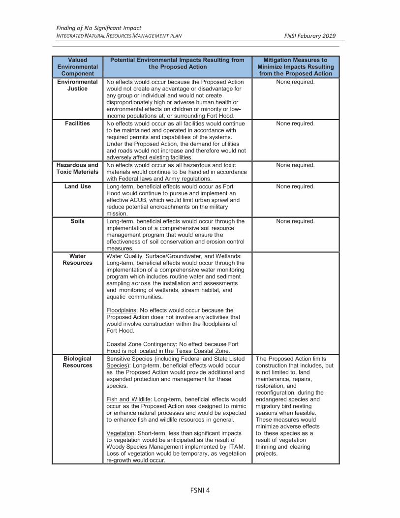
Finding of No Significant Impact INTEGRATED NATURAL RESOURCES MANAGEMENT FNSI 2019
FSNI 4
ValuedEnvironmental
Component
Potential Environmental Impacts Resulting fromthe Proposed Action
Mitigation Measures toMinimize Impacts Resultingfrom the Proposed Action
EnvironmentalJustice
No effects would occur because the Proposed Actionwould not create any advantage or disadvantage forany group or individual and would not createdisproportionately high or adverse human health orenvironmental effects on children or minority or low-income populations at, or surrounding Fort Hood.
None required.
Facilities No effects would occur as all facilities would continueto be maintained and operated in accordance withrequired permits and capabilities of the systems.Under the Proposed Action, the demand for utilitiesand roads would not increase and therefore would notadversely affect existing facilities.
None required.
Hazardous andToxic Materials
No effects would occur as all hazardous and toxicmaterials would continue to be handled in accordancewith Federal laws and Army regulations.
None required.
Land Use Long-term, beneficial effects would occur as FortHood would continue to pursue and implement aneffective ACUB, which would limit urban sprawl andreduce potential encroachments on the militarymission.
None required.
Soils Long-term, beneficial effects would occur through theimplementation of a comprehensive soil resourcemanagement program that would ensure theeffectiveness of soil conservation and erosion controlmeasures.
None required.
WaterResources
Water Quality, Surface/Groundwater, and Wetlands:Long-term, beneficial effects would occur through theimplementation of a comprehensive water monitoringprogram which includes routine water and sedimentsampling across the installation and assessmentsand monitoring of wetlands, stream habitat, andaquatic communities.
Floodplains: No effects would occur because theProposed Action does not involve any activities thatwould involve construction within the floodplains ofFort Hood.
Coastal Zone Contingency: No effect because FortHood is not located in the Texas Coastal Zone.
BiologicalResources
Sensitive Species (including Federal and State ListedSpecies): Long-term, beneficial effects would occuras the Proposed Action would provide additional andexpanded protection and management for thesespecies.
Fish and Wildlife: Long-term, beneficial effects wouldoccur as the Proposed Action was designed to mimicor enhance natural processes and would be expectedto enhance fish and wildlife resources in general.
Vegetation: Short-term, less than significant impactsto vegetation would be anticipated as the result ofWoody Species Management implemented by ITAM.Loss of vegetation would be temporary, as vegetationre-growth would occur.
The Proposed Action limitsconstruction that includes, butis not limited to, landmaintenance, repairs,restoration, andreconfiguration, during theendangered species andmigratory bird nestingseasons when feasible.These measures wouldminimize adverse effectsto these species as a result of vegetationthinning and clearing projects.

Finding of No Significant Impact INTEGRATED NATURAL RESOURCES MANAGEMENT FNSI 2019
ValuedEnvironmental
Component
Potential Environmental Impacts Resulting fromthe Proposed Action
Mitigation Measures toMinimize Impacts Resultingfrom the Proposed Action
CulturalResources
Long-term, beneficial effects would occur because theProposed Action provides for consultation andcoordination with the Cultural Resources Managerprior to the initiation of any activity that might affecthistoric or cultural resources. As a result of thisrequired consultation, the probability of disturbingpotential cultural resources would be greatly reduced.
None required.
6.0 PUBLIC COMMENTS
A Notice of Availability (NOA) of
published in the Killeen Daily Herald newspaper on Saturday,September 15, 2018 During the 30-day public review and comment period,copies of the EA and Draft FNSI were made available at the KilleenPublic Library located at 205 East Church Avenue, Killeen, Texas 78544.
FSNI 5

Finding of No Significant Impact INTEGRATED NATURAL RESOURCES MANAGEMENT FNSI 2019
FSNI
BRIAN L. DOSADirector of Public orksFort Hood, Texas
Civil LawOffice of the Staff Judge Advocate
Fort Hood, Texas
SANCHEZ.NANCY.1070741977
Digitally signed by SANCHEZ.NANCY.1070741977Date: 2019.02.27 10:48:42 -06'00'
DOSA.BRIAN.LAWRENCE.1045276682
Digitally signed by DOSA.BRIAN.LAWRENCE.1045276682Date: 2019.02.27 18:00:57 -06'00'

FSNI