Fort Benning
210
Fort Benning THE LAND ..--ND THE PEOPLE SHARYN KANE AND RICHARD KEETON This book provided at no cost to interested members of the public. Courtesy of the US Army, Fort Benning. NOT INTENDED FOR SALE
-
Upload
khangminh22 -
Category
Documents
-
view
4 -
download
0
Transcript of Fort Benning

Fort Benning THE LAND
..--ND THE PEOPLE
SHARYN KANE AND RICHARD KEETON
This book provided at no cost to interested members of the public. Courtesy of the US Army, Fort Benning. NOT INTENDED FOR SALE

This book provided at no cost to interested members of the public.
Courtesy of the US Army, Fort Benning. NOT INTENDED FOR SALE
Cover Image: "Loading Meal at Ee/beck" Oil on Canvas painting py Martin Pate U.S. Army, Fort Benning, Georgia

FORT BENNING: THE LAND AND THE PEOPLE
SHARYN KANE AND RICHARD KEETON
Published by
U.S. Army Maneuver Center of Excellence
Directorate of Public Works
Environmental Management Division
Fort Benning, Georgia
Administered by
Southeast Archeological Center
National Park Service
Tallahassee, Florida
Book Design and Production by
Sharyn Kane and Richard Keeton
Marietta, Georgia
This book provided at no cost to interested members of the public.
Courtesy of the US Army, Fort Benning. NOT INTENDED FOR SALE

This book is not copyrighted
Printed in the United States of America
Third Printing
First Printing - First Edition, 1998
Second Printing - First Edition, 2003
Third Printing - Second Edition, 2015
Defense Logistics Agency (Document Services)
6980 Yeager Ave.
Fort Benning, GA 31905
Above is Fort Benning's new insignia: the Maneuver Center of Excellence (MCoE). Its symbols represent the combat arms branches of Armor and Infantry working together. Because Fort Benning now trains Armor as well as Infantry, this
Second Edition uses this insignia in place of the Infantry crossed rifles of the previous edition.
The third printing of the book has resulted in changes in text alignment.

To DavidVV. Chase Oct31 , 1916 - Feb7, 2002
A self-taught archaeologist who lead the way in Cultural Resource Man
agement at Fort Benning. His decades-long dedication made his name
synonymous with research and conservation of Fort Benning's archaeo
logical resources.
US Army I US Coast Guard, WWII, Korea
Ft. Benning Head Archaeologist 1950s - 1960s
1st Curator (Director), National Infantry Museum, 1957

Foreword Fort Benning's Cultural Resource Management (CRM) Program of the Environmental Management Division (EMD)
of the Directorate of Public Works is pleased to bring to the public the third printing of, Fort Benning: The Land and the People.
The EMD holds responsibility for conducting archeological and historical surveys and studies on behalf of the US Army in compliance with the National Historic Preservation Act of 1966, as amended. Over the course of several decades, the EMD produced through contract, dozens of professional cultural resource reports of survey, evaluation and mitigation of archeological sites and historic buildings and districts. Fort Benning recognized the need to illustrate good stewardship of its cultural resources and promote public awareness and education about the importance of those resources. In 1998, Fort Benning met that need by working in partnership with the Southeast Archeological Center of the US National Park Service to produce this book. Utilizing the numerous reports and conducting their own interviews with people having direct knowledge and memories of their time on the installation, the authors Sharyn Kane and Richard Keeton have provided to us a very comprehensible and enjoyable overview of Fort Benning's voluminous archaeological and historic research.
In this book, Kane and Keeton pay respectful tribute to the peoples who once lived, worked, and trained here at Fort Benning. Federally recognized Indian Nations or Tribes with ancestral ties to Fort Benning such as Muscogee (Creek) Nation, Thlopthlocco Tribal Town, Kialegee Tribal Town, the Porch Band of Creek Indians, Seminole of both Florida and Oklahoma, Alabama-Coushatta of Texas, and the Yuchi among others whose fires are extant or extinguished, figure prominently in this account. The presence on the installation of historic luminaries such as James Oglethorpe, William Bartram, Benjamin Hawkins and the Marquis de Lafayette contribute to the importance of Fort Benning within the expanding colony and states of Georgia and Alabama. Settlers and their descendants of all social classes are examined, such as the Woolfolks, Lees, Mehaffeys, McCardels, Turners, and Canteys. And, of course, Soldiers such as Eisenhower, Patton, Bradley, Marshall, and Powell are profiled.
Dr. Christopher E. Hamilton
Cultural Resource Manager
Fort Benning, Georgia
June 23 , 2014

JI

Acknowledgements Many individuals helped make this cultural history of Fort Benning possible and we are grateful to them all. Leading
the list are John Ehrenhard and John Jameson of the National Park Service. They have enthusiastically encouraged and supported our efforts over the years in writing about archeology and history and we appreciate their confidence in us. Their uncompromising determination to inform the public about the rich cultural heritage of our nation and the scientific findings on public lands is inspiring. The people of the United States are fortunate to have these dedicated stewards of our country 's past.
At Fort Benning, John Brent and Christopher Hamilton have been especially helpful. From the start, they had a clear vision of how they wanted this story told and never lost sight of the big picture. Chris, who has conducted some of the archeological research described in this volume, went out of his way to provide information, sources, reports, whatever we needed. Frank Hanner, director of the Infantry Museum, was a font of knowledge about the military history of the post, and Charles White, Fort Benning's historian, was also most helpful.
Dean Wood, another archeologist whose work figures prominently in these pages, was also an invaluable ally who generously shared his knowledge and library. His insights about Fort Benning's prehistoric years and the environment were particularly beneficial. Frank Schnell Jr., archeologist with the Columbus Museum, drew on a lifetime of experience studying the region to provide knowledge unavailable anywhere else. The hours we spent poring over his files and photographs in the museum basement were also vitally important, as were the books he loaned from his collection. Kimberly Washington, contracting officer for the National Park Service, as always, was reliable, professional, and good humored. We also wish to acknowledge the professionalism of the Government Printing Office representatives and their work to ensure the highest standards were followed in publishing this book.
Hubert G. Mehaffey Sr. deserves special mention for the gifts of his time, memories, and photographs. His recollections about living near a mill on Fort Benning are vivid and poetic, and it was a pleasure to hear him recount stories about a time and place gone forever.
Finally, we thank our families and friends for their encouragement and interest in this ambitious endeavor.
Ill

lV

Contents Page
Introduction . . . . . . . . . . . . . . . . . . . . . . . . . . . . . . . . . . . . . . . . . . . . . . . . . . . . . . . . . . . . . . . . . . . . . . . . . . . . . . . . . . . . . . . . . . . . . . . . . . . . . . . 1 Chapter
1-Days of Giants and Ice . . . . . . . . . . . . . . . . . . . . . . . . . . . . . . . . . . . . . . . . . . . . . . . . . . . . . . . . . . . . . . . . . . . . . . . . . 3 2- Stories Rocks Tell . . . . . . . . . . . . . . . . . . . . . . . . . . . . . . . . . . . . . . . . . . . . . . . . . . . . . . . . . . . . . . . . . . . . . . . . . . . . . . . . 13 3-An Unforgiving Climate . . . . . . . . . . . . . . . . . . . . . . . . . . . . . . . . . . . . . . . . . . . . .. . . . . . . . . . . . . . . . . . . . . . . . . 25 4-Shaping the Earth . . . . . . . . . . . . . . . . . . . . . . . . . . . . . . . . . . . . . . . . . . . . . . . . . . . . . . . . . . . . . . . . . . . . . . . . . . . . . . . . . 31 5-Rituals and Commerce ............ ................ ............................................. 39 6-Seeds of Change . . . . . . . . . . . . . . . . . . . . . . . . . . . . . . . . . . . . . . . . . . . . . . . . . . . . . . . . . . . . . . . . . . . . . . . . . . . . . . . . . . . 51 7-Invasion and Devastation . . . . . . . . . . . . . . . . . . . . . . . . . . . . . . . . . . . . . . . . . . . . . . . . . . . . . . . . . . . . . . . . . . . . . 63 8- A Brave J oumey . . . . . . . . . . . . . . . . . . . . . . . . . . . . . . . . . . . . . . . . . . . . . . . . . . . . . . . . . . . . . . . . . . . . . . . . . . . . . . . . . . 71 9-The Flower Hunter . . . . . . . . . . . . . . . . . . . . . . . . . . . . . . . . . . . . . . . . . . . . . . . . . . . . . . . . . . . . . . . . . . . . . . . . . . . . . . 79
10- A Sacred Fire Flickers . . . . . . . . . . . . . . . . . . . . . . . . . . . . . . . . . . . . . . . . . . . . . . . . . . . . . . . . . . . . . . . . . . . . . . . . . . 87 11-As Long as Grass Grows . . . . . . . . . . . . . . . . . . . . . . . . . . . . . . . . . . . . . . . . . . . . . . . . . . . . . . . . . . . . . . . . . . . . . . 95 12-A Forgotten Church ...... ........................................................................ 105 13-Prosperity for a Few . . . . . . . . . . . . . . . . . . . . . . . . . . . . . . . . . . . . . . . . . . . . . . . . . . . . . . . . . . . . . . . . . . . . . . . . . . . . . 111 14-Henry Benning's War ........................................................................... 117 15-Hard Times . . . . . . . . . . . . . . . . . . . . . . . . . . . . . . . . . . . . . . . . . . . . . . . . . . . . . . . . . . . . . . . . . . . . . . . . . . . . . . . . . . . . . . . . . . . 123 16-Word Comes Too Late ................................. ............. ............................ 129 17-Freedom's High Price ........................................................................... 137 18- Wheel-Spun Memories ......................................................................... 143 19-All the Time in the World ..................................................................... 149 20-The Infantry's Story .............................................................................. 159 21-Politics and Persistence ...................... ................................................... 167 22-A Place in History .. ...................................... .... ..................................... 175
Figures . . . . . . . . . . . . . . . . . . . . . . . . . . . . . . . . . . . . . . . . . . . . . . . . . . . . . . . . . . . . . . . . . . . . . . . . . . . . . . . . . . . . . . . . . . . . . . . . . . . . . . . . . . . . . . . 185 Bibliography ...................................................................................................... 188 Index ................................................................................................................... 193
v

VI

Introduction
The land and the people. The words can stir vivid images and
strong emotions, perhaps because all of us are tied to a place, a people. Scratch the soil deep enough and you will likely find traces of the ties others had to the same place long before, if you know how to recognize the signs.
Exploring the lengthy chain of human links to the land occupied by Fort Benning is the purpose of this book. Fortunately, skilled observ-ers for some time have been searching for signs left long ago by earlier people. These observers, including archeologists, historians, and others, have gathered enough evidence for a true narrative sparked with mystery and adventure, tragedy and courage.
Scientific fact and informed speculation track an ongoing human presence on Fort Benning land as far back as the Ice Age. Following in the footsteps of these prehistoric visitors were hundreds of generations who also left fragments to be found from their lives.
The proud tradition of the Infantry of the United States Army is integral to the unfolding story. Indeed, little of the knowledge in these pages would ever have come to light without ef-
I '
I ----'\..
"· '-- \ . . ALABAMA' GEORGIA
forts sponsored by the Army to investigate and document the post's rich cultural history. Figure I : Fort Benning is located in west Georgia and east Alabama.
Since the military arrived in 1918, hundreds of thousands of American soldiers have trained at Fort Benning and gone on to fight in every major conflict the United States has faced since then. In small towns and large cities across the nation, families cherish photographs of young soldiers who spent time at Fort Benning, Georgia.
Some of the most respected American military
leaders in the twentieth century were stationed on the post- Omar Bradley, Dwight Eisenhower, George Marshall, George Patton, and Colin Powell, to cite only a few. Like the officers and enlisted troops today, they came to know the oak-lined streets of the Main Post Cantonment and the many other landmarks on the post 's approximately 182,000 acres.

An account of how the Infantry came to call Fort Benning home comes near the end of this book because the Army's arrival occurred relatively late in the human sequence of events in the sand hills adjoining the Chattahoochee River. First there were the Native Americans who occupied the landscape until the 1800's when they were driven away to make room for white settlers.
Ongoing excavations continue to uncover artifacts dating back thousands of years when prehistoric hunters stalked game in the forests and pitched camps overlooking the winding creeks. Pieces of crude stone
bowls followed in time by artfully decorated Figure 2. Hubert G. Mehaffey, SR., grew up on Fort Benning land near a grist mill.
pottery document passing centuries and ways that early people learned to adapt to make life easier.
While the Creeks, Yuchis, and other Indians are homesteads in a strange, new land mirrors similar struglong gone from the area, Fort Benning, indeed all of gles enacted across the nation. The colonists ' forced the surrounding region, is filled with places, rivers, and displacement of the Indians also reverberated again and creeks bearing their names- Cusetta, Coweta, Upatoi, again. Ochille, Uchee, Chattahoochee. Exploring who left these words as their legacy is one facet of this volume. Indeed, descendants of Native Americans who once lived on Fort Benning land continue to show interest in historical and archeological research on the post even though their homes are now in Oklahoma, Florida, and Alabama.
There are countless others who made their marks in the earth of Fort Benning, and their times and roles are also examined. Tales of bravery fill the early colonial years when Georgia's British founder, James Edward Oglethorpe, traveled at great risk through the wilderness to meet with the Indian leaders at a village on Fort Benning. William Bartram, the famous naturalist, was another early visitor. He sketched and wrote about the plants and animals so vibrantly that some of his readers ultimately left their homes to see this new world for themselves. And there were others who dared to explore the uncharted land, including Hernando de Soto, a Spanish conquistador on a feverish search for gold. Spanish missionaries were on a different quest, a spiritual mission to convert the Indians to Christianity. Farmers, slaves, and mill families came after them. The struggle faced by colonial pioneers to scratch out their
2
When cotton was king in the Chattahoochee Valley, African slaves and their descendants planted and tended the fields, often under threat of the lash. They also built the houses and bridges and performed hundreds of other jobs that shaped the Columbus area into one of the South's most promising young communities in the days before the Civil War. But the cost of slavery was enormous, and its toll is part of Fort Benning's story. Sinking gunboats, blazing bridges, frightened troops caught behind enemy lines, these are the true details of a battle fought after a war stopped when word of peace came too late to the Chattahoochee River.
Once, grist mills were the centerpieces of rural life, places where farmers brought their wheat and com to be ground into meal and stayed awhile to socialize with neighbors too rarely seen. Mills, particularly one named Eelbeck, were important in Fort Benning's history. Hubert G. Mehaffey, Sr., the miller 's son, generously shared his memories and photographs to document a cherished place and a beloved way of life that have all but vanished.
The land and the people. Turn the pages and scratch beneath the surface for traces of those who came before.

1-Days of Giants and Ice
L ong ago, about the time the first people arrived on the land now occupied by Fort Benning, huge creatures roamed North America. These were the cold, ebbing days of the last Ice Age when giant, elephant-like wooly mammoths and other large species existed. Camels and horses could also be found. They were not identical to the animals we know today, but recognizable nonetheless.
Like the animals they coexisted with and depended upon for food , these earliest human visitors probably traveled long distances before they arrived and once they reached the area didn 't stay long. Perhaps they were a small group of male hunters who lived at least part of the year in a distant base camp. Their home site where the women and children , stayed for long periods, was possibly along the Tennessee River in what is now northern Alabama, or perhaps in northern Florida where large concentrations have been found of early prehistoric artifacts.
Another possibility is that rather than a hunting party the first visitors were an extended fami- _
No remnants have been found to reveal whether these first inhabitants erected any sort of temporary shelters for themselves. The highly acidic soils in the region, along with other causes, often destroy signs of human occupation, especially over the thousands of years that have elapsed since the first people explor.ed Fort Benning land. If the Ice Age visitors did bmld shelters, they probably made simple, but sturdy huts from saplings stripped of limbs, then tied together and
ly, called a band by archeologists. Figure 3. Archeologists have excavated on Fort Benning for decades.
Such a group might have moved covered with animal skins to keep out the cold and rain. through the region during a long foot journey search- During this time of prehistory, there were slow, but ing for game, raw materials for tools, or a new home dramatic changes occurring in the environment as base. Men, women, and children would have traveled the climate steadily warmed. Many species eartogether, and again they would not have lingered Ion~. ly people depended upon were beginning to d~in-
Whether these prehistoric visitors were a m1- dle in number and would eventually become extmct, grating extended family or a hunting group, the_Y perhaps speeded into oblivion by human p:edators. were unlikely to meet many other people along thelf For the first visitors to the Fort Bennmg area, way because the continent was only sparsely popu- however, finding game was not a problem. Killing their lated. Yet, the landscape was hardly empty. Wildlife was abundant, with ample prey for hungry travelers.
3

quarry was another matter, especially when they went after the wooly mammoth with its menacing sharp tusks and enormous size.
The big-game hunters' principal weapons were wooden spears with sharpened stone points, and they spent great effort looking for the best materials to make them. They preferred rocks such as chert, a type of flint, that can be chipped precisely. A chalky form of chert is plentiful south and east of Fort Benning near the Flint River. Outcrops are especially prevalent near Albany, Georgia. Chert is a sedimentary rock that began forming millions of years ago beneath the ocean that once covered southern Georgia and much of Alabama.
Working with stone was a crucial survival skill for early people. The spear point maker followed steps he likely began learning as a young boy by watching older hunters. He started by using a harnmerstone to knock away many pieces called flakes from a second stone that would become the spear point.
Hours of practice and experimentation taught him how to strike the two rocks together at just the right angle and with just the right impact. Meticulously, he knocked away flake after flake, steadily reducing the spear point rock until what remained was a projectile shaped like a lance or laurel leaf between two and three inches long.
He forced away more pieces of the stone to form long grooves or flutes down the center of both sides of the point, and he honed the point edges razor sharp. He then split the end of a wooden or bone spear shaft so he could slip it into the spear point grooves. Finally, he used strands of dried animal intestines or tendons to bind the spear point and shaft together for a sturdy and deadly weapon.
At least two of these ancient spear points have been found on Fort Benning, and others have been discovered nearby. These few, small pieces of worked stone are the best proof available that some of the earliest people in North America found their way to the Chattahoochee River Valley.
The artful sculpting, the shapes, the flutes , and the type of stone used in the spear points are immediately evident to the trained eye as the handiwork of people from a specific cultural chapter in prehistory- the Paleolndian period.
Archeologists identified the stones as Clovis spear points, named forthe site near Clovis, New Mexico 4
where similar spear points were first discovered. Apart from identifying Paleolndian spear
points, however, there is little else unanimously agreed to among researchers about the people from this ancient time. So many centuries have come and gone and so little evidence has been found that drawing irrefutable conclusions is nearly impossible at present. Many researchers, however, are on a quest to learn more, and so far there is a tantalizing array of theories and bits of potential scientific data about this mysterious chapter in the human past.
The people who first walked on Fort Benning soil may have been direct descendants of the original humans to reach North America. Theories vary. Human settlement of the continent began perhaps a century before people arrived near the Chattahoochee River, or perhaps many centuries earlier.
When human beings first ventured into the Americas is a matter of conjecture and considerable scientific debate, but few authorities seem to doubt the first inhabitants entered Alaska sometime during the last Ice Age. The earth has endured four brutally cold periods, spanning two million years. The last Ice Age began about 70,000 years ago and continued until about 10,000 years ago. During this time, colossal glaciers, some a mile high, surged south, carving out valleys, scooping out the Great Lakes, and otherwise forcing spectacular rearrangements in the terrain.
The glaciers advanced, retreated, and advanced again as temperatures plummeted, warmed, then dipped. In the most frigid periods, so much water froze that sea levels lowered worldwide, dropping as much as 460 feet. As the seas retreated, more land was exposed and continents expanded. The Georgia coast, for a time, extended 150 miles farther into the Atlantic Ocean than it does today. It was during this era of advancing land and shrinking seas that a long ridge surfaced in the Bering Straits. This land bridge, about 1,300 miles long, opened the way for people to move from Asia to the New World.
What prompted their journey? Perhaps they were pursuing game. Similar animal fossils are found on both sides of the Bering Straits. The fossils reveal that many animals and varied species moved back and forth across the land bridge. Also, excavations of prehistoric human occupation sites in Siberia have turned up similarities with early occupation sites found in North America.

0 5
centimeters
Also in recent years, a small, but growing number of archeologists have speculated that people were in the Americas even earlier than 29,000 years ago. They point to tantalizing hints- a cave in the Yukon, a rock shelter in Pennsylvania, a bog in Chile- that hunter-gatherers roamed both North and South America as long as 30,000 years ago or earlier.
At Flea Cave, high in Peru 's rugged mountains, scientists uncovered evidence purportedly showing human existence 20,000 years ago. If people reached South America so far in the past, then they must have been in North America even earlier, argue some. In Pendejo Cave in southern New Mexico, archeologist Richard MacNeish recently discovered an ancient human hand print made in clay. The archeologist also recovered stone tools, animal bones with spear points embedded in them, and fire blackened hearths. Radiocarbon dating showed the site to be 28,000 years old.
These intriguing findings may never have come .....__ ___________________ _____. to light if the cave had not been part of the Figure 4: A sketch of front and back views of a Clovis spear point fo und on Fort Benning shows the center groove and many fl ake marks. U.S. Army 's Fort Bliss missile range, pro-
The first momentous crossing could have occurred any time over a span of thousands of years. The land bridge surfaced between 50,000 and 40,000 years ago, and again between 28,000 and 10,000 years ago. Potentially, people could have traveled across during the earliest period, and some scientists think that is what happened. There is, however, much more unequivocal evidence supporting an arrival sometime after 28,000 years ago.
The prevailing view until recently has been that people did not arrive in North America until about 12,000 years ago. That assessment, however, has lately come under sustained attack. One challenge to the theory comes from geneticists at Emory University who have tested blood from 400 contemporary Native Americans. They took blood samples from individuals representing 18 different tribes in both North and South America. By examining mitochondrial DNA- the genetic material passed from one generation to the next- the scientists concluded that the first inhabitants must have come to the Americas between 22,000 and 29,000 years ago.
tected from the vandals who have tampered with and destroyed important prehistoric remains in nearby caves unprotected by the military.
While the evidence for very early human existence in the Americas is mounting, there is much that remains controversial. Skeptics doubt the accuracy of dating methods used at some of the purported early sites and contend that artifacts- objects produced or shaped by people- at some locations may not be artifacts at all but simply rocks or pebbles battered by natural forces.
Critics also protest about the low number of very early sites discovered. If people were in the Americas, there ought to be more proof, they contend. Archeologist David Anderson argues that if some of the disputed locations do in fact represent very earl y campsites, then they may also represent migrations into the Americas that failed because all the participants died, leaving the land empty of people once again.
Unless more widespread and undeniable evidence develops, skepticism is likely to persist that human occupation occurred in the Americas before 20,000 years ago. Many think even 20,000 years ago is too early a date for arrival.
5

Few disagree, however, that by about 12,000 years ago-perhaps a thousand years earlier-a wave of people began spreading across what is today the United States. These Paleolndians left behind abundant proof of their existence in the form of their distinctive Clovis spear points.
There is little doubt that Paleolndians lived in northern Alaska. On a mesa, several hundred miles from the coast, archeologists discovered a Paleolndian camp with spear points and remnants of an ancient fire. The charcoal left from the campfire radiocarbon dated to about 11 ,700 years ago. What prompted Paleolndians to migrate from Alaska is unknown, nor are we sure of
their exact route south. There were few possible avenues for foot travelers out of the frozen north. Interestingly, some theorists contend that early people skirted the glaciers by traveling along the Pacific coast, perhaps in dugout canoes or other craft, before dispersing into North and South America. However, no one has uncovered substantial proof to support this idea.
Far more commonly accepted is the theory that Paleolndians traveled south through western Canada, a route made possible because of a slight warming trend. When the Canadian glaciers began to melt and split apart, they revealed a wide swath of land, a pathway directly into the American West.
Whether the Paleolndians moved in one mass
(
\ j .
migration or in small, isolated groups over many years is unknown. When they reached the northern United States, they faced four major river systems- the Missouri, Platte, Arkansas, and Red- as they moved south. The four rivers flow generally south and east toward the Mississippi River.
L..:iurcntidc Ice Shc<;1 -~
Pacific Otton
Carib/Jeon Sta
--
Many of the Paleolndians followed the waterways, just as trailblazers have always tended to do for similar reasons, archeologists theorize. Rivers erode valleys through rugged terrain, opening relatively level passageways. Animals, dependent upon fresh water, beat down paths near the rivers, paths that people also follow, both for access to water and the animals they hunt. Paleolndians may have walked along the river edges or possibly built vessels to float downstream.
At the Mississippi River, many crossed and began exploring the other side where they slowed their great migration. Some chose to stay in the general area. They concentrated in the lush valleys of the Ohio, Cumberland, and Tennessee Rivers, according to archeologist David Anderson.
The Paleolndians chose an environment abun-~. dant with both animals and the type of rocks they '"-j"\ used for spear points and tools. In parts of Ohio, 0 milc1 1000
I Kentucky, Tennessee, and northern Alabama, ar-. cheologists find many Paleolndian artifacts, in-
=:::i--------~~~~~~~~~~~~~--!.~~~~_J
0 kilometers 1000
Figure 5: The arrows indicate the theoretical migrations of early people into the continent.
6
eluding thousands of spear points. In fact the most Paleolndian artifacts found in the entire United States came

Figure 6: Archeologists use screens suspended sapling poles to sift soi ls in the search for arti fac ts and other signs of earlier human existence. This excavation at the Carmouche site near Upatoi Creek disclosed evidence from many cultural ears.
from by
those four states and m areas near-just west of the Mississippi River.
The Paleolndians remained concentrated in the valleys for perhaps two to three centuries. By staying in the same general vicinity, they eased the hardships of long-distance travel and consequently helped boost their population. Studies of hunter-gatherer cultures of today demonstrate that less movement among a group leads to healthier diets and less danger to pregnant women, resulting in more successful births.
During their time in the mid-South and Ohio regions, Paleolndians began familiarizing themselves with the varied resources around them. They also explored widely across the eastern United States.
Evidence gathered attheLittle Salt Springs site on Florida's southern Gulf coast indicates that Paleolndians arrived there quite early. Researchers found remains of
an extinct Ice-Age tortoise laying on its back where Paleolndians had plunged a wooden stake into the tortoise to kill it. The stake radiocarbon dated to 12,030years ago.
Further observations of modern-day preliterate people suggest that Paleolndians probably lived in extended family bands of between 50 and 150 members. While a few dominant males may have had slightly more control in decision-making, everyone- male and female- probably had a fairly equal say. Cooperation would have been necessary in the wilderness, although there was probably some division of labor. Men probably assumed primary responsibility for hunting, building shelters, and making tools. Women likely took charge of raising the young and stitching animal skins together into clothing. Women probably also gathered firewood, foraged for edible roots and other wild plant
7

foods , started fires , and cooked. Other details of their culture are harder to determine. For instance, what were their spiritual beliefs, if any?
Research in Arkansas indicates Paleolndians buried their dead in cemeteries, while studies in Montana show that Paleolndians there practiced ceremonial burials. Two teenagers were buried at the Anzik site in Montana with many artifacts, including deliberately broken spear foreshafts made of bone. Curiously, the teens' bodies
were sprinkled with red coloring derived from ochre. Such ceremonialism leads some scientists to infer that Paleolndians believed in life after death.
Researchers have observed, again by studying contemporary preliterate people, that bands become inefficient when they grow large. Inevitably, as a group expands, people break away and form new bands. As the number of Paleolndians mounted near the Ohio, Cumberland, and Tennessee Rivers, new groups likely
0 c:cntimetcrs
8
Figure 7: Clovis spear points are found in various sizes. These examples come from different locations in the southeastern United States.

separated and headed for other territories. It was during this time of expansion, sometime in the Early Paleolndian period between 11,500 and 11 ,000 years ago, that the first people passed through land now occupied by Fort Benning and left the two distinctive Clovis spear points.
Whattbeyweredoing, wheretheycamefrom,and where they were going can only be speculated. Perhaps they were trailing big game or searching for a new home or for rock outcrops where they could extract materials for tools. In all probability, they camped on spots with a good view of the wide Chattahoochee River.
Just as with many Clovis spear point discoveries in the Southeast, there was no other evidenceno other tools, no campfire charcoal, no sign of housing-found with the artifacts on Fort Benning. This doesn't mean that Early Paleoindians didn't bum fires or build shelters. Signs could have been destroyed in the acidic soils or buried under centuries of river sediment. Future excavations may yet reveal such evidence. It is also possible that scientists don't yet recognize all the tools Paleolndians used.
Whatever drew Paleoindians to the region, one of their most likely activities was hunting. Paleolndians in the Southeast ate a variety of foods. They probably gathered nuts and leafy plants, dug up roots, and also hunted small game such as deer and rabbit. There is little doubt, however, that they also tracked large animals, such as the giant sloth- a slow-moving mammal standing up to 18 feet tall- the grizzly bear, and the elephant-like mastodons and mammoths.
Ideas about how Paleoindians hunted such massive animals comes, in part, from research about African elephants. Other information derives from Paleoindian sites in the western United States where dry conditions help preserve bone better than in the Southeast. Scientists have found Paleoindian spear points lodged between mammoth rib bones and embedded in ribs of prehistoric bison, proof of the hunting prowess of early people. Paleolndian spear points have also been found near mammoth skeletons in Arizona, New Mexico, Colorado, Wyoming, and Montana. Mastodon bones and fluted points have also been located together in Missouri.
Even in the Southeast, where environmental decomposition complicates discoveries, some limited evidence of Paleolndian interaction with large Ice Age species exists. Archeologists exploring underwater
sites in Florida have recovered a prehistoric bison skull with an embedded spear point fragment and a prehistoric horse skeleton and mammoth bones with cut marks apparently made by humans.
While other signs of hunting are slim, scientists have little doubt that Paleolndians were pursuing large Ice Age creatures in the South. Scuba divers near St. Simon's Island, Georgia recently surfaced with remains of a giant sloth. The sloth in life stood 14 feet tal 1 and 22 feet long and weighed perhaps six tons. Slow-moving animals that looked somewhat like bears, sloths were vegetarians. They stood on hind legs and reached high into trees, using 12-inch claws to snare tree limbs and pull them within reach.
Another recent find was a fossilized, Ice-Age elephant bone on a beach at Edisto Island, South Carolina. Someone thousands of years ago apparently carved grooves in the bone with a knife. Large prehistoric animals also roamed the area around Fort Benning. Just south of the post in Stewart County, Georgia a mastodon tooth was recovered. Scientists speculate that the mammoth, the mightiest of Ice Age animals, also roamed in the area, though in lesser numbers than the mastodon.
Mammoths stood up to 12 feet tall and weighed thousands of pounds, dwarfing the Paleolndian hunters. Their tough hides and shaggy hair insulated the creatures from frigid weather. Long, sharp, semicircular tusks, along with massive size and surprising speed, provided protection from enemies. Such formidable defenses meant the mammoths faced no serious predators- except for humans.
To hunt the mammoth, the Paleolndians had to keep careful watch on their intended prey by often lurking downwind at watering holes. The hunters targeted animals that strayed from the herd and those that appeared weakest- the sick, the old, and the young. Even so, attacking a mammoth required courage, intense concentration, and cooperation. Hunters had to rely on surprise by sneaking undetected within a few feet of the animal. When they rose up to attack, they ha:d to be close enough to throw or jab their spears with sufficient force to pierce the mammoth's tough hide. Then they had to scramble out of the way or be crushed because the wounded creature might thrash about or charge with horrifying speed. The noise and confusion of trumpeting
9

mammoths and thundering hooves must have been deafening and terrifying. All the effort and danger proved worthwhile if the hunt was successful because the Paleoindians were rewarded not only with ample meat, but also with raw materials for housing, clothing, and tools.
Examining where Clovis spear points are found tells us where Early Paleoindians were and also which areas they avoided. They stayed away from high mountains, for the most part. With a few exceptions, they also avoided the vast coastal plain bordering the Gulf of Mexico. For example, while Early Paleolndian artifacts (known to scientists) are concentrated in northern Alabama, few have been reported in southern parts of the state. Archeologist Eugene Futato cataloged where some 1,600 fluted points have surfaced in Alabama, and more than 90 percent were in the far north of the state.
The climate was cold and dry during the most intense part of the Ice Age north of 33 degrees latitude- a straight line passing from near Charleston, South Carolina to just north of Macon, Georgia and just south of La Grange, Georgia. Spruce, fir, and jack pine trees dominated the forests in an environment similar to southern Canada today. Forests were separated by many open fields where herbs and shrubs thrived.
The forests were changing before Paleolndians arrived. The climate warmed and became moister, as the Ice Age moved into its final centuries. In the area north of 33 degrees latitude, hardwoods such as oak, hickory, beech, and birch gained mastery by 12,000 years ago as the spruce and firs retreated north. Remnants of the spruce forests of long ago still exist in enclaves high in the Appalachian mountains. When the Paleolndians arrived in Georgia and Alabama, the weather north of 33
Figure 8: Hunters near the end of the Paleo lndian cultura l period used a new spear point called the Dalton. These examples show the vari ety in the shapes and sizes of Dalton projectiles.
More than 200 of the points were found in one place, the Quad site near the Tennessee River.
Not many Paleolndians passed through the Fort Benning area early in the era, judging by the small number of Clovis spear points discovered so far. The scarcity of early artifacts is unsurprising and is compatible with Early Paleoindian avoidance of the Gulf Coastal Plain. Perhaps they skirted the region because game was not as abundant as it was in other places. Herds of animals like mastodons and mammoths may have been small and widely scattered in this area, some scientists speculate. Another factor may have been a climate warmer than farther north where most Early Paleoindians congregated.
10
degrees latitude was still considerably colder than today. Winter hit the area hard, resembling the climate New York state experiences.
Hardwoods dominated the forests south of 33 degrees latitude- the territory now encompassing Fort Benning- during the depths of the Ice Age. Even as the overall climate warmed, this forest remained much the same for thousands of years. There were some pines, but oaks and hickories were plentiful, similar to forests today farther north in Georgia and Alabama.
When the Paleoindians arrived, the climate was colder than now but fairly temperate, influenced by powerful air flows from the Gulf of Mexico. The weather was also wetter than today. Heavy winter rains

and melting snows in the mountains transformed the Chattahoochee River into a raging torrent that often overflowed its banks, according to some scientists. If they are correct, the flood plain frequently became unlivable. Consequently, in times of high water, hunters probably camped on the ridges overlooking the flood plain.
While Early Paleolndians generally avoided the Gulf Coastal Plain, they did settle in great numbers in northern Florida, perhaps because of chert deposits there. Archeologists have cataloged nearly 1,300 fluted points in Florida.
One reason Paleolndians selected chert is because it remained sharp for a long while, even after repeated use on long hunting excursions. Paleolndians carried their spear points up to 150 miles away from a rock source, according to information developed in South Carolina
rock, which they carried to a nearby spot. There they continued to work on the stone, reducing it in size for easy transport to the base camp where they finished making spear points and tools. A band also set up temporary camps scattered across the landscape from which they hunted and gathered plant foods.
Early Paleolndians did not avoid all of southern Georgia. They left behind minor artifact concentrations near chert outcrops on the eastern side of the state near the Savannah River and in western Georgia near Albany, about 40 miles southeast of Fort Benning. Near Albany, archeologists have discovered several possible Paleolndian camps. One site, found on Muckafoonee Creek, not far from its juncture with the Flint River, was a toolmaking site where Paleolndians brought large pieces of chert from nearby outcrops.
If these early people regularly visited chert sites so
Figure 9: Hunters often used the Dalton spear points as knives and resharpened them to use aga in and again.
by Tommy Charles, an avocational archeologist. Paleolndians discovered that chert could
be made even more pliable by exposing it to intense heat. They often buried chert in a shallow depression and built a fire on top to heat the rock. Once the rock cooled, they chipped it into tools.
Studies conducted by archeologist William Gardner in Virginia demonstrated that Paleolndians established base camps at least part of the year near chert outcrops. Gardner thinks Paleolndian bands all along the Atlantic coast behaved similarly, returning year after year to the same general area. These bands left behind evidence that produces several forms of archeological sites. At quarries, they extracted large chunks of their preferred
close by, they may have camped in the Fort Benning area more often than evidence now indicates. Some scientists think there may be more proof of early visitations yet to be discovered. Archeologists have examined more than 40 percent of Fort Benning's surface, but even in the areas studied many clusters of artifacts could have been missed. Then, too, Early Paleolndians often preferred camping near major rivers, such as the Chattahoochee. During the thousands of years since the prehistoric people existed, flood waters may have washed away some of the evidence of their visits or buried the signs under many layers of sediments.
If Paleolndians spent little time on Fort Ben-nmg
11

land during their first thousand years in the East, they were present more often during the closing centuries of the era. During the Late Paleo Indian period between 10,500 and 10,000 years ago, expanding population reduced the range that Paleoindians traveled. There still were relatively few people, but there were perhaps limits on how far members of one band normally traveled.
The great Ice Age animals had become extinct or were becoming scarce by the last centuries of the era. In response, the Paleolndians adapted how they hunted and lived. Unlike Early Paleoindians who camped mainly near major rivers, Late Paleoindians often spent time on land some distance from big rivers, according to archeologist Lisa O'Steen. They pursued smaller game more often and also a wider variety of animals than their predecessors.
They were also changing the way they moved across the land, although change likely occurred at different places at different times. Archeologists Dan Morse and Phyllis Morse discovered that Late Paleoindians in northeast Arkansas and southern Missouri lived in base camps perhaps year round.
In other areas, however, the Paleolndians began using base camps less. Instead, bands becamemorenomadic, moving the entire extended family more often, a trend that would accelerate in the next era, the Archaic period.
Paleoindians also modified their weapons. They used lighter spears and smaller points, which were more efficient for killing smaller game. Hunters developed spear points called Daltons, often distinguishable by flared comers at the base. The flutes or grooves of the early Clovis spear points are absent on most Daltons. However, the bases of the points were ground in a manner that resembles the beginning of a flute,
12
leading scientists to assume that descendants of the original Paleolndians created the Daltons, not some new group that migrated to the area.
The outer edges of many Dalton points are serrated, showing that they were used as knives, as well as spears, and that the Paleolndians had learned to cut more efficiently. They attached a short, wooden handle when using a Dalton point as a knife. The handles, like wooden spear shafts, rotted away with time, leaving the stone point as the only artifact.
The construction of the Bradley Fighting Vehicle firing range at Fort Benning led to important excavations in 1983. Archeologists uncovered a site high on a bluff above Upatoi Creek that was a favorite prehistoric camping ground spanning thousands of years and many cultural periods. Called the Carmouche site, the spot was first used during the Late Paleolndian era. These first visitors to the Carmouche site left several Dalton-like spear points. Archeologists also uncovered numerous triangular spear points, probably from the same era. Called Tallahassee points, these weapons have concave bases. Like Daltons, the Tallahassee points often display serrations and grinding at the base. The people who made these points valued them. They didn 't use them once and discard them, but kept resharpening them as needed.
Scientists found 23 of these Late Paleoindian/ Early Archaic spear points on the bluff above Upatoi Creek. Eleven other spear points perhaps came from the same era. Paleolndians were staying in the area for longer periods, these findings seem to confirm. The people at Carmouche were perhaps the first who, for at least part of the year, considered Fort Benning land their home.

2-Stories Rocks Tell
I n the early morning quiet l 0,000 years ago, hunters along Upatoi Creek moved stealthily into place. They had camped overnight on a high ridge overlooking the rushing waters, a spot they chose for its strategic advantages. Downstream about 100 yards, the creek rolled over a series of sandstone ledges, creating small rapids. Behind the rapids, the water backed up into a calm pool where deer drank in the quiet just before dawn. As the deer leaned over to lap the waters, there were no unusual noises hinting of danger. Four animals stood in the creek. A fifth , a large buck, stood cautiously to the side, waiting, sniffing the air, before he also waded in.
Thick vegetation provided camouflage and a sense of security. Trees and underbrush thrived in the damp soils of the broad plain where for centuries the creek had dumped sand and gravel during floods. This flood plain, bordered on both sides by tall ridges and bluffs, teemed with life. Birds chattered wake-up calls. A mother raccoon waddled away from the stream with young raccoons strung out behind her. A woodpecker hammered a dying tree.
The largest deer reared his head, his antler rack barely visible in the shadows. Water cascaded from his alert face. The rest of the deer also lifted their heads and stood watchfully. Suddenly, shouting and terrible loud noises burst the calm. Men and women, waving their arms, darted from hiding places.
Startled, the deer bounded away, rapidly putting distance between themselves and their pursuers. Then, confused by all the sudden sound and motion, they noticed for the first time that other hunters were stationed on the opposite side of the creek on the bluff slopes. These hunters also shouted, waved wildly, and made banging noises. The deer plunged forward, straight into a trap.
The flood plain dwindled into a tight constriction of the valley. A steep bluff, bordering the creek, blocked the way. The deer desperately veered back and forth.
Still more hunters, crouched behind hiding places on the canyon walls, abruptly stood and flung spears, hitting several deer. The animals leaped into the air, then fell. Others bolted up the slopes, managing to escape.
Archeologists speculate that such a hunt took place on Fort Benning land in what is now the Carmouche Range for the Bradley Fighting Vehicle. There, on a long, tall ridge above Upatoi Creek, scientists uncovered many artifacts from many different eras in an archeological site also called Carmouche.
The setting was an ideal camping place for prehistoric people. Upatoi Creek meanders across what in most places is a wide flood plain. The creek is fed by swift tributaries- Cox, Kendall , and Baker Creeksand the Tar River. These tributaries begin to the north in the hills of the Piedmont, a geological region dominated by hard metamorphic and igneous rocks. Igneous rocks, such as granite and quartz, formed from molten materials from the earth's red hot core. Their beginnings trace back 200 to 300 million years ago when volcanic eruptions occurred as the continental plates of Africa and North America smashed together.
Metamorphic rocks, such as schist and gneiss, were once igneous or sedimentary rocks that transformed under the tremendous pressures and heat produced by the shifting earth. Sedimentary rocks, such as sandstone, developed from deposits at the bottom of ancient seas and lakes.
Because the underlying Piedmont rock is so hard, it is slow to erode, which is why narrow valleys border the tributaries of Upatoi Creek. The tributaries follow a fairly steady course and rush through a series of rapids in the Piedmont. The streams lose velocity and meander more once they leave the Piedmont and pour into the sand hills on Fort Benning.
As they leave the Piedmont, the streams cross the fall line, the boundary between the Piedmont and
13

I IR(N£ 2 STALLINGS tSl.AHO 1 ETOWAH 4 HACOOCHE ) MANOEVtt.. LE S ICOt.()MC)t(I 7 D(PTFOAO I SWlf T CREEK 9. HOLLYWOOO IO CX:M\JLG£E NAT .. Oft .. T II REf"UG( t2 .Mc00WELL CMULMmn- ) 13 ft(M8£RT 14. t41WASSEE ISLAND ~ CHAUGA
96 I C F(W, IC(OW(( 11. McCOl.LUM MOUNO
'8 TOWN CJltfCM ~ f()ftf WATSON 20 GAAO(N CRCO: Zl Wll.8AMCS ZZ. lAMAR 2l TUGALO 24 ESTATO( 25 '«>OO'S l ANOtHG 26. LAKE SPftlNG 21 GASTON 21. OOCRSOtl.Jk 29 HAAO•AY lO ICEHOUSE BOT TOM ll Tt.WACUNNH(E
PHTSIOOftAPHIC PftCN'IHC(S Art(R f(NN[MAN 09381
Figure I 0: The fa ll line is a geographic boundary indicated here by dashes between the Piedmont and Coast Plain.
Coastal Plain, an area dominated by sand and sedimentary rocks. The fall line dissects central Georgia from Augusta to Columbus, then rises in Alabama to the northwest. The fall line is a major geological boundary and one that archeologists refer to often in explaining ancient human cultures.
The sedimentary rocks in the Coastal Plain began forming some 200 million years ago when the ocean lapped at what is now the fall line. The sea floor of sand and organic materials-comprised of dead plants and animals- gradually accumulated until thousands of feet of sedimentary material lay atop the underlying igneous rock.
The broad flood plain of Upatoi Creek narrows sharply near the Carmouche occupation site, creating a natural trap where researchers speculate prehistoric hunters stalked deer. If the scientists are right, people camped right above this constriction in the flood plain
14
on an extended ridge almost 400 yards long. Early Archaic people camped in an area slightly below the highest sections of the ridge. The hunters could look directly down the bluff abutting Upatoi Creek, an ideal place for surveying the flood plain and spotting game.
There were also other reasons to choose the spot. This was a high, well-drained site where fresh water was easily accessible. A small, spring-fed creek, one of many in the vicinity, curves around the base of the ridge where the prehistoric hunters camped. Springs also spout from the slopes bordering Upatoi Creek, sending water cascading in small waterfalls. Hunters of long ago likely also chose the
Carmouche site because it was close to raw materials for their spear points and other tools. More than 70 percent of the Early Archaic spear points at the site were formed from chert. The chert was in various colors and shades-white, mottled gray, amber-but tan and brown

\
RUSSELL COUNTY
'\--. I
"---
ALABAMA: GEORGIA
Figure 11: The fall line passes through the northern boundaries of Fort Benning.
predominated. The hunters obtained the chert in one of two ways, according to archeologists Tom Gresham and Dean Wood. They theorize that hunters could have paddled small vessels about 70 miles down Upatoi Creek and the Chattahoochee River to reach sources of the rock. Native Americans in the area when Europeans
arrived were adept at boat travel, usmg everything from well-crafted canoes to makeshift craft of bent saplings and animal skins.
Another, perhaps more likely route Early Archaic people followed to reach chert sources was hiking toward the southeast and the Flint River. Chert outcrops
15

Digging Reveals More Than Expected The Carmouche site was the first major excavation in the sand hills of west Georgia away from the Chat
tahoochee River. It produced more than 19,000 stone artifacts and other objects related to earlier times, making it one of the most important sites discovered on Fort Benning so far. Staff Sergeant David Chase, an amateur archeologist, discovered the site in 1957. From the artifacts he saw, Chase thought Carmouche had been settled only late in prehistory. He didn't know that buried beneath the surface were signs of far older settlements.
Archeologists David McCollough and Tom Gresham relocated the site in the fall of 1982. David McCollough later returned for a more thorough assessment because of plans to develop the surrounding area into a firing range for the Bradley Fighting Vehicle. The Bradley replaced the Army's outdated armoured personnel carrier, and Fort Benning was chosen as the primary training ground.
McCollough and a team of archeologists began their work in December 1982. They dug at various places on the long ridge. By examining artifacts unearthed in these test digs, they determined definitively that the Carmouche site was significant. The question they faced was how to protect additional information that could be obtained from the site once the firing range became operational. McCollough and his team determined that there was no way to redesign the firing range to limit impact on the archeological site. The Army couldn't reconfigure the range because of natural barriers such as Upatoi Creek. There was also no way to seal off the site once the firing range began operating because moving targets would be spread all across the area. There was only one viable alternative-a major excavation to learn as much as possible before the firing range opened.
Researchers still had no idea that so many prehistoric eras would be represented at the site. Only in September 1983 when a team led by archeologist Dean Wood began a massive excavation did the true nature of the site become apparent. Instead of just being a place where people camped during one or two eras, this site attracted people from many different times, including the Late Paleolndian, Early Archaic, Middle Archaic, and Late Archaic periods.
are found about 40 miles away in that direction. Indisputably, early people established a network of foot trails, and strenuous exercise, including running, was an accepted part of everyday life. The trip from the Carmouche site to the chert outcrops probably took about two days, based on contemporary studies of how far pre-literate people routinely walk in Africa. Once they reached the outcrops, the Early Archaic hunters broke off large pieces of rock, then carried them to nearby spots where they finished the first toolmaking steps.
To produce a spear point, early people chipped away at a rock, knocking off progressively smaller flakes . The chipping produced larger, broader flakes in the beginning stages, while final steps or resharpening produced small, thin, flat flakes . By analyzing flakes discovered at the Carmouche site, researchers determined that little initial toolmaking occurred there. In contrast, sites near the Flint River show a good deal of evidence of the first stages of toolmaking.
16
Archeologists found only a few large chunks of chert at Carmouche, another indication that most initial toolmaking occurred elsewhere, a logical conclusion because hunters would have avoided carrying big rocks for long distances.
Not only did the Carmouche people perform most of the beginning toolmaking elsewhere, they also finished most of the process at other sites, evidence seems to show. Scientists discovered only two preforms-rocks in a preliminary stage of toolmaking done before the intricate final steps. The few preforms found perhaps reflects the toolmakers ' skill. Once they reached the final toolmaking steps, they almost always successfully finished the work. The few preforms probably also shows that when people arrived at camp, they brought most of their weapons and tools in finished form with them. Instead of creating implements at the site, hunters at Carmouche probably spent more time resharpening tools.
The visitors did make some spear points and tools

;"~·~-. !~ · '-~P!~lt' .:;..__.::::._""""":...::....:..___.:.___.--'--'---"-'--.. . 2 ~ - ..,.
Figure 12: The Carmouche excavation site borders Upatoi Creek where sandstone rocks help fonn pools in the water.
from quartz, which was much easier to find nearby than chert. They probably had to walk only about six miles north to find Piedmont quartz. Quartz comes in different colors and varieties, but Early Archaic people preferred the translucent kind, sometimes known as cold cream jar or milk glass quartz. People today continue to be attracted by the glassy look and feel of quartz. Perhaps the same qualities, as well as the rock's durability and susceptibility to precise chipping, appealed to the Early Archaic people of Carmouche.
Color and texture alone did not determine which quartz they used, however. The quality of quartz varies substantially, and prehistoric people were adept at selecting the best rocks, those with small crystals that make them easier to shape into tools.
The Carmouche residents also found quartz in the nearby flood plain. Upatoi Creek and its banks are
littered with loose gravel, much of it quartz. Most is too small for toolmaking, but some pieces are about four inches in diameter, big enough to be shaped into tools.
Prehistoric toolmakers also collected quartzite from the creek bed gravel and in the Piedmont. They used quartzite as hammerstones- fist-size rocks used to hammer quartz and chert into spear points and other tools. Both Pine Mountain and Oak Mountain, relatively short walks away, are composed of quartzite, a hard, durable material.
Life at an early Carmouche camp centered around the fire . Flames cooked food, provided warmth, and offered a focal point for toolmaking and conversation. Early people stacked stones around their hearths, just as campers do today. The intense heat often fractured the rock and sometimes left smudges of charcoal. Archeologists uncovered a great deal of fire-cracked
17
18
\
a b
c d
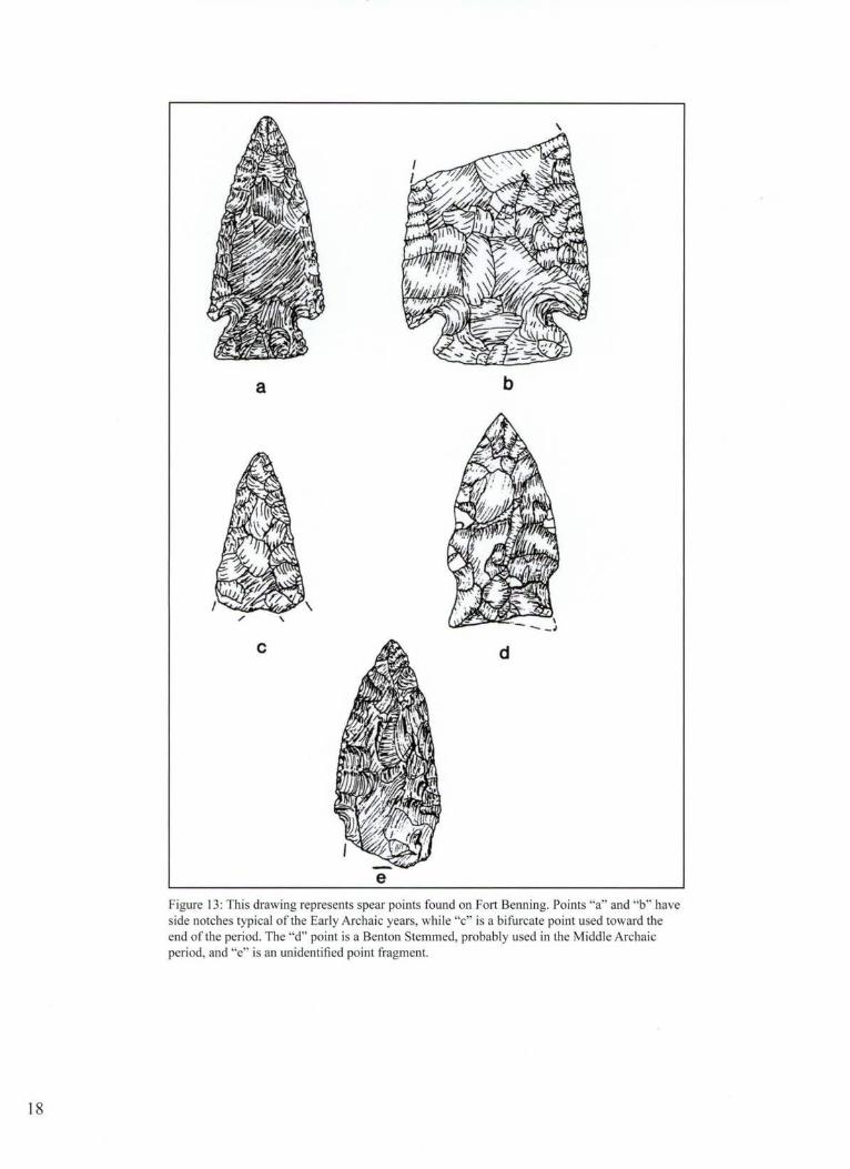
e Figure 13 : This drawing represents spear points found on Fort Benning. Points "a" and "b" have side notches typical of the Early Archaic years, while "c" is a bifurcate point used toward the end of the period. The "d" point is a Benton Stemmed, probably used in the Middle Archaic period, and "e" is an unidentified point fragment.

rock, mostly quartzite and quartz, at the Carmouche site, signs that prehistoric visitors built many fires .
While they used the same general area as those who came before them, life for people of the Early Archaic era was vastly different from what the earliest Paleolndian visitors to Fort Benning territory experienced. The climate was warmer and perhaps much wetter. Studies by Antonio Segovia in east Georgia revealed periods of heavy rainfall in the region during the Early Archaic period. Sea levels also rose as a result of the melting ice cap during this interval. By 7000 B.C., the beaches of the Atlantic Ocean and Gulf of Mexico were within yards of where they are today.
Other changes more directly impacted people. Gone were vast herds of Ice Age animals, and other species, such as the caribou, had retreated far north. Thirty-three genera of large animals had become extinct, including the mastodon, mammoth, cave bear, giant beaver, jaguar, giant sloth, prehistoric horse and camel. How much Paleolndian hunting hastened their demise is impossible to determine, but certainly the changing environment was a major factor. Most extinctions may have occurred earlier than previously thought, perhaps by 10,500 years ago, according to archeologists such as Albert Goodyear. Certainly by 10,000 years ago (8000 B.C.) almost all the large Ice Age animals were gone. Ice Age bison continued to exist on the Great Plains for a thousand years or more, and people there continued to live a Paleolndian lifestyle for centuries longer, but in the East, hunters were forced to adapt to new conditions.
Many more Early Archaic artifacts have been found at Fort Benning compared to the Paleolndian period. Scientists have discovered 39 sites on the post that can be definitely tied to the Early Archaic years. The inhabitants at such sites still hunted a great deal, but depended upon a greater variety of smaller animals than their predecessors. They hunted raccoons, rabbits, opossums, squirrels, beavers, turkeys, and other creatures, especially deer. They valued deer not only as food , but also for hides and antlers. Deer antlers probably served as important tools in the final , intricate steps of spear point making, while the skins were useful for many things, including clothing, shoes, and hut coverings.
Hunters, at the beginning of the Archaic period, continued to use Dalton spear points, often with flared ears at the base. They also used triangular spear points
with concave bases, called Tallahassee points. A number of these spear points were unearthed at the Carmouche excavation. As the centuries unfolded, people of the Archaic period began using spear points with notches near the base on both sides. Hunters used these comer and side notches to wrap binding holding the point in place on the spear. The spear points are labeled Palmer, Bolen, and Kirk. Somewhat similar spear points appear at this time throughout the eastern United States, as far north as New England. Scientists think the similarities reveal that there was trade and other interaction among groups. Spear point design also differs from region to region , a trend that started in the Middle Paleolndian era. The differences demonstrate that bands were settling into territories, not traveling as far as they once did.
Early Archaic people used a vari-ety of tools, with the manufacture of many of them an offshoot of making spear points.
Figure 14: A graver is a tool with a sharp point.
For example, during spear point production, pieces of stone splintered off, falling to the ground. Toolmakers retrieved some of these flakes and sharpened them on one side, producing unifacial scrapers, which they used to peel away hair and meat from animal hides.
They spent little time making most scrapers, quickly sharpening a flake , using it once or twice, then tossing it aside. Archeologists call these expedient tools. Prehistoric stone workers spent more time crafting some scrapers, even attaching wood handles to them, showing these scrapers were intended to be used repeatedly.
Scrapers, like many Early Archaic tools, were identical to tools Paleolndians used. Interestingly, few
19

A 8
.c E
D
F G
0 2
cm
Figure 15 : Unifacial stone tools were often used for scraping hair and skin from animal hides.
scrapers, among the most important tools at many other Early Archaic sites, were found at the Carmouche site, and scientists aren 't sure why.
People of this era sometimes modified rounded flakes into punching tools called gravers. A small, sharp projection juts from one edge of a graver and was used to punch holes in hides so they could be tied together. Gravers were also used to engrave bone and wood. Early people likely shaped many tools from wood or bone, but
20
these artifacts decomposed in Fort Benning soils. There were several scrapers found at the Carmouche site with graver-like projections. Early people probably used these two-in-one tools for tasks that they performed simultaneously.
Also important was the pitted stone, an ordinary looking rock to the untrained eye, but actually a new tool for Early Archaic people. These relatively flat rocks have one or more depressions in one or both sides

a
b c 0 5
centimeters
Figure 16: Places marked with crosses show where pits were worn into stone tools through repeated use by prehistoric people. These tools were all found on Fort Benning. The artifact marked "a" is a pitted stone, perhaps used for nut cracking, while "b" is a pitted hammerstone, possibly used to make spear points. The long stone is a celt, a prehistoric ax that once had a wood or bone handle.
21
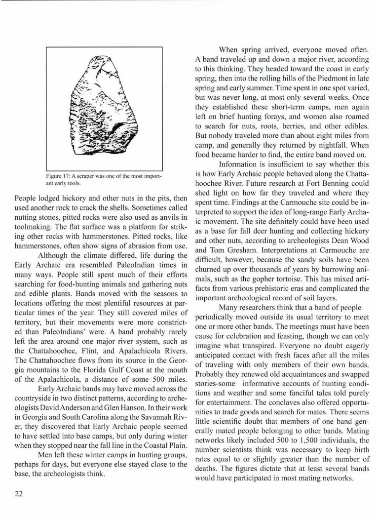
Figure 17: A scraper was one of the most important early tools.
People lodged hickory and other nuts in the pits, then used another rock to crack the shells. Sometimes called nutting stones, pitted rocks were also used as anvils in toolmaking. The fl.at surface was a platform for striking other rocks with hammerstones. Pitted rocks, like hammerstones, often show signs of abrasion from use.
Although the climate differed, life during the Early Archaic era resembled Paleolndian times in many ways. People still spent much of their efforts searching for food-hunting animals and gathering nuts and edible plants. Bands moved with the seasons to locations offering the most plentiful resources at particular times of the year. They still covered miles of territory, but their movements were more constricted than Paleolndians' were. A band probably rarely left the area around one major river system, such as the Chattahoochee, Flint, and Apalachicola Rivers. The Chattahoochee flows from its source in the Georgia mountains to the Florida Gulf Coast at the m~uth of the Apalachicola, a distance of some 500 miles.
Early Archaic bands may have moved across the countryside in two distinct patterns, according to archeologists David Anderson and Glen Hanson. In their work in Georgia and South Carolina along the Savannah River, they discovered that Early Archaic people seemed to have settled into base camps, but only during winter when they stopped near the fall line in the Coastal Plain.
Men left these winter camps in hunting groups, perhaps for days, but everyone else stayed close to the base, the archeologists think.
22
When spring arrived, everyone moved often. A band traveled up and down a major river, according to this thinking. They headed toward the coast in early spring, then into the rolling hills of the Piedmont in ~ate spring and early summer. Time spent in one spot vaned, but was never long, at most only several weeks. Once they established these short-tenn camps, men again left on brief hunting forays, and women also roamed to search for nuts, roots, berries, and other edibles. But nobody traveled more than about eight miles from camp, and generally they returned by nightfall. When food became harder to find, the entire band moved on.
Information is insufficient to say whether this is how Early Archaic people behaved along the Chattahoochee River. Future research at Fort Benning could shed light on how far they traveled and where they spent time. Findings at the Carmouche site could be interpreted to support the idea oflong-range Early Archaic movement. The site definitely could have been used as a base for fall deer hunting and collecting hickory and other nuts, according to archeologists Dean Wood and Tom Gresham. Interpretations at Carmouche are difficult, however, because the sandy soils have been churned up over thousands of years by burrowing animals, such as the gopher tortoise. This has mixed artifacts from various prehistoric eras and complicated the important archeological record of soil layers.
Many researchers think that a band of people periodically moved outside its usual territory to meet one or more other bands. The meetings must have been cause for celebration and feasting, though we can only imagine what transpired. Everyone no doubt eagerly anticipated contact with fresh faces after all the miles of traveling with only members of their own bands. Probably they renewed old acquaintances and swapped stories-some informative accounts of hunting conditions and weather and some fanciful tales told purely for entertainment. The conclaves also offered opportunities to trade goods and search for mates. There seems little scientific doubt that members of one band generally mated people belonging to other bands. Mating networks likely included 500 to 1,500 individuals, the number scientists think was necessary to keep birth rates equal to or slightly greater than the number of deaths. The figures dictate that at least several bands would have participated in most mating networks.

Figure 18: This aerial photograph of the Carmouche excavation shows how archeologists study a site in precise blocks.
How groups arranged to meet, especially given the many miles separating them, is unclear.
Archeologists have discovered huge accumulations of stone tools and spear points at various locations throughout the Southeast, which they think were left from band gatherings. The meetings often occurred at locations that were somehow distinctive. For example, Eagle Hill at Fort Polk in Louisiana looms above the surrounding terrain and is visible for miles. The hill sits near three major rivers-the Sabine, Calcasieu, and Redall likely home territories to different Archaic bands.
The Feronia site in south Georgia is another possible meeting place. Established on a prominent ridge overlooking the Ocmulgee River, the site is near where the river begins a sweeping bend toward the Atlantic coast. Many fresh water springs bubble to the surface nearby. Here archeologists Dennis Blanton and
Frankie Snow uncovered many Early Archaic and Late Paleolndian artifacts. Perhaps prehistoric visitors picked the place because it is near the divide where water flows toward the Atlantic Ocean in one direction and toward the Gulf of Mexico in another.
Other favored meeting spots in the Southeast were near the fall line, perhaps in late autumn. Early people were drawn to the fall line for many reasons. When moving inland from the coast, the fall line is the first place where rocks and shallows become prominent in major rivers. This was the first spot where people could easily ford rivers on foot. Animals also took advantage of these crossings, offering good prospects for hunters. From the fall line, people could easily reach many resources-the plants, animals, and rocks for tools plentiful in either the Coastal Plain or the Piedmont.
23

But despite Fort Benning's location near the fall line, no evidence of such an Archaic meeting ground has yet been uncovered. The real possibility exists, however, that further study will reveal one.
Most evidence of Warly Archaic settlement on Fort Benning so far comes from what appear to be small campsites with much fewer signs of human presence than the Carmouche site. An example is the Box Springs site on broad terrace near Upatoi Creek, an area dotted with pine trees and bordering a swamp. There in 1955, Staff Sergeant David Chase, who conducted extensive archeological research on Fort Benning whenever he had the opportunity, discovered artifacts from a number of prehistoric eras. By digging about four feet deep, Chase located spear points associated with the Early Archaic period.
Archeologists excavated another Early Archaic site in 1988. As often happens, the scientific work was prompted by a construction project, in this case an access ramp at the intersection of Victory drive and Custer Road. The excavation had to be finished before construction began or information about the past would be lost forever. The archeologists dug into a small knoll about 100 feet above Upatoi Creek. The site yielded one
24
spear point, a hammerstone, 11 unifacial scrappers, and a number of flakes left from sharpemng tools, all from the Early Archaic era.
A new variety of spear point, the bifurcate, with a base divided into two parts, was left at Fort Benning near the end of the Early Archaic era. Also found were a variety of spear points with a notched stem at the base. Called a Stanly Stemmed, the point broadens near the base and has two projections extending from each side.
Two Stanly Stemmed points were discovered at the Carmouche excavation and both may have been used as drills. Scientists associate the Stanly Stemmed with eastern Tennessee and the North Carolina Piedmont, as well as northern Alabama. Presence of the points at Fort Benning could indicate an incursion into the area by people from farther north; or the points could have been acquired through trade. Made from tan-colored chert, like so many other tools of the era, the points could also have been produced by people long in the area.
By around 5500 B.C., a new era was dawning, the Middle Archaic. Population continued to expand and territories shrank. Harsh weather in the sand hills may have caused the Fort Benning area to lose some its appeal to prehistoric visitors.

3-An Unforgiving Climate
A lthough scientists divide North ·American prehistory into categories such as Paleoindian and Archaic, the designations do not imply that human behavior abruptly changed from one period to the next. Far more often, people gradually modified customs over many years, and the modifications more likely than not occurred in different regions at varying times. Ferreting out the reasons for these changes is often difficult and occupies a great deal of researchers ' attention.
Sometimes human innovation spurred change. In other instances, population growth was instrumental, and in some cases, the weather was the impetus.All three factors came into play during the Middle Archaic period of 5500 to 3000 B.C.
Nature was more closely intertwined than most of us can imagine with the lives of early people, whose survival hinged on knowledge of their environment. If they were to eat, they had to know where edible plants grew and where game could be found . With only spears for weapons, they could afford few hunting miscalculations.
Too, prehistoric people spent most of their lives outdoors where they witnessed the force and whims of nature up close, likely resulting in both awe and wariness. When spring floods came, they saw a languid river became a ravenous brute, devouring huge trees, steep earthen banks, and everything else in its furious rush downstream. Then there were the mysterious springs bubbling from the earth. We know from early European encounters with Native Americans that some indigenous people considered a spring to be a doorway to the underworld where fierce and hideous monsters lay in wait for the unwary. In
Figure 19: When archeologists find a stain, called a feature, in an excavation, they carefull y remove the soil by scraping with a trowel. Thi s feature at Carmouche is partly excavated.
deed, early people saw life in nearly everything around them, leading to many superstitions and taboos.
seemed especially cruel in the sand hills. Beginning about 5000 B.C., in a time called the Altitherrnal, the weather turned drier and warmer. Views differ about During the Middle Archaic era, nature may have
25

precisely which conditions existed, how dry the climate was, for example. The sand hills suffered a drought, producing near desert conditions, some think. Antonio Segovia, who has studied early climates, theorizes that prehistoric droughts could have been quite severe in the South, sometimes lasting as long as 500 years. He describes a terribly parched land where trees and other vegetation shriveled and died, big rivers thinned to narrow streams, and tributaries and springs evaporated. Wildlife suffered in the struggle to find water. When thunderstorms erupted, lightning knifed into the dry earth, sparking fires that consumed remaining trees and plants.
Resilient nature slowly recovered. Rain doused the fires , and vegetation began to grow. The first trees to reappear were the pines with fire-resistant seeds that burst to life in the charred aftermath.
Other scientists question whether prehistorric droughts as envisioned by Segovia occurred in the South. Precisely how average temperatures changed during the Middle Archaic years is also debated. Archeologists Joel Gunn and Kathy Wilson, for instance, calculate that average temperatures were not that different from today, but that conditions were drier and extremes in heat and cold were greater. Others argue that the climate was only slightly warmer and slightly drier than now. Whatever the precise weather was, agreement is widespread that major ecological changes occurred. Longleaf pine trees spread across much of the northern Coastal Plain by the close of the Middle Archaic era about 3000 B.C., replacing the mixed forest of oak, hickory, and Southern pine that had thrived in the Coastal Plain since the Ice Age. Those forests now existed primarily in the Piedmont.
Some researchers think people tended to avoid the sand hills during this era, and there is evidence supporting their view. Archeologists have pinpointed only 27 Middle Archaic sites on Fort Benning, a drop from the 39 Early Archaic sites. If there were fewer people in the region, harsh, arid conditions could have been a cause. The spread of longleaf pine into the sand hills may have also played a role . There were still hardwoods, but they probably grew primarily in the wetter lowlands and river flood plains. Fewer hardwoods meant fewer nuts, striking at the core of the prehistoric way of life. Acom, hickory, and other nuts were important elements in the human diet, but more
26
significantly, deer and turkey, mainstays of human consumption, ate nuts and were therefore most abundant in hardwood forests. With fewer nut-bearing trees, people were forced to concentrate less on hunting and spend more time gathering a variety of plant foods, archeologist Christopher Hamilton argues .
The Middle Archaic era is somewhat enigmatic in the Fort Benning area because there have been so few significant sites found and studied. Scientists will undoubtedly locate more sites as they come to understand more fully the different spear points used in the era. Archeologists have long recognized Morrow Mountain spear points as especially important to people in the Piedmont. Mostly manufactured of quartz, the projectiles are often so irregularly made that they can be easily mistaken for odd-shaped pebbles. Formed in ovate, almond shapes, Morrow Mountain points seem crude compared to the aesthetically pleasing Paleolndian Clovis points or the less defined, but still carefully made Early Archaic weapons.
Despite their roughness, Morrow Mountain points may represent enhanced technology. Many have a tanged base that presumably fit into a socket, attaching the point to the rest of the spear. Named for a site in North Carolina, Morrow Mountain points appear as far north as Virginia and as far west as Texas. But in the Coastal Plain of Alabama and Georgia, Morrow Mountain points are rare. Scientists are beginning to agree on other types of spear points that people used in the Fort Benning area, including some with side notches that previously had been designated as Early Archaic.
The people in this stretch of prehistory roved almost constantly and apparently did not use base camps. However, the total area they traveled was greatly reduced because expanding population shrank territories. Some bands likely now lived most of their lives within the Piedmont, which in Georgia is about 80 miles wide.
Other groups spent most, if not all , their time in the Coastal Plain. They apparently used mostly chert for tools, while Piedmont bands depended upon quartz. These preferences grew from convenience. People of this era were much more likely than their Early Archaic predecessors to make informal tools, which they produced quickly, used briefly, then tossed aside. Gone from Middle Archaic campsites were many of the formal tools with handles that earlier people so carefully

- -- - -- - - -- - - -Figure 20: These spear point types were found at Fort Benning. "A " are Kirk corner notched points from the Early Archaic period . "B "are Guilford projectiles from late in the Middle Archaic years. "C" are Stanly stemmed points from the transition period between Early and Middle Archaic periods. "D" are Morrow Mountain points from the Middle Archaic period. "E" are called Savannah River points from the Late Archaic period, and "F " are Yadkin points from the Woodland period.
27

crafted. Gone, too, was the variety of blades and stone knives once used, according to archeologist Dennis Blanton. Middle Archaic people were also less likely to resharpen tools, a practice common during the Early Archaic years when bands traveled long distances to get preferred rocks. People now were more likely to camp fairly close to the materials they needed so there was less need to retain stone tools.
The Fort Benning region may have served as a boundary between those who spent most of their time in the Piedmont and others who considered the Coastal Plain home. Perhaps residents from both areas visited Fort Benning. Research at the Carmouche site may support this idea, although interpretation is difficult because of the mixing of soil layers and artifacts from different eras.
Prehistoric visitors to Carmouche tended to work on chert tools at different locations at the site than when working on quartz tools. This could indicate that Coastal Plain bands and bands from the Piedmont camped at the site, arriving at different times over thousands of years, according to Dean Wood and Tom Gresham. Also interesting is that while Morrow Mountain spear points elsewhere overwhelmingly tend to be quartz, at Carmouche, five of six such points were made from chert.
During the Middle Archaic era, people were much less dependent upon the Chattahoochee River. They often camped in the sand hills, which are some distance from the flood plain. Of the 27 Middle Archaic sites discovered so far on Fort Benning, only two are adjacent to the Chattahoochee. Middle Archaic people tended to choose high, flat hills or terraces safe from flooding and with good vistas for spotting game. They had few other requirements. They stayed only a short time, collecting their few possessions and moving on when animals and plant resources dwindled. This was an efficient way to live in an environment where potential food sources were similar everywhere within a band's range.
They probably ate the most deer in the fall , for a number of reasons, including the decline of other foods such as fruits and berries. Also, the animals are more vulnerable in autumn when leaf cover disappears and bucks lose their caution in the mating season battle for does. Fall is also when acorns and hickory nuts ripen and drop to earth. Fall camps, then, are likely to reveal a few more tools for scraping away animal flesh and
28
more pitted rocks for cracking nuts than sites occupied during other seasons.
When the hunt was successful, Middle Archaic people often roasted the meat over an open fire. They also enjoyed stews and soups heated in bark or animal skin containers in these days before pottery. Archeologists think people sometimes created cooking vessels for stews and soups by digging holes, about six inches deep, then lining them with animal skins and staking down the edges to hold the skins in place. A stew might contain deer, bear oil, water, and various plants, which the cook heated with rocks warmed in a nearby fire then dropped into the stew.
Dramatic changes in human customs occurred elsewhere during this period that perhaps affected people living in the Fort Benning area. In Tennessee and in northern Alabama, for instance, people began staying in place longer, camping along rivers. They waded into the shallows and plucked mussels from the river bottoms. They ate enormous quantities of mussels, freeing them from constantly hunting. And because they moved less, they were able to keep more possessions. They tossed the empty mussel shells into large piles, and the shell in these garbage dumps, or middens, helped seal human belongings from corrosion, preserving some artifacts for thousands of years.
Some objects protected by the shell piles reveal an aesthetic nature among their creators. For example, at a site called Eva in Tennessee, inhabitants were adept at fashioning bone into jewelry. They transformed delicate bird bones into beads and the skeleton of a rattlesnake into a sinister-looking necklace. They also drilled holes into bear, bobcat, and dog teeth and strung them into necklaces. Similar objects probably adorned people at Fort Benning, but have disappeared. No shell piles have been found that could have helped preserve bone adornments, a good indication that people in the region were not yet eating shellfish in any quantity.
People at Eva also smoothed edges and drilled holes in stones, then suspended them from necklaces and bracelets as pendants. Other aspects of life were more solemn, such as burying the dead. Mourners arranged the corpse in a flexed, fetal position and placed the deceased 's possessions such as spear points and other tools in the grave. Sometimes they also interred dogs with the dead, some of the earliest signs of domesticated animals in North America.

At the Perry site in northern Alabama, people also ate mussels, discarding the shells in a mound some ten feet high and 300 by 200 feet wide. Located on Seven Mile Island in the Tennessee River, the Perry site was the seasonal home during warm months to prehistoric people when they hunted, fished , gathered plant foods, and ate mussels. They also found time to make pieces of chert into preforms, apparently to trade to others who used the preforms to make tools. Preforms found in east central Mississippi probably came from the Perry site, and some finished artifacts discovered along the Gulf
Figure 2 1 : The atlatl , or spear thrower, increased the power in the hunter 's throw.
Coast possibly were made from Perry preforms. What did the Perry site residents gain in return? One coveted trade good was seashell from the Gulf Coast. Long shell bead necklaces were found at the site.
Gulf Coast shells have also appeared elsewhere in the country's interior, further proof of long distance trade. So far, no sign of similar trade during this period has surfaced at Fort Benning, but there is a strong possibility that inhabitants were involved. Long-distance trade goods may have funneled through the area, with local residents acting as intermediaries, speculates archeologist Dan Elliot.
Burials and grave goods have also been found in northern Alabama at the Stanfield-Worley rock shelter and inside Russell Cave, now a National Monument.
Artifacts from these sites reflect development of a new weapon. Hunters still used spears, but now they added extra power to their throws with a spear thrower called an atlatl.
Made of wood, an atlatl was about a third to half the size of the spear. The hunter attached the end of the spear onto a hook, usually made of bone, embedded in one end of the atlatl. The spear then lay atop the atlatl. When he spotted game, the hunter flung the atlatl forward with a pitching motion. He did not, however, release the atlatl. As his arm came forward, the spear separated from the atlatl and flew toward the target with far more power than without the atlatl. Middle Archaic people living on Fort Benning land perhaps used such weapons. They were definitely using the atlatl during the following Late Archaic era.
The first homes of long duration in North America have also been traced to the Middle Archaic years, specifically at the Kostner site in southern Illinois. But perhaps the most spectacular practice of the time was the building of earthen mounds. Until recently, researchers thought prehistoric people did not erect mounds until much later. Middle Archaic people Jacked the organizational skills required, according to this thinking, and were too preoccupied with the hunt for food to mount a huge building program. Overwhelming evidence gathered in recent years soundly contradicts such assumptions. Using radiocarbon dating and new measures to determine the age of soils, scientists have discovered that dozens of mounds, especially in Florida and Louisiana, can be traced to the Middle Archaic era. Some consist partially of garbage, cast aside by prehistoric people, but they also contain huge amounts of dirt deliberately mounded.
To form one of these monuments, the builders collected earth in baskets, which they carried to the mound site and emptied. They tamped the dirt into place with their feet, then refilled their baskets again and again. They repeated the process hundreds of times, shaping monuments that have stood for thousands of years . Some of the mounds are astonishing, considering when and how they were made. For example, at the Watson Brake site in norther Louisiana, inhabitants built eleven mounds, one 23 feet tall, that form a circle about 900 feet wide. This is the earliest circle of mounds discovered anywhere in North or South America, built
29

monuments and around them is, for now, another mystery.
As knowledge of the Middle Archaic mounds grows, archeologists are rethinking old ideas about band organizations and their presumed nature of equality.
The new assumption is that some type of hierarchical leadership, perhaps temporarily selected by consensus, was necessary to persuade or to cajole people into action. Researchers also think there may be more evidence of early mound building still to be discovered.
Figure 22: Watson Brake Mounds in Louisiana, depicted .in this sketch, is the earliest prehistoric mound circle di scovered so far in North and South Amen ca.
Public lands, such as Fort Benning, will play a pivotal role
in the search for more mounds.
even before the pyramids in Egypt and Mexico. If there is a common thread among the first
mound builders it was perhaps their inclination to fish, suggest archeologists Jon Gibson and Michael Russo. Because they lived in places rich in aquatic resources, there was perhaps less need for the mound builders to hunt and move. Consequently, they could afford to devote energy to public works, such as building an earthen monument. Why did they undertake such huge projects? There is no certain answer now and perhaps never will be. Surprisingly, unlike mounds built in later periods, few burials have been unearthed in the Middle Archaic mounds, leading to speculation that they were built to delineate group territory and also for religious and ceremonial purposes. The nature of ceremonies that might have unfolded atop the
30
Scientists now know what to look for, making discovery more likely, if the mounds exist.
Only time and further research at Fort Benning will disclose if the post was once home to Middle Archaic people who built a mound.
For now, researchers continue to assume that those who lived on Fort Benning land were organized into bands of fairly egalitarian, extended families throughout the Middle Archaic era. They changed camps often, did not build elaborate earthwo~ks ,
and depended on seasonal hunting and gathenng. Their lives unfolded year after year in much the
same way. Major change, however, was approaching. The Late Archaic years heralded the beginning of a new age. Trade became more widespread and a new invention would alter prehistoric life.

4-Shaping the Earth
The people cleared a stretch of land near the Chattahoochee River for the camp where they would stay for several months, perhaps longer. They slashed and pulled out the smaller vegetation of bushy plants and young trees, then went to work on the larger trees, the ones they couldn 't cut down with hand tools. With axes and stone knives, they peeled away the bark as high as they could reach. Eventually, the trees would die and stand like eerie skeletons around the campsite.
To build their huts, the men used small trees chosen when they cleared the site. They rejected pines because the wood was too brittle and likely to break when bent. They used young hickory saplings and some oaks, all about a foot in diameter at the base. The men hacked
away all the branches, using stone axes made from quartz or chert.
After they stripped branches from the saplings, they soaked the poles in the river to make them more pliable. After a time, they waded in to retrieve them and carried them to the spot where they intended to build.Using shovels made from deer shoulder bones and wooden handles, they dug a circle of holes, all about eight inches deep. The distance across the circle was about seven yards. They lodged the tree poles into the holes, packing clay around the bases to hold them secure, then bent the poles, made supple from soaking, toward the center of the circle. Then they tied the ends together in a dome like frame and interlaced long sticks through the frame
Figure 23: A trench visible to the left helped archeologists explore the different periods at the Carmouche site.
31

to support a cover of animal hides, which the women were prepanng.
Using bone and stone tools, the women punched holes in the deer skins then laced them together, before placing the animal hides on the frame of the hut. Everyone added a layer of plant thatch and strips of bark on top, taking care not to cover the hole deliberately left in the roof for smoke to escape. There was also another opening on one side of the structure, a doorway with a pleasing view facing the river.
The band stayed in their river-front home for months until the air began to cool and the leaves changed color. Then they gathered their few belongings to travel to another place where hunting would be best, the Carmouche site where the Bradley Fighting Vehicle firing range now exists. The change of setting stirred excitement for everyone. They knew that deer had grown fat from the long summer of grazing and a rich diet of acorns and hickory nuts. The men eagerly discussed the upcoming hunt so important to their winter survival. The women carried large baskets woven from strips of oak, which they would use to collect fallen nuts.
At their destination, a ridge overlooking Upatoi Creek, once again they prepared their campsite. The men cleared away vegetation, but this time there was no need to erect substantial shelter because they would be staying only briefly. They used poles from young trees as they had before, but built only lean-tos. They dug shallow holes and jammed in the poles, leaning them at 45 degree angles from the ground. They propped up the poles by lashing them to tree trunks. Everyone then covered the frame with thick layers of leaves and tree bark.
They also dug a series of holes of varying depths around the camp. Some, about six inches deep, were for storing nuts . Others about the same depth would be used to bury garbage. The shallowest holes were for campfires, which they lined with stones. Several family members searched for flat pieces of sandstone along the edges ofUpatoi Creek to use for cracking hickory nuts and acorns and grinding and crushing seeds and plant foods.
Once shelter was ready, the men built a series of wooden frames to dry meat from the upcoming hunt. Into the ground, they stuck four sticks, each forming a v shape at the top. They laid a framework of sticks in an
32
,;.: ...
~:·/ .. .. ..,.. . ·-.·
Figure 24: An awl , made from a deer ulna bone, was found at the Carmouche site. Awls were used to punch holes in animal hides.
arrangement resembling a barbeque grill into these notches. A fire of green logs beneath the frame would smoke the meat, preserving it for the cold months ahead. Next to these frames the men stuck two more poles in the ground and stretched a deer skin between them. This baffle would block the wind and help ensure that smoke from the fire wafted upward toward the meat.
Later, the men sharpened their spear points and lashed them to wooden spear staffs. Small pieces of chert and sparks flew in the air as they worked. The clinking sounds of toolmaking were often drowned out by laughter as they told stories and boasted and teased about their hunting prowess. A group of children watched from a distance for a while, then began chasing one another and racing into the woods.
Some 5,000 years later, archeologists led by Dean Wood discovered remnants of such an encampment at the Carmouche site, a place also visited by others much earlier in prehistory. Evidence of the drying racks,

baffles, and lean-tos appeared in the ground as stains-residue from posts that had long since rotted away. The stains measured from six to 12 inches in diameter and revealed that posts were anchored in the soil to a depth between four and eight inches. While the age of many of the stains could not be determined, some certainly represent posts erected during the Late Archaic era.
Archeologists also located the residue of 11 pits at the site, represented by stains that were from about one to three feet in diameter. These pits ranged from about eight inches to about two feet deep. Traces of wood charcoal were found in one pit about 16 inches below the soil surface. Radiocar-
Ground Surface
0 20 iiiiiiiiiiiiil::~
bon dating revealed the charcoal was burned about 1910 B.C., within the Late Archaic cm e a Th l t d th tw th d
Figure 25 : Archeologists sketch excavation features, such as this post hole from the r . e era as e more an o ousan . . Carmouche site, to record precisely what they find and where.
years between about 3000 B.C. to 700 B.C. Also uncovered were 12 grinding slabs, large
flat rocks used to pulverize seeds and other plant foods . Early people placed food on a slab, then crushed and ground it with smaller, fist-sized rocks called grinding stones or manos. These smaller rocks found at the site were formed from quartz, quartzite, sandstone, and, in one instance, gneiss. The repeated grinding wore away broad, shallow depressions in the slabs.
All of the grinding slabs, with one exception, were made from sandstone, easily available in tabular form in Upatoi Creek and in the flood plain adjacent to the creek. While grinding slabs were used during different prehistoric eras, the growing appetite among Late Archaic people for various plant foods makes it likely that a number of the grinding slabs and stones found at the Carmouche site date to this time.
Scientists found 12 pitted nutting stones at various levels of earth at the site. Coupled with a large amount of hickory shell found, the pitted rocks seem to indicate that throughout prehistoric time the site served as a place for collecting nuts. After breaking the shells in the cavities of the nutting stones, early people often crushed the nut meat into a kind of meal or flour on the grinding slabs. Native Americans Europeans encountered added hickory and acorn meal to soups to thicken them and
also made thick breads from nut meal. Researchers think that Archaic people prepared similar foods . Most acorns required more preparation than other nuts to be palatable. The acorns, shells partially cracked, were placed into shallow depressions in the sandy soils. Then hot water was poured repeatedly over the shells until distasteful tannin leached away. Prehistoric people learned that the sweetest acorns generally fell from trees associated with the white oak family, identified by round-cornered leaves.
Flat stone ornaments called gorgets also appeared at the Carmouche excavation between 12 and 20 inches beneath the surface. The artifacts apparently came from the Late Archaic era. People drilled holes in the gorgets, made from sandstone and soapstone, to string them on necklaces as pendants. Soapstone is a relatively soft rock found in the Piedmont region of both Alabama and Georgia, and it is especially associated with the Late Archaic years when people used it often and in a variety of ways. Frequently greenish in color, soapstone may also be white, gray, or almost black. A type of talc, soapstone, also known as steatite, has a greasy or soapy feel, which explains the derivation of the name. Prehistoric people used this relatively soft rock for carved bowls.
33

Earlier people had roasted meat over an open flame and prepared stews in animal skins placed in the ground, adding red-hot rocks for heat. They may have also used crude bowls of wood or sandstone, but these containers couldn't withstand fire. Because wood burned and sandstone cracked, to cook in vessels made from them probably required heating the food with the same hot rock technique used in animal skins. The constant heating of rocks was inefficient and tedious. A better solution was the soapstone bowl, a breakthrough because soapstone can withstand the intense heat of a campfire.
Soapstone's texture and composition vary considerably, and the people who stayed at the Carmouche camp would have learned to gauge which types could be best shaped to their liking. Even so, knocking loose a chunk large enough to serve as a bowl wasn't easy. Half-emerged bowls left imprisoned in rock divulge just how difficult the task could be. A forceful assault with a mallet was required to free a large, convex shaped rock from a boulder. Then the bowl maker chiseled out a shallow depression in the detached stone, forming a vessel that was both solid and heavy.
Finding soapstone wasn't a problem for Late Archaic people camping at the Carmouche site. Soapstone outcrops are nearby, perhaps as close as 20 miles to the north.
After studying the hardened clay for a while, they perhaps carried it to the river and dipped it in the water. When they lifted this first bowl, the water stayed inside. Through trial and error, they learned to duplicate the process that had formed the first clay vessel.
Authorities are fairly certain that the first pottery in North America was used around 2500 B.C. along the Savannah River, the border between Georgia and South Carolina. One major find of this early pottery was on Stallings Island near Augusta, Georgia. Here in the late 1800's archeologists investigated a massive heap of mussel shells 12 feet tall, 500 feet wide, and 1,500 feet long. The shell mound was left by large crowds who
Clearly, soapstone was valu- Figure 26: The outline of a prehistoric bowl someone tried to chisel from this soapstone is still able to those who stayed at the Fort visible. Late Archaic people gouged shapes from rock to make containers.
Benning site. Fragments from six different soapstone bowls were uncovered. The stone was also a coveted trade item during this era.
Pottery was even more important than soapstone in its long-term implications for people of this time period. No one knows for sure how pottery developed, but archeologist Dean Wood speculates the invention was accidental. Perhaps after a rainstorm, people built a fire on damp clay. After the fire died and ashes cooled, someone noticed that the texture of the clay had hardened. Lifting the clay to examme it more closely, observers would have wondered at the way the earth maintained its shape.
34
gathered during the Late Archaic period to fish in the river, eat shellfish, and renew acquaintances with others from far flung territories. The shells they discarded served as a shield against acidic soils and helped preserve a fascinating collection of artifacts, including decorative pins, shell beads, and bone and stone pendants. There were also fragile fish hooks and other bone tools, including awls-long needles used for punching holes to lace hides together.
Stallings Island visitors had learned to fortify pottery by mixing plant fibers such as grass, roots, or Spanish moss into the moist clay. Knowledge of the technique gradually spread
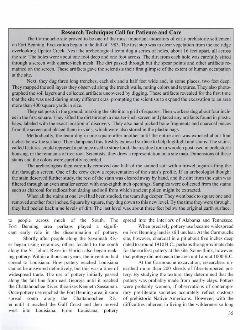
Research Techniques Call for Patience and Care The Carmouche site proved to be one of the most important indicators of early prehistoric settlement
on Fort Benning. Excavation began in the fall of 1983. The first step was to clear vegetation from the toe ridge overlooking Upatoi Creek. Next the archeological team dug a series of holes, about 16 feet apart, all across the site. The holes were about one foot deep and one foot across. The dirt from each hole was carefully sifted through a screen with quarter-inch mesh. The dirt passed through but the spear points and other artifacts remained on the screen. These artifacts gave the scientists their first glimpse of the extent of human occupation at the site.
Next, they dug three long trenches, each six and a half feet wide and, in some places, two feet deep. They mapped the soil layers they observed along the trench walls, noting colors and textures. They also photographed the soil layers and collected artifacts uncovered by digging. These artifacts revealed for the first time that the site was used during many different eras, prompting the scientists to expand the excavation to an area more than 400 square yards in size.
They set posts in the ground, marking the site into a grid of squares. Then workers dug about four inches in the first square. They sifted the dirt through a quarter-inch screen and placed any artifacts found in plastic bags, labeled with the exact location of discovery. They also hand picked bone fragments and charcoal pieces from the screen and placed them in vials, which were also stored in the plastic bags.
Methodically, the team dug in one square after another until the entire area was exposed about four inches below the surface. They dampened this freshly exposed surface to help highlight and stains. The stains, called features, could represent a pit once used to store food, the residue from a wooden post used in prehistoric housing, or the remnants of tree root. Scientists, they drew a representation on a site map. Dimensions of these stains and the colors were carefully recorded.
The archeologists then carefully removed one half of the stained soil with a trowel, again sifting the dirt through a screen. One of the crew drew a representation of the stain's profile. If an archeologist thought the stain deserved further study, the rest of the stain was cleared away by hand, and the dirt from the stain was filtered through an even smaller screen with one-eighth inch openings. Samples were collected from the stains such as charcoal for radiocarbon dating and soil from which ancient pollen might be extracted.
When all the stains at one level had been studied, the team dug deeper. They went back to square one and removed another four inches. Square by square, they dug down to this new level. By the time they were through, they had peeled back nine levels of dirt. The last level was about three feet below the original earth surface.
to people across much of the South. The Fort Benning area perhaps played a significant early role in the dissemination of pottery.
Shortly after people along the Savannah River began using ceramics, others located to the south along the St. John's River in Florida also began making pottery. Within a thousand years, the invention had spread to Louisiana. How pottery reached Louisiana cannot be answered definitively, but this was a time of widespread trade. The use of pottery initially passed along the fall line from east Georgia until it reached the Chattahoochee River, theorizes Kenneth Sassaman. Once pottery use reached the Fort Benning area, it soon spread south along the Chattahoochee River until it reached the Gulf Coast and then moved west into Louisiana. From Louisiana, pottery
spread into the interiors of Alabama and Tennessee. When precisely pottery use became widespread
on Fort Benning land is still unclear. At the Carmouche site, however, charcoal in a pit about five inches deep dated to around 1910 B.C., perhaps the approximate date for the earliest pottery at the site. Some think, however, that pottery did not reach the area until about 1000 B.C.
At the Carmouche excavation, researchers unearthed more than 200 sherds of fiber-tempered pottery. By studying the texture, they determined that the pottery was probably made from nearby clays. Potters were probably women, if observations of contemporary pre-literate societies accurately reflect customs of prehistoric Native Americans. However, with the difficulties inherent in living in the wilderness so long
35

ago, cooperation and role sharing were likely. A prehistoric potter began by locating a spot
along the edge of a river or creek where she could dig up a lump of clay. She cupped her hand into the river and sprinkled the water on the clay to keep it wet and also moistened some leaves and wrapped them around the clay for the walk back to camp. There she began making a pot by kneading thin roots and fibers into the clay to strengthen it. Gradually, she molded the mixture into a bowl, continuing to sprinkle on water to keep it malleable. Satisfied with the bowl 's shape, she used a flat stick to smooth away rough spots. (Later, potters learned to twirl clay into long rolls which they coiled on top of each other to form vessels).
Figure 27: This drawing represents a Late Archaic point found on Fort Benning. The point stem is typical of the era.
The potter sometimes decorated a bowl, but not always. If she wanted to make a design, she used a sharp object- a stick, bone, antler, or river cane- to stick gently into the clay, causing an indentation. Archeologists call these marks punctations. On some bowls, the potter made a series of punctations. On others, she made a punctation, then dragged the stick across the clay, then made another punctation. This punch and drag design appeared on sherds discovered at the Carmouche site.
Once the bowl was shaped and decorated, the potter left it under a hot sun to dry. The final step involved stacking kindling and larger
36
pieces of wood around the bowl, then setting the wood ablaze and keeping it burning for a Jong while. Only when the potter scraped away the smoldering ashes did she learn if her creation survived the inferno or cracked into uselessness.
Prehistoric potters in the Fort Benning area eventually learned to add sand or grit from bits of rock to clay for temper. At first, they added the sand or grit along with fibers , but eventually they omitted fibers completely. Fiber-tempered pottery tended to shatter when exposed directly to hot flames, but the grit and sand acted as strengthening agents. While fiber tempered pottery was so fragile it could be used only in cooking on top of a hot rock, the pots made with grit or sand were strong enough to be put directly into a camp fire.
Archeologist Albert Goodyear thinks the progression from depending primarily on roasting foods, to using boiling stones, to cooking in pots placed on hot rocks, to using soapstone bowls and pottery directly in the flames was spurred by growing population and diminishing territories. The resulting pressure on resources would have encouraged people to develop and accept more efficient cooking methods, which would have made cooking stews and other foods easier, enhancing nutrition. Healthier diets increased survival rates for everyone, but especially the young.
People were probably staying longer in one place than before, another factor leading to growing populations. Anthropologists have documented that birth rates climb when nomadic people begin to settle. In all, scientists have located 85 Late Archaic sites on Fort Benning, evidence of growing population. They also associate the use of pottery with people becoming more established. However, long-term occupation sites for this period on Fort Benning remain elusive. The Late Archaic sites discovered so far apparently served as short-term camps. Typical is a site, called RU95, examined on the Alabama side of the post by a team directed by archeologist Martin Dickinson. Researchers located only scattered pieces of fire-cracked rock, several hammerstones, a few tools, and flakes left over from toolmaking.
The many small camps discovered lead some to think the area continued to be a buffer zone. People who stayed predominately in the Piedmont and others who

a b
j . .
.
d e
0
centimeters g
c
I
'u . -5
h
I
I
Similar spear points appear along the East Coast as far north as New England.
After the harshness of the Middle Archaic era, the climate moderated. The temperatures and humidity levels were similar to those today, and sea and river depths stabilized. Different bands may have come together occasionally to catch migrating fish, and such cooperative efforts may have marked the beginnings of hierarchical leadership, the first inkling of tribal rule. Certainly, during the final centuries of the period there were more camps near the Chattahoochee, perhaps to take advantage of fishing . People were eating more plant foods, perhaps collecting seeds from flowering species such as sunflower, and replanting seeds each year.
Longleaf pine trees may have covered much of the Fort Benning area, except the flood plains, during the Late Archaic years, according to archeologist Tom Gresham. The pine barrens apparently thrived until the coming of the Europeans, who instigated wide-scale tree cutting. Today 's predominantly dwarf oak forest was already in place.
In the closing centuries of the Late Archaic era,
Figure 28 : Archaic spear points fo und on Fort Benning are represented in thi s drawing. "A" is from the Early Archaic years, while "b" and "c " are stemmed points from the Late Archaic period. "D" is an arrowhead from a later time, while the rest are fragments of various projectiles.
a new development in northeast Louisiana likely affected life along the Chattahoochee. On a creek called the Macon Bayou, people constructed a series of six long ridges of earth, one inside the other, in a giant horseshoe shape about three quarters of a mile wide. The open end of the horseshoe bor
lived mostly in the Coastal Plain may have both visited the Fort Benning area, if this theory is accurate.
Research just south of Fort Benning, however, at Lake Walter F. George supports thinking that people were staying in place longer during the year. Archeologists Vernon Knight and Tim Mistovich found evidence of camps occupied for at least one season at the lake sites.
Scientists have discovered large numbers of Late Archaic artifacts on Fort Benning, including atlatl weights used to balance spear throwing mechanisms. Spear points from this era generally have wide, square stems. Many of these projectiles discovered on Fort Benning resemble the Savannah River Stemmed point, called the Broadpoint because of its large blade.
dered the curving bayou. The ridges were about ten feet tall and about 100 feet apart.
Late Archaic residents built their dwellings on the ridges. They also opened up four straight passageways through the earthworks. These pathways spread out from the bayou like the rays of the sun.
Directly behind the ridges, the people accumulated enormous amounts of dirt to build a mound 75 feet high, the approximate height of an eight-story building. This mound was apparently designed to resemble a bird with a wing span of 680 feet, one of the first major earth effigies built anywhere in North America. Another
37

mound, about a half mile away, was smaller, a little more than 20 feet tall , and may have served as a place for cremating the dead. Archeologists discovered bits of charred bone in the mound in a bed of ash.
Late Archaic people built two other mounds at the site, which is now called Poverty Point and is preserved as a park by the state of Louisiana. Researchers estimate that people collected perhaps one million cubic yards of earth or 40 million, 50-pound baskets full of dirt to build the various earthworks. There was nothing quite like this place anywhere in North or South America at the time, about 1000 B.C.
The people of Poverty Point were great traders. They sought out the finest stones from as far away as Ohio and Illinois to make tools and fascinating art. They turned amethyst, galena, red and green talc, jasper and other stones into beads, small tablets, and pendants. Most visually pleasing of all are the bird and human effigies they shaped from glistening red jasper.
It is difficult to say which came first, the flowering of Poverty Point or the trade in which its residents participated. There is evidence, however, that many different people, not just those directly associated with Poverty Point, joined in trade during this era. Pottery use spread throughout much of the South, and red jasper beads made in Louisiana appear in Tennessee and as far away as Florida. Soapstone bowls were used at Poverty Point far from any soapstone source.
The people living in the Fort Benning area likely were part of the trade involving Poverty Point, thinks archeologist Dan Elliot.
It is certainly conceivable that people living near the Chattahoochee helped supply or pass along soapstone bowls destined for Louisiana. What objects they may have received in return is uncertain, but the exchange of goods often leads to an exchange of ideas. Perhaps people living on Fort Benning land learned from their trading partners new ideas about political organization, religion, and how best to grow plant foods .
The cultivating of plants would become increasingly important in the next archeological period, the Woodland era. Mound building would also become more important, pottery making skills would improve
38
markedly, and a mysterious ceremonialism would take hold along the Chattahoochee. But before these developments, some aspects of Late Archaic society collapsed.
There were no more major gatherings of people harvesting shellfish at places such as Stallings Island on the Savannah River in east Georgia by 1000 B.C. By 500 B.C. , the people of Poverty Point in Louisiana had abandoned mound building and slipped back into a less complex existence, similar to how their ancestors lived centuries before.
The reasons for the decline of these cultures haven ' t been fully explained. There is the possibility that around 1000 B.C. climate was a factor. The glaciers advanced slightly and sea levels fell a few feet, nothing comparable with the Ice Age, but perhaps enough to diminish the availability of inland shellfish and limit the runs of migratory fish. These changes may have inhibited some groups from depending so much on major nvers.
Population, while still quite small compared to today's standards, may have grown too rapidly in some areas, straining the capacity of some groups to maintain cohesion and, in some cases, heightening tensions with neighbors. Whether the cause was the weather or population increases or some other factor, fighting definitely erupted in some places because burials from the period in Indiana and Kentucky reveal spear points inside human skeletons.
Yet, there was apparently no change in climate to explain the decline of Poverty Point and no signs of warfare or unrest. Perhaps residents simply lost interest in creative endeavors. They stopped making elaborate stone ornaments, ending the need to seek out exotic looking stones through long-distance trade.
On Fort Benning land, the Early Woodland era began somewhat haltingly. The number of sites attributable to the period drops slightly from earlier eras, perhaps an indication that fewer people were visiting the sand hills.
The Woodland era overall , however, is associated with dramatic change that altered lifestyles along the Chattahoochee.

5-Rituals and Commerce
W hile stationed at Fort Benning, Major George Veight, a dentist, spent his spare time searching for artifacts. He was walking near the post 's southern border in July 1955 when he spotted something interesting along Halloca Creek. As he stooped to retrieve his discovery, be saw pieces of pottery with intricate curving designs that he suspected were made thousands of years ago. Veight contacted Staff Sergeant David Chase, known for his archeological research, who soon visited the site with him to probe for more signs of prehistoric cultures.
Chase's tools were a shovel, pencil, and paper. He recorded that the site was on a tributary of Ochillee Creek, one of the larger streams on the post
emptying into Upatoi Creek. The potsherds surfaced near a swampy area adjacent to a wide meander of Halloca Creek. A rolling terrace gently rose from the swamp toward a series of low clay hills. Construction nearby of a military road had exposed some of the ancient artifacts that Veight had noticed.
With help from Frank Schnell Jr. , an archeologist now employed by the Columbus Museum, and others, Chase dug a series oftest holes, some two and a half feet deep, to see how widespread the artifact distribution might be. Ultimately, they concluded that an area about an acre in size seemed to contain a multitude of artifacts
Figure 29: Prehistoric people during the Woodland era sometimes created earthen monuments fo r various purposes, including burials and pinnacles for temples. Residents of the Kolomoki mound center, pictured here, made pottery strikingly similar to ceramics found on Fort Benning.
39

Figure 30: Staff Sergeant David Chase (right), Richard Lamer, and an unidentified volunteer excavate a Woodland occupation site near Halloca Creek on Fort Benning in the I 950 's.
In some of the holes, at about six to 12 inches deep, they encountered black sand, evidence of a prehistoric garbage dump. This darkly stained sand, which archeologists call midden, also contained many stone flakes from prehistoric tool production, as well as potsherds and charcoal.
Joseph Caldwell, an archeologist with the University of Georgia, next visited the site and recommended further testing. He suggested digging a deep trench w here the midden seemed particularly dense. This trench confirmed that much of the pottery belonged to the Woodland cultural era of 700 B.C. to A.D. 900. The trench excavation began in August 1955, directed by David Chase, assisted by Fort Benning soldiers. The soldiers participated because General Herbert B. Powell , the post commandant, took a personal interest in the archeological work.
The effort, like so much of the early archeological investigations at Fort Benning, was accomplished primarily on weekends when David Chase, often accompanied by his wife, Phyllis, was free from regular duties .
The work proceeded slowly under a blistering summer sun. As David Chase wrote, the fieldwork took
40
place "often under the most adverse conditions, brought about by the intense heat and the hordes of insects." The team removed and studied more than 300 artifacts from the trench and determined that prehistoric people camped at the site in various prehistoric eras. Their findings led to further excavations in the spring and summer of 1957.
In the soi l about a foot below the surface, scientists uncovered pieces of fiber-tempered ware, called Stallings Island pottery, from the Late Archaic era. Pottery names reflect specific decorations, tempering, and clay texture, as well as where a particular type was first discovered. They also found soapstone bowl sherds made in the Archaic years. However, the major occupation of the site occurred during the Early and Middle Woodland eras.
Potsherds from the earliest years of the Woodland era demonstrated that people strengthened clay by adding sand or used clay that was already sandy. Or they added crushed rock, called grit.
This was a time of experimentation for potters. Woodland people in the Fort Benning area often formed deep vessels, some with four small appendages on the bottom. These tetrapods, or feet, stabilized the pot so it wouldn't tip over. Potters also developed new decorations. For example, using their fingers as looms, they wove Spanish moss, roots, and other plant fibers into fabric, which they wrapped around a stick or paddle then pressed into the damp clay before they fired a pot. This technique is evident on a type of pottery archeologists call Dunlap.
Fabric-impressed pottery, found at Halloca Creek and at other Fort Benning sites, is only one indication that prehistoric people had learned to weave plant fibers. While no prehistoric fabric has been found on Fort Benning, perhaps because it decayed, there is little doubt that people of this time, and even earlier, were weaving. The Windover bog archeological site in Florida, where the muck sealed out oxygen and other corrosive elements, revealed that even earlier Archaic-era people were twining fibers together into fabric. Scientists have also found woven slippers, this time from the Woodland era, in Salt Cave in Kentucky, another protective environment.
Some artifacts labeled fabric-impressed pottery found at Fort Benning may actually not be fabric

b
a c
0 5 911 \/
centim e te rs h g
Figure 3 1 : Sketches of prehistoric pottery found on Fort Benning show the different techniques potters used . "A" is undecorated fiber-tempered; "b" is sand-tempered pottery; "c " is also sand-tempered and has a check stamp; "d" through "e" are complicated stamped sherds; " f " is simple-stamped; and "g" and "h" are complicated stamped.
impressed. Researchers think that Early Woodland people sometimes formed pottery inside baskets and that the wet clay took on the basket impressions, mistaken for fabric marks by some archeologists. Again, artifacts from sealed environments not far from Fort Benning show that prehistoric people wove baskets and similar items. For example, Archaic people living in Russell Cave in northern Alabama wove cane strips into mats for the cave floor. Impressions from the mats remain preserved in the cave clay. Also, evidence of Woodland basketry showed up in Salt Cave in Kentucky.
Excavations at Halloca Creek revealed that Woodland people living in the Fort Benning area also developed other ways of decorating pots. These excavations, Jed by David Chase and A. R. Kelly of the University of Georgia, uncovered significant amounts of artifacts- more than 5,000 stone tools and potsherds. Some of the sherds reveal that Woodland-era people wove plant fibers into cord, which they wrapped around a stick and pressed into wet clay.
They also carved simple designs in wood pad-dies
41

then pressed the paddles into clay. One of the most popular early paddle designs was a series of parallel lines called simple stamping. Potters also carved small, waffle-like squares into the paddles. Called check stamping, this type of design also appeared on potsherds at Halloca Creek and other Fort Benning locations .
more productively than any other group throughout the thousands of years of prehistory, suggests archeologist Tom Gresham, who studied four massive archeological surveys on Fort Benning that examined almost 8,000 acres.
By the Woodland years, people probably sched.---------------------------. uled their hunting and gathering with maxi
a b
mum efficiency. They recognized which plants they could eat without fear of poisoning, and they knew where and when to find various animals. They understood intimately the details of animal behavior that could mean the difference between a successful hunt and going hungry. They had knowledge passed down through the generations about plants with apparent medicinal properties. And they selected some plants for special attention. They collected the seeds and replanted them.
The roots of agriculture probably reach back to the Archaic period when people developed increasing appetites for eating and cooking the seeds of some plants, such as sunflowers. Perhaps, as they prepared seeds for meals, some fell to the ground and eventually sprouted. Someone noticed and concluded that rather than consume all the seeds they should save a portion and bury them. Gradually, they learned they could nurture favorite plants by watering them and clearing away competing vegetation.
Archeologists know about prehistoric '---------------------------J agriculture because of ancient seed and pollen Figure 32 : Woodland projectile points found by archeologist Erwin Roemer's crew on samples they collect at excavations. Ancient Fort Benning included "a" and "b," both Gary points; "c" an Ebenezer point; and "d" a Swan Lake point. sunflower seeds, for example, found at Wood-
c d
Scientists label the simple stamping and check stamping pottery from this era Mossy Oak, Cartersville, and Deptford.
The people who visited Halloca Creek in the first few centuries of the Woodland era probably often used the uplands, the areas away from the Chattahoochee River. In fact, the Late Archaic and Early Woodland inhabitants may have used the uplands more often and
42
land-era sites tend to be uniform in size and larger than comparable seeds found in the wild. These flower seeds seem to confirm that prehistoric people purposely saved what they considered the best seeds from the best plants. Similar findings lead to thinking that Woodland people also cultivated sumpweed and chenopodium, now considered weeds. Prehistoric sumpweed seeds are two to three times bigger than those of today, suggesting that the larger, seed-bearing plants became extinct without

human perhaps sibly
intervention. People grew squash, as early as the Archaic era, pos-
using it for gourd-like containers. The plants that dramatically changed prehistor
ic life, however, were com and beans, which probably filtered into eastern North America from Mexico. Data collected so far at Fort Benning indicates that com did not play a pivotal role locally during the Woodland years.
What did have an impact was a widespread trade in burial goods and a mysterious ceremonialism. Scientists trace the beginning of these developments to the middle and southern Ohio region, although the antecedents may have originated earlier in the lower Mississippi River Valley or even in Mexico.
About 500 B.C., people in Ohio and neighboring participated in what archeologists call the Adena culture. They built cone-shaped mounds for burying the dead, placed ceremonial objects in the graves, and enacted extended mortuary rites. Stone tablets carved with elaborate predatory bird drawings and geometric designs, as well as fragments of animal masks, have been uncovered in human graves of the time.
Archeologists think the Adena people disposed of their dead in various ways. They might have placed the body on a scaffold or in a tree or buried it temporarily in an earthen mound and waited until decay was advanced. When most of the flesh was gone, they bundled the major bones together for burial in a mound. The Adena people buried some remnants of the dead in log tombs. At other times, they cremated the bones in clay basins dug in the ground. They placed still other remains inside buildings which they deliberately set afire.
The Adena culture was eventually overshadowed by a development called Hopewell that directly impacted the Fort Benning area. Sometime between 100 B.C. and 100 A.D. the Hopewellian movement blossomed in Ohio and Illinois, perhaps growing out of the Adena culture or merging with it. Hopewell followers built large ridges of earth, as tall as 12 feet, that sometimes extended for miles, forming giant squares, circles, and octagons enclosing up to 80 acres. Venerated religious leaders or priests officiated at the intricate Hopewell burial ceremonies that often involved cremation and sumptuous feasts . The Hopewellians buried the dead with prized objects made from materials that originated far away. These included
copper from the Great Lakes and the Appalachian Mountains, bear teeth and glass-like obsidian from the Rocky Mountains, and seashells and shark teeth from the shores of the Gulf of Mexico. Their presence in the Hopewell burials all point to a well-organized trade system. Perhaps the trade's primary purpose was to obtain these materials and objects for funerals. Some researchers think there was also a specialized group of artists who made some of the articles buried with the dead. Certainly, Hopewell people crafted interesting and sometimes compelling objects-human figurines , copper falcons , and elaborate jewelry.
There may have also been a special class of traders who followed a network of trails and rivers extending
0 2 J 4 5
CM
Figure 33: Potters used their skills during the Woodland years to make platform pipes such as this one found at the Tunacunnhee site in northwest Georgia.
hundreds of miles. As the traders sought materials near and far, they probably imparted their religious and ceremonial ideas to those they met along the way.
Apparently, one of the major trade routes passed from Ohio south through the Fort Benning area and followed the Chattahoochee River into western Florida. A long this path, a major ceremonial center, now called Mandeville, developed just south of Fort Benning in Clay County, Georgia, not far from present-day Fort Gaines. There, in about A.D. 100, inhabitants built a large village on a bluff overlooking two creeks about a fifth of a mile from the Chattahoochee.
At first, villagers had little contact with the outside world, thinks archeologist Betty Smith, who notes that artifacts from this era consist of locally made
43

pottery and tools formed from nearby materials. Then, about A.D. 250, the community began erecting two mounds and accumulating artifacts similar to those made by the Hopewell people in Ohio and Illinois. One of the mounds eventually reached a height of about 14 feet and had a flat top where a building stood, perhaps a temple or the residence of a revered leader. The other mound, about eight feet tall, was shaped like a cone and served as a cemetery. Burned bones found in the mound indicate that cremation was among the funeral practices.
The mounds, now submerged under the waters of Lake Walter F. George, stood about 900 feet apart, with the village between them. Archeologists uncovered many artifacts in the mounds, including five panpipes, the earliest musical instruments ever discovered in the region near Fort Benning. Made from hollowed river cane, four of the instruments were coated with copper; one was covered with a mixture of copper and silver. The Mandeville mounds also contained copper beads, cut mica, prismatic blades, and many axlike tools called celts made from lustrous greenstone. Fourteen copper ear spools, all except one found in a single grave, testified to what must have been a particularly painful form of adornment. The ear spools, disk-shaped and resembling miniature cymbals, were held in place by a thin column or rivet. The wearer 's ear lobe was sliced open with a sharp rock, then the ear spool column was inserted. As the wound healed, the ear spool was sealed into place.
Archeologists uncovered remnants of several smoking pipes, one with the bowl shaped like a bird. All of the pipes found at Mandeville were the platform variety, standing upright on squat, rectangular bases. The bowls are plain or shaped into bird and other animal effigies.
Scientists also found several human figurines at Mandeville, both intact and in fragments. One clay figurine, about three and a half inches tall and found in the burial mound, represents a woman bent slightly forward at the waist. She wears a skirt painted red and is bare breasted. Her feet are also painted red, and she wears red arm bands. Her hair tapers down her back to the waist, and both her hair and back are painted black.
There is a display in the Columbus Museum of another Mandeville woman figurine with an elaborate hairdo with two out-swept sides resembling horns. 44
Archeologists speculate that the figurines may be sculptural portraits of the society 's elite.
People who lived at Mandeville participated in hunting and gathering forays into surrounding areas that no doubt included Fort Benning land. They may have camped at the Halloca Creek site and left potsherds with
Figure 34: This reconstructed Woodland jar, decorated in the Early Swift Creek complicated stamped design, was found in an excavation pit at Halloca Creek by Staff Sergeant David Chase.
the same intricate patterns found on ceramics at Mandeville. Called Swift Creek pottery, the designs include chevrons, rectangles, squares, and other decorations carved into wood paddles and pressed into the wet clay. Potters also carved curved lines, ovals,

concentric circles, and teardrop shapes into the paddles. Sometimes they filled these designs with straight lines resembling ladders. Like earlier potters, those who visited Halloca Creek also left some pots plain.
The whorling complexity of Swift Creek pottery is striking. Potters of this era moved beyond the limited repetitiveness of earlier ceramic decorations. They developed a sense of form and allowed imagination to influence their work. Swift Creek pottery appears in only a restricted area of the Southeast, including Fort Benning, although similarities to ceramics farther north attest to the widespread influence of trade and Hopewell culture.
In large sections of Georgia and South Carolina where Swift Creek pottery has been discovered, there is no evidence of the extensive ceremonial ism practiced at Mandeville, according to archeologist David Anderson. That makes ongoing studies at Fort Benning all the more important because they may provide more clues to how Hopewellian ideas affected those living near the Chattahoochee.
Swift Creek pottery changed subtly over time. The complicated stamping that covered nearly entire pots during the early Woodland centuries was often confined to just parts of the vessels as the era drew to a close. Woodland people grew more adept at storing food, using deep ceramic jars, baskets, and earthen pits. At Halloca Creek, the largest pit David Chase uncovered was about four feet across at the top. The sides plunged downward about two feet, ending in a flat bottom. Similar pits, though not all as big, were found on other Woodland sites on Fort Benning. Some were used for garbage disposal.
Fire continued to play a vital role at camps like Halloca Creek where archeologists discovered one cluster of 15 fire-cracked rocks. There were also fragments of bone and traces of charcoal , further evidence of a prehistoric hearth. A human burial was also uncovered, but there were no objects with the remains. Their absence indicates not everyone of the time received the special mortuary treatment accorded some buried in the Mandeville mound. The many exquisite grave goods discovered at Mandeville suggest the emergence there of leaders accorded deference in life and death.
There is some evidence that people at Mandeville were fabricating sheets of mica to trade with residents of
other ceremonial centers. Archeologists found no mica in the burial mound at Mandeville, but did find mica in the flattop mound where presumably it was processed for sending to other ceremonial centers. Mica sheets appear often in burial mounds in northern Florida and at Tunacunnhee, a Woodland occupation site just south of Chattanooga, Tennessee. Tunacunnhee, with eight low burial mounds made from earth and limestone, features
Figure 35: Potters used a decoration with ladder-like lines in one Swift Creek stamped design shown in thi s arti st 's reconstruction. A potsherd with the stamping was found on Fort Benn ing.
many of the same types of artifacts found at Mandeville and was presumably on the same trade route leading north toward Ohio and Illinois.
Artifacts like panpipes, ear spools, and platform pipes found in burial mounds at both Tunacunnhee and at Mandeville have not been discovered at Fort Benning or in other excavations presumably along the same route. This leads some to suspect that the primary purpose for much of the long-distance trade was to
45
acquire objects for religious ceremonialism and burial rites and for honoring elites at the mound centers. Many theorize, however, that there was a great deal of trade of commodities important to everyday life during this era. The evidence of this more conventional commerce is less visible to archeologists because of decomposition, proposes author William Winn.
Materials subject to decomposition, such as hickory and oak shafts for tools, as well as medicinal herbs, are just some of the items probably bartered. Another commodity may have been bear oil, used for cooking, as a hair dressing, and for protecting skin from biting insects. Other possibilities were baskets, mats, stone tools, pottery, feathers for personal adornment, beads,
contrast, were often transported great distances. The final burial at Mandeville that contained
Hopewellian-type grave goods was perhaps especially dramatic and solemn. The deceased was a girl aged 11 or 12 who died sometime around A.D. 420. Her body, placed in a large pit dug in the mound, was buried with a number of what must have been rare and valuable articles at the time. There were nine greenstone celts, a greenstone spade, 13 copper-covered ear spools, and more than four pounds of galena. If, as archeologists think, these exotic objects were restricted to the highest class at Mandeville, the child may have represented the last in the line of a once powerful family, speculates archeologist Betty Smith.
Figure 36: Prehistoric traces can be found in unexpected places on Fort Benning. The Quartermaster site, occupied dur ing the Woodland era, was photographed in the 1950 's. The site was uncovered when crews were digging a gas line trench.
animal skins, red ochre and other pigments for painting the skin, animal pelts, and various foodstuffs .
These more utilitarian items often were not carried as far as the exotic artifacts found at mound centers because they were exchanged among groups who lived fairly near one another. Ceremonial materials, in
46
Inhabitants abandoned Mandeville around A.D. 500, leaving a wealth of archeological mysteries. Indeed, people of the Woodland era left behind many fascinating and curious monuments. One of the most spectacular is Serpent's Mound, built atop a steep bluff in southern Ohio. About five feet tall and 20 feet wide, this

intriguing structure of dirt winds across the ground for about 730 feet, complete with a head and coiled tail. The earth snake can be fully appreciated viewed only from above.
The same is true of Rock Eagle, a mass of thousands of rocks forming the shape of a huge bird, perhaps a mythical creature. Built in Putnam County in central Georgia, Rock Eagle couldn't be fully seen by its builders unless they climbed trees and looked down from above. Another similar, though less well-known bird effigy was shaped in stone nearby in the same county. The purposes of these stone birds remain unknown. Their creators left few artifacts nearby to serve as clues for archeologists.
Woodland people also erected a long, low wall of stones atop Fort Mountain in north Georgia, near Ellijay. The wall, never more than a few feet tall, has long inspired mythic tales of invading Europeans trapped on the mountain in a fierce, climatic battle. There is no evidence, however, of Europeans visit- Figure 37: Late Woodland sherds decorated with Weeden Island designs were
ing there or anywhere else in the Southeast until the found at the Quartermaster site on Fort Benning. The same decorations ap-pear on ceramics at a large mound center, Kolomoki, near Blakely, Georgia.
1500's when the Spanish arrived. More likely, the wall was used for Woodland-era rituals, as were similar structures in Alabama, Kentucky, Tennessee, and Missouri. The people who lived on Fort Benning land during this era likely also participated in ceremonies involving stone enclosures. In fact, remnants of such a structure have been found on nearby Pine Mountain.
Another significant development was the invention of the bow and arrow. The ramifications of the weapon were enormous. Hunters no longer had to stalk game with only spears. They could stand some distance away and still be assured of a good chance of success. The bow and arrow must have eased life immeasurably and increased leisure time. First use of the bow and arrow on Fort Benning is evident from the small, triangular stone points attributable to the later centuries of the Woodland era.
The last centuries of the period may have also witnessed another major development on Fort Benning land-establishment of a large village. The discovery of the prehistoric community site came on October 24, 1958. David Chase picked up the telephone about noon that day and learned that a construction crew digging a gas line trench had churned up bones and
large pieces of ancient-looking pottery. Located near the Quartermaster warehouse (Building 173 7), the trench was on the outer edges of the main post. Chase immediately went to inspect what the construction crew found. With the help of Frank Schnell, Sr. , and others, he began piecing together information on a prehistoric settlement about one-half mile from the Chattahoochee.
Construction had already covered or erased large portions of the site, making a thorough investigation impossible, but Chase was able to gather enough information to surmise that a large settlement had existed during the later centuries of the Woodland era. He called it a "large and productive village" with many houses. Chase's discoveries seem to bolster thinking that Woodland people were staying in place longer.
Prehistoric residents at this Quartermaster site dug immense holes in the ground, possibly for cooking. In an area labeled Pit Number One, Chase discovered some 600 Late Woodland potsherds and a large amount of animal bone, mostly from deer. He also uncovered a small needle made from animal bone, and a deer ulna bone shaped into an awl, the long pointed tool used to
47

Fi gure 38: Archeologists use fragments of pots to visualize how the unbroken vessels looked. Thi s drawing shows how a jar in the Late Swift Creek stamped design fo und at the Quartermaster site might have appeared. Researchers base their concepts on the shapes of fragments they fi nd, as well as comparisons wi th intact vessels from the same time frame.
punch holes in hides. The pit was about five feet in diameter. The exact depth couldn ' t be determined because of soil disturbance by machinery, but Chase estimated the pit to be at least four feet deep. There was
48
a layer of gray wood ash, about five inches thick in the pit. Another large pit, probably with similar dimensions, also contained two layers of light colored ash, each about five inches thick, and fire-cracked rock. Similar,

though smaller, pits were unearthed at the Carmouche site and described by Dean Wood and Tom Gresham as possible earth ovens.
To cook in an earth oven, Woodland-era people probably stacked wood at the bottom of a pit, then started a fire. They let the fire bum until only hot coals remained, while simultaneously heating rocks in campfires near the earth oven. Once the rocks were extremely hot, they lifted them from the fire , probably with wood paddles, and dropped them into the coals at the bottom of the pit. They then layered moistened leaves over the hot rocks and coals and placed meat or other food on top of the leaves. They covered the food with more moistened vegetation and finished with a final layer of insulating dirt, trapping the considerable heat radiating from the hot coals and rocks inside the oven. After awhile, they dug away the dirt and leaves and enjoyed a well-cooked meal.
Other significant finds at the Quartermaster site were globe-shaped pots with folded rims associated with people living farther south along the Chattahoochee. This type of pottery developed at a mound center in south Georgia near the town of Blakely.
rl \
DESIGN ELEMENTS
D •
OA
CONFIGURATIONS OF ELEMENTS
/
•
' Ill I
Located on Kolomoki Creek, about six miles from the Chattahoochee, the Kolomoki site of about 300 acres features nine mounds and signs of human sacrifice. One mound is huge, standing about 56 feet tall with a base 325 feet wide and 200 feet
Figure 39: Woodl and potters who used Swift Creek simple design elements, shown in the top of this drawing, duplicated and combined the elements to create complex decorations depicted at the bottom.
long. Archeologists think this mound was once topped with a temple. Two other smaller mounds served as burial grounds. Signs indicate that the death of a leader at Kolomoki triggered complex ceremonies that perhaps involved killing the leader 's close relatives and servants. Evidence of possible retainer deaths was found in construction details of one of the burial mounds,
which was dome-shaped and about 20 feet tall. Building of the mound occurred in one fairly
continuous episode, speculates archeologist William Sears. While many of the burials and cremations may have been performed for individuals who had died earlier and whose remains had been preserved until the
49

Figure 40: Kolomoki, a Woodland-era mound center, has a museum operated by the state of Georgia where visitors can see artifacts, including large ceramic vessels, uncovered in the earthworks. Archeologists speculate that Kolomoki residents traded with their neighbors at Fort Benning because similar pottery appears at both places.
death of a leader, some people were perhaps purposely sacrificed, possibly by strangulation. The burial mounds contained specially made funeral pottery, ocean shell beads, and other ceremonial objects such as clay animal sculptures painted red.
During Kolomoki's peak, perhaps some 2,000 people lived there. How they interacted with or affected the people on Fort Benning land is somewhat of a puzzle. Before the work of David Chase and other archeologists on the military reservation, scientists thought that pottery used at Kolomoki didn 't spread farther north. But at the Quartermaster site and other locations, Kolomoki-type pottery does appear in small amounts. For example, about ten percent of the Late Woodland pottery at the Quartermaster site is similar to
50
Kolomoki ceramics. Possibly, villagers from the Kolomoki site moved north to live on Fort Benning land. More likely, however, Fort Benning inhabitants traded with the mound center residents.
Surprisingly, only 14 sites dating to the closing years of the Woodland era have been found on Fort Benning, and archeologists are unsure whether the local population declined or people merely congregated in a few locations.
The last prehistoric era, the Mississippian period, was intensely creative, producing exquisite art. There was also much warfare. Mound building increased, and rulers became more secular. The Mississippians were the Native Americans the earliest European explorers found.

6-Seeds of Change
S entinels of the past's secrets, the great mounds are legacies of what the human will can accomplish. The builders had no bulldozers or other machinery to help them, only their strong backs, hands, and legs. They made some mounds only a few feet tall. Yet even these small monuments were often hallowed ground with potent symbolism for people living for miles in all directions. Other mounds were much more impressive, soaring toward the sky like small mountains and offering breathtaking views from their summits.
Mounds preserved at places such as Ocmulgee and Etowah, Georgia, Moundville, Alabama, Spiro, Oklahoma, and Cahokia, Illinois draw thousands annually. Even today when visitors ascend these monuments, they often linger at the top in peaceful contemplation just as the builders must have done some thousand years before. If there is a breeze to catch, on even the hottest days it seems to drift over the earthworks.
The human effort required to create the largest mounds was extraordinary. From dawn till dusk, the prehistoric workers toiled. They moved back and forth from great borrow pits, collecting sand, clay, and dirt into baskets, then carrying them to the emerging mound. Emptying the baskets, they used their feet to compact the soil, then returned to the pits for more dirt. The ribbon of workers moved in this procession day after day.
As the mound slowly grew, they built a ramp up its face toward the top and eventually added wooden steps. At last, when the height and shape of the creation were satisfactory, the builders collected clay from the river bank to coat the entire mound, sealing in the dirt and reducing the chance of erosion of all their labor.
While the exact construction methods sometimes differed, mound building occurred in many places at about the same time. Mound centers flourished mainly along major rivers in many areas of the South, but also
emerged as far north as Wisconsin and as far west as Oklahoma. Vast numbers of these monuments, however, did not survive into the modem era. These mounds, including some built on Fort Benning land, have vanished, destroyed by looters, construction projects, farming, and erosion. Enough were spared and preserved, however, to allow scientific exploration. The archeological excavations, coupled with written accounts from early Spanish and French explorers, document the powerful role the earthworks served in human life.
They reached their zenith of importance during the Mississippian era, which takes its name from the Mississippi River where a complex, new culture evolved about A.D. 700. It was along the fertile banks of the continent's largest river where people congregated in small cities centered around mounds.
The most impressive of these cities was Cahokia in southern Illinois, with more than 100 mounds spaced over about six square miles. Cahokia's largest monument is Monk 's Mound, named for a group of Trappist monks who established a monastery there in 1809. Monk's Mound rises majestically over the countryside some 100 feet and at the base covers about 15 acres.
Once, long before the monks found their way to Illinois, a great Mississippian leader resided at the peak of Monk's Mound in a large building, 104 feet long and about 48 feet wide. The structure probably also served as a council house for the ruler 's advisors and as a temple. Cahokia's leader ruled from the ancient city over communities and farms dispersed over some 125 square miles.
Some think as many as 40,000 people once lived in Cahokia, while others, including James B. Griffin, a noted mound authority, doubt the population ever exceeded 8,000. Regardless, Cahokia and other mound centers, because they knit so many inhabitants together
51

Figure 41 : The Mississippian cultu re centered around agriculture and earthen monuments. A sketch by artist Martin Pate shows how one mound center probably looked, with temples and housing atop some mounds. The large central plaza was a common foca l point for Mississippian communities.
into a structured, hierarchical society, constituted major change for North American people.
The mound building culture gradually attracted followers far from the Mississippi River along other waterways. The second largest mound center ever discovered, Moundville, once flourished in Alabama.
52
There, along the winding Black Warrior River near Tuscaloosa, Mississippian people built 20 mounds around a seven and a half acre plaza. The largest mound rises some 60 feet. Moundville 's leaders controlled trade, whether there was war or peace

between competing factions, and the distribution of food among people over an area of about 240 square miles.
At times, the center was home to many, although exact numbers are impossible to determine. Between A.D. 1230 and A.D. 1300, inhabitants built a stockade fence around their settlement and people began moving from the surrounding area inside the enclosure.
At other points during the Mississippian era, most of the population loyal to Moundville was dispersed into the surrounding region, apparently living in small farmsteads . Only the leaders and their servants stayed full-time at the mound center, suggests research by archeologists Vernon Knight and Vincas Steponaitis.
While Moundville served as the administrative and religious hub for the area, there were other mound centers not far away with leaders subordinate to Moundville 's rulers.
One of many interesting facets of the Mississippian culture was the followers ' tendency to build different types of earthworks for different purposes. For example, some mounds were for burials only. Others were enormous, flat-topped, earthen pedestals for sacred temples, some of which were lavishly decorated with statues and other ornaments. The society's elites also built their homes and meeting places atop some flat topped mounds.
Mississippian rulers had both religious and secular power, a potent combination that allowed them to wield enormous influence over large territory. People living some distance away often paid tribute to these leaders, sometimes in the form of choice parts of slain deer. Toward the close of the era, paramount chiefs at some mound centers held sway over virtual states. Chiefs from other, less powerful mound centers formed alliances with these paramount chiefs, forging formidable military alliances, according to archeologist David Halley.
The heads of mound centers probably inherited their positions, much like the kings and queens of Europe. Lineage was traced through women, but men governed most mound centers. There were, however, a few Mississippian societies led by women. When the leader or chief of a mound center died, his authority, in most cases, passed to his sister 's son. Elevated status was probably enjoyed by all of the
A vere tt Plain ,-c;·--·· ' . ' ' ' ' ' ' ' . ' . . ' ' '
} ·. ·~--o --- - - --------
Averett Incised
,~------B · --- · · f ' . . "
.-·p··--- ----, ~-- ---- - ---'-' { ' '.
:·-- ___ ? ____ . ---·: \ l!!Y : ,r-·-v-~ - ~. I ~ '
' ' ' . ' . ' ' ' :
,.-- -- - -~--~---- - ... / ; // f I • I 'I J/
:
Figure 42: Early Mississippian Averett potsherds found at the Carmouche excavation were used to draw this hypothetical sketch of how the intact vessels might have looked. Most Averett pottery was undecorated, a change from the Woodland years.
leaders ' relatives, who, at least in the larger mound centers, also lived atop mounds.
At Moundville and Cahokia and many other centers, the great ceremonial mounds were often spaced around a large plaza where residents played games. One of the most popular was chunkey. Key to the contest was the chunkey stone, a disk, sometimes made from highly polished stone. The game began with the stone rolled on the ground. Contestants threw spears in the direction they thought the stone would land, and the player won whose spear landed closest to the place where the stone finally stopped.
The plazas were also gathering spots to hear speeches and partake in religious ceremonies. Leaders, sometimes wearing masks and colorful costumes with a profusion of feathers, jewelry, and ceremonial weapons, paraded on the mounds high above the assembled citizenries. Rulers used the occasions to call forth blessings upon their people and the fields where they
53

grew com, beans, and squash. The precise rituals enacted, unfortunately, went unrecorded and are lost.
The people who lived on Fort Benning land during the first centuries of the Mississippian era (A.D. 900 to 1250) are somewhat of a mystery. They followed the Averett culture, and unlike many of their nearby contemporaries were not overly dependent upon mounds. Until recently, most scientists argued that these people were not mound builders. Recent research, however, suggests that residents did erect at least one mound near Fort Benning.
The lack of extensive mound building led archeologist Gail Schnell to argue that the people who lived on Fort Benning land participated in a less complex society than their neighbors nearby to the north and south. Building mounds and houses atop them was a way for Mississippian people to legitimize their
farmsteads near Fort Benning grew substantial com crops, as well as beans and squash. Farming was so important that at larger communities special priests waited until they perceived conditions were auspicious then summoned everyone to the fields for planting. As the crops began growing, primary responsibility tending them fell to the women, with men standing guard at night to scare away rabbits, deer, and other hungry creatures. Everyone likely joined in the harvest.
Inhabitants on Fort Benning land in the first centuries of the era, however, may not have been so dependent on com. Perhaps they chose to live along the Chattahoochee because of its value as a route of transportation. Mississippians often used rivers as their pathways to trade and had grown quite skillful at crafting sleek canoes to glide across the water. For their boats, they kept a sharp look out for stout trees that fell
Figure 43: Shells held special fasc ination for Mississippian people. They made them into various ornaments, including beads. They took the center column from a large conch shell and cut it into individual pieces to form a necklace.
leaders ' authority, she suggests. The absence of mounds attributable to the Averett people may mean they lived under few levels of leadership. There is still much to learn about these people, however.
Averett sites are scattered across Fort Benning. Several may represent villages, according to the work of Staff Sergeant David Chase, while others were probably small farmsteads or hunting camps.
By the Middle Mississippian era of A.D. 1250 to A.D. 1400 and the Late Mississippian era of A.D. 1400 to A.D. 1550, the great majority of sites occurred along the Chattahoochee. Agriculture was often the lure for settlers along major rivers. They were drawn by the fertile soils, which were nourished by periodic :flooding. But precisely when people on Fort Benning land began growing significant amounts of com is one of the questions to be answered by additional research. Clearly, residents of mound centers, villages, and small
54
in the woods because of high winds, erosion, or some other cause. They hollowed out the center of such a tree with stone axes and burned away the hard core they couldn 't remove with axes.
Carefully, they shaped the two ends of the canoe into sharp points that could slice through the water, quickly and silently. They also carved lightweight paddles. They traveled miles by canoe to trade or to make sneak attacks on enemies. David Chase discovered beads fashioned from ocean seashells in an Averett-era burial on Fort Benning, an indication of the trade that occurred.
Still, there is some hint that people in the Fort Benning area during the Early Mississippian era of A .D. 900 to A.D. 1250 did grow com. David Chase found a bit of evidence of com growing at one site he excavated in the 1950's. More recent findings were uncovered at the Carmouche site. The excavation near Upatoi Creek

produced significant clusters of Early and Middle Mississippian-era artifacts, as well as remnants from much earlier eras discussed in previous chapters. Archeologists uncovered several possible com seeds. None could be definitively identified, however. Even if they could be confirmed, there weren't any com cob fragments discovered and no other evidence of com. If com was grown at the location, it was never a significant crop. This does not mean, however, that the residents didn 't grow com somewhere else.
People who camped at the Carmouche site used a drill archeologists call a microtool. Long and stubby, the microtool resembles a spike. At the Carmouche excavation, the devices tended to be about an inch long and about one-third of an inch wide. Unfortunately, because of mixing of soils from different time frames, scientists were unable to say for certain which tools were used during the Mississippian era and which were used earlier.
Figure 44: Theodore De Bry's engraving of a drawing by Le Moyne de Morgues depicts Native Americans preparing and planting a field. Le Moyne, who visited the ew World on an exped ition about 1585, drew the Indi ans with European features than as they actually appeared.
Archeologists Dean Wood and Tom Gresham suspect the Carmouche site may have served as a short term camp for hunting or collecting wild plant foods . The people who used the site probably also lived at a more pennanent location nearby where soils were more fertile. While there was insufficient evidence to say absolutely that Carmouche was a short-term camp, the archeologists pointed out there were no burials, suggesting that inhabitants probably did not stay for extended periods because Mississippian people often buried the dead beneath their homes.
Eight whole or partial microtools were found. By examining them under a microscope, researchers detected shell polish on the tips of at least three. The polish partially extended up the sides, indicating the microtools were used for drilling or punching holes into shell.
Mississippian people valued seashells and willingly traded food and other goods for them. Their favorite was the large conch or whelk shell, which they made into various kinds of jewelry, including the delicately carved gorget-a type of pendant. The ideal shell had a wide central spiral, called the columella, and a colorful whorl,
55

the part fanning out from the central column. The artisan carefully cut the whorl away from the shell central column. The column, about the size of a stick, was then cut into small beads, which archeologists call barrels or disks. Or the entire columella might be saved, a hole drilled in one end, then the shell piece hung from a
Figure 45: Delicate carving was one of many Mississippian achievements. This drawing represents a shell gorget found at Etowah mounds in Georgia.
necklace of beads or cord. The finished ornament resembles an upside down tornado frozen in shell.
The making of the gorget involved cutting out a square, circle, or oval from the relatively fiat shell whorl. The artisan then drilled holes into the gorget to hang it from a necklace. Detailed representations of birds and animals, both mythical and real, were often carved into the gorgets. Some of these images are so fluid they seem alive. Other designs represent ominous looking creatures from the underworld. The likenesses probably symbolized beliefs and group affiliations of the person who wore them, as well as the individual 's leadership position.
Archeologists found fiat grinding stone tools at the Carmouche excavation that were probably used for crushing plant foods, indicating consumption of these foodstuffs even at what was probably only a short-term camp. There were also many pottery pieces. People during the Early Mississippian era at the site mainly produced plain pottery, with little or no decoration, a significant change from the intricate,
56
complicated stamped pottery of the Woodland era. Why they preferred unadorned vessels is one
of the mysteries about the Averett people. They tempered the clay vessels with sand and grit and used small amounts of ceramics identical to wares made at the major mound centers to the north and south-Etowah and Rood 's Landing. Archeologists infer from this that the Fort Benning area may have been a buffer zone between territories ruled by the two mound centers.
To the north, near Cartersville, Georgia loomed Etowah where a powerful Mississippian chiefdom developed. Now preserved as a state park, Etowah was built around six major mounds, one about 60 feet tall. A temple once stood on the pinnacle and may have also served as the residence of the primary chief. Skilled artisans created magnificent ceremonial objects at Etowah, including carvings and statues.
They also made a polished stone disc with scalloped edges, large copper sheets embossed with male figures wearing falcon costumes, and an intricate head dress pieced together with sheets of copper. Two statues carved in marble of a kneeling man and woman were uncovered from a burial mound where more than 500 people were interred, some of them probable leaders dressed in ornate costumes and accompanied by numerous grave goods.
The community was well defended. A deep ditch partially encircles the 52-acre site, and the Etowah River forms another boundary. There was also a stockade fence with bastions where sentries stood watch. The defenses made the center practically invulnerable and indicate the sporadic warfare that erupted among Mississippian people.
Sources of conflict were seemingly inevitable in the Mississippian culture. Because they built their main settlements along major rivers, greater numbers of people competed for a limited amount of land. This competition helped fuel disputes, suggests archeologist Lewis Larson, who spearheaded much of the archeological research at Etowah. Political rivalries arose between different mound centers over such crucial resources as hunting territories, agricultural lands, and trade routes, according to archeologist David Anderson.
In his research into Mississippian settlement in northwest Georgia, Anderson has shown that as population densities increased so did warfare.

at least some of the flat-topped mounds were built in several stages, typical of many Mississippian mound centers. These building episodes probably began when a structure atop the mound was deliberately burned. More dirt was then added to the mound, which was then covered with a new cap of clay. Such building events were probably tied to rituals of renewal and purification.
Singer Moye, another maJor mound center associated with Rood's Landing, was only about 17 and a half miles away.
This site once was a town with six platform mounds and an earthlodge, a building covered with dirt except for the central smoke hole. A similar earthlodge has been reconstructed by the National Park Service at the Ocumulgee National Monument near Macon, Georgia.
The Ocmulgee earthlodge, reconstructed over the original floor, has 50 clay seats rising slightly off the floor and aligned along the lodge wall. Three seats, raised higher than the rest on a bird-shaped platform, were probably reserved for the most prominent leaders. The pattern of human settlement not far south of Fort Benning consisted of major ceremonial centers such as Rood's Landing and Singer Moye, smaller villages with one to three mounds, and the smallest of all the settlements, farmsteads . Everyone depended on crops for much of their food.
Figure 46: Two marble statues were discovered in the Etowah mounds. They and other arti facts, are displayed in a museum at the site, which is a state park.
Another reason for fighting was that some Mississippian groups forced their way into areas where people lived under less structured rule and still practiced Woodland customs de-pending more on hunting and gathering food.
Another reason for fighting was that some Mississippian groups forced their way into areas where people lived under less structured rule and still practiced Woodland customs depending more on hunting and gathering food. This may represent how the Rood 's Landing mound center was established south of Fort Benning. Located on a peninsula formed by Rood 's Creek and another smaller creek, the mound center was also well protected with moats and a stockade fence.
Covering some 15 acres, the site included eight, possibly nine mounds, with five apparently located around a large open plaza. Excavations disclosed that
This may represent how the Rood 's Landing mound center was established south of Fort Benning. Located on a peninsula fanned by Rood 's Creek and another smaller creek, the mound center was
One of the smaller villages, Cemochechobee, spread out over about 150 acres and had three mounds. Located in Clay County, Georgia, along the Chattahoochee, the site demonstrates what was apparently true of many Mississippian centers- mounds were often built on land already considered special and sanctified for many years. An archeological team led by Frank Schnell Jr., Gail Schnell and Vernon Knight
57

Figure 47: Ocmulgee National Monument near Macon, Georgia features a reconstructed earthlodge over the original clay floor left by followers of the Mississippian culture. A center hearth is ringed by clay seats aligned wi th the wall. Several seats are raised hi gher than the rest and were likely designated for the leaders.
probed below two of the mounds. They found that before the mounds were built, early residents had set aside part of the area as a carefully tended burial ground. Another section seemed connected at different times either to important ceremonies and games or to housing for the elite.
One interesting aspect of an early pre-mound configuration was what must have been a tall tree pole, about two feet in diameter, that stood in the midst of the ceremonial area. Archeologists think such poles were important to Mississippian villages. Males sometimes practiced their shooting skills, trying to hit targets 30 to 40 feet up on the poles with a bow and arrow. The poles may have also served as places to hang war trophies or to chart the sun's path in changing seasons. Athletic contests, such as the spear throwing game chunkey, were often played nearby. At least by the time Europeans arrived, the post was important to a game played by men and women. Called the single pole game, the goal was to gain possession of a small, hard ball and to score points by :flinging it against the pole higher than
58
a designated mark. Bonus points were won by bitting an animal skull or some other object attached even higher on the pole. Women threw the ball with their hands, while men used sticks with webbing on the end.
The men also used the sticks in a game similar to lacrosse called "little brother of war." Two teams ran up and down a field , struggling to control the ball and trying to throw it with their webbed sticks through goals at each end of the field. The contests could be brutal, resulting in many injuries and, occasionally, deaths.
In pre-mound levels at Cemochechobee, there was also a clay fire pit more than three feet in diameter and a little over a foot deep. A wide, flat ring of clay, apparently about eight inches wide, circled the pit. Here people apparently maintained the sacred ceremonial fire , perhaps keeping it continually burning. Adjacent to the fire was the burial of an adult male. A pole spud, a symbol of rank formed out of greenstone, was placed in his right hand, and there was a fragment of copper on his right shoulder. The body was in a rectangular tomb

oriented with the cardinal directions and covered with a series of charred logs or bark strips. Both of his feet were severed and missing from the grave.
The mound centers south of Fort Benning impacted local residents, though to what extent is difficult to know. Certainly pottery similar to ceramics used at the Rood 's Landing site and associated mound settlements appears at Fort Benning. At the Carmouche site, for instance, people using Averett pottery also cooked with globe-shaped jars with handles that apparently came
//VTE/i/tfEL>/ATE LEVELS
pressed into the clay. Also associated with Etowah were nested concentric circles and other curving designs. The Etowah pottery tends to be similar in paste, temper, vessel size, and form with the Averett pottery made by residents of the Fort Benning area.
By the Middle Mississippian period of A.D. 1250 to A.D. 1400, the people living on Fort Benning land used pottery associated with the Rood's Landing site to the south almost exclusively, although Fort Benning inhabitants were still on the periphery of that chiefdom's
"'1FO .1'7L,ltfrD
~ UYTr,iruwr
p . .... .. ... '
/N .SAOJ#' .. ... . .)
' -
' ~
0 ...
Figure 48: Mississippian pottery from the Rood's Creek mounds was sketched by archeologist Joseph Caldwell in 1955. The mound center influenced residents on Fort Benning land who used similar types of pottery.
from farther south. These jars were made with a coarser paste than what the Fort Benning people normally used and were probably gained through trade, surmised Dean Wood and Tom Gresham. These vessels were preferable for boiling foods for longer periods than the more straight sided jars more commonly used by people living on Fort Benning land. The coarser paste and rounded shape of these jars made them stronger and more durable under intense heat.
Pottery decorated with complicated stamping associated with the Etowah mound center to the north also appeared at the Carmouche site. This pottery often featured designs of nested diamonds-one diamond shape inside a larger diamond, inside another diamond. The designs were carved into a wooden paddle, then
influence, suggests archeologist Dan Elliot. However, by the Late Mississippian period of A.D. 1400 to A.D. I 550, people on Fort Benning land were apparently more under the influence of mound-based chiefdoms.
One of the most important settlements of the time was at the Bull Creek site, just north of Fort Benning. Excavations there conducted by Isabel Patterson and others in the l 930's demonstrated that there was once a vi II age covering about three-quarters of a square mile. Found with some burials were ceramic containers shaped to resemble dogs. Some of these dog effigy pots were painted with scroll motifs. Large villages from this era have been located on Fort Benning along the Chattahoochee and its major tributaries. During this stretch of time, population reached new heights on Fort
59

Benning and agriculture had firmly taken hold. Scientists note that occupation sites from this era shift away from sandy soils to more fertile silt loam soils .
There were also mounds on Fort Benning. However, because they all disappeared long ago, there is disagreement among archeologists about precisely how many mounds once existed and where. At Engineer 's Landing on the Chattahoochee River banks, there were perhaps two mounds. Harold Huscher of the Smithsonian Institution investigated the site after the presumed mounds were gone and discovered stains in the earth, indicative of ancient rectangular houses, but no definitive evidence of a mound.
and worn down by plowing. By the time David Chase visited the site in the 1950's, the mounds had disappeared, as well as most evidence of a settlement that once existed.
Other mounds may have stood on Fort Benning, but traces of them haven 't been found. One or more platform mounds also existed at a site just north of the post. Called Kyle Mound, the site may have been visited in the mid-l 800 's by Charles C. Jones Jr. He definitely saw mounds on or near what became Fort Benning, but archeologists aren 't sure exactly which mounds Jones described. One of the largest of these earthworks, Jones wrote, "was used to construct a heavy dam, and nothing
Figure 49: The museum at Etowah mounds near Cartersville, Georgia displays intact vessels found at the Mississippian site. Archeologists th ink that Fort Benning land served as a buffer zone in the Early Mississippian era between the powerful mound centers at Etowah to the north and Rood's Creek to the south .
Also in the vicinity of the main post, near the confluence of Upatoi Creek and the Chattahoochee, another village existed that apparently featured two mounds. Floods in the 1880's apparently badly damaged the earthworks, and eventually farming destroyed them.
Clarence Moore, an archeologistwho traveled the Chattahoochee by steamboat, apparently visited this site in 1907. He reported that the mounds were small
60
was found in it save a shell drinking-cup and bits of charcoal."
Pottery is one of the most abundant artifacts found from this period. People living on Fort Benning land during the closing centuries of the Mississippian era used ceramics decorated in a variety of ways. Sites reveal large amounts of complicated stamped pottery,

d
0 Centimeters 5
a: Curvilinear Complicated Stamped Rim; b, c, d : Incised and Plinctated Rims; e: Complicated Stamped and Folded Punctated Rim.
Figure 50: Pottery designs found on sherds at the Bull Creek site show how intricately Mississippian potters decorated their wares. Potters sometimes first carved decorations into wooden paddles then pressed the paddles against damp clay to imprint the designs. Archeologists can tell a great deal from the way ceramics are decorated, including where the pottery likely was made and when . Some designs are thought to reflect ceremonial use and may include images important to the spiritual beliefs of the Mississippians.
61

Figure 51: This Mississippian dog effigy pot is similar to artifacts found at the Bull Creek si te. Animals often appear In the effigy ceramics of the Mississippian Indians. During the later years of the last prehistoric cultural era, people living on Fort Benn ing land probably paid allegiance to rulers living at mound centers. They also apparently traded tor some pottery with people in northern Florida who were making the first contact with Europeans.
much of it with curving designs. Potters also decorated with incised lines, punctations, or check stamps resembling the waffle-like decorations first seen in the preceding Woodland period.
People living in the Fort Benning area also traded for small amounts of pottery associated with northern Florida. Some Florida locations where the pottery
62
apparently originated have revealed European trade objects.
These first signs of European contact with native cultures signaled the beginning of major change in the Southeast. In the next era, the mound cultures collapsed forever. Fort Benning gradually became an important heartland for Creek Indians.

?-Invasion and Devastation
I magine how the mounted Spanish conquistadors appeared to Native Americans who had never seen a horse before. The animals seemed so wild- snorting through flared nostrils and swishing long, silken tails. And they were fast, swifter even than deer. Yet, the Spanish were their masters. They pulled the reins left, and the horses moved obediently in that direction. The conquistadors must have appeared incredibly powerful an impression magnified by the metal armor many wore. The Indians, dependent upon their crops of com and beans and squash, considered the sun sacred and omnipotent, and these visitors with light skin seemed to carry the sun in their flesh . The beards some of the Spanish wore further accentuated their dissimilarities.
Then there were their clothes. While the Indians sometimes donned lavish fur mantels to ward off the cold and colorful costumes to celebrate ceremonial occasions, they had never seen anything like the dress of the strangers. Generally, the Indians prided themselves on being unencumbered and wore as little as possible. They marveled at the thick quilted armor favored by the Spanish.
As the Spanish moved across the land encountering various groups of native people, the reception they received was often hospitable, although sometimes they met bands ready to fight. The attitudes and actions of the Spanish also varied. At least some treated the natives with open disdain and rewarded friendliness with treachery.
Sorting out who spilt blood first and why, in most situations is impossible, but once there were injuries and death the war cries for revenge were hard to still. For both the Spanish and the natives, separating those with peaceful intentions from aggressors must have been difficult. Their languages were so different and customs so alien.
Inhabitants in theFortBenningareastillfollowed the Mississippian way of life. They hunted, gathered
fruits and nuts, and cultivated large agricultural fields dominated by com. They still venerated chiefs who lived atop earthen mounds. The most important mound center in the region was in Alabama, the Abercrombie site, not far from Fort Benning. There were villages on Fort Benning land and scattered farmsteads tended by individual families. At least some villages probably also featured mounds. Archeologist David DeJamette located pottery on Fort Benning where a mound once stood, pottery associated with the Abercrombie site, indicating contact between the two sites.
The Indians living on Fort Benning land no doubt heard tales of the strange visitors on the periphery of their world. Prehistory, the years when there was no written record, was ending. History began in the region with the coming of the Spanish who recorded what they saw and experienced. While some quibble about exactly when history started in a particular area, major change was sweeping over the Southeast that would quickly envelop everyone.
One of the first Spaniards to arrive in the Southeast was Lucas Vazquez de Allyon. His two ships weighed anchor off the South Carolina coast in 1521. He befriended local Indians, then invited some onto his ships where he shackled them and set sail. He intended to sell the captives into slavery in Hispaniola, the Caribbean island now known as the Dominican Republic, which the Spanish then controlled. But one of the ships sank, drowning everyone on board, and conditions on the other vessel rapidly deteriorated. The Indians refused to eat, and many became ill and died. By the time the ship docked in Hispaniola, the surviving Indians were so emaciated that Spanish authorities took pity on them and set them free, except for one. Allyon kept him prisoner, taking him to Europe for display. The Spaniard returned to the East Coast in 1526 to establish a colony, but illness, food shortages, and hostile natives doomed the attempt.
63

Figure 52: Spanish conquistador Hernando de Soto, accompanied by a fo rce of some 600 men and sundry slaves, traveled extensively throughout the Southeast in a futile search fo r gold. His expedi tion and others in troduced di seases with devastating impact on
ative Americans.
In 1528, Pamphilo Narvaez inched the European presence closer to the Fort Benning area. However, harsh conditions and angry natives forced his expedition of about 600 people to flee from eastern Florida.
Next came Hernando de Soto, the European who probably first directly impacted life in the Fort Benning area. Even though he never set foot on the land occupied by the post, he traveled a broad circle around it, wreaking havoc everywhere he went, setting into motion
64
changes with devastating impact on the local people. De Soto perhaps had even more ties to Fort Benning. There are hints that his soldiers met the Yuchi Indians, possible ancestors of a people who eventually settled along the Chattahoochee River. Some researchers also contend that the conquistador traveled through the Indian towns Tuskegee, Chiaha, Tamathli, and Kasita that eventually resettled along the Chattahoochee, some of them on what became Fort Benning land.

De Soto landed at Tampa Bay in La Florida in 1539, leading 600 soldiers. There were also several soldiers' wives and a number of slaves and servants in the entourage, which included 200 horses and many pigs to be slaughtered as needed for food. De Soto also brought along vicious Irish wolfhounds to enforce his own harsh justice, unleashing the dogs against any Indian guide who displeased him.
Already rich from pillaging the Peruvian Incas, de Soto was determined to add to his coffers by finding more gold in North America. While other Spaniards traded with the Indians, de Soto stole what he wanted, including precious stores of com. He abducted Indian women for his soldiers and native men to haul his supplies, often chaining these slaves to prevent escape. He frequently burned Indian villages after stealing any valuables. Then, to guarantee safe passage through a group's territory, he humiliated chiefs by kidnapping them. As a final symbol of conquest, he planted Christian crosses in village plazas or atop the Indians' sacred mounds.
De Soto's army fought many skirmishes with the natives in Florida. The entrada, as it was called, spent the winter near Tallahassee, then in spring headed north into Georgia.
We know a great deal about de Soto's exploration because several members of his expedition, including his personal secretary, Rodrigo Ranjel, recorded details. Also, de Soto's experiences and a close approximation of his route are the focus of intensive recent research by Chester DePratter, Marvin Smith, and especially Charles Hudson.
As de Soto's army swung toward Fort Benning, it was forced to cross a major river, likely the Flint, in south Georgia. Spring rains had swollen the waterway to dangerous levels, but there was no alternative route in sight. They had to cross. The soldiers removed the chains from the Indian slaves and lashed the bonds together into one long chain. They tethered one end around a big tree on one bank of the river, then managed to swim with the other end across the waters and tie it around another tree. They then built a barge, which they pulled back and forth across the river by pulling on the chain. Twice the chain broke and the barge went bounding out of control. Somehow, everyone eventually crossed.
At this point the army began to veer away from Fort Benning territory as it headed north. Near the end
of March, they reached the vicinity of present-day Macon, Georgia, then turned east. While traveling among people tied to the Ocute chiefdom, one of the Indian guides, a 17-year-old boy named Perico, fell into some kind of fit. The Spanish were so concerned they held an exorcism, trying to release the evil spirit they thought had invaded his body.
Perico insisted that if the Spanish traveled four days further east they would find gold. However, local Indians warned de Soto that if he headed in that direction he risked starvation because he would enter a large patch of uninhabited land. Researchers think the deserted area was along the Savannah River, the boundary between Georgia and South Carolina. De Soto, lured by the promise of finding gold, chose to follow Perico 's advice and headed east. An Indian war chief, Patofa, and his warriors, accompanied the Spanish. (Indians often had both peacetime and war chiefs.)
De Soto and his men traveled four days. Just as they had been warned, they found no people, food, or gold. The terrain was so desolate they derided it as "the desert of Ocute." On the fifth day, they reached the Savannah River, which they called un grandisimo rio. Like the Flint River, the Savannah was swollen from spring rains, making crossing treacherous. Mounted soldiers crossed where the river swept around an island near where Augusta, Georgia is today. There were some stepping stones in the shallower spots, but soon the water lapped at the horse stirrups and saddlebags. Some of the pigs, squealing in fright, were swept away and drowned. The foot soldiers crossed the river further north. They linked arms in a human chain 30 to 40 feet long and slowly pulled themselves across the raging river. Exhausted but safe on the other side, they faced another crisis. They were running out of food. De Soto ordered everyone to move faster. Instead of the normal 17 miles traveled a day, they were now covering 30. They encountered more flooded rivers and often had to halt to build barges to cross them. Nine days after they had left the last Ocute village, the soldiers reached the location of present-day Columbia, South Carolina. It was late April, and the Spanish were hopelessly lost. They happened upon a few abandoned hunting or fishing shacks, but found no food .
Patofa and his warriors were little help as guides. Their goal was to find and fight their enemies from a
65

chiefdom called Cofitachequi. But unlike the pitched battles between armies the Europeans were accustomed to, the conflicts between the two chiefdoms apparently involved skirmishes between hunting bands in a wide buffer zone. The Indians were as lost as the Spanish.
The spring rains continued to fall and rivers continued to rise. Still, the Spanish wandered. Finally, on April 25, a scout returned, reporting that he had come across a village. The army arrived at the village, called Aymay, after journeying 130 miles from the last Ocute community. They were now on the outskirts of the immense chiefdom called Cofitachequi that controlled
- Solo Ul9-ISO
--···· L.a US9-IS61
---- Pudo IS6J-IS67
at Aymay tortured and then burned to death because he refused to divulge her whereabouts.
Somehow, de Soto eventually made his way to the chiefdom headquarters, reportedly near Camden, South Carolina. He camped on one side of a river, apparently the Wateree, and summoned the woman chief. The Lady of Cofitacbequi- the chieftainess or a relative, accounts vary-soon approached de Soto and invited the strangers to cross the river to her village.
There the Indians presented the Spaniard with gifts of animal pelts, blankets, pearls, salt, venison, and other food, in a cordial welcoming ceremony.
A1la111ic Oct01t
(Sowce1; HudaM cc .a. 1914. 191S. 1917; l>&Pr•- a al. 191l; Hltdson n.d. 19U. 1916. 1919)
Figure 53: Hernando de Soto's route through the Southeast in the 16th century is traced in a solid dark line. The expeditions of other Spanish explorers are also shown.
most of what today is the eastern half of South Carolina, as well as parts of North Carolina.
The war chief, Patofa, and his followers raided several villages, looted and desecrated temples, and killed and scalped their captives. Their lust for battle satisfied, the Indians left for home.
De Soto wanted to find the reputed leader of Cofitachequi, a woman. He ordered at least one villager
66
De Soto demanded their precious metals, but when the Indians responded by bringing him copper and sparkling mica, he grew impatient, and demanded to see gold. De Soto interpreted their lack of cooperation for deliberate disobedience, and with a group of his soldiers, stormed to the top of a sacred mound where the roof of the temple was encrusted with strings of pearls and seashells. The soldiers moved to the entranceway which

was guarded by six palfs of life-size human statues holding weapons as if ready to attack.
Inside, more pearls and shells decorated the ceiling, and there were more statutes, some holding ceremonial weapons decorated with strips of copper. Ornate chests lined the walls. Inside some were the bones of honored ancestors. Others brimmed with animal skins, furs, and pearls. The Spanish stole everything valuable they could carry, then kidnapped the Lady of Cofitachequi and headed north.
Soon they were climbing their way through the mountains of North Carolina. Near Asheville, the Lady
the Hiwassee River in Polk County, Tennessee. These people apparently bad encounters with various Spanish explorers, possibly including de Soto. The Spaniard's chroniclers refer to a people they called the chiscas or chichimecs (some historians think these were the Yuchi), but offer few details. We don't know how these encounters may have affected the Yuchi. At some point they apparently migrated south into Georgia, first living along the Savannah River before moving west.
The de Soto expedition moved southwest across Alabama. The soldiers continued to kidnap Indian chiefs and managed to avoid attack, at least for a while. Indians
Figure 54: Le Moyne de Morgues drew this scene oflndians mourning their leader in 1591 . The shell on a mound surrounded by arrows was the leader 's drinking cup. Several houses are ablaze, perhaps deliberately set afire in a Mississippian Indian funeral custom.
of Cofitachequi managed to escape, taking with her some of the pearls stolen from her people. De Soto's expedition moved west, exploring parts of north Georgia and eastern Tennessee. One of the early Yuchi villages, called Tsistuyi by the Cherokee, was likely located on
finally did mass for battle in a south central part of the state at a community called Mabila.
Surrounded by a stockade fence, the village bristled with defenses. There was a series of towers as part of the palisade. Seven to eight archers hid in the towers as the
67

Spanish approached the village. A furious onslaught of arrows caught the Spanish unaware and drove them back.
The Spanish were spared from disaster by their quilted armor which stopped many of the Indians ' arrows, rendering them harmless. For the Indians, the only recourse was to aim for the heads and necks of their foes and to fire at the horses. The power and swiftness of the animals also proved advantages for the Spanish who regrouped and rushed the garrison.
The battle raged for hours, but turned into slaughter as the Indians flung themselves almost suicidally at the Spanish. In the end, the Indian forces were crushed. Between 2,500 and 5,000 of them died.
The Spanish also suffered severely, although their casualties were much fewer. Twenty soldiers perished in the fight, and almost everyone was injured in some way. Twenty more died later from wounds. The Spanish also lost 50 horses and all of the remaining pearls stolen from the Cofitachequi. Gone too was much of their food and supplies, including spare clothing.
The crippled expedition continued west, but now faced almost continuous harassment from the Indians, who attacked swiftly in the night then retreated into the landscape they knew so well. De Soto grew despondent as his futile search for gold dragged on and his resources dwindled. On the western side of the Mississippi River, he caught a fever and died. His soldiers plunged his body into the river 's gloomy depths.
The next European expedition to pass close to Fort Benning was the one organized by Tristan de Luna in 1558. His convoy moved north from the Gulf Coast and settled in either northwest Georgia or northeast Alabama almost 20 years after de Soto had visited the same area. The colony disbanded in 1561.
After the failure of the de Luna mission, the Spanish established missions and outposts along the Georgia, South Carolina, and Florida coasts, but for about 150 years Europeans stayed out of much of the interior of the Southeast. In that time, the vast majority of Mississippian mound cultures vanished. The contacts with de Soto and other explorers drove a killing stake into a system dependent upon devotion to hereditary chiefs. The humiliation of these leaders at the hands of the Europeans, the loss of vital food crops and shelter, and the many deaths and enslavements of the Indians were devastating. Trade patterns were altered and there
68
was political upheaval. Taking even more of a toll were the diseases unleashed by the visitors, for which the natives had no immunity. Thousands died as a result.
There is some evidence that the mound system was already in decline even before de Soto arrived, probably because of diseases first incubated in NorthAmerica when Christopher Columbus arrived in the Caribbean.
There is little information about what happened next on Fort Benning land during the century and a half after the early European incursions. The artifacts left by indigenous people reveal only a fragmented picture. Indians were making far fewer pots with complicated stamped designs. Their pottery was predominantly plain and undecorated.
At the Ambercrombie site, archeologist Frank Schnell Jr. uncovered a number of Indian burials with Spanish trade goods, including silver beads, dating to about 1590. People living in the Fort Benning area probably traded for these goods with other Indian groups to the south or east who perhaps traded with still other Indians. This down-the-line exchange eventually reached the Spanish at St. Augustine, Florida.
Archeological research on Fort Benning and nearby also shows a reduction in the number of sites and the amount of artifacts at individual sites, evidence of the vast numbers killed because of smallpox, cholera, and other diseases introduced by Europeans.
When European explorers eventually ventured back into the Southeastern interior, the great mound centers had been abandoned. Muscogee Indians living in villages on what is now Fort Benning said that nearby mounds were built by "the ancient people." They professed to know little, if anything, about these earlier inhabitants.
The pace of history quickened between 1633 and 1650 when the Spanish established missions in northern Florida, including the main mission, San Luis de Apalache, located within present-day Tallahassee. Then in 1670, the British landed at Charles Towne, later known as Charleston, South Carolina, and the race was on to try to win the allegiance of Indians living along the Chattahoochee River.
The British were aggressive traders who offered numerous goods- mirrors, glass beads, metal hatchets, European earbobs, buttons, cloth, rum, and other items- as well as what the Indians coveted the most- horses and guns. In return, the British secured

animal pelts and slaves, which helped make some rich. The yearning for English goods altered Indian
life. They now captured slaves in numbers far exceeding any they had ever taken before the Europeans arrived. The
with the Indians. Unlike the British traders, they were reluctant to supply the Indians with guns. Also, many of the Spanish sought to convert the Indians to Christianity, producing resentment, while most of the British seemed interested only in commerce.
~~~~~~~~~~~~~~~~~~~~~~~
The Spanish, after a hiatus from active explora-tion, again sought to penetrate and control regions outside their strongholds in Florida. In Georgia, they founded the mission Sabacola el Mayor in 1679, only a few miles south of Fort Benning. Fray Juan Ocon neglected to seek permission for the settlement from a local chief, the Grand Cacique, who ordered the missionaries out of his territory. The friar obeyed, but he returned two years later, accompanied by seven infantrymen to provide protection. However, he abandoned this mission as well when the Indians turned hostile, perhaps because they wanted no interference with English trade.
The British were represented in the area by an aggressive and wily trader named Henry Woodward. He visited the Fort Benning area in 1685, and Spanish authorities in Florida learned he was there. Woodward enjoyed free access to Indian villages all along both sides of the Chattahoochee River. He apparently frequented villages such as Kasita and Kawita where Muscogee Indians lived.
Spanish authorities were angered at the Englishman's audacity. He openly worked in territory they considered exclusively under Spanish domain. They dispatched two separate armed expeditions (combined forces of Florida Indians and Spanish soldiers) into the Fort Benning area with explicit instructions to capture the elusive Wood-
._ ___________________ ____. ward. Both efforts failed . Figure 55 : The Native Americans introduced the Spanish and other Europeans to tobacco, one of a variety of plants the Indians smoked. These pipes were discovered in a Mississippian mound center in Georgia called Hollywood.
Lieutenant Antonio Matheos, who led the expeditions, and his soldiers captured at least one villager from Kawita, threatening and torturing him,
natives felt they had to have guns to remain strategically on par with everyone else and to protect themselves from other marauding Indians looking for slaves. To get guns from the English, they had to capture slaves to trade.
The Spanish were at a disadvantage in exchanges
but the Indian refused to disclose Woodward 's where-abouts. Frustrated that the natives insisted on protecting Woodward, Matheos ordered the burning of four villages, maybe more. At least two of the villages were probably located on what is now Fort Benning. Remnants of one of these villages have been discovered by archeologists on the military reservation.
69

Chad Braley and Frank Schnell Jr. uncovered evidence at a site called Yuchi Town of an early village consumed by fire. Once in habited by Hitchiti-speaking natives, the site revealed numerous Spanish trade goods. The archeologists think that this was one of the villages destroyed by the Spanish.
Because of the Spanish threats and the burning of villages, eight other Indian villages located near the Chattahoochee River yielded and formally agreed to have no relations with the English. Despite these agreements, however, the Indians continued to meet with the British and to accept their goods.
The. Spanish launched three more unsuccessful raids in an effort to stop the burgeoning trade and to capture trader Henry Woodward, to no avail. Ultimately, Spanish officials concluded that the only way to stop the English was to build a permanent settlement in the area. Captain Don Enrique Primo de Rivera and 24 infantrymen arrived in 1689 to supervise the building of a fort adjacent to the Indian village of Apalachicola. About 20 Florida Indians participated in the fort construction and were also there to defend it.
Remnants of the fort were discovered immediately south of Fort Benning with the help of a monk at the Holy Trinity Monastery. Several excavations have been conducted at the site, uncovering part of the ancient earthen walls. Archeologists also found a number of Spanish artifacts, including pieces of olive jars, and many Indian pottery sherds, indicative of the interaction of the two cultures.
Ultimately, however, the fort failed to expand Spanish influence. Because of the fort construction and previous Spanish intimidations, many Indians, perhaps entire villages, abandoned their homes along the Chattahoochee River and relocated eastward. The Indians rebuilt on the Ocmulgee River near present-day Macon, Georgia. This removed a major portion of the
70
population from the Fort Benning area, according to many researchers. Some, however, argue that Indians did not completely abandon their bases on the
) (
l ' . . )
·- __ J
Figure 56: A monastery monk discovered the site of Fort Apalachicola in 1956 near Fort Benning. The plan for the fort was found in the Archives of Seville, Spain .
Chattahoochee even as they established frontier settlements near present-day Macon.
Former residents along the Chattahoochee left to move close to an English trading post. The Indians wanted to be near English goods that were no longer luxuries, but now necessities for many of them. And they wanted English protection from the Spanish.
The Spanish ultimately abandoned their settlement at Apalachicola, their northernmost fort in eastern North America, in 1691. The troops were recalled to St. Augustine. Within 20 years, there would be another major Indian migration, this time back to the Chattahoochee and the Fort Benning area.

8-A Brave Journey
B etween about 1690 and 1717, many of the Indians who eventually moved to the Fort Benning area were located on the Ocmulgee River near present-day Macon, Georgia in the center of the state. These were violent unsettled times, with England, Spain, and France fighting for power. In Europe, there were fierce battles, and in the Americas Europeans didn't hesitate to use the Indians as pawns in their disputes.
The Muskogee Indians who came to be known as the Creeks received their new name during this period. The English first called them Ocheese Creek Indians, then eventually simply the Creeks because they lived by a creek near an English trading post. Ocheese was an early name for the Ocmulgee River. Both Ocheese and Ocmulgee originally were names for local Indian groups. The Creeks were not the only native people living near the trading post. A group that would also play an important role in Fort Benning's history, the Yuchi Indians, moved to the banks of the Ocmulgee River a few years before the Creeks.
Most knowledgeable historians agree that the Yuchi Indians lived in the mountains and hills of present-day eastern Tennessee and western North Carolina when Spanish conquistador Hernando de Soto passed through the region. Sometime later, the Yuchis migrated south, perhaps because of war with the Cherokee Indians who came to dominate in the mountains. Many Yuchi Indians settled along the Savannah River in east Georgia near present day Augusta, although related Indians may have moved into other areas. Then, in 1681, at least some of the Yuchi Indians migrated again, perhaps because of warfare with the Shawnee Indians. They reportedly relocated from the Savannah River area to the Ocmulgee River near Macon and were there almost a decade before the Creeks arrived. The Yuchis, Creeks, and other groups settled in central Georgia in part because of the lure of English goods. In return for trade items, the Indians raided northern Florida to capture slaves for the
English and at the same time helped weaken Spanish influence. The Spanish controlled Florida through a system of missions and fortified settlements.
The slaves captured in Indian raids were sent to build a thriving plantation economy in Charleston, South Carolina, leading to some of the first colonial fortunes. A census in 1708 showed that among 9,500 people officially counted in the South Carolina colony there were 3,000 black and 1,400 Indian slaves, or one slave for every white person. The numbers do not fully reflect the Indian slave trade, however. Black slaves, primarily from Africa, were easier to control because they were far removed from their homeland. Indians, because they were held not far from their villages, were far more likely to escape. Many were transported to New England or to Caribbean Islands to ensure they would be more docile. Consequently, they were not counted in the census. Not everyone approved of the trafficking in human beings. Whites living on South Carolina's frontier could see the havoc the slave trade was causing among native groups, and the managers of the colony, the Proprietors, were also concerned. They attempted to regulate and limit the trade, but the effort was shunted aside as the lure of profits drew more colonists into the practice.
In retaliation for slave raids, the Spanish and a force of Florida Indians, the Apalachee, invaded Creek settlements in 1695, destroying six. One village they burned was called Uchichi, which may have referred to a Yuchi Indian settlement. However, the community could have belonged to the Creeks or Ocheese Indians. A series of battles and raids between people based in Florida and others living in central Georgia followed. The most significant raids into Florida were led by Colonel Thomas Moore, the South Carolina governor. Born of Irish descent on the Caribbean island of Barbados, Moore, along with Creek and other Indian allies, laid waste to Spanish presence in northern
71

Florida. His most devastating assault came in the winter of 1704. Leading a force of 50 English soldiers and a thousand Indian warriors, Moore destroyed Indian villages and 13 Spanish missions in northern Florida. His
English settlements along the South Carolina coast. Warriors slipped into white homesteads, catching
settlers by surprise. Simultaneously, they killed traders
force killed at least several hundred slaves . .--------------------------~ The impact on Spanish control was devastating.
Indian raids to capture slaves for the English continued. Native groups in Georgia traveled as far as Mississippi on raids to catch slaves to exchange for guns. Indian hunters also slaughtered deer in unprecedented numbers, according to anthropologist Charles Hudson. Before Europeans arrived, hunters used almost every part of the slain animals as food and tools. Now they often took only the hides to trade and left the rest of the deer to rot.
Yet, growing numbers of Indians were becoming disenchanted with the English. The slave trade escalated combat between different Indian groups and was poisonous to traditional societies. European settlers were pushing further into the frontier from Charleston. Also, the Indians hated many English traders, seeing them as dishonest scoundrels, an opinion shared by many colonists.
The powerful chiefs of the Mississippian era were gone. Chiefs now represented only a single village or two and nearby hamlets. Their control was also diminished in other ways. They no longer ruled for life. If
.. - --~----- -- ------- -- ---___ __ ..,.. ~,,. .. .. --- ~--.. .... -----..,-J ______ " ___ _____ ... _ _.._ . 7 .J.. •· 0
I I ' .:J"/ I A : - , = r . ..... . _, //; .- -:.. ·~ . r. . -'?'~) . . I . c·...- ' r '-\ . , .N '
""' \ d
~
a chief's followers became disgruntled they . . . . . ' Figure 57: A map from 1744 of the Fort Benmng area shows the names and locations
might remove him from leadership. Also, be- of the many diffe rent Indi an groups who occupied the region along the Chattahoochee
fore chiefs made crucial decisions, they usu- Ri ver and Uchee Creek.
ally had to summon a council of important men of the village to seek advice.
Despite these limitations, a number of loose alliances arose among various Indian leaders to confront pressures on native societies forced by the Europeans. These networks became more obvious in 1715 when disenchantment with whites reached a boiling point and spilled over into war. The conflict began with the Indians launching coordinated attacks against
72
caught within Indian villages and stole their supplies. They killed more than 200 people and attacked traders as far west as Alabama in Creek and Choctaw villages. Various groups participated- the Creeks, Yuchis, Yamasees, possibly some Cherokees, and others. Despite the diverse collection of fighters , however, the uprising became known as the Yamasee War.

The colonial response was swift. Officials slapped an embargo on selling arms to the Indians and launched brutal retaliatory attacks. Colonial armies killed many men, women, and children, and burned Indian villages.
Colonial authorities also began negotiating an alliance with the Cherokee Indians in return for bargain priced trade goods and guns. The Cherokee, still living in the mountains to the north, didn't easily agree to fight other Indians battling Europeans. There were factions both for and against the proposed alliance. The issue reached a climax when a group of Cherokee in favor of the colonists killed some Creek emissaries, violating Indian rules guaranteeing safe passage for negotiators. The murders required Creek retaliation and poisoned relations between the two groups for years after.
With aid from the Cherokees, the colonists defeated the uprising. Indians living in South Carolina and the eastern half of Georgia abandoned their homes and fled west. Creek Indians, including residents associated with the Kawita and Kasita communities, relocated back to the Chattahoochee River. The Yuchi and others also migrated to the Chattahoochee River. By 1717, the Yamasee War was over. In the aftermath, more than two dozen Indian villages existed either on Fort Benning land or nearby.
The war brought about other changes. The Indian slave market began to fade as the trade in Africans expanded. Black slaves brought higher prices because they were less likely to escape. The Macon-area trading post closed, but bartering with the Indians for animal furs continued to thrive. English traders now traveled to the Chattahoochee to hawk their wares. The Creeks settled along the Chattahoochee became known as the Lower Creeks. They maintained communication and cooperation with other native peoples, such as the Yuchi, when dealing with the Europeans. Many Indian groups lived along the river, including the Apalachicola, Oconee, Yuchi, and Apalachee, as well as the Lower Creeks. The alliances that had helped fuel the Yamasee War were the beginnings of the Creek Confederacy, a loose, often changing coalition of various Indian groups.
Another source of trade developed when the French erected Fort Toulouse near present-day Montgomery, Alabama in 1717. Creeks living nearby dominated the trade and became known as the Upper Creeks.
English colonists associated with Charleston, South Carolina continued to handle most of the trade with the Lower Creeks and other Indians nearby who lived along the Chattahoochee.
A momentous gathering occurred at Creek villages on Fort Benning land in the summer of 1739, an event that influenced the political future of the fledgling colony of Georgia. The central figure in the episode was James Edward Oglethorpe, a British aristocrat, member of Parliament, and former soldier who once served as aide de camp to Prince Eugene, Austria's renown military strategist, in fending off the Turks. Stirred by the plight of a friend who died in an English debtors ' prison, Oglethorpe organized support for a colony in the New World where the poor and individuals suffering religious persecution, as well as others who wished to, could embark on a fresh start. With 20 associates, be obtained a royal charter in 1732 for the new colony, which they named in honor of Britain's King George. The British government backed the colony of Georgia to establish a barrier between the prosperous colonists in Charleston and the Spanish in Florida.
Oglethorpe's decision to visit the Chattahoochee villages was prompted, in part, by two of his closest advisors, Tomochichi and Mary Musgrove, both of whom were trusted by the Creek Confederacy and may have been born along the Chattahoochee. Oglethorpe met Tomochichi soon after the Englishman landed with an advance party at Yamacraw Bluff on the Savannah River in 1733. They were searching for a place to build Savannah, the first town of the new colony of Georgia. Tomochichi was the mico, or chief, of the Yamacraw Indians who lived nearby. Almost six feet tall, Tomochichi impressed Oglethorpe with his intelligence, wisdom, and eloquence. A few days after their first encounter, Oglethorpe returned with the rest of the original 114 settlers. Tomochichi presented Oglethorpe with a buffalo robe and said, "We have come to welcome you, as I promised. I have brought you a present. This is the skin of a buffalo, which is the strongest of all beasts. Inside, you see painted the head and feathers of an eagle, which is the swiftest of all birds and flies furthest.. .. The eagle 's feathers are warm and soft and signify love. The buffalo robe is warm and signifies protection. Therefore, love and protect our little families." Tomochichi and Oglethorpe became friends and
73

worked side by side to secure peaceful relations between the colonists and Indian groups, including the Lower Creeks. Tomochichi arranged meetings among different chiefs and Oglethorpe.
Oglethorpe impressed the Indians because, unlike many Europeans they had met, he treated them as equals. He proposed that the natives be allowed to testify in colonial courts and that their words be given equal weight to those of European witnesses. Officials
half white, was related to one of the Creek leaders. She served often as Oglethorpe 's chief Indian translator. When he needed a sensitive message dispatched to Indian leaders, Musgrove was often the messenger.
Both Musgrove and Tomochichi urged Oglethorpe to travel to the Chattahoochee villages in July 1739 to cement ties with the Creeks and other Indians. The French were gaining influence along the Gulf Coast, and the Spanish were again attempting to expand their
Figure 58: James Edward Oglethorpe was a wealthy member of Parliament who risked his own fortune and his life to settle the new colony of Georgia.
in England overruled Oglethorpe, but Indians respected his attempt. There was mutual trust between them and Oglethorpe when he began his long, 250-mile journey to the Fort Benning area.
The second advisor influencing Oglethorpe was Mary Musgrove. Considered by many early colonial settlers to be an Indian princess, Musgrove, who was
74
power. Tomochichi and Musgrove knew that important Indian leaders were to gather at the villages of Kawita and Kasita, providing an ideal opportunity for the Englishman to gain their favor.
Oglethorpe 's long and dangerous horseback trip across the wilderness passed along a series of paths known as the Lower Creek Trail. The same route had

been followed for hundreds of years by native people seeking game and contact with each other. In the future, the Lower Creek Trail evolved into a key artery for white settler migration. But as Oglethorpe and his anned escort of 25 men slowly wound their way toward the Chattahoochee, they couldn ' t have imagined how the sometimes barely visible path would someday expand into a roadway. Their major concern must have been reaching their destination alive.
Sleeping in the open air, with a few tree limbs laced together overhead to provide shelter from rain, Oglethorpe fell ill with fever but was determined to continue.
Near the end of July, they reached the top of a hill offering a fine view of the surrounding rolling countryside. Off in the distance, they saw a column of smoke. Indian scouts moved silently ahead to investigate. They discovered a smoldering campfire,
Figure 59: Southeastern Indians, on important occasions, shared a ceremonial drink brewed from caffeine-rich holly leaves. Called A-cee or black drink, the potent beverage was served hot and sometimes caused vomiting.
Led by Indian guides, the Englishmen rode horseback under a hot summer sun. They were plagued by mosquitoes and other pests and forced to be alert for poisonous snakes, alligators, and other dangers. The narrow foot trails curved through dense thickets and woods. There were no bridges over the many rivers and wide creeks they encountered. They forded those they could on horseback and built rafts to cross others
apparently left behind by Spanish horsemen. What a coup it would be for the Spanish to capture or kill the leader of the new colony of Georgia which maintained such a tenuous toehold along the coast. The colonists became even more alert.
Wildlife was everywhere. Deer and turkey were abundant, and close to a river they came upon a herd of buffalo grazing peacefully. Nearing the end of the trip,
75
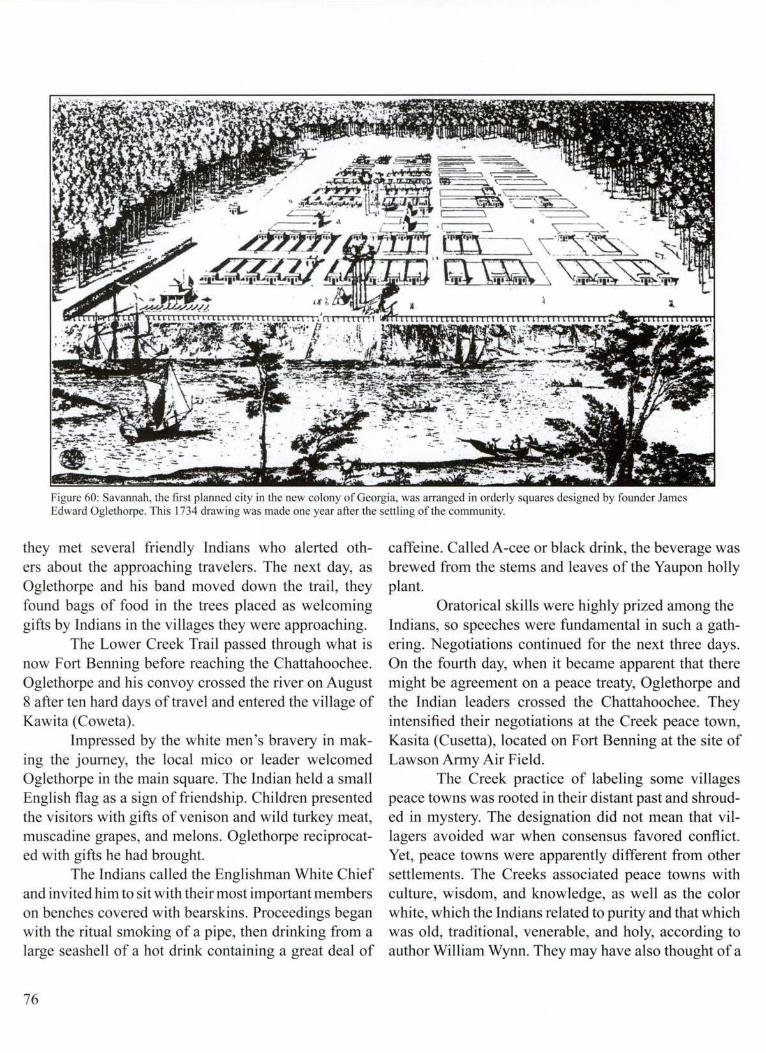
Figure 60: Savannah, the first planned city in the new colony of Georgia, was arranged in orderly squares designed by founder James Edward Oglethorpe. This 1734 drawing was made one year after the settling of the community.
they met several friendly Indians who alerted others about the approaching travelers. The next day, as Oglethorpe and his band moved down the trail, they found bags of food in the trees placed as welcoming gifts by Indians in the villages they were approaching.
The Lower Creek Trail passed through what is now Fort Benning before reaching the Chattahoochee. Oglethorpe and his convoy crossed the river on August 8 after ten hard days of travel and entered the village of Kawita (Coweta).
Impressed by the white men's bravery in making the journey, the local mico or leader welcomed Oglethorpe in the main square. The Indian held a small English flag as a sign of friendship . Children presented the visitors with gifts of venison and wild turkey meat, muscadine grapes, and melons. Oglethorpe reciprocated with gifts he had brought.
The Indians called the Englishman White Chief and invited him to sit with their most important members on benches covered with bearskins. Proceedings began with the ritual smoking of a pipe, then drinking from a large seashell of a hot drink containing a great deal of
76
caffeine. Called A-cee or black drink, the beverage was brewed from the stems and leaves of the Yaupon holly plant.
Oratorical skills were highly prized among the Indians, so speeches were fundamental in such a gathering. Negotiations continued for the next three days. On the fourth day, when it became apparent that there might be agreement on a peace treaty, Oglethorpe and the Indian leaders crossed the Chattahoochee. They intensified their negotiations at the Creek peace town, Kasita (Cusetta), located on Fort Benning at the site of Lawson Army Air Field.
The Creek practice of labeling some villages peace towns was rooted in their distant past and shrouded in mystery. The designation did not mean that villagers avoided war when consensus favored conflict. Yet, peace towns were apparently different from other settlements. The Creeks associated peace towns with culture, wisdom, and knowledge, as well as the color white, which the Indians related to purity and that which was old, traditional, venerable, and holy, according to author William Wynn. They may have also thought of a

peace town as a place for mediating disputes, suggests anthropologist Charles Hudson. There were supposed to be no executions in a peace town, a tradition Creeks sometimes abandoned in the anger of war. Still, colonial traders knew to flee to peace towns during hostilities and sometimes found sanctuary.
The 18th century naturalist and explorer William Bartram, who later passed through the Fort Benning area, told the story of Apalachicola, a village then located on the Alabama side of the Chattahoochee in what is now Russell County. The village, according to Bartram, once thrived as a peace town. Some white traders seeking refuge there were executed, and the village went into decline. The Creeks were convinced the village failed because blood was shed in a place supposed to be sacred.
Kasita was even more special than most peace towns, apparently serving as a "head peace town" where leaders from many villages gathered to deliberate peace proposals.
The Creeks called other villages red towns. Red was the color of war. Kawita, the village where Oglethorpe first met the Creek chiefs, was the head red town. According to Bartram, Kawita " is called the bloody town, where the Micas, chiefs, and warriors assemble when a general war is proposed."
The Creeks also thought of red as the color of the earth and connected it to human instinct and nature. Red towns were associated with the practice of killing captives, sometimes torturing them to death. Early explorers reported seeing tree poles stuck in the ground at Indian villages where captives were tied and tortured. Indians sometimes topped the poles with human scalps. Some English, French, and Spanish explorers, including Hernando de Soto, also tortured captives to death.
When he negotiated with the various chiefs at Kasita, Oglethorpe probably visited the village's square ground where important meetings usually occurred in good weather. A Creek square ground consisted of four open sheds facing one another across an open square of land about a half acre in size. The four sheds frequently were aligned with the four cardinal directions, and a sacred fire often burned in the center of the square ground.
The sheds were made of wood frames, stood about one story tall, and were covered with gabled or slanted roofs. The rear of the sheds and the sides had clay walls,
often with open windows near the roofs for air circulation. Ritual objects, such as scalping knives, war clubs, swan wings, eagle feathers, or herbs, hung from the ceilings, while the walls were often painted with mythical creatures, such as the uktena, a winged serpent.
Oglethorpe met with the Indian leaders at Kasita for nine days. The resulting peace treaty, signed on August 21 , 1739, guaranteed that a wide section of land along the Atlantic coast belonged to the colonists, although the Indians still maintained exclusive hunting rights in some of the area. Most of what constitutes Georgia today still belonged to the Creeks and their allies under the treaty. Oglethorpe agreed that the colonists would never settle further west and would never again encroach on lands the Indians considered exclusively theirs.
The treaty set the stage forthe continued existence of the colony of Georgia because of close ties Oglethorpe forged with the Indians, but dark days lay ahead.
As he headed home, Oglethorpe 's fever continued to plague him. Weak and tired, he fell from his horse in a field of wild cane. A sharp cane stalk pierced his side, and soon the wound was infected. When Oglethorpe finally did reach the small settlement of Augusta, he was forced to bed to recuperate. Then came word that his trusted friend, the Indian leader Tomochichi, was dying. Oglethorpe, despite his condition, headed back to Savannah to be at Tomochichi 's side, but he was too late. He learned on the journey that Tomochichi was gone. Oglethorpe, overcome with emotion, wept.
Other problems beset him. A number of colonists complained about what they considered Oglethorpe 's heavy-handed, ineffectual leadership. There was also continuous carping from critics in London, from both colony trustees and British officials. A growing number in Parliament favored dismantling the Georgia colony to appease the Spanish and guarantee peace. Oglethorpe 's own financial picture darkened as he plunged deeper into debt to finance the venture and its army.
After the English declared war against Spain. Oglethorpe and his army, including several hundred Creek warriors, invaded Florida and menaced the mighty stone fortress , Castillo de San Marcos, at St. Augustine. They failed to capture the fort, and Oglethorpe returned to Georgia and sank into depression. In the end, however, Oglethorpe triumphed. His knowledge of Indian war tactics and information about
77

the enemy provided by his Indian scouts helped turn the tide. In July 1742, Oglethorpe learned that a Spanish army, 3,000-men strong, had pushed ashore and was approaching his Fort Frederica on St. Simon's Island off the Georgia coast. Vastly outnumbered, Oglethorpe nonetheless attacked advance Spanish forces and hurled them back. Then, with fewer than a thousand colonial and Indian fighters , Oglethorpe set a trap, dispatching most of his small band into dense vegetation along both sides of a narrow path the Spanish were expected to follow. When the Georgians opened fire , the Spanish army was forced to retreat.
Although there were few casualties, the fight came to be known as the Battle of Bloody Marsh. Afterwards, Spanish armies never again mounted a serious challenge to the British in Georgia.
For the next 20 to 25 years, the Creek Indians and their allies near the Chattahoochee controlled most of what is now Georgia, a vast territory where they hunted, traded, and sometimes fought with enemies such as the Cherokees. The village of Kasi ta continued to be one of the most important Creek settlements.
Much of what remained of the village was destroyed by the construction of Lawson Army Air Field before the site could be examined with modern archeological techniques. But in 1938, noted archeologists Gordon Willey and Charles Fairbanks did study a narrow strip ofland, at some points 300 feet wide, on the western
78
border of the air field. This was a relatively small area on the river edge of what must have once been a large village. The archeologists located five refuse pits, some as large as four and five feet across, and evidence, in the form of post molds, of two buildings. The post molds revealed that one structure was circular or semicircular and the other was a rectangular house about 25 feet long and 21 feet wide. The Indians buried three people near the house. One of them, placed in a flexed, fetal position, was buried with several hundred European trade goods, dated to between 1700 and 1800.
A partial list of these items demonstrates how thoroughly European culture had modified Indian life. There were bells, English smoking pipes, copper buttons, straight brass pins, and 250 trade beads. There were also a number of European tools. These included a claw hammer, scrapers made from bottled glass, iron files , metaf spikes, an iron adz, a chisel, gun parts, knives, and a mold for making bullets.
The colonists ' lives were also changed from contact with the Indians. They learned new methods for waging war, hunting, cooking, and raising crops. They also adapted many Indian practices for surviving in the wilderness, as well as the habit of smoking tobacco.
The alterations to Indian society because of the intermingling of cultures were, however, much more profound and ultimately destructive. The Creek Indians were about to face their biggest challenge.

9-The Flower Hunter
When William Bartram, the naturalist and explorer, set out for the Fort Benning area, the first skirmishes of the Revolutionary War had already occurred. As a scientist and writer, he was determined to explore as much of the frontier as possible and report on his findings for the mutual benefit of other scientists interested in the flora and fauna and for a public that seemed insatiable for information about the region then known as the West.
Bartram departed from Fort Charlotte, on the South Carolina side of the Savannah River north of Augusta, Georgia, with one companion in the mid-1770s. Bartram knew that his journey to the powerful Indian villages on the Chattahoochee River was dangerous. The country he would cross was still largely uninhabited except for roving bands of Indians. There were wild animals and other dangers lurking for the unwary, and if a traveler became injured or ill, medical help was likely to be far away. Not incidentally, the eastern part ofNorthAmerica was also aflame with talk of war and rebellion from English colonial rule.
The first shots of the Revolutionary War had been fired in Lexington and Concord, Massachusetts in May 1775. The countryside was rife with rumors about which Indian groups would decide to fight with the British or the rebels. A trip into the frontier was riskier than usual because no one knew when any particular group of warriors might decide to join the fighting.
Eventually, a number of Creek Indians did side with the British and attacked American settlements. Bartram, a highly religious person, had braved the dangers of the frontier before, sometimes traveling all alone, but his writings from this trip indicate his concern.
He and his companion, a Mr. Whitfield, were both riding horses. They crossed the Savannah River in late June and headed south in the general direction of Augusta. They planned to pick up the Lower Creek Trail, the same path followed by James Edward Oglethorpe
36 years before. The weather was hot, and by the time the pair turned onto the great Indian trading path several of their horses were noticeably fatigued.
The travelers met two groups of traders also heading for the Creek villages along the Chattahoochee River.
Figure 61 :William Bartram, a naturalist and explorer, was among the first to write about the landscape and people on Fort Benning land.
79

When the traders invited Bartram and Whitfield to ride along with them, Bartram was relieved. The traders had spare horses and allowed Bartram to lighten the load on some of his animals by transferring packs to some of theirs. Also, the traders seemed to offer protection. As Bartram wrote, "Our caravan consisted of about 20 men and 50 horses. We made a formidable appearance, having now little to apprehend from predatory bands [of Indians] or out-laws."
Nevertheless, Bartram wasn't entirely comfortable with his rough-and-tumble companions, although they did elicit a type of grudging admiration for the way they handled unruly horses. When a horse started kicking and bucking because it didn't like being loaded down with a pack, the traders cursed, shouted, and cracked a whip, all to no avail. Exasperated, a trader grabbed one of the animal's ears and bit it fiercely. The horse suddenly became quite docile. As Bartram wrote, "Instantly, the furious, strong creature, trembling, stands perfectly still until he is loaded."
By July 1, the caravan entered what is now central Georgia and camped near the Oconee River. The next day, they reached and crossed the Ocmulgee River, near present-day Macon. The water was 300 to 400 yards wide where they led the horses across.
The following day, they forded the Flint River and camped by a deep creek, a branch of the Flint. They were nearing the Fort Benning area. Within the next few days, Bartram experienced both the beauty and the pestilence the region offered. The campsite the traders chose was pleasant enough, with a cane swamp nearby and plenty of grass for the horses to graze. Allowing the animals plenty of range time had become a necessity because of their fatigue.
Bartram, who began complaining frequently in his diary about the searing summer heat, wrote that the horses had become dispirited. Because of the heat and the tired horses, the travelers, on most days, stopped to camp earlier in the day than they had before and they resumed their journey later the next morning, giving everyone more time to rest.
Bartram was impressed by the many hills and ridges and the overall beauty of the countryside. As he edged close to Fort Benning land, he predicted that someday the spot would be perfect for settlement.
Of one camping site he wrote that it "presents every appearance of a delightful and fruitful region in 80
some future day. It being a rich soil, and exceedingly well situated for every branch of agriculture, and grazing. [The land is] diversified with hills and dales, savannas and vast cane meadows and watered by innumerable rivulets and brooks."
Bartram also mused about the future, a day when he guessed the Flint, Chattahoochee, and Apalachicola Rivers would be ideal vehicles for commerce. He predicted the river system would offer uninterrupted trade routes to the Gulf of Mexico, the Atlantic Ocean, "to the West India islands, and all over the world."
Then conditions took a tum for the worse. The next day the caravan managed to cover only a few miles, despite traveling all day, from sunrise to sunset. A cloud of bitting flies "so thick as to obscure every distant object" swarmed about the riders and their horses. The tormenting insects stung the horses' necks so many times that large drops of blood formed and were "rolling down like tears." Bartram added that "the heat and the burning flies tormented our horses to such a degree as to excite compassion, even in the hearts of pack horsemen."
Some of the flies were quite large, virtually the size of bumble bees, and were "armed with a strong sharp beak or proboscis, shaped like a lancet, and sheathed in flexible thin valves," which they used to puncture the skin of their victims. Three or four other species of flies were smaller but vastly more numerous, and just as bothersome. Particularly vexing for animals and humans alike was a fly colored a "splendid green" but with a gold colored head. The sting of this fly was " intolerable, no less acute than a prick from a red-hot needle, or a spark of fire on the skin. These are called burning flies." Bartram, ever the scientist, carefully cataloged details about their tormentors. He spotted two other species of biting flies, each a grayish dusky color. One of these species had a green head and spotted wings. Try as he might to keep at his dispassionate studies, Bartram, and everyone else, was suffering.
"Almost sinking under the persecutions from the evil spirits who continually surround and follow us over the burning desert ridges and plains," the caravan finally moved into a grove of trees, apparently near a brook, that offered hope of relief and somewhat cooler air. When the riders halted, however, there was no respite after all. They were ambushed by still another form of fly that was "small and perfectly black."

00 ,_..
Figure 62: Yuchi Town was thriving Native American Community in the I 700 's on land now occupied by Fort Benning. This painting by Martin Pate draws on archeological research to portray how the town may have appeared.

Bartram was stunned. Here in "some hopes of momentary peace and quietness, under cover of the cool humid groves, we are surprised and quickly infested with dark clouds of these persecuting demons." To make matters worse, gnats and mosquitoes also began swarming and biting.
usual. The traders tried to nap, but their rest was fitful, broken occasionally by "plaintive murmurs and groans" from one of the men. Bartram apparently lay down and was in such misery that he could hardly y move.
"The air [was] still, gloomy, and sultry," he wrote, as a dark cloud began billowing up above the
Figure 63: Archeological excavations typically occur in the warm, dry months. Here an archeologist is surrounded by the tools of his profess ion, including framed screens used to filter excavated soil in the search fo r artifacts.
The infestation of pests continued to plague the beleaguered troop the next day, following the pack train as it climbed to the summit of a high and lovely ridge. Here they found an "open, airy" grove of pine trees. There were gurgling brooks meandering through the trees, "their banks ornamented with blooming, aromatic shrubs and plants perfuming the air. "
But the stifling heat continued and the stinging flies would not leave them alone. It was only mid day, but the riders were exhausted. They couldn't travel one more mile. They dismounted and tried to rest. As Bartram recalled, they just were "unable to support ourselves under such grievances, even in our present situation charming to the senses."
Even the horses seemed more despondent than
82
northwestern horizon. The cloud soon draped the sky in angry dark gray. Powerful winds began swaying the trees. And "the earth trembled under the peals of incessant distant thunder."
Bartram was "shocked again to life" by the storm, which was now roaring through the campsite. "I raised my head and rubbed open my eyes, pained with gleams and flashes oflightning." As floods ofrain poured from the sky, Bartram tried to rouse his companions. With the sky :flashing and the rain sweeping through, the exhausted traders began to realize the dangers posed by the storm. They ran to their packs, flinging every spare piece of clothing, animal skins, and all the bedding they had over the merchandise and food . supplies in an effort to keep them dry.

As they rushed about in the deluge, a blast of lightning exploded overhead. It was "a vast river of the ethereal fire," Bartram wrote, then added, "I am instantly struck dumb, inactive and benumbed."
As the storm's fury finally subsided, a cooling rain refreshed everyone, including the horses. "The pulse of life begins to vibrate, the animal spirits begin to exert their powers, and I am by degrees revived."
Bartram's more characteristic optimism soon returned. That evening, the "surprisingly heavy tempest passed off. We had a serene sky and a pleasant, cool night."
Just about every scrap of clothing and bedding, however, was drenched. Luckily, the men had collected
pleasant, the air having recovered its elasticity. I found myself cheerful and invigorated. Indeed, all around us appeared reanimated, and nature presented her cheerful countenance."
When Bartram arrived in the Fort Benning area, it was still a focal point for Indian villages, which were located on both sides of the Chattahoochee River. A recent study by archeologists compares occupation sites discovered along the Chattahoochee on Fort Benning and in the Oliver Basin, just north of Columbus. Researchers learned by counting sites that population was less dense in the river's flood plain on Fort Benning land throughout prehistory than was the case in the Oliver Basin. But in the historic era, after the Yuchis
Profile of House "A" Floor Area
Stake Stake
A
B
o========::::i2 Feet (VenicaJ Scale Approximatc)
A Hum~ - 3"
B Refuse, Post Ruin Level 6" 10 9"
C - Fallen Daub Wall - 2" - 3"
D Aoor Surface
x - Charred Can Pit
Y - Smashed Pouery Vessel
Figure 64: Archeologists sketched a profil e of the excavation of a house site found at Yu chi Town. Remnants of daub, a mud housing material, were found under a layer of refu se. Also found were a pit of charred corn , a floor surface, and a smashed pot.
pine knots and pieces of wood before the storm broke. They fed these into roaring fires that lit up the camp and everyone rested near the crackling flames, warming themselves and waiting for the heat to dry their clothes and bedrolls .
Bartram wrote that the "next day was cool and
and Lower Creeks settled the area, the population soared on Fort Benning land near the river and far surpassed the density immediately to the north. What prompted the Indians to concentrate in the Fort Benning area and not to the north is still a matter of conjecture, although a greater availability of farmland may have been a factor.
83
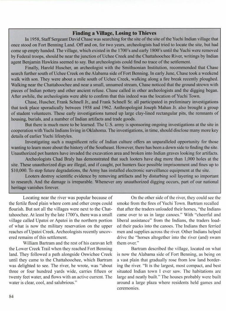
Finding a Village, Losing to Thieves In 1958, Staff Sergeant David Chase was searching for the site of the site of the Yuchi Indian village that
once stood on Fort Benning Land. Off and on, for two years, archeologists had tried to locate the site, but had come up empty handed. The village, which existed in the l 700's and early 1800's until the Yuchi were removed by Federal troops, should be near the junction of Uchee Creek and the Chattahoochee River, writings by Indian agent Benjamin Hawkins seemed to say. But archeologists could find no trace of the settlement.
Finally, Harold Huscher, an archeologist with the Smithsonian Institution, recommended that Chase search further south ofUchee Creek on the Alabama side of Fort Benning. In early June, Chase took a weekend walk with son. They were about a mile south of Uchee Creek, walking along a fire break recently ploughed. Walking near the Chattahoochee and near a small, unnamed stream, Chase noticed that the ground strewn with pieces of Indian pottery and other ancient refuse. Chase called in other archeologists and the digging began. After awhile, the archeologists were able to confirm that this indeed was the location of Yu chi Town.
Chase, Huscher, Frank Schnell Jr., and Frank Schnell Sr. all participated in preliminary investigations that took place sporadically between 1958 and 1962. Anthropologist Joseph Mahan Jr. also brought a group of student volunteers. These early investigations turned up large clay-lined rectangular pits, the remnants of housing, burials, and a number of Indian artifacts and trade goods.
But there is much more to be learned. The U.S. army is sponsoring ongoing investigations at the site in cooperation with Yuchi Indians living in Oklahoma. The investigations, in time, should disclose many more key details of earlier Yuchi lifestyles.
Investigating such a magnificent relic of Indian culture offers an unparalleled opportunity for those wanting to learn more about the history of the Southeast. However, there has been a down side to finding the site. Unauthorized pot hunters have invaded the excavation area and broken into Indian graves looking for artifacts.
Archeologists Chad Braly has demonstrated that such looters have dug more than 1,000 holes at the site. These unauthorized digs are illegal, and if caught, pot hunters face possible imprisonment and fines up to $10,000. To stop future degradations, the Army has installed electronic surveillance equipment at the site.
Looters destroy scientific evidence by removing artifacts and by disturbing soil layering so important to research. And the damage is irreparable. Whenever any unauthorized digging occurs, part of our national heritage vanishes forever.
Locating near the river was popular because of the fertile flood plain where com and other crops could flourish. But not all the villages were next to the Chattahoochee. At least by the late l 700's, there was a small village called Upatoi or Apatoi in the northern portion of what is now the military reservation on the upper reaches of Upatoi Creek. Archeologists recently uncovered remains of this settlement.
William Bartram and the rest of his caravan left the Lower Creek Trail when they reached Fort Benning land. They followed a path alongside Oswichee Creek until they came to the Chattahoochee, which Bartram was delighted to see. The river, he wrote, was "about three or four hundred yards wide, carries fifteen or twenty feet water, and flows with an active current. The water is clear, cool, and salubrious."
84
On the other side of the river, they could see the smoke from the fires of Yu chi Town. Bartram recalled that after the traders unloaded their horses, "the Indians came over to us in large canoes." With "cheerful and liberal assistance" from the Indians, the traders loaded their packs into the canoes. The Indians then ferried men and supplies across the river. Other Indians helped drive the "horses altogether into the river (and) swam them over."
Bartram described the village, located on what is now the Alabama side of Fort Benning, as being on a vast plain that gradually rose from low land bordering the river. "It is the largest, most compact, and best situated Indian town I ever saw. The habitations are large and neatly built." The houses probably were built around a large plaza where residents held games and ceremomes.

During archeological investigations on the site in 1991, Frank Schnell Jr. noted a gap, about 500 yards across, where there were no major concentrations of artifacts. He thinks that this area was the village plaza. Toward the center of the plaza there was probably a giant tree pole like those found in earlier Mississippian settlements.
,, __
. .. ,,,, '
l /f I
t t/ j
o• ! ' •• I I ..
::
-·:.!!:~·:.::-.:::::::::::_:; :-.<~:~::::-,_
YUCHI TOWN 1RU63 .__.,., .. ,,.,
,,_ '
.. o 0 ... o- ...
0 '"
IS ION
' ......
.~· .. f~.~· ! _f f-=-r-.• O• , --Ot-....,..
1W 10' ~ ;::-::.----..._ .......
0...__,_ ,,.,.. . ..,,
Figure 65 : A map of the Yuchi Town site shows with small , open circles the many holes dug illegally by pot hunters. Also outlined with slanted diagonal lines is the large excavation sponsored by the Smithsonian Institution from 1958 through 1962.
The homes were built with wattle and daub. As described by Bartram, the walls "are constructed of wooden frame, then lathed and plastered inside and out with a reddish well-tempered clay or mortar, which gives them the appearance ofred brick walls. And these houses are neatly covered or roofed with Cypress bark or shingles of that tree."
85

similar to a theater in the round. The seats were usually benches with animal skins or cane mats stretched across rectangular wooden frames . The frames were supported by short posts stuck in the ground. The chief, or mico, and the village council used the town house for meetings in winter or during bad weather. Council houses were also used for winter dances, feasts , and festivals , and sometimes to house visitors. The sick requiring isolation sometimes also stayed in the town houses.
While the Yuchi shared many similarities with their Creek neighbors and cooperated with the Lower Creeks when dealing with people of European descent, they were a separate people with their own traditions and government.
As Bartram observed, "Their own national language is altogether or radically different from the Creek (or Muscogulge) tongue .... They are in confederacy with the Creeks, but do not mix with them. And, on account of their numbers and strength, are of importance enough to excite and draw upon them the jealousy of the whole Muscogulge [Creek] confederacy. [They] are usually at variance [with the Creeks] , yet are wise enough to unite against a common enemy, to support the interest and glory of the general Creek confederacy."
The Creeks and the Yuchi sometimes intermarried, but the practice may have been discouraged. Indian agent Benjamin Hawkins reported hearing the following story:
"In the year 1729, an old chief of Kasita, called by the white people Captain Ellick, married three Yuchi women, and brought them to Kasita [the Creek village on what is now Fort Benning], which was greatly disliked by his towns people. Their opposition determined him to move from Kasita. He went down opposite where the town (Yuchi Town) now is, and settled with his three brothers, two of whom [also] had Yuchi wives."
Archeologists have completed a series of preliminary investigations at the Yuchi site and have determined that the residents used various types of pottery decoration similar to styles used in nearby Lower Creek villages. Archeologists label one prominent decoration Chattahoochee Brushed.
86
Potters apparently made the design by using a bundle of fine twigs or coarse grass which they swept in a broomlike fashion across the damp clay.
The Indians also produced plain pottery and pottery with incised line decorations. Another type of pottery decoration they used involved red pigment. Called Kasita red filmed, the ceramic decoration sometimes has the red paint outlined by engraved lines, but not in every instance. Often just the rim of a bowl was painted red, without any outlines.
Whereas the Kasita red filmed pottery appears often in sites associated with the Lower Creeks, it is seen infrequently in the Montgomery, Alabama area, associated with the Upper Creeks. Frank Schnell Jr. theorizes that the red decorations were a way to demonstrate cultural and tribal differences between the two Creek groups.
Anthropologist Joseph Mahan Jr. has conducted research among the descendants of the Yuchi who lived on Fort Benning. Now living in Oklahoma, the Yuchi still cooperate with the Creek Indians but also still maintain a separate organization and their own traditions. The Yuchi elders command considerable respect from other Indian groups because of their wisdom and knowledge of ancient religious and medical concepts.
As for William Bartram, he went on to visit other Indian villages, including the Apalachicola settlement, just south of the Fort Benning area. The naturalist wrote eloquently and prolifically about his experiences. His was one of the voices urging peaceful relations with the Indians, but ironically, his detailed writings about the beauty he saw inflamed enthusiasm for the frontier and inadvertently encouraged white settlers to move onto Indian lands. The resulting clashes proved disastrous to Indian settlements on the Chattahoochee.
Bartram's writings contain some of the most detailed early accounts of Indian lifestyles, while sidestepping simplistic stereotyping so common among other writers in his time. Indians across the Southeast respected the curious naturalist, often allowing him to roam freely through their settlements. They called him "Puc Puggy," the Flower Hunter.

10-A Sacred Fire Flickers
The Lower Creeks and related tribes gradually lost territory in the 1700's. A trickle of settlers moving into Georgia swelled to a flood. More and more white people claimed land that various governments had guaranteed belonged exclusively to the Indians.
The settlers, for the most part, were rough-hewn and ready to fight for a better life. They had fled Europe for common reasons- to escape religious persecution, crowded conditions, and few economic opportunities. They had abandoned family, home, and friends, cutting virtually all ties with their pasts, in pursuit of dreams. When they arrived in the New World, many began small farms . They soon discovered that choice agricultural ground was near major rivers in the rich, fertile flood plains.
Acreage farmed away from rivers without benefit of the nourishing silts deposited by flooding often wore out quickly. Land in the hill country also quickly eroded when etched by the plow and stripped of trees. Discouraged by their hard existence, homesteaders were easily lured further west by rumors of fruitful , uninhabited land. Everyone knew that the first settlers into a new area had the best chance of claiming the lush river-front property.
There were also other reasons compelling settlers westward. New immigrants arrived every day from Europe looking for the promised land they had heard about, boosting competition for the best sites. Too, established homesteaders chaffed at being hemmed in by new neighbors. They wanted territory with fewer people.
Many probably didn 't consider the effect their encroachments were having on the Indians. The Native Americans, according to a popular view, were dangerous nuisances blocking the way of civilization. When the Indians attacked, fear, anger, and a thirst for vengeance enveloped the colonists. Volunteers sometimes traveled long distances to fight and hurl back what they considered savage killers. Brutality committed on both sides fostered smoldering and long-lasting resentments.
When there was war, the Indians invariably lost to better equipped and larger armies. The resulting peace treaties almost always required them to relinquish more land. They lost still more property because of mounting debts they accumulated in dealings with traders. Thomas Jefferson was one of the early leaders who advocated placing trading posts near the Indians, exchanging goods for indebtedness, and then acquiring Indian land to wipe out the debt.
Georgia's colonial government in 1773 forgave Indian debts with traders in exchange for land. Called the New Purchase, the agreement was negotiated with Creek and Cherokee leaders in Augusta, Georgia. The document added 1.5 million acres to the colony, pushing its boundaries far north of Augusta. William Bartram attended the meetings leading to the cessation of land and wrote, " ... the negotiations continued undetermined many days; the merchants of Georgia demanding at least two millions of acres of land from the Indians, as a discharge of their debts, due, and of long standing. The Creeks, on the other hand, being a powerful and proud spirited people, their young warriors were unwilling to submit to so large a demand."
The warriors appeared ready to break off the talks and fight, according to Bartram, who thought they were unwilling "to listen to reason and amicable terms."
"However, at length, the cool and deliberate counsels of the ancient venerable chiefs, enforced by liberal presents of suitable goods, were too powerful inducements for them any longer to resist, and finally prevailed."
By the beginning of the Revolutionary War, the Creeks still claimed much of Georgia. Their lands extended to the far eastern portion of the state to the Ogeechee River. The vast territory was important to the people living along the Chattahoochee River. Many of the Creeks left their villages on extended hunting trips, particularly in winter.
87

Traveling in small groups, some did not return to their villages until February or March, laden with smoked meat and many animal skins. Deer continued to be the most important quarry, although the Indians also hunted other animals, including bear, which they prized for its oil , essential to their cooking and ceremonial life.
When the Indians killed an animal, they recited a ritualized chant asking the animal 's forgiveness . They believed that failure to follow the ritual could result in the animal 's spirit following the hunter and causing illness. On winter hunts, Indians often offered the first deer in a sacrificial fire. On subsequent hunts, when they ate meat, they sometimes threw one piece into the fire as an offering. Corn and other cultivated plants, such as beans and squash, were still vital to the survival of the Creeks, Yuchis, and other natives who lived along the Chattahoochee.
After the Revolutionary War, military veterans began locating on Indian territory based on government grants in reward for their service. John O'Quinn, for example, apparently moved onto Fort Benning land in the 1780's, although some researchers think he didn't arri ve until the l 820 's. O'Quinn, a relative of the Eelbecks, who later operated an important rural grist mill, was buried on Fort Benning land, according to archeologist Frank Schnell Jr.
White settlement in the Fort Benning area, however, was sparse during this period and apparently caused little friction with the Indians. Trouble was brewing, however, in part because many Georgians were incensed that Creeks had sided with the British during the Revolutionary War. Settlers also wanted more land opened to them. They demanded that the new United States government push Indian boundaries further west. The Lower Creeks and their allies accepted the surrender of more land, this time giving up property to the Oconee River, a boundary passing through present day communities of Athens and Milledgeville, Georgia. Negotiations to finalize the deal took place on the Oconee River in 1789 at a place called Rock Landing. Many of the Upper Creeks, however, led by a chief named Alexander McGillivray, adamantly refused to yield more territory, and negotiations fell apart.
Fighting erupted between Upper Creek warriors and white settlers and threatened to escalate into a full-
88
blown war. President George Washington stepped in to defuse the tension by inviting McGillivray and other Creek chiefs to New York City, then the nation 's capital. The president sent a personal escort to Georgia in the summer of 1790 to accompany the Indian chief McGillivray and others to New York. Eight Upper Creek chiefs joined McGillivray, his nephew, and two servants as they rode on horseback to a rendezvous with other Creek chiefs at Stone Mountain, near present-day Atlanta. Then the entire group rode north toward New York City. Once there, McGillivray eventually agreed to a treaty moving the Georgia boundary to the Oconee River. The document also guaranteed no further encroachments on Creek lands and perpetual friendship with the United States.
One subsidiary agreement to the treaty, then kept secret, committed the United States to provide each chief "a commission, a great medal with proper ornaments, and each one-hundred dollars annually for themselves and the other beloved men of their towns respectively."
The chiefs received large silver medals from four to six inches in diameter, hand engraved with elaborate etchings. The medals, along with other peace offerings, including engraved silver arm bands, were likely distributed at the signing ceremony, August 13, 1790, which was attended by President Washington. These peace offerings were highly prized by the chiefs, not only because of their monetary value, but because they were symbols of the chiefs ' power and high status. One of the silver arm bands, broken in two pieces, was recently discovered on Fort Benning. The artifact was engraved with the letters "US". The husband and wife archeological teams of Dean and Karen Wood and Rita and Dan Elliot found the ornament in a northern section of Fort Benning. Such a find is extremely rare, perhaps because the peace offerings were so valued. The letters "D V" were stamped in the arm band, the mark of silver smith David Vinton of Providence, Rhode Island.
Three U.S. presidents- Washington, John Adams, and Jefferson- attempted to maintain smooth relations with Native Americans by promoting trade treaties and by trying to induce the Indians to become more settled by raising livestock and growing crops according to methods practiced by white farmers. The efforts often failed, in part because the government provided inadequate money, training, and material to help foster

change. Government agents also bad to deal with disgruntled natives put off by the government's inability to halt the flow of settlers across guaranteed borders .
giving that land to the United States. In the early 1800's. the Creeks again agreed to relinquish more land. This time they gave up all claims east of the Ocmulgee
....-------------------------------. River, slicing present-day Georgia al
From Small Silver Band
From Large Silver Band
most in half. Benjamin Hawkins was the U.S . Government's Indian agent to the Creeks at the time. Hawkins, who spoke the Creek language, was a careful observer of Native American lifestyles. He wrote about much of what he saw, beginning in the late 1700's when he became an Indian agent.
Hawkins established his home and agency headquarters near the Flint River but his base of operation was often the village of Kasita on Fort Benning land when dealing with natives living along the Chattahoochee. He also maintained a subagency at Coweta Tallahassee, not far from the present Fort Benning boundaries. He worked tirelessly to persuade the Indians to live more like white settlers and even hired a white farmer to live among the Creeks at the Upatoi village on the northern fringes of Fort Benning land. There are indications that Hawkins ' efforts were successful , particularly with the Lower Creeks and Yuchis . Beginning in the Mississippian period, Indians on Fort Benning land had maintained small farmsteads apart from centralized villages. During Hawkins ' tenure, the establishment of individual farms appar-ently increased. Many who once lived
...__ __________________________ __, in centralized villages, such as Yuchi Figure 66: Silver arti facts found in a burial on Fort Benning included pieces ofa large arm band Town and Kasi ta moved to outlying presented to a Creek leader by the United States government to mark the signing of a treaty ' . . . ceding Indian lands. The monogram with the date 1789, the letters " U S" as well as the figure farms, say archeologists Martm Dick-of the bird and initials " D V" shown in this sketch, were all found on the large ann band . inson and Lucy Wayne. Further evi-
With each new treaty, trespassing on Indian lands only seemed to worsen, leading to sporadic outbursts of violence. The greater the number of settlers who moved into some new comer of Indian territory, the more pressure there was to negotiate a new treaty,
dence of this dispersal of settlements came with the recent discovery of the site where the small village of Upatoi once existed. The archeological teams of Wood and Elliot discovered the site north of Upatoi Creek near the fall line.
89

The archeologists identified Upatoi, also known as Apatai, as "a branch or satellite village" of the larger village of Kasita. The head man or chief of the village, Tus-se-kia Mico (known as the Warrior King), once lived in Kasita and apparently moved to the village in 1792.
Besides locating the village and its council house remains, the archeologists found evidence of two clusters of numerous small Creek farms nearby. Writings from the period indicate that such farms were often fenced. The Indians raised com, pumpkins, peaches, beans, peas, and potatoes. They also tended cattle, hogs, and horses. Hawkins introduced the Indians to the iron plow in 1797.
There are also signs that Indians living throughout the region gradually changed the way they built their homes. Earlier inhabitants stuck upright posts into the ground, then wove branches between the posts and covered the frames with clay. Now they favored log cabins on short stilts, similar to frontier homes built by white settlers. They used clay to fill in the open spaces between the logs.
Adam Hodgson, a missionary, visited Kasita in 1820 and wrote that the town "appeared to consist of about 100 houses, many of them elevated on poles from two to six feet high, and built of unhewn logs, with roofs of bark, and little patches of Indian com before the doors." The village apparently still retained some of the ancient features of Creek Indian communities, including the large, circular town house where the chief and his counselors met in the winter. There was also a square ground with four open sheds facing each other across a plaza where the chief and important men met in good weather. Near the square ground, there "is a high pole, like our May poles, with a bird at the top, round which the Indians celebrate their Green Com Dance," wrote Adam Hodgson.
The Green Com Ceremony represented the most important Creek festival. It lasted eight days at Kasita, according to Indian agent Benjamin Hawkins. A celebration of bountiful crops, the ceremony was held in mid to late summer when the com was ripening. It was also a New Year's celebration, a period of thanksgiving, and a religious event to help purify the spirit.
A special reverence envel-oped the annual lighting of the sacred fire.
90
Everyone who watched grew silent. The high priest, clothed in white deer skin and white moccasins, began twirling wood against wood to start the fire, generating the sparks that grew into flames. He fanned the fire with a wing from a large white bird, probably a heron or crane. Then he placed the small fire into an earthen vessel and carried it into the open plaza of the square ground. The plaza bad earlier been sprinkled with a covering of new white sand. Attendants fed dry wood into the flames . The high priest, chanting solemnly, then circled the sacred fire. He poured some of the ceremonial drink A-cee into the fire, perhaps to bless it.
Figure 67 : Manawa, an Upper Creek Indian leader, directed an unsuccessful fight against General Andrew Jackson.
The priest also dropped into the sacred fire a mixture made from button snakeroot plants and perhaps other important medicines the Indians used. The button snakeroot medicine was used to treat kidney diseases and a variety of other afflictions, including snake bite.
The ceremony neared the end when the high priest led everyone in a single-file procession to the river

wheretheyimmersedthemselvesinthewater. Then everyone walked to the village square ground for a final dance.
In 1804, Benjamin Hawkins negotiated an agreement with some Native American leaders to guarantee safe passage for whites along the Lower Creek Trail to Kasi ta and beyond. The United States had just completed the Louisiana Purchase and an idea blossomed to build a road eventually from Washington, D.C. to New Orleans. The Lower Creek Trail, nothing more than a narrow path at first, became known as the Federal Road. Initially, it began in Augusta, Georgia. On Fort Benning land, the Federal Road followed a ridge south of Upatoi Creek and crossed the Chattahoochee at Lawson Army Air Field. In 1811, workers began widening the path and relocating some sections to accommodate wagons and the increasing traffic. At some point, crossing the Chattahoochee became easier when a ferry began carrying wagons and pedestrians.
A number of Indians, particularly among the Upper Creeks, disapproved of the Federal Road and the parade of settlers using it to move onto Indian lands. The Lower Creeks were less combative and more receptive to Benjamin Hawkins ' ideas because they lived closer to white settlements and bad more peaceful contacts with whites. Lower Creeks married whites more often than the upper Creeks, and some Lower Creek leaders were more willing to accept payments to comply with the wishes of settlers.
Inevitably, friction mounted between the Upper Creeks and Lower Creeks. The spark for conflict came the following year with the outbreak of the War of 1812. The British, once again battling the Americans, sent agents to the Creeks urging them to join the war. Many Lower Creeks turned a deaf ear to the British, but many Upper Creeks listened. The British were not alone in attempts to stir the Creeks to war. The influential Shawnee leader Tecumseh agitated for all Indians to join him in an uprising to push white settlers from Indian lands. Tecumseh visited Upper Creek towns, giving passionate, eloquent speeches to gather support.
The Red Sticks, part of the Upper Creeks, were especially outraged by continuing violations of their sovereignty. Apparently, they were called Red Sticks because they painted themselves and their war clubs bright red, although some think the name derives from bundles of sticks natives sent to other villages to mark
the passage of days until some significant event. If the final stick in the bundle was painted red, war would begin on that day. In February 1813, a group of Red Stick warriors, mistakenly thinking their leaders had declared war against the United States, attacked and killed seven frontier families . The assaults led to virtual civil war among Creek factions. A Creek tribal council put the Indians responsible for the killings on trial and executed them. A Red Stick chief, Menawa, and other leaders, declared they would kill those responsible for the executions. They whipped up enthusiasm for wiping out all vestiges of Hawkins' Indian economic enhancement program.
Tensions mounted later that year in July when a frontier militia, composed of both whites and people of mixed blood (descendants of Creek and white parents), ambushed a Red Stick wagon train filled with ammunition in the southern part of present-day Alabama. In the fighting, the militia obliterated the Indian town Burnt Com. The Red Sticks retaliated by storming Fort Mims, just north of present-day Mobile, Alabama. They killed more than 400 people, including black slaves and white settlers. Concern and panic spread throughout white settlements on the frontier. The Georgia militia dispatched troops commanded by General John Floyd from Athens, Georgia. The troops, following the Federal Road, passed through the Fort Benning area, crossed the Chattahoochee, and launched attacks against several Upper Creek villages. Red Stick warriors, after intense fighting, retreated, and the militia moved in and burned the villages.
Floyd also withdrew. He and his soldiers returned to the Chattahoochee where they built a fort. Called Fort Mitchell, in honor of Georgia governor David Mitchell the stockade was located on the Federal Road about one half mile from the river. Floyd wrote General Andrew Jackson, giving a brief description of Fort Mitchell: "have caused a strong stockade fort defended by block houses to be erected on the west side of the Rivers Flint and Chattahoochee." Located just outside the perimeter of modern-day Fort Benning, Fort Mitchell was destined to play a pivotal role in local history.
Meanwhile, Andrew Jackson assembled a powerful force composed of the Tennessee Militia, U.S. infantry, and Indian warriors. Lower Creeks, Yuchis, and Cherokees all participated heroically and decisively. The force invaded northern Alabama and struck south into
91

HORSESHOE NATIONAL
PARK NEWYAUCAU VILLAGE SITE
0 0 .1 o.s~.
0 I
~,,
Figure 68: The Battle of Horseshoe Bend, fought in Alabama, pitted General Andrew Jackson 's forces against the Upper Creek Indians. The battle site was a teardrop-shaped peninsula, which is now a National Park.
the area between the Coosa and Tallapoosa Rivers, heartland of the Upper Creeks. Prospects looked good for a quick end to the conflict when Jackson 's forces won two successive battles. Then his army bogged down, hindered by the logistics of maneuvering so many men and getting supplies in dense wilderness far from his home base. Some soldiers threatened to quit and head home as their enlistments began to expire. Jackson also faced the real possibility his army would starve or would dissolve into full-fledged mutiny.
Reinforcements and supplies finally arrived in
92
January 1814, and Jackson was once again on the move. After two bloody battles with the Upper Creeks, however, his forces were compelled to withdraw to an American stockade on the Coosa River.
The Upper Creeks were suffering even more, battered by the war and dislocated from villages where com and other food could be found. They had fewer weapons and fewer warriors than their opponents. A group of about a thousand warriors and their families took refuge on a peninsula formed by a tear shaped loop of the Tallapoosa River. Protected by the

river on all sides except for a thin strip of land, the peninsula was roughly shaped like a horseshoe.
During the winter of 1814, the warriors and their families hunkered down inside crude log huts against the cold. While they waited, some tried to make their position impregnable. Across the entranceway to the peninsula, they built a log barricade five to eight feet tall. They survived the long winter by hunting game in the nearby countryside.
On the morning of March 27, Jackson's forces, more than 3,000 soldiers and warriors strong, approached the Upper Creek fortress . Jackson later wrote that the horseshoe bend in the river contained possibly "eighty or a hundred acres [of land]. The River immediately around it, is deep, and somewhat upwards of a hundred yards wide. As a situation for defense it was selected with judgment, and improved with great industry and art."
Jackson ordered General John Coffee to move some 700 mounted infantry and 600 Cherokee, Lower Creek, and Yuchi warriors across the Tallapoosa River. Silently, in the early morning hours, these forces fanned out and surrounded all sides of the peninsula, except for the entranceway. Here, Jackson readied 2,000 troops to storm the barricade.
The Upper Creek defenders, numbering about one thousand, waited on the other side. At about 10:30 a.m., Jackson ordered soldiers to fire two cannons repeatedly. Despite a two-hour barrage, the shelling had little effect- the barricade still stood.
During the cannon rounds, one of the Cherokee leaders, Junaluska, swam across the river with another Indian. Without being noticed, the two warriors cut loose many of the Upper Creek canoes anchored and unoccupied on the peninsula side of the water. They pulled a number of the canoes back across the river where other Indian warriors stealthily climbed inside and paddled silently back across the river. The warriors began firing their weapons as they stormed into the back side of the Upper Creek encampment.
Simultaneously, sometime after noon, Jackson ordered his soldiers to charge the barricade with fixed bayonets. The soldiers clambered over the impediment and began a hand-to-hand fight with the Upper Creeks.
The battle lasted for hours and ultimately dissolved into a slaughter as the Upper Creeks were driven into the river and into withering fire
from white soldiers and Indian warriors. As Jackson later wrote, "The event could no
longer be in doubt. The enemy, although many of them fought to the last with the kind of bravery desperation inspires, were at last entirely routed and cut to pieces. The whole margin of the river which surrounded the peninsula was strewed with the slain."
Jackson lost about 200 soldiers and warriors in the fight. The Upper Creek force was just about wiped out. Some estimates indicate that only 41 of them survived, while others think about 200 Upper Creek warriors managed to escape. Though severely wounded, the Upper Creek leader, Menawa, did manage to elude capture. The Americans took about 350 Upper Creek women and children prisoner.
The battle all but finished the Creeks as a power in Alabama and Georgia, although many of them would rise to fight again. The Creeks signed a peace treaty with the now familiar proviso that they give up land, some 20 million acres, more than half of their ancestral territory. They surrendered a huge block of territory in south Georgia and what became central Alabama. A wide strip ofland on both sides of the Chattahoochee still belonged to them, but would shrink rapidly over the next decade.
Even after their horrible defeat, many Upper Creeks remained defiant. Only one of their chiefs signed the peace treaty. Many Upper Creeks slipped away into northern Florida where, with runaway slaves and African-American freemen, they formed a major part of the people known as the Seminoles. The Seminoles, who learned to live in virtually impenetrable swamps, were to have their own battles with American forces. The ultimate outcome, however, favored the Indians.
The Fort Benning area continued to be the focus for Lower Creek and Yuchi settlement. The building of Fort Mitchell added a new element. Eventually an entire community grew up around the fort, including residences, a Native American trading house, a tavern, and a hospital.
A number of Creek Indians apparently camped near the trade center. Called a "factory," the enterprise was sponsored by the United States government as a kind of store where the Indians could buy goods at low prices. It was never highly successful , and the center was sold to the Creeks in 1820. There were various taverns located along the Federal Road, including the one at Fort Mitchell. Apparently places where travelers could rest
93

-~' ..... Figure 69: Their defeat at the Battle of Horseshoe Bend left the Creek Indians virtually surrounded by white settlers. Land they lost because of the battle and subsequent treaty is shown in the darkest shading on this map.
for the night, the taverns were located about 16 miles apart, which was a day's wagon ride. Generally, a tavern was operated by a Native American with an American partner, according to historian Jeffrey Holland.
The state of Alabama was established in 1819, formed from Indian lands. While not as large as Alabama today, the newly designated state resulted in
94
the Creeks being surrounded by whites. There were now state governments and legal white settlements on both sides of their land. In 1821 , the Creeks signed over still more territory. This time they were restricted in Georgia to ground between the Chattahoochee and Flint Rivers. Instead of easing tensions, however, the new boundary only increased pressure on the Creeks.

11-As Long as the Grass Grows
T he Creek Indians, encouraged by Indian agents including Benjamin Hawkins, developed written laws to earn fair treatment as a nation. Codifying rules in print, they hoped, would help reduce misunderstandings with white settlers hemming them in on all sides. The Creeks published a final version of their laws in 1824.
The statutes, among other prohibitions, declared:
"Murder shall be punished with death. The person who commits the act shall be the only one punished and only upon good proofs." (The Creeks considered self defense an acceptable exception to this law.)
"Stealing shall be punished as follows : For the first offense, the thief shall be whipped. For the second offense, [he] shall be cropped [ears cut]. For the third offense he shall be put to death."
"If any person gives false evidence by which another suffers punishment, he shall receive the same punishment, which he inflicted upon the one against whom he stated the falsehood."
"If a person should get drunk and want to fight, he shall be roped until he gets sober."
"Prisoners taken in War shall not be considered or traded as slaves, and it shall be the duty of the law makers to make them as free as ourselves."
"If any man should think proper to set his Negro free, he shall be considered a free man by the nation."
Rather than improve relations with whites, however, the Creek's willingness to allow freed blacks and runaway slaves to live among them added another layer of tension between the Indians and settlers. Slavery was banned in the early years of the colony of Georgia because founder James Edward Oglethorpe disapproved of the practice. As time passed, however, Georgia settlers came to envy the huge profits enjoyed by plantation owners in South Carolina where, from the earliest days of the colony, there were many slaves.
Georgiasettlersagitatedforchangeandeventually
the prohibition against slavery was lifted. Both Georgia and Alabama became slave states under the United States Constitution, which allowed individual states to decide whether they allowed or banned slavery.
Relative peace reigned between whites and Native Americans in the early 1820's. A notable event in the Fort Benning region occurred when the aging Frenchman and Revolutionary War hero, Marquis de LaFayette, journeyed down the Federal Road in March 1825 on his triumphant tour of the country. LaFayette was one of the last, high-ranking officers of the Revolutionary War still alive.
Lafayette 's entourage made its first stop on Fort Benning land at a trading post run by an American fur trader. The sky was just clearing after a spring storm when Lafayette's carriage, guarded by the Georgia militia, arrived. Auguste Levasseur, Lafayette's secretary, later wrote that there were two male Indians, "remarkable for their beauty and form," sitting near the doorway of the trading post. The youngest of the pair spoke impeccable English. His name was Hambly (or Hamley), and he was the son of Creek and white parents.
Hambly told the visitors that he had left Indian territory when he was younger to be educated in the United States, but returned to Indian lands because he preferred the native way oflife. He had apparently married several Creek women.
Levasseur and another man, known only as George, who were traveling with LaFayette carried on a cordial conversation with Hambly who invited them (and apparently the rest of the caravan) to visit his nearby home. There he demonstrated Indian dances for the visitors. Levasseur reciprocated by performing French dances.
Researcher John Metcalf recently pinpointed the probable location of the Hambly farm in an eastern quadrant of Fort Benning. In a report on preliminary investigations at the site, archeologists Christopher
95

Goodwin and Eric Poplin state there were apparent remains of a fireplace and a group of sandstone boulders perhaps used as footing stones for a cabin.
LaFayette and his caravan traveled on to the banks of the Chattahoochee River where they encountered a large delegation of Creeks. At the Kasita crossing, the elderly Frenchman climbed upon a barge. Then young Indian men, first wading, then swimming,
to his reputation was the rumor that he was susceptible to being bribed by white officials. He was also suspect because he maintained cozy relations with the Georgia governor, George Mcintosh Troup, his first cousin.
Mcintosh signed his own death warrant when he put his name on the Second Treaty oflndian Springs on May 1, 1825, surrendering all remaining claims the Creeks had to Georgia land. The treaty relinquished
dragged the barge across the river. On the other ..------..-~---------------------. ~=
side, LaFayette climbed into a small carriage, ,.fl 'C a n d o • k t "-' . o:.,
and the Indians, Using tWO long ropes, pulled ~ ~ p I n o s c:~· · . !~ • ~~
_, .... ~
Upon his arrival at Fort Mitchell, an ,_ > ···: ,~~·~;..~ .... ',, ~, ;~~d~ :~~ the carriage up the steep slope. ~; ~~ .\ \..·/-~'-,,, ~~
elaborate welcoming ceremony unfolded. ( ':;f' Flelda;:·n:, . ', ' ,,, Ji There were laudatory speeches in the French- - , rubble " v~ -,-, • ·:~; __ _,...,.
IL" · " ' - . l -- __-man 's honor by various dignitaries on the parade 1.-: ·J?~ ',_ ,,..-&;..,._.. _,...,.
-" "'"; -" ··::....-- A~-;;:,· ground. The Creek chief, Little Prince, dazzled ~ _.....- / , · ":",.~·
the crowd with a moving oration. He expressed P ine •• ump- !!,, ~ ~.~ _.....- ·',,, 0 '!!! \.oo/t-~".........- Ji ' •
joy at being able to welcome the honored war ~ / ~ / ... \ hero. After his speech, Little Prince explained ~ ~< • _--- ~~~¢r'r .11 " " 0 ° ; to the visitors the lacrosse-type game some- ~ r-.. ---- _.<:"i.;(fr· ,.. e
times called the "little brother of war." Indians : ;--- ~fi~.'!. ~- • ~ ' "
then put on a demonstration game. It was one g .:f&~~~~~ -" of the last times that local Native Americans ~- -
~~ ',, __ _ _ and white settlers shared friendly relations. ..... ·
-~~f Unrest had been smoldering for some
months. Earlier in the year, the Creek chiefs gathered at the central Georgia community of Indian Springs to meet with Georgia gov- ~
emment representatives. They negotiated at a ~ 0
tavern owned by William Mcintosh, one of the ,_ Branch
0 5 L.__J
METE RS
: m • R e c en c :
• o • Q----garbage :
I I
Ji' ' I
... I ~ 0
' ,
five great chiefs of the Creek nation. Mcintosh, whose father was a Scot and mother a Creek, ~ • KE v
was chief of the village of Kawita on the Ala- Ji :~:::: ;::: w / ArWa c l
bama side of the river, not far from Fort Ben- r:::· Ex te nt of Cultural Matoria l . . N ;:);,;>~~ Tr e e Lin e
nmg's boundanes. . . . . Figure 70: A site pl an reveals the probable location of an Indian homestead, ca lled the
Mcintosh was a d1stmgmshed warnor, Hambly settlement, on Fort Benning where the Marqui s de LaFayette stayed dur ing
but his choice of foes did not endear him to his triumphant tour of the country.
some Native Americans. He had fought beside Andrew Jackson in the 1814 Battle of Horseshoe Bend against the Upper Creeks, so there was probably already mistrust between him and some of the Creeks. Mcintosh had also fought with American forces against the Seminoles in Florida. More damaging
96
Native American rights to land from the Flint River to the Chattahoochee River, including the area now occupied by Fort Benning and the city of Columbus. Reportedly, Mcintosh accepted thousands of dollars in return for his signature Outraged Upper Creek leaders

angrily withdrew from the negotiations, branding Mcintosh a traitor and the treaty a fraud.
The Creek council had earlier decreed that anyone who sold Creek lands without unanimous consent from the council would be sentenced to death. Mcintosh knew he was in danger and sought protection from Georgia officials. No one, however, could save him from the fury of his kinsmen.
Soon after the signing of the detested treaty, Upper Creek warriors invaded Mcintosh 's plantation, near present day Carrollton, Georgia. They set his house on fire , and when Mcintosh ran from the blaze, shot and stabbed him to death.
Violence spread as more settlers began moving onto land many Creeks still considered theirs. The Indians responded with raids on white settlements. The United States government ordered the 4th Infantry Regiment to Fort Mitchell to quell the unrest. The earlier fort had fallen into disrepair, and a new one was built.
The second Fort Mitchell was protected by wooden picket fences about 12 feet tall built in a square. Soldiers built blockhouses on two corners of the square where hiding sharpshooters could train their rifles on all approaches to the fort.
The controversy concerning the Indian Springs treaty escalated when Colonel John Crowell , an Indian agent, publicly criticized the document as invalid. Georgia 's Governor Troup denounced Crowell, accusing him of inciting the Upper Creeks to kill Mcintosh. He demanded that Crowell be suspended from office while there was an investigation of him. The governor also insisted that a survey of the Indian lands begin at once so that a lottery could be held to distribute free land to white settlers.
However, the Indians had an unexpected ally. The president of the United States, John Quincy Adams, also decided the treaty was flawed. He ordered a ban on surveying Indian lands until a new treaty could be negotiated. The president's action outraged Georgia 's Governor Troup. He considered the president to be meddling illegally in the state of Georgia 's affairs . Troup vehemently disagreed that there was anything wrong with the original treaty, saying that the Georgia legislature had already upheld the treaty's validity.
The president ignored Troup's protests and summoned Creek representatives to Washington, where
a new treaty was hammered out more favorable to the Indians. Ratified by the U.S. Senate on April 22, 1826, this new treaty was scorned by Troup.
Backed by the Georgia legislation, the governor proceeded to launch the survey of disputed Indian lands anyway. His authority challenged, Adams dispatched a lieutenant with the U.S. Army, J. R. Minton , to hand deliver a dispatch to the Georgia governor, ordering him to halt the survey. The president also ordered the U.S. Attorney for Georgia to arrest anyone attempting illegal surveying on Indian land.
Adams wrote the Georgia governor, threatening to send in federal troops: "The pretensions under which these surveys are attempted are in direct violation of a treaty, and if persevered in, must lead to a disturbance of the public tranquility .. . the President will feel himself compelled to em ploy, if necessary, all the means under his control to maintain the faith of the nation by carrying the treaty into effect."
Troup's reply was equally blunt. If, he wrote, the president ordered troops to Georgia to enforce the treaty. "From the first decisive act of hostility, you will be considered and treated as a public enemy ... . You, to whom we might constitutionally have appealed for our defense against invasion, are yourselves the invaders, and, what is more, the unblushing allies of the savage whose cause you have adopted."
The governor ordered two divisions of militia on alert to defend the state against a possible invasion by United States forces. Troup declared: "The argument is exhausted; let us stand by our arms."
With both sides threatening military action, powerful members of the U.S. Congress stepped into the breech. They persuaded the president that the dispute wasn 't worth risking civil war. Armed conflict to protect Indian rights, they argued, wouldn ' t be politically palatable for many voters.
Adams backed down, ending a serious challenge to federal power. The president ordered the Indian agent, John Crowell, to negotiate yet another treaty. Signed November 27, 1827 at Fort Mitchell , the treaty committed the Creeks to relinquish all claims to Georgia. Settlement of the village that grew into the city of Columbus and the Fort Benning area could now legally proceed.
As a result of the treaty, most Creek settlement was banished from the state.While the Indians sometimes
97

still hunted in unsettled areas south of Columbus, their villages were clustered on the Alabama side of the river.
Archeologists are gradually learning more about Indian life in the 1820's and 1830's. Accumulating knowledge, however, is painstakingly slow because few homestead locations have been uncovered, making each discovery important.
Archeologist Dean Wood identified one homestead site on Fort Benning. Located on the Alabama side of the Chattahoochee and north ofYuchi Town, the spot apparently once held the homestead of Jim Barnard, a Yuchi .
Barnard was probably the grandson of Timothy Barnard, a well-known frontier trader whose ancestors came from England. Timothy Barnard, like many traders, married an Indian, a Yuchi woman, with whom he had eight children. Besides his dealings with Indians, he was also a translator for various government officials and attended the signing of many significant treaties.
One ofTimothy Barnard 's sons was Timpoochee
(John) Barnard, who became the principal chief of Yuchi Town and was also a renown warrior and major in the United States Army.
Timpoochee Barnard command-ed about 100 warriors who fought the Upper Creeks in 1814. Later, he lived near Fort Mitchell and was buried in the cemetery at the fort.
Although they are not certain, researchers speculate that Timpoochee Barnard may have been Jim Barnard 's father, or in some other way closely related.
On land where Jim Barnard apparently once lived, archeologist Christopher Espenshade located numerous potsherds. However, unlike nearby white settlements, there were few nails or other artifacts found associated with housing construction. This may mean that Barnard built his log cabin by carefully notching logs and fitting them together, avoiding expensive nails and window glass.
While there were more than 100 pieces of EuroArnerican pottery found, native-made potsherds domi
r----=---:-~""'17""-r-----------------, nated at the site. Archeologists speculate that the In-
dians used the pottery they obtained from whites as a type of luxury item that they proudly displayed. While they probably served food on trade pottery, they still cooked and stored food in containers they made themselves, following precedents established by ancestors over many years.
Archeologists also found no Euro-American smoking pipes. They speculate that Yuchis preferred their own handmade pipes to inexpensive, mass produced ones. Even in the early 1900's, Yuchis living in Oklahoma were observed still making their own tobacco pipes.
Andrew Jackson was elected president of the United States in 1829, and with his inauguration the government stance toward Indians turned harsher. Jackson abandoned the policy of his predecessors of treating different Indian groups as separate nations. Instead, he aggressively pursued plans to move all Indian tribes living east of the Mississippi River to Oklahoma.
Early in his administration, Jack-son addressed the Creeks and their allies:
L---------------""'-"-----'L ......... .z:<JL........J:;;;J;;..<J.__ __ ....1 Friends and Brothers-By p ermission of the Great Figure 7 1: William Mcintosh, son of a Scot father and Creek mother, surren-dered lndian lands to the federal government, a gesture that cost him hi s li fe at Spirit above, and the voice of the p eople, I have been the hands of his Indian kinsmen. made President of the United States, and now speak
98 to you as your Father and friend, and request you to

listen. Your warriors have known me long. You know I love my white and red children, and always speak with a straight, and not with a forked tongue; that I have always told you the truth. I now speak to you, as my children, in the language of truth-Listen.
Where you now are, you and my white children are too near to each other to live in harmony and peace. Your game is destroyed, and many of your people will not work and till the earth.
Beyond the great River Mississippi, where a part of your nation has gone, your Father has provided a country large enough for all of you, and he advises you to remove to it.
There your white brothers will not trouble you; they will have no claim to the land, and you can live upon it, you and all your children, as long as the grass grows or the water runs, in peace and plenty. It will be yours forever. For the improvements in the country where you now live, and for all the stock which you cannot take with you, your Father will pay you a fair price.
Where you now live, your white brothers have always claimed the land. The land beyond the Mississippi belongs to the President and to no one else; and he will give it to you for forever. ...
Chief Speckled Snake gave this reply to Muscogee (Creek) Indians:
Brothers! When the white man first came to these shores, the Muscogees gave him land, and kindled him a fire to make him comfortable. And when the pale faces of the south [the Spanish} made war on him, their young men drew the tomahawk, and protected his head from the scalping knife.
But when the white man had warmed himself before the Indian s fire, and filled himself with the Indians hominy, he became very large. He stopped not for the mountain tops, and his feet covered the plains and the valleys. His hands grasped the eastern and western sea.
Then he became our great father. He loved his red children; but said, 'You must move a little farther, lest I should by accident tread on you. ' With one foot he pushed the red man over the Oconee, and with the other he trampled down the graves of his fathers.
But our great father still loved his red children, and he soon made them another talk.
Figure 72: Apothleyoholo, an Upper Creek leader, warned William Mcintosh against signing the treaty that ultimately led to Mcintosh 's death.
He said much; but it all meant nothing, but 'move a little farther; you are too near me. I have heard a great many talks from our great father, and they all began and ended the same.
Brothers! When he made us a talk on a former occasion, he said, 'Get a little farther. Go beyond the Oconee and the Ocmulgee. There is a pleasant country. 'He also said, 'It will be yours forever. '
Now he says, 'The land you live on is not yours. Go beyond the Mississippi. There is game. There you may remain while the grass grows or the water runs. '
Brothers! Will not our great father come there also? Heloveshisredchildren,andhistongueisnotforked.
At Jackson's request, the United States Congress opened a fierce debate on an Indian Removal Bill. In the end, the bill passed, but the vote was close. The Senate passed the measure 28 to 19, while in the House it squeaked by, 102 to 97. Jackson signed the legislation into law June 30, 1830.
Most Creeks angrily opposed the idea of moving
99

west. They had no desire to leave their homelands where they bad lived and buried their loved ones for many years. Many had apparently done exactly what the federal government had urged. They had adopted the ways of white settlers. They owned farms, and some owned slaves and raised cattle. Jim Barnard, for example, according to the Indian Census of 1832, maintained a household where there were three males, three females, and three slaves.
But the push to take over Indian lands was relentless. There were more negotiations with the Indians, leading to another treaty in 1832. The Creeks and their allies surrendered all claims to land in the Southeast in exchange for an Indian territory west of the Mississippi River. The Creeks received firm assurances, however, that any individual native who wished to remain in Alabama was free to do so. Those who chose to stay were to receive property they could farm. Anyone remaining on the land for five years would gain a property title and become undisputed owner. The federal government also guaranteed to protect any Indians remaining behind and to remove any whites who trespassed on their farms.
For those wishing to migrate west, the government agreed to pay transportation costs and to finance their subsistence for one year.
The treaty ink was barely dry when the promises began unraveling. For years, many whites had hated, underestimated, stereotyped, and feared the Indians, feelings that were in some instances fueled by grief over friends or family killed in Indian wars . Now all the pent up hostility, coupled with a desire for free land, exploded into violence.
White settlers invaded Indian farmsteads, beating, murdering, raping, and driving the natives off their allocated land. Still other Indians lost their land to trickery. Speculators, many of them headquartered in Columbus, hatched various schemes to induce Indians to abandon their allotments.
Many natives fled into the swamps and deep forests . They struggled to survive by hunting and gathering wild foods. There were reports of Indians starving. Conditions degenerated so much that Andrew Jackson dispatched an envoy, Francis Scott Key (composer of the Star Spangled Banner), to Fort Mitchell to try to curtail the violence. But tragedy continued to unfold. In the winter of 1834, a group of 634 Indians departed for the West. The weather turned bitterly cold, and the
100
natives were so poorly clad that they had to stop repeatedly to build fires, sometimes seven times a day, to keep from freezing. By the time the group reached Oklahoma, 161 had died.
The assaults and swindles perpetrated against the Indians remaining in Alabama continued, abetted by the state government, which did everything possible to pressure the Indians to leave. Native Americans were not allowed to testify in court and had no rights to file legal claims against their tormentors. There were few avenues to tum to for help.
Rumors swirled through the white settlements about impending Indian attacks. Members of the Georgia militia, in a state of high alert, erected a stronghold on what is now Fort Benning to defend against attacks in Georgia. Called Fort Twiggs, the post was apparently completed in March 1836, next to a spring about three quarters of a mile from the Chattahoochee. The stockade fences, about eight feet tall, enclosed an area of about 140 square feet.
There were two attached blockhouses, both two stories high, and a third blockhouse separate from the fort, not far from a horse corral, where guards were stationed around the clock. In a communication written to Georgia Governor William Schley, Major John Howard of the Georgia militia explained that he kept most fort supplies in one of the blockhouses "and my com in the upper stories of the other two."
With about 180 soldiers stationed at the outpost, Major Howard thought he could fend off any attack and still allow half the force to scour the nearby countryside for hostile forces. He wrote the governor that soldiers should remain at the fort "until the emigration [of Indians] commences, to preserve peace, as well as to tranquilize the public's mind."
Howard alluded to how jittery white settlers in Georgia had become. "On Sunday morning last we had quite an alarm." Some settlers "came in from the other side of the river and informed us that the Indians had taken a flat [a boat] and had been crossing in the night in large numbers. Immediately [we] mustered 40 good and true men and returned to the place, where it was found they had, as usual," left no signs."I continued the scout down the river until I had passed beyond all the trails they usually travel....Satisfied that the information was from alarm only, I returned the same evening. Upon

returning to the camp, [I] ascertained that the flat had only been turned loose by the Indians and had been found lodged against a snag after floating about two miles." Howard added, "Although I have no confidence in the frequent alarms, we attend to them all."
Within about a month, however, concerns about mounting Indian anger proved justified. Several chiefs, including Eneah Emathla, a Hitchitee Creek, and Jim Henry, a Yuchi or Hitchitee Creek, led warriors in
pierced with two balls and the head scalped. The settlers in the neighborhood of the disaffected Indians have al I left their plantations with their [slaves] and have come into this place [Columbus] and its neighborhood for protection. Several other murders are reported to have been committed yesterday and the day before. They [the murders] , however, want confirmation (although some of them are believed) .... ! am clearly under the impression that the probabilities of an open rupture with
Figure 73: The last Creek houses in the Fort Benning area resembled those erected by white settlers, as the Indi ans made a fu tile attempt to fi t in with the new inhabitants. The Creek Indi an Jim Barnard perhaps lived in a dwelling resembling this one on Fort Benning.
attacks on white settlements. White settlers on both sides of the Chattahoochee were fleeing the area, while volunteers began pouring in from distant parts of Georgia to help squash the revolt.
Major General Armstrong Bailey of the Georgia militia wrote the governor on May 8 to report that a settler had been killed. The body of Mr. Flournoy "was
a portion of the Creek Nation is daily increasing." Major General Armstrong Bailey hesitated to estimate how many natives would fight, but added, "Their number is beyond doubt rapidly increasing and will continue to do so until an efficient force is stationed in the territory of Alabama for the protection of her unfortunate and defenseless citizens."
101

Georgia Governor William Schley received various reports on the flight of whites to Columbus and Fort Mitchell. One communique from Russell County, Alabama indicated that the Indian agent, Colonel John Crowell, had advance word about the outbreak of war.
where- we don't [know]. We are commanded to march tomorrow to Fort Twiggs .... But what for?
"To guard Columbus and its vicinity, leaving our farms and [slaves] , our sacred firesides to the ravages of
According to the communique, Crowell ....--------------------------~
"stated that Ne ha micco, the principal chief of the lower Creeks, advised him and a few of his particular friends not to sleep in his house, but to go to the Fort [Mitchell] or leave the Nation for his people were determined to fight and he could not prevent it. This disposition was not confined to a few Indians but was a general feeling among them .... Two white men have been murdered, William B. Flourney and a Mr. Hobbs, and there are rumors of others. Ne ha micco further advised Col. Crowell to inform the citizens
N-
fighting] might be stopped by sending them something to eat by such persons as they know to be their friends .. .I think such a course of conduct might have a tendency to pacify them."
Simpson's pleas were ignored. o 40 so
The war was already out of control. More FEET
Georgia militia forces were ordered to re- .__ ____ co_N_Tou_R_iN_T_ER_v_AL_1_Foo_T ______________ __,
inforce Fort Twiggs Not everyone how- Figure 74: Staff Sergeant David Chase drew a contour map of the Fort Mitchell site. The
d £ 11. ' . outer dotted line represents the first fort, while the inner dotted line represents the second one.
ever, wante to o ow the orders. Major William Holland and others living in Randolph County wrote Governor Schley from Cuthbert, Georgia (just south of the Fort Benning area), complaining that they shouldn 't be required to go to Fort Twiggs. "A great many men have deserted [this county] to [go] to other and stronger parts of the state. Most of our women and children are gone- some, God knows
102
ruthless savages. "The weak are compelled to contribute their
might to aid the strong. Is this impartial administration? .. . No, it is because men of influence with public officers entrusted with the management of Indian affairs live about Columbus and in that direction."

A dispatch from Colonel John Dill at Fort Fort Mitchell until they could be transported out of the Gaines, Georgia (also south of the Fort Benning area. Jacob Motte, an Army surgeon stationed at the fort area) expressed similar reservations about divert- observed one clusterof 500 hostile Creeks being marched ing militia to Fort Twiggs. According to Dill's let- West. "The men were handcuffed two together, and a long ter, most of the white settlements in the area, all chain passing between the double file connected them the way north to Columbus, had been abandoned. all together .... The women followed drowned in tears .... "
The Creeks and their allies did cross the A large group of Indians still at large tried to Chattahoochee and attacked settlements in Geor- escape south to join forces with the Seminoles in Florgia. Their most devastating assault came at the small ida. Federal troops commanded by Winfield Scott, community of Roanoke, just south of the Fort Ben- however, moved along the Chattahoochee and botning area, in Stewart County, Georgia, where Hit- tied up the Indians ' avenue of retreat. Then, in June chiti Indians killed 12 people and torched the town. 1837, federal troops led by General Thomas S. Jesup
On at least two occasions, Creek Indians also captured the Creek chief, Eneah Emathla. Soon afattacked steamboats carrying troops through the Fort ter, about a thousand of his followers surrendered. Benning area. The paddle wheeler Hyperion was about A report written at the time described the scene eight miles south of Columbus when Indians opened fire. as U.S. soldiers herded defeated Indian warriors toThe ship engineer and one or two others were wounded. ward Fort Mitchell. "On the 22 June, we witnessed The boat pilot, John Brockway, was shot dead and fell the grand entree of a drove of (Indians) into the Fort, at the wheel, leaving the craft without anyone at the consisting of men, women, and children, in all about helm. The steamboat drifted aimlessly toward the Geor- one thousand. Among them [were] 200 warriors ... gia side of the river before crewmen managed to wres- brought in .. . under the command of Major General tle it back under control and steer safely to Columbus. Patterson ... . They were all ages, from a month old to a
In another incident, the Metamora was steam- hundred years ... . The old 'Blind King ' as he is called, ing upriver near Uchee Shoals with armed state militia [one of the chiefs] , rode in the center of the throng ... aboard. The craft was patrolling the Chattahoochee to his feeling of hostility continued to rankle at his heart." prevent Creek warriors from crossing to attack Georgia In July, about 2,500 Indians, including about settlements. Suddenly, Indians began shooting from the 900 Yuchis, were loaded on two steamboats and carried river banks. The boat engineer, one of the first to be hit, down the Alabama River to Mobile. From there, they fell dead on the deck. Several others were wounded. were transferred to the Indian territory in present-day
Incensed, the boat captain decided to retali- Oklahoma. ate. He swung the vessel around, reversing course, to- Federal authorities were about to remove a ward where the first shots had been fired. As he steered final group of Creeks when conflicts erupted anew alongside where the Indians were hiding, the soldiers with the Seminoles further south. A force of 700 on board opened fire . The Indians fired back, while the Lower Creek warriors agreed to patrol in Floristeamboat continued to float with the current. During da in support of the American military. The warthe exchange of gunfire, there were several more ca- riors ' families were kept in concentration camps sualties on board. Warriors also probably died, but where they were supposedly under federal protection. numbers of Indian dead and wounded are unknown. However, mobs from Alabama and Geor-
The captain decided against another en- gia broke in and ransacked the camps. They raped gagement. He maneuvered the craft farther down women, killed some occupants, and carted othriver and docked so soldiers could carry the bod- ers away to be slaves. Some of the Indians manies of their comrades ashore and bury them. aged to flee into nearby swamps, only to be pursued
Despite such intense battles, the days when the by the Alabama militia, which killed many of them. Creeks and their allies could mount a serious challenge About4,000 Creeks were moved to concentration to white settlers had long since past. The warriors were camps in Mobile, Alabama in March 183 7. When Lower soon overwhelmed. Many were rounded up and held at Creek warriors returned from the Florida war, they
103

found the remnants of their families in the camps. Soon, all the Indians from the camps were loaded onto steamships and sent to the Indian territory, whether they had supported the United States or not.
Often, the steamboats used to transport the Indians, either from Montgomery or Mobile, were seriously overcrowded. Many Indians were kept in chains. Conditions were unsanitary, resulting in many deaths. Others died when the steam boat Monmouth smashed into another boat and sank. Tustennuggee Emathla, who had been a staunch supporter of U.S. policy, was one of the 611 Indians on board. More than half the Indian passengers, 311 , died, including four of Tustennuggee Emathla's children.
Once in Oklahoma, the Indians discovered that the promised provisions from the federal government never materialized. The lack of supplies was just one of many problems plaguing the Indians. Being uprooted from their homes and losing so many loved ones left them demoralized. Now they faced the physical and psychological strain of adapting to a wholly different
104
environment. Starvation and various diseases, including smallpox, influenza, cholera, and others, took a heavy toll. Many more people died.
By 1838, the transport oflndians from Alabama and Georgia ended, although small groups of natives continued to migrate west for about 10 more years. A few Indians, some as slaves, remained behind. But the vast majority of native people, whose ancestors had thrived in the Southeast for thousands of years, were gone.
The overall effect of the Creek trail of tears was staggering. There were 21 , 792 Creeks in Georgia and Alabama in 1832. Twenty years after the "removal" ended, there were only 13,537 Creeks left in Oklahoma. Some 8,000 people apparently had died. Counted as a percentage of their population, the Creeks and related tribes suffered more deaths than the Cherokee in their own, far better known trail of tears.
The Fort Benning area on both sides of the Chattahoochee River soon lost its label as a frontier. The era of steamboats and cotton had begun.

12-A Forgotten Church
S hortly after the Creeks were banished from Georgia, state officials held a lottery in 1827 to distribute free land in Muscogee County, including much of the area now occupied by Fort Benning. Officials awarded lots of 202.5 acres, small enough, they hoped, to encourage development of individually-owned farms.
The land lottery generated considerable excitement across the state. Any male citizen of Georgia, age 21 or older, could participate and gain one chance to win property. If married and a father, he received two chances. Women could participate only if they were widows. Slaves were ineligible.
Entrants could register at any one of the state 's county courthouses. Their names were then forwarded to the state capitol, then in Milledgeville, where state workers wrote them on lottery tickets and placed them inside a large wheel. They also labeled other tickets with lot numbers, identifying land to be given away, and placed these tickets into a second wheel.
Anticipation crackled in the air as the time for the drawing arrived. An official drew a ticket with a name from one wheel and simultaneously reached into the second wheel to get a ticket with a land lot number. The person whose name was drawn won the property free of any charge, except for a small recording fee of $4 per 100 acres.
Winners could occupy the land or sell it.
which became prosperous plantations. Those who could afford the biggest acreage also
were frequently able to buy slaves to perform much of the work for them. These landowners often accumulated handsome profits from selling cotton and used the
Many sold to eager speculators who hoped to re- . . . . . . . . Figure 75: The cotton gm, invented by Eh Whitney m 1793 , led to bigger profits
sell at a profit. Buyers considered parcels along the for planters and increased demand fo r slaves to plant and tend cotton fie lds.
Chattahoochee River especially valuable because of rich alluvial soils, which were regularly replenished by periodic floods. Ready access to water transportation was another important bonus. Some buyers were able to assemble many contiguous lots,
money to buy more land and slaves to work it. The most successful plantation owners were
shrewd deal makers who used far-flung contacts to get the highest prices for crops and the best credit terms to
105

Figure 76: Southern farmers caused rampant erosion with their tree cutting to clear fie lds and heavy dependence on cotton growing. Rather than repair the damage, they often chose to leave the problem behind and move further west.
finance their operations. They, like the small farmers, had to be wily enough to survive the periodic panics when cotton prices nose dived or lending money dried up. They also had to weather natural disasters such as droughts, when crops withered and the river dropped so low that it became impassable.
One of the most successful enterprises in the Fort Benning area was the Woolfolk Plantation. John Woolfolk began accumulating his substantial holdings along the river in 1828 until his plantation stretched south from about eight miles below Columbus and encompassed some 5,000 acres. The plantation included the location of at least one, and perhaps two ancient Native American mound sites, as well as the land where the Creek village of Kasita once stood.
Cotton was the principle cash crop of the time for everyone, wealthy planter and struggling small farmer alike. The invention near Augusta, Georgia of the cotton gin in 1793 by Eli Whitney proved a boon to cotton growers. The gin removed seeds from the cotton fiber,
106
a laborious task previously done by hand. Still, cotton profits were far from a sure thing. The plant rapidly depletes soil nutrients, a primary reason why farmers in the uplands, away from replenishing Chattahoochee River floods, often faced especially difficult challenges.
Erosion was another serious problem plaguing sand hill farmers . When they cleared trees to make room for crops and houses, the top soil, no longer held by roots, easily washed away. Then they hastened the erosion with the plow. Soil loss and decreased fertil ity worsened because most farmers were either unfamiliar with crop rotation, contour plowing, fertilization, or other beneficial techniques or chose not to practice them. Then, too, most of the sandy soils had never been terribly rich and were unlikely to sustain the voracious nutrient appetites of crops like cotton and com for long, whatever the farmers did.
The pioneers who first moved into the back country arrived when the region was still considered wilderness. Often, with little help, they had to clear the land,

then struggle to survive far from neighbors. Many had trouble holding onto property and sold out. Typically, ground changed hands quickly and often.
For example, a man named George H. Johnson drew lot 242 in district nine during the lottery, property on Fort Benning's eastern side. Within ten years, he sold to James Sullivan. Within merely two more years, the land had changed bands two more times.
Similar quick land turnovers occurred repeatedly in the back country. Little is known about many of the land owners because they left few written records. In the case of lot 242, however, historians and archeologists have determined that one of the early owners built a mill for grinding grain into grist. This grist mill was powered by the fast-moving waters of Pine Knot Creek. In later years, owners replaced the original structure with another mill nearby. A community, which came to be known as Eelbeck, grew up around the mill and remained viable into the twentieth century.
Settlements often clustered around mills, which were gathering spots for farmers to talk with neighbors, arrange business deals, and have their com turned into meal and grain into grist, used in baking bread.
Settlers also used churches as social centers where they could gather with others in a common purpose. Archeologists at Fort Benning learned a great deal about early life by studying a long-forgotten cemetery discovered during the construction of the Carmouche firing range. They also uncovered evidence of two mysterious deaths of questionable causes.
By studying land records, researchers determined that 12 early settlers came together in March of 1832, five years after the land lottery, to organize the Mt. Gilead Baptist Church. Not much is known about these founders, but it is likely they were small farmers who had to travel significant distances on horseback or by wagon to attend church gatherings. Probably because of the distances involved, they agreed to meet only one Saturday a month to conduct church business and one Sunday a month for worship.
On May 1, 1832, the congregation appointed three commissioners to oversee construction of a church on donated property. According to the deed, Jesse Cabannis transferred two and a half acres to "the deacons of the Baptist church at Mount Gilead ... for and in consideration of the love, good will, and affection ... for the said church." The name Jesse Cabannis is unlisted
on the church rolls, but the names Mary and George Cabannis do appear. Perhaps they were his relatives.
The members built the church on a high ridge. Nearby, on the same ridge, they set aside a place for a cemetery. A spring flowed from the hillside below the cemetery, sending a small stream cascading down toward Upatoi Creek. By the end of the first year, the congregation had grown to 33 members. During the first 17 years, some 60 people belonged to the church, though not all at the same time.
Mt. Gilead Baptist Church closed in 1849 when the members erected another sanctuary about six miles away. They must have felt some pangs of regret as they shuttered the old building and abandoned it. Perhaps some stood in the cemetery and thought of the friends and relatives buried there.
The new building signaled a fresh start and a new name, the County Line Baptist Church. The church continues to exist today with an active congregation. Over time, as members died and others took their place, people forgot about the first building and cemetery. The original building decayed, along with the wooden markers that likely identified the old graves. After awhile, there were no visible traces that either a church or graveyard bad ever existed. A place once so important had vanished.
When the cemetery was finally rediscovered, the U.S . Army took every precaution to ensure it was quickly studied and then moved to another location out of harm's way. By examining the remains, scientists, led by archeologists Dean Wood and Chad Braley, determined that the church members long ago had enjoyed fairly long lives, if they survived beyond their first 11 years. The beginning years of life were particularly hazardous. Eighteen of 29 burials were either children or newborns. Five were infants.
There was only one burial that might be attributable to a teenager, a female identified as younger than 21 when she died. No other remains were found for anyone between the ages of 11 and 30 years old. A shotgun blast probably killed one of the children. Scientists located shot gun pellets buried with the body of a child who was between five and six years old at the time of death. Researchers were unable to locate any records explaining exactly what happened- whether the child was murdered or killed in an accidental shooting. The complete story of this long ago tragedy may remain
107

one of the unsolved mysteries of Fort Benning's past. Scientists did note that some of the chi Id 's front teeth were misaligned. Another child, about seven years old and buried nearby, had front teeth misaligned in almost exactly the same way, prompting speculation that two children were possibly siblings.
Researchers analyzed chemical elements in all the remains by removing small sections of bone before the burial relocation. This analysis led to con-
may have been poisoned. Bone tissue from the child, who was about four feet tall, disclosed extremely elevated levels of both arsenic and iron.
It is possible that arsenic leached into the bone tissue from the surrounding soil, but the quantities were significantly higher than in any other burial. Large amounts of iron normally accumulate in the human body when arsenic is introduced into the system. The body responds to the poison by mass producing red blood cells, as well as by producing a great deal of hemoglobin, concomitantly boosting iron levels.
Again, scientists were left with a mystery about exactly how this child died. Arsenic was used extensively as an agricultural pesticide, but no other sign of poisoning appeared in the other burials. Whether this child died by accident or was deliberately poisoned remains unknown.
Most who survived beyond childhood had an excellent chance of living into middle age or even old age. Five of the burials were of individuals older than 60. One woman lived to be 84. Researchers were surprised by the apparent longevity of the adults buried in the cemetery, considering the extreme hardships and privations the settlers must have encountered. The average life span of a white male adult was about 59 years, while a woman's life span was about 65 years. Those responsible for the placement of the graves apparently wanted the deceased pointing in the general direction of the setting sun. The grave diggers made the graves about four to six feet deep,
0
D 0 .5
km
apparently in rows, and oriented them in an east/ Figure 77: Mt. Gilead Baptist Church was founded by farmers on Fort Benning land who likely traveled great distances for services.
west direction. Another burial revealed a 61-year
old man who must have suffered enormously.
108

malady the settlers more affluent contemporaries did sometimes suffer. The well-to-do of the plantations were exposed to lead in utensils, pewter, and plumbing, while the back country inhabitants were largely poor farmers without plumbing or expensive tableware.
Seven of the individuals buried in the Mt. Gilead Cemetery suffered chronic ear infections that in at least one instance probably caused death. The ear infections were so severe and so poorly medicated that the bacteria spread to the mastoid portion of the skull, just behind the ear; causing small crater-like openings symptomatic of a condition called otitis mastoidea. The infections must have been quite painful.
Scientists detected high copper levels in the remains of a 31-year-old man who apparently died of otitis mastoidea. Copper levels typically increase in people with severe infections. Scientists also noted that people with the ear disease tended to have low levels of nutrients such as iron, zinc, calcium, and phosphorous. The remains of these people also exhibited decreased strontium, perhaps due to the breaking down of body tissues because of chronic infection.
A likely source of the infection was common "swimmer 's ear" contracted from bacteria in nearby Upatoi Creek. Swimming, bathing, or holding baptisms in the creek, all likely activities for early settlers, could have infused bacteria into the ear. Similar ear infections can also erupt as a by-product of measles, influenza, or upper respiratory diseases. Whatever the source, the infection, if al lowed to grow unchecked, will rapidly spread to the mastoid region of the skull, causing extensive suffering and declining health.
Scientists were also able to determine the sex of ten of 11 adults in the cemetery. Surprisingly, in only one instance were the graves of a man and woman placed side by side. Three of the burials of women were slightly more elaborate than any others in the cemetery. Fabric, held in place with brass tacks, covered the outside of their coffins. Most of the newborns and children were covered with either a shroud or blanket inside their coffins.
While people in this era could expect to live a reasonably long time, most were relatively unhealthy during their lives. Most spent their years in hard, physical labor far from medical care. They often suffered with bad teeth and experienced the debilitating effects of trauma, infections, or other diseases never treated successfully.
As they aged, many suffered from arthritis. The burial remains had much less of the ele
ment strontium than two people buried in the same area about 30 years later, an indication the earlier settlers ate much more meat. They probably hunted a great deal because there was still plenty of wild country all around, teeming with game. They may also have raised some herd animals such as cattle.
Apparently, there was one African-American buried in the Mt. Gilead Cemetery, an 11-yearold. Scientists were unable to learn any significant details about the child. They did note there was one person listed on the church rolls as "Tom (col)", presumably meaning that he was "colored."
Blacks and whites often attended church together prior to the Civil War, but blacks generally were required to sit in segregated areas such as the balcony, if there was one. Blacks were in many ways the invisible people of the period. Most were slaves, rarely listed in any written documents and then only by their first names. Slave surnames were often the same as their slave holders ', a mark of ownership.
While slavery was vital to the South 's prosperity, many whites were not slave owners. For example, on the eve of the Civil War, the 1860 census showed that out of a total population of almost 600,000 whites, there were only about 41 ,000 slave owners in Georgia. There were, however, about 6,000 plantations with 20 or more slaves, and some of these plantations had several hundred slaves.
Most farms were small in 1860, with more than 31 ,000 farms less than 100 acres . Many such farms had no slaves, or only a few.
Slaves rarely could read or write and were therefore unable to record their own history. Denying education to slaves was common in the South, often sanctioned by law. For example, Georgia law, as early as 1770, forbid anyone to educate slaves, although a few white landlords defied the prohibition. One slave who did learn to write was Olaudah Equiano. Born in West Africa, he was sold to slave traders at age 11 and brought to the United States. Eventually granted his freedom, he wrote about his experiences in his autobiography:
"The first thing I saw when I got to the coast [of Africa] was the sea and a slave ship waiting for its cargo. These filled me with much astonishment and
109

Figure 78: A number of cemeteries can be found on Fort Benning. The Army seeks to preserve them and track their history when possibl e. Th is cemetery on a tributary ofOswichee Creek was investigated by an archeological team led by Erwin Roemer.
terror. When I was carried on board, I looked around and saw a large furnace boiling and many black people chained together. I no longer doubted my fate. I was soon put down under the decks. There with the terrible stench and crying, I became so sick and low that I was not able to eat. I wished for death to relieve me. Soon two white men offered me food. When I refused to eat, one of them held me by the hands. My feet were tied and I was severely whipped .. . .The closeness of the hold, the heat of the climate, so crowded was it that each person scarcely had room to turn ... .lt almost suffocated us . This brought on sickness and many died. I became so low I was put on deck. One day two of my countrymen who
110
were chained together jumped into the sea. "They preferred death to a life of such misery.
Then another fo llowed their example. I be lieve that many more would have done the same if they had not been prevented by the ship's crew. Two of the wretches were drowned, but they got the other and flogged him unmercifully for attempting to prefer death to slavery."
The conditions described by Equiano were typical on slave ships, according to various historians. Disease rampaged through many of the ships, with one in eight Africans perishing on board, by some accounts. Other reports cite deaths on some ships of half the human cargo- or more.

13-Prosperity for a Few
V isiting Columbus was a big event for farmers who tended land destined to become Fort Benning. Sometimes, depending upon how far they had to travel, both husband and wife made the trip, as well as their children.
First the farmer had to load the cotton crop, either baled or in big baskets, onto the wagon. As he loaded his crop, the farmer no doubt wondered exactly what price the cotton would gamer in the city. How much the cotton sold for would determine which supplies the family could afford, supplies important to a family's well being. Most farmers were fairly self-sufficient. They grew sweet potatoes, corn, and a few other crops for their own tables. But they needed to buy or swap for staples such as coffee, sugar, and salt, as well as farm implements to replace worn out tools. If there was any money left after buying necessities, maybe the family could afford a new bonnet, hat, or shoes, or some fabric to fashion into clothes.
There was an air of anticipation as everyone bathed and took extra time with their clothes and appearance. Once the horse was led into place and hitched to the wagon, everyone scrambled on board.
Despite their excited anticipation, the journey could be arduous and slow. Early roads were often little more than broad, dusty paths snaking through the forests and fields. Often, the roads were former Indian foot paths, and many were poorly maintained and rutted, jostling the wagon and its occupants. One report about the Federal Road indicated that it was sometimes more comfortable to walk than ride over some sections because of ruts. If it rained, the roads could dissolve into beds of slippery mud, often impassable.
The excursion to Columbus could also be a long one. Some farmers hauled their cotton from as far as 30 miles away, according to historian Lynn Willoughby.
Early settlements in the Fort Benning area, before 1840, tended to be located near major rivers and creeks,
archeological studies reveal. Farmers needed fresh water for drinking, bathing, fishing, watering their livestock, and, when possible, transportation. After 1840, however, many built homesteads further from major waterways, a development made possible by wells and improved roads.
There were also other changes as the l 800's unfolded. The Federal Road had been bypassed as a major route through the region. Westward traffic shifted north through Columbus after 1833 when city leaders ordered a bridge built over the Chattahoochee River. John Godwin managed the construction, while Horace King, Godwin 's slave, directed all the carpentry on the project.
As time passed, more small communities developed at the intersections of rural roads. A church, post office, store, and a mill often clustered at the crossroads, and this is where farmers sometimes gathered to socialize and buy supplies. Several small communities developed in Georgia on land now occupied by Fort Benning, including Roland (later Cotton Mills), Shell Creek (later Jamestown), and Halloca.
Francis Orray Ticknor, a physician, lived at Shell Creek in the l 840 's. He was born in Columbus and educated in Massachusetts. Ticknor loved flowers and other manifestations of nature 's beauty and enjoyed studying gardening. He also liked to write about plants in great detail.
Ticknor was also a prolific letter writer unafraid to speak his mind about rural life, which he sometimes found to be tedious, depending upon his mood. He also found it stimulating living on the main thoroughfare called the Stewart Road (later Lumpkin Road) leading south from Columbus to Stewart County. Ticknor enjoyed observing the passing parade of people on the road and talking with them.
In January 1844, soon after arriving in the area, Ticknor wrote: "My room is 18 feet square and 12 [feet]
111

high- nice, neat, clean, and sweet in every particular, as you may discover by giving the 'Prince' [a horse] a short heat on the Stewart road.
"This road is quite a thoroughfare, and life passes me here in all its phases. As mine host keeps a house for 'private entertainment,' I have frequent opportunities of conversing with the passers-by."
River boat landings often served as the focal points for social gatherings on plantations. When one of the big boats docked-whistling steam, clanging
In February the Steubenville steamed into Columbus. Soon, passengers were boarding the boat to take the first pleasure excursion ever launched from Columbus. The Steubenville paddled down river to the remnants of an Indian mound on land just north of what is now Fort Benning.
Apparently the trip to the mounds was pleasant, but things soured on the return voyage. A strong current slowed the steamer to a crawl, irritating many of the passengers who grew impatient with the glacial pace
Figure 79: Steamboats, including the Pactolus, traveled along the Chattahoochee River. Their arrivals and departures stirred great excitement and sometimes were even the cause or celebrations with dancing and feasting.
bells- it was often cause for celebration, or, at least a quickening of activity.
Steamboats first traveled up the Chattahoochee and reached Columbus in 1828, the year the community was officially founded. Because of the Columbus waterfall and other shoals further up river, the steamboats couldn't travel any farther north, making Columbus the last docking point.
The first steamboat to arrive was the Fanny in January 1828.
112
Demanding to be allowed to disembark, they walked the rest of the way back to town. When the Steubenville at last reached Columbus, the crew fired a signal gun to announce they had finally arrived.
In following years, there would be many other excursions, and again, the destinations often proved to be landings in the Fort Benning area. Steamboat operators would often arrange to have music, dancing, and bountiful food available when the boats arrived at

the landings. One landing on the Alabama side of the river, called Bon Acre, was near the spot where Indians from Yuchi Town once beached their canoes.
During the long, hot summers, the Chattahoochee receded from lack of water and regularly became impassible to Columbus for the steamboats. After the cotton harvest, plantation owners and merchants always kept one eye on the river to see if the water was rising enough to be navigable. The steamboats carried cotton down river to Apalachicola, Florida on the Gulf coast for eventual shipment to English textile mills or to mills in New England. After unloading their cargo, the boats returned from Apalachicola laden with manufactured goods, household items, luxuries, and raw materials for Columbus industries.
Apalachicola bustled during autumn and winter when a flotilla of steamboats took turns unloading precious cargoes of cotton, much of it from the Fort Benning area. The majority of cotton merchants in the coastal town hailed from the northern United States. They vacated Apalachicola when the stifling summer heat returned. In fact, between 1840 and 1860, 66 percent of the Apalachicola cotton merchants, whose birth places are known, were born in the North, according to historian Lynn Willoughby.
The cotton merchants, flush with cash, clustered around five downtown hotels, which catered to their expensive tastes. The hotel restaurants served fine imported wines, locally dredged oysters, and an assortment of deliciously-prepared wild game.
The excitement of the beginning of the business season was captured by an Apalachicola newspaper article: "Vessels are making their appearance in the bay .... The ringing of the auction bell- the cries of the auctioneer- the puffing and blowing of the steamers as they traverse the waters, remind us of the busy scenes that will ensue when they [the steam boats] come booming down the river with their tall chimneys just peeping over the bales of cotton.
"Horses and drays are running hither and thither as if anxious to hurry along the time when they can get a load ... .In a few weeks our wharves will be covered with cotton-our streets filled with people, and the places of business and amusement opened and every inducement held out to those who wish to enter the field of competition and struggle on for wealth. "Again, and again, will the latest news be sought
for; and again will the speculator rub his hands, and laugh or look sad, and put them in his breech 's pockets as his anticipations again are realized-or blasted."
As the article reflects, this was a time of burgeoning commerce all along the Chattahoochee, an exciting era when fortunes were made- and lost.
Steamboats, for all their benefits to the cotton-based economy, were also perilous. Submerged trees and other dangers often lurked just beneath the river surface, obstacles that could rip open a boat hull like a can opener. Many vessels sank after just such encounters. Others ran aground on sand bars where they sat like bloated ducks out of water, sometimes for days, until they could be pulled free.
Too, the dominant cargo, cotton, was highly flammable. Sparks from the steamboat smokestacks often ignited the fibers , which quickly flamed out of control. At other times, boilers exploded, sinking boats and killing passengers and crews. Of the 43 steamboats cruising the river until 1853, at least 20 were wrecked or burned, resulting in lost lives and destruction of more than one million dollars in property, according to historian Joseph Mahan.
There were so many mishaps on the Chattahoochee that insurance rates on freight soared to as much as twice the amount charged for Mississippi River cargo. More than a few of the steamboat accidents occurred on the river as it wound through the Fort Benning area.
From the earliest days of steamboat travel , there was a concerted push to improve passages just south of Columbus. In 1839, for example, the Columbus City Council appropriated one thousand dollars for channel improvements at Woolfolk 's Bar and Uchee shoals in the Fort Benning area. Obstacles and low water and fires and explosions were only some of the serious problems for steamboats. Rampaging floods could prove hazardous as well. If the Chattahoochee rose too high, the vessels couldn't safely steer under bridges spanning the river. Harried boat pilots not only had to negotiate the fast-moving, debris filled waters, they also had to swing around bridges into uncharted areas that only a short time before bad been open fields. Flooding also created other problems. In 1841 , the Chattahoochee overflowed in an episode remembered as the Harrison Freshet because it occurred during the one month William Henry Harrison served as president of
113

the United States before he died in office. The flood swept away the pride and joy of Columbus- the City Bridge (later called the Dillingham Street Bridge.)
Writer John Martin described what happened: "Never was there a more majestic sight than the departure of that noble bridge on its remarkable voyage. Several parties walked across it a short time before it was gone. The river was then flowing over the flooring." The covered bridge was ripped from its piers and floated downstream to the Woolfolk Plantation, which later become part of Fort Benning. Colonel Woolfolk, the plantation owner, reportedly helped lash down the bridge remnants to keep them from being carried further by the rushing waters.
A plantation, such as Woolfolk's, was often a hive of activity. The planter's residence anchored the central complex. Nearby there were often storage sheds, corrals, and slave housing. Archeologist Marlessa Grey has demonstrated that housing on large plantations often clustered in several areas in addition to the central complex. Cotton growing so exhausted the soil that land had to be constantly cleared to open new fields , even on plantations where flooding periodically replenished the earth. An overseer and some slaves moved from the central complex to housing near the new fields. Sometimes, even the planter followed and had a new residence built for himself near the new fields.
Plantations were often largely self-sufficient, with various machines to help grind grains and com, saw lumber, or gin and bail cotton. There were countless skilled tasks needed to keep plantations functioning, and slaves performed many of them, while others were done by independent contractors. There were blacksmiths, wagon makers, well diggers, harness makers, carpenters, and mechanics to keep the mills operating.
By far, slaves performed the majority of work. How they were treated varied depending upon their skills and the dispositions of their owners. Plantation slaves were nominally divided into three classes, although categories frequently overlapped.
There were house servants, field hands, and skilled craftsmen, such as blacksmiths, carpenters, and masons. Men, women, and children as young as seven years old worked as field hands. Day after day, they spent long hours, from dawn to dusk, under a scorching sun.
114
Overseers stood ready with whips, in many instances, to ensure maximum productivity from everyone.
Owners had a financial interest in keeping slaves fed, clothed, and housed to prevent ill-health from spreading and crippling the work force . They also had a competing goal of trying to keep costs low. The resulting compromise often meant providing the bare minimum in subsistence.
... C"
<
Figure 80: Slave ships were built to pack as many human beings aboard as possible. The captives often were unable even to stand in the tight quarters and conditions were so unsanitary that thousands died before the ships ever reached American shores.
Slaves' quarters were generally flimsy wood structures with one or two rooms and a fireplace . Their clothes were made of the cheapest fabric often sewn by slave women. Food tended to be cheap and monotonous, rationed weekly. Some plantation owners allowed slaves to supplement their diets with food grown in small private plots.
Some of the rare first-person descriptions of what it was like to be a slave came from interviews given by elderly blacks to writers hired by the Works Progress

Administration m the l 930's. For-mer slave George Womble of Colum-bus, born in 1843 in Georgia, remembered:
I never saw my father, as he was sold before I was old enough to recognize him as being my father. I was still quite young when my mother was sold to a plantation owner who lived in New Orleans. As she was being put on the wagon to be taken away, I heard her say, 'Let me see my poor child one more time because I know I'll never see him again. ' That was the last time I ever saw or heard of her.
.... My master, who was Mr. Robert Ridley, had me placed in his house where I was taught to wait tables and to do all kind of house work. ...
When Marse Robert died, I was still a small boy. ... I was sold to Mrs. Ridley 's brother. Enoch Womble. He paid his sister $500 for me.
The slaves all got up long before day and prepared their breakfasts and then, before it was light enough to see clearly, they were standing in the field holding their hoes and other implements ....
An overseer was hired by the master to see that the work was done properly. If any of the slaves were careless about their work, a sound whipping was administered. Field hands also got whippings when they failed to pick the required 300 pounds of cotton daily.
Julia Brown, another former slave m Georgia, was interviewed in Atlanta in 1939:
There were six of us children. ... We didn't stay together long. I was given away when I was just a baby, and I never did see my mama again.
I was given to the Mitchell family. .. .I was put to work in the fields when I was five years old, picking cotton and hoeing. I slept on the floor nine years, winter and summer, sick and well.
I had such a hard time. That mistress Mitchell didn 'tcarewhat happened to us .... Sheusedto lash us with a cowhide whip. When she died, I went from one family to another. All the owners was pretty much the same .... Some of the white folks [however J was very kind to their slaves. Some didn't believe in slavery and some freed them before the war and even give them land and homes.
Slaves generally worked six days a week with Sundays off. Some enjoyed occasional festivities allowed by slave owners. Carrie Hudson, also from Georgia, recalled that her master sometimes allowed
slaves to hold a dance on Saturday nights. She remembered there were also some other pleasurable moments. One of her favorites was Christmas time when " ... there would be plenty of fresh meat, and there was heaps of good chickens, turkeys, cake, candies, and just everything good." For a week at Christmas, slaves were not required to work. They spent the time visiting each other's cabins and feasting.
Regardless of the extent of the slave holders' good will, slaves were still prisoners with few, if any, opportunities for bettering their lives. In most cases, they were never allowed to leave the plantation or farm without written permission, a restriction backed by law in many Southern states.
In Georgia, for example, by 1770, the law stipulated that slaves could not leave their owners' land without a ticket signed by the owner or another person in charge of the slave. According to the law, "Every slave who shall be found without a ticket, or without a white person in his or her company, shall be punished with whipping on the bare back, not exceeding twenty lashes."
Plantations depended in varying degrees on small towns and communities that sprung up nearby, though they were not nearly as reliant on the developments as small farmers. Planters, however, sometimes ventured into the small towns to conduct business and to discuss farm prices and other matters.
On the Russell County, Alabama side of Fort Benning, the community of Broken Arrow was north of Uchee Creek and shared the same name with a nearby plantation. An earlier Creek Indian village was also called Broken Arrow.
South of Uchee Creek was an area bordering the Chattahoochee known as Oswichee, another Indian name. There was no central town, but the community had schools, churches, and stores that served nearby plantations. The Oswichee Land Company of New York owned one of the largest slave holding plantations in Russell County, with 200 to 300 slaves.
Attempts to bring a railroad into Columbus began within a decade of the city's founding. These efforts co !lapsed because of the economic panic of 183 7 that sent interest rates soaring and depressed business conditions. By the early l 850's, however, trains were steaming into the city, changing how people traveled and offering new opportunities for shipping goods. The
115

first long-distance train ride from Savannah through Macon and on to Columbus arrived on May 19, 1853 with 200 passengers who had made the entire trip. The train had taken 13 hours to journey from the Atlantic coast, speeding along at the unheard ofrate of23 miles per hour.
An editor of the Columbus Enquirer newspaper captured the sense of startling change engendered by the railroad: "Sober minded men who have been used to traveling 35 or 40 miles a day and who have not yet realized the fearful speed of this fast generation, will scarcely believe that our friends from Savannah were whirled along by the iron horse, a distance of three hundred miles, between the rising and the setting sun."
The railroads helped accelerate the growth of Columbus as a manufacturing center. People living in rural areas, including the huge expanse that would some day become Fort Benning, now saw more opportunities to escape the day-to-day struggle of farming. The rural poor trickled into Columbus to accept low-paying jobs in the mills. Engineers and machinists were also drawn to the booming riverside city from the north. About half the skilled workers listed in the 1850 census were born outside the South, according to historian Maxine Turner.
116
The population of Columbus shot up by 3,000 people in just seven years after the first railroad was built in the city. The 1860 census showed a population of about 5,600 whites, 3,000 slaves, and 100 free blacks. There were also 19 manufacturing companies with an annual production valued at almost $1.5 million.
More people were also settling into places further away from Columbus in eastern and southern portions of Muscogee County. Some of these residents complained about having to travel long distances to Columbus to conduct official business. They lobbied for the creation of a new county and new county seat.
Chattahoochee County was carved out of Muscogee and Marion Counties in 1854 and included parts of what is now Fort Benning. The town of Cusseta, with a name harking back to the Creek Indians, served as the county seat.
But a dark cloud hovered over all the prosperity and growth. Politicians from the North and South continually wrangled in increasingly bitter debates over slavery, an issue that would rip the nation into two warring camps. With the election of Abraham Lincoln as president of the United States in 1860, there was less and Jess talk of compromise.

13-Henry Benning1s War
The street of Columbus erupted in wild celebration with the secession of South Carolina from the United States in December 1860.
Bonfires blazed, and a torch-lit parade snaked through avenues illuminated by new gas lamps. There were impassioned speeches and stirring band music, capped off with an explosion of fireworks.
Figure 81: Henry Benning was a successful Columbus, Georgia lawyer and judge before joining the Confederate State Army.
Rural areas, especially plantations, also reveled over this first rupture of the union. Wealthy planters along the Chattahoochee River tended to form a closeknit society, and one of their principal forms of recreation was visiting one another's homes for elaborate parties. The festivities cemented business alliances and deals often led to romances and marriages. The Christmas season of 1860 gave planters something else to cheer besides the usual holiday get-togethers, caroling, and egg nog. A favorite party song, as they hailed Geor
gia's possible secession, was We Conquer or Die. Quickly tagged as rebels, instigators of the for
mation of the Confederate States of America nonetheless organized their revolt in a democratic and orderly fashion. Elections were held in both Georgia and Alabama to choose delegates to secession conventions. Henry Benning, for whom Fort Benning is named, was among representatives selected from Muscogee County. About six feet tall, Benning cut an impressive figure and left an indelible impression on most who met him, in part because of the way he spoke. He enunciated each syllable crisply in a deep, booming baritone.
His speaking ability likely helped Benning build a successful legal practice, culminating in his serving for six years as a judge of the Georgia Supreme Court. As a Muscogee County delegate to the secession convention, he was on the committee that introduced the bill calling for Georgia to withdraw from the United States. The convention voted on January 19, 1861 to secede, sparking even giddier rounds of celebration. The tally was 208 for secession, 89 against.
The enthusiasm continued for a time, with the first two years of the Civil War finding most secessionists brimming with optimism as combat reports favorable to the South dominated. General Robert E. Lee and his Confederate army fought superior
117

Union forces either to a standstill or achieved astonishing victories. General T.J. (Stonewall) Jackson, with an army briefly separated from Lee 's, played havoc with Union efforts to capture Virginia's picturesque Shenandoah Valley.
Jackson, seemingly trapped between two converging Union armies, attacked one force, then wheeled around and attacked the other, all within two days, sending both Union armies into disorganized retreat. Jackson 's soldiers moved so fast that they seemed to be in two places at once, fueling rumors that kept official Washington, D.C. on edge, anticipating an attack. When Jackson rejoined Lee, the Army of Northern Virginia seemed virtually invincible.
Henry Benning of Columbus, a colonel in the Confederate army, participated in the early fighting in Virginia where he joined Robert E. Lee's forces. Despite his distinguished civilian career, Benning's beginning days with the army were stormy. Early in his military career, he, along with many other defenders of "states ' rights," vehemently questioned the legality of the Confederate government's conscription act. Benning even refused to obey orders based on the law sanctioning the draft, and for a while was on the verge of being court marshaled. An influential friend and fellow Georgian, Colonel T.R.R. Cobb, intervened to dissuade Confederate officials from placing Benning on trial.
Even more precarious to Benning's reputation was an early misstep in battle. In September 1862, Lee boldly divided his army in half and attacked the Union army from the front and rear at the second battle of Manassas in Virginia (also referred to as the second Battle of Bull Run). The Union general , John Pope, was hopelessly outmaneuvered and eventually saw his army shattered, but not before a perilous interval when the outcome was in doubt.
During the bitter fighting, Benning lost control of an entire brigade of about 2,000 men under the onslaught of a Union charge. Bewildered, Benning climbed on an artillery horse and rode to General James Longstreet, Lee 's other top subordinate, to seek help.
Benning shouted to Longstreet above the din of fighting, "General, I am ruined! My brigade was suddenly attacked and every man was killed. No one is to be found. Please, give orders where I can do some fighting." Longstreet coolly assessed that Benning
118
was befuddled and responded with icy sarcasm: " Nonsense, Colonel. You are not so badly hurt. Look about you. I know you will find at least one man [to command]."
Then Longstreet flung one further jab at the stunned colonel. When Benning managed to find that "one man," Longstreet commanded, he should "report your brigade to me, and you two shall have a place in the fighting line."
The ridicule snapped Benning out of his fog . Spurring his horse back into the battle, he soon located his missing brigade and rallied the men to fight throughout the rest of the battle. There was apparently no further question about either his valor or judgment under fire.
It seems that Benning was not above flattering his immediate superior, Brigadier General Robert Toombs. A fellow Georgian and former United States senator, Toombs was a controversial figure. Overweight and pale, he was 51 when Georgia broke away from the Union. Toombs, renowned for his oratory, was considered intelligent, but critics complained he was often illogical. Howell Cobb, who later led the defense of Columbus from Union forces, said of Toombs, he "disagrees with himself between meals."
Toombs was also known for his ambition and reportedly was sorely disappointed he wasn 't chosen president of the Confederacy instead of Jefferson Davis. He served, sullenly, a short while in Davis ' cabinet before resigning to join the Confederate army where he was critical of just about everyone.
In 1862, not long before the second battle of Manassas, Toombs was ordered to advance a brigade of soldiers in Virginia to a road near the Rapidan River. When the rider arrived with the command, Toombs was away from his brigade, visiting an old political acquaintance who lived nearby. One of Toombs' subordinates accepted the orders and proceeded to send the soldiers toward the road. But as the troops began moving, Toombs arrived and commanded them to halt. Later, Toombs explained his disobedience by claiming that he thought his men had not had enough time to cook their rations. He also asserted that other Confederate troops blocked their way, a claim which turned out to be false.
His refusal to carry out orders resulted in near disaster for the Confederacy. Federal cavalry slipped up the road Toombs and his troops were supposed to be

guarding and surprised J.E.B. (Jeb) Stuart and his officers camping beside a nearby farmhouse .
The Union soldiers, guns blazing, came riding up on a startled Stuart, who ran to his horse and vaulted into the saddle, then sped into a gallop across an open field. With dirt flying from its hooves, the horse leaped the garden fence and disappeared into nearby woods. The fiery cavalry commander escaped just ahead of the Union bullets.
When his officers finally reassembled, shaken but unhurt, they noted that Stuart, in his haste, had lost both his cloak and prized plumed hat. Under a blistering summer sun, Stuart improvised by wrapping a handkerchief over his reddish hair. Throughout the rest of the day, he was subjected to catcalls and kidding remarks. Repeatedly, soldiers called out, "Hey, Jeb, where 's your hat?"
Robert Toombs ' failure to follow orders, however, was no laughing matter. His action spawned a near fiasco that almost caused the death or capture of Stuart, who had already assumed mythical renown for Southerners. Toombs was arrested and removed from active duty.
However, because of the pressing needs of war, and, perhaps, because of his many well-placed political connections, Toombs was soon released to return to his troops. They received him with much cheering during the second battle of Manassas. It was then that Toombs supposedly uttered the famous words, "Go to it boys: I am with you. Jeff Davis can make a general, but it takes God almighty to make a soldier."
In fact, Toombs probably never made such a statement, according to historian Douglas Southall Freeman. The words were likely fabricated by an inventive subordinate, Colonel Henry Benning, who apparently inserted them into an official report he penned about the battle.
Benning, who came to be called "Old Rock" by his men because of his courage under fire, began to gain renown in his own right just when the South's fortunes started spiraling downward. After his victory at the second battle of Manassas, Lee decided to seize the opportunity by invading the North. This first major foray into Union territory would, Lee hoped, force Abraham Lincoln 's government to sue for peace.
Lee seemed to have every reason to be confident. The Confederate forces in Virginia had repeatedly
Out maneuvered and out fought the enemy. And there was another reason for Lee's assurance. The commander of the Union army, General George B. McClellan, while quite capable in defense, had repeatedly vacillated and shrunk away on the slightest pretext from attacking Lee 's army. He regularly overestimated the number of Lee 's troops and used the inflated figures to wheedle more supplies and soldiers from Lincoln.
Then, near the small village of Sharpsburg, Maryland, McClellan suddenly turned uncharacteristicallyaggressive. WhatLeedidn'trealizewas thata Union soldier had discovered the Confederates' complete battle plans wrapped around several cigars. Lee suddenly found his army penned between the Potomac River and Antietam Creek, with no room to execute any of the brilliant maneuvers that had so perplexed Union generals. He could have retreated, but Lee chose to fight, despite having only 40,000 men against a Union force of70,000.
McClellan directed his first heavy assault directly at the left side of Lee's army, commanded by Stonewall Jackson. The Union soldiers attacked at dawn, and Jackson's forces buckled under the fierce onslaught. There were heavy casualties. Never had so many high-ranking Confederate officers been put out of action so quickly. As Union soldiers charged into gaps forced in the Confederates ' defenses, they encountered a new batch of Southerners moving up quickly from the rear. Hardened Texas veterans led by John B. Hood rushed into the breaches, helping to temporarily halt the Union advance. Hood 's veterans, survivors of many battles, were appalled at the bloodshed and carnage they saw all around them.
Doggedly the Texans moved forward, loading their rifles and firing, loading and firing, as they stepped over rows of dead comrades killed in the first Union charge. Hood later recalled, "Never before was I so continuously troubled with fear that my horse would further injure some wounded fellow soldier, lying helpless on the ground."
Stonewall Jackson saw his lines collapsing and dispatched Sandie Pendleton into the fray for a more thorough assessment. Pendleton later described his harrowing ride: "Such a storm of balls I never conceived it possible for men to live through. Shot and shell shrieking and crashing, canister and bullets whistling and hissing most fiend-like through the air until you
119
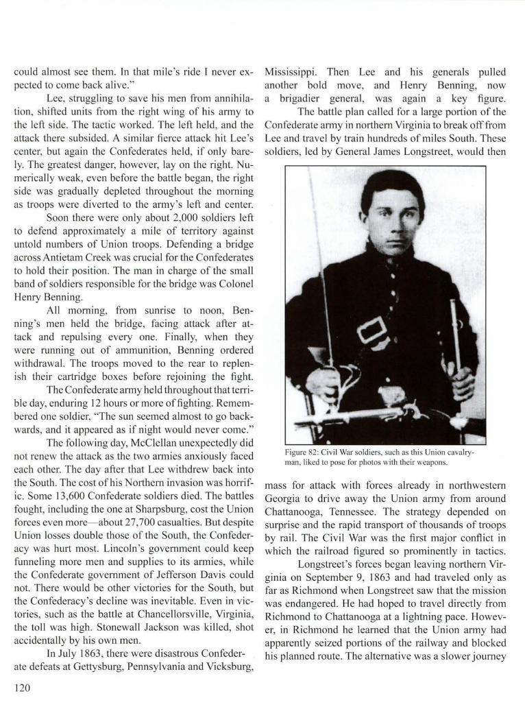
could almost see them. In that mile's ride I never expected to come back alive."
Lee, struggling to save his men from annihilation, shifted units from the right wing of his army to the left side. The tactic worked. The left held, and the attack there subsided. A similar fierce attack hit Lee's center, but again the Confederates held, if only barely. The greatest danger, however, lay on the right. Numerically weak, even before the battle began, the right side was gradually depleted throughout the morning as troops were diverted to the army's left and center.
Soon there were only about 2,000 soldiers left to defend approximately a mile of territory against untold numbers of Union troops. Defending a bridge across Antietam Creek was crucial for the Confederates to hold their position. The man in charge of the small band of soldiers responsible for the bridge was Colonel Henry Benning.
All morning, from sunrise to noon, Benning's men held the bridge, facing attack after attack and repulsing every one. Finally, when they were running out of ammunition, Benning ordered withdrawal. The troops moved to the rear to replenish their cartridge boxes before rejoining the fight.
The Confederate army held throughout that terrible day, enduring 12 hours or more of fighting. Remembered one soldier, "The sun seemed almost to go backwards, and it appeared as if night would never come."
The following day, McClellan unexpectedly did not renew the attack as the two annies anxiously faced each other. The day after that Lee withdrew back into the South. The cost of his Northern invasion was horrific. Some 13,600 Confederate soldiers died. The battles fought, including the one at Sharpsburg, cost the Union forces even more- about 27,700 casualties. But despite Union losses double those of the South, the Confederacy was hurt most. Lincoln's government could keep funneling more men and supplies to its armies, while the Confederate government of Jefferson Davis could not. There would be other victories for the South, but the Confederacy's decline was inevitable. Even in victories, such as the battle at Chancellorsville, Virginia, the toll was high. Stonewall Jackson was killed, shot accidentally by his own men.
In July 1863, there were disastrous Confederate defeats at Gettysburg, Pennsylvania and Vicksburg,
120
Mississippi. Then Lee and his generals pulled another bold move, and Henry Benning, now a brigadier general, was again a key figure.
The battle plan called for a large portion of the Confederate army in northern Virginia to break off from Lee and travel by train hundreds of miles South. These soldiers, led by General James Longstreet, would then
Figure 82: Civil War soldiers, such as this Union cavalryman, liked to pose for photos with their weapons.
mass for attack with forces already in northwestern Georgia to drive away the Union army from around Chattanooga, Tennessee. The strategy depended on surprise and the rapid transport of thousands of troops by rail. The Civil War was the first major conflict in which the railroad figured so prominently in tactics.
Longstreet's forces began leaving northern Virginia on September 9, 1863 and had traveled only as far as Richmond when Longstreet saw that the mission was endangered. He had hoped to travel directly from Richmond to Chattanooga at a lightning pace. However, in Richmond he learned that the Union army had apparently seized portions of the railway and blocked his planned route. The alternative was a slower journey

through Atlanta. There the forces would have to transfer to other tracks heading north and west of the city into the hill and valley region near Chattanooga. Longstreet also learned of a potentially far more serious problem whi le he organized his invasion force in Richmond. A New York City newspaper, The Herald, printed exact details of his operation, including specifics about which troops he had with him. The critical element of surprise was rapidly disappearing.
Some of the first soldiers to depart for Atlanta were those under the command of Henry Benning. An odd assortment of railroad trains was assembled to accommodate the huge troop movement. Soldiers packed inside and on top of all sorts of rolling stock-box cars, passenger cars, baggage carriers, scooped out coal bins, and flat-topped platform cars. The pace was slow and precarious over rickety tracks, neglected because of the war. As one soldier wrote, " ... all and every sort [of railroad car] was wobbling on the jumping strap iron."
Still, a festive air developed on board, despite the devastating pounding the men had taken at Gettysburg, just a few weeks earlier. All along the route, the soldiers yelled and whistled and waved at cheering bystanders lining the tracks. Women waved handkerchiefs and Confederate flags. Old men and young boys threw their hats in the air as the trains rolled through the Carolinas and Georgia.
Soldiers jammed inside the box cars were missing out on the celebration that their comrades riding on top of the cars were enjoying. The weather was also hot, so the troops began tearing off the side paneling. With knives and axes they pried away the outer shells of the box cars, leaving only the skeletal frames and roofs. Then the men inside could also enjoy the pleasant scenery and bask in the enthusiasm of the adoring crowds.
Benning's troops were the first to arrive in Atlanta where they faced another delay, symptomatic of supply problems beginning to pinch the South's ability to wage war. Arriving on September 12, Benning had to stop to get shoes for his men. He was stalled for two days.
Slowly, the soldiers from Virginia began pouring into northwest Georgia. Many climbed off the trains and walked directly into the fierce battle erupting along Chickamauga Creek. The Union army commanded by General William Rosecrans, with about 58,000 men,
faced Braxton Bragg's Confederate force of about 43 ,000. With reinforcements from Virginia and elsewhere in the South, the Confederate army swelled to about 66,000 soldiers. Despite all the problems the troops had reaching Georgia, the numerical advantage had swung to the South.
Fighting began shortly after dawn on the morning of September 19, spreading out along a front about four miles long. The battle raged all day, often in handto hand combat. By sunset, the Confederate forces had pushed the Union army back about a mile. Unlike many previous fights , this one was not in open fields, but in dense forest and thick underbrush, which impeded movement and visibility. Officers on both sides had difficulty keeping up with their units, much less directing them.
The next day began with a Confederate charge at the Union's left side. So intense was the fighting that the Union generals began shifting units from their right side. This was the pivotal moment in the battle. As some of the Union troops left the right side, the Confederate forces from Virginia charged through a resulting gap. After fierce fighting, a major portion of the Union army gave way and began fleeing.
Benning was one of the Confederate heroes, according to Frank Hanner, director of the Infantry Museum at Fort Benning. In the midst of the battle, his horse was shot from under him. Benning, undeterred by the bullets flying all around him, grabbed another mount and charged back at Union forces. Then the second horse was hit and collapsed. This time Benning spied a replacement harnessed to a twowheeled wagon pulling a cannon. Benning cut this "horse away from the artillery cason, rode it bareback, and continued to lead his troops," says Hanner.
The cost of the Battle of Chickamauga was devastating. There were some 18,000 Confederate casualties and 16,000 Union losses. In one day, the 22d Alabama Regiment of the Confederate army lost more than half its soldiers. Seventeen of 23 officers in the 20th Georgia fell in the fight.
One Union officer from Kansas remembered his troops were "sometimes driving the enemy and in tum being driven by them, until we had fought over the [same] ground over and over again, and almost half of our number lay dead and wounded." A Confederate general sadly recalled that Chickamauga was a sluggish
121
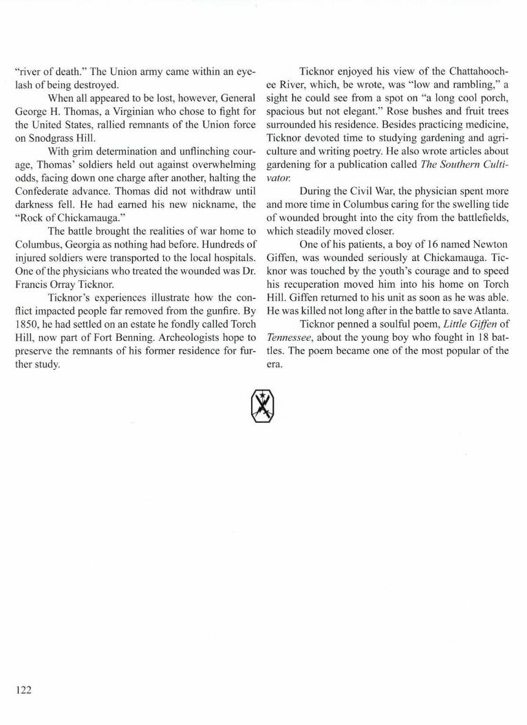
"river of death." The Union army came within an eyelash of being destroyed.
When all appeared to be lost, however, General George H. Thomas, a Virginian who chose to fight for the United States, rallied remnants of the Union force on Snodgrass Hill.
With grim determination and unflinching courage, Thomas' soldiers held out against overwhelming odds, facing down one charge after another, halting the Confederate advance. Thomas did not withdraw until darkness fell. He had earned his new nickname, the "Rock of Chickamauga."
The battle brought the realities of war home to Columbus, Georgia as nothing had before. Hundreds of injured soldiers were transported to the local hospitals. One of the physicians who treated the wounded was Dr. Francis Orray Ticknor.
Ticknor's experiences illustrate how the conflict impacted people far removed from the gunfire. By 1850, he had settled on an estate he fondly called Torch Hill, now part of Fort Benning. Archeologists hope to preserve the remnants of his former residence for further study.
122
Ticknor enjoyed his view of the Chattahoochee River, which, be wrote, was "low and rambling," a sight he could see from a spot on "a long cool porch, spacious but not elegant." Rose bushes and fruit trees surrounded his residence. Besides practicing medicine, Ticknor devoted time to studying gardening and agriculture and writing poetry. He also wrote articles about gardening for a publication called The Southern Cultivator.
During the Civil War, the physician spent more and more time in Columbus caring for the swelling tide of wounded brought into the city from the battlefields, which steadily moved closer.
One of his patients, a boy of 16 named Newton Giffen, was wounded seriously at Chickamauga. Ticknor was touched by the youth's courage and to speed his recuperation moved him into his home on Torch Hill. Giffen returned to his unit as soon as he was able. He was killed not long after in the battle to save Atlanta.
Ticknor penned a soulful poem, Little Giffen of Tennessee, about the young boy who fought in 18 battles. The poem became one of the most popular of the era.

15-Hard Times
For most in the rural South, life turned harsher during the Civil War. Thousands of men left to fight, and for those left behind the departures frequently spawned hardship. Residents of plantations generally suffered the least direct ramifications. While the absence of young males created emotional vacuums, daily operations usually continued much as before because of slave labor. On small farms, however, the loss of one man was often a devastating blow. Running a small farm was always a struggle, but without able-bodied men to help, wives, children, and other family members often had more than they could do to get crops planted and harvested and tend to basic upkeep and chores.
A farm wife 's letter to her husband, a Confederate soldier stationed in Florida, expressed the plight of many: "I have no com, nor no meal , nor any way of getting of it...I want you to send sum com soon or fetch it" She pleaded, "Let your captain read this."
The elation stirred by early battlefield victories ebbed as casualty lists lengthened, with nearly everyone suffering the death of a family member or friend in the war. People in the Fort Benning area also faced increasing challenges because of the tightening Union naval blockade of the port of Apalachicola, Florida.
At first, the blockade attempt to cut off the flow of goods to and from the South was largely inconsequential because there were too few ships available to guard a huge area. The Union navy had only 42 vessels to patrol some 3,500 miles of Confederate coast from Virginia to the Rio Grande River in Texas, according to historian Maxine Turner. For a time, growers continued to send cotton 300 miles from Columbus down the Chattahoochee River, into the Apalachicola River, and then to the harbor at Apalachicola. There the bales were unloaded from the river steamboats and hoisted onto oceangoing sailing vessels- the blockade runners.
One of the Union's first strategies to bottle up shipping along the Gulf Coast was to station blockade
vessels near Apalachicola, chosen for its commercial significance. Two Union naval vessels appeared off Apalachicola within two months of the first cannon fire in April 1861 at Fort Sumter near Charleston, South Carolina. But the ships were ill-chosen for the task. They had deep hulls for stability in stormy seas, making them too big to navigate safely into the shallows of Apalachicola Bay. They were forced to hug close to islands ringing the bay- St. Vincent 's, St. George 's, and
Figure 83: A Confederate cavalryman, armed with a shotgun and a Bowie knife, had hi s canteen strapped to his side fo r times when water was scarce.
Dog Islands. The islands, however, gave an advantage to the Union because they formed a partial barrier to blockade runners. Ships had to pass through channels leading from the Gulf of Mexico between the islands or between one of the islands and the main land to leave or
123

enter Apalachicola's port. Early attempts by both Union and Confederate forces to control the port of Apalachicola were ineffectual, bordering on the comical.
For the Union, the effort started auspiciously enough. Within 100 days of arriving in the area, Union patrols captured their first quarry. On August 26, 1861, sailors lowered five small boats from the two Union blockade ships and headed into Apalachicola harbor where they seized a suspected blockade runner, the oceangoing vessel, the Finland.
The sailors worked all night to prepare the ship for towing out of the harbor and into the custody of the Union blockade ships. Finally, at dawn, they began towing the Finland into the bay. But the sailors, unfamiliar with the area and battling unfavorable winds and tides, soon ran the ship aground on a sand bar adjacent to St. Vincent's Island. The Finland was stranded like a beached whale about four miles from the protection of the nearest Union blockade ship, anchored in deeper water.
F9rty Union sailors remained with the Finland, trying to float it free . Again they worked feverishly throughout the night. As the sun rose, they noticed a steam boat, towing an ocean-sailing schooner, apparently heading into Apalachicola's port. Suddenly, the steamer switched directions, sailing straight for the Finland and the Union sailors trying to free the ship. The sailors soon realized that both the steamboat and the trailing schooner were Confederate vessels. Nine local militia members, armed with rifles, stood aboard the schooner, poised and ready to fire.
The unprotected Union sailors had no choice but to flee. The big guns of the blockade ships were too far away to help, and their captains couldn't risk sailing into the shallows. The Union sailors set the Finland on fire before scrambling into their boats, with the Confederate militia shooting at them. The sounds of gunfire ricocheted across the bay as the Union sailors rowed furiously away.
The Finland was engulfed in flames by the time the Confederates stormed ashore. Some of the soldiers braved the heat and fire to recover lifeboats and a few other items, but the vessel and nearly everything aboard was burned. Soon, all that was left was a charred husk. The Union sailors escaped without a single casualty. Damaged pride was their only wound.
The Confederates suffered an even worse debacle of ineptitude. A group of militia stationed in
124
Apalachicola decided they should evacuate, fearing that if they stayed the Union blockade ships might attempt to bombard the town with cannon fire.
The militia crowded onto a flat-bottom boat and used poles to push into the Apalachicola River, intending to travel upstream only a short distance. Everything went according to plan until the boat reached midstream where the soldiers discovered the poles were too short to reach bottom. They could no longer control the boat, which began to float aimlessly in the current. Gradually they moved out into the bay, straight toward waiting Union blockaders. Shamefaced , the militia surrendered without firing a shot.
Apart from these incidents, for most of 1861, Confederate shipping along the Gulf Coast continued largely unimpeded. Union forces had only seven ships to patrol 1,300 miles of Florida. They captured only nine boats the first year of the war.
The blockade gradually tightened, however, as the United States steadily added more ships to the effort. Union forces also replaced the original blockaders on the outskirts of Apalachicola with ships easier to maneuver and equipped with more firepower. Union navy officers also learned bow to deploy smaller boats capable of moving around in the shallow bay while the large blockade ships remained on the perimeter.
The strategy began to pay off by late 1861 when more blockade runners were captured, leading to fewer attempts by others to enter or leave Apalachicola's port. Clearly, the blockade was beginning to pinch. Some blockade runners continued to outfox the Union navy by hiding in the deep tributaries feeding the Apalachicola River north of the town. Others anchored west of Apalachicola along a less frequented portion of the Florida coast. They could skirt Union patrols more easily this way and get supplies to the town by a roundabout route. The cargo was carried over land by wagon, traveling north to a landing on the Apalachicola River near the Georgia border. From there, the cargo was loaded on a steamboat and hauled south some 90 miles to Apalachicola. Cotton stored in Apalachicola was sent back by the same circular and costly route to reach oceangoing vessels.
Eventually, some Confederate officials began losing interest in guarding Apalachicola from a possible Union attack. The blockade had diminished the port's

importance. And there were just too many other places where Confederate leaders thought their soldiers were needed more desperately. Troops abandoned fortifications on St. Vincent 's and St. George's Islands first and then left Apalachicola altogether.
The departing Confederate troops left behind a skeleton population of about 500 in the once bustling town. These residents lived in a nether world. Many were supporters of the Confederate cause. Nonetheless, they were loosely ruled by the United States ' navy, whose ships were stationed off the coast and whose officers and sailors periodically visited Apalachicola. Most stores and other businesses closed.
·--· ··-:-r . , . uk .· -~ Uk ' -,
••~ ... C.r··,. 0 • ··l , /'VIC1UJIXIJ . . ' : : . . . t' ! \
S.C. . . .. I'' .. .
~r~~ ! ·y~ \, .( ) GEORGIA ! ... '/\ .. f.~::::~~~. . .... \ \ . / ~ >-~ola ~ ( ria- .z"-....
' '.9·~. • • ~ F L 0 RI DA 1 Apalachicola "'!
Figure 84: There was a tug of war between the Union and Confederates over Apalachicola.
By 1862, Columbus authorities grew increasingly nervous that the Union navy would dispatch a force of boats up river to invade their city. To defend against that possibility, the Confederate military sank obstructions in the Apalachicola River north of Apalachicola. This had the dual effect of limiting the possibility of an invasion and preventing any boats from traveling south to Apalachicola, unless the water was exceptionally high. Increasingly, steamboats paddled south only as far as the town of Chattahoochee, Florida, near the Georgia border, and then made a U-tum,
heading either up the Flint River toward Albany, Georgia or back up the Chattahoochee River toward Columbus.
The steamboats, most commandeered by the Confederate government, still carried cotton as they bad before the war, but now often carried the bales north toward Columbus. Eventually, nearly all cotton grown in the Fort Benning area ended up in Columbus mills where it was woven into cloth and fashioned into garments for the Confederate army.
Farmers and plantation owners still considered cotton an essential crop, although less important than before the war. Now they grew more com and other produce to feed the seemingly insatiable hunger of the Confederate army. Some planted sweet potatoes and peanuts between com rows to increase the yields of every acre. They also planted more land in wheat. Farmers sent their crops by steamboat or wagon to Columbus where the produce was shipped by rail north to the troops. Turpentine, made from tree sap collected in the Fort Benning area, also rarely went south by steamboat anymore . Instead, the turpentine stayed in Columbus for use by local industries. The Fort Benning area, particularly Russell County, Alabama, served as a major supplier of timber, especially important to the naval ship building industry which became important in Columbus .
Steamboats that formerly transported society 's most affluent passengers in well-appointed cabins often became troop carriers. Some of the soldiers traveled to the site of old Fort Mitchell, which became an early training center for Confederate forces. Steamboats also shuttled manufacturing supplies and equipment back and forth between Columbus and small production centers at Eufaula, Alabama and Saffold, Georgia, both south of Fort Benning. Columbus had become an industrial dynamo, the second most prolific producer of clothes, after Richmond, Virginia, in the entire Confederacy. Eagle Mill , the largest facility in the area, produced some 17 ,000 yards of cloth per day. Columbus also produced more shoes than any other city in the South and was the largest manufacturer of swords.
Columbus plants also manufactured army uniforms, rain gear, hats, gun cartridges, pistols, rifles, artillery sh el ls, cannons, and other equipment and supplies in massive quantities for the Confederate army. Many of
125

the factory workers were farmers who once lived in rural areas nearby. Perhaps half the work force , however, was made up of slaves.
There were other changes altering life all along the Chattahoochee. Because of the blockade, everyone, even wealthy planters, had to economize and scrimp on purchases once considered commonplace. Prices skyrocketed for scarce goods such as coffee, sugar, and salt. Luxury items became virtually unavailable. Before the war, steamboats carried imported cigars, brandy,
Benning was dramatic. Hard currency grew scarce. Customers who once bought clothes from local merchants now sewed their own. They learned to mix fabric dyes from materials close at hand- using poke berries to produce red, hickory tree bark for green, and walnut hulls for brown. Like the Indians before them, people were using more wild plants to concoct homemade medicines and other essentials. Seeds from dogwood trees, containing chemicals similar to those in quinine, became medicines for quelling fevers . Corn cob ash
Figure 85: Eagle Mill and other industries helped make Columbus the second leading clothes manu facturing center in the South during the Civil War. Farmers left the land to work in the booming businesses, which supplied goods to Confederate soldiers.
and rich fabrics north from Apalachicola. Eventually, only salt, packaged in Florida, and a few other items came from that far south. Salt was critical for preserving meat, both for local residents and the armies, in the days before refrigeration.
For farmers, the struggle to survive became increasingly hard, and the blockade was not the only cause. Taxes rose, as the war grew more costly. The impact of rising taxes, higher prices, and widespread shortages on the area that eventually became Fort
126
was transformed into bicarbonate of soda, and wood ash, mixed with lard, became homemade soap.
Women on plantations organized work parties where they darned socks and made other garments for the troops . There were also countless charity drives to collect spare metal, from belt buckles to church bells, to supply Columbus industries.
A common assumption often repeated was that life along the Chattahoochee would improve dramatically for everyone if only the blockade of Apalachicola

could be broken. There were two serious attempts. The first came m 1863 and depended upon the new gun ship, the Chattahoochee.
The vessel was a novelty on the river. Built mostly at Saffold, Georgia, a landing in Early County more than 100 miles south of Columbus, the Chattahoochee was a steamboat with sails that could be raised on three different masts. Built for the open seas, the steamboat's masts and sails fo lded away out of sight so that the vessel could serve as a hard-to-spot blockade runner
Apalachicola bay and attack the Union ships blockading the harbor.
The boat traveled about 28 miles, reaching deep into the Florida panhandle, more than a third of the distance from the Georgia border to Apalachicola. Then it encountered shallow water at Blountstown Bar. Guthrie issued the order to drop anchor. They would wait in place through the night in hopes that by morning the river would rise enough to allow them to continue.
Figure 86: Union soldiers destroyed factories and any other means the South might have to fuel the war. This Harper's Weekly illustration from 1862 depicts Union soldiers ra iding a salt factory.
Unlike traditional steamboats propelled by a large water wheel, the Chattahoochee had two propellers and two separate engines to drive them. About 130 feet long, the steamboat was also heavi ly armed with six cannons.
Confederate Lieutenant John Julius Guthrie was in command when the big boat steamed south into Florida. It was May 26, 1863 .
Guthrie hoped that the river was high enough from winter and spring rains for the vessel to float safely over the obstructions deliberately placed in the water earlier by the Confederate military. If he could get by the obstacles, Guthrie planned to steam boldly into
But morning brought no help. The Chattahoochee would have to wait until conditions improved and try another time. A discouraged Guthrie told his crew to prepare to depart. They would weigh anchor, then tum around and head back up river. The captain issued the final order to leave at about ten in the morning.
Crew members in the engine room began arguing about how much water was still in the boilers that supplied steam to power the engines. A temperature gauge had been malfunctioning since the day before and apparently was one source of the dispute. The chief engineer, Henry Fagan, was in bed, suffering from a
127

fever. A man with plenty of river experience, he sensed something was wrong because the big engines were taking too long to kick into action.
Fagan apparently heard the argument between crewmen and hurried to the engine room to investigate. About the same time, the ship's pilot, William Bilbro, apparently fired up the small engine that pumped water into the boilers.
Just as Fagan, the chief engineer, began descending the stairs into the engine room, fresh water began pouring into the boilers. Without warning, there was a massive explosion. Both Fagan and Bilbro were killed, along with a number of others.
Pandemonium erupted as sailors ran this way and that, some hideously scalded by the hot water. There were groans of pain and shouts that the ship 's magazine, a storage room for large amounts of ammunition, would likely explode. Sailors leaped over board trying to escape the expected blast and frantically swam for shore. In the panic, three drowned.
The ship's doctor moved quickly along the deck, attending the wounded. Guthrie, the captain, was also active on the deck, administering baptism to the dying when the boat began to sink.
128
He ordered sailors to flood the magazine to prevent an explosion. Then he commanded everyone to abandon ship.
The crew worked furiously to ferry the dead, the dying, and the injured across the river and onto shore. Bodies and injured men were strewn out on the river bank as if a deadly tide had washed them ashore. Storm clouds started pelting the survivors with rain, and the injured, some writhing in pain, spent hours lying in the mud. Finally, about midnight, more than 12 hours after the accident, the steamship William H. Young arrived to begin transporting victims. Some of the injured, however, weren 't picked up until the next day, almost 24 hours after the accident, during which rain continued to fall virtually nonstop. It took five days before the victims reached Columbus and better medical treatment, according to historian Maxine Turner.
The disaster weighed heavily on people living along the river as the news spread and funerals were held. In all, 18 sailors died. Most of the ship officers were killed or wounded.
All plans to attack the blockaders, who were squeezing the flow of goods into the area like a tourniquet, were put on hold.

16-Word Comes Too Late
I n the wake of the explosion aboard the gunboat Chattahoochee, attention along the river returned to the battlefields inching closer to Columbus. In September 1863, there was the fight at Chickamauga in north Georgia where Henry Benning displayed so much valor.
Despite the engagement's many casualties, people near the Chattahoochee River and elsewhere in the South considered Chickamauga a triumph because Union soldiers were forced to retreat, Many thought that the Confederacy was again headed toward victory. Southern forces, for a brief while, held the heights around the strategic city of Chattanooga. Tennessee, with an entire Union army pinned down inside. Then in November 1863, soldiers led by General Ulysses S. Grant, after fierce fighting, shoved Confederate troops off the peaks of Lookout Mountain and Missionary Ridge overlooking Chattanooga. The Union was now firmly in control of the area, opening a gateway into Georgia. It was just a matter of time before General William Tecumseh Sherman would launch an invasion into the deep South.
In the interim, there was still talk along the Chattahoochee River of prying loose the blockade's grip. By the winter of 1863, hope centered on two Confederate navy ships, both undergoing work in Columbus. One was the old gun ship Chattahoochee, resurrected from its watery grave after the boiler explosion and towed to Columbus for reconstruction.
An even more menacing ship was being built from scratch. First called the Muscogee, and later renamed the Jackson, the vessel was unlike any ever seen in the region. The Jackson would be a floating fortress that could conceivably alter the entire strategic balance along the river. More than 200 feet long, the ship was covered above the waterline in iron four inches thick. When completed, the Jackson would boast six, possibly eight, heavy guns. The armor and weapons would make the vessel virtually impregnable to any
known weapons, except bad luck and poor timing. Lieutenant Augustus McLaughlin and Chief
Engineer James Warner supervised construction of the two ships and the machinery to propel them. Their work at the Columbus Naval Yard and nearby Naval Iron Works (now the location of the Columbus Trade and Convention Center) became increasingly vital to Confederate naval operations as Union forces drove deeper into the South, capturing key ports and construction sites. As the war neared the end, McLaughlin and Warner proved to be adept improvisers, masters of efficiency, and skilled administrators, battling government bureaucracy and fighting for scarce supplies.
In the words of historian Maxine Turner, McLaughlin and Warner "wrought a miracle, not of military strategy or naval design, but of management." They were helped by some highly skilled contractors, including Horace King, a former slave and respected bridge builder, granted his freedom by a special act of the Alabama legislature.
The ironclad Jackson, after about a year of round-the-clock work, was ready for launching in the Chattahoochee by December 1863. All that was required was higher water. Hopes soared on New Year's Day, 1864 as the river crept upward, then rose rapidly. The water climbed ten feet over night, ascending so high that there was concern it might sweep away some of the dams and equipment funneling water into local mills. Worried managers shut the cotton mills until they were sure the river had crested.
The river rose so fast that it quickly submerged blocks holding the Jackson in a construction frame, preventing workers from removing them to allow the ship to float free. The only option was to wait and hope that the river rose enough to lift the boat up and out of the frame.
And the water did continue to rise, and part of the
129
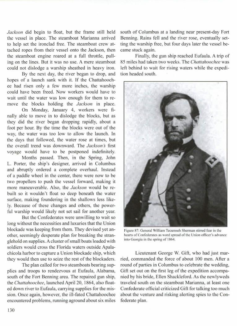
Jackson did begin to float, but the frame still held the vessel in place. The steamboat Marianna arrived to help set the ironclad free. The steamboat crew attached ropes from their vessel onto the Jackson, then the steamboat engine roared at a full throttle, pulling on the lines. But it was no use. A mere steamboat could not dislodge a warship sheathed in heavy iron.
By the next day, the river began to drop, and hopes of a launch sank with it. If the Chattahoochee had risen only a few more inches, the warship could have been freed. Now workers would have to wait until the water was low enough for them to remove the blocks holding the Jackson in place.
On Monday, January 4, workers were finally able to move in to dislodge the blocks, but as they did the river began dropping rapidly, about a foot per hour. By the time the blocks were out of the way, the water was too low to allow the launch. In the days that followed, the water rose at times, but the overall trend was downward. The Jackson s first voyage would have to be postponed indefinitely.
Months passed. Then, in the Spring, John L. Porter, the ship 's designer, arrived in Columbus and abruptly ordered a complete overhaul. Instead of a paddle wheel in the center, there were now to be two propellers to push the vessel forward, making it more maneuverable. Also, the Jackson would be rebuilt so it wouldn 't float so deep beneath the water surface, making foundering in the shallows less likely. Because of these changes and others, the powerful warship would likely not set sail for another year.
But the Confederates were unwilling to wait so long without the necessities and luxuries that the Union blockade was keeping from them. They devised yet another, seemingly desperate plan for breaking the stranglehold on supplies. A cluster of small boats loaded with soldiers would cross the Florida waters outside Apalachicola harbor to capture a Union blockade ship, which they would then use to seize the rest of the blockaders.
The plan called for two steamboats bearing supplies and troops to rendezvous at Eufaula, Alabama, south of the Fort Benning area. The repaired gun ship, the Chattahoochee, launched April 20, 1864, also floated down river to Eufaula, carrying supplies for the mission. Once again, however, the ill-fated Chattahoochee encountered problems, running aground about six miles
130
south of Columbus at a landing near present-day Fort Benning. Rains fell and the river rose, eventually setting the warship free, but four days later the vessel became stuck again.
Finally, the gun ship reached Eufaula. A trip of 85 miles had taken two weeks. The Chattahoochee was left behind to wait for rising waters while the expedition headed south.
Figure 87: General William Tecumseh Shemian stirred fear in the hearts of Confederates as word spread of the Union officer 's advance into Georgia in the spring of 1864.
Lieutenant George W. Gift, who had just married, commanded the force of about 100 men. After a round of parties in Columbus to celebrate the wedding, Gift set out on the first leg of the expedition accompanied by his bride, Ellen Shackleford. As the newlyweds traveled south on the steamboat Marianna, at least one Confederate official criticized Gift for talking too much about the venture and risking alerting spies to the Confederate plan.

The Marianna halted briefly at Saffold, Georgia, near the Florida border, to allow Mrs. Gift to disembark so she could travel to her nearby plantation home, "The Pines." Back underway, Gift wrote his wife:
"I felt lonely last night. I retired early, and the little room seemed a vast and desolate waste. There was no Ellen to welcome me, as she did on our honeymoon trip .... But won't we be blithe and gay when I return? Won 't I tell of the hairbreadth escapes by land and sea, won't I build castles in the air?"
Gift and his soldiers crowded onto seven small boats for the final passage to Apalachicola. Near the town, they waited until nightfall before crossing the open bay to reach St. George's Island. There they hid the boats and camped, waiting for ideal conditions to launch their attack- a pitch-black night with rough seas to shield their moves. Shrouded in darkness, they planned to sneak up on the Union blockade ship, the Adela, and then use it to force the surrender of the other blockade vessel, the Somerset.
But the dark, rolling seas they hoped for never materialized until it was too late. Midshipman J.T. Scharf, later recalled, "The sea was smooth and the dipping of the oars in the phosphorescent water emitted a luminous light which shone brightly some distance beyond."
Gift and his soldiers waited and waited. Almost a week passed. Their food was running short until scouts brought supplies from Apalachicola- and bad news. Union blockaders knew about their plans to attack. Gift decided they should all escape while they could.
Late on the night of May 12, 1864, the seven boats shoved off from the island. As luck would have it, the hoped-for rough seas arrived as they set sail. The wind picked up rapidly and began churning the waves . The Confederates split their forces, perhaps to increase the likelihood of survival. Gift's boat, with 17 aboard, and another boat, carrying ten men, charted a course straight for Apalachicola, across the open water. The other boats hugged the shore, taking the longer, but safer route around St. George's sound until they reached the mainland.
Gift's decision to brave the wide expanse of water between St. George 's Island and Apalachicola proved unfortunate. Blustery winds bowled in from the north, and the waves grew taller and angrier. Minutes turned into hours as the two small boats battled the
ferocious wind and waves. The smallest boat took on so much water that it sank. Cast into the raging sea, the ten soldiers swam for Gift 's boat. Every man somehow reached the vessel and clung to its sides.
Amid the wildly tumbling and tossing waves, Gift became seriously ill. He was so sick that he was unable to function and relinquished command to midshipman J. T. Scharf.
The craft, carrying 1 7 passengers and with ten others in the water desperately holding on, took on a dangerous amount of water. As Scharf later recalled, "The boat was about two miles from shore and all expected every moment would be the last."
Scharf reasoned that their only hope of survival was to tum the boat and ride with the waves, with the squall at their backs. Shouting across the storm noise, he told Gift of his plans. Gift, still terribly sick, shouted back that Scharf should do whatever he thought best.
Scharf ordered the men to toss overboard any extra weight they could possibly spare. Guns, ammunition, water casks, lanterns, and other supplies were thrown into the sea. Then the men prepared to tum the ship sideways before the raging waves.
Before they turned the boat, however, something had to be done about the men banging onto the sides. Six were so exhausted that they might loosen their grip and drown. Soldiers in the boat grabbed the six who were the weakest and pulled them inside. That left four others still in the water.
Scharf shouted orders, and the crew began turning the craft. They plunged into a deep valley of water, then a huge wave rolled underneath the boat, nearly lifting it out of the ocean. Somehow, when they were most vulnerable, they didn't capsize. The crew successfully maneuvered the boat around to ride the waves straight toward St. George 's Island. But they were not out of danger. The boat, weighed down by so many men, was barely afloat, yet the soldiers still in the water couldn 't last much longer. Fearing they would drown, Scharf decided to risk the extra weight and hoist them inside.
The men crouched helplessly in the boat as the waves pushed them faster and faster toward shore. Then they heard a fearful sound above the storm 's noise, the sound of waves crashing against the beach. The terrible force of the water would surely smash their small craft to bits. They had no choice but to abandon ship. Everyone dove into the water and began to swim.
131

The rest of the expedition force, between 70 and 80 soldiers, eventually reached Apalachicola. Greeted by friendly residents, they delayed their departure by about 24 hours, waiting for Gift and the rest of the men to appear. They were preparing their boats to leave at dawn on May 13 when a Union raiding party from one of the blockade ships approached the harbor and spotted them.
The Confederate soldiers had no choice but to flee. Abandoning their boats and all supplies, keeping only their rifles, they ran wildly through Apalachicola streets, trying to get away. The Union sailors fired at least two rounds at the fleeing Confederates, but hit none of them, and, apparently, none of the town civilians either.
Thinking they were out of harm's way, the Confederates slowed their pace and walked north of the town along a road paralleling the Apalachicola River where they headed almost directly into the path of another Union landing party. But their luck held, and once again they managed to escape. In the early morning light, the Union lieutenant heading the landing party mistook the Confederates for Union troops and allowed them to pass unchallenged. By the time Union forces realized they had let the enemy slip away, the Confederates had plunged into a nearby swamp and were running for cover in the thick underbrush. The Union soldiers pursued, but after splashing and slashing their way through the thick vegetation for about two miles gave up the chase.
Back on St. George 's Island, all 27 men in the group commanded by Gift and Scharf managed to swim safely ashore. As the storm ended, they faced the grim reality of surviving on the deserted island without the food and fresh water they had thrown overboard. They scavenged about and found palmetto cabbage and oysters and also killed and ate at least one alligator. Finally, after they hid for two days on the island, sympathizers from Apalachicola found them and ferried them across to the town.
From Apalachicola, Gift and his soldiers traveled up river a short distance, then sunk their boat in a bayou and walked the rest of the way to safety. The entire doomed effort resulted in no deaths, but four men were captured by Union forces, although one claimed he had actually deserted. ThreeApalachicolasympathizers, who scouted for the expedition, also fell into Union hands.
Though chances of ever breaking the blockade
132
now seemed minuscule, some Confederates still placed their hopes on the ironclad warship, the Jackson. Work on the vessel continued in Columbus at a furious pace, but time was running out. Within days of the failed expedition to Apalachicola, frightening news spread throughout the region on May 15, 1864- the town of Dalton in northwest Georgia was being evacuated. General William Tecumseh Sherman's troops had begun their drive toward Atlanta. Ten days earlier, Grant had launched his campaign against General Robert E. Lee 's army. In the almost impenetrable wilderness of Virginia, the two armies grappled, confusion rampant on both sides. Henry Benning, shot in the shoulder, was among the many wounded.
Combat resumed a few days later at Spottsylvania Court House as Lee continued his skillful maneuvers and Grant relentlessly hammered away at his foe. Then at Cold Harbor in early June the battle dissolved into brutal trench warfare, a precursor of what was to come in World War I. The combat degenerated into the costliest and most futile engagement of the war as Grant launched attacks across the entire length of Lee 's army. Waves of Union troops swarmed toward the Confederate trenches.
So many bullets flew that they seemed like swarming insects, making it nearly impossible to avoid being shot. Cannon fire was also incessant, sending showers of dirt and hot metal everywhere. Union soldiers, sure they were about to die, pinned pieces of paper on their backs with their names and addresses in hope that their corpses would be identified. Eight to 9,000 men were killed in only a few hours.
For ten days, the trench warfare continued. Many of the wounded, stranded in the noman 's land between the lines, died of thirst, starvation, infection, and loss of blood. At night, soldiers in the trenches helplessly listened to their moans.
Lee 's anny suffered about 30,000 casualties in one month, while Grant lost some 60,000 soldiers. Grant, however, continued to receive replacements, while Lee did not. As the two armies settled into nine months of siege warfare around Petersburg, Virginia, the Confederate army was running short of both men and supplies. Many of the Confederates ' uniforms were in tatters, with the men patching together outfits with garments taken from killed Union foes. More than a few were barefoot.

Sherman, meanwhile, continued his methodical march through Georgia, burning nearly everything in his path that might help the South prolong the war. By September, Atlanta had fallen. By Christmas, Savannah was under Union control.
The next year brought more bad news for the Confederacy. By April 1865, Grant's army had grown to more than 100,000 strong, while Lee's had shrunk to about 30,000. The Confederates abandoned Petersburg and Richmond, trying to escape the vise tightening
Lee, flawlessly outfitted in a new, fulldress uniform, continued his slow ride on his horse Traveler back through his own troops. Historian Douglas Southall Freeman described the scene:
"On any other day, even a glimpse of him on a battlefield in that martial garb would have sent the rebel yell running through the ranks .... Now, it was different. Dignity and loftiness remained on his countenance but anguish was deeply cut in the angles of his mouth. He, supreme master of his emotions, was battling with tears.
Figure 88: The Col umbus Navy Yard, depicted in an 1865 drawing, made the city an inevitable target for Union forces, who stormed across the Chattahoochee Ri ver on Easter Sunday in 1865, unaware that the war was over.
around them. The army was starving, going without sleep for days at a time, yet continued to fight. Henry Benning, recovered from his wounds, had resumed command.
Finally, with the enemy to his front and rear, Lee concluded that to continue the struggle was hopeless. He surrendered to Grant April 9 at Appomattox Courthouse in Virginia. As the defeated general rode back to his lines, a cheer of triumph began spreading through the Union ranks, but Grant hurriedly ordered silence.
"Each soldier seemed to have the same question in his throat: 'General, are we surrendered, are we surrendered? ' His face gave the answer, but they followed him and thronged him and tried to touch him. This man at his side wept unabashed. Starving soldiers seemed to feel more acutely his distress than their own. Sensitive boys choked as they sought to comfort him. The defiant shouted that if he said the word, they would 'go after them again.'"
The formal laying down of arms for most troops
133

took place several days later, on April 12, signaling the final dissolution of Lee 's army. The rain, falling virtually nonstop since Lee 's surrender, finally stopped, but the sky was still heavily overcast, and there was a chill in the air. The long line of Confederate soldiers marched down a hill on a road leading up to and between formations of Union soldiers. In their muddy boots and disheveled uniforms, the Confederates moved forward . There was a deathly silence.
Leading them on horseback was General John B. Gordon. Georgia born, Gordon gained renown early in the war for his courage and the valor of the Alabama soldiers he led.
Gordon sat erectly in the saddle, his chin on his breast, eyes downcast. When the Confederate reached the Union general in command, Joshua Chamberlain, Gordon stiffened. As he turned his horse to face Chamberlain, he brought down his sword in salute.
Chamberlain later recalled the moment, "On our part not a sound of trumpet more, nor roll of drum; not a cheer, nor word, nor whisper of vain-glorying ... but an awed silence rather, and breath-holding, as if it were the passing of the dead."
The Confederates then passed by, unit after unit, and stacked their rifles and other arms. Sergeants in charge of the colors folded regimental flags and also piled them on the ground. On and on, the Confederates came, laying down their weapons. Henry Benning, near the end of the long procession, was among the last to surrender.
The war was over. Or, at least it should have been. Because of poor communications, word didn 't reach Columbus about the surrender until there was another battle right in the city, the last major Civil War clash east of the Mississippi River.
Leading up to the battle in Columbus was the arrival in Alabama of 13,000 cavalry soldiers led by Union Major General James Wilson. Wilson overwhelmed forces commanded by Confederate General Nathan Bedford Forrest who were defending the manufacturing town of Selma. The Union troops next advanced on Montgomery, Alabama, which surrendered without a shot being fired because it had no defenses. After a briefrest, the cavalry rode on toward Columbus.
Compared to Wilson's 13,000 men, there were only about 3,000 soldiers to defend Columbus, and they were woefully inadequate. Many were factory workers who served as part-time militia, their only training
134
cons1stmg of Saturday drills. A number had been summoned to help defend Atlanta and Savannah from Sherman, but they couldn't by any measure be called experienced troops.
Others ready to defend Columbus were either men too old for regular military service or boys deemed too young to leave home. There was also a smattering of regular troops on hand, but from the beginning, the battle of Columbus was a hopeless mismatch.
As Wilson's cavalry thundered toward the Chattahoochee, some Columbus residents began evacuating. Walking and riding, they hurried away on roads leading east through land now part of Fort Benning. The roads became clogged with refugees, carrying a few hurriedly gathered possessions on their backs or in wagons, desperate to get away.
The Confederate forces decided to make a stand on the Alabama side of the river in the small community of Girard. Earlier called Sodom when Alabama was in habited by rough-hewn frontiersmen, Girard had become a small factory town. Many residents regularly crossed the river to work in Columbus. Eventually, Girard would be enveloped by Phoenix City.
The Confederates didn' t have enough soldiers to defend all three major bridges across the river so they concentrated their defenses around the center crossing, the covered Brodnax Street Bridge (later known as the 14th Street Bridge). They placed artillery pieces atop two hills guarding the approach to the bridge and dug trenches and erected fortifications to block access. The Confederates also stacked bales of cotton on the bridges spanning the river and soaked the cotton in highly flammable kerosene.
The Union cavalry galloped into the outskirts of Girard about two in the afternoon on Easter Sunday, April 16. They first tried to cross the bridge at Clapp 's Factory, about three miles north of Columbus, but as they approached, Confederates set the bridge on fire, destroying it.
Almost simultaneously, Union soldiers charged toward the lightly defended southernmost passageway, the Dillingham Street Bridge. But C. C. McGehee, a factory worker stationed on the Georgia side, torched the bridge, making it impassable as well.
Now, as the Confederates had hoped, the Union forces were lured into a confrontation with them around the approach to the Brodnax Bridge. The attack didn't

come immediately, however. First, Union officers scrambled to locate key personnel and organize the assault. Because it was late in the day, Wilson opted to attack after dark. The resulting battle is still studied today at Fort Benning as an example of what can go wrong in night combat.
It was pitch black by about eight that night, with no visible moon to provide light. About 300 Union soldiers from Iowa crept forward toward the Confederates ' outer defenses. When they were within about 50 yards, they were detected. The Confederates opened fire with
saw shelling during the night time. It is a beautiful , but awful spectacle."
The Union soldiers somehow reached the bridge, but seeing they were trapped wheeled their horses around and rode back through the Confederate positions to the relative safety of their own lines.
Other Union soldiers advanced more methodically, pushing toward the Confederate guns on one of the hills. Dense woods and muddy bogs hindered the advance, and in the darkness, the troops became disoriented. Some officers yelled that the troops should veer to the
Figure 89: The Spencer Carbine was a rapid-firing weapon that proved to be an enormous advantage fo r Union soldiers against the Confederate fo rces in the fin al stages of the Civil War.
rifles and artillery. In the darkness, however, the Confederate aim was too high and did little damage. Union forces were able to push the Southern defenders back.
Unable to see clearly what was happening, Union officers wrongly assumed their forces had opened a hole in the Confederate defenses and ordered a cavalry charge. Soldiers from Missouri, riding in four columns, galloped toward the bridge. They passed right through the Confederate defensive perimeter, which was still intact. The Confederate defenders allowed the Union cavalry to pass by, offering no opposition because they mistakenly assumed they were fellow Confederates. Now the Union cavalry was behind enemy lines and in danger of being surrounded and cut off from any support. Confederate cannon fire was aimed in their direction.
One of the Union soldiers later described what he saw: "All of a sudden there was a shot, another, and in a second 10,000 more. The whole country seemed to be alive with demons .. . the next second brought the balls of the enemy by thousands over our heads and the shells hurried their way in every direction, leaving a fiery streak behind them. This was the first time that I ever
left, while others ordered everyone to move to the right, leading to more confusion. Different companies of soldiers became inadvertently intertwined.
Nonetheless, the Union forces, veterans of previous campaigns, kept moving forward. The inexperienced Confederate defenders were already fleeing in complete disarray. Panic took hold, and many of them began running for the bridge in hopes of escaping the battle.
Tumult reined as both Confederates and Union forces crowded onto the covered bridge. There were no lights on the bridge, so seeing more than a few feet ahead was impossible. Foot soldiers, horsemen, artillery wagons, and ambulances were all jammed together inside the bridge, everyone straining to get to the other side. "How it was that many were not crushed to death in the tumultuous transit...seems incomprehensible," recalled one observer.
Confederate soldiers trained cannons on the bridge but decided not to tire to protect their comrades streaming across. The nightmare ended quickly. As soon as Union troops cleared the bridge, they spread out and began to secure strategic locations throughout Columbus. In all , the battle lasted about an hour.
135

Southern soldiers fled in all directions, many joining the desperate throngs crowding the roads out of town.
Fearing defeat, Confederate naval officers tried to move the ill-fated wooden warship, the Chattahoochee, out of Union reach on the day of the battle. They used a steamship to tow the boat south of the city, but it soon became obvious that the vessel would be captured. Sailors used ten barrels of kerosene to douse the Chattahoochee from stem to stern. They then lit slow fuses , abandoned ship, and headed out overland, trying to escape the oncoming Union army. The boat was meandering down river when it exploded into flames. A tower of light shot high against the night sky. The boat continued to drift down river, eventually sinking for the second time. It settled about 12 miles south of Columbus on the bottom of the river from which it took its name.
The next day, Union soldiers destroyed much of Columbus ' industrial might, burning mills, warehouses, and supplies, anything that could be used to support a war which no one in town yet realized was over.
The Union soldiers also set the
136
ironclad warship, the Jackson, ablaze. The massive fortress, more than 200 feet long, was in the water and just weeks from being ready for action. Burning with red-hot flames, the Jackson slowly drifted down river through what would become Fort Benning, one final testament to the war's destructiveness. The Jackson finally ran aground on a sand bar about 25 miles south of Columbus. The fire destroyed most of the ship down to the waterline.
Both the Jackson and the Chattahoochee remained submerged on Fort Benning property until the early 1960's. The U.S. Army Corps of Engineers, along with volunteer boat owners and divers, recovered major sections from both vessels and floated them to Columbus.
Participating in the salvage operations were soldiers from Fort Benning's 568th Engineer Battalion. Funding for the salvage efforts came from many sources, but was spearheaded by donations from the Woodruff family, heirs to Coca-Cola fortunes. Today the remains from both ship hulls are on display at the Confederate Naval Museum in Columbus.

17-Freedom's High Price
I f ever a region needed Reconstruction, it was the South after the Civi l War. So much was destroyed by invading Union soldiers, retreating Confederates, and simple neglect while everyone focused on the conflict. Many generations would come and go before the damage faded from view; bitterness and memories of the devastation would persist long after visible reminders disappeared.
Merely getting from one place to the next was often an ordeal. Roads were rutted and frequently impassible. Bridges had coll apsed or been .---="<=
burned. Rail roads, never in the best condition even before the war, were frequently out of service. Union troops had twisted the rails into knots or wrapped them around trees into pretzel shapes called "Sherman neckties" in honor of the conquering Union general.
On many fanns and plantations, fences were down and weeds overran un
tended fie lds. Buildings left standing by ~~W1~ Union forces showed the wear and tear of~ four years of neglect. Livestock was al l but
laboring for men who had once enslaved them. There was talk of free land- "40 acres and a mule"-from the United States government, but months passed and nothing materialized. Former slaves often crowded into shanty communities on the outskirts of towns, waiting for things to improve. Food was often in short supply, and many went hungry. Some resorted to stealing food.
Southern state legislatures, still controlled by
gone. But worst of all, tens of thousands of 1 ~~~::t.;~ men who once helped perform the everyday ~ tasks of rural life were never coming home.
The Civi l War, the bloodiest conflict ever in the United States, killed 670,000 men. Some 40,000 died from Georgia alone. Those who did return were often wounded, crippled, or sick. At best, they were exhausted and dispirited from their terrible defeat.
Planters and well -to-do farmers had also lost the forced free labor of slaves who Figure 90: ~former slav_e casting a, ballot as a free man was captured in a front page
. . 11lustrat1on m the magazine Harper s Weekly m 1867. Freedom came with a heavy price, suddenly found themselves adnft m an of- however, as some whites resorted to violence.
ten hostile environment. They were now free, but had no homes or
money and often few ski ll s beyond farm work. Many were understandably reluctant to continue
137

whites, sought to restrict blacks ' new freedoms through legislation. Typical laws limited voting rights and ordained that freed slaves could work only in the lowest paying jobs. Called "Black Codes," the laws also excluded them from owning guns, serving on juries, and testifying in trials against whites.
Racial tensions continued to mount. Ill will in Columbus rose ominously when black cavalry troops arrived to occupy the city and ensure federal law was obeyed. Black Union outfits had distinguished themselves during the war, but their presence stirred only deep resentment among many white Southerners, feelings that were sometimes reciprocated by the soldiers.
Things came to a head on February 12, 1866, when one of the black soldiers fired a rifle from an upstairs window of his Columbus barracks. Apparently, he had no specific target in mind, as long as the person was white. The bullet hit James Warner, shattering his leg. Warner was the engineer instrumental in Confederate naval construction of the Chattahoochee and Jackson.
The wound was so severe that doctors had to amputate, but their efforts proved futile , and Warner died sometime later. The white community was outraged and hungry for vengeance. Only careful negotiation between city officials and the United States military averted full-scale riots in Columbus. A shaky peace held, however, and the black soldiers were withdrawn.
In the face of a flood of Southern laws sanctioning racial discrimination, the United States Congress adopted the 14th amendment to the Constitution guaranteeing equal protection under the law. The amendment also required every state to allow black men to vote before the state could elect representatives to Congress. Federal troops supervised voter registration to guarantee compliance. Nearly all men, regardless of race, could vote, if they first swore allegiance to the United States, although some ex-Confederate soldiers and government officials were banned from balloting. Many other eligible white voters boycotted elections. Women did not win the right to vote until 1920 with the passage of the 19th amendment to the Constitution.
With the power of the federal government behind them, black men from the South for the first time ran for and were elected to state and national offices. In 1868, for example, Georgia elected 32 blacks out of a total of
138
216 representatives to the state legislature. Still, some Southerners refused to accept the
new equality with former slaves and hid behind hooded disguises to prey upon them. Some former Confederate military men, following the lead of Robert E. Lee, worked for peace. Others, however, such as John B. Gordon and Nathan Bedford Forrest, led efforts toterrorize blacks.
The tactics of the Ku Klux Klan and similar groups added a dark page to Southern history. Documentation of their activities is spotty because they enforced a code of secrecy, but there is strong evidence that the Klan went on rampages in many areas, beating and murdering blacks. Entire black communities fled their homes to escape the nighttime raids. Klan harassment was especially severe just before elections to scare the new voters away from the polls. Still, with the economy wrecked by the war, both blacks and whites were often forced to cooperate for survival. For blacks, this meant returning to the fields and the only life many had ever known. Some continued to work for former slave masters and grappled with the unfamiliar issue of how much they should be paid for their efforts.
For their part, planters worried about the dependability of workers who could come and go at will. Many tried a number of labor arrangements before setti ing on something satisfactory. Because of federal urging, many signed contracts with field hands. But rather than guaranteeing the workers would not be subjugated, as the government intended, some of the documents tied blacks to the land in arrangements similar to slavery.
Typically, a contract dictated that the worker couldn't leave the plantation for a year without the owner 's permission. The planter would supply food, housing, and clothing, as he did during slavery, only now he also paid a small salary.
For many planters, however, money was scarce. They had lost much of their wealth with the emancipation of slaves and collapse of the Confederate government, which had issued bonds and currency that were now worthless. A severe economic depression gripped the South, causing land prices to plummet.
Archeologists, lead by the husband and wife teams of Rita and Dan Elliott and Karen and Dean Wood, examined land records, census reports, and other public documents from Reconstruction to follow the lives of

some local landowners and form a clearer picture of what transpired in the period.
They learned, for example, that Joseph Lee became one of the wealthiest property owners in the northern portion of what became Fort Benning. In 1850, Lee owned land in Muscogee County valued at $2,000. He also had 23 slaves who apparently spent most of their time clearing land and making other improvements . In this early period, the farm produced only a small amount of com and oats, and there was about $900 worth of livestock. Only about 160 acres could be considered improved, probably plowed and planted. Lee also owned about 450 unimproved acres, probably uncleared fields and forests .
potatoes, and 500 bushels of peas and beans. Then war erupted, and his fortunes began to de
cline. Lee apparently retained about the same amount of land, but his personal worth plummeted to only $6,000 by 1870. Census figures show that in just ten years, much of his wealth, about $40,000 worth, had vanished. His improved acreage was cut in half. He grew fewer crops than before the war, and his overall production fell. His cotton harvest dropped from 120 bales to 56, and he produced only 4,000 bushels of com compared to 6,000 bushels earlier. He paid $3,000 in wages.
Things became so tenuous that Lee risked debt to keep his farm afloat. In 1873, he obtained a loan of almost $5,000 to buy provisions for his livestock and
Figure 91: Columbus rebounded quickly after the Civil War, with rebuilt industries and bridges shown in thi s 1868 sketch.
In the following ten years, Lee dramatically increased his wealth. By 1860, he owned 800 improved acres and 760 acres unimproved. The value of his property bad skyrocketed from $2,000 to $20,000, and his personal wealth was estimated at $46,000. Lee had also more than doubled his number of slaves. There were now 50 and most were old enough to work.
Lee reached his financial peak in the years just before the Civil War. By 1860, he was 44 years old, married, and had six children. His livestock was worth $4,000 compared with $900 just a decade earlier. Lee had also diversified his plantings- growing 120 bales of cotton, 6,000 bushels of com, 2,000 bushels of sweet
fertilizer and other supplies to plant the next crop. To secure the Joan, he pledged much of his land to the Columbus firm of Allen, Preer, and Illges.
Apparently, Lee's willingness to jeopardize his holdings paid off. He repaid the loan and kept his farm, but the strain at the age of 64 of so much debt may have also weakened him. He died less than two years later, sometime before December 1874. Despite his economic woes, Lee was still one of the most prosperous people in the area at the time of his death.
The Ritch family suffered even more setbacks because of the war, perhaps because they were not as prosperous as Lee before the conflict began when their
139

Figure 92 : Teaching slaves was outlawed throughout the South, but after the Civil War churches from Northern states and the U.S. Government's Freedmen 's Bureau sponsored schools for blacks.
property was valued at $7,325, and their personal estate was worth $20,000.
There were ten children in the family, four boys and six girls, listed in the 1860 census. The eldest son, Thomas, was 19, the only son old enough to join the Confederate army.
In the next census, in 1870, Thomas had disappeared from the family listing. Researchers suspect he was killed in battle. In addition to the personal grief family members apparently sustained, they also experienced drastic financial reversals. Their property lost about half its value in ten years and was now worth only $3, 700. The family's personal estate had dwindled to $2,600, down from $20,000. The 1870 census showed that the two eldest sons, John, 19, and James, 17, both worked on the family farm. Their father was 56 years old.
Ten years later, the 1880 census showed that the family survived the postwar economic crunch and managed to keep the farm. The two eldest sons bad moved away, and one of them, James, farmed 70 rented acres nearby. The youngest son, Edward, then 21, still lived at home, as did his six sisters, all between 30 and 40 years old. The sisters were unmarried, except for one.
140
In all likelihood, the women had few eligible men to consider as mates because so many were killed in the war.
By 1900, the two parents had died and the second oldest son, John, returned to manage the family farm. Living with him were five unmarried sisters, ranging from 47 to 59 years old, and a 30-year-old nephew.
Federal efforts to reconstruct the South waned and eventually ended as people in the North lost interest in the well-being of the former slaves and in spending any more money on the vanquished region. By 1876, Reconstruction was over, and all Federal troops withdrew.
State governments controlled by the Republican party, which included numerous black officials, were turned out of office and replaced by conservative governments dominated by whites. Southern state legislatures soon retracted most rights blacks had gained and instituted segregation. Blacks were relegated, with few exceptions, to society's lowest rungs. By custom or by law, they often were forced to accept the poorest paying jobs, attend inferior, part-time schools, and submit to an inferior social status.

Despite the immense obstacles they faced, there is evidence that some blacks were able to buy land in the Fort Benning area after Reconstruction. Little is known about most of these landowners. Two brothers, George and Washington Williams, originally from Virginia, bought land in 1878 in the northern portion of what became Fort Benning. Eventually their property was subdivided, but most of it continued to be owned by blacks until it became part of Fort Benning.
Isaiah P. Turner, another black, purchased property nearby in 1925. A widower, he lived with his daughter, Emma, and a five-year-old granddaughter, Pattie Turner could read and write, which, considering the limited schooling allowed many blacks, may have been relatively unusual. Census figures show that about 40 percent of the blacks at this time in Muscogee County were illiterate. Turner apparently farmed until he was 86. In 1940, be sold his property to the United States government as part of the pre-World War II expansion of Fort Benning.
The Cantey's were one of the early prominent black families in Russell County, Alabama and lived close to what is now Fort Benning. Former slaves, the Cantey family members achieved success as entrepreneurs and were responsible for establishing the first African American school in Russel 1 County. A descendant, Alma Thomas, gained world renown as an artist and is the subject of an exhibit at the Columbus Museum.
Gradually, in the years following the Civil War, a new system for organizing rural labor took bold in much of the South. Many owners of large tracts of land began parceling out acreage to tenants. The landowner usually provided a small house for his tenants. Sometimes he also supplied farm tools, animals, seeds, and fertilizer, everything necessary, except the labor, to plant and harvest a cotton crop. Called share cropping, this arrangement required tenants to pay the owner onethird to one-half of their harvest.
In other arrangements, the owner provided only the house and land, while the tenant was responsible for buying all supplies and equipment, as well as farm animals. The tenant agreed to pay a fixed rent in cash or a portion of the harvest.
Cotton continued to be the most important cash crop. Demand soared in the years immediately following the Civil War because of a worldwide shortage. Consequently, many farmers didn't diversify because
cotton brought the best price. Also, they continued to grow cotton because they could get credit by agreeing to repay loans with part of their next harvest. Lenders generally considered other crops too perishable to serve as loan security. Many farmers plunged deeper and deeper in debt, especially between 1873 and the l 890's when cotton prices stalled.
Low land prices and depressed economic conditions also led to much land speculation. Research by Dan and Rita Elliot and Karen and Dean Wood demonstrates that many parcels in the northwestern part of Fort Benning, near Upatoi Creek, changed hands frequently after the war. Many of the owners were from out of state.
Speculation was particularly rampant near the Muscogee Railroad that ran along the northern border of what later became the military reservation. This area also experienced a slight growth spurt after the Civil War as more people settled near the small towns of Upatoi and Box Springs close to the railroad.
Upatoi, in Muscogee County, was about 17 miles east of Columbus and in 1880 had a population of 20, a church, and a school. The community also had the luxury of daily mail service because of its location only about three fourths of a mile from the railroad.
By 1886, Upatoi's population rose to 150. There was now a mill for turning com into grist, a sawmill, three blacksmith shops, and a store. The owners of the gristmill and the store also worked for the railroad.
A group of Christian idealists selected land near Upatoi in 1896 for what they hoped would be a perfect community. Their attempt at establishing a utopia was sparked by a belief that the nation was sinking into moral decline. The founders believed that over-crowded cities and increasing industrialization were prime culprits for the downturn. They chose a thousand acres along Dozier Creek that overlapped what is today Fort Benning as the site of their community. They called the settlement Commonwealth because residents agreed to devote all labor to the common good.
People from around the nation migrated to Commonwealth, some from as far away as Spokane, Washington. The greatest number of settlers, however, came from North Carolina. The community grew sufficiently to merit its own post office, but eventually the effort collapsed. By 1901 , Commonwealth had disbanded. The post office was transferred to the town of Upatoi.
141

Other residents of the sand hills continued to struggle with erosion. There was little incentive for tenant farmers to care about preserving precious top soils on land they didn't own. Few practiced soil conservation, and this lapse, coupled with dependence on cotton, which robbed the earth of nutrients, led to low yields and poor soils.
The higher elevations were often crisscrossed with gullies. There were apparently some attempts to drain wetlands near major creeks so that these more fertile lands could be farmed, but how successful the efforts were is unknown.
Ralph Albertson, who lived at Commonwealth, cogently summarized the problems many farmers faced . The land at the religious commune, he wrote, was about half "upland and half swamp. The swamp was rich , black land very hard to cultivate, but very productive. The upland was mostly worn out cotton land."
About six miles from Upatoi was another small railroad town, Box Springs. Located close to the Fort Benning boundary, Box Springs, in Talbot County, grew to 150 residents in 1886. Besides serving as a business center, it was also an important juncture for tourists who left the train there and traveled to nearby mineral spring resorts, White Sulphur Baths and Parade Springs. The resorts attracted people searching for relaxation. A stage coach traveled regularly between Box Springs and White Sulphur Baths. Tourists stayed in White SulphurBaths'hotel that had room for200 guests.
In the early 1900's, cotton boomed again. Prices rose for a while and farmers struggled less than before. Then, in 1915, the boll weevil invaded from
142
Texas and devastated cotton crops. Farmers throughout the region suffered, but not only because of the weevils. Much of the land in the Fort Benning area was exhausted. Even without the insect infestation, yields were declining.
Then cotton demand slackened, setting off a panic. Farm owners booted some tenants off their land; other tenants just gave up and left. Whites streamed into Southern towns such as Columbus looking for work. Many blacks left the area altogether in a mass migration to northern cities such as New York, Philadelphia, and Chicago.
Towns, including Box Springs and Upatoi, began losing population. The Great Depression in the l 930 's caused even worse conditions, causing more people to abandon the rural, small-town life. Better roads and the automobile made it easier for people to bypass small towns and take their business directly to big cities. Many small towns, established as centers of commerce, lost their primary reason to exist. Today, Upatoi has only a few residences and almost no businesses . Box Springs also has shriveled in size.
Throughout the 1800's and into the 1900's, mills, operated with water power, were vitally important to rural life. One of the most important mills in the Fort Benning area came to be known as Eelbeck. As often happened, a community developed around the mill and was also called Eelbeck, a place so special that even today people lovingly recall time spent there. Besides the many fond memories, Eelbeck also produced a World War II hero who survived a harrowing ordeal.

18-Wheel-Spun Memories
T races have all but disappeared of the mills that once were part of Fort Benning land. Yet the memories of mill life are as vivid as yesterday to some, especially Hubert G. Mehaffey, Sr. He can walk over the ground and point out where his father, a tough, but fair businessmen, greeted farmers bringing their corn to his
its cool porch with his mother who seemed to be able to fix anything that broke around the house. The taste of her hot biscuits and cornbread washed down with fresh milk from the family cow still seem faint on his tongue.
Indeed, Mehaffey's recollections of his childhood on Fort Benning land are as clear and detailed as a fine
Figure 93 : A photograph of Charlie L. McCardel , Laura Mehaffey McCardel, and their son Elmer is among the treasured famil y heirlooms of Hubert G. Mehaffey, Sr. Laura McCardel , his paternal grandmother, was a young widow when Charlie L. McCardel courted her.
Eelbeck Mill for grinding. And he can show where the icy mill race ran, funneling water power to the grinding stones and serving as a swimming hole and baptismal font for him and his brothers and sisters. He can find the site of his family's old home place and recall sitting on
painting about to spring to life. Born in his parents bedroom on July 28, 1921 , he can remember his mother sending him out on a cold morning with hot coffee to Fort Benning soldiers training near his home. Mehaffey ultimately became a soldier himself. A gunner on a B-17
143

bomber with the Army Air Corps in World War II, he was shot down and taken prisoner by the Germans. He endured months of forced marching and near starvation, an ordeal he thinks he survived in large measure because of the strength of his rural upbringing. He generously agreed to share his memories and family stories and photographs for this cultural history.
The story of how the Mehaffeys came to the mill community of Eelbeck begins with Hubert Mehaffey 's paternal grandfather, John Morgan Mehaffey, a well known Columbus merchant in the later half of the 1800's. John Morgan traveled up and down the Chattahoochee and Apalachicola Rivers on steam boats, buying and trading furs and skins ofbeaver, fox, and deer. When he had accumulated enough inventory, he returned to sell the merchandise in his shop on First Avenue in Columbus where he also dealt in surplus property and junk.
It was an adventurous life, at times unexpectedly dangerous. For example, on one journey into Florida in the late 1800's, John Morgan found himself trapped in Pensacola during a small pox epidemic. Officials quarantined the town, forbidding anyone to leave or enter. The situation was desperate, with so many dying that residents had to stack bodies out on the street at night. A slow-moving wagon came by in the morning for workers to pile on the corpses.
Somehow John Morgan found someone who knew how to slip him out of Pensacola. Finally away from the town, be spent his first free night on a beach then made his way to the Apalachicola River where he caught a steamboat back to Columbus.
In some ways, his life was stalked by tragedy. During the Civil War, his mother, who lived with his father in South Carolina, decided she wanted to visit John Morgan in Columbus. Because so many men were away from home, the Civil War was the first era when it was acceptable for women to travel alone. Her husband accompanied her as far as Augusta, Georgia where he bid her goodbye as she boarded the stage coach. He never saw her again. Family members assumed she was abducted and killed, but her body was never found . As far as John Morgan knew, his mother simply vanished.
Perhaps losing his mother so mysteriously sparked an introspective nature in John Morgan. His writing to Laura Emiline Ford, whom he hoped to marry, reveals
144
a great deal of thought on the subject of husbands and wives. He wrote the letter on January 19, 1874.
"What does a man need a wife for. It is not merely to sweep the house and make the beds and darn the socks and cook the meals .... But what the true man wants of a wife is her companionship, sympathy, and love.
"The way oflife has many dreary faces, and a man
Figure 94: Hubert G. Mehaffey, Sr. remembers taking hot coffee to Ft. Benning soldiers train ing near hi s home on cold days.
needs a companion to go with him. A man is sometimes overtaken with griefs [or] fortune . He meets with failure and defeat. Trials and temptations beset him, and he needs one to stand by and sympathize. He has some stern battles to fight with poverty, with enemies, and with sin. And he needs a woman that- while he puts his arm around her and feels that he has something to fight for- will help him fight. [He needs a woman] who will put her lips to his ear and whisper words of counsel and

her hand to his heart and impart new inspirations .. .. Man needs a woman's love. The heart yearns for it. Men and women have spiritual natures that require spiritual food- pure affections- sentiment free from taint of any kind, and as rare as pure charity."
Six months later the two wed, and Laura soon gave birth to a child. The new family didn't have long
written to her before they were married. Without her husband to travel the countryside
collecting merchandise for sale, there was no way to maintain the store, so Laura and her son moved to Phenix City, Alabama, where she worked in a cotton mill. The pay was poor, and the mother and child struggled financially. One day when C. R. was about
Figure 95: C. R. Mehaffey turned Eelbeck Mill into a thriving business serving customers in several states. He stands on the dam that funneled water to the mill on Fort Benning land.
together. At the age of 46, John Morgan Mehaffey caught the mumps and died. His son, CliffRhoy (C.R.) was only a year-and-a-half old.
Laura must have been devastated by the loss because she maintained a lifelong love for her husband. She cherished her memories of him and later told stories about him to her son, C. R. When he was old enough, she took out the letter, now creased from being opened and read many times, and showed him his father's words
seven or eight years old, he asked her for a nickel so he could buy a candy bar. His mother started crying. She put him on her knee and, wiping her tears, explained, "I don ' t have a nickel. I can ' t give you one."
C. R. Mehaffey decided at that moment that he was going to help his mother. He quit school after the third grade and began selling newspapers on the street. It was about this time that C. R. and his mother first met Charlie McCardel. She bought food and supplies in the
145

A Mill Boy Becomes a Soldier Hubert G. Mehaffey, Sr. was on his forty-fourth bombing run for the Army Air Corps in Europe when he
was shot down over Luxembourg. A gunner on a B-17 bomber, he was just one mission short before he would earn a battlefield commission and a trip home to the United States.
As it was, Mehaffey was captured and became a prisoner of war. He was transported to a prison camp on the eastern edge of German territory, then moved to another camp. In all, he spent 14 months in the camps. That was just the beginning of his ordeal. With Allied troops invading Germany from both East and West, Nazi troops began moving Mehaffey and other prisoners to keep them from being freed by invading American or Russian forces.
For about three months, the prisoners walked under guard, for miles. They slept in barns or out in the open. Most days they were given little to eat, sometimes only a few potatoes. Hunger was a constant, gnawing companion. The prisoners became so weak from lack of food that it was hard to summon enough energy to keep going. Mehaffey traded away a shirt for a loaf of bread. A companion traded a gold wrist watch- a high school graduation gift from his grandmother- for food.
Still, at times hunger overcame the prisoners. Day after day, they grew weaker. Once, when they were virtually beyond desperation, a group of them were clustered in a barn yard when a German farmer rode in with a wagonload of carrots. Mehaffey ignored the obvious danger and approached the wagon. A German guard yelled for him to halt. Mehaffey kept walking.
The guard cocked his gun. Once again he yelled for Mehaffey to halt. The world seemed to stand still. The gun was pointed directly at Mehaffey's back, but he kept walking, right up to the wagon. He scooped up four carrots, turned, and walked into the nearby barn. The guard never fired. Instead, he began yelling furiously, letting be known that if anyone else made a move toward the wagon he would be shoot. Mehaffey walked into the barn where he gave two of the carrots to a fellow prisoner, then quickly devoured the other two.
Sometime later, the Allied forces pushed through the last German resistance, ending the war. Prisoners, including Mehaffey, were freed. He recalled, "I never lost hope. I never felt I wanted to give up. Sometimes I wondered if maybe I wouldn't live through it or ifl would just starve to death, but I never gave up hope."
When asked what helped him survive, he cited his upbringing in the community of Eelbeck, a setting that still holds a special place in his memories.
store he owned in Phenix City. McCardel tried to strike up conversations with the young widow, but she wasn't interested and began avoiding him. She even took to walking on the opposite side of the street from his store to keep from encountering him.
But the shopkeeper was persistent. When McCardel saw Laura and her son approaching across from his business, he would take one of the store's best shiny apples and roll it across the street right at the young boy. Making friends with the child was his way of reaching the mother. Eventually, her resistance broke down and they courted and married.
McCardel bought a store in the country at a community called Eelbeck and moved his new family there. He raised the small boy, C. R. Mehaffey, as his own. As the boy grew into manhood, it became obvious that he had a talent for business.
146
He and McCardel became partners and, in 1910, bought more land and the nearby mill.
By 1916, McCardel sold most of his interest in the store, mill, and surrounding farmland to his stepson, C. R. Mehaffey. It was Mehaffey who turned the sleepy mill into the foundation of a successful enterprise that sold cornmeal throughout much of Georgia and Florida.
C. R. Mehaffey's story is a tale of a hard-working and successful entrepreneur who created opportunities through diligence and ingenuity. His experiences also reflect a way and pace of life that have disappeared.
There was something soothing and picturesque about the old rural mills, usually built near the clear waters of a briskly moving stream. Typically, a giant wooden wheel- anywhere from ten to 16 feet in diameter-turned slowly at the side of the mill, propelled by a rush of water. The water pounded against the buckets

E~lB1cK A SUPERIOR
WATER GROUND MEAL UNBO L TED
FROM SELECTED WHITE CORN M A NUf- AC T URE D BY
EELBECK MILLING CO., INC. COLUMBUS, GA.
t.1 ·~ ') IY .<H A, 1:.E BECK &. t': i NGSBO 0. G A. r_ \,.. ... I I ·•" ' I ··' . fi..t t~r P r 11. f" t, r .... r~C.' tcn
lr 11 \l" M . 1 · ~ He-1;. N o . ? l? -4 5 2
H.t Weight 13,4 LM.
Figure 96: C. R. Mehaffey was the first to use paper packages for hi s Eelbeck cornmeal, an innovation he marketed as a more sanitary container than the traditional fl our sacks. The label fea tured a drawing of a mill and dam and a young boy fishin g in the mill pond .
or wooden paddles ringing the wheel's outer edge. The water splashed, dripped, and tumbled down over and over again. A mist floated around the mill even on the hottest days.
As the wheel turned, so did a long, thin shaft embedded in the wheel center. The shaft turned a simple connection of gears, which spun another shaft.
This second shaft turned the giant, fiat mill stone. As the heavy mill stone turned, it crushed and ground kernels of corn. The mill stone was actually a solid wheel, about four feet in diameter, cut from hard rock, often granite. The mill stone lay flat on an equally solid platform.
147

Gravity helped push corn kernels underneath the water into the mill race. The race was perhaps almost mill stone, and as the stone turned, the grinding pres- 300 yards long, about the length of three football fields. sure created cornmeal- also known as grist. Corn- Workers, perhaps slaves, built a gristmill at the meal, introduced to settlers by Native Americans end of the mill race. This mill underwent modifications and long a staple in Southern cooking, is the chief over the years and may have even been rebuilt. The ingredient in corn bread, grits, and other dishes. structure became the focal point of an entire settlement.
The first gristmill built at Eelbeck may have As researcher Julie Barnes Smith discovered, Eelbeck been powered by a large water wheel. If so, there Mill had humble beginnings in the l 800 's, probably were three different types of water wheels that may serving only farmers who lived nearby. The business have been used. An overshot wheel is turned by wa- probably functioned as a custom mill, meaning a farmter channeled to the top of the wheel. Water drops er brought corn and waited to have it custom ground. onto the wheel paddles, and its weight and im- The miller kept a small portion of the meal for himself pact force the wheel to move, generating power. as payment and gave the rest to the farmer.
The breast wheel is similar, except that wa- By 1853, James M. Cook and his brother-in-ter is funneled into the middle of the wheel. An- law, Henry Eelbeck, owned the mill and much of the other type, the undershot wheel, turns because of adjoining land. The gristmill became known as Cook's water pushed up against the wheel bottom. All Mill and the surrounding community as Eelbeck. Offithree varieties of wheels were popular in the ear- cial documents indicate that in 1880, the mill was powly 1800's when the first mill at Eelbeck was built. ered by one or more tub wheels, rather than the
Precisely what type of mill first existed atEelbeck traditional upright water wheel. is unclear, although further study may reveal the answer. A tub wheel has paddles along the edges like a Researchers do know that a mill was built near Pine paddle wheel, but the wheel is smaller and lies flat, parKnot Creek shortly after the area was settled. Popular allel to the ground. Water traveled down the race until tradition ascribes the mill construction to the year 1832. it reached the mill. Then the water dropped downward,
Researchers from the University of Alabama, led as if over a waterfall, into a chute or flume. The water by Julie Barnes Smith and Carey Oakley, recently found thundered down the flume until it slammed into the tub partially buried remains of an old building along Pine wheel paddles, putting the wheel in motion. Knot Creek. These remnants may be from the first mill. James Cook held an annual dance and picnic at
Determining whether this was indeed an early Eelbeck, and the area became known as a community mill and whether it was a sawmill, gristmill, or a com- gathering spot. Picnics, reunions, dances, and family bination of the two, awaits more detailed excavations. gatherings took place near the mill well into the 1900 's. According to local lore, a sawmill was built first. Water Even after the community disbanded, residents and power activated the saws that sliced pine logs into their families returned regularly for reunions, according lumber. The lumber was then used to construct a grist- to Julia George Schnell, who once lived there . mill. Eventually, there was no more need for a sawmill. James Cook and Henry Eelbeck jointly owned Former residents of the area report that by the 1920 's no the mill for almost 25 years. Ownership eventually sawmill existed. passed to Cook's son-in-law, who then sold the mill in
At some point during the l 800 's, probably prior 1910 to Charlie McCardel and his stepson Cliff Rhoy to the Civil War, workers, probably slaves, dug a deep (C. R.) Mehaffey. It was C. R. Mehaffey who eventuditch to divert water from Pine Knot Creek. The ditch ally trans formed the mill into a thriving industry that was called a mill race because water raced down its distributed cornmeal in two states. Both the mill and length toward a mill. At about the same time, a darn the surrounding community gradually become known was erected across the creek to ensure a constant flow of as Eelbeck.
148

19-All the Time • In the World
B y 1919, when Fort Benning began taking shape, there were about 30 families living near the Eelbeck mill. Perhaps all of them bought cornmeal ground at the mill and supplies at the nearby store, both owned and operated by C. R. Mehaffey.
When the United States government began acquiring land for Fort Benning, it bought the lot where C.R.
Mehaffey and his employees jacked up the house, then maneuvered greased logs beneath it. Then they hitched mules and ropes to the house and prodded the animals forward. The ropes stretched and the mules strained. Finally, the house inched ahead, but at a glacial pace. The routine was repeated for days, with workers arriving early in the morning and hitching up the mules.
Inside the house, as the mules began pulling, Rosa Mehaffey continued to prepare breakfast and otherwise care for four children. Throughout
the move, she and the children spent much of their time inside the house. Rosa went about her chores as if having her home sliding along on greased logs was a common, everyday experience.
Eventually, at a rate of no more than 50 feet a day, the house, which became known as the "old home place," was pulled about a thousand feet. The Mehaffeys repositioned their home on a hill overlooking the gristmill about a half mile away. The U. S. Army owned the land after 1919 where the mill stood, but leased it back to the Mehaffey family for a nominal fee.
L---'-""--'~..;.._--.::.-"--=-=----~....;_~~~~--~~...;...;;....:_~~~~'--~
Hubert G. Mehaffey, Sr., who would become a prisoner
Figure 97: C. R. and Rosa Mehaffey posed fo r a Columbus photographer on their wedding day. of war in World War II, was
Mehaffey and his wife, Rosa King Mehaffey lived. The Mehaffeys decided, rather than losing their home as well as their land, they would move the house onto nearby property they owned. And what 's more, they would continue to live in the house while they moved it.
born in the "old home place" in 1921, his birth attended by a doctor. He was the sixth of eight chi ldren, four boys and four girls. He recalled that his boyhood home had a large, open porch that stretched across most of the front of the house, along one side, and along part of the rear.
The house faced west, and for a time the front
149

porch baked under the relentless summer sun. His mother complained about the sunlight and heat, so his father planted kudzu, introduced from Asia to control eros10n.
The irrepressible vine, a bothersome, fast growing weed to most Southerners, soon covered the approach to the front porch in an organic screen. The plant ensured that the front of the house stayed relatively cool even on
in the 1920's when his mother sent him to the store, about a half mile away. She wanted to use the family car, a Model T Ford, and needed it driven to her from the store. Young Hubert, who was about six years old, ran and walked to the store, where he approached his father.
"Papa was busy, but I didn't think about him being
t ... ,, - , ~ . ;.
. .
Figure 98: The Mehaffey family continued to live in their house while workers and mules slowly dragged the building to a new location once Fort Benning acquired the old home site. The kudzu vine planted near the porch provided shade in the days before air conditioning.
the hottest days. At the rear of the house, Rosa Mehaffey planted wisteria, and the sweet scented lavender flowers perfumed the air.
Before the family had an indoor bathroom installed, this back porch was designated as a place to wash. A tub of fresh water sat ready, along with a basin for cleansing hands and faces. There was a line strung across the porch for hanging damp towels.
From time to time, young Hubert's mother would dispatch him to the store for some supply or to carry a message to his father. The only phone in the area was in the store. Hubert remembered in particular one occasion
150
busy," he recalled. "I said, 'Papa, Mama wants the car.' He said. 'Okay, I'll see about it in a minute.' It seemed like an eternity to me, but it was probably only about three or four minutes. I went back to him and said, 'Papa, Mama wants the car.' He said, 'Okay. I'll see about it in a few minutes.' I waited awhile and I came back and insisted, 'Papa, Mama wants the car!"'
Exasperated, C.R. Mehaffey, told his son, "Well, go get it and take it to her!" And that is just what the six-year-old did. He walked out of the store, cranked up the car, and started driving onto the dirt road, heading home.
The older Mehaffey heard the sputtering of the

Model T. Then it dawned on him what was happening. He ran outside and saw the youngster, barely able to see past the steering wheel, driving the car toward the bridge crossing Pine Knot Creek. Another car was approaching on the other side of the creek, speeding toward the bridge. The older Mehaffey's heart must have
three different stores at Eelbeck over the years. The first store, which operated before 1910, was only several hundred feet from the gristmill. A log foot bridge led across Pine Knot Creek from the mill to the store. Between 1910 and 1936, Mehaffey's second store was located on the mill
lurched as his little boy barreled toward a certain ..------------------------~ wreck.
C. R. Mehaffey sprinted toward the Model T, leaped on the running board, and grabbed the steering wheel. The car veered right, out of control, and headed off the road. It slammed into a shed which collapsed on top of the car.
Both father and son were uninjured, but the child began sniffling, big tears rolling down his cheeks. The father brushed him off and asked, "What are you crying for?"
"Cause you're going to whip me," answered the boy.
"Well , no, I'm not. You did exactly what I told you to do. If you tore up the car, it's all right. You did what I told you to do."
C. R. Mehaffey's store was a gathering place for people who lived nearby. His son Hubert remembers how people used to linger, talking about the weather, crops, local gossip, and politics. "They wanted to stay as long as they could. They just kind of hung around. They would buy a little bit and then sit and talk awhile and say, 'Oh, Mr. Mehaffey, I remember I got to have something else.' Then they would talk some more."
C.R. Mehaffey didn't allow profanity to be spoken in the store and wanted every customer to be treated with respect, including children. Hubert remembers how exciting it was to visit the store, a place chock full of cold drinks and candy, although .__ _________ __;:me,_ __________ _.
his father wouldn't allow his children to have can- Figure 99: C.R. Mehaffey rescued his little boy Hubert who took the wheel of
dy unless they paid for it. his father 's Model T Ford and headed for disaster.
Hubert recalled: "If you went to him and asked could you have a candy bar, he'd say, 'Well, do you have the money?' [And we would answer] 'No, don't have any money." [And he said] 'Well, I think I can spare you a nickel.' But he would tell us that you couldn't take anything out of the store without paying for it."
C. R. Mehaffey actually owned and managed
side of the creek, not far from the mill race. Archeologists working for the United States Army have apparently located remains of this building.
C. R. Mehaffey moved his store a third time in 1936. This final store was some distance from the mill
151
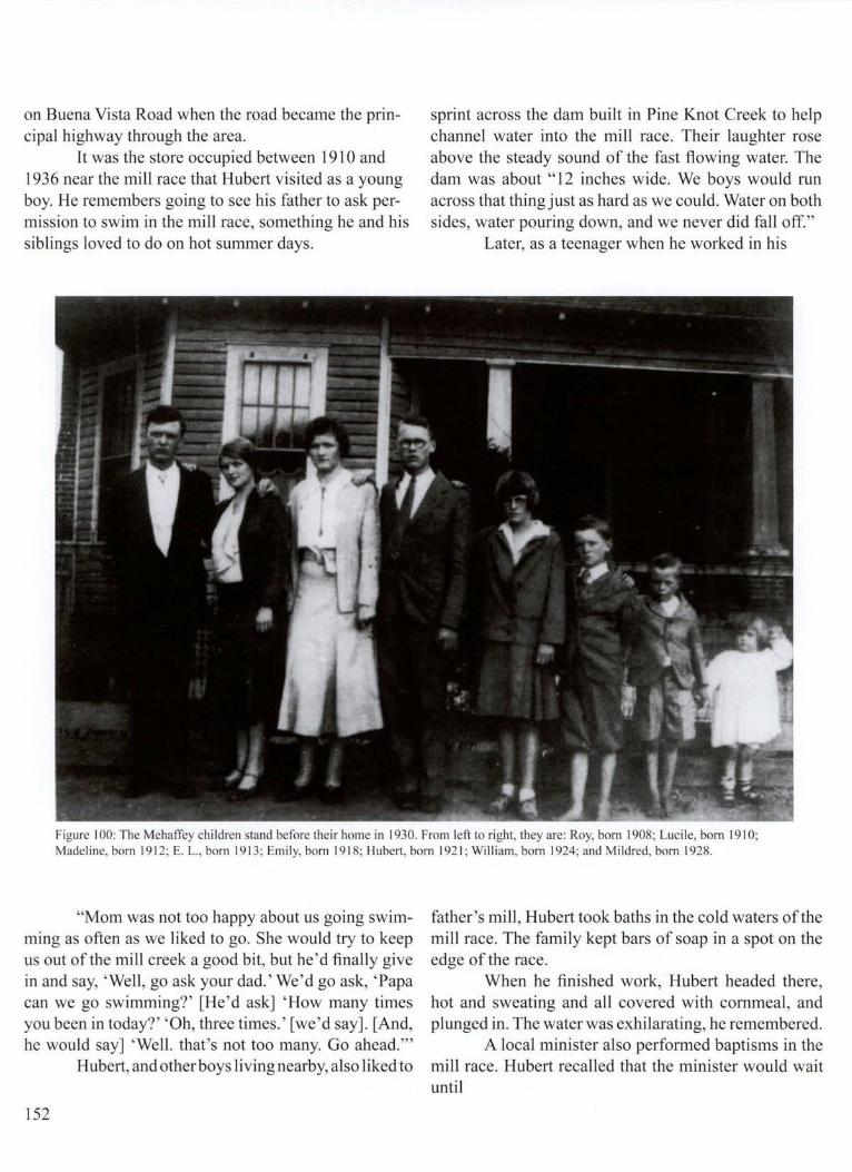
on Buena Vista Road when the road became the principal highway through the area.
It was the store occupied between 1910 and 1936 near the mill race that Hubert visited as a young boy. He remembers going to see his father to ask permission to swim in the mill race, something he and his siblings loved to do on hot summer days.
sprint across the dam built in Pine Knot Creek to help channel water into the mill race. Their laughter rose above the steady sound of the fast flowing water. The dam was about "12 inches wide. We boys would run across that thing just as hard as we could. Water on both sides, water pouring down, and we never did fall off."
Later, as a teenager when he worked in his
Figure I 00: The Mehaffey children stand before their home in 1930. From left to right, they are: Roy, born 1908; Lucile, born 19 1 O; Madeline, born 19 12; E. L. , born 19 13; Emily, born 1918; Hubert, born 192 1; William, born 1924; and Mildred, born 1928.
"Mom was not too happy about us going swimming as often as we liked to go. She would try to keep us out of the mill creek a good bit, but he 'd finally give in and say, ' Well, go ask your dad.' We 'd go ask, 'Papa can we go swimming?' [He 'd ask] 'How many times you been in today?' 'Oh, three times. ' [we 'd say]. [And, he would say] ' Well. that's not too many. Go ahead."'
Hubert, and other boys living nearby, also liked to
152
father's mill, Hubert took baths in the cold waters of the mill race. The family kept bars of soap in a spot on the edge of the race.
When he finished work, Hubert headed there, hot and sweating and all covered with cornmeal , and plunged in. The water was exhilarating, he remembered.
A local minister also performed baptisms in the mill race. Hubert recalled that the minister would wait until

Figure I 0 I : Farmers brought their corn to Eel beck Mill fo r grinding and enj oyed lingering fo r conversation with ne ighbors and fri ends. Arti st Mart in Pate portrays a typical scene ,_. at the mill. Many such enterpri ses fo rmerly ex isted on Fort Benning land. Vl (,,..)

there were about seven or eight people to be baptized. Then one at a time, he would dip their heads beneath the surface. "He wouldn't let you drown, but you would think you were going to."
Far from town and any organized activities, the children learned to create their own entertainment. One game they invented was called "stealing sticks." Hubert and his friends etched a straight line about 50-feet long into a field. Then they divided into two teams, with about eight children on each. The teams faced each other across the line. Behind each team a small circle was
all the sticks from one side, and if you did, you won." The children occasionally would enlist one of
the Mehaffey's young steers for their games. The boys tied ropes around the calf's head, with a rope end trailing to each side. A boy stationed on one side pulled the rope to urge the steer to walk in his direction. Then the boy on the other side pulled the rope he was holding, encouraging the animal to move his way. If the steer refused to budge, a third boy, standing behind the animal, "cranked his tail to make him go. We would do that until, after awhile, that steer would eventually get
Figure I 02: Hubert G. Mehaffey, Sr., posed with his seventh grade class and the sixth grade students in 1934 at Sulphur Springs Grade School. He is the fourth from the left on the back row, wearing overalls like the other boys. Notice that four students on the front row are barefoot.
carved in the ground, about three feet in diameter. The youngsters put ten sticks in each circle.
The object of the game was to sprint across the line onto the other team's turf and try to reach the circle without being touched. "If you could pick up a stick and get back on your side of the line before they touched you, that was your stick and you could put it on your pile. You kept doing that, back and forth, until you stole
154
the idea he was supposed to go where you wanted by just pulling a rope. We built a little cart, hooked him up to that, and made him pull us."
The children also liked to slide down a hill covered with pine straw. They found a barrel stay- a slat of wood used to form the sides of a barrel- and polished it smooth by rubbing it against a pine tree. They could rub barrel stays as smooth as a desk top, Hubert recalled.

The children would then carry the stay to the top of a hill in a pine forest. The ground was covered with slippery pine straw, and using the barrel stay as a sled, they would fly down the hill. How far could they travel? "Oh, it seemed like a long way, probably 200 feet. Seemed like forever when you were a child," he remembered.
In bad weather, the Mehaffey children played inside in a long hallway about ten feet wide that ran the length of their house. The hallway divided the house in half and though enclosed, was reminiscent of dog trots incorporated in some homes beginning in the 1800's. A dog trot is a breezeway, open at both ends, where a dog could run from the front yard to the back and residents could enjoy fresh air.
The Mehaffey home had three bedrooms-one for the parents, one for the girls, and one for the boys. A front room was designated the parlor, reserved for special occasions, such as entertaining relatives and other Sunday guests. Sometimes a guest would play the parlor piano. One of the daughters could also play. She couldn 't read music, but could hear most songs just once and then play them.
Sometimes guests traveled from Columbus, some 18 miles away, and shared the family meal. "Every four or five weeks someone would
bridge 103 to Buena Vista
site of Mehaffey home D(gone)
_Eel beck Cemetery
D
:- ·:
former site of Girl Scout Cam
come over on a Sunday afternoon. You Figure 103: Julia George Schnell , whose mother lived in the community of Eel beck, provided details for a plan of the area.
would have guests that maybe you weren't expecting .... They would come out and brag on what good food we had and how fresh our milk was and buttermilk ... We really thought they [people from Columbus] had better than we did. We thought they were leading us on. We learned later they weren't. We did have real wonderful food ," said Hubert Mehaffey.
When guests came, Rosa Mehaffey made sure the dining room table was correctly set with fine china. "Everybody was properly cleaned up, and we waited for everyone to come [and sit] and [then] asked the blessing before we started to eat."
On Sundays, about once a month during the
155

summer, the family made ice cream in a five-gallon chum, turned by hand. Everyone eagerly awaited their chance to crank the chum which was packed in ice. The children sometimes grabbed pieces of ice and playfully tried to deposit them inside each other's shirts.
Rosa Mehaffey was in charge of just about every activity in and close to the house. She personally handled a number of jobs or supervised employees who did them, including cooking, milking the cows, feeding hogs and chickens, and making sure hens were sitting on all the eggs and caring for baby chicks. She managed the garden and repaired all electrical switches in the house. She and her daughters also did the canning. They canned beans, peas, beets, tomatoes, peaches, and sundry other foods . Hubert Mehaffey fondly recalls the sweet preserves his mother made and the sausage, the best he ever ate.
His mother was also the one who administered castor oil when the children caught a cold. The bitter medicine was widely accepted as a cure for almost any ailment, and children hated it. Hubert tried to make castor oil more palatable, as he got older, by swallowing it with hot coffee. The practice nearly ruined the taste of coffee for him .
"When I left home [to attend college], I couldn't drink coffee for a couple of years. That castor oil was the worst tasting thing you ever put in your mouth. When I left home, I said, 'I'm not going to take any more castor oil. I don't care if I die."'
Fort Benning troops sometimes were on maneuvers within 300 yards of their house, and Rosa Mehaffey brewed coffee for them, which Hubert and his brother delivered. At times the soldiers let the boys ride in one of their tanks. One even took time to write down Hubert 's name and address and later sent a dollar to express his appreciation for the coffee, a kindness the small boy never forgot.
By the time he was a teenager, Hubert Mehaffey worked different jobs for his father, especially in summer. At least one of the tasks was frightening. He was sent to sleep in the store to help guard it from thieves. He shared the bedroom in the back of the building with a young man hired by his father. The employee kept a loaded .38 caliber pistol under his pillow.
The employee woke Hubert Mehaffey one night and whispered, "Someone is trying to bore a hole in that
156
door." Sure enough, Hubert could hear someone shuffling around outside.
The employee pointed the pistol toward the noise and whispered, "I'm not going to open the door. I'm just going to shoot." He aimed and squeezed the trigger. Bang, the gun went off. Then they heard someone say, "Ooh, uh."
"I think I got him," said the employee. "I'm not getting up at night to see about him. He 's probably dead. We'll just wait until the morning to see about him."
The next morning the two slowly opened the door. Nobody was there. The bullet had ripped through the door, but there was no sign of the thief.
Other jobs Hubert Mehaffey had in the family business included working in the gristmill. A 1930 newspaper article described the mill: "The mill is a large wooden structure whose age has blackened, but not impaired its sturdy longleaf pine timbers and weather boarding. The lumber was cut on the site, which once had many beautiful bodies of original timbers .... Every piece of it [the mill] appears today as sound as it was the day it was put in place. Inside the mill are parts of the original equipment such as the meal bins and elevator. The former are made of solid pieces of longleaf pine, 20 inches wide, which gives an idea of the size of the timber once foresting the section."
The gristmill was three stories tall. A conveyor belt about one-half foot wide and about one-quarter inch thick carried the corn to the top floor. The belt was fitted with hundreds of rectangular cups. As the belt moved, the cups dipped into the com, and then carted it to the third floor where the cups flipped over, dumping the corn into bins. Workers then removed any extraneous materials from the com.
From the third floor, the corn dropped down a chute into a holding container directly above the grinding stones on the first floor. Gravity then pulled the com under the heavy mill stones.
The mill had three grinding stones. Early documents show that one was imported from France and that the other two originated in the United States. Hubert Mehaffey, however, thinks that all three stones in the mill during his time there were from France.
Once the com was ground, it was carried, again by conveyor belt, to the second floor. This meal, including the husks and nutritious corn germ, was then packaged for distribution. As tastes changed in the l 930's in favor

of more refined meal, sifting machines were installed on the second story to remove the germ and husks.
Hubert Mehaffey used to stand on the second floor and load the fresh meal into paper bags with an aluminum scoop. He weighed the bags on a scale, then tied them shut with string.
The paper bags were one of his father's innovations, a move at first scoffed at by some of his competitors
number of years. Good with people, he maintained a staff of between 15 and 20 employees who helped operate the store, a large fann, the gristmill, and a cotton gin. Many of them worked for him for years.
"He had a warm, loving personality. He could be very strict. He expected all his children and all his employees to perform their responsibilities, to do their duties, and to do them well. But as long as you would do
Figure 104: C.R. Mehaffey, accompanied by his dog Smokey, walks near Eelbeck Mill in 1943, the year the Army took possession of the land to expand Fort Benning.
who stopped laughing when the bags became more popular than their cloth packages. Eelbeck com meal eventually became the best-selling brand in and around Columbus for household use.
C. R. Mehaffey was an avid reader, despite having only a third grade education. He combed the local newspaper thoroughly every day and was constantly learning. He served on the county school board for a
that, he would brag on you, and he would encourage you, and if you made a mistake, he would never get on you about it. He'd just say, 'Well, you had to make a mistake to learn,"' remembered his son.
C. R. Mehaffey was also shrewd. He taught his son, who sometimes drove a mill delivery truck, that he shouldn't buy lunch with cash while on his rounds. Instead he should trade sacks of meal to store owners for
157

food. Since the price of the cornmeal included profit, Hubert Mehaffey made a little extra on the deal, and he saved his cash.
C. R. Mehaffey priced his cornmeal one cent more than the product made by his largest competitor, City Mills of Columbus. He instructed his delivery drivers, "Don ' t wait to get back to tell me. The minute you see them [City Mills] go up a penny [in price], you go one cent higher at the next stop. I don't want anyone to think their meal is as good as mine." It was a strategy that paid big dividends. There was a time when City Mills dwarfed Mehaffey's operation. Eventually, be bought out the competitor.
C. R. also bought a mill in Omaha, Georgia, southwest of Fort Benning, another in Juniper, Georgia, slightly northeast of Eelbeck, and one in Kingsboro, north of Columbus. After World War II, he also owned a mill in Jacksonville, Florida.
There were also other ways C. R. Mehaffey displayed his business acumen. To increase cotton output, he planted peanuts in the cotton fields to feed nitrogen into the soil. He harvested so many peanuts that Mehaffey was unsure what to do with them all. Then he thought of buying pigs and let them loose in the fields to eat the peanuts. The pigs kept the family well-stocked in bacon, ham, and sausage. Mehaffey built a smoke house to cure and preserve the meat.
During the 1930's economic depression when he and just about everyone else struggled financially, Mehaffey concluded that farmers could make money by selling sweet potatoes. He urged his neighbors to plant the crop, and then he built a sweet potato house equipped with a gasoline engine to blow in warm air. The air dried and cured the sweet potatoes, ensuring their preservation for months. Mehaffey held the potatoes until supplies elsewhere dwindled, then sold them, reaping an off season profit for his neighbors and himself.
158
His reputation for integrity was important to Mehaffey. Like many store keepers of his era, he was a powerful figure in the community. Farmers often bought supplies from him on credit to be repaid when they harvested their cotton. They trusted him to keep accurate totals of what they owed.
His son Hubert remembers how the farmers lined up their wagons in the Fall, waiting to take their harvest to the cotton gin, which his father also owned. The Mehaffeys actually operated several cotton gins over the years, with one located on the second floor of the gristmill.
Eventually, the Mehaffeys had to give up the gin, the gristmill, and all of the surrounding lands to the military because of the World War II buildup at Fort Benning. Hubert Mehaffey recalled that his family and neighbors didn't resent losing their land because they realized the Army needed to prepare for war.
"Still, it was a real sad time for those people. They had to move out of their homes. I think people don't ever get over that. I'm not over it yet."
His father quietly accepted the need to leave the home he had lived in for almost a half century. "He just said, 'This is what we have to do. We will just go on and move to Columbus."'
His son remembered, "What we lost back then was an almost unbelievable prize. Upatoi and Pine Knot Creek running together and the branches that fed those creeks and the rolling hills and beautiful pine tree land .... What we lost was absolute paradise.
"My dad would never cry over it. When he got real old, I'd go over and see him .... Sometimes he would just sit there and say, 'Dear old Pine Knot Creek.' He'd say, 'I loved that place better than any place in the world. Dear old Eelbeck. "'
C. R. Mehaffey died in 1979 in Jacksonville, Florida, at the age of 93 .

20-The Inf antry1s Story
The U. S. Army Infantry, which calls Fort Benning home, has born the brunt of every major connect involving the nation 's military. Yet developing a program for effective infantry training came neither quickly nor easily. The first movement to shape the country's foot soldiers into a superior force came more than 200 years ago at the request of the general who became the first president of the United States.
Revolutionary forces commanded by General George Washington were barely surviving as they camped at Valley Forge, Pennsylvania during the dreary winter of 1777. Washington realized that his tattered and shivering legion needed better training if there were to be any hope of winning against the well-schooled British army. He sought advice from the respected Prussian general, Baron Friedreich Wilhelm von Steuben.
Von Steuben agreed to help, but recognized the huge challenge he faced to mold the loose band of rebels into a disciplined, cohesive force . As one observer at the time noted, the colonial army "was the finest body of troops be had ever seen out of step." Von Steuben's own assessment was that the Continental Army was a disgrace. "There was no uniformity of drill, no ~imi,~
larity of organization, and no teamwork of _any kmd~
wrote Leroy Yarbrough, first lieutenant of mfantry, m an unpublished 1931 history of Fort Benning. No two companies drilled alike, and they all drilled poorly. .
But von Steuben was resourceful and energetic and known for his tact. He established standard drill exercises and taught them patiently, but relentlessly to the troops. Once he saw progress, he chose those most adept at military formations to demonstrate for the rest to emulate. This practice of using the best troops to model techniques and tactics became fundamental in military training, continuing long after the Revolutionary War. For his efforts, von Steuben is known as the
"Father of the U.S. Infantry." When the Revolutionary War ended and victo
ry and freedom were assured, the public lost interest in the military. Funding was scarce for training as the new government struggled to organize, and the reforms begun by von Steuben were almost forgotten. Instruction became virtually nonexistent for military officers in bow to lead and organize troops. By the time the War of 1812 began, the United States Army was as disorganized as before von Steuben arrived on the scene. There was little spirit and no unity.
The demands of the War of 1812 renewed efforts to increase military efficiency. The Army brass borrowed ideas from the French military about how to instill discipline throughout the ranks. By 1815, a board of officers, including General Winfield Scott, issued regulations to be followed by every infantry unit. But once again when the war ended, public interest faded in funding military training.
There were, however, voices arguing that military schooling should continue in peace times as well as during war. Major General Edmund P. Gaines, after a protracted effort to get the attention of officials in Washington, D.C. , finally won permission from the War Department to open an infantry school in 1826 at St. Louis, Missouri. The school instructed both enlisted men and officers in tactics and military organization. Funding from the U.S. Congress was insufficient, however, and the facility closed within two years, doomed by lack of public support.
The next several decades found the Army in sporadic battles with Native Americans and waging a controversial war with Mexico. Elected officials made little effort to use the Army to restrain settlers from encroaching on land set aside by treaty for Indians. A repeated pattern occurred of whites settling i~ !ndian ~erritory, the Indians attacking, and then the military bemg ordered to intervene to protect settlers. The
159

battles, spread out over hundreds of miles, dispersed Army units and resources. The military was too scattered and its energies too focused on immediate tasks to allow much improvement of overall training.
There were military schools, however. West Point, the Virginia Military Institute, and the Citadel trained officers including Robert E. Lee, Stonewall Jackson, Ulysses S. Grant, and others involved in the Mexican War, Civil War, or both.
Nonetheless, it took another conflict, the Civil War, to spur further infantry training. Union forces even published a manual on infantry tactics. Still, neither the Union nor the Confederacy established an infantry training school.
In the aftermath of the Civil War, during the last half of the l 800's, there were various attempts at upgrading infantry tactics and drills, usually in the form of government publications. Germany and France developed postgraduate military schools, and the United States followed suit in 1881 , establishing a command and staff school at Fort Leavenworth, Kansas. This gave way to the Riley Service School for Cavalry and Sill School for Field Artillery, but there was still no school for the infantry. Knowledge about effective use of the cavalry and artillery leaped forward, while information about the infantry lagged behind. The esprit de corps in both the cavalry and artillery units became the envy of the infantry.
Various military leaders recommended that a separate school be established for the infantry, but they were ignored, perhaps because there was a perception that Americans tended to be excellent shots before they entered the Army and therefore didn't need much additional instruction. However, by the tum of the century, this perception faded as marksmanship gradually began declining.
The waning rifle skills didn't alarm everyone within the Army, but Lieutenant General Arthur MacArthur grew concerned. MacArthur, commander of the Army's Pacific Division, including California, Oregon, and Washington, pushed for and obtained permission to open the School of Musketry to train soldiers stationed on the West Coast. The school opened in 1907 at the Presidio in San Francisco and became a key forerunner for Fort Benning's development.
Instructors taught officers and enlisted personnel shooting skills. They also shared theory about the use of 160
rifles, pistols, and machine guns, and showed how different weapons were made. In particular, they demonstrated the paths different kinds of bullets might take and how various types of ammunition should be carried into battle.
Training was intensive. In their first trips to the firing range, everyone had a coach, a teaching method that became a staple of military instruction. Classroom work was also exhaustive. In one course, for example, everyone was issued different weapons used by soldiers of other countries. They were told to learn everything they could about the weapons, including the names of every part. Each student then had to lecture the class about the weapons he was assigned and disassemble and reassemble them, another example of students teaching one another. Graduates then returned to their respective units to teach their fellow troops.
The Army now had within its arsenal high-powered, small-caliber rifles, but little study had been done on their potential impact on battle tactics. General Arthur MacArthur envisioned that the School of Musketry would be used for such research and for wide-ranging experimentation. Everything from rifle sights, to targets, to silencers, to machine-gun cooling devices was tested at the school.
One officer testing a new Colt pistol discovered he could shoot the gun without touching the trigger simply by moving the safety, a switch designed to prevent the gun from firing accidentally. However, Colonel Marion Maus, president of the school's testing board, didn't believe it was possible to shoot a gun that way and tried to prove it. But when he jiggled the safety, the gun went off, firing right at Maus' foot. The bullet ricocheted off his boot toe, leaving an impressive nick, but no wound.
Particular attention was paid to experimenting with and teaching about the machine gun, a weapon many in the Army still thought would never have much practical use. President Theodore Roosevelt recommended that Captain John H. Parker be assigned to the Presidio in 1908. Known as "Gatling-Gun Parker," he fought beside Roosevelt during the charge up Cuba's San Juan Hill in the Spanish American War of 1898. Parker commanded a Gatling-gun platoon during the battle. The conflict made Roosevelt a national hero, eventually helping propel him to the White House.
Many of Parker 's theories about how the weapon would affect strategies proved accurate in World War

....... 0\ .......
~OLLMBUS . GA. 11 A Business B lock"
r.,:
Figure 105: The area around Columbus. Georgia offered an ideal climate for year-round training for infantry soldiers, as well as ample open land. The path to establishing Fort Benning as a permanent faci lity, however, was far from smooth. This photograph of early Columbus reveals a thriving downtown .

His job at the Presidio was to cooperate with instructors in the School of Musketry while writing a booklet on machine-gun use.
There were many tests made on machine-gun capacity at the School of Musketry, but skepticism about the weapon persisted in the Army. Critics scoffed at the weapon, saying it was too complicated ever to be much use. Some argued that the machine gun was being promoted by "youthful cranks" whose ideas were "absolutely nutty."
Even by 1914, Army regulations recognized the machine gun as merely a weapon for emergencies. But in 1917, when the country became engulfed in World War I, the machine gun had already proved deadly effective for Europeans in trench warfare. Experimentation carried on at the School of Musketry had been ahead of its time and probably saved American lives. Knowledge gained at the school about the machine gun was used in training troops before they headed overseas.
Staff members at the School of Musketry were also among the first to anticipate that the airplane would be significant in combat and seriously menace ground troops, predictions that came true in World War I. Students experimented at the school in ways to ward off attack from above by firing rifles and machine guns at high-flying box kites, stand-ins for airplanes.
The School of Musketry succeeded so well that within a few years there were powerful voices urging that the school be moved to a more central location and made national in scope, which happened in 1913 when the school relocated to Fort Sill, Oklahoma. The new site was open only a short while when President Woodrow Wilson ordered a massing of troops in Texas because of civil war in Mexico. Efforts to improve infantry training were again set aside for two years, and the school closed.
The Oklahoma School of Musketry reopened in 1915, but operated sporadically as American soldiers were again called into action because of trouble in Mexico. Francisco (Pancho) Villa, a rebel and bandit, captured a train in northern Mexico in 1916, seized 16 Americans, and ordered them shot. His aim was to provoke war between the United States and his country, headed by a former Villa ally who had turned against him . Then Villa brazenly invaded the United States with a force of about 400 men. They attacked Columbus, New Mexico, partially burning the town and killing 19
162
people before fleeing back into northern Mexico. American troops hurriedly gathered along the border to protect residents.Othersoldiers,leadbyGeneralJohnJ.Pershing, pursued Villa into Mexico. Although they didn't capture the guerilla leader, his attacks across the border ceased.
Training for American troops continued to have a tenuous foothold . Any time there was a flare-up of tensions in Mexico, the War Department suspended operations at military schools. When the School of Musketry did operate, conditions for the officers stationed there were far from ideal. They lived in cold stone buildings in the winter of 1915-1916 that were in "terrible shape," according to one of the faculty. Repairs made to the housing that winter only seemed to make matters worse.
As one officer recalled, "They tore off the porches [and] built new ones. [They] tore down kitchens [and] built new ones. [They] took out the windows and put in new ones." The officer added, "I had two small children and my poor wife had a terrible time the first winter we were there. I remember one day she telephoned me frantically to come to the house, as the workmen had both front and back of the house in such shape that she and the children were prisoners .... All the other officers had the same experience."
The entry of the United States into World War I caused major changes at the School of Musketry. The United States, led by President Woodrow Wilson, had repeatedly tried to steer clear of the conflict that erupted in 1914 between the Allies, primarily armies of France, England, and Russia, against forces aligned with Germany. The neutrality began to unravel on May 7, 1915, when a German submarine fired a torpedo into a British passenger ship, the Lusitania, which sank in 18 minutes off the coast of Ireland. There were 128 Americans among the 1,198 people who drowned.
The Germans used submarine warfare sporadically after that against American shipping. They stopped their attacks briefly each time President Wilson expressed dismay at the killing of innocents and threatened to break off diplomatic relations.. England, with its powerful navy, was blockading Germany, squeezing its economy, while England continued to receive trade goods from the United States.
In 191 7, the German high command took a calculated gamble to unleash unrestrained submarine

warfare against all shipping in the Atlantic Ocean and risk bringing the United States into the war. By launching repeated attacks, the Germans thought that they could cut off crucial supplies from reaching England, causing it to pull out of the war before the
tankers and cargo ships into convoys protected by warships. Within six months after the United States entered the war, the tonnage sunk by German submarines reduced to a third of what it had been. The United States also began mobilizing an army. General
Figure 106: Enlisted soldiers and offi cers used to sleep in tents in the early days of Camp Benning. The silo in the fa r background of thi s 1925 photograph was part of Arthur Bussey's plantation, which he sold to the government so that the School of In fantry could be built.
Americans could marshal enough forces in Europe. The strategy almost worked. In April, President
Wilson delivered his message of war to Congress. In the same month, German submarines sank a number of ships weighing nearly 900,000 tons. Whether the United States and its allies could win the war hinged on whether the frightening loss of shipping could be stemmed and if Americans could train enough soldiers quickly to blunt the German offensive in Western Europe.
The solution to the shippingproblem was to group
John J. Pershing set a goal of having a million American soldiers in Europe by the summer of 1918.
Against this backdrop, the School of Musketry at Fort Sill, Oklahoma was renamed the Infantry School of Arms. The change was significant. For the first time, the school was officially an institution of the infantry. The use of the word "arms" in the title was also important recognition that the single shot rifle was no longer the dominating infantry weapon. There was a whole host of new warfare technology. Now on equal footing with the
163

rifle were machine guns, automatic rifles, grenades, and mortars. Students now also learned how to protect themselves from poison gas, already being used in Europe.
The Infantry School of Arms expanded rapidly. The contingent of soldiers assigned to help maintain the facility jumped from 94 to 428. The number of instructors and students ballooned as well. Hundreds of officers were trained during the first year. They hailed from every state of the country and represented virtually every background. These were soldiers who once worked as bank presidents, farmers, industrial leaders, and laborers. Former noncommissioned officers from African-American regiments were among the students.
Discipline was rigorous and the hours long, underscoring the urgency pushing the entire Army. Class time normally lasted ten hours a day, but sometimes work extended to as much as 14 hours. One observer remembered, "An instructor rose at six and retired at eleven [at night], [but only] if his papers were corrected and he had the programs and schedules prepared."
The rigorousness undoubtedly contributed to successes on the battlefields and saved American lives. The school was so successful that top military brass wanted to expand the concept. The only question was where to move the school. Fort Still was seriously over crowded. Students were wedged together in cramped barracks where there was barely enough space for all the beds and lockers.
The school 's machine gun training was ordered to move in the summer of 1918 to Camp Hancock, near Augusta, Georgia. The Army also opened a school at Camp Perry, Ohio to train instructors in marksmanship. Both schools would soon be located at Fort Benning.
At the same time, several Army committees began searching for a new, more spacious location for the Infantry School of Arms. Eventually, the Army high command selected Columbus, Georgia.
The Infantry School of Arms left Oklahoma by early October 1918, heading for its new home, about three miles from downtown Columbus, near what today is a large shopping center-the Columbus Square Mall on Macon Road. (A sign commemorates the original camp at the intersection of Mimosa and Dixon roads.)
On October 19, this temporary camp was officially named Camp Benning. Anna Caroline Benning,
164
daughter of Confederate General Henry Benning, raised the first American flag over the post.
Army leaders quickly concluded that Camp Benning's location wasn 't large enough to accommodate the infantry school. They decided to move about nine miles from the city into an area dominated by an 1,800 acre plantation owned by Arthur Bussey. This new site for Camp Benning was primarily south and east of the intersection of Upatoi Creek and the Chattahoochee River.
At the same time, however, World War I, was drawing to a close. The war's conclusion would imperil Camp Benning's existence and change some local residents' favorable perceptions about the military reservation.
By the end of 1917, Russia had left the war, and revolution had brought Nikolai Lenin and the Communist Party to power. The German army withdrew from the eastern front, moving a vast army into western Europe. In early 1918, German leaders began a massive offensive they hoped would crush the Allies before many American soldiers could arrive to help.
In March, German forces crashed through French and British forces near the Somme River, not far from the Normandy Coast. Allied armies staggered back under the fierce attack, but somehow managed to reorganize their defenses and prevent a complete collapse. The situation seemed desperate. The Allied armies were outnumbered by 300,000 men.
American soldiers had begun streaming into France, at times at a rate of more than 250,000 per month. Still, the momentum was with the Germans. By late May, German forces drove to within 50 miles of Paris, pounding French and American armies. After a week of bitter fighting, however, the Allies held their ground. Then the Americans counter attacked, recapturing an area known as Belleau Wood.
By midsummer, the Americans had more than a million soldiers in France, just as General John J. Pershing had wanted. By August, his forces began a major assault near the French town of Verdun. An American soldier described the battle in his diary. "Bullets, millions of them, flying like rain drops. Rockets and flares in all directions. Shrapnel bursting the air and sending down its deadly iron .... Every minute looking for the next to be gone to the great beyond.
"A mad dash for 50 feet and then look for cover. A

......... 0\ Vi
Figure I 07: Arthur Bussey built this home, called Riverside, in 1909. The house, originally built as a summer home for tbe Columbus businessman and his family, was part of Bussey's extensive plantation . The residence now serves as the commandant 's quarters and is listed on the National Register of Hi storic Places .

stop for a minute and then the barrage would lift ... and then another mad rush. Always leaving some of your comrades cold in the face of death .. .. The field of dead a terrible sight. Both Americans and German. A day never to be forgotten. "
In September, the Americans surged forward again in the Argonne Forest, not far from France 's border with Belgium. The assault, along a 24-mile front, bogged down in difficult terrain in the face of fierce German resistance.
The Americans reorganized and then surged forward again. General Pershing later said that the battlefield was "a vast network of uncut barbwire, [with] deep ravines, dense woods, myriads of shell craters, and a heavy fog ." The American campaign lasted 47 days .
Somehow the Americans endured and kept moving forward, surprising even leaders of Allied forces who didn 't think it possible to make progress against
166
such a formidable defense. The battle for control of the Argonne Forest was
the largest ever fought by Americans. More than a million soldiers were involved. The Americans expended more ammunition and explosives than Union forces used in the entire Civil War.
The Americans and other Allies were poised to invade Germany. German leaders, realizing the fight was hopeless, negotiated an armistice on November 11 , 1918, effectively ending the war.
About 100,000 Americans had died, victims of enemy shells or disease. European casualties were much higher. More than one million French were killed and 900,000 British. Germany suffered similar losses.
With the war over, powerful voices urged that the infantry training center near Columbus should be closed and abandoned. A new fight was about to begin for the survival of Camp Benning.

21-Politics and Persistence
C amp Benning's future became doubtful soon after signing of the peace agreement in November 1918 ending World War I. There was no need to continue building a school for the infantry when the war was over, some argued. In Washington, D.C. , and even in Columbus, Georgia, voices, some quite powerful, contended that Camp Benning should be abandoned.
States Senate, ordered construction stopped. An enterprising officer at the post, however, found some convenient ambiguity in the wording of the command. While the order called for an end to building and for stopping all condemnation procedures to acquire land, it also stipulated that construction materials and structures partially completed should be salvaged in
Figure 108: Sixteen trains, including thi s one photographed in 1944, transported soldiers and construction materials around Fort Benning from 1920 to 1946. The trams traveled over a narrow gauge track. One tra in was called the Chattahoochee Choo Choo.
Those against the post won- for a time. On January 9, 1919, the War Department, acting in concert with the powerful Committee on Military Affairs of the United
ways that best served the government. Major John Paul Jones, the quartennaster corps officer in charge of construction, chose to interpret that to mean that work
167

on out kept
unfinished buildings could continue. Withofficial sanction from Washington, he construction crews toiling at the post. This wasn 't the only instance when the ma-
jor showed initiative to keep Camp Benning moving forward. When the Army needed a way for trains to transport construction supplies to the post, the solution was to lay tracks from Camp Benning to a connection with the Central of Georgia Railroad, which passed through Columbus. There was a wrinkle in the plan, however. The track would have to intersect another railroad owned by the Seaboard Line, a Central of Georgia rival. The local Seaboard Line superintendent objected strenuously to the Camp Benning scheme.
Nonetheless, Jones pushed forward with the laying of railroad tracks. He even had the framework for a crossing built that would be placed over the Seaboard Line tracks so that the Camp Benning trains could pass over them. When the Seaboard Line superintendent heard about the crossing construction, he stormed into court to stop it and won a temporary restraining order.
The major, however, wasn't easily deterred. He collaborated with a local attorney, Frank Garrard, and somehow managed to finagle a bearing before a sympathetic judge at four in the morning. This judge quickly nullified the restraining order, and within two hours, before anyone from the Seaboard Line could object, the crossing was in place. A train, loaded with rails and ties, chugged over the crossing, and construction of the new track resumed on the other side. There were no more legal challenges to the new railroad.
But the War Department's command to cease construction posed a much more serious problem. The post was just beginning to take shape. Only about 2,000 acres had been acquired. Efforts to buy more land were snarled in bureaucratic red tape or contested in court cases.
About 4,000 troops were stationed at Camp Benning, most housed at the original site near Columbus while they waited for the new facilities to be finished near the Chattahoochee River. Building progress was slow. The railroad track to the post was incomplete, and construction materials from Columbus had to be carted in by wagon.
Construction, however, had begun on a two-story building designated to be the original camp headquarters. There was also an assortment of warehouses, mess 168
halls, and other buildings either ready or near completion. But though Jones was able to keep crews working, it was doubtful be could continue building for long without authorization from the powerful Senate Committee on Military Affairs .
The Senate committee had voted unanimously against Camp Benning continuing, but within days of the vote, committee member Senator Hoke Smith of Georgia had a change of heart. He transformed into one of Camp Benning's biggest advocates. Why be switched sides is undocumented, but intense lobbying by the Columbus Chamber of Commerce perhaps was a factor.
Once he became a champion of the post, Smith vigorously pursued the slow, delicate process of changing other senators' minds. His first victory was convincing committee members to reconsider their Camp Benning vote and hold public hearings on the matter.
Proponents and opponents of Camp Benning flooded the committee with their views, sent by mail, telegram, or delivered in person. Colonel Henry Eames, post commandant, was the first witness to testify. He described the extensive national search for an infantry school site, stressing, "Columbus was decided upon in preference to anything we saw."The terrain and climate made the location superior for the year-round training the Army required, Eames explained.
Some of the most crucial testimony came from Columbus civilians, with partisans both for and against the military reservation. Columbus residents had once seemed unanimously in favor of the post, lobbying hard to have the military choose their city. But after the patriotic fervor stirred by World War I subsided, some had second thoughts. Some members of the business community, once seemingly united in favor of a post, now complained that the military caused upward pressure on wages. If they had to pay workers more, they would just as soon have the Army pack up and leave.
Landowners had also turned hostile to Camp Benning. Some were angered because they were ordered off their property, but hadn't been paid. Others didn ' t want to leave, no matter how much they were compensated. Still others, disgruntled over the amount of money the government bad offered, had taken their complaints to court.
Some citizens voiced fears that the influx of young,

....... °' \0
Figure I 09: Housing was in such short supply in the earl y years that officers sometimes built the ir own quarters, such as thi s one .

unmarried men would threaten the well-being or moral uprightness of their daughters and wives. As one telegram writer to the committee pleaded, "Save our homes, our churches, and our schools." Another complaint concerned spending tax dollars on the military when the United States was no longer at war. "My motto after the war, 'More to eat and less guns,"'wrote the opponent.
Advocates for Camp Benning matched foes in their fervor. Many landowners were eager to sell, which was not surprising considering declining farm prices and the devastating impact of the boll weevil on cotton crops. The Columbus Chamber of Commerce also continued to offer a spirited defense of the post. Business Leaders testified that the military brought substantial economic benefits to the community. Among the last and most pivotal witnesses was Colonel Morton C. Mumma, Camp Benning's assistant commandant. Mumma proposed that 17 ,000 acres of expensive property be dropped from planned purchases, saving the federal government $1 million. He also recommended that money allocated for building be slashed by more than half, from $13 million to $6 million.
His compromise won over the senators. They could now proclaim fiscal responsibility to those concerned about costs and still satisfy the post's supporters. They voted in March 1919 to resume building at Camp Benning and buying land. The tighter budget led military officials to lower the proposed capacity of the school from 25,000 to 5,000 troops. Colonel Mumma explained why he was willing to reduce the scope of the building program. "I was prompted ... by my great desire to save .. . this very important school."
But the battle was far from settled. Sensing that Washington opponents would try again to eliminate the post, Camp Benning's commanders decided on a preemptive strike. They moved a number of soldiers onto the military reservation in June, even though work crews were everywhere feverishly hammering away at unfinished buildings. The commanders reasoned that with instructors, soldiers, and families already in place Washington officials would be reluctant to shut Camp Benning. They miscalculated.
The United States Congress, as part of the military appropriations bill, voted to cut off any more funding for Camp Benning construction. The bill also required that any money already authorized, but not spent,
170
should be returned to the United States Treasury. In July 1919, the War Department issued a second order to stop all work. This command seemed unequivocal, leaving little room for creative interpretation. All construction contracts were to be canceled, all construction workers dismissed, and no construction funds were to be spent.
The work stoppage left Camp Benning in chaos. Some 5,000 construction laborers departed, leaving barracks, school buildings, sewers, water mains, electrical wiring, and roads unfinished.
Some 250 officers and 1,500 enlisted men lived on post, carrying out duties as students, instructors, or demonstration troops. Some of their families lived with them. For everyone, conditions were rough. "Frames of partially finished buildings stood like raggedly clothed skeletons. Heaps of unused materials lay haphazardly about. Miles of ditches yawned for the unlaid pipes and sewers. Everywhere was a profusion of litter ... .Inhabited buildings [were] without water, sewers, or lights," according to an unpublished history written by infantry First Lieutenant Leroy Yarborough.
With winter approaching, Camp Benning's leaders decided once again to improvise. Soldiers would become construction workers. Using materials already on hand and resources they could harness on the post, soldiers began installing plumbing and sewer lines, repairing old roads and finishing new ones, and completing unfinished structures. They also graded grounds around buildings, assembled target ranges, and built and operated a small-gauge railroad. The railroad, eventually 27 miles long, connected to the main line leading to Columbus. One of the trains that ran on the post line was affectionately named the Chattahoochee Choo Choo.
Troops cut trees, then used two saw mills on the post to shape the timber into construction lumber. They also excavated sand and gravel from the post grounds. Muscogee County officials pitched in by sending 150 prisoners to help lay the sewer system.
Throughout this period, men continued arriving to attend the infantry school. Finding housing for them became an acute problem. Row after row of white canvas tents sprung up around the post. Unheated, damp, and drafty, the makeshift shelters were so uncomfortable that when winter set in troops began calling Camp Benning the "peacetime Valley Forge."

More Than Just a House Riverside, the stately mansion where the Fort commandant lives, has a long history. It occupies land
once part of a plantation owned by John Woolfolk. Shortly after the 1827 lottery to distribute Creek Indian lands, Woolfolk assembled a large estate of about 5,000 acres along the Chattahoochee River. He named his estate Cusseta Plantation after the Creek village, Kasita.
After the Civil War, the plantation was divided into parcels and sold to different owners. By 1883, Martha and Benjamin Hatcher owned about 1,780 acres of former Woolfolk property. The Hatcher family, in tum, sold the land in 1909 to Arthur Bussey, a businessman who lived in Columbus. Bussey named the plantation Riverside and later gave the same name to his house on the property.
The house itself has a colorful past. Bussey decided to move a meeting house located on Lumpkin Road to his property. Workers jacked up the building onto logs, then pulled it slowly through a forest where Fort Benning's Patch School now stands. The school is one of many on post for children of military personnel.
Transporting the meeting house was heralded by a local newspaper as an engineering feat. Bussey saw to it that not a single tree was damaged or destroyed in the process. Once the meeting house was in place, he had workers build on additions, greatly enlarging the house into a two-story, neoclassical dwelling. They added upstairs bedrooms and porches, two-story, neoclassical dwelling. They added upstairs bedrooms and porches, two kitchens, and at least one other room.
The Bussey family used the place as their summer home. The land around the residence served as a year-round plantation, where cotton, com, and sugar cane grew.
Early in its existence, Riverside had running water, a rarity at the time. A pond at the base of a hill about a mile from the house supplied the water, which was pumped up into a tower, then allowed to flow down a pipe into the house.
One plantation worker's sole duty was to tend the trees and landscaping. The grounds then, as they are today, were beautiful. Peacocks strutted among the oak trees. The graceful oaks continue to grow around the house and are carefully nurtured by experts.
Shortly after the Army bought the house in 1919, there was a servant quarters built at the rear. Both the mansion and servant quarters were listed on the National Register of Historic Places in 1971.
Some noncommissioned officers moved into small farmhouses or shacks, apparently once occupied by tenant farmers. Another ten officers were allowed to use old farm buildings which the government bad not yet bought. The officers could occupy the buildings only after they agreed to buy fire insurance with their own money to protect the owners from loss.
About l 00 officers rented homes for their families in Columbus, but opportunities to visit them were few. Regulations prevented personnel undergoing training to leave the post, except on weekends, and even then getting to town wasn't easy. The road to Columbus was poor even in dry weather and became a quagmire when it rained. Few officers could drive to Columbus anyway, because most didn't own cars.
The post train traveled to Benning Junction, about four miles from Columbus, where soldiers could board the Central of Georgia railroad for the rest of the trip into town. However, there was only one passenger train operating each day, leaving Columbus at 7 :30 in the morning and returning at six in the evening.
For officers with the 29th infantry stationed at Camp Benning, being present for the mandatory dawn reveille was impossible, if they took the train. The result was that most officers with families in Columbus didn't see them for days.
There were also other inconveniences. The Army hospital was in Columbus, nine miles away, occupying space rented from the city hospital. Camp Benning also didn't have enough storage space so the Army had to rent warehouses in Columbus. There was no laundry on post until late in 1919, when a mobile laundry arrived. But even then the laundry could clean clothes for only about a thousand soldiers . Everything else had to be dispatched to Camp Gordon in Augusta, Georgia, requiring eight days.
Despite all the problems, Camp Benning continued to operate and gradually began taking shape. Training continued, and then umber of infantry graduates steadily climbed, including groups ofrecent West Point alumni. The post commandant moved into the stately plantation home called Riverside, built in 1909 by Columbus
171

businessman Arthur Bussey. Still, the post's status was uncertain and hinged on a final decision by Congress.
Members of a Congressional committee toured the post in September 1919, seeing for themselves the bustling activities and rigorous training. They also observed the dilapidated hovels and tents in which many soldiers were forced to live. But no definitive action from Congress followed their tour.
In December, General John J. Pershing, hero of World War I, visited. Hard rain for several days before he arrived turned the camp into a sea of mud and
No matter what size Army the country deemed necessary, there should be a permanent infantry school to ensure preparedness, urged Colonel Paul B. Malone, Camp Benning's assistant commandant.
He wrote, "Losses of American lives ... will bear a close but inverse ratio to the extent to which training ... in time of peace is given to the leaders of infantry units."
Enough elected representatives eventually came to share Malone's viewpoint for Congress to vote in February 1920 to declare Camp Benning a permanent military post. They approved, resumed construction
Figure 11 0: United States President Warren G. Hard ing visited Camp Benning in 1921 . He is seated on the first row on the left. Next to him is Major General Walter H. Gordon, the third commandant of the post.
puddles. Soldiers remembering the deluge referred to the "Pershing Flood."
The Army, unwilling to lose the infantry school, mustered statistics to build an argument to support Camp Benning. Officers prepared reports for Congress documenting that the infantry comprised 89 percent of American combat casualties in World War I. While improved training had saved lives during the war, the large numbers of casualties were attributed to training that was still inadequate, most military experts agreed.
172
and appropriated more than $1 million additional building funds for the Infantry School of Arms, which became the Infantry School.
The vote seemed to assure Camp Benning's existence, but many problems lingered in an era of tight military budgets. Population at the camp continued to mushroom. By the fall of 1920, there were 350 officers, as well as 7 ,000 troops and 650 student officers. They overwhelmed the post's housing capabilities. Soldiers had to vacate barracks so the rooms could be used for classes. More tents were raised for housing.

The entire 29th Infantry moved into a tent camp, which continued to be used for the next ten years.
Housing was so scarce and inadequate that some officers received permission to use salvaged materials to build their own shelters. The result was a hodgepodge of houses all distinctively different from each another. They were " limited only in size and design by the resources and imaginations of their builders," wrote Fort Benning historian Yarborough.
Slowly, the housing situation improved, although not without occasional steps backward. In March 1921 , a tank crew accidentally fired a sixpound shell into one of the officers' quarters. Apparently, no one was hurt. A few days later, an artillery shell hit one of the camp railroad tracks. A workman nearby narrowly escaped injury. In the same month, violent thunderstorms raked the area, tearing off some roofs and lifting other buildings off foundations.
Mostly, however, Camp Benning continued to improve both its operation and reputation. In October 1921 , President Warren G. Harding visited, the first of many chief executives to make the journey.
The Infantry School had come a long way since its predecessor, the School of Musketry, had trained soldiers primarily about rifles and pistols. Now there were courses about a whole array of modem weapons. There were also new lessons in battle tactics, as well as bow the infantry should coordinate efforts with other military branches. The overal 1 aim was to develop "efficient commanders and staff officers" and to improve "the quality of leadership and the capacity to instruct others." Another goal was to instill the ability to perform high-quality analysis and research.
Additional troops arrived to provide different types of demonstrations- the 344th Tank Battalion, Company D of the 7th Engineers, the 1st Battalion 83d Field Artillery, a medical demonstration detachment, and the 32d Balloon Company, used for observing troop movements. The hot air balloon equipment was stored in hangers where Lawson Army Airfield now stands. These buildings still exist, although modified from their original designs.
By 1922, the post was renamed Fort Benning, and in March, General John J. Pershing returned for another visit. Violent thunderstorms again pelted the area with heavy rains, producing what came to be known as the
"Second Pershing Flood." A new commandant, Brigadier General Briant
H. Wells, in 1924 began establishing a greater sense of order and cohesive appearance for Fort Benning. He prepared a formal document, which became known as the Wells Plan, for permanent construction, emphasizing the importance of the outdoor environment. Wells envisioned pleasant landscaping in the developed areas and wanted sound management practices in undeveloped areas so that Fort Benning's forests continued to flourish. The first organized landscaping took place during Wells' regime when some 2,000 trees were transplanted from the nearby forests . Wells also oversaw plantings of grass, shrubs, and flowers. This was an important first step in creating the campus-like environment that characterizes Fort Benning today. Commandants who followed Wells continued to emphasize the importance of landscaping.
Under the Wells Plan, academic and civic areas were combined into one large campus, a scheme that continues today at Fort Benning's hub, now called the Main Post Cantonment. The plan also called for the building of permanent "cuartel" barracks. Construction began on the first of these buildings in 1925.
The Wells Plan also placed heavy emphasis on providing recreation opportunities for military personnel. Doughboy Stadium, with its distinctive towers and arches, was completed in 1924, built with contributions from soldiers to honor fallen comrades who bad fought in World War I. The stadium is preserved today as one of Fort Benning's important historic sites.
During General Wells' tenure, Fort Benning developed recreational facilities unequaled on any other military post, with the possible exception of West Point. Besides Doughboy Stadium, there was Gowdy (baseball) Field, named after Captain Hank Gowdy, a professional player with the New York Giants, the Post Theater, and Russ Swimming Pool. The Army also completed an 18-hole golf course in the late 1920's. Eventually, Fort Benning also boasted a handball court, a bowling alley, the Campbell King Horse Show Bowl, and a new gyrnnas i um.
Some athletic feats , however, weren 't planned and didn 't take place in any recreational facility. Private Joseph Wiggins was handling the controls of the post's narrow gauge train in February 1925 when up ahead he
173

Figure 111 : Doughboy Stadium is built of reinforced concrete in the Spanish Mission style. Construction costs were paid by soldiers in tri bute to fa llen comrades from World War I.
noticed something moving on the tracks. He realized that a baby had crawled in front of the train. Wiggins yanked on the brakes. The train slowed, but, because it was heading down hill , continued to roll forward . Wiggins leaped out of the cab and started running. He raced ahead of the moving engine and somehow managed to snatch the baby off the tracks just in time.
Lt. Col. George C. Marshall was appointed assistant commandant of the post in 1927 and initiated major changes. He was appalled by high casualties in World War I, caused, he thought, by insufficient training. He was determined to prevent a lack of preparation from costing more lives in any future conflicts.
Marshall , who later became Army Chief of Staff during World War II, authored the Marshall Plan for reviving postwar Europe, and won the Nobel Peace Prize, gathered around him bright, innovative young officers, including Omar Bradley and Joseph Stillwell, who both also gained fame in World War IL He and his subordinates revamped the education system at Fort Benning, seeing to it that all courses offered instruction
174
of the highest quality. The changes he fostered are still known as the Benning Revolution.
Marshall thought that an officer in battle should be able to assess any situation coolly, no matter how chaotic the circumstances, and make clearheaded decisions. He directed officers under his command to plan military field exercises carefully, then he would throw in a monkey wrench.
"He would come in and take all your maps, take all your notes, and see how well you did without them. The ones who could be put under that kind of pressure and scrutiny and then succeed, Marshall felt like they had achieved the goal. He kept a little black book and would jot down whom he felt the leaders of tomorrow's Army would be," according to Frank Hanner, the Infantry Museum director.
His ability to spot military talent, first developed at Fort Benning, served Marshall well in the perilous years that followed. During World War II, Marshall and Fort Benning would be tested beyond what anyone could have imagined.

22-A Place • In History
Lucky coincidence had nothing to do with the campus-like atmosphere of Fort Benning's main post or the neighborhood feel of the officers ' quarters. The appealing architecture, manicured landscaping, and stately trees trace to the late 1920's when leaders in the United States Army concluded that soldiers learn best in pleasant environments.
A newspaper article of the time in the Benning Herald explained: "The depressive influence of bare or squalid surroundings is well known to psychologists and other observant people. Army officers have observed that soldiers, as a class, are much affected by the environment in which they are quartered. It is definitely established that unbeautiful surroundings affect adversely important aspects of military life, such as morale ... . "
This thinking prompted the Army in the 1920's to hire George B. Ford, a pacesetter in the emerging field of city planning. Cities across America had sprawled without forethought, spawning the new planning profession whose practitioners hoped to prevent similar mistakes. Military leaders decided that if forethought could help beautify cities, then Fort Benning could also benefit.
A great deal of construction had already occurred on Fort Benning before Ford formulated his plan for the post. Already in place were one of the massive cuartels for housing soldiers, a heating plant, nurses' quarters, the library (now the telecommunications center), and various other buildings. Many of these buildings were in Fort Benning's hub, the academic and civic area, known as the Main Post Cantonment. Cantonment means temporary camp. The name stemmed from Fort Benning's early days when many soldiers and officers were quartered in temporary buildings and tents.
"Fort Benning ... just grew, like Topsy," wrote Ford. "The permanent buildings seem to be scattered at random all over the post. At first glance, it seemed to be
hopeless to try to work out any orderly arrangement." Nonetheless, the planner envisioned a grouping
of buildings and open spaces that was eventually realized and largely still exists. Ford completed his grand scheme for the post in 1929. His work reflects the influence of the City Beautiful Movement, then in vogue. The movement 's aim was to create aesthetically pleasing designs with open spaces, straight avenues, and appealing architecture. The planner incorporated all of these into his vision for Fort Benning's main complex. Ford also proposed that existing structures and future buildings should be coordinated to match in color and form.
He avoided austere, monotonous patterns. In Ford's design, the appearances of buildings were pleasingly harmonious with one another, without distracting from their military purpose, according to W. Robinson Fisher. Fisher led a team of researchers in the 1980's who studied Fort Benning's buildings and layout.
Most elements of Ford's plan became reality between 1930 and 1935 when Depression-era public works programs for the unemployed pumped $10 million into post construction and helped provide workers. The result was a building boom at Fort Benning. Structures that resulted include the Post Chapel, the Officers' Club, and the original Infantry School Building, now headquarters for the School of the Americas where Latin American military officers are trained.
This original Infantry School Building dominates the Main Post Cantonment. The structure 's appeal comes, in part, from its massive curves and expert details, including the central tower, and the large, arched window of numerous panes above the rear entrance. The building is symmetrical with four wings spreading out from the center, two on each side of the rear entrance. The center bows outward toward the front, creating a horseshoe pattern. The main entrance features three
175

Figure 112: The Post Chapel's vaulted ceiling and side galleries are among its distinctive architectural features.
176

massive arches . Designed by nationally acclaimed New York architects, McKim, Mead, and White, the structure is a prime example of Second Renaissance Revival, a style made famous by the firm.
The walls of stucco, veneered over hollow clay tiles, and the red terracotta roof tiles are typical of many Fort Benning buildings, creating a sense of continuity. Ashlar limestone was carefully shaped and implanted in parts of the wall s to add definition and artistic details.
The architects who designed various Fort Benning buildings in the 1930 's employed a number of classical elements reminiscent of early Greek or Roman buildings.
These included pilasters- rectangular columns embedded in the surrounding wall, entablatures- long, horizontal decorative patterns placed just beneath the roofs-and arcades, a series of arches.
Like most of the l 930 's structures, the original Infantry School Building is placed some distance back from the street, enhancing its appeal. The building 's grandeur is further emphasized by five large triangles of open space deliberately left around the structure. Other distinctive 1930's buildings include: • The Chapel. Built to accommodate Catholic, Protestant, and Jewish worship, this structure reflects an architectural style called Georgian Colonial Revival. The design is noted for understated elegance. The 100-foottall steeple is divided into six sections or tiers . Arched windows are outlined with decorative pieces of ashlar limestone. • The Officers ' Club. The Spanish Colonial Revival style of architecture was a major influence in the structure design , as it was for many Fort Benning buildings. The Second Renaissance Revival style, used nearby at the original Infantry School Building, also influenced the Officers' Club appearance. The building is symmetrical , with two identical wings. The main entrance fonns an arch, as do the windows a long both wings. The building center opens into a room two-stories tall , featuring a wooden beam ceiling, two curving staircases, five iron chandeliers, and a massive fireplace . • The 24th Infantry Theater. The 24th Infantry was an African-American regiment stationed at
Fort Benning beginning in 1922. The theater was built in 1933 specifically for black troops who were segregated from white soldiers throughout the Army at the time. The brick theater has two arched entrance ways. Metal chains still suspend a wooden awning over the old wooden ticket booth. • The Air Corps Double Hanger. Lawson Army Airfield began operation in 1931 on the site of the former Creek Indian village, Kasita. The double hanger is the first permanent airplane shelter on the post and is framed by four rectangular towers at the comers, reflecting influence of the Art Deco architectural style. Long, narrow windows in the towers contrast with broad banks of windows across the front and back of the hanger. • The Cuartels. Cuartel is a Spanish word meaning barracks for soldiers. The Army completed two of these massive buildings between 1930 and 1939. The cuartels, built in U-shapes, were constructed around a large open space, a design similar to one used at the Pentagon building near Washington, D.C. Long, porch-like galleries span the length of the cuartels, capturing breezes and providing shade.
Various work-related buildings occupy areas near the cuartels. Some of these, including the old tank shops, display classical design elements. Built in 1932 when the tank school, stationed at Fort Mead, Maryland was transferred to Fort Benning, these buildings, with their broad banks of multi paned windows, reflect a mixing of modem commercial and Art Deco styles.
When Ford conceived his plan for Fort Benning, zoning laws had become popular as a way to keep commercial buildings from impinging on residential neighborhoods. The planner chose a similar strategy. Ford segregated training, administration, and recreation buildings in one area of the Main Post Cantonment and placed warehouses and residences in separate locations on the periphery.
There are seven neighborhoods for officer housing on the edges of the Main Post Cantonment. Ford 's ideas about how these neighborhoods should look were influenced by the Garden City movement, which emphasized ample open space. Houses were built far enough apart for privacy, but close enough to create a
177

neighborhood atmosphere. An average of two houses was built per acre in most neighborhoods. Many of the dwellings face a central commons or open area, with the rear of the buildings toward the street. The houses have white stuccoed walls and red terracotta tile roofs. A number have two stories, full basements, large interior rooms, a sleeping porch, and a sun room.
The pleasant environment at Fort Benning m the late
Poland. World War II had begun, with Britain and France declaring war against Germany.
In the Spring of 1940, German troops stormed into Denmark, Norway, Holland, Belgium, and deep into France in a furious assault, the blitzkrieg. In June, Italy, under dictator Benito Mussolini, joined the fight against France. President Franklin Roosevelt blistered the Italians, saying, "The hand that held the dagger has
Figure 11 3: Early paratroopers at Fort Benning prepare to practice jumping from an airpl ane. They stand near a vintage aircraft on the post's historic Lawson Army Air Field .
1930's didn't obscure the fact that the world had turned ominously dangerous. Japan invaded large parts of China, and in the process bombed an American gunboat, the Panay . The Japanese claimed the bombing was accidental, but tensions mounted between the United States and Japan. Then, in September 1939, Nazi Germany, led by Adolph Hitler, attacked and conquered
178
struck it into the back of its neighbor." Twelve days later, the French army surrendered.
The only forces in all of western Europe opposing powerful Nazi armies were shattered remnants of British troops that had managed to escape across the English Channel from Dunkirk. The odds of Great Britain surviving against the expected German onslaught

seemed slim. The American public was stunned by the fall of France. Nearly 70 percent told pollsters that if Germany conquered Great Britain, the existence of the United States would be threatened. Most vehemently disapproved of the totalitarian regimes and their aggression, but nonetheless did not want the United States to enter the war.
But involvement appeared inevitable. Under the direction of President Roosevelt, the United States transported more and more supplies and war material to Great Britain. After June 1941, supplies were also shipped to aid Russia which Germany had invaded. The United States also began building up its own military capacities, just in case. So much material was going overseas to the British, however, that some American troops were forced to train with telephone poles substituting as artillery pieces.
The influx of new troops quickened the pace at Fort Benning where the population skyrocketed to 100,000. George S. Patton arrived in 1940 to begin training and reorganizing the Second Armored Division, based in temporary quarters at Sand Hill. It was at Sand Hill that Patton gained his nickname, "Blood and Guts," because of his graphic descriptions to his troops of war's horrors and the sacrifices required to win.
Stationed for about a year at Fort Benning, Patton used his headquarters building to catnap between appointments when his work schedule ran long. The ability to sleep for short stretches later served him well when he commanded American forces in Africa and Europe. He was one of several Fort Benning alumni who played crucial roles in World War II. General Omar Bradley was Fort Benning commandant in 1941 . He was spending a relaxed moment in the garden at the Riverside mansion when an aide approached with devastating news on December 7, 1941. The Japanese had made a surprise attack on the United States' naval station at Pearl Harbor in Hawaii.
"Not in his wildest dreams did he ever think he would reach the highest ranks of the U.S. military," explains Frank Hanner, director of the Infantry Museum. "He hadn't even fought in World War I. The closest he had ever come to fighting was helping to police a copper mine strike in Montana. Before World War II was over, Bradley would command the largest field army ever assembled by the United States."
The bombing of Pearl Harbor caught the United
States completely off guard, devastating the Pacific Ocean fleet. The first wave of Japanese fighter planes flew in at 7:55 on Sunday morning. Within two hours, they destroyed or crippled eight battleships, three cruisers, and four other ships. Almost 200 American military planes were also ravaged, most bombed before they could get off the ground. There were 3,435 American casualties.
The raid united Americans as never before in favor of armed conflict. On Monday, December 8, the United States declared war on Japan. Within three days, Japan's allies, Germany and Italy, retaliated by declaring war on the United States. The biggest, most widespread conflict in history was now fully engaged. The war transformed Fort Benning into a beehive of activity, as it became a major staging area for sending troops overseas. The Anny erected hundreds of temporary buildings on post. There was also an officers' candidate school established and a new parachute school opened. More than I 00,000 troops passed through the parachute school, including the country's first African American parachute unit. In all, more than 600,000 World War II soldiers trained at Fort Benning.
General Dwight David Eisenhower, shortly after Pearl Harbor, was called to Washington, D.C. to serve as a Far East expert. Eisenhower had earlier spent time at Fort Benning, living with his wife, Mamie, in Building 418 of the Austin Loop, part of the Main Post Cantonment. He helped coach the post's 1926 All-Army Football Team.
Eisenhower went to Washington after catching the eye of General George C. Marshall, Army chief of staff. Earlier at Fort Benning, Marshall had shown a penchant for singling out talented leaders, often before others saw their potential. The more he observed Eisenhower at work, the more impressed he became. Eisenhower showed a keen grasp of global strategy, which is what this war, unlike any before it, required. Soon Eisenhower was appointed to the critical position of assistant chief of the war plans division.
Many Americans, outraged by the attack on Pearl Harbor, argued that the United States should throw all the military power it could muster against Japan. Eisenhower, carefully and skillfully argued that the country should not scatter its forces here and there, piecemeal. Rather, he urged, the United States should concentrate firepower on one primary goal rushing
179

Nazi Germany. His arguments helped shape American strategy for the rest of the war.
In late 1942, Eisenhower directed the joint American and British invasion into western North Africa. His troops eventually collided against the battlehardened German Afrika Corps, led by the skillful Field Marshal Erwin Rommel, who came to be known as the "Desert Fox." Green American troops initially faltered , suffering heavy losses, but eventually they triumphed. Eisenhower's forces raced east across North Africa while British soldiers pushed west from their base on the
( -l
invasion into German-occupied France. The Germans had amassed a heavy wall of defenses, and Hitler boasted, "No power on earth can drive us out of this region against our will."
The Americans struggled to gather enough men and supplies to launch the biggest military landing in history. Particularly vexing was the gargantuan effort to assemble enough landing craft. General George Marshall lamented, "Prior to the present war, I never heard of any landing craft except a rubber boat. Now I think about little else."
Figure 11 4: Dwight David Eisenhower was stationed at Fort Benning early in his military career. He was one of the All-Army Football Team. The future United States president is third from the left in this 1926 photograph, which shows him with fe llow coaches.
Suez Canal , catching the German and Italian forces in a tightening vice. By May 1943, the last German soldiers in North Africa surrendered, and the tide, for the first time, seemed to be turning against the Nazis.
Next came the bloody Sicilian and Italian campaigns as the Allies slowly fought their way toward Rome. Meanwhile, the entire world waited for an expected
180
Eisenhower was named Supreme Commander of the Allied Forces in Europe. He was placed in charge of the invasion, called D-Day, and faced the daunting task of deciding when to begin the attack. He first scheduled the massive movement of troops and supplies across the English Channel for early May 1944. The date had to be postponed, however, to give American industry more

time to produce supplies, equipment, and landing craft. The postponement proved risky because the weather worsened in the interim.
There were only three days early the following month when tides favored an invasion, June 5, 6 or 7. Eisenhower selected the 5th, but on Sunday, June 4, a brisk gale blew across the English Channel, and the invasion had to be halted once again. He now had to decide whether to try again on Tuesday, June 6. Weather forecasters said there would be a brief period of relative clearing, but predicted that within 24 hours the coast would experience more stormy conditions. The general agonized over what to do, knowing that so many lives were at stake. Could he move enough soldiers ashore before the weather turned bad again? Were the weather forecasters right? Should be wait, postpone the invasion again, and possibly lose the potential for surprise? As he would later write, "I went to my tent alone and sat down to think."
He gambled on moving forward. Not long after midnight on June 6, British flyers began dropping bombs on German shore batteries. At about 1 :30 in the morning, British and American paratroopers swooped silently downward, dropping into enemy territory.
By dawn, United States airplanes blanketed the sky, dropping some 3,000 tons of explosives on German block houses and other shore defenses. American fighter planes dove at the beaches, spitting out bullets at the fortifications.
As the morning light increased, a huge fleet became visible, spread out across the ocean, facing 60 miles of Normandy coast. Six battleships and other war vessels began unlimbering their heavy guns at German gun emplacements above the beaches. Yellow bursts of flames exploded on the shores. The Nazi gun batteries returned fire, belching shells, smoke, and flames.
Then some 4,000 vessels, stretching as far as the eye could see, began pouring soldiers, tanks, and other equipment toward shores named Omaha, Utah, and Point du Hoc. The British, Canadian, and American troops began wading onto the beaches. The Americans at Omaha Beach faced the most peril. A choppy sea and treacherous currents made the landing craft difficult to navigate. Many soldiers drowned; others reached the beach exhausted and were immediately pinned down by gunfire from well-prepared German troops. The noise was deafening. Mines exploded, artillery
shells crashed into the sand, bot pieces of shrapnel shot through the air, and everywhere there seemed to be rapid fire from machine guns. Casualties were heavy. Gradually, however, the American soldiers pushed forward. By the end of the day, the Allies held all the beaches, but the cost was enormous. There were 7 ,300 Americans ki lied.
In the following two weeks, the Allies funneled ashore more than one million soldiers and tons of equipment and supplies. Moving beyond the beachhead, however, proved difficult, and excruciatingly slow. Troops commanded by Omar Bradley edged forward, trying to capture the strategic village of St. Lo. The combat was grueling. The Germans fought tenaciously in an area filled with natural defenses. Fields, roads, and lanes were lined with tall hedges and trees. A few feet at a time, mile by mile, and under heavy fire , the American troops crept forward.
One officer remembered the battle for St. Lo this way: "The artillery fire and the tank explosions kept repeating, over and over, day and night. Gunfire was everywhere. We were dirty and exhausted. One moment you had a buddy on your right. The next moment, he was dead. It was the closest thing to hell I ever saw."
On July 19, 1944, the Americans captured St. Lo. The awful beginning of the invasion was over. Now the spotlight turned on General George S. Patton, one of America 's most flamboyant military leaders. Known for his eccentricities, Patton sometimes rode atop tanks, brandishing a pearl-handled revolver. His unguarded statements to newspaper reporters, among others, landed him in hot water more than once. His remarks sometimes zigzagged from the pious, to the crude, to the inflammatory, but his troops, by and large, were devoted to him, and he was a fierce warrior.
Earlier in the war, Patton nearly jeopardized his career when he struck a wounded soldier whom he mistakenly suspected of faking an injury. American public opinion soured on Patton, but Eisenhower stood by him, keeping him on active duty after severely chastising him. Patton, in tum, apologized to the entire Army.
Now, with the Allies finally breaking out of their enclaves around the Normandy beaches, his troops smashed south through the German lines in late July 1944. Deploying his tanks the way Civil War generals used cavalry, Patton's fast-moving legions swept around
181

the German flank, forcing the enemy army into retreat. Within a month, on August 25, French forces, commanded by General Charles de Gaulle, were able to ride into Paris to boisterous celebration.
By mid-September, the Allies had driven the Nazi army out of most of Belgium and France. They now faced stout defenses, just inside Germany, and their advance began to stall. The Allies had charged ahead so rapidly that they had outrun their supplies. Once supply problems were solved, heavy rains and tenacious German resistance continued to hinder progress.
Then, on December 16, under cover of a cold, thick fog, the Germans instigated a desperate counter attack through the Ardennes Forest region of Belgium. The enemy tanks were pouring through an area some 75 miles wide.
The Americans were caught off guard. Their forces were scattered and initially disorganized in face of the onslaught. Casualties were heavy. The Nazi army drove some 50 miles into American-held territory, creating a bulge behind American lines. During this Battle of the Bulge, the fast-moving Germans captured some 7 ,000 soldiers. Other Americans in small groups were stranded behind enemy lines, but refused to surrender despite running short on ammunition and food . They waited and smvered in the snow-covered forests.
The 101 st Airborne and remnants of the 10th Armored Division at Bastogne were quickly surrounded and teetered on the edge of annihilation. The Germans demanded the Americans surrender. Defiantly, Brigadier General Anthony McAuliffe sent back his one-word reply: "Nuts." Now, the American soldiers had no choice but to hold out, hoping that somehow they would be rescued.
In this moment of crisis, Eisenhower assembled his key advisers at Verdun, not far from the Bulge and near where so much heavy fighting occurred during World War I. Hours passed as they discussed the likely intentions of the German military leader, Field Marshall Gerd von Rundstedt.
Eisenhower's chief of staff, Bedell Smith, told the British General Bernard Law Montgomery that he would have to contain the Germans in the northern portion of the Bulge. Then Smith turned to Patton and asked if he could hold and attack the southern portion of the Bulge. It was not an idle question because Patton's troops were some miles south of the German 182
onslaught and involve in heavy fighting. Patton stood, looked around the room, then barked: "Hold them! Why, I'll take [Field Marshall] von Rundstedt and ram him right down ... [a part of Montgomery 's anatomy]! "
It was typical bluster, but Patton and his soldiers performed brilliantly over the next few days during the deepening crisis. His troops disengaged from one battle, wheeled around, and began moving rapidly. A large portion of Patton 's army traveled 90 miles within 24 hours and immediately began attacking the Germans, driving directly toward the trapped American soldiers at Bastogne.
In the midst of the desperate battle, Patton never seemed disheartened. Somehow he even found time to hold a news briefing for reporters. One of them, Larry Newman, recalled that the reporters were tense and depressed about the war 's sudden reversal. But "when Patton strode into the room, smiling, confident, the atmosphere changed within seconds."
Patton demanded of the journalists, "What the hell is all the mourning about? This is the end of the beginning. We've been batting our brains out trying to get the Hun [the Nazi army] out in the open. Now he is out. And with the help of God we ' ll finish him off this time- and for good."
Patton's prediction was uncannily accurate. His troops fought all the way to the beleaguered 1 Olst Airborne at Bastogne, helping end the last major threat to American forces in Europe. Within about a month, the original American lines were reestablished and the attack into Germany began again in earnest.
When Patton learned his troops had suffered more casualties in the Battle of the Bulge than the airborne paratroopers he had rescued, he told reporters, "It's a helluva lot easier to sit on your rear end and wait than it is to fight into a place like this. Try to remember that when you write your books about this campaign."
Not long after, troops commanded by Omar Bradley punched into central Germany where they encircled and trapped 300,000 enemy soldiers. The Americans, British, and other allies then fought their way to Germany's Elbe River where they met Russian soldiers battling from the other direction through east Germany.
Finally, the war in Europe ended. The Nazis surrendered in May 1945. A few months later, Patton was dead, killed in an automobile accident in occupied Germany.

Figure 11 5: The parachute jump tower, a familiar Fort Benning landmark, was built after soldiers trained in New Jersey on a similar tower built by the company that buil t parachute towers fo r the 1939 World 's Fair in ew York.
The war against the Japanese had been gaining momentum since 1942, as the Americans, suffering heavy casualties, participated in fierce naval battles and captured a series of islands.
Then, on September 2, 1945, the Japanese also surrendered. The formal ceremony took place aboard the battleship Missouri, presided over by General Douglas MacArthur.
Never before or since has war had such global impact. Worldwide, some 14 million soldiers were killed. Countless millions of civilians were also slain. In all, about 322,000 Americans were killed or were missing in action.
After World War II, Fort Benning continued to play a vital role in schooling soldiers for every conflict involving the United States. Ranger training, initiated at the post in 1950, supplied key personnel in the Korean War. The officer candidate school also reopened.
During America's longest conflict the Vietnam
War, Fort Benning trained thousands of officers who participated in the combat. During this era, soldiers at Fort Benning helped pioneer a whole new concept of warfare, using helicopters to transport troops for large scale assaults. The post also hosted basic training centers at the Sand Hill and Harmony Church areas. The facilities, before closing in 1970, trained 129 ,000 new soldiers.
Fort Benning also served as a major staging ground for troops sent to the Middle East to fight Iraq after its invasion of Kuwait in 1990. Training and tactics developed at Fort Benning played a major role in the United States victory. The 100-hour war liberated Kuwait and its valuable oil resources from Iraq.
Fort Benning has also helped foster changes in the role of women in the military. In November 1973, Privates Joyce Kutsch and Rita Johnson became the first women to undergo airborne training. They completed the rigorous course and became parachute riggers.
183

The Bayonet, the post newspaper, reported in February 1974 that Sylvia Campos was the first woman named soldier of the month in the 36th Engineer Group. Fort Benning's first officer candidate school class to include women graduated in 1977. In August of the same year, Private Grace Hammack became the first woman named Fort Benning soldier of the year.
As it has since its beginning, Fort Benning has continued to mold officers for the highest levels of command. General William J. Livsey, born in the small town of Clarkston, Georgia, served as the Infantry School commandant between 1977 to 1979. Later, he became commander-in-chief of the United Nations command in Korea.
General Colin Powell spent two tours of duty at Fort Benning before moving to Washington, D.C., and serving in several prominent posts. His advancement demonstrates the Army's resolve to provide equal opportunities for its soldiers, regardless of race. In 1989, Colin Powell became the first African-American to serve as chairman of the Joint Chiefs of Staff, the closest military advisors to the President of the United States.
In 1973, the 197th infantry at Fort Benning became the Army's first all-volunteer brigade-sized unit. At the time, there was a common belief that a volunteer Army would prove incapable of performing its duties, according to post historian, Charles White. This myth, he says, has been destroyed indeed, Fort Benning was named the best U.S. military installation in the world for two consecutive years .
The leaders of Fort Benning continue to demonstrate an eagerness to support and promote historical research and preservation. Each year, archeologists and historians uncover more information about Fort Benning's past and the people who once lived there. They continue to delve into important human occupation sites, such as the Native American community, Yuchi Town, to learn
184
more about this nation's earliest existence. Each year the scientists also find new places worthy of research. Historians, archeologists, and other researchers have also assembled important details about Fort Benning's significant buildings. Their work bas resulted in the entire Main Post Cantonment's nomination to the National Register of Historic Places. Riverside, the commandant's residence, is already listed on the National Register.
A cluster of structures recently relocated behind the Infantry Museum includes the 1940's Fort Benning headquarters for General Patton. The buildings were moved so they could be preserved and shown to the public.
Frank Hanner, museum director, hopes to accumulate enough funds to refurbish the buildings and to recreate how they appeared when Patton was at Fort Benning. Hanner emphasizes that Patton's crucial role in World War II makes these buildings important components in Fort Benning's cultural resources.
"There are no more World War I temporary structures left on base. Not one has survived to this day. The same thing is going to happen to World War II structures if we are not careful. We are tearing them down very rapidly."
History is fragile and can easily be lost. That is why the Army has sought, with this book, to educate the public about the discoveries being made on post. Frank Hanner explained, "We need to remember the sacrifices people have made and the past lessons that have been learned and pass that information on to the next generation as best we can."
As Charles White, Fort Benning's historian, remarked "If you don't have any understanding of the past, how can you deal with your present? Without an understanding of history, you're like a horse with blinders on. History takes the blinders off."

Figures Page
1 . Map of Fort Benning, Historic Preservation Plan, Daniel Elliott & Jeffrey Holland............ ... ......... ... .. . 1 2. Hubert G. Mehaffey Sr., Sharyn Kane & Richard Keeton, photographers . .. .. ..... .. .. .. .... ....... .. .. .. .. .. .. ... .. .. 2 3. Archeologists at work, The Carmouche Site, Dean Wood & Thomas Gresham .... .... ................. ....... ..... . 3 4. Clovis spear points, Archaeological Survey of Selected Areas, Erwin Roemer ............... ..... .. .......... ... .... 5 5. Paleoindian migrations, Paleo!ndian Period Archaeology of Georgia, David Anderson .............. ..... ..... 6 6. Archeologists at work, The Carmouche Site, Dean Wood & Thomas Gresham .. .. .... . .. .. .. .. .. .. .... .. .... .. .. ... 7 7. Clovis spear points, Paleo!ndian Period Archaeology of Georgia, David Anderson . . . .. .. .. ... ... .... . ... .. .. .. . 8 8. Dalton spear points, Ibid ......... ........ ........... ....... .... ..... .... ... .. ..... .. ... ........ ... ..... .. ...... .. ..... .... ...... .... ... ........... 10 9. Dalton spear points, Ibid ................. .. .......................... ....................................... ......... ..... ...... ......... ...... ... 11 10. Fall line map, Russell Papers, Moundville, Alabama ...... ....... ......... .... .... ..... .... ....... ......... .............. ... ...... 14 11. Fall line and Fort Benning, Historic Preservation Plan, Daniel Elliott & Jeffrey Holland ..... ...... ........ .. 15 12. Upatoi Creek at an excavation, The Carmouche Site, Dean Wood & Thomas Gresham ........................ 17 13. Archaic spear points at Fort Benning, Archaeological Survey of Selected Areas, Erwin Roemer ........... 18 14. A graver, provided by John Jameson ...... ... .. ...... ............. ..... ...... ... ... ....... ... .. ...... ............. ..... ..... .... .... ... .... 19 15. Unifacial stone tools, The Carmouche Site, Dean Wood & Thomas Gresham ............................ ............. 20 16. Pitted stone and other prehistoric tools, Archaeological Survey of Selected Areas, Erwin Roemer ..... .... 21 17. A scraper, The Gregg Shoals and Clyde Gully Sites, Ann Tippitt & William Marquardt .. .......... ....... ... . 22 18. Aerial photograph of an excavation, The Carmouche Site, Dean Wood & Thomas Gresham ...... ........ .. 23 19. Excavating a feature, Ibid .............................. ..................... ... ... ............ ......... ....... ...... .......... ..... .............. 25 20. Morrow Mountain and other spear points, Russe ll Papers, Moundville, Alabama ............... .................. 27 21. Drawing of an atlatl , Julie Barnes Smith, artist, Beneath These Waters, Sharyn Kane &
Richard Keeton ..... ... ... ... .. ........ ..... ....... ...... ......................................... ..................................................... 29 22. Drawing of Watson Brake Mounds, Martin Pate, artist, Prehistoric Mounds in the Lower Mississippi
Valley ................................. .... ..... ............. .............. .... ... ...... .............. .............. .. ..... .... .......... .... ..... .. ...... ... 30 23. An excavation trench, The Carmouche Site, Dean Wood & Thomas Gresham ...................................... 31 24. An awl, Gisela Weis-Gresham, artist, The Carmouche Site, Dean Wood & Thomas Gresham .............. 32 25. Sketch of a posthole, The Carmouche Site, Dean Wood & Thomas Gresham ....................... .... ... ...... ... 33 26. Prehistoric bowl embedded in soapstone, Georgia Department oflndustry, Trade and Tourism ....... ..... 34 27. Late Archaic spear point found on Fort Benning, Archaeological Survey of Selected Areas,
Erwin Roemer ... ...... ...... .. ... .. ..... .... .. ..... ... ..... .. ..... .. ... .... ... ..... .. ..... .. ........ ......... ........ ........ ... .... ......... ......... . 36 28. Spear points found on Fort Benning, Ibid ..... ..... .. .. ... ...... ... ..... ... ... ...... ............... .... ... .. ..... ... ..... .. .. ....... ..... 37 29. Kolomoki mound center, Georgia Department oflndustry, Trade and Tourism ....... ........ ... ... .. .... .... .... .. 39 30. Staff Sergeant David Chase at work on a dig, provided by Frank Schnell Jr ........... ............. ........ .... ..... 40 31. Sketches of prehistoric pottery found on Fort Benning, Archaeological Survey of Selected Areas,
Erwin Roemer .......... .............. .... ..... ...... ......... ..... .... ... .. ... .... ... .... ... .... ... .... ...... .............. .. ...... .. .... .... ....... ... 41 32. Woodland-era projectile points, Ibid .. .... ........ .... ... ...... ..... ..... .... ..... .... ... ....... ..... ... .... ... ..... .. ... .... .... .... ..... .. 42 33. Platform smoking pipe, The Tunacunnhee Site: Hopewell m Northwest Georgia, Richard Jefferies ..... 43 34. Woodland-era jar from the Halloca Creek site, provided by Frank Schnell Jr .............. ...... ..... ... ....... ..... 44 35. Reconstruction of a Swift Creek pot, Historic Preservation Plan, Daniel Elliott & Jeffrey
Holland ........ ................. ........ .... ........ .......... .. .... .. .. .. ... .... .... .. ...... ............ .. ..... ..... ... .... ..... ...... ... ..... ........ .. ... 45 36. Photograph of the Quartermaster site, provided by Frank Schnell Jr .. ..... ......... .... ... .. .......... ................. .. 46
185

3 7. Weeden Island pottery sherds from Fort Benning, Ibid . . . . . . . . . . . . . . . . . . . . . . . . . . . . . . . . . . . . . . . . . . . . . . . . . . . . . . . . . . . . . . . . . . . . . . . . . 4 7 38. Late Swift Creek designs, Historic Preservation Plan, Daniel Elliott & Jeffrey Holland ........ ... ........... 48 39. Swift Creek design elements, Prehistory in the Richard B. Russell Reservoir, Dean Wood . ............. .... 49 40. Kolomoki visitor center, Georgia Department oflndustry, Trade and Tourism ... ....... ..... ....... ................ 50 41 . Drawing of a mound center, Martin Pate, artist, Prehistoric Mounds in the Lower Mississippi Valley .. 52 42. Averett pot drawings, The Carmouche Site, Dean Wood & Thomas Gresham ........................... ...... .. .... 53 43. Mississippian shell beads, Twelfth Annual Report of the Bureau of Ethnology ....................................... 54 44. Theodore De Bry engraving, Ibid ............ ..... ....... ................. .................... ......... .... ... ...... ... ...................... 55 45. Drawing of gorget design, Ibid ...... ......... ................ ..... .... ... ........... ... ... ....... .... ....... .. ..... ........... .......... ... ... 56 46. Marble statues at Etowah, Georgia Department oflndustry, Trade and Tourism .................................... 57 47. Earthlodge at Ocmulgee National Monument, National Park Service .............. .......... ..... ... ..... ............ ... 58 48. Drawing of Rood's Creek pottery, The Carmouche Site, Dean Wood &Thomas Gresham .......... ... ..... .. 59 49. The museum at Etowah mounds, Georgia Department oflndustry, Trade and Tourism ... ..... ........ ......... 60 50. Bull Creek pottery designs, Historic Preservation Plan, Daniel Elliott & Jeffrey Holland ......... ........ ... 61 51 . Dog effigy pot, provided by Frank Schnell Jr ...... .......... .... ............ ........... ... ............................................ 62 52. Drawing of Hernando de Soto, National Park Service .. ......... ........ ........ ....... ... .... .... ............... ........ ........ 64 53 . De Soto 's route, provided by David Anderson .... ............... ....... ...... ............ ....... ....... ........................... ... 66 54. Le Moyne de Morgues drawing of Indians mourning, Twelfth Annual Report of the Bureau of
Ethnology .......................................................... ........ ..... ..... ........ ....... ..... ................... ....... ........... ............ 67 55 . Mississippian-era smoking pipes, Ibid ................ ... ... ........ .... ......... .. ... ....... ... ...... ....... ....... ....... ...... ... .... ... 69 56. Drawing of Fort Apalachicola, Columbus Museum .... ........... ........... .... .. ... ...... ...... .......... ..... .................. 70 57. Historic map of Fort Benning area, Historic Preservation Plan, Daniel Elliott & Jeffrey Holland ......... 72 58. James Edward Oglethorpe, Georgia Department of Archives and History ......... ..... ... ....... ............. .. ... ... 74 59. Indians drinking the black drink, Smithsonian Institution ....... ......... ... ... ... ... ...... .................................. ... 75 60. Drawing of early Savannah, University of Georgia Library ......... ...... ...... .... ...... ..... ....... ...... ............. ..... 76 61. William Bartram, Charles Willson Peale, artist, Columbus, Georgia's Fall Line 'Trading Town' .. ........ 79 62. Yuchi Town painting, Martin Pate, artist ..... .... ... .. ... ..... ..... ....... ............. .... ... ...... ... .... ... .... .... .... ........ ..... .. 81 63 . Archeologist with the tools of his profession, The Carmouche Site, Dean Wood & Thomas Gresham. 82 64. Remnants of a house at Yuchi Town, Yuchi Town Site, Chad Braley .... .. ..... .. .. .. ..... .. ....... .. .. .. .. .... .. .. .. .. .. 83 65 . Diagram of pot hunter holes at Yuchi Town, Ibid ....... ..... ... ...................................... ......... .... ........ ... ... .. .. 85 66. Silver artifacts found on Fort Benning, Up on the Upatoi, Daniel & Rita Elliott & Karen & Dean
Wood ... .. .... .......... .... ................ .. ......... ... ... ............... ....... .... .... ... .... ......... ............ .................................. ... . 89 67. Drawing of Menawa, an Upper Creek leader, Columbus Museum ..... ... .... ........... ... .... .... .. ..... ............ .. .. 90 68. Map of Horseshoe Bend, National Park Service ........... ....... .... ........ .... ....... ..... ... .............. ................. ..... 92 69. Creek land cessions, Ibid . . . . . . . . . . . . . . . . . . . . . . . . . . . . . . . . . . . . . . . . . . . . . . . . . . . . . . . . . . . . . . . . . . . . . . . . . . . . . . . . . . . . . . . . . . . . . . . . . . . . . . . . . . . . . . . . . . . . . . . . . 94 70. Hambly settlement site, Cultural Resources Sample Survey Mechanized Infantry Training,
Eric Poplin ........ ..................................................... ..... ..... .......... .......... ........ ....... ....... .... ................... .... ... 96 71. Drawing of William Mcintosh, Charles Bird King, artist, Columbus, Georgia's Fall Line
'Trading Town ' .... .......................................... ...... .. ... ...... ........ ............. ........ ............ ....... ........................ . 98 72. Drawing of Apothleyoholo, Upper Creek leader, Ibid ........... ............... ....... ......... ............. .... ... ........... .... 99 73 . Creek house prior to the removal, Archaeological Assessment of lRUJ 35, Christopher Espenshade. 101 74. Site map of Fort Mitchell, Historic Preservation Plan, Daniel Elliott & Jeffrey Holland ..... ................ 102 75. The cotton gin, University of Georgia Library .... ..... ...... ............................ ..... .... .. ..... ....... ...... .......... .... 105 76. Erosion problems, Russell Papers, Moundville, Alabama ..... ............... ........... .... .............. ............ .... .... 106 77. Location of Mt. Gilead Baptist Church, The Mt. Gilead Cemetery Study, Dean Wood .... ....... ............ .. 108 78 . Cemetery on Oswichee Creek, Archaeological Survey of Selected Areas, Erwin Roemer .. ....... ....... ... 110
186

79. The Pactolus steamboat, Georgia Department of Archives and History .. ..... ............... ......................... 112 80. Slave ships, University of Georgia Library .. ........... ....... ............... ... .......................... ... ......................... 114 81. Henry Benning, the Infantry Museum, Fort Benning ... ....... .... .. .............................. ........... ........ .. ......... 117 82. Union cavalryman, The Civil War Times Photographic History of the Civil War, William Davis &
Bell Wiley . . . . . . . . . . . . . . . . . . . . . . . . . . . . . . . . . . . . . . . . . . . . . . . . . . . . . . . . . . . . . . . . . . . . . . . . . . . . . . . . . . . . . . . . . . . . . . . . . . . . . . . . . . . . . . . . . . . . . . . . . . . . . . . . . . . . . . . . . . . . . . 120 83. Confederate cavalryman, Ibid ... ........................................... ... .. .......... ......... .......................................... 123 84. Apalachicola location, The Atlanta Constitution ........................................... ... ...... ....... ... .............. .. ... .. 125 85. Eagle Mill and other Columbus industries, Columbus Museum ........................................................... 126 86. Union soldiers attack a salt factory, Harpers Weekly ...... ......... ......... .... ................................................ 127 87. General William Tecumseh Sherman, The Civil War Times Photographic History, William Davis &
Bell Wiley ..... .. .. ........... .. .... .. .. .. .. .. .. .. .... .. ... .... ....... .. .. ... .. .. ... . ... .. ... .. .. .. . .. .. ..... .. .. ... . ....... .... .. ... .... .. .. ......... .. 130 88. The Columbus Navy Yard, Harpers Weekly ................................. ... .... .. ..... .... .............. .... ................ .... 133 89. Spencer Carbine rifle, The Civil War Times Photographic History, William Davis & Bell Wiley ........ 135 90. Former slaves vote, Harpers Weekly ... ...... ............................................................................................ 137 91. Columbus after the Civil War, Harpers Weekly ........ ............................................................. ..... ........ .. 139 92. Teaching former slaves, Harpers Weekly ..... .. ....... ....... ......................................................................... 140 93. Charlie McCardel and Laura Mehaffey McCardel, provided by Hubert G. Mehaffey Sr .. ............... .... 143 94. Hubert G. Mehaffey Sr., Sharyn Kane & Richard Keeton, photographers .............. ........ ..... ... ......... ...... 144 95. Eelbeck dam, provided by Hubert G. Mehaffey Sr . ..... ..... .............. ...... ..... ..... ... ... ............... ........ .......... 145 96. Eelbeck label, The Historic Eelbeck Community, Julie Barnes Smith ...... ...... ....... ........ ...... ....... ........ .. 147 97. C.R. and Rosa Mehaffey, provided by Hubert G. Mehaffey Sr ................. ...... ....... .. ..... .. ..... ..... ..... ...... 149 98. Mehaffey family home, Ibid ............................ .... .. ..... ...... ..................................................................... 150 99. C.R. Mehaffey with his Model T Ford, Ibid ... ........................................................ .. ......... ...... ......... .. .. 151 100. The Mehaffey children, Ibid ..... .............................. ........... ...... ... .. .. ........ .................................... ........... 152 101. Painting of the Eelbeck mill, Martin Pate, artist ... ..... .. ......... ................ ................................................. 153 102. Sulphur Springs Grade School, provided by Hubert G. Mehaffey Sr .................................................... 154 103. Julia George Schnell's memories of the layout of Eelbeck, The Historic Eelbeck Community, Julie
Barnes Smith .. ........................... .... ...... ..... ............ ............................ .... ... ..... .... ....... .... ....... ........ .... ........ 155 104. C.R. Mehaffey and his dog Smokey, provided by Hubert G. Mehaffey Sr ..................................... ..... 157 105. Downtown Columbus, Georgia Department of Archives and History .... .... ....... ...... ............................. 161 106. Early days at Camp Benning, Ibid ... ...................................... ....... ......................................................... 163 107. The Riverside mansion, Ibid . . . . . . . . . . . . . . . . . . . . . . . . . . . . . . . . . . . . . . . . . . . . . . . . . . . . . . . . . . . . . . . . . . . . . . . . . . . . . . . . . . . . . . . . . . . . . . . . . . . . . . . . . . . . . . . . . . 165 108. The Fort Benning train, Ibid ........ ..... ..... .......... ....... ... .... .................................................................. ...... 167 109. Early housing at Fort Benning, Ibid ....................... .......................................................... ........ ........ .. .... 169 110. President Warren G. Harding visits Fort Benning, Ibid .................... ........ .... ....................................... .. 172 111. Doughboy Stadium, Ibid ....................... ..... ....... ... ...... ........ ........... ....... ........... .... ... ............. .......... ...... ... 174 112. The post chapel, Ibid ..................... ..... ......................... '. .... .................. ......................... ...... ............ ........ . 176 113. Early paratroopers, Ibid .......................... ..... ........ ... ,. ........................................................ ....... .... ..... .... .. 178 114. Dwight David Eisenhower at Fort Benning, Ibid ...... .... .... .. ..... .... ... .. ....... ... ..................... .... ....... ........ .. 180 115. Parachute jump towers, Ibid ... ................................. ..... .. ............ ....... ........... ......... .................... ...... ...... 183
187

Bibliography
Anderson, David G. 1990 The Paleolndian Colonization of Eastern North America: A view from the Southeastern United States.
In Early Paleoindian Economies of Eastern North America, ed. by Barry Isaac and Kenneth Tankersley, pp. 163-216. Journal of Economic Anthropology Supplement 5.
Anderson, David G., R. Jerald Ledbetter, and Lisa O'Steen 1990 Paleoindian Period Archaeology of Georgia. University of Georgia, Athens, Georgia.
Anderson, David G., and J. Joseph 1988 Prehistory and History Along the Upper Savannah River: Technical Synthesis of Cultural Resource
Investigations, Richard B. Russell Multiple Resource Area, Volumes I & II. Russell Papers, Southeast Archeological Center, National Park Service, Tallahassee, Florida.
Blanton, Dennis B. 1983 Lithic Raw Material Procurement and Use During the Morrow Mountain Phase in South Carolina.
Unpublished M.A. Thesis, Department of Anthropology, Brown University.
Braley, Chad 0. , Frank Schnell Jr. , and David Chase 1994 The Yuchi Town Site, 1 R U63, A Summary of the I 9 58-I 962 Excavations. Southeast Archeological
Center, National Park Service, Tallahassee, Florida.
Bridges, Connie, Richard Brill, Terry Ray, and Jennifer St. Onge 1994 The History of Fort Benning, Diamond Jubilee, 1918-1993. The Advertiser Company, Columbus,
Georgia.
Brose, David S. , and N'omi Greber (editors) 1979 Hopewell Archeology-The Chillicothe Conference. Kent State University Press, Kent, Ohio.
Candler, Allen D. 1913 The Colonial Records of the State of Georgia, 1737-1740. Chas. P. Byrd, State Printer.
DePratter, Chester B. 1989 Cofitachequie: Ethnohistorical and Archaeological Evidence, from studies in South Carolina
Archaeology: Essays in Honor of Robert L. Stephenson. The University of South Carolina, Charleston, South Carolina.
Dickens, Roy S., Jam es L. McKinley, James H. Chapman, Leland G. Ferguson 1979 Frontiers in the Soil, the Archaeology of Georgia. Frontiers Publishing Company, Atlanta, Georgia.
188

Ehrenhard, John E. (editor) 1990 Coping with Site Looting: Southeastern Perspectives. Southeast Archeological Center, National Park
Service, Tallahassee, Florida.
Elliott, Daniel T., Karen G. Wood, Rita Folse Elliott, and W. Dean Wood 1996 Up on the Upatoi: Cultural Resources Survey and Testing of Compartments K-6 and K-7, Fort Benning
Military Reservation, Georgia. Submitted by Southern Research, Ellerslie, Georgia, for the Environmental Management Division, Directorate of Public Works, U.S. Army, Fort Benning, Georgia.
Elliott, Daniel T., Jeffrey L. Holland, Phil Thomason, Michael Emrick, and Richard W. Stoops Jr. 1995 Historic Preservation Plan: For the Cultural Resources on VS. Army Installations at Fort Benning
Military Reservation, Chattahoochee and Muscogee Counties, Georgia, and Russell County, Alabama. Submitted by Garrow & Associates, Inc., for the Southeast Archeological Center, National Park Service, Tallahassee, Florida.
Espenshade, Christopher T. and Marian D. Roberts 1992 Archaeological Assessment of IRUJ 35, A Nineteenth Century Creek Site, Uchee Creek Recreation
Area, Fort Benning, Alabama. Submitted by Brockington and Associates, Inc., Norcross, Georgia, for the N. A. F. Procurement Office and the Community Affairs Division, U.S. Army, Fort Benning, Georgia.
Fisher, W. Robinson and Christine Johnson 1987 Historic Building Survey, Fort Benning, Georgia. U.S. Army Infantry Center, Fort Benning, Georgia.
Freeman, Douglas Southall 1944 Lee's Lieutenants, A Study in Command. Charles Scribner's Sons, New York, New York.
Frison, George C. 1989 Experimental Use of Clovis Weaponry and Tools on African Elephants. American Antiquity. 54:
766-784.
Gardner, Joseph L. 1986 Mysteries of the Ancient Americas. The Reader's Digest Association, Inc., Pleasantville, New York.
Gardner, William M. 1989 An Examination of Cultural Change in the Late Pleistocene and Early Holocene (circa 9200 to 6800
B.C.). Jn Paleolndian Research in Virginia: A Synthesis, edited by J. Mark Wittkofski and Theodore R. Reinhart, pp. 5-51.
Goodyear, Albert C., James L. Michie, Tommy Charles 1990 The Earliest South Carolinians: The Paleoindian Occupation of South Carolina. The Archaeological
Society of South Carolina, Inc. Occasional Papers No.2, American Systems of the Carolinas, Inc., West Columbia, South Carolina.
189
Gray, Marlessa A. 1983 'The Old Home Place, 'An Archaeological and Historical Investigation of Five Farm Sites Along the
Savannah River, Georgia and South Carolina. Russell Papers, Southeast Archeological Center, National Park Service, Tallahassee, Florida.
Gresham, Thomas H., Robbie F. Ethridge 1989 Archeology at the Mill Creek Site. Southeastern Archeological Services, Inc., Athens, Georgia.
Gresham, Thomas H., W. Dean Wood, Chad 0. Braley, and Kay G. Wood 1985 The Carmouche Site: Archeology in Georgia's Western Fall Line Hills. Southeastern
Archeological Services, Inc., Athens, Georgia.
Hepburn, Lawrence R. 1982 The Georgia History Book. Institute of Government, the University of Georgia, Athens, Georgia.
Hudson, Charles M., Marvin T. Smith, and Chester B. DePratter 1984 The Hernando de Soto Expedition: From Apalachee to Chiaha. Southeastern Archaeology. 3 :65-77.
Hudson, Charles M. 1976 The Southeastern Indians. University of Tennessee Press, Knoxville, Tennessee.
Jefferies, Richard W. 1978 The Tunacunnhee Site: Hopewell in Northwest Georgia. Hopewell Archaeology- The Chillicothe
Conference. Edited by David S. Brose and N'omi Greber. The Kent State University Press, Kent, Ohio.
Kane, Sharyn and Richard Keeton 1993 Beneath These Waters. Archeological and Historical Studies of I 1,500 Years Along the Savannah River.
Russell Studies, Southeast Archeological Center, National Park Service, Tallahassee, Florida.
Keeton, Richard and Sharyn Kane 1994 In Those Days, African-American Life near the Savannah River. Russell Studies, Southeast
Archeological Center, National Park Service, Tallahassee, Florida.
Knight, Vernon James, Jr. and Tim S. Mistovich 1984 Walter F George Lake Archaeological Survey of Fee Owned Lands, Alabama and Georgia. U.S. Army
Corps of Engineers, Mobile District, Mobile, Alabama.
Krebs, W. Phillip, Eugene Futato, Polly Futato, and Vernon James Knight, Jr. 1986 Ten Thousand Years of Alabama Prehistory, A Pictorial Resume. Alabama State Museum of Natural
History, Moundville, Alabama.
Larson, Lewis H., Jr. 1972 Functional Considerations of Warfare in the Southeast during the Mississippian Period, American
Antiquity. 37:383-392.
190

Ledbetter, R. Jerald 1995 Archeological Investigations at Mill Branch Sites 9WR4 and 9WR11 , Warren County, Georgia.
Southeast Archeological Center, National Park Service, Tallahassee, Florida.
Mahan, Joseph B. 1986 Columbus, Georgia s Fall Line "Trading Town." Windsor Publications, Inc., Northridge, California.
Meltzer, David J. 1989 Why Don't We Know When the First People Came to North America? American Antiquity. 54:471-490.
Miller, Zell 1983 Great Georgians. Advocate Press, Franklin Springs, Georgia.
Morison, Samuel Eliot and Henry Steele Commager 1962 The Growth of the American Republic. Oxford University Press, New York, New York.
Morse, Dan F. and Phyllis A. Morse 1980 Zebree Archaeological Project: Excavation, Data Interpretation, and Report on the Zebree Homestead
Site, Mississippi County, Arkansas. Unpublished Manuscript on file, U.S. Army Corps of Engineers, Memphis, Tennessee.
Mueller, Edward A. 1990 Perilous Journeys: A History of Steamboating on the Chattahoochee, Apalachicola, and Flint Rivers,
1828-1928. Historic Chattahoochee Commission, Eufaula, Alabama.
Newman, Robert D. 1984 Archaeological Investigations at Seven Mills Sites. Russell Papers, Southeast Archeological Center,
National Park Service, Tallahassee, Florida.
Orser, Charles E., Annette M. Nekola, and James L. Roark 1987 Exploring the Rustic Life: Multidisciplinary Research at Millwood Plantation, A Large Piedmont
Plantation in Abbeville County, South Carolina and Elbert County, Georgia. Russell Papers, Southeast Archeological Center, Tallahassee, Florida.
Poplin, Eric C. and R. Christopher Goodwin 1988 Cultural Resources Sample Survey Mechanized Infantry Training Area Fort Benning, Georgia. U.S.
Army Corps of Engineers Savannah District, Savannah, Georgia.
Roemer. Erwin, Teny Lolley, Geoffrey Herbert, Terry McClung, Shari D. Moore, and Jack R. Bergstresser 1994 Archaeological Survey at Ft. Bennings Compartment A-9, Chattahoochee County. Georgia. Submitted
by Panamerican Consultants, Inc. , Tuscaloosa, Alabama, for the Southeast Archeological Center, National Park Service, Tallahassee, Florida.
Rudolph, James L. and David J. Hally 1985 Archaeological Investigation at the Beaverdam Creek Sile (9EB85), Elbert County. Georgia. Russell
Papers, Southeast Archeological Center, National Park Service, Tallahassee, Florida.
191

Russo, Michael 1994 A Brief Introduction to the Study of Archaic Mounds in the Southeast. In Southeastern Archaeology
13(2):89-93.
St. Onge, Jennifer, Connie Bridges, Richard Brill, and Terry Ray 1994 The History of Fort Benning, 75th Anniversary. The Advertiser Company, Columbus, Georgia.
Sassaman, Kenneth E. 1983 Middle and Late Archaic Settlement in the South Carolina Piedmont. Unpublished M.A. thesis,
Department of Anthropology, University of South Carolina, Columbia.
Saunders, Joe W., Thurman Allen, and Roger T. Saucier 1994 Four Archaic? Mound Complexes in Northeast Louisiana. In Southeastern Archaeology 13(2): 134-153.
Schnell, Frank T., Vernon J. Knight Jr., and Gail S. Schnell 1981 Cemochechobee: Archaeology of a Mississippian Ceremonial Center on the Chattahoochee River.
University Presses of Florida, Gainesville, Florida.
Segovia, Antonio V. 1985 Archeological Geology of the Savannah River Valley and Main Tributaries in the Richard B. Russell
Multiple Resource Area. Russell Papers, Southeast Archeological Center, National Park Service, Tallahassee, Florida.
Smith, Betty A. 1979 The Hopewell Connection in Southwest Georgia. In Hopewell Archaeology and the Chillicothe
Conference, edited by David S. Brose and N'omi Gerber, pp. 181-187. The Kent State University Press, Kent, Ohio.
Smith, Julie Barnes 1992 The Historic Ee/beck Community, Fort Benning, Chattahoochee County, Georgia. U.S. Army Corps of
Engineers. Savannah District, Savannah, Georgia.
Snyder, Louis L. and Richard B. Morris 1962 A Treasury of Great Reporting: Literature Under Pressure from the Sixteenth Century to Our Own Time.
Simon & Schuster, New York, New York.
Turner, Maxine 1988 Navy Gray: A Story of the Confederate Navy on the Chattahoochee and Apalachicola Rivers. Sponsored
by the Historic Chattahoochee Commission and the James W. Woodruff, Jr. Confederate Naval Museum, The University of Alabama Press, Tuscaloosa, Alabama.
Van Doran, Mark (editor) 1985 Travels of William Bartram. Dover Publications, Inc., New York.
Willey, Gordon R. And William H. Sears 1952 The Kasita Site. Southern Indian Studies IV:3-l 8.
192

Williams, T. Harry, Richard N. Current, Frank Freidel 1960 A History of the United States Since 1865. Alfred A. Knopf, New York, New York.
Willoughby, Lynn 1993 Fair to Middlin: The Antebellum Cotton Trade of the Apalachicola/Challahoochee River Valley. The University of Alabama Press, Tuscaloosa, Alabama.
Winn, William W. 1992 The Old Beloved Path, Daily Life Among the Indians of the Chattahoochee River Valley. The Columbus
Museum, Columbus, Georgia, and the Historic Chattahoochee Commission, Eufaula, Alabama.
Wood, W. Dean and Chad 0. Braley 1986 The Mt. Gilead Cemetery Study: An Example ofBiocultural Analysis from Western Georgia. U.S. Army
Corps of Engineers, Savannah District, Savannah, Georgia.
Yarborough, Leroy W. and Truman Smith 1931 A History of the Infantry School, Fort Benning, Georgia. Unpublished report.
193

Index
A a-cee, 75, 76, 90 Adams, John Quincy, 97 Adena, 43 Altithermal, 25 Ambercrombie site, 68 Anzik site, 8 Apalachicola, 22, 70, 73 , 77, 80, 86, 113, 123-127, 130-132, 144 Apalachicola Bay, 123, 127 Apalachicola River, 123-125, 132, 144 Argonne Forest, 166 atlatl , 29, 37 Averett culture, 54 awl, 31 , 47
B baffles, 33 Barnard, Jim, 98, 100-101 Barnard, Timpoochee, 98 Bartram, William, 2, 77, 79-87 Battle of the Bulge, 182 Battle of Bloody Marsh, 78 Belleau Wood, 164 Benning, Henry, 117-121 , 129, 132-134, 164 Benning Junction, 171 Benning Revolution, 174 Bering Straits, 4 bifurcate, 17, 24 boll weevil, 142, 170 bow and arrow, 47, 59 Box Springs, 24, 141-142 Bradley Fighting Vehicle, 12-13, 16, 32 Bradley, Omar, l , 174, 179.181 -182 Bull Creek site, 60-61
c Cahokia, 51 , 53 Camp Benning, 163-164, 166-168, 170-173 Camp Gordon, 171 Canteys, 141
194
Carmouche site, 7, 12, 14, 16, 19-20, 22, 24, 28, 31-36, 49, 54-55, 59-60 castor oil, 156 Cemochecbobee, 57-58 Charleston, 10, 68, 71-73 , 123 Chapel, 175, 177 Chattahoochee River, 2, 4, 9-10, 15-16, 22, 28, 31 , 35, 39, 42-43 , 54, 64,68-70, 72-73, 79-80, 82-83 , 87, 96-97, 104-106, 111-112, 116-117,122-123,125,129, 133, 164, 168, 171 check stamping, 42, 62 Cherokee, 67, 71 , 73 , 87, 93, 104 chert, 4, 11 , 14-17, 24, 28-29, 31-32, 55 Chickamauga, 121-122, 129 Chief Speckled Snake, 99 Civil War, 2, 91, 97, 109, 117, 120, 122-123, 126, 134-135, 137, 139, 141 , 144, 148, 160, 162, 166, 171 , 181 Clovis, New Mexico, 4 Clovis spear point, 5, 9 Coastal Plain, 10- 11 , 14, 22-23, 26, 28, 37 Cofitachequi, 66-68 Cold Harbor, 132 Columbus, 117, 122, 161 , 164, 167 Columbus Enquirer, 116 Commonwealth, 14 I -142 Confederate Naval Museum, 136 Creeks, 2, 43 ,71-77,83 , 85-89,91-98, 100, 102-105, 111 , 142, 158 Crowell, John, 97, 102 Coweta, 2, 76 cuartels, 175, 1 77
D Dalton points, 12 Davis, Jefferson, 118, 120 deer, 9, 13-14, 19,22, 26, 28,31-32,47, 53-54, 63 , 72, 75, 88, 90, 144 de Soto, Hernando, 2, 64-68, 77 Dillingham Street Bridge, 114, 134 Doughboy Stadium, 173

E Eagle Hill, 23 Eames, Henry, 168 Early Archaic period, 19, 24, 27 ear spools, 44-46 earth oven, 49 Eelbeck, 2, 107, 142-149, 151-152, 154, 157-158 Eisenhower, Dwight, 1, 1 79-180 Emathla, Eneah, 101 , 103 Emathla, Tustennuggee, 104 Engineer 's Landing, 60 Equiano, Olaudah, 109 erosion, 51 , 54, 105-106, 142, 150 Etowah, 51 ,56-57, 59-60 Eufaula, 123, 125-126, 130 Eva, 28
F fall line, 1 3-14, 22-24, 35 , 89 fabric-impressed pottery, 40 Federal Road, 91 , 93 , 95 Feronia site, 23 fiber-tempered pottery, 35-36 fire-cracked rock, 19, 36, 48 Flea Cave, 5 Ford, George B., 175, 177 Forrest, Nathan Bedford, 134, 138 Fort Benning, 1-2, 3-5, 9, 11-14, 16-17, 19-20, 22, 24, 26-30, 34-47, 49-51 , 54-65,68-74,76-77,79-81, 83-84, 86, 88-89, 91 ,93, 95-98, 100-109, 111 -117, 121-123, 125-126, 130, 134-136, 139, 141-143, 145, 149-150, 152, 156-159, 161 , 164, 167, 171 , 173-175, 177-180, 183-184 Fort Bliss, 5 Fort Charlotte, 79 Fort Mims, 91 Fort Mitchell, 91 , 93, 96-98, 100, 102-103, 125 Fort Mountain, 47 Fort Toulouse, 73 Fort Twiggs, 100, 102-103
G Gaines, Edmund P. , 159 Giant sloth, 9, 19 Gift, George W. , 130, 132 glaciers, 4, 6, 38
grist mill, 2, 88, 107, Gulf Coastal Plain, 10-11 Gulf of Mexico, 10, 19, 23, 43 , 80, 123, gopher tortoise, 22 Gordon, John B., 134, 138 gorget, 33 , 56 Grant, Ulysses S., 129, 132-133, 160 gravers, 20 Green Com Ceremony, 90 grinding stones, 33 Guthrie, John Julius, 127-128
H Halloca Creek site, 44 Hambly, 95-96 hammerstones, 22 Harding, Warren G., 172-173 Harrison Freshet, 113 Hawkins, Benjamin, 89-91 , 95 Hopewell, 43-45 Horseshoe Bend, 92-94, 96 Hyperion , 103
I IceAge, 1, 3-4, 9-10, 12, 19,26, 38 Infantry Museum, 121 , 174, 179, 184 Infantry School, 159, 163-164, 168, 170, 172-173, 175, 177, 184 Infantry School Building, 175, 177
J Jackson, Andrew, 90-93 , 96, 98, 100 Jackson, Stonewall, 119-120, 160 Jackson, the, 129 Jefferson, Thomas, 87-88 Jesup, Thomas S., 103 Jones, John Paul, 167 Junaluska, 93
K Kasita,69-70,73-74,76-78,86,89-91 ,96-97, 106, 171,177 Kawita, 69-70, 73-74,76-77, 96 King, Horace, III, 129 Kolomoki, 39, 46, 49-50 Kostner site, 29
195

L .
LaFayette, Marquis de, 95-96 Lake Walter F. George, 3 7, 44 land lottery, l 05, 107 Late Archaic period, 27, 34, 37 Lawson Army Air Field, 62, 76, 78, 91 , 178 Lee, Robert E. , 118, 132-133, 138, 160 Lincoln, Abraham, 119-120 Little Salt Springs, 7 Longstreet, James, 118, 120 Lower Creek Trail, 74-76, 79, 84, 91 Little Prince, 96 Lusitania, the, 162
M MacArthur, Arthur, l 60 Macon, 10, 58, 65 , 70, 71 Madison/Pinellas points, 55 Main Post Cantonment, 1, 173, 175, l 77, 179 Malone, Paul B. , 172 Manassas, 118-119 Mandeville, 43-46 mammoth, 4, 9, 19 Marianna, the, 13 0-131 Marshall, George, 174, 179-180 mastodon, 9, 19 Matheos, Antonio, 69 McClellan, George H. , 119 McGillivray, Alexander, 88 Mcintosh, William, 96, 98-99 McLaughlin, Augustus, 129 Mehaffey, C.R.. 145-148 Mehaffey, Hubert G., 2, 143-144, 146, 149, 154 Menawa, 90-91 , 93 Metamora, the, 103 microtool, 55 Middle Archaic period, 17, 25, 27 Mississippi River, 6-7, 43 , 51-52, 68, 98, 100, 113, Mississippian period, 50, 55, 60, 89 Model T Ford, 150 Moore, Clarence, 60 Moore, Thomas, 71 -72 Morrow Mountain points, 26-27 Moundville, 51-53 Mt. Gilead Baptist Church, 107-108 Mt. Gilead Cemetery, 109
196
Mumma, Morton C., 170 Muscogee County, 105, 1 1 6-117, 139, 141 , 170 Muscogee Railroad, 141 Musgrove, Mary 73-74
N National Park Service, 38, 58 New Purchase, 87
0 Ocmulgee National Monument, 56, 62 Officers ' Club, 175, 177 Oglethorpe, James Edward, 2, 73-79, 95 Omaha Beach, 181 O'Quinn, John, 88 Oswichee, 84, 109, 115 otitis mastoidea, 109
p
Paleolndians, 6-12, 19 Parker, John H., 160 Panon, George, 1, 179, 181-182, 184 Pearl Harbor, 179 Pendejo Cave, 5 Perry site, 29 Pershing, John J. , 162-164, 172-173 Phenix City, 145 Piedmont, 13-14, 17, 22-24, 26,28, 33 ,36 Pine Knot Creek, 107, 148, 151-152, 158 Pine Mountain, 17, 47 pitted stone, 20 Presidio, 160, 162 Poverty Point, 38 Powell, Colin, 1, 184 prehistoric agriculture, 42 punctations, 36, 56, 62
134 Q Quartennaster site, 46-50 quartz, 13, 17, 19, 26, 28, 31 , 33, 55 quartzite, 17, 19, 33
R railroads, 116, 137 Reconstruction, 45, 129, 137-138, 140-141 Red Sticks, 91

Revolutionary War, 79, 87-88, 95, 159 Riverside, 116, 165, 171 , 179, 184 Rock Eagle, 4 7 Rood 's Creek, 57, 59, 60 Rood 's Landing site, 57, 59-60 Roosevelt, Franklin, 178-179 Roosevelt, Theodore, 160 Russell Cave National Monument, 29, 41 Russell County, 102-103, 115, 125, 141
s Saffold, 125, 127, 131 Saint Augustine, 68, 70, 77 Saint Lo, 181 Salt Cave, 40-41 sandstone, 13, 16,32-34, 96 Savannah, 11, 22, 27, 34-35 , 37-38, 65, 67, 71 , 73 , 76-77, 79, 116, 133-134 Savannah River, 11 , 22, 27, 34-35, 37-38, 65-67, 71 , 73, 79 Savannah River stemmed point, 3 7 School of the Americas, 175 School of Musketry, 173 Scott, Winfield, 159 scrapers, 78 shell mound, 34 Sherman, William Tecumseh, 129-130, 132 Singer Moye site, 57 simple stamping, 42 slavery, 2, 63 , 95 , 109-110, 115-116, 138 slave ships, 110, 114 Smithsonian institution, 61 , 83 , 85 smoking pipes, 44, 78, 98 soapstone, 33-34, 36-38, 40 Stallings Island, 34-35, 38, 40 Stanfield-Worley rock shelter, 29 Stanly Stemmed points, 27 steamboats, 103-104, 112-113, 123, 125-127, 130, 144 Steubenville, the, 112 Stewart Road, 111-112 Stillwell, Joseph, 174 Stuart, J. E. B. , 119 Swift Creek pottery, 44-45
T Tallahassee, 12, 65 , 68 Tallahassee points, 12 Tecumseh, 91 Thomas, Alma, 141 Thomas, George H., 122 Ticknor, Francis Orray, 111 , 122 Tomochichi , 73-74 Toombs, Robert, 118 Torch Hill, 122 town house, 85 , 90 Troup, George Mcintosh, 96-97 Tunacunnhee, 43 , 45
u underwater sites, 9 Upatoi Creek, 7, 12, 32-34,54,61 , 83 , 89, 91 , 107, 109, 141 , 164
v Verdun, 164, 182 von Steuben, Friedreich Wilhelm, 159
w Warner, James, 129, 138 Washington, George, 88, 159 Watson Brake site, 29-30 Weeden Island, 46 Wells, Briant H., 173 Wells Plan, 173 West Point, 160, 171 , 173 White Sulphur Baths, 142 Wiggins, Joseph, 1 73 Wilson , James, 134 Wilson, Woodrow, 162 Windover Bog, 40 Witney, Eli , 105-106 Woodland period, 27, 62 Woodruff family, 136 Woodward, Henry, 69-70 Woolfolk Plantation, 62, 106, 112, 114
y
Yamasee War, 73 Yuchi Town, 70, 81-86, 89, 98, 113, 184
197


Doughboy Stadium, Fort Benning, December 23, 1928: "Thousands of football fans filled the stands of Doughboy Stadium to witness the final and festive game of the Infantry School season, the championship battle between the Terrible Tankers of the 15th Tank Battalion and the Fighting Kellys of the 2nd Battalion of the 29th Infantry. The stands of the stadium were a mass of bright colors. Pennants of every organization in the U.S. Army floated above the ramparts. Hundreds of visitors were present to witfless the final struggle for supremacy between two of the most powerful Army football teams ever developed by independent organizations. (Final score: Tankers 6, Kellys O.)" Al Durden, sports editor, The Infantry School News, captured the tremendous role sports played at Fort Benning. Martin Pate, artist.
FORT BENNING
THE LAND AND THE PEOPLE •••
tells the human story of the hundreds of generations who lived on the grounds of the U.S. Army post, as well as the proud history of the Infantry, which calls Fort Benning home. This richly-illustrated book is the first complete record of the many archeological and historical studies conducted on Fort Benning, located in west Georgia and east Alabama.