Goliad, Texas Spanish-era Fort
35
Transcript of Goliad, Texas Spanish-era Fort


ITINERARY
8:00 a.m. Depart UT: 23rd St. & San Jacinto—East Mall turn-around 9:20 Arrive at the square in Gonzales 9:30 Depart Gonzales 10:40 Arrive at Presidio La Bahia 11:00 Lecture in chapel 11:30 Self-guided tour of museum, and assessment exercise of
grounds, and buildings 12:30 Meet-up at the southwest bastion 12:50 Depart presidio 1:00 Arrive at Goliad State Park 1:15 Tour of Mission Espiritu Santo church; discussion of mission economy and the origins of cattle ranching; self-guided tour of mission buildings and grounds 2:00 Depart Goliad State Park 2:45 Arrive at Dairy Queen in Cuero (drinks only, NO FOOD) 3:00 Depart Cuero 5:00 p.m. Arrive back at UT: East Mall turn-around
2

Austin
Lockhart
Gonzales
Cuero
Goliad
Vegetation Regions
Source: Atlas of Texas 3


Presidio La Bahia By an anonymous author of a site brochure
Presidio La Bahia, designated a National Historic Landmark, is considered the world’s finest example of a Spanish frontier fort. This is the most fought over fort in Texas history, having seen participation in six national revolutions/wars for independence. Spanish, Mexican and Texan soldiers all garrisoned its frontier walls. Here, at this “Crossroads of Revolution,” was felt almost every attempt to forcibly change the governmental order of Texas. The fort is the site where Goliad began. The location of the fort had been an occupied site long before Spaniards arrived in the New World. Strategically located on an elevation overlooking the surrounding area, Spaniards arrived here in 1749 and found evidence of an native village in the area they named Santa Dorotea. As permanent settlement by Spain began the town of La Bahia (The Bay), grew up around the protection of the fort. This town was the original Goliad, the name being changed in 1829 as an anagram for Hidalgo, in honor of the patriot priest of the Mexican Revolution, Father Miguel Hidalgo, who sounded the famous “Grito de Dolores” in 1810 for Mexican independence from Spain. This town became the second largest populated settlement in Spanish Texas. The Founding The establishment of the Royal Presidio La Bahia in the year 1721 was a direct response to encroachment by France in the Spanish province of Texas. First founded on the banks of Garcitas Creek near present-day Lavaca Bay it was erected on the remains of the ill-fated French Fort St. Louis built by LaSalle. This location proved unsuitable and in 1726 it was abandoned and the fort relocated to an inland position near Mission Valley above present-day Victoria. In 1749, the presidio was relocated to its present location here. The Spanish Occupation The Royal Presidio La Bahia, though an inland frontier fort, became the only fort responsible for the defense of the coastal area and eastern province of Texas after the abandonment of the presidios at Los Adaes and Orcoquisac. Soldiers from Presidio La Bahia assisted the Spanish army fighting British soldiers along the Gulf coast during the American Revolution. This action gives Goliad the distinction of being one of the only communities west of the Mississippi River to have participated in the American Revolution.
5

The cattle industry of America had its beginnings here at La Bahia with the soldiers of the presidio overseeing the vast herds of the nearby missions Rosario and Espiritu Santo. Troop escorts for cattle drives to supply other settlements in the Spanish Southwest were commanded by the garrison of the presidio. Birthplace of the Texas Revolution On October 9, 1835 a group of Texas citizens, led by Capt. George Collinsworth entered Goliad and attacked the Mexican garrison stationed at the presidio and were successful in taking possession of the fort. This action followed the famous “Come and Take It!” incident in Gonzales, Texas, one week earlier. From here the Texans marched out in a detachment and captured Ft. Lipantitlan, near the Nueces River on Nomber 5, thereby cutting off the last remaining line of Mexican communication from San Antonio to Matamoros. Here at the presidio was formally declared the first Declaration of Texas Independence on December 20, 1835, signed by 92 citizens and distributed throughout other municipalities in Texas, boldly stating the intentions of these settlers in Texas. Along with it flew the first flag of Texas Independence. Nothing short of full independence from Mexico would satisfy those who had suffered under the injustices of a dictatorial government led by the self-styled “Napoleon of the West,” General Antonio Lopez de Santa Anna. The Goliad Massacre The darkest day in Texas history, the Goliad Massacre, took place here on Palm Sunday, March 27, 1836, when Col. James Walker Fannin and 352 men under his command were executed a week after their capture at the Battle of Coleto, under orders of the Mexican dictator, General Santa Anna. There was twice as much loss of life here at Goliad than at the Alamo. Nothing had touched the raw nerve of the American character as did the news of the large numbers of men who were all slaughtered in one execution. As grim news reached the United States, volunteers streamed forth for the people of Texas who were engaged in a war with a dictator who took no prisoners—a war of extermination. This one single event, the Goliad Massacre, more than any event in the Texas Revolution, proved to the people of the United States what manner of warfare confronted the Texans. Our Lady of Loreto Chapel Though a fort, not a mission, a chapel was erected inside the quadrangle for the sole use of the soldiers and Spanish settlers living in the town of La Bahia surrounding the fort. The religious needs of the natives were served by the missions of Rosario,
6

Espiritu Santo and Refugio. The chapel was named “Our Lady of Loreto,” and is the oldest building in the compound in continuous use since the 1700s. One of the oldest churches in America, it also is one of the only buildings in existence that has the original “groin vaulted ceiling” in place. The striking fresco at the back of the altar was done in 1946 by the “Michelangelo of South Texas,” Corpus Christi artist Antonio Garcia. Located in the niche about the chapel entrance is the statue of Our Lady of Loreto made by Lincoln Borglum, of Mt. Rushmore fame. The centuries-old chapel was where Fannin’s men were held in captivity before they were massacred. The first Declaration of Texas Independence was signed inside the chapel on December 20, 1835. After the Texas Revolution of 1836, while other buildings of the presidio fell into neglect and disrepair, the chapel was still used as a place of worship and at one time was temporarily used as a private residence. An act of the Republic of Texas in 1841 restored the church properties confiscated by the Republic but it was not until 1855 that the first non-Hispanic Bishop of Texas, Bishop J. M. Odin, received title from the Town Council of Goliad. Over the years, through the loving devotion of the local residents, the chapel continued its existence as a place of worship and today many of the area families can look back proudly to the time when their ancestors kept alive the light of faith they passed on to their children. The Presidio Today The presidio was restored in the 1960s through the dedicated generosity of Mrs. Kathryn O’Connor to stand as a lasting memorial alongside its sister shrines the Alamo and San Jacinto. Local artisans supplied the labor for the project and the noted restoration architect, Raiford L. Stripling, directed the project to its completion and today is considered one of the most authentic restoration projects in the United States. The presidio compound is a self-sustaining private institution operated under the administration of the Diocese of Victoria Catholic Church. Tax deductible contributions are accepted and can be given through the fund-raising campaign, “Friends of the Fort.” General Zaragoza’s Birthplace Ignacio Zaragoza was born at the presidio in 1829 and lived in the area as a child. Educated in Mexico, he joined the Mexican army and worked his way to the rank of General. At the Battle of Puebla, Mexico on May 5, 1862, General Zaragoza’s outnumbered forces defeated a French army of intervention. May 5th, or “Cinco de mayo,” is a Mexican national holiday and is celebrated each year in Goliad.
7
Notes of Interest about the Presidio 1 The only fully restored Spanish presidio in existence in the United States. 2 The only site in the entire state of Texas that appears as it did in 1836. 3 The most fought over fort in Texas history—the presidio saw ninety years of
warfare before the first battle was fought at the Alamo. 4 Almost every attempt to forcibly change the governmental order of Texas was
felt here. 5 A Crossroad of Revolution—the presidio is the only fortification on the North
American continent to have participated in six national revolutions/wars for independence.
6 Participated in the American Revolution from Great Britain (1779-1783), this action gives the town of Goliad the distinction of being one of the only communities west of the Mississippi River to have taken part in the American Revolution.
7 The presidio is the OLDEST fort in the United States west of the Mississippi. 8 There have been NINE flags that have flown over the presidio, three more
than the Six Flags Over Texas. 9 The longest siege in Texas military history took place here from November of
1812 through February of 1813. 10 The saddest page of Texas history occurred here, the Goliad Massacre,
which was the largest loss of life the Texians suffered in the Revolution. There was twice as much loss of life here at Goliad than at the Alamo.
11 One of the largest graves in the United States of America is located beyond the walls of the presidio, the Fannin Memorial Monument.
12 The first Declaration of Texas Independence from Mexico was signed here on December 20, 1835.
13 The first flag of Texas Independence was created here and flown after the Declaration as drafted that December.
14 The first offensive action taken by the Texians in the Texas Revolution took place here on October 9, 1835, when the Texians captured this fort from the Mexican garrison.
15 From this fort the Texians marched to the Nueces River and captured Fort Lipantitlan from the Mexican army on November 3, 1835.
16 The centuries-old fort chapel is one of the oldest church structures in the country. It is the ONLY church structure from the Spanish Colonial period that has its original “groin vaulted ceiling” intact.
17 Excavations have revealed NINE levels of civilization on the site, from native occupation to the present historical period.
8

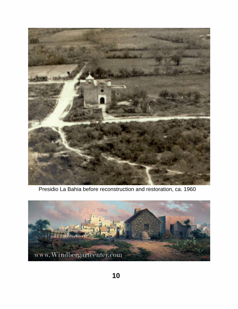
Presidio La Bahia before reconstruction and restoration, ca. 1960
10

11

Source: Berlandier, Jean Louis, The Indians of Texas in 1830, Washington, 1969.
12

13
Drawing by Captain Joseph H. Chadwick,
March 1836


Walking Tour of Presidio La Bahia By an anonymous author of a site brochure
Coordinated to the presidio plan on the previous page
Soldiers’ Quarters. The center section of this building was built in 1752 as the first stone structure on the site. The original buildings built in 1749 were of post oak and mud construction and were all replaced by 1790. The entire building was used by the commanding officer and his staff for quarters and offices. In January of 1780, Texas Governor Cabello moved his office to this building from San Antonio to direct cattle shipments to Galvez’s Spanish army fighting the British. This building now serves as the entrance to the presidio, offices, and the museum. Independence Flag Pole. Here, the first flag of Texian Independence was raised on December 20, 1835 after the garrison signed the Declaration of Independence inside the chapel. Below it is the gravestone of Lt. Augustus Magee, a former US Army officer who died during the 1813 seige while commanding a combined force of Mexican rebels and American volunteers. Lt. Magee is buried somewhere in the quadrangle. Chapel Courtyard. Here, on March 27, 1836, Col. James Fannin was executed during the Goliad Massacre. Several people were buried here in the 1880s, of which only the grave of Annie Taylor remains marked. She has no historical connection with the presidio. The water gate opened to a path down to the San Antonio River. In 1836, Fannin’s troops built a covered ditch from this wall to the river to gain a fresh water supply. Office. This extension of the Soldiers’ Quarters was built in 1835-38 and now contains rest rooms and guest quarters. NW Bastion. Built as part of the Spanish defenses, this was reshaped in 1835-36 by Texian troops. Bastions were designed to allow the artillery to have a clear view of fire and to cover the flanks of the walls. This bastion also covered the old San Antonio Road and crossing. The sentry box or bartizon was built to give the guard cover during bad weather. The cannon, an English pattern six pounder, is original to the site. Chapel. Built between 1780 and 1807, the original simple fort chapel has been enhanced greatly with the addition of a bell tower in the early 1900s and the fresco painted by Antonio Garcia in 1948 behind the altar. The side altar, originally served as
15

the fort’s powder magazine. It now contains the flags of the states and countries whose sons were killed in the Goliad Massacre. The groin vault roof is the only surviving example of this style of construction in the Southwest. Over the altar is the statue of Our Lady of Loreto (for whom the chapel is named). It dates from 1721 and is the only original item to survive the presidio’s three moves. Col. Fannin’s men were held in this chapel for the first three days of their confinement in 1836. Quadrangle Parade Ground. Because of the large number of troops in his command, Col. Fannin had his companies camped around the parade ground in tents. SE Bastion. One of the original Spanish fortifications, its bartizon is in ruins. The grave of Col. Fannin and his men is under the large monument that can be seen from here. Calabozo. These “South Barracks” were built from existing structures in 1810, and housed up to 80 soldiers in the Spanish period as well as the Mexican garrison after 1821. Currently, it is being restored to its 1836 appearance. There were no bunks for the soldiers, who slept on straw piled on the floor. Sally Port. This was the main gate through which Texian soldiers marched, were broken into three groups, taken down different roads one-quarter mile, and executed by order of Santa Anna. Guard House. This is the room next to the gate that was set aside for the guard detail. SW Bastion. Like its SE counterpart, remnants of the original bartizon remain visible. From here one has a good view of the house purported to be the birthplace of Ignacio Zaragoza, surrounding landscape, vegetation, and Mission Espiritu Santo, one mile away to the north and on the other side of the San Antonio River.
16

17
Mission Farm Land

18

Farmland but No Mission
Much like the map Joseph de Urrutia drew of San Antonio in 1767, the one he drew of Goliad (next page) shows farmland as well as the presidio. Unlike his map of San Antonio which also showed the Alamo, or mission San Antonio de Valero, his map of Goliad shows no mission. The farmland, therefore, was clearly associated with the presidio.
Climate and Agriculture Urrutia’s map San Antonio showed a canal irrigation system. His map of Goliad does no. Why? A review of the climate data suggests that such a system might not have been needed. As the figures below indicate, Goliad is certainly a more humid environment than San Antonio. Variable (Annual average) Goliad San Antonio Precipitation 34” 28” Temperature 71° 69° Evaporation Rate 30” 40” ER in drought years 42” 53” Relative humidity 6 a.m. 88% 83% 6 p.m. 60% 52% That said, a document found in the archives of San Luis Pótosi, México and pertaining to Goliad in 1819 suggest a canal might have been needed. It reads: “…los habitates de este pueblo, no tienen otra ocupación que dedicarse en las siembras de maíces de temporal, cuyas cosechas pierden en los años que calman las lluvias; siendo este el único arbitrio para su subsistencia…” Translated: “The inhabitants of this town only have the occupation of cultivating rain fed corn, and lose their harvests in dry years; this is the only means of subsistence.”
19

20

21
Presidio Farm Land

A Google Earth image superimposed on Urrutia’s map of 1767
22


Mision Nuestra Señora del Espíritu Santo de Zúñiga y Mision Nuestra Señora del Rosario
and Cattle Ranching By anonymous authors of site brochures
In 1749 after two previous moves (see pp. 24-25) Mission Espíritu Santo was established in its current location on the banks of the San Antonio River. Mission life proved destructive to the natives’ traditional way of life, which involved seasonal movements between Goliad and the coast. Prior to living at the missions, the Aranama of South Texas spent their summers on the coast exploiting various marine and littoral resources. They moved north in the winter and hunted bison that migrated away from the snow-covered Great Plains. With the introduction of cattle, missions afforded the natives a permanent food supply, and in concert with the presidios, protection from more aggressive tribes. A permanent life style and instruction in the Catholic faith contributed to the gradual erosion and eventual destruction of their traditional tribal culture. Mission Espíritu Santo became the center of a small but busy community. Supervised by Franciscan priests, men branded cattle, mixed mortar, and constructed the church, granary, and housing. Women spun wool, wove clothing, and made ceramic vessels for storage and cooking. Ranching, however, became the principal occupation. Thousands of feral long-horned cattle roamed the mission lands. Natives adapted Spanish riding and roping styles and became accomplished vaqueros. Renowned for its livestock, the mission regularly traded cattle with other settlements. During the American Revolution, mission cowboys herded thousands of beeves to Louisiana in support of the American struggle for independence. Franciscan efforts at the mission continued until 1830 when declining native populations (see p.27), lack of money, and political turmoil in Mexico forced it to close. By 1931 when the fledgling Texas State Park system acquired the site, neglect and the use of stone for other construction projects had left the buildings in ruins. Crews of the Civilian Conservation Corps worked to restore the mission from 1935 until 1941. During the 1970s, Texas Parks and Wildlife Department rehabilitated the chapel and built exhibits in the restored granary. Mission Rosario was founded in 1754 by Franciscan missionaries from the College of Zacatecas, Mexico in an attempt to settle the wandering Karankawa who had abandoned the first Mission Espíritu Santo. In 1767 the superior of the Franciscan missions in Texas, Father Jose de Solís, reported of Mission Rosario:
28

“As far as the temporal goods are concerned, it is in a flouring condition. It possesses two droves of asses, forty tame horses, thirty tame mules, twelve teams of oxen, two hundred milk cows, seven hundred sheep, and five thousand head of cattle.” This temporal success was short-lived. Regimented mission life had little appeal to the Karankawa who returned to their traditional ways. Mission Rosario was abandoned in 1781, briefly reopened in 1789, and closed permanently in 1792. It was located approximately four miles west of Goliad (see p. 30), on a slightly elevated point with a panoramic view of the grassy San Antonio River valley. The stabilized ruins of mission walls are all that remain of one of Texas’ last intact Spanish mission archaeological sites. In 1935 the site was donated to the County of Goliad by W.F. O’Connor. Later it was deeded to the state and in 1972 it became a unit of the Goliad State Historical Park. The site is fenced and closed to the public.
A view of the site of Mission Rosario.
29

30
Oak-Hickory Forest
Coastal Prairie
Mission Rosario
Mission Espiritu Santo
Presidio La Bahia

31

An enlargement of a portion of Berlandier’s 1830 drawing of the Presidio La Bahia as seen from Mission Espíritu Santo. Note the paucity of vegetation, especially trees. This landscape is strikingly different than that of today’s.
32