
Kitwanga Fort Report
146
Transcript of Kitwanga Fort Report


Kitwanga Fort
Report
by George F. MacDonald
Canadian Museum of Civilization

©Canadian Museum of Civilization 1989
Canadian Cataloguing in Publication Data
MacDonald, George F.
Kitwanga Fort report
(Mercury series, ISSN 0316-1854) (Directorate paper I Canadian Museum of Civilization; no. 4) Bibliography: p.
7 ISBN 0-660-10777-5 Includes abstract in French.
1. Kitwanga Fort Site (B.C.) 2. Kitwanga (B.C.) -- Antiquities. 3. Excavations (Archaeology) -British Columbia -- Kitwanga. 4. Skeena River (B.C.)--Antiquities. 5. Indians of North America - Canada --Hist:.ory. I. Canadian Museum of Civilization. II. Title. III. Series: Directorate paper (Canadian Museum of Civilization); no. 4.
E78.B9 M33 1989 971.1'3201 C89-097042-4
Printed and bound in Canada
Published by Canadian Museum of Civilization 100 Laurier Street P.O. Box 3100, Station "B" Hull, Quebec J8X4H2
This report was originally published as: Kitwanga Fort National Historic Site Skeena River, British Columbia Historical Research and Analysis of Structural Remains Parks Canada Manuscript Report Number 341
OBJECT OF THE MERCURY SERIES
The Mercury Series is designed t:.o permit the rapid dissemination ofinfonnation pertaining t:.o the disciplines in which the Canadian M usewn of Civilization is active. Considered an important reference by the scientific community, the Mercury Series comprises over three hundred specialized publications on Canada's history and prehistory.
Because of its specialized audience, tho series consists largely of monographs published in the language of the author.
In the interest of making information available quickly, normal production procedures have been abbreviated. AB a reault, grammatical and typographical errors may occur. Your indulgence is requoeted.
Titles in the Mercury Series can be obtained by writing to tho:
Mail Order Services Publishing Division Canadian Museum of Civilization 100 Laurier Street P.O. Box 3100, Station "B" Hull, Quebec J8X4H2
(613) 957-9905
BUT DE LA COLLECTION MERCURE
La collection Mercure vise a diffuser rapidement le r~ultat de travaux dans !es disciplines qui rel event des spheres d'activites du Musee canadien des civilisations. Conaideree comme un apport important dane la communauW scientifique, la collection Mercure presente plus de trois cent publications specialisees portant sur l'h6ritage canadien prehistorique et hlstorique.
Comme la collection s'adresse A un public specialise celle-ci est constituoo essentiellement de monographies publiees dans la langue dee au tours.
Pour assurer la prompte distribution des exemplaircs imprimes, !es etapes de l'Odition ont et.e ab~goos. En consequence, certaines coquilles ou faute11 de grammaire peuvent eubeister : c'est pourquoi nous reclamons votreindulgence.
Voue pouvcz voue procurer la liste des titres parus dans la collection Mercure en ocrivant au :
Service des commandes post.ales Division de !'edition Musee canadien des civilisations 100, rue Laurier C.P. 3100, Succursale "B" Hull (Quebec) J8X4H2
(613) 957-9905

Abstract
During the mid-eighteenth century, early influences from coastal trade in iron from Russian sources had repercussions on Indian villages up the Nass and Skeena rivers. Eulachon grease trails that bad been established between villages for millennia took on new strategic importance in intertribal warfare once iron began to move along them. Kitwanga Fort was probably one of many settlements established by ambitious warriors like Nekt to control this new trade. During the summer of 1979, a joint project of the Archaeological Survey of Canada, Canadian Museum of Civilization, and the National Historic Sites and Parks Services, Parks Canada excavated five houses sites on top of a hill near the confluence of the K.itiwankul and Skeena Rivers and mapped several hundred salmon stornge pits around the back of the hill.
Rich oral tradition concerning the hilltop fort and its occupants were collected during the project at the village of Kitwanga, two miles from the archaeological site.
The archaeological and ethnohistoric research at the Kitwanga Fort Site, now a National Historic Site, throws new light on an episode of endemic warfare in Northern British Columbia at the time of initial contact with the outside world.
iii

Resume
Vers le milieu du xvme siecle, l'influence du commerce de fer d'origine russe sur le littoral commence a se faire sentir dans les villages amerincliens situes le long des rivicrcs Nass et Skeena. Le contrOle des pistes millenaires utilisees pour le commerce de la graisse d'eulakane entre les villages prend alors une importance strattgique nouvelle dans les conllits entre tribus. Le fon Kitwanga est probablement un des nombreux etablissements eriges par des guerriers qui, comme Nekt, veulent dominer ce commerce. Au cours de l'ete 1979, dans le cadre d'un projel commun de la commission archeologique du Canada (Musee canadien des civilisations) et des Services des pares et lieux historiques nationaux, cinq emplacements de maisons ont ete mis A jour, au sommet d 'une colline se trouvant au confluent des rivicrcs Kitiwankul et Skeena, et plusieurs cenlaines de fosses servant au stockage du saumon ont ett reperees derriere la colline.
'A quelques kilometres du site arcMologique, les chercheurs ont pu recueilli r de nombreux recits sur le fort et ses occupants, recits qui leur ont ete transmis oralement.
La recherche archeologique et ethnohistorique menee a !'emplacement du fort Kitwanga, classe depuis lieu historique, nous aide a comprendre cette periode de con flit endemique qui sevissait dans le nord de la Colombie-Britannique au moment des premiers contacts avec le mondc exterieur.
iv

Table of Contents
Abstract Acknowledgements Introduction
Part I - The Cultural Setting Ethnohistory
Warfare Armour
Helmets Weapons Forts on the Northern Northwest Coast
Trails and Trade Kitwank:ul Trail
The Historical Period Early Historical Contacts
Exploration of the Skeena River
Part II - Physical Setting at the Ta'awdzep Site Geology Botanical Survey of the Site Excavations Test Trenches
Trench 1
Trench2 Cultural Stratigraphy The Reconstruction of the Model of Kitwanga Fort Summary and Conclusion
Bibliography Appendix I Appendix II Appendix III Appendix IV AppendixV Appendix VI Appendix VII
v
iii
vii
ix
1
1 4
6 8 8
13
16
16
24 24 26
30 30 33 33
56 56 64 68 69 72 79
A-1 A-5
A-11
A-29
A-41
A-45
A-47


Acknowledgements
Historical events associated with the native peoples of Canada are largely unknown to the general public. As an archaeologist, I am increasingly aware that the native history of our country is both rich and varied. It is important to make this rich heritage known to the Canadian public and to see that it is commemorated adequately. The story of the warrior Nekt is one such fascinating episode of lndjan history involving hilltop forts, warriors in elaborate suits of armour, and all of the ceremonialism and ritual, which has made Northwest Coast Indian culture so fascinating to us today. Like many such stories, we began with semi-legendary accounts and attempted to fit them into an hjstoric context by investigating both the locale in which the events took place and the memories of people whose ancestors had been associated with those events.
The investigation reported here would not have been possible without the support and assistance of the people of Kitwanga. In particular, I would like to thank the fonnerChief Councillor.Larry Moore, and the former Band Secretary, Glen Williams, for the arrangements they made for students from the reserve to work on the project. 1 also wish to thank Neil Sterritt, Director of the Gilksan-Carrier Tribal Council in Hazelton for advice and encouragement as well as Polly Sargent and the 'Ksan Dancing Society for allowing me to photograph the suits of armour they have recreated, particularly that of the warrior Nekt. The picture of Nekt's armour, worn by Victor Mowat of Hazelton (fig. 2), is reproduced here with kind pennission of the 'Ksan Dancing Society.
I would like to express my appreciation to the two agencies that sponsored this research, first to the National Museum of Man (now the Canadian Museum of Civilization), National Museums of Canada, particularly lhe Director at that time, Dr. W.E. Taylor, Jr., for making my time available to the project and to Mr. Wally Kozar, then Assistant Director for providing valuable administration support, and second to lhe National Historic Parks and Sites Service, Parks Canada, particularly the Research Section, including Mr. John Rick, Heact of the Research Division in Om1wa who first invited me to undertake this project, and Mr. Gerard Finn, Head of the Western Canada Research Section in Calgary, who was responsible for the planning and administration of the projecL I would also like to thank DiAnn Herst, Chief of the Archaeological Research Section, Ottawa, for providing space for analysis of the collections and the production of this report, and Al Wilson for arranging drafl.ing services. Similarly, 1 would like to thank Dr. Roger Marois, then of the Chief Archaeological Survey of Canada, Nal.ional Museum of Man, for services he made available from that agency.
For his extensive assistance both in the field project at Kitwanga and in the laboratory in Ottawa, I wish to thank my colleague Dr. James B. Shaeffer. From the initial planning of the project to the preparation of the report. Dr. Shaeffer was involved throughout. He gave his time and effort far beyond the requirements of his research contract with Parks Canada. I would also like to thank Rosalind Whalley, who has been very helpful in researching questions of much importance to the archaeological interpretation of the site and its former occupants, both through ethnographic research in archives in Ottawa and Victoria, and direct! y, with the descendants of the people of the Ta' awdzep, now living in and around Kitwanga, British Columbia.
vii

I further want to thank.my wife, Joanne MacDonald, for her continued support throughout this project and for her research on material culture associated with the families at the fort.
Thanks also go to Joanne Monahan, the regional advisor for Kitimat district to the Archaeological Sites Advisory Board of British Columbia. She served most ably as finds recorder, photographer and field laboratory supervisor.
To the crew, who excavated the site for six weeks in the summer of 1979, I extend thanks for their interest and help. The student assistants include: Jane Sproule Thompson, Wayne Nelles, Helen Lemmon and Richard Mackie. Two volunteers were Dianna Farrow and Joanne MacDonald. Local assistance from Kitwanga included: Charlie Morgan, Oyde Williams, Valerie Williams, Leona Bright, Leona Williams, Phyllis Morgan and Patsy Bright.
While excavating the fort hill, most of the crew lived in the teacherages in Ki twankul village, arranged by E. Bergman of the Department of Indian Affairs in Hazelton. Chief Peter Williams and Chief Solomon Marsden made us welcome in the traditional way, with a special perfonnance of their Lak-an-zok dance group. May Derek. a local historian. and resident anthropologists Vickey Jensen and Jay Powell helped with many arrangements.
Expression of my appreciation is due to the team of scientists from the Forestry Research Station of the Government of British Columbia in Smithers, who contributed their special expertise for the region to settling some major questions about the natural history of the site. They include Dr. David Wilfred, who provided a thorough interpretation of the geology of the site area; Dr. Richard Throwbridge, who interpreted the soils; and Dr. James Pozar, who provided a definitive list of the plant and tree species observed in the Parks Canada property.
The preparation ofthis report in Ottawa involved many pcopl e in addition to those already mentioned. For the appendix on faunal remains from the site, I am indebted to Anne Meachem Rick, Director, Zooarchaeological Identification Centre, National Museum of Natural Sciences. Thanks also go to Gerard Van Velthuizen, Contract Geologist and L. Moyd, Associated Curator, Mineralogy Department, NationalMuseumofNatural Sciences for the identification and interpretation of mineral specimens; and from the staff of Historic Parks and Sites Branch, Material Culture Research, Karlis Karklins who examined and commented on Lhe bead collection from the site; Douglas Bryce, ofthe Underwater Archaeology Section, and Bruce Morton, arms specialist, who examined and commented on weapon pans and Catherine Sullivan, glass specialist, who examined and commented on the glass fragments from the Conservation Division; H. Unglik and John Dawson, for chemical analysis and identification of metal objects.
For drafting, I wish to thank Rick Lalonde of the Calgary office of National Historic Sites and Parks Branch, Steve Epps of the Ottawa office of N.H.S.P.S. and David Laverie of Archaeological Survey of Canada, National Museum of Man. For Lhe typing, many thanks go to my secretary JuneMarsham, and to Lucie Clayton of the National Historic Parks and Sites Service, Ottawa. Finally, I would like to thank the Ottawa artist, An Price, for his patience and skill in interpreting my vision of what the Ta'awdzep looked like in Nekt's Lime into a fine display model.
George F. MacDonald, Ottawa, January 15, 1980
Vlll

Introduction
ln 1965 I visited Dr. Marius Barbeau al his home in Ottawa to talk of my plans for archaeological field work in northern British Columbia. Dr. Barbeau was almost eighty years old at that time and had been retired from the National Museum for many years. After a brief con versa Lion about my interest in the Skeena River peoples, Dr. Barbeau began a long story about a warrior named N ekt and about the hill near Kitwanga where this warrior had his fort. Before I left that afternoon Dr. Barbeau stressed how important he thought this site was to the history Of the coast and that he thought I should undertake an investigation ofNckt's fon.
Figure 2
on top of the hiJI but that nothing of significance had been found, and that there did not appear to be any sizeable cultural deposit on top of the hill.
In 1975 the Kitwanga
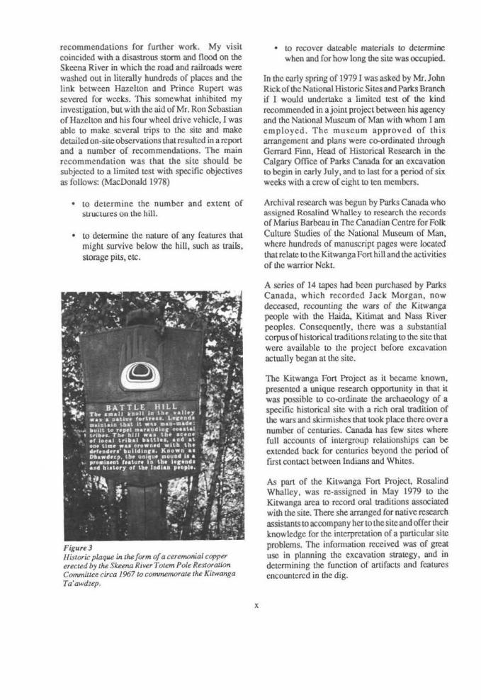
It was not until 1968 that I heard of the site once again, and on this occasion it was from Mrs. Polly Sargeant of Hazelton, who with the Skeena River Totem Pole Restoration Society, had decided to erect a historical marker at the site (Fig. 3). Mrs.
Battle Hill came to my auenlion once again when it was brought before the National Historic Sites and Monuments Board of Canada. I represented the National Museums of Canada on that Board and was pleased to support the Board's declaration that the site was of National Historical importance. I did point out to the board, at that time, that there was another much larger fort at the Kitselas Canyon, which appeared to have much more extensive archaeological remains and had been occupied for a much longer period than the one near Kitwanga. I had cleared the Kitselas site of vegetation and carc-fully mapped the site in 1968 and published reports on it in 1969
A reconstructwn by the Ksan Dancing Society of the arTMUI'
and weapons of the warrior NekJ. (Reproduced with the K~·an Dancing Socier/ s permission).
(MacDonald & Allaire 1969) and later in 1979 (AJlaire, MacDonald and Inglis 1979). The relationship between these two forts was not well understood but there seemed to be as many differences between these sites as rhere were similarities.
Sargeant recounted to me the stories of how the hill was 'man made' as its name apparently indicated and she suggested once again that I investigate the hill. l did make a visit to the site that summer and observed that there were ridges and numerous depressions on top of the hill that indicated the remains of old structures. Shortly, thereafter, I talked to Mr. Philip Ward, Conservator at the British Columbia Provincial Museum, who was helping the local society to conserve poles at Kitwanga and Kitwankul. He said he had excavated a small test pit
ix
The National Historic Sites and Parks Service of Parks Canada felt more information about the JGtwanga fort site was required for their planning purposes and invited me to pay a brief visit ro the site in November of 1978 and provide them with
recommendations for further work. My visit coincided with a disastrous storm and flood on the Skcena River in which lhe road and railroads were washed out in liLerally hundreds of places and the link between Hazellon and Prince Rupert was severed for weeks. This somewhat inhibited my investigation, buL with lhe aid of Mr. Ron Sebastian of Hazelton and his four wheel drive vehicle, I was able to make several trips to the site and make detailed on-site observations that resulted in a report and a number of recommendations. The main recommendation was that the site should be subjected to a limited test with specific objectives as follows: (MacDonald 1978)
• to determine the number and extent of structures on the hill.
• to determine the nature of any features that might survive below the hiU, such as trails, storage pits, etc.
Figure 3 Historic plaque in the form of a cerembnial copper erected by the Skeena River Totem Pole Restoratwn Commiuee circa 1967 to commemoraJe the Kitwanga Ta'awdzep.
x
• to recover dateable materials to determine when and for bow long the site was occupied.
In the early spring of 1979 I was asked by Mr. John Rick of lhe National Historic Sites and Parks Branch if I would undertake a limited test of the kind recommended in a joint project between his agency and the National Museum of Man with whom I am employed. The museum approved of th is arrangement and plans were co-ordinated through Gerrard Finn, Head of Historical Research in the Calgary Office of Parks Canada for an excavation to begin in early July, and to last for a period of six weeks with a crew of eight to ten members.
Archival research was begun by Parks Canada who assigned Rosalind Whalley to research the records of Marius Barbeau in The Canadian Centre for Folk Culture Studies of the National Museum of Man, where hundreds of manuscript pages were located that relate to the Kitwanga Fort hill and the activities of the warrior NckL
A series of 14 tapes had been purchased by Parks Canada, which recorded Jack Morgan, now dee.eased, recounting the wars of the Kitwanga people with the Haida, IGlirnat and Nass River peoples. Consequently, there was a substantial corpus of historical traditions relating to the site that were available to the project before excavation actually began at the site.
The Kitwanga Fort Project as it became known, presented a unique research opportunity in that it was possible to co-ordinate the archaeology of a specific historical site with a rich oral tradition of the wars and skirmishes that took place there over a number of centuries. Canada has few sites where full accounts of intergroup relationships can be extended back for centuries beyond the period of first contact between Indians and Whites.
As pan of the Kitwanga Fort Project, Rosalind Whalley, was re-assigned in May 1979 to the Kitwanga area to record oral traditions associated with the site. There she arranged for nati vc research assistants to accompany her to the site and offer their knowledge for the interpretation of a particular site problems. The information received was of great use in planning the excavation strategy, and in determining the function of artifacts and features encountered in the dig.

Part I The Cultural Setting
Ethnohistory
The oral history of Skeena River tribes has engaged the interest a number of anthropologists beginning with Franz Boas who collected many legends from the Gil.ksan and Tsimshian at Port Essington on the lower Skeena late in the last century (Boas 1970). Lieutenant George Thornton Emmons who first served as an American Naval Officer on the coast of Alaska, retired to a long commitment to the study of Indian cultures of the northern coast. He made numerous trips to the Skeena River between 1908
and 1914 and took a particular interest in Kitwanga and the stories of Neb. Marius Barbeau, and his field researcher William Beynon, collected a large quantity of text materials from Gitksan sources from 1915 until the mid 1950s.
The richness of the Boas, and Barbeau/Beynon narratives attracted the attemion of Claude Levi-Strauss who chose the myth of Azdiwal from the Skeena-Nass River as the vehicle for several essays on structural analysis, with many rejoinder articles by colleagues, which continue to appear in the anthropological journals.
-~~::!~N~~;~;!~:::.~:0~~-,·:,,, >Ttuicfes. Luttaisttb <teteived herhusbiiidasliftliesex .. &hCrthird child .tnaking him beli~i;ffiJth!UHt ·. ;': ':6lt1h ofadaughier, ~hosefifehe~(0r~Jtrds(iti.'Wtt1i thehelpofsornetelalivesQf~~~~li·l . <j;·er"t. Luinlisun mUrdered her HaidaJiusbaridf t:¥t:offhis head. and e&:~ b)' night ill a ~'.1iM'. ·· The tale of bee m~t ~ the sea ti?' ®..~1ancf is illustrated in a few poles of this clan. whicttifi:; ,, .. ,>-'. may be cauoo the Naeqt (Tongue-licied} clafuJiercldld .in the bow of the canoe is supposed to have'.~, · ',i,. ·~eked the pt'01.tlµli.ng tongue of hiS fathelj.s .~Lu~ was tescued at ilie tnOttth of the Nw .,,;;.~ . ~d was adoptM ~ by a family ·Qf ~~:Jf~ son._named Naeqt fI'ongue.:tic;k~} fu)m ~· ·· ·· .:. .. epi~ of his. momer's flight in a .. ~.:~:y;~ ~ ~og. reckless boy, inheriting many o(b~ ,; : :::, ::':fi!ttier.'sctlaracteristics. lbe uncle$6.P3l1y'. (fj~iss.edlx>Ul·mother and son, who then began alim0f•'%i'
f~lil§it:;rtfifi~3~1 .. :·.·. '• ·°*e$ <)f sl~t~ find .be ~QJ1i$ ~at¢edt~'.a.··: .· :s : jjUf;oo~fQt..q.;iastaI)<f~b$ .a1v.~.~~~:· . '""''"1
a fence of logs atoo.nd the rtve.houses .. df:ftidribe;aoo a·trap door ®~red with deet eoors.~wh.iCb'XT would rattle at the !east contact )yti~;.~;~!l.}~,·~ ~igbt tried to climb the steep ~Oi>e.'.?f;~:i!ti Ta' awdzep. they were cru~hed to death ·by. me:lOgS dlat r8ttted ~n as soon as t.he.y were JeteaSed · ;: by the besieged warriors above. Naeqf. ~ i~.wrnm~ some say by a gunshot (f!Qrii the first gun\'.;' .::
. used i.n tile countty), wbilo be dormoo JUs: grilzjy;:l>etliarmour on a.n eicpeditioa, and then clubbed~ '.: ;: ,,, ·'!' death." . ···'· · __ ,,,, -iC·'.::..,.,: ·• .;· .. , •...
: ~~-- :~~~t::.:· i¥ :...;.

All.hough Lhis rich resource of textual materials runs co Lhe thousands of pages, there is a much smaller, but not insignificant amount lhat relates to the Kitwanga fon hill. The most extensive notes are those of Barbeau/Beynon in the files of the Canadian Centre for Folk Culture Studies of the National Museum of Man in Ottawa.
A collection of materials of special interest to the project arc the tapes recorded by Willis Morgan of his elderly uncle Jack Morgan, who died almost a decade ago. These recordings are being transcribed by Rosalind Whalley and together with the archival maccriaJs will fonn the basis of a lacer study on the oral traditions surrounding the Ta' awdzep of Nekt.
AILhough there are many variants of the Nekt (Naeqt) story (see Appendix I). Barbeau has conveniently synthesized a standard accoum, which is reproduced here to set the stage for the reconstruction that follows (Barbeau 1929: 52, 53).
Fonnal analysis of the many variants of the Nekt story would undoubtedly produce many conclusions of historical and anthropological significance. A strucwral analysis should reveal a set of relationships between Gitksan families and villages as well as wider set of relationships to other groups as far separated as the Haida, the Haisla, the Niska, Coast Tsimshian and TsetsauL In many respects the Neltt story is constructed of archetypal elements that occur in many other warrior stories from the North Coast. Undoubtcdly there was a historical person called Nekt who did have a fort on the Kitwanga hill, but his existence was sufficiently far back in the past for I.he exact localities of hls adventures to have been readaptcd to regional needs. In some accounts his mother comes from Kispiox. In others she is from Kisgigas or from a Nass River village. Stories also vary as to where
2
Nekt resettles afl.cr he leaves lhe Ta'awdzep at Kitwanga and even to the place where, and the melhod whereby he is fmally killed.
Similar to the difficulties of reconstructing the biography of the warrior Nekt are those of trying to sort out the various episodes of warfare that took place at the Ta 'awdzep and of matching them with the archaeological remains at the site. ln preparation for this t.ask it is necessary to review some of the background of warfare and weaponry among the nonhem tribes of the northwest coast
Figure 4 The Tsimshian Artist Fred Ale:rcee produced many painlings based on ml!111()r~s of Port SinpS()n. This Tsimshian warriour is Ol1I! of a rwmber showing the use of armour, bows and arrows in S(JmewhaJ crude buJ very dramatic i//ustraticn.r. (Courtesy Vancouver Ce11ten11ia/ Mu.teum).

Figures Locaiions of Kilwanga Fort, North Coast District, BriJish Colwnbia.
0 N
0 0
3

Warfare
Among the Tsimshian speaking peoples of British Columbia warfare is recorded in epic oral histories that, by conservative estimates, span three or four centuries prior to European contact (Robinson and Wright 1962). The wars of the coast Tsimshian were on a much larger scale than were those of their relaLives on the upper Skccna River. The coast Tsimshian went to war in large, sea-going canoes that could carry fifty warriors and that were deployed on raids hundreds of miles north and south of their home territory. In a recent study of norlhwestcoast warfare, Ferguson (l 979B:4) states:
"The river mouths also were centers of trade both before and aft.er cont.act. Furs and other items from the interior were traded down the valleys and western buyers clustered around the estuaries. Control of this trade was a continual source of connict."
In particular reference to the Skccna Estuary, he st.ates (Ferguson 1979B:6):
"Boas' (1970:335-378) infonnants recalled a long series of exterminative raids fought between the Tlingit and Tsimshian over control of the Nass and Skccna Estuaries. These occupied most of the eighteenth century, with the Tlingit finally being defeated and pushed north."
The Haida were pushing out from their Queen Charlotte Islands home in several directions. To the north they displaced Tlingit people from much of the PrinceofWales Archipelago and made frequent attacks on Coast Tsimshian villages. According to legend they were leading war parties up the Skeena River even before the maritime fur trade had been established.
Archaeology in thePrinceRupertHarbour area near the Skeena estuary (MacDonald 1968) demonstrates clearly that warfare has been an organized and relatively extensive activity since approximately 1000 B.C. A Sludy of fractures in human skulls and limbs from skeletons recovered from shell midden si1es near Prince Rupert shows major conllicts with heavy weapons such as stone clubs throughout the first millenium B.C.
4
(Cybulskil978). Finds of massive monolithic clubs as well as stone club heads, slate dagger blades and whalebone clubs verify this conc lus ion. Repercussions of such widespread hostilities near the Skeena estuary undoubtedly were felt at least as far as the Kitselas Canyon (Allaire 1978). Even from this early period the coincidence can be seen in the increase in evidence for interregional trade, and in intergroup conflict Warfare and trade go hand in hand over the past three thousand years in the Skeena estuary and adjacent coast.
The pattern of warfare was consistent along the entire Norlhwest coast as far as the Bering Sea (Burch 1974). Night or dawn attacks were favoured and the aim was generally to trap as many people in the house as possible, and IO rake the women and children alive to be slaves. Most such activities could best be characterized as raids rather lhan wars. Motivation for war was for revenge or to take slaves, food stores or crest privileges. Territorial expansion was rarely the motivation or result of such hostilities.
Large specially built war canoes gave amazingly effective strike and retreat capability. Campaign supplies could be stored easily in the big watercraft so that !he warrior crew was not slowed down by the necessity of foraging for food. There are several accounts that describe Tsimshian war canoes armed with large rocks that were used at close range LO sink enemy crafL. Small cannon were mounted on war canoes early in the maritime fur trade period. The mobility provided to the coast Indians by the war canoe can be favourably compared to that of the h orse nomads of Eurasia. Traditional narratives talk of Haida war parties on the Skcena River with as many as 600 men in 12 canoes.
The only organization of war parties was into lineage or household groups each of which re.cognized the authority of their own chief. A chief wishing to lead a war party was required to solicit the assistance of other house chiefs within his village. War parties drawn from a number of villages were rare. The close relationships between a household group and a canoe pany is noteworthy. A house chief became a canoe chief and every member of the party had an assigned scat in the canoe that corresponded to his seating rank within the house. Canoes, like houses, were named beings
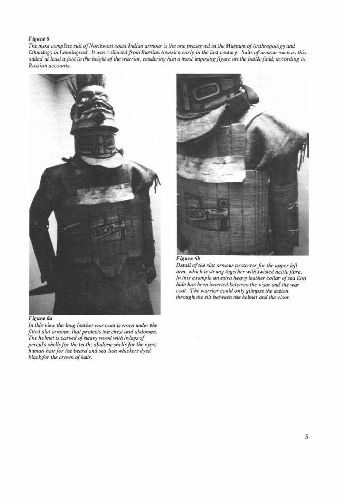
Figure6 The most complete suit of Northwest coast Indian armour is the one preserved in the Museum of Anthropology and Ethnclogy inLenningrad. It was collected from Russian America early in the last ceniury. Suits of armour such as this added at least afoot to the heighJ of the warrior, rendering him a most imposing figure on the battlefield, according to Russian accounJs.
Figure 6a In this view the long leaJher war coal is worn under the fitted slat armour, that protects the chest and abdomen. The helme1 is carved of heavy wood wilh inlays of percula shells for the teeth; abalone shells for the eyes; human hair for the beard and sea lion whiskers dyed black for the crown of hair.
Figuu6b Detail of the slal armour prOlector Jot the upper left arm, which is strung together wilh twisted nellle fibre. In this example an eXJra heavy lealher collar of sea lion hide htJs been inserted between the visor and the war coat. The warrior could only glimpse the action through the slit between the helmet and the visor.
5
thought lO have an existence and history of their own.
It has often been noted for the Northwest Coast that warfare is conducted like a ceremony, and ceremonies, particularly I.he potlatch, are conducted like warfare. There is good evidence to suppon the view that potlatching and warfare were pan of a continuum whereby disputes between groups who were physically or culturally close would be dealt with through the potlatch, whereas disputes between those who were more distant were dealt with through warfare.
The use of armour appears to have been almost as much for ceremonial display as it was for protection. Ritual combats between elaborately armoured warriors were often used to decide the outcome of a particular battle. Elaborately carved helmets, or painted leather jerkins over the armour, were important fonns of display.
Preparation for war involved fasting and abstinence from sexual intercourse by the man prior to the campaign, and rigidly observed abstinence by wives back in the villages. Ritual purification of a warrior was achieved by talcing emetics or sweat baths.
Shamans were taken on war parties as they could often foretell the future or sec through the mist or fog on canoe journeys. Some Shamans had mirrors of stone in which they could foresee the outcome of proposed bau.les or campaigns. Shamans often wore armour for their combat with other Shamans over the souls of patients. Naekt's armour of a grizzly bear hide is virtually identical to the bear skin cape used by Shamans among the Gitksan. It is this bear skin armour of Nekt that Awkawt wears as a Shaman on The Raven-Sailing-through-the-air pole at Kitwanga.
6
Armour
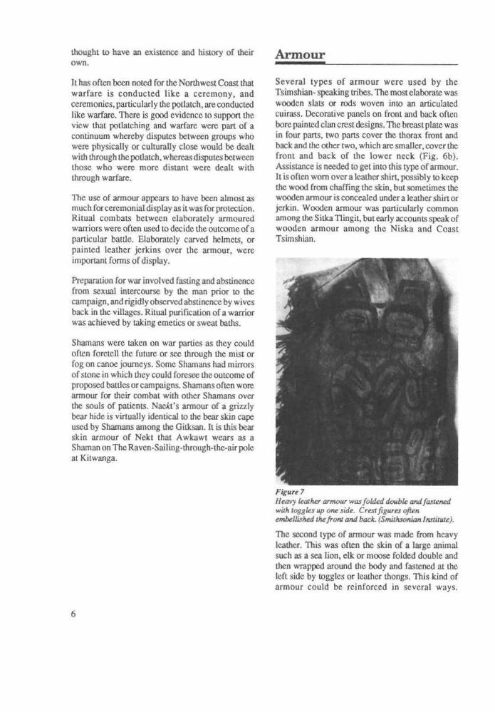
Several types of armour were used by the Tsimshian- speaking tribes. The most elaborate was wooden slats or rods woven into an articulated cuirass. Decorative panels on front and back often bore painted clan crest designs. The breast plate was in four pans, two pans cover the thorax front and back and the other two, which are smaller, cover the front and back of the lower neck (Fig. 6b). Assistance is needed to get into this cype of armour. lt is oflen worn over a leather shirt, possibly to keep the wood from chaffing the skin, but sometimes the wooden armour is concealed under a leather shin or jerkin. Wooden armour was particularly common among the Sitka Tlingit, but early accounts speak of wooden armour among the Niska and Coast Tsimshian.
Figure 7 JJ eavy le asher arrrwur was folded double and f astef1'!d with toggles up OM! side. Crest figures often embellished the fronJ and bock. (Smillisonian Institute).
The second type of armour was made from heavy leather. This was often the skin of a large animal such as a sea lion, elk or moose folded double and then wrapped around the body and fastened at the lefl side by toggles or leather thongs. This kind of armour could be reinforced in several ways.

Wooden or metal slats could be sewn inside, and gravel or small stones could be glued on the outside with strong fish glues. This trcatmenL was often applied three or four times until the leather coal was like cement.
Nekt' s annour was a variant from both of these types since some accounts claim that he had plaques of shale sewn on the inside of his annour, which was made from a grizzly bear hide with Ille hair outside. The weight of this armour must have been considerable. Chief Hlengwah of Kitwanga (Jim Laknitz) described Nckt's armour to Barbeau in detail in 1920 (Barbeau ms: 277).
"Maskibu (the name Nekt had as a youtll) made up his mind to skin it (a grizzly bear he & a companion had just killed), but he did not want to cut the skin opcn,just a little cut across tile belly. They skinned iL After that, tlley decided to kill mountain goats. They got some and took out tile sinew and some hoofs. They lit a fire and heated some stones in (it) and put the sinew on Ille Stones, and they tanned the grizzly's skin there. When Ille skin was dry, one of Maski bu' s nephews tried to put Ille skin on himself. Putting on the skin, tlley made a noise 'haw, haw, haw.' Theman insideillried to gallop like a bear. When tile skin was quite dry, they opened the hole in the ground where the hot stones were witll the sinew. The sinew was cooked and ready. Maskibu and some of his nephews wenl to get some slate and told the woman to sew the skin of Ille grizzly together with groundhog skins. They put the cooked sinew (it was cooked soft like cornstarch) on the skin, inside and into tile fur, spreading it all over. It was like glue. Then they laid on some broken slate and made it adhere. It was difficult to lay it just right in the joints of the arms and at the knees. After tlley had finished doing this, they took more sinew (like glue) and spread it all over with more slate. When this was done, they put groundhog skins over il all and made a lining. The name of this [armour] was Gwisendzedzall, 'Gluc-all-over.' Maskibu then tried to put it on himself, and told to some of his nephews, 'When I run, try to shoot me with your arrows. Try lo spear me too.' He was testing the grizzly's skin. So they began to chase him with arrows. But the arrows did not penetrate
the skin. Thal is why they had worked on it. It was now complete. (The informant has a skin like it in his house showing the ends of the arrows sticking into it)."
Limb Armour Wooden slats were also used in greavcs to protect the lower leg and on the lower anns (as in Fig. 6b).
Visors Wooden collars could be used with eitller type of annour (as in Fig. 5). They were made by kerfing a piece of wood and bending it into a complete circle, fixed by leather lashing at the back. Visors were widest in from to cover the throat and had a mouthpiece to be held in the teeth for security. Visors had both breathing holes as part of the mouthpiece and eye holes for visibility. They were usually decorated with shallow relief carvings and painted.
\ Figure8 A variety of daggers and sheaths (Smilhsonian Institute).
7

Helmets
Massive wooden helmets fitted flush over Lhe visors and added considerably to the height of the warrior. Europeans found I.hat although they had no trouble shool.ing through the wooden breast plates of the natives they could not shoot through their wooden helmets, which were often at least four inches thick.
The decoration of helmets usually consisted of human faces, often grotesquely contorted, or animal crests such as bear or beaver. A chief at the Kitselas fort surprised and defeated his enemy by wearing a helmet carved like a vagina.
Figure 9
Weapons
Daggers
The most common weapon for close hand to hand fighting was the dagger. In prehistoric times daggers were made of chipped and ground slate (MacDonald & Inglis 1975). Slate daggers have been used by Tsimshian in the areaofMellakatlaforthepast three thousand years. Old ethnographic examples of such weapons have been collected, which are made of native copper or of whalebone and have the disl.inctive fluted blade. Some of these examples of native materials may be prehistoric, inspired in their fonn by the Siberian type of fluted dagger, known
Gitksan armour included the visor and helmet but often hid the armour plating under the decorative war coat. (Jack Hudson photo, Courtesy of the Ksan Dancing Society).
8

since the Bronze Age of that region. In specific reference to the Gilksan, Emmons notes (1910ms):
"The primitive knife was of stone and bone, but of these none remain. The oldest type of metal knife was like that of the coast tribes and unquestionably procured from them in trade -a double bladed weapon fashioned from an old file or piece of steel and later steel knife having a broad single blade was procured from white U"aders."
War Spear
De Laguna (1972:589) describes the war spear of the North Coast as "a knife Lied on the end of a slick, and seems Lo have been the same as that used in hunting bears." The Tsimshian claim to have used spears from the palisades of their forts that were eighteen feet long. Presumably these would be
Figure JO
knives or spear points lashed to long poles to ward off attackers. Most spears that were used in hand to hand combat were no more than six or seven feet long and were used for thrusting and never thrown.
War Clubs
Stone Arecognizable "club complex" on theSkeenaRiver (Duff 1963) dates back several millennia. The most dramatic examples are made entirely of stone (Duff 1975: 101-111) and represent a wide variety of animals, birds, fish, humans and mythological, composite creatures. Thirty-five clubs of this style were found in a cache pit in the Hagwilget Canyon by Johnny Muldoc in 1898. Others now in theCMC, Ouawa, were collected at Metlakatla on the coast demonstrating that this style was known throughout Tsimshian-speaking territory. Fragments of similar clubs have been found in the Prince Rupert Harbour
VarieJy of war clubs from the Skeena River, from left: a prehistoric stone club in the Skeena Rivu style, an . ethnographic puiod stone club, a war pick wiJh a n.ephriJe blade, an antkr war club thaJ was broken and repaved wiJh a w~n handle splice.
9

Figure Jl nd Kitwanga. l aJ ions arou Forl oc
10

and in the Kitselas Canyon in association with materials radiocarbon dated at more than 2000 years old (MacDonald 1977 ms).
Antler Another type of war club much used by the Tsimshian-speaking peoples was made from the beam of a caribou an lier on which one tyne has been left projecting to fonn a sharp point of the weapon. Miniature examples of this type, carved in bone and an lier, have been found in the Prince Rupert sites as early as two millennia ago. G.T. Emmons describe them for us (l910ms):
"The caribou horn club A halah was common to all of the interior people who had the caribou and reached lhe coast tribes in crade. I have found the type among the Tlingits which had been brought from the valley of the Yukon, and on a totem pole at kitwangar is represented one in the hand of a human figure. The club is generally ornamental in lines and cuts and a record of those killed was kept in cuts on the under part of the handle. Many small ones were carried concealed under the arm pit or blanket and in the projecting arm was oft.en inserted a sharp point of stone or bone and laler steel, such were used lo strike a vital blow back of the car or the temple."
War Picks
These consisted of a slate or nephritc blade attached with lashing lO a wooden or bone handle. They were very effective in poking a hole in an enemies skull, a feature noted in some of the skulls from the Prince Rupert Harbour excavations.
The Strike-only-once club of the warrior Nekt was probably this kind of club, as the model which appears on the Ta'awdzep pole of Hlengwah is a variety of this type. Emmons comments on several types of picks, which he noted in the area (1910 ms):
"Stone clubs dug up on living sites along the river from Kispiox to Kitwangar are of the club and pick type. The fonn Ahhalah or Hanne yat sar 'to raise up and hit on the head', was pointed at both ends with a deep groove in the middle and is said to have been attached to the end of a short straight handle by means of a lashing of raw hide passing around the
Figure 12 CombaJ beJween armed warriors was a ceremonial as well as a militaristic exercise. A warrior would~ chosen to represenl each side. The visual effect of the elaborate crest decorations on helmets, clubs and war shirts was considered very importanl and wars were occasionally terminated when a particularly spectacular piece of weaponry was brought in10 the duel. Just such a piece was the "Strike-only-once" club belonging to the warrior Ne/<J from the Kitwanga Ta'awdzep. Fighling usually began with long spears and progressed to clubs and daggers Ulllil one warrior was defeated. If the duel was decisive the whole campaign was considered to be determined.
handle and over the groove. This character of club is similar lO that used by many of the Plains tribes except that the stone head was flattened on the sides instead of being
JI

rounded. The other Dar Coess was a stone pick slightly curved at the smaller pointed end, from eight to twelve inches long and mounted through the end of a short stout wooden hand1e. This type is found among the Tlingit and was somewhat of a ceremonial weapon used to kill slaves at feasts and was the property of a chief. I am inclined to believe that this was of the coast and was borrowed by the Kitckshean (Gitksan)."
Braining Stone Pecked and ground from a cobble and often bipointed, such hand held clubs were like a concealed weapon. Gitksan stories recount how warriors often carried these stones along with them should they be suddenly attacked. Some examples observed in private collections in the area are grooved for the fingers, while others had knobs or points on either end.
Bows and Arrows
The bow and arrow was widely used in warfare. Some were compound bows reinforced with sinew and pitch while others were simple wooden bows. Some had fluting on the inside of the bow in imitation of the fluting on dagger blades. Many had painted decorations and may have been used only
Figure 13
on ceremonial occasions. War arrows were made from the wood of the Saskatoon berry bush that grew almost everywhere in the Skeena Valley but which was rare on the coast Consequently, there was a brisk trade in arrow shafts from the Git.ksan to the coast tribes. The Gitksan maintain that the cedar arrows used by coast tribes could be easily broken off by the wounded man, but that Saskatoon arrows were too hard and consequently caused more bleeding before they were removed.
Firearms
One version of the Nekt story maintains that he was shot with the first rifle that came into the area. It was purchased by a consortium of chiefs from the Nass River, possibly from Tlingits who had guns by 1794 (de Laguna 1972:589). Guns were probably common on the Skeena River after the beginning of the nineteenth century, although it was probably not until about 1835 that good rifles became readily available through the Hudson's Bay Company at Port Simpson, or slightly earlier from Fort St. James.
A pistol barrel was found at Ta'awdzep along with many pieces of lead shot Although the demise of Nekt by a rifle may be apocryphal, there can be little doubt that the last clays of the Th' azdzep resulted from the introduction of accurate rifles. Once attackers could shoot with any accuracy from the
The partially fortified Tlingit village of Hoonah in Southeast Alaska. Only five of fourteen houses have been included wilhin the palisade. The props are only found on the front of the fort and may have been to roll logs dQwn on invaders like al the Kitwanga Ta'awdzep. The house in the foreground is built out beyond the winter high tide line on props like two of the Ta' awdzep houses. On the extreme right behind the village is a brush structure that is probably a sweaJ lodge. Northwest Trading Company Photo circa 1805. Courtesy Berlin Museum filr VOlkerkunde. (NMC neg. 78-6040).
12

high ridge thal surrounds the fort hill on three sides, picking off the inhabitants would be like shooting fish in a barrel.
Forts on the Northern Northwest Coast
Of the North Coast language groups, Tsimshian, Haida and Tlingit, all had elaborate forts at the period of contact with Europeans. Captain Cook recorded the first example when he described a hilltop fortified retreat on a small island off the West Coast of Graham Island, Queen Charlotte Islands, in 1778. He called it Hippah Island, after the Maori term for similar forts he had recently encountered in New Zealand.
Newcombe recorded two dozen fort locations on the Queen Charlotte Islands and the myths of the Haida speak of many others. In fact each village appears to
Figure 14
have had its retreat or defensive place. Depending on local topography these varied from simple palisades on rocky outcrops to sizeable forts wilh elaborate defensive systems. One of the largesl forts was supposed to have been the one built by the people of Hiellan village at Tow Hill, a prominent landmark on the North Coast of Graham [sJand, Q.C.I. This fort had rolling log defenses like those of the Kitwanga fort and is the particular Corl involved in the K.itwanga-Ha.ida wars.
The Haida term for fort as recorded by Dr. C.F. Newcombe is Taodji. The tenn is nOl Haida in origin, but is likely derived from the Tsimshian term Ta'awdzep, which can be analysed to mean 'built up above' a basic description of a hill top fort. This raises an interesting question whether the concept of a hill fort, as well as the term, was borrowed by the Haida from the Tsimshian.
Detail of the HooMh Fort. Note the large raven head crest on the top of the palisades. The two gaJeways have two dif!erent kinds of stairs. Those in the foreground are of European type while the notched log ladders al the further door are aboriginal and could be quickly drawn back into the fort like a drawbridge. (NMC neg. 78-6041 ).
13

Figure JS Tlingit Fort al Silica. Destroyed l1y the Russians in 1804. The sile has been excavaJed and is now pan of the SITKA NaJion.al Historic Park.
'llingit Forts
The Russian explorers and early traders recorded many Indian fons, which they called redoubts (the Russian tenn for fortified retreat).
After the Tlingit tribe attacked and took the Russian fort at Silka in 1803 they immediately set to work to build a fort for the retributive strike from the Russians, which they knew would come. It came a year later, and various episodes of the conflict are the best documented illustrations of northern Northwest Coast use of forts that we have.
The Tlingit decided to move the fort from the island in Sitka Harbour where it had traditionally been because they knew the Russian gunboats could shell the fon withouc obsltuction. Therefore they moved their fort to the mouth of the Indian River where the shallow tidal fiats prevented the ships from drawing
14
within effective cannon range, but which did not inhibit their own canoe navigation. On a foray to attack the fort in longboats, the Russians were taken totally by surprise by a Jone Tlingit warrior who had floated down the Indian River to a place below where they landed on the beach. Dressed in a suit of leather and wooden armour, and nailing a Russian made sledge hammer, he attacked the Russian party from behind and drove them off single-handed. Before the Russians could plan a second attack the Tlingit mysteriously abandoned the fon. It took 300 Russian seamen several days to demolish and bum it. Before its destruction Lisianski recorded a plan and elevation. The details of the palisades, entry ways, etc. for this fort are consistent with the oral descriptions of the Kitwanga Ta'awdzep. The Indian River fort has become a U.S. National Historic Monument and has a large interpretive centre, totem pole park and ground interpretation of the fort itself. The whole operation is very

instructive as to what can be done with this type of site.
Only one Tlingit fort, the one at Hoonah, was ever photographed. In Fig. 3. the vertical log palisade proLCClS only five houses in a village of a dozen or more community houses. However, the large bird's head (probably Raven) is evidently a clan-marker and is consistent with the practice of wars being
'I, II l" I
waged primarily by one particular clan against another. The startling feature of these photographs, confirmed by period drawings, is that the palisades always have external supports for the vertical posts. IL appears that it wouJd be relatively easy to pull away these supports with ropes and hooks. even under fire, reducing the strength of the palisade wall very considernbl y.
Figure 16 A fortified house in southeast Alaska. The steeply pitched palsade is also described as occurring among the flaida of the Queen Char lone Islands. The doorways swing up and may have been the origin of the idea of a trapdoor. (ReproducedfromRidley 1903).
15

Trails and Trade
Kitwankul Trail
Of the dozens of trails that linked native villages in northern British Columbia. the most famous of all was the Kitwankul Trail between the Skeena and Nass Rivers. It was one of the widest Lrails in the region and reported to be as much as one metre deep where it cut over hills and ridges. It was about 60 km long. The trail was used by many explorers of the late nineteenth century, including George Mercer Dawson and Charles Horetzsky, who have left detailed descriptions of the trail and the traffic they encountered on it.
The IGtwankuJ Trail is mainly a cross-country trail from Aiyansh on the Nass River to Kitwankul Lake. From there it follows the edge of the lake and the Kitwanga River all the way to its confluence with
Figure17a Transport on the old grease trails consisted of carrying heavy loads on the backs of men, women, children and dogs.
. . ., -'I. -
. ·l:/y '• . \,' t .. . ·. . . ., . ,.- ~ '. I
' _111, \..l~lit ! ., . ' . .. f ""· :! . I .. ".
. f . l .. ' -,
' I
-..... -_ - - .. _ ~ . ·--
Figure 17b Transport on the rivers relied on small dug-out canoes made from local cottonwood trees or larger red cedar canoes traded from coastal Indians, as in this illustration. (NMC 47035 ).
16
.

the Skeena. There are some minor deviations from the river to cut overland as it does a few kilometres before it reaches the Skeena. This eliminates a large meander of the !Gt wanga River and also reaches the Skeena farther upstream from the Village of IGtwanga. Trails rarely have their junctions with other trails or rivers right at villages (Donahue 1974). AL the Skeena River, the IGtwankul Trail joined with the Skeena River Trail, a major segment of which ran from Usk to Hazelton via IGtwanga. It was the Jauer trail that was used by the authorities to suppress the Skeena River Rebellion and hunt down IGtwankul Jim (Barbeau 1928).
Commodities carried over the Grease Trail spanned a wide variety of both native and European trade gcxxis. Olachan grease, from which the trail took its name, was undoubtedly the single most important commodity, since this trail was the main line from the Nass fisheries into the interior. According to Horetzky, men on the trail carried an average of three hundred pounds of goods in tied wooden boxes, with a tump-line to their forehead. Women carried half that amount, but even children and dogs were pressed into service to carry as much as possible.
Figure 18b
The IGtwankul Trail was first made in prehistoric times, but it is impossible to say when. As a hunting trail, it is undoubtedly many thousands of years old, but as a major trade route, it probably came into importance between two and three thousand years ago. The technology of fishing Eulachon, and of preserving the fish oil by fermentation and separation, may not be older than that. There is clear evidence of prehistoric trade in the finds of fourteen pieces of obsidian at the site, which came from Mt. Edziza on the Stikine River. The Nass to Skeena Grease Trail and the Nass to Stikine Trail form a direct route from Kitwanga to the Edziza Source. {Appendix VI).
The IGtiwanga Fort Hill is located onJy a few hundred metres from the Grease Trail. The major question is, however, if the function of the fort was to secure the Grease Trail. Informants say there was no attempt to block anyone going to the Nass fisheries from !he trail, nor to charge them a users' fee. It would appear I.hat this situation is parallel to ones described by Amsden in Alaska, where local groups who controlled resources so rich they could not hope to deplete them, would. exploit the resources further by inviting the neighbours in to
GiJksan Indian dog wiJh carrying pock on Skeena River Trail. (Harlan I. SmiJh, 1925. NMC 65510).
17

Figure Illa 111dia11 boy on Skeena River Trail with a woven cedar back pack and woven Twnp-Iine. ((Harlan I. Smith photo, 1925 NMC 49308).
fish, and thereby put the visitors in their debt. This applied Lo Lhe provision of camp sit.es and fishing St.alions LO visitors by the Nishka, and the trails were simply another necessity to which sharing was extended. Il is unlikely a fort was required on the Grease Trail as long as the main use was in connection with the Nass fishery. When European trade had commenced in the region, however, the situation probably changed rapidly.
European trade it.ems were an extremely desirable and very rare resource in the eighteenth century. Metal weapons, including war daggers, metal arrow points etc., gave a military advantage as well as an economic one. In return for European trade objects, the Indians were required to barter skins, which were also in limited supply. It is clear that in the eighteenth and nineteenth centuries, chiefs vied with each other to control trade routes. This has been documented on the coast for Maquina among the Nootka, Cunneha among the Haida and Lcgaic among the Coast Tsimshian (Robinson, M; 1978). Legaic fonned solid alliances with lhe Hudson's Bay Company when they established Fort Simpson in 1834, by providing I.he land on which to build che pcst. and by marrying his daughter to the chief factor. Within a short period, his new wealth and weaponry gave him undisputed authority over all trade on both the Nass and Skeena Rivers, and presumably I.he Grease Trail, which linked the two rivers. Since the Kitwanga Ta 'awdzep was
18
abandoned at just the time Legaic rose to power, it is conceivable that he may have had a hand in the burning of the fort buildings. Mrs. Suuon (the present Chief Akhawt) said a "crazy man" burned the fort, but there may be a more rational explanation for the event.
The Kitwankul Trail is part of a network of trails that distributed goods between the coast and the interior. Of all of the northern coast rivers, from Telegraph Creek in the north to Kemano in the south, only a handful are navigable (such as the Nass and the Skeena), because of I.he steep gradient of their channels. Even the Skeena and the Nass present problems of spring flooding, other seasonal flash flooding and winter freeze-up, which put limits on their usefulness for canoe travel. Overland trails or trails along I.he river banks provided a much more reliable system for the transport of trade it.ems. ls that connected the IGtwankul Trail to the major villages throughout the North Coast and adjacent interior is provided here. The numbers correspond tO I.hose on the trail map in Fig. 19. The Kitwankul trail is unnumbered on the map. • The Skeena Trail runs along the north bank of that
river from possibly as far downstream as the Khyex River to the Kitsumkalum River near Terrace, where it linked with a irail past Lake Kitsumkalum to the Nass River. From Kilsumkalum, the Skeena Trail continued through the Kitselas Canyon, past Usk to Kitwanga where it met the Kitwankul Trail. From Kitwanga, the Skeena Trail went to Gitenmax (Hazelton) where it joined with five other trails (Donahue 1973:4). One branch continued up the Skeena River, cutting across the big bend of the river above Kispix to rejoin it at the now abandoned village of Kuldo. From there it continued to Dease Lake and links with other trails. IL appears that this one trail alone, which was made up of a number of segments, followed the Skeena River for about one thousand kilometres.
• The Cranberry Trail begins at Kispiox Village on the upper Skeena River and follows the course of the Kispiox River to a point near its source, where it jumps over to the headwaters of the Cranberry River, a tributary of the Nass River. At Cranberry Junction, the Kispiox, Kitwankul and Stikine trails meet together and then descend the Nass River to Gitlaxdamsk.. There, it passes the Kitsumkalum Trail and links up with the

Figure 19 Trading trails in the TWrthern interior of British Columbia. A good number of them have now been de\/eloped as roadways.
19

Figure20a The Kispioxfort was the scene of pitched ban/es with the Coast Tsimshian. Its fortified houses once covered the small island i111he middle of lhe photo.
Eu lac hon fishery grounds at Mill Bay, Red Bank and Nass Harbour.
• The Stikine Trail begins at Cranberry Junction, where it meets the Kispiox Trail from the Upper Skeena and runs north to Telegraph Creek on the Stikine River, at which point a number of trails intersecL Obsidian from the Stikine source, found in sites along the Skeena River, indicates that this trail has been in use for several thousand years. Although more research is required, it appears that this was a major trail for bringing Russian trade goods into the Upper Skeena and Nass River areas.
• The Kitsumkalum Trail is a close parallel to the Kitwankul Trail. It begins on the Skeena River at Kitsumkalum, below Terrace, and passes the old village site of Kitsumkalum (now deserted). It follows the eastern shoreofK.itswnkalumLake to emerge on the Nass River a short distance from the village of Gitlaxdamsk. The recently constructed highway from Terrace to Ayansh follows this trail.
• The Copper River Trail leaves the south bank of the Skcena River at the bottom of the Kitselas Canyon and follows the course of the Copper River, which is unnavigable, to the Bulkley River near Taye Lake, above Moricetown. It is clearly inclicated on Father Morlee's map of 1907. It was followed by J. Fountain and H.C. Hawkins in 1904 (Morice 1907). About midway on this trail, a branch north led through a pass to join the Gitseguecla-Moricetown Trail.
• The Gitseguccla-Moricetown Trail follows a mountain pass between the Skeena and Bulkley
20
Figure20b Theforl of Gitlaxdzok al rhe Kirselas Canyon srood on the tree covered bluff OJ rhe right. Jr also had rolling log defences and was the larges/ fort on the Skeena
River valleys. It leaves the Skecna at a point near where the Kitwankul Trail reached the Skcena from the north, just above Kitwanga and just below Gitseguecla, on the OP,posite side. It was, in a real sense, a southern continuation of the Kitwankul Trail past the Skeena River.
• The IGsgegas Trail began at Gitenma.x (Hazelton) and followed the east bank of the Skeena River north to Kisgegas Village (now abandoned). Today. it has been turned into an emergency road for the Fisheries Service of British Columbia. From Kisgegas Village on the Babine River, the trail beads northeast to Bear Lake, where old Fort ConneUy once stood, and from there east to Fort Graham on the Finlay River. The use of this trail to bring iron goods to the Finlay River Indians was commented upon by Simon Fraser (Morice 1971).
• The Babine Lake Trail began at Gitenmax (Hazelton) and followed the Bulkley River Trail to just past Hagwilget, where it headed east, following the Bear River Valley to a pass south of Mt. French, down to Fort Babine. The fort was on the site of an ancient village of the Babine Indians at a narrows in the lake. Archaeological work there in 1966 showed evidence for a long occupationofthissite(Tumbull 1966ms).Across the narrows, the trail continued as far as the Peace River.
The Moricetown-Babine Lake Trail paralleled the Hazelton-Fort Babine Trail but ran from further south on the Bulkley to a more southerly point on Babine Lake.

• The Bulkley River Trail stancd at Gitenmax (Hazelton) and followed the course of the Bulkley River past Moricetown, and past the Morice River near where Houston stands today, to trails that connect it with Oosta Lake and others in the Tweedsmuir Parks region.
• The Kcmano-Telkwa Trail began on Gardner Inlet and ran up the Kemano River, then took a southern branch through a high pass to Emerald Lake, and a chain of neighbouring lakes to Lamprey Creek, a tributary of the upper Bulkley River. From there Lo Telkwa, the trail was along the banks of the Bulkley River. This was not a major trail and was undoubtedly closed during midwinter.
The Kilimat Trail was one of major importance that linked the Skeena River with the head of Douglas Channel. The trail lefl the Skeena just below the Kitselas Canyon, cutting overland IO
the eastern slopeofLakelse Lake. From there, the trail ran parallel to the Kitimat River, though some miles to the east of it, until it reached salt water, where present day Kilimat stands. This trail is important in the traditions surrounding the Kilwanga Fort, as it was the trail taken by Nekt during his raid on the Kitimat, where he acquired the rights to secret ceremonies. It was also the trail that brought the Kitimat warriors to Kitwanga in another episode.
• The Port Essington - The Hartley Bay Trail left the Skeena at what is now Port Essington, and followed lhe Ecstall River to a low divide back of Hanley Bay. The Hudson's Bay Co. established a post at Port Essington, only a few years after Port Simpson was established. The people from Kitimat, Kemano and Hartley Bay found this a convenient route to trade for European goods throughout most of the nineteenth century.
The Kitimat-Kemano Trail linked these two communities through the interior, although good water links also existed between them.
• The trail to Work Channel linked the Lower Skeen~ from the mouth of the Khyex River to a small Indian village at the head of Work Channel. It provided a well-protected route from the Skeena to PonJand lnlet and the mouth of the Nass River.
• The Stikine Trail ran up the Stikine River, from its mouth to Telegraph Creek, where it met the trail south to the Nass River (trail no. 3). It continued up Telegraph Creek to Dease Lake, and
'
Figur~ll
The Nass River al Gillaxdamsk. Looming in the background is another Ta' awdzep al the opposite end of the Kilwankul Grease Trail from the o~ al Kitwanga. (NMC 69678).
eventually to Lower Post on the Yukon border. The Slikinc River is not navigable very far up by canoe. The importance of this trail lies in the fact that this route linked with the Russian Fort Dionysius. Before 1825, this was a major avenue for Russian trade materials, but after this date, the area was leased lo the Hudson's Bay Company. The post near the mouth was renamed Fort Dionysius.
• The trail from Babine Lake to Bear Lake is undoubtedly an aboriginal one but became very significant in the early nineteenth century as a link between two fur trading posts -Fort Babine at the north end of Babine Lake, and Old Fort Connelly
21

al the north end of Bear Lake. From I.he lau.e; post, a series of trails led eastwards to thePeace River.
• This is another trail that links Bear Lake to Takla Lake, and a chain of other lakes and rivers ID the major trading post al Fort St James in the Upper Fraser River drainage.
Leading north from Old Fort Connelly is an important trail to the Finlay River with connections to the Peace River and lhe high plains.
• Al the big bend of the Skeena River, north of Kuldo, the uail branches with the northern trail heading between the headwaters of the Nass and Skecna Rivers to Jjnk with the SpalSizi River to Dease Lake near the headwaters of the Stikine River.
• At the same branch where trail No. 19 heads north, the second branch follows theSkeenaRiver to a tributary that leads to Bear Lake and Old Fort Connelly, where several other trails in Carrier territory converge.
• From Gitlakdamsk on the Nass River, a short but important trail leads across to the head of Observaiory Inlet. where the town of Alice Arm stands today.
• A branch of the trail from the Nass River to Telegraph Creek heads due west around the north shore of Bowser Lake to the Lower lskut River, which it follows to the mouth of theStikine River, near where Fort Dionysius (later Wrangell) was situated. This was indeed the shortest route from the Skecna River to a Russian fur trading post and became most important as trade for European goods opened up in the eighteenth century.
The twenty-three trails discussed above are all major ones that were in use in prehistoric times. There were, of course, scores of secondary trails that linked every village and every major economic or resource area iogethcr. For most trails, I.here were alternate routes that were used in summer and winter. In winter, many of the higher passes were blocked with snow, in which case, longer alternate trails along river banks were used. In spring, however, these routes often disappeared under Dood waters. Once the rivers froze over, they became natural highways. There were considerable periods each year on the Skccna when ice was unstable, or the river was in flood, that trails along the bank were required. By late spring, these usually became
22
congested wjth the prolific new growth, which characterized the area, diverting traffic.
The Tsimshian-speaking peoples of Lhe Skeena and Nass Rivers were unique on the West Coast of Canada for using snowshoes extensively in their trading ventures. They employ their own style with pointed, lashed toe struts that suggest a long period of development and use.
Hisiorically, dog teams have been widely used on the Skeena Ri verin winter. The sleighs were oflocal manufacture, but were not aboriginally known in this area. Dogs were used to pack supplies in prehistoric times, but dog sleds probably fust came into use in the early 1800s,aftertradingpostsatBear Lake, Fort St James and Fort Babine introduced the concept.
Charles Horet.zky was the first person to leave an eyewitness account of the Kitwankul Grease Trail from Kitwanga to the Nass, when he was surveying the route for the Canadian Pacific Railway in 1872. He decided that the Skeena route was not too promising and that he would cut over to the Nass valley to see what it offered. Unfortunately, be took a short cut overland from the Skeena and met the Kitwanga River Valley just above the fort hill which he never saw. He describes his route as follows (1874:117):
"For three miles and a half we still kept the ice of the Skecna. When reaching the head of a rapid, we stuck to the right, and ascended a steep hill, keeping a Nor' west course for the Kitwanga River, which we came to al one p.m., having cut off a good-sized triangular piece of the rough country between it and the Skeena."
Horetzky'sdescription of the trail and the traffic that passed along jt is particularly useful (l 874: 117):
"Since we left the river, we met many of the Kitsgiguehl6 (((jtscguccla) lndians returning from the great feast at Kitwancole. More than one hundred must have passed us, and they were, without a single exception, not only the men, but also the women and children, laden with large cedar boxes, of the size and shape of tea-chests, which were filled with the

rendered grease of the candle fish caught in the Nass waters."
He goes on to state, (1874:118):
"They passed us in twos and threes; sometimes a whole family, father, mother and olive branches, all loaded to their utmost capacity; little children even, of tender years, carried burdens of thirty or forty pounds weight, and tottered along in silence. One savage had, in addition to the usual load of grease, perched on its summit, an old and decrepid woman, perhaps his mother. This man could not have had less than two hundred and fifty pounds weight on his back; but they are a tough, hardy set and great carriers."
As to the condition of the trail, he states (ibid: 118):
" ... on the morning of the 7th, when we were again on the road, still benefiting by a fine trail, where we could dispense with our snowshoes, we were now following the eastern slope of I.he Kitwanga Valley, which was very rough and intersected by numerous gullies. The trail kept Crom a mile toa mile and a haU from the river, and soon entered a dense forest of heavy spruce and pine, through which we plodded umil ten, when the trail turned suddenly riverwards, and we descended to a beautiful level, in the middle of which the K.itwanga flowed southwards to the Skeena, then distant probably twelve miles. Just before leaving the high ground above, we passed through the centre of an immense encampment of Indians, numbering at least two hundred."
On arriving at Kitwankul, midway on Lhe trail, he observes (ibid: 120):
"For the last ten days, this village has been the place of barter between the Naas Indians and those of the interior. The former had carried up grease to the extent of many hundred boxes, which they had exchanged with the Skeena Indians for blankets and other articles."
He passed Kitwankul Lake and, to the north, encountered low swampy ground in which cedars predominated. He continues (ibid: 122):
''Resuming our march after dinner, the trail being yet well beaten ... we passed, three miles and a half further on, the Indian village of Welpamtoots ... "
Approaching lheNassRiverheobserves (ibid: 123):
"We pushed on, however, the trail becoming very much worse ... after making poor progress we camped near a large assemblage of Naas Indians, who were returning homewards. Here, the trail, or what was left of it, disappeared entirely, and we had now tO
beat the road through three feet of snow, very soft, and extremely difficult to plow through."
Heading down the valley toward GitlMdamsk he notes, (ibid: 126):
"On the 13lh, at six a.m., we moved on; a mile and a half over the hills, taking us to the edge of the valley again, down lhe side of which we slid for about two hundred and fifty feet, and as the dawn was breaking, reached the bed of the Chean-Nowan, close to an Indian suspension brid.ge."
Following a trail that sometimes rose to three hundred and fifty feet above the river, and at other times took them along narrow ledges of river ice, they arrived at Gillaxdamsk at 5:30 on the 14th. It took them from 6 a.m. on the 6th until 5:30 p.m. on the 14th - or eight and a half days - to cover the Kitwankul Trail from Kitwanga to Gitlaxdamsk, under winter conditions.
George Mercer Dawson, who conducted a geological survey of the Skeena Valley in 1879 for the federal government, states that it could be covered much faster in the summer months:
"A trail leads from this place (Kitwanga) across to the Nass River, the journey occupying, according to the natives, tluee long days. (Dawson 1889: lSB).
23

The Historical Period
Early Historical Contacts
It is an open question as to when the first trade objects of European manufacture appeared among the native people of Northwest British Columbia.
Maritime exploration began with the Spanish under Juan Perez, who probably reached the Queen Charlotte Islands by 1775. Cook made landfalls on the outer coast in 1778, followed by Captain Dixon in 1787 (LaPerouse). By the 1790s, Vancouver and a host of other explorers and traders had also arrived. Invariably, the early maritime explorers expressed considerable surprise at finding quantities of trade goods, particularly iron axes and knives, in the hands of the native people they contacted.
Dixon remarks, " ... A fondness for carving and sculpture was found among the people by Captain Cook; iron implements were in common use." He adds: "lt must, doubtless, be a considerable Lime ago that iron was introduced from that coast" (1968: 243-44).
At roughly the same Lime, in the late eighteenth century, explorers and traders came to Northern British Columbia over the Rockies, beginning with Alexander MacKenzie in 1792. Father Morice describes what he believes to be the first iron axe owned by the Dene, as coming from a village called "Tsechak," near Hazelton on the Skeena River, in about 1730. Morice also notes that Simon Fraser found iron wares near the 49th parallel " ... Some of them which seemed of Russian manufactures." (1962: 9) Morice justifies this by pointing out, "When in 1741, Behring first reached the mainland of America, he found, among the inhabitants of the Fox or Eastern Aleutian islands ' long iron knives, apparently their own manufacture'." (quoted in Morice J 962: 346)
Such items were undoubtedly traded across Bering Strait from the Gulf of Anadyr, opposite the mouth of the Yukon River. Behring noteS (9-10) that as early as 1648, trading expeditions had brought quantities of trade objects to this area, some of which would have been traded into the New World.
24
Stellar comments of the Siberian Eskimos: (Jochelson 1933: 22):
"The Chuckchee carry on trade with America through the medium of the islanders (Diomede). They sell to the Americans iron knives, axes, lances, (and) iron points in exchange for sea-otters, martens and foxes. The Chuckchees obtain ironwares at Anadyr at excessive prices from the Russians, and sometimes sell to the Americans for furs."
Gregor Shelikov established the first permanent trading settlement at Three Saints, on Kodiak Island, in 1784 (Clark n.d.). In the 1790s, as the Russians depleted the sea-otter, first on the Aleutians and later around Kodiak Island, they began to extend down the coast of Southeast Alaska. In 1799 Baranov founded Redoubt St. Gabriel at Sitka, in Southeast Alaska, only to be driven out by the Tiingil in 1802.
In reference to the founding of Sitka by Baranov, Bennelt and Schermacher state (1967:3):"A seUlement here, he saw, would bring the Northwest coast under Russian rule and thus make it more difficult for other nations to continue their trade rivalry."
After driving the TiingiL rebels from their fort at Sitka in 1804, the Russians expanded their sculements and activities rapidly down the coast, until 1824, when they were held by a treaty with the United States to a southern boundary at 54"40'. Zagoskin visited the Russian posts at Fort St. Michael on Norton Sound and Fl. Alexander on Bristol Bay on the Bering Sea coast of Alaska in the 1840s. At that Lime, he wrote, "Both carried a stock of native goods. In addition to 'Yakut' (knives), 'Kolosh' (capes) and 'Yenesei' (axes), these forts were stocking walrus and whale fat, walrus and deer hides, and decorated Chuckchee parkas." Stoddard (1972:55)
The Yenesei and Chuckchee items were direct imports from Siberian tribes. Recently, I found a suit of Tlingit armour in a small museum in Finland, which had a broad border of Chuckchee fur mosaic

attached to the hem, bearing witness to the trade in native goods between Siberia and the Northwest Coast.
Archaeologically, trade goods which corroborate these dates have been found in the central interior of B.C. Borden (1959) found a Chinese coin at the Carrier village of Chilac, which Morice claims was destroyed during a Chilcotin raid of 1745. Excavating in the Chilcotin area south of Carrier territory, Wilmeth (1979:150) has trade copper objects appearing at A.D. 1705, plus or minus 35 years. It is now apparent that trade objects of European origin began to appear in the SkeenaRiver district in the early decades of the eighteenth century, although the first European did not travel this river until a century later.
Indian consultants confirm that Russian trade goods were the first European-made it.ems they saw. When an iron pot was discovered in house 3 at the Kitwanga Fort this summer, Leonard Bright from Kitwanga said it was a Russian pot and gave a Gitksan term that incorporated a form of the name "Russian." The term is used for all such iron vessels
Figure22
even today, although most were traded later from the Hudson's Bay Company.
The pistol barrel found at the site could have come from any source, as could the adze blades and other metal objects, with the exception of the dagger. The fluted blade of the dagger is based on the Siberian style of knife and unlike any Euroamerican knives, which are usually asymmetrical in outline but symmetrical in cross-section, a design that is the converse of Siberian knives. Siberian forms can be traced back to Bronze Age prototypes approximately 4000 years old. This type of dagger became very popular as a war dagger in the late eighteenth and early nineteenth century. However, I.here are examples with either copper or bone blades, which could be much older.
Excavations indicate iron was worked at the Archangel Gabriel Redoubt at Old Sitka, which only existed from 1799 to 1802 (Barnett and Schumacher 1967: 29) and at the Archangel Michael Redoubt, which replaced the former in 1804, at the present site of Sitka.
Early view from the foot of Ta' awdzep before bulldozing the farm road lcoldng souJh to the Seven Sisters Mounlainr. (Photograph by G.T. Emmons 1910. Viola Garfield Collection, Suzalo Library, University of Washington).
25

Exploration of the Skeena River
The first European to enter the Skeena River was Mr. Whidby, Captain Vancouver's first officer, on July 9th and 10th in 1793. Whidby surveyed "a very rapid stream against which the boats could scarcely make any way," 01 ancouver) and progressed up as far as the Ecstall River, which was named Port Essington. None of the rivers entering the delta of the Skeena at this point were recognized as being of particular size or note.
At the upper reaches of the Skeena in the interior, Sir Alexander McKenzie heard only rumours of the river in his journey of 1793. It was not until 1805 Lhat Simon Fraser, coming via the Parsnip River, established Fort McLeod and, the next year, buiJt Fort St James on Stuart Lake. In January 1812, D.W. Hannon, the factor at Fort St James, and McDougal from Fort McLeod paid a New Year's visit to the Indians on Babine Lake. They were the first Europeans to enter the headwaters of the Skeena River. A fort was built on Babine Lake in 1833, the year after the Northwest Fur Company and the Hudson's Bay Company were amalgamated. One of the major reasons for the post was to develop a good source of fish to supply posts located farther in the interior, where fish and game were scarce.
In 1830, Peter Skene Ogden's began a reconnaissance of the north coast for the Hudson's Bay Company co find a suitable post location. As part of that venture, Donald Manson was sent up lhe Skeena in October, 1832, and ascended the river for about fifty miles by canoe (Large 1957:174).
John Wark probably covered much the same territory of the lower Skeena in 1835. Large (1957: 23) comments,
26
"It is doubtful, however, if the Indians would have permitted him to ascend past the canyon, as they were exceedingly jealous of their trading privileges on the river and would look on John Wark as their opposition."
The first record of a European on the Skeena River in Gitksan territory (that is, above the Kitselas Canyon) is the journey of Major Downie, who did pass through the Kitselas Canyon and ascended the Skeena in 1859 as far as Gitenmax (Hazelton). He then took the inland trail to Kisqegas on the Upper Skeeoa. From there, he went to Babine Lake and Fort St. James, and down the Fraser to Vancouver.
The first steamer was tried on the Skeena in 1864 by Captain Tom Coffin, to supply the proposed Collins overland telegraph line from New York to Europe via the interior of British Columbia and Siberia. He was able to ascend the Skeena for only ninety miles in the steamer "Union," to a point below the present city of Terrace. The scheme to build the overland telegraph trail was abandoned before work crews had progressed very far beyond Fifth Cabin, north of Kispiox. Outside settlement of the area was slow until the railway down the Skeena was built between 1907 and 1914. It was the railways that drew the attention of the National Museum of Man (now CMC) to the fact that the Indian cultures would now face rapid change. Harlan I. Smith and Marius Barbeau were dispatched in 1915: Smith to Kitwanga, Hazelton and Kispiox and Barbeau to Port Simpson on the coast. They both returned periodically to the Skeena villages, until the Great Depression in 1929, when field work halted for some years. Many specimens from Kitwanga were colleci.ed during this trip, particularly by Barbeau.
It was the railroad, with its interest in tourism, that provided Smith with mostofthefunds to restore the totem poles at Kitwanga and Kitselas Canyon. The relocation and conservation treatment the K.itwanga poles received between 1924 and 1926 is largely responsible for their existence today. Many of these poles relate, graphically, the histories of the Ta'awdzep families.

Figure 23
KITWftNGft fORTRESS MAP I
I I 1 ... :-..
. .,.. __ ~
---€ ::::::: = =-
/1
27

28
.. . . / " I
I
KlTIA1ftNGft fORTRESS MAP 2
Contow lnterv.a.t 11"

Figure 25
,... ... ...
, .. - '
•.. ~
0 .,
\ ~r ~
I -- -
\ ~ ~
< 0
... ---~- ,,,. .• ...
KITWftNGft fOKTR~c.! MAP 3 ~
29


Part2 Physical Setting at the Ta'awdzep Site
Geology
Dr. David Wilfred, of the Research Branch of I.be B.C. Forest Service in Smithers, visited lhe site in mid-July. An inspection was made of the fort hill, as well as a broader survey of the whole of the Parks Canada site Lo the east of the Kitwanga River, and additional areas near the highway where there were convenient road cuts and a gravel pit. A type section was chosen on the northeast side of the road, which cuts through the lip of the upper terrace, between the Kitwanga road and the Faulkner farm.
Figurt 26
The bedrock throughout the area is calcareous limestone. In certain areas, there is an overlying bedrock unit of shale that is very friable and weathered when exposed. This unit has been eroded by the river upstream from the site and accounts for the numerous water-worn shale pebbles encmmlered in the excavation.
Capping the bedrock units in most areas is a medium-to-coarse unsorted gravel, ~hich represents outwash from the last glaciation and is found on the highest terraces well above the present river level.
The north face of Ta' awdzep take.n in 1945 before the trees had grown e:aensively over it. The bank in the foreground appears to have eroded little in the past thirty-five years.
31

The uppennost unit in the section examined on the high terrace was identified as a loess unit that is part of a system due to aeolian deposition of sediment at the end of the Wisconsin glacial period, from about Hazelton, down the Skeena Valley as far as Terrace.
On the lower terrace to the north of the fort hill, the sediments are all fluvial, as exposed in the eroding bank of the Kitwanga River. The variation of sediment size, sorted into various layers, indicated strong seasonal fluctuation of the volume of water in the river and constantly shifting channels. The controlling factor on stream downcutting, at this point, is the level of the bedrock slightly downstream at the hill.
Geology of the Fort Hill
The core of the fort hiU is the highlyfractured calcareous limestone unit. The slope of the hill on the north side is 34' steepening to 40' in some areas. A test pit was dug only 40 cm to bedrock, LO confirm Dr. Wilfred's observation that the steep slope on that side indicated that bedrock was just under the surface of the ground, although no bedrock is
Figure 27 A rest excavatio11011 the TWrthside of Che Ta' awdzep reveals the bedrock core of the hill close to the surface.
32
exposed anywhere on the hill itself. To test che depth of the mantle of sediments on top of the hill, one of the excavation units (lA) was taken down a depch of 1. 7 5 m before encountering the top of the rock.
The opposite side of the hill, facing south, has a much gentler slope, protected as it was on the downstream side in early Holocene times. Although no shale bedrock was found in the test pits, heavy gravels were encountered just below the crest of the hill and only I 0 cm below the surface. Some of the storage pit features in house 3 had been excavated into these heavy gravels.
The Ulllit capping the fort hill was !he yellowish fine loess. The only structure that could be detected in undisturbed sections of this material appeared to be mineralization bands, due perhaps to spring drainage conditions. Dr. Wilfred thought it highly unlikely that there were ever springs on the hill, except at the period of maximum spring runoff. However, springs were found along the bank, beneath the uppermost terrace and near the Kitwanga Road.
Dr. Richard Throwbridge, a pedologist with the B.C. Forest Service, observed thatthecarbonateand shale bedrock would have encouraged the natural growth of juniper on the soulh slope of the hill. However, it is clear from accounts of other sites that the slopes of fortified hills were kept clear of vegetation as much as possible.
Climate
The Skeena River system has an interior continental climate above the Kitselas Canyon, and a coast climate below that point. The interior system is characterized by abrupt seasonal temperature change (summer io·c to 16'C, winter-IO'C to-7'C). At Terrace, the mean precipitation is 117 cm per annum, with average temperatures of I re in July and -4.5°C in January. Al New Hazelton, the precipitation is 46 cm per annum, and the average temperature fluctuates from lS'C in July to -9'C in January. Kitwanga is located midway between Terrace and New Hazelton but, in climate, is closer to the latter.

Figure 29
Figure28 Photo by Marius Barbeau ta/cm in 1923 .en1itled 'The Mythic Tahawdzep fortress 2 miles behind Kitwanga."
Kitwanga Ta' awdzep from the south. This was the lowest & gentlest slope and probably the most heavily fortified.
33

Botanical Survey of the Site
A thorough survey of plants to be found on the Parks Canada property was prepared by Dr. James Pozar, a botanist with the Research Branch of the B.C. Forest Service. The complete list of trees, shrubs, herbs and weeds is included as Appendix V.
It is interesting to note that the archaeological finds of wood and bark closely parallel the list of trees on the site at present. Hemlock does not occur in the archaeological remains on the site today but is found in the Kitwanga River valley. W estem red cedar occurred in the site remains but is no longer found on the property. It would have been imported for the construction of houses, boxes, etc. Lodgepole pine was the most common wood species found on the site, where it still grows, and was probably the main source of firewood for the site inhabitants. Paper birch is relatively rare on the property today but was extensively used in the past to line storage pits and probably for containers, as well. Cottonwood was likely the commonest material for dug-out canoes in this area
An attempt was made to investigate the ethnobotany of the site. Almost all of the shrubs that bear edl'ble fruits or nuts were used by the native people, including Saskatoon-berries, hazelnuts, chokecherries, rosehips, gooseberries, squashberries, raspberries, thim bleberries and soopalalies (or soapberries). Willow bark was used as a Lashing material, and red willow branches were used for the forms of sweat lodges and puberty huts.
The Excavations
Excavation Control
Since the site on the top of the hill was relatively small, and the deposit quite shallow, metre squares provided convenient excavation units. A metre grid was extended over the site in a quadrant system, having its centre in House Three. The east-west baseline ran through the centres of Houses One to Three. The grid number of the southeast stake was chosen Lo represent the square. Squares were referenced in the records by the operation number followed by a sub-operation letter (e.g. 9a, b, c, etc.).
34
Excavation was conducted in lots, or 5 cm levels, starting from the surface at Lhe southeast stake. !solaced squares were trowelled, while the trenches were both troweUed and shovelled, with all dirt screened through a 1/4" or finer mesh screen. Levels for recording purposes were La.ken from a point at the surface at the southeast stake, which both designated the square and established the datum point for the square. All datum points were calculated from the permanent bench mark datum set on the hilltop in 1976 by Parks Canada surveyors.
Strategy
The excavations were designed to accomplish limited testing objectives and were not intended to be a full-scale investigation of the site. Of the six weeks scheduled for the digging period of the crew, approval delays reduced the operation by one full week. Six full-time student excavators were employed for the entire period, augmented by local labour from the Kitwanga Reserve, which totalled an additional two person months. Thus, it was possible to do only the minimum amount of excavation required to answer key questions about the site. The operations divided neatly into two sections:
• The top of the hill with its houses and palisade.
• The area below the hill with its trails, puberty and storage pits, possible fish smoking houses and sundry other structures.
The investigation and numbering of operations began with the clearest features and were extended virtually to the property limits, and in a few cases, beyond them. The questions posed and the approach taken to testing each of them is outlined below:

SUB-OPERATION 1A
NORTH WALL EAST WALL
Figure JO
Operations and Sub-operations
Operation
2
3
4
s 6
7
8
Sub-operations
IA, lB, IC, lD, lE 9A, 9B , 9C, 9D
2A, 2B, 2C, 2D
3A, 3B, 3C, 9K
4A, 4B, 9G, 9E
5A, SB, SC, SD
trench A
7 A, 7B, 7C, 7D, 7E 6S food storage pitS
19 food storage pits
SOUTH WALL
Legend
Turf
Light brown organic loess
Dark brown orgonlc loess
Mottled orgnnlc stained loess
Red burned loess
9 9E,9F,9G
WEST WALL
Yellow loess
Grey loess
Unallorod orany~ lo~ss
ROCKS
Bedrock
9T Test Pits, l, 2, 3, 4, 5, 6, 7, 9H
10 nil
11 LesL pit at spring
1-4, 9T trench 1
1-3, 9T trench 2
3S

Figure31 W OC<kn fragmenls of a stuctural support post in house J discovered in trench 2.
Operation 001
This was meant to coincide as nearly as possible, with surface indications of a house feature on the top of the hill at the eastern end. In most areas, the walls of the house were clearly outlined by a ridge of earth around the periphery and a rectangular central depression inside the wall ridges. Among the Indians of the coasl, houses with central depressions invariably indicale those of the higher-ranking families in the village. It is assumed the same principles apply in lhis area as well. My initial assumption that this was Nekt's house was later confirmed by the majorily of the native commentators.
The first tesl was in what was presumed to be the side wall of house 1. Designated lA, this one-metre square Lest encountered the sill of the house as well as some additional features of interesL The second unit lB, to be opened, was in the presumed area of the central hearth of house l. ft immediately produced grey wood ash of unusual compactness, lhatextcnded out beyond the one-metre square in all directions. To delimit the hearth, additional units were placed on either side of the original one along
36
the E-W grid line. They were labelled units IC & D. The hearth was shown to be roughly circular, and about two metres in diameter. Its shape suggests it was built on a dirt floor rather than within a square hearth opening in a wooden floor.
The hearth was clearly distinguished as a highly cemented layer up to 20 cm in depth that was very consolidated when first uncovered, to the extent that it was assumed to be decomposed limestone. However, il dried out and fractured on exposure to air. Examination of fragments disclosed immediately that the material consisted of highly compacted wood ash with a high admixture of calcined bone and small quantities of earth. The effect of hearth temperatures on this material was to fuse it almosl into low-grade bone china. This peculiar hearth lining appeared in all other hearth areas of the site and became a major indicator in test pits of the central hearths of houses. The soil immediately beyond this compacl ash crust was invariably reddened by the intense heat of the central hearth.
A half-metre trench cut through the front and back wall areas of house 1 revealed features of house support posts, numerous smaller posts (some still contained preserved wood as in Fig. 32) and food storage pits. At the back of the house was a large pit feature that was presumed from the outset to be a trap door in the palisade. As more information was discovered concerning house l, it was concluded that this feature was on the back wall of the house and that the palisade was built against the house wall in such a way that the trap door led under both the back wall and the palisade at the same time. Inside the confines of this large feature was a large storage pit that still retained much of its birch-bark lining. The numbering applied first to this feature was part of operation 9, that assigned to the palisade area, and it was not changed once it was decided that the feature was also part of operation OCH (house l), since that would have added confusion to the notes and photo records. Consequently. the four units in the trap door feature were designated 9a, b, c & d and are described and illustrated in Operation 009.
Features in Operati,on 001 Sub-Operation IA (Fig. 33). This was a single metre square located on the ridge that marked the west wall of house 1. It was the first unit excavated,

since it was on the highest area of the site, which was clearly a cultural feature. It promised to yield the deepest stratigraphic section, as well as details of wall construction of the house. The unit fulfilled all of these expectations, and it was decided to continue its excavation as a geological pit, to test the depth of soft sediment on the top of the hill. Excavation ceased upon encountering a pavement of rocks at 175 cm below the surface.Probing with the steel rod confmned that bedrock was continuous across the unit. The upper rocks were exfoliated blocks from the surface of the bedrock.
Four significant cultural features were found in this unit:
Feature 1 (Fig. 34) was an ash pit 50 cm in diameter, filled with partly consolidated wood ash and a high proponion of calcined bone fragments. At the bottom of the pit was a dark lens of organic material in which were preserved several large pieces of birch bark. This appeared to be the original lining of the pit. The animal bone has been identified (Appendix II) and consists mostly of small animals
Figure 32
like hare, marmot and beaver. The clear demonstration of the pit edges and the remains of birch-bark lining suggest the ashes were buried in the pit, rather than the feature representing a hearth of any kind. The mixture of ash and burned bone is the same as that in the central hearths. It may represent a symbolic transfer of ashes to the walls of the house. This practice is known to have taken place at the rebuilding of houses by a chiefs successor, when a small quantity of the old hearth ash is transferred to the walls of the new house.
Feature 2 is a large pit, which is illustrated in the north and west wall profiles. It is a layered pit with burned soil at the bottom, in the deepest area, with a thin layer of dark organic soil separating it from the mottled, organic stained loess.
Feature 3 (Fig. 34) is a lrench which, through the middle of the unit, can be clearly seen in the centre of the north and south wall profiles. It appears to be the sill of the west wall of house 1.
House 1 (op. 001) Organic stain of wesl house wall across centre unil parallel to arrow. Pins mark post mbulds.
37

Figure33 The central hearth, units 1 B, C &. D in House 1.
SOUTH WALL
Figure34
38
SUB· OPERATION 9C
WEST WALL
Legend
Turi
L1gh1 brown organic loess
Oark brown organic loess
Mottled organic stamed loess
Red burned loess
NORTH WALL
Yellow loess
Grey loess
EAST WALL
Unaltered orange loess
Rocks

Feature 4 are 10 scattered post moulds, which do not form any particular pattern but may represent stakes set in the ridge Lo create wall partitions, drying racks, etc.
Sub-Operation IB. C and D. These three units were excavated to reveal a single large hearth feature in the centre of house 1. I twas the mostfullyexeavated of all five central hearths that were tested, and it was also the largest. It is slightly more than two metres in diameter and roughly circular in outline. The hearth was in the exact centre of the house depression, although not the cen1te of the house itself, since there was a wide back platfonn to this house.
The hearth is characteriz.ed by three layers. The largest portion is the highly consolidated grey wood ash and calcined bone. There are some fire-cracked
.... . '
Figur~ 35
rocks mixed in the ash and a few artifacts, mostly glass beads.
Underlying the ash is a thin layer of charcoal and incompletely combusted wood. Under the hearth feature, the loess appears Lo be undisturbed but has been burned red by the heat of the hearth.
Sub-Operation IE. The purpose of this unit was Lo detennine the nature of a burnt semi-circular lens that appeared in the south profile of trench 2, at 19 .S - 20. OE. When encountered in the trench profile, it appeared this feature might be the remains of a burnt sill of the house but, upon excavation, it appeared to be a localized pit feature.
Sub-Operation 9A, B, C and D. These four one-metre units quartered a large depression on the nonh edge of the hill behind house I. I had known of this large depression since my first visit to the site
ExcavaJion of feature 9A, B, C, D, 1he hiding place and escape hatch at the rear of house 1.
39

Figure36 The birch-bark lining in the bottom of a storage pi.I within the hiding place at the rear of house 1.
and had al ways considered it to be the best candidate for the trap door entrance to the Ta'awdzep, as described in oral traditions. For this reason, it was included within the operation 009, intended to encompass the palisade.
As clearing of the site continued. and as excavation of the houses advanced, it became more obvious that the entire feature lay within the platform of House L Excavation of the large pit itself indicated that there was a large depression filling most of the four units. In the fill of this pit, several complete artifacts were found, including a delicate antler barbed harpoon and a chipped stone projectile point. Since neither artifact was damaged in the slightest, it appeared that these objects had been cached in the pit, probably with their hafts attached. The space in
40
the pit was large enough for several people to hide themselves if the house were under attack.
In the northwest unit, 9C there was a large second pit (Fig. 36, feature 1 ), which extended an additional 40 cm further down. It was lined with sheets of birch bark, which were still relatively intact, preserved by the depth at which they bad lain. After records had been made, hot wax was put on the sheets of bark to preserve them for possible later conservation. Both feature 1 and the larger pit were filled with soil containing numerous fragments of decayed wood and charcoal.
Subsequent interpretation of the palisade at the north side of the hill suggests that it stood directly beside the rear walls of houses l, 2, 3 and probably

5. The hiding place in 9A, B, C and D was probably built so that one could enter from the back of the house and exit under the palisades by pushing aside some planks disguised on the outside with dirt.
An episode of the Skawah legend of the Gitksan seems Lo describe this feature dramatically (Barbeau 1928:174-176).
"Abalone-pearl-labret spread her skin robe over her fair daughter Skawah and led her to the inner partition of the house, wherein are secreted a family's sacred possessions. With her bands she scooped up the earth from the floor and raised a copper shield, which hid a passage extending Lo the forest tangle in the rear. Both mother and daughter crawled down the narrow opening, resetting the shield behind them. Thus, they passed off from the light of day into the gloom of a refuge underground, while the Kunradal warriors in fearful numbers swanned over the ice on the river. As the fugitives crouched in hiding, they heard the war-whoops of the invaders, the howling of dogs, the uproar of challenge and defiance in tum; faintly at first, from afar; then distinctly, as the battle spread wide over their heads. They shuddered at the thump of stone mauls on the split-cedar planks of their houses, the peals of invectives, and on every side, the din of blows, incessant and deadly. There travelled through the air at sunset a clamour of victory, the war-chant of Kumradal exultant. Succeeded with fatal progress, the crackling of fire overhead, the acrid smell of burning cedar, the rumbling of comer posts and roof-beams sinking to the floor, then stillness, that of death and extinction. Only ruins remained on the defaced terraces of Keemelay, and terror below, in I.he bosoms of mother and daughter abandoned to their fate in a wasted homeland."
Operation 002 This operation number was applied to a level rectangular area immediately west of the boundaries of operation 001. IL appeared to be a prepared house floor, and although there were numerous surface depressions along the edges of the unit, these were not elevated ridges. On the north side of the operation was a lower terrace, about one metre wide,
LDT S 3 9 t9711
Figure37 Cast iron trade kettle lying in a storage pil inside of house 2. Carbonized food remai11s and cedar bark matting were found adhering to the underside of the kettle.
that appeared to be a pathway in front of the house. It connects with a similar path in front of the houses on either side of house 2. The centnll area of operation 002, a zone about two melTes by five metres, was covered in Saskatoon bushes almost ten feel high. They appeared to be growing over the old central hearth. Ash often encourages prolific plant growth of this kind. A metre square (2d) was excavated to confinn the hearth position. The hearth appeared to be of similar dimensions to the central hearth of operation 001, but it was not economical to excavate the feature further. Several fragments of iron-rich rock, possibly from the same parent block, gave extremely high response from the metal detector that was passed over the hearth before excavation, but no other metal objects were found in the unit Infonnants had indicated that during times of seige, people hid in pits under the floors of the houses. The shape and location of the two pits at the front of house 2 warranted further investigation. Consequently, a metre square (2b) was excavated into a linear depression about 1.S metres long, one
41

NORTH WALL
NORTH WALL
NORTl 1 WALL
-- ---Figure 38
42
Legend
Turt Yellow ioess
Gray loon L1ghl brown organic loess
Dark brown organie loess
Mo\lled organic stained loess
Red burned toess
~
ES7:0'2J f-'"' g::.:f!j
L:LJ ~
Unanercd orang" lo11r.s
Roek5
Cot>bl~S
SUB- OPERATION 3A
EAST WALL SOUTH WALl WEST WAll
SUB- OPERATION 3B
EAST WALL SOUTI1 WALL WtSI WALL
SUB - OPERATION 3C
EAST WALL SOUTH WALL WEST WALL
Fig . 40

of a pair of depressions that flanked the front entrance to the house. Large fragments of burned wood were encountered just under the tmf and appear to have resulted from the collapse of a burning structure. When a 50-cm trench was laid out across the site, it took in part of this square, so that half was finished as part of the trench, while the other half was abandoned at the 20-cm level.
The metal detector yielded its highest reading on the hilltop at a spot in the northeast portion of house 2 (N3-4, El0-11). To detennine the reason for this reading, a metre square (2c) was excavated and found to contain a large side portion of a cast iron cooking pot (Fig. 39) in a pit that had not been detected on the surface.
Trench 2 cul along the back wall of house 2 and through the depression that seems to be the trap door escape hatch of that house. Numerous pit features and fragments of posts were encountered in this
trench. They are shown in Fig. 33 and described in fearures 1-5 of trench 2.
Operation 003 The levelled surface of house 3 consisted of a large rectangular area lying at a slightly lower elevation, immediately to the west of house 2. Three metre squares and two half-metre trenches were excavated in this house. Square 3A and 3B were excavated in a double depression that appeared to represent two overlapping pits or large post moulds. It w~ hoped that there might be temporal separations between the two pits, so they were both excavated. Square 3C was established to test another large depression, thought to represent a large food storage pit along the western side wall of house 3.
Two more units, 9A and 9B, were excavated into surface depressions in part of zone 9 that were thought to be in the palisade area in front of house 3. It now appears that they are still within the front wall of house 3, and this house projected
43

considerably further south of houses 1 and 2, as did its neighbour, house 4, to the west Although not renumbered as operation 003, these depressions proved Lo be large storage pits with birch-bark linings rather than palisade post depressions, as first thought
Trench 2 at the back of this house intersected a very large feature, possibly lhe trap door/hiding place for house 3.
Features in Operanon 003 Sub-Operation 3A: This unit was thought to be in the approximate location of the southwest comer post of house 3. A surface depression was noted in about the centre of the unit before excavation began. IL was later evident that this unit was well within the house.
Feature 1 was a large post mould containing decayed wood fragments of red cedar. It must have been a structural member of the house, but to judge from its size, it may have been from an interior partition rather than the main outside wall.
Feature 2 is a continuation of feature 1 into the northeast comer of the unit. The whole feature shows soil disturbance from an old excavation at the time of occupation of the site. It is possible I.hat I.his wall feature is from a phase of occupation when there were perhaps two house structures on the platform in operation 003.
Sub-Operation 38: To determine if the large feature (1 and 2) of sub-operation 3A was continuous, as would be expected for a house wall trench, the unit immediately west was opened up. There was no evidence of any such extension in the east wall of 3B, as would have been expected jf the feature from 3A had continued.
Feature J is a large storage pit in the west wall of 3B. The bottom of the pit was lined with sheets of birch bark and rolls of birch bark were found within the pit fill, along with numerous pieces of charcoal and fire-cracked rock. This probably simply indicates that the pit was filled after use with debris from the hearth.
Feature 2 is a clearly marked post mould that may have been associated with the wesl wall of the house.
44
Sub-Operation 3C: In hopes of locating clear evidence for the west wall of house 3, a unit was excavated at the western edge of platform. The dark brown organic soil, which can be noted underlying feature l in the south wall and in the north wall, was continuous on the west wall. It probably represents the decayed remains of the sill for the west wall. There were two post moulds, both ten centimetres in diameter, in the floor of the unit. These do not appear in the profiles but were probably used as wall or partition supports.
Feature 1 was a very large pit in the southwest wall of the unit, which contained typical pit fill of small pieces of charcoal and fire-cracked rock. It may have been a hiding place for goods or people under the sleeping platfonns, near the wall of the house.
Figure40 Birdseye view of the Ta' awdzep from the west end showing the estimated outlines of the house platforms in relation to the trenches. The horizon1al dimension of the platforms are shown in black. The area covered by the houses as adjusted to the slopes of the hill are in dashed lines.

Figure41 The hearth of house 5 (operas ion 009) on the edge of the platform al the east end of Ta' awdzep. Half of the house was built on pilings.
Operation 004 This small triangular terrace al lhe western tip of lhe site appeared Lo be Loo small LO have supponed any house structure. Infonnanls claim that lhere was at least one house built on stilts and overhanging the edge of the hill. Unforcunately, opinion differed as to which end of lhe site the "hanging house" was on. Mrs. Sutton (Chief AkawL) maintained that it was justeasLofNekt's house.on an even smaller triangle of land, while all the other infonnants maintained that it was in the operation 004 area.
It was assumed thaL the central heanh of house 4 could not easily have been built out over the edge without danger of fire spreading into the timber supports bul was probably localed along the edge of the hill. From the likely position of the easL wall, it was calculated approximately where the west wall would be and, more particularly, where the comer post on the extreme overhang would be. A metre test square placed downslope at the estimated position,
fai led to locate the post, but subsequently became a convenient starting point for a trench (No.I) along the south 3 line. It soon became obvious from the downslope profile of this trench, thaL dirt had been loaded over the side of the hill and had buried an old humus line (Fig. 62). The loaded material came from quarrying the triangular level terrace on which half of house 4 stood. In depth, the material loaded over the side of the hill reached a maximum oflOcm,and covered an area of the downhill slope slightly larger than the level triangle itself. IL is quite likely that the cutting and dumping encountered on this loL constituted a major pan of the baskeL and box transpon of soil mentioned in the legends about the construction of the hill. Considerable eanhmoving was reflected in this feature, and the story was possibly enhanced through time, to give rise eventually to the story thaL the hill itself was artificial.
The central hearth for house 4 (Fig. 28) was located on the last day of the project, in a tcsL excavation on
45

a small bulge along the edge of the hill. The heanh covered the entire surface of the bulge and, allhough the test unit was not taken down to the sterile zone for lack of time, it appears probable that the bulge was an earth pile built out from the edge to suppon the ccnlral hearth. All the features of this house indicate that every effort was made to establish space for a house where there had originally been only a small sloping triangle, offset to the south of the hill. This offset, part of the downstream hook of the hill crescent, required house 4 to shift south of the other houses in order to encompass enough land on which to build it.
Operation 009T The fifth and last house was discovered on an even smaller Lriangle of land than house 4, on the eastern end of the hill. Jn fact, the level space was so small that I initially thought it may have been an entrance through the palisade; that is, some kind of fortified gateway. There was ample evidence of small pits and trenches on the surface which could have been part of a stockade and gateway. Consequently, the
SUB-OPERATION 58
WEST WALL
~ !'"." ___ _.. , ,_ _ _,
~~
····~
Figure43
46
NORTH WALL
legend
Turf
Light brown organic loess
Om I< brown organte loess
Moltled otganic s1ained loess
Red burned loess
EASJ WALL
Yellow loess
Grey loess
Orange sireaked clay
Pebbley clay
Unauerod ornnoe ioess
Rocks
SOUTH WALL

operation was initially considered to be !hat of the palisades, operation 009, and sub-operation 9H was labelled accordingly.
The firsL conclusive evidence Lhat Lhis was a house platform was found in one of six test pits dug into various depressions in this operation area. Compact grey ash with calcined bone fragments, underlain by heat-reddened soil, established the location of the cenlral hearr.h features, confirming evidence in the fonn of large pieces of burned wood that were found on the downhill slope, under what would have been the house overhang. The length and orientation of the carbonized wood indicated that it resulted from burned planks, which had fallen down the slope (Fig. 44). The location of the charcoal just benealh the sod suggests that the burning episode was the terminal event for use of the fort, since no occupation refuse was found to overlie iL If this slope should be carefully excavated at some future date, it is likely that structural details of the house could be determined from the burned plank remains.
Operation 005 A small terrace located between the hill and the river was found by the surveying crew in 1966 to contain three large depressions, roughly equidistant from each other. The terrace is much lower than the hill buL slill well above the flood reach of Lhe river. It is a bedrock-controlled feature, with only a thin mantle of soil.
When the area was cleared of dense brush (mostly red willow), another smaUer depression was also found near the southern edge of the terrace. It was initiaJly assumed !hat the depressions were all food storage pits, although they were considerably larger than usual.
Units I meLre square were excavated into the two largest pits (5A and 5B) to provide cross-sections and soil samples, lO be collected for content analysis. During a visit by Mrs. Sutton, she was taken LO this area and asked her opinion. AL first, she agreed they were food storage pits, but then looked puzzled for a few moments. She kept looking at lhe pits and then up the hiU and down LO the river. Finally, her expression changed to a smile of recognition, and she exclaimed, "This is the girls' school!" She then explained Lo an incredulous audience of students, Rosalind Whalley and myself, U1al these were Lhe pits over which small conical
Figure44 Operation 005 showing the excavaJion of units 5A and SB from the top of Ta' awdzep. The girls puberty lodges were usually located al the grealer distance from the village, buJ during times of warfare, the lodges were kept closer to the fort. Cedar bark stings were said to provide a communicaJion link between the lodges and the houses of the girls parenls. The girls were not allowed to speak diring their monJh long seclusion.
huts were built for the seclusion of girls when they reached puberty. AL firsL menstruation, the girls were broughtlo these huts by an aunt and taught how to behave as a woman. I checked as many details as possible about the size of the huts; how they were heated, how oriented and if they were re-used. My conclusion was that all of the observed features of the pits fiued with Mrs. Sutton's interpretation. The remainder of the units 5A and B were excavated, with a view Lo testing this suggestion. Unit 5B (Fig. 48) produced a central hearth feature, with abundant charcoal lenses suggestive of re-use at intervals. Samples of Lhe pit's soil content were collected for later analysis. Since food storage pits do not require hearths, it is most likely that SB is the pit for a puberty hut, with a small fireplace to provide warmth in cold weather. William Beynon describes the use of the puberty hut among the Tsimshian as follows (1948-49 ms):
"The next siage for Lhe girl was when she had her first menstrual period. When this came on, she would be again in the charge of the oldest paternal aunt or paternal grandmother, and she would be taken to the hut specially-built for
47

this purpose. There she should be kept in seclusion, attended only by her paternal aunt. She would be made to drink water with a tube, usually a small hollow leg bone of some bird. When she was thoroughly cleaned of her menses, then four children were brought in. These were about six years old, l wo male and two female and these would chew food for the adolescent. The reason for this was so that she would have children of both sexes."
Figure45 The hearthstones and charcoal lenses in the bottom of a girLr' puberty pil 58.
Flgure46 Excavating a girLs' puberty pit in operation 005.
48
There was a small swale between operation 005 and the side of the fortress hill that was very wet, when first cleared of the red willow cover. A small shovel test was made in the clearing, to detennine if there was a spring al this location. No evidence for a spring was found, and in a few days the exposed soil dried out.
Operation 006 The large terrace, extending several acres to the north of the fort hill. appeared to have all the requirements for a village location. It was close to the hill and protected by it, since most invasion threats by trail or river would come from the soulh. It was well above the flood plain. Of lhe two terraces south of the hill, one was below lhe flood plain and the other quite a climb from lheriver, rendering both of them undesirable for houses.
The area of operation 006 had itself been a flood plain in early post-glacial times and consisted of fluviaJ sediments of different grain sizes. A shallow channel, characteristic of the quarrying action of streams along the outer edge of an erosion loop, was traced along the inner edge of the terrace, against the steep face of the next higher terrace.

Figure47 OperaJion 006 consisted of a trench across whaJ was suspected to be the sire of houses or smoke houses. No cultural feaJures were noted in the trench floor.
Figure48 The trench in operation 006 was excavated by shovel and mechanized shaker screen.
49

~ .. . . . .. ~.~ . ~ ~" ' ; ~ ~ . ' ,,. • ~, ,,$ . ·. ... ~~ ~ ,-;..u.-: •• ~ ~ . .;. .. _.~ . .. ';
'?~"ff.. ~~~-~ "' '1 ~ .. -... ~ ,,: - ~ ~ ..
'iii.~• " ~.... • ~-,.w;_ _ ·;.t~,~~·~~ . Figure49 Probing one of 50 food storage piJs at the base of Ta'awdzep.
In one area near the hill, lhere was a depression with relatively heavy vegelation, covering what appeared to be a house site, although noLOne of long duration. The stream bank was carefully checked, and showed no trace of eroding house deposits. Consequently, a long trench was excavated some IO metres from the bank, which seemed to be the optional area to encounter house remains if any had stood there. The trench was 60 metres long, ending in a swale that cut diagonally across the terrace and which marked an old channel of the river. The fleld on this terrace had been plowed numerous times in the past although, for the last few decades, it had served only as pasture. Cullivation would have filled in any food storage pits. However, the marked contrast between the light yellow subsoil and the dark humus layer would have made any storage pits or post holes stand oul very clearly in an excavation. Because of the uncertain return involved, the entire trench was excavated by shovel, with the soil passed through a motor-driven shaker screen of 1/4" mesh. The extremely efficient shovel work of two crew members completed the trench in three days. lt is somewhat surprising to note that not a single
50
sub-surface feature or artifact was found in the entire length of the trench, although pieces of modem glass were recovered from the sod zone.
The reaction of a visjting geologjst lo this situation, was to indicate that very active erosion was occurring along the river edge in this area and that erosion of up to one hundred metres could have occurred within I.he past two centuries.
Operations 007 and 008 Due to the influence of the bedrock core of the fort hill, a series of depositional and erosional cycles formed a boundary between all the terraces on the pro~rty and, at the same time, linked them together. Taking advantage of this topography, the Indians established a trail down the slope from the high terrace where the Kitwankul Trail passed (and where the "Hand of History" sign of the hjghway is today) lo the eastern horn of the hill. From there the trail ran along the southern flank of the hill to' the western horn, where another path zigzagged down the steep northern slope of the hill, toward the area of0peration005 and the river. The main trail up the hill was in front of N~'s house (No. 1) and is still clearly marked to this day.
From a point midway down the first slope to the western horn of the fort hill, the trail wa'i spotted on either side with large food storage pits (Fig. 29). I had noted half a dozen of these pits on my visit to the site in November, but the brush was too dense to see many of them. It took two men a fuU two weeks to clear all the brush from these trails, so they could be accurate! y mapped and tested. Each pit was marked with an orange tag stake and assigned a number.
Where the modem service road cut over the terrace edge, the trails and pits were obliterated in a swath nearly 10 metres wide (Fig. 29). The area to the east of the road was designated operation 008, while the area Lo the west of the road, flanking the hill, was operation 007. Once the areas were cleared, it becarn~ obvious that they should have been a single operauon and should henceforth be considered together, as parts of a trail network between the trail and the river, with the fort hill standing in the middle.
In total, 84 food storage pits were mapped in these two operations. All the pits were tested with a Jong steel probe (Fig. 49) to determine their depth and

Figure SO £xcavaJed sweai ba1h rock pile in feature 7A, which con1ained sca11ered charcQ(ll buJ was only a superficiaifeaiure.
FigureSl £xcava1ed sweat ba1hfeature 7E Iha! had been partly destroyed by agricultural levelling.
51

52
OPERATION 007
SUB . OPERATION A
·~ '° •-o ~<""
legend
8D Surface artifact
OPERATION 007 SUB. OPERATION O
O>
0
a
D
0
cf) oO
0
0 QO
0
0
c
4
0 CJ /--....
legend
Surface arltlaci
Rock
Outhne ot depression
Pooni Of depre_ss:_:1o_n __ ---, Lowes1
METAL OBJECTO
0 ~ \,o 0 0 () 00
0 0 0 0
0 c:gQ 0 0 ,/" ',, 0
/ ' / \ / \
/6 0 ~\I I 6 I
( DcP~ J 0 I 026
- """V I \ I \ 0 (J /
\ / ' / G:._..c ____ _
0
0
0

Figure SJ A .sweai bath structure among the Tlingil of souJheast Alaska ca.1895. (NMC photo).
whether or not they contained any cultural remains, such as stone or metal tools or weapons. They were also LeSted with the metal detector, but no artifacts were found in these tests.
Several typeS of other features were encountered that required explanation. The first type consisted of piles of cobbles, some of which were buried beneath the sod, indicating considerable time depth. Three large cobble concentrations were tested, but there were many smaller concentrations that were simply mapped as a cluster.
The largest of the three 1.ested (designated 7 A -Fig. 54) contained over a hundred cobbles, some of which had been worked into chopping tools. A trench was cut across the concentration, after each cobble had been mapped and marked for restoration purposes. After excavation, the trench was lined with a sheet of plastic, to mark the limit of excavation. The trench was then filled and the cobbles restored to their original position. A number of worked cobbles were collected as artifacts from the feature.
A related fearure (designated 7C) was encountered just below the hill, adjacent to the trail It consisted of a small mound with considerably fewer cobbles than in 7 A. When cross-sectioned with a half-metre wide trench, the cobbles were found to be mostly resting on the surface. The small mound consisted of loose topsoil, with no indications of burning or evidence for an underlying pit.
The final feature of this type (70 - Fig. 54) was beyond the undisturbed zone of area 7, just in front of the office trailer, and appeared to be a stone pile that had been mostly destroyed by the bulldozer, which cleared a road through the site several decades ago. About twenty larger cobbles and numerous worked cobble spans were uncovered in the excavation of the feature, but there was no pit associated with the feature.
The interpretation of these stone piles presented a problem that was taken to the native consultants. It was clear that at least one pile was prehistoric, and not the product of field clearance, since most cobbles were partially or completely buried;
53

furthermore, there were artifacts in all three features, and charcoal in one (7 A).
Mary Johnson, of Kispiox, was asked her opinion first. She studied the feature and the immediate surroundings, and then pronounced unequivocally that it had been a steam bath, or "medicine" bath. Other consultants, including Olive Mulwain of Gitseguecla, agreed with the first interpretation. Since no steam balh had been described in detail for the Skeena River, I asked Olive Mulwain to advise on the details of reconstructing one (Fig. 54). Although the results of this experimental reconstruction are not conclusive, they suggest that the "steam bath" (or sweat lodge) is the best explanation for the use of these rock piles. lt was deemed that there was no cooking activity associated with preservation of food for the storage pits nearby, that could provide an alternative explanation for these rock features.
Much smaller accumulations of rock, such as 7B, could also have been sweat lodges on a smaller, probably individual scale. They also included both fire-cracked and whole cobbles and varied from a few to a dozen cobbles. No doubt, other examples could have been designated, but in small features of this son, the effect of "borrowing" stones from one feature to another blunts the usefulness of 1rying to record all examples of this phenomenon.
Native consultants claimed lhal both medicine baths (designed to improve the health of a patient) and purification baths (meant to divest a hunter or fisherman of his human smell, which is repulsive to animals and fish) were usually taken "individually." The lhree larger concenLrations may refer to group steam baths, which were an occasional practice, or even communal rock piles at favoured localities, for the use of individuals.
Operation 009 The original intention of this operation was to include the zone around the house lots, which was thought to include the palisade of the fort. As the evidence accumulated for the house structures, it became obvious that some houses were larger than initially assumed. In fact, the back of house 1, and the fronts of houses 3 and 4 extended into operation 009. The fifth house, at the east end of the hilltop, was entirely within operation 009 and was designated 009T. Since, in fact, no evidence was found of a palisade, the raison d'etre for the
54
Figurt54 Reconstruction built under native supervision aJ the Ta'awdzep 1979.
operation designation disappeared, but for the sake of continuity in recording, the original numbering was maintained. The operation 009 features were presented earlier with lhe house operations to which they belonged, but a resume of all of the sub-operations is presented below:
9A, B, C and D were each quadrants of the Lrap door feature at the back of house 1 (operation ()()1).
9E, F, and g were storage pits in the south end of House 3 (operation 003). They were marked by surface depressions that were thought to represent posts (possibly of the palisade), bul which, on excavation, proved to be storage pits with birchbark linings.
9K was a small hearth, under a huge flat slab at the southern end of house 3.
Operation 010 Oral history for lhe site abounds with references to a spring along the hillside, where girls were sent daily to draw water for lhe fort. ln one important episode, the girls see the reflection of an enemy warrior, in the pool at the spring. They quickly return to notify Nekt of an impending auack. The most likely location of the spring seemed, at first, to be in the zone at the base of the hill, but a thorough search of that area revealed no sign of a permanent spring. A not.e on the local maps showed a spring along the steep slope from the uppermost terrace, where the Grease Trail passes the fort. This slope was cleared from the point at which the road cuts down between the two main fields, to the northeast comer of the property, in an auempl to locate the spring. Since no likely features were found, nothing was designated in operation 010.

SUB - OPERATION 9E
Wl$T WAU
Figure SS
Operation 011
w~ [ 71 ~~
NORTH W4lL
Legend
Turi
l1qht brown orot1ruc loess
0.H"k b,vwn orq:lni<: loess
MJlllt-d orvJn11 • .: SI.tined loess
Re-d b1Jrn~o IOESS
The large field, to the south of the fort hill on the far side of the road, would have been kept clear of trees for defensive purposes while the fort was in use. It would have provided a large activity area for drying fish and processing other food. A thorough search of lhe area yielded several doten massive stone tools, mainly cobble choppers and hammerst0ncs.
One intriguing tool type, which turned up in surprising numbers, was a cobble with deeply pilled depressions on one or both faces. Similar artifacts, considered to be anvils for stone chipping, had been found before on Indian sites in Canada, but not previously in this region. Some careful observations and deductions by Mr. Jack Hepplewhite, of Terrace, demonstrated that they were indeed hammerst0nes, but ones used by local fanners tO pound metal horse tethering stakes intO the ground. A single example was retained for future reference.
The possibility of the existence of food siorage pits in operation 011 cannot be ignored. Bulldozing and cultivation in this area would have obliterated all trace of such pits on the surface, but sub-soil
EAST WALL SOUiH WALL
l. 1 y.,110., lcess C-'!:0:'.l:Tj Gr~y loess
[_ ] un.,ltr•rpd oranQe toess
~ Ro<:ks
indications should be pre.served. Unfortunately, it would require a lot of earth-moving tO test this hypothesis and it does not appear to be justified, since a sizeable sample of such features is preserved on the northern side of the road in operation 007.
Operation 012 After a thorough, but unsuccessful, search of operation 005 and 010 for the spring used by the inhabitants of the fort, the quest was extended tO the steep bank to the east of operation 0 l l, just below the location of the present highway and the old Grease Trail. Mr. Faulkner, the custodian of the property, had indicated that this is where they tapped the water for their horses and for the family use as wcU. This spring is just over the boundary of Parks Canada land. With assurance to the owner that we would be careful not to dig up his water supply line, a small test pit was put into a very wet spot just below the spring. In this lest. preserved wood was recovered, some fragments of which appear to have been worked. Soil conditions for preservation in this area are optimal, but there is evidence of recent disturbance mixing old and new wood throughout the area.
55

7T 9E
--. \
Figure 56 Fe01ure 9E in house 3 was a large food storage pil with fragments of a bark lining. The large rocks in the bottom may have been added to support laJer posts. The post mould on the right still contains brillle fragments of red cedar.
56

Test Trenches
Prior to excavation, the sod from each trench was removed in 25 x SO-cm blocks, to the top of the cultural deposit The underlying deposit was then removed with shovels in S-cm layers, in sections of the trench a metre at a time. If soil colours changed, rock concentrations, artifacts or other clues appeared, the area thought to encompass the find was marked off and the shoveller proceeded down the trench. All soil removed from the ttench was screened through 1/4" mesh shaker screens that were lined with a finer mesh screen when smaller items, like beads, were suspected.
Follow-up crews excavated the special find areas with trowels and took soil and other samples from the features. The density of features in both trenches was higher than anticipated. A drafting and a photographic team recorded the profiles and features encountered in the trench, using dry and wet spray techniques to enhance the subtle soil and stratigraphic changes.
Trench 1(Fig.57)
The first test trench was a half-metre wide and ran east and west along the south three-metre line, from West 13 LO East 30. It was situated so as to cut across the front walls of as many houses as possible, with particular attention to houses 1 and 2. General observations on the discoveries, in the trench for each particular house, have already been provided in the operation summaries above. The average depth of trench 1 was one metre, which was sufficient to catch the bottoms of the deepest pits or post features encountered.
The most notable finds in trench 1 were:
• the buried soil horizon (W6 to WU profile) indicative of site terracing prior to the last period of construction.
• the large central hearth of house 3.
• house post features for houses 1 and 2.
The features in this trench were numbered from 1 to 80 and indicated on the floorplan and profile in Fig.
Features in the North Wallo/Trench 1: Feature 1 (5.3W-13W) here is long lens of fill that has been dumped down the western slope of the hill
Figure57 Trench 1 (right) and 2 (left) from the west across the top of the Ta' awdzep. The blocks along 1he side of the trenches are pites of sod that were carefully replaced after excavatwns the prevenJ later eroswn of the hill.
during the preparation of the lot for house 4. The feature begins at 6.3 metres west and continues to the end of the ttench at 13 metres west The outline of the feature could be detected from the LOp of the hill when vegetation had been cut down, and the sun was at a low angle in late afi.emoon. The feature covered about fifty square metres. The average depth of the fill, which comprised the feature, was thirty centimetteS. The total volume of fill was about seventeen cubic metres.
57

/ I
J. I 1
'/I j t
'i l ·~
• ·.: .. l ...
] j • J. I
~l :~f~· i',.. r :\~{.; )1· 1\ : .. :i·:
r ••'
·~ ,I' • \, ·t
,) ·, .j :. '18 ir 1 . 1
,,, •I' \. ·1 . ' 1
1~~ \ ·1"'. .•l .. t . 1: l, ,
I J{ t I ., . •J,)
:: ~ .
tf' "" .1 !• ·\
i; :r .. . . t
Jt. ·=f~ ,, 11' I ~· ,} •
.l J . , -~ . t ,, J,1 I I
\ t I( ' \ 11•
\
I ' 1\ \ \ r ! i_ \I 1 •! 1 ~ \1. i ~ ~ 1 i
\ \ •
\' J ! I I ~ ~ ;i .i
H
58

The feature overlays the old sod line, and could be clearly traced along the wall of trench 1. The eastern end appears to end in a dark organic stained vertical line, which may represent the remains of a retaining wall, at the west end of house 3 platfonn.
Feature 2 (2.2W) is a post mould, filled with dark brown organic material. It was approx. SO cm Jong and was slightly angled to the west.
Feature 3 (0.5-lW) is a relatively straight-sided pit, about 50 cm in diameter which extends thirty centimetres below the humus zone. The west end of lhc pit is stained from decomposed organic remains, while charcoal stains are found at the east end and near the top of the pit. It is presumed to be a food storage pit near hearth 3.
Feature 4 (0.llE) is a basin-shaped pit on lhe very edge of hearth 3. It is filled with charcoal-stained earth. Its shallowness, position and contents suggest it may have been an earth oven for baking at lhe side of the main fireplace of house 3.
Feature 5(0.2-1.ll E) is a trilobate depression, filled with a highly consolidated mixture of wood, bone ash and soil. Bene.a th the bottom of the feature, the earth is burned red, indicating this was a major hearth feature. Its size and location at the centre of the platform for house 3, indicates il is the central hearth for this house.
Feature 6(1.6 E) this post mould is about 8 cm in diameter and 20 cm in depth below the dark organic and charcoal zone in which it originates. Its total depth from the surface is 3S cm.
Feature 7(1.7 E) is another post mould, similar to feature six in size and contents.
Feature 8(1.9 E) is a concentration of 24 rocks. They range up to 14 cm Jong, and all show evidence of fire-cracking. It probably represents the remains of a baking oven, although no trace of a pit could be distinguished.
Feature 9 (2.2 E) is a small, post mould about 5 cm in diameter. which extends 25 cm from the surface. It is faint in colour and probably represents the position where a stake, perhaps as a fish roasting fork, was pushed into I.ho ground and later removed.
Feature JO (2.4£) is virtually identical to feature 9.
Feature 11 (4.5E) is a depression filled with organic matter, which could be traced in a line across the trench. It appears to be part of the sill of a wall of house 2. On the south wall of trench I, this featme was recorded as nwnber 43.
Feature 12 (5E) isa smalldepression,perhapsasill about 5 cm. wide and extending 30 cm from the surface. It may connect with feature 44 in the south wall of the trench.
Feature 13 ( 5 .1 E) is another post mould of similar dimensions to feature 12.
Feature 14 (5.6-6.lE) is a large pit, 40 cm in diameter and 35 cm deep, that is marked on the surface by a depression about 15 cm in depth. The pit fill consists of a thin charcoal lining, followed by organic rich, unburned soil, and a core (50 cm in diameter) of burned wood fragments. It may be a door post depression for house 2.
Feature 15 (7.7E) was a small post mould 8 cm in diameter, in the baulk (no 3) which does not show on the profile of the trench. It extended SS cm below the surface. It lies directly in front of the large post in feature 16.
Feawre 16 (7.8E) is a large pit filled with mottled soil It is 40 cm deep from the surface, and about 50 cm in diameter. It may be another support door post of house 2.
Feature 17 (8.7E) is a small, irregular-shaped, organic-stained area that might be either a post mould of unusual shape, or a large root channel. It is about 7 cm in diameter and extends 30 cm from the surface.
Feature 18 (8.8E) is a relatively large and clearly marked post feature. It is 15 cm in diameter and exlCnds 75 cm from !.he surface. It may represent a structural member of the wall of house 2.
Feature 19 (9.0E) is a small post mould 8 cm in diameter, extending 38 cm below the surface.
Feature 20 (9.4E) is a small post mould 5 cm in diameter and extends about 3S cm from the surface.
Feature 21 (12-12.6E) at 12 east, is a large pit, about 50 cm in diameter and about SO cm deep. It is lined with a dark, organic layer on the bottOm but mostly
59

filled with only slightly darkened yellow loess material. The uppermost one-third of the pit contains numerous lenses of charcoal, organic-stained soil and yellow loess.
Feature 22 (12.8EJ is a ridge across the trench, filled with organic material that may represent a sill of house I.
Feature 23 (13.7E) is a small post mould with a tapered base, which extends only 30 cm below the surface.
Feature 24 (14.lE) is a small post mould, 5 cm in diameter and 25 cm deep, which contains decomposed wood in the lower 12 cm of the feature.
Feature 254.4E) is similar to feature 24, but is only 16 cm from the surface to the base.
Feature 26 (145-15.JE) is a large pit, 58 cm in diameter by 53 cm in depth. It is filled with layers of charcoal, burned and unburned sand. It may have been used for cooking.
Feature 27 (15.2-16.lE) is a metre-long lens of black stained soil. There is no charcoal in the lens, only a greasy uniform slain in the loess subsoil. It is possible that this feature, and the previous one, relate to the preparation of bone or fish grease.
F eaiure 28( 16.8£) is a small post mould in baulk 7 that does not appear on the north profile.
60
Feature 29(17.6-18.4E) is a piece of very rotten wood, about 6 cm in thickness and about one metre long, that is lying 10 cm below the surface. The east end of the wood is vertical at 18.6 m east.
Feature 30(18.6£) is another vertical piece of decomposed wood, 10 cm in thickness and extending 20 cm below the surface.
Feature 31 (19.J-19.4E) is another fragment of rotten wood. It is probable that all three pieces of wood in features 29 to 31 were once pan of the same structure.
Feature 32(20.4-21 E) is an ash lens between 20.5E and 21E, adjacent to reddish burned soil at 20E. lts position, under the eastern sill of house l, is reminiscent of the ash pit in the west wall of the house in unit IA, although feature 32 is not as concentrated or as well demarcated as the one in IA.
Feature 33 (21.3-21.8) is a channel, running along I.he base of I.he east ridge of house 1. It appears to be either the remains of a log retaining wall of house l, or of a log sill of the house in operation 9T {house 5). Since the lot for house 5 is so narrow, the latter seems most likely.
Feature 34(23.JE) is a small post mould 8 cm in diameter, and extending to only 20 cm below the surface.

Figure 60 North wall of trench 1 midway down slope between W9 and W JO showing the old soil horizon that was buried by loess removed in the original constructio11 of house 4.
Feature 35 (24.2-24.7£) appears to be the remains of a burned log, which may have been part of the structure of house 5.
Feature 36(28.4-29£) is a shallow depression, lined with charcoal fragments. IL may relate either LO the structure of house 5, or LO part of the palisade around the Con.
Features in South Wall of Trench 1 Feature 37 (2.6-3.4W) is in alignment with the eastern end of feature l, on the north wall of the trench, and marks even more clearly the collapse of a retaining wall along the edge of the platfonn for house 3. The hori1..onuil lines of rotten wood in the profile probably represent one of the retaining planks with mixed zoncsofyellow locss and organic and charcoal stained soil over iL, representing the collapsed fill that was once retained behind the wall.
Feature 38 (0.4W) is a small basin-shaped depressionabout30cm in diameter and lOcm deep, filled with charcoal stained soil. Its function is not clear.
Feature 39 (0.0-J 5E) is a part of the same central hearth of house 3, as noted in feature 5 in the north wall. The compact ash is continuous across the trench, as is the underlying burned soil.
Feature 40 (0.6-J.2E) is a food storage pit. with traces of a birch-bark lining in the botLOm. Its position under the central hearth of house 3 suggests it was used prior LO the positioning of the hearth.
Feature41 (1.6-2.lE) is a shallow piLon the edge of the hearth of house 3, which has been filled with fire-cracked rocks. It appears to be part of feature 8. noted in the opposite profile.
Feature 42 (2.9-3.2£) is a medium-sized pit, 30 cm in diameter and 62 cm in depth. The pit fill was only slightly darker than the surrounding soil, suggesting that the pit was deliberat.ely fi11cd in after use, with more or less the soil that was excavated from it.
Feature43 (4.2-4.5E) isa house sill on the4.4E line. It corresponds with feature 11 in the opposite wall and represents a sill of a house.
Feature 44 (4.7E) may be a continuation of the disturbance associated with the wall of house 2, perhaps another sill that appears in the north wall as feature 12.
Feature 45 (4.9-5.5E) is a large circular pit with remarkably straight sides and flat botLOm. It is (i() cm in diameter and ex tends 4 5 cm from the surface. The bottom is covered with 5 cm of dark organic
61

Figure 61 Kitwanga Ta' awdzep from tlu! north taken at tlu! end oftlu! excavation. Trench 1 is in tlu! background and trench 2 is in tlu! foreground.
material, overlain by yellowish-brown loess and topped by another dark organic layer. It is possible that this is a hole for a roof support post.
Feature 46 (6.8E) is a long thin post mould 6 cm in diameter, extending 50 cm below the surface.
Feature 47 (6.9-7.6E) is a large storage pit 60 cm in diameter and 60 cm deep. There was no evidence of a liner in this pit.
Feature 48 (8.7E) shows a slight depression about 10 cm in diameter and about the same depth below the humus (25 cm from the surface).
Feature 49 (9.3-lOE) appears to be a double pit, marked by a surface depression. The upper half of the pit is 75 cm in diameter and 45 cm from the surface, to a heavy organic layer in the bottom. Beneath that, a narrower pit, 60 cm in diameter, extends down a further 35 cm.
62
Feature 50 (10.1-10.6E) is a large slab of rock 50 cm long and 15 cm thick. It is sitting between lenses of charcoal and darlc humus material and probably represents a roof weight slab used to hold down sheets of cedar bark roofing.
Feature 51 (10.7E) is a small post mould, 6 cm in diameter and about the same depth below the humus layer.
Feacure52 (ll .4-11.7E) is a small semi-circular pit, 30 cm in diameter and extending to 40 cm from the surface. It was filled with lenses of dark organic material and of loess.
Feature 53 (12.2E) is a large post mould, 15 cm in diameter and 45 cm below the surface.
Feature 54 (12.6E) is a small post mould, 4 cm in diameter and 30 cm below the surface.

Feature 55 (12.7-l 3E) is a shallow depression, filled with dark organic material that may be part of a sill.
Feature 56 (13.l-14.6E) is a large depression, 150 cm long, marked by a surface depression about SO cm wide by 150 cm long. The fill consists of some fire-cracked rock and dark organic material. It is located just inside the sill of house 1 and may be a hiding place for women or children under the floor of the house.
Feature 57 (14.7E) is a small post mould, IO cm in diameter and extending 25 cm below the surface.
Feature 58 (14.9E) is a large post mould, 10 cm in diameter extending 55 cm below the surface.
Feature 59 (15.1-15.8£) at 15.4 metres Eis a large post hole, 65 cm in diameter and 80 cm deep, which still retains traces of the wooden post on the sides and at the bottom of the pit. The post would appear to be 40 cm in diameter, which is thought to be a reasonable size for houses on I.he hill at this time.
Feature 60 (15 .8-17.5 E) is a thick dark lens from I.he humus zone to 40-50 cm below lhe surface. It is 170 cm in lenglh. The function of this feature is not obvious, but it possibly is connected with another hiding place just behind the front wall of the house - one that was filled in before the house was abandoned.
Feature61 (16.7E) is a small post mould in the floor of- the trench.
Feature 62 (17.1E) is a medium post mould with dark organic fill I.hat cuts through feature 60.
Features 63-708 (17.3-19.2E) are all small post moulds, 6-8 cm in diameter with the following depths.
63-40cm
64-55 cm
65-33 cm
below surface
below surface
below surface
66 A,B-59 cm below surface (slanted}
67 not assigned
68-26 cm below surface
69A-26 cm below surface
69B-26 cm below surface
70A-44cm
70B-70cm
71 (A,B,C)-
below surface
below surface
depth not recorded.
This concentration of 14 small post moulds is the most extensive noted at the site. It occurs adjacent to a large concentration of fire-cracked rock, and may represent a sweat bath within the house. Such features are noted in the oral traditions.
Feature n (18.6-19E) is an area about 50 cm in diameter that is filled with fire-cracked rock and charcoal. It lacks a layer of solid ash, characteristic of a major hearth, and which may have served only to heat or store rocks for a steam bath.
Feature 73 (20.3-20.6£) is a large post mould, 20 cm in diameter and 55 cm from the surface to the base. It is on the slope of the ridge between house 1 and house 5 (operation 9T). It could belong to either house.
Feature 74 (22.0E) is a small linear depression, fiJJed with dark organic material. It may be part of a sill of house 5.
Feature 75(22.4£) isa small post mould in the floor of the trench.
Feature 76 (22.3-22.5E) isa small depression 20cm wide and of undetermined length.
Feature 77 (22.9-23.5£) is a large shallow depression 55 cm in diameter.
Feature 78 (24 .6-25 .1 E) is a large pit 50 cm wide on the brink of the hill, with dark organic staining. It may be part of the sill of house 5.
Feature 79 (25.4E) is a large post mould, 10 cm in diameter and 50 cm in depth. It may be one of the palisade pickets.
Feature 80 (25.8-27-0E) is a shallow basin-like depression 1 m wide, with dark lenses. It may also relate to defensive works near the crest of the hill.
63

Trench 2 (Fig. 63)
Trench 2, also 50cm wide, was located on the North 4 line from EO to E30, to cut across the back ridges of houses 1, 2 and 3 and the area at the east end of the site that later proved to be the location of another house, number 5 (operation 9T). In houses 2 and 3, I.he trench revealed the structure of the trap door hiding places. At the west end of the trench in house 3, a buried soil indicated that burning had occurred before the last construction phase. The trap door for house 3 also turned out to be a very large feature, and in the trench through house 1 the stumps of wooden posts were found in place, preserved in the sub-soil.
The trench was opened for its Cull length by removing the extremely densely rooted sod in rectangles of 30 cm by SO cm, and stacking them along the south side of the trench. This was done for two reasons: first, because it was almost impossible to trowel through the woody roots in the sod, and
Flgure62 Houses J (left) and 2 (right) outlined with surveyor· s tape.
64
second, because a long trench across the top of the hill would have started seasonal erosion, if there were no sod to hold the light loess soil in place, particularly in the spring.
The trench was excavated in 10-cm levels, progressing along the entire length of the trench, then returning to the starting point at the west end to begin the next 10-cm level. All of the soil was sifted through a 1/4" mesh screen. Where finds were dense or the stratigraphy showed complications, an area thought to encompass the find was sectioned off and trowel excavation commenced. Artifacts and features were recorded in reference to one metre grid stakes, which were positioned along the south wall of the trench. Levels were taken from the southeast stake for each grid unit.
Photographs in both colour and black-and-white were taken to record the floor and profiles of the trench at each level. Record photographs were done with the floor and walls in a dry condition. Then, they were sprayed with water from a back-pack

sprayer and allowed to dry partially, to bring out the difference in the organic context of the soil. Finally, they were photographed again.
Feature 1 (6.0-8.JE) is a very large, bark-lined pit, 56 cm deep at its deepest point (E7). It is probably part of a much larger feature, joining with feature 11 (E4.5-E5.6), which would make this one super feature almost 4 metres in length and 80 cm in depth. There is complex lensing in the upper parts of the feature, which may represent different periods of use, and abandonment with wall collapse. It appears most likely from the size and position of this feature, that it is part of a trap door hiding place for house 3.
Feature 2 (9.2E) is a post mold 10 cm in diameter and 50 cm in depth from the surface. It is large enough to have been a structural member of the house, perhaps to support an interior partition at the back of the house.
Feature 3 (105-1 l E) is a moderate-sized pit, filled with ash. The sand under the ash is burned orange. It may have been a small cooking hearth.
Feature4 (10.65-J0.70E) is a post mould, 52cm in depth below the surface.
Feature5 (11.76-ll.BlE) isa shallow post mould in the north wall of the trench, which extended 35 cm below the surface.
Feature 6 (12.5E) is a tapered post mould 5 cm in diameter, ex.tending 38 cm from the surface on the south wall of the trench.
Feature 7 (12-12 .6£) is a storage pit 39 cm in depth.
Feature 8 (13E) a post mould 9 cm in diameter and 35 cm deep, with an unusually flat bottom.
Feature 9 (13.4-13.BE) is a pit, 50 cm in diameter and 65 cm deep. It is narrower at the top than in the middle, which is an unusual feature in pits at this site. There was no evidence of a bark lining in this pit.
Feature 10 (J 3.7-14E) is a moderate-sized wooden post in the floor of the trench. The wood had deteriorated in the outer layers but could be removed in tact for later study. It proved to be western red cedar. The post it.self was approximately 18 cm in diameter, while the pit it rested in, was 30 cm in
diameter. The post was preserved between 26 cm and 63 cm below the surf.ace.
Feature 11 (4.5-5.7E) was numbered out of sequence, and was located adjacent to feature 1. It consisted of a bark-lined pit and, as noted in the comments on feature 1 (which was also a bark lined pit), the two may be opposite ends of a very large trap door structure or sub-floor hiding place, at the back of house 3. 1f that is the case, then the structure was not completely excavated.
Feature 12 (12.5E) is a post mould in the north wall of the trench. It is 10 cm in diameter and extends 35 cm from the surface.
Feature 13 (12.BE) is a post mould that enters the north wall of the trench at an angle, so that only the lower part is exposed. lt is tapered and only 5 cm in diameter at its widest part and could be a root cast.
Feature 14 (13.9-15.SE) is a very large pit, one and a half metres long, which penetrates to l m below the surface. It is much larger in the southern profile than in the northern one, but both indicate that it is part of a large storage pit with complex internal stratigraphy and evidence of two intrusive pits within it.
Feature 15 (15.5E) is a small post mould, 5 cm in diameter extending 30 cm from the surface. It occurred in the floor of the trench on the edge of feature 18.
Feature 16 (15.6E) is a small post mould, 6 cm in diameter extending to 24 cm below the surface, in the floor of the trench.
Feature 17 (15.7-16.JE) is a rotten log lying on the floor of the trench, between 20 and 25 cm below the surface. It is probably part of a post that had fallen over and been buried by later fill.
Feature 18 (15.30-16E) is a basin-shaped pit, extending to 45 cm below the surface. There is a tense of rotten organic material on the bottom of the pit.
Feature 19 (16-16.3E) is a large post mould, 30 cm in diameter, extending 90 cm from the surface in the north wall of the trench. The feature is large enough to have supponed a structural member of the house.
65

Figure 63
66

A worked shell adze fragmem and a flake were found in association.
Feature 20 (16.4-17.63£) is a large pit. over 1 min diameter and 90 cm deep, in I.he south wall of the trench. There are alternate lenses ot dark organic and yellow loess filling. This was probably a food storage pit, judging by its size.
Feature 21 (16.88-17.lE) is a small pit extending to 30 cm below the surface on the nonh wall of the trench.
Feature 22 (17.88-18.17£) is a small pit, 30 cm in diameter and extending only 30 cm below the surface on the nonh wall of the trench.
Feature 23 (18.46-18.7E) isa small pit, 40cm at the top and extending down 29 cm from the surface in the south wall of the trench.
Feature 24 (19.47-20.05E) is a small heanh, filled with grey ash, that extends down 30 cm in the south wall of lhe trench.
Feature 25 (19.37-19.85£) is a pit, 50 cm in diameter and 40 cm deep from the surface, in the north wall of the square, which may have held a wall post of house l.
Feature 26 (20.24-2035) is a post mould, 20 cm in diameter and 65 cm deep below the surface in the south wall of the trench.
Feature 27 (21-21.40) is a depression, which could also be traced on the surface, at right angles to the trench and parallel to the ridge of house I. It was 50 cm wide and 25-40 cm deep. Il appears to be the sill of house 5.
Feature 28 (23.08-23.18) is a post mould in the soulh wall of the trench extending to 22 ems. below surface.
Feature 29 (27.29-2824£) is a concentration of ash and charcoal, which cuts across the trench and attains a maximum width of 2 m. The whole concentration is only 15 cm below the surface and probably represents the remains of the last burned house on this lot
Feature 30 (3.9£) is a large post mould, 6 cm in diameter and 95 cm deep below the surface.
Cultural Stratigraphy
The excavations on the hilltop area at the Kitwanga Fon present some unique features, in terms of the stratigraphic interpretation. Since the area available for the houses was slightly crested in its original form and was too small to accommodate the number of sttuctures placed on it, considerable cutting and filling had to be done to terrace the hilltop into house platforms.
For the last occupation of the fort, there is considerable evidence for levelling of the platforms for houses I, 2 and 3. Platform 4 presented special problems to accommodate a house saucture. The west end of trench 1 clearly illustrates the dumping of fill to build up the hillside in this area with fill taken from the eastern side of the platform. The result was that the elevation ofhouse4 platform was considerably lower overall than that of houses 1 to 3 (but only slightly lower than house 5, which had a similar problem).
The changes made to house 1 were equally drastic in character. The central portion had been excavated, as had the trap door feature, and the fill was used to bank up the walls of the houses and form the rear bench. It appears that some earth was also brought up the bank from house 5, since there is no evidence for a buried soil in the profile of trench 2, on the eastern slope of the hill beneath house 5. In other words, where house 4 added to its own lot by dumping quarried material over the hill, house 5 added to the foundations of house I.
The effect of all of this cutting, filling and levelling was to remove most of the earlier deposit. The most extreme case was again in house 1 housepit, where there was no evidence of cultural deposits under either the floor or the hearth. On the other hand, most leveJLing activities were of the order of25 cm or less, so that the bottom of post holes and pits would not be disturbed. Similarly, some old surfaces would be protected by fill dumped over them. Evidence for all these possibilities were found in the excavations.
There is no evidence, however, that occupations of Kitwanga Fon were very intensive. There is some side-bill midden on the north side of the hill. At no place was it more than 15 cm thick. Since the gradient is so steep (over 40°), it is likely that most garbage tumbled down the hill, ralher than building
67

up in any one spot. This would tend to diminish the accumulation of usual occupation indicators.
The number of pits and post holes dug into the top of the hill is most impressive. Using the pits and posts encountered in the excavation units and trenches. it can be estimated that there were nearly 1000 pits and post moulds of various sizes and functions, dug into the top of the hill. Stratigraphy has been obliterated in certain areas of the hill by this activity. In view of the small population and short occupation of this site, relative to coastal sites, it is staggering to contemplate the effect of the digging of pits and post holes on the stratigraphic picture of coast sites.
Stratigraphic markers in the light brown loess occur in the form of organic staining and of charcoal lenses. The first is due to the decomposition of organic material. Since there is not a great an1ount of human activity (in terms of population or time)
~ II-
Figure64 Ta' awdzep house fronJ decoration.
68
at the fort, the organic staining of deposits can be described as slight.
Burning, however, has been a much more significant marker in the stratigraphy. Oral traditions indicate that the fort was purposefully burned down. This is confirmed by large pieces of charcoal, indicating collapsed structures in house 2 and house 5. This would mark the termination of the fort occupation. Anolher buried charcoal lens is less extensive but shows up in the profile of N4/E0-4 and possibly in trench 1 in operation 001. It consists of a stain, rather than lumps of charcoal, as in the previous example. Burning of forts may, in fact, have been a frequent occurrence. From the legends, it appears !hat if a fort was captured, it was always burned down before the enemy retreated.
It is tempting to assume that lhe zone between the upper and lower charcoal line coincides with the historic occupation of the fort by Nekt, whereas what lies below the charcoal line represents
\
,t, r'-• f ,·( ) A
t-1~ f4 ~ Jta~'Je.J
lo~~~
/

Figure 65 M<Xkl reconsrrucJion of the Kitwanga Ta' awdzep. The four spiked log rollus are based on oral tradilions, which specify this number.
69

prehistoric occupation. The disuibution of artifacts that are considered prehistoric (including chipped stone, ground shell, adze blades, etc.) coincides with this scheme. This will be elaborated further in of this report. It should be stressed, however, that stratigraphic boundaries are highly discontinuous across the house platfonns. and that the picture is further complicated by the large number of intrusions through the stratigraphic horizons.
The Reconstruction of the Model of Kitwanga Fort
In mid-November, 1979, after working with the notes and profiJes and looking at the ethnohistoric data for several months, I decided that a model of the site, with reconstructed buildings, would be the best method ofbringing various bits of data together from a variety of sources into a coherent whole. Art Price, a freelance artist and an experienced model-maker from Ottawa, undertook to construct
Figur~ 66
the model after my plans and sketches. It was completed before the end of December.
The most appropriate size for the model, in order to show the house structures and palisades in reasonable detail, was on a scale of 1 to 50. Setting the boundaries of the model at che minimum needed to show the special structures investigated in the periphery of the hill, required that the model be two metres square (almost 50 square feet). Since the model was destined to go back to Calgary, and eventually to K.itwanga, it was necessary to build it of light, but strong, materials. The topography was constructed of fibreglass, on a strong plywood frame, so that the finished model weighed only 60 lbs.
Details for the structures came primarily from the floor plans of the excavation. The large central hearths indicated the number of houses and their relative widths. Their length was detennined by the house platfonns themselves and information from
The houses as originally con.s1ructed in the nwde/ of the Ta' awdzep. Native consultants claim that the houses had hidden doorways and did not have rocks on the roofs of the houses. The log rollers have branches trimme4 to the dimensions discussed in the traditions for this fort .
70

the two trenches. Evidence for the superstructural details came from the photographs, laken along the Skeena River early in the century, by Marius Barbeau and Harlan I. Smith of the National Museum of Man. Cedar bark roofing, held down with light poles, is confirmed in many photographs of Gitksan traditional houses, as is the low pit.ch of the gable roof. Although there was no direct evidence of oval doorways in any of the photographs, they were originally included in the model houses. This was thought to be appropriate, since there are several very old entry poles still standing in Kitwanga, which have oval doors through them, and which show signs of wear from actual use as doorways. I was soon informed by knowledgeable people on the Skecna, who saw photos of the model, that the Ta 'awdzep houses had no doors. Entry IO the houses was gained by moving certain loose waJI boards, known only IO house members and friends.
There were no totem poles on the hill, according to most informants, but one house had a decorated gable according to one of Barbeau's informants (C.C.F.C.S. archives). It consisted of paintings of three women holding children, with an added device of five poles, lashed diagonally on either side of the doorway (Fig. 17). (Barbeau, C.C.F.C.S. A-vii, 48a i).
The decorated house was said to be "Hanging House," which is thought IO be either house 4 or 5. This feature was not included in the model because of the uncertainty as to the exact house.
Trap doors were included in the back of houses l, 2 and 3, as indicated from the excavations. It became obvious, when constructing the model, that the palisade must have virtually touched the back walls of the houses, in order for the trap door hiding places to have allowed passage from the house, under the palisade, within the dimensions of the features found on site.
There was no direct evidence at the site for the palisade, other than scattered post feawres, which do not form a recognizable pauem. There are several good sources in existing drawings and photographs of nineteenth cenlllry foru in Southeast Alaska The earliest document is the Lisianski drawing of the floorplan and elevation of a Tlingit Fort at Sitka. This fort, (Fig. 15) pictured in 1804, was a
contemporary of the late occupation of the Kitwanga Fon. Details from this drawing were followed closely in the model.
For the length and thickness of the pickets, they appear in the photograph in Fig. 14) to be 25 to 30 cm in diameter and 3 to 4 m in length. The pickets are supported in the Sitka Fort, by rows of sleeper logs stacked three high, on both the inside and outside of the palisade. This would allow the pickets Lo be supported, without being set in deep holes. This would have been impossible on the side ofKitwanga Ta' awdzep, since tests proved the bed.rock was only 40 cm or so beneath the surface.
There arc three doorways in the model of the Kitwanga Fort. Infonnants' impressions varied bet ween a single door and four doors. Most forts had multiple doors, to allow escape if the fort fell to attackers. The doorways are modelled on those at Sitka, which are short and raised a metre or so off the ground, so that one must stoop over and climb through them sideways, creati ng a marked disadvantage for the person going through the doorway.
All three documented forts (Figs. 13-16) show the walls supported by external prop poles, fastened at wide intervals to stringers which, in turn, are fastened near the top of the palisade. This arrangement appears impractical, since it would help enemies to scale the palisade, or would allow them to pull away the props with ropes, and possibly the palisade as well (as in the Haida fort with pickets at a 70° angle). The uniformity of this feature in all the documents shows that they were a regular feature of the palisade.
Jack Morgan said there were poles sloping out from the palisade at the Kitwanga Fort, to start the spiked logs rolling. A spike log dropped vertically from the palisade would merely stick in the ground. They are shown this way in the model, as skids for the rolling Jogs, as well as props for the palisade. In reference to the log rollings, Luke Fowler, (Laxsail of the house of Haku) told Barbeau (Ms.P: 252): "In all there were four of the large logs covered with sharp spikes."
There were severa1 features surrounding the fort hill that were investigated archaeologically and have been included in the model. Of major significance
71

were the four puberty pits on the small rock outcrop, between the fort and the river (operation 005). The sweat bath in operation 011 was based on an excavated rock feature, thought to be a sweat bath, and the description of two informants from Gitscquccla on the conslruclion of the framework for the bath.
AJI features on the model were constructed in such a fashion that they could be altered easily, as new information came io from further excavations or from ethnographic sources. Since this process has already begun with the doorway modifications, the use of interpretive models in ethnohistory and archaeology becomes apparent. It is surprising that so few models arc used on an experimental basis in Canadian archaeology.
The Structures at the .Kitwanga Fort National Historic Site
Swmnaryand Conclusions
The main slructural complex investigated by the National Museum of Man (now CMC) and Parks Canada project team was the fortified dwellings on top of the hill. However, evidence was also sought on Parks Canada land around the hill, for additional structures which native consult.ants claimed had stood below the hill. In some cases, such as the food storage pits and trails, matching evidence was found in the site. In other cases, where native consultants provided clear descriptions of dwellings and fish smoking houses below the hill, no evidence was found in testing.
Some features, on the other hand, had not been predicted. When they were encountered, native consultants were brought in and, in certain cases, were able lo offer probable explanations that could be further tested archaeologically. One such example was the girls' puberty pits. The consultants' explanation for these pits would never have occurred lo me, as I assumed that such features would be well secluded from the village. The native explanation that they were kept close to the fort because of the condition of hostilities that prevailed when the fort was occupied, made good sense. On this basis, I was able to postulate differences between food storage pits and puberty pit structures
72
and modify the excavation strategy to look for superstructure details like post moulds for the puberty huts, that would not be found in food cache pits, which were not supposed lo be detectable from the surface of the ground.
There were some structures that were claimed to have existed on the site, but which bad been destroyed subsequenlly. One example would be the evidence for fish weirs in the river, all traces of which have been washed away by subsequent floods. Nevertheless, clear oral statements were collected that weirs existed within the Parks Canada property and at another locality one kilometre up the river.
The structures of these weirs would have been very similar lo the one that Lou is Shotridge photographed fifteen miles further up the IGtwankul River from the Ta'awdsep, while on an experution for the University Qf Pennsylvania Museum in 1918 (Fig. 69). He also recorded the basketry traps that went with this weir. Another basketry trap. possibly from a weirneartheTa'awdzep itself, was collected from one of the families related to the fort. This trap is said lo be for deep water. It is hard lo know whether this might be for a deep pool along the Kitwanlrul River, or on the Skeena near Kitwanga.
In understanding some of the native interpretations of archaeological structures, it was necessary lo attempt actual reconstructions and to put the structures to use. This was particularly valuable for the sweat baths. In this case, a list of all of the materials used could be made, and each sub-activity area recorded, such as the fireplace to heat the rocks, which was discrete from the sweat lodge itself.
It was my intention lo reconstruct a food storage pit, but in a projection of the cost, in both time and money, it was decided to postpone that for another time. Digging the pit would have been the easiest part; collecting the bark from four or five birch trees would have been somewhat more difficult, requiring permission of whoever owned the land on which the trees were growing on, lo strip and therefore kill that number of trees. The most difficult part would have been accumulating enough dried food stuffs lo simulate a woman's food store for a year, and leaving them in the pit long enough to test the results. Native consult.ants were able to describe

Figure 67 A fish weir on the Kitwankul River.fifteen miles upstream from the Kitwanga Fort . October 1, 1918. Louis Shotridge. PhotoNMC 71-8442.
Flgure68 Gilkson youth with .ralmon trap for use wilh fish weir above. October l, 1918. louisShotridge. PhotoNMC 71-8566.
lhe delicious aromas that emanated from a freshly opened salmon cache pit.
A delai.led description of the construction of the food storage pits was collected on tape. Even though
lhesc accounts are quite specific as lo the actual construction of the pit, the idea of re-making one should not be abandoned. There are many details of the way the packages for the various types of food were wrapped and tied, and how the pit was disguised, once finished. Such details would only come out in a full-Oedged reconstruction. Since food storage pits constitute the single most common structural fe.alUre al the Ta'awdzep, and at other prehistoric village sites in the region, and since they figure prominently among the causes of raiding and warfare, they should be understood and inteypreted as fully as possible.
There are, of course, other kinds of storage pits, which could be anticipated al a site of this nature. One example is the kind of pit that is used for preparing "stink eggs." These are generally much smaller pits than those used for food storage. They are also carefully lined with birch bark and filled with fresh salmon roe. The pit is then re-sealed and left to fenncnt for several months. The l.cchnique is part of an approach to fish preservation by means of fermentation that is widespread in Asia, particularly Siberia, as well as on the Northwest Coast. It is related to the fermentation of EuJachon oil to make fish "grease" that was so essential in the development of the grease ttails. This theme of food
73

preservation, involving the fermentation of fish oil and eggs, as well as the preservation of fish by drying and smoking, deserves major emphasis in the interpretation of this site.
Although they are not structures in the usual sense, trails across the park property were another type of feature on which a swprising amount of information was recovered. That section of the trail from the observation point on the highway LO the western end of the hill, traversing operations 008 and 009, has been remarkably well preserved and should be safeguarded from future degradation. Once cleared of dense brush, it became all the more obvious how close the trail came to obliteration due to agricultural activities in the adjacem fields. The identity of the trail as the original one used by Ta'awdzep inhabitants would not have been nearly as conclusive, had it not been for the more than eighty food storage pits that flanked the trail on either side for virtually its full length. The trail has been seriously damaged at only one point, where the service road cuts through it, but this section could easily be restored.
The linking trail to the top of the hill and the fort iiself was so obvious it almost escaped my attention. It runs directly between the main trail and the door ofNekt's house. I had initially concluded that trails to the top of the hill went up the gentle slopes on either end of the hill. Consequently, test excavations were laid out on the east end of the hill, at the position where a gate or enLry way might be expected. No such evidence was found, and it became evident from the infonnation in these tests (operation 0091) that the area had been a house structure (house 5). It is quite possible that this house had a trap door escape hatch, as did the houses that were built on platforms 1 LO 3 on the hill.
Since house 5 was built mostly on stilts over the end of the hill, it is possible that it could also have had a trap door that functioned as a concealed entrance to the house. This was described in the oral traditions, where a trap door with dried deer hooves was suspended from it on cords.
The evidence for the palisade was the most elusive. The picture is fairly clear on the north slope of the hill, where the palisade had to be adjacent Lo the back wall of the house, in order LO allow the trap door for houses 1 LO 3 to function at all. On the south
74
side of the hill excavations were concentrated on top of the hill. From the ridges of house platforms that emerged once the site was cleared of vegetation it initially appeared that the houses were smaller and fewer in number than was evident later. It was not, in fact, until the model was constructed from the house floor plans, that the size and density of structures on the hilltop became obvious. The palisade on the south side of the hill is almost certainly farther down the slope than was tested in the excavations reported here.
The arguments entertained, while planning the reconstruction of the fort in model form, are reported in the next section.
The main strucl.Ures on the Ta'awdzep were, of course, the plank houses and it was these structures which received the most attention. Informants claimed variously. that there were three, four, five or six houses on the hilltop in Nekt's time. The people most familiar with the histories of the hill, particularly Chief Hlengwah, claimed there were five houses. Barbeau himself adopts this number as the most likely, when referring to the houses in the fort. I also favour this number, since there were five large, intact hearths, relatively equi-distant along the medial axis of the hill. These houses were entirely contained on their individual platforms, which had been terraced on the hilltop, while the ones at either end of the hill were built out over the edge, supported by posts.
The hearths of both of the "hanging houses" were nestled on the brink of the small triangular platforms, which anchored the two houses LO the hilltop. It is probable that the hearths had been cribbed for support, particularly on the downhill slope. The floors of these houses would necessarily have been decked with cedar planks, LO provide a level platform.
It is probable that houses 1 to 3 also had planks covering their floors, except for the hearth area, since there were large storage pits and hiding places that would only have been effective if the floors were covered by wide planks.
The floor of house 1 was probably the most elaborate in its construction, since the earth ramps and the corresponding sunken area around the hearth indicate that there were benches around the

a .
b. c. Figure 69 Drawings of the houses on the Ta' awdzep by Chief Hlengwah 1925. a. The orieni01icn of this sketch is clearly marked. The irregular house lot on the eastern end is shown but no trace is given of the similar house on the opposite end. b. This drawing wilh Barbeau' s handwriling shows five marked areas, the number of houses he ascribed to the fort in Ne/d's day. c. Barbeau has indicated four chiefs houses on this sketch map, that of Ne/a and another Laxsel chief. TenemgeJ (Laxhibu) and Gilawo (laxskek).
central pit. A wide platform at the rear of the house was likely panitioned off from the rest of the dwelling, as the compartment of the chief.
Informants identified house 1 as Nekt's house, but this poses something of a problem. On the one hand, itappears thatNekt would occupy the most elaborate structure in the fort, since he was the head warrior. However, be was out-ranked, in terms of status, by Chief Hlengwah (at least once the latter had moved to the fort). Nekt was also out-ranked by several
other chiefs at the fort. Nevertheless, there appears to be a recognized principle in operation, that the war chief takes over exceptional privileges during times of conflict, and this was probably particularly true in the case of Nekt, whose reputation as a warrior has survived above any other.
There are fragmentary references to the identity of various houses on the hill, the order in which they were built and who inherited them. The social
75

aspects of the households is discussed in Appendix I.
Marius Barbeau questioned Jim LaknilZ (Chief H!engwah) on this topic in the mid-twenties and has left in his archives a number of sketches of the houses on Ta'awdzep, which are germane to this discussion and are therefore reproduced in (Fig. 69).
The structural members of the houses. from direct site evidence, wereofredcedar. None of the support. posts appeared to be very large, compared to later historic houses, but were in proportion to the relatively small size of the houses on the hill and the light cedar bark roofs that covered them.
According lO the taped information of Jack and Willis Morgan, the first episode of building activity on the hill was a single structure. This was built as a defensive retreat during the Haida wars. In fact, the war never came to the fort, and it was eventually abandoned without ever being used. This structure was described as having two stories; the first story consisted of a cribwork of horizontal logs. Soil was piled up around this barricade lo disguise the first
story of the building. The informant who provided these details was Jack Morgan, who unfortunately is now deceased. No other native consultant has comparable information lO that which he received directly from his grandfather. about the year 1900. Mr. Morgan's grandfather was probably born within the first quarter of the nineteenth century and may have actually lived in the fort, since he passed on a lot of detailed information about the episodes and structures of the Ta'awdzep at Kitwanga to his grandson.
References are made, in accounts from other groups on the North Coast. to double-storied houses used in warfare. These are usually regular plank houses that have had a floor added, to form an attic, where warriors can hide and surprise the enemy. In one such account, the invaders got their daggers stuck in the wooden dummies they took for sleeping people, and were slaughtered by the defenders.
There is some resemblance between the description of the house with the basement where the women and children could hide, and the remains of house 1, which cannot be dismissed without further
Figure 70 Two Kitwanga people standing in the cen1ral pit of Ne/a' s house, which is the nwsl lilcely place for the double-floored structure menJioMd in the legends. It was the first building on top of Ta' awdzep and was designed to protect the Kilwangapeoplefromflaida invaders. (Photo by Marius Barbeau 1924. NMC 59723).
76

excavation. If the first storey of the Haida war house was, in fact, only a hiding place with room enough lO crawl around (perhaps 50 cm), then the central pit of house 1 could have been floored over. This conforms to both the traditions and the physical evidence. The immediate objection lO this concept is that the central hearth on the floor of the pit was in situ and had not collapsed from a floor, even a short distance above. This objection can be countered by postulating that the foundation is original, but that the final owner of house 1, possibly Nekt himself, removed the intermediate floor and converted it to a house pit becoming of a warrior-chief. The hearth excavated by the archaeological project could then be in its last position, on the ground, in the pit.
IL was hoped that trench 2 would clarify this problem by revealing stratigraphic evidence for several building phases, on the back platform of the house. No such evidence materialized, although the post fragments found near the bottom of the trench, could be interpreted as belonging lO an early construction phase of the house.
Two recommendations for further archaeological testing can be made at this point:
I) That the position of the palisade on the south side of the hill be determined by further testing (up to 10 m) , downslope from the 1979 excavation.
2) That the wall ridges and interior pit of house 1 be carefully excavated for stratigraphic evidence that could detennine the question of whether or not this was once the site of the single, fortified house built for the first Haida war as mentioned in the myth.
There was simply not the time available Last summer, within the limited testing operation that had been planned, to solve these two significant problems. Finally, it should be noted here that there is no natural agency threatening this site Lhat would suggest an urgency to the above recommendations beyond that which was set by requirements for this information by Parks Canada.
77


BIBLIOGRAPHY
Adams, John 1973 "The Gitksan Potlatch: Population Flux, Resource Ownership, and Reciprocity". Mont.real; Holt, Rinehart and Winston of Canada.
Bancroft, Hubert 1884 "flistory of the Northwest Coast of America". 2 vols .. San Francisco, A.L. Bancroft
Barbeau, Marius 1928 "The Downfall of Temlaham", Toronto, MacMillan. 1950 "Totem Poles" - 2 vols., NationaJ Museums of Canada Bulletin 119, Ottawa. 1973 "Totem Poles of Gitksan, Upper Skeena River, British Columbia" - Facsimile Edition, National Museum of Man, Ottawa. MS (no date) "Wolf-Clan Invaders from the Northern Plateaux Among the Tsimsyans" Archives C.C.P.C.S., National Museum of Man.
Barrell, A.W. & PauJ J.P. Schumacher 1967 "An Analysis of the Archaeological Excavations by the U.S. Forest Service at Old Sitka, Sitka Alaska in 1934-1935", 85p. ?pl., m.s. on file at Sitka National Monument, Sitka, Alaska.
Bishop, Charles 1979 "limiting Access to Limited Goods: The Origins of Stratification in Interior British Columbia''. Paper presented at the meetings of the American Ethnology Society. April 23-24, Vancouver, B.C.
Boas, Franz 1970 "Tsimshian Mythology" - New York, Johnston Reprint Co.
Burch, Ernest S. Jr. 1974 "Eskimo Warfare in Northern Alaska",
Anthropological Papers on the University of Alaska, vol. 16. no. 2,pp. 1-14.
Clark, Donald n.d. "Preliminary List of Non-Aboriginal Artifacts from the Three Saints Site, Three Saints Bay, Kodiak Island.Alaska". ms. sp.
Collison, W.H. 1915 "In the Wake of the War Canoe", London: Seely Service & Co.
Cook, James 1967 "The Voyage of the Resolution and Discovery, 1776-1780" Ed .. J.C. Beaglehole, Hakluyt Society, Cambridge, Pts. one and two.
Codere, Helen 1966 "Fighting with Property: A Study of Kwakiutl Pot latching and Warfare 1792-1930". Monographs of the American Ethnology Society No. 18, Seattle and London: University of Washington Press.
Dawson, George Mercer 1889 "Notes on the Indian Tribes of the Yulcon District and Adjacent Northern Portion of British Columbia", AnnuaJ Report of the GeologicaJ Survey of Canada, 1887, Ottawa.
Dixon, George 1968 "A Voyage Round the World: But more particularly to the North-West Coast of America", New York: Da Capo Press.
Douglas, Mary 1967 "The Meaning of Myth. with Special Reference to la Gesce d' Asdtwal". In Edrmmd Leach, ed., The Structural Study of Myth and Totemsian, Tavistock Publications.
79

Duff, Wilson 1959 "Histories, Territories. and Laws of the Kitwancoo/" Victoria, B.C., British Columbia Provincial Museum. 1963 "Stone Clubs from the Skeena River Area" Provincial Museum Annual Report for 1962, pp. 2-12, Victoria. 1969 "The Indian llistory of British Colwnbia" (2nd ed.) Victoria, B.C. British Columbia Provincial Museum. 1975 "Images Stone B .C.: Thirry Centuries of Northwest Coast Indian Sculpture". Oxford Unviersity Press, Toronto.
Emmons, George Thornton 1910 (ms) notes on Kitwanga on file at the National Museum of Man, Ottawa.
Ferguson, Brian 1977 (ms) "War on the Northwest Coast: An Inquiry into the causes and certain effects of warfare in several native-American societies". 1 l 7p. 1979A (ms) "A Re-Examination of Northwest Coast Warfare" 64p. 1979B (ms) "War and Exchange on the Northwest Coast" 30p.
Garfield, Viola 1939 "Tsimshian Clan and Society" Seattle: University of Washington Publications in Anthropology, Vol. 7,No.3. 1966 "The Tsimshian and their Neighbours" In Garfield and Wingert, "The Tsimshian Indians and their Arts", Seattle, University of Washington Press.
Gunther, Erma 1972 "Indian life on the Northwest Coast of North America". Chicago, Unversity of Chicago Press. 1972 "Indian Life on the Northwest Coast of North America as seen by the early explorers and fur traders during the last decade of the Eighteenth Century", Chicago and London: University of Chicago Press.
80
Hadleigh-West., Fred 1953 *"Exploratory Excavations at Sitka National Monument", Report to the National Parlcs Service, Regional Office, San Francisco. 102 pp. illus.
Harrison, Charles 1925 "Ancient Warriors of tlie North Pacific", London, H.F. S.G. Wilherby.
Horetzky, Charles 1874 "Canada on the Pacific", Montreal.
Jochclson, Waldemar 1933 "History, Ethnology and Anthropology of the Aleut", Anthropological Publication, Oosterhoot, The Netherlands.
de Laguna, Frederica 19()() "The Story of a Tlingit Community: A Problem in the Relationships Between Archaeological, Ethnological and llistorical Methods", Smithsonian Institution, Bureau of American Ethnology. Bulletin 172. 1964 et al. "Archaeology of the Yakutat Bay Area, Alaska". Smithsonian Institution, Bureau of American Ethnology. Bulletin 192. 1972 "Under Mount Saim Elias: The History and Culture of the Yakutat Tlingit", Washington: Smithsonian Contributions to Anthropology. Vol. 7.
Large, R. Gecdes 1957 "The Skeena River of Destiny", Mitchell Press, Vancouver.
Levi-Strauss, Claude "The Story of Azdiwal" translated by Nicholas Mann. In Edmund Leach, ed., The Structural Study of Myth and Totcmism. A.S.A. monograph 5 Tavistock Publications, London.
Lisiansky, Urey 1968 "Voyage Round the World in the Years 1803, 1804, I805and1806". New York: Da Capo Press.

MacDonald, George F. 1969 "Preliminary Culture Sequence from the Coast Tsimshian Area, British Columbia" - NorthwesL Anlhropological Research Notes. Ill pp. 240-254. 1976 "The Dig" 1977 (ms) "The Archaeological evidence for the development of art on the northern northwest coast." Lo be published in "Prehisloric An of the NorthwesL Coasl". Roy Carlson edilor. 1979 ms. "Report and Recommendations on the Kitwanga Indian Fort, Skeena River District, British Columbia". 22 pages and illustralions. Submitted Lo the National HisLOric Parks and Sites Service, Parks Canada, Ottawa. (on file).
MacDonald, George F. and Richard Inglis 1979 "Skeena River Prehistory", Mercury Vol. 87.
Morice, A.G. 1971 "The History of the Northern Interior of British Columbia", Ye Galleon Press, Fairfield, WashinglOn.
Ridley, William 1903 "Snapshots from the North Pacific", Church Missionary Society, London.
Robinson, Michael P. 1978 "Sea Oller Chiefs". Friendly Cove Press (Limited edition of 500 copies)
Robinson. Will and Waller Wright 1962 "Men of Medeek", Northern Sentinel Press Ltd., IGtimaL, B.C.
Stoddard, Nalalic B. 1972 "Some Ethnological Aspects of the Russian Fur Trade". Second International Fur Trade Conference. Hudson's Bay Sociely.
Turnbull, Christopher 1966 (ms) "Report on an Archaeological Reconnaissance around Babine Lake", ms. on file, Archaeological Survey of Canada. Ottawa.
Zagoskin, L.A. 1967 "Lieutenant Zagoskin' s Travels in Russian America", 1842-1844. Ed. Harry N. Michael, Arctic Institute of North America: Anthropology of the North: Translations from Russian Sources No. 7, University of Toronto Press, Toronto.
81


APPENDIX I
Preliminary Statement on the Gitksan Villages and Chiefs Associated with the Kitwanga Fort National Historic Site
By Rosalind Whalley Research Assistant Western Region National Historic Parks and Sit.cs Parks Canada Dept of Environment
A-1
This appendix is a preliminary staLement on the various Gitksan villages and chiefs of the Kitwanga area associated with Kitwanga Ta'awdzep during the span of its occupation as a fortress.
n is preliminary because, in addition (0 possible errors by this writer, the research involved is based on information that is oral (in the form of tape recordings or transcriptions of narrations), or derived from oral traditions, which were transcribed by earlier researchers, such as W. Robinson (Men of Medeek), W. Beynon and M. Barbeau (unpublished field notes}. As such, they are subject to the greater or lesser variations typical of unwritten accounts.
By means of introduction, affiliations of "phratry ," (to use M. Barbeau's terminology in Totem Poles of the Gitksan) are very significant to the Gitksan Indians. The word refers to a kind of federation of clans, and there are four of them among the Gitksan:
1) Frog-Raven
2) Eagle
3) Wolf
4) Fireweed
Although the present-day villages of the Gitksan combine members of several of these fourphratries, this was not always the case. There are indications that often a village comprised only one or two phratral groups, which developed out of family groupings. For example, field notes of W. Beynon, 1924, (infonnant Maggie Wells, Eagle, Kitwanga) when discussing the origins of her ancestor Ska'yeen mentions that there was "only one chief," Ligi'nihla, at Git'angat (near present-day Doreen on the Skeena River). As each phratry was headed by a chief, this indicates that there was only one phratry - in this instance, the Eagle phratry. Again from archival sources, this Lime field notes of M. Barbeau, (interviewing Jim Lagaxnits), Frog-Raven with interpretation by Alfred Sinclair, we read that "the ancient village" of Gitlusek (formerly just below Cedarvale) had "just one cresl/phratry /in that village," namely Frog-Raven. The head-chief there was Wii Hlengwax. As for the Wolf "tribe," Skwilikstat, a former village several miles upstream on the Skeena River/Cedarvale is cited as being theirs (Stephen and Mrs. Morgan, Mrs. Morgan being of the Wolf tribe, 1924 field notes of M. Barbeau). Although similar information was not
A-2
directly found regarding the Fireweed tribe of the Kitwanga area (there are only a few members there who have come relatively recently), the book Men of Medeek, by W. Robinson and W. Wright, describing the history of this tribe at K.itselas, gives similar information. Interestingly, it also corroborates the information given above for the other tribes.
Discussion about motivations for the various groups amalgamating will not be dealt with here, beyond a few brief comments. Despite the abundance of natural resources, they were not limitless, and conflict arose over competition for them. The reasons for co-operating, therefore, must have been equally strong. Increased needs for friendly social interactions were probably minor ones; regulations prohibiting marriage between people of the same phratry and requirements for defence may have been the major ones. It is in regard to the point about defence, that the Kitwanga Fort (Ta'awdzep) is of such interest.
After a 'deadly' revenge attack on his village by the Fireweeds of Kitselas, Gok, the leader at that time of the Eagles of the Kitwanga area, escaped to the bank of the Skeena River and
"with a scattering of warriors he crossed to the other side. Up the valley of the K.itwancool River. !hey followed the trails, until three miles to the north they rallied on a small round hill to make their final stand against the foe .... lights were seen in the four houses that sat on the summit Here lived four families of the Totem of the Crow /Frog-Raven/."
In the end. despite the opportunity of fending off the attackers by means of the 'great logs' which were to be pushed down over the crest of the hill, Gok decided to pay ransom instead. And to this end, he 'borrowed buckskins' from the Frog-Raven people. Thus, collaboration could take the form either of combining forces for defence, or of sharing commodities which were valued for 'ransom' pwposes. (Men of Medeek pp. 73-75)
From the Barbeau notes mentioned earlier, concerning the Frog-Raven tribe in the ancient village of Gitlusek, we are given a listing of the relative importance of the main chiefs, in order of

rank from the head chief down. They are as follows:
Wii ffiengwax
Nekt
H.alus
AxgooL
Perhaps each of these chiefs originally had their own house on the Ta'awdzep. However, as other groups came to join them, they probably doubled up in some way, as varying accounts give the maximum number of houses on the hill as six; on the other hand, some say five, others four.
Subdivisions within individual groups (headed by a chief), and a different attitude to recording the Lime frame of events by the Gitksan, have presented difficulties in sorting out just who may have been living on the Khwanga Fort Hill. For example, one person gives lhe names of the four chiefs as being: Nekt, and Hlohlatxw (Frog-Raven), Gilawo' (Eagle) and Tenemget (Woll) (Barbeau field notes, Jim Laga.mits Frog-Raven chief).
Regarding Nekt, there is general agreement that a chief of this name lived on the hill. In fact, most accounts claim that it was he who fortified it for its presumed second occupation (there may have been other prehistoric ones). The difficulty surrounding him is that there are sufficient variations in the accounts of his place of origin and exploits, plus wide variation as to possible dates of occurrence, that Barbeau has used the term 'semi-historical' to describe him. It is outside the scope of this appendix to son out the controversies between villages and phratries, or to enter into speculations concerning Nckt. Nevertheless, it may be noted that one informant, Mrs. A. Sutton, of Ccdarvale, calls Kilwanga Fort hill 'ta'awdzcps Nekt', i.e. Nckt's fortress.
As for the oLher names mentioned, Hlohlatxw, the other Frog-Raven, it is not familiar to either Agnes Sutt0n, nor Fred Johnson, bolh of the Frog-Raven phratry. though of different branches. Yet Barbeau cites it as being a name of the house of Lalt (Frog-Raven), of which Fred Johnson is now the present holder! Perhaps over time, some of the names in 'houses' fall out of use. A further complication arises out of the fact that some families lived together in one house on the hill, only to
separate after leaving it. For some, this involved going back to their original state; for others. it meant adaptation to an increase in numbers.
For example, Barbeau noted that for the Wolf group, "There was only one house there. Butafler Uvingon tahodzep, I.here were two subdivisions: IDots and Tenemget." (Axti'ix,anothermain Wolfchicf,isnol mentioned directly.) Similarly for the Frog-Ravens, at leasL at one point, Axgoot had separalcd from IDengwax and Halus. "These three were only one house on te'odzep."
An interesting feature of the fortifications is that of a trap door. Some accounts mention that one of the houses was thus protected. It is not clear as to the exact name of the chief at that time, (Frog-Raven family), nor to the name of the family group. The chiers name may be YaxyakorTxahaphapxw. lfLhe former, the family name is also Yaxyak (which had at one time moved Lo Kitwancool); if the latter, to Lhe family of Lah. Further, anoLher name is connected wilh that of Yaxyak (which means 'hanging down'). lt is Do.xansxw, mentioned both by Willis Morgan (Tape 1, Side I) and Leonard BrighL The lauer translaled the name as 'braced something, to hold something in the ground.' Both of these names may refer to the fact that at least one of the houses on the bill was built partially on stilt-like structures, due to limited space.
As for the Eagle Lribe, Gok, Skayeen, Tewalasxw and Ligi'nihla are all names more commonly mentioned in connection with the Ta'awdzcp than the name mentioned above, 'Gilawo. • There is only one reference to any of the Fireweed phratry being on the hill (Willis Morgan, Tape 3, Side I). l do not consider this to be sufficient evidence to make an argument to that effect, and I therefore consider that (unless in very recent time after contact with "Euro-Canadians") they were not represented on the Kitwanga Ta'awdzep.
As there is no agreement as to the number of houses on the Ta'awdzep, or the composition of any one family changed from year to year (especially as to which chief took the headship) it seems to me fruitless to anempt to comment further along this line. It is more appropriate, perhaps, to again point out that the three tribes, which had, over the years, migrated into the area of Kitwanga from their respective ancestral villages, were all, at one time or another, living in houses on the Ta'awdzep. The
A-3

fourth tribe, the Fireweed, which was less evident in the local history, was not
Another aspect of interest, however, is the nature of the habitations. Some people indicated that only the chiefs (and presumably their warriors) lived there, and that the rest of the people lived in safer areas. Others claim that, although the hill looks small, 'everyone' lived there. Perhaps there is confusion over the fact that the surrounding flat areas may have been used at least for fishing and berrying camps in the summer. Interestingly, while Barbeau, in his book on the totem poles of the Gitksan. mentions Txa skabaxs. a Frog-Raven chief who joined Hlengwax"s house on the Ta'awdzep, (and
A-4
subsequently moved to Kitsegyukla), Fred Johnson (on a tape of June 79), mentions him as living on the 'flat part.' It would seem that only much more extensive archaeological studies than were possible in this year's project, would help sort out such questions.
A more detailed look at the relationship of chiefs with the Kitwanga Fort historic site, including further references and an attempt at linking the chiefs' names with the English names of the chiefs, both past and present, will be contained in a report by the same writer for Western Region, Historic Parks and Sites, Parks Canada, to be completed by the end of March, 1980.

APPENDIX II
Preliminary Report on Animal Remains from the Kitwanga Fort National Historic Site
Anne Meachem Rick Zooarchaeological Identification Centre, National Museum of Natural Sciences, Ottawa, Ontario December 20, 1979
A-5

Introduction
Kitwanga Fort National Historic Site, British Columbia, is siLuated in the valley of the Kitwanga River, a lribuiary of the Skeena. This mountainous region is the territory of the Gitksan Indians of northern British Columbia. The sile itself is something of a mystery. but seems to consist of an early historic period occupation from about 1795 to 1835 as well as a smaller late prehistoric occupation. The fort was originally a refuge from attack by the Skidegate Haida from the Queen Charlotte Islands. It was finally abandoned about 1835 with the establishment of a Hudson• s Bay Company post at
Port Simpson and the introduction of rifles to the area, which made the fort indefensible.
The site was excavated in 1979 by Dr. G.F. MacDonald, Senior Archaeologist, National Museum of Man, for Parks Canada. Animal remains were transferred to the Zooarchaeological Identification Centre (ZIC) for analysis, after the 1979 field season.
Most bone found at Kitwanga was recovered from hearths in three of the five house areas. Bone material was almost all calcined and, in some places, had fused into cement-like blocks, which were collected intact. The sample sent to ZIC for analysis consists of material obtained by general excavation and screening but does not include the blocks.
This preliminary analysis includes description and identification of the bones submitted, as well as minimum numbers of individuals (MNl) calculated for hearth material in houses 1, 2 and 3. A few comments have also been made, but this report is in no way intended to be a full fauna! analysis. Future dala manipulation and research may follow submission of this repon, if the inilial results seem promising.
Methods
All bone are listed on ZIC data sheets, where they are described as fully as possible. Because a slightly 'shorthand' method of recording was used, the reader may have Lo refer to the list of abbreviations to clarify cenain points.
Table 1 provides a summary of all identified Kitwanga bone. A detailed list of site bone in each bag of vial appears in Table 6*. For convenience,
A-6
bags and vials containing only unidentifiable fragments were removed from Table 6 and appear separately as Table4*.
A fragments summary and MNI for hearths of houses 1 through 3 are presented in Table 2. Table 3* is a detailed list of all proveniences used in preparing Table 2. Table 5* gives a list. by bag or vial, of all fragments used in preparation of Tables 2 and 3. MNI was calculated using all available information rather than a simple element count. However, the fragmentary and calcined nature of the fauna! remains meant that little subsidiary data could be obtained. The unit of MNI calculation is the house hearth; referring to Table 3, all bones in proveniences listed under operation l, were combined to produce the house 1 MNI. operation 2 proveniences were grouped for the house 2 MNl and operation 3 proveniences for the house 3 MNI.
Faunal remains were identified using the skeletal reference collection of the ZIC.
Discussion of such ecological mauers as species ranges and availability. habitat preferences, etc. have deliberately been avoided in this preliminary report because of time limitations.
• NOTE: Tables 3, 4, 5 and 6 are not included in this appendix.
Abbreviations used in bone data recording -Kitwanga, British Columbia:
f H c Bv B
Pc MM MLM p UM D UF epi MB a.. pr. caud. cu abd.
fragment hare calcined beaver burned (some original bone colour remaining) not burned or calcined porcupine medium mammal medium to large mammal proximal unidentified mammal (no size estimate) distal unidentified fish of ulna epiphysis medium bird anconeal process caudal class uncertain abdominal

C.pr. coronoid process of ulna phal. phalanx pmx premaxilla T.c. central tarsal mx- maxilla T tarsal mand mandible unt tarsometatarsus cmc carpometacarpus ll tibiot.arsus me metacarpal mt metatarsal
The Kitwanga Fauna
At Kitwanga, the fauna! list is small because of the fragmentary and calcined nature of the bone material. Nonetheless, at least 13 vertebrate species are present. Whereas some identifications have been made to the species level, others are more general and bones could only be assigned to a group of species, subfamily or family. A brief discussion of the rationale behind the identifications is appropriate here.
Mammals comprise the largest group of identified fragments. Six species are definitely present: hare (Lepus americanus), hoary marmot (Marmota caligata), beaver (Castor canadensis), porcupine (Erethizon dorsatum}, marten (Martes americanus) and cow (Bos taurus). The marmot was identified on the basis of a single relatively complete unburned bone from an animal of large size, thus excluding the smaller woodchuck (Marmota monax). Unfortunately, all other Marmota fragments are calcined so that their original size cannot be determined, and they have been lumped in a composite Woodchuck/Marmot category.
Bear bones are represented by foot clements. Since both the black bear (Vrsus americanus) and grizzly (Vrsus arctos) occur in the region, identification can proceed no further than genus (Ursus). One piece of bone from a large rodent was consigned to a composite Beaver/Porcupine category.
An unburned loon cervical vertebra is within the size range of the Artie loon (Gavia arctica) and a dabbling duck carpometacarpus fragment (also unburned) may be from either a small mallard (Anas platyrhynchos) or a large pintail (Anas acura). One
eagle bone represents either a bald (Haliaeetus leucophalus) or golden (Aquila chrysaetos) eagle, since both general range through the area, and the element is not diagnostic.
As many as seven members of the grouse/ptarmigan family, Tetraonidae, may occur in the Kitwanga vicinity. Due to the broken and calcined nature of most tetraonid fragments from the site as well as to problems of identification between species, all were assigned to a single general category.
Tecraonids in the area probably include the blue grouse (Dendragapus obscurus), spruce grouse (Canachiles canadensis), ruffed grouse (Bonasa umbellus), sharp-tailed grouse (Pediocetes phasianellus) and as many as three ptarmigan: willow ptarmigan (lagopus, lagopus), rock ptarmigan (lagopus mutus) and white-tailed ptarmigan (Lagopus leucurus). Measurements of two unburned grouse/ptarmigan elements in the fauna! collection indicate that one or more of the smaller species is present, nol the larger blue or sharp-tailed grouse. However, remains of these species could be present in the calcined, unmeasurable material.
Fish remains at Kitwanga consist primarily of vertebrae, whole or fragmentary. Nearly all these can be assigned to the subfamily Salmoninae, represented in the site area by various salmons (Oncorhychus) and trout (Sa/mo and Salvelinus). A single vertebra seems to be from a whitefish, subfamily Coregoninae (probably Coregorws clupeaformis or Prosopium williamsoni). The fauna! remains contain no identifiable cranial elements, but five pectoral and pelvic girdle bones are present and recognizable as salmon (Oncorhynchus).
Unidentifiable bone from a site is always worth examining, for it c.an often yield information concerning animal size or at least vertebrate class. In this instance, remains arc usually so fragmentary that much size information has been lost Also, a site that contains both hare and bird bone in fair quantities, makes separation by class difficult, for unidentifiable hare fragments can be mistaken for bird bone and vice versa. About all that can be said of the unidentifiable component at Kitwanga is that it seems to reflect the composition of the identifiable bone component.
A-7

Remarks
A few items of interest are noted here to stimulate further discussion and thought.
Medullary bone, a granular bony material found in long bones of female birds during the breeding season, was noted in three specimens: an ulna and a tibiotarsus fragment from #32, identified as grouse/ptarmigan, and an unidentified bird radius fragment from #213. This indicates that at least some birds were captured in spring.
All 45 bear bones are foot elements. This probably reflects the fact that only these small elements of the bear skeleton survived cultural treatment relatively intact and identifiable. However, one cannot disprove the alternate theory that only bear feet (as amulets or in pelts?) were brought to the site.
Table 1.
Butchering marks or other types of cuts are difficult to see on calcined bone, as are signs of artifact production. Only three fragments are modified. A calcined fragment less than 20 mm long (#533) has a slight polish, which may be artificial. An unburned hare innominate (#536) contains two fine cuts medially on the pubis, but function of such cuts is unclear. A cow phalanx (#IB) shows two crosswise cuts dorsally and a single cut ventrally at the proximal end, all perhaps resulting from skinning activity.
Some bone at the site has been chewed by carnivores, but it is difficult to estimate just how much might have been chewed, since diagnostic chew marks are not usually visible on calcined bone.
Summary of all identified bone from the Kitwanga site
Taxon Hare \Voodchuck/lv1armot Marmot Beaver Porcupine Beaver/Porcupine Bear Marten Cow
Artie loon Mallard/Pintail Eagle Grouse/Ptarmigan
TOTAL
TOTAL
Pieces 456
5 I
45 16 1
45 1 2
572
1 1 1
.If.. 40
Oncorhynchus (Salmon) 5 Salmoninae (Salmon and Trout subfamily) 354 Coregoninae (Whitefish subfamily) 1
TOTAL 362•
GRAND TOT AL 974•
* These totals include two Salmonidae vertebrae not otherwise listed. The vertebrae could belong to either salmon, trout or whitefish.
A-8

Table 2. Summary of Identified Bones and Minimum Number of Individuals (MNI) from Hearths at Kitwanga, British Columbia
House 1 House2 House3 Taxon Pieces MNI Pieces MNI Pieces MNI Hare 191 12 30 2 5 1 Woodchuck/Marmot 1 1 1 1 Beaver 8 2 2 1 6 2 Porcupine 4 1 Bear 6 l 3 2 4 1
Total 210 17 35 5 16 5 Eagle 1 1 l Grouse/Ptarmigan 14 2
Total 15 3 Oncorhynchus (Salmon) 1 1 Salmoninae (Salmon and Trout subfamily) 110 4 39 1 11 3 Coregoninae (Whitefish subfamily) l l Salmonidae (Salmon, Trout and Whitefish family} 1
Total 112 s 40 .2 12 3
A-9


Appendix III
Wood and Charcoal Sample Analysis for the Kitwanga Fort National Historic Site
Dendrochronological analysis by L.A. Jozsa, M.L. Parker and P.A. Bramhall Species identification by R.M. Kellogg and S.Rowe.
Western Forest Products Laboratory Vancouver
A-11

Foreword
The objective of Contract WR 156-79 (Wood Sample Analysis), between Forintek Canada Corp. and Parks Canada, Western Region, is to identify wood species and conduct dendrochronological analyses on wood and charcoal samples from Lhe Kitwanga National Historic Site, Battle Hill.
To fulfil this obligation, tentative master tree-ring chronologies were builL for western hemlock (Tsuga heterophyl/a (Raf.) Sarg.) and western red cedar (Thuja plicata Donn) living-trees from the Kitwanga area. These chronologies were used for crossdating with archaeological specimens.
Wood and Charcoal Sample Analysis for the Kitwanga Fort
National Historic Sit.e
Dendrochronological analysis by L.A. Jozsa, M.L, Parker, P.A. Bramhall. Species identification by R.M. Kellogg
and S. Rowe.
Conclusions
1. Identification of archaeological samples of charcoal revealed a predominance of lodgepole pine (56.5%) followed by western red cedar (18.0%) and poplar species (16.8%). The remaining samples (8.6%) were represented by species of spruce, alder, willow, birch and maple.
2. A noteworthy observation is that no western hemlock was found in the charcoal specimens even though this tree species is a very dominant component of the living forest in the Kitwanga area.
3. Visual cross-dating between living trees and archaeological charcoal samples was not possible.
4. The archaeological specimens show more sensitive tree-ring patterns (much year-to-year variation) than do the very complacent living trees (little year-to-year varialion).
5. One western red cedar archaeological sample was dated in the period of 1680-1749 by a special computerized dating technique.
A-L2
6. Dating was hindered by two facts. First. the iree samples available from the logging site were not really old enough; i.e., that the charcoal samples may have come from trees that predated the ones from which the reference specimens were collected. Second, the archaeological samples were of l.00 poor quality; i.e., had an insufficient number of rings or had uneven grain orientation.
Recommendations
1. Living trees, 400-500 years of age, should be sampled in order to ensure that the archaeological samples do not predate the living tree chronology.
2. It also would be desirable to find old lodgepole pine trees, not only because this species was the most common in the archaeological collection, but also because of high sensitivity of the charcoal annual ring patterns.
Introduction
Dendrochronological studies were conducted in the Kitwanga area for several purposes: 1. To identify and determine the composition of
genera and tree species of the woody archaeological material.
2. To auempt to date the archaeological iree-ring samples excavated from the Kitwanga Fort National Historic Site (Battle Hill).
3. To build living-tree chronologies that will be useful for dating, dendrocUmatic and other environmental studies.
4. To evaluate the dendrochronological quality of several species of trees in the area.
Experimental
A. Living trees
Samples used in this pilot study were taken from 12 western hemlock (Tsuga heterophyl/a (Raf.) Sarg.) and 12 western red cedar (Thuja plicata Donn) disks. Cross-sectional disks were cut from freshly felled logs in the Kitwanga area in mid-October, after the 1979 growing season.
Because of the limited time and funds available for this study, four disks were selected for each of

wesLem hemlock and wesLem red cedar, using age (number of annual rings) and lack of decay as the main selection crileria. Two radii were cul from each disk, 16 in all for the LWo species, Lo be used for X-ray analysis. These radial strips were glued belween Lwo mounting sticks and sawn to transverse sections of a uniform 1.96mm thickness. An in-motion X-ray scanning machine was used to make radiographs of the unifonnly surfaced radial strips. Each of the eight western red cedar radii was scanned on a computerized densitomeLer from lhe first ring from the pith to the last complete ring on the sample, 1979. For western hemlock, one iree had lo be eliminated after being X-rayed, because of the difficulty in cross-dating the two radii from the same disk. During the densitometer scanning, one hemlock radius was aborted because of parity error on the magnetic tape, resulting in five satisfactory radial strips (three trees) being incorporated into the west.cm hemlock summary chronology. AH the eight radial scans (four trees) were compiled for the west.cm red cedar summary chronology.
The general techniques in X-ray densitometry used Lo derive the ring-width and ring-density data have been described by Parker et al. ( 1977).
B. Archaeological material
Identification of 161 samples of wood charcoal from the Battle Hill site was carried out. In many cases a given sample contained multiple fragments of charcoal. Several fragments might have been examined in making the identification, but no effort was made to systematically examine them all.
Each one of the archaeological samples was carefully examined (in a non-destructive manner) and assessed for dendrochronological potential. Most of tl1e samples in the collection were charcoal and charred wood. Only samples of softwood origin were considered because of the inherent problems with hardwoods. The most serious drawback was found to be the limited number of annual rings (fewer than 10) and the very poor demarcation between those rings on the hardwood samples.
Soflwood charcoal samples with 15 or more annual rings were set aside, even though the generally accepted standard for a lower limit is about 50 rings. The reason for this criterion is that short annual ring series (especially the complacent ones) tend to
produce inconclusive chance-related multiple cross-dates.
The hand-picked candidate specimens were cut on a band saw to a uniform 2.5-mm thickness. This dimension was found to be a good compromise for a thickness that would reduce the effect of parallax, and at the same time, provide sufficient strength to reduce fragmentation. Adhesive tape was used to minimize crumbling and fragmentation. Radiographs were made by the in-motion technique described by Parker and Jozsa (1973). Grain angle deviations were measured for each sample and compensated for by tilting the X-ray generator head to ensure optimum image sharpness.
C. Cross-dating living trees
A low-power, binocular microscope and a light table were used to examine radiographs for clarity and for annual-ring pallems. Each sample was examined in this manner. and it was ensured that each annual ring in a sample corresponded to the true annual increment. The matching of ring-width and ring-density pauems. or cross-dating, is usually started with the last completely fonned annual ring. In the Kitwanga living tree material, 1979 was the last complete ring.
D. Chronology building
In building a master chronology, the ring widths and densities of all the sample irees are combined on a year-to-year basis into a single average for each parameter in order to minimize variations found in individual trees.
Before this summarizing can be done, however, each series musl be standardized to remove growth trends due lO age and tree vigor.
This was accomplished by using the Digital Filter Index program (Parker 1970) that fits a trend line to approximate lhe expected growth rate. Then the actual ring-width (or density) for each year was divided by the weighted running mean value for ring width (or density) to obtain an index value reference. The filtered index values derived by this technique accentuate year-to-year variations and permit analysis of the extremely complacent tree-ring material such as that found in the Kitwanga area. Statistics such as mean sensitivity. standard deviations and a number of other values, are
A-13
calculated by this program for the purpose of evaluating the quality of Lhe Lrcc-ring series.
E. Cross-dating archaeological specimens
Cross-dating is the method employed to date specimens of wood or charcoal of unknown age. The pauems of narrow and wide rings or low and high density late wood bands in such a specimen are compared with pauems of ring series of other trees in the region (master chronology).
If the specimen came from a site near the trees used in building the master chronology is of sufficient quality and was comemporaneous with the known and dated ring sequences, the paucms will match at some point and the specimen can be dated. Usually a minimum or 50 years is necessary for cross-dating to be reliable. The problem wilh shorter series, especially when dealing with complacent tree-ring records, is the possibility of accidental or "chance" fits.
With one exception, the Baule Hill charcoal material has to be classified as poor quality for definitive cross-dating.
F. Shifting Unit Dating Program
The Shifting Unit Dating Program (SUDP) was designed LO detect cross-dating between chronologies that is not apparent by visual comparison of samples or plots. The SUDP uses computer techniques lO cross-date 1ree-ring series by cross correlation analysis.
A portion (unit length) of an undated tree-ring series is correlated wilh a daled master tree-ring series in all possible positions. The positions and the correlations of the three best matches between the unit and Lhe master series arc recorded.
The correlation coefficient values derived by this procedure indicate not only the number of cases of agreement and disagreement between variables, but also the relative degree of correspondence.
Results obtained by these statistics were cross-checked by broken-line plot comparisons of master and undaled tree ring series.
A-14
Results and Discussion
The study area, shown in Figure 1, is classified as Coastal Western Hemlock by Krajina, with approximately 30 inches of annual precipitation.
Both western red cedar and west.em hemlock living trees showed very little annual variation in ring width or density from year to year, resulting in a highly complacent chronology from 1670 lO 1979, and 1703to1979 respectively, making cross-dating difficult This lack of sensitivity means that the trees were growing in an environment where conditions of sufficient moisture and proper temperature were present during the growing season. This also results in a 'weak climatic signal' for this particular site. Figure 2 illustrates the quality of living-tree annual ring patterns for Kitwanga.
The inner-most rings (pith years) for the oldest collected western hemlock and western red cedar trees are 1698and 1660respectively. Tree numbers, ages and intervals scanned arc shown in Table I.
The results of the archaeological sample identification are presented in Table 11. Species abbreviations are those based on botanical nomenclature as proposed by RJ. Day of the University of ToronlO. A key lO the abbreviations follows Table ll.
For those samples other than lodgepole pine and western red cedar, identification only to the genus level was possible. There is more than one species of each of these genera indigenous lO the Kitwanga area and these are not separable on the basis of their wood anatomy.
For the most part, Lhc fragments within a sample appeared to be from the same species. A few cases will be noted where two speci~ were found within one sample. It is highly probable that a more thorough examination would reveal other samples containing multiple species. The identified samples were distributed as follows:

Sample Identification Lodgepole pine Western red cedar Poplar or cottonwood Spruce Alder Willow Birch Maple Total
be a fairly major undertaking. The soil-like samples were, in general, not identified due to the time restraint. An initial inspection of a few of these samples revealed that any wood present was in the form of highly deteriorated. very small fragments. It might be possible to sift these samples and, with careful work, make an identification, if it were important to the analysis of the site. In addition, there were approximately 33 samples in which no attempt at identification was made because of the time restraint.
It is notewonhy that no western hemlock was found in the archaeological collection since this tree species is a dominant component of the living forest in the K.itwanga area.
Charcoal samples with 15 or more annual rings were earmarked for dendrochronological analysis, even though the generally accepted standard for a lower limit for ring width analysis is about 50 rings. Thirty-two samples were found by this selection process, 15 western red cedar and 17 lodgepole pine (Fig. 3). Of these, only 16 specimens produced acceptable radiographs for densitometer scanning.
Archaeological charcoal samples, on the whole, appear to be more sensitive (much year-to-year variation) in both ring-width and maximum-ring-density pattern, than do the living trees. This indicates there is variation in site quality in the K.itwanga area. For this reason, the old, living trees should be sampled from sites that show marked annual variation in these parameters. Such a site will have well-draining, porous soil with rock outcrops and a south-facing slope of about 45 degree angle. Such a microsit.e will benefit from maximum solar radiation input the year round, and the hydrological activity (runoff, evaporation, snow, flee periods, local wind etc.) will result also in a more stressful growing season.
Number of samples
91 29 27
7 3 2 1 1
161
% of total identified
56.5 18.0 16.8 4.3 1.9 1.2 0.6 0.6 100
It is also evident in Figure 3 that the western red cedar charcoal fragments originate from mature, large trees that have ring boundaries with very slight curvature, whereas the lodgepole pine samples have ring boundaries with pronounced curvature, indicating lhe close proximjty of the pith (small stems or blanches).
The four individual western red cedar, living-tree, filtered index chronologies, for ring-width and maximum ring-density, are shown in Figure 4 and Figure 5 respectively. Growth pattern variations for individual trees can be seen clearly for both tree-ring variables. For ring width, in Figure 4, a large portion of the inconsistencies (which are related to non-climatic factors) falls between 1670 and 1757, the juvenile wood part of the radii. Growth pattern, which is associated with climatic variation, shows up in this type of broken-line plot as a reinforcing signal (i.e., when averages are made, these signals are retained and result in marker years). The following dates show this quality in the ring-width pattern: 1727, 1750, 1758, 1771, 1790-1805, 1824, 1840-41, 1870-83 (in both narrow and wide ring patterns), 1886, 1892, 1916-21, 1941-47 and 1967 to 1969.
For maximum ring-density, the first good marker year is 1768, approximately 70 ring-years from the pith. Other good marker years arc: 1795, 1801-2, 1810, 1849, 1893-96, 1917-19 and 1943. By comparing the two variables in Figures 4 and 5, it is evident that the maximum density signal is more definitive than the ring width signal. There is less variation, not only generally, but especially in the marker years.
Western hemlock master chronologies were also built for studying the response function of this species. Unfortunately, the trees were too young for cross-dating with the archaeological material.
A-15

A number of specimens musL be examined and cross-dated from any given site to ensure that no inconsistency appears. In addition, the average of replicated measurements from a large number of trees, provides the best chronology, because I.he growth variation that is associated with climatic variation, which is common to all trees in a given area, is retained when such averages are made. A large portion of the effects of non-climatic factors, which differ among individuals and from site to site, is minimized by the averaging process. Such a chronology was available for the Kitimat area, approximately 125 km south of Kitwanga.
Kilwanga living-tree master chronologies were cross-dated with Kitimat in order to evaluate the potential of using an existing long chronology from the general area. Although matches were made between both western hemlock and weslem red cedar for the two sites, the Kitimat master chronology was not adequate to date shon series of Kitwanga archaeological material. The Shifting Unit Dating Program was used with unit length of 150 years, for cross-dating the two sites.
Western red cedar charcoal sample No. 111-1 (with 70 annual rings) and No.110-1 (wilh 40 annual rings) cross-dated wil.h one another visually and by the SUDP. The quality of agreement is shown graphically in Figure 6. Positive radiographic images of the two samples are also included in the illustration, to show annual ring detail. The maximum density pattern of No. 110-1 is of poor quality because of I.he blurred image, hence the poor agreement on the broken-line plot for this variable.
Sample No. 111-1 also cross-dated with the living, western red cedar, maximum density chronology by the SDUP in the period of 1680-1749. The results of the cross-dating procedure by SUDP is given in Table Ill and the broken-line plot is shown (Fig.7).
Of tJle 70 annual rings (undated series), 50 years were designated for the unit length. Successive 50-year units were correlated with the master chronology at all possible locations until the entire undated series (21 separate runs) had been matched with the entire dated interval from 1670101969. The validity of cross-dating was evaluated then by the sequential placement of the 50-year units in Column B and A-B and the values of the correlation coefficients.
A-16
Because oflitUe year-to-year variation in the annual ring width pattern and the juvenile nature of this part of the living trees, the ring width variable produced inconclusive results for sample No. 111-1.
In addition to the above match by the SUDP, many other unsuccessful runs were made by cross correlating both ring width and maximum density components of undated archaeological samples with the Kitwanga and Kitimat western hemlock and western red cedar master series. Two possible reasons why no conclusive cross-dating was produced through the use of SUDP are that either archaeological samples predate living-tree chronologies, or the samples had an insufficient number of annual rings or poor resolution.
Work with this complacent tree-ring material from the Kitwanga area indicates that maximum density is superior to ring-width pattern for cross-dating purposes. It also can be concluded that dating of archaeological tree-ring samples is possible, but study samples of higher quality, both archaeological and living tree should be sought in the future in the Kitwanga area.
Literature Cited
Parker, M.L. 1970. Dendrochronological Techniques Used by the Geological Survey of Canada. ln Tree-Ring Analysis with Special Reference to Northwest America ed.
J. HarryG. Smith and John Worrall. The University of British Columbia Faculty of Forestry. Bulletin No. 7. pp. 55-66. (Also published in 1971 as Geological Survey of Canada Paper 71-25. 30 p.)
Parker, M.L., and L.A. Jozsa. 1973. X-Ray Scanning Machine for Tree-Ring Width and Density Analysis. Wood and Fiber, Vol. 5, No. 3, pp. 192 - 197.
Parker, M.L., R.D. Bruce and L.A. Jozsa. 1977. Calibration, Data Acquisition and Processing Procedures used with an Online Tree-Ring Scanning Densitometer. Presented at fUFRO Group P4.0l.05, Instruments Meeting, Corvallis, Oregon, Sept. 8-9, 1977. 20 pp.

List of Illustrations and Tables
Figure 1 - Location of swdy area, Kitwanga, B.C.
Figure 2 - Living-tree annual ring patterns in !be Kitwanga area.
Figure 3 - Archaeological charcoal samples.
Figure 4 - Western red cedar ring-width chronologies for four trees.
Figure S - Western red cedar maximum ring-density chronologies for four u-ees.
Figure 6 - Matching tree-ring patterns of archaeological charcoal samples 110-1 and 111-1.
Figure 7 - Western red cedar living-tree (1670 to 1800) and archaeological charcoal sample No.111-1 {1680 to 1749) maximum density chronologies.
Table l - List of living trees used in master chronology building
Table Il- Archaeological sample identification
Table ill - Computerized Shifting Unit Dating Program output
A-17

200 •OO 800
Figure 1 Location of sLudy area, Kitwanga, B.C.
A-18
N.WT.
ALTA.
n·\ \ \ \
8E~ON \
\
U.S.A.

TABLE I List of living trees used in master chronology building
Tree number Pith-year Last complete Age Interval scanned and radius ring-year yrs.
Species: Western Hemlock
la 1701 1979 279 1703·1979 lb 1701 1979 1706-1979 3a 1720 1979 260 1721-1979 3b 1720 1979 1722-1979•• Sa• 1698 1979 282 1800-1979 8b 1698 1979 1720-1979
Species: Western Red Cedar 14a 1685 1979 2945 1686-1979 14b 1685 1979 1686-1979 !(ia 1685 1979 295 1701-1979 16b 1685 1979 1800-1979 203* 1660 1979 320 1680-1979 20b 1660 1979 1670-1979 2la• 1713 1979 267 1760-1979 2lb 1713 1979 1726-1979
*Oldest trees in collection. **Dar.a Jost because of parity error on magnetic Lape.
1660 1700 1750 1800 1850 1900 1979
1 \ Ii I I I \lllln\1\1\.\I\' 111\\\\\\\\llllllli''!llllll, i 111111111» 111111\i I 111
______ ............ 1---1 ----._
,,- 1 cm '-......._ - ._
cedar! r ITll 1 1 111m11111111111111111111\11\\\\\\®~\\ Western red
1800 1850
1701 1750 1800 1850 1900 1979
t I \l . · ·.tTTiTi!I r- .. · . 1 l/'I .,..._ -..,._~~1 •• )1
Western
,,,/ .....__ ----/ ----/ 1 cm ......._-......
rem~) tt!Ji I l I I I l lll ln\))l)\\\)\\\\\\\\l\\\\il\\ 1800 1850
Figure2 Living-tree annual ring patterns in the Kitwanga area.
A-19

TABLE II - Archaeological sample identification Artifact No. Identification Artifact No. Identification
PNc- 46 PO lA THp 47 PI 2 PO 48 PO 3 PNc- 49 PI 4 PO 50 PNc-5 51 No ID Sa PNc- 52 PI 9 PO 55 PNc-10 PNc- +THp 56 PNc-11 PNc- 57 PNc-13 PO 58 PO
14 PO 59 PO 16 PO 60 PNc-17 PNC- 61 No sample 18 PO in bag 19 PNc- 62 PNc-
20 AL 63 PNc-
21 No ID 64 PNc-
22 B 65 THp 23 SA+THp 66A PNc-
25A PO 66B PNc-
26 PNc- 67 PNc-
27 PNc- 68 PNc-
28 PNc- 69 PO 29 AL 70 PO 30 PO 71 PNc-31 PNc- 72 PNc-32 PNc- 73 THp 33 PNc- 74 THp 34 THp 75 PO 35 PNc- 76 PO
36 PNc- 77 PNc-
37 THp 78 PNc-
38 PNc- 79 PNc-
39 PNc- 80 PNc-
40 AC 81 PO+THp 41 PNc- 82 PNc-
42 PNc- 83 THp 43 PNc- 84 PO 44 Pl 85 No ID
45 PNc- 86 PNc-
A-20

Artifact No. Identification Artifact No. Identification
87 PO 133 No ID 88 PNc- 134 No ID 89 PNc- 135 AL 90 PNc- +PO 136 PNc-91 PNc- 137 PO 92 THp 138 PO 93 PNc- 120 No ID 94 PNc- 356 No ID 95 PNc- 456 No ID 96 PNc-97 PNc-98 PI Sample Identification Key
99 THp THp = Thuja plicata • west.em red cedar 100 PNc-101 PNc- PNc- =Pin us con tor ta var. lalifolia - lodgepole pine
102 PNc-PO = Populus sp. • could be black cottonwood or
103 PNc- trembling aspen 104 No ID 105 No ID AL =Al nus sp. - could be any of four alder species
106 PNc-B = Betula sp. - could be any of two birch species
107 PNc-108 No ID SA= Salix sp. ·could be any of four or more willow 109 THp species 110 PNc- +THp
AC = Acer sp. - probably Acer glabrum var. 111 THp douglasii, Douglas maple, because of the 112 PO geographic location. 113 PNc-114 PNc- PI = Picea sp. - could be any of two spruce species
115 THp No ID =No identification possible 116 PNc-117 PNc-118 PNc-119 PO 120 PNc-121 No ID 122 No ID 123 PO 124 No ID 127 No ID 129 No ID 130 No ID 131 No ID 132 No ID
A-21

WESTERN RED CEDAR
SCANNED
.. ;
10-2 81 -1 83·1
• ~ 109-t 109-2 109-3
110 1
306-2 Scale: 1 cm 1---i
NOT SCANNED
- . l 1(1.1 1(1.3
83-2
606·1 404-1 404-2
FigureJ Archaeological charcoal samples.
A-22
LODGEPOLE PINE
SCANNED
~ ._,, 56-3
' 382·3 103·1
118·2 382·2
69-1
NOT SCANNED
69-2
56-1
114·1
382·1

Cl) G> .!ii ~ .c
~ss..__ __ _._ __ _._ __ __._ __ ---'.__ __ ..._ __ __,_ _ _ -L. __ __. ___ .__ _ ___,
1600 1700
1,30...----..----..----..------,.----T-----Y------.-----r--- ...-.,.----,
~QSS'--~----''--~_,_~~_._~~......_~~-'-~~..._~~'--~--"~~_..._--~,~800 3: 1700 1750 ~,,30.--~-.-~~...-~-..~~....-~--.~~--..-----..rr---.r-"TT""""~~.--~--.
Cf I
~ o.SSL----'----_._ __ __. ___ .__ __ _._ __ _._ __ __,__.___~---'----'
1800 1850 1900
1.30
QSSL-. _ _ _._ __ _._ __ _._ __ ---''-----'----'--
1900
Figure4
1950
Years
Western red cedar ring-width chronologies for four trees.
- - - -----
1969
2000
A-23

I/) IP u
~ >--·~
1.20
1.20
~ OYERl.APPING MATCH WITH ARCH. SAMPt..E m-1 c o.1st====ic=:===ic=:==:::::i=====::l=:i.:::::...._u __ -l __ ...:.....1 __ _J __ _J __ _J
Ol 1700 1750 1800 c: if 1.20
I
~ .=
o.1s.__ __ ...._ __ __.._ _ __ ....._ __ _.._ __ __. ___ ._ __ _._ ___ ._ __ _.._ __ _. 1900 1950 2000
Years
Figures
Western red cedar maximum ring-density ch.ronologies for four trees.
A-24

10 20 30 40
1.28 :
50 60
I I I 1cm
I I I I I I I I I
Q.61IL-~-1...~......L.L-~-'-~~.L-~--':-~--:60':-~~70:---~ 10 20 30 40 50
Annual Ring Number
Figure6 Matching tree-ring pattern of archaeological charcoal samples 110-1 and J 11 -1.
A -25

TABLE ID- Computerized Shifting Unit Dating Program Output
Undated Scnes (BHI BRCTl 1101-DF) Master Series (KlTW ANGA FIELD) Number of Values = 70 Number of Ring-Years= 300 Interval (ARBITRARY)= l-70 Date Interval= 1670 - 1969 Unit Length = 50 Increment= 1
Undated series Last ring on Last ring-year of best-fit Correlation or undated unit undated series unit on master series unit with
unit best-fit master unit First Second Third First Second Third
A B c 0 A-B A-C A-D I 50 1729 1800 1886 0.459 0.426 0.356 - 1679 -1750 -1836 2 51 1730 1801 1887 0.458 0.412 0.35 1 -1679 -1750 -1836 3 52 1731 1802 1888 0.458 0.358 0.338 -1679 -1750 -1836 4 53 1732 1876 1803 0.443 0.338 0.338 -1679 -1823 -1750 5 54 1733 1804 1877 0.444 0.354 0.344 -1679 -1750 -1823 6 55 1734 1878 1754 0.465 0.366 0.320 -1679 -1823 -1699 7 56 1735 1857 1879 0.472 0.333 0.333 -1679 -1801 -1823 8 57 1736 1770 1858 0.488 0.344 0.332 -1679 -1713 -1801 9 58 1737 1859 1771 0.504 0.354 0.353 -1679 -1801 -1713 10 59 1738 1860 1809 0.526 0.350 0.333 -1679 -1801 -1750 11 60 1739 1891 1861 0.519 0.331 0.326 -1679 -1831 -1801 12 61 1740 1892 18 l1 0.517 0.326 0.3 11 -1679 -1831 -1750 13 62 1741 1893 1885 0.507 0.327 0.319 -1679 -1831 -1823 14 63 1742 1886 1813 0.493 0.329 0.3!0 -1679 -1823 -1750 15 64 1743 1887 1895 0.506 0.328 0.314 -1679 -1823 -1831 16 65 1744 1896 1888 0.492 0.326 0.315 -1678 -1831 -1823 17 66 1745 1770 1823 0.474 0.309 0.307 -1679 -1704 -1757 18 67 1746 1898 1824 0.478 0.302 0.299 -1679 -1831 -1757 19 68 1825 1747 1745 0.366 0.357 0.313 -1757 -1679 -1677 20 69 1748 1826 1940 0.400 0.315 0.3 11 -1679 -1757 -1871 21 70 1749 1912 1747 0.395 0.376 0.3 17 -1679 -1842 -1677
Average correlation 0.470 0.344 0.326 LM1.!l= 1.365 0.344

Maximum Tree - Ring Density Indices
~
~ t-----===:----1
Figur~ 7 Western red cedar living-tree (1670 IO 1799) and archaeological charcoal sample no. 111-1 (1680 to 1749) maximum density chronologies.
A-27


APPENDIX IV
Archaeobotany of the Kitwanga Fort Project Skeena River, British Columbia
J.H. McAndrews and R.D. Fecteau, Department of Bo1any, Royal Ontario Museum, Toronto
A-29

Introduction
Thirty-one samples were submitted for botanical analysis by George F. MacDonald, Senior Archaeologist, National Museum of Man, National Museums Canada, Ottawa. Thirteen soil samples were received on November 5, 1979, eleven seed samples were received on November 13, 1979 and six soil samples were received on November 27, 1979.
Objectives
Analysis of palaeobotanical remains from archaeological soils was undenaken to obtain data concerning: 1) the nature and importance of plant subsistence to the occupants; 2) the season of occupation; 3) the effect of natural fire episodes and hearth fires on plants; 4) the separation of historic from prehistoric component and 5) the nature and function of house structures.
Pollen Analysis
Pollen analysis and a thermal analysis for organic carbon and calcium carbonate was done on seven samples. Six were archaeological soil: Cl5 and Cl9 were ash samples; 108, 115 and 116 were hearth samples, 85 was soil Lining a pit. A spring detritus sample from a depth of 25 cm was also analysed t0
serve as a comparison with the archaeological soil.
Method
Two subsamples were weighed: one was used for pollen analysis and the other was dried to determine moisture content and ashed al sso·c for organic carbon content and at 1ooo·c to determine CaC03
content. The pollen concentration and organic C and CaC03 percentages arc based on dry weight.
The soil samples concentrated for fossil pollen weighed 20 to 30 g. Before fossil pollen concentration was begun, 23 700 Lycopodium spores were added to the subsample. Fossil pollen concentration was by the method of Cwynar et al. (1979) except that both 150 um and 15 um sieves were used before acetolysis. The introduced lycopodium spores were counted together with the fossil pollen and spores. Counting proceeded until I 00 fossil pollen were identified. The ratio of
A-30
introduced Lycopodium spores to fossil pollen was used to calculate the fossil pollen concen1ration per g dry weight of soil.
Results
The organic C, CaC03 and fossil pollen are given in Table 1. The C content was hier in the spring detritus relative to the soils. CaCO was relatively low in the pit soil and spring detritus. All samples had abundant charcoal and indigestible plant fragments. Fungal fragments were common, indicating an oxidizing environment.
The pollen was rather well preserved. Sample 119 did not produce an adequate abundance of pollen for an efficient percentage analysis. FossiJ pollen varied by a factor of 10, from 200 to 2 300 pollen per gin the soil samples. The highest concentration (31 900) occurred in the spring detritus.
Discussion
The spring sample serves as a control for the analyses. Its high content of organic C and low CaC03 are consistent with a non-calcareous organic detritus. As expected, the mineral-rich soil had lower organic C but unusually high carbonate (except sample 85 that lined a pit). The carbonate was probably derived from the burning of fishbone. Another possibility is the burning of faeces, but this is unlikely because of the paucity of seeds in the samples.
In general, the tree pollen reflects forest dominance by conifers. The local pine and spruce is well represented, whereas the pollen of fir and western hemlock must be derived from crees growing outside the site locality. The pollen of poplar is absent because it does not preserve. The spring sample confinns the growth of a local stand of alder and suggests a local stand of birch. In contrast, lhe archaeological soil contains abundant pollen of weedy herbs, particularly grass, composite and chcnopod pollen, indicating weedy vegetation. Despite local growth of hazel and presence of hazel nuts, only one pollen grain was found. Most pollen is derived from wind-pollinated species and, except for the composites, there are surprisingly few pollen of insect-pollinated taxa such as heaths, soapberry

and lhe families exemplified by carrot, pink and evening primrose.
The pollen assemblage does not compare closely wilh lhe seed assemblage excepL lhaL soil samples ClS, 108 and 85 (but not 115) have both abundant chenopod pollen and goosefoot seeds. Thus lhe pollen and seed data arc complcment.ary, and therefore lhey cannot be used to predicL one another.
Macrofossil Analysis
Nineteen soil samples and I l seed samples were submiucd for plant macrofossil identification.
The following is the archaeological comexL of lhe soil samples;
64, 108, 115, 116, 109, 110 and 111 were hearth samples; 65, 119 and 120 were pit samples; Cl5 was an ash sample; 66 and 67 were dump samples; 85 was from a piL lining; 78 and 118 were from post moulds; 16, 76 and 79 are 'level' samples.
Method
AJl soil samples were floated and concenl!atcd in a sieve wilh a mesh size of 0.5 mm.
A total of 1750 mL of fioaL residue was recovered from flotation of 18 375 mL of soil; lhis is a reduction Lo 10% of original volume.
A Lota! of 2461 seeds were present; 2209 were uncarbonized and 252 were carbonized (Tables 2 and 3). Charred seeds were picked from float residue under !Ox magnification with a stereo-microscope. Uncharred seeds were identified but not picked, excepL for unknowns. Seeds were identified using seed identification manuals (Montgomery 1977, Martin and Barkley 1973) and by comparison with reference specimens.
Charcoal was prepared for examination by breaking the specimen to obtain a fresh transverse (cross) section (McAndrews, et al. manuscript). Charred wood from nine samples was classified into three categories, 1) pine, 2) conifer (gymnosperm) wood and 3) diffuse porous (angiosperm) wood.
Results
The concentrate was mostly uncharred plant debris such as roots, wood and leaf fragments. Charred seeds were present (Table 2) but uncharred seeds were more common (Table 3). Bone was often present.
There was a total of 14 tax.a of charred seeds (N=252) and 22 taxa of uncharred seeds (N=2209) (Table 4).
Two species, bearberry and hawlhome, occur only as charred specimens. Charred seeds were present in 13 of 19 soil samples and 2 of 12 seed samples. Uncharred seeds were present in all but 2 soil samples and 7 of 12 seed samples.
Results - Soil samples
SampleC15,ash (007T,001A,El3NO,Lot5, 15P) Charred seeds include blueberry, sedge and goosefoot Charred sedge seeds are rare with the other occurrence in sample 66. The unusual dearth of uncharred seeds is shared with sample 118. Uncharred spruce needle fragments are present.
Sample 64, central hearth (7TIC, house I, level 3) The charred seed assemblage is small. Seeds of two small fleshy fruits are present, elderberry and blueberry. One goosefoot seed and one grass seed (unique in lhe charred seed assemblage) were also identified. Eight seeds were assigned to the goosefoot family. Goosefoot seeds were the only uncharred seeds in the sample. Like the previous sample, uncharred spruce needle fragments were also present.
Sample 108, central hearth2 (7T2D, DBD 18 cm) The concentrate contained insect parts and some small bone fragments. Charred seeds were absent. The uncharred assemblage contained seeds of the small fleshy fruits of saskatoonberry, raspberry and blueberry and of two weeds, goosefoot and sedge.
Sample I 15, central hearth, house4 (7T4, 13Pwest side, Batlle Hill, 5-15 cm DBC) This sample contained insect parts and was essentially barren of seeds. IL contained one unidentified, poorly-preserved, charred seed and one uncharred cherry (Prunus) seed.
A-31

Sample 67, side hill dump under house 4 (7T4A, level 2, 5-10 cm) This sample contained pebbles, snails, insect parts and small bone fragments. Charred seeds occurred in small numbers, including seeds of the small fleshy fruits, raspberry and elderberry and seeds of Lwo weeds, plantain and knoLwced. These weed seeds are rare, each appear in only one other sample, i.e. plan Lain (a single seed) in dump sample 66 and knotweed (40 seeds) in pit samplc65.
Sample 67 contains lhe third largest number of uncharred seeds with ten taxa; most numerous are elderberry and raspberry. Seeds of two weedy plants, goosefootand sedge are abundant, especially goosefooL Cherry, dandelion, plantain, vetch, birch and 11 seeds that compare closely with violet were also present.
Sample 66, side hill dump under house 4, level l, 0-5 cm (7T4A, 20PW12 S4) InsecL parts and snails are present. Charred seeds were limited to small fleshy fruits and weeds. Raspberry (most abundant), elderberry, cherry and dogwood are present Cherry and dogwood are represented by single seeds. Weeds arc represented by single seeds of sedge and plantain.
This sample contains the seco nd largest concentration of uncharred seeds. Two weeds dominate the assemblage, sedge and goosefoot. Knotweed, campion, dandelion, violet and birch are present Grass was identified by the presence of glumes. Soapberry is confined to this sample. A moss (cf.Isothecium) is present.
Sample 16 (7T5A, level 2, 5-10 cm DBS S 0-50 cm E 0-40 cm) Insect partS, snails and spore balls were in lhc concentrate. This sample is essentially barren of charred seeds, wilh one unidentified specimen. The few uncharred seeds are represented by raspberry and elderberry, goosefoot and sedge. A hazel nut shell fragment was also identified.
Sample 78, 'pose' feature (7T9C l 3P, near bottoming out, level 9, DBS 45 cm, DBD 48-52 cm) Charred seeds are absent.
Uncharred seeds are mostly gooscfoot. A few seeds of saskatoonberry and elderberry were also present.
Sample 85.folded bank pit lining, level 13 (7T9E extension) The concentrate included small
A-32
uncharred bark fragments, insect parts, spore balls and clumps of dirt.
One charred elderberry seed was identified.
The uncharred seed assemblage was limited to three elderberry, three goosefoot and two sedge seeds.
Sample 116. central hearth, house 5 (7T10 24.5 ME/.5 m Soper. 10, 5-15 cm DBS)Theconcentrat.e was composed of ash and many small mammal bones; a fish vertebra was also present This sample was virtually barren of seeds. Charred seeds were absent. One uncharred dandelion seed and one snowbcrry seed were present.
Sample 109, central hearth, house 3, level J (TI'3Tl) The concentrate contained insect pans and clumps of dirt Nine charred goosefoot seeds were present
The uncharred seed assemblage is dominated by sedge and dandelion. Goosefoot, strawberry and saskatoonberry also occur in small numbers.
Sample 110, hearth (7T3Tl 17P, from W. section of rock feature - DBS 17-25 cm) Insect parts were present in the concentrate. The sample contained two charred goosefoot seeds and one uncharred strawberry seed. Strawberry seeds are limited to this sample and sample 109.
Sample 119, ash pit (7111106P, in wall - seep. 57 and noor plan Tl S3 El4 DBD, 37-40cm S 10-100 cm E 40-80 cm) Leaf fragments, small bone fragments and insect parts were present in the concentrate. This sample contains charred seeds of three small fleshy fruits; saskatoonberry, bea.rberry and hawthome. This sample has lhe largest quantity of bearberry seeds and the only occurrence of haw1home. One charred goosefoot seed was aJso present.
Uncharred seeds of sedge and dandelion aJso occur.
Spruce needle fragments were also present.
Sample 76 (7T3B 07 28nn9 - house 3, level 4, 15-20 cm N 0-100 cm W 20-100 cm) The concentrate contained insect partS and larvae. The sample was barren of charred seeds. Twenty uncharred seeds were identified, i.e., 18 goosefoot seeds, one elderberry seed and one sedge seed.

Sample 118, house post feature (1TlTl 06p 10/8n9, I 5- I 7E 30-35 DBS from house post feature) The sample was essentially barren except for one unidentified uncharred seed.
Sample 65 (7T9G 20p 21nn9, SE comer of pit, level 3, 10-15 cm, palisade) The sample contained small bone fragments, probably mammal, and insect parts.
This sample contained the greatest number of seeds, both charred and uncharred. Four iaxa of charred and eight taxa of uncharred seeds are present. The charred seed assemblage is dominated by knot weed. Charred knotweed occurs elsewhere only in dump sample 67. The greatest concentration of elderberry occurs here together with a few saskalOOnberry seeds. One bearberry seed was also identified. The uncharred seed assemblage in this sample accounts for 40% of the seeds of all samples. It has 811 goosefoot, followed in descending order of abundance by: elderberry, sedge, saskalOOnberry, raspberry, dragon head (Dracocephalum parviflornm) and cherry. Two seeds, one in the grass family and one in the rose family, could not be funher identified. Ninety-four identifiable seeds have yet to be identified. Analysis of these seeds is being continued.
Sample I I I, ash from hearth (7T9K 06P 9/8n8, 5-15 cm DBS, lot 2) This sample was essentially barren of seeds. No charred seeds were present. Four uncharred goosefoot seeds and two elderberry seeds were present; one seed was unidentified.
Sample 120. puberty pit (7T5 B. 10/8n9 Cl7P, bottom of pit - humus layer DBU 70-75 cm, S 0-20 cm E 80-lOOcm) The concentrate of miscellaneous plant fragments, charred and uncharred, also contained insect parts. This sample was one of three samples containing charred bearberry, the others were samples 65 and 119. One bcarberry was identified. Two charred raspberry seeds were also present.
The uncharred seed assemblage is dominated by raspberry. One whole hazel nut and hazel nut fragments were present. dandelion, vetch, birch seeds also occurred, and one seed assigned to the composite family was identified.
Sample 79 (7TIA. lot 8, 15P 72 cm) This sample was barren of seeds except for one uncharred goosefool seed.
Results - Seed samples
Sample S JO This sample contained uncharred hazel nuts, 7 whole, 48 halves and 10 fragments.
Sample S 12 Like sample S 10, only uncharred hazel nuts were present
Sample S 13 The three uncharred seeds are red osier dogwood. Two charred seeds could not be identified.
Sample I 33 This sample contained one uncharrcd pin cherry seed.
Sample 152 B This sample contained an uncharred nutshell fragment of hazel.
Sample 152 C The uncharred seed is chokecherry.
Sample I 83 Five charred chokecherry seeds were presenL Charred cherry seed fragments were also present.
Sample 215 This sample contains three uncharred chokecherry seeds. All seeds have a hole at the proximal end, suggesting insect-boring.
Sample 431 This sample contained din clumps; no seeds were present.
Results - charred wood
Charred wood from most samples was small (4 mm), lhus making a positive identification difficult. However. some fragments were large enough to make a partial identification.
Pine charcoal was identified in six of nine samples (Table 5).
The pieces of indeterminable conifer were too small to be sure that the resin canals of pine were absent The diffuse porous angiosperm wood could be poplar. There is no apparent correlation between species and features.
A-33
Discussion
The interpretation of the seeds found in the archaeological soil is difficult. Their relative spruseness (except sample 65) indicates that they are more or less randomly distributed and do not represent caches. Except for birch, the seeds are from shrub and herb species that mostly occupy weedy habitats. Most species occur on the site today, and the seeds could be modem and intrusive or could have persisted in the soil since occupation. The charred seeds arc likely to be in situ because they are less likely to decay than uncharred seeds.
With regard to their seeds, plant species have varying strategies of reproduction (Grime 1979). Most Canadian tree species have seeds that germinate within a few months of dispersal to produce a more or less annual crop of seedlings. These seedlings usually die unless an opening in the canopy occurs. Such species, with limited dormancy, usually have thin-coated seeds that decay rapidly and do not persist in the soil. On the other hand, many weed species such as cherry and goosefoot (Chenopodium), have seeds capable of prolonged dormancy. These seeds have relatively thick seed coats and persist in the soil as a seed bank, until they are stimulated to germinate by change in light and temperature that is associated with soil disturbance and the renewal of a weed habitat
Soil disturbance during human occupation produces a weedy habitat and weed vegetation. Local burning would produce charred weed seeds and these, together with unburned weed seeds, would result in the archaeologicaJ soil becoming a seed bank. Thus, the charred seeds are in situ and the uncharred seeds arc probably contemporaneous. The presence of pollen of weedy plants supports the conclusion that the seeds are in situ.
Conclusions
1. Hazel nut and the berries of blueberry, hawthorn, saskatoon. raspberry. elderberry, chokecherry and strawberry were available and perhaps eaten, but there is no ev idence that they were quantitatively important.
Goosefoot seeds are abundant and could have been collected for food.
There is no indication of crop plants.
A-34
2. The seed assemblage hints al a summer-autumn occupation, because the edible fruits ripen then. However, because the seeds belong to 'weedy' species thal probably grew sponianeously on the site, their seeds could be naturally incrocluced into the soi I.
3. There is no evidence as to the season of burning. The seeds, needles and wood are all available on the soil surface and could be burned al any season.
4. Assuming thal uncharrcd seeds eventually decay and only charred seeds persist, then samples with mostly charred seeds would be relatively older. Applying this criteria, samples C15 and 119 are older than samples 65, 66, 67 and 78. However, samples 65, 66 and 67 arc near the surface and the uncharrcd seeds could be modem intrusives.
5. The lx>tanical analyses provide no insight as to feature function.
6. The surprisingly high calcium carbonalc content ofsarnplesC15, 108, 115, 116and 119indicate much burned bone in contrast to the spring sample and sample 85.
7. The pollen analysis indicates the regional forest was dominated by conifers. Birch and alder were locally abundant around the spring. Analyses of the archaeological soils indicate local weedy herbs.
Acknowledgements
We Lhank G . Christine Manville for moss identification and preparation of samples for pollen analysis, Darakshan Siddiqqi for checking seed identifications and Jo-Ann Huskinson, who typed the report.
References Cited
Cwynar, L.C . • E. Burden, J.H. McAndrews. 1979 An Inexpensive Sieving Method for Concentrating Pollen and Spore Crom Fine-grained Sediments. Can. J. Earth Sci. Vol. 16: 1115-1120.
Grime, J.P., 1979 Plant S 1ra1.egies and Vegetation Processes. J. Wiley. Toronto.

McAndrews,J.H., RD. Fecteau and S.A. Hick, n.d. Archaeobotany in Ontario. Manuscript.
Martin, A.C. and W.D. Barkley, 1973 Seed Identification Manual. University of California Press, Berkeley.
Montgomery,F.H., 1977 Seeds and Fruits of Plants of East.em Canada and Northeastern United States. Univecsity of Toronto Press, Toronto and Buffalo.
Turner, NJ., 1975 Food Plants of British Columbia Indians; Part I -Coastal Peoples. British Columbia Provincial Museum Handbook No. 34.
A-35
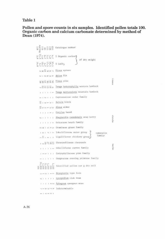
Table 1
Pollen and spore counts in six samples. Identified pollen t.otals 100. Organic carbon and calcium carbonate determined by method of Dean (1974).
A-36
"' =~ - o:i = 0 ~ Cataloguu number ..0,...0'1..nV'IOOLn
~ f,,,..I ~-Cf",..,_,::... ~~a.~:.C»:....
- - --w ~!'"'~~:-':°:-a QO ..... .....,.....,V'V'V'
% Organic ca rbonz
% CaC03 J ..., 0> 0 _,, a- ._, ~ spruce
of dry weight
.... ~;::; ;::;::;;.,. Tsuga hctcrophvlla western hemlock
1 1 1 1 1 - Tsug3 mcrtcnslana mountain hemlock
_ , .... 1 1 1 Cuprcssacca" cedar family
0 1 ..., - ..., , 8etula birch
~ _c.."' - ~ w Alnus alder
I I I I - I ~ry_!_~ hazel
, 1 1 1 , Shcpherdia canadensis soap berry
, , 1 1 1 - Ertcacene heath family
N\D 1 VI ~l,,.J Graminuac grass family
I w I -.I
I I I t I -
Tubullfloreae aster group (
Ligull(lurne chickory groupj
Chenopodiineae chenopods
Umbcll1fcrac carrot famlly
1 - - 1 1 1 Cd cyophylla~"a" pink family
composi t e family
- 1 , 1 1 1 Onagruceae evening primros" fomlly
.... __ ,..,_ w ~ .. ~ ~ ~~ r-..;. C Identi!it:d pollen pet" g dry bUl l ggggggg
Dryopteris type fern
'" 1 , , 1 , Lycopodium club moss
1 1 1 1 ..., "' Sphagnum spnagnum moss
.... - ~...,-.. P Tndetcnnlnoble
" " '" '" ..
~ .... c: O" ..
iii .... g

Table2
Charred seeds from the Kitwanga Fort Project, Skeena River, B.C.
+ ... , I I
"O..., ., ., .. ~ .... ~ ~ ... :> ...
V> c H r-
I I ..... I I I I I I I I I I I I Corylus sp. hozel
N . ..... ..... ...., _ . c
"'
• V>
"' ...,_ • 0
"° ON • C7' .... .... . "' N
.... N
"" . "' "'
N
I I I ui I N I I I I I I I I I
I I - - I CO I I I • I I I I
I I I I I I I I ' I I - I I 1
I I I I I - I I I I l I I I t
I I I I I I I I I I I - I I I
l/\ I I I I I I I I I I I I I I
I I N I I I I I I I W\.n I I I
I I 1 ';1 I 1 1- I N"IV'ol
I I I I t I I I I I I I I VI <,..i
t I I I I I I I I I I - I I
I I l I I I I I I IN- I I I
,,. I I IC I I I I I I - I I I I
I I I I l I I I I I I I I CO I
I I J I j I I I I I I I I I I
I I I I I I I I I I I I I - I
>&; -.1 r:-.-1 I I t-IVt - t..;.I
I I I I I+ I I I I I I I I I
~ ~ - - N~ ~l~~-NN~--~~-N~
Amelanchier sp. saskatoon berry
Arctostaphyloa uva-ursi bearberry
Cornus sp. dogwood
Crataegus sp. hawthorne
Prunus sp. ch<'rry
Prunus virginiana choke cherry
Rubus sp. raspberry
Sambucus sp. elderberry
Vaccinium sp. blueberry
Carex sp. s<'dge
Chenopodium sp. goosefoot
Plantago sp . plantain
Polygonum sp. knotweed
C~£NOPOOIACEAE c~enopods
CYPERACEA£ sedge
GRJ~~INEAE grasA fnmily
Unknown
Picea sp . (needles)
TOTAL
z c: ...
.. It ... .., '<
A-37

Table3
Uncharred seeds from the Kitwanga Fort Project, Skeena River, B.C.
A_... t .. - fo;rr- •• e-.. ,,.,
!'tvn1.11 rtn,.'tlYllMC• 1111\ t .. ri.
;: -'1->f"t"lu-Jl• ct,~"''~"''
'~tl"'t.- 1p •1-lllf'm
;. . -; ... -·-- .... -10"
~•;hV•tC'°I
' I
; .. "
T(lhl..
.....
A-38

Table4
List of macrofossils from the Kitwanga Fort Project, Skeena River, B.C. Ast.erisk indicat.es plants used by natives (Turner 1975).
Uncharred * Corylys cornuta beaked hazel BETULACEAE * Amelanchier sp . saskatoon berry ROSACEAE * Cornus sp. dogwood CORNACEAE ~ stolonif era red-osier dogwood CORNACEAE
* Fragaria sp . strawberry ROSACEAE * Prunus sp. cherry ROSACEAE * ~ pensylvania pin cherry ROSACEAE * Prunus virginiana choke cherry ROSACEAE * Rubus sp . raspberry ROSACEAE * ~cus sp. elderberry CAPRlOFOLIACEAE * Shepherdia canadens is soapberry ELAEAGNACEAE
Symphoricarpos sp . snowberry CAPRIOFOLIACEAE * Vaccinium sp . blueberry ERICACEAE
Carex sp . sedge CYPERACEAE * ~podium sp . goosefoot CHENOPODIACEAE
Dracocepholum parviflorum dragon head LIBIAIAE Galium sp. bedstraw RUBIACEAE Plantago cf . lancelota r ibgrass plantain PLANTAClNACEAE Polygonum sp. knotweed POLYGONACEAE Silene sp . campion CARYOPHYLLACEAE ~cum officlnale dandelion COMPOSITA£ Vicia sp . vet.ch LEGUMINOSA£ Viola sp. violet VIOLECEAE
* Be tula sp . birch BETULACEAE CottPOSITAE CRAftlNEAE ROSACEAE Picea sp . (needle) PlNACEAE
Nbr . FAM1L1ES 19 Nbr . TAXA 22
Charred * Corylus sp. hazel BETULACEAE * Amelanchier sp. saskatoon berry ROSACEAE * Arctostaphvlos uva-ursi bearberry ERICACEAE * Cornus sp . dogwood CORNACEAE * Crataegus sp. hawthorne ROSACEAE * Prunus sp . cherry ROSACEAE * Prunus virginiana choke cherry ROSACEAE * Rubus sp. raspberry ROSACEAE * sa.iibU"cus Sp . elderberrv CAPRlOFOLTACEAE * Vaccinium s p. blueberry ERICACEAE
Carex sp . sedge CYPERACEAE * Chenopodium sp. goosefoot CHENOPODIACEAE
Plantago sp . ribgrass Pl antain PLANTAGINACEAE Polygonum s P• knotweed POLYGONACEAE CHENOPOOIACEAE CYPERACEAE GRAftlNEAE Picea sp . spruce (neddle) PINACEAE
Nbr. FAMILIES Nbr . TAXA
12 14
A-39

Table5
Charred wood from the Kitwanga Fort Project, Skeena River, B.C.
ANGIOSPERM GYMNOSPERM Catalogue Indeterminable Pin us Indeterminable
number diffuse porous pine Conifer
16 + 65 + 67 + + 108 + 110 + + 111 + 118 + 119 + + + 120 +
A-40

APPENDIXV
Botanical Species Identification for the Kitwanga Fort National Historic Site Area
James Pozar B.C. Forest Service, Smithers,
A-41

Trees
POPULUSTREMULOlDES
P. TRICHOCARPA
BETULA PAPYRIFERA
PINUS CONTORTA
PICEA GLAUCA X SITCHENSIS
Shrubs
ALNUS lNCANA (A. TENU1FOLIA)
Aspen
Black Couonwood
Paper Birch
Lodgepole Pine
Spruce
CORYLUSCORNUTA
AMELANCHIER ALNlFOLIA
PRUNUS VIRGINIANA
SYMPHORICARPOS ALBUS
POSA ACICULARIS
Speckled Alder
Beaked Hazel
Saskatoon
Chokecherry
Snow berry
Prickly Rose
LONICERA INVOLUCRATA BlackTwinberry
CORNUS STOLONIFERA Red Osier Dogwood
P ARISTIMA MYRSINITES False Box
VIBURNUM EDULE
SORBUS SCOPULlNA
RIBES LACUSTRE
R. OXY ACANTHOIDES
SPIRAEA DOUGLASII
SHEPHERD IA CANADENS£S
RUBUS IDAEUS
R. PARVIFLORUS
SALIX BEBBIANA, S. SCOULENA VA,
S. LASIANDRA
Squashberry, Highbush Cranberry
Mountain Ash
Swamp Gooseberry
Yellow Gooseberry
Hardhack
Soopalalie,Soapberry
Wild Raspberry
Thimbleberry
Willows
Herbs & Dwarf Shrubs:
FRAGARIA VIRGINIANA Suawberry
EPILOBUlM AUGUSTIFOLIUM Fireweed
A-42
ASTER CILIOLATUS, A. CONSPICUlS
SOLIDAGO CANADENSIS
Asters
Goldenrod
THALIC1RUM OCCIDENT ALE Meadow Rue
ACHILLEA MILLEFOUIM Yarrow
ARALIA NUDICAULIS False SarsapaidJa
SMILACINA RACEMOSA False Solomon's Seal
GALIUM BOREALE
G. TRIFLORUM
GERANIUM REICHARDSONI
Northern Bedstraw
Sweet Bedstraw
White Geranium
GEUM MACROPHYLLUM
HERACLEUM LANALUM
CAREX MACOVIANA
CASTILLEJA MINlATA
CAMPANULA ROTUNDIFOLIA
Avens
Cow Parsnip
Sedge
Paintbrush
Harebell
VIOLA CANADENSIS White Violet
V. GLABELLA Yellow Stream Violet
PYROLA ASARIFOLIA Large-flowered Wintergreen
POTENTILLA ARGUTA Cinquefoil
ACTAEA RUBRA Bane Berry
EQUlSETUM AR VEN SE, E. PRA TENSE Horsetails
DISPORIUM TRACHYCARPUM Fairy Bells
VICIA AMERICANA
LATHYRUS NEV ADENSIS
CLINTONIS UNIFLORA
AINICA
American Vetch
Purple Peavine
Queen's Cup
V ACCINIUM CAESPITOSUMDwarf Blueberry
GYMNOCARPIUM DRYOPTARJS Oak.Fem
CIRCAEA ALPINA Enchanter's Nightshade
ANEMONE LY ALLll Wood Anemone
SANICULA MARILANDICA Snakeroot
DELPHINIUM GLAUCUM
EL YMUS GLAUCUS
Larkspur
Blue Wildryc

AGROPYRON1RACHYCAULUM ssp.PINIT A TERALE Wheatgrass
STIP A RICHARDSONII S. OCCIDENT ALIS Needle-and-Thread grasses
KOELERJA MACRANTHA Junegrass
OR YZOPSIS ASPERIFOLIA Indian Ricegrass
HEUCHERA Cl-Il..ORANTHA Alumroot
Weedy Aliens
TARAZACUM OFFICINDE Dandelion
PHLEUM PRA TENSE Timothy
PLANTAGO MAJOR Plantain
PHINANTHUS MINOR YellowRatUe
Fields
BROMUS INERMIS Smooth Brome
TRIFOLIUM PRA TENSE Red Clover
CHRYSANTHEMUM LEAUCANTIIEMUM Ex-eye Daisy
MEDICAGO SATERIA Alfalfa
RUMEX ACETOSELLA Sheep Sorrel
Weedy Natives
POA PRA TENSIS Kentucky Bluegrass
AGROSTISSCABRA
ACHlLLEA MILLEFOLIUM
EQUISETUM ARVENSE
S. Slope
Tickle Grass
Yarrow
Earlier probably open grassland 7 natural vegetation influenced by fire, slope, aspect and aboriginal people.
AMELANCIDER ALNIFOLIA
PRuNUS YffiGlNIANA
ROSA ACICULARIS
CORYLUSCORNATA
POPULUS TREMULOIDES
SYMPHIRICARPOS ALBUS
AGROPYRON TRACHYCANLUM ssp
UNILATERALE
POA PRANTENSIS ?
PHLEUM PRA TENSE
CREPIS CAPILLARIS
STIPA COLUMBIANA (S.OCCIDENT ALIS)
CAREX ? PRA TICOLA or PACKYST ACHIY A
ASTER CONSPICUS
SMILANCINA STELLATA
KOELERIA MACRANTHA
GALIUM BOREALE
ALLIUM CERN UM
LA TI-IRUS NEY ADENSIS
Spring Shrubs
Hawkweed
ALNUS Il'ICANA (A. TENUIFOLIA)
CORNUSSTOLONIFERA
RUB US PARYIFLORUS
CORYLUSCORNUTA
SAMBUCUSRACEMOSA
RIBES LACUSTRE
RUBUS IDAEUS
Herbs
ACTAEA RUBSA
OSMORI-ilZACHILENSIS
ARALIA NIDICAULIS
EQUISETUM AR VENSE, E.PRATENSE
Sweet Cicely
CINNA LA TIFOLIA Nodding W oodreed
DISPOSIUM TRACHYCARPUM
VIOLA BLABELLA
MITELLA NUDA Mitrewort
THALICTRUM OCCIDENTALE
SMILACINA RACEMOSA, S.STELLALA
ATHYRIUM FlLEX-FEMlNA Ladyfern
A-43

GALIUM TRIFLORUM
ClRCAEA ALPINA
HABENARIA SACCATA Green Rein Orchid
A-44

APPENDIX VI
Report on the Analysis of Obsidian Artifacts from Kitwanga Fort National Historic Site
D.E. Nelson Department of Archaeology Simon Fraser University
Submitted to G. MacDonald, National Museum of Man, Ottawa January,1980
A-45

The obsidian samples submitted to the SFU Archaeology Department for identification were analysed using the X-ray fluorescence technique described by Nelson et al. (1975). The relative concentrations of the elements K, Ca, Ti, Fe, Zn, Pb, Rb, Sr, Y, Zr and Nb in these samples were compared to those obtained in an identical manner on samples from the majority of the known obsidian sources on the Northwest Coast. They were also compared with the relative concentrations of obsidian sources that are not known to the SFU laboratory; however, these sources must exist, as obsidian artifacts of unique and unknown relative elemental concentrations appear in Northwest Coast sit.es.
The flakes examined in this study all were found to be made from obsidian originally obtained from the Mt. Edziza volcanic complex. located in N.W. British Columbia. (A list of the source identification for each flake is given in Table 1). In this volcanic complex, several separate eruptions have yielded obsidian flows separated by distances of a few kilometres. (This complex has been described by Souther (1972).) An XRF analysis of obsidian samples obtained from Dr. Souther showed that the separate flows he identified had very similar, but distinguishable, relative trace element concentrations (Nelson et al. 1975).
These separate sub-groupings have been labelled Edziza-1 lhrough Edziza-5. However, the numbers of samples analysed for each sub-group are, in some cases, not large enough to allow us to be absolutely certain of the differences between these sub-groups. Some of the sub-groups described must then remain tentative, until a very thorough study can be done on the obsidian flows in the; Mt. Edziza complex.
A-46
The flakes identified as Edziza-3 were very likely obtained from obsidian cobbles that are found within or close to a small valley that is just south of Raspberry Pass in the Mt. Edziza area. Obsidian from this sub-group is known to have been widely traded prehistorically (R. Carlson and E. Nelson, unpublished data) and the valley itself contains considerable evidence of obsidian-working activity (Fladmark and Nelson 1977). The samples labelled Edziza-2 likely were obtained from an area a few kilometres to the north of Raspberry Pass. This sub-group is also known to have been used prehistorically. However, we have less information on the Edziza - 2 source area.
In summary, we can be quite certain that the artifacts were made from ML Edziza obsidian. For each flake, we can also suggest specific quarry locales within the Mt. Edziza complex, but this last must remain tentative until a very detailed study of the complex can be done.
References
Nelson. D.E., D'Auria, J.M. and Bennett, R.B., 1975 Archaeometry llill. 85-97.
Souther, J.G., 1972 Bull. Volcano!. Soc. Jap.111, 107.
Fladmark, K.R. and Nelson, D.E., 1977 Report on a preliminary reconnaissance of a portion of Mt EdzizaProvincial Park, submitted to the B.C. Heritage Advisory Board.

Appendix IX
Analytical Investigation of samples from Kitwanga Fort National Historic Site
1. Identification of Bark Samples John E. Dawson 2. Surface Analysis of Copper Objects Henry Unglik 3. Radiography of Ferrous Artifacts Louis Lafleche & Charles Costain 4. Consolidated Hearth Ash
John Stewart & Charles Costain 5. Food Material Analysis Monteiro Helleur
A-47

Table 1
MacDonald artifact number SFU analysis number
Source identification
259 285 310 311 (small flake) 311 Oarge flake) 337 355 (small flake) 355 (medium flake) 355 Oarge flake) 411 446 447 453 473
1. IdenlificaLion of Bark Samples
EN92-2 n -3 "-4 " -5 "-6 n -7 .. -8 II -9
II -10 II -11 II -12 II -13 "-14 "-15
John E. Dawson, National Museums of Canada
Bark samples number 250, 307, 328, 395 and 440 were identified as paper birch (Betula papyrifera March).
2. Surface composition of the eiuunined artifacts obtained with the EDX semi.quantiLive analysis Henry Unglik, Conservation Division
Artifacts material (approx. percentage)
9 copper
38 'impure' copper 1-3% Pb - 1 - 3% Bi
20D copper
136 II
149G ..
208 II
209 ..
330 'impure' copper with 2-4% Pb
362 high leaded brass 55-65% Cu, 19-33% Zn 16-22% Pb
373 copper
A-48
Edziza- 3
Edziza-2 "
Edziza- 3
430 II
464 ..
483 "
In all cases some iron (Fe) was also detected, all of which probably comes from iron corrosian products.
3. Radiography of ferrous artifacts Charles Costain, Conservation Scientist Louis Lafl~che, Technician Conservation Division
Five objects were submitted for radiography.
They include an adze (#342), a gun barrel (#415), a knife blade (#308), a dagger (#527) and a blade (#255). No significant features were visible on the radiographs.
4. Preliminary Report on Consolidated Hearth Ash
John Stewart, Acting Senior Conservation Scientist
Charles Costain, Conservation Scientist, Conservation Division Ottawa.
Summary:
The consolidated hearth ash is composed of a highly porous brown matrix of calcite with white inclusions of h ydroxyapatite. The h ydroxyapatite is

lhe nonnal mineral constituent of bone and has not been altered by the action of the fire. The calcite matrix, on lhe other hand, most probably results from lhe fonnation of calcium oxide from lhe action of the fire on the hydroxyapatite. This calcium oxide would have rapidly been slaked by water to give calcium hydroxide which, in tum, would pick up carbon dioxide from the atmosphere to form the calcite.
Results:
A) Gross Examination
The samples were cross-sectioned to reveal a brown matrix with numerous white inclusions (maximum sizc5 mm by 1 mm (Fig. l ). The matrix hada munsel colour 7.5YR over 7.5/2 and the inclusions a bone white colour.
Fig. 1 Cross-section sample 210.
BJ Density
A sub-sample was given a thin coating of parafin wax to render it watertighL Its apparent density was then detennined by weighing in air and submerged in water. The apparent density was 1.25 g/cm3; this is the density of the whole object, including pore space and solid material.
A further sub-sample was ground to pass a 200 mesh sieve (ASTM) and its density determined by weighing 5 g into a 10-ml volumetric flask and making to volume with water and weighing. This gives the true density, density of solid material, as 2.5 g/cm3
. The sample then has a porosity or void ~-pace of 50%.
C) Mineralldentification Mineral identification was done using X-ray diffraction and the International Centre for Diffraction Data standard patterns.
The white inclusions were identified as hydroxyapatite (Ca5 (P0")3 (OH)) and the matrix is calcite (CaC03
) with lesser amounts of a - quartz (Siol).
Conclusion:
The samples from the consolidated hearth ash are fonned of a porous brown matrix with white inclusions. They were most probably made by burning bone, some of which remained as hydroxyapatite, giving the white inclusions, and some of which were decomposed to fonn calcium oxide which, with weathering, produced calcite. The a -quartz in the matrix, as well as the brown colour, are a result of ash contamination. The extent of this contamination, plus a final characterization of the material, waits on a full analysis currently being completed.
5. Food Materials Analysis
L. Monteiro Helleur, Conservation Technician, Analytical Section
Kitwanga Pot Segment (#347) : Preliminary Findings
If the residue in the pot segment was food material, substances such as fatty acids and/or proteins would be expected. Preliminary tests showed nitrogen present However, there is no evidence of protein or amino acids in either the sample or extracts of the sample. Infra-red spectroscopy of the material in the pot showed the presence of organic matter but no specific compound was identifiable. However, various extracts of the pot material showed presence of unsaturation and the possibility of fatty acids.
Further work is required involving gas-liquid chromatographic analysis, in order to det.ennine u indeed there are any fatty acids present and. if so, their relative proportions.From these data it is hoped that any food typeS of residues thereof may be identified.
A-49


ISBN 0-66 0-10777-5
I 9 780660 107776