Richardson-extrapolated sequential splitting and its application
Upload
khangminh22Category
view
1download
0
FIVE-YEAR REVIEW REPORT
First Five-Year Review Report for
Fort Richardson, Alaska
April 2003
Prepared by
United States Army Alaska Directorate of Public Works
ATTN: APVR-RPW 730 Quartermaster Road #6500
Fort Richardson, Alaska 99505-6500
UNITED STATES ARMY
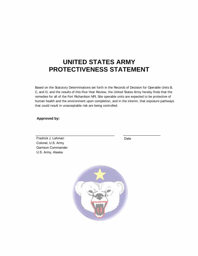
PROTECTIVENESS STATEMENT
Based on the Statutory Determinations set forth in the Records of Decision for Operable Units B, C, and D, and the results of this Five-Year Review, the United States Army hereby finds that the remedies for all of the Fort Richardson NPL Site operable units are expected to be protective of human health and the environment upon completion, and in the interim, that exposure pathways that could result in unacceptable risk are being controlled.
Approved by:
Fredrick J. Lehman DateColonel, U.S. Army Garrison Commander U.S. Army, Alaska

REGULATORY AGENCY CONCURRENCES
Signature sheet for the first Five-Year Review of Records of Decision, Fort Richardson, Alaska
EPA’s concurrence with the findings of this five year review is based on the information presented in the accompanying Five-Year review Report, First Five-Year Review Report for Fort Richardson, Alaska.
____________________________________ _____________________ Michael F. Gearheard, Director Date Environmental Cleanup Office U.S. Environmental Protection Agency, Region 10 ADEC’s concurrence with the findings of this five year review is based on the information presented in the accompanying Five-Year review Report, First Five-Year Review Report for Fort Richardson, Alaska.
_____________________________________________ _____________________ Jennifer Roberts, Section Manager Date ADEC Contaminated Sites

TABLE OF CONTENTS
CONTENTS Page
LIST OF ACRONYMS ....................................................................................................................
EXECUTIVE SUMMARY ............................................................................................................... i
FIVE-YEAR REVIEW SUMMARY FORM .................................................................................... ii
1.0 INTRODUCTION............................................................................................................1-1
1.1 Purpose.........................................................................................................................................1-1 1.2 Statutory Review...........................................................................................................................1-1 1.3 Agency Oversight Agreements .....................................................................................................1-2 1.4 Public Involvement ........................................................................................................................1-4
2.0 APPROACH...................................................................................................................2-1
2.1 Report Organization ......................................................................................................................2-1 2.2 Five-Year Review Team................................................................................................................2-1 2.3 Five-Year Review Tasks ...............................................................................................................2-1
3.0 FORT RICHARDSON NPL SITE BACKGROUND........................................................3-1
3.1 Post History...................................................................................................................................3-1 3.2 CERCLA History ...........................................................................................................................3-2 3.3 Land and Resource Use ...............................................................................................................3-3 3.4 Physical Characteristics ................................................................................................................3-4 3.5 History of Contamination...............................................................................................................3-7 3.6 Institutional Controls......................................................................................................................3-7
4.0 OPERABLE UNIT A ......................................................................................................4-1
5.0 OPERABLE UNIT B ......................................................................................................5-1
5.1 OUB Poleline Road Disposal Area Background ...........................................................................5-1 5.2 Remedy Selection .........................................................................................................................5-5 5.3 Status of Remediation...................................................................................................................5-8 5.4 Five-Year Assessment ................................................................................................................5-13
6.0 OPERABLE UNIT C ......................................................................................................6-1
6.1 OUC Eagle River Flats Background .............................................................................................6-1 6.2 Remedy Selection .........................................................................................................................6-5 6.3 Status of Remediation...................................................................................................................6-8

TABLE OF CONTENTS
CONTENTS Page 6.4 Five-Year Assessment ................................................................................................................6-14 6.5 OB/OD Pad .................................................................................................................................6-16
7.0 OPERABLE UNIT D ......................................................................................................7-1
7.1 OUD Source Areas Requiring No Further Action .........................................................................7-2 7.2 OUD Source Areas Referred to the Two-Party Agreement ..........................................................7-2 7.3 OUD Source Areas Requiring Additional Sampling......................................................................7-2 7.4 OUD Source Areas Subject to RCRA Closure Requirements ......................................................7-4 7.5 OUD Source Areas Transferred to OUE.......................................................................................7-5
8.0 OPERABLE UNIT E ......................................................................................................8-1
8.1 Building 35-752 .............................................................................................................................8-1 8.2 AVMA ............................................................................................................................................8-1
9.0 SITE-WIDE SUMMARY AND RECOMMENDATIONS..................................................9-1
9.1 General .........................................................................................................................................9-1 9.2 Operable Unit and Source Area Specific ......................................................................................9-2
10.0 PROTECTIVENESS STATEMENTS ...........................................................................10-1
10.1 OUB – Poleline Road Disposal Area ..........................................................................................10-1 10.2 OUC – Eagle River Flats.............................................................................................................10-1
11.0 NEXT REVIEW ............................................................................................................11-1
12.0 REFERENCES.............................................................................................................12-1
TABLES
FIGURES
APPENDICES Appendix A Two-Party Agreement Site Appendix B Site Inspection Checklist and Photographic Log Appendix C Administrative Record Assessment Appendix D Interview Record Forms Appendix E 5-Year Review Range Analysis

LIST OF ACRONYMS
AAC Alaska Administrative Code
ADEC Alaska Department of Environmental Conservation
ADC Alaskan Defense Command
ADF Alaska Defense Forces
ARARs Applicable or Relevant and Appropriate Requirements
AS Air sparging
AS/SVE Air Sparging and Soil Vapor Extraction
AVMA Armored Vehicle Maintenance Area
AWQS Alaska Water Quality Standard
BGS Below Ground Surface
BTEX Benzene, Toluene, Ethylbenzene, and Xylene(s)
CERCLA Comprehensive Environmental Response, Compensation, and Liability Act
CFR Code of Federal Regulations
COC Contaminant of Concern
CRREL Cold Regions Research and Engineering Laboratory
DCE Dichloroethene
DERA Defense Environmental Restoration Act
DNAPL Dense Non-Aqueous Phase Liquid
DPW Directorate of Public Works
DRO Diesel Range (Petroleum Hydrocarbon) Organic Compounds
DSERTS Defense Site Environmental Restoration Tracking System
DVS Design Verification Study
EDB 1,2-Dibromoethane
EPA Environmental Protection Agency
ERF Eagle River Flats
HHRA Human Health Risk Assessment
FES Fairbanks Environmental Services
FFA Federal Facility Agreement
FFCA Federal Facility Compliance Agreement
FR Federal Register
FS Feasibility Study
FT Feet
GIS Geographic Information System
HASP Health And Safety Plan

LIST OF ACRONYMS continued HVE High Vacuum Extraction
IAG Interagency Agreement
IC Institutional Control
IRP Installation Restoration Program
IAP Installation Action Plan
ITR Independent Technical Review
LB Pound
LTM Long Term Monitoring
MCLs Maximum Contaminant Levels
MCLG Maximum Contaminant Level Goal
Mg/kg Milligrams per Kilogram
Mg/l Milligrams per Liter
MOA Municipality of Anchorage
MSL Mean Sea Level
NCP National Oil And Hazardous Substances Pollution Contingency Plan
NPL National Priorities List
NFA No Further Action
O&M Operation and Maintenance
OU Operable Unit
PA Preliminary Assessment
PAH Polycyclic Aromatic Hydrocarbon
PA/SI Preliminary Assessment/ Site Investigation
1,1,2,2-PCA 1,1,2,2-Tetrachloroethane
PCB Polychlorinated Biphenyls
PCE Tetrachloroethene
POL Petroleum, Oil And Lubricant
PRG Preliminary Remediation Goal
PSE Preliminary Site Evaluation
PSE2 Expanded Preliminary Site Evaluation
RA Remedial Action
RAB Restoration Advisory Board
RAO Remedial Action Objective
RAR Remedial Action Report
RBC Risk Based Concentrations
RCRA Resource Conservation and Recovery Act

LIST OF ACRONYMS continued RD Remedial Design
RD/RA Remedial Design/Remedial Action
RI Remedial Investigation
RI/FS Remedial Investigation/Feasibility Study
ROD Record of Decision
ROLF Railcar Off-Loading Facility
RPM Remedial Project Manager
SARA Superfund Amendments and Reauthorization Act of 1986
SI Site Investigation
SOP Standard Operating Procedure
SPSH Six-Phase Heating System
SVE Soil Vapor Extraction
SVOC Semi-volatile Organic Compound
TBC To Be Considered (in addition to ARARs)
TCA Trichloroethane
TCE Trichloroethene
USARAK United States Army Alaska
UST Underground Storage Tank
VOC Volatile Organic Compound

Page i
EXECUTIVE SUMMARY
The United States Army Alaska (USARAK) conducted the first Five-Year Review of the remedial actions at the Fort Richardson National Priorities List (NPL) site, Anchorage, Alaska, from April 2002 through February 2003. This report presents the results of that review. The purpose of this review is to ensure that remedial actions selected in the Records of Decisions (RODs) for the Fort Richardson Operable Units (OUs) are being implemented and that they continue to be protective of human health and the environment. To achieve this purpose, this review evaluates the status of implementation of the selected remedies, identifies significant variances from the RODs, and makes recommendations for reconciling variances and/or for improving performance of remedial actions. This statutory review is required by the Comprehensive Environmental Response, Compensation, and Liability Act (CERCLA) since all of the RODs for this site were signed after the effective date of the Superfund Amendments and Reauthorization Act of 1986 (SARA) and some of the remedial actions result in hazardous substances, pollutants, or contaminants remaining at the site above levels that allow for unlimited use and unrestricted exposure. The Fort Richardson NPL site is comprised of five OUs, OUA, OUB, OUC, OUD, and OUE. Records of Decision (RODs) have been written and signed for four of these OUs, OUA through OUD. The Five-Year Review found that the remedies for all Fort Richardson OUs are expected to be protective of human health and the environment upon completion, and in the interim, exposure pathways that could result in unacceptable risk are being controlled. The OUE ROD will describe selected remedies for two source areas currently undergoing investigation. In the interim, institutional controls are in place at these sites that prevent exposure to contaminated soil and/or groundwater.

Page ii
FIVE-YEAR REVIEW SUMMARY FORM SITE IDENTIFICATION
Site name (from WasteLAN): Fort Richardson, Alaska
EPA ID (from WasteLAN): AK6214522157
Region: 10 State: AK City/County: Anchorage
SITE STATUS NPL status: ⌧ Final Deleted Other (specify)____________________________________ Remediation status (choose all that apply): ⌧ Under Construction ⌧ Operating Complete
Multiple OUs?* ⌧ YES NO Construction completion date: 2004
Has site been put into reuse? YES ⌧ NO Active Army installation REVIEW STATUS
Reviewing agency: ⌧ EPA ⌧ State Tribe ⌧ Other Federal Agency U.S. Army ___________________ Author name: U.S. Army, Alaska (USARAK) Review period:** 4/18/2002 to 02/22/2003
Date(s) of site inspection: 8/16/2002 Type of review: ⌧ Statutory Policy Post-SARA Pre-SARA NPL-Removal only Non-NPL Remedial Action Site NPL State/Tribe-lead Regional Discretion Review number: ⌧ 1(first) 2 (second) 3 (third) Other (specify) _____________________ Triggering action:
Actual RAA Onsite Construction at OU #___ ⌧ Actual RA Start at OUB Construction Completion Previous Five-Year Review Report Other (specify)
________________________________________________________________ Triggering action date (from WasteLAN): 02/22/1998
Due date (five years after triggering action date): 02/22/2003
*["OU" refers to operable unit.]
**[Review period should correspond to the actual start and end dates of the Five-Year Review in WasteLAN.]

Five-Year Review Summary Form
Issues
One issue affecting current protectiveness and three issues potentially affecting future protectiveness were identified at OUB. Institutional controls at OUB that do not specifically identify the UXO hazard in Areas A-1 and A-2 affect current and future protectiveness. Future protectiveness is also affected by the fact that RAOs have not been achieved in the “hot spot” (The “hot spot” is defined in the OUB ROD as the subsurface area containing greater than 1.0 milligrams per liter of 1,1,2,2-tetrachloroethane in groundwater and/or free-phase solvents.) and information north of the source area is needed to determine contaminant migration.
No other issues affecting current or future protectiveness were identified during the Five-Year Review.
One other issue at OUB concerned contaminants detected in groundwater that were not identified as COCs in the ROD, and at OUC, waterfowl mortality data may be skewed by active remedial activities.
Recommendations and Follow-Up Actions:
Recommendations and follow-up items at OUB included continuing to monitor groundwater contaminant reduction and performing groundwater modeling for trend analysis; continuing to analyze groundwater samples for VOCs using methods that include compounds not addressed in the ROD; including new wells, installed in 2002, in the long-term groundwater monitoring program; and identifying an IC specific to UXO buried in Areas A-1 and A-2.
At OUC, evaluating waterfowl recovery trends upon completion of remedial action is recommended.
In general, the project managers should review continued operation and planned optimization changes to determine whether they are performing as intended (continuing to make progress toward achieving the RAOs). The project managers will further determine whether the plan is operating efficiently and cost-effectively. Based on the results of the annual evaluation, the project managers will set the operating parameters of the plan for the next year. The Army will make operational adjustments that they consider reasonable and in accordance with agreements made during the last annual evaluation. If the project managers can not reach concurrence on the operating parameters, then operating parameters previously agreed to will be followed until the issue is resolved in accordance with the dispute resolution procedures incorporated in the Federal Facility Agreement
A summary of recommendations and follow-up actions is included in Section 9 of this report.
Protectiveness Statements:
Protectiveness statements were developed using the sequential process described in EPA guidance for conducting Five-Year Reviews.
The remedy at OUB is expected to be protective of human health and the environment upon completion. Identifying institutional controls that address potential UXO hazards in Areas A-1 and A-2 is necessary to control exposure pathways that could result in unacceptable risks.
The remedy at OUC is expected to be protective of human health and the environment upon completion. Exposure pathways that could result in unacceptable risks are being controlled with ICs.
Protectiveness statements are developed in Section 10 of this report.

Page 1-1
1.0 INTRODUCTION
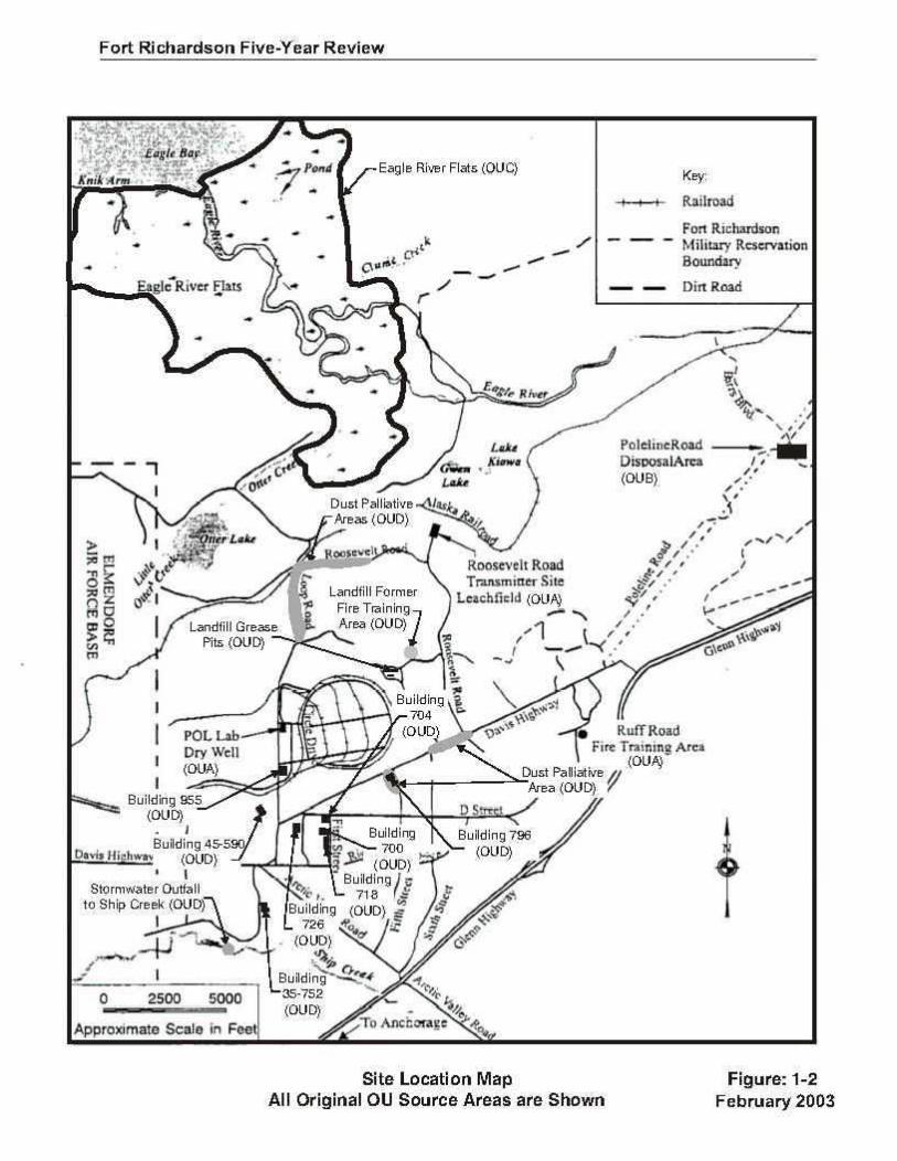
The United States Army Alaska (USARAK) has conducted the first Five-Year Review of the remedial actions at the Fort Richardson National Priorities List (NPL) site, Anchorage, Alaska (Figure 1-1), from April 2002 through February 2003. Fairbanks Environmental Services performed work in support of this review. This report presents the results of the first Five-Year Review for Operable Units A through E shown on Figure 1-2.
1.1 Purpose
The purpose of this review is to ensure that remedial actions selected in the Records of Decision (RODs) for the Fort Richardson Operable Units (OUs) are being implemented, that they continue to be protective of human health and the environment, and are functioning as designed. To achieve this purpose, this review evaluates the status of implementation of the selected remedies, identifies any significant variances from the RODs, and makes recommendations for reconciling variances and/or for improving performance of remedial actions. In addition, the review identifies any new information that becomes evident, documents that no new contaminant sources or exposure pathways were discovered, confirms that no new OUs were established, and verifies that no additional work was performed that was not identified in the RODs.
1.2 Statutory Review
This Five-Year Review was conducted to meet the statutory mandate under the Comprehensive Environmental Response, Compensation, and Liability Act (CERCLA) §121(c). A review is required for all RODs that were signed after the effective date of the Superfund Amendments and Reauthorization Act of 1986 (SARA) and for sites where remedial actions resulted in hazardous substances, pollutants, or contaminants remaining at the site above levels that allow for unlimited use and unrestricted exposure. The Army must conduct Five-Year Reviews consistent with CERCLA and the National Oil And Hazardous Substances Pollution Contingency Plan (NCP). CERCLA §121 (c), as amended, states:
If the President selects a remedial action that results in any hazardous substances, pollutants, or contaminants remaining at the site, the President shall review such remedial action no less often than each five years after the initiation of such remedial action to assure that human health and the environment are being protected by the remedial action being implemented.
This requirement is interpreted further in the NCP part 300.430(f)(4)(ii) of the Code of Federal Regulations (CFR), which states:
If a remedial action is selected that results in hazardous substances, pollutants, or contaminants remaining at the site above levels that allow for unlimited use and unrestricted exposure, the lead agency shall review such action no less often than every five years after the initiation of the selected remedial action.

Page 1-2
The Environmental Protection Agency (EPA) Five-Year Review guidance states that “the first Five-Year Review generally should be completed and signed by the EPA Region within five years of the initial trigger date”, and “for the purpose of a Five-Year Review, a remedial action typically is initiated on the date of actual Remedial Action (RA) on-site construction or the ‘actual RA start’ date for federal facilities”. The date of actual RA on-site construction generally corresponds to the date the contractor begins work at a site for the remedial action, typically the date of on-site mobilization. The definition of the “actual RA start” varies as outlined in the Superfund/Oil Program Implementation Manual OSWER Directive 9200.3-14-1G-P. The first remedial action at the Fort Richardson NPL site was for OUB and was initiated on February 22, 1998. Five-year review guidelines state “an entire site is subject to a statutory review if any one of its remedial actions is subject to a statutory review”. A full Five-Year Review was conducted for two of Fort Richardson OUs: OUB, discussed in Section 5 and OUC, discussed in Section 6. OUA is discussed briefly in Section 4; however, a Five-Year Review was not conducted for OUA because all of the source areas within this OU were determined to be NFA under CERCLA. Issues subject to Five-Year Review for OUD are discussed in Section 7, and source areas transferred from OUD to OUE are discussed in Section 8.
1.3 Agency Oversight Agreements
1.3.1 Federal Facility Agreement
The EPA (Region 10), the Alaska Department of Environmental Conservation (ADEC), and the United States Department of the Army signed a Federal Facility Agreement (FFA) for Fort Richardson on December 5, 1994. The FFA ensures that environmental impacts associated with past practices at Fort Richardson are investigated and remedial actions are completed to protect human health and the environment. This agreement establishes a procedural framework and schedule for developing, implementing, and monitoring appropriate response actions in accordance with CERCLA, the NCP, national Superfund guidance and policy, Resource Conservation and Recovery Act (RCRA), national RCRA guidance and policy, and applicable state law. The FFA establishes and describes the CERCLA process as applied to Fort Richardson. The FFA also facilitates cooperation, exchange of information, and participation of the Army, EPA, and ADEC in these actions. It details the responsibilities and authority associated with each party pursuant to the CERCLA process and the environmental investigation and remediation requirements associated with Fort Richardson. The FFA divided Fort Richardson into four operable units: OUA, OUB, OUC, and OUD, and outlines the general requirements for investigation and/or remediation of suspected historical hazardous waste source areas associated with Fort Richardson. OUD was originally established as the final OU to be investigated at Fort Richardson. However, it was necessary to establish a new OU, OUE, to integrate all previous and any new sources not addressed under the RODs for OUA through OUD. OUE will address two source areas previously identified in the OUD ROD. No additional source areas or environmental concerns have come to light since OUE was established and no additional OUs are anticipated. The FFA also addressed integration of the Army’s CERCLA and RCRA requirements at sites where both regulations applied. The FFA states that RCRA corrective actions required at solid waste
Page 1-3
management units identified in the FFCA would be integrated with any ongoing CERCLA response actions so that duplication of effort would not occur and the Army could realize cost savings as a result. Work performed at these sites under CERCLA was intended to meet or exceed the requirements of the RCRA corrective action program. A Remedial Project Manager (RPM) represents each of the parties to the Fort Richardson FFA. The term RPM is used in this report to refer to these three representatives from ADEC, EPA, and Army. In general, the RPMs meet quarterly, to discuss the Army’s progress regarding remedial actions selected in the RODs and to address related issues as they arise during the course of remedial action. The RPMs meet more frequently than quarterly when needed and make themselves available to each other for purposes of Fort Richardson remediation (e.g., for technical reviews, modifying monitoring programs, etc.) and to meet the intent and commitments of the FFA.
1.3.2 Remedy Protectiveness, Optimization and Cost-Effectiveness
Optimization of remedy and assessment of cost effectiveness is an on-going process for the Fort Richardson NPL site. Performance of remedies is evaluated at all FFA meetings and discussed by the RPMs. Upon agreement of the RPMs, remedial action can be modified as necessary to ensure efficacy, protectiveness, and the best use of resources. Such modifications have included decisions to perform additional investigation, to terminate operation, to restart operation, to decommission treatment systems, to move treatment systems to new locations, to revise groundwater monitoring systems, and to implement institutional controls. Changes are generally presented in annual reports. Groundwater monitoring programs are updated at least annually based on findings from the preceding year to ensure that well locations and sampling regimes are meeting the objectives of the RODs.
1.3.3 Two-Party Agreement
Source areas where petroleum contamination was identified were referred to the Two-Party Agreement between the Army and the State of Alaska. The Two-Party Agreement is actually two separate agreements which focus on source areas at Fort Richardson contaminated with petroleum from underground storage tanks (UST) and petroleum source areas not associated with USTs. These Two-Party Agreements, which represent the petroleum cleanup strategy, document all known historical petroleum sources on Fort Richardson and their current cleanup status. The Army and ADEC signed the State-Fort Richardson Underground Storage Tank Compliance Agreement for USTs (Two-Party Agreement) in 1993. The agreement defines the process by which the Army agrees to investigate and remediate petroleum-contaminated areas. These areas are associated with USTs that have leaked or with surface spills of petroleum products, such as lubricating oils/grease, heating fuels, and motor fuels. Fort Richardson also negotiated the State-Fort Richardson Environmental Restoration Agreement (Two-Party Agreement) for Non-UST source areas with ADEC for petroleum-contaminated source areas not associated with USTs on November 3, 1994. This Agreement sets the framework to

Page 1-4
cooperatively address known or suspected non-UST source areas. The Two-Party agreement, officially designated as the State-Fort Richardson Environmental Restoration Agreement, is a companion agreement to the FFA that guides parallel track investigations under the auspices of the CERCLA FFA between the Army, EPA, and ADEC for Fort Richardson. These source areas are not included in the work being conducted under CERCLA. The Two-Party Agreements guide how the Army performs necessary site assessments, monitors, remediates, and closes POL contaminated source areas not subject to CERCLA oversight. These agreements verify the Army’s commitment to adequately address these source areas in a manner consistent with the State of Alaska Administrative Code, Title 18, Chapters 75, Oil & Hazardous Substances Pollution Control, and 78, Underground Storage Tanks. Two-party source areas are discussed further in the OUD ROD and the current status is presented in Appendix A of this report.
1.4 Public Involvement
1.4.1 Community Involvement at Fort Richardson
Community involvement regarding environmental issues regarding the Eagle River Flats impact area began in the late 1980s with the discovery of high water fowl mortality due to white phosphorus contamination. The Eagle River Flats Task Force, a cooperative agreement between the installation and state and federal agencies, was formed in 1988. One function of the task force was to foster community involvement. The Community Relations Plan, published in April 1995, identified current issues of community concern regarding known and potential contamination at Fort Richardson and included proposals for community involvement activities to address these concerns. Fort Richardson began publishing quarterly newsletters in January 1995. Newsletters cover information about all OUs, Two-Party agreement source areas, and other restoration activities, and have been sent to interested community members since 1995. Prior to the formation of the Restoration Advisory Board (RAB) Fort Richardson conducted several informational public meetings. The first meeting conducted on June 29, 1995, covered information about the progress that had been made involving the environmental monitoring and cleanup process occurring at Fort Richardson. In addition, OU specific public meetings were held in conjunction with a public comment period for each of the associated Proposed Plans. The proposed plan public meetings presented investigative information and proposed cleanup plans for each of the OUs with a focus on receiving public comments on the proposed actions. The public was offered several different venues for providing public comments: written, verbal, and via a toll-free telephone comment line. Three information repositories were established in 1996 to contain microfiche copies of the Administrative Record for Fort Richardson restoration activities. The locations of the locations of the three information repositories included the Bureau of Land Management Alaska Resource Library, the Fort Richardson Post Library, and the University of Alaska Anchorage Consortium Library. The official copy of the Administrative Record was established and is currently

Page 1-5
maintained at the Directorate of Public Works, Building 724, on Fort Richardson. The Administrative Record has been updated annually since inception.
1.4.2 Restoration Advisory Board
USARAK established a Restoration Advisory Board (RAB) in October 1997. The RAB originally consisted of 12 community members, and representatives form the Army, EPA, and ADEC. The RAB was established in October 1997 and has met quarterly since its inception. Community members represent academic institutions, state/national environmental activist group, adjacent Elmendorf Air Force Base, and the Anchorage/Eagle River community at large. The RAB regularly reviews available technical reports and offers written comments and recommendations concerning the Fort Richardson restoration program. Besides quarterly meetings, the RAB also participates in site visits to Fort Richardson OU source areas and attends other environmental meetings and conferences publicized during RAB meetings and in quarterly fact sheets. The Army presents technical briefings for the RAB as needed, and members of the RAB have the opportunity to share their concerns about the site and provide input on remediation studies and remedial actions. The Army continues to look for opportunities to keep the community informed and involved in the remediation process. The Army’s Installation Restoration Program (IRP), the RAB, the FFA, and the Two-Party Agreement effectively ensure public involvement in and environmental agency oversight of the remediation process at Fort Richardson. The active nature of military operations at Fort Richardson ensures an ongoing federal presence and has contributed to the Army’s ability to meet the commitments in the RODs.
1.4.3 Community Involvement During the Five-Year Review
The Five-Year Review is an important milestone for public involvement at a NPL site. The public was informed of the Fort Richardson Five-Year Review as follows:
• A public notice of the Five-Year Review was published in the Anchorage Daily News and in the Fort Richardson POST Newspaper during June 2002.
• The commencement of the Five-Year Review was announced during the April 2002 RAB meeting and updates have been provided at subsequent RAB meetings.
• The Army included a Five-Year Review update in the October 2002 Environmental Restoration News.
• Following completion of the Five-Year Review, a notice of availability will be published in the Anchorage Daily News notifying the public of the availability of the review, and the Review Report will be added to the Administrative Record and placed at the Fort Richardson NPL site public information repositories.
• The results of the Five-Year Review will also be presented at the April 2003 RAB meeting.


Page 2-1
2.0 APPROACH
2.1 Report Organization
The Five-Year Review was performed in accordance with the Interim Army Guidance for Conducting CERCLA Five-Year Reviews (April 2000) and EPA Comprehensive Five-Year Review Guidance (June 2001). The basic report structure is derived from the EPA guidance document, modified to accommodate all of the Fort Richardson RODs. To the extent possible, discussion related to all of the OUs appears at the beginning of the report and OU-specific discussion appears in the different OU sections of the report. One of the goals of this report is to compile information from existing OU reports into a single status document. To make best use of resources, this report has taken much of the discussion and information from the RODs, other reports, and Army summaries. Findings that were overseen, reported, reviewed, and accepted by the Fort Richardson RPMs have been included in the Five-Year Review report without further scrutiny. The findings and recommendations sections of this report document ongoing issues and concerns, identify variances in the implementation of remedial actions, and suggest changes to ensure that remedial actions undertaken pursuant to the RODs are adequately protective of human health and the environment.
2.2 Five-Year Review Team
This Five-Year Review was performed at the direction of the USARAK Directorate of Public Works (DPW) Environmental Office (federal lead agency for this site) with EPA Region 10 and ADEC oversight pursuant to the FFA and Two-Party agreement. This work was conducted under contract to the Alaska District Corps of Engineers by Fairbanks Environmental Services (FES). Key project staff included Karol Johnson, Project Manager, and Bryan Johnson, Project Scientist.
2.3 Five-Year Review Tasks
The objectives of the Five-Year Review are to answer the following questions:
• Are the remedies functioning as intended by the decision document?
• Are the exposure assumptions, toxicity data, cleanup levels, and remedial action objectives (RAOs) used at the time of the remedy still valid?
• Has any other information come to light that could call into question the protectiveness of the remedy?
Page 2-2
The Five-Year Review has been accomplished by five major tasks:
• Review of relevant documents in the Administrative Record including but not limited to the RODs and Remedial Design/Remedial Action (RD/RA) Reports to determine the initial effectiveness of the remedies;
• Review of Monitoring Plans, Annual Sampling Reports, and Operation and Maintenance (O&M) Reports to determine the ongoing effectiveness and protectiveness of the chosen remedies;
• Review of chemical, location, and action-specific Applicable or Relevant and Appropriate Requirements (ARARs) identified in the RODs for each OU to determine whether changes have occurred that might affect the protectiveness of the remedies;
• Site inspections to observe visible elements of remedies; and
• Interviews of various individuals who have been involved with the OUs.
2.3.1 Document Review
Documents consulted in the course of this Five-Year Review include:
• Interim Army Guidance for conducting Five-Year Reviews
• Comprehensive Five-Year Review Guidance, OSWER Directive 9355.7-03B-P (June 2001)
• RODs for OUs A through D
• Remedial Designs (RDs) (including drawings and as-builts)
• Draft Interim Remedial Action Reports (IRARs)
• Community Relations Plan
• O&M reports and manuals
• Groundwater sampling results
• Other sampling results, monitoring data, and summaries Table 2-1 is a compilation of reports and documents available at the time of this review. Key information sources used in this review are identified in this table.
2.3.2 ARARs and Numeric Cleanup Goal Review
As part of this Five-Year Review, significant ARARs for each ROD were reviewed for changes or the promulgation of new laws since the ROD was signed that might be considered ARARs if the RODs were to be written today. New laws that might be considered ARARs today are applicable for Fort Richardson only if they are essential to ensure protectiveness of the remedies. As part of this review, RAOs were reviewed, and contaminant-specific standards used to set numeric cleanup goals in each ROD were compared to present day values to assess continued

Page 2-3
protectiveness of the remedies. More specifically, current Maximum Contaminant Levels (MCLs) and toxicity and/or carcinogenicity values were compared to MCLs and toxicity/carcinogenicity values at the time of the RODs. At sites where regulatory values for COCs were not available at the time the ROD was developed, RBC values were used to establish cleanup goals. For these sites, current Region 3 (2002) RBCs were used to evaluate if ROAs have changed. The OU-specific RAOs, ARARs, and cleanup goals are discussed in the OU sections of this report.
2.3.3 Site Inspections
Site inspections were conducted on August 16, 2002. The purpose of the inspection was to assess the protectiveness of the remedy, including the presence of control measures to restrict access, the integrity of the treatment system, and the condition of the site. The site-inspection checklist and photographs taken during the site inspections are included in Appendix B of this report. Because Fort Richardson is a site with ongoing Army presence and agency oversight, it was possible to discuss project status with people familiar with site histories and remediation status. The Fort Richardson NPL site public information repositories were also inspected to confirm availability of Administrative Record documents for public review. The findings and recommendations from the repository inspections are included in Appendix C of this report.
2.3.4 Interviews
During the course of this Five-Year Review, written interviews were conducted with several parties involved with the site. Interview Record Forms documenting the issues discussed during these interviews are provided in Appendix D. Interview responses were overwhelmingly positive. The principal impression was that remedial action at Fort Richardson has been well planned and effective. Several comments were made regarding the positive results and progress that has been made in a relatively short period of time at OUC. Interviewees noted that some community members had concerns about continued UXO contamination at OUC. However, the overall impression of the remedy effectiveness at OUC was that the remedial actions undertaken pursuant to the RODs are adequately protective of human health and the environment.
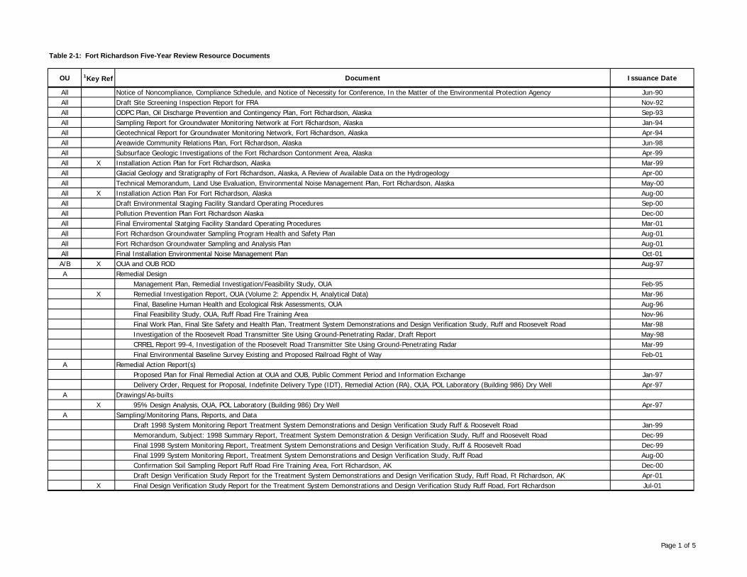
Table 2-1: Fort Richardson Five-Year Review Resource Documents
OU 1Key Ref Document Issuance Date
All Notice of Noncompliance, Compliance Schedule, and Notice of Necessity for Conference, In the Matter of the Environmental Protection Agency Jun-90All Draft Site Screening Inspection Report for FRA Nov-92All ODPC Plan, Oil Discharge Prevention and Contingency Plan, Fort Richardson, Alaska Sep-93All Sampling Report for Groundwater Monitoring Network at Fort Richardson, Alaska Jan-94All Geotechnical Report for Groundwater Monitoring Network, Fort Richardson, Alaska Apr-94All Areawide Community Relations Plan, Fort Richardson, Alaska Jun-98All Subsurface Geologic Investigations of the Fort Richardson Contonment Area, Alaska Apr-99All X Installation Action Plan for Fort Richardson, Alaska Mar-99All Glacial Geology and Stratigraphy of Fort Richardson, Alaska, A Review of Available Data on the Hydrogeology Apr-00All Technical Memorandum, Land Use Evaluation, Environmental Noise Management Plan, Fort Richardson, Alaska May-00All X Installation Action Plan For Fort Richardson, Alaska Aug-00All Draft Environmental Staging Facility Standard Operating Procedures Sep-00All Pollution Prevention Plan Fort Richardson Alaska Dec-00All Final Enviromental Statging Facility Standard Operating Procedures Mar-01All Fort Richardson Groundwater Sampling Program Health and Safety Plan Aug-01All Fort Richardson Groundwater Sampling and Analysis Plan Aug-01All Final Installation Environmental Noise Management Plan Oct-01A/B X OUA and OUB ROD
Management Plan, Remedial Investigation/Feasibility Study, OUA Feb-95
Aug-97A Remedial Design
X Remedial Investigation Report, OUA (Volume 2: Appendix H, Analytical Data) Mar-96Final, Baseline Human Health and Ecological Risk Assessments, OUA Aug-96Final Feasibility Study, OUA, Ruff Road Fire Training Area Nov-96Final Work Plan, Final Site Safety and Health Plan, Treatment System Demonstrations and Design Verification Study, Ruff and Roosevelt Road Mar-98Investigation of the Roosevelt Road Transmitter Site Using Ground-Penetrating Radar, Draft Report May-98CRREL Report 99-4, Investigation of the Roosevelt Road Transmitter Site Using Ground-Penetrating Radar Mar-99Final Environmental Baseline Survey Existing and Proposed Railroad Right of Way Feb-01
A Remedial Action Report(s)Proposed Plan for Final Remedial Action at OUA and OUB, Public Comment Period and Information Exchange Jan-97Delivery Order, Request for Proposal, Indefinite Delivery Type (IDT), Remedial Action (RA), OUA, POL Laboratory (Building 986) Dry Well Apr-97
A Drawings/As-builtsX 95% Design Analysis, OUA, POL Laboratory (Building 986) Dry Well Apr-97
A Sampling/Monitoring Plans, Reports, and DataDraft 1998 System Monitoring Report Treatment System Demonstrations and Design Verification Study Ruff & Roosevelt Road Jan-99Memorandum, Subject: 1998 Summary Report, Treatment System Demonstration & Design Verification Study, Ruff and Roosevelt Road Dec-99Final 1998 System Monitoring Report, Treatment System Demonstrations and Design Verification Study, Ruff & Roosevelt Road Dec-99Final 1999 System Monitoring Report, Treatment System Demonstrations and Design Verification Study, Ruff Road Aug-00Confirmation Soil Sampling Report Ruff Road Fire Training Area, Fort Richardson, AK Dec-00Draft Design Verification Study Report for the Treatment System Demonstrations and Design Verification Study, Ruff Road, Ft Richardson, AK Apr-01
X Final Design Verification Study Report for the Treatment System Demonstrations and Design Verification Study Ruff Road, Fort Richardson Jul-01
Page 1 of 5
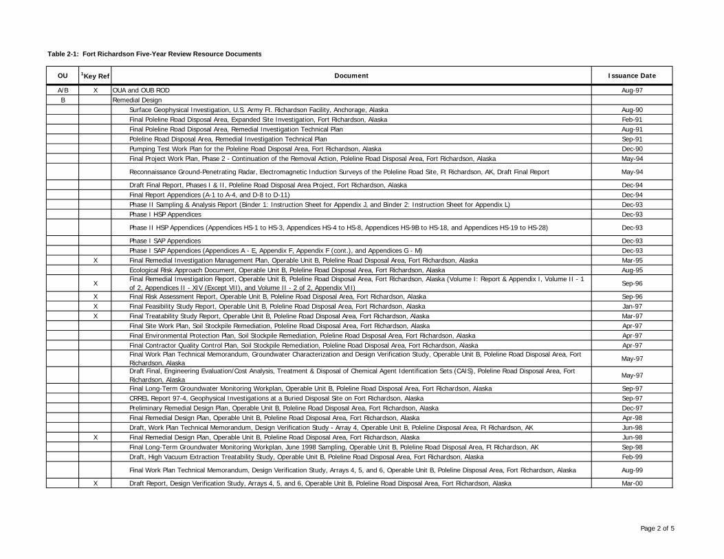
Table 2-1: Fort Richardson Five-Year Review Resource Documents
OU 1Key Ref Document Issuance Date
A/B X OUA and OUB ROD Aug-97B Remedial Design
Surface Geophysical Investigation, U.S. Army Ft. Richardson Facility, Anchorage, Alaska Aug-90Final Poleline Road Disposal Area, Expanded Site Investigation, Fort Richardson, Alaska Feb-91Final Poleline Road Disposal Area, Remedial Investigation Technical Plan Aug-91Poleline Road Disposal Area, Remedial Investigation Technical Plan Sep-91Pumping Test Work Plan for the Poleline Road Disposal Area, Fort Richardson, Alaska Dec-90Final Project Work Plan, Phase 2 - Continuation of the Removal Action, Poleline Road Disposal Area, Fort Richardson, Alaska May-94
Reconnaissance Ground-Penetrating Radar, Electromagnetic Induction Surveys of the Poleline Road Site, Ft Richardson, AK, Draft Final Report May-94
Draft Final Report, Phases I & II, Poleline Road Disposal Area Project, Fort Richardson, Alaska Dec-94Final Report Appendices (A-1 to A-4, and D-8 to D-11) Dec-94Phase II Sampling & Analysis Report (Binder 1: Instruction Sheet for Appendix J, and Binder 2: Instruction Sheet for Appendix L) Dec-93Phase I HSP Appendices Dec-93
Phase II HSP Appendices (Appendices HS-1 to HS-3, Appendices HS-4 to HS-8, Appendices HS-9B to HS-18, and Appendices HS-19 to HS-28) Dec-93
Phase I SAP Appendices Dec-93Phase I SAP Appendices (Appendices A - E, Appendix F, Appendix F (cont.), and Appendices G - M) Dec-93
X Final Remedial Investigation Management Plan, Operable Unit B, Poleline Road Disposal Area, Fort Richardson, Alaska Mar-95Ecological Risk Approach Document, Operable Unit B, Poleline Road Disposal Area, Fort Richardson, Alaska Aug-95
XFinal Remedial Investigation Report, Operable Unit B, Poleline Road Disposal Area, Fort Richardson, Alaska (Volume I: Report & Appendix I, Volume II - 1 of 2, Appendices II - XIV (Except VII), and Volume II - 2 of 2, Appendix VII)
Sep-96
X Final Risk Assessment Report, Operable Unit B, Poleline Road Disposal Area, Fort Richardson, Alaska Sep-96X Final Feasibility Study Report, Operable Unit B, Poleline Road Disposal Area, Fort Richardson, Alaska Jan-97X Final Treatability Study Report, Operable Unit B, Poleline Road Disposal Area, Fort Richardson, Alaska Mar-97
Final Site Work Plan, Soil Stockpile Remediation, Poleline Road Disposal Area, Fort Richardson, Alaska Apr-97Final Environmental Protection Plan, Soil Stockpile Remediation, Poleline Road Disposal Area, Fort Richardson, Alaska Apr-97Final Contractor Quality Control Plan, Soil Stockpile Remediation, Poleline Road Disposal Area, Fort Richardson, Alaska Apr-97Final Work Plan Technical Memorandum, Groundwater Characterization and Design Verification Study, Operable Unit B, Poleline Road Disposal Area, Fort Richardson, Alaska
May-97
Draft Final, Engineering Evaluation/Cost Analysis, Treatment & Disposal of Chemical Agent Identification Sets (CAIS), Poleline Road Disposal Area, Fort Richardson, Alaska
May-97
Final Long-Term Groundwater Monitoring Workplan, Operable Unit B, Poleline Road Disposal Area, Fort Richardson, Alaska Sep-97CRREL Report 97-4, Geophysical Investigations at a Buried Disposal Site on Fort Richardson, Alaska Sep-97Preliminary Remedial Design Plan, Operable Unit B, Poleline Road Disposal Area, Fort Richardson, Alaska Dec-97Final Remedial Design Plan, Operable Unit B, Poleline Road Disposal Area, Fort Richardson, Alaska Apr-98Draft, Work Plan Technical Memorandum, Design Verification Study - Array 4, Operable Unit B, Poleline Disposal Area, Ft Richardson, AK Jun-98
X Final Remedial Design Plan, Operable Unit B, Poleline Road Disposal Area, Fort Richardson, Alaska Jun-98Final Long-Term Groundwater Monitoring Workplan, June 1998 Sampling, Operable Unit B, Poleline Road Disposal Area, Ft Richardson, AK Sep-98Draft, High Vacuum Extraction Treatability Study, Operable Unit B, Poleline Road Disposal Area, Fort Richardson, Alaska Feb-99
Final Work Plan Technical Memorandum, Design Verification Study, Arrays 4, 5, and 6, Operable Unit B, Poleline Disposal Area, Fort Richardson, Alaska Aug-99
X Draft Report, Design Verification Study, Arrays 4, 5, and 6, Operable Unit B, Poleline Road Disposal Area, Fort Richardson, Alaska Mar-00
Page 2 of 5

Table 2-1: Fort Richardson Five-Year Review Resource Documents
OU 1Key Ref Document Issuance Date
B Remedial Action Report(s)Operable Unit B Remedial Design/Remedial Action, Statement of Work, December 5, 1997 Dec-97DRAFT Remedial Action Work Plan Operable Unit B Poleline Road Disposal Area, Fort Richardson, AK Dec-00
X DRAFT Interim Remedial Action ReportOperable Unit B Poleline Road Disposal Area, Fort Richardson, AK Jan-03B Sampling/Monitoring Plans, Reports, and Data
Long-Term Groundwater Monitoring November 1997 Sampling Operable Unit B Poleline Road Disposal Area Nov-97Long-Term Groundwater Monitoring November 1997 Sampling Poleline Road Disposal Area Jan-98Draft Design Verification Study, Operable Unit B, Poleline Road Disposal Area, Fort Richardson, Alaska Feb-98Long-Term Groundwater Monitoring Technical Memorandum June 1998 Sampling, Operable Unit B Jun-98Technical Memorandum OUB Poleline Road Disposal Area Jul-98Chemical Quality Assurance Report, Operable Unit B, Fort Richardson, Alaska, Draft Jul-98Final Chemical Quality Assurance Report OUB Sep-98Long-Term Groundwater Monitoring Technical Memorandum June 1998 Sampling, Operable Unit B Sep-98Analytical Results of Post Treatment Surface Samples collected at Poleline Road Disposal Area, Ft Richardson, AK Nov-98Final Long-Term Groundwater Monitoring, October 1998 Sampling, Operable Unit B, Poleline Road Disposal Area, Fort Richardson, Alaska Jan-99Technical Memorandum for Batch Treatment Cell No. 3, Soil Stockpile Remediation, Poleline Road Disposal Area, Fort Richardson, Alaska Apr-99
X Final Long-Term Groundwater Monitoring, March 1999 Sampling, Operable Unit B, Poleline Road Disposal Area, Fort Richardson, Alaska Jun-99Technical Memorandum, OU-B, Poleline Road, Ft. Richardson Sep-99Final System Evaluation, Operable Unit B, Poleline Road Disposal Area, Fort Richardson, Alaska Sep-99Technical Memorandum, OU-B, Poleline Road, Ft. Richardson, Alaska, Installation of Array 5 and associated Soil Sampling, May 1999 Sep-99Final Report, Operable Unit B, Poleline Road Disposal Area, Long-Term Groundwater Monitoring Report May-00Poleline Road Disposal Area Long-term Groundwater Monitoring Oct-00
X Final Report Operable Unit B Poleline Road Disposal Area October 2000 Long-Term Groundwater Monitoring Report Nov-00Design Verification Study Arrays 4, 5, and 6 Dec-00
X Revised Final Report Design Verification Study Arrays 4, 5,and 6, Operable Unit B Poleline Road Disposal Area, Fort Richardson, Alaska Mar-01X July 2001 Long Term Groundwater Monitoring Report Jul-01
Final Technical Memorandum Updating Long-Term Groundwater Monitoring Results Volume I Dec-01
Page 3 of 5

Table 2-1: Fort Richardson Five-Year Review Resource Documents
OU 1Key Ref Document Issuance Date
C X Record of Decision for OUC Fort Richardson Anchorage, Alaska Sep-98C Remedial Design
Eagle River Flats, Expanded Site Investigation, Fort Richardson, Alaska, Final Technical Report, Data Item A011 Jun-90CRREL Report 92-5, Waterfowl Mortality in Eagle River Flats, Alaska, The Role of Munitions Residues May-92FY 92 Final, Phase II. Remedial Investigation Report: White Phosphorus Contamination of Salt Marsh Sediments at Eagle River Flats, Alaska Jun-93CRREL Report 93-23, Preliminary Assessment of Sedimentation and Erosion in Eagle River Flats, South-Central Alaska Dec-93
X Interagency Expanded Site Investigation, Evaluation of White Phosphorus Contamination and Potential Treatability at Eagle River Flats, Alaska May-94X Eagle River Flats, Comprehensive Evaluation Report, Fort Richardson, Alaska Jul-94
XInteragency Expanded Site Investigation, Evaluation of White Phosphorus Contamination and Potential Treatability at Eagle River Flats, Alaska, FY 94 Final Report (Volumes 1 and 2)
May-95
Eagle River Flats, Final 1995 Work Plan, Fort Richardson, Alaska Jun-95Eagle River Flats, Final Quality Assurance Program Plan, Fort Richardson, Alaska Jun-95CRREL Report 96-9, Physical System Dynamics and White Phosphorus Fate and Transport, 1994, Eagle River Flats, Fort Richardson, Alaska Aug-96Operable Unit C, OB/OD Pad, Fort Richardson, Alaska, Site Investigation Work Plan Sep-96CRREL Report 96-13, Physical Processes and Natural Attenuation Alternatives for Remediation of White Phosphorus Contamination, Eagle River Flats, Fort Richardson, Alaska
Dec-96
Site Safety and Health Plan for Site Visit to Eagle River Study Area Apr-97X Scope of Work for Treatability Study of Pond Pumping for Enhancement of in-situ White phosphorus Attenuation in Eagle River Flats Apr-98
Technical Memorandum: Spill Prevention and Control for Eagle River Flats Pumping Treatability Study Jun-98OB/OD Pad Interim Closure Plan Approach Document Dec-98Draft OB/OD PAD Interim Closure Plan Mar-991999 Field Work Plan for Eagle River Flats Jun-99Field Work and Pond Drainage Eagle River Flats, Safety and Health Plan Dec-98Remediating and Monitoring White Phosphorus Contamination at Eagle River Flats Jul-00
C Remedial Action Report(s)X DRAFT Interim Remedial Action ReportOperable Unit C Eagle River Flats, Fort Richardson, AK Jul-02
Page 4 of 5
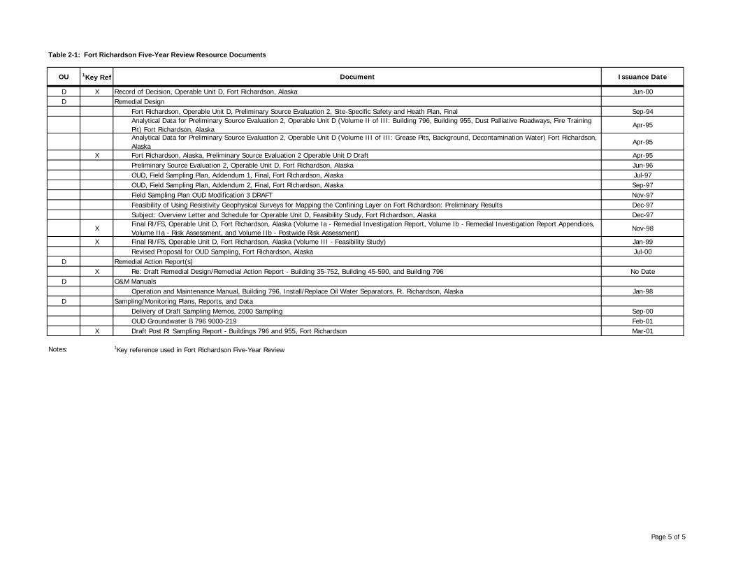
Table 2-1: Fort Richardson Five-Year Review Resource Documents
OU 1Key Ref Document Issuance Date
D X Record of Decision, Operable Unit D, Fort Richardson, Alaska Jun-00D Remedial Design
Fort Richardson, Operable Unit D, Preliminary Source Evaluation 2, Site-Specific Safety and Heath Plan, Final Sep-94Analytical Data for Preliminary Source Evaluation 2, Operable Unit D (Volume II of III: Building 796, Building 955, Dust Palliative Roadways, Fire Training Pit) Fort Richardson, Alaska
Apr-95
Analytical Data for Preliminary Source Evaluation 2, Operable Unit D (Volume III of III: Grease Pits, Background, Decontamination Water) Fort Richardson, Alaska
Apr-95
X Fort Richardson, Alaska, Preliminary Source Evaluation 2 Operable Unit D Draft Apr-95Preliminary Source Evaluation 2, Operable Unit D, Fort Richardson, Alaska Jun-96OUD, Field Sampling Plan, Addendum 1, Final, Fort Richardson, Alaska Jul-97OUD, Field Sampling Plan, Addendum 2, Final, Fort Richardson, Alaska Sep-97Field Sampling Plan OUD Modification 3 DRAFT Nov-97Feasibility of Using Resistivity Geophysical Surveys for Mapping the Confining Layer on Fort Richardson: Preliminary Results Dec-97Subject: Overview Letter and Schedule for Operable Unit D, Feasibility Study, Fort Richardson, Alaska Dec-97
XFinal RI/FS, Operable Unit D, Fort Richardson, Alaska (Volume Ia - Remedial Investigation Report, Volume Ib - Remedial Investigation Report Appendices, Volume IIa - Risk Assessment, and Volume IIb - Postwide Risk Assessment)
Nov-98
X Final RI/FS, Operable Unit D, Fort Richardson, Alaska (Volume III - Feasibility Study) Jan-99Revised Proposal for OUD Sampling, Fort Richardson, Alaska Jul-00
D Remedial Action Report(s)X Re: Draft Remedial Design/Remedial Action Report - Building 35-752, Building 45-590, and Building 796 No Date
D O&M ManualsOperation and Maintenance Manual, Building 796, Install/Replace Oil Water Separators, Ft. Richardson, Alaska Jan-98
D Sampling/Monitoring Plans, Reports, and DataDelivery of Draft Sampling Memos, 2000 Sampling Sep-00OUD Groundwater B 796 9000-219 Feb-01
X Draft Post RI Sampling Report - Buildings 796 and 955, Fort Richardson Mar-01
Notes: 1Key reference used in Fort Richardson Five-Year Review
Page 5 of 5

Page 3-1
3.0 FORT RICHARDSON NPL SITE BACKGROUND
This section is an overview of the post wide Fort Richardson NPL site. Background information on the individual OUs is presented in the OU-specific sections of this document.
3.1 Post History
In 1939, increasing world tensions caused the establishment of Elmendorf Field just outside of Anchorage. One year later, the name Fort Richardson was adopted by the U.S. War Department in memory of Brigadier General Wilde P. Richardson. Japanese aggression in the Aleutian Islands emphasized the strategic importance of Alaska. Fort Richardson’s first mission was defense of southern Alaska by establishing a permanent air base, supply depot, and garrison. When the Japanese attacked Pearl Harbor in 1941, Fort Richardson was charged with defending Alaska from invasion and coordinating the Alaskan war effort. Before the outbreak of World War II, military strength in Alaska was less than 3,000; it soon grew to 7,800 troops stationed at Fort Richardson alone, including the 4th Infantry, 85th Field Artillery, and 75th Coast Artillery (Anti-Aircraft). As the war progressed, Fort Richardson’s mission expanded significantly as the logistics base for numerous Army garrisons and the Air Corps. Army troops were redesignated as the United States Army Alaska on November 15, 1947, and assigned to the Alaskan Command, the nation’s unified command staffed jointly by Army, Navy, and Air Force officers. Headquarters for U.S. Army Alaska were established at FRA. At that time the post was located on what is now Elmendorf Air Force Base. After the establishment of the Air Force as a separate service in 1947, the Army post was rebuilt on its present location in 1950. In December 1974, as part of worldwide realignments, U.S. Army Alaska was inactivated and the post became headquarters for the 172nd Infantry Brigade (Separate) in January 1975. As in previous years, subordinate posts were maintained at FWA (near Fairbanks) and Fort Greely (near Delta Junction). In a subsequent realignment in March 1986, the newly reactivated 6th Infantry Division (Light) replaced the 172nd Infantry Brigade (Separate). This marked a new mission for the Army in Alaska as a light, deployable force capable of defending United States interests across the globe. The division became aligned more closely with the Defense Department’s forces in the Pacific when, in 1989, it began reporting to the US Army Western Command in Hawaii (later re-designated United States Army Pacific). Headquarters was established on FRA and remained there until 1990. In 1990, headquarters for the 6th was moved to FWA. In 1993, as part of Army-wide downsizing, the 6th was reorganized as a light infantry brigade. The 6th Infantry Division (Light) was inactivated July 1994, and FRA became headquarters for United States Army Alaska (USARAK) when U.S. Army Alaska was

Page 3-2
restructured. In 1998, the 1st Brigade, 6th Infantry Division (Light) was deactivated, and the 172nd Infantry Brigade (Separate) was reactivated.
3.2 CERCLA History
In 1988, EPA Region 10 placed Fort Richardson on the hazardous waste compliance docket. The Army’s investigation of contaminated sites at Fort Richardson under the IRP began in 1988. The objectives of the IRP are to assess sites where potentially hazardous material may exist and to develop and recommend remedial actions for those sites that pose a threat to human health and welfare or the environment. The IRP is the basis for response actions under the provisions of CERCLA. Because known or suspected releases of hazardous chemicals were identified on the Post, Fort Richardson was proposed for placement on the CERCLA NPL on June 18, 1993 and listed on June 1, 1994. As a result, environmental assessment and remediation activities at Fort Richardson are being performed to comply with CERCLA, as amended by the Superfund Amendments and Reauthorization Act (SARA) of 1986 and subsequent amendments. Attachment I to the FFA describes the investigation and restoration approach agreed upon by the Army and the regulatory agency parties to the agreement. The FFA identified a number of source areas based on historical uses and past investigations and initially listed 102 potential source areas at Fort Richardson. No Further Action (NFA), response complete, was selected for 70 of these source areas. An additional nine source areas were identified for NFA under CERCLA following the FFA. Nineteen of the remaining potentially contaminated source areas were grouped into four OUs. Four source areas with known or suspected Petroleum (non-UST) contamination were transferred for investigated in accordance with the Environmental Restoration Agreement (Two Party Agreement). Source areas were evaluated through a screening process called a Preliminary Source Evaluation (PSE). The PSE included record searches, interviews, and if warranted, limited field investigations. During the investigations, analytical data was generated for many chemicals. The target analyte list for each source area was determined based on site history and previous investigations. PSEs lead into the remedial investigations (RI), followed by feasibility studies (FS) for the selection of remedies, remedial designs (RD), remedial action (RAs), Operation and maintenance (O&M) associated with remedial actions, and long-term monitoring (LTM). The history of contamination and remediation of source areas are summarized in the OU-specific sections of this report. Documents that record all investigation and cleanup decisions are located in the administrative record. Under OUD, a post wide human health and ecological risk assessment was performed for the entire Fort Richardson Army Post to supplement the individual risk assessments conducted for each source. The objectives of the post wide risk assessment were to evaluate potential risks to wide-ranging receptors that may be exposed to multiple source areas and to fill data gaps that became evident upon thorough review of all data collected during each RI for each OU. The

Page 3-3
current postwide human health risk assessment remains protective; however, it will be evaluated as part of the OUE RI/FS and updated as necessary. Pursuant to the 1991 FFCA, the Army conducted sampling activities at solid waste management units addressed in the FFCA to establish whether or not hazardous wastes were managed at these units, and in some instances, prepared closure plans. These closure plans, developed under the RCRA program guidelines, were used as an integral part of the CERCLA cleanup actions.
3.3 Land and Resource Use
Fort Richardson encompasses approximately 61,376 acres. The post is located in south-central Alaska adjacent to the cities of Anchorage and Eagle River, and Elmendorf Air Force Base. The Knik Arm of Cook Inlet borders the north side of the post, and Chugach State Park lies to the south and southeast. The Town of Eagle River lies along the northeast border; Anchorage and Elmendorf Air Force Base form the western boundary. The western boundary is approximately 11 miles long, from the Knik Arm to its terminus beside Anchorage and Chugach State Park. The eastern border is 21 miles, and also runs from the Knik Arm to Chugach State Park. Fort Richardson is approximately six miles across, from east to west. The cantonment area is situated at the base of the Chugach foothills, on the alluvial floodplain between the Chugach Mountains and the Knik Arm of Cook Inlet. Located approximately seven miles from downtown Anchorage, the cantonment area is bordered on the west by Elmendorf Air Force Base, on the north by training areas, on the east by the Glenn Highway, and on the south by Ship Creek, recreational areas, and training areas. The majority of the land currently used by USARAK is on long-term withdrawal from the public domain and was originally assigned to the Bureau of Land Management (BLM). Residual responsibility for USARAK withdrawn lands remains with the BLM, which retains interest in the stewardship of the transferred parcel even though the land is under the Department of Defense’s long-term management. Land use at Fort Richardson is varied. More than 75 percent of the total land area in Fort Richardson is dedicated to ranges, combat courses, drop zones, airfields, troop loading yards, training facilities, open storage areas, and ammunition storage areas. Other industrial-type activities that take place at Fort Richardson occur mostly in the cantonment area and include the following: vehicle maintenance, general equipment and building maintenance, pest control and grounds keeping, photographic processing, printing, dry-cleaning, drinking water treatment, water quality and petroleum analysis, heat and electrical power generation, and dental and medical services. A portion of the base has been developed for troop training and support operations, including housing and recreational facilities. The remaining acreage is basically undeveloped and includes wetlands, lakes, and ponds. Fort Richardson’s land use also provides the services, facilities, and infrastructure necessary to support the rapid deployment of Army forces from Alaska to the Pacific Theater. Recreational uses are permitted where consistent with the military mission.
Page 3-4
Eagle River and Ship Creek are the primary streams on the installation, running from east to west. Ship Creek, the primary water source for Fort Richardson and Elmendorf Air Force Base, runs through Fort Richardson. Fort Richardson obtains drinking water from the Ship Creek Dam Reservoir and has several emergency water supply wells near Ship Creek. Groundwater used for the emergency water supply is obtained from the confined aquifer in the Knik outwash deposit. Water storage for Fort Richardson is provided by a permanent 2.5 million gallon underground reservoir in the Elmendorf Moraine, and by the Ship Creek Dam Reservoir at the base of the Chugach Mountain Range. A water treatment plant near the dam processes the drinking water. A drinking water well is located at the Otter Lake Recreational facility, located approximately 2 miles from the cantonment area.
3.4 Physical Characteristics
Geologic Setting
Fort Richardson lies in an alluvial plain, often referred to as the Anchorage Lowland, which is bordered on the east by the Chugach Mountains and on the north, south, and west by waters of the Cook Inlet. Fort Richardson is situated in a transitional zone on the eastern edge of the Anchorage Lowland and is inundated with four major drainages that originate in the Chugach Mountains. The topography of Fort Richardson has been highly influenced by glacial activity and the effects of stream deposition and erosion. The Chugach Mountains rise rather abruptly to more than 5,000 feet along their front facing the Anchorage lowlands. Only a small western section of the Chugach Mountains is contained within the boundaries of Fort Richardson. The valleys of the Chugach Mountains are occupied by major and minor drainages including Ship Creek, Eagle River, Campbell Creek, and Chester Creek. The Anchorage Lowland is characterized by rolling hills with 50 to 250 feet of relief in eastern areas along the Chugach Mountains. Towards the west, the terrain flattens into an alluvial plain that is inundated with broad shallow channels and wetlands. This area is characteristic of glaciated terrain and contains various landforms, including moraines, esker deposits, outwash plains, and estuarine sediments. The principal features transecting Fort Richardson are the Elmendorf moraine, the Mountain View alluvial fan, ground moraines, and Eagle River Flats tidal marsh. The Mountain View fan originates at the mouth of the Eagle River Valley. The fan slopes gently to the west-southwest and underlies most of the main cantonment area of Fort Richardson. The main deposits of the Elmendorf moraine form a low lying ridge that tends to run east to west across the region immediately north of the main cantonment area of Fort Richardson. The ground moraines were formed by a number of physical processes that operate underneath glaciers. The ground moraine found on the northern part of Fort Richardson was probably formed at the same time as the Elmendorf moraine. The southern ground moraine lies much deeper and was likely created by a glacial event that preceded formation of the northern ground moraine. The ground moraines tend to be extensive deposits of glacial till with hummocky surfaces and moderately gentle slopes.

Page 3-5
Eagle River Flats is a low-lying tidal marsh located north-northwest of the main cantonment area on Fort Richardson that was created by various estuarine processes. Modern estuarine sediments are continually deposited during spring flood events and by tidal fluctuations of up to 30 feet or more. Older estuarine deposits are found extensively in Eagle River Flats and were likely deposited during the Holocene Epoch. Estuarine deposits are generally composed of well-bedded and sorted silt and fine sands. Geology
The geology of Fort Richardson and adjacent lands has been extensively mapped. The thick sequences of unconsolidated Quaternary deposits that underlie Fort Richardson have accumulated primarily as a result of glacial and marine sedimentation. These deposits thicken westward from the base of the Chugach Mountains. Below the Fort Richardson cantonment, glacial sediments range from 230 to 320 feet thick according to well logs. They are up to 1000 feet thick elsewhere in the Anchorage basin. The underlying geology of Fort Richardson is complex and highly variable due to deposition that occurred during the advance and retreat of glaciers with intermittent marine incursion (marine sedimentary processes). The following paragraphs provide descriptions of the various geologic units, but are not intended to reflect exact conditions underlying any given site on Fort Richardson. The Mountain View fan is commonly on the order of 40 to 60 feet thick under most of the main cantonment area. The fan consists mostly of sands and gravels with a high concentration of silt and clay. The formation is highly layered, and it is common to find lenses of clay and silt interbedded within the sand and gravel. Silt and clay lenses were likely deposited during floods and also could have resulted from deposition in small ponds and lakes. The Elmendorf moraine lies beneath the Mountain View fan in the area of the main cantonment. The Elmendorf moraine is an end moraine and consists primarily of diamicton (poorly-sorted mixtures of silt, sand, and gravel) along with coarse gravel, fine well-sorted sand, dense silt, and moderately to well-compacted clay. The lateral and ground moraine deposits tend to consist of diamicton of variable thickness with interbedded lenses of sand, silt, and gravel. In areas where the Mountain View fan is absent, the moraine deposits represent the upper geologic unit. Coarse outwash deposits intermingled with deposits of unsorted material can be found along the front of the moraine. Older ground moraine deposits can be found in the southern part of the cantonment area. The Bootlegger Cove Formation, an intermediate formation often referred to as the Bootlegger Cove Clay, was formed during the advance and retreat of glacial ice, with an intermittent period of marine intrusion. The thickness of the Bootlegger Cove Formation is quite variable, but has been found to be almost 300 feet thick in parts of the Anchorage Lowland. Even though the Bootlegger Cove Formation is extensive, evidence exists to suggest that the formation does not extend much further northeast than the edge of the cantonment area. The formation is likely not

Page 3-6
found north and east of the cantonment area and is suspected to be only about 30 feet thick in the south-southwest areas of the post. The lower geologic sequences (Dishno Pond moraines, Fort Richardson moraines, and Rabbit Creek moraines) all tend to be glacial diamictons. Because of a lack of deep geologic borings and geophysical surveys, many of the descriptions of these sequences are speculative and descriptions vary. The Dishno Pond Sequence appears to underlie much of the Anchorage Lowland and the diamicton should be similar to the Fort Richardson diamicton, and be a few to tens of meters thick. The Fort Richardson diamicton is thought to be highly stratified with sand and gravel horizons. This description is based on the proposed glacial history of the Anchorage basin. The Rabbit Creek moraine lies on top of the Kenai Formation (sedimentary bedrock). There is some evidence that layers of silt and clay were deposited between these moraines during periods of marine inundation. Hydrology
Groundwater on Fort Richardson is found in both an unconfined and a confined aquifer. Water recharges the groundwater on Fort Richardson and the Anchorage Bowl in several ways. Along the mountains, groundwater seeps from bedrock fractures into the glacial deposits. In the foothills and lowlands, water flows from streams into the unconfined aquifer where the water table is below the stream elevation. In the lowlands, rain and snowmelt percolate from the surface into the groundwater. The hydrogeology of Fort Richardson is complicated due to deposits from multiple glacial advances through the region. There is an unconfined aquifer and multiple confined aquifers that connect in some places. The unconfined aquifer is generally composed of poorly sorted, sandy gravel with varying amounts of silt. In general, low-permeability layers containing clay and sand underlie the unconfined aquifer. The clay is present at depths ranging from 30 to 175 feet. The low-permeability clays create a lower boundary for the unconfined aquifer and an upper boundary for the confined aquifer. The confined aquifer joins the unconfined aquifer just north of the Davis Highway, where the clay layers end. The hydraulic gradient of the unconfined aquifer generally trends northwesterly, following the topography of the Mountain View Fan. The overall trend in flow direction in the confined aquifer is to the northwest, except to the north of Bryant Airfield where groundwater flow patterns are unclear. Perched groundwater tables are common on Fort Richardson. They form when water from precipitation infiltrates the ground surface and forms pools on top of discontinuous layers of low-permeability silt and clay layers. These perched groundwater tables are found at a higher elevation than the main unconfined groundwater table. Contaminants that enter the ground from the surface can also pool on discontinuous, low-permeability layers. Measured depths to groundwater on Fort Richardson range from near the surface at Ship Creek, to 200 feet near Bryant Airfield. Four major streams and rivers pass through sections of Fort Richardson. In addition, numerous other small streams, lakes, and wetland area are found on Fort Richardson. Fort Richardson has 12 named lakes and ponds and multiple other unnamed surface water bodies. The combined

Page 3-7
area for the named lakes and ponds is 359 acres. Five relatively large lakes, Clunie, Otter, Gwen, Thompson, and Waldon, are managed for recreational fishing. Eagle River is a glacial waterway that originates at the base of the Eagle Glacier in the Chugach Mountains. Eagle River meanders across Fort Richardson, where it flows over an alluvial base of glacial outwash and into Eagle River Flats, a 2,200-acre estuarine tidal marsh. Ship Creek, a non-glacial stream, originates at Ship Lake in the Chugach Mountains and flows 25 miles to the Knik Arm. A water supply dam located at the base of the Chugach Mountains on Fort Richardson, approximately 10 miles from the mouth of the river diverts water from the stream. The watershed encompasses 90.5 square miles above the diversion dam. Chester Creek and Campbell Creek, both non-glacial streams, are located south of Ship Creek and flow through the southwestern portion of Fort Richardson. The creeks flow into marsh wetlands at the base of the Chugach Mountains on Fort Richardson but rechannelizes near the western boundary of the post.
3.5 History of Contamination
Since World War II, Fort Richardson has supported combat unit training and operations (primarily light infantry) that have resulted in various hazardous substances being released to soil and groundwater. Used oils, solvents, and fuel spills were reportedly discharged to the floor drains that drained directly to the sanitary sewer or to dry wells with discharged to subsurface soils. Spent solvents and contaminated fuels were routinely mixed with waste oils in the past. Waste oils, solvents, and contaminated fuels have been used for fire training practice at the fire bum pits. Waste oil USTs were installed at many of the maintenance facilities in the 1940's. Current Army practices no longer allow uncontrolled or unpermitted releases of pollutants to the environment. The primary environmental contaminants at Fort Richardson are white phosphorous, volatile organic compounds (VOCs, usually solvents and cleaners), polychlorinated biphenyls (PCBs), fuel products, and polycyclic aromatic hydrocarbons ([PAHs] commonly used in wood preservatives and also given off in automobile or truck exhaust or during burning activities).
3.6 Institutional Controls
The Army has established Standard Operating Procedures (SOP) and a Geographic Information System (GIS) based tracking system to ensure that the land use restrictions are enforced. The IC system has been incorporated into the post wide Master Plan, and compliance with ICs is reported in the Annual Monitoring Reports for each OU. The IC policy applies to all USARAK units and activities, Military and Civilian Support Activities, Tenants Organizations and Agencies and Government and Civilian Contractors. In the fall of 2001, the Institutional Control Memorandum signed by Major General Cash dated February 1999, was updated to require a Work Authorization Permit for all groundwater and soils on USARAK lands. This revised memorandum, signed by the Commanding General, includes a section on areas with ICs mandated by a Record of Decision

Page 3-8
and a section on areas where contamination is not suspected. Currently, all contracts that include intrusive activities require a Work Authorization Permit. The Permit was recently updated to clearly alert the user on procedures to follow when potential contamination is encountered. The Standard Operating Procedure (SOP) for ICs will include a more detailed section on the procedures and responsibilities for incidents where potential contamination is found.
Fort Richardson instituted a post wide IC policy for all known or suspected contaminated source areas. Further details of the Army/Fort Richardson IC policy can be found in Appendix E of the OUB Draft Interim Remedial Action Report, the U.S. Army Alaska Institutional Controls Standard Operating Procedures [(APVR-RPW [200-1)], and a Memorandum on Institutional Controls [APVR-RPW-EV (200-1c)]. IC policies include the following:
• No unauthorized intrusive actions take place at source areas,
• No potable water wells are installed on source areas, and
• No soil excavation can take place without prior briefings on potential concerns at the source area, knowledge of the procedures for handling contaminated soils on Fort Richardson, and possession of a valid site-specific Fort Richardson Excavation Permit.
USARAK DPW maintains the GIS database with information on all of the contaminated source areas on Post. The DPW is responsible for ensuring ICs on Fort Richardson are enforced. ICs will remain in place as long as hazardous substances remain on site at levels that preclude unrestricted use.

Table 3-1: Current Disposition of Source Areas at Fort Richardson Identified in the Original FFA.
OU BLDG/ LOC. SITE DESCRIPTION POTENTIAL COCs STATUS COMMENTS WC REPORT SITE #
1990 RFA SWMU
NOTES & REFS.
A 986 POL LABORATORY DRYWELLWASTE OIL, LUBRICANTS, AVIATION FUELS,
SOLVENTS, ACID, ALCOHOL, REAGENTS, POL SOIL
TRANSFERRED TO 2PTY, CURRENTLY ACTIVE IN LTO
PHASE WITH ICs
CURRENTLY UNDERGOING SVE/BIOVENTING TREATMENT.
W020 60USATHAMA 1991 PROPERTY REPORT AND RCRA FACILITY
ASSESSMENT (1990 RFA )
A 67630 ROOSEVELT ROAD TRANSMITTER SITELEACHFIELD
PCB'S IN TRANSFMR OIL TRANSFERRED TO 2PTY - NFA WITH ICs
CONTAMINATED SOIL WAS EXCAVATED PRIOR TO ROD AND SITE WAS NFA IN ROD. SITE HAS SINCE BEEN SAMPLED AND CAPPED WITH 6 FEET OF SOIL.
W010 118 USATHAMA 1991 PROPERTY REPORT AND 1990 RFA
A FMR LNDFIL#9 (RUFF ROAD)
RUFF ROAD FORMER FIRE TRAINING AREA
CONSTRUCTION RUBBLE, JP-4, CHLORINATED & NONCHLOR. SOLVENTS
TRANSFERRED TO 2PTY - NFA WITH ICs
SITE UNDERWENT SVE TREATMENT AS PART OF 2PTY AGREEMENT AND HAS SINCE BEEN NFRAP WITH ICs
W040 97 USATHAMA 1991 PROPERTY REPORT AND 1990 RFA
B POLELINE ROAD DISPOSAL AREA
POLELINE ROAD DISPOSAL AREA DECON. SOLVENTS, SMOKE CANNISTERS, CW TRAINING MATERIAL
LTM WITH ICsCURRENTLY PERFORMING GROUNDWATER MONITORING AND DEVELOPING GROUNDWATER CONTAMINANT MODEL.
N087 NONE
C EAGLE RIVER FLATS EAGLE RIVER FLATS IMPACT AREA WHITE PHOSPHORUS RAOSTARTING 5TH YEAR OF ACTIVE REMEDIAL ACTION WITH PONDING PUMPING TO DRY SEDIMENTS AND ELIMINATE WP.
W006 117 USATHAMA 1991 PROPERTY REPORT AND 1990 RFA
C EAGLE RIVER FLATS OPEN BURN/OPEN DEMO AREAPOWDER BAGS, FUZES, TNT,
GRENADES,ROCKET MOTORS, PROJECTILES, ASH
RCRA CLOSURE NFA UNDER CERCLA AND REFERRED TO RCRA FOR CLOSURE.
W025 99 USATHAMA 1991 PROPERTY REPORT AND 1990 RFA
D 700 FORMER DRUM/PCB STORAGE AREA POL NFA UNDER CERCLA AND 2PTY
NFA IN OUD ROD. GROUNDWATER SAMPLING INDICATED THAT SITE WAS CLEAN AND NFRAP UNDER 2PTY.
W009 1, 91 USATHAMA 1991 PROPERTY REPORT AND 1990 RFA
D 704FORMER ROADS AND GROUNDS DRUM
STORAGE & WASTE ACCUMULATION AREA
WASTE SOLVENT NFA UNDER CERCLA AND 2PTY
NFA IN OUD ROD. SAMPLING INDICATED THAT SITE WAS CLEAN AND NFRAP UNDER 2PTY.
R053 3, 4 1990 RFA
D 726 FORMER LAUNDRY & DRYCLEANING USTs
PERCHLORETHYLENE, SLUDGE NFANFA IN OUD ROD. LOW LEVEL CONTAMINATION AT DEPTH NOT CONSIDERED A RISK.
W016 9, 10, 11, 12, 13, 14, 15, 120
USATHAMA 1991 PROPERTY REPORT AND 1990 RFA
D 796 DOL MAINT, AREA --FORMER BATTERY ACID DISPOSAL SITE
NEUTRALIZED BTRY ACID, HEAVY METALS PROPOSED FOR NFA IN OUEROD
GROUNDWATER AT THE SITE WAS SAMPLED POST OUD ROD. NO CONTAMINANTS EXCEEDED MCLs SO SITE WILL BE CLOSED UNDER THE OUE ROD.
R059 37 1990 RFA
D 955 USED OIL TRANSFER AREA (SLUDGE BIN)
PESTICIDES, USED OIL/FUEL PROPOSED FOR NFA IN OUEROD WITH RCRA CLOSURE
CONTAMINATED SOIL DISPOSED OF AT PERMITTED DISPOSAL FACILITY. SOIL SAMPLES COLLECTED POST OUD ROD. NO CONTAMINANTS EXCEEDED CLEANUP LEVELS OR RBCs SO SITE WILL BE CLOSED UNDER THE OUE ROD.
R060 41 1990 RFA
D 45590 MOTOR POOL WASTE OIL, LUBRICANTS, ANTIFREEZE, ACID, SOLV.
NFA UNDER CERCLA WITH RCRA CLOSURE
NFA UNDER CERCLA. NO EVIDENCE OF CONTAMINANT RELEASE THAT POSES AN UNACCEPTABLE RISK. GROUNDWATER IS MONITORED AS PART OF CLOSURE PLAN FOR FORT RICHARDSON LANDFILL.
W002 83 USATHAMA 1991 PROPERTY REPORT AND 1990 RFA
Page 1 of 8

Table 3-1: Current Disposition of Source Areas at Fort Richardson Identified in the Original FFA.
OU BLDG/ LOC. SITE DESCRIPTION POTENTIAL COCs STATUS COMMENTS WC REPORT SITE #
1990 RFA SWMU
NOTES & REFS.
D FRA LANDFILL (EAST SIDE) LANDFILL FORMER FIRE TRAINING AREA
OIL, SOLVENT, TRANSM./BRAKE/HYDRAULIC FLUID, WATER CONTAM. DIESEL, JP-4
NFA
NFA UNDER CERCLA. NO EVIDENCE OF CONTAMINANT RELEASE THAT POSES AN UNACCEPTABLE RISK. GROUNDWATER IS MONITORED AS PART OF CLOSURE PLAN FOR FORT RICHARDSON LANDFILL.
W015 98 USATHAMA 1991 PROPERTY REPORT AND 1990 RFA
D FRA LANDFILL (EAST
SIDE), approx. 1000' sw of FF PIT #2
GREASE PIT #1COOKING GREASE, PETROLEUM, GREASE/OIL, O/W SEDIMENT SEPARATOR BOTTOMS, FUEL
TANK WATER, ETHYL GLYCOLNFA
NFA UNDER CERCLA. NO EVIDENCE OF CONTAMINANT RELEASE THAT POSES AN UNACCEPTABLE RISK. GROUNDWATER IS MONITORED AS PART OF CLOSURE PLAN FOR FORT RICHARDSON LANDFILL.
R072 92 1990 RFA
D FRA LANDFILL (EAST
SIDE), approx. 1000' sw of FF PIT #2
GREASE PIT #2COOKING GREASE, PETROLEUM, GREASE/OIL, O/W SEDIMENT SEPARATOR BOTTOMS, FUEL
TANK WATER, ETHYL GLYCOLNFA
NFA UNDER CERCLA. NO EVIDENCE OF CONTAMINANT RELEASE THAT POSES AN UNACCEPTABLE RISK. GROUNDWATER IS MONITORED AS PART OF CLOSURE PLAN FOR FORT RICHARDSON LANDFILL.
R073 93 1990 RFA
D CIRCLE ROAD DRUM SITE CIRCLE ROAD DRUM SITE POL NFA WITH RCRA CLOSURE
CONTAMINATION REMOVED FROM SITE AND CONFIRMATION SAMPLING INDICATED NO EVIDENCE OF CONTAMINATION REMAINING AT THE SITE THAT POSED UNACCEPTABLE RISK
N090 NONE
D FRA STORM DRAINAGE OUTFALL TO SHIP CREEK
OILS, FUELS, SOLVENTS NFA
NFA UNDER CERCLA. NO EVIDENCE OF CONTAMINANT RELEASE THAT POSES AN UNACCEPTABLE RISK. GROUNDWATER IS MONITORED AS PART OF CLOSURE PLAN FOR FORT RICHARDSON LANDFILL.
R075 115 1990 RFA
D FRA ROADs DUST PALLIATIVE WASTE OIL, SOLVENT NFASAMPLING INDICATED NO EVIDENCE OF CONTAMINATION THAT POSES UNACCEPTABLE RISK
W028 USATHAMA 1991 PROPERTY REPORT
E 35752 PCB SITE/UST (ANTENNA BLDG)
PCBs, POL, RCRA CLOSURE (INSIDE
BLDG), CERCLA RI/FS OUTSIDE
SITE IS BEING INVESTIGATED AS PART OF OUE AND REQUIREMENTS WILL BE DOCUMENTED IN THE OUD ROD
W023 90 USATHAMA 1991 PROPERTY REPORT AND 1990 RFA
E AVMA GROUNDWATER PLUME UPGRADIENT OF 45590 SITE
SOLVENTS CERCLA RI/FSSITE IS BEING INVESTIGATED AS PART OF OUE AND REQUIREMENTS WILL BE DOCUMENTED IN THE OUD ROD
604 MEDICAL LAB FIXATIVE W/SILVER, METHYL METHACRYLATE, REAGENTS
NFA
NO REPORTED SPILLS. WASTE GENERATED INSIDE BLDG. MEDICAL LAB REAGENT DISCHARGES INTO SANITARY SEWER SYSTEM.
W004 USATHAMA 1991 PROPERTY REPORT
700 PAINT SHOP SPRAY BOOTH WASTE PAINT NFA
RELEASES TO SOIL, SURFACE WATER, OR GROUND WATER UNLIKELY; UNIT LOCATED INDOORS ON THIRD FLOOR; FILTERS CAPTURE AIR RELEASES.
R051 2 1990 RFA
Page 2 of 8
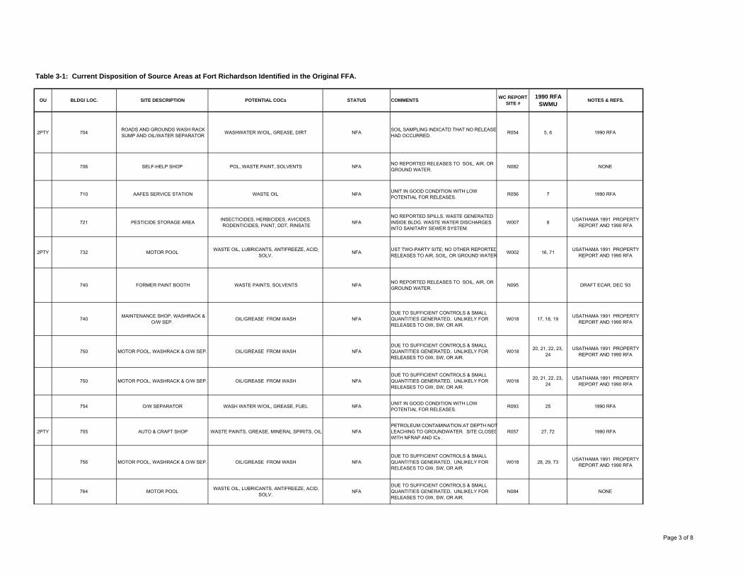
Table 3-1: Current Disposition of Source Areas at Fort Richardson Identified in the Original FFA.
OU BLDG/ LOC. SITE DESCRIPTION POTENTIAL COCs STATUS COMMENTS WC REPORT SITE #
1990 RFA SWMU
NOTES & REFS.
2PTY 704 ROADS AND GROUNDS WASH RACK SUMP AND OIL/WATER SEPARATOR
WASHWATER W/OIL, GREASE, DIRT NFA SOIL SAMPLING INDICATD THAT NO RELEASE HAD OCCURRED.
R054 5, 6 1990 RFA
706 SELF-HELP SHOP POL, WASTE PAINT, SOLVENTS NFA NO REPORTED RELEASES TO SOIL, AIR, OR GROUND WATER.
N082 NONE
710 AAFES SERVICE STATION WASTE OIL NFA UNIT IN GOOD CONDITION WITH LOW POTENTIAL FOR RELEASES.
R056 7 1990 RFA
721 PESTICIDE STORAGE AREA INSECTICIDES, HERBICIDES, AVICIDES, RODENTICIDES, PAINT, DDT, RINSATE
NFANO REPORTED SPILLS. WASTE GENERATED INSIDE BLDG. WASTE WATER DISCHARGES INTO SANITARY SEWER SYSTEM.
W007 8 USATHAMA 1991 PROPERTY REPORT AND 1990 RFA
2PTY 732 MOTOR POOL WASTE OIL, LUBRICANTS, ANTIFREEZE, ACID, SOLV.
NFA UST TWO-PARTY SITE; NO OTHER REPORTEDRELEASES TO AIR, SOIL, OR GROUND WATER
W002 16, 71 USATHAMA 1991 PROPERTY REPORT AND 1990 RFA
740 FORMER PAINT BOOTH WASTE PAINTS, SOLVENTS NFA NO REPORTED RELEASES TO SOIL, AIR, OR GROUND WATER.
N095 DRAFT ECAR, DEC '93
740 MAINTENANCE SHOP, WASHRACK & O/W SEP.
OIL/GREASE FROM WASH NFADUE TO SUFFICIENT CONTROLS & SMALL QUANTITIES GENERATED, UNLIKELY FOR RELEASES TO GW, SW, OR AIR.
W018 17, 18, 19 USATHAMA 1991 PROPERTY REPORT AND 1990 RFA
750 MOTOR POOL, WASHRACK & O/W SEP. OIL/GREASE FROM WASH NFADUE TO SUFFICIENT CONTROLS & SMALL QUANTITIES GENERATED, UNLIKELY FOR RELEASES TO GW, SW, OR AIR.
W018 20, 21, 22, 23, 24
USATHAMA 1991 PROPERTY REPORT AND 1990 RFA
750 MOTOR POOL, WASHRACK & O/W SEP. OIL/GREASE FROM WASH NFADUE TO SUFFICIENT CONTROLS & SMALL QUANTITIES GENERATED, UNLIKELY FOR RELEASES TO GW, SW, OR AIR.
W018 20, 21, 22, 23, 24
USATHAMA 1991 PROPERTY REPORT AND 1990 RFA
754 O/W SEPARATOR WASH WATER W/OIL, GREASE, FUEL NFA UNIT IN GOOD CONDITION WITH LOW POTENTIAL FOR RELEASES.
R093 25 1990 RFA
2PTY 755 AUTO & CRAFT SHOP WASTE PAINTS, GREASE, MINERAL SPIRITS, OIL NFAPETROLEUM CONTAMINATION AT DEPTH NOT LEACHING TO GROUNDWATER. SITE CLOSEDWITH NFRAP AND ICs .
R057 27, 72 1990 RFA
756 MOTOR POOL, WASHRACK & O/W SEP. OIL/GREASE FROM WASH NFADUE TO SUFFICIENT CONTROLS & SMALL QUANTITIES GENERATED, UNLIKELY FOR RELEASES TO GW, SW, OR AIR.
W018 28, 29, 73 USATHAMA 1991 PROPERTY REPORT AND 1990 RFA
764 MOTOR POOL WASTE OIL, LUBRICANTS, ANTIFREEZE, ACID, SOLV.
NFADUE TO SUFFICIENT CONTROLS & SMALL QUANTITIES GENERATED, UNLIKELY FOR RELEASES TO GW, SW, OR AIR.
N084 NONE
Page 3 of 8

Table 3-1: Current Disposition of Source Areas at Fort Richardson Identified in the Original FFA.
OU BLDG/ LOC. SITE DESCRIPTION POTENTIAL COCs STATUS COMMENTS WC REPORT SITE #
1990 RFA SWMU
NOTES & REFS.
770 MOTOR POOL WASTE OIL, LUBRICANTS, ANTIFREEZE, ACID, SOLV.
NFADUE TO SUFFICIENT CONTROLS & SMALL QUANTITIES GENERATED, UNLIKELY FOR RELEASES TO GW, SW, OR AIR.
W002 75
772 IN-SERVICE TRANSFORM. PCB'S IN TRANSFMR OIL NFA
TRANSFORMER INSIDE SECURE BUILDING. SUFFICIENT CONCRETE CURBING AROUND TRANSFORMER TO CONTAIN SPILLS. NO FLOOR DRAIN
W008 USATHAMA 1991 PROPERTY REPORT
778 MOTOR POOL, WASHRACK & O/W SEP. OIL/GREASE FROM WASH NFADUE TO SUFFICIENT CONTROLS & SMALL QUANTITIES GENERATED, UNLIKELY FOR RELEASES TO GW, SW, OR AIR.
W018 31, 76 USATHAMA 1991 PROPERTY REPORT AND 1990 RFA
782 VEH. WASHRACK & O/W SEP. OIL/GREASE FROM WASH NFADUE TO SUFFICIENT CONTROLS & SMALL QUANTITIES GENERATED, UNLIKELY FOR RELEASES TO GW, SW, OR AIR.
W018 USATHAMA 1991 PROPERTY REPORT
784 MOTOR POOL, WASHRACK & O/W SEP. OIL/GREASE FROM WASH NFADUE TO SUFFICIENT CONTROLS & SMALL QUANTITIES GENERATED, UNLIKELY FOR RELEASES TO GW, SW, OR AIR.
W018 32, 77 USATHAMA 1991 PROPERTY REPORT AND 1990 RFA
789 DS/GS MAINTENANCE FACILITY TCE, WASTE SOLVENT/OIL, GREASE, PAINT, ACID NFADUE TO SUFFICIENT CONTROLS & SMALL QUANTITIES GENERATED, UNLIKELY FOR RELEASES TO GW, SW, OR AIR.
W001 78 USATHAMA 1991 PROPERTY REPORT AND 1990 RFA
2PTY 794 CANNIBILIZATION YARD POL, SOLVENTS NFA SAMPLING INDICATED THAT CONTAMINANTS ARE NOT PRESENT ABOVE RISK LEVELS
N096 DRAFT ECAR, DEC '93
796 VEH.WASHRACK & O/W SEP. OIL/GREASE FROM WASH NFA UNIT IN GOOD CONDITION WITH LOW POTENTIAL FOR RELEASES.
W018 34 USATHAMA 1991 PROPERTY REPORT AND 1990 RFA
796 SPRAY PAINT BOOTH AND VEHICLE & WEAPONS SHOP
ENAMEL/CARC PAINT FUME NFADUE TO SUFFICIENT CONTROLS & SMALL QUANTITIES GENERATED, UNLIKELY FOR RELEASES TO GW, SW, OR AIR.
R058 36 1990 RFA
798 DS/GS MAINTENANCE TCE, WASTE SOLVENT/OIL, GREASE, PAINT, ACID NFADUE TO SUFFICIENT CONTROLS & SMALL QUANTITIES GENERATED, UNLIKELY FOR RELEASES TO GW, SW, OR AIR.
W001 79 USATHAMA 1991 PROPERTY REPORT AND 1990 RFA
802 SUPPLY WAREHOUSESOLVENTS,WASTE OIL, REAGENTS, PHOTO
FIXATIVE, WASTE PAINT/LITHIUM BATTERIES, HVY METALS
NFANO REPORTED SPILLS. WASTE GENERATED INSIDE BLDG. WASTE WATER DISCHARGES INTO SANITARY SEWER SYSTEM.
W011 USATHAMA 1991 PROPERTY REPORT
802 RAD. MATRL. STORAGE PDR-27, KRYPTON-85, PROMETHIUM-147, TRITIUM, RADIUM
NFANO REPORTED SPILLS. WASTE GENERATED INSIDE BLDG. WASTE WATER DISCHARGES INTO SANITARY SEWER SYSTEM.
W012 USATHAMA 1991 PROPERTY REPORT
804 SUPPLY WAREHOUSESOLVENTS,WASTE OIL, REAGENTS, PHOTO
FIXATIVE, WASTE PAINT/LITHIUM BATTERIES, HVY METALS
NFANO REPORTED SPILLS. WASTE GENERATED INSIDE BLDG. WASTE WATER DISCHARGES INTO SANITARY SEWER SYSTEM.
W011 USATHAMA 1991 PROPERTY REPORT
Page 4 of 8

Table 3-1: Current Disposition of Source Areas at Fort Richardson Identified in the Original FFA.
OU BLDG/ LOC. SITE DESCRIPTION POTENTIAL COCs STATUS COMMENTS WC REPORT SITE #
1990 RFA SWMU
NOTES & REFS.
804 RAD. MATRL. STORAGE PDR-27, KRYPTON-85, PROMETHIUM-147, TRITIUM, RADIUM
NFANO REPORTED SPILLS. WASTE GENERATED INSIDE BLDG. WASTE WATER DISCHARGES INTO SANITARY SEWER SYSTEM.
W012 USATHAMA 1991 PROPERTY REPORT
812 MOTOR POOL, WASHRACK & O/W SEP. OIL/GREASE FROM WASH NFADUE TO SUFFICIENT CONTROLS & SMALL QUANTITIES GENERATED, UNLIKELY FOR RELEASES TO GW, SW, OR AIR.
W018 40, 80 USATHAMA 1991 PROPERTY REPORT AND 1990 RFA
908 PRINT SHOP/PHOTO LAB GREASE,MINERAL SPIRITS, OIL, SOLV, INK, SILVER, RAGS
NFANO REPORTED SPILLS. WASTE GENERATED INSIDE BLDG. WASTE WATER DISCHARGES INTO SANITARY SEWER SYSTEM.
W003 USATHAMA 1991 PROPERTY REPORT
974 SPER SHOP -- WASTE SOLVENT (TCE) ACCUMULATION AREA
TCA NFA NO EVIDENCE OF RELEASE TO SOIL, AIR, OR GROUND WATER.
R062 45 1990 RFA
974 SPER SHOP
USED OIL/SOLVENTS, CHLORINATED SOLV, ANTIFREEZE, GREASE, POTASSIUM HYDROXIDE,
WASTE WATER, TRICHLOROETHANE, BRAKE FLUID, CONTAM. OIL/DIESEL
NFA NO EVIDENCE OF RELEASE TO SOIL, AIR, OR GROUND WATER.
R061 44 1990 RFA
974 VEH.WASHRACK & O/W SEP. OIL/GREASE FROM WASH NFA UNIT IN GOOD CONDITION WITH LOW POTENTIAL FOR RELEASES.
W018 49 USATHAMA 1991 PROPERTY REPORT AND 1990 RFA
974 FUEL BLIVET CLNG AREA WASHWATER W/FUEL, DETERG. NFANO EVIDENCE OF RELEASE TO SOIL, AIR, OR GROUND WATER; SURFACE OF CLEANING AREA IS COATED CONCRETE W/CURB.
R091 46, 47 1990 RFA
975 ELECTRONICS MAINTENANCE SHOP, VEH.WASHRACK & O/W SEP.
OIL/GREASE FROM WASH NFADUE TO SUFFICIENT CONTROLS & SMALL QUANTITIES GENERATED, UNLIKELY FOR RELEASES TO GW, SW, OR AIR.
W018 50, 51, 52 USATHAMA 1991 PROPERTY REPORT AND 1990 RFA
976 MAINT SHOP,ACID BATH/TK WASTE ACIDS NFA
UNIT LOCATED INSIDE BUILDING; NO REPORTED RELEASES TO SOIL, AIR, OR GROUND WATER; UNIT INACTIVE SINCE 1974; UNIT HAS BEEN REMOVED.
R065 56 1990 RFA
976 MAINT SHOP, FIB.GLAS FILT. FIBERGLASS PARTICLES NFAFILTERS LOCATED INSIDE ALUMINUM BOX INSIDE BUILDING; NO REPORTED RELEASES SOIL, AIR, OR GROUND WATER.
R066 57 1990 RFA
978 PHOTO LAB, SILVER RECOV. HYPO SOLUTION NFASELF-ENCLOSED UNIT INSIDE BUILDING; NO REPORTED RELEASES TO SOIL, AIR, OR GROUND WATER.
R067 58 1990 RFA
978 TASC PAINT SPRAY BOOTH WASTE PAINTS NFAUNIT LOCATED INSIDE BUILDING; NO REPORTED RELEASES TO SOIL, AIR, OR GROUND WATER.
R068 59 1990 RFA
988 RETAIL FUEL STORAGE YD DIESEL FUEL, GASOLINE NFA NO EVIDENCE OF RELEASE TO SOIL, AIR, OR GROUND WATER;
W031 USATHAMA 1991 PROPERTY REPORT
27006 MOOSE RUN GOLF CRSE GREASE, OIL NFADUE TO SUFFICIENT CONTROLS & SMALL QUANTITIES GENERATED, UNLIKELY FOR RELEASES TO GW, SW, OR AIR.
R078 81 1990 RFA
Page 5 of 8

Table 3-1: Current Disposition of Source Areas at Fort Richardson Identified in the Original FFA.
OU BLDG/ LOC. SITE DESCRIPTION POTENTIAL COCs STATUS COMMENTS WC REPORT SITE #
1990 RFA SWMU
NOTES & REFS.
28002 WATER TREATMENT PLANT FILTER BACKWASH WATER., SETTLED SLUDGE, FUEL OIL
NFA SUBJECT TO NPDES PERMIT MONITORING W046 USATHAMA 1991 PROPERTY REPORT
36012 CENT.HEAT & PWR PLANT/WASTE ACCUM. AREA
DIESEL FUEL, COAL, FLY ASH NFA
SINCE UNIT IS COVERED, PAVED, AND HANDLED SMALL QUANTITIES OF WASTE, RELEASE TO GROUND WATER OR SURFACE WATER UNLIKELY.
W026 62, 104-114 USATHAMA 1991 PROPERTY REPORT AND 1990 RFA
36013 CLASSIFIED WASTE INCIN. CLASSIFIED WASTE, ASH NFADUE TO ABSENCE OF HAZARDOUS CONSTITUENTS IN WASTES, NO POTENTIAL FOR HARMFUL RELEASES.
W027 103 USATHAMA 1991 PROPERTY REPORT AND 1990 RFA
2PTY 39600 FORMER NIKE MISSILE SITE (UPPER SITE SUMMIT), & LOWER SITE SUMMIT
WATER W/RESIDUAL SOLV, FUELS, RADIOACTIVEMATERIAL, ASBESTOS
ACTIVE 2PTY SITE SITE WILL UNDERGO ADDITIONAL INVESTIGATION STARTING IN FY05
W048 USATHAMA 1991 PROPERTY REPORT
45040 BOAT SHOP ANTIFREEZE, DRYCLEAN SOLVENT, OIL, PAINT THINNER
NFADUE TO SUFFICIENT CONTROLS & SMALL QUANTITIES GENERATED, UNLIKELY FOR RELEASES TO GW, SW, OR AIR.
R079 82 1990 RFA
45125 HAZ WASTE STORAGE FAC. WASTE SOLVENT/OIL/PAINT FUEL, PCB-CONTAM. MATERIAL
NFA INVESTIGATE IAW RCRA PERMITTING PROCESS
W022 88 USATHAMA 1991 PROPERTY REPORT AND 1990 RFA
45133 HAZ WASTE STORAGE AREA CONTAM. SOILS (OIL/FUEL) NFA INVESTIGATE IAW RCRA PERMITTING PROCESS
R071 89 1990 RFA
45703 176 EOD MAINT FAC NFADUE TO SUFFICIENT CONTROLS & SMALL QUANTITIES GENERATED, UNLIKELY FOR RELEASES TO GW, SW, OR AIR.
N081 NONE
45726 23 EN CO MAINTENANCE FACILITY, WASHRACK & O/W SEP.
OIL/GREASE FROM WASH NFADUE TO SUFFICIENT CONTROLS & SMALL QUANTITIES GENERATED, UNLIKELY FOR RELEASES TO GW, SW, OR AIR.
W018 64, 65 USATHAMA 1991 PROPERTY REPORT AND 1990 RFA
2PTY 47203 AIRCRAFT MAINTENANCE FACILITY WASTE JP-4, JET FUEL, OIL, HYDRAULIC FLUID, PETROL. NAPTHA, HEAVY METALS
NFA ACLs FOR dro CONTAMINATION AT SITE. NFRAP WITH ICs.
N095 NONE
47427 AIRCRAFT MAINTENANCE FACILITY WASTE JP-4, JET FUEL, OIL, HYDRAULIC FLUID, PETROL. NAPTHA, HEAVY METALS
NFA NO EVIDENCE OF RELEASE TO SOIL, AIR, OR GROUND WATER.
W021
86, ( 1990 RFA
MISTAKENLY LISTS AS BLDG
USATHAMA 1991 PROPERTY REPORT, 1990 RFA
47430 AIRCRAFT MAINTENANCE FACILITY WASTE JP-4, JET FUEL, OIL, HYDRAULIC FLUID, PETROL. NAPTHA, HEAVY METALS
NFA NO EVIDENCE OF RELEASE TO SOIL, AIR, OR GROUND WATER.
W021 USATHAMA 1991 PROPERTY REPORT
47430 A/C WASHRACK & O/W SEP. OIL/GREASE FROM WASH NFA NO EVIDENCE OF RELEASE TO SOIL, AIR, OR GROUND WATER;
W019 USATHAMA 1991 PROPERTY REPORT
47431 AIRCRAFT MAINTENANCE FACILITYDRYCLEAN SOLV, GREASE, HYDRAULIC FLUID,
METHYL ETHYL KETONE, NAPTHA, WASTE FUELS/OIL
NFA UNDER FFA NO EVIDENCE OF CONTAMINANT RELEASE AND SITE WAS NFA IN THE FFA.
W021 67 USATHAMA 1991 PROPERTY REPORT
Page 6 of 8

Table 3-1: Current Disposition of Source Areas at Fort Richardson Identified in the Original FFA.
OU BLDG/ LOC. SITE DESCRIPTION POTENTIAL COCs STATUS COMMENTS WC REPORT SITE #
1990 RFA SWMU
NOTES & REFS.
47432 AIRCRAFT MAINTENANCE FACILITY WASTE JP-4, JET FUEL, OIL, HYDRAULIC FLUID, PETROL. NAPTHA, HEAVY METALS
NFA NO EVIDENCE OF RELEASE TO SOIL, AIR, OR GROUND WATER;
R070 84
47433 AIRCRAFT MAINTENANCE FACILITY WASTE JP-4, JET FUEL, OIL, HYDRAULIC FLUID, PETROL. NAPTHA, HEAVY METALS
NFA NO EVIDENCE OF RELEASE TO SOIL, AIR, OR GROUND WATER;
W021 USATHAMA 1991 PROPERTY REPORT
47641 AIRCRAFT MAINTENANCE FACILITY WASTE FUEL, GREASE, OIL NFA NO EVIDENCE OF RELEASE TO SOIL, AIR, OR GROUND WATER;
R094 85 1990 RFA
47811 VETERANARY INCIN. ANIMAL CARCASSES, INFECTIOUS WASTE, ASH NFADUE TO NATURE OF HAZARDOUS WASTES AND UNIT CONSTRUCTION, LITTLE POTENTIALFOR HARMFUL RELEASES.
W027 102 USATHAMA 1991 PROPERTY REPORT AND 1990 RFA
55295 AMMO DEACTIV. FURNACE WASTE SMALL CAL. AMMO, CARTRIDGES, ASH, HVY METALS, PROPELLANT, PRIMERS, FUZES
NFA UNDER CERCLA PENDING PERMIT APPLICATION W024 101 USATHAMA 1991 PROPERTY REPORT AND 1990 RFA
59000 AK ARNG VEH MAINT FAC WASTE FUEL, GREASE, OIL, SOLVENTS, ANTIFREEZE; OIL/GREASE FROM WASH
NFASTATE OF THE ART UNIT LOCATED INSIDE BUILDING; NO REPORTED RELEASES TO SOIL, AIR, OR GROUND WATER.
N086 NONE
AMMO AREA C RAD. MATRL. DISPOSAL RADIOACTIVE WASTES NFA INACTIVE SITE WITH NO KNOWN RELEASES. W013 USATHAMA 1991 PROPERTY REPORT
AMMO HOLDING AREA AMMO SUPPLY POINT AMMUNITION NFAAMMO SECURED INSIDE CONCRETE BUNKERS. NO KNOWN RELEASES WITHIN ASP COMPOUND.
W029 USATHAMA 1991 PROPERTY REPORT
FIELD LOC SEPTIC TANKS/LEACH FLDS SAN. WASTE WATER, INDUSTRIAL WASTEWATER NFA NO EVIDENCE OF PAST RELEASES W017 USATHAMA 1991 PROPERTY REPORT
FIELD LOC SPILL AREAS DIESEL, MOGAS, JP-4 NFA ALL KNOWN SPILL SITES REMEDIATED. W049 USATHAMA 1991 PROPERTY REPORT
FRA ABOVE GND STORAGE TNKS DIESEL, GASOLINE, HTNG OIL NFA SUFFICIENT CONTROLS IN PLACE; NO EVIDENCE OF PAST RELEASES
W041 USATHAMA 1991 PROPERTY REPORT
FRA ABOVE GND STORAGE TNKS DIESEL, GASOLINE, HTNG OIL NFA SUFFICIENT CONTROLS IN PLACE; NO EVIDENCE OF PAST RELEASES
W042 USATHAMA 1991 PROPERTY REPORT
FRA UNDERGROUND STOR.TNKS DIESEL, MOGAS, WASTE OIL, NFA SUBJECT TO UST TWO-PARTY AGREEMENT W043
7, 16, 19, 23, 24, 26, 29, 30, 35, 38, 39, 42, 43, 48, 53, 61, 63, 66, 68, 69, 70, 119, 120
USATHAMA 1991 PROPERTY REPORT AND 1990 RFA
FRA FORMER USTs DIESEL, MOGAS, FUEL OIL, NFA SUBJECT TO UST TWO-PARTY AGREEMENT W044 USATHAMA 1991 PROPERTY REPORT
FRA FORMER USTs WASTE OIL, FUEL OIL NFA SUBJECT TO UST TWO-PARTY AGREEMENT W045 USATHAMA 1991 PROPERTY REPORT
FRA SANITARY SEWER SYSTEM SANITARY/INDUSTRIAL WASTEWATER W/OILS, GREASE
NFA SUBJECT TO NPDES PERMIT MONITORING R076 116 1990 RFA
Page 7 of 8

Table 3-1: Current Disposition of Source Areas at Fort Richardson Identified in the Original FFA.
OU BLDG/ LOC. SITE DESCRIPTION POTENTIAL COCs STATUS COMMENTS WC REPORT SITE #
1990 RFA SWMU
NOTES & REFS.
LANDFILL #1, east sector of FRA LF, 400 acres
LANDFILL SANITARY WASTE, WASTE OIL/BRAKE FLUID, PESTICIDES
NFA UNDER CERCLA CLOSED UNDER SOLID WASTE REGS WITH LONG-TERM GW MONITORING
W032 94, 95 USATHAMA 1991 PROPERTY REPORT AND 1990 RFA
LANDFILL #2, north-central sector of FRA LF; 338 acres
LANDFILL SAN. WASTE, UNKNOWN NFA UNDER CERCLA CLOSED UNDER SOLID WASTE REGS WITH LONG-TERM GW MONITORING
W033 USATHAMA 1991 PROPERTY REPORT
LANDFILL #3, south-central sector of FRA LF; 60 acres
LANDFILL SAN. WASTE, UNKNOWN NFA UNDER CERCLA CLOSED UNDER SOLID WASTE REGS WITH LONG-TERM GW MONITORING
W034 USATHAMA 1991 PROPERTY REPORT
LANDFILL #4, southwest sector of FRA LF; 3 acres
LANDFILL CONSTRUCTION DEBRIS NFA UNDER CERCLA CLOSED UNDER SOLID WASTE REGS WITH LONG-TERM GW MONITORING
W035 USATHAMA 1991 PROPERTY REPORT
LANDFILL #5, northwest sector FRA LF; 3 acres
LANDFILLCONSTR. DEBRIS, SANITARY WASTE, METAL,
WOOD, ASBESTOS, EXPLOSIVES, INFECTIOUS WASTE
NFA UNDER CERCLA CLOSED UNDER SOLID WASTE REGS WITH LONG-TERM GW MONITORING
W036 USATHAMA 1991 PROPERTY REPORT
LANDFILL #6, west edge of FRA LF; unk. size
LANDFILL UNKNOWN NFA UNDER CERCLA CLOSED UNDER SOLID WASTE REGS WITH LONG-TERM GW MONITORING
W037 USATHAMA 1991 PROPERTY REPORT
LANDFILL #7, adjacent to old Davis Highway (vic.
Anchorage LF)LANDFILL SANITARY WASTE NFA UNDER CERCLA CLOSED UNDER SOLID WASTE REGS WITH
LONG-TERM GW MONITORINGW038 USATHAMA 1991 PROPERTY
REPORT
LANDFILL #8, adj. to old Davis/Glenn Highways,
approx. 3 km south of the Eagle River; 3 acres
LANDFILL CARS W/WASTE OIL, JUNK NFA UNDER CERCLA CLOSED UNDER SOLID WASTE REGS WITH LONG-TERM GW MONITORING
W039 USATHAMA 1991 PROPERTY REPORT
UC553983 RT BRAVO TRANSFORMER SITE (VIC. GWEN LAKE)
PCBs, METALS NFA CONTAMINANTS BELOW EPA ACTION LEVELS. N089 USAPACEHEA REPORT, 31 JAN 94
VARIOUS FIELD LOCATIONS
OPEN BURNING SITES AND FIRING RANGES/IMPACT AREAS
LEAD, MUNITIONS WASTE FROM MORTAR, SMALLARMS, GRENADES, ROCKETS
NFA
ACTIVE TRAINING FACILITIES FOR MARKSMANSHIP/GUNNERY TRAINING WITH NO EVIDENCE OF ADVERSE ENVIRONMENTAL EFFECTS.
W005 100 USATHAMA 1991 PROPERTY REPORT AND 1990 RFA
VIC. UC577959 TRANSFER STATION FRA SOLID WASTE, ASBESTOS NFA NO REPORTED RELEASES TO SOIL, AIR, OR GROUND WATER.
R074 96 1990 RFA
Page 8 of 8

Page 4-1
4.0 OPERABLE UNIT A
The OUA ROD included the following three source areas:
• Roosevelt Road Transmitter Site Leachfield
• Ruff Road Fire Training Area
• Building 986 Petroleum Oil and Lubricant (POL) Laboratory Dry Well The Army, EPA, and ADEC determined that the source areas included within OU-A did not represent unacceptable risk to human health or the environment, based on EPA criteria for residential use. Thus, no remedial action was necessary to ensure protection of human health and the environment under CERCLA. However, the levels of petroleum contamination in the soil did exceed the ADEC soil cleanup criteria. Accordingly, the sites were transferred to the Non-UST POL Environmental Restoration Agreement (Two-Party Agreement) between the Army and ADEC. Two of the sites, Roosevelt Road Transmitter Site Leachfield and Ruff Road Fire Training Area, have undergone remedial action and have been closed under the Two-Party Agreement. The Building 986 POL Laboratory Dry Well site was undergoing active remediation at the time of this review. A description of these sites and NFA decisions can be found in the OUA/OUB ROD. During the Five-Year Review process, the remedies conducted under the Two Party Agreement were reviewed and determined to be protective. A summary of remedial actions at the OU source areas can be found in the Administrative Record and are presented on Table 3-1. In addition, Table 3-1 contains updated information for all sites listed in the FFA. Because the OUA POL source areas are addressed through the Two-Party Agreement, they are not discussed further in this Five-Year Review.

Page 5-1
5.0 OPERABLE UNIT B
The OUA and OUB source areas were the first to undergo Remedial Investigation at Fort Richardson and reach a final-action ROD. RODs for the two OUs were contained in a single document. The OUA/OUB ROD was signed September 18, 1997 and initially addressed four source areas. OUB consists of a single source area, the Poleline Road Disposal Area (Poleline Road).
5.1 OUB Poleline Road Disposal Area Background
5.1.1 Overview
Two former soldiers stationed at Fort Richardson in the 1950s identified the Poleline Road Disposal Area in 1990. It was determined that four chemical disposal areas were used from 1950 to 1972. During this time, chemical agent identification sets and other military debris were burned and disposed in trenches. The chemical agents were neutralized with a mixture of bleach or lime and chlorinated solvents before burial. Based on maps, aerial photography, and geophysical surveys, Poleline Road was divided into four disposal areas; Areas A-1, A-2, A-3, and A-4. Figure 5-1 is a site map of Poleline Road showing the locations of the disposal areas. The RI determined that the principal contamination at OUB was chlorinated solvents in soil and groundwater. Remedial action was accomplished through, a dual-phased, high vacuum extraction (HVE) treatability study conducted from March through October 1998 and six-phase soil heating (SPSH) treatability studies conducted in 1997 and 1999. The six-phase soil heating treatability studies incorporated soil heating and high-vacuum extraction to facilitate removal of contaminants from soil and groundwater. The SPSH was discontinued in 1999 and decommissioned in 2002. Results of the SPSH treatability studies indicated that about 95 percent of the contaminants in soil had been removed during system operations, thus eliminating the source of groundwater contamination at the site. A groundwater monitoring plan was developed in 1997 to determine the effectiveness of the HVE treatment system and to determine whether or not groundwater contaminant levels were decreasing, increasing, or remaining stable. Groundwater samples have been collected twice per year since 1997 and current monitoring data shows that the contaminant plume does not appear to be expanding. Analytical results from chemical analysis of soil samples collected after the SPSH treatability studies indicate that RAOs have been achieved for soil. A revised long-term monitoring plan and exit strategy will be developed to achieve compliance with state and federal MCLs.
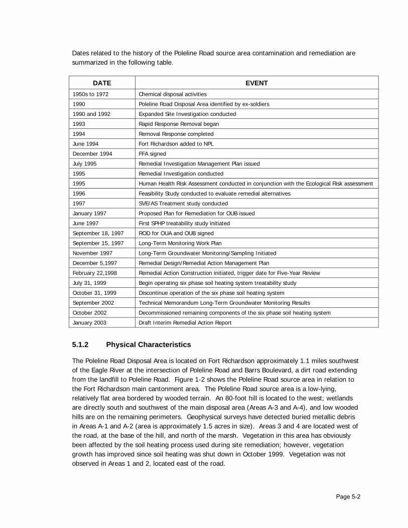
Page 5-2
Dates related to the history of the Poleline Road source area contamination and remediation are summarized in the following table.
DATE EVENT 1950s to 1972 Chemical disposal activities
1990 Poleline Road Disposal Area identified by ex-soldiers
1990 and 1992 Expanded Site Investigation conducted
1993 Rapid Response Removal began
1994 Removal Response completed
June 1994 Fort Richardson added to NPL
December 1994 FFA signed
July 1995 Remedial Investigation Management Plan issued
1995 Remedial Investigation conducted
1995 Human Health Risk Assessment conducted in conjunction with the Ecological Risk assessment
1996 Feasibility Study conducted to evaluate remedial alternatives
1997 SVE/AS Treatment study conducted
January 1997 Proposed Plan for Remediation for OUB issued
June 1997 First SPHP treatability study initiated
September 18, 1997 ROD for OUA and OUB signed
September 15, 1997 Long-Term Monitoring Work Plan
November 1997 Long-Term Groundwater Monitoring/Sampling Initiated
December 5,1997 Remedial Design/Remedial Action Management Plan
February 22,1998 Remedial Action Construction initiated, trigger date for Five-Year Review
July 31, 1999 Begin operating six phase soil heating system treatability study
October 31, 1999 Discontinue operation of the six phase soil heating system
September 2002 Technical Memorandum Long-Term Groundwater Monitoring Results
October 2002 Decommissioned remaining components of the six phase soil heating system
January 2003 Draft Interim Remedial Action Report
5.1.2 Physical Characteristics
The Poleline Road Disposal Area is located on Fort Richardson approximately 1.1 miles southwest of the Eagle River at the intersection of Poleline Road and Barrs Boulevard, a dirt road extending from the landfill to Poleline Road. Figure 1-2 shows the Poleline Road source area in relation to the Fort Richardson main cantonment area. The Poleline Road source area is a low-lying, relatively flat area bordered by wooded terrain. An 80-foot hill is located to the west; wetlands are directly south and southwest of the main disposal area (Areas A-3 and A-4), and low wooded hills are on the remaining perimeters. Geophysical surveys have detected buried metallic debris in Areas A-1 and A-2 (area is approximately 1.5 acres in size). Areas 3 and 4 are located west of the road, at the base of the hill, and north of the marsh. Vegetation in this area has obviously been affected by the soil heating process used during site remediation; however, vegetation growth has improved since soil heating was shut down in October 1999. Vegetation was not observed in Areas 1 and 2, located east of the road.

Page 5-3
Four water-bearing intervals have been identified at Poleline Road:
• A perched zone – The top of the perched interval was encountered at 4 feet to 10 feet bgs and is approximately 5 feet thick.
• A shallow groundwater zone – The shallow saturated zone is an average of 10 feet thick; the top was encountered at 20 feet to 25 feet bgs. Groundwater in the shallow zone flows in a northeasterly direction.
• An intermediate groundwater zone – The intermediate zone was encountered at approximately 65 feet to 95 feet bgs. Groundwater flow in this zone is not well defined.
• A deep aquifer – The deep aquifer is an advance moraine/till complex with a thickness between 3 feet and 40 feet and was encountered at 80 feet to 125 feet bgs. Groundwater elevations indicate that the flow direction in the deep aquifer is locally to the northeast and regionally to the northwest.
Zones of very dense, low-porosity, compact tills separate the saturated intervals, but the detection of contaminants in all four intervals suggests that they are interconnected to some degree. Hydraulic conductivities were estimated to average 0.5 feet per day (ft/day) for all saturated zones except the intermediate zone, which averaged 0.05 ft/day. These relatively low hydraulic conductivities suggest that groundwater flow in the site area would not significantly disperse dissolved contaminants.
5.1.3 Land and Resource Use
The OUB site (approximate 300 acre site) is off limits except to authorized personnel and access is controlled by locked gates. Signs posted around the perimeter of the site clearly indicate that the site is a contaminated and a controlled area. The land surrounding OUB currently is used for Army training activities and limited recreational purposes where allowed. At present, there are no plans for development of OUB. The deep aquifer may provide sufficient yield for installation of drinking water wells, however, future development of the deep aquifer for this purpose is unlikely.
5.1.4 History of Contamination
The Poleline Road Disposal Area was identified in 1990 through interviews conducted by the Army with two former soldiers who were stationed at Fort Richardson in the 1950s who recalled the disposal of chemicals, smoke bombs, and Japanese cluster bombs. The disposal location was corroborated by a 1954 United States Army Corps of Engineers map showing a “Chemical Disposal Area” at Poleline Road and by 1957 aerial photography showing trenches in the area. Two separate burial areas were identified at Poleline Road: Areas A-1 and A-2 are suspected to contain buried munitions, and Areas A-3 and A-4 where chemical warfare decontamination kits and chemical agent identification sets (CAIS) disposal occurred. The disposal areas were active from approximately 1950 to 1972. The standard practice at Poleline Road to dispose of chemical agents and munitions materials consisted of a series of four steps:
• A layer of “bleach/lime” was laid down in the bottom of the trench.

Page 5-4
• The materials contaminated with chemical agent were placed on a pallet in the trench.
• Diesel fuel was poured on the agent and then ignited with thermal grenades.
• After burning was completed, a mixture of either bleach or lime, combined with chlorinated solvent carrier was poured over the materials to neutralize the chemical agent.
No known documentation exists detailing what types of chemicals were buried. However, a removal action at Areas A-3 and A-4 uncovered CAIS and other general debris. Based on eyewitness accounts from former soldiers, Areas A-1 and A-2 are suspected to contain buried munitions. Geophysical surveys confirmed the presence of buried metallic objects at the site. Soil samples collected near the burial trenches A-1 and A-2 did not indicate COCs were present. Because soil sampling has not identified contamination in the vicinity of Areas A-1 and A-2 and because of the dangers associated with potential UXO, the Areas were not excavated.
5.1.5 Pre-ROD Response
Pre-RI activities began in 1993 and included a removal action in Areas A-3 and A-4. The removal action was halted when CAIS and other chemical agent related materials were unearthed. A geophysical survey performed in early 1994 indicated that anomalies were present in the trenches that were consistent with buried metallic debris. Of the four disposal areas, A-3 and A-4 showed the greatest evidence of buried debris, including possible stacked canisters or cylinders. The removal action was resumed in 1994. Approximately 3,600 cubic yards of soil contaminated with chlorinated hydrocarbons (1,1,2,2-PCA, TCE, and PCE) and diesel fuel were excavated and stockpiled on-site. This soil was thermally treated on-site using a thermal desorption system. Another geophysical survey was performed in June 1995 to determine whether any anomalous material remained in the recently excavated areas and to investigate thoroughly areas not excavated during the 1994 removal action. Results of the survey confirmed that buried material previously encountered in Areas A-3 and A-4 had been removed, thereby removing a primary source of subsurface contaminants. During fall 1996, a treatability study was conducted at the site to evaluate the effectiveness of potential remedial technologies addressed in the FS. The treatability study involved field tests to evaluate the potential performance of soil vapor extraction (SVE) and air sparging (AS) of groundwater. The study also involved characterization of hydraulic conductivity of water bearing zones underlying the site and collection of groundwater samples to assess which types of natural attenuation processes may be degrading contaminants in groundwater. In June 1997, prior to the signing of the ROD, a design verification study (DVS) was initiated to evaluate the applicability of six-phase heating as an in situ technology for remediating solvent-contaminated soils. The remedial system design involved incorporation of both soil vapor extraction and soil heating. The soil was heated using six-phase soil heating elements and vapors generated through the soil heating process were extracted using an HVE system. Results of this treatability study are discussed in Section 5.3.

Page 5-5
5.2 Remedy Selection
5.2.1 Nature of Contamination
Several investigations and a removal action have been conducted at Poleline Road since its discovery in 1990. This information was used to focus the RI. Site investigations were conducted between 1990 and 1992 and included a geophysical survey, a water level study, aquifer tests, and soil, soil gas, and groundwater sampling. The results of the site investigations indicated the presence of VOCs in the subsurface. The RI concluded that the principal contamination at Poleline Road was chlorinated solvents in soil and groundwater and the highest concentrations of contaminants detected in soil and groundwater samples were found in Areas A-3 and A-4. No measurable levels of chemical agent have been detected in groundwater at the site. The specific reasons for conducting remedial actions at Poleline Road are provided below, with the main focus being protection of groundwater in accordance with the NCP Groundwater Protection Strategy:
• VOCs, including PCE; TCE; and 1,1,2,2-PCA, in contaminated soils were a continuing source of groundwater contamination; and
• VOCs (i.e., PCE; TCE; and 1,1,2,2-PCA) in groundwater at Poleline Road were present at concentrations above state and federal MCLs and risk-based criteria.
A Human Health Risk Assessment (HHRA) was performed in 1995. The risk assessment was base on groundwater fate and transport modeling and showed 1) that it would take 120 years for concentrations of TCE exceeding the drinking water MCL (0.005 milligrams per liter [mg/L]) to reach the Eagle River, and 2) that it would take 170 years for concentrations of 1,1,2,2-PCA exceeding 0.005 mg/L to reach the Eagle River. Soil
Contaminated soils associated with past disposal practices at the Poleline Road source area appear to have been the source of contamination detected in the groundwater. Soil data collected from the excavation during the removal action and from soil borings drilled during the RI indicated that a layer of soil with high concentrations of 1,1,2,2-PCA (greater than 2,000 milligrams per kilogram [mg/kg]) existed around 15 to 25 feet bgs. Areas A-1 and A-2 were not excavated because of the potential presence of unexploded ordnance. Contaminant levels detected in soils near Areas A-1 and A-2 were less than RAOs, suggesting that chlorinated solvents had not been disposed in those areas. Thus, Areas A-1 and A-2 were not considered to be source areas. Groundwater
Groundwater sampling conducted prior to the 1993 and 1994 removal action indicated a localized area of groundwater was contamination with chlorinated solvents. There was no evidence that the contamination was migrating, however, the level of solvents was sufficient to indicate the presence of a source of these contaminants.

Page 5-6
During the RI, 1,1,2,2-PCA and TCE were found in groundwater at concentrations significantly higher, and over a greater extent, than any other chemical detected at the site. Contaminants were detected in each of the four saturated intervals. A well installed near Area A-3 and screened in the perched interval had the highest concentrations of 1,1,2,2-PCA and TCE. Contaminants were also detected in wells screened in the deep aquifer. Contamination in the deep aquifer indicates that there is interconnection between the saturated intervals that allow contaminants to migrate vertically. A review of known information on the Poleline Road Disposal Area indicated that Areas A-1 and A-2 might potentially contain buried ordnance. Investigations conducted around Areas A-1 and A-2 detected only low levels of contaminants. No chemical agent or breakdown products were detected in the soil or groundwater. Available data suggests that chlorinated solvents were not disposed in Areas A-l and A-2. Thus, Areas A-1 and A-2 were not considered to be source areas for the groundwater contamination. The area of greatest contamination identified at the source area during the RI was referred to as the “hot spot”. The “hot spot” encompasses an area approximately 150 feet by 300 feet that is bounded by a 1 milligram per liter (mg/L) or greater concentration of 1,1,2,2-PCA in groundwater. The “hot spot”, as estimated in 1999, is shown on Figure 5-2.
5.2.2 Remedial Action Objectives
As a part of the Remedial Investigation/Feasibility Study (RI/FS) process, RAOs were developed in accordance with NCP and EPA guidance. The overall objective is to reduce contamination in groundwater at OUB to levels that do not pose a threat to human health and the environment. RAOs are based on either human health risk estimates that exceed or fall within the 1 x 10⁻⁶ to 1 x 10⁻⁴ risk range, or on federal and state ARARs. The objectives of remedial action at OUB continue to be in accordance with the ROD signed in 1997 and are as follows:
• Reduce contaminant levels in the groundwater to comply with drinking water standards;
• Prevent contaminated soil from continuing to act as a source of groundwater contamination;
• Prevent the contaminated groundwater from adversely affecting the Eagle River surface water and sediments; and
• Minimize degradation of the State of Alaska’s groundwater resources at the site as a result of past disposal practices.
5.2.3 ARARs
The OUB ROD cited the most significant ARAR for the remedy selection at Poleline Road to be:
State and federal MCLs are relevant and appropriate for groundwater. These MCLs set the active remediation goals for groundwater contaminants regulated by state and federal drinking water regulations.

Page 5-7
Cleanup Goals
Groundwater
• Federal and State of Alaska drinking water MCLs were adopted as groundwater cleanup goals for benzene, carbon tetrachloride, cis-1,2-dichloroethene, trans-1,2-dichloroethene, PCE, and TCE
• The concentration corresponding to the EPA Region 3 RBC (10-4) in residential drinking water was adopted as the cleanup goal for 1,1,2,2-PCA
Numeric values for cleanup goals in groundwater are presented in the following table.
REMEDIAL CLEANUP GOALS FOR GROUNDWATER
Contaminant of Concern Remedial Action Objective (mg/L) Source of RAO
Benzene 0.005 MCL Carbon Tetrachloride 0.005 MCL cis-1,2-Dichloroethene 0.07 MCL trans-1,2-Dichloroethene 0.1 MCL Tetrachloroethene (PCE) 0.005 MCL Trichloroethene (TCE) 0.005 MCL 1,1,2,2-Tetrachloroethane (1,1,2,2-PCA) 10.052 RBC
1 The RAO listed in the ROD appears to be incorrect and the value should have been 0.0052. The risk assessment and groundwater model results were all based on an RBC of 0.005 mg/l for 1,1,2,2- PCA.
Soil
RAOs for soil are based on protection of the groundwater from leaching of the contaminants (EPA, Region 3, RBCs, 1995). Numeric values for cleanup goals in soil are presented in the following table.
REMEDIAL CLEANUP GOALS FOR SOIL
Contaminant of Concern Remedial Action Objective (mg/kg) Source of RAO
Tetrachloroethene 4.0 RBC 1,1,2,2-Tetrachloroethane 0.1 RBC
5.2.4 Selected Remedy
The major components of the preferred remedy identified in the OUB ROD are listed below.
Component 1 – Treat the “hot spot” (The “hot spot” is defined in the ROD as the subsurface area containing greater than 1.0 milligram per liter of 1,1,2,2-tetrachloroethane in groundwater and/or free-phase solvents) through HVE of soil vapor and groundwater in the perched and shallow zones to prevent the main source of contamination from continuing as a
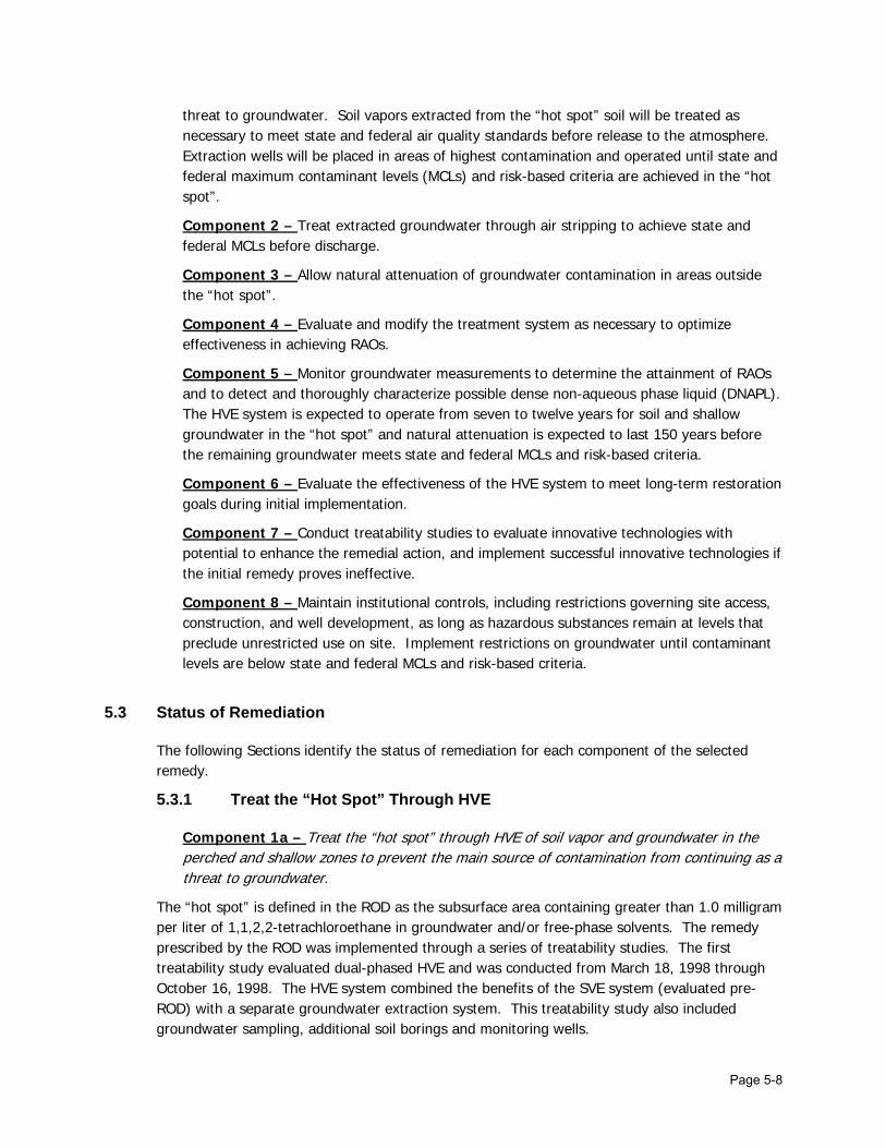
Page 5-8
threat to groundwater. Soil vapors extracted from the “hot spot” soil will be treated as necessary to meet state and federal air quality standards before release to the atmosphere. Extraction wells will be placed in areas of highest contamination and operated until state and federal maximum contaminant levels (MCLs) and risk-based criteria are achieved in the “hot spot”.
Component 2 – Treat extracted groundwater through air stripping to achieve state and federal MCLs before discharge.
Component 3 – Allow natural attenuation of groundwater contamination in areas outside the “hot spot”.
Component 4 – Evaluate and modify the treatment system as necessary to optimize effectiveness in achieving RAOs.
Component 5 – Monitor groundwater measurements to determine the attainment of RAOs and to detect and thoroughly characterize possible dense non-aqueous phase liquid (DNAPL). The HVE system is expected to operate from seven to twelve years for soil and shallow groundwater in the “hot spot” and natural attenuation is expected to last 150 years before the remaining groundwater meets state and federal MCLs and risk-based criteria.
Component 6 – Evaluate the effectiveness of the HVE system to meet long-term restoration goals during initial implementation.
Component 7 – Conduct treatability studies to evaluate innovative technologies with potential to enhance the remedial action, and implement successful innovative technologies if the initial remedy proves ineffective.
Component 8 – Maintain institutional controls, including restrictions governing site access, construction, and well development, as long as hazardous substances remain at levels that preclude unrestricted use on site. Implement restrictions on groundwater until contaminant levels are below state and federal MCLs and risk-based criteria.
5.3 Status of Remediation
The following Sections identify the status of remediation for each component of the selected remedy.
5.3.1 Treat the “Hot Spot” Through HVE
Component 1a – Treat the “hot spot” through HVE of soil vapor and groundwater in the perched and shallow zones to prevent the main source of contamination from continuing as a threat to groundwater.
The “hot spot” is defined in the ROD as the subsurface area containing greater than 1.0 milligram per liter of 1,1,2,2-tetrachloroethane in groundwater and/or free-phase solvents. The remedy prescribed by the ROD was implemented through a series of treatability studies. The first treatability study evaluated dual-phased HVE and was conducted from March 18, 1998 through October 16, 1998. The HVE system combined the benefits of the SVE system (evaluated pre-ROD) with a separate groundwater extraction system. This treatability study also included groundwater sampling, additional soil borings and monitoring wells.

Page 5-9
An additional SPSH design verification study was conducted in 1999. This remedial action was similar to the treatability study conducted in 1997 because it incorporated both soil vapor extraction and six-phase soil heating technologies. Because the six-phase heating study performed in 1997 was very successful at removing contaminants in a short time period, this technology was, in accordance with the ROD, selected as the final remedy. Soil and groundwater samples collected after completion of the second SPSH treatability study indicated that about 95 percent of the contaminants in soil had been removed during system operations, thus eliminating the source of groundwater contamination at the site. The system was less successful at treating groundwater contamination, but about 76 percent of groundwater contaminants were removed during system operations.
Component 1b – Soil vapors extracted from the “hot spot” soil will be treated as necessary to meet state and federal air quality standards before release to the atmosphere.
Initially, a catalytic oxidizer (CATOX) was used to treat off-gas from the condenser while heating array 1. The CATOX removed solvents in the off-gas by heating the off-gas to 650 degrees Fahrenheit (ºF) in the presence of a catalyst. USEPA regulations limit discharge to the atmosphere to 10 tons per year or more of one hazardous contaminant or 25 tons per year of 2 or more in combination (40 CFR 264.1032). Since the concentration of solvents in the off-gas vapor was less than expected, the CATOX was removed from the site before the first array was completed. To comply with ADEC regulations (18 MC 50.110) air was discharged away from the operations area and the breathing zone was monitored to ensure that the contents of soil vapor did not exceed health and safety standards.
Component 1c – Extraction wells will be placed in areas of highest contamination and operated until state and federal maximum contaminant levels (MCLs) and risk-based criteria are achieved in the “hot spot”
Soil gas and groundwater were extracted from two HVE wells (DPE-1 and DPW-2) that were located within the “hot spot”, in the area of highest known contaminant concentrations. Undiluted off-gas and condensate samples were collected approximately every other day while the system was running. Analytical results were used, along with system instrument readings, to calculate the mass of contaminants removed via the extracted soil gas and condensate water. The system removed approximately 500,000 gallons of groundwater and approximately 230 lbs of chlorinated solvents. Analysis of the test data indicated that the cost to operate the system and treat the groundwater produced during system operation greatly exceeded previous estimates. The increased cost was due in large part to an increase in the time estimated for the HVE system to remediate the groundwater plume. Also, the groundwater samples collected during the test did not clearly indicate that the HVE system was effective at reducing the concentration of chlorinated solvents in the groundwater at this site. Because HVE alone was not expected to be effective at treating the “hot spot”, the remedy, as prescribed in the ROD, was enhanced with the introduction of six-phase heating.

Page 5-10
5.3.2 Treat Extracted Groundwater
Component 2 – Treat extracted groundwater through air stripping to achieve state and federal MCLs before discharge
Groundwater, and condensed soil vapors were collected in a knockout tank attached to the extraction system. Contaminants were removed from the water using a cooling tower equipped with an air-stripper. Up to 50 percent of the water added to the cooling tower evaporated. When treated water accumulated in the tower, it was pumped into drip tubes and discharged to the soil surface. Water samples were periodically collected from the treated water tank and analyzed for contaminants. None of samples were found to contain contaminants.
5.3.3 Allow Natural Attenuation Outside the “Hot Spot”
Component 3 – Allow natural attenuation of groundwater contamination in areas outside the “hot spot”
Because of the slow groundwater flow at the site, it may take several years for impacts of source area treatment to be reflected in the concentration of contaminants detected in groundwater wells down gradient from the treated area. Information is needed north of the source area, northwest of MW-16, to determine if there is contaminant migration in this direction. Wells will be installed in this area during the 2002/2003 field season and analytical results from these wells will be available for inclusion in future Long-Term Groundwater Monitoring Reports. Natural attenuation parameters are measured during each groundwater sampling event and analyzed to determine if trends exist that would allow estimation of time to reach cleanup goals. To date, natural attenuation data suggest that little if any biodegradation is currently occurring. This is not surprising, since the site was heating excessively using the six-phase heating system. Continued groundwater monitoring should establish whether or not biodegradation will occur at the site.
5.3.4 Evaluate and Modify the Treatment System
Component 4 – Evaluate and modify the treatment system as necessary to optimize effectiveness in achieving RAOs
The dual-phase HVE treatability study completed during the summer of 1998 showed that further design work would be necessary before installation of a reliable system. The dual-phase system, as installed, was prone to shut down and took several hours to restart. The crux of the problem was the drop tubes used to extract air and water. The bottom of the drop tube was set just above the water table in the well. If water level in the well rose rapidly, the drop tube would be flooded, and unable to further extract either water or air.

Page 5-11
Rather than exclusively use the selected remedy (HVE), SPSH was also used to treat the hotspot. The ROD stated that if HVE alone failed to remediate the source area within a reasonable time frame, then soil heating would be combined with the selected remedy. The HVE system would have operated an estimated 5 to 10 years to reach RAOs in the hotspot. The SPSH studies achieved the “hotspot” cleanup criteria (MCLs and RBCs) in much less time.
5.3.5 Monitor Groundwater
Component 5a – Monitor groundwater measurements to determine the attainment of RAOs and to detect and thoroughly characterize possible dense non-aqueous phase liquid (DNAPL). The HVE system is expected to operate from seven to twelve years for soil and shallow groundwater in the “hot spot” and natural attenuation is expected to last 150 years before the remaining groundwater meets state and federal MCLs and risk-based criteria
Groundwater monitoring at OUB provides data on groundwater contaminant trends. Samples are collected in accordance with, and the rationale for sampling each well is presented in, the Long-Term Groundwater Monitoring Work Plan Operable Unit B, Poleline Road Disposal Area, Fort Richardson, Alaska. Eleven rounds of groundwater data have been collected from November 1997 through October 2002. Seven rounds of groundwater samples have been collected since the SPSH system was shut off. Separate reports for each of the groundwater monitoring events are available and included in the administrative record. Results of groundwater samples collected during groundwater monitoring have shown that the concentrations of primary VOCs (1,1,2,2-tetrachloroethane, TCE, and PCE) in groundwater were reduced as a result of the SPSH treatment in 1997 and 1999.
Figure 5-3 summarizes the results of groundwater monitoring associated with the OUB Poleline Road source area through the end of the 2002 field season. Contaminant levels have remained consistent since the remedial system was shut down in 1999. Slight increases in contaminant concentrations noted during the 2002 sampling events are attributed to a change in sampling technique (switched to low-flow sampling in 2002) and not to a rebound in contaminant levels. During a pre-ROD treatability study conducted in 1996, three inches of what was described as dark liquid was noted in the bottom of a bailer, while developing one monitoring point (MP-2). The liquid was not analyzed to determine if it was a dense nonaqueous phase liquid (DNAPL) and to date, DNAPL has not been found in any OUB wells during any of the sampling events. Due to enhancements of the HVE treatment system through SPSH, the time period for reducing the groundwater contaminant concentrations in the “hot spot” was greatly reduced.
5.3.6 Evaluate HVE for Meeting Goals
Component 6 – Evaluate the effectiveness of the HVE system to meet long-term restoration goals during initial implementation
An HVE pilot study was conducted in 1998. Soil gas and groundwater were extracted from two extraction wells. The HVE system primarily removed soil gas from low permeability formations and groundwater removal was a secondary function. System monitoring was conducted twice

Page 5-12
each week for the duration of the HVE system test. Extracted soil gas and groundwater were periodically sampled and analyzed for VOCs to monitor the effectiveness of the HVE system. Approximately 500,000 gallons of groundwater were extracted and treated during system operation, and an estimated 230 pounds of chlorinated solvents were removed from groundwater. Additionally, the system was estimated to have removed approximately 490 pounds of contaminants from the soil. There were many equipment failures and shuts during operation of the system. Groundwater samples collected during the test did not clearly indicate that the HVE system was effective at reducing the concentration of chlorinated solvents in the groundwater. Because the system was not effective at reducing groundwater contaminants, HVE as a remedy for this site, did not appear to meet the long-term restoration goals prescribed in the ROD.
5.3.7 Conduct Treatability Studies
Component 7 – Conduct treatability studies to evaluate innovative technologies with potential to enhance the remedial action, and implement successful innovative technologies if the initial remedy proves ineffective
Because the HVE system was not as effective at treating groundwater as anticipated by the ROD, the Army implemented a second treatability study to evaluate SPSH as an enhancement for the selected remedy prescribed in the ROD. The SPSH treatability study ran from July to October 1999. Six-phase heating uses six-phase electricity to resistively heat soils and groundwater and create an in situ source of steam to strip contaminants that are then captured using SVE. Both the 1997 and 1999 studies removed contaminants of concern from saturated and unsaturated soil. The 1999 study also showed that SPSH could remove contaminants of concern from groundwater. In 1999, the SPSH system was used to heat a region approximately 110 ft long by 50 ft wide by 35 ft deep for 9 weeks. The volume of soil treated in 1999 was about 20 percent greater than treated in 1997. The mass of chlorinated solvents removed via the extracted soil in 1999 (1,450 lbs) was nearly twice the mass removed in 1997 (756 lbs). During the 1999 study, soil temperatures showed that soil at a depth of 25 ft in most locations, was heated to approximately 100°C, the boiling point of water. Once soil was heated to this temperature, water in the soil turned to steam and was removed by the SVE system. The volume of condensate from extracted soil gas averaged approximately 1,100 gallons per day. Concentrations of the primary VOCs detected in the off-gas and condensate generally decreased during operation of the SPSH system. The estimated mass of TCE, PCE, and 1,1,2,2-PCA removed via the off-gas was 1,385 lbs, while the mass of these contaminants removed in the condensate was 65 lbs. Data collected during the 1999 study suggested that the rate that 1,1,2,2-PCA degrades into TCE is increased when the compounds are heated, which increased the amount of solvents removed from the subsurface. The concentration of solvents in the extracted soil gas during the 1999 DVS were very similar to the 1997 DVS and much higher than the concentration of solvents from the 1996 unheated SVE test. This result clearly demonstrates that heat enhancement increases the concentration of solvents in the extracted soil gas.

Page 5-13
Soil samples collected before SPSH indicated the highest VOC concentrations were detected near the groundwater interface (about 15 to 25 ft bgs). After SPSH was completed, soil samples collected from borings located adjacent to the initial borings showed that approximately 99.9 percent of the 1,1,2,2-PCA present before treatment was removed from the soil within the treatment area. Removal of PCE ranged from 79.5 to 99.6 percent and removal of TCE ranged from 68.5 to 97.2 percent.
5.3.8 Maintain institutional controls,
Component 8 – Maintain institutional controls, including restrictions governing site access, construction, and well development, as long as hazardous substances remain at levels that preclude unrestricted use on site. Implement restrictions on groundwater until contaminant levels are below state and federal MCLs and risk-based criteria.
To ensure long-term effectiveness of the remedy, institutional controls have been put into place at Poleline Road. Institutional controls restrict access to the site, water use, excavations, and property transfers; however, ICs do not specifically address buried UXO at the site. The ICs that are in place are supplementing engineering controls for both short-term and long-term management to prevent and limit human and environmental exposure to hazardous substances, pollutants, and contaminants. The Army has inspected this site regularly since the ROD was signed and visual observations verify that the institutional controls are effective. Locked gates limit access to the site and signs posted around the perimeter of the site clearly identify the area as a contaminated site. One component of the IC policy involves obtaining an Excavation Clearance Request (USARAK Form 81 a – 1 Mar 02) to prevent undertaking work inconsistent with established ICs at a particular site. U.S. Army Alaska Institutional Control Standard Operating Procedures (SOP) (APVR-RPW (200-1) and a Memorandum on Institutional Controls [APVR-RPW-EV (200-1c)] establishes the procedures, responsibilities, and policies for complying with institutional controls at Fort Richardson. This document has been provided in Appendix D of the OUD ROD. This document is reviewed and reissued approximately every two years with the change of command at U.S. Army – Alaska.
5.4 Five-Year Assessment
5.4.1 Are the Remedies Functioning as Intended by the Decision Document?
Remedial Action Performance
As specified in the ROD, an evaluation of the effectiveness of the HVE system to meet long-term restoration goals was conducted during initial implementation. Ultimately, HVE was supplemented with SPSH that effectively remediated the soil at the site and reduced contaminate levels in groundwater to near RAO levels. Operation of the SPSH system resulted in contaminant reduction in the “hot spot”. Groundwater monitoring data collected since the completion of the SPSH study show that VOC concentrations have decreased since the time of the ROD and there has been no identified migration of the plume within or down gradient of the site. At the current time, natural attenuation of contaminants in groundwater is being monitored to collect information necessary to perform a trend analysis. This information will be used to determine the effectiveness of natural attenuation as a remedy for achieving compliance with state and federal MCLs.

Page 5-14
The results of the 1999 SPSH treatability study established that through the remedial actions that have occurred at OUB, the RAOs have been achieved for soil. The following table summarizes performance to date related to the RAOs for this source area.
Remedial Action Objective Performance to Date
Reduce contaminant levels in the groundwater to comply with drinking water standards.
Contaminant concentrations have been reduced; however, concentrations remain above federal MCLs.
Prevent contaminated soil from continuing to act as a source of groundwater contamination. The RAOs have been achieved for soil.
Prevent the contaminated groundwater from adversely affecting the Eagle River surface water and sediments.
No increases in the extent of the contaminant plume or magnitude of contaminant concentrations have been observed. However, existing wells may not completely cover the down gradient groundwater flow path. New wells are being installed that will provide additional data on the groundwater gradient and direction.
Minimize degradation of the State of Alaska’s groundwater resources at the site as a result of past disposal practices.
Contaminant concentrations have been reduced, minimizing degradation of groundwater.
Implementation of Institutional controls
ICs are in effect and will continue to restrict groundwater usage. Figure 5-4 depicts the OUB Poleline Road area subject to restricted use under the IC policy. System Operations
The SPSH system that was installed and operated at Poleline Road to treat the soil and groundwater was discontinued in 1999 following the treatability study and the heating equipment was removed from the site. Wells associated with the treatment system were decommissioned in October 2002. Natural attenuation data collected during 2002 suggests little if any biodegradation is currently occurring at the site. This could be for several reasons:
• OUB has undergone several rounds of SPSH remediation (a process that causes the soil and groundwater to be heated to the boiling point of water), effectively sterilizing the soil and water,
• Chlorinated solvents are difficult to biologically reduce, and
• No other energy source for the microbes is present. Optimization
The timeframe for natural attenuation is 150 years as stated in the ROD. A groundwater model is being developed to support the optimization of the most beneficial monitoring plan and to verify the position that natural attenuation will meet groundwater state and federal MCLs within

Page 5-15
the timeframe specified in the ROD. At the current time additional groundwater monitoring wells are being installed at the site to address concerns about potential migration of contaminants. These wells will be included in the groundwater model and used to evaluate the natural attenuation of the contaminants at the site.
5.4.2 Are the exposure assumptions, toxicity data, cleanup levels, and remedial action objectives used at the time of the remedy still valid?
Changes in Standards
No new contaminant sources have been identified; however, three additional constituents (1,1,2-TCA, 1,1-DCE, and vinyl chloride) were identified within and down gradient of the Poleline Road source area. Because these contaminants are VOCs and because monitoring data shows that the treatability studies have lowered concentrations of these compounds, the remedial action at OUB remains protective in the short- and long-term. There have been no changes to ARARs or TBCs identified in the ROD. However, the cleanup level of 0.052 mg/L established for 1,1,2,2-PCA in groundwater appears to have been the result of a transcription error. The RBC for 1,1,2,2-PCA at the time the ROD was written was 0.0052 mg/L. The risk assessment and groundwater fate and transport model both used the value of 0.0052 mg/L for 1,1,2,2-PCA to estimate the time to reach clean up levels. The groundwater model estimated that it would take about 150 years for groundwater concentrations to reach the cleanup levels (0.0052 mg/L for 1,1,2,2-PCA). The original model estimate was based on initial conditions where much higher levels of chlorinated solvents were present; a new model may indicate that the time to reach cleanup levels has been greatly reduced by substantial reduction of the source area contaminants in soil and groundwater. Although it will be necessary to document the incorrect RBC that was identified in the ROD, this change does not affect the scope, performance, or long-term reliability of the remedy. The remedy is protective since IC’s are in place to prevent the use of groundwater as a drinking water source. The most recent version of the Region 3 RBC table was reviewed as part of this five year review. The new table now has an RBC equal to 0.0053 mg/L (tap water) for the 10-4 excess cancer risk. This RBC has not changed significantly since the risk assessment and groundwater modeling were conducted. This change does not call into question the validity of the original assessment work. After the OUB ROD, the state of Alaska promulgated a new groundwater cleanup standard of 0.004 mg/L for 1,1,2,2-PCA. The ADEC has also promulgated soil cleanup levels for tetrachloroethene (0.03 mg/kg) and 1,1,2,2-PCA (0.017 mg/kg). The ADEC cleanup levels are not based on site-specific risk data, but are generic cleanup levels. ADEC will approve alternate cleanup levels based on site-specific risk assessments and will allow a ten-times increase in the cleanup levels if the department determines that the groundwater is not a current source of drinking water or that the reasonably expected potential future use if the groundwater is not a drinking water source. Institutional controls for groundwater at this site preclude the installation of groundwater supply wells or the use of groundwater at this site, thus these newly promulgated soil and groundwater cleanup standards for the state of Alaska do not call into question the protectiveness of the remedy.

Page 5-16
Recent information has surfaced about a potential contaminant, 1,4 dioxane, used as a stabilizer in chlorinated solvents. Dioxane is an ether similar to MTBE and has many of the same properties. It is very soluble in water and does not adsorb well to soil particles and is difficult to biodegrade. Neither EPA nor the ADEC has promulgated cleanup levels for this chemical in groundwater, but the state of California has employed an advisory level of 3 ug/L in drinking water. To date, no sample analysis has been conducted to determine the presence of 1,4 dioxane in groundwater at OUB. Groundwater monitoring will continue at the site and future sampling events will likely include analysis for 1,4 dioxane. In the interim, the remedy is protective since ICs have been established that preclude the use of groundwater for any purpose at this site.
Exposure Pathways
• There are no changes in land use or the anticipated land use on or near the site.
• No new human health or ecological exposure pathways or receptors have been identified.
• Current groundwater monitoring may not encompass the entire groundwater flow path in the deep aquifer downgradient of the “hot spot”. However, monitoring wells currently being installed at the site will provide additional information concerning groundwater flow, direction, and quality.
5.4.3 Has any Other Information Come to Light That Could Call Into Question the Protectiveness of the Remedy?
No additional information has come to light that could call into question the protectiveness of the remedy.
5.4.4 Issues
The following table describes the issues that were identified during this first Five-Year Review.
Issues Affects Current Protectiveness
(Y/N)
Affects Future Protectiveness
(Y/N)
Remedial action was performed that effectively remediated the site; however, RAOs have not yet been achieved within the “hot spot”.
N Potential
Contaminants that were not identified as COCs in the ROD have been detected in groundwater above MCLs.
N N
Information is needed north of the source area to determine if there is contaminant migration in this direction.
N Potential
ICs do not specifically identify the UXO hazard in Areas A-1 and A-2 Y Potential
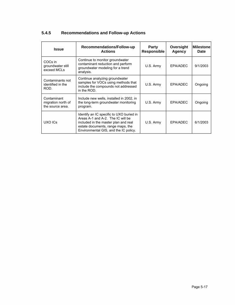
Page 5-17
5.4.5 Recommendations and Follow-up Actions
Issue Recommendations/Follow-up Actions
Party Responsible
Oversight Agency
Milestone Date
COCs in groundwater still exceed MCLs
Continue to monitor groundwater contaminant reduction and perform groundwater modeling for a trend analysis.
U.S. Army EPA/ADEC 9/1/2003
Contaminants not identified in the ROD.
Continue analyzing groundwater samples for VOCs using methods that include the compounds not addressed in the ROD.
U.S. Army EPA/ADEC Ongoing
Contaminant migration north of the source area.
Include new wells, installed in 2002, in the long-term groundwater monitoring program.
U.S. Army EPA/ADEC Ongoing
UXO ICs
Identify an IC specific to UXO buried in Areas A-1 and A-2. The IC will be included in the master plan and real estate documents, range maps, the Environmental GIS, and the IC policy.
U.S. Army EPA/ADEC 6/1/2003

0 50 100 200
Approximate Scale in Feet
NO
RTH
AREA A-4
AREA A-3
AREA A-1A
REA A
-2
WETLANDS
TREES
TREES
BA
RR
S B
LVD
TREES
EAGLE RIVER IS LOCATED 1 MILE NORTH
ANCHORAGE REGIONAL LANDFILL IS LOCATED 0.6 MILES SOUTH
APPROXIMATE GROUNDWATER FLOW DIRECTION IN SHALLOW INTERVAL AND DEEP AQUIFER
KEY
HIL
LSID
E
Poleline Road Disposal Areas
February 2003Figure: 5-1
Fort Richardson Five-Year Review


AP-3981(MW-19)
AP-3985(MW-23)
AP-3986(MW-24)
AP-4015(MW-5)
AP-4017(MW-7)
AP-4013(MW-3)
AP-3745(MW-13)
AP-4012(MW-2)
AP-4011(MW-1)
AP-3982(MW-20)AP-3744
(MW-12)
AP-4016(MW-6)
AP-3983(MW-21)
AP-3984(MW-22)
AP-4014
AP-3989
AP-3990
AP-3746
AP-3747(MW-15)
AP-4019(MW-9)
AP-4020AP-3748(MW-16)
5-3


Page 6-1
6.0 OPERABLE UNIT C
OUC is the third OU to reach the final-action ROD at the Fort Richardson National Priorities List site and was signed September 30, 1998. OUC has two source areas, Eagle River Flats (ERF) and the Open Burning/Open Detonation OB/OD area. This ROD addresses sediment contamination at the ERF source area of OUC. The OB/OD will be closed under RCRA. However, closure will occur concurrently with final clearance of the operating range.
6.1 OUC Eagle River Flats Background
6.1.1 Overview
Eagle River Flats is a 2,160-acre salt marsh on Fort Richardson where Eagle River meets tidal waters in Knik Arm. It has been used for artillery training since 1949. In the early 1980’s, the Army noticed an unusually high number of waterfowl deaths. In response, the Army initiated a comprehensive sampling program to determine if munitions or munitions constituents were the cause of mortality. Pre-RI investigations conducted in 1990 analyzed 172 sediment samples for 14 chemicals of concern (munitions constituents). Eventually in 1991, it was determined that white phosphorous was the cause of mortality. Data collected prior to the RI/FS in 1994 were use to focus the RI on the main contaminant, white phosphorous. Some areas, used more frequently as targets, received higher amounts of white phosphorus. Therefore, white phosphorus particles are not distributed uniformly throughout sediments at ERF. As a result of the discoveries at ERF, the Army stopped using white phosphorus during training at wetland impact areas nationwide in 1990. Eagle River Flats was divided into nine areas for RI/FS activities and other investigation purposes: A, B, C, C/D, D, Racine Island, Bread Truck, Coastal East, and Coastal West. To define areas most likely to contain white phosphorus, investigations focused on (1) areas with the most craters, (2) areas preferred by the waterfowl at risk (dabblers), and (3) areas where carcasses were observed. The sediments in the open ponds in these areas were extensively sampled for white phosphorus. The RI for ERF was completed in July 1996. Figure 6-1 shows the locations and approximate boundaries for the ERF areas. From 1994 through 1997, the ERF investigations focused on finding a feasible remedy for white phosphorus contamination in sediments. Priority cleanup areas were evaluated by using data from white phosphorus sampling, waterfowl telemetry, carcass transects, physical system dynamics, and mapping of landcovers (combinations of topographical features such as ponds and vegetation). Based on the results of these studies, pond draining by pumping was chosen as the preferred alternative for remediating the contaminated areas of ERF. The objective of this remedial action is to temporarily drain ponds to allow the pond sediments to dry and allow white phosphorus to sublimate and oxidize.
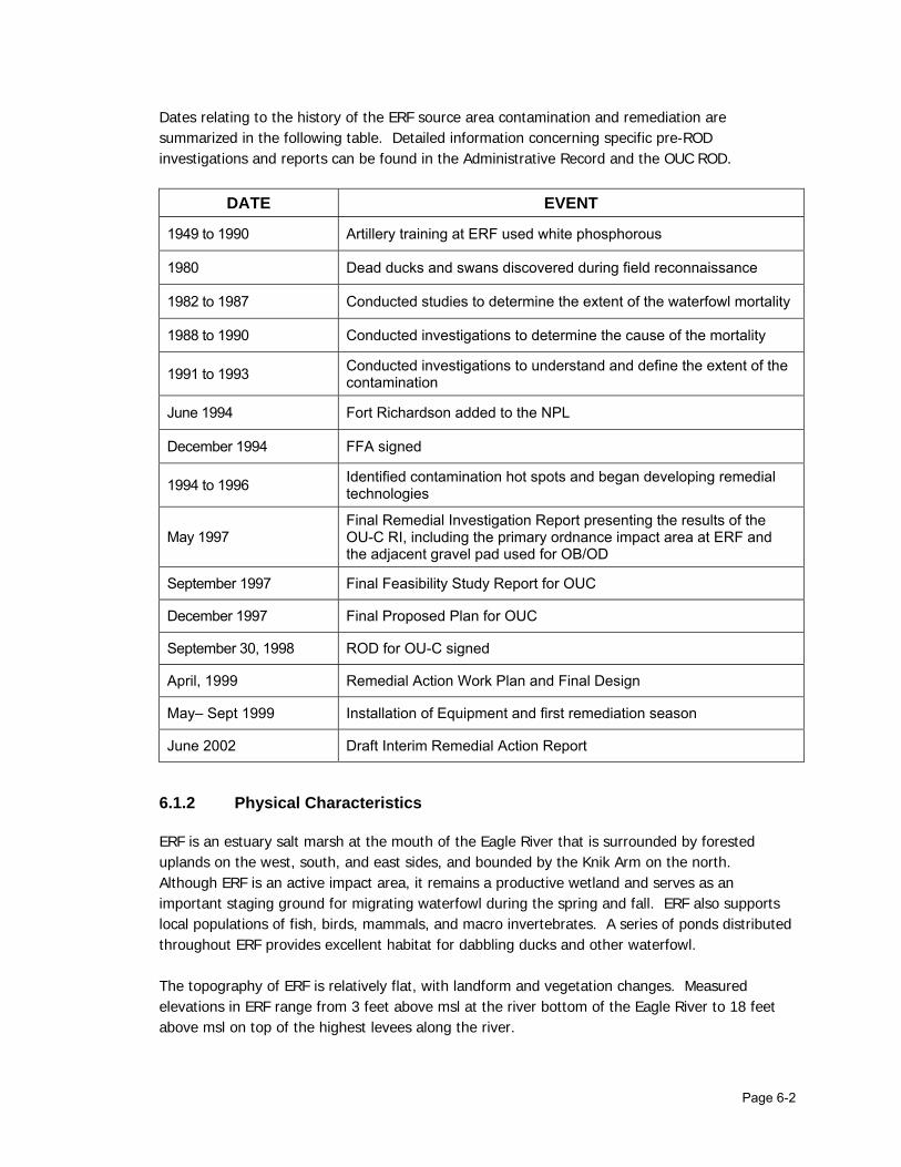
Page 6-2
Dates relating to the history of the ERF source area contamination and remediation are summarized in the following table. Detailed information concerning specific pre-ROD investigations and reports can be found in the Administrative Record and the OUC ROD.
DATE EVENT
1949 to 1990 Artillery training at ERF used white phosphorous
1980 Dead ducks and swans discovered during field reconnaissance
1982 to 1987 Conducted studies to determine the extent of the waterfowl mortality
1988 to 1990 Conducted investigations to determine the cause of the mortality
1991 to 1993 Conducted investigations to understand and define the extent of the contamination
June 1994 Fort Richardson added to the NPL
December 1994 FFA signed
1994 to 1996 Identified contamination hot spots and began developing remedial technologies
May 1997 Final Remedial Investigation Report presenting the results of the OU-C RI, including the primary ordnance impact area at ERF and the adjacent gravel pad used for OB/OD
September 1997 Final Feasibility Study Report for OUC
December 1997 Final Proposed Plan for OUC
September 30, 1998 ROD for OU-C signed
April, 1999 Remedial Action Work Plan and Final Design
May– Sept 1999 Installation of Equipment and first remediation season
June 2002 Draft Interim Remedial Action Report
6.1.2 Physical Characteristics
ERF is an estuary salt marsh at the mouth of the Eagle River that is surrounded by forested uplands on the west, south, and east sides, and bounded by the Knik Arm on the north. Although ERF is an active impact area, it remains a productive wetland and serves as an important staging ground for migrating waterfowl during the spring and fall. ERF also supports local populations of fish, birds, mammals, and macro invertebrates. A series of ponds distributed throughout ERF provides excellent habitat for dabbling ducks and other waterfowl. The topography of ERF is relatively flat, with landform and vegetation changes. Measured elevations in ERF range from 3 feet above msl at the river bottom of the Eagle River to 18 feet above msl on top of the highest levees along the river.

Page 6-3
The discharge from Eagle River bisects ERF. Distributaries cut through the mud flats and connect ponds with Eagle River. Subtle changes in elevation of the channel floors dictate whether tidal flooding occurs daily, occasionally, or rarely. In summer, there may be long periods between flooding tides, and parts of ERF can become relatively dry. During winter, Eagle River continues to flow, but ice thickens over ERF with succeeding flood events during cold temperatures. Ice breakup typically occurs in April or early May. It appears that the river dominates the hydrology and sedimentology of the upper third of ERF; the remainder of the area is dominated by the tides.
6.1.3 History of Contamination
Operable Unit C underwent considerable investigation before being placed on the NPL; therefore, before implementation of the formal CERCLA process all potential contaminants of concern, except white phosphorus, were eliminated. Investigations into the mortality of birds began in 1988-1990, with extensive fieldwork to determine if munitions or munitions compounds were the cause of bird deaths. During this time over 200 samples of water and sediments were analyzed for explosive compounds, metals and VOC’s. The only chemical of concern detected on ERF was white phosphorus. 2,4-DNT was detected near the OB\OD pad at levels exceeding 1 part per million. However, these values were much less than the RBC of 4100 mg/kg for soil ingestion at an industrial site. A baseline risk assessment was conducted to analyze the potential, current, and future adverse health and environmental effects caused by releases and exposure to site-related chemicals. To develop the baseline risk assessment, a data quality review was conducted on all pre-RI data to demonstrate the adequacy and quality required under CERCLA and RCRA. The risk assessment demonstrated that white phosphorous was the only contaminant of concern at ERF. In 1990, after extensive investigation to monitor by-products, it was discovered that ingestion of particles of white phosphorus, a component in smoke munitions, was the cause of waterfowl deaths. White phosphorus and hexachloroethane-zinc-mixture smokes are the two most common agents used by the military to produce white smokes in the visible spectrum. White phosphorus, consisting primarily of elemental phosphorus, has been used as a smoke-producing material in munitions since World War I. When munitions containing white phosphorus are detonated, the phosphorus breaks up into minute particles that disperse over a large area; white phosphorus reacts spontaneously with air creating a column of smoke. Unburned particles from exploded white phosphorus munitions can rain down and become buried in the wet, soft mud. Dabbling waterfowl can pick up the particles of white phosphorus as they are sieving the mud for food. Because white phosphorus persists (does not sublimate and oxidize) when wet or submerged, the water and sediment conditions at ERF are conducive to the long-term retention of white phosphorus. ERF investigations performed after 1990 focused on defining the extent of the white phosphorus contamination, determining site conditions and other factors that affect the likelihood of exposure to white phosphorus, and understanding the physical dynamics of ERF. In 1993, waterfowl telemetry studies were initiated.

Page 6-4
Results of a 1994 Cold Regions Research and Engineering Laboratory (CRREL) study showed that white phosphorus particles remained intact and relatively unaffected in water-saturated sediments, but began to immediately degrade and disappear when the sediments became unsaturated, especially at warmer temperatures. Therefore, sublimation/oxidation was determined to be a viable remedial option for mud flats and intermittent ponds that have the potential to drain and dry. This conclusion led to feasibility studies conducted from 1994 through 1998 aimed at determining potential technologies that could be used in ERF to remediate white phosphorus. Investigations performed to define contaminant hot spots determined that the most significant areas of concern for exposure to white phosphorus were the sediments in ponds and some marshes. Twenty-two hot ponds were identified, covering 57 acres. Figure 6-2 illustrates the pond groups within the OU-C Areas. Some of the ponds identified in the ROD as potential hot spots had not been sampled for white phosphorus. Composite sampling has been conducted to locate and refine areas of known contamination. This information has helped direct remediation efforts.
6.1.4 Land and Resource Use
The ERF is the only impact area for heavy artillery and mortars on Fort Richardson. It is situated on land that is withdrawn from the public domain for military purposes by Executive Order. Current land use is for military readiness activities and the ERF is considered an operational range. In 1990, the Army banned the firing of smokes containing white phosphorus into the ERF. Several additional restrictions currently apply and are listed in the Record of Environmental Consideration, Modified Firing Regime for the Eagle River Flats Impact Area, Fort Richardson, Alaska, October 9, 2001. The community of Eagle River lies within the boundaries of the Municipality of Anchorage, about 4 miles upstream of the nearest point of the ERF. The 2000 estimated the population of Eagle River to be about 29,917. The primary source of drinking water for the residents of the Eagle River community is surface water from Eklutna Lake, 15 miles to the northeast. Most residents of the urban/suburban Eagle River area are served by the Municipality of Anchorage (MOA) water system. Those residences and businesses outside of the MOA water system service area use private wells for a water supply. However, there is only one water supply well within a 4-mile radius of the nearest point of the ERF, on the west shore of Otter Lake. The surface water and near surface groundwater, is highly saline because of the estuarine nature of the site. Consequently, surface water and groundwater from the site are not currently used as potable water supplies and future use is not expected. Because the site continues to be used as an active range, access to the site will continue to be restricted. At this time, the military plans to continue using the site as an operational range.

Page 6-5
Potential UXO and the estuarine habitat prevent use of the area as future residential or industrial sites.
6.1.5 Pre-ROD Response
Treatability studies conducted between 1994 through 1998 are listed below:
• In 1995, capping and filling technology was tested at Pond 285 on Racine Island. This pond was filled with gravel–clay mixture that was intended to prevent ducks from feeding in the contaminated sediment. The mixture also supported the growth of vegetation.
• In 1995 and 1996, small areas of contaminated sediments (<1.5 acres total) were removed from Pond 146 by a remote-controlled dredge during another treatability study.
• In 1996, Pond 109 (8.2 acres) was drained with a blasted ditch. Draining by breaching has discouraged waterfowl use and has initiated a slow remediation by sediment drying.
• In 1997, Ponds 293 and 297 (1.5 acres) on Racine Island were drained with a blasted ditch.
• Also in 1997, a single 2,000-gpm pump powered by a separate floating diesel genset was used to drain Pond 183 in Area C to test the equipment and determine feasibility.
• In 1998, a full-scale pump system treatability study was conducted using six pump systems. Pumps were deployed in Ponds 183, 155, and 146 in Area C and Ponds 290, 256, and 258 in Area A.
6.2 Remedy Selection
6.2.1 Nature of Contamination
The principal COC at the ERF source area is particulate white phosphorus in sediment. When white phosphorus particles settle into pond and marsh sediments that remain saturated, they can last for an indefinite time. However, white phosphorus particles will break down into harmless materials when exposed to air and temperatures above 15°C. A grid for collecting composite samples was established in 1998, which was the first year that a decline in white phosphorus concentration was evident. Sampling results showed that the highest concentration of white phosphorus was found on Racine Island, followed by Bread Truck, and Pond 183 in Area C. The average depth of white phosphorus is generally within the top 8-inches of sediment, but it has been found as deep as 24 inches. In Areas A and C/D, only small amounts of white phosphorus were found. However, bird use and deaths in Area A were historically high. No white phosphorus was detected in Areas B and D. White phosphorus has not been detected in the water of the gullies or the Eagle River. Only trace amounts of white phosphorus contamination have been detected in the gully sediments. No evidence of movement of white phosphorus through Eagle River to Knik Arm was found.

Page 6-6
The human health risk assessment determined that the limited human exposure at ERF reduced potential risks and that risks of exposure to white phosphorous were very low. The risk assessment also noted the existence of potential on-site risk to humans from UXO.
6.2.2 Remedial Action Objectives
As part of the RI/FS process, RAOs were developed in accordance with the NCP and EPA guidance for conducting RI/FS investigations. The primary objective of the remedial action is to reduce the number of waterfowl deaths attributable to white phosphorus. Short and long-term RAOs for the remedial action at OUC are as follows:
• Within five years of the ROD being signed, reduce the dabbling duck mortality rate attributable to white phosphorus to 50% of the 1996 mortality rate attributable to white phosphorus. Radio tracking and aerial surveys suggest that about 1,000 birds died from white phosphorus at ERF in 1996. Therefore, the allowable number of duck deaths from white phosphorus would be approximately 500.
• Within 20 years of the ROD being signed, reduce the mortality attributable to white phosphorus to no more than 1% of the total annual fall population of dabbling ERF ducks. Currently, that population is about 5,000. Therefore, the allowable number of duck deaths from white phosphorus would be approximately 50. This long-term goal could be adjusted based on future population studies conducted during the monitoring program.
It was determined that these objectives would be achieved by reducing the area of white phosphorus-contaminated media; thus, reducing waterfowl exposure to white phosphorus. Reducing the exposure to white phosphorus reduces the availability of white phosphorus to ducks, which in turn reduces duck deaths.
6.2.3 ARARs
The OUC ROD cited the most significant ARARs for the remedy selection at OUC Eagle River Flats to be:
• Section 404 of the Clean Water Act, which coincides with Alaska water quality standards, for protection of wetlands.
• Provisions in the Migratory Bird Treaty Act of 1972 that prohibit unregulated “taking” of birds, including poisoning at waste sites.
6.2.4 Selected Remedy
The dates established in the selected remedy were estimated based on costing purposes. The dates, originally described in the OUC ROD, have not been referenced in this Five-Year Review but will be evaluated annually to determine if they remain valid. The initial evaluation will involve developing a closure evaluation using currently available techniques such as the Closes model.

Page 6-7
Subsequent evaluations will likely involve having scientific professionals familiar with the site re-evaluate the CLOSES model and decision matrix. The major components of the preferred remedy for OUC are listed below.
Component 1 – Treat white phosphorus-contaminated sediment by draining ponds with pumps. Pumping will allow the sediments to dry and the white phosphorus to sublimate and oxidize. The treatment season will begin in May and end in August or September. A pond elevation survey will be conducted to determine the optimal pump placement. To enhance drainage, explosives may be used to make small sumps for the pumps and shallow drainage channels. These shallow drainage channels will enhance the hydraulic connectivity between ponds to encourage drainage.
Component 2 – Implement the following protective procedures to minimize disturbances to wetlands habitat:
a) Restriction of activities that disturb wildlife in Area B and Area D, which are prime waterfowl habitat areas
b) Selection of the narrowest and shortest walking corridors to minimize disturbances to vegetation and habitat
c) Proper maintenance of equipment and structures
d) Minimize the use of equipment and staging-area footprints
e) Minimal localized use of explosives
f) Preparation of work plans and solicitation of agency reviews
g) Monitoring for impacts to wetlands habitat
h) Monitoring for waterfowl use of ERF
Component 3 – Sample pond bottoms for white phosphorus at the beginning of the treatment season to confirm or determine that the pond or area requires remediation. The sampling also would establish a white phosphorus baseline and determine additional areas that may require remediation. The baseline sampling would be performed at the beginning of each field-pumping season.
Component 4 – Sample pond bottoms for white phosphorus after treatment to determine effectiveness of the treatment system. This verification sampling would be performed at the end of each field-pumping season.
Component 5 – Perform telemetry monitoring and aerial surveys concurrently with pumping activities to determine bird populations, usage, and mortality. These activities would begin in 1999. Monitoring would be continued for 3 additional years to verify that short-term goals are maintained.
Component 6 – Perform limited aerial surveys and ground truthing to evaluate waterfowl mortality, physical habitat changes, and vegetation rebound.
Component 7 – Perform aerial photography (beginning in 1999) to monitor habitat changes resulting from remedial actions. Changes in drainage, topography, and vegetation would be evaluated.
Page 6-8
Component 8 – Perform habitat mapping to evaluate impacts to habitat as a result of remedial actions, as well as to observe habitat rebound after pumping is discontinued.
Component 9 – Perform limited hazing (only as a contingency) starting in 1999, if incidental hazing from pumping operations and other fieldwork activities does not deter bird usage.
Component 10 – After remedial action objectives are achieved and pumping is discontinued, apply cap-and-fill material in ponded areas that did not drain and dry sufficiently to enable the white phosphorus to sublimate and oxidize. Cap-and-fill material placement is expected to occur in Year 5 (2003).
Component 11 – Monitor cap and fill material integrity after the material is placed.
Component 12 – Incorporate white phosphorus sampling, telemetry, aerial survey, habitat, and physical landform data into a GIS database.
Component 13 – Maintain institutional controls, including the restrictions governing site access, construction, and road maintenance and the required training for personnel who work at OUC source areas. The objective of these institutional controls is protection of human health, safety, and the environment by limiting or preventing access to contaminated areas or otherwise denying exposure pathways.
6.3 Status of Remediation
Because duck mortality data are obtained concurrently with remediation and sampling activities that can cause bird hazing, the true mortality will not be known until after remediation is completed and waterfowl usage of ERF is uninhibited by remedial activities. Mortality rates that are being derived from the telemetry data and the mortality model show a decreasing rate of mortality in ERF. This reduction is strengthened by the sediment-sampling program, which is showing a large decrease in the amount of white phosphorus contamination. The combination of the results of the sampling program with the morality data indicates that cleanup goals are being met.
6.3.1 Treat White Phosphorus-Contaminated Sediment
Component 1 – Treat white phosphorus-contaminated sediment by draining ponds with pumps beginning in 1999. Pumping will allow the sediments to dry and the white phosphorus to sublimate and oxidize. The treatment season will begin in May and end in August or September. A pond elevation survey will be conducted to determine the optimal pump placement. To enhance drainage, explosives may be used to make small sumps for the pumps and shallow drainage channels. These shallow drainage channels will enhance the hydraulic connectivity between ponds to encourage drainage.
From 1999 through 2002 remediation was conducted during the summer field seasons. Each season, a portion of the permanent pond habitat was drained as a result of remediation efforts.
Page 6-9
1999 Full-scale remediation was initiated using pumps to drain ponds and marsh areas in the flats. Pump systems were deployed in the same five ponds where pumps were deployed during the 1998 treatability study. One pump system was deployed in a new pond. The ponds treated in 1999 were Ponds 183, 155, and 146 in Area C; Pond 730 in Area C/D; and Ponds 256 and 258 in Area A. 2000 In 2000, full-scale remediation continued using six pump systems deployed in the same areas drained during the 1999 field season. 2001 Remediation continued using six pump systems. One pump was relocated within Area A and a second pump was moved to Pond 75 at the border of Area C/D and Coastal East. Tide gates were installed to enhance the selected remedy. Tide gates were placed in natural drainage gullies to prevent high tides from flooding the pond areas. Use of tide gates has enhanced pumping effectiveness by holding back high tides that would have otherwise flooded pond basins. 2002 A tide gate was installed on the Bread Truck ditch with limited success and the gate washed out during flooding tides. Failure of the tide gate hampered remediation efforts in Ponds 730 and 155. Current plans are to reinstall the tide gate in spring 2003, conditions permitting. One pump was deployed into C-Marsh area called the Bomb Craters. The remaining pumps were deployed in the same areas that were drained in 2001. Pond pumping was very successful during the 2002 field season, with a long continuous drying period of 73 days from 29 May until 9 August. The sump in the Bomb Crater area was enlarged using explosives in August. 2003 and beyond (future work) The Army will attempt to install a new tide gate on the Bread Truck ditch in February/March 2003 timeframe. Six pumps will be deployed in the ERF, but efforts will be concentrated on the C-Marsh area. At the current time there are no plans to continue the remedial effort after the 2003 field season. However, the RPMs will evaluate the need to continue remediation after completion of the 2003 field season. Because of expected flooding tides throughout the 2004 season, no pond remediation could occur, regardless of whether or not the RPMs wanted to extend the remedial phase.
6.3.2 Implement Protective Procedures to Minimize Disturbances to Wetlands
Component 2 – Implement the following protective procedures to minimize disturbances to wetlands habitat:
a) Restriction of activities that disturb wildlife in Area B and Area D, which are prime waterfowl habitat areas
No remediation activities are occurring in Areas B and D. No access is required into or through these areas. With the exception of limited helicopter flight surveys in Area B in early August, no low-level flight activities occur over these areas.

Page 6-10
b) Selection of the narrowest and shortest walking corridors to minimize disturbances to vegetation and habitat
Walking paths to areas undergoing remediation or sampling are flagged. Prior to use, a UXO technician clears the areas along the paths. All access within ERF is limited to these cleared and flagged paths. This ensures the safety of the personnel by limiting potential exposure to UXO. It also limits the potential impacts to the habitat to a few restricted paths.
c) Proper maintenance of equipment and structures
Pumping equipment is inspected and maintained on a regular basis by a qualified O&M contractor. External fuel tanks for the generator sets are ADEC-approved, double-walled tanks. An oil spill prevention and cleanup plan is in place. Spill kits are deployed at each generator set in the field and at the staging area on the OB/OD pad adjacent to ERF.
d) Minimize the use of equipment and staging-area footprints
Generator sets, pumps, external fuel tanks, and pipe are airlifted into ERF by helicopter to minimize potential impacts. The staging area is confined to the gravel footprint of the OB/OD pad at the edge of ERF.
e) Minimal localized use of explosives
Sumps for the floating pumps are excavated (explosives are used to excavate the sumps) in the early spring prior to arrival of waterfowl at ERF. Sumps are located within existing pond basins. Explosives are used to excavate shallow drainage channels to link various low points within pond basins to the pump sumps. All ditching is within pond basin complexes and does not affect external drainage of these ponds. Once pumping remediation is completed within a pond complex and the pump is removed, the pond refills naturally and the sumps and ditches become part of the pond habitat.
f) Preparation of work plans and solicitation of agency reviews
Work plans are prepared prior to each season. The results of the previous season’s fieldwork and work planned for the following season are reviewed each year by the Remedial Project Managers from the Army and various regulatory agencies.
g) Monitoring for impacts to wetlands habitat
A monitoring program is in place to assess changes to wetlands habitat due to remediation efforts. Aerial photography, long-term study plots, and on-the-ground field observations are used to monitor changes.
h) Monitoring for waterfowl use of ERF
U.S. Fish & Wildlife Service personnel conducted periodic aerial surveys throughout the field season. This information is combined with the extensive data collected from the radio-collared waterfowl to provide detailed information on both the numbers of waterfowl using ERF and the specific areas used by waterfowl for resting and feeding activities.
Page 6-11
6.3.3 Sample Pond Bottoms for White Phosphorus
Component 3 – Sample pond bottoms for white phosphorus at the beginning of the treatment season to confirm or determine that the pond or area requires remediation. The sampling also would establish a white phosphorus baseline and determine additional areas that may require remediation. The baseline sampling would be performed at the beginning of each field-pumping season.
Component 4 – Sample pond bottoms for white phosphorus after treatment to determine effectiveness of the treatment system. This verification sampling would be performed at the end of each field-pumping season.
Sampling for white phosphorus at OUC is conducted during each field season. Results for each year are compared to those from previous years to determine the progress of remediation. In 2001, all ponds showed a reduction of white phosphorous from planted white phosphorus particles. The mean white phosphorus reduction for all ponds was 64%. All formerly identified hot spots are either clean or have shown significant progress toward remediation. Composite white phosphorus sampling data is compared with mortality studies to identify additional areas of contamination. A summary of pond sampling results is provided below:
• Pond 183 is clean except for a small, contaminated area that was found beneath some geotextile fabric left on site from previous actions.
• Pond 146 is also clean. Composite sampling of this pond, which had a white phosphorous concentration of 7.31 micrograms per gram (µg/g) in June 1999, was reduced to 0.0005 µg/g in September 2001.
• Pond 155 requires further remediation. Improved drainage in 2001 resulted in a reduction in the composite sample concentration. However, some discrete and subsurface samples taken in 2002 show that white phosphorous is still present.
• Results of discrete and composite samples collected at the Bread Truck pond are below the detection limit.
• Pond 730 (Area C/D) and 290 (Area A) are considered clean. No white phosphorous has ever been detected in samples from these ponds. Pumping was performed based on waterfowl mortality in the area.
• White phosphorus contamination in Ponds 256 and 246 (Area A) is no longer detectable and so these ponds are determined to be clean.
6.3.4 Perform Telemetry Monitoring and Aerial Surveys
Component 5a – Perform telemetry monitoring and aerial surveys concurrently with pumping activities to determine bird populations, usage, and mortality. These activities would begin in 1999.
Monitoring of the movement, distribution, and mortality of mallards has been performed each season by attaching transmitters to approximately 100 captured ducks. However, telemetry monitoring did not occur in 2000 due to a contracting problem and decreased availability of helicopters.

Page 6-12
Bird mortality has decreased since 1996 when an estimated 655 ducks died due to ingestion of white phosphorus. Estimated mortality rates were 655 (1996), 240 (1997), 355 (1998), 198 (1999), 87 (2001), and 224 (2002). Mortality rates were not estimated in 2000 because of contracting problems that prevented the procurement of helicopter service. The current projected mortality rate is less than the short-term RAO of about 500 deaths due to white phosphorus. Mortality rate measured in 2002 was slightly higher than the rate measured in 2001 and is likely due to a decrease in the number of ducks monitored during the 2002 season. Because of problems with securing helicopter service, only 69 ducks were fitted with radio collars instead of the approximate 100 birds captured in 2001. There is imprecision when trying to model a larger population with a small subset, as is being done with the radio-collared birds. The mortality model is an attempt to predict what is happening in a transient population of waterfowl in ERF by monitoring a small subset. The model is continually being refined to improve its accuracy.
Component 5b –Monitoring would be continued for 3 additional years to verify that short-term goals are maintained.
The RPMs are currently assessing the field data to determine appropriate times to perform telemetry monitoring. This assessment will include an evaluation of other methods to measure mortality.
Component 6 – Perform limited aerial surveys and ground truthing to evaluate waterfowl mortality, physical habitat changes, and vegetation rebound.
Limited aerial surveys have been conducted periodically throughout the period of remediation. The dates established in the selected remedy and described in the OUC ROD were estimated based on costing purposes and will be evaluated annually to determine if they remain valid.
6.3.5 Perform Aerial Photography
Component 7 – Perform aerial photography (beginning in 1999) to monitor habitat changes resulting from remedial actions. Changes in drainage, topography, and vegetation would be evaluated.
The Army is evaluating aerial photography to determine if habitat changes are resulting from the remedial actions. No changes have been noted to date.
6.3.6 Perform Habitat Mapping
Component 8 – Perform habitat mapping to evaluate impacts to habitat as a result of remedial actions, as well as to observe habitat rebound after pumping is discontinued.
Habitat mapping has been done and the Army will evaluate the need to continue habitat mapping in the future.

Page 6-13
6.3.7 Perform Limited Hazing as a Contingency
Component 9 – Perform limited hazing (only as a contingency) starting in 1999, if incidental hazing from pumping operations and other fieldwork activities does not deter bird usage.
Hazing was attempted but was not successful. Therefore, the Army no longer conducts hazing activities.
6.3.8 Apply and Monitor Cap-and-Fill Material
Component 10 – After remedial action objectives are achieved and pumping is discontinued, apply cap-and-fill material in ponded areas that did not drain and dry sufficiently to enable the white phosphorus to sublimate and oxidize. Cap-and-fill material placement is expected to occur in Year 5 (2003).
Component 11 – Monitor cap and fill material integrity after the material is placed.
The ROD called for capping and filling of areas that did not drain and dry, enabling the white phosphorous to sublimate. AquaBlok, a bentonite-gravel mixture, was tested as a capping material and was unsuccessful. The bentonite became loose and unstable in open water and did not succeed in preventing ducks from picking up white phosphorus particles from the areas where it was applied. If capping is needed in the future to cover any untreated hot spots, AquaBlok is not recommended. Instead, as recommended in the 2001 OUC Remedial Progress Report, gravel alone should be used as capping material.
6.3.9 Incorporate Data into a GIS Database
Component 12 – Incorporate white phosphorus sampling, telemetry, aerial survey, habitat, and physical landform data into a GIS database.
A comprehensive geographical information system (GIS) database was established in 1994 and is continuously updated. The Directorate of Public Works (DPW) maintains the GIS database that includes ERF data and information on all of the contaminated sites on post.
6.3.10 Maintain Institutional Controls
Component 13 – Maintain institutional controls, including the restrictions governing site access, construction, and road maintenance and the required training for personnel who work at OUC source areas. The objective of these institutional controls is protection of human health, safety, and the environment by limiting or preventing access to contaminated areas or otherwise denying exposure pathways.
Institutional controls (ICs) at OUC have been implemented. Fort Richardson has established a post wide IC policy at all known or suspected contaminated sites. Further details regarding the Army/Fort Richardson IC policy can be found in the OUD ROD, the U.S. Army Institutional Controls Standard Operating Procedures [APVR-RPW (200-1)], and a Memorandum on

Page 6-14
Institutional Controls [APVR-RPW-EV (200-1c)], from Major General James J. Lovelace – Fort Richardson, Alaska. This policy ensures that limitations on access, water use, excavations, and property transfers as appropriate for the site have been established. At OUC, controls include a locked gate limiting access, fences and signs around the perimeter of the area, and large signs at access points to Eagle River. One component of the IC policy involves obtaining an Excavation Clearance Request (USARAK Form 81 a – 1 Mar 02) to control excavation inconsistent with established ICs at a particular site. ICs will remain in place as long as hazardous substances remain on site at levels that preclude unrestricted use
6.4 Five-Year Assessment
6.4.1 Are the Remedies Functioning as Intended by the Decision Document?
Remedial Action Performance
The Army has determined that the remedy is operational and functional. Components of the preferred remedy that were scheduled to occur from 1999 to 2002 have been implemented as planned with one exception; the telemetry monitoring for duck mortality did not occur in 2000. The following table summarizes performance to date related to the RAOs for this source area:
Remedial Action Objectives Performance to Date
Within five years of the ROD being signed, reduce the dabbling duck mortality rate attributable to white phosphorus to 50% of the 1996 mortality rate attributable to white phosphorus. Radio tracking and aerial surveys suggest that about 1,000 birds died from white phosphorus at ERF in 1996. Therefore, the allowable number of duck deaths from white phosphorus would be approximately 500.
The duck mortality rate is currently less that the short term RAO. Waterfowl mortalities in 1999, 2001, and 2002 were below the short-term RAO of approximately 500.
Within 20 years of the ROD being signed, reduce the mortality attributable to white phosphorus to no more than 1% of the total annual fall population of dabbling ERF ducks. Currently that population is about 5,000. Therefore, the allowable number of duck deaths from white phosphorus would be approximately 50. This long-term goal could be adjusted based on future population studies conducted during the monitoring program.
Based on the mortality model, population studies have shown an overall decrease in the duck population. However, duck mortality is still above 1% and the long term RAO has not been met.
Implementation of Institutional controls
Access and ICs are in place and prevent exposure. ERF is an active range and subject to Army regulations. Figure 6-3 depicts the OUC Eagle River Flats area subject to restricted use under the IC policy.

Page 6-15
Operation and Maintenance
Two minor problems with the pumping system arose and were addressed during the 2002 season. On several systems the positive battery terminal post corroded, preventing good contact between the post and the battery cable clamp. These batteries, although still good, need to be replaced to prevent starting faults on the generator sets. The second problem is with the magnetic relay on the motor starter for pump one on System 3. Failure to make contact has resulted in the generator sets running without the pump operating. The magnetic relay either needs to be cleaned to improve reliability or replaced. Additional actions taken to address components of the Remedial Action Objective are addressed in the OUC 2002 Draft Interim Remedial Action Report.
6.4.2 Are the exposure assumptions, toxicity data, cleanup levels, and remedial action objectives used at the time of the remedy still valid?
Standards
There are no changes in standards identified as ARARs, newly promulgated standards, and/or changes in TBCs identified in the ROD, that could call into question the protectiveness of the remedy. Exposure Pathways
• There are no changes in land use or the anticipated land use on or near the site;
• No new human health or ecological exposure pathways, receptors, or populations at risk have been identified;
• No new contaminants or contaminant sources have been identified;
• No changes in the physical site conditions have been observed; and
• No changes in the toxicity factors for contaminants of concern have been identified.
6.4.3 Has any Other Information Come to Light That Could Call Into Question the Protectiveness of the Remedy?
No new information is available to question the protectiveness of the current remedy.
6.4.4 Issues
The following table describes the issues that were identified during this first Five-Year Review.
Issues Affects Current Protectiveness
(Y/N)
Affects Future Protectiveness
(Y/N)
Mortality data may be skewed by active remedial activities. N N

Page 6-16
6.4.5 Recommendations and Follow-up Actions
Issue Recommendations/Follow-up Actions
Party Responsible
Oversight Agency
Milestone Date
Potentially Skewed mortality data
Evaluate recovery trends upon completion of remedial action. U.S. Army EPA/ADEC Ongoing
6.5 OB/OD Evaluation
The RI conducted at the OB\OD Pad indicated that no concentrations of contaminants of concern above regulatory levels specified in the Operable Unit C RI/FS Management Plan have been discovered. In addition, the ecological and human health risk assessments completed during the RI indicate that the risks are very low. Therefore, no further action under CERCLA was selected. The OUC ROD selected the remedial action under CERCLA, as well as the EPA decision under RCRA regarding closure of the OB\OD pad. The OB\OD pad is designated as a RCRA regulated unit and subject to closure under 40 CFR 265, Subpart G and P. The RPMs and EPA RCRA mutually agreed to delay final RCRA closure of the OB\OD pad until final clearance of the operating range. The ROD stipulates that no less often than during the CERCLA 5-year reviews, the Army will evaluate the OB/OD area. Because the range has not been closed and Fort Richardson remains an active installation, the Army has determined that delayed closure will not affect the OB/OD area. The Army's evaluation concluded that ICs for the OB/OD area remain protective. No new RCRA or munitions rules/regulations specific to post-closure procedures for former OB/OD areas have been promulgated. Therefore the selected remedy remains protective. The 5-Year Review Range Analysis is included in Appendix E.

Eagle River Flats Site Location Map
Pond 109 (BT)
Area A
Knik Arm
0 1000m
Eagle River
Racine Island
Area D
Pond 155
Pond 183
Pond 146
Area C
Area B
Pond 256
Pond 258
Pond 290
February 2003Figure: 6-1
Fort Richardson Five-Year Review

Eagle River Flats Pond Groups
February 2003Figure: 6-2
Fort Richardson Five-Year Review

Fort Richardson Five-Year Review
February 2003
Institutional Control Area for OUC Eagle River Flats on Fort Richardson.
Knik Arm
Eagle River
Figure: 6-3
Institutional Control Boundary
Institutional Control Boundary
LegendLegend

Page 7-1
7.0 OPERABLE UNIT D
OUD is the fourth OU to reach a final-action ROD and was signed June 30, 2000. This ROD documented a NFA Decision in accordance with EPA Guidance. OUD was originally established to be the final OU to be investigated at Fort Richardson. Consequently, this ROD was intended to integrate the remaining evaluations at the Post and include the potential cumulative human health and ecological risks that may become evident from the aggregate of source areas and areas not otherwise resolved in previous OUs. Additional background details and general site information is documented in the OUD ROD and in the Administrative Record for each source area listed in this Section. OUD originally consisted of the following 12 potential source areas (shown on Figure 7-1):
• Building 35-752 - High Frequency Transmitter Site
• Building 45-590 - Auto Hobby Shop
• Building 726 - Laundry Facility
• Building 796 - Battery Shop
• Storm water Outfall to Ship Creek
• Dust Palliative Locations (four separate areas)
• Landfill Fire Training Area
• Grease Pits
• Circle Road Drum Site
• Building 700/718
• Building 704
• Building 955 Each source area was evaluated through the PSE process (Pre-RI), and where warranted, limited field investigations, called PSE2s, were conducted. Based on the PSE2, petroleum contamination at Building 955 qualified the site to be investigated under the Two-Party agreement and DDT contamination at the Building 955 site was evaluated as part of OUD. Four of the original source areas were carried through an RI/FS: the Building 726 Laundry Facility, the Building 796 Battery Shop, the Building 35-752 High Frequency Transmitter Site, and the Building 45-590 Auto Hobby Shop. Based on the PSE and RI information, the Army, ADEC, and EPA determined in the OUD ROD that six source areas required NFA under CERCLA, three source areas should be referred to the Non-UST Two-Party Agreement, two source areas be recommended for NFA under CERCLA following additional limited monitoring, and the two remaining source areas were referred to a newly created OU, OUE, for investigation and further evaluation.

Page 7-2
7.1 OUD Source Areas Requiring No Further Action
The NFA decision was recommended for source areas if: no visible sign of contamination was observed during the source area inspection; a removal action eliminated existing and potential risks to human health and the environment; or environmental sampling results showed that contamination, if present, is at levels below the protective human health-based levels for unrestricted use. The NFA decisions for seven of the sites identified in the ROD are intended to document that the risk to human health and the environment associated with contamination from past activities at Fort Richardson is not present at these sites. Two of these source areas, the landfill fire training area and the grease pits, are being monitored in accordance with the requirements of the Fort Richardson Landfill Closure Plan (see Section 7.4). Institutional controls established for these source areas are shown on Figure 7-2. The NFA decision under CERCLA was made in the OUD ROD for the following source areas:
• Building 726 Laundry Facility
• Storm water Outfall to Ship Creek
• Dust Palliative Locations (four separate areas)
• Landfill Fire Training Area
• Grease Pits
• Building 45-590
• Circle Road Drum Site
7.2 OUD Source Areas Referred to the Two-Party Agreement
Three source areas were referred to the Two-Party Agreement because the only contaminants of concern were petroleum. This agreement is part of the FFA for Fort Richardson. This Two-Party Agreement, officially referred to as the State-Fort Richardson Environmental Restoration Agreement, presents the petroleum cleanup strategy and documents all known historical petroleum sources on Fort Richardson and their current cleanup status. It also confirms the Army’s commitment to adequately address these petroleum source areas in a manner consistent with state regulations. Further information concerning the status of source areas referred to the Two-Party agreement can be found in the Administrative Record and in Appendix A of this document. Appendix D and E of the OUD ROD also further explains these agreements. The source areas that were referred to the Two-Party agreement and do not require any additional action under the OUD ROD include:
• Building 700/718
• Building 704
• Building 955 petroleum contaminated soils
7.3 OUD Source Areas Requiring Additional Sampling
The ROD determined that two source areas, Building 796 (Battery Shop) and Building 955 (DDT contaminated soils), should undergo further monitoring. These source areas are subject to Five-Year Review for evaluation of post-ROD monitoring data to determine if levels of chemicals of

Page 7-3
concern at these sites are below MCLs or EPA risk based criteria and do not pose a threat to human health or the environment. Institutional controls established for these source areas are shown on Figure 7-2. 7.3.1 Building 796 Battery Shop
Background
Building 796, a battery and vehicle and maintenance weapons repair shop, is located at the southwest corner of Fifth Street and Davis Highway. The facility is used for vehicle and equipment maintenance. Historically, this site served as the Battery Shop and former activities at this source area included discharging neutralized battery fluid into a floor drain that subsequently drained into either a log crib, UST, or storm sewer. This activity took place from the 1950’s until the late 1980’s. In 1993, a UST removal identified possible petroleum contamination. However, petroleum concentrations did not exceed State soil cleanup levels. During a PSE2 investigation in 1994, carbon tetrachloride and chloroform were detected in the groundwater. The presence of chloroform or carbon tetrachloride was not confirmed during additional groundwater pre-RI sampling events; however, 1,2-Dibromoethane (EDB) was detected during 1 out of 12 of the sampling events and benzo(a)pyrene (a PAH) was detected in 2 out of 8 sampling events. Even though the concentrations of chloroform and carbon tetrachloride were below risk based cleanup levels, the source area was added to the OU-D RI/FS because of the carcinogenic potency of the two chemicals. The FS recommended a remedial action that was developed in the Proposed Plan and the Draft OUD ROD. During the ROD review, it was determined that the risk was overestimated for the contaminants detected in groundwater. Risks calculated during the RI were based on an estimated value for EDB concentration and PAH detected in samples that were unfiltered. Because the Risk Assessment and determination during the RI were based solely on contaminants that may or may not have been present in groundwater, after re-evaluating the Risk Assessment and the data, it was determined that there were no contaminants above risk levels. . The Army, EPA, and State of Alaska agreed in the OUD ROD that an additional groundwater sampling event would be conducted. If no contaminants are detected the site will require no further action under CERCLA, and the decision will be documented in the OUE ROD. Post-ROD Activities
Groundwater samples were collected from five on-site monitoring wells during July 2000 and analyzed for VOCs, DRO, EDB, and metals. Samples were collected again during January 2001 for analysis of PAHs only. Threshold criteria for evaluating groundwater sample results are the federal MCLs or secondary MCLs. Results of the post-ROD sampling indicated that all analytes were non-detectable or well below the MCLs. Recommendations and Follow-up Actions
Per the OUD ROD, the Building 796 site should be formally closed in the OUE ROD.

Page 7-4
7.3.2 Building 955 DDT Contaminated Soil
Background
This site is the location of the former sludge bin that was used at the waste-oil transfer station. Waste liquids containing water and small amounts of solids were transported to the bin from various motor pool operations. The waste liquids were allowed to settle and the contents segregated into water, liquid petroleum compounds, and sludge. The water was pumped from the bin, and the used oil was deposited into USTs located adjacent to the bin. A site assessment was performed in 1993 for closure of the UST. This resulted in the detection of petroleum hydrocarbons, VOCs, herbicides and pesticides at the site. The UST site was not investigated as part of OUD, but was investigated as part of the Two-Party UST Agreement. During a 1995 investigation, DDT was detected near Building 955 at 95 mg/kg at 6 feet bgs in one boring. This area was considered an isolated small spill site and the Army conducted a removal action of the DDT in 1998. Approximately 100 cubic yards of DDT contaminated soil was removed. The soil was field screened, but confirmation samples were not collected for laboratory analysis. Because confirmation samples were not collected and three of the field screening samples exhibited potential concentrations of DDT greater than 10 ppm, a risk determination could not be made. Therefore, the OUD ROD recommended performing confirmation sampling for DDT to confirm that concentrations did not exceed the EPA Region 3 risk-based level of 17 mg/kg or State of Alaska standard of 24 mg/kg. A Recommended Action Decision Document, which details the analytical results of confirmation sampling, a risk analysis for the source area, and a discussion of the 1998 removal action, can be found in the Administrative Record. Post-ROD Activities
Ten confirmation samples were collected during July 2000 and submitted for laboratory analysis of DDT, DDE and DDD. Surface and subsurface soil samples were collected from four borings to a maximum depth of nine feet. Threshold criteria for evaluating soil sample results were EPA Region 3 RBC of 17 mg/kg (soil ingestion at an industrial site). Results of the post-ROD sampling indicate that DDT contaminant levels were below the RBC and all analytes were below the most restrictive ADEC cleanup levels. Recommendations and Follow-up Actions
The Building 955 DDT contaminated soil site should be closed in the OUE ROD.
7.4 OUD Source Areas Subject to RCRA Closure Requirements
An additional goal of the FFA was to integrate the Army’s CERCLA response obligations and RCRA Corrective Action requirements resulting from the EPA’s and Army’s 1991 Federal Facilities Compliance Agreement. As stipulated in the OUD ROD, six source areas are subject to RCRA Closure in accordance with the FFCA. Those six sites are: Circle Road Drum site, Building 700/718, Building 704, Building 955, Building 35-752, and Building 45-590.

Page 7-5
The former landfill fire training source area and the grease pits source area were recommended for NFA under CERCLA with unrestricted use and have been closed in accordance with RCRA Subtitle D of Solid Waste Landfill Regulations and State of Alaska Solid Waste Regulation 18 AAC 60. As part of the closure plan, groundwater sampling has been conducted in wells located around the perimeter of the landfill since 1989. The depth to groundwater under the landfill is 180 feet. An annual report for groundwater monitoring and cap integrity is provided to the State of Alaska. To date, no contamination has been detected in either the down gradient or up gradient wells. This monitoring program is expected to continue for thirty years under the landfill closure plan. Documents detailing the analytical results for long-term monitoring at the landfill are located in the Administrative Record. The Army’s evaluation indicates that ICs for the landfill area remain protective. Institutional controls established for these source areas are shown on Figure 7-2. No new RCRA rules have been promulgated specific to post-closure procedures for the former landfill fire training source area or the grease pits source area.
7.5 OUD Source Areas Transferred to OUE
While the OUD ROD was being developed, new information was discovered concerning the Building 35-752 source area. Based on new information it was determined that this source area required additional investigation to assess if other potential COCs (dioxin) are present. This source area is being reinvestigated as part of the OUE RI/FS. Building 45-590 was determined not to be a source for groundwater contamination and was considered NFA under CERCLA in the OUD ROD. Groundwater contamination was attributed to an up gradient source area referred to as the Armored Vehicle Maintenance Area (AVMA). This newly identified potential source area is being investigated as part of the OUE RI/FS. After reviewing new information for these source areas, the EPA, State and Army determined that the potential contamination and human health risks had not been adequately addressed, and that it would be necessary to integrate all previous and any new sources into OUE. In the interim, Fort Richardson has established a post wide IC policy at all known or suspected contaminated sites. Further details regarding the Army/Fort Richardson IC policy can be found in the OUD ROD, the U.S. Army Institutional Controls Standard Operating Procedures [APVR-RPW (200-1)], and a Memorandum on Institutional Controls [APVR-RPW-EV (200-1c)], from Major General James J. Lovelace – Fort Richardson, Alaska. Institutional controls established for these source areas are shown on Figure 7-2. 7.5.1 Building 35-752
Building 35-752 is located approximately one-third of a mile south of the Davis Highway, within one mile of Elmendorf Air Force Base. The RI/FS conducted as part of OUD focused on a former generator building that was active from 1953 to 1987 and housed four generators. The generators were fueled by diesel fuel, which was stored in seven 5,000-gallon USTs south of the building. Cooling ponds, located southwest of the building, stored water to cool the generators.

Page 7-6
In 1990, seven USTs were excavated from the south side of the building. During the UST closure, petroleum hydrocarbon contamination was found in the excavation as well as PCB and Aroclor 1260 in the stockpiled soil.
A PSE was conducted at Building 35-752 during fall and winter 1994 and 1995. PCBs were detected in samples collected from the floor of Building 35-752. PCBs and petroleum hydrocarbons were detected in soil and groundwater samples collected in the former UST area. PCBs and petroleum hydrocarbons were detected in subsurface soil samples collected in the drum storage area. Petroleum hydrocarbons, PCBs, pesticides, and solvents were detected in sediments collected from the cooling pond. Petroleum products and metals were detected in groundwater samples collected near the cooling pond. Petroleum products and solvents were present in groundwater samples collected from wells around the building. Fieldwork at Building 35-752 for the RI was conducted during fall 1996. RI fieldwork included wipe sampling of the floor of Building 35-752, surface and subsurface soil sampling at the former UST locations, soil sampling at a drum accumulation area, surface water and sediment sampling at the cooling pond, and groundwater sampling. In order to construct a more permanent asphalt surface, approximately 1,500 cubic yards of soil were excavated from the gravel parking lot at the site in 1997. Soil removed during excavation activities was found to contain PCBs at higher concentrations than samples collected at other locations evaluated during the RI. A definitive source of the PCBs was never determined. The Proposed Plan for OUD indicated that the soil removed during the excavation would be treated using phytoremediation. The soil was stockpiled at the site and later packaged and shipped to a TSCA permitted TSDF for disposal. While the OUD ROD was being developed, new information was discovered about the source of PCB contamination in this area. Interviews with Fort Richardson personnel indicated that oil from four 750-kilovolt transformers located behind Building 35-750 was drained via a trench into a pit located adjacent to Building 35-752 and burned with diesel fuel. The interviews also indicated that another transformer was drained onto the ground in the area directly east of Building 35-752. Considering the new information obtained after issuing the Proposed Plan, it was determined that this site had not been adequately characterized for PCBs and potentially dioxins. As a result, this site is being investigated as part of OUE. Access to Building 35-752 has been completely restricted. In addition, institutional controls will prohibit access to the groundwater as a source of drinking water and, the land use at this source area and neighboring source areas will remain industrial for the foreseeable future. Further action requirements for this site will be documented in the OUE ROD. 7.5.2 Armored Vehicle Maintenance Area
Based on previous investigations, the primary concern was groundwater contaminated with carbon tetrachloride and PCE. The highest concentrations of carbon tetrachloride and PCE in groundwater were observed up gradient and/or cross gradient to the suspected Building 45-590

Page 7-7
source area. Therefore, the OUD ROD concluded the likely source for groundwater contamination was not from Building 45-590. Therefore, Building 45-590 was considered NFA under CERCLA. In an attempt to identify a source area, the OUE RI investigated the AVMA site. Aerial photos from 1957, 1960 and 1966 show a large disturbed area east of Building 45-590 with trenches, large cylinders, stained areas and buried debris. Interviews with former employees indicated that this area was used as a lower echelon or lowest level of field maintenance for armored vehicles (tanks) with disposal of oil and other waste material. Considering this new information, it was determined that this site would be further investigated as a part of OUE. In the interim, institutional controls will prohibit access to the groundwater as a source of drinking water and, the land use at this source area and neighboring source areas will remain industrial for the foreseeable future.

Fort Richardson Five-Year Review
February 2003Figure: 7-1Operable Unit D Source Area Location Map

NN
Institutional Control BoundaryInstitutional Control Boundary
Installation Action PlanInstallation Action Plan
LegendLegend
Fort Richardson Five-Year Review
February 2003
Institutional Control Areas for OUA, OUD and OUE on Fort Richardson. Institutional Controls are shown for both CERCLA and Two-Party Sites.
Figure: 7-2
0.50.50.250.25
Scale in MilesScale in Miles
00

Page 8-1
8.0 OPERABLE UNIT E
Based upon new information, two remaining source areas (formerly addressed in the OUD ROD) will require additional characterization to verify the source and extent of contamination. These two sites are building 35-752 and the AVMA. Building 35-752 includes soils contaminated with PCBs and the concern at the AVMA is groundwater contamination with solvents such as TCE.
8.1 Building 35-752
A pre-RI investigation was conducted in 2000 at the Building 35-752 OUE source area to evaluate the site-specific subsurface geology and identify areas for future sampling. A groundwater sampling program was implemented and the first sampling event was conducted during September 2001; low levels of site contaminants were detected. During 2002, the OUE Management Plan was used to conduct the RI. A removal action was also conducted for the PCB contaminated soil that was excavated and stockpiled by the Air Force. This soil transported by rail for disposal at a TSCA permitted landfill in Idaho. Further action requirements for this source area will be documented in the OUE ROD.
8.2 AVMA
The Army has completed a pre-RI soil sampling and groundwater well installation at the OUE AVMA site. The result of the soil sampling was inconclusive, but further investigation is planned. Two groundwater wells were installed and groundwater sample results indicated the presence of lead and mercury at levels exceeding drinking water standards. The draft Management Plan for the RI/FS has been prepared, which presents the approach and methodologies that will be used to conduct the remedial investigation for OUE. A groundwater sampling program has been implemented for the OUE sites and the first sampling event was conducted during September 2001. In addition, CRREL has conducted some additional geophysical investigation at the AVMA site to help determine sampling locations during the remedial investigation. Geophysical studies indicated the presence of large areas of buried metallic objects at the site; the nature of the objects will be identified during the RI. Further action requirements for this site will be documented in the OUE ROD.

Page 9-1
9.0 SITE-WIDE SUMMARY AND RECOMMENDATIONS
9.1 General
9.1.1 ROD Commitments are Being Met
Management of Fort Richardson NPL site remediation under the FFA has been very effective. This effectiveness translates into a good rate of progress implementing the remedial actions specified in the RODs and is in the best interest of the public and the environment. This effectiveness also translates into the best use of public resources, i.e. a greater proportion of funding for RD/RA/LTM is focused on remediation (as opposed to transactional costs) than has been the case at many other NPL sites. 9.1.2 Public Information Repositories
A status memorandum concerning inspection of the Fort Richardson public information repositories is included as an appendix of this report. Site visits found that the repositories generally met the CERCLA requirements and public needs. The site visit report includes several specific recommendations for enhancing the repositories and potentially simplifying maintenance of the administrative record at these locations (Appendix C). 9.1.3 Institutional Controls
The Army has established Standard Operating Procedures (SOP) and a Geographic Information System (GIS) based tracking system to ensure the land and use restrictions are enforced. The IC system has been incorporated into the post wide Master Plan, and compliance with ICs is reported in the Annual Monitoring Reports for each OU. The IC policy applies to all USARAK units and activities, Military and Civilian Support Activities, Tenants Organizations and Agencies and Government and Civilian Contractors. In the fall of 2001, the Institutional Control Memorandum signed by Major General Cash dated February 1999, was updated to require a Work Authorization Permit for all groundwater and soils on USARAK lands. This revised memorandum, signed by the Commanding General, includes a section on areas with ICs mandated by a Record of Decision and a section on areas where contamination is not suspected. Currently, all contracts that include intrusive activities require a Work Authorization Permit; however, the Permit was updated to clearly alert the user on procedures to follow when potential contamination is encountered. The Standard Operating Procedure (SOP) for ICs will include a more detailed section on the procedures and responsibilities for incidents where potential contamination is found. Fort Richardson instituted a post wide IC policy for all known or suspected contaminated source areas. Further details of the Army/Fort Richardson IC policy can be found in Appendix E of the OUB Draft Interim Remedial Action Report, the U.S. Army Alaska Institutional Controls Standard Operating Procedures [(APVR-RPW [200-1)], and a Memorandum on Institutional Controls [APVR-RPW-EV (200-1c)]. USARAK DPW maintains the GIS database with information on all of the contaminated source areas on Post. The DPW is responsible for ensuring compliance with ICs on Fort Richardson. ICs will remain in place as long as hazardous substances remain on site at levels that preclude unrestricted use.
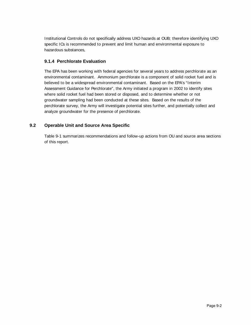
Page 9-2
Institutional Controls do not specifically address UXO hazards at OUB; therefore identifying UXO specific ICs is recommended to prevent and limit human and environmental exposure to hazardous substances, 9.1.4 Perchlorate Evaluation
The EPA has been working with federal agencies for several years to address perchlorate as an environmental contaminant. Ammonium perchlorate is a component of solid rocket fuel and is believed to be a widespread environmental contaminant. Based on the EPA’s “Interim Assessment Guidance for Perchlorate”, the Army initiated a program in 2002 to identify sites where solid rocket fuel had been stored or disposed, and to determine whether or not groundwater sampling had been conducted at these sites. Based on the results of the perchlorate survey, the Army will investigate potential sites further, and potentially collect and analyze groundwater for the presence of perchlorate.
9.2 Operable Unit and Source Area Specific
Table 9-1 summarizes recommendations and follow-up actions from OU and source area sections of this report.

Table 9-1 Recommendations and Follow-Up Actions
OU Source Area Recommendations/ Follow-Up Actions Party Responsible
Oversight Agency
Milestone Date
Affects Current Protectiveness
(Y/N)
Affects Future Protectiveness
(Y/N)
Continue to monitor groundwater contaminant reduction and perform groundwater modeling for a trend analysis.
U.S. Army EPA/ADEC 9/1/2003 N Potential
Continue analyzing groundwater samples for VOCs using methods that include the compounds not addressed in the ROD.
U.S. Army EPA/ADEC Ongoing N N
Include new wells, installed in 2002, in the long-term groundwater monitoring program.
U.S. Army EPA/ADEC Ongoing N Potential
B Poleline Road Disposal Area
Identify an IC specific to UXO buried in Areas A-1 and A-2. The IC will be included in the master plan and real estate documents, range maps, the Environmental GIS and the IC policy
U.S. Army EPA/ADEC 6/1/2003 Y Potential
C Eagle River Flats Evaluate recovery trends upon completion of remedial action. U.S. Army EPA/ADEC Ongoing N N

Page 10-1
10.0 PROTECTIVENESS STATEMENTS
Table 10-1 was developed based on the EPA Comprehensive Five-Year Review Guidance (June 2001) and summarizes OU and source area information from the preceding sections used to formulate protectiveness statements. Only OUB and OUC source areas are included in this section since all OUA and OUD source areas were either NFA or transferred.
10.1 OUB – Poleline Road Disposal Area
The remedy at OUB is expected to be protective of human health and the environment upon attainment of groundwater cleanup goals and in the interim ICs are preventing exposure to contaminated groundwater. The initial soil removal in 1993 and 1994 and subsequent treatability studies removed the most highly contaminated soil and debris. The remedy is expected to prevent and limit human and environmental exposure to hazardous substance once specific ICs are identified that address potential UXO hazards at this site. ICs for UXO in Areas A-1 and A-2 will be included in the master plan and real estate documents, range maps, the Environmental GIS, and the IC policy. Long-term protectiveness of the remedial action will be verified by obtaining groundwater samples to evaluate potential migration of the contaminant plume downgradient toward Eagle River and ensure contaminant levels in groundwater are decreasing through natural attenuation. Current monitoring data indicates that the plume is not migrating and that the remedy is functioning as required. Groundwater modeling at the OUB source area will help to confirm that RAOs will be achieved within the timeframe required by the ROD.
10.2 OUC – Eagle River Flats
The remedy at OUC is expected to be protective of human health and the environment upon completion. Exposure pathways that could result in unacceptable risks are being controlled with ICs. At the time ERF is closed, the human health risk from exposure to UXO will be addressed using the ARARs that are in place at the time.

Table 10-1 Protectiveness Statement Basis
OU Source Area Question A: Is the
remedy functioning as intended in the
decision documents?
Question B: Are the exposure assumptions, toxicity data, cleanup
levels, and remedial action objectives still valid?
Question C: Has any other information come to light
that could call into question the protectiveness of the
remedy?
Is the remedy protective in the
short term?
Is the remedy protective in the
long term?
B Poleline Road Disposal Area Yes Yes No Yes
Yes – However, ICs must be identified to
address UXO hazard.
C Eagle River Flats Yes Yes No Yes Yes

Page 11-1
11.0 NEXT REVIEW
The next Fort Richardson Five-Review will be conducted in 2008, five years from the date of this review. The next Five-Year Review will be the first full-term review for the OUC ROD.

Page 12-1
12.0 REFERENCES
This Five-Year Review focused on understanding commitments made in the RODs, the status of remedial actions undertaken in response to the RODs, and the continued protectiveness of the remedial actions specified in the RODs. The individual RODs were the starting points for the reviews of compliance with the RODs, remediation progress to date, and protectiveness. To the extent possible, the review made use of the most recent summary documents available, augmenting the information in those summaries with information from earlier reports and, in some cases, with knowledge or information not yet included in reports. Much of the review focused on post-ROD reports, though pre-ROD documents were also consulted as needed to understand the history of contamination and remediation at the source areas. Table 2-1, in Section 2 of this Report, is a listing of the RODs and related documents and post-ROD reports available at the time of this Five-Year Review.

APPENDIX A TWO-PARTY AGREEMENT SITES

Building 604 Building 798 Building 45005Building 700 Building 812 Building 45580Building 704 Building 908N Building 45590Building 730 Building 920 Building 45726Building 732 Building 972 Building 47431Building 750 Building 974 Building 47641Building 754 Building 979 Building 47811Building 756 Building 980 Building 55295Building 760 Building 1175 Building 55804Building 770 Building 8102 Building 59011Building 772 Building 27004 Building 59068Building 778 Building 35610 Black Spruce CampBuilding 782 Building 35750-UST Circle Road Drum SiteBuilding 784 Building 35752-UST UST Landfill Soil PilesBuilding 786 Building 36012 Building T139Building 789 Building 39225-NSS-UST
Building 702 Building 934 Building 968Building 712 Building 936 Building 975Building 740 Building 944 Building 987-USTBuilding 755 Building 946 Building 39600-NSS-USTBuilding 794 Building 950 Building 47022Building 908S Building 952 Building 47203Building 914 Building 955-UST/OUD Building 47662Building 926 Building 956 Roosevelt Road FTSBuilding 932 Building 962 Ruff Road FFTA
Building 762 Building 28008 Building 47220Building 986-Dry Well Building 35620 Building 59000Building 987-Spill Building 45070 Nike Site Summit (NSS)
Source areas in italics indicate a change of status since listed in the June 2000 OUD ROD.
1 Building 955-DDT contaminated soils was removed from the active POL source area list, as it is not a POL site but is currently inlcuded under OUE.
Appendix A: Two-Party Agreement Sites at Fort Richardson
1POL Source Areas Currently Active
POL Source Areas Closed with Institutional Controls Only
POL Source Areas Requiring No Further Action

APPENDIX B SITE INSPECTION CHECKLIST
AND PHOTOGRAPHIC LOG

Five-Year Review Site Inspection Checklist SITE INFORMATION Site name: Poleline Road Disposal Area Date of inspection: August 16, 2002 Site Location: Fort Richardson, Alaska Operable Unit OUB x Site Map Attached EPA Region: 10 EPA ID: AK6214522157 Agency, office, or company leading the five-year review: U.S. Army Weather/temperature: overcast, cool to mild temperatures Remedy Includes: (Check all that apply)
□ Landfill cover/containment X Monitored natural attenuation X Access controls □ Groundwater containment X Institutional controls □ Vertical barrier walls □ Groundwater pump and treatment □ Surface water collection and treatment □ Other _________________________ ON-SITE DOCUMENTS & RECORDS VERIFIED (Check all that apply) O&M manual □ Readily available □ Up to date X N/A As-built drawings □ Readily available □ Up to date X N/A Maintenance logs □ Readily available □ Up to date X N/A Remarks_________________________________________________________________________ Site-Specific Health and Safety Plan □ Readily available X Up to date □ N/A Contingency Plan/Emergency Response Plan □ Readily available X Up to date □ N/A Remarks_________________________________________________________________________ O&M and OSHA Training Records □ Readily available □ Up to date X N/A Permits and Service Agreements Air discharge permit □ Readily available X Up to date □ N/A Effluent discharge □ Readily available □ Up to date X N/A Groundwater Monitoring Records □ Readily available X Up to date □ N/A Daily Access/Security Logs □ Readily available □ Up to date X N/A

ACCESS AND INSTITUTIONAL CONTROLS (Show location on a site map) Fencing damaged X Gates secured □ N/A Signs and other security measures X In place □ N/A Institutional Controls (ICs) Implementation and enforcement Site conditions imply ICs not properly implemented □ Yes X No □ N/A Site conditions imply ICs not being fully enforced □ Yes X No □ N/A Adequacy X ICs are adequate □ ICs are inadequate □ N/A Vandalism/trespassing evident □ Yes X No □ N/A Land use changes on site □ Yes X No □ N/A GENERAL SITE CONDITIONS Roads □ Damaged X Adequate □ N/A GROUNDWATER/SURFACE WATER REMEDIES Groundwater Extraction Wells, Pumps, and Pipelines Pumps, Wellhead Plumbing, and Electrical □ Good condition X All required wells properly operating □ Needs Maintenance □ N/A Surface Water Collection Structures, Pumps, and Pipelines Collection Structures, Pumps, and Electrical □ Good condition □ Needs Maintenance X N/A Monitoring Data
□ Groundwater plume is effectively contained X Contaminant concentrations are generally declining
Monitored Natural Attenuation Monitoring Wells (natural attenuation remedy) X Properly secured/locked X Functioning X Routinely sampled X Good condition X All required wells located □ Needs Maintenance

OUB: Poleline Road, Interpretive Sign.
OUB: Poleline Road, Institutional Control Site Gate.
Fort Richardson Five-Year Review
February 2003

OUB: Poleline Road, Remediation Area Facing Southwest towards Areas 3 and 4, View of Wetlands in the Background.
OUB: Poleline Road, Remediation Area Facing North near Area 4.
Fort Richardson Five-Year Review
Approximate location of drywell wall protrusion.
February 2003

OUB: Poleline Road, View of Site, Facing West towards Areas 2, 3 and 4.
OUB: Poleline Road, Facing Northeast towards Area 1. Pallets of Steel Shot and Excess System Component Materials.
Fort Richardson Five-Year Review
February 2003
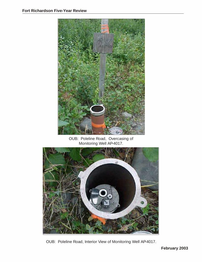
OUB: Poleline Road, Overcasing of Monitoring Well AP-4017.
OUB: Poleline Road, Interior View of Monitoring Well AP-4017.
Fort Richardson Five-Year Review
February 2003

OUB: Poleline Road, View of Site with Various Type of Well Completions.
OUB: Poleline Road, Two Downgradient Monitoring Wells.
Fort Richardson Five-Year Review
Approximate location of drywell wall protrusion.
February 2003

OUB: Former Six-Phase Soil Heating Remediation System Components.
Fort Richardson Five-Year Review
February 2003

Five-Year Review Site Inspection Checklist SITE INFORMATION Site name: Eagle River Flats Date of inspection: August 16, 2002 Site Location: Fort Richardson, Alaska Operable Unit OUC x Site Map Attached EPA Region: 10 EPA ID: AK6214522157 Agency, office, or company leading the five-year review: U.S. Army Weather/temperature: overcast, cool to mild temperatures Remedy Includes: (Check all that apply)
□ Landfill cover/containment □ Monitored natural attenuation X Access controls □ Groundwater containment X Institutional controls □ Vertical barrier walls □ Groundwater pump and treatment □ Surface water collection and treatment X Other Pond draining to allow contamination in sediments to oxidize and sublimate ON-SITE DOCUMENTS & RECORDS VERIFIED (Check all that apply) O&M manual □ Readily available X Up to date □ N/A As-built drawings □ Readily available X Up to date □ N/A Maintenance logs □ Readily available X Up to date □ N/A Remarks_________________________________________________________________________ Site-Specific Health and Safety Plan □ Readily available X Up to date □ N/A Contingency Plan/Emergency Response Plan □ Readily available X Up to date □ N/A Remarks_________________________________________________________________________ O&M and OSHA Training Records □ Readily available X Up to date □ N/A Permits and Service Agreements Air discharge permit □ Readily available X Up to date □ N/A Effluent discharge □ Readily available X Up to date □ N/A Groundwater Monitoring Records □ Readily available □Up to date X N/A Daily Access/Security Logs □ Readily available X Up to date □ N/A

ACCESS AND INSTITUTIONAL CONTROLS (Show location on a site map) Fencing damaged X Gates secured □ N/A Signs and other security measures X In place □ N/A Institutional Controls (ICs) Implementation and enforcement Site conditions imply ICs not properly implemented □ Yes X No □ N/A Site conditions imply ICs not being fully enforced □ Yes X No □ N/A Adequacy X ICs are adequate □ ICs are inadequate □ N/A Vandalism/trespassing evident □ Yes X No □ N/A Land use changes on site □ Yes X No □ N/A GENERAL SITE CONDITIONS Roads □ Damaged X Adequate □ N/A GROUNDWATER/SURFACE WATER REMEDIES Groundwater Extraction Wells, Pumps, and Pipelines Pumps, Wellhead Plumbing, and Electrical □ Good condition X All required pumps properly operating □ Needs Maintenance □ N/A Surface Water Collection Structures, Pumps, and Pipelines □ Applicable □ N/A Collection Structures, Pumps, and Electrical X Good condition □ Needs Maintenance □ N/A

OUC: Eagle River Flats, Northwest View of Eagle River Flats
OUC: Eagle River Flats, Northeast View of Eagle River Flats.
Fort Richardson Five-Year Review
February 2003
OUC: Eagle River Flats, Southeast View of Eagle River Flats.
OUC: Eagle River Flats, Targeting Debris with OB/OD Visible in Background.
Fort Richardson Five-Year Review
February 2003

OUC: Eagle River Flats, View of Drained Pond.
OUC: Eagle River Flats, View of Ponds.
Fort Richardson Five-Year Review
February 2003

OUC: Eagle River Flats, View of Large Water Pumping System.
OUC: Eagle River Flats, Two Water Pumps in Background.
Fort Richardson Five-Year Review
February 2003

OUC: Eagle River Flats, View of Generator Set, Spill Kit, Diesel AST’s and Large Water Pipe.
OUC: Eagle River Flats, Diesel AST’s and Generator Set for Water Pumps.
Fort Richardson Five-Year Review
February 2003

Fort Richardson Five-Year Review
OUC: Eagle River Flats, Generator Set Control Panel.
OUC: Eagle River Flats,Spill Kit Container.
February 2003

Fort Richardson Five-Year Review
OUC: Eagle River Flats, Pipeline to Transport Water from Ponds to Knik Arm.
OUC: Eagle River Flats, Typical Connection of Water Pipe. February 2003
APPENDIX C REPOSITORY ASSESSMENT
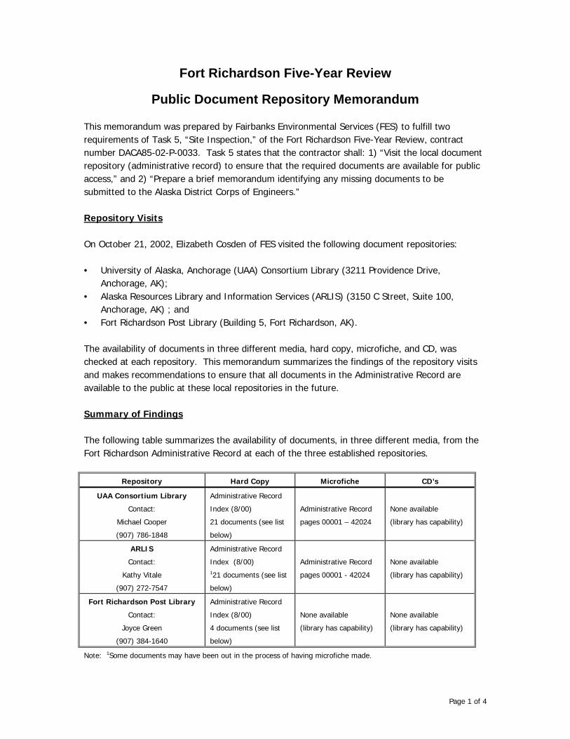
Page 1 of 4
Fort Richardson Five-Year Review
Public Document Repository Memorandum
This memorandum was prepared by Fairbanks Environmental Services (FES) to fulfill two requirements of Task 5, “Site Inspection,” of the Fort Richardson Five-Year Review, contract number DACA85-02-P-0033. Task 5 states that the contractor shall: 1) “Visit the local document repository (administrative record) to ensure that the required documents are available for public access,” and 2) “Prepare a brief memorandum identifying any missing documents to be submitted to the Alaska District Corps of Engineers.” Repository Visits On October 21, 2002, Elizabeth Cosden of FES visited the following document repositories: • University of Alaska, Anchorage (UAA) Consortium Library (3211 Providence Drive,
Anchorage, AK); • Alaska Resources Library and Information Services (ARLIS) (3150 C Street, Suite 100,
Anchorage, AK) ; and • Fort Richardson Post Library (Building 5, Fort Richardson, AK). The availability of documents in three different media, hard copy, microfiche, and CD, was checked at each repository. This memorandum summarizes the findings of the repository visits and makes recommendations to ensure that all documents in the Administrative Record are available to the public at these local repositories in the future. Summary of Findings The following table summarizes the availability of documents, in three different media, from the Fort Richardson Administrative Record at each of the three established repositories.
Repository Hard Copy Microfiche CD’s
UAA Consortium Library
Contact:
Michael Cooper
(907) 786-1848
Administrative Record
Index (8/00)
21 documents (see list
below)
Administrative Record
pages 00001 – 42024
None available
(library has capability)
ARLIS
Contact:
Kathy Vitale
(907) 272-7547
Administrative Record
Index (8/00) 121 documents (see list
below)
Administrative Record
pages 00001 - 42024
None available
(library has capability)
Fort Richardson Post Library
Contact:
Joyce Green
(907) 384-1640
Administrative Record
Index (8/00)
4 documents (see list
below)
None available
(library has capability)
None available
(library has capability)
Note: 1Some documents may have been out in the process of having microfiche made.

Page 2 of 4
Hard copies of the documents found during the repository visits are listed below:
Repository Document
UAA Consortium
Library, ARLIS, and
Post Library
OUA, B, C, and D Updates, Site Summary, Information Repository, Administrative Record, Fort Richardson, Alaska (E&E, June 2000)
UAA Consortium
Library and ARLIS
Record of Decision, Operable Units A and B, Fort Richardson, Alaska (August 1997) OUA, B, C and D Updates, Site Summary, Information Repository, Administrative Record, Fort Richardson, Alaska (August 1999) OUA, B, C, and D Updates, Site Summary, Information Repository, Administrative Record, Fort Richardson, Alaska (May 1998) Engineering Evaluation and Cost Analysis for the Treatment and Disposal of Chemical Agent Identification Sets Recovered from the Poleline Road Disposal Area (U.S. Army Program Manager for Chemical Demilitarization, May 1997) Public Health Assessment for Fort Richardson (U.S. Department of Health and Human Services, July 1996) U.S. Army, Alaska Newsletters: “The Proposed Plan for Remedial Action at OUD, Fort Richardson, Alaska” (April 1999) “Proposed Plan for Cleanup Action at OUC, Fort Richardson, Alaska” (February 1998) “Proposed Plan for Remedial Action at OUA and OUB, Fort Richardson, Alaska”
(January 1997)
UAA Consortium
Library
Public Health Assessment for Fort Richardson (U.S. Department of Health and Human Services, May 1996) Eagle River Corridor, Recreational Management Plan, Fort Richardson, Alaska (Horne, March 1996) Environmental Assessment, Recreational Management in the Eagle River Corridor, Fort Richardson, Alaska (Horne, February 1995)
ARLIS Final RI/FS, Operable Unit D, Fort Richardson, Alaska (Volume Ia - Remedial Investigation Report, Volume Ib - Remedial Investigation Report Appendices, Volume IIa - Risk Assessment, and Volume IIb - Postwide Risk Assessment) (ENSR, November 1998) Fort Richardson Restoration Advisory Board Public Information Meeting (March 19, 1997, 7:00p.m.) U.S. Army, Alaska Newsletter: “Alaska Army Lands Withdrawal,” Volume 3, Number 1. (October 2000)
The microfiche at the UAA Consortium Library and ARLIS are organized by operable unit and stored in a small metal box. Both microfiche collections are well organized, easily accessible, and complete. Each of the three repository locations is equipped with microfiche printers and computers with CD-ROM’s.

Page 3 of 4
Recommendations The following table summarizes recommendations for the maintenance and improvement of the Fort Richardson Administrative Record at each of the three local repositories. Following the table are general, optional recommendations pertaining to future methods of maintaining the documents in the Administrative Record. It is understood that decisions regarding the means of providing the Administrative Record will consider the public involvement goals for this site.
Repository Hard Copy Microfiche CD’s
UAA Consortium
Library
Provide Administrative Record
Index update with 2001 and 2002
documents.
Provide copies of key documents:
OUC and OUD ROD’s,
Remedial Investigation Reports
(OUD currently available),
Risk Assessments, and
Feasibility Studies.
Continue to provide
updated microfiche until
such time when a decision
is made to provide
documents exclusively on
CD.
Provide all documents
in the Administrative
Record on CD.
Provide the USARAK
Environmental
Administrative Record
Help Document.
ARLIS
Provide Administrative Record
Index update with 2001 and 2002
documents.
Provide copies of key documents:
OUC and OUD ROD’s,
Remedial Investigation Reports,
Risk Assessments, and
Feasibility Studies.
Continue to provide
updated microfiche until
such time when a decision
is made to provide
documents exclusively on
CD.
Provide all documents
in the Administrative
Record on CD.
Provide the USARAK
Environmental
Administrative Record
Help Document.
Fort Richardson
Post Library
Provide Administrative Record
Index update with 2001 and 2002
documents.
Provide copies of key documents:
OUA/B, OUC, and OUD ROD’s,
Remedial Investigation Reports,
Risk Assessments, and
Feasibility Studies.
Provide a complete set of
Administrative Record
documents on microfiche,
unless a decision is made
to provide documents
exclusively on CD.
Provide all documents
in the Administrative
Record on CD.
Provide the USARAK
Environmental
Administrative Record
Help Document.
It is recommended, pending approval by the EPA’s RPM for Fort Richardson, that the complete set of Administrative Record documents be provided solely on CD at each of the local public repositories. Making the Administrative Record documents available on CD’s would simplify maintenance of the Record, reduce the use of paper and shelf space, and offer the public a more user-friendly media than microfiche. Each of the three public repositories currently has computers with CD ROM’s available for public use.

Page 4 of 4
In addition, key documents for each of the operable units, as listed in the above table, could be provided in hard copies for quick reference. Another option for facilitating public access to the Administrative Record would be to post documents to the Fort Richardson internet home page. This would allow access to the documents from any computer with internet access, including the publicly available computers at the three local repositories.

APPENDIX D INTERVIEW RECORD FORMS

Interview forms included in this Appendix were requested from the following personnel during this Five-Year Review.
Personnel Telephone Number Email Address OU ARMY
1 Cristal Fosbrook (384-3044) [email protected] All
2 Mark Prieksat (384-3042) [email protected] All
3 Bill Gossweiler (384-3017) william.gossweiler@richardson-
emh2.army.mil All
CORPS OF ENGINEERS
4 Howard Blood (USACE, Seattle District)
(206-764-3642) [email protected]
6 Marilyn Plitnik (753-2881) [email protected]
7 Joann Walls (753-5608) [email protected] OUC
8 Todd Fickel (753-2764) [email protected] OUE
9 Ken Andraschko (753-564) [email protected] OUB
11 Scott Kendall (753-5661) [email protected] OUD
12 Ted Bales (753-5666) [email protected] OUA
13 Andrea Elconin (753-5680) [email protected]
14 Mark Wallace (753-5660) [email protected]
EPA
15 Bill Adams (206 553-2806) [email protected] All
16 Howard Orlean (206 553-2851) [email protected] All
17 Matt Wilkening (Boise Office of EPA)
(208 378-5760) [email protected] All
18 DR. Bruce Duncan (206 553-8086) [email protected] All
ADEC
19 Louis Howard (269-7552) [email protected] All
20 Jennifer Roberts (269-7550) [email protected] All
OTHER
21 John Hopkins RAB Community Co-Chair
(694-1603) None All
22 Charlie Collins CRREL (353-5180) [email protected] OUC
23 Jerry Williams ENSR (561-5700) [email protected] OUD

Page 1
FORT RICHARDSON FIVE-YEAR REVIEW INTERVIEW QUESTIONNAIRE
INTERVIEW RECORD
Name: Mark Prieksat
Title: Remedial Project Manager, Ft. Richardson Organization: USARAK
Telephone No.: (907) 384-3042 E-Mail Address: [email protected]
Street Address: 730 Quartermaster Road City, State, Zip: Fort Richardson, AK 99505
Interview Date: 8/30/02 Site Name: Fort Richardson
Interview Type: Telephone Visit Email The following general questions were adapted from the EPA’s Comprehensive Five-Year Review Guidance.
INTERVIEW QUESTIONS 1. What is your overall impression of the work conducted at the site? (general sentiment)
OUB-Treatability Study for SPSH worked exceptionally well in treating contaminated soil and groundwater at the site.
OUC-Novel solution to the problem. Is effective and low tech, but not always low cost.
OUE-Work is progressing well and should provide enough data to effectively assess risk at the sites.
2. From your perspective, what effect have remedial operations at the site had on the surrounding community? Because the sites at Fort Rich are far removed from the surrounding community, there is very little impact. In general the surrounding community is not even aware that these sites exist. None of these sites pose an unacceptable level of risk to the community or the local Ft Rich population. I do feel that these sites need to be cleaned up and that by doing so we are protecting valuable land and water resources.
3. Are you aware of concerns from the local community regarding the site, operation and administration, implementation, or overall protectiveness of the ROD remedies? I do know that there are certain elements within the community that disagree with the remedial work at OUC and in fact have filed a lawsuit regarding the cleanup. However, there will always be that element that are anti military and nothing the military does to clean up these sites will ever be good enough. In general, the community is very supportive of the military and the efforts to prevent contamination and clean areas that are contaminated. Most of the RAB members feel that we have spent too much money on these sites.

Page 2
INTERVIEW QUESTIONS (continued) 4. Are you aware of any events, incidents, or activities at the site such as vandalism,
trespassing, or emergency responses from local authorities? To my knowledge there have not been any incidents at the sites. We have had incidents of theft of dataloggers and batteries from the flow systems, but those were not located at the sites.
5. Since signing the RODs for the various OUs, are you aware of any changes in land uses, access, or other site conditions that you feel may impact the protectiveness of the site? Only for the better. We have beefed up the IC policy and the Excavation Clearance Request procedure. In general the land use has not been changed for any areas on post.
6. Were any problems or difficulties encountered after the initiation of remedial action that impacted construction progress and implementability? The only thing I can think of is the difficulty we have had in procuring a helicopter to do the bird capture and mortality studies at OUC. We missed performing the mortalitiy study in 2000 because we couldn’t contract to get a helicopter. This year we were late getting into the field and didn’t collect as many birds as we expected because of the same issue.
7. Is there a regular on-site inspection and operation, maintenance and monitoring (OMM) presence at the OU? What is the frequency of O&M site inspections and activities? OUC-There is a constant presence at the site during active remedial operations.

Page 3
INTERVIEW QUESTIONS (continued)
8. Have there been unexpected O&M difficulties or costs at the site since start-up or in the last five years? Costs have tracked fairly well with the FS and ROD for OUA and OUC. We haven’t finished with the cost analysis for OUB, but expect it to track fairly well with the FS costs.
9. Have there been any significant changes in the O&M requirements, maintenance schedules, or sampling routines since start-up or in the last five years? If so, do they affect the protectiveness or effectiveness of the remedy? Nothing of significance. We have changed some of the sampling and routine at OUC as the RA progressed, but those were lessons learned types of things and simple modifications that didn’t affect the overall.
10. Have there been opportunities to optimize the operation, maintenance, or sampling efforts? Please describe changes, cost savings, and/or improved efficiency. See item 9, but you would need to ask CRREL on the specifics for OUC.
11. Do you have any comments, suggestions, or recommendations regarding the site’s management or operation? In general it would be nice to simplify the process or make it more flexible. The rigid framework under CERCLA does not always lend itself towards the most efficient and cost effective process for site cleanup.


Page 1
FORT RICHARDSON FIVE-YEAR REVIEW INTERVIEW QUESTIONNAIRE
INTERVIEW RECORD
Name: Howard Orlean
Title: Corrective Action Technical Coordinator Organization EPA/Region 10
Telephone No.: (206)553-2851 E-Mail Address: [email protected]
Street Address: 1200 6th Ave. M/S: WCM-121 City, State, Zip: Seattle, WA 98101
Interview Date: 08/07/02 Site Name: Fort Richardson
Interview Type: Telephone Visit x Email The following general questions were adapted from the EPA’s Comprehensive Five-Year Review Guidance.
INTERVIEW QUESTIONS 1. What is your overall impression of the work conducted at the site? (general sentiment)
Worked on site from 1995-1999. Work conducted during this time was very well planned and effective.
2. From your perspective, what effect have remedial operations at the site had on the surrounding community?
I have not been in touch with the community since 1999.
3. Are you aware of concerns from the local community regarding the site, operation and administration, implementation, or overall protectiveness of the ROD remedies? Community generally supported remediation of white phosphorus contamination at Eagle River Flats (Operable Unit C), but had concerns about continued UXO contamination.

Page 2
INTERVIEW QUESTIONS (continued)
4. Are you aware of any events, incidents, or activities at the site such as vandalism, trespassing, or emergency responses from local authorities?
No
5. Since signing the RODs for the various OUs, are you aware of any changes in land uses, access, or other site conditions that you feel may impact the protectiveness of the site? Not aware of any changes.
6. Were any problems or difficulties encountered after the initiation of remedial action that impacted construction progress and implementability?
UXO has always been a problem and poses unique difficulties in implementing remedial action at OU C.
7. Is there a regular on-site inspection and operation, maintenance and monitoring (OMM) presence at the OU? What is the frequency of O&M site inspections and activities?
No longer involved with OU so I’m not familiar with current O&M activities.

Page 3
INTERVIEW QUESTIONS (continued) 8. Have there been unexpected O&M difficulties or costs at the site since start-up or in the last
five years?
Don’t know
9. Have there been any significant changes in the O&M requirements, maintenance schedules, or sampling routines since start-up or in the last five years? If so, do they affect the protectiveness or effectiveness of the remedy? Don’t know
10. Have there been opportunities to optimize the operation, maintenance, or sampling efforts? Please describe changes, cost savings, and/or improved efficiency. Don’t know
11. Do you have any comments, suggestions, or recommendations regarding the site’s management or operation?


Page 1
FORT RICHARDSON FIVE-YEAR REVIEW INTERVIEW QUESTIONNAIRE
INTERVIEW RECORD
Name: Kenneth Andraschko
Title: Environmental Engineer Organization U.S. Army Corps of Engineers
Telephone No.: 753-5647 E-Mail Address: [email protected]
Street Address: PO Box 6898 City, State, Zip: Elmendorf AFB, AK 99506
Interview Date: July 26, 2002 Site Name: Poleline Road Disposal Area, OUB
Interview Type: Telephone Visit X Email The following general questions were adapted from the EPA’s Comprehensive Five-Year Review Guidance.
INTERVIEW QUESTIONS 1. What is your overall impression of the work conducted at the site? (general sentiment)
Very good. Excellent results in a relatively short amount of time.
2. From your perspective, what effect have remedial operations at the site had on the surrounding community? Any potential that did exist for migration of the contamination has been greatly reduced.
3. Are you aware of concerns from the local community regarding the site, operation and administration, implementation, or overall protectiveness of the ROD remedies? I am not aware of any.

Page 2
INTERVIEW QUESTIONS (continued) 4. Are you aware of any events, incidents, or activities at the site such as vandalism,
trespassing, or emergency responses from local authorities? I am not aware of any.
5. Since signing the RODs for the various OUs, are you aware of any changes in land uses, access, or other site conditions that you feel may impact the protectiveness of the site? I am not aware of any.
6. Were any problems or difficulties encountered after the initiation of remedial action that impacted construction progress and implementability? I am not aware of any.
7. Is there a regular on-site inspection and operation, maintenance and monitoring (OMM) presence at the OU? What is the frequency of O&M site inspections and activities? Semi-annual long term monitoring has been conducted at the site.

Page 3
INTERVIEW QUESTIONS (continued)
8. Have there been unexpected O&M difficulties or costs at the site since start-up or in the last five years? None that I am aware of.
9. Have there been any significant changes in the O&M requirements, maintenance schedules, or sampling routines since start-up or in the last five years? If so, do they affect the protectiveness or effectiveness of the remedy? I am not aware of any.
10. Have there been opportunities to optimize the operation, maintenance, or sampling efforts? Please describe changes, cost savings, and/or improved efficiency. I am not aware of any.
11. Do you have any comments, suggestions, or recommendations regarding the site’s management or operation? Continue long term monitoring.

Page 1
FORT RICHARDSON FIVE-YEAR REVIEW INTERVIEW QUESTIONNAIRE
INTERVIEW RECORD
Name: Charles M. Collins
Title: Research Physical Scientist Organization USA ERDC CRREL
Telephone No.: (907) 353-5180 E-Mail Address: [email protected]
Street Address: PO Box 35170 City, State, Zip: Fort Wainwright AK 99703
Interview Date: Site Name:OU-C Eagle River Flats
Interview Type: Telephone Visit x Email The following general questions were adapted from the EPA’s Comprehensive Five-Year Review Guidance.
INTERVIEW QUESTIONS 1. What is your overall impression of the work conducted at the site? (general sentiment)
The site investigation and remediation work in Eagle River Flats has set a national example for innovative and cost effective efforts. This site was the first site in the country identified to be contaminated with white phosphorus in a wetland setting. Sampling, analyise, and remediation procedures all had to be developed in order to quantify the contaminant problem and devise a cost effective remedial solution. The pond pumping remediaton solution chosen was the most cost effective alternative as well as the least environmentally damaging of the solutions looked at.
2. From your perspective, what effect have remedial operations at the site had on the surrounding community? There has been minimal effect on the surrounding community.
3. Are you aware of concerns from the local community regarding the site, operation and administration, implementation, or overall protectiveness of the ROD remedies? The only concerns have been about potential contamination that is not addressed by the ROD

Page 2
INTERVIEW QUESTIONS (continued) 4. Are you aware of any events, incidents, or activities at the site such as vandalism,
trespassing, or emergency responses from local authorities? The only emergency response was a wildfire last year at the edge of the OB/OD pad that was ignited by demo activities associated with the remediation. The Fort Richardson Fire Department responded. Fire was contained to approximately 1 acre of grass and woods at edge of pad.
5. Since signing the RODs for the various OUs, are you aware of any changes in land uses, access, or other site conditions that you feel may impact the protectiveness of the site? No
6. Were any problems or difficulties encountered after the initiation of remedial action that impacted construction progress and implementability? No. Remediation is proceeding well.
7. Is there a regular on-site inspection and operation, maintenance and monitoring (OMM) presence at the OU? What is the frequency of O&M site inspections and activities? Yes. Pond pumping equipment is installed each spring. Equipment is visited and inspected by the O&M contractor three times a week throughout the summer. Dataloggers are continuously monitoring soil drying conditions. Remote video camera equipment post images of the remediation project to the Web five times a day.

Page 3
INTERVIEW QUESTIONS (continued)
8. Have there been unexpected O&M difficulties or costs at the site since start-up or in the last five years? No
9. Have there been any significant changes in the O&M requirements, maintenance schedules, or sampling routines since start-up or in the last five years? If so, do they affect the protectiveness or effectiveness of the remedy? No
10. Have there been opportunities to optimize the operation, maintenance, or sampling efforts? Please describe changes, cost savings, and/or improved efficiency. Yes. Use of small tide gates to keep moderate high tides out of ponds has greatly increased the effectiveness of the pumping operations and reduced fuel costs. Improved scheduling and use of helicopters to lift equipment in to the site during the spring and remove equipment in the fall has resulted in reduced helicopter usage and a savings of over $50k per year.
11. Do you have any comments, suggestions, or recommendations regarding the site’s management or operation? Remediation in Eagle River Flats has been a great success story to date. It is garnered national attention because of the unique problems and the innovative remediation procedures that are underway.

Page 1
FORT RICHARDSON FIVE-YEAR REVIEW INTERVIEW QUESTIONNAIRE
INTERVIEW RECORD
Name: JoAnn Walls
Title: Supervisor, Environmental Engineer Organization: Corps of Engineers, Alaska District
Telephone No.: 907-753-5608 E-Mail Address: [email protected]
Street Address: 2204 3rd St City, State, Zip: Elmendorf, AFB, AK 99506-1538
Interview Date: 27 August 2002 Site Name: OUC, Eagle River Flats
Interview Type: Telephone Visit x Email The following general questions were adapted from the EPA’s Comprehensive Five-Year Review Guidance.
INTERVIEW QUESTIONS 1. What is your overall impression of the work conducted at the site? (general sentiment)
Great progress has been made in remediating the white phosphorus contamination in the ponds on Eagle River Flats.
2. From your perspective, what effect have remedial operations at the site had on the surrounding community? I do not believe it has had a big impact. The work includes some explosive blasting work that may be heard by the community. Notices are published in the newspaper prior to the blasts to notify the public.
3. Are you aware of concerns from the local community regarding the site, operation and administration, implementation, or overall protectiveness of the ROD remedies?

Page 2
INTERVIEW QUESTIONS (continued) 4. Are you aware of any events, incidents, or activities at the site such as vandalism,
trespassing, or emergency responses from local authorities? I have heard 2nd or 3rd hand of finding indications of hunters being in the area
5. Since signing the RODs for the various OUs, are you aware of any changes in land uses, access, or other site conditions that you feel may impact the protectiveness of the site? I believe that the access to the site has become even more restrictive since the ROD was signed. Additional signs were added to the water side entry.
6. Were any problems or difficulties encountered after the initiation of remedial action that impacted construction progress and implementability? We have had some difficulties in procuring helicopter services at times. In most instances we were able to find another source for the helicopter. However, in 2000, we were unable to procure a helicopter for the bird mortality study due to high incidence of fires during that time. In 2002 a similar problem occurred and the work was performed approximately 10 days later than planned resulting in less ducks being captured.
7. Is there a regular on-site inspection and operation, maintenance and monitoring (OMM) presence at the OU? What is the frequency of O&M site inspections and activities? Yes, a contractor inspects and performs maintenance as needed 3 times per week while the equipment is in use at Eagle River Flats (May – Sept). This maintenance includes checking fuel levels, observing for leaks, adding oil if needed and adding grease to the grease reservoirs on the pumps. During the off-season, the contractor inspects and performs maintenance one time per month. This includes oil and oil filter change, fuel, air, and water filters changed, cooling systems drained, checked and new antifreeze added. The generators are started up each month during the off-season in order to keep the seals lubricated. In the winter of 2000-2001, a thorough inspection and servicing of all generators were performed. Three of the generators had the rear main crankshaft seal replaced.
Page 3
INTERVIEW QUESTIONS (continued)
8. Have there been unexpected O&M difficulties or costs at the site since start-up or in the last five years? At the end of the 2nd year, three of the systems required some additional maintenance. Since then, the contractor has checked on the equipment monthly during the winter to avoid similar problems.
9. Have there been any significant changes in the O&M requirements, maintenance schedules, or sampling routines since start-up or in the last five years? If so, do they affect the protectiveness or effectiveness of the remedy? No other than described above
10. Have there been opportunities to optimize the operation, maintenance, or sampling efforts? Please describe changes, cost savings, and/or improved efficiency. Helicopter operations have become more efficient each year. Rigging lines and straps were purchased to allow piping to be bundled and sling loaded to and from the site.
See also info in IRAR and CRREL’s Summary Report.
11. Do you have any comments, suggestions, or recommendations regarding the site’s management or operation?

Page 1
FORT RICHARDSON FIVE-YEAR REVIEW INTERVIEW QUESTIONNAIRE
INTERVIEW RECORD
Name: Kevin Gardner
Title: Organization: USARAK DPW Strategic Planning
Telephone No.: 907-384-3331 E-Mail Address: [email protected]
Street Address: 730 Quartermaster Rd City, State, Zip: Fort Richardson, AK 99505
Interview Date: 3 Sep 02 Site Name: Fort Richardson
Interview Type: Telephone Visit x Email The following general questions were adapted from the EPA’s Comprehensive Five-Year Review Guidance.
INTERVIEW QUESTIONS 1. What is your overall impression of the work conducted at the site? (general sentiment)
Well done. Source Areas/Operable Units were somewhat diverse in nature and were investigated expeditiously. Data gaps posed the biggest challenge and in retrospect could have been pursued more aggressively through interviews with Post personnel.
2. From your perspective, what effect have remedial operations at the site had on the surrounding community? Very little. While the work at Eagle River Flats receives the most publicity, to my knowledge there are no human health risks that threaten the surrounding community, so the public generally has little to no interest.
3. Are you aware of concerns from the local community regarding the site, operation and administration, implementation, or overall protectiveness of the ROD remedies? Yes. Alaska Community Action on Toxics remains concerned that the Army is not being protective of human health or the environment at Eagle River Flats.

Page 2
INTERVIEW QUESTIONS (continued)
4. Are you aware of any events, incidents, or activities at the site such as vandalism, trespassing, or emergency responses from local authorities? The only vandalism I am aware of occurred several years ago with several of the main post groundwater monitoring wells. Batteries providing power to in-hole data loggers were stolen.
5. Since signing the RODs for the various OUs, are you aware of any changes in land uses, access, or other site conditions that you feel may impact the protectiveness of the site? No.
6. Were any problems or difficulties encountered after the initiation of remedial action that impacted construction progress and implementability? Additional information regarding disposal activities at one of the OU D sites resulted in a delay to the completing the OU D ROD and resulted in the establishment of a fifth OU for Fort Richardson.
7. Is there a regular on-site inspection and operation, maintenance and monitoring (OMM) presence at the OU? What is the frequency of O&M site inspections and activities? I am generally aware of the on-going work at OU C, less so with the other Operable Units. OU C has recurring OMM – cleanup operations each summer since ROD signature; OU B has long term ground water monitoring.

Page 3
INTERVIEW QUESTIONS (continued)
8. Have there been unexpected O&M difficulties or costs at the site since start-up or in the last five years? Not that I am aware of.
9. Have there been any significant changes in the O&M requirements, maintenance schedules, or sampling routines since start-up or in the last five years? If so, do they affect the protectiveness or effectiveness of the remedy? Not that I am aware of. To the best of my knowledge, all remedies remain protective and effective.
10. Have there been opportunities to optimize the operation, maintenance, or sampling efforts? Please describe changes, cost savings, and/or improved efficiency. Don’t know. I’ve been away from the day-to-day management of the program since late 1999.
11. Do you have any comments, suggestions, or recommendations regarding the site’s management or operation? No.

Page 1
FORT RICHARDSON FIVE-YEAR REVIEW INTERVIEW QUESTIONNAIRE
INTERVIEW RECORD
Name: Jerry Williams
Title: Sr. Program Manager Organization ENSR
Telephone No.: 561-700 E-Mail Address: [email protected]
Street Address: 4600 Business Park Blvd. #22 City, State, Zip: Anchorage, AK 99503
Interview Date: 7-16-02 Site Name: OUE
Interview Type: Telephone Visit xEmail The following general questions were adapted from the EPA’s Comprehensive Five-Year Review Guidance.
INTERVIEW QUESTIONS 1. What is your overall impression of the work conducted at the site? (general sentiment)
? Should be on-going now.
2. From your perspective, what effect have remedial operations at the site had on the surrounding community?
none
3. Are you aware of concerns from the local community regarding the site, operation and administration, implementation, or overall protectiveness of the ROD remedies?
none

Page 2
INTERVIEW QUESTIONS (continued)
4. Are you aware of any events, incidents, or activities at the site such as vandalism, trespassing, or emergency responses from local authorities?
no
5. Since signing the RODs for the various OUs, are you aware of any changes in land uses, access, or other site conditions that you feel may impact the protectiveness of the site?
No ROD yet for OUE.
6. Were any problems or difficulties encountered after the initiation of remedial action that impacted construction progress and implementability?
?
7. Is there a regular on-site inspection and operation, maintenance and monitoring (OMM) presence at the OU? What is the frequency of O&M site inspections and activities?
?

Page 3
INTERVIEW QUESTIONS (continued)
8. Have there been unexpected O&M difficulties or costs at the site since start-up or in the last five years?
No remediation started at this time.
9. Have there been any significant changes in the O&M requirements, maintenance schedules, or sampling routines since start-up or in the last five years? If so, do they affect the protectiveness or effectiveness of the remedy?
NA
10. Have there been opportunities to optimize the operation, maintenance, or sampling efforts? Please describe changes, cost savings, and/or improved efficiency.
NA
11. Do you have any comments, suggestions, or recommendations regarding the site’s management or operation?
no

APPENDIX E FIVE-YEAR REVIEW RANGE ANALYSIS

OB\OD Delayed RCRA Closure Evaluation Fort Richardson Five-year Review The Record of Decision for Operable Unit C, p. 9-16, requires US Army Alaska (USARAK) to evaluate no less often than during the CERCLA Five-Year Review whether delay of closure of the OB/OD Pad is still viable. The ROD stipulates three conditions under which delay of closure is no longer viable:
• The Eagle River Flats impact area (ERF) is no longer operating;
• The post (Ft. Richardson, Alaska) is being closed;
• Any other reason. As of the time of the current Five-Year Review (February, 2003), Ft. Richardson is an operational installation quartering a number of active military units including the 501st PIR, the 4/11th Field Artillery, among others. These active military units continue to use ERF as an impact area for artillery, mortar, and aircraft (fixed-wing and rotary) training. Institutional controls regarding the type of munitions used at the site, and regarding the time of year the range may be used are still in force. USARAK has no other information or reason to suggest that delayed closure of the OB/OD Pad is not protective or viable.
Copyright © 2022 FDOKUMEN