Roadmap for Integrated Water Resources Management in the ...
53
BAPPENAS 1 Road map Information System - Technical Notes This report is an active document, progressively updated and revised as necessary, particularly following any changes in project or program implementation arrangements. Ministry of Public Works State Ministry of Environment Ministry of Health Ministry of Agriculture Ministry of Forestry Project Number: 37049 Multitranche Financing Facility (MFF) Number 0027 July 2010 Roadmap for Integrated Water Resources Management in the Citarum River Basin Bridging Sub Component
-
Upload
khangminh22 -
Category
Documents
-
view
1 -
download
0
Transcript of Roadmap for Integrated Water Resources Management in the ...
BAPPENAS
1
Road map Information System - Technical Notes
This report is an active document, progressively updated and revised as necessary, particularly following any changes in project or program implementation arrangements.
Ministry of Public Works
State Ministry of Environment Ministry of Health Ministry of Agriculture Ministry of Forestry Project Number: 37049 Multitranche Financing Facility (MFF) Number 0027 July 2010
Roadmap for Integrated Water Resources Management in the Citarum River Basin
Bridging Sub Component
Document Revision No Revision Date Page
RPT_RMP_CST_ RIS 2 09/07/10 2
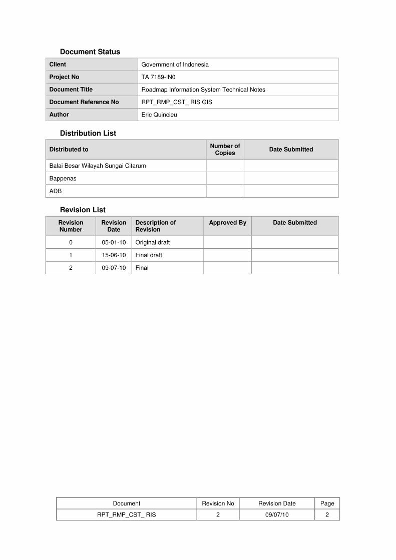
Document Status
Client Government of Indonesia
Project No TA 7189-IN0
Document Title Roadmap Information System Technical Notes
Document Reference No RPT_RMP_CST_ RIS GIS
Author Eric Quincieu
Distribution List
Distributed to Number of
Copies Date Submitted
Balai Besar Wilayah Sungai Citarum
Bappenas
ADB
Revision List
Revision Number
Revision Date
Description of Revision
Approved By Date Submitted
0 05-01-10 Original draft
1 15-06-10 Final draft
2 09-07-10 Final

Document Revision No Revision Date Page
RPT_RMP_CST_ RIS 2 09/07/10 3
ABBREVIATIONS
ADB – Asian Development Bank
BAPPENAS – National Planning and Development Agency
BBWSC – Balai Besar Wilayah Sungai Citarum
BPS – Badan Pusat Statistik
CAD – computer-aided design
CRB – Citarum River basin
CSO – civil society organization
CSR – corporate social responsibility
DB – data base
DEM – digital elevation model
DGWR – Directorate General of Water Resources
DWRI Directorate of Water Resources and Irrigation
DWRM Directorate of Water Resources Management
EA – executing agency
GIS – geographic information system
GOI – Governement of Indonesia
IA – implementing agency
IDR – Indonesian rupiah
IP – investment program
ICWRMIP – integrated Citarum water resources management investment program
IWRM – integrated water resources management
KML – keyhole markup language
MIS – management information system
MOA – Ministry of Agriculture
MOE – Ministry of Environment
MOF – Ministry of Finance
MOFr – Ministry of Forestry
MOH – Ministry of Health
MPW – Ministry of Public Works
NGO – non government organization
PCMU – program coordination and management unit
PHP – hypertext preprocessor
PIU – project implementation unit
PJT 2 – Perum Jasa Tirta 2 (CRB operator)
PPTA – project preparation technical assistance
RBO – river basin organization
RIS – roadmap information system
RCMU – road map coordination and management unit
RPJM –
SQL – structured query language
TA – technical assistance
UTM – universal transverse Mercator
WGS – world geodetic system
Document Revision No Revision Date Page
RPT_RMP_CST_ RIS 2 09/07/10 4
(i)
TABLE OF CONTENTS A. BACKGROUND 5 B. DATA COLLECTION AND PROCESSING 5 1. COLLECTION AND PROCESSING OF CITARUM ENVIRONMENTAL ACTIVITIES TABULAR
DATA 5 2. COLLECTION AND PROCESSING OF COMPREHENSIVE SPATIAL CITARUM DATA 6 C. CONCEPT 6 1. SYSTEM STRUCTURE 6 2. SPATIAL DATABASE 7 3. ONLINE MAPPING INTERFACE 11 4. ACTIVITY TABULAR ONLINE DATABASE 12 D. FUTURE DEVELOPMENTS 14 E. UPDATING AND MAINTENANCE 14 F. MANAGEMENT OF THE RIS 15 G. PROGRAMMING AND SOURCE CODE 15
LIST OF TABLES
Table 1: Environmental activities online database fields ................................... 12
LIST OF FIGURES
Figure 1: RIS Structure ........................................................................................... 7 Figure 2: GIS interface ............................................................................................ 8 Figure 3: Screenshot of the project 1 layer ........................................................... 9 Figure 4: Screenshot of the metadata interface .................................................. 10 Figure 5: Example of thematic map ..................................................................... 11 Figure 6: Online mapping interface ..................................................................... 12 Figure 7: Screenshot of the proposed tabular activity database interface ....... 13 Figure 8: Screenshot of the proposed query facility .......................................... 14
LIST OF ANNEXES
Annex 1: Status of collected project tabular data Annex 2: Project categorization rules Annex 3: Collected GIS layers inventory Annex 4: RIS layers Annex 5: Thematic maps list Annex 6: PODES 2008 survey indicators Annex 7: Standardized legend Annex 8: Map Server Documentation Annex 9: References Attached DVD: Online tabular database source code, report and RIS data (layers, metadata, project files, thematic maps, shp files)
5
A. Background
Information sharing is a basic principle of IWRM planning. The Roadmap and the Integrated Citarum Water Resource management Investment Program (ICWRMIP) are no exception. Data, Information and Decision Support is a “foundation” key area of the road map, as data is fundamental to all aspects of water resource management. To ensure effective planning and monitoring of the roadmap activities, it has been proposed to develop the Road map Information System (RIS) which is linked to the Citarum online platform as presented in this report. Having an effective information system that holds spatial data on the water, land and other natural resources of the Citarum River Basin, as well as the man-made infrastructure and information specific to the various component projects, is an essential tool for program management and coordination. The system is based on geographic information system (GIS) technology that allows capturing, storing, analyzing, managing, and presenting data that refers to or is linked to location. It serves the following purposes:
- To have a comprehensive database on all roadmap component projects, including geographical extent, key project sites, and so on, in a form that is accessible to all that need it, to facilitate effective and efficient implementation of the roadmap activities;
- To have basic information on water, land and associated natural resources available to the stakeholders;
- To have an inventory of relevant water-related physical infrastructure and its spatial location;
- To linked the roadmap development to spatial planning; - To have a means to share the above information with the stakeholders;
B. Data Collection and Processing
An assessment of the GIS capabilities and resources from the various agencies and stakeholders has been carried out through a questionnaire in 2008 in order to:
- Evaluate data availability - Identify used software - Identify used format and projection - Evaluate technical staff capabilities - Identify gaps and training needs
The development of the RIS has taken into account existing capabilities and resources in order to ensure long-term viability of the system and its maintenance.
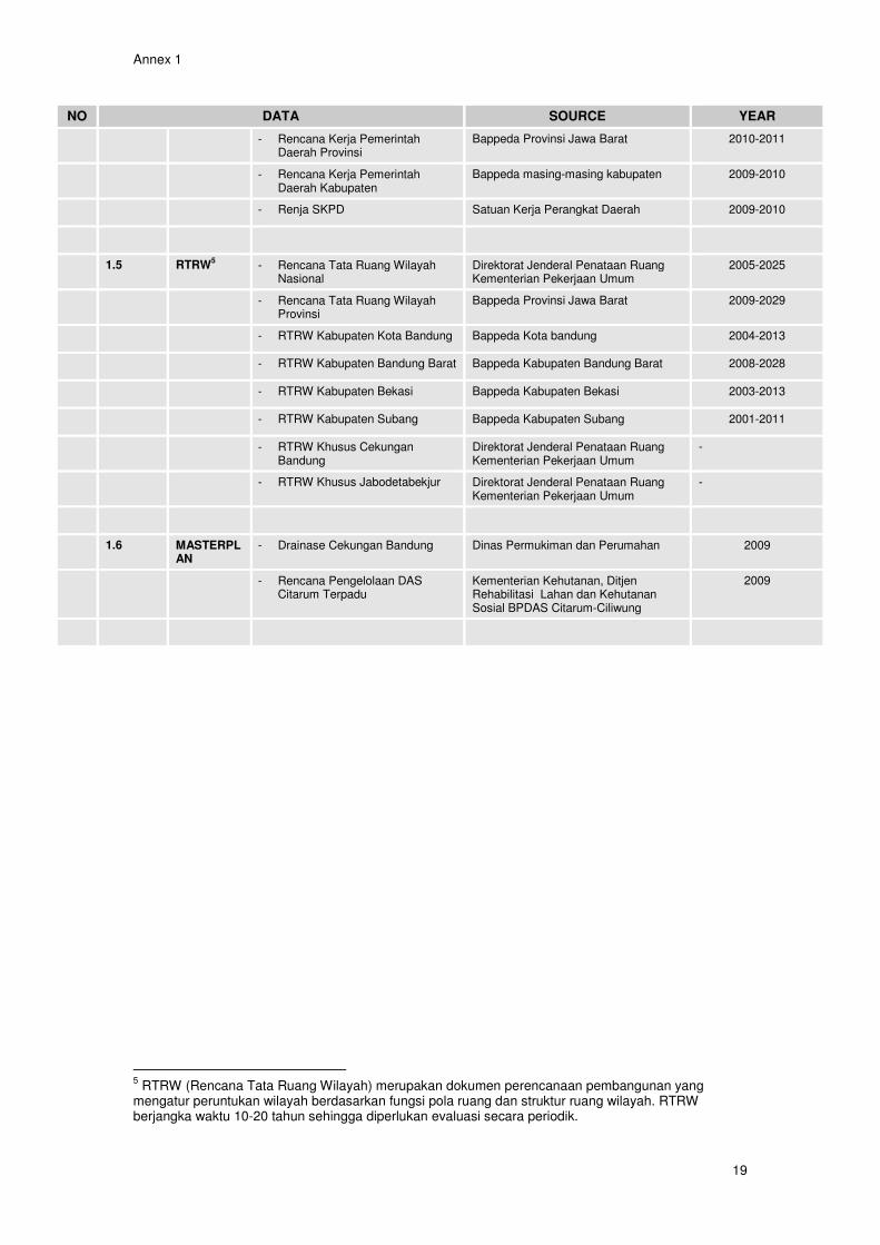
1. Collection and processing of Citarum environmental activities tabular data
Data collection is a continuous activity, which includes all available planning information related to environmental activities in the Citarum river basin, as listed below:
- RPJM (governmental planning agencies 5 years plans) at national, province and district levels
- “Rencana strategi” (governmental sectoral agencies 5 years plans) at national, province and district levels
- CSO/NGOs environmental related activities - CSR environmental related activities
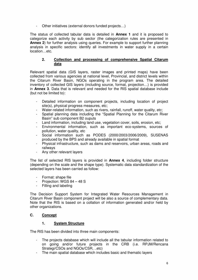
6
- Other initiatives (external donors funded projects…) The status of collected tabular data is detailed in Annex 1 and it is proposed to categorize each activity by sub sector (the categorization rules are presented in Annex 2) for further analysis using queries. For example to support further planning analysis in specific sectors: identify all investments in water supply in a certain location…etc.
2. Collection and processing of comprehensive Spatial Citarum data
Relevant spatial data (GIS layers, raster images and printed maps) have been collected from various agencies at national level, Provincial, and district levels within the Citarum River Basin, NGOs operating in the program area. The detailed inventory of collected GIS layers (including source, format, projection…) is provided in Annex 3. Data that is relevant and needed for the RIS spatial database include (but not be limited to):
- Detailed information on component projects, including location of project site(s), physical progress measures, etc;
- Water-related information, such as rivers, rainfall, runoff, water quality, etc; - Spatial planning data including the “Spatial Planning for the Citarum River
Basin” sub component B2 ouputs - Land information, including land use, vegetation cover, soils, erosion, etc; - Environmental information, such as important eco-systems, sources of
pollution, water quality, etc - Social information such as PODES (2000/2003/2006/2009), SUSENAS
produced by the BPS and already available in spatial format - Physical infrastructure, such as dams and reservoirs, urban areas, roads and
railways - Any other relevant layers
The list of selected RIS layers is provided in Annex 4, including folder structure (depending on the scale and the shape type). Systematic data standardization of the selected layers has been carried as follow:
- Format: shape file - Projection: WGS 84 – 48 S - Filling and labeling
The Decision Support System for Integrated Water Resources Management in Citarum River Basin component project will be also a source of complementary data. Note that the RIS is based on a collation of information generated and/or held by other organizations. C. Concept
1. System Structure
The RIS has been divided into three main components:
- The projects database which will include all the tabular information related to on going and/or future projects in the CRB (i.e. RPJM/Rencana Strategi/CSOs and NGOs/CSR, ..etc)
- The main spatial database which includes basic and thematic layers
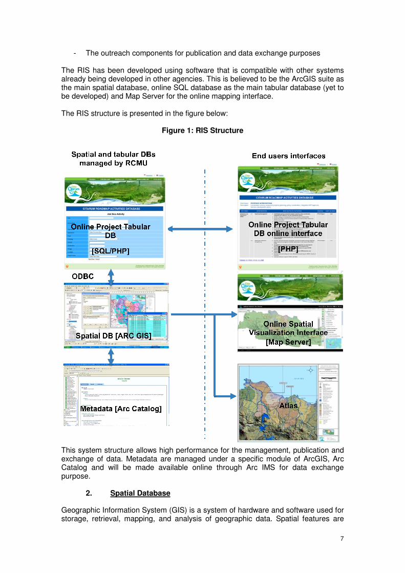
7
- The outreach components for publication and data exchange purposes The RIS has been developed using software that is compatible with other systems already being developed in other agencies. This is believed to be the ArcGIS suite as the main spatial database, online SQL database as the main tabular database (yet to be developed) and Map Server for the online mapping interface. The RIS structure is presented in the figure below:
Figure 1: RIS Structure
This system structure allows high performance for the management, publication and exchange of data. Metadata are managed under a specific module of ArcGIS, Arc Catalog and will be made available online through Arc IMS for data exchange purpose.
2. Spatial Database
Geographic Information System (GIS) is a system of hardware and software used for storage, retrieval, mapping, and analysis of geographic data. Spatial features are
8
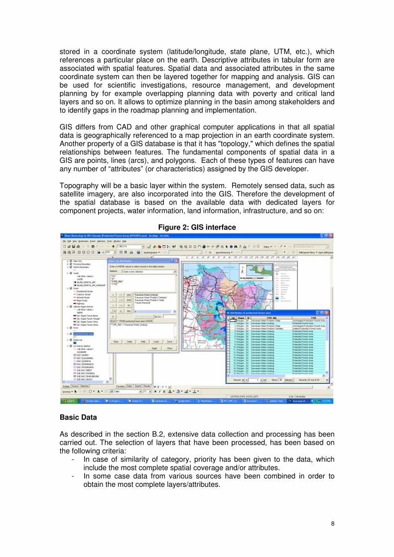
stored in a coordinate system (latitude/longitude, state plane, UTM, etc.), which references a particular place on the earth. Descriptive attributes in tabular form are associated with spatial features. Spatial data and associated attributes in the same coordinate system can then be layered together for mapping and analysis. GIS can be used for scientific investigations, resource management, and development planning by for example overlapping planning data with poverty and critical land layers and so on. It allows to optimize planning in the basin among stakeholders and to identify gaps in the roadmap planning and implementation. GIS differs from CAD and other graphical computer applications in that all spatial data is geographically referenced to a map projection in an earth coordinate system. Another property of a GIS database is that it has "topology," which defines the spatial relationships between features. The fundamental components of spatial data in a GIS are points, lines (arcs), and polygons. Each of these types of features can have any number of “attributes” (or characteristics) assigned by the GIS developer. Topography will be a basic layer within the system. Remotely sensed data, such as satellite imagery, are also incorporated into the GIS. Therefore the development of the spatial database is based on the available data with dedicated layers for component projects, water information, land information, infrastructure, and so on:
Figure 2: GIS interface
Basic Data As described in the section B.2, extensive data collection and processing has been carried out. The selection of layers that have been processed, has been based on the following criteria:
- In case of similarity of category, priority has been given to the data, which include the most complete spatial coverage and/or attributes.
- In some case data from various sources have been combined in order to obtain the most complete layers/attributes.
9
Selected and processed layers have been categorized (depending on the coverage) into six main categories as followed:
- Basic Layers (1:25,000) West Java - Basic Layers (1:250,000) West Java - Secondary Layers (West Java) - Secondary Layers (Citarum, Ciliwung, Cisadane, Ciujung, Cidurian, Cidanau
– 6CIs river basin territory) - Secondary Layers (Citarum river basin) - Secondary Layers (Citarum watershed) - A digital elevation model (DEM) has been built based on contours and
elevation points available from the 1:25,000 scale maps for the West Java province.
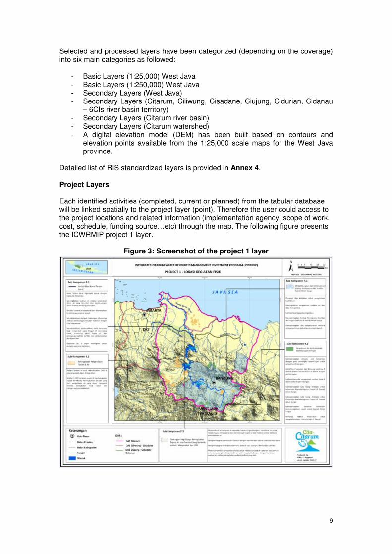
Detailed list of RIS standardized layers is provided in Annex 4. Project Layers Each identified activities (completed, current or planned) from the tabular database will be linked spatially to the project layer (point). Therefore the user could access to the project locations and related information (implementation agency, scope of work, cost, schedule, funding source…etc) through the map. The following figure presents the ICWRMIP project 1 layer.
Figure 3: Screenshot of the project 1 layer
10
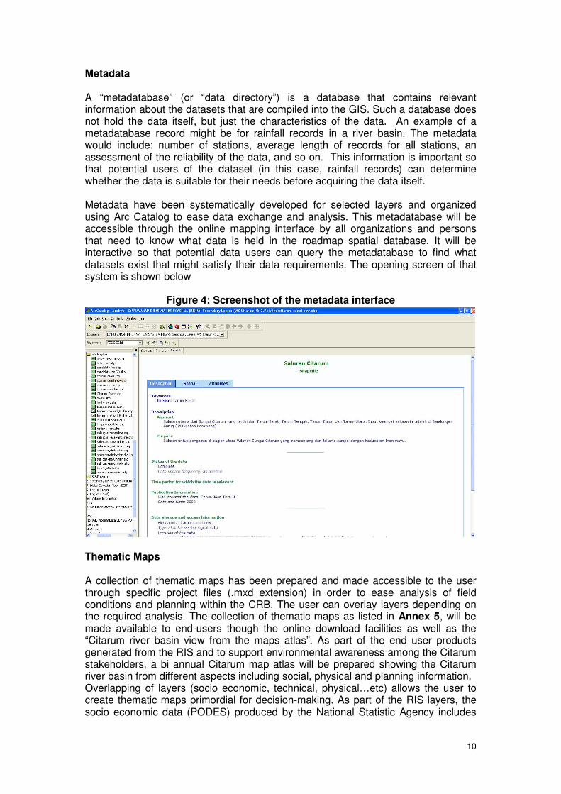
Metadata A “metadatabase” (or “data directory”) is a database that contains relevant information about the datasets that are compiled into the GIS. Such a database does not hold the data itself, but just the characteristics of the data. An example of a metadatabase record might be for rainfall records in a river basin. The metadata would include: number of stations, average length of records for all stations, an assessment of the reliability of the data, and so on. This information is important so that potential users of the dataset (in this case, rainfall records) can determine whether the data is suitable for their needs before acquiring the data itself. Metadata have been systematically developed for selected layers and organized using Arc Catalog to ease data exchange and analysis. This metadatabase will be accessible through the online mapping interface by all organizations and persons that need to know what data is held in the roadmap spatial database. It will be interactive so that potential data users can query the metadatabase to find what datasets exist that might satisfy their data requirements. The opening screen of that system is shown below
Figure 4: Screenshot of the metadata interface
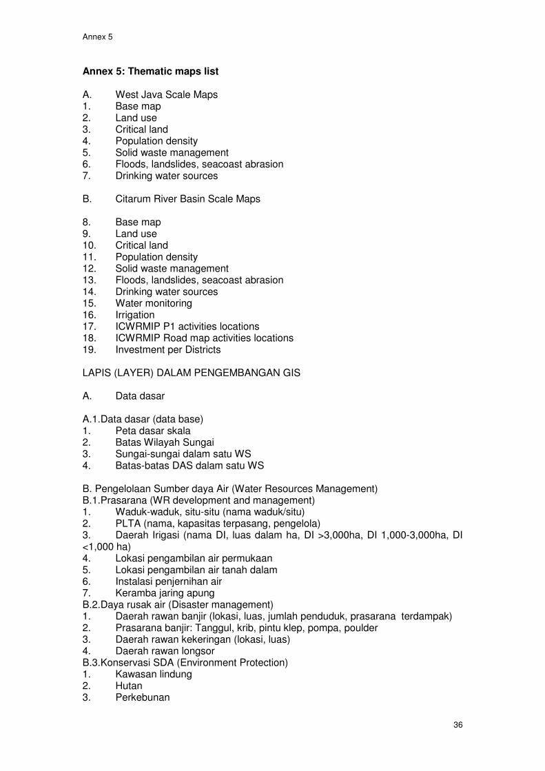
Thematic Maps A collection of thematic maps has been prepared and made accessible to the user through specific project files (.mxd extension) in order to ease analysis of field conditions and planning within the CRB. The user can overlay layers depending on the required analysis. The collection of thematic maps as listed in Annex 5, will be made available to end-users though the online download facilities as well as the “Citarum river basin view from the maps atlas”. As part of the end user products generated from the RIS and to support environmental awareness among the Citarum stakeholders, a bi annual Citarum map atlas will be prepared showing the Citarum river basin from different aspects including social, physical and planning information. Overlapping of layers (socio economic, technical, physical…etc) allows the user to create thematic maps primordial for decision-making. As part of the RIS layers, the socio economic data (PODES) produced by the National Statistic Agency includes

11
indicators at village level (see full list of indicators of the 2008 sensus in Annex 6). Therefore planning and programming of the roadmap activities could be based on physical, institutional and socio economic criteria. An example of thematic map is shown in the figure below:
Figure 5: Example of thematic map
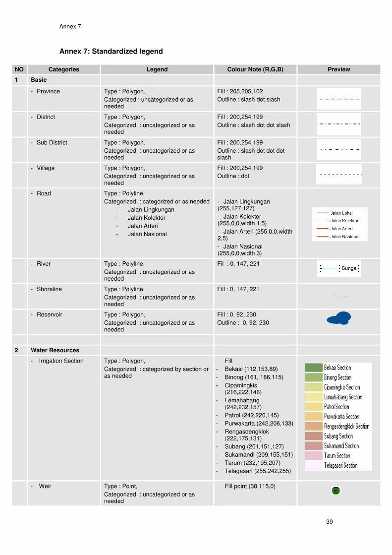
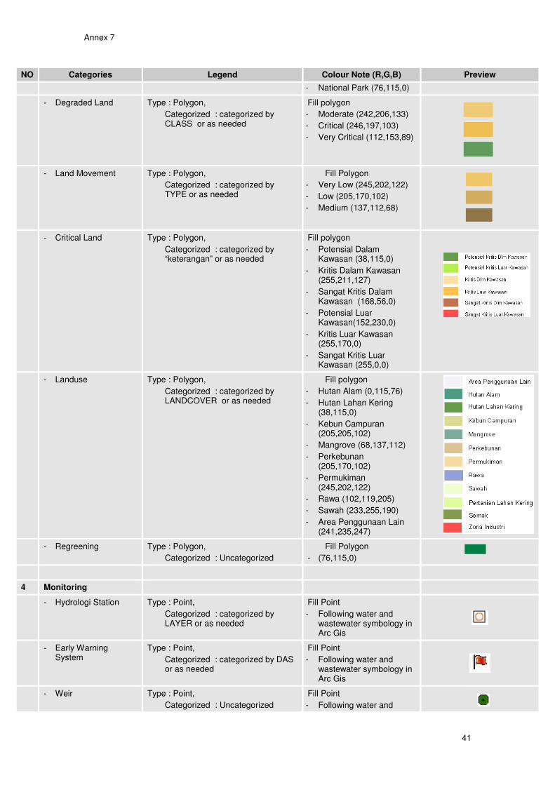
To ease analysis and to produce standard maps, specific legend (based on the Indonesian standard made available by Bakosultanal) has been developed as presented in Annex 7.
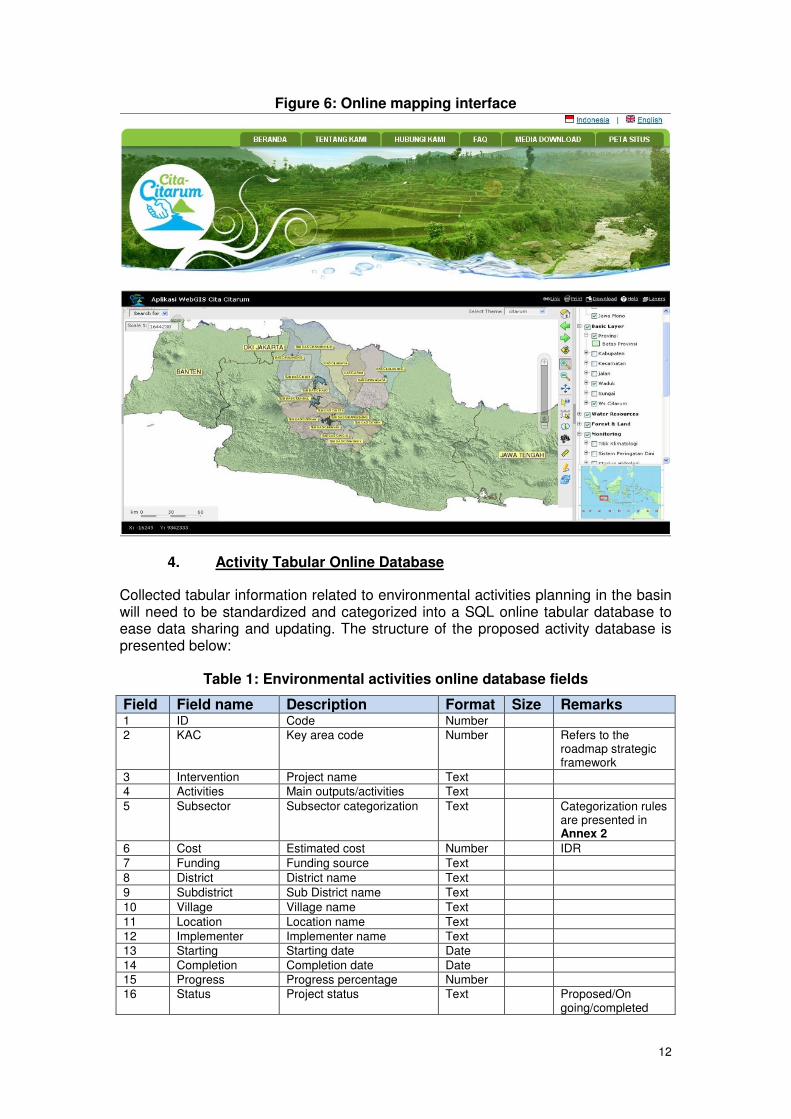
3. Online mapping interface
The collection of thematic layers are made available to end-users though the online mapping interface which allows displaying spatial data (project planning, spatial planning, environmental, physical and social information) held in the roadmap spatial database via a web browser (which virtually all computers have installed) – that is, without the user having to have specialized GIS software installed on their computer. This interface is using user-friendly technology Map Server, which a free software. The web master and/or GIS technician upload to the server the shp files to be displayed through the mapping interface. Details of the map server-mapping interface are presented in Annex 8. The interface includes the basic functionalities such as zoom, layer activation, overlap, legend, printing, export…etc. This dedicated module of the Citarum online platform also includes facilities for the user to export maps (jpeg, geotiff format) for overlapping it on Google Earth and/or other software for further analysis.
12
Figure 6: Online mapping interface
4. Activity Tabular Online Database
Collected tabular information related to environmental activities planning in the basin will need to be standardized and categorized into a SQL online tabular database to ease data sharing and updating. The structure of the proposed activity database is presented below:
Table 1: Environmental activities online database fields
Field Field name Description Format Size Remarks 1 ID Code Number
2 KAC Key area code Number Refers to the roadmap strategic framework
3 Intervention Project name Text
4 Activities Main outputs/activities Text
5 Subsector Subsector categorization Text Categorization rules are presented in Annex 2
6 Cost Estimated cost Number IDR
7 Funding Funding source Text
8 District District name Text
9 Subdistrict Sub District name Text
10 Village Village name Text
11 Location Location name Text
12 Implementer Implementer name Text
13 Starting Starting date Date
14 Completion Completion date Date
15 Progress Progress percentage Number
16 Status Project status Text Proposed/On going/completed

13
Field Field name Description Format Size Remarks 17 Source Information source Text
18 Remarks Remarks Text
A specific user-friendly interface will be developed specifically for those purposes, accessible through internet on a limited access basis. Updating of this tabular DB will be ensured by the RCMU in close collaboration with the CRB stakeholders.
Figure 7: Screenshot of the proposed tabular activity database interface
14
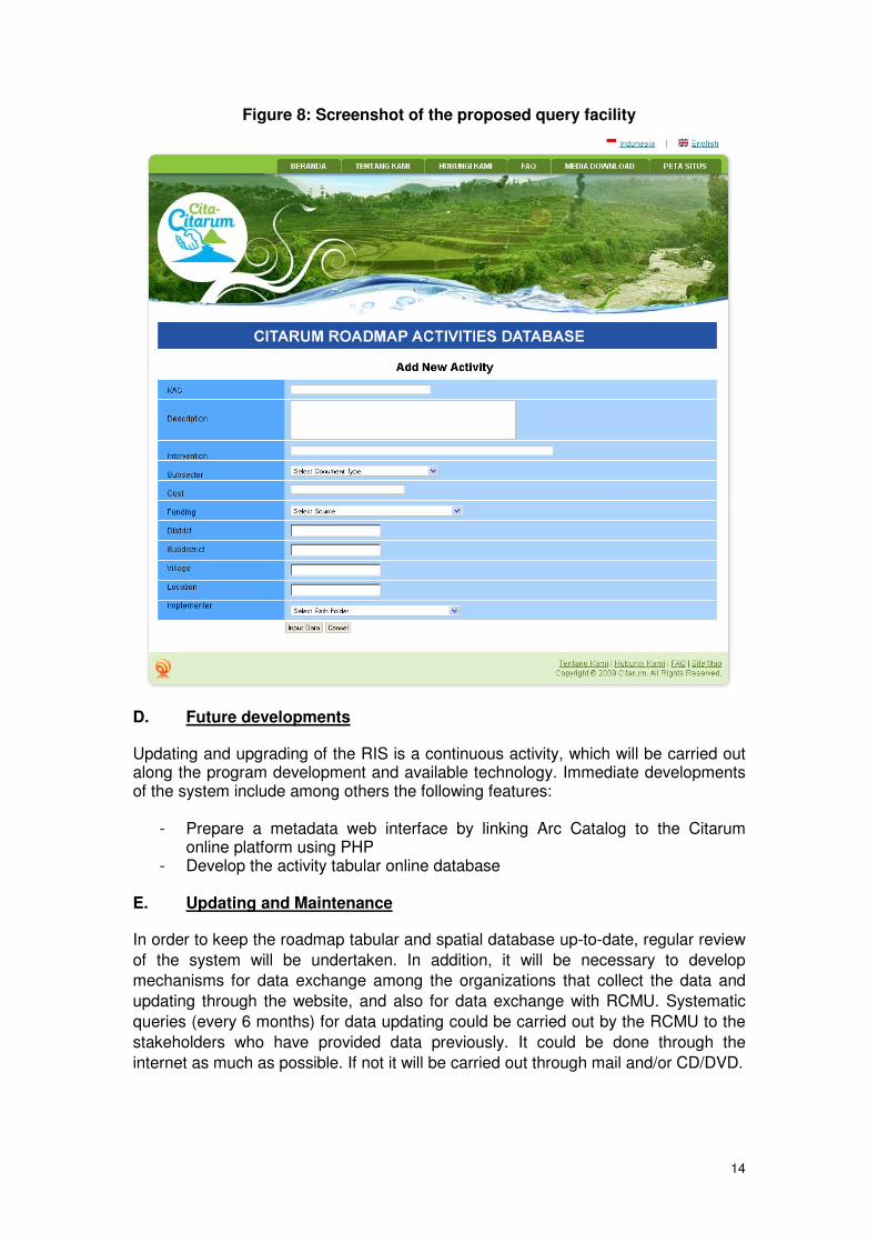
Figure 8: Screenshot of the proposed query facility
D. Future developments
Updating and upgrading of the RIS is a continuous activity, which will be carried out along the program development and available technology. Immediate developments of the system include among others the following features:
- Prepare a metadata web interface by linking Arc Catalog to the Citarum online platform using PHP
- Develop the activity tabular online database E. Updating and Maintenance
In order to keep the roadmap tabular and spatial database up-to-date, regular review
of the system will be undertaken. In addition, it will be necessary to develop
mechanisms for data exchange among the organizations that collect the data and
updating through the website, and also for data exchange with RCMU. Systematic
queries (every 6 months) for data updating could be carried out by the RCMU to the
stakeholders who have provided data previously. It could be done through the
internet as much as possible. If not it will be carried out through mail and/or CD/DVD.
15
F. Management of the RIS
A dedicated GIS operator from the RCMU team actively maintains the RIS by collecting, validating, processing and labeling any tabular and spatial data. Other users will have the right to view and download those data. Submission of spatial data to be included in the RIS will be through the RCMU. The RCMU GIS operator will register all the data including file name, size, format, author, creation date and description. Training in the use of the roadmap tabular and spatial database will also be given to other RCMU staff and relevant stakeholders. The data set is available in the attached DVD. G. Programming and source code
The online tabular project database will be programmed using Hypertext Preprocessor (PHP).
Annex 1
16
Annex 1: Status of collected project tabular data
NO DATA SOURCE YEAR
1 1.1 RPJP1 - RPJP Nasional Bappenas 2005-2025
- RPJPD Provinsi Jawa Barat Bappeda Provinsi Jawa Barat 2005-2025
- RPJPD Kabupaten Bandung Bappeda Kabupaten Bandung 2005-2025
1.2 RPJM2 - Rencana Pembangunan Jangka
Menengah Nasional Bappenas 2010,2011
- Rencana Pembangunan Jangka Menengah Daerah Provinsi Jawa Barat
Bappeda Provinsi Jawa Barat 2008-2013
- RPJMD Kota Bandung Bappeda Kota Bandung 2008-2013
- RPJMD Kabupaten Bandung Bappeda Kabupaten Bandung 2005-2010
- RPJMD Kabupaten Bandung Barat
Bappeda Kabupaten Bandung Barat 2008-2013
- RPJMD Kabupaten Bekasi Bappeda Kabupaten Bekasi 2008-2013
- RPJMD Kota Bekasi Bappeda Kota Bekasi 2008-2013
- RPJMD Kabupaten Karawang Bappeda Kabupaten Karawang 2006-2010
- RPJMD kabupaten Cianjur Bappeda Kabupaten Cianjur 2006-2010
- RPJMD kabupaten Sumedang Bappeda Kabupaten Sumedang 2008-2013
- RPJMD kabupaten Subang Bappeda Kabupaten Subang 2009-2014
- RPJMD kabupaten Indramayu Bappeda Kabupaten Indramayu 2006-2010
- RPJMD Kota Cimahi Bappeda Kota Cimahi 2008-2013
1.3 RENSTRA3 Renstra Kementerian Pekerjaan
Umum Kementerian Pekerjaan Umum 2009-2014
- Renstra Ditjen Sumberdaya Air Ditjen SDA Kementerian Pekerjaan Umum
2010-2014
- Renstra Ditjen Cipta Karya Bina Program Cipta Karya Kementerian Pekerjaan Umum
2010-2014
Renstra Kementerian Pertanian Kementerian Pertanian 2010-2014
- Renstra Direktorat Jend Pengelolaan Lahan dan Air
Kementerian Pertanian 2010-2014
- Renstra Kementerian Kesehatan Kementerian Kesehatan 2010-2014
- Renstra Kementerian Kehutanan Kementerian Kehutanan 2010-2014
Provinsi Jawa Barat
1 RPJP (Rencana Pembangunan Jangka Panjang) merupakan dokumen perencanaan pembangunan
yang bersifat jangka panjang (20 tahunan) serta berskala nasional dan daerah. 2 RPJM (Rencana Pembangunan Jangka Menengah) merupakan dokumen perencanaan pembangunan
yang bersifat jangka menengah (5 tahunan) yang berskala nasional dan daerah. 3 RENSTRA (Rencana Strategis) merupakan dokumen rencana program setiap instansi berjangka
waktu 5 tahun dan mengacu pada RPJP serta RPJM.

Annex 1
17
NO DATA SOURCE YEAR
- Renstra PSDA Dinas PSDA Provinsi Jawa Barat 2008-2013
- Rensta BPLHD BPLHD Provinsi Jawa Barat 2008-2013
- Renstra Dinas Permukiman Perumahan
Dinas Permukiman Perumahan Provinsi Jawa Barat
2008-2013
- Renstra Dinas Pertanian Dinas Pertanian Provinsi Jawa Barat 2008-2013
- Renstra Dinas Kesehatan Dinas Kesehatan Provinsi Jawa barat 2008-2013
- Renstra Dinas ESDM Dinas ESDM Provinsi Jawa Barat 2008-2013
- Renstra Bappeda Bappeda Provinsi Jawa Barat 2008-2013
Kota Bandung
- Renstra BPLHD Kota Bandung BPLHD Kota Bandung 2009-2013
- Renstra Dinas Permukiman Perumahan
Dinas Permukiman Perumahan Kota Bandung
2009-2013
- Renstra Dinas Kesehatan Dinas Kesehatan Kota Bandung 2009-2013
Kabupaten Bandung
- Renstra Dinas PSDA Dinas PSDA Kabupaten Bandung 2009-2013
- Renstra BPLHD BPLHD Kabupaten Bandung 2008-2013
- Renstra Dinas Pertanian,Perkebunan dan Kehutanan
Dinas Pertanian,Perkebunan dan Kehutanan Kabupaten Bandung
2008-2013
- Renstra Dinas Kesehatan Dinas Kesehatan Kabupaten Bandung 2008-2013
Kabupaten Bandung Barat
- Renstra Dinas Pertanian,Perkebunan dan Kehutanan
Dinas Pertanian,Perkebunan dan Kehutanan Kabupaten Barat
2008-2013
- Renstra BPLHD BPLHD Bandung Barat 2008-2013
- Renstra Dinas Kesehatan Dinas Kesehatan Bandung Barat 2008-2013
Kabupaten Karawang
- Renstra Bappeda Bappeda Kabupaten Karawang 2006-2011
- Renstra BPLHD BPLHD Kabupaten Karawang 2006-2011
- Renstra Dinas Permukiman Perumahan
Dinas Permukiman Perumahan Kabupaten Karawang
2006-2011
Kabupaten Cianjur
- Renstra BPLHD BPLHD Kabupaten Cianjur 2006-2011
- Renstra Dinas Permukiman dan Perumahan
Dinas Permukiman dan Perumahan Kabupaten Cianjur
2006-2011
Annex 1
18
NO DATA SOURCE YEAR
- Renstra Dinas Pertanian TP dan Hortikultura
Dinas Pertanian TP dan Hortikultura Kabupaten Cianjur
2006-2011
- Renstra Dinas Kesehatan Dinas Kesehatan Kabupaten Cianjur 2006-2011
- Renstra Dinas Kehutanan dan Perkebunan
Dinas Kehutanan dan Perkebunan Kabupaten Cianjur
2006-2011
Kabupaten Sumedang
- Renstra Dinas Pekerjaan Umum Dinas Pekerjaan Umum Kabupaten Sumedang
2009-2013
- Renstra Badan Lingkungan Hidup Badan Lingkungan Hidup Kabupaten Sumedang
2009-2013
- Renstra Dinas Ketahanan Pangan, pemberdayaan pertanian, perikanan dan kehutanan
Dinas Ketahanan Pangan, pemberdayaan pertanian, perikanan dan kehutanan Kabupaten Sumedang
2009-2013
- Renstra Dinas Pertanian Tanaman Pangan
Dinas Pertanian Tanaman Pangan Kabupaten Sumedang
2009-2013
- Renstra Dinas Kesehatan Dinas Kesehatan Kabupaten Sumedang
2009-2013
- Renstra Dinas Pertambangan, Energi dan Pertanahan
Dinas Pertambangan, Energi dan Pertanahan Kabupaten Sumedang
2009-2013
Kabupaten Subang
- Renstra Dinas Pertanian Dinas Pertanian Kabupaten Subang 2009-2014
- Renstra Dinas Kehutanan dan Perkebunan
Dinas Kehutanan dan Perkebunan 2009-2014
- Renstra BPLHD Subang BPLHD Subang 2009-2014
Kabupaten Purwakarta
- Renstra Bappeda Bappeda Kabupaten Purwakarta 2008-2013
-
Kota Cimahi
- Renstra Dinas Lingkungan Hidup Dinas Lingkungan Hidup Kota Cimahi 2007-2012
- Renstra Dinas Koperasi, Perindustrian, Perdagangan dan Pertanian
Dinas Koperasi, Perindustrian, Perdagangan dan Pertanian Kota Cimahi
2007-2012
- Renstra Dinas Kesehatan Dinas Kesehatan Kota Cimahi 2007-2012
- Renstra Dinas Penyehatan Lingkungan
Dinas Penyehatan Lingkungan Kota Cimahi
2007-2012
1.4 RKP4 - Rencana Kerja Pemerintah
Nasional Bappenas 2010-2011
4 RKP (Rencana Kerja Pemerintah) merupakan rencana kegiatan pemerintah pusat maupun daerah
yang bersifat tahunan dan dibreakdown RPJM maupun RPJP. Pada tahap ini rencana kegiatan lebih bersifat implementasi.
Annex 1
19
NO DATA SOURCE YEAR
- Rencana Kerja Pemerintah Daerah Provinsi
Bappeda Provinsi Jawa Barat 2010-2011
- Rencana Kerja Pemerintah Daerah Kabupaten
Bappeda masing-masing kabupaten 2009-2010
- Renja SKPD Satuan Kerja Perangkat Daerah 2009-2010
1.5 RTRW5 - Rencana Tata Ruang Wilayah
Nasional Direktorat Jenderal Penataan Ruang Kementerian Pekerjaan Umum
2005-2025
- Rencana Tata Ruang Wilayah Provinsi
Bappeda Provinsi Jawa Barat 2009-2029
- RTRW Kabupaten Kota Bandung Bappeda Kota bandung 2004-2013
- RTRW Kabupaten Bandung Barat Bappeda Kabupaten Bandung Barat 2008-2028
- RTRW Kabupaten Bekasi Bappeda Kabupaten Bekasi 2003-2013
- RTRW Kabupaten Subang Bappeda Kabupaten Subang 2001-2011
- RTRW Khusus Cekungan Bandung
Direktorat Jenderal Penataan Ruang Kementerian Pekerjaan Umum
-
- RTRW Khusus Jabodetabekjur Direktorat Jenderal Penataan Ruang Kementerian Pekerjaan Umum
-
1.6 MASTERPLAN
- Drainase Cekungan Bandung Dinas Permukiman dan Perumahan 2009
- Rencana Pengelolaan DAS Citarum Terpadu
Kementerian Kehutanan, Ditjen Rehabilitasi Lahan dan Kehutanan Sosial BPDAS Citarum-Ciliwung
2009
5 RTRW (Rencana Tata Ruang Wilayah) merupakan dokumen perencanaan pembangunan yang
mengatur peruntukan wilayah berdasarkan fungsi pola ruang dan struktur ruang wilayah. RTRW berjangka waktu 10-20 tahun sehingga diperlukan evaluasi secara periodik.

Annex 2
20
Annex 2: Project categorization rules
KEY AREA DEFINITION SUBSECTORS THEMES
Institutions and Planning for IWRM
In the definition of this key area, the term “institutions” is used in its broadest sense, that is, dealing with organisations, as well as legislation, policies and other protocols that define the relations among those organisations. Planning for IWRM (and in particular in this context, river basin planning) is seen as a mechanism for promulgating and implementing policies of government, and as such is included in this key area. Accordingly, the following activities are included:
� Organisation restructuring;
� Organisational capacity building;
� Policy development;
� Implementing the legislative framework;
� Planning for IWRM;
� Regulation (such as licensing of water utilisation and wastewater discharge);
� Setting of water tariffs;
� Institutions for participatory irrigation management (PIM).
• • Community Infrastructure Development
• Community Empowerment
• Community Finance
• Corporate Social Responsibility
• Clean Development Mechanisms
• Training
• Institution Capacity Building
• Rehabilitation
• Construction
• Operation & Maintenance
Water Resource Development and Management
This key area includes those activities that are related to exploiting water resources – that is, increasing water availability to authorised users, and operating and maintaining the infrastructure developed in the process. The main activities included are:
� Project planning, including “master planning” (that is, planning that focuses on development of infrastructure, and distinct from broader basin planning);
� Construction of infrastructure for storing and delivering water (including reservoirs, canals and pipeline systems);
� Operation and maintenance of infrastructure;
� Promoting efficient and effective utilization of water;
� Drilling of wells for use of groundwater.
• Irrigation
• Water Supply
• Sanitation
• Solid Waste
• River Erosion
Annex 2
21
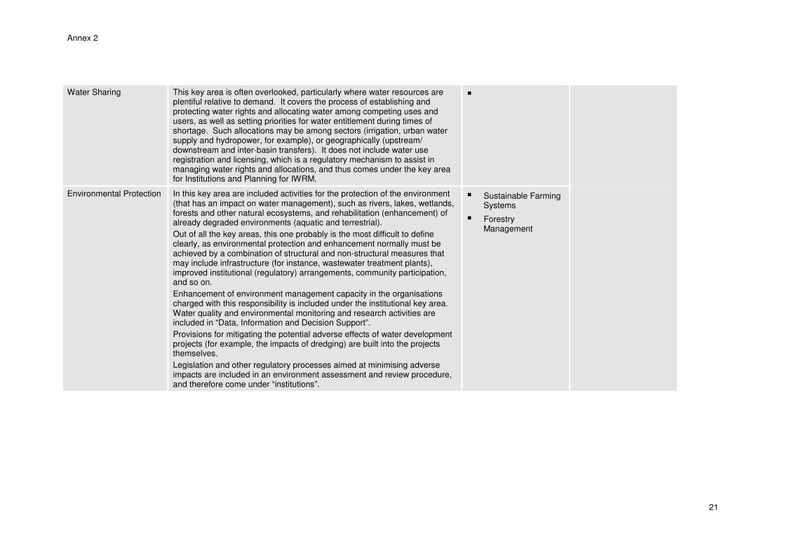
Water Sharing This key area is often overlooked, particularly where water resources are plentiful relative to demand. It covers the process of establishing and protecting water rights and allocating water among competing uses and users, as well as setting priorities for water entitlement during times of shortage. Such allocations may be among sectors (irrigation, urban water supply and hydropower, for example), or geographically (upstream/ downstream and inter-basin transfers). It does not include water use registration and licensing, which is a regulatory mechanism to assist in managing water rights and allocations, and thus comes under the key area for Institutions and Planning for IWRM.
�
Environmental Protection In this key area are included activities for the protection of the environment (that has an impact on water management), such as rivers, lakes, wetlands, forests and other natural ecosystems, and rehabilitation (enhancement) of already degraded environments (aquatic and terrestrial).
Out of all the key areas, this one probably is the most difficult to define clearly, as environmental protection and enhancement normally must be achieved by a combination of structural and non-structural measures that may include infrastructure (for instance, wastewater treatment plants), improved institutional (regulatory) arrangements, community participation, and so on.
Enhancement of environment management capacity in the organisations charged with this responsibility is included under the institutional key area. Water quality and environmental monitoring and research activities are included in “Data, Information and Decision Support”.
Provisions for mitigating the potential adverse effects of water development projects (for example, the impacts of dredging) are built into the projects themselves.
Legislation and other regulatory processes aimed at minimising adverse impacts are included in an environment assessment and review procedure, and therefore come under “institutions”.
� Sustainable Farming Systems
� Forestry Management
Annex 2
22
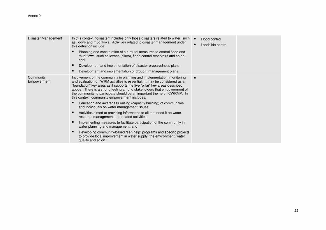
Disaster Management In this context, “disaster” includes only those disasters related to water, such as floods and mud flows. Activities related to disaster management under this definition include:
� Planning and construction of structural measures to control flood and mud flows, such as levees (dikes), flood control reservoirs and so on; and
� Development and implementation of disaster preparedness plans.
� Development and implementation of drought management plans
� Flood control
� Landslide control
Community Empowerment
Involvement of the community in planning and implementation, monitoring and evaluation of IWRM activities is essential. It may be considered as a “foundation” key area, as it supports the five “pillar” key areas described above. There is a strong feeling among stakeholders that empowerment of the community to participate should be an important theme of ICWRMP. In this context, community empowerment includes:
� Education and awareness raising (capacity building) of communities and individuals on water management issues;
� Activities aimed at providing information to all that need it on water resource management and related activities;
� Implementing measures to facilitate participation of the community in water planning and management; and
� Developing community-based “self-help” programs and specific projects to provide local improvement in water supply, the environment, water quality and so on.
�
Annex 2
23
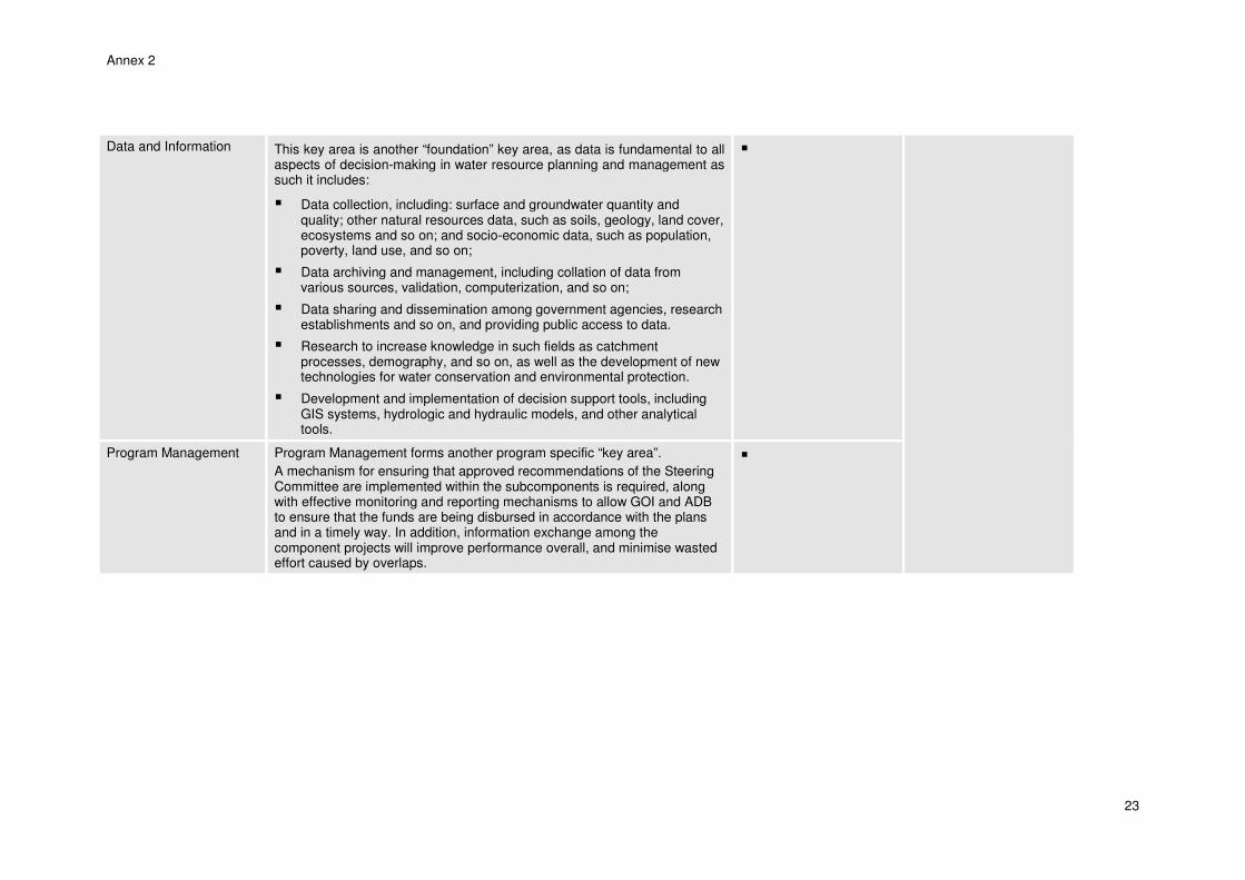
Data and Information This key area is another “foundation” key area, as data is fundamental to all aspects of decision-making in water resource planning and management as such it includes:
� Data collection, including: surface and groundwater quantity and quality; other natural resources data, such as soils, geology, land cover, ecosystems and so on; and socio-economic data, such as population, poverty, land use, and so on;
� Data archiving and management, including collation of data from various sources, validation, computerization, and so on;
� Data sharing and dissemination among government agencies, research establishments and so on, and providing public access to data.
� Research to increase knowledge in such fields as catchment processes, demography, and so on, as well as the development of new technologies for water conservation and environmental protection.
� Development and implementation of decision support tools, including GIS systems, hydrologic and hydraulic models, and other analytical tools.
�
Program Management Program Management forms another program specific “key area”.
A mechanism for ensuring that approved recommendations of the Steering Committee are implemented within the subcomponents is required, along with effective monitoring and reporting mechanisms to allow GOI and ADB to ensure that the funds are being disbursed in accordance with the plans and in a timely way. In addition, information exchange among the component projects will improve performance overall, and minimise wasted effort caused by overlaps.
�
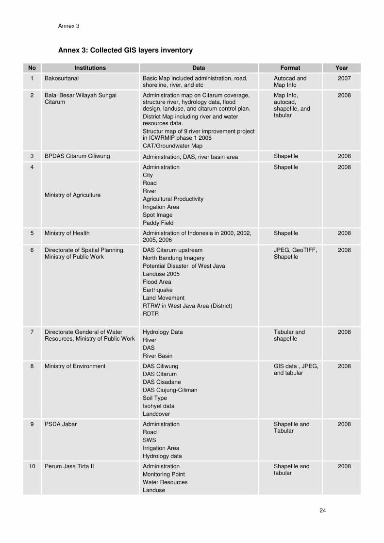
Annex 3
24
Annex 3: Collected GIS layers inventory
No Institutions Data Format Year
1 Bakosurtanal Basic Map included administration, road, shoreline, river, and etc
Autocad and Map Info
2007
2 Balai Besar Wilayah Sungai Citarum
Administration map on Citarum coverage, structure river, hydrology data, flood design, landuse, and citarum control plan.
District Map including river and water resources data.
Structur map of 9 river improvement project in ICWRMIP phase 1 2006
CAT/Groundwater Map
Map Info, autocad, shapefile, and tabular
2008
3 BPDAS Citarum Ciliwung Administration, DAS, river basin area Shapefile 2008
4
Ministry of Agriculture
Administration
City
Road
River
Agricultural Productivity
Irrigation Area
Spot Image
Paddy Field
Shapefile 2008
5 Ministry of Health Administration of Indonesia in 2000, 2002, 2005, 2006
Shapefile 2008
6 Directorate of Spatial Planning, Ministry of Public Work
DAS Citarum upstream
North Bandung Imagery
Potential Disaster of West Java
Landuse 2005
Flood Area
Earthquake
Land Movement
RTRW in West Java Area (District)
RDTR
JPEG, GeoTIFF, Shapefile
2008
7 Directorate Genderal of Water Resources, Ministry of Public Work
Hydrology Data
River
DAS
River Basin
Tabular and shapefile
2008
8 Ministry of Environment DAS Ciliwung
DAS Citarum
DAS Cisadane
DAS Ciujung-Ciliman
Soil Type
Isohyet data
Landcover
GIS data , JPEG, and tabular
2008
9 PSDA Jabar Administration
Road
SWS
Irrigation Area
Hydrology data
Shapefile and Tabular
2008
10 Perum Jasa Tirta II Administration
Monitoring Point
Water Resources
Landuse
Shapefile and tabular
2008
Annex 3
25
No Institutions Data Format Year
Socio economic data
Project Activity
Conservation Area
Protected Forest Area
11 PT. Hatfield Indonesia Landuse 2008
Digital Elevation Model
DAS
Shapefile, JPEG, and tabular
2008
12 Environmental Support Program, Bappenas
Rupa Bumi Indonesia West Java, Cental Java and East Java
Landuse 2000-2006
Landsystem
SRTM
Shapefile and ECW format for SRTM.
2008
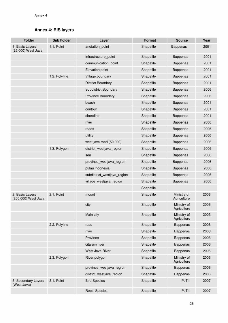
Annex 4
26
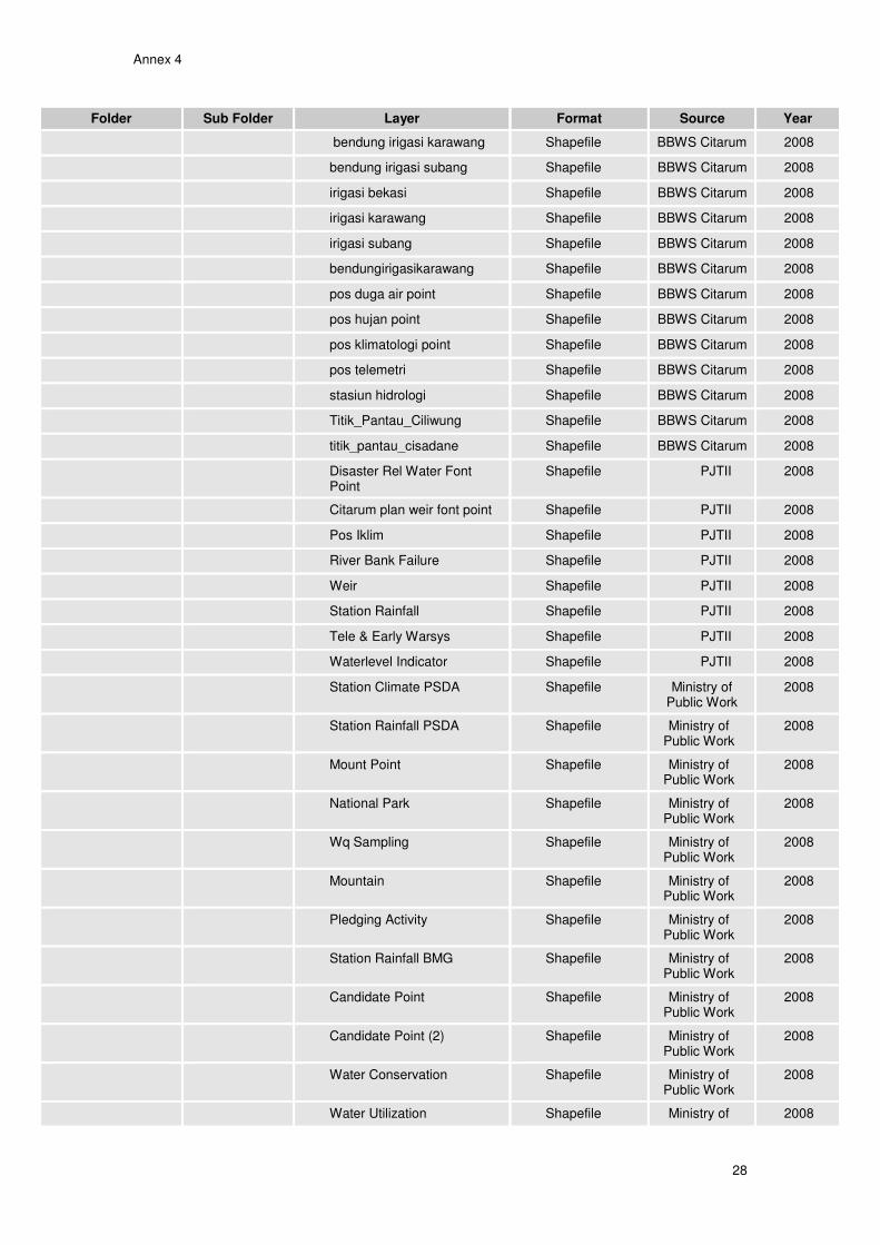
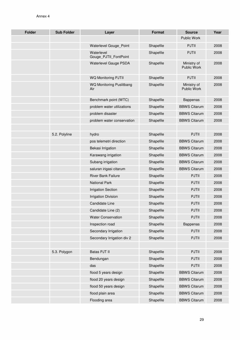
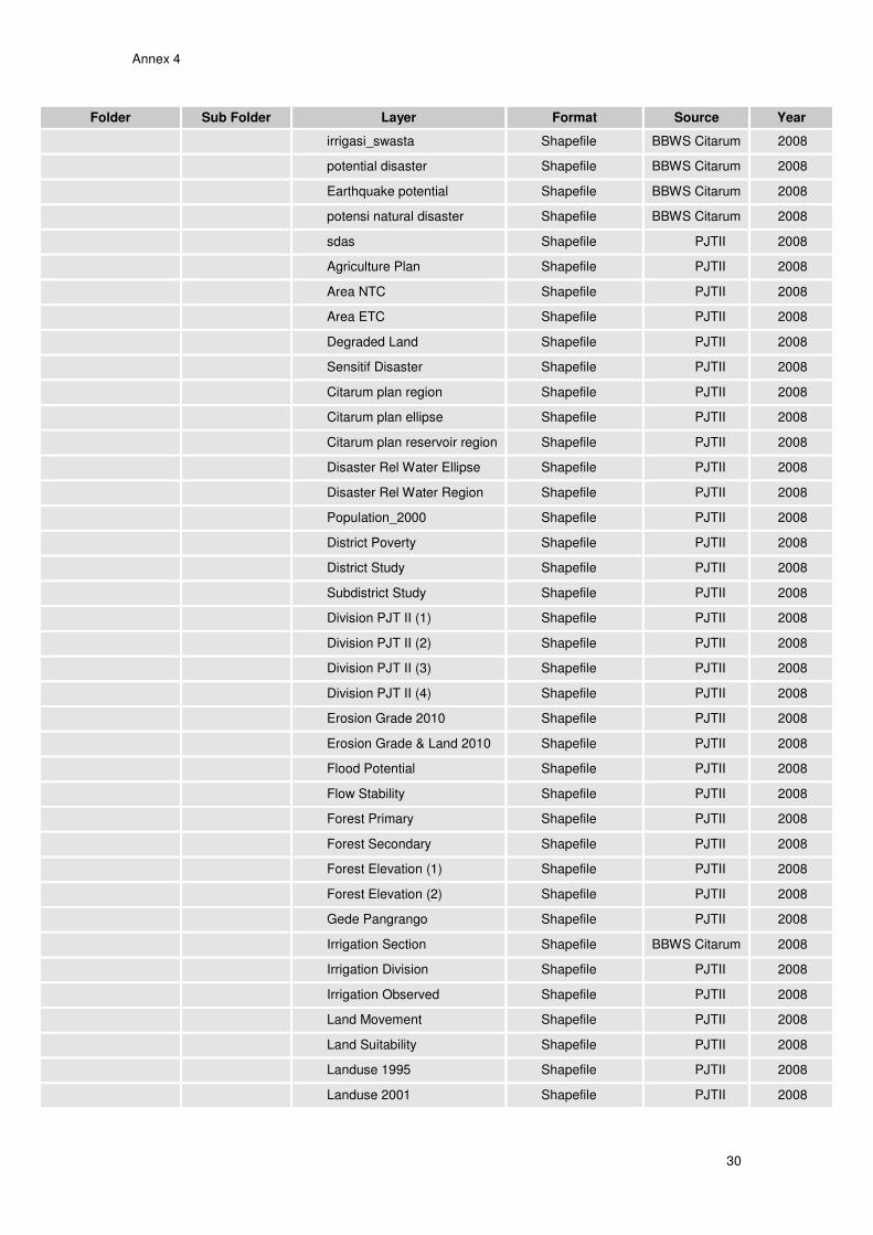
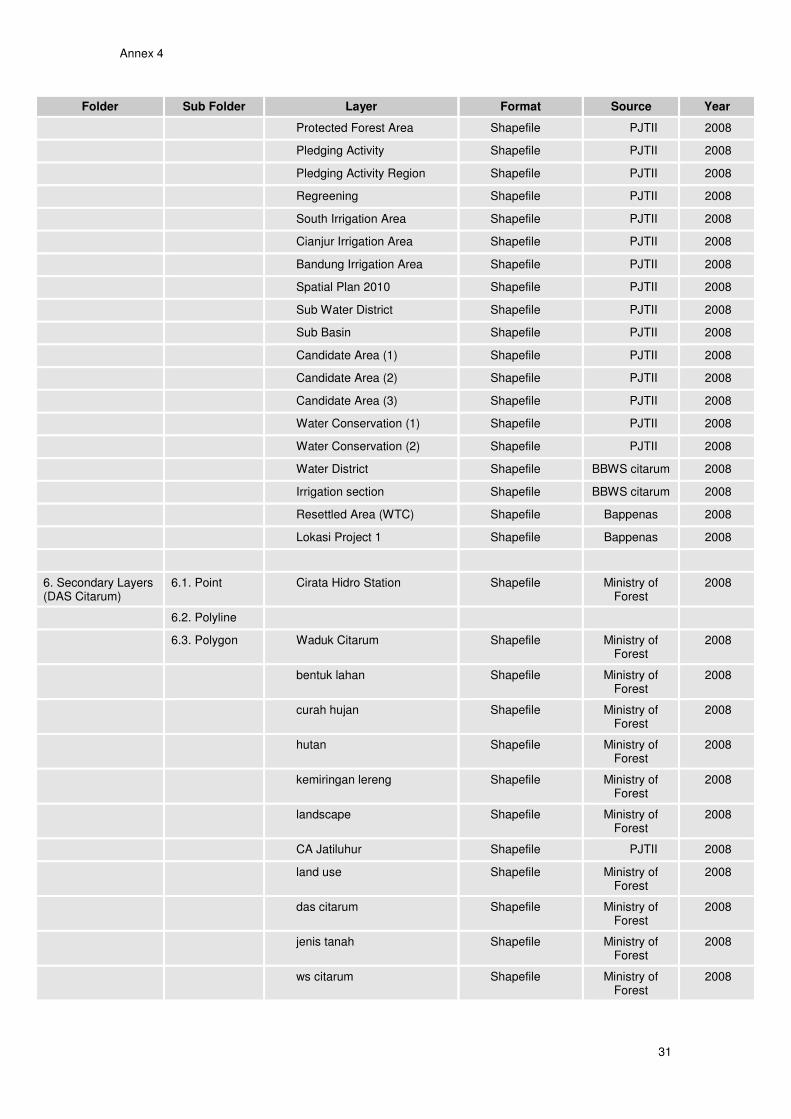
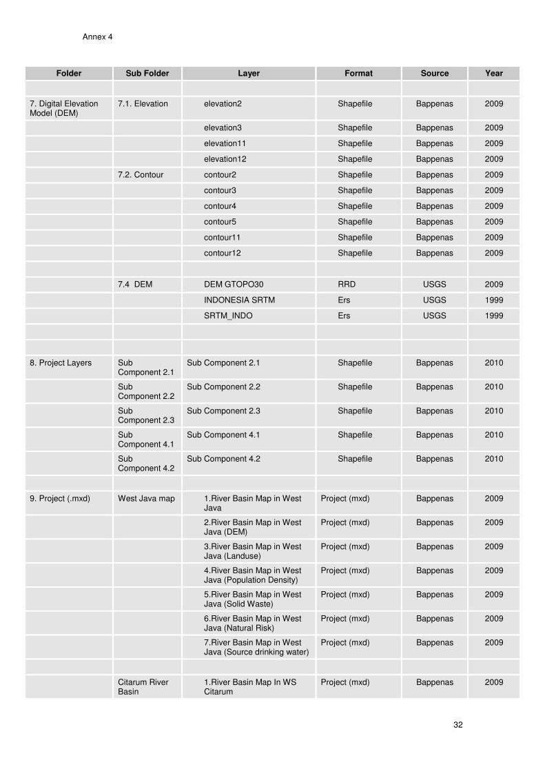
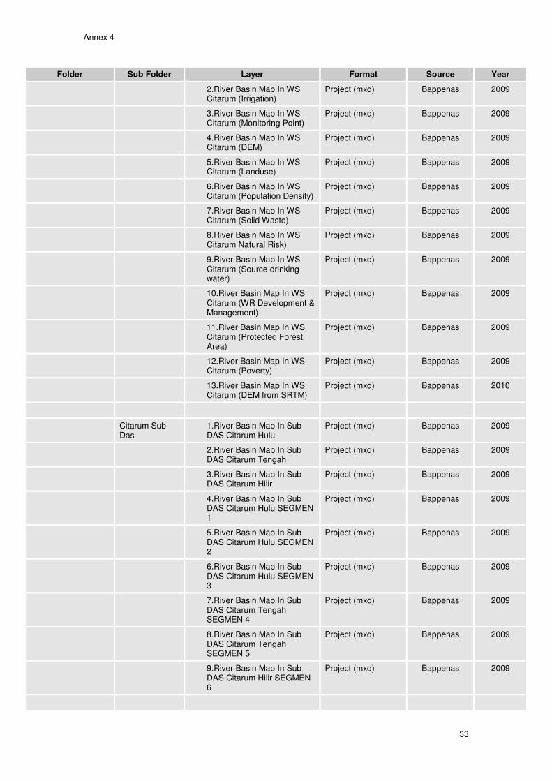
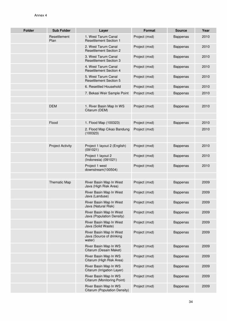
Annex 4: RIS layers
Folder Sub Folder Layer Format Source Year
1. Basic Layers (25.000) West Java
1.1. Point anotation_point Shapefile Bappenas 2001
infrastructure_point Shapefile Bappenas 2001
communication_point Shapefile Bappenas 2001
Elevation point Shapefile Bappenas 2001
1.2. Polyline Village boundary Shapefile Bappenas 2001
District Boundary Shapefile Bappenas 2001
Subdistrict Boundary Shapefile Bappenas 2006
Province Boundary Shapefile Bappenas 2006
beach Shapefile Bappenas 2001
contour Shapefile Bappenas 2001
shoreline Shapefile Bappenas 2001
river Shapefile Bappenas 2006
roads Shapefile Bappenas 2006
utility Shapefile Bappenas 2006
west java road (50.000) Shapefile Bappenas 2006
1.3. Polygon district_westjava_region Shapefile Bappenas 2006
sea Shapefile Bappenas 2006
province_westjava_region Shapefile Bappenas 2006
pulau indonesia Shapefile Bappenas 2006
subdistrict_westjava_region Shapefile Bappenas 2006
village_westjava_region Shapefile Bappenas 2006
Shapefile
2. Basic Layers (250.000) West Java
2.1. Point mount Shapefile Ministry of Agriculture
2006
city Shapefile Ministry of Agriculture
2006
Main city Shapefile Ministry of Agriculture
2006
2.2. Polyline road Shapefile Bappenas 2006
river Shapefile Bappenas 2006
Province Shapefile Bappenas 2006
citarum river Shapefile Bappenas 2006
West Java River Shapefile Bappenas 2006
2.3. Polygon River polygon Shapefile Ministry of Agriculture
2006
province_westjava_region Shapefile Bappenas 2006
district_westjava_region Shapefile Bappenas 2006
3. Secondary Layers (West Java)
3.1. Point Bird Species Shapefile PJTII 2007
Reptil Species Shapefile PJTII 2007
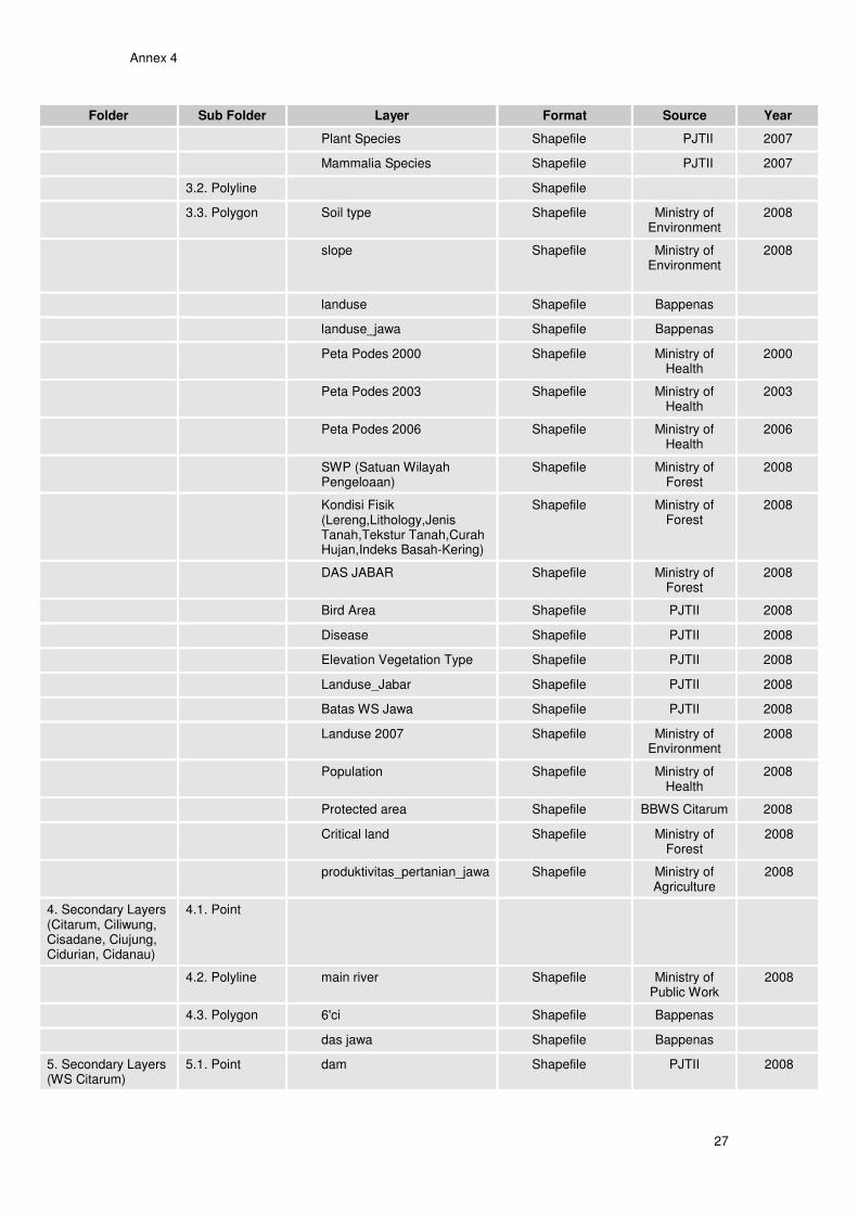
Annex 4
27
Folder Sub Folder Layer Format Source Year
Plant Species Shapefile PJTII 2007
Mammalia Species Shapefile PJTII 2007
3.2. Polyline Shapefile
3.3. Polygon Soil type Shapefile Ministry of Environment
2008
slope Shapefile Ministry of Environment
2008
landuse Shapefile Bappenas
landuse_jawa Shapefile Bappenas
Peta Podes 2000 Shapefile Ministry of Health
2000
Peta Podes 2003 Shapefile Ministry of Health
2003
Peta Podes 2006 Shapefile Ministry of Health
2006
SWP (Satuan Wilayah Pengeloaan)
Shapefile Ministry of Forest
2008
Kondisi Fisik (Lereng,Lithology,Jenis Tanah,Tekstur Tanah,Curah Hujan,Indeks Basah-Kering)
Shapefile Ministry of Forest
2008
DAS JABAR Shapefile Ministry of Forest
2008
Bird Area Shapefile PJTII 2008
Disease Shapefile PJTII 2008
Elevation Vegetation Type Shapefile PJTII 2008
Landuse_Jabar Shapefile PJTII 2008
Batas WS Jawa Shapefile PJTII 2008
Landuse 2007 Shapefile Ministry of Environment
2008
Population Shapefile Ministry of Health
2008
Protected area Shapefile BBWS Citarum 2008
Critical land Shapefile Ministry of Forest
2008
produktivitas_pertanian_jawa Shapefile Ministry of Agriculture
2008
4. Secondary Layers (Citarum, Ciliwung, Cisadane, Ciujung, Cidurian, Cidanau)
4.1. Point
4.2. Polyline main river Shapefile Ministry of Public Work
2008
4.3. Polygon 6'ci Shapefile Bappenas
das jawa Shapefile Bappenas
5. Secondary Layers (WS Citarum)
5.1. Point dam Shapefile PJTII 2008
Annex 4
28
Folder Sub Folder Layer Format Source Year
bendung irigasi karawang Shapefile BBWS Citarum 2008
bendung irigasi subang Shapefile BBWS Citarum 2008
irigasi bekasi Shapefile BBWS Citarum 2008
irigasi karawang Shapefile BBWS Citarum 2008
irigasi subang Shapefile BBWS Citarum 2008
bendungirigasikarawang Shapefile BBWS Citarum 2008
pos duga air point Shapefile BBWS Citarum 2008
pos hujan point Shapefile BBWS Citarum 2008
pos klimatologi point Shapefile BBWS Citarum 2008
pos telemetri Shapefile BBWS Citarum 2008
stasiun hidrologi Shapefile BBWS Citarum 2008
Titik_Pantau_Ciliwung Shapefile BBWS Citarum 2008
titik_pantau_cisadane Shapefile BBWS Citarum 2008
Disaster Rel Water Font Point
Shapefile PJTII 2008
Citarum plan weir font point Shapefile PJTII 2008
Pos Iklim Shapefile PJTII 2008
River Bank Failure Shapefile PJTII 2008
Weir Shapefile PJTII 2008
Station Rainfall Shapefile PJTII 2008
Tele & Early Warsys Shapefile PJTII 2008
Waterlevel Indicator Shapefile PJTII 2008
Station Climate PSDA Shapefile Ministry of Public Work
2008
Station Rainfall PSDA Shapefile Ministry of Public Work
2008
Mount Point Shapefile Ministry of Public Work
2008
National Park Shapefile Ministry of Public Work
2008
Wq Sampling Shapefile Ministry of Public Work
2008
Mountain Shapefile Ministry of Public Work
2008
Pledging Activity Shapefile Ministry of Public Work
2008
Station Rainfall BMG Shapefile Ministry of Public Work
2008
Candidate Point Shapefile Ministry of Public Work
2008
Candidate Point (2) Shapefile Ministry of Public Work
2008
Water Conservation Shapefile Ministry of Public Work
2008
Water Utilization Shapefile Ministry of 2008
Annex 4
29
Folder Sub Folder Layer Format Source Year
Public Work
Waterlevel Gouge_Point Shapefile PJTII 2008
Waterlevel Gouge_PJTII_FontPoint
Shapefile PJTII 2008
Waterlevel Gauge PSDA Shapefile Ministry of Public Work
2008
WQ Monitoring PJTII Shapefile PJTII 2008
WQ Monitoring Puslitbang Air
Shapefile Ministry of Public Work
2008
Benchmark point (WTC) Shapefile Bappenas 2008
problem water utilizations Shapefile BBWS Citarum 2008
problem disaster Shapefile BBWS Citarum 2008
problem water conservation Shapefile BBWS Citarum 2008
5.2. Polyline hydro Shapefile PJTII 2008
pos telemetri direction Shapefile BBWS Citarum 2008
Bekasi Irrigation Shapefile BBWS Citarum 2008
Karawang irrigation Shapefile BBWS Citarum 2008
Subang irrigation Shapefile BBWS Citarum 2008
saluran irigasi citarum Shapefile BBWS Citarum 2008
River Bank Failure Shapefile PJTII 2008
National Park Shapefile PJTII 2008
Irrigation Section Shapefile PJTII 2008
Irrigation Division Shapefile PJTII 2008
Candidate Line Shapefile PJTII 2008
Candidate Line (2) Shapefile PJTII 2008
Water Conservation Shapefile PJTII 2008
Inspection road Shapefile Bappenas 2008
Secondary Irrigation Shapefile PJTII 2008
Secondary Irrigation div 2 Shapefile PJTII 2008
5.3. Polygon Batas PJT II Shapefile PJTII 2008
Bendungan Shapefile PJTII 2008
das Shapefile PJTII 2008
flood 5 years design Shapefile BBWS Citarum 2008
flood 20 years design Shapefile BBWS Citarum 2008
flood 50 years design Shapefile BBWS Citarum 2008
flood plain area Shapefile BBWS Citarum 2008
Flooding area Shapefile BBWS Citarum 2008
Annex 4
30
Folder Sub Folder Layer Format Source Year
irrigasi_swasta Shapefile BBWS Citarum 2008
potential disaster Shapefile BBWS Citarum 2008
Earthquake potential Shapefile BBWS Citarum 2008
potensi natural disaster Shapefile BBWS Citarum 2008
sdas Shapefile PJTII 2008
Agriculture Plan Shapefile PJTII 2008
Area NTC Shapefile PJTII 2008
Area ETC Shapefile PJTII 2008
Degraded Land Shapefile PJTII 2008
Sensitif Disaster Shapefile PJTII 2008
Citarum plan region Shapefile PJTII 2008
Citarum plan ellipse Shapefile PJTII 2008
Citarum plan reservoir region Shapefile PJTII 2008
Disaster Rel Water Ellipse Shapefile PJTII 2008
Disaster Rel Water Region Shapefile PJTII 2008
Population_2000 Shapefile PJTII 2008
District Poverty Shapefile PJTII 2008
District Study Shapefile PJTII 2008
Subdistrict Study Shapefile PJTII 2008
Division PJT II (1) Shapefile PJTII 2008
Division PJT II (2) Shapefile PJTII 2008
Division PJT II (3) Shapefile PJTII 2008
Division PJT II (4) Shapefile PJTII 2008
Erosion Grade 2010 Shapefile PJTII 2008
Erosion Grade & Land 2010 Shapefile PJTII 2008
Flood Potential Shapefile PJTII 2008
Flow Stability Shapefile PJTII 2008
Forest Primary Shapefile PJTII 2008
Forest Secondary Shapefile PJTII 2008
Forest Elevation (1) Shapefile PJTII 2008
Forest Elevation (2) Shapefile PJTII 2008
Gede Pangrango Shapefile PJTII 2008
Irrigation Section Shapefile BBWS Citarum 2008
Irrigation Division Shapefile PJTII 2008
Irrigation Observed Shapefile PJTII 2008
Land Movement Shapefile PJTII 2008
Land Suitability Shapefile PJTII 2008
Landuse 1995 Shapefile PJTII 2008
Landuse 2001 Shapefile PJTII 2008
Annex 4
31
Folder Sub Folder Layer Format Source Year
Protected Forest Area Shapefile PJTII 2008
Pledging Activity Shapefile PJTII 2008
Pledging Activity Region Shapefile PJTII 2008
Regreening Shapefile PJTII 2008
South Irrigation Area Shapefile PJTII 2008
Cianjur Irrigation Area Shapefile PJTII 2008
Bandung Irrigation Area Shapefile PJTII 2008
Spatial Plan 2010 Shapefile PJTII 2008
Sub Water District Shapefile PJTII 2008
Sub Basin Shapefile PJTII 2008
Candidate Area (1) Shapefile PJTII 2008
Candidate Area (2) Shapefile PJTII 2008
Candidate Area (3) Shapefile PJTII 2008
Water Conservation (1) Shapefile PJTII 2008
Water Conservation (2) Shapefile PJTII 2008
Water District Shapefile BBWS citarum 2008
Irrigation section Shapefile BBWS citarum 2008
Resettled Area (WTC) Shapefile Bappenas 2008
Lokasi Project 1 Shapefile Bappenas 2008
6. Secondary Layers (DAS Citarum)
6.1. Point Cirata Hidro Station Shapefile Ministry of Forest
2008
6.2. Polyline
6.3. Polygon Waduk Citarum Shapefile Ministry of Forest
2008
bentuk lahan Shapefile Ministry of Forest
2008
curah hujan Shapefile Ministry of Forest
2008
hutan Shapefile Ministry of Forest
2008
kemiringan lereng Shapefile Ministry of Forest
2008
landscape Shapefile Ministry of Forest
2008
CA Jatiluhur Shapefile PJTII 2008
land use Shapefile Ministry of Forest
2008
das citarum Shapefile Ministry of Forest
2008
jenis tanah Shapefile Ministry of Forest
2008
ws citarum Shapefile Ministry of Forest
2008
Annex 4
32
Folder Sub Folder Layer Format Source Year
7. Digital Elevation Model (DEM)
7.1. Elevation elevation2 Shapefile Bappenas 2009
elevation3 Shapefile Bappenas 2009
elevation11 Shapefile Bappenas 2009
elevation12 Shapefile Bappenas 2009
7.2. Contour contour2 Shapefile Bappenas 2009
contour3 Shapefile Bappenas 2009
contour4 Shapefile Bappenas 2009
contour5 Shapefile Bappenas 2009
contour11 Shapefile Bappenas 2009
contour12 Shapefile Bappenas 2009
7.4 DEM DEM GTOPO30 RRD USGS 2009
INDONESIA SRTM Ers USGS 1999
SRTM_INDO Ers USGS 1999
8. Project Layers Sub Component 2.1
Sub Component 2.1 Shapefile Bappenas 2010
Sub Component 2.2
Sub Component 2.2 Shapefile Bappenas 2010
Sub Component 2.3
Sub Component 2.3 Shapefile Bappenas 2010
Sub Component 4.1
Sub Component 4.1 Shapefile Bappenas 2010
Sub Component 4.2
Sub Component 4.2 Shapefile Bappenas 2010
9. Project (.mxd) West Java map 1.River Basin Map in West Java
Project (mxd) Bappenas 2009
2.River Basin Map in West Java (DEM)
Project (mxd) Bappenas 2009
3.River Basin Map in West Java (Landuse)
Project (mxd) Bappenas 2009
4.River Basin Map in West Java (Population Density)
Project (mxd) Bappenas 2009
5.River Basin Map in West Java (Solid Waste)
Project (mxd) Bappenas 2009
6.River Basin Map in West Java (Natural Risk)
Project (mxd) Bappenas 2009
7.River Basin Map in West Java (Source drinking water)
Project (mxd) Bappenas 2009
Citarum River Basin
1.River Basin Map In WS Citarum
Project (mxd) Bappenas 2009
Annex 4
33
Folder Sub Folder Layer Format Source Year
2.River Basin Map In WS Citarum (Irrigation)
Project (mxd) Bappenas 2009
3.River Basin Map In WS Citarum (Monitoring Point)
Project (mxd) Bappenas 2009
4.River Basin Map In WS Citarum (DEM)
Project (mxd) Bappenas 2009
5.River Basin Map In WS Citarum (Landuse)
Project (mxd) Bappenas 2009
6.River Basin Map In WS Citarum (Population Density)
Project (mxd) Bappenas 2009
7.River Basin Map In WS Citarum (Solid Waste)
Project (mxd) Bappenas 2009
8.River Basin Map In WS Citarum Natural Risk)
Project (mxd) Bappenas 2009
9.River Basin Map In WS Citarum (Source drinking water)
Project (mxd) Bappenas 2009
10.River Basin Map In WS Citarum (WR Development & Management)
Project (mxd) Bappenas 2009
11.River Basin Map In WS Citarum (Protected Forest Area)
Project (mxd) Bappenas 2009
12.River Basin Map In WS Citarum (Poverty)
Project (mxd) Bappenas 2009
13.River Basin Map In WS Citarum (DEM from SRTM)
Project (mxd) Bappenas 2010
Citarum Sub Das
1.River Basin Map In Sub DAS Citarum Hulu
Project (mxd) Bappenas 2009
2.River Basin Map In Sub DAS Citarum Tengah
Project (mxd) Bappenas 2009
3.River Basin Map In Sub DAS Citarum Hilir
Project (mxd) Bappenas 2009
4.River Basin Map In Sub DAS Citarum Hulu SEGMEN 1
Project (mxd) Bappenas 2009
5.River Basin Map In Sub DAS Citarum Hulu SEGMEN 2
Project (mxd) Bappenas 2009
6.River Basin Map In Sub DAS Citarum Hulu SEGMEN 3
Project (mxd) Bappenas 2009
7.River Basin Map In Sub DAS Citarum Tengah SEGMEN 4
Project (mxd) Bappenas 2009
8.River Basin Map In Sub DAS Citarum Tengah SEGMEN 5
Project (mxd) Bappenas 2009
9.River Basin Map In Sub DAS Citarum Hilir SEGMEN 6
Project (mxd) Bappenas 2009
Annex 4
34
Folder Sub Folder Layer Format Source Year
Resettlement Plan
1. West Tarum Canal Resettlement Section 1
Project (mxd) Bappenas 2010
2. West Tarum Canal Resettlement Section 2
Project (mxd) Bappenas 2010
3. West Tarum Canal Resettlement Section 3
Project (mxd) Bappenas 2010
4. West Tarum Canal Resettlement Section 4
Project (mxd) Bappenas 2010
5. West Tarum Canal Resettlement Section 5
Project (mxd) Bappenas 2010
6. Resettled Household Project (mxd) Bappenas 2010
7. Bekasi Weir Sample Point Project (mxd) Bappenas 2010
DEM 1. River Basin Map In WS Citarum (DEM)
Project (mxd) Bappenas 2010
Flood 1. Flood Map (100323) Project (mxd) Bappenas 2010
2. Flood Map Cikao Bandung (100323)
Project (mxd) 2010
Project Activity Project 1 layout 2 (English) (091021)
Project (mxd) Bappenas 2010
Project 1 layout 2 (Indonesia) (091021)
Project (mxd) Bappenas 2010
Project 1 west downstream(100504)
Project (mxd) Bappenas 2010
Thematic Map River Basin Map In West Java (High Risk Area)
Project (mxd) Bappenas 2009
River Basin Map In West Java (Landuse)
Project (mxd) Bappenas 2009
River Basin Map In West Java (Natural Risk)
Project (mxd) Bappenas 2009
River Basin Map In West Java (Population Density)
Project (mxd) Bappenas 2009
River Basin Map In West Java (Solid Waste)
Project (mxd) Bappenas 2009
River Basin Map In West Java (Source of drinking water)
Project (mxd) Bappenas 2009
River Basin Map In WS Citarum (Desain Maket)
Project (mxd) Bappenas 2009
River Basin Map In WS Citarum (High Risk Area)
Project (mxd) Bappenas 2009
River Basin Map In WS Citarum (Irrigation Layer)
Project (mxd) Bappenas 2009
River Basin Map In WS Citarum (Monitoring Point)
Project (mxd) Bappenas 2009
River Basin Map In WS Citarum (Population Density)
Project (mxd) Bappenas 2009

Annex 4
35
Folder Sub Folder Layer Format Source Year
River Basin Map In WS Citarum (Natural Risk)
Project (mxd) Bappenas 2009
River Basin Map In WS Citarum (Poverty)
Project (mxd) Bappenas 2009
River Basin Map In WS Citarum (Protected Forest Area)
Project (mxd) Bappenas 2009
River Basin Map In WS Citarum (Solid Waste)
Project (mxd) Bappenas 2009
River Basin Map In WS Citarum (Source of drinking water)
Project (mxd) Bappenas 2009
River Basin Map In WS Citarum (WR Development & Management)
Project (mxd) Bappenas 2009
Annex 5
36
Annex 5: Thematic maps list A. West Java Scale Maps 1. Base map 2. Land use 3. Critical land 4. Population density 5. Solid waste management 6. Floods, landslides, seacoast abrasion 7. Drinking water sources B. Citarum River Basin Scale Maps 8. Base map 9. Land use 10. Critical land 11. Population density 12. Solid waste management 13. Floods, landslides, seacoast abrasion 14. Drinking water sources 15. Water monitoring 16. Irrigation 17. ICWRMIP P1 activities locations 18. ICWRMIP Road map activities locations 19. Investment per Districts LAPIS (LAYER) DALAM PENGEMBANGAN GIS A. Data dasar A.1.Data dasar (data base) 1. Peta dasar skala 2. Batas Wilayah Sungai 3. Sungai-sungai dalam satu WS 4. Batas-batas DAS dalam satu WS B. Pengelolaan Sumber daya Air (Water Resources Management) B.1.Prasarana (WR development and management) 1. Waduk-waduk, situ-situ (nama waduk/situ) 2. PLTA (nama, kapasitas terpasang, pengelola) 3. Daerah Irigasi (nama DI, luas dalam ha, DI >3,000ha, DI 1,000-3,000ha, DI <1,000 ha) 4. Lokasi pengambilan air permukaan 5. Lokasi pengambilan air tanah dalam 6. Instalasi penjernihan air 7. Keramba jaring apung B.2.Daya rusak air (Disaster management) 1. Daerah rawan banjir (lokasi, luas, jumlah penduduk, prasarana terdampak) 2. Prasarana banjir: Tanggul, krib, pintu klep, pompa, poulder 3. Daerah rawan kekeringan (lokasi, luas) 4. Daerah rawan longsor B.3.Konservasi SDA (Environment Protection) 1. Kawasan lindung 2. Hutan 3. Perkebunan
Annex 5
37
4. Lahan kritis 5. Kawasan rehabilitasi lahan (GRLK, GNKPA, ) 6. Lokasi monitoring kualitas air 7. Kawasan industri 8. Sumber limbah industri (point source) 9. Peternakan 10. Kawasan permukiman padat penduduk 11. Instalasi Sanitasi komunal 12. Instalasi Air minum komunal 13. Instalasi pengelolaan limbah industri terpadu (lokasi, kapasitas terpasang) 14. Instalasi pengelolaan limbah domestik terpadu (lokasi, kapasitas terpasang) 15. Lokasi kritis air tanah dalam 16. Kali mati (?), bekas galian C (?) B.4.Sistim Informasi SDA 1. Lokasi pengambilan contoh kualitas air 2. Instalasi pengukuran debit air (In situ, AWLR) 3. Lokasi stasiun hujan 4. Instalasi pengukuran penyinaran matahari 5. Instalsi pengukuran kelembaban udara 6. Lokasi stasiun klimatologi 7. Telemetri system (tinggi muka air, curah hujan) B.5. Organisasi masyarakat 1. Organisasi Perkumpulan Petani Pemakai Air (P3A) 2. Lembaga Sosial Masyarakat (LSM) terkait Pengelolaan SDA 3. Lembaga Pengabdian Masyarakat Perguruan Tinggi C. Terkait dengan Administrasi Pemerintahan 1. Batas Kabupaten/Kota 2. Ibukota kabupaten /Kota 3. Batas Kecamatan/Desa (nama Kecamatan, nama Desa/Kelurahan) 4. Kantor Pengelola WS (Balai Besar, Balai PSDA, PJT2, Divisi PJT, Indonesia Power, Pembangkit Jawa Bali, BKSDA,Perhutani Jawa Barat) D. Terkait dengan kondisi sosial 1. Desa miskin 2. Akses terhadap air minum (sangat mudah, mudah, tersedia, sulit, sangat sulit) 3. Akses terhadap sanitasi 4. Akses terhadap fasilitas kesehatan (puskesmas) E. Kegiatan pengembangan sektor-sektor terkait Pengelolaan SDA (On going project) 1. Pengembangan prasarana SDA 2. Prasarana Air Minum 3. Prasarana Sanitasi 4. Pembangkitan Listrik Tenaga Air 5. Pengembangan perikanan air tawar 6. Pengendalian banjir 7. Pemberdayaan masyarakat terkait kesehatan lingkungan air 8. Pemberdayaan masyarakat terkait pemanfaatan air untuk pertanian 9. Pemberdayaan masyarakat terkait pengelolaan limbah peternakan 10. Pemebrdayaan masyarakat terkait dengan konsevasi daerah hulu 11. Pemberdayaan masyarakat terkait dengan pemanfaatan air tanah dalam

Annex 6
38
Annex 6: PODES 2008 survey indicators
Annex 7
39
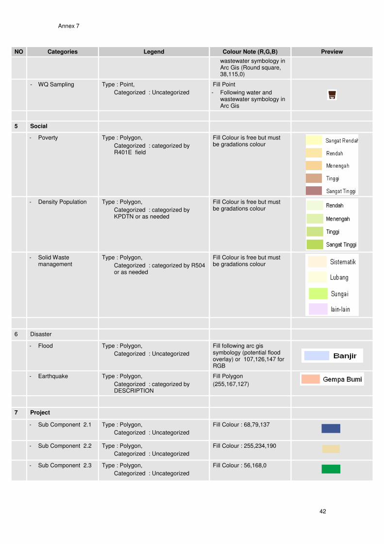
Annex 7: Standardized legend
NO Categories Legend Colour Note (R,G,B) Preview
1 Basic
- Province Type : Polygon,
Categorized : uncategorized or as needed
Fill : 205,205,102
Outline : slash dot slash
- District Type : Polygon,
Categorized : uncategorized or as needed
Fill : 200,254.199
Outline : slash dot dot slash
- Sub District Type : Polygon,
Categorized : uncategorized or as needed
Fill : 200,254.199
Outline : slash dot dot dot slash
- Village Type : Polygon,
Categorized : uncategorized or as needed
Fill : 200,254.199
Outline : dot
- Road Type : Polyline,
Categorized : categorized or as needed
- Jalan Lingkungan
- Jalan Kolektor
- Jalan Arteri
- Jalan Nasional
- Jalan Lingkungan (255,127,127)
- Jalan Kolektor (255,0,0,width 1,5)
- Jalan Arteri (255,0,0,width 2,5)
- Jalan Nasional (255,0,0,width 3)
- River Type : Polyline,
Categorized : uncategorized or as needed
Fil : 0, 147, 221
- Shoreline Type : Polyline,
Categorized : uncategorized or as needed
Fill : 0, 147, 221
- Reservoir Type : Polygon,
Categorized : uncategorized or as needed
Fill : 0, 92, 230
Outline : 0, 92, 230
2 Water Resources
- Irrigation Section Type : Polygon,
Categorized : categorized by section or as needed
Fill
- Bekasi (112,153,89)
- Binong (161, 186,115)
- Cipamingkis (216,222,146)
- Lemahabang (242,232,157)
- Patrol (242,220,145)
- Purwakarta (242,206,133)
- Rengasdengklok (222,175,131)
- Subang (201,151,127)
- Sukamandi (209,155,151)
- Tarum (232,195,207)
- Telagasari (255,242,255)
- Weir Type : Point,
Categorized : uncategorized or as needed
Fill point (38,115,0)
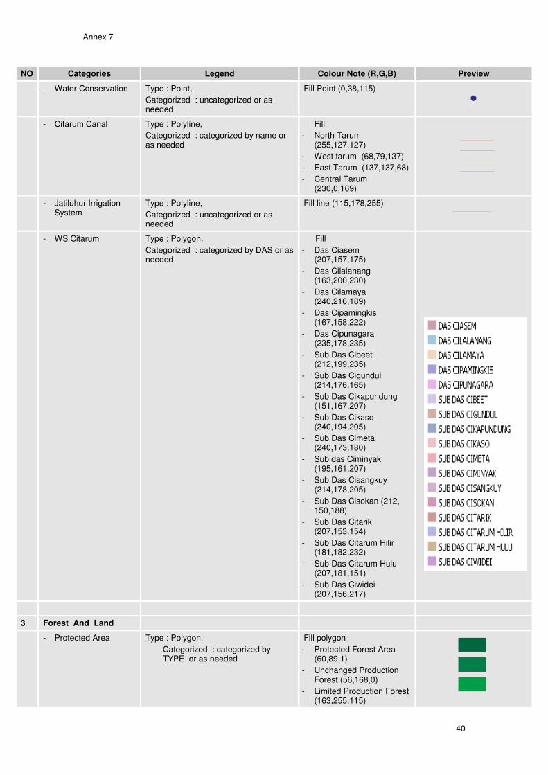
Annex 7
40
NO Categories Legend Colour Note (R,G,B) Preview
- Water Conservation Type : Point,
Categorized : uncategorized or as needed
Fill Point (0,38,115)
- Citarum Canal Type : Polyline,
Categorized : categorized by name or as needed
Fill
- North Tarum (255,127,127)
- West tarum (68,79,137)
- East Tarum (137,137,68)
- Central Tarum (230,0,169)
- Jatiluhur Irrigation System
Type : Polyline,
Categorized : uncategorized or as needed
Fill line (115,178,255)
- WS Citarum Type : Polygon,
Categorized : categorized by DAS or as needed
Fill
- Das Ciasem (207,157,175)
- Das Cilalanang (163,200,230)
- Das Cilamaya (240,216,189)
- Das Cipamingkis (167,158,222)
- Das Cipunagara (235,178,235)
- Sub Das Cibeet (212,199,235)
- Sub Das Cigundul (214,176,165)
- Sub Das Cikapundung (151,167,207)
- Sub Das Cikaso (240,194,205)
- Sub Das Cimeta (240,173,180)
- Sub das Ciminyak (195,161,207)
- Sub Das Cisangkuy (214,178,205)
- Sub Das Cisokan (212, 150,188)
- Sub Das Citarik (207,153,154)
- Sub Das Citarum Hilir (181,182,232)
- Sub Das Citarum Hulu (207,181,151)
- Sub Das Ciwidei (207,156,217)
3 Forest And Land
- Protected Area Type : Polygon,
Categorized : categorized by TYPE or as needed
Fill polygon
- Protected Forest Area (60,89,1)
- Unchanged Production Forest (56,168,0)
- Limited Production Forest (163,255,115)
Annex 7
41
NO Categories Legend Colour Note (R,G,B) Preview
- National Park (76,115,0)
- Degraded Land Type : Polygon,
Categorized : categorized by CLASS or as needed
Fill polygon
- Moderate (242,206,133)
- Critical (246,197,103)
- Very Critical (112,153,89)
- Land Movement Type : Polygon,
Categorized : categorized by TYPE or as needed
Fill Polygon
- Very Low (245,202,122)
- Low (205,170,102)
- Medium (137,112,68)
- Critical Land Type : Polygon,
Categorized : categorized by “keterangan” or as needed
Fill polygon
- Potensial Dalam Kawasan (38,115,0)
- Kritis Dalam Kawasan (255,211,127)
- Sangat Kritis Dalam Kawasan (168,56,0)
- Potensial Luar Kawasan(152,230,0)
- Kritis Luar Kawasan (255,170,0)
- Sangat Kritis Luar Kawasan (255,0,0)
- Landuse Type : Polygon,
Categorized : categorized by LANDCOVER or as needed
Fill polygon
- Hutan Alam (0,115,76)
- Hutan Lahan Kering (38,115,0)
- Kebun Campuran (205,205,102)
- Mangrove (68,137,112)
- Perkebunan (205,170,102)
- Permukiman (245,202,122)
- Rawa (102,119,205)
- Sawah (233,255,190)
- Area Penggunaan Lain (241,235,247)
- Regreening Type : Polygon,
Categorized : Uncategorized
Fill Polygon
- (76,115,0)
4 Monitoring
- Hydrologi Station Type : Point,
Categorized : categorized by LAYER or as needed
Fill Point
- Following water and wastewater symbology in Arc Gis
- Early Warning System
Type : Point,
Categorized : categorized by DAS or as needed
Fill Point
- Following water and wastewater symbology in Arc Gis
- Weir Type : Point,
Categorized : Uncategorized
Fill Point
- Following water and
Annex 7
42
NO Categories Legend Colour Note (R,G,B) Preview
wastewater symbology in Arc Gis (Round square, 38,115,0)
- WQ Sampling Type : Point,
Categorized : Uncategorized
Fill Point
- Following water and wastewater symbology in Arc Gis
5 Social
- Poverty Type : Polygon,
Categorized : categorized by R401E field
Fill Colour is free but must be gradations colour
- Density Population Type : Polygon,
Categorized : categorized by KPDTN or as needed
Fill Colour is free but must be gradations colour
- Solid Waste management
Type : Polygon,
Categorized : categorized by R504 or as needed
Fill Colour is free but must be gradations colour
6 Disaster
- Flood Type : Polygon,
Categorized : Uncategorized
Fill following arc gis symbology (potential flood overlay) or 107,126,147 for RGB
- Earthquake Type : Polygon,
Categorized : categorized by DESCRIPTION
Fill Polygon
(255,167,127)
7 Project
- Sub Component 2.1 Type : Polygon,
Categorized : Uncategorized
Fill Colour : 68,79,137
- Sub Component 2.2 Type : Polygon,
Categorized : Uncategorized
Fill Colour : 255,234,190
- Sub Component 2.3 Type : Polygon,
Categorized : Uncategorized
Fill Colour : 56,168,0
Annex 7
43
NO Categories Legend Colour Note (R,G,B) Preview
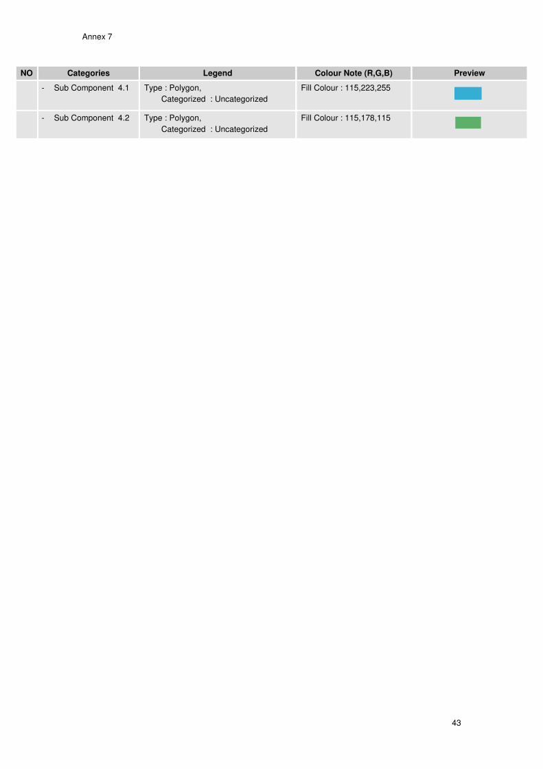
- Sub Component 4.1 Type : Polygon,
Categorized : Uncategorized
Fill Colour : 115,223,255
- Sub Component 4.2 Type : Polygon,
Categorized : Uncategorized
Fill Colour : 115,178,115

Annex 8
44
Annex 8: Web mapping solutions Cara menggunakan aplikasi Web GIS Citarum dengan MS4W (Map server)
Untuk melihat Aplikasi Web GIS Citarum ketik url pada browse www.ms4w.citarum .org
Atau kunjungi website cita citarum url www.citarum.org pilih menu peta interaktif
Setelah tampil aplikasi Web GIS Citarum akan tampil default peta Propinsi Jawa Barat dengan tampilan seperti berikut
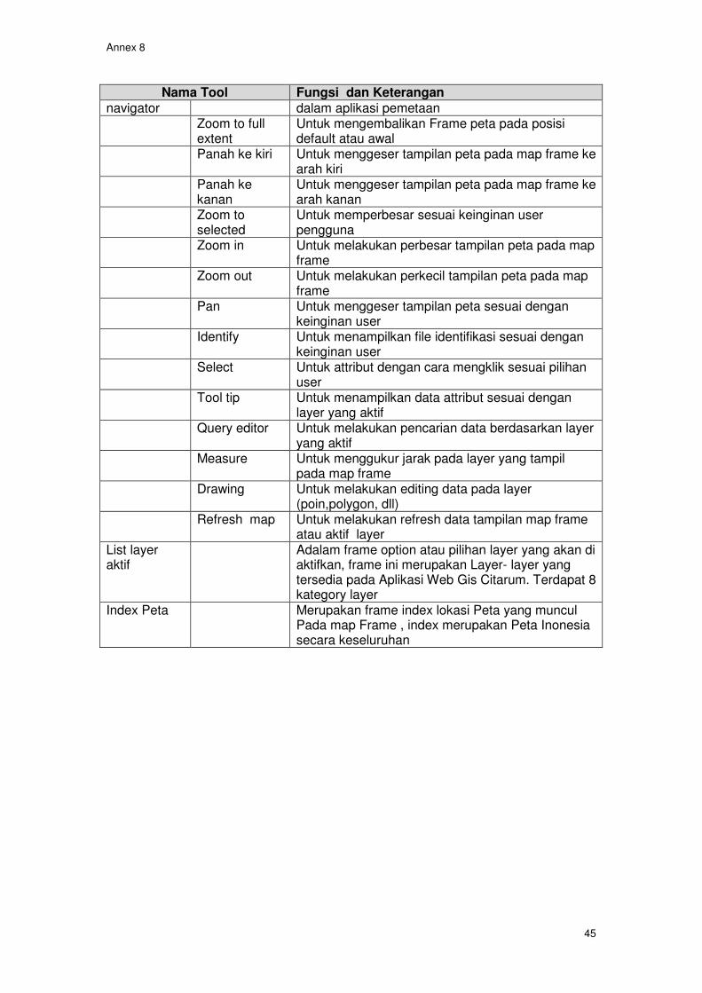
Fungsi dan kegunaan dari tool Map Server (MS4W)
Nama Tool Fungsi dan Keterangan
Main Menu Menu yang disediakan untuk Link Merupakan fasilitas untuk melihat url atau link pada
tampilan Web GIS Print Merupan fasilitas untuk mencetak gambar layer yg
aktif pada Web GIS berbagai properti resolusi (dpi) Download Merupakan fasilitas untuk mendownload attribut
dari layer yang aktif file yang akan di download disediakan dengan beberapa option format
Help Merupakan fasilitas bantuan untuk menggunakan Web GIS citarum
Layer Merupakan fasilitas keterangan layer yang aktif Map Frame Frame tempat menampilkan Layer Shp yang aktif
atau di pilih oleh User pengguna Web Gis Citarum Tool Adalah Tool pemetaan yang standar digunakan di
Map
Frame
Tool Navigator
List Layer
aktif
Index peta
Main
Menu
Frame
Annex 8
45
Nama Tool Fungsi dan Keterangan
navigator dalam aplikasi pemetaan Zoom to full
extent Untuk mengembalikan Frame peta pada posisi default atau awal
Panah ke kiri Untuk menggeser tampilan peta pada map frame ke arah kiri
Panah ke kanan
Untuk menggeser tampilan peta pada map frame ke arah kanan
Zoom to selected
Untuk memperbesar sesuai keinginan user pengguna
Zoom in Untuk melakukan perbesar tampilan peta pada map frame
Zoom out Untuk melakukan perkecil tampilan peta pada map frame
Pan Untuk menggeser tampilan peta sesuai dengan keinginan user
Identify Untuk menampilkan file identifikasi sesuai dengan keinginan user
Select Untuk attribut dengan cara mengklik sesuai pilihan user
Tool tip Untuk menampilkan data attribut sesuai dengan layer yang aktif
Query editor Untuk melakukan pencarian data berdasarkan layer yang aktif
Measure Untuk menggukur jarak pada layer yang tampil pada map frame
Drawing Untuk melakukan editing data pada layer (poin,polygon, dll)
Refresh map Untuk melakukan refresh data tampilan map frame atau aktif layer
List layer aktif
Adalam frame option atau pilihan layer yang akan di aktifkan, frame ini merupakan Layer- layer yang tersedia pada Aplikasi Web Gis Citarum. Terdapat 8 kategory layer
Index Peta Merupakan frame index lokasi Peta yang muncul Pada map Frame , index merupakan Peta Inonesia secara keseluruhan
Annex 8
46
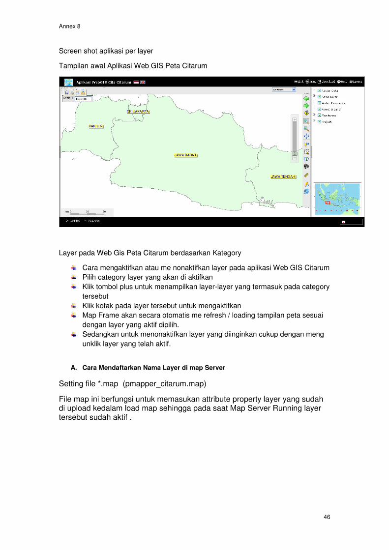
Screen shot aplikasi per layer
Tampilan awal Aplikasi Web GIS Peta Citarum
Layer pada Web Gis Peta Citarum berdasarkan Kategory
Cara mengaktifkan atau me nonaktifkan layer pada aplikasi Web GIS Citarum
Pilih category layer yang akan di aktifkan
Klik tombol plus untuk menampilkan layer-layer yang termasuk pada category
tersebut
Klik kotak pada layer tersebut untuk mengaktifkan
Map Frame akan secara otomatis me refresh / loading tampilan peta sesuai
dengan layer yang aktif dipilih.
Sedangkan untuk menonaktifkan layer yang diinginkan cukup dengan meng
unklik layer yang telah aktif.
A. Cara Mendaftarkan Nama Layer di map Server
Setting file *.map (pmapper_citarum.map)
File map ini berfungsi untuk memasukan attribute property layer yang sudah di upload kedalam load map sehingga pada saat Map Server Running layer tersebut sudah aktif .

Annex 8
47
File *.map ini bisa dibuka menggunakan notepad atau Wordpad
Diatas adalah contoh script include layer raster pada file pmapper_citarum.map
Configurasi file XML (config_default.xml)
File configurasi XML ini digunakan untuk menampilkan file layer yang usdah di upload ke dalam tampilan Web GIS Citarum sehingga bisa di tampilkan pada map Server (ms4w)
Annex 8
48
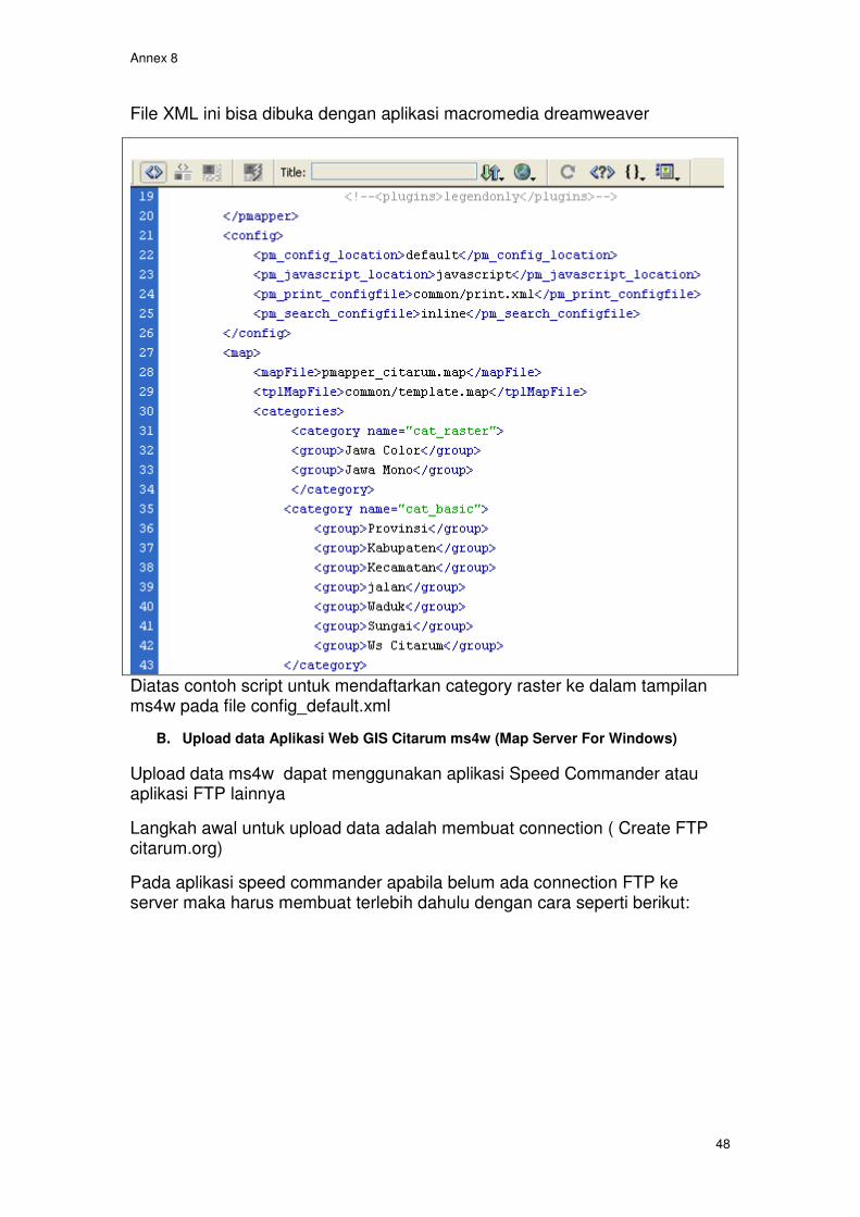
File XML ini bisa dibuka dengan aplikasi macromedia dreamweaver
Diatas contoh script untuk mendaftarkan category raster ke dalam tampilan ms4w pada file config_default.xml
B. Upload data Aplikasi Web GIS Citarum ms4w (Map Server For Windows)
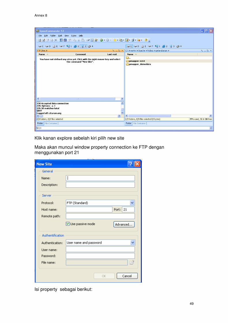
Upload data ms4w dapat menggunakan aplikasi Speed Commander atau aplikasi FTP lainnya
Langkah awal untuk upload data adalah membuat connection ( Create FTP citarum.org)
Pada aplikasi speed commander apabila belum ada connection FTP ke server maka harus membuat terlebih dahulu dengan cara seperti berikut:
Annex 8
49
Klik kanan explore sebelah kiri pilih new site
Maka akan muncul window property connection ke FTP dengan menggunakan port 21
Isi property sebagai berikut:

Annex 8
50
Setelah new connection dibuat
Coba connection setalah berhasil maka explore FTP akan muncul seperti dibawah
c1t4ru
Annex 8
51
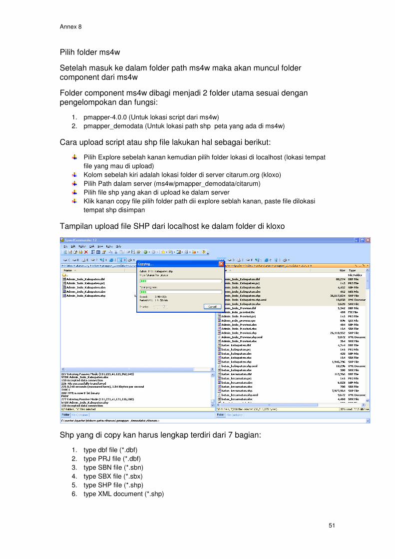
Pilih folder ms4w
Setelah masuk ke dalam folder path ms4w maka akan muncul folder component dari ms4w
Folder component ms4w dibagi menjadi 2 folder utama sesuai dengan pengelompokan dan fungsi:
1. pmapper-4.0.0 (Untuk lokasi script dari ms4w)
2. pmapper_demodata (Untuk lokasi path shp peta yang ada di ms4w)
Cara upload script atau shp file lakukan hal sebagai berikut:
Pilih Explore sebelah kanan kemudian pilih folder lokasi di localhost (lokasi tempat
file yang mau di upload)
Kolom sebelah kiri adalah lokasi folder di server citarum.org (kloxo)
Pilih Path dalam server (ms4w/pmapper_demodata/citarum)
Pilih file shp yang akan di upload ke dalam server
Klik kanan copy file pilih folder path dii explore seblah kanan, paste file dilokasi
tempat shp disimpan
Tampilan upload file SHP dari localhost ke dalam folder di kloxo
Shp yang di copy kan harus lengkap terdiri dari 7 bagian:
1. type dbf file (*.dbf)
2. type PRJ file (*.dbf)
3. type SBN file (*.sbn)
4. type SBX file (*.sbx)
5. type SHP file (*.shp)
6. type XML document (*.shp)

Annex 8
52
semua file harus di upload ke dalam path server , apabila ada file yg tida include akan mengakibatkan layer tidak akan muncul di dalam map frame ms4w (map Server For Windows)
Annex 9
53
Annex 9: References Nippon Koei Co Ltd Supplemental Appendix VII: Geographic Information System, Integrated Citarum Water Resources Management Project (ICWRMP) Technical Assistance (TA 4381-INO) Integrated Citarum Water Resources Management Project TA - 4381(INO) - ANNEX I - Outline for a DST set-up to support, IWRM in the Citarum basin, Teunis H. op ten Noort, River Basin Modeller/Water Quality Expert, November 2006 Eddy Prahasta, 2006, Membangun Aplikasi Web-based GIS dengan MapServer, Informatika-Bandung Review Of Flood Control Plan And Detailed Design Preparation, GIS Database of Greater Citarum Basin, 2007: Pacific Consultants International
Modul Pelatihan Arc Gis Tingkat Dasar, 2007, GIS Consortium Aceh Nias