Structural adjustment programmes adversely affect vulnerable ...
Upload
khangminh22Category
view
2download
0
North East Local Plan District – Local Flood Risk Management Plan
Ellon (Potentially Vulnerable Area 06/12)
168
2.3.12 Ellon (Potentially Vulnerable Area 06/12)
Local Plan District local authority Main catchments
North East Aberdeenshire Council River Ythan
Buchan coastal
Background
This Potentially Vulnerable Area is centred on
Ellon. It is approximately 19km2.
The A920, A948, B9005 and a short section
of the A90 pass through the area.
The main river in the area is the Ythan, which
is tidally influenced downstream of Ellon.
There are approximately 110 residential and
40 non-residential properties at risk of
flooding.
The Annual Average Damages are
approximately £300,000 with the majority due
to river flooding.
Annual Average Damages by flood source
Reproduced from North East Flood Risk Management Strategy, SEPA (December 2015)
Summary of flooding impacts
The river flood risk comes from the River Ythan and its smaller tributaries, including
Modley Burn and Broomies Burn.
Roads at risk of flooding include the A920, A948 and A90. One school is at risk of
flooding. Three designated cultural heritage sites and small areas of designated
environmental sites are shown to be at risk.
For this Potentially Vulnerable Area the highest damages are to residential properties
followed by damages to non-residential properties.
River 75%
Coastal <1%
Surface
water 25%
North East Local Plan District – Local Flood Risk Management Plan
Ellon (Potentially Vulnerable Area 06/12)
169
History of flooding
There are two recorded floods from the Modley Burn in Ellon. In 2000 a wall collapsed,
causing flooding. In 2002 the basements of property located on the culverted section of
the burn flooded due to water backing up.
In 2004, two properties in Findhorn Gardens flooded due to runoff from the adjacent
housing development.
In 2009 there was a flood from Broomies Burn, which affected Castle Way Industrial
Estate, Ellon and damaged two bridges. Two industrial units and a school were affected.
Flooding in December 2015 resulted in damage to over 80 Properties within Ellon. 18
homes evacuated in the Meadows area and an electricity substation flooded causing
power cuts to 150 homes. 37 people attended rest centre in Ellon. The road between
Ythanbank and Methlick was closed.
Objectives to manage flooding in Potentially Vulnerable Area 06/12
Objectives provide a common goal and shared ambition for managing floods. These
objectives have been set by SEPA and agreed with flood risk management authorities
following consultation. They were identified through an assessment of the underlying
evidence of the causes and impacts of flooding. Target areas have been set to focus
actions; they do not necessarily correspond to areas at risk in SEPA’s flood map. The
objectives below have been set for Ellon Potentially Vulnerable Area.
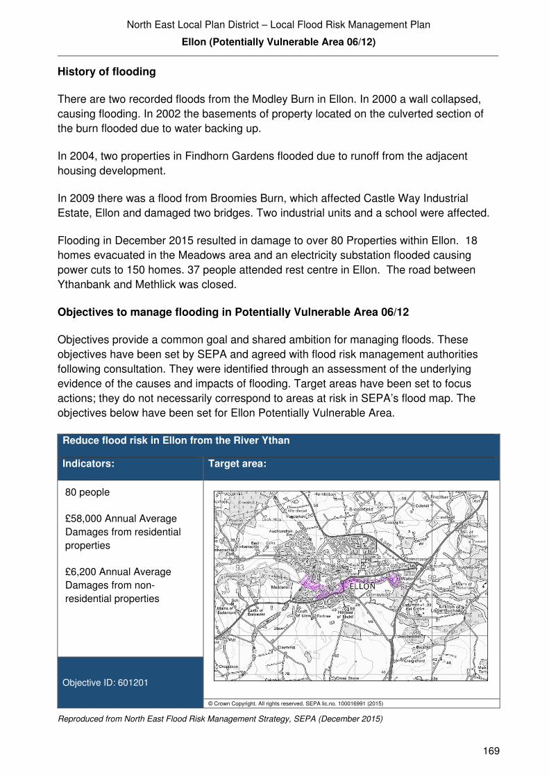
Reduce flood risk in Ellon from the River Ythan
Indicators: Target area:
80 people
£58,000 Annual Average
Damages from residential
properties
£6,200 Annual Average
Damages from non-
residential properties
Objective ID: 601201
© Crown Copyright. All rights reserved. SEPA lic.no. 100016991 (2015)
Reproduced from North East Flood Risk Management Strategy, SEPA (December 2015)

North East Local Plan District – Local Flood Risk Management Plan
Ellon (Potentially Vulnerable Area 06/12)
170
Reduce flood risk in Ellon from the Modley Burn
Indicators: Target area:
80 people
£80,000 Annual Average
Damages from residential
properties
£20,000 Annual Average
Damages from non-
residential properties
Objective ID: 601202
© Crown Copyright. All rights reserved. SEPA lic.no. 100016991 (2015)
Reproduced from North East Flood Risk Management Strategy, SEPA (December 2015)
Reduce flood risk in Ellon from the Broomies / Bronie Burn
Indicators: Target area:
£4,100 Annual Average
Damages from residential
properties
£37,000 Annual Average
Damages from non-
residential properties
Objective ID: 601203
© Crown Copyright. All rights reserved. SEPA lic.no. 100016991 (2015)
Reproduced from North East Flood Risk Management Strategy, SEPA (December 2015)

North East Local Plan District – Local Flood Risk Management Plan
Ellon (Potentially Vulnerable Area 06/12)
171
Target area Objective ID Indicators within
PVA
Applies across
North East Local
Plan District
Avoid an overall increase in flood risk 600001 110 residential properties
£300,000 Annual Average Damages
Applies across
North East Local
Plan District
Reduce overall flood risk 600002 110 residential properties
£300,000 Annual Average Damages
Applies across
North East Local
Plan District
Organisation such as utility companies and
Historic Environment Scotland actively
maintain and manage their own assets,
including the risk of flooding. These
actions are not detailed further in the Flood
Risk Management Strategies.
Reproduced from North East Flood Risk Management Strategy, SEPA (December 2015)
Actions to manage flooding in Potentially Vulnerable Area 06/12
Actions describe where and how flood risk will be managed. These actions have been set
by SEPA and agreed with flood risk management authorities following consultation.
Selection of actions to deliver the agreed objectives was based on a detailed assessment
and comparison of economic, social and environmental criteria. The actions shaded and
then described below have been selected as the most appropriate for Ellon Potentially
Vulnerable Area.
Selected actions
Flood protection
scheme/works
Natural flood management
works
New flood warning
Community flood action
groups
Property level protection scheme
Site protection plans
Flood protection
study
Natural flood management
study
Maintain flood warning
Awareness raising
Surface water plan/study
Emergency plans/response
Maintain flood protection scheme
Strategic mapping and
modelling
Flood forecasting
Self Help Maintenance Planning policies

North East Local Plan District – Local Flood Risk Management Plan
Ellon (Potentially Vulnerable Area 06/12)
172
The delivery of selected actions by year over the six-year plan cycle is summarised below.
Delivery of selected actions
Year 1 (2016/17) Year 2
(2017/18)
Year 3
(2018/19)
Year 4
(2019/20)
Year 5
(2020/21)
Year 6
(2021/22)
Flood protection study
Awareness raising
Emergency plans/response
Strategic mapping and modelling
(Scottish Water)
Flood forecasting
Self help
Maintenance
Planning Policy

North East Local Plan District – Local Flood Risk Management Plan
Ellon (Potentially Vulnerable Area 06/12)
173
Action (ID): FLOOD PROTECTION STUDY (6012010005)
Objective (ID): Reduce flood risk in Ellon from the Broomies / Bronie Burn (601203)
Reduce flood risk in Ellon from the Modley Burn (601202)
Reduce flood risk in Ellon from the River Ythan (601201)
Delivery lead: Aberdeenshire Council
Priority: National: Within local authority:
55 of 168 1 of 12
Status: Scheduled Indicative delivery: 2016-2019
Description:
Aberdeenshire Council will undertake a flood protection study to evaluate options for flood
management to reduce the risk of flooding in Ellon from the River Ythan, Modley Burn and
Broomies / Bronie Burn. The study will be completed by the Summer 2019
The study has the potential to benefit 77 residential properties, 18 non-residential properties,
sections of road network and a school at risk of flooding in this location, with potential damages
avoided of up to £6.1 million. A reduction in flood risk would have a positive benefit to the health
and wellbeing of the community and socially vulnerable people located within the study area and
may also contribute to enhanced biodiversity and economic activity.
The study will take a sustainable and integrated approach by coordinating with the river basin
management plan. It will be undertaken with due consideration to internationally, nationally and
locally designated sites including listed buildings. It will also explore opportunities for enhancing
biodiversity and for promoting economic activity and social wellbeing.
The study will consider natural flood management measures along with traditional flood defences
by exploring opportunities for online and offline flood storage, flow control structures, modification
to conveyance capacity of watercourses by sediment and channel management, modifications to
the bridges to improve conveyance, the construction of direct defences, river / floodplain
restoration, runoff control through catchment and riparian tree planting, land-use and land-
management changes, etc. Additionally, the study will also consider property level protection and
property relocation. It is expected that the recommended flood protection scheme will comprise a
combination of such measures to ensure a sustainable and integrated approach to flood risk
management by due consideration of impacts on economy, society, environment and cultural
heritage.
(continued)

North East Local Plan District – Local Flood Risk Management Plan
Ellon (Potentially Vulnerable Area 06/12)
174
Aberdeenshire Council will coordinate with SEPA, Scottish Water, SNH, The Crown Estate,
landowners and community groups as well as other relevant agencies and organisations.
Aberdeenshire Council will undertake the study through the Local Planning District (LPD)
partnership and / or through separate agreements.
Funding for the study will be subject to Scottish Government’s block grant and capital support,
and budget allocations over the six years of the Plan, 2016-2022.
Potential impacts
Economic: The study could benefit 77 residential and 18 non-residential properties at risk
of flooding in this location, with potential damages avoided of up to £6.1
million.
Social: The development of flood protection works following the study would
potentially reduce risk to 169 people. A reduction in flood risk would have a
positive benefit to the health and wellbeing of the community and socially
vulnerable people. One school may benefit from any works. Three utility sites
(energy/electricity) could also benefit from the flood protection works identified
in the study depending on the location and extent of works. Natural flood
management actions can restore and enhance natural environments and
create opportunities for recreation and tourism. Negative impacts through
disturbance to the local community during the construction phase should be
considered.
Environmental: Flood protection studies should consider the positive and negative impacts of
proposed actions on the ecological quality of the environment. Natural flood
management actions can have a positive impact by restoring and enhancing
natural habitats. Opportunities to mitigate any environmental impacts may
include design and timing of works. The flood protection study should
consider how to avoid or minimise potential negative effects such as loss or
disturbance of sediment, disruption to natural processes and loss of habitat.
To be in accord with the FRM Strategy, the Responsible Authority should
seek to ensure as part of the study that the action will not have an adverse
effect on the integrity of the Ythan Estuary, Sands of Forvie and Meikle Loch
Special Protection Area. The study should ensure the actions do not impact
the downstream Sands of Forvie and Ythan Estuary Site of Special Scientific
Interest.
North East Local Plan District – Local Flood Risk Management Plan
Ellon (Potentially Vulnerable Area 06/12)
175
Action (ID): AWARENESS RAISING (6000020013)
Objective (ID): Reduce overall flood risk (600002)
Delivery lead: Responsible authorities
Status: Existing Indicative delivery: Ongoing
Description:
Aberdeenshire Council have a duty to raise public awareness of flood risk under the Flood Risk
Management (Scotland) Act 2009 and to plan and inform of risks to communities under the Civil
Contingencies Act 2004.
Over the six years of the Plan, 2016-2022, Aberdeenshire Council will seek opportunities to raise
awareness of both flood risk and actions that enable individuals, homes and businesses to
reduce the overall impact of flooding.
In partnership with Education Scotland Aberdeenshire Council will look to engage schools in
activities relating to flooding, extreme weather, climate change and other community resilience
issues.
Aberdeenshire Council will also develop emergency response plans and work with community
flood action groups where these exist.
Awareness raising will be funded from existing local authority flood revenue budgets.
From 2016 SEPA will engage with the community through local participation in national
initiatives, including partnership working with Neighbourhood Watch Scotland. In addition, SEPA
will engage with local authorities and community resilience groups where possible.
Across Scotland, SEPA will create and share communication and education resources with other
responsible authorities. These resources will include awareness campaigns, media and
marketing activities and promotion of SEPA's flood forecasting and warning service (Floodline).
Where they exist, SEPA will engage with community resilience groups and community safety
partnerships. Additionally, SEPA's awareness raising activities will be coordinated with the
activities of other responsible authorities as required.
SEPA's awareness raising activities are funded by Scottish Government through their grant in aid
settlement and will be coordinated with the activities of other responsible authorities as required.
Scottish Water will support SEPA and responsible authorities with their awareness raising
activities as required and provide targeted flooding communications for Scottish Water specific
activities. Scottish Water will raise awareness by producing and supplying targeted information to
the public on large capital projects and detailed local studies.
(continued)

North East Local Plan District – Local Flood Risk Management Plan
Ellon (Potentially Vulnerable Area 06/12)
176
Action (ID): EMERGENCY PLANS/RESPONSE (6000020014)
Objective (ID): Reduce overall flood risk (600002)
Delivery lead: Category 1 and 2 Responders
Status: Existing Indicative delivery: Ongoing
Description:
Providing an emergency response to flooding is the responsibility of many organisations,
including local authorities, the emergency services and SEPA. Effective management of an
emergency response relies on emergency plans that are prepared under the Civil Contingencies
Act 2004 by Category 1 and 2 Responders.
Aberdeenshire Council has an overarching Flood Response Plan, which is coordinated through
the Responders identified under the Civil Contingencies Act 2004. The aim of the plan is to set
out arrangements to deal effectively with flood risk. At predetermined trigger levels flood alerts
and warnings will be issued through SEPA's flood forecasting and warning service (Floodline)
and Aberdeenshire Council will conduct assessments at known hotspots and prepare resources
as required. Aberdeenshire Council will also coordinate measures in conjunction with the other
Responders. The emergency response process is coordinated through regional and local
resilience partnerships. This response may be supported by the work of voluntary organisations.
The Operational Flood Response Plan will undergo review on an annual basis to reflect
operational or responsibility changes. A debrief and plan review will also be carried out after the
Plan is activated during emergencies.
Aberdeenshire Council funding for emergency plans/response will be shared with other
organisations, emergency services and Responders, as appropriate, and will be subject to
Scottish Government’s block grant and capital support, and budget allocations over the six years
of the Plan, 2016-2022. SEPA's emergency plans/response are funded by Scottish Government
through SEPA’s grant in aid settlement.
More general information and flooding guidance will be available on the website at:
https://www.scottishwater.co.uk/you-and-your-home/your-home/flooding-information
Scottish Water will keep responsible authorities informed of its awareness raising activities
through the Local Plan District partnerships.
North East Local Plan District – Local Flood Risk Management Plan
Ellon (Potentially Vulnerable Area 06/12)
177
Action (ID): STRATEGIC MAPPING AND MODELLING (6000020019)
Objective (ID): Reduce overall flood risk (600002)
Delivery lead: Scottish Water
Status: Scheduled Indicative delivery: 2016-2020
Description:
Scottish Water will undertake further investigation and modelling in the Ellon sewer catchment to
improve knowledge and understanding of flood risk in this area as required under Section 16 of
the Flood Risk Management (Scotland) Act 2009.
Scottish Water will work with responsible authorities to incorporate relevant information into these
studies by regularly keeping the responsible authorities informed of their progress. Scottish
Water will provide responsible authorities with the outputs of the Section 16 assessment which,
where relevant, may be used to inform Surface Water Management Plans and SEPA flood
hazard and risk maps.
Scottish Water funding is committed in its capital programme through Q&S 4a (2015-2021) which
is approved by its regulators and customers.
Action (ID): FLOOD FORECASTING (6000020009)
Objective (ID): Reduce overall flood risk (600002)
Delivery lead: SEPA
Status: Existing Indicative delivery: Ongoing
Description:
The Scottish Flood Forecasting Service is a joint initiative between SEPA and the Met Office that
produces daily, national flood guidance statements which are issued to Category 1 and 2
Responders. The flood guidance statements provide an assessment of the risk of flooding for a
five day period allowing responders time to put preparations in place to reduce the impact of
flooding. The service also provides information which allows SEPA to issue flood warnings,
giving people a better chance of reducing the impact of flooding on their home or business. For
more information, please visit SEPA’s website. The Potentially Vulnerable Area is within the
'Aberdeenshire and Aberdeen City' flood alert area.
SEPA / Met Office joint initiative. Hydrological information is provided by SEPA and
meteorological information is provided by the Met Office. SEPA uses the information to predict
the likelihood and timing of river, coastal and surface water flooding.
SEPA’s flood forecasting service is funded through Scottish Government’s grant in aid allocation.
The Met Office receives funding from the UK Government.

North East Local Plan District – Local Flood Risk Management Plan
Ellon (Potentially Vulnerable Area 06/12)
178
Action (ID): MAINTENANCE (6000020007)
Objective (ID): Reduce overall flood risk (600002)
Delivery lead: Aberdeenshire Council, asset / land managers
Status: Existing Indicative delivery: Ongoing
Description:
Local authorities have a duty to assess watercourses and carry out clearance and repair works
where such works would substantially reduce flood risk. Aberdeenshire Council will produce
schedules of clearance and repair works and make these available for public inspection.
Maintenance will be funded from existing Flood revenue budgets, for works which are defined to
pose a significant flood risk.
Scottish Water undertake risk based inspection, maintenance and repair on the public sewer
network together with keeping responsible authorities informed of large scale capital
maintenance work to identify opportunities for co-ordination.
Action (ID): SELF HELP (6000020011)
Objective (ID): Reduce overall flood risk (600002)
Delivery lead: —
Status: Existing Indicative delivery: Ongoing
Description:
Everyone is responsible for protecting themselves and their property flooding. Property and
business owners can take simple steps to reduce damage and disruption to their homes and
businesses should flooding happen. This includes preparing a flood plan and flood kit, installing
property level protection, signing up to Floodline and Resilient Communities initiatives, and
ensuring that properties and businesses are insured against flood damage.
Aberdeenshire Council currently provide a small range of flood protection products for individual
property protection, which are available for all types of flooding, at cost price with free delivery
across Aberdeenshire.

North East Local Plan District – Local Flood Risk Management Plan
Ellon (Potentially Vulnerable Area 06/12)
179
Action (ID): PLANNING POLICIES (6000010001)
Objective (ID): Avoid an overall increase in flood risk (600001)
Reduce overall flood risk (600002)
Delivery lead: Planning authority
Status: Existing Indicative delivery: Ongoing
Description:
Scottish Planning Policy and accompanying Planning Advice Notes set out Scottish Ministers’
priorities for the operation of the planning system and for the development and use of land. In
terms of flood risk management, the policy supports a catchment-scale approach to sustainable
flood risk management and aims to build the resilience of our cities and towns, encourage
sustainable land management in our rural areas, and to address the long-term vulnerability of
parts of our coasts and islands. Under this approach, new development in areas with medium to
high likelihood of flooding should be avoided.
For further information on the application of national planning policies see Annex 5.
Aberdeenshire Council is a local planning authority and will work with the regional planning
authority, the Aberdeen City and Shire Strategic Development Planning Authority.
As a consultee on planning applications, Aberdeenshire Council’s Flood & Coast Protection team
will work directly with colleagues in the Planning Service to ensure that appropriate policies and
measures are put in place to reduce flood risk. Planning applications are assessed against the
flooding standards set out in the current Aberdeenshire Local Development Plan, and in future
those in the proposed Aberdeenshire Local Development Plan 2016.
SEPA has a statutory role in relation to the provision of flood risk advice to planning authorities.
This role is expressed in Section 72 of the FRM Act, 2009. SEPA also has a duty to cooperate
with planning authorities in the preparation of development plans. When consulted in relation to
planning applications for development or site allocations in development plans, and where the
planning authority considers there may be a risk of flooding, SEPA will provide advice. The
advice provided by SEPA will be with respect to the risk of flooding and on the basis of the
relevant information it holds which is suitable for planning purposes. It will also be in line with the
principles and duties set out in the FRM Act. Further information about how SEPA engages in
the planning system, including guidance on flood risk and planning is available on SEPA’s
website http://www.sepa.org.uk/environment/land/planning/
SEPA's land use planning activities will be coordinated with the activities of other responsible
authorities as required and are funded by Scottish Government through SEPA’s grant in aid
settlement.
Scottish Water is a statutory consultee within the planning legislation and is required to comment
on all outline or full planning applications which are referred by a local authority.
Copyright © 2022 FDOKUMEN