2001Qiu-Geocarto
10
19 Geocarto International, Vol. 16, No. 1, March 2001 Published by Geocarto International Centre, G.P.O. Box 4122, Hong Kong. Introduction There has been great interest in the extraction of land use/ land cover and biophysical information from satellite remotely sensed data using digital image processing techniques since the late 1960s (Estes and Jensen, 1998; Lulla and Dessinov, 2000). Significant strides have been made in the digital extraction of biophysical information (especially temperature, biomass, leaf-area-index, net primary productivity, terrain elevation) from digital remote sensing data (Jensen, 1996; 2000). However, less improvement has been seen in the extraction of Anderson Level II, III, and IV land use and land cover information, which often requires the digital processing of relatively high spatial resolution data. One of the major reasons for this lag in capability is that most digital image processing classification algorithms are based on traditional statistical methods that assume normally distributed data, and no collinearity among variables (Johnston, 1980). High spatial resolution remote sensor data are often composed of many heterogeneous patches of terrain and complex nonlinear patterns. The normality and linearity assumptions of the statistical methods may be violated. In addition, most statistical digital image processing systems only utilize the spectral information presented in the remote sensing imagery on a pixel by pixel basis. They do not incorporate contextual information very well. Thus, the land use/land cover classification results obtained using traditional statistical image processing techniques are often crude when compared with those produced by a well-trained image interpreter (Philipson, 1997). Human image interpreters do not interpret an image as if it were composed of individual pixels. They employ the totality of information associated with an unknown object or area, including its tone, color, size, shape, shadow, texture, pattern, height, site, and contextual situation and association (Estes et al., 1983; Jensen, 2000). For these reasons, most statistically-based digital image analysis is restricted to extracting relatively simplistic Level I and some Level II land cover information. In fact, the scientific community has become rather accustomed to accepting approximately 70- 80 percent absolute accuracy as about the maximum A Neural Network Image Interpretation System to Extract Rural and Urban Land Use and Land Cover Information from Remote Sensor Data John R. Jensen Department of Geography University of South Carolina Columbia, SC 29208 Fang Qiu Program in Geographic Information Science School of Social Science University of Texas at Dallas Richardson, TX 75083-0688 Keith Patterson Geonex Corporation 8950 5th Street North St. Petersburg, FL 33702 Abstract This paper describes the characteristics of a neural network image interpretation system that is designed to extract both rural land cover and urban land use from high spatial resolution imagery (e.g., digitized aerial photography, IKONOS imagery) and/or from relatively coarse spatial and spectral resolution remote sensor data (e.g., Landsat Thematic Mapper). The system consists of modules that a) classify remote sensing imagery into different land use/land cover types, b) segment the rural land cover information into relatively homogeneous polygons in a standard GIS format, and/or c) digitize and interpret urban/suburban land use cover polygons based on their feature attribute information with the aid of a neural network.
Transcript of 2001Qiu-Geocarto

19Geocarto International, Vol. 16, No. 1, March 2001Published by Geocarto International Centre, G.P.O. Box 4122, Hong Kong.
Introduction
There has been great interest in the extraction of land use/land cover and biophysical information from satelliteremotely sensed data using digital image processingtechniques since the late 1960s (Estes and Jensen, 1998;Lulla and Dessinov, 2000). Significant strides have beenmade in the digital extraction of biophysical information(especially temperature, biomass, leaf-area-index, net primaryproductivity, terrain elevation) from digital remote sensingdata (Jensen, 1996; 2000). However, less improvement hasbeen seen in the extraction of Anderson Level II, III, and IVland use and land cover information, which often requiresthe digital processing of relatively high spatial resolutiondata.
One of the major reasons for this lag in capability is thatmost digital image processing classification algorithms arebased on traditional statistical methods that assume normallydistributed data, and no collinearity among variables(Johnston, 1980). High spatial resolution remote sensor dataare often composed of many heterogeneous patches of terrain
and complex nonlinear patterns. The normality and linearityassumptions of the statistical methods may be violated. Inaddition, most statistical digital image processing systemsonly utilize the spectral information presented in the remotesensing imagery on a pixel by pixel basis. They do notincorporate contextual information very well. Thus, the landuse/land cover classification results obtained using traditionalstatistical image processing techniques are often crude whencompared with those produced by a well-trained imageinterpreter (Philipson, 1997).
Human image interpreters do not interpret an image as ifit were composed of individual pixels. They employ thetotality of information associated with an unknown object orarea, including its tone, color, size, shape, shadow, texture,pattern, height, site, and contextual situation and association(Estes et al., 1983; Jensen, 2000). For these reasons, moststatistically-based digital image analysis is restricted toextracting relatively simplistic Level I and some Level IIland cover information. In fact, the scientific community hasbecome rather accustomed to accepting approximately 70-80 percent absolute accuracy as about the maximum
A Neural Network Image Interpretation System to Extract Ruraland Urban Land Use and Land Cover Information from RemoteSensor Data
John R. JensenDepartment of GeographyUniversity of South CarolinaColumbia, SC 29208
Fang QiuProgram in Geographic Information ScienceSchool of Social ScienceUniversity of Texas at DallasRichardson, TX 75083-0688
Keith PattersonGeonex Corporation8950 5th Street NorthSt. Petersburg, FL 33702
Abstract
This paper describes the characteristics of a neural network image interpretation system that is designed toextract both rural land cover and urban land use from high spatial resolution imagery (e.g., digitized aerialphotography, IKONOS imagery) and/or from relatively coarse spatial and spectral resolution remote sensor data(e.g., Landsat Thematic Mapper). The system consists of modules that a) classify remote sensing imagery intodifferent land use/land cover types, b) segment the rural land cover information into relatively homogeneouspolygons in a standard GIS format, and/or c) digitize and interpret urban/suburban land use cover polygons based ontheir feature attribute information with the aid of a neural network.

20
obtainable from satellite digital multispectral data using digital imageprocessing techniques (Jensen, 1996).
The extraction of Level II, III, and IV land use and land coverinformation have been almost exclusively obtained from the visualinterpretation of high spatial resolution, relatively large scale (≥1:40,000) black and white (panchromatic), color, and/or color-infraredaerial photography. It requires great skill to visually interpret aerialphotography correctly. It is a relatively slow and laborious process thatis fraught with error because:• The data were acquired using a central perspective camera system
that introduces several types of error that are difficult to remove,including: scale changes throughout the image due to reliefdisplacement, vignetting (light fall-off) away from the principalpoint of the photograph, and at times, tonal changes due tophotographic processing and emulsion differences;
• an interpreter brings to the interpretation task all his or her knowledge(correct and incorrect), biases, anxieties, fatigue; and
• the polygons identified on the aerial photography must usually belaboriously transferred to a planimetric basemap and then digitized toplace them in a geographic information system (GIS).
These characteristics have caused the public at large to dismiss theinterpretation of traditional aerial photography as being too complex,i.e., a science or art best left to experts (Philipson, 1997; Jensen andCowen, 1999). Only specialized companies and certain federal andstate agencies with trained image analyst routinely extract accurateland use/land cover information from such data (Baker, 2000). Forexample, Figure 1 depicts the land use/land cover polygons for aportion of the Jacksonville Beach, FL 7.5-minute quadrangle extractedfrom digitized National Aerial Photography Program (NAPP)photography by personnel at the Geonex Corporation using visualimage interpretation techniques and manual digitization. It takesapproximately 11.5 person days for a specialized company like Geonex
to extract land use/land cover information foreach 7.5-minute quadrangle.
The launch of Space Imaging’s IKONOSsatellite in 1999 with its 1 x l m panchromaticband and four 4 x 4 m multispectral bands initiateda new era of Earth observation (Li, 1998;Dehqanzada and Florini, 2000). Other commercialdata providers intend to provide high spatialresolution data in the near future such asEarthWatch Quickbird (l x l m pan; 4 x 4 mmultispectral), and OrbImage Orb View-3 (1 x 1m pan; 4 x 4 m multispectral). Such imagery willbe a significant boon to obtaining accurate LevelII, III, and IV land cover/land use information, ifthere are appropriate image analysis techniquesavailable (Jensen and Cowen, 1999).
Analysis of High Spatial ResolutionImagery
High spatial resolution (≤ 4 X 4 m) black andwhite, color and color-infrared digital imagery forall practical purposes looks like aerial photographywhen viewed on a CRT screen. This provides anopportunity to extract Level II, III and IV landuse/cover information by “on-screen” (alsoreferred to as “heads-up”) visual humaninterpretation and subsequent digitization of thepolygons of interest. The problem is that photo-interpretation has almost become a lost art, nothaving been taught systematically in colleges anduniversities for the past 20 years (Estes and Jensen,1998). Remote sensing digital image processingcourses simply do not cover the same manual,visual photo interpretation skills once socommonly taught in introductory airphotointerpretation or photogrammetry courses.
Unfortunately, there will likely be a significantincrease in “on-screen” photo interpretation of thehigh resolution digital remote sensor dataperformed by novices who do not have a clue as towhat they are doing. Baker (2000) points out thatthe availability of the new very high resolutionimagery may in fact be a double-edged sword. Ifwe have the appropriate tools, excellentinformation may be extracted from the imagery.If we don’t have the right tools, serious imageinterpretation errors will result. Imageinterpretation errors will make their way into thepublic forum where it is possible that the public atlarge will then lose faith in the accuracy ofinformation derived from remote sensor data(Baker, 2000).
In order for the high spatial resolution digitalimagery to be fully utilized for the extraction ofLevel II, III, and IV land use/cover informationwe need user-friendly digital image interpretation
Figure 1 Digitized National Aerial Photography Program (NAPP) image (1 x 1 m) ofJacksonville Beach, FL with vectors derived from “on-screen” visual imageinterpretation.

21
systems that assist image analysts as they literally photo-interpret the high spatial resolution imagery on the CRTscreen. The improved image interpretation system shouldsupply image and collateral information that the analyst usesto make the most accurate interpretation possible. It is alsoimportant that the digital image processing system generatepolygonal boundaries for geographically extensive objects-of-interest, either automatically or semi-automatically, sothat the time and labor involved in digitization can be greatlyreduced. In addition, the system should automatically placethe interpreted results in a planimetric map projection so thatthe information is available for modeling purposes (Jensenand Cowen, 1999). This paper summarizes the status of thedevelopment of an artificial neural network based imageinterpretation system for land use/land cover classificationusing high spatial resolution remote sensor data thataccomplishes many of these goals.
Design of an Artificial Neural Network ImageInterpretation System
The image interpretation system must be able to extractaccurate land use/land cover information from both ruraland urban/suburban landscapes to be effective. The followingsections describe some of the important considerations.
Urban/Suburban ConsiderationsUrban environments are composed of diverse natural
(e.g., vegetation, soil, rock, water) and man-made materials(e.g., plastic, asphalt, concrete, metal) that man arranges in avariety of ways including asphalt rooftop shingles, asphaltpavement, concrete sidewalks and roads, grass lawns andgolf course fairways. It is possible to have a computerprogram analyze an image and identify the homogeneouslandscape ‘patches’ of biophysical material in a high spatialresolution image based on spectral information. The outputfrom such a computer analysis is general a map depicting therelatively homogeneous patches of vegetation, asphalt,concrete, water, metal, etc. that represent biophysicalinformation and not land use/cover information.
Conversely, when a human being interprets a highresolution aerial image on a CRT screen, he or she is usuallycapable of automatically identifying some of the fundamental“primitive” land uses attributes such as sidewalks, roads,buildings, parking lots, water bodies, etc. The analyst thencommonly draws a polygon around what they believe to bean unknown object-of-interest that contains many of theseprimitives (e.g., a shopping center, single-family tract ofresidential housing, apartment complex, open pit mine, mall,a fabrication industry). Unfortunately, the analyst is oftenunable to identify exactly what type of land use or land coveris found within the polygon. To do this, the analyst mustoften use not only spectral information, but also contextualinformation associated with nearby objects of interest andother elements of image interpretation previously discussed.
This is precisely where the artificial neural network (ANN)image interpretation system described in this paper becomes
useful. The system allows the analyst to identify in commonterms the “primitive” land use attributes found within thepolygon he or she has drawn on the screen. The ANN thenanalyzes the input attributes with the expert knowledgestored in the ANN library of attributes, and suggests to theanalyst the most logical label for the polygon. The polygonis then updated and the neural network evaluates the nextpolygon-of-interest. Eventually, the entire urban study areais mapped with all information stored in a vector-based GISdatabase for future spatial modeling purposes.
Rural ConsiderationsRural land use/land cover consists of water, agriculture,
forest, wetland, rangeland, grassland, desert, etc. Except forhighly engineered agricultural areas, these rural landscapesare usually composed of many relatively homogeneouspatches with curvilinear boundaries (i.e., humans tend torectilinearize the landscape to make it mechanically efficient).Unlike the urban environment, it would be an unwise wasteof time and talent for an image analyst to draw a polygonaround each patch of homogeneous wetland, forest, or water.Rather, for rural areas it is logical to allow the computer tolocate the homogeneous patches using an image classificationand/or segmentation routine, generate the edges of the patchusing an edge-detection algorithm, and covert the edge to aclean bounding polygon that can be stored in a GIS.
It is possible to train a neural network system on thespectral and textural information associated with variousrural land cover types, such as forested wetland, non-forestwetland, water, etc. so that it a) identifies homogenouspolygons, and b) assigns each polygon to a unique landcover class.
Final DesignA neural network image interpretation system was
designed that addressed many of these urban and ruralconsiderations. It consists of the following integrated modules(Figure 2)1) an Image Classification Module that is used to process
high spatial resolution imagery based on spectral,contextual, and/or textural information using a back-propagation neural network algorithm;
2) a Rural Image Segmentation Module that removes thenoise found in the classified regions and groups theminto homogeneous image segments to extract and labelsmooth bounding polygons automatically forgeographically extensive rural areas; and
3) an Urban/Suburban Image Digitization and InterpretationModule that allows analysts to draw bounding polygonsaround objects-of-interest in the extremely complexurban/suburban environment, identify “primitive” landuse attributes within the objects-of-interest, and use aneural network to assist in the identification of the mostlogical land use or land cover type.
A GIS is used to integrate these modules so that land use/land cover information from both rural and urban/suburban

22
areas can be merged into a single spatial database. The GIScan also be used to smooth and edit polygon boundaries, ifdesired.
Methodology
Neural networks simulate the thinking process of humanbeings whose brain uses interconnected elements called“neurons” to process incoming information (Jensen et al.,1999). A neural network reaches a solution not by using astep-by-step algorithm or a complex logical program, but ina non-algorithmic, unstructured fashion based on theadjustment of the weights connecting the neurons in thenetwork (Rao and Rao, 1993). Neural networks have been
used to classify various types of remote sensor data and havein certain instances produced superior results when comparedto that of traditional statistical methods (Benediktsson et al.,1990; Foody et al., 1995; Atkinson and Tatnall, 1997). Thissuccess can be attributed to two of the important advantagesof neural networks: 1) freedom from normal distributionrequirements, and 2) the ability to adaptively simulatecomplex and non-linear patterns given proper topologicalstructures (Atkinson and Tatnall, 1997; Jensen et al., 1999).Therefore, a neural network was selected to implement theImage Classification Module, because high spatial resolutiondigital imagery consists of non-normally distributed dataand nonlinear biophysical and land use/land covercharacteristics.
Figure 2 The Neural Network Image Interpretation System for extracting land use/land cover information from remotesensing data.

23
To implement the Urban/suburban Digitization andInterpretation Module, one might consider using an expertsystem instead of a neural network. Neural networks arebelieved to be superior in simulating the interpretation processof an image analyst for a number of reasons. First, theknowledge in an expert system that must be extracted fromknowledgeable experts of a domain area may be subjectiveand incomplete. This is because the experts may have abiased or even incorrect understanding of reality, and/orthey may not be aware of underlying rules they have used orhave difficulty articulating these rules (Neural Ware, 1996).Conversely, knowledge in a neural network is acquiredthrough learning by empirical (real-world) examples.Although experts are essential in selecting and preparingexample data, generally their personal biases are excludedfrom the knowledge acquisition process.
Second, knowledge in an expert system is represented bylogical rules made up of binary predicates. Numericalattributes such as the number of driveways and the size of abuilding have to be converted to binary true/false statementsthat may cause a large amount of information to be lost in thesimplification process. On the other hand, a neural networkcan embrace data in nominal, ordinal, interval and/or ratioscales in its knowledge base (Roll et al., 1996).
Third, most rule-based expert systems fail to generalize apredictable inference if an appropriate match with the perfectrules that must be articulated by experts cannot be obtained.Conversely, the knowledge in a neural network derived fromreal-world examples inevitably contains some noise no matterhow careful these examples are selected. Therefore, neuralnetworks are good at generalizing both discrete andcontinuous data and have a capability to interpolate or adaptto the patterns never seen in the training process. Thus,neural networks are tolerate of noise and missing data andalways attempt to find the best fit for input patterns (Russelland Norvig, 1995; Kasabov, 1996). Finally, neural networkscontinuously adjust the weights as more training data areprovided in a changing environment. Thus, they learn.
The Neural Network Classification ModuleThe process of classifying both urban and rural land use/
cover information using high resolution imagery may beinitiated by first passing the data through the Neural NetworkImage Classification Module to generate relativelyhomogeneous regions of interest. This module uses a back-propagation neural network (Heermann and Khazenie, 1992;Civco, 1993; Benediktsson and Sveinsson, 1997) with twoadditional options (Figure 2):
1) It allows the classification to be performed not only on asingle pixel, but also on a neighborhood of spectralinformation through the use of an n x n moving window.The employment of a moving window enables the neuralnetwork classifier to remove some noise by intentionallyutilizing the spectral information of the surroundingpixels.
2) Image texture (variance) and other ancillary data (e.g.,
digital elevation information) can be incorporated intothe classification module as additional features alongwith the original spectral bands of remote sensor data.
Figure 3 depicts the topological structure of the back-propagation neural network used in the Neural NetworkImage Classification Module in which neurons are arrangedinto three layers, (i.e., input layer, hidden layer and outputlayer). The neurons in the input layer represent the spectraland/or textural information of the n x n pixels within themoving window. The use of hidden neurons in the hiddenlayer enables the simulation of nonlinear patterns found inthe high-resolution imagery. Every neuron in the outputlayer represents one class of land use/land cover. The ImageClassification Module process includes two phases: trainingand testing (classification).
TrainingIn the training phase, the analyst selects specific x, y
locations in the input image with known attributes (e.g.,forested wetland, water, upland pine) as training sites. Theper pixel spectral information and contextual surroundinginformation for each of these training sites is then collectedand passed to the input layer of the neural network. At thesame time, the true target (class) value is sent to neurons ofthe output layer by assigning the neuron representing thisclass a membership value of 1, while all the other neuronsare assigned a value of 0. Neural network training based onthe examples obtained from an image acquired at a specific
Figure 3 The topological structure of the back-propagation neuralnetwork used in the study.

24
time and location may only be of value to the imagery in the immediategeographic area and perhaps for only a given season.
Learning is accomplished by adjusting the weights using back-propagation algorithm. For each training example, the output of thenetwork is compared with the true target (class) value. The differencebetween the target and output value is regarded as an error and ispassed back to previous layers in the network to update the connectionweights. The magnitude of the adjustment is proportional to the absolutevalue of the error. After many iterations, the root mean square (RMS)error diminishes to a small value less than a predefined tolerance andfurther iterations will not improve the performance of the network(Jensen et al., 1999). At this time, the system achieves convergence andthe training process is completed. The rules inherent in the examplesare stored in the weights of the network for use in the testing(classification) phase.
Testing (Classification)During the test or classification stage, the spectral and/or textural
characteristics of every pixel in the scene irrespective of whether theyare urban or rural are passed to input neurons of the neural network.The network evaluates each pixel using the weights stored in thenetwork to produce a predicted value for every neuron of the outputlayers. The value obtained for every output neuron is a number between0 and 1 that gives the fuzzy membership grade of the pixel belonging tothe class represented by that neuron. The value of every output neuronfor all the pixels in the study area comprises the fuzzy classificationmap of each class. Defuzzification of these maps using a local maximumfunction leads to a hard classification map where each pixel is assignedto a unique class that has the highest fuzzy membership grade (Jensen,1996).
Rural Image Segmentation ModuleAfter each pixel in the scene is classified into a unique class in the
Neural Network Image Classification Module, the resultant map isusually still very noisy even though a 3 x 3 moving window wasapplied. It is then necessary to group the classified pixels in the sceneinto relatively homogeneous segments. This has been frequently dealtwith using a local majority filter. Unfortunately, the size of neighborhoodfor the filter has to be very large for the noise to be sufficientlyremoved. A large size neighborhood may alter the boundaries betweenclasses and creating zigzag bounding polygons. In this study, analternative approach was proposed that preserved the detail of theboundary while noise in the scene was effectively removed.
Each class output from the Image Classification Module was firstdisassembled into individual layers. Pixels that belonged to a class kepttheir original code, while pixels of all others classes were recorded as 0.The two types of noise exhibited in each class are shown in Figures 4aand 5a. “Exterior noise” consists of small groups of pixels that existoutside the major regions of a class. “Interior noise” consists of smallgroups of pixels unclassified within major regions of a class.
Each separate layer is processed using two passes of a RegionGroupoperation. After the first pass, all the regions that have an area less thana user-specific threshold (e.g., 10,000 pixels) are selected, which includesboth “interior noise” and “exterior noise” regions. The selected regionsare recoded to 0, which is the code for the background. As a result, the“exterior noise” region for the class is removed, but the “interior noise”regions are untouched because they were assigned a value of 0 before
Figure 4 Rural image segmentation for the water class.
to indicate other class types (Figure 4b and 5b).The second pass of the RegionGroup operationidentifies the remaining “interior noise” regionsthat are less than the predefined threshold in areaand have a value of 0. By recoding the selected
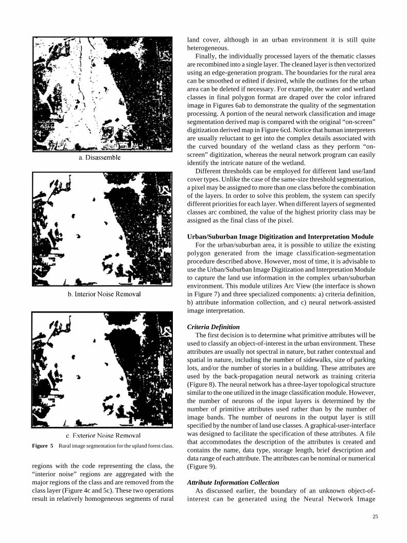
25
land cover, although in an urban environment it is still quiteheterogeneous.
Finally, the individually processed layers of the thematic classesare recombined into a single layer. The cleaned layer is then vectorizedusing an edge-generation program. The boundaries for the rural areacan be smoothed or edited if desired, while the outlines for the urbanarea can be deleted if necessary. For example, the water and wetlandclasses in final polygon format are draped over the color infraredimage in Figures 6ab to demonstrate the quality of the segmentationprocessing. A portion of the neural network classification and imagesegmentation derived map is compared with the original “on-screen”digitization derived map in Figure 6cd. Notice that human interpretersare usually reluctant to get into the complex details associated withthe curved boundary of the wetland class as they perform “on-screen” digitization, whereas the neural network program can easilyidentify the intricate nature of the wetland.
Different thresholds can be employed for different land use/landcover types. Unlike the case of the same-size threshold segmentation,a pixel may be assigned to more than one class before the combinationof the layers. In order to solve this problem, the system can specifydifferent priorities for each layer. When different layers of segmentedclasses arc combined, the value of the highest priority class may beassigned as the final class of the pixel.
Urban/Suburban Image Digitization and Interpretation ModuleFor the urban/suburban area, it is possible to utilize the existing
polygon generated from the image classification-segmentationprocedure described above. However, most of time, it is advisable touse the Urban/Suburban Image Digitization and Interpretation Moduleto capture the land use information in the complex urban/suburbanenvironment. This module utilizes Arc View (the interface is shownin Figure 7) and three specialized components: a) criteria definition,b) attribute information collection, and c) neural network-assistedimage interpretation.
Criteria DefinitionThe first decision is to determine what primitive attributes will be
used to classify an object-of-interest in the urban environment. Theseattributes are usually not spectral in nature, but rather contextual andspatial in nature, including the number of sidewalks, size of parkinglots, and/or the number of stories in a building. These attributes areused by the back-propagation neural network as training criteria(Figure 8). The neural network has a three-layer topological structuresimilar to the one utilized in the image classification module. However,the number of neurons of the input layers is determined by thenumber of primitive attributes used rather than by the number ofimage bands. The number of neurons in the output layer is stillspecified by the number of land use classes. A graphical-user-interfacewas designed to facilitate the specification of these attributes. A filethat accommodates the description of the attributes is created andcontains the name, data type, storage length, brief description anddata range of each attribute. The attributes can be nominal or numerical(Figure 9).
Attribute Information CollectionAs discussed earlier, the boundary of an unknown object-of-
interest can be generated using the Neural Network Image
Figure 5 Rural image segmentation for the upland forest class.
regions with the code representing the class, the“interior noise” regions are aggregated with themajor regions of the class and are removed from theclass layer (Figure 4c and 5c). These two operationsresult in relatively homogeneous segments of rural

26
Classification Module. However, with high spatialresolution imagery it is more likely that the object-of-interest in the urban area will be identifiedusing the “on-screen” digitization method. Forexample, Figure 7 depicts a polygon drawn aroundan object-of-interest based on “on-screen”digitization. In this case, it is clear to most expertsthat this is a multiple-family residential housingcomplex. However, this may not be clear to anovice image interpreter. The Urban/SuburbanImage Digitization and Interpretation Module canbe used to collect information about variousattributes within the polygon-of-interest. Thegraphical-user-interface shown in Figure 9 helpsthe analyst obtain the attribute information aboutthe feature under investigation. The user firstchecks the attribute presented and then assignsthe value for the attribute through a slide-bar ifthe attribute is a quantitative variable, or a scroll-list if it has qualitative characteristic. Uncheckedvalues are treated as missing data. If theinformation collected is for training purposes, thetrue target class is required. Otherwise, it isoptional for the user to assign his or her bestguess about the possible class of the feature. Oncethe attribute information of the object-of-interestis collected, it is saved as a record in the featureattribute file of the polygon and passed to theneural network interpretation component forsubsequent training or testing (classification).
Neural Network-Assisted Image InterpretationThe Urban/Suburban Image Digitization and
Interpretation Module makes use of quantitativeattribute information directly. Qualitative attributeinformation are automatically converted tonumerical values. Similar to the imageclassification module described, this module alsoconsists of training and testing (classification)stages. In the training stage, the neural networklearns the rules (weights) of image interpretationfrom all the input training examples. Trainingexamples obtained from images acquired atdifferent times and even different locations canbe used to extract the image interpretation rulesfor urban/suburban areas. This makes it possiblefor the knowledge base extracted for one projectto be extended across both space and time andused in other projects.
Once the training process is complete and allthe “rules” are saved as the weights of the neuralnetwork, these rules can be applied to classifyunknown objects-of-interest. After the attributeinformation of the unknown object are retrievedand passed to the neural network, it outputs thecalculated class membership grade of the objectby recalling the “rules” stored in the weights of
Figure 6 Results of the Neural Network Image Interpretation System compared withthose of traditional “on-screen” digitization.
Figure 7 The graphical-user-interface of the Urban/suburban Image Digitization andInterpretation Module.
Neural Network Derived Water Class Neural Network Derived Wetland Class
a. b.
c. d.
On-screen Digitization MethodNeural Network
Classification-Segmentation Method

27
miniute quadrangle was approximately 56.5 percent of theoriginal 11.5 days.
Summary
A Neural Network Image Interpretation System for theextraction of urban and rural land use/land cover informationfrom high spatial resolution digital imagery was designedand implemented. The system consists of modules that a)classify high spatial resolution imagery into different landuse/land cover types, b) segment the rural land coverinformation into relatively homogeneous polygons in astandard GIS format, and c) digitize and interpret urban/suburban land use polygons based on their feature attributeinformation.
The Image Classification and Rural Image SegmentationModules have value because they generate a relativelyaccurate classification of extensive rural land cover such aswetland, water, and upland forest in a digital polygon format.This removes an expensive step in the current processwhereby the geographically extensive rural land cover areoften laboriously visual photo-interpreted and then manuallydigitized into the GIS database. This methodology can bealso extended to classify relatively coarse spatial and spectralresolution remote sensor data, such as Landsat ThematicMapper image. The image Segmentation Module can also beapplied to the post-classification processing of the resultsobtained from other digital image classification approaches,so that noise can be effectively removed while the boundariesbetween classes remain smooth.
The Urban/Suburban Image Digitization and InterpretationModule demonstrates great potentials for interpreting urbanland use. It requires more training examples to be fullyoperational. Examination of the initial results in the studysuggests that the urban image interpretation prototype may
Figure 8 The graphical-user-interface for the criteria definitioncomponent.
neurons in the network. After confirmation, the classinformation is passed to the polygon attribute table to updatethe record for the object. Beginning image analysts also havethe option to compare the labeling provided by the neuralnetwork to the their best guess. This helps them to graduallydevelop improved image interpretation skills.
The Urban/Suburban Image Digitization and InterpretationModule is still under development. Not all the urban landuse classes have been sufficiently included and/or trained-on using the system. In order for the module to be operational,additional classes of training examples such as those forindustrial land use categories are needed. We are in theprocess of continuing the development of the training databaseso that the system will contain sufficient “rules” for theneural network to classify the urban land use consistently.
Table 1 estimates the cost of performing imageinterpretation using traditional versus a neural network imageinterpretation system per 7.5-minute quadrangle (Pattersonet al., 1998). The potential time saving benefit per 7.5-
Figure 9 The graphical-user-interface for the attribute informationcollection component.
Approximate Person-Effort to Extract Information per7.5-minute Quadrangle Using TraditionalPhotointerpretation Techniques
Combined on-screen digitization of Land Use/Land CoverTotal1
Approximate Person-Effort to Extract Information per7.5-minute Quadrangle Using Digitally Assisted ImageAnalysis Techniques
Rural Land Cover (using Neural Network assisted classificationand segmentation)Urban Land Cover (using both traditional visual imageinterpretation and neuralnetwork assisted methods of imageclassification and segmentation)Total1
Potential Time Saving Benefit per 7.5- minute Quadrangle
Table 1 Potential Cost-Benefit of Implementing A Contextual Neural-Network Method of Extracting Rural and Urban Informationfor a Single 7.5-minute Quadrangle
Days
11.511.5
1
4
5
6.5/11.5=56.5%l These calculations do not include Arc-Info validation time.

28
also be of values for training novice image interpreters.Unfortunately, a neural network based image processing
system is a black box making it impossible to explain how aparticular answer has been reached by the network. Thereexists an inherent inability to represent knowledge acquiredby the network in an explicit form with simple “if-then”rules. The rules of image classification and interpretationlearned by the neural network are buried in the weights of thehidden neurons of the hidden layers. A possible solution is tocombine neural networks with fuzzy logic so that theknowledge residing in the hidden neurons of the network canbe extracted in the form of fuzzy “if-then” rules (Qiu, 1999).
Acknowledgments
This research was funded by NASA Commercial RemoteSensing Program (CRSP) at John C. Stennis Space Center.
References
Atkinson P. M. and A. R. L. Tatnall, 1997. Neural network in remotesensing, International Journal of Remote Sensing, 18(4): 699-709.
Baker J., 2000. New users and established experts: bridging theknowledge gap in interpreting commercial satellite imagery,Commercial Observation Satellites: At the Leading Edge of GlobalTransparency, RAND Corporation and American Society forPhotogrammetry & Remote Sensing, Washington, in press.
Benediktsson, J. A., Swan, P. H. and Ersoy O. K., 1990. Neuralnetwork approaches versus statistical methods in classification ofmultisource remote sensing data, I.E.E.E. Transactions onGeoscience and Remote Sensing, 28: 540-552.
Benediktsson, J. A., and Sveinsson, J. R., 1997. Feature extraction formultisource data classification with artificial neural networks,International Journal of Remote Sensing, 18: 727-740.
Civco, D. L., 1993. Artificial neural network for land cover classificationand mapping, International Journal of Geographical InformationSystem, 7: 173-186.
Dehqanzada, Y. A. and A. M. Florini, 2000. Secrets for Sale: HowCommercial Satellite Imagery Will Change the World, CarnegieEndowment for International Peace, Washington, 45 p.
Estes, J. E. and J. R. Jensen, 1998. Chapter 10: Development ofRemote Sensing Digital Image Processing and Raster GIS, TheHistory of Geographic Information Systems: Perspectives from thePioneers, Prentice-Hall, Inc., Saddle river, NJ, pp. 163-180.
Estes, J. E., Hajic, E. J. and L. R. Tinney, 1983. Chapter 24:Fundamentals of Image Analysis: Analysis of Visible and ThermalInfrared Data, Manual of Remote Sensing, American Society forPhotogrammetry & Remote Sensing, Bethesda, pp. 987-1124.
Foody, G. M., McCulloch, M. B., and Yates, W. B., 1995. Classificationof remotely sensed data by an artificial neural network: issuesrelated to training data characteristics, PhotogrammetricEngineering and Remote Sensing, 61: 391-401.
Jensen, J. R., 1996. Introductory Digital Image Processing: A RemoteSensing Perspective, Prentice-Hall Inc., Upper Saddle River, NJ,318 p.
Jensen J. R. 2000. Remote Sensing of The Environment: An EarthResource Perspective, Prentice-Hall, Inc., Upper Saddle River, NJ,544 p.
Jensen, J. R. and D. C. Cowen, 1999. Remote sensing of urban/suburban infrastructure and socioeconomic attributes,Photogrammetric Engineering and Remote Sensing, 65(5): 611-622.
Jensen J. R., F. Qiu and M. Ji, 1999, Predictive modeling of coniferousforest age using statistical and artificial neural network approachesapplied to remote sensing data, International Journal of RemoteSensing, 20(14): 2805-2822.
Johnston, R. J., 1980. Multivariate Statistical Analysis in Geography:A Primer on the General Linear Model, Longman Scientific andTechnical, New York, NY, 280 p.
Heermann P. D. and Khazenie N., 1992. Classification of multispectralremote sensing data using a back-propagation neural network,IEEE Transactions On Geosciences and Remote Sensing, 30(1):81-88.
Kasabov, K. N., 1996. Foundations of Neural Networks, Fuzzy Systems,and Knowledge Engineering, MIT Press, Cambridge, 550 p.
Lulla, K. P. and L. V. Dessinov, 2000, Dynamic Earth Environments:Remote Sensing Observations from Shuttle-Mir Missions, NewYork: John Wiley & Sons, 268 p.
Neural Ware, Inc., 1996. Using Neural Works, Neural Ware Inc.,Pittsburgh, 157 p.
Philipson, W. (1997). Manual of Photographic Interpretation. AmericanSociety for Photogrammetry & Remote Sensing, Bethesda, 830 p.
Qiu F., 1999. Remote sensing image classification based on automaticfuzzy rule extraction by integrating fuzzy logic and neural networkmodel’ Proceedings of ASPRS 1999 Annual Conference (CD-ROM), May 17-21, 1999, Portland, Oregon.
Patterson, K., Jensen, J. R. and F. Qiu. 1998, Development of ImprovedImage Classification Algorithms to Extract Quantitative Urban/Suburban Landuse/Land Cover Information from High SpatialResolution Imagery, GEONEX, Inc., St. Petersburg, FL., 25 p.
Rao, V. B. and H. V. Rao. 1993, C++Neural Network and FuzzyLogic, Management Information, Inc., New York, NY, 408 p.
Roli F., S. B. Serpico and Gianni Vernazza, 1996. Neural networks forclassification of remotely sensed images, Fuzzy Logic and NeuralNetwork Handbook, (C. H. Chen, editor), McGraw-Hill, Inc., NewYork, NY, pp. 15.1-15.28
Li, R., 1998. Potential of high-resolution satellite imagery for nationalmapping products, Photogrammetric Engineering & RemoteSensing, 64(12):1165-1169.
Russell, S. and P. Norvig, 1995. Artificial Intelligence: A ModernApproach, Prentice-Hall, Inc., Upper Saddle River, 932 p.