2 Konsep TRANSPORTASI dalam TATA RUANG Regional
32
KONSEP TRANSPORTASI DALAM TATA RUANG REGIONAL Dr Dyah R.Hizbaron Geografi & Ilmu Lingkungan Fakultas Geografi Universitas Gadjah Mada 2009
-
Upload
independent -
Category
Documents
-
view
0 -
download
0
Transcript of 2 Konsep TRANSPORTASI dalam TATA RUANG Regional

KONSEP TRANSPORTASI DALAM TATA RUANG REGIONALDr Dyah R.HizbaronGeografi & Ilmu LingkunganFakultas GeografiUniversitas Gadjah Mada2009

AMERICAN STUDIESTransportation Geography

Edward Ullman Examine why flow or interaction among some areas were different? Transferability Complementarity Intervening opportunity
Mapping commodity flow across US Criticsm from Isard:
Input output model Multiplier and location analysis Interregional linear programming technique
Analysis, Hipotheses and Models to represent such descriptive result.
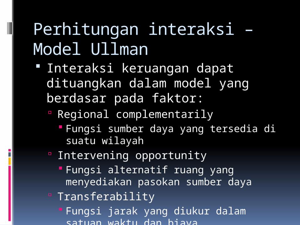
Perhitungan interaksi – Model Ullman Interaksi keruangan dapat dituangkan dalam model yang berdasar pada faktor: Regional complementarily
Fungsi sumber daya yang tersedia di suatu wilayah
Intervening opportunity Fungsi alternatif ruang yang menyediakan pasokan sumber daya
Transferability Fungsi jarak yang diukur dalam satuan waktu dan biaya

Copyright © 1998-2008, Dr. Jean-Paul Rodrigue, Dept. of Economics & Geography, Hofstra University. For personal or classroom use ONLY. This material (including graphics) is not public domain and cannot be published, in whole or in part, in ANY form (printed or electronic) and on any media without consent. This includes conference presentations. Permission MUST be requested prior to use.
Logika Jarak, Waktu dan BiayaA BWalkingCycling Driving
D(W) D(C) D(D)
Friction ofDistance
Movement
Distance (D)
Time
Friction of distance◦ the cost of
overcoming distance ◦ If the friction of
distance is too great, interaction will not occur in spite of a complementary supply-demand relationship.
◦ Depends on prevailing transportation technology and the price of energy.

Walter Isard Transport cost, Gravity Model, and Transport Optimization Problem Role of transport cost in industrial location through comparative cost analysis
Regional Study on Transportation (spatial approach on efficient pattern of location and transportation) vs Geography Study on Transportation (system approach on location and transportation)
Modern Geography Transportation
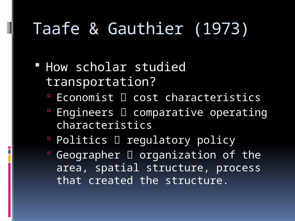
Taafe & Gauthier (1973)
How scholar studied transportation? Economist cost characteristics Engineers comparative operating characteristics
Politics regulatory policy Geographer organization of the area, spatial structure, process that created the structure.

Classic Transportation Geography
Distance
Cost
Location
Descriptive Manner
QUALITATIVE APPROACH
1950s – 1960s-Description-Classification -Mapping

Modern Transportation Geography
Multi discipline Approach
Politics,Regional Approach
Economic,
Technical
Approach
QUANTITATIVEAPPROACH
Modeling
1970s – recent-Analysis of impact-Model building-Statistic & MathematicalCalculation- Forecasting

Context of Transportation
Geography
Economic
Regional
• Spatial Structure
• Spatial Process• Cost Effectiveness
• Supply & Demand• Spatial Interaction
• Spatial Planning

Spatial Form of the Transport Network
Gambar 9. Model Teori Poros (Babcock, 1933)
Sumber : Yunus, 2000.

Perhitungan interaksi – Model Gravity
2 kota memiliki 1000 masing-masing 1000 penduduk, jarak di antara kedua kota adalah 10 km.
Diketahui konstanta a = 1 dan b = 2. Berapa interaksi yang terjadi antara dua kota tersebut?
Tij = the spatial interaction between origin i and destination j,
Pi and Pj = their respective populations,
dij = distance between them. b = exponent representing the interaction retarding effect of the friction of distance which depends on transportation technology. T
a = constant, k =scale differences.

Pertanyaan?Pengembangan Metode SCL
Menurut Anda, apakah peran transportasi dalam rencana tata ruang?

Contoh Penelitian
1. Mendeskripsikan jumlah penduduk di suatu wilayah dan kebutuhan jenis jalan.
2. Mendeskripsikan kadar Pb di sepanjang poros jalan kolektor primer.
3. Memetakan jalur bus di Kota Yogyakarta.4. Menganalisa lokasi pembangunan halte
busway.5. Menemukenali pemanfaatan guna lahan di
sepanjang poros ulang-alik Yogya-Solo6. Analisa cost and benefit terhadap
penempatan jalur poros pengembangan wilayah Kulonprogo - Purworejo

EUROPEAN STUDIESTransportation Geography

Development of the studies in Europe
Era Basic Theme
Related Concept
Domain Concern
Classic Transport Geography
Distance, Cost, transport zone
Location Theory (Von Thunen, Weber, and Christaller)
- Economic Geography- Political Geography
Different types of transportation mode
Macro – meso level, effect of transport zone
Regional Concept
Economic GeographyApolitical Geography
Different level of analysis
Modern Transport Geography
Traffic participation
Behavioral Theory
Social Geography, mobility study
Different preference on transportation

Transport Planning
Supply Demand
Transp
ort
Planni
ng EngineeringEconomics
1950 – 1960s Fokus pada :Kuantitas (Penyediaan infrastruktur & media)Kualitas (Perbaikan infrastruktur & media)
1970 – recent
Fokus pada:Isu keruanganIsu lingkunganIsu pola pemilihan moda

Scientific CritismNo Framework, varied in:•Methods •Concept•Approach
Research Questions •Overlap to transport planning
•Overlap to politics
•Not neutral by science

Transport in Mobility Studies Problem oriented research Non traditional discipline (multi dimension)
Used to be description in “spatial supply & demand” now turn to “causes of traffic”
Rooted in socio-political discussion
Seeing practice and theory as united approach (not separable)

ASIAN STUDIESRural – Urban Transformation

Case of Asian Decision Making in Development
Poli
cy i
n As
ia
Industrialization Urbanization Structural shiftMass marketProductivity basedInfrastructure investmentHi – tech applied
Impa
ct r
ural
Low family farmOff-farm laborMigrant laborFood importsIncome disparityGreen revolution from technology in agricultureEnvironmental impact
Impa
ct u
rban
Concentrated activitySlum areaTraffic congestionService-centredIssue of sustainability
Impact to transportation Overview on accelerated transaction flow between urban – rural
Flow of people Flow of commodities Flow of capital Flow of information Growth in transportation sector Improve inter-regional linkage (breaking down friction on distance and reduction of transport cost)
Urban corridor

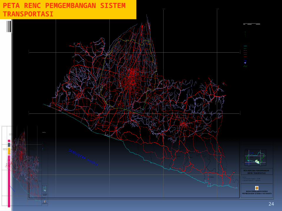
CONTOH KEBIJAKAN TRANSPORTASI YOGYAKARTA
24
2000 0 2000 4000 6000 M eters
Inset Peta :
8 00' LS
109 00' BT 111 00' BT
o
7 00' LSo
o o
Jaw a TengahSkala 1 : 2.000.000
PEM ERINTAH PROPINSIDAERAH ISTIM EW A YOGYAKARTA
N
BADAN PERENCANAAN DAERAHPROPINSI DAERAH ISTIM EW A YOGYAKARTA
PROPINSIJAW A TENGAH
PROPINSIDI. YOGYAKARTA
SA MUDE RA HINDIA
LA UT J AW A
PETA RENCANA PENGEMBANGANSISTEM TRANSPORTASI
Sum ber :1. Peta Rupabum i Digital 1 : 25.000.2. Bap peda Propinsi D.I. Yogyakarta.
Keterangan :
W aduk / TelagaSungaiJalan K ereta A piJalan K abupatenJalan P ropinsiJalan N asionalBatas P erairan Laut ( 12 m il )Batas P erairan Laut ( 4 m il )
G aris P antaiBatas D esaBatas K eca m atanBatas K abupatenBatas P ropinsiIbukota Kecam a tanIbukota Kabupaten
%[
#Y
#S
Ibukota Pro pinsi
KA B U P A TE N M A G E LA N GP R O PIN S I JA W A T E N G AH
KA B U P ATE N W O N O G IR IP R O P IN SI JAW A TE N G A H
K A B U P A TE N P U R W O R E JOP R O P IN S I JA W A TEN G A H
K AB U P A TE N K LA TE NP R O PIN S I JA W A T E N G AH
400 00 0
400 00 0
425 00 0
425 00 0
450 00 0
450 00 0
475 00 0
475 00 0
910
0000
91000
00
912
5000
91250
00
915
0000
91500
00
#S
#S
#S
#Y
#S
#S
#S
#Y
#S
#S
#S
#S
#S
#S
#S
#S
#S
#S
#S
#S
#S
#S
#S
#S
#S
#S
#S
#S
#S
#S
#S
#S
#S
#S
#S#Y
#S
#S
#S
%[
#S
#S
#S
#S
#S
#S
#S
#S
#S
#S
#S
#S
#S
#S
#S
#S
#S
#S
#S
#S
#S
#Y
#S
#S
#S
#S
#S
#S
#S
Turi
Tem on
K okap
W ates
G alur
M lati
Jetis
Sew on
Pakem
D epok
Patuk
Tepus
Sem in
Pandak
G odean
Sedayu
Lendah
Sanden
D lingo
Pundon
B antul
Tem pel
Kretek
Slem an
Pleret
B erbah
Playen
Sem anu
Ngaw enSentolo
M oyudan
M inggir
K alasan
Im ogiri
K asihan
Seyegan
G am ping
N gaglik
Paliyan
N glipar
Ponjong
R ongkop
Pengasih
Panjatan
Pajangan
Panggang
N gem plak
Piyungan
W onosari
G irisubo
N anggulan
Sam igaluh
G irim ulyo
Srandakan
Purw osari
Saptosari
Pram banan
K alibaw ang
G edangsari
K arangm ojo
C angkringan
B anguntapan
Tunjungsari
B am banglipuro
R EN C A N A O U TE R R IN G R O A D
20 00 0 20 00 4000 600 0 M e ters
Inset Peta :
8 00 ' LS
10 9 0 0' BT 1 11 0 0' BT
o
7 00 ' LSo
o o
Jawa Te ngahSkala 1 : 2.000.000
PEMERINTAH PROPINSIDAER AH ISTIMEW A YOGYAKARTA
N
BADAN PEREN CANAAN DAERAHPROPINSI DAERAH ISTIM EW A YOGYAKARTA
P ROP INS IJAW A T ENG AH
PRO PINS IDI. YO G YAKA RT A
SAM UDE RA H INDIA
LA UT JAW A
PETA RENCANA PENGEMBANGANSISTEM TRANSPORTASI
Sum ber :1. Pe ta Rupabum i Digital 1 : 25.000.2. Bappeda Propinsi D.I. Yogya karta.
K eteran gan :
W aduk / T elagaSung aiJalan K ereta ApiJalan K abupatenJalan P ropinsiJalan N asionalBatas Pera iran Laut ( 12 m il )Batas Pera iran Laut ( 4 m il )
G aris P antaiBatas D es aBatas Kecam atanBatas Kab upatenBatas Prop insiIbukota Kecam atanIbukota Kabupate n
%[
#Y
#S
Ibukota Propinsi
KA B UP A TEN M A G E LAN GP RO PINS I JA W A TEN G A H
KA BU P A TE N W O N O G IR IPR O PIN SI JA W A T E N G A H
KABU P A TEN PU R W O R E JOPR O PIN SI JAW A TE N G A H
KABU P ATE N K LAT ENP RO PIN S I JA W A TEN G AH
40 00 0 0
40 00 0 0
425 00 0
425 00 0
4 50 00 0
4 50 00 0
475 00 0
475 00 0
9100000
9100000
9125000
9125000
9150000
9150000
#S
#S
#S
#Y
#S
#S
#S
#Y
#S
#S
#S
#S
#S
#S
#S
#S
#S
#S
#S
#S
#S
#S
#S
#S
#S
#S
#S
#S
#S
#S
#S
#S
#S
#S
#S#Y
#S
#S
#S
%[
#S
#S
#S
#S
#S
#S
#S
#S
#S
#S
#S
#S
#S
#S
#S
#S
#S
#S
#S
#S
#S
#Y
#S
#S
#S
#S
#S
#S
#S
Turi
Tem on
K okap
W ates
G alur
M lati
Jetis
Sew on
Pakem
D epok
Patuk
Tepus
Sem in
Pandak
G odean
Sedayu
Lendah
Sanden
Dlingo
Pundon
Bantul
Tem pel
Kretek
Slem an
Pleret
Berbah
Playen
Sem anu
Ngaw enSentolo
M oyudan
M inggir
K alasan
Im ogiri
K asihan
Seyegan
Gam ping
Ngaglik
Paliyan
Nglipar
Ponjong
R ongkop
Pengasih
Panjatan
Pajangan
Panggang
Ngem plak
Piyungan
W onosari
Girisubo
N anggulan
Sam igaluh
G irim ulyo
Srandakan
Purw osari
Saptosari
Pram banan
Kalibaw ang
Gedangsari
K arangm ojo
C angkringan
Banguntapan
Tunjungsari
B am banglipuro
REN CA NA O U TER R IN G RO AD
PETA RENC PEMGEMBANGAN SISTEM TRANSPORTASI

25PETA RENC INFRASTRUKTUR UTAMA

26
PETA RENC KWS STRATEGIS

27
PETA PROYEKSI KEPADATAN PENDUDUK

28
PENGEMBANGAN FUNGSI KORIDOR-PERKOTAAN YOGYAKARTA
No Arahan Fungsi Dominan
Arahan Fungsi Dominan Ket
1. Inti Perkotaan Yogyakarta
•Perdagangan•Pariwisata•Pendidikan•Pemerintahan•Industri (hitech)•Perumahan
Kota Yogyakarta dan Sekitarnya
2. Koridor Jl. Magelang •Industri kecil dan sedang•Jasa Komersial/perdagangan•Pertanian
Jalur Sleman – Tempel
3. Zona Pinggir UtaraZona Pinggir Barat – SelatanKoridor Jl. SoloZona Pinggir Barat - Selatan
•Pendidikan•Pariwisata•Perumahan•Pertanian
Depok dan Mlati
4. Zona Pinggir UtaraZona Pinggir Barat – SelatanKoridor Jl. SoloZona Pinggir Barat - Selatan
•Pendidikan•Perumahan•Pertanian•Industri kecil – sedang
Godean, Moyudan, Gamping, Sedayu
5. Zona Pinggir UtaraZona Pinggir Barat – SelatanKoridor Jl. SoloZona Pinggir Barat - Selatan
•Industri besar – sedang•Pertanian
Jalur Sentolo, Wates, Temon

29
No Arahan Fungsi Dominan
Arahan Fungsi Dominan Ket
6. Zona Pinggir UtaraZona Pinggir Barat – SelatanKoridor Jl. SoloZona Pinggir Barat - Selatan
•Industri kecil-sedang-besar•Pertanian•Perumahan•Pariwisata•Pendidikan
Kasihan, Panjangan, Bantul
7. Zona Pinggir Timur - SelatanKoridor Jl. SoloPusat Pelayanan PakemPusat Pelayanan Wates
• Pariwsata• Pendidikan• Pertanian• Perumahan• Industri kecil
Sewon, Banguntapan, Berbah, Pleret, Imogiri
8. Zona Pinggir Timur - SelatanKoridor Jl. SoloPusat Pelayanan PakemPusat Pelayanan Wates
• Pariwsata• Pendidikan• Pertanian• Perumahan• Industri kecil• Komersial
Jalur Kalasan Prambanan
9. Zona Pinggir Timur - SelatanKoridor Jl. SoloPusat Pelayanan PakemPusat Pelayanan Wates
• Pertanian• Pariwisata• Pendidikan
Jalur Pakem – Ngaglik.Pelayanan Lokal
10. Zona Pinggir Timur - SelatanKoridor Jl. SoloPusat Pelayanan PakemPusat Pelayanan Wates
• Pemerintahan• Sosio-Ekonomi
Pelayanan Sub Regional

30
No Arahan Fungsi Dominan
Arahan Fungsi Dominan Ket
11. Pusat Pelayanan Galur - Srandakan
• Pemerintahan• Industri Kecil
Pelayanan Lokal
12. Pusat Pelayaan Kretek • Pariwisata• Industri Kecil
Pelayanan Internasional
13. Pusat Pelayanan Semin • Pertanian• Fasilitas Sosial Ekonomi
Pelayanan Tol – perbatasan
14. Pusat Pelayanan Wonosari •Pemerintahan•Pelayanan sosial – ekonomi•Pertanian
Kelompok Playen- Wonosari – Semanu.Pelayanan Sub
Regional Sumber : 1. RTRW Prov. DIY tahun 2002-20072. Bantek Prov DIY 2007-2027

Aspek Transportasi Wilayah Papua Barat
Transportasi darat bukan yang utama, terutama antar kabupaten/kota;
Kondisi jalan pada semua Kab/Kota masih dalam tahap pembangunan;
Antar distrik di Kab. Raja Ampat, Teluk Bintuni, & Teluk Wondama masih mengandalkan transportasi air;
Transportasi udara sangat diandalkan walaupun di Kab. Teluk Wondama, Teluk Bintuni, dan Sorong Selatan hanya bisa didarati oleh pesawat kecil;
Maskapai yang beroperasi belum banyak, jadwal penerbangan pun tidak selalu ada;
Transportasi laut juga diandalkan khususnya untuk memasok barang kebutuhan dari Surabaya/Makassar;
Pelabuhan Sungai hanya terdapat di Kab. Teluk Bintuni.

RENCANA PENGEMBAGAN
SISTEM TRANSPORTAS
I
DARAT
LAUTUDARA