
1st International Conference on Urban Planning - ICUP2016
347
-
Upload
khangminh22 -
Category
Documents
-
view
0 -
download
0
Transcript of 1st International Conference on Urban Planning - ICUP2016

1st International Conference on Urban Planning - ICUP2016
Publisher Faculty of Civil engineering and Architecture, University of Nis
For Publisher Dean Petar Mitkovic, PhD
Editor Petar Mitkovic, PhD
Co-Editor Milan Tanic, PhD
Text formatting, prepress and cover Milan Brzakovic Ana Curk Vojislav Nikolic
ISBN 978-86-88601-22-1
Circulation 150 copies
Printing Grafika Galeb Nis

1st International Conference on Urban Planning - ICUP2016
Is organized by Faculty of Civil Engineering and Architecture, University of Nis Urban Planning Cluster, Nis
Under patronage of the GOVERNMENT OF THE REPUBLIC OF SERBIA MINISTRY OF EDUCATION, SCIENCE AND TECHNOLOGICAL DEVELOPMENT

SCIENTIFIC PROGRAM COMMITTEE
Petar Mitkovic, PhD, Chairman, Faculty of Civil Engineering and Architecture, University of Nis, Serbia Ljiljana Vasilevska, PhD, Faculty of Civil Engineering and Architecture, University of Nis, Serbia Milena Dinic Brankovic, PhD, Faculty of Civil Engineering and Architecture, University of Nis, Serbia Goran Jovanovic, PhD, Faculty of Civil Engineering and Architecture, University of Nis, Serbia Aleksandar Kekovic, PhD, Faculty of Civil Engineering and Architecture, University of Nis, Serbia Danica Stankovic, PhD, Faculty of Civil Engineering and Architecture, University of Nis, Serbia Milan Tanic, PhD, Urban Planning Cluster, Serbia Milica Bajic Brkovic, PhD, Faculty of Architecture, University of Belgrade, Serbia Eva Vanista Lazarevic, Faculty of Architecture, University of Belgrade, Serbia Aleksandra Djukic, PhD, Faculty of Architecture, University of Belgrade, Serbia Jelena Zivkovic, PhD, Faculty of Architecture, University of Belgrade, Serbia Mila Pucar, PhD, Institute of Architecture and Urban & Spatial Planning of Serbia Igor Maric, PhD, Institute of Architecture and Urban & Spatial Planning of Serbia Rajica Mihajlovic, PhD, Faculty of Civil Engineering, University of Belgrade, Serbia Paolo Scattoni, PhD, Sapienza Università di Roma, Italy Grigor Doytchinov, PhD, Graz University of Technology, Austria Demetrio Muñoz Gielen, PhD, Radboud University Nijmegen, Netherlands Kishii Takayuki, College of Science and Technology, Department of Civil Engineering, Nihon University, Japan Marie-Alice L'Heureux, PhD, School of Architecture, Design & Planning – Architecture Department, The University of Kansas, Lawrence, USA Bonnie Johnson, PhD, School of Architecture, Design & Planning - Department of Urban Planning, The University of Kansas, Lawrence, USA Серебряная Валентина Васильевна, PhD, Volgograd State University of Architecture and Civil Engineering, Russia Птичникова Галина Александровна, PhD, Volgograd State University of Architecture and Civil Engineering, Russia Pavle Krstic, PhD, Faculty of Architecture, University of Sarajevo, Bosnia and Herzegovina Brankica Milojevic, PhD, Faculty of Architecture, Civil Engineering and Geodesy, Univesity of Banja Luka, Bosnia and Herzegovina Aleksandra Miric, PhD, chercheur associé, Institut de recherche sur l'architecture antique, France Ali A. Alraouf, Phd, Head of CB, Development, CB and Research Unit-QNMP, Research and Training, Ministry of urban planning, Doha, Qatar Hossam Samir Ibrahim, Phd, Urban and Environmental Planning Expert, Deputy Team Leader - QNMP Group at Ministry of Municipality and Environment, Doha, Qatar Zorica Nedovic –Budic, Professor Chair of Spatial Planning School of Geography, Planning and Environmental Policy University College Dublin Cristian Suau, PhD, Studio Pop C.I.C., Glasgow, Scotland Aida Nayer, Ph.D, Assistant Professor, Arch Dept., Effat University, Saudi Arabia
ORGANIZING COMMITTEE
Milan Tanic, PhD, Chairman Tanja Obradovic Milena Dinic Brankovic, PhD Slavisa Kondic Vojislav Nikolic Vuk Milosevic Milan Brzakovic Milica Radosavljevic Milja Penic Marija Marinkovic Ana Curk

FOREWORD
It is with great pleasure that I present to you the following Proceedings of the International Conference on Urban Planning ICUP2016, held in Nis on November 18-19, 2016. This is the first conference organized by the Faculty of Civil Engineering and Architecture, University of Nis and Urban Planning Cluster, with the aim of bringing together scholars, researchers and students from all areas of Urban Planning.
The ICUP conference explores a broad spectrum of Urban and Spatial Planning issues from both theory and practice. Some of the topics that we are focusing on this year include sustainable development, urban regeneration, urban design, land readjustment, public-private partnerships in urban development, urban management, knowledge-based urban development, smart cities, architectural heritage and various current problems of planning and development. These topics are discussed in more than 40 conference papers from various study areas and diverse places in the world, and therefore provide a valuable insight into contemporary urban policies and approaches. They also make good grounds for discussion at the conference and a good basis for further research. The authors are professors, researchers, PhD students and planning professionals. We are especially proud of our keynote speakers and the members of our Scientific Program Committee, who are eminent experts in their fields from all over the world.
Urban structure is a complex and multidimensional system that is prone to change. Therefore, it requires to be closely monitored by continuous research, which brings up some entirely new issues or sheds new light on the old ones. Given the importance of the planning topics elaborated at the conference and numerous questions that are raised here, we firmly believe that it is our task to continue exploring this matter. Hence, we are striving for the ICUP conference to have a biennial character in the future, and establish itself as a traditional manifestation of the University of Nis.
I take this opportunity to thank all of the authors and co-authors of papers, reviewers, keynote speakers, members of the Scientific Program Committee, as well as teachers and associates engaged in the technical preparation of these Proceedings. And finally, I am pleased to invite all authors from the academic and research community to participate and give their scientific and professional contributions to the future Conferences, for the benefit of all of us.
Petar Mitkovic, PhD, Full professor Faculty of Civil Engineering and Architecture, University of Nis
Chairman of the Scientific Program Committee

Disclaimer
The contents of the papers presented in this publication are the sole responsibility of their authors and can in no way be taken to reflect the views of the Organizer.
CONTENTS
A.A. Alraouf EMERGING KNOWLEDGE-BASED URBANISM AS AN URBAN STRATEGY IN QATAR ………………………………… 9
K. Mathey URBAN RENEWAL AND REVITALIZATION – THE ECO CITY TOOL BOX IN EUROPE ………………………………….. 19
C. Suau RISE OF THE PLANET OF THE SERVANTS …………………………………………………………………………………………………. 33
F. Rotondo URBAN REGENERATION PLANNING. DIFFERENT OBJECTIVES AND PRINCIPLES …………………………………….... 45
D. Muñoz Gielen, I. Maguregui Salas, J. Burón Cuadrado AN INTERNATIONAL COMPARISON ON PUBLIC VALUE CAPTURE INSTRUMENTS, AND HOW THEY WORKTT II WITHIN PUBLIC AND PRIVATE URBAN LAND POLICIES ……………………………………………………………………… ……. 51
D. Oktay IN PURSUIT OF HUMAN SUSTAINABLE URBANISM: ECOLOGICAL AND CULTURAL INTEGRITY ………………… 69
T.K. Sood URBAN REGENERATION AND COLLECTIVE SALES – THE SINGAPORE EXPERIENCE ………………………………….. 77
M. Cekic TRANSECT - A 21ST CENTURY URBAN DESIGN TOOL ………………………………………………………………………………… 87
B. Antonic, E. Vanista Lazarevic ORGANISATION OF MUNICIPALITIES IN SERBIA - PROS AND CONS FROM THE PERSPECTIVE OF URBAN ANDTTT SPATIAL PLANNING ………………………………………………………………………………………………………………………….. …….. 97
M. Marjanovic, M. Milicevic, D. Ristic BREAKING DOWN CREATIVITY: FLORIDA’S CREATIVE CLASS ON THE EXAMPLE OF LONDON …………………… 105
I. Bogdanovic Protic, M. Igic, M. Ljubenovic, M. Mitkovic POSSIBLE DIRECTIONS FOR REVITALIZATION OF OPEN SPACES IN HIGH-RISE HOUSING COMPLEXES ……... 111
D. Stankovic Zec, A. Djukic TRANSFORMATION OF A CITY BLOCK FROM THE TRANSITIONAL PERIOD IN BANJA LUKA ………………………. 117
A. Jovanovic LEGAL AND INSTITUTIONAL FRAMEWORK OF PUBLIC-PRIVATE PARTNERSHIP IN THE REPUBLIC OF SERBIATTT ………………………………………………………………………………………………………………………………………………………………… 125
M. Ljubenovic, M. Dinic Brankovic, I. Bogdanovic Protic, M. Mitkovic FUTURE OF CITIES – OPPORTUNITIES AND CHALLENGES OF SCENARIO APPROACH …………………………. ……. 133
M. Dinic Brankovic, I. Bogdanovic Protic, M. Igic, J. Djuric, P. Mitkovic RESTRUCTURING THE CENTERS OF LARGE HOUSING ESTATES IN THE POST-SOCIALIST CITY …………………… 141
A. Djukic, M. Cvetkovic SHOPPING MALL VS. OPEN PUBLIC SPACE IN CONSUMER CULTURE ……………………………………………………….. 149
S. Lakic FROM MOSTAR WITH LOVE: NEW URBAN IMAGINARIES OF A DIVIDED CITY ………………………………………….. 159
S. Lakic TRANSGRESSIVE NEIGHBOURHOODS: POST-PRIVATISATION EXPERIENCE FROM BOSNIA AND HERZEGOVINAHH ....................................................................................................................................................................... 167
M. Igic, M. Ljubenovic, M. Dinic Brankovic, P. Mitkovic, J. Djuric PLANNING PROBLEMS IN URBAN – RURAL SETTLEMENTS OF CITY OF NIS .................................................. 177
A. Miric, J. Tamburic URBAN DEVELOPMENT AGAINST ARCHITECTURAL HERITAGE? ARCHAEOLOGY AS A PATRIMONY PROTECTIONIIII TOOL ............................................................................................................................................................. 187
M. Stanimirovic, G. Jovanovic, S. Kondic, V. Nikolic, V. Stankovic URBAN DESIGN AND CONTEXT ..................................................................................................................... 193
H. Ibrahim, A. Feraish Mubark Saleh PROMOTING SUSTAINABLE HOUSING AND URBAN DEVELOPMENT FOR QATAR THROUGH PPP MODEL … 201
E. Vasic Petrovic, I. Cvetkovic, A. Niksic CULTURAL LANDSCAPE OF GOSTUSA - A PERFECT SYMBIOSIS OF MAN AND NATURE …………………………….. 207
B. Stoiljkovic, N. Petkovic Grozdanovic CONTEMPORARY APPROACHES TO DESIGNING OF COMMON OUTDOOR SPACES IN MULTI-FAMILY HOUSINGTIII PROJECTS ...................................................................................................................................................... 213
A. Til SPATIAL ORGANIZATION OF A ROMANI SETTLEMENT ................................................................................. 221
T. Trkulja, D. Aleksic URBAN DYNAMICS AND RESILIENCE .........................................................................................................…. 229
A. Nayer COMPREHENSIVE URBAN MANAGEMENT ANALYSIS TOWARDS CREATION OF NEW GENERATION OF EGYPTI-NII AN CITIES ……………………………………………………………………………………………………………………………………………..... 235
DJ. Jovic URBANIZATION OF THE SOUTHEASTERN ZONE OF THE CITY OF NIS – BETWEEN URBAN PLANS AND REALITYTTT ....................................................................................................................................................................... 243
M. Soskic, R. Mihajlovic, S. Marosan, N. Visnjevac CRITICAL STAGES FOR SUCCESSFUL IMPLEMENTATION OF LAND READJUSTMENT IN SERBIA .................... 251
M. Pucar, M. Nenkovic Riznic, S. Petrovic, B. Brankov THE ROLE OF ARCHITECTS AND URBAN PLANNERS IN THE FORMATION OF THE CONCEPT AND FUNCTIONINGTTI OF SMART CITY ............................................................................................................................................. 259
M. Ralevic, T. MrDjenovic, M. Ivanovic URBAN MANAGEMENT MATRIX ................................................................................................................... 269
M. Soskic, R. Mihajlovic, S. Marosan, N. Visnjevac THE POSSIBILITY OF APPLYING LAND READJUSTMENT IN SERBIA ................................................................ 279
A. Kostic, D. Stankovic, M. Mitkovic ELEMENTARY FEATURES OF URBAN DEVELOPMENT OF THE CITY CENTRES DURING TRANSITION ............. 287
M. Vasilevska POSSIBILE SOLUTIONS FOR URBAN TRANSFORMATION OF LARGE HOUSING ESTATES IN POST-SOCIALISTITT PERIOD: A CASE OF PETRZALKA, BRATISLAVA .............................................................................................. 295
S. Kondic, T. Obradovic, M. Stanimirovic, M. Tanic, I. Kostic THE TREATMENT OF MULTI-FAMILY HOUSING IN URBAN PLANNING DOCUMENTS: CENTRAL CITY ZONE OF TT NIS, SERBIA .................................................................................................................................................... 303
T. Obradovic, M. Zivkovic, S. Konic, P. Mitkovic, A. Kekovic RELATION BETWEEN LAND ALLOTMENT AND POPULATION DENSITY ANALYZED IN DETAILED REGULATION TT PLAN .............................................................................................................................................................. 311
M. Penic URBAN REGENERATION OF DOCKLAND: BORNEO SPORENBURG, AMSTERDAM ......................................... 317
M. Zecevic REGENERATION OF INDUSTRIAL COMPLEXES – MARSHALL’S MILL .............................................................. 325
M. Zecevic URBAN AND SPATIAL PLANNING REGULATIONS – DEVELOPMENT OF RURAL AREAS IN THE EU AND SERBIA TT FROM THE ASPECT OF REGULATION ............................................................................................................. 333
V. Nikolic, V. Milosevic, P. Mitkovic, M. Brzakovic REVITALIZATION OF CITY SQUARES BY COVERING IT WITH MODERN CONSTRUCTIONS: LA ENCARNACIÓN TT SQUARE ......................................................................................................................................................... 339

A.A. ALRAOUF: EMERGING KNOWLEDGE-BASED URBANISM AS AN URBAN STRATEGY IN QATAR
ICUP 2016 PROCEEDINGS Nis: November 2016 9
EMERGING KNOWLEDGE-BASED URBANISM AS AN URBAN STRATEGY IN QATAR
Ali A. Alraouf
Head of CB, Research and Development - MME, Doha, Qatar PhD., Prof. of Architecture and Urbanism, [email protected]
ABSTRACT
Considering Qatar’s current thrive into a post-Carbon paradigm where knowledge economy might be the generative force for urban development, an examination of how the State’s new development strategy contributes to Qatar’s new vision becomes so relevant. Doha is considered by many indicators as the most advanced city within the Middle East to adopt knowledge economy as a conceptual base for its 2030 vision. Qatar did a radical transformation to go beyond the typical image of a Gulf city relaying on presumably endless assets of oil and gas. A move towards being a regional center for education, knowledge and culture is the new aspired identity for the Gulf State. A major investment in knowledge-based urban development characterizes major projects in the country during the last five years. The paper analyzes the process of constructing a new urban identity, and the role of new knowledge-based projects in substantiating such a trend. Then, we will exploit the findings of this discussion in the assessment and critical review of the selected projects and case studies. By analyzing the process of constructing a new urban identity for Qatar, the paper also examines the role of knowledge-based urban development in approaching a new paradigm by moving from consuming old heritage to constructing a new tradition and manufacturing an alternative contemporary heritage. The paper addresses crucial questions such as: Why knowledge-based urban development is a catalyst of change in contemporary urbanity of Qatar? What is the relation between building cultural and educational facilities and pursuing a future development vision? Can knowledge-based urbanism facilitate a different level of diversified community engagement?
Keywords: knowledge-based urban development; Gulf Cities; Post Carbon Paradigm; Doha; Qatar.
1. INTRODUCTION
The last 20 years of the 20th century, Gulf urbanity was mainly characterized by a commitment to use oil revenues to allow primitive, small and simple Gulf cities to rapidly transform into modern status. A process of massive transformation of the endless deserts into real estate mega projects coupled with qualitative upgrade of cities’ infrastructure to get them ready for a new modern condition. Observing skylines of cities in the Gulf or tracing their geographical boundaries during the last two decades would prove what diverse researchers have considered unprecedented momentum of development. Yet, during the last five years, major Gulf cities have emerged as rapid growing knowledge economy localities. A well-planned process for building Qatar’s new assembled identity and urban brand. Qatar is now capturing the world’s imagination with an exceptional balance between global aspirations and local necessities. Doha, its capital is planned as future hub in different areas such as a cultural hub exemplified by museums and cultural events. A sports hub manifested in a considerable number of world class events including the Asian Games of 2006 to the successful bid for World Cup 2022. Doha is gradually becoming a business and services hub as manifested in the intensive activities of international companies, banks and oil and energy industries. The critical narrative of constructing such a brand is the focus of this paper. The paper examines the vision and strategy of Qatar to use its oil and gas revenues to diversify its economy.

A.A. ALRAOUF: EMERGING KNOWLEDGE-BASED URBANISM AS AN URBAN STRATEGY IN QATAR
10 ICUP 2016 PROCEEDINGSNis: November 2016
Figure 1: Gulf coast before economical growth of Qatar.
2. CONTEXT AND TERRITORIAL BACKGROUND
Until few decades ago, Qatar was dominated by nomadic people whose livelihood depended on fishing and pearling. However, the discovery of oil and gas has encouraged not only socio-economic changes, but environmental changes as well. Today, the capital is home to more than 90% of the country’s 2.5 million people, the majority of whom are professionals from all around the globe (QSA, 2015)1. Up to the mid-1960s, the majority of Doha’s built environment was composed of traditional houses that represent local responses to the surrounding physical and socio-cultural conditions. During the 1970s and 1980s Doha was transformed into a modernized city. Over the past decade, Qatar has become one of the major producers and exporters of Liquefied Natural Gas (LNG) in the world. The wealth produced by Qatar's oil and gas exports has generated a construction development boom in the capital, Doha, and the surrounding vicinity. This resulted in significant growth at all levels from urban development and infrastructure provision to cultural and educational facilities.
Figure 2: City silhouette of Doha, Qatar's capital, today.
3. THE CONCEPT OF CREATIVE AND KNOWLEDGE CITIES
To illuminate the connection between creativity, knowledge and city planning, Richard Florida’s “Creative City” (2008, 2006, 2005, and 2002) theory is an essential tool for understanding how cities have become central to the achievement of competitive advantage. Therefore, the real economic competition today plays out among cities, not nation states as Florida rightly argues. An essential part of Florida’s theory is the notion of creative class; the body of talented people that would be attracted to a specific city. Florida’s theory emphasizes three main factors; Technology, Talent, and Tolerance, as responsible for attracting the “Creative Class”, contributing to the national economy and establishing the requisite framework for sustaining competitive advantage. The creativity of cities is attributed to various factors, including openness to diversity, level of tolerance and the peaceful coexistence of differences in a society. Levels of technological innovation and a population comprised of talented and innovative people are also believed to have a direct impact on the creativity and hence, development of a city. In his latest book, Florida (2008) asserts that people can now choose the cities in which they want to live in, and this choice is shaped by the characteristics of the cities.
1 Qatar’s overall population witnessed unprecedented increase since 2010. The current population of 2.4 million, of which only around 15 percent are native Qataris, and the peninsula is just 11.571 square kilometers.

A.A. ALRAOUF: EMERGING KNOWLEDGE-BASED URBANISM AS AN URBAN STRATEGY IN QATAR
ICUP 2016 PROCEEDINGS Nis: November 2016 11
4. POST CARBON ERA: A NEED FOR AN ALTERNATIVE URBANISM
All Gulf States came to the conclusion that a focus on strategies for a post carbon paradigm is essential. The recent decline in oil prices from 100 $US to a less than 40 $US suggests a swift change in the way Gulf States envisioned its future. Therefore, the principles of knowledge economy was declared as the backbone in all Gulf States’ future visions including Bahrain 2030, Dubai 2030, Abu Dhabi 2032, Qatar 2030 and Riyadh 2025. Emerging knowledge cities in the Gulf, mainly Doha, Manama, Dubai, Abu Dhabi and more recently Riyadh are transforming from their previous status as oil producing economies to cities celebrating education, research, innovation and attracting knowledge workers. For this process to thrive, a different kind of urbanism is required. The needs of knowledge workers moving to the new cities will change the spatial contents, boundaries and qualities of these cities. Knowledge-based urban development (KBUD) can be an appropriate vehicle towards a new planning paradigm for Gulf cities. More specifically, establishing a creative or knowledge city implies its ability to affect the spatial properties. New patterns of urban spaces should be articulated. The ultimate goal is to increase the innovation and creative capacity of cities based on a new set of knowledge patterns.
5. THE CASE OF DOHA, QATAR: AN INTERROGATION OF A GULF CREATIVE CITY
In the past decade, Qatar has transformed itself into a major hub for numerous economic and cultural activities. Hosting a number of top-level sporting tournaments, culminating in the successful FIFA World Cup 2022 bid, is contributing in establishing Qatar and Doha as an emerging brand. Whether to counter regional economic competitors or to further tie Qatar to the economies of the world's leading countries, this brand is designed innovatively to counter a range of security concerns; in short, Qatar is diversifying its dependencies (Roberts 2015; Alraouf, 2016). Furthermore, Qatar has become attractive as a place for foreign knowledge workers and creative class to use Florida’s terminology. Qatar’s national vision for the year 2030 consists of basic foundations focused on the necessity of continuous social development in order to achieve a fair and safe society based on upholding human values and social welfare and aims to maintain and improve its economic standards in order to further strengthen its national economy and remain competitive, while continuing to secure and satisfy the needs of its citizens (QNV 2030). Maintaining the current growth of its urban population and fostering quality of life is seen as critical to the future development of the country, as indicated in the national development strategy 2011–2016 (QSDP, 2011).
Figure 3: Transformation of Doha from 2006. to 2016.
Qatar’s economy has experienced three transformations. It has been 39 years since the British left Qatar and much has changed during the last four decades. Hydrocarbons have replaced pearls as Qatar’s main source of revenue, bringing previously unimagined wealth to the former British protectorate as White (2010) rightly argued. With a per capita income of $83,000, second in the world, the tribesmen of Qatar are building a new future for their country. In 2005, Qatar Investment Authority (QIA) was established with a vision to reinvesting oil and gas revenues and building a diversified international asset portfolio. According to financial analysis done by RGE Monitor New York, Qatar has around $75bn worth of investments outside the country.
Strategically, Qatar has been on a multibillion spending spree to acquire assets across the globe. Yet, the country’s leaders fully acknowledge the importance of development from within. So, while Qatar is spending a fortune on foreign shores, it is not forgetting to invest at homeland. As part of this development the face of Doha will change immeasurably over the coming years. So far, Doha is a more successful example in incorporating knowledge within the city. As clearly reflected in its future vision, Qatar’s rulers acknowledged the shift towards a post oil paradigm (QNV 2030). More significantly, realized the global competition between

A.A. ALRAOUF: EMERGING KNOWLEDGE-BASED URBANISM AS AN URBAN STRATEGY IN QATAR
12 ICUP 2016 PROCEEDINGSNis: November 2016
cities around the world. Hence, acknowledge that in the context of international competition, new strategies for development have to emerge. Undoubtedly, architecture and urbanism are excellent tools that help cities create its niche in the global competition. Doha, while investing in positioning itself on the map of world emerging economies, was alert to use architecture and urbanism as a manifestation of a new era of planning and urban development (Figure 3. and 4.) (Alraouf, 2013; 2016).
During the last decade, Qatar adopted a new vision in holistic development which was crystallized in the doctrinal document Qatar Vision 2030. It is structured around huge investments in education, science, and research. In other words, the knowledge economy was explicitly declared as the selected economic platform for the country’s future. While Doha’s position is radically different from cities like Manama and Dubai when it comes to oil and Gas reserves, Qatar leaders were convinced that the post-oil paradigm is becoming a reality. Hence, moving from an industrial economy to a knowledge-based economy is a global and inevitable transformation that requires understanding and better engagement. To pave the way for this process to be implemented, a previous effort was made. In 1995, Sh. Hamad authorized the establishment of Qatar Foundation (QF). Qatar Foundation is a comprehensive and dynamic knowledge structure which includes all level of educational services from basic to university education. More importantly, QF accommodates creativity and innovation forums, a leadership academy, a sports academy, research centers, intellectual debates and state of the art conference facilities. For the sake of this paper, I will focus on some specific projects from within Qatar foundations. These projects are education city and science and technology oasis. I will use the two projects with other projects from outside QF to evaluate Qatar’s effort to construct its identity as a knowledge and creative city within the Gulf’s emerging urbanism.
Figure 4: Stages of Doha's growth from 1937. To 2005.
6. THE VISION, THE MISSION AND THE ADOPTED STRATEGIES
In this part I will discuss three main strategies adopted by the country’s leaders to create a new identity for Qatar amid the Gulf States. Roberts (2015) argues that rarely has a state changed its character so completely in so short a period of time.
7. EXTENDED GLOBAL INVESTMENT ARM
Oil and gas reserves have made Qatar one of the most rapidly growing economies in the world. Qatar became the world’s top liquefied natural gas (LNG) exporter in 2007. Qatar’s copious supplies of (LNG) allowed its small population to enjoy being one of the world wealthiest countries and have the globe’s highest per capita income. Fascinatingly, Qatar is trying hard to diversify its economy and its future vision named Qatar 2030 is forecasting an economy based on knowledge and creativity rather than soon to be depleted natural carbon resources. Qatar changed the classical slogan of different Gulf States known as earn locally, spend globally into earn locally, invest globally. The traditional method of international investment was based on moving oil revenues to foreign banks and stocks. Qatar is paving a new route by focusing on substantial global investment. Qatar pays close attention to the diversification of its economy. Although the oil and gas related sectors still constitute the majority of state revenues, varying yearly from about 50 to 70 percent, diversification is high on the agenda. As a good example of this sensitivity, the country’s Sovereign Wealth Fund (SWF), the Qatar Investment Authority (QIA), valued at approximately US $115 billion at the end of 2012, “does
A.A. ALRAOUF: EMERGING KNOWLEDGE-BASED URBANISM AS AN URBAN STRATEGY IN QATAR
ICUP 2016 PROCEEDINGS Nis: November 2016 13
not invest in the Qatari energy sector” (Gray, 2013, p. 105). In light of this, Gray claims that QIA “was created either primarily or partly as a deliberate strategy of the Emir toward balancing out the fluctuations in energy rents and diversifying the economy” (Gray, 2013, p. 107).
8. POLITICAL CREDIBILITY: A NEW GLOBAL MEDIATOR.
Qatar is, as Kamrava (2013), explains a "tiny giant": although severely lacking in most measures of state power, it is highly influential in diplomatic, cultural, and economic spheres. In the process of reinventing itself as a potential Arab super power, Qatar focuses on gaining global credibility. The Gulf State tries to build a niche as conflict mediator within the Middle East and Africa. Using a combination of its financial power and its increasing diplomatic credibility, Doha is winning global respect as an able negotiator. Financed by gas exports, Qatar diversified its foreign relations to include Iran and Israel, and carved a leading role in international mediation (Roberts, 2015). Currently, Qatar is successfully building a reputation as the mediator of choice in regional and international conflicts. Qatar gained political credibility among Arab and foreign states alike. It has endeavoured to cut a unique profile as a diplomatic mediator and peace negotiator in recent years, intermingling in conflicts from Lebanon to Yemen and Darfur and most recently, the Arab spring countries. Qatar's prominent role in the Arab Spring follows a similar pattern, yet the gamble it is taking in supporting elected presidents and people’s choices proved to be of a high cost. Qatar used the Arab Uprisings as an opportunity to seize rather than a challenge to be contained (Ulrichsen, 2014).The state’s strategy was to achieve regional and global prominence. Qatar has a palpable desire to be a trendsetter at the forefront in all domains, whether it is education, media or diplomacy (Farha, 2010, The Gulf). Therefore, the Amir is expected to continue to give priority to mediation efforts, boosting Qatar’s stranding diplomatic circles. Qatar's effective use of its subtle power, Kamrava (2013) argues, challenges how we understand the role of small states in the global system. Qatar’s diplomatic triumph is a result of clear vision that Doha is the ideal environment for regional conflict resolutions and constructive negotiations. Kamrava (2013), points to the changing nature of power in international arena in general and its utilization by Qatar in particular, labelling the new form of power that Qatar has carved out “subtle power”.
9. BRANDING QATAR VIA DOHA’S EMERGING KNOWLEDGE-BASED URBANISM
Architecture, urbanism and planning are used, as will be explained in the coming sections, to prepare the country for the post-carbon era. Such preparation includes creating the environment which would attract knowledge workers and creative people from around the world to settle in Qatar. On a planning level, the new blueprint for the urban development of Qatar titled “Qatar National Development Framework (QNDF)” is the outcome of Qatar’s urban planning department and its focus group envisioning Qatar National Master Plan (QNMP). The main pillars of the framework suggest a new form of urbanism for Qatar articulated around planning for sustainable growth, compacted settlements, transit oriented urban development, walkability, mixed use urban centers and positive public realm. Such new planning principles aim at transforming Qatari cities and municipalities into people friendly places and spaces and create the attractive environment which speaks to knowledge and creative workers considering Doha and other Qatari cities as their new homes. For instance, enhancing walkability within the West Bay development is considered as a catalyst to transform the area from a composition of isolated towers and skyscrapers into a network of activities which would enhance social integration, walkability, public real and urban connectivity.
More significantly, according to QNDF and all municipal spatial development plans, Qatari cities are planned to accommodate a number of mixed use urban centers. The centers go all the way form the level of the neighbourhood to the level of the whole city. All centers provide the needed community services and facilities including open and green spaces. To enhance the sense of walkability, the centers are designed around either a metro station or a public bus node to emphasize the transit oriented development strategy adopted in all of Qatar. Additionally, the National Spatial Strategy (2032) and Metropolitan Doha Plan (2032) are providing a future vision for the Qatari Capital. The vision is founded on a multi-centered approach to urban development. Metropolitan Doha contains three capital city centers include Downtown Doha, Airport City and West Bay. The three centers are characterized by mixed use development which can guarantee vibrant, attractive and sophisticated public realm. Also, numbers of sustainable patterns of development are introduced including bicycles and water buses and taxies. All of these policies and strategies substantiate QNDF’s main aim to provide an excellent spatial strategy which provides sustainable urban living for locals and expatriates.
Another crucial point related to the qualitative understanding of Qatar’s future population. QNV 2030 asserts the value of attracting knowledge workers to reside in Doha. To better cope with the conditions of establishing

A.A. ALRAOUF: EMERGING KNOWLEDGE-BASED URBANISM AS AN URBAN STRATEGY IN QATAR
14 ICUP 2016 PROCEEDINGSNis: November 2016
knowledge economy, the vision suggests revisiting the country’s demographic structure. While the current population is approaching 2.5 million, the vision is estimating around the same number for 2030. The rational as explained in the vision, stems from the fact that Qatar’s population will experience qualitative and not quantitative change. At least 800,000 construction and infrastructure workers will leave the country by 2019/2020 when most of the mega projects are finalized. This 35% of the total population will be replaced by knowledge workers and creative class members to occupy position in education, research, innovation, arts, banking, services and all other aspects of knowledge-based development. On the levels of architecture and urbanism, two main categories of can be observed within the boundaries of Doha, as the main channels for articulating the new urban brand. Knowledge-based Urban Development (KBUD) is the first category (Figure 5.). The balanced combination between local and global urbanism is the second.
Figure 5: Education City in Doha as one of the KBUD projects
10. KNOWLEDGE-BASED URBAN DEVELOPMENT (KBUD)
Qatar underwent a radical transformation to go beyond the typical image of a Gulf city relying on presumably endless assets of oil and gas. Significant investment has been made in knowledge-based urban development in the country during the last decade. Architectural and urban evidences of the new trend towards knowledge based urbanism can be observed around Doha include iconic projects like Education City, Qatar Science and Technology Park, National Library, Qatar National Museum (QNM), and Museum of Islamic Art (MIA) (Figure 6.).
Figure 6: Museum of Islamic Art, Doha, Qatar
To learn more about these projects, I would start with the two iconic museums MIA and QNM as they are both helping in envisioning Doha as a new arts capital in the Middle East. MIA opened its door to visitors in December 2008. Inspired by the geometry of Ibn Tulun Mosque in the heart of Islamic Cairo, the museum, which was designed by prominent architect I.M. Pei, is a contemporary representation of generative architecture produced from applying three dimensional geometrical complexities. Qatar Museums (QM) which constructs the umbrella underneath MIA and other museums are covered, has its own cultural development strategy for Qatar. Subsequently, constructing museums would substantiate Qatar’s vision for Doha as an emerging knowledge city amid other Gulf Cities. Marking the next stage of its program to develop Qatar into a hub of culture and communications for the Gulf region and the world, the Qatar Museums (QM) revealed its plans for the new National Museum of Qatar, as expressed in a striking and evocative design by Pritzker Prize-winning architect Jean Nouvel. The project is also seen as manifestation of knowledge based urban
A.A. ALRAOUF: EMERGING KNOWLEDGE-BASED URBANISM AS AN URBAN STRATEGY IN QATAR
ICUP 2016 PROCEEDINGS Nis: November 2016 15
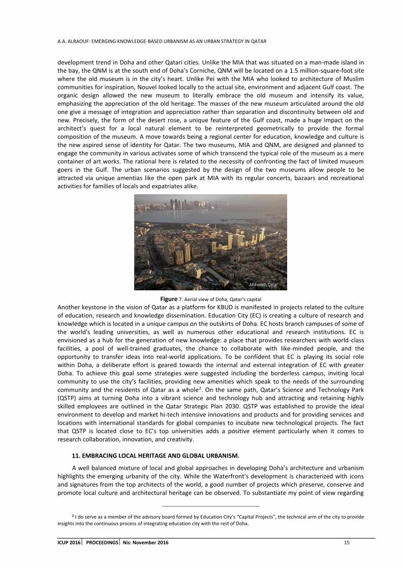
development trend in Doha and other Qatari cities. Unlike the MIA that was situated on a man-made island in the bay, the QNM is at the south end of Doha’s Corniche, QNM will be located on a 1.5 million-square-foot site where the old museum is in the city’s heart. Unlike Pei with the MIA who looked to architecture of Muslim communities for inspiration, Nouvel looked locally to the actual site, environment and adjacent Gulf coast. The organic design allowed the new museum to literally embrace the old museum and intensify its value, emphasizing the appreciation of the old heritage. The masses of the new museum articulated around the old one give a message of integration and appreciation rather than separation and discontinuity between old and new. Precisely, the form of the desert rose, a unique feature of the Gulf coast, made a huge impact on the architect’s quest for a local natural element to be reinterpreted geometrically to provide the formal composition of the museum. A move towards being a regional center for education, knowledge and culture is the new aspired sense of identity for Qatar. The two museums, MIA and QNM, are designed and planned to engage the community in various activates some of which transcend the typical role of the museum as a mere container of art works. The rational here is related to the necessity of confronting the fact of limited museum goers in the Gulf. The urban scenarios suggested by the design of the two museums allow people to be attracted via unique amentias like the open park at MIA with its regular concerts, bazaars and recreational activities for families of locals and expatriates alike.
Figure 7: Aerial view of Doha, Qatar's capital
Another keystone in the vision of Qatar as a platform for KBUD is manifested in projects related to the culture of education, research and knowledge dissemination. Education City (EC) is creating a culture of research and knowledge which is located in a unique campus on the outskirts of Doha. EC hosts branch campuses of some of the world's leading universities, as well as numerous other educational and research institutions. EC is envisioned as a hub for the generation of new knowledge: a place that provides researchers with world-class facilities, a pool of well-trained graduates, the chance to collaborate with like-minded people, and the opportunity to transfer ideas into real-world applications. To be confident that EC is playing its social role within Doha, a deliberate effort is geared towards the internal and external integration of EC with greater Doha. To achieve this goal some strategies were suggested including the borderless campus, inviting local community to use the city’s facilities, providing new amenities which speak to the needs of the surrounding community and the residents of Qatar as a whole2. On the same path, Qatar’s Science and Technology Park (QSTP) aims at turning Doha into a vibrant science and technology hub and attracting and retaining highly skilled employees are outlined in the Qatar Strategic Plan 2030. QSTP was established to provide the ideal environment to develop and market hi-tech intensive innovations and products and for providing services and locations with international standards for global companies to incubate new technological projects. The fact that QSTP is located close to EC’s top universities adds a positive element particularly when it comes to research collaboration, innovation, and creativity.
11. EMBRACING LOCAL HERITAGE AND GLOBAL URBANISM.
A well balanced mixture of local and global approaches in developing Doha’s architecture and urbanism highlights the emerging urbanity of the city. While the Waterfront’s development is characterized with icons and signatures from the top architects of the world, a good number of projects which preserve, conserve and promote local culture and architectural heritage can be observed. To substantiate my point of view regarding
2 I do serve as a member of the advisory board formed by Education City’s “Capital Projects”, the technical arm of the city to provide insights into the continuous process of integrating education city with the rest of Doha.

A.A. ALRAOUF: EMERGING KNOWLEDGE-BASED URBANISM AS AN URBAN STRATEGY IN QATAR
16 ICUP 2016 PROCEEDINGSNis: November 2016
the importance of local architecture and urbanism, I will provide a short analysis of some projects which substantiate this trend of development. One interesting project which brings people together to enjoy leisure time and also confront cultural and knowledge experiences is The Cultural Village (Katara). Katara, Qatar’s cultural village is situated on Doha’s eastern coast at West Bay, near the Qatar International Exhibition Center. Katara’s concept is to create an environment suitable for nurturing and activating the cultural and innovative activities in the country; to be a cultural hub and meeting place for the educated and creative; to raise public cultural awareness through festivals, exhibitions, forums and other cultural events; to conduct researches and studies relevant to the objectives and activities of Katara; and to invest in the buildings and facilities.
Figure 8: Souq Waqif, after renovation
Another unique example is Souq Waqif was originally a weekly market for local Bedouins. The souq acquired its name “Waqif,” which means “standing” in English because merchants stood up to peddle their goods. Coinciding with the emerging of modern Qatar, the souk developed to expand in space and activities. The Souq recent renovation is considered one of the most successful projects which took place within Doha in the last decade. It has become one of Doha’s most popular sites. After renovation, Souq Waqif (figure 8.) becomes a showcase of traditional architecture, handicrafts and folk art. The Souq evokes the feeling of traditional Qatar heritage. The successful renovation highlights the nobility and wisdom behind the region’s traditional architecture in the face of modern construction devoid of any cultural identity. This traditional experience made Souk Waqif imperative and the prime place to visit for locals, expatriates and tourists alike. Souq Waqif was nominated for prestigious Aga Khan Award for Architecture in the 2010 cycle. It has been described as a revitalization project, a unique architectural revival of one of the most important heritage sites in Doha aimed to reverse the dilapidation of the historic structures and remove inappropriate alterations and additions.
12. CONCLUDING REMARKS
As people and capital move more freely around the world, people will have the option to choose which area to live. This creates competition among global cities. Qatar is using the design and planning of the built environment to disseminate a positive message and to create a global and regional brand promoting the quality of life expected in its cities. Contemporary Qatari cities are being designed to attract knowledgeable and entrepreneurial people from around the globe to their locals so that the state may benefit socially and economically from the ideas, goods and services provided by such people. Doha has gained global significance through the growth of knowledge economy related projects. The city’s new urban development and its spatial qualities contribute to the global attractiveness of Doha for knowledge economy investments, firms and people. Such urbanism fulfils the requirements of Knowledge workers coming to the city from literally every spot of the globe anticipating an attractive smooth quality of life which would foster their creativity and innovation.
Knowledge-based urban development should be perceived by Gulf cities as the most appropriate answer for their quest to overpass the oil economy era and moving vigorously towards post-oil one. A large part of the motivation behind the projects is clearly the desire to establish Qatar as both a tourist destination and as an ideal place where knowledge workers might be prepared to relocate. Making global and knowledge workers happy by innovating and creating might be the new definition of 21st century urban knowledge and creative city. Qatar acknowledged culture as a main catalyst for a new era of development. Knowledge based society as Qatar national vision suggests, considers culture as a crucial asset that should be preserved. Knowledge economy and the commitment towards transforming Doha into a creative and knowledge city govern every step the Qatar government is taking to shape the future of its Capital city, Doha. Hence, the government
A.A. ALRAOUF: EMERGING KNOWLEDGE-BASED URBANISM AS AN URBAN STRATEGY IN QATAR
ICUP 2016 PROCEEDINGS Nis: November 2016 17
emphasizes the importance to embrace Qatari culture and identity, ensuring that development will not have a negative impact on culture and social norms. Looking at the major measures taken by the government, Qatar’s path looks optimistic in terms of ensuring that economic development will not compromise its culture.
REFERENCES
1. Thierstein, A., Schein, E., 2008. Emerging Cities on the Arabian Peninsula: Urban Space in the Knowledge Economy Context in ArchNet-IJAR: International Journal of Architectural Research, Volume. 2, Issue 2, Archnet- MIT Design Media Lab, Cambridge, USA, PP. 178-195.
2. Anholt, S., 2009. Places: Identity, Image and Reputation. Palgrave Macmillan.
3. Alraouf, A.A., 2012. An Emerging Urbanity in Knowledge Economy Paradigm: The Case of Doha, Qatar. International Conference on Realigning Power Geometries in the Arab World. Leipzig University, Germany. February 24-26, 2012.
4. Alraouf, A.A., 2011. Assembling Identity for an Emerging Urbanity. Doha, Qatar, as a Creative City. The City: 2nd International Conference. "The City: Culture, Society, and Technology." Vancouver, British Columbia. Canada. May 4-6, 2011.
5. Alraouf, A.A., 2010. From Knowledge to Creativity Economy, Qatar Urbanity Transformed. Third Knowledge Cities Summit (KCS) 2010. Melbourne, Australia. November 16-19.
6. Alraouf, A.A., 2008. Emerging Middle Eastern Knowledge Cities: the Unfolding Story. In Knowledge Based Urban Development: Planning and Application in the Information Era. Edited by Tan Yigitcaular& V. Koray. USA: IGI Global Publishing.
7. Carrillo, F.J., 2005. Knowledge Cities: Approaches, Experiences, and Perspectives. Butterworth-Heinemann
8. Davidson, C.M., 2008. Dubai: The Vulnerability of Success. N.Y.: Colombia University Press.
9. Dinnie, K., 2011. City Branding: Theory and Cases. Palgrave Macmillan.
10. Evans, G., 2009. Creative Cities, Creative Spaces and Urban Policy. Urban Studies, 46 (5-6).
11. Florida, R., 2002. The Rise of the Creative Class. New York: Basic Books.
12. Florida, R., 2005. Cities and the Creative Class. New York: Routledge.
13. Florida, R., 2008. Who’s your city? New York: Basic Books.
14. Gehi, J., 2010. Cities for People. Island Press.
15. Gray, M., 2011. A Theory of ‘Late Rentierism’ in the Arab States of the Gulf, Occasional Paper No. 7, Center for International and Regional Studies, Georgetown University School of Foreign Service in Qatar, 2011.
16. Gray, M., 2013. Qatar: Politics and the Challenges of Development. Boulder, CO: Lynne Rienner Publishers.
17. Harvey, D., 2009. Social Justice and the City (Geographies of Justice and Social Transformation). University of Georgia Press, Revised edition.
18. Kamrava, M., 2013. Qatar: Small State, Big Politics. New York: Cornell University Press.
19. King, A.D., 2004. Spaces of Global Cultures, Architecture, Urbanism, Identity. London: Routledge.
20. Kotler, P., 1993. Marketing Places. Free Press.
21. Jodidio, P., 2009. Museum of Islamic Art, Doha, Qatar, New York, NY: Prestel.
22. Landry, C., Phil, W., (eds.). 2007. The Intercultural City: Planning for Diversity Advantage. London: Earthscan Publications Ltd.
23. Landry, C., 2006. The Art of City Making. London: Earthscan Publications Ltd.
24. Sassen, S., 2001. The Global City: New York, London, Tokyo. 2nd edn. Princeton, NJ, USA
25. Richer, R., 2009. Conservation in Qatar: Impacts of Increasing Industrialization. Center for International and Regional Studies (CIRS), Georgetown University, Qatar.

A.A. ALRAOUF: EMERGING KNOWLEDGE-BASED URBANISM AS AN URBAN STRATEGY IN QATAR
18 ICUP 2016 PROCEEDINGSNis: November 2016
26. Roberts, D.B., 2015. Qatar: Securing the Global Ambitions of a City-state. London: C Hurst & Co Publishers Ltd.
27. QSDP (Qatar General Secretariat of Development Planning) 2011. National Development Strategy 2011–2016. Gulf Publishing and Printing Company, Doha, Qatar.
28. Ulrichsen, K.C., 2011. Insecure Gulf: The End of Certainty and the Transition to the Post-oil Era. London: C Hurst & Co.
29. White, A., 2010. How Doha’s Dollars are changing the World. In Arabian Business. Vol. 11 issue 28.Pp: 26-34.
30. Wood, P., Landry, C., 2008. The Intercultural City: Planning for Diversity Advantage London: Earthscan.

K. MATHEY: URBAN RENEWAL AND REVITALIZATION – THE ECO CITY TOOL BOX IN EUROPE
ICUP 2016 PROCEEDINGS Nis: November 2016 19
URBAN RENEWAL AND REVITALIZATION - THE ECO CITY TOOL BOX IN EUROPE
Kosta Mathéy
GLOBUS Berlin1 PhD, Professor, [email protected]
ABSTRACT
After the proclamation of the Sustainable Development Goals by the United Nations in 2015, the label ‘sustainability’ has become an often unreflected commonplace which does not consider the complexibility of the concept. In the context of urban development we can, for example, distinguish between climatic, ecological, social or economic sustainability. To achieve each of those goals, different strategies can be applied with an open set of different interventions for each strategy. This paper evaluates different sustainability goals, strategies and interventions in search of Urban Renewal programs implemented in Europe over the last 20 years or so.
Keywords: urban renewal; European experiences; sustainable development; strategies; tools.
1. SUSTAINABLE DEVELOPMENT THROUGH URBAN RENEWAL
Within the frameworks of sustainable development, which is considered an overriding principle for all future interventions in the environment since the 1992 UN Conference on Environment and Development, urban planning ideally should enable a fair balance between economic, social and environmental concerns.
The application of sustainable development principles are main characteristics of eco-cities2. Hence, the fulfilment of eco-city requirements will be measured upon the satisfaction of the various sustainability objectives – which generally can be achieved in the combination of different reinforcing or complementary instruments or planning tools. Those will be explained to greater detail in the eco-city tool box further below.
2. THE ECO CITY TOOL BOX
In the following chapters we will portray specific tools and instruments which have been introduced in Europe in the recent past and which had been developed specifically to attain the urban renewal objectives.
2.1. Strategy: Environmental Sustainability through Climate Change Mitigation
Given the overall Objective has been identified as stopping Global Warming, different strategies can be followed. The first one to be covered here is C.C. mitigation. Each strategy has its own set of objectives.
2.1.1. OBJECTIVE: REDUCTION OF NON-RENEWABLE ENERGY DEMAND
TOOL: Thermal roof insulation by adding extra floor. The most common tool for CO2 reduction in Europe consists in improving the thermal insulation of walls and roofs of old buildings (saving non-renewable fuel). In order to avoid condensation of moisture within the walls the insulation is normally fixed on the outside of the building skin. In historic buildings with facing bricks or decorated facades special techniques, like the incorporation of a moisture barrier or a thick layer of light mud plaster allow to place the insulation on the inner side of the wall construction.
1This paper is a condensed version of another illustrated paper with more than 100 pages. All described strategies were extracted from a suvey of more than 65 European urban renewal case studies and not a theoretica contruction. The material was originally collected as part of an expert assignment for the EU-Eco City program in the P.R.China.
2 Roseland, Mark (1997). "Dimensions of the Eco-city". Cities 14 (4): 197–202.
K. MATHEY: URBAN RENEWAL AND REVITALIZATION – THE ECO CITY TOOL BOX IN EUROPE
20 ICUP 2016 PROCEEDINGSNis: November 2016
TOOL: High tech energy furbishing. Theoretically, a high-tech combination of insulating the building skin with other climate active measures, such as solar collectors, electro-voltaic cells, heat pumps, grey water recycling, green facades or roofs, can make the difference between a zero-energy house and a an energy-plus building.
2.1.2. Objective: Energy – Recycling
Since energy recycling is one of three basic principles of energy saving (avoiding, recycling, clean production), many different variations of applications exist and one or another tool can be incorporated.
TOOL: Reuse of embodied energy. Within the scope and duration of an urban renewal process the embodied energy of any existing constructions is best recovered by adapting, modernizing or transforming the same rather than demolishing and replacing them. After completion of the renewal works and during the subsequent utilization period recycling of embodied energy requires the (previous or/and posterior) separation and controlled removal of household and other waste – which at least requires adequate storage and transportation facilities. In Europe this process is standard practice in most municipalities and large variety of technologies are in use.
TOOL: Heat exchangers. Where the regional climate requires heating or cooling of indoor living space, much energy is lost during the necessary exchange of used air for fresh air. However, direct exchange of heat (or cold) between two air streams is relative simple by use of heat exchangers in which both air streams are separated through a membrane over a larger area. Commercial heat exchangers can recover 70% of the heat normally lost through necessary room ventilation3. The same principle can also be applied for warm water but only makes sense where larger quantities of hot water are being consumed – like saunas, swimming pools, canteen kitchens etc.
TOOL: Capturing biogas of organic waste. Biogas is produced in de fermentation of organic material. It contains methane, a potent greenhouse gas with a warming effect that is 21 times greater than that produced by carbon dioxide4.When biogas is burnt it still releases CO2, but with much less impact on global warming which can even be neutralized in production of new organic matter. Therefore it is a good idea to capture and use the biogas which is generated in the context of urban greening and organic waste collection – for example in a local heat-energy plant within an urban eco-block as part of an urban or brown field renewal project.
2.1.3. Objective: Clean and renewable energy
Quantitative reduction of energy consumption is a virtue in the context of oil based economies, but energy in itself is not a bad thing. After all, life is energy and nothing else. And in fact, the term ‘renewable energy’ is misleading since even crude oil is renewable – but the cycle length takes several million years and we have to deal with the short term effects of over consumption, to which our ecosystem, and even less our human organisms, may be unable to adapt. Therefore, to enable mankind to survive, we must take care and stop or even better: reverse the phenomenon of climate change. Stopping CO2 emissions is the most significant single measure to achieve this aim.
TOOL: Autonomous energy supply. Electric power is highly versatile but suffers from the high energy losses dependent on generation technology and to the resistance of transmission cables and transformers. Many factors are involved but as a general figure we can assume that less than 30% of the originally inserted energy reaches the consumer5. Therefore it makes sense to decentralize power production and furthermore to capture the unavoidable energy losses i.e. in the form of heat (a conventional light bulb only transforms 1% into light but 99% into heat!). Decentralized energy production also has the charm that it can be mostly powered through renewable energy sources such as photovoltaic cells, wind power generators, small hydroelectric generators and, last but not least, conventional water solar collectors. Many urban renewal and revitalization projects in Europe include local energy production whether on the house/dwelling unit or on a district level.
3 http://www.homepower.com/articles/home-efficiency/equipment-products/heat-energy-recovery-ventilators seen 15/07/2015
4 http://www.tusk.org/userfiles/file/PACE/science-sample/Biogas%20and%20Climate%20Change.pdf seen 15/07/2015
5 https://electricalnotes.wordpress.com/2013/07/01/total-losses-in-power-distribution-transmission-lines-part-1/.
Visited 15/07/2015
K. MATHEY: URBAN RENEWAL AND REVITALIZATION – THE ECO CITY TOOL BOX IN EUROPE
ICUP 2016 PROCEEDINGS Nis: November 2016 21
TOOL: Modular energy saving kits for house refurbishment. In mass housing schemes most units tend to have the same construction and typology and were built to low or medium standards. When it comes to urban renewal and revalorization the energy standards invariably have to be improved. By definition mass housing refers to a large number of units involved and therefore cost savings can be achieved through standardization and mass production of solutions which not only cater for insulation demand but also for the capture of natural energies.
TOOL: District heating: Integrated heat-and-energy management. Individual house- or dwelling-based heating/cooling systems are less efficient than larger collective heat generation installations, also known as ‘co-generation’ of heat and power. The larger ones not only have lower investment cost per unit of energy but can also shift from one energy source (solar, natural or biogas, timber pellets etc.) to another dependent on cost and availability. They also have less consumption peaks and interruptions. Like in the case of autonomous energy supply described above they can make best use of waste heat invariably generated in the production process of electricity.
2.1.4. Objective: Land reclamation
Coastal cities often can enjoy the privileged location on the waterfront but this location also cuts the land reserve for expansion by half. Through land reclamation on shallow water extra and usually centrally located terrain can be created for urban development and provide resettlement reserves for historic and centrally located urban renewal programs. The term ‘land reclamation’ is sometimes also used for brown field development; redevelopment of harbour areas combines both interpretations.
TOOL: Creation of external overspill areas to accommodate greenery and/or housing as part of urban renewal programs. Land reclamation usually implies filling up the ground on shallow water with rocks or even sand – whatever is available and affordable. Obviously construction on this kind of land is more expensive than on solid land and usually requires pile foundation which can go rather deep.
2.2. Strategy: Environmental Sustainability through Climate Change Adaptation6
Contrary to Climate change mitigation, which attempts to reduce greenhouse gas emissions, Adaptation Strategies also aim at reducing the vulnerability of cities against the negative effects of climate change.
2.2.1. Objective: Micro climate7,8 / Heat island9,10 reduction
‘Urban areas generally have a lower humidity level than the surrounding countryside due to much absence of vegetation and the increased absorption of energy from the sun caused by dark asphalted or concrete surfaces. This also explains why inner city areas are often many degrees warmer than their surroundings. This phenomenon, known as the urban heat island effect, can have serious consequences for vulnerable people, such as those who are chronically ill or the elderly, particularly during heat waves. The moist air generated by natural vegetation helps to counter this phenomenon. Humidity levels could also be artificially increased using electricity to evaporate water, but this would cost significantly more than using natural vegetation (around €500,000 per hectare). Working with nature and using Green infrastructure in an urban environment, for example by incorporating biodiversity-rich parks, green spaces, green roofs and walls and fresh air corridors, is generally a much cheaper and more versatile option to help mitigate the urban heat island effect. It can also help to absorb CO₂ emissions, improve air quality, reduce rainfall runoff and increase energy efficiency’11.
6 http://www.dw.com/en/climate-change-can-affect-all-of-us/a-17529180 seen 17/07/2015
7 http://www.gardening.cornell.edu/weather/microcli.html seen 22/08/2015
8 http://www.metoffice.gov.uk/media/pdf/n/9/Fact_sheet_No._14.pdf seen 22/08/2015
9 http://www.epa.gov/heatisland/about/index.htm , http://scied.ucar.edu/longcontent/urban-heat-islands seen 17/07/2015
10 http://education.nationalgeographic.com/encyclopedia/urban-heat-island/ visited22/08/2015
11 Quotation from: http://ec.europa.eu/environment/nature/ecosystems/docs/green_infrastructure_broc.pdf, seen 17/07/2015

K. MATHEY: URBAN RENEWAL AND REVITALIZATION – THE ECO CITY TOOL BOX IN EUROPE
22 ICUP 2016 PROCEEDINGSNis: November 2016
TOOL: Greening of streets, backyards and roofs12. Urban greenery through evaporation can cool down ambient temperature. Secondly, by filtering the air fine dust particles can be retained, which are a major cause of smog, which caused by ‘heavy’ air building a sort of lid over the city and hinders natural thermal air circulation. Thirdly, psychologically the visual impact but also the movements of the leaves of plants give the impression of flowing air which the mind associates with a cooler environment.
2.2.2. Objective: Flood protection
Due to rising sea level or flooding of river basins many cities suffer from flooding every couple of years, whereby the frequency of those events tend to become closer due to climate change or deforestation (river basins).
TOOL: Sustainable Urban Drainage System (SUDS). In the case of very heavy rains, which tend to occur more frequently now due to climate change, urban sewage system – especially in cities which don’t operate a separate sewage and rain water drainage evacuation - are not capable of absorbing the masses of rain water and the resulting flooding causes not only material damage but also presents a health hazard after spilling of sewage into the floods. Comprehensive sewage systems aim at retaining rain water in open basins, for example football fields located slightly below street level, for a couple of hours. Other cities located on more permeable ground, now oblige owners of houses to provide for penetration of all rain water into the subsoil of the plot and do not tolerate rainwater to be led into the collective sewage system at all.
TOOL: Water proof ground floors and pedestrian access above street level. Dykes around the city were a traditional remedy against flood damage, but they are not always feasible or would separate the city from the water front. Steel shutters are a feasible alternative and additionally provide physical protection against break-ins and damage in connection with violent mass manifestations.
TOOL: Floating homes. ‘Special planning for floating apartments is one way to adapt to the effects of rising sea levels and increasing rainfall due to climate change. According to experts from the Dutch government's Delta Commission, the sea level will rise in the country by 1.3 meters (4.3 feet) in the next century, and up to 4 meters (13 feet) over the next 200 years. One-third of the Netherlands is situated either at sea level, or below it’13. ‘There are two types of floating homes, permanently floating homes and homes that float only when flood waters swell, but sit on the ground during the dry season. Requiring floatability for new construction within floodplains, and considering same for threatened shore lines, is one way to plan for the future. Although floating homes near the coast need protected waters, like wave attenuation through wave walls and dykes (as used in Europe) they represent a future urbanization possibility’14.
2.2.3. Objective: Drought precaution
Climate change not only brings too much water to certain regions, but takes it away from others which were used to receive sufficient quantities in the past. We know from history that complete cities were abandoned when the water supply ceased. Given size of modern cities, and the vanishing of land reserves on habitable land, the solution of just moving a city is not feasible any more.
TOOL: Rainwater harvesting and Green Roofs. Ancient cities in dry regions were used to collect rain water and store it in cisterns for the months with little rainfall. Of course, it is not very easy to store the water needs for an entire season in a cistern, but since most of the collected water is not meant for drinking anyway but mostly for watering gardens, storage can also happen in the subsoil and pumped from there again.
2.2.4. Objective: Integrated flood prevention and erosion control
The previous example which focuses on the improvement of the micro climate where water resource conservation will improve the comfort levels in cities but is not enough to prevent and handle serious disaster scenarios. This requires a combination of many different measures together with a tested emergency plan. An example of such integrated and cooperative strategy could exist of different elements such as: 1) Roadways
12 http://www.scp-knowledge.eu/sites/default/files/R%C3%B8m%C3%B8%202012%20Green%20roofs%20worldwide_0.pdf seen 21/07/2015
13 http://www.dw.com/en/floating-houses-to-fight-climate-change-in-holland/a-17532376 seen 17/07/2015
14 http://www.inspirationgreen.com/floating-homes.html, seen 17/07/2015

K. MATHEY: URBAN RENEWAL AND REVITALIZATION – THE ECO CITY TOOL BOX IN EUROPE
ICUP 2016 PROCEEDINGS Nis: November 2016 23
redesigned for water management, 2) Shift away from ‘grey’ towards ‘blue and green’ infrastructure, 3) Responsibility of private property owners.
TOOL: Integrated disaster prevention planning. Where rainwater harvesting or retention or infiltration technologies are applied individually, disaster prevention requires a concertized intervention plan for the worst case scenario. This means that efforts to reduce the impact of climate change are not enough but a possibly necessary rescue plan must be elaborated in parallel.
2.3. Strategy: Environmental sustainability
Climate change is only one factor which has an influence on the environment and on the material and on the spiritual base of our wellbeing. Ecological diversity and air quality also impacts on mankind future living chances and conditions. When a food chain is broken, the consequences can be much bigger than removing a single link in the chain. If we use up certain mineral resources they will be missing for our grandchildren.
2.3.1. Objective: Combating resource depletion
Measured by the relatively short period that mankind has conquered our planet, the speed in which we use up the earth’s ‘non-renewable’ resources is irresponsible, nor economically sensitive. Most of resource depletion is linked to the urban economy and development. This is why stopping this process, in general, has to begin in the cities first.
TOOL: Municipally led waste and resource management. Priorities in resource preservation go from avoidance to recycling and only in the last consequence to safe disposal. In fact, the most active municipalities in fighting Climate Change include some waste directed modules in their strategy.
2.3.2. Objective: Preserving Biodiversity
Every day species’ extinctions are ascending up to 1,000 times or more of the natural rate15.18,788 species out of 52,017 so far assessed are threatened with extinction – and most of them directly or directly due to anthropogenic disturbance in the world ecological balance16.Paradoxically, sometimes there still is a larger variety of species inside cities than in the countryside where monoculture and heavy use of pesticides still dominate. But even so, urbanization is not a safeguard against biodiversity loss, since farm products are mostly consumed in cities and pesticides are produced there too. Nevertheless, consciousness building as well as practical support to conservation of biodiversity can start from the cities.
TOOL: Community gardens and diversity of species. The promotion of school and community gardens follows an education effort in the first place, community building in the second and food production last. Usually there is some social staff taking care of attendance, and collective activities stand in the centre.
TOOL: Urban Forestry17. Forests usually provoke the association with wilderness and incompatible with urban civilisation. Nevertheless for many urbanites, hiking through the forest ranks among the most exciting Sunday afternoon occupations. For some 20 years there already exists an initiative to complement the urban gardening movement by advocating the alternative of urban forestry – even some M.Sc. programs on the topic have opened recently in European Universities. It must be remembered though that urban forest already existed centuries ago when they were attached to Baroque Palaces and functioned as hunting grounds for the nobles while not being open to the public. Only with the French revolution this exclusiveness changed (see: Bois de Boulogne in Paris).
2.3.3. Objective: Healthy cities – healthy living
Flora and fauna are not the only endangered species, but also mankind. Back in the1970s and 1980s there was a growing criticism against living in buildings which had been conceived as a dwelling machine by its architects, and some (mostly underground) architects in Berkley (US) and Germany promoted Biological Building instead. They avoided cancerogenic and other dangerous chemical substances as components in building materials, concentrations of electromagnetic fields etc. Most buildings were either individual houses
15 https://www.iucn.org/iyb/about/biodiversity_crisis/ seen 7/22/2015
16 http://www.who.int/globalchange/ecosystems/biodiversity/en/ seen 7/22/2015
17 http://scenariojournal.com/article/beyond-planting/ seen 7/23/2015
K. MATHEY: URBAN RENEWAL AND REVITALIZATION – THE ECO CITY TOOL BOX IN EUROPE
24 ICUP 2016 PROCEEDINGSNis: November 2016
or settlements at the fringe of the city, but some coherent urban renewal programs also adopted biological building principles, like in Germany the International Building Exhibition (IBA) in its urban renewal site18. The WHO (World Health Organization) also took up the issue and discussed it in the context of the Healthy Home19. More recent projects – mostly in overspill areas and not in the city centres, combine certain ecological building principles with other sustainable settlement features, like car sharing arrangements or energy self-sufficiency.
TOOL: Provision of space for urban agriculture. Over the last 30 years there has been a revival of urban farming practices – though less for the pure material need to supplement personal food supply (as it was in the post war period of WWI and II), but rather in the intention to improve living standards through close contact to nature and possibly also consuming healthier food.
2.3.4. Objective: Clean and fair building materials
Ecological construction defines certain standards, such as the absence of poisonous ingredients and complying with basic workers’ rights including healthy working conditions. With accelerating globalization it becomes more difficult to assure the compliance with the standards as a large number of products or their components are imported from far away countries with little possibilities to enforce fair standards.
TOOL: Green Public Procurement policy. Urban infrastructure and public buildings are mostly paid by the exchequer and represent a large proportion of the construction sector. Since these works normally must be tendered, this is the opportunity to enforce the desired ecological standards, if intended, by the politicians.
2.3.5. Objective: Air pollution control
Air pollution may have many causes, including industries, road traffic, smog and sand storms (still very rarely in Europe) and others. Specific tools must be chosen carefully.
TOOLS against pollution generated by local industries. Typical remedies are subsides or loans to the industries to modernize their production process or relocation.
TOOLS against pollution caused by heavy traffic20. The best remedy against smog is stopping through traffic all together, like the car free zones like the CBDs of Milan, Florence or Lisbon. The second best option would be to reduce the speed of traffic, i.e. by uneven road surface (bumpers), non-synchronised traffic lights, mixed use of road space by cars and pedestrians21. Especially critical are exhaust fumes from gas oil cars without filters.
TOOLS against smog. Smog is partly an effect of air pollution and not a cause. Therefore the last two tools will also remove smog. Complementary to that air circulation through the city can be improved (where topography allows) through cutting green corridors through the city.
2.3.6. Objective: Noise pollution control
Noise pollution can cause disruption, interference and irritation and can even lead to the development of stress or loss of sleep. Maintaining the comfort and well-being of people in their own homes is important – not just to protect human rights but also to help sustain a happy, healthy and productive society22.
TOOLS: Traffic calming, road closures. If quiet zones are included in the master plan, then traffic planners can direct traffic to arterial roads and ensure that traffic stays outside the residential neighbourhood. Alternatively they can regulate traffic speeds to reduce noise levels during specific hours of the day or at night. The European Noise Directive23regulates the assessment and management of environmental noise. Another EU
18 http://f-iba.de/, https://www.google.de/url?sa=t&rct=j&q=&esrc=s&source=web&cd=5&ved=0CEoQFjAEahUKEwi2_ 7f0hPDGAhWIOxQKHZaUAEg&url=http%3A%2F%2Fwww.stadtentwicklung.berlin.de%2Fstaedtebau%2Fbaukultur%2Fiba%2Fdownload%2FLearning_from_IBA.pdf&ei=4zqwVfaBD4j3UJapgsAE&usg=AFQjCNFVeyxv9SDlCNg_ygFvIvwdqaWOTA&sig2=TU1XLYp4pRV6OSLmN8DuAw
19 http://www.who.int/healthy_settings/types/homes/en/ , http://www.who.int/hia/housing/en/, seen 7/22/2015
20 http://www.frankfurt-greencity.de/en/environment-frankfurt/the-air-in-frankfurt/ seen 7/24/2015
21 https://www.google.co.uk/url?sa=t&rct=j&q=&esrc=s&source=web&cd=5&ved= 0CDcQFjAEahUKEwiW26iWoPLGAhWEFCwKHcArCKg&url=http%3A%2F%2Flibrary.ite.org%2Fpub%2Fe277e2be-2354-d714-519b-fdd0b98f0d7d&ei=6WOxVdbCIISpsAHA16DACg&usg=AFQjCNHOL8ja2RHil4VORdUW3HrJBEkNJQ&cad=rja. seen 7/22/2015
22 http://noisenuisance.org/ viewed 24/07/2015
23 http://eur-lex.europa.eu/legal-content/EN/TXT/?qid=1435827004963&uri=OJ:JOL_2015_168_R_0001 viewed 24/07/2015

K. MATHEY: URBAN RENEWAL AND REVITALIZATION – THE ECO CITY TOOL BOX IN EUROPE
ICUP 2016 PROCEEDINGS Nis: November 2016 25
document24states, ‘First conservative and partial estimates show that at least 1.600.000 Disability Adjusted Life Years are lost every year in the EU, mostly due to road traffic (noise).’ The directive requires all cities and agglomerations of more than 100,000 inhabitants to assess the noise exposure of people in their residence. Buses, city utility vehicles and garbage trucks can be noisy, and it is expensive to replace them with quieter models. To set a policy in place, the planning department of a community needs to present a cost/benefit analysis to enforce the improvements. A noise analysis and prognosis can pinpoint which school, hospital and neighbourhood is improved by what margin for a variety of noise solutions25.
2.4. Strategy: Economic Sustainability
If urban renewal projects fail, it is mostly because of economic reasons. This may be during the actual project implementation period, or in the long run because the incomes by the resident population are insufficient to keep up with the improved standards and induce gentrification or renewed decay for lack of maintenance. This is not the fault of the target population but the lack long term economic foresight on behalf of the planners. This is not really a surprise since urban planners never learned about economics nor have any powers to interfere in this field. There are, however, also some positive experiences in economically sustainable urban renewal which will be discussed in the following section.
2.4.1. Objective: Public-private partnerships
For quite an extended period already, disposable state income tends to decrease while at the same time neoliberal local authorities are less prepared to finance public services and investments. It is also true that private investors are more flexible and less bureaucratic in project administration, at the cost of lacking social accountability and the need to be able to withhold a compatible profit margin. A possible third player in municipal governance is the social sector who represents the resident population. Well managed cooperation of the three sectors: state, private and social sectors, in known as participatory governance26,27,28, where part of the costs can be recovered by community itself.
TOOL: Soft Renewal. Urban renewal is expensive; but it also creates economic values which accrue to the house owner’s assets. Soft renewal means animating landlords to invest without using the instrument of expropriation.
2.4.2. Objective: Green economy
Internationalization often removes decision making power, even on business matters from the local context and can lead to absurd situations or destroys the local economic base. An example would be if Portugal with a labour intensive traditional wine production was overrun with cheap industrially produced wine from California or from South Africa and local producers cannot compete.
TOOL: Local green currency (small is beautiful). An obvious solution would be some kind of exchange economy for local goods whose values represent the true labour input.
TOOL: Playing the globalization game: international awards. If you can’t beat them, then join them. International awards usually will give you less direct financial returns than what you invest in the application. But the points earned in publicity can be high and pay back in the long run. Even more important is an award when it comes to convince local politicians about future policy orientation.
TOOL: Green Banking and Green Bonds29. Green Bonds are short-hand for Qualified Green Building and Sustainable Design Project Bonds, i.e. tax-exempt bonds which are issued by federal-qualified organizations and/or municipalities for the development of brown field sites. The tax-exempt status makes purchasing a green bond a more attractive investment when compared to a comparable taxable bond. The public sector can
24 http://ec.europa.eu/environment/noise/home.htm, viewed 24/07/2015
25 http://www.soundplan.com/noise-control.htm?gclid=CInetJCv8sYCFRLMtAodPb0A_g viewed 7/24/2015
26 http://onlinelibrary.wiley.com/doi/10.1111/j.1467-7660.2009.01586.x/abstract visited 23/08/2015
27 https://books.google.de/books?id=nTQAAgAAQBAJ&dq=richard+stren,+participatory+governance&lr=&source=gbs_navlinks_s visited 23/08/2015
28 file:///C:/Users/Kosta/Downloads/cusp-110108-participatory-gov.pdf visited 23/08/2015
29 https://www.idfc.org/Our-Program/green-finance-mapping.aspx visited 7/31/2015

K. MATHEY: URBAN RENEWAL AND REVITALIZATION – THE ECO CITY TOOL BOX IN EUROPE
26 ICUP 2016 PROCEEDINGSNis: November 2016
facilitate a bank’s development by creating the institutional framework and rules. Feeding the institution with public capital can then attract greater shares of private funds. The World Bank has been a leader in the market, and has issued over $USD 5.3 billion in Green Bonds since an initiating activity in 200830,31.The Climate Bonds Initiative, an international NGO, reports that issuances of Green Bonds grew by 25% between 2011 and 2012 globally; and that issuers come from both the municipal, corporate, and institutional sectors. Another option for scaling up the available capital for green technology and infrastructure investments is the creation of a public-private ‘Green Bank.’ Creating this type of institution can leverage public funds with private sources that are attracted to the long-term returns of infrastructure projects from investors motivated by a low-carbon or green innovation ethos. Pension and insurance funds are often cited as ideal investor candidates for the green economy.
TOOL: Urban Renewal Funds. Smaller municipalities and districts, which eventually carry the responsibility for local action, normally don’t have the resources to engage in the issue of bonds. Nevertheless, competition between these institutions to access Urban Renewal Funds issued by large municipalities or governments can work as stimulation to execute sustainable renewal schemes on the local level.
2.4.3. Objective: Economic revitalization and stronger global integration
Investors and manufacturers are becoming more and more international and, like tourists, tend to operate between a limited number of ‘global cities’. These are characterised by certain rational characteristics, like proximity to ports and airports, political and urban security, cultural or natural attraction etc. Also simple reference in the news to the city, positive mention in the media, and connotation with international events contribute to global popularity. Higher ranking on the global cities usually result in more international investment and/or attraction for tourists. Both imply more jobs locally and higher incomes for the municipality and region.
TOOL: Place branding and iconic architecture. Commercial city marketing, usually referred to as ‘place branding’, actively promotes the international reputation of a city – or sometimes of an entire region where individual cities are not strong enough on their own. Apart from world scale events, like Olympic Games or World Exhibitions, even an iconic Building designed by a famous architect can have a supporting effect, like the Sidney Opera House, the Sony Centre in Berlin and, of course, the Guggenheim museum in Bilbao serve for promotion.
TOOL: Green business and leadership. Economic successes in navigating a city within the ocean of global economy merit recognition but do not necessarily contribute to the reduction of global warming. Ecological approaches to urban economies rather suggest a certain independence from global markets but still need income levels to cover all operational costs and redemption.
TOOL: Mix of several land uses. Replacing old and decaying old housing stock and building fresh again can be more economical than renewal– especially on virgin land at the outskirts of the city where land prices are more economical. However, considering all monetary and other costs, it makes more sense to densify inner city areas where the urban infrastructures already exist, the distances are shorter and the urban footprint is reduced. This is particularly true when different land uses are combined as the time and transportation needs are less (city of short ways).
2.5. Strategy: Social Sustainability
The well being of a neighbourhood depends on the interplay between its physical, economic and social structures. If the residents are poor, they cannot maintain their dwellings. If they lack skills and education or if they are stigmatized they may find it more difficult to find employment or earn an honest income otherwise. If the buildings are in a poor estate, the residents may also suffer stigmatization etc. Therefore it is essential to look at a neighbourhood with a comprehensive understanding – otherwise no renewal program can be sustainable.
30 http://www.tbligroup.com/tbliconference/news/conferences/will-green-bonds-incentivize-more-direct-investments-perspectives-from-tbli-conference-nordic-2015.html seen 7/31/2015
31 http://www.worldbank.org/content/dam/Worldbank/document/Climate/climate2014-green-bonds-brief-091214.pdf seen 7/31/2015
K. MATHEY: URBAN RENEWAL AND REVITALIZATION – THE ECO CITY TOOL BOX IN EUROPE
ICUP 2016 PROCEEDINGS Nis: November 2016 27
2.5.1. Objective: access to adequate shelter
For the residents the ultimate objective of urban renewal schemes is the creation and adaptation of adequate living space, of which housing, though not exclusively, is the principal element. The perceived lack of housing units usually is the leading argument, although the official numbers may be rather misleading. Size, location and typology can be inadequate but can be adapted – which is also true for the problem of affordability.
TOOL: Neighbourhood contracts and other governmental subsidy schemes. Almost all European urban renewal and revalorization schemes imply subsidies in which the state attempts to rectify defects in past and current housing and urban policies or practices. The subsidy programs usually reflect the changing ideologies of the state, which in Europe tend to be determined by the political parties in power.
TOOL: Adaptation of unpopular mass housing typology. Particularly uniform mass housing estates can become unpopular with its residents and turn into ghettos of the disadvantaged who don’t have the means or connections to transfer to other neighbourhoods or typologies. Physical transformation of those housing blocks can be a solution.
2.5.2. Objective: Tackling the land question
When it comes to discussing housing affordability and location, the cost of the land invariably turns out to be the key issue. Differential land values fuel social segregation, and land speculation makes decent housing unaffordable even to middle income groups in major urban centres. Since more than a hundred years different reformers have tried to find a solution to this problem, or at least a way to combat excesses of land speculation.
TOOL: Cooperative housing. Land speculation tends to be perpetuated in conditions where housing property changes hands between different occupants a dwelling. But similar as in the classic government owned social housing schemes, a permanent ownership can be achieved in certain types of housing cooperatives in which its members are not allowed to materialize increased land values when moving flats.
2.5.3. Objective: Location and ease of mobility
Poorer people are more dependent on public transport since they are less likely to afford individual transport (at least in cold climates) – either own or hired – and they find it more difficult to find a new or first home after accepting a workplace far away from their previous residence.
TOOL: Better and affordable public transport. Transportation is expensive and if several family members of less affluent families need to move for work or education this may consume a substantial share of their household income. Therefore urban renewal needs to take the mobility question into consideration – especially keeping in mind that a considerable part of the population, like old age persons, handicapped and children cannot switch to car, bicycles of hiking.
TOOL: Pro-cycling planning and infrastructure. On short to medium distance trips in town, say from 0,5 to 5km, the bicycle is still the fastest and certainly most ecological means of transport. It is non-polluting and in addition keeps the body fit. Local governments can do a lot to encourage the use of bicycles but also to protect cyclists from accidents
TOOL: Pedestrianization. Although pedestrian streets are now a very common feature in main shopping areas all over Europe, a lot needs to be done in secondary streets where motor vehicles still enjoy far reaching preference even where they represent a clear minority in numbers. To make things worse, there is a tendency in some commercial zones and in public transport installations to remove existing benches or other horizontal surfaces to inhibit comfortable resting for non-consumers out of an irrational phobia against possibly appearing vagrants or drunkards.
TOOL: Integrated mobility concept. In those cases where an urban renewal scheme suggests a change in the mobility modal split, this plan will only function if alternatives to the current situation are offered, and the attractiveness of the favoured solution is increased. Therefore public transport, road and parking planning, pricing etc. need to be well synchronized.

K. MATHEY: URBAN RENEWAL AND REVITALIZATION – THE ECO CITY TOOL BOX IN EUROPE
28 ICUP 2016 PROCEEDINGSNis: November 2016
2.5.4. Objective: Poverty alleviation
TOOL: Urban renewal programs targeting the poorest neighbourhoods. Upgrading a poor neighbourhood, while frequently facing a suspicious community, requires extra public relation resources which often are not available in conventional urban renewal programs. This way, the neediest population is easily left out unless special programs are targeting this problem.
TOOL: Income generation programs. The formal labour market prefers applications from people who already have relevant work experience. This makes it very difficult to find employment for young people who are just entering the job market. However, many of those applicants are very talented and imaginative – a capital which can be exploited. In urban renewal schemes, the provision of cheap work space is an asset which may be developed into a busy start-up economy nucleus– for example for co-working ventures. In many cities empty ware houses have been adapted to provide such opportunities, with the rent covered through a subsidy for the first couple of years.
TOOL: Neighbourhood service centres. Public institutions are very helpful for renewal programs for the urban poor and are supposed to assist the resident population who pays for them anyway through their taxes. But often they maintain a bureaucratic tenure, are accommodated far away from their clientele in some institutional premises with annoying opening hours and possibly staff exposing quite a hostile tune. Fortunately a new generation of ‘real’ public service centres are popping up, are often located right within socially critical urban renewal settings, where citizens are not sent from one office to another but find all type of assistance underneath one roof and can even turn up at late hours. In the same building you may also find innovative interpretations of public libraries, where you can watch videos, take the books to the coffee shop or can book evening classes. Obviously, kids from less educated family background feel more attracted to these establishments than to classical borough libraries, and will voluntarily learn ‘the easy way’.
2.5.5. Objective: Social inclusion
With the widening gap between the poor and the rich, accompanied by progressing privatization of public space, socio-spatial segregation becomes more evident and turns very conflictive where it leads to expulsion and gentrification of traditionally low-income neighbourhoods. In urban renewal schemes these processes can always be an unintended side effect and should be avoided at all cost.
TOOL: Positive discrimination. Many urban renewal schemes in Europe are specifically targeted to low-income and otherwise disadvantaged (i.e. Sinti or refugee) groups. Under the condition that there are not enough funds to offer all services to the entire population indiscriminately this is a wise strategy – but bears the risk of automatically stigmatizing the population living in the concerned area.
2.5.6. Objective: Fighting stigmatization
Stigmatization generally leads to exclusion, but can be stronger than just economic exclusion since it adds other, for example cultural or ethnic prejudices to exclusion. Quite frequently, parts of the disadvantaged or poor population, in order not to admit that they at the losing end of society, look out for minority groups which they can consider of less value. Sometimes the mere fact of living in a certain neighbourhood can lead to stigmatization. In that case, the objective of urban revalorization scheme may include generating a better image of the neighbourhood.
TOOL: Social engineering. Where an area suffers stigmatization because of the decaying architecture, it may be enough to embark on an uplifting of the facades. If the stigmatization is based on a racial, religious or other personalised argument then physical interventions are not enough. Specific magnets must be found to convince ‘respectable’ members of society also to move to the area in question as part of the renewal process.
TOOL: Diversification of housing mix. In the European culture, large and homogeneous housing estates are not liked very much, even by its own residents. People like to be different from others which is expressed, for example, in the desire for an individualized front door. Furthermore, in countries where social housing is not available to everyone any more but only poor families with small or no income, those estates are easily stigmatised. This may extend to the entire neighbourhood if this only consists of similar housing typology. Therefore it is only logical that in order to fight stigmatization, a greater variety of housing types – and status of residents at the same time – is a good answer to the problem.

K. MATHEY: URBAN RENEWAL AND REVITALIZATION – THE ECO CITY TOOL BOX IN EUROPE
ICUP 2016 PROCEEDINGS Nis: November 2016 29
2.5.7. Objective: Cultural identity
TOOL: Participation. The concept of sustainability implies the survival and stable operation of a project after its formal ending – when a project turns into a practice. In urban regeneration this requires that the local population identifies itself with the project which is best achieved through active participation in the planning and decision making right from the beginning. This is part of community building and contributes to the formation of neighbourhood identity.
2.5.8. Objective: Crime and violence prevention
Over the last years, urban violence has been perceived a problem also in certain European cities – for example in immigrant quarters with high rates of unemployment and in relation to vagrants loitering in public space. Hence, violence reduction and prevention recently is being been frequently included in the list of expected outcomes of urban renewal projects. The three principal strategies in violence reduction and prevention include policing, physical provision and community building.
TOOL: Conventional policing. The classical response to deviant behaviour is repression by the state and is still occasionally effective in extreme situation – the main reference case is the strong arm policing initiative promoted by the mayor of New York in the 1990s. A precondition, however, is that the state itself and its police strictly follow democratic principles which is not always the case even in Europe.
TOOL: Shared space streets. Lonely places are often perceived as unsafe, even if there is no statistical evidence to support it. The same applies to streets in which delinquents with cars and motos can escape quickly and easily. On the other hand, a reasonably frequented urban pedestrian area is believed to be relatively safe because there are many potential helpers around who can intervene in case of an attack. Therefore pedestrian areas and traffic speed reduction can reduce the fear of violence and crime.
TOOL: Community building and participation. A strong community is the best safeguard against public violence, and when people know each other they are more likely to assist you when threatened by foreigners and intruders. Therefore community building is an effective means of violence prevention and has been introduced in projects where safety is an issue. Community funds are a popular means to bring people together and start speaking to another.
2.5.9. Objective: Conviviality, well being
So far, all presented urban renewal activities were designed to support deprived neighbourhoods with serious urban and social problems. Of course, better off parts of the city are also being renewed – usually funded by the ordinary municipal budget – and therefore special programs are not necessary. There are also cheaper since only the physical works need to financed and the positive long term effects in the sense of place branding are even bigger since international visitors more likely to visit these zones rather than deprived neighbourhoods.
TOOL: Multi-centrality and the enhancement of public open space. Whereas the up-keeping and modernization of individual houses usually are the responsibility of the owner, the valorisation of public and semi-space (smaller streets and places, de-densification of street blocks, attractive public spaces) fall into the responsibility of the municipality. Investments in this field pay back in the long and medium term as quality of life in a city influences the choice of residence for investors, high rank decision makers of companies but also of well-off old age pensioners.
2.5.10. Objective: Heritage conservation
Historic buildings, whether listed or not, account largely for the cultural identity of a city. Furthermore, due to a less competitive land market at their time of origin, the plan could be more generous and the rooms could be higher than modern buildings can afford. Ecologically speaking, the recycling of existing building structures is more sustainable than demolition and new construction anyway.
TOOL: Conversion with change of land use. Listed historic buildings, maybe even with UNESCO certification, are intended to tell us and future generations about our historical past and should therefore be authentic; substantial alterations should be avoided. Conversions, on the contrary, generally maintain the outer skin of a building while the interior can be modified and adjusted to the future occupants need – either residential or commercial.

K. MATHEY: URBAN RENEWAL AND REVITALIZATION – THE ECO CITY TOOL BOX IN EUROPE
30 ICUP 2016 PROCEEDINGSNis: November 2016
3. SOME LESSONS LEARNT
3.1. Participation and PPP
In order to become sustainable, urban infrastructure and public space improvements require regular care and maintenance beyond the day inauguration. In most cases, the local authorities are unable to guarantee this service all over the city to the same extent. Furthermore, many urban renewal projects require some residents or business to be relocated which creates great dissatisfaction unless a fair and reasonable solution can be negotiated between the different stakeholders. In the same way care and maintenance by the community can only be achieved if the same is already involved in the planning phase and can identify themselves with the renewal outcome. Certainly, participation takes more time than top-down decisions but helps to overcome civic resistance and brings political rewards to the decision makers.
3.2. Need for subsidies
The reason why a neighbourhood slip into a state of disrepair and show certain social difficulties is the lack of investment capacity – either by the local authority or by the residents. Therefore almost all European urban renewal and revitalization projects involve public funding to a certain degree. A 100% funding is almost never achieved and often not wanted in order to encourage the participation of the beneficiaries’ right from the beginning. It has also been observed that in general public source infrastructure and services improvement encourage private house owners – which are the rule in Europe – to invest in parallel.
3.3. Neighbourhood contracts
In Europe politicians are sometimes over optimistic in their declarations and executing administrative agencies are not always very eager to engage in tasks that fall outside their day-to-day routine. Or, on the other hand, once they have accustomed themselves to work with public funding they expect the availability of such funding to continue forever and do not feel any stimulation to push for early completion of a renewal program. Therefore some governments have integrated mutually binding contractual obligations in urban renewal programs.
3.4. Risk of gentrification and expulsion
In Europe many people prefer to live in a central or historic part of the city and if such a zone is being upgraded as part of an urban revitalization program. Higher income citizens move in and replace poorer sections of society who cannot compete in a liberal housing market. This process is known as Gentrification32 and has been observed in many parts of the world. This is a real danger in urban renewal programs. The Brussels neighbourhood contracts are an important reference of how to avoid gentrification through positive discrimination, integrated social development and a coverage over many low-income neighbourhoods in the first place. On the other hand, private initiative can sometimes get interested in the rehabilitation of historic factory buildings and invest to a higher standard than public programs can do.
REFERENCES
1. Roseland, M., 1997. Dimensions of the Eco-city. Cities 14 (4), pp 197–202.
2. http://www.homepower.com/articles/home-efficiency/equipment-products/heat-energy-recovery-ventilators [Accessed: 15/07/2015].
3. http://www.tusk.org/userfiles/file/PACE/science-sample/Biogas%20and%20Climate%20Change.pdf [Accessed: 15/07/2015].
4. https://electricalnotes.wordpress.com/2013/07/01/total-losses-in-power-distribution-transmission-lines-part-1/ [Accessed: 15/07/2015].
5. http://www.dw.com/en/climate-change-can-affect-all-of-us/a-17529180 [Accessed: 17/07/2015].
6. http://www.gardening.cornell.edu/weather/microcli.html [Accessed: 22/08/2015].
7. http://www.metoffice.gov.uk/media/pdf/n/9/Fact_sheet_No._14.pdf [Accessed: 22/08/2015].
32 http://dictionary.reference.com/browse/gentrification visited 24/08/2015

K. MATHEY: URBAN RENEWAL AND REVITALIZATION – THE ECO CITY TOOL BOX IN EUROPE
ICUP 2016 PROCEEDINGS Nis: November 2016 31
8. http://www.epa.gov/heatisland/about/index.htm, http://scied.ucar.edu/longcontent/urban-heat-islands [Accessed: 17/07/2015].
9. http://education.nationalgeographic.com/encyclopedia/urban-heat-island/ [Accessed: 22/08/2015].
10. http://ec.europa.eu/environment/nature/ecosystems/docs/green_infrastructure_broc.pdf [Accessed: 17/07/2015].
11. http://www.scp-knowledge.eu/sites/default/files/R%C3%B8m%C3%B8%202012%20Green%20 roofs%20worldwide_0.pdf [Accessed: 21/07/2015].
12. http://www.dw.com/en/floating-houses-to-fight-climate-change-in-holland/a-17532376 [Accessed: 17/07/2015].
13. http://www.inspirationgreen.com/floating-homes.html [Accessed: 17/07/2015].
14. https://www.iucn.org/iyb/about/biodiversity_crisis/ [Accessed: 7/22/2015].
15. http://www.who.int/globalchange/ecosystems/biodiversity/en/ [Accessed: 7/22/2015].
16. http://scenariojournal.com/article/beyond-planting/ [Accessed: 7/23/2015].
17. http://f-iba.de/, https://www.google.de/url?sa=t&rct=j&q=&esrc=s&source=web&cd=5&ved=0CEo QFjAEahUKEwi2_7f0hPDGAhWIOxQKHZaUAEg&url=http%3A%2F%2Fwww.stadtentwicklung.berlin.de%2Fstaedtebau%2Fbaukultur%2Fiba%2Fdownload%2FLearning_from_IBA.pdf&ei=4zqwVfaBD4j3UJapgsAE&usg=AFQjCNFVeyxv9SDlCNg_ygFvIvwdqaWOTA&sig2=TU1XLYp4pRV6OSLmN8DuAw
18. http://www.who.int/healthy_settings/types/homes/en/,http://www.who.int/hia/housing/en/, [Accessed: 7/22/2015].
19. http://www.frankfurt-greencity.de/en/environment-frankfurt/the-air-in-frankfurt/[Accessed: 7/24/2015].
20. https://www.google.co.uk/url?sa=t&rct=j&q=&esrc=s&source=web&cd=5&ved=0CDcQFjAEahUKE wiW26iWoPLGAhWEFCwKHcArCKg&url=http%3A%2F%2Flibrary.ite.org%2Fpub%2Fe277e2be-2354-d714-519b-fdd0b98f0d7d&ei=6WOxVdbCIISpsAHA16DACg&usg=AFQjCNHOL8ja2RHil4VORdUW3H rJBEkNJQ&cad=rja [Accessed: 7/22/2015].
21. http://noisenuisance.org/[Accessed: 24/07/2015].
22. http://eur-lex.europa.eu/legal-content/EN/TXT/?qid=1435827004963&uri=OJ:JOL_2015_168_R_0001 [Accessed: 24/07/2015].
23. http://ec.europa.eu/environment/noise/home.htm [Accessed: 24/07/2015].
24. http://www.soundplan.com/noise-control.htm?gclid=CInetJCv8sYCFRLMtAodPb0A_g [Accessed: 7/24/2015].
25. http://onlinelibrary.wiley.com/doi/10.1111/j.1467-7660.2009.01586.x/abstract[Accessed: 23/08/2015].
26. https://books.google.de/books?id=nTQAAgAAQBAJ&dq=richard+stren,+participatory+governance &lr=&source=gbs_navlinks_s [Accessed: 23/08/2015].
27. file:///C:/Users/Kosta/Downloads/cusp-110108-participatory-gov.pdf [Accessed: 23/08/2015].
28. https://www.idfc.org/Our-Program/green-finance-mapping.aspx [Accessed: 7/31/2015].
29. http://www.tbligroup.com/tbliconference/news/conferences/will-green-bonds-incentivize-more-direct-investments-perspectives-from-tbli-conference-nordic-2015.html [Accessed: 7/31/2015].
30. http://www.worldbank.org/content/dam/Worldbank/document/Climate/climate2014-green-bonds-brief-091214.pdf [Accessed: 7/31/2015].

K. MATHEY: URBAN RENEWAL AND REVITALIZATION – THE ECO CITY TOOL BOX IN EUROPE
32 ICUP 2016 PROCEEDINGSNis: November 2016

C. SUAU: RISE OF THE PLANET OF THE SERVANTS
ICUP 2016 PROCEEDINGS Nis: November 2016 33
RISE OF THE PLANET OF THE SERVANTS -THE CINEMATIC PORTRAIT OF NEO-LIBERAL URBAN SERVITUDE
Cristian Suau
STUDIO POP, Scotland PhD., chair & founding director, [email protected]
ABSTRACT
Our habitats are being urbanised, furnished and restructured and, in this process, urban landscapes are being radically altered. This change of scale is economical, social y environmental. Urbanism is related to the establishment of socio-economic dynamics that create the production and occupancy of every-day spaces in our cities. Its problematic is neither aesthetic nor moral question but political one with socio-spatial and environmental implications.
Border conditions are specially connected to the establishment of socio-economic forces that rule the production and occupancy of every-day spaces in emerging urban economies. This phenomenon creates a ‘new geography of centrality and marginality’ (Bayat, 2000), which is characterised by contestation, social asymmetries and discontinuous transgressions between interurban territories in friction. Emergent urban economies are often driven by neo–liberal forces (Brenner, Peck, and Theodore, 2012) with a stark increase in internal and external dissimilarities (Scott and Storper, 2003), growing environmental problems (Bateson, 1972), displacement of rural communities, extension of slums, informal employment and the dismantling of socio-environmental protections (Davis, 2006). How do the every-day dynamics of urban servitude operate and interplay within mega-cities and beyond urban frontiers? What are spatial manifestations of domestic services in urban environments?
The rise of domestic workers is related to the right to literacy. Discrimination toward domestic workers is among the more entrenched social deceases in Latin America and beyond boundaries. For Instance, in gentrified gate communities just south of Lima (Peru), maids are not allowed to swim in the ocean until their employers have left the water. In Mexico City, some luxury restaurants ban maids from sitting down to eat and some tall buildings still force workers to take the service elevators instead. In Santiago de Chile, human rights activists are challenging issues on low payment (below minimum wage), unpaid overtime and discrimination that afflict both foreign and national domestic workers. This essay will explore the border situations of urban servitude in the mega-cities of Moscow and Santiago de Chile through the comparative analysis of two independent films: Elena (2011) and The Maid (2009) together with site-specific visits.
Elena (Елена) is a Russian drama film directed by Andrey Zvyagintsev. It debuted at the 2011 Cannes Film Festival. The film depicts the social and cultural distance between the inhabitants of a luxury apartment in Moscow centre and a rundown collective housing building in Moscow's industrial suburbs. Elena connects these asymmetric social contexts. She met Vladimir, an elderly businessman, in a hospital. Their relationship is represented as a ‘morganatic marriage’.
The Maid (La Nana) is a comedy-drama film, directed by Sebastian Silva. It has won numerous awards such as the 25th Annual Sundace Film Festival (2009). La Nana represents the every-day life of Latin-American social hierarchy whilst also focusing on one woman's situation to release herself from a mental servitude. The film is an exceptional study of the emotional investment that domestics make in the families they serve. It is the story of Raquel, who has worked for over 20 years in a wealthy Chilean household, rediscovers herself.
This comparative filmic study reflects on the socio-programmatic relationship between served vs. servant domestic spaces both in collective dwelling type 1605-AM/12 in south Moscow versus detached bungalows in Santiago de Chile.
Keywords: urban geography; mega-cities; social segregation; urban servitude; border conditions; informality

C. SUAU: RISE OF THE PLANET OF THE SERVANT
34 ICUP 2016 PROCEEDINGSNis: November 2016
1. ONCE UPON A TIME… THE ‘CONQUEST OF THE PLANET OF THE APES’
‘But now... now we will put away our hatred. Now we will put down our weapons. We have passed through the night of the fires, and those who were our masters are now our servants. And we, who are not human, can afford to be humane. Destiny is the will of God, and if it is Man’s destiny to be dominated, it is God’s will that he be dominated with compassion, and understanding. So, cast out your vengeance. Tonight, we have seen the birth of the Planet of the Apes!’ Caesar’s last speech, Conquest of the Planet of the Apes (1972)
I born in Santiago de Chile during the ascension of Salvador Allende1, the first Marxist president democratically elected in a Latin American country through open elections (1970-1973). A cruel coup d'état culminated this Socialist project by establishing a military junta that reigned for seventeen years through a neo-liberal model that has accentuated the social differences in the Chilean society until nowadays. I was only 3 years old when the Chilean coup occurred. I am one of the three children of a progressist Catholic family from the ‘intellectual bourgeoisie’. We certainly lived a comfortable childhood. Inescapably I grew up with several live-out domestic workers until my adolescence concluded. I still can memorise the names of Juana and Corina. I loved them. I shared memorable time learning how to bake, share Mapuche folklore and watching TV daily during teatime.
All my generation (now active participants of the Michelle Bachelet’s second mandate in Chile) grew up watching the serial ‘Conquest of the Planet of the Apes’ (1972), a science fiction film directed by J. Lee Thompson. They were episodes in black-and-white (Colour TV arrived in the early ’80 in Chile). So the monochromatic character of this serial still flourishes in my juvenile memories. This movie describes how in 1983 a syndrome exterminated the world's cats and dogs, leaving humans with no pets. In order to supplant them, human beings commenced keeping apes as ‘household pets’. Understanding the apes' capacity to learn and adapt, humans coach them to perform household jobs. By 1991, American culture is based on ape slave labour. It is also suggested that the North America of the 1990s is part despotic, as apes and humans are being watched at all times. Ironically my remote culture was living not the American culture background of this fictional narrative based on ape slave labour but the brutal ‘reality show’ of General Pinochet’s tyranny.
The impact of this movie reminded dormant in my life. In 2011 I saw a film billboard in Earls’ Court tube station in London advertising the more sophisticated version of the epic J. Lee Thompson’s oeuvre called ‘Rise of the Planet of the Apes’. The photography in motion was bright and polychromatic. Rupert Wyatt directed a new dictatorship ruled by drug industry. At the story's heart is Caesar again, a chimp who gains human-like intelligence and emotions from an experimental drug treatment. Raised like a child by the drug's creator, Will Rodman (scientist in a major pharmaceutical firm trying to find a cure for Alzheimer's disease) and a primatologist Caroline Aranha, Caesar eventually finds himself taken from the ‘parents’ he adores and caged in an ape reservation in San Bruno.
Figure 1: The Maid (La Nana), Chilean comedy-drama film directed by Sebastian Silva (2009). Source: Film distributor, 2009
1 Salvador Allende (2004), a documentary film directed by Patricio Guzman about Chilean president Salvador Allende, from his election campaign to the coup d'état which ended his life.

C. SUAU: RISE OF THE PLANET OF THE SERVANTS
ICUP 2016 PROCEEDINGS Nis: November 2016 35
Looking for justice for his fellow convicts, Caesar gives the apes the same drug that he inherited. The apes escape the facility, release the remaining apes from Gen-Sys drug factory, and free the other apes from the San Francisco zoo. Like the revolutionary Che Guevara’s actions he then creates a simian militia located the Redwood forest at Muir Woods putting humans and primates on a collision course that could alter the planet Earth’s management forever. Wyatt (2009) stated, "(…) Caesar is a revolutionary figure who will be talked about by his fellow apes for centuries (...) This is just the first step in the evolution of the apes, and there is a lot more stories to tell after this. I imagine the next film will be about the all-out war between the apes and humans."
A psychoanalysis review of both movies portrait simians as ‘servants’ deprived to the ‘right to literacy’. Who might be that ‘revolutionary figure’ that will change our unbalanced urban order? Is Caesar the reincarnation of the black-Superman? The socialistic asset of both films are embedded in the ‘libertarian principles’ of any capitalist society. It is a ‘socio-simulacrum’ of how educational asymmetries are mapped in wealth countries. Literacy is Freedom. For instance, if we revise the UNESCO’s educational facts and figures2, it reveals the educational placement of all nations regarding rates (and ranking) of illiteracy worldwide. Demographically almost 75% of the world's 775 million illiterate adults are concentrated in ten countries (India, China, Pakistan, Bangladesh, Nigeria, Ethiopia, Egypt, Brazil, Indonesia, and the Democratic Republic of the Congo). Women exemplify 2/3 of all uneducated adults globally. Extremely low literacy rates are focused in three regions: South Asia, West Asia and Sub-Saharan Africa.
The global literacy rate for all people aged 15 and over is 84.1%. The global literacy rate for all males is 88.6% and the rate for all females is 79.7%. However, this problem also occurs in socially deprived urban areas in rich countries such as USA and the UK. For instance, historically in 1820, 20% of the American adult white population was illiterate, and 80% of the African American population was illiterate. By early 20th century, 44% of African American people remained illiterate. The gap in illiteracy between white and black adults continued to constrict through the 20th century, and in 1970s the rates were about the same. As portrait of this socio-ethnic phenomenon, the ‘Conquest of the Planet of the Apes’ was released in 1972.
2. THE DOMESTIC WORKERS ILO CONVENTION: WHO CARES?
The situation of illegal work conditions and ‘informalism’ in urban economies mainly regarding overseas immigrants has been well illustrated in the film ‘Biutiful’ (2010) directed by Alejandro González Iñárritu. In this film Uxbal, who lives in a rundown apartment in Barcelona (Catalonia) with his two young kids, has no family members other than his brother Tito, who works in the construction sector. Uxbal earns his living by gaining work for illegal immigrants and managing a group of Chinese women producing fake designer goods along with African street vendors who are trading them. They are violently detained and deported by the national police despite his regular bribes seemingly because of their connection with drugs.
Instead the Chinese cohort is put to work at a construction site. Sadly, almost all of them perish whilst asleep in a factory basement due to failing gas heaters that Uxbal purchased to warm up their damp sleeping space. A frantic attempt by the Chinese human trafficker to get rid of the corps by throwing them into the Mediterranean Sea fails when they are washed up on the shore afterwards.
Every day we observe how informal labour conditions are rising in different cities without effective solutions. During summer 2012, in the context of the EU Strategy towards the Eradication of Trafficking in Human Beings, the European Commission urged its Member States to “ratify all relevant international instruments, agreements and legal obligations which will contribute to addressing trafficking in human beings in a more effective, coordinated and coherent manner, including the Domestic Workers Convention”3. However, since September 2013, only ten countries have ratified the ILO Convention 189 on Domestic Workers4. Two
2 Literacy is a fundamental human right and the foundation for lifelong learning. It is fully essential to social and human development in its ability to transform lives. For individuals, families, and societies alike, it is an instrument of empowerment to improve one’s health, one’s income, and one’s relationship with the world. UNESCO not only monitors global literacy levels, notably through the UNESCO Institute for Statistics (UIS) and the EFA Global Monitoring Report. UNESCO: http://www.unesco.org/new/en/education/themes/education-building-blocks/literacy/ (accessed in 15/10/2016)
3 European Commission (press released). Refer to: http://ec.europa.eu/commission_20102014/andor/headlines/news/2013/03/20130321_en.htm (accessed in 15/10/2016).
4 C189 - Domestic Workers Convention, 2011 (No. 189): Convention concerning decent work for domestic workers (Entry into force: 05 September 2013). The C189 safeguards equal treatment between domestic workers and other workers as regards compensation and benefits. It introduces a compulsion to apprise workers of the terms and details of their employment. It protects domestic workers against

C. SUAU: RISE OF THE PLANET OF THE SERVANT
36 ICUP 2016 PROCEEDINGSNis: November 2016
European countries (Germany and Italy) have ratified it but not in force yet. Woefully Uruguay, Philippines and Mauritius are the only member states whose have put it in force. Why do most of the nations accept this lethargy? Can Neo-liberal policies still operate without informalised urban economies? Why do pseudo-democratic regimes continue tolerating manifestations of labour slavery and domestic servitude?
For instance, László Andor, EU Commissioner for Employment, Social Affairs and Inclusion, stated "I urge Member States to ratify this Convention as soon as possible, which will also contribute to implementing the EU strategy against trafficking in human beings"5. Nonetheless, why do European states are not speeding up both the ratification and implementation of this resolution? What are the ‘legal impediments’ for the ratification by those Member States? It is evident that the C189 is legally more detailed and non-discriminatory than any EU law regarding the coverage of domestic workers by legislation and in other particular aspects of domestic works. Democratic nations should urgently take actions to ensure fair-minded and reasonable working conditions and to prevent any sign of exploitation, violence and child labour abuse mainly in domestic employment.
Figure 2: Elena (Елена), Russian drama film directed by Andrey Zvyagintsev (2011). Source: Film distributor, 2011
3. GLOBAL SERVITUDE
Beyond conventions and macro-figures, who are those domestic workers? They work as maids, cooks, waiters, valets, butlers, laundresses, gardeners, gatekeepers, stable-lads, chauffeurs, caretakers, babysitters, tutors and even secretaries. As every-day routine, they mostly feed and take care of children and old people in upper and middle class families in developed and developing nations in Asia or Latin America. They cook and serve; clean the homes; walk and collect excrements of pets; wash, dry and iron clothes; and collect the privately educated children from school in London, Moscow or Santiago de Chile.
Mostly informal employees, they globally represent between 53 and 100 million people (excluding children), 83% of who are women; 45% have no entitlement to weekly rest periods/paid annual leave and 29.9% are excluded from national labour legislation. They embody the grand league of global servitude.
Due to a range of social, economic and demographic asymmetries, including gender employment trends and the aging population in many regions, more women are supplying the demand for informal domestic servitude. According to the International Labour Organisation (ILO) there was an upturn of more than 19 million informal
4 discrimination by offering decent living conditions and easy access to mechanisms of association and complaints. Finally, this Convention sets out rules regarding foreign recruitment. Refer to: http://www.ilo.org/dyn/normlex/en/f?p=NORMLEXPUB:12100:0::NO::P12100_ILO_CODE:C189 (accessed in 15/10/2016).
5 Idem, European Commission (press released).

C. SUAU: RISE OF THE PLANET OF THE SERVANTS
ICUP 2016 PROCEEDINGS Nis: November 2016 37
domestic workers worldwide between the mid-1990s and 20106. This demand predominantly comes from US, Pacific Asia (Hong Kong, Japan, Malaysia, Singapore and South Korea) and the Arabian Peninsula. Globally these workers live outside the orbit of wealthy nations, in Indonesia, Sri Lanka, and the Philippines, as well as India, Bangladesh and Nepal, and east Africa countries like Ethiopia, Somalia and Kenya. They constitute around 8% of the total worldwide female workforce, (1/13) and more than a third of women domestic workers have no maternity protection. After Asia (leading with 41%), 37 per cent of the world domestic workers are allocated in Latin America and the Caribbean.
For instance, if we focus on long working hours, we obtain that they are especially common among live-in domestic workers, who usually work on a full-time basis and are, in many cases, expected to be available at all times (ILO, 2011c; Rodriguez, 2007; Gallotti, 2009; Tous et al., 2010; Kundu, 2008; Esim and Smith, 2004; Sabban, 2002). According to the ILO report titled ‘Domestic Workers across the World: Global and Regional Statistics and the Extent of Legal Protection’7, in Chile live-out domestic workers worked an average of 40 hours per week in 2000, while live-in domestic workers worked an average of 67.6 hours. Similarly, in Peru the average weekly working-time was 49 hours for live-out domestic workers and 62 hours for live-in domestic workers (Stefoni, 2009).
Live-in arrangements are particularly common for migrant domestic workers, both internal migrants, who move from rural areas to urban centres where they have no established residence, and international migrants, who take up employment in a foreign country. Reasons for this arrangement include the preference of the employer -especially when they have care responsibilities-, regulations on migrant workers, the scarcity of alternative housing arrangements and the distance between the domestic worker’s home and the workplace. For instance, over 110,000 immigrants live in Chile and 65% in Santiago. Amongst this demographic turmoil, urban integration and discrimination narratives overlap and multiply. Unworthy excessive rents and prices, which affect mainly Peruvians and Dominicans, to immigrants who are welcomed and start successful businesses can be found. In Santiago de Chile, the five largest colonies are Peruvian (24,339 immigrants), Colombian (9,782), Spanish (3,531), Argentinean (3,112) and Bolivian (2,998).
Figure 3: Global map of the situation of domestic workers in the world (ILO, 2013). Source: Suau, 2016
6 ILO report (Genève, Jan. 2013). Refer to: http://www.ilo.org/global/about-the-ilo/newsroom/news/WCMS_200937/lang--en/index.htm (accessed in 15/10/2016).
7 ILO report (Genève, Jan. 2013). This publication sheds light on the magnitude of domestic work, a sector often invisible behind the doors of private households and unprotected by national legislation. Refer to: http://www.ilo.org/travail/Whatsnew/WCMS_173363/lang--en/index.htm (accessed in 15/10/2016).

C. SUAU: RISE OF THE PLANET OF THE SERVANT
38 ICUP 2016 PROCEEDINGSNis: November 2016
Figure 4: Distribution of foreign workers in Santiago de Chile (2013). Source: Policia de Investigaciones de Chile (2013)
4. THE SILENT SERVITUDE IN URBAN BORDER CONDITIONS
Globalisation is engendering a new geography of centrality and marginality, a contradictory space, which is characterised by contestation, internal asymmetries, and continuous transgression between urban territories in transformation. Nowadays American nations are experiencing a new phase of modernisation towards neoliberal urban-based economies8. Cities are mainly sustained by informalised markets, which rapidly transform our habitat in productive spaces. Due to the rapid externalisation of production and services, capital’s flows and new transport and communication webs; informal economies are transforming the social border condition of cities and regions towards dynamic networks of trade, labour and migration.
The notion of informal economy is often associated with developing countries; where up to half of the labour force works in alternative ways. This trend is broadly common in all kind of economic systems and also in European countries like Spain, Italy or Greece. Informal economy is neither residual nor marginal but rather the most dynamic sector of any fast growing economy. According to Manuel Castell (1989), the phenomenon of informal economy establishes ‘a major structural feature of society both in industrialized and less develop countries. And yet, the ideological controversy and political debate surrounding its development have obscured comprehension of its character, challenging the capacity of the social science to provide a reliable analysis’9. Still there are not enough consistent observational urban studies that examine the dynamics of informality along social networks or, even more important, that traces its linkages with the formalised economy and its social adaptation. Labour informality is associated with territories of production in friction and subsequently
8 Brenner, N., Peck, J. and Theodore, N. (2012) Afterlives of Neoliberalism, London: Bedford Press, pp. 56-62
9 Castells, M., Portes, A. and Benton, L. (1989) The Informal Economy, London: The John Hopkins University Press, p1

C. SUAU: RISE OF THE PLANET OF THE SERVANTS
ICUP 2016 PROCEEDINGS Nis: November 2016 39
connected with spaces of insurgency or resistance: the ‘quiet encroachment’10 or infringement of the poor and marginalised workers upon the cities. Informality is a state of spatial contradictions, exceptions and ambiguities.
Domestic work is one of the oldest works in the world. It is a fundamental source of employment for millions of people, representing up to 10% of total employment in some underprivileged countries. The International Labour Convention (ILO) estimates that at more than 52.6 million men and women work as domestic workers across the world, as well as 7.4 million children below the age of fifteen. Domestic work accounts for 7.54% of women’s salary employment internationally and a bigger income in some regions. Domestic workers play a range of duties in private homes including cooking, cleaning, laundry, taking care of children and the elderly, and running shops. Some domestic workers also live in their employers’ dwellings.
Nowadays many developing countries find that their most lucrative export is people. Look at the cheap labour emigration to the oil-rich countries of Kuwait, Qatar and the United Arab Emirates! Their domestic work imports come from India, Pakistan, Bangladesh, Philippines, Egypt and Sri Lanka. Paradoxically the region with the highest number of migrant domestic workers as a percentage of the total workforce is the Gulf States where it is almost one in three: mistreatment and abuse is widespread and labour laws for domestics are amongst the weakest in the world. Most of them migrate far from home and foreign workers and their families must cope with an inevitable trade-off, which consists of emotional loss for relative material gain. For instance, every year 100,000 Filipinas find jobs overseas in countries like UAE, Singapore or Hong Kong as private domestics or hotel maids, often leaving behind their own families. These domestic workers are not considered ‘workers’ but rather as informal ‘service’ and are excluded from national labour legislation or naturalisation.
This condition not just occurs in the Gulf Region but is spread out everywhere. To illustrate alternative cases within the network of world domestic servitude, I have selected two independent films -Elena (Moscow, 2011) and The Maid (Santiago de Chile, 2009) - to explore the ‘social border situation’ of urban servitude in the mega-cities of Moscow and Santiago de Chile through the comparative analysis.
Figure 5: Clockwise sequence of domestic life in Elena (Елена) film: Commuting (top left image); life in the penthouse flat (top right and bottom right image) and life in the collective dwelling (bottom left image). Source: film distribution, 2011
Elena (Елена) is a Russian drama film directed by Andrey Zvyagintsev. It debuted at the 2011 Cannes Film Festival. The film depicts the social and cultural distance between the inhabitants of a luxury apartment in Moscow centre and a rundown khrushchevka housing building in Moscow's industrial suburbs. Elena connects
10 Bayat, A. (2000) From Dangerous Classes to Quiet Rebels: Politics of the Urban Subaltern in the Global South, London: SAGE Publication, International Sociology 15/3, pp. 533-557.

C. SUAU: RISE OF THE PLANET OF THE SERVANT
40 ICUP 2016 PROCEEDINGSNis: November 2016
these asymmetric social contexts. She met Vladimir, an elderly businessman, in a hospital. Their relationship is represented as a ‘morganatic marriage’.
The film ‘Elena’ shows the social differences between Moscow’s privileged neighborhood adjacent to the Kremlin and the industrial sprawl and rundown Soviet-era housing slabs on the southern border districts of Moscow. ‘Elena’ portrait – in her 50s, a specialized nurse, obedient and silent- performs her life as a live-in ‘domestic worker’. She is a single mother that periodically that cares of her marginalised son’s family in a crumbling flat in Biryulyovo. Her life is like many live-out maids that commute from the peri-industrial southern district to the urban core of Moscow whilst ‘The Maid (La Nana)’ reveals the situation of a live-in ‘nanny’ who lives in a sort of self-captivity and therefore deprived of the ‘right to the city’.
‘Elena’ lives a split-life of two domestic realities: one as a single mother and another as spouse of a wealthy man. Unfortunately she is married with a greedy elder person who only accepts her as a private nurse, someone that takes care of him. Their relationship expresses capacities about alienation, exploitation and attraction. He refuses any contact with her trouble-making son and family. He also declines any financial support. As part of her servitude condition, she has limited living conditions such as having to sleep in a servant room, iron his clothes and prepare his morning breakfast. ‘Elena’ is invaded with the sense that people can live side-by-side for years and still be divided. Such as Katerina (Vladimir’s daughter) state in the film: ‘We all are rotten seeds’.
Zvyagintsev critically reflects throughout the film about the Russian cultural servitude. He describes it as a ‘feudal society with a slavish mentality’. He believes that if we want to make any changes, we have to change ‘our entire world order changes. We need to have many new generations born in freedom.’
Figure 6: Clockwise sequence of Rachel’s domestic life in The Maid (La Nana) film: Rachel is wearing an ape’s mask like the simians in film ‘Conquest of the Planet of the Apes’ (top left image); life in the bungalow alone (top right image) and with her Peruvian assistant (bottom
right image) and employer supervising her job (bottom left image). Source: film distribution, 2009.
‘The Maid’ (La Nana) is a comedy-drama film, directed by Sebastian Silva. It has won numerous awards such as the 25th Annual Sundace Film Festival (2009). La Nana represents the every-day life of Latin-American social hierarchy whilst also focusing on one woman's situation to release herself from a mental servitude. The film is an exceptional study of the emotional investment that domestics make in the families they serve. It is the story of Raquel, who has worked for over 20 years in a wealthy Chilean household, rediscovers herself.
In the film ‘La Nana’, the housemaid is stressed due to often work excessively long hours, without weekend breaks, days off or holidays. The big psychological issue is that the maid is trapped in her own cage. Raquel is captivated in a rigid social environment based on false loyalties, jealousy among servants, and self-deprivation of civil rights. Finally, Raquel met a young maid novice who open her eyes and reveal a vivid world beyond her physical and personal social demarcations.
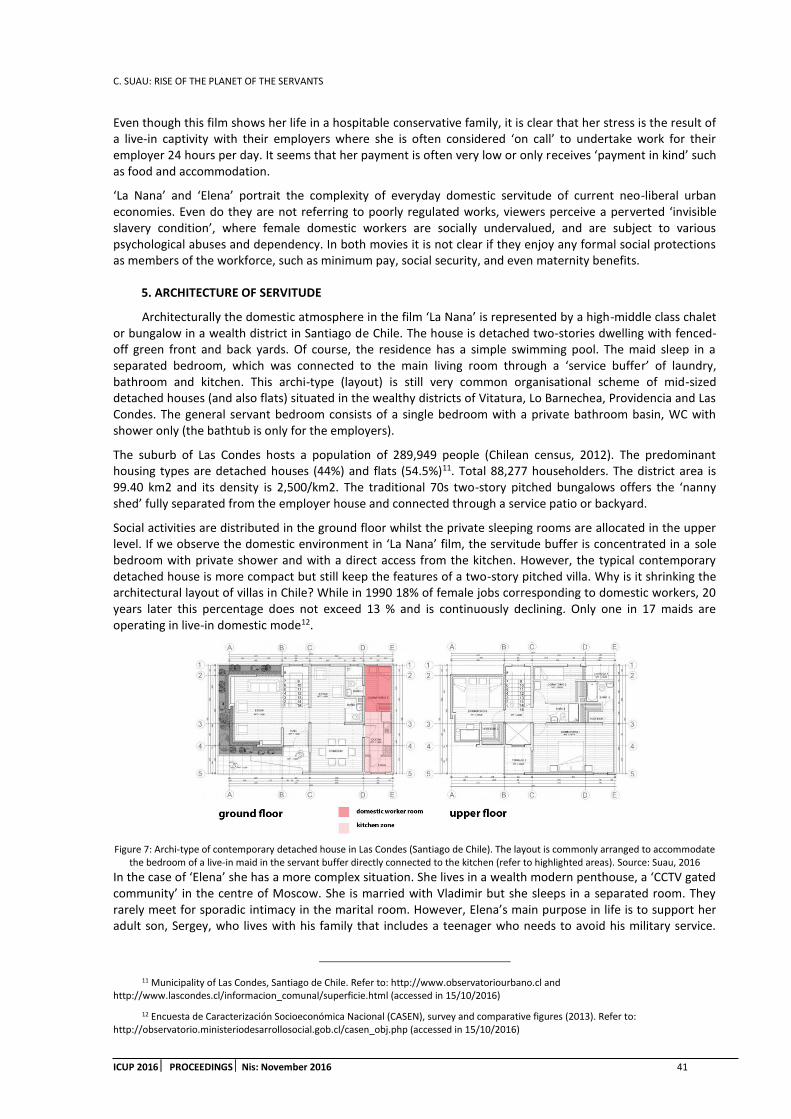
C. SUAU: RISE OF THE PLANET OF THE SERVANTS
ICUP 2016 PROCEEDINGS Nis: November 2016 41
Even though this film shows her life in a hospitable conservative family, it is clear that her stress is the result of a live-in captivity with their employers where she is often considered ‘on call’ to undertake work for their employer 24 hours per day. It seems that her payment is often very low or only receives ‘payment in kind’ such as food and accommodation.
‘La Nana’ and ‘Elena’ portrait the complexity of everyday domestic servitude of current neo-liberal urban economies. Even do they are not referring to poorly regulated works, viewers perceive a perverted ‘invisible slavery condition’, where female domestic workers are socially undervalued, and are subject to various psychological abuses and dependency. In both movies it is not clear if they enjoy any formal social protections as members of the workforce, such as minimum pay, social security, and even maternity benefits.
5. ARCHITECTURE OF SERVITUDE
Architecturally the domestic atmosphere in the film ‘La Nana’ is represented by a high-middle class chalet or bungalow in a wealth district in Santiago de Chile. The house is detached two-stories dwelling with fenced-off green front and back yards. Of course, the residence has a simple swimming pool. The maid sleep in a separated bedroom, which was connected to the main living room through a ‘service buffer’ of laundry, bathroom and kitchen. This archi-type (layout) is still very common organisational scheme of mid-sized detached houses (and also flats) situated in the wealthy districts of Vitatura, Lo Barnechea, Providencia and Las Condes. The general servant bedroom consists of a single bedroom with a private bathroom basin, WC with shower only (the bathtub is only for the employers).
The suburb of Las Condes hosts a population of 289,949 people (Chilean census, 2012). The predominant housing types are detached houses (44%) and flats (54.5%)11. Total 88,277 householders. The district area is 99.40 km2 and its density is 2,500/km2. The traditional 70s two-story pitched bungalows offers the ‘nanny shed’ fully separated from the employer house and connected through a service patio or backyard.
Social activities are distributed in the ground floor whilst the private sleeping rooms are allocated in the upper level. If we observe the domestic environment in ‘La Nana’ film, the servitude buffer is concentrated in a sole bedroom with private shower and with a direct access from the kitchen. However, the typical contemporary detached house is more compact but still keep the features of a two-story pitched villa. Why is it shrinking the architectural layout of villas in Chile? While in 1990 18% of female jobs corresponding to domestic workers, 20 years later this percentage does not exceed 13 % and is continuously declining. Only one in 17 maids are operating in live-in domestic mode12.
Figure 7: Archi-type of contemporary detached house in Las Condes (Santiago de Chile). The layout is commonly arranged to accommodate the bedroom of a live-in maid in the servant buffer directly connected to the kitchen (refer to highlighted areas). Source: Suau, 2016
In the case of ‘Elena’ she has a more complex situation. She lives in a wealth modern penthouse, a ‘CCTV gated community’ in the centre of Moscow. She is married with Vladimir but she sleeps in a separated room. They rarely meet for sporadic intimacy in the marital room. However, Elena’s main purpose in life is to support her adult son, Sergey, who lives with his family that includes a teenager who needs to avoid his military service.
11 Municipality of Las Condes, Santiago de Chile. Refer to: http://www.observatoriourbano.cl and http://www.lascondes.cl/informacion_comunal/superficie.html (accessed in 15/10/2016)
12 Encuesta de Caracterización Socioeconómica Nacional (CASEN), survey and comparative figures (2013). Refer to: http://observatorio.ministeriodesarrollosocial.gob.cl/casen_obj.php (accessed in 15/10/2016)

C. SUAU: RISE OF THE PLANET OF THE SERVANT
42 ICUP 2016 PROCEEDINGSNis: November 2016
During her visits to she only occupies the narrow dining zone in the kitchen and the living room. After the death of Vladimir, she decided to move in with her adult son Sergey’s family to Vladimir’s modern flat.
Her son’s Soviet apartment-type is situated in Biryulyovo, a working-class residential area in South Moscow. More than 132,000 dwellers live in. The building type is named ‘1605-AM/12’13, a 12-storey collective dwelling scheme. The type provides one, two, three and four-room apartments at an average rate of living area 9m² per person. Originally the street level was designed to accommodate shops as well as public service facilities (cafes, eateries and hairdressers), The 1605-AM/12 became the most massive version during the period between 1969 and 1985. Structurally it consists of transversal load-bearing walls (140mm thickness) and modular floors, which span 2.70m and 3.30m. The height of each dwelling is 264cm.
They provide reliable and stiffness of the structural system. These series were applied experimental prefab panels with insulation elements inside the outer walls. Unfortunately, the prefabrication solution causes considerable difficulties for repair and maintenance. The envelope offers enlarged exterior curtain wall panel with high thermal insulation and heat capacity. The cladding of the exterior walls was decorated with colourful ceramic tiles or textured layers of pigmented concrete.
Figure 8: Archi-type of the collective dwelling type 1605-AM/12 in Moscow (refer to highlighted area). Source: Suau, 2016
6. CONCLUSION
‘Workers of my country, I have faith in Chile and its destiny. Other men will overcome this dark and bitter moment when treason seeks to prevail. Go forward knowing that, sooner rather than later, the great avenues will open again and free men will walk through them to construct a better society: Long live Chile! Long live the people! Long live the workers!’ Salvador Allende's Last Speech, Radio Magallanes, Chile (11 September, 1973)
The situation of servitude worldwide and especially in emergent economies like in Latin America, Middle East or Russia have a long tradition in the local social class structure. Formerly they were employed only by the upper classes. They migrated from rural area to undertake the cleaning and care at someone else’s home called ‘patrones’. In recent years, this practice has been extended to the urbanites middle-class families, where many women have been educated and have started paid for domestic work placement. The ‘machos’ partners hardly assume co-responsibility in domestic work, so a maid must necessarily do this work. All this is part of the universal absence of public policies childcare or health care, since governments in Latin America, the Gulf or Asia mostly leaves the responsibility to vulnerable and weak neoliberal-based labour policies. Domestic work is a highly discredited work in our society and considered ‘typically female’. It is underpaid and with poor working conditions; arduous days without rest; and with low status because it has a servile character coined since colonial times, which promotes its social and political ‘invisibility’. For instance, the current Chilean Labour Code has a specific legislation that unjustifiably discriminates even more domestic workers by stipulating that the salary can be 75% of the minimum wage (circa US$ 300) with twelve hours of work per day and only one
13 Collective housing type 1605-AM/12 (Manufacturer: DSK-2), Moscow (1969-1985). Refer to: http://mgsupgs.livejournal.com/190638.html (accessed in 15/10/2016)

C. SUAU: RISE OF THE PLANET OF THE SERVANTS
ICUP 2016 PROCEEDINGS Nis: November 2016 43
day of rest weekly. Undoubtedly, this legislation accentuates social and gender discrimination, detonates exploitative labour practices and also establishes a subservient informal marketplace. In short, the films ‘Biutiful’, ‘Elena’ and ‘La Nana’ constitute explicit urban radiographies of social asymmetries that invite an ethic and civic debate on the improvement of working environment and urban conditions, effective social mobility and adequate standards for all domestic workers worldwide.
REFERENCES
1. Brenner, N., Peck, J. and Theodore, N., 2012. Afterlives of Neoliberalism, London: Bedford Press, pp. 56-62
2. Castells, M., Portes, A. and Benton, L., 1989. The Informal Economy, London: The John Hopkins University Press, p1
3. Bayat, A., 2000. From Dangerous Classes to Quiet Rebels: Politics of the Urban Subaltern in the Global South, London: SAGE Publication, International Sociology 15/3, pp. 533-557.
4. Salvador Allende. Dir. Patricio Guzman, 2004. Film
5. The Maid (La Nana). Dir. Sebastian Silva, 2009. Film.
6. Biutiful. Dir. Alejandro González Iñárritu, 2010. Film
7. Elena (Елена). Dir. Andrey Zvyagintsev, 2011. Film
8. C189 - Domestic Workers Convention (No. 189), 2013. http://www.ilo.org/dyn/normlex/en/f?p=NORMLEXPUB:12100:0::NO::P12100_ILO_CODE:C189 [Accessed: 25th October 2016].
9. ILO report, 2013. http://www.ilo.org/global/about-the-ilo/newsroom/news/WCMS_200937/lang--en/index.htm [Accessed: 25th October 2016].

C. SUAU: RISE OF THE PLANET OF THE SERVANT
44 ICUP 2016 PROCEEDINGSNis: November 2016
F. ROTONDO: URBAN REGENERATION PLANNING: DIFFERENT OBJECTIVES AND PRINCIPLES
ICUP 2016 PROCEEDINGS Nis: November 2016 45
URBAN REGENERATION PLANNING: DIFFERENT OBJECTIVES AND PRINCIPLES
Francesco Rotondo
Polytechnic University of Bari, Italy PhD., Adjunct Professor, [email protected]
ABSTRACT
Urbanism is a discipline born to manage the expansion of cities in growth stimulated by a process of industrialization and further outsourcing and ensuring a massive wealth hitherto unknown. Currently it seems to have reached a sufficient awareness of the need to change objectives and then techniques and tools. While traditional plans proposed a development model linked to new housing and productive developments, contemporary plans are increasingly careful and defined about structural forecasts in relation to environmental protection and infrastructure (tangible and intangible) that represent the core of the proposal. In this paper we outline possible objectives of the urban plan development in the contemporary city to overcome the merely conforming dimension that the plan continues to have, pursuing urban regeneration as the basic objective. The plan focus on attempting to seize opportunities for the integration of a range of urban policies, making the most of scarce resources. It means changing our common approaches to urban planning, abandoning the growth paradigm in search of methods capable of generating a positive “De-Growth”, as Serge Latouche has defined it. Density, Quality, Greening, Sustainability, Participation, Reversible Changes, are the key words of such approach.
Keywords: urban regeneration planning; urban sustainability; reversible urban planning; soil consumption; making better places.
1. EXPANSION, CONSERVATION, ENHANCEMENT
The disciplinary debate that characterized the nineties has been busy trying to locate and consolidate new paradigms capable of guiding urban planning in a society in constant and rapid change, where the model of sustainable development has become the shared reference. Traditional plans had simple but clear idea of the development model: new housing developments, productive and in the best cases new public spaces, confident that growth was necessary and sufficient to ensure a better city capable of making better places (Healey, 1999) for its citizens. The slums and abandoned industrial areas have often refuted this argument.
Figure 1: Piano Regolatore Generale (PRG - General Master Plan) of Bari, in the South of Italy, designed by prof. Ludovico Quaroni (one of the most famous Italian planners of that period)1 during the ‘sixties. Infrastructures are well designed in a city were the car is the first and
1 The Master plan’s design group was made by many contributors such as Rocco Carlo Ferrari, Antonio Renzulli.

F. ROTONDO: URBAN REGENERATION PLANNING: DIFFERENT OBJECTIVES AND PRINCIPLES
46 ICUP 2016 PROCEEDINGS Nis: November 2016
most important movement medium. All the areas in grey are expansion areas useful to re-join two pieces of the existing city. Residential and productive expansion is the ratio of the plan, useful to grant growth and welfare.
Contemporary plans in Italy are increasingly careful and defined the structural forecasts in relation to environmental protection and infrastructure that represent the core of the proposal, while appearing increasingly blurred and lacking conviction in relation to development goals. In most cases continue to propose building expansions ever more difficult to implement and less and less attractive to the same real estate market; in more advanced cases they try to complete the urban spaces and transform underutilized or abandoned areas.
Figure 2: Piano Urbanistico Generale (PUG - General Master Plan) of Monopoli, in the South of Italy, designed in the 2007 by prof. Federico Oliva (one of the most famous contemporary Italian planners)2. The plan started by the definition of structural environmental protection (blue and green lines) and infrastructure that represent the core of the proposal. It tries to design the city’s borders delimited by the big
road limiting the existing and the forecasted city. In the structural plan it defines preferable area of urbanisation and no urbanisable areas.
2 The Master plan’s design group was composed by many contributors such as Francesco Rotondo, Maria Macina, Grazia Maggio (urban planners), Mario Rotolo (geologist), Giovanni Zaccaria (botanist), and Ferruccio Piccinni (hydraulic engineer). The group’s composition already denounces the will to start from the structural environmental profile of the territory.

F. ROTONDO: URBAN REGENERATION PLANNING: DIFFERENT OBJECTIVES AND PRINCIPLES
ICUP 2016 PROCEEDINGS Nis: November 2016 47
Transfer development rights and volumetric compensations are insufficient to handle the urban transformations in the contemporary city where the residual volumes of the plans in force are already superfluous (following the growth indexes of the precedent fifty years) and value of development rights is not attractive for investors and is no longer sufficient to offset the costs of transformation. The plan gets it difficult to find motivation and new development goals.
(a) (b)
Figure 1: (a) An extract of the Public Utilities and Community Services’ Plan of the same city of Monopoli in the South of Italy3. (b) Master Plan of the same areas, showing natural and green areas, principle foot, cycle and car infrastructures, in strict spatial relationship with
preferable places for Public Utilities, Community Services, residential and touristic houses. This plan has been opened to the public participation of inhabitants and private development promoters to collect ideas and funds to develop the program in a collaborative
process.
If the paradigm of self-sustainable development, how to properly achieved by Alberto Magnaghi (2005), is now widely accepted in the scientific community but now also in the professional and institutional one, how can we make urban plans integrated tools capable of supporting and directing economic development and social cohesion, as well as preserving traditional conformative characteristics, appears to be defined. If as stated Magnaghi (2005), territorial heritage not only demands a conservation - which, paradoxically, without development destroys it, according to the analysis of Dermatitis (2009) - but its exploitation "through new ways of “territorialisation” and the creation of new resources "what are these new ways it remains to be defined.
2. A FLEXIBLE PLAN: BETWEEN ECOLOGY AND ECONOMIC DEVELOPMENT. NEW MEANINGS FOR URBAN DESIGN
The characters of the contemporary urban project begin to be consciously outlined by Manuel de Solà Morales, in the light of the Catalan experience, according to which: "the attention to road layouts as a means of architectural formalization, the proposed new tissues of buildings and the public spaces reinterpretation are three of the main issues, with solutions and innovative approaches, common to the most interesting contemporaries urban projects "(de Solà Morales, 2008).
In these design themes should be added the use of green as an Urban material able to relate different parts of the city (Magnaghi, 2005) with a structural role for designing a green and blue network capable to guide the entire urban planning process (see also Desvigne, 20094); the attention to the urban plan intended not as a
3 The Public Utilities and Community Services’ Plan design group was composed by prof. Federico Oliva,Francesco Rotondo, Raffaele Macina, Pierangela Loconte (urban planners).
4 This work is organized by a series of themes: Natural Mechanisms, Textures, Time Management Traces, Lisieres, Prototype City Public Spaces. In this journey the projects ranged in scale from courtyards to entire cities; all showing his understanding of flows and the relationship of the landscape and the urban.

F. ROTONDO: URBAN REGENERATION PLANNING: DIFFERENT OBJECTIVES AND PRINCIPLES
48 ICUP 2016 PROCEEDINGS Nis: November 2016
model to pursue, but as a process to initiate, implement and manage5; the attention to the participation of the inhabitants, additional form of knowledge and assessment of territorial and social context of the project.
The urban project becomes a process in which the same act of design is part of a set of economic social and management actions, aimed to clarify the overall strategies identified in the new form of plan, the operational plan, able to define the most appropriate physical forms (Ingallina, 2001). Paramount to the continued coordination of the whole process, unfortunately up to now poorly implemented. Being aware that the urban project - confronting a territorial context in perpetual change - proceeds by trial and error, and that can hardly be caged in a deductive logic defined by the master plan, as was the case in the traditional implementation plans, is increasingly becoming out the value of the project as a research tool.
In this theoretical context, the main difference with the past introduced by the European Code of Landscape (Florence, 2000) is having it included the landscape throughout the territory. In fact, no longer you have to distinguish between what is the landscape, so worthy of being safeguarded, and that the landscape is not so liable to be sacrificed. The landscape is considered, also, positive factor of sustainable development, image and, at the same time, the engine of a balanced relationship between social needs, economic activities and the environment, biological and cultural diversity indicator, measurement of the resistance to land homologation processes (Magnaghi, 2005), but also an element able to create a dialogue and connect instances, different places and subjects (Menichini, Caravaggi, 2006).Compared to this setting, the uncomfortable perception for infrastructure and settlement planning consolidated practices appears destined to increase.
Recent urban and territorial dynamics, less and less related to the expansion and increasingly attentive to rethink marginal and residual parts areas, have led to a different dimension of urban planning processes. The urban planning and its primary instruments, or different forms of plan, they no longer have the main objective to control and limit urban growth, but directing, promoting and organizing the processing strategies. In essence, town and country planning it has changed from a passive to an active approach. In this development a major role had just the new way of looking at the landscape as a positive factor. A plan strongly oriented by the recognizing of landscape networks as infrastructures of the resilient city and adaptation to climate change (Waldheim, 2006).
Interesting appear, therefore, the current spatial planning and landscape experiences that seek to put into practice these cultural trends. In this field the conceptual and technical development has not yet reached fully satisfactory solutions, but it is the capacity to improve the landscape through human intervention that depends on the quality of the future of the next generations.
3. URBAN REGENERATION PLANNING: OBJECTIVES AND PRINCIPLES
The urban expansion of recent decades, even in compliance with existing planning instruments - built largely on the practice of zoning - occurred almost everywhere by addition of parts, designed in a distinct and separate way even when they were contiguous. They were made so many microcosms building, fences and settlement islands, often heavily conditioned by compliance with pre-established boundaries dictated solely the ownership structure, "little or not at all related, not only to their urban context, but especially to the larger structural and morphogenetic system"(Selicato, Rotondo, 2010) of the existing city.
Even in cases of settlement transformations determined by implementation plans for specific geographical areas, sufficiently homogeneous (for functionality) and not in direct relation with the consolidated urban fabric (think especially to productive areas), the urban instrumental apparatus of "traditional type"(such as the organization of the lots for production use) proved inadequate to ensure the urban quality and significance of settlement.
The consequence of this approach was that of a construction projects, largely with the use of standardized types without any attention to the context, and, sometimes defined as a function of an improbable expressive originality attributed mainly to the use of formal facade elements, grouped to stand in the rampant homologation of urban peripheries. It missed most importantly, almost everywhere, the very idea of public space as an ordering element of the settlement fabric, in a manner exactly opposite to what was being ensured in historical times. In this way, by limiting the negative effects of fragmentation, randomness and segmentation, is promoted in fact a different culture of public space (Selicato, Rotondo, 2010).
5 That is in Italy, in the new form of municipal operational planning, his robe most suitable (Oliva et alii, 2002).

F. ROTONDO: URBAN REGENERATION PLANNING: DIFFERENT OBJECTIVES AND PRINCIPLES
ICUP 2016 PROCEEDINGS Nis: November 2016 49
All this has contributed heavily to determine a consequent absence of settlement quality and more in general of urban environment. The architecture, therefore, cannot be separated from urban planning: every building there is necessarily in its urban location, nor can isolate themselves from it. This relationship between the individual building and the whole nexus of facilities and infrastructure from which it depends is the only way to appreciate the sense of the city, meaning that is also found in the individual building. And it is equally true mutual: the city is not only a sum of infrastructure, houses or palaces; it must be lived and understood as a whole that is greater and more important than the sum of the elements that constitute it.
The new design approaches introduce the need to think in terms of juxtaposition, of determination and openness, autonomy and interconnection of urban planning and architecture, and bring forth new forms of experimentation and innovation in the development of residential spaces, opening the door to the realization of new places of production, trade, consumption, distribution.
Interesting issues of redevelopment is to "give meaning and significance to residential fragments, articulating new polarities, revitalize the building development, exploring the urbanized margins, and negotiate with the infrastructure and convert urban voids "(Gianmarco, Isola, 1993). They are spatial conditions that are accompanied by social and economic ones.
The challenge is to be able to re-establish a system of public spaces, places of everyday life related to new meanings and new identities, for which the inhabitants audition attachment and sense of belonging. There is indeed a strong demand for integrated spaces, flexible and multi-purpose, in which even the separation between public and private becomes increasingly blurred; the same specialist functions, such as trade and exchange, they offer some versions, although subordinated to the logic of consumption. It is necessary to break down the insulation, pens, hyper-specialization, the self-referential forms (for example, the commercial settlements within them simulate some city’s effect, but with the real cities have little contact, because physically different and separate from the city, and because their placement depends almost exclusively from automotive accessibility), recovering forms-tissue that can no longer be those of the ancient city, but will propose a new plot of urban functions relations with the space of the city.
To enrich the contents of the new public spaces today combine two great themes that seem to have taken top priority in urban regeneration: the urban green and its new ecological dimension, infrastructure and transport systems and, ultimately, urban mobility. Urban Green has a strategically importance today that goes beyond the purely recreational functions; parks, green corridors and ecological networks increasingly play a structuring role and propagate their effects on the area surrounding the town. The network for mobility is specialized and hierarchical, dominating absolutely. Infrastructure and the parking lots are inadequate to perform the required functions. Mobility is now entered into crisis and is the subject of therapies around the world; its importance, in fact, remains despite telematics competition. Moreover, we are in what is known in literature as the forth wave of conservation policies and strategies (Carmona, et alii, 2010), called stewardship, where the first one was preservation (the protection of individual buildings and historic monuments); the second one was conservation (after preserving the heritage it has to be managed); the third one was revitalisation (once historic buildings and areas were protected, they needed to be in active and viable use. In the fourth wave of stewardship (after the revitalisation, the heritage needs a continuing care of the conserved and newly revitalised areas). So, as Ellin (2006) argues, a good plan need to nurture healthy growth and change without being “over involved”, without determining everything, allowing the city to blossom and define itself. While providing some overall defining guidelines, these frameworks should not prescribe every land use and every architectural detail. In this way urban design implementation is a process of guiding or steering incrementalism, in which a place vision or design framework can provide strategic coordination, but it must also retain sufficient flexibility to accommodate underlying and evolving process of change. While blueprints dictate, frameworks guide transformation process.
4. CONCLUSIONS. THE NEXT HORIZON
Reflecting on the urban project is equivalent to explore quality, performance, problems of contemporary urban morphology, the planning process of architectural interventions, of how to involve stakeholders and inhabitants, the necessary integration between public and private entities, the necessary consistency between anthropogenic uses and environmental structure of the territory.
It is a problem of not simple solution, with numerous elements related between them and with human activities, difficult to control simultaneously for our limited ability of interpretation of the phenomena and conscious management of the transformations. While the structural aspects of the plan appear to easily set in a

F. ROTONDO: URBAN REGENERATION PLANNING: DIFFERENT OBJECTIVES AND PRINCIPLES
50 ICUP 2016 PROCEEDINGS Nis: November 2016
scientific logic, based on objective factors which are closer to engineering disciplines, as opposed to urban design, that is, the interpretation of this text, the heart of the operational part of the plan (for the presence of an essential component of urban composition), appears closer to the compositional disciplines, for which, according to some, trying to understand the principles can be equivalent to breaking its magic results.
The explanation of the design interpretation is difficult and not always completely decipherable, but this does not diminish the need for a method capable of addressing the project's formation, or at least of some of its basic parts, as already argued by Françoise Choay (1986).
It is the recognition that there may be some steps of the design process, reconstructed and scrolled through, not entirely entrusted to the creative imagination. This kind of generalization necessarily entail reductions or omissions; However, at the same time it allows the identification of areas of public rationality and found recurrences, and the latter is particularly useful for the government of the shares that make up the urban and territorial project, whose prevailing subject of study such as open spaces, particularly in the public, empty, paths, relations between the full of the architectural design, rethinking the city starting from its already built environment limiting soil consuming.
REFERENCES
1. Carmona, M., Tiesdell, S., Heath, T., Oc, T., 2010. Public places, Urban spaces. Elsevier Architectural Press, London.
2. Choay, F., 1980. La Règle et le Modèle sur la théorie de l'architecture et de l'urbanisme. Editions du Seuil, Paris
3. De Solà Morales, M., Frampton, K., Ibelings, H., 2008. Manuel de Solà-Morales A Matter of Things. NAi Uitgevers, Rotterdam.
4. Dematteis, G., 2005. The territorial Sustainibility of development. Lotus International, 140. pp. 84-88.
5. Desvigne, M., 2009. Natures Intermédiaires: Les Paysages de Michel Desvigne. Birkhäuser, Basel
6. Ellin, N., 2006. Integral urbanism. Routledge, London, 103
7. Haley, P., 1997. Collaborative planning. Shaping Places in Fragmented Societies. Macmillan Press, London.
8. Ingallina, P., 2001. Le projet urbain. Éditions PUF, Paris.
9. Isola, A., Gianmarco, C., 1993. Il progetto delle periferie. NIS Italia, Torino.
10. Magnaghi, A., 2005. The Urban Village: A Charter for Democracy and Local Self-sustainable Development. Zed Books, London.
11. Oliva F. 2012. Simplifying the planning, change the Plan, Urbanistica, 149/12, pp 17-19, http://www.planum.net/journals-books/issues/n149 [Accessed: 1st October 2016].
12. Selicato,F.,Rotondo, F., The role of urban design in the process of regeneration of the suburbs: The case of the Puglia Region, In: Advances in Urban Rehabilitation and Sustainability (Eds. Panagopoulos T., Noronha T., Beltrao J.). Wseas Press, Athens, pp. 55-61. WSEAS International conference on Urban Rehabilitation and sustainability (URES '10), Faro, November 3-5, 2010, available on line at: http://www.wseas.us/e-library/conferences/2010/Faro/URES/URES-07.pdf [Accessed: 1st October 2016].
13. Waldheim C., The landscape urbanism reader, Princeton Architectural Press, New York, 2006, p.38

D. MUÑOZ GIELEN ET AL: AN INTERNATIONAL COMPARISON ON PUBLIC VALUE CAPTURE INSTRUMENTS, AND HOW THEY WORK WITHIN PUBLIC AND PRIVATE URBAN LAND POLICIES
ICUP 2016 PROCEEDINGS Nis: November 2016 51
AN INTERNATIONAL COMPARISON ON PUBLIC VALUE CAPTURE INSTRUMENTS, AND HOW THEY WORK WITHIN PUBLIC AND PRIVATEURBAN
LAND POLICIES
Demetrio Muñoz Gielen
Nijmegen School of Management, University Radboud Nijmegen; Netherlands, Public officer Municipality of Purmerend, Netherlands
PhD., Lecturer, [email protected]
Iñigo Maguregui Salas
"EKITEN-Thinking" study group, University Basque Country, Spain Lawyer
Javier Burón Cuadrado
"EKITEN-Thinking" study group, University Basque Country, Spain Lawyer/economist
ABSTRACT
Public and private bodies can play different roles in land development processes, this leading to more public or more private forms of governance, also called ‘active’ and ‘passive’ approaches to land management. These approaches change over time and interact with the institutional, economic/financial and environmental framework. This article compares different approaches to land management and their dynamics by analysing whether and how they capture the economic value increase that accrues from urban development and how this has changed over time. It also analyses the effects of these changes on the intrinsic rationales that govern land policies: their legitimacy, effectiveness, efficiency and justice. After categorizing value capture instruments and identifying examples in England, Spain and the Netherlands, this article illustrates the institutional design, the dynamics and the practical results of three relevant value capture instruments in three different approaches to land management, ordered from more passive to more active: developer obligations, land readjustment and traditional public active land management.
Keywords: betterment; compensation; land value capture; land readjustment; developer obligations; affordable housing
1. INTRODUCTION
1.1. Land management1approach vs public value capture
Public and private bodies play different roles in the different steps of land development processes, which are: 1) land purchase and assembling; 2) financing, land preparation and development (construction of the necessary infrastructure), 3) land disposition, 4) construction and 5) property transfer. This leads to two different forms of governance. In the first public bodies deploy themselves many of these steps. In a second form of governance private bodies are the ones in charge of all or almost all these steps (Alexander, 2001: 758-759; 2014: 538). A similar categorization distinguishes among ‘active’ and ‘passive’ land management
1 Other synonymous terms of land management are ‘planning management’ and ‘implementation’, and in the UK it is referred to as ‘development control’ (Webster e.a., 2012: 9).

D. MUÑOZ GIELEN ET AL: AN INTERNATIONAL COMPARISON ON PUBLIC VALUE CAPTURE INSTRUMENTS, AND HOW THEY WORK WITHIN PUBLIC AND PRIVATE URBAN LAND POLICIES
52 ICUP 2016 PROCEEDINGSNis: November 2016
approaches (Van der Krabben & Jacobs, 2013: 775-776; Hartmann & Spit, 2015). Active approaches or forms of governance in urban land development imply public bodies purchasing and assembling the land (step 1), financing its preparation and development and providing the infrastructure (step 2) and finally disposing it (step 3) to real estate developers who build on them (step 4) and dispose the built property (step 5). Passive approaches imply public bodies regulating the use of land and letting private bodies to do the work. Of course these are extreme models and practice shows a wide variety of mixed formulas.
The debate on active and passive approaches to land management is a recurring discussion topic in many countries. In this debate advantages and disadvantages of each approach are evaluated, for example the financial risks connected to an active public predominance in land development, or the lack of effectiveness to implement public land use goals in passive approaches. An example is the more or less continuous debate in the Netherlands since the 1990s about the consequences of the transition from active to passive approaches that initiated in that country at the beginning of that decade (e.g. Priemus & Louw, 2003; Van der Krabben & Jacobs, 2013). Another examples are the discussion in Spain since the 1970’s (Muñoz Gielen, 2010: 30-34) and in the USA in the 1960’s and 1970’s (Van der Krabben & Jacobs, 2013: 775) about the poor functioning of passive approaches. Recently there is a revival of a debate in many countries and international fora about the possibilities of land readjustment (LR)2 to cope with the problem of scattered property ownership and land speculation. In this debate LR is presented as a third way among the active and passive approaches (e.g. Hong & Needham, 2007; Home, 2007; UN-HABITAT, 2012; World Bank, 2014).
There is a recurring link among these discussions and the more normative discussion about who’s the legitimate owner of the economic value increase that accrues from urban development (also often referred to as ‘unearned increment’, ‘betterment’, ‘windfalls’ or ‘givings’). For example in the UK since the 2nd WW, Spain in the 1980’s and 1990’s and the Netherlands in the 1990’s, both discussions interweaved (Muñoz Gielen, 2010: 24-34). On one side is the thesis of full or conservative liberal ownership, where any value increase of land, no matter who or what caused it, belongs to the landowner. An alternative thesis, to be found also in liberal thinkers, advocates that the use value can be indeed considered as fundamental to individual and social well-being, but that the exchange value (should the property be exchanged) does not. Any value increase resulting from exchange belongs to the community because it is the community after all that is responsible for it (MacIntyre, 1984: 251; Christman, 1994; Krueckeberg, 1995). A common topic in the neo-classical theory of economic rent is the idea of taxing the value increase of land, which, when removed, will not affect the output or the price of the product. Variants of this argument have been advanced by Adam Smith, David Ricardo, J.S. Mill, Alfred Marshall, A. Pigou and, specially, Henry George (George, 1879: 89-94, 219-241; Prest, 1981: 7-21; Oxley, 2006: 103; Alterman, 2009: 4-5).
1.2. Intrinsic rationales and changing dynamics of land policies
The institutional, financial/economic and environmental (land policy) framework in which land management approaches and value capture instruments are embedded influence their institutional design and results (Hartmann & Needham, 2012). This paper focuses on how changes in the financial/economic framework influence value capture and how this influences the environmental (land policy) framework in a feedback loop that retroacts again on value capture instruments.
To analyze the interactions among value capture instruments and the environmental (land policy) framework this paper uses Hartmann & Spit’s methodological approach to identify and discuss the dynamics of land policies. Their approach focus on the underlying rationales of land policies (2015: 729-731):
Their democratic legitimacy, or whether land policies serve the public interest, and if this is not clear, whether the demands of citizens are represented in the institutional system of politics (legitimacy of the decision-making) and the results match the collective goals of citizens (output-legitimacy);
2 Land Readjustment regulations prescribe how landowners can develop together their land. LR regulations usually prescribe in detail the obligations for landowners (to deliver for free their land and sometimes also to pay a share of the infrastructure costs) and their rights (a share of the final serviced building plots). LR is also called ‘land consolidation’, ‘pooling’, ‘replotting’, ‘parcellation’, ‘repartition’ and ‘reconstitution’, besides of course of terminology in other languages than English, for example Umlegung in Germany, kukaku seiri or KS in Japan, Reparcelación in Spain, Reajuste deTerrenos in Colombia or halukah hadasha in Israel.

D. MUÑOZ GIELEN ET AL: AN INTERNATIONAL COMPARISON ON PUBLIC VALUE CAPTURE INSTRUMENTS, AND HOW THEY WORK WITHIN PUBLIC AND PRIVATE URBAN LAND POLICIES
ICUP 2016 PROCEEDINGS Nis: November 2016 53
Their effectiveness, or whether land policies succeed in achieving the planning objectives within a reasonable period of time. In modern liberal democracies this implies also whether land policies succeed in doing so without conflicts that delay the implementation;
Their efficiency, or whether the results of land policies are worth related to the efforts made, i.e. whether planning is a good use of scarce resources. As this is very difficult to assess, an alternative is to compare the financial risks that municipalities must assume in each approach;
Their fairness, or whether land policies fulfil different concepts of justice: libertarian (the market should not be regulated except the minimum necessary to reduce market failures); social (the state should promote welfare among the poor) and utilitarian (the state should promote the happiness of the majority).
The degrees to which land management approaches and the value capture instruments embedded in them capture the increased economic value have an effect on these intrinsic rationales. For example, if public bodies use the captured value to finance the necessary public infrastructure and affordable housing, this can be an important argument (though not the only one) to advocate the public interest of a planning intervention (democratic legitimacy), ease its implementation (effectiveness), compensate for the necessary public and/or private efforts (efficiency) and fulfil at least a social concept of justice (justice).
This article reflects thus on how different approaches to land management use public value capture instruments, how they are embedded in the broader financial/economic and environmental framework, how they have changed over time and whether the results have influenced the democratic legitimacy, effectiveness, efficiency and fairness of land policies. Doing so it contributes to the debate in different countries mentioned in section 1.1 about the advantages and disadvantages of active and passive approaches. Additionally, it contributes to literature that categorizes and illustrates public value capture instruments from an international comparative perspective (e.g. Hagman & Misczynski 1978; Healey e.a. 1995; Alterman 2012; Webster e.a., 2012; Monk & Crook, 2016).
1.3 Methodological approach
The data in this article support on literature review and several cases in England, Spain and the Netherlands. Although these cases show specific evidence that allow assessing the practical functioning of value capture tools and their interaction with the financial/economic and environmental framework, is it however often not possible to generalize the results to the entire region or country. Specially public-private contracts in active land management approaches and development agreements in passive approaches do not always have a sound record of evidence because they are no or only briefly regulated in legislation, depend more on local policies and attitudes and are not always available for the public. The atomization and local character of negotiable developer obligations (which are more common in passive approaches) have made them in many countries almost invisible for academic literature (except in the UK). There is more evidence about non-negotiable developer obligations and land readjustment because they use to be more regulated and framed in policy, but there is still little evidence about their results in practice.
Another challenge of figuring out conclusions based on the presented evidence regards the possible influence of other variables, e.g. the governance practices: transparency and political attitude can influence the results of value capture instruments. Also many other contextual variables can be relevant, e.g. prices in real estate markets. In methodological terms the ‘internal validity’ of the conclusions is at the stake here (Miles & Huberman, 1994: 278); e.g. good or bad results might not be caused by a specific value capture instrument but by other variables. Sections 3 to 5 include evidence on other relevant variables, but even though the internal validity of the conclusions, and henceforth their generalizability, must be interpreted cautiously. Section 2 categorizes all possible value capture tools and their rationales, and sections 3 to 5 illustrate how public value capture instruments are embedded in different land management approaches, starting from passive approaches to more active ones. Section 3 shows how in English passive approaches relatively light regulations and policies condition modifications in land-use regulations to the landowner agreeing in contracts a contribution to public infrastructure (negotiable and non-negotiable developer obligations). Section 4 shows how in Spain an in-between approach (land readjustment) can force landowners not only to pay contributions but also to allow development of their land. And section 5 shows how in the more classic public approach of Dutch active land use policies municipalities can cream-off the economic value increase but must at the same time assume significant financial risks that can lead to financial loses. Each section focus also on the dynamics

D. MUÑOZ GIELEN ET AL: AN INTERNATIONAL COMPARISON ON PUBLIC VALUE CAPTURE INSTRUMENTS, AND HOW THEY WORK WITHIN PUBLIC AND PRIVATE URBAN LAND POLICIES
54 ICUP 2016 PROCEEDINGSNis: November 2016
in the economic/financial and the environmental (land policy) framework, and on the interaction with land management approaches and value capture instruments. Finally, Section 6 presents the reflections and conclusions.
2. PUBLIC VALUE CAPTURE INSTRUMENTS
There are many different sorts of value capture tools. Partly based on Alterman (2012: 763-66, 775-79) we distinguish among direct and indirect instruments.
2.1 Direct and indirect value capture instruments
Direct instruments seek to capture all or some of the economic value increase of property under the explicit rationale that this increase belongs to the community and not to the landowner. Direct instruments are considered wealth redistribution instruments and are thus often considered as a tax (capital gains tax on land or real property, a tax upon transfer of title or an annual property tax) that needs explicit and detailed legislative base at the regional or national level. However, direct instruments might also take the form of a developer obligation (see under). As long as instruments are exclusively motivated by the rationale that the increased value belongs to the community, and provided they support on a regional or national legislative authority, they belong to this category of direct value capture instruments.
Indirect instruments are more pragmatic and seek to capture some of the economic value increase under the rationale that landowners and developers should internalize the costs of mitigating the impacts of their building plans, i.e. to pay the public investments directly or indirectly needed to support the new developed areas. The value of these impacts represents the social costs or compensation that can be exacted by the community that bears such costs (Bowers 1992, Webster 1998). Indirect value capture tools are introduced often by local authorities and can support on regional or national legislation. However, they can also operate without almost any legislative authority, leaving it to municipalities to prescribe and frame them. This makes indirect tools flexible and their introduction relatively easy.3
Because of their variety and local character indirect instruments are less visible in literature than direct tools, but in practice they have increasing popularity. The need for innovative funding sources for public services has stimulated the last years a plethora of locally inspired ways of agreeing contributions of landowners and developers in money, land or construction services in exchange of land-use regulation decisions of any kind (rezoning, additional development rights, relaxation of existing land-use regulations, etc). We follow here Alterman (ibidem) and name all of them ‘developer obligations’. We should not forget, however, that some forms of developer obligations, if based on the rationale alone that the economic value increase belongs to the community and should therefore be paid back to the public, belong to the direct value capture instruments.
2.2 Negotiated and non-negotiable developer obligations
Sometimes obligations are the result of negotiations, i.e. they might be or not prescribed beforehand, but the final contribution is uncertain and depends on the will of parties to agree. Examples of negotiated developer obligations are exactions in the US, development charges in Canada, planning gain and planning obligations in the UK, participation in France, bijdrage bovenwijkse voorzieningen in the Netherlands and compromisos complementarios in Spain.
Besides there are other obligations that are less negotiable and might sometimes be considered as taxes: for example the Community Infrastructure Levy in England, impact fees in the US, the Tax d’amenagement in France, Erschliessungsbeitrag in Germany, Cargas de Urbanización, cesiones and reservas de suelo in Spain, oplaty adiacenskie in Poland4 and exploitatiebijdrage in the Netherlands. These instruments do support on regional/national detailed legislation that regulates more precisely their scope with detailed legal standards and categorizations, and use to have therefore a less local character than the negotiated developer obligations.
3 This being said, developer obligations require a minimum regulation and policy framing because there is need of some sort of legal and policy legitimacy to prescribe requirements on landowners and other private parties when they develop their land. At least national or regional legislation and/or jurisprudence must explicitly recognize the legality of asking such obligations in exchange of land-use regulation decisions. In addition to this, legislation and/or policy framing can (but not always do) prescribe the scope of the contributions.
4 In case it captures betterment arising from public infrastructure works (Havel, 2016).

D. MUÑOZ GIELEN ET AL: AN INTERNATIONAL COMPARISON ON PUBLIC VALUE CAPTURE INSTRUMENTS, AND HOW THEY WORK WITHIN PUBLIC AND PRIVATE URBAN LAND POLICIES
ICUP 2016 PROCEEDINGS Nis: November 2016 55
2.3 Embedment of value capture instruments in land management approaches
Direct and indirect value capture instruments are embedded into broader land management approaches that can influence their effectiveness. Land management approaches can be subcategorized as follows (ordered from more active to more passive): a) nationalization of all land and public land development, b) public land banking and development, c) public-private land development, d) land readjustment and e) private land development. Developer obligations are often used in passive approaches (c, d and e), where landowners and other private parties depend on a public decision to develop their land. Whether the obligations are negotiable or not, the fact is that their achievement depend on an agreement (except in some sorts of land readjustment, see chapter 4). If there is no agreement public bodies cannot impose them. This is partly why passive approaches are criticized as being ineffective (see section 1.1). In a genuine active approach (a and b) the dependence on agreement is lower and henceforth the effectiveness of value capture can be higher (along however with the financial risks for the public body in charge).
In land readjustment (LR) landowners must pay together the developer obligations, provide the land needed for the public infrastructure and they share the final serviced building plots. In some countries a public body can, under certain circumstances, force landowners to allow and contribute to LR, even if they oppose. Here LR can diminish dependence on agreement and have thus the potentiality of increasing the effectiveness of value capture instruments. LR includes mainly indirect value capturing instruments because it’s main motivating rationale is the internalization of the costs of mitigation of the development impacts. This is for example the case with all the costs that can be charged to landowners in the German Umlegung, and with almost all the costs in the Spanish Reparcelación. However, LR can also include direct value capture instruments in case they also oblige landowners to share part of the economic value increase with the public, with the argument that this increase belongs partially or totally to the public.5
All of these instruments, direct and indirect of any kind, embedded in different land management approaches, interact in different ways with the financial/economic and environmental framework. Next chapters analyse three different combinations in England, Spain and the Netherlands, starting with the more passive and finishing with the most active approaches.
3. DEVELOPER OBLIGATIONS IN PASSIVE LAND MANAGEMENT APPROACHES, EXPERIENCES IN ENGLAND, SPAIN AND THE NETHERLANDS
Developer obligations include a wide variety of pecuniary and non-pecuniary contributions, more or less negotiated in public-private and private land development formulas and in land readjustment. They can include the obligation to construct the public space (roads, footpaths, public parks), social facilities (schools, health services) and social and affordable housing (also referred to as ‘inclusionary zoning’) or pay to the public administration for it, to contribute to specifically defined main infrastructure, usually located off-site, or to pay standard charges.
3.1 Developer obligations in England
The British planning obligations support on an old legal prescription6entitles local governments to enter
negotiations with property developers (Moore, 2005: 345-346). In addition, central legislation allows local governments to condition land-use regulations decisions to negotiated contributions, so they can refuse to rezone the land in case the developer doesn’t want to contribute. Initially, this provision was not used very much, but since the 1970’s local public bodies increasingly used them to obtain planning gain for the community (Moore 2005: 346). The negotiation of planning obligations has continued to grow (Campbell et al., 2001; Department for Communities and Local Government, 2006: 3-4, 17, 41-42; Crook, 2016).
Controversy arose because agreements seem to have enabled local authorities to agree significant contributions from developers that went beyond matters strictly related to the development in question. This
5 This is the case with the obligation in the Spanish Reparcelación, besides paying all needed public infrastructure, to cede for free to the Municipality enough serviced building plots to construct at least 10% of the total floor space index in the development area. This cession is based on the Spanish constitutional principle that ‘the community shall have a share in the benefits from the town-planning policies of public bodies’ (section 47, 1978 Constitution) (Muñoz Gielen, 2010: 120).
6 First introduced by section 34 of the 1932 Town and Country Planning Act.

D. MUÑOZ GIELEN ET AL: AN INTERNATIONAL COMPARISON ON PUBLIC VALUE CAPTURE INSTRUMENTS, AND HOW THEY WORK WITHIN PUBLIC AND PRIVATE URBAN LAND POLICIES
56 ICUP 2016 PROCEEDINGSNis: November 2016
was for example the position of the Home Building Federation, the representative of the British housing developers (Whithaker, interview in 2007). Other institutions (included public ones), and experts seemed to share this view (e.g. Department for Communities and Local Government, 2006: 6; Barker, 2004: 66; Corkindale, 2004: 13-14). Since then a small number of judgments have been very important in constraining the discretionary freedom of local planning authorities. In turn, this case law has been ‘repatriated’ into the planning system through new policy guidance, which focused on preventing abuse. Obligations were henceforth legitimate and lawful only if they are correctly applied (Booth, 2003: 113115; Ratcliffe e.a., 2002: 140-159).Alongside judicial scrutiny and policy guidance new legislation has transformed the English negotiated planning obligations from a poorly regulated, non-transparent process with lack of accountability into more regulated and framed negotiations. Development agreements are nowadays public and often available on-line and, since the 1990s, a majority of English local authorities have introduced formal policy on planning obligations. This has resulted in a generalized increase of contributions (Ennis, 1997: 1935-6; Campbell e.a., 2000: 760,763-764; Campbell e.a., 2001; Ratcliffe e.a., 2002: 140-159; Booth, 2003: 4, 113-115; Barker, 2004: 66; Corkindale, 2004: 13-14; Department for Communities and Local Government , 2006: 3-4, 6, 17, 19-20, 41-42; Gallent & Tewdwr-Jones, 2007: 211- 213, 257; Crook & Monk, 2011). Generally, planning obligations are nowadays prescribed in local policy documents that define and quantify the contributions (e.g. a minimum percentage of affordable housing, or payments in money per additional pupil numbers in excess of the capacity of local nursery, primary and secondary schools), but they still are negotiable. See figure 1 for the case of ‘Temple Quay’ in the City of Bristol (7.4 ha, 495 apartments, 61,000 m² office, and 7,000 m² leisure and facilities). Here the Local Planning Authority and the developer agreed in 2003 that the developer would construct on his costs around 60% of the total surface of the plan area as public infrastructure, build 14% of the total number of housing units as affordable housing (10% selling units with regulated price under the market price and 4% rental units) and pay around € 6 million as contribution to off-site public infrastructure and facilities.
Figures 1. Air photo previous situation, plan area and some pictures of ‘Temple Quay’ in Bristol (sources: Report Head Bristol Planning
Services to Bristol Local Council Committee 5 June 2002 and author’s pictures).
This process of increasing regularization and policy framing culminated so far with the introduction in 2010 of a non-negotiable Community Infrastructure Levy, to be calculated by municipalities and that coexists with the older practice of negotiable planning obligations (Crook, 2016: 71-72, 93-97).
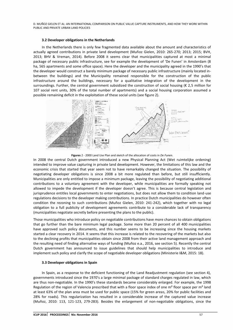
D. MUÑOZ GIELEN ET AL: AN INTERNATIONAL COMPARISON ON PUBLIC VALUE CAPTURE INSTRUMENTS, AND HOW THEY WORK WITHIN PUBLIC AND PRIVATE URBAN LAND POLICIES
ICUP 2016 PROCEEDINGS Nis: November 2016 57
3.2 Developer obligations in the Netherlands
In the Netherlands there is only few fragmented data available about the amount and characteristics of actually agreed contributions in private land development (Muñoz Gielen, 2010: 265-270; 2013; 2015; BVH, 2013; BHV & Vreman, 2014). Before 2008 it seems clear that municipalities captured at most a minimal package of necessary public infrastructure, see for example the development of ‘De Funen’ in Amsterdam (8 ha, 565 apartments and some office space). Here the developer and the municipality agreed in the 1990’s that the developer would construct a barely minimum package of necessary public infrastructure (mainly located in-between the buildings) and the Municipality remained responsible for the construction of the public infrastructure around the buildings, necessary for a qualitative integration of the development in the surroundings. Further, the central government subsidized the construction of social housing (€ 2,5 million for 107 social rent units, 30% of the total number of apartments) and a social housing corporation assumed a possible remaining deficit in the exploitation of these social units (see figure 2).
Figures 2 - 2000 Land Use Plan and sketch of the allocation of costs in De Funen.
In 2008 the central Dutch government introduced a new Physical Planning Act (Wet ruimtelijke ordening) intended to improve value capturing in private land development. However, the limitations of this law and the economic crisis that started that year seem not to have remarkably changed the situation. The possibility of negotiating developer obligations is since 2008 a bit more regulated than before, but still insufficiently. Municipalities are only entitled to impose a minimum package, leaving the possibility of negotiating additional contributions to a voluntary agreement with the developer, while municipalities are formally speaking not allowed to impede the development if the developer doesn’t agree. This is because central legislation and jurisprudence entitles local governments to enter negotiations, but does not allow them to condition land-use regulations decisions to the developer making contributions. In practice Dutch municipalities do however often condition the rezoning to such contributions (Muñoz Gielen, 2010: 241-242), which together with no legal obligation to a full publicity of development agreements contribute to a considerable lack of transparency (municipalities negotiate secretly before presenting the plans to the public).
Those municipalities who introduce policy on negotiable contributions have more chances to obtain obligations that go further than the bare minimum legal package. Some more than 20 percent of all 400 municipalities have approved such policy documents, and this number seems to be increasing since the housing markets started a clear recovery in 2014. It seems that this increase is related to the recovering of the markets but also to the declining profits that municipalities obtain since 2008 from their active land management approach and the resulting need of finding alternative ways of funding (Muñoz e.a., 2016, see section 5). Recently the central Dutch government has announced to issue guidelines that should help municipalities to introduce and implement such policy and clarify the scope of negotiable developer obligations (Ministerie I&M, 2015: 18).
3.3 Developer obligations in Spain
In Spain, as a response to the deficient functioning of the Land Readjustment regulation (see section 4), governments introduced since the 1970’s a large minimal package of standard charges regulated in law, which are thus non-negotiable. In the 1990’s these standards became considerably enlarged. For example, the 1998 Regulation of the region of Valencia prescribed that with a floor space index of one m² floor space per m² land at least 63% of the plan area must be used for public space (15% for green areas, 20% for public facilities and 28% for roads). This regularization has resulted in a considerable increase of the captured value increase (Muñoz, 2010: 113, 121-123, 279-283). Besides the enlargement of non-negotiable obligations, since the
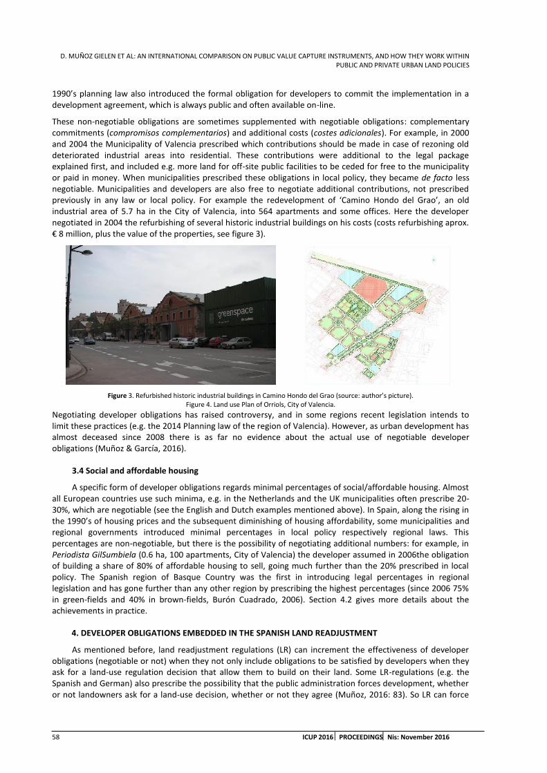
D. MUÑOZ GIELEN ET AL: AN INTERNATIONAL COMPARISON ON PUBLIC VALUE CAPTURE INSTRUMENTS, AND HOW THEY WORK WITHIN PUBLIC AND PRIVATE URBAN LAND POLICIES
58 ICUP 2016 PROCEEDINGSNis: November 2016
1990’s planning law also introduced the formal obligation for developers to commit the implementation in a development agreement, which is always public and often available on-line.
These non-negotiable obligations are sometimes supplemented with negotiable obligations: complementary commitments (compromisos complementarios) and additional costs (costes adicionales). For example, in 2000 and 2004 the Municipality of Valencia prescribed which contributions should be made in case of rezoning old deteriorated industrial areas into residential. These contributions were additional to the legal package explained first, and included e.g. more land for off-site public facilities to be ceded for free to the municipality or paid in money. When municipalities prescribed these obligations in local policy, they became de facto less negotiable. Municipalities and developers are also free to negotiate additional contributions, not prescribed previously in any law or local policy. For example the redevelopment of ‘Camino Hondo del Grao’, an old industrial area of 5.7 ha in the City of Valencia, into 564 apartments and some offices. Here the developer negotiated in 2004 the refurbishing of several historic industrial buildings on his costs (costs refurbishing aprox. € 8 million, plus the value of the properties, see figure 3).
Figure 3. Refurbished historic industrial buildings in Camino Hondo del Grao (source: author’s picture). Figure 4. Land use Plan of Orriols, City of Valencia.
Negotiating developer obligations has raised controversy, and in some regions recent legislation intends to limit these practices (e.g. the 2014 Planning law of the region of Valencia). However, as urban development has almost deceased since 2008 there is as far no evidence about the actual use of negotiable developer obligations (Muñoz & García, 2016).
3.4 Social and affordable housing
A specific form of developer obligations regards minimal percentages of social/affordable housing. Almost all European countries use such minima, e.g. in the Netherlands and the UK municipalities often prescribe 20-30%, which are negotiable (see the English and Dutch examples mentioned above). In Spain, along the rising in the 1990’s of housing prices and the subsequent diminishing of housing affordability, some municipalities and regional governments introduced minimal percentages in local policy respectively regional laws. This percentages are non-negotiable, but there is the possibility of negotiating additional numbers: for example, in Periodista GilSumbiela (0.6 ha, 100 apartments, City of Valencia) the developer assumed in 2006the obligation of building a share of 80% of affordable housing to sell, going much further than the 20% prescribed in local policy. The Spanish region of Basque Country was the first in introducing legal percentages in regional legislation and has gone further than any other region by prescribing the highest percentages (since 2006 75% in green-fields and 40% in brown-fields, Burón Cuadrado, 2006). Section 4.2 gives more details about the achievements in practice.
4. DEVELOPER OBLIGATIONS EMBEDDED IN THE SPANISH LAND READJUSTMENT
As mentioned before, land readjustment regulations (LR) can increment the effectiveness of developer obligations (negotiable or not) when they not only include obligations to be satisfied by developers when they ask for a land-use regulation decision that allow them to build on their land. Some LR-regulations (e.g. the Spanish and German) also prescribe the possibility that the public administration forces development, whether or not landowners ask for a land-use decision, whether or not they agree (Muñoz, 2016: 83). So LR can force

D. MUÑOZ GIELEN ET AL: AN INTERNATIONAL COMPARISON ON PUBLIC VALUE CAPTURE INSTRUMENTS, AND HOW THEY WORK WITHIN PUBLIC AND PRIVATE URBAN LAND POLICIES
ICUP 2016 PROCEEDINGS Nis: November 2016 59
landowners to develop their land7 and pay their corresponding share of contributions. LR is considered a private land management approach because it does not necessarily imply a public body being in charge of the development, but in Spain de facto it allows public bodies to considerably regulate the performance of private parties in development steps 1 (land purchase and assembling) and 2 (financing, land preparation and development).8
However, LR does not always contribute to resolve the problems it claims to resolve, and in many countries it is a dead word in legislation. The Spanish LR (Reparcelación) was introduced in 1956 and its evolution illustrates which ingredients make LR effective or not. Until the 1990’s the regulation did not really contributed to fight land speculation and did not provide properly serviced development areas with enough public infrastructure. Only after the arrival of the first democratically elected local governments in the 1980’s, and after some major legal modifications,9 LR has provided good results (cfr. Burón Cuadrado, 2006; Muñoz Gielen & Korthals Altes, 2007; Muñoz Gielen, 2014). Two different regional sub-models of Reparcelación illustrate this evolution, the Valencian and the Basque models.10
4.1 Valencian Land Readjustment
In 1994 the region of Valencia introduced an important novelty in the LR-regulation. Before this legal modification landowners had a monopoly in the implementation of LR: they were the only ones who could become the implementing agency. The implementing agency is the one who prepares all the necessary documents and procedures and actually readjusts the property boundaries and provides the necessary public infrastructure. Only in case landowners did not fulfil properly their duties of readjusting the properties and providing the public infrastructure, a public body had the statutory powers to overrule them and force LR. As far the Spanish LR was somehow similar to the German, where public bodies (and not landowners) implement LR. In Spain however municipalities did most of the times not have enough financial means and/or knowledge and/or political will to force LR and lead the procedure: this requires setting up a public land development company, and requires full political commitment. So in practice when municipalities prescribed high standards of public infrastructure, most of the times landowners impeded development.
The Valencian legal modification in 1994 introduced the possibility of organizing a public tender and, after evaluating the different submitted proposals, to appoint one of them as implementing agency (urbanizador). It is also possible to select a public company as implementing agency, without the need of a public contest. This agency (private or public) does not necessarily need to own the land, although most of the times it owns some land or at least has an agreement with some landowners. Once the Municipality selects this agency, all landowners must deliver the land necessary for the public infrastructure and pay their corresponding share of the costs, as well as the overhead costs made by the agency. Finally, the agency, after readjusting the properties and providing the infrastructure, delivers for free the infrastructure to the municipality and distributes the serviced building plots among the landowners. This Valencian ‘model’ of LR has accelerated the plan preparation and increased very significantly the total amount and surface of developed areas, notably improving the amount and quality of public infrastructure. An example in the region of Valencia is ‘Orriols’ (54 ha, 3,350 housing units, most of them apartments, see figure 4). In February 1997 the Local Council selected here a private developer as implementing agency. The land was originally divided into 688 plots, owned by 288 landowners, which during the readjustment procedure sold their properties to this and other developers. The agency delivered the infrastructure provision in 2000. In addition to the legal minimum of non-negotiable developer obligations (landowners delivered for free 76% of the total surface for public infrastructure, built part of the infrastructure on it, built a large park and 10% of affordable housing) the agency negotiated as additional obligation the refurbishing on his costs of an old historic farmer house.
7 Or cooperate with others to do so, or sell the land to any party willing to develop.
8 As mentioned before, development processes include the following steps: 1) land purchase and assembling; 2) financing, land preparation and development (construction of the necessary infrastructure), 3) land disposition, 4) construction and 5) property transfer.
9 The in sections 3.3 and 3.4 mentioned introduction and enlargement of legal standards of public infrastructure and percentages of social/affordable housing, and the introduction of an obligatory development agreement.
10 The central Spanish state and each of the 17 Spanish regions (Autonomous Communities) share the legal competences in the urban planning field. The central estate keeps exclusive competences for property law (e.g. expropriation law), common administrative proceedings, environmental law and national infrastructure. The regions have almost all other competences over planning law, which allowed them to develop since the 1990’s different models of LR.

D. MUÑOZ GIELEN ET AL: AN INTERNATIONAL COMPARISON ON PUBLIC VALUE CAPTURE INSTRUMENTS, AND HOW THEY WORK WITHIN PUBLIC AND PRIVATE URBAN LAND POLICIES
60 ICUP 2016 PROCEEDINGSNis: November 2016
This model has been gradually introduced in many other regions in Spain (Muñoz Gielen & Korthals Altes, 2007). This being said, there is a great deal of debate in Spain on the ultimate consequences of this model. Some have argued that it has attracted speculative investments in urban development and leaved the region with one of the greatest stocks of new empty dwellings and offices of Spain. Others underline that also other regions of Spain suffer the same problem of empty stocks, even though they apply the old LR regulation in which landowners had a much stronger position and there was need of support of a majority of them.
4.2 Basque Land Readjustment
The Basque model of LR supports partly on an active public land management approach, and the case of the city of Vitoria-Gasteiz (244.000 inhabitants) illustrates this the best. This city developed in the 1990s ambitious plans for two large urban expansions on its green-field surroundings: Salburua (359 ha) and Zabalgana (284 ha, see figure 5). More than 400 private parties owned 2/3 of the land (455 ha), and public bodies the rest (153 ha). The plans included large legal standards of obligatory public infrastructure, of high quality, regulated both in regional legislation and, complementarily, in the 2001 General Land Use Plan of this city. It included the obligation to bear the costs of constructing not only the legal minimum standards of local public infrastructure, but also some additional off-site, large public infrastructure. This went beyond the minimal legal standards, so landowners were formally speaking only obliged by law to cede for free the necessary land, but not to assume the costs of construction. In addition, as mentioned before, the regional Basque government introduced since 1994 legal percentages of social and affordable housing, which in greenfield developments initially amounted 65% of all number of housing units and from 2006 onwards 75%. To meet these percentages, landowners must cede some serviced building plots for free to the municipality (cesiones) and offer additional plots for a regulated maximum price (reservas de suelo). Most of these contributions (legal standards of public infrastructure –except construction costs off-site large infrastructure- and 65% of social/affordable housing) were non-negotiable. In Salburua and Zabalgana, the 2001 General Land Use Plan prescribed in total 21,742 housing units, of which 70% should be social/affordable units, more thus than the regional legal percentage of 65%.
Anticipating that landowners would not easily implement the plans with such high standards (specially the construction costs of large off-site infrastructure and that extra 5% social/affordable housing) and within schedule, the Municipality prescribed the compulsory expropriation of all those landowners who did not cooperate with LR.
Figures 5. Urban expansion in Vitoria-Gasteiz, respectively neighborhoods of Zabalgana (aerial view and affordable housing) and Salburua (panoramic view and affordable housing) (source: Visesa, regional public land and housing company).
At that time expropriation was very expensive for the municipality because legislation on expropriation compensated landowners for the future value of their land, including thus any subsequent development value

D. MUÑOZ GIELEN ET AL: AN INTERNATIONAL COMPARISON ON PUBLIC VALUE CAPTURE INSTRUMENTS, AND HOW THEY WORK WITHIN PUBLIC AND PRIVATE URBAN LAND POLICIES
ICUP 2016 PROCEEDINGS Nis: November 2016 61
but excluding additional contributions to the legally prescribed. However, in this specific case compensation sums were lower than the profits of participating in land readjustment.11 After negotiating a couple of years, a majority of landowners supported the implementation of the plans through LR. In 2000 they signed a development agreement with the municipality in which they accepted the public leading of the readjustment procedure and assumed the prescribed non-negotiable obligations together with the additional contributions. This all together resulted in abundant public infrastructure of high quality (landowners delivered the land necessary for the public infrastructure and assumed about 60% of the costs of the public infrastructure, € 223 million, including a negotiated additional contribution of € 64 million for the construction of off-site, large public infrastructure) and in the free cession to the municipality of the serviced building plots needed to build most of the affordable/social units. Together with the serviced building parcels that belonged to public bodies (initially 1/3 of the land was in public hands), the Municipality received enough land to build 12,978 affordable/social units (of a total of 15,193 affordable/social units). The landowners assumed the obligation to offer serviced building plots with a low regulated price meant for the building of the remaining 2,215 units. In total 70% of the total number of housing units (15,193 of 21,742, 5% more than the legal minimum at that time) was meant to be social/affordable.
In 2004 the Municipality increased the building possibilities on her land to build 2,831 extra social/affordable housing units (so the total number became 24,573, of which 74%, 18,024 units, social/affordable, 15,809 of them on municipal’s land). In 2011 and 2012 new modifications have been introduced to the land use plan to make it possible to increase further the building possibilities, but as far not much has been actually built due to the economic crisis. Nowadays about 80% of the total number of dwellings has been built.
The Municipality and the regional Basque government have built together the affordable/social units on the municipal plots, and private parties have done the same on the private plots zoned for social/affordable housing. This combined approach of LR and active intervention has resulted in a large amount of social/affordable housing in the city of Vitoria-Gasteiz. In the period 2002-2005 about 70% of all new housing production was social/affordable, while in whole Basque Country this was 30% and in Spain 8% (Burón Cuadrado, 2006: 13-14).
Thanks to LR the investments of public bodies in land have been modest (there was no need to buy much land), which explains why nowadays the involved municipal and regional public companies have endured the economic crisis without major problems. This contrasts especially with the large financial risks taken by public bodies in the traditional public active land management approach in other European countries.
5. PUBLIC ACTIVE LAND POLICY IN THE NETHERLANDS
Since the Second World War, and more or less until the 1980s, Dutch municipalities applied on a large scale a public land management approach which consisted in public bodies (mostly municipalities) buying land, rezoning it, providing the infrastructure, selling the serviced parcels and bearing the corresponding risks and possible profits. This was applied to develop industrial areas, offices and housing. For about four decennia, Dutch municipalities dominated the markets of serviced building plots, which gave them a predominant, almost monopolist position in urban development.12
This active public intervention was institutionalized through public land development companies, and almost all municipalities had one. Non-profit housing associations and municipal housing companies (of which almost all municipalities also had one) bought many of these plots and developed social housing on them. Commercial developers played a modest role: they bought some of the plots to build free market housing and some social housing, mostly owner-occupied. The central government subsidized and assumed the financial risks of both the active land policy of the municipalities and of the building of social housing (Korthals Altes, 2007).
At the end of the 1980s various circumstances forced a change. First, the economic recession in the 1980s led to an important rise in public expenditures and subsequently to budgetary cuts. Central government’s subsidies for public land development were reduced and those for the development of social housing abolished (Muñoz
11 Expropriation was based on the future development value based on the legal minimum standards of infrastructure (thus future development value minus the costs of this legal minimum, but not minus the costs of constructing off-site infrastructure) and based on the legal 65% of social/affordable housing (but not 70%)
12 For example, between the 1960’s and the 1980’s municipalities sold between 60 and more than 80 per cent of all serviced building parcels zoned for housing (Needham et al., 1993: 92).
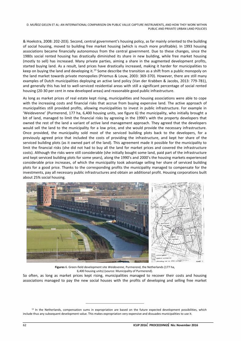
D. MUÑOZ GIELEN ET AL: AN INTERNATIONAL COMPARISON ON PUBLIC VALUE CAPTURE INSTRUMENTS, AND HOW THEY WORK WITHIN PUBLIC AND PRIVATE URBAN LAND POLICIES
62 ICUP 2016 PROCEEDINGSNis: November 2016
& Hoekstra, 2008: 202-203). Second, central government’s housing policy, as far mainly oriented to the building of social housing, moved to building free market housing (which is much more profitable). In 1993 housing associations became financially autonomous from the central government. Due to these changes, since the 1980s social rented housing has drastically diminished its share in new building, while free market housing (mostly to sell) has increased. Many private parties, aiming a share in the augmented development profits, started buying land. As a result, land prices have drastically increased, making it harder for municipalities to keep on buying the land and developing it.13 Some describe the transition as a shift from a public monopoly on the land market towards private monopolies (Priemus & Louw, 2003: 369-370). However, there are still many examples of Dutch municipalities deploying an active land policy (Van der Krabben & Jacobs, 2013: 779-781), and generally this has led to well-serviced residential areas with still a significant percentage of social rented housing (20-30 per cent in new developed areas) and reasonable good public infrastructure.
As long as market prices of real estate kept rising, municipalities and housing associations were able to cope with the increasing costs and financial risks that accrue from buying expensive land. The active approach of municipalities still provided profits, allowing municipalities to invest in public infrastructure. For example in ‘Weidevenne’ (Purmerend, 177 ha, 6,400 housing units, see figure 6) the municipality, who initially brought a bit of land, managed to limit the financial risks by agreeing in the 1990’s with the property developers that owned the rest of the land a variant of active land management approach. They agreed that the developers would sell the land to the municipality for a low price, and she would provide the necessary infrastructure. Once provided, the municipality sold most of the serviced building plots back to the developers, for a previously agreed price that included the costs of providing the infrastructure, and kept her share of the serviced building plots (as it owned part of the land). This agreement made it possible for the municipality to limit the financial risks (she did not had to buy all the land for market prices and covered the infrastructure costs). Although the risks were still considerable (she initially bought some land, paid part of the infrastructure and kept serviced building plots for some years), along the 1990’s and 2000’s the housing markets experienced considerable price increases, of which the municipality took advantage selling her share of serviced building plots for a good price. Thanks to the corresponding profits the municipality managed to compensate for the investments, pay all necessary public infrastructures and obtain an additional profit. Housing corporations built about 25% social housing.
Figures 6. Green-field development site Weidevenne, Purmerend, the Netherlands (177 ha, 6,400 housing units) (source: Municipality of Purmerend).
So often, as long as market prices kept rising, municipalities managed to recover their costs and housing associations managed to pay the new social houses with the profits of developing and selling free market
13 In the Netherlands, compensation sums in expropriation are based on the future expected development possibilities, which include thus any subsequent development value. This makes expropriation very expensive and dissuades municipalities to use it.

D. MUÑOZ GIELEN ET AL: AN INTERNATIONAL COMPARISON ON PUBLIC VALUE CAPTURE INSTRUMENTS, AND HOW THEY WORK WITHIN PUBLIC AND PRIVATE URBAN LAND POLICIES
ICUP 2016 PROCEEDINGS Nis: November 2016 63
housing. Nowadays the Netherlands still show enviable performances on social housing that can definitively serve as inspiration for other countries: about 30 per cent of the total housing stock is social rented housing.14
The economic crisis since 2008 has however evidenced the enormous risks of deploying public active approaches in speculative land markets. They turned out to be a financial nightmare for many municipalities. From 2010 till 2012 Dutch municipalities suffered a total loss of € 3,300 millions, and in 2013 of € 700 millions. A further loss between € 300 and € 2,100 millions is expected in the 5-years period till 2018 (Deloitte, 2014: 13-14; EY & Fakton, 2015: 5, 9). Since 2013 the looses have moderated and the expectations for the next years improved, but the hit on many municipal budges is far from recovered and it is uncertain whether and when active land policies will become profitable again. For example in ‘Waalsprong’ (Nijmegen, 1,300 ha, 13,000 housing units, see figure 7) the municipality suffered major losses after 2008 because it bought all the land and confronted the break down in housing prices. In 1997 the municipality, five developers and two housing associations agreed to jointly develop the site, and bought together most of the land. Due to unforeseen circumstances the development delayed, and at the time of the start of the economic crisis in 2008 most of the land was still undeveloped. After 2008 the developers and the housing associations left the joint development, leaving the Municipality with all the land, a total investment in 2014 of € 850 million (with large financial costs as effect, about € 37,000 per day) and about 8,500 housing units still to be built. It is expected that the final investments will be € 1,200 million, and there is uncertainty about whether the final revenues will cover all the costs. The municipality has already accounted a loss of € 97 million and expected in 2014 a future loss of another € 58 million (V/d Krabben & De Feijter, 2014: III-VIII).
Figure 7. Green-field development site Waalsprong, Nijmegen, the Netherlands (picture from Ontwikkelingsstrategie Waalsprong 2013, Municipality of Nijmegen).
The changes initiated in the 1980’s and especially the recent economic crisis have led to many municipalities reconsidering their active approach and gradually increasing the use of negotiable developer obligations (although, as explained in section 3, there is not yet much evidence about their use and results).
6. DISCUSSION AND CONCLUSIONS
As mentioned in section 1.2, the institutional, financial/economic and environmental (land policy) framework interact with land management approaches and value capture instruments (Hartmann & Needham, 2012), and in turn this affects the democratic legitimacy, effectiveness, efficiency and justice of land policies (Hartmann & Spit, 2015: 729-731). England and Spain (from the 1970’s onwards), and the Netherlands (from
14 This being said, last years housing associations in the Netherlands are under severe critic because of several cases of financial mismanagement (Parlamentaire enquete woningcorporaties, 2014).

D. MUÑOZ GIELEN ET AL: AN INTERNATIONAL COMPARISON ON PUBLIC VALUE CAPTURE INSTRUMENTS, AND HOW THEY WORK WITHIN PUBLIC AND PRIVATE URBAN LAND POLICIES
64 ICUP 2016 PROCEEDINGSNis: November 2016
the 1990’s onwards and specially in recent years) show how changes in the financial or economic framework (the need for innovative funding sources for public services) influence the institutional design and results of value capture instruments (more and more effective instruments). In England this led to a generalization of negotiable developer obligations and lately to the introduction of non-negotiable obligations. In Spain this led to an enlargement of both non-negotiable and negotiable developer obligations and to an improvement of the effectiveness of land readjustment. In the Netherlands this led to an introduction and as far a timid use of negotiable developer obligations. The larger public sharing in the increased value in England and Spain undoubtedly must have increased the efficiency (in terms of less financial involvement of municipalities, who increasingly can support on larger private contributions) and the justice of their passive approach to land management (at least from a social and utilitarian points of view). The results of passive approaches in the Netherlands are still uncertain.
The evidence presented in sections 3 to 5 also shows how the introduction of and the modifications in value capture instruments sometimes influenced back the environmental (land policy) framework (more negotiations in England and Spain led with time to an increased need of more accountability and transparency) and this in turn influenced back the value capture instruments (more regulation and policy framing intended to increase accountability and transparency, clearly in England and Spain, and it seems that the Netherlands will soon follow this path). This has increased the legitimacy of value capturing, if not for the general public as Hartmann’s & Spit’s definition of legitimacy suggests, at least for the involved stakeholders (landowners and property developers). This might have diminished the conflicts and therefore improved the effectiveness of the English and Spanish passive approach to land management. This being said, as mentioned in section 1.3, generalizations of these conclusions to other contexts and countries must be done with precaution. Other variables might be relevant for the practical results of value capture instruments. For example the introduction of more negotiated developer obligations, if not accompanied with good governance practices, does not necessarily improve the amount of contributions (effectiveness and efficiency), serve the public interest (legitimacy) or promote welfare and happiness among the inhabitants (justice).
In the debate of active vs. passive approaches to land management (see section 1.1) one recurring critique to passive approaches is their lack of effectiveness: public bodies can indeed, as illustrated in section 3, require contributions to property developers, but if these do not agree, development doesn’t take place and no value is captured. Active land management approaches (see section 5) were in the Netherlands the traditional answer to this lack of effectiveness of passive approaches: by buying the land and developing it municipalities can ‘get things done’ and capture part of the value increase. In Spain the answer was the introduction and later improvement of the land readjustment-regulation, which nowadays is very effective (see section 4). The Dutch active approach and the Spanish LR can both diminish the democratic legitimacy of land policies if landowners are not properly represented in the institutional system of politics. However, they can certainly improve its effectiveness and, as far as they result in a clear improvement of the quantity and quality of public infrastructure, also its social and utilitarian justice. Unlike the Dutch active approach, the Spanish LR does not require the previous assembling of land (buying or expropriating it), which reduces the financial costs and involvement of public authorities and also of private parties (property developers owning some land do not need anymore to acquire all the land to develop). This certainly increases the efficiency. Within the Dutch active approach (see section 5) it is possible to reduce the risks through a sort of privately agreed LR, i.e. if all or a majority of landowners agree it is possible re-distribute the risks and reduce the necessary investments. The difficulty of achieving such consensus led recently in the Netherlands to a proposal of compulsory LR for urban areas (Muñoz Gielen, 2016).
REFERENCES
1. Alexander, E.R. (2001), ‘Governance and transaction costs in planning systems: a conceptual framework for institutional analysis of land-use planning and development control – the case of Israel’, in Envi- ronment and Planning B: Planning and Design, 28, 755-76.
2. Alexander, E.R. (2014), ‘Land-property markets and planning: A special case’, in Land UsePolicy, 41, pp. 533-540.
3. Alterman, R. (2009), Can the “unearned increment” in land values be harnessed tosupply affordable housing?, paper in Conference ‘Financing affordable housing andinfrastructure in cities: towards innovative land and property taxation system’, UN Habitat GLTN, Warsaw 15 and 16 October 2009.
D. MUÑOZ GIELEN ET AL: AN INTERNATIONAL COMPARISON ON PUBLIC VALUE CAPTURE INSTRUMENTS, AND HOW THEY WORK WITHIN PUBLIC AND PRIVATE URBAN LAND POLICIES
ICUP 2016 PROCEEDINGS Nis: November 2016 65
4. Alterman, R. (2012), “Land-Use Regulations and Property Values. The ‘Windfalls Capture’ Idea Revisited”, in Brooks, N; Donangy, K; Knapp, G.J. (eds.), The Oxford Handbook on Urban Economics and Planning, Oxford University Press, pp.755-786.
5. Barker, Kate (2004), Review of Housing Supply. Delivering Stability: Securing our Future Housing Needs, Barker Review, London, March 2004, p.p. 149.
6. Booth, Philip (2003), Planning by Consent. The origins and nature of British development control, Routledge, London, 213 p.p.
7. Bowers, J. (1992), ‘The Economics of Planning Gain: a re-appraisal’, in UrbanStudies, vol. 29, nr. 8, pp. 1329-1339.
8. Burón Cuadrado, J. (2006), ‘Land reserves for subsidized housing: lessons learned from Vitoria-Gasteiz’, in Architecture, City and Environment, Vol. 1, núm. 2, Universitat Politécnica de Catalunya.
9. BVH Ruimte bv (2013), Onderzoek forfaitaire bijdrage Bovenplanse kosten enBijdrage ruimtelijke ontwikkelingen, in opdracht van Ministerie BZK en I&M,‘s - Hertogenbosch, the Netherlands.
10. BVH Ruimte bv & Vreman Advies (2014), Vervolgonderzoek bovenplanse kosten enbijdrage ruimtelijke ontwikkelingen, in opdracht van Ministerie BZK en I&M,‘s - Hertogenbosch, the Netherlands.
11. Campbell, Heather; Ellis, Hugh; Henneberry, John; Gladwell, Caroline (2000), “Planning obligations, planning practice, and land-use outcomes”, Environmental andPlanning B: Planning and Design, volume 27, p.p. 759-775.
12. Campbell, Heather; Ellis, Hugh; Gladwell, Caroline; Henneberry, John; Poxon, J.; Rowley, S. (2001), Planning Obligations and the Mediation of Development, RICS Foundation Research Papers, 4(3), p. 44, London.
13. Christman, John (1994), The Myth of Property: Toward an Egalitarian Theory ofOwnership, New York: Oxford University Press, 219 p.p.
14. Corkindale, J. (2004), The Land Use Planning System: Evaluating Options forReform, Hobart Paper 148, Institute of Economic Affairs, London, 113 p.p.
15. Crook, T. (2016), ‘Planning Obligations Policy in England: de facto Taxation of Development Value’, in Croot et al. (2016), p.p. 63-114.
16. Crook, T.; Henneberry, J. & Whitehead, C. (2016), Planning Gain. ProvidingInfrastructure & Affordable Housing, WILEY Blackwell, RICS Research, p. 289.
17. Crook, T. & Monk, S. (2011), ‘Planning Gains, Provinding Homes’, in HousingStudies, Vol. 26, nrs 7-8, p. 997-1018.
18. Deloitte (2014), Monitor gemeente financiën 2014. Special: grond en vastgoed, October 2014, Utrecht, the Netherlands.
19. Department for Communities and Local Government (2006), Valuing PlanningObligations in England, London, DCLG Publications, May 2006.
20. Ennis, Frank (1997), ‘Infrastructure Provision, the Negotiating Process and the Planner’s Role’, in Urban Studies, Vol. 34, No. 12, pp.: 1935-1954.
21. Ernst & Young and Fakton (2015), Financiële positie gemeentelijke grondbedrijven, available on-line: https://www.rijksoverheid.nl/documenten/rapporten/2015/02/27/rapport-financiele-positie-gemeentelijke-grondbedrijven-actualisatie-2014.
22. Gallent, Nick & Tewdwr-Jone, Mark (2007), Decent home for all, Routledge, Abingdon, UK, 300 p.p.
23. George, Henry (1879), Progress and Poverty, 2006 edited and abridged edition, Robert Schalkenbach Foundation, New York, 210 p.p.
24. Hagman, D. & Misczynski, D. (1978), Windfalls for Wipeouts: land value captureand compensation, Planners Press American Planning Association, Washington DC.

D. MUÑOZ GIELEN ET AL: AN INTERNATIONAL COMPARISON ON PUBLIC VALUE CAPTURE INSTRUMENTS, AND HOW THEY WORK WITHIN PUBLIC AND PRIVATE URBAN LAND POLICIES
66 ICUP 2016 PROCEEDINGSNis: November 2016
25. Hartmann, T., Needham, B., 2012. ‘Why reconsider planning by law and property rights?’, in Hartmann, T., Needham, B. (Eds.), Planning by law and property rightsreconsidered, Ashgate, Farnham, 1–23.
26. Hartmann, T. & Spit, T. (2015), ‘Dilemmas of involvement in land management – Comparing an active (Dutch) and passive (German) approach’, in Land Use Policy, 42, pp: 729-737.
27. Havel, B. (2016), Unlock the lock-in! Balance of rights in relation to betterment and compensation in Poland, Centre for Land Tenure Studies Working Paper 2/16, Norwegian University of Life Sciences, DOI: 10.13140/RG.2.1.2541.8007, 21 p.
28. Healey, P., Purdue, M., Ennis, F. (1995), Negotiating development: rationales and practice for development obligations and planning gain, E&FN Spon, London.
29. Home, Robert (2007), ‘Land Readjustment as a Method of Development Land Assembly: A Comparative Overview’, in The Town Planning Review, vol. 78, nr. 4, pp. 459-483.
30. Hong, Y.H. & Needham, B. (2007, eds.), Analyzing Land Readjustment. Economics, Law, and Collective Action, the Lincoln Institute of Land Policy, pp. 203.
31. Korthals Altes, W. (2007), ‘The impact of abolishing social -housing grants on the compact-city policy of Dutch municipalities’, Environment and Planning A, volume 39, p.p. 1497-1512.
32. Krueckeberg, D.A. (1995), ‘The Difficult Character of Property: To Whom Do Things Belong?’, in Journal of the American Planning Association, Vol. 61, nr. 3, p.p. 301-309.
33. MacIntyre, Alasdair (1984), After Virtue: A Study in Moral Theory, 1st edition 1981, 2nd edition 1984, Notre Dame, University of Notre Dame Press.
34. Miles, Matthew B. & Huberman, A. Michael (1994), Qualitative Data Analysis, SAGE Publications.
35. Ministerie I&M (2015), Kamerbrief over Grondbeleid, 25 November 2015, IENM/BSK-2015/193853, p. 21, The Hague.
37. Monk, S. & Crook, T. (2016), ‘International Experience’, chapter in Crook, T.; Henneberry, J. & Whitehead, C. (2016), Planning Gain: Providing Infrastructure and Affordable Housing, p.p. 227-268, DOI: 10.1002/9781119075103.ch9.
38. Moore, V. (2005), A practical approach to Planning Law, Oxford University Press, Ninth Edition, 666 pages.
39. Moya, L. (2008, ed.), La Vivienda Social en Europa. Alemania, Francia y Países Bajos desde 1945, Mairea Libros, Madrid, 225 pages.
40. Muñoz Gielen, D.: (2010), Capturing value increase in urban redevelopment, Sidestone Press, 478 pages.
41. Muñoz Gielen, D.: (2014) ‘Urban governance, property rights, land readjustment and public value capturing’. European Urban and Regional Studies, 21 (1), 60-78.
42. Muñoz Gielen, D.: (2016), ‘Proposal of Land Readjustment for the Netherlands: analysing its effectiveness from an international perspective’, in Cities 53, 78-86.
43. Muñoz Gielen, D. & García Pastor, M. (2016), ‘Negotiable and less negotiable developer obligations in urban development in Spain: international perspective’, paper in 10th Annual Conference International Academic Association Planning, Law and Property Rights, Bern, Switzerland, February 2016.
44. Muñoz Gielen, D. & Hoekstra, J. (2008), ‘De la política de Vvivienda Social en los Países Bajos’, in Moya, L. (2008, ed.), p.p. 201-209.
45. Muñoz Gielen, D; Korthals Altes, W. (2007), ‘Lessons from Valencia: separating infrastructure provision from landownership’, Town Planning Review, 78 (1), 61-79.
46. Muñoz Gielen, D., Lenferink, S. and V/d Krabben, E. (2016), ‘The role of developer obligations in financing large public infrastructure after the economic crisis in the Netherlands’, paper in 10th Annual Conference International Academic Association Planning, Law and Property Rights, Bern, Switzerland, February 2016.

D. MUÑOZ GIELEN ET AL: AN INTERNATIONAL COMPARISON ON PUBLIC VALUE CAPTURE INSTRUMENTS, AND HOW THEY WORK WITHIN PUBLIC AND PRIVATE URBAN LAND POLICIES
ICUP 2016 PROCEEDINGS Nis: November 2016 67
47. Needham, B.; Kruijt, B. y Koenders, P. (1993), Urban land and property markets in the Netherlands, University College London (UCL) Press, London, pp. 243.
48. Oxley, Michael (2006), ‘The Gain from the Planning-Gain Supplement: A Consideration of the Proposal for a New Tax to Boost Housing Supply in the UK’, in European Journal of Housing Policy, Vol. 6, No. 1, p.p. 101–113, April 2006.
49. Parlamentaire enquete woningcorporaties (2014), Ver van Huis, Tweede Kamer, vergaderjaar 2014–2015, 33 606, nr. 4.
49. Prest, A.R. (1981), The taxation of urban land, Manchester University Press, p.p. 190.
50. Priemus, H. & Louw, E. (2003), ‘Changes in Dutch land policy: from monopoly towards competition in the building market’, in Environment and Planning B: Planning and Design, volume 30, pp. 369-378.
51. Ratcliffe, John; Stubbs, Michael; and Shepherd, Mark (2002), Urban Planning and Real Estate Development, Second Edition, Spon Press, London and New York.
52. UN-HABITAT (2012), Handling land. Innovative tools for land governance and secure tenue, UNON, Publishing Services Section, Nairobi, 151 p.
53. Van der Krabben, E. & Jacobs, H.M. (2013), ‘Public land development as a strategic tool for redevelopment: Reflections on the Dutch experience’, in Land Use Policy 30, p.p. 774-783.
54. Van der Krabben, E. & De Feijter, F. (2014), De Slag om de Waalsprong, Radboud Universiteit Nijmegen, 86 p.p.
55. Webster, C. J. (1998), ‘Public choice, Pigouvian and Coasian planning theory’, in Urban Studies, 35(1), pp. 3–75.
56. Webster, C.J.; Melián Marrero, G., Calzada, G; Carr R & Lee, S.S. (2012), ‘A Property Rights Analysis of Urban Planning in Spain and UK’, in European Planning Studies, DOI:10.1080/09654313.2012.722950, 16 p.
57. Worldbank (2014), ‘Land value capture in urban DRM programs’, Working Paper Series No. 26, 80583,
http://www-wds.worldbank.org/external/default/WDSContentServer/WDSP/IB/2013/08/23/00035 6161_20130823130137/Rendered/PDF/805830Brief0260Box0379807B00PUBLIC0. pdf.

D. MUÑOZ GIELEN ET AL: AN INTERNATIONAL COMPARISON ON PUBLIC VALUE CAPTURE INSTRUMENTS, AND HOW THEY WORK WITHIN PUBLIC AND PRIVATE URBAN LAND POLICIES
68 ICUP 2016 PROCEEDINGSNis: November 2016

D. OKTAY, IN PURSUIT OF HUMAN SUSTAINABLE URBANISM: ECOLOGICAL AND CULTURAL INTEGRITY
ICUP 2016 PROCEEDINGS Nis: November 2016 69
IN PURSUIT OF HUMAN SUSTAINABLE URBANISM: ECOLOGICAL AND CULTURAL INTEGRITY
Derya Oktay
Ondokuz Mayis University, Turkey PhD., Professor, [email protected]
ABSTRACT
Sustainable urbanism is characterised in many contexts through addressing natural environment and ecological sustainability as the major concern, a condition that could be explained with the climate change. However, it should not be underestimated that today’s development practices do not only consume enormous amounts of land and natural resources, damage ecosystems, produce a wide variety of pollutants and toxic chemicals, create ever-growing distances and fuel global warming, but also create inequities between groups of people, undermine local community and social values, economies and quality of life. These incremental changes imply a more critical state in cities of traditional societies where transformations in the urban level are still visible. This calls for sensitivity to the traditional urbanism and impact of global ideas, practices, and technologies on local social and cultural practices both at the city scale and architecture scale. In line with these, this paper aims to establish an environmentally sound and human friendly framework for ‘human sustainable urbanism’ integrating ecological and cultural sustainability. In this context, the study firstly provides a conceptual understanding of sustainable urbanism and a critical review of its philosophical and practical framework; secondly, it provides a critical assessment of contemporary approaches to sustainable urbanism and architecture; thirdly, the paper analyses the traditional Turkish city which provides valuable clues for sustainable development, and discusses possible research directions that could help promote the concept of sustainability in the urban and architectural environment of future cities.
Keywords: ecological sustainability; cultural sustainability; traditional cities; contemporary paradigms; ecological and cultural integrity.
1. INTRODUCTION
Dramatic changes that have taken place in the world over the past twenty years, including ecological disturbances and radical changes in traditional settlements have produced cities that are not just chaotic and monotonous in appearance, but have serious environmental problems threatening their inhabitants. In this context, environmentally sensitive design approaches at the building scale has been understood better comparing to those at the urban scale, and there have been significant developments in the field, although the contemporary architectural practice in the developing countries is still lacking many aspects of sustainable building design. On the other hand, the absence of the urban or neighborhood scale in most of the environmental literature has been masked by the recent obsession with “green” building. Based on these shortcomings, I would like to highlight here the primacy of the settlement pattern and the necessity for sustainable urbanism. On that ground, sustainable urbanism - pattern of settlement - emerges as a sound framework that draws attention to the immense opportunity to redesign the built environment in a manner that supports a higher quality of life and human health. Many progressive leaders now envision and champion a win-win balance between human needs, both social and economic, and of nature. An increasing numbers of those leaders recognize the power of thoughtful urbanism to induce people to willingly live a more human-powered and less resource intensive lifestyle. A small but fast-growing number of leaders are now beginning to recognize the inherent sustainability of a walkable, diverse urbanism integrated with high-performance buildings and infrastructure (Farr, 2008). When sustainable urbanism is characterized in many contexts, what is usually addressed as the main concern is natural environment, and hence ecological sustainability, a condition

D. OKTAY, IN PURSUIT OF HUMAN SUSTAINABLE URBANISM: ECOLOGICAL AND CULTURAL INTEGRITY
70 ICUP 2016 PROCEEDINGS Nis: November 2016
that could be explained with the climate change, the inevitable environmental crisis. However, we should be aware of the fact that today’s development practices do not only consume enormous amounts of land and natural resources, damage ecosystems, produce a wide variety of pollutants and toxic chemicals, create ever-growing distances and fuel global warming, but also create inequities between groups of people, undermine local community and social values, economies and quality of life. These incremental changes imply a more critical state in cities of traditional societies where transformations in the urban level are still visible. What is questioned in this paper is, given our knowledge that environmental sustainability is a crucial need, are the contemporary approaches adequate for all settings? At a time of uncontrolled globalization in which sense of place, history and cultural distinctiveness is constantly under attack and many cities lack socially inclusive and responsive environments, do these approaches also integrate social-cultural dimensions? These call for a new understanding of traditional settlements as they represent good uses of local environmental and social values in their times. On that ground, this paper first provides a theoretical underpinning of sustainable urbanism and a critical review of its philosophical and practical framework; second, assessing contemporary approaches to sustainable urbanism and analyzing the traditional Turkish (Ottoman) City, proposes a holistic framework for sustainable urbanism that integrates environmental sustainability with social sustainability.
2. CONTEMPORARY PARADIGMS
Sustainable urbanism grows out of three late 20th Century reform movements based on the idea of promoting “sustainable development”, that is a development which is non-damaging to the environment and which improves the long-term health of human and ecological systems: The “New Urbanism”, “Smart Growth”, and “Green Architecture”. Each of these movements, however, has revealed certain insularity. Within architecture and urban design, the movement known as the New Urbanism, which appeared in the early 1990s and has become a strong force for re-evaluating the physical layout of communities, cannot be considered efficient and urban, as its focus has been better-designed “suburban” development. New Urbanism cannot be considered new either as it revives many ideas about the city or planning that was mainstream before the Modern Movement. Another criticism about New Urbanism is about the elitism within the movement (Kelbaugh, 2002). Indeed, the movement is open to criticism on a number of fronts – in particular for being focused on better-designed suburban development, often for upper income groups, rather than the creation of truly “urban” places, and for not incorporating green building design and landscaping. Furthermore, it can be considered a new type of “ideal vision” conceived, ordained and disseminated from above and not rooted in specific places or local cultures. Just a few years later, in the mid-1990s, “Smart Growth” evolved as an effort to recast the policy debate over sprawl in a way that more directly linked the environment, the economy and daily life concerns in pursuit of a positive and sustainable urban growth as essential to the quality of the city and urban life. The movement focused especially on mechanisms to promote more compact, walkable, and economically efficient urban development. Compact cities are argued to offer opportunities to reduce fuel consumption for traveling, as homes, work and leisure facilities are closer together. They are also favoured by many in the field of urbanism because urban land can be re-used, while rural land beyond the urban edge is protected. Economic benefits, due to high concentrations of people supporting local economics and easier access to services and facilities, are also suggested. Compact cities with higher densities may also mean that people are more likely to meet each other on the street than in low-density areas, and people may have a stronger sense of attachment to place. Ultimately, a good quality of life is argued to be sustained, with high concentrations of people providing social conditions conducive to vibrancy, liveliness and cultural production and consumption.
However, there are many who believe that the case of the compact city is not proven, and have negative views about it. As the compact city requires us to ignore the causes and effects of decentralization, and benefits it may bring, the preference for suburban living in many world cities where the city cannot offer an ideal living environment in its central parts is worth consideration. These contradictions indicate a serious problem indeed and require a thorough understanding of determinants. On the other hand, anti-sprawl strategies, which have obvious consequences for green and open space, have frequently lead to deadlocks in planning, especially concerning green space (Ståhle, 2010). Research supports the intuitive belief of a beneficial relationship between contact with nature and quality of life. A city with high-quality and generous green spaces symbolizes good planning and management, a healthy environment for humans, vegetation and wildlife populations, and bestows pride on its citizenry and government. On that ground, it can be stated that if green space is deprived, a compact city may be the antithesis of a green city.

D. OKTAY, IN PURSUIT OF HUMAN SUSTAINABLE URBANISM: ECOLOGICAL AND CULTURAL INTEGRITY
ICUP 2016 PROCEEDINGS Nis: November 2016 71
Further, the compact city makes little sense for developing countries because the context is completely different from North American and European countries whose cities have experienced declining populations and deindustrialization. Cities of developing countries have much higher densities than their counterparts in developed countries, and they are not becoming significantly less compact in spite of decelerating population growth and the beginnings of decentralization. Moreover, there are some other issues which necessitate developing country cities to be making realistic - yet minimal - plans for urban expansion. Rapid urbanization and higher densities, especially in some developing countries, have obvious consequences in terms of the choice of transportation modes, living conditions, congestion and pollution, and could compromise an environmentally sound planning. In most of these cities, city cannot be restructured into a compact sustainable city within the current planning framework that is limited to a two-dimensional thinking and the private land-owning interests, at the expense of long-term sustainability. Sustainability is most certainly concerned with extravagant use of finite resources and the efficient management of the ecosystem. It also addresses the need to ensure that what we do now does not negatively affect what future generations may wish to do. On that ground, what we need is “good mixed-use” or “fine grain mixed-use”, not just in relation to the inner city but equally for the urban edge and new settlements. What is disregarded in all these approaches is that cities also have social-cultural aspects.
Most urban and suburban development during the past 50 years has been relatively generic, with little sense of place, history, or cultural distinctiveness. Many critics condemn low-density, car-oriented, suburban style development, which they label socially isolating, segregating and alienating, calling instead for widespread use of higher density, mixed-use planning principles that lessen reliance on the automobile and increase social interactions. All these factors lead a long-term decline in the extent to which citizens participate in community groups and social institutions, and this decline of community participation is at least partly related to the physical nature of our cities and towns (Ehrenhalt, 1995; Moe and Wilkie, 1997). The acceleration of globalization has initiated a process of urban transformation, posing some serious threats and challenges to the public spaces of cities, among others. As cities have grown larger and spread wider, urban functions have disintegrated and public spaces, which are important to a democratic and inclusive society, have lost much of their significance in urban life. They became “empty spaces”, a space of abstract freedom but no enduring human connection (Sennett, 1994). Public realm, in this context, is shrinking and losing its meaning in people’s life. For a long time, owing to the effects of the Modern Movement in architecture, it has been common practice in the development of new districts to prioritize the buildings themselves, then, if possible the public life. The results are deserted districts and urban spaces, as if the city is for cars, not for people.
In the last decade, explosions of information technology have caught up with Webber’s forecast with the prediction of millions of people eventually working from home, and electronic media, like e-mail and the internet, are allowing groups to plan and organize events and open space use much more readily than before. Those who advocate the low-density suburban developments use this phenomenon as an additional supportive point, positing that once the obligation for commuting is taken away, the arguments against “sprawl” diminish. In contrast to this and much more convincing, is the argument that if people work at home then there is even greater need for a range of facilities and diverse settings in close proximity to minimize the increased isolationism resulting from the loss of urban experience (Murrain, 1993). Face-to-face human interactions in the public realm, indeed, are intensely relevant for supporting livability, safety and control, economic development, participation, and identity.
Since it is urban public spaces that provide the opportunity to meet and watch others (strangers), we should unquestionably use their potential to the full through enhancing their quality and their accessibility by all. One issue many cities are faced today is that privately owned, controlled spaces of modern urban commerce and design are isolating people from the city spaces which are important to a democratic and inclusive society. The shift from the traditional commercial strip to the sanitized shopping mall has a devastating effect on the city behaviour with significant reduction in city-behaviour trade, deteriorated atmosphere and weakened identity. The recent efforts towards more sustainable urban environments have revealed that, in order for sustainable urbanism to move forward and gain traction, it is essential that it be seen by citizens as playing an integral role in addressing the key issues of our times. The shift to a more sustainable lifestyle necessitates the communities to integrate individualized and privatized environmental action into everyday life and to achieve resource savings in a more extensive context using less water, less energy, less fuel for transportation and leading to less CO2 emissions.
D. OKTAY, IN PURSUIT OF HUMAN SUSTAINABLE URBANISM: ECOLOGICAL AND CULTURAL INTEGRITY
72 ICUP 2016 PROCEEDINGS Nis: November 2016
To this point, we have to ask ourselves what specific measures need to be taken to create sustainable urban environments, and how environmental and social concerns can be brought together into one convincing scenario, in which everyone benefits. In this context, it is important to understand that the idea of sustainability is not new, and the traditional cities are excellent examples to learn from regarding various dimensions of sustainable urbanism. On that ground, the following section will focus on the Ottoman (Turkish) city, which teaches many lessons that can contribute to meeting contemporary and future planning and design needs provided that their viability is checked for each case and in a time-based perspective.
3. LESSONS FROM THE OTTOMAN CITY
From an urban and social point of view, the main characteristic of the Ottoman city was its compartmentalization by mahalles (neighborhoods), the outcome of ethnic particularities and religious differences. The mahalle was a geographical entity as well as a homogeneous community providing social and economic collaboration among neighbors. Each mahalle had its own characteristics and provided an indicative, unique social environment for their inhabitants. However, spatial segregation that was based on ethnicity and profession leaded separate lives within each minority, and therefore indicated a negative aspect from the perspective of contemporary sustainable urbanism. The mahalle was self-sufficient as well through the presence of a variety of functions, and as a result of the closed economy, every household produced their own foodstuffs. The efforts of numerous private builders (masters) in residential areas were guided only by a few simple rules of civility, assuring individuality within the neighborhood as well as community identity apart from the works of government. It is a remarkable lesson that every house in the Ottoman city was different, even as there is an overall unity and consistency in building technique, scale and character (Eldem, 1987). As such, despite the lack of an organized development plan at the governmental level, that is a must in today’s development practices, the respect to local environmental and social values made the Ottoman City a sustainable settlement regarding many points.
The space of the traditional (Ottoman) city was, at a functional level, clearly divided into public and private realms. The public realm, often in the town center, contained all the collective activities of the town, such as trade and commerce, religion, education, administration, and urban facilities, resulted in a fine-grain mixed-use character. The main public node and the representation of people’s power were bestowed to the citadel, the Friday mosque and its courtyard, and the bazaar. One of these elements, the main - often covered - street or streets of the city, the bazaar or arasta, functioned also as a communication channel, connecting these to each other and top the less important activities such as public baths, water storages, and educational centres, hence creating a vivid public realm in a spatial continuum. This space was the meeting place of the local people with each other, with the political, religious, end economic hierarchies, and with the outside world.
The street system in residential areas was mostly pedestrian and had a hierarchical order: from the main streets spread out narrower streets that themselves had dead-end branches that lead to individual houses. In this system, only the main through-fares separated the urban fabric. This system was achieved through a process of organic growth in which the street pattern was gradually adjusted and changed according to the peculiarities of the land and needs of the local people, where there was no need for wider streets and a low level of accessibility was required. Despite the criticism of the street system from the viewpoint of accessibility and vehicular traffic, a conservationist principle is said to exist in this organic growth that concentrates on the minimum space required (Madanipour, 1994). Moreover, the hierarchical pattern of streets with dead-end branches serving a group of houses created privacy for the dwellers (especially for women - as a significant need at the time) and helped create a strong sense of belonging to their neighborhood. From an urbanistic point of view, this organic character of the street, in the state of continuous becoming, produces an effect of great expressiveness, and therefore, enhances the character in the Ottoman city. The street also bore a potential for social activities. Children of similar ages played together and identified themselves with the street they lived in. Fountains of running water were found at many street corners where women had the chance to meet their neighbours and have a chat whilst getting water every morning and evening.
On the other hand, avlu, the courtyard of each house, an isolated environment that is well defined and well protected, served a variety of uses including social gathering, such as wedding and circumcision parties, women’s preparing winter food together, or just spending time together, and helped create a more cohesive community in the mahalle (Eldem 1987; Cerasi 1999).

D. OKTAY, IN PURSUIT OF HUMAN SUSTAINABLE URBANISM: ECOLOGICAL AND CULTURAL INTEGRITY
ICUP 2016 PROCEEDINGS Nis: November 2016 73
The Ottoman city possessed various attributes that generated an ecologically sustainable environment. Regional climatic characteristics were reflected on the patterns of settlements, and accordingly every region produced its own characteristic urban fabric and architecture. The pre-existing topographic character of the site was apparent at the urban scale even in intense built-up areas. The green gardens, i.e. vegetable gardens and patches (bostan), orchards, and so forth, implied a green belt dividing the quarters and bounded the town (Aru 1998, 12), and contributed to the self-sufficiency in general. The small squares at the intersection of streets with trees created opportunity for access to nature in the public realm as well. The streets that were defined by high walls of the residential courtyards provided a protected and comfortable space, and being divided into two by a typical medieval gutter in the center for rain and waste-water, helped water gardens, and prevented the rainwater from flowing into the courtyards.
4. REDEFINING ESSENTIALS FOR SUSTAINABLE URBANISM
Based on our critical review of contemporary approaches to sustainable urbanism and our analysis of the Ottoman city as an ideal model for sustainable urbanism, I would advocate that new urban planning and design endeavours should comprise a human dimension and demonstrate respect to regional characteristics. Figure 1 illustrates the essential aspects of sustainable urbanism based on our holistic understanding.
Figure 1. A holistic framework for human sustainable urbanism.
4.1. Efficiency of urban form: context-sensitive compactness and de-fragmentation
Urban design of compact cities can obviously contribute to a more sustainable way of life, particularly in industrialized societies. However, as revealed through the ideas exemplified by the traditional Ottoman city that comply with regional characteristics, it cannot be expected that cities should all fit the same formula. What is needed is not a radical set of measures, but by a complete diagnosis of the territory, identifying local characteristics, specificities, demands and dynamics, and an estimating and evaluation of the urban development processes, through comparing the demand and the offer for urban growth, and consideration of the issues of “where” and “how” the urban settlement grow. Inspired by the Ottoman city and mahalle, the contemporary city could be thought as an entity made up cohesive and identifiable districts, and smaller towns of functional diversity could be created in the vicinity of the city rather than reaching unacceptable levels of density and population. In this context, density should be related to design in such a way that its advantages and disadvantages are investigated by considering local social dynamics (need for privacy, degree of privacy, neighbourly relations, and so forth) and environmental values (green infrastructure, made of wetlands, forests, groundwater recharge zones, and so forth), and new scenarios for “de-fragmentation” where open growth may find its placement.
4.2. Completeness: good mixed-use
Good mixed-use as “a finely grained mix of primary land uses, namely a variety of dwellings and workplaces with housing predominant, closely integrated with all other support services, within convenient distance of the majority of the homes”, which was an important component of the public realm in the Ottoman city, is useful. In that context, containing all the collective activities, the central parts of the city revealed a fine-

D. OKTAY, IN PURSUIT OF HUMAN SUSTAINABLE URBANISM: ECOLOGICAL AND CULTURAL INTEGRITY
74 ICUP 2016 PROCEEDINGS Nis: November 2016
grain mixed-use character and helped the local people meet with each other and with the outside world. The main street and the bazaar or arasta in the Ottoman city, functioned as a communication channel, connecting the main activities to each other and top the less important activities (i.e. public baths, water storages, and educational centers), and created a vivid public realm in a spatial continuum. These characteristics can be re-interpreted as a model when planning and/or re-designing our cities whose central parts are deteriorating owing to the lack of diversity of main functions (business, commerce, housing, recreation) and the effects of privately owned, introverted spaces of modern urban commerce and design.
4.3. Connectedness
Integrated transportation and land use. In a sustainable urban environment, people should have abundant opportunities to walk, bike, and (if necessary) use a wheelchair around the neighborhoods, as well as having access to good public transport. These varied transportation options would increase access to services and facilities, help reduce car dependency and thus congestion and pollution, achieve a reduction of energy consumption and help maintain a high-level of energy-efficient and environment-friendly mobility inside the city or city region. In the Ottoman city, the walkability of the streets was enhanced by human scale, physical convenience (protection from sun, rain, etc.) due to the narrow and winding streets following the natural contours of the land, and pleasant continuity of the outer walls of the houses and courtyards that. From these, one important lesson for the contemporary city is designing the city streets first for people taking into account the functional and aesthetic needs of people rather than complying with cars only.
3.4. Ecological sensitivity
As observed in the Ottoman settlements which reveal an ideal integration with the natural environment and climate, sustainable urbanism seeks to connect people to nature and natural systems, even in dense urban environments. In this context, an attempt at integrating such features as edible landscapes of fruit trees and large vegetable patches (allotments) into the city would be beneficial for dwellers in terms of lower heating and cooling bills, lower food costs, and reduced risk of flooding and landslide damage. When a more flexible design is possible, the traditional concept of courtyard can be reinterpreted and modified in the new housing developments, and walk-up type housing blocks can be arranged around a semi-private courtyard space in some areas in a diverse typological pattern. In order to eliminate safety problems and to enhance the sense of place, the design of the residential complex should be based on the principles of responsive urban design by providing active edges (mixed-use if possible) along the streets and encouraging active use of the courtyards by residents.
4.5. A focus on place and public spaces
Although public spaces form a crucial feature of sustainable and livable cities, contemporary urban environments frequently lack enough space kept aside for them, and most of those spaces which are introduced as “public spaces” miss spatial, ecological and social qualities, and cannot be considered “places for people”. Inspired by the Ottoman city, new urban areas could be planned and designed around a hierarchy of spaces for different purposes, the idea of main shopping strip could be revived in order to prevent the shopping malls to be the norm, and the street pattern could be organized in a way that each street has an identity through the continuity, design and functional layout of buildings. In the contemporary city, streets, squares and public parks are the only places where people truly meet as equals, and a high-quality public realm may help create a sense of belonging and collective identity.
4.6. Social-cultural sustainability
Social-cultural sustainability is a system of social-cultural relations in which the positive aspects of disparate cultures are valued and promoted and there is widespread participation of citizens not only politically but also socially in all areas of urban life environment. Its success depends on the level of people’s expectations, behaviour, value systems, transparency and accountability in both public and private decision-making. As the most appealing aspect of sustainable urbanism is to be the sustainable neighborhood with its societal benefits, we must widen our definition of the sustainable urban neighborhood to include social as well as environmental concerns as reflected in mahalle, the cohesive neighborhood unit in the Ottoman city. However, we should not ignore the great changes that happened in the daily life of people, i.e. significant

D. OKTAY, IN PURSUIT OF HUMAN SUSTAINABLE URBANISM: ECOLOGICAL AND CULTURAL INTEGRITY
ICUP 2016 PROCEEDINGS Nis: November 2016 75
increase in percentage of working women, women’s equal participation in almost all aspects of life, and so forth.
4.7. Sustainable life style
In order to achieve positive results from planning and design efforts towards a sustainable environment, changing environmental behaviour of consumers, companies, communities and governments to ‘ecological citizenship’ is critical (Asilsoy and Oktay, 2016). Adopting sustainable life styles require incorporating a range of behavioral responses from energy saving and water conservation, to waste recycling and green consumption, and these would influence the urban quality of life without damaging the planet for the future. In the Ottoman city, owing to the preferred simplicity in every aspect of life and self-sufficiency in many senses, people generally adopted a sustainable life style, and it was a healthy and contended community. In today’s cities, what is needed for sustainable life style is “education for sustainable development” and hence “ecological citizenship”, that would enable urban residents to develop the knowledge, values and skills to participate in decisions about the ways they do things individually and collectively, both locally and globally.
5. CONCLUSION
As we live in environments that have often been very damaged both in ecological terms and cultural terms, there is an urgent need for a radical shift towards a holistic approach to sustainable urban planning/design, namely ‘human sustainable urbanism’ integrating ecological and cultural sustainability. This calls for sensitivity to traditional urbanism and impact of global ideas, practices and technologies on local social and cultural practices.
Urban design of compact cities can obviously contribute to a more sustainable way of life, particularly in industrialized societies. However, since cities are all different in form and structure owing to a host of place-specific factors, it cannot be expected that they should all fit the same formula when it comes to the question of a sustainable urban form. The degree of compactness and/or defragmentation should therefore be context-sensitive. Inspired by the Ottoman city and mahalle that comply with local environmental and social-cultural values of the time, the contemporary city could be reconsidered as an entity made up of cohesive districts, and smaller towns of functional diversity could be created in the vicinity of the city rather than reaching unacceptable levels of density and population. A sustainable community endeavours to promote multi-functional rather than mono-functional settlement patterns by providing compact urban behaviours, with a broad range of services and amenities in close proximity. This reduces the need for vehicular and public transport, thereby decreasing demands on infrastructure and energy resources, while promoting pedestrian accessibility and community.
In the course of environmental transition, cities could attempt to keep as many as possible of the environment-sustainability ingredients, including green spaces. In that sense, an attempt at integrating such features as edible landscapes and directing some of the efforts of greening towards streets would be beneficial.
We can move towards more inclusive urban design approach that not only views the public realm as an outside room with equitable access, but also as a welcoming place where a variety of users benefit from it and place a value on it as they interact with other people and their own prior experiences. We must widen our definition of the sustainable urban neighborhood to include social as well as environmental concerns as reflected in mahalle, the social-spatial unit in the Ottoman city, without ignoring the great changes that happened in the daily life of people. In the new settlements, there must be places that foster special rituals where all residents come together in common pursuit and observance as used to be done in the streets and courtyards. There should be places, which support multiple public activities, recreation, and settings arranged to encourage safe, and every day, personal exchanges among people who might otherwise remain strangers.
Naturally these ideas and principles will not achieve their objective without an appropriate application strategy. Urban planning and design is a shared responsibility and putting aims into practice depends on evaluations within a far broader political-economic context.
REFERENCES
1. Asilsoy, B. and Oktay, D. 2016. Environmental attitudes as predictors of ecological citizenship: findings from a survey in Famagusta, North Cyprus. Open House International, 41(2), pp 47-55.

D. OKTAY, IN PURSUIT OF HUMAN SUSTAINABLE URBANISM: ECOLOGICAL AND CULTURAL INTEGRITY
76 ICUP 2016 PROCEEDINGS Nis: November 2016
2. Bentley, I. et al. 1985. Responsive Environments. Architectural Press, London, UK.
3. Richardson, H. W., Bae, C. C., and Baxamusa, M. H. (2000). Compact cities in developing countries, in R. Burgess & M. Jenks, Compact Cities: Sustainable Urban Forms for Developing Countries. Spon Press, London, UK.
4. Cerasi, M.M. 1999. Osmanlı Kenti: Osmanlı Kentinde 18. ve 19. Yüzyıllarda Kent Uygarlığı ve Mimarisi. Yapı Kredi, Istanbul, Turkey.
5. Dobson, A. 2009. Ecological Citizenship, in Reynolds, M. et al., The environmental responsibility reader. Zed Books, London, UK.
6. Duany, A., Plater-Zyberk, E. and Speck, J. (2001). Suburban Nation: The Rise of Sprawl and the Decline of the American Dream. North Point Press, USA.
7. Ehrenhalt, A. 1995. The lost city: the forgotten virtues of community in America. Basic Books, New York, USA.
8. Eid, Y. Y. (2003). “Sustainable Urban Communities: History Defying Cultural Conflict”, in Moser, G. et al., People, Places and Sustainability. Hogrefe & Huber Publishers, Seattle, USA.
9. Eldem, S.H. (1987). Turkish Houses, Ottoman Period, Volume III. T.A.Ç., Istanbul, Turkey.
10. Farr, D. (2008). Sustainable Urbanism: Urban Design with Nature. Wiley, New Jersey, USA..
11. Günay, R. 2005. Safranbolu Houses. Yapı Yayın, Istanbul.
12. Haughton, G. & Hunter, C. 1994. Sustainable Cities. Jessica Kinsley Publishers, London, UK.
13. Jacobs, J. 1961. The Death and Life of Great American Cities. Random House, New York, USA.
14. Kelbaugh, D. S. 2002. Repairing the American Metropolis: Common Place Revisited. University of Washington Press, Seattle, USA.
15. Kuban, D. 1986. Turkish culture and arts. Istanbul: BBA. Lund, H. 2002. Pedestrian environments and sense of community. Journal of Planning Education and Research 21, pp 301–312.
16. Madanipour, A. 1999. Why are the design and development of public spaces significant for cities? Environment and Planning B: Planning and Design 26, 6, pp 879 – 891.
17. Mitchell, D. 2003. The Right to the City: Social Justice and the Fight for Public Space, Guilford Press, New York, USA.
18. Moe, R. & Wilkie, C. 1997. Changing places: Rebuilding community in the age of sprawl. Henry Holt & Co., New York, USA.
19. Murrain, P. 1993. Urban Expansion: Look Back and Learn, in Hayward, R. and McGlynn (eds.), Making Better Places: Urban Design Now. Butterworth, Oxford, UK, 83-94.
20. Oktay, D. 2012. “Urban Regeneration and Place-Making for Sustainability”, Recycling Common Ground (Ed:C. Lamanna),Alinea Editrice, Florence, pp 20-27.
21. Oktay, D. 2014. “Towards Human Sustainable Urbanism: Interrogating the Contemporary Approaches and the Traditional Turkish (Ottoman) City”, Urban Sustainability: Innovative Spaces, Vulnerabilities and Opportunities (Eds: R. G. Mira & A. Dumitra), Deputacion, Da Coruna, Spain.
22. Oktay, D. 2004. “Urban Design for Sustainability: A Study on the Turkish City”, International Journal for Sustainable Development and World Ecology, 11/1, 24-35.
23. Wheeler, S. M. 2006. Planning for sustainability: Creating livable, equitable and ecological communities. Routledge, New York, USA.
24. WCED (World Commission on Environment and Development) 1987. Our Common Future (Brundtland Report). Oxford University Press, Oxford, UK.
T.K. SOOD: URBAN REGENERATION AND COLLECTIVE SALES – THE SINGAPORE EXPERIENCE
ICUP 2016 PROCEEDINGS Nis: November 2016 77
URBAN REGENERATION AND COLLECTIVE SALES – THE SINGAPORE EXPERIENCE
Teo Keang Sood
Faculty of Law, National University of Singapore PhD., Professor, [email protected]
ABSTRACT
This paper discusses urban regeneration in Singapore through the lens of collective sales. It discusses certain aspects of the collective sales legal regime which seeks to balance the interests of unit owners opting for a collective sale and those opposing it. Certain possible areas for reform are also touched upon in this controversial area of the law.
Keywords: urban regeneration; collective sales; legal regime.
1. INTRODUCTION
Before the collective sale regime became a unique feature of the strata title landscape in Singapore in 1999, it was possible for a strata scheme to be brought to an end in two ways - either by the management corporation pursuant to a resolution1; Building Maintenance and Strata Management Act or with the approval of the court2. In the case of the former, the resolution must have been voted in favour by all the unit owners entitled to vote at a general meeting of the management corporation. As for the latter, it is dependent on the court being satisfied that it is just and equitable to end the strata scheme. As can be seen, these two methods do not facilitate collective sales as they are strict and cumbersome.
The issue of collective sale3 came about after the Urban Redevelopment Authority4 started releasing its then Development Guide Plans in 1993. Some sites were assigned higher plot ratios, which meant that the land in question could be used more intensively. There is also a public interest involved as rejuvenation of estates through collective sales of older developments cannot be realised. It defeats national objectives if changes reflected in the Urban Redevelopment Authority’s Master Plans cannot be translated into better utilisation of scarce land resources to meet a growing population5 just because disagreements have held up or prevented collective sales.
2. POLICY OBJECTIVES OF THE COLLECTIVE SALE REGIME
To move away from the strict and cumbersome legal regime noted above, the Land Titles (Strata) (Amendment) Act6 was enacted by the Singapore Parliament and brought into force on 11 October 1999.7
1 Land Titles (Strata) Act (Cap 158, 1999 Rev Ed), s 81(1). In this connection, see also now the Building Maintenance and Strata Management Act (Cap 30C, 2008 Rev Ed), s 84.
2 Ibid, s 78. These two methods mentioned above are still available.
3 Also popularly referred to as en bloc sales. An en bloc sale is a sale, usually to a single purchaser, where completion of all the units is effected at the same time.
4 It is the national land use planning and conservation authority regulating and facilitating the physical development of Singapore.
5 With a projected population of 6.5 million in future, Singapore would need to optimise land use and explore new ways to create space (Singapore Parliamentary Debates (2007) Vol 82 at Col 1546)
6 No 21 of 1999
7 Vide S 445/1999. The Amendment Act 1999 has its origin in the Land Titles (Strata) (Amendment) Bill (Bill No 28/1998). As the changes to be effected were of keen public interest, the Bill was referred to a Select Committee which sought the views of the public. Not surprisingly, the Committee received tremendous feedback on the Bill. Property owners, lawyers, the Law Society, the Singapore Institute

T. K.SOOD.: URBAN REGENERATION AND COLLECTIVE SALES – THE SINGAPORE EXPERIENCE
78 ICUP 2016 PROCEEDINGSNis: November 2016
which paves the way for the introduction of the collective sale regime. The aims of the statutory scheme for collective sale set out in the Land Titles (Strata) Act8 are two-fold: to facilitate the optimal use of prime land to build more quality housing in land-scarce Singapore and to promote the rejuvenation of older estates9.
The basic idea is to enable the majority unit owners to sell the development to a purchaser without the consent of the minority unit owners, subject to the approval of a Strata Titles Board10or the High Court, as the case may be. In essence, the collective sale is not a contractual sale, but a new form of statutory sale as it takes effect by virtue of the order of a Board or the High Court and not by virtue of the sale and purchase agreement11.
That the collective sale regime has achieved the objective of creating more housing units in prime areas and rejuvenating older developments can be seen in the fact that between 2005 and 2009, of the 462 collective sale transactions, almost half, or 217, are being redeveloped or had been redeveloped. These 217 developments originally had 11,994 strata units but after redevelopment, the resulting new developments will have more than 26,000 strata units, more than doubling the number of strata units12.
2.1. Unique features of strata title ownership
Three unique features stand out when a person buys into strata title ownership which are absent in the case of non-strata landed property ownership. This has to do with the issue of the perceived erosion of property rights of the minority unit owners under the collective sale regime. First, a strata unit owner buys into a parcel of airspace (in the case of a high-rise condominium development) and common property. Second, strata title ownership involves communal living where matters are generally dealt with by majority decision. Finally, a collective sale looks at the redevelopment potential of the land (common property) in question, not the individual units. Thus, it is important for strata unit owners to know what they are buying into in a strata scheme and the extent of their rights therein.
2.2. Balancing the competing interests of the majority and minority unit owners
A broad overview of some of the main features of the statutory scheme which seek to balance the competing interests involved will be undertaken below. Relevant case law developments will also be considered.
As the statutory scheme of collective sale is here to stay, at least in the foreseeable future, it is imperative that the rights and interests of all affected parties are taken into account13 and adequately protected, especially those of the minority unit owners who oppose a sale. As was observed by the Singapore Court of Appeal in Ng Eng Ghee v Mamata Kapildev Dave14:
As a class, [the minority unit owners] have to be adequately protected from bullying and underhand tactics as well as any potentially collusive or improper conduct on the part of any of the majority owners15.
of Surveyors and Valuers as well as others in the real estate business responded and offered their views. In all, the Committee received 46 written representations and heard oral presentations from 14 individuals and groups. The practice in other jurisdictions were looked at, in particular that of Ontario and British Columbia in Canada, Hawaii in the United States and Hong Kong. Changes were, accordingly, made to the Bill which was later passed as the Amendment Act 1999.
8 Cap 158, 2009 Rev Ed, Part VA.
9 See Ng Swee Lang v Sassoon Samuel Bernard [2008] 2 SLR 597 at [5] and Ng Eng Ghee v Mamata Kapildev Dave [2009] 3 SLR 109 at [1]. See also Singapore Parliamentary Debates, Official Report (31 July 1998) vol 69 at col 601
10 Constituted under Part VI of the Building Maintenance and Strata Management Act (Cap 30C, 2008 Rev Ed) to hear applications for, inter alia, orders for collective sale under Part VA of the LTSA.
11 Ng Swee Lang v Sassoon Samuel Bernard [2008] 2 SLR 597 at [7]. See also LTSA, ss 84B(1)(a), 84B(1)(b) and 84B(4).
12 See Singapore Parliamentary Debates (2010) Vol 87 No 3 at Col 400.
13 See Singapore Parliamentary Debates, Official Report (31 July 1998) vol 69 at cols 635–636.
14 [2009] 3 SLR 109.
15 [2009] 3 SLR 109 at [3].

T.K. SOOD: URBAN REGENERATION AND COLLECTIVE SALES – THE SINGAPORE EXPERIENCE
ICUP 2016 PROCEEDINGS Nis: November 2016 79
That protection of the minority unit owners’ interests is paramount in the collective sale statutory scheme was again emphasised in the later Court of Appeal decision in Chua Choon Cheng v Allgreen Properties Ltd16, when dealing with the contention of the majority unit owners that the legislative intent of the LTSA is for the protection of all owners:
‘However, viewed in its proper context, the [Minister of State for Law]’s overriding concern is plainly the protection of the interests of the minority owners. This must be so, given that in every successful collective sale, it is the minority owners who lose their homes, despite their objections, as a result of the majority’s decision to enter into a collective sale. If, indeed, the interests of all parties were an overriding consideration in every collective sale, Parliament would have provided that an application to the STB would be necessary even if unanimous consent was obtained. The following excerpts of the same speech by Minister Ho vividly illustrates [sic] this point (at coll 601–603, 634 [of Singapore Parliamentary Debates, Official Report (31 July 1998) vol 69]): …’ 17
At the same time, the measures put in place must not make it unduly onerous to bring about or realise a collective sale so as to ensure that the public interest objective in optimising the use of prime land in land-scarce Singapore is achieved18.
The safeguards and prerequisites originally enacted in 1999. have been further refined19 to provide additional safeguards and greater transparency in the collective sale process. The changes also addressed concerns over the lack of clarity and certainty in the collective sale procedure. Below are some of the main prerequisites and safeguards in the collective sale process.
For a development which is ten or more years old, the consent of unit owners with at least 80% of the share values20 as well as the total area of all the units is required for a collective sale to go through21. In the case of a development which is less than ten years old, the majority consent level is higher at 90%22. The percentage requirement seeks to strike a balance between the interests of the majority and minority unit owners, taking into account the policy objectives of the collective sale statutory scheme. It may also be noted that the percentage requirement applies to all unit owners alike. For example, it makes no distinction between resident owners and investors in units in a development, thus maintaining consistency with the present general regime of property ownership, which does not discriminate on this basis. The percentage requirement in terms of area of units will mitigate the bias against residential unit owners in a mixed development who may hold lesser share values but own a substantial floor area23.
It is preferable that the consent level be pegged to the age of the development as it is more likely that older developments will be sub-optimally utilised, have higher repair bills and have more unit owners in favour of collective sales24. The ten-year criterion is a reasonable time-frame which sets apart the older developments. This will enable the land to be better exploited and its economic potential maximised25. In addition, if the land
16 [2009] 3 SLR 724.
17 [2009] 3 SLR 724 at [80].
18 Singapore Parliamentary Debates, Official Report (20 September 2007) vol 83 at col 2001.
19 See Land Titles (Strata) Act (Amendment of Fourth Schedule) Order 2004 (S 243/2004), Land Titles (Strata) (Amendment) Act 2007 (No 46 of 2007) and Land Titles (Strata) (Amendment) Act 2010 (No 13 of 2010). See also Singapore Parliamentary Debates, Official Report (20 September 2007) vol 83 at col 1994 and Singapore Parliamentary Debates (2010) vol 87 No 3 at cols 375, 382 and 397
20 The share value is a figure that represents the proportionate share entitlement assigned to each unit in a strata development. It determines, inter alia, the voting rights of the unit owners, the quantum of their undivided share in the common property and the amount of their contributions to the management or sinking fund levied by the management corporation (LTSA, 2009. ss 30(2)(a)–30(2)(c)).
21 LTSA, s 84A(1)(b).
22 LTSA, s 84A(1)(a).
23 Singapore Parliamentary Debates, Official Report (20 September 2007) vol 83 at col 1997.
24 The average age of all developments applying for collective sale between January 2005 and August 2007 was 25.9 years, which indicates that the collective sale process is being used for urban renewal (SPD, Official Report, 2007. Vol. 83 at col 2036) in line with the national objective of maximising scarce land resources in the public interest).
25 Singapore Parliamentary Debates, Official Report (31 July 1998) vol 69 at cols 633–634 and Report of the Select Committee on the Land Titles (Strata)(Amendment) Bill (Bill No 28/98) (Parl 2 of 1999, 19 April 1999) at iii–iv.

T. K.SOOD.: URBAN REGENERATION AND COLLECTIVE SALES – THE SINGAPORE EXPERIENCE
80 ICUP 2016 PROCEEDINGSNis: November 2016
had already been assigned a higher plot ratio some years after the completion of the development, it can be used even more intensively.
Since 1999, almost 70% of developments for collective sale were more than 20 years old26. The average age of all developments which applied for collective sale from January 2005. to August 2007. was 25.9 years which is indicative that the collective sale process is being used for urban renewal27 in line with the national objective of maximising scarce land resources in the public interest.
It is mandatory for the collective sale committee, before an application can be made to a Board for an order for sale, to convene one or more general meetings of the management corporation for all the unit owners to discuss the issue of collective sale of the development28. At the meetings, the unit owners will not only get to know the details of the sale but will also have the opportunity to scrutinise the marketing and property agents involved in the collective sale. The formation, function and proceedings of a collective sale committee are regulated to enhance procedural clarity in this regard29.
Provisions are also made in respect of the drafting and signing of the collective sale agreement so that unit owners are apprised of the important information30 contained therein to enable them to make an informed decision before they sign it. To guard against any duress or misrepresentation, a solicitor appointed by the collective sale committee must be present to explain the terms contained therein and address any doubts that a unit owner may have31. This will also go towards ensuring the integrity of the transaction32. To address the issue of intimidation or harassment, a five-day cooling-off period after the signing of the collective sale agreement is provided to enable a unit owner to rescind his or her agreement to be a party thereto33.
Following a failed collective sale attempt, no general meeting is permitted to be called for the purposes of constituting a collective sale committee unless a minimum two-year period has elapsed34. Nevertheless, a re-try to convene a general meeting to form a collective sale committee is allowed within the two-year restriction period provided a higher requisition level is met. The first requisition in the two-year restriction period must be made by at least 50% of the total number of unit owners or by unit owners owning at least 50% of the total share value in the development35. The second or subsequent requisition in the restriction period must satisfy an even higher requisition level of 80%, either by share value or total number of unit owners36. This is to ensure a high degree of certainty that the proposal to constitute a collective sale committee will succeed before a general meeting can be convened. It is also meant to discourage repeated attempts where there is no prospect of a collective sale succeeding.
A collective sale committee is automatically dissolved where, within a year after it is constituted, there is no collective sale agreement or there is a failure to obtain any signatories to its collective sale agreement37. This ensures that there is a measure of certainty in the collective sale process and that a sale committee cannot drag out the collective sale process indefinitely.
It should, however, be noted that an application for collective sale shall not be invalidated by a Board by reason only of non-compliance with any requirement in the Schedules to the LTSA if the Board is satisfied that such non-compliance or irregularity, which is purely technical or procedural in nature, does not prejudice the
26 See Singapore Parliamentary Debates (2007) Vol 83 No 13 at Col 2047.
27 See Singapore Parliamentary Debates (2007) Vol 83 No 13 at Col 2036.
28 LTSA, s 84A(3) and Third Schedule, paras 7(1) and (2).
29 LTSA, Second and Third Schedules.
30 LTSA, First Schedule, para 3(a)–(f).
31 LTSA, First Schedule, para 4.
32 See Singapore Parliamentary Debates (2010) Vol 87 No 3 at Col 382.
33 LTSA, First Schedule, paras 5 and 6(1). See also The Schedule to the Land Titles (Strata) (Notice of Rescission) Regulations (Cap 158, Rg 2, 2010 Rev Ed).
34 LTSA, Second Schedule, para 2(1A)(a).
35 LTSA, Second Schedule, para 2(1A)(b)(i).
36 LTSA, Second Schedule, para 2(1A)(b)(ii).
37 LTSA, Third Schedule, para 12(2)(b).

T.K. SOOD: URBAN REGENERATION AND COLLECTIVE SALES – THE SINGAPORE EXPERIENCE
ICUP 2016 PROCEEDINGS Nis: November 2016 81
interest of any person38. In Siow Doreen & Ors v Lo Pui Sang & Ors39, three pages comprising the execution pages of three of the majority unit owners were not attached to the collective sale agreement for the purposes of the application for collective sale before the Board. This resulted in the Board dismissing the application. In allowing the appeal, the High Court held that the Board could have corrected the error without inconvenience and without prejudice because the requisite 80% requirement had already been satisfied even without the three missing pages.
Having regard to the policy objective of the statutory scheme to facilitate collective sale, it is clear that the courts will not allow what is a truly technical breach of the LTSA which causes no prejudice to the minority unit owners to frustrate the wishes of the majority unit owners who wish to obtain a collective sale order. The general guiding principle is that each objection should be examined on its own facts and that the particular requirement breached should be set against the overall purpose of the legislation. One then considers whether a strict construction and the invalidation of a Board’s order is what Parliament would have intended, taking into account any prejudice to the rights of the parties and the public interest.
2.3. Duties of collective sale committee, the requirement of good faith and other relevant factors
The duties of a collective sale committee and the relationship between it and the unit owners were authoritatively delineated in the landmark Court of Appeal decision in Ng Eng Ghee v Mamata Kapildev Dave40. The Court of Appeal ruled that the collective sale committee is the agent for all the unit owners collectively in relation to the collective sale of their strata units. As the collective sale committee is the agent of the unit owners collectively, there is no point at which it may act solely in the interests of any group of unit owners, whether they are consenting or objecting unit owners.
Based on the underlying agency relationship noted above, a fiduciary relationship arises between the collective sale committee and the unit owners41. This, in turn, imposes on the sale committee fiduciary obligations to all the unit owners independently of its contractual obligations as set out in the collective sale agreement42.
The rationale for imposing high standards of accountability and conduct upon the collective sale committee vis-à-vis not only the majority, but also the minority, unit owners is because a collective sale will result in the objecting minority unit owners losing their units without their consent in exchange for compensation which may not be their preferred right. In addition, the collective sale committee usually comprises the very same consenting majority unit owners whose objective is to sell the property contrary to the wishes of the objecting unit owners. There would naturally be an inclination on the part of a collective sale committee to sell rather than not to sell.
In Ng Eng Ghee, the collective sale concerned the strata development known as Horizon Towers. First Tree Properties Ltd, a housing agent with two shareholders, neither of whom was a licensed valuer, was appointed as the sole marketing agent for the sale of the development. Prior to their appointment to the collective sale committee and unknown to the other members of the committee and the majority unit owners, the chairman and a member of the committee had purchased, with the assistance of substantial financing, additional units in the development. In due course, the development was sold to HPPL for $500 million. This was lower than the offer of $510 million made by another potential purchaser, VHL. Prior to the sale to HPPL, a member of the sale committee had suggested that a fresh mandate be sought from the majority unit owners given that property prices had suddenly risen sharply, leading to a substantial erosion of the premium promised when the reserve price was set at $500 million. This was rejected by the sale committee as it was clear to the committee that it would not get the mandate to sell if it were to go back to the unit owners. The sale of the development to HPPL at the reserve price of $500 million was concluded notwithstanding that a neighbouring property had just increased by 25% the reserve price for its collective sale. In addition, no disclosure of the purchase of additional units was made by the chairman and the member concerned prior to the decision to sell to HPPL, nor was any independent valuation of the development obtained even though this was expressly authorised by the
38 LTSA, s 84A(7C).
39 [2008] 1 SLR(R) 213.
40 [2009] 3 SLR 109.
41 Ng Eng Ghee v Mamata Kapildev Dave, 2009., 3 SLR 109 at [108]
42 Ibid, at [109] and [117].

T. K.SOOD.: URBAN REGENERATION AND COLLECTIVE SALES – THE SINGAPORE EXPERIENCE
82 ICUP 2016 PROCEEDINGSNis: November 2016
collective sale agreement. The minority unit owners who objected to the application for collective sale, contended, inter alia, that the transaction was not in good faith. They alleged that the dismissal or concealment of the alternative offer by VHL was actuated by dishonesty or bad faith. Both the Board and the High Court allowed the collective sale application.
In allowing the appeal, the Court of Appeal noted that under the LTSA, a collective sale transaction must be undertaken in good faith after taking into account such factors as the sale price obtained for the development before a sale order can be granted43. The Court of Appeal was of the view that in considering whether there is good faith in the transaction, regard should be had to what is good faith at general law, given that Part VA of the LTSA, which sets out the collective sale statutory scheme, does not abrogate or purport to abrogate all general law principles44. Thus, in determining whether a collective sale transaction is in good faith, a breach of duties by the collective sale committee is a relevant consideration45.
Further, the requirement of good faith in the transaction goes beyond the mere question of whether the price is fair and would also refer to the conduct of the collective sale committee in the entire sale process.
Having regard to all the circumstances that might have had a bearing on the price of the property, the court concluded that the collective sale committee did not act in good faith in the transaction in the manner and at the time it did in selling the development to HPPL at $500m. In particular, the collective sale committee had committed breaches of its duties by failing to, inter alia: (a) act with due diligence and transparency in the process leading to the appointment of the property agent; (b) make use of the existence of the VHL offer as leverage in negotiations with HPPL; (c) obtain advice from an independent property expert prior to the sale; and (d) consult (or even update) the consenting unit owners despite the price surge in the property market. In addition, the sale committee also decided to sell the property to HPPL notwithstanding the conflicts of interest involving two of its key members46.
In Lim Li Meng Dominic v Sally Ching Pui Sim47, the latest case on collective sales in Singapore, the Court of Appeal held that it was proper for the court to have regard to the collective sale agreement in assessing the bona fides of the transaction given that the word ‘transaction’ in s 84A(9)(a)(i) is broader than the word ‘sale’ or ‘agreement for sale’ as it includes the whole sale process, including how the consent for the collective sale was secured48. The method of distributing the proceeds of sale must be taken to refer to the entire system by which the final shares of the sale proceeds are determined as a whole and this would cover not only the amount of sale proceeds to be received by an objecting unit owner but also the method of distributing such proceeds as well49. Thus, all the terms in the contract must be looked at when assessing the good faith of the transaction. In the result, certain objectionable clauses contained in the collective sale agreement were held to have unfairly prejudiced the interests of the objecting unit owners. These clauses had the effect of requiring the latter to make a default contribution of double the amount of the original contribution which would be deducted from their share of the sale proceeds upon successful completion of the collective sale and such sums would be shared among those who agreed to the collective sale. In the circumstances, the Court of Appeal had no hesitation in ruling the transaction to be not in good faith after taking into account the method of distributing the proceeds of sale.
The following brief comments may be made in relation to the Court of Appeal decisions in the above two cases. These two decisions may be viewed as compensating for the absence of a fundamental right to one’s property, a right not enshrined in the Constitution of the Republic of Singapore50. As will be seen below, case law has reiterated that there is no constitutional protection of property given the scarcity of land in Singapore51. In light
43 LTSA, s 84A(9)(a)(i)(A).
44 [2009] 3 SLR 109 at [131].
45 Ibid, at [208].
46 Ng Eng Ghee v Mamata Kapildev Dave [2009] 3 SLR 109, at [176].
47 [2015] 5 SLR 989.
48 Ibid, at [47].
49 Ibid, at [57].
50 1999 Rev Ed.
51 Lo Pui Sang v Mamata Kapildev Dave [2008] 4 SLR 754.
T.K. SOOD: URBAN REGENERATION AND COLLECTIVE SALES – THE SINGAPORE EXPERIENCE
ICUP 2016 PROCEEDINGS Nis: November 2016 83
of this, protection for the property rights of minority unit owners has emerged by way of the stringent duties required of a collective sale committee as laid down in Ng Eng Ghee. Given the powers and obligations of a sale committee, the onerous duties imposed on it are understandable and logical. The duties to which a sale committee is subject strike a careful balance between the interests of the majority and minority unit owners without making it unduly difficult for a collective sale to be carried out. Whether there is a breach of these duties also depends very much on the circumstances obtained in a given case. With proper professional advice it is unlikely that unit owners will be discouraged from serving in sale committees as navigating these duties and complying with them should, hopefully, not prove too difficult.
2.4. Constitutionality of collective sale provisions
In Lo Pui Sang v Mamata Kapildev Dave52, it was contended that the relevant provisions53of the LTSA providing for the collective sale of strata developments violated, inter alia, Article 12(1) of the Constitution of the Republic of Singapore54. This Article provided that all persons are equal before the law and are entitled to the equal protection of the law. It was submitted that Article 12(1) is presumed to lay down a prohibition against unreasonableness and arbitrariness. The 80% majority rule in section 84A(1)(b) of the LTSA discriminated against the minority unit owners in that the majority had a choice as to where they wished to live while the minority would be deprived of that choice. The High Court, in dismissing the argument, explained that the right to equal protection under Article 12(1) must be determined from the outset, that is, when a law is passed, it must apply to everyone equally. On this basis, the opportunity of selling a condominium by way of a collective sale is an equal opportunity to all unit owners. Neither the legislature nor the Boards decide who the minority would be. Instead, the minority is decided by a vote of all the unit owners. Furthermore, the omission of a provision in the Singapore Constitution that would have entrenched a fundamental right to own property was a deliberate omission given the scarcity of land in Singapore and the court must therefore recognise that there is no such fundamental right under the Singapore Constitution55.
2.5. Possible areas for reform
Below are some aspects of a collective sale process that may warrant a review so as to promote greater transparency and ensure a better balance of the competing interests involved.
Currently, it is possible for a unit owner or owners who own just 20% of the total share value to requisition for the convening of a general meeting to consider a potential collective sale of the development56. It suits those unit owners who are particularly interested in pushing for a collective sale of the development even though they do not own a substantial percentage of the aggregate share value. As the expenses of holding the meeting will have to be borne out of the management fund57, it will be a drain on the finances of the management corporation. This is not to mention the stress, agony and uncertainty that unit owners have to go through at the meeting, not knowing if their development will ultimately be put up for collective sale. The percentage requirement to requisition for the convening of a general meeting should, accordingly, be raised to a level which will give the process more credibility and legitimacy. This is arguably justified since the end result concerns the deprivation of the private property of owners in a development58.
Under the Building Maintenance and Strata Management Act, the members of a management council assist the management corporation in the upkeep, maintenance and management of the development. Given the nature of the role played by members of the management council, a pertinent question arises as to whether members of the council should, at the same time, also serve as members of the collective sale committee. It is clear that the role played by the latter is the direct opposite of the management council, namely, to effect a sale of the development. Their roles are different. Because of the conflicting interests and duties arising from the different
52 [2008] 4 SLR 754 (reversed on other grounds in [2009] 3 SLR 109).
53 LTSA, ss 84A(1)(b) and 84B(1)(b).
54 1999 Rev Ed.
55 [2008] 4 SLR 754 at [7]. See also Singapore Parliamentary Debates, Official Report (17 March 1967) vol 25 at cols 1424–1425.
56 LTSA, Second Schedule, para 2(1)(a) and (b).
57 Building Maintenance and Strata Management Act (Cap 30C, 2008 Rev Ed), s 38(9A).
58 Ibid, s 29(1)(a) and (b).

T. K.SOOD.: URBAN REGENERATION AND COLLECTIVE SALES – THE SINGAPORE EXPERIENCE
84 ICUP 2016 PROCEEDINGSNis: November 2016
roles played by a management council and a sale committee, it might be preferable to disallow members of a management council from serving at the same time as members of the sale committee. Given the potential collective sale of the development, the management council may not upkeep and maintain it. Not doing so may result in the development being in a dilapidated state. This will be an additional reason for the sale committee to ‘induce’ the uncommitted unit owners to sell the development given the state of disrepair. There is an ‘incentive’ for members of the management council to not maintain and upkeep the development where they also serve, at the same time, as members of the sale committee. Hence, the suggestion above that they should not be permitted to serve on both committees at the same time. While complaints may be lodged with the Commissioner of Buildings in respect of the ‘neglect’ of duties, the management council may, nonetheless, take the practical view that to incur additional maintenance expenses would be a waste in light of the imminent sale of the development. Legislation to clarify the grey areas in respect of these duties of the management council in the collective sale process would be helpful.
In respect of the make-up of the collective sale committee, it should, ideally, include representatives of the minority unit owners who stand to be persuaded that a collective sale of the development is in the best interest of the unit owners as a whole. Such a composition will enable the sale committee to hear the arguments of both sides on matters pertaining to the viability of a collective sale. It will ensure a full airing of views as to matters pertaining to the sale and the concerns of minority unit owners. Opportunities for abuse by those in favour of a collective sale will also be minimised and kept in check.
3. CONCLUSION
Given the scarcity of land in Singapore, collective sale by majority consent will remain a feature of the strata title landscape in the foreseeable future, especially in view of the public interest to ensure optimal use of scarce land resources and to promote urban redevelopment. Where necessary, the statutory framework provided will be further refined to overcome shortcomings and weaknesses therein. Ultimately, a balance has to be struck between ensuring transparency and clarity of the law on the one hand and not making collective sales unduly onerous, on the other, given the policy objectives involved.
REFERENCES
1. Building Maintenance and Strata Management Act (Cap 30C, 2008 Rev Ed), s 38(9A).
2. Building Maintenance and Strata Management Act (Cap 30C, 2008 Rev Ed), s 84
3. Building Maintenance and Strata Management Act (Cap 30C, 2008 Rev Ed), s 78
4. Building Maintenance and Strata Management Act (Cap 30C, 2008 Rev Ed), Part VI
5. Chua Choon Cheng v Allgreen Properties Ltd [2009] 3 SLR 724
6. Constitution of the Republic of Singapore, 1999 Rev Ed
7. Land Titles (Strata) Act (Cap 158, 1999 Rev Ed)
8. Land Titles (Strata) Act (Cap 158, 2009 Rev Ed),
9. Land Titles (Strata) (Amendment) Act 1999, No. 21
10. Land Titles (Strata) Act (Amendment of Fourth Schedule) Order 2004 (S 243/2004)
11. Land Titles (Strata) (Amendment) Act 2007 (No 46 of 2007)
12. Land Titles (Strata) (Amendment) Act 2010 (No 13 of 2010)
13. Land Titles (Strata) (Notice of Rescission) Regulations (Cap 158, Rg 2, 2010 Rev Ed
14. Lim Li Meng Dominic v Sally Ching Pui Sim [2015] 5 SLR 989
15. Lo Pui Sang v Mamata Kapildev Dave [2008] 4 SLR 754
16. Ng Swee Lang v Sassoon Samuel Bernard [2008] 2 SLR 597
17. Ng Eng Ghee v Mamata Kapildev Dave [2009] 3 SLR 109
18. Report of the Select Committee on the Land Titles (Strata)(Amendment) Bill (Bill No 28/98) (Part 2 of 1999, 19 April 1999) at iii–iv
19. Singapore Parliamentary Debates (2007) Vol 82 at Col 1546
T.K. SOOD: URBAN REGENERATION AND COLLECTIVE SALES – THE SINGAPORE EXPERIENCE
ICUP 2016 PROCEEDINGS Nis: November 2016 85
20. Singapore Parliamentary Debates (2007) Vol 83 No 13 at Col 2047
21. Singapore Parliamentary Debates (2010) Vol 87 No 3 at Col 382
22. Singapore Parliamentary Debates, Official Report (17 March 1967) vol 25 at cols 1424–1425
23. Singapore Parliamentary Debates, Official Report (31 July 1998) vol 69 at cols 635–636
24. Singapore Parliamentary Debates, Official Report (20 September 2007) vol 83 at col 2001
25. Siow Doreen & Ors v Lo Pui Sang & Ors [2008] 1 SLR(R) 213

T. K.SOOD.: URBAN REGENERATION AND COLLECTIVE SALES – THE SINGAPORE EXPERIENCE
86 ICUP 2016 PROCEEDINGSNis: November 2016

M. CEKIC: TRANSECT - A 21ST CENTURY URBAN DESIGN TOOL
ICUP 2016 PROCEEDINGS Nis: November 2016 87
TRANSECT - A 21ST CENTURY URBAN DESIGN TOOL
Milosav Cekic, MA, CNU, AICP
President, MC/A Architects, Inc.Austin, Texas, USA milosavcekic-architects.com
ABSTRACT
This paper is an introduction to and explanation of an old classification system for the natural environment invented by geographers in the late 18th century that has been modified into a system for classifying and designing human settlements. It represents a method of classification of the built environment as a continuum of six conditions, ranging from rural to urban. It is now being used by the New Urbanism movement in the US as an alternative coding tool to the suburban codes that are threatening to completely eradicate the organic and delicate pre-war structure of American towns and cities. Each point along the continuum has distinctive unifying characteristics that are reflected in street patterns, building form, urban design, relationships to the natural world and public infrastructure. The continuum of the Transect, when subdivided, lends itself to the creation of zoning categories and, when the different aspects of the continuum are systematized into a land use code, the Transect can, and in many places has, become a comprehensive alternative to conventional zoning.
Keywords: transect; transect planning; urban design tool; zoning; smartcode.
1. INTRODUCTION
One of the key objectives of Transect planning, as used by the New Urbanists, is the creation of immersive environments. Immersive environments are coherent and harmonious assemblages of physical patterns that make villages, towns and cities, the character of which is determined by their location within the Transect. Successful immersive environments are based and depend on the proper selection and arrangement of all the components that contribute to a particular type of environment. For example, a ranch house fits well in the rural section of the Transect, while a five-story urban dwelling is appropriate in the urban zone.
A transect was first used for bio-geographical analysis by naturalist Alexander Von Humboldt in the late 18th century. A century later, brothers Andres and Douglas Duany, an architect/urban designer and a landscape architect, identified rural-to-urban transect for Miami beach, Florida, from the beach (T1), through neighborhood fabric (T3 and T4), to mixed use corridors (T5 and T6). They, and other New Urbanists, recognizing the dangers of sprawl and the codes that promote conventional suburban developments, began to analyze the local transects across the US in an attempt to extract the “DNA” for regenerating human settlements. In this way, they codified human habitats and established the basis for a different kind of development code.
Figure 1: Original Transect by A.V. Humboldt

M. CEKIC: TRANSECT - A 21ST CENTURY URBAN DESIGN TOOL
88 ICUP 2016 PROCEEDINGSNis: November 2016
Transect as currently used is a classification system that organizes all elements of the built environment on a scale from rural to urban. It is both a descriptive theory and a system of land use. The central notion of the Transect idea is that of a gradient of habitats, from wilderness to urban core. As one moves along the gradient, differences in design, ecology, overall physical patterns, and social structure are apparent. Different people thrive in different habitats. Some would never choose to live in an urban core, while some would wither in a rural place. To provide meaningful choices in living arrangements, the rural-to-urban Transect is divided into six T-zones for application in zoning ordinances and maps. These six habitats vary by the ratio and level of intensity of their natural, built, and social components. The T-zones coordinate their components at various scales of planning, from the continuity of neighborhood, to the block scale, and down to the individual lot and building.
Figure 2: The New Urbanism Rural-To-Urban Transect With Transect Zones

M. CEKIC: TRANSECT - A 21ST CENTURY URBAN DESIGN TOOL
ICUP 2016 PROCEEDINGS Nis: November 2016 89
2. ENVIRONMENTAL BACKGROUND
As mentioned earlier, the concept of Transect is rooted in environmental studies. A transect is a standard tool used by ecologists to make sense of different ecosystems and natural habitats. It takes a cross-section slice of the landscape and examines how it changes along a continuum. A transect study made by a natural scientist may move from the ocean beach to the marshland, then to low scrub pine forest, and then to mature upland forest.
The environmental scientists have traditionally ignored humans and their activities. An early understanding of the Transect as applied to the built environment is found in the work of Ian McHarg and his influential book Design with Nature. However, McHarg focuses almost exclusively on determining the areas of environmental quality to be preserved and not on the form or function of the built environment. The innovation of New Urbanism is the extension of Transect into the human environment. Applying the Transect to human settlements suggests that we think of human and natural environment not in conflict with each other, but rather of interacting ecosystems that are affected by humans, to a greater or lesser degree.
3. TRANSECT ZONES
The New Urbanist Transect is a method of classification of the built environment as a continuum of six conditions, ranging from rural to urban. Each point along the continuum has distinctive unifying characteristics that are reflected in street patterns, building form, urban design, relationships to the natural world and public infrastructure. The value of the Transect is that it serves to locate any given place within a context in which all of the parts fit together harmoniously. For example, a rural street typically has no curbs or sidewalks and its buildings look like farmhouses or barns. An urban street, on the other hand, depending on the intensity of urbanism, may have curbs and gutters, regularly placed street trees, sidewalks, and building forms that include common walls, flat roofs, and cornices.
Within a city or town, there is also a continuum from the urban downtown core to the moderate-density and then lower density residential zones, each of which exhibits a coherent but specific set of streets, landscape, and building design characteristics. Each Transect zone has detailed provisions for density, thoroughfare dimensions and design, block dimensions, the design of parks, appropriate building frontages, the mix of uses, building design, parking, and other aspects of the built environment.
The Transect begins with two zones that are entirely non-urban in character. Natural Zone (T1), which consists of lands at or near a wilderness state; and Rural Zone (T2), which consists of sparsely settled farmland or open land.
The transition zone between countryside and town is Sub-urban Zone (T3), which encompasses the most rural part of the neighborhood, and the countryside just beyond. Although the T3 Zone is primarily single-family homes, it can have some mixed use, such as civic buildings, or schools that are particularly appropriate for this zone. Next is the General Urban Zone (T4), typically the largest zone. The T4 Zone is primarily residential, but more urban in character, having somewhat higher density with a mix of housing types and a slightly greater mix of uses allowed.
At the more urban end of the spectrum are the two zones that are primarily mixed use. They are Urban Center (T5) and Urban Core (T6). The T5 Zone can be a small neighborhood center or a larger town center, in which case it can be serving more than one neighborhood. The T6 Zone serves the region as well asadjacent neighborhoods, and is typicallyunderstood as the central business district.
Additionally, the inclusion of Special Districts, in addition to the six T-zones, makes allowances for auto-dependent activities, such as big box retail, or specialty functions such as sport or medical complexes, industrial uses, and other functions requiring areas too large to fit within the grain of the more delicate neighborhood patterns.
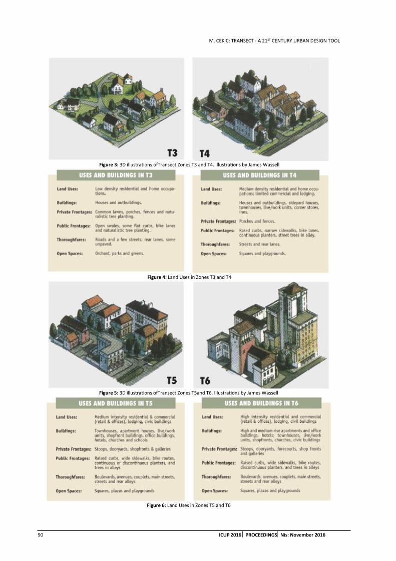
M. CEKIC: TRANSECT - A 21ST CENTURY URBAN DESIGN TOOL
90 ICUP 2016 PROCEEDINGSNis: November 2016
Figure 3: 3D illustrations ofTransect Zones T3 and T4. Illustrations by James Wassell
Figure 4: Land Uses in Zones T3 and T4
Figure 5: 3D illustrations ofTransect Zones T5and T6. Illustrations by James Wassell
Figure 6: Land Uses in Zones T5 and T6
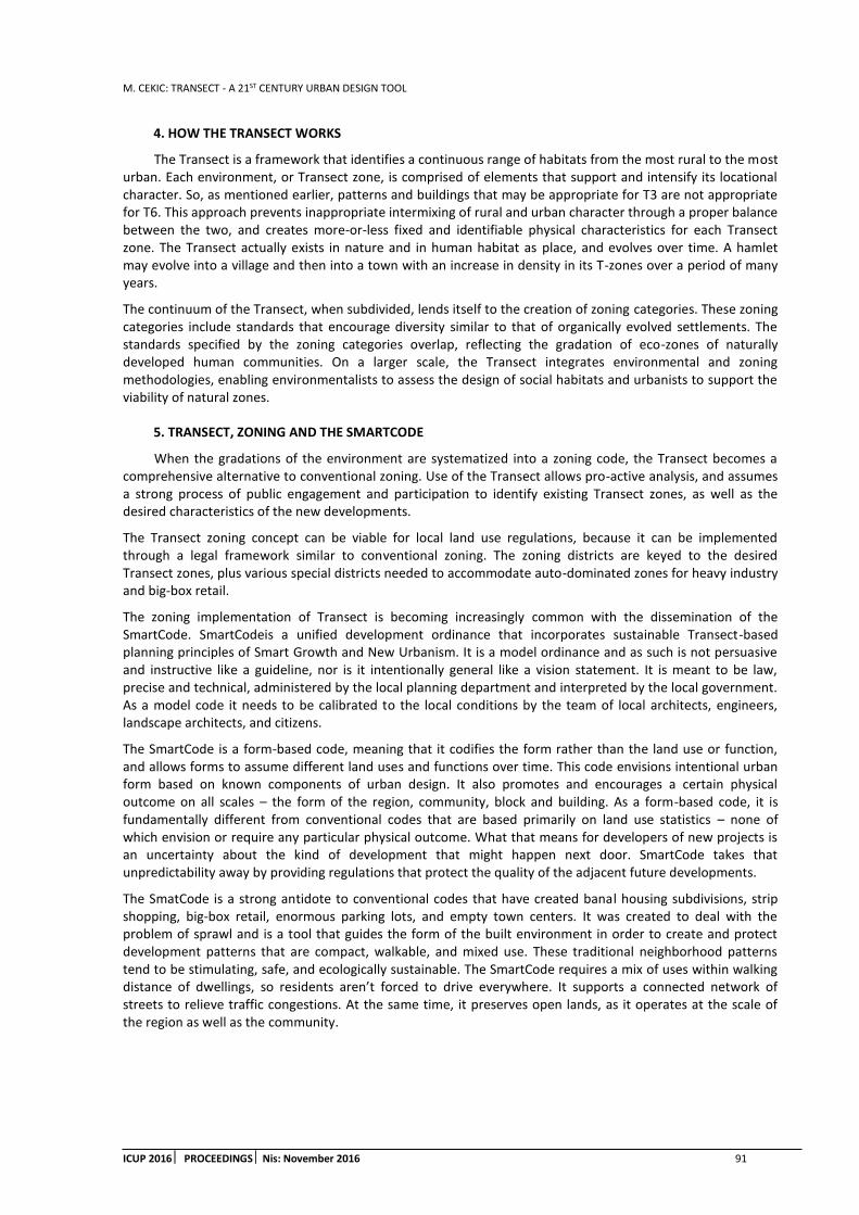
M. CEKIC: TRANSECT - A 21ST CENTURY URBAN DESIGN TOOL
ICUP 2016 PROCEEDINGS Nis: November 2016 91
4. HOW THE TRANSECT WORKS
The Transect is a framework that identifies a continuous range of habitats from the most rural to the most urban. Each environment, or Transect zone, is comprised of elements that support and intensify its locational character. So, as mentioned earlier, patterns and buildings that may be appropriate for T3 are not appropriate for T6. This approach prevents inappropriate intermixing of rural and urban character through a proper balance between the two, and creates more-or-less fixed and identifiable physical characteristics for each Transect zone. The Transect actually exists in nature and in human habitat as place, and evolves over time. A hamlet may evolve into a village and then into a town with an increase in density in its T-zones over a period of many years.
The continuum of the Transect, when subdivided, lends itself to the creation of zoning categories. These zoning categories include standards that encourage diversity similar to that of organically evolved settlements. The standards specified by the zoning categories overlap, reflecting the gradation of eco-zones of naturally developed human communities. On a larger scale, the Transect integrates environmental and zoning methodologies, enabling environmentalists to assess the design of social habitats and urbanists to support the viability of natural zones.
5. TRANSECT, ZONING AND THE SMARTCODE
When the gradations of the environment are systematized into a zoning code, the Transect becomes a comprehensive alternative to conventional zoning. Use of the Transect allows pro-active analysis, and assumes a strong process of public engagement and participation to identify existing Transect zones, as well as the desired characteristics of the new developments.
The Transect zoning concept can be viable for local land use regulations, because it can be implemented through a legal framework similar to conventional zoning. The zoning districts are keyed to the desired Transect zones, plus various special districts needed to accommodate auto-dominated zones for heavy industry and big-box retail.
The zoning implementation of Transect is becoming increasingly common with the dissemination of the SmartCode. SmartCodeis a unified development ordinance that incorporates sustainable Transect-based planning principles of Smart Growth and New Urbanism. It is a model ordinance and as such is not persuasive and instructive like a guideline, nor is it intentionally general like a vision statement. It is meant to be law, precise and technical, administered by the local planning department and interpreted by the local government. As a model code it needs to be calibrated to the local conditions by the team of local architects, engineers, landscape architects, and citizens.
The SmartCode is a form-based code, meaning that it codifies the form rather than the land use or function, and allows forms to assume different land uses and functions over time. This code envisions intentional urban form based on known components of urban design. It also promotes and encourages a certain physical outcome on all scales – the form of the region, community, block and building. As a form-based code, it is fundamentally different from conventional codes that are based primarily on land use statistics – none of which envision or require any particular physical outcome. What that means for developers of new projects is an uncertainty about the kind of development that might happen next door. SmartCode takes that unpredictability away by providing regulations that protect the quality of the adjacent future developments.
The SmatCode is a strong antidote to conventional codes that have created banal housing subdivisions, strip shopping, big-box retail, enormous parking lots, and empty town centers. It was created to deal with the problem of sprawl and is a tool that guides the form of the built environment in order to create and protect development patterns that are compact, walkable, and mixed use. These traditional neighborhood patterns tend to be stimulating, safe, and ecologically sustainable. The SmartCode requires a mix of uses within walking distance of dwellings, so residents aren’t forced to drive everywhere. It supports a connected network of streets to relieve traffic congestions. At the same time, it preserves open lands, as it operates at the scale of the region as well as the community.
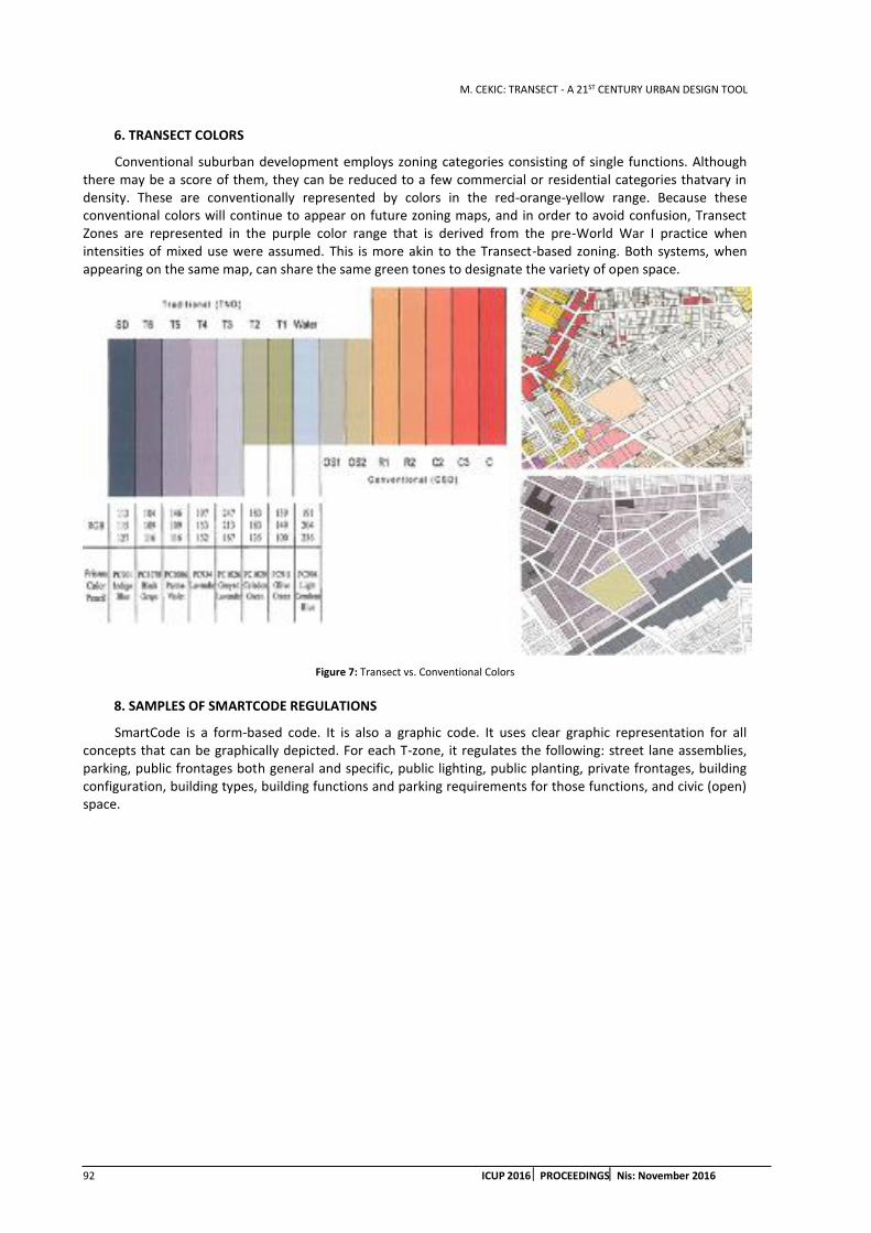
M. CEKIC: TRANSECT - A 21ST CENTURY URBAN DESIGN TOOL
92 ICUP 2016 PROCEEDINGSNis: November 2016
6. TRANSECT COLORS
Conventional suburban development employs zoning categories consisting of single functions. Although there may be a score of them, they can be reduced to a few commercial or residential categories thatvary in density. These are conventionally represented by colors in the red-orange-yellow range. Because these conventional colors will continue to appear on future zoning maps, and in order to avoid confusion, Transect Zones are represented in the purple color range that is derived from the pre-World War I practice when intensities of mixed use were assumed. This is more akin to the Transect-based zoning. Both systems, when appearing on the same map, can share the same green tones to designate the variety of open space.
Figure 7: Transect vs. Conventional Colors
8. SAMPLES OF SMARTCODE REGULATIONS
SmartCode is a form-based code. It is also a graphic code. It uses clear graphic representation for all concepts that can be graphically depicted. For each T-zone, it regulates the following: street lane assemblies, parking, public frontages both general and specific, public lighting, public planting, private frontages, building configuration, building types, building functions and parking requirements for those functions, and civic (open) space.

M. CEKIC: TRANSECT - A 21ST CENTURY URBAN DESIGN TOOL
ICUP 2016 PROCEEDINGS Nis: November 2016 93
Figure 8: Sample Regulations From Smart Code Pages
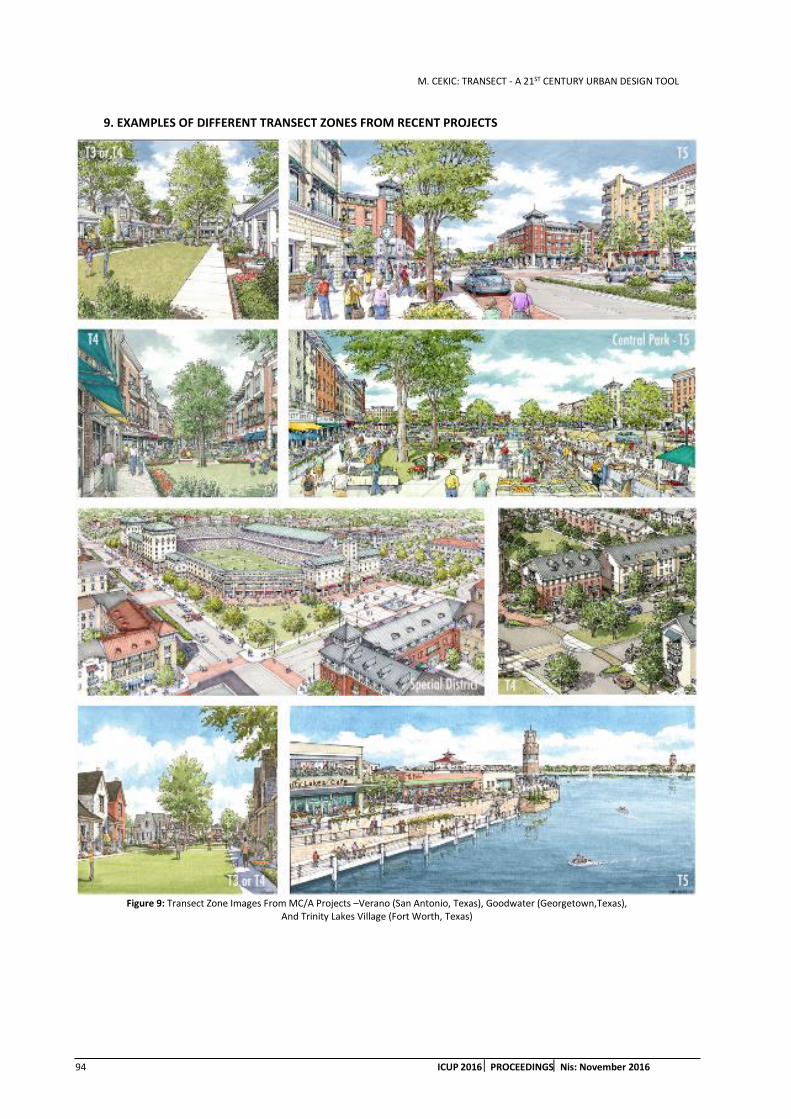
M. CEKIC: TRANSECT - A 21ST CENTURY URBAN DESIGN TOOL
94 ICUP 2016 PROCEEDINGSNis: November 2016
9. EXAMPLES OF DIFFERENT TRANSECT ZONES FROM RECENT PROJECTS
Figure 9: Transect Zone Images From MC/A Projects –Verano (San Antonio, Texas), Goodwater (Georgetown,Texas),
And Trinity Lakes Village (Fort Worth, Texas)

M. CEKIC: TRANSECT - A 21ST CENTURY URBAN DESIGN TOOL
ICUP 2016 PROCEEDINGS Nis: November 2016 95
10. CONCLUSION
The most loved towns in North America were either carefully planned, or they evolved as compact, mixed use places because of their geography and the limits of the transportation and economics of their time. However, over the past sixty plus years, places have evolved in a completely different pattern. They have spread loosely along the highways and haphazardly across the countryside, enabled by the widespread ownership of automobiles, by cheap petroleum and cheap land, and by zoning codes that separate dwellings from workplaces, shops and schools. These codes’ primary standards favour automobile over the pedestrian and have created some of the most desolate and depressing housing developments in history. They have made walking and cycling dangerous and unpleasant and have made children, the elderly and the poor utterly dependent on those who can drive. They have caused the simultaneous destruction of both town and open space – the 2oth century phenomenon called sprawl.
Transect and the SmartCode are a comprehensive alternative to suburban approach to planning and the 21st century tool of correction for our built environment. Based on the principles extrapolated from the most loved historic neighbourhoods and towns that still exist in North America, they promote a certain physical outcome, eliminate adjacency unpredictability, and through the system of gradation of natural and human environments from rural to urban attempt to restore the mix of uses, the pedestrian scale, and the formal richness and diversity of the best places to live.
REFERENCES
1. Thadani, D., 2010. The Language of Towns and Cities, A visual Dictionary, Rizzoli, New York, London, Paris.
2. Tachieva, G., 2010. Sprawl Repair Manual, Island Press, Washington, USA.
3. Duany, A., Sorlein, S., Wright, W., 2009. SmartCode and Manual, New Urban News.
4. Dunham-Jones, E., Williamson, J., 2009. Retrofitting Suburbia, John Wiley and Sons, Hoboken New Jersey.

M. CEKIC: TRANSECT - A 21ST CENTURY URBAN DESIGN TOOL
96 ICUP 2016 PROCEEDINGSNis: November 2016
B. ANTONIC ET AL.: ORGANISATION OF MUNICIPALITIES IN SERBIA - PROS AND CONS FROM THE PERSPECTIVE OF URBAN AND SPATIAL PLANNING
ICUP 2016 PROCEEDINGS Nis: November 2016 97
ORGANISATION OF MUNICIPALITIES IN SERBIA – PROS AND CONS FROM THE PERSPECTIVE OF URBAN AND SPATIAL PLANNING
Branislav Antonic
University of Belgrade – Faculty of Architecture, Serbia PhD student and Researcher-assistant, [email protected]
Eva Vanista Lazarevic
University of Belgrade – Faculty of Architecture, Serbia PhD, Full Professor, [email protected]
ABSTRACT
The fields of urban and spatial planning have been significantly changed in Serbia during last 25 years of post-socialist era. These fields have witnessed great changes in legislative framework, socio-economic structure, and implementation connected with everyday practice. The main intention of these changes has been the customization of the entire system of territorial planning to new post-socialist reality. However, municipalities as well as the other levels of the territorial organisation of Serbia have stayed almost intact by their number and size for decades, despite the shift of demographic and economic conditions. But, Serbian municipalities have been particularly important for territorial planning, because they have been the only active level of self-government below national one. This position has given them more active role in territorial planning.
Understanding that both urban and spatial planning is strongly connected with territorial organisation, it is questionable how these two sectors have functioned during the last 25 years within the unchangeable shape of municipalities. The purpose of this paper is to explore this issue. The first step, organized as an argumentative essay, will be dedicated to the advantages and disadvantages of the current and prospective organisation of municipalities in Serbia. Then, presented discussion will be an overview from the stance of adequate levels of territorial planning. It is expected to find is current territorial organization of Serbian municipalities suitable for contemporary urban and spatial planning and, if not, which are the ways of its improvement.
Keywords: municipalities; Serbia; urban planning; spatial planning; post-socialist period.
1. INTRODUCTION
The enactment of new Law on territorial organisation of the Republic of Serbia in 2007 has reopened the many discussions about this issue among both experts and public last years. They include the questions of the regionalisation, decentralisation, competence of municipalities and cities, etc.
One of the reasons for the new law was certainly general tendency for the innovation and customization of Serbian legislative system to the system of the European Union (EU). But, there is no evident ‘pattern’ for territorial organisation among EU countries. Actually, every EU country has its own approach to territorial organization, depending on its history, size, demographics, governance tradition, etc. (Baldersheim, 2009). In the other hand, there is a unique system for the European Union – Nomenclature of Units for Territorial Statistics, better known as NUTS1. But, this is a Geocode standard used mainly for country division for statistical
1 Serbia enacted a special decree about the Nomenclature of Units for Territorial Statistics at national level, further customized with EU legislation (PS, 2009-10).

B. ANTONIC ET AL.: ORGANISATION OF MUNICIPALITIES IN SERBIA - PROS AND CONS FROM THE PERSPECTIVE OF URBAN AND SPATIAL PLANNING
98 ICUP 2016 PROCEEDINGSNis: November 2016
purposes, i.e. without other competences. A. Faludi described the existence of both systems as a ‘European model’, which clearly presented European official motto ‘Unity in diversity’ (Faludi, 2005).
However, more important element of the entire process in probably to develop democracy in Serbia with the improvement of all elements of territorial organization, where ‘[K]ey principle is that all decisions will be enacted at the level more close to citizens’ (RTS, 2010). But, implementation of this principle has not been simple. As in cases with other important questions in Serbia, polarisation between supporters and opponents was observable during the enactment of the Law on regional development and accompanying acts in 2009 and 2010 (Martinovic, 2010). Furthermore, different views how regions should be formed and how they will function in reality was also evident (Bakovic, 2009; DJordjevic et al, 2009). This clarifies that all issues regarding territorial organisation are complex and interconnected and they need thereby thoughtful overview and action.
From the position of urban and spatial planning, the possible reorganisation of municipalities in Serbia is a significant issue. The change of their size and number as well as the new relation between included settlements can trigger some of the fundaments of territorial planning in the country. Moreover, municipal level is also important because it is an ‘elementary territorial unit of local self-government’ (DJordjevic et al, 2009, p. 12). In Serbia, it is the only active governance level under national one (Vasiljevic, 2009); regions are just the units for statistical purposes and administrative districts have a very limited competence and independence, being typical examples of the de-concentration of national government (Milosavljevic, 2009, pp. 13-15). Finally, there have been a lot of local initiatives across the country to form new, smaller municipalities last years. Therefore, this is an issue for contemporary urban and spatial planning in Serbia.
2. MUNICIPALITIES IN SERBIA – GENERAL CHARACTERISTICS AND TENDENCIES
First, traditional Serbian term Општина (eng. Municipality) was officially changed into Јединица локалне самоуправе (eng. Unit of local self-government)2 1990. In everyday life, both terms were almost synonyms in the next 15 years. Since 2005, demographically and economically major municipalities have been ‘renamed’ as cities. As a result, there are 24 ULSs in Serbia with the status of city today. They have a bit wider competences than other ULSs or ‘normal’ municipalities (MNGLS, 2007-16). The administrative name City is considered as confusing one; traditional Serbian meaning City is an urban settlement. New meaning was strictly administrative, but it usually does not cover one (urban) settlement, but several of them at least. Usual situation is the main urban settlement with many other ones (suburban or rural) in vicinity. This is also a problem for documents in urban and spatial planning, where the term City can be found in both meaning.
The main facts about ULSs (municipalities and cities) in Serbia from the last national census in 2011 are (RORS, 2012)3:
Number: Serbia has 145 ULSs with 49,565 inhabitants on average.
Population: The majority of ULSs has 10-50 thousands inhabitants (103/71%). 13 ULSs (9%) can be considered as big ones, i.e. with more than 100,000 inhabitants. There are only 9 municipalities (6%) with less than 10,000 inhabitants, but their number is increasing – there were 6 of them by the previous census in 2002.
Area: Average size of the area of Serbian ULS is 534 km2. There are 11 extraordinary spacious ULSs in Serbia, which area is more than 1,000 km2. The spatially biggest is the City of Kraljevo with 1,529 km2, which is almost three times more than national average.
Settlements4: Using the data of 4,706 settlements in the country (RASP, 2010, p. 138), typical Serbian ULS includes 32.45 settlements. However, the number of officially existed settlements (MNGLS, 2007-16) per a ULS is very variable. It is just one settlement in the case of the municipality of Sremski Karlovci. The Municipality of Lapovo has two settlements. In contrast, City of Leskovac occupies 144 settlements. Generally, there is a huge difference of the number of settlements per a ULS between the northern Serbian province of Vojvodina and the rest of Serbia, which the consequence of different historical conditions. For example, the ULS in Vojvodina with the biggest number of
2 Hereinafter for Serbian case: ULS
3 Data for Serbia without Kosovo
4 Here, Belgrade is a specific case, due to its size and the long history of urban municipalities with al lot of settlements. Therefore, it is not counted by this issue.
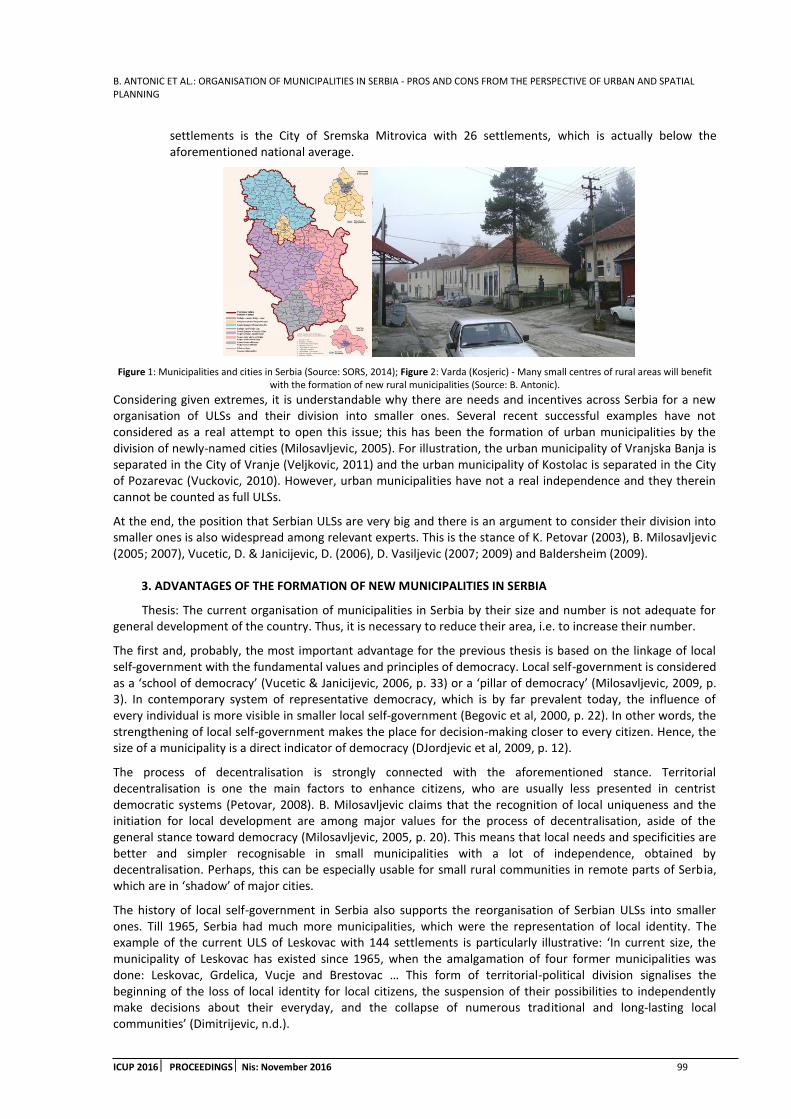
B. ANTONIC ET AL.: ORGANISATION OF MUNICIPALITIES IN SERBIA - PROS AND CONS FROM THE PERSPECTIVE OF URBAN AND SPATIAL PLANNING
ICUP 2016 PROCEEDINGS Nis: November 2016 99
settlements is the City of Sremska Mitrovica with 26 settlements, which is actually below the aforementioned national average.
Figure 1: Municipalities and cities in Serbia (Source: SORS, 2014); Figure 2: Varda (Kosjeric) - Many small centres of rural areas will benefit with the formation of new rural municipalities (Source: B. Antonic).
Considering given extremes, it is understandable why there are needs and incentives across Serbia for a new organisation of ULSs and their division into smaller ones. Several recent successful examples have not considered as a real attempt to open this issue; this has been the formation of urban municipalities by the division of newly-named cities (Milosavljevic, 2005). For illustration, the urban municipality of Vranjska Banja is separated in the City of Vranje (Veljkovic, 2011) and the urban municipality of Kostolac is separated in the City of Pozarevac (Vuckovic, 2010). However, urban municipalities have not a real independence and they therein cannot be counted as full ULSs.
At the end, the position that Serbian ULSs are very big and there is an argument to consider their division into smaller ones is also widespread among relevant experts. This is the stance of K. Petovar (2003), B. Milosavljevic (2005; 2007), Vucetic, D. & Janicijevic, D. (2006), D. Vasiljevic (2007; 2009) and Baldersheim (2009).
3. ADVANTAGES OF THE FORMATION OF NEW MUNICIPALITIES IN SERBIA
Thesis: The current organisation of municipalities in Serbia by their size and number is not adequate for general development of the country. Thus, it is necessary to reduce their area, i.e. to increase their number.
The first and, probably, the most important advantage for the previous thesis is based on the linkage of local self-government with the fundamental values and principles of democracy. Local self-government is considered as a ‘school of democracy’ (Vucetic & Janicijevic, 2006, p. 33) or a ‘pillar of democracy’ (Milosavljevic, 2009, p. 3). In contemporary system of representative democracy, which is by far prevalent today, the influence of every individual is more visible in smaller local self-government (Begovic et al, 2000, p. 22). In other words, the strengthening of local self-government makes the place for decision-making closer to every citizen. Hence, the size of a municipality is a direct indicator of democracy (DJordjevic et al, 2009, p. 12).
The process of decentralisation is strongly connected with the aforementioned stance. Territorial decentralisation is one the main factors to enhance citizens, who are usually less presented in centrist democratic systems (Petovar, 2008). B. Milosavljevic claims that the recognition of local uniqueness and the initiation for local development are among major values for the process of decentralisation, aside of the general stance toward democracy (Milosavljevic, 2005, p. 20). This means that local needs and specificities are better and simpler recognisable in small municipalities with a lot of independence, obtained by decentralisation. Perhaps, this can be especially usable for small rural communities in remote parts of Serbia, which are in ‘shadow’ of major cities.
The history of local self-government in Serbia also supports the reorganisation of Serbian ULSs into smaller ones. Till 1965, Serbia had much more municipalities, which were the representation of local identity. The example of the current ULS of Leskovac with 144 settlements is particularly illustrative: ‘In current size, the municipality of Leskovac has existed since 1965, when the amalgamation of four former municipalities was done: Leskovac, Grdelica, Vucje and Brestovac … This form of territorial-political division signalises the beginning of the loss of local identity for local citizens, the suspension of their possibilities to independently make decisions about their everyday, and the collapse of numerous traditional and long-lasting local communities’ (Dimitrijevic, n.d.).

B. ANTONIC ET AL.: ORGANISATION OF MUNICIPALITIES IN SERBIA - PROS AND CONS FROM THE PERSPECTIVE OF URBAN AND SPATIAL PLANNING
100 ICUP 2016 PROCEEDINGSNis: November 2016
Parallel with the reduction of the number of municipalities, new conditions for the decentralisation of governance and development in newly-formed bigger municipalities have not been achieved. In contrast, the gap between municipal seats and other settlements in new municipalities have deepened. K. Petovar names this phenomenon as ‘municipal centrism’ (Petovar, 2003, p. 26). A good example is the municipality of Kursumlija, which is one of the most spacious and the most underdeveloped ULSs in Serbia at the same time. In the period 1961-1991, the town of Kursumlija, as a municipal seat, had witnessed the rise of population for 4 times; in contrary, other, rural settlements lost more than 50% of their population during the same period5. This is clear evidence that this process of amalgamation in the 1960s has produced many negative problems in territorial development.
European experience also supports the idea of small and numerous units of local self-government. The ULSs in Serbia are among the biggest ones in Europe and there are examples where average ULS is ten times smaller by population than in Serbia (Baldersheim, 2009). Only Denmark and Lithuania have bigger municipalities by area than Serbia (Baldersheim, 2009). But, this territorial division is a novelty in both countries. Therefore, it is hard to talk about the advantages and disadvantages of these ‘territorial projects’. Supervening to the issue of the age of current territorial organisations, the territorial reorganisation of municipalities is always an actual and never unfinished process, characteristic for democratic societies (Milosavljevic, 2009, pp. 16-17). This ‘approach’ is quite different in Serbia, where major changes in this issue have not been made since the 1960s (Zlokapa, 2007, p. 232).
Similarly to Europe, small and numerous ULSs exist at regional level. The most of ex-Yugoslavian countries have formed such municipalities after their independence. Except Bosnia and Herzegovina6, all other countries have implemented new organisation by national consensus. The new number of ULSs in following:
Table 1: New ULSs in some neighbour countries
Country Number
ofbULSs
Number of ULSs
2007/1991
Source
Croatia 556 5 Kopajtih - Skrlec, 2007, pp. 55-56
Macedonia / FYROM 84 2.5 Angelov, 2007, pp. 140-141
Slovenia 212 3 Plostajner, 2007, pp. 11-15
The example of Slovenia is a very interesting case due to the gradual process of the formation of new municipalities, with cooperation with EU institutions. Slovenia has got several new municipalities in the last years (Plostajner, 2007, pp. 11-15). However, some voices say that this is just the begging of decentralisation in the country. Thus, there are still many misunderstandings, such about problems in small municipalities regarding human resources. All these information present the complexity of this issue, but also clarify that the formation of new/small ULSs is a part of the development of democracy.
Then, demographic parameters of Serbian ULSs have changes sharply in the last half of century. Typical example is the Municipality of Crna Trava with 1,500 inhabitants. This very small municipality with expected further population decline is not ready for the basic elements of decentralisation. To conclude – the tiny municipalities (<3,000 inh.) hardly can cope with current administrative duties and competences. They are thereby obvious indicator that new territorial organisation in Serbia is almost required.
The reason for the new division of ULSs in Serbia can be found also in the characteristic of their ‘monotypism’. A monotypic municipality in Serbia always implies an ‘urban centre and rural surrounding’ (DJordjevic et al, 2009, p. 31). This is not a historical perspective. For example, the first law regarding this issue in modern Serbia, the law on the organisation of municipalities from 1839, differentiated rural and urban municipalities (Milosavljevic, 2009, p. 23). D. Vasiljevic noticed that the difference between cities and ‘named’ municipalities was only in their name before the last law from 2007 (Vasiljevic, 2007, p. 185). Thus, it is questionable is a ‘simple’ division in two or more parts with similar areas is adequate. Mentioning again the problem with rooted ‘municipal centrism’, this question is even more emphasised. The other approach, based on the division of bigger Serbian ULSs into urban and rural municipalities with totally different characteristics, is maybe more
5 Data from the Strategy of Sustainable Development of the Municipality of Kursumlija 2010-2020.
6 In Bosnia and Herzegovina, new ULSs were formed by 'Dayton demarcation'.

B. ANTONIC ET AL.: ORGANISATION OF MUNICIPALITIES IN SERBIA - PROS AND CONS FROM THE PERSPECTIVE OF URBAN AND SPATIAL PLANNING
ICUP 2016 PROCEEDINGS Nis: November 2016 101
appropriate. European tradition recognised this approach in many cases. Some of them are among newest ones, such as ULSs in Latvia7.
4. DISADVANTAGES OF THE FORMATION OF NEW MUNICIPALITIES IN SERBIA
Antithesis: The current organisation of municipalities in Serbia by their size and number is adequate for general development of the country. Thus, changes of their size and number are not necessary.
Probably the strongest argument for this statement is current tendencies in Europe, where the process of the merging of municipalities is ongoing (Milosavljevic 2005; Baldersheim, 2009; DJordjevic et al, 2009). The merging is done in several ways. The most often of them is a simple amalgamation, but there are various strategies for this process, from high-rank decisions to locally-organised referendums (Baldersheim, 2009, pp. 4-6). Moreover, there are many reasons for this process. The most usual reason for the merging is the strengthening of local capacities (DJordjevic et al, 2009), which consequently enables wider competences of newly-formed bigger municipalities (Milosavljevic 2005, p. 37). As a final result, municipalities become more independent. Theoretically speaking, the strengthening of independence is related to the development of democracy. Nevertheless, the other element of democracy – accessibility of local self-government to citizens - is certainly threatened by this process (Baldersheim, 2009, p. 4).
In the case of Serbia, the obstacles for new and smaller municipalities can be also found in the territorial organisation of the country with one-level local self-government8. Small municipalities have very limited capacities in complex and experts-led competences and doings, which make them dependent to upper levels (district, regional, and national). This has been noticed in Slovenia, where the financial, professional and organising support from state level is inevitable for small municipalities (Plostajner, 2007, pp. 40-43). The other option is cooperation among municipalities (Petovar, 2008). The municipalities in France and Czech Republic are a role-model for this option – bigger (urban) municipalities do some competences for smaller ones in vicinity (Baldersheim, 2009, p. 6).
Some authors accent that there are other modes of territorial decentralisation at the level of municipalities instead of their reducing. The examples are wards as a territorial-administrative level below municipal one in Anglo-Saxon countries. They roughly correspond to the term mesna zajednica (eng. the office of local community) in the former Yugoslavia (DJordjevic et al, 2009, p. 12). However, D. Vucetic and D. Janicijevic (2006) concluded that the importance of offices of local community was very restricted, because they were strongly dependent to upper levels. They have not had the character of territorial units for decades (Milosavljevic, 2009, pp. 103-104). Accordingly, it is very doubtful can this option with completely underdeveloped basement be used for future decentralisation.
‘Bureaucratic obstacles’ are also a potential disturbance for the formation and functioning of smaller municipalities. The formation of smaller municipalities is usually considered as a process of decentralisation, but their small size and big number can be negatively reflected on the efficiency of local governance, which is in the essence of decentralisation. The problem with the increase of the number of employees in municipal institutions and bodies is one of the most noticeable problems (Vucetic and Janicijevic, 2006, pp. 19-20). Disproportionally huge municipal bureaucracy in such municipalities can be a big obstacle for local finances. Neighbouring Croatia with more than 500 independent cities and municipalities is a very illustrative example for this, because approximately one third of them cannot independently cover their own expenses, let alone to do other duties from their competences (Bajrusi, 2009). This is also evident in smallest of existing municipalities in Serbia, which have disproportionally high number of employees in local administration (Baldersheim, 2009). Moreover, smaller municipalities do not mean the decrease of corruption; corruption can be just transferred to local level (DJordjevic et al, 2009, p. 11). There are also other minor problems, but there similarly more refer to the organisation and character of local administration than strictly to the process of the formation of smaller municipalities.
7 Latvia introduced new territorial organisation 2009, recognising urban, rural, and ‘classic’ municipalities. The first ones occupy only the physically-built areas of major cities; rural municipalities include dependent villages around them; the third municipalities are ‘classic’, because they consist of one town-seat and villages in surrounding.
8 As it was previously mentioned, the role of districts and regions is very limited in present-day Serbia.

B. ANTONIC ET AL.: ORGANISATION OF MUNICIPALITIES IN SERBIA - PROS AND CONS FROM THE PERSPECTIVE OF URBAN AND SPATIAL PLANNING
102 ICUP 2016 PROCEEDINGSNis: November 2016
5. INSTEAD OF ‘CLASSIC’ CONCLUSION –PROSPECTIVE UNITS OF LOCAL SELF-GOVERNMENT AND TERRITORIAL PLANNING
The previous explanation of the advantages and disadvantages regarding the possible formation of smaller ULSs clearly demonstrates that this process is not alone – it is just one segment of wider and constant aspirations to improve territorial governance. The position of urban and spatial planning is very challenging in relation to this issue. Here, the most interesting element is to determine the challenges for the creation and the implementation of the spatial plans of the units of local self-government and general urban plans, mainly dedicated for their seats, which are usually the only urban settlements there.
In the case of the spatial plans of the unit of local self-government, smaller municipalities will enable the creation of simpler plans due to smaller area and the lower number of included settlements. Knowing that the current law to planning and construction prescribes special schemes or base-plans for all settlements uncovered by more detailed plans (MCTI, 2009-14), new plans will be certainly simplified by fewer settlements. Then, smaller municipalities with smaller areas for consideration mean better focus to major territorial potentials and obstacles and easier contact with local people and their representatives. Finally, spatial planning had to be ready to adapt spatial plans for smaller municipalities. Nowadays, this is not an issue – spatial plan for the aforementioned Crna Trava with 1,500 inhabitants in municipality is the same by structure as spatial plans for much bigger and well-developed UCSs. It is questionable is this ‘universal’ approach is compatible for every ULS.
General urban plans have different questions regarding this topic. The borders of general urban plans are mostly defined by real needs at local/urban level instead of official administrative lines. Therefore, general urban plans can be good role-models for the ‘framing’ of area for new urban municipalities in Serbia. In this way, administrative borders can concur with real-life conditions, i.e. with real built-up and functionally organised settlement areas. This option will reduce problems with ‘spatial gaps’ between urban and rural areas, which have had the most triggering planning history in Serbia (illegal suburbia, unfinished urban periphery, etc.). Furthermore, new municipal seats will contribute with more general urban plans. This situation will enable broader urban planning at national level and consequently will support socio-economic perspectives of these settlements, which are usually in decline today.
The major problem for both spatial and urban plans will be the implementation of new plans. The municipalities should organise relevant services and bodies for ‘territorial affairs’. They should be smaller by the number of staff, but with the same competence. This is a challenging issue in Serbia, where this problem is even evident in many cases today. Furthermore, transitive period for the creation of new plans or the harmonization of existing plans is also inevitable.
Therefore, possible process of territorial decentralisation with the establishment of new and smaller municipalities will face several complex and interconnected challenges for territorial planning as well as for other segments of territorial development and governance. However, there is no reason to halt this process, because it is a quite normal element of the functioning of every country. The knowledge and experience from urban and spatial planning can be very useful for this process due to their connection and respect of local specificities and real-life conditions and borders. Finally, both territorial planning and territorial organisation are not a final solution, but tools which should initiate and endorse overall development of a territory. Therefore, the most important issue is to organise both segments properly and to insist on gradual implementation of all its elements.
ACKNOWLEDGEMENTS
This paper is done as a part of two national research projects of the Republic of Serbia: ‘Research and systematization of housing development in Serbia, in the context of globalization and European integrations, with the aim of housing quality and standard improvement’ (TR 36034) and ‘Spatial, environmental, energy and social aspects of developing settlements and climate change – mutual impacts’ (TP 36035).
REFERENCES
1. Angelov, G., 2007. Трећи талас реформе локалне самоуправе: Локална самоуправа у Македонији (The third wave of the reform of local self-government: Local self-government in Macedonia) in Модели организације локалне самоуправе: Словенија, Хрватска, Босна и Херцеговина, Македонија и Србија (Models of Organisation of Local Self-Government: Slovenia,
B. ANTONIC ET AL.: ORGANISATION OF MUNICIPALITIES IN SERBIA - PROS AND CONS FROM THE PERSPECTIVE OF URBAN AND SPATIAL PLANNING
ICUP 2016 PROCEEDINGS Nis: November 2016 103
Croatia, Bosnia and Herzegovina, Macedonia and Serbia) (Eds. Z. Zlokapa and D. Damjanovic). Palgo centar: Belgrade. pp. 130-181.
2. Bajrusi R., 2009. Jedino rjesenje: hitno ukinuti 35 gradova i 150 opcina (The only solution: Urgently abolish 35 cities and 150 municipalities). Nacional, 18st August. http://arhiva.nacional.hr/clanak/ 65052/hitno-ukinuti-35-gradova-i-150-opcina [Accessed: 29th August 2016].
3. Bakovic, B., 2009. Децентрализација ломи партијски монопол (Decentralisation breaks party monopoly), Politika, 20st August. http://www.politika.rs/scc/clanak/100523/Децентрализација- ломи-партијски-монопол [Accessed: 26th August 2016].
4. Baldersheim, H., 2009. Децентализација у пракси - европски модели и пракса (Decentralisation in practice – European models and practice). Ministry for National Government and Local Self- Government – MNGLS, Belgrade.
5. Begovic, B., Vacic, Z., Mijatovic, B., Simic, A., 2000. Upravljanje Lokalnom Zajednicom - putevi ka modernoj lokalnoj samoupravi (Governance of local community – Ways toward moden local self- government). Centar za liberalno-demokratske studije - CLDS, Belgrade.
6. Veljkovic, 2011. Врањска Бања постала општина (Vranjska Banja has become a municipality). Vecernje Novosti. 10st January. http://www.novosti.rs/Врањска-Бања-постала-општина [Accessed: 26th August 2016].
7. Vucetic, D., Janicijevic, D., 2006. Децентрализација као полазиште даљег развоја Србије: приручник (Decentralisation as a Starting-Point for the Further Development of Serbia: Guidance). Protekta, Nis.
8. Vuckovic, V., 2010. Костолац после пола века опет постао општина (After half of century, Kostolac has become a municipality again). Press-online, 30st January. http://www.pressonline.rs/svet/ balkan/98598/kostolac-posle-pola-veka-opet-postao-opstina.html [Accessed: 26th August 2016].
9. Dimitrijevic, M., n.d. Лесковац (Leksovac). http://phs.etf.rs/Dokumenti/Gradovi/Leskovac.pdf [Accessed: 28th August 2016].
10. DJordjevic, S., Stojanovic, S., Vesic Antic, A., 2009. Pokrenimo zajednice!: prirucnik za javno zastupanje u procesu decentralizacije: Balkanski fond za lokalne inicijative – BCIF, Belgrade.
11. Faludi, A., 2007. Territorial Cohesion Policy and the European Model of Society. European Planning Studies, 15(4). pp. 567-583.
12. Kopajtih - Skrlec, N., 2007. Од једностепене до вишестепене локалне самоуправе - Локална самоуправа у Хрватској (From one-level to multi-level local self-government – Local self- government in Croatia). In Модели организације локалне самоуправе: Словенија, Хрватска, Босна и Херцеговина, Македонија и Србија (Models of Organisation of Local Self-Government: Slovenia, Croatia, Bosnia and Herzegovina, Macedonia and Serbia) (Eds. Z. Zlokapa and D. Damjanovic). Palgo centar: Belgrade. pp. 50-91.
13. Martinovic, S., 2010. Децентрализација (Decentralisation). Blic, 17. March. http://www.blic.rs/vesti/ tema-dana/decentralizacija/bf42fmb [Accessed: 26th August 2016].
14. Milosavljevic, B., 2005. Систем локалне самоуправе у Србији (System of Local Self-government in Serbia). SKGO: Belgrade.
15. Milosavljevic, B., 2009. Систем локалне самоуправе у Србији – унапређено издање (System of Local Self-government in Serbia – Improved edition). SKGO, Belgrade.
16. Ministry of construction, transport and infrastructure– MCTI, 2009-14. Закон о планирању и изградњи (Law on Planning and Construction). Official Gazette No 72/09, 81/09, 64/10, 24/11, 121/12, 42/13, 50/13, 98/13, 132/14 & 145/14, Belgrade. Retrieved from: http://www.ingkomora. org.rs/zakoni/zakon_o_planiranju_i_izgradnji2014.pdf.
17. Ministry for National Government and Local Self-Government – MNGLS, 2007-16. Закон о територијалној организацији Републике Србије (Law on Territorial Organisation of the Republic of Serbia). Official Gazette No 129/07 & 18/16, Belgrade. Retrieved from: http://www.paragraf.rs/ propisi/zakon_o_teritorijalnoj_organizaciji_republike_srbije.html.

B. ANTONIC ET AL.: ORGANISATION OF MUNICIPALITIES IN SERBIA - PROS AND CONS FROM THE PERSPECTIVE OF URBAN AND SPATIAL PLANNING
104 ICUP 2016 PROCEEDINGSNis: November 2016
18. Parliament of Serbia – PS, 2009-10. Уредба о номенклатури статистичких територијалних јединица (Decree on Nomenclature of Units for Territorial Statistics). Official Gazette No 109/09 & 46/10, Belgrade. Retrieved from: http://rra-jug.rs/v2/wp-content/plugins/downloads- manager/upload/Uredba-o-nomenklaturi-statistickih-teritorijalnih-jedinica.pdf.
19. Petovar, K., 2003. Наши градови између државе и грађанина: урбана социологија (Our cities between state and citizens: Urban sociology). Faculty of Geography, Faculty of Architecture and IAUS: Belgrade.
20. Petovar, K., 2008. Локална управа и грађани (Local self-government and citizens). http://www.arh.bg.ac.rs/upload/0809/Specijalisticke_studije/nove/Lokalna%20uprava%20i%20gradj ani.pdf [Accessed: 28st August 2016].
21. Pihler-Milanovic, N., 2010. Љубљана: стратешки развој за конкурентност и одрживост (Ljubljana: Strategic framework for competiveness and sustainability). In Стратешко планирање локалног развоја: студије случаја малих и средњих европских градова (Strategic planning of local development: Case studies of small and medium European cities) (Eds. Z. L. Ramirez and G. Kebede). UN Habitat, Belgrade, pp. 71-86.
22. Plostajner, Z., 2007. Мале општине: предности и недостаци (Little municipalities: Advantages and disadvantages). In Модели организације локалне самоуправе: Словенија, Хрватска, Босна и Херцеговина, Македонија и Србија (Models of Organisation of Local Self-Government: Slovenia, Croatia, Bosnia and Herzegovina, Macedonia and Serbia) (Eds. Z. Zlokapa and D. Damjanovic). Palgo centar: Belgrade. pp. 10-49.
23. Radio Television of Serbia - RTS, 2010. Децентрализација чува стабилност (Decentralisation keeps stability). RTS online, 29. March. http://www.rts.rs/page/stories/ci/story/1/politika/596321/ decentralizacija-cuva-stabilnost.html [Accessed: 26th August 2016].
24. Republic Agency for Spatial Planning – RASP, 2010. Закон о просторном плану Републике Србије 2010-2020 (Law on Spatial Plan of the Republic of Serbia 2010-2020). RASP, Belgrade.
25. Statistical office of the Republic of Serbia – SORS, 2014. Comparative Overview of the Number of Population in 1948, 1953, 1961, 1971, 1981, 1991, 2002 and 2011 - Data by settlements. SORS, Belgrade.
26. Vasiljevic, D., 2007. Нови законски оквир за локалну самоуправу у Србији: Локална самоуправа у Србији. (New legislative framework for local self-government in Serbia: Local self-government in Serbia). In Модели организације локалне самоуправе: Словенија, Хрватска, Босна и Херцеговина, Македонија и Србија (Models of Organisation of Local Self-Government: Slovenia, Croatia, Bosnia and Herzegovina, Macedonia and Serbia) (Eds. Z. Zlokapa and D. Damjanovic). Palgo centar: Belgrade. pp. 182-227.
27. Vasiljevic, D., 2009. Основне каратеристике система локалне самоуправе у Србији (The main characteristics of the system of local self-government in Serbia). Chapter in Водич за планирање локалног развоја (Guidance for the Planning of Local Deveopment) (Ed. V. Vranic). CESS, Novi Sad, pp. 26-38.
28. Zlokapa, Z., 2007. Компаративни преглед локалне самоуправе: Словенија, Хрватска, Босна и Херцеговина, Македонија, Србија (Comparative Overview of Local Self-Government: Slovenia, Croatia, Bosnia and Herzegovina, Macedonia and Serbia). In Модели организације локалне самоуправе: Словенија, Хрватска, Босна и Херцеговина, Македонија и Србија (Models of Organisation of Local Self-Government: Slovenia, Croatia, Bosnia and Herzegovina, Macedonia and Serbia) (Eds. Z. Zlokapa and D. Damjanovic). Palgo centar: Belgrade. pp. 229-239.

M. MARJANOVIC ET AL.: BREAKING DOWN CREATIVITY: FLORIDA’S CREATIVE CLASS ON THE EXAMPLE OF LONDON
ICUP 2016 PROCEEDINGS Nis: November 2016 105
BREAKING DOWN CREATIVITY: FLORIDA'S CREATIVE CLASS ON THE EXAMPLE OF LONDON
Marjan Marjanovic
T33 Srl, Italy MSc, Consulting and Planning Intern, [email protected]
Mario Milicevic
Institute for urbanism, civil engineering and ecology of Republika Srpska - IUGERS, Bosnia and Herzegovina MSc, GIS and Spatial Planning Associate, [email protected]
Dusan Ristic
University of Belgrade - Faculty of Geography, Serbia MSc, PhD Candidate, [email protected]
ABSTRACT
The paper discusses Richard Florida's view on economic growth and development of cities and regions through the notion of creative class and creativity. Florida recognizes a distinct group of 'creative' people (working in so-called 'creative' professions) and their increasing importance for generating growth whichis considered to be crucial today. This approach focuses on diversity and creativity of the creative class as basic drivers of innovation and both local and regional, but also national growth. It is believed that more tolerant environments are more likely to attract creative people as they can more freely exhibit their individuality and ultimately – creativity.Therefore, developing diverse and tolerant community will attract talent which will in return bring high-tech firms and create innovations in technology. The paper tests Florida’s assumptions on the example of London. It explores two aspects of the creative class theory: a) if creative people are attracted by tolerant, diverse and high life quality places, and b) if creative class attracts high-tech firms and leads to higher innovation potential. Overall, it has been found that London's high share of creative people cannot be explained solely by region's attractiveness and level of tolerance, nor strong presence of creative class can serve as a complete explanation for region's strong economic performance. There is a weak support to some correlations, but causalities cannot be found.
Keywords: creativity; creative class; Richard Florida; London; economic growth.
1. INTRODUCING CREATIVE CLASS: SOCIOLOGICAL APPROACH TO GROWTH AND DEVELOPMENT OF CITIES
Various theoretical perspectives have been used to explain territorial disparities arising between regions and cities. The perspective this paper is going to take will be based on Richard Florida's view on economic growth and development of cities and regions through the notion of creative class and creativity (Florida, 2002; 2003). The authors of this paper opted for this approach due to various reasons, the most important being it can be labelled as interesting. 'Interesting' here means that it is both new and different. Florida published his first book on the topic in 2002 and after that there has been a lot of hype surrounding it. It can be noted that creative class is still a young concept which is something that makes it appealing for researchers, but even more it is because it offers something different than usual. Most theories on regional growth and development base their rationale on production as the focal point. On the contrary, Florida brings people and their 'creativity' to growth and development (and vice versa) which can be considered as something of a renaissance (humanistic) approach where ‘man is the measure of all things’1. Furthermore, this approach also provides a
1 Famous saying of Protagoras, a Greek philosopher

M. MARJANOVIC ET AL.: BREAKING DOWN CREATIVITY: FLORIDA’S CREATIVE CLASS ON THE EXAMPLE OF LONDON
106 ICUP 2016 PROCEEDINGSNis: November 2016
new vigour for rational planning which is underlined by the rationale of 'giving the people what they really want'. As this planning model has been largely neglected in recent history, this change provided by Florida's perspective is more than welcome.
Essentially, Florida's approach attempts to explain why some places grow and some do not. If we look at his rationale from a high perspective, it could be seen in the background that society is transforming, from organizational to 'creative' society. A closer look would show that the number of 'creative' people (working in so-called 'creative' professions, which Florida (2002) defines very broadly) is increasing and their importance for generating growth has become crucial today. Florida (2002) sees these 'creative' people as members of a distinct, creative class (p. 3):
‘a fast-growing, highly educated, and well-paid segment of the workforce on whose efforts corporate profits and economic growth increasingly depend. Members of the creative class do a variety of work in wide variety of industries---from technology to entertainment, journalism to finance, high-end manufacturing to the arts. They do not consciously think of themselves as a class. Yet they share a common ethos that values creativity, individuality, difference, and merit.’
This approach focuses on diversity and creativity of the creative class as basic drivers of innovation and growth at both local and regional, but also national level (Florida, 2003). Florida argues that ‘the ability to attract creativity and to be open to diverse groups of people of different ethnic, racial and lifestyle groups provides distinct advantages to regions in generating innovations, growing and attracting high-technology industries, and spurring economic growth’ (Clifton, 2008, p. 63).This is the reason behind the unbalanced growth: some places display a higher share of 'creative' population than others. While the former are experiencing a rising development and a high growth potential, the latter are stagnating and their ‘economic and social future is troubling to contemplate’ (Florida, 2002, p. 7). However, the question that has to be asked here is why some places attract creative people and others do not? Florida (2002, 2003) explains this with 'low-entry barriers' for people of so-called 'plug-and-play' communities in which all sorts of people find it easy to fit in and be accepted by community. It is all about tolerance. More tolerant environments are more likely to attract creative people as they can more freely exhibit their individuality and ultimately – creativity. For example, the assumption is that communities open to gay people are more favourable to creative class than others. Furthermore, it is also important to have greater diversity and higher life quality of place because location choices of the creative class are based on their lifestyle interests (Florida, 2002). In that sense, having authentic, green and 'varied' places is beneficial.
However, while on one side some places offer such opportunities for creative people to thrive, on the other side of the coin are places struggling to become creative hubs which is attributed to 'institutional sclerosis' (Florida, 2002; 2003), i. e. a kind of organizational and cultural path-dependence which these places find difficult to shake off. However, it is not all about attracting creative people, but also about translating that underlying advantage into creative economic outcomes (Florida, 2002). In order to measure this, Florida (2002) developed the Creativity Index which consists of four equal factors: creativity (the creative class share of the workforce), high-tech industry (based on Milken Institute's Tech Pole Index), innovation (patents per capita) and diversity (Gay Index). This is based on author's creative capital theory which consists of 3 Ts: tolerance, talent and technology. The rationale is as it follows: developing diverse and tolerant community attracts talent which in return brings high-tech firms and boosts innovations in technology. Florida uses this index to rank the growth potential of countries, cities and regions, but it is not truly known how relevant it is. Despite the widespread use of the Creativity Index, the share of the creative class remains to be essential to Florida’s theory and in the following analysis of London it will be regarded as the most important aspect to describe the situation in the city-region.
Policy-wise, Florida’s approach aims at creating self-reinforcing processes: increasing tolerance will bring creative people to the region which will cumulatively increase tolerance (the creative class is more tolerant according to Florida (2002));a more diverse community will attract more diverse people; and improving the quality of space will bring in people that will furthermore benefit to the development of attractive urban and rich cultural landscape. Essentially, it calls for 'urban design' measures that will create attractive and enjoyable urban spaces with numerous lifestyle amenities. Additionally, land use planning and building norms should be introduced to support the process of urban change.However, according to this approach, besides urban design measures, a successful policy entails demanding institutional adaptations in order to get rid of 'institutional sclerosis', especially in terms of embedded community values and norms, which may prove to be difficult to change in a short-term policy perspective.

M. MARJANOVIC ET AL.: BREAKING DOWN CREATIVITY: FLORIDA’S CREATIVE CLASS ON THE EXAMPLE OF LONDON
ICUP 2016 PROCEEDINGS Nis: November 2016 107
2. LONDON'S CREATIVE CLASS
This paper will posit the following analysis of London on two main aspects of Florida's theory:
Creative people are attracted by tolerant, diverse and high life quality places.
Creative class attracts high-tech firms and leads to higher innovation potential.
Recent report on the geography of class and education in London (MPI, 2011) shows that there are over 3.3 million creative class workers in London (more than New York’s 2.9 million), i. e. 42% of the working population, which is much higher than New York’s (35.8%), Los Angeles’ (34.1%) and Chicago’s (35.1%) creative class share and less than just seven US cities. This share corresponds to high proportion of London’s population with tertiary education, which at 43% (Knee, 2011) stands similar to its creative class output. Overall, London ranks second in the UK when it comes to creativity, behind only Manchester (BBC, 2003).
If we try to relate such a high share of creative people to region's attractiveness and tolerance indicators, the results are varying. Recent report by Hartley et al. (2012) ranks London pretty high when it comes to attractiveness (97.8%) and openness, tolerance and diversity (76.5%) factors, which would suggest certain correlation between these indicators and the share of creative class. However, it appears that there is no causal relation between them. Gibbon's (2005) comprehensive study on creative class in England and Wales found no evidence that a diverse, tolerant climate attracts creative people to UK cities, which was also evident when model was tested within the area of Greater London (Nathan, 2007). On the other hand, some reports suggest that London actually has low life quality characteristics and according to Good Growth for Cities Index (PwC, 2015) is placed close to the bottom of the list of all UK cities due to unfavourable socio-economic and ecologic factors like the lack of affordable and appropriate housing, transport congestion, long commuting, air pollution, income inequality, noise pollution and long working hours. These findings may suggest that, when it comes to London, contrary to Florida's belief (2002), it seems that there is no correlation between the life quality of the place and the high share of creative people.
Figure 1: Class share within the London region: creative class (purple) and service class (red) (Florida, 2013)
In order to get a better understanding of the interplay of these factors, this paper will turn to see how they work within the region itself. The map of the distribution of London's creative class is shown in Figure 1. It is evident that creative population is highly concentrated within the central and south-western part of the region with several pockets in the northern areas. Florida (2013) reports that ‘across London, the creative class accounts for more than half of all residents in 27.4 percent of neighbourhoods and more than two-thirds of residents in 6.7 percent of London's neighbourhoods’.
If this spatial distribution of creative people is compared to the life quality levels in certain areas of the region (Figure 2), we will get the same conclusion as above: life quality is not a relevant indicator to explain spatial concentration of creative people. In the first place, as it was noted hereinabove, London predominantly has below average life quality scores. Furthermore, if we compare figures 1 and 2, it is evident that concentrations of creative people correspond to above average quality areas only to a limited extent and large areas of good life quality to the east and south-east of the region are the ones with the least share of creative population. Obviously, a pattern cannot be seen and it can be assumed that something else than the life quality of place serves as a pull factor for creative people.

M. MARJANOVIC ET AL.: BREAKING DOWN CREATIVITY: FLORIDA’S CREATIVE CLASS ON THE EXAMPLE OF LONDON
108 ICUP 2016 PROCEEDINGSNis: November 2016
Figure 2: Distribution of Good Growth Index Scores across London boroughs (PwC, 2015)
Even if we take things other way around and look into the ways creative class benefits economic growth and development through attracting high-tech firms and creating innovations, the situation does not become any different. Firstly, despite the high share of creative class in the total population, London still displays a weak innovation performance and since 2006, has been ranked as an innovation follower according to the Regional Innovation Scoreboard (EC, 2016). It is especially evident when it comes to Florida's main criteria for innovation indicator, patents per capita, where London ranks significantly low, far below the EU average for instance (Knee, 2011; EC, 2016; Chapain et al., 2010), despite having a much higher share of creative workers. This can lead us to ask: how creative the creative class actually is? Apparently, when it comes to London, the creativity of people has little to do with the innovative performance in these terms and other factors play an important role, a structure of the economy for instance.
Furthermore, Gibbon's study (2005) shows that, in the case of London, there is a weak support to Florida's argument that creative class attracts high-tech companies. What is more probable is that firms are still exercising power over labour market and ‘skilled workers move to where jobs are – and have no effect on business location decisions’ (Nathan, 2007, p. 12). When it comes to London, where strong financial sector exists, according to Krätke (2010),the concentration of high-ranking professionals in finance, management and consulting does not play a decisive role in benefiting economic growth by bringing new companies to the city-region and what is more probable is that processes of opposite direction take place
From what was said above, it can be assumed that London's high share of creative people cannot be explained solely by the region's attractiveness and its level of tolerance, nor the strong presence of creative class can serve as a complete explanation for the region's strong economic performance. There is a weak support to some correlations, but causalities cannot be found.
3. CONCLUSIVE DISCUSSION: HOW CREATIVE THE CREATIVE CLASS ACTUALLY IS?
The concept of creative class has received a lot of attention both by researchers and policy-makers. It can be said that, initially, it became an instant success, with fast growing popularity and numerous applications in regional strategies (Peck, 2005). However, there is an impression, that Florida's theory has been accepted rather uncritically. Indeed, it seems that Florida developed a 'catchy' concept which took world by storm. On the surface, it looks plausible as Florida bases his argumentation on what we can regard as 'axioms' as he takes them as being self-evidently true. These axioms can be presented via a simple syllogism:
Creativity brings development.
Some people are (more) creative.
Some (creative) people bring development.
This looks somewhat trivial, but it seems that there is general consensus on it. Who would question such thing as people's creativity?
However, if we dig deeper we will discover a rather nebulous concept of creativity, which Florida used to ‘present a concept of social classes based on arbitrary assignments and supports a self-idealization of the ‘leading’ occupational groups of today’s capitalism’ (Krätke, 2010, p. 836). And indeed, Florida's reasoning is all but systematic. It was initially developed without a sound evidence base, with foundations in specific, rather isolated examples. What results from that is the largely arbitrary (inaccurate) delimitation of the creative class.

M. MARJANOVIC ET AL.: BREAKING DOWN CREATIVITY: FLORIDA’S CREATIVE CLASS ON THE EXAMPLE OF LONDON
ICUP 2016 PROCEEDINGS Nis: November 2016 109
For instance, Florida did not take into account the ambiguity of contemporary industrial activities where nearly all occupational groups are dealing with a mix of creative and simply executive activities (Krätke, 2010; Howkins, 2001). Following on Schumpeter's reasoning that only a minority of entrepreneurs can become creative innovators while most others can be labelled as imitators, Krätke (2010) questions Florida's broad understanding of creativity and inclusion of certain subgroups, especially professionals in finance and politics which, according to him, do not have the supposed function of creatively applying knowledge to support economic development.
This leads us to question how creative Florida's creative class actually is. Even if we follow his own examples peculiarities can be found. Florida's main assumption is that the distinct advantage of creative class in spurring economic growth is the ability to generate innovations. However, in his analysis of creative potential of large American cities (Florida, 2002), Washington ranks number one in terms of creative class population (percentage of share), but takes only the 30th place when it comes to innovation. If we take into account our own example of London, it could also be seen that a high share of creative people (one of the EU highest) did not benefit to high innovation performance (which is below the EU average). On the opposite side are cities like San Diego or Tucson which despite having low share of creative class, score rather high on innovation charts (Florida, 2002). That leads us to conclusion that even if there is correlation between the size of creative class and innovation performance of the region, it does not imply a causal relationship between them.
Furthermore, Florida (2002) states that the concentration of creative people in the region will also bring regional concentration of high-tech companies. Essentially, he does little to support this argument which makes his reasoning pretty simplified. Firstly, he largely neglects the importance of traditional economic factors of location. As it was noted hereinabove, firms are still maintaining power over labour market (Nathan, 2007) and distribution of labour force has little influence on business location decision, except when it comes to massive manufacturing industries where cheap labour still plays an important role as a location factor. However, creative industries are rarely large in scale (Howkins, 2001). Secondly, Florida puts little attention to labour mobility factors. Labour is usually more mobile than industry and people usually move where business is (Nathan, 2007). But what Florida overlooked is that creative people are more mobile than others. This is usually true for highly skilled and high-educated people who are included in 'creative class' and who change their job and place of job more often. If Florida's reasoning was true, creative people, once settled in a city/region which meets their needs and their life-style, would not move elsewhere, which, however, is not reflected in reality.
Other Florida's statements are also nothing less than questionable. He (2002) assumes that creative people are attracted by tolerant, diverse and 'cool' places. However, there is not enough evidence to support this statement. Florida's location factors are something that matters, but they are far from being decisive. Various empirical studies (Gibbon, 2005; Nathan, 2007) have found no evidence to support Florida's claim. Some authors (Krätke, 2010, p. 840; Peck, 2005) also state that ‘co-location does not necessarily indicate a causal relationship of interdependence between the locational preferences and choices of occupational groups that are co-located in particular urban regions’.
On the other hand, Florida's work turned attention to some other factors, like social relations and place quality. The concept especially received a good reception among planners who, after more than two decades of tapping in the dark of 'strategic' planning, finally saw a light at the end of the tunnel. But it was more of a straw offered to a drowning sailor, than a matter of rational choice. It changed focus back to the rational model of planning and therefore became a likable concept. This is the important aspect of Florida's approach as attention of both planners and policy-makers is turned to things that have been largely neglected so far in favour of achieving economic growth (sometimes at all costs). The change was welcome and legitimate one. It spurred the 'planning for people' and not 'planning for growth' approach. However, it represents a dangerous pitfall as these are usually taken to be the same. There is not enough evidence to confirm that designing attractive places will bring economic growth and development, but it will undoubtedly increase some aspects of quality of life and that also matters.
Overall, the main weakness of Florida's concept is that he largely misinterprets certain correlations for causalities. That is, there is no sound evidence base to support his claims. On the other hand, good side of his approach is that it turned attention of planners and policy-makers to certain elements that have been largely neglected so far and where they ultimately have more capacity to make an impact.

M. MARJANOVIC ET AL.: BREAKING DOWN CREATIVITY: FLORIDA’S CREATIVE CLASS ON THE EXAMPLE OF LONDON
110 ICUP 2016 PROCEEDINGSNis: November 2016
REFERENCES
1. BBC Rainy city is UK's most creative, 2003. http://news.bbc.co.uk/2/hi/uk_news/england/manchester/2938204.stm[Accessed on May 22, 2016.]
2. Chapain, C., Cooke, P., De Propris, L., MacNeill, S., & Mateos-Garcia, J., 2010. Creative clusters and innovation: Putting creativity on the map. London. NESTA.
3. Cifton, N., 2008. The "creative class" in the UK: an initial analysis. Geogr. Ann. B 90 (1), p. 63-82.
4. EC - European Commission, 2016. Regional Innovation Monitor Plus: London. https://ec.europa.eu/growth/tools-databases/regional-innovation- monitor/base-profile/london [Accessed on April 11, 2016].
5. Florida, R., 2002. The rise of the creative class. The Washington Monthly, 34(5), 15-25.
6. Florida, R., 2003. Cities and the creative class. City & Community, 2(1), 3-19.
7. Florida, R., 2013. Class-Divided Cities: London Edition. http://www.citylab.com/work/2013/11/londons-class-divides/6056/[Accessed on: May 19, 2016].
8. Gibbon, C., 2005. The Cosmopolitan City: Does Richard Florida’s 2002 paper ‘Bohemia and Economic Geography’ provide a useful tool for understanding the spatial concentrations of high- tech employment in urban areas in England and Wales?. In Nathan, M., 2007. The wrong stuff? Creative class theory and economic performance in UK cities. Canadian Journal of Regional Science, 30(3), pp. 433-450.
9. Hartley, J., Potts, J., MacDonald, T., Erkunt, C. & Kufleitner, C., 2012. CCI Creative City Index 2012. http://www.cci.edu.au/sites/default/files/CCI%20Creative%20City%20Index%202012%20Final%20R eport.pdf
10. Howkins, J., 2001. The creative economy. How people make money from ideas. Penguin Press, London and New York.
11. Knee, P., 2011. Regional Innovation Monitor: Regional Innovation Report (London). European Commission. Retrieved from: http://ec.europa.eu
12. Krätke, S., 2010. ‘Creative Cities’ and the rise of the dealer class: a critique of Richard Florida's approach to urban theory. International Journal of Urban and Regional Research, 34(4), pp. 835-853.
13. MPI – Martin Prosperity Insights, 2011. London, brilliant!. http://martinprosperity.org/wp-content/uploads/2013/06/London-Insight_v01.pdf
14. Nathan, M., 2007. The wrong stuff? Creative class theory and economic performance in UK cities. Canadian Journal of Regional Science, 30(3), pp. 433-450.
15. Peck, J., 2005. Struggling with the creative class. International journal of urban and regional research, 29(4), pp. 740-770.
16. PwC, 2015. Good growth for cities 2015: A report on urban economic wellbeing from PwC and Demos. http://www.pwc.com/gx/en/psrc/assets/good-growth-for-cities-2015.pdf
I. BOGDANOVIC PROTIC ET AL.: POSSIBLE DIRECTIONS FOR REVITALIZATION OF OPEN SPACES IN HIGH-RISE HOUSING COMPLEXES
ICUP 2016 PROCEEDINGS Nis: November 2016 111
POSSIBLE DIRECTIONS FOR REVITALIZATION OF OPEN SPACES IN HIGH-RISE HOUSING COMPLEXES
Ivana Bogdanovic Protic
University of Nis, Faculty of Civil Engineering and Architecture, Serbia PhD, Assistant, [email protected]
Milica Igic
University of Nis, Faculty of Civil Engineering and Architecture, Serbia Phd Student, Assistant, [email protected]
Milica Ljubenovic
University of Nis, Faculty of Civil Engineering and Architecture, Serbia Phd Student, Assistant, [email protected]
Mihailo Mitkovic
University of Nis, Faculty of Civil Engineering and Architecture, Serbia Phd Student, Assistant, [email protected]
ABSTRACT
This paper considers the neglect of open spaces in high-rise housing complexes, which is manifested by a wide range of problems, lack of functional values, and especially the quality of life of tenants. It is much more expressed in the post-socialist countries, and especially in Serbia, where the open spaces can be characterized as marginalized and devastated areas, not in accordance with the needs of tenants. This situation is a result of inadequate treatment in planning documents, a long delay in the maintenance and improvement and prolonged economic crisis. The investigation is based on the analysis of one area with high-rise housing in the city of Nis, Serbia, which is representative of very bad condition of open spaces. The paper considers the identification of directions for the revitalization of open spaces as a basis for encouraging the stay of tenants and improvement of multiple levels of open spaces in housing complexes built in the time of socialism. The starting point is the analysis of the current status of open spaces. The paper focuses on the assessment of the type of content and activities; equipment, decoration, diversity; frequency of use; parking (parking on green areas); environmental comfort (hygiene, the state of vegetation); good neighbourly relations, security, territoriality; personalization, attractiveness and appeal of open spaces. The research indicates some of the possible measures for revitalization of open spaces. It suggests that the implementation of these measures on open spaces can be the basis for improving the quality of life and sustainability of residential complexes.
Keywords: open spaces; high-rise housing complexes; revitalization; quality of life.
1. INTRODUCTION
Great technological, social and economic changes in recent years of the twentieth century were reflected in the trends in urban development through a series of spatial transformation, both positive and negative. The changes can be seen through the transformation of lifestyles of citizens and deterioration of the quality of the living environment. Particularly negative consequence of all this is a distortion of the quality of life, which is largely reflected in the high-rise housing complexes. It can be recognized by: the absence of basic human values and neglecting the immediate environment - functional, health, environmental, social and aesthetic values of open spaces. In modern conditions of urban development and changes in the socio-economic sphere, comes a change of citizens' needs. This, along with the aforementioned negative tendencies, emphasizes the need for

I. BOGDANOVIC PROTIC ET AL.: POSSIBLE DIRECTIONS FOR REVITALIZATION OF OPEN SPACES IN HIGH-RISE HOUSING COMPLEXES
112 ICUP 2016 PROCEEDINGSNis: November 2016
revitalization of open spaces in the high-rise housing complexes, in addition to adapting to new requirements and needs of the tenants. The aim of these measures is a redefinition of open spaces, so that tenants may be provided with adequate hygiene, spatial and functional and aesthetic requirements for a comfortable stay. In European countries, revitalization of open spaces is actual process that takes several decades. Effective solutions for open spaces revitalization and improvement of the quality of life are achieved through various programs (Bogdanovic Protic, 2009). It is held with the participation of different actors and stakeholders, with elaborate measures and instruments, in cooperation with the tenants, and complies with the national housing policy. On the other hand, Serbia as well as in other post-socialist countries, faces a prolonged economic crisis and the consequences of transition, ownership transformation of urban land and privatization. All this processes are manifested very negatively on the quality of open spaces. The aim of this study was to identify measures and modalities for the revitalization of open spaces as a basis for encouraging tenants stay, improvement of multiple levels of open spaces, quality of life and sustainability of housing complexes built in the time of socialism. Polygon research in this paper is to examine the possible directions the revitalization of open spaces in the specific area with high-rise housing in the city of Nis. In this article following methods are applied: observation, analysis and synthesis. The measures set out in this paper could be the basis for a more detailed study of larger spatial extent of open spaces in Nis and for creating feasible and applicable programs / projects for remodelling and solutions to meet the needs of tenants.
2. QUALITY INDICATORS OF OPEN SPACES IN HIGH-RISE HOUSING COMPLEXES
Bearing in mind the contemporary urban and architectural practice, quality of open spaces in the high-rise housing complexes is determined by a variety of factors that correspond to multidisciplinary research (urban , architectural, social, environmental, economic ... ) . Despite various studies, the overall structure of values of this area has not been established, which could include the complexity of the problems of these integral elements of housing. As it is well known, thanks to their potential to positively influence the physical, psycho - social, health and other aspects of the housing environment, open spaces contribute to meeting the diverse needs of tenants. This allows them a role of fundamental components of the quality of life of the tenants and of the sustainability of residential complexes (Bogdanovic Protic, 2012a).
Correlation of open spaces and the quality of life for tenants in the high-rise housing complexes can be seen through the multiple significance of open spaces for quality of life: health, recreation, utility, environmental, psycho-social, educational, visual and aesthetic (Mitkovic, Bogdanovic, 2004). For this nature the aspects of quality open spaces arise, which make up a fundamental point of reference for their improvement and revitalization. Health and recreational significance of the open spaces is reflected in their potential for unwinding psycho-physical relaxation of tenants in the immediate vicinity of the high-rise housing. It can be achieved through a variety of leisure activities, stay in the free, open spaces. Ecological significance of the open spaces can be viewed through their impact on improving the microclimate and the general hygienic conditions of housing. Open spaces play an important educational role in promoting understanding of the nature and possibilities of learning about the residential environment. Tenants may acquire various skills in the field of horticulture, engage in artistic activities and maintain a variety of events and spectacles at the open spaces. Open spaces in the high-rise housing complexes offer the possibility of staying in the open, accessible to all age categories of users and provide spacious opportunities for encounter, gathering and social interaction, i.e. development of neighbourly relations (Li, 1999). In this way they contribute to social cohesion and sense of belonging, identification with the residential environment and territoriality. By applying the principles of modern urban design, they contribute to the aesthetic values of residential environment, encourage high-quality visual perception of space and tenants stay on them (Fig. 1). So, all the above benefits of open spaces are manifested in the quality of life of tenants of the complexes with multi-storey housing. Those are the reasons for investigation of possible measures for open spaces revitalization in case where their quality is low.
Concerning the importance of open spaces, in this paper following initial aspects for the assessment of the current situation of open spaces have been adopted as a basis for establishing solutions for their revitalization: functional, ecological, psycho - social and visual aesthetic. In this sense, the evaluation of the open spaces using the following indicators : types of facilities and activities ; equipment , decoration , diversity ; frequency of use ; parking ( free parking and green areas ) ; environmental comfort ( hygiene , the state of vegetation ) ; good neighborly relations, security , territoriality ; personalization , attractiveness and attraction (Bogdanovic Protic , 2016 ) .
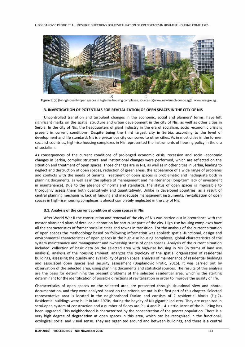
I. BOGDANOVIC PROTIC ET AL.: POSSIBLE DIRECTIONS FOR REVITALIZATION OF OPEN SPACES IN HIGH-RISE HOUSING COMPLEXES
ICUP 2016 PROCEEDINGS Nis: November 2016 113
(a) b)
Figure 1: (a) (b) High-quality open spaces in high-rise housing complexes; sources:(a)www.newlaunch-condo.sg(b) www.ura.gov.sg
3. INVESTIGATION OF POTENTIALS FOR REVITALIZATION OF OPEN SPACES IN THE CITY OF NIS
Uncontrolled transition and turbulent changes in the economic, social and planners' terms, have left significant marks on the spatial structure and urban development in the city of Nis, as well as other cities in Serbia. In the city of Nis, the headquarters of giant industry in the era of socialism, socio -economic crisis is present in current conditions. Despite being the third largest city in Serbia, according to the level of development and life standard, Nis is a precarious city compared to other cities. As in most cities in the former socialist countries, high-rise housing complexes in Nis represented the instruments of housing policy in the era of socialism.
As consequences of the current conditions of prolonged economic crisis, recession and socio -economic changes in Serbia, complex structural and institutional changes were performed, which are reflected on the situation and treatment of open spaces. Those changes are in Nis, as well as in other cities in Serbia, leading to neglect and destruction of open spaces, reduction of green areas, the appearance of a wide range of problems and conflicts with the needs of tenants. Treatment of open spaces is problematic and inadequate both in planning documents, as well as in the sphere of management and maintenance (long-term lack of investment in maintenance). Due to the absence of norms and standards, the status of open spaces is impossible to thoroughly assess them both qualitatively and quantitatively. Unlike in developed countries, as a result of central planning mechanism, lack of funding and inadequate management instruments, revitalization of open spaces in high-rise housing complexes is almost completely neglected in the city of Nis.
3.1. Analysis of the current condition of open spaces in Nis
After World War II the construction and renewal of the city of Nis was carried out in accordance with the master plans and plans of detailed elaboration for particular parts of the city. High-rise housing complexes have all the characteristics of former socialist cities and towns in transition. For the analysis of the current situation of open spaces the methodology based on following information was applied: spatial-functional, design and environmental characteristics of open spaces in the high-rise housing complexes, global characteristics of the system maintenance and management and ownership status of open spaces. Analysis of the current situation included: collection of basic data on the selected area with high-rise housing in Nis (in terms of land use analysis), analysis of the housing ambient, analyzes the typology of the spatial organization of residential buildings, assessing the quality and availability of green space, analysis of maintenance of residential buildings and associated open spaces and security assessment (Bogdanovic Protic, 2016). It was carried out by observation of the selected area, using planning documents and statistical sources. The results of this analysis are the basis for determining the present problems of the selected residential area, which is the starting determinant for the identification of possible directions of revitalization in order to improve the quality of life.
Characteristics of open spaces on the selected area are presented through situational view and photo-documentation, and they were analyzed based on the criteria set out in the first part of this chapter. Selected representative area is located in the neighborhood Durlan and consists of 2 residential blocks (Fig.2). Residential buildings were built in late 1970s, during the heyday of Nis gigantic industry. They are organized in semi-open system of construction and a number of floors are P + 4 and P + 4 + attic. Most of the building has been upgraded. This neighborhood is characterized by the concentration of the poorer population. There is a very high degree of degradation at open spaces in this area, which can be recognized in the functional, ecological, social and visual sense. They are organized around and between buildings, and there is a central

I. BOGDANOVIC PROTIC ET AL.: POSSIBLE DIRECTIONS FOR REVITALIZATION OF OPEN SPACES IN HIGH-RISE HOUSING COMPLEXES
114 ICUP 2016 PROCEEDINGSNis: November 2016
gathering space at the level of blocks. As a result of poor treatment in the design phase, as well as the inconsistent implementation of plans and unfinished character in the stage performance, open spaces in this area are just empty spaces between buildings, without identity and belonging to tenants (Fig.3).
(a)
(b)
Figure 2:(a) Position of the analyzed area in the urban matrix of Nis (b) Plan; sources: (a) www.sk.rs, (b) www.gis.ni.rs
(a) (b)
Figure 3: (a), (b) Images of devastated open spaces at the analyzed area; source: author
In addition, due to long neglect of maintenance, in current conditions is evident obsolete and devastated urban equipment, lack of urban equipment and facilities for the admission for the various categories of tenants, antisocial behavior, and low level of hygiene and green areas. All this contributes to the unattractiveness of open spaces, monotony and low quality of life of its residents. Vegetation is present in different forms, but it is poorly maintained. There is also plenty of free unused area - full of rubbish and without urban furniture. It is characteristic of the low level of hygiene; lack of greenery, inadequate maintenance and cleaning, garbage dumps disorder. This is affected by: 1. tenants who leave trash outside the container in front of the building on the primary open spaces and green areas; 2. irregular garbage collection by the public utility companies. Spaces for tenants assembling are completely neglected. The lighting is insufficient, which affects the very low level of occupant safety. The big problem is the lack of differentiation of pedestrian and motor traffic, and one of the key problems in this area is parking spaces. In current conditions many instances of parking on green areas is present, as well as on children's playgrounds, areas for gathering, pedestrians paths (Fig.3). All this negative phenomena disrupt movement, stay and use value of open spaces. Reasons to the aforementioned negative trends are: 1. insufficient number of parking spaces 2. the absence of housing culture of tenants.

I. BOGDANOVIC PROTIC ET AL.: POSSIBLE DIRECTIONS FOR REVITALIZATION OF OPEN SPACES IN HIGH-RISE HOUSING COMPLEXES
ICUP 2016 PROCEEDINGS Nis: November 2016 115
3.2 Possible courses of revitalization of open spaces
From the analysis of the current status of open spaces in this area, it can be concluded that the key issues are: 1. the use of the humble, poor quality materials, equipment and neglecting of urban design; 2. lack of multifunctional character of space and adequate content inside for different categories of tenants (which may affect the discontent of tenants and the emergence of anti-social behavior); 3. inadequate equipment and marginalization of playgrounds; 4. elements of antisocial behavior (graffiti, destruction of street furniture); 5 parking on open spaces and green areas; 6. low level of security; 7. the absence of a coherent approach for the management, maintenance and improvement of open spaces. Given the complexity and the high intensity of the problems identified on the open spaces, it can be concluded that it is necessary to apply a variety of measures in order to achieve optimal solutions for their improvement. In accordance with identified problems, the following measures of revitalization are proposed: spatial-functional, ecological, social, aesthetic and organizational. In this sense, it is proposed to set some of the possible measures (1-6) for the revitalization of open spaces and improving the quality of life of residents. Measure 1 refers to the promotion of functional values: 1 setting up new urban equipment (pergolas, small walls, benches and other seating equipment, lighting); 2. design of multifunctional, variable and diverse open spaces; 3. design of spaces for all categories of tenants, refurbishment of spaces for children’s play; 4. arrangement of several smaller spaces for different age categories of residents of the area; 5. creating little neighborhood park. Measure 2 is aimed at solving the problem of parking on open spaces: 1. introduction of penalties for parking on open spaces; 2. differentiation of pedestrian and motor traffic; 3. increase of parking spaces; 4. parking relocation from the central part of blocks; 5. building underground garage. Measure 3 refers to the improvement of the ecological comfort- hygiene, the state of greenery, including: 1. improving the maintenance system; 2. regular garbage collection 3. encouraging participation of tenants in maintenance; 4. planning and revival of the existing greenery, additional planned greening, landscaping greenery along the entrance area. Measure 4 is related to the improvement of safety: 1. the lightness; 2. introduction of penalties for antisocial behavior 3. monitoring of open spaces by the police 4. Measure 5 refers to the encouragement of territoriality and personalization through: 1. encouraging personalization by the local government bodies; 2. refurbishment of space for gathering tenants. Measure 6 is aimed at stimulating the attractiveness and appeal of: 1. application of modern principles of urban design; 2. harmonization of open spaces design to the needs of tenants.
The proposed measures are based on the revitalization of open spaces adjusting to new market conditions and to the current needs and demands of tenants on the principle of minimum intervention and investment, as well as more efficient use of building land. The initial element is the existing urban matrix, and the aims of improving are: functional values of open spaces, environmental comfort, troubleshooting of parking on the open spaces, encouraging tenants personalization and territoriality as a basis for the development of good neighborly relations and tenants’ sense of belonging to the residential community, the affirmation of visual perception by tenants and stimulation of creating living environment identity. The basic idea of revitalization of the open spaces is emphasizing their human values, creating diverse and high-quality spaces for tenant’s leisure time, all in the direction of improving the quality of life.
In addition to the above measures, of particular concern is the reorganization and modernization of the system of maintenance and management. After the changes in the socio-political system, there was a collapse of social companies for maintenance and no adaptation to new ownership status concerning city building land. In current conditions, relevant public utility companies in Nis work with very little financial means. This is due to insufficient funds allocated from the city budget, which are insufficient even for the ongoing maintenance of open spaces. In this sense, it is necessary the modernization and restructuring of these companies and the provision of greater financial resources as major preconditions for revitalization of open spaces. It should be noted that affirmation of tenants’ participation is of great importance, which is an actual process and instrument in many European countries (Bogdanovic Protic, 2012.b). It can contribute to the achievement of better ideas for improving the availability of open spaces, and optimal solutions, strengthening the affiliation of tenants to residential environment and territoriality.In addition, it is particularly important to redefine the property relations of the open spaces, through adequate regulation. This is one of the prerequisites for introduction of public/private delineation and creation of semi-public/semi-private open spaces. This would contribute to encouraging tenants to take part in the design and maintenance of open spaces and finding diverse solutions for their revitalization.

I. BOGDANOVIC PROTIC ET AL.: POSSIBLE DIRECTIONS FOR REVITALIZATION OF OPEN SPACES IN HIGH-RISE HOUSING COMPLEXES
116 ICUP 2016 PROCEEDINGSNis: November 2016
4. CONLUSION
Long lasting duration of open spaces neglecting in high-rise housing complexes and the lack of strategies for improvement have contributed to marginalization and very bad condition of open spaces in the analyzed area in Nis. The poor status of open spaces in this area can be recognized as: lack of basic human values, devastation of urban equipment, and lack of necessary physical and functional valuesfor activities of tenants in the leisure time, disturbed ecological comfort, loss of identity and unattractiveness. In the context of improvement some of the possible measures to revitalize open spaces were identified. These measures could help increase the use value of open spaces, environmental comfort and security, achieving the visual aesthetic benefits and the development of good neighborly relations. These are the basic attributes of open spaces that could be able to achieve the prerequisites for remodeling of open spaces and the realization of their basic purpose-extended housing and places where residents like to spend their leisure time, where they can develop territoriality and identity with residential environment in which they live. Analyzed open spaces are wider representatives for the whole urban-architectural and socially image characteristics of high-rise housing complexes in Nis, as well as in other cities in Serbia. Those are consequences of years of neglecting due to numerous social, political, economic and institutional problems and the absence of appropriate norms and standards. Accordingly, it can be concluded that some of the key preconditions for the application of those measures to revitalize open spaces are: 1. involvement of various actors and stakeholders; 2. encouraging of tenants’ assemblies establishment where they do not exist; 3. provision of financial instruments. Provision of financial instruments is currently an unsolvable problem, which can be overcome by complex changes in organizational and institutional terms and training relevant bodies of local self-government for application for grants from EU funds. To determine the modalities of comprehensive revitalization of open spaces, it is necessary to stimulate tenants’ participation (through surveys in order to identify their requirements) and the application of variety of measures in the field of multidisciplinary research, studies and strategies of improvement, which may be the subject of some further research.
5. FINAL REMARKS
This paper was done in the framework of the project of the Ministry of Education, Science and Technological Development of Republic of Serbia: „Optimization of architectural and urban planning and design in terms of sustainable development in Serbia“TR36042.
REFERENCES
1. Bogdanovic Protic, I., 2009. Urbana regeneracija visespratnog stanovanja, Zaduzbina Andrejevic, Belgrade, Serbia
2. Bogdanovic Protic, I., 2012a. Urban open spaces contribution to the quality of life improvement, International Symposium for Students of Doctoral Studies in the Fields of Civil Engineering, Architecture and Environmental Protection 4th Phidac 2012, Nis, University of Nis, Faculty of Civil Engineering and Architecture, Nis, Serbia, pp. 33-39
3. Bogdanovic Protic, I., 2012b. Tenants' participation as a tool for urban regeneration of multi-family housing, International Scientific Conference Indis 2012 Planning, design, construction and renewal in the civil engineering: proceedings, Novi Sad, Faculty of Technical Sciences, Department of Civil Engineering and Geodesy, Novi Sad, Serbia, pp. 757-763
4. Bogdanovic Protic, I., 2016. Definisanje modela revitalizacije slobodnih prostora kompleksa sa visespratnim stanovanjem u funkciji unapredjenja kvaliteta zivota, Phd Thesis, Faculty of civil engineering and architecture, University of Nis, Serbia
5. Li, Y., 1999. Space Between Buildings in Beijing's New Housing, Master Thesis, School of Architecture, McGill University, Montreal
6. Mitkovic, P., Bogdanovic, I., 2004. Open and recreational spaces as the parameters of the dwelling quality, Facta Universitatis, series Architecture and civil engineering, Vol.3, No 1, Nis, University of Nis, pp. 79-97

D. STANKOVIC ZEC ET AL.: TRANSFORMATION OF A CITY BLOCK FROM THE TRANSITIONAL PERIOD IN BANJA LUKA
ICUP 2016 PROCEEDINGS Nis: November 2016 117
TRANSFORMATION OF A CITY BLOCK FROM THE TRANSITIONAL PERIOD IN BANJA LUKA
Dijana Stankovic Zec
University of Belgrade-Faculty of Architecture, Serbia PhD student, [email protected]
Dr. Aleksandra DJukic
University of Belgrade-Faculty of Architecture, Serbia PhD. Associate Professor, [email protected]
ABSTRACT
Social and economical changes that happened in period of post-socialist transformation left their marks in urban environment. Results of these changes are visible in inarticulate city block transformations. This work examines from morphological aspect, transformation of a typical city block from the period of transition, based on previously determined criteria and timeline. A city block in Banja Luka is chosen for a case study. Research goal is to define guidelines for further research of this issue, as well as establishing conceptual model type of city block whose parameters could be included in future city planning.
Keywords: city block; transition; morphology; transformation; urban regeneration
1. INTRODUCTION
On a global level, as a result of powerful changes in social life of urban communities, cities are experiencing a dynamic urban transformation. The discrepancy between developed and undeveloped world is a new level of segregation of urban phenomenon which includes not only economical, but also political and socio-cultural development factors. On one hand, cities in the developed world are faceing stagnating urbanization process and constant qualitative development. On the other hand, cities of undeveloped world face dramatic (uncontrollable) quantitative development and pose a threat to sustainable development on a global level.
Urban phenomenon of a city in transition is recognizable in urban-morphological layers of cities in East and South-east Europe. Urban transformation was strongly influenced by social phenomenon (social and economical restructuring) and social processes manifested directly in space (war destructions, migration of population, etc.), leaving behind permanent changes in urban environment.
It is evident that every important change in economical organization of society, social stratification, technological innovations cultural patterns and political systems leave their marks on the urban pattern. With the process of acceleration on all of the above mentioned levels, in the last couple of decades urban analysts use the term cities in transition, which implies a broad spectre of qualitatively various changes: changes in city in developed capitalist countries, marked by the transition from industrial to post-industrial economy and significant restructuring of these lands of prosperity; changes in cities of the countries that are known as “the outskirts” of the capitalist system, which in the process of globalization are becoming industrial centres on a global level, as well as the cities in post-socialist countries that are also affected by multiple changes. Furthermore, it could be said that there are three types of changes in the cities: the transformation of basic organizational principles of social system; the social and city restructuring, linked to the unfinished modernization (in comparison to the developed world) and change that implies inclusion in the global division of labour and power on modified socio-economical grounds (Petrovic, 2000).
Sasha Tsenkova points out that strategic planning in post-socialist countries can be the answer to economical, social and spatial changes caused by the transition, because it gives the necessary participatory framework for

D. STANKOVIC ZEC ET AL.: TRANSFORMATION OF A CITY BLOCK FROM THE TRANSITIONAL PERIOD IN BANJA LUKA
118 ICUP 2016 PROCEEDINGS Nis: November 2016
decision making and management of land use, with appropriate master plans. It is considered that this can create an adequate city management strategies and promote better understanding of contemporary urban issues, sustainability, economic vitality and life quality (Tsenkova, 2003).
Cities, in their general development trajectories, are becoming a part of global process of urbanization, whose laws are transposed to local socio-economical activities, cultural patterns and urban environment. Consequently, it is evident that the complex changes in every aspect of society in transition have made its impact in the urban environment. Meanwhile, contemporary urban planning aims to meet the needs and expectations of society in this regard, to harmonize urban development, using available methods and techniques on an underdeveloped model of contemporary urban planning (Milojevic, 2015).
On the other hand, according to architectural and urban planning theories after the 1960s, city as a complex system with city blocks that represents urban entity which, with street network, is the most resilient to changes of urban structure through time (Jacobs, 1992 (1961); Kostof, 1999, 2005; Alexander, 1977, 1987; Krier, 1979, 1991). M. R. G. Conzen, one of the founders of typo-morphological research in England, commenting on the elements of the complex phenomenon of urban form, claimed that historical and morphological characteristics of a city block are its place in the hierarchy of urban structure elements and possibilities of transformations and adjustment to changeable requirements over time (Conzen, 2001).
Typo-morphological research, based on establishing a connection between architectural typology and urban morphology, has its roots in Italy, in the work of Severio Muratori and Gianfranco Caniggia, and in France in the works of Castex, Depaule and Panerai. The newest research is based on these theories, and find that the connection between the street network, city blocks and physical structure are the key determinants for guidelines for future development.The “agony” of spatial organization of a city block, defined as a “particularity of a classical European town changed by 19th, abolished by the 20th century”, is shown by the above mentioned Castex, Panerai and Depaule, in their work about morphological and typological spatial models of a city block as a spatial unit in the context of a town. They emphasize the danger of separation between architecture and urbanism, pointing out that then the objects don’t communicate with urban environment (Castex et al., 1980.).
This paper deals with the issue of transformation of blocks in cities in transition that are faced with complex requirements of a society in every aspect of human activity. This is followed by a series of problems in creation of an urban space, from defining goals of urban development and management policy to planning and landscaping. The case study is a city of Banjaluka.
Having in mind the complexity of the phenomenon of urban form of the block, the focus is on morphological and morphogenetic aspect, giving a comparative analysis of cross-sectional situation in order to follow the morphogenesis.
2. DEVELOPMENT (TRANSFORMATION) OF A CITY BLOCK
2.1. Monitoring criteria for city block transformation
According to Conzen’s interpretation of the elements of the complex phenomenon of urban form, historical and morphological characteristics of a city block are analyzed, as well as the possibility of transformation and adjusting to the changing requirements over time. As a founder of typomorphologic research in England, and as a geographer and city planner, Conzen bases his research on three following components: the plan of the city (cartographic manifestation of physical representation), city tissue (groups of buildings and open spaces) and the land use. Severio Muratori (1960) deals with two basic hypotheses in his work. First, he claimed that city structure can be understood only through its historical continuity. The second hypothesis stating that the typology and the built form are the foundations of the urban form. When it comes to typological approaches which aim to find the fundamental principles for area classification, Christopher Alexander (1977) with his “pattern language” defined theinstruments for urban planning and design, by reducing to types with a precise number of key properties. Cliff Moughtin (1992) in his research concludes that it is possible to observe the connection between the public and the private through the connection between the street and the city block, as well as the built and the unbuilt.In that context, he observes that the indicative rates of accessibility and flexibility that a street network offers to the user, represents the model of city blocks.
The common feature of the listed approaches is the fact that they are taking into account time, form and size when considering town’s space and landscape. City space goes through the process of continuous change
D. STANKOVIC ZEC ET AL.: TRANSFORMATION OF A CITY BLOCK FROM THE TRANSITIONAL PERIOD IN BANJA LUKA
ICUP 2016 PROCEEDINGS Nis: November 2016 119
under the influence of social and economical conditions of construction, use and space transformation (Djokic, 2009).
In accordance with the above mentioned, this work will use several criteria for monitoring the transformation of a city block, i.e. the changes they face in certain time period: size and shape of the block, block streets, number of lots, type of buildings, occupancy index, construction index and number of floors.
The most of the blocks in the central part of Banja Luka and suburban area are semi-open, medium sized and large blocks. Average size of the block in the central part of the town range from 0.5ha to 2ha and from 2ha to 5ha. In suburban areas blocks range from 0.8ha to 3ha, or from 5ha to 10ha. In this area the urban matrix is mostly orthogonal. Shapes and sizes of the lots are largely conformed to Conzen’s parceling system. Lots with narrower fronts and longer sides are prevalent and blocksusually contain several elongated lots. Therefore, rectangular blocks are prevalent which offers bigger possibilities for the development of the frontal parts of the lots. According to Conzen’s terminology, the front part of the lot, which is in the direct contact with the street is usually occupied by a dominant building –“dominant lot”, while the back part of the lot is of lower significance and usually doesn’t have contact with the street and is mostly used as a garden or eventually for outbuildings. In his interpretation of lot development cycles, Conzen describes situations in which, in accordance with intensive land use, growing occupancy and construction index, there is a need for changing lot boundaries and lot merging, in order to allow building of bigger buildings. Another possibility is to change the nature of the buildings in the back part of the lot which can lead to splitting one lot into several smaller. The type of the buildings is another important criteria in research. The central part of the city is dominated by buildings that, in average have three to six floors in a densely build urban tissue. The contact area is still dominated by free standing individual structures, with a maximum of two floors, but there is an increased number of blocks that are constantly transforming, resulting in structures in a row, next to the street front (edge type build). There are individual cases of buildings with interior courtyard. In the central part of the city, in accordance with the densely built matrix, the occupancy index is higher than the construction index, having in mind that in this area is largely filled with lower buildings inherited from a different period, marked by lack of free space. The situation is reversed in the contact areas, since the construction of residential buildings with much more floors is intensifying. The transformation of high number of blocks is in progress. From blocks dominated with individual buildings, to blocks with high occupancy and construction index.
2.2. Review of the criteria in case study
The city of Banja Luka and its city block that was transformed several times in the transition period is chosen to be the case study.
Substantial reconstructions and development of Banja Luka started after the war in 1990s. As a result of a new spatial policy, the reconstruction process is followed by private investments, i.e. new construction requests and more intensive use of the city space. The lack of local and national mechaisms that would control the activity in the field of planning and landscaping, as well as the strong inflow of private capital, created unregulated construction market. Certain spatial interventions occured in these circumnstances, i.e. city blocks that disturbed the ambiance, lower quality of life in public and private spaces, which certainly leads to permanent destruction of cultural and architectural heritage and urban identity.
The selected city block is near the city center and it is framed with primary city streets – Pave Radana St., Petra Kocica St. and Prvog Krajiskog Korpusa St. (Pictures 1 and 2).
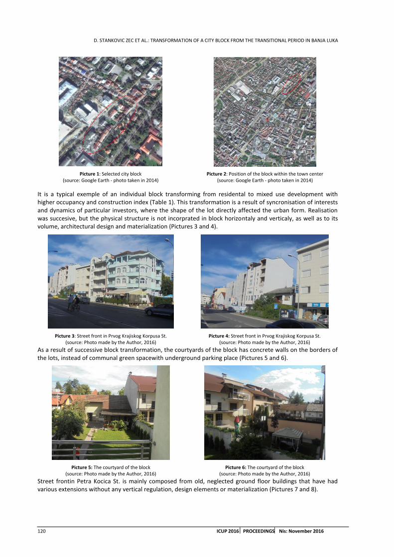
D. STANKOVIC ZEC ET AL.: TRANSFORMATION OF A CITY BLOCK FROM THE TRANSITIONAL PERIOD IN BANJA LUKA
120 ICUP 2016 PROCEEDINGS Nis: November 2016
Picture 1: Selected city block (source: Google Earth - photo taken in 2014)
Picture 2: Position of the block within the town center (source: Google Earth - photo taken in 2014)
It is a typical exemple of an individual block transforming from residental to mixed use development with higher occupancy and construction index (Table 1). This transformation is a result of syncronisation of interests and dynamics of particular investors, where the shape of the lot directly affected the urban form. Realisation was succesive, but the physical structure is not incorprated in block horizontaly and verticaly, as well as to its volume, architectural design and materialization (Pictures 3 and 4).
As a result of successive block transformation, the courtyards of the block has concrete walls on the borders of the lots, instead of communal green spacewith underground parking place (Pictures 5 and 6).
Picture 5: The courtyard of the block (source: Photo made by the Author, 2016)
Picture 6: The courtyard of the block (source: Photo made by the Author, 2016)
Street frontin Petra Kocica St. is mainly composed from old, neglected ground floor buildings that have had various extensions without any vertical regulation, design elements or materialization (Pictures 7 and 8).
Picture 3: Street front in Prvog Krajiskog Korpusa St. (source: Photo made by the Author, 2016)
Picture 4: Street front in Prvog Krajiskog Korpusa St. (source: Photo made by the Author, 2016)

D. STANKOVIC ZEC ET AL.: TRANSFORMATION OF A CITY BLOCK FROM THE TRANSITIONAL PERIOD IN BANJA LUKA
ICUP 2016 PROCEEDINGS Nis: November 2016 121
Picture 7: Street front in Petra Kocica St. (source: Photo made by the Author, 2016)
Picture 8: Street front in Petra Kocica St. (source: Photo made by the Author, 2016)
According the regulation plan from 1996 (Picture 9), the block was builtasresidential block with individual houses with two floors on in its North-east part, and multifamily buildings with four floors on South-west part, with large communal space for parking.
Picture 9: Regulation plan from 1996 - selected block (Regulation plan for the area between the streets: Vuk Karadzic, Prvog Krajiskog Korpusa, Milan Radman, dr Mladen Stojanovic and kralj Petar 1. Karadjordjevic in Banja Luka; Plan made by “Urbanisticki zavod” Banja
Luka, 1996)
Picture 10: Block (source: Google Earth - photo taken in 2002)
Picture 11:Block (source: Google Earth - photo taken in 2006)
According to the picture taken from “google earth” (Picture 10), it is evident that from the moment the Regulation plan was done in 1996 until 2002 there were not any significant changes in the area. This block has got the large percentage of green space, although it is located near the town center.
The Regulation plan from 1996 was changed in 2004 after the Decision of City Assembly, to meet the new needs and adapt to new circumstances in the location. The previous realization of the Plan deviated from planned requirements. Therefore, it was necessary toadjust the resulting situation with the new Plan. Intensification of constructions in this area starts in 2002, reaching its peak after the adoption of the new Plan changes in 2005, as shown on the Picture 11.According to the previously stated principles, i.e. program elements, the new Plan adjusted to the potential investors needs and defined buildings with significant vertical and horizontal dimensions on the small lots (Picture 11).

D. STANKOVIC ZEC ET AL.: TRANSFORMATION OF A CITY BLOCK FROM THE TRANSITIONAL PERIOD IN BANJA LUKA
122 ICUP 2016 PROCEEDINGS Nis: November 2016
A public parking space was planned within the lots and the access was defined in contact lots, i.e. more lots use the same access street. This approach proved to be impossible in practice. Along with the over ground parking, an underground public one was planned, in order to satisfy the parking needs of block’s users (Picture 12).
Construction on empty lots in this block is still in progress, since 2006.
In accordance with all of the above, certain changes of previous parameters (criteria) can be observed in this block (Table 1):
Table 1: Change of urban parameters from 1996 to 2016
time period size and
shape of
block
number of
new
streets
number
of lots
building
type
occupanc
y index
constructi
on index
average
floors from 1996 to
2006
11 800 m2
middle
block open
type
0 24 free-
standing
0.23 0.33 GF/GF+
1 from 2002 to
2006
11 800 m2
middle
block semi-
open type
0 28 free-
standing
70%
rows –
30%
0.32 1.10 GF+2+
M from 2006 to
2016
11 800 m2
middle
block semi-
open type
0 47 free-
standing –
5%
rows –
95%
0.37 1.44 GF+3+
M
Based on the parameters shown in the Table 1 and Pictures (13, 14, 15) it can be concluded that the selected blockexperienced major changes in the period from 2002 to 2006, which led to significant increase in occupancy and construction index. Furthermore, the new type of buildings in the block was built. Instead of free standing, with the average of GF+1, there are row of buildings with the average of GF+2+M and the open block type is transformed into semi-open type. From 2006 untiltoday, this tendency continued and the remaining empty lots are filled, which further contributes to the increase of occupancy and construction index.
Picture 13: The city block from 1996 to 2002; Models are made by the Author
Picture 12: New Regulation Plan from 2005 (Edit the Regulation plan for the area between the streets: Vuk Karadzic, Prvog Krajiskog Korpusa, Milan Radman, dr Mladen Stojanovic and kralj Petar 1. Karadjordjevic in Banja Luka;
Plan made by “Stilling” d.o.o. Banja Luka, 2005) - Plan of spatial organization and allotment plan (selected block)

D. STANKOVIC ZEC ET AL.: TRANSFORMATION OF A CITY BLOCK FROM THE TRANSITIONAL PERIOD IN BANJA LUKA
ICUP 2016 PROCEEDINGS Nis: November 2016 123
Picture 14:The city block from 2002 to 2006; Models are made by the Author
Picture 15:The city block from 2006 to 2016; Models are made by the Author
As shown in the Table 1, there are no new public spaces, although they were planned in the regulation PlanAt the same time the number of lots is increasing. Therefore, existing lots are being fragmented without proper access and there is a significant deficit of parking places.
It is clear that after the regulation changes, there were certain problems in issuing of building permits. Administrative problems, as well as the parking deficiency, led to chaotic use of lots, especially of the inner parts of the block that does not have access from the street. Construction of public facilities, which implies cooperation between public and private investors was not implemented (Table 1).
3. CONCLUSION
In the cities that are in the period of transitionthere is a tendency for more efficient use of city’s construction land, since private capital became the main pillar of development, which led to increase of occupancy and construction index and use of every available vacant area. As a result, partial interventions on a block level in the form of “internal filling” visibly disturbed the appearance, quality of life and functionality in the block and its surroundings.
Therefore, it is necessary to find a way to deal more efficiently with city block transformation in transitional period. The interventions performed on city blocks during the period of transition resulted in number of problems such as loss of urban identity and quality of life. Uncoordinated system of urban regeneration and city planning, as well as partial intervention on city block level pose a big problem to contemporary city in transition, since the ambiance, living conditions and practical use of public spaces are disrupted. Negligence of these values leads to permanent loss of cultural and architectural heritage as well as urban identity, and later to creation of unsustainable urban systems.
Although sustainable regeneration of a city block implies realization of economical, ecological, social and cultural goals, the process of urban regeneration in practice is fulfilled by economical goals. The result of this approach is in neglect of historical, spatial and cultural value of locations, as an active component of material culture and urban memory. Social and cultural factors should be included in the process and historical, social, cultural and spatial urban values should be taken into consideration, since these qualities represent a very important development potential. Establishing the morphogenesis, in the function of preserving identity and
D. STANKOVIC ZEC ET AL.: TRANSFORMATION OF A CITY BLOCK FROM THE TRANSITIONAL PERIOD IN BANJA LUKA
124 ICUP 2016 PROCEEDINGS Nis: November 2016
cultural patterns, should contribute to sustainable urban regeneration and improvement in urban identity. In the context of before mentioned issues, it is necessary to ascertain current approaches in the city planning.
Further, research could bring the results that improve the process of urban regeneration of the city in the period of transition. Furthermore, it would be possible to define local urban patterns for more efficient and successful urban regeneration of city blocks.
REFERENCES
1. Alexander, C., 1977. A Pattern Language. Oxford University Press, New York.
2. Alexander, C., 1987. A New Theory of Urban Design. Oxford University Press, New York.
3. Berghauser Pont, M., Haupt, P., 2010. Spacematrix: Space, Density and Urban Form. NAi Publishers, Rotterdam.
4. Caniggia, G. Maffei, G., 1979. Composizione Architettonica e Tipologia. Edilizia: 1.Lettura dell’ Edilizia di Base. Marsilio, Venezia.
5. Castex, J. Depaule, J. i Panerai, P., 1980. Urban forms. Gradjevinska knjiga, Beograd.
6. Conzen, M.R.G., 1960. Alnwick, Northumberland: A Study in Town–Plan Analysis. George Philip & Son, London.
7. Conzen, M.P., 2001. The study of urban form in the United States. Urban Morphology, 15(1). pp 3-14.
8. Djokic, V., 2009. Morphology and typology as a unique discourse of research. Serbian Architectural Journal. pp 107‐130.
9. Jacobs, J., 1992 (1961). The Death and Life of Great American Cities. Vintage Books, New York.
10. Kostof, S., 1999. The City Shaped: Urban Patterns and Meanings Through History. Thames & Hudson, New York.
11. Kostof, S., 2005. The City Assembled: Elements of Urban Form through History. Thames & Hudson, New York.
12. Krier, R., 1979. Urban Space. Academy Editions, London.
13. Krier, R., 1991. Gradski prostor u teoriji i praksi. Gradjevinska knjiga, Beograd.
14. Milojevic, B., 2010. Uticajni faktori na urbanu transformaciju – primjer nekih gradova u Bosni i Hercegovini u novijoj istoriji. Doktorska disertacija. Arhitektonsko-gradjevinski fakultet Univerziteta, Banjaluka.
15. Milojevic, B., 2015. Gradovi u promjenama – Urbane forme, transformacije, uticaji. Arhitektonsko-gradjevinsko-geodetski fakultet, Banjaluka.
16. Moughtin, C., 1992. Urban Design: Street and Square. Oxford University Press, New York.
17. Muratori, S., 1960. Studi per una operante storia urbana di Venezia. Istituto Poligrafico dello Stato, Roma.
18. Panerai, P. Depaule, J‐C. Demorgon and M. Veyrenche, M, 1980. Elements d’analyse urbaine. Bruxelles, Editions Archives d’Architecture Moderne.
19. Petrovic, M., 2000. Gradovi u tranziciji: iskustva razvijenih zemalja u poslednjim decenijama 20. veka. Sociologija, XLII (3).
20. Tsenkova, S., 2003. Post-socialist Cities in a Globalizing world. Planum Magazine, pp 1-20.

A. JOVANOVIC: LEGAL AND INSTITUTIONAL FRAMEWORK OF PUBLIC-PRIVATE PARTNERSHIP IN THE REPUBLIC OF SERBIA
ICUP 2016 PROCEEDINGS Nis: November 2016 125
LEGAL AND INSTITUTIONAL FRAMEWORK OF THE PUBLIC-PRIVATE PARTNERSHIP IN THE REPUBLIC OF SERBIA
Andrijana Jovanovic
The Public-Private Partnership Commission, The Government of RS, Belgrade Phd student, [email protected]
ABSTRACT
Once the Law on Public-Private Partnership and Concessions was adopted in November 2011, the concept of public-private partnership (PPP) was introduced to the legal system of the Republic of Serbia for the first time. This Law allowed to central and local authorities to fullfill their needs for infrastructure projects and public services whithin this model, with clearly established and defined rules of conduct.The aim of this paper is to analyze concept of PPP in the Republic of Serbia and to explain essential elements of this model and its implementation on both central and local level. Subsequently, this paper has a further social aim, which is related to the ability to attract the attention of the general public and political elite to the institute of PPP as an important instrument of economic development. Both central and local government have a direct interest when it comes to the quality of life of its citizens, which is reflected through the support they are willing to provide to this model, and enter into PPPin order to provide realization of large infrastructure projects and/or public services, in case these arrangements mean more effectiveness and savings in comparison with traditional ways of budget financing.
Keywords: Public-Private Partnership (PPP); Concessions, Comission for Public-Private Partnership; Public Sector; Private Sector; Cooperation; Legal Framework; Public Interest; Institucional Framework.
1. INTRODUCTION AND CONCEPT OF PUBLIC-PRIVATE PARTNERSHIP
PPP is a long lasting cooperation between a public and a private partner with a goal of providing financing, building, reconstruction, managing or keeping of infrastructure and other buildings of public importance and providing services of public importance that can be a partnership based on a contract or it can be institutionalized.1PPP is a dynamic and developing process of funding projects of economic development, and it represents a form of a cooperation between the government and private sector with a purpose to modernize the construction of public infrastructure as well as strategic public services. Linking public and private sectors enables support to ongoing development and implementation of local strategies for sustainable development, in order to improve the quality of life. The essence of private sector involvement in traditional public affairs is to reduce the fiscal pressure on local budgets, accelerating infrastructure investments, improving services, and encouraging the growth of output and job creation.
In some cases, PPP includes financing, planning, constructing, reconstructing, managing or maintenance. In other cases, it includes providing the services which are traditionally provided by public institutions. Although, the focus of public-private partnership should be on the improvement of efficiency in public services through sharing risks and implementation of private sector expertise, it should be stressed that PPP indirectly reduces the pressure on public finances by providing additional source of funding. For that reason, PPP is based on the fact that both public and private sector can benefit from adjoining their financial resources, knowledge and expertise for providing better services to all citizens.2
1 Zakon o javno-privatnom partnerstvu i koncesijama, „Sluzbeni glasnik RS“, broj 88/2011, 15/2016, cl. 7.
2 JovanovicA., 2013.The Role and Importance of the Public-Private Partnership in the Republic of Serbia in Financing Local Economic Development, U: Osmankovic J., Pejanovic M., (ur.) Proceedings, Local Economic and Infrastructure Development of SEE in the Context of EU, Akademija nauka i umjetnosti Bosne i Hercegovine, Sarajevo, str. 416.
A. JOVANOVIC: LEGAL AND INSTITUTIONAL FRAMEWORK OF THE PUBLIC-PRIVATE PARTNERSHIP IN THE REPUBLIC OF SERBIA
126 ICUP 2016 PROCEEDINGSNis: November 2016
PPP is the direct consequence of the economic needs of country to develop a partnership with private capital, instead of obtaining credit capital intended for construction, and development of infrastructure, and the development of sustainable system that provides services of public interest. It is very important that public and private interest, although in partnership, remain in constant competition which is realized in legal frameworks of PPP3. PPP has justified its existence when both sectors (public and private) achieve their objectives partnership as their cause. This causes aren’t the same. The cause of public-private subjects is achieving social prosperity and improving the quality of living by making the quality of public services better and building infrastructure and objects of public importance. The aim of private-legal participants is economic benefit. The main characteristic of PPP is cooperation, not competition. Mutual interest and risk sharing are crucial for realization of projects. Public- legal entities should adopt entrepreneur way of thinking and acting, and private public sector should respect the criteria of public responsibility and it should have the obligation to protect the public interest. In a situation like that the common interest is to create a flexible management structure and to evaluate the effectiveness of PPP with a measurable result- economic, political and social.4
2. REGULATORY FRAMEWORK OF PUBLIC-PRIVATE PARTNERSHIPS IN THE REPUBLIC OF SERBIA
PPP is an object of direct and indirect regulating of different laws. Indirectly, the institution of PPP is an object of regulating the Law of Public-Private Partnership and Concessions5and Law of Public Purchases6. Directly, PPPis an object of regulating systemic laws that that regulate the economic system of Republic of Serbia. In that sense, the most important laws are Law of Utility Services7, Law on Public Property8, Law on Foreign Investments9, Law on Energetic10. Norms referring to PPP represent the rules that are generally implemented to all types of partnerships, regardless of legal model or an object of partnership (energetic, infrastructure, schools, and hospitals). For the first time in the Republic of Serbia Law on Public-Private Partnership and Concessions (2011) provides an explicit framework for regulation of this important institute.11This law regulates the conditions and manner for preparing, proposing and approving project proposals for PPP, public bodies and parties in charge of proposing and implementing PPP projects, the rights and obligations of public and private partners, public contracts with or without concession elements, the scope of concessions, the authorities and parties in charge of the concession approval procedure, the termination of concessions, legal protection in the public contract award procedures, protection of the rights of parties participating in the procedure, the establishment and the competences of the Commission for Public-Private Partnership, and other issues relevant to PPP with or without elements of concession. The law was enacted because of the realization of following goals: The empowerment of financial capacities in regard to building infrastructures; Realizing the public services of a higher quality; Realization of publicity and ‘transparency’ of procedure of availability and usage of public resources; Compatibility of legal frame of PPP and the conventions of EU and ‘good practice’.12
The Law on Public-Private Partnership and Concessions regulates conditions and fashion of creation, suggestion and approving of projects of PPP; rights and obligations of public and private partners; authority of Commission
3 Cvetkovic P., Sredojevic S., 2013. Javno-privatno partnerstvo, Prirucnik za sprovodjenje na nivou lokalne samouprave, Stalna konferencija gradova i opstina - Savez gradova i opstina Srbije, Beograd, str. 13-14.
4 JovanovicA., 2013.The Role and Importance of the Public-Private Partnership in the Republic of Serbia in Financing Local Economic Development, U: Osmankovic J., Pejanovic M., (ur.) Proceedings, Local Economic and Infrastructure Development of SEE in the Context of EU, Akademija nauka i umjetnosti Bosne i Hercegovine, Sarajevo, str. 416.
5 Zakon o javno-privatnom partnerstvu i koncesijama, „Sluzbeni glasnik RS“, broj 88/2011, 15/2016.
6 Zakon o javnim nabavkama, „Sluzbeni glasnik RS“, broj 124/2012.
7 Zakon o komunalnim delatnostima, „Sluzbeni glasnik RS“, broj 88/2011.
8 Zakon o javnoj svojini Republike Srbije, „Sluzbeni glasnik RS“, broj 72/2011.
9 Zakon o stranim ulaganjima, „Sluzbeni list SRJ“, broj 3/2002, 5/2003.
10 Zakon o energetici Republike Srbije, „Sluzbeni glasnik RS“, broj 57/2011.
11 JovanovicA., 2013.The Role and Importance of the Public-Private Partnership in the Republic of Serbia in Financing Local Economic Development, U: Osmankovic J., Pejanovic M., (ur.) Proceedings, Local Economic and Infrastructure Development of SEE in the Context of EU, Akademija nauka i umjetnosti Bosne i Hercegovine, Sarajevo, str. 418.
12 Cvetkovic P., 2012. Regulatorni okvir javno-privatnog partnerstva: pregled novih resenja, Casopis za javnu politiku POLIS, Stakna konferencija gradova i opstina – Savez gradova i opstina Srbije i Centar za javnu i lokalnu upravu – PALGO cetar, Beograd, str. 11.

A. JOVANOVIC: LEGAL AND INSTITUTIONAL FRAMEWORK OF PUBLIC-PRIVATE PARTNERSHIP IN THE REPUBLIC OF SERBIA
ICUP 2016 PROCEEDINGS Nis: November 2016 127
for PPP; conditions and the way of concessions; the subject of a concession; legal protection during the acts of assignment of public contract13, as well as presents the basic principles:
The protection of the interests of the public;
Efficiency;
Transparency;
Equal and just treatment;
Free market;
Proportionality;
The protection of environment;
The autonomy of will;
The equality of both partners.14
The reasons for adoption of the Law Amending the Law on Public-Private Partnership and Concessions (2016) are reflected in the need of further regulation and clarification of certain provisions after four years of its implementation, further alignment with the Acquis communautaire as well as strengthening the role of the Ministry of Finance in the approval and contracting process in order to control fiscal risks that the public-private partnership and concession projects are implicitly imposing.15
Increased demands for fiscal impact assessment accompanied with need for new public infrastructure in the Republic of Serbia contributed to the consideration of the possibilities to balance both need for private financing of public infrastructure projects. In addition, the lack of public financing and insufficient funds of the state authorities to develop and modernize the road and utility infrastructure such as water supply network and waste water management, district heating and electricity supply systems, led to solutions which will allow both (protection of budget and attracting investors).
The Law Amending the Law on Public-Private Partnership and Concessions provide more clear provisions for competent state authorities as contracting parties, contract award procedure and other. New provisions on including opinion of the Ministry of Finance to the proposed public-private partnership/concession projects will result in achieving a higher degree of Fiscal Impact Control for the higher in value projects and will leave the decentralization for the local projects of the smaller scale.
By their nature, the provisions of the Law on Public-Private Partnership and Concessions have an effect on public sector, all domestic and foreign companies, as well as entrepreneurs, and on the public authorities, as well as banks and other financial institutions. The proposed solutions will have a direct effect on: state authorities of the Republic of Serbia, authorities of autonomous province and local self-government units, companies, entrepreneurs, a number of other interested parties.
The object regulated by the law is extensively defined. The law regulates the conditions and the manner of producing, suggesting and approving of projects of PPP, subjects, rights and obligations of actors in PPP, legal grounds (public contract), a process of awarding concessions, protection of the rights of actors in the process of assigning public contracts, and any other issues that can occur during the arranging and realizing the partnership. The Law on Public-Private Partnership and Concessions is the fundamental legal source of managing PPP. Note that subjects of PPP cannot be used exclusively for commercial purposes of general application. The awareness of the public interest is therefore essential for the existence of the partnership; without that element a project is not a PPP in reference to the Law on Public-Private Partnership and Concessions. On the other hand, a public body can use other legal mechanisms (a lease contract or other forms of contracts) with a goal of creating such a project (commercial, without realization of public interest). However, those mechanisms are not included in frameworks of the implementation of the Law on Public-Private Partnerships. Additionally, when a municipality (or any other public body) sells or leases a lot for construction or a plant for industrial production, there are no grounds for the implementation of PPP. Namely, this is the case of putting into operation of economic resources (a lot) in order to utilize it in an economic activity. Public interest is being exhausted, which means that it begins and finishes with the obligation of an investor (a buyer or a leaseholder) to utilize the lot in the purposes of performing an economic activity with
13 Zakon o javno-privatnom partnerstvu i koncesijama, „Sluzbeni glasnik RS“, broj 88/2011, 15/2016, cl. 1.
14 Zakon o javno-privatnom partnerstvu i koncesijama, „Sluzbeni glasnik RS“, broj 88/2011, 15/2016, cl. 6.
15 Zakon o javno-privatnom partnerstvu i koncesijama, „Sluzbeni glasnik RS“, broj 88/2011, 15/2016.

A. JOVANOVIC: LEGAL AND INSTITUTIONAL FRAMEWORK OF THE PUBLIC-PRIVATE PARTNERSHIP IN THE REPUBLIC OF SERBIA
128 ICUP 2016 PROCEEDINGSNis: November 2016
regard to systemic laws (tax, labor and employment law, environmental law and others). Nonetheless, if a lot is leased for a limited period of time (not longer than fifty years, according to the Law on Public-Private Partnership and Concessions) with an aim of fulfilling a certain public interest, then it is the matter of a project that is regulated by this Law, since its realization and process partly involves public interest. Thereby, the existence of the private interest realized in the interest of a private actor for the returns of their investments and earning a suitable profit. Is not excluded (without such an interest that agreement would not be a PPP, but it would be a project of public works that are funded from the budget).
3. INSTITUTIONAL FRAMEWORK -COMMISSION FOR PUBLIC-PRIVATE PARTNERSHIP IN THE REPUBLIC OF SERBIA
An important actor of the concept of PPP in Republic of Serbia is Commission for PPP designed as professional body of the Government of Republic of Serbia, which provides help in the realization of PPP projects and concessions in Republic of Serbia.16As provided for under the Law on Public-Private Partnership and Concessions, Commission is an inter-departmental, operationally-independent public body that provides expert assistance in the implementation of PPP projects and concessions. The Commission was established under the Decision on the Establishment of the Public-Private Partnership Commission (Official Gazette of the Republic of Serbia, No. 13/2012 108/2012, 44/2013, 64/2013, 104/2013, 115/2013, 20/2014, 15/2015). Commission is made of nine members who were nominated by the Prime Minister and appointed by the ministries in charge of economy and regional development; finance; infrastructure; mining; utilities; and environmental protection; the Vojvodina authorities; and the City of Belgrade. Representative of the Ministry in charge of Economy and Regional Development is also the President of the Commission, a representative of the ministry responsible for finance is his deputy.17The Commission’s statutory remit entails:
Assisting in the drafting of public-private partnership proposals to facilitate the development of public private partnerships and public contracts;
Providing information and consulting on both concession and non-concession public-private partnership issues;
Providing its formal opinions regarding the approval of concession and non-concession public-private partnership projects and the submission of these projects to appropriate bodies for approval;
Identifying and facilitating the implementation of best foreign practices in Serbia with respect to concession and non-concession public-private partnerships;
Drafting public-private partnership methodologies, including Value-for-Money Methodology;
Co-operating with other government bodies and NGOs active in the field of public-private partnership;
Providing its recommendations regarding projects as required by public bodies or concessionaires;
Reporting to the Government of Serbia on an annual basis, as stipulated by Law;
Co-operating, in the exercise of its authorities, with budget inspection bodies, the State Audit Institution, sub-national or local budget inspection bodies, and other national and international bodies, organisations and institutions;
Posting government-approved annual reports on realised public-private partnership projects on its web site, as well as making available other data and information it believes to be of importance for the implementation of the Law, and
Undertaking other tasks as stipulated under the Law.18
The Ministry in charge of Economy and Regional Development provides the Commission with office space and operational assistance in the form of analytics and administrative and technical support. In doing so the Ministry receives and processes project applications; keeps records of PPP and concession projects; drafts annual reports submitted to the Government by the Commission; and assists the Commission in other ways as and when required.
16 JovanovicA., 2013.The Role and Importance of the Public-Private Partnership in the Republic of Serbia in Financing Local Economic Development, U: Osmankovic J., Pejanovic M., (ur.) Proceedings, Local Economic and Infrastructure Development of SEE in the Context of EU, Akademija nauka i umjetnosti Bosne i Hercegovine, Sarajevo, str. 420.
17 Zakon o javno-privatnom partnerstvu i koncesijama, „Sluzbeni glasnik RS“, broj 88/2011, 15/2016, cl. 65.
18 Zakon o javno-privatnom partnerstvu i koncesijama, „Sluzbeni glasnik RS“, broj 88/2011, 15/2016, cl. 68.
A. JOVANOVIC: LEGAL AND INSTITUTIONAL FRAMEWORK OF PUBLIC-PRIVATE PARTNERSHIP IN THE REPUBLIC OF SERBIA
ICUP 2016 PROCEEDINGS Nis: November 2016 129
President of the Commission represents the Commission before the state bodies and organizations, as well as other national and international bodies, organizations and institutions; manages the work of the Commission; organizes, directs and coordinates the work of the Commission; President convenes meetings of the Commission, proposes the agenda of meetings and presides at meetings; signs documents of the Commission; he takes care of implementations of the Rules and other regulations of the Commission; performs other duties specified by law, these Rules and other regulations of the Commission. The deputy chairman of the Commission can preside at a Session of the Commission on the basis of the written authority of the President of the Commission.19 Preparing of the meetings organizes the President of the Commission with the help of professional services of the Ministry. Preparing of the meeting of the Commission shall include in particular: compiling proposals on the agenda; preparing appropriate written materials for the meeting; summons for the meeting and providing technical and administrative conditions for the undisturbed work of the Commission. The work of the meeting of the Committee report shall be prepared. Record contains basic information about the meeting of the Committee, and in particular:
indication of the number of session with the note marked oral, in written or conference session;
place, time and date of the session;
information about the present and absent members of the Commission at the meeting members, and other persons present at the meeting;
agenda of the session;
issues that were the subject of the vote and the result of each vote;
summary of discussions on issues on the agenda, unless the record is made of the work of the writing session;
results of the voting on all issues on which the Commission discussed at the meeting;
opinions or other documents adopted at the meeting;
other information relevant for the session and decision making;
time of the conclusion of the session.20
The Commission is profiled as a professional (not a political body). Following the adoption of the Law on public-private partnership and concessions adopted by-law (Decree on the establishment of the Public-Private Partnership), which provides that "the implementation of any project of PPP necessary to obtain a favorable opinion of the Commission" (paragraph 5. Decision).21 This is clearly committed to the "binding" nature of the above the Commission's opinion: the absence of a positive or negative opinion means giving the project a PPP is not approved.22 Until today it is adopted a positive opinion from the Commission to the thirty six project proposals of PPP. The Value-for-Money Methodology for Public-Private Partnerships and Concessions, which is entrusted to the international consultants, was adopted by the Commission in July 2013.23
4. VALUE-FOR-MONEY METHODOLOGY FOR PUBLIC-PRIVATE PARTNERSHIPS AND CONCESSIONS
Investments of importance to the general public (public investments) are an important factor in generating domestic product and welfare. Not only do the value of the social product and the achieved level of prosperity affect the act of investing, they also influence its quality, which is primarily manifested through the efficiency and effectiveness of the delivery of public investment. Calculating Value-for-Money (VfM) is an analytical procedure that endeavours to quantify whether taxpayer money would be better spent on traditional investment, where a public body appears as the investor and assumes all or most of the risk of a public investment, or it is more cost-effective to buy the service from a private-sector contractor, allocating most of the risk to that entity in PPP. The European Commission defines PPP as partnerships between the
19 Poslovnik o radu Komisije za javno-privatno partnerstvo, Beograd, 2012, clan 4.
20 Poslovnik o radu Komisije za javno-privatno partnerstvo, Beograd, 2012, clan 25.
21 JovanovicA., 2013.The Role and Importance of the Public-Private Partnership in the Republic of Serbia in Financing Local Economic Development, U: Osmankovic J., Pejanovic M., (ur.) Proceedings, Local Economic and Infrastructure Development of SEE in the Context of EU, Akademija nauka i umjetnosti Bosne i Hercegovine, Sarajevo, str. 421.
22 JovanovicA., 2013.The Role and Importance of the Public-Private Partnership in the Republic of Serbia in Financing Local Economic Development, U: Osmankovic J., Pejanovic M., (ur.) Proceedings, Local Economic and Infrastructure Development of SEE in the Context of EU, Akademija nauka i umjetnosti Bosne i Hercegovine, Sarajevo, str. 421.
23 Metodologija za analizu dobijene vrednosti u odnosu na ulozeni novac (Value-for-Money) u javno-privatnom partnerstvu i koncesijama, Beograd, 2013.
A. JOVANOVIC: LEGAL AND INSTITUTIONAL FRAMEWORK OF THE PUBLIC-PRIVATE PARTNERSHIP IN THE REPUBLIC OF SERBIA
130 ICUP 2016 PROCEEDINGSNis: November 2016
public and the private sector aiming to provide services traditionally delivered by the public sector. The public sector appears as the principal, whose goal is to ensure that a public service is provided to users, while the private sector serves as the contractor, whose role is to actually deliver the services contracted for.24
PPP models have become particularly popular after a new PPP model was introduced in the United Kingdom to provide non-commercial public services; this is known as the Private Finance Initiative (PFI).25Comparing the different methods of making a public investment entails a comparative analysis of the traditional model and PPP model. In that sense, value for money is calculated by comparing the effects of these models of public investment. Each model has its costs and its benefits. The principal benefit is success in achieving standards of public service, which must be set by the public partner for the entire term of the contract. Costs are whole life costs (WLC) of the investment; for public buildings, these include the expenses of constructing and maintaining them. Since investing - and not only in the public sector - entail numerous risks, establishing value for money requires all these risks to be quantified, described and analysed (assessed). The risk assessment must conclude with a quantitative statement of each individual risk. Finally, these identified and quantified risks are divided between the partners: some risks will be fully allocated to the private partner, while some will be shared. The practice of many countries with experience in implementing PPP models shows there are numerous projects where bring the greatest value for money. This methodology can be applied to PPP aiming to provide finance for, construct, reconstruct, operate, or maintain infrastructural or other public facilities, or deliver public services.26The Law on Public-Private Partnership and Concessions (Official Gazette of the Republic of Serbia, No. 88/2011, 15/2016) stipulates that a proposed PPP project must contain, among other information, a business plan including an estimation of costs and value-for-money analysis (in accordance with methodology adopted by the Commission for PPP). Such a business plan must also contain information regarding the financial acceptability of PPP to the public authority in question; information as to how the project will be financed (from the budget, by donors, or using private finance) and what the cost of such finance will be; availability of finance; and planned risk allcation. PPP project proposals must also include an analysis of economic efficiency of the proposed project.27
5. CONCLUSION
With growing public needs and more and more expensive and complex infrastructure projects, public sector is faced with a lack of public funds. Traditional way of budget financing of such projects became unsustainable. On the other hand, the liberalization of the economy and the privatization of public companies primarily in the European Union opened the possibility of finding a middle way between the government’s financing projects, on the one side, and privatization, on the other side. And it is exactly a model of private financing of various public projects i.e. model of PPP which shows its opportunities for implementation and advantages in practice. It is more than expected for PPP to gradually become an option of choice in the following years, for national/regional/local authorities and in relation to funding great local and regional projects. The questions of conducting valid and transparent mechanisms for analysis of projects' „value for money“, elaboration of legal criteria for assessment and approval of a project (including determining type of risks of each partner), as well as determining a valid mechanism within a municipality in order to follow up a project implementation, are the most important issues and challenges that are open for further analysis and consideration. 28
Main objectives of the legislative activity in the field of PPP refer to the introducing better control of fiscal impact of the PPP and concessions; creating an efficient mechanism that would allow all government levels to implement projects through PPP based on clear rules; attracting domestic and foreign investors and banks to
24 Metodologija za analizu dobijene vrednosti u odnosu na ulozeni novac (Value-for-Money) u javno-privatnom partnerstvu i koncesijama, Beograd, 2013, str. 1.
25 Milenkovic D., 2014. Upravni ugovori - teorija, zakonodavstvo i praksa, Centar za javnu upravu, lokalnu samoupravu i javne politike Fakulteta politickih nauka Univerziteta u Beogradu, i Cigoja stampa, Beograd, str. 31.
26 Metodologija za analizu dobijene vrednosti u odnosu na ulozeni novac (Value-for-Money) u javno-privatnom partnerstvu i koncesijama, Beograd, 2013, str. 2.
27 Metodologija za analizu dobijene vrednosti u odnosu na ulozeni novac (Value-for-Money) u javno-privatnom partnerstvu i koncesijama, Beograd, 2013, str. 3.
28 Pavlovic-Krizanic T., 2012. Lokalna javno-privatna partnerstva u Srbiji - izmedju propisa i realnosti, Casopis za javnu politiku POLIS, Stakna konferencija gradova i opstina - Savez gradova i opstina Srbije i Centar za javnu i lokalnu upravu - PALGO cetar, Beograd, str. 23.
A. JOVANOVIC: LEGAL AND INSTITUTIONAL FRAMEWORK OF PUBLIC-PRIVATE PARTNERSHIP IN THE REPUBLIC OF SERBIA
ICUP 2016 PROCEEDINGS Nis: November 2016 131
finance/co-finance and manage projects of public interest (participation of the private sector);providing a legal framework for a transparent and fair tender procedure with equal treatment of all bidders in the process of looking for a private partner for such projects; harmonization with the European Union regulations.
The expectations from PPP are immense in terms of increase an influx of private investments in those local projects with the potential of improving the quality of public services, by investing the funds into new infrastructures, equipment and services. Commission for PPP has crucial role in fulfilling such expectations. Arrangements of PPP should be established after a thorough and impartial assessment. Promotion of PPP and its wider application could be very beneficial not only for private sector, but as well for the society in general.29
REFERENCES
1. Akintoye, A., Beck M., Hardcastle C., 2003. Public Private Partnerships: Managing Risks and Opportunities, Blackwell Publishing Company.
2. Custos, D., Reitz, J., 2010. Public-Private Partnerships, American Journal of Comparative Law, The American Society of Comparative Law
3. Cvetkovic, P., 2012. Regulatorni okvir javno-privatnog partnerstva: pregled novih resenja, Casopis za javnu politiku POLIS, Stakna konferencija gradova i opstina – Savez gradova i opstina Srbije i Centar za javnu i lokalnu upravu - PALGO cetar, Beograd.
4. Cvetkovic, P., Sredojevic S., 2013. Javno-privatno partnerstvo, Prirucnik za sprovodjenje na nivou lokalne samouprave, Stalna konferencija gradova i opstina – Savez gradova i opstina Srbije, Beograd.
5. Damnjanovic, D., Pavlovic-Krizanic T., Peteri G., 2010. Partnerstvo javnog i privatnog sektora, Dobra i losa iskustva u zemljama u tranziciji, Centar za javnu i lokalnu upravu – PALGO centar, Beograd.
6. European PPP Expertise Centre: The Guide to Guidance: How to Prepare, Procure and Deliver PPP Projects, European Investment Bank, 2011, Luxembourg.
7. Jovanovic, A., 2013. The Role and Importance of the Public-Private Partnership in the Republic of Serbia in Financing Local Economic Development, U: Osmankovic J., Pejanovic M. (ur.) Proceedings, Local Economic and Infrastructure Development of SEE in the Context of EU, Akademija nauka i umjetnosti Bosne i Hercegovine, Sarajevo.
8. Milenkovic, D., 2014. Upravni ugovori - teorija, zakonodavstvo i praksa, Centar za javnu upravu, lokalnu samoupravu i javne politike Fakulteta politickih nauka Univerziteta u Beogradu, i Cigoja stampa, Beograd.
9. Pavlovic-Krizanic, T., 2012. Lokalna javno-privatna partnerstva u Srbiji - izmedju propisa i realnosti, Casopis za javnu politiku POLIS, Stalna konferencija gradova i opstina - Savez gradova i opstina Srbije i Centar za javnu i lokalnu upravu - PALGO centar, Beograd.
10. Rosenau Vaillancourt, P., 2000. Public-Private Policy Partnerships, Massachusetts Institute of Technology.
LEGAL SOURCES
1. Zakon o javno-privatnom partnerstvu i koncesijama, „Sluzbeni glasnik RS“, broj 88/2011, 15/2016.
2. Zakon o javnim nabavkama, „Sluzbeni glasnik RS“, broj 124/2012.
3. Zakon o javnoj svojini Republike Srbije, „Sluzbeni glasnik RS“, broj 72/2011.
4. Zakon o komunalnim delatnostima, „Sluzbeni glasnik RS“, broj 88/2011.
5. Zakon o stranim ulaganjima, „Sluzbeni list SRJ“, broj 3/2002, 5/2003.
6. Zakon o energetici Republike Srbije, „Sluzbeni glasnik RS“, broj 57/2011.
7. Metodologija za analizu dobijene vrednosti u odnosu na ulozeni novac (Value-for-Money) u javno-privatnom partnerstvu i koncesijama, Beograd, 2013.
29 Jovanovic A., 2013. The Role and Importance of the Public-Private Partnership in the Republic of Serbia in Financing Local Economic Development, U: Osmankovic J., Pejanovic M., (ur.) Proceedings, Local Economic and Infrastructure Development of SEE in the Context of EU, Akademija nauka i umjetnosti Bosne i Hercegovine, Sarajevo, str. 424.

A. JOVANOVIC: LEGAL AND INSTITUTIONAL FRAMEWORK OF THE PUBLIC-PRIVATE PARTNERSHIP IN THE REPUBLIC OF SERBIA
132 ICUP 2016 PROCEEDINGSNis: November 2016
8. Odluka o obrazovanju Komisije za javno-privatno partnerstvo, „Sluzbeni glasnik RS“, broj 13/2012, 108/2012, 44/2013, 64/2013, 104/2013,115/2013, 20/2014, 15/2015)
9. Poslovnik o radu Komisije za javno-privatno partnerstvo, Beograd, 2012.

M. LJUBENOVIC ET AL.: FUTURE OF CITIES – OPPORTUNITIES AND CHALLENGES OF SCENARIO APPROACH
ICUP 2016 PROCEEDINGS Nis: November 2016 133
FUTURE OF CITIES – OPPORTUNITIES AND CHALLENGES OF SCENARIO APPROACH
Milica Ljubenovic
Faculty of Civil Engineering and Architecture, University of Nis, Serbia PhD. student, Assistant, [email protected]
Milena Dinic-Brankovic
Faculty of Civil Engineering and Architecture, University of Nis, Serbia PhD., Assistant, [email protected]
Ivana Bogdanovic-Protic
Faculty of Civil Engineering and Architecture, University of Nis, Serbia PhD., Assistant, [email protected]
Mihailo Mitkovic
Faculty of Civil Engineering and Architecture, University of Nis, Serbia PhD. student, Assistant, [email protected]
ABSTRACT
In an era of accelerating change, increasing complexity and uncertainty, adopting scenario planning techniques offers a rigorous, comprehensive and integrated approach to urban management. Scenario planning encourages strategic thinking and helps to reduce the uncertainty by creating and identifying possible paths of future development. Though scenario planning has been widely applied in corporate world, there are fewer examples applied to the city realm. One of the reasons for this is the huge variety of methods and tools. In order to consider different methodologies and achieved results, six examples of scenario planning applied to cities were analyzed. According to the selected criteria, an assessment of scenarios was done. The main goal of the research is to better understand the way in which the future is created in the current process of urban planning and how scenario planning process can be improved.
Keywords: scenario planning; urban planning; city futures; uncertainty.
1. INTRODUCTION
Urban environment is shaped by different influences and complex interactions that create unpredictable and unexpected outcomes. Traditional methods of planning and management of cities are not suitable to the times of rapid change, complex environment and associated uncertainties of spatial development (von Wirth, et al. 2013; Ratcliffe and Krawczyk, 2011). In order to maintain the vitality and viability of cities, a major shift in the way of thinking, planning and acting is needed. Urban planners and decision makers need effective future-oriented approach allowing them to realize the existing complexity, anticipate upcoming changes and shape desired future state.
In order to respond to these problems an increasing emphasis on the use of scenarios techniques is being placed. The main advantages of adopting the scenario methods in urban planning are to overcome conventional thinking and inspire people to think 'outside the box'. The future cannot be predicted, but we can make assumptions about the future and imagine what the future might look like (Pillkahn, 2008). Future planning can play an important role in the development of the desired future. This approach allows for dealing with the complexity of the system and the uncertainty of the upcoming changes. It can help to create a platform for cooperation between different actors in order to formulate specific actions and broader policy proposals. Scenario writing is not only a planning tool, but it is also an effective learning tool, as it helps to

M. LJUBENOVIC ET AL.: FUTURE OF CITIES – OPPORTUNITIES AND CHALLENGES OF SCENARIO APPROACH
134 ICUP 2016 PROCEEDINGSNis: November 2016
understand the development logic and to clarify driving forces, key factors and actors (Lindgren and Bandhold, 2009). Because of these benefits, urban planners have given attention to revision and reivention of futures studies in the last few decades (Miguel Fernández Güell, 2012). The process of scenario planning in urban context can be very complex, because various urban structures, actors, functions and interlinkages must be considered. Therefore, there is a need for reviewing existing scenario methods and approaches. The paper analyzes different cases of constructing city scenarios, in order to indicate the achieved results, opportunities and challenges for future projects and thus contribute to the conversation on the use of scenario method in the urban planning process.
2. SCENARIOS IN URBAN PLANNING
A key function of urban planning is to make decisions in the present that will direct future activities in order to create cities that are economically advanced, culturally vibrant, socially cohesive, clean, green and safe (von Wirth, et al., 2013; Myers, 2001; Myers and Kitsuse, 2009).Even in 1985 Andrew Isserman pointed out that planning lost an insight into the future and left its visionary role (Myers, 2001).In numerous studies, various organizations involved in urban and regional planning pointed to the lack of specific skills for using futures methods and approaches (Krawczyk and Ratcliffe, 2006). They also indicated that there was the lack of capacity to adopt new approaches and ways of thinking, acting and collaborating. However, although there is an increased awareness of the need for more imaginative thinking about the future in urban planning (Khakee, 1991), there is still not enough ‘future’ in contemporary planning (Sam, 2011).
The scenario method has evolved into a tool for effectively forming conceptions of an uncertain and complex future (Amer, Daim and Jetter, 2013; Varum and Melo, 2010; Godet, 2000). First used for military purposes after World War II (van der Heijden, 1996; Bradfielda, et al., 2005; Pillkahn, 2008), scenario planning approach is now more or less a standard tool in many companies and consulting firms. Herman Kahn, who is considered one of the founders of futures studies and father of scenario planning, defines scenario as „a set of hypothetical events set in the future constructed to clarify a possible chain of causal events as well as their decision points” (Amer, Daim and Jetter 2013).Scenario planning differs from most other future-oriented approaches. For instance, forecasts identify the most probable paths and estimate uncertainty. Visions build pictures of desired future together with strategies for achieving goals. Unlike them, scenarios explore the range of possible outcomes resulting from uncertainty. They provide more qualitative description of future paths, rather than requiring numerical accuracy. Scenarios do not predict the future, they explore the multiple possible future situations in order to wider the thinking sphere of participants (Godet, 2000; Schnaars, 1987).
Scenarios can be useful for identifying possible patterns of urban development. They can describe what the city might look like in a few decades and stimulate thinking about the preferred conditions and actions for achieving it. The process of scenario building is also an important technique for identifying and better understanding the factors that shape the urban environment, and their mutual influences and relations. It is also considered that scenarios are essential component of integrated approaches towards sustainable development (Wiek, Binder and Scholz, 2006; Rotmans, van Asselt and Anastasi, 2000).However, the role of planners in shaping the future is accompanied by certain difficulties. The context is usually complex, with many interconnected elements. In addition to that, decisions about the future require the agreement of a number of actors with different opinions.
The use of scenario techniques in urban and regional context refers to modelling, planning and learning about alternative spatial development with consideration of uncertainties. Scenario planning also provides insight into decision-making process and the preferences of urban and regional planning actors (von Wirth, et al., 2013).
Scenario planning is increasingly used in land use-transportation planning, although the process should be improved (Bartholomew, 2007). The challenges of the planning for climate change have also caused theorists to question the usefulness of scenario planning techniques (Quay, 2010). The field of environmental planning has also recognized the advantage of scenario methods in exploring uncertainty and normative concerns (Alcamo, 2001, Nassauer, 2004; Mahmoud et.al, 2009). Volkery and Ribeiro (2009) indicate that the methodological approaches to scenario planning have been largely discussed in the literature, but less attention has been paid to their use and impact in the field of policy-making.
Despite the wide range of different scenario approaches, the most appropriate technique of constructing scenarios of urban future in uncertain conditions has not yet been developed. Such technique should be based at least on the following methodology requirements (Khakee 1991):

M. LJUBENOVIC ET AL.: FUTURE OF CITIES – OPPORTUNITIES AND CHALLENGES OF SCENARIO APPROACH
ICUP 2016 PROCEEDINGS Nis: November 2016 135
scenarios should provide perspectives for policies or proposals in an urban plan; the goal of linking scenarios to urban planning is not only to provide results that would serve as inputs in planning but also to encourage planners to a new way of thinking;
images of the future should be presented in such a way that the analysis of the development can be phased out in time intervals corresponding to the meddle-term planning; the knowledge generated could then be used as input in the planning process;
the city represents a system for which the changes in the external environment (national and international conditions) are essential; for this reason, it is useful to make explicit assumptions about the future development of the environment.
3. THE CASE STUDIES
Examples of the scenario method applied to cities are different because they match the specific context, they are initiated by different motives and objectives and use different methodological approaches. Despite the differences, many of these projects are faced with similar problems deriving from the lack of systematic knowledge about the process. In order to better understand the methodological settings, opportunities and challenges of scenario building, six examples from the practice were analyzed. Selected case studies have different starting point and purpose, different spatial coverage and time horizon.
3.1. Västerås scenario
The urban government in Västerås, Sweden has implemented the method for constructing alternative urban scenarios under economic and political uncertainty in 1985 (Khakee 1991). Variable conditions of development of cities in Sweden have caused their stagnation or decrease in population. That has led to an increasing awareness about the need for new planning system. Scenario planning was one of the main techniques that were used in this context. The main objective of the Västerås scenario was to improve planning practice and stimulate new thinking among politicians.
The process of constructing scenario included the extrapolation of trends for certain key aspects of the quantitative variables. Politicians and civil servants gave the subjective evaluation of the probability of trends, events and discontinuities. The four scenarios for the period 1985-2010 were created. The scenario-writing helped to identify the key areas that required more detailed and specific strategic studies. The final phase of scenario planning included the selection of policies and actions for achieving alternative future.
The created scenarios are mostly qualitative and based on intuition with a little use of quantitative data. Because of the use of intuitive imagination, there is a certain amount of incompatibility within each scenario. However, scenario construction was seen as complementary activity to planning. This was different from the conventional long-term planning in Sweden, based on linear changes and quantitative data.
3.2. Limmattal 2030
Scenario of the Limmattal region (a suburban agglomeration close to Zurich) for 2030 was made with the goal of integrating knowledge from science and practice for a better understanding of the complex interaction between impact factors in the urban fabric (von Wirth, et al. 2013). A group of researchers that conducted the scenario study consists of scientists from the disciplines of landscape planning, social sciences and architecture, as well as practitioners - urban designers, investors and representatives of state bodies.
The formative scenario analysis (FSA) was applied. This method builds on the systematic procedure based on the influential factors, with intuitive contributions. FSA allows the analyses of the direct variable impacts and the internal consistency of scenario based on the matrix. It supports the exploration of possible and plausible states of multiple alternative futures. This method also enables the integration of qualitative and quantitative information. In each step of FSA, depending on its objective, the specific type of communication among participants was carried out (information, consultation and cooperation). Analysis of the dynamics of the regional system revealed the important feedback loop between the main impact factors enabling better understanding of the systemic interactions within the regional transformation. The final step included the description of four scenarios.

M. LJUBENOVIC ET AL.: FUTURE OF CITIES – OPPORTUNITIES AND CHALLENGES OF SCENARIO APPROACH
136 ICUP 2016 PROCEEDINGSNis: November 2016
3.3. Stockholm 2050
The backcasting study for Stockholm 2050 was conducted to obtain a vision of the city that would successfully address the climate change challenge (Höjer, Gullberg and Pettersson 2011). The approach of target-oriented backcasting was applied in order to develop images of the future. These images showed how certain targets could be achieved in different ways, with no specific research of future development. The focus was on developing images of a future Stockholm with sustainable energy use. The first versions of the images of the future were developed within two workshops. The qualitative survey of residents of Stockholm was also conducted.
The images of the future are based on the three spatial structures and two tempos of life structures. Spatial structures are Urban Cores, Suburban Centres and Low-rise Settlements. Tempos of life are Fast (productivity leads to higher income and wealthier population) and Slow (increase in productivity leads to a reduction of working hours). Combining the three spatial structures with two tempo structures gave six pictures of the future, which were complemented with technological developments. Given the fact that the images were not the future planning goals, there was not worked on strategies to achieve them. The aim was to present possible ways for the transition to a low-energy city life and to identify possible conflicts and consequences of fulfillment of the set tasks.
3.4. Dublin City Foresight
In the project ‘Dublin City Foresight’ the focus of scenario planning was on sustainable planning and development of Dublin, with an overview of key aspects of Irish cultural, political and economic situation (Branagh and Ratcliffe, 2002). The methodology applied was ‘Prospective through Scenarios Process’ developed by ‘The Futures Group’ with clearly defined steps. This methodology is based on French school “La prospective’ and includes a process of 10 steps. The importance of this approach is reflected in the possible linking of the process of constructing scenario with strategic planning and the adoption of concrete measures and actions. Based on the key uncertainties four scenarios were made. After the development of the scenarios, another workshop was held to test policy options and develop strategies related to set strategic question. After that, each proposed strategy was evaluated in relation to the scenario.
3.5. Competitive global city 2030
The Futures Academy and the Dublin Institute of Technology in collaboration with the Urban Land Institute (ULI), took a joint initiative in 2005 to stimulate thinking and encourage discussion on the future direction and sustainable development of ‘competitive global city’ (Kelly, Ratcliffe and Gannon, 2006). Using the methodology ‘Prospective through Scenarios Process’, they established certain trends that were likely to continue and those that could have a high but uncertain impact on future global city. Within each of three main scenarios of the global city, separate scenarios were written for the USA, EU, Asia and the region of the Middle East/North Africa. Based on analysis of issues and trends, policy proposals were formulated and tested with relation to any vision of the future.
The final document provides contextual background of challenges, driving forces, issues and trends that shape the evolution of the global city for the next 25 years. It also provides a framework for discussion about the way that the issues such as possibility of living, economic and demographic changes, environment, urban design and urban management could affect cities.
3.6. Delivering Tomorrow: Logistics in 2050
The set of scenarios form the German post, DHL concentrate on logistic, but they also focus on external forces that affect urban complexity. The study ‘Delivering Tomorrow: Logistics 2050’ presents five visions of the future and their impact on trade, commerce and society (Deutsche Post AG, 2012). These visions are based on a detailed analysis of the most critical factors (including schemes of trade and consumption, technological and social trends, as well as climate change) and assessment of their probable impact on people's behavior and values in 2050.
An exploratory scenario with long-term and global perspective was made. In order to conduct the process, 42 experts from various fields were engaged. Five consistent future scenarios that are completely different from each other were made. For each scenario, the simulation was made in order to better understand them and

M. LJUBENOVIC ET AL.: FUTURE OF CITIES – OPPORTUNITIES AND CHALLENGES OF SCENARIO APPROACH
ICUP 2016 PROCEEDINGS Nis: November 2016 137
more easily remember them. The final impact analysis helped to define the strategic implications of the scenarios on the logistics.
4. ASSESSMENT AND ANALYSIS OF CASE STUDIES
The aim of assessment of chosen scenario studies is not to judge the quality of them, but to provide a basis for systematic evaluation and to indicate challenges and opportunities for future projects. The assessment was conducted according to the six criteria (Table 1):
Complexity – more complex scenarios have multi-sectoral approach, they have larger territorial scale and include all external elements related to urban system.
Technical quality – includes methodological rigor and software support.
Scenario validation – good scenario must be consistent, plausabile, relevant and creative (Amer, Daim and Jetter, 2013).
Participation – involvement of wide range stakeholders in scenario exersise.
Action-oriented – scenario should include strategic guidelines and preferably operational roadmaps.
Direct impact – scenarios were translated in urban policies or projects.
Table 1: Assessment of case studies
Scenario Complexity Technical
quality
Scenario
validation
Participation Action-
oriented
Direct impact
Västerås scenario
Limmattal 2030 – –
Stockholm 2050 – –
Dublin City Foresight
Competitive global city 2030 –
Logistics 2050
– non-compliance, - low compliance, - medium compliance, - high comliance
Regarding the complexity, most of the interventions take various sectors into account, but local initiatives are not related to the wider territorial context. Västerås scenario has the lowest methodological quality regarding technical support and validation, but it should be noted that this scenario was conducted at least 15 years before the other five. Stockholm scenario does not involve analytical rigor, but it includes maps of different urban forms, which can be helpful for future planning. This study also shows some contradictions in created images. It can be noticed that stakeholders were involved more or less in every scenario exercise. Most of the case studies were learning oriented and therefore they do not include strategic implications. They also lack in direct impact on the urban spatial realm. In other words, it seems that there is a gap between city analysis and urban intervention.
The methodologies applied for constructing scenarios were different but it can be noticed that they had four main phases, which were further elaborated in different ways:
Objective and scope definition.
Identification and analysis of the key factors and trends.
Scenario construction.
Transfer and interpretation of scenarios (not included in every case).
The number of future scenarios developed in the examples varies from four to six. Based on the literature, three to five scenarios are optimal (Stojanovic, Mitkovic and Mitkovic, 2014). In order to explore whether there are common themes among constructed scenarios (Table 2), they were classified using four archetypes proposed by Dator (1979) in (Inayatullah, 2008):
Continued growth - in this future, current conditions and trends are enhanced.
Collapse -this future results as continued growth fails and contradictions are great.
Steady state -this future seeks to arrest growth and find a balance in the economy and with nature. The emphasis is on communities and human values.
Transformation -this future comes out through dramatic technological or spiritual change.
It should be noted that although the scenarios share the same category, they are not the same future, but have the same characteristics. Some of the futures were categorized relatively easily, as they match closely one of the archetypes. Others have been placed where they fit best. There are also scenarios that have aspects of more than one archetype. There was especially the problem with scenarios in which the growth continues or
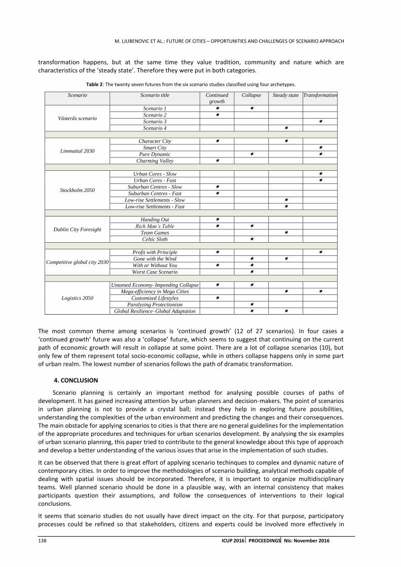
M. LJUBENOVIC ET AL.: FUTURE OF CITIES – OPPORTUNITIES AND CHALLENGES OF SCENARIO APPROACH
138 ICUP 2016 PROCEEDINGSNis: November 2016
transformation happens, but at the same time they value tradition, community and nature which are characteristics of the ‘steady state’. Therefore they were put in both categories.
Table 2: The twenty seven futures from the six scenario studies classified using four archetypes.
Scenario Scenario title Continued
growth
Collapse Steady state Transformation
Västerås scenario
Scenario 1
Scenario 2
Scenario 3
Scenario 4
Limmattal 2030
Character City
Smart City
Pure Dynamic
Charming Valley
Stockholm 2050
Urban Cores - Slow
Urban Cores - Fast
Suburban Centres - Slow
Suburban Centres - Fast
Low-rise Settlements - Slow
Low-rise Settlements - Fast
Dublin City Foresight
Handing Out
Rich Man’s Table
Team Games
Celtic Sloth
Competitive global city 2030
Profit with Principle
Gone with the Wind
With or Without You
Worst Case Scenario
Logistics 2050
Untamed Economy–Impending Collapse
Mega-efficiency in Mega Cities
Customized Lifestyles
Paralyzing Protectionism
Global Resilience–Global Adaptation
The most common theme among scenarios is ‘continued growth’ (12 of 27 scenarios). In four cases a ‘continued growth’ future was also a ‘collapse’ future, which seems to suggest that continuing on the current path of economic growth will result in collapse at some point. There are a lot of collapse scenarios (10), but only few of them represent total socio-economic collapse, while in others collapse happens only in some part of urban realm. The lowest number of scenarios follows the path of dramatic transformation.
4. CONCLUSION
Scenario planning is certainly an important method for analysing possible courses of paths of development. It has gained increasing attention by urban planners and decision-makers. The point of scenarios in urban planning is not to provide a crystal ball; instead they help in exploring future possibilities, understanding the complexities of the urban environment and predicting the changes and their consequences. The main obstacle for applying scenarios to cities is that there are no general guidelines for the implementation of the appropriate procedures and techniques for urban scenarios development. By analysing the six examples of urban scenario planning, this paper tried to contribute to the general knowledge about this type of approach and develop a better understanding of the various issues that arise in the implementation of such studies.
It can be observed that there is great effort of applying scenario techinques to complex and dynamic nature of contemporary cities. In order to improve the methodologies of scenario building, analytical methods capable of dealing with spatial issues should be incorporated. Therefore, it is important to organize multidisciplinary teams. Well planned scenario should be done in a plausible way, with an internal consistency that makes participants question their assumptions, and follow the consequences of interventions to their logical conclusions.
It seems that scenario studies do not usually have direct impact on the city. For that purpose, participatory processes could be refined so that stakeholders, citizens and experts could be involved more effectively in

M. LJUBENOVIC ET AL.: FUTURE OF CITIES – OPPORTUNITIES AND CHALLENGES OF SCENARIO APPROACH
ICUP 2016 PROCEEDINGS Nis: November 2016 139
scenario exercise, especially when determining implications of future visions. The approach should be more action-oriented and fully integrated into the planning process.
REFERENCES
1. Alcamo, J. 2001. Scenarios as tools for international environmental assessments. Environmental issue report No 24, Copenhagen: EEA.
2. Amer, M., Daim, T.U. and Jetter, A., 2013. A review of scenario planning. Futures, 46. pp 23-40.
3. Bartholomew, K., 2007. Land use-transportation scenario planning: promise and reality. Transportation, 34 (4). pp 397-412
4. Bradfielda, R., Wright, G., Burt, G., Cairns, G. and van Der Heijden, K., 2005. The origins and evolution of scenario techniques in long range business planning. Futures, 37(8). pp 795–812.
5. Branagh, S. and Ratcliffe, J., 2002. Dublin city foresight. Dublin Institute of Technology.
6. Deutsche Post AG, 2012. Delivery Tomorrow - Logistics 2050: A Scenario Study. Bonn: Deutsche Post AG.
7. Godet, M., 2000. The Art of Scenarios and Strategic Planning: Tools and Pitfalls. Technological Forecasting and Social Change 65(1). pp 3-22.
8. Höjer, M., Gullberg, A. and Pettersson, R., 2011. Backcasting images of the future city—Time and space for sustainable development in Stockholm. Technological Forecasting & Social Change 78 (5). pp 819–834.
9. Inayatullah, S., 2008. Six pillars: futures thinking for transforming. Foresight 10(1). pp 4-21.
10. Kelly, P.R., Ratcliffe, J.R. and Gannon, J.N., 2006. The competetive global city 2030: a futures approach. Futures Academy, Dublin Institute of Technology.
11. Khakee, A., 1991. Scenario Construction for Urban Planning. Omega 19(5). pp 459-469.
12. Krawczyk, E. and Ratcliffe, J., 2006. Application of futures methods in urban planning processes in Dublin. Fennia 184(1). pp 75–89.
13. Lindgren, M. and Bandhold,H., 2009. Scenario planning - Revised and Updated Edition: The link between future and strategy. Palgrave Macmillan.
14. Mahmoud, M. et al., 2009. A formal framework for scenario development in support of environmental decision-making. Environmental Modelling & Software 24 (7). pp 798–808.
15. Miguel Fernández Güell, J. and Redondo, L., 2012. Linking territorial foresight and urban planning. Foresight, 14(4). pp 316-335.
16. Myers, D., 2001. Symposium: Putting the future in planning. Journal of the American Planning Association 67(4). pp 365-367.
17. Nassauer, J.I. and Corry, R.C., 2004. Using Normative Scenarios in Landscape Ecology. Landscape Ecology 19(4). pp 343-356.
18. Pillkahn, U., 2008. Using Trends and Scenarios as Tools for Strategy Development. Erlangen, Germany: Publicis Corporate Publishing.
19. Quay, R., 2010. Anticipatory Governance - A Tool for Climate Change Adaptation. Journal of the American Planning Association 76 (4). pp 496 - 511.
20. Ratcliffe, J. and Krawczyk, E. 2011. Imagineering city futures: The use of prospective through scenarios in urban planning. Future 43 (7). pp 642–653.
21. Ratcliffe, J. and Krawczyk, E. 2004. Imagineering cities – creating liveable urban futures. The Futures Academy. Dublin Institute of Technology. http://www.thefuturesacademy.ie/node/72 [Accessed: 30thJanuary2014].
22. Sam, C., 2011. Dare to dream: Bringing futures into planning. Journal of the American Planning Association 67(4). pp 372.
23. Schnaars, S.P., 1987. How to Develop and Use Scenarios. Long Range Planning 20(1). pp 105-114.
M. LJUBENOVIC ET AL.: FUTURE OF CITIES – OPPORTUNITIES AND CHALLENGES OF SCENARIO APPROACH
140 ICUP 2016 PROCEEDINGSNis: November 2016
24. Stojanovic, M., Mitkovic, P.and Mitkovic, M., 2014. The scenario method in urban planning. Facta Universitatis, Series: Architecture and Civil Engineering, 12(1). pp 81-95.
25. Van der Heijden, K., 1996. Scenarios: The Art of Strategic Conversation. John Wiley & Sons Ltd, Chichester, England.
26. Varum, C.A. and Melo, C., 2010. Directions in scenario planning literature – A review of the past decades. Futures 42 (4). pp 355–369.
27. Volkery, A. and Ribeiro, T., 2009. Scenario planning in public policy: Understanding use, impacts and the role of institutional context factors. Technological Forecasting & Social Change 76 (9). pp 1198–1207.
28. Von Wirth, T., Hayek, U.W., Kunze, A., Neuenschwander, N., Stauffacher, M. and Scholz,R.W., 2013. Identifying urban transformation dynamics: Functional use of scenario techniques to integrate knowledge from science and practice. Technological Forecasting & Social Change89, pp 115-130.
29. Wiek, A., Binder, C. and Scholz, R.W., 2006. Functions of scenarios in transition processes. Futures 38 (7). pp 740–766.

M. DINIC-BRANKOVIC ET AL.: RESTRUCTURING THE CENTERS OF LARGE HOUSING ESTATES IN THE POST-SOCIALIST CITY
ICUP 2016 PROCEEDINGS Nis: November 2016 141
RESTRUCTURING THE CENTERS OF LARGE HOUSING ESTATES IN THE POST-SOCIALIST CITY
Milena Dinic-Brankovic
University of Nis, Faculty of Civil Engineering and Architecture, Serbia PhD., Assistant, [email protected]
Ivana Bogdanovic-Protic
University of Nis, Faculty of Civil Engineering and Architecture, Serbia PhD., Assistant, [email protected]
Milica Igic
University of Nis, Faculty of Civil Engineering and Architecture, Serbia Assistant, [email protected]
Jelena DJuric
University of Nis, Faculty of Civil Engineering and Architecture, Serbia Assistant, [email protected]
Petar Mitkovic
University of Nis, Faculty of Civil Engineering and Architecture, Serbia PhD., Full Professor, [email protected]
ABSTRACT
The experience in the implementation of central urban functions in large housing estates shows that a mere densening of central amenities is not enough to accomplish genius loci. As these estates in general lacked central facilities, and since they have a very large population, the creation of central places is necessary, and in a manner that would least disturb the authentic concept. The goal of this paper is to point out the possibilities of mixed-use implementation in the restructuring of centers of large housing estates. Therefore, the experiences of two post-socialist cities (Bratislava and Leipzig) are presented here, since they implement mixed-use development. The engagement of all existing resources of physical structure is recommended, as well as the least occupation of green/ open spaces in the estates, without the provision of new housing. New construction should be of anthropometric scale, and should form an adequate spatial frame for central activities. Due to the area’s compact size and high density, the main center of the estates should be the rank of a secondary urban center.
Keywords: large housing estates; secondary center; restructuring; mixed-use development; urban design.
1. INTRODUCTION
Large housing estates (hereinafter LHE) were constructed at the periphery of cities in the first decades after WW2, according to the CIAM principles of urban planning (Dekker and Van Kempen, 2005). These housing estates were planned and built as master-planned communities, in the form of massive urban extensions at the urban edge (Sykora and Stanilov, 2014). In socialist cities, large housing estates were the predominant development form. In planning theory, such an estate should have been served by corresponding public services according to the established standards (Stanilov, 2007a). The reality, however, was different - planners either significantly reduced the people needs for services, or deliberately postponed the construction of non-residential facilities in order to keep the cost low (Hirt and Stanilov, 2007). Therefore, LHE were mono-
M. DINIC-BRANKOVIC ET AL.: RESTRUCTURING THE CENTERS OF LARGE HOUSING ESTATES IN THE POST-SOCIALIST CITY
142 ICUP 2016 PROCEEDINGSNis: November 2016
functional by plan and with a relatively modest degree of public services. Local centers were not completed as planned, or their construction had never even begun (Dinic and Mitkovic, 2016).
Nowadays, large housing estates are no longer located at the city periphery, since the expansion of cities brought them closer to the city center. New position in the urban fabric and the transition to market economy after the collapse of socialism led to a growing interest in this land, which became attractive for commercial uses. Under the increased market pressure, public open and green areas, which made up a high share of urban fabric in the socialist period (Stanilov 2007b), perish under the onslaught of new commercial construction (Hirt and Kovachev 2006; Kreja 2006). Foreign experiences in new commercial development in LHEs show us the successful and some less successful examples of creating new centers in the existing socialist environment. In practice, the ‘completing’ of the estates with central facilities is often performed partially, without a coherent plan and outside the context of the central district established by plan, while a mere densening of central amenities is not enough to accomplish genius loci. The domestic experience so far shows that in large housing estates a multifunctional spontaneous development occurs, instead of planned mixed-use development, and that there are no well-designed centers.
Creating a new center in the existing environment is not simple at all, especially when it comes to large housing estates that represent a specific urban legacy of Modern style. Since these urban formats had almost no central functions whatsoever, it is of crucial importance for their future development to create/ improve their centers and make them vital nexuses of social life. From the standpoint of this research, a significant contribution to this process can be provided by the implementation of mixed-use development. This development is characterized by (Schwanke, 2003): (1) Three or more significant revenue-producing uses, that in well-planned projects are mutually supporting; (2) Significant physical and functional integration of project components, which results in a relatively close-knit and intensive use of land, including uninterrupted pedestrian connections; and (3) Development in conformance with a coherent plan, that frequently stipulates the type and scale of uses and permitted densities. This paper examines the implementation of mixed-use development in LHE centers as important urban sub-centers, and discusses the main urban design principles.
2. EXAMPLES OF RESTRUCTURING THE CENTERS OF LARGE HOUSING ESTATES WITH THE IMPLEMENTATION OF MIXED-USE DEVELOPMENT
This chapter illustrates the creation of a completely new settlement center in the LHE Petrzalka (Bratislava), as well as the remodeling of the center defined by plan but never completed in LHE Grunau (Leipzig), both in the post-socialist period. First, the genesis of both settlements and their development circumstances are exposed, then the post-socialist restructuring of their centers is described, and finally the results expected/ achieved are presented.
2.1. LHE Petrzalka, Bratislava
Petrzalka district on the right bank of the Danube River is the largest of 17 large housing estates in Bratislava, made of prefabricated concrete panels ('panelak'). In the area of Petrzalka, the construction of first socialist housing blocks began in 1977. The settlement was planned as an urban extension for 100,000 inhabitants and was built as a self-sufficient housing area. The original concept included the integrated urban functions of housing, work, education and social infrastructure in the area. However, only the residential buildings were built (about 800), while the settlement center was not constructed. Until the end of the 20th century Petrzalka was a uniform ‘bedroom community’ of Bratislava with residential use only, anticipating the completion of its central facilities.
At the end of the 20th century, Petrzalka district was characterized by good environmental values and an underdeveloped transport system. The main problems of tenants of Petrzalka were related to the lack of jobs in the estates and the city in general, followed by security issues and a lack of cultural and entertainment facilities. In this sense, a strategy was designed to complete central amenities and improve the quality of life.
Today, 106,000 people live in this LHE, covering an area of 287 ha (bratislava.sk). In Petrzalka, mixed-use projects and shopping facilities are increasingly being built, in order to improve the level of services of non-residential facilities in the estates. However, new interventions with various commercial uses did not create the center of the settlement. It is expected that the borough would gain the missing community center only by constructing the attractive mixed-use project Petrzalka City.

M. DINIC-BRANKOVIC ET AL.: RESTRUCTURING THE CENTERS OF LARGE HOUSING ESTATES IN THE POST-SOCIALIST CITY
ICUP 2016 PROCEEDINGS Nis: November 2016 143
Petrzalka City is a modern ‘self-sufficient’ multifunctional center, which is being built in the center of the district Petrzalka, 2 km from the historic center of Bratislava. The location of Petrzalka City is the undeveloped green space in a densely populated area (Figure 1a). The most important feature of the project is that urban design establishes a unique place to live, work, rest and recreate in an attractive park environment near the water, and that the project achieves a synergy of various components with careful implementation of environmentally friendly solutions.
(a) (b) Figure 1. (a) The site of the Petrzalka City project and its environment. Source: https://maps.google.com; (b) Petrzalka City project layout. Source: http://www.asb.sk/fotogalerie/architektura/petrzalka-city-bude-novym-multifunkcnym-centrom-fotoalbum/petrzalka-city-bude-
novym-multifunkcnym-centrom-1
In order to examine the possibilities of space and propose the optimal urban design for the area (shaping and programming), an urban study was made. The total site area of 27 ha was divided into three subunits A, B and C. The project requirements included: modern and complex design of the district center of Petrzalka, the optimal setting and position for multi-storey buildings, emphasizing the environmental aspect of the project, and the optimum integration of public transport (www.petrzalkacity.sk). The project provides for housing, business, sports and recreational facilities, hotel, retail, culture and entertainment (Figure 1b). The total area of constructed premises without parking space will amount to 400,000 m2 (www.petrzalkacity.sk). The project is being implemented in stages, with the completion that was initially planned for 2013. However, there have been several delays of the start of construction. Construction began in 2010, and the first phase is currently being implemented (subunit A). Subunit A covers the area of 2.5 ha, where a mixed-use center will be built. However, only one residential-commercial building has been built so far. The second phase will cover an area of 25 ha (subunits B and C). In the subunit B a district center will be created, with the implementation of the traditional element of ’good urbanism’ - the town square. In this square a town hall, library, multi-purpose hall, modern art gallery, church center and other public facilities will be built.
The project aims to preserve a part of the existing vegetation by forming a city park. In this ecologically valuable area, a modern urban park of 7 ha with unique architectural artefacts will be located, as well as a landscaped coastal area of 2.4 ha (www.visitbratislava.com). An especially valuable resource of the project is the Danube armlet, whose revitalization will provide a high-quality water area in the park. Sports activities are planned on the undeveloped land, so the gym, sports fields, running tracks, skating and cycling will be situated in the area. A parking area for 4,500 vehicles is planned, which will be placed in underground garages and surface parking lots. The project is being developed in synergy with the development of public transport, of whom it is directly dependent. The new road with a new fast tram line is planned, which will link the city center and Petrzalka.
Although it is intended for the project Petrzalka City to transform the largest and the most densely populated residential area in Central Europe from the monotonous concrete prefabricated housing model into a fully equipped settlement with a district center, the project has undergone numerous critics. The site of Petrzalka City is the only location in the area which was designated for a park for the entire settlement. When the entire project is completed, denizens of Petrzalka will have virtually no greenery - the only large undeveloped green area will be occupied by physical structures. The 7 ha of greenery anticipated by the project is not nearly
M. DINIC-BRANKOVIC ET AL.: RESTRUCTURING THE CENTERS OF LARGE HOUSING ESTATES IN THE POST-SOCIALIST CITY
144 ICUP 2016 PROCEEDINGSNis: November 2016
enough for the area which will have approximately 150,000 inhabitants. One more reproach is related to the position of the new high-speed rail route, which will pass through this single park area.
2.2. LHE Grunau, Leipzig
With the exception of Berlin, Grunau represents the largest housing estate built in the prefabricated system in East Germany. It was created in the period 1976 to 1988 on the western outskirts of Leipzig, as a concentrated residence of the new workforce and a balance to the densely populated eastern part of the city. It occupies an area of 401 ha. The economic crisis that went on in the eighties had severely affected the Grunau estate1. The designing of residential environment was neglected, schools and kindergartens were built with a delay, and residential buildings were built instead of the planned public facilities. The district center, which was supposed to have a department store, an indoor pool and a cultural center, remained neglected until the end of the German Democratic Republic. At the time of important political changes in 1989, Grunau was an unfinished settlement that lacked a number of public facilities.
By 2002, the settlement has already lost about 40% of population (LHASA, 2006). As the issue of empty dwellings in Leipzig grew more evident and had a tendency of deterioration, a Partial plan of large housing estates was established in 2004. The urban renewal of residential areas was performed in accordance with the program ‘Stadtumbau Ost’ and in cooperation with housing agencies. The City of Leipzig has reached an agreement with six large cooperatives and Leipziger Wohnungs und Baugesellschaft mbH on that the large housing areas should be stabilized and deconstructed in a controlled way (LHASA, 2006). Although the denizens were actively involved in the reconstruction process of the Grunau estate, conflicts still occurred.
Leipzig’s plan for managing urban shrinkage also required a complete redefinition of the system of centrality. Leipzig City Council adopted the 1999 Development plan for the network of centers (STEP Zentren), in order to support the planned investments in retail, create new jobs, strengthen the economy and improve public facilities. In the new network of local centers, the centers were ranked A, B or C, with the inner-city being the A-Center. Before the urban regeneration of Grunau estate, the primary function was dwelling, along with the necessary social facilities. Commercial facilities were not situated in this area. According to the new urban development plan, the district center in Grunau is one of two B-Centers of Leipzig, with the gravitating population of approximately 45,000 inhabitants. Distance from the inner-city is 6 km. This center is formed along the remodeled Stuttgarter Allee, where newly built shopping, business, sports and public facilities are located next to the existing housing, on the land that has been cleared after the deconstruction of some residential buildings. Densening of the physical structure was partially performed on existing large green areas, while the rest of the greenery is used for sport and recreation. The central zone of Grunau stretches starting from PEP shopping center in the north, continues along the pedestrian street Stuttgarter Allee, along which the shopping center Allee-Center, library, cultural center, commercial and service facilities are located, all the way to the sports center in the south (Figure 2a).
The ‘heart’ of Grunau estate is the Allee-Center, a shopping and business center which opened in 1996. It is a two-storey building with gross leasable area of 24,000 m2, of which 1,400 m2 is intended for business use (www.ece.com). It contains 115 shops, a department store, two outlet stores, a store selling electronic devices, a multiplex cinema with 8 movie theaters, service and catering facilities. Parking for 1,000 vehicles is positioned on the roof and in the underground garage. In front of the Allee-Center a pedestrian overpass above busy roads is created, in order to achieve a continuous pedestrian flow along the entire route. In the pedestrian street area a pedestrian square is created, which also serves as market space (Figure 2b). Existing multi-storey buildings of collective housing are included in the scope of the center. The ground floors of some high-rise buildings along the pedestrian street are remodeled to engage in retail. The green roof of the ground floor provides greater privacy to the residents of the first floor (protection from noise and street views), and better living quality.
1 The city of Leipzig is known as a ‘shrinking city’ or a ‘perforated city’, since it has been continuously shrinking since 1966. This phenomenon was further accelerated by the post-socialisttransition since 1989.

M. DINIC-BRANKOVIC ET AL.: RESTRUCTURING THE CENTERS OF LARGE HOUSING ESTATES IN THE POST-SOCIALIST CITY
ICUP 2016 PROCEEDINGS Nis: November 2016 145
(a) (b) Figure 2. (a) District center Grunau of B rank and pedestrian connections of central facilities along the Stuttgarter Allee. Source:
http://www.urban-ma.de/wp-content/uploads/2013/07/6ca04b9151615732dcd8a81a8da8bf3a.jpg; (b) The layout of a part of the pedestrian street Stuttgarter Allee with the square. Source: http://www.hanke-partner.de/stuttgarter_allee_leipzig.php?bn=0
Traffic setting of the Grunau estate enables attractive, busy and safe pedestrian flows in the interior, away from motor vehicle traffic. Reconstruction measures provided for additional parking spaces, which together with a large number of empty apartments enabled enough parking for everyone. The estate is well connected by public transport with the rest of the city via metro, tram and bus lines.
Leipzig's strategy of urban shrinking management has suffered some criticism. D. Florentin (2010) argues that this strategy was largely limited to a marketing campaign, based on the traditional rhetoric of urban regeneration, and that it had a lot of negative social implications. Planners lacked the financial and legal instruments to fully implement the strategy. Some interventions have produced conflicts with landowners regarding new land uses. However, urban regeneration of Grunau is generally assessed positively by a large part of the population of the estates. The settlement has a high population density with a compact layout of physical structures, but also offers plenty of green and open spaces. Surveys show that the denizens are satisfied with both the location and the apartments. Accessibility of public transport enables quick access to the inner-city, although the estate itself has a well-developed district center. The estate leans on natural environment and achieves quality integration with it. There are enough public facilities that are easily accessible. The price-quality ratio of apartments is good. Nevertheless, Grunau estate still has the largest population decline of all settlements in the territory of Leipzig, and an overall poor image. Also, there is a fear that the effects of Grunau urban regeneration would only further enhance social and spatial differences.
3. DISCUSSION
In the analyzed examples of socialist housing estates, an attempt was made to restructure the missing centers of the settlements by using a systematic planning approach, since the centers did not have an opportunity to be developed during socialism or at the beginning of the chaotic transition period.
In the case of Petrzalka, where the settlement center did not exist, a creation of a new mixed-use center is planned within a large park area in the estate. For this reason, housing is included in the mix of functions, occupying the upper floors. However, despite the attractiveness of the project that offers a wide range of uses and quality public spaces, a severe objection to this design is that the only neighborhood park in this estate is intended for construction. This intervention will undoubtedly diminish the quality of life in the settlement Petrzalka, because it will disrupt the environmental conditions and significantly reduce the ratio of green space per capita. From the aspect of urban design, this concept reduces the value of Modern urbanism layout, in which the estate was designed. Regardless of market pressure, further occupation of a majority stake of undeveloped land by new construction should not be permitted in LHE, or it should at least be limited to a reasonable level. In these estates, with high values of population density, new housing should not be provided, because this would lead to additional densening of space with objects, users and activities. Also, the construction of underground garages is provided to prevent further decrease of undeveloped areas in the center. It should be pointed out that the center of Petrzalka has not been constructed in total and that all implications of its construction cannot be perceived or evaluated just yet. It remains to be seen what will be the effects of this project on the environment when it is completed.

M. DINIC-BRANKOVIC ET AL.: RESTRUCTURING THE CENTERS OF LARGE HOUSING ESTATES IN THE POST-SOCIALIST CITY
146 ICUP 2016 PROCEEDINGSNis: November 2016
In remodeling the center of Grunau settlement, an existing central nucleus is used. In this case, it can be concluded that the preferred modalities of creating centers of socialist estates are those interventions that do not generate new housing, but only introduce missing central facilities. Reusing the ground floors of residential buildings in the Stuttgarter alley was facilitated due to emigration and the high percentage of empty dwellings. In this case, a certain part of the green areas is also occupied by new construction, but in a far smaller percentage. It involves small edge surfaces of undeveloped land, and not a massive compact development as in the case of Petrzalka. It is also important to mention the fact that in the Grunau estate a part of the parterre was disengaged by the demolition of the surplus of structures. In this way, the original ratio of built-undeveloped land is not drastically undermined as in the settlement Petrzalka. The areas of deconstructed buildings are used as parking.
Regardless of the limitations imposed by the current situation in LHEs, it is possible to form a mixed-use district center. This is confirmed in the case of Stuttgarter alley as a linear center of Grunau estate, where all existing non-residential uses (shops, community centers, clubs) are activated and integrated into a singular central space. Physical integration is enabled by quality pedestrian connections, while functional integration is achieved by amending the missing uses (that are compatible both with each other and with housing). These interventions are implemented through:
Reusing of non-residential buildings that are not in use and their remodeling (adaptation, upgrade, extension) for more attractive and more vital commercial purposes;
Activating the ground floors of residential buildings for commercial purposes, and building object extensions to bring commercial facilities closer to the street line and the pedestrian promenade;
Controlled new construction of the missing amenities (sports center) on a limited part of undeveloped areas, which is used to shape an adequate spatial framework for central activities, or to create a continuity of physical structures;
Achieving a continuity of pedestrian flow along the Stuttgarter alley by using leveled pedestrian crossings over busy roads, distinctive pavement appropriate for pedestrians and forming pedestrian nodes along this street;
Remodeling of all undeveloped areas in socialist complexes and increasing their value of usage, and creating quality public spaces that are really appealing to the users and which serve as a suitable spatial frame for central activities;
The demolition of certain buildings/ upper floors since the estate is experiencing demographic decline.
The newly planned structure of uses in the center should incorporate missing facilities. It is recommended to preserve the existing housing in the restructured center, which in the case of Grunauestate is 70% in the mix of uses. In addition to housing, other main uses that appear in the project are shops, business and catering. Allee-Center has as a positive impact on the functional structure of the settlement center, due to its thoughtful design and pedestrian connections to other amenities. Less profitable uses that are planned are service activities, cultural and entertainment facilities (as generators of social life in the estate) and areas/ facilities for sport and recreation. The high rank of the center and the large number of gravitating population cause the share of non-residential uses in the center ranging from 30% in Grunau up to 70% in Petrzalka.
The analyzed cases show that the remodeling of public spaces in socialist complexes is a necessary element for the creation of the settlement center, with a controlled increase in the degree of public availability of public open spaces and their integration into the district center. The complemented commercial facilities in the center are interconnected by convenient pedestrian links, and lean on quality public spaces, in order to encourage the usage of space by pedestrians and form a distinctive central character. Creating the physical integration of uses is illustrated in the case of the promenade in Grunau estate: continuous pedestrian lines with central amenities are formed, new construction approaches the street line, and ground floor premises are made visually accessible and included in the vertical frame of public spaces. In both analyzed centers priority is given to pedestrian traffic. The accessibility of the settlement by public transport is considered to be a necessary precondition for the vitality of the center.
Due to the large number of users – denizens of the settlements Grunau and Petrzalka, the newly formed centers are ranked as secondary centers and they represent important urban sub-centers. Such centers are necessary for big cities in order to provide equal service to the denizens of the entire territory. It is also important to emphasize that the lack of central amenities in Petrzalka’s LHE is resolved by concentrating new amenities in a single mixed-use project, while in the case of Grunau a network of local centers is formed in the
M. DINIC-BRANKOVIC ET AL.: RESTRUCTURING THE CENTERS OF LARGE HOUSING ESTATES IN THE POST-SOCIALIST CITY
ICUP 2016 PROCEEDINGS Nis: November 2016 147
entire area of the estate, with the highest concentration of uses in the main settlement center. From the viewpoint of providing for the customers and sustainable development of the estate, optimal solution is the uniform distribution of central uses within a hierarchically structured network of centers.
4. CONCLUSIONS
In the transition period, due to the massive undeveloped areas, large housing estates gained a handful of new facilities, which mostly emerged randomly and according to the dictate of the market. Analyzed cases confirm that identity and vitality of these important urban sub-centers can be significantly improved by channeling of spontaneous development into the development with planned, integrated and diverse uses. In this sense, in the center of the LHE (secondary urban center), it is possible to implement the mixed-use development principle in two scenarios: (1) the construction of a new mixed-use center which includes housing and (2) the conversion of the central nucleus by ‘supplementing’ the missing amenities, without new housing. The recommended development model is the more moderate mode of densening of physical structure with supplemental central uses, without introducing new housing, and the creation of a mixed-use central zone.
New interventions in the restructuring of centers should be carried out carefully, so as to minimize the violation of the existing urbo-architectural features of the estates and the spirit of Modern style in which the objects are built. The standpoint of this paper is that this can be achieved if the construction of new buildings is confined to central facilities, or if remodeling of existing facilities is performed. Before any new construction in the area, the original setting of buildings and open spaces should be considered (about 18-28% of developed and 72-82% of undeveloped areas). The value of open and green space per capita must not be reduced significantly (by introducing new residents, densening the physical structure, occupying large compact areas with new facilities or upgrading existing buildings). New facilities should be introduced only to the extent which is necessary for the independent functioning of these settlements, without generating additional car traffic. New development at the expense of public open spaces and greenery should be performed on the street line, in order to achieve the continuity of street frontage, in minimum width. The rest of the land should be preserved in its original public purpose. In turn, the developers of new commercial schemes should be obliged to design, equip and maintain the remaining public open/ green space. Parking for facilities in the central area should be provided within existing streets of narrow profile (short-term parking), and by constructing underground garages underneath public open spaces, or rooftop garages on top of the new central facilities.
Regarding residential use as a component of a mixed-use project in LHEs, where mono-functionality was one of the biggest issues, it can be concluded that the construction of new apartments within the complex is unnecessary. This is particularly relevant in domestic circumstances, where LHEs still remain a popular form of housing (there is no significant emigration or devastation of estates). Also, in cases where demographic decline and demolition of residential buildings do not occur, reuse of the ground floors can be initiated through various regeneration programs. Therefore, the restructuring of the center should be monitored by the program of implementation. Such programs should motivate the tenants to begin the transformation of living space into a commercial one (market incentives for various activities, subsidies for the relocation from the ground floors, etc.), or stimulate other unpopular actions, if necessary, such as demolition of some floors/ buildings.
By forming a suitable center, large housing estates would achieve long-term sustainability, which is especially important for post-socialist cities that cannot afford the costly processes of demolition of residential buildings and population displacement.
ACKNOWLEDGEMENTS
This paper is the result of the project “Improving energy characteristics and quality of inner space in buildings of educational institutions in Serbia with the influence on health” (No: III 42008), financed by the Ministry of Education, Science and Technological Development of the Republic of Serbia.
REFERENCES
1. Dekker, K. and Van Kempen, R., 2005. Large housing estates in Europe: a contemporary overview. In Restructuring Large Housing Estates in Europe (Eds. R. Van Kempen, K. Dekker, S. Hall and I. Tosics). The Policy Press, Bristol. pp 19-45.
2. Dinic, M. and Mitkovic, P., 2016. Suburban design: from ‘bedroom communities’ to sustainable neighborhoods. Geodetski Vestnik 60(1), pp 98-113.

M. DINIC-BRANKOVIC ET AL.: RESTRUCTURING THE CENTERS OF LARGE HOUSING ESTATES IN THE POST-SOCIALIST CITY
148 ICUP 2016 PROCEEDINGSNis: November 2016
3. Florentin, D., 2010. The ‘Perforated City’: Leipzig’s Model of Urban Shrinkage Management. Berkeley Planning Journal 23(1), pp 83-101.
4. Hirt, S. and Kovachev, A., 2006. The changing spatial structure of post-socialist Sofia. Part II in The urban mosaic of post-socialist Europe: space, institutions and policy (Eds. S. Tsenkova and Z. Nedovic-Budic). Physica-Verlag HD, New York. pp 113–130.
5. Hirt, S. and Stanilov, K., 2007. The perils of post-socialist transformation: Residential development in Sofia. Part 3 in The Post-Socialist City: Urban Form and Space Transformations in Central and Eastern Europe after Socialism (Ed. K. Stanilov). Springer, Dordrecht. pp 215-244.
6. Kreja, K., 2006. Spatial imprints of urban consumption: large-scale retail development in Warsaw. Part III in The urban mosaic of post-socialist Europe: space, institutions and policy, (Eds. S. Tsenkova and Z. Nedovic-Budic). Physica-Verlag HD, New York. pp 253-272.
7. Large housing areas stabilisation action (LHASA), 2006. Strategies of stabilisation for large housing areas, An INTERREG III B-Project in the co-operation area CADSES of the European Union, Case Study Leipzig-Grünau.
8. Schwanke, D., 2003. Mixed-Use Development Handbook. Urban Land Institute, Washington DC.
9. Stanilov, K., 2007a. Housing trends in Central and Eastern European cities during and after the period of transition. Part 3 in The Post-Socialist City: Urban Form and Space Transformations in Central and Eastern Europe after Socialism (Ed. K. Stanilov). Springer, Dordrecht. pp 173-190.
10. Stanilov, K., 2007b. Democracy, markets, and public space in the transitional societies of Central and Eastern Europe. Part 4 in The Post-Socialist City: Urban Form and Space Transformations in Central and Eastern Europe after Socialism (Ed. K. Stanilov). Springer, Dordrecht. pp 269-283.
11. Sykora, L. and Stanilov, K., 2014. The Challenge of Postsocialist Suburbanization. In Confronting Suburbanization: Urban Decentralization in Postsocialist Central and Eastern Europe (Eds. K. Stanilov and L. Sykora). Wiley-Blackwell, Chichester. pp 1–32.
12. http://bratislava.sk/petrzalka/d-75043 [Accessed: 11th August 2016].
13. http://www.petrzalkacity.sk/ [Accessed: 11th August 2016].
14. https://www.visitbratislava.com/ [Accessed: 11th August 2016].
15. http://www.ece.com/en/centers-projects/shopping/detail/allee-center-leipzig/ [Accessed: 11th August 2016].
16. https://maps.google.com [Accessed: 11th August 2016].
17. http://www.asb.sk/fotogalerie/architektura/petrzalka-city-bude-novym-multifunkcnym-centrom-fotoalbum/ petrzalka-city-bude-novym-multifunkcnym-centrom-1 [Accessed: 11th August 2016].
18. http://www.urban-ma.de/wp-content/uploads/2013/07/6ca04b9151615732dcd8a81a8da8bf3a.jpg [Accessed: 11th August 2016].
19. http://www.hanke-partner.de/stuttgarter_allee_leipzig.php?bn=0 [Accessed: 11th August 2016].

A. DJUKIC ET AL.: SHOPPING MALL VS. OPEN PUBLIC SPACE IN CONSUMER CULTURE
ICUP 2016 PROCEEDINGS Nis: November 2016 149
SHOPPING MALL VS. OPEN PUBLIC SPACE IN CONSUMER CULTURE FOR ICUP 2016
Prof. PhD Aleksandra DJukic
Department of Urban Planning University of Belgrade - Faculty of Architecture Bulevar kralja Aleksandra 73/2, Belgrade 11000, Serbia
PhD., Associate Professor, [email protected]
Marija Cvetkovic
Department of Urban Planning University of Belgrade - Faculty of Architecture Bulevar kralja Aleksandra 73/2, Belgrade 11000, Serbia
Teaching Assistant, [email protected]
ABSTRACT
This paper explores the built environment of a shopping mall considering perception by its users. The aim of this paper is to compare the preferences consumers have towards shopping malls and public spaces, by determining consumers’ opinion on the (dis)advantages of the shopping malls over features of the city center. The research question is about the competitiveness of shopping mall with open public space with the focus on the main qualities of it. Furthermore, the paper aims to explore the ways in which the inner space of these malls dictates behaviour of their visitors and shape the way how they spend their free time. The methodological frameworks are observations, questionnaires and surveys. Identity of shopping malls versus public places in Belgrade is observed through technical analyses and qualitative surveys using questionnaires. This research suggests that understanding experiences of contemporary urban change in public space requires a broader performative understanding of users’ needs and its qualities.
Keywords: shopping mall; identity; Belgrade; semi-public space.
1. INTRODUCTION
Shopping malls have lately become one of the basic characteristics of cities. Behaviour and interactions of its visitors are defined by the primary purpose of this space - consumption. Potential interactions are reduced to temporary, superficial and formal communication. Simulation of city streets with shops and small squares takes over the role which downtown had, until recently.
Reproducing the city within its walls, shopping center states that experience of the city is safer and cleaner in the climate-controlled and secure conditions, than on the real streets outside.1 The disappearance of public space and the emergence of pseudo-public spaces with limited access occur simultaneously with the aggression of commercial culture and emergence of cultural spectacle. "The difference between the public and pseudo-public space is that the pseudo-public space represents a privatized public sphere. It, however, seems like a public sphere, but the rules of the game are defined in a way that there are not many "public potentials."2
Among the first, notion of pseudo-public space was introduced by Mike Davis, who explained them as a special kind of public space where the admission and behavior of people are strongly constrained by a strong security system. Davis, explaining the fear of the crowds, said that "the designers of malls and pseudo-public space attack the crowd by homogenizing it. They set up architectural and semiotic barriers to filter out ‘undesirables’. They enclose the mass that remains, directing its circulation with behaviourist ferocity. It is lured by visual
1 Margaret Crawford. „The World in a Shopping Mall“ u M. Sorkin (Ur.), Variations on a Theme Park: The New American City and the End of Public Space(3-30). New York: Hill and Wang, 1992.
2 Srecko Horvat. Znakovi postmodernog grada: prilog semiologiji urbanizma. (Zagreb: Naklada Jesenski i Turk, 2007): pp. 139.

A. DJUKIC ET AL.: SHOPPING MALL VS. OPEN PUBLIC SPACE IN CONSUMER CULTURE
150 ICUP 2016 PROCEEDINGSNis: November 2016
stimuli of all kinds, dulled by muzak3, sometimes even scented by invisible aromatizes."4Davis presents an image of total detention, which is the result of the city planning besieged with security measures. Unlike the public space, malls do not have dark, unsafe and narrow streets. Plants5 are put to refresh the interior, as a reminiscent of nature, while on the other hand, the nature in an unnatural environment, "the presence of nature, albeit tamed in a garden setting, naturalizes consumption, and mitigates the alienation inherent in commodity production and consumption."6 Significant development strategy is the development of shopping centers in the form of public spaces, but this creates only an illusion of “openness”. Shopping centers are largely private, closed and guarded premises: pseudo-public spaces.
A general phenomenon7 is that the numerous contents of the city center are disappearing along with the opening of the new shopping center. The shopping mall is primarily a non-place.8 Marc Augé, who defined this term, indicates that the super modernity is producing non-places, which are transit and anonymous spaces that allow the fast flow of a larger number of individuals. Since they are deprived of identity, history and meaning as a social construct, non-spaces are not anthropological places. With transition of functions primarily intended for an open public space, to pseudo premises of the malls, purpose of the city square is lost. The streets and the squares of the shopping mall have been designed to create the impression that they are public spaces. However, it is a privately-owned space with movement restrictions and controlled behaviour of consumers, with selective access and video surveillance.
The modern consumer spaces give a distorted picture of social relations. Shopping centers are celebrated as family places where family members can spend their free time together. Everyday life of a modern family is mediated by the consumer society, according to G. Ritzer9. Late capitalist forms of social cohesion, such as families or communities, should consume goods to strengthen their relations. According to this author, these new means of consumption are transforming the nature of social relationships.
Since the 1980`s the focus of urban planners in Western Europe and developed countries are moved from construction of the new shopping malls to the regeneration and revitalization of the open public spaces. However, in Serbia and ex Eastern European countries, there is a booming process of the construction of new shopping malls. The recent economic decline in Serbia extinguishes glow of consumerism from few decades ago. Only the largest and strongest shopping malls survived, while small local malls, formed inside former department stores, are shutting down. Former local shopping centers, such as Siti pasaz, Staklenac, Stari Merkator, Cumicevo Sokace, Robna kuca Beograd, are examples of past glory and carriers of consumerism in Belgrade in the 70’s of the last century. In the era of global economy crisis, central axis of false consumerism in above-mentioned two shopping malls in Belgrade are low and middle category consumer goods, originating from various Asian countries. As a reaction to that, new shopping streets of high-class consumerism and elite are formed.
2. FIRST SHOPING MALLS
During the last decade shopping centers are beginning to dominate the center of cities and suburbs, as a visual sign of putting the production process before the consumer amenities. Victor Gruen was the architect of
3 Muzak is recorded music that is played quietly and continuously in public places, such as airports, hotels, and shops, to make people feel relaxed
4 Mike Davis, “Fortress L.A.” City of Quartz: Excavating the Future in Los Angeles. New York: Vintage Books, 1992, pp. 180
5 In order to create a more natural environment in large shopping malls, designers are building spacious gardens with all the characteristics of real. Goss (1993: 44) gives an example of Tyson's Corner in Virginia, whose administration has selected 29 large palm trees that were excavated in Florida and kept for 18 months in the shade in order to acclimatize to the conditions inside, before they are placed in the interior of the shopping center.
6 Jon Goss. „The "Magic of the Mall":An Analysis of Form, Function, and Meaning in the Contemporary Retail Built Environment“, Annals of the Association of American Geographers, Vol. 83, No. 1. (Mar., 1993), pp. 18-47., pp. 36
7 Борис Костуранов. „Отворено о јавним просторима – чији су јавни простори“. Отворено о јавним просторим , pp. 42.
8 The author (Marc Augé) defines the non-space of the city as a space that unlike the city can not be identified either as with identity, not as a relational, not as historical space. Non-space the are places of alienation, spaces that occur as a result of postindustrial and networked information society.
9 Ritzer, G. i Stillman, T. The Modern Las Vegas Casino-Hotel: The Paradigmatic New Means of Consumption. Management, 4(3), 2001, стр 184

A. DJUKIC ET AL.: SHOPPING MALL VS. OPEN PUBLIC SPACE IN CONSUMER CULTURE
ICUP 2016 PROCEEDINGS Nis: November 2016 151
the first shopping mall. He proposed mall as a basic unit of urban planning, where the mall becomes a multi-purpose city center. He identifies shopping as a part of a larger network of human activity, arguing that the selling would be better if commercial activities were integrated into the cultural and entertaining activities. Gruen saw designing of shopping malls as a way of producing new urban centers or, as he called them, "shopping towns." He was encouraging designers to program a shopping mall which included many shopping activities, as well as cultural, artistic and social events. He labelled this social integration of commercial activities "architecture of the environment."
Presence of the square and city streets, representing a symbol of the real city content, reminds us of Gruen’s idea of shopping malls. Shopping centers have encouraged the development of suburbs and became some kind of community centers; moreover, they have become a part of the American way of life, causing changes in our daily lives and habits. Creating place for public, political, cultural and recreational events, and above all, places of leisure and socialization, they have become more than a "commercial city," but an alternative center of the city. In postmodern times, former role of the city square completely disappeared. In order to understand why, we shall oppose city square as a meeting point with the modern shopping centers as a new "gathering point."10
An increasing number of activities related to the traditional contents of the city center, such as work, play, shopping, recreation, public protests,11 culture, entertainment, health and educational services has been transferred to the "mall."12 These activities include even tourism, which used to be related exclusively to landmarks of urban city.
3. METHOD AND MATHERIAL
The methodological frameworks are observations, questionnaires and surveys. Identity of shopping malls versus public places in Belgrade is observed through technical analyses and qualitative surveys using questionnaires. The aim of this paper is to compare the preferences consumers have towards shopping malls and public spaces.
3.1. Method of survey
Relevant data was collected by online questionnaire, during first two weeks of September 2016. The target population for this study consisted of mostly young people with their families, due to the fact that they belong to the group of people who are active mall visitors, which was noted by observation in largest Belgrade shopping malls. This could be pointed out as a lack of the research, given the disproportion of age groups in relation to the population of Belgrade in whole. A structured questionnaire was developed to measure the customers’ shopping motivation, both in the shopping mall and in the largest shopping city street in Belgrade, Knez Mihailova street. The questionnaire consisted of questions concerning shopping motivation, preferences, demographic information of respondents, questions about identity of shopping mall and identity of city center, the connection between them, etc.
The survey was conducted by an online questionnaire, which consisted of two parts:
Personal details of the respondents and demographic information;
Specific part of the questionnaire, concerning identity, preferences and choice of shopping space. The results are based on responses from 138 respondents. Questionnaires and face-to-face interviews were used in collecting data from the target population. Selected demographic information of the respondents, including gender, age, city and employment status, are presented in Figure 1.
10 Srecko Horvat. Znakovi postmodernog grada: prilog semiologiji urbanizma. (Zagreb: Naklada Jesenski i Turk, 2007): стр. 124.
11 The owners are rigorous when it comes to this situation and respond to it by calling the police to disperse people from the shopping mall (private property, which is presented as part of social life).
12 Shopping centreorshopping center, shopping mall,or justmall, are synonyms. Shopping center in USA popularly is calledshopping mall (Ritzer, 1999.), the term is used forto indoor, air conditioned and insured sales areamall (Underhill, 2005)

A. DJUKIC ET AL.: SHOPPING MALL VS. OPEN PUBLIC SPACE IN CONSUMER CULTURE
152 ICUP 2016 PROCEEDINGSNis: November 2016
Figure 1: Demographic profile of the sample (sex, age and employment status of respondents)
In total, there are more female respondents, with a prevalence of 73,9% over male respondents, who formed 26,1% of the sample. The age of the respondents shows that in general most of the respondents (90,6%) are between 15-30 years of age, with minority being over 30 years (30-45 – 5,8%; 45-60 – 3,6%). This proves that the sample was composed of all age groups, with target population of younger people from Belgrade (87.7%) and 12,3% from other Serbian cities. Almost 66% of respondents are students, and 26.1% are employed.
3.2. QuestionNaire sample
The difference between identities of shopping malls and public places in Belgrade is observed through questionnaire conducted in Belgrade, in Serbian language. Figure 2 shows specific part of the questionnaire concerning identity, preferences and choice of shopping space.
Figure 2: Questionnaire sample
4. RESULTS
4.1. Time Profile
The research also sought to establish the length of time the respondents have been spending in the mall and how often they go to shopping malls. Findings indicate that the most of the shoppers are spending 1-3h (80,4%) during one visit, while 10,1% spend less than an hour, and 9,4% of respondents spend 3-6h. Results from Figure 3 indicate that more of the half of the respondents visit shopping malls once a month (42%) or even once a week (12.3%). However, other half of respondents go to shopping malls rarely, few times a year (31,9%) or seasonally (8%)

A. DJUKIC ET AL.: SHOPPING MALL VS. OPEN PUBLIC SPACE IN CONSUMER CULTURE
ICUP 2016 PROCEEDINGS Nis: November 2016 153
Figure 3: Time profile (time span and frequency of visit).
4.2. Do people prefer shopping mall over city street?
In order to assess why shoppers are preferring shopping malls instead of public spaces and shopping streets, such as Knez Mihailova street in Belgrade, the respondents were presented with a list of seven statements and asked to rate how much they agreed with each of them. The statements were measured on a five-point scale, with following responses: strongly agree-5; agree=4; neutral=3; disagree -2; strongly disagree-1. Average score for each statement was calculated and the results disintegrated by type of respondents, with results displayed below, in Figures 4, 5 and 6.
Figure 4: climate comfort (score 3,38) and safety (score 2,22)
Most of the respondents mentioned the positive aesthetics of malls, such as pleasing colors, attractive lighting, warmth, and so on. Overall score for climate control is 3.38. Instead of common opinion that shopping malls are more preferred than city streets because of their safety, the results indicate that this is not the reason why people are choosing to stay in closed mall. Overall score for safety as a factor that makes shopping mall preferable choice is 2.22.
Figure 5: content concentration (score 3,33); people concentration (score 1,81)
75 out of 138 respondents mentioned in negative context “crowds” or “lots of people” in shopping malls. They strongly disagree that big concentration of people is preferable in choice of shopping place. They find the malls noisy, due to constant crowds. Only 7 participants liked that the large concentration of people in shopping malls. However, content concentration is important for majority of the participants.
Figure 6: Shopping brands (score 3,10); shops, cafes, leisure activities (score 2,25)

A. DJUKIC ET AL.: SHOPPING MALL VS. OPEN PUBLIC SPACE IN CONSUMER CULTURE
154 ICUP 2016 PROCEEDINGSNis: November 2016
The respondents agree that shopping malls offer many choices through a wide variety of branded stores and food courts. Opposite to a common opinion that leisure activities are important when choosing a shopping place, 40% of participants strongly disagree with this opinion; only 8% of them find it very important. However, some are concerned that there is a shortage of retailers, who meet their changing needs.
It is important to note that 89 out of 138 respondents (65%) stated they do not prefer shopping malls to city streets.
4.3. Identity of shopping mall versus public space
Almost half of participants believe that opening of new shopping malls will not affect the reduction of visitors to the shopping street of Knez Mihailova. On the other hand, 44.2% of respondents believe it will not affect city streets at all. Similarly, half of them (47.8%) are not concerned that city center will lose its identity, which can be noticed in Figure 7.
Figure 7: Identity of shopping mall versus public space (opinion of respondents about influence of shopping malls on public space)
We asked respondents who agreed to this statement to provide explanation for that. Some of the answers are:
“Malls are always the same, generic in every country”;
“Malls are distracting people from places in the city where they can find all possibilities the mall offers plus cultural heritage, the city's identity, cultural events ...”;
“City rejects its own tradition and heritage, and blindly throws the Western model, without character and parameters appropriate for us sensibility”;
“A large concentration of people in the wrong place, sense of values is lost under the shadow of the goods”;
“Because shopping centers impose a certain system of values, but it is necessary to create a non-leading human interaction”;
“It emphasizes consumerism, leads to alienation of people inside it”;
“Malls are not inherently bad, but the desire for capital, poor location, bad architecture, without greater and more noble goal is bad”;
“It became touristic destination.” As can be concluded from Figure 8, most the respondents claim that they spend more time walking on city streets (91,3%) than in the closed shopping malls (8,7%)l. Nevertheless, more than half of them (53,6%) enjoy shopping in closed and guarded premises - mall than on open city streets.
Figure 8: Choice of place (walking and preferences)
4.4. Mall compared to the open public space
It can be noticed from the results from a sample survey show that 82,6% of people believe that shopping malls cannot successfully replace open public spaces, while 15,2% agree with that statement, and the remainder had not thought about the issue (Figure 9).

A. DJUKIC ET AL.: SHOPPING MALL VS. OPEN PUBLIC SPACE IN CONSUMER CULTURE
ICUP 2016 PROCEEDINGS Nis: November 2016 155
Figure 9: Opinion of respondents about replacement and resemblance of shopping mall vs. public spaces
A few respondents who agreed to this statement elaborated their opinion:
“There are more shops”
“Because it gives more opportunities”
“Complexity”
“Because in the mall you can avoid bad climatic conditions without staying at home”
“Because in the one place you can find greater choice of goods adapted for different budget population, you do not have to go throughout the city”
Simulation of city streets with shops and small squares, takes over the role which downtown had, until recently. Figure 9 shows that participants who agreed with statement that interior of shopping mall resembles city streets (5,1%) said that this is due to concentration of movement, crowded shops, concentration of content and people.
“they should probably look like the streets, although I do not have that impression, the more I feel like in a box system of streets and squares, benches and greenery in pots, shops around, entertaining "parks", cafes, ice cream stalls etc.”
On the question “How should open public space look for you to spend more time in it?” participants answered:
“more vegetation(x29), cleaner(x27), more content and activities(x14), safer (x5)”, “should be more the shelter during bad weather and plenty of greenery, should be more interactive”
“Lots of variety of greenery and large number of comfortable urban furniture. The less of surrounding traffic and the more space for children to play.”
“unburdened by spectacle but comfort, small city spaces”
“the problem is not in open public places but in people”
“greater concentration of entertainment content, better ambient, they should be multifunctional”
“more comfort: public toilets, bins, benches etc.”
“more shops”
“Tidy in terms of clean or painted facades. Highlight of historical value in the location if any. Unique shop windows. Cafe bars. Interesting events. No beggars or people they distribute leaflets. Music.”
“They should be covered with free internet and more fountains with water”
“Decorated space, clean (maintained), with plenty of nature / greenery, clear and transparent but with a certain amount of mystery that draws you to explore more.”
On the question: “What do you miss in shopping malls in comparison with open public space?” respondents answered:
Fresh air (x57), space (x31), freedom (x9), sky (x8), sun (x4), natural lighting(x4);
“Feeling of the real time and space”;
“A choice of movement”;
“Easy observing the time of day, openness of the view, which has been reduced substantially exclusively to the sky or no view at all”;
“Width of open space, nature, diverse cafes”;
“Daylight and notion of time”;
“No matter how designers are trying to imitate ancient places, city centers or even nature, Shopping mall remains closed controlled space”;
“Shopping centers can have a garden or can be a complex of low buildings. It is about money, creativity of space”;
“The diversity of visitors, mostly one and the same group of people are coming to mall.”

A. DJUKIC ET AL.: SHOPPING MALL VS. OPEN PUBLIC SPACE IN CONSUMER CULTURE
156 ICUP 2016 PROCEEDINGSNis: November 2016
4.5. Preferences of respondents concerning choice of shopping mall
What determines where people shop? Why would people visit one shopping center rather than another? These questions are important to developers, planners and the Government. In addition, there is a need to understand shopping as a fundamental feature of modern society. Attributes such as transport links, parking and choice of major stores are well-known determinants of shopping center success.
Used questionnaire surveys are based on the respondents’ perceptions of the importance or ratings of attributes of shopping centers.
Figure 10: Preferences of respondents concerning choice of shopping mall
This part of survey contains multiple-choice questions. The survey shows that 65.2% of participants think that Usce is the best shopping mall in Belgrade for shopping and entertaining. Just behind Usce13 is Delta City14 , with 44,2% of votes, as shown in Figure 10. The importance of local shopping centers is lost, given that Delta City and Usce shopping center, as market leaders in this category, are preferable choice than all the local shopping centers together.
Figure 11: Vicinity of shopping mall and opinion of respondents about mall becoming part of life in nowadays culture.
Figure 11 shows that vicinity of a shopping mall is important to 43,5% of respondents, while 21% of them stated that it depends on their available time, purpose of visit, location of their residence, choice of content and brands, and ease of reachability by public transport, etc. Only 35,5% of respondents stated that vicinity of shopping mall is not important. More than 60% of participants claim that shopping malls did not became part of their life, but 25,4% of them admit that they agree with this statement.
5. LIMITATIONS OF RESEARCH
This survey contains limitations inherent to all researches. These limitations should be considered when the results of this research are interpreted. The results of the survey, if conducted in other part of the country, may vary. The sample of this survey consisted of 138 active mall shoppers. The small sample size is also error-prone. Shopping motivation in this study captures the general predisposition of respondents towards the act of shopping. It is likely that individuals display different shopping motivations on varying occasions. While this study identified several shopping motivations why consumers go to shopping, it may have missed others. These will need to be measured empirically in future research with more diverse target population.
13 Usce shopping center in New Belgrade is the largest shopping center in Serbia and the region. At six levels, 130,000 square meters, of which 50,000 commercial space, 150 shops, restaurants, bars, game room, supermarket, a multiplex cinema with 11 halls, etc.
14 Delta City is situated in New Belgrade, Serbia. It has 85,000 m2 and 125 shops.
A. DJUKIC ET AL.: SHOPPING MALL VS. OPEN PUBLIC SPACE IN CONSUMER CULTURE
ICUP 2016 PROCEEDINGS Nis: November 2016 157
6. DISCUSSION AND CONCLUSION
Shopping centers are becoming increasingly similar to the traditional city centers and their owners cease being mere traders and become builders of new, controlled urban areas, which take precedence over the streets of the city center, because they provide a higher order, cleanliness and safety, as well as an ideal climate without frost, rain and heat. The results of the questionnaire also showed that comfort is one of the most important qualities of public space required by users. Another result of the survey shows that consumers pick a shopping center to visit by observing the number of stores. During the last two decades, the main open public spaces in Belgrade and Serbia have been losing their commercial function. Instead of the shops, the banks and offices are located in the ground floors, which influence the number of the users. This phenomenon is even more visibly in the mid-sized towns and cities.
It was also found that entertainment within the shopping malls is very important for the users, and that they insist on more activities and functions in the open public space, too. Shopping malls as closed boxes mimic the city center with minimal participation in the immediate surrounding area. The fact is that each of them is trying to keep their customers as long as possible, and, for this reason, music is playing in the parking lot, there are restaurants, bars and other leisure and entertainment opportunities. Almost all new shopping malls have children playgrounds where customers may leave their children and enjoy shopping undisturbed (Horvat connects that to the phenomenon of total space, especially important for the quality of today's postmodern construction).15 The same codes could be applied on the public spaces.
The interior of the shopping centers is organized as the urban matrix, with streets and squares. The various events, exhibitions, performances, promotions, concerts, etc., are organized on the streets of the shopping malls from time to time. The interior is furnished in a way that resembles the urban space: benches are placed along the promenade, nature elements are deployed throughout the mall. To create the illusion of the urban environment and public space (outside of which there is no other public space), everything is arranged so that the corridors of the shopping center are converted into a pedestrian zone, street, square, park or public space.
The streets and the squares of the shopping mall have been designed to create the impression that these are public spaces. However, shopping mall is a privately owned space with movement restrictions and controlled behavior of consumers, with selective access and video surveillance. The privatization of public space with the appearance of so-called semi-public space, spaces that are only seemingly public is the general trend in modern society. In the construction of shopping centers, there is a tendency of design, where design solutions have the scheme caused by the model dominated with the streets and small squares. That means that the shopping malls took over the role of the citysquare both in functional and design relations. In simulation of city center, mall space contains elements such as urban street with benches with nature elements, square with catering facilities and a fountain. Similar to the real heart of the city, street and square have the function of walking, sightseeing windows and socializing.
By simulating city environment, shopping malls are adopting features of the city falsely declaring themselves as a public space. Squares and streets in these pseudo-public spaces are presented as symbols of the real city facilities. What was once a public square, a gathering place for citizens and collective cohesion - today is the shopping center, the pseudo-public space in which private interests completely overshadow any public space, and citizens are welcome as long as they adhere established (consumerist) forms. In this sense, the consumer expects certain homogeneity of the population. Family purchases are motivated by qualitative factors combined with the implementation of free time, and the feeling of comfort and satisfaction. Imitation of physical context leads to neglection of new layers of culture, new needs and construction, and sensibility, even to the negation of any developed and transformed identity.
REFERENCES
1. Crawford, M., The World in a Shopping Mall u M. Sorkin (Ed.), Variations on a Theme Park: The New American City and the End of Public Space (3-30). New York: Hill and Wang, 1992.
2. Davis, M., Fortress L.A. City of Quartz: Excavating the Future in Los Angeles. New York: Vintage Books, 1992.
15 Srecko Horvat. Znakovi postmodernog grada: prilog semiologiji urbanizma. (Zagreb: Naklada Jesenski i Turk, 2007): pp. 128

A. DJUKIC ET AL.: SHOPPING MALL VS. OPEN PUBLIC SPACE IN CONSUMER CULTURE
158 ICUP 2016 PROCEEDINGSNis: November 2016
3. Goss, J.,The "Magic of the Mall":An Analysis of Form, Function, and Meaning in the Contemporary Retail Built Environment, Annals of the Association of American Geographers, Vol. 83, No. 1. (Mar., 1993), pp 18-47.
4. Horvat, S., Znakovi postmodernog grada: prilog semiologiji urbanizma. Zagreb: Naklada Jesenski i Turk, 2007.
5. Костуранов, Б.,Отворено о јавним просторима – чији су јавни простори. Отворено о јавним просторима, стр. 42-46.
6. Oze, M., Nemesta: Uvod u antropologiju nadmodernosti, превод: Ana A. Jovanovic. Beograd: Krug, 2005.
7. Ritzer, G., Stillman, T.,The Modern Las Vegas Casino-Hotel: The Paradigmatic New Means of Consumption. Management, 4(3), 2001.
8. Underhill, P., The Call of the Mall: The Geography of Shopping. New York: Simon&Schuster. 2005.

S. LAKIC: FROM MOSTAR WITH LOVE: NEW URBAN IMAGINARIES OF A DIVIDED CITY
ICUP 2016 PROCEEDINGS Nis: November 2016 159
FROM MOSTAR WITH LOVE: NEW URBAN IMAGINARIES OF A DIVIDED CITY
Sonja Lakic
Gran Sasso Science Institute (GSSI), L’Aquila, Italy PhD Student, [email protected]
ABSTRACT
This paper, unlike any other body of Mostar-centred literature produced so far, perceives the city as the stage of displacement – e.g. the post-war condition that caused the radical shift from once remarkably integrated to ethnically divided city, yet, more importantly, served as the catalyst for imagination and creativity. In that sense, I hereby focus on specific civil society actors who have employed different forms of art in public places all over the city in order to overcome divisions. I aim to add more of an understanding how have these practices so far contributed to Mostar being other than divided. To what extent can these shape an alternative vision of the city? I aim to conclude that these practices of Mostar civil society, which are hereby understood as the urban imaginaries, had significant impact on the urban reality of the city and have, unlike regular urban planning practice, already contributed to Mostar being different than divided.
Keywords: Mostar; displacement; public space; art; urban imaginaries.
1. INTRODUCTION
In 2004, Office of the High Representative administratively unified the divided city of Mostar by imposing the new Statute, which was considered an extra attempt to ‘reconcile and reintegrate post-conflict society’ (Bjorkdahl and Gusic, 2013, p.12). The Statute was ‘carefully designed to ensure that no single people can dominate the others’ (OHR, 2004). As such, it transferred most of the executive powers to Mostar City council and brought thirty-five councillors of different ethnicities together, forcing them ‘to interact and, to a limited extent, compromise’ (Bjorkdahl and Gusic, 2013, p.23) for the first time after the war. However, from the very beginning, various ‘nationalist agendas or influences’ and ‘a myriad of political, social and economic barriers on the local level’ complicated local government’s task ‘to deliver equal and adequate services’ (Heffernan, 2009, p.28) to all the population. Superabundance of vetoes, political tie-ups, various problems regarding the adoption of the city budget, fourteen months and total eighteen attempts to elect a Mayor in 2008 (Bjorkdahl and Gusic, 2013; Coric, 2013) altogether with the institutional parallelism that, in spite of the administrative unification, never ceased to exist, consequently labelled the Council as a ‘shared yet paralyzed political system’ (Bjorkdahl and Gusic, 2013, p.10). Due to injustices in how the votes were distributed, the Constitutional Court of Bosnia and Herzegovina proclaimed the city’s Statute unconstitutional in 2012 (Coric, 2013). Consequently, up to this date, local elections in Mostar never took place. Accordingly, the city nowadays operates without any local government for more than four years, while all the public interests, if any, represent the responsibility of a single person - Mayor Ljubo Beslic, whose mandate also expired. The very same year administrative unification took place, two different planning departments that were situated at two different banks of the river Neretva – e.g. eastern or Bosniak-dominated part and western, Croat-dominated part - were unified as well. However, this had hardly any impact to Mostar being different than divided. Each of the fourteen plans the local Institute for Urban Planning produced since 2008 deals solely with the ethnically clean parts of the city. There was never a single plan produced for ‘the only legally non-ethnic’ part of Mostar (Sherman, 2011, p.75) – e.g. the Central Zone. In the post-war period, the International Community envisioned the Zone as the site of forthcoming jointly administered institutions. As such, it was supposed to be the only shared area in the city where the meeting of two detached communities could actually happen (Makas, 2011). However, the Zone was never part of the city where the ethno-nationalist politicians’ vote(r)s come from. As such, it was simply never an area of anyone’s interest. Therefore, it remained neglected and undeveloped for decades and completely out of focus of local planners. Without a single plan ever produced for this ‘planned unifier’ (Mitrovic, 2008, p.31), the urban planning practice in Mostar earned the label of “enclave planning” (Sherman, 2011). The latter, by

S. LAKIC: FROM MOSTAR WITH LOVE: NEW URBAN IMAGINARIES OF A DIVIDED CITY
160 ICUP 2016 PROCEEDINGS Nis: November 2016
definition, ‘begets unplanned border zones, the non-implementation of rational/technical-styled plans and the reification of conflict into built form’ (Sherman, 2011). It furthermore prioritizes plans that ‘narrate a certain perspective on the former conflict and give specific material benefits to only a certain side of the city’ (Sherman, 2011, p.3) rather than focusing on the shared public space which may link the both sides (Sherman, 2011), such as the one of the Zone itself. Without a single line ever drawn towards “the unified everyday” (Bjorkdahl and Gusic, 2013), urban planning practice in Mostar clearly never contributed to a more integrated and shared city.
Mostar is nowadays labelled as the place where the attempts of both international organisations and local institutions with respect to re-establishing the city as the shared multicultural society have largely failed. Nobody ever managed to provide the local population with a sense of community and belonging. Despite the administrative unification (2004), the institutional parallelism – e.g. two healthcare, postal and transportation systems, followed by two different universities, theatres and electricity companies - was kept as an integral part of a general strategy of the local ethno-nationalist politicians – e.g. the practice of manipulating ‘political, demographic and cultural space’ (Pignotti, 2013: 12). Furthermore, different ethno-nationalist politicians’ territorial strategies – e.g. renaming of the streets (Palmberger, 2012), construction of new (mainly religious) objects and monuments related to particular ethnic identity, as well as destruction of ‘formerly shared spaces and memories’ (Bjorkdahl & Gusic, 2013, p.23) - which were exercised in different parts of Mostar in order to ‘secure the spatial dominance’ (Bjorkdahl & Gusic, 2013, p.23), resulted in the establishment of ‘the new ethno territorial order of space’ (Pignotti, 2013, p.91). The latter grounded new ‘demographic, social and psychological realities’ (Bollens, 2008, p.1276) in the city, which consequently developed ‘the imaginary walls’ (Bjorkdahl & Gusic, 2013, p.7) in the minds of most of the inhabitants. This specific state of mind contributed to Mostar being perceived as de facto divided into our side and their side, with allegedly no true-shared space and any genuine heterogeneity left (Coward, 2009). Interpreted as ‘the world of the others’ (Gonca, 2012, p.18), the city represents the place where Croats define Bosniaks as the other, and vice versa. Since local City Council never succeeded ‘to create a fairer and less stringently ethno-territorial urban area’ and local planners got stuck ‘in a hamstrung position’ (Bollens, 2008, p.1276), the shared Mostar remained out of reach until further notice. However, in spite of the fact that ‘the lives of most Bosniaks and Croats are still separated’ (Palmberger, 2012, p.13), the administrative unification indeed provided inhabitants of Mostar with opportunities to ‘coexist, cooperate and to participate in the everyday processes in the city’ (Mitrovic, 2008, p.6) to some extent. The most significant outcome of this process were, for example, ‘the incentives for new usage or the redefining’ (Mitrovic, 2008, p.5) of the city’s urban space – e.g. provision of new meeting points for individuals such as cafes, bars and shopping centres (Mitrovic, 2008), as well as possibilities to engage in various non-governmental organizations, interest associations, movements etc. In the post-conflict period, ‘the only legally non-ethnic’ part of Mostar (Sherman, 2011, p.75) – e.g. overlooked and neglected Central Zone - became a site of ‘exploration, surprise and self invention’ (Bloomfield, 2006, p.54). In other words, it became the sphere of ‘symbolic, psychic indicators of unconscious desires and social constructions’ (Bloomfield, 2006, p.46), with the inhabitants employing all they had left – e.g. their own creativity and imagination. This paper describes specific civil society actors – e.g. Urban Movement Mostar, platform for art production and urban research “Abart”, Marina Djapic and Ivan Rozic - that employed different means of art as primary means of (re)construction of local public spaces and the sense of community and belonging. It is ambition of this paper to examine different interventions that are, for the purpose of this paper, understood as “urban imaginaries” (Bloomfield, 2006), and to explain to what extent these different symbolic events managed to regain the city as it once was – e.g. shared rather than divided.
2. INITIATIVES OF MOSTAR CIVIL SOCIETY: TOWARDS THE NEW URBAN IMAGINARIES
In 1993, Veselin Gatalo and Nino Raspudic, who were overwhelmed with the fact that each of the ethnicities was ‘trying to endow “their own” space with “their own” characteristics, to “posses” it even more by constructing their own religious and cultural objects and symbols’ (Raspudic, 2004, p.2), established Urban Movement Mostar. The latter employed satirical tales, exhibitions, TV and radio shows in order ‘to express local social issues and respond to tensions that have emerged from the mass victimizations during the war’ (Veljanovska, 2012, p.194). However, what placed both them and the city on the world map was the inauguration of the world’s first ever statue of Bruce Lee in local Zrinjevac Park in November 2005. The statue, which was designed by Croatian artist Ivan Fiolic, was primarily a result of personal frustrations – e.g. ‘the general absence of the law’ in Mostar that was, according to Raspudic, manifested ‘through the total devastation of public space’, with citizens overwhelmed with politics and ideologies, feeling ‘more and more alienated in their own environment’ (Raspudic, 2004, p.2). Being the son of a Chinese father and an English

S. LAKIC: FROM MOSTAR WITH LOVE: NEW URBAN IMAGINARIES OF A DIVIDED CITY
ICUP 2016 PROCEEDINGS Nis: November 2016 161
mother, Lee was recognized as ‘a symbolic bridge between the East and the West’ (Raspudic, 2004, p.3). However, it was less important who Bruce Lee really was. It was more important that ‘he was not a Bosnian, Croat nor Serb’ (Kushinski, 2013, p.69). Hong Kong-born kung-fu star was first and foremost recognized as a childhood hero figure that was simply loved by people from different ethnic backgrounds (Raspudic, 2004). As such, the statue was suppose to serve as ‘a common denominator’ (Raspudic, 2004, p.3), reminding the inhabitants of Mostar that ‘outside of this vicious circle of national conflict’ (Raspudic, 2004, p.1), there were still some common things left to be shared – e.g. the childhood memories. Thus, Bruce Lee of Mostar was somewhat a gentle reminder that ‘the real values of life have nothing to do with politics or the ‘great narrations’’ (Raspudic, 2004, p.1).
In 2009, Anja Bogojevic, Amila Puzic, Mela Zuljevic and Husein Orucevic founded “Abart” as one of the sub-divisions of the Youth Cultural Centre “Abrasevic”. “Abrasevic”, which is situated in the former frontline area within the Central Zone, was always praised as ‘one of the main civil society actors working towards reunification’ (Carabelli, 2013, p.54), establishment of the ‘everyone’s land’ (D’Alessio and Gobetti, 2010, p.17) and bringing ‘urban culture back’ to Mostar (Heffernan, 2009, p.60). “Abart” had clear ‘political strategy to organize cultural events with the aim of engaging with art practice as a tool for social change’ (Carabelli, 2013, p.56). As such, the platform was after long-term projects, such as “Art in Divided Cities” (2009) and “(Re)Collecting Mostar” (2010), aiming ‘to create awareness and facilitate discussion among citizens on the possibility that the future of the city could be other than divided’ (Carabelli, 2013, p.56). “Abart” addressed the phenomenon of a divided city from various perspectives, collaborating with various individuals and organisations from all over the world and employed different exhibitions, performances and artistic interventions as primary tools to target the city’s ‘problematic polarization’ (Carabelli, 2013, p.56). It is considered that the work of “Abart” evolved around the idea to re-interpret the notion of a border and assign it with a whole new and more flexible meaning – e.g. the one of a threshold – that could bring people together rather than separate them hence generate places of encounter (Vidovic, 2011). In that sense, artistic interventions “Lazne price o istoriji Mostara” and “OpSjene. ver. 1.0 Gdje bi ljudi trebalo da hodaju naglavacke nogu podignutih u vis” as well as exhibition “Urbani Imaginarij” – “Urban Imaginary”, that represent (the first phase the of building of) ‘a different future’ (Carabelli, 2013, p.58) are of great significance this paper. As such, they are discussed in the next section.
In 2012, Marina Djapic, who represents ”Abrasevic’’ in umbrella NGO organization of the Youth Council of the City of Mostar, formed Street Art Festival Mostar team with Ljubica Bajo, teacher at the United World College Mostar. The two immediately launched the call for applications and started developing the programme of the Festival while simultaneously applying for funding. The first Street Art Festival Mostar took place in May 2012. The amount of applications received astonished the organizers. Young people were very enthusiastic, showing enormous interest to participate (Djapic, 2015). Everybody wanted to seize the opportunity to express themselves through arts, to present themselves to a wider public, and, finally, to be part of something new, completely different and unseen. Everybody wanted to be(come) visible in the public space(s) of Mostar. Five editions of Festival have so far brought more than 500 young people from Bosnia and Herzegovina and abroad to the city, all of them contributing to the festival according to their own preferences – e.g. murals, graffiti, workshops, exhibitions, jam sessions, breakdance, theatre performances, sculptures and art installations etc. The activities took place in different public places all over Mostar. Apart from art historians, with whom the street art was discussed during yearly round table sessions (Djapic, 2015), some of the acknowledged graffiti artists from different parts of the world took part in the festival as well. Organizers state that more than 4000 people visited this one-of-a-kind festival (Djapic, 2015) that undoubtedly enriched the city, representing ‘some good that the present lacks’ (Albrechts, 2010, p.1120). Very same year, Ivan Rozic, just an ordinary young local man, got frustrated after another series of riots that took place in centrally located Spanish square, when around two hundreds of supporters of Croatian national football team who were disturbed by the fact that their favourites lost the match against Spain in the eighth-finals of the European football championship, clashed with the police forces and demolished the city (or, at least, what was left of it). Rozic posted a status on Facebook, inviting all the counterparts who were tired of what he believed to be ‘the wrong image of Mostar’ (Rozic, 2015) gaining enormous media attention again, to finally share something – that being a chocolate. Hundreds of the inhabitants of Mostar came together at the Spanish square, taking part in what Rozic self-proclaimed “Cokoladni neredi” (“Chocolate riots”), here referred to as “Chocolution”. The news fast spread all over the region, making Mostar the headline again. According to his personal confession, Rozic was quite sceptical and had doubts if anyone would actually come (Rozic, 2015). However, hundreds of people took part in the “Chocolution”, believing that sharing is caring (see Figure 1).
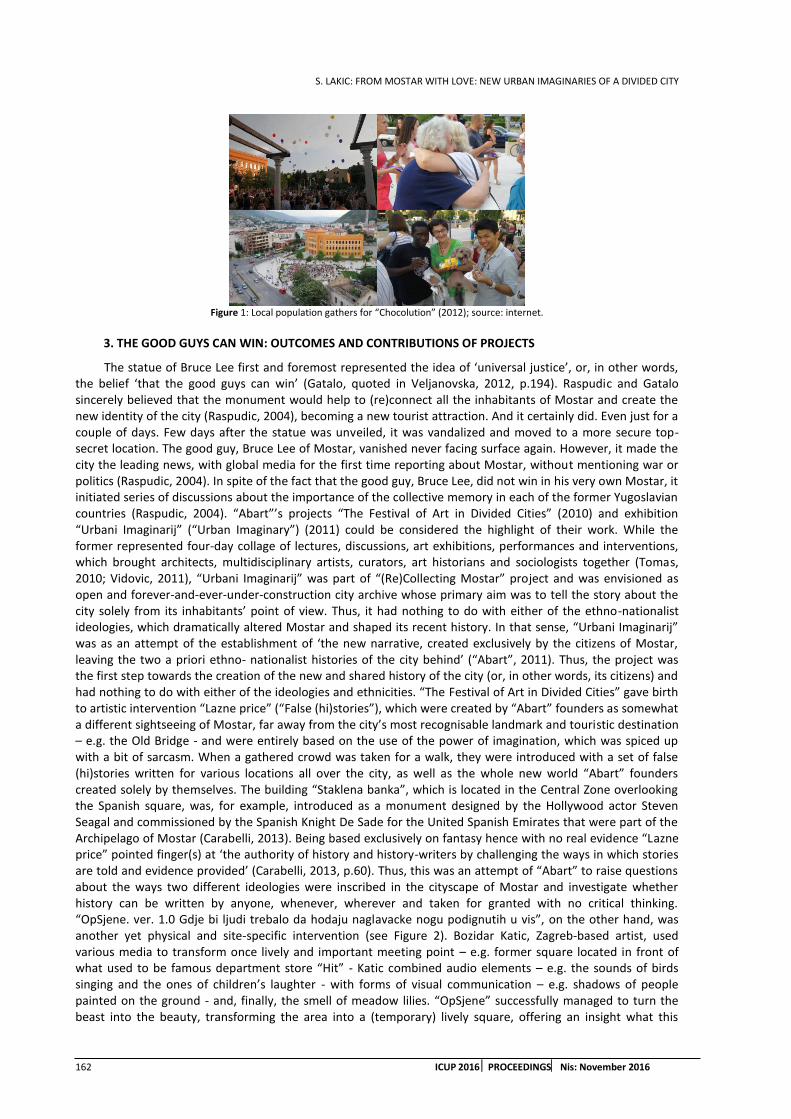
S. LAKIC: FROM MOSTAR WITH LOVE: NEW URBAN IMAGINARIES OF A DIVIDED CITY
162 ICUP 2016 PROCEEDINGS Nis: November 2016
Figure 1: Local population gathers for “Chocolution” (2012); source: internet.
3. THE GOOD GUYS CAN WIN: OUTCOMES AND CONTRIBUTIONS OF PROJECTS
The statue of Bruce Lee first and foremost represented the idea of ‘universal justice’, or, in other words, the belief ‘that the good guys can win’ (Gatalo, quoted in Veljanovska, 2012, p.194). Raspudic and Gatalo sincerely believed that the monument would help to (re)connect all the inhabitants of Mostar and create the new identity of the city (Raspudic, 2004), becoming a new tourist attraction. And it certainly did. Even just for a couple of days. Few days after the statue was unveiled, it was vandalized and moved to a more secure top-secret location. The good guy, Bruce Lee of Mostar, vanished never facing surface again. However, it made the city the leading news, with global media for the first time reporting about Mostar, without mentioning war or politics (Raspudic, 2004). In spite of the fact that the good guy, Bruce Lee, did not win in his very own Mostar, it initiated series of discussions about the importance of the collective memory in each of the former Yugoslavian countries (Raspudic, 2004). “Abart”’s projects “The Festival of Art in Divided Cities” (2010) and exhibition “Urbani Imaginarij” (“Urban Imaginary”) (2011) could be considered the highlight of their work. While the former represented four-day collage of lectures, discussions, art exhibitions, performances and interventions, which brought architects, multidisciplinary artists, curators, art historians and sociologists together (Tomas, 2010; Vidovic, 2011), “Urbani Imaginarij” was part of “(Re)Collecting Mostar” project and was envisioned as open and forever-and-ever-under-construction city archive whose primary aim was to tell the story about the city solely from its inhabitants’ point of view. Thus, it had nothing to do with either of the ethno-nationalist ideologies, which dramatically altered Mostar and shaped its recent history. In that sense, “Urbani Imaginarij” was as an attempt of the establishment of ‘the new narrative, created exclusively by the citizens of Mostar, leaving the two a priori ethno- nationalist histories of the city behind’ (“Abart”, 2011). Thus, the project was the first step towards the creation of the new and shared history of the city (or, in other words, its citizens) and had nothing to do with either of the ideologies and ethnicities. “The Festival of Art in Divided Cities” gave birth to artistic intervention “Lazne price” (“False (hi)stories”), which were created by “Abart” founders as somewhat a different sightseeing of Mostar, far away from the city’s most recognisable landmark and touristic destination – e.g. the Old Bridge - and were entirely based on the use of the power of imagination, which was spiced up with a bit of sarcasm. When a gathered crowd was taken for a walk, they were introduced with a set of false (hi)stories written for various locations all over the city, as well as the whole new world “Abart” founders created solely by themselves. The building “Staklena banka”, which is located in the Central Zone overlooking the Spanish square, was, for example, introduced as a monument designed by the Hollywood actor Steven Seagal and commissioned by the Spanish Knight De Sade for the United Spanish Emirates that were part of the Archipelago of Mostar (Carabelli, 2013). Being based exclusively on fantasy hence with no real evidence “Lazne price” pointed finger(s) at ‘the authority of history and history-writers by challenging the ways in which stories are told and evidence provided’ (Carabelli, 2013, p.60). Thus, this was an attempt of “Abart” to raise questions about the ways two different ideologies were inscribed in the cityscape of Mostar and investigate whether history can be written by anyone, whenever, wherever and taken for granted with no critical thinking. “OpSjene. ver. 1.0 Gdje bi ljudi trebalo da hodaju naglavacke nogu podignutih u vis”, on the other hand, was another yet physical and site-specific intervention (see Figure 2). Bozidar Katic, Zagreb-based artist, used various media to transform once lively and important meeting point – e.g. former square located in front of what used to be famous department store “Hit” - Katic combined audio elements – e.g. the sounds of birds singing and the ones of children’s laughter - with forms of visual communication – e.g. shadows of people painted on the ground - and, finally, the smell of meadow lilies. “OpSjene” successfully managed to turn the beast into the beauty, transforming the area into a (temporary) lively square, offering an insight what this

S. LAKIC: FROM MOSTAR WITH LOVE: NEW URBAN IMAGINARIES OF A DIVIDED CITY
ICUP 2016 PROCEEDINGS Nis: November 2016 163
neglected and forgotten space could (or, in other words, should) look, sound and feel like if ever used in a proper way again.
Bruce Lee of Mostar was recognised in academia as ‘an attempt to reconceive (and avoid national narrative,) as well as to unify the city’ (Kushinski, 2013, p.69) by ‘inciting childhood nostalgia’ (Kushinski, 2013, p.71). Furthermore, it was considered ‘an ironic representation’ of ‘familiar, but absolutely foreign’ (Kushinski, 2013, p.74) non-political celebrity, placed in ideologically overburdened public space with a very clear strategy of ‘eluding the national narrative’ (Kushinski, 2013, p.74). The statue, however, first and foremost represented ‘an attempt for the public spaces in the city to regain their meaning’ (Raspudic, 2004, p.1). Different practices described in this paper are no exception in that sense. Unlike the statue of Bruce Lee, which is clearly to be understood as an end product, artistic interventions of “Abart” – e.g. “Lazne price” and “OpSjene” - represent a process. As such, they offered a possibility to the inhabitants of the city to participate in the (re)making of a different Mostar. They indeed managed to produce a temporary (sense of) community in the city. The same goes for Street Art Festival Mostar and “Chocolution”. What was primarily ‘a personal revolt’ of Rozic (Rozic, 2015) turned out to be a true bombshell indeed. “Chocolution” seemed to make once remarkably integrated and nostalgically recalled ‘charming microcosm of Bosnia and the former Yugoslavia’ named Mostar (Bose, 2002, p.98) to resurrect, even for a couple of hours only. Moreover, what started as a personal confession on a social network nowadays takes place yearly all over Bosnia and Herzegovina. The last three editions of “Chocolution”, which was firstly widely recognized as a massive local anti-hooliganism protest (Pavkovic, 2012), were of humanitarian character, helping the abandoned children, citizens of Bosnia and Herzegovina affected by 2014 floods as well as the children with special needs. Rozic’s initiative clearly used completely different method than all the other initiatives, but, with no doubt, managed to produced the same effect – e.g. the one of Mostar community being awaken, even for just a couple of hours.
(a) (b) Figure 2: “OpSjene. ver. 1.0 Gdje bi ljudi trebalo da hodaju naglavacke nogu podignutih u vis” (a) People gather at the square under
(re)construction: on-site intervention (2011); source: “Abart”, and (b) Passers-by at the site in 2012; source: author.
Although sharing chocolate ‘on the surface appears to be a banal’ thing, it is, in fact, ‘a process leading to new forms of communication, new forms of relating amongst a specific community and, potentially, a more humanising geography’1. Each of these interventions ‘avoid speaking directly of the state’ (Kushinski, 2013, p.74). Thus, Bruce Lee of Mostar was not the only medium that strived ‘to express feelings of the people who were exhausted by a sense of justice that did not match theirs’ (Veljanovska, 2012, p.194). So were the squares and walls covered with murals. So was the chocolate shared among all of those coming from the other side. The same goes for imagination and sarcasm, the sounds of birds singing and children laughing, shadows of people painted on the ground and smell of the meadow lilies. Unlike Gatalo and Raspudic, who used actual statue in order to explain ‘what it felt like to live in such a context of defeat in terms of disagreeing with the past nationalist regime (that took their pre-war existence and norms,) as well as within a new order that struggles to manage social divisions’ (Veljanovska, 2012, p.194), Djapic and Bajo decided to look beyond the divisions and to focus on what they believed was the city’s greatest potential – e.g. talented and creative youth. The two primarily envisioned Street Arts Festival Mostar as the way to ‘encourage the young people to set themselves free’ of what was believed to be ‘a heavy burden of a divided city’ (Djapic, 2015). They also aimed to send the message that Mostar is ‘not such a peculiar city after all’ (see Figure 3) and wanted to demonstrate that ‘despite the fact that situation in the city is far from perfect’ there was still a lot of good things to be
1 Loftus, Alex, Democratic Interventions into the Urbanisation of Nature. Electronic article. Retrieved from: www.artsite.org.uk/Alex%20Loftus%20-%20Democratic%20Interventions%20into%20the%20Urbanisation%20of%20Nature.pdf

S. LAKIC: FROM MOSTAR WITH LOVE: NEW URBAN IMAGINARIES OF A DIVIDED CITY
164 ICUP 2016 PROCEEDINGS Nis: November 2016
appreciated (Djapic, 2015). Rozic, for example, also stressed that “Chocolution” primarily aimed to send out the message to all the citizens of Bosnia and Herzegovina, as well as the world, that Mostar is much more than just an(other) ethnically divided city. It is rather a place where ‘many normal people (keep to) live in, believing in a better future’ (Rozic, 2015). It is these normal people who deep within wanted their voices to be heard while mingling with their fellow citizens and sharing a piece of chocolate at the very core of the Central Zone. It is these normal people that, according to Rozic, can make a difference. It takes one step at a time though. The good guy from Mostar, Bruce Lee, is to be understood as a pioneer and the first ‘strong voice of resistance’ in terms of building local population’s ‘own sense of justice’ (Veljanovska, 2012, p.194). The rest of the practices followed its footsteps.
Figure 3: “Zivot je lijep” (“Life is beautiful”) mural made during one of the editions of Street Arts Festival Mostar (unknown author); source: Street Arts Festival Mostar Facebook page.
4. CONCLUSION
This paper never aimed to introduce the chosen practices of the civil society actors in Mostar as first and foremost examples of good practices. Rather, their selection was made in order to demonstrate if and to what extent these, unlike local urban planning practice, contributed to a more unified everyday, or, in other words, Mostar making a step towards the shared city. As described, the initial motivation for each of the initiatives is different. However, the paper clearly demonstrated that the described practices managed to assign (the public places in) the Central Zone of Mostar with what was truly missing – e.g. “the investment with meaning and value”, or, in other words, naming, identification and first and foremost representation by ordinary people (Gieryn, 2000). It is exactly this presence of ordinary people, being involved in different processes, such as the one of sharing a chocolate, that made a difference between space of Mostar, hereby understood solely in terms of materiality, location and geometry, and Mostar as the place, hereby understood as coming together, or, in other words, community (Gieryn, 2000). Thus, it is exactly the new urban imaginaries of Mostar that finally resulted in a temporary (sense of) community in the city, although this often lasted not more than couple of hours. In that sense, the described practices, with no doubt, represent a unique achievement in the world of others of Mostar. Hereby-discussed new urban imaginaries of Mostar teach us several things. Firstly, civil society in Mostar is to be perceived as growing number of ordinary and everyday people who are ‘seemingly marginalized from and immiserated by urban life’ yet they, to some extent, managed to make ‘the city productive, reproducing it, and positioning its residents, territories, and resources in specific ensembles where the energies of individuals can be most efficiently deployed and accounted for’ (Simone, 2004, p.407). Accordingly, Mostar is to be understood as the city of “people as infrastructure” (Simone, 2004). Secondly, as demonstrated, hereby-described events of a symbolic character, which are first and foremost based on emotional experience (Bloomfield, 2006), indeed managed to ‘help remake the city’ at least ‘in the image of its citizens’ (Bloomfield, 2006, p.49) and work towards the alternative future. Thus, unlike official urban planning, hereby-discussed practices of Mostar civil society make a significant contribution towards the shared city, one step at a time. Moreover, studied practices make one wonder if the alternative future of urban planning in turbulent societies such as Mostar lies in the performative planning, which stands for variety of events that never rely on professional skills and competences but rather get involved with the practices of everyday life, and, as such, ‘allow the temporary exploration of the possible futures of a place’ (Kremer, 2011, p.83). Therefore, it could be said that hereby-discussed practices of civil society in Mostar also question the role of official urban planning and position of trained architects and urbanists. It is hence undoubtedly clear that in unsettled societies of this kind it is social interaction that matters. It is social interaction that shapes places, not the urban planning or the planners (Gaffikin, 2012). It is, however, important to stress that, in the case of quite
S. LAKIC: FROM MOSTAR WITH LOVE: NEW URBAN IMAGINARIES OF A DIVIDED CITY
ICUP 2016 PROCEEDINGS Nis: November 2016 165
specific political situation in Mostar, any strategy undertaken in baby-steps manner should be considered and appreciated as the sign of the significant progress. Needless to say, it will take some time to see the actual (or, in other words, the long-term) outcome of hereby-portrayed practices and initiatives. In that sense, patience is the keyword. Thus, time is the best ally for anyone interested in how and that,
REFERENCES
1. “Abart”, 2011. Personal interview with founders of “Abart”, Amila Puzic and Mela Zuljevic. OKC‘Abrasevic’, Mostar.
2. Albrechts, L., 2010. More of the same is not enough! How could strategic spatial planning be instrumental in dealing with the challenges ahead? Environment and Planning: Planning and Design 37. pp.1115 – 1127.
3. Bjorkdahl, A. and Gusic, I., 2013. Mostar and Mitrovica: Contested Grounds for Peacebuilding. Working Paper Series: Contested Administrations. Lund University, Roskilde University.
4. Bloomfield, J., 2006. Researching the Urban Imaginary: Resisting the Erasure of Places in Urban Mindscapes of Europe (Eds. Bianchini, F. and Weiss-Susssex, G.) Rodopi. pp.43-63.
5. Bollens, S. A., 2008. Urbanism, Political Uncertainty and Democratisation. Urban Studies 45(5&6). pp.1255-1289.
6. Bose, S., 2002. Bosnia after Dayton: Nationalist Partition and International Intervention. Sage, London,UK.
7. Carabelli, G. and Zuljevic, M., 2011. (Re)collecting Mostar: mapping public space to generate memory collections. Paper presented at the Urban Conflicts Conference: Ethno-national Divisions, States and Cities. Belfast, Ireland.
8. Carabelli, G., 2012. Living Critically in the Present: Youth Activism in Mostar (Bosnia Herzegovina). European Perspectives - Journal on European Perspectives of the Western Balkans, 5: 1(8). pp.48-63.
9. Coric, T., 2013. Abrasevic Center, Mostar. Conference paper. Post-Conflict Development and Civic Imagination (Divided Cities) conference and workshop.Home for Cooperation, Nicosia Buffer Zone, Cyprus.
10. Coward, M., 2009. Community as Heterogeneous Ensemble: Mostar and Multiculturalism. Alternatives: Global, Local, Political, 27(1). pp.1 – 17.
11. D’Alessio, V. and Gobetti, E., 2010. Who is Who in the Balkans Today: Mythmaking and Identity Mutations. Paper presented at the Mediterranean Research Meeting.
12. Djapic, M., 2015. Personal interviews / e-mail correspondence with Marina Djapic. March/April 2015.
13. Gaffikin, F., 2012. Planning in Divided Cities: Collaborative Shaping of Contested Space. Blackwell Publishing Ltd.
14. Gieryn, Thomas F., 2000. A Space for Place in Sociology. Annual Review of Sociology 26. pp.463 – 496.
15. Gonca, N., 2012. Old bridge as a symbol of multiculturalism: global discourse and local narratives in Mostar. University of Chicago. Chicago, Illinois, USA.
16. Heffernan, Kathryn L. (2009). Reinventing Mostar: The Role of Local and International Organizations in Instituting Multicultural Identity. Thesis submitted to Central European University Nationalism Studies Program in partial fulfilment of the requirements for the degree of Master of Arts. Central European University Budapest, Hungary.
17. Heynen, H. and Loeckx, A., 1998. Scenes of Ambivalence, p.Concluding Remarks on Architectural Patterns of Displacement. Journal of Architectural Education, 52(2). pp.100 – 108.
18. Kremer, E., 2011. Performative Planning as a Method of Initiating Change. Scientific Journal of Riga Technical University 2. pp.81 – 84.
19. Kushinski, A., 2013. Non-commemoration and the nation: memory and forgetting in the former Yugoslavia. University of Bucharest Review: Cultures of Memory, Memories of Culture, 3(1). pp.68-76.
S. LAKIC: FROM MOSTAR WITH LOVE: NEW URBAN IMAGINARIES OF A DIVIDED CITY
166 ICUP 2016 PROCEEDINGS Nis: November 2016
20. Makas, E., 2011. Mostar’s Central Zone: Battles over Shared Space in a Divided City. Urban Conflicts Conference: Ethno-national Divisions, states and Cities. Belfast, Ireland.
21. Mitrovic, J., 2008. Bridging the Divides - 'Unifications' of Mostar. Thesis submitted to the Central European University Nationalism Studies Program in partial fulfilment of the requirements for the degree of Master of Arts. Central European University Budapest, Hungary.
22. Office of the High Representative., 2004. Decision enacting the statute of the city of Mostar. Retrieved from http: //www.ohr.int/decisions/mo-hncantdec/default.asp?content_id=31707. Last date accessed / consulted: February 26th 2015.
23. Palmberger, M., 2012. Renaming of Public Space: A Policy of Exclusion in Bosnia and Herzegovina. MMG Working Paper 12-02. Max Planck Institute for the Study of Religious and Ethnic Diversity. Göttingen, Germany.
24. Pavkovic, I., 2012. Cokoladni neredi u Mostaru. Electronic article. Retrieved from: http: //balkans.aljazeera.net/video/Cokoladni-neredi-u-mostaru. Last date accessed / consulted, p.March 1st 2015.
25. Pignotti, A., 2013. Stealing Mostar: The Role of Criminal Networks in the Ethnic Cleansing of Property. Thesis Presented in Partial Fulfilment of the Requirements for the Degree Master of Arts. Arizona State University.
26. Raspudic, N., 2004. Bruce Lee monument in Mostar. The presentation made by Nino Raspudic in the context of the workshop held at Volkspark in Halle/Saale on November 5th 2004. Text edited by Oana Radu and Jessica Gearhart.
27. Rozic, I., 2015. Skype interviews / e-mail correspondence with Ivan Rozic. May 2015.
28. Simone, A., 2004. People as Infrastructure: Intersecting Fragments in Johannesburg. Public Culture 16 (3). pp.407 – 429.
29. Sherman, Stephen A., 2011. The Effects of Elite-led Power Sharing on Postconflict Urban Reconstruction: Consociationalism and the Mostar case. Thesis submitted in partial fulfilment of the requirements for the degree of Master of Urban Planning in Urban Planning. Graduate College of the University of Illinois at Urbana-Champaign, Urbana, Illinois.
30. Tomas, M., 2010. AbART: Umjetnost u podijeljenim gradovima. Electronic article. Retrieved from Zurnal – online magazine. http: //zurnal.ba/novost/1439/abart-umjetnost-u-podijeljenim-gradovima. Last date accessed / consulted: February 26th 2015.
31. Veljanovska, M., 2012. The consequences of judicial obligations as a politics of transition in post- war Serbia, Bosnia and Herzegovina and Croatia. Temida. pp.179-204.
S. LAKIC: TRANSGRESSIVE NEIGHBOURHOODS: POST-PRIVATISATION EXPERIENCE FROM BOSNIA AND HERZEGOVINA
ICUP 2016 PROCEEDINGS Nis: November 2016 167
TRANSGRESSIVE NEIGHBOURHOODS: POST-PRIVATISATION EXPERIENCE FROM BOSNIA AND HERZEGOVINA
Sonja Lakic
Gran Sasso Science Institute (GSSI), L’Aquila, Italy PhD Student, [email protected]
ABSTRACT
This paper is concerned with what I refer to as the post-privatization reality in Starcevica, the biggest local community in Bosnia and Herzegovina. The paper describes the outcomes of privatisation of socially owned apartments in the neighbourhood that was never previously investigated. Furthermore, unlike most of the previous post-socialist studies, which exclusively focused on the big cities, the paper also adds more of an understanding regarding the (post-socialist) transformation of the medium-sized city of Banja Luka, Bosnia and Herzegovina. The paper exclusively focuses on different acts of self-managed and illegal modifications of privatized apartments that relied solely on homeowners’ personal needs and/or aesthetics. These practices were never previously investigated; as such, they represent the original contribution of this research to the body of knowledge. How has the change of the ownership pattern contributed to the emergent of the new means of the behaviour of the local population, and, moreover, resulted in the rise of self-built illegal practices? What kind of physical city emerged as a consequence of the privatization? I argue that the process of privatization firstly served as the catalyst for the specific mind-shift of the masses that consequently transformed once well-ordered built environment and finally resulted in a whole new world of entirely new standards and principles hence affected society as a whole.
Keywords: transition; privatisation; housing; informality; Bosnia and Herzegovina.
1. INTRODUCTION
In the late 1990s the process of transition, or, in other words, ‘a deconstruction of the socialist system’ (Vujadinovic, 2010: 40) was initiated in Republika Srpska (one out of two post-war emerged entities of Bosnia and Herzegovina, here referred to as ‘the entity’). International institutions, such as the World Bank and International Monetary Fund, pressured local political leaders to implement ‘neo-liberal strategies that favour the fastest possible abandonment of all aspects of state socialism’ (Petrovic, 2005, p. 7). In that sense, privatisation of socially owned property and transfer of property rights from the state to individuals was introduced as essential for the stabilization and further development of political and economic system altogether (Dugalic & Sokcevic, 2007). Accordingly, privatisation was considered an integral part of political ‘preparatory strategies for the inevitable economic and political transformation’ (Petrovic, 2001, p. 216). Since it was recognized as an ‘internal political legitimation of the new society’ (Smith, 1994, p. 614), it was of a ‘great symbolic significance’ (Smith, 1994, p. 614). Moreover, it became ‘the leitmotif’ (Hirt, 2012, p. 43) of the overall process of transition. The process of privatisation of socially owned apartments, which was introduced in 2001, resulted in variety of socio-spatial changes, producing ‘more serious negative (social) effects than expected’ (Petrovic, 2005, p. 10). Firstly, the process clearly marked the end of the nation of the tenants, declaring the beginning of the era of the nation of the homeowners. This further led to the emergent of the new means of behaviour, with thousands of the homeowners, who were suddenly ‘released from the ruthless chains of socialist regulation’, (Czepczynski, 2008, p. 150) reshaping their own apartments by themselves, according to their own needs and, more importantly, their personal taste. These new informal self-managed practices were undertaken in the name of personal profit exclusively, spreading rapidly as somewhat an ‘epidemic process’ (Galster, 2001). Consequently, they became so widespread and highly tolerated that ‘one might even hesitate to call them illegal’ (Petrovic, 2005, p. 18), resulting in ‘overwhelming feeling of disorder’ and illegality being recognised as ‘some sort of the new norm’ (Hirt, 2012, p. 46). The main contribution of this

S. LAKIC: TRANSGRESSIVE NEIGHBOURHOODS: POST-PRIVATISATION EXPERIENCE FROM BOSNIA AND HERZEGOVINA
168 ICUP 2016 PROCEEDINGS Nis: November 2016
paper is to add more of an understanding regarding the outcomes of the (post-socialist) transformation – e.g. privatisation of socially owned apartments - in Starcevica, the biggest local community (mjesna zajednica) in the city of Banja Luka. Since no research was ever done on this matter, I aim to contribute to the body of knowledge by filling the gap and explaining how and to what extent Starcevica changed after the introduction of privatisation. How has the change of ownership pattern contributed to emergent of the new means of local population’s behaviour and, moreover, led to the rise of what I define as new residential landscapes? I hereby primarily focus on self-managed modification of apartments, making a distinction between interior and exterior alterations, while describing roles of both homeowners and condominiums in the emergent of new informalities. I argue that privatisation served as a catalyst for the emergence of new forms of illegality that are hereby analysed using the concept of “spatial secessions” (Hirt, 2012). To what extent have these ‘new practices of private usurpation, withdrawal and partition’ (Hirt, 2012, p. 49) altered Starcevica? In addition, unlike most of the researchers who, dealing with the (post-socialist) transformation of former Yugoslav cities, have so far mainly focused on Belgrade, the capital of Serbia, believing that ‘socialist housing policy outcomes were the most visible in big cities’ (Petrovic, 2001, p. 217), with this paper I also aim to add more of an understanding regarding the extent and the outcomes of the transformation of a former Yugoslav medium-sized city of Banja Luka. The paper is divided in three parts. In the first part of the paper, I explain how the neighbourhood of Starcevica came to be. Secondly, I offer an overview of the process of privatisation, in order to explain why the latter was so appealing to the tenants hence why hardly anyone resisted becoming an owner of their own property. I then describe the outcomes of the privatisation. I aim to conclude that privatisation of socially owned apartments in Starcevica served as the catalyst for the new means of behaviour, which led to personal taste being deeply embedded in the urban landscape. Consequently, privatisation resulted in the rise of various informal practices, such as spatial seizures and statutory secessions (Hirt, 2012).
2. THE CONTEXT: STARCEVICA IN BRIEF
After devastating 1969 earthquake, Banja Luka was characterised by the shortage in housing supply, with estimated 3.000-4.000 dwelling units in demand (SIZ BL, 1986). The local housing policy was primarily based on ‘ad hoc decisions’ (Urbanisticki zavod Banja Luka, 1979, p. 9), with overall housing construction being exclusively based on the assessments made with regard to the physical capacity of a certain area as well as the cost-effectiveness (Samoupravna interesna zajednica (SIZ) stanovanja Banja Luka, 1986). Accordingly, most of the construction took place at the so-called “individual locations” (Samoupravna interesna zajednica (SIZ) stanovanja Banja Luka, 1986). These were considered attractive primarily due to the fact that they were already equipped with all the possible infrastructure (Samoupravna interesna zajednica (SIZ) stanovanja Banja Luka, 1986). However, the local housing policy was not following the framework of ‘directed and concentrated’ housing construction at all (Urbanisticki zavod Banja Luka, 1979, p. 34). The construction was not rationalised - e.g. as fast and cheap as possible, with the dwellings of a high quality (Samoupravna interesna zajednica (SIZ) stanovanja Banja Luka, 1986). In the mid-1970s local authorities declared Starcevica, the hill situated in the south-western part of the city (see Figure 1a), ‘the site of socially-oriented housing construction’ (Samoupravna interesna zajednica (SIZ) stanovanja Banja Luka, 1986, p. 5). At that time, Starcevica was recognised and cherished as a ‘natural memorial’ area (Samoupravna interesna zajednica (SIZ) stanovanja Banja Luka, 1986, p. 31) – e.g. park-forest of significant environmental characteristics. With several single-family houses, which were predominantly illegally built, the area was generally characterised by ‘the low level of utilization of space’ (Samoupravna interesna zajednica (SIZ) stanovanja Banja Luka, 1986, p. 17). This provided planners and architects with an opportunity to do something completely different – e.g. to develop the neighbourhood from scratch.
Starcevica represented a pioneer attempt of applying the local community as the module in the planning process (Urbanisticki zavod Banja Luka, 1979, p. 60). The core idea was to design the neighbourhood as somewhat a city within a city and an ‘oasis for relaxation’ (Bodroza, 2009, p. 14), dislocated yet very well connected with the city centre by the means of public transport (Bodroza, 2009). Since the housing demand called for standardisation, pre-made panels were predominantly used for the construction. Interestingly enough, these were produced in the neighbourhood itself, within the manufacture section of the state enterprise – e.g. Gradjevinsko-inzenjerski kombinat (GIK) “Kozara”- that was in charge of the overall process of construction. Although the use of the pre-made panels was generally considered somewhat a threat for creativity, and was about to undermine ‘the ability of architects and planners to actually design places’ (Hirt, 2012, p. 39), Starcevica turned out to be more than typical ‘sad, rather miserable grey and dark after dawn’ (Czepczynski, 2008, p. 149) socialist neighbourhood. First and foremost, Starcevica did not lack diversity in
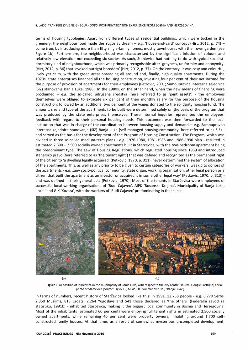
S. LAKIC: TRANSGRESSIVE NEIGHBOURHOODS: POST-PRIVATISATION EXPERIENCE FROM BOSNIA AND HERZEGOVINA
ICUP 2016 PROCEEDINGS Nis: November 2016 169
terms of housing typologies. Apart from different types of residential buildings, which were tucked in the greenery, the neighbourhood made the Yugoslav dream – e.g. ‘house-and-yard’ concept (Hirt, 2012, p. 74) – come true, by introducing more than fifty single-family homes, mostly townhouses with their own garden (see Figure 1b). Furthermore, the neighbourhood was characterised by the significant infusion of colours and relatively low elevation not exceeding six stories. As such, Starcevica had nothing to do with typical socialist-dormitory kind of neighbourhood, which was primarily recognisable after ‘grayness, uniformity and anonymity’ (Hirt, 2012, p. 36) that ‘evoked outright boredom’ (Hirt, 2012, p. 37). On the contrary, it was cosy and colourful, lively yet calm, with the green areas spreading all around and, finally, high quality apartments. During the 1970s, state enterprises financed all the housing construction, investing four per cent of their net income for the purpose of provision of apartments for their employees (Petrovic, 2001; Samoupravna interesna zajednica (SIZ) stanovanja Banja Luka, 1986). In the 1980s, on the other hand, when the new means of financing were proclaimed – e.g. the so-called udruzena sredstva (here referred to as ‘joint assets’) - the employees themselves were obliged to extricate six per cent of their monthly salary for the purpose of the housing construction, followed by an additional two per cent of the wages donated to the solidarity housing fund. The amount, size and type of the apartments to be built were determined solely on the basis of the program that was produced by the state enterprises themselves. These internal inquiries represented the employees’ feedback with regard to their personal housing needs. This document was then forwarded to the local institution that was in charge of the coordination between housing supply and demand – e.g. Samoupravna interesna zajednica stanovanja (SIZ) Banja Luka (self-managed housing community, here referred to as SIZ) - and served as the basis for the development of the Program of Housing Construction. The Program, which was divided in three so-called medium-term plans - e.g. 1976-1980, 1981-1985 and 1986-1990 plan - resulted in estimated 2.300 – 2.500 socially owned apartments built in Starcevica, with the two-bedroom apartment being the predominant type. The Law of Housing Regulations, which regulated housing since 1959 and introduced stanarsko pravo (here referred to as ‘the tenant right’) that was defined and recognized as the permanent right of the citizen to ‘a dwelling legally acquired’ (Petkovic, 1970, p. 311), never determined the system of allocation of the apartments. This, as well as any priority to be given to certain categories of workers, was up to donors of the apartments - e.g. „any socio-political community, state organ, working organisation, other legal person or a citizen that built the apartment as an investor or acquired it in some other legal way’ (Petkovic, 1970, p. 313) - and was defined in their general acts (Petkovic, 1970). Most of the tenants in Starcevica were employees of successful local working organisations of ‘Rudi Cajavec’, AIPK ‘Bosanska Krajina’, Municipality of Banja Luka, ‘Incel’ and GIK ‘Kozara’, with the workers of ‘Rudi Cajavec’ predominating in that sense.
(a) (b)
Figure 1: a) position of Starcevica in the municipality of Banja Luka, with respect to the city centre (source: Google Earth); b) aerial photo of Starcevica (source: Sljivo, G., Mikic, DJ., Vukmanovic, M., “Banja Luka”)
In terms of numbers, recent history of Starcevica looked like this: in 1991, 12.738 people - e.g. 6.770 Serbs, 2.350 Muslims, 813 Croats, 2.264 Yugoslavs and 541 those declared as ‘the others’ (Federalni zavod za statistiku, 1991b) - inhabited Starcevica, making it the biggest local community in Bosnia and Herzegovina. Most of the inhabitants (estimated 60 per cent) were enjoying full tenant rights in estimated 2.500 socially owned apartments, while remaining 40 per cent were property owners, inhabiting around 1.700 self-constructed family houses. At that time, as a result of somewhat mysterious uncompleted development,
S. LAKIC: TRANSGRESSIVE NEIGHBOURHOODS: POST-PRIVATISATION EXPERIENCE FROM BOSNIA AND HERZEGOVINA
170 ICUP 2016 PROCEEDINGS Nis: November 2016
Starcevica was significantly deprived of different facilities, primarily additional elementary school and kindergarten. Since the political elites failed to meet the needs of the local population, the neighbourhood became somewhat ‘location of betrayed expectations’ (Petrovic, 2005, p. 11). These, however, did not lead to ‘resignation and political passivity’ (Petrovic, 2005, p. 11). On the contrary, they triggered interesting political dynamics – e.g. the idea of the official local community representatives to establish Starcevica as an autonomous municipality to begin with, as well as an ironic letter sent to the Assembly of the City of Banja Luka in September 2015, in order to let the local politicians know that 30.000 inhabitants of Starcevica were perfectly happy with everything they (did not) have. The neighbourhood, which is of great sentimental significance for the city, remains the winter sports place to be for more than twenty-five years, bringing together thousands of children and adults, from all over Banja Luka. Moreover, it is the base of the only subcultural group in the city – e.g. the supporters of the local football team (‘The Vultures’). These have significantly contributed to the visual identity of the neighbourhood, using various graffiti and murals in order to express everything from their loyalty to the club to begin with, to their right-oriented political orientation.
3. PRIVATISATION: THE TRIGGER OF CHANGE AND OUTCOMES OF PROCESS
In May 2001, the Law on Privatisation of Socially Owned Apartments marked the beginning of the process of privatisation of socially owned apartments in Republika Srpska. All the tenants with valid tenant rights they were allocated with in accordance with the Law of Housing Regulations were entitled to repurchase their apartments. While around 70.000 dwellings in the entire entity were ready to be repurchased (Stevandic, 2002), around 20.500 (Federalni zavod za statistiku, 1991a) apartments in the city of Banja Luka were to be redeemed. In addition, estimated 2.300 – 2.500 apartments at Starcevica were waiting for their owners. The Law proclaimed municipalities and local institutions, such as Zavod za izgradnju a.d. Banja Luka (ZIBL) – the Institute for the Development Banja Luka, here referred to as ‘ZIBL’ - the one in charge of the overall process. The Law-prescribed various personal discounts instantly made the privatisation quite appealing. Firstly, the price of each apartment could have been reduced on the basis of tenant’s own (as well as their spouse’s) employment, with one per cent of the discount allocated per each year of the working service. Secondly, tenants were provided with an additional discount on the basis of their own and / or their spouse’s engagement during the 1990s war. Specific categories of population – e.g. handicapped tenants, the 1990s war handicapped tenants as well as civil victims of war – were also entitled to different personal discounts, ranging from five up to forty per cent. Refugees, returnees and IDPs were entitled to a maximum seventy-five per cent of discount. Since all the socially owned apartments in Starcevica were built before January 1 1995, this, according to the Law, led to the market values being determined by the multiplication of the surface area with the amount of 400 BAM (around 200 EUR). The final purchase price was determined by the multiplication of the market value with three different coefficients – e.g. coefficient of positional benefits, coefficient regarding the age of the building and coefficient of personal discounts. The latter could be understood as the one the final price of the apartment mostly depended upon, since, for example, the coefficient of positional benefits was automatically set to 0.75. Moreover, the Law introduced several different options for the tenants to redeem their apartments. Purchasing apartment in cash, for example, would have reduced the final price of the apartment for thirty per cent. Tenants choosing an option to pay in monthly instalments had a maximum repurchase deadline of twenty years, with one per cent of discount allocated for each year paid in advance. Finally, it was possible to purchase an apartment using sixty per cent of frozen savings account means and forty per cent of cash altogether. Sum of all the discounts the tenant was entitled to could not exceed total seventy-five per cent. By the end of 2006, process of privatisation was almost fully completed. Total ninety-six per cent (67.200 dwellings) of the housing stock was repurchased in the entire entity. The only official data regarding the outcomes of the privatisation in Banja Luka are those from 2011, which stated that 86% of the total housing stock (17.717 out of total 20.548 apartments) was repurchased (Jokic, 2011). Total 149.632.169,80 BAM (around 76.7 million EUR) were gained through the privatisation process. The money was transferred to the banking accounts of Fond stanovanja Republike Srpske a.d. Banja Luka (Housing Fund of Republika Srpska, here referred to as ‘the Fund’), which was established by the Government of Republika Srpska with primary aim to provide citizens in demand for housing – e.g. families of fallen soldiers, war handicapped veterans, refugees, returnees and IDPs, as well as highly educated newlyweds buying their first-ever apartment - with the low-interest loans ranging from four to five per cent. Up to this point, total 2.087 residential loans were provided.
Privatisation, which primarily focused ‘on the wellbeing of the individual’ (Keil, 2011, p. 46), resulted in the establishment of the new social category – e.g. the one of the homeowner (Dugalic & Sokcevic, 2007; Keil, 2011). In that sense, the process first and foremost clearly marked an end of an era – e.g. the one of the
S. LAKIC: TRANSGRESSIVE NEIGHBOURHOODS: POST-PRIVATISATION EXPERIENCE FROM BOSNIA AND HERZEGOVINA
ICUP 2016 PROCEEDINGS Nis: November 2016 171
tenants – and imposed a radical shift from the nation of tenants to the nation of the homeowners. Furthermore, privatisation provided thousands of ‘recently freed inhabitants, released from the ruthless chains of socialist regulation’ (Czepczynski, 2008, p. 150) with an opportunity to ‘enjoy freedom and full protection in their own property’ (Dugalic & Sokcevic, 2007, p. 107). Hence homeowners were given a chance to finally set free what was within and what was suppressed during the socialism – e.g. ‘personalism, spontaneity, fragmentation’ (Hirt, 2012, p. 65) - and express themselves and ‘deviate from the norm’ (Hirt, 2012, p. 39). And so they did, by modifying the apartments according to their own needs and their personal taste. However, due to ‘fairly spontaneous understanding of freedom on both personal and institutional levels’ and personal taste adopted as ‘a significant landscape management canon’ (Czepczynski, 2008, p. 150), massive homeowners-managed modification of apartments led to new type of informality, hereby understood as ‘the wilful act of disjoining, disassociating, or carving space for oneself from the urban commons’ (Hirt, 2012, p. 49) and primarily characterised by the ‘overwhelming feeling of disorder’ (Hirt, 2012, p. 46) – e.g. spatial secessions (Hirt, 2012).
One of the first and most common changes undertaken by each of the homeowners individually was the massive replacement of (dilapidated) entrance doors. These were quite minor, yet very perceptible visual conversions. These changes brought ‘the visual uniformity and commonality’ (Hirt, 2012, p. 47) of a socialist system to an end, with every single homeowner choosing a different type of the entrance doors according to their personal preferences. Hence, the first changes introduced massive infusion of different types of entrance doors, differing in colours, materials and appearance. What followed were processes of rearrangement and reorganisation of the apartments. Since the size and the structure of the privatised apartments were, back in the day, determined by construction costs and financial capabilities of former state enterprises (Samoupravna interesna zajednica (SIZ) stanovanja Banja Luka, 1986), two-bedroom apartments were predominantly built. Taking into account that estimated 3.6 people inhabited single dwelling unit (Samoupravna interesna zajednica (SIZ) stanovanja Banja Luka, 1986), a certain number of tenants were, with no doubt, provided with an apartment, which, in fact, could not possibly meet their families’ demands. Thus, for some of the homeowners modification of the apartment was first and foremost necessary conduct, which primarily aimed to solve the actual needs of the households hence to gain some additional space. In order to solve this kind of problem, most of the homeowners decided to go for the easiest and the cheapest option – e.g. to convert an existing balcony or a terrace into an extra room. On the other hand, homeowners, who had enough money to do so, engaged themselves in more complicated (and, obviously, more expensive) processes of rearrangement and reorganisation of their apartments, by first and foremost demolishing interior party walls. In most of the cases, these alterations were not done solely for the purpose of obtaining additional space. Rather, they were result of the changes made in the name of the personal lifestyle and/or personal aesthetics. Alterations limited to interior space only were never considered a violation of any legislation hence they do not fall under any of categories of spatial secessions. Self-managed changes that included conversion of balconies and/or terraces violated core principles of the original building design, and, as such, represent a violation of Legislation on Internal Regulations in Apartment Buildings (see Figure 2a). In other words, these, with no doubt, represent an example of a specific type of spatial secession – e.g. “statutory secession” (Hirt, 2012). The process spread explosively, resulting in some sort of epidemic (Galster, 2001; Hirt, 2012) and led to the rise of a specific kind of behaviour that may be described as ‘the contagion model’ (Galster, 2001, p. 2119):
‘… if decision-makers live in a community where some of their neighbours exhibit non-normative behaviours, they will be more likely to adopt these behaviours themselves’ (Galster, 2001, p. 2119).
It is, however, important to point out that, depending on their financial capabilities, different categories of the homeowners used different materials when modifying their apartments (see Figure 2a). Thus, converted balconies and terraces can, to some extent, give hint about those ‘poor, unemployed, unsuccessful’ or simply called ‘project-less’ (Czepczynski, 2008, p. 178). In other words, these types of conversions may indicate who is who in the nation of the homeowners today. However, the most radical forms of self-managed modifications of apartments included different means of illegal appropriation of what was considered to be a common space. Consequently, the new era of the homeowners resulted in a wide spectrum of illegally appropriated courtyards, corridors, building entrances etc. (see Figure 2b). It was exactly these former common spaces where variety of permanent structures were built solely for the purpose of personal use and private profit (Hirt, 2012). This kind of informal activities represent acts of ‘the post-socialist re-commoditization of space’ and are obviously often ‘accompanied by the physical enclosure of the newly acquired land’ (Hirt, 2012, p. 49). I find these so-called “spatial seizures” (Hirt, 2012) an embodiment of a specific mind-set and a wide-spread belief that ‘my land is my castle, and now only I decide what my landscape will look like’ (Czepczynski, 2008, p. 150)

S. LAKIC: TRANSGRESSIVE NEIGHBOURHOODS: POST-PRIVATISATION EXPERIENCE FROM BOSNIA AND HERZEGOVINA
172 ICUP 2016 PROCEEDINGS Nis: November 2016
(see Figure 2b). The role of condominiums and their contribution in the emergent of the new informality is, on the other hand, quite minor. Rather, as demonstrated, individual acts of homeowners prevailed in that sense. The most common conversions undertaken by the condominiums were, for example, installation of intercoms and replacement of building entrance doors. These changes were mostly made for the purpose of security. Obviously, the changes altered initial visual identity of a building to a certain extent, but acts of this kind were never considered violation of any legislation. As such, these cannot be considered an example of any form of informality. The big investments, such as repair of roofs and renewal of facades, were, until now, quite rare, since they primarily depend upon the financial abilities of the condominium (or, in other words, the homeowners). However, due to misinformation and the lack of expertise, specific examples of renewal of facades failed to maintain the original appearance of the building, violating the core principles of its original design. Since, as such, this kind of (failed) interventions represented a violation of the Legislation on Internal Regulations in Apartment Buildings (Skupstina Grada Banja Luka, 2005), this undoubtedly added them to the list of spatial secessions.
(a) (b)
Figure 2: (a) Spatial secessions: conversion of balconies was the most common act performed by the homeowners; (b) Spatial seizures: extension of the ground floor apartment, where the homeowner converted balcony for the purpose of obtaining additional living space
and occupied one out of two total building entrances for the same reason. Source: author.
4. DISCUSSION
What all the aforementioned described acts (apart from modifications of the interior space) have in common is the fact that they represent a violation of the local Legislation on Internal Regulations in Apartment Buildings. As such, they altogether undoubtedly fall under specific category of spatial secessions – e.g. the one of statutory secessions. The latter is considered ‘the widespread process of violating public planning and building statutes’ (Hirt, 2012, p. 50) and goes hand in hand with the paradigmatic shift of the ownership pattern. This, as demonstrated in the case of Starcevica, resulted in various types of informality, varying from unauthorized physical or functional remodelling of the buildings to ‘self-styled building additions and renovations’ (Hirt, 2012, p. 58). Furthermore, it is also considered that converted (or, in other words, closed and walled-up) balconies and terraces may be understood as a visual manifestation of the recent trend – e.g. ‘a newly sharpened focus on the individual, the family, the home, the small, the secure, and the interior, in opposition to a public world’ (Hirt, 2012, p. 55). As such, in a broader sense, they may be interpreted as examples of ‘growing social atomization and ‘loneliness in the city’ (Czepczynski, 2008, p. 164). It is, nevertheless, important to stress that these post-privatisation informal practices became so widespread and highly tolerated that ‘one might even hesitate to call them illegal’ (Petrovic, 2005, p. 18). They are mainly overlooked since the local governments, which used to be ‘merely units subordinated to the state administration during the socialist era’, nowadays lack ‘sufficient institutional capacity, knowledge and funds’ (Petrovic, 2005, p. 8) to deal with these complex changes. The aforementioned self-managed practices of individual homeowners are to be understood as a consequence of ‘a particular mass mindset’ – e.g. the one

S. LAKIC: TRANSGRESSIVE NEIGHBOURHOODS: POST-PRIVATISATION EXPERIENCE FROM BOSNIA AND HERZEGOVINA
ICUP 2016 PROCEEDINGS Nis: November 2016 173
‘that pursues the perpetual decomposition of urban commonality not only with impunity but also without regrets’ (Hirt, 2012, p. 56). Consequently, the illegality, which is deeply embedded in the new post-privatisation reality, ‘attained such an air of banality and ordinariness’ resulting in the phenomenon nowadays recognised as the new ‘social norm’ (Hirt, 2012, p. 56). Another outcome of privatisation that, indeed, has nothing to do with informality and spatial secessions yet is as equally important, is the role of the state in provision of housing. Since the political elites in former Yugoslav countries were strongly convinced that the privatisation of socially owned apartments itself would make all the economic problems gone (Vujadinovic, 2010), there was never ‘any strategically thinking’ (Vujadinovic, 2010, p. 40) done regarding prospective housing policy. Consequently, the state completely vanished from the housing sector in terms of provision of housing (Hirt, 2012; Petrovic, 2005; Tsenkova, 2014). Unlike former Yugoslavia, where the acquisition of dwelling space was ‘under the case of society’ (Petkovic, 1970, p. 311) hence the responsibility of the State, this kind of responsibility is nowadays transferred to individuals and/or families (Petrovic, 2005). The State of Bosnia and Herzegovina as a whole, for example, is ‘almost invisible’ (Tsenkova, 2014, p. 96) in social housing policy. Major responsibilities on this matter, if any, are ‘delegated to the entity level and correspondingly to the cantons and municipalities’ (Tsenkova, 2014, p. 96). In addition, massive influx of private investors resulted in the housing sector being predominantly the one of private production, rather than consumption (Petrovic, 2001; Vujadinovic, 2010). In the last ten years, Starcevica experienced radical transformation due to both intensive and extensive housing development. The private investors are exclusively in charge of the latter. Since the master plan of Banja Luka is out-dated – e.g. the one produced in 1975 is still widely used - the new development permits are not linked to a citywide vision or program (Hirt, 2012). On the contrary, these rather represent modifications of the neighbourhood-scale plans, made solely for the purpose of the new development permits.
5. CONCLUSION
In this paper, I described how and to what extent the biggest local community in Bosnia and Herzegovina, the neighbourhood of Starcevica, changed after the former socially owned housing stock was ‘hurriedly privatised’ (Gabriel, 2007, p.2) with hardly any concern regarding prospective housing strategy (Gabriel, 2007). Despite the shortage of the evidence such as official data from institutions, I explained the reasons behind the rise of the new means of behaviour, which finally contributed to emergence of the new informality, hereby analysed using Hirt’s concept of “spatial secessions” (Hirt, 2012). These new chaotic and anarchy-driven spatial configurations hereby discussed are related to the concept of newly gained personal freedom (Czepczynski, 2008). If/when perceived solely as the visual outcome of the process of privatization, this new type of informality undoubtedly serves as the evidence that the former Yugoslav cities, such as Banja Luka, are characterized by the ‘wide plurality of styles – perhaps a vibrant plurality – but also one that creates aesthetic conflicts’ (Hirt, 2006, p. 480). Moreover, the wide spectrum of converted balconies as well as illegally appropriated common spaces – e.g. courtyards, building corridors, entrances etc. –also illustrate that nowadays the ‘aesthetic integrity of the street is in danger of becoming a victim of aggressive individualism’ (Hirt, 2006, p. 481). However, I strongly argue that there is more to the story than meets the eye. I find post-privatisation triggered spatial appropriation practices the result of the lack of the homeowners’ affiliation with the law-prescribed rights, duties and obligations in the post-privatisation era. Moreover, as most of the interviews conducted proved, complete ignorance seems to prevail as the main reason behind these informal and anarchy-driven spatial practices, especially in the case of the most radical forms of self-managed modifications of apartments – e.g. different means of illegal appropriation of what used to be a common space. This hence illustrates that this new kind of urban development (or, better to say, this new kind of informality) is not to be considered ‘linear’ – on the contrary, ‘it can follow conscious choices by individuals and societies’ (Leontidou, 1993, p. 962). Hence the spatial practices hereby discussed tell a story about ‘“the quiet revolution” of decentralization and the devolution of power and responsibility to local governments’, which ‘significantly affects the performance of post-socialist cities’ (Tsenkova, 2006, p. 23). That being said, I argue that prospective research will immensely benefit from the comparative study of the phenomenon of “spatial secessions” in a wider, cross-national and regional context hence far beyond the physical and territorial scope of the cities. That kind of research will collect new data and knowledge, with primary aim to assemble, review and share ‘a wealth of positive and interesting experience’ from different cities and/or countries in the Western Balkans region, ‘which, incidentally, has not been adequately reviewed and shared for the mutual benefit of all countries’ (Gabriel, 2007, p. 9) beyond their physical and territorial scope, illustrating ‘connections and circulations through which cities already inhabit each other’ (Robinson, 2011, p. 7).

S. LAKIC: TRANSGRESSIVE NEIGHBOURHOODS: POST-PRIVATISATION EXPERIENCE FROM BOSNIA AND HERZEGOVINA
174 ICUP 2016 PROCEEDINGS Nis: November 2016
REFERENCES
1. Bodroza, M., 2009. Strategija urbane transformacije naselja Starcevica u Banjaluci. (Master Degree), University of Banja Luka, Banja Luka, Bosnia and Herzegovina.
2. Czepczynski, M., 2008. Cultural Landscapes of Post-Socialist Cities: Representation of Powers and Needs. Hampshire, Ashgate, UK.
3. Dugalic, V., & Sokcevic, S., 2007. Privatizacija drustvenog / drzavnog vlasnistva – neuspjeli tranzicijski proces? Socijalno-eticka prosudba. Diacovensia, 15(1). pp 103-154.
4. Federalni zavod za statistiku, 1991. Privatni i drustveni stanovi za stanovanje po opstinama. Sarajevo, Bosnia and Herzegovina: Federalni zavod za statistiku.
5. Federalni zavod za statistiku, 1991. Stanovnistvo prema nacionalnom izjasnjavanju po mjesnim zajednicama. Sarajevo, Bosnia and Herzegovina Federalni zavod za statistiku.
6. Gabriel, B., 2007. Informal Settlements in SEE - A regional support approach. FIG Commission 3 Workshop: Spatial Information Management toward Legalizing Informal Urban Development. Athens, Greece.
7. Galster, G., 2001. On the Nature of Neighbourhood. Urban Studies, 38(12). pp. 2111-2124.
8. Hirt, S. A., 2006. Post-socialist urban forms: notes from Sofia. Urban Geography, 27 (5). pp. 464-488.
9. Hirt, S. A., 2012. Iron Curtains: Gates, Suburbs and Privatization of Space in Post-Socialist City. Chichester, Wiley-Blackwell, UK.
10. Jokic, S., 2011. Nezakoniti korisnici 107 gradskih stanova. http://www.glassrpske.com/banjaluka/gradske_vijesti/Nezakoniti-korisnici-107-gradskih-stanova/lat/67943.html [Accessed: 1st December 2015]
11. Keil, S. , 2011. Social Policy in Bosnia and Herzegovina between State-Building, Democratization and Europeanization. In Welfare States in Transition: 20 Years after the Yugoslav Welfare Model (Eds. S. Dehnert and M. Stambolieva) pp. 41-58, Friedrich Ebert Foundation, Sophia, Bulgaria.
12. Leontidou, L., 1993. Postmodernism and the City: Mediterranean Versions. Urban Studies, 30 (6). pp. 949-965. Petkovic, S. 1970. Housing system in Yugoslavia. International review of administrative sciences, 36(4). pp. 311-316.
13. Petrovic, M., 2001. Post-socialist housing policy transformation in Yugoslavia and Belgrade. International Journal of Housing Policy, 1(1). pp. 211-231.
14. Petrovic, M., 2005. Cities after socialism as a research issue. Proceedings of Discussion papers (South East Europe series), DP34, Centre for the Study of Global Governance, London School of economics and political science, London, UK.
15. Samoupravna interesna zajednica (SIZ) stanovanja Banja Luka, 1985. Analiza realizacije srednjorocnog plana Samoupravne interesne zajednice stanovanja za period 1981-1985. Banja Luka, Bosnia and Herzegovina: Samoupravna interesna zajednica (SIZ) stanovanja Banja Luka.
16. Samoupravna interesna zajednica (SIZ) stanovanja Banja Luka, 1986. Srednjorocni plan za period od 1986.-1990. godine sa globalnim projekcijama do 2000-te godine. Banja Luka, Bosnia and Herzegovina: Samoupravna interesna zajednica (SIZ) stanovanja Banja Luka.
17. Odluka o kucnom redu u stambenim zgradama, 2005.
18. Smith, D., 1994. Social justice and the post-socialist city. Urban Geography, 15(7). pp. 612-627.
19. Stevandic, B., 2002. Otkup stanova u Republici Srpskoj: za izbjeglice teku rokovi tek kada dodju u posjed stana. Informativni bilten za povratak: pilot projekt dvosmjernog informiranja.
20. Sljivo, G., Mikic, DJ., Vukmanovic, M., 1990. Banja Luka. Institut za istoriju.
21. Tsenkova, S., 2006. Beyond transitions: Understanding urban change in post-socialist cities. In The Urban Mosaic of Post-Socialist Europe: Space, Institutions and Policy. (Eds. S. Tsenkova & Z. Nedovic-Budic (Eds.) pp. 21-51, Physica-Verlag, Heidelberg, Germany.
S. LAKIC: TRANSGRESSIVE NEIGHBOURHOODS: POST-PRIVATISATION EXPERIENCE FROM BOSNIA AND HERZEGOVINA
ICUP 2016 PROCEEDINGS Nis: November 2016 175
22. Tsenkova, S., 2014. Planning trajectories in post-socialist cities: patterns of divergence and change. Urban Research & Practice, 7(3). pp. 278-301.
23. Urbanisticki zavod Banja Luka, 1979. Analiza prostornih cjelina za koncentrisanu stambenu izgradnju. Banja Luka, Bosnia and Herzegovina: Urbanisticki zavod Banja Luka.
24. Vujadinovic, Lj., 2010. Fenomen i politika stanovanja i kompetitivnost drustvenog sistema. Socioloska luca, 4(2). pp. 38-45.
25. Zakon o odrzavanju stambenih zgrada, 2002.

S. LAKIC: TRANSGRESSIVE NEIGHBOURHOODS: POST-PRIVATISATION EXPERIENCE FROM BOSNIA AND HERZEGOVINA
176 ICUP 2016 PROCEEDINGS Nis: November 2016

M. IGIC ET AL.: PLANNING PROBLEMS IN URBAN – RURAL SETTLEMENTS OF CITY OF NIS
ICUP 2016 PROCEEDINGS Nis: November 2016 177
PLANNING PROBLEMS IN URBAN – RURAL SETTLEMENTS OF CITY OF NIS
Milica Igic
Faculty of Civil Engineering and Architecture, University of Nis, Serbia PhD student, Assistant, [email protected]
Milica Ljubenovic
Faculty of Civil Engineering and Architecture, University of Nis, Serbia PhD student, Assistant, [email protected]
Milena Dinic Brankovic
Faculty of Civil Engineering and Architecture, University of Nis, Serbia PhD Assistant, [email protected]
Petar Mitkovic
Faculty of Civil Engineering and Architecture, University of Nis, Serbia PhD Full Professor, [email protected]
Jelena DJuric
Faculty of Civil Engineering and Architecture, University of Nis, Serbia PhD student, Assistant, [email protected]
ABSTRACT
During history, territory of the cities was facing constant physical and demographic changes and from small towns in the beginning of XX century, because of frequent population migrations, they became gravitation centres of some regions. On the other hand, rural areas, which emerged haphazardly, in the period of transition changed their structure and many former villages that were centres of settlements faced strong demographic decline. Unlike them villages located next to the city during time became more attractive for people and they spontaneously became part of its outskirt. Infrastructure development didn't follow territory expansion so these settlements received urban status but they remained rural in character and physical structure. This paper discusses main characteristics and planning problems in urban-rural settlements which are linked with the city but their physical and spatial structure is rural. The aim of this paper is to highlight main planning problems that are facing these settlements. Analysis that are part of this research cover seven suburban settlements on the territory of the city of Nis which are part of urban territory. This paper analyzes their spatial organization, demographic structure, distribution of main urban functions and existing plan documents that are adopted for these settlements. Based on analyses, it is obvious development of these settlements is very slow because of their inherited structure and inadequate infrastructure system. There is great potential for their improvement but lack of initiatives and failure of implementation of urban and legislative instruments, allow illegal construction and have extremely negative impact on environment. On the other hand planning documents are not covering entire rural territory and new construction is very limited. Lack of open public and green spaces are having negative impact on these settlement development and also reduce life quality and comfort.
Keywords: urban-rural settlements; urban planning problems; suburban areas in city of Nis; planning legislation; spatial planning;
M.IGIC ET AL.: PLANNING PROBLEMS IN URBAN-RURAL SETTLEMENTS OF CITY OF NIS
178 ICUP 2016 PROCEEDINGSNis: November 2016
1. INTRODUCTION
Urban planning has a long history and elements of spatial organization are visible even in the formation of the first settlements in the Neolithic period. A clearer differentiation of the first settlements - villages is visible in period of formation of the first cities which were built mainly in the fertile soil along the river flows. Due to emergence of the first states, cities started to differ from the village by function - villages remain predominantly with an agricultural function, while cities had mainly political function. In Ancient period and during Roman Empire cities were important segment in the state organization and even there were cities that were states itself. With the arrival of feudalism in the Middle Ages, cities were formed around the castles, monasteries and similar fortifications. Cities were created by expanding the old villages or demolition of existing structures, but also new cities were built. Later in the period of the Renaissance cities become cultural, educational and economic centers in which there were a large number of citizens because in this period, the population went from village to city. For the present state of the cities around the world, the most responsible is industrial revolution in the XVIII and XIX centuries. In Serbia, in the late XIX and early XX century begins creation of a large number of towns which were located on the main strategic directions. After World War II starts period of de-industrialization which led to abandonment of the factories and the creation of the big problems for planners and architects. The most attractive locations in the city remained empty while the housing in peripheral areas was at risk and there was a threat for "congestion". In many countries, an additional problem was the arrival of communism and the enormous political influence on urbanism and architecture. Also a kind of communist utopia was present and it dictated planning and construction completely.
City of Nis is located in Southern part of Serbia and consists of 5 municipalities and beside urban there are also 69 rural settlements that are part of the city of Nis. Villages were formed spontaneously on the slopes of the surrounding hills and some of them along banks of Nisava river. City of Nis has very long history, on its territory there are archaeological sites from different epochs that are kind of witness of city history. After World War II city became very important economic center with developed industry. City territory starting spreading and few worker settlements were formed. In period of communism, villages started to expand and thanks to the strong association that every village had, many of them had developed production and technology for agriculture. People lived in villages because they had multiple functions developed and life conditions were satisfying. In the nineties, these associations disintegrated and all the property became ownership of the city. Villages that were not next to the city faced negative demographic decline and population migrations became very frequent. City territory started to spread and nearby settlements spontaneously became part of the city territory during last three decades. This city territory merging didn’t follow infrastructure reconstruction and development or planning construction and this caused large number of problems that are present today.
This paper discusses urban and spatial planning problems of urban settlements that are rural in character and physical structure, which became part of urban territory as consequence of city territory spreading. In this paper planning problems will be discussed on the case of city of Nis which has several settlements that became part of urban territory. These settlements are mainly built without any regulation plans and until few years ago they didn’t have distribution of all urban functions. The aim of this paper is to highlight main planning problems that are facing these settlements in order to improve their future development. Analysis that are part of this research cover suburban settlements on the territory of the city of Nis and observe their spatial organization, demographic structure, distribution of main urban functions. Main planning problems that are common for all of these settlements will be discussed in order to find solutions for their future development. Based on analyses, it is obvious that development of these settlements is very slow because of their inherited structure and inadequate infrastructure system. There is great potential for their improvement but lack of initiatives and failure of implementation of urban and legislative instruments, allow illegal construction and have extremely negative impact on environment. Urban and spatial planning is facing numerous problems and even with new regulations there are still obstacles for their implementation.
2. URBAN AND SPATIAL PLANNING IN SERBIA
Spatial planning is a discipline that deals with the organization, planning and arranging of the territory of a settlement, region or entire country. Urban planning represents set of activities and strategies that are dealing with development, functions and territory of the settlements. It can be said that spatial and urban planning are main mechanisms for the regulation of spatial development. Plan represents planning process as legitimate document that manages social systems according to predetermined criteria and strategies. Urban sociology is dealing with connections between space and place and try do defines space not only in physical and
M. IGIC ET AL.: PLANNING PROBLEMS IN URBAN – RURAL SETTLEMENTS OF CITY OF NIS
ICUP 2016 PROCEEDINGS Nis: November 2016 179
geographical terms, but also their connection with people and with surrounding. (Lobao, et al, 2007) Need for spatial and urban planning was priority because of the rapid development of cities and because of growing rural to urban areas. Abandonment of agriculture as a core activity for survival was necessary to organize and shape the urban space but also to harmonize all the dominant features of the city. At first, there were only a function of residence and work, due to evolution of other functions, it was necessary to plan space and to arrange it so as to create favorable conditions for life and work. The task of planning depends on the general, special and primary objectives. The main objective of planning is definitely setting long-term goals and proposing strategies to achieve them with the uniform development. One of the important characteristic is the multidisciplinary approach to the integration of the different sectors and spheres of interest in order to improve national and local urban and rural development along with the analysis of the current situation - the problem of space, which is the subject of the plan. During integrated planning process, social, economic, ecological and cultural factors are considered together in order to plan for a sustainable territorial development. (Marinovic-Uzelac, 1986.) The origins of urban planning, during the Kingdom of Yugoslavia period, are linked to the early thirties when the Building Act 1931. was issued. This was the first normative act which regulated the construction of cities and towns. The law provides that every small town and city have a plan of regulation and rules for building. (Obradovic, Mitkovic, 2012) Between the Constitution from 1835. and this act, many regulations and legal acts were adopted but this act was the first normative document for entire Kingdom. New set of laws came in the beginning of XXI century with change of political regime. Today we have Law on Planning and Construction which was adopted in 2015.
Plan is the main planning instrument and it is result of conscious social activities in the planning process. Among the plans, there is a clear hierarchy and there are different levels of planning - national, regional and local level planning. In urban and spatial planning, we differentiate Spatial plans - National Spatial Plan; Regional spatial plan; Spatial plan of local government; Spatial plan of territory with special purpose; and Urban Plans – General urban Plan –GUP (strategic developing plan, with general elements of spatial development); General Regulation Plan –PGR (this plan is drawn up for the whole buildable area of the inhabited settlements); Plan of detailed regulation -PDR (this plan is for undeveloped parts of a populated locality, bringing in order of informal settlements); Urban project –UP (project that was done for one lot or few for purposes for location requirements). Planning is the process during which we analyze the current situation and resources and make decisions on the implementation of strategies for the achievement of specific and general objectives. Planning subject is space in general together with natural, economic, social, cultural, political-administrative, residential and legal backgrounds. Planning encourages balanced social and economic development thus improving urban development and function and also connection between rural and urban. One of the important factors is the valorisation and preservation of cultural heritage in order to promote and develop natural and cultural-historical heritage. During planning process emphasis is also on conservation of energy resources and sustainable development. However, the biggest influence on planning process have natural and created conditions which must be analyzed in order to come up with strategies for their improvement. (Law on Planning and Construction, 2015)
City of Nis assembly has in 2011. adopted Spatial plan of Administrative area of the city of Nis for period 2010-2025 which is still valid. Also in 2011. General Urban Plan for the territory of city of Nis was adopted. After that there were adopted few General regulation Plans – PGR Pantelej phase 1,2,3; PGR Medijana; PGR Crveni Krst phase 1,2; PGR Palilula phase 1,2; PGR Niska Banja phase 1,2.
3. URBAN - RURAL SETTLEMENTS IN CITY OF NIS
Nis has very important strategic position because it represents an important crossroads and a hub of many important roads. The town developed along the banks of river Nisava and the main architectural landmarks are fortress and summer residence of Emperor Konstantin. During the rule of Ottoman Empire, housing was only within the fortification walls until later spread outside the walls of the fortress on the other side of the river but completely unorganized - unplanned. The first plan of reconstruction and development of the city outside the walls was Vinter's plan by the end of the XIX century. In the twentieth century, outside the territory of the city there were a large number of rural settlements that were just expanding their territory. Most of the villages emerged earlier that is evidenced by cultural heritage in many villages. The process of "industrialization" of the city of Nis established workers' settlements as a large dormitories for workers (village Nikola Tesla, Suvi Do, Brzi Brod) in industrial giants Mechanical, Electronic and Tobacco factory. As for the disposition of rural settlements of the city of Nis, settlements are distributed within the 5 municipalities of which municipality Medijana occupies the central part of the city and almost all of its territory is in the urban

M.IGIC ET AL.: PLANNING PROBLEMS IN URBAN-RURAL SETTLEMENTS OF CITY OF NIS
180 ICUP 2016 PROCEEDINGSNis: November 2016
fabric of the city, a municipality of the Crveni Krst, Pantelej, Niska Banja and Palilula have a higher percentage of rural areas. Villages are positioned within the territories of all municipalities without special regularity. In a way, city represents composite mechanism, and conditionally speaking, city spreading and growing is mostly dictated by market economy and politics and less by regulation and strategic plans. (Geyer, 2007)
According to the classification (Simonovic, 1980) villages can be classified into the following types: Primary villages whose main activity is housing and agriculture; Villages with rural centers which in addition to agricultural and residential functions have developed health, cultural, and commercial functions that have limited capacity; Community centres of rural settlements which in addition to the previously defined primary function combine surrounding villages; Tourist or spa villages in addition to basic functions have tourist and recreational and health function; Rural village as a municipal center is the village where there is an administrative office of the municipality; Suburban villages that can be agricultural type, mixed where agriculture is less present, and new activities and urban functions are developing. This classification can be applied in the case of city of Nis but not all the villages that became part of the suburban area have all the characteristics described above. It is very difficult to separate strictly urban and rural settlements in some cases and if we look in administrative terms, settlements that are characterized as urban-rural or as suburban areas by census and their location, have dominant rural character but still their residents are working in city, agriculture is very slightly present or completely absent and it is obvious that they have urban behavior. (Champion, Hugo, 2004) Settlements Deveti Maj, Medosevac and Nikola Tesla are sort of community centers of rural settlements; Donja Vrezina, Brzi Brod and Donji Komren are sort of Suburban villages and Pasi Poljana is village with rural center. Depend on their location – along the river banks or in hilly area, different settlements have variety of urban functions within. Figure 1 shows location of rural settlements around urban territory. All the villages are marked with different colour depending on number of inhabitants from 2011. census. 7 of total 69 are marked with red ellipses to show suburban settlements that emerged from rural settlements. It is obvious that the common for these settlements is that they became part of urban territory as consequence of city territory growth caused by frequent migrations. These 7 settlements are located on the outskirt of the city on the different side and they belong to different municipalities. City territory is spreading in all directions and like city merged with surrounding rural areas, rural settlements are merging mutually and they are creating continuous network of settlements. Because of constant migrations and because these territories are having lower taxes for land use, there are projections that in next decade more rural settlements will merge with urban territory.
Figure 1: Disposition of rural settlements on the territory of Nis, source for the map: www.geosrbija.rs

M. IGIC ET AL.: PLANNING PROBLEMS IN URBAN – RURAL SETTLEMENTS OF CITY OF NIS
ICUP 2016 PROCEEDINGS Nis: November 2016 181
From these 7 settlements, 3 have less than 3.000 inhabitants according to census from 2011. Municipalities of these settlements from land registry have different surface area and because of that their density is very different. Almost all settlements are located above 500m altitude, some of them on the banks of the Nisava river and some on the slopes of surrounding hills. Their spatial organization also varies and their spreading goes unplanned and in most cases uncontrolled. Settlement spreading is not followed with new infrastructure development and it is not always according adopted plan for that area. All the settlements have school buildings and in Nikola Tesla, Donja Vrezina and Donji Komren teaching is organized only in 4 and in others all 8 grades. Every settlement has local administration office where basic services are provided, only in Brzi Brod there is police administration office where residents can apply for personal documents. Four of the seven settlements have post office on its territory which at same time has banking services. Except Pasi Poljana and Donji Komren all the settlements have basic healthcare within infirmaries but because of lack of the healthcare stuff, these infirmaries often work only in one shift or they have one doctor per shift. In Table 1 main urban parameters for these settlements are shown.
Table 1: Main urban parameters for analyzed urban-rural settlements
SETTLEMENT Inh Nr
/census
2011/
Area km2
/Geo
Srbija/
Density
st/km2
Altitude
m
Existing
plan
document
Admin.
Office
/Police/Post
Healthcare School
building Teaching
Brzi Brod 4.642 2,62 1775 203 PGR
AO/police/
post infirmary yes 8 grades
Nikola Tesla 4.651 / / 325 PGR AO/Post infirmary yes 4 grades
Deveti Maj 4.795 2,44 1965 190 GUP AO/post infirmary yes 8 grades
Pasi Poljana 2.938 5,82 505 289 GUP A. office none yes 8 grades
Donja Vrezina 6.758 4,02 1681 214 PGR A. office infirmary yes 4 grades
Donji Komren 1.838 6,96 264 228 PGR A. office none yes 4 grades
Medosevac 2.674 5,06 528 185 GUP AO/post infirmary yes 8 grades
4. PLANNING PROBLEM IN URBAN - RURAL SETTLEMENTS IN CITY OF NIS
All analyzed settlements are covered with General Urban Plan which defines land use and purpose. This plan is general plan which is done for entire territory of the city and it is not detailed for every settlement and city area in particular. It defines zones of land use in general and it is base for other plans that are going to be done in future. Deveti maj, Pasi Poljana and Medosevac are the settlements that only have General Urban Plan and that is huge problem for new construction. According to the Law on Planning and Construction, Construction permit cannot be issued based on General Urban Plan and also Urban Project cannot be done based only on General plan. So if any investor wants to build he must pay making planning document - General Regulation Plan or Plan of Detailed Regulation in order to get construction approval. This is huge problem not only in analyzed settlements but also in other rural settlements that are covered only with GUP. As these three settlements became part of urban territory, this problem of deficiency of planning documents is huge problem. On the other hand, other four settlements have PGR plans that are adopted which makes new constructions much easier and quicker. But, because of inherited structure and illegal construction, regulation plans face very negative reaction of residents that have built their houses in protection zones along the water flows or in protected areas and parks of nature. Residents of Donja Vrezina protested during public review for PGR for municipal Pantelej phase II because banks of the river were marked as areas of protection (Figure 2(a)) and they already built their houses illegaly (Figure 2(b)) and because of the plan they cannot legalize them. This issue only made process of plan adoption longer even these residents had no legal basis to complain. Similar problem was also with illegal construction along highway and railway corridor because on defined distance by law is zone of protected area and construction is not allowed.
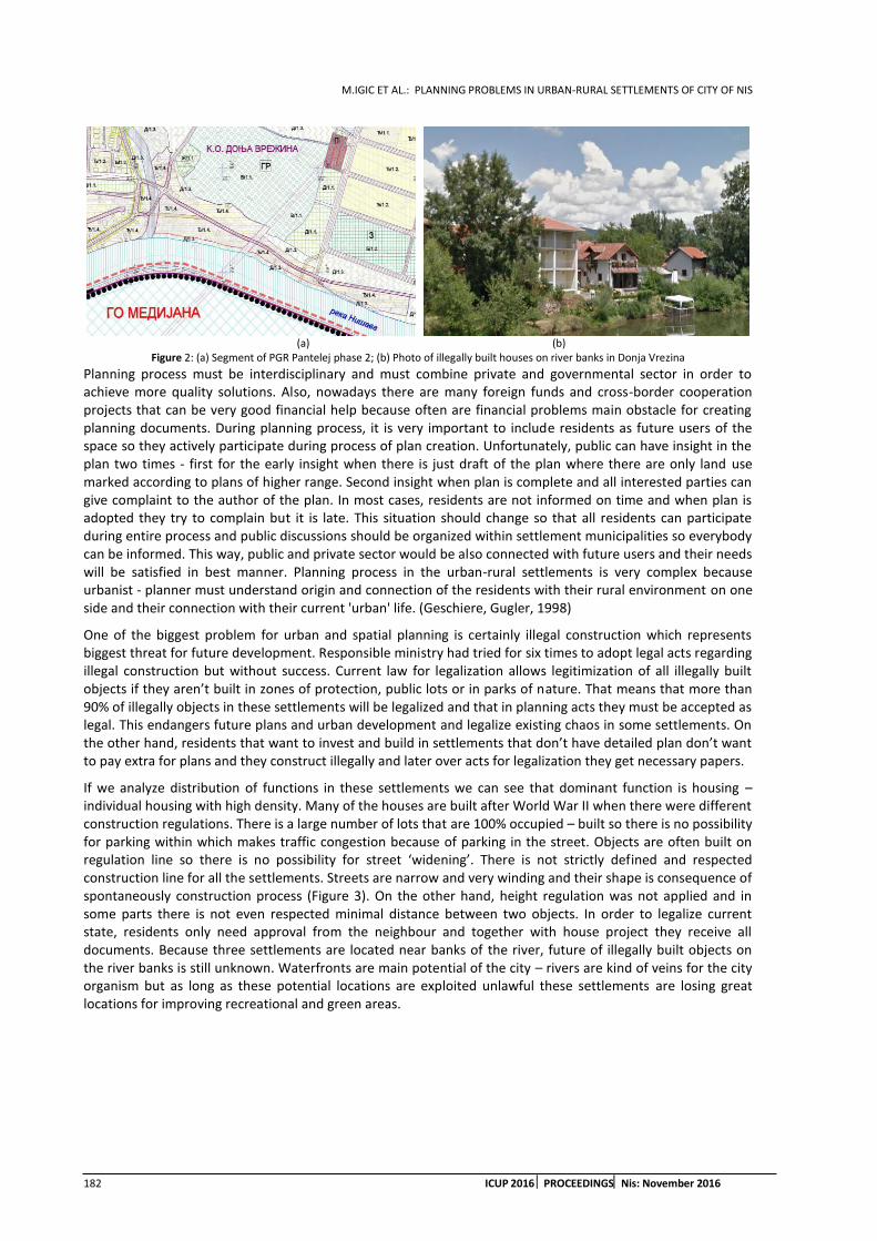
M.IGIC ET AL.: PLANNING PROBLEMS IN URBAN-RURAL SETTLEMENTS OF CITY OF NIS
182 ICUP 2016 PROCEEDINGSNis: November 2016
(a) (b)
Figure 2: (a) Segment of PGR Pantelej phase 2; (b) Photo of illegally built houses on river banks in Donja Vrezina
Planning process must be interdisciplinary and must combine private and governmental sector in order to achieve more quality solutions. Also, nowadays there are many foreign funds and cross-border cooperation projects that can be very good financial help because often are financial problems main obstacle for creating planning documents. During planning process, it is very important to include residents as future users of the space so they actively participate during process of plan creation. Unfortunately, public can have insight in the plan two times - first for the early insight when there is just draft of the plan where there are only land use marked according to plans of higher range. Second insight when plan is complete and all interested parties can give complaint to the author of the plan. In most cases, residents are not informed on time and when plan is adopted they try to complain but it is late. This situation should change so that all residents can participate during entire process and public discussions should be organized within settlement municipalities so everybody can be informed. This way, public and private sector would be also connected with future users and their needs will be satisfied in best manner. Planning process in the urban-rural settlements is very complex because urbanist - planner must understand origin and connection of the residents with their rural environment on one side and their connection with their current 'urban' life. (Geschiere, Gugler, 1998)
One of the biggest problem for urban and spatial planning is certainly illegal construction which represents biggest threat for future development. Responsible ministry had tried for six times to adopt legal acts regarding illegal construction but without success. Current law for legalization allows legitimization of all illegally built objects if they aren’t built in zones of protection, public lots or in parks of nature. That means that more than 90% of illegally objects in these settlements will be legalized and that in planning acts they must be accepted as legal. This endangers future plans and urban development and legalize existing chaos in some settlements. On the other hand, residents that want to invest and build in settlements that don’t have detailed plan don’t want to pay extra for plans and they construct illegally and later over acts for legalization they get necessary papers.
If we analyze distribution of functions in these settlements we can see that dominant function is housing – individual housing with high density. Many of the houses are built after World War II when there were different construction regulations. There is a large number of lots that are 100% occupied – built so there is no possibility for parking within which makes traffic congestion because of parking in the street. Objects are often built on regulation line so there is no possibility for street ‘widening’. There is not strictly defined and respected construction line for all the settlements. Streets are narrow and very winding and their shape is consequence of spontaneously construction process (Figure 3). On the other hand, height regulation was not applied and in some parts there is not even respected minimal distance between two objects. In order to legalize current state, residents only need approval from the neighbour and together with house project they receive all documents. Because three settlements are located near banks of the river, future of illegally built objects on the river banks is still unknown. Waterfronts are main potential of the city – rivers are kind of veins for the city organism but as long as these potential locations are exploited unlawful these settlements are losing great locations for improving recreational and green areas.
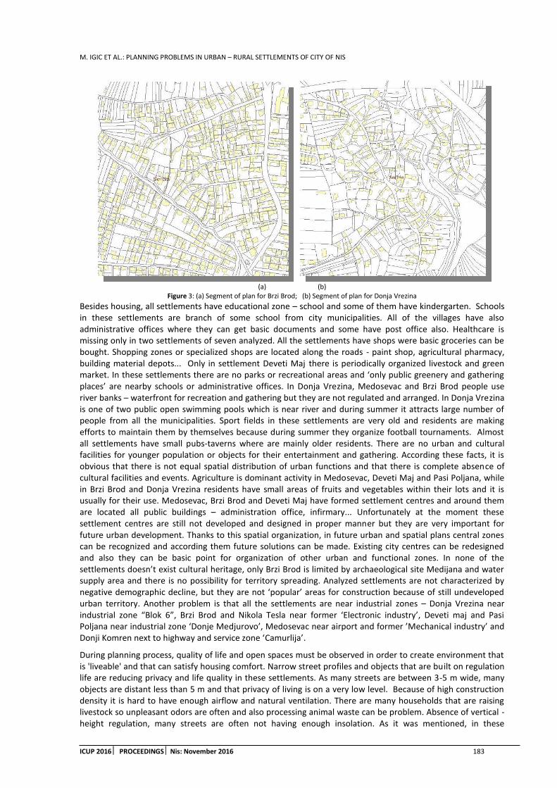
M. IGIC ET AL.: PLANNING PROBLEMS IN URBAN – RURAL SETTLEMENTS OF CITY OF NIS
ICUP 2016 PROCEEDINGS Nis: November 2016 183
(a) (b) Figure 3: (a) Segment of plan for Brzi Brod; (b) Segment of plan for Donja Vrezina
Besides housing, all settlements have educational zone – school and some of them have kindergarten. Schools in these settlements are branch of some school from city municipalities. All of the villages have also administrative offices where they can get basic documents and some have post office also. Healthcare is missing only in two settlements of seven analyzed. All the settlements have shops were basic groceries can be bought. Shopping zones or specialized shops are located along the roads - paint shop, agricultural pharmacy, building material depots... Only in settlement Deveti Maj there is periodically organized livestock and green market. In these settlements there are no parks or recreational areas and ‘only public greenery and gathering places’ are nearby schools or administrative offices. In Donja Vrezina, Medosevac and Brzi Brod people use river banks – waterfront for recreation and gathering but they are not regulated and arranged. In Donja Vrezina is one of two public open swimming pools which is near river and during summer it attracts large number of people from all the municipalities. Sport fields in these settlements are very old and residents are making efforts to maintain them by themselves because during summer they organize football tournaments. Almost all settlements have small pubs-taverns where are mainly older residents. There are no urban and cultural facilities for younger population or objects for their entertainment and gathering. According these facts, it is obvious that there is not equal spatial distribution of urban functions and that there is complete absence of cultural facilities and events. Agriculture is dominant activity in Medosevac, Deveti Maj and Pasi Poljana, while in Brzi Brod and Donja Vrezina residents have small areas of fruits and vegetables within their lots and it is usually for their use. Medosevac, Brzi Brod and Deveti Maj have formed settlement centres and around them are located all public buildings – administration office, infirmary... Unfortunately at the moment these settlement centres are still not developed and designed in proper manner but they are very important for future urban development. Thanks to this spatial organization, in future urban and spatial plans central zones can be recognized and according them future solutions can be made. Existing city centres can be redesigned and also they can be basic point for organization of other urban and functional zones. In none of the settlements doesn’t exist cultural heritage, only Brzi Brod is limited by archaeological site Medijana and water supply area and there is no possibility for territory spreading. Analyzed settlements are not characterized by negative demographic decline, but they are not ‘popular’ areas for construction because of still undeveloped urban territory. Another problem is that all the settlements are near industrial zones – Donja Vrezina near industrial zone “Blok 6”, Brzi Brod and Nikola Tesla near former ‘Electronic industry’, Deveti maj and Pasi Poljana near industrial zone ‘Donje Medjurovo’, Medosevac near airport and former ’Mechanical industry’ and Donji Komren next to highway and service zone ‘Camurlija’.
During planning process, quality of life and open spaces must be observed in order to create environment that is 'liveable' and that can satisfy housing comfort. Narrow street profiles and objects that are built on regulation life are reducing privacy and life quality in these settlements. As many streets are between 3-5 m wide, many objects are distant less than 5 m and that privacy of living is on a very low level. Because of high construction density it is hard to have enough airflow and natural ventilation. There are many households that are raising livestock so unpleasant odors are often and also processing animal waste can be problem. Absence of vertical - height regulation, many streets are often not having enough insolation. As it was mentioned, in these

M.IGIC ET AL.: PLANNING PROBLEMS IN URBAN-RURAL SETTLEMENTS OF CITY OF NIS
184 ICUP 2016 PROCEEDINGSNis: November 2016
settlements there are no green areas or public open spaces where residents can spend their time. Settlements that have centres formed still didn't developed their function enough to offer variety of activities and to be main public spaces for gathering residents. These centres are having administrative and trade functions without possibility to create space where people will spend quality time and not just to go through. Beside Donji Komren, Pasi Poljana and Deveti Maj, other settlements are located near banks of river Nisava. Waterfront has huge potential for development because of green areas it is possible to design recreational areas and to design open spaces for people gathering. Unfortunately, river banks are used uncontrolled for fishing, camping and grilling and natural environment is devastated and endangered. River is polluted because there is no control for waste management even these settlements are covered with programme of waste collection.
5. CONCLUSION
Urban - rural areas are consequence of unplanned and constant city territory spreading. There are many causes for the city spreading but on the first place are population migrations and economic market growth. Most of the cities are gravitation centers for many rural settlements and in the case of city of Nis there are 69 villages. In this paper seven of them are analyzed as part of city sprawl in order to highlight main planning problems within these settlements. Urban and Spatial planning are facing large number of barriers for their effective implementation and that results with very bad state of planning system in these settlements. Analyzing these settlements, it is obvious that lack of planning document for each settlement is big problem because it slows done process of urbanization and future construction and these areas often are not interesting for investors. On the other hand, because of lack of planning documents, residents are building spontaneously and illegal which causes series of problems for future development and life quality. Big problem during planning process is also insufficient participation of the residents and public and insights are possible only in beginning phase and in the end of the plan. There is not developed model of governmental, private and public partnership in planning process. These settlements have developed various urban functions but without any zoning and regularity and recreational and cultural facilities are not present. Inherited irregular structure is causing large problems for natural insolation and ventilation and also reduce privacy degree so many objects are built to close. Because there is no zoning, many warehouses and construction depots are in the zone of housing. Few settlements have organized their centers but they are not arranged at all and they have circulating character without possibilities for gathering people. It is necessary to create open public spaces and green areas where people could spend their time and organize different cultural events. Most dominant function is housing but because of all above mentioned, quality of life and life comfort are not on a satisfactory level and these areas are not interesting for younger population because there are neither urban facilities designed for them.
Perceiving the real needs and state of each municipality for each settlement can be made a SWOT analysis which should be the basis for the creation of strategies and plans for the promotion and development of these settlements and to solve their current problems. Raising the quality of the living conditions of the local community is gaining in importance and becoming socio-economically developed and stable is very important. In designing and implementing strategies for the development of rural – suburban areas can apply the principles that are used in the European Union - economic and social cohesion, sustainable development and balancing the competence of management. In order to achieve these objectives, it is necessary to establish a permanent and effective functional links between urban and rural areas in order to set out examples of good practice - developed areas could draw lessons for improving the development of less developed settlement. It is necessary to make balance between the use of modern technologies in spatial planning and architecture and inherited traditions in order to create an environment that would be attractive and challenging for the younger population.
REFERENCES
1. Champion, T., Hugo, G., 2004. New forms of Urbanisation: Beyond the Urban-Rural Dichotomy. Ashgate Publishing Limited, United Kingdom
2. General Regulation Plan for Municipality Pantelej phase II. 2015.
avaliable on: http://www.zurbnis.rs/index.php/2015-06-15-09-17-30/2015-06-15-09-19-10.html
3. General Urban Plan for the territory of the city of Nis for period 2010-2025, Sluzbeni list grada Nisa, br. 43 od 1. jula 2011. godine

M. IGIC ET AL.: PLANNING PROBLEMS IN URBAN – RURAL SETTLEMENTS OF CITY OF NIS
ICUP 2016 PROCEEDINGS Nis: November 2016 185
4. Geschiere, P., Gugler, J., 1998. Introduction: the urban–rural connection: changing issues of belonging and identification. Africa, Volume 68, Issue 3 (The Politics of Primary Patriotism), p.309-319
5. Geyer, H.S.,2007. International Handbook of Urban policy, Volume 1. Edvard Elgar Publishing Limited, United Kingdom
6. Lobao, L., Hooks, G., Tickamyer, A., 2007. The Sociology of Spatial Inequality.State University of New York Press, New York
7. Marinovic-Uzelac, A., 1986. Naselja, gradovi, prostori. Tehnicka knjiga, Zagreb
8. Obradovic,T, Mitkovic,P., 2012: The development of urban legislation in Serbia and England, Facta Universitatis, Vol 10, No 3 , p. 315-326
9. Republican statistic bureau (RZS). 2014. Podaci popisa stanovnistva 2011.
10. Simonovic, DJ., 1980. Uredjenje seoskih teritorija i naselja: urbanizacija sela, prostorni razvoj, stanje sa regionalnim karakteristikama i ocenom, elementi, pokazatelji i normative za planiranje, projektovanje i izgradnju. Gradjevinska kjniga Beograd
11. The Law on Planning and Construction, 2015. Sluzbeni glasnik Republike Srbije. Republika Srbija: Ministarstvo gradjevinarstva, saobracaja i infrastrukture.

M.IGIC ET AL.: PLANNING PROBLEMS IN URBAN-RURAL SETTLEMENTS OF CITY OF NIS
186 ICUP 2016 PROCEEDINGSNis: November 2016

A. MIRIC ET AL.: URBAN DEVELOPMENT AGAINST ARCHITECTURAL HERITAGE? ARCHAEOLOGY AS A PATRIMONY PROTECTION TOOL
ICUP 2016 PROCEEDINGS Nis: November 2016 187
URBAN DEVELOPMENT AGAINST ARCHITECTURAL HERITAGE? ARCHAEOLOGY AS A PATRIMONY PROTECTION TOOL
Aleksandra Miric
Institut de recherché sur l’architecture antique, France PhD., long-distance joint researcher, [email protected]
Jasmina Tamburic
Faculty of Civil engineering and architecture, University of Nis, Serbia Assistant, [email protected]
ABSTRACT
Large number of existing archaeological sites is endangered by development of urban and rural infrastructure and other construction works. With disturbance of stratigraphy of the ground and damaging of construction elements, the readability of archaeological remains and, therefore, possibilities for scientific research are compromised. Such damage can lead to irreversible loss of precious data and valuable artefacts from the past.
Archaeological research is an obligatory element and precondition to realization of infrastructural and construction work of larger scales in most of the countries of European Union, as well as in Serbia. Even if the majority of archaeological remains found during the excavations rest cluttered, their documentation represents a significant contribution to their research and visibility.
In this article, the level of effectiveness of legislation regarding urban development-led archaeology in Serbia is analysed, the effects that protective archaeology has on development of archaeological science as independent scientific branch, as well as influences on protection, preservation and presentation of cultural heritage.
Keywords: urbanistic development-led archaeology; preventive archaeology; protective archaeology; protection of built heritage; conservation of heritage.
1. INTRODUCTION
Rapid urbanization caused by the need for constant improvement of living standards and enabled by the industrial revolution, provoked a series of planned or spontaneous process of partial or total transformation of the inherited landscape. Infrastructure works that accompanied the aforesaid process, regardless of their volume, irrevocably destroyed part of the architectural heritage on their route and has not been previously explored.
Since the time of first activities of amateur archaeologists to modern definition of modern archaeology research methods, the study of primary historical text sources led to the location, excavation and creation of conditions for the detailed research and interpretation of great number of so far discovered and presented important archaeological localities.
The Council of Europe had the pioneering role in protection of cultural heritage. Under the slogan "The future for our past" (D.Thérond in Bozóki-Ernyey, 2013), the European Convention for the Protection of the Archaeological Heritage was signed in London on May 6th 1969, and revised in Valletta on January 16th 1992. In this document the importance of the archaeological heritage for understanding the development of civilization was emphasized (Council of Europe, 1969). The convention defines the obligations of Member States to protect the archaeological finds as an important source of the earliest history of the European continent. The document presents the development policy framework to protect built heritage. Because of the universal applicability and general acceptance, this document is one of the major achievements of the joint efforts of the Council of Europe member states to improve cooperation in the field of culture.
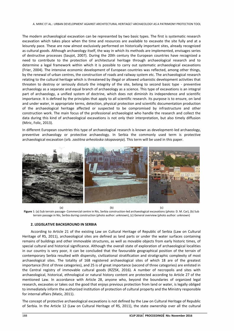
A. MIRIC ET AL.: URBAN DEVELOPMENT AGAINST ARCHITECTURAL HERITAGE? ARCHAEOLOGY AS A PATRIMONY PROTECTION TOOL
188 ICUP 2016 PROCEEDINGSNis: November 2016
The modern archaeological excavation can be represented by two basic types. The first is systematic research excavation which takes place when the time and resources are available to excavate the site fully and at a leisurely pace. These are now almost exclusively performed on historically important sites, already recognized as cultural goods. Although archaeology itself, the way in which its methods are implemented, envisages series of destructive processes (Saujot, 2007). During the 20th century the European countries have recognized a need to contribute to the protection of architectural heritage through archaeological research and to determine a legal framework within which it is possible to carry out systematic archaeological excavations (Frier, 2004). The intensive economic development of European countries was reflected, among other things, by the renewal of urban centres, the construction of roads and railway system etc. The archaeological research relating to the cultural heritage which is threatened by illegal or allowed urbanistic development activities that threaten to destroy or seriously disturb the integrity of the site, belong to second basic type - preventive archaeology as a separate and equal branch of archaeology as a science. This type of excavations is an integral part of archaeology, a unified system of doctrine, which does not diminish its independence and scientific importance. It is defined by the principles that apply to all scientific research. Its purpose is to ensure, on land and under water, in appropriate terms, detection, physical protection and scientific documentation production of the archaeological heritage affected or suspected to be compromised by infrastructure and other construction work. The main focus of the professional archaeologist who handle the research and collect the data during this kind of archaeological excavations is not only their interpretation, but also timely diffusion (Miric, Folic, 2013).
In different European countries this type of archaeological research is known as development-led archaeology, preventive archaeology or protective archaeology. In Serbia the commonly used term is protective archaeological excavation (srb. zastitna arheoloska iskopavanja). This term will be used in this paper.
(a) (b) (c) Figure 1: (a) Sub terrain passage- Commercial centre in Nis, Serbia construction-led archaeological excavations (photo: D. M. Car), (b) Sub
terrain passage in Nis, Serbia during construction (photo author: unknown), (c) General overview (photo author: unknown)
2. LEGISLATIVE BACKGROUND IN SERBIA
According to Article 21 of the existing Law on Cultural Heritage of Republic of Serbia (Law on Cultural Heritage of RS, 2011), archaeological sites are defined as land parts or under the water surfaces containing remains of buildings and other immovable structures, as well as movable objects from early historic times, of special cultural and historical significance. Although the overall state of exploration of archaeological localities in our country is very poor, it can be concluded that the favourable geographical position of the terrain of contemporary Serbia resulted with dispersity, civilizational stratification and stratigraphic complexity of most archaeological sites. The totality of 168 registered archaeological sites of which 18 are of the greatest importance (first of three categories), and 25 is of great importance (second of three categories) are enlisted in the Central registry of immovable cultural goods (RZZSK, 2016). A number of necropolis and sites with archaeological, historical, ethnological or natural history content are protected according to Article 27 of the mentioned Law. In accordance with Article 28, anyone who, beyond the boundaries of organized legal research, excavates or takes out the good that enjoys previous protection from land or water, is legally obliged to immediately inform the authorized institution of protection of cultural property and the Ministry responsible for internal affairs (Matic, 2011).
The concept of protective archaeological excavations is not defined by the Law on Cultural Heritage of Republic of Serbia. In the Article 12 (Law on Cultural Heritage of RS, 2011), the state ownership over all the cultural

A. MIRIC ET AL.: URBAN DEVELOPMENT AGAINST ARCHITECTURAL HERITAGE? ARCHAEOLOGY AS A PATRIMONY PROTECTION TOOL
ICUP 2016 PROCEEDINGS Nis: November 2016 189
goods enjoying previous protection is mandatory, so that ownership over cultural goods cannot be acquired by accidental discovery during the unauthorized excavations. According to Articles 109-110, if in the course of urbanistic development-led construction and other works, archaeological sites or archaeological items are found, the contractor is obliged to immediately, without any delay, inform the authorized state institution for protection of cultural monuments and to take measures in order to prevent destruction and damage of archaeological remain. It needs to be kept in place and in a position in which it is detected. If there is an imminent danger of damage of archaeological sites or objects, the authorized institution for protection of cultural monuments will temporarily suspend the construction works while, as prescribed by this Law, the value status of remains is not determined. If the authorized institutions for protection of cultural monuments do not suspend works, works will be suspended by Republic Institute for Protection of Cultural Monuments.
In Serbia, large number of existing archaeological sites is endangered by development of urban and rural infrastructure and other construction works. With disturbance of stratigraphy of the ground and damaging of construction elements, the readability of archaeological remains and, therefore, possibilities for scientific research are compromised. Such damage can lead to irreversible loss of precious data and valuable artefacts from the past.
Unlike the law on preventive, so called development-led archaeology of the EU countries, which define the amount of state financial subventions, the Serbian law on cultural heritage does not provide financial compensation for this type of protective archaeological excavations. The investor of the work is required to provide funding for excavation, preservation, scientific research, publication and exhibition of goods that enjoy previous protection, detected during the construction and other works. The lack of interest of investors to finance protective archaeological research that usually interrupt construction work for a longer period, could often cause concealment of archaeological findings and silent disappearance of many sites. It therefore seems necessary to establish a permanent mechanism in order to raise awareness of professionals- constructors as well as investors on significance of cultural and historical heritage.
The Articles of this Law that stipulate the mechanisms of control over its implementation, particularly Article 130 (Law on Cultural Heritage of RS, 2011) predicts a fine for the institution, enterprise, organization or other legal entity, who
by inadequate protection or inappropriate organization of work, contribute to the damage or destruction of cultural goods, or good that enjoys previous protection
fails to notify, within a given period, the owner, as well the municipality about the existence of good that enjoys previous protection
fails to promptly inform the institution of protection about all legal and physical changes that occurred in connection with cultural heritage
does not terminate the execution of construction and other works in case of existence of archaeological remains
does not take measures to report destroyed and damaged finds and does not take measures to preserve the site and in the position in which it has been discovered fails to provide funds for the research, protection, preservation and exhibition of goods with previous protection that are discovered during the execution. (Miric, Miric, 2012)
(a) (b) (c) Figure2: (a) Early-Christian basilica on the Site Kladenciste, Crvena reka, during the construction of road-led archaeological excavations
(photo: www.novosti.rs), (b) General overview (photo author: www.rtv.rs), (c) protection of basilica before the road crossed over its remains (photo: http://rs.n1info.com/)

A. MIRIC ET AL.: URBAN DEVELOPMENT AGAINST ARCHITECTURAL HERITAGE? ARCHAEOLOGY AS A PATRIMONY PROTECTION TOOL
190 ICUP 2016 PROCEEDINGSNis: November 2016
3. INSTITUTIONAL AND PROCEDURAL BACKGROUND IN SERBIA
Pursuant to Article 112 of the Law on Cultural Heritage (Law on Cultural Heritage of RS, 2011), the Ministry of Culture issues licenses for carrying out archaeological research and excavation. Excavation and archaeological survey may be conducted solely by scientific institution or institution of protection, in accordance with the law. Approval may be granted only if the institution has made a project of archaeological research with adequate professional staff, equipment and funds provided for research and implementation of measures of protection of sites and finds. Institution conducting archaeological excavations and research is required to keep records on the work that is prescribed in the regulations of RS (Regulations on forms of documentation that is kept on the archaeological excavations and research 1995, Ordinance on forms of documentation carried on archaeological excavations and research 2006). The institution which carried out archaeological research and excavation shall deliver, within three months after completion of the works, to the Ministry of Culture a prelaminar report on the completed excavation. It should contain basic information about the works, particularly the plan of the finds, required number of photographs, an inventory of excavated movable items, the time during which the works are completed, the list of professionals that have carried out works, funds spent and the description of technical measures taken in order to protect the site and findings. Upon completion of the archaeological excavations or research institution that conducted these works, shall, within a period of one year, deliver to the Ministry the final report. This report will be permanently archived by the Institute for the protection of cultural heritage.
(a) (b) Figure3: (a) The building with octagonal room and floor mosaics, Gradsko Polje, Nis, (photo: www.blic.rs)(b) Orto photo of valorised roman
remains and pedestrian pathway (photo: Google Maps and A. Miric)
4. SOME EXEMPLES OF URBANISTIC DEVELOPMENT-LED ARCHAEOLOGICAL SITES IN NIS
Protective archaeology led to some of discoveries that changed the views on early history of territory of Serbia. Still, some of the excavated remains have been devastated or are threatened to be devastated by the construction of highways, hydropower stations or artificial lakes. Most often, they remain non-presented, buried under the protective layers of soil. The case of historically important and well preserved Early Christian basilica on the site Kladenciste, Crvena reka is a very illustrative example. In spite of a public outcry, this precious building was covered in eco-textile and sand just before the new road past over it (Suljagic, 2015). Fig. 2
Speaking about the territory of Nis, ancient city of Naissus, the valuable roman remains were demolished at the time when post-war urban renewal took off. Many development-led excavations were conducted on threatened sites. Despite the importance of findings, the construction permissions continued to be issued without enough care for the archaeological consequences. Important remains, as in case of hundreds of square meters of floor mosaics found on the territory of roman suburbia Mediana during the construction of Electronic Industry Factory, were destroyed. The dislocation of roman castellum aquae from the endangered site and its re-construction on an archaeological-park-to-be surface is a good example of efforts invested in a roman historical heritage protection (Jeremic, 1988). On the same site, the construction of the contemporary road leading from Nis to Pirot brought numerous information on roman habitat. Confirming the claims of scientific community that the roman road Naissus-Serdica is located beneath this modern road, dozens of antique houses located by the roadside were discovered. Its detailed documentation permits interpretation and theoretical reconstruction of the past-time societies. (Fig.4)
ROMAN
RUINS
PEDESTRIA
N
PATHWAY
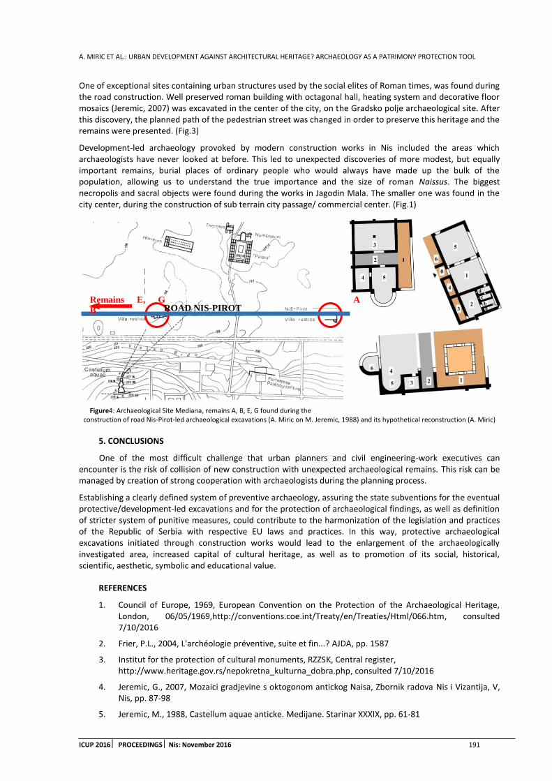
A. MIRIC ET AL.: URBAN DEVELOPMENT AGAINST ARCHITECTURAL HERITAGE? ARCHAEOLOGY AS A PATRIMONY PROTECTION TOOL
ICUP 2016 PROCEEDINGS Nis: November 2016 191
ROAD NIS-PIROT Remains E, G A
B
One of exceptional sites containing urban structures used by the social elites of Roman times, was found during the road construction. Well preserved roman building with octagonal hall, heating system and decorative floor mosaics (Jeremic, 2007) was excavated in the center of the city, on the Gradsko polje archaeological site. After this discovery, the planned path of the pedestrian street was changed in order to preserve this heritage and the remains were presented. (Fig.3)
Development-led archaeology provoked by modern construction works in Nis included the areas which archaeologists have never looked at before. This led to unexpected discoveries of more modest, but equally important remains, burial places of ordinary people who would always have made up the bulk of the population, allowing us to understand the true importance and the size of roman Naissus. The biggest necropolis and sacral objects were found during the works in Jagodin Mala. The smaller one was found in the city center, during the construction of sub terrain city passage/ commercial center. (Fig.1)
Figure4: Archaeological Site Mediana, remains A, B, E, G found during the construction of road Nis-Pirot-led archaeological excavations (A. Miric on M. Jeremic, 1988) and its hypothetical reconstruction (A. Miric)
5. CONCLUSIONS
One of the most difficult challenge that urban planners and civil engineering-work executives can encounter is the risk of collision of new construction with unexpected archaeological remains. This risk can be managed by creation of strong cooperation with archaeologists during the planning process.
Establishing a clearly defined system of preventive archaeology, assuring the state subventions for the eventual protective/development-led excavations and for the protection of archaeological findings, as well as definition of stricter system of punitive measures, could contribute to the harmonization of the legislation and practices of the Republic of Serbia with respective EU laws and practices. In this way, protective archaeological excavations initiated through construction works would lead to the enlargement of the archaeologically investigated area, increased capital of cultural heritage, as well as to promotion of its social, historical, scientific, aesthetic, symbolic and educational value.
REFERENCES
1. Council of Europe, 1969, European Convention on the Protection of the Archaeological Heritage, London, 06/05/1969,http://conventions.coe.int/Treaty/en/Treaties/Html/066.htm, consulted 7/10/2016
2. Frier, P.L., 2004, L'archéologie préventive, suite et fin...? AJDA, pp. 1587
3. Institut for the protection of cultural monuments, RZZSK, Central register, http://www.heritage.gov.rs/nepokretna_kulturna_dobra.php, consulted 7/10/2016
4. Jeremic, G., 2007, Mozaici gradjevine s oktogonom antickog Naisa, Zbornik radova Nis i Vizantija, V, Nis, pp. 87-98
5. Jeremic, M., 1988, Castellum aquae anticke. Medijane. Starinar XXXIX, pp. 61-81

A. MIRIC ET AL.: URBAN DEVELOPMENT AGAINST ARCHITECTURAL HERITAGE? ARCHAEOLOGY AS A PATRIMONY PROTECTION TOOL
192 ICUP 2016 PROCEEDINGSNis: November 2016
6. Law on cultural heritage, Official Gazette RS, No.71/94, 52/2011 and 99/2011
7. Matic, M., 2011, Pravni aspekti zastite arheoloskog nasledja, Nasledje, Beograd, XII, pp. 287
8. Miric, A., Kurtovic-Folic, N., 2013, Preventivna arheologija u sluzbi zastite graditeljskog nasledja, Evropsko zakonodavstvo. - Beograd: Institut za medjunarodnu politiku i privredu, No. 43/44 (2013), pp. 408-419
9. Miric, F., Miric, A., 2012, Krivicnopravne mere u oblasti zastite nepokretnih i pokretnih kulturnih dobara na osnovu osnivackih ugovora EU (primer Francuske), Evropsko zakonodavstvo, Beograd: Institut za medjunarodnu politiku i privredu, 2012, No. 42/12, pp. 124.
10. Ordinance on forms of documentation carried on archaeological excavations and research, 2006, Official Gazette of RS, No. 102/06
11. Regulations on forms of documentation that is kept on the archaeological excavations and research, 1995, Official Gazette of RS, No. 19/95
18. Saujot, C., 2007, Le droit français de l'archéologie, Paris, pp.6
19. Suljagic, S., 2015, Neophodnost ocuvanja Bazilike u Kladencistu, Politicka revija, 4, Vol 46, pp. 19-46
20. Thérond, D., Foreward, in: Bozóki-Ernyey, K., 2004, Ed, European Preventive Archaeology, Papers of the EPAC Meeting, Vilnius pp. 9

M. STANIMIROVIC ET AL.: URBAN DESIGN AND CONTEXT
ICUP 2016 PROCEEDINGS Nis: November 2016 193
CORELLATION BETWEEN URBAN DESIGN AND CONTEXT: SQUARE IN PIROT
Mirko Stanimirovic
Faculty of Civil Engineering and Architecture - University of Nis, Serbia PhD. Student, Teaching Assistant, [email protected]
Goran Jovanovic
Faculty of Civil Engineering and Architecture - University of Nis, Serbia PhD., Associate Professor, [email protected]
Slavisa Kondic
Faculty of Civil Engineering and Architecture - University of Nis, Serbia PhD. Student, Teaching Assistant, [email protected]
Vojislav Nikolic
Faculty of Civil Engineering and Architecture - University of Nis, Serbia PhD. Student, Teaching Assistant, [email protected]
Vladana Stankovic
Faculty of Civil Engineering and Architecture - University of Nis, Serbia PhD. Student, Teaching Associate, [email protected]
ABSTRACT
The process of urban design as part of the process of design in general will be dealt with in this paper. The first part shows the process of urban design. In the second part, by using square in Pirot as an example the completed urban project will be assessed according to analysis of unity in space and ambience. The basic hypothesis of this work is that architecture (in general) and urban design (in particular) depend on the context that is defined by three decisive factors: programme, place and time.
Keywords: square; urban design; ambience; Pirot.
1. URBAN DESIGN PROCESS
Physical and social environment should be analysed by using the concept of architectural environment. Environmental studies have their own existential roots and they arise from the need to understand human relations in a certain environment. According to Christian Norberg-Schulz most of human actions have their aspect in space, because objects of orientation are based on the concepts of outside and inside, far and near, separate and together, continuous or interrupted. Since physical and mathematical concepts of space meet only one need for orientation, a world of abstract notions is perceived by quantifying primitive experience, thereby lacking in emotional relations towards the environment. That is the reason why the concept of space applies other concepts that embrace affective aspects of behaviour and relations. C.N. Schulz names five concepts of space: pragmatic, perceptual, existential, cognitive and abstract (Norberg-Sulc, 2002). S. Gidion puts the problem of space into the centre of modern architecture, while the history of architecture is viewed as a series of consecutive spatial concepts. The claim that space represents one essential part in existential structure should be complemented by defining the special structure (Gidion, 2002).
By putting together architecture and space an issue arises whether the environment we create should be suitable for personal or public world. Reducing architecture to a rationalist activity would make people homeless, therefore a hope remains that our environment would create its own sense and significance that goes beyond practical aspects. Many people believe that architecture serves public life, i.e. that architectural

M. STANIMIROVIC ET AL.: SQUARE IN PIROT
194 ICUP 2016 PROCEEDINGS Nis: November 2016
space makes public existential space concrete that also includes personal existential spaces. „People put soil that they carry on the ground, that they come across, and put landscapes they carry to existing landscapes, and the two become one.” (Schwarz, 1949:59)
Le Corbusier, a renowned urban planner and an architect sees architecture as creation of exciting harmony. According to his views, architecture creates passion and drama out of a motionless stone, it controls quantities and gives sense to harmony. What gives us the excitement while viewing a certain space cannot be made by using a recipe, whereas by using the art of architecture.
‘You employ stone, wood and concrete, and with these materials you build houses and palaces; that is construction. Ingenuity is at work. But suddenly you touch my heart, you do me good, I happy and say "This is beautiful." That is Architecture. Art enters in. My house is practical. I thank you, as I might thank Railway engineers or the Telephone service. You have not touched my heart.
But suppose that walls rise towards heaven in such a way that I am moved. I perceive your intentions. Your mood has been gentle, brutal, charming or noble. The stones you have erected tell me so. You fix me to the place and my eyes regard it. They behold something which expresses a thought. A thought which reveals itself without word or sound, but solely by means of shapes which stand in a certain relationship to one another. These shapes are such that they are clearly revealed in light. The relationships between them have not necessarily any reference to what is practical or descriptive. They are a mathematical creation of your mind. They are the language of Architecture. By the use of inert materials and starting form conditions more or less utilitarian, you have established certain relationships which have aroused my emotions. This is Architecture.’ (Le Corbusier, 1986:203)
How does an architectural space have an impact on senses and causes certain emotions, how does it work and what is aesthetic content of architecture? According to M. Lojanica aesthetic content is the one that causes the sense of harmony. The reasons for aesthetic effects should be looked after in the direction of subject and object. He collects experience by using philosophemes about creation, in that way is architectural space moved to the points of perception, perspective, experience and inevitably to psychology (Lojanica, 2001:passim).
Urban design blends architecture, landscape architecture and roads that transform an individual identity into a new thing, called urban ambience by D. Toskovic. Well combined elements that make up one ambience unit are recognised as comfortable ambience, made by reconstruction of events that led to its distinctive character. „Here are examples: unity-ambience, balance-calm, rhythm-movement, altogether reaching the beautiful. In architecture the criteria boil down to purpose-function to put it short and architectonics as a synonym for composition: organic composition of elements into a coherent whole. The principle of beautiful in urbanism is the human coming to being.” (Toskovic, 2000:passim)
Unity in space and ambience refers to the part of space around us that awakens aesthetic feelings or pleasant feelings, beauty, harmony, simplicity or order. Such space serves the purpose and is different from a work of art that only serves its artist, therefore purpose and aesthetics combine into urban design. Design is a branch of applied arts that deals with the artistic creation of a plan or convention. Its aim is the construction of an object, system or creation of something applicable. Design usually occurs when there is a pre-established plan, idea or thought. The purpose of design is the realisation of a plan or an idea that can be caused by a need to solve a certain problem. That is why the process of design is usually defined as a process of problem solving.
Urban design blends architecture, landscape architecture and roads that transform an individual identity into a new thing, called urban ambience by D. Toskovic. Well combined elements that make up one ambience unit are recognised as comfortable ambience, made by reconstruction of events that led to its distinctive character.
‘Aesthetics and urban design recognise creation from an idea, that the essence lies in the idea. The process of urban design is the act of creation-thoughtful and sensible, that in the graphic notion integrates the purpose and structure of a building and ambience into a coherent composition. (…) Since urban design as a process also involves the aesthetics, certain notions from contemporary aesthetics need to be taken into consideration that are also binding on urbanists. Their implementation such as buildings, squares and other forms of reception must have artistic qualities of permanent value in a certain urban space, because they are in an immediate connection with human existence. (…) The examples are: unity-ambience, balance-calm, rhythm-movement altogether reaching the beautiful. In architecture the criteria boil down to purpose-function to put it short and architectonics as a synonym for composition: organic composition of elements into a coherent whole. The principle of beautiful in urbanism is the human coming to being.’ (Toskovic, 2000.)

M. STANIMIROVIC ET AL.: URBAN DESIGN AND CONTEXT
ICUP 2016 PROCEEDINGS Nis: November 2016 195
‘It is obvious that architects and architecture have a pivotal role in creating the atmosphere of a place, whereas the inherent connection between architectonic ideology and national consciousness is neglected. Academics take a critical look at the role of architects, architecture and spatial planning as connection between national ideology and the politicisation of space.’ (Yacobi, 2004:passim)
‘Art in its pure form is the production of works of art by certain methods either by learning or invention. Methods are correct and certain ways that justify our actions.’ (Stravinski, 1966:13)
The design process can be divided into three stages: defining the problem, brainstorming solutions, choosing the best solution. Doing background search is also necessary in the first stage. The understanding of genius loci term can be a good starting position. A location’s distinctive atmosphere or ‘a spirit of place’ is a key to further development. Historical analysis is one of techniques for data collection. Its significance for urban design process can be seen in the following statement: “The study of history is the pursuit of future” (Kurtovic Folic, 2008). Visual analysis belongs to the phase of collection and can be divided into three parts: the study of three dimensional public space, the study of two dimensional surface that shapes the public space and the study of architectural details that are the most important for describing the atmosphere of a place.
The main purpose of data collection is to get knowledge about the problem of research and to create innovative ideas to solve the problem. There are no ready details and efficient ways to come to a solution in this phase. Understanding the environment and its history forms the basis for innovative development. A city research begins with the analysis of the history of that area, followed by the study of perception. Defining the structure determines the image and identity of a city. Detailed studies that refer to the visual qualities of a city make the analysis of a city landscape complete.
Urban design theory deals primarily with creation of ideas for designing and managing of public space, i.e. public environment. They are a basis for creative thinking in urban design so as not to turn it into sterile and boring activity. These concepts or ideas that are a possible way of problem solving can be achieved through various techniques: making conclusions based on the area analysis, previous historical study, theoretical conditions, synthetic techniques or analogy, as well as techniques of lateral thinking, brainstorming or searching for ideas directly from the citizens. Techniques of idea creation as described in the design process are universal, as well as the process of thinking in general.
For many designers the second stage is the beginning of design process. New ideas and forms are created in this stage, new feelings are explored and this process is like a world in miniature. Some recommendations for work have a goal of not creating a better idea but helping a designer when imagination lacks or deadlines approach. There are external and internal factors that impact creativity according to science, that is why a favourable atmosphere for creating new ideas is desirable. Image of the world of a designer, his personality and clarity of goals and problems are reflected in the process of creation. The more a designer feels lee under the pressure and the greater the number of solutions, the more creative he becomes. Parallel worlds of conscious and unconscious, memories and other attributes of a person enable a relevant relation of solutions and problems. M. Lojanica defines several methodological approaches that are used in the second stage of design.
A normative approach is based on the accepted rules, established standards that guarantee successful design. Such approach gives guidelines for efficient combining of elements into significant units, and other necessary and fixed value systems. There are elaborate systems of modular coordination included in complete and closed logical systems. M. Lojanica notices in this approach a basic idea that there is deterministic relation between form and content.
The main characteristic of creative approach is that discussions about methodology of design are unnecessary, because method depends on the individual. A designer sets his own rules for valuing a work of art. Rational analysis is not needed when we deal with creativity. The main feature of this approach is form. A designer creates it by himself and all the other characteristics of architectural work are subject to it.
A rational approach in design had its best results in the sphere of technological design. Rational methodology of design is based on mathematical and logical structures, standards and algorithms. It is widely held among designers that contemporary needs, technological possibilities and conditions in environment are highly complex in creating artificial environment that they are beyond perceptive powers of a designer. They believe that methodology of design should be viewed as methodology of science, i.e. classical scientific method that logically and experimentally deals with hypothesis, whereas deductive and inductive methods find the solutions

M. STANIMIROVIC ET AL.: SQUARE IN PIROT
196 ICUP 2016 PROCEEDINGS Nis: November 2016
A heuristic technique for problem solving is not exclusively creative or rational, but both of it. It employs a practical method not guaranteed to be optimal or perfect, but sufficient for immediate goals. According to M. Suvakovic, research in art is usually assumed to be a heuristic approach. There is no precise programme of research in heuristic approach. The most fundamental heuristic is trial and error. It is based on an uncertain research that leads to the unknown, unexpected, authentic and new. It is why it is applicable in art. Heuristic approach denotes searching and finding out new, original knowledge. It considers in advance possibilities of failure or mistakes, untruth, delusions, oversight. Its way is paved for finding out, establishing and rejecting the achieved and not on system of rules. The goal of experimenting and cycles of trial and error is to experience new sphere of art that will broaden its method. One experiences new revelations in art through constant experiments with oneself and the material.
‘An artist is no longer considered a creator but a contemporary explorer that goes beyond particular media and craft specializations in the name of multimedia or nomadic architecture. He/she should be conscious of his/her individual position towards art, society and theory.’ (Suvakovic, 2010:40)
G. Broadbent, a pedagogue and an architect, claims that an architect creates form by referring to: pragmatic rules, models of problem solving, analogue solutions and canonical approach (Broadbent, 1995:passim).
According to pragmatic approach, an object or conception can only be fully understood through its practical consequences. It is suitable regarding social issues because it requires a conduct that resolves problems as it assesses the practical consequences of a project.
An architectural model built to study aspects of an architectural design are used for a range of purposes. A model is used to communicate design ideas; by using a certain model its unfavourable characteristics are also accepted, such as economic problems, maintenance, energy consumption and so forth. Models help visualise a design but the features they represent are hardly ever identical. In that case similarities are not so visible, by following the model by a renowned architect, natural forms, traditional architecture etc. The application of these analogies is positive in G. Broadbent’s views, a good analogy is better than a bad original. Academic communities in the Serbian history in XIX and XX century have had positive views of the objects of Serbian national style that freely interpreted its architectural legacy. Contrary to this, objects that contain medieval quotations are in fact referring to the past with the aim of valuing current expressions. The outcome of such an idea is doomed to failure, and that is only nowadays after more than half a century to be seen in the eyes of those who perceive the development of architecture in its entirety.
Canonical approach is frequently used in apartment designs, because it brings very effective methodological procedures. An architect creates his own or adopts an already acknowledged system that is made up of modules and rules of modular coordination. Modules can refer to design and constructive modules, while dimensions are established according to the type of interior functions and characteristics of construction systems.
The last (third) stage of design brings us back to reality. Various solutions in the end have to be narrowed down. Based on the criteria set in the first stage, one solution has to be chosen. Desired details have to be added to put the project into the final stage.
According to Lynch’s criteria (Linc, 1974) a place with a comfortable ambience should have the following characteristics: not be too hot, loud, light, cold, calm, crowded, empty, steep, dirty; to be versatile in providing a suitable type of environment for anyone at any time; to provide activities for people to take part in; to have a clearly defined identity; to have its remarkable parts so defined that any viewer can see their relations and understand their model in space and time and in other aspects of life; to have an impact in intellectual, emotional and physical development of an individual.
Contemporary aesthetics, according to D. Toskovic, claims that there are two views of aesthetic form: beauty is sought after in the object (the theory of imitation: mimesis) or the subject (psychology and theory of pleasure, independent creativity; poesis). If a designer neglects aesthetic criteria and seeks only to obtain his goals under the market pressures, then his ways are certain to become a failure.
2. SQUARE AS AN URBAN ELEMENT
A town square as an urban element of city space and composition acquires a certain social function depending on its purpose, position and construction. Town squares have unique concept owing to the function they assume in the heart of a town and the shape they make in space. Their shape and size vary depending on

M. STANIMIROVIC ET AL.: URBAN DESIGN AND CONTEXT
ICUP 2016 PROCEEDINGS Nis: November 2016 197
the purpose they have. They can be closed in space with buildings evenly built at the forefront and dominant verticality in the background. The size of a town square and the height of buildings surrounding it need to be correlated. Dimensions should be adjusted to allow perception of: certain parts of a building, whole building, neighbouring structures and their contours. A favourable perception is achieved when the width of a square and the height of a building have the same value. Buildings can be viewed as a whole if the width of a square equals twofold height of buildings, while at threefold distance the quality of perception diminishes.
The area of a town square has a significant role in visual perception because it provides views of structures, characteristic buildings or square contours. Surface coating enables free movements of pedestrians and traffic. It can be viewed in space, while space shaping can be viewed from different points and aspects.
Square dimensions should be measured according to the size and character of city districts. Missing the appropriate size would create a space that is not lively and intimate. It is necessary to carefully study the elements of a square and establish its real purpose, the surrounding buildings, size and relation towards the city.
Spatial composition means using the available space to create the desired environment and it is comprised of basic and supplementary elements. The basic elements of a square are: concept and disposition of an object, convex and concave shapes and surface elements, vertical alignments and cross-sections, arcades, colonnades. Supplementary elements include: greenery, sculptures, fountains, pools and monuments.
An aesthetic basis in the square formation is superficial surface covering. In complex spatial compositions, asymmetry, irregularity, light-shadow-contrast display are used to show the dominants. D. Toskovic concludes that spatial unity includes square formation in spatial and surface sense. If the spatial elements do not complement each other architecturally and in composition, then the formation of a square is not regular.
A distinctive feature of a square that has characteristic height, shape, content, position or meaning is the main motif of a square. The silhouette is the factor that dominates the square and is used in irregular and asymmetric squares
‘It is useful to know how long time ago certain possibilities were used in the construction of a fountain or a monument. There were strict rules in the antic world, but they were less obvious in the Middle Ages and the Renaissance. Leaving an empty space in the middle is visible in the Roman Forum. (...) There were also many cases when untypical places were chosen. However, Michelangelo's David is certainly placed with sophisticated attention. We are looking at the secret of unconscious artistic feelings that made miracle without any aesthetic paragraphs and lots of rules. At the same time, we are waiting with a ruler and callipers convinced that heavy-handed geometry would solve our intrinsic feelings.’ (Zite, 1967:20)
C. Moughtin (2003:1) sees urban design as the art of city construction, a method for a man to create his surroundings that meet his needs and represents his values. Since taking care of nature becomes one of crucial importance, urban design can be described as human usage of accumulated technological knowledge that controls and adapts nature according to social, economic, political and spiritual needs. An architect should be able to recognise and understand the needs and aims of citizens that he can later use for design. The studying of process of urban design, projects and creation in general answers the question of how a certain space should be designed.
Royal Institute of British Architects divides the process of urban design into four stages: assimilation (gathering of general information and data that concretely refer to a problem), general study (research of problems and possible solutions), development (elaboration of one possibility) and communication (representing the project to the client).
Project appraisal as the process of assessing the case for proceeding with a project in urban design involves comparing various options and in many ways: from cost analysis, benefits, to complete influence of the project on environment. It is also essential to include the public in the initial assessments and to allow them to choose one of the several solutions of the project.
3. SQUARE IN PIROT
In 2008 Pirot Municipality has as an investor (Fund for building land and residential dwelling maintenance in public property) ordered the reconstruction of central square from Urban Public Company in Pirot. Once the funds were provided, a main project of reconstruction was made in 2010. Investor requests were stipulated in the project, pursuant to the law, regulations and standards used in construction.

M. STANIMIROVIC ET AL.: SQUARE IN PIROT
198 ICUP 2016 PROCEEDINGS Nis: November 2016
Based on the given project, consulting company (Urban Public Company in Pirot) proposes a motion while consulting with the investor (representatives of local self-government). It is adopted in an assembly once the decision is made to implement the offered project. National Investment Plan (a part of Ministry of Economy and Regional Development) based on the finished main project invites bids for projects that must be submitted. Contractor, project supervisor and workgroup made up of responsible designers are selected.
‘Pirot Warrior Square, the most famous and busiest site in Pirot city will be reconstructed by National Investment Plan funds. Works will begin in July, and they will finish in the autumn. The current poor condition of the square mirrors the previous period in which there was a shortage of equipment for maintenance and reconstruction. Therefore, the site's potential and attractiveness, availability of many cultural-historic, gastronomic, tourist and trade offers are mostly unused. National Investment Plan finances the development of Pirotski Warriors Square to be fully returned to the park users. Its aim is to create new ambience by maximally using its full potential. The plan envisages reconstruction of existing underground infrastructure and new areas of space with features adapted to the place. Green area will be completely rearranged; each will have at its centre a sculpture that is part of a vast collection of factory Prvi Maj Pirot. Fountains are also part of this project and they are put in the sunniest position of the square. Just beside the park is multi-purpose area with an open air stage for many cultural and educational performances. The project is worth 62,3 million dinars. NIP finances works in the value of 57.5 million dinars, while local self-government co-finances it with 4.8 million dinars.’ (http://www.mnip.gov.rs/Pages/Archive.aspx? NewsId =234. Accessed: June 26, 2011.)
The main architects in the reconstruction of Pirot Warrior Square are A. Mancic, A. Manic, K. Kostadinovic. Reconstruction of the existing pedestrian zones, parking lots and green areas are represented in the main project, while part of the technical description is taken out from the archive of Urban Public Company in Pirot.
‘The main purpose of reconstruction is the return of space to the park users by adapting it to the needs of contemporary users. This complex process creates new ambience while using all its potential maximally. (...) The expected connection with tradition is achieved, not through imitation of well known forms and motifs, but by the tolerance between the existing and new architecture, built and natural surroundings (green areas and water), pedestrian walks (earlier named Corso) and space reserved for outdoor cafes; as well as the use of contemporary and traditional materials. As opposed to the alienation that is becoming part of everyday life, the square is open and hospitable and that was once our greatest quality. (...) The square consists of several units that do not break the space by their organization in space and function but make it unique. The space is light and cleared out and that makes it a perfect ground for creating a museum in an open space.’ (Archive of JUP)
Figure 1: Pirot, The new centre of town (Source: http://www.pirotskevesti.rs/wp-content/uploads/2015/05/pirot-panorama_resize-
1024x314.jpg, Accessed: September 15, 2016)
4. CONCLUSION
In Pirot Square only some parts of the shown design process can be noticed. The authors have probably started from the second stage, they used the concepts of pragmatic approach. It is visible from a compromise solution made in concrete paving which is politically influenced. This square is an example of financial and political connections. Public space is covered with inadequate material for somebody’s financial gains to the detriment of the users. Another compromise settlement is made in sculpture due to the lack of pattern imprinted concrete. Lynch’s criterion of identity is achieved. Illumination and sprinklers are set in an original way by using a model design. The undersized types of trees are put in concrete planting boxes only on the surface of the square. The roots are not able to grow, and the users are forced to create their own mental

M. STANIMIROVIC ET AL.: URBAN DESIGN AND CONTEXT
ICUP 2016 PROCEEDINGS Nis: November 2016 199
feelings of shade which is contrary to Lynch’s first criterion-it should never be hot at a square. No matter how huge the weaknesses in Pirot square are, the unity in space and ambience is achieved artistically, that among other things, reflects the problems in society.
There is no doubt that some projects that are unique and have major cultural significance have become role models for constructing new squares and they are monads of remarkable creative spirit. They contribute a lot to artistic creation, particularly architecture. On the other hand, epoch-making questions arise from major projects. This is a living history of architecture and human existence in general.
Pirot Warrior Square is one of the two central squares in Pirot. Red Square (or Republic Square), the smaller one is reconstructed a few years earlier in the first stage of reconstruction. Although the citizens were informed about the whole process according to law, they were not satisfied. The new project was not open to public, because the local self government and its MPs embarked on the project. The decisions that were not in the project were later only added by the council. The efforts of the author to apply the usual standards of urban design were only strengthened by the needs of the investor. Pattern imprinted concrete as paving supply was used in the reconstruction of Red Square but it proved to be inefficient in slippery conditions, it was expensive and difficult to replace. The patterns of Pirot Kilim are made in the way Le Corbusier would call it 'not organized'. They are used as an example not to criticize the reconstruction but the investor's demands that are not appropriate and legal. The issues of not publicly presenting the project and public disapproval of imprinted concrete need to be addressed legally and they are inevitably coupled with space creation of square ambience. In the end we can stress out the fact that architecture, urbanism and urban design depend on three factors:
Programme (man's needs, the project), Place (natural and created surroundings) and Time (sociocultural and technological influences).
ACKNOWLEDGEMENTS
Thanks to the kindness of the main project architecture author of Pirot Warrior Square, descriptions and drawings from the archive of Urban Public Company in Pirot were named.
REFERENCES
1. Archive of JUP. 2010. Pirot. Srbija.
2. Broadbent, G. 1995. Emerging Concepts in Urban Space Design. Taylor & Francis. London. UK.
3. Gidion, Z. 2002. Vreme, prostor i arhitektura. Gradjevinska knjiga. Beograd. Srbija.
4. Kurtovic Folic, N. 2008. Handouts sa predavanja: Doktorske studije, Zastita graditeljskog nasledja. Arhitektonsko-gradjevinski fakultet u Nisu. Nis. Srbija.
5. Le Corbusier. 1986. Towards a new architecture. Dover Publications. New York.
6. Linc, K. 1974. Slika jednog grada. Gradjevinska knjiga. Beograd. Srbija.
7. Lojanica, M. 2001. Proces projektovanja. Arhitektonski fakultet. Beograd. Srbija.
8. Moughtin, C. 2003. Urban Design: Method and Techniques, Architectural Press. Oxford. UK.
9. Norberg-Sulc, K. 2002. Egzistencija, prostor i arhitektura. Gradjevinska knjiga. Beograd. Srbija.
10. Schwarz, R. 1949. Von der Bebauung der Erde. Verlag Anton Pustet. Salzburg. Austria.
11. Stravinski, I. 1996. Moje shvatanje muzike. Vuk Karadzic. Beograd. Srbija.
12. Suvakovic, M. 2006. Diskurzivna analiza. Univerzitet umetnosti u Beogradu. Beograd. Srbija.
13. Toskovic, D. 2000. Urbani dizajn: urbanisticka tehnika i estetika. Urbanisticki zavod Republike Srpske. Banjaluka. Republika Srpska.
14. Yacobi, H. 2004. Constructing a Sense of Place. Ashgate. Aldershot. UK.
15. Zite, K. 1967. Umetnicko oblikovanje gradova. Gradjevinska knjiga. Beograd.

M. STANIMIROVIC ET AL.: SQUARE IN PIROT
200 ICUP 2016 PROCEEDINGS Nis: November 2016

H. IBRAHIM ET AL.: PROMOTING SUSTAINABLE HOUSING AND URBAN DEVELOPMENT FOR QATAR THROUGH PPP MODEL
ICUP 2016 PROCEEDINGS Nis: November 2016 201
PROMOTING SUSTAINABLE HOUSING AND URBAN DEVELOPMENT FOR QATAR THROUGH PPP MODEL
Hossam Ibrahim
PhD, Urban Planning Expert, Qatar National Master Plan, Ministry of Municipality & Environment, Qatar. Senior Lecturer, Faculty of Urban & Regional Planning, Cairo University.
Senior Lecturer, Mansoura Higher Institute for Engineering & Technology. [email protected]
Ali Feraish Mubark Saleh
Head of Planning Implementation Section, Ministry of Municipality & Environment [email protected]
ABSTRACT
Qatar is a unique country blessed with a strong people and a distinctive natural environment. As the world’s third largest holder of natural gas reserves, the economic prosperity of Qatar is guaranteed for generations to come. Despite this abundance of natural wealth, Qatar recognizes the need to continue to invest strongly in its people and to create a diversified economy where the private sector plays a prominent role. Nowadays Qatar as one of the Gulf countries is devising strategies to tackle over the 60% plunge in oil prices. The impact of falling oil prices on the wider economy could create pressure on economic planning in Qatar, which has an oil-linked pricing mechanism for its supplies. To overcome these challenges, Qatar is increasingly interested in public private partnerships for its development and infrastructure projects as an ideal solution to complement government spending and drive growth.
This paper aims to provide insight into how the PPP model can help promote sustainable housing and urban development for Qatar. It reviews PPP model focusing on the importance of PPP, the advantages and dis-advantages of PPPs. The paper also explores challenges for PPPs in housing and urban development. It seeks through a critical evaluation to provide practical recommendations that serve to enhance the implementation of PPPs in Qatar.
Keywords: urban planning; sustainable housing; urban development; PPP.
1. INTRODUCTION
Qatar is a unique country blessed with a strong people and a distinctive natural environment. As the world’s third largest holder of natural gas reserves, the economic prosperity of Qatar is guaranteed for generations to come. Despite this abundance of natural wealth, Qatar recognizes the need to continue to invest strongly in its people and to create a diversified economy where the private sector plays a prominent role. Qatar is striving to become an internationally recognized destination attracting high-end business, high performing education and research development, premier sporting and conference events, as well as luxury leisure.
The population of Qatar has more than doubled over the last eight years. The resulting urban development and the provision of infrastructure to support this growth is challenging. Furthermore under Qatari National Housing Program (NHP) male Qataris who marry are provided with free land plots once in their lifetime, to establish a family home. The current allocation is 625 m2 within Doha Municipality and 1,000 m2 elsewhere in Qatar. NHP has put a strain on the supply of suitable residential land. About 21,000ha of land is currently understudy for potential supply of housing for Qatari households,85% of which is located outside the Metropolitan Doha growth boundary(MME, 2014).The supply of vacant Government land zoned for residential use within Doha Municipality is seriously constrained. However most of the new sites are located in generally un-serviced locations on the urban fringe, which exacerbates the urban sprawl problem. In order to solve this

H. IBRAHIM ET AL.: PROMOTING SUSTAINABLE HOUSING AND URBAN DEVELOPMENT FOR QATAR THROUGH PPP MODEL
202 ICUP 2016 PROCEEDINGSNis: November 2016
issue Qatar National Development Framework (QNDF) highlighted a policy to ensure that sufficient land is available to cater for future demand by Qatari households (MME, 2014). Box 1 shows the housing policy in QNDF.
Box 1: Housing policy in QNDF
Nowadays Qatar as one of the Gulf Countries is facing the oil crisis and its impact on the GDP. The collapse in the price of oil, from more than $100 a barrel in 2014 to under $40 has a great impact on all sectors including housing and other basic infrastructure assets. The ever-widening gap between the demand and supply of housing and community facilities in GCC countries is pressing the governments in the region to have an urgent look at the issue. To overcome these challenges, Qatar is increasingly interested in Public Private Partnerships (PPPs) for its development and infrastructure projects as an ideal solution to complement government spending and drive growth (Chadwick, P. et.al. 2015). Qatar recent initiatives are encouraging, where government are coming forward to encourage private sector to participate in providing housing and community facility by using many approaches such as:
Provide land in good locations and at reasonable prices.
Provide incentives to developers
To sum up there has been a higher acceptance of PPP in the GCC, in recent years, due to the enhanced ability of the private sector to execute housing and community facility projects on a large-scale. However PPPs are unlikely to entirely replace traditional infrastructure financing and development any time soon, if ever. PPPs are just one tool among many. Governments typically have a number of objectives when building infrastructure: getting good value for money, timely delivery, meeting public needs and so on. The procurement model that best addresses these objectives is the one that should be chosen in each individual circumstance. PPPs have shown their potential as an important way to meet these objectives and address infrastructure shortages. For example, they provide new sources of capital for public infrastructure projects. Private equity, pension funds and other sources of private financing must still be repaid, but shifting the responsibility for arranging the financing to the private partner can help deliver infrastructure if a public entity is unwilling or unable to shoulder the full debt or the associated risk of the project at a certain point in time (Burger et.al. 2011).
This paper through a critical desk analysis for PPPs literature review aims to provide insight into how the PPP model can help promote sustainable housing and urban development for Qatar. Therefore the paper is divided into seven sections. First section reviews PPP model focusing on the importance of PPP. Then a brief overview PPPs stages is provided. The third section reviews different patterns in applying PPPs model to housing and urban development. Then the paper also explores the advantages and dis-advantages of PPPs followed by brief discussion of challenges for PPPs in housing and urban development. Then a discussion of Qatar initiatives takes place. Finally some practical recommendations that could help to enhance the implementation of PPPs in Qatar are highlighted.
2. PPPS MODELS
A public-private partnership, or PPP, refers to a contractual agreement formed between a government agency and a private sector entity that allows for greater private sector participation in the delivery of public projects (OCED, 2012). PPPs are used around the world to build new and upgrade existing public facilities such as schools, hospitals, roads, waste and water treatment plants and prisons, among other things. Compared with traditional procurement models, the private sector assumes a greater role in the planning, financing, design, construction, operation, and maintenance of public facilities. Risk associated with the project is transferred to
In accordance with current Government policy prepare a phasing strategy which identifies and releases sustainable sites for the Qatari NHP based on achieving the following criteria:
Located on vacant Government-owned land zoned for residential purposes;
Provided with utilities, community facilities and public transportation services;
Designed in accordance with best practice planning principles and accords with National Planning Codes and Standards.
Source: QNDF (MME, 2014)

H. IBRAHIM ET AL.: PROMOTING SUSTAINABLE HOUSING AND URBAN DEVELOPMENT FOR QATAR THROUGH PPP MODEL
ICUP 2016 PROCEEDINGS Nis: November 2016 203
the party best positioned to manage it (Eggers, w, 2006). Figure 1 illustrates the most common PPP models and the Scale of Public-Private Partnerships. Box 1 describes the most common PPP models.
Figure 1: The Scale of Public-Private Partnerships: Risk Transfer and Private Sector Involvement Source: Canadian Council for Public-Private Partnerships
Box 1: PPP models
Design-Build: The private sector designs and builds infrastructure to meet public sector performance specifications, often for a fixed price, so the risk of cost overruns is transferred to the private sector. (Many do not consider Design-Build Models to be within the spectrum of PPPs).
Finance Only: A private entity, usually a financial service industry, funds a project directly or uses various mechanisms such as long-term lease or bond issues.
Operation and Maintenance Contract: A private operator, under contract, operates a publicly-owned asset for a specified term. Ownership of the asset remains with the public entity.
Build-Finance: The private sector constructs an asset and finances the capital cost only during the construction period.
Design-Build-Finance-Operate: The private sector designs, builds and finances an asset and provides hard facility management or maintenance services under a long-term agreement.
Design-Build-Finance-Maintain-Operate: The private sector designs, builds and finances an asset, provides hard and/or soft facility management services as well as operates under a long-term agreement.
Build-Own-Operate: The private sector finances, builds, owns and operates a facility or service in perpetuity. The public constraints are stated in the original agreement and throughout on-going regulatory authority.
Concession: A private sector concessionaire undertakes investments and operates the facility for a
fixed period of time after which the ownerships reverts back to the public sector.
Source: Canadian Council for Public-Private Partnerships

H. IBRAHIM ET AL.: PROMOTING SUSTAINABLE HOUSING AND URBAN DEVELOPMENT FOR QATAR THROUGH PPP MODEL
204 ICUP 2016 PROCEEDINGSNis: November 2016
3. PPPS STAGES
There are different stages of understanding and applying PPPs. This is depending on many factors including local geography, political climate, the sophistication of the capital market, the forces driving formation of partnerships and the factors enabling their creation. Figure 2 define the PPPs stages.
Figure 2: the PPPs stages Source: (Eggers, w, 2006)
4. PATTERNS IN APPLYING THEPPP MODEL TO HOUSING ANDURBAN DEVELOPMENT
This section describes some global patterns in the application of PPPs for the most prominent urban infrastructure sectors, including affordable housing, transport, water service, schools and hospitals (Moskalyk. A, 2011).
4.1. Urban Housing
The PPP approach to housing projects in most of developed countries has included a joint venture where the private and public sectors jointly finance, own, and operate a housing project, and where risk is shared according to predetermined contractual provisions.
4.2. Urban Transport
In urban transport, PPPs have emerged as an effective tool for the expansion, maintenance, and construction of new roads, railways, airports, seaports and other forms of transport. The financial viability of urban transport projects makes this sector a more attractive investment option to the private partner, particularly in developed countries where there is a growing public acceptance of tolls, or other user fees for roads and bridges.
4.3. Urban Water and Sanitation Management
Water and sanitation management represents another fast growing urban sector for PPPs around the world. Being more specific many governments are moving away from traditional state management of water service delivery and towards private sector involvement.
4.4. Urban Schools and Hospitals
Public-private partnerships are also becoming an accepted norm in global education and health sectors. Governments are realizing the need for involving the private sector to help deal with the escalating costs of health and education.

H. IBRAHIM ET AL.: PROMOTING SUSTAINABLE HOUSING AND URBAN DEVELOPMENT FOR QATAR THROUGH PPP MODEL
ICUP 2016 PROCEEDINGS Nis: November 2016 205
5. ADVANTAGES AND DIS-ADVANTAGES OF PPPS
While this section highlights the important key advantages associated with PPP model, it also considers some of the arguments made against PPP procurement for wider urban development.
5.1. Advantages of PPPs
Some of the advantages of PPPs can be defined as follows:
Cost Savings
Encouraging innovation to take place by motivating the private partner to develop new methods and approaches for project delivery.
Linking payments to performance.
Motivating the private sector to organize its activities in a way that drives efficiencies and maximizes returns on investments.
Transferring risk between the public and private sectors based on the ability to manage that risk cost-effectively.
PPPs Deliver On-Time
Enhancing Public Management by focusing on other important policy issues
Enabling the Public Sector to Focus on Outcomes and Core Business
Improving Levels of Service
5.2. Disadvantages of PPPs
Some disadvantages of PPPs can be defined as follows:
PPP contract requires that each partner spend considerable time and resources on outside experts to help anticipate and oversee all possible future contingencies
Reduced Control of Public Assets
Loss of Accountability
6. CHALLANGESS TO PPPS IN HOUSINGAND URBAN DEVELOPMENT
Almost all countries around the world have witnessed some form of PPP investment in the provision of housing and urban infrastructure since the early 1990s.However when applying PPPs governments around the world are facing a range of challenges. These challenges vary depending on the country’s level of understanding and development in using the partnership model (Moskalyk. A, 2011). This section highlights some of the most common PPP challenges facing governments today:
Differing Goals between the private sector and the public sector.
Public Acceptability.
Lack of internal capacity including negotiation, finance, contract and other skills required to manage highly complex urban projects such as PPPs.
Integration of sustainable development into planning and implementation process.
7. DISCUSSION OF QATAR INITIATIVES
Over 10 years ago, Qatar had already initiated its privatisation programme by transferring the responsibility of the state-owned electricity and water corporation to an independent authority. More recently the BOOT was used to implement the Ras Laffan IWPP (Independent Water and Power Project). There is great scope for widening the use of PPPs in Qatar and there is a strong indication that this is the path Qatar is taking with its future plans for its rapid major infrastructure development. Qatar is also looking to partner with the private sector to improve delivery of public services and efficient management of public assets.
Qatar recent initiatives are encouraging, where government are coming forward to encourage private sector to participate in providing housing and community facilities this including but not limited to:
Hospitals
Schools
Tourism projects
Affordable housing for expats and workers in Qatar

H. IBRAHIM ET AL.: PROMOTING SUSTAINABLE HOUSING AND URBAN DEVELOPMENT FOR QATAR THROUGH PPP MODEL
206 ICUP 2016 PROCEEDINGSNis: November 2016
The country inter to this partnership by
Provide land in good locations and at reasonable prices.
Provide land free of charge.
Provide incentives to developers.
From the previous illustration of Qatar initiatives towards PPPs it can be clarified that Qatar is still in the first stage of applying PPPs and mostly using the two models, Design-Build-Finance-Maintain-Operate and Build-Own-Operate- Transfer. The next section will provide recommendations for Qatar in order to enhance the implementation of PPPs and move forward to the higher stages.
8. RECOMMONDATIONS
Latecomers to the PPP party can avoid some of the mistakes often made in earlier stages of maturity the tendency to apply a one-size-fits-all model to all infrastructure projects. Furthermore they can adopt from the outset some of the more flexible, creative and tailored PPP approaches now being used in trailblazer countries.
The public interest is paramount.
Good practices in accountability and transparency measures must be maintained throughout the lifecycle of the project.
A PPP project needs to be carefully planned, well-defined in scope and fundamentally clear in its objectives.
The viability of the project needs to be measured against a criteria set by the initiating partner to assist it in determining its potential suitability for PPP procurement.
The selected PPP model must provide value for money in terms of cost and time savings with appropriate consideration of risk transfer.
The PPP tendering process must be competitive, fair and subject to proper due diligence on the part of the partnership.
An urban sector PPP must reflect the needs of the affected community and must integrate into the project key stakeholder priorities.
Finally it is certain that PPP models developed in mature PPP markets in other regions can be used as a guideline. Ultimately, however, states such as Qatar will look to adopt a PPP delivery solution and find their own structures that are adapted to the local market and to government requirements.
REFERENCES
1. Burger, P., Hawkesworth, I., 2011. How To Attain Value for Money: Comparing PPP and Traditional Infrastructure Public Procurement, OECD Journal on Budgeting, 11(1). pp 1-56.
2. Chadwick, P., Bastress, S., 2015. Prospects of public-private partnerships for Qatar’s infrastructure.http://www.qatarconstructionnews.com/prospects-public-private-partnerships- qatars-infrastructure/#sthash.IfEMxRmK.dpuf [Accessed: 1st October 2016]
3. Eggers, W., 2006. Closing the Infrastructure Gap: The Role of Public-Private Partnerships, Deloitte Development LLC.
4. MDPS, 2008, Qatar National Vision 2030, Ministry of Development Planning and Statistics (MDPS), Doha, Qatar.
5. MME, 2014. Qatar National Development Framework (QNDF), Ministry of Municipality and Environment (MME), Doha, Qatar.
6. Moskalyk, A., 2011. Public-Private Partnerships in Housing and Urban Development, The Global Urban Economic Dialogue Series, UN-HABITAT, Nairobi,ISBN Number (Volume): 978-92-1-132356-6.
7. OECD, 2012. Recommendation of the Council on Principles for Public Governance of Public-Private Partnerships.

E. VASIC PETROVIC ET AL.: CULTURAL LANDSCAPE OF GOSTUSA - A PERFECT SYMBIOSIS OF MAN AND NATURE
ICUP 2016 PROCEEDINGS Nis: November 2016 207
CULTURAL LANDSCAPE OF GOSTUSA - A PERFECT SYMBIOSIS OF MAN AND NATURE
Elena Vasic Petrovic
Institute for Cultural Heritage Preservation Nis, Serbia Director, Architect Conservator, [email protected]
Ivana Cvetkovic
Institute for Cultural Heritage Preservation Nis, Serbia Associate, Architect Conservator, [email protected]
Aleksandar Niksic
Freelance, Serbia Architect, [email protected]
ABSTRACT
The village of „Gostusa“, also called the “stone settlement”, is located in South-East Serbia in the area of the Nature Park „Stara Planina“, in Pirot District.
Gostusa’s position, structure and materialization are unique in many ways, and this reflects in the following facts:
-Spatial concept of the settlement is composed of the so called “core and satellites”, where residential part is completely divided from the livestock and agricultural buildings;
-Architecture of the building units is always adapted to the terrain and vertical composition varies for dozens of meters at a very short distance;
-Stone dominates as a building material, and it is used widely from the foundation to the top and the roofing, by applying unusual construction techniques and methodologies.
Gostusa is situated in the canyon at the point where the threе mountain rivers join together. The surroundings of the village comprises of beautiful landscapes with a large expanse of pastures, plateaus, fields of wild berries, thick forests, but also steep slopes, wondrous waterfalls, pure mountain rivers and fish-rich lakes.
Keywords: Gostusa village; cultural landscape; heritage; stone; architecture.
1. INTRODUCTION
The Research project in Gostusa village which started in 2012, has provided extraordinary results in the field of heritage conservation in a very short period of time. It was developed by the Institute for Cultural Heritage Preservation Nis during the following years, and in 2016 the Project’s published Conservation study won the most prestigious European Union Grand-prix Prize and Europa Nostra Award as the first Serbian laureate ever. The Study was made up of the most important results of the architectural research in the field, but also it contains spatial and rural planning elements, combined with the designation proposal and protective technical measures.
The cultural property of the village and its surroundings is positioned within the nature property of “Stara planina” Nature Park. This makes it, by the definition a perfect example of “cultural landscape”. Although the Serbian low doesn’t have this option for the legislative protection, the Project kept this concept in all of its aspects and also implemented many other international conventions. As much the nature set the foundations for the village’s creation and development it also had set the directions for our work.

E. VASIC PETROVIC ET AL.: CULTURAL LANDSCAPE OF GOSTUSA - A PERFECT SYMBIOSIS OF MAN AND NATURE
208 ICUP 2016 PROCEEDINGSNis: November 2016
The village and its related settlements, together with the other cultural and natural elements in the surroundings, were proposed to the protection as a unique cultural and historic ambiental unity.
2. CULTURAL LANDSCAPE
A “landscape” can be defined as a “collection of all the visible features of an area of land, often considered in terms of their aesthetic appearance” or in another words, defined by the Council of Europe it “means an area, as perceived by people, whose character is the result of the action and interaction of natural and/or human factors”. If we go more in details we can bring a “landscape” to another level and say that a “cultural landscape” includes combined works of nature and humankind, where they express a long and intimate relationship between peoples and their natural environment. There is a great variety of cultural landscapes that are representative of the different regions of the world and to date, 88 properties with 4 transboundary properties (1 delisted property) on the World Heritage List have been included in this category. Considering the fact that none of them is in our region, our research and work are dedicated to the mountain “rural landscapes” of Serbia, especially in the area of Stara Planina (Balkan Mountain).
“Rural landscapes are considered a productive, economic, environmental, social, scientific and technical resource, but cultural and historical as well” and by chance or not, our project was conceived at the same time as the International Scientific Committee on Cultural Landscapes ICOMOS-IFLA (ISCCL) has launched in 2012 the World Rural Landscapes Initiative, following the same principles together with the already existing European Landscape Convention 2000 and FaroConvention 2005.
In Serbia, where even urban environments are not using their advantages in promoting and preserving the reach cultural heritage, bringing the idea of rural heritage conservation was really a unique case. Anyway we were determined to make a change and try to implement a new sustainable concept to the most unexpected place.
Gostusa village is located 25km to the east from the town of Pirot and it belongs to the Nature Park “Stara Planina”. The surroundings of the village comprises of beautiful landscapes with plateaus, fields of wild berries, thick forests, but also steep slopes, wondrous waterfalls, pure mountain rivers and fish-rich lakes, all together enjoying the moderate continental climate with a five month snow period per year.“Stara planina” has specific flora and fauna and is a habitat of rare and endangered species of both kinds.
The village has more than 300 buildings, and approximately 80 permanent residents. Except the electricity and running water installations, there is no other technical achievement in this settlement, including the total absence of telecommunications, meaning no mobile or any other kind of telephone network.
Most of the population left Gostusa during the 70’s of the XX century in order to find a better life in the town, which was experiencing industrial expansion at that time. This is exactly why Gostusa is so special, everything there is frozen in time, providing at the same time a unique experience of the past.
Figure 1: (a) Image of Stara Planina highlands (photo by Aleksandar Ciric), and (b) satellite view – Gostusa village and its surroundings, the “core and satellites” spatial concept (https://www.google.com/earth/)
People there are still living the same way of life like their ancestors, mainly engaged in cattle breeding and their buildings preserved authenticity like nowhere else in interiors and exteriors.
The research of specific building techniques and materialization in stone of all the structural, functional and decorative elements of the village and learning about the environment of the Nature Park gave us a proof of the extraordinary connection between the nature and architecture that managed to survive in its original form for more than one hundred years. The peaceful coexistence of man and nature brought back to life the values

E. VASIC PETROVIC ET AL.: CULTURAL LANDSCAPE OF GOSTUSA - A PERFECT SYMBIOSIS OF MAN AND NATURE
ICUP 2016 PROCEEDINGS Nis: November 2016 209
that were forgotten for decades, and the thought that this simple symbiosis can ensure sustainability for the future.
3. SPATIAL CONCEPT
Spatial concept of the settlement is composed of the so called “core and satellites”, where residential part is positioned in the canyon at the point where the threе mountain rivers join together and is completely divided from the livestock and agricultural buildings, located from several hundred meters to several dozens of kilometers at the highlands of Stara Planina. The satellites represent also a kind of small settlements called “pojate” or “priseline” and utilizing, beside livestock breeding, a temporary housing with incorporated small dairies and barns.
This specific functional and architectural concept of the village is very interesting and all together the units form a unique living organism, changing together with the change of seasons.
Architecture of residential and economy units is always adapted to the terrain and the natural resources. Stone dominates as a building material, and it is used widely from the foundation to the top and the roofing.
The special values of the site are the “view points” and “view corridors”, available because of the specific terrain configuration and village location.
Figure2: (a) Functional organization of the village, (b) road organization and pavement and (c) view points and corridors (drawings by Aleksandar Niksic)
Road network has evolved along with the village, so it’s has irregular and meandering structure, developed primarily for walking.
The “core” is at the lowest point (approx.700m altitude) when we look at vertical elevation, but still from the entrance of the village, coming from the Pirot direction, to the exit there is a 1,2 km distance, and several dozens of meters of difference in altitude. Opposite to the length of the residential area the width doesn’t exceed 200m. Also the width of the canyon narrows towards the exit to the highlands. The “satellites” are positioned around the settlement, the nearest having also the direct visual communication with the “core” from their direction. The most remote ones are positioned at the 1800m attitude.
The residential part is divided in two mayor units, “lower” and “upper” settlement.
The “satellites” are functionally connected to the “core” and between each other. They are built on the large plots and consist usually of not more than 20 buildings.
Concept of village where residential part is completely free from the livestock and agricultural buildings is not usual, or maby is even unique in spontaneously developed villages, without knowledge of urban theory and practice.

E. VASIC PETROVIC ET AL.: CULTURAL LANDSCAPE OF GOSTUSA - A PERFECT SYMBIOSIS OF MAN AND NATURE
210 ICUP 2016 PROCEEDINGSNis: November 2016
Figure3: (a) House in Gostusa village, (b) house in Gostusa village and (c) barns in Gostusa village (photos by Elena Vasic Petrovic)
4. THE “STONE SETTLEMENT”
Several researchers in various fields explored the area of Gostusa village in the years before our Project, so the name “stone settlement” stands there for a long time, marking this unique village as something that should have been given more attention. The first two years of the Research campaign gave us the insight into a large number of completely preserved houses and households, because the village did not suffer any serious contemporary intervention, so this made it a unique example of completely preserved site. This stands for interiors as well for the exteriors, all thanks to the following facts: the building techniques did not change through time due to the physical isolation of the village and most of the residents left their homes at the 1970’s and moved to the town because of the industrial expansion.
The total number of buildings we have prospected in details was 256 and the total number of all the buildings in village was 370. The half of this buildings were residential, 38% were agricultural buildings positioned outside the “core” and only 14% within it. Those are mostly watermills and other small facilities for food or electricity production connected functionally to the rivers and their water power.
Figure4: (a) Stone wall in Gostusa village, (b) street in Gostusa village carved in rock and (c) stone bridge in Gostusa village (photos by Elena Vasic Petrovic)
There were only 5 public buildings positioned at the lower parts of the settlement. All of them have one thing in common-they all reflect the perfect resemblance of nature and manmade structures with a specific use of stone as dominate building material. All of the elements of this extremely wide area are connected with roads and paths which were extensively used for hundreds of years.
Like the Nature Park in general, Gostusa village is extremely rich in number of water springs. Almost every household has its own water spring or at least a small water stream running through.
5. CONCLUSIONS
The “landscape concept” provides a global frame within which heritage can be understood, cherished and protected, and which offers new ways to benefit from the social, economic and environmental values of heritage. Its perspective can be both local and universal, both personal and collective; it embraces both tangible and intangible heritage and connects with digital and virtual heritage. Using landscape as guide and a
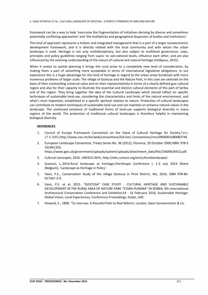
E. VASIC PETROVIC ET AL.: CULTURAL LANDSCAPE OF GOSTUSA - A PERFECT SYMBIOSIS OF MAN AND NATURE
ICUP 2016 PROCEEDINGS Nis: November 2016 211
framework can be a way to help ‘overcome the fragmentation of initiatives deriving by diverse and sometimes potentially conflicting approaches’ and ‘the multiplicity and geographical dispersion of bodies and institutions’.
This kind of approach represents a holistic and integrated management that is a part of a larger socioeconomic development framework, and it is directly related with the local community and with whom the urban landscape is used. Heritage is not only multidisciplinary, but also subject to multilevel governance. Laws, principles and policy guidelines ranging from supra- to sub-national levels, influence each other, and are also influenced by the evolving understanding of the nature of cultural and natural heritage (Veldpaus, 2015).
When it comes to spatial planning it brings the rural areas to a completely new level of consideration, by making them a part of something more acceptable in terms of international legislative obligations. In our experience this is a huge advantage for this kind of heritage in regard to the urban areas burdened with more numerous problems of larger scale. The village of Gostusa and the Nature Park, in this case are selected on the basis of their outstanding universal value and on their representativity in terms of a clearly defined geo-cultural region and also for their capacity to illustrate the essential and distinct cultural elements of this part of Serbia and of the region. They bring together the idea of the Cultural Landscape which should reflect on specific techniques of sustainable land-use, considering the characteristics and limits of the natural environment, and what’s most important, established in a specific spiritual relation to nature. Protection of cultural landscapes can contribute to modern techniques of sustainable land-use and can maintain or enhance natural values in the landscape. The continued existence of traditional forms of land-use supports biological diversity in many regions of the world. The protection of traditional cultural landscapes is therefore helpful in maintaining biological diversity.
REFERENCES
1. Council of Europe Framework Convention on the Value of Cultural Heritage for Society,Faro, 27.X.2005,http://www.coe.int/en/web/conventions/full-list/-/conventions/rms/0900001680083746
2. European Landscape Convention, Treaty Series No. 36 (2012), Florence, 20 October 2000,ISBN: 978 0 101841320, https://www.gov.uk/government/uploads/system/uploads/attachment_data/file/236096/8413.pdf.
3. Cultural Lanscapes, 2016. UNESCO WHL, http://whc.unesco.org/en/culturallandscape/.
4. Scazossi, L.,2014.Rural landscape as heritage,CHeriScape Conference I, 1-2 July 2014 Ghent (Belgium), ‘Landscape as Heritage in Policy’.
5. Vasic, P.E., Conservation Study of the village Gostusa in Pirot District, Nis, 2016, ISBN 978-86-917367-2-9.
6. Vasic, P.E. et al, 2015. “GOSTUSA” CASE STUDY - CULTURAL HERITAGE AND SUSTAINABLE DEVELOPMENT IN THE RURAL AREA OF NATURE PARK “STARA PLANINA” IN SERBIA, 4th International Architectural Conservation Conference and Exhibition14 - 16 February 2016, Sustainable Heritage: Global Vision, Local Experiences, Conference Proceedings, Dubai, UAE.
7. Howard, E., 1898. “To-morrow: A Peaceful Path to Real Reform, London, Swan Sonnenschein & Co.

E. VASIC PETROVIC ET AL.: CULTURAL LANDSCAPE OF GOSTUSA - A PERFECT SYMBIOSIS OF MAN AND NATURE
212 ICUP 2016 PROCEEDINGSNis: November 2016

B. STOILJKOVIC ET AL: CONTEMPORARY APPROACHES TO DESIGNING OF COMMON OUTDOORSPACES IN MULTI-FAMILY HOUSING PROJECTS
ICUP 2016 PROCEEDINGS Nis: November 2016 213
CONTEMPORARY APPROACHES TO DESIGNING OF COMMON OUTDOORSPACES IN MULTI-FAMILY HOUSING PROJECTS
Branislava Stoiljkovic
Faculty of Civil Engineering and Architecture, Serbia PhD., Assistant Professor, [email protected]
Natasa Petkovic-Grozdanovic
Faculty of Civil Engineering and Architecture, Serbia PhD student, [email protected]
ABSTRACT
The quality of outdoor spaces between and around multi-family housing buildings has a great importance in the overall satisfaction of residents and contributes to the quality of housing generally. They have an important social function and present a transition zone between the anonymity of the street and privacy of the apartment. This research deals with the analysis of different approaches to designing common outdoor spaces - residential yards in multi-family housing projects. The survey covers several aspects: enclosure, organization and equipping, and maintenance possibilities of residential yards. It is realized through the analysis of contemporary examples in the world housing practice. As a result some recommendations for the design of common outdoor spaces can be drawn. The use of them could contribute to improving the quality of life in multi-family housing projects.
Keywords: multi-family housing; outdoor spaces; residential yards; residents; activities; quality; community; safety.
1. INTRODUCTION
The activities of residents are not limited only to the space within the apartments and apartment buildings, but can also take place in the immediate surroundings of the building, on the common outdoor spaces - residential yards. (Ebner et al., 2010; Levitt, 2010) Residential yardsin multifamily housing projects offer great potential for the creation of residential environments that stimulate and encourage users activities, contribute to orientation in space and create identity. Residential yards have an important social function and present quiet and pleasant transition zone between anonymity of the street and privacy of the apartment.
The need for common outside areas which are an integral part of the multifamily housing complex has long been widely recognized. Nowadays, in the developed countries, their common feature is that they are thoughtfully designed and equipped spaces, with provided solutions for their safety and maintenance. This means not only providing capital to build them physically, but also providing the revenue necessary to maintain them without the additional intolerable burden to the residents.
Solutions presented in this paper are analyzed from the aspect of enclosing, organization and ways of equipping and maintenance of residential yards, and illustrate different approaches to designing common outdoor spaces in multi-family housing projects.
2. ECLOSURE OF RESIDENTIAL YARDS
The way housing buildings are grouped and their mutual positions determine the shape and the size of residential yards, level of their enclosure and arrangement possibilities. As the residential yards are designed for a much larger number of users, their privacy is particularly disrupted. If they are clearly defined, physically fenced and easy overlooked, they could provide to the residents a sense of belonging, safety, intimacy and

B. STOILJKOVIC ET AL: CONTEMPORARY APPROACHES TO DESIGNING OF COMMON OUTDOORSPACES IN MULTI-FAMILY HOUSING PROJECTS
214 ICUP 2016 PROCEEDINGSNis: November 2016
community. In an open urban block, because of its unbundling and 'fluidness' and the lack of enclosed common spaces, it is much more difficult to achieve such a quality.
2.1. Enclosed and semi-enclosed residential yards
Enclosure of residential yards, visual protection from the outside view, spatial integrity etc. contribute to the increase in the level of privacy in multi-family housing and provide a sense of belonging and safety. Compact, physically enclosed yards contribute to achieving the spatial integrity of housing environment and to the improvement of its environmental value.
Rueda-Pizarro Arquitectos designed in Madrid a multi-family housing building 'L' shape and formed a little semi-enclosed residential yard, oriented and open to a busy road, pulling in that way the housing tracts from it. The yard is fenced to the street, which clearly expresses his semi-private character, but it is completely open to it, and although it is meant to be a quiet area, with paved paths and benches to sit and rest, due to the low degree of privacy it does not provide a sense of belonging, community and safety.
(a) (b) (c) Figure 1: Residential Complex, Madrid, Spain, Rueda-Pizarro Arquitectos, 2003; (a) Image, (b) Image, (c) Plan
By turning the yard to the interior of the urban block, as in the case of Miss Sargfabrik housing building in Vienna, more enclosed type of yard is occurred. It is pleasant and intimate, and far more suitable for interaction between the residents and well functioning of the community. This common space is intended only for residents of this buildings and is used for their common and individual activities. The yard is physically demarcated and reflects the identity of its users. That is why the residents' sense of possession of their own outside space is more conspicuous. (Figure 2)
(a) (b) Figure 2: Miss Sargfabrik, Vienna, Austria, BKK3, 2001; (a) Image, (b) Plan
In traditional urban blocks, where the courtyard is bordered by buildings set around the perimeter of the block, for good functioning of the common outdoor space it is necessary that the interior of the block is connected to one or more peripheral roads and that it remains unallowed to car traffic. Furthermore, the quality of housing environment achieved in a residential yard will depend on the level of enclosure of the yard, the level of connection to the interior of surrounding housing buildings, available land area, the organization and the equipment level, as well as quality of living in housing buildings. Safety and overlooking are also very important for the quality of residential yards.

B. STOILJKOVIC ET AL: CONTEMPORARY APPROACHES TO DESIGNING OF COMMON OUTDOORSPACES IN MULTI-FAMILY HOUSING PROJECTS
ICUP 2016 PROCEEDINGS Nis: November 2016 215
Housing complex Benny Farm in Montreal confirms the social importance of common, bordered outside areas. The project is unique because it combines outdoor spaces intended to a wider audience with ones which are intended only for residents of the complex. Outdoor spaces of different degree of publicity are conceived to operate in a conjunction with one another. Semi-public courtyards are more enclosed, bordered by housing buildings, and can be accessed from the buildings themselves. The public one, centrally positioned, is 'flowing' and designed as a promenade. They combine hard surfaces intended for walks, children's play and other activities, with the green areas of high and low vegetation. Each of these courtyards has its own distinct geometrical pattern and its own vocabulary. All the apartments are oriented to some of these common outside areas, which contributes to good overlooking and their safety. (Figure 3)
(a) (b) (c) Figure 3: Benny Farm, Montreal, Canada, Saia/Barbarese/Laverdière/Giguêre, 2000; (a) Image, (b)Image, (c) Plan
2.2. Open residential yards
Detached types of multi-family housing buildings have no possibility of forming common, enclosed outside spaces, but the way they are grouped, their compositional arrangement and position affect the design possibilities of outside spaces and contribute to the creation of microenvironment, so necessary for the acceptance of these spaces by their users. On Werdwies housing development in Zurich the full and the empty in a layout are combined. Housing towers are distributed throughout the elongated urban block in an alternating rhythm, forming a yard in every empty field. Each of these yards is arranged in a particular way, which contributes to easier identification of residents with the nearest housing environment. These yards are intertwined with green areas and green glass fence on the building facades links the architecture of buildings with greenery in gardens, underlining the unity of all elements of the complex. (Figure 4)
(a) (b) (c) Figure4:Housing development Werdwies, Zurich, Swiss, Adrian Streich, 2007; (a) Image, (b)Image, (c) Plan
Another well-designed housing complex with detached multi-family housing buildings is Funen park in Amsterdam. The concept of the complex is in contrast to many of the Dutch residential neighbourhoods. In fact, it contains qualities of different typologies: the construction of perimeter buildings along two sides, with a new interpretation of the ‘garden city’ model to their rear. Perimeter buildings protect central part of urban block, conceived as one, continuous courtyard around the sixteen newly built detached housing buildings. All parking is located in the underground levels, so the courtyard is completely car-free. It is designed not to be split up in any way and consists of only three elements: grass, paved and scattered trees. Since the idea was to
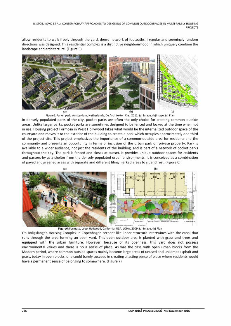
B. STOILJKOVIC ET AL: CONTEMPORARY APPROACHES TO DESIGNING OF COMMON OUTDOORSPACES IN MULTI-FAMILY HOUSING PROJECTS
216 ICUP 2016 PROCEEDINGSNis: November 2016
allow residents to walk freely through the yard, dense network of footpaths, irregular and seemingly random directions was designed. This residential complex is a distinctive neighbourhood in which uniquely combine the landscape and architecture. (Figure 5)
(a) (b) (c) Figure5: Funen park, Amsterdam, Netherlands, De Architekten Cie., 2011; (a) Image, (b)Image, (c) Plan
In densely populated parts of the city, pocket parks are often the only choice for creating common outside areas. Unlike larger parks, pocket parks are sometimes designed to be fenced and locked at the time when not in use. Housing project Formosa in West Hollywood takes what would be the internalized outdoor space of the courtyard and moves it to the exterior of the building to create a park which occupies approximately one third of the project site. This project emphasizes the importance of a common outside area for residents and the community and presents an opportunity in terms of inclusion of the urban park on private property. Park is available to a wider audience, not just the residents of the building, and is part of a network of pocket parks throughout the city. The park is fenced and closes at sunset. It provides unique outdoor spaces for residents and passers-by as a shelter from the densely populated urban environments. It is conceived as a combination of paved and greened areas with separate and different tiling marked areas to sit and rest. (Figure 6)
(a) (b)
Figure6: Formosa, West Holiwood, California, USA, LOHA, 2009; (a) Image, (b) Plan
On Boligslangen Housing Complex in Copenhagen serpent-like linear structure intertwines with the canal that runs through the area forming an open yard. This open outdoor area is planted with grass and trees and equipped with the urban furniture. However, because of its openness, this yard does not possess environmental values and there is no a sense of place. As was the case with open urban blocks from the Modern period, where common outside spaces mainly became large areas of unused and unkempt asphalt and grass, today in open blocks, one could barely succeed in creating a lasting sense of place where residents would have a permanent sense of belonging to somewhere. (Figure 7)
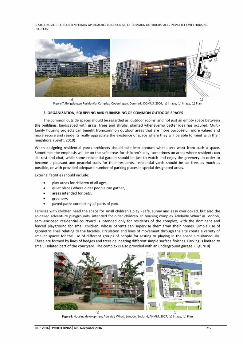
B. STOILJKOVIC ET AL: CONTEMPORARY APPROACHES TO DESIGNING OF COMMON OUTDOORSPACES IN MULTI-FAMILY HOUSING PROJECTS
ICUP 2016 PROCEEDINGS Nis: November 2016 217
(a) (b) (c) Figure 7: Boligslangen Residential Complex, Copenhagen, Denmark, DOMUS, 2006; (a) Image, (b) Image, (c) Plan
3. ORGANIZATION, EQUIPPING AND FURNISHING OF COMMON OUTDOOR SPACES
The common outside spaces should be regarded as 'outdoor rooms' and not just an empty space between the buildings, landscaped with grass, trees and shrubs, planted wheneverno better idea has occured. Multi-family housing projects can benefit fromcommon outdoor areas that are more purposeful, more valued and more secure and residents really appreciate the existence of space where they will be able to meet with their neighbors. (Levitt, 2010)
When designing residential yards architects should take into account what users want from such a space. Sometimes the emphasis will be on the safe areas for children's play, sometimes on areas where residents can sit, rest and chat, while some residential garden should be just to watch and enjoy the greenery. In order to become a pleasant and peaceful oasis for their residents, residential yards should be car-free, as much as possible, or with provided adequate number of parking places in special designated areas.
External facilities should include:
play areas for children of all ages,
quiet places where older people can gather,
areas intended for pets,
greenery,
paved paths connecting all parts of yard.
Families with children need the space for small children's play - safe, sunny and easy overlooked, but also the so-called adventure playgrounds, intended for older children. In housing complex Adelaide Wharf in London, semi-enclosed residential courtyard is intended only for residents of the complex, with the dominant and fenced playground for small children, whose parents can supervise them from their homes. Simple use of geometric lines relating to the facades, circulation and lines of movement through the site create a variety of smaller spaces for the use of different groups of people for resting or playing in the space simultaneously. These are formed by lines of hedges and trees delineating different simple surface finishes. Parking is limited to small, isolated part of the courtyard. The complex is also provided with an underground garage. (Figure 8)
(a) (b) Figure8: Housing development Adelaide Wharf, London, England, AHMM, 2007; (a) Image, (b) Plan

B. STOILJKOVIC ET AL: CONTEMPORARY APPROACHES TO DESIGNING OF COMMON OUTDOORSPACES IN MULTI-FAMILY HOUSING PROJECTS
218 ICUP 2016 PROCEEDINGSNis: November 2016
The residential courtyard in housing complex Chapel in Southampton is conceived as a common outdoor space for all residents of perimeter housing buildings. Ground floor apartments have their own backyards, set around a central, common courtyard. Although fenced, they are linked to it through small gates. This kind of design offers a hierarchy of spaces for children's play - very young children can play in their own private courtyards and be under constant supervision of their parents, and the older ones can play with their peers in a common courtyard, which is still safe from outsiders and car-free. (Figure 9)
(a) (b) Figure 9:Chapel, Southampton, England, Chetwood Associates, 2006; (a) Image, (b) Plan
Materials in use for paving, furniture, lighting and greenery should be durable and resistant, that is such quality that they wear well, and that they are easy to maintain. The furnishing and equipping quality depends on the standard of multi-family housing buildings, and should be appropriate to the needs and economic possibilities of the residents. This is especially important for maintenance of the yards - more luxurious contents demand more funds and efforts for maintenance, so they are not convenient for low standard housing. Courtyard design itself should be durable and sustainable, but at the same time, it should be subject to changes that will certainly occur over time.
In order to fulfil different needs of the residents, it is preferable that there are several smaller entities - 'microenvironments'- in residential courtyards (green areas, walking paths, play areas for younger children, adventure playgrounds, areas to sit etc.). Differentiation of residential yard spaces can be achieved by denivelating the floors, by fencing some spaces, by using different surface finishes, urban furniture, etc. Separation of various entities with their own spatial identity contributes to reducing the degree of anonymity and allows the identification with that area. Finally, it contributes to the quality of housing in multi-family housing buildings in general.
Semi-enclosed courtyard in the centre of the Iroko Housing development provides a secure communal landscaped garden for the residents. In the courtyard, intersected by walkways, green spaces are combined with areas for children's play and sitting areas. Ground floor apartments are oriented on its own fenced, greened backyards. Denivelating terrain, combination of various plants, a variety of materials, colours and textures make this garden a distinctive and special. (Figure 10)
(a) (b) (c) Figure 10: Iroko Housing, London, England, Haworth Tompkins, 2004;(a) Image, (b) Image, (c) Plan

B. STOILJKOVIC ET AL: CONTEMPORARY APPROACHES TO DESIGNING OF COMMON OUTDOORSPACES IN MULTI-FAMILY HOUSING PROJECTS
ICUP 2016 PROCEEDINGS Nis: November 2016 219
4. MAINTENANCE OF COMMON OUTDOOR SPACES
Forming a common outdoor areas within a multi-family housing complex is more often linked to problems with maintenance than with the possibility to provide spaces that will have the potential to improve the quality of housing and living of the residents, and sometimes of a wider audience. Therefore, planning of common outdoor spaces requires careful consideration how they will be maintained. The idea that outside areas in multi-family housing projects should be designed with benches and flower beds is as old as the multi-family housing itself. However, residential yards were often grown into derelict and sad places. Partly because there was not enough money to look after them properly, but also because they were not identified by residents as belonging places, so they have become breeding grounds for all kinds of anti-social activities. There are many examples of common outside areas that are abandoned, neglected and exposed to vandalism and that, on any basis, cannot be called pleasant. Even if the residents of these housing complexes live in spacious, functional and well-lit and ventilated apartments, they will not be satisfied with the quality of housing because of unpresentable and devastated yards.
One of the possible ways for residential yards to remain pleasant gardens, clean and well maintained over time is to be fenced and inaccessible to non-residents. First, they would be safer by closing or controlling the entrances. In this way, it would be impossible to strangers, foreigners and deviant groups to gather and anti-social activities would be prevented. Furthermore, as the number of yard users is limited, the wear of equipment and materials will be less. Smaller social group can more easily identify with that kind of space and find it as its own, which is not the case with a large group of users.
Responsibility for servicing of the common outdoor spaces is to owners of apartments or housing buildings. Maintenance of residential yard is very important and should be properly organized. It provides opportunities for residents to engage with their personal action and responsibility. Maintenance should be organized to provide the initiative of the users, and activities of the residents should have a motif defined by interest and benefit.
The creation of community gardens, as common spaces where residents gather to garden and grow food, is a possibility to include the residents in the care of the appearance and quality of common outdoor space. Community garden provides community bonding opportunities. Gardening is not only a good and healthy activity, but the way people can enjoy together. Designed to provide a spaces for public gardening as well as senior living, hybrid complex Homefarm has a rich array of green roofs, terraces and facades allowing for locally-grown produce as well as civic interaction. The authors sought to combine high-density housing, sustainable architecture and urban agriculture in this complex. (Figure 11)
(a) (b) (c) Figure 11: Homefarm, Singapore, SPARK Architects; (a) Image, (b) Image, (c) Plan
During the construction of a residential building The Whale in Amsterdam, housing corporation New Deal had a drastically different approach to the arrangement and organizing of residential courtyard. After many years of optimistic attempts of housing companies and city authorities to make common outside spaces accessible to all, including drug addicts and the homeless, this housing company choose for courtyard arrangement a new 'Realpolitik', by which it is there only to be watched, so it is fenced by decorative steel fence and forbidden to the public. (Figure 12)

B. STOILJKOVIC ET AL: CONTEMPORARY APPROACHES TO DESIGNING OF COMMON OUTDOORSPACES IN MULTI-FAMILY HOUSING PROJECTS
220 ICUP 2016 PROCEEDINGSNis: November 2016
(a) (b) Figure 12: The Whale, Amsterdam, The Netherlands, de Architekten Cie., 2000.; (a) Image, (b) Plan
5. CONCLUSION
By analysing contemporary examples of good practice we could derive certain recommendations for designing and equipping of common outdoor spaces around and between multi-family housing buildings. Outside semi-public space within the residential urban block should be in a natural environment, in direct contact with the building itself, appropriate for different, but compatible common activities and also 'open' for intervention by residents, who will adapt it to their own needs and create it according to their own wishes and preferences. Without their involvement and contribution, residents will not find that area enough 'theirs'. Furniture and equipment of the yard will depend on the desires, needs, and financial capabilities of its users. As the needs and wishes of residents (and the residents themselves) change over time, these spaces should allow a certain degree of flexibility and variability. The essential factors to make a successful, pleasant and sustainable residential yard can be defined as (Levitt, 2010; Stoiljkovic, 2015):
creating a sense of enclosed external space, appropriately dimensioned and sunlit,
designing secure paths from individual apartments to the semi-public outdoor amenities,
eliminating the presence of cars, if possible,
forming useful and well overlooked outside spaces,
choosing durable and easy to maintain materials and planting,
creating such a design which could easily be transformed or revised during time, if needed.
Common outdoor areas in multi-family housing projects are potential for improving the quality of housing. The existence of environmental values in residential yard, affected by the characteristics of housing buildings themselves, as well as by the content of the yard, furnishing and equipping, activities that take place in it, gathering people, the connection with other environments, etc. contribute to the quality of housing. As the appearance of residential yard is very important for overall quality of housing and living, it requires a lot of attention, in the phase of design and construction, as well as in the use phase.
REFERENCES
1. Bazik, D., 1995. Potencijal neizgradjenih povrsina u viseporodicnom stanovanju, in Unapredjenje i dalji razvoj stanovanja u visespratnim stambenim zgradama (ed. D. Ilic). Prosveta, Nis, Srbija
2. Ebner, P. et al., 2010. Typology + - Innovative Residential Architecture. Birkhauser, Basel, Switzerland
3. Ferre, A., Salij, T., 2010.Total housing. Actar, Barcelona, Spain
4. Levitt, D., 2010.The housing design handbook - A guide to good practice. Routledge, Abingdon, UK
5. Marusic, D., 1999. Sveska 1-10. Arhitektonski fakultet Beograd, Srbija
6. Schittich, C., 2004. High-density Housing: Concepts, Planning, Construction. Edition Detail, München, Germany
7. Segantini, M. A., 2008. Contemporary Housing. Skira, Milano, Italy
8. Vasileska, Lj., 2014. Nicija zemlja? upravljanje i odrzavanje medjublokovskih povrsina u okviru nasledjenih stambenih podrucja. Naucno-strucni skup Lokalna samouprava u planiranju i uredjenju prostora i naselja, Zbornik radova, Zlatibor, Srbija
A. TIL.: SPATIAL ORGANIZATION OF A ROMANI SETTLEMENT
ICUP 2016 PROCEEDINGS Nis: November 2016 221
SPATIAL ORGANIZATION OF A ROMANI SETTLEMENT
Aleksandra Til
University of Belgrade Faculty of Architecture, Serbia Student, [email protected]
ABSTRACT
The city is a symbol of potential: it attracts members of all social groups and provides a physical space for the unique combination of culture, technology, innovation and work space.
With the dramatic growth of the population at the turn of the century also comes a growing number of people living on the edge of existence, due to many socio-economic factors that make it impossible for them to keep in step with the manic tempo of today’s world. Poverty, a decline in living standard and an increase in crime rates are all to be expected with a sudden growth in population. The problem of social living is becoming a looming obstacle on the way to global stability and community development.
The purpose of this paper is to get an insight into the connection between Romani cultural heritage and the spatial organization of their settlement. Taking in consideration the large amount of Romani citizensin Belgrade as well as their settlements which do not fulfil even the most basic human needs, this paper researches the possible model of Romani households and communities in the urban cluster.
Keywords: social housing; Romani; Romanipen; Romani settlements; Romani housing; culturally adjusted environment.
1. INTRODUCTION
According to Maslow’s hierarchy of needs1, the need for security is at the very base of the pyramid, be it material security or the ethnic and ethical security offered by one’s community. This feeling of security, a prerequisite for self-realisation, is formed around family and a safe home. The city, as a rich amalgam of activity and interaction, offers an endless number of opportunities. The living standard in cities is developed in sectors, where the frame and purpose of a space are defined in advance via urban planning.
The marginalisation of a social group can be indicated by the absence of a certain, or several different resources, as well as the impossibility to reproduce those resources. Following the indications of social exclusion, marginalized social groups can be sorted into two categories: one-dimensional marginalized groups, in which the inability to reproduce one resource leads to social marginalization of a part of the social group, or the entire group; two-dimensional marginalized groups, in which the group is unable to reproduce two or several resources, leading to multiple social exclusion.2
Their status as such implies several main aspects such as ‘experiencing poor living conditions (in terms of housing, nutrition, clothing, physical safety); being unable to participate in the social and political life of one’s community (not out of choice but as a result of obstacles encountered); being unable to enjoy cultural and recreational activities (as a result of obstacles encountered); suffering from health conditions deriving from poor living standards and experiencing obstacles to accessing health care and social services when needed;
1 Maslow A.H., 1943. A theory of human needs, Originally Published in Psychological Review, 50, pp 370-396
2 Republicki zavod za socijalnu zastitu, 2008. Teorijsko metodoloski okvir, Chapter 1 in Pracenje drustvene iskljucenosti u Srbiji (Following social exclusion in Serbia), Belgrade, Serbia, pp 3-11

A. TIL: SPATIAL ORGANIZATION OF A ROMANI SETTLEMENT
222 ICUP 2016 PROCEEDINGSNis: November 2016
suffering from an emotional and psychological sense of exclusion and isolation from the community and/or from society at large.’3
The subject of social housing has become a great part of architectural and urbanistic planning. As Grbic M. has elaborated: ’Generally speaking, the concept of sustainable housing is based on the recognition of multiple functions of housing and the tendency to hold its environmental, social, cultural and economic aspects in a continuous, harmonic interaction that benefits the inhabitants.’4
The principles of sustainable housing can be implemented in various cases. The Romani society is heavily influenced by the Romanipen- the Romani cultural and behaviour patterns. Traditions and beliefs have been passed on throughout generations and still hold a key in the everyday life of the Romani society.56 Self-built Romani settlements are a physical manifestation of Romani traditions: strong family ties, extended family members sharing the same living space, distinct roles for male and female members and a strong sense of belonging to one society all lead to specific spatial organisation.7
By researching several existing projects on the value of communities, social housing, getting insight on the Romani cultural and behaviour patterns, as well as examining several existing projects which strive to improve the life of Romani settlements in Belgrade, this paper gives an analysis of the correlation between the Romani lifestyle and the spatial organisation of the Romani settlement, as well as possible methods of improvement for future reference.
2. ROMANI SETTLEMENTS
By definition, a community is a group of people with interpersonal connections, living together in a certain area. It is a model of living: a set of interactions, human behaviors that have meaning and significance, as well as a manifestation of expectations between members. Defined by a socio-cultural identity entertwined with a spatial form, a community becomes a highly functioning mechanism throughout several generations of its members. Why is it important to build communities?
Communities bring a sense of belonging and fulfil the needs of their members. Living conditions are greatly improved, as well as the standard of living, in places with organised communities unlike those where there are none. Studies have shown that places with lower social diversity have higher levels of crime. Places with no communities fail to take care of their vulnerable members. 8 It is the socially vulnerable who suffer the most when faced with a space without an organised community.
Living in slums is an indicator of extreme poverty. In Belgrade, 95% of the slums are built as unplanned construction on former constructions or construction zones. Underdeveloped infrastructure, unhygienic living conditions, illiteracy and poor education structure are some of the factors which have led to the marginalisation and exclusion of socially vulnerable groups such as the Romani.9
In a socio-cultural context, the Romani community upholds traditional values. Collective consciousness has enabled the preservation of their cultural identity, making them truly unique. Romani history, its culture and its language are preserved within the community itself. The Romani way of living has been passed down, generation to generation, and is not defined by borders of a country or territory. 10 A member of the Romani
3 Education Audiovisual and Culture Executive Agency (EACEA) of the European commission, 2013. Social exclusion: A working definition, Chapter 1 in Youth Social Exclusion andLessons from Youth Work, European commission, pp. 5-6
4 Grbic M., 2015. Preferences and perspectives of sustainability in informal Roma settlements, FACTA UNIVERSITATIS Series: Architecture and Civil Engineering Vol. 13, No 1, 2015, pp. 66
5 Ibid
6 Raykova A., 2003. “Cultural identities of Roma, Gypsies, Travellers and related groups in Europe”, International Seminar in Strasbourg, France
7 Matras Y., Roma culture: an introduction, http://romafacts.uni-graz.at/images/stories/pdf/c_1.0_culture-i.pdf [ Accessed: 28th October 2016 ]
8 Irvine, L., 2013, Creating communities, University of Srathclyde, Glasgow, Scotland
9 Sabic D., Knezevic A., Vujadinovic S., Golic R., Milincic M. and Joksimovic M., 2013. Belgrade slums- Life or survival on the margins of Serbian society?Trames, 17(67/62), pp. 55-86
10 Ackovic D., 2010. Istorija, kultura i jezik Roma kao nacionalni elementi identiteta naroda (Roma history, culture and language as national elements of a nation’s identity)

A. TIL.: SPATIAL ORGANIZATION OF A ROMANI SETTLEMENT
ICUP 2016 PROCEEDINGS Nis: November 2016 223
society follows a complicated series of Romani principles and lifestyle choices creating Romanipen philosophy. Due to its specific lifestyle, the Romani community has been modelling its own living space. Low standards of living, the inability to preserve their cultural uniqueness and identity as well as a bad socio-economic position all lead to the creation of settlements with inadequate living conditions. Slums, unhygienic settlements, old city clusters, legal and illegal punctual living and transformed planned settlements become a part of a city’s urban identity and the identity of the population.11 All Romani settlements have been heavily influenced by the Romanipen principles.
(a) (b) Figure 1 (a) Romani slum Gazela in Belgrade and (b) Backyard/storage room in Gazela
Within the architectural-urbanistic discourse, Romani settlements have been discussed in regards to their location, the activities and parameters which shape them, and the organization, the size and the price of certain models of Romani houses.
Sustainable housing for the Romani community does not only recognize its physical requirements, but is deeply entertwined with economic, cultural, social and ecological needs.12 By overlapping the cultural and the physical needs of housing, a spatial model for future Romani settlements is proposed.
3. THE ROMANI COMMUNITY
The everyday life of the Romani community does not take place in public squares or large places of gathering. Due to the Romanipen way of life, Romani open spaces are not planned and tend to be self-built: the Romani are not defined by the space around them, they create their own space following their own principles and needs. Therefore, the Romani public spaces tend to be unplanned and maintain atypical forms.
(a) (b) Figure 2 (a) Schematic view of the Yard Object Group and (b) Detail of atmosphere
As Grbic M. has concluded from her research, the courtyard is the center of everyday activities in the Romani settlement. The courtyard is formed by the Romani expanding their house over time, due to their growing needs, as well as building new ones. As the expansion starts creating a closed (or semi-closed space), 5 to 7
11 Grbic M., 2015. Unapredjenje prostorne organizacije stanovanja u romskim naseljima u Beogradu pod uticajem nacela romaniteta, Doctoral dissertation, Belgrade, Serbia
12 Grbic M., 2015. Preferences and perspectives of sustainability in informal Roma settlements, FACTA UNIVERSITATIS Series: Architecture and Civil Engineering Vol. 13, No 1, 2015, pp. 66

A. TIL: SPATIAL ORGANIZATION OF A ROMANI SETTLEMENT
224 ICUP 2016 PROCEEDINGSNis: November 2016
units become the borderline of a courtyard. The building process of the units usually begins from the first unit-the main room, the hearth of each family activity, and expands in several different directions, heavily influenced by the growth of the family, as well as its needs. Following its expansion, the added houses form a closed structure, a courtyard meant for the members of the extended Romani family that resides in the expanded house.13
Figure 3 The forming of the courtyard
Heavily influenced by the growth of each housing unit, the public space in the Romani community can easily become chaotic. To prevent uncontrolled and unplanned growth, which is often linked to the Romani community and leads to a complete decrease in living conditions, the Romani families (or members of one household) are to be given a framework and limited space for the growth of their houses.
As the public space in a Romani settlement is heavily influenced by the houses which surround and shape it, the Romani house becomes the main unit of building in Romani society.
4. THE ROMANI HOUSE
During the Gazela project, Macura V. interviewed the residents of the Gazela slum in Belgrade. He discovered that more than 200 barracks, from 250 reviewed, were built from waste materials, and then only one of the households had access to clean drinking water in their yard. By further analysis, he discovered three different levels of poverty in the slum: extremly poor families (63%), poor families (33%) and wealthy families (1%).14
(a) (b) (c) Figure 4 (a) Extremely poor Romani household, (b) The front porch of a poor Romani household and (c) Wealthy Romani household
Social housing, meant for the socially vulnerable groups, has been a topic of many research endeavours. Aravena A. in his project ELEMENTAL has created several models of a housing unit which fulfils the basic human needs of several socially vulnerable groups.15 By researching the needs of those he was building for, Aravena had created a house with the essentials for those in need: a kitchen and a bathroom, as well as the framework of a house with one or several rooms providing the shelter needed for marginalized social groups, and gave them space to expand and adjust the house to their needs. For instance, when asked whether they would prefer hot water or a bathtub since the budget for each house couldn’t cover both, the socially vulnerable explained they do not have the money for the hot water and are used to showering in the open, and that a
13 Grbic M., 2015. Preferences and perspectives of sustainability in informal Roma settlements, FACTA UNIVERSITATIS Series: Architecture and Civil Engineering Vol. 13, No 1, 2015, pp. 66
14 Macura V., DJuric M., Mitrovic Z., Projekat novog naselja za preseljenje romskog slama ’’Gazela’’ (New roma mahala for 130 families from ’Gazela’ slum)
15 ELEMENTAL, Aravena, A., ABC of incremental housing, http://www.elementalchile.cl/en/projects/abc-of-incremental-housing/ [Accessed: 5th October 2016]
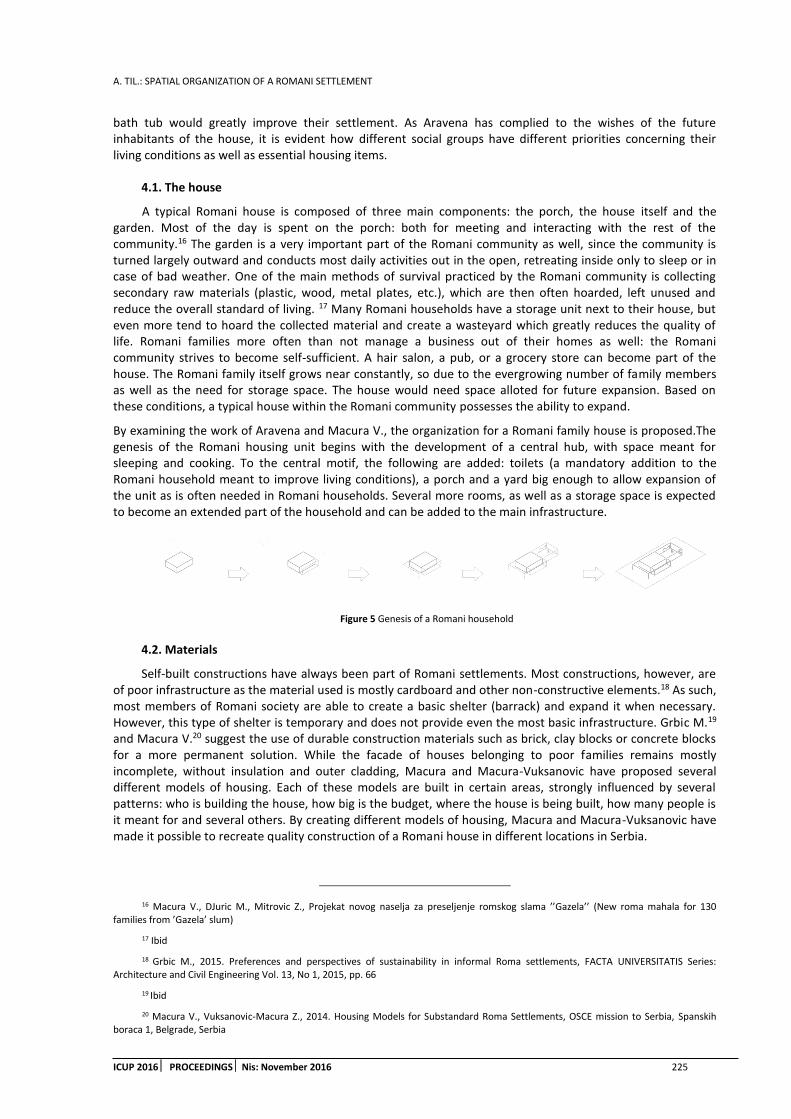
A. TIL.: SPATIAL ORGANIZATION OF A ROMANI SETTLEMENT
ICUP 2016 PROCEEDINGS Nis: November 2016 225
bath tub would greatly improve their settlement. As Aravena has complied to the wishes of the future inhabitants of the house, it is evident how different social groups have different priorities concerning their living conditions as well as essential housing items.
4.1. The house
A typical Romani house is composed of three main components: the porch, the house itself and the garden. Most of the day is spent on the porch: both for meeting and interacting with the rest of the community.16 The garden is a very important part of the Romani community as well, since the community is turned largely outward and conducts most daily activities out in the open, retreating inside only to sleep or in case of bad weather. One of the main methods of survival practiced by the Romani community is collecting secondary raw materials (plastic, wood, metal plates, etc.), which are then often hoarded, left unused and reduce the overall standard of living. 17 Many Romani households have a storage unit next to their house, but even more tend to hoard the collected material and create a wasteyard which greatly reduces the quality of life. Romani families more often than not manage a business out of their homes as well: the Romani community strives to become self-sufficient. A hair salon, a pub, or a grocery store can become part of the house. The Romani family itself grows near constantly, so due to the evergrowing number of family members as well as the need for storage space. The house would need space alloted for future expansion. Based on these conditions, a typical house within the Romani community possesses the ability to expand.
By examining the work of Aravena and Macura V., the organization for a Romani family house is proposed.The genesis of the Romani housing unit begins with the development of a central hub, with space meant for sleeping and cooking. To the central motif, the following are added: toilets (a mandatory addition to the Romani household meant to improve living conditions), a porch and a yard big enough to allow expansion of the unit as is often needed in Romani households. Several more rooms, as well as a storage space is expected to become an extended part of the household and can be added to the main infrastructure.
Figure 5 Genesis of a Romani household
4.2. Materials
Self-built constructions have always been part of Romani settlements. Most constructions, however, are of poor infrastructure as the material used is mostly cardboard and other non-constructive elements.18 As such, most members of Romani society are able to create a basic shelter (barrack) and expand it when necessary. However, this type of shelter is temporary and does not provide even the most basic infrastructure. Grbic M.19 and Macura V.20 suggest the use of durable construction materials such as brick, clay blocks or concrete blocks for a more permanent solution. While the facade of houses belonging to poor families remains mostly incomplete, without insulation and outer cladding, Macura and Macura-Vuksanovic have proposed several different models of housing. Each of these models are built in certain areas, strongly influenced by several patterns: who is building the house, how big is the budget, where the house is being built, how many people is it meant for and several others. By creating different models of housing, Macura and Macura-Vuksanovic have made it possible to recreate quality construction of a Romani house in different locations in Serbia.
16 Macura V., DJuric M., Mitrovic Z., Projekat novog naselja za preseljenje romskog slama ’’Gazela’’ (New roma mahala for 130 families from ’Gazela’ slum)
17 Ibid
18 Grbic M., 2015. Preferences and perspectives of sustainability in informal Roma settlements, FACTA UNIVERSITATIS Series: Architecture and Civil Engineering Vol. 13, No 1, 2015, pp. 66
19 Ibid
20 Macura V., Vuksanovic-Macura Z., 2014. Housing Models for Substandard Roma Settlements, OSCE mission to Serbia, Spanskih boraca 1, Belgrade, Serbia

A. TIL: SPATIAL ORGANIZATION OF A ROMANI SETTLEMENT
226 ICUP 2016 PROCEEDINGSNis: November 2016
(a) (b) Figure 6 (a) A house from recycled bricks and (b) Construction of a new house next to the old one
4.3. Builders
From the practical research of Macura and Grbic, inside the Romani settlement, the main builder is usually someone who is the best craftsman in the community, or someone close to the settlement that is called upon. His craftsmanship comes from the ability to quickly and easily combine different kinds of materials collected by the Romani people (eg. bus doors, cardboard, waste wood etc.) but, as Grbic had discovered while talking with the inhabitants of the settlement, ‘’everybody helps’’. Such houses can be built in 24h and are temporary, lacking basic infrastructure.21
Unlike the temporary houses, built from ‘waster’ material (mainly iron and wood), more permanent houses in the Roma settlement are built by several craftsmen usually with the help of the family inhabiting the house. While difficult at first, with the combined effort of the Roma society, often helped out by non-Romas from outside the settlement concerning more complex work like electricity (Macura and Vuksanovic-Macura, 2007)., the work gets simpler as the constructors get closer to the final product. The entire Roma family, as well as several other members of the Romani society are included in the creation of a permanent house.22
5. CONCLUSSION
The Romani community is not defined by country or territory. What keeps it alive is the Romanipen, a set of key principles seen in every aspect of Romani life. The Romani community continues to exist and preserve its heritage thanks to its patterns and behaviours which are manifested throughout each aspect of the Romani lifestyle, including the architectural-urbanistic aspect.
Throughout this paper, several aspects of Romani lifestyle were examined, as well as how they influence the spatial organisation of the Romani settlement: the value of family, growth and expansion as the way of Romani life, and the Romani community which works closely together. The self-built homes in the Romani settlement express core of the Romani lifestyle however, the spatial organisation lacks urban and architectural planning.
The houses of the Romani people are mostly temporary, built from non-constructive materials and do not provide protection or fulfil even the most basic needs. Due to its very nature, the house, despite being a physical manifestation of the Romani lifestyle, does not provide quality living for its inhabitants. This paper has given a possible model for building a quality house for a Romani family and improving their living standards, all the while preserving the unique Romani way of life. The Romani house still has the possibility of expansion, as well as creating a courtyard for the expanded family, the central motive of Romani life.
As members of the Romani community have always participated directly in the building of Romani houses, by creating new models and teaching the Romani on how to recreate them, the community becomes able to expand and rebuild the house models, giving more and more Romaniquality living space, strengthening the community itself.
21 Grbic M., 2015. Preferences and perspectives of sustainability in informal Roma settlements, FACTA UNIVERSITATIS Series: Architecture and Civil Engineering Vol. 13, No 1, 2015, pp. 66
22 Macura V., Vuksanovic-Macura Z., 2014. Housing Models for Substandard Roma Settlements, OSCE mission to Serbia, Spanskih boraca 1, Belgrade, Serbia

A. TIL.: SPATIAL ORGANIZATION OF A ROMANI SETTLEMENT
ICUP 2016 PROCEEDINGS Nis: November 2016 227
By implementing the principles of Romanipen in quality construction, giving the Romani community the physical base for further growth and expansion as well as teaching them on how to organize space to their needs, the Roma community slowly strives to establish its place in the class system as well as become part of the urban formation of the city.
The research done in this paper follows the contemporary approach to communities, showing how everyday life strongly influences the formation of architectural and urbanistic forms. It can be used as a base on how to resolve Romani settlements and preserve the Romani community.
REFERENCES
1. Ackovic, D., 2010. Istorija, kultura i jezik Roma kao nacionalni elementi identiteta naroda (Roma history, culture and language as national elements of a nation’s identity)
2. Education Audiovisual and Culture Executive Agency (EACEA) of the European commission, 2013. Social exclusion: A working definition, Chapter 1 in Youth Social Exclusion andLessons from Youth Work, European commission, pp. 5-6
3. ELEMENTAL, Aravena, A., ABC of incremental housing, http://www.elementalchile.cl/en/projects/abc-of-incremental-housing/ [Accessed: 5th October 2016]
4. Grbic, M., 2015. Unapredjenje prostorne organizacije stanovanja u romskim naseljima u Beogradu pod uticajem nacela romaniteta, Doctoral dissertation, Belgrade, Serbia
5. Grbic, M., 2015. Preferences and perspectives of sustainability in informal roma settlements, FACTA UNIVERSITATIS Series: Architecture and Civil Engineering Vol. 13, No 1, 2015, pp. 65 – 74
6. Hrvatic, N., 1996.Romi u interkulturalnom okruzju, Drustvena istrazivanja, 5-6 (25-26), pp. 913-933
7. Irvine, L., 2013, Creating communities, University of Srathclyde, Glasgow, Scotland
8. Macura, V., Vuksanovic-Macura Z., 2014. Housing Models for Substandard Roma Settlements, OSCE mission to Serbia, Spanskih boraca 1, Belgrade, Serbia
9. Macura, V., DJuric M., Mitrovic Z., Projekat novog naselja za preseljenje romskog slama ’’Gazela’’(New roma mahala for 130 families from ’Gazela’ slum)
10. Maslow, A. H., 1943. A theory of human needs, Originally Published in Psychological Review, 50, pp 370-396
11. Matras, Y., Roma culture: an introduction, http://romafacts.unigraz.at/images/stories/pdf/c_1.0_culture-i.pdf [Accessed: 28th October 2016]
12. Raykova, A., 2003. Cultural identities of Roma, Gypsies, Travellers and related groups in Europe, International Seminar in Strasbourg, France
13. Republicki zavod za socijalnu zastitu, 2008. Teorijsko metodoloski okvir, Chapter 1 in Pracenje drustvene iskljucenosti u Srbiji (Following social exclusion in Serbia), Belgrade, Serbia, pp. 3-11
14. Sabic, D., Knezevic A., Vujadinovic S., Golic R., Milincic M. and Joksimovic M., 2013. Belgrade slums- Life or survival on the margins of Serbian society?, Trames, 17(67/62), pp. 55-86
Fig 1, Fig 4 - Macura V., DJuric M., Mitrovic Z., Projekat novog naselja za preseljenje 130 porodica iz romskog slama ’’Gazela’’ (Project Gazela- New roma mahala for 130 families from ’Gazela’ slum)
Fig 2, Fig 3 –Grbic M., 2015. Preferences and perspectives of sustainability in informal roma settlements, FACTA UNIVERSITATIS Series: Architecture and Civil Engineering Vol. 13, No 1, 2015, pp. 68
Fig 5 – Schemes were made by the author.
Fig 6 -Macura V., Vuksanovic-Macura Z., 2014. Housing Models for Substandard Roma Settlements, OSCE mission to Serbia, Spanskih boraca 1, Belgrade, Serbia, pp. 19-20

A. TIL: SPATIAL ORGANIZATION OF A ROMANI SETTLEMENT
228 ICUP 2016 PROCEEDINGSNis: November 2016

T. TRKULJA ET AL.: URBAN DYNAMICS AND RESILIENCE
ICUP 2016 PROCEEDINGS Nis: November 2016 229
URBAN DYNAMICS AND RESILIENCE
Tanja Trkulja
University of Banja Luka, Faculty of Architecture, Civil Engineering and Geodesy, Bosnia and Herzegovina PhD, Assistant Professor, [email protected]
Dubravko Aleksic
University of Banja Luka, Faculty of Architecture, Civil Engineering and Geodesy, Bosnia and Herzegovina PhD, Senior Teaching Assistant, [email protected]
ABSTRACT
This paper explores the relationship betweenthe theory of urban resilience and theory of urban dynamic system. It combines general settings and objectives of resilience theory and structure ofan urban dynamic system. The study analyzes possibilities of applying principles of theory of urban resilience in social and spatial context by using dynamic systems. Contemporary social and spatial context requires more resilient environments, flexibility and transformability of which could be achieved by a combination of static and dynamic spatial elements i.e. by use of urban dynamic systems.
Keywords: dynamic system; resilience; flexibility; transformability; environment.
1. INTRODUCTION
Rapid urbanization and growth of mega-cities indicate the need for smarter and more resilient cities. Those cities would have capacity to withstand shocks caused by population growth, world economic crises, rapid demographic shifts in population, and environmental catastrophes. Additionally, resilience must also be shown in terms of events that have more long-term time horizon, such as when we see cities in decline. By conceptualizing cities as complex and adaptive systems, and by reducing them to components and analytical elements, we are able to work more efficiently onenhancement of resiliency through urban system designing, planning and management. Both physical and social processes could be seen as spatial and temporal interactions across networks. Inflow, outflow, and movements within cities are of utmost importance in process of increasing beneficial operations and suppressing harmful ones. People, activities, institutions, resources and processes are in interaction within developing patterns that are creating dynamic, unknown ordering which is a city (Desouza, Flanery, 2013).
Principles of urban resilience could be implemented into a built environment with connection to the basic structure of the urban dynamic system. Resilience theory successfully identifies contemporary problems and offers clear guidelines for their solutions. The structure of an open urban dynamic system represents a good base for defining a model that allows the application of principles of resilience.
The theory of urban resilience is based on two radical concepts. The first one argues that there are no natural systems without people, nor are there social systems without nature. Therefore, they are unique socio-ecological systems that are genuinely interdependent and evolve together through space and time. The ability of a single socio-ecological system to survive the turbulence of climatic, economic or political impact, to renew itself and continue to exist after that, represents its resilience (Ilincic, 2010)
An urban dynamic system, thanks to its main construction element - the feedback, directs information about consequences of his actions toward a man – a human user. So the man and the space evolve together and are interdependent. Also, thanks to timely information exchange (through feedback) on responses and flexibility of the system, it is possible for the system to become more resilient.
The second concept argues that the currently accepted model, by which the systems are changing in a linear and predictable way, is wrong. This linear model focuses on finding the optimal solution within the context of a
T. TRKULJA ET AL.: URBAN DYNAMICS AND RESILIENCE
230 ICUP 2016 PROCEEDINGS Nis: November 2016
single balanced sheet, and it reduces the ability of socio-ecological systems to cope with change and continue theirdevelopment. Existing and common statistical analyses completely ignore the importance of uncertainty, while the key drivers of changes today (such as climate or technological change) are largely unpredictable and could be changed in a non-linear fashion. Therefore, the concept of resilience rejects the old idea of "sustainability". Instead of accepting the static state, it is in accordance with inconstancy, flexibility and decentralization. The change of perspectivehas a potential for development and innovation. The second concept denotes systems that depend on organic and self-organizing processes. This concept exchanges the management approach that is trying to control changes in ecosystems (under the assumption that they would be stable) for the one that boosts the capacity of a socio-ecological system to cope with changes that shape them, and that are finding ways to transform them into more desired directions (Ilincic, 2010).
The concept of urban dynamic system basically rejects the linear and one-way system. Dynamic system is based on vagueness and flexibility so potential of system's own success is based on uncertainty. Dynamic system is designed to accept the terms of change in circumstances, and use them for development and improvement. So, the urban dynamic system is managing environment by adjusting to changes and by directing its activities in those directions that require the least number of changes in the environment.
2. URBAN DYNAMICS
Factors affecting the designing process are immensely numerous and complex, and probably completely undetermined. They include subjectivity of a user and all social factors. Subjectivity and social factors are variables in time. Frequency of these changes in the contemporary context is on the increase. Such circumstances cause constant uncertainty and require flexible and less rigid solutions. If the problem of uncertainty is in the context of immensely complicated attempts to solve linear and closed system, the result will probably be a failure or the problem would get a short-term solution. Linear and closed system implies structural and functional approach to a design. Additionally, it refers to any system that has phases of designing, construction and use without a pre-designed mechanism for continuous improvement, i.e. the mechanism that would allow continuous and cyclic repetition of all these phases (Ralevic, 1988; Forrester, 1969). Linear approach to design is the key instrument ofthe traditional strategy of spatial organization of architectural programs that requires a detailed list of the space that is being organized, with clearly defined base area, technical requirements, and environmental needs (Summerson, 1957). Requirementsfor architectural programs for built environments are specific and inflexible, which turns them into bureaucratically determined checklist, thus establishing linearity and immutability even more (Mitchell, 2005). "However, the architecture of the Twenty-first century, if it seizesthe opportunity, could be far less under the influence of such a rigid program" (Mitchell, 2005: 173). Architecture has a chance to be a tool for creating flexible and different human environments that would enable spontaneous integration of handheld electronic elements into its structure. It could be an architecture that does not make a stable and certain routines of spatial patterns (Mitchell, 2005), but the architecture of "permanent reconfiguration of clusters of spatial events characterized by its own duration, intensity, instability and location" (Batty, 2002: 2). According to Jay Wright Forester (1969), a model showing dynamic behavior of a system consists of the hierarchical set of four structural levels: closed borders, feedback loop, status within the feedback loop, and variable rates within the feedback loop. Closed border frames the operation of the system and contains a feedback loop as a basic building block within the border. The feedback includes phases, levels or conditions that represent the accumulation variables within the circle of the feedback loop. It also contains movement or flow variables that represent activities within the feedback loop.
A closed system defines boundaries of a dynamic system. It is necessary to enable development of the concept for the systemdevelopment. Among the elements within the border interaction, which gives the system a characteristic behavior, is taking place. Creating a simulation model of the system involves an assessment and selection of elements that would define the interaction behavior of the system, i.e. exclude all other potentially irrelevant components of the system (Forrester, 1969).
Feedback loops are key elements in the system by which system generates its dynamic behavior. They consist of two types of variables, the rate levels, which are necessary and sufficient for functioning of feedback loops. The formula that defines and manages variable rate flow controlsa feedback loopfunctioning. Functioning generates a system level, and information on that level represents a base for control of the flow rate. For example, one level represents the number of residents in a city. Number is an intersection of the current situation in the city and it is generated by accumulation of various factors, and the rate of change of factors defines a change in the current level of feedback, i.e. population (Forrester, 1969). Marshall McLuhan (1994), a

T. TRKULJA ET AL.: URBAN DYNAMICS AND RESILIENCE
ICUP 2016 PROCEEDINGS Nis: November 2016 231
famous Canadian philosopher and communicationtheorist, defines feedback loop as a circle or loop of information that is different from mechanical linear and unidirectional flow of information. Feedback represents the end of linearity that entered the western civilization with the emergence of the alphabet Euclidean space. It is a dialogue between a mechanism or a system and the environment that includes a full understanding of future structural changes in the relationship between the mechanism and the environment. In a system with feedback there is no room for assumptions. A common designing practice is based on designing forms and structures of a space while assumingthe consequences. In the words of a dynamic system, this means designing exclusively fixed elements of the system, which are almost always on a single level, i.e. elements that do not change or are difficult and slow in changing. The relations between these elements of the system, although connections are not designed they are merely guesses, are quite determined. Their uncertainty and openness continues until the space is build up and begins to live. On the other hand, designing of dynamic systems, which includes designing of connections between the elements, can act more specifically and be more closed. However, dynamic elements of the system are also levels, they are variables, which from their perspective gives them far greater flexibility and resilience, as well as a more space for improvement.
Forester (1969) connects the presented general structure of the system with the structure of the urban model, which shows the border of the urban system and the environment within the border, as a reference point. It also mentions terms of relative attractiveness and internal systems. Urban systems are essentially, by many of its factors, associated with the structure of any general system. The essence of the system a city is in interacting elements that make up the city. In the urban system, there are streams of activity, frames of causal process, feedback loops, levels, factors affecting the different states, processes, etc.
First step in modeling of interactionsof urban system is to define boundaries of the urban system. Within the borders are defined or selected elements that will, in its constitutive interrelated link, represent the character traits or a system that will determine the behavior of the system. The environment outside the boundaries of the urban system represents a reference point to which it flows to, also from the context of the system of control levels within the limits of the system. Accordingly, if the conditions are more favorable within the borders than the conditions outside the borders, the users will no longer be present within the border. The opposite is true as well (Forrester, 1969).
Problems in the urban environment are not limited to a single country, society or historical era. Events in the city and the behavior of the urban environment as a system are directly dependent on their own economies and internal mixed factors of industry, housing and population as primary users of city services (Forrester, 1969). The main influence transmitters between the countries, companies and even historical era are the users. They are the basis for all other factors and behavior of urban environments. Therefore, the main factor that affects the operation of any urban system is a man, as a user of the built environment. In order to meet the substantial needs of modern users of built environments it is desirable to involve all end-users more directly in the process of planning and designing. More serious role of users in creating their own environment can be achieved by involving users in every stage of space creation process. It is far more effective if the stages or levels are part of an open and dynamic system.
3. URBAN RESILIENCE
The concept of resilience in urban research can be defined as „the ability of an urban space to be transformed and retransformed“(Ultramari, Rezende, 2007: 51). In fact, it refers to „the ability to absorb, adapt and respond to changes in an urban system“(Desouza, Flanery, 2013: 89). The aim of the urban space transformation is to fulfill the changing needs of users of these areas in a dynamic life that characterizes the XXI century. Therefore, the relationship between society and space becomes a key causal relation that requires flexibility and transformability of space.
Kilper and Thurmann (2010) elaboratedthe relationship between society and space from the perspective of resilience. Without denying the existence of physical space, they understand the space as a social construct, respectively, as a result and a consequence of human actions, which exists for mankind only because of individual and social ascriptions of meaning. The space cannot exist outside the material world, but the social perception and evaluation of physical and material structures, and the ascription of meaning are always pre-structured. Measures for developing resilience include interesting approaches to social integration that seek to give away improvementof the quality of life, attractiveness, and also improvement of the stigmatized image of urban neighborhoods, cities and regions, but also of initiatives which could be construed as regaining the ability of actors to act by overcoming negative self-images as well as negative images in the eyes of the others.

T. TRKULJA ET AL.: URBAN DYNAMICS AND RESILIENCE
232 ICUP 2016 PROCEEDINGS Nis: November 2016
Figure 1: Elements of Urban Resilience (Source: Surjan, Sharma, Shaw, 2011: 22).
Urban population by the virtue of living in cities and struggling with different routine urban problems can be an excellent source of channelizingof urban solutions as well. The high level of awareness among urban masses can be further influenced as high level of action. The urban community today is well informed and this potential must be correctly captured to quickly upscale resilient visions of the cities. Surjan et al. (2011) reviewed different concepts, methods, perspectives and challenges related to urban resilience and identified four elements of urban resilience: redundancy, flexibility, capacity to reorganize, and capacity to learn (Figure 1).
Desouza and Flanery (2013) provide a deeper look at resilience in cities and propose a conceptual resilience framework. This framework should serve as a more holistic approach to designing, planning and managing for resilience by including an estimation of cultural and process dynamics within cities as well as their physical elements. It is imperative for cities to be resilient if they can be considered smart. In other words resilience have to be at the center of a city’s intelligent planning efforts in order to create spaces that can operate a wide range of network signaling stressors inclusive of both resources and information. The authors provide Strategies for Resilience (Table 1) that include accepting the change and uncertainty inherent to complex adaptive systems like cities and their associated ecosystems, maintaining the social and ecological diversity and network capacity for recovery after disorders, and creating knowledge generation and self-organizing capacities across these interactive webs. Table 1 describes the raw materials or tactics from which resilient urban planning have to start up more practical application and modeling. It is interesting to note that some of these strategies for resilience (for example buffering) are similar to those considered by engineers when dealing with physical systems. These strategies help to streamline the development of the city towards the goals of managing and preparing for the change and uncertainty through strategies, adaptive plans, redundancy, modularity and learning from crisis.
Table 1: Strategies for Resilience (Source: Desouza, Flanery, 2013: 91).
In order to create resilient cities, Godschalk (2003: 139) finds the characteristics of resilient systems that are taken for design and management of cities: „redundant—with a number of functionally similar components so that the entire system does not fail when one component fails; diverse—with a number of functionally

T. TRKULJA ET AL.: URBAN DYNAMICS AND RESILIENCE
ICUP 2016 PROCEEDINGS Nis: November 2016 233
different components in order to protect the system against various threats; efficient—with a positive ratio of energy supplied to energy delivered by a dynamic system; autonomous—with the capability to operate independent of the outside control; strong—with the power to resist against an attack or some other outside force; interdependent—with system components connected so that they support each other; adaptable—with the capacity to learn from experience and the flexibility to change; collaborative—with multiple opportunities and incentives for broad stakeholder participation“.
Resilience Alliance, established in 1999 as an international, multidisciplinary research organization that explores the dynamics of social-ecological systems (Resilience Alliance, a) has been at the forefront of developing tools and approaches for assessing and managing resilience in a wide variety of social-ecological systems. It defines key elements of resilience in practice (Figure 2) that include: describing and developing a conceptual model of the social-ecological system; understanding system dynamics including alternate regimes and thresholds; identifying interactions across scales including structural influences of larger systems and novelty emerging from smaller sub-systems; mapping governance networks and exploring adaptive governance options; active adaptation, resilience-based stewardship & transformation (Resilience Alliance, b).
Figure 2: Key elements of Resilience in practice (Source: Resilience Alliance, b).
In understanding resilience of urban systems, the role of metabolic flows in maintaining urban functions, welfare and quality of life are identified. Resilient urban systems allow for a urban society to learn, to adapt, and reorganize while facing urban challenges. The social dynamics of people and their relationship with a built environment defines physical patterns of the urban forms, their spatial relations and mutual connections.
4. DISCUSSION AND CONCLUSION
Because the social dynamics of urban systems users and their relationship with environment define the physical form of the town, it could be assumed that a more flexible and dynamic structure of the built environment would provide better mirroring of the dynamic behavior of a man on the dynamic structure of the built environment. Metabolic flows of urban functions include dynamic in their structure. Also, the resilience that allows urban society to teach is not possible without the dynamic urban system i.e. without his basic element of the feedback loop. Feedback loop helps a user to quickly learn the result of its own actions, and it also provides the user with opportunity to learn from its activities.
The concept of the social and ecological model is the basis for defining the model of an open urban dynamic system. Good understanding of the dynamics system is the basis for definition of a good model, while its implementation is not possible without permanent generation of alternative paths and thresholds. Identifying the interaction between the user and the system, and between man and the environment, serves as a basis for improvement of the system and for introduction of innovations in its operation, which is only possible by using feedback loop. It automatically includes all the conditions for active adaptation and transformation of space. Mapping process and exploration of the transformation and adaptation, represents the automatic activity of the urban dynamic system.
Redundancy as a process that allows the selection of multiple options, or alternative courses, is essentially a dynamic system. Any feedback should enable actions towards a new alternative flow or towards new options in order for urban dynamic system to exist. In this way, failure of one flow or option does not mean failure of the entire system. On the contrary, the failure then becomes the basis for learning and improvement of the system, and therefore, makes system more resilient. The diversity in the choice of courses and options ensures
T. TRKULJA ET AL.: URBAN DYNAMICS AND RESILIENCE
234 ICUP 2016 PROCEEDINGS Nis: November 2016
greater resistance of the system to various external influences. It also enables system autonomy. Thanks to the feedback loop all the elements of the urban dynamic system are interdependent and thanks to a growing number of alternative flows and options, system is largely flexible and better able to cooperate with external influences.
REFERENCES
1. Batty, M., 2002. Editorial: Thinking about Cities as Spatial Events. Environment and Planning B, 29. pp 1–2.
2. Desouza, K. and Flanery, T., 2013. Designing, planning, and managing resilient cities: A conceptual framework. Cities, 35. pp. 89-99.
3. Forrester, J. W., 1969. Urban Dynamics. Peagasus Comunication, Waltham.
4. Godschalk, D. R., 2003. Urban Hazard Mitigation: Creating Resilient Cities. Natural Hazards Review 4(3). pp. 136-143.
5. Ilincic, N., 2010. [Online] Rezilijentnost – novi pristup odrzivom razvoju. http://www.expeditio.org/benefit-living/index.php?option=com_content&view=article&id=64%3Arezilijentnost-novi-pristup-odrivom-razvoju&catid=7%3Aexpeditio&Itemid=13&lang=sr [Accessed: 2nd February 2013].
6. Kilper, H. and Thurmann, T., 2010. Vulnerability and Resilience: A Topic for Spatial Research from a Social Science Perspective. Urban Regional Resilience: How Do Cities and Regions Deal with Change? Springer-Verlag Berlin Heidelberg, New York. pp. 113-119.
7. McLuhan, M., 1994. Understanding Media: The Extensions of Man. The MIT Press, Cambridge, Massachusetts, London.
8. Mitchell, W. J., 2005. After the Revolution Instruments of Displacement.Disappearing Architecture: From Real To Virtual To Quantum.Birkhauser,Basel. pp. 20-23.
9. Ralevic, M. (1988). Programsko modelovanje urbanih funkcija. Beograd: Centar za multidisciplinarne studije Univerziteta u Beogradu
10. Resilience Alliance (a). http://www.resalliance.org/about[Accessed: 26th September 2015].
11. Resilience Alliance (b). http://www.resalliance.org/practice [Accessed: 26th September 2015].
12. Summerson, Ј. 1957. The Case for a Theory of Modern Architecture. Royal Institute of British Architects Journal 64: 307–310
13. Surjan, A., Sharma, A. and Shaw, R., 2011. Understanding urban resilience. Climate and disaster
resilience in cities. Emerald Group Publishing Limited, UK. pp. 17-45.
14. Ultramari, C. and Rezende, D. A., 2007. Urban resilience and slow motion disasters. City & Time, 2(3). pp. 47-64.
A. NAYER: COMPREHENSIVE URBAN MANAGEMENT ANALYSIS TOWARDS CREATION OF NEW GENERATION OF EGYPTIAN CITIES: THE CASE OF NEW EL ALAMEIN CITY, EGYPT
ICUP 2016 PROCEEDINGS Nis: November 2016 235
COMPREHENSIVE URBAN MANAGEMENT TOWARDS CREATION OF NEW GENERATION OF EGYPTIAN CITIES:
THE CASE OF NEW EL ALAMEIN CITY, EGYPT.
Aida Nayer
Lecturer, Egypt, Effat University, Kingdom of Saudi Arabia
PhD., Assistant Professor, [email protected]
ABSTRACT
Egyptian new cities generation is a constant trend adopting the policy of comprehensive urban management systems, CUM, which is explicitly implemented by planning authorities and decision makers in the country. These initiatives have great impacts on community potentials of development in terms of sustainability. The paper investigates new cities development plans in relevance of persistent analytical studies and researches. A criterion model is proposed to demonstrate public responsiveness against aspects of efficient planning development and desired goals; implementinganalytical hierarchy process, AHP. Further demonstrations are presented in the case study of El Alamein new citymaster plan. The result demonstrates the possibility of increasing efficient CUM by disserting sustainability features in order to increase public responsiveness and involvement in the decision making process.
Keywords: comprehensive urban planning; sustainability; new cities.
1. INTRODUCTION
Egyptian planning authority is currently processing an initiative for new cities generation; which is a constant trend adopting the policy of comprehensive urban management, CUM, systems. These initiatives have great impacts on community potentials of development in terms of sustainability. Nevertheless, Public responsiveness towards planning strategies and sustainability implications have to be investigated. The new city of Al Alamein will be discussed as a case study. The aim is to increase the quality of life; assure the satisfaction of communities and increase their involvement in the decision making process.
2. RESEARCH OBJECTIVES
The research objective is to explicitly demonstrate the impact of sustainable features within a comprehensive urban management framework for new cities generations planning process. The approach adopted investigates the integration of public responsiveness towards areas of development proposed.The research uses a mixture of initial information, from authorities, public and private institutions involved in the process. Public observations and relevant expectations are reflected in order to highlight the cause and effects of potential development impact on the overall strategic plan adaptation.
3. RESEARCH METHODOLOGY
The paper investigates new cities potentials of sustainability in relevance of persistent analytical studies and researches. A criterion model is proposed to demonstrate public responsiveness against aspects of efficient planning development in the case of the master plan of El Alamein new city. analytical hierarchy process,AHP, is implemented to allow for an explicit comparative analysis of communities’ expectations towards proposed development plan details.The result demonstrates the possibility of increasing efficient planning management by disserting sustainability features in order to increase public involvement in the decision making process.

A. NAYER: COMPREHENSIVE URBAN MANAGEMENT ANALYSISTOWARDS CREATION OF NEW GENERATION OF EGYPTIAN CITIES: THE CASE OF NEW EL ALAMEIN CITY, EGYPT
236 ICUP 2016 PROCEEDINGS Nis: November 2016
4. LITTERATURE REVIEW
A holistic concept has been discussed by Ronald McGill, 1995; analysing urban management performance framework to be centred around three main activities in cities: development, operations and impact, as an operational guide for Third World city managers. While managing urban cities towards a sustainable way is a challenge that receives increasing attention from policy-makers and researchers. Many Contemporary authorities in developed countries have established defined sets of sustainability indicators for the urban areas, reference is made to the works by Tan Y., 2015; Noorul H. et al., 2013.
The research investigates cases of urbanisation models potentials; (Ivan Marovic1, et al.,2015). The analysis of urban development of the past twenty years presented in several edition of the World Cities Reports shows, with compelling evidence, that there are new forms of collaboration and cooperation, planning, governance, finance and learning models that can sustain positive change, UN-Habitat III, World Cities Report 2016.
The overall objective of authorities’ approach in developing new cities is to enhance the socio-economic and quality of life for the population, specifically focusing on cities capacities for improvement: city development strategies for guiding their long-term growth; urban policies and strategies as well as urban sustainability indicators in the process adopted were investigated to demonstrate public involvement and satisfaction; (Abdulaziz A.et al., 2014).
Figure 1: Hierarchical Decision model; (Sahar S. et al, 2015).
Researchers Investigations in the area of public responsiveness has resulted in explicit details forming structure of hierarchical model. Diverse urbanisation patterns are adopted and analysed in terms of sustainable developments objectives on the level of environment, social, economic and urban details, demonstrating Sustainable Development Goals (SDGs): “Make cities inclusive, safe, resilient, and sustainable”;(Egyptian Government, 2015). A set of indicators are determined to assess relative impact on potential residents’ preferences in Egyptian cities; (Sahar et.al, 2015).
5. NEW CITIES COMPREHENSIVE URBAN DEVELOPMENT
Urban population is increasing rapidly for many reasons, fast increase in the country’s total population, more job opportunities, better living standards, and availability of reliable utility services in the cities, (Egyptian Government, 2016). Urban land management and administration are crucial as well as the quality of urban spatial experiences and land use.
The sustainability factors will continuously be investigated, even though strategies often address problems within the context of developed areas. The assessment of the different indicators respectively is enhancing the approach of comprehensive urban management, (CUM); (Bailey E., 2014).
The initiation of Egyptian new cities disseminates several assignments of high relevance for enhancing sustainable urban development principles and approaches. The study entails a fundamental shift in how Egyptian cities are managed, in line with the future vision for towards environmentally, economically and socially sustainable development; (UN-Habitat, 2014).
6. ALAMEIN NEW CITY INITIATION PLAN
The Alamein New City project component has witnessed distinctive achievements throughout utilizing an advanced town planning methodology that secures broad social inclusion for local communities as well as it
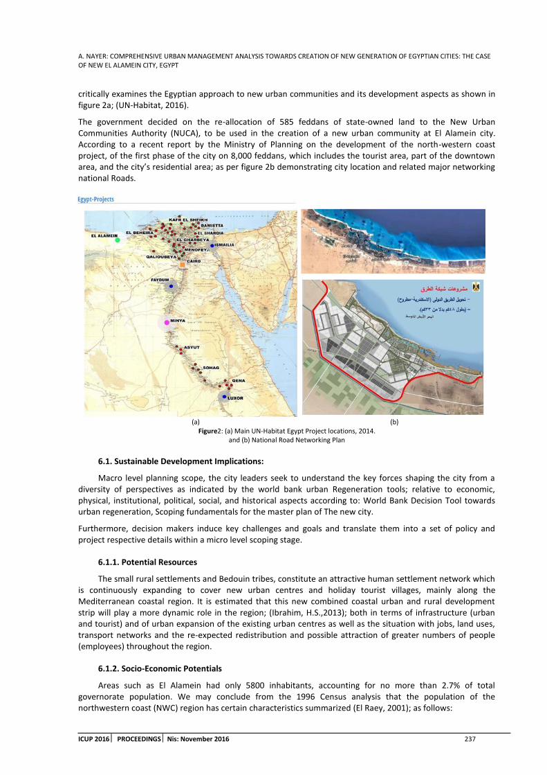
A. NAYER: COMPREHENSIVE URBAN MANAGEMENT ANALYSIS TOWARDS CREATION OF NEW GENERATION OF EGYPTIAN CITIES: THE CASE OF NEW EL ALAMEIN CITY, EGYPT
ICUP 2016 PROCEEDINGS Nis: November 2016 237
critically examines the Egyptian approach to new urban communities and its development aspects as shown in figure 2a; (UN-Habitat, 2016).
The government decided on the re-allocation of 585 feddans of state-owned land to the New Urban Communities Authority (NUCA), to be used in the creation of a new urban community at El Alamein city. According to a recent report by the Ministry of Planning on the development of the north-western coast project, of the first phase of the city on 8,000 feddans, which includes the tourist area, part of the downtown area, and the city’s residential area; as per figure 2b demonstrating city location and related major networking national Roads.
(a) (b) Figure2: (a) Main UN-Habitat Egypt Project locations, 2014.
and (b) National Road Networking Plan
6.1. Sustainable Development Implications:
Macro level planning scope, the city leaders seek to understand the key forces shaping the city from a diversity of perspectives as indicated by the world bank urban Regeneration tools; relative to economic, physical, institutional, political, social, and historical aspects according to: World Bank Decision Tool towards urban regeneration, Scoping fundamentals for the master plan of The new city.
Furthermore, decision makers induce key challenges and goals and translate them into a set of policy and project respective details within a micro level scoping stage.
6.1.1. Potential Resources
The small rural settlements and Bedouin tribes, constitute an attractive human settlement network which is continuously expanding to cover new urban centres and holiday tourist villages, mainly along the Mediterranean coastal region. It is estimated that this new combined coastal urban and rural development strip will play a more dynamic role in the region; (Ibrahim, H.S.,2013); both in terms of infrastructure (urban and tourist) and of urban expansion of the existing urban centres as well as the situation with jobs, land uses, transport networks and the re-expected redistribution and possible attraction of greater numbers of people (employees) throughout the region.
6.1.2. Socio-Economic Potentials
Areas such as El Alamein had only 5800 inhabitants, accounting for no more than 2.7% of total governorate population. We may conclude from the 1996 Census analysis that the population of the northwestern coast (NWC) region has certain characteristics summarized (El Raey, 2001); as follows:

A. NAYER: COMPREHENSIVE URBAN MANAGEMENT ANALYSISTOWARDS CREATION OF NEW GENERATION OF EGYPTIAN CITIES: THE CASE OF NEW EL ALAMEIN CITY, EGYPT
238 ICUP 2016 PROCEEDINGS Nis: November 2016
High percentage of population under 15 years, and low percentage of working population in the productive age, compared with the national standards.
Low educational standards, and high illiteracy, which reached 75% of the population.
Despite the fact of the small size of the population, it should be necessary to depend on local skills in traditional agriculture, also in trade and commerce. Their long acquired experience will enable them in playing an important role in developing and financing different projects.
6.1.3. Cultural and Heritage Aspects
Alamein is the largest city of the North Coast, and is famous for having witnessed famous battles during World War II. The main touristic attractions in Alamein are the cemeteries, notably the Commonwealth War Graves Commission, the Australian 9th Division War Memorial, the Italian and German military cemeteries, in addition to Alamein’s War Museum, in addition to and a major cultural heritage site, that of the ancient Marina, known as “Leokathbes” port, of El Alamein, which is also still in the process of excavation. Figure 2a Shows the current urban features of the city, while figure 2b demonstrates potential plans undertaken to accommodate the new city sustainable developments.
(a) (b) Figure 3: (a) Current Urban Features and (b) Potential Development Features; (NUCA Website).
6.2. Indicators Assessment Model:
The Assessment model is divided into eight aspects responding to three major development levels of
sustainability features. to summative indicators describing public expectations and involvement in the decision
making process, consisting of four sections; Economic Development, Social Stability, Environmental
Conservation andInstitutional Strength. Public preferences should be measured against the set of criteria
derived from the research literature review and presented in table 1.
Table 1: Public Responsiveness against Master Plan sustainability features
Master Plan Sustainability Indicators
assessment Index
Fundamental Scale of Public Responsiveness
( 1 to 4 )
First Assessment Index Second Assessment Index
Equally important
Moderately more important, likely or
preferred
Strongly more important, likely or
preferred
Extremely more important, likely or
preferred
Level of development Economic
Social
Population growth
Development coordination extent
Resources and environmental protection
Environmental economy
Urban-rural relationship
Development potential Institutional support
Management and adjustment potential
A. NAYER: COMPREHENSIVE URBAN MANAGEMENT ANALYSIS TOWARDS CREATION OF NEW GENERATION OF EGYPTIAN CITIES: THE CASE OF NEW EL ALAMEIN CITY, EGYPT
ICUP 2016 PROCEEDINGS Nis: November 2016 239
6.2.1. Steps of Model detailed Definition
The method of assessment proposed is crucial since it assists the decision makers in observing the continuousinteraction between the elements of new city El Alamein plan, as well as allowing for a progressivedefinition of alternative solutions proposed during implementation and after the completion of the major aspects. In order to set the objectives prioritization and impacts depending on the potential communities’ relevant knowledge and experiences as well as authorities the desired goals, AHP analytical hierarchy process;(Saaty, 2008), is applied to rank and prioritize the proposed a set of urban sustainability indicators, as per the following steps:
Identifying the Fundamental Scale of Public Responsiveness against the master plan proposed.
Identifying the Secondary level of criterion demonstrating reflective areas of development.
Identifying the Relative sustainability impacts implicated by the elements proposed.
Constructing the hierarchical model Fundamental Scale of Public Responsiveness.
6.2.2. Public Responsiveness against Master Plan sustainability features
The planning framework establishes the long-term vision and context. It is vital to sustaining the regeneration vision through the inevitable changes and unforeseen challenges of market and political cycles. An effective planning framework will balance vision, planning principles and facilitates negotiation amongst the public, private and community sectors within a clear regulatory process.
Communities responsive implications are constantly integrated within the planning process regarding details of all the vital elements or assets of the regeneration project, including land, community, and the environmental issues.
6.2.3. Weighting System for Communities Preferences
Proposed Weighting system will be detailed according to actual details of the plan implementation in terms of services provided to the communities. These features will give a seldom improvement to the quality of life for communities in terms of facilities, transportation, housing, educational and institutional services, further quantitative scale is added to the weighting system.
Further Investigations are processed through Structured questionnaires will be used to provide for feedback on several aspects of development. Weighting system will be applied according to table 2.
Table 2: Development aspects for the secondary assessment scale.
Master Plan Secondary
Assessment Index
Development Aspects
Economic Assets-Investments-Budgeting for services-Job Opportunities
Social Educational Facilities-Research Progress-Qu Population growth Gentrification – Job opportunities-
Resources and environmental protection Natural Resources – Preservatories- Water Supply Environmental economy Renewable Energy Resources Urban-rural relationship Agriculture – networking – resource exchange
Institutional support Community services – authorities budgeting Management and adjustment potential Touristical investment
7. RECOMMENDATIONS AND FURTHER STUDIES
The Proposed criterion model is subject to be tested among graduate studies research of institutions related to project investigation in collaboration with residents of the area of the case study.
The “big picture frame,” of new cities contextual planning should include areas for urban management policy development integrating both macro and micro levels including:
Economic data. These data determine strengths and weaknesses of the city drivers of economy.
Growth dynamics: fundamentals of growth of the city and the vitality of the regional, state, and national economy as a percentage of gross domestic product (GDP) and employment.
Socioeconomic and demographic analysis gentrification, aging, special populations, and migration.

A. NAYER: COMPREHENSIVE URBAN MANAGEMENT ANALYSISTOWARDS CREATION OF NEW GENERATION OF EGYPTIAN CITIES: THE CASE OF NEW EL ALAMEIN CITY, EGYPT
240 ICUP 2016 PROCEEDINGS Nis: November 2016
Physical analysis civic structure of the city, building forms, and urban patterns Based on the civic structure of the city, what areas have potential for growth.
Asset, network, and social media mapping.
Infrastructure needed for the growth of the city and the regeneration site
Housing serving a diverse range of the population’s needs.
Fiscal analysis including the status of the city budget and municipal finances. In addition, it examines the debt burden of the city
Political analysis as key priorities, demands, and goals with regard to national governments in potential support through legislation, financing and capital projects.
Market assessment and state of the private sector regarding overall market position for managing urban growth.
Institutions supporting a city’s growth and development such as universities, hospitals, and research facilities
Historical analysis envisioning its future and analysis the built and natural forms of the cultural aspects it its unique character.
Best practices potential relevance and lessons learned applied to the potential regeneration schemes.
8. CONCLUSION
Comprehensive urban management approach explicitly guides policy makers towards detailing development plans according to defined goals. Project development and construction, Housing and Infrastructure, planning services; Impact on Integrated development strategy and Capital programme budget expected investments. Meanwhile, sustainability features implementations are constantly present while defining objectives of new cities established plans. Communities’ responsiveness can be reflected through urban management performance assessment. Informative feedback and data need to be analysed based on efforts that assure the integration of policy development; urban development; and institutional development. The findings will help facilitate application of urban models in a resource-efficient manner while fulfilling the needs of multiple-stakeholders, authorities and public interests.
REFERENCES
1. Abdulaziz, A., et al., 2014. Evaluating the Urban Sustainable Development on the Basis of AHP: A Case Study for Riyadh City, Journal of Sustainable Development; Vol. 7, No. 2.
2. Bailey, E., 2014. Redefining Comprehensive Urban Management, in The Kingston Metropolitan Region, Jamaica, Journal of Place Management and Development issue 7(vol.1).
3. El Raey, M., et al., 2001. A Framework for Integrated Coastal Area Management Plan Fuka-Matrouh, ICAM PLANNING STUDY FUKA, (Egypt), UNEP MAP Technical Report No.131, vol. II.
4. Government of Egypt, 2015. Voluntary National Review on Progress on the Sustainable Development Goals – Executive Summary, http://www.moic.gov.eg/MopRep/MIC/English.pdf_915201625622PM.pdf
5. Government of Egypt, 2016. Egypt Vision 2030– Sustainable Development Strategy. http://sdsegypt2030.com/wp-content/uploads/2016/10/11.-Urban-Development-Pillar.pdf
6. Ibrahim, H.S.,2013. Towards an Effective Framework for Coastal Zone Management: The Egyptian Experience, Journal of Coastal Conservation, Vol. 17, Issue 3, pp 601–613.
7. Marovic, I., et al.,2015. Ranking Zones Model – A Multi-Criterial Approach to The Spatial Management of Urban Areas, Croatian Operational Research Review, CRORR 6, pp.91–103
8. NUCA, New Urban Communities Authority.
http://www.wcities.gov.eg/english/New_Communities/default.aspx.
9. Noorul, H.Z., et al., 2013. Analytical Hierarchy Process Application in Urban Sustainability Indicators Prioritization.

A. NAYER: COMPREHENSIVE URBAN MANAGEMENT ANALYSIS TOWARDS CREATION OF NEW GENERATION OF EGYPTIAN CITIES: THE CASE OF NEW EL ALAMEIN CITY, EGYPT
ICUP 2016 PROCEEDINGS Nis: November 2016 241
10. McGill, R., 1995. Urban Management Performance: An Assessment Framework for Third World City Managers, Cities, Vol. 12, No. 5, pp. 337-351.
11. Saaty, T.L., 2008. Decision Making with The Analytic Hierarchy Process, International Journal Services Sciences, Vol. 1, No. 1, pp. 83–98.
12. Abdalla, S.S., et al., 2016. Society of Civil Engineers, Decision-Making Tool for Participatory Urban Planning and Development: Residents’ Preferences of Their Built Environment, Journal of Urban Planning Development, Issue 142, vol.1.
13. Yigitcanlar, T., et al., 2015. Planning, Development and Management of Sustainable Cities; www.mdpi.com/journal/sustainability.
14. UN-Habitat III, 2016. Conference Urbanization and Development – Emerging Futures; Annual Progress Report 2014 Implementation of the Strategic Plan 2014 – 2019, Quito.
15. UN-Habitat Egypt Project locations, 2014. UNhabitat.org/egypt/projects.
16. World Bank, Urban Regeneration Decision tool, http://urban-regeneration.worldbank.org/.

A. NAYER: COMPREHENSIVE URBAN MANAGEMENT ANALYSISTOWARDS CREATION OF NEW GENERATION OF EGYPTIAN CITIES: THE CASE OF NEW EL ALAMEIN CITY, EGYPT
242 ICUP 2016 PROCEEDINGS Nis: November 2016

DJ.JOVIC: URBANIZATION OF THE SOUTHEASTERN ZONE OF THE CITY OF NIS – BETWEEN URBAN PLANS AND REALITY
ICUP 2016 PROCEEDINGS Nis: November 2016 243
URBANIZATION OF THE SOUTHEASTERN ZONE OF THE CITY OF NIS – BETWEEN URBAN PLANS AND REALITY
DJordje Jovic
Faculty of Technical Sciences, Novi Sad, Serbia Ph.D. Student, [email protected]
ABSTRACT
Belated industrialization has induced the term of 'explosive urbanization' in many post-socialist countries. This paper is a result of a qualitative research based on observation of the intensive demographic and physical growth of three suburban settlements – Brzi Brod, Suvi Do, and Nikola Tesla. The primary hypothesis was that the Electronic Industry complex, as a former main gravity force in this part of the city, was the sole cause of the explosive immigration and socioeconomic changes. However, urbanization is a more complex process, conditioned by different factors, especially in terms of multiple political and economic shifts. Therefore, the field of study has been expanded, and the paper has been written by using available literature relating to urban planning, statistics, social, economic and political theory and practice, while the conclusion is based on comparison of urban actions planned within urban plans published in the second half of the 20 th century and the present state of the area.
Keywords: urbanization; urban planning; suburban settlements; informal settlements; spatial-functional transformations; post-socialist city.
1. INTRODUCTION
This paper represents the beginning of a research, addressing an intensive process of urbanization, characteristic for many post-socialist cities, defined by Enyedi as a 'new model of modern urbanization'. The post-socialist countries 'replicate the stages of the global process. These countries have reached different stages of urbanization and have developed special features as they reproduced each stage because of belated modernization and the socialist political system.'1The research is based on the analysis of three suburban settlements located in the eastern suburban area of the City of Nis, and it corresponds to a ‘development and planning problems’ section. In order to narrow down the area that will be an object of discussion in this paper, it is necessary to define its boundaries. The studied region is determined by the Electronic Industry (EI) complex andMediana archeological complex in the west, Nisava River in the north, and Niska Banja in the east, which encircles three suburban neighborhoods positioned along the road from Nis to Niska Banja – Brzi Brod, Suvi Do and Nikola Tesla (Figure 1a). Even though the urban plans recognize these three neighborhoods as a part of the urban area of the City of Nis from 1974, this paper will address their development and transition from villages, over suburban/satellite settlements to integral parts of the administrative area of the City of Nis. Therefore, they will mostly be referred to as separate suburban settlements.Each of the three settlements has had a different background in terms of the beginning of formation, intensity of the population growth, contours, directions and limitations of physical growth etc. However, a sequence of political and economic changes has caused certain resemblances in thedevelopment of these settlements in the second half of the twentieth century. Brzi Brod and Suvi Do have been mentioned in a Census which dates from the end of the 15th century. On the other side, Nikola Tesla is the only suburban settlement within the urban area of Nis which can be categorized as a newer village.2 Today it’s undisputable that, besides being included within the administrative boundaries of the city, Brzi Brod, Suvi Do and Nikola Tesla create a conurbation with the City of Nis, simultaneously creating a connection with Niska Banja. This, as their explosive growth in general, has been
1 Enyedi, G., 1990. pp. 164
2 Enciklopedija Nis- priroda, prostor, stanovnistvo. 1995. pp. 164
DJ.JOVIC: URBANIZATION OF THE SOUTHEASTERN ZONE OF THE CITY OF NIS – BETWEEN URBAN PLANS AND REALITY
244 ICUP 2016 PROCEEDINGSNis: November 2016
noted, but uncontrolled by planning documentation, which will be further discussed in following chapters. The main objective of the paper is to initiate the research of the urbanization process conditioned by industrialization, i.e. the importance of industrialization on the formation of the contemporary urban tissue of Nis.
2. SOCIOECONOMIC FRAMEWORK
After the Second World War, a lot of facilities and infrastructure have been devastated, so one of the main principles of the newly established state regulation was a profound reconstruction, redefinition, and extension of capacities, due to greater needs of the growing population. Of course, an inevitable outcome of the political shift was ‘a complete reshaping of thesocial structure of the economy in Nis, conducted in the context of a thorough transformation of socio-economic relations in the whole state’.3 The recovery of a great number of sites was started right after the liberation of Nis, and partially or completely finished by 1947. The need to adapt to the pace of development of economically stable countries as quickly as possible has induced immediate electrification and industrialization as the main principles. One of the largest investment projects, initiated in 1948, was the construction of Radio and X-ray machines Institute by the road from Nis to Niska Banja, known as Zavodi RR, which would be restructured and transformed into the Electronic Industry of Nis in 1962.4 Construction of the future Institute complex began in July 1948, after the final location (by the road Nis - Niska Banja, next to Suvi Do) was selected over two other options since it satisfied all the conditions regarding the building area, distance from the city, transportation costs etc. One of the main problems at the beginning of the formation of the Institute was the untrained and inexperienced workforce. In order to focus on training local inhabitants instead of seeking abroad, the Institute has founded the Industrial school near the complex, and seminars and courses were organized for those who were already employed.
The EI has shown very soon its potential to develop to an economic giant, which has been perceived as a secure substitution for a vast number of people transiting from agriculture to non-agricultural activities. Along with capacitating facilities, besides the immigration of German and domestic experts, new workforce from Nis and its surroundings has been engaged almost each day. This was a start of a perennial rural exodus, which was going to bring significant socioeconomic changes to the suburban area of Nis and, by now, former villages nearby. As it’s been said in 1970, what has been typical for many socialist cities in the second half of the twentieth century was ‘a sudden population growth, caused by a sudden development of the economy’5. Unfortunately, so-called ‘demographic explosion’ has had negative consequences, since ‘the city was not prepared. Informal settlements were appearing in suburban area over the night.’ Since both the new political regime and its economy were on a path to their stability, budgetary expenses for housing units construction were too high. Therefore, ‘the special-purpose contribution is left to labor organizations. Due to that, the status of the labor organization became measurable in percentage points of how well such organizations managed to accommodate, in the sense of housing accommodation, their employees.’6 The EI has invested into theconstruction of multifamily housing buildings, even complexes (Krivi Vir, KriveLivade), within the city boundaries, but it seems that there was no existing plan concerning the accommodation of workers immigrating from and to surrounding settlements. As a logical consequence, newly arrived workers started settling near the working place, which has been fostered by already existing villages surrounding the two industries, and low land use fees in industrial zones.
Another influencing factor has been brought in 1948, when a Copper mill construction was started between Nis and Niska Banja, which allows the author to suggest, due to lack of planning documentation for the first period after the war, that this area has been determined for a future industrial zone. However, the federal authorities have altered the decision on the facility location in 1949, and its complete equipment has been transferred to Sevojno, western Serbia. In 1955 ‘Metalurgija’ split from Sevojno factory and started working as a Ferrous metal factory ‘Moravka’, in a location on the west of the city. Not so long after its separation, the factory transformed into ‘Djuro Salaj’. It was not before 1968 that it finally started working in its original location, next to the already formed settlement – Nikola Tesla. Since 1970, after the integration with one more facility from
3 Istorija Nisa III. 1995. pp. 197
4 Randjelovic, S. N., 2003. Ei Pola veka u korak sa svetom 1948.-1998. pp. 115
5 Decision on harmonization (amending and supplementing) the General urban plans of Nis and Niska Banja, 1970
6 Ristic Trajkovic,J. et.al., 2015
DJ.JOVIC: URBANIZATION OF THE SOUTHEASTERN ZONE OF THE CITY OF NIS – BETWEEN URBAN PLANS AND REALITY
ICUP 2016 PROCEEDINGS Nis: November 2016 245
Sevojno, the factory operates until today, in spite of many political and economic difficulties, in the same field of activity, under a new name – ‘Nissal’. 7
The EI, like many other companies and economic giants of post-socialist states, has always had many difficulties in business. However, specific political and economic transformations and problems the SFRY has been forced to face have brought to a misfortunate collapse of the EI. Social transformations at the end of the last two decades of the 20th century have caused a fragmentation of the institution, which announced the latter process of privatization. Specific economic decisions of the national leadership have only aggravated the current situation of the EI.8 Soon enough, separated companies started having financial difficulties, which brought one by one to a state of bankruptcy. A vast number of workers were on a forced leave, declared redundant, or lost their jobs. Political instability and unrest across the former Federation (disintegration of the SFRY, economic blockade, hyperinflation, etc.) were a constant state throughout the future period. Electronic Industry undergoes a process of transformation into a Holding company. From almost 30.000 in 1989, over less than 10.000 of actively working employees in 1993, the EI came to a number of 1.000 employees in the year 2000 and 100 in 2010. There have been many initiatives to transform the complex into a Free trade zone, a Technological park, etc. Nowadays, a couple of the EI companies are still engaged in the same activities, while several different private companies occupy the rest of the EI complex objects.
3. DEMOGRAPHIC AND PHYSICAL DEVELOPMENT
3.1. Brzi Brod
Brzi Brod was established in the area with rich history – adjacent to the Mediana complex - a residential area for higher-class Roman citizens. Therefore, the potential of this location for placing a suburban settlement has already been noted at the end of the 3rd and the beginning of the 4th century AD, due to its’ geographic position, by the road leading to Consantinopolis, but also due to its recreational and rehabilitation advantages. An Ottoman census dating from 1498 counts 42, while in 1516 there were 27 households. In the 16th century, it was inhabited only by Muslims, and from the17thcentury, it was a Serbian commonalty settlement with a few Muslims (Turks).9 After the liberation, until 1955, Brzi Brod was a village, when it started developing explosively. 'Zavodi RR' were formed across the road Nis - Niska Banja and the settlement started to sprawl towards west, and along the road. As a matter of fact, Brzi Brod has probably had the less expected directions of development, comparing to 1963 plans. As a result of intensive working immigrations and of changes in indigenous population, the village has radically changed its socioeconomic structure. The proximity of the river and a possibility of connecting with villages across the river fostered the immigration, enabling the inhabitants of Donja Vrezina, Gornja Vrezina and villages towards Svrljig to inhabit Brzi Brod and even Suvi Do. In 1971, the census results show that Brzi Brod counted 26 agricultural, 29 mixed and 497 non-agricultural households. That brought to a loss of traditional rural characteristics to mixed-suburban, at first, and during the seventies and eighties to urban, since it has gained a form of a workers settlement. Nevertheless, in terms of its physical appearance, Brzi Brod has kept its rural characteristics. Even though the Electronic Industry collapsed, Brzi Brod preserved its attractiveness thanks to the position in relation to the city and good traffic connections with Nis and surrounding settlements. Today, it is defined by Mediana, the road Nis - Niska Banja and the Nisava River, thus its further spreading in these three directions is completely limited. Therefore, it could only grow towards the east, which would cause merging with Nikola Tesla.
Table 1: Population change in Brzi Brod
Year 1878 1930 1948 1953 1961 1971 1981 1991 2002 2011
Housing units 13 57 108 119 278 552 855 1.114 1.477 1.510 Inhabitants 111 416 568 595 1.055 1.935 2.945 3.665 4.452 4.642
3.2. Suvi Do
Suvi Do is an old village located about 6km East of the center of Nis, already formed in the 15th century – an Ottoman census in 1498 defines it with 10 households. Not many information can be found before the
7 Enciklopedija Nisa-privreda. 1995. pp.147
8 Randjelovic, S. N., 2003. Ei Pola veka u korak sa svetom 1948.-1998. pp. 305
9 Enciklopedija Nisa-priroda, prostor, stanovnistvo. 1995.pp. 12-13

DJ.JOVIC: URBANIZATION OF THE SOUTHEASTERN ZONE OF THE CITY OF NIS – BETWEEN URBAN PLANS AND REALITY
246 ICUP 2016 PROCEEDINGSNis: November 2016
liberation. Local toponymy (Vlasko Brdo – Vlach Hill) speaks of presence and prevalence of Vlach shepherds.10 Until 1949, Suvi Do has been a small village, with thecompletely agricultural population. In the same year, the first facilities of 'Zavodi RR', the forerunner of the Electronic Industry, were built at the entrance to the village. This moment and the proximity to the city have induced the immigrations of workers and socioeconomic restructure of Suvi Do, which caused a decrease of traditional rural characteristics. The 1971 Census shows that Suvi Do counted 15 agricultural, 9 mixed and 153 non-agricultural households. That way, starting from 1960, Suvi Do at first gained mixed-suburban, and later urban characteristics (as a workers settlement), yet retaining a rural form. Its form is also conditioned by Vlasko Brdo and Vucji Do, hills representing the morphology that limited the growth to the South. At the same time, the EI has had a magnetic effect, and it has caused the village to linearly extend towards it. Nowadays, the settlement leans directly both to the EI complex and the road.
Even though the electrification has been carried out in 1946, and the water system in 1962, urban plans still highlight that the poor state of utility infrastructure is one of the main obstacles for any further development of Suvi Do and its complete rural-to-urban transition. However, studies from 1963 already show drastic social changes due to thenewly established economy, especially 'Zavodi RR'. As a matter of fact, the elaborate states that new inhabitants immigrate from more than 30km far from Suvi Do, searching for employment in the mentioned industry.11 This leads to a tendency of widening the construction area towards the industry and the road. The consequence, which would become common for all these settlements, is the reduction of the arable land, simultaneously reducing the number of agricultural households. Therefore, it is logical that Suvi Do, which developed due to the proximity of the EI, was the most affected by its collapse. The majority of the population abandoned agriculture, and reoriented to the city, while some of them were forced to go back to land cultivation, so the non-agricultural households made 69% of the total number in 2006.12 The possible proof that Suvi Do suffered the most after the EI collapse is the prediction of the number of inhabitants for 1972 and 2001, made in 1963. With certain deviations, predictions for Brzi Brod and Nikola Tesla and far closer to the real situation in 1971 and 2002, when the Census was organized, then in thecase of Suvi Do (Table 4). This means that the actual initiator of immigration in Suvi Do didn't exist in 2002, which could explain a difference for the same year for Brzi Brod. This is the exact period when the EI was going through its most difficult period.
Table 2: Population change in Suvi Do
Year 1878 1930 1948 1953 1961 1971 1981 1991 2002 2011
Housing units 20 45 61 63 118 157 189 237 321 341 Inhabitants 152 275 319 326 442 564 631 807 935 1.010
3.3. Nikola Tesla
This settlement was formed east of Nis, about 7.5km from its center. Today, it's separated from Suvi Do by two complexes – the Winegrowing Institute and the Electrical substation – together occupying approximately the same surface as the EI complex.Although it was already developed settlement with more than 1.000 inhabitants in 1960, it still belongs to a group of newer settlements. The oldest object in its area, known as Karaula 6, was built in 1886, and until 1954 the name of the village was Broj 6 (Number 6). Building by the road towards Nisava and Gornja Vrezina starts in 1951, while more intensive immigration starts after 1955.13 With two industries being constructed after the liberation, with more immigrations, new catering facilities by the crossroad and several crafts being conceived, the settlement started rounding up and growing, with a tendency of further explosive demographic and physical growth. Along with this spontaneous development, different problems, started multiplying and becoming more serious, showing the urge for an urban reconstruction.Even though 'Istorija Nisa’ states that 'it was not before the seventies when Nikola Tesla was included in the Plan of detailed regulation’, the first elaborate concerning the settlement Nikola Tesla was completed in 1963. However, until 1974, this village was considered informal, illegally built settlement. The Detailed urban plan from 1963 recognizes the urgency of urbanization, since 'the residential area has enlarged
10 Enciklopedija Nisa-priroda, prostor, stanovnistvo. 1995. pp. 184
11 Indroductory considerations of the elements of the organization and conditions for development of the conurbation of Nis – Suvi Do, 1963
12 Turnsek, AJ B., 2006. Doctoral dissertation. pp. 153-154
13 Istorija Nisa, 1995. pp. 405

DJ.JOVIC: URBANIZATION OF THE SOUTHEASTERN ZONE OF THE CITY OF NIS – BETWEEN URBAN PLANS AND REALITY
ICUP 2016 PROCEEDINGS Nis: November 2016 247
drastically in a past few years, threatening to merge with Niska Banja and Brzi Brod'.14 Today we witness the reality of this prediction since the northern part of the settlement is separated from Brzi Brod only by a belt of arable land, while the southern part reached the border zone of Niska Banja by spreading along the roads. Planning documentation in 1970 addresses the settlement as one of two residential suburban agglomerations, difficult to define as a city or a village since it was partially equipped with communal infrastructure. Besides that, which is more significant, the social structure has been different than in other two discussed settlements, since this one was the newest to develop. Therefore, the percentage of non-agricultural households has always been high, reaching 84% in 2006.15 The reason for this is the proximity to 'Nissal', and the EI. These two factors have caused intensive migrations, mostly from surrounding villages, especially Donja Vrezina and Zaplanje, as Turnsek states. On the other side, the population still grows today (Table 3), which means that the number of (individual) housing units also grows. This process was and it is happening on account of arable land, which reduced drastically, disabling the inhabitants to turn to agriculture.
Table 3: Population change in Nikola Tesla
Year 1948 1953 1961 1971 1981 1991 2002 2011
Housing units 181 237 431 663 899 1159 1214 1512 Inhabitants 686 880 1500 2360 3029 3672 3532 4651
Table 4: Predictions made in 1963 and the real number of inhabitants
Settlement Prediction for 1972 1971 Prediction for 2001 2002
Brzi Brod 2.100 1.935 6.000 4.422 Nikola Tesla 1.800 2.360 4.000 3.710
Suvi Do 700 564 3.000 930
(a) (b)
Figure 1: (a) The whole area: 1-3) settlements, A) the city, B) EI complex, C) Mediana complex, D) Winegrowing Institute, E) substation, F) ‘Nissal’ complex, G) Niska Banja; and (b) Street grid of Brzi Brod
(a) (b)
Figure 2: (a) Street grid of Suvi Do, and (b) Street grid of Nikola Tesla
14 Detailed urban plan for the residential settlement Nikola Tesla, 1963
15 Turnsek, AJ B., 2006. Doctoral dissertation. Pp. 145-146
DJ.JOVIC: URBANIZATION OF THE SOUTHEASTERN ZONE OF THE CITY OF NIS – BETWEEN URBAN PLANS AND REALITY
248 ICUP 2016 PROCEEDINGSNis: November 2016
4. URBAN PLAN ANALYSIS – COMPARISON OF PLANNED AND ACTUAL
There have been many difficulties in terms of finding specific General urban plans made in the second half of the 20th century (dating from 1953, 1973 and 1995). The documentation is often incomplete, or even impossible to locate within institutions responsible for their preserving. Therefore, the oldest available urban documents concerning the settlements Brzi Brod, Suvi Do and Nikola Tesla date from 1963, when a series of separate studies was completed, providing urban guidelines for a spatial development of 11 villages surrounding the city of Nis. Two of them were Brzi Brod and Suvi Do, for which a detailed research has been done, with complete demographic analysis, historic background and guidelines for any further development. On the contrary, Nikola Tesla has been observed as an informal settlement, hence the lack of information concerning its demographic structure or previous development. Instead, the study on this settlement has produced several plans for its thorough reconstruction and urbanization. However, these three studies have provided much useful information for the research, especially when it comes to comparison of actions planned in this and latter plans, and the present state of the area. The comparison has been done through observing the present state of the area and discussing it along with several statements found in noted plans.
A protective zone - a green belt along the main road has been planned for all the settlements, as well as along the industrial complexes, in the case of Suvi Do and especially Nikola Tesla. This step has been implemented as planned, but the situation today is quite different. As a matter of fact, Brzi Brod has never completely spread to the south, due to a belt of arable land, except a small western region which might continue its development and lean on the road. Also, starting from the EI complex, commercial buildings have occupied both sides of the road, all the way to the 'Nissal' complex. A northern part of Suvi Do is adjacent to the EI lot, while its small part has detached and spread to the north, by the road. In the case of Nikola Tesla, both northern and southern parts of it have occupied the sides of the road, surrounding 'Nissal' in the north, and if there weren't for Kutinska river, it would also surround it in the east.
Reconstruction of roads within settlements – implementation of the orthogonal street grid has been planned in order to form regular residential blocks. In the case of Suvi Do, the implementation is partial, done through paving the streets and correcting their shape where it was possible, due to local morphology and the existing distribution of the objects (Figure 2a). Brzi Brod has kept its original main courses of streets, i.e. several radial directions extend from the center. The only visible reshaping of the grid is in the northeastern part, where rectangular residential blocks are obvious. Also, compared to the 1963 plan, the southwestern, illegally built part, has been slightly reshaped, but only in terms of extending dead end streets (Figure 1b). Nikola Tesla has been the less successful in terms of internal road reconstruction. Only in the east of the southern part of the settlement, there is a visible attempt of regulation and rectangular block formation. The rest of it, both above and below the main road, kept its informal, ribbed shape (Figure 2b).
Forming the central square with public functions – in order to bring these settlements toward urban principles. In the case of Brzi Brod, the original street grid has defined the square position, even though it is slightly decentralized towards the south. Suvi Do probably kept the most of its rural characteristics, mostly due to its morphology and lack of public functions. Even though it spread towards the north, its central functions, among which is the elementary school, are located in the south of the settlement, its historical core, with the largest population density. Nikola Tesla kept its purely residential character, lacking other functions, which is characteristic for informal settlements, and especially for workers' settlements. A square with a church in the southern part of Nikola Tesla is the most similar to the idea of a central square, while the northern part has no organized public areas.
The study on Suvi Do and Brzi Brod states that the 'mechanical population growth has a temporary character, therefore there is no need for dislocating the building area boundaries for Brzi Brod and Suvi Do since the final migration point is the city with its nearest surroundings.' Nevertheless, the plan defined new building area i.e. 34ha instead of 19ha for Brzi Brod, and 30ha instead of 15ha for Suvi Do, if certain measures were going to be explored and applied. The measures concern: terms of concentration in Nis in order to obtain a high labor productivity and humane living conditions; dislocation of economic capacities, i.e. forming of new industrial and other economic facilities in suburban settlements; effects of modernization of technological process of various industrial sectors in Nis in terms of reduction of needs for massive unqualified workforce; suburban traffic connection with industrial sites. The analysis of these measures might represent a significant factor in defining

DJ.JOVIC: URBANIZATION OF THE SOUTHEASTERN ZONE OF THE CITY OF NIS – BETWEEN URBAN PLANS AND REALITY
ICUP 2016 PROCEEDINGS Nis: November 2016 249
reasons for unsuccessful plans implementation and inability to control the process of urbanization. Therefore, they will be examined and discussed in further research.
In lack of anactual General urban plan from 1953, the author only had access to a document dating from 1970 which analyzes the previous plan and suggests its modifications and additions. Following are some of the most important observations in this document, regarding the research:
Even though the mentioned documentation dating from 1963 requires additional green areas and protective zones, several decisions of the former government made changes in established land use. Working and residential areas across the city have been expanded on account of the third functional zone – zone of green area and recreation. This explains the first item of the previous chapter, and justifies, in a way, the informal settlements occupying the green area which surround them. Also, this was one of the factors which have allowed the urban tissue to surround and 'absorb' industrial sites, causing their incorrect position today.
This document suggests that industrial facilities in Nis might be incorrectly positioned. This refers to the Textile industry in the first place, but observing from today's point of view it's rational to say that both EI and 'Nissal' complexes had been positioned without careful consideration of possible effects on demographic and urban changes, which is in accordance with the previous statement.
The document addresses the region between the EI complex and Niska Banja. There are two of seven given program headings which should be commented. Firstly, it's stated that the existing content created a homogenous urban whole. This statement is questionable for the reason of the obvious uneven deployment and intermittent placement of functional groups. In the first place, the whole area is separated from the city by the EI complex in the south and Mediana complex in the north. Furthermore, even though Brzi Brod and Nikola Tesla are practically merged today, in 1970 there was a large plot of unbuilt land between them. On the southern side of the road, in 1970 there were only two built complexes – EI and 'Djuro Salaj') with the substation being built the same year, and the Winegrowing Institute being planned. A small part of Suvi Do, a, part of the settlement Nikola Tesla in front of today's 'Nissal' and commercial objects by the road all interrupted the sequence. The second statement anticipates the tendency of this micro-region to develop into a tourist and recreational center with a dominant landscape. Unfortunately, in spite of this regions' favorable touristic and recreational conditions, no measure was taken in order to foster its development in this direction. Instead, the sprawl of settlements has probably reduced the opportunity for a future transformation.
One of the suggestions is to remove a developing settlement at the foot of Niska Banja and to keep only a few worthy architectural objects which should be gain public functions. The present situationshows that the removal never happened, allowing it to nearly merge with the eastern part of Nikola Tesla neighborhood developing along the road.
The document forbids any new industrial facility in this region, in order to preserve the green area, since this region is of great importance for the fresh air, thanks to the wind rose. Having this in mind, the industrial zone should have never been positioned in this area.
Since the author could not come into possession of the General urban plan dating from 1995, the last available was the newest – General urban plan of the City of Nis 2010-2025. However, this one will not be analyzed within this paper, due to lack of previous plans. The research needs to be completed in terms of former regulation discussion in order to enable the comparison with contemporary documentation and given directions of development.
5. CONCLUSIONS
Within a framework of a couple of decades of the industrial golden age in Nis, the immigration of these three settlements might also be observed as a favorable circumstance in terms of providing the workforce with low transportation costs and creating a compact urban zone. However, the present state shows that one of the growing problems is mono-functionality, which ‘doesn’t date back to the settlement origins, but is a consequence of the loss of functions due to development circumstances.'16
16 Dinic, M., DJuric, J. & Mitkovic, P.,2016

DJ.JOVIC: URBANIZATION OF THE SOUTHEASTERN ZONE OF THE CITY OF NIS – BETWEEN URBAN PLANS AND REALITY
250 ICUP 2016 PROCEEDINGSNis: November 2016
Nevertheless, the process of urbanization must be observed and approached from various points of view. With that said, one of the main remarks after examining the available planning documentation is that the process of urban planning lacks multidisciplinary approach, e.g. a close cooperation with economic subjects that have a significant influence on society, or they might have in the future. One of the main reasons for the uncontrolled spreading of informal settlements was ignoring and neglecting them in the moment when the unwanted sprawl could have been regulated. Regarding the present state of the city of Nis, its surroundings and directions of their development in the last few decades, the same pattern of negligence and inertia in urban actions is more and more obvious. This characteristic is present even in archiving the previous planning documentation, which represents legislative documents in the domain of architecture and urbanism. Active preservation and availability of urban plans are of invaluable significance for the work of students, researchers and professionals.
In the case of Brzi Brod, Suvi Do, and Nikola Tesla, the measures of their ‘inclusion’ must be implemented. Infrastructural reconstruction and functional content enrichment should be carried out within the active period of the current General urban plan. Also, detailed plans should be made in order to foresee and monitor the further spreading towards the east, or merging of neighborhoods. Future purpose of the former EI complex, as well as of the former Winegrowing Institute should be thoroughly reconsidered, in order to create an opportunity for inclusion of local inhabitants.
The following phase of the research will be focused on finding and examining former planning documentation, in order to create conditions and knowledge needed for comparison with active and future plans. The research conducted in 1963 by M. Zivkovic should be repeated in present time to define the social structure of the three settlements and facilitate the production of plans for their future development.
REFERENCES
1. Dinic, M., DJuric, J. & Mitkovic, P., 2016. Suburban design: from “bedroom communities” to sustainable neighborhoods. Association of Surveyors of Slovenia, Ljubljana, Slovenia.
2. Enciklopedija Nisa – priroda, prostor, stanovnistvo. 1995. Gradina, Nis, Serbia.
3. Enciklopedija Nisa – privreda. 1995. Gradina, Nis, Serbia.
4. Enyedi, G., 1990. Specific Urbanization in East-Central Europe. Geoforum, Vol. 21, No. 2. Great Britain. pp. 163-172.
5. Istorija Nisa III – od 1941. Do 1980. godine. 1996. Gradina, Nis, Serbia.
6. Randjelovic, S. N., 2003. Ei Pola veka u korak sa svetom 1948.-1998. (Monografija o Elektronskoj industriji). Ei Korporacija, Nis, Serbia.
7. Ristic Trajkovic, J., Stojiljkovic, D., Medjo, V., 2015. Influence of the socialist ideology on the conception of multi-family housing: new urban landscape and the typological models of housing units. Facta Universitatis, Series: Architecture and Civil Engineering Vol. 13, No 2. pp. 167 – 179.
8. Turnsek, AJ. B. 2006. Transformacija seoskog domacinstva u selima na podrucju grada Nisa u kontekstu odrzivog razvoja – Doctoral dissertation. Retrieved from the Faculty of Civil Engineering and Architecture library, Nis.
9. A decision on harmonization (amending and supplementing) the General urban plans of Nis and Niska Banja. 1970. Institute for urban and regional spatial planning Nis.
10. Detailed urban plan for the residential settlement Nikola Tesla. 1963. Institute for urban planning Nis.
11. Introductory considerations of the elements of the organization and conditions for thedevelopment of the conurbation of Nis – Suvi Do. 1963. Institute for urban planning Nis, Department for spatial planning.
12. Tables 1-3, Demographic statistics. Retrieved from Statistical Yearbooks of the City of Nis and ‘Istorija Nisa III’ (Reference number 5).
13. Figures 1a, 1b, 2a, 2b. Maps of the studied area, modified by the author. https://www.google.rs/maps/ [Accessed: October 9, 2016].
M. SOSKIC ET AL.: CRITICAL STAGES FOR SUCCESSFUL IMPLEMENTATION OF LAND READJUSTMENT IN SERBIA
ICUP 2016 PROCEEDINGS Nis: November 2016 251
CRITICAL STAGES FOR SUCCESSFUL IMPLEMENTATION OF LAND READJUSTMENT IN SERBIA
Mladen Soskic
Faculty of Civil Engineering Belgrade, Serbia PhD., TeachingAssistant, [email protected]
Rajica Mihajlovic
Faculty of Civil Engineering Belgrade, Serbia PhD., Assistant Professor, [email protected]
Stevan Marosan
Faculty of Civil Engineering Belgrade, Serbia PhD., Assistant Professor, [email protected]
Nenad Visnjevac
Faculty of Civil Engineering Belgrade, Serbia Teaching Assistant, [email protected]
ABSTRACT
The subject of the study in this paper is the use of land readjustment as an instrument for the implementation of urban plans in Serbia. The possibility of successful implementation of land readjustment depends on many factors that are specific to a particular society and a country: the current state of urban development, socio-economic relations, history, tradition, law, the legal system, economy, needs, natural characteristics, demographic characteristics, etc. Therefore, with the aim of the successful implementation of land readjustment in Serbia, it is necessary to perform a detailed analysis of all mentioned factors and identify the critical stages in the process which will provide proper decision-making in respect of the implementation of land readjustment. As critical phases, we identified: The analysis of urban plan adequacy, consideration of distribution criteria, consideration of the distribution of benefits from increased land value and public areas structure analysis. Each of these stages is further processed. The decisions that need to be made in order to achieve the best possible results of the implementation of land readjustment are presented.
Keywords: land readjustment; urban plans; distribution criteria; land evaluation.
1. INTRODUCTION
Land readjustment is a tool that has long been used in many countries of Europe and the world with the aim of urban development and the implementation of urban plans (Viitanen, 2000.). In Serbia, land readjustment is a new tool that has the potential to significantly contribute to solving the accumulated problems in the area of urban development (Soskic, 2016.).
Each country has a distinctive model that is adapted to certain conditions that are specific to that society (Larsson, 1997.). Among each other, they are significantly different, which is natural, given the specificity of each country in terms of socio-economic relations, history, tradition, the current state of urban development, legislation, legal system, economy, needs, natural characteristics etc.
In Serbia, land readjustment is a new tool to be introduced into the legal system and practice, and which is expected to bring about a significant contribution to the urban development of the country. Considering foreign experiences where land readjustment brings many benefits to landowners and local government (Sorensen, 1999.) it is reasonable to expect similar result in Serbia. The need to define the model is, therefore,

M. SOSKIC ET AL.: CRITICAL STAGES FOR SUCCESSFUL IMPLEMENTATION OF LAND READJUSTMENT IN SERBIA
252 ICUP 2016 PROCEEDINGSNis: November 2016
crucial. It is not possible to fully adopt a foreign model with minor changes because of a number of specificities that require a special approach to the problem. A comprehensive and analytical approach to defining the best models with respect to the basic principles of land readjustment is necessary. Basic principles of land readjustment are: providing areas for public purposes, providing appropriate parcel structures, realizing private interests and achieving the public interest.
The models of land readjustment must, on the one hand, rely on these basic principles, and on the other hand take into account all the factors that represent the characteristics of a particular country and society. All this must be integrated into a unique process that will significantly contribute to a better urban development.
This paper identifies key elements on which the way that land readjustment will be implemented depends and which, therefore, have a major impact on its final outcome. These elements are the outcome of a detailed analysis of the current situation in Serbia and the causes of such a state. The identification of those key elements was a part of much wider study that was conducted with a goal of development of new land readjustment models in the function of urban land development (Soskic, 2016.). The development of the land readjustment model included the setting up of the system of land readjustment process in which, on the basis of recognized parameters, optimal models were defined. By defining the technological process of land readjustment, preconditions were created for the recognition of the key stages of the process, in which, based on the analyzed criteria, decisions on the application of a particular model will be made. Based on the analysis, four activities that must be carried out during the process of land readjustment in Serbia with the aim of its successful implementation and maximization of results have been identified:
Urban plan adequacy analysis;
Consideration of distribution criteria;
Consideration of the distribution of the benefits from the increased value of land;
Public areas structure analysis.
2. URBAN PLAN ADEQUACY ANALYSIS
Since land readjustment is a tool for the implementation of urban plans, the assumption is that there is already an appropriate urban or spatial plan. The very procedure of the adoption of urban plans in our country is such that it does not always take into account all the parameters necessary for finding the most optimal solution. The adequacy of the solutions defined by the urban plan can be examined through the analysis of three factors:
Determined factual situation;
Wishes and possibilities of land owners;
Applicability.
In the process of making the urban plan, current real estate cadastre data are available. The outdatedness of these data is a well-known weakness of the real estate data record system in Serbia. Designers who are working on the development of plan designs do not have the ability to update the real estate cadastre data but are forced to use the data official at that moment. On the other hand, in the process of land readjustment, the update of real estate cadastre is being done through the process of determining the factual situation. This gives an up to date picture of the land readjustment area both in terms of property rights over land and in terms of the factual situation on the ground. The situation registered in the process of determining the factual situation can be significantly different from the situation that was used in the preparation of the urban plan. The objective of the adequacy analysis of the existing urban plan, from the viewpoint of the established factual situation, is to determine the extent to which the factual situation affects the prescribed plan design. In other words, would the solutions defined by the urban plan differ if, at its creation, up-to-date data on the factual situation on the ground was used?
The participants of land readjustment (the land owners and holders of other property rights on the land) are a factor that can significantly influence the development of the observed area. In designing urban plans, stage of public inspection is obligatory. During this stage in the process of making plans all interested parties can provide comments and suggestions. Theoretically, this is a good solution but in practice, the system demonstrated certain weaknesses. The owners of land, in spite of the apparent motive, are not sufficiently involved in the process. The whole process is insufficiently approximated to those whom it concerns the most, so it often happens that they are not even informed that for the area an urban plan is adopted, and when they are, they do not realize the importance of active participation through stating remarks and proposals at

M. SOSKIC ET AL.: CRITICAL STAGES FOR SUCCESSFUL IMPLEMENTATION OF LAND READJUSTMENT IN SERBIA
ICUP 2016 PROCEEDINGS Nis: November 2016 253
different stages. In the process of land readjustment, the participants are individually invited at different stages and are actively involved in the process. Furthermore, they can be organized through the association of participants that can represent their interests. All this together makes them activate and realize that taking active participation is primarily in their interest. The importance of active participation of landowners in the process of land readjustment is even greater if one takes into account one of the main characteristics of this process, being the preservation of the social structure. The preservation of social structure means that after the completion of the land readjustment process, the ownership structure of the area remains unchanged. This practically means that these same participants will be responsible for the construction and further development of that part of the construction land, so their features must be taken into account. In other words, it is purposeless to implement a plan design for which landowners have no options or interest. For example, it is illusionary to envision the construction of buildings that structurally exceed the financial possibilities of landowners. The objective of the adequacy analysis of the existing urban plan, from the perspective of wishes and possibilities of landowners, is to determine to what extent these wishes and possibilities affect the solutions defined by the urban plan.
Another negative feature of certain urban plans in our country is the lack of applicability. A well-known fact is that one of the major problems in Serbia is the adoption of urban plans that are not enforceable in practice. Traditional urban plans are mostly static in nature. They are developed according to the scenario of slow urban growth and have no answer for the much more dynamic planning process in which priorities should be evaluated continuously, and the modification of these evaluations should be done continually, in the light of available resources. It is obvious that there is no implementation of urban plans and urban development in general if urban plans are not designed in a way that they can be implemented on the ground. In this sense, the adequacy analysis of the existing plan from the viewpoint of applicability serves as a kind of a plan design test. The applicability of the solutions defined by the urban plan is being re-evaluated from all aspects and an appropriate conclusion is drawn.
If at this stage of land readjustment, on the basis of the adequacy analysis, it is concluded that the urban plan is inadequate, its modification must be approached. The modification of the plan design is performed according to the prescribed legal procedure. In this procedure, the data obtained in the already completed stages of land readjustment, and especially data determining the factual situation, are used in order to develop a meaningful and implementable urban plan.
Figure 1 shows an example of a land readjustment area with planned building rules for individual blocks.Left in the figure are land use and building rules in accordance with the general regulation plan and right are modifications arising from the adequacy analysis of the urban plan. Block 4 was too large for the planned sizes of plots and land ownership which was established by determining the factual situation and was divided into three smaller blocks. Block 7, which was intended for the commercial-shopping complex was changed to "moderate density housing in an urban area." The reason for this is the existence of residential buildings within it, and the existence of two more blocks with a commercial purpose in the same area of land readjustment, which is rated as satisfactory.
(a) (b)
Figure 1: (a) Official urban plan, and (b) Modifications of urban plan (Soskic, M. et al.)

M. SOSKIC ET AL.: CRITICAL STAGES FOR SUCCESSFUL IMPLEMENTATION OF LAND READJUSTMENT IN SERBIA
254 ICUP 2016 PROCEEDINGSNis: November 2016
3. CONSIDERATION OF DISTRIBUTION CRITERIA
Distribution of new plots to participants of land readjustment can be carried out according to the area criterion or value criterion. The distribution according to the area criterion means that each participant gets a part of the redistribution mass that is proportional to the area of his included land. The distribution according to the value criterion means that each participant gets a part of the redistribution mass that is proportional to the entered value. The area criterion is applied in cases where the land on the land readjustment area, prior to the implementation of land readjustment, was homogeneous in terms of value and when the corresponding urban plan provides a homogeneous value of the land after its implementation. The value criterion is applied in cases where the land on the land readjustment area was not homogeneous in terms of value prior to or after the implementation of the urban plan. It is obvious that the decision on which criteria will be applied depends on the land evaluation.
A valid question that arises when choosing the method of distribution is an issue of equity. In the case of a distribution by the value criterion, there is a seemingly equitable procedure as it accurately calculates the value of each plot obtained in relation to the entered one. On the other hand, with the distribution by the area criterion, the participants are distributed in proportion to the area of the land which they have entered, and which may be different in terms of value within the value homogeneity of the land readjustment area. Namely, when selecting the method of distribution, the essential norm for the selection of the distribution by area criterion is the homogeneity of the land value on land readjustment area. No matter how much the land is homogeneous, there is a certain tolerance of value difference in the whole area. The main question that arises here is: "What is the land value homogeneity limit to choose the method of distribution by area criterion?" To answer this question it is necessary to take into account the reliability of land evaluation. Since it is "evaluation" rather than "determination", it is clear that the evaluation of real estate carries with it a certain error or unreliability. With this in mind, it can be concluded that the distribution by the area criterion works in cases where the unevenness of the land values on the land readjustment area is less than evaluation error.
In order to make the land evaluation reliable, it is essential that there is a developed real estate market. For Serbia, unfortunately, we cannot say that it is a country where there is a developed real estate market. The inevitable result of such underdevelopment of real estate market is, to a large extent, the reduced reliability of real estate evaluation. Thereby, the probability of selecting the method of distribution by area criterion increases. It can be concluded that, in such circumstances, the degree of equity of this type of distribution increases.
From the above, it can be seen how important a decision as to which criterion of distribution is used in particular land readjustment project is. First, all plots on the land readjustment area must be evaluated while, at the same time, the reliability of such evaluation must be assessed. What the reliability will be, depends on both micro and macro location of the specific land readjustment area, or the degree of the development of the real estate market in comparable locations. Depending on these analyses, a decision on choosing the method of distribution shall be made. It is expected that a large percentage of land readjustment projects in Serbia will be implemented by choosing the distribution by the area criterion at least in the near future until the real estate market experiences a significant level of development. Once the distribution criterion is chosen, the process of parcel distribution itself can be carried out by using various ways, for example optimization of land distribution (Mihajlovic et al 2011.).
Figure 2 shows an example of land readjustment area. The value of land in certain blocks after land readjustment in accordance with their purpose and building rules is presented. In this case, it is quite obvious that on the basis of land evaluation data, the distribution according to the criterion of value must be selected due to large differences in land values after the implementation of the urban plan.

M. SOSKIC ET AL.: CRITICAL STAGES FOR SUCCESSFUL IMPLEMENTATION OF LAND READJUSTMENT IN SERBIA
ICUP 2016 PROCEEDINGS Nis: November 2016 255
Figure 2: Value of land after the plan implementation (Soskic et al.)
4. CONSIDERATION OF DISTRIBUTION OF BENEFITS FROM LAND VALUE INCREASE
One of the main characteristics of land readjustment is land value increase. The land that was used for other purposes, and that had no plot structure that fulfils the urban criteria for construction, is transformed into construction land with formed building plots. The increase in the value of land per unit area is evident, which represents a significant motivation for the implementation of land readjustment. The amount of increase in value depends on many factors, but it can be quite large. The important question is also who should benefit from the corresponding increase in value, landowners and local government.
The first option is that landowners benefit from the increase in the corresponding land value. In this case, the land distribution would be carried out after excluding the areas for public purposes by the criterion of value or area. Any profit from the increase in the value of the land would be proportionately distributed to the participants of land readjustment in proportion to their entered value or area. The process of land readjustment is, in this case, funded by the local government, and some form of compensation is the fact that the areas for public use would be excluded without paying compensation to the landowners. Landowners would still be obliged to pay land development fee, or the construction of infrastructure in accordance with applicable laws and regulations.
Another option is that the local government benefits from the increase in land value. Funds obtained that way would be used for financing the land readjustment process and construction of infrastructure. A model that would allow this is to grant the local government, from the redistribution mass, in addition to land for public purposes, a number of building plots. These building plots would be marketed and sold, and from these funds, the local self-government would fund the costs of the proceedings and the costs of utility equipping of the construction land. Landowners would, in that case, be exempt from paying the land development fee. This option is clearly better for the local government because it immediately gets the funding for the construction of infrastructure, which is certainly in its best interest. In the first version, it may take some time after the completion of the process of land readjustment for the landowners to pay the land development fee.
Which of the options will be used depends on several factors. One of the most important is the amount of increase in value. The basic principle of land readjustment is that participants cannot get a lower value than the one they entered. If the increase in value is not sufficient to fund the process and construction of infrastructure, it is obvious that the second option is not possible, at least not completely. Another important factor is the attitude of land owners. In the case of allocating a part of building plots for sale in order to finance construction of infrastructure, the landowner should give its consent. Such solutions should not be imposed, with the aim of preserving the democracy and transparency of the whole process of land readjustment. There may be a combination of these two variants where only the part of the costs of infrastructure construction would be settled by the sale of a certain part of the land on the market, and the other part through the payment of land development fee.
When applying the second option, where the benefit from the increase in the value of the land belongs to the local government, it is required to promptly sell these plots on the market in order to provide funds to build

M. SOSKIC ET AL.: CRITICAL STAGES FOR SUCCESSFUL IMPLEMENTATION OF LAND READJUSTMENT IN SERBIA
256 ICUP 2016 PROCEEDINGSNis: November 2016
infrastructure. It is possible that the realized market price is significantly different than the estimated one in the process of land readjustment due to significant changes in the circumstances on the real estate market caused by unforeseen events. Since the land evaluation in the land readjustment is done on a certain date, it is something that could not have been taken into account and the procedure for the sale continues nevertheless. The risk, in this case, is taken by the local government and it will, in the case of a significant drop in prices, have to fund the difference from its own source.
5. PUBLIC AREAS STRUCTURE ANALYSIS
Public areas are, in land readjustment, excluded free of charge, which means that the owners of the land do not receive any compensation. As already mentioned, they are being compensated in a manner that increases the value of their land. In addition, these public areas are intended primarily for the use by the participants of land readjustment, or serve for the normal use of their possessions, therefore this also justifies their exclusion without compensation.
When on the land readjustment area the public use areas are planned not to be in the predominant function of the inhabitants of this land readjustment area but intended to meet the needs of a significantly wider area, it is necessary to find a fair solution for the separation of such areas. It would not be fair that the inhabitants of only a smaller part of the settlement give up their possessions in order to meet the needs of other parts of the same settlement. Public areas, provided by the relevant urban plan, which serve a wider area than that on which the land readjustment is being implemented, can be: schools, preschools, health institution, main streets (the streets that serve to connect other settlements or parts of settlements), sport and recreation courts, etc.
Those public areas would, in the event that urban readjustment is not being implemented, be allocated probably by expropriation or some similar measure. Since land readjustment does not imply the expropriation as its integral part, and bearing in mind the obligation to implement the plan design, it is possible to find a compromise solution. Such a solution must involve respect for the rights of landowners, but also the obligation to implement the plan. Public areas would, in such cases, be separated in the cadastre and on the ground in separate plots but the right of ownership of them would be retained by land readjustment participants. Shares in ideal parts ownership would be proportional to the value or the area which these participants entered in land readjustment mass. In this way, new plots of land for public use would be created in accordance with the urban plan but the property rights would not be transferred to the state. At a future time, when the conditions to expropriate these areas by the state are met, the owners would be paid compensation proportionate to their shares in the property, in accordance with the rules and regulations that apply for land expropriation.
Public areas structure analysis is, therefore, necessary to make the assessment of whether the areas of public use, which will serve a much wider area, exist and to which extent. It is necessary to separate such areas from those that serve primarily the inhabitants of the land readjustment area because they will be treated differently. On these assessment depends which course will be taken in further stages of the process of land readjustment, primarily on the part of land readjustment design that refers to the subdivision of the parcels.
Figure 1 shows an example of a land readjustment area with the planned land use and building rules. Planned land use of block 9 is "social protection". Specifically, a home for children with disabilities is planned. Obviously, the facility will serve a much larger area that the land readjustment area, so the decision was made to exclude the needed area in to a separate parcel, but the property right would be kept by the land readjustment participants with ideal parts of the ownership proportional to the value that these participants entered in the land readjustment.
6. CONCLUSION
The introduction of the new tool which should contribute to the urban development of settlements and foremost the implementation of urban plans is a complex task. It is necessary to analyze in detail all aspects of the problems that a specific country currently faces (in this case Serbia) and at the same time adhere to the basic principles such a tool as land readjustment involves: providing areas for public purposes, providing appropriate plot structures, realizing private interests and realizing the public interest.
The paper recognizes the elements on which the way land readjustment will be implemented depends and which, therefore, have a major impact on its final outcome. The analysis and appropriate decision making are groundbreaking stages of land readjustment. For decision-making in described crucial stages of the process, it

M. SOSKIC ET AL.: CRITICAL STAGES FOR SUCCESSFUL IMPLEMENTATION OF LAND READJUSTMENT IN SERBIA
ICUP 2016 PROCEEDINGS Nis: November 2016 257
is necessary to engage all profiles of professionals involved in the procedure: urban planners, surveyors, lawyers, experts for the real estate evaluation as well as land readjustment participants.
The importance of proper decision-making is even greater if one takes into account the risk that the introduction of an entirely new tool brings. At the beginning of the implementation of land readjustment, its transparency, efficiency, purposefulness and cost effectiveness must be ensured. If this does not happen, there is a real danger of compromising the land readjustment as a tool for urban development. This would mean at the same time losing confidence primarily by decision-makers (local authorities) and potential land readjustment participants (landowners), which would discredit urban readjustment and lead to it not being implemented, if not forever, at least in a mid-term future. Such scenarios are not unknown in certain countries which, because of the failure to recognize the significance of the analysis of local characteristics and their implementation in land readjustment model, lost the ability to use such a powerful tool.
REFERENCES
1. Larsson, G., (1997): Land readjustment: A tool for urban development. Habitat International, Volume 21, Issue 2, Pages 141-152, June 1997.
2. Mihajlovic, R., Miladinovic, M., Soskic, М., (2011): Optimization of Land Distribution in Urban Land Consolidation. Professional practice and education in geodesy and related fields. International scientific conference and XXIV meeting of Serbian Surveyors, 24-26 June 2011, Kladovo, upon Danube, Serbia. Proceedings: ISBN 978-86-7518-135-4 pp. 60-69.
3. Sorensen, A., (1999): Land Readjustment, Urban Planning and Urban Sprawl in Tokyo Metropolitan Area. Urban Studies, Volume 36/13 - 1999, Elsevier Science Ltd., London, pp. 2333-2360.
4. Soskic, M., (2016.): Development on new land readjustment models in the function of urban land development. Ph.D. thesis, Faculty of Civil Engineering, University of Belgrade, Belgrade 2016.
5. Viitanen, K., (2000): The Finnish Urban Land Readjustment Procedure in an International Context. Ph.D. thesis, Royal Institute of Technology, Real Estate and Construction Management, Real Estate Planning and Land Law. (In Swedish with a summary in English), Publication 4:84, 397 pages, Stockholm 2000

M. SOSKIC ET AL.: CRITICAL STAGES FOR SUCCESSFUL IMPLEMENTATION OF LAND READJUSTMENT IN SERBIA
258 ICUP 2016 PROCEEDINGSNis: November 2016

M. PUCAR ET AL.: THE ROLE OF ARCHITECTS AND URBAN PLANNERS IN THE FORMATION OF THE CONCEPT AND FUNCTIONING OF SMART CITY
ICUP 2016 PROCEEDINGS Nis: November 2016 259
THE ROLE OF ARCHITECTS AND URBAN PLANNERS IN THE FORMATION OF THE CONCEPT AND FUNCTIONING OF SMART CITY
Mila Pucar
Institute of Architecture and Urban & Spatial Planning of Serbia, Belgrade, Serbia PhD., Scientific Adviser, [email protected]
Marina Nenkovic-Riznic
Institute of Architecture and Urban & Spatial Planning of Serbia, Belgrade, Serbia PhD.,Research Fellow, [email protected]
Snezana Petrovic
Institute of Architecture and Urban & Spatial Planning of Serbia, Belgrade, Serbia PhD., Full Professor, [email protected]
Borjan Brankov
Institute of Architecture and Urban & Spatial Planning of Serbia, Belgrade, Serbia Scholarship holder of the Ministry of Education, Science and Technological Development,
ABSTRACT
The concept of smart city that has emerged as a response to the growing problems to which the world has been exposed over the last fifty years implies a set of multidisciplinary measures, ideas and policies oriented towards encouraging the development of human and technological resources of urban areas and their interaction aiming at enabling sustainable development and improving the quality of life of its population. All structures of different city systems in a smart city react in a clear and simple way through contemporary technologies and design. High technologies have for a long time influenced a new understanding of the role of architects and urban planners in the formation of the smart city concept. The paper highlights the problems that have led to a widely accepted concept of smart city, such as climate change, increasingly aggressive urbanization, excessive use of all resources, etc. The paper explains the role of architectural and urban planning profession in creating a smart city. Modelling of key systems of urban development requires the architects and urban planners to have new knowledge in different fields, as well as an interactive and creative approach to solving the set tasks. The philosophy of the profession is changing and new fields of activity are opening up, this being a challenge, but also an obligation to master the fields and skills on which the profession has not had influence so far. The architects and urban planners in teams formed in cities throughout the world for the purpose of conceiving this concept are losing the leading position in the processes of design and design management and are becoming equal amongst equals (in infrastructure system designs, amongst construction and traffic engineers, economists, sociologists, ecologists, programmers, city managers, management structures, equipment manufacturers, but also amongst city dwellers who are also becoming actively involved in this process, etc.). On the other hand, the development of new technologies has a positive influence on architecture and urbanism, particularly concerning the rational energy consumption and the use of renewable energy sources. Energy efficient buildings contribute to reducing the CO2 emissions, thus having significant positive effect on climate change. How to reconcile different interests and make the development of new technologies became a part of sustainable development is today one of the most important challenges in the profession, but also in the society as a whole.
M. PUCAR ET AL.: THE ROLE OF ARCHITECTS AND URBAN PLANNERS IN THE FORMATION OF THE CONCEPT AND FUNCTIONING OF SMART CITY
260 ICUP 2016 PROCEEDINGSNis: November 2016
Keywords: smart city; climate change; population growth; high technologies; sustainable development; smart city modelling; energy efficiency.
1. INTRODUCTION
Climate change has led to an increase in annual mean temperatures on Earth much faster than predicted. Mankind, faced with sudden climate change, is responding inadequately and inefficiently. On the other hand, the population growth, sudden expansion of cities and over-consumption of resources, shortages of water and other energy sources are becoming global problems.
Globally, more people live in urban areas than in rural areas. In 2007, for the first time in history, the global urban population exceeded the global rural population, and the world population has remained predominantly urban thereafter. The planet has gone through a process of rapid urbanization over the past six decades. In 1950, more than two-thirds (70 percent) of people worldwide lived in rural settlements and less than one-third (30 percent) in urban settlements. In 2014, 54 percent of the world’s population was urban. The urban population is expected to continue to grow, so that by 2050, the world will be one-third rural (34 percent) and two-thirds urban (66 percent), roughly the reverse of the global rural-urban population distribution of the mid-twentieth century [14]. These growth rates imply that, every week, a city of one million inhabitants will be built for the next four decades.
Just three countries — India, China and Nigeria — together are expected to account for 37 percent of the projected growth of the world’s urban population between 2014 and 2050. India is projected to add 404 million urban dwellers, China 292 million and Nigeria 212 million [14].
The trend of rapid urban growth from the mid-20th century till the present has led to an increase of economic and social wealth in some places, but also to continuing poverty of others. Cities are complex systems and big consumers of energy. The consumption of enormous amounts of energy, water, materials and all natural and man-made resources has as a consequence a powerful effect on the environment.
As the Intergovernmental Panel on Climate Change’s (IPCC) report indicated, cities consume somewhere between two-thirds and three-quarters of total global energy and generate 75 percent of global carbon emissions [1].
The concept of Smart City (hereinafter referred to the “SC”) has been developed as a response to the growing problems the world has been exposed to over the last forty years, such as climate change, increasingly aggressive urbanization, excessive use of all resources, etc. The concept implies a set of multidisciplinary measures, ideas and policies oriented towards encouraging the development of human and technological resources of urban areas and their interaction aiming at enabling sustainable development and improving the quality of life of its population.
A smart city is one in which the seams and structures of the various urban systems are made clear, simple, responsive and even malleable via contemporary technology and design. Citizens are not only engaged and informed in the relationship between their activities, their neighbourhoods, and the wider urban ecosystems, but are actively encouraged to see the city itself as something they can collectively tune, such that it is efficient, interactive, engaging, adaptive and flexible, as opposed to the inflexible, monofunctional and monolithic structures of many 20th century cities. [11].
Cities are hubs of economic, political and cultural activities and centres of knowledge and innovations at the same time. With their means and capacities, they get the leading role in the development and implementation of measures for increasing the energy efficiency (hereinafter referred to the “EE”) and for the use of renewable energy sources (hereinafter referred to the “RES”). Given the data that buildings use about 40% of global energy, out of which heating and cooling account for 90%, the concept of smart city cannot be imagined without the use of RES and EE principle at the level of urban planning and building design. Advocating the smart cities, which also implies new technologies and infrastructure, has its deep foundation in science and practice [6].
The SC concept is closely linked to the development of the information and communications technologies (hereinafter referred to as the “ICTs”), but it is a considerably broader than the one-way implementation of technological solutions and comprises sociological concepts such as maximum social inclusion and transparent decision-making system.

M. PUCAR ET AL.: THE ROLE OF ARCHITECTS AND URBAN PLANNERS IN THE FORMATION OF THE CONCEPT AND FUNCTIONING OF SMART CITY
ICUP 2016 PROCEEDINGS Nis: November 2016 261
The development of new technologies has seen great progress, and the influence on urban building can be characterized as a new movement in architecture and urban planning. On the one hand, this progress is due to the ongoing development of digital technologies, including the Internet, as well as new software programmes (3D animation, numeric modelling packages etc.) On the other hand, new materials and systems offer architects great possibilities, provided they are available and economically justified [8].
Cities and city dwellers generate a large amount of data that can be used in a smart way with the aim to achieve strategically important goals. The innovative use of ICTs enables a progress in the fight against climate change and improvement in quality of life.
As a result of all this, the city authorities throughout the world and numerous professions that have recognized the importance of the concept of smart sustainable city increasingly advocate the use of high technologies for solving the existing problems. The solving of these problems requires a close cooperation between experts, citizens, companies, organizations and the national and city authorities. All abovementioned puts the relationship of architectural and urban planning profession towards such important global challenges into a completely new context. New knowledge is being developed and the concept of sustainable, green, ecological and energy efficient construction that could slow down, if not stop, negative processes and phenomena has been promoted. Architects and urban planners must prepare themselves for new challenges brought about by new technologies in the SC planning. Schools and academic institutions should become a part of information society based on the exchange of creative ideas, knowledge, information and experiences.
2. SMART CITY MODELLING
The SC modelling is based on the following characteristic criteria: (a) Smart Economy, (b) Smart Mobility, (c) Smart Environment, (d) Smart People(e) Smart Living i (f) Smart Governance. All of these criteria contain a series of indicators based on which the evaluation is performed. Thus, for example, the indicators for (a) Smart Economy include: innovative spirit , entrepreneurship, economic image & trademarks, productivity, flexibility of labour market, international embeddedness and ability to transform; the indicators for (b) Smart Mobility include: local accessibility; (inter-)national accessibility; availability of ICT-infrastructure; sustainable, innovative and safe transport systems, while indicators for (c) Smart Environment include: attractiveness of natural conditions, pollution; environmental protection and sustainable resource management. The factors and indicators for (d) Smart People include: level of qualification, affinity to lifelong learning, social and ethnic plurality, flexibility, creativity, cosmopolitanism/open-mindedness and participation in public life. Furthermore, the indicators for (e) Smart Living include: cultural facilities, health conditions, individual safety, housing quality, education facilities, tourist attraction and social cohesion. Finally, the indictors for (f) Smart Governance include: participation in decision-making; public and social services; transparent governance and political strategies & perspectives. It is necessary to standardise different values considering the heterogeneity amongst some groups of criteria, but also within the groups themselves [12].
By investigating the phenomenon of SC, it can be concluded that there is no ready model of how to find a solution in creating a digital platform, either concerning economic development or structural urban variables. The economic power and greater democratic “openness” certainly contribute to greater investment and development of innovative abilities of a city. Often, the digital infrastructure coverage is not in correlation with the size of a city. The social infrastructure and population density play an important role in the SC formation. Neirotti and group of authors pointed out an important phenomenon that relates to the differences, advantages and disadvantages when it comes to innovative abilities of large and small cities. In essence, small cities are a good ''ecosystem'' in which it is easier to initiate experimental research of limited scope and, when it comes to the previous investment in the ICT infrastructure, they are more flexible and less inert. On the other hand, large cities usually face more critical needs and problems that entail digitalization endeavours and they can attract technology vendors more easily as they can offer a larger potential market of more educated citizens. However, density is a factor in development of SC initiatives, as it increases problems related to urban congestion at various levels of physical infrastructure (e.g. transportation, energy distribution, waste and water management, etc.) [3].
Models of cities in 2D and 3D format and the use of GIS technologies, softwares and tools which have one of the key roles in the development of smart cities would serve for entering the data on the building stock and its physical parameters. In the domain of energy efficiency, being a characteristic of these cities, the geo-information technologies provide an integration of spatial data and their analysis, exploration of development scenarios and, finally, the selection of optimum solutions [6]. The model for the improvement of energy
M. PUCAR ET AL.: THE ROLE OF ARCHITECTS AND URBAN PLANNERS IN THE FORMATION OF THE CONCEPT AND FUNCTIONING OF SMART CITY
262 ICUP 2016 PROCEEDINGSNis: November 2016
efficiency of building stock would contain possibility for the valorisation of procedures according to previously defined indicators.
For the decision makers in modelling and efficient city management, the following possibilities of geo-information technologies are particularly important: (a) analysis and modelling of the optimum distribution of population, i.e. users of space or consumers relative to the capacity of space, existing infrastructure and availability of contents, thus reducing the consumption of energy needed for transportation; (b) optimization of the construction and operation of infrastructure systems by improving their efficiency, reducing the costs of construction and exploitation by selecting the most favourable locations for buildings and by planning the roads relative to users; (c) integration of the data from different sensors and measurement devices that collect information of the importance for energy efficiency, their creation and analysis (visualization); and (d) provision of available internet services and services that expose location and navigation-related data, thus rationalizing the spending of time and money; etc.
The development of models for application of the ICT tools relates to the majority of proposed criteria. The goals are set for each group of criteria. Thus, for example, one of the goals of forming the models for application of the ICT tools is to use the web-based platforms and online services for identifying the potential locations for the use of the renewable energy generation systems and for improving the energy efficiency, whether it comes to buildings, industry, transportation or municipal infrastructure.
3. THE USE OF HIGH TECHNOLOGIES IN SMART CITIES - URBAN PLANNIING
Urban expansion on global level is wasteful in terms of land and energy consumption and it increases the greenhouse gas emissions. The urban centre of gravity — at least for mega-cities has shifted to the developing regions. In 1995, there were 22 large cities and 14 mega-cities globally; by 2015, both categories of cities had doubled. The fastest growing urban centres are the medium and small cities with less than one million inhabitants, which account for 59 percent of the world’s urban population. [13]. Themedium-sized cities should be given special attention. These cities include almost all larger cities in Serbia. They tend to compete with large metropolises, but they are not sufficiently developed and organized to achieve the critical mass of technological infrastructure and functional reliability and efficiency.
Considering this fact, as well as economic and technological changes caused by the globalization and the integration process, cities in Europe face the challenge of combining competitiveness and sustainable urban development simultaneously. It is very evidently that this challenge is likely to have an impact on issues of Urban Quality such as housing, economy, culture and social and environmental conditions. However, the project European Smart Cities 4.0 does not deal with the leading European metropolises, but with medium-sized cities and their perspectives for development. Although the vast majority of the urban population lives in such cities, the main focus of urban research tends to be on the ‘global’ metropolises. As a result, the challenges of medium-sized cities, which can be rather different, remain unexplored to a certain degree. The medium-sized cities, which have to cope with competition of the larger metropolises on corresponding issues, appear to be less well-equipped in terms of critical mass, resources and organizing capacity [2].
The technological innovations related to the elements of energy efficiency, modelling, simulation, measurement, etc., are becoming a part of urban planning practice. They have brought about great changes in city planning and have changed the way of thinking and understanding the role of urban planners, architects and the profession as a whole. The development and the use of Internet, computer tools, software, AutoCAD, 3D animations and numeric modelling of building performances have created new possibilities in the fields of planning and design. Technological solutions implemented in urban planning can, to a great extent, provide answers to all current problems caused to cities by climate change, as well as answers to new challenges, ranging from the natural phenomena, demands of the profession, but also of investors, influence of power of big capital, to ecological and social demands. The enhancement of comfort and the environment is an important segment of EE and the use of RES [10].
The urban structure that relates to the energy performances consists of energy network, blue and green urban areas, different types of buildings, green roofs and facades, etc.In SC it is necessary to identify potentials for the use of RES, whether it comes to the sun energy, wind power, potential of biomass, geothermal energy, small hydro power plants in the wider city area, etc. The contemporary technologies enable mapping of renewable energy sources at city level. This includes, for example, vacant and neglected spaces in a city, roofs or facades of the buildings suitable for the installation of solar collectors for water heating and PV power

M. PUCAR ET AL.: THE ROLE OF ARCHITECTS AND URBAN PLANNERS IN THE FORMATION OF THE CONCEPT AND FUNCTIONING OF SMART CITY
ICUP 2016 PROCEEDINGS Nis: November 2016 263
supply systems. Such procedure would enable both the users and local community or private sector to make decisions on the most optimum locations for the use of RES based on detailed analyses of climatic parameters, different policies and technical limitations exiting in a city. The aim is to mark suitable and unsuitable locations for the installation of renewable energy systems.
New technologies are increasingly adopted and recognized by participants in different professions in a complex process of urban planning. Solving the problems of greenhouse gas emissions, infrastructure systems, energy efficiency, transportation, municipal solid waste, etc., is based on available technologies and mutual connections between the complex information, communications and regulation systems.
One of the possible solutions to the abovementioned problems lies in the concept of integrated urban planning in which the professionals of different profiles take place from the very beginning stages of planning and selecting the location and who can contribute to offering sustainable solutions, reducing energy consumption and environmental protection.
The integrated planning is possible owing to the information and communications technologies and softwares which provide simulations and unlimited number of variant solutions. One the one hand, this concept enables a systematic analysis of the use of different forms of energy in the conceptual stage of planning, while, on the other hand, it enables to calculate investment price at any time, as well as the payback period of a given investment [9].
It should be borne in mind that it is better to invest in all energy-efficiency measures then in new production and new plants. Besides the fact that these measures are economically justified, they also save resources, contribute to environmental protection and to improving the quality of life.
In addition, the possibilities of reducing energy consumption include introduction of smart street lighting technologies through the control and energy efficient lighting systems, energy efficient city transportation, the use of bioclimatic parameters in planning and design, introduction of traffic monitoring and signal control systems across the city, etc.
Urban plans represent an efficient way for improving the energy efficiency, while different tools are used depending on the city size and position, street geometry, vehicle movement, height of buildings, position of green and blue areas, industrial complexes and air pollution dispersion.
In SC special attention is given to the users’ experience, scientific research and data in the domain of urban informatics. Research and results are made based on qualitative observations and quantitative analyses of data obtained from the realized projects, their integration and adoption level of technological solutions in urban environments. The aim is to further use the acquired knowledge and experiences, as well as the technological solutions for the design of new prototypes and assessment of the concepts and solutions for mobile network operators, urban and utility services, urban planners and decision makers.
4. THE USE OF HIGH TECHNOLOGIES IN SMART BUILDINGS – ARCHITECTURAL DESIGN
The principles of smart development including different studies preceding the design, which refers to the physical parameters, form, orientation, materials, components and sub-systems of buildings, as well as to the microclimatic conditions. Smart Building (hereinafter referred to as the „SB“) are based on the principles of optimisation, integration of building systems and on the combination of technological solutions and passive systems with the aim to improve building performances.
The use of high technologies in buildings influences the change in concept and way of construction, development and the use of new materials with high performances which meet the complex design, structural, environmental and energy requirements.
Smart architecture cannot be imagined without the use of the Internet, computer tools, software, CAD and CAM technologies, 3D animation, numeric modelling of building performances, programmes for calculating energy consumption, cost-effective use of new technologies, etc.
The development of new technologies has had a positive effect on building performances, particularly in relation to the rational energy use and the use of renewable energy sources. Energy efficient buildings contribute to reducing CO2 emissions, which in return has a positive effect on climate change.

M. PUCAR ET AL.: THE ROLE OF ARCHITECTS AND URBAN PLANNERS IN THE FORMATION OF THE CONCEPT AND FUNCTIONING OF SMART CITY
264 ICUP 2016 PROCEEDINGSNis: November 2016
According to the definition given by Terri Peters, the eco-friendly architecture combines technological, cultural, systemic and user-oriented strategies [4]. It is at the same time also the smart architecture that can use the power of new technologies and tools not only for the optimisation of structures relative to their surroundings, but also for the improvement of social and cultural programmes. The advocacy for eco-friendly construction, energy efficiency, green and sustainable construction fits in the concept of smart city.
The architects in a team conceiving the SC concept are required to include the elements of energy efficiency, sustainability, modelling, simulation and measurements in their projects, as well as to have greater knowledge on physics, but also on mathematics. The concept that implies eco-friendly, energy efficient, green architecture that fits in the natural environment and reacts to nature with minimum negative effects has influenced the change in the attitude of professionals in different fields, and not only in architecture.
Today, the idea of sustainability, using the cutting-edge technologies, is becoming an integral part of the contemporary architectural solutions within an integrated approach to design. These solutions are achieved by harmonizing the aesthetics, functional, energy and economic criteria in planning, design, construction and reconstruction of buildings. Integrated planning and design of new buildings and the restoration of the existing ones facilitate the economic optimisation throughout the lifespan of a building. This integrated approach involves a concept that includes the participation of professionals in different fields from the very first stage of work and selection of the location, who can contribute to reducing the energy use and pollution and to improving the environmental protection. This concept has a positive influence on the improvement of the quality of buildings, on construction of modern low-energy buildings and energy reconstruction of the existing buildings using the innovative technologies and solutions. Such buildings have a better standard and comfort, while the maintenance and energy costs are reduced. With the achieved costs savings, the interest of consumers in a more careful energy consumption management grow, but also the interest of the investors in integrated planning and maintenance of buildings. In this way, the living conditions are improved and the durability and value of the building rises. This concept of design is possible to carry out owing to the emergence of programmes that provide simulation and an endless number of variant solutions. The new technology allows, among other things, the cost of buildings and the payback period of a given investment to be calculated already in the conceptual stage of design, thus raising the price of the building in the beginning stage [5].
It is necessary to use the existing or purpose-designed softwares for calculating the estimate which would provide data on energy use in the existing and new buildings. In addition, it is also necessary to carry out monitoring of the existing buildings using the contemporary technologies such as different devices for measuring the energy use, sensors, thermal imaging cameras, etc. As it is impossible to carry out monitoring of each individual building, it is necessary to first define the typology of the building stock according to the determined methodology. Starting from the existing, recorded conditions of buildings and target energy category (according to the current Regulations on Energy Efficiency in Buildings and the Regulation on Energy Performance Certification of Buildings in Serbia), it is necessary to determine the energy savings potential and propose measures for the realization of this potential. In this way, the necessary criteria would be established and reference values and methodologies introduced, without which it is not possible to ensure energy efficient construction and reconstruction of buildings [6].
The High-Tech architecture that experienced a flourishing in the second half of the twentieth century, whose pioneering architects were Norman Foster and Richard Rogers, can be linked to the SC and SB concepts in a certain way. Yet, they are basically different concepts. High technology is necessary for the functioning of smart city, but it is becoming a means to an end, not an end in itself. The SC is turning to the complex relationship between the user and space, the building and the city, sustainable planning and energy efficiency, environmental protection, carbon emission reduction, climate change mitigation and, certainly, to more humane cities with social policies turned to citizens.
5. CONCLUSIONS
Rural depopulation in Serbia has been going on more than 50 years, while population growth is recorded in a small number of larger cities, particularly in Belgrade and Novi Sad. The cities in Serbia are not prepared neither have they adequately developed infrastructures for a continuous population growth. The regional and urban planning and accompanying legislation at national and local levels are still being conceived on principles of the past, while new concepts and the use of new technologies are being reluctantly accepted. The complex infrastructure systems, such as transportation, energy, sanitary and water supply infrastructures, are centralized and the communications between them are often reduced only to contacts, to which they are

M. PUCAR ET AL.: THE ROLE OF ARCHITECTS AND URBAN PLANNERS IN THE FORMATION OF THE CONCEPT AND FUNCTIONING OF SMART CITY
ICUP 2016 PROCEEDINGS Nis: November 2016 265
compelled for formal reasons. The cities are not able to meet basic needs of their citizens and, as the time passes, the growing problems are not being solved and the situation is becoming increasingly difficult.
Therefore, it is of extreme importance to start implementing the SC concept in Serbia. This indeed cannot be done quickly as this is a process in which time and money have to be invested in the long run. All the more so, the creation of sustainable models and policies for urban space development are becoming a global imperative. The initiatives that go in the direction of creating the SC model should be recognized primarily by local authorities, professionals and citizens. That is why it is important to first conceive a concept of cooperation between the public, private and academic sectors in combination with professional knowledge in the use of the cutting-edge technologies.
In order to apply the SC concept in Serbia, it is necessary to develop technological platforms and industry for the ICTs, as well as accompanying industries that would fit in this concept, considering the fact that the imported equipment is expensive, thus being an obstacle to the fast implementation. Out of this reason, it is necessary to gradually develop the production of high-tech components in Serbian cities, but also the production of equipment in different fields, such as components for smart buildings, transportation, renewable energy, eco-systems, infrastructure systems, etc.
Social inclusion and raising the awareness not only of citizens, but of local authorities and the profession, play a key role in this process. To make this possible, the issues of new educational programmes and models for engineers of scientific professional profiles should also be placed in the focus of the state and local policies. Without this, it is hard to expect the sustainability of economic and social development of Serbia. The institutional connecting and adjustments in the domain of city management is also necessary.
In parallel with this, the strategies for the young, educated professionals in all fields necessary for the SC functioning, to stay in the country and for their inclusion should be developed.
The multidisciplinarity, education, communicativeness and readiness to accept innovative ideas is a sine qua non in forming the smart city development strategies at national, regional and local levels, and then also their implementation. Therefore, it is necessary to form at least one multidisciplinary smart city pilot project. This would open up a new area in which possibilities for including the cities of Serbia into the European network of SC projects could be found, as well as the possibilities for obtaining funds for such pilot projects.
It is also necessary to create a database on researchers (faculties, institutes), experts in different branches of economy, programmers, stakeholders, investors, local authorities, etc., in a single network dealing with the problem of smart city. This database should be initiated by the Standing Conference of Towns and Municipalities of Serbia (SKGO), Chamber of Commerce and Industry of Serbia (CCIS), Serbian Chamber of Engineers, etc., as a part of a single project, and apply for financial support through the European funds, but also to other institutions and industries which can recognize their own interest in this.
All this should be followed by regulations harmonized with the highest EU standards. The creation of a set of regulations and by-laws will mobilize numerous participants in these projects and also stimulate investment in transformation and new technological solutions.
The most successful examples of good practice should be promoted and awarded, but also given a space in media, both local and national ones.
The role of architects and urban planners in the formation of the SC concept and in the “process that lasts” is of extreme importance. However, their involvement in projects and research will not come of itself, but the profession and individuals have to win this. Just like the High-Tech revolution has brought about great changes in architecture and has changed the philosophy and understanding of the role of architects, the new time and new changes bring new challenges, new knowledge and new paradigms. The relationships within space which in itself include the physical, communications and digital parameters are increasingly complex, while the communication between them requires mastering the skills and tools which could have not been imagined until only a decade ago. The smart cities are turned to complex relationships between users and space, the building and the city, sustainable planning and energy efficiency, environmental protection, carbon emission reduction, climate change mitigation and, certainly, to more humane cities with social inclusion and policy in which the citizens and city authorities are involved. All this is bringing about new changes in architecture and urban planning and has changed the way of thinking and understanding of the role of architects and the profession as whole. The way of construction has been changed and new materials with high performances that meet the complex design, structural, ecological and energy standards have been discovered. Smart cities

M. PUCAR ET AL.: THE ROLE OF ARCHITECTS AND URBAN PLANNERS IN THE FORMATION OF THE CONCEPT AND FUNCTIONING OF SMART CITY
266 ICUP 2016 PROCEEDINGSNis: November 2016
wait for answers to new challenges, ranging between the natural phenomena, demands of the profession, but also of investors, influence of the power of big capital, to social and ecological demands.
Besides, more frequent extreme climactic events like floods, droughts, strong winds and very cold periods with lots of snow, are a good opportunity to test how vulnerable a settlement is, as well as to examine the possible models for the existing and newly-designed building stock to withstand such challenges. Here, it is necessary to take a multidisciplinary approach to the problem, whereby it is expected from planners and project-designers to have a more active role in the partnership. For this, the existing knowledge must be expanded and there has to be a more intensive exchange of specific information on both the local and the global level [7].
ACKNOWLEDGEMENTS
This work has resulted from research within the scientific project No TR36035 entitled “Spatial, environmental, energy and social aspects of developing settlements and climate change – mutual impacts” financed by the Serbian Ministry of Education, Science and Technological Development (2011-2016).
REFERENCES
1. Climate Change 2014, Mitigation of Climate Change, (IPCC), 2014, http://www.ipcc.ch/report/ar5/wg3/ [Accessed: 31st August 2016].
2. europeansmartcities 4.0, 2015, http://www.smart-cities.eu/?cid=01&ver=4 [Accessed: 12nd April 2016].
3. Neirotti, P., De Marco A., Corinna Cagliano, A., Mangano, G., Scorrano, F., 2014, Current trends in Smart City initiatives: Some stylised facts, Cities 38, p.p. 25–36.
4. Peters T., 2011, Experimental Green Strategies, Redefining Ecological Design Research, Introduction Architectural Design, Vol. 81, Issue 6, pp. 14-19.
5. Pucar M., 2009, Nove tendencije u teoriji i praksi energetski efikasne izgradnje, (New Tendencies in Theory and Practice of the Energy Efficiency Construction), In. Proc. Contemporary Theory and Practice in Building Development, Banja Luka, str. 55-75.
6. Pucar, M. Obnovljivi izvori i energetska efikasnost u funkciji inteligentnog grada, 2016, ‘’Mogucnost sistematskog uvodjenja koncepcije inteligentnog grada u Srbiji’’, AINS, IKS, (Eds. Borislav Stojkov, (in press)
7. Pucar M., Devetakovic, M., 2011, Publikation: Klimawandel aus der perspektive von Jura undArchitektur/Publikacija: Klimatske promjene iz perspektive prava i arhitekture, Goethe Institut, Round Tisch, Sarajevo, Beograd.
8. Pucar, M. and Lojanica, V., 2014. Chapter title: New technologies as new ideologies, Monografy: Architecture and Ideology, (Ed.V. Mako, M. Roter Blagojevic, M. Vokotic Lazar), 2014, Publisher: Cambridge Scholars Publishing, p.p. 277-297.
9. Pucar M., Nenkovic-Riznic, M., Josimovic, B., 2009, Environmental Protection in the Function of Regional Development in Serbia. Keynote paper, International Scientific Conference In: Thematic Proc Vol.1 „Regional Development, Spatial Planning and Strategic Governance“, Beograd, IAUS, p.p. 287-319.
10. Pucar, M., 2015, Znacaj urbanog planiranja za energetsku efikasnost i odrzivi razvoj gradova (The Significance of Urban Planning for Energy Efficiency and Sustainable Development of Cities), CIRSD (Centar za medjunarodn saradnju i odrzivi razvoj) (Center for International Relations and Sustainable Development) http://www.cirsd.org/en/see-views/2
11. Smart Cities, Transforming the 21st century cityvia the creative use of technology, ARUP, Arup_SmartCities_June 2011
12. The smart city model, http://www.smart-cities.eu/model.html [Accessed: 15 May 2016].
13. UN-Habitat launches the World Cities Report 2016, Urbanization and Development: Emerging Futures, http://unhabitat.org/un-habitat-launches-the-world-cities-report-2016/[ Accessed: 30 September 2016]

M. PUCAR ET AL.: THE ROLE OF ARCHITECTS AND URBAN PLANNERS IN THE FORMATION OF THE CONCEPT AND FUNCTIONING OF SMART CITY
ICUP 2016 PROCEEDINGS Nis: November 2016 267
14. World Urbanization Prospects, The 2014 Revision, United Nations, New York, 2014, Published by the United Nations, ISBN 978-92-1-151517-6

M. PUCAR ET AL.: THE ROLE OF ARCHITECTS AND URBAN PLANNERS IN THE FORMATION OF THE CONCEPT AND FUNCTIONING OF SMART CITY
268 ICUP 2016 PROCEEDINGSNis: November 2016

M. RALEVIC ET AL.: URBAN MANAGEMENT MATRIX
ICUP 2016 PROCEEDINGS Nis: November 2016 269
URBAN MANAGEMENT MATRIX
Prof. dr Miodrag Ralevic, grad. eng. of Arch.
University of Belgrade – Faculty of Architecture, Serbia PhD., Full Professor retired, [email protected]
Ass. dr Tatjana Mrdjenovic, grad. eng. of Arch.
University of Belgrade – Faculty of Architecture, Serbia PhD., Assistant, [email protected], [email protected]
Milena Ivanovic, MArh.
University of Belgrade – Faculty of Architecture, Serbia PhD student, [email protected]
ABSTRACT
Uncontrolled urban development process, has led the city in a 'crisis' situation in which prevailing negative trends are in opposition to the complementary process of uncoordinated growth in certain parts of the city and the uneven development of individual components. All this manifests itself in a discrepancy between the rapid growth of the size of the city, reducing the chances for its optimal use and tearing through the internal relations within the system and the failure to achieve adequate links with its immediate and wider environment. This complex and acute problem, does not allow any '' delay '' and hold 'better times already requires immediate action toward forming a modern approach which, resting on new methods, models and techniques necessary to identify the essence of the problem' 'uncontrolled and uncoordinated' 'development of the city, make selection of the optimal trajectory and find the right management mechanisms to achieve the optimal size of the city in every moment of its development.
Keywords: urban management; governance; urban development.
1. INTRODUCTION
Uncontrolled urban development process, has led the city in a 'crisis' situation in which prevailing negative trends are in opposition to the complementary process of uncoordinated growth in certain parts of the city and the uneven development of individual components. All this manifests itself in a discrepancy between the rapid growth of the size of the city, reducing the chances for its optimal use and tearing through the internal relations within the system and the failure to achieve adequate links with its immediate and wider environment.This complex and acute problem, does not allow any '' delay '' and hold 'better times already requires immediate action toward forming a modern approach which, resting on new methods, models and techniques necessary to identify the essence of the problem' 'uncontrolled and uncoordinated' 'development of the city, make selection of the optimal trajectory and find the right management mechanisms to achieve the optimal size of the city in every moment of its development.
All in all 'urban system' 'is all over, boasts van will of man: roads and streams that are no longer in the interest man, rhythm and behaviours that are the opposite of human behaviour.In the process of formation, development and transformation '' centre '' as a system, a certain level of problems they managed, by various criteria that the elections themselves' priority is' 'in relation to all the others. So now, as the guard system (at least in our conditions) is in a specific situation, which becomes the main problem is how to increase the '' influence '' the man on the behaviour of urban systems ie. how to exercise management functions in all its aspects.
This, in final form means that more and more becoming aware of the need for management of the city, on the one hand, while on the other hand, becomes aware of his options for exercising control functions.Management

M. RALEVIC ET AL.: URBAN MANAGEMET MATRIX
270 ICUP 2016 PROCEEDINGSNis: November 2016
(1) in its essence, is a timely attempt (consciously) influence on behaviour (model), in this case CITY, to achieve the (desired) OPTIMAL (solutions) effects with constant security BALANCE system, through all phases of behaviour.
This conscious attempt to influence the behaviour of the always present, while today there is a need for a wholesome and complex access management.Today, all the elements, are mutually intertwined to an aspiration for a total comprehensive '' taking '' the fate of the city in their hands, the various multiple procedures.The degree of realization of the impact of the 'behaviour' of the city depends on an infinite number of parameters, a different character for which the control function is the function of multiple criteria multivalent relationships with unpredictable number of variables UNKNOWN with little reliable constant acquaintance.
2. MANAGING SYSTEM
''Managing system'' (Image 1) is a very complex system, which is very difficult to 'simplify’. It has three main parts:
Control model that manages the system or model that selects the behaviour of the system.
Managed model, a model which is operated and it is in this case the urban system.
Mechanisms of management model is linking the two previous models is a model for how to achieve, selected decisions.
Image 1: Parts of managing system
Control model plays the role of '' brain '' systems that are used for selecting (alternative) behaviour. It should contain the following parts:
'Receiver' is part of the behaviour of the system being controlled,
'Processor' is a part of information obtained,
'Sender' is a part to send information of instructive nature.(Image 2)
Image 2: Structure of urban system
Managed '' model, in this case the urban system, viewed from the focus '' model '' selection, is to their overall '' behaviour '' through the possibility of its current shape and future development.
''Behavior '' urban system (4) should be seen in several aspects:
Aspects of hierarchy: Establish and show possible ways of establishing relations within the system.
Aspect system structure: Investigate direct behaviours, present structures (sociological, technological and natural).
Aspect of integrity: perceived behaviour of the complexity level of integrity and Regenerative reproduction, physical framework, organizational and functional level. (Image 3):
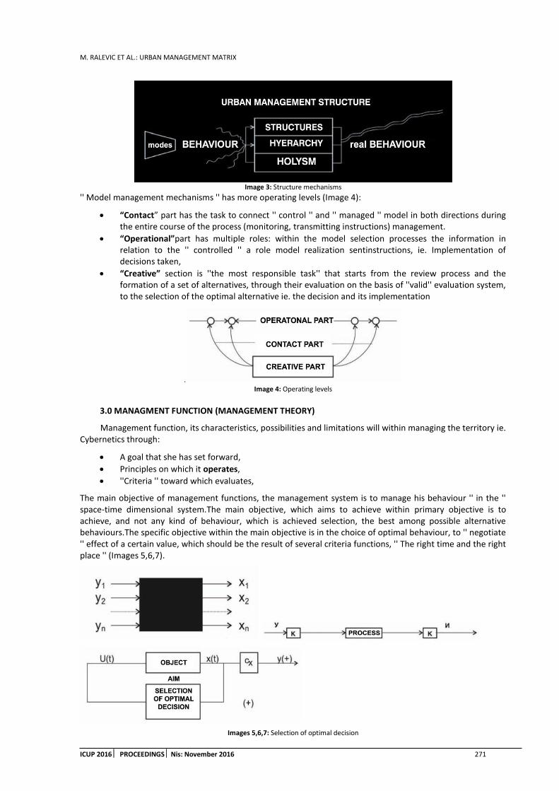
M. RALEVIC ET AL.: URBAN MANAGEMENT MATRIX
ICUP 2016 PROCEEDINGS Nis: November 2016 271
Image 3: Structure mechanisms
'' Model management mechanisms '' has more operating levels (Image 4):
“Contact” part has the task to connect '' control '' and '' managed '' model in both directions during the entire course of the process (monitoring, transmitting instructions) management.
“Operational”part has multiple roles: within the model selection processes the information in relation to the '' controlled '' a role model realization sentinstructions, ie. Implementation of decisions taken,
“Creative” section is ''the most responsible task'' that starts from the review process and the formation of a set of alternatives, through their evaluation on the basis of ''valid'' evaluation system, to the selection of the optimal alternative ie. the decision and its implementation
. Image 4: Operating levels
3.0 MANAGMENT FUNCTION (MANAGEMENT THEORY)
Management function, its characteristics, possibilities and limitations will within managing the territory ie. Cybernetics through:
A goal that she has set forward,
Principles on which it operates,
''Criteria '' toward which evaluates,
The main objective of management functions, the management system is to manage his behaviour '' in the '' space-time dimensional system.The main objective, which aims to achieve within primary objective is to achieve, and not any kind of behaviour, which is achieved selection, the best among possible alternative behaviours.The specific objective within the main objective is in the choice of optimal behaviour, to '' negotiate '' effect of a certain value, which should be the result of several criteria functions, '' The right time and the right place '' (Images 5,6,7).
Images 5,6,7: Selection of optimal decision

M. RALEVIC ET AL.: URBAN MANAGEMET MATRIX
272 ICUP 2016 PROCEEDINGSNis: November 2016
3.1. Principles of management theory.
The theory of governance as a major power involved in research management positions in various systems has some basic ''principles'' that applies in most different areas that due to the specific area in which the applicable require certain additional clarifications, ie. some ''new'' interpretation, because the area where applicable.
I. - The principle of 'black boxes''
The theory of management system '' managed '' is treated as a model '' black box ', whereby the control function is not decisive nor essential internal structure of the model, but only the external behaviour as a whole, ie. Encouraging response to a specific action.
II. - Principle: 'The entry - exit'
This principle is closely related to the previous one, and at the same time resulting from it.Most importantly, in terms of the theory of management, ie the establishment. Finding a direct link between inputs - (conscious) impacts (or unexpected effects) model '' black box '' and outputs - reaction to our conscious (or other) operation.The relationship between inputs and outputs can be twofold, after which the systems are classified into specific categories:
'Linear' system are the kind of system, where each '' input '' there is a pre-known value '' output ''. For this type of relationship, where the ruling within a particular system is said to be a type of closed system.
'Nonlinear systems' are systems in which input or quantity that can be changed on a case-by-case basis or completely unknown. Such systems fall under this criterion in open systems.
III. - The principle of '' feedback '' is the main principle, by means of which the control function is achieved. His failure to realize all the other principles lose their importance.
The mere feedback, except that it has, in both directions, the effect may be:
''Functional'' when under constant, the interaction of a ''elements'' comes to the mutual influence and conditioning '' change '' of both.
''Time management'' - has a role to connect back at the exercise instruction - the decision to form a new decision. This principle is realized roundabout information between models.
IV. - The principle of ''optimal'' the principle of value categories, which stipulates that in the '' management '' we have constantly before him '' value '' that we want to achieve our operation on the behaviour of '' managed '' model.
Value '' optimal '', is a complex category, which contains complex relationships, as a result of:
Operation of multi-criteria function,
Multivalent relationships between these criteria,
Balanced relationship, constantly new relations
Variability of character and attitude criteria, before and after the selection.
V. - The principle of 'selectivity' 'is a continuation of the previous one, it ensues from it achieves. At the same time use the first three principles for its realization. Po, essentially, means that during the process of governance, (must) exist for the selection-selection '' optimal trajectory '' through:
Provision of alternative (possible) solutions - making, between which is possible to make a choice,
The choice is necessary to provide a system of values, on the basis of which is determined by the desired effect, by individual criteria,
Selection is done through a complex system of evaluation through the use of qualitative and quantitative criteria.
VI. - The principle of '' dynamism ''the principle that expresses the ratio of management theory to the systems concerned. That in this specific case means that the urban system (we have to) treat as a dynamic - changing system, and investigate its behaviour not only 'U through' time.Which means that, for the territory of dimensional management system, consisting of a '' space '' and '' time '' dimensions. The mutual respect and equal treatment, and tends to direct the behaviour of the system through the '' space-time corridors'

M. RALEVIC ET AL.: URBAN MANAGEMENT MATRIX
ICUP 2016 PROCEEDINGS Nis: November 2016 273
VII. - The principle of verifiability is a principle whose realization, increase the reliability of previously selected decision-solutions-trajectory. It bind us to the process of selecting before the final selection, we carry out (technique) simulation, possible alternative behaviours determine the effects of exercising certain alternatives, and then we perform real-optimal alternative.
3.2 Criteria of management functions
Criteria such value measurement categories have a role preconditions, '' to be fulfilled, provide and realize that '' control '' function may not work ''. Depending on the degree of satisfaction of criteria to measure the degree of achievement of performance management functions and values of the results of its operations.
There are three basic categories of criteria:
The criterion 'TIMELINESS' 'is the criterion which the measured value-checked and realized' 'and the' 'space-time dimensional system, where it is important to' 'hit the target', and the 'right place (target), at the right time.
This means that you need to fulfil two conditions:
1) In order to be 'managed' 'behaviour of the system so that it has at all times provided the necessary spatial conditions for smooth, his behaviour.Each breach of this condition, we will achieve behaviour that cannot be carried out normally as it comes to '' jump '' system, when the system will be forced to seek a solution that suits him.
'' TARGETING TARGET '' on the principle to hit the right place in the right way
2) Yes ''time'' that we have available for the process of selecting, is still limited, and that we are obliged to taking account of the determinants of this, timely make decisions and react in a timely manner. Any excess ''weather determinants'' mandatory, entails (unforeseeable) consequences. In some cases, the time sequence tends to ''0'' and our response must be instantaneous.
The criterion ''EFFICIENCY'' (resultative) the criterion whose dimensional measurement values and qualitative nature, which means that the goal of 'management' choices and not achieving any kind of behaviour, but behaviour that gives the best and highest possible achievable effects. This means that you need to fulfil two conditions (below) criteria:
1) In order to achieve their criteria of timeliness within the dimensional system should include the first space size (volume, length, area) and time (just pursuance of this spacious size), according to the principle of utilization of space ''no loss'' and the ''short'' the duration of the immediate need for him), ''no profit'' (the existence of '' excess'' of space, and its ''through'' the duration of unused space).
2) Yes, while ensuring real space-time greatness realize the quality, impact, the highest possible value, to whose results may be reached through a very complex multi-criterion function, which is a result of establishing the best relations, within the urban system and the environment. Directly linked to the 'objective function' selection process, which we must aspire.
The criterion of 'EQUILIBRIUM', perhaps in the order management processes in the 'third'place, however, by nature, we cannot be categorized as a major criterion whose non-performance, we can bring into question the previous two criteria, including the overall appropriateness control functions. According to this criterion, no matter what degree of efficiency achieved and no matter how timely respond, we need to ensure steady state control the entire system, all of its structures and mechanisms, in every moment of his behaviour.
''Equilibrium'' condition is essential to achieve harmonization of relations:
1) Within the ''management model'' - the urban system by harmonizing the relationship between all the parameters that affect between system structure and hierarchy between the continent between the ''inside'' the level of the urban system, '' through the 'spatial dimensional system.
2) Between the 'model', through the harmonization of 'development issues' and (development) opportunities for the realization of mutual urban model takes contact and improve the operational mechanism of action for faster selection (Image 8).

M. RALEVIC ET AL.: URBAN MANAGEMET MATRIX
274 ICUP 2016 PROCEEDINGSNis: November 2016
Image 8: Targeting acc. to criteria
4.0 THE PROCESS OF FORMING THE MANAGEMENT TRAJECTORY
“Process control”, due to its great complexity in all phases of (his) unfolding, it is impossible (' 'too' ') to simplify; and for this reason, trajectory management is formed by the equivalent complex procedure that follows includes;
Alternative route to arrive at solutions
The value system of selecting
Way of discovering trajectory development
4.1 An alternative approach is one of decisive actions, which is used in management theory. In the process of selecting the form of alternative '' solutions '', according to certain criteria, and then chooses between them (again) the optimum behaviour, ie. Performed the analysis of their effects process simulation.The first question that arises, how to have a relationship in the process of selecting the optimal trajectory, ie. how to use such a system established alternative trajectory. There are two basic options:
A. The formation of a trajectory to one of the following ways(Image 9);
1) Mono approach is based on one of the offered alternatives immutable, the sort that have been made in its election form. This value is obtained according to the principle that it is in the final (evaluation) 'sum total' collect most 'points'.
2) Inter approach is the result of the selection of one alternative corrected, where one of the alternatives, changing deficiencies, and to their changing, does not undermine its benefits.
3) Multi approach is the way to the formation of 'a new' alternative, which is the result of all or the majority, ie the alternatives their values that were observed during the simulation.
Image 9: Mono, Inter, Multi approach
B. The moving trajectory of one of the following ways:
1) ''Offshoring'' with the flow of a stream to other alternatives, which means abandoning those whose condition has changed a binding for those whose conditions are valid at a given moment.
2) “Offshoring” corrected during whose correction caused by the appearance of partially changing conditions which will immediately request a correction flow behaviour alternative, but still in their elementary-road route chosen behaviour.
3) “Offshoring” during their”, in which pave a new “way”, a set of alternatives offered only serves as the backbone, with whose behaviour simulation avoid the negative consequences of choosing a better, new

M. RALEVIC ET AL.: URBAN MANAGEMENT MATRIX
ICUP 2016 PROCEEDINGS Nis: November 2016 275
trajectories behaviour. This way of migration is caused by fluctuations in conditions - (our superiors) and the desired effects, which need to choose new behaviours (Image 10).
Image 10: SYSTEM Offshoring
4.2 ''Value of the'' optimality. Applying either of the two aforementioned principals (''channelling and migration ') an alternative approach, we will find ourselves in a situation that we choice to decide for one of the possibilities that we offer the offered alternatives, ie. we will be in a position to carry out the selection of the optimal alternative, ie. to find the optimal value effects that we want to achieve.
In this sense, system is in a position to put across from '' value of the ''; AIM, Possibilities and Limitations and their confrontation, explore-establish the possible achievable 'qualitative and quantitative' value effects.
The effect is a value, which is the result of the function; coma harder (our) desires, (objective) that realize the available potential (opportunities) and regulate defined determinants. In relation to each other, this, at first glance, contradictory value categories, each other condition and change;
The aim of encouraging and training required features (tools and mechanisms) and by its essence strives towards overcoming the limitations,
By increasing the range of possibility, it reduces the extent of the restrictions, ie. a range of limit values (min and moss.), is constantly increasing, with constantly increasing the prospects for achieving the goal,
Constraints, essentially corrected objectives and regulate the possibilities.
4.3 Method of programming trajectory management that are at our disposal, as a result of the adopted initial commitment equidistance and scope of observation.
In this sense, there are three possible basic forms (Image 11):
'Interception'
'Мonitoring'
'Steerage'
'Interception' 'is a case where the coordinates of the selection in front of the coordinates of the urban system, with predictions of future situations, in order to be on time, pre ascertain the conditions in which they will find the urban system in the future and try to correct management-selection the flow behaviour achieve optimal situation.
The advantages of this procedure are that it provides the ability to check any simulation-specific solutions and its consequences, because it is a state that has yet to materialize. It is also possible to count on a greater influence on the behaviour urban system. However, there is also the strong possibility '' failure '' because the information fund, not all data is completely reliable, but the majority is based on certain assumptions, which needs to be checked.
“Monitoring” is when the PV coordinate selection is behind the PV coordinates urban System (Ed o), where our team is working on the principle of '' delay '', which allows us to fully '' look '' real-ago realized the behaviour of urban systems to get to the right information, but the influence on the control functions course of conduct in question. Our reactions are based on the principles of '' correction '' has already created 'critical - crisis'' state of the system, which state that was established on the basis of our understanding of the crisis, or on the basis of measurement-detecting negative consequences.
“Steerage”, by its nature may be, is the purest form of governance, a fundamental decision of his that the system of selection, in the same (absolute and relative) PV coordinates, in which the urban system in all times in any position. In the present case, this means that we are in the immediate situation in which the urban system is, then that is the source of information that gives him the ability to use data that sus him directly

M. RALEVIC ET AL.: URBAN MANAGEMET MATRIX
276 ICUP 2016 PROCEEDINGSNis: November 2016
necessary that the links between models (management and managed) in direct, direct contact to the sequence between the receipt of the information and giving instructions to a minimum, (so to speak are current) to be selected according to the experience already-established and proven alternative that best match the need of creation of optimal conditions, while avoiding the negative consequences.
Image 11: Basic forms of trajectory management
5.0 CONCLUSIONS: THE PROCESS OF ACHIEVINGMANAGEMENT FUNCTIONS
The process of achieving management functions, it is necessary to include the ''timely'' perceive;
Approaches to the urban system
Operation procedures
Structure of the ''Way'' of realization
Requirements management.
''MANAGEMENT MODEL'', in the case of the urban system can have three basic forms:
1) Comprehensive - at the same time management is the way in which the relationship between the level of treated through vision constant scope of relations and all forms - the trajectory of behaviour are the result of the simultaneous resolution of the three 'levels'' of the problem. This method requires the training of the entire selection process, and in particular the contact and operational work.
2) Meet-priority management is the way in which each level is viewed as a separate entity, and management is realized by the principle of priority of a certain level, the priority of state level that’s in crisis'' and should be drawn from it, or is clearly oriented system and manages the '' main - priority 'levels ie. his behaviour in relation to the behaviour of other levels on the principle of meeting the level of conduct as a private entity.
3) Successive-priority control, such a procedure where each level has its own system of selection and its directions-forms of behaviour and occasionally, if necessary, come up with their connection and harmonization.
Conditions of management are the direct reflection of the level of development of the control system, the mechanism and the relationship (impact) of the participants in the governance process. These conditions can best be recognized through their identification with the level of development of individual categories; the level of development of tools and mechanisms for the realization of management decisions, the degree of regulation determinants - environmental conditions for the adopted decision within the system and the impact activator- makers in the form of subsidies for the realization of '' decision '' at the highest level.
In the above context of the relationship between the level of development '' activator '' and '' means and mechanisms' regulation can have the following types and methods of management;
The management of the 'unmanageable conditions'' means the situation, which is' 'condition' 'outside' 'will' 'i-range' 'hand' 'when a man can only be managed' 'her' 'adapting to their environment. Accepting all its requirements. This completely natural conditions prevail.
The management of the 'manual' conditions' is the case when all the mechanisms and all assets are reduced to the possibility of man; contact with '' controlled '' model through his senses, the operational part of his hand, as a tool, net energy as a driving force behind a creative part of man himself, with all the speed and quality of decision subordinate his pace, his rhythm and his range of understanding and the notion of quality.
MENAGEMENT the 'mechanized' conditions' is realized division of roles, the operational part of the executive management taken over by mechanical means, the contact part is still in the hands of man, for the most part, a part is transferred to the mechanical devices that are still '' dispute '' a 'creative' 'is part of the brand in the hands of a man while he controls the behaviour of resources, and performs formation and selection decisions.
The management of the 'automated' conditions' is realized through two forms;

M. RALEVIC ET AL.: URBAN MANAGEMENT MATRIX
ICUP 2016 PROCEEDINGS Nis: November 2016 277
Semi-automatic management includes interactive work of man and machine, where they are granted the role of man and machine. In the process of the operative part of man only minipulise with machine operators and thus, indirectly, controls '' controlled '' model. In the process of 'creations he kept himself the right to make decisions and the machine has enabled the processing and sorting of information for decision making;
Automatic control, the control without direct participation of man, where man is present only in the phase of system activation and disconnection.
REFERENCES
1. Y.S.Antomonov, “Sistemi, slozenost, dinamika'' Nauka DUMKA, Kiev, 1969
2. V. Bjelikov; ''Planiranje i uredjenje prostora-metodoloski pristup u primeni zakona'', ZUKDS, Beograd, 1977.
3. Dejvid Bom; ''Uzrocnost i slucajnost u savremenoj fizici'', Nolit, Beograd, 1972
4. Norbert Wiener: ''Kibernetika – ili upravljanje i komunikacija kod zivih bica i masina'' ICS, Beograd, 1972.
5. A.Glikson; ''Regionalno planirawe i razvoj'', KMA, Beograd, 1971
6. R.Gabalov; F.M. Kirilova; ''Metodi linearnog programirawa'', BGU, Minsk, 1977
7. S.Gulerihic, V.Marevic, O. Mikic, R. Petrovic; ''Sistemi, upravljanje sistemima, sistemske discipline tehnike i merila'', Institut ''M.Pupin'', Beograd, 1974.
8. Grupa autora; ''Modelovanje teritorijalnih sistema'', Budvelink, Kiev, 1977
9. M.Ferencak; ''Razvojni grad, mogucnosti formirawa resetkaste, strukturalne matrice, JIUS-70, Beograd
10. M. David; ''Sistemski pristup planiranju'', JUIS-1972, Beograd
11. Hubert I. Drayfus; ''Sta racunari ne mogu'', Nolit-Sazvezdje, Beograd, 1977
12. Milisav Drulovic; ''Upravljanje operacijama u slozenom sistemu, PFV, Beograd, 1979.
13. C.A.Doxiadis; ''Ekumenopolis-naselje u buducnosti'', SSAT, Beograd, 1971
14. Umberto Eko; ''Kultura, informacija, komunikacija'', Nolit, Beograd, 1972.
15. D.M.Komskij; ''Tehnicaskma kibernetika'', DOSAAF, Moskva, 1977
16. Martin Kuenzlen; ''Playing urban games'', Boston, 1972, All rights receved
17. V.Lavrov; ''Gradovi menjaju svoju strukturu'', SZUKS, Ara SSSR-br.11, 1966
18. A.J.Lerner; ''Principi kibernetike'', ICS, Beograd, 1975
19. Anri Lefevrt; ''Urbana revolucija'', Nolit, Beograd, 1974
20. A.G.Mamigonov; ''Upravljanje i informacija'', Nauka, Moskva, 1975
21. Havel Marec; ''Covek i masine'', Nolit, Beograd, 1976
22. D.H.Meadows, D.L.Meadows, J.Randels, WW.Berrens; ''Gradice rasta'', Stvarnost, Zagreb, 1972.
23. Borko Novakovic; ''Sistemsko inzenjerstvo i graditeljstvo'', AF, Beograd, 1976
24. Nedeljko Parezanovic; ''Racunarske masine i programiranje'', PFV, Beograd, 1976
25. Ivan K. Petrovic; ''Sistemski pristup metodologiji projektovanja'', Arh, pml, PS-6, Beograd, 1995
26. R.Prjvdom, Z.Brjuneter, G.DJupjum; ''Imitacionie modeli goroda'', Progres, Moskva, 1979
27. M.B.Posohin; ''Gorod dlja celoveka'', Novosti, Moskva, 1973
28. Milos Rajkov; ''Teorija sistema'', PFV, Beograd, 1979
29. D.Stkic, M.Vukobratovic; ''Dinamicko upravljanje manipulatorima'', M.Pupin, Beograd, 1979
30. R.Tomovic; ''Upravljanje sistema'', CMS, Beograd, 1975
31. R. Tomovic, W.J.Karplus, ''Ogranicenja formalne teorije sistema'', Elektrot. F., Beograd, 1978

M. RALEVIC ET AL.: URBAN MANAGEMET MATRIX
278 ICUP 2016 PROCEEDINGSNis: November 2016
32. R.Tomovic, S.Stankovic; Toskovic; ''Nelinearni sistemi automatskog upravljanja'', CMS, Beograd, ,1975
33. DJ.Ciribini; ''Sistemoloski pristupi arhitekturi'', SSAF, Beograd, 1972
34. J. W.Forrester; ''Principies of systems'', Wright-Allen Press, Cambridge, 1969
35. A.V.Silenko; ''Kibernetika bez matematiki'', Energija, Moskva, 1977
36. Ivan Stajenberg; ''Covek u automatizovanom sistemu'', Nolit, Beograd, 1980
37. Moron Hoddenfeld ''The potential for new towns'', The Columbia Press
38. Fransoa Soe; ''Urbanizam, utopija i stvarnost'', Priv. Stampa, Beograd, 1979
39. M.Ferencek; ''Razvojne sinteze i nerazvojni elementi grada'', JIUS-1977, Beograd
40. Miodrag Janic; ''Primena modela u praksi urbanistickog i regionalnog planiranja'' AF., Beograd, 1985.
41. Jonathan Barnet; ''The elusive city ''The Herbert Press, London, 1987
42. Michael Batty; ''Urban modelling'', Cambridge University Press, Cambridge, 1976
43. Lewis Mumford, ''Grad u historiji'', Naprijed, Zagreb, 1968
44. Jonathan Barnet, ''An introduction to urban design'', Harpen & Row, New York, 1991
45. John Thackara; ''Design after modernism'', Thames and Hudson, Cloucecier,, 1988
46. Robert J.Holloway, Robert S.Hancock, ''Marketing at a changigng environment'', John Willey & Sons, New York, 1968
47. Aleksa Milivijevic, ''Optimalna velicina grada'', Mladost, Beograd, 19..
48. M.Ralevic; ''Programsko modelovanje urbanih funkcija'', AF-CMS, Beograd, 1985
49. M.Ralevic;''Urbani sklop stanovanja kao proces'', Arhitektonika Br-6, AF, Beograd, 1991.
50. M. Kojovic; ''Arhitektura urbanih sistema'', JIUS-1973, Beograd
51. B.Geoffrey; ''Design in architecture'', John Wiley, New York, 1973
52. R.Stojanovic; ''Planiranje u samoupravnom drustvu'', SAIEI, Beograd, 1979
53. Grupa autora; ''Urbanizam i sociologija'' casopis Socioloski pregled br.1, Beograd, 1974
54. L.Kolakowski; ''Dijalektika prirode'', casopis ''Ideje'', br.7, SSOJ, Beograd, 1979
55. E.Ravnikar i drugi; ''Aplikacija racunara u projektovanju i gradjenju'', Gradbeni centar, Sloveenije, Ljubljana, 1977
56. M.Ralevic; ''Buducnost malih i srednjih gradova'', edicija urbanologija-kolo Urbo Sveske, br.3, Arh.Fakultet, Beograd, 1995.

M. SOSKIC ET AL.: THE POSSIBILITY OF APPLYING LAND READJUSTMENT IN SERBIA
ICUP 2016 PROCEEDINGS Nis: November 2016 279
THE POSSIBILITY OF APPLYING LAND READJUSTMENT IN SERBIA
Mladen Soskic
Faculty of Civil Engineering Belgrade, Serbia PhD., Teaching Assistant, [email protected]
Rajica Mihajlovic
Faculty of Civil Engineering Belgrade, Serbia PhD., Assistant Professor, [email protected]
Stevan Marosan
Faculty of Civil Engineering Belgrade, Serbia PhD., Assistant Professor, [email protected]
Nenad Visnjevac
Faculty of Civil Engineering Belgrade, Serbia Teaching Assistant, [email protected]
ABSTRACT
Basic principles of land readjustment as tool for urban planning from the aspect of its usage considering current circumstances in Serbia are explained in the paper. The most common issues that urbanization in Serbia is dealing with and potential usage of land readjustment in solving those issues are analyzed in the paper. The potential benefits of applying land readjustment are represented on both, government and its structures and on land owners. Potential difficulties which may be expected while introducing land readjustment and possibilities of their exceeding have been identified.
Keywords: land readjustment; urban development; urban plans; parcel structure.
1. INTRODUCTION
Taking into account the fact that land, i.e. territory is a limited and the most worth resource of each country, it is clear why there is a need for right and meaningful managing of that property and why it has to have priority if the society strives to progress and development. Due to rapid urbanization in contemporary times one aspect of land development comes to fore. That is urban land development. Serbia is not an exception in this process, on the contrary, urbanization in Serbia is very intensive since the middle of the last century until today.
Although urbanization represents positive social process and logical repercussion of economic development in general, it may be a source for numerous problems/issues unless it is not accompanied with suitable mechanisms for urbane land arrangement. Primarily, those mechanisms have to deal with two main problems of urbane land arrangement: to provide a land for public needs (streets, squares, parks, green areas, various objects for public usage - for example schools, medical centers, etc.) and shaping building plots in accordance with the standards of urban planning.
Land readjustment represents complex process of arranging building land where existing parcel structure is being cancelled and new one is being made (Soskic, M., 2016.). Principles of retaining property rights and value are being kept. Parcels that are not suitable for building, whether because of their size or shape are adjoined as a one whole – readjustment mass by land readjustment, in order to have parcels that are in accordance with urban standards for building according to all parameters (size, shape, position) out of that readjustment mass. Usually it is land that used to have other usage (agricultural, forest or industrial, etc.) but according to urban

M. SOSKIC ET AL.: THE POSSIBILITY OF APPLYING LAND READJUSTMENT IN SERBIA
280 ICUP 2016 PROCEEDINGSNis: November 2016
plan it is being transformed into building land. Also, land readjustment can be conducted on existing building land that has unsuitable parcel structure in shape, size or has inappropriate infrastructure.
One of the most significant characteristics of land readjustment is land providing for public requirements: streets and other roads, parks, green areas, playgrounds, etc. and if there are larger readjustment areas, lands for school, kindergartens, medical centers, sports centers, etc.
Besides having favorable parcel structure for building and providing land for public needs, property rights on readjustment area are being solved by land readjustment. Those problems are known to be a big problem and obstacle to the efficient urbane land arrangement in Serbia. Besides that, principles of retaining property rights and value by the land owners are being kept. Those principles enable land readjustment participants who had property rights over land prior to land readjustment to keep the ownership over part of the readjustment mass which will be redistributed to them after land readjustment pro rata to the area or land value which they brought to the readjustment.
Since in this project land for public needs is being excluded, it is clear that land area that participants will gain after the readjustment will be less than they brought in. Having in mind that land which is parcelled in accordance with urban parameters and for which public areas are being provided have greater value by the land unit, it is clear that participants are reimbursed in the manner that they got land of higher value. Besides that, in some cases construction of public infrastructure may be part of the process of land readjustment.
2. THE BEGINNINGS OF LAND READJUSTMENT IN SERBIA
The first clue of land readjustment in this area is mentioned in Construction law of Kingdom of Yugoslavia in 1931. All phases of land readjustment, jurisdiction of certain institutions, processes and other aspects were developed in highly detail manner in the law. From today`s perspective that was a high quality law especially taking into account time when it was brought. That was approximately just 20 years after the first land readjustment law was established (Lex Adickes) which had been initiated by the major of Frankfurt am Main, Franc Adickes after which it was named. Unfortunately, there are no records of mass usage of the law and land readjustment in general in the state from that time. That was primarily because of the fact that the method was new and non-established in practice and historical circumstances as well. Not long after this law was passed, II WW started. After the war there were political and social changes in Yugoslavia, so that the law was never fully implemented in practice.
Land readjustment was created by taking over and customization of basic principles of land consolidation of agricultural land which was already established tool and it was conducted along Europe and the world. Serbia has a long tradition of conducting land consolidation of agricultural land. The first land consolidations go back to 18.century in the time of Maria Theresa in Vojvodina area.
The biggest job in this area has been done since the 1960s until the 1980s when 1,700,000.00 ha of agricultural land was arranged by land consolidation (Soskic, M., 2010.). Although those were land consolidation of agricultural land within them, settlement areas were also arranged. Albeit there was no legal basis and specially designed system of land readjustment, existing legal options were used within land consolidation of agricultural land so that readjustment could be done in the building areas of the settlement (Mihajlovic, R. et al 2011.). Achievements of this system were limited and it ended up mainly on solving problems with property rights. Corrections of parcel boundaries and in some cases area for public needs were provided. Besides that, settlement area arrangement of this kind could have been conducted only on territories and cadastre municipalities which were covered by land consolidation of agricultural land, but not on greater urban areas where the need for this tool was much higher.
Characteristics of social political system were so called public property, i.e. importance was not given to the private property ownership over land (Mihajlovic, R. et al 2011.). After the II WW, Socialism was the political system in Serbia which lasted until the end of the last century. At the same time, urbane plans which could not have been realized in close future were developed. In the time period of great population migration from villages to cities occur. It led to an increase for living space. Non-existing of urbane plans or inability to realize existing ones mixed with violation of legislative procedure during construction of buildings, represent factors which have led to illegal construction of all types of buildings.
Civil war that erupted in the region in the 1990s just made the whole situation even worse. Those war years were linked with political uncertainty, sanctions and overall crisis of the society as a whole. As a consequence
M. SOSKIC ET AL.: THE POSSIBILITY OF APPLYING LAND READJUSTMENT IN SERBIA
ICUP 2016 PROCEEDINGS Nis: November 2016 281
of rapid impoverishment and fast standard decrease a great number of highly educated inhabitants migrate abroad and additional influx of rural population comes to cities.
General lack of laws and regulations reflected on already havoc in legislative system in the area of urban planning and construction. Due to those facts illegal construction occurred. The scope of illegal construction was vast. It started with single illegal objects, mass illegal up build and reconstruction and it continued to development of whole illegal settlements where thousands of people live. Additional characteristics of that period is spreading of so called `kiosk/stall economy`. It reflected in setting prefabricated sales objects in major roads and other attractive locations.
3. NEED FOR LAND READJUSTMENT IMPLEMENTATION IN SERBIA
Current situation in Serbia is that there is not enough arranged, not even formed building plots. It leads to great problems in various fields. On one side it negatively effects on construction industry development and unemployment in that and related fields, while on the other hand it makes hard for the cities and settlements in Serbia to develop properly (Mihajlovic, R. et al 2011.). It also disables population to have their homes easier and cheaper. Serbia needs appropriate solutions in order to solve anomalies from the past and to define better manners of efficient and applicable adjustment and protection of building land and the space in general. Thanks to its characteristics, land readjustment may be one of the measures which will significantly bring efficient arrangement of building land.
Up till now, usual manner of implementation of urbane plans in Serbia was mainly linked to forming and setting new boundaries of building plots in the areas where usually present structure of parcels, concerning size and shape was not in accordance with urbane plan, i.e. to building rules which were defined in the urban plan. In those situations, building plot forming required merging of several parcels parts which belonged to different owners. In practice, those were highly demanding obstacles in manner of solving issues concerning property rights.
It is clear that without forming a building plot which by its size and shape meets all requirements which were defined by urbane plan, building on it is not possible. In practice, it meant big problems for land owners, since they had to solve issues concerning property rights by individual court cases, if they wanted to have right to build on that parcel. Although that system is based on indisputable private property law, it is clear that the system is not at all suitable for individual owners on one side and for local government and country as a whole. Additional problem which brought further complication of situation is common case of nonconformity of actual boundaries of parcels on the ground with actual legal situation of parcel boundaries in cadastre.
Serbia can expect further increase of urbane population due to expected economic growth and also taking into account the fact that Serbia is at the bottom of the European countries list by the degree of urbanization. Degree of urbanization – share of the urban population in total population was 53% in the beginning of 1990s. At that time Serbia became predominantly urban society. Trend growth in urbanization degree was positive, so in 2002 it was 56.3%, in 2011 was 59.4%. Since the degree of urbanization in developed countries is 78%, it is clear that increase of urbanization trend will be continued in future as well (Soskic, M., 2016.).
Industrialization and technology development led to change of occupation for a great number of inhabitants all over the world. Fewer and fewer number of people is engaged in agriculture and more and more people are dealing with other activities that are linked with life in urban areas. Due to that fact, increase of urbanization degree should be observed as natural and logical process in human society development. Having all that in mind, paradoxically the fact that increase of degree of urbanization in Serbia resulted in many problems because of irresponsible and unorganized implementation of urbanization. As a result of that approach to urban planning there is so called city ruralisation. It is obvious if morphology of Serbian cities is taken into account and soci-professional qualification of population. As an addition to that claim it is obvious that situation in city infrastructure is miserable.
Professionals and competent institutions identified urbanization problems in contemporary Serbia and by plan documentation of many Serbian cities bad aspects of urban development has been defined. Those are (Master Plan of Belgrade, 2007.): uncontrolled illegal construction of residential and other buildings, semi legal residential construction, slow and scarce realization of urban plans, non-developed building land, forming poor city neighborhoods, industry closure in existing industrial zones, outdated traffic system, scarce development of infrastructure, unregulated city agriculture, illegal connection on infrastructural installations, creating a great number of unhygienic garbage dumps, etc.

M. SOSKIC ET AL.: THE POSSIBILITY OF APPLYING LAND READJUSTMENT IN SERBIA
282 ICUP 2016 PROCEEDINGSNis: November 2016
Although professionals and competent institutions are coping with these problems for many years they are still significantly present and represent a huge barrier not just for urban development but economy and society development in a whole. It is clear that those problems are not simple and that they are not solvable over night, but it is also clear that certain mechanisms and tools are missing. Those mechanisms and tools could cope with present acute state much more efficient.
Taking into account described situation and problems in urbanism, conclusion is being imposed that it is required to have an urban development method update which will make a u-turn for a negative trend and lead to better situation in urbanism as soon as possible. Further on, those methods must be efficient, economically viable and applicable from the aspect of legislative system and democracy. Land readjustment may find a place in this process. It may even be one of the key tools that will be used for urban development measures implementation. Land readjustment meets necessary criteria in many aspects.
Basic characteristics of land development are: inexpensive and in some cases self-financing tool for implementation of urbane plans in short time period. Criteria of economy, efficiency and speed conducting are being met and all of that through active involvement of all interested parties, both land owners and authorities. Besides that, land readjustment may be a big help to the planners during urbane plan development. It gives them greater freedom in designing i.e. increases the number of possible solutions which leads to urban plans of higher quality.
4. AREAS IN SERBIA WHERE LOCAL READJUSTMENT IS APPLICABLE
Point of land readjustment is implementation of urbane plans, but it can be seen as a tool of urban development as well since it can lead to the increase of urban plan quality. It can be said that land readjustment gives an opportunity to reallocate building land via democratic process through cooperation of individual owners and authorities. To establish preconditions for the construction of local public infrastructure so that the whole land readjustment area can be adjusted to the approved urban plan.
Land development may be implemented in various areas:
New building areas which had different purpose
Projects like this have the goal to bring to the functionality a land that is not building land but it was intended to be building land by approved urban plan. The most common case is agricultural land in city outskirts where the city is being spread. The goal of land readjustment is to provide land for public needs and parcel structure in accordance with urban plan. Effects of land readjustment are usually highest in this type of the project (figure 1).
Figure 1: Urbanization of new building areas which had different purpose
Partially urbanized areas
Projects like this are being conducted in areas where construction has been started and a number of buildings are built, but during time a problem occurred. The mentioned problem is inability to provide complete public areas or required parcel structure of building plots (figure 2).

M. SOSKIC ET AL.: THE POSSIBILITY OF APPLYING LAND READJUSTMENT IN SERBIA
ICUP 2016 PROCEEDINGS Nis: November 2016 283
Figure 2: Arrangement of partially urban areas
Illegal settlements or settlements that were built as illegal
Unfortunately, there is a great number of illegal buildings in Serbia. There were numerous attempts through numerous laws and legislatives in order to legalize those objects. Certain number of objects is legalized, but it did not solve problems which that type of constructions brings. Goal of projects like this is primarily to solve infrastructural problems of those settlements by providing areas for public infrastructure. Effects of land readjustment are pretty limited here. In figure 3 part of one of the typical illegal settlement in Serbia is being depicted.
Figure 3: An example of illegal settlement – Kaludjerica, Belgrade (Geoserbia)
Dilapidated industrial complexes that are located in city areas
These specific projects have goal to integrate land that was a part of industrial complex into surrounding urban structure. There are various industrial complexes in Serbia that are out of operation and are located within city itself. In their surrounding there are residential and business complexes, so it is of prime importance for local community development to conduct planned conversion of that area in efficient manner. An example of one of such industrial complexes is given in figure 4.
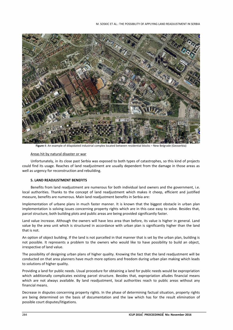
M. SOSKIC ET AL.: THE POSSIBILITY OF APPLYING LAND READJUSTMENT IN SERBIA
284 ICUP 2016 PROCEEDINGSNis: November 2016
Figure 4: An example of dilapidated industrial complex located between residential blocks – New Belgrade (Geoserbia)
Areas hit by natural disaster or war
Unfortunately, in its close past Serbia was exposed to both types of catastrophes, so this kind of projects could find its usage. Reaches of land readjustment are usually dependent from the damage in those areas as well as urgency for reconstruction and rebuilding.
5. LAND READJUSTMENT BENEFITS
Benefits from land readjustment are numerous for both individual land owners and the government, i.e. local authorities. Thanks to the concept of land readjustment which makes it cheep, efficient and justified measure, benefits are numerous. Main land readjustment benefits in Serbia are:
Implementation of urbane plans in much faster manner. It is known that the biggest obstacle in urban plan implementation is solving issues concerning property rights which are in this case easy to solve. Besides that, parcel structure, both building plots and public areas are being provided significantly faster.
Land value increase. Although the owners will have less area than before, its value is higher in general. Land value by the area unit which is structured in accordance with urban plan is significantly higher than the land that is not.
An option of object building. If the land is not parcelled in that manner that is set by the urban plan, building is not possible. It represents a problem to the owners who would like to have possibility to build an object, irrespective of land value.
The possibility of designing urban plans of higher quality. Knowing the fact that the land readjustment will be conducted on that area planners have much more options and freedom during urban plan making which leads to solutions of higher quality.
Providing a land for public needs. Usual procedure for obtaining a land for public needs would be expropriation which additionally complicates existing parcel structure. Besides that, expropriation alludes financial means which are not always available. By land readjustment, local authorities reach to public areas without any financial means.
Decrease in disputes concerning property rights. In the phase of determining factual situation, property rights are being determined on the basis of documentation and the law which has for the result elimination of possible court disputes/litigations.

M. SOSKIC ET AL.: THE POSSIBILITY OF APPLYING LAND READJUSTMENT IN SERBIA
ICUP 2016 PROCEEDINGS Nis: November 2016 285
Property tax fund increase. Land readjustment speeds up legal construction. Result is, increase in tax on the basis on newly build objects.
Faster construction of local public infrastructure of greater quality. With defining areas for public needs and by parcel distribution in accordance with building rules preconditions for faster construction of adequate infrastructure are being met, which will, among other things decrease cost of its future maintaining.
Having updated cadastre. By finalizing land readjustment, cadastre becomes updated in that area. Surveying data becomes of higher quality and all data are in digital form in accordance with valid legislation.
Construction industry operation support. By increasing construction of both buildings and infrastructure positive effects are achieved for construction industry and auxiliary operations. As a result unemployment decreases.
Keeping existing social structure. Since land owners are staying at the same area after land readjustment and that they are allowed to build, change of inhabitant social structure are being avoided, unlike other known tools.
6. CONCLUSION
Land readjustment is new tool which was recently introduced in Serbian legislation. It is undisputable that land readjustment has possibilities for wide usage, especially when we review problems that are in focus of Serbian urban planning society. The use of conducting the projects would be vast and would significantly contribute improving the situation in urban planning and economy and social progress. On the other hand, every new institute which is being introduced in already existing system is exposed to difficulties/danger not to be accepted despite its undisputable advantages. Difficulties which could jeopardize wider usage of land readjustment can be monitored from three points of view.
The first potential threat to successful usage of land readjustment is possible bad legislation. It is necessary to adopt not just laws but also certain bylaws on both state and local level. Those regulations should be carefully tailored so that they are not an obstacle to the entire process. The regulations should be one of the project starters and motivators to the both local authorities and individual land owners.
Second possible array of problems is scarce awareness and skill of employees in local government offices. Herein is meant on both administration staff and experts in bodies responsible for urban planning in local government offices. Employees who are in position to make decisions or recommendations about land readjustment must be educated about nature of complete process and benefits, but also about limitations which are brought by it. It would be dangerous to dismiss in advance possibility of conducting land readjustment just because of unfamiliarity with the process. It would be even more dangerous to overrate its achievements and opportunities.
Third threat is possible opposing stand point of land owners, i.e. potential land readjustment participants. In order to prevent those problems timely informing and education of land owners on planned land readjustment areas is necessary. This can be conducted via active campaigns, by organizing gatherings where experts could present all possibilities and benefits of land readjustment in a simple manner which is comprehensive to anyone. It can be expected that people would fear from anything that is new and not known and that is why it is necessary to present it in real light what they can expect in this process. This is a key thing for the success of land readjustment. Although there is an obligation by the law to participate in the process, i.e. approval from the land owner is not necessary in order to have land readjustment, their significant resistance to land readjustment would condemn the whole procedure on failure.
By perceiving from one side current situation in urban planning in Serbia and requirements to solve burning issues, and from the other side the concept of land readjustment, its goals and benefits that brings, it can be said that possibilities of its usage are great and that significant benefits would be achieved in the field of urban planning. It would also contribute to progress of both country and society as a whole.
REFERENCES
1. Mihajlovic, R., Miladinovic, M., Soskic, М., (2011): Optimization of Land Distribution in Urban Land Consolidation. Professional practice and education in geodesy and related fields. International scientific conference and XXIV meeting of Serbian Surveyors, 24-26 June 2011, Kladovo, upon Danube, Serbia. Proceedings: ISBN 978-86-7518-135-4 pp. 60-69.
M. SOSKIC ET AL.: THE POSSIBILITY OF APPLYING LAND READJUSTMENT IN SERBIA
286 ICUP 2016 PROCEEDINGSNis: November 2016
2. Mihajlovic, R., Miladinovic, M., Soskic, М., (2011): Development of Rural Settlements in Land Consolidaton. 1st Serbian Geodetic Congress, International Scientific Conference, 01.-03. December, 2011., Belgrade.
3. Soskic, M., (2010): Improvement of the Land Consolidation Process By Use of Modern Technologies. Msc. thesis, Faculty of Civil Engineering, University of Belgrade, Belgrade 2010.
4. Soskic, M., (2016.): Development on new land readjustment models in the function of urban land development. Ph.D. thesis, Faculty of Civil Engineering, University of Belgrade, Belgrade 2016.
5. *** (1931): Construction law. Official newspapers of Kingdom of Yugoslavia no.133/1931.
6. 6. *** (1931): Master Plan of Belgrade. Official newspapers of Belgrade no.27/2003, 25/2005, 34/2007.

A. KOSTIC ET AL.: ELEMENTARY FEATURES OF URBAN DEVELOPMENT OF THE CITY CENTRES DURING TRANSITION
ICUP 2016 PROCEEDINGS Nis: November 2016 287
ELEMENTARY FEATURES OF URBAN DEVELOPMENT OF THE CITY CENTRES DURING TRANSITION
Aleksandra Kostic
University of Nis, Faculty of Civil Engineering and Architecture, Serbia PhD student, [email protected]
Danica Stankovic
University of Nis, Faculty of Civil Engineering and Architecture, Serbia PhD., Associate Professor, [email protected]
Mihailo Mitkovic
University of Nis, Faculty of Civil Engineering and Architecture, Serbia PhD student, [email protected]
ABSTRACT
Aim of this paper is to emphasize the bivalent implications of transition process on the urban development of the city environments. The radical abandonment of the socialist political and socio-economic system is reflected in the post-socialist patterns of urban development. The paper examined the conditions and circumstances under which the transition process is realized in Serbia and analyzed their causal impact on the morphology of urban centres with the separation of characteristic urban ‘products’. In the case of the urban centre the city of Leskovac has been explored the current state of the urban structure of the city, which is a result of a long transition period. The research work is focused on defining adaptable measures to redefine the current state of urban centres and application in the future urbarchitectonic practice.
Keywords: transition process; city centres; transformations; urban development; influential factors.
1. INTRODUCTION
Transition is defined as a complex and comprehensive systematic reform process in society, politics, economy and culture. Process of transition is a significant factor of socio spatial changes of urban centres. Trajectory and dynamics of the realization of this process depends on the achieved level of development in the global and national level, and is associated with a set of political, economic and social influence factors. Starting from the fact that every urban process is essentially political and economic process (Wu, 2003), a reflection of the social and economic momentum to the space, readable in the physical manifestation of the city and its parts, is inevitable. The transformations that the contemporary urban environments are experiencing, originate from the adjustment of the city to habits, needs and wishes of its social factors (individuals) with the ultimate goal expressed as a higher level of well-being. The face of urban area is actually a consequence of social changes and civilization reaches. Olbrycht (2013) defines transition as deliberate, necessary and positive change in consciousness first, and then all of the elements of the administrative, social and physical elements of the city towards sustainable system resistant to changes, regardless if they are willing, planned or unexpected natural, social or economic. Often is the use of the term transition for ‘social trend in the developed world where serious change of basic elements is necessary in order to accept a new global paradigm: We live in time of crisis and in the ‘modern era’, which requires metamorphosis of all urban systems’ (Gligorijevic, 2016).
Radical abandoning the socialist systematic achievements generated the changes in the area of post-socialist cities, which were of intensified flow, partial and non-systematic realization, followed by the difficult auditing by the relevant institutions and inconsistency of public and private interests. Thus, issues of quality ‘newly-

A. KOSTIC ET AL.: ELEMENTARY FEATURES OF URBAN DEVELOPMENT OF THE CITY CENTRES DURING TRANSITION
288 ICUP 2016 PROCEEDINGSNis: November 2016
created’urban environment, its relation to the startled built environment and other products of the transition process became important for considerations and systematic resolving.
The transition, which started at the beginning of 90-ies of XX century in Serbia, was promising the development of market economy, the private sector, democracy and culture. The market economy and political democracy is supposed to replace the established state planned economy and one-party political system. Considering the effects that the transition had on neighbouring countries members of the European Union, providing them with plenty of benefits, including urban development of city areas, as long and destabilizing process in Serbia had significant negative impact on global development. It has become apparent complexity and severity of the realization of this process in terms of the state disintegration, sanctions and war devastations, economic decline, in terms of devastated industrial, infrastructural and human potentials. Multi-year delay in the development, fluctuations in the development of society, the introduction of parliamentary democracy, rehabilitation of private property and the abolition of social ownership, the introduction of market economy, the new territorial organization, European integration processes and globalization processes, are generators of the chaos that contributed to the crisis of the value system of spatial planning.
This paper focuses on the transformations of the entire urban space, and especially of the city centres appeared under the influences of transition. The conditions and circumstances, under which transition process in Serbia happened, were investigated, in order to elicit their legalities and stress their positive and negative effects. In the case of the urban centre of national importance - the city of Leskovac, the impacts of the transition to urban development of the city were explored, the current situation of the urban structure of the city, was analysed, with emphasis on the guidelines for further development. The basic intention of this paper was to point out the influence of bivalent transition process to the urban development of the city centres. Concretization of research work is viewed in defining practical measures for the operation in order to achieve urban development, of the city core that will satisfy the current needs of current and upcoming generations..
2. CIRCUMSTANCES OF TRANSITION PROCESS REALIZATION IN THE CASE OF SERBIA
The transition in the region of southeast Europe is seen as a process of adjustment and imposed gradual changes of the society, institutions, regulations and habits from the socialist, centrally planned economy towards a democratic free-market system. (Gligorijevic, 2016) Turning to the concept of private ownership on property, entrepreneurship development, reform of the legal and institutional framework in line with European trends in Serbia takes place in conditions of economic crisis, social segregation, poverty and similar supporting problems. However unregulated institutional and legislative situation and incompletely defined privatization modus of state or social property generated a number of problems, among other things, the destruction of the social housing stock. In addition, thus existing capacities of production facilities, public facilities and purposes, such as business, trade, catering, touristic, educational, sports and recreation, etc., have become the subject of neglect, conscious destruction from its creators and without the state-social control. The lack of coordination of actors envisaged for the contribution, implementation and control of urban development (local government, mayors, city managers, city architects and architects, Department of Urban Development, Directorate for Construction, Mapping Institute), faced with the situation of general chaos exacerbated the further urban development. The absence of statutory legislation about social and state ownership on the construction land, restitution law, the lack of initiative to implement the existing regulations, marked the beginning of the transition process. Urban areas are left without the inflow of necessary funds even for the ongoing maintenance and operation, so that their urban development was questionable.
Subordination of urban planning and long-term development strategies to the individual interests and selective implementation of regulations is the additional factor of city areas development usurpation. Unregulated and chaotic situation constituted a firm basis for the positioning and activation of resourceful and trained officers of the former social structures. Associated labour unscrupulous actors of city structures, aided by the influence of city government, through the Directorates responsible for building and construction land, neglected zones of individual housing are activated as a potentially profitable urban construction lands. Occupying of valuable urban spaces through the system of purchase from individual owners and ceding them for building multi-family residential and commercial buildings and other profitable facilities, enormous and sustained profits are achieved. Often there is appearance of collusion between actors from the spheres of politics (dominant position in the disposal of social power and decision-making processes) and the sphere of economics (profit-making) in the area of planning and space use and their efforts to marginalize other actors in shaping urban space. (Petovar, 2010) Under the pressure of shortage of finance in the budgets of the cities, an increase in taxes and the costs of living and attractive offers by wealthy investors, in central urban areas new structures

A. KOSTIC ET AL.: ELEMENTARY FEATURES OF URBAN DEVELOPMENT OF THE CITY CENTRES DURING TRANSITION
ICUP 2016 PROCEEDINGS Nis: November 2016 289
sprout, without roots in a given cultural area, while the social strata with lower income are pressed out to the periphery (Gentrification of urban centres, residential areas - the social division of space). Elements of the previous daily life are fading, to be replaced by an attractive (‘’Disney-ficated’’) semi-public spaces, which are intended for new residents to accommodate the new, gated communities. (Backovic Vera, 2012) Higher social classes find their position in the area of the inner city, condominiums in the framework of the most prestigious settlements or single-family houses in closed type suburban communities. (Sykora, 2006) Social differentiation gradually leads to socio spatial segregation, with the suburbanization process, relocation of middle and upper classes to the periphery of the city, or with the gentrification process, urban renewal of inner city areas, which are settled by members of the higher social groups with their former displacement of poor residents. Based on the foregoing, it can be argued that the relief the central city areas from the residential functions due to commercialization and increasing population density in the suburbs due to suburbanization represent two main components of socio-spatial stratification in post-socialist cities. Thus, the homogeneous structure of the socialist city under the influence of a bundle of a kind of economic, social and political interests broke into countless fragments.
3. PATTERNS OF CITY CHANGES IN TRANSITIONAL SERBIA
In this section the facts that marked the transition process in Serbia, are investigated.
The reform of the housing stock. By leaving the postulates of the socialist system changes occurred in the area of long-standing housing policy. In the new conditions the state funds intended for the financing and subsidizing housing construction experienced the crash, which damaged a large number of households with unresolved housing issues, poor economic and financial situation, unable to independently solve the problem of housing. The state is gradually withdrawing from transactions relating to the maintenance and allocation of flats, allowing residential construction becomes swollen left to market conditions. The blockade of the transition process and insufficient engagement in the sphere of rounding housing policy reforms, the implementation of existing and the lack of specific regulations have caused problems and changes in direction of urban processes. The escalation of the development of informal housing construction is one of the byproducts of such a post-socialist development. Unlike European countries, in Serbia, illegal construction, uncontrolled and sanctioned by the authorities, experienced a fairly high intensity. The lack of legal mechanisms to address the housing issue, influenced to the increase in the volume of illegal construction, even on the formation of informal settlements. Only at the end of the first decade of the new millennium, there is a attempts period towards regulation of social housing cases by adopting the Social Housing Law 72/09 and the National Strategy for Social Housing 13/12, while the solution to the problem of illegal construction with system of legalization – legitimation, began to ‘cure’ with the introduction of the Law on Legalization of buildings in 2013, with the primary aim of introducing the payment of the costs, taxes and the like in the legal channels.
The use of space, strengthening of the commercial and retail sectors. The consequence of socialist urban policy, on the one hand, was the homogenization city socio-ecological structure, and on the other, insufficient utilization of space in prestigious locations in the inner fabric of the city. (Backovic, 2005) Such city structures experience the transformations of the city through the spatial redistribution of the population based on socioeconomic status. The introduction of foreign capital into the structure of the domestic market and the floating of local power actors, central areas of urban areas are becoming focal of commercial activities. The preferences of the population have changed, influenced by economic changes, which implied the demand for land and buildings with potential. Sykora explains changes in use of space with the theory of functional and annuity gap (Sykora, 1993). Functions that inefficiently use the space are replaced by more profitable functions, i.e. the function that will pay the highest rent will be given space. In this way urban centres are experiencing functional transformation from residential to predominantly commercial zone (a wide range of commercial contents such as head offices of business companies, exclusive retail, catering contents (hotels, restaurants, branches of banks, etc.), and then the suburban zone, for reasons of lower prices of greenfield sites are starting with a moderate reception of commercial contents. Maximum use of space will positively influence the renewal of neglected urban fabric and enrichment with the new structures, but on the other hand it can have negative social consequences-new forms of migrations, including suburbanization. The drastic increase in rents in the non-residential sector and the gradual deregulation of tenant rents will affect the availability of housing in the central locations. Popular interventions applied in order to change the inherited state to a higher and more efficient use of urban space, in the central urban fabric of the city are manifesting as the demolition of dilapidated facilities and buildings that have lost their function, reconstruction, revitalization and rehabilitation

A. KOSTIC ET AL.: ELEMENTARY FEATURES OF URBAN DEVELOPMENT OF THE CITY CENTRES DURING TRANSITION
290 ICUP 2016 PROCEEDINGSNis: November 2016
of buildings with commercial potential, building modern multi-storey facilities with luxury residential, office or retail space for a particular customer, in free or liberated areas, repurposing of apartments into office space, replacing the less effective industrial or commercial activities in an efficient. The positive effects of these changes are seen in the fact that attracting foreign capital the requirement of recovery of the local and national economy is provided. Disadvantages of this process are reflected in the products of urban transformation with unplanned relocation of housing function, i.e. cleaning central zones of urban areas of housing activities and eliminating traditional commercial activities, unplanned spatial magnification of the cities.
In an effort to reach the west European way of life, strengthen the purchasing power of the population especially the middle class and internationalization of the retail, not only urban centres experience changes, but changes are projected also in suburban areas of the city with the appearance of shopping centres that become multivalent functions.
4. OVERVIEW OF THE LEGISLATION CHANGES
In the last decade of the twentieth century in Serbia, private and NGO sector faced with the social changes, through the change in business policy to meet the investments, using the change in jurisdiction and the problems of mutually non-harmonized plans and laws. This situation clearly indicated the need for changes in the correlation system management-planning-design. The need for these changes resulted in adoption of a package of laws in 1995, regulating the area of planning, construction and maintenance of housing stock: the Law on Spatial Planning and Development and settlements, the Law on Construction and the Law on the maintenance of residential buildings, the Law on Construction Land (‘’Official Gazette of the Republic of Serbia’’ No. 44/95).
Political changes in 2000, brought with them a consideration of the existing legislation with a view to democratization and the operationalization of the planning process and development of urban and technical documents for more efficient recovery of the country, more efficient regulation of settlements and space and to ensure the investments, construction, rehabilitation and halting of illegal construction, protection of natural and immovable cultural properties and the environment. With Law from 2003, the attitude towards the market is changing and competitiveness and competitiveness are activated as conditions for the development of the city and the community. Rights and responsibilities for planning and development are in the responsibility of local governments, while the strategic state documents and national assets remain under state control. Urban plans divided construction land to the public and the rest. Planned purposes become predominant in order to reduce the limitations of urban plans, insisting on a more flexible and simpler planning, a smaller number of mandatory plans. Public spaces, social and technical infrastructure, public green areas, natural and cultural resources become the subject matter of ‘administrations’, while other facilities and purposes remain in the domain of the private sector to form and adjust towards the needs of the market. Illegal construction in this law gains legitimacy which further contributes to the disruption of urban policy. Amendments to the Law on Planning and Construction from 2009, and 2014, were conducted in order to move closer to EU standards, when energy efficiency aspects are introduced, in certain articles of the law. Tendency, among other things, was the impact on the more efficient production plans and increase of their transparency (availability of plans to investors and citizens). Local governments receive new tasks, namely the creation of new and revision of existing planning documents. Significant changes in the field of planning were not adopted with the provisions of the Law on Amendments to the Law on planning and construction in 2014. A direct implementation of the rules of all the plans of the regional spatial plan to detailed regulation plan is provided, which abbreviated time required for the realization of important projects of local government, but this made impossible quality spatial decision-making due to insufficient data. This law and other by-laws provided the operationalization of technical documentation, reduction of time required for the issuance of building permits, the responsibility was transferred to licensed professionals and there is a greater professionalism in the field of design and construction.
5. SOCIO-SPATIAL TRANSFORMATIONS IN THE CASE OF THE CITY OF LESKOVAC
Urban areas in the post-socialist period are becoming big labour market and consumption, specifically affirmed in spaces of expressed competing and competition. Comparatively looking, in relation to the socialist city characterized by high densities of housing in central city areas and high levels of urban diffusion, cities that have undergone transition processes are experiencing certain urban changes. Transformations of urban space created as a result of the transition process have been researched in the case of the city of Leskovac.

A. KOSTIC ET AL.: ELEMENTARY FEATURES OF URBAN DEVELOPMENT OF THE CITY CENTRES DURING TRANSITION
ICUP 2016 PROCEEDINGS Nis: November 2016 291
City of Leskovac represents the urban centre that belongs to the functional urban area of state importance and medium-sized industrial centre on the development axis of the first rank. As local government unit and the economic, social, political, cultural, educational and administrative centre it is operational since 2008. Once known for its developed textile, chemical, metal-processing and food industry, organization of the fairs, culinary crafts and specialties, it is considered to be devastated area with an abundance of anomalies. In addition to the economic devastation, it is characterized with unsuccessfully implemented privatizations, the failure of the industrial sector, the closure of a large number of enterprises and other economic entities, obsolete equipment and facilities, drastically reduced employment, narrow market, underutilized resources in the field of transit tourism, the poor quality of infrastructure and lack of access to some tourist localities, with a lack of connection to the tourist offer in the region and others. Statistical data about demographic indicators determine Leskovac as a demographic endangered zone on whose stream of future urban development will have particular impact of existing and future unfavourable age structure of the population, the number and average size of households. Other accompanying problem are contained in the following: the local political instability; dysfunctional urbanization (disproportions in the development of social, economic and political functions of the settlements); disproportion between demographic, functional and spatial-physical flow of urbanization; the burden on the city centre; unarticulated construction of settlements; inadequate housing; the degradation of nature; unregulated environment; blocked the common property of the citizens with the existing regulations of the central government; irresponsible attitude of the authorities towards the adopted plans; corruption in local government bodies; lack of the city square, pedestrian zones and bike paths; disregard of the basic needs of citizens (settlements should serve them, and not them serve to those settlements); inconsistent implementation of GUP; better urban offer of city territorial units, lack of teams for monitoring European integrations whose role would be finding investors and other ways of external financing. The lack of instruments and mechanisms that will systematically control and direct a comprehensive development of the city, reflect to the changes of the urban fabric of the city centre and its surroundings, as well as the quality of living standard in the city.
Current status of the old town to the north and south from the Boulevard of Liberation, main traffic route, and the area between the railway station and the river Veternica and the space on the Veternica bank, characterize the central functions of general-urban type, such as administration, social and cultural facilities, shops and specialized purposes. At the time when it was allowed to set up temporary facilities a polychrome is created in public spaces in the city centre, at the crossroads and other urban public spaces. In the absence of new jobs someone began to build commercial facilities on the regulation line, on individual residential plots. In the newly created market conditions, large industrial complexes are disintegrated and many factories have ceased. Empty unused capacity equipped with infrastructure that began to deteriorate, remained.
In the state of housing fund, general conclusion is that the existing capacity meets current needs in terms of surface area. The existing housing stock is in certain parts of the wide and narrow city centre neglected, especially in the sector of individual housing construction. Housing stock of physical structures of collective housing in the narrow and wider city centre requires urgent rehabilitation and improvement of the quality of housing in accordance with contemporary needs and tendencies of the housing. Problems in the housing sector incurred as a result of inadequate reform of housing policy also apply to the domain of illegal construction and marginalization of vulnerable groups through the years of neglect of the development of social housing. Migration of rural population in the city did not end. This contingent of housing was left to fend for solving the housing problem, but the simplest solution was the illegal construction on the free surfaces intended for collective housing construction on the outskirts of the city where landowners found interest in the allotment of land to individual builders (‘Djurino settlement’, settlement ‘Slavko Zlatanovic’, ‘Dencino settlement’,‘Ohridsko’, ‘Vaskovo’, ‘Obrada Lucica’settlement, a settlement in the industry zone and on the approaches to the city from the direction of the Vucje, Lebane, Bojnik etc., Fig 1.). Some of these settlements exist in pathological conditions without infrastructure and sanitation. Illegal construction has affected the areas intended for other functions. However, other features of the city have changed their location, due to certain circumstances. So, in a residential area, the textile fair is formed. On the complex on which the industry is located, the residential area was built in (‘Pop-Micino’ settlement) and in residential area, chemical industry ‘Zdravlje’, was built.

A. KOSTIC ET AL.: ELEMENTARY FEATURES OF URBAN DEVELOPMENT OF THE CITY CENTRES DURING TRANSITION
292 ICUP 2016 PROCEEDINGSNis: November 2016
Figure 1: Black spot of the city of Leskovac-illegal settlements; affected area near the center of the city (Source: A. Kostic)
5.1. Guidelines for spatial and functional improvement of the city of Leskovac
The application of interventions such as urban reconstruction, renovation and transformation of the central zone of the city of Leskovac and beyond are in its infancy, but certainly, intensification in the direction of improving the urban characteristics of the city depends on the future strategic economic steps with a primary focus on creating benefits in order to attract capital. Creating a functional institutional framework for planning and project management of development activities, the definition and delimitation of urban-communal development (Statute of the city offers the possibility of territorial reorganization of the city with a balanced development model, bearing in mind the cumbersome and inefficient local administration, sprawl, the size of the territory and the number of settlements), completion of the transition process started (privatization and restructuring of social and public systems that involve the acceptance of market principles in the process of local economic development and fostering public private partnerships), the realization of the financial aspect necessary for the implementation of planned activities, make the necessary framework for spatial and functional improvement of the city of Leskovac and the quality of life of Leskovac citizens in accordance with the principles of sustainable development and the market economy.
5.2. Concretization of the space use improvement:
Creating personnel, organizational and technical conditions for strengthening the spatial and urban planning function;
Activation of residential areas by introducing catering and retail facilities and services;
Improvement of the city in terms of providing the main gathering places that maintains its vitality - the formation of the city square;
The impact on the face of the city through the activation of brownfield locations, archaeological park ‘Hisar’, tourist sites, abandoned buildings of public character in the very center of the city (hotel ‘Dubocica’, hotel ‘Belgrade’), through the urban renewal of ambiental units etc.
The informal housing stock established in the defined residential zone to be reviewed and included in detailed plans and completely to suppress the further spread of such construction.
In the lack of space, with the aim of sustainable development, a fundamental principle in contemporary planning is imposed and this is: the maximum use of internal resources for the new construction and the use of existing equipped capacities. Using unused or underutilized space by applying the concept of sustainable development, with a projected volume of urban reconstruction in the direction of the construction of residential and office blocks housing with higher density (block ‘Nevena’ block,‘Bagat’ block,‘Dezert’ till, ‘Nikola Skobaljic’ street).
6. CONCLUSION
According to Velev, a modern city in Serbia, presents urban structure possessed by a galloping process of transitional changes, and as such is at the watershed between the traditional and contemporary globalistic model. (Velev, 2011) Despite the fact that the cities throughout Serbia have designed a thorough and valid

A. KOSTIC ET AL.: ELEMENTARY FEATURES OF URBAN DEVELOPMENT OF THE CITY CENTRES DURING TRANSITION
ICUP 2016 PROCEEDINGS Nis: November 2016 293
long term plansofurban development, inappropriate and non-targeted investment activities in a number of urban cities are often represented phenomena that are destabilizing socio spatial vision of urban centres. Urban areas have precisely defined spatial areas for all required city activities with a necessary spatial coverage for development each of them corresponding to forward planned expansion according to natural necessity.Public interest in the cities and the general interest of the community became completely ignored. Exceptional large effect on the post-communistic urban development emerged from international, national and local policies in the last decade of 20th century and dependency on the communistic past. Such circumstances lead to an extremely high rate of reforms in many areas: privatization of social housing, restitution of property, commercialization of city centres, decentralization of housing and retail outlets according to new market conditions, as well as in public infrastructural investments. (Velev, 2011) After a detailed analysis of circumstances and significant influential factors on the urban development of city centres, with consideration of the current situation of urban structure of the cities in transition, as a conclusion is proposed physical, spiritual, social, cultural transformation of urban areas. There are several ways to change the inherited state to a higher and more efficient use of urban space: 1. re-use of vacant and abandoned buildings; 2. replacing less effective industrial or commercial activity with a more efficient; 3. converting apartments into office space; 4. rehabilitation of old apartments into luxury; 5. on unused land construction of new buildings. (Sykora, 1993: 290) The legislation and policies of urban development of the state and the citiesmust containclearly defined goals and vision of urban development. Due to the fact that these issues should be subject to local and national politics, and bearing in mind the current situation in Serbia, it is necessary to audit the system of planning and space management relying on the knowledge and favourable experience of the countries in the region and Europe.
REFERENCES
1. Backovic, V. 2005. Evropski gradovi u postsocijalistickoj transformaciji (European Cities in Postsocialist Transformation). Sociologija, 47(1), 27-44. Doi:10.2298/SOC051027B
2. Backovic, V. 2012. Dzentrifikacija kao socio-prostorni fenomen savremenog grada: socioloska analiza koncepta, doctoral dissertation, University in Belgrade, Faculty of Architecture
3. Generalni urbanisticki plan Leskovca od 2010. do 2020. godine (Sl. glasnik grada Leskovca br. 4/13) (General Urban Plan of the City of Leskovac until the year 2020, Official Gazette of Leskovac No. 4/13)
4. Gligorijevic, Z. 2016.‘Odnos strategija urbanog razvoja i planskih politika Beograda, 1995 – 2015.’doctoral dissertation, University in Belgrade, Faculty of Architecture
5. Olbrycht, J. 2013.The State of European Cities in Transition 2013, Taking stock after 20 years of reform, Nairobi: UN-Habitat, United Nations Human Settlements Programme, p. 5. (ISBN (Series): 978-92-1-133397)
6. Petovar, K. 2010. Grad bez gradjana – tako se gradi(lo) u Beogradu i Srbiji. Republika - glasilo gradjanskog samooslobadjanja, 484-485. Dostupno na http://www.republika.co.rs/484-485/20.html#f15 (pristupljeno 10. 09.2016).
7. Sykora, L. 1993. ‘City in Transition: The Role of Rent Gaps in Prague's Revitalization’ Tijdschrift voor Economische en Sociale Geografie, Vol. 84, No. 4
8. Sýkora, L. 2006. Urban Development, Policy and Planning in the Czech Republic and Prague. U U. Altrock, S. Günter, S. Huning i D. Peters (Ur.), Spatial Planning and Urban Development in the New EU Member States: From Adjustment to Reinvention (str. 113–140). Aldershot: Ashgate.
9. Velev J., P. Mitkovic, i L. Vasilevska. 2011. Spatial and functional transformation of the city center structure in the process of transition. Facta universitatis - series: Architecture and Civil Engineering 9, (3): 455-462
10. Wu, F. 2003. Transitional cities (Commentary). Environment and Planning A, 35(8), 1331-1338.

A. KOSTIC ET AL.: ELEMENTARY FEATURES OF URBAN DEVELOPMENT OF THE CITY CENTRES DURING TRANSITION
294 ICUP 2016 PROCEEDINGSNis: November 2016
M. VASILEVSKA: POSSIBILE SOLUTIONS FOR URBAN TRANSFORMATION OF LARGE HOUSING ESTATES IN POST-SOCIALIST PERIOD: A CASE OF PETRZALKA, BRATISLAVA
ICUP 2016 PROCEEDINGS Nis: November 2016 295
POSSIBLE SOLUTIONS FOR URBAN TRANSFORMATION OF LARGE HOUSING ESTATES IN POST-SOCIALIST PERIOD: A CASE OF PETRZALKA, BRATISLAVA
Magdalena Vasilevska
Engaged Teaching Associate, Faculty of Civil Engineering and Architecture, University of Nis, Serbia PhD Student, [email protected]
ABSTRACT
This paper relates to the drafting of solutions which would lead to a better quality of life in inherited large housing estates. The research is conducted in selected neighbourhoods in south part of large housing estates from socialist past in Bratislava, Petrzalka. The area has undergone significant urban transformations during the last few decades with visible influence on the built landscape but still has a lot of potential and challenges which must be carefully considered in the current and future planning activities within the processes of urban regeneration. Since the spatial and social consequences of urban transformations on everyday life are most obvious at the neighbourhood level, this part of Petrzalka was sampled as subunits of analysis for detailed observation and proposed urban design solution. The research contains the following: defining the problem and target suggestion for effective solution of the research problem; analysis and the current state of development issues, overview of theoretical, conceptual and planning processes and methods in the study area; theoretical and methodological elaboration of solutions to problems; the model area - accompanying report in the structure of the graphic.
Keywords: urban transformation; large housing estate; urban regeneration; neighbourhood; Petrzalka; Bratislava
1. INTRODUCTION
Fall of socialism and radical political changes in the 1990s established a new social, economic and cultural reality which shaped new urban reality – reality of post-socialist city. It was marked, and still is, with processes of significant urban changes and transformations in urban structure, functions and urban forms. Regardless of differences caused by peculiarities of development paths, both in the socialist past and post-socialist era, urban forms and land use patterns in cities of Central East European countries (CEE) and South East European countries (SEE) have been affected by a remarkably similar post-socialist processes of urban changes. Although they are not an exclusively a post-socialist phenomenon, many scholars consider that the pace and intensity of those processes are exactly the key drivers for shaping distinctive urban landscape of post-socialist city (Vasilevska, 2015).
After WW II, the socialist system was introduced to the CEE and SEE countries, promoted the top-down modernization. As the political ideology and the ruling system of social relationships, socialism insisted on equality and solidarity, which led to the incorporation of these values into the social and spatial reality. The rejection of the past and the creation of a new social reality, based on the guiding principle and fundamental values of the common interest, social equality and collective cultural identity, get, among others, their obvious physical expressions in the form of large housing estates with socially-owned flats. Beside the other areas, Petrzalka large housing estates are a typical example for city of Bratislava.
Shaped the built environment of numerous large housing estates through urbanism and the architecture of equality, the former socialist countriesshaped at the same time bothanew society and collective cultural identity as a national project. Initial urban and architectural design of large housing estates, including Petrzalka and its chosen part, were based on a mixture of rigid socialist urban planning and a CIAM – inspired design, which basically meant a rupture with the inherited urban patterns and forms of material culture from the past. The physical and functional characteristics of Petrzalka are based on the following: 1) large-scale urban blocks;

M. VASILEVSKA: POSSIBLE SOLUTIONS FOR URBAN TRANSFORMATION OF LARGE HOUSING ESTATES IN POST-SOCIALIST PERIOD: A CASE OF PETRZALKA, BRATISLAVA
296 ICUP 2016 PROCEEDINGSNis: November 2016
2) architectural and functional uniformity shaped by repetition of group of buildings that have same architectural and structural features; and 3) a wide range of generously dimensioned public open space, however, poorly equipped in the initial stage of the construction. From the aspect of intercultural relations and influence, it can be said that the impact of globalization is indisputable, since the large housing estates in socialist past were visible confirmation of the ideas of the modernist movement that identical settlements and typologically clearly identifiable urban and architectural units can be built on all continents, irrespective of the tradition, culture, or the climatic conditions.
The decline of socialism meant the decline of an entire system of values, which opened up and deepened the crisis of the collective identity.The cities from CEE and SEE countries, including Bratislava, experienced significant transformation in their urban and functional structure during the past twenty five years, shaped by similar post-socialist processes of urban changes. The common processes of urban change, which can be recognized also in Bratislava, consider spatial-social residential differentiation, suburbanization, land-use diversification, privatization of space, increase in commercial functions (Golubchikov et al., 2013; Hirt, 2012; Tosics, 2004; Sailer-Fliege, 1999) as well as significant urban transformation of inherited large housing estates. In line with this, the future of the aging large housing estates, one of the most striking spatial legacies of socialism, is considered as one of the key challenges in the urban development of the post-socialist city (Stanilov, 2007; Tsenkova, 2006).
2. METHODOLOGY
As a capital city, Bratislava has gone through significant post-socialist urban transformations which reflect socio-spatial changes, socio-economic changes, and policy reforms since the 1990s. Therefore, Bratislava with its large housing estates Petrzalka is the perfect laboratory for exploring the relationships between politics, involved actors and changes in urban forms and structure through the various stages and angles of the post-socialist period. The research is conducted in selected neighborhoods in south part of large housing estates from socialist past in Bratislava, Petrzalka, from two reasons. First, this part was chosen because it has undergone significant urban transformations during the last few decades with visible influence on the built landscape, but still has a lot of potential and challenges which must be carefully considered in the current and future planning activities within the processes of urban regeneration. Second, since the spatial and social consequences of urban transformations on everyday life are most obvious at the neighborhood level, we sampled this part of Petrzalka as subunits of analysis for detailed observation and proposed urban design solution. The methodological framework is based on an analytical approach. Research relies on an analysis of empirical data sources, interviews, questionnaire survey, observation, analysis, SWOT analysis and modeling. The research is based on an analysis of the references of foreign and domestic literature, available planning documents as well as other sources. The methodological framework is based on an analytical approach which relies on method of case study. The research is conducted in selected neighbourhood in large housing estate from socialist past in Bratislava - Petrzalka. This is the largest housing area from socialist past in chosen city, which was one of the key criteria for its selection.
3. A CASE OF PETRZALKA LARGE HOUSING ESTATE
As many other large housing estates, Petrzalka has also undergone transformation in terms of the massive privatization of housing stock (1), prominent densification through infill development or renewal (2), increase of commercial functions (3), and the quantitative and qualitative decrease of public open spaces (4). Because of this, the research deals with the possible planning and design activities and solutions aimed at improving the quality of life in the chosen part of Petrzalka.
The beginning of settlements in Petrzalka dates from 13th century, when the village Flezyndorf was established. In 1866 there were 594 inhabitants living in 103 houses in Petrzalka, but the fires caused severe damages of most houses, which affected all district inhabitants. In 1891 the first railway bridge was constructed which connected Petrzalka with Bratislava, and later in 1946 Petrzalka finally became the part of Great Bratislava. Between 1950 and 1965 there was significant increase in number of inhabitants in Bratislava. That lead to construction of high-rise prefabricated panel buildings, known as Panelák (Petaccia, 2012). With 104914 inhabitants, Petrzalka is now the largest housing estate in Slovakia and largest panel housing estate in Central Europe. Despite disadvantages in some areas, for example living environment, housing quality, transport infrastructure, Petrzalka remains an area with some specific positive aspects - greenery, water

M. VASILEVSKA: POSSIBILE SOLUTIONS FOR URBAN TRANSFORMATION OF LARGE HOUSING ESTATES IN POST-SOCIALIST PERIOD: A CASE OF PETRZALKA, BRATISLAVA
ICUP 2016 PROCEEDINGS Nis: November 2016 297
element, sport, cross-border cooperation. The fifth district of Bratislava - Petrzalka is linked to the city centre with five bridges: two for the highway, one old pedestrian bridge, and two bridges for Danube car-crossing.
The area of Petrzalka is characterized by several building typologies, different for the plan, the array of the buildings, the height. In all the different parts of Petrzalka the buildings are facing the inner block yards where the schools are located. Beside the residential function, Petrzalka is conducted of other services like schools, University of Economics and municipalities.
b)
a) c)
Figure 1: (a) Petrzalka district, (b) Image from past, and (c) Image from present
South part of Petrzalka (Figure 2) was chosen as a field research because it has a lot potential for development of public services and public open spaces, which are most important for imroving the quality of life in inherited, densely populated, housing areasuch as Petrzalka. Acording to physical and functional charachteristics as well as pace and intensity of urban transformation in post-socialist period, the chosen neighbourhod can be divided in to four zones (Figure 2b).
Namely, beside two neighbourhoods on eastern and western part of the area, there is a large open space which allows possibilities to transform in to quality central part with function which can contribute to the quality of life and improve level of identity of whole area. Analysis covered the whole chosen area, but the focus of urban regeneration activities are canalized exactly in the central open spaces, which is nowadays exposed to degradation and abandonment. Analyzed area is mainly covered with residential buildings, mostly 8 and 10 stories high. Generally, on the ground floor of those buildings there are business units allocated to shops or other services, and they are, so call, functionally mixed buildings (include both residential and commercial function).
Some of them have garages in first floors of buildings. Between residential apartments, there are some commercial services important for citizens, for example the biggest megastore in the whole area – Lidl, that disturbs the attractive look of the neighbourhood. Next to Lidl there is a landmark of the chosen area- circular church. In the right zone of the area (1. zone) there are two public schools with sports fields: Základná Skola, and Speciálna základná skola, and in the left zone (2. zone) there is one school: Cirkevná základná skola– Narnia. Nearby is local community centre (Dom kultury), where we had an opportunity to speak with one of the workers and get some information about the past and current situation of the area. Near the river course and lake there are also following facilities: medical center “Medissimo”, hotel “Bonbon”, and beside boundary of our project area – huge hospital “Univerzitná nemocnica Bratislava - Nemocnica svätého Cyrila a Metoda”.Whole analyzed area is well communicated and accessible for cars.
There are different types of roads – primary, secondary and inner block. Primary road on the south part (Panonska cesta), which is there the most common street, leads both to Rusovce on south, and on the other
Picture 5.Localization of analyzed area
(Source: https://maps.google.com/)
Source: https://maps.google.com/
CHOSEN AREA
Source:
http://atrium.ipet.gr/atrium_catalogue/component
s/com_atriumview/gallery/demo/index.php?testva
r=45

M. VASILEVSKA: POSSIBLE SOLUTIONS FOR URBAN TRANSFORMATION OF LARGE HOUSING ESTATES IN POST-SOCIALIST PERIOD: A CASE OF PETRZALKA, BRATISLAVA
298 ICUP 2016 PROCEEDINGSNis: November 2016
side to the north part of the Bratislava. Another one (Dolnozemska cesta) which is right boundary of analysed area, connects with Panonska cesta and leads to Ovsiste. On secondary and inner block roads, there are appointed bus stops. Isochrones from bus stops at this analysis are drawn with ray measuring 350 meters – this is the distance that people can pass while walking 4,5 km/h for 5 minutes. As we noticed, there are enough bus stops, and whole area is accessible for people to easily use public transport instead of private cars.
a) b)
Figure 2:(a) Chosen area and area in focus of urban design solution, and (b) Four identified zones in chosen area: 1. ZONE - Neighbourhood with renovated buildings, carried green space between them; flower-beds and playgrounds for children; no infill development; 2. ZONE-Neighbourhood with destroyed, old buildings; sidewalks in bad condition; low safety level; neglected lawns; unattractive space; no infill
development; 3. ZONE-Water surface (public lake and river course) - recreational area; attractive sidewalks, through the riverside; various services in surrounding area; 4. ZONE-Green, undeveloped and uncarried space between 1. and 2. built up zones, big recreational potential
There are also some unused, wasted spaces, a few abandoned buildings and some wide and long cemented areas with no concept of using. There are being made a lot of reckless and frivolous urban decisions that destroy the whole view of this green district of Bratislava. There were found some inner settlements and treated green belts, flower-beds, rockeries, while between two separated zones on the south part, zone 1 and 2, there is neglected green area with big recreational potential.
Figure 3: Current situation of analyzed area
Source: https://maps.google.com/
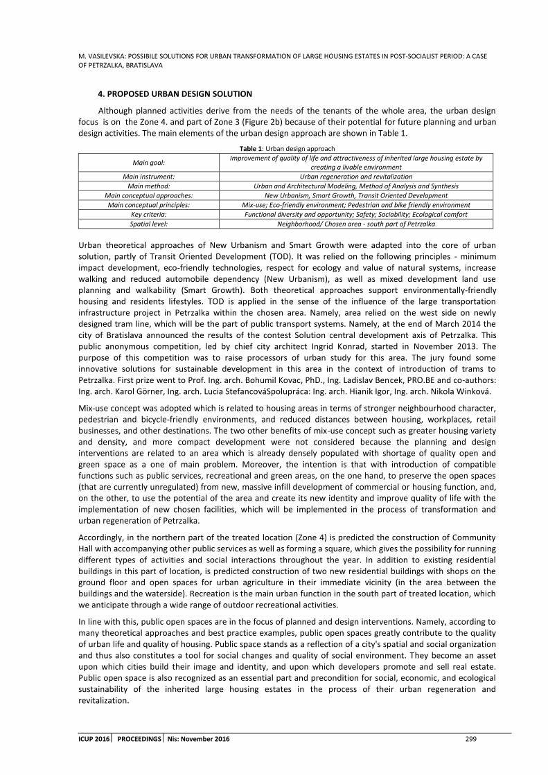
M. VASILEVSKA: POSSIBILE SOLUTIONS FOR URBAN TRANSFORMATION OF LARGE HOUSING ESTATES IN POST-SOCIALIST PERIOD: A CASE OF PETRZALKA, BRATISLAVA
ICUP 2016 PROCEEDINGS Nis: November 2016 299
4. PROPOSED URBAN DESIGN SOLUTION
Although planned activities derive from the needs of the tenants of the whole area, the urban design focus is on the Zone 4. and part of Zone 3 (Figure 2b) because of their potential for future planning and urban design activities. The main elements of the urban design approach are shown in Table 1.
Table 1: Urban design approach
Main goal: Improvement of quality of life and attractiveness of inherited large housing estate by
creating a livable environment
Main instrument: Urban regeneration and revitalization
Main method: Urban and Architectural Modeling, Method of Analysis and Synthesis
Main conceptual approaches: New Urbanism, Smart Growth, Transit Oriented Development
Main conceptual principles: Mix-use; Eco-friendly environment; Pedestrian and bike friendly environment
Key criteria: Functional diversity and opportunity; Safety; Sociability; Ecological comfort
Spatial level: Neighborhood/ Chosen area - south part of Petrzalka
Urban theoretical approaches of New Urbanism and Smart Growth were adapted into the core of urban solution, partly of Transit Oriented Development (TOD). It was relied on the following principles - minimum impact development, eco-friendly technologies, respect for ecology and value of natural systems, increase walking and reduced automobile dependency (New Urbanism), as well as mixed development land use planning and walkability (Smart Growth). Both theoretical approaches support environmentally-friendly housing and residents lifestyles. TOD is applied in the sense of the influence of the large transportation infrastructure project in Petrzalka within the chosen area. Namely, area relied on the west side on newly designed tram line, which will be the part of public transport systems. Namely, at the end of March 2014 the city of Bratislava announced the results of the contest Solution central development axis of Petrzalka. This public anonymous competition, led by chief city architect Ingrid Konrad, started in November 2013. The purpose of this competition was to raise processors of urban study for this area. The jury found some innovative solutions for sustainable development in this area in the context of introduction of trams to Petrzalka. First prize went to Prof. Ing. arch. Bohumil Kovac, PhD., Ing. Ladislav Bencek, PRO.BE and co-authors: Ing. arch. Karol Görner, Ing. arch. Lucia StefancováSpolupráca: Ing. arch. Hianik Igor, Ing. arch. Nikola Winková.
Mix-use concept was adopted which is related to housing areas in terms of stronger neighbourhood character, pedestrian and bicycle-friendly environments, and reduced distances between housing, workplaces, retail businesses, and other destinations. The two other benefits of mix-use concept such as greater housing variety and density, and more compact development were not considered because the planning and design interventions are related to an area which is already densely populated with shortage of quality open and green space as a one of main problem. Moreover, the intention is that with introduction of compatible functions such as public services, recreational and green areas, on the one hand, to preserve the open spaces (that are currently unregulated) from new, massive infill development of commercial or housing function, and, on the other, to use the potential of the area and create its new identity and improve quality of life with the implementation of new chosen facilities, which will be implemented in the process of transformation and urban regeneration of Petrzalka.
Accordingly, in the northern part of the treated location (Zone 4) is predicted the construction of Community Hall with accompanying other public services as well as forming a square, which gives the possibility for running different types of activities and social interactions throughout the year. In addition to existing residential buildings in this part of location, is predicted construction of two new residential buildings with shops on the ground floor and open spaces for urban agriculture in their immediate vicinity (in the area between the buildings and the waterside). Recreation is the main urban function in the south part of treated location, which we anticipate through a wide range of outdoor recreational activities.
In line with this, public open spaces are in the focus of planned and design interventions. Namely, according to many theoretical approaches and best practice examples, public open spaces greatly contribute to the quality of urban life and quality of housing. Public space stands as a reflection of a city's spatial and social organization and thus also constitutes a tool for social changes and quality of social environment. They become an asset upon which cities build their image and identity, and upon which developers promote and sell real estate. Public open space is also recognized as an essential part and precondition for social, economic, and ecological sustainability of the inherited large housing estates in the process of their urban regeneration and revitalization.
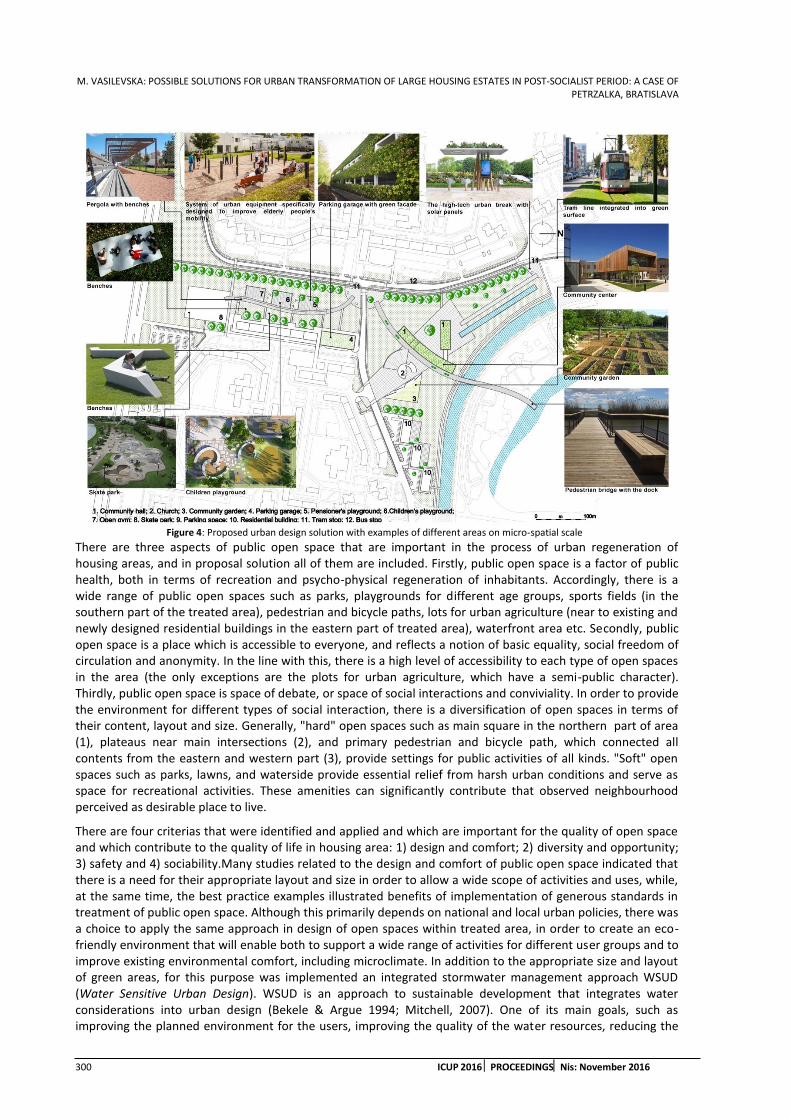
M. VASILEVSKA: POSSIBLE SOLUTIONS FOR URBAN TRANSFORMATION OF LARGE HOUSING ESTATES IN POST-SOCIALIST PERIOD: A CASE OF PETRZALKA, BRATISLAVA
300 ICUP 2016 PROCEEDINGSNis: November 2016
Figure 4: Proposed urban design solution with examples of different areas on micro-spatial scale
There are three aspects of public open space that are important in the process of urban regeneration of housing areas, and in proposal solution all of them are included. Firstly, public open space is a factor of public health, both in terms of recreation and psycho-physical regeneration of inhabitants. Accordingly, there is a wide range of public open spaces such as parks, playgrounds for different age groups, sports fields (in the southern part of the treated area), pedestrian and bicycle paths, lots for urban agriculture (near to existing and newly designed residential buildings in the eastern part of treated area), waterfront area etc. Secondly, public open space is a place which is accessible to everyone, and reflects a notion of basic equality, social freedom of circulation and anonymity. In the line with this, there is a high level of accessibility to each type of open spaces in the area (the only exceptions are the plots for urban agriculture, which have a semi-public character). Thirdly, public open space is space of debate, or space of social interactions and conviviality. In order to provide the environment for different types of social interaction, there is a diversification of open spaces in terms of their content, layout and size. Generally, "hard" open spaces such as main square in the northern part of area (1), plateaus near main intersections (2), and primary pedestrian and bicycle path, which connected all contents from the eastern and western part (3), provide settings for public activities of all kinds. "Soft" open spaces such as parks, lawns, and waterside provide essential relief from harsh urban conditions and serve as space for recreational activities. These amenities can significantly contribute that observed neighbourhood perceived as desirable place to live.
There are four criterias that were identified and applied and which are important for the quality of open space and which contribute to the quality of life in housing area: 1) design and comfort; 2) diversity and opportunity; 3) safety and 4) sociability.Many studies related to the design and comfort of public open space indicated that there is a need for their appropriate layout and size in order to allow a wide scope of activities and uses, while, at the same time, the best practice examples illustrated benefits of implementation of generous standards in treatment of public open space. Although this primarily depends on national and local urban policies, there was a choice to apply the same approach in design of open spaces within treated area, in order to create an eco-friendly environment that will enable both to support a wide range of activities for different user groups and to improve existing environmental comfort, including microclimate. In addition to the appropriate size and layout of green areas, for this purpose was implemented an integrated stormwater management approach WSUD (Water Sensitive Urban Design). WSUD is an approach to sustainable development that integrates water considerations into urban design (Bekele & Argue 1994; Mitchell, 2007). One of its main goals, such as improving the planned environment for the users, improving the quality of the water resources, reducing the

M. VASILEVSKA: POSSIBILE SOLUTIONS FOR URBAN TRANSFORMATION OF LARGE HOUSING ESTATES IN POST-SOCIALIST PERIOD: A CASE OF PETRZALKA, BRATISLAVA
ICUP 2016 PROCEEDINGS Nis: November 2016 301
negative impacts of stormwater and preserving ecosystems make that WSUD serves simultaneously and synergistically social, environmental and economic goals of urban regeneration of inherited housing areas. Beside the reduced the rainwater run-off (1) and (optionally) stop flooding in the area (2), the main drivers for implementation of this approach in chosen area are increase in green space (3), increase of biodiversity (4), reduce of the heat island effect (5), and improve the neighborhood image and aesthetics through the areas that also may be used for recreational purposes. Expected activities would be significant physical changes in existing infrastructure through creation of stormwater sustainable urban drainage system, focusing in this case, on the implementation of so called soft technical measures such as dry or wet swales (on the western part of the area and along the tram line on the northern border), bioretension, raingardens (on the eastern part), and porous pavement (main square, plateaus near main intersections, pedestrian paths).
5. CONCLUSION
With their layout, size, materialization, lighting etc., all public open spaces are safety for all users, equipped to facilitate active and passive surveillance. Whole solution is based on walkability, which is a key component of Smart Growth. By definition, walkable communities make pedestrian activity possible, thus expanding transportation options, and creating a streetscape that better serves a range of users - pedestrians, bicyclists, transit riders, and automobiles. To foster walkability, communities must ensure safe and inviting pedestrian corridors and open spaces, which was intention in this solution. A lot of benefits of pedestrian friendly housing areas can be expected at the individual and community level, in terms of lower transportation costs, greater social interaction, and improved individual and public health. In addition, reduce car usage and alternative transportation options at the planning and implementation (new tram line), the possibilities to sporting and leisure activities, play areas, public spaces, ecological building materials (Community Hall), solar panels (at the tram stops) etc. are just a few elements of design code which are prepared in order to support environmentally friendly housing and improving quality of lifestyles. In terms of social sustainability, the project promotes a greater sense of community through development programs and activities that promote social interaction and cultural enrichment (especially in northern part of area) supported by public space physical features (square, Community Hall). Following the good practice from other European cities like for example Polish town Lodz, it is the intention to improve the exterior of some down and dirty buildings, by putting murals on them. This idea can develop in future, and succeed in creating whole web of paintings with background story, and become another tourist attraction. On this issue it would be possible to cooperate with local art school students, and organize variety of competitions for the best project for murals. To face the problem of lack of parking places, the project proposes a cubic, multistoried garage with green walls and roof. Use of this technology will reduce spending on heating in winter and cooling in summer, improve air quality and aesthetics of the building. To eliminate spatial problem with megastore next to the church, this store will be relocated and become “less visible” by embedding into multistoried residential buildings at their ground floor.
ACKNOWLEDGEMENTS
This paper was realized under my stay in Bratislava as scholar within International Visegrad Fund in school year 2015/2016. The paper was partly developed within a broader research as an individual research under mentorship of Prof. Ing. arch. Maros Finka, STU Bratislava, and partly within semester project "Smart Cities for knowledge-based societies in CEE: Research and development scenario of Petrzalka" (supervisors: Prof. Ing. arch. Maros Finka, Doc. PhDr. Dagmar Petrikova andIng. Dejan Popovic) on STU Bratislava with my colleagues Margareta Banaszewska (Poland) and Quentin Chaillet (France). I am very gratefull for their support and help.
REFERENCES
1. Bekele, G, Argue, J.R. (1994) Stormwater management research in South Australia. Preprints Water Down Under, Adelaide, 1994, IEAust NCP 94/15, Vol 3, 305-311
2. Golubchikov, O., Badyina, A. and Makhrova, A. (Published “Online First” July 2013) The HybridSpatialities of Transition: Capitalism, Legacy and Uneven Urban Economic Restructuring, Urban Studies, DOI: 10.1177/0042098013493022
3. Hirt, S. (2012) Iron Curtains: Gates, Suburbs and Privatization of Space in the Post-socialist City. Blackwell.

M. VASILEVSKA: POSSIBLE SOLUTIONS FOR URBAN TRANSFORMATION OF LARGE HOUSING ESTATES IN POST-SOCIALIST PERIOD: A CASE OF PETRZALKA, BRATISLAVA
302 ICUP 2016 PROCEEDINGSNis: November 2016
4. Mitchell, V.G., Deletic, A., Fletcher, T.D, Hatt, B.E., McCarthy, D.T (2007) Achieving multiple benefits from stormwater harvesting, Water Science and Technology, 55 (4) 135-144
5. Petaccia, N. (2012). Petrzalka Case study. available: http://www.nicolapetaccia.com/petrzalka-case-study/
6. Salkind, N.J. and Neil, J. (1997). Exploring Research. Englewood Cliffs, NJ: Prentice Hall.
7. Sailer-Fliege, U. (1999). Characteristics of post-socialist urban transformation in East Central Europe. Geo-Journal, 49, 7e16.
8. Stanilov, K (2007) Housing trends in Central and Eastern European cities during and after the period of transition, in: K. Stanilov (Ed.) The Post-Socialist city: Urban Form and Space Transformation in Central and Eastern Europe after Socialism, pp. 173–190. London: Springer.
9. Szabová, S., Sausová, V., Sulíková, K., Stahlová, I., Osvaldová, D. (2014). Statistical yearbook of the capital of the Slovak republic Bratislava (2014). Statistical office of the Slovak republic - regional office of Bratislava
10. Tosics, I. (2004). Determinants and consequences of spatial change in Post-Socialist cities (Paper presented at the conference: “Winds of Societal Change: Remaking Post-Communist Cities” at the University of Illinois, Urbana-Champaign)
11. Tsenkova, S. (2006). Beyond transitions: Understanding urban change in postsocialist cities. In S. Tsenkova, & Z. Budic-Nedovic (Eds.), The urban mosaic of post-socialist Europe. Heidelberg:Springer.
12. Vasilevska, Lj., Milanovic, D., Nikolic, M., Vranic, P. and Milojkovic, A.: ''Garage capitalism'' as a form and process of urban changes: Its pace, intensity and structural characteristics. A case study of Nis, Serbia. Habitat International, Vol 48, 2015., pp. 149-158. DOI information: 10.1016/j.habitat int.2015.03.022
13. Urbanistická súťaz na riesenie centrálnej osi Petrzalky - súťazné návrhy. (2014). Available on www.bratislava.sk/urbanisticka-sutaz-na-riesenie-centralnej-osi-petrzalky-sutazne-navrhy/d- 11041755/p1=11049947

S. KONDIC ET AL: THE TREATMENT OF MULTI-FAMILY HOUSING IN URBAN PLANNING DOCUMENTS: CENTRAL ZONE OF NIS, SERBIA
ICUP 2016 PROCEEDINGS Nis: November 2016 303
THE TREATMENT OF MULTI-FAMILY HOUSING IN URBAN PLANNING DOCUMENTS: CENTRAL CITY ZONE OF NIS, SERBIA
Slavisa Kondic
University of Nis, Faculty of Civil Engineering and Architecture, Serbia PhD student, Assistant, [email protected]
Tanja Obradovic
Ministry of Construction, Transport and Infrastructure, Serbia PhD student, [email protected]
Mirko Stanimirovic
University of Nis, Faculty of Civil Engineering and Architecture, Serbia PhD student, Assistant, [email protected]
Milan Tanic
University of Nis, Faculty of Civil Engineering and Architecture, Serbia PhD, Assistant Professor, [email protected]
Ivan Kostic
University of Nis, Faculty of Civil Engineering and Architecture, Serbia PhD student, Assistant, [email protected]
ABSTRACT
Degradation of housing quality in contemporary market and investor oriented housing development in Serbia is evident. Inadequate public open spaces that are mainly used as parking lots, without spaces for socialization of tenants, low percentage of greenery, lack of parking space, inadequate insolation are only some of the effects of this degradation. Reduced housing quality is a result of a complex process influenced by economic, social and political factors. Urban planning documents had significant impact on this process. The treatment of multi-family housing in urbanistic plans is very important for the resulting housing quality. The aim of this research is to analyse the treatment of multi-family housing in urban planning documents in Nis, Serbia and determine correlation between urban parameters and housing quality. The most important urban parameters influencing housing quality were identified and analysed. After that, as the results of the research, recommendations for the improvement of future urbanistic plans were formulated.
Keywords: urban planning; multi-family housing; urban parameters; housing quality
1. INTRODUCTION
Political transition from communist to capitalist political system, and economical transition from centrally planned to market based economy in Serbia had significant social and spatial implications. Impoverishment and stratification of population, as a result of these changes, influenced considerable changes in urban planning and architectural design framework. Transition to democracy (systemic political change), markets (systemic economical change) and decentralized system of local governance were identified as a major drivers of urban change (Tsenkova, 2006).Government and markets are the two key determinants of social and spatial processes in this new environment (Nedovic-Budic, 2001).

S. KONDIC ET AL: THE TREATMENT OF MULTI-FAMILY HOUSING IN URBAN PLANNING DOCUMENTS: CENTRAL ZONE OF NIS, SERBIA
304 ICUP 2016 PROCEEDINGSNis: November 2016
Political crisis and conflicts in south-eastern European region had a considerable negative effects on the transition process in Serbia. Construction industry, as an important driver of economic development, and urban planning and architectural design, as its essential part, were severely affected. Lack of adequate legislative and government control and high degree of corruption, were the main problems in this area.
Housing development, as a means to satisfy a basic human need for dwelling, inevitably survived in this newly formed social and economic context. It even became a dominant portion of the construction industry, since there were no big investors or government funding for industrial and public buildings. But this new housing market had been primarily investor-oriented and profit-driven, without any regard for public or final user interest. Low construction and materials quality, as well as reduced quality of architectural design and functional organization of the apartment, often considerably influenced by the investors, were the main characteristics of this low competition housing market.
Changes in the economic system and land ownership required and conditioned significant changes in urban planning system. New urban legislative and documents were often unclear and low quality. The result of this process is degradation of urban environment and housing quality. Inadequate public open spaces that are mainly used as parking plots without spaces for socialization of tenants, low percentage of greenery, lack of parking space, inadequate insolation are only some of the effects of this degradation. In order to explore multi-family housing quality in the transition period in Serbia, it is necessary to consider its treatment in urban planning documents and determine their impact on achieved housing quality.
2. METHODOLOGY
This research had been conducted on the representative sample of multiple multi-family sites in the central zone of city of Nis, in Serbia. This area is within the scope of General Regulation Plan of City Municipality Medijana. The objective is to evaluate treatment of multi-family housing in urban planning documents and their impact on achieved housing quality, by analysis and on site observation.
At first, it is necessary to identify urban planning parameters that could influence housing quality. Following parameters were identified by analysis of urban planning documents:
Building typology
Housing density (observed through plot ratio)
Site coverage
Minimal distance between architectural structures (connected to insolation)
Parking solution (ratio between the number of parking spaces in open parking lots and garages)
Urbanistic regulation (regulation and construction lines, number of storeys, building height, recommended depth of construction…).
It is also necessary to identify the level of impact of specific parameters. Three basic impact levels were identified:
Urbanistic level (the quality of physical structure and the surroundings, including public open spaces)
Architectural structure level (achieved quality of architectural assembly)
Apartment level (impact on the quality of apartment (functional organization, daylight…).
The aim of the research is to determine positive and negative effects of urban planning parameters, and form the recommendations for their corrections in future urban planning documents in order to improve overall multi-family housing quality.
3. BUILDING TYPOLOGY
Building typology in earlier urban planning documents in Nis, since 2003, had never been precisely defined. Urban plans allowed all of the building types: detached, semi-detached, row and courtyard buildings. The choice of the building type depended of the approval of neighbours. If the investor wanted to build row or semi-detached building that would be positioned on plot border to neighbouring plot, he would need the approval of the neighbouring plot owner. This was unacceptable because urban planning and physical structure of the city had been left over to neighbours relationships and good will instead of urban planners. So, this requirement often became a blackmail mechanism. In many cases neighbours required substantial financial compensation for the consent.
New General Regulation Plan of City Municipality Medijana (GRP) from 2015 included building typology by urban blocks (Fig. 1).

S. KONDIC ET AL: THE TREATMENT OF MULTI-FAMILY HOUSING IN URBAN PLANNING DOCUMENTS: CENTRAL ZONE OF NIS, SERBIA
ICUP 2016 PROCEEDINGS Nis: November 2016 305
Figure 1: Building typology by urban blocks, General Regulation Plan of City Municipality Medijana 2015
This is great improvement compared to previous plans, but its application revealed some of the new problems. The scope of this general regulation plan is very large, and it is very difficult to consider every individual urban block and plot and appropriate building type for it. Planned building typology did not carefully consider land allotment and morphology of individual plots. There is a large number of plots with narrow street fronts in the central city area, with already formed row and courtyard physical structure. But for many of these blocks building typology layout requires detached or semi-detached buildings, with minimum required distances between buildings. This makes construction on a large number of plots impossible, requiring merging of several individual plots in one larger plot, in order to enable building construction.
This process opens up new problems between neighbours and investors and possibilities for extortions. Although general idea has been good, the realisation was flawed, and objectives and expected improvements were not achieved in many individual cases, where poorly perceived typology became prohibition of construction on a large number of plots.
In order to overcome this problem, the need for further urban elaboration of this area is needed. In GRP, the need of more detailed urban elaboration by urbanistic projects is already required. But building typology, so strictly defined by GRP, does not leave much possibility for improvisations that would correct these shortcomings. It can be concluded that defining building typology is generally necessary, in order to prevent spontaneous and chaotic urban development that is present in Nis in recent decades. But the realisation of this idea must be very carefully planned and detailed. The scope of GRP for the whole municipality is too large to define detailed building typology. It is necessary to provide some guidelines on this level, and to implement them through more detailed elaboration by detailed regulation plans or urbanistic projects. The role of urbanists and the Committee for urban plans in this process is of key importance.
This problem is very important, since building typology can have great impact on housing quality on all levels, urbanistic, architectural structure and apartment. It can also influence the profitability and feasibility of the investment.
4. HOUSING DENSITY
Housing density is generally thought of as primary urban parameter determining housing quality. Lower density is associated with higher quality and vice versa.
In urban planning documents in Serbia, housing density is usually expressed as a number of residents per hectare. This is a general planning parameter, used to define housing zones. GRP Medijana 2015 defines zones of small, medium, high density housing and commercial-residential zone (Fig. 2). But in the construction rules

S. KONDIC ET AL: THE TREATMENT OF MULTI-FAMILY HOUSING IN URBAN PLANNING DOCUMENTS: CENTRAL ZONE OF NIS, SERBIA
306 ICUP 2016 PROCEEDINGSNis: November 2016
for specific zones housing density, or the number of tenants, are not defined. The parameter defining density is plot ratio, the ratio between total gross area of the building and area of the plot. Higher plot ratio implies higher number of apartments and users, and therefore greater housing density. Maximal plot ratio ranges from 1.2 to 4.2, depending on the zone and plot area.
Figure 2: Land Use Layout, General Regulation Plan of City Municipality Medijana 2015
The tendency of the investors is to increase housing density and plot ratio, to make the investment more profitable. Larger density and the number of residents reduces the price of the building per resident. The lack of functional mechanism to control the number of residents makes this easier. The assumption is that the total built area defines the number of residents, because of the standards that define minimal apartment area per resident. But in practice, housing development does not comply this standards. As a consequence of general impoverishment, very often it is the case that actual number of the residents in the apartment is larger than the originally designed. Besides, only plot ratio appears as a parameter defining housing density, but it cannot precisely define the number of residents since it does not define actual size and structure of the apartments, but only total apartment area. In practice, because of the low financial potency of tenants, small and sub-standard area apartments appear very often. This, as well as larger number of residents than the originally planned, significantly increases housing density. (Kondic, 2015)
A. Koneski identifies too large area covered by average parameter value and lack of more precise and detailed elaboration in planning documents, as a key problem that allows legal manipulation with housing density values in lover ranking urbanistic plans (Koneski, 2009). Although it would take much more time, more detailed elaboration of urban parameters through detailed regulatory plans is desirable, since negative effects and urbanistic chaos arising from insufficiently defined urban parameters are much more durable.
5. SITE COVERAGE
The percentage of the plot covered by physical structure is referred as the site coverage parameter. This parameter is very important for housing quality, primarily on urbanistic level, since it defines the amount of public open spaces (POS) available for socialization and recreation of residents. So, the lower site coverage implies higher POS, and therefore housing quality.
On the other hand, General Urbanistic Plan of Nis 2010-2025 (GUP) defined maximal number of seven storeys above the ground, and all of the lower ranking plans are obligated to incorporate this parameter. Since the value of the land in central city area is substantial, it is required to increase density to make housing development profitable. Considering limitation in number of stories, the only possible method of increasing housing density is by increasing site coverage, thus reducing POS area, social interaction level, and housing quality in general. Thus, maximal site coverage in central city area, defined by GUP ranges from 60 to 80 percent. This process could have considerable negative implications and should be the subject of further, more detailed multidisciplinary research.

S. KONDIC ET AL: THE TREATMENT OF MULTI-FAMILY HOUSING IN URBAN PLANNING DOCUMENTS: CENTRAL ZONE OF NIS, SERBIA
ICUP 2016 PROCEEDINGS Nis: November 2016 307
6. MINIMAL DISTANCE AND URBANISTIC REGULATION
Minimal distance between buildings and urbanistic regulation are very important parameters defining physical structure of the city. These parameters are implying the quality of insolation and available POS. They are of key importance, because insolation has great impact on housing quality on all levels. Possible physiological and psychological implications of long term lack of adequate insolation can be very negative.
Urban plans in Nis adopted minimal distance parameter value of half of the higher building. This value was taken from general state building codes, and it is presumed to provide minimal required insolation for housing areas. However, this assumption could be questioned, since it does not take into account the position of higher building or orientation. East-west orientation requires larger distance between buildings than north-south. Also, if the higher building is in the south it requires larger minimal distance value than if it is in the north.
Urbanistic regulation has key importance for the quality of cities physical structure. However, in some cases, urbanistic regulation In GRP Medijana 2015 does not provide required minimal distances between buildings, and thus adequate insolation. One of such examples is Pasterova Street (Fig. 3).
Figure 3: Pasterova street Layout, General Regulation Plan of City Municipality Medijana 2015, photo: maps.google.com
The plan defined regulation lines and coinciding construction lines. Therefore, planned width of the street of 10.5m is at the same time planned distance between the buildings. However, the area on east side is defined as a medium density housing (five storeys, max. height of 20m) and the area on the west side as high density housing (seven storeys, max. height of 27m). So, the required minimal distance between buildings would be 13.5m, and due to planned street regulation it is impossible to comply. But this requirement is neglected if the area between buildings is public space (a street). In addition to inadequate insolation of the apartments, in this case we have an inadequate insolation and visual appearance of public space of the street.
The situation is even worst considering east-west disposition of physical structure, that requires larger distances between buildings, as well as exiting physical structure that is totally neglected. On the east side of the street, that is planned as medium density housing with maximum five storeys, existing structure consists of nine, up to sixteen storey multi-family housing buildings. It is unrealistic to expect them to be demolished in the near future. On the west side existing structure consists of one or two storey family houses, that will probably be demolished in the near future, and high density, seven storey multi-family buildings can be expected to be construct. So, in the near future we can expect 10.5 meter wide street with nine storey row building on the east and seven storey row building on the west side (according to building typology).
Considering previous analysis, significant degradation of public street space, and low quality physical structure development could be expected in Pasterova Street in the near future. This is good example of the impact of shortcomings in urbanistic plans can have a negative effect on housing and public space quality on all levels.
7. PERCENTAGE OF GREENERY
The percentage of greenery is very important urban parameter, implying the quality of POS and thus housing quality in general.This parameter defines ambience quality and hygienic conditions in public open spaces of residential developments.

S. KONDIC ET AL: THE TREATMENT OF MULTI-FAMILY HOUSING IN URBAN PLANNING DOCUMENTS: CENTRAL ZONE OF NIS, SERBIA
308 ICUP 2016 PROCEEDINGSNis: November 2016
General Urbanistic Plan of Nis 2010-2025 (GUP Nis) defined minimal percentage of greenery of min. 10% of the construction plot. However, this requirement had not been implemented in some of the lower ranking plans (like GRP Medijana 2012). It is unclear if this had been a mistake of intention to avoid this parameter. In the ne GRP Medijana from 2015 this mistake has been corrected and minimal percentage of greenery on construction plot has been defined. Parameter value of 10% had been taken from GUP Nis.
Although this generally is an improvement, considering previous plan, this percentage still is relatively low, especially for low and medium density housing areas. Considering obvious lack of public green areas in the city, this parameter value cannot provide adequate high quality housing ambience. That is why the increase of this parameter is necessary.
On the other hand, financial interest of the investors is one of the perquisites for housing development. Without investors interest there would be no housing development in contemporary housing market context. The increase of the percentage of greenery could jeopardize these interests. Considering low number of storeys allowed in GUP and large site coverage and density, there is not much available space left for necessary parking spaces on the lot.
In order to solve these problems future urbanistic plans must devote much more attention to the treatment of greenery. Percentage of greenery should be increased, but it is essential not to reduce available parking space. The use of grasscrete paving should be stimulated, as well as the use of planters and green roofs. That would have significant aesthetic, but also environmental and ecological effect. At present, these forms of greenery are not included in the required minimal percentage, so the investors do not have the interest in their application. By increase of minimal greenery percentage and including grasscrete pavers (as 40% greenery e.g.), green roofs and planters (planter with trees with even larger percent) it could be expected that the investors start to use these systems to compensate lack of green areas on the construction plots. This could have significant positive aesthetic and environmental effect.
8. PARKING SOLUTION
Adequate parking space is one of the most important parameters for housing quality. One parking space per apartment or per 70 square meters of usable commercial space is usual parameter value in urbanistic plans in Nis. However, this parameter does not consider the size of the apartment or the number of users. Larger apartments, with large number of users, usually need more parking space than smaller ones.
In some of the plans from recent years this parameter is different, allowing one parking spare per 70 square meters of the apartment. Considering average apartment size, that is a lot smaller than this value, it is obvious that the intention was to reduce required number of parking spaces. Resulting lack of parking spaces can significantly reduce housing comfort and quality.
Ratio between number of parking spaces in garages and in open parking lots is also an important parameter that could have large impact on public open spaces quality, and therefore housing quality in general. Higher ratio leaves more POS area for other purposes, social gathering sites and green areas, thus improving housing quality on urbanistic level. This parameter had not been implemented in many urbanistic plans in Nis in recent years.
But illegal conversion of the garages located on the ground floor is additional frequent problem. This conversion increases the need for parking space and reduces available parking space at the same time. This significantly reduces housing quality. Unclear legislative and high degree of corruption allow the investors to legalise this problematic behaviour.
9. CONCLUSION
The treatment of multi-family housing in urban planning documents is of essential importance for housing quality. Housing development, as a dominant form of construction, is influenced by urban legislation to a large degree. Through the analysis of urbanistic plans in Nis it had been determined that certain urbanistic parameters have significant effect on the quality of housing. Also, some of the potential problems had been identified. It is possible to formulate some basic recommendations for future urban planning documents:
Detailed elaboration through lower ranking plans (DRP) or urbanistic projects is often necessary. The scope of GUP and GRP is usually too large, so they can not define high quality planning solutions for every individual construction plot. Therefore many inconsistencies and mistakes can be identified in urbanistic plans that can have a serious negative effects on urban environment. This research

S. KONDIC ET AL: THE TREATMENT OF MULTI-FAMILY HOUSING IN URBAN PLANNING DOCUMENTS: CENTRAL ZONE OF NIS, SERBIA
ICUP 2016 PROCEEDINGS Nis: November 2016 309
identified several inconsistencies and illogical solutions in building typology and minimal distances between buildings. More detailed further research is expected to identify more potential problems. Although more detailed elaboration would take additional time, it is often necessary on order to improve quality of city development. Partial time compensation can be achieved through more efficient procedures of their adoption and implementation by the authorities. That way, through more precise elaboration of urban parameters for certain city areas, much better effects could be achieved, resulting in much higher quality housing development. Problems with increased housing density and overpopulation, as well as distances and bad urbanistic regulation could be resolved through more detailed urbanistic elaboration.
Limitation of the number of storeys in GUP, and the fact that the land in the central city area is a valuable resource whose value should not be decreased by inadequate urban parameters, has considerable negative effects on POS quality, and thus housing quality in general. Reduction of maximal site coverage could improve housing quality through larger available area for greenery and social gathering spaces in public open spaces. However, since land in the central city area is a valuable resource, its value should not be decreased by the reduction of construction area and plot ratio. That is why the number of storeys should be increased to compensate the reduction of site coverage.
More detailed elaboration of green areas in urban plans is necessary in order to improve housing quality. Minimal percentage of greenery should be increased, especially in lower density areas where defined minimal 10% is inadequate. Stimulation of the use of grasscrete paving, planters and green roofs could also be achieved by including them in green area percentage. This would significantly increase aesthetic, ambience and environmental quality of multi-family housing areas.
Parking solution is very important urban parameter affecting housing quality. Ratio between parking spaces in the garages, under or above ground and parking spaces on the plot is essential parameter, beside greenery percentage, that defines the manner of POS usage. More parking spaces in the garages leave more space for greenery and socialization spaces. Also, the prerequisite of one parking space per apartment should be reconsidered. For larger apartment structures with larger number of residents the larger number of needed parking spaces can be assumed.
Urban planning documents are of essential importance for the development of the city and its residential areas. That is why the quality of urbanistic plans and urban parameters is very important for housing quality. The implementation of these principles in future urbanistic plans could lead to some advancements in the future urban planning documents and increase of multi-family housing quality.
REFERENCES
1. Koneski A. 2010. Indikatori kvaliteta stanovanja u planskim dokumentima grada Nisa. Zbornik radova Gradjevinsko-arhitektonskog fakulteta, br. 25: 135-142
2. Koneski A. 2009. Odredjivanje gustine naseljenosti u planskim dokumentima grada Nisa. Nauka+Praksa, br 12.1: str.80-84
3. Kondic S., Tanic M., Mitkovic P., Nikolic V., Penic M. 2016 The influence of urban planning parameters on housing quality in multi-family residential areas in Nis, Serbia, Architecture. Construction. Education., No 1 (7), pp. 147-156.
4. Mitkovic P., Bogdanovic I. 2004. Open and recreational spaces as the parameters of dwelling quality. FACTA UNIVERSITATIS, Series: Architecture and Civil Engineering Vol. 3, No 1: 79 – 97
5. Mitkovic P., Bogdanovic I. 2005. Revitalization of Residential Complexes in the Context of Housing Quality Improvement. FACTA UNIVERSITATIS, Series: Architecture and Civil Engineering Vol. 3, No 2: 219 – 233
6. Nedovic-Budic Z. 2001. Adjustment of planning practice to the new Eastern and Central European context. Journal of the American Planning Association 67(1): 38-52
7. Tsenkova, S. 2006. Beyond Transitions: Understanding Urban Change in Post-socialist Cities. In Tsenkova, S. and Nedovic-Budic, Z. (eds) The Urban Mosaic of Post-socialist Europe. Heidelberg: Springer-Verlag, pp. 21-51
S. KONDIC ET AL: THE TREATMENT OF MULTI-FAMILY HOUSING IN URBAN PLANNING DOCUMENTS: CENTRAL ZONE OF NIS, SERBIA
310 ICUP 2016 PROCEEDINGSNis: November 2016
8. Vasilevska, Lj., Vranic, P. and Marinkovic, A. 2014. The effects of changes to the post-socialist urban planning framework on public open spaces in multi-story housing areas: A view from Nis, Serbia. Cities, Volume 36: 83–92
9. General Urbanistic Plan of Nis (2010-2025.) 2010.
10. General Regulatory Plans of Medijana Municipality 2012, 2
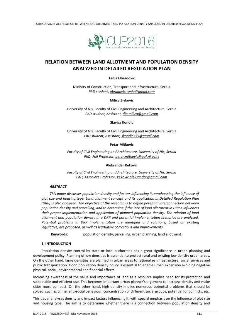
T. OBRADOVIC ET AL.: RELATION BETWEEN LAND ALLOTMENT AND POPULATION DENSITY ANALYZED IN DETAILED REGULATION PLAN
ICUP 2016 PROCEEDINGS Nis: November 2016 311
RELATION BETWEEN LAND ALLOTMENT AND POPULATION DENSITY ANALYZED IN DETAILED REGULATION PLAN
Tanja Obradovic
Ministry of Construction, Transport and Infrastructure, Serbia PhD student, [email protected]
Milica Zivkovic
University of Nis, Faculty of Civil Engineering and Architecture, Serbia PhD student, Assistant, [email protected]
Slavisa Kondic
University of Nis, Faculty of Civil Engineering and Architecture, Serbia PhD student, Assistant, [email protected]
Petar Mitkovic
Faculty of Civil Engineering and Architecture, University of Nis, Serbia PhD, Full Professor, [email protected]
Aleksandar Kekovic
Faculty of Civil Engineering and Architecture, University of Nis, Serbia PhD, Associate Professor, [email protected]
ABSTRACT
This paper discusses population density and factors influencing it, emphasising the influence of plot size and housing type. Land allotment concept and its application in Detailed Regulation Plan (DRP) is also analysed. The objective of the research is to define potential interconnection between population density and parcelling, and to determine if the lack of land allotment in DRP-s influences their proper implementation and application of planned population density. The relation of land allotment and population density in a DRP and potential implementation scenarios are analysed. Potential problems in DRP implementation are identified and solutions, based on existing legislative, are proposed, as well as legislative corrections and improvements.
Keywords: population density; parcelling; urban planning; land allotment.
1. INTRODUCTION
Population density control by state or local authorities has a great significance in urban planning and development policy. Planning of low densities is essential to protect rural and existing low density urban areas. On the other hand, large densities are planned in urban areas to rationalize infrastructure, social services and public transportation. Good population density policy is essential to enable urban expansion avoiding negative physical, social, environmental and financial effects.
Increasing awareness of the value and importance of land as a resource implies need for its protection and sustainable and efficient use. This becomes important urban planner’s argument to increase density and make cities more compact. On the other hand, high density implies numerous potential problems that should be solved, such as crime, anti-social behaviour, concentration of different social groups, potential for conflicts, etc.
This paper analyses density and impact factors influencing it, with special emphasis on the influence of plot size and housing type. The aim is to determine whether there is a connection between population density and

T. OBRADOVIC ET AL.: RELATION BETWEEN LAND ALLOTMENT AND POPULATION DENSITY ANALYZED IN DETAILED REGULATION PLAN
312 ICUP 2016 PROCEEDINGS Nis: November 2016
parcelling and whether the lack of land allotment in the detailed plans is affecting the proper implementation of the plans and applying the planned density in one area.
2. POPULATION DENSITY
The use of land, as a resource, needs to be carefully planned, not only for agricultural production, but also for a number of other functions such as building development, recreation, waste disposal, road construction etc.There is a need to define and measure population density, which can be used for strategic development planning as well as for proper land use. For planning purposes, the density is determined based on the number of residential buildings, dwellings or the number of inhabitants per hectare. However in the central urban areas it is usually defined throughthe plot ratio and site coverage indexes.
3. LAND ALLOTMENT
The layout plan of the plots and streets (parcelling plan) is an important part of housing and environmental planning. This is important information for urban planners helping them to produce better plans that result in sustainable construction and socially and economically stable environment. The street network provides a framework that connects different elements of land use and makes the skeleton that supports further development plan of building plots. Thus, the street and plot layout plans are inextricably linked and togethermake the whole, professionally called the parcelling plan.
4. DETAILED REGULATION PLAN
The main objective of implementation of detailed regulation plans in urban areas is to create healthy urban structure, to ensure the development and proper use of land as well as to regulate the use of private and public land.
Another important goal is to prevent improper, unplanned and illegal expansion of the city. Proper implementation of detailed regulation plans provides a positive change and urbanity to space. This way the cadastral parcels of irregular shape are transformed into proper building plots, the necessary infrastructureis installed and vertical and horizontal construction is regulated. Importance of well-designed and later correctly implemented detailed regulation planlies in fact that itprovides the final silhouette, shape and identity of the area.
In contrast to the earlier detailed plans, the detailed regulation plans do not include the parcelling plans. Therefore, through the process of implementation it is not possible to affect the final shape but only the size of a building plot. During the plan development, it is impossible to determine the exact number, shape and position of the building plots which will be formed in a plan covered area. This all together leads to a disturbance in population density. Correlation between number of formed building plots and population density will be analysed through the example of an urban area in the city of Nis.
5. CASE STUDY: DETAILED REGULATION PLAN OF A PART OF THE LOCAL COMMUNITY "OBILICEV VENAC" IN NIS (THE OFFICIAL GAZETTE OF THE CITY OF NIS, NO. 70/03)
This plan elaborates an area of 22,66 ha (Figure 1), divided into zone A (1,3,4,16,24-28 blocks) and zone B (2,5-15,17-23), which include different urban functions:
Urban housing with the density of 250-450 p/ha, with business premises (brown cross-hatching),
Urban housing with the density of 200-250 p/ha, with or without business premises (yellow hatching),
Public facilities of general interest: school, children's institutions and local office,
Public areas: greenery, parks, squares and streets.
The plan stipulates the basic principles of planning intervention:
reconstruction of the existing building stock with an increase in business functions,
to be in compliance with the existing traditional street-matrix,
harmonization of planned urban parameters and built physical structures and associated utility and infrastructure equipping.
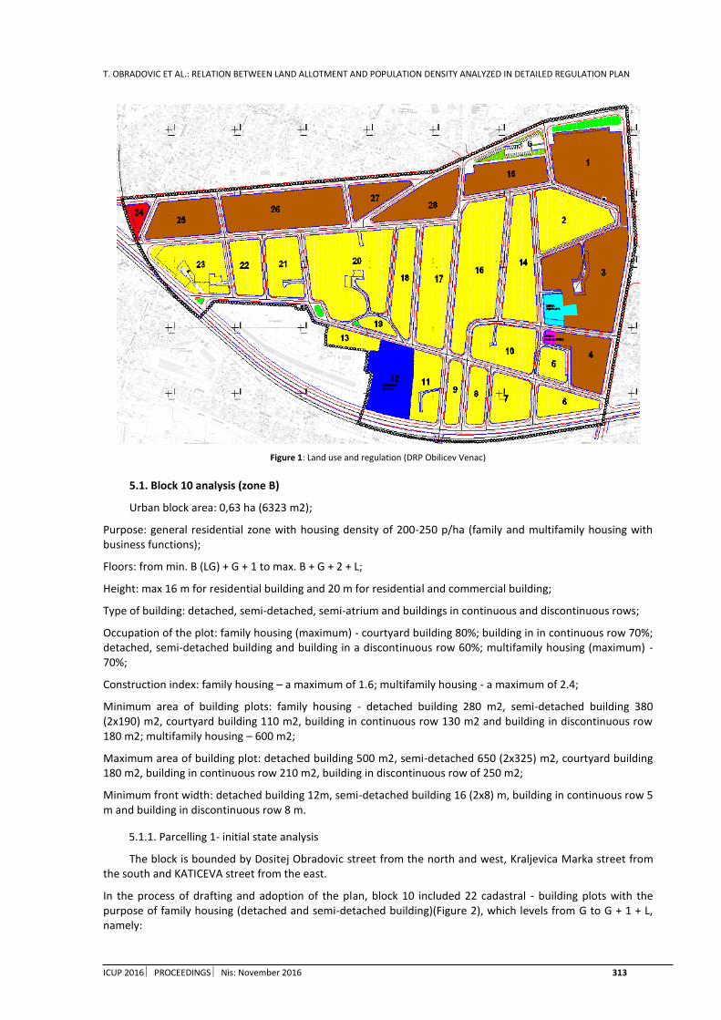
T. OBRADOVIC ET AL.: RELATION BETWEEN LAND ALLOTMENT AND POPULATION DENSITY ANALYZED IN DETAILED REGULATION PLAN
ICUP 2016 PROCEEDINGS Nis: November 2016 313
Figure 1: Land use and regulation (DRP Obilicev Venac)
5.1. Block 10 analysis (zone B)
Urban block area: 0,63 ha (6323 m2);
Purpose: general residential zone with housing density of 200-250 p/ha (family and multifamily housing with business functions);
Floors: from min. B (LG) + G + 1 to max. B + G + 2 + L;
Height: max 16 m for residential building and 20 m for residential and commercial building;
Type of building: detached, semi-detached, semi-atrium and buildings in continuous and discontinuous rows;
Occupation of the plot: family housing (maximum) - courtyard building 80%; building in in continuous row 70%; detached, semi-detached building and building in a discontinuous row 60%; multifamily housing (maximum) - 70%;
Construction index: family housing – a maximum of 1.6; multifamily housing - a maximum of 2.4;
Minimum area of building plots: family housing - detached building 280 m2, semi-detached building 380 (2x190) m2, courtyard building 110 m2, building in continuous row 130 m2 and building in discontinuous row 180 m2; multifamily housing – 600 m2;
Maximum area of building plot: detached building 500 m2, semi-detached 650 (2x325) m2, courtyard building 180 m2, building in continuous row 210 m2, building in discontinuous row of 250 m2;
Minimum front width: detached building 12m, semi-detached building 16 (2x8) m, building in continuous row 5 m and building in discontinuous row 8 m.
5.1.1. Parcelling 1- initial state analysis
The block is bounded by Dositej Obradovic street from the north and west, Kraljevica Marka street from the south and KATICEVA street from the east.
In the process of drafting and adoption of the plan, block 10 included 22 cadastral - building plots with the purpose of family housing (detached and semi-detached building)(Figure 2), which levels from G to G + 1 + L, namely:

T. OBRADOVIC ET AL.: RELATION BETWEEN LAND ALLOTMENT AND POPULATION DENSITY ANALYZED IN DETAILED REGULATION PLAN
314 ICUP 2016 PROCEEDINGS Nis: November 2016
Three buildings with height of G + 1 + L – 3 buildings x 2 flats = 6; 6x4 = 24 inhabitants
19 one-storey buildings – 19 buildings x 4 = 76 residents
Figure 2: The regime of land use (DRP Obilicev venac)
Taking into account the surface of the block (0,63ha), a total of about 100 residents in the block 10 means that there were about 160 inhabitants per hectare.
Figure 3: Block 10 – Photo documentation (Photo by T. Obradovic)
5.1.2. Parcelling 2- research by the authors
Second, but almost impossible variant, in accordancewith urban plan indicators, is the maximal plot occupancy, i.e. edge line construction of multifamily buildings with the maximum number of storeys ofB + G + 2 + L. Hypothetically,this is possible if an investor buys all the parcels in the block and builds the complex. This kind of planning and implementation was typical for the period until 2003, when the state was the owner of the land and block construction was planned and implemented on site. This scenario is also possible if a system of urban land readjustment would be implemented.
The analysis leads to the following conclusion:

T. OBRADOVIC ET AL.: RELATION BETWEEN LAND ALLOTMENT AND POPULATION DENSITY ANALYZED IN DETAILED REGULATION PLAN
ICUP 2016 PROCEEDINGS Nis: November 2016 315
With the respect to the site coverage (max. 70%) and the plot ratio (max. 2.4), 13 multifamily buildings with the size of 18 x 14 m are obtained. If the office space on the ground floor and 4 flats on the typical floorare planned, we get 3 x 4 = 12 flats in one building; 13 x 12 = 156 flats, a total of 156 x 4 = 624 inhabitants, which still means 990 p/ha.
Figure 4: Block 10 - Parcelling 2, research project
5.1.3. Parcelling 3 - current situation analysis
Since the adoption of the plan in 2003 till today, three building plots are formed on the subject area (block 10), containing multi-family housingbuildings with or without commercial functions. Formed building plots are of irregular shape (Figure 5), with a maximum site coverage and plot ratio, without greenery and required parking places for the residents (all sidewalks are occupied by cars).
Figure 5: Block 10 - Parcelling on site
Building plot 1- two entrances, 17+19=36 flats; 36x3=108 inhabitants.
Building plot 2- 20 flats; 20x3=60 inhabitants.
Building plot 3- 40 flats; 40x2=80 inhabitants.
Total of 248 inhabitants on three newly formed plots.
The rest- 13 mainly terrestrial and one storey houses have 13 x 4 = 42 inhabitants.
The foregoing shows that the block 10 currentlyhas 290 inhabitants in the area of 0.63 ha (i.e. 460 p/ha).
Taking into account that this represents the central zone and that the other buildings in the block have poor worthiness, in further period the population growth through the development of multi-family buildings can be expected. Currently, the number of 460 p/ha exceeds the plan derived average net density of 432 p/ha (Table 1).
Table 1: Derived urban parameters (DRP Obilicev venac)

T. OBRADOVIC ET AL.: RELATION BETWEEN LAND ALLOTMENT AND POPULATION DENSITY ANALYZED IN DETAILED REGULATION PLAN
316 ICUP 2016 PROCEEDINGS Nis: November 2016
a Gross housing density 328
b Net housing density 432
c Plot ratio - gross 1,43
d Plot ratio - net 1,88
e Site coverage - gross 36%
f Site coverage - net 47,6%
6. CONCLUSION
The parcelling process conducted nowadays usually means that every investor perceives only hisplot and tries to utilize it as much as possible, without any regard for the aesthetics and without considering the neighboring plots or builtentirety. New construction impairsthe old identity of space but does not form a new one. One gets the impression that every building is architecture for itself (if any), without any concern of public and common interest, so the purpose and existence of urban planningis completely lost. However, apart from the above, the parcelling is closely associated with disorders that accompany population growth reflected in inadequately distributed density or values completely beyond the planned housing density.
From the presented case studyit can be concluded that this influence is present in the central (already built) zones as well as in the suburban undeveloped areas. In the case of family housing, the deviation from the plani.e. planned density is less pronounced, but this does not diminish other negative effects primarily aesthetic and qualitative, as well as inadequate use of the land.
In addition, without any clearly defined land allotment, it is impossible to predict the exact number of people (or at least approximate) because there are a lot of input variables. This is especially noticeable in the central zones, as plangives the possibility of both family and multi-family construction. Despite the fact that plan defines all other urban parameters, the absence of clear division of land in plans and their partial implementation lead to a significant disbalance in population density. Density is usually defined in strategic higher ranking urban plans, but it cannot be successfully implemented due to the lack of land allotment in lower ranking plans.
The solution for the proper implementation of plans and the formation of a coherent urban structure is to implement the allotment plan into detailed plans. This can be achieved through a system of urban land readjustment. The result would be a high-quality urban, ownership and infrastructure arrangement of building plots.
REFERENCES
1. Arvantis, A. and Balla, E., 2005. Some technical, legal, financial and social issues of Land Readjustment (An approach of modelling the Greek LR procedure), COST ACTION G9 Modelling Real Property Transactions, Stockholm.
2. Detailed regulation plan of a part of the local community “Obilicev Venac” in Nis (the Official Gazette of the city of Nis, no. 70/03)
3. Viitanen, K., 2001. The Finnish Urban Land Readjustment Procedure in an International Context: What Can Be Learned Commonly. “Tools for Land Management and Development: Land Readjustment, Lincoln Institute of Land Policy, Cambridge, Massachusetss.
4. Law on Planning and Construction, 2014. Official Gazette of the Republic of Serbia, no. 145/14
5. Мeindl, R., 2002. Land Reallocation in Cities on the basis of the German Federal building Code, International Conference on Land Management and Land Readjustment as tools of Urban Planning in Developing Areas, Cyprus.
6. Müller-Jökel, R., 2004. Land Readjustment – A Win-Win-Strategy for Sustainable Urban Development, FIG Working Week, Athens, Greece.
7. Sisko, D., Roic, M., 2007. Pristupi preraspodjele gradjevinskog zemljista, Symposium on Engineering Geodesy, SIG2007

M. PENIC: URBAN REGENERATION OF DOCKLAND: BORNEO SPORENBURG, AMSTERDAM
ICUP 2016 PROCEEDINGS Nis: November 2016 317
URBAN REGENERATION OF DOCKLAND: BORNEO SPORENBURG, AMSTERDAM
Milja Penic
Faculty of Civil Engineering and Architecture, University of Nis, Serbia student, [email protected]
ABSTRACT
The docks and coastal areas of large cities are one of the important examples of degraded areas whichprogressively lost their functional value and become abandoned spaces, due to the evolution of industrialization and traffic. One of important examples of such areas are Borneo and Sporenburg peninsulas, a part of Eastern Docklands in the wider centre of Amsterdam. City Council of Amsterdam made a decision that the Eastern Docklands become residential area, and Group of architects West 8 made a master plan for conversion of Borneo Sporenburg docks into a residential area with high density housing.
Regeneration of Borneo Sporenburg peninsulas represents a combination of development of local economy and the local market, improving housing quality in the wider city centre, encouraging tourism and development of urban and architectural thought. Project of Borneo Sporenburg settlement offers an innovative approach to the modern trend of housing in urban zone of the city instead of the suburbs, takes the principles of living comfort, privacy and securityfrom the classical model of 'suburbs' and creates communities with a small frequency of vehicular traffic.
Keywords: urban regeneration; Eastern Dockland; coast; Borneo Sporenburg; conversion.
1. INTRODUCTION
Urban regeneration or urban renewal of urban complex in the broader sense is a term that includes a complete and complex process of restoration of degraded physical structure of a smaller or larger part of the city, but also its social structure. In this sense, urban regeneration is an effort to stop urban degradation and weakening of urban structures that arise as a consequence of a general degradation of the ecological and social conditions of people's lives (Caldarovic, 2010). The docks and coastal areas of large cities are one of the important examples of degraded areas whichprogressivelylost their functional value and become abandoned spaces due to the evolution of industrialization and traffic. Most commonly these spaces are located near the central city area and therefore represent a significant spatial and social potential, and since the early 80s, they become the subject of urban regeneration (Kloosterman, 2009). A pioneering example is the renovation of coastal area in London, which represents a comprehensive reconstruction on the level of city districts which started back in the early 80s. This principle of regeneration of coastal area and docks continued in many other big cities, including the Amsterdam.
The subject of this paper is urban regeneration of coastlands through case study of Borneo Sporenburg, a project that represents the architectural renewal of the community, built on the site of the former Eastern Docklands in Amsterdam. The aim of this specific project and venture was the reversal of trend of development of dense urban core by creating a high-density housing in wider city centre. Landscape architects West 8, Rotterdam, have done masterplan which includes two large docks: Borneo and Sporenburg.
2. SOCIAL AND ECONOMIC CAUSES OF URBAN REGENERATION OF BORNEO SPORENBURG PENINSULAS
In the period that preceded the decision on conversion of the Eastern Docklands, Amsterdam was facing a big problem of poverty and unemployment in the town centre. Post-industrial phenomenon caused enormous differences between the new well-paid people in high-tech industries and low-paid and unemployed people who have lived on the edge of existence. In the period after World War II it came to the deterioration of the Eastern Docklands, and a large numbers of people employed by the pier loses their jobs. As a result of all these
M. PENIC: URBAN REGENERATION OF DOCKLAND: BORNEO SPORENBURG, AMSTERDAM
318 ICUP 2016 PROCEEDINGSNis: November 2016
circumstances in Amsterdam, inner city core became a ghetto for the poor, minorities and immigrants, and area of abandoned Eastern Docklands becomes a European example of the degradation of the area under the pressure of economic and social circumstances (Kloosterman, 2009).
In the seventies and eighties wealthy people did not live in the centre of Amsterdam, but they settled at the elite parts of the city that were away from the centre, at then popular principle. The growth of the national economy in the nineties marked a sudden boom in private building development, and it was becoming increasingly popular to live in the old part of the city. (De Maar, 1999)
The City Council of Amsterdam in 1975 made a decision that the Eastern Docklands become residential area, due to their favourable position relative to the city centre (Figure 1). Following the concept of a densely built city, it had been decided for a density of 100 dwellings per hectare and to settle 18,000 people in this area. City Council of Amsterdam and the local authority were keen to maximise the potential for the existing docks area, Eastern Docklands were divided into several zones, and each zone had its own urban planning regulations and controlled development phases lasted over 20 years. Each neighbourhood was built over a period of five years, starting in 1985 with the district of Abattoir (1985–1992), followed by Entrepot, KNSM Island (1990–1995), Java Island (1994–2001), Borneo-Sporenburg (1997–2002) and Rietlanden (1998–2003) (Cousins, 2008).
Figure 1: The position of docks Borneo Sporenburg on a map of Amsterdam
3. SUSTAINABLE DEVELOPMET PLAN OF BORNEO AND SPORENBURG PENINSULAS
3.1. General information about the project
BorneoSporenburg is housing development built on the area of two peninsulas that were part of the Eastern Docklands, located in the eastern part of the wider centre of Amsterdam. Urban design of the Borneo Sporenburg included a masterplan, the typology of the building construction, architectural supervision, three bridges and organization of green and public spaces. Two peninsulassurrounded by aport landscapes and canals, were turned into residential areas, with high density: 100 units per hectare, 2,500 housing units, inspired by the architecture of the Dutch heritage. As part of the project, 60 plots were sold and intended for private building, which had to comply with the recommendations given in master plan (Abrahamse, 2003).
CLIENTS: Gemeente Amsterdam, Lord Major Stadig, Grondbedrijf Amsterdam, New Deal
DESIGN: 1993 – 1996. West 8 urban design & landscape
Architects: Adriaan Geuze, Wim Kloosterboer, Yushi Uehara, Sebastiaan Riquois
Master plan of the settlement Borneo-Sporenburg was created by a group West 8, an international team for urban design and landscape architecture, which was founded by Adriaan Geuze in 1987 in Rotterdam. Group West 8 consists of 75 architects, urban designers, landscape architects and industrial engineers. Borneo Sporenburg settlement is their most famous project, for which they received several awards.
4.2. Location
Borneo-Sporenburg is located in the east of Amsterdam, in the area of the Eastern Docklands. During the 1970s this area settledvagrants and the city homeless, but also artists. Thousands of them created an alternative communityin this area, and majority of them left during the eighties when renewal of the whole pierbegan. However, many artists remained and contributed to the current atmosphere in the area.
Peninsulas Borneo and Sporenburg have specific geographical characteristics and form ofelongated ‘pieces’ of land which are separated from the continental part of the city and 'dive' into the expanse of water, like two fingers. They are located near the centre of the city, and are the great potential of the city in a broad context.

M. PENIC: URBAN REGENERATION OF DOCKLAND: BORNEO SPORENBURG, AMSTERDAM
ICUP 2016 PROCEEDINGS Nis: November 2016 319
This space could be used in many cost-effective ways, but housing attractive to tourists was the choice (Abrahamse, 2003). Tourism is very developed industry in Amsterdam, and this location had been used so that it represents a tourist attraction in a specific way. Views from Borneo and Sporenburg peninsulas towards the centre and towards the water are one of the major qualities of the location. The settlement Borneo Sporenburg is designed as luxury housing.
Specific features of the location determined the direction of designing a master plan, and the group West 8 detailed and carefully used all of its benefits. In the area of Borneo and Sporenburg peninsulas a traffic network already existed that led to the perimeter of the settlement, and imposed a traffic solution inside the settlement.
4.3. Master plan
Group West 8 master plan had been designed by the unique approach to fulfilling the usual demands for single-family houses: a large private space, secure parking, security and individuality. West 8 successfully transferred the comfort of life which is usually associated with the suburbs - low-density housing, to urban area of Amsterdam and fulfilled all requirements of a conventional household through the project (Geuze, 1995). Master plan defined a set of strict, but well-conceived and clear rules for further elaboration of the plan on individual lots, including guidelines for positioning streets and parking, private outdoor space, storey height and plot width (Figure 2a).
Rows of family houses are interrupted by large residential buildings set diagonally to the street (Figure 2b). Three main elements characterize the design (Höger):
The first characteristic element are "back to back" three-story houses that represent the rich architecture of the well-known domestic and foreign architects; this includes 60 individual private houses built in accordance with the guidelines of the project. The concept involved the reinterpretation of traditional Dutch houses in a row. Due to the high density, open spaces and green areas are reduced compared to the occupancy of the terrain, and integrated into the housing unit where 30-50% of the area of the house is designed as an open space such as roof gardens, courtyards and terraces.
The second element are three large buildings that represent the sights of settlement and provide more urban character to the area. Residential building Pacman is designed by architect Koen van Velsen and is located on Borneo peninsula; a residential building "The Whale" or "The Sphinx" work of architect Frits van Dongen, is located on the peninsula Sporenburg. The third residential building is "Fountainhead" that was originally supposed to be designed by Steven Holl and later was assigned to Kees Christiaanse. According to the master plan it supposed to be located on Sporenburg peninsula, and in 2003 it was excluded from the plan. These multi-storey residential buildings with high density of housing have become height benchmarks of settlement, with good views towards the city centre.
The third major element are three pedestrian bridges that have an important role in creating the atmosphere in this harbour-residential zone. Two bridges are 93m long and connect Sporenburg and Borneo peninsulas, and the third extends 25m above the inner harbour.
(a) (b) Figure2: (a) Master plan of settlement Borneo-Sporenburg, authors West 8; (b) Graphic schemes showing the position of family houses,
apartment blocks and public spaces (source: Geuze, 1995)
Additional quality of housing is reached by the urban composition unity with a special relationship to the dockland area, as well as the architectural organization of the typology of residential buildings and houses. In accordance with the city’s decision and urban policy, master plan has a high density of housing, about 100 units

M. PENIC: URBAN REGENERATION OF DOCKLAND: BORNEO SPORENBURG, AMSTERDAM
320 ICUP 2016 PROCEEDINGSNis: November 2016
per hectare. It consists of two peninsulas, Borneo and Sporenburg, which are interconnected via three bridges for pedestrians and bicyclists.
4.4. Traffic
Settlement is linked with other parts of the city along the main road that comes from the city centre to the western part of BorneoSporenburg settlement. Smaller roads branch off the main road and lead to housing units and parking (Figure 3). Residential streets in the settlement are minimum width, but maximum efficient because the parking on the street is reduced to minimum, only for the visitors of the settlement. Parallel to the streets are pedestrian sidewalks, and by the street that goes around the perimeter of the peninsula, near the water, between the sidewalk and street are bike paths. The Netherlands is known for its bicycle traffic, so this domain of traffic is carefully arranged.
Figure3: Traffic scheme showing the vehicular traffic within the settlement and traffic connections with the rest of the city (source: Höger)
One of the important principles on which was made master plan was that residents do not use streets for parking but that parking be within the residential units, in order to provide additional comfort and safety of home. This principle resulted in solving parking for individual houses by partial digging of garages above which is a ground floor elevated from ground level, and for residential buildings by digging in large underground garages beneath the ground floor of buildings. (Höger) In this manner is possible that streets are arranged for low frequent vehicular traffic and for the maximum pedestrian frequency. For visitors of the settlement parking is solved in some places along the street.
Public transportation that connects settlement with the rest of the city is resolved by bus lines, subway and tram lines. Metro and tram only touch the settlement in the north-western part, and bus lines go through the part of the settlement on Borneo peninsula. Reducing of public transport through the BorneoSporenburg settlement was necessary due to the priorities of dense construction, but it did not diminish the quality of housing because it is a settlement which does not require a dense network of public transport due to its area and development.
Urban plans of settlement suggest pedestrian mobility, wide paths are creating a dense network which covers every part of the settlement. These principles of encouraging pedestrian traffic is underlined not only by the master plan, but also by sculptural design of three pedestrian bridges that connect Sporenburg and Borneo peninsulas (Geuze, 1995). These red steel bridges have become a recognizable symbol of Borneo Sporenburg settlement (Figure 4).
Figure4: Pedestrian bridges - Sculptures between Borneo & Sporenburg peninsulas
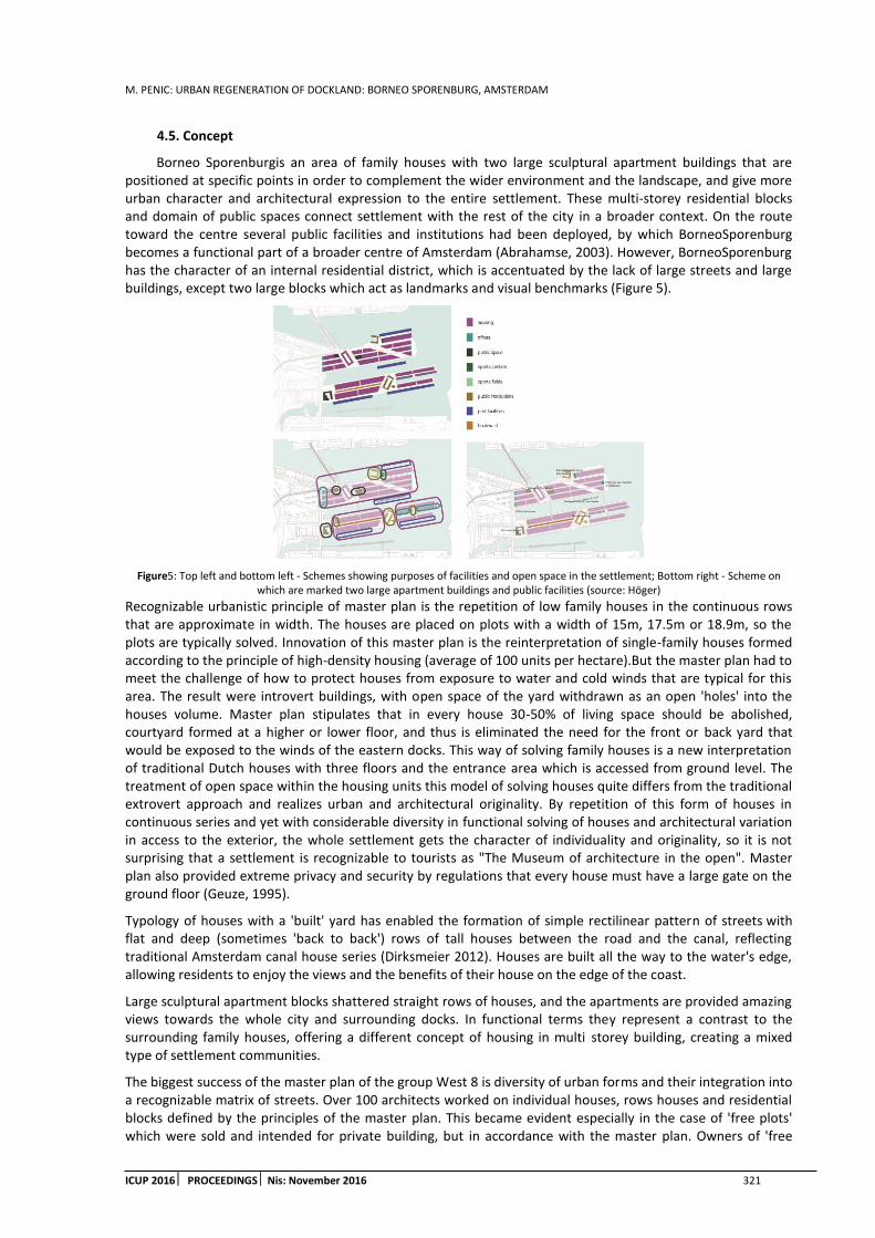
M. PENIC: URBAN REGENERATION OF DOCKLAND: BORNEO SPORENBURG, AMSTERDAM
ICUP 2016 PROCEEDINGS Nis: November 2016 321
4.5. Concept
Borneo Sporenburgis an area of family houses with two large sculptural apartment buildings that are positioned at specific points in order to complement the wider environment and the landscape, and give more urban character and architectural expression to the entire settlement. These multi-storey residential blocks and domain of public spaces connect settlement with the rest of the city in a broader context. On the route toward the centre several public facilities and institutions had been deployed, by which BorneoSporenburg becomes a functional part of a broader centre of Amsterdam (Abrahamse, 2003). However, BorneoSporenburg has the character of an internal residential district, which is accentuated by the lack of large streets and large buildings, except two large blocks which act as landmarks and visual benchmarks (Figure 5).
Figure5: Top left and bottom left - Schemes showing purposes of facilities and open space in the settlement; Bottom right - Scheme on which are marked two large apartment buildings and public facilities (source: Höger)
Recognizable urbanistic principle of master plan is the repetition of low family houses in the continuous rows that are approximate in width. The houses are placed on plots with a width of 15m, 17.5m or 18.9m, so the plots are typically solved. Innovation of this master plan is the reinterpretation of single-family houses formed according to the principle of high-density housing (average of 100 units per hectare).But the master plan had to meet the challenge of how to protect houses from exposure to water and cold winds that are typical for this area. The result were introvert buildings, with open space of the yard withdrawn as an open 'holes' into the houses volume. Master plan stipulates that in every house 30-50% of living space should be abolished, courtyard formed at a higher or lower floor, and thus is eliminated the need for the front or back yard that would be exposed to the winds of the eastern docks. This way of solving family houses is a new interpretation of traditional Dutch houses with three floors and the entrance area which is accessed from ground level. The treatment of open space within the housing units this model of solving houses quite differs from the traditional extrovert approach and realizes urban and architectural originality. By repetition of this form of houses in continuous series and yet with considerable diversity in functional solving of houses and architectural variation in access to the exterior, the whole settlement gets the character of individuality and originality, so it is not surprising that a settlement is recognizable to tourists as "The Museum of architecture in the open". Master plan also provided extreme privacy and security by regulations that every house must have a large gate on the ground floor (Geuze, 1995).
Typology of houses with a 'built' yard has enabled the formation of simple rectilinear pattern of streets with flat and deep (sometimes 'back to back') rows of tall houses between the road and the canal, reflecting traditional Amsterdam canal house series (Dirksmeier 2012). Houses are built all the way to the water's edge, allowing residents to enjoy the views and the benefits of their house on the edge of the coast.
Large sculptural apartment blocks shattered straight rows of houses, and the apartments are provided amazing views towards the whole city and surrounding docks. In functional terms they represent a contrast to the surrounding family houses, offering a different concept of housing in multi storey building, creating a mixed type of settlement communities.
The biggest success of the master plan of the group West 8 is diversity of urban forms and their integration into a recognizable matrix of streets. Over 100 architects worked on individual houses, rows houses and residential blocks defined by the principles of the master plan. This became evident especially in the case of 'free plots' which were sold and intended for private building, but in accordance with the master plan. Owners of 'free

M. PENIC: URBAN REGENERATION OF DOCKLAND: BORNEO SPORENBURG, AMSTERDAM
322 ICUP 2016 PROCEEDINGSNis: November 2016
plots' were free to choose with which architects want to work with from a long list of architects which was compiled by the group West 8 and to build a house within the guidelines given by the master plan. The resulting visual vitality and expression of personal identity, both of architects and residents of this settlement, is one of the most successful aspects of the master plan of West 8 group.
4.6. Free spaces and greenery
Open areas that are designed for larger number of users are public open spaces or gardens of large housing blocks (Figure 6). Public open spaces are reduced due to the high population density and due to the inclusion of water as open space. There is only one large open space with plants intended for public use and it is located on Sporenburg peninsula. In addition, there are two large green areas within the blocks of Pacman and the Whale. Private outdoor spaces as part of family houses are usually solved within the volume of houses, and although their surfaces have to be reduced due to the basic requirements of the project the unit is solved with enough open space area.
Figure6: The scheme shows the distribution of private and public open spaces in the settlement Borneo Sporenburg (source: Höger)
Two large apartment blocks are solved by edge building, and thus is obtained space in the building for the courtyard with greenery and large surfaces for playgrounds and recreation. Although this is densely built settlement, the free open spaces along the streets were taken into account (Geuze, 1995). A small residential streets through settlement are with minimal width, and although they are open for traffic, by the treatment and the materialization one gets the impression that these are broad walkways through the settlement, and thus provides a sense of unity of open space and surrounding houses to visitors and residents (Figure 7).
Figure7: Top left - The courtyard of apartment block The Whale; Top right and bottom right - Segments of open spaces along the roads; Bottom left - pedestrian bridge over the inner harbour
In such a densely built settlement it was not easy to incorporate green areas, but the master plan included the maximum use of free space for that purpose. Master plan envisages plenty of greenery along the streets, often as the spaces between the streets and sidewalks, filled with grass, shrubs and rows of trees. On Sporenburg peninsula is the largest green area in the settlement park, which obliquely extends over the entire width of the peninsula. The park is open on both sides to water and leads to one of the sculptural pedestrian bridges designed by a group West 8. In the park there are playgrounds and recreation spaces, plenty of high greenery
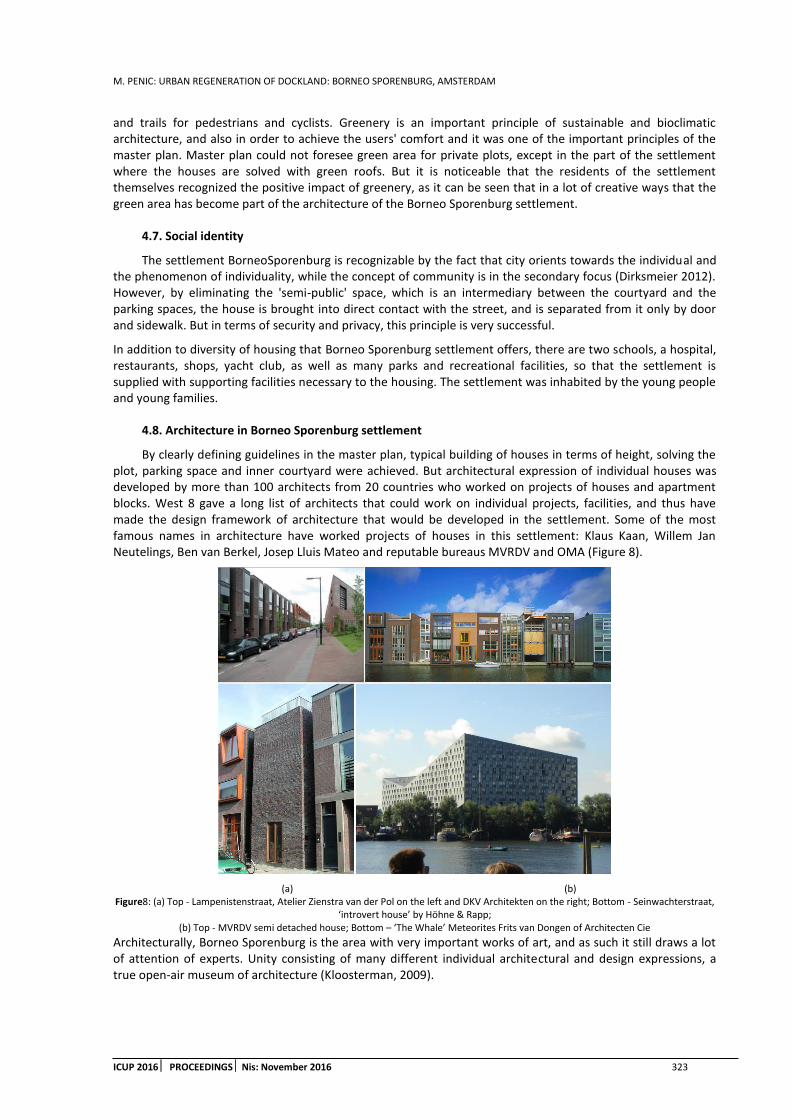
M. PENIC: URBAN REGENERATION OF DOCKLAND: BORNEO SPORENBURG, AMSTERDAM
ICUP 2016 PROCEEDINGS Nis: November 2016 323
and trails for pedestrians and cyclists. Greenery is an important principle of sustainable and bioclimatic architecture, and also in order to achieve the users' comfort and it was one of the important principles of the master plan. Master plan could not foresee green area for private plots, except in the part of the settlement where the houses are solved with green roofs. But it is noticeable that the residents of the settlement themselves recognized the positive impact of greenery, as it can be seen that in a lot of creative ways that the green area has become part of the architecture of the Borneo Sporenburg settlement.
4.7. Social identity
The settlement BorneoSporenburg is recognizable by the fact that city orients towards the individual and the phenomenon of individuality, while the concept of community is in the secondary focus (Dirksmeier 2012). However, by eliminating the 'semi-public' space, which is an intermediary between the courtyard and the parking spaces, the house is brought into direct contact with the street, and is separated from it only by door and sidewalk. But in terms of security and privacy, this principle is very successful.
In addition to diversity of housing that Borneo Sporenburg settlement offers, there are two schools, a hospital, restaurants, shops, yacht club, as well as many parks and recreational facilities, so that the settlement is supplied with supporting facilities necessary to the housing. The settlement was inhabited by the young people and young families.
4.8. Architecture in Borneo Sporenburg settlement
By clearly defining guidelines in the master plan, typical building of houses in terms of height, solving the plot, parking space and inner courtyard were achieved. But architectural expression of individual houses was developed by more than 100 architects from 20 countries who worked on projects of houses and apartment blocks. West 8 gave a long list of architects that could work on individual projects, facilities, and thus have made the design framework of architecture that would be developed in the settlement. Some of the most famous names in architecture have worked projects of houses in this settlement: Klaus Kaan, Willem Jan Neutelings, Ben van Berkel, Josep Lluis Mateo and reputable bureaus MVRDV and OMA (Figure 8).
(a) (b) Figure8: (a) Top - Lampenistenstraat, Atelier Zienstra van der Pol on the left and DKV Architekten on the right; Bottom - Seinwachterstraat,
‘introvert house’ by Höhne & Rapp; (b) Top - MVRDV semi detached house; Bottom – ‘The Whale’ Meteorites Frits van Dongen of Architecten Cie
Architecturally, Borneo Sporenburg is the area with very important works of art, and as such it still draws a lot of attention of experts. Unity consisting of many different individual architectural and design expressions, a true open-air museum of architecture (Kloosterman, 2009).

M. PENIC: URBAN REGENERATION OF DOCKLAND: BORNEO SPORENBURG, AMSTERDAM
324 ICUP 2016 PROCEEDINGSNis: November 2016
5. CONCLUSION
Amsterdam faced the progressive deterioration of the spatial structure of the Docklands in the wider centre, under expansion of industrialization. The city managed to turn this big disadvantage over a longer period of time in its favour. Regeneration of BorneoSporenburg peninsulas represents a combination of development of local economy and the local market, improving the housing quality in the wider city centre, encouraging tourism and development of urban and architectural thought.
In terms of improving the physical structure of the devastated area, it is important to take all the positive elements of the location and specifics of the program, which has been successfully applied at BorneoSporenburg settlement. Limitations of space and close proximity to the water are turned into a favour of the settlement, and obtained an innovative approach to functional solution of housing. The necessity of a minimum width of streets and minimum vehicular traffic, is turned into a favour of creating a peaceful community that resembles a 'suburban neighbourhood'.
Project of Borneo Sporenburg settlement offers an innovative approach to the modern trend of housing in urban zone of the city instead of the suburbs, and from the classical model of 'suburbs' takes the principles of living comfort, privacy and security, and creates communities with a small frequency of vehicular traffic. The profession recognizes this example as the beginning of expansion of urban and architectural thought about housing in the city centre without compromising any domain of comfort. The analysis of available data on urban regeneration of Borneo and Sporenburg peninsulas comes to the conclusion that this is one of positive examples of conversion of docks into residential areas, and generally conversion of devastated area close to the centres of large cities.
REFERENCES
1. Abrahamse J.E., 2003. Eastern Harbour District Amsterdam: Urbanism and Architecture. Nai Publishers, Rotterdam
2. Cousins M., 2008. Design Quality in New Housing: Learning from the Netherland's. Taylor & Francis, Abingdon, UK. pp. 25-31
3. Caldarovic O., 2010. Jos jednom o ’urbanoj obnovi’: o pojmovima i procesima obnove urbanog naslijedja. Kvartal: kronika povijesti umjetnosti u Hrvatskoj, VII, 1-2.str. 70-76
4. Christiaanse K., 2003. Housing in Harbours in Holland. Journal disP, Volume 39, Issue 154: Seaports - Airports – Teleports. pp. 4-10
5. De Maar B., 1999. A sea of houses: The houses of New Deal on Borneo Sporenburg, Thoth, Bussum
6. Dirksmeier P., Helbrecht I. 2012. New Urbanism: Life, Work, and Space in the New Downtown. Ashgate, Berlin
7. Geuze A., 1995. West 8 - Landscape Architecture. Stiching Rotterdam- Maaskant Foundation, Uitgeverij 010 Publishers, Rotterdam. pp. 68-73
8. Höger K. (ed.) Draft- Case studies 1: Studio IBA Basel waterfront
9. Kloosterman R., 2009. New urbanity in the old city: lessons from Amsterdam. Amsterdam Institute for Social Science Research (AISSR). pp. 59-72
WEB SOURCES
10. http://www.amsterdamdocklands.com/navigation/Historie/Introduction-2.html[Accessed: October 2016]
11. http://courses.umass.edu/latour/Netherlands/livingstone/index.html[Accessed: October 2016]
12. http://www.zarez.hr/clanci/berlin-amsterdam-i-melbourne-scene-alternativne-kulture[Accessed: October 2016]
13. http://www.cab.rs/en/tag/west-8-2[Accessed: October 2016]
14. http://www.west8.com/[Accessed: October 2016]

M. ZECEVIC: REGENERATION OF INDUSTRIAL COMPLEXES – MARSHALL’S MILL
ICUP 2016 PROCEEDINGS Nis: November 2016 325
REGENERATION OF INDUSTRIAL COMPLEXES - MARSHALL'S MILL
Marko Zecevic
Faculty of Civil Engineering and Architecture, University of Nis, Serbia Architect, [email protected]
ABSTRACT
Re-urbanization and regeneration of certain areas plays an important role in the sustainable development of cities and regions. All of the cases are old and abandoned industrial cores and complexes, mostly in city centers, occupying their former edges. Those areas need to be regenerated and restored, so they can regain their practical function for the community. Marshall Mill is an old industrial complex of Leeds, England, which has been the wool and flax processing factory. Until today, this complex has managed to preserve most of its buildings. The specificity of the project is reflected in the incorporation of the entire historical heritage in the contemporary designed complex. So, we will consider the historical development of the area, as well as the analysis of the current situation. Also, we will explain all the ideas and share our critical approach on all important decisions, analyze urban parameters, such as the solution approach, public spaces, underground car parking etc. The aim of our work is to show that the regeneration of industrial complexes is very important part of spatial and economic progression, as well as to prove the great effect on the socialization of the population and improvement of living standards.
Keywords: urban regeneration; revitalization; industrial heritage; urban renewal; mixed-use complex
1. INTRODUCTION
This design statement has been produced in support of the outline planning application for the Marshall’s Mill site that is being submitted to Leeds City Council by Igloo. The Marshall’s Mill site illustrated on the plan and includes 2.1ha of land in the Holbeck area. The triangular site is bounded by Bath Road, Water Lane, Marshall Street and Union Place and lies within the Holbeck Conservation area. The site falls within the Holbeck Urban Village which is being promoted by Leeds City Council and Yorkshire Forward. The master plan for Marshall’s Mill proposes a mixed-use, dense urban quarter that can contribute positively to the development of the wider urban village. This planning application has been prepared following discussions with Leeds City Council and Yorkshire Forward and in parallel with the emerging Supplementary Planning Guidance for Holbeck Urban Village. The proposals set out in this document are entirely in line with this emerging vision for the area.
2. MARSALL’S MILL – THE RESEARCH SUBJECT
2.1. Historical development of the area
The existence of commercial facilities in the mentioned location dates back to the early 18th century, when the warehouse, a spinning mill and a family house of the Marshall family were on this location. During this period, this was the family farm providing fabric spinning services. With the spread of the industrial revolution in the European countries in the mid-19th century, the mill changed the primary activity and became a cotton mill with related contents, operating like this until the mid-twentieth century. Facilities that remained on the location after their exploitation are:
Marshall Court – the court building, built in 1808, the smallest and the oldest building in the complex,
Marshall Mill – the spinning mill, multi-storey building whose oldest part was built in 1815 and was used for the aforementioned purposes. Only a few years later, this space is transformed into a spinning mill with the sector for bleaching and dyeing of flax and linen. With the beginning of the transition it becomes the world's first mechanized flax factory. Until 1903, two more aisles are added in the rear for the purposes of the same factory,

M. ZECEVIC: REGENERATION OF INDUSTRIAL COMPLEXES – MARSHALL’S MILL
326 ICUP 2016 PROCEEDINGS Nis: November 2016
Linen dyehouse was built in 1898 in the form of an industrial open space. This facility was originally constructed as a three-story building, but due to the fire the top floor was removed,
Temple Work – a one-storey building that represents the expansion of the factory, and it was built the last. In its time it was highly energy efficient. Conditioned by the technological process, the facility required temperature control and additional cooling, which was permitted by a green roof. Natural light has been achieved through the spherical lanterns.
There were several structures that were directly related to the process of production and processing of flax, which were not part of the subject location, but formed independent complexes:
Three chimneys, which were internally called towers, because they served the citizens as a spatial reference. Chimneys have had the classic function of ejecting dust from manufacturing plants,
Foundry, which was used for the production of textile machines, almost simultaneously developed with the factory linen.
2.2. Analysis of existing conditions
In order to successfully realize the process of re-urbanization and revitalization of the urban tissue, it is necessary to analyze the mutual interaction of specific space and its environment.
Based on chronological analysis we can see that, of all buildings and facilities that originally existed for production purposes, only a spinning mill and foundry complexes are preserved in an unaltered state, while other blocks undergone significant transformation. Given the fact that the foundry building is already transformed into apartment space, and the whole complex is privately owned, there is no possibility for the city to invest in this space. On the other side there is a spinning mill complex, which is partly under the protection and requires professional planning and design procedures. Railway and water supply infrastructure has not significantly changed since its inception in the early 20th century and in today's environment does not perform the intended function. It is envisaged that the viaduct, which is the most prominent part of the water supply network, gets converted to a park and promenade at the beginning of the current decade. Street network that exists today was formed in a short period after the construction of the railway. Communications intended for vehicular traffic did not change the position or the regulatory breadth; new connections are formed only around the circumference of the area. Contemporary border roads and a multitude of footpaths are considered to be of great significance, particularly the inherited pedestrian communication between Marshall’s Mill and Temple Work.
(a) (b)
Figure 1: (a) Area displacement, and (b) Object standardization
The surrounding area is mainly occupied by commercial and industrial buildings, as shown in Figure 1a. The residential area is present only the periphery, in an optimal manner. Given the already implemented plans in the immediate vicinity, as well as the objectives to converts outdated industrial plants to residential and office space, we expect the same principles at the location.
There are currently no open public spaces on the location, so the retention of people in this area is undetectable. The potential of this area is reflected primarily in its position relative to the center and the attractive views. With a view to the towers, which have represented the symbol of the city through the history, to the viaduct and the river, this space is considered one of the most attractive in the city. Finally, the analysis of protected values should be done, which directly causes the very planning activity in the given area. Figure 1b

M. ZECEVIC: REGENERATION OF INDUSTRIAL COMPLEXES – MARSHALL’S MILL
ICUP 2016 PROCEEDINGS Nis: November 2016 327
clearly distinguishes objects that are protected from any changes of the structure and design features (red) and objects that can be functionally and physically transformed (yellow).
3. PRODUCTION OF THE MARSHALL’S MILL MASTER PLAN
3.1. Analysis of the predispositions and needs
In order to begin with the conception of the Master plan in case of regeneration of certain area, first the needs at the city level must to be identified, as well as characteristics of the space that classify it among other areas to meet the same needs. Ways and means by which this area can be integrated into the wider environment should be defined. The first way is potentiation of transport links to the city center, motor and pedestrian. Motor communications need to be extended in accordance with new content and capacity. It is possible to open the space between the existing and newly designed buildings to the public, which will further revitalize the area and encourage the population. Public spaces can thus be transformed into walkways and playgrounds. The other method of recovery involves channeling and retaining of people, by predicting residential and commercial structures. It is not necessary to condition the housing with age or any other affiliation, since the main goal of bringing people to the center is establishing a balance between excessive concentration of industry and other facilities. Predisposition of the space for placement of commercial content is the proximity of the urban tissue. For this purpose, it is necessary to foresee mainly office, commercial and multifunctional character. The last method of integration of this space and the city is the visual experience towards and from the space. Views provided from the given location are previously mentioned, but they can’t be discerned from the ground level. Regarding this, the design should be focused on the possibility to observe the wider environment from newly planned objects.
3.2. Redesigned area structure proposal
(a) (b)
Figure 2: (a) Block formation, stage 1, and (b) Block formation, stage 2
After examining the analysis, planning activities were directed towards the creation of a closed block structure. The basic principles were closing the street front, terraced floors dispositions and the introduction of public spaces for pedestrians and cyclists. Figure 2a shows the first stage of the block formation. Pedestrian communication between Marshall's Mill and Temple Work is transformed into the road, limiting the location. This allows objects to be set around the border of the site. In the next stage of the formation, the introduction of the mentioned communication in strategic positions is planned, directing towards the center. Emphasizing the idea of accessibility from all sides has created the opportunity to obtain a transit space character. Figure 2b shows the preliminary position of paths. The third stage of defining the structure represents the suggestion on object disposition, their approximate dimensions and the space in between (Figure 3a).

M. ZECEVIC: REGENERATION OF INDUSTRIAL COMPLEXES – MARSHALL’S MILL
328 ICUP 2016 PROCEEDINGS Nis: November 2016
(a) (b)
Figure3: (a) Block formation, stage 3, and (b) Block A formation
3.3. Solution based on heritage
Inherited values had a large share in the Master Plan production, both on the site and beyond. Among the preserved buildings, as forms that will be integrated into the new complex, significant are the court, the spinning mill, a flax warehouse, a flax dyehouse and a firewall. In terms of preserving the old spirit, the protective activity of the historic buildings is encouraged, which is the case of the flax dyehouse reflected in the direct binding of the original facade and roof with the upgraded object.
According to historical records and documentation owned by the mill, designers realized that the block formed by the mill building and the court is incomplete, and that, until the end of the 19th century, it had an entirely different look. Hoping not to violate the identity of the space by new objects, a block A is formed, which basically follows the position and dimensions of objects that existed throughout the history. This way, a gap in the continuity of the façade is closed, and a new pedestrian passage to the central area of the block is created. In Figure 3b, existing buildings are marked gray, while new buildings are marked brown. The purpose of the aforementioned firewall was the preservation of buildings that were on the original plot. In accordance with the standards and requirements, the wall was made of brick with a clear intention to prevent the entrance of the unemployed. Such a structure is a trace of ancient times, which planners, investors and local residents want to preserve.
The problem, as well as a special challenge for designers appeared when the size of the plot has increased beyond the boundaries of firewall. In this situation, the wall has taken apposition of the screen, which divides the plot into two parts. It was necessary to intervene in a particular part of the wall in order to connect the area. More specifically speaking, the south wall of the linen warehouse will be mostly removed. In order not to completely lose the feeling of the existence of the wall, his end in the south of the plot is incorporated into the facade block D. The function of the remaining wall, implanted in the new tissue would be to create a visual barrier between the pedestrian users, on the one hand, and the entrance to the underground garage, on the other hand. North of the warehouse, in its immediate vicinity, the intervention will be much smaller, creating a pedestrian passage in the form of a gate. To make the entire project more attractive, and in order for the newly created complex to keep memories of past times, the warehouse, as another historical heritage, receives special treatment. The building gets a central position in the whole area, around which the market occurs, and together they form the heart of the new project. In accordance with the law of property, this building is private property, and its reallocation must be done in consultation with the owners. The design team proposes that the full utilization of this facility would be achieved if a ground floor opened to the market and it in became a public space. Position that the building occupies and possibilities that it has require deeper analysis and resolution, so it will be characterized in further explanation of the project as an area with the original purpose, while in the near future it is planned to complete its revitalization and conversion.
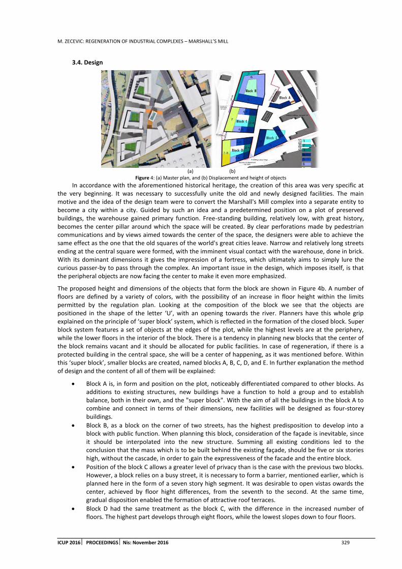
M. ZECEVIC: REGENERATION OF INDUSTRIAL COMPLEXES – MARSHALL’S MILL
ICUP 2016 PROCEEDINGS Nis: November 2016 329
3.4. Design
(a) (b)
Figure 4: (a) Master plan, and (b) Displacement and height of objects
In accordance with the aforementioned historical heritage, the creation of this area was very specific at the very beginning. It was necessary to successfully unite the old and newly designed facilities. The main motive and the idea of the design team were to convert the Marshall's Mill complex into a separate entity to become a city within a city. Guided by such an idea and a predetermined position on a plot of preserved buildings, the warehouse gained primary function. Free-standing building, relatively low, with great history, becomes the center pillar around which the space will be created. By clear perforations made by pedestrian communications and by views aimed towards the center of the space, the designers were able to achieve the same effect as the one that the old squares of the world's great cities leave. Narrow and relatively long streets ending at the central square were formed, with the imminent visual contact with the warehouse, done in brick. With its dominant dimensions it gives the impression of a fortress, which ultimately aims to simply lure the curious passer-by to pass through the complex. An important issue in the design, which imposes itself, is that the peripheral objects are now facing the center to make it even more emphasized.
The proposed height and dimensions of the objects that form the block are shown in Figure 4b. A number of floors are defined by a variety of colors, with the possibility of an increase in floor height within the limits permitted by the regulation plan. Looking at the composition of the block we see that the objects are positioned in the shape of the letter ‘U’, with an opening towards the river. Planners have this whole grip explained on the principle of ‘super block’ system, which is reflected in the formation of the closed block. Super block system features a set of objects at the edges of the plot, while the highest levels are at the periphery, while the lower floors in the interior of the block. There is a tendency in planning new blocks that the center of the block remains vacant and it should be allocated for public facilities. In case of regeneration, if there is a protected building in the central space, she will be a center of happening, as it was mentioned before. Within this ‘super block’, smaller blocks are created, named blocks A, B, C, D, and E. In further explanation the method of design and the content of all of them will be explained:
Block A is, in form and position on the plot, noticeably differentiated compared to other blocks. As additions to existing structures, new buildings have a function to hold a group and to establish balance, both in their own, and the "super block". With the aim of all the buildings in the block A to combine and connect in terms of their dimensions, new facilities will be designed as four-storey buildings.
Block B, as a block on the corner of two streets, has the highest predisposition to develop into a block with public function. When planning this block, consideration of the façade is inevitable, since it should be interpolated into the new structure. Summing all existing conditions led to the conclusion that the mass which is to be built behind the existing façade, should be five or six stories high, without the cascade, in order to gain the expressiveness of the facade and the entire block.
Position of the block C allows a greater level of privacy than is the case with the previous two blocks. However, a block relies on a busy street, it is necessary to form a barrier, mentioned earlier, which is planned here in the form of a seven story high segment. It was desirable to open vistas owards the center, achieved by floor hight differences, from the seventh to the second. At the same time, gradual disposition enabled the formation of attractive roof terraces.
Block D had the same treatment as the block C, with the difference in the increased number of floors. The highest part develops through eight floors, while the lowest slopes down to four floors.

M. ZECEVIC: REGENERATION OF INDUSTRIAL COMPLEXES – MARSHALL’S MILL
330 ICUP 2016 PROCEEDINGS Nis: November 2016
Block E has the same basic shape and structure as previous blocks, with the only difference in orientation. This block is also the edge block that requires the maximum height towards the street and cascade toward the inside, but at the same time it is necessary to meet another condition. Given that this block is in between the block D i.e. its four-storey part, and the mill building, it is necessary to achieve the continuity of the facade and street frontage. Therefore, the optimal height, designed for this block, is five floors.
3.5. Parking and underground garage
Parking, as an important issue in planning of an urban area, has clearly set conditions that must be met, for a certain space to work well. In case of re-urbanization of the area, depending on the urban functions that are foreseen in this space, in most cases it is necessary to plan many more parking spaces than the status quo. As we have previously explained that this complex contains several urban functions, the conclusion is that the need for parking varies depending on urban functions. Therefore, we will hereafter consider the ideas of designers and their solutions of parking in and around the block.
Proximity of the city center provides cyclists an easy and quick access to the stated location, and it was necessary to provide places for occasional bicycle parking, without going deep into the interior of the block and disturbing the quality of pedestrian communications. For this purpose, bike parking is provided along the newly designed pedestrian access communications.
A large number of planned housing units have caused designers to predict the underground garage, to ensure the safety of the vehicle and also relieve the plateaus around the buildings. Due to its size and capacity of 220 parking places, underground garage has two entrances, i.e. exits. Care was taken that the access ramp leading to the underground garage does not interfere with traffic, which requires a solution providing access across a residential street. As seen in Figure 5a, in addition to the underground parking garage, it was necessary to provide parking spaces at ground level. These parking spaces are primarily intended for office space and will be of short duration. Positions of the two parking spaces visually do not burden the interior of the block, for the designers have managed to preserve the quality of public space. The capacity of the two parking areas is much less than the capacity of the underground garage, which clearly indicates that the whole complex is primarily intended for housing. The third aspect of parking of motor vehicles is a parking space located next to the newly designed building. The capacity of one set of parking area is small and amounts to 5 cars. These parking spaces are intended for visitors who park their vehicle for a short period. We recognize that this kind of intervention has not undermined the quality of public space and that two parking areas are very carefully integrated into the complex, to be inconspicuous to pedestrians.
(a) (b)
Figure 5: (a) Parking spaces, and (b) Maintenance access
Through a more detailed solution analysis, we can conclude that the designers tried to keep a greater percentage of motor traffic positioned on the same part of the plot. There is a clear separation of space for future residents of the complex and occasional users.
In Figure 5b we see the space that the designers foresaw for the purpose of supplying and servicing the complex, with clearly indicated possibilities. The principles which have guided the planners do not differ greatly from the principles that are used for solving the parking space. Open extended plateaus are intended to be used for transport vehicles to be excluded from the traffic, as their stay in the complex would not slow it. Positions that have been targeted by designers for the transport access, suggest that care was taken for every part of the complex to have balanced treatment in respect of supplies of goods. It is important to note that the

M. ZECEVIC: REGENERATION OF INDUSTRIAL COMPLEXES – MARSHALL’S MILL
ICUP 2016 PROCEEDINGS Nis: November 2016 331
entry of vehicles in the depth of the area is limited and that the goods must be delivered without transport vehicles on the remaining part of the road.
3.6. Access routes
Through the term of a closed block system and through analysis of the principles on which it’s based, we will try and define the access routes in our example. The closed block system is often composed of three or more residential or collecting streets. In this case, besides the existing Marshall’s Mill Street, designers planned formation of three more streets in the periphery of the plot, and defined by that the concept of the closed traffic network. For the reason of safety of consumers and traffic participants, streets will gain a residential status, controlling the driving speed. Access positions from which a motor vehicle can enter the complex are marked with red in the Figure 6a. On the left part of the plot, both accesses have a double function, accessing the plot and the underground garage. Blue color in Figure 6a marks the remaining accesses to the complex and they are exclusively intended for cyclists and pedestrians. So as to prevent security breaches within the very pedestrian communication, the authorities decreed that the maximum speed of cyclists is 20 miles/h. Position of accesses to the block allows simple and easy passage through the complex in a safe and pedestrian convenient way. Another important condition is the fire way. The width of the peripheral motor roads and pedestrian communications within the block are fully complied with the requirement to enable the fire truck to pass. The average width of the internal pedestrian communications is 15m, therefore the condition of unrestricted access to the fire truck is fulfilled.
(a) (b)
Figure 6: (a) Access routes, and (b) Public space organization
3.7. Public space design
In an informal presentation, newly designed complex could be named a lively mixed-use neighbourhood. In accordance with that description public space in such complex is a set of complex network of streets, squares, service communication, green spaces, etc. This is the attitude that the designers represented in the design of public space. In many ways, this attitude is more appropriate for such a playful position of buildings than if the central position of the block was a large playground designed exclusively for recreation. In this way, most of the public space will be used on a daily basis and it will be purposeful to future users.
In accordance with the statutory provisions, local authorities require that at least 20% of the total surface area is public space. With a total area of 5916 m2 of space with a public purpose, it represents about 30% of the total area in this location. This includes public spaces at the ground level, while the area of 2238 m2, which includes more closed courtyards and roof terraces, further reinforces the requirements of the government. As we have said, the square of area 1660m2is planned in the heart of the subject location, around the preserved warehouse. Current situation of the warehouse remains unchanged, but it was necessary to provide a plateau around the building, so that in the near future, after redevelopment of the facility, adequate access to the facility can be provided. Other pedestrian communications will be transient and the most striking pedestrian communication is the one that runs along the preserved partition wall. All pedestrian communication from coming from the peripheral roads into the depth of the block end on the central plateau, thus providing an balanced regime of the footpaths use. Good quality paving and street furniture equipment will ensure the attractiveness of pedestrian communications and justify the expectations of designers that all footpaths are used continuously throughout the year. As part of the public space all the peripheral communication will be defined as a public space with a dual function, and with adequate paving and street furniture will create a pleasant atmosphere both for drivers and pedestrians.

M. ZECEVIC: REGENERATION OF INDUSTRIAL COMPLEXES – MARSHALL’S MILL
332 ICUP 2016 PROCEEDINGS Nis: November 2016
4. CONCLUSIONS
Basing this paper on an analysis of an example of regeneration of an old industrial complex, our objective was to draw attention to the problem present in the most modern European cities. This problem manifests itself in unsynchronized development of individual parts, which includes abandoned industrial buildings within the new wider city center. The example we have analyzed contains all the facts that characterize it as a historical complex of abandoned industrial sites. Consequently, it was necessary to revive such space through its regeneration, and in accordance with all relevant conditions and needs of the local population.
From the analysis of the case, we concluded that the position of objects, their dimensions and volume are skilfully designed and incorporated into the existing situation, in contrast to the function disposition. Our critical attitude is primarily related to the purpose of certain parts on the ground level, with a poor function replacement. We believe it would be more appropriate to position commercial space and public activities on the ground floor, and housing to higher floors, which is not the case in this example. We note that the idea of the designers was that the space should be created so that it reflected a higher quality of life, with an attractive design, a roof terrace and free pedestrian communication. We took a positive view of the purpose of the designers to preserve historical heritage to a greater extent, and integrate it into new projects.
The project of re-urbanization of the industrial complex is a demanding and thorough task, with some fundamental principles to be compiled during the design process. The current urban thinking is based on the renovation of abandoned industrial areas, on the least possible pollution of cities, and in general, on full utilization of resources. As a final consideration we can state that in this case the aforementioned principles are considered to a large extent.
REFERENCES
1. www.urbed.com
2. www.weloveholback.com
3. www.igloo.uk.net
4. www.holbeckurbanvillage.co.uk
5. Giles & Goodall (1992). Yorkshire Textile Mills 1770–1930. HMSO. ISBN 0113000383.
6. Urban Regeneration and Industrial Heritage in Leeds, UK, Jasna Cizler
7. Leeds City Council (2006).HolbeckUrban Village (HUV) Revised Planning Framework. Leeds: Leeds City Council.
8. Leeds City Council (2006).Holbeck Conservation Area Appraisal. Leeds: Leeds City Council.
9. Tallon, A. (2010). Urban Regeneration in the UK. Oxon: Routledge.
10. Percival, T. (2008). 'Urban renaissance' or gentrification?: a critical analysis of urban change in Holbeck, Leeds. Leeds: University of Leeds, School of Geography.

M. ZECEVIC: URBAN AND SPATIAL PLANNING REGULATIONS – DEVELOPMENT OF RURAL AREAS IN THE EU AND SERBIA FROM THE ASPECT OF REGULATION
ICUP 2016 PROCEEDINGS Nis: November 2016 333
URBAN AND SPATIAL PLANNING REGULATIONS - DEVELOPMENT OF RURAL AREAS IN THE EU AND SERBIA FROM THE ASPECT OF REGULATION
Marko Zecevic
Faculty of Civil Engineering and Architecture, University of Nis, Serbia Architect, [email protected]
ABSTRACT
Depending on the method of defining, nearly 80% of the territory of the Republic of Serbia can be classified as rural, inhabited by approximately 50% of population. Rural areas in Serbia differ in social, economic and demographic characteristics, which are, however, compatible in terms of issues. The primary problems are constant migration from rural to urban areas, extensity of agricultural production, high rate of unemployment, poor and underdeveloped infrastructure, etc. The subject of this work will be to analyze and compare the programs and objectives of Rural Development of the European Union and the Republic of Serbia. The aim of the research is to show the similarities and differences in the rural development strategy between the EU and Serbia, as well as to highlight the EU's development policy in this area, where our country needs to adapt in order to approximate to EU membership.
Keywords: rural development; urban planning; sustainable development; rural economy; EU regulations
1. INTRODUCTION
During the analysis of the current state, problems have been defined which need to be solved fundamentally in order to contribute to economic and social progress of our country, with approximation to the European Union (EU) set as an objective. Difficulties in rural areas could be partly explained by the existence of laws and by-laws, which are incomplete or imprecise, and which should regulate or eliminate negative phenomena in rural regions, dating back to the end of the Second World War. The Law on Agriculture and Rural Development, adopted in May 2009, with amendments from 2013 and 2015, defines only certain objectives and measures that should lead to the development of rural areas in the Republic of Serbia (RS), but the strategy of rural development, as well as the concept of harmonization of regulations in the field of rural development with EU regulations haven’t yet been adopted. Strategies of the EU evolve and overcome the upcoming problems, while the task and the condition for the RS is to overcome all the problems, previous and upcoming, as soon as possible in order to enable the future parallel existence of Directives of the RS and the EU. This paper will be based on descriptive and comparative research method.
2. THE EU STRATEGY OF RURAL DEVELOPMENT
Development and progress of rural regions represent a policy area which is of vital importance for the development of the EU itself. The first development strategies in Europe in order to promote and enhance productivity in agricultural production appeared in the seventies. During this period, preservation of the rural identity and prevention of migrations from rural to urban areas were emphasized. From the next decade onwards, besides already existing goals, the environmental protection principle has been introduced. In the nineties reforms of the existing system have been performed, mostly manifested in increasing competitiveness through price reduction and providing direct aid to agricultural population. Rural development in this period has also been conditioned by Regulations from 1992, which were based on integral approach to agricultural activities, economic diversification and management of natural resources. The current strategy of rural development of the EU is based on Agenda from 2000 and it encourages multifunctionality of agriculture, employment opportunities, decentralization, partnership at local and regional level, etc.

M. ZECEVIC: URBAN AND SPATIAL PLANNING REGULATIONS – DEVELOPMENT OF RURAL AREAS IN THE EU AND SERBIA FROM THE ASPECT OF REGULATION
334 ICUP 2016 PROCEEDINGSNis: November 2016
2.1. The current EU rural development programs
In order to improve living standards in an environmentally and socially sustainable way, current rural development programs applied by the EU have been adopted by the European Commission on February 2nd 2000, within the Lisbon Strategy for the EU. Programs of the Strategy are based on certain modifications of essential problems, and they are reflected through a system of direct aid, market-based instruments and rural development policy.
The system of direct aid represents a one-off financial support to agricultural population, whereby it is not related to the production level. The main objective is to provide financial support to farmers in exchange for compliance with standards of environmental protection, animal welfare, food safety and keeping the land in good condition.
Through market-based instruments, sellers or manufacturers can receive export, manufacturing or transitional subsidies for products with solid market prices during a given period. Given that agricultural production in any part of the world depends on the climate and microclimate conditions, degree of utilization of renewable energy sources, conservation of biodiversity, it requires the involvement of significant financial resources. Balancing and proper use of these funds could only be achieved through pre-defined rural development strategy.1 The European Commission has formed the European Agricultural Fund for Rural Development (EAFRD) for the period 2007-2013, with a budget of about 88.75 billion euros, which should enable the achievement of the objectives of the rural development policy, such as a balanced economic growth, technological improvements and the creation of new, environmentally sustainable, work methods. The basic rules of governing the rural development policy for this period are given in the regulations of the European Commission no. 1689/2005, in which the main strategic objectives are presented.
Besides the Lisbon Strategy, there are other documents significant for rural development, such as different funds and the Commission Decision 2006/636. Among the funds, mention should be made of the European Agricultural Guarantee Fund (EAGF) from which finances direct aid to farmers, and the European Agricultural Fund for Rural Development financing rural development programs.2Commission Decision 2006/636 establishes annual funding for rural development of the EU Member States.
For candidate countries for EU membership, as our country is, IPA regulation is of great importance. IPA regulation (Instrument for Pre-Accession Assistance) determines the scope and type of aid the candidate country will get, as well as the assistance to potential candidate countries for the period 2007-2013. In this way the help can be achieved in some of the following areas: transition assistance and institution building, cross-border cooperation, regional development, human resources development and rural development.3
2.1. The strategic objectives of the EU rural development
Besides mentioned strategies and programs proposed by the EU within rural development, mention should be made of some of the main objectives proposed by the Commission, in order to modernize and strengthen this sector of the EU. Those objectives have been included in the annex to the Agenda from 2000:
Restructuring of the European model of agriculture through the improvement of the environment and ensuring sustainable use of land, especially in areas with natural and physical disabilities. Maintenance of the economically viable agriculture is of primary importance, which could be somewhat regulated through reconstruction of the Common Agricultural Policy (CAP). Its new objectives are to provide European consumers with reasonable prices of agricultural products, and producers with adequate incomes, through the common agricultural organizations and the application of uniform price, financial support and equal treatment of agricultural products from the territory of the whole EU.
1 http://scindeks.nb.rs/article.aspx?artid=0350-137X0904158M
2 http://www.strategija.hr/hr/kako-do-fondova/poljoprivreda-i-ruralni-razvoj/europski-poljoprivredni-fondovi
3http://vesti.knjazevac.org.rs/wpcontent/uploads/downloads/2010/03/strategija_ruralnog_razvojaop%C5%A1tineKnja%C5%BEevac.pdf

M. ZECEVIC: URBAN AND SPATIAL PLANNING REGULATIONS – DEVELOPMENT OF RURAL AREAS IN THE EU AND SERBIA FROM THE ASPECT OF REGULATION
ICUP 2016 PROCEEDINGS Nis: November 2016 335
Increasing competitiveness in agriculture and forestry, i.e. introducing transitional measures for the new Member States, supporting small farming households in the process of growth and supporting the formation of manufacturing associations,
Improving the quality of life in rural areas, encouraging diversity in rural economies, and improving the socio-economic structures in remote rural and suburban areas. Financial resources are dedicated to improving access to basic services, infrastructure development, improving the environment, promoting sustainable development, creating conditions for employment outside agriculture, and easier access to information technology solutions, which is in accordance with the principles of obtaining and using funds from the Economic and Monetary Union.
Among these principles, the Member States must allocate their funds for rural development between the three above-mentioned principles.
3. THE STRATEGY OF RURAL DEVELOPMENT IN THE REPUBLIC OF SERBIA
As mentioned above, majority of the RS territory has a rural character, therefore agriculture has a large economic potential. Until the beginning of the seventies there were no funds or associations that encouraged the development of agriculture in our country. Resources of the "Green Plan" were planned and established in eighties, under the influence of the Organization for Economic Cooperation and Development and with the help of international funds. In nineties, due to the crisis in the state, there were no notable results of these funds. It was not until 1995 when there were prerequisites for the provision of financial assistance, with the adoption of the Law on the use of resources of the agricultural budget. In May 2009, the Law on Agricultural and Rural Development, which defines the objectives in the development of rural areas, was adopted.4
3.1. The current rural development programs of the Republic of Serbia
So far, there were no strategic documents defining rural development. Strategic objectives of rural development could be observed only in the form of segments in a number of following documents:
Regional Development Strategy for the period 2007-2012, adopted in January 2007. It has a focus on a balanced regional development, representing a detailed analysis of economic, social and infrastructural indicators in Serbia and its regions. Regarding the uneven regional development, this document shows that rural areas lag behind in basic life parameters like demography, human resource development, economic development, etc. However, it doesn’t speak of development potentials and specific problems of rural areas.5
National Sustainable Development Strategy directs its goals not only in domain of development and encouragement of agriculture, but also in domain of rural tourism development.6
Agricultural Development Strategy adopted in June 2005 emphasizes in certain segments the commitment of the Ministry of Agriculture, Forestry and Water Management to properly implement complementary models of European strategies in the RS. The key objectives of the Strategy are development of sustainable and efficient agricultural sector which could be competitive at the European level, supporting life standards of people living form agriculture, creating social and economic conditions in rural areas in order to ensure their contribution to economic development of the state, rural development policy which understands territorial specificities, protecting the environment from negative impacts of agricultural production. Seemingly numerous and specific, these objectives are not sufficiently comprehensive to ensure that all key requirements of agriculture, rural sector and rural population are adequately treated and respected.7
The Poverty Reduction Strategy from 2003 defines poverty as the primary rural problem and foresees a wide range of measures aiming to reduce poverty, such as: enhancement of social services, education and infrastructure development.8
4 http://www.ekoagrar.in.rs/pdf/ruralni%20_razvoj_srbije.pdf
5 http://www.decentralizacijasrbije.net/uploads/file/strategija_regionalnog_razvoja.pdf
6 http://www.ekoplan.gov.rs/DNA/docs/strategija_rs.pdf
7 http://www.stips.minpolj.gov.rs/content/strategija-razvoja-poljoprivrede
8 http://www.prsp.gov.rs/

M. ZECEVIC: URBAN AND SPATIAL PLANNING REGULATIONS – DEVELOPMENT OF RURAL AREAS IN THE EU AND SERBIA FROM THE ASPECT OF REGULATION
336 ICUP 2016 PROCEEDINGSNis: November 2016
The Strategy of Development of Tourism in the RS for the period 2005-2010, adopted in 2006. One of the issues addressed by this Strategy is the rural tourism development, as an additional sector of the economy, which would enhance and ensure the sustainable development of rural communities. The main objective is providing additional incomes for rural population, which would contribute to a more balanced development of the whole state.9
The Law on Agriculture and Rural Development is certainly of great importance for the development of agriculture in Serbia. It defines the objectives of the agricultural policy and the manner of its implementation, types and conditions of the subsidies in agriculture, potential beneficiaries, etc. The law was adopted on May 29, 2009, for a period of at least ten years, so it will be analysed within the strategic objectives of the RS. Since this law has already been adopted and can be treated as current directives, following items can be stated as the objectives of agricultural policy:
Building the competitiveness of agricultural products on the market,
Providing high-quality and healthy food,
Providing support to living standards of farmers who can’t ensure their economic survival on the market through their production,
Providing support to rural development,
Protecting the environment from negative effects of agricultural production.
The RS implements these objectives through the Strategy for Agriculture and Rural Development, which includes the National Program for Rural Development, both being compiled but not adopted by the Government.
3.2. The strategic objectives of the rural development of the Republic of Serbia
Serbia is on its way to legally regulate its priorities and objectives in domain of the development of rural areas, through adopting the National Program for Rural Development (NPDR) for the period 2008-2013. This plan is funded by the EU and completed in 2008, but the new Government hasn’t adopted it yet. Following are the main guidelines and objectives included in the NPDR:
Enterprising rural Serbia,
Competitive agricultural production,
Advanced ecology,
Progressive and comprehensive communities.
Through the program of the enterprising rural Serbia, the policy of the government can be combined with market activities to stimulate agricultural business, wealth of generations and the development of the state, by providing economic security of rural communities. Through this system, the Government should achieve following objectives:
Improving the rural development planning system and provide more support to rural needs,
Enriching trainings and skills which represent the basis of the rural economy,
Improving economic and social infrastructure in rural areas,
Improving rural tourism and recreation.
The agricultural sector should become competitive on a regional, European and global level, and the competitiveness should be achieved through:
Competitive commercial farms,
Reducing the dependence of farmers on government subsidies,
The modernization of farms and introduction of additional activities,
Encouraging agricultural producers to direct their production to new markets, such as the production of organic food, geographically protected products, etc.
Ecology on rural level should be improved in order to:
Raise the level of environmental awareness and practice throughout the agricultural sector,
9 http://www.srbija.sr.gov.yu/extfile/sr/61980/strategija_turizam_lat.zip

M. ZECEVIC: URBAN AND SPATIAL PLANNING REGULATIONS – DEVELOPMENT OF RURAL AREAS IN THE EU AND SERBIA FROM THE ASPECT OF REGULATION
ICUP 2016 PROCEEDINGS Nis: November 2016 337
Reduce the overexploitation of land of high ecological value,
Improve land-use planning in rural areas in order to achieve a balance of economic and environmental objectives,
Improve access to rural areas.
Furthermore, advanced and comprehensive communities with improved access to services and resources should be formed, which could be achieved in the following ways:
By strengthening the rural economy,
By improving access to public, common and commercial services,
By providing more efficient services that solve social and economic problems,
By strengthening centers in rural areas as centers of economic activity and the provision of services.
4. COMPARISON OF STRATEGIES OF THE EU AND THE REPUBLIC OF SERBIA
Within the comparison of strategies of the EU and the RS the first thing that should be emphasized is the fact that most of the documents prepared and adopted by the Government are mainly based on the principles applied by the EU in complementary fields. Regarding this, we can expect consistency in the implementation of European objectives of the rural development in our country.
4.1. Comparison of the existing programs
Rural development is a significant economic sector, both for the EU and for our country. For the purpose of approximation to the EU membership, our country is trying to bring its policy to the EU policies and trends. On the other hand, the EU encourages developing of countries which are potential members, through the legal system in the form of economic assistance. The interaction of the RS and the EU in the field of rural development is reflected in a series of aid which are regulated by the IPA Regulation. Since the aid provided by this Regulation, our country is able to use two of five existing types of assistance, in accordance with the terms of the acquisition and use of assistance. Our country will be able to use all five types of aid when it acquires the status of a potential candidate for the membership.
The differences in the existing strategies manifest themselves in the field of legal and strategic documents. While the EU has its priorities in rural development defined by the Lisbon Strategy, the RS does not possess any strategic document adopted in this field. Although the Lisbon Strategy addresses the problems of improving living standards, a significant part of this document is also encouraging the development of rural areas, with specifically defined methods and goals. These objectives are reflected in the provision of direct assistance to farmers through mentioned funds, market instruments and policies on rural development. Unlike the EU, the RS has no direct documents pointing to the problems of rural development and methods of their elimination, but they can be observed only as side effects of other problems. Financial stimulation of agriculture is mostly done through a system of one-time assistance within the laws on the underdeveloped areas, and not through the Law on agriculture. Therefore, existing documents and regulations dealing with rural development policy haven’t been adopted so far. In accordance with this situation, unlike the EU, there are no funds in our country, which would finance rural development programs, or allocate direct aid to farmers across the country. Funds that are current in Serbia are formed mainly at the local level, by local governments, or at the provincial level, and so on.
4.2. Comparison of strategic objectives
On the basis of the EU's strategies and mentioned objectives of the development of rural areas, the RS created the National Program for Rural Development. It represents a legitimate document dealing with rural development policy, which in the majority of the objectives and principles coincides with the EU rural development policy. Its adoption would have a double positive effect - the realization of the EU requirements, set against the potential candidate countries, as well as the contribution to the development of rural areas and the economic strengthening of the country. From previously exposed objectives of the EU and the RS we can see their mutual correspondence. The correspondence lies in the following:
Improvement of living standards and the image of rural areas, the potentiation of tourism and implementation of innovative technologies,

M. ZECEVIC: URBAN AND SPATIAL PLANNING REGULATIONS – DEVELOPMENT OF RURAL AREAS IN THE EU AND SERBIA FROM THE ASPECT OF REGULATION
338 ICUP 2016 PROCEEDINGSNis: November 2016
Provision of stable rural economy through uniform price of finished products and of primary raw materials in order to improve production and quality of products,
Achieving a balanced treatment of products at the international level, through the proportional stimulus from small to large farms, encouraging manufacturers to expand product assortment and target it to new markets,
Preserving the natural identity of rural areas and increasing environmental awareness of farmers, which would directly affect the environmental and health safety of products.
Differences that exist between systems of improvement of rural areas in the EU and the RS are primarily legal consequences of situations in individual states, which, on one hand, have improved, and, on the other, degraded agricultural system. That is why the RS is late with directives, objectives and methods that are already implemented in the EU and regulations which are current in the RS at this point actually represent methods of equalizing with the level at which the EU is now.
5. CONCLUSIONS
Europe's rural policy is determined at the EU level, and its implementation is entrusted to the Government of the Member States. The policy of development of rural areas in the EU is carried out through strategies and regulations, which are composed of the primary objectives and methods to be implemented regarding the assumed problem. Once the new problem, which is not covered by current law, strategy and regulation, occurs within the EU, new suggestions and amendments to the law are proposed. With a number of institutions dealing with the problem of rural development in the legal framework, Member States have all the possibilities to improve their agricultural sector.
At this point in the RS there is no general coordination in making systematic and strategic documents, in cooperation between state authorities and institutions and farmers involved in different aspects of rural development, and therefore there is no clear regulation. Contribution of Local Governments is expected, in the form of involvement in the development of their agricultural areas, but lacking regulatory authority, they are often insufficiently trained, in terms of human resources or technically, to be engaged in this field. However, Serbia has great potential for development of rural areas. For now it is on track to realize its development objectives, but it is necessary to adopt and adequately implement proposed plans, laws and strategies of development of rural areas, in accordance with the requirements and standards of the EU. Only then agriculture will take primary place in the economic structure of Serbia, which belongs to it due to its role and significance.
REFERENCES
1. http://www.stips.minpolj.gov.rs
2. http://www.prsp.gov.rs
3. http://www.srbija.sr.gov.yu
4. http://scindeks.nb.rs
5. http://www.decentralizacijasrbije.net
6. http://www.ekoplan.gov.rs
7. Ruralni razvoj: praktikum za lokalne aktere / Branislav Milic. - Beograd: Stalna konferencija gradova i opstina, 2011 (Beograd: Dosije studio). - 94 str.: ilustr. ; 24 cm
8. WB (2013). Agriculture and Rural Development - Projects (Year and Project Title). Washington, DC, USA: The World Bank - WB. Retrieved November 1st, 2013, from http://web. worldbank.org/WBSITE/EXTERNAL/TOPICS/EXTARD/0,,c ontentMDK:20445361~pagePK:210058~piPK:210062~theSite PK:336682,00.html
9. Severini, S., & Tantari, A. (2013). The effect of the EU farm payments policy and its recent reform on farm income inequality. Journal of Policy Modeling, 35(2), 212-227. DOI:10.1016/j.jpolmod.2012.12.002

V. NIKOLIC ET AL.: REVITALIZATION OF CITY SQUARES BY COVERING IT WITH MODERN CONSTRUCTIONS: LA ENCARNACIÓN SQUARE
ICUP 2016 PROCEEDINGS Nis: November 2016 339
REVITALIZATION OF CITY SQUARES BY COVERING THEM WITH MODERN CONSTRUCTIONS: LA ENCARNACIÓN SQUARE
Vojislav Nikolic
University of Nis, Faculty of Civil Engineering and Architecture, Serbia PhD student, Assistant, [email protected]
Vuk Milosevic
University of Nis, Faculty of Civil Engineering and Architecture, Serbia PhD student, Assistant, [email protected]
Petar Mitkovic
Faculty of Civil Engineering and Architecture, University of Nis, Serbia PhD, Full Professor, [email protected]
Milan Brzakovic
University of Nis, Faculty of Civil Engineering and Architecture, Serbia PhD student, [email protected]
ABSTRACT
This paper focuses on city squares as one of the most important urban elements of the city. As cities have recently experienced great changes, the topic of city square revitalization is very up-to-date. Worldwide the leading experts in the field of urban planning and architecture are dealing with this topic, while in our country, mainly due to financial reasons, there are no significant developments in this field. In order to examine the theme of city square revitalization we chose a characteristic example of revitalized La Encarnación square in Seville, Spain. This square has been chosen as the most suitable for the analysis for a number of reasons, but primarily because it is likely to become the founder of a new trend not only in the field of revitalization, but also in designing new city squares. Analysis methods, case studies and deductive methods were used in the study.
Keywords: city square; revitalization; urban planning; covering construction.
1. CITY SQUARE AS AN URBAN ELEMENT
"A man comes into the city only when he comes to its main square" (Cvoro, 2006). Along with a street, city square is the oldest urban element of a settlement. While the street is a linear element, the square is spatial. The function of the square as an open space of the city has not substantially changed. These were the places of socialization, where a variety of activities took place, from exchanging of information and goods, to spontaneous everyday gatherings of people in order to meet each other and exchanged ideas and opinions. The development of city outside the city's main square, which usually was located in the center of the settlement, meant the forming of other squares that received specific purposes. The size of a settlement and the way of life in a given social order determined the number of squares, their size, shape and function. To experience a specific open public space as the city square, it is necessary that the square is surrounded by architectural structures. Without these natural "scenes" open spaces are hard to perceive as closed and limited public space building structures (Hiel & Blagojevic, 2014).
A part of the professional public believes that the purpose of the square itself is its main characteristic for the simple reason that it is the initiator of its construction and duration. That does not mean its physical side should be neglected, because every social activity must find a place in the corresponding physical frame. The

V. NIKOLIC ET AL.: REVITALIZATION OF CITY SQUARES BY COVERING IT WITH MODERN CONSTRUCTIONS: LA ENCARNACIÓN SQUARE
340 ICUP 2016 PROCEEDINGS Nis: November 2016
significance of its purpose is reflected in the fact that it defines the initial shape of the square as well as its location and size.
What is important to note is that there is no domination of one over the other functions of the square. A large number of different activities that take place at the same place only contributes to its character and reveals the complexity.
Definitions of the town square in regard to its physical structure from the aspect of architecture and urban planning profession are the most acceptable, but are not the only ones that should be taken into account. One of the most representative definitions states that the square represents "... the relationship between the open spaces, buildings that surround it and the firmament." In addition to this it is important to mention two more definitions that deserve attention. The first is the "square is a space framed by buildings where the frame made of the buildings is an essential part of the square, because it is thus formed to present it in the best way" and the definition from the English dictionary of architecture, "the square is a piece of land in which there is an internal garden framed by streets, and which allows access to the buildings on all four sides." (DJokic, 2004)
It is evident that the common feature of the aforementioned definitions is that they rely primarily on the physical construction status, while other characteristics may be omitted. This simplification makes things more understandable, but it certainly cannot be approximated as a representation of the complete and true state of affairs, because it leads to irrecoverable disadvantages (Velev, 2006).
2. REVITALIZATION OF CITY CENTERS AND SQUARES
A city center represents the starting and end point of numerous and various urban developments (Mitkovic & Dinic, 2004.). Urban revitalization and reconstruction represent the future of modern cities. (Dinic et al. 2008.) The reasons for the revitalization of the city center are numerous; some of the most important are as follows:
Existing infrastructure - City center already has a street, water supply and sewerage network. From an environmental and economic point of view it would be a clear loss to throw away all the existing capacities and pay for the construction of the new infrastructure on the outskirts of the city.
The focus of all paths - City center is traditionally the focus of the movement and the place of recognizable identity of the city in the minds of its inhabitants. Without an attractive city center with a concentration of various activities it is difficult to provide local support for any projects.
Diversity - The City center has a higher functional diversity than any new center on the periphery. As the center of trade, services, administration, culture and entertainment, with a distinctive historical stratification, city center achieves long-term prosperity.
Work - Statistically, the center is a part of the city with the highest concentration of jobs. Employees who work in the city center come to work every day and they make a stable market there.
Housing - Many cities lost residential role of the city center, but recently there has been seen a trend in the returning of residents to centers. This process started in seventies, and continued in the 21th century. The residents of the city centers are usually educated, employed young people without children.
From the aspect of sustainability, we can draft some guidelines for successful revitalization of the city center (Paumier, 2004).
Promoting function diversity - City center should have a diverse mix of functions that are complementary to each other so as to create a lively environment. The essential question refers to the type and distribution of functions as well as their infrastructure and pedestrian connections.
Encouraging compactness - Central city zone must be compact so that activities that take place in it are available to pedestrians. The reconstruction priority is the formation of a dense urban fabric. Remote or isolated facilities result in a significant synergy decline in function and pedestrian activity.
Encouraging intensive development - high density activities in the center are necessary to ensure all-day vitality of the area. Laws and recommendations are mechanisms to ensure that they are not overloaded with various contents, which is often the case in the pursuit of extra profits. Zoning as an instrument of urban planning has to find a good measure between the new construction and the existing environment.
Ensuring a good function balance - City center should have 24 hour balanced activities. Disproportion of functions in favour of business can lead to a lack of activity in the central zone after the end of
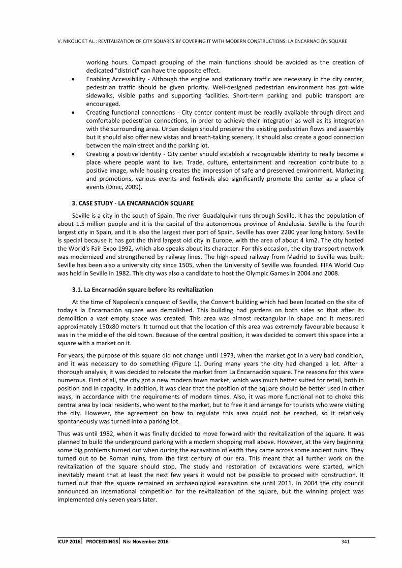
V. NIKOLIC ET AL.: REVITALIZATION OF CITY SQUARES BY COVERING IT WITH MODERN CONSTRUCTIONS: LA ENCARNACIÓN SQUARE
ICUP 2016 PROCEEDINGS Nis: November 2016 341
working hours. Compact grouping of the main functions should be avoided as the creation of dedicated "district" can have the opposite effect.
Enabling Accessibility - Although the engine and stationary traffic are necessary in the city center, pedestrian traffic should be given priority. Well-designed pedestrian environment has got wide sidewalks, visible paths and supporting facilities. Short-term parking and public transport are encouraged.
Creating functional connections - City center content must be readily available through direct and comfortable pedestrian connections, in order to achieve their integration as well as its integration with the surrounding area. Urban design should preserve the existing pedestrian flows and assembly but it should also offer new vistas and breath-taking scenery. It should also create a good connection between the main street and the parking lot.
Creating a positive identity - City center should establish a recognizable identity to really become a place where people want to live. Trade, culture, entertainment and recreation contribute to a positive image, while housing creates the impression of safe and preserved environment. Marketing and promotions, various events and festivals also significantly promote the center as a place of events (Dinic, 2009).
3. CASE STUDY - LA ENCARNACIÓN SQUARE
Seville is a city in the south of Spain. The river Guadalquivir runs through Seville. It has the population of about 1.5 million people and it is the capital of the autonomous province of Andalusia. Seville is the fourth largest city in Spain, and it is also the largest river port of Spain. Seville has over 2200 year long history. Seville is special because it has got the third largest old city in Europe, with the area of about 4 km2. The city hosted the World's Fair Expo 1992, which also speaks about its character. For this occasion, the city transport network was modernized and strengthened by railway lines. The high-speed railway from Madrid to Seville was built. Seville has been also a university city since 1505, when the University of Seville was founded. FIFA World Cup was held in Seville in 1982. This city was also a candidate to host the Olympic Games in 2004 and 2008.
3.1. La Encarnación square before its revitalization
At the time of Napoleon's conquest of Seville, the Convent building which had been located on the site of today's la Encarnación square was demolished. This building had gardens on both sides so that after its demolition a vast empty space was created. This area was almost rectangular in shape and it measured approximately 150x80 meters. It turned out that the location of this area was extremely favourable because it was in the middle of the old town. Because of the central position, it was decided to convert this space into a square with a market on it.
For years, the purpose of this square did not change until 1973, when the market got in a very bad condition, and it was necessary to do something (Figure 1). During many years the city had changed a lot. After a thorough analysis, it was decided to relocate the market from La Encarnación square. The reasons for this were numerous. First of all, the city got a new modern town market, which was much better suited for retail, both in position and in capacity. In addition, it was clear that the position of the square should be better used in other ways, in accordance with the requirements of modern times. Also, it was more functional not to choke this central area by local residents, who went to the market, but to free it and arrange for tourists who were visiting the city. However, the agreement on how to regulate this area could not be reached, so it relatively spontaneously was turned into a parking lot.
Thus was until 1982, when it was finally decided to move forward with the revitalization of the square. It was planned to build the underground parking with a modern shopping mall above. However, at the very beginning some big problems turned out when during the excavation of earth they came across some ancient ruins. They turned out to be Roman ruins, from the first century of our era. This meant that all further work on the revitalization of the square should stop. The study and restoration of excavations were started, which inevitably meant that at least the next few years it would not be possible to proceed with construction. It turned out that the square remained an archaeological excavation site until 2011. In 2004 the city council announced an international competition for the revitalization of the square, but the winning project was implemented only seven years later.
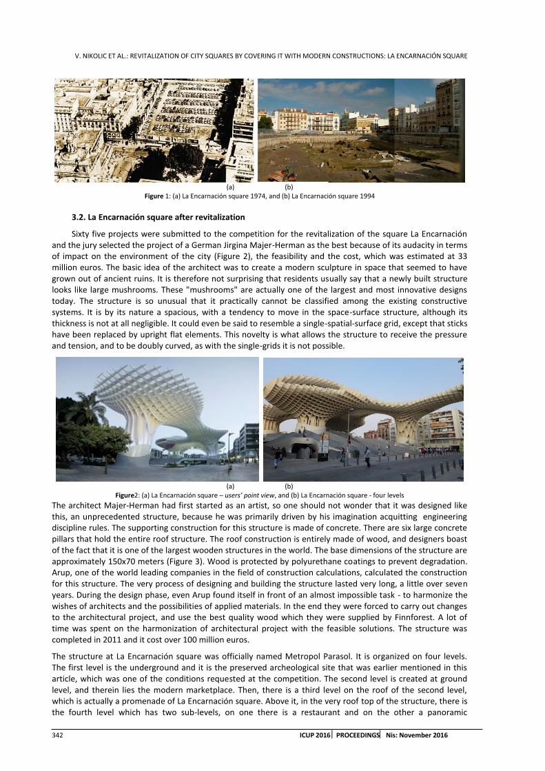
V. NIKOLIC ET AL.: REVITALIZATION OF CITY SQUARES BY COVERING IT WITH MODERN CONSTRUCTIONS: LA ENCARNACIÓN SQUARE
342 ICUP 2016 PROCEEDINGS Nis: November 2016
(a) (b)
Figure 1: (a) La Encarnación square 1974, and (b) La Encarnación square 1994
3.2. La Encarnación square after revitalization
Sixty five projects were submitted to the competition for the revitalization of the square La Encarnación and the jury selected the project of a German Jirgina Majer-Herman as the best because of its audacity in terms of impact on the environment of the city (Figure 2), the feasibility and the cost, which was estimated at 33 million euros. The basic idea of the architect was to create a modern sculpture in space that seemed to have grown out of ancient ruins. It is therefore not surprising that residents usually say that a newly built structure looks like large mushrooms. These "mushrooms" are actually one of the largest and most innovative designs today. The structure is so unusual that it practically cannot be classified among the existing constructive systems. It is by its nature a spacious, with a tendency to move in the space-surface structure, although its thickness is not at all negligible. It could even be said to resemble a single-spatial-surface grid, except that sticks have been replaced by upright flat elements. This novelty is what allows the structure to receive the pressure and tension, and to be doubly curved, as with the single-grids it is not possible.
(a) (b)
Figure2: (a) La Encarnación square – users’ point view, and (b) La Encarnación square - four levels
The architect Majer-Herman had first started as an artist, so one should not wonder that it was designed like this, an unprecedented structure, because he was primarily driven by his imagination acquitting engineering discipline rules. The supporting construction for this structure is made of concrete. There are six large concrete pillars that hold the entire roof structure. The roof construction is entirely made of wood, and designers boast of the fact that it is one of the largest wooden structures in the world. The base dimensions of the structure are approximately 150x70 meters (Figure 3). Wood is protected by polyurethane coatings to prevent degradation. Arup, one of the world leading companies in the field of construction calculations, calculated the construction for this structure. The very process of designing and building the structure lasted very long, a little over seven years. During the design phase, even Arup found itself in front of an almost impossible task - to harmonize the wishes of architects and the possibilities of applied materials. In the end they were forced to carry out changes to the architectural project, and use the best quality wood which they were supplied by Finnforest. A lot of time was spent on the harmonization of architectural project with the feasible solutions. The structure was completed in 2011 and it cost over 100 million euros.
The structure at La Encarnación square was officially named Metropol Parasol. It is organized on four levels. The first level is the underground and it is the preserved archeological site that was earlier mentioned in this article, which was one of the conditions requested at the competition. The second level is created at ground level, and therein lies the modern marketplace. Then, there is a third level on the roof of the second level, which is actually a promenade of La Encarnación square. Above it, in the very roof top of the structure, there is the fourth level which has two sub-levels, on one there is a restaurant and on the other a panoramic
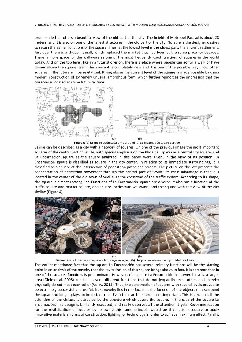
V. NIKOLIC ET AL.: REVITALIZATION OF CITY SQUARES BY COVERING IT WITH MODERN CONSTRUCTIONS: LA ENCARNACIÓN SQUARE
ICUP 2016 PROCEEDINGS Nis: November 2016 343
promenade that offers a beautiful view of the old part of the city. The height of Metropol Parasol is about 28 meters, and it is also on one of the tallest structures in the old part of the city. Notable is the designer desires to retain the earlier functions of the square. Thus, at the lowest level is the oldest part, the ancient settlement. Just over there is a shopping mall, which replaced the market that had been at the same place for decades. There is more space for the walkways as one of the most frequently used functions of squares in the world today. And on the top level, like in a futuristic vision, there is a place where people can go for a walk or have dinner above the square itself. This concept is completely new and it is one of the possible ways how other squares in the future will be revitalized. Rising above the current level of the square is made possible by using modern construction of extremely unusual amorphous form, which further reinforces the impression that the observer is located at some futuristic time.
(a) (b)
Figure3: (a) La Encarnación square – plan, and (b) La Encarnación square section
Seville can be described as a city with a network of squares. On one of the previous image the most important squares of the central part of Seville, with special emphasis on the Plaza de Espania as a central city square, and La Encarnación square as the square analyzed in this paper were given. In the view of its position, La Encarnación square is classified as square in the city center. In relation to its immediate surroundings, it is classified as a square at the intersection of pedestrian paths and streets. The picture on the left presents the concentration of pedestrian movement through the central part of Seville. Its main advantage is that it is located in the center of the old town of Seville, at the crossroad of the traffic system. According to its shape, the square is almost rectangular. Functions of La Encarnación square are diverse. It also has a function of the traffic square and market square, and square -pedestrian walkways, and the square with the view of the city skyline (Figure 4).
(a) (b)
Figure4: (a) La Encarnación square – bird’s eye view, and (b) The promenade on the top of Metropol Parasol
The earlier mentioned fact that the square La Encarnación has several primary functions will be the starting point in an analysis of the novelty that the revitalization of this square brings about. In fact, it is common that in one of the squares functions is predominant. However, the square La Encarnación has several levels, a larger area (Dinic et al, 2008) and thus several different functions that do not jeopardize each other, and thereby physically do not meet each other (Velev, 2011). Thus, the construction of squares with several levels proved to be extremely successful and useful. Next novelty lies in the fact that the function of the objects that surround the square no longer plays an important role. Even their architecture is not important. This is because all the attention of the visitors is attracted by the structure which covers the square. In the case of the square La Encarnación, this design is brilliantly executed, and really deserves all the attention it gets. Recommendation for the revitalization of squares by following this same principle would be that it is necessary to apply innovative materials, forms of construction, lighting, or technology in order to achieve maximum effect. Finally,

V. NIKOLIC ET AL.: REVITALIZATION OF CITY SQUARES BY COVERING IT WITH MODERN CONSTRUCTIONS: LA ENCARNACIÓN SQUARE
344 ICUP 2016 PROCEEDINGS Nis: November 2016
the approach applied in the La Encarnación square changes some of the definitions of a square, already mentioned in this paper, and that is the definition that the market represents the relationship between the open spaces, buildings that surround it and the firmament, and it is necessary that square is framed with architectural objects because otherwise the square would be difficult to perceive. In the case when the square is covered by some construction, then it is no longer a "relationship between the open space, surrounding facilities and the firmament," but that space becomes partially closed, and covering structure replaces the firmament as the upper height limit of the square. Also, it is absolutely not necessary for the architectural objects to make the frame of the square; it is possible that the square limits are determined by the roofing construction of the square.
4. CONCLUSION
In this work, the effects of revitalizing city squares through covering with modern constructions were analyzed. The term modern structures mean structures that apply new structural systems, amorphous forms, innovative technology or materials. In the first part a theoretical basis for the market as an urban element was given. The market is defined as "the ratio between the open space, surrounding facilities and the firmament." In the second part of the paper a case study of the square covered by modern structures was elaborated. The covering structure on the square Le Encarnación is a wooden structure resembling the monolayer surface - spatial grid. The results proved the need to review the existing definition of a square. In the case when the square is covered, as is the case here, the definition of the square should be changed because its upper limit is no longer the firmament, but rather the construction by which it is covered. Also, the objects that surround it in this case play a much less important role, and it can even be said that they are unnecessary. Another aspect of the revitalization of this square is its division into several height levels. In this way, not only the result is the larger usable area, but also the square itself gained more functions. These functions are distributed into levels so that they do not jeopardize each other. The existing classification of squares by function is compromised because there is no longer a dominant feature of the square according to which it could be classified into the appropriate category, but there are several functions of the square at the same time. As a final conclusion of this work it can be emphasized that city squares entered a new stage of development. The development of structural systems has allowed that even large ranges, such as those in the squares, can be covered with modern structures. These structures have a role in defining the square space, but perhaps even more importantly, in attracting new visitors. Attractive architectural structures contribute to the promotion of trade and the cities in which these squares are located. This fact can be no longer ignored, and it is obvious that in recent years it has been increasingly gaining in importance. Although there are more squares that are being revitalized than those that are just being created and formed, covering with the modern constructions in both cases should be kept in mind as one of the most successful options.
REFERENCES
1. Cvoro M.,2006. Mogucnosti transfirmacije gradskih trgova u gradovima zapadne R. Srpske, Zbornik radova Gradjevinskog fakulteta Subotica, pp 417-422.
2. Dinic M., Mitkovic P., 2011. Planning regulations in the USA and their implications on urban design in the central city zone, Facta Universitatis, Series: Architecture and Civil Engineering, Vol. 9, no. 2, pp 289-299.
3. Dinic M., Mitkovic P., Velev J., Bogdanovic I., 2008. Application of the urban reconstruction methods in the central city area of Nis, Facta Universitatis, Series: Architecture and Civil Engineering, Vol. 6, no. 1, pp 127-138.
4. Dinic M., 2009. Revitalizacija gradskog centra u kontekstu odrzivog razvoja, Nauka + Praksa, Vol. 12, broj 1, pp 18-21,
5. DJokic V. 2004. Urbana morfologija: grad i gradski trg, Arhitektonski fakultet Univerziteta u Beogradu, Beograd. (preuzeto iz Velev,2006)
6. Hiel K., Blagojevic I. 2014. Squares in Novi Sad as unrecognizable public spaces, International conference: Contemporary achievements in civil engineering, Subotica, pp 757-762.
7. Mitkovic P., Dinic M., 2004. City center organization and its influence on the city structure, Facta Universitatis, Series: Architecture and Civil Engineering, Vol. 3, no. 1, pp 41-56.

V. NIKOLIC ET AL.: REVITALIZATION OF CITY SQUARES BY COVERING IT WITH MODERN CONSTRUCTIONS: LA ENCARNACIÓN SQUARE
ICUP 2016 PROCEEDINGS Nis: November 2016 345
8. Paumier C., 2004. Creating a Vibrant city center – urban design and regeneration principles, Washington, Urban Land Insitite, (preuzeto iz Dinic, 2009)
9. Velev J., 2006. Analiza prostorno-funkcionalne transformacije trga „Svetog Save“ u Nisu, Zbornik radova Gradjevinsko-arhitektonskog fakulteta, Vol. 21, pp. 153-168.
10. Velev J., Mitkovic P., Vasilevska Lj., 2011. Spatial and finctional transformation of the city center structure in the process of transition, Facta Universitatis, Series: Architecture and Civil Engineering, Vol. 9, no. 3, pp 455-462.


1st International Conference on Urban Planning - ICUP2016
Supported by
Potisje Kanjiža, Fibran, Sika, Knauf Insulation, Dunav Osiguranje, “TRACE PZP NIŠ” AD, Diz komerc, Ingrad, New City Hotel – Niš, City View Guest House, Rosa, Teking, Lawyer's office Dragana Markovic - Niš