(12) Potentials of discovery of human occupation sites on the continental shelves and nearshore...
38
Quaternary Coastlines and Marine Archaeology: Towards the prehistory of land bridges and continental shelves Edited by P. M. MASTERS N. C. FLEMMING 1983 Scripps lnstitution of Oceanography, La Jolla, USA I nstitute of Oceanographic Sciences, Godalming, U K @ ACADEMIC PRESS A Subsidiary of Harcourt Brace Jovanovich, London New York Paris San Diego San Francisco Sao Paulo Sydney Tokyo Toronto
Transcript of (12) Potentials of discovery of human occupation sites on the continental shelves and nearshore...
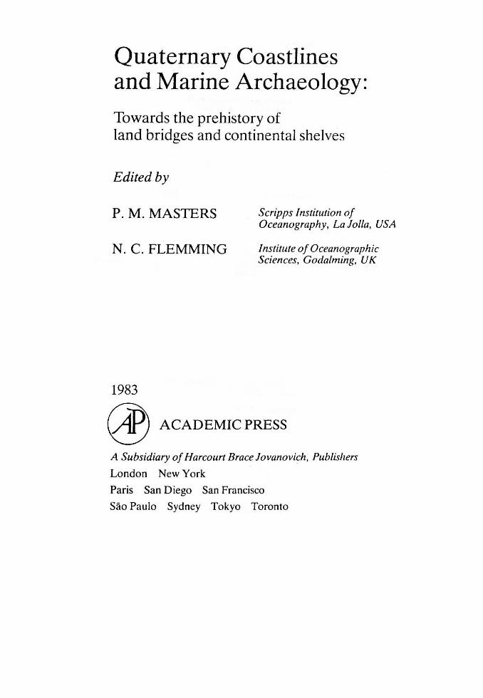
Quaternary Coastlines and Marine Archaeology:
Towards the prehistory of land bridges and continental shelves
Edited by
P. M. MASTERS
N. C. FLEMMING
1983
Scripps lnstitution of Oceanography, La Jolla, USA
I nstitute of Oceanographic Sciences, Godalming, U K
@ ACADEMIC PRESS
A Subsidiary of Harcourt Brace Jovanovich, Publislıers
London New York
Paris San Diego San Francisco
Sao Paulo Sydney Tokyo Toronto
ACADEMIC PRESS JNC. (LONOON) LTD. 24/28 Oval Road
London NWI
Uniıed Sı111es Edition pııblislıed by ACADEMIC PRESS INC.
111 Fifth Avcnue New York. Ncw York I0003
Copyright '[, 19H3 hy ACADEMIC PRESS INC. (LONDON) LTD.
,\// f(ig/ıı.ı· ffr.<Nl'l'ıl
No part of thi~ hııok ıııay he rcprııılut'cd in arıy forııı hy phıll(lstat. nıicrolilnı. (lr any ııthcr nıcans. without writtcn pcrnıission frııın ıhc puhlishas
Bririslı Lilmıry Caıafogııing in l'ııhlic"ıion Duta Quatcrnary coastlines ancl marinc archacolugy.
1. Geology. Stratigraphic-Ouaternary-Congresscs 2. Man-Migraıions-Congresscs 1. Mastc::rs. P.M. il . Fknınıing. N.C. 30-L8 GflOI
ISBN 0-12--1792511-2
l'rirııı.:ıl in Cirı.:at Ilı iwi ıı
xiv Contents
SECTION 2: EXCA VA TIONS AND SUR VEYS OF SUBMERGED AND COASTAL LITHIC ARTIFACT SITES
Early Neolithic Occupation on the Submerged Continental Plateau of Roussillon (France)
David S, Geddes, Jean Guilaine and Andre Monaco 175
Detection and Assessment of Prehistoric ArtifaCt Sites off the Coast of Southern California
P.M. Masters
Submerged Prehistoric Sites off the Mediterranean Coast of Israel
189
A, Raban 215
Preliminary Geomorphological Survey of an Early Neolithic Submerged Site in the Sporadhes, N. Aegean
N.C. Flemming 233
Core Sampling of a Holocene Marine Sedimentary Sequence and Underlying Neolithic Cultural Material off Franchthi Cave, Greece
J , Gifford 269
Mesolithic Settlement on the Sea Floor in the Strait of Öresund
L. Larsson 283
Human Occupation of the Submerged Coast of the Massif Armoricain and Postglacial Sea Level Chan.ges
D, Prigent, L. Vissent, M.T . Morzadec-Kerfourn and J,P, Lautrido 303
The Subme rged Neolithic Village "Newe Yam" on the lsraeli Mediterranean Coast
E . E. Wreschner 325
Quaternary Shorelines in the Region of Corfu and Adjacent lslets, Western Greece
A, Sordinas 335
SECTION 3: FROM SrBERIA TO NOR TH AMER ICA AND THE ADJACENT ISLANDS
Hard Times in Beringia: A Short Note D,M. Hopkins
The Stages and Routes of Human Occupation of the Beringian Land Bridge Based on Archaeological Data
N,N, Dikov
345
347
Contents
The Holocene Trangression on the Arctic Flank of Beringia: Chukchi Valley to Chukchi Estuary to Chukchi Sea
D.A. McManus , J. S . Creage r, R.J. Echol s and !1 . L. Hol mes
Bergs, Barrie rs and Be ringia: Re fle ctions on the Pe opJing of the New World
B.O. K. Reeves
Meadowc roft Rockshelte r and the Peopling of the New World
J . M. Ado vasi o , J . Donahue , J ,E, Guilday , R. Stuckenrath , J . D. Gunn and W,C, Johnson
Early Man in the New World c. r.,. Me ighan
The Upper Pleistocene Pe opling of the New World: Evide nce De rived from Radioc arbon, Amino Acid Racemization and Uranium Series Dating
J . L . Bada and R. Fi nke l
The California Continenta l Borderla nd: Landbridges, Waterga ps a nd Biotic Disp ersals
D. L . J ohns on
SECTION 4: AUSTRALIA AND THE OLD WORLD
Prehistory and Palaeoecology of Torres Strait A. J . Ba rham and D.R. Harr i s
Problems of Site Forma tio n a nd the Interpre ta ti on of Spatial and Temporal Disco ntinuities in the Distr ibution of Coasta l Middens
G. N. Bailey
The \Voakwine Terrace in the South East of South Australia a nd fndications of the Ve ry Early Presence of Ma n
N.D . Tindale
Surnrnary and Conc lusio ns P ,N, Ma sters and N. C. Fl enıming
Subject fndex
xv
365
389
413
441
463
481
529
559
583
601
63 1
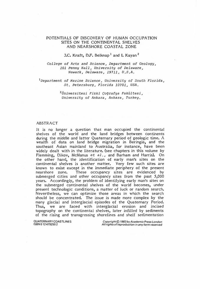
POTENTIALS OF DISCOVERY OF HUMAN OCCUPATION SITES ON THE CONTINENTAL SHELVES
AND NEARSHORE COAST AL ZONE
J.C. Kraft, D.F. Belknap 1 and l. Kayan 2
Col l ege of Arts and Science, Depa rtment of Geology, 101 Penny Hall, University of Delaware,
Newark, Delaware, 19711, U,S,A.
1Departmen t o f Narine Selence, Univer sity o f South Florida , St. Petersburg, Florida 33701, USA,
2 Üniversitesi Fizki Ço9rafya Fakültesi, University of Ankara, Arıkara, Turkey ,
ABSTRACT
It is no lenger a question that man occupied the continental shelves of the world and the land bridges between continents during the middle and Jattcr Quatermıry period of geologic time. A wealth of data on land bridge migration in Beringia, and the southeast Asian mainland to Australia, for instance, have been widely dealt with in the literature. (see chapters in this volume by Flemming, Dikov, McManus et al., and Barham and Harris). On the other hand, the identification of early man's sites on the continental shelves is another matte r. Very few such sites a re known t o exist except in the immediate periphery of the present nearshore zone. These occupancy sit es are evidenced by submerged cities and other occupancy sit es from the past 5,000 years. Accordingly, the problem of iden tifying early man•s sites on the submerged continental she lves of the world becomes, under present technologic conditions, a matter o f luck or random search. Neve rtheless, we can optimize those a reas in which the search should be concentrated. The issue is made more complex by the many glacial and interglacia l episodes of the Quaternary Period. Thus, we are faced with interglacial e rosion and incised topography on the continental shelves, late r infilled by sediments of the rising and transgressing shorelincs and shelf sedirnentation
OUATERNARY COASTLINES ISBN O 12 479250 2
Copyrighr© 1983 by Academic Press Landon All rights of reproduction in any form reserved

88 J.C. Kraft et al.
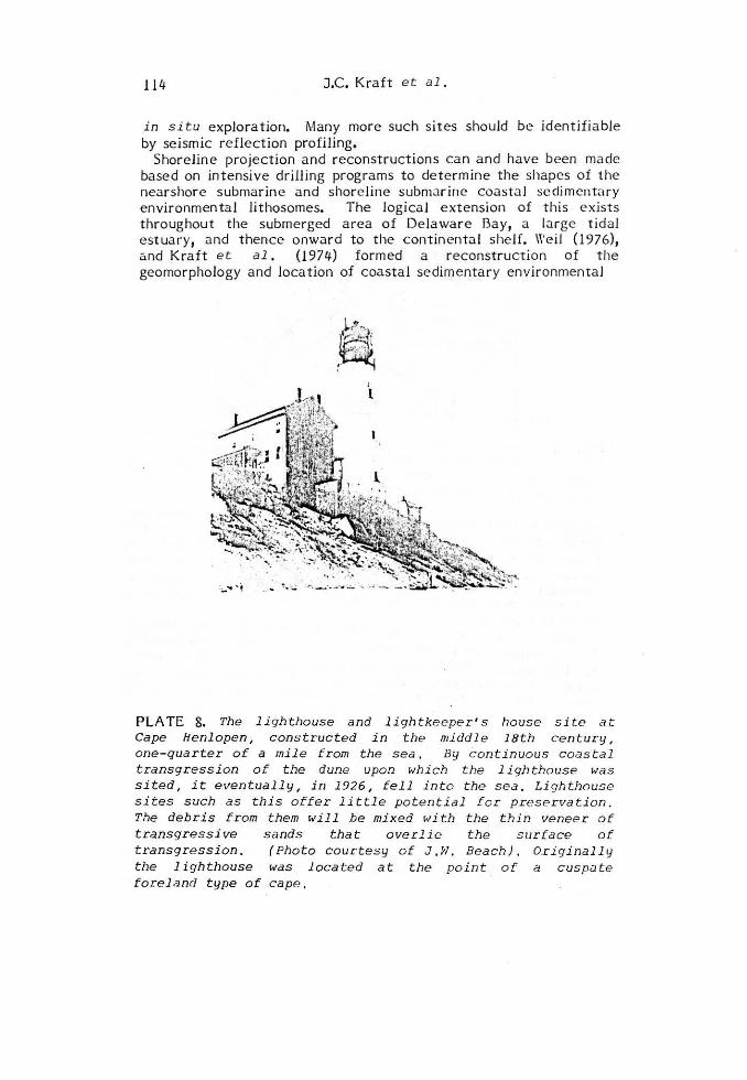
processcs. Taking the Holocenc Epoch as an exanıple, we know tha t the possibilit y of discovcry of lmajor sites does cxist. Palimpsests of rccognizable coastal deposi tional environments similar to those of the present coastal zone have been discovered in various areas around the world, mainly by random dredging by fishermen. This paper examines two extremes: 1) an area of active undergoing wave cut terrace erosion and the deposition of a thin veneer of Holocene Epoch sediment over the present and prior wave-cut t erraces in the northern Aegean Sea; and 2) the A tlantic continental shelf off Delaware and southern New Jersey, an area of a subsiding geosyncline in which erosional and deposi tional processes are presently advancing landward and upward via e rosion of the shoreface and relative sea-Jevel rise over coasta l environınental systerns. Study of the present coastal zone and its environrnents in each of thcse extrerne examples can lead us to nıodels that should be empirically useful.
INTRODUCTION
Study of huınan ancestors on the contin ental shelves and migrations via the land bridges between continents has been continuing for over a century. Nevertheless, very few, if any, significant sites have been found on the continental shelves to date (see Flemming, this volume, for a review of human sites). One of the primary reasons is that the continental shelves are dynamic areas of sedimentation and crosion. There tends to be both cataclysmic destructive elements as weU as depositional e lements that might preserve sites, both going on at the same time. Further, in the earlier part of the Holocene Epoch, beginning with the waning of the Wisconsin (Wurm) latest glaciation approximately 14,000 years ago, we know that man had spread throughout all of the continents of the world. · \Ve also know from the archaeological record that man occupied the coastal zone throughout at Jeast the past 6,000 years for the specific purpose of utilizing its shellfish and finfish resources for food. It is most logical to assume that earlier man did the same thing , at least throug hout the Holocene Epoch and probably in the Pleistocene Epoch as well.
Whitmore et al. (1967) and Edwards and Emery (1977) have listed some of the materials dredged up by fishermen on the outer A tlantic continental shelf of the United States. These demonstrate with positive evidence that coastal environments similar to those of the present shorelines have migrated distances up to 150 km Jandward since early Holocene times; the evidence includes salt and fresh-water marsh peats and nearshore-estuarine molluscs such as Crassostrea virginica (the oyster) and !1e rcenaria mercenaria (the northern quahog). Because these earliest a reas of the Holocene Epoch lie below the photic zone,
Potential of Sites on the Shelves 89
methods and technology for discovery of these sites remain in a primitive state. \Ve shall probably need to rely on hypothesis and chance to advance the study of these potentials in the near future. in the longer term, the more active geologic programs now on the cootinental shelves of the world conducted by the major oil companies should begin to provide abundant geophysical and sedimentological data regarding the thin Quaternary veneer on the wor ld's continentaJ sheJves. However, to date, there appears to be no systematic approach by researchers in this fieJd to coUect this data, coJJate it, and form actuaJ models of transgression and regression on the inner, middle, and outer shelves of the world. The problem is furthe r complicated by the fact . that the sp udding-in of oiJ weJJs usually ignores the Quaternary veneer without sampling or geophysical recording. On the othe r hand, in many cases , for site stabili ty reasons, cores ha ve been tak en in concentrated detaiJ on the continental sheJves and these shouJd and could provide data necessary for our studies. Beyond that, the challenge to us is to examine the continental sheJves from the point of view of rationaJizing the optimal site areas of the migrating coastaJ environments into and up the estua rine river systems and putting our major research resources to t he study of these areas in particular. Random studying of the shelves appears to be an impossible approach in terms of present technoJogy and what we can expect for the next several decades.
DISCUSSION
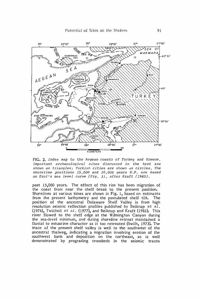
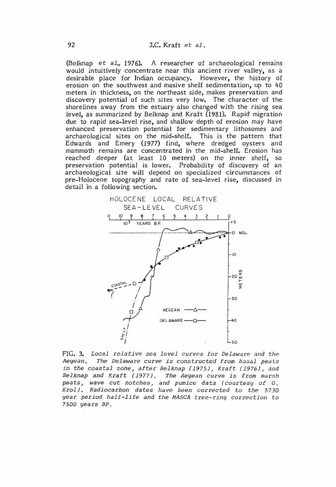
Fig. 1 is a location map for 'the mid-Atlantic coast of the US. ShoreJines, cross-section lines, ~nd the location of the ancestral Delaware River va lley a re discussed later in the text. Fig. 2 is a location map for the Aegean coa'st. A discussion of evolution of the shelves in these two localities requires_ first an understanding of shoreline changes through time and the driving mechanism for that change: sea-level changes. The - melting of the latest Wisconsin (Wurm) glacial ice resulted in a worldwide eustatic rise of sea level of at least 95 meters (Fairbridge, 1976) and possibly as much as 130 meters (Milliman and Emery, 1968). (see Inman, this volume). Radiocarbon dating of sea-level indicators, especiaUy tidal-marsh peats, has resulted in several c.fifferent views of worldwide sea-level change through the Holocene (for example, Shepard and Murray, 1967; Fairbridge, 1976). Belkna p and Kraft (1977) have p referred the use of loca! relative sea-level curves, recognizing the unlikelihood of the formation of a single worldwide eusta tic curve based on present sta tus of t he science. Fig. 3 shows two published loca! rela ti ve sea level curves: the Delaware coastal curve is after Belknap and Kraft (1 977), from basal peats on the Delaware coast. The De laware shelf curve, (Belknap and Kraft, 1981) and Milliman and Emery's (1 968) curve based on a few

90
76°
J.C. Kraft et al,
75•
o ıo 20 '040 <;()
KLW.ETERS -=-=-
74•
DEPTHS iN METERS 11 fm • 18 3m )
FIG. 1. I nde x map to the mid-Atlantic United States . The locations given are f or profiles A , B, a nd C described in t he text and shown in Fig. 7 , Shoreline positions a r e based o n the sea-l evel c urve of Belknap and Kraft (19 77 ), adjusted for shelf- tilt by comparison to the Milliman and Eınery
(1968) curve. Position of the former course of the Delaware River valley is from Bel knap et al. (19 76 ), and Twi chell et al. (1 977) .
peats and oyster shells, are considerably lower than most othe r coastal curves, suggesting a tilt of the shelf of some 40 meters at the shelf break, due to hydroisost a tic loading or tectonics (Belknap and Kraft, 1977). The history of sea ... level change in Dela ware has been a s t eady rise at a generally dec reasing rate throughout the
Potcrıtia l of Sitcs on thc Shclvcs 91
25• 25° 30' 26" 26"30' 27" 27°30'
4 0 ° 30 '
40'
39'30'
KILOMETERS
FIG. 2. Index map to the Aegean coasts ot Turkey and Greece. Important archaeological si tes d iscussed in the t e xt are shown as triangles; Turkish cities are shown as circles , The shoreline positions 15,000 and 10,000 years B.P. are based on Erol•s s e a level curve (Fig. 3), after Kraft (1980) .
past 15,000 years. The effect of this rise has been migration of the coast from near the shelf break to the present position. Shorelines at various times are shown in Fig. 11 based on estimates from the present bathymetry and the postulated shelf tilt. The posi tion of the ancestral De la ware Shelf Valley is from high resolution seismic reflection profiles published by Belknap et al. (1976)1 Twichell et al. (1977), and Belknap and Kraft (1981). This river flowed to the shelf edge at the Wilmington Canyon during the sea-level minimum, and during shoreline retreat maintained a fluvial to estuarine character as it too retreated (Swift, 1973). The trace of the present shelf valley is well to the southwest of the ancestral thalweg, indicating a migration involving erosion of the southwest bank and deposition on the northeast, as is well demonstrated by prograding crossbeds in the seismic traces
92 J.C. Kraft et al.
(Belknap et al., 1976). A researcher of archaeological remains would intuitively concentrate near this ançient river valley, as a desirable place for Indian occupancy. However, the hist ory of erosion on the southwest and masive shelf sediinentation, up to 40 meters in thickness, on the northeast side, makes preservation and discovery potential of such sites very Jow, The character of the shorelines away from the estuary a lso changed with the rising sea level, as summarized by Belknap and Kraft (1981). Rapid migration due to rapid sea- level rise, and shallow depth of erosion may have enhanced preservation potential for sedimentary lithosomes and archaeological sites on the mid-shelf. This is the pattern that Edwards and Emery (1977) find, where dredged oysters and mammoth remains are concentrated in the mid-shelf. Erosion has reached deeper (at least 10 meters) on the inner sheJf, so preservation potential is Jower. Probabili ty of discovery of an archaeological site will depend on specialized circumstances of pre- Holocene topography and rate of sea-level rise, discussed in detai1 in a following section.
i l 1
HOLOCENE LOCAL RELA Ti VE SEA -L EVE L CURVES
10 9 B 7 6 5 4 1
10'31
YE1
ARS 1 B. P.
3 2
o"s'(P.\. _o-. -1-- - / . /
.f A y AEGEAN -t:ı.-
OELAWARE - 0 -
o •5
o MSL
ıo
"' 20 ~ >-w ::;:
30
40
50
FIG. 3. Local relative sea l evel c urves tor Delaware ana the Aegearı . 7'he Delaware curve is constructed f r om basal peats .in t h e coasta l zone , after Belknap ( 1975), Kraft ( 1976), ana Belknap ana Kraft ( 1977). The Aegean curve is trom mar sh peats, wave cut n otches, ana pumice da ta ( courtesy of o . Erol). Radiocarborı dates lıave been corrected t o the 57 30 year period halt-li fe and tlıe MASCA tree-ring correction t o 7500 years BP .
Potential of Sit es on the Shelves 93
The second curve in Fig. 3 is a loca! re lative sea-level curve from the eastern Aegean, courtesy of Prof. Oguz Erol (Kraft et al., 1980). Loca! relative sea-level studies are extremely difficult owing to high t ectonic activity in this area. This curve differs from the Delaware curve in being steepe r before 6,000 years B.P., and reaching a gently fluctuating sea level near or above present since then. it is based on several radiocarbon dates in marshes, and on pumice radiometric data. The mildly fluctua ting relative sea Jevel since 6,000 years B.P. leads to profoundly different shoreline changes in the Aegean, specifically cycles of cliff retreat a t faster and slower rates on exposed headlands. Prior to 6,000 years B.P. shoreline retreat across the continenta l shelf (Fig. 2) proceeded rapidly on the Jow-gradient plain occupied by the ancestral Dardanelles River, until s~a cliffs were encountered. These cliffs were the remnants of former high sea-level shorelines of prior interglacials, which had cut terraces and scarps to their sea-level maxima. Absolute location of these features is unknowna t_ present, until seismic reflection profiles for this portion of the world become available. The estimated shoreline positions of 15,000 and 10,000 years B.P. are shown in Fig. 2, based on Erol's Curve, after Kraft e t al. (1 980). The search for earlier man before 6,bOO years B.P. on the continental shelf must be with the understanding of rapid sea-level rise rela tiv e to Jand and accordingly very high rates of coasta l transgression. Whether or not the sedimentation rates accompanying this were fast or slow (thick or thin) are not known. However, based on the example of the A tlantic coast continenta l shelf, the rapidity of the transgression would suggest that t his is an optinıal a rea for study in tha t the time fram·e is short , the transgression is rapid, and the possibility of exposed areas of Holocene coastal sedim ent a ry e nvironments is great. After 6,000 years before present, with a fluctuating shore line , conditions and techniques for searching for early man on the continenta l shelf of the north Aegean Sea change. \Ve are faced with tim es of rapid transgression, short times of retreat of the coast or regression, transgression again, ete. The complexity of this t ype of erosion/deposi tion would create a very complex veneer over the wave cut terrace formed over the past 6,000 years. The refore, our possibility of discove ry of sites of occupancy by earl ier man decrease until we get to Classica l to ear ly Helladic time (2,500 years before present to 5,000 years before present) when man's structures became those of for tified massive. stone construction.
\Ve know the Aegean Sea to be a very comple x ar:ea of collision between severa l of the world's c rustal pla t es (Flemming, 1978). it is tectonically extremely active. Nowhere is this more t rue than in t he northe rn part of the Aegean Sea, \Ve know a great deal a bout the morphology of the contin enta l shelf south of Thrace (Greece) and the she lf south of European Turkey and the west of

94 J.C. Kraft et al.
Asia Minor. In the vicinity of the Biga Peninsula in the Troad at the mouth of the DardaneUes, we know the area to be seismically active and upwarping. Miocene marine sediments, for instance, crop out high above the deeply incised valley of the Dardanelles. Further, when sea level was lowered 100 meters, approxima tely at its maximum low in the latest Wisconsin (\Vürm) glaciation, a wide sheJf became exposed to the south of Thrace, European Turkey, and the Biga Peninsula. Little is known about the Quaternary stratigraphy of this submarine sheJf, Jet alone the Holocene stratigraphy or the geophysical form and shape of the various sedimentary environmental Jithosomes and the many incised valleys that must have crossed this shelf area in latest Würm time. However, the Dardanelles have been studied and provide a · direct example of pre-Holocene deeply incised topography of a river that flowed in the ancestral valley of the Dardanelles, across the continental shelf and into the Aegean Sea of 13,000 to ltı.,000 years ago. Presently we do not know the precise path of this river and its tributaries (at least it is not published. to the authors ' knowledge), but, on the other hand, we do know much about . the Dardanelles and can conjecture the form of this vaUey system in pre-Holocene time across the shelf (Fig. 2). \Ve further know that the Sea of Marmara to the north of the Dardane1les lies a long the 11greater Anatolian fault", is of great depth, far below any pre-Holocene incision of va1leys, and tectonically active. Thus an inland sea !ay in this area throughout the Quaternary time. The greater Anatolian fault does not foUow the path of the DardaneUes but rather crosses the GaUipoli Peninsula and thence into the Aegean Sea. This was the pre-Wisconsin (Würm) pathway or marine connection between the Aegean Sea and the Black Sea. Studies of this system would be important to those interested in early man on the shelf south of Thrace and European Turkey before !ate Wisconsin (Würm) time. For some reason, probably tectonic and possibly fault relatcd, the Holocene incision of stream valleys includcd the incision of the present DardaneUes valley leading southward accross the shelf and incision of the pre-Bosphorus valley northward into the Black Sea. With eventual rise of sea level to its present level, the present straits of the Dardanelles, Sea of Marmara, and Bosphorus were formed between the Acgean Sea and the Black Sea.
Returning to the shelf south of Thrace (Greece) and European Turkey, we can study the present morphology of the submerged shelf to form hypothetical models as to what occurrcd and optimize the areas of possible search for earlier man occupation sites. The most rational inital approach would be that of shallow seismic studies to delineate the stream systems which would have formed the leading edge of the transgression landward. On the other hand, this is an area of presently active wave-cut cliff retreat and, t herefore, the form of an area of wave-cut terrace
_J <(
1-7: w 1-
&' z o 1-
~ cı:: w (/)
w o:: o..
z Q 1-
§ o:: w en w o:: o..
Potential of Sites on the Shelves 95
,.__ _____ ıı: ------;ı<-lll-tl U. S. f+--ı-+ın-.ı
a SUBMARINE
---1 AGE OF SiTE RETREATING SHORELINE IL,NC0NS0L IOATED SEOIMENTS)
1 ... _,
MID-ATLANTIC COAST
() ISLANO FIELD
[) ~Aı,,~ ~l~~z~~~E
J::. 'LIGHTHOUSE " SiTE
~ ;ı~~~~ , c~~&iNs
..._ ·- .- .:- -İRısıNG
SEA LEVEL
1DELAYE0 RETREAT ING SHORELIN E
TURKISH - GREEK AEGEAN COASTS
8 AGHIOS ILIUS
1%1 NISAKOULI
A ASSOS (CIT Y)
lı:::,, ASSOS IHARBOR)
~ GYTHION
~ SIGEUM
o TROY
~~~~-,====;A~G~E=O~F:;:::;;S~IT~E;::::===;::--~~~~-
RETREATıNG ~RIU11EATING
ıMILDLY FLUCTUA TIN G t SEA LEVEL
SHORELINE 1 + - + + ıRocK cuFFı r - P'RoG°RAoiNG" s H'oRE'LINE' - -
IUNCONSOLIDATED SEDIMENTS>
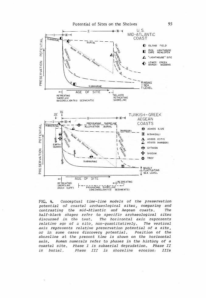
FIG. 4. Conceptual time-line models of the preservation potenti~l of coastal archaeological sites, comparing and contr asting the mid-Atlantic and Aegean coasts . The half-black shapes refer to specific archaeological sites di scussed in the text . Thc hori zontal axis represents rela ti ve age of .:ı s ite, non - quanti ta ti ve ly. The vertical axis represents relative preservation potential of a site, or in some cases discovery potential. Position of the shoreline at the present time is shown on the horizontal axis. Roman nume rals r e fer to phases in the history of a coastal site . Phase I i s subaerial degradation. Phase II is burial. Phase III i s shoreline erosion: IIIa

96 J.C. Krilft et al .
Fig. 4 ( cont ) representing open ocean co.-ıditions, Il"Ib represe nting estuarine conditions. Phase IV is tectonic movemerıt, such as dropping of a graberı valley block. The dotted lines refer to discovery potential of a buried site only . Relative sea- level change is i ndicated to the right .
and resultant depositional units of Holocene age might tend to have covered many of the earlier humao sites (particularly the Holocene sit es). Our model for this submerged land bridge-sheH must therefore be formed only partly on fact and much on an empirical basis.
Conceptual Models
Fig. 4 is a conceptual model of coastal a rchaeological sites in the US mid-A tlantic coast contrasted with the Aegean coasts of Greece and Turkey. The vertical axis represents the preservation potential of an archacological si te. The horizontal axis is a relative nıeasure of the age of a site. For actual examplcs, this axis wiJJ strctch or shrink depending on ratc of shorclinc movement and original distance of the site from the shoreline. The relative shoreline position at present is shown below. The horizontal axis should not be misinterpreted as a strict linear, quantitative measure of time. Similarly, the vertical axis is also relative: archit ectural ruins of quarried stone from the Aegean would be far more resistant to shoreline processes than lndian middens of the mid-A tlantic coast, but conversely a midden or mound is more resistant to earthquakes than a building. Thus the relative preservation potentials are purely qualita tive in nature.
On the mid-A tlantic coast, sites initia!Jy pass through a subaerial degradation phase (1 on Fig. 4) in which running water, frost, and biological activity alter the site. Phase II is common for sites on the landward side of marshes and Jagoons, such as Island Field (Fig. 9), which ultimately are buried by tidal marsh or Jagoon muds with continuing sea-leveJ rise. Under these quiet environments preservation is enhanced (dashed line). Probability of discovery, however, faJJs as buriaJ hides sites from view (dotted line). Phase III is as the erosive shoreface passes the site. Degree of preservation is dependent on the depth of scour, which reaches 1 O meters on the Atlantic coast and 3 to 4 meters on the Delaware Bay shore (Fig. 4, Cape Henlopen light house, 1926). Thus, probability of destruction is dependent in part on whether a sHe is intersected by a deeply-eroding oceanic shoreface (Jine a) or a shaJJowly-eroding estuarine shoreface (Jine b).. Either 5 or J O meters depth of scour is suffident to remove most Indian archaeological sites on a flat plain. Delayed arrival of the
Potential of Sites on tlıe Shelves 97
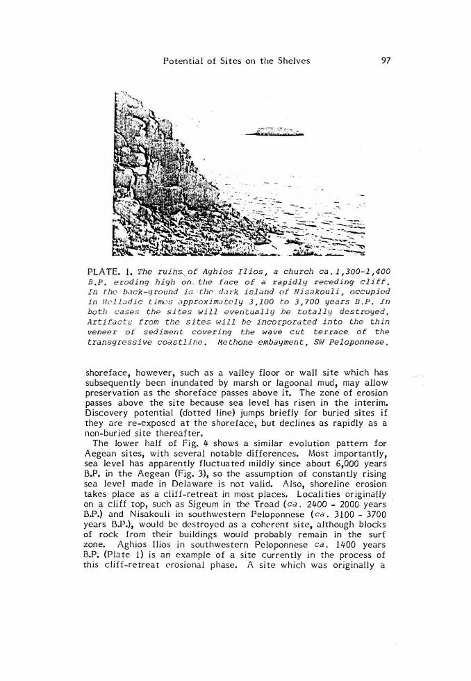
PLATE. 1. The ruihs.-._ of Aghios Ilios, a church ca. 1,300-1,400 B. P. eroding high on .. the tilce of a rapidly receding cliff. In f° hC' bac k - g r o und is l:lı0 d.ırk island of Ni sakoul i , occupie d in llL'l l:ıdic time s approxim.ıt<.>ly 3,100 to 3,700 years D . P . In both c:ases the si tes will e ventually be totall y destroyed . Arti fc:ıcts f rom tlıe sites ı.;ill be incorporate d into the thin veneer of sediment covering the wave cut terrace of t he transgressive coastline. Me thone embayment, Svl Peloponnese.
shoreface, however, such as a valley floor or wall site which has subsequently been inundated by marsh or Jagoonal mud, may a llow preservation as the shoreface passes above it. The zone of erosion passes above the site because sea level has r isen in the interim. Discove ry potential (dotted line ) jumps briefly for buried s ites if they a re re -exposcd at the shoreface , but declin es as rapidly as a non-bur ied site tlıereafter.
The Jowe r ha lf of Fig. 4 shows a simila r evolution pattern for Aegean sites, with severa l nota ble diffe rences. Most importantly, sea Jevel has apparently fluctua ted mildly since a bout 6,000 years B.P. in the Aegean (Fig. 3), so the assumption of constantly rising sea leve l made in De laware is not valid. Also, shorel ine erosion takes place as a cliff-retreat in rnost places. Localities originally on a cliff t op, such as Sigeum in the Troad ( ca. 2400 - 2000 years B.P.) and Nisakouli in southwcst e rn Peloponnese ( ca. 3100 - 3700 years 13.P.), would be dcstroycd .:ıs a cohcrcnt site, although blocks of rock from their buildings would probably remain in the surf zone. Aghios Ilios in southwestern Peloponnese ca . 1400 years B.P. (Plate 1) is a n example of a site c urre ntly in the process of this c li ff-retreat crosiona l phase. A si t e which was or iginally a
98 J.C. Kra ft et al .
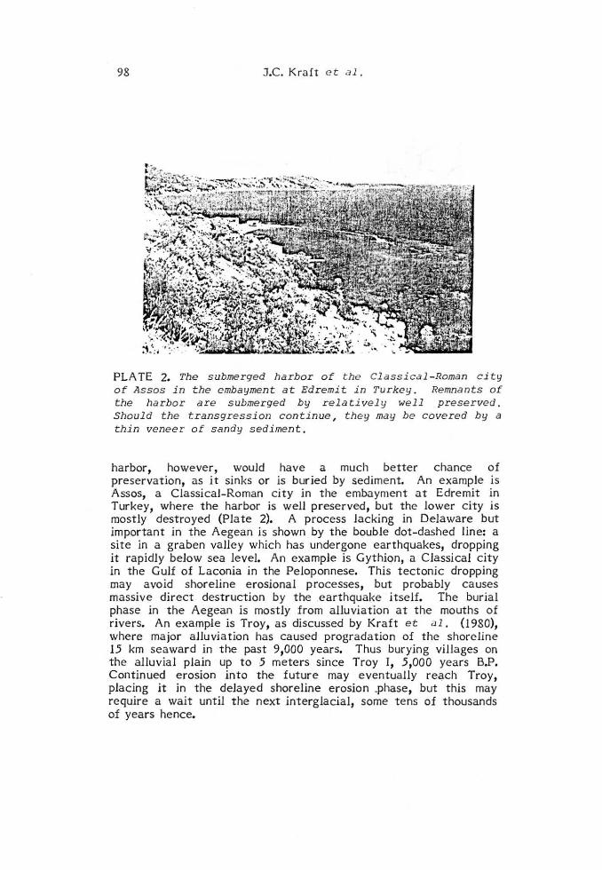
PLATE 2. The s ubmer ged harbor of t he Cl assi c al-Roman cit y of Assos i n the embayment a t Edremit i n Turkey . Remnants of the harbor are submerged by rela tivel y well preserve d. Should t he transgression con t inue, t hey may be covere d by a thin veneer of sandy sediment,
harbor, however, wouJd ha ve a much better chance of preservation, as it sinks or is buried by sedim.ent. An example is Assos, a Classical-Roman city in the embayment at Edremit in Turkey, where the harbor is well preserved, but the lower city is mostly destroyed (Plate 2). A process Jacking in DeJaware but important in the Aegean is shown by the bouble dot-dashed !ine: a site in a graben vaHey which has undergone earthquakes, dropping it rapidly below sea level. An example is Gythion, a Classical city in the GuJf of Laconia in the PeJoponnese. This tectonic dropping may avoid shoreJine erosionaJ processes, but probabJy causes massive direct destruction by the earthquake i tself. The buriaJ phase in the Aegean is mostJy from aJluviation at the mouths of rivers. An example is Troy, as discussed by Kraft et al. (1980), where major aJJuviation has caused progradation of the shorcline 15 km seawar d in the past 91000 years. Thus burying villages on the alluvia l plain up t o 5 meters since Troy r, 5,000 years B.P. Continued erosion into the future may eventually reach Troy, placing it in the deJayed shoreline erosion .phase, but this may require a wait until the next interglacial, some tens of thousands of years hence.
(/)
er: w tw ::;:
NW
t40
+ZO
-20
-40
Potentia l of Si tes on the She iv es
~ MUD
o •.•• ~ GOAVEL
~ DOO•NC
~ SH(LL o PLEISTOCEhE
C5l ...... .
TROY- SIGEUM
KILOME TER S
99
SE
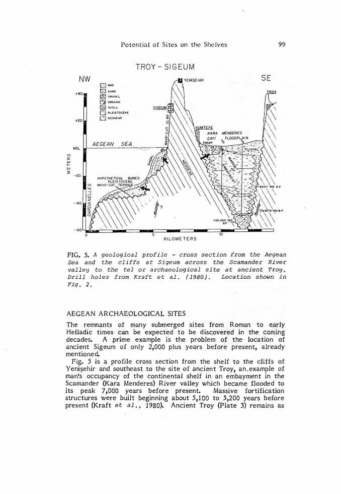
FIG. 5 • .ll geological profile - c ross section from the Aegean Sea and the cliffs at S igeum across the Scamander River valley to the tel or archaeological site at ancient Troy. Drill holes trom Kraft e t al. ( 1980). Location shown in Fig. 2 .
AEGEAN ARCHAEOLOGICAL SITES
The remnants of many submerged sites from Roman to eariy HeUadic times can be expected to be discovered in the coming decades. A .prime example is the problem of the location of ancient Sigeum of only 2,000 plus years before present, already mentioned.
Fig. 5 is a profile cross section from the shelf to the cliffs of Yenişehir and southeast .to the site of ancient Troy, an_example of man.•s occupancy of the continentai shelf in an embayment in the Scamander (Kara Menderes) River valley which became flooded to its peak 7,000 years before present. Massive fortification structures were built beginning about 5,100 to 5,200 years before present (Kraft et al., 1980). Ancient Troy (Plate 3) remains as
100 J.C. Kra ft et al.
an a rc haeological tel of occupancy from 5,000 years before present to 2,000 years before present. Ancient Sigeum is possibly totally eroded into the sea by wave cut cliff retreat or a small remnant of it may r ema in in place unde r the a bandoned to\vn s ite of Yenisehir with the majority of the city broken up and fallcn into th.e sea (Pla t e 4). Kumtepe is a shell midden, of n;arine organisms, now at the edge of the wide a lluvia l plain. Beyond this, we know nothing a bout the occupancy of still earlie r Holocene people on the continental she lf south of Thrace (Greece) and Turkey in the north Aegean Sea. The problem is made more complex by the fact of multiple wave cut terraces of early Quaternary Ages, presently not related to sites occupied by Qua ternary ma n, the sit es probably now forever buried. A hypothetica l terrace of a lower Pleistocene high sea stand is indicate d in Fig. 5.
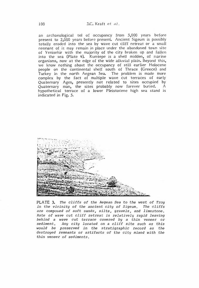
PLATE 3. The cliffs of the Aegean Sea to the west of Troy in the vicinity of the ancient city of Si geum . The cliffs are composed of soft sands , silts, gra vels , and limestone . Rate of tV"ave c ut cliff retreat is relatively rapid l eaving behind a wave cut terrace covered by a thin veneer or sediment . Any city located on a c li ff site such as this would be pı·eserved in the stratigraphi c r ecor d as the destroyed remnants or artifacts of t he city mixed with the thin veneer of sediments.
rr:h .: ~.ili;Jıdıt ->-a·~·~ Heitc.r,pc;ı ~;;_-;,,;,.-;u-,p;;_por<J:~\ ''• ~rv ~ _ A
-x~ f, . • ·'. . ' ·._ . • l " ) "'· • ı \ . ı 1 . • • ~ - . f: -. . - ...A~- l .., ._ ., .... , .. . , -r ·r· . . , . . , ı\ ,r =ı - -... . ' "" · .. , .. .ı . . , .. _.. - ---- . , ., . . .
· . , ' _ . ' • , • , ._ ........ .., .... _ ... ·-··- "'!":/ . _ .. .. "!"-.• • ·--_ .; ·--=-~· - -~~..... ... .. . ..... . . .... · .,_,,a , ... _ ~r::.
..:.,', . ~. J, :< - ..... JI
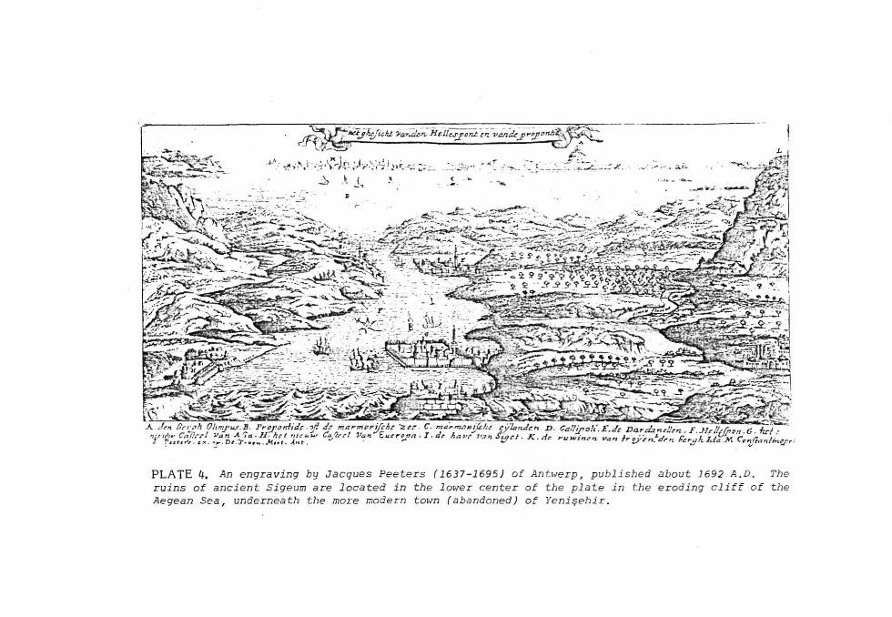
PLATE 4. An engraving by Ja cques Peeters (1637 -1695) of An t werp, published ruins of ancient Sigeum are located in the l ower center of the plate in the Aegean Sea , underneath tlıe moı-e modern to~m ( abandoned) of Yenişehir.
about 1692 A . D. The eroding cliff of the
"ıoo
"' Ats, a:
"' o 1-... ,. ~
"'oo
s,,.~ '
·· .. : ... ~ : -~ :~:~~~'~«-.:1
o
o ~c,"'
.,o ' "o
KNOWN SIT(S
1 2 3 4 5
CJ HOLOCENE 6
~ PLEIST OCE NE
T ROY SIGEUll. KUi.iT EPE YENİ KÖY BE SİK ASSOS
t POTENTIAL SITES
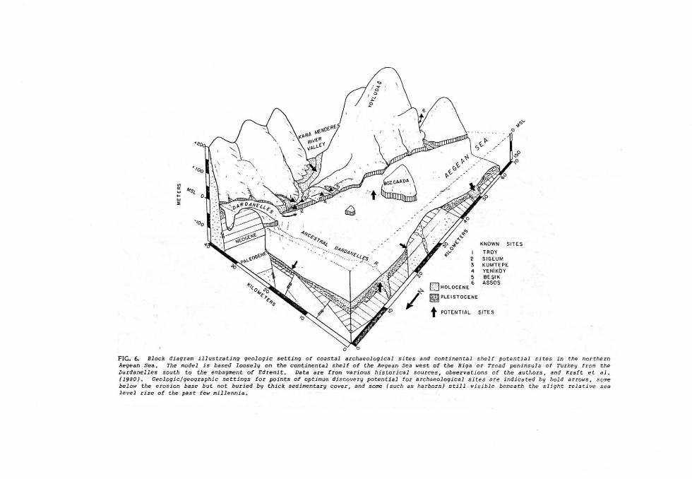
FIG. 6. Block diagram illus trating geologic setti.ng ot coııstal archaeologica l sites and cont1nental shelf potential sites i.n t h-. northern Aegean Sea , The model i.s bascd loosely on the conti.nental shelt o f the Aegean Seıı west of the Biga or Troad peninsula of Turk"Y from t he Dardanelles sout h to t he embayment of Edremi t. Data are from various histor.ical sources , obser vat l ons of the a ut t,ors. and Xr aft et a l . 11980) . Ceologic/geographic settings l or points of optiı:ıum discovery potenti.al tor ıı rchaeologi.cal s ites are indicated by bold arrc.ws, s ome bel o"' the e rosion base b ut no t bucied by thick sedimentar y cover, and some (suclı as ha rbors) still visible baneath the slight relative sea level rise ot the past few mJllennia .
Potcntial of Sites on the Shelves 103
fig. 6 is a block diagram illustrating concepts describcd for the northern Aegean. shclf. The coast is of high re lie f, tect onically active , a nd fragmented by normal fault-s.- Tlie Kara Menderes r iver va lley is possibly a graben. Rising sea Jevel has caused cliff retrea t and terrace c utting 1 destroying many former sites. Pot ential sites, however, are indica t ed by t he arrows. Known si tes are shown as triangles. Other coastal features shown in Fig. 6 are: (l) a double tombolo oH Bozcaada, enclosing a former lagoon, which may ha ve high pot entia l for discovery of si t es, (2). a shoal formed by littoral drift to the southwest fronı t he mouth of the Dardanelles, and (3) a lluvia tion in several embayments. Note also the inc ision hypothesized for the former Dardanelles river valley.
\Ve have an out standing mode l for the processes that occurred along this coast from ancient Alexa ndria Troas and Besika emba ymcnt in the south , to t he entrance to the Da rdanelles in the north. Approximat ely 8 km to the eas t of the present wave cut
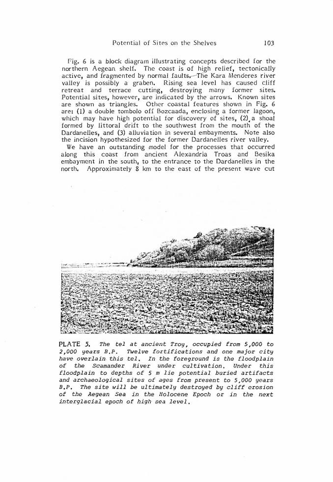
PLATE 5. The tel at ancient Troy , occupied from 5 ,000 to 2 ,000 years B. P. Twelve f ortifications and one major city have overlain. this tel , In the fore ground is the floodplain of the Scamander River under cultivation. Under thi s floodp l ain to depths of 5 m lie potent ial buried artifacts and archaeological sites of ages from present to 5 , 000 year s B,P. The si t e will be ultimately dest royed by cliff erosion of the Aegean Sea i n the Holoce ne Epoch o r in tlıe next intergl acial epoch of high sea leve l ,
104 J .C. Kraft c:t al.
terrace and e roding c liffs lies the Bronze Age site of ancient Troy awa iting in turn the arriva l of coasta l erosion, if not during this interglacial high sea stand, then in the next Quaternary interglacia l rise of the sea (Pla te 5). He re lies a s t eep wave cut cliff incised into sands, gravels, and marls. The ancient city of Sigeum, origina!ly an A thenian colony, lies along this cliff coast (Plate 4). lts present site is assumed to be under the more modern· but a bandoned Turkish town of Yenisehir. As this is a mil it ary zone, the site has not been studied in detail with modern t echnologies. Neverthe!ess, documentation by early European visitors in the 17th and 18th centuries do suggest Ciassical-Roman structures being e roded away from under the site of Yenisehir (Pla t e 4). A more modern example is that of Yenikôy. This village was also bui!t along this cliff and has had to be moved inland over the past JO years and rebuilt because of the rapidity of wave cut cliff retreat. Further out on the continenta l she lf lie a number of islands such as Bozcaada (ancient Tenedos), Limnos (Greece), Bozcaada (Turkey), and Samothrace (Greece ) (Fig. 2). These islands or outliers are in effect giant stacks of more resistant rocks that were bypassed by the wave cut terrace in the process of landwa rd erosion. These ancient is!ands might a lsa provide optimal areas for nearshore submarine studies of potentia! early man sit es because of their accessibi!ity. Regard!ess, we know that high cliffs (up to 20 me ters) a re unde rgoing active wave Cl..lt cliff retrea t, wave terrace formation and finally deposition of a thin veneer in the Holocene Epoch.
To the southeast lie the ruins of the ancient Cit y of Assos (Fig. 2, Plate 2). Its harbor was built a t the base of a c!iff , the c itade l high a bove the sea on a granitic terrain. Re!ative sea !eve! has risen over the ruins, preserving extant a "ha rbor under the sea11•
The cliffs above the harbor of Assos a re formed of granit ic rock occupied by the acropolis, not as easily eroded as at Yeniköy and Sigeum to the northwest. This results in nearshore submergence of an ancient Greek ci ty harbor intact similar to Elaphonisos in the southeast Peloponnese (Flemming, 1971). The process could have been by seismic cataclysmic event such as at. Helice (373 B.C.) in the Gulf of Corinth, now lost under al!uvium of the f!ank of a graben, or at Gythion, still weU preserved in the nearshore zone of the Gulf of Laconia in the southeastern Peloponnese.
Knowing the most probab!e relative ra t es of sea-level rise as defineci by Erol previously, knowing the processes of wave-cut terrace - cliff ret reat and deposition of thin sedimentary sheets overlying this t errace, we can derive fair!y accurate positions of ancient shorelines in this she!f model. Two reconstructions of shore line positions are shown on Fig. 2 as examples of this t ype of empirical geologica! exercise. The 10,000 to 15,000 years B.P. shorelines can be defineci within a zone of e rror ± 10 kilomet e rs assuming that the small t ectonic uplift of this region was equal

Potential of Sites on the Shelves 105
throughout the region. It goes without saying that in defining such a coastal zone, the eustatic or absolute sea-level curve and any loca! relative deflections from the curve must be known.
THE ATLANTIC CONTINENTAL SHELF: OFF DELAWARE
The geologic-tectonic settings of the northern Aegean Sea continental shelf and the A tlantic continental shelf are extremely different. But they can be compared and contrasted. The A tlantic continental shelf and coastal plain is a continuum throughout Quaternary time of the same geologic province of the emerged and submerged shelf. Coastal deposi tion is now on the western flanks of the Baltimore Canyon Trough geosyncline although in early HoJocene time the coastal zone was centered in the geosyncline. The difference is of major import. in contrast, there is Jittle evidence of any recent flooding of the land surrounding the northe rn periphery of the Aegean Sea con tinenta l shelf. it is an area of slow wave erosion and coasta l cliff retreat.
De1aware Coastal and Continental Shelf Archaeological Sites
There is major evidence that the re la tive sea !eve! has risen and fallen, flooding the cntire portions of the 1ow 1ying coastal plain of southern Delaware, Maryland, and the Virginia east ern shore. Thus, some. evidences of early man on "the continental shelf" may in fact someday be discovered in the shoreline facies of_ earlier Quaternary period high sea stands. The 1ikelihood is admittedly very lo\v, neverthe1ess, the sedim ents are available for shallow drilling and outcrop studies.
On the other hand, the submerged A tlantic continental shelf is a completely different matter. The sediments undergoing submergence and emergence are aJJ of Qua t ernary age and consist of unconsolidated sands, silts, and muds of the var ious coastal and fJuvial environments t hat have migra t ed in transgressive and regressive modes across the shelf over the past two million years. Here again a knowledge of JocaJ re lative and absolute sea-level change is needed in order to make projections of the potential for discovery of early human sites on the shelf. Loca! re lative sea-level curves for the coastal zone environments of Delaware are weJJ known (Kraft, 1976; Belknap and Kraft, 1977; Belknap a nd Kraft, 1981). Supcrimposed upon these Jocal rclative curves must be the worldwide custati<: e ffect (fairbridge , 1976). Dcfinition based on thc limited d.:ıta wc lı .:ıvc lronı the Ja t cst transgression across tlıc shcJJ in Holoccnc times can be used to idcntify location and age of coastal posit ions th.:ıt would tend to be the areas of occupance by early man. The loca! relative curve cstablished in Delaware based on over fourteen basa! peats and 100+ radiocarbon suppor ting data points has a more regional application in view of
106 J.C. Kraft et al.
new data (unpublished) from the Pautuxent River and the St. Mary's River on the western side of the estuary, Chesapeake Bay, approximately 100 km southwest of the sources of the Delaware da ta. Nevertheless, when the Dela ware curve is applied to radiocarbon data from coastal environments (oysters, coastal salt marsh sediment, ete.) as dredged up by random chance on the outer continental shelf (Whitmore et al ., 1967), it shows that deposits of the earliest Holocene or !ate Wisconsin times are significantly lower than similar coasta l deposits presentJy located and identified in great detail in the Delaware coastal zone (Kraft et al. , 1979; Kraft and John, 197 6; and Kraft, 1971). An anaJysis af the radiocarbon dates from coastal sedimentary environmental lithosomes along the major estuary Delaware Bay, the west shore of the Chesapeake Bay, and the Atlantic coastaJ area of Delaware showed horizontality or parallelism of sea level dates vs. depth re la ti ve to the coastaJ plain (Belknap and Kraft, 1977). Further, the data from Whitmore et al. (1967), and Belknap and Kraft (1977) show that the earliest Holocene-very latest \Visconsin depth positions of sedimentary and coastal sedimentary environments of the outer shelf are much Jower than those indicated by the Dela ware coastal da ta. The entire area is in the large and presumabJy actively subsiding Baltimore Canyon Trough geosyncline (greater than 35,000 feet in depth). it may be hypothesized that the latest movement of water over the coastaJ plain-continental shelf geomorphic provinces has led to significant tectonic subsidence of the outer shelf area as opposed to little subsidence or change aJong the fringe or northwest f lank of the geosyncline in Delaware and Maryland. Aı. Bloom (oral communication) has a ttributed this to a hydroisostatic effect of 11water Joading".
Regardless of the reasons for the discrepancy of levels of sea relative to land, the facts speak far themselves. During the waning of the latest \Visconsin (Würm) glaciation and the very earliest Holocene times, the shoreline lay at the outer edge of the continental shelf with deep estua rin e embayments across the shclf into the coastal estuarlne systems of DeJaware Bay and its tributary valleys, from evidence a long the coastaJ zone of Delaware (Kraft et al ., 1979; Kraft et al., 1976; Kraft and John, 1976; and Kraft, 1971). To the north, the subm erged canyon of the Hudson Rive r, an extension of the present day Hudson River back to earliest HoJocene times remains exposed as a valle y on the continentaJ shelf. Further south, the. ext ensio ns of the ancestraJ river drainage system of the Delaware River and its tributaries in early Holocene times are muted by infill of Jater Holoce ne sediments. However, by seismic information and projection (Be lknap et al ., 1976; KnebeJ et al., 1977; and Sheridan et al., 1974) we now have a knowledge of the location of these ancestral rivers across the continen tal shelf adjacent to De laware.
MLSL
w
MLSL
"' o: w ,... ıo w :ı;
A.
B.
c.
Potential of Sites on the Shelves
ISLAND FIE L D
WE il , 197'/ F ı G 68 • 5 7 •Hı SE I S~'.IC
BAY
NE flEL.<NAP, 19?5 TID.:.L 11.ARSH 14ç DATES IMASCAI
----~ 2000 YRS BP
L EWE S CREE K MARSH ·'------SHERIDAN c T AL. ,1974
FIG 5
ATLANTJC
--~-
REHOBOTH BAY
OCcAN
~ ... ... . >
t=mg - 4200
NE
--~-~ 900 YRS. B P
~7300
15
I CORES
A ~ITES f' :JGRAVEL
!::'·]SANO
~~ :j MUO
107
JOHN • 1977 FIG 50 -ı-sHERIDAN er AL, 1974 FIG 9
E []J TıOAL MARSH
~ SHELLS
::'._i PRE • HOLOCENE
REHOBOTH
5 KILOME TERS
ATLANTIC OCcA N . _..::;::ı::-_ _____ _
15
~ •50 YRS B P
~ 3400
~ 5600
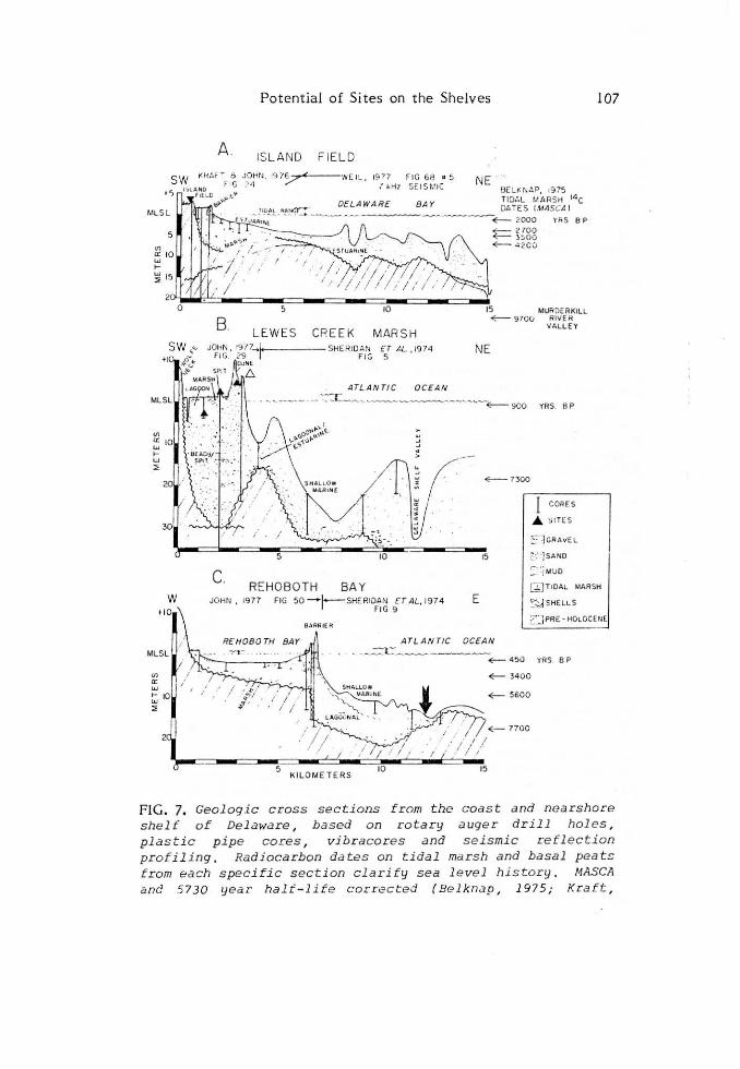
FIG. 7. Geologic cross sections from the coast and nearshore shelf of Delaware , based o n rotary a uger dril l holes , plastic pipe cores, vibr acores and seismic refl ection profiling, Rad i ocarbon dates on tidal ma r s h and basal peats f r om each specific sect ion clarify sea l e vel history . MASCA anc! 5730 yea r halt-life correc ted (Be .lknap, 1975; Kraft ,
108 J.C. Kraft et al.
Fi g . 7. ( cont.) 1 976). Location of cross section given in Fig . 1. Figure 7A based on da ta f r om Weil ( 1977) for Delaware Bay and Kr aft and John (1976) for South Bower s (Island Fi e ld) . Figuie 78 modifie d and projected three miles from Sheridan et al . ( 1974) for nearshor e marine and modified from John ( 1977) tor Le wes Cr eek Marsh. Figure 7C moditied trom John ( 1977) tor Rehoboth Ba y, and atter Sheridan et al. (1974) tor the nea rshore marine . Actua l archaeological sites d iscussed in the text ~re shown as black triangles . The bold black arrow in Fig, 7C reters to the li ke ly spot to search t o r a submarine si te , reterr ing to the concept expressed by s imilar arrows in Fig, 8 .
Swift et al. (1972) developed a mode l geomorphic-process or iented map of the continental shelf of the region. \Ve know from thei r hypotheses as t o the na ture of erosion , deposition and ra vineme nt or erosion of the shoreface as the coast s transgressed landward across the A tla ntic continental shelf that deposi tional uni ts a re very complex. Kne bel et al. (1977), Sherida n et al . (1 974), Field and Dua ne (1976) a nd Duane et al . (1972) provide us with a wealth of informa tion regarding which e lements of subma rine morphology on the shelf are erosional and which are depositional. \Ve can thus envisage an early Holoce ne se t t ing of a coastal barrier system with Jagoons very simila r t o t hat of t he presen t New Je rsey-Dela ware-Ma ryl and-Virginia shore line with dee p embayments across the continental shelf of the magnitude of ± 50 to 7 5 km inland. Surrounding t hese coastal e nvironments would be the optima l areas for search for evidences o f earl y ma n in the Holocene Epoch. Here again we have the problem that muc h of the area t o be studied is below t he photic zone. This is fu rther compounded by the fact that we are dealing with Ame rican In dian traditions a nd life styles. Therefore , it is unlikely t hat any massive amoun ts of meta l or rock would be availa bJe to aid us in the search of this area . As sta t ed before , Whitmore et al , (1967) clea rly demonstrated that coastal sedimentary environmental lithosomes simila r to those of present tim e a re exposed in pa tch y a reas on the outer continenta l shelf. Ultirnately, whether early human si tes a re discove red or not, may depe nd upon luck or new technologica l applica tions.
Da ta presented in Fig. 7 and studies ove r the past decade permit a de taile d s um mation of the problem and solution t o some of the questions about earl ier huma n occupation of the continenta l shelf or the subme rged areas in Delawa re Bay. A recent summary of tlıis work is given by Kraft and John (1978). This study clear ly dernonstrates one of tlıe dilemmas of the researclıer in loca ting occupa tion sites of ear lier man. For instance, in the extre me landwa rd estuarine posit ions in many areas a long t he Delaware
</)
er: "' .... "' =<
-1
~$\.. o
\0 vı
er: "' 20 ....
"' :::<
->})
~ LAGOON/ ESTUARY
CJ BARRIER
D SHALLOW MARINE
~ MIOOEN
o o ts::SJ PRE- HOLOCENE
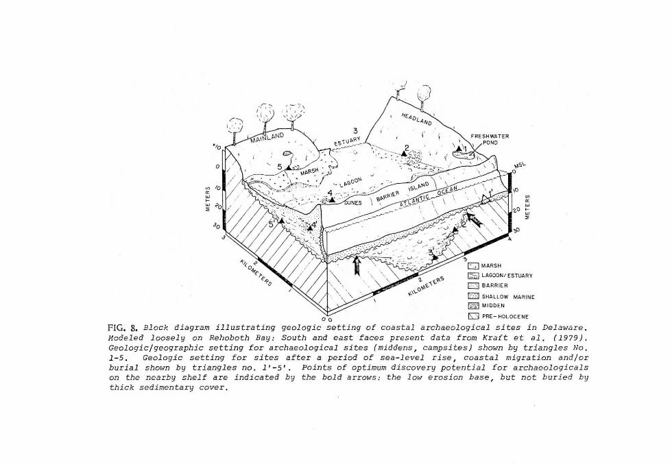
FIG. 8. Block diagram illustrating geologic setting of coastal archaeological sites in Delaware. Modeled loosely on Rehoboth Bay: South and east faces present data from Kraft et al. ( 1979). Geologic/geographic setting for archaeologica l sites (middens , campsites) shown by triangles No , 1-5. Geologic setting fo r sites after a period of sea-l e vel rise, coastal migration and/or burial shown by triangles no . l' - 5'. Points of optimum discovery potential tor archaeologicals on the nearby shelf are indicated by the bold arrows: t he l ow erosion base, but not buried by thick sedimentary cover.
110 J.C. Kraft et al.
~.r::::.-.·•h .. c:;c.., .......... _ -- • . • ·-
ı'
. ' ~ : ı ·
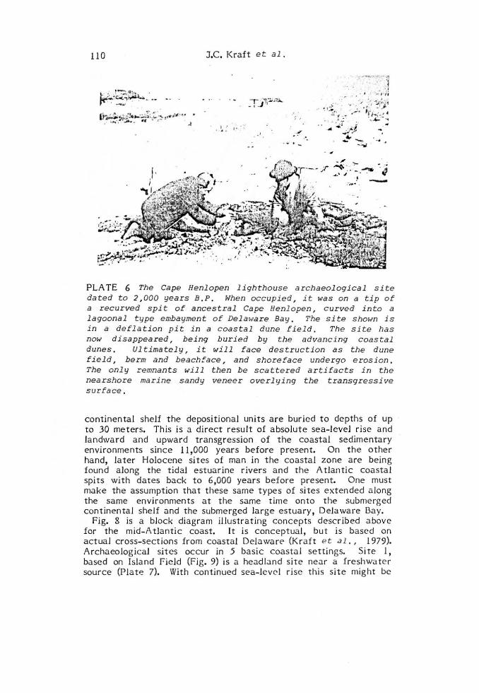
PLATE 6 The Cape Henlopen lighthouse archaeological site dated to 2,000 years B.P. When occupied , it was on a tip of a recurved spit of ancestral Cape Henlopen , curved into a lagoonal type embayment of Delaware Bay. The site shown is in a deflation pit in a coastal dune field. The site has now disappeared, being buried by the advancing coastal dunes. Ul timately, it t-1ill face destruction as the dune field, berm and beachface, and shoreface undergo erosion. The only remnants will then be scattered artifacts in the nearshore marine sandy veneer overlying the transgressi ve sur:face.
continental shelf the depositional units are buricd to depths of up to 30 meters. This is a direct resu lt of absolute sea-level rise and landward and upward transgression of the coastal sedimentary environments since 11,000 years before present. On the other hand, la ter Holocene si tes of man in the coastal zone are being found along the tidal estuarine rivers and the Atlantic coasta l spits with dates back to 6,000 years before present. One must make the assumption that these same types of sites extended along the same environments at the same tim e onto the submerged continentaJ shelf and the submerged large estuary, Delaware Bay.
Fig. 8 is a block diagram illustrating concepts described above far the mid- A tlantic coast. it is conceptual, but is bascd on actuaJ cross-sections from coastal Delawarı;- (Kraft e t al. , 1979). Archaeological sites occur in 5 basic coastal settings. Site 1, bascd on lsland Field (Fig. 9) is a headland site near a freshwa te r source (Plate 7). With continued sea- levcl rise this site might be
Potential of Sites on the Shelves ı 11
completely obliterated by the shoreface erosion, as shown by 1 '. Site 2 is a midden on a lagoon and marsh edge, based on shellfish resources. Continued sea-level rise might preserve t his site, as shown in 2'. A variation on this theme is also shown for sites 5 and 5'. Many examples of these coastal middens a re found on the mid-A tlantic coast. Sit e 3 would be originally far up an estuary or tidal river. Since it would experience the longest delay between burial and subseguent a rrival of the shoreface, it would be deepest in the column, and be most likely to survive , as shown at 3'. Site 4 is an example of a small midden on the coastal barrier island, or on a spit, representative of t he Lewes Creek Marsh spit tip sites and the Cape Henlopen "Lighthouse" a rc haeological site (Pla t e 6). These may be buried by dune sands or marsh, but since they are close to a rapidly retreating shoreline, have less li kelihood of long survival, as shown by 4'. Of the three si t es l', 2' and 3' it is obvious that preservation potential depends on the original site
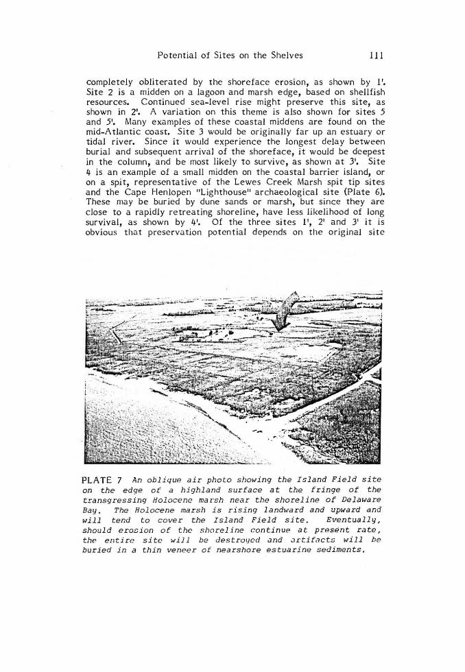
PLATE 7 An oblique air photo showing the Island Field s i te on the edge of a highlana surface at the fringe of the transgressing Holoce ne marsh near the shoreline of Delaware Bay. The Ho locene mar sh is rising landwara ana upward ana will tend to cover the Islana Fiela site, Eventually, should erosion of the shoreline con tinue at present rate, the erıtire site will be ılestroı1ed and .ırtifacts will be ·buried in a thin veneer of nearshore estuarine sedi ments .
112 J.C. Kraft et al.
location and the rate of sea-level rise. in looking for potential archaeological sites on the continental shelf, we would Jook in the areas shown by the broad arrows, in other words on the flanks of interfluves below the eroded zone, but not so deeply buried as to be inaccessible . . Figure 7 is a compilation of geologic cross-sections in thc
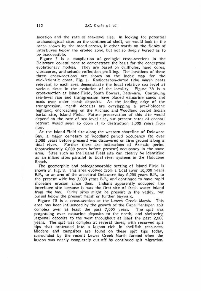
Delaware coastal zone to demonstrate the basis far the conceptua l evolutionary mode ls. They are based on drillholes, hand cores, vibracores, and seismic reflection profiling. The Jocations of these three cross-sections are shown on the index map for the mid-A tlantic coast, Fig. 1. Radiocarbon-dated tidaJ marsh peats relevant to each area demonstrate the Jocal relative sea level at var ious tim es in the evolution of the locality. Figure 7 A is a cross-section at Island Field, South Bowers, Delaware. Continuing sea-level rise and transgression have placed estuarine sands and muds over older marsh deposits. At the Jeading edge of the transgression, marsh deposits are overlapping a pre-Holocene highland, encroaching on the Archaic and Woodland period Indian buria l site, lsland Field. Future preservation of this site would depend on the rate of sea level rise, but present rates of coastal re treat would seem to doom it to destruction 1,000 years from now.
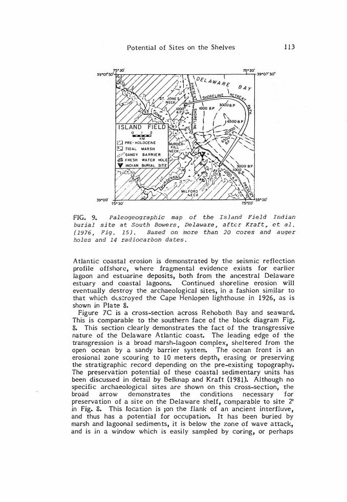
At the lsland Field site along the western shoreline of Delaware Bay, a major cemetary of Woodland period occupancy (to over 3,000 years before present) was discovered on firm ground along a tidal river. Further there are indications of Archaic period (approxima tely 6,000 years before present) occupancy in the same area. Sites such as the Island Field site can clearly be identified as an inland sites parallel to tidal river systems in the Holocene Epoch.
The geomorphic and paleogeomorphic setting of lsland Field is shown in Fig. 9. This area evolved from a tidal river 10,000 years B.P., to an arm of the ancestral Delaware Bay 6,500 years B.P., to the present wide bay 3,000 years B.P., and continued to have rapid shoreline erosion since then. Indians apparently occupied the interfluve site because it was the first site of fresh water inland from the bay. OJder sites might be present in the valley, but buried below the present marsh or further bayward.
Figure 7B is a cross-section at the Lewes Creek Marsh. This area has been .influenced by the growth of the Cape Henlopen spit complex over a t least the past 7,000 years. The spit was prograding over estuar.ine deposits to the north, and sheltering lagoonal deposits to the west throughout at Jeast the past 2,000 years. The sp.it was complex a t several t imes, with recurved spit tips that protruded into a lagoon rich in shellfish resources. Middens and campsites are found on these spit tips today, surrO'unded by the recent Lewes Creek Marsh formed when the Jagoon was nearly compJetely cut off by continued spit migration.
Potential of Sites on t he Shelves 113
39•00' 7 •30'
FIG. 9. Pa leogeographic map of the Islan d Field Indian burial si t e at South Bowers, Delaware, afte:r Kraft , et al. (1976, Fig. 15). Based on more than 20 cores and auger holes and 14 radioca rbon dates.
Atla ntic coastal erosion is demonstrated by the seismic reflcction profile offshorc, where fragment~l evidence exists for earlier lagoon and estuarine deposits, both from the ancestral Delaware estua ry and coastal lagoons. Continued shore line erosion will eventuaHy destroy the archaeological sites, in a fashion similar to that which dt..s-~royed the Cape Henlope n lighthouse in 1926, as is shown in P la te 8.
Figure 7C is a cross-section across Rehoboth Bay a nd seaward. This is comparable t o the southe rn face of the block diagram Fig. 8. This section clear!y demonstrates the fact of t he transgressive nature of the Dela ware A tlantic coast. The leading edge of the transgression is a broad marsh-lagoon complex, sheltered from the open ocean by a sandy barrier system. The ocean front is an erosional zone scouring t o 10 meters depth, erasing or preserving the stratigraphic record depending on the pre-exist ing topography. The preservation potential of these coastal sedimentary units has been discussed in detail by Belknap a nd Kraft (1981). Although no specific a rchaeological sites are shown on this c ross-section, t he broad arrow demonstra tes the conditions necessary for preservation of a site on the De laware shelf, comparable to site 2' in Fig. 8. This location is ;on the flank of an ancient interfluve, and thus has a potential for occupation. It has been buried by marsh and Jagoonal sediments, it is below the zone of wave attack, and is in a window which is easily sampled by coring, or perhaps
114 J.C. Kraft et al.
in si tu exploration. Many more such sites should be identifia ble by seismic reflection profiling.
Shoreline projection a nd reconstructions can and have been ma de based on intensive driHing programs to determine the shapes of the nearshore submarine and shoreline subm.:ırine coast.:ıl sedimentary environmental Jithosomes. The Jogica l extension of t his exists throughout the submerged area of Delaware Bay, a brge tidal estuary, and thence onward to the continental shelf. Weil (1976), eınd Kraft et al . (1974) formed a reconstruction of t he geomorphology and location of coastal sedimentary environmental
PLATE 8. The lighthouse and lightkeeper • s house site at Cape Henlopen, constructed in the middle lBth century, one-quarter of a mile from the sea. By cont inuous coastal transgression of the dune upon whi ch the lightho use was sited, it eventually, in 1926, fell into the sea. Lighthnuse sites such as tlıis offer little potential tor preservation . nıe debris from them wil l be mixed ı"ith the thin veneer of t ransgr essive sands that overlic the sur[ace of transgression. (Photo courtesy of J . ~ı. Beach) . Originally the lighthouse was located at the point of a cuspate foreland type of cape,
Potential of Sites on the SheJves 115
f"7~ .. --:~ · ...... ·'~·';:'"," "' •1 t,• ...... --- .... '" "''" ......._ -...........-..- - --- ~.
! _, ... · • · ...... ·· ı · la · •· (l
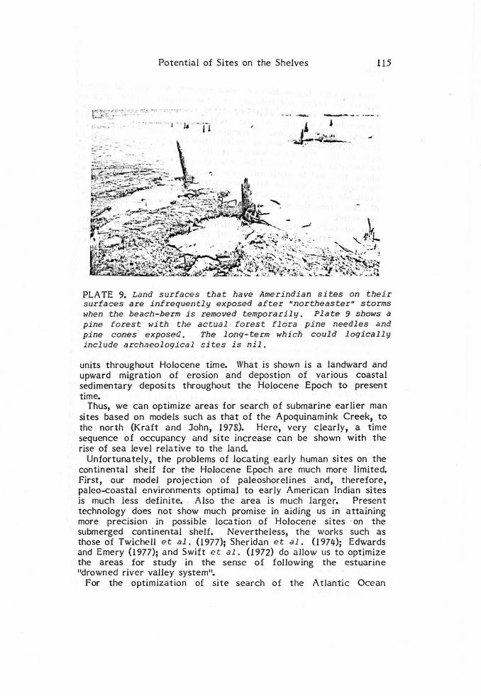
PLATE 9. Land surfaces that ha ve Amerindian si tes on their surfaces are infrequently exposed after "northeaster" storms when the beach-berm is removed temporarily. Plate 9 shows a pine forest wi th the actual · forest flora pine needles and pine cones expose<l. The long-term which could logically include archaeological sites is nil.
units throughout Holocene time. \Vhat is shown is a landward and upward migration of erosion and depostion of various coastal sedimentary deposits throughout the Holocene Epoch to present time.
Thus, we can optimize areas for search of submarine earlier man sites based on models such as that of the Apoquinamink Creek, to the north (Kraft and John, 1978). Here, vcry cleariy, a time sequence of occupancy and site increase cun be shown with the rise of sea level rela tive to the land.
Unfortunately, the problems of locating early human sites on the continental shelf for the Holocene Epoch are much more limi_ted. First, our model projection of paleoshorelines and, therefore, paleo-coastal environments optinıal to early American Indian sites is much less definite. Also the area is much larger. Present technology does not show much promise in aiding us in attaining more precision in possible loca tion of Holocene si tes ·on the submerged continenta l shelf. Nevertheless, the works such as those of Twiche ll e t al. (1977); Sheridan e t al. 0 974); Edwards and Emery (1977); and Swift e t al. (1972) do allow us to optinıize the areas for study in the sense of following the estuarine 11drowned river valley system".
For the optimization of site search of the A tlantic Ocean
116 J.C. Kraft N. a ı.
cocı s t-p.:.ı ra llcJ l.:ıgooıı-barrie r cnvironments , we nıust at prescnt depend on reJict morphoJogies and the ra ndom c hance d iscovcry suclı as those listed iıı \Vhitmorc- c> t al. (1967). FortunateJy, some georııorplıi c c lemcnts oıı thc shcl f caıı providc aid rcg.:ırdirıg
ancicnt shoreJine zones. ı\ numbcr of scarps ha vc becn ident i fi ed fro rn topographic studic-s of slıc l f bottonı contour maps. A not.:ı ble onc is the 11 Fr.:rnkliıı Shorc " at tlıe very outcr p.:ırt of rlıc
coııtin ent.:ıl shelf. Seve rn J Jesscr sca rps may be identi ficd Jandwa rd aJong the rniddJe shelf off. Ne w Jersey. AJthough some wouJd maintain that they can date tlıese site s, factual data is in fact not ava ila blc and tlıe sites a re in reaJity dated on a relativc basis of position from the ma ximum Jow of sea stand o f the present high se a stand.
in sumrnary, regarding the Atlantic continental she lf, we then lıave a re latively large amount of geomorphic and environmental data but re Ja tively poor chances of precise site location prcdict<.ıbility.
CONCLUSIONS
The comp.:ır i sons made between the wave cut terrace-cliff retreat on the northern Aegean Sea continental shelf and the A tla ntic contincn tal shelf barrier-lagoon-estuar ine transgression show two dramaticaliy different situations. Problems a re revealed rega rding location and/or preservation of early American rnan sites. For the Holocene Epoch, the possibility of cveııtu.:ıl disc overy of si tes is high. However, t he t echnoJogy tor Jocation of these sites is poor and in the short terrn, rdndom dredge data and intensive petroleum company drill site studies will provide us with the best data. Random diving and search is severe ly limite d as a t echnique because of the lack of visibility over much of the middle and outer shelf b-0ttom. In the estua'Ties there is a lack of visibility because of high turbidity. Clearly, Holocene sites must exist. Based on landward evidcnces a long the deeply indented tidal estuaries in the Delaware coastal zone , we know that early man was occupying the tidal coastaJ zone, utiiizing shellfish and finfish resources. The refore , it is a logical assumption that this would apply to stili earlie r man and to possible sites on t he subm erged continenta l shelf throughout the Holocene Epoch.
Similarly, we know that the landward a reas north of the continental sheif in the north Aegean Sea were occupied by Holocene man and, therefore, the potential for sites must exist on the submerged continenta l shelf. However, one might through empirical reasoning suggest that there is a Iesser chance of locating such sites because geologic processes such as wave cut terrace incision and de posit ion of nearshore stratigraphic units occur as the wave cut t errace advances landward.
The search for early human sites on the continental shelves will
Potential of Sites on the Shelves 117
probably lead to discoveries. \Vhether this wi11 be done by scientific and technological technique or by random chance or accident remains to be seen. Neverthe less, a fu11 understanding of t he coast a l environmenta l units from models of present dc:ıy coastal studies, and direct projection of onshore analogies seaward into the submarine record of the shelf provide us with a capability for optimizing the choice of potential occupancy zones. \Vi thout this reduction in the number of square kilometers of submerged shelf to be studied and sele ction of the seach a rea s, the study would be an almost impossible task in terms of our exist ing and potential "st a te of the a r t" of science a nd t echnology.
ACKNOWLEDGEMENTS
\Ve would like to acknowledge the fin ancial support over more than five years of the NOAA Sea Grant progrnm of tlıe Un iversity of Dclaw.:ıre, and thc Oifice of Na val Rcsc<.ırch Geography Progra m. \Ve also acknowledge the technical assistance of Maden Tetkik ve Arama Institüsü (the Turkish Geological Survey). In particula r, thanks a re due to Professor Oguz Erol, of the University of Ankara, without whorn the work in Turkey would have been impossible .
REFERENCES
Belknap, D.f'. (1975). Da ting o f Late Pl ı-.• i!.J tocene a nd Ho l ocen e
r e l a ti ve s ea le ve l s in coas t al Delaware , Department of Geology , Unive rsity of Dela ware, Newa rk, Maste r o J Sc ie nce Thesis, 95 pp.
Belknap, D.F. a nd Kraft J .C. ( l 977). Holocene re la ti ve sea- lcvel changes a nd coastal stratigra phic units on the nor thwest f Ja nk of t he Baltimore Canyon Trough Geosyncline , Journa l of Sedimenta r y Petrology , 47, 610-629.
Belknap, D.F. a nd Kraft J.C. ( 1981). Pre se rvation pote ntia l of transgressi ve coasta l lithosomes on · the U.S. Atlantic s heif, Mar ine Geol o gy, 42_, 429-442.
Belknap, D.F., Sheridan R.E., Swif t D.J.P., and Lapie ne G. (1 976). Geophysical inves t iga tions of the De la wa re She lf Va lley. Geoloqi c a l Soci et y o f Ameri c a Abs t r acts wi th Programs ş_,
131-1 32.
Duane, D.B., Field M.E., Me isburger E.P., Swift D.J .P., a nd Will iams, S.J. (1 972). Line o.r shoaJs on the A tla ntic inne r c ontinenta l she lf, FJorida t a Long lsla nd. In (D.J.P. Swift · e t a l . , eds.) She l f Sed ime n t Tra n s p o r t : P rocess and Pat t e rn Dowden, Hutchinson, a nd Ross, Stroudsburg, PA pp. 447-499.
118 J.C. Kraft et al.
Edwards, Robert L. and Emery, K.O. (1 977), Man on the continental shelf. In (Newman, W.S. and B. Salwen, eds.) Amerinds and th2ir Pal eoenvironmen ts in Eastern North Ameri ca , Annals of the Neı-1 ·r ork Academy of Science 2~
353-359.
Fairbridge, R.W. (1976). Shellfish-eating preceramic I nd iaııs in coastal Brazil. Science 191, 353-359.
Field, M.E. and Duane, D.B. (1 976). Post-Pleistocene history of t he United States inner continental shelf: Significance and origin of barrier islands, Geological Society of America Bulletin ~ 691 -702.
Flemming, N.C. (1971). Ci ti es in the Sea. Doubleday and Co., New York, 222 pp.
F!emming, N.C. (1978). Holocene eus.ta tic changes and coastal tectonics in the northeast Mediterranean: lmplications for models of coastal consumption, Philisophical 1'ransactions of the Royal Society of London 298, 405-458.
John, C .J. (1 977). Internal sedimen t a r y s tructures, vertica l stratigraphic s equences, and grain - size diameter variations in a transgress ive coastal bar-der complex: the Atlantic coast of Delaware . Ph.D. Dissertation, Department of Geology, University of Delaware, Newark, 287 pp.
Kra ft, J .C. (1971 ). Sedimentary facies patterns and geologic history of a Holocene marine transgression. Ceological Society o f lımerica Bulletin g 2131-2158.
Kraft, J.C. (l 976a). Radiocarbon dates in the De laware coastal zone (Eastern At lantic Coast of North America) University of De laware NOAA Sea Grant Program Publication (DEL-SG-19-76), Newark, 20 pp.
Kraft, J.C. (l 976b). Geological reconstruc tions of ancient coastal environments in the vicinity of Island Field arc haeological site , Kent County, Delaware. Tr9nsactions ot the Delaware Acad emy of Science - 1974 and 1975, Newark ?._, 31-66.
Kraft, J.C. and John C.J. (l 97 6). The geological structure of the shore lines of Delaware, University of Delaware NOAA Sea Grant Program (DEL-SG-14-76), Ne wark, 107 pp.
Potential of Sites on the She!ves 119
Kraft, J.C. and John, C.J. Gl 978), Paleogeographic ana!ysis of coasta! archaeological settings in De!aware. Archeology of Eastern North Aırıerica §., 41-60.
Kraft, J.C., Sheridan, R.E., Moose, R.D., Strom, R.N., and \Veil , C.B. (1974). Midd!e-Late Holocene evo!ution of the morpho!ogy of a drowned estuary system - The Delaware Bay. Mem. Inst . Geol . Bassin Aquitaine !..J 297-305.
Kraft, J.C., AH en, E.A., Be!knap, D.F., John, C.J., and Maurmeyer, E.M. (1976). De!aware's Changing Shoreline, Technical Report No. 1, Delaware Coastal Zone Managemen t Program, Delaware State P!anning Office, Dover, 319 pp. (Prepared fro m an unpublished marıuscript: Geologic processes and the geo!ogy of Dela ware's coasta! zone.)
Kraft, J.C., AH en, E.A., Belknap, D.F., John, C.J. and Maurmeyer, E.M. (1979). Processes and morphologic evo!ution of an estuarine and coastal barrier system. in Barrier Islands, from the Gulf St. Lawrence to the Gulf of Nexico (S.P. Leatherman, ed.) Academic Press, New York. pp. 149-183
Milliman, J.D. and Emery, K.O. 0 968). Sea levels dur ing the past 351000 ye.:ırs, Science 162, 1121-1123.
Shepherd, F.P. and Curray, J.R. (1967). Carbon-14 determination of sea !eve! changes in stable areas. Progress in Oceanograplıy
!±, 283-291.
Sheridan, R.E., Dil!, C.E. Jr. and Kraft, J.C. (1974). Holocene sedimentary environment of the At!antic inner shelf off Delaware Geological Society ot America Bulletin ~ 1319-1328.
Swift, D.J.P. (1973). Delaware Shelf VaUey: estuary retreat path, not drowned river valley. Geological Society of America Bulletin §!±_, 2743-2748.
Swift, D.J.P., Kofoed, J.W., Saulsburg, P.J. and Sears, P. (1972). Holocene evolution of the shelf surface, central and southern Atlantic shelf of North America. in (D.J.P. Swift et al., eds.) Shelf Sediment Transport: Process and Pattern. Dowden, Hutchinson, and Ross, Stroudsburg, PA, pp. 499-574.
TwicheJl, D.C., Knebe!, H.J . and Folger, D.W., (1977). Delaware River: Evidence for its former extension to \Vilmington Canyon. Sc.lence 195, 483-484.
120 J.C. Kraft et al .
Weil, C.B., Jr. (1976). A model tor the distribution, dynamics and e vo l ution of Holocene sediments and morphologic features ot Delaware Bay. Ph.D. Disse rtation, Department of Geology, Unive rsit y of Dela ware, Newa rk, 408 pp.
\Vhit more , F.C., Jr., Emery, K.O.,Cooke, H.G.S. and Swift, D.J.P. ( 1967). Ele phant teeth on the A t lantic Continenta l Shelf, Science 156, 1477-1481.