10Be dating of river terraces of Santo Domingo river, on Southeastern flank of the Mérida Andes,...
12
10 Be dating of river terraces of Santo Domingo river, on Southeastern flank of the Mérida Andes, Venezuela: Tectonic and climatic implications Oswaldo Guzmán a, b, * , Riccardo Vassallo b , Franck Audemard c, d , Jean-Louis Mugnier b , Javier Oropeza c , Santiago Yepez a, e , Julien Carcaillet f , Miguel Alvarado g , Eduardo Carrillo h a Departamento de Ciencias de la Tierra, Universidad Simon Bolivar, 89000, Caracas 1081-A, Venezuela b ISTerre, Université de Savoie, CNRS, F-73376 Le Bourget du Lac, France c Departamento de Ciencias de la Tierra e Fundacion Venezolana de Investigaciones Sismologicas, Caracas, Venezuela d Escuela de Geología, Minas y Geofísica, Facultad de Ingeniería, Universidad Central de Venezuela, Caracas, Venezuela e Fundacion Instituto de Ingenieria e CPDI, Sartenejas, Venezuela f ISTerre, Université de Grenoble 1, CNRS, F-38041 Grenoble, France g Universidad de Los Andes, Mérida, Venezuela h Instituto de Ciencias de La Tierra, Universidad Central de Venezuela, Venezuela article info Article history: Received 1 May 2013 Accepted 3 September 2013 Keywords: Venezuela Mérida Andes River terraces Climatic control Uplift rate In situ produced 10 Be abstract In this study, we discuss the first cosmogenic 10 Be dating of river terraces located in the lower reaches of the Santo Domingo river (Southeastern flank of the Mérida Andes, Western Venezuela). The geomorphic observations and dating allowed the restoration of the temporal evolution of incision rate, which was analysed in terms of tectonic, climatic and geomorphic processes. The long-term incision rate in the area has been constantly around 1.1 mm/a over the last 70 ka. Taking into account the geologic and geo- morphologic setting, this value can be converted into the Late Pleistocene uplift rate of the Southeastern flank of the Mérida Andes. Our results show that the process of terraces formation in the lower reaches of the Santo Domingo river occurred at a higher frequency (10 3 e10 4 years) than a glacial/interglacial cycle (10 4 e10 5 years). According to the global and local climate curve, these terraces were abandoned during warm to cold transitions. Ó 2013 Elsevier Ltd. All rights reserved. 1. Introduction River terraces are paleotopographic markers, the genesis of which results from tectonics, climatic changes, eustatic variations and geomorphic processes at the catchment scale (Pazzaglia, 2013). The geometrical and sedimentological analysis of river terraces coupled with numerical ages have been widely used in order to decipher and quantify the role of each process (e.g. Maddy et al., 2001; Antoine et al., 2007; Wegmann and Pazzaglia, 2009; Lewin and Gibbard, 2010). The Mérida Andes (MA) is an active tectonic range, located in Western Venezuela (Fig. 1), where several rivers (e.g. Chama, Santo Domingo, Motatán, Guanare, Mocotíes, Tucaní) provide a wide record of river terraces. The origin of these terraces has been mainly associated with Pleistocene paleoclimatic fluctu- ations (e.g. Zinck, 1980; Vivas, 1984; Schubert and Vivas, 1993), in particular with glacial/interglacial cycles (Tricart and Millies- Lacroix, 1962; Tricart and Michel, 1965; Tricart, 1966). For the ter- races located along the axial part of the chain, a tectonic origin associated with the uplift of the chain has also been proposed (Shagam, 1972; Giegengack, 1984; Audemard, 2003). Nonetheless the lack of numerical ages in the river terraces of the MA constitutes a weakness in the argumentation for these two hypotheses. This study focuses on the Southeastern flank of the MA. The study area is located in the lower reach of Santo Domingo river between the Barinitas city and El Charal village (Fig. 1). In this re- gion, the river presents a series of well-preserved strath terraces, thus the incision rate can be estimated at different time scales. In this reach, the river is orthogonal to the structural trend of the chain; therefore the effect of localized active deformation in the * Corresponding author. Departamento de Ciencias de la Tierra, Universidad Simon Bolivar, 89000, Caracas 1081-A, Venezuela. E-mail addresses: [email protected], [email protected] (O. Guzmán). Contents lists available at ScienceDirect Journal of South American Earth Sciences journal homepage: www.elsevier.com/locate/jsames 0895-9811/$ e see front matter Ó 2013 Elsevier Ltd. All rights reserved. http://dx.doi.org/10.1016/j.jsames.2013.09.004 Journal of South American Earth Sciences 48 (2013) 85e96
Transcript of 10Be dating of river terraces of Santo Domingo river, on Southeastern flank of the Mérida Andes,...

lable at ScienceDirect
Journal of South American Earth Sciences 48 (2013) 85e96
Contents lists avai
Journal of South American Earth Sciences
journal homepage: www.elsevier .com/locate/ jsames
10Be dating of river terraces of Santo Domingo river, on Southeasternflank of the Mérida Andes, Venezuela: Tectonic and climaticimplications
Oswaldo Guzmán a, b, *, Riccardo Vassallo b, Franck Audemard c, d, Jean-Louis Mugnier b,Javier Oropeza c, Santiago Yepez a, e, Julien Carcaillet f, Miguel Alvarado g,Eduardo Carrillo h
a Departamento de Ciencias de la Tierra, Universidad Simon Bolivar, 89000, Caracas 1081-A, Venezuelab ISTerre, Université de Savoie, CNRS, F-73376 Le Bourget du Lac, Francec Departamento de Ciencias de la Tierra e Fundacion Venezolana de Investigaciones Sismologicas, Caracas, Venezuelad Escuela de Geología, Minas y Geofísica, Facultad de Ingeniería, Universidad Central de Venezuela, Caracas, Venezuelae Fundacion Instituto de Ingenieria e CPDI, Sartenejas, Venezuelaf ISTerre, Université de Grenoble 1, CNRS, F-38041 Grenoble, Franceg Universidad de Los Andes, Mérida, Venezuelah Instituto de Ciencias de La Tierra, Universidad Central de Venezuela, Venezuela
a r t i c l e i n f o
Article history:Received 1 May 2013Accepted 3 September 2013
Keywords:VenezuelaMérida AndesRiver terracesClimatic controlUplift rateIn situ produced 10Be
* Corresponding author. Departamento de CienciSimon Bolivar, 89000, Caracas 1081-A, Venezuela.
E-mail addresses: oswaldojoseguzman@gm(O. Guzmán).
0895-9811/$ e see front matter � 2013 Elsevier Ltd.http://dx.doi.org/10.1016/j.jsames.2013.09.004
a b s t r a c t
In this study, we discuss the first cosmogenic 10Be dating of river terraces located in the lower reaches ofthe Santo Domingo river (Southeastern flank of the Mérida Andes, Western Venezuela). The geomorphicobservations and dating allowed the restoration of the temporal evolution of incision rate, which wasanalysed in terms of tectonic, climatic and geomorphic processes. The long-term incision rate in the areahas been constantly around 1.1 mm/a over the last 70 ka. Taking into account the geologic and geo-morphologic setting, this value can be converted into the Late Pleistocene uplift rate of the Southeasternflank of the Mérida Andes. Our results show that the process of terraces formation in the lower reaches ofthe Santo Domingo river occurred at a higher frequency (103e104 years) than a glacial/interglacial cycle(104e105 years). According to the global and local climate curve, these terraces were abandoned duringwarm to cold transitions.
� 2013 Elsevier Ltd. All rights reserved.
1. Introduction
River terraces are paleotopographic markers, the genesis ofwhich results from tectonics, climatic changes, eustatic variationsand geomorphic processes at the catchment scale (Pazzaglia, 2013).The geometrical and sedimentological analysis of river terracescoupled with numerical ages have been widely used in order todecipher and quantify the role of each process (e.g. Maddy et al.,2001; Antoine et al., 2007; Wegmann and Pazzaglia, 2009; Lewinand Gibbard, 2010). The Mérida Andes (MA) is an active tectonicrange, located in Western Venezuela (Fig. 1), where several rivers(e.g. Chama, Santo Domingo, Motatán, Guanare, Mocotíes, Tucaní)
as de la Tierra, Universidad
ail.com, [email protected]
All rights reserved.
provide a wide record of river terraces. The origin of these terraceshas been mainly associated with Pleistocene paleoclimatic fluctu-ations (e.g. Zinck, 1980; Vivas, 1984; Schubert and Vivas, 1993), inparticular with glacial/interglacial cycles (Tricart and Millies-Lacroix, 1962; Tricart and Michel, 1965; Tricart, 1966). For the ter-races located along the axial part of the chain, a tectonic originassociated with the uplift of the chain has also been proposed(Shagam, 1972; Giegengack, 1984; Audemard, 2003). Nonethelessthe lack of numerical ages in the river terraces of theMA constitutesa weakness in the argumentation for these two hypotheses.
This study focuses on the Southeastern flank of the MA. Thestudy area is located in the lower reach of Santo Domingo riverbetween the Barinitas city and El Charal village (Fig. 1). In this re-gion, the river presents a series of well-preserved strath terraces,thus the incision rate can be estimated at different time scales. Inthis reach, the river is orthogonal to the structural trend of thechain; therefore the effect of localized active deformation in the

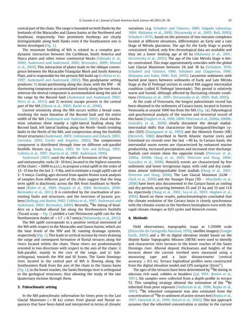
Fig. 1. Geodynamic and morphological settings of the study area. a) simplified main present-day active tectonics of Northern South America (from Audemard and Audemard, 2002).(SMBF) Santa Marta Bucaramanga Fault; (OAF) Oca-Ancón Fault; SSF) San Sebastián Fault; (EPF) EL Pilar Fault; (BF) Boconó Fault. Location of the Cariaco basin is shown. b) Shadedrelief map of the MA based on SRTM. Location of the study area is shown by a red square. Main active trace of the Boconó Fault is located between the two red arrows. c) Geologicalmap of the study area from Hackley et al. (2005). 1. Pleistocene to Holocene alluvial sediments; 2. Oligocene, Miocene and Pliocene conglomerates and sandstones; 3. Paleocene toEocene shales and sandstones; 4. Jurassic to Cretaceous (Undifferentiated) limestones and sandstones; 5. Carboniferous to Permian phylites and limestones; 6. Ordovician to Silurianshales and silstones; 7. Upper Paleozoic to Mesozoic intrusives rocks; 8. Upper to Lower Paleozoic intrusives rocks, phyllites, schist and gneiss; 9. Proterozoic gneiss, schist andgranites. Location of Tucaní scarp (Wesnousky et al., 2012) and El Carmen block (Kohn et al., 1984) are also shown. (For interpretation of the references to colour in this figure legend,the reader is referred to the web version of this article.)
O. Guzmán et al. / Journal of South American Earth Sciences 48 (2013) 85e9686
process of terraces formation can be quantified. Additionally, theriver is far from the sea (more than 1500 km), then the effect ofeustatic variation can be neglected. Hence, in this study a mor-photectonic analysis is coupled with in situ produced 10Be dating(10Be dating, in the text), in order to reconstruct the temporalevolution of the incision rate, which will be analysed in terms ofimpact of the different processes.
2. Geological setting
The MA is situated in the Western part of Venezuela. This rangeis around 400 km long with an SW-NE direction from theColombian-Venezuelan border in the Southwest to Barquisimetocity in the Northeast. Themean elevation of theMA is about 2024ma.s.l. and culminates at 4978 m a.s.l. at Pico Bolivar, located in the
O. Guzmán et al. / Journal of South American Earth Sciences 48 (2013) 85e96 87
central part of the chain. The range is bounded on both flanks by thelowlands of the Maracaibo and Llanos basins at the Northwest andSoutheast, respectively. Two prominent forebergs are clearlydistinguishable along both flanks even if the Southeastern one isbetter developed (Fig. 1).
The mountain building of MA is related to a complex geo-dynamic interaction between the Caribbean, South America andNazca plates and other minor continental blocks (Taboada et al.,2000; Audemard and Audemard, 2002; Bermudez, 2009; Monodet al., 2010). This interaction of plates leads to the oblique conver-gence between the Maracaibo Triangular Block and South AmericaPlate, and is responsible for the present MA build-up (Colletta et al.,1997; Audemard and Audemard, 2002). This geodynamic settingproduces: 1) strain partitioning along the chain, with the NW e SEshortening component accommodatedmostly along the two fronts,whereas the dextral component is accommodated along the axis ofthe range by the Boconó fault (Audemard and Audemard, 2002;Pérez et al., 2011); and 2) tectonic escape process in the centralpart of the MA (Dhont et al., 2005; Backé et al., 2006).
Current seismicity along the MA occurs within a broad zone,involving the main lineation of the Boconó fault and the entirewidth of the MA (Audemard and Audemard, 2002). Focal mecha-nism solutions show mainly a right-lateral faulting along theBoconó fault, left lateral faulting along the NortheSouth trendingfaults to the North of the MA, and compression along the foothillsthrust structures (Audemard, 2003; Colmenares and Zoback, 2003;Corredor, 2003; Cortés and Angelier, 2005). The compressioncomponent is distributed through time on different sub-parallelfoothills thrusts (e.g. Soulas, 1985; De Toni and Kellogg, 1993;Colletta et al., 1997; Duerto et al., 1998; Audemard, 1999).
Audemard (2003) used the depths of formation of the igneousand metamorphic rocks (8e10 km), located in the highest summitsof the chain (w5000m a.s.l.), to propose a total uplift in the order of12e15 km for the last 3e5Ma, and to estimate a rough uplift rate of2e5 mm/a. Cooling ages derived from apatite fission track analysisof samples from different part of the chain suggest that the longterm uplift is diachronic across the MA from Southeast to North-west (Kohn et al., 1984; Shagam et al., 1984; Bermudez, 2009;Bermudez et al., 2011). It is controlled by the reactivation of pre-existing faults and structures, and the inversion of Jurassic gra-bens (Kellogg and Bonini, 1982; Colletta et al., 1997; Audemard andAudemard, 2002; Bermudez, 2009). Recently, 10Be dating of boul-ders on a faulted alluvial fan along the Northwestern foothills(Tucaní scarp e Fig. 1) yielded a Late Pleistocene uplift rate for theNorthwestern Andes of w1.7 � 0.7 mm/a (Wesnousky et al., 2012).
The MA uplift corresponds to a positive vertical movement ofthe MAwith respect to the Maracaibo and Llanos basins, which arethe base levels of the NW and SE running drainage systems,respectively (Fig. 1). This leads to vertical incision by rivers drainingthe range and consequent formation of fluvial terraces along therivers located within the chain. These rivers are predominantlyoriented in two directions with respect to the axis of the chain: i)Sub-parallel, mainly in the core of the range, and ii) Sub-orthogonal, towards the NW and SE fronts. The Santo Domingoriver, located in the central part of MA is flowing along theSoutheastern flank from the axis of the chain to the Llanos basin(Fig. 1); in the lower reaches, the Santo Domingo river is orthogonalto the geological structures, thus allowing the study of the lateQuaternary incision through them.
3. Paleoclimatic setting
In the MA paleoclimatic information for times prior to the LastGlacial Maximum (w18 ka) comes from glacial and fluvial se-quences that have been dated and interpreted in terms of climatic
variations (e.g. Schubert and Valastro, 1980; Salgado Labouriau,1984; Mahaney et al., 2000; Dirszowsky et al., 2005; Rull, 2005).Schubert (1974), based on the presence of two moraine complexeslocated at different elevations, differentiates an Early and a LateStage of Mérida glaciation. The age for the Early Stage is poorlyconstrained. Indeed, only few chronological data are available andthey set a lower limiting age at 60 ka (Mahaney et al., 2001;Dirszowsky et al., 2005). The age of the Late Mérida Stage is bet-ter constrained. This stage approximately coincides with the globalLast Glacial Maximum between 24 and 18 ka (Schubert, 1974;Schubert and Valastro, 1980; Schubert and Clapperton, 1990;Mahaney and Kalm, 1996; Rull, 2005). Lacustrine sediments withburied peat layers between sediments of Early and Late MéridaStage at the El Pedregal section in central MA suggest interstadialcondition (called El Pedregal Interstade). This period is relativelywarm and humid, although affected by fluctuating climatic condi-tions (Mahaney et al., 2001; Dirszowsky et al., 2005; Rull, 2005).
At the scale of Venezuela, the longest paleoclimate record hasbeen obtained in the sediments of Cariaco basin, located in EasternVenezuela at around 1000 km from the MA (Fig. 1a). Palynologicaland geochemical analysis of the marine and terrestrial record ofthis basin (Hughen et al., 1996, 2000; Peterson et al., 2000a, 2000b;González et al., 2008) clearly document the abrupt stadial-interstadial shifts that characterize the Dansgaard/Oeschger cy-cles (D/O) (Dansgaard et al., 1993) and the Heinrich Events (HE)(Heinrich, 1988) described in North Atlantic marine cores andGreenland ice records over the last w90 ka. In Cariaco basin, theinterstadial warm events are characterized by enhanced marineproductivity, increased precipitation and increased river discharge.Stadials cool events show the opposite trends (Peterson et al.,2000a, 2000b; Haug et al., 2001; Peterson and Haug, 2006;González et al., 2008). Heinrich events are characterized by fewsediments and lower terrigenous input, with cold and dry condi-tions almost indistinguishable from stadials (Haug et al., 2001;Peterson and Haug, 2006). The Last Glacial Maximun (LGM e
Clark et al., 2009) and the Younger Dryas (YD e Muscheler et al.,2008) have been also documented in the Cariaco basin as coolingand dry periods, occurring between 23 and 21 ka and 13 and 11.8ka, repectively (Haug et al., 2001; Lea et al., 2003; Hughen et al.,2004). Based on these results, paleoclimatologists concluded thatthe climate evolution of the Cariaco basin is closely synchronouswith the climatic events in the Northern hemisphere evenwith therapid climate changes as D/O cycles and Heinrich events.
4. Methods
Field observations, topographic maps at 1:25000 scale(Dirección de Cartografia Nacional, 1976), satellite imagery (GoogleEarth, 2005) and a 30em digital elevation model based on theShuttle Radar Topographic Mission (SRTM) were used to identifyand characterize river terraces in the lower reaches of the SantoDomingo river. Alluvial deposit thicknesses and heights of theterraces above the current riverbed were measured using ameasuring tape and a laser distancemeter (verticalaccuracy � 0.5 m). Terrace logitudinal profiles were constructedfrom the digital elevation model and GPS navigator (Etrex�).
The ages of the terraces have been determined by 10Be dating insiliceous rich sand, cobbles or boulders (Lal, 1991; Brown et al.,1991). Six samples were collected from a depth-profile in terraceT2. This sampling strategy allowed the estimation of the 10Beinherited from prior exposure (Anderson et al., 1996; Repka et al.,1997). 10Be inherited component was also estimated from theconcentration of 10Be in sediment of active stream bed (Repka et al.,1997; Hancock et al., 1999; Hetzel et al., 2002). This last approachassumes that the inherited concentration is similar to the current

O. Guzmán et al. / Journal of South American Earth Sciences 48 (2013) 85e9688
riverbed concentration. For the terraces T3 and T2, we sampled thefirst 5 cm of the upper part of the siliceous surface boulders (gneiss,granite, pegmatite, sandstone) partly embedded in the alluvialdeposit of the terrace and therefore not remobilized since theirdeposition (five and three sample were taken for dating T3 and T2,respectively).
Beryllium oxide targets were extracted following the chemicalprocedures of Brown et al. (1991) and Merchel and Herpers (1999).The extractions were made in the Cosmogenic Laboratory of Insti-tut de Sciences de la Terre (ISTerre, France). 10Be concentrationswere measured at the accelerator mass spectrometry facility ASTER(CNRS, France) (Arnold et al., 2010). They were calibrated againstNIST Standard Reference Material 4325 using its assumed 10Be/9Beratio of 2.79 � 0.03 � 10�11, and a 10Be half-life of 1.387 � 0.012 Ma(Chmeleff et al., 2010; Korschinek et al., 2010). Production rateswere calculated following Stone (2000) using the modified scalingfunctions of Lal (1991) and a 10Be production rate in quartz of4.5 � 0.3 at/g/a at sea level and high latitude. Geomorphic scalingfactors were calculated following Dunne et al. (1999). All 10Be agecalculations were performed using attenuation lengths of 150, 1500and 5300 g/cm2 with associated relative contributions to the totalproduction rate of 97.85%, 1.50% and 0.65% for neutrons, slowmuons and fast muons, respectively (Braucher et al., 2003).
Methods and factors of correction for paleomagnetic effectsremain amatter of debate and uncorrected ages do not significantlydiffer from intensity-corrected ages (e.g. Dunai, 2001; Carcailletet al., 2004; Masarik et al., 2001; Pigati and Lifton, 2004), so inthis study paleomagnetic intensity correction was not applied.Thus, numerical ages are given in 10Be ka in order to allowstraightforward correction for future refinements in productionrates histories and paleomagnetic intensity corrections.
The incision rates were estimated from the ratio between theheights of the terrace surfaces above the current riverbed and the10Be exposure ages. These estimations were made in river terraceslocated sufficiently far from the deformation front not to suffertectonic deformation (Figs. 2e4). In the lower reaches of the SantoDomingo river, the strath levels outcrop only in a few localizedsites; thus, in order to homogenize the estimation of incision rates,the surfaces of the terraces were always taken as reference levels.The possible repercussions that this approach may generate in theestimation of the incision rate (e.g. overestimation) in the studyarea can be neglected for the following reasons: 1) the surfaces ofthe terraces have not been modified by post-depositional colluviaor tributary alluvial fan; 2) in most cases, the alluvial deposit is onlyfew meters thick (Fig. 5a, b), which is negligible with respect to the
Fig. 2. Structural interpretation from seismic and topographic profiles across the Southeastexhibit ramp-flats geometry. Note the good matchinh between subsurface (seimic data) andof the Piedemonte Oriental Fault (POF) (low-dipping fault plane) causes a rising almost horizin the lower reaches of Santo Domingo river (object of this study and projected in this sectionLocation of this section is shown in Fig. 1.
incision of the terraces (more than 29 m, height of the lowest one);3) the surfaces of the terraces are in general flat, which suggeststhat they have been little modified by denudation processes, or thatthe modifications have been uniform over the terrace surface(tread) (Fig. 5a); 4) in the few sites where strath levels can beobserved, they are parallel to the surface of the correspondingterrace (Fig. 5a, b).
5. Geomorphic analysis and age calculations
5.1. General river description
The Santo Domingo river is located in the central part of the MA,and drains the Southeastern flank of the chain. Its catchment has asurface of 1250 km2 upstream to Barinas city. Its source wasglaciated during the Las Glacial Maximum (LGM) (Clarck et al.,2009), as suggested by well-preserved glacial features (e.g.Schubert and Vivas, 1993; Mahaney and Kalm,1996; Carrillo, 2006).It flows over 200 km from the Mucubaji lake at 3570 m a.s.l. to theApure river in the Llanos basin, with an outlet around 200 m a.s.l.The river in the upper reaches of the Santo Domingo flows fromWSW to ENE for around 24 km along the Boconó fault and the axialpart of the chain. In these reaches, the river flows over crystallineand metamorphic Paleozoic rocks (granite, gneiss and pegmatite)(Fig. 1c) (Hackley et al., 2005). Then it bends abruptly and flowsfrom NW to SE downstream toward the front of the Southeasternflank. In this part, the river is orthogonal to the structural trend ofthe chain. It flows over crystalline-metamorphic Palaeozoic,calcareous Cretaceous, siliciclastic Neogene rocks and alluvialQuaternary alluvial sediments (Fig. 1c) (Hackley et al., 2005). Theriver crosses Quaternary faults, among which the POF and the SAFF,which belong to the Southeastern Foothills thrust system(Audemard et al., 2000; Audemard, 2009). In the lower reaches, theSanto Domingo river continues into the Llanos basin toward theApure river, then into the Orinoco river, which reaches the AtlanticOcean at more than 1500 km from the study area.
This work is geographically focused on the lower reach of SantoDomingo river, where river terraces have been studied since thefirst half of the XXth century (e.g. Liddle, 1928; Mackenzie, 1937;Pierce, 1960; Tricart and Millies-Lacroix, 1962; Zinck and Stagno,1966). However, previous studies lack of detailed geomorphologicalanalyses and numerical ages for these terraces. We thereforecharacterized terrace geometry (longitudinal and lateral extension,slope, height on the river, deposits thickness), stratigraphy, sedi-mentology, and dated their abandonment.
ern foothills of the MA (Funvisis, 1997; Duerto et al., 1998; Audemard, 1999). The faultssurface deformation (topographic data). In the middle part of the section, the geometryontally of the ground surface of his hangingwall block, where the river terraces located) are located. In this part of the section, the POF has not produced surface deformation.

1
70.45°W 70.26°W
8.65°N
8.79°N
POF
SAFF
Santo Domingoriver
T6T5
T4
T3T2
T1
Site 3 - El Charal
Site 2Site 4
Site 1
Site 5
Site 6
Sdo-11-01 to 07
Sdo-11-16 to 20
Sdo-11-23 to 25
Sdo-11-15
5 km
figure 9+A
C
D
E+
++
N
2
Fig. 3. Geomorphologic map of the lower Santo Domingo river. Surface projection of the POF and SAFF location are based on Audemard et al. (2000). Longitudinal river profile of theFig. 4 was constructed in the lower reaches of the river between the point 1 and 2. The studied sites and the sampling locations are also shown. Location of the Fig. 9 is shownwithred dashed line. (For interpretation of the references to colour in this figure legend, the reader is referred to the web version of this article.)
O. Guzmán et al. / Journal of South American Earth Sciences 48 (2013) 85e96 89
5.2. Terrace geometry
On the basis of geomorphic and stratigraphical analysis, six wellpreserved strath terraces were mapped in the lower reaches of theSanto Domingo river between Barinitas city and El Charal villages(Figs. 3 and 4). These terraces are called in the following T6 to T1,from the oldest to the youngest. They have an average downstreamslope between 1.1� and 0.4�, decreasing with age of the terrace anddownstream. Average slope of the present riverbed is 0.4� (Fig. 4).In general, the alluvial deposits of the terraces overlay detriticpoorly lithified Neogene rocks (conglomerate, sandstone ormudstone), and their stratigraphy is relatively similar. Alluvial de-posits present a lower unit of fine gravelled sand matrix supportedconglomerate, where the clasts are composed of stratified well-rounded pebbles and cobbles (2e10 m thick), deposited in a
T
Alti
tude
(m
a.s
.l.)
150
250
350
450
550
650
750
Distan
5 10 0
SAFFLlanos basin
* Extrapolated from the minimal elevation abovethe present riverbed
1
SurfaceAverage slopeof the surface
(°)
Height of surface above the current
riverbed at Po (m)
T6 1.1 130 + 0.5 *T5 0.6 - 0.8 92 + 0.5T4 0.9 82 + 0.5T3 0.8 69 + 0.5T2 0.5 42 + 0.5T1 0.4 29 + 0.5 *
river 0.4 -
Fig. 4. Longitudinal profiles of the lower Santo Domingo river and terraces. The table in thshown in the figure. The height of the terraces T6 and T1 above the current riverbed at Po, wSAFF are based on Audemard et al. (2000).
fluvial environment. The clasts are constituted mainly of gneiss,granite and sandstones. This unit is overlain by a fine alluvial sandand clay unit that represented floodplain facies (50e150 cm thick).
All the river terraces analysed in this study are located suffi-ciently far from the deformation front not to suffer tectonicdeformation. Moreover, most of the terraces are in the samestructural block, except T6, which is traversed by the inferredprojection of the POF (Fig. 2) (Audemard et al., 2000). Nevertheless,this fault has not produced surface deformation since the aban-donment of T6, as proven by the absence of fault scarp at the sur-face of this terrace (Fig. 4). Therefore, no local structural controlexcept at the front exists over the fluvial incision. The flat surface ofthe terraces when they cross two different lithological bedrockunits and the absence of knickpoint in the current longitudinal riverprofile (Fig. 4) suggest that the fluvial incision is not dependent on
T6
T5
T4
T3
T1T2
5
ce (km)
15 20 3025
POF
Southeastern flank of the Mérida Andes
Po
2
e upper left corner summarizes the geometry of the terraces. The localization of Po isere extrapolated from the minimal elevation of these terraces. Location of the POF and

Fig. 5. Morphology of river terraces in the study area. a) Flat surface of the terrace T5 (site 2). b) Alluvial deposit of T5 composed of a basal unit of stratified cobbles and pebbles andan upper unit of red sand and silt. This deposit cut the sandstone Neogene bedrock. The surface of the terrace is parallel to the strath surface (site 2). c) Plurimetric rounded boulderpartially embedded into the alluvial deposit of terrace T3 (site 4). Pictures by R. Vassallo (a, c) and M. Alvarado (b).
O. Guzmán et al. / Journal of South American Earth Sciences 48 (2013) 85e9690
the lithology of Neogene bedrock. The effect of the growth of thedrainage network over the fluvial incision is evidenced by thelongitudinal upstream incision increase, which produces verticallydivergent terraces upstream (Fig. 4). This effect is therefore lowesttoward the outlet of the catchment. In order to minimize and ho-mogenize this effect, we evaluate the fluvial incision at a singlepoint (Po in the text) of the current riverbed in the lower part of thecatchment, where most of the terraces are present (Fig. 4). Conse-quently, the long term fluvial incision rate in the lower reach of theSanto Domingo river is mainly controlled bymountain uplift. Hencethe quantification of the incision rate allows the estimation of theuplift rate for the Southeastern flank of the MA.
In the following, we discuss the individual geometry andstratigraphy-sedimentology of the terraces. T6 is a river terracelocated on the right bank of the Santo Domingo river, on which thecity of Barinitas has settled (Fig. 6). The surface of this terrace has anaverage downstream slope of 1.1�. This terrace, as well as the otherterraces, has a higher slope than the current riverbed (Fig. 4). Thedevelopment of Barinitas city on the terrace inhibits the charac-terization of the original surface and the alluvial deposit. However,in a natural section located toward the Southern border of theterrace (site 1 e Figs. 3 and 6), T6 has an irregular surface with amean rugosity around 50 cm. In this site the alluvial deposit of T6 ismade of a gravel-sand matrix supported conglomerate. The clastsare composed by stratified rounded pebbles and cobbles (w400 cmthick).
Terrace T5 was studied at two sites along the study area. Despitethis terrace is largely used for agriculture, there are places wherethe original surface of the terrace is well preserved. The surface ofT5 is mainly flat with a variable downstream slope between 0.8�
and 0.6� (Fig. 5a). At site 2 (Figs. 3 and 6), the alluvial deposit of T5 isaround 4 m thick. It contains a basal unit of stratified roundedpebbles and cobbles. Thickness of the basal unit varies laterally (in acontext of fluvial channels and bars sedimentation) from 0 to350 cm, and is overlain by a red sand unit, which is 50e400 cmthick. At this site, the alluvial deposit of T5 is above a strath surface,located at the top of the sandstone Neogene bedrock (Fig. 5b).
T5 was also studied, in a pit-soil of 2 � 3 � 2 m located to theSoutheast of the studied area (site 3e Fig. 3). At this site, the surfaceof the terrace is relatively flat, with a maximal rugosity around10 cm. The lower unit of the alluvial deposit of T5 is a 150 cm thickroughly stratified bed. This unit contains well-rounded pebbles andcobbles. An intermediate unit of 10 cm is made of coarse sand. Theupper unit shows 40 cm of unsorted fine sand, silt and clay (Fig. 7).
Terrace T4 was observed on both banks of the river (Figs. 3 and6). On the left bank, T4 is better preserved. T4 has a flat surfacewithan average downstream slope of 0.9� (Fig. 4). The alluvial deposit ofT4 comprises a lower unit of stratified rounded pebbles and cob-bles, which is at least 10m thick. An upper thinw60 cm thick sandyunit is observed.
T3 is preserved on the right bank of the river (Figs. 3 and 6). Thesurface of terrace T3 is mainly flat with an average downstreamslope of 0.8� (Fig. 3). The alluvial deposit of T3 exhibits a lower unitof stratified well-rounded pebbles and cobbles at least 100 cmthick, and an upper thin fine sand and clay unit, not thicker thanw70 cm. Additionally, plurimetric rounded boulders composed ofcrystalline rocks, with an average diameter of w200 cm and amaximal size of 400 cm, are embedded into the alluvial material.The top of these boulders are exposed >100 cm above groundsurface (Fig. 5c).

Fig. 6. Panoramic view of terraces from satellites images (Google earth, 2005). The estimated and extrapolated ages calculated in the present study are assigned to the terraces. Thestudied sites are also shown. Surface projection of the POF location are based on Audemard et al. (2000).
O. Guzmán et al. / Journal of South American Earth Sciences 48 (2013) 85e96 91
Terraces T2 and T1 are located on the right bank of the river.These terraces are the lowest and smallest preserved terraces in thestudy area (Figs. 3 and 6). The surfaces of these terraces are roughlyirregular, with a rugosity that can reach 30 cm. They have adownstream slope of 0.5� (T2) and 0.4� (T1) (Fig. 5). The alluvialdeposit of both terraces contains a lower unit of w100 cm thick ofstratified well-rounded pebbles and cobbles, and a w150 cm thickupper unit of fine sand and clay. Into this unit, few pluri-decimetricexposed boulders, with an average diameter of 40 cm can be found.
Sdo-11-01Sdo-11-02
Sdo-11-04
Sdo-11-05
Sdo-11-07
20
Be (10
Dep
th (
cm)
0
100
200
300
400
Age: < 72.06 ± 3.00 Be ka 10
Sedimentaryunit
2
1
3
Fig. 7. Depth profile of the 10Be concentration within the alluvial deposit of the terrace T5 adashed line shows the inherited 10Be concentration. Details of the exposure age calculations athe stratigraphy of the alluvial deposit. It is composed of three units. Unit 1: roughly stratifiedPicture by R. Vassallo.
5.3. Age calculations
In order to determine the exposure ages of the terraces identi-fied in the lower reaches of the Santo Domingo river, the concen-trations of 10Be in samples taken in terraces T5, T3 and T2 wereanalysed. The results are discussed from oldest to youngest.
Terrace T5 was sampled at site 3 (Fig. 3). A cosmogenic depthprofile was made along a 200 cm deep pit-soil (Fig. 7). At thesampling site, the small roughness of the surface of T5 suggests that
Sdo-11-03
4 8
at/gr) X 105
6
t site 3. The depth-production best fit using a chi-square inversion is in solid line. There in Table 1. On the picture we can see the soft rugosity in the surface of terrace T5 andwell-rounded pebbles and cobbles. Unit 2: coarse sand. Unit 3: fine sand, silts and clay.

O. Guzmán et al. / Journal of South American Earth Sciences 48 (2013) 85e9692
a denudation process could have only slightly modified the originalsurface of the terrace. The local loss of alluvial material probablydoes not exceed the maximum rugosity of the surface irregularities(w10 cm). This upper-bound value was taken into account for thedata inversion to determine a maximum age (Arboleya et al., 2008;Schmidt et al., 2011). The four lower samples are individual cobbles,coming from the coarse unit (see Section 5.2). The two othersamples are constituted of fine sand from the upper unit (Fig. 7).The distribution of 10Be concentration shows an exponentialdecrease with depth, except for the sample Sdo-11-03 (Fig. 7). Thissample shows a high grade of weathering with respect to the othersamples with similar lithology, and suggests a longer pre-exposurehistory. Thus, this sample was not considered for the age estima-tion. A mathematical model was used, in order to estimate the 10Bein surface and consequently the exposure age of the terrace T5.Using a chi-square inversion to minimize the difference betweenobserved and modeled 10Be data (e.g. Braucher et al., 2003; Ritzet al., 2006) and assuming a density of 2.4 g/cm3, the maximuminherited concentration was estimated at 0.30 � 0.03 � 105 at/g(Fig. 7). This value is consistent with the inherited componentestimated from the sediments of the active stream (Sdo-11-15 e
Table 1). This result yields a maximum exposure age of72.06 � 3.00 10Be ka (Table 1).
To date terrace T3, five samples were taken from the pluri-metric boulders partially embedded into the alluvial deposit of theterrace (Sdo-11-16 to 20 e Table 1) (see Section 5.2). 10Be con-centrations are similar and range between 2.14 � 0.12 and2.51 � 0.20 � 105 at/g (Table 1). The height of the boulder topsabove ground surface of the terrace (some of them >80 cm) sug-gests that the samples have not been shielded by any matrix even
Table 1Results of the 10Be analysis. Calibration against NIST Standard Reference Material 4325. 10
and blank correction, whereas the ages uncertainties also include the errors of the producof the 10Be decay constant (Chmeleff et al., 2010; Korschinek et al., 2010). (*) Age estima2.4 g/cm3.
Sample Type of sample Lithology Latitude(N)
Longitude(E)
Altitude(m a.s.l.)
depth(cm)
Ht(c
Site 3 e El Charal �70.2903 8.7302 321Sdo-11-01 Sand Heterogene
ous15
Sdo-11-02 Sand Heterogeneous
30
Sdo-11-03 Cobble Gneiss 53Sdo-11-04 Cobble Granite 80Sdo-11-05 Cobble Gneiss 125Sdo-11-07 Cobble Granite 200Site 4 e Santo Domingo �70.3696 8.738 380Sdo-11-16 Metric
boulderPegmatite
Sdo-11-17 Metricboulder
Granite
Sdo-11-18 Metricboulder
Granite
Sdo-11-19 Metricboulder
Granite
Sdo-11-20 Metric boulder Granite 1Site 5 e Los Platanos �70.3711 8.7486 361Sdo-11-23 Pluri-centimetric
boulderSandstone
Sdo-11-24 Pluri-centimetricboulder
Granite
Sdo-11-25 Pluri-centimetricboulder
Sandstone
Site 6 e Barinesa bridge �70.389 8.7701 348Sdo-11-15 Sand Heterogene
ous
if a slight denudation of the surface of the terrace occurred. Despitethe difficulty to know the amount of inheritance in each boulder,the fact that these boulders are only present in terrace T3 and theirhomogeneous 10Be concentrations suggest that these bouldershave a similar simple and short pre-exposure history. Thisassumption gives a maximum exposure age estimate for thisterrace that cluster around 59 and 70 ka. Therefore, the apparentage given by the boulder with the smallest concentration shouldbe the closest to the true age (Vassallo et al., 2011). Sample Sdo-11-16 is the one with the lowest concentration with2.14 � 0.12 � 105 at/g, and yields a maximum exposure age of59.21 � 6.29 10Be ka (Table 1).
For terrace T2, we applied the same strategy used for terraceT3. Three surface samples were taken from pluri-decimetric well-rounded boulders, which outcrop at different heights above theground. Two of them have similar 10Be concentration (Sdo-11-23and Sdo-11-25 e Table 1). At the sampling site, the surface of T2has an irregular slope toward the axis of the valley, which sug-gests a bad preservation of the original surface. Therefore thesamples could have suffered shielding since deposition. In thiscase, it is also difficult to know the amount of inheritance in eachboulder. However, the impact in the estimation of the age thatcould be caused by the loss of thickness of this terrace of at least30 cm (maximum rugosity of the surface esee subsection 5.2), islikely higher than the impact caused by the amount of inheri-tance. Therefore, we use the highest concentration for the ageestimation, which corresponds to a minimum value. Sample Sdo-11-23 is the one with the highest concentration with1.53 � 0.15 � 105 at/g, which yields a minimum age of43.14 � 5.78 10Be ka (Table 1).
Be concentrations uncertainties include analytical errors from the counting statisticstion rate introduced by the scaling model of Lal (1991) e Stone (2000) and the errorsted from 10Be depth profile assuming a maximum erosion of 10 cm and a density of
eight abovehe groundm)
Surface P0(at/g/y)
Shieldingfactor
10Be concentration(105 at/g)
10Be age(ka)
Terrace
3.50 � 0.23 1 T51.95 � 0.10 72.06 � 3.00*
1.66 � 0.10
7.44 � 0.391.49 � 0.210.97 � 0.170.39 � 0.06
3.66 � 0.24 1 T370 2.14 � 0.12 59.61 � 6.29
50 2.52 � 0.08 70.18 � 6.71
40 2.51 � 0.20 70.08 � 8.37
86 2.45 � 0.13 68.33 � 7.19
80 2.34 � 0.15 65.18 � 7.283.60 � 0.24 1 T2
15 1.53 � 0.15 43.14 � 5.78
8 0.82 � 0.05 23.14 � 2.60
15 1.43 � 0.07 40.17 � 4.13
0 0.32 � 0.02 river

O. Guzmán et al. / Journal of South American Earth Sciences 48 (2013) 85e96 93
6. Discussion
6.1. Incision rates and tectonic uplift
The incision rates were estimated for terraces T5, T3 and T2 at asingle point (Po in Fig. 4), where most of the terraces are present.The results are summarized in the Table 2.
These estimations allow concluding that the long-term incisionrate close to the mountain front in the lower Santo Domingo riveraverages around 1.1 mm/a over the last 70 ka. Taking into accountthe geologic and geomorphologic setting of the study area (seesubsection 5.2.), this incision rate represents the uplift rate of theSoutheastern flank of the MA. This estimation of the uplift rate is inthe same range of the recent estimation (w1.7� 0.7mm/a) done byWesnousky et al. (2012) for the Northwestern flank over the LatePleistocene. Additionally, this value is similar to the exhumationrate of 0.8 mm/a for the last 800 ka, proposed by Kohn et al. (1984)from cooling ages derived from apatite fission track of sampleslocated in El Carmen Block, in the central part of the MA (Fig. 1).These results give a more detailed and broader picture of the upliftrate of the MA. In fact, they seem to indicate that the two flanks ofthe MA (NE and SW) uplift at a similar rate and that this rate isprobably unchanged over several 100 ka. Nonetheless a moreextensive analysis and dating of river terraces located in the valleysalong the axis of the chain (e.g. Chama, Upper Santo Domingo,Upper Mocotíes and Pueblo Llano valleys), as well as in the Nort-western and Southeastern flanks (e.g. Lower Motatán, Guanare,Escalante and Uribante valleys) are required to constrain the spatialdistribution of the uplift rate of the chain.
100
120
140
)
T5
T6
6.2. Terrace formation vs climate
From the extrapolation of the average incision rate performed inthis study (w1.1 mm/a) and the height of the terraces at Po abovethe current riverbed, the ages of terraces T6, T4 and T1 were esti-mated at around 110, 68 and 26 ka, respectively (Fig. 8, Table 2).These results coupled with the exposure ages directly estimated forT5, T3 and T2 (see subsection 5.3) show that the process of terracesformation in the lower reach of Santo Domingo river occurred at amuch higher frequency than an interglacial/glacial cycle (104e105 years) (Fig. 9).
Our dating also shows that all of the terraces younger than EarlyMérida Glaciation in the lower Santo Domingo river were formedduring the El Pedregal Interstade (betweenw65 and 22 ka). Duringthis period the climatic conditions were relatively warm and humid(Dirszowsky et al., 2005; Rull, 2005; Kalm and Mahaney, 2011). Thecomparison of our dating with the high resolution paleoclimaticrecord of the Cariaco basin (Peterson et al., 2000; González et al.,2008), show a correlation between the ages of abandoment ofterraces T5, T3 and T2 and short periods of cold and dry conditionsaround 74, 60 and 43 ka (i.e. stadial (S) and Heinrich event (H6)
Table 2Summary of Santo Domingo river terraces ages and incision rates. The extrapolatedages for the terraces T6, T4 and T1 are also shown. Details of the extrapolated agecalculations are in subsection 5.2.
Terrace Height of surfaceabove the currentriverbed at Po (m)
Exposureage (ka)
Extrapolatedage (ka)
Incision rateat Po (mm/a)
T6 130 � 0.5a e 110 e
T5 92 � 0.5 72.06 � 3.00 e 1.27 � 0.06T4 82 � 0.5 e 68 e
T3 69 � 0.5 59.61 � 6.29 e 1.16 � 0.12T2 42 � 0.5 43.14 � 5.78 e 0.98 � 0.13T1 29 � 0.5* e 26 e
a Extrapolated from the minimal elevation above the current riverbed.
conditions e Fig. 10). Therefore this correlation shows that theabandonment of the terraces occurred during a long-term warmand humid stage, but was triggered by short and rapid climaticvariations from warm to cold conditions (Fig. 10). Hence, we arguethat the process of river terraces formation in the lower reaches ofSanto Domingo river was probably controlled by climatic varia-tions. During the warm and humid periods of the El PedregalInterstade (Dirszowsky et al., 2005; Rull, 2005; Kalm and Mahaney,2011) the river attained an equilibrium between incision andaggradation. Consequently strath surfaces were developed. Then,during short period of cold and dry conditions equilibrium wasinterrupted by vertical fluvial incision triggered by the decrease inthe transport capacity. Additionally, the signature of an instanta-neous high energy aggradations event is put in evidence by thepresence of the pluri-metric boulders at the surface of terrace T3.These boulders are embedded into the alluvial deposits and wereprobably transported and deposited by debris flow climatically ortectonically triggered in a context of high water discharge andsediment supply. In the case of climate controlled events, theseevents could have been similar to those occurring today in theMérida Andes (Olivero et al., 2005a,b).
This climatic-driven formation model is opposed to the glacial/interglacial model previously proposed for the terraces of MA byTricart and Millies-Lacroix (1962) (published well before that therecent advance in Quaternary geochronology and paleoclima-tology) that associated the abandonment of the terraces to inter-glacial conditions. Our results show that this model is notapplicable in the lower reaches of the Santo Domingo river. In fact,no river terraces have been formed in the study area during the endof the maximum extension of ice sheets through the Last Glacialperiod (LGM; Clark et al., 2009), which is well documented inglacial sediments in the core of the MA and dated at 21.5 ka (KalmandMahaney, 2011). This comparison also suggests that the processof terraces formation could be different in the upper catchment ofthe river. Thus, an analysis of river terraces in the upper part of theSanto Domingo catchment, close to the interaction with glacialfluctuations, could allow a better understanding of this issue.
7. Conclusion
This study established a river terrace chronology based oncosmogenic ages for the lower reaches of the Santo Domingo river.The six well-preserved Late Pleistocene strath terraces identifiedallowed reconstructing the history and the dynamics of the incisionas a response to climatic and tectonic inputs.
We estimated maximum exposure ages for terraces T5 and T3 at72.06� 3.00 and 59.61�6.29 10Be ka, respectively, and a minimum
0
20
40
60
80
0 20 40 60 80 100 120
Time (ka)
Inci
sion
(m
T2
T3
T1
T4
~26 ~68 ~110
Incision rate ~1.1 mm/a
Fig. 8. Incision rate of lower Santo Domingo reaches calculated from the ratio betweenthe height of terraces T5, T3 and T2 and the exposure ages estimated in this work.Extrapolated ages for T6, T4 and T1 were estimated assuming a constant incision rateover the last 120 ka. Maximum and minimum ages performed are plotted with theiruncertainty associated and a dashed line toward younger and older times (maximumand minimum ages, respectively).

600
500
300
400
Alt
itude (
m a
.s.l
.)
0 1km
NWNE
Santo Domingoriver
~110 ka
< 72.06 + 3.00 Be ka10
>43.14 + 5.78 Be ka10
WNW SE
?
?
ESE NNW SWSSE
<59.61 + 6.29 Be ka10
T6
~68 ka
A B C D E
T5 T3 T4
T2
Fig. 9. Cross section trough the river terraces of the lower reaches of the Santo Domingo river. The ages of the terraces correspond to the numerical ages and extrapolation agesproposed in this work. Red-dashed line in Fig. 3 indicates location of this profile. Note that T5, on the left bank, is located downstream with respect to the other terraces.
O. Guzmán et al. / Journal of South American Earth Sciences 48 (2013) 85e9694
exposure age for terrace T2 at 43.14� 5.78 10Be ka. These results andthe elevations of terraces above the present riverbed yield a long-term constant incision rate around 1.1 mm/a over the last 70 ka.
The analysis of the geologic and geomorphologic settingallowed proposing that the long-term fluvial incision in the lowerSanto Domingo river is mainly controlled by mountain uplift.Therefore we consider that the value estimated for the incision rate(w1.1 mm/a) can be converted into the Late Pleistocene uplift rateof the Southeastern flank of the MA. This value is in the same rangeof the uplift rate on the same period of the Northwestern flank(Wesnousky et al., 2012), showing that the MA may be beingsymmetrically uplifting on both flanks.
From the extrapolation of the long-term average incision rateestimated in this study, the ages of the terraces T6, T4 and T1 were
6000080000100000
H6S S SS
6000080000100000
Time (a)
T3T5
MIS 5c MIS 5b MIS 5a MIS 4 MIS
Fig. 10. Comparison of ages of abandonment of the lower Santo Domingo river terraces wiColor reflectance curve of Cariaco basin (Peterson et al., 2000). The gray rectangles represGonzález et al. (2008) in the Cariaco basin. (S) stadial. (H6) Heinrich event 6. (MIS) MarinGlacial Maximum (Clark et al., 2009); (YD) Younger Dryas (Berger, 1990).
estimated at around 110, 68 and 26 ka, respectively. This resultshows that the process of terraces formation on the Southeasternflank of the MA occurred with a higher frequency than a glacial/interglacial cycle. In particular terraces seem to have been aban-doned during warm to cold transitions and are therefore climati-cally controlled. However, the impact of the climatic input interraces formation remains to be quantified, while other param-eters such as seismic activity within the MA could play a signifi-cant role.
Acknowledgments
The authors thank the Fondo Nacional de Ciencia, Tecnología eInnovación e Venezuela (FONACIT) and the Fundación Gran
-44
-42
-40
-38
-36
-34
-322000040000
0(%
o S
MO
W)
% Reflectance
(Color)
GISP2North Atlatic
MD03 - 2622Cariaco basin
S S
02000040000
25
20
15
10
5
30
0
T2
3 MIS 2 MIS 1LGM YD
18
th: a) d18O record from the GISP2 ice core (Grootes et al., 1993; Stuiver et al., 1995). b)ent short periods of cold and dry conditions identified by Peterson et al. (2000) ande Isotope stage (Aitken and Stokes, 1997; Wright, 2000; Shackleton 1987); (LGM) Last
O. Guzmán et al. / Journal of South American Earth Sciences 48 (2013) 85e96 95
Mariscal de Ayacucho by funded otorgated through the ECOS Nordproject PI-2007001823 to O.G. and R.V. during field work. We alsothank the Fundación Venezolana de Investigaciones Sismológicas(FUNVISIS) by the aerial photos and topographic maps of the studyarea, and the logistical support given during the field work. Wethank the Fundación Instituto de Ingeniería e Laboratorio deProcesamieno Avanzado de Imagenes Satelitales e LPAIS e ofVenezuela by supporting in construction of the DEM of the studyarea. We thank the Aster team (Mrs. Arnold M., Aumaitre, G. andKeddadouche, K.) for the isotopic mesures of the samples. Thispublication was also made possible through support provided bythe IRD-DPF to O.G. We thank V. regard and an anonymousreviewer for their constructive comments that allowed us tosignificantly improve the quality of the paper.
References
Aitken, M.J., Stokes, S., 1997. Chapter 1. In: Taylor, R.E., Aitken, M.J. (Eds.), Chrono-metric Dating in Archaeology. Birkhäuser, ISBN 0-306-45715-6. ISBN 978-0-306-45715-9, google books.
Anderson, R.S., Repka, J.L., Dick, G.S., 1996. Explicit treatment of inheritance indating depositional surfaces using in situ 10Be and 26Al. Geology 24, 47e51.
Antoine, P., Limondin, N.L., Chaussé, C., Lautridou, J.-P., Pastrea, J.-F., Auguste, P.,Bahaine, J.-J., Falguères, C., Galehb, B., 2007. Pleistocene fluvial terraces fromNorthern France (Seine, Yonne, Somme): synthesis, and new results frominterglacial deposits. Quat. Sci. Rev. 26, 2701e2723.
Arboleya, M.-L., Babault, J., Owen, L., Teixell, A., Finkel, R., 2008. Timing and natureof quaternary fluvial incision in the Ouarzazate foreland basin, Morocco. J. Geol.Soc. 165, 1059e1073.
Arnold, M., Merchel, S., Bourles, D., Braucher, R., Benedetti, L., Finkel, R.C.,Aumaitre, G., Gottdang, A., Klein, M., 2010. The French accelerator mass spec-trometry facility ASTER: Improved performance and developments. Nucl. Ins-trum. Methods Phys. Res. Sect. B: Beam Interac. Mater. Atoms 268, 1954e1959.
Audemard, F.A., 1999. Morpho-structural expression of active thrust fault systemsin humid tropical foothills of Colombia and Venezuela. Z. für Geo-morphologie 118, 1e8.
Audemard, F.A., 2003. Geomorphic and geologic evidence of ongoing uplift anddeformation in the Mérida Andes, Venezuela. Quat. Int. 101e102, 43e65.
Audemard, F.A., 2009. Flexura Frontal sub-andina, Venezuela (VE-07). In: ServicioNacional de Geología y Minería (Ed.), Atlas de las deformaciones cuaternariasde Los Andes, Proyecto multinacional andino: Geociencia para las comunidadesandinas, pp. 300e311. Publicacion Geológica nacional N� 7.
Audemard, F.A., Machette, M., Cox, J., Dart, R., Haller, K., 2000. Map and Database ofQuaternary Faults in Venezuela and Its Offshore Regions. US Geological SurveyOpen-File Report 00-0018. Include map at scale 1:2,000,000 and 78-pagereport.
Audemard, F.E., Audemard, F.A., 2002. Structure of the Mérida Andes, Venezuela:relations with the South America-Caribbean geodynamic interaction. Tectono-physics 345, 299e327.
Backé, G., Dhont, D., Hervouët, Y., 2006. Spatial and temporal relationships betweencompression, strikeeslip and extension in the Central Venezuelan Andes: cluesfor PlioeQuaternary tectonic escape. Tectonophysics 425, 25e53.
Berger, W.H., 1990. The Younger Dryas cold spell e a quest for causes. Glob. Planet.Change 3 (3), 219e237.
Bermúdez, M., 2009. Cenozoic Exhumation Patterns across the Venezuelan Andes:Insights from Fission-track Thermochronology. Ph.D. thesis. Joseph FourierUniversity, France, p. 305.
Bermúdez, M., van der Beek, P., Bernet, M., 2011. Asynchronous Miocene-Plioceneexhumation of the central Venezuelan Andes. Geology 39 (2), 139e142.
Braucher, R., Brown, E.T., Bourlès, D.L., Colin, F., 2003. In situ produced 10Be mea-surements at great depths: implications for production rates by fast muons.Earth Planet. Sci. Lett. 211, 251e258.
Brown, E.T., Edmond, J.M., Raisbeck, G.M., Yiou, F., Kurtz, M.D., Brook, E.J., 1991.Examination of surface exposure ages of moraines in Arena Valley, Antarctica,using in situ produced 10Be and 26Al. Geochim. Cosmochim. Acta 55, 2269e2283.
Carcaillet, J., Bourlès, D.L., Thouveny, N., 2004. Geomagnetic dipole moment and10Be production rate intercalibration from authigenic 10Be/9Be for the last1.3 Ma. Geochem. Geophys. Geosystem. 5. http://dx.doi.org/10.1029/2003GC000641.
Carrillo, E., 2006. L’Enregistrement sédimentaire de la sismicité récente le long de lafrontière sudoccidentale de la plaque caraïbe ‘Faille de Boconó): Modalités etchronologie. Contribution à l’estimation de l’aléa sismique régional. Ph.D.thesis. Université de Savoie, France, p. 335.
Chmeleff, J., Von Blanckenburg, F., Kossert, K., Jakob, D., 2010. Determination of the10Be half-life by multicollector ICP-MS and liquid scintillation counting. Nucl.Instruments Methods Phys. Res. Sect. B: Beam Interac. Mater. Atoms 268, 192e199.
Clark, Peter U., Dyke, Arthur S., Shakun, Jeremy D., Carlson, Anders E., Clark, Jorie,Wohlfarth, Barbara, Mitrovica, Jerry X., Hostetler, Steven W., 2009. The lastglacial maximum. Science 325 (5941), 710e714.
Colletta, B., Roure, F., De Toni, B., Loureiro, D., Passalacqua, H., Gou, Y., 1997. Tectonicinheritance, crustal architecture, and contrasting structural styles in the Ven-ezuelan Andes. Tectonics 16 (5), 777e794.
Colmenares, L., Zoback, M.D., 2003. Stress field and seismotectonics of NorthernSouth America. Geology 31, 721e724.
Corredor, F., 2003. Eastward extent of the Late Eocene-Early Oligocene onset ofdeformation across the Northern Andes: constraints from the Northern portionof the Eastern Cordillera fold belt, Colombia. J. South Am. Earth Sci. 16, 445e457.
Cortés, M., Angelier, J., 2005. Current states of stress in the Northern Andes asindicated by focal mechanisms of earthquakes. Tectonophysics 403, 29e58.
Dansgaard, W., Johnsen, S.J., Clausen, H.B., Dahl-Jensen, N.S., Gundestrup, N.S.,Hammer, C.U., Hvidberg, C.S., Steffensen, J.P., Sveinbjörnsdottir, A.E., Jouzel, J.,Bond, J., 1993. Evidence for general instability of past climate from a 250-kyrice-core record. Nature 364, 218e220.
De Toni, B., Kellogg, J., 1993. Seismic evidence for blind thrusting of the North-western flank of the Venezuelan Andes. Tectonics 12 (6), 1393e1409.
Dhont, D., Backé, G., Hervouët, Y., 2005. PlioeQuaternary extension in the Ven-ezuelan Andes: mapping from SAR JERS imagery. Tectonophysics 399, 293e312.
Dirección de Cartografía Nacional, 1976. Mapas Topograficos a Escala 1:25000.Hojas, Barinitas, Rio Calderas, Qda. Seca, Campo Azul, La yuca.
Dirszowsky, R.W., Mahaney, W.C., Hodder, K.R., Milner, M.W., Kalm, V., Bezada, M.,Beukens, R.P., 2005. Lithostratigraphy of the Mérida (Wisconsinan) glaciationand Pedregal interstade, Mérida Andes, NorthwesternVenezuela. J. South Am.Earth Sci. 19, 525e536.
Duerto, L., Audemard, F.E., Lugo, J., Ostos, M., 1998. Síntesis de las principales zonastriangulares en los frentes de montana del occidente venezolano. In: IX Con-greso Venezolano de Geofısica (CDRom; paper # 25).
Dunai, T.J., 2001. Influence of secular variation of the geomagnetic field on pro-duction rates of in situ produced cosmogenic nuclides. Earth Planet. Sci. Lett.193, 197e212.
Dunne, J., Elmore, D., Muzikar, P., 1999. Scaling factors for the rates of production ofcosmogenic nuclides for geometric shielding and attenuation at depth onsloped surfaces. Geomorphology 27, 3e11.
Funvisis, 1997. Estudio neotectónico y geología de fallas activas en el piedemontesurandino de los Andes venezolanos (Proyecto INTEVEP 95e061). unpublishedreport for INTEVEP, S.A. Funvisis’, p. 155. � appendices.
Giegengack, R., 1984. Late Cenozoic tectonic environments of the central Ven-ezuelan Andes. In: Bonini, W., Hargraves, R., Shagam, R. (Eds.), The Caribbean-south American Plate Boundary and Regional Tectonics, Memoir e GeologicalSoc. of America, vol. 162, pp. 343e364.
González, C., Dupont, L.M., Behling, H., Wefer, G., 2008. Neotropical vegetationresponse to rapid climate changes during the last glacial: palynological evi-dence from the Cariaco basin. Quat. Res. 69, 217e230.
Google earth V 6.1.0.5001, Mai 7, 2005. Barinitas City, Mérida Andes. 8� 43.653’N,70� 20.988’W, Eye Alt 1.57 Km. SIO, NOAA, U.S. Navy, NGA, GEBCO. GeoEye.http://www.googleearth.com.
Grootes, P.M., Stuiver, M., White, J., Johnson, S., Jouzel, J., 1993. Comparison of ox-ygen isotope records from the GISP2 and GRIP Greenland ice cores. Nature 366,552e554.
Hackley, P.C., Urbani, F., Karlsen, A.W., Garrity, C.P., 2005. Geologic Shaded ReliefMap of Venezuela. U.S. Geological Survey Open File Report 2005e1038.
Hancock, G.S., Anderson, R.S., Chadwick, O.A., Finkel, R.C., 1999. Dating fluvial ter-races with 10Be and 26Al profiles: application to the Wind River, Wyoming.Geomorphology 27, 41e60.
Haug, G.H., Hughen, K.A., Sigman, D.M., Peterson, L.C., Rohl, U., 2001. Southwardmigration of the Intertropical Convergence Zone through the Holocene. Science293, 1304e1308.
Heinrich, H., 1988. Origin and consequences of cyclic ice rafting in the NortheastAtlantic Ocean during the past 130,000 years. Quat. Res. 29, 142e152.
Hetzel, R., Niedermann, S., Tao, M.X., Kubik, P.W., Ivy-Ochs, S., Gao, B., Strecker, M.R.,2002. Low slip rates and long-term preservation of geomorphic features inCentral Asia. Nature 417, 428e432.
Hughen, K.A., Overpeck, J.T., Peterson, L.C., Trumbore, S.E., 1996. Rapid climatechanges in the tropical Atlantic during the last deglaciation. Nature 380, 51e54.
Hughen, K.A., Southon, J.R., Lehman, S.J., Overpeck, J.T., 2000. Synchronous radio-carbon and climate shifts during the last deglaciation. Science 290, 1951e1954.
Hughen, K.A., Eglinton, T.I., Xu, L., Makou, M., 2004. Abrupt tropical vegetationresponse to rapid climate changes. Science 304, 1955e1959.
Kalm, V., Mahaney, W.C., 2011. Late Quaternary glaciation in the Venezuelan(Mérida) Andes developments in Quart. Science 15, 835e841.
Kellogg, J., Bonini, W., 1982. Subduction of the Caribbean Plate and basement upliftsin the overriding South-American Plate. Tectonics 1 (3), 251e276.
Kohn, B., Shagam, R., Banks, P., Burkley, L., 1984. MesozoicePleistocene fission trackages on rocks of the Venezuelan Andes and their tectonic implications. Geol.Soc. America. Memoir. 162, 365e384.
Korschinek, G., Bergmaier, A., Faesterman, T., Gerstmann, U.C., Knie, K., Rugel, G.,Wallner, A., Dillmann, I., Dollinger, G., Lierse von Gostomski, C., Kossert, K.,Maiti, M., Poutivsev, M., Remmert, A., 2010. A new value for the half-life of 10Beby heavy-Ion elastic recoil detection and liquid scintillation counting. Nucl.Instrum. Methods Phys. Res. B 268 (2), 187e191.
Lal, D., 1991. Cosmic ray labeling of erosion surfaces: in situ nuclide production ratesand erosion models. Earth Planet. Sci. Lett. 104, 424e439.

O. Guzmán et al. / Journal of South American Earth Sciences 48 (2013) 85e9696
Lea, D.W., Pak, D.K., Peterson, L.C., Hughen, K.A., 2003. Synchroneity of tropical andhigh-latitude Atlantic temperatures over the last glacial termination. Science301, 1361e1364.
Lewin, J.A., Gibbard, P.L., 2010. Quaternary river terraces in England: forms, sedi-ments and processes. Geomorphology 120, 293e311.
Liddle, R.A., 1928. The Geology of Venezuela and Trinidad. MacGowan, Fort Worth,p. 552.
Mackenzie, A.N., 1937. Sección geológica de la región de Barinas: Distritos Barinas,Bolívar y Obispos del Estado Barinas, Venezuela. Bol. Geol. Y Min., Caracas 1 (2e4), 269e293.
Maddy, D., Bridgland, D., Westaway, R., 2001. Uplift-driven valley incision andclimate-controlled river terrace development in the Thames Valley, UK. Quat.Int. 79, 23e36.
Mahaney, W.C., Kalm, V., 1996. In: Field Guide for the International Conference onQuaternary Glaciation and Paleoclimate in the Andes Mountains, June 21eJuly1, 1996. Quaternary Surveys Ltd, Toronto, Canada, p. 79.
Mahaney, W.C., Milner, M.W., Voros, J., Kalm, V., Hütt, G., Bezada, M., Hancock, R.G.V.,Aufreiter, S., 2000. Stratotype of the Mérida glaciation at Pueblo Llano in theNorthern Venezuelan Andes. J. South Am. Earth Sci. 13, 761e774.
Mahaney, W.C., Russell, S.E., Milner, M.W., Kalm, V., Bezada, M., Hancock, R.G.V.,Beukens, R.P., 2001. Paleopedology of middle Wisconsin/Weichselian Paleosolsin the Mérida Andes. Venezuela. Geoderma 104, 215e237.
Masarik, J., Frank, M., Schäfer, J.M., Wieler, R., 2001. Correction of in situ cosmogenicnuclide production rates for geomagnetic field intensity variations during thepast 800000 years. Geochim. Cosmochim. Acta 65 (3e4), 515e521.
Merchel, S., Herpers, U., 1999. An update on radiochemical separation techniquesfor the determination of long lived radionuclides via Accelerator Mass Spec-trometry. Radiochim. Acta 84, 215e219.
Monod, B., Dhont, D., Hervouët, Y., 2010. Orogenic float of the Venezuelan Andes.Tectonophysics 490, 123e135.
Muscheler, R., Kromer, B., Björck, S., Svensson, A., Frieddich, M., Kaiser, K.F.,Southon, J., 2008. Tree rings and ice cores reveal 14C calibration uncertaintiesduring the Younger Dryas. Nat. Geosci. 1, 263e267.
Olivero, M.L., Aguirre, J., Moncada, A., 2005a. Phenomena related to the movementof mud and debris occurred in the Páramo zone of Mérida in June 2003. RevistaForestal Venezolana 49 (2), 131e141.
Olivero, M.L., Aguirre, J., Moncada, A., 2005b. Technical information about themovement of mud and debris occurred in the Páramo zone of Mérida in june2003. Revista Forestal Venezolana 49 (2), 143e151.
Pazzaglia, F.J., 2013. Fluvial terraces. In: Shroder, J.F. (Ed.), Treatise on Geo-morphology, vol. 9. Academic Press, San Diego, pp. 379e412.
Pérez, O.J., Bilham, R., Sequera, M., Molina, L., Gavotti, P., Codallo, H., Moncayo, C.,Rodriguez, C., Velandia, R., Guzmán, M., Molnar, P., 2011. GPS derived velocityfield in Western Venezuela: dextral shear component associated to the Boconófault and convergent component normal to the Andes. Interciencia 36, 39e44.
Peterson, L.C., Haug, G.H., Hughen, K.A., Rohl, U., 2000a. Rapid changes in the hy-drologic cycle of the tropical Atlantic during the last glacial. Science 290, 1947e1951.
Peterson, L.C., Haug, G.H., Murray, R.W., Yarincik, K.M., King, J.W., Bralower, T.J.,Kameo, K., Rutherford, S.D., Pearce, R.B., 2000b. Late Quaternary stratigraphyand sedimentation at ODP Site 1002, Cariaco basin (Venezuela). Proc. OceanDrilling Project: Scientific Results 165, 85e99.
Peterson, L.C., Haug, H.G., 2006. Variability in the mean latitude of the AtlanticIntertropical Convergence Zone as recorded by riverine input of sediments tothe Cariaco basin (Venezuela). Palaeogeogr. Palaeoclimatol. Palaeoecol. 234,97e113.
Pierce, G.R., 1960. Geología de la cuenca de Barinas: Boleltín de Geología. In: Pub-licación Especial N� 3, 1, pp. 214e276.
Pigati, J.S., Lifton, N.A., 2004. Geomagnetic effects on time-integrated cosmogenicnuclide production with emphasis on in situ 14C and 10Be. Earth Planet. Sci. Lett.226 (1e2), 193e205.
Repka, J.L., Anderson, R.S., Finkel, R.C., 1997. Cosmogenic dating of fluvial terraces,Fremont river, Utah. 794 Earth Planet. Sci. Lett. 152, 59e73.
Ritz, J.-F., Vassallo, R., Braucher, R., Brown, E.T., Carretier, S., Bourlès, D.L., 2006.Using in situ-produced 10Be to quantify active tectonics in the Gurvan Bogd
mountain range (Gobi-Altay, Mongolia). In: Siame, L., Bourlès, D.L., Brown, E.T.(Eds.), Special Paper 415 in Situ-produced Cosmogenic Nuclides and Quantifi-cation of Geological Processes. Geological Soc.. of America, pp. 87e110.
Rull, V., 2005. A middle Wisconsin interstadial in the Northern Andes. J. South Am.Earth Sci. 19, 173e179.
Salgado-Labouriau, M.L., 1984. Late-Quaternary palynological studies in the Ven-ezuelan Andes. Erdwissenschaftliche Forschung 18, 279e293.
Schmidt, S., Hetzel, R., Kuhlmann, J., Mingorance, F., Ramos, V., 2011. A note ofcaution on the use of boulders for exposure dating of depositional surfaces.Earth Planet. Sci. Lett. 302, 60e70.
Schubert, C., 1974. Late Pleistocene Mérida glaciation, Venezuelan Andes. Boreas 3,147e152.
Schubert, C., Valastro, S., 1980. Quaternary Esnujaque formation, Venezuelan Andes:preliminary alluvial chronology in a tropical mountain range. Z. der DeutschenGeologischen Gesellschaft 131, 927e947.
Schubert, C., Clapperton, C.M., 1990. Quaternary glaciations in the Northern Andes(Venezuela, Colombia and Ecuador). Quat. Sci. Rev. 9, 123e135.
Schubert, C., Vivas, L., 1993. El Cuaternario de la Coordillera de Mérida e AndesVenezolanos. Universidad de Los Andes-Fundacion Polar, Mérida, Venezuela,p. 345.
Shackleton, N.J., 1987. Oxygen isotopes, ice volume and sea level. Quat. Sci. Rev. 6,183e190.
Shagam, R., 1972. Andean research project, Venezuela: principal dat and tectonicimplications. Geol. Soc. America. Memoir. 132, 449e463.
Shagam, R., Kohn, B., Banks, P., Dasch, L., Vargas, R., Rodríguez, G., Pimentel, N., 1984.Tectonic implications of CretaceousePliocene fission track ages from rocks ofthe circum-Maracaibo Basin region of Western Venezuela and EasternColombia. Geol. Soc. America. Memoir. 162, 385e412.
Soulas, J.-P., 1985. Neotectonica del flanco occidental de los Andes de Venezuelaentre 701300 y 711000W (Fallas de Bocon o, Valera, Pinango y del Piedemonte).In: Memorias del VI Congreso Geológico Venezolano, Caracas, pp. 2690e2711.
Stone, J.O., 2000. Air pressure and cosmogenic isotope production. J. Geophys. Res.105 (B10), 753e759.
Stuiver, M., Grootes, P.M., Braziunas, T.F., 1995. The GISP2 18O climate record of thepast 16,500 years and the role of the sun, ocean and volcanoes. Quat. Res. 44,341e354.
Taboada, A., Rivera, L.A., Fuenzalida, A., Cisternas, A., Philip, H., Bijwaard, H., Olaya, J.,Rivera, C., 2000. Geodynamic of the Northern Andes: subductions and intra-continental deformation (Colombia). Tectonics 19 (5), 787e813.
Tricart, J., 1966. Paléoclimats et terrasses quaternaires: C.R. Somm. seances. SocietéGéologique de France, pp. 202e203 (Fasc. 5).
Tricart, J., Millies-Lacroix, A., 1962. Les terrasses quaternaires des Andes vén-ézueliennes. Bull. Soc. Géol. France, 7e Sér. 4, 201e219.
Tricart, J., Michel, M., 1965. Monographie et carte geomorphologique de la regionde Lagunillas (Andes Vénézuéliennes). Revue de Geomorphologie Dynamique15, 1e33.
Vassallo, R., Ritz, J.F., Carretier, S., 2011. Control of geomorphic processes on 10Beconcentrations in individual clasts: complexity of the exposure history inGobi-Altay range (Mongolia). Geomorphology. http://dx.doi.org/10.1016/j.geo-morph.2011.07.023.
Vivas, L., 1984. El Cuaternario. La Imprenta, Mérida, p. 266.Wegmann, K.W., Pazzaglia, F.J., 2009. Late Quaternary fluvial terraces of the
Romagna and Marche Apennines, Italy. Quat. Sci. Rev. 28, 137e165.Wesnousky, S.G., Aranguren, R., Rengifo, M., Owen, L., Caffee, M.W., Krishna, M.,
Pérez, O.J., 2012. Toward quantifying geomorphic rates of crustal displacement,landscape development, and the age of glaciation in the Venezuelan Andes.Geomorphology 141-142, 99e113.
Wright, J.D., 2000. Global climate change in marine stable isotope records. In:Noller, J.S., Sowers, J.M., Lettis, W.R. (Eds.), Quaternary Geochronology:Methods and Applications, vol. 4. American Geophysical Union ReferenceShelf, pp. 427e433.
Zinck, A., Stagno, P., 1966. Estudio edafologico de la zona de Santo Domingo-Pagüey,Estado Barinas: Division de Obras Hidraulicas. Ministerio de Obras Publicas,Caracas.
Zinck, A., 1980. Valles de Venezuela. Cuadernos Lagoven, p. 150.