zobe dam and associated infrastructures rehabilitation works
218
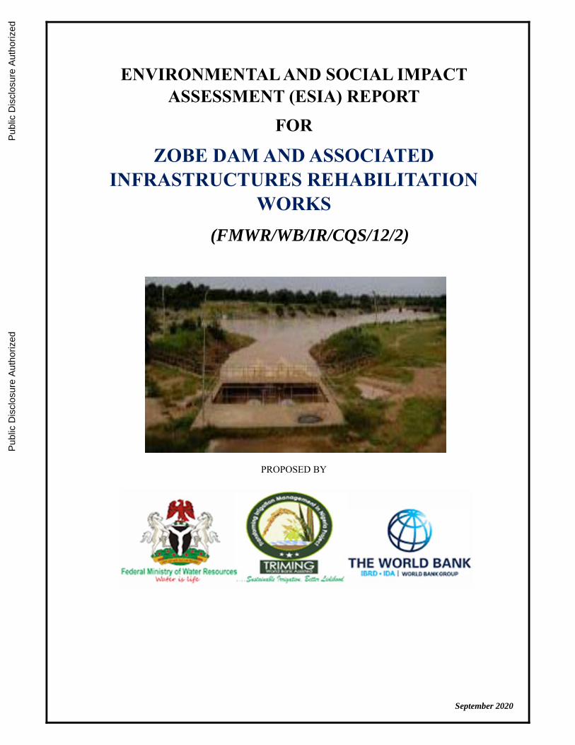
ENVIRONMENTAL AND SOCIAL IMPACT ASSESSMENT (ESIA) REPORT FOR ZOBE DAM AND ASSOCIATED INFRASTRUCTURES REHABILITATION WORKS (FMWR/WB/IR/CQS/12/2) PROPOSED BY September 2020 Public Disclosure Authorized Public Disclosure Authorized Public Disclosure Authorized Public Disclosure Authorized
-
Upload
khangminh22 -
Category
Documents
-
view
0 -
download
0
Transcript of zobe dam and associated infrastructures rehabilitation works
i
ENVIRONMENTAL AND SOCIAL IMPACT ASSESSMENT (ESIA) REPORT
FOR
ZOBE DAM AND ASSOCIATED INFRASTRUCTURES REHABILITATION
WORKS
(FMWR/WB/IR/CQS/12/2)
PROPOSED BY
September 2020
Pub
lic D
iscl
osur
e A
utho
rized
Pub
lic D
iscl
osur
e A
utho
rized
Pub
lic D
iscl
osur
e A
utho
rized
Pub
lic D
iscl
osur
e A
utho
rized

ESIA Report for Zobe Dam and Associated Infrastructures Rehabilitation Works
i
Table of Contents Content Page Title Page i List of Contents ii List of Tables vi List of Figures vii List of Maps viii List of Plates ix List of Appendices x List of Abbreviations and Acronyms xi Executive Summary xii CHAPTER ONE: INTRODUCTION 1 1.1 Introduction 2 1.2 Background 2 1.3 Scope of Works 2 1.4 Location of the Proposed Project 2 1.5 General Approach and Scope of the ESIA Study 5 1.6 Aim and Objectives of the ESIA Study 5 1.7 Need for Environmental and Social Impact Assessment 7 1.8 Policy, Legal and Administrative Framework 7 1.8.1 Federal Institutions 7 1.8.2 State Institutions 10 1.8.3 Local Government Institutions 10 1.8.4 Relevant National Regulatory Guidelines 11 1.8.5 International Regulatory Instruments 15 1.9 The ESIA Report Structure 18
CHAPTER TWO: PROJECT JUSTIFICATION AND OPTIONS 19 2.1 Justification of Project 19 2.2 Need for the Project 19 2.3 Benefits of the Project 19 2.4 Envisaged Sustainability 20 2.4.1 Environmental Sustainability 20 2.4.2 Political Support and Institutional Sustainability 20 2.4.3 Social Sustainability 20 2.4.4 Technical Sustainability 21 2.5 Project Options 21 2.6 Alternative Option for Project Execution 22
CHAPTER THREE: PROJECT DESCRIPTION 24 3.1 Introduction 24 3.2 Location of Dam 24 3.3 General Description of Zobe Dam 25 3.4 Previous Work Done on Zobe Dam 25 3.5 Condition of the Zobe Dam Project 25 3.6 Proposed Rehabilitation Activities 28

ESIA Report for Zobe Dam and Associated Infrastructures Rehabilitation Works
ii
3.7 Project Schedule 30 CHAPTER FOUR: DESCRIPTION OF ENVIRONMENTAL AND SOCIAL BASELINE
STUDIES 31 4.1 Introduction 31 4.2 Methodology of the ESIA Study 31 4.2.1 Desktop Studies / Literature Review 32 4.2.2 Reconnaissance Survey/Field Visit 32 4.2.3 Scoping Report 33 4.2.4 Baseline Data 34 4.2.5 Sampling Design 34 4.2.6 Field Data Gathering 36 4.2.7 Air Quality and Noise Level Assessment 36 4.2.8 Soil Sampling/Collection 37 4.2.9 Water Quality Sampling/Collection 37 4.2.10 Land Use / Land Cover, Flora and Fauna Studies 38 4.2.11 Scope and Design of Socioeconomic Assessment 38 4.3 General Description of the Physical Environment 40 4.3.1 Climate and Meteorology 40
4.3.2 Air Quality and Noise Analysis 43 4.3.3 Soil Type and Soil Analysis 43 4.3.4 Sediment 47 4.3.5 Drainage and Relief 47 4.3.6 Topography 47 4.3.7 Geology 51 4.3.8 Hydrogeology and Ground water analysis 53 4.3.9 Water Quality Analysis 54 4.3.10 Catchment Characteristics 61 4.3.11 Land Use 61 4.4 General Description of the Biological Environment 62 4.4.1 Agro-ecozone 62 4.4.2 Flora and Fauna 62 4.4.3 Hydrobiology 63 4.4 Ecological Problems 64 4.5 General Description of the Social Environment 64 4.5.1 The Project Area - Katsina State 64 4.5.2 Study Location and Population 65 4.5.3 The Impacted Local Government Areas 65 4.5.4 Socioeconomic Analysis 67 4.5.5 Baseline Data of Host Communities/Villages 68 4.5.6 Land Use Pattern, Land Cover and Crop Production 70 4.5.7 Floral and Fauna Investigation 71 4.5.8 Gender Issue 72 4.5.9 Health and Safety 73 4.5.11 Environment Health Determinants 73 4.6 Public Consultation/Stakeholders’ Engagement 86 4.6.1 Introduction 86 4.6.2 The Objectives of Consultations 87 4.6.3 Stakeholder Engagement Approach 87 4.6.4 Stakeholders Identification 87

ESIA Report for Zobe Dam and Associated Infrastructures Rehabilitation Works
ii
4.6.5 The Stakeholders Consulted 88 4.6.6 Stakeholders Engagement Plan 89 4.6.6.1 Mechanism for Consultation 89 4.6.6.2 Summary of Outcome of Consultation 90 CHAPTER FIVE: POTENTIAL AND ASSOCIATED IMPACT ASSESSMENT 91 5.1 Introduction 91
5.2 Identified Receptors of the Potential Impacts of Remedial Works 92 5.3 Identifying Project Activities and Biophysical, Socio-Economic and
Health Aspects 93 5.4 Impact Assessment Method 95 5.5 Significance Assessment Method 96 5.5.1 Sensitivity of an Environmental and Social Receptor 96 5.5.2 Magnitude of impact 99 5.5.3 Significance of an Impact 101 5.6 Risk Assessment Method 101 5.7 Evaluation of Potential Impacts 102 5.8 Impact Assessment Method 103 5.9 Some Identified Potential Impacts 103 5.9.1 Positive Impacts 104 5.9.2 Negative Impacts 105 CHAPTER SIX: MITIGATION MEASURES 111
6.1 Introduction to Impact Mitigation 111 6.2 Proposed Mitigation Measures 112 6.3 Project Options and analysis of Alternatives 117 CHAPTER SEVEN: ENVIRONMENTAL AND SOCIAL MANAGEMENT PLAN 119
7.1 Introduction 119 7.2 Impact Assessment Management 119 7.3 Monitoring Program 133 7.4 Environmental Management Responsibility 135 7.5 Arrangement for ESMP Implementation 136 7.5.1 Capacity Building and Training 137 7.5.2 Training of Contractor Personnel 137 7.5.3 Cost Estimate for ESMP Implementation 140 7.6 ESMP Disclosures 140 CHAPTER EIGHT: DECOMMISSIONING AND ABANDONMENT 141
8.1 Introduction 141 8.2 Decommissioning activities 141 8.3 Abandonment 142 8.4 Anticipated Impacts 143 CHAPTER NINE: CONCLUSION AND RECOMMENDATION 145
9.1 CONCLUSION 145 9.2 Recommendation 145

ESIA Report for Zobe Dam and Associated Infrastructures Rehabilitation Works
iv
REFERENCES 147
APPENDICES 151

ESIA Report for Zobe Dam and Associated Infrastructures Rehabilitation Works
v
LIST OF TABLES
Table Page 1.1 Selected Project Areas 1 1.2 Triggered Safeguard Policies 16 1.3 EIA Procedural Guidelines 17 3.1 Water balance 28 3.2 Project Schedule Guide 30 4.1 Indicative Parameters for Baseline Characterisation 34 4.2 Coordinates and Elevations of Sample Locations 35 4.3 Noise and Air Quality Measurements 43 4.4 Sand Thickness 44 4.5 Physical Properties of the Soil Samples Collected 45 4.6 Chemical Properties of the Soil Samples Collected 45 4.7 Heavy Metals Concentration of the Soil Samples Collected 46 4.8 Existing Boreholes Drilled in the Dutsin Ma LGA and in Dutsin Ma Village 53 4.9 Physiochemical Properties of Surface and Groundwater in Zobe Dam Area 56 4.10 Summary of Catchment Descriptors 61 4.11 Shrub and Trees Identified in the Study Area 71 4.12 Some Common Animals of the Study Area 72 4.13 Air Pollution Sources 74 4.14 Water Sources at the Communities 75 4.15 Sanitary Facilities 77 4.16 Sanitary Conditions 77 4.17 Solid Waste Management 78 4.18 Noise Pollution Sources 79 4.19 Stakeholders Consulted 88 5.1 Identified Project Environmental and Socio-economic Receptors 91 5.2 Proposed Remedial Works &Environmental and Social Receptors 93 5.3 Criteria for Determining the Sensitivity of Environmental and social Receptors 95 5.4 Criteria for Determining the Magnitude of Impacts 97 5.5 Significance Assessment Matrix 98 5.6 Qualitative Criteria for Impact Likelihood 98 5.7 Qualitative Criteria for Consequence 99 5.8 Qualitative Risk Assessment Matrix 100 5.9 Degree of Impact Significance 100 5.10 Matrix for the Evaluation of Significant Environmental Impacts 101 5.11 Criteria for Qualification and Quantification of Significant Impact 102 5.12 Types of Significant Effects 102 5.13 Significance Criteria 103 5.14 Summary of Major Positive Impact in the Project 107 5.14b Summary of Major Negative Impacts in the Project 107 5.15 108 6.1 Approaches to Mitigation Measure Development 111 6.2 Proposed Mitigation Measure 112 7.1 ESMP of Zobe Dam Rehabilitation Project (Pre-Rehabilitation Phase) 122 7.2 ESMP of Zobe Dam Rehabilitation Project (Rehabilitation Phase) 124 7.3 ESMP of Zobe Dam Rehabilitation Project (Operation & Maintenance Phase) 128 7.4 Institutional Responsibilities 135 7.5 Proposed Training Programme for the Implementation of ESMP 136

ESIA Report for Zobe Dam and Associated Infrastructures Rehabilitation Works
vi
7.6 Estimated Cost for ESMP Implementation 140 8.1 Environmental and Social Aspects Related to Decommissioning 143
ESIA Report for Zobe Dam and Associated Infrastructures Rehabilitation Works
vi
LIST OF FIGURES Figures Page 1.1 Dutsima Showing Zobe Dam 4 3.1 Schematic Drawings of the Proposed Rehabilitation works 29 4.1 The ESIA process 32 4.1 Monthly Rainfall Pattern in the Project Area 40 4.2 Mean Monthly Evapotranspiration (ETo in mm) in the Project Areas 41 4.3 Nigeria Solar Radiation 42 4.4 Three Types of Pre-Cambrian Basement Complex Present in the Study Area 52 4.5 Age Distribution of Respondents 67 4.6 Occupation of Respondents 68 4.7 Last Case of Flooding in Various Communities 75 4.8 Comparison of Weight across Communities 81 4.9 Comparison of Height across Communities 81 4.10 Comparison of BMI among Communities 82 5.1 Method to Apply Impact assessment Process 93
ESIA Report for Zobe Dam and Associated Infrastructures Rehabilitation Works
vi
LIST OF MAPS
Map Page 3.1 Zobe Dam Reservoir and Tributaries 24 4.1 Sampling Location in project Area 35 4.2 Soil types in Zobe Catchment Area 44 4.3 Relief and Drainage Map of the Zobe Catchment area 48 4.4 Slopes of Zobe PCA 48 4.5 The River Basin of Zobe Dam and Irrigation Scheme 49 4.6 Zobe Dam Rehabilitation Zone 50 4.7 Zobe Dam Rehabilitation Work Site Plan 51 4.8 Land Use in Zobe Dam Catchment Area 61 4.9 Project Affected LGAs 66

ESIA Report for Zobe Dam and Associated Infrastructures Rehabilitation Works
ix
LIST OF PLATES
Plate Page 4.1 Air and noise levels measurement 36 4.2 Soil samples collection in the vicinity of Zobe Dam 37 4.3 Mining water from the river bed for domestic uses 55 4.4 Typical Vegetation and Existing Farms in the Project Location 62 4.5 Fish catch in the PCA and its variety 63 4.6 Granitic Outcrops Weathering with Loose Material Moving Downhill 64 4.7 Pastoral activities within the PCA 70 4.8 A Typical Kitchen in Dogun Ruwa Community 73 4.9 Water Sources 74 4.10 Typical Housing Structure 76 4.11 Sanitary Conditions 76 4.12 Refuse Littering Drainages and Streets 77 4.13 Possible Insect and Vector Breeding Site 78 4.14 Food Handling Practices 79 4.15 Anthropometric Measurements of Some of the Selected Study Participants 80

ESIA Report for Zobe Dam and Associated Infrastructures Rehabilitation Works
x
LIST OF APPENDICES
Appendix 1: Terms of Reference for the Project ESIA Appendix 2: Project Schedule Guide Appendix 3: Stakeholders’ Engagement and Consultation Documents Appendix 4: Grievance Redress Mechanism Appendix 5: Community–Based Survey Questionnaire: Socioeconomic & Health Appendix 6: Health Log
ESIA Report for Zobe Dam and Associated Infrastructures Rehabilitation Works
xi
LIST OF ABBREVIATIONS AND ACRONYMS
ALARP As Low as Reasonably Practicable BOD Biochemical Oxygen Demand cm centimeter DO Dissolved Oxygen EC Electrical conductivity EIA Environmental Impact Assessment EPA Environmental Protection Agency ESIA Environmental and Social Impact Assessment ESMF Environmental and Social Management Framework ESMP Environmental and Social Management Plan FAO Food and Agriculture Organization FCA Fadama Cooperative Association FEPA Federal Environmental Protection Agency FGN Federal Government of Nigeria FMEnv Federal Ministry of Environment FMWR Federal Ministry of Water Resources FRN Federal Republic of Nigeria GIS Geographic Information System GPS Geographical Positioning System GPS Global Positioning System ha Hectare HA Hydrological Area HEMP Hazard and Effect Management Process HVIS Hadejia Valley Irrigation Scheme IPM Integrated Pest Management ISO International Standards Organization IWRM Integrated Water Resources Management JICA Japanese International Cooperation Agency kg kilogram km kilometer (s) KRIS Kano River Irrigation Scheme LGA(s) Local Government Area(s) m meter (s) MCM Million Cubic Metres MDAs Ministries, Departments and Agencies MDS Multiple Development Services Ltd mg milligram ml milliliter mm millimeter NCWR National Council on Water Resources NESREA National Environmental Standards and Regulations Enforcement Agency NIMET Nigerian Meteorological Services Agency NIPS National Irrigation Policy Strategy NIWA National Inland Waterways Authority NPK Nitrogen Phosphate Potassium NTCWR National Technical Committee on Water Resources NWRI National water Resources Institute OC Organic Carbon

ESIA Report for Zobe Dam and Associated Infrastructures Rehabilitation Works
xi
oC/oF Degree Centigrade/Fahrenheit PAD Project Appraisal Document PCA Project Command Area PMP Pest Management Plan RAP Rapid Appraisal Process RBDAs River Basin Development Authorities RPF Resettlement Policy Framework SRRB Sokoto Rima River Basin SRRBDA Sokoto Rima River Basin Development Authority TDS Total Dissolved Solids TN Total Nitrogen TOR Terms of Reference TRIMING Transforming Irrigation Management in Nigeria UV Ultraviolet WB World Bank ZIP Zobe Irrigation Project
ESIA Report for Zobe Dam and Associated Infrastructures Rehabilitation Works
xi
EXECUTIVE SUMMARY ES1 Introduction The Federal Government of Nigeria (FGN) is implementing the Transforming Irrigation Management in Nigeria (TRIMING) project, which is jointly financed by the World Bank. The project aims to achieve improved performance of irrigation and water resources infrastructure and institutions for higher agricultural productivity in selected irrigation schemes in Northern Nigeria. The Project Development Objective is to improve access to irrigation and drainage services and to strengthen institutional arrangements for Integrated Water Resources Management (IWRM) and agriculture service delivery in selected large-scale public schemes in Northern Nigeria. The Zobe Dam was designed to supply drinking water, hydropower and water for irrigation originally. Unfortunately, the Dam has been redundant as it has never been put into any of these uses. Recently with the support of the World Bank, TRIMING Project conceived the idea of utilizing the dam for surface irrigation and marginal for sprinklers. However, the review of the soil results contained in the Feasibility Report prepared under the Zobe Dam and Irrigation Project showed that sandy soil with very high infiltration rates and low fertility dominants the environment. This type of soil is not suitable for surface irrigation and marginal for sprinklers. To this end, TRIMING and the World Bank decided against the irrigation component and concluded to only support on the rehabilitation of the dam and its associated infrastructures alone due to the current challenge of seepage, taking into cognizance that the last remedial work was carried out in 1983 and repeated in 1984. In other words, the project is not interested in agriculture because of poor return on investment but only the remedial work. The proposed project activities on the rehabilitation works are seen to have some positive and negative impacts and as such triggered the World Bank Safeguard Policies, specifically Environmental Assessment (OP 4.01); Safety of Dams (OP 4.37); and Projects on International Waterways (OP 7.50) requiring environmental assessment. In order to ensure compliance with the requirements of the World Bank Safeguard Policies, especially on Environmental Assessment (OP/BP 4.01) and the Environmental Impact Assessment (EIA) Act in Nigeria, TRIMING assigned the preparation of the Environmental and Social Impact Assessment (ESIA) Studies and Report to MULTIPLE DEVELOPMENT SERVICES LTD (MDS), a Health, Safety, Environmental & Social Risks Management Consultancy firm. The purpose of the ESIA is to identify potential and significant adverse or positive environmental and social impacts associated with the proposed activities associated with the dam rehabilitation project and proposed mitigation measures for identified impacts and/or ameliorating them to acceptable levels while enhancing the positive impacts. Additionally, the ESIA considered the capacity of existing institutions to manage the predicted environmental and social issues vis-a-vis implementing the Environmental and Social Management Plan (ESMP) for project sustainability. ES2 Project Description The Sokoto – Rima River Basin (SRRB) is a major watershed in Northern Nigeria, comprising a number of rivers flowing in a northwesterly direction into the River Niger. Some dams were built in the 1970s and 1980s on various tributaries of the River Sokoto, designed to supply drinking water, hydropower and water for irrigation. One of such dams is the Zobe Dam constructed on the River Karaduwa (Rima Sub-basin of SRRB), a major watershed of the hydrological area I (HA-I) of Nigeria. Construction works at Zobe dam began in the 1970s and was completed in 1983.

ESIA Report for Zobe Dam and Associated Infrastructures Rehabilitation Works
xi
Location - The Zobe Dam is located about 65 km south of the city of Katsina in Katsina State, northern Nigeria at approximate co-ordinates 12o 22’ N and 7o 30’ E (Map 1.1). The dam is owned by the Federal Government of Nigeria and operated by the Sokoto Rima River Basin Development Authority (SRRBDA) under the supervision of the Federal Ministry of Water Resources (FMWR). The Zobe dam impounds River Karaduwa and has a catchment area of 2,527 km2. The dam is approximately 15 km long with a surface area of 36.9 km2 and a storage capacity of 177 x 106 m3 at full supply level. The Zobe Dam has a maximum height of approximately 20 m. The dam was constructed of earth fill materials and has embankment structures of 2.7 km long on a curvilinear alignment incorporating a 110 m long free overflow spillway in the left side. This is re-enforced by concrete culvert from the intake tower, which is located at the upstream toe of the embankment at Chainage 0 + 950. The Zobe Dam reservoir, which filled up between 1981 and 1983, was initially designed to supply water to the proposed 8,000 hectares (ha) irrigation development downstream of the dam as well as the supply of water to villages and towns around the Karaduwa axis. The Zobe Dam was also intended to provide water supply for the city of Katsina. In 1993 work began on the water-supply component, but was abandoned in 1995 due to lack of funds. The dam was overtopped during heavy rains in 1999 causing heavy crop damage downstream. A water treatment plant was begun in 2003, but was abandoned half-built. A dam safety review in 2005 noted seepage around the dam foundations and recommended close monitoring. In 2009, the Katsina State Government considered developing hydropower facilities at the dam but this plan has not gone forward to date. As a consequence, the water impounded in the dam has served no useful purpose to date. Since 2009, work on two main distribution canals to supply irrigation water has been on-going. The work has been suspended, again due to lack of funds. The canals are approximately half completed. ES3 Proposed Remedial Works on Zobe Dam As detailed in the Zobe Dam Safety feasibility study report and contained in the TOR for the ESIA, the following remedial works are proposed for intervention under the TRIMING project for the Zobe Dam: Remedial works to the embankment dam Remedial works to the concrete gravity dam Repair and replacement work for the Monitoring system of the dam and development of
an Instrumentation Plan Rehabilitation of the mechanical and electrical (M&E) equipment
These activities have been identified to have positive impacts which are indeed the reasons behind the proposed rehabilitation. The activities also have the potential to induce adverse negative impact on the environment and people hence the preparation of this ESIA taking into consideration the nature of the project location. ES4 Scope of the ESIA Study The scope included all the necessary preparatory studies (review of all feasibility studies and project disclosed safeguards documents), field work, research and investigations (including the

ESIA Report for Zobe Dam and Associated Infrastructures Rehabilitation Works
xv
generation of new field data, as deemed necessary or appropriate) to compile the information required for the ESIA study. The scope also included the development of an ESMP and the actions needed to implement the ESMP. The ESIA study was divided into four major reporting phases i.e. scoping report, draft report, draft final report and final report, all of these which emanated from extensive literature review, stakeholders’ consultation and field studies with laboratory analysis of relevant samples with activities coordinated with (SRRBDA), the TRIMING environmental and social officers and ATKINS (Feasibility study consultant). ES5 Policy, Legal and Administrative Framework The policy, legal and administrative framework section of this report took into cognizance relevant local regulations, the Environmental Impact Assessment Act, No. 86 1992, other relevant international guidelines and conventions, and industry best management practices and World Bank Safeguard Policies applicable to the project. It should be noted that in August 2016, the World Bank’s Board of Executive Directors approved the Environmental and Social Framework (ESF); the ESF became effective on October 1, 2018. The ESF protects people and the environment from potential adverse impacts that could arise from Bank-financed projects, and promotes sustainable development. This new framework provides broad coverage, including important advances on transparency, non-discrimination, social inclusion, public participation and accountability. The ESF also places more emphasis on building borrower governments’ own capacity to deal with environmental and social issues. The ESF recognises that existing projects such as this Zobe Project will continue to apply the Safeguard Policies, since the two systems (the World Bank’s environmental and social policies and Environmental and Social Framework) will run in parallel for an estimated seven years from the start of the ESF. ES6 Environmental and Social Condition of the Project Area Based on the literature/desk review and field survey, the environmental and social conditions of the project area were established as follows: 1. Socio-Economic Condition Access to land and ownership is through customary rights such as inheritance, purchase,
hire or lease and gift. The study revealed that most farmers (about 95%) in the project area inherited their farms (owner-occupier) while very small number obtained their farms through hire or lease arrangement. The study reveals that farmers with land holdings of less than 5ha per person are predominately present. Furthermore, it was also revealed that farmers are usually reluctant to sell land in anticipation of Zobe Dam irrigation project (ZIP). However, there are some instances of farm sales as well as sharecropping.
Some form of associations exists among farmers and are largely for the purpose of facilitating access to farm inputs such as chemical fertilizer, credit and loan facilities.
Women Participation in Decision Making - Traditionally, women in the area have no place in the leadership structure of the communities but could be involved in farming. The women are also at liberty to control their farming activity as well as attend meetings and be heard.
Economic Activities of Children – Children participate in a number of economic activities. The boys can be seen fishing in Zobe reservoir as well as downstream ponds. They also help their parents with the sale of caught fish at the fish market. The girls help their mothers in selling/hawking groundnut cake. They also gather folder as well as firewood for fuel. Children also partake in water mining from river beds for domestic purpose. For Fulani households, the boys assist in cattle rearing which is their main occupation.
ESIA Report for Zobe Dam and Associated Infrastructures Rehabilitation Works
xv
Gender Based Violence (GBV) – There are no known or reported Cases of gender-based violence in the project area. However, the volatile nature of activities associated with banditry which has increased recently generally in the Katsina State cannot be ruled out as source of worry to gender-based violence. To prevent possible case of GBV during project implementation in Zobe dam and vicinities, there is need to put in place an effective security response system that takes into consideration local support and intelligence for adequate response.
Structure of Traditional System – Katsina State has a hierarchical traditional system made up of two Emirates (Katsina and Daura). Each Emirate is headed by the Emir and administered traditionally by the Emirate Council with the Emir as the Chairman. Each emirate is subdivided into districts, which are headed by District Heads (Hakimi). Each district is also made up of villages headed by Village Heads (Dagatai/Magaji). Further, town wards and hamlets are headed by the MasuUnguwa Ward Hamlet Head. The study area is within the Katsina Emirate.
Health Issues – Dutsin Ma and Safana LGAs have a general hospital. There are primary health centers and many dispensaries. Malaria is endemic in the study area. Water-borne diseases such as diarrhea, dysentery, cholera and cerebro-spinal meningitis are also reported diseases in the area. Herbs and other local therapies are used in treating diseases by local herbal doctors.
Prevalence of HIV/AIDS and Other Sexually Transmitted Diseases in the Area – HIV/AIDS and other health related problems information were obtained from the health facilities in Dutsin Ma and Safana LGA using health log. Lots of responders as a result of belief and low level of awareness doubt the existence of the disease. However, rural-urban migration seems to be a predisposing factor as many seasonal urban dwellers pass the virus to their wives on returning after involving in un-protected casual sex.
2. Environmental Condition Air quality assessment - Results of air quality assessment show Suspended Particulate Matters
(SPM) concentrations in the ambient air of the study area ranging from 14.7μg/m3 to 16.8μg/m3 with a mean of 15.9μg/m3. The concentrations of SPM recorded in all the sampling locations were below the FMEnv hourly average values of 250μg/m3. Atmospheric gases (SO2, NO, Co2, Co, H2S). The concentrations of SO2, NO, CO2 and H2S were below equipment detection limit (<0.0ppm) in all the sampling locations in the study area. Similarly, Hydrocarbons (Volatile Organic Carbon) levels were below equipment detection limit (<0.0ppm) at all the sampling locations. With respect to CO2, values ranged from 2.90 to 4% in all the sampling locations, which is below the Federal Ministry of Environment (FMEnv) guideline of 20%.
Noise - Noise levels in the project areas are generally low and within the FMEnv and WHO permissible levels (90 and 70 Decibels respectively). The rehabilitation/construction phase of the project will be accompanied with increased noise levels within the area, which might be due to the use of heavy-duty equipment during the construction phase. These increases will be short term and mostly localized.
Water. Surface and ground water sampling conducted within the vicinity of the project area during the dry season reveal that result of most of the surface water samples were within acceptable limits of FMEnv and WHO drinking water/ irrigation standards for most water parameters (E.C, PH, No3, DO, FE, Mn, Zn,SO4, BOD) except for phosphate, hardness and suspended solid. Zobe downstream sample result show high level of hardness with values as high as 1189.5mg/l.
Soil –Soil samples were randomly collected from the banks of Zobe Dam, upstream, midstream and downstream to cover the entire project area. The soils in the project area are

ESIA Report for Zobe Dam and Associated Infrastructures Rehabilitation Works
xv
predominantly Lithic Leptosol. This soil type could be described as well drained loamy sand as deduced from the particle size distribution of analysed soil samples. The project area soil is low in essential nutrients such as Sodium (Na), Potassium (K), Calcium (Ca) and Magnesium (Mg) as well as clay, soil moisture and organic matter content. The soil is there not fertile and may not retain fertilizer if applied. Due to high infiltration rate and low fertility, most soils in the project area is not suited for surface irrigation and marginal form sprinkler. Concentration of heavy metals in the soil was low when compared to naturally occurring concentration in unpolluted soil.
Land-use/cover- The predominant land use type Identified at the bank of Zobe dam was agriculture with vegetable, wheat, onion and maize being the major crops grown. Fish farming is also practiced. Neem tree is also seen scattered in this location. In addition to agricultural land use (maize, wheat, cucumber, cabbage, onion and tomatoes), residential land use as well as animal production (cattle, goat and sheep) were other land uses identified at the upstream, midstream and downstream parts of the project area. Main trees identified in the project area include: Eucalyptus, Adasoniadigitata and Azadirachtolides.
ES 7: Potential Impacts The study revealed that the project has both positive and negative impacts. These have been highlighted below and Table ES1. Positive Impacts Dam Safety: Zobe Dam hydraulic model revealed that a flooded area of 1,712km2 and
flooding extending downstream past Sokoto will result as a consequence of dam failure. Zobe Dam and associated infrastructure rehabilitation will therefore hugely decrease risk to lives and properties in the event of a dam breach due to piping or overtopping.
Creation of Employment opportunities: Zobe dam and associated infrastructure rehabilitation work will bring a positive impact of job creation during and after the rehabilitation.
Improved commercial activities: Existing commercial activities will be enhanced and new one created at various scale during the rehabilitation phase of project in line with the increase in population of the damsite communities and environ.
Improved infrastructure & Services: Zobe Dam and infrastructure rehabilitation is likely to improve existing social amenities and rise of new ones (e.g. hospital, school) in the project area in an effort to meet up with the challenge posed by the increase in population. Increase in vehicle movement could lead to road rehabilitation or building of new ones.
Flood prevention: Localised flooding (dam site) due to present poor state of flood control system (inverted filter, pressure relief well and drainage collection system) will be greatly reduced or averted with the implementation of the rehabilitation project.
Negative Impacts Negative impacts could be environmental, social-economic or health related. It is therefore necessary to weigh all negative impacts of the project and proffer mitigation measures to ameliorate the negative impacts in order to safeguard lives, properties and the environment. Below and in Table ES 2, the identified negative impacts are highlighted according to the various phases of the project, namely: pre-rehabilitation, rehabilitation and operational.
a. Pre-rehabilitation Impacts Mobilization of personnel, material and equipment to site at this stage will cause: Disturbance/Nuisance to people: Inhabitants of damsite and environ are likely to complain of
noise and air pollution from increased movement as a result of site mobilisation.

ESIA Report for Zobe Dam and Associated Infrastructures Rehabilitation Works
xv
Traffic Congestion: Congestion resulting from increased traffic associated with truck moving material to site as well as equipment transport to site will be witnessed. Pressure on the Dutsin-Ma to Malumfashi road leading to the Zobe dam site is likely to raise the level of road accidents.
Key
+ Low Positive Impact ++ Medium Positive Impact +++ High Positive Impact
b. Rehabilitation Impacts. Impacts on the rehabilitation phase can be of the following types. Soil Contamination: Equipment maintenance and fueling may cause contamination of the soil
and possible ground water if fuel and lubricants are not properly handled. Operation of machinery during embankment rehabilitation could also lead to accidental spill of oil and fuel.
Table ES1: Summary of Major Positive Impact in the ProjectS/No Potential Issue/Activity Potential Positive Impacts Impact Qualification L M HEmbankment Rehabilitation 1 Contractor's Camps Improved economy of the community (local food
vendors make more income) Employment opportunity (security) Local community benefitting from security arrangement
+++
2 Embankment Remedial work (excavation, filling and compaction)
Improvement of local economies Improvement of dam safety by reducing internal and external erosion risk.
+++
3 Dam Crest Access Route (Left bank abutment to valve tower)
Providing access route to the community for emergencies.
+++
Drainage Monitoring Instruments 1 Gauged well (Piezometer)
cleaning Provides improved indication of piping failure from foundation seepage for safety planning
+++
2 Replacement of v-notch weir for measuring flow from inverted filter and the installation a v-notch weir to monitor flow from pressure relief well.
Quantify flow from pressure relief well +++
3 Crest Levelling and pin installation
Improves crest level monitoring (deformatiom/settlement) for structural stability of dam
+++
Seepage Control System 1 Inverted Filter remedial work Improving efficiency of filter to drain seepage
flow +++
2 Pressure Relief Well cleaning Improving well performance/efficiency and decreasing uplift pressure on dam due to seepage to acceptable level.
++
3 Drainage Collection System (channel & ditch) Cleaning & modification self- cleaning)
Prevention of localized flooding at the damsite. Conveying artesian flow from pressure relief well and inverted filter back to the river Karaduwa downstream ensuring safety of dam
+++
Dam Inlet & Outlet Control Work 1 Pipe & Valve (butterfly, hollow
jet and flap ap valve) repairs. Preventing backward flow and flooding of valve chamber as well as piping due to draw off conduit
+++
ESIA Report for Zobe Dam and Associated Infrastructures Rehabilitation Works
xi
Noise & Vibration Disturbance: Increase in noise from plants/machineries (excavators, compactors and trucks) during embankment rehabilitation and seepage control works is likely to be a source of disturbance
Air Quality Deterioration: Earth work activities during rehabilitation phased of Zobe Dam is envisaged to cause air quality deterioration. Activities such as removal tree trunks/ant hills, filling of cracks created by tree trunk and ant hills as well as fill compaction using rollers is likely to send dust as well as gaseous emissions from exhaust into the atmosphere.
Water Quality Deterioration: Operation of pressure relief well after rehabilitation works as well as planned drainage ditch cleaning and modification work is likely to cause sediments to flow into Karaduwa thus increasing the river turbidity.
Disposal of Excavated Material & Construction Waste: Waste generation is inevitable throughout the rehabilitation phase of Zobe dam. These waste if not properly managed could lead to significant deterioration of the environment.
Degradation of landscape & Embankment Erosion: Remediation works at embankment crest and slope could lead to removal of slope protection exposing the embankment to the risk of erosion as well as destruction of landscape asthetic value.
Public Health & Safety: The proposed Zobe dam rehabilitation project has the potential to increase the transmission of HIV and other STIs due mainly to a male workforce with a comparatively larger disposable income engaging in casual sexual activities in local communities.
Gender Based Violence (GBV) and a risk of Sexual Exploitation and Abuse (SEA) is not unlikely in a project like Zobe Dam and associated infrastructure rehabilitation considering the fact that hotels and brothels are not common place in dam area.
Occupational Health & Safety: Zobe dam rehabilitation project will come with health risk to the communities at the vicinity of the dam site as dust/particulate matter raised during construction work could likely lead to respiratory diseases. However, the construction workers are likely to be more affected. There are also added risks of accidents and injuries from operation of equipment.
Fishing: Fishing is an important economic activity of the Zobe dam communities, as stated earlier, Zobe dam reservoir holds more variety of fish than downstream Karaduwa River. Remedial works at the dam site is envisaged to have a temporary impact on fishing as this activity cannot be allowed during dam rehabilitation in the interest of health and safety.
c. Operational Impact
Deterioration (increase in turbidity) of Karaduwa river downstream of drainage collection discharge point from sediment blown out with seepage flow during operation of relief well and collection system.
Flooding of downstream dam toe due to inadequate capacity of drainage control system with particular reference to relief well.
Flow rejection at Relief well collector pipe is due to increase in seepage flow. Flow back up due to occasional vegetation and debris blockage of drainage ditch.

ESIA Report for Zobe Dam and Associated Infrastructures Rehabilitation Works
xviii
Table ES2: Summary of Major Negative Impacts and mitigation measures
S/N Negative Issue/Activity
Potential Negative Impacts Impact Qualification Mitigation measures
L M H
Pre-rehabilitation (Environment)
1 Mobilization to Site
Fume/gaseous emissions from equipment and machine are likely to cause air and noise pollution during mobilization of material and equipment to site.
XX Reduce effect of dust by spraying water. Ensure that vehicles are serviced; undergo vehicle emission
testing (VET) and vehicle exhaust screening (VES) as laid down in the NESREA guidelines.
2 Installation of Contractor’s Camp
Removal of vegetation XXX In setting up contractor’s camp, care should be taken to limit vegetal removal during site clearance. Area cleared should be enough for setting up Contractor’ camp.
Pre-rehabilitation (Social)
1 Traffic Congestion
Congestion resulting from increased traffic associated with truck moving material to site as well as equipment transport to site will be witnessed. Pressure on the Dutsin-Ma to Malumfashi road leading to the Zobe damsite is likely to raise the level of road accidents.
XXX Provide training for drivers on road safety with particular emphasis on haulage and pedestrian safety
Implement traffic Management plan (TMP) such as strict enforcement of speed limit, use of road safety signage and minimization of peak period movement to avoid any form of congestion or delay in travel time to other road users as a result of increase in volume of traffic. Mobilization to dam site should be carried out during off peak hours.
2 Installation of Contractor’s Camp
Social stress could emanate from possible land acquisition
XXX Engage land acquisition experts to aid with best practices
Rehabilitation (Environment)
1 Soil Contamination
Equipment maintenance and fuelling may cause contamination of the soil and possible ground water if fuel and lubricants are not properly handled. Operation of machinery during embankment rehabilitation could also lead to accidental spill of oil and fuel.
XX Avoid maintaining vehicle and machinery at damsite. If unavoidable, fuel and lubricants should be stored above
ground with provision to catch leaks. Ensure vehicles and machinery are serviced and in good
condition prior to being used for remedial works to forestall avoidable spill of oil and fuel.
2 Air Quality Deterioration
Earth work activities during rehabilitation phased of Zobe Dam is envisaged to cause air quality deterioration. Activities such as removal tree trunks/ant hills, filling of cracks created by tree trunk and ant hills as well as fill compaction using rollers is
XX Adequate water should be sprayed while carrying out earth work at dam embankment to reduce the effect of dust. Enough water should also be applied during compaction of fill.

ESIA Report for Zobe Dam and Associated Infrastructures Rehabilitation Works
xix
likely to send dust as well as gaseous emissions from exhaust into the atmosphere.
3 Water Quality Deterioration
Operation of pressure relief well during rehabilitation works as well as planned drainage ditch cleaning and modification work is likely to cause sediments to flow into Karaduwa thus increasing the river turbidity.
XXX Settling tanks should be used to prevent drainage channels and ditches from conveying sediments along with artesian flow from pressure relief well.
Debris rack/barrier should be placed at ditch mouth to prevent debris entering karadunwa River.
Carry out routing water quality check at discharge point of seepage collection system to monitor water quality.
4 Degradation of landscape & Embankment Erosion
Remediation works at embankment crest and slope could lead to removal of slope and crest protections exposing the embankment crest and slope to the risk of erosion as well as destruction of landscape aesthetic value.
X Remedial work at the dam crest and slope should be done in a manner that will cause minimal displacement of crest and slope protection (stone & grass) that provide protection against external erosion. In areas where protection have been unavoidably removed, stone cuttings should be re-placed.
Rehabilitation (social)
1 Noise & Vibration Disturbance
Increase in noise from plants/machineries (excavators, compactors and trucks) during embankment rehabilitation and seepage control works is likely to be a source of disturbance
X Noise from compactors, excavators, trucks and plants should be limited to dam site as much as possible. Equipment with reduced noise levels such as vibrating rollers should be used.
Hours of operation can also be reduced as a way of reducing noise by using fill material with required hydraulic conductivity and density during compaction. Also machines should be switched off during idle times
Quiet/silent centrifugal pumps should be employed in the flushing of gauged (Piezometer) well and pressure relief well.
2 Public Health & Safety
The proposed Zobe dam rehabilitation project has the potential to increase the transmission of HIV and other STIs due mainly to a male workforce with a comparatively larger disposable income engaging in casual sexual activities in local communities. This envisaged negative social impact of the project is ultimately likely to affect the health and wellbeing of Zobe dam host communities and in turn their economic activities. The construction workers are also likely to be affected health wise consequently they will be unable to undertake their duties to the detriment of the project completion time.
XX Awareness is to be raised by health workers in communities as to the possible health problems (HIV/STIs) that could come by engaging in casual sex.
Contractors should undertake similar campaign to inform and educate construction workers on the importance of safe sex.

ESIA Report for Zobe Dam and Associated Infrastructures Rehabilitation Works
xx
3 Gender Based Violence (GBV) and a risk of HIV
Sexual form of GBV (SBGV) have largely been related to HIV in a number of quarters and is not unlikely in a project like Zobe Dam and associated infrastructure rehabilitation considering the fact that hotels and brothels are not common place in dam area. While various forms (rape, domestic violence, FGM) of GBV indirectly increase the risk of HIV, SBGV seem to have the strongest direct relationship. Victims of early sexual abuse are more likely to be HIV positive, and usually show high risk behaviour. Although cases of GBV whether in the form of verbal abuse, physical abuse or emotional abuse have not been reported in dam area and environ, SGBV is still a reality that should be guarded against. Sexual assault referral centres (SARC) are not present in the project area to provide protection for the vulnerable. It is therefore important to have special prosecutors in addition to aforementioned institution to provide needed grievances address system.
X Contractor is to provide working guidelines or code of conduct for employees working under the Zobe Dam project. GBV in any form is to be discouraged and sexual assault referral centre (SARC) should be present in the project area to provide protection for the vulnerable people against SGBV. It is therefore important to have special prosecutors in the aforementioned institution to provide needed grievances address system.
4 Occupational Health & Safety
Zobe dam rehabilitation project will come with health risk to the communities at the vicinity of the dam site as dust/particulate matter raised during construction work could likely lead to respiratory diseases. However, the construction workers are likely to be more affected. There are also added risks of accidents and injuries from operation of equipment.
Risk of communicable diseases such as COVID-19 pandemic amongst others associated with closed working environment and physical contact.
XXX To reduce the chances of contracting respiratory disease from dust/ particulate matter raised during Zobe dam rehabilitation works, construction workers should wear the right personal protective equipment (PPE)/respiratory protective equipment (RPE) such as dust mask. The Contractor shall therefore instruct his workers in health and safety matters, and require workers to undertake generic and site-specific risk assessment prior to carrying out a task.
Contractor has to ensure that all operators of heavy or dangerous machinery are properly trained/certified, and also insured. He will have to provide first aid facilities, trained paramedical personnel/ first aiders and emergency transport to nearest hospital with accident and emergency facilities.
Contractor to ensure the use of face masks, hand sanitizers and observance of social distancing as much as possible.
Comprehensive insurance cover for all workers
5 Generated waste management
Waste is envisaged to be generated during embankment as well as seepage control system rehabilitation. Household waste from increased economic activities within the damsite is also
XXX Arrangement should be made with Katsina State waste management agency of collection and safe disposal of waste.

ESIA Report for Zobe Dam and Associated Infrastructures Rehabilitation Works
xxi
Key X Low (L) Negative Impact XX Medium (L) negative impact XXX High (H) negative Impact
anticipated. If not properly managed, generated waste could cause all kinds of environmental problem.
Small tree grinder/stump grinder should be made available onsite for grinding excavated vegetation, root large tree bowl into woodchips that can be used as organic mulch in gardening.
6 Pipe & Valve (butterfly, hollow jet and flap ap valve) repairs.
Pipe failure during valves repair work could cause flooding of inside of culvert due to water pressure from dam reservoir.
X Flooding is temporary and the reinforced concrete culvert provides protection for the embankment from piping associated with draw-off. Ensure that the intake valves at the draw-off pipe are in good condition are able to regulate flow prior to undertaking repair work at the lower end of the draw-off pipe/ outlet.
Make available stoplog or sandbag that can be used to block the draw-off pipe in an emergency.
Operation (Environment)
1 Water Quality Deterioration
Deterioration (increase in turbidity) of Karaduwa river downstream of drainage collection discharge point from sediment blown out with seepage flow during operation of relief well and collection system.
X Routinely clean well (well rehabilitation). Incorporate sump in the drainage collection system design to
settle down/filter relief well flows before discharging into Karaduwa river downstream.
Separate seepage flow from relief well from other drainage flows for easy identification of problem.
2 Flooding Flooding of downstream dam toe due to inadequate capacity of drainage control system with particular reference to relief well.
Flow rejection at Relief well collector pipe is due to increase in seepage flow.
Flow back up due to occasional vegetation and debris blockage of drainage ditch.
XXX Monitor rise in seepage flow by using v-notch weir on the collector drain to measure flow rates and piezometers to determine the saturation levels (phreatic surface) at the embankment.
Using flow net programme or ground water hydraulic (finite element/ finite difference method) model to determine hydrostatic/uplift pressure at the embankment and ascertain the adequacy or otherwise of the present relief well layout and suggest quantity and location of additional relief wells.
Routinely observe ditch for blockages. Remove blockages to clear ditch path way.
If available, use drain CCTV camera for more regular check
3 Ground Water Pollution
Pollution of ground water via piezometer/relief well at dam toe flooding occasioned by inverted filter drainage ditch usage.
X Provide protective cover for piezometer

ESIA Report for Zobe Dam and Associated Infrastructures Rehabilitation Works
x1
ES 8 Project Alternatives The No project, delayed project or alternative site/location options were considered against the choice of going ahead (immediate option) with the project. No project option as it applies to proposed project is the option of not undertaking the remedial work (existing state remains). This was considered as not applicable as the situation of no option will continue to render the dam as redundant and could even give way to dam break. Delay option was not applicable as there was no negative economic, social or political reason warranting a delay or postponement of the proposed rehabilitation work. Consideration for alternative development site or location was not applicable as the project is an existing one and the need to do a remedial activity remain most viable and did not present a consideration for an alternative location, Otherwise, the safety guaranteed by the proposed work on the existing dam will be lost and the risk of dam failure or break becomes higher. The viable and immediate option of go-ahead to rehabilitate has more advantages. The repair of the embankment, dam safety monitoring installations as well as rehabilitation & modification of seepage control system as the main focus of the Zobe dam and associated infrastructure (appurtenances) are all seen to preserve the environment, reduce the level of risk on safety due to likely dam break and the socio-economic utilization of a rehabilitated dam make the options of go ahead to be the best option. ES 9: Environmental and Social Management Plan (ESMP) The ESMP outlines the measures to be taken during project implementation and operation to mitigate adverse envisaged environmental and social impacts of Zobe dam rehabilitation work and the actions needed. The ESMP components include; recommended mitigation measures, description of monitoring program, institutional arrangement including capacity building, Implementation schedule and Cost estimates. The total cost to implement the ESMP is estimated at N178,248,525.00 (One hundred and Seventy Eight Million, Two Hundred and Forty Eight Thousand, Five Hundred and Twenty Five Naira only) with the breakdown shown below:
Table ES 3: Estimated Cost for ESMP Implementation S/N Item Responsibilities Cost (N) 1 Mitigation TRIMING PMU OFFICE,
contractors, 93,900,000.00
2 Monitoring TRIMING, WUA, SRRBDA 18,360,500.00 3 Capacity Building World Bank, TRIMING,
Independent consultant, FRSC,NEMA, FMH, KSMH
57,500,000.00
Sub-total 169,760,500.00 Contingency 5% of sub total 8,488,025.00 Total 178,248,525.00
ES 10: Stakeholders Consultation and Public Participation A large number of the stakeholders are farmers whom have been anticipating the completion of the Zobe Dam irrigation component and the release of water downstream for irrigation. The present

ESIA Report for Zobe Dam and Associated Infrastructures Rehabilitation Works
x2
limitation of the TRIMING intervention to dam and associated infrastructure rehabilitation notwithstanding, the communities were glad to know that the dam is being rehabilitated and put to use. They are also happy that the current rehabilitation works will address the issue of flooding at the damsite. They further pleaded with the Federal Government to consider the completion of the two existing canals and the release of water to provide additional water to the small scale (tube well) irrigation agriculture programme. On the other hand, the fear within the communities include land take by the government. The communities also believe that an influx of people to their communities is inevitable as a result of the dam remediation works which would come with its challenges. Meetings held with communities around Zobe Dam also revealed the following.
Inadequate utilization of the dam since its commissioning for irrigation increased the level of poverty and disease in the communities;
It also results in rural - urban migration due to the rise in unemployment locally, especially among the youth;
The community members largely depend on rainy season farming and livestock keeping for their livelihood due to unavailability of water flow from the dam and mechanized farming techniques;
The community people and animals are prone to diseases related to the use of unhealthy water from the dam reservoir; and
Most of the communities visited do not have potable water for domestic use. The communities embraced the idea of working together in solving problems confronting them. In responding to issues and fears raised in the communities concerning the implementation of the rehabilitation project, TRIMING sighted the feasibility findings on the nature of soil which revealed that Zobe Dam is unsuitable for irrigation by gravity (i.e. surface) and so the project is not interested in Agriculture because of poor return on investment at the area. Nevertheless, the stakeholders agreed to support the project since the remedial works will save the communities from any calamity that could be due to dam break or failure. They agreed to also keenly monitor the activities of the project implementation. ES 11: Conclusion Since the inception of the Zobe Dam and Irrigation Project in 1983, the full potential of the project has not been realized due to the non-completion of the project.
The Zobe Irrigation Project was conceived with the aim of increasing farm output from irrigation, water supply to Katsina town and possibly generated electricity. However, since its near-completion, the dam and reservoir have been grossly underutilized because the irrigation component was not fully completed.
Recent feasibility studies showed that the nature of soil, which is mainly sandy is not suitable for agriculture because of poor return on investment that will yield from it. Hence the current work is limited to rehabilitation of the Zobe Dam and associated infrastructure, without the irrigation component.

ESIA Report for Zobe Dam and Associated Infrastructures Rehabilitation Works
x3
For the Dam Rehabilitation Works, this ESIA has assessed and identified a range of potential environmental and social impacts that could emanate and thus suggested corresponding mitigation measures to the impacts. Thus if the environmental and social mitigation/management measures provided in the ESIA and associated ESMP are implemented, the adverse negative impacts will be reduced to a negligible level of insignificance while enhancing the positive impacts. ES12 Suggestions There is need to monitor the safety of Zobe dam and associated infrastructure following the execution and operation of the proposed rehabilitation works. It is suggested that an evaluation of the seepage control system particularly the relief well capacity to effectively decrease uplift pressure to a safety margin be carried out using ground water hydraulic/seepage model such as SEEPAGE/W. The safety factor of the dam toe against uplift pressure should be used as a standard to monitor performance. Future dam safety programme should include dam monitoring, regular preventive maintenance, routine surveillance inspection and the identification of problem in the early stages to ensure dam remain in good operating system.
In anticipation of the completion of the rehabilitation of the dam, population growth and net migration has occurred in the vicinity of the dam. In spite of the current works being limited to rehabilitation of the dam infrastructure, there is the expectation from the population that additional water will be released downstream to augment/enhance their dry season farming and irrigation practices which currently rely on dug wells and boreholes with hand pump installation.
In order to improve the health and socio-economic conditions of the population in the Zobe project command area, the following recommendations may be considered as part or extension of the rehabilitation works:
Provision of infrastructure such as portable drinking water, schools and health centers in the communities should be given due consideration as well as;
Provision of tube wells to support the local farmers to irrigate their farms around the dam vicinity to curb illegal access to the dam itself
Provision of community based informal/formal flood warning system.
ESIA Report for Zobe Dam and Associated Infrastructures Rehabilitation Works
1
CHAPTER ONE GENERAL INTRODUCTION
1.1 Introduction The Federal Government of Nigeria (FGN) is implementing the Transforming Irrigation Management in Nigeria (TRIMING) project, which is financed by the World Bank. The project aims to achieve improved performance of irrigation and water resources infrastructure and institutions for higher agricultural productivity in selected irrigation schemes in Northern Nigeria.
The Project Development Objective is to improve access to irrigation and drainage services and to strengthen institutional arrangements for Integrated Water Resources Management (IWRM) and agriculture service delivery in selected large-scale public schemes in Northern Nigeria.
The project consists of four (4) components namely: Component 1: Water Resources Management and Dam Operation Improvement Component 2: Irrigation Development and Management. Component3:Enhance Agricultural Productivity and Support Value Chains Development Component 4: Institutional Development and Project Management.
Further information on these four (4) components are outlined in the Project Appraisal Document (PAD) access at the Trimming and World Bank domain. The selected schemes based on these Components are outlined in Table 1.1. Table 1.1: Selected Project Areas
Basin (hydrological
area)
Sub-basin Intervention Sites Remarks
Niger North Sokoto Bakolori Irrigation Scheme Rima Middle Rima Valley Irrigation
Scheme Zobe Dam and its associated
components, the subject of this Environmental and Social Impact
Assessment (ESIA) are located within this Sub-Basin
Lake Chad Hadejia Jama’are Kano River Irrigation Scheme Hadejia Valley Irrigation Scheme
Upper Benue Gongola Dadin Kowa Irrigation Scheme
Based on findings from the soil review contained in the feasibility report of Zobe Dam and Irrigation Project which shows that most soils around the dam are sandy with very high infiltration rates and low fertility which is not suited for surface irrigation and marginal for sprinklers, it was decided by the client and the World Bank that irrigation development on very sandy land that is not suitable for surface irrigation was inappropriate, as such the TRIMING project intervention in Zobe Irrigation scheme is limited to the Zobe Dam and its associated infrastructures alone. The impacts of previous seepage remedial work carried out on the dam in 1983 and repeated in 1984 has been taken into cognizance.

ESIA Report for Zobe Dam and Associated Infrastructures Rehabilitation Works
2
1.2 Background
The Sokoto – Rima Basin is a major watershed of Northern Nigeria, comprising a number of rivers flowing in a northwesterly direction into the River Niger. A number of dams were built in the 1970s and 1980s on various tributaries of the River Sokoto, designed to supply drinking water, hydropower and water for irrigation.
One of such dams is the Zobe Dam constructed on the Karaduwa River (Rima Sub-basin), a major watershed of the Hydrological Area 1 of northern Nigeria which began in the 1970s and was completed in 1983. It comprises a number of rivers flowing in a northwesterly direction into the Niger River.
The Zobe Dam was intended to provide water supply for the city of Katsina. The reservoir had a capacity of 179 MCM and has the capacity to provide water to some 8,000 hectares (ha). In 1993 work began on the water-supply component, but it was abandoned in 1995 due to lack of funding. The dam was overtopped during heavy rains in 1999 causing heavy crop damage downstream. A water treatment plant was begun but abandoned, half-built, in 2003.
1.3 Scope of Work
Based on findings from the prefeasibility soil review report of Zobe (which shows that most soils are sandy with very high infiltration rates and low fertility, which is unsuitable for surface irrigation and marginal for sprinklers), it was decided by the Client and the World Bank that irrigation development on very sandy land that is not suitable for surface irrigation was inappropriate, as such the TRIMING project intervention in Zobe Irrigation scheme is limited to the Zobe dam and its associated infrastructures alone. The impacts of previous seepage remedial work carried out on the dam in 1983 and also repeated in 1984 were taken into cognizance.
ATKINS-ENPLAN was engaged by TRIMING to conduct a dam safety review on Zobe and associated infrastructure with a view of improving their safety. Following the review, the dam experts made recommendation on remedial work on the dam embankment, seepage control system, dam monitoring instrumentation, dam crest access and inlet/out let works. Remedial works proposed by the consultants include: flushing of pressure relief well and gauge well, leveling and installation of pin at dam crest, maintenance of inlet/outlet control valves and construction of access route from left abutment to control valves.
Most of the activities do not appear to create any serious impacts since they are remedial in nature. They must however be subjected to an Environmental and Social Impact Assessment (ESIA); which is the subject of this report.
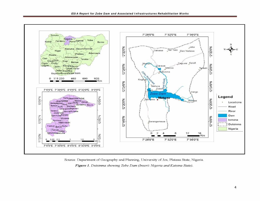
1.4 Location of the Proposed Project
The Zobe Dam is located about 65 km south of the city of Katsina in Katsina State, northern Nigeria at approximately Latitude 120 22’ North and Longitude 70 30 East (Map 1.1). The dam is owned by the Federal Government of Nigeria and operated by the Sokoto Rima River Basin Development Authority (SRRBDA) under the supervision of the Federal Ministry of Water Resources.

ESIA Report for Zobe Dam and Associated Infrastructures Rehabilitation Works
3
The Zobe dam impounds the Karaduwa River, and has a catchment area of about 2,527 km2. The dam is approximately 15 km long with a surface area of 36.9 km2, and a storage capacity of 177 x 106 m3 at full supply level. The reservoir, built between 1981 and 1983 was initially designed to supply water to the proposed 8000 ha irrigation development downstream of the dam as well as the supply of water to villages and towns around the Karaduwa axis.
ESIA Report for Zobe Dam and Associated Infrastructures Rehabilitation Works
4

ESIA Report for Zobe Dam and Associated Infrastructures Rehabilitation Works
5
1.5 General Approach and Scope of the ESIA Study Using the Terms of Reference and /Scope of work provided for this assignment as guide, the consultant had to adopt a stepwise approach in the process of execution. The approach includes but not limited to: Extensive literature review to acquire background information on the environmental and
social characterization of the study area. Field Data Gathering of relevant biophysical, physico-chemical, socio-economic and
health issues Laboratory analyses/experiment which covers relevant environmental components Evaluation of identified environmental and social impacts Evaluation of mitigation/amelioration measures Development of Environmental and Social Management Plan Report preparation and Submission as deliverables attached to payments for remunerations
and reimbursables.
The Scope of the ESIA Study includes the carrying out of all necessary preparatory studies, field work, research and investigations (including the generation of new field data, as deemed necessary or appropriate) to compile the information required for the work including carrying out all necessary preparatory studies (review of all feasibility studies and project disclosed safeguards documents), field work, research and investigations (including the generation of new field data, as deemed necessary or appropriate). The ESIA also considered the capacity of existing institutions to manage the predicted environmental and social issues, and implement the Environmental and Social Management Plan (ESMP) that was prepared for this purpose. This plan should also include the actions needed to implement the ESMP. The study was divided into four major parts to ensure adequate coverage and ease of potential impact evaluation: scoping report, draft report, draft final report which will include extensive stakeholders’ consultation, and final report. This is to reduce complexity of the proposed project and ensure a comprehensive study. Furthermore, the study took cognizance all other project safeguards instruments (RPF, ESMF and PMP) that have been prepared and disclosed and all relevant feasibility and dam safety reports prepared for Zobe project. Activities were coordinated with the Sokoto Rima River Basin Development Authority, the TRIMING environmental and social safeguards team. 1.6 Aim and Objectives of the ESIA Study The aim of this study is to assess the potential environmental and social impacts of the TRIMING interventions (on the Zobe dam and its associated infrastructures) on the flora and fauna, water resource management, soil, air quality, agricultural activities and communities within the Zobe catchment area; and propose means of mitigating and/or enhancing them to acceptable level.
The specific objectives of the studies include the following:

ESIA Report for Zobe Dam and Associated Infrastructures Rehabilitation Works
6
To conduct an Environmental and Social Impact Assessment of the planned remedial work on Zobe dam in order to identify and assess their potential environmental and social impacts; taking into consideration impacts of previous seepage remedial works carried out in 1983 and 1984 given the seepage history of the dam;
To carry out consultations with relevant stakeholders, including potential project-affected persons/communities, and obtain their views and suggestions regarding the environmental and social impacts of the proposed rehabilitation work on the Zobe dam and associated infrastructures. The outcome of the consultations will be reflected in the ESIA report and incorporated into the project design and rehabilitation work as appropriate;
Develop a spatial analysis of the area of influence of the project and prepare a map base with appropriate overlays as specified below using GIS software (e.g. ArcGIS).
To assess the capacity of existing agencies and institutions to monitor and manage the ESMP;
To prepare and cost an Environmental and Social Management Plan (ESMP) detailing mitigation measures as well as institutional roles and responsibilities in the operationalization of the ESMP; Establish and benchmark the existing state of the environment and identify sensitive components of the existing environment within the project area and area of influence;
Propose project design and planning by identifying those aspects of location, construction which may cause adverse environmental, social, health and economic effects, including strong focus on conflict management, cohesion and inclusion;
Provide a detailed description and analysis of the environmental and social pre-project baseline situation as a basis for development, mitigation and future monitoring;
Identify and provide recommendations to the project design to build on developmental opportunities;
Identify and assess gender aspects of the project;
Recommend measures during construction, commissioning, operation and decommissioning to avoid and mitigate these adverse effects and to enhance beneficial impacts that will be part of the ESMP;
Identify existing and expected environmental and social regulations that will affect the development and advise on standards and targets;
Identify any future environmental and social issues and concerns which may affect the development of the project, including induced impacts;
Identify communities on the downstream of the dam, and assess the rate of sedimentation and its impact on the downstream ecologies and their impact on the socio-economic activities of the surrounding communities; and
Provide the basis for co-operation and consultation with regulatory and non-regulatory authorities and the public

ESIA Report for Zobe Dam and Associated Infrastructures Rehabilitation Works
7
1.7 Need for Environmental and Social Impact Assessment The proposed intervention works for Zobe Dam and associated infrastructure are expected to trigger the Bank Safeguard Policies, especially Environmental Assessment (OP 4.01); Safety of Dams (OP 4.37); and Projects on International Waterways (OP 7.50).
In order to ensure compliance with the requirements of the World Bank Safeguard Policies, especially on Environmental Assessment (OP/BP 4.01) and relevant environmental laws/legislations of the Federal Government of Nigeria Environmental Impact Assessment Act, TRIMING assigned the preparation of the Environmental and Social Impact Assessment (ESIA) Report to MULTIPLE DEVELOPMENT SERVICES LTD (MDS) a Health, Safety, Environmental &Social Risks Management Consultancy firm.
The purpose of the ESIA was to identify potential and significant adverse or positive environmental and social impacts and to propose means of mitigating or ameliorate identified impacts to acceptable levels. This ESIA also considered the capacity of existing institutions to manage the predicted environmental and social issues and implement an Environmental and Social Management Plan (ESMP) for this purpose.
Detailed scope for this assignment is contained in the Terms of Reference as Appendix 1 to this document.
1.8 Policy, Legal and Administrative Framework It is instructive to appreciate that duty and responsibility for environmental and social protection and management related to projects in various sectors of Nigerian economy are mandated under: Current Federal, State and Local and relevant acts, rules, regulations and standards, and the
common law of the Federal Republic of Nigeria (FRN) International environmental agreements and treaties ratified by the Federal Republic of
Nigeria Development Partners (such as World Bank (WB)'s) safeguard Policies To this end, for comprehensiveness and inclusiveness of the relevant local and international laws and policies with relevance, the ESIA is prepared in conformance to: The Environmental and social legal requirements of the Republic of Nigeria and the respective
provisions of Katsina State; Relevant sectoral guidelines The applicable standards of the World Bank; and The relevant international conventions and treaties to which Nigeria is party.
However, it is considered relevant, first and foremost, to discuss briefly the administrative framework as provided below. 1.8.1 Federal Institutions 1. National Council on Environment This is the apex policy-making organ on environment. The Council:
The Council consists of the Minister of Environment, Minister of State for Environment, and State Commissioners of Environment

ESIA Report for Zobe Dam and Associated Infrastructures Rehabilitation Works
8
Participates in the formulation, coordination, harmonization and implementation of national sustainable development policies and measures for broad national development.
Meets regularly to Consider and receive States’ reports on environmental management; Consider national environmental priorities and action plans as it affects Federal and
State governments; and Exchange ideas and information where necessary with Federal Government on
environmental issues. 2. Federal Ministry of Environment (FMEnv) This was set up by Presidential Directive, Ref. No. SGF.6/S.221 of October 12, 1999 and empowered with regulation of all environmental matters protecting, enhancing and preserving the Nigerian environment. In addition, the Ministry; Carries out the Federal Executive Council decisions on environmental matters Serves as the focal point and designated National Authority for the implementation of
various international laws on environmental protection/conservation. Co-ordinates the environmental protection and conservation of natural resources for
sustainable development in Nigeria and specifically:
▪ Monitor and enforce environmental protection measures;
▪ Enforce international laws, conventions, protocols and treaties on the environment;
▪ Prescribe standards and make regulations on air quality, water quality, pollution and effluent limitations, the atmosphere and ozone layer protection, control of toxic and hazardous substances; and
▪ Promote cooperation with similar bodies in other countries and international agencies connected with environmental protection.
The act establishing the Ministry places on it the responsibility of ensuring that all development and industry activity, operations and emissions are within the limits prescribed in the National Guidelines and Standards, and comply with relevant regulations for environmental pollution management in Nigeria as may be released by the Ministry. To fulfill this mandate a number of regulations/instruments have been churned out such as outlined below. Thus, in line with her mandate, the Ministry has developed far reaching legal instruments for achieving environmentally sound management of resources and sustainable development across all major sectors of the economy. These regulatory instruments are enforced through the activities of her two Agencies of which National Environmental Standards and Regulations Enforcement Agency (NESREA) is most relevant to the current project.
NESREA was established via a Gazette No. 92, Vol. 94 of 31st July, 2007 with responsibility for the protection and development of the environment, biodiversity conservation and sustainable development of Nigeria’s natural resources in general and environmental technology, including coordination and liaison with relevant stakeholders within and outside Nigeria on matters of enforcement of environmental standards, regulations, rules, laws, policies and guidelines.
ESIA Report for Zobe Dam and Associated Infrastructures Rehabilitation Works
9
The Federal Ministry of Environment through the Department of Environmental Assessment provides an oversight for Environmental Impact Assessment preparation and implementation such as the one for the proposed project. 3. Federal Ministry of Water Resources (FMWR) The Federal Ministry of Water Resources (FMWR) created in 1976, is the major national water coordinating body in Nigeria, headed by the Minister for Water Resources. The FMWR formulates and implements the National Water Resource development policies, and co-ordinates their development. Its principal functions are outlined below:
Formulate and implement National Irrigation Policy; Develop and support irrigated agriculture; Coordinate development and utilization of water resources for irrigation and other
purposes; Develop and implement Water Resources Master plan for the development of dams,
irrigation and drainage, water supply, soil erosion, etc.; Collect, store, analyze and disseminate hydro-meteorological, hydrological data; Support, monitor and evaluate programmes and performances of the River Basin
Development Authorities (RBDAs) and National Water Resources Institute (NWRI); Formulate and review National Water Legislation; Undertake and support studies and investigations on the efficient use of the Nation’s
water resources; Develop guiding principles for dam construction nationwide; and Liaise with relevant National and International Agencies on matters relating to water
resources development. Relevant Institutions in the Water Sector and their Responsibilities a. The National Council on Water Resources (NCWR) – is the highest and most important water resources policy formulating body, headed by the FMWR. It was established in 1980 and includes representatives from the Federal Ministry of Environment and all State Government Commissioners for Water Resources. b. The National Technical Committee on Water Resources (NTCWR) – is a sub-committee of the NCWR, and chaired by the permanent secretary of the FMWR. The NTCWR provides technical advice on policy issues. However due to fund constraints NTCWR now meets once a year, and has five specialist sub-committees: dam, water supply, irrigation and drainage, hydrology and hydrogeology, and manpower. c. National Water Resources Institute (NWRI) – is responsible for training, educating, collecting of data, and disseminating services in the field of water resources development and management. The institute directly reports to the FMWR. d. River Basin Development Authorities (RBDAs)-are the main bodies in charge of administering and developing Nigeria’s water resources and are responsible for public sector irrigation at the federal level. The functions of RBDAs related to irrigation are defined in the RBDA Act No. 35 of 1986. They were established in the mid-1970s and the areas of operation are determined by the extent of the river basins they serve.

ESIA Report for Zobe Dam and Associated Infrastructures Rehabilitation Works
1
1.8.2 State Institutions 1 Katsina State Ministry of Environment/Environmental Protection Agency Each State of the Federation has an Environment Ministry and/or Environmental Protection Agency (EPA) that is charged with the responsibility of providing decent, orderly, conducive and habitable environment. In Katsina State, the Ministry of the Environment carries out the following:
Liaison with the Federal Ministry of Environment to achieve a healthy or better management of the environment
Co-operate with FMEnv and other National Directorates/Agencies in the performance of environmental functions including environmental education/awareness to the citizenry
Monitoring waste management standards, Responsibility for general environmental matters in the States, and Monitoring the implementation of EIA studies and other environmental studies for all
development projects in the State.
2 State Environmental Protection Agency: The Katsina State Environmental Protection Agency (KSEPA) has the functions of:
Collection and disposal of wastes generated in the State capital, urban towns and institutions in the State;
Inspection of government premises, institutions, factories etc. in order to ensure compliance with sanitary standards in the State; and
Creation of public awareness campaign on environmental protection and improvement through mass media.
3 State Ministry of Water Resources: The Katsina State Ministry of Water Resources (KSMWR) is in charge of water resource exploitation, provision of potable water and irrigation facilities in the State. The project shall ensure cooperation with the state agency. Some legal instruments put in place by the Katsina State Ministry of Environment include the following:
Environmental Protection Agency Law No.4 of 1994; Environmental Sanitation Monitoring and Enforcement; and Rural Water Supply and Sanitation.
1.8.3 Local Government Institutions Like the State Government, the Local Government liaise and cooperate with the Federal and State Ministries of Environment to achieve a healthy or better management of the environment within their domains with the relevant bye-laws. According to Local Government law, in the Fourth schedule, Local Governments constitute a tier of the government structure with unique responsibilities to discharge services such as the followings:
Transportation services (roads, public transit); Environmental services (sewers, garbage disposal, water supply);
ESIA Report for Zobe Dam and Associated Infrastructures Rehabilitation Works
1
Social and health services (welfare administration, day care, homes for seniors, public health programs);
Recreation and cultural services; Land use planning; Maintenance of Law and Order in Local Government Areas in collaboration with Law
Enforcement Agencies; Collection of taxes and fees; Establishment and maintenance of cemeteries, burial grounds and homes for the
destitute or infirm; Establishment, maintenance and regulation of markets, motor parks and public
conveniences; Construction and maintenance of roads, streets, drains and other public highways,
parks, and open spaces; Naming of roads and streets and numbering of houses; Provision and maintenance of public transportation and refuse disposal; and Registration of births, deaths and marriages;
1.8.4 Relevant National Regulatory Guidelines The major national regulatory instruments relevant to the proposed development are considered below: The Nigerian Constitution, 1999, as the national legal order, recognizes the importance of improving and protecting the environment and makes provision for it. Relevant sections are
Section 20 which makes it an objective of the Nigerian State to improve and protect the air, land, water, forest and wildlife of Nigeria.
Section 12 which establishes, though impliedly, that international treaties (including environmental treaties) ratified by the National Assembly be implemented as law in Nigeria.
Sections 33 and 34 which guarantee fundamental human rights to life and human dignity respectively, and have also been argued to be linked to the need for a healthy and safe environment to give these rights effect.
Pursuant to the realization of these Sections, a number of regulations and guidelines have been churned out by the Government over the years. Some relevant National instruments are outlined below.
National Policy on Environment; Environmental Impact Assessment Act No 86 of 1992; National Environmental Impact Assessment Procedural Guidelines 1994; National Environmental Protection (Management of Solid and Hazardous Waste)
Regulations 1991; National Environmental Protection (Pollution Abatement in Industry and Facility
Generating Waste) Regulations 1991; National Environmental Protection (Effluent Limitation) Regulations 1991; Public Health Order (1950, as amended by Public Health Order 1963); Nigerian Urban and Regional Planning Act, CAP N138, LFN 2004; Guidelines on Environmental Audit (1999 updated in 2010);

ESIA Report for Zobe Dam and Associated Infrastructures Rehabilitation Works
1
Harmful Waste (Special Criminal Provision Etc) Act 1988, CAP H1, LFN2004; National Environmental Standards and Regulations Enforcement Agency, Federal
Republic of Nigeria Official Gazette No.92, Vol. 94 of 31st July 2007; Public Health Law (L.N 47 of 1955, Cap 103); National Policy Framework on PCB Management in Nigeria; Draft National Social Protection Policy; National Environmental (Control of Vehicular Emissions from Petrol and Diesel
Engines) Regulations, 2010. S. I. No. 20; National Environmental (Noise Standards and Control) Regulations, 2009.S. I. No. 35.
FMEnv Policy Guidelines on Solid waste Management 2005; Pollution Abatement in Industries and Facilities Generating Waste Regulation 1991; Management of Hazardous and Solid Wastes Regulation 1999; National Environmental (Sanitation and Waste Control) Regulations, 2009. S.I No. 28; National Environmental (Access to Generic Resources and Benefit Sharing)
Regulations, 2009. S. I. No. 30; National Environmental (Control of Bush/Forest Fire and Open Burning) Regulations,
2010. S. I. No. 15; and National Environmental (Protection of Endangered Species in International Trade)
Regulations, 2010. S. I. No. 16. Other relevant ones were identified. A brief of two of the relevant instruments have been given below. Details of the others can be found in the relevant references cited above. a. National Policy on Environment The National Policy on Environment, 1989 (revised 1999), provides for “a viable national mechanism for cooperation, coordination and regular consultation, as well as harmonious management of the policy formulation and implementation process which requires the establishment of effective institutions and linkages within and among the various tiers of government – federal, state and local government”. Prior to the launching of this policy, there was no unified coordination of activities of the three tiers of government responsible for the environment. The thrust of the policy is the achievement of sustainable development in Nigeria. Guidelines and strategies are therefore defined for:
Securing for all Nigerians a quality of environment adequate for their health and well-being;
Conserving and using the natural resources for the benefit of present and future generations;
Restoring, maintaining and enhancing the ecosystem and ecological processes essential for the preservation of biological diversity;
Raising public awareness and promoting understanding of the essential linkages between the environment, resources and development; and
Cooperation with other countries, International Organisations and agencies to achieve optimal use of trans-boundary in order to prevent environmental recourses.

ESIA Report for Zobe Dam and Associated Infrastructures Rehabilitation Works
1
Further, the defined guidelines and strategies provide for the effective management of the environment in the following 14 major areas: Human population; Land use and soil conservation; Water resources management; Forestry, wildlife and protected areas; Marine and coastal area resources; Toxic and hazardous substances; Energy production and use; Air pollution; Noise pollution; Working environment; Occupational Health and Safety); and Settlements, recreational space, greenbelts monuments and cultural property. b. Environmental Impact Assessment (EIA) Act No. 86 of 1992 (now CAP 2000 LFN) This act stipulates that the public or private sector of the economy shall not undertake or embark or authorize projects of activities without prior consideration, at an early stage of their environmental effects. Procedurally, before commencement of an EIA, the FMEnv issues a letter of intent on notification by the proponent, to approve the terms of reference and ensure public participation. The EIA Act requires that development projects be screened taking cognizance of the nature, size, and sensitivity of the proposed project environment as well as the potential impacts of the project. Based on the screening, a full, partial, or no EIA may then be required, according to the following categories:
Category I: projects that require a full EIA; Category II: projects that may require only a partial EIA, which will focus on mitigation
and Environmental planning measures, but if located near an environmentally sensitive area then a full EIA is required; or,
Category III: projects considered having “essentially beneficial impacts” on the environment, thus only an Environmental Impact Statement is prepared.
c. Water Resources Act No. 101 of 1993
The Water Resource Act provides for an effective management, conservation, usage and control of water resources in Nigeria. The Act vests on the Federal Government through the Federal Ministry of Water Resources, the right to use and control of all surface and groundwater and any watercourse affecting more than one State. The Act confers on the FMWR the responsibility to make proper provision for adequate supplies of suitable water for, amongst others, agricultural purposes in general and irrigation in particular.
d. National Water Policy The National Policy on Water, 2004, anchors the provision of sufficient potable water to all Nigerians in an affordable and sustainable way through participatory investment by the three tiers of government, the private sector and the beneficiary. The policy document sets out the following principles for water resource management:
All water is a national asset the use of which shall be subject to national control; Management objective shall be to achieve optimum, long term, environmentally
sustainable social and economic benefit for society; There shall be no ownership of water but only a right for its use and abstraction fees
for raw water shall be charged for its commercial use; Operational management of water resources and services shall be decentralized to the
lowest practicable level and shall seek to harmonize human and environmental requirements; and

ESIA Report for Zobe Dam and Associated Infrastructures Rehabilitation Works
1
Pollution protection measures shall be based on both regulatory and market-based approaches to waste management, applying the “polluter pays” principle.
e. National Inland Waterways Authority (NIWA) Act
The National Inland Waterways Authority (NIWA) Act No. 13 of 1997 provides for the establishment of National Inland Waterways Authority (NIWA), and bestows on the agency the responsibility for improving and developing inland waterways in Nigeria for efficient navigation. The NIWA based on this act, are to provide alternative modes of transport for evacuation of economic goods and persons and execute objectives of the national transport policy as they concern inland waterways. The Act prescribes regulations and sanctions on the use and exploitation of resources of inland waterways, such as: dredging, sand or gravel mining and erection of permanent structures within the right of way or diversion of water from a declared waterway. f. National Environmental (Wetlands, River Banks and Lake Shores Regulations, S. I. No. 26 of 2009.
These regulations provide for conservation of wetlands and their resources, whilst ensuring sustainable use of wetlands for ecological and tourism purposes and protect wetland habitats for species of fauna and flora.
g. National Environmental (Surface and Groundwater Quality Control) Regulations 2010. S. I. No. 22.
These regulations restore, enhance and preserve the physical, chemical and biological integrity of the nation’s surface waters and maintains existing water uses.
h. National Environmental (Soil Erosion and Flood Control) Regulations, 2010. S. I. No. 12.
The overall objective of these regulations is to check all earth-disturbing activities, practices or developments for non-agricultural, commercial, industrial and residential purposes.
i. National Irrigation Policy and Strategy (NIPS)
The Water Resources Decree No. 101 of 1993 gives the FMWR significant power to control and coordinate activities for proper watershed management and resources protection. It confers to the FMWR the responsibility to make proper provision for adequate supplies of suitable water for, amongst others, agricultural purposes in general and irrigation in particular.
The development of Nigerian’s National Irrigation Policy and Strategy (NIPS) is an ongoing collaboration between FMWR and Food and Agriculture Organization of the United Nations (FAO). The primary purpose of the NIPS is to improve the performance of water services in irrigated agriculture - basically improving performance of irrigation services, as they fall under the mandate of the FMWR per the Water Resources Act. Implementation of the NIPS will expedite alignments of complementary policies and strategies in specific aspects of agricultural production, commercial environment (marketing and trading or irrigated production), etc., in Federal, State and Local Government Levels. In addition, the NIPS is expected to boost domestic agricultural production utilizing irrigation to increase quality and quantity of these products, and achieve strategic balance between irrigated and rain-fed production.

ESIA Report for Zobe Dam and Associated Infrastructures Rehabilitation Works
1
j. River Basin Development Authorities (RBDAs)
River Basin Development Authorities were established through Decree No. 25 of 1976. In 1987, Decree No. 85 was enacted, separating RBDAs from all forms of agricultural and extension services including agricultural production. Their primary focus, based on the updated decree is on water supply for irrigation, human and livestock consumption within their catchment areas. 1.8.5 International Regulatory Instruments Nigeria subscribes to a number of International Regulations and Conventions relating to Environmental Protection. In addition, Nigeria government does every now and then seek partnership with different international development partners such as the World Bank. To this end, all relevant administrative frameworks have relevance to environmental and social management of the Nigerian environment and wellbeing, especially in project for which supports are needed such as the current subproject.
Some of the related guidelines/conventions/treaties to which Nigeria is a signatory are highlighted below: o Convention Concerning the Protection of the World Cultural and Natural Heritage Sites
(or World Heritage Convention); o Basel Convention on the Control of Trans-boundary Movements of Hazardous Wastes and
their Disposal; o United Nations Framework Convention on Climate Change (1992); o African Convention on the Conservation of Nature and Natural Resources of 1969; o Convention on the Conservation of Migratory Species of Wild Animals of 1979; o Convention on the Law of the Seas of 1982; o The RAMSAR Convention on Wetlands of 1971; o Agenda 21 – United Nations Conference on Environment and Development; and o World Health Organization (WHO) Health for All Strategy and Policy, 1978 and 1998.
I. International Associations and Protocols The international associations and protocols provide the flora and instruments respectively for ensuring standards and sustainability of dams:
The World Commission on Dams; International Hydropower Association; Hydropower Sustainability Assessment Protocol; and International Commission On Large Dams.
II. World Bank Environmental and Social Safeguards
The World Bank has 10+ 2 Environmental and Social Safeguard Policies to reduce or eliminate the adverse effects of development projects, and improve decision making which are summarized in Table 1.2. Three safeguards instruments of ESMF, PMP and RPF have already been prepared, reviewed, approved and publicly disclosed in Nigeria and World Bank InfoShop.

ESIA Report for Zobe Dam and Associated Infrastructures Rehabilitation Works
1
The TRIMING Project intervention across all the schemes triggered a number of World Bank Safeguard policies (Table 1.2). For Zobe Dam intervention work, the triggered policies include: Environmental Assessment (OP 4.01), Safety of Dams (OP 4.37), Projects on International Waterways (OP 7.50), Physical Cultural Resources (OP 4.11).
It should be noted that in August 2016, the World Bank’s Board of Executive Directors approved the Environmental and Social Framework (ESF); the ESF became effective on October 1, 2018. The ESF protects people and the environment from potential adverse impacts that could arise from Bank-financed projects, and promotes sustainable development. This new framework provides broad coverage, including important advances on transparency, non-discrimination, social inclusion, public participation and accountability. The ESF also places more emphasis on building borrower governments’ own capacity to deal with environmental and social issues. The ESF recognises that existing projects such as this Zobe Project will continue to apply the Safeguard Policies, since the two systems (the World Bank’s environmental and social policies and Environmental and Social Framework) will run in parallel for an estimated seven years from the start of the ESF. Table 1.2: Triggered Safeguard Policies
*NA= Not Applicable
Safeguard Policies Triggered Triggered by Site-specific Project?
Applicability to Project due to
How Project Address Policy Requirements
Yes No Yes NoEnvironmental Assessment (OP/BP 4.01)
[x] [ ] [x] [ ] Civil works with site-specific impacts
ESIA for site specific mitigation measures prepared in consonance with the precursor ESMF
Natural Habitats (OP/BP 4.04)
[x] [] [ ] [x] Civil works with site-specific impacts
This ESIA report
Pest Management (OP 4.09)
[x] [] [ ] [x] NA Pest Management Plan prepared
Physical Cultural Resources (OP/BP 4.11)
[x] [] [ ] [X] NA Natural Habitat Conservation Plan
Involuntary Resettlement (OP/BP 4.12)
[x] [ ] [] [ x ] NA
NA
Indigenous Peoples (OP/BP 4.10)
[ ] [x] [ ] [x] NA NA
Forests (OP/BP 4.36) [ ] [x] [ ] [x] NA NASafety of Dams (OP/BP 4.37)
[x] [] [x] [] Zobe dam Dam panel of experts established by the Project
Projects in Disputed Areas (OP/BP 7.60)*
[ ] [x] [ ] [x] NA NA
Projects on International Waterways (OP/BP 7.50)
[x] [] [x] [] NA Riparian Notification issued and Project is in receipt of response

ESIA Report for Zobe Dam and Associated Infrastructures Rehabilitation Works
1
Nigeria EIA Guidelines and World Bank EA Guidelines As Nigeria's regulatory authority for the environment, the Federal Ministry of Environment (FMEnv) prohibits public and private sectors from embarking on major projects or activities without due consideration of likely environmental impacts. Specifically, the Environmental Impact Assessment (EIA) Act No. 86 of 1992 makes an EIA mandatory for any development project, and prescribes the procedures for conducting and reporting EIA studies. Procedurely, before commencement of an EIA, the FMENV issues a letter of intent on notification by the proponent, approve the terms of reference, ensure public participation, review and mediate. Table 1.3 indicates the procedures for the EIA process in Nigeria. The EIA Act requires that development projects be screened for their potential impact. Based on the screening, a full, partial, or no EIA may then be required, according to the following categories:
Category I: projects that require a full Environmental Impact Assessment (EIA); Category II: projects that may require only a partial EIA, which will focus on mitigation
and Environmental planning measures, but if located near an environmentally sensitive area then a full EIA is required; or,
Category III: projects considered having “essentially beneficial impacts” on the environment, thus only an Environmental Impact Statement is prepared.
The World Bank also has a categorization (A, B, & C) which corresponds in principle with the Nigeria EIA requirements of Category I, II and III, which in actual practice is done with regard to the level of impacts associated with a given project. Table 1:3 EIA Procedural Guidelines
Activity What Who Registration of project Proposed Project with the Designated Authority (DA) Proponent through appointed
Consultant Project proposal Submission to the DA The Proponent Preliminary assessment/Initial Environmental Evaluation
Determine projects requiring full EIA Categorisation of EIA projects into either I, II or III
DA
Screening Does the project require an EIA? DA Scoping What issues and impacts should the EIA address? Proponent through appointed
Consultant EIA study Baseline studies -data gathering, Laboratory Analysis,
Consultation, Impact identification & Assessment Mitigation of impacts, Development of an Environmental Management Plan (EMP) , Report writing
Proponent through appointed Consultant
Review EIA Report either through in-house review, Panel review (sitting may be public) public or mediation
DA invites relevant public members for their comments.
Decision Making All relevant information and the consultation findings taken into account in reaching a decision on the proposed project
DA
Monitoring and Auditing Provide feedback to the EIA process Monitoring - before the project situation versus after the project situation -enables an assessment of the quality of predictions and of the effectiveness of mitigation measures.
DA

ESIA Report for Zobe Dam and Associated Infrastructures Rehabilitation Works
1
Harmonization of FMEnv EIA Procedures and World Bank EA Safeguard Policy The Nigerian EIA Act and the World Bank (WB) operational procedures were harmonized as much as possible. In the implementation of the project, when there is a dissonance between those of the country (Nigeria) and WB policies, the most beneficial for the environment and people shall take precedence. This emphasizes the adherence to best practice and more so that the Government of Nigeria signed to uphold that of the Bank as satisfying best practice With this, the ESIA is made responsive to the objectives of good practice with regard to the followings: Early consideration of environmental and social issues (starting at the screening stage); Identification and early consultation with stakeholders; Prevention of adverse impacts through the consideration of feasible alternatives; and Incorporation of mitigation measures into planning and (engineering) design
III. Environmental Quality Standards and Criteria
Based on a number of the instruments outline above, some relevant environmental standards or regulations for emissions and discharges and acceptable concentrations of contaminants in soil and water ((ambient water quality in streams, or effluent discharge standards; air emissions, noise,) relevant to dam rehabilitation were identified and utilised to serve as benchmarks for the field tests.
1.9 Report Structure
The ESIA report of the proposed project is in the format laid down by the Federal Ministry of Environment (FMEnv), 1999 as outlined below:
Chapter One – Introduction Chapter Two – Project Justification Chapter Three - Project Description Chapter Four – Description of the biophysical, socio-economic and health environment Chapter Five, - Associated and Potential Environmental and Social Impacts Chapter Six, - Mitigation Measures and Alternatives Chapter Seven - Environmental Management and Community Development Plans Chapter Eight - Decommissioning and Abandonment Chapter Nine - Conclusions and Recommendations

ESIA Report for Zobe Dam and Associated Infrastructures Rehabilitation Works
1
CHAPTER TWO PROJECT JUSTIFICATION AND OPTIONS
2.1 Justification of Project The idea to construct Zobe Dam was conceived in the late 1970s during the military administration of General Olusegun Obasanjo. The Dam was planned to supply 50% of drinking water for Katsina State and support irrigation farming in the area. Zobe Dam was completed and commissioned in 1983 during Second Republic under the leadership of President Shehu Shagari.
The Zobe Dam (Irrigation) and Associated Infrastructures Rehabilitation Works Project was conceived with the aim of increasing farm output through irrigation, water supply to Katsina town and possibly through its generated electricity. However, since its near-completion, the dam and reservoir have been grossly underutilized because the irrigation component was not fully completed.
2.2 Need for the Project Failure to implement the recommended remedial measures on Zobe dam and appurtenances increase the risk of a dam break/failure with grave consequences of loss of lives and properties downstream of the dam. Other reasons why there is urgent need for the rehabilitation of Zobe Dam and appurtenances include, large scale environmental degradation and loss of livelihood (fishing and agriculture) in the event of dam break which will cause the release of as much as 177 x 106m3 from Zobe Dam reservoir. The proposed remedial works of the dam will ensure the safety of the dam and improve water supply to the outlying communities whose livelihood largely depends on the river.
Dam breach assessment study undertaken by Atkins et al during the feasibility phase of the project revealed that failure of Zobe Dam will result in significant flood extent and depths with flooded area of 1,712km2 and with flooding extending downstream past Sokoto. Flooding of this nature is expected to cause a large-scale environmental degradation and social problem such as loss of livelihood (farming & fishing). Even more worrisome and justifies the undertaking of this project is the risk of the said dam failure to human safety. It is therefore important that the rehabilitation of Zobe Dam be carried in the light of the danger it poses to human and environmental safety as well as social-economic concerns raised above. Based on feasibility studies, a cost-benefit analysis, environmental and social risk consideration, a preferred project alternative option was selected from implementation and technological alternatives. 2.3 Benefits of the Project
The main project interventions are the remedial works involving upgrading and rehabilitation of the dam to improve dam safety as indicated in TRIMING’s Dam Safety Report, water management, and agricultural service interventions. When completed, the project will mitigate economic losses because of: (i) flooding of crops, properties and public infrastructure downstream which had been experienced in the past (ii) overtopping/breach of the dam and the resulting damage to crops, properties and public infrastructure.

ESIA Report for Zobe Dam and Associated Infrastructures Rehabilitation Works
2
These interventions are therefore expected to also improve water supply which has become the major focus in view of the outcome of the feasibility study that revealed that surface irrigation will not be the best method for improving agricultural production in the area. The improvement of water supply will have the effect of improving livelihood of people in the host communities. The flood control will involve the redesign and reconstruction of protective dykes on the irrigation schemes, as well as training of the rivers (through channelization and dredging of the river bed for de-siltation and free flow of water).
2.4 Envisaged Sustainability
2.4.1 Environmental Sustainability
The Zobe Dam remedial project principles are based on cost reduction, minimization of negative environmental, social impacts, utilization of local skilled labour and livelihood improvement Hence, Environmental, public safety and health considerations are being given adequate consideration while appropriate mitigation measures and Environmental Management Plan will be carefully implemented.
Saving costs by reducing the loss Saving cost through industrial ecology principles Ensuring cascading of energy and waste materials Relying on free ecological services as an activity contributing to the delivery of the value proposition Transforming waste into a productive resource Direct employment of skilled and semi-skilled Development of rural employment opportunities Production of new knowledge and fostering of innovation Societal innovation Delivering engineering, technical and project execution excellence to the downtrodden Increasing the spaces of differentiation and contributing to enhance a positive image.
2.4.2 Political Support and Institutional Sustainability
With the realisation the the Zobe Dam has the capacity to improve the subsisting water supply condition in the State, The Katsina State Government has chosen the Zobe Dam on the Karaduwa river for the as one of the major Dams in the State for improving water supply in the State. Thus the State Government has demonstrated commitment to ensuring that Zobe Dam is restored to the condition required. This is in addition to the commitment demonstrated by the World bank and the Federal Ministry of Water Resources through TRIMING.
2.4.3 Social Sustainability The commitment of the people of the communities towards the project is being ensured through the planned engagement and continuous consultation. Also, project specific social and environmental management activities to ensure social sustainability of the proposed project has been developed as part of the overall project management plan.

ESIA Report for Zobe Dam and Associated Infrastructures Rehabilitation Works
2
2.4.4 Technical Sustainability The Project is planned to be constructed and supervised by an assemblage of a team professional with impressive relevant experience that would be involved in the implementation of the project and would where necessary source for necessary technical expertise to ensure the sustainability of the project applying internationally recognised best practices.
Consequently, the Best Available Technology will be applied in the implementation of the project and adhere strictly to all relevant engineering codes and standards
2.5 Project Options
No Project Option The No-project option is the non-implementation option. It assesses the environmental, social and economic pro and cons of leaving the dam and associated infrastructure in their present condition. Not executing the proposed remedial work at the dam embankment with particular emphases on filling and compaction of vegetation and root bowls as well as removal of anthill and termite mounds from the downstream face of the embankment will ultimately serve as a catalyst for internal erosion (piping) and eventual collapse of the embankment with catastrophic consequences of extensive downstream flooding which could lead to possible loss of lives and economic activities. Failure to monitor uplift pressure on dam structure emanating from dam foundation seepage problem using gauge well (piezometers) and v-notch weir as well as rehabilitating existing seepage control system (inverted filters, relief well and drainage collector) will increase uplift pressure on the dam with a threat on the structural stability of the dam. Therefore, the No-Go Alternative is not a reasonable alternative and it is necessary to implement the remedial action to avoid such a situation. Delayed Project Option This option suggests that the proposed dam and associated work rehabilitation project be delayed until a later date. The delayed project option will cause further deterioration of the dam embankment which could be currently corrected by simple maintenance work. Noticed vegetation, root and tree bowls will degenerate into large seepage channels. This will bring about a situation of both embankment and foundation seepage problem necessitating more extensive and expensive seepage control measure such as cutoff wall which could have been avoided. Postponing rehabilitation works on dam seepage control system, crest level regulation and pipe work (dam appurtenances) will put pressure/stress on the dam structure leading to possible collapse. For the above reasons, this option is not a viable option and is rejected. Immediate Project Intervention option
This option means that the project rehabilitation works which involve maintenance of dam monitoring equipment as well as dam and associated infrastructure will go ahead. The proposed dam and associated infrastructure rehabilitation will restore to working condition dam monitoring instruments such as level pin, Piezometer and v-notch weir that provide early signals of faults such
ESIA Report for Zobe Dam and Associated Infrastructures Rehabilitation Works
2
as dam crest deformation (settling), increase in uplift/hydrostatic pressure due to foundation seepage as well as increase seepage discharge from relief well that could compromise dam safety.
Maintenance work on the dam embankment with reference to excavation and filling of vegetation root and tree bowls noticed during dam inspection will prevent the emergence of avenues for seepage (piping/internal erosion) through dam embankment. Maintenance and modification of seepage control system which include inverted filter, relief well and collector system of ditches and channels will relief dam structure of excess uplift/hydrostatic pressure associated with foundation seepage as well as improve conveyance of relief well flow downstream. Servicing inlet and outlet pipework as well as valves during rehabilitation works will reassure reservoir safety. Downstream flooding of valve chamber will cease with the proposed servicing of the flap (non-return) valve on the drain pipe. Construction of dam access road from right abutment to valve tower as part of Zobe dam rehabilitation will provide access for maintenance and emergency. Judging from the above benefits of the go-ahead option as well as the environmental and social impacts of carrying out remedial work under this option, the go-ahead option is considered the most viable and recommended for implementation. 2.6 Alternative Option for Project Execution In making recommendations for remedial work at Zobe Dam following dam safety inspection, the consultant concentrated efforts in proposing ways of restoring to working conditions existing dam monitoring and seepage control instruments. However, it is important to compare and contrast in terms of cost, benefit and environmental risk of possible/existing alternatives to suggested rehabilitation methods (execution options) under the go-ahead option. Water levels in observational wells at the downstream face of the dam or within the vicinity of the dam could indirectly be used to gauge dam site uplift pressure. However, there will be need to drill so many more of such observational well at additional cost to the project. Moreso, observational well within the vicinity of the dam are further away from the dam and may have least response to changing uplift pressure at the dam site. Generally speaking, results obtained using observational wells using an indirect approach will not be as accurate as results from piezometers which are very sensitive to low pressure changes. Environmentally speaking, it is safer to use piezometer to gauge piezometric levels in the foundation downstream of the dam as against using observational well. Therefore, flushing piezometers with water to bring them to working conditions for the purpose of monitoring increase in hydrostatic pressure from foundation seepage flow is the best option. When operational, flow from inverted filter as well as pressure relief well should be monitored. Flow meters could be placed in the drainage ditches and used to monitor flows from pressure relief well. However most of the available flow meters are not as sensitive to low flow as v-notch weir suggested by the consultants. Replacing submerged and damaged v-notch weir on drainage ditch which monitors flow from inverted filter at dam toe is the most reasonable option offering the best result.

ESIA Report for Zobe Dam and Associated Infrastructures Rehabilitation Works
2
Crest level deformation/settlement monitoring using high resolution light detection and ranging (LiDAR) could offer an alternative option to the recommended pin leveling using differential global positioning system (DGPS). LiDAR has the advantage of providing accurate height information over a long length of embankment in shorter time than DGPS leveling. However, the cost of using aerial LiDAR is prohibitive and its use can only be justified in very difficult dam terrain or where time is of essence. For the purpose of Zobe dam and associated infrastructure rehabilitation, crest level deformation monitoring by DGPS will be the best viable option. Consultants to Zobe dam project discovered during feasibility study that compressed air was used to lift silt like material from the gauged well (piezometer) and artesian pressure relief well. This method is ineffective and likely to displace sand around well screen which will adversely affect flow through the well screen. Flushing well with water as suggested by the consultants will flush sand upwards into a settlement tank and be safely disposed off. This method is more effective and environmentally friendly and is the most viable option.

ESIA Report for Zobe Dam and Associated Infrastructures Rehabilitation Works
2
CHAPTER THREE PROJECT DESCRIPTION
3.1 Introduction In this Chapter, a general description of the Zobe Dam and reservoir are provided. This is especially in relation to the specific location of the dam, brief history, and remedial activities have been carried out and that proposed.
3.2 Location of Dam
Zobe reservoir is located about 65 km south of the city of Katsina in Katsina State, northern Nigeria, at approximately 120 22’ latitude North and 70 30’ longitude East co-ordinates as indicated in Figure 1.1 in Chapter One. In Map 3.1 shows the location of the reservoir which is owned and operated by the Sokoto-Rima River Basin Development Authority (SRRBDA). Like all other such authorities SRRBDA are responsible to the Federal Ministry of Water Resources.
Map 3.1: Zobe Dam Reservoir and Tributaries
3.3 General Description of Zobe Dam

ESIA Report for Zobe Dam and Associated Infrastructures Rehabilitation Works
2
The Zobe Dam impounds River Karaduwa and has a catchment area of 2,527 km2. The dam is approximately 15 km long with a surface area of 36.9 km2 and a storage capacity of 177 x 106 m3 at full level. The Zobe Dam has a maximum height of approximately 20 m. The dam was constructed of earth fill materials and has embankment structures of 2.7 km long on a curvilinear alignment incorporating a 110 m long free overflow spillway in the left side. This is re-enforced by concrete culvert from the intake tower, which is located at the upstream toe of the embankment at Chainage 0 + 950.
The Zobe Dam reservoir, which filled up between 1981 and 1983, was initially designed to supply water to the proposed 8,000 hectares (ha) irrigation development downstream of the dam as well as the supply of water to villages and towns around the Karaduwa axis. The Zobe Dam was also intended to provide water supply for the city of Katsina. In 1993 work began on the water-supply component, but was abandoned in 1995 due to lack of funds. The dam was overtopped during heavy rains in 1999 causing heavy crop damage downstream. A water treatment plant was begun in 2003, but was abandoned half-built.
3.4 Previous Work Done on Zobe Dam Zobe Dam has a history of foundation seepage related incidents and a number of works aimed at controlling foundation seepage have been carried out. Upon completion, during the first filling in 1983 seepage was noted in the area downstream of the toe drain on the right bank. An extended drainage blanket 34m wide covered by a low berm 1-2m high was therefore constructed from Ch 0+980m to 1+545m immediately downstream of the dam together with 40 relief wells at 15m centres along the toe of the embankment. Seepage subsequently occurred in 1984 in the area downstream of the toe drain on the left bank of the river. An extended drainage blanket, similar to that on the right bank, was added in 1985 followed in 1986 by a row of relief wells at 20-30m centres.
A dam safety review in 2005 noted seepage around the dam foundations and recommended close monitoring. In 2009, the Katsina State Government considered developing hydropower facilities at the dam but this plan has not gone forward to date. As a consequence, the water impounded in the dam has served no useful purpose to date. Since 2009, work on two main distribution canals to supply irrigation water has been on-going. The work is currently suspended, again due to lack of funds. The canals are approximately half completed.
3.5 Condition of the Zobe Dam Project
An inspection exercise was carried out on the Zobe dam in October, 2013 to determine the performance of the dam. The team comprises staff of the SRRBDA and expert from Atkins. The upstream face was examined randomly and it was discovered that generally the surface of the embalmment was in a good condition with no signs of distress, and the water line was found to be straight despite the poor maintenance.
There were quite some numbers of shrubs and trees within upper part of the rip rap. The rip rap continues unto the crest to form an informal wave wall of about 1 m high. At the left- and right-hand end of the dam, the embracement continues beyond those lengths which impound water under
ESIA Report for Zobe Dam and Associated Infrastructures Rehabilitation Works
2
normal operating conditions. These trees and shrubs if left to continue could damage the dam embankment.
The dam crest was found to be generally in good condition with a satisfactory line and level. The crest is dotted with a significant amount of vegetation, ant hills and some termite mounds. Some of the vegetation are woody trees while the stump of some cut low shrubs still remain on the crest. These cut low shrubs trees has the potential of penetrating and damaging the dam crest, while the presence of the ant hill and termite mounds could suggest that void has been created on the crest.
The edge of the crest has deteriorated due to erosion by animals and people in places where paths have been created. In addition, there are a number of places where runoff is entering the downstream face which is considered to be causing other problems on the dam. The crest of the left hand section of the embankment has been recently cleared of trees which were substantial. Some of these trees have become an integral part of the wave wall.
On the downstream face, there are a number of places where foot paths from the irrigated field and Garfi village have caused the displacement of stones over and above the ones on the edge of the crest. There are also linear features running up and down the slope which is believed to have been caused by erosion of the fill immediately below the surface protection.
Given the likely damaging effect of these trees on the dam, it was recommended that they be removed from the downstream face and the root of these trees bowls be removed totally.
Seepages on the Embankment
The Zobe dam is known to have a history of foundation seepage related incidence. By design, the dam seems to have been constructed to seep to some extent, as such no formal cut off seems to have been provided in the middle of the dam despite the alluvial deposit in the center of the dam. To this end, the designer provided an array of relief wells just off the downstream toe with an increased frequency over the central section. All these notwithstanding, several seepage remedial works were carried out on the dam in 1983 and 1984 respectively to control the seepage downstream of the toe of the embankment.
During a recent inspection of the dam, the right hand side of the ditch was found to be full of water downstream of the original filter, and the outlet of the relief pipe was found to be under water. The ditch on the extended blanket was also found to be heavily overgrown.
The V-notch chamber on the original blanket drain was totally ineffective with no V- notch plate because water had backed up from the road culvert and the whole area submerged.
Condition of the Spillway
The approach to the overflow structure was free from obstruction. The reservoir was just below top water level, with occasional waves passing over the weir. The weir was very level. The weir structure and wing walls appeared to be in a satisfactory condition with no signs of significant distress. There were one or two slight seepages through one or two of the lift joints but the amounts of seepage were small.

ESIA Report for Zobe Dam and Associated Infrastructures Rehabilitation Works
2
The channel downstream of the weir as far as the next spillway structure appeared to be in a satisfactory condition. The rip rap which forms the lining to the channel appeared to be in a satisfactory condition.
Intake Tower and Culvert/Tunnel
The bridge to the intake tower appeared to be in a satisfactory condition with no signs of structural distress or deterioration. The lamp standards were in a poor condition. The hand railing appeared to be in a good condition. The valve house on the top of the tower was secure and dry and appeared to be in a satisfactory condition.
A generator at the top of the tower now powers lighting which was in a satisfactory condition with no signs of distress. There appeared to be little or no leakage from the reservoir into the shaft. The base of the shaft was seen to be in a satisfactory condition. The culvert through the dam appeared to be in a good condition with good line and level and no signs of distress.
Inlet and Outlet Pipework and Valves
There are six headstocks on the upper platform of the tower but it is clear that only one – for the butterfly valve on the upper draw off on the left hand side is regularly used, but during the wet season both valves are opened to make releases to river through both pipelines. Besides this, none of the other valves have been used, and have not been moved for a large number of years and in particular the bottom outlet has never been opened since the dam was completed. The headstocks, control rods, valves, fittings and pipework all appeared to be in a satisfactory condition however it is clear that no maintenance has been provided for many years as such the valves have not been exercised. The pipework at the base of the shaft exhibits some minor corrosion of the metalwork.
Crest Level Condition
Many of the surface monitoring points have been damaged and cannot be used. The last readings obtained were many years ago although a survey of the dam was just about to be undertaken.
Apparently in 1997 the maximum settlement had been recorded as 274 mm at chainage 1200 m but this was expected and compensated for by super elevation built into the dam. However, by visual examination, the line and level appeared to be satisfactory.
Instrumentation
It appears that most of the instrumentation installed now does not function. The monitoring points on the crest are damaged, the V-notches have been removed and most if not all of the piezometers do not work.
Once the piezometers have been flushed out and it is established which work and also when information comes from the relief wells and inverted filter then it may be necessary to install some additional standpipe piezometers.

ESIA Report for Zobe Dam and Associated Infrastructures Rehabilitation Works
2
Crop Data
The 1979 Wakuti feasibility study shows that the irrigation scheme was designed to irrigate 8,137 ha (3,140 ha by gravity and 4,997 ha by pumping). The water balance was as follows:
Table 3.1 Water Balance
Parameter Volume (MCM)
Reservoir Full Storage
Reservoir Dead Storage 7.0
Irrigation Demand 55.5
Water Supply 6.6
Evaporation Loss 40.7
Percolation Loss 3.6
The crops that are currently grown are cotton, groundnuts, cowpeas, beans, guinea corn, millet, cassava, rice, maize and vegetables. These are used for the current calculation of crop water requirements. On completion of the agronomic survey, the cropping pattern will be designed and crop water requirements re-calculated.
3.6 Proposed Rehabilitation Activities
The TRIMING project intervention for Zobe Dam, proposes to carry out rehabilitation works for the Zobe Dam and associated infrastructure component. These activities have triggered World Bank Safeguard Policies.
Zobe Dam and associated infrastructure require rehabilitation work in line with the recommendations of a dam safety review conducted in 2013 by ATKINS-ENPLAN.
As detailed out in the Zobe Dam Safety feasibility study report and contained in the ESIA TOR, the following remedial works have been proposed for intervention under the TRIMING project for the Zobe Dam:
Remedial works to the embankment dam Remedial works to the concrete gravity dam Repair and replacement work for the Monitoring system of the dam and development of
an Instrumentation Plan Rehabilitation of the mechanical and electrical (M&E) equipment
Most of the above activities do not appear to create any serious impacts since they are remedial in nature. They must however be subjected to an Environmental and Social Impact Assessment (ESIA); which is the subject of this report.
See schematic drawings of the proposed rehabilitation works in Fig. 3.1 below.

ESIA Report for Zobe Dam and Associated Infrastructures Rehabilitation Works
2
Fig. 3.1: Schematic Drawings of the Proposed Rehabilitation works

ESIA Report for Zobe Dam and Associated Infrastructures Rehabilitation Works
3
3.7 Project Schedule The assignment shall be completed within 6 months after signing of contract and additional 3 months for the mandatory disclosure period.
Table 3.2: Project Schedule Guide Activities Weeks 1 4 12 16 26 36Signing of Contract
Submission of Scoping report
Submission of Draft Report
Submission of Draft Final Report
Submission of Final Report

ESIA Report for Zobe Dam and Associated Infrastructures Rehabilitation Works
3
CHAPTER FOUR DESCRIPTION OF ENVIRONMENTAL AND SOCIAL BASELINE STUDIES
4.1 Introduction
This Chapter describes all relevant physical, chemical, biological, economic, social and cultural factors existing in the project area, against which subsequent changes can be detected through monitoring. In order to identify the potential impact and changes to the natural and socioeconomic environments, it is essential to have a thorough understanding of the nature of the existing environment prior to commencement of the proposed project activities. This translates as a need to characterize the existing baseline environmental and socioeconomic conditions including establishing the prevailing conditions for a range of media through primary monitoring, undertaking focused surveys and the collection of secondary information from various published sources. All baseline data have been gathered in such a way that the importance of the particular area to be affected can be placed in the context of the region or surroundings and that the effects of the proposed changes can be predicted. This baseline study, therefore, is not confined to an inventory of the main components within the environment rather it was developed through the study of existing documents, and where existing data were not relevant or incomplete, they were complemented by conducting field survey.
The environmental characteristics are required to establish the existing environmental status of the proposed project area and also serve as a reference data for future studies and environmental monitoring. The data will also be used as a baseline for which the anticipated impacts of the proposed project would be determined for appropriate mitigation measures to be put in place. The data acquired will be used in the project design, operation and in making general management decisions as well as in the assessment of the potential and associated impacts of the proposed project activities on the host environment (ecological and socio-economic).
The project study area has different landforms, distinct climates and same vegetation formations. The Biophysical and socio-economic baseline data for the ecological zone were obtained from extensive review of available literatures, field survey, laboratory analysis and consultations with the stakeholders.
4.2 Methodology of the ESIA Study The ESIA was prepared in accordance with the World Bank Environmental Assessment Operation Policies (OP 4.01) and provisions of the Federal Government of Nigeria EIA Law and subsequent Federal Ministry of Environment standard procedures for conducting EIA/ESIA in Nigeria. The process is summarized in the Fig 4.1. Specifically, the study consisted of a series of specific though inter related tasks. The work includes but not limited to: Extensive literature review to acquire background information on the environmental
characterization of the study area; Field Data Gathering of relevant biophysical cum socio-economic and health issues; Laboratory analyses/experiment which covered relevant environmental components; Evaluation of identified environmental impacts; Evaluation of mitigation/amelioration measures; Development of Environmental and Social Management Plan; and Report preparation and Submission.

ESIA Report for Zobe Dam and Associated Infrastructures Rehabilitation Works
3
Suffice it to say that the methodology broken into three stages based, essentially on the three outcomes of all the efforts, namely: The Scoping Report, the Draft Final Report and the Final Report.
Fig. 4.1: The ESIA process
4.2.1 Desktop Studies / Literature Review
The ESIA team conducted a thorough and comprehensive search and review of available literature and other information on the proposed project environment. These included reports of previously conducted environmental assessments of the dams, feasibility studies, hydrological studies, dam safety studies done for the Irrigation schemes, meteorological data obtained from NIMET, academic research studies and technical publications. A comprehensive understanding of information already available was critical in designing the field data collection program.
4.2.2 Reconnaissance Survey/Field Visit
The reconnaissance survey was carried out between December 1-5, 2016 in two phases. The first phase of the study was the reconnaissance visit to the study areas, particularly the dam site then the upstream and downstream communities of Zobe Dam. During the reconnaissance study, formal and informal interviews were conducted with officials of the dam management, heads of community, community members and other interested persons.
The second phase of the study involved field investigations and observations of the key environmental issues, identifications of communities likely to be impacted and assessment of field works including collection of maps and reports.
A baseline of information for comparison against future performance;

ESIA Report for Zobe Dam and Associated Infrastructures Rehabilitation Works
3
Benchmarking for comparison against other dam remediation projects; and
Providing a basis for making specific recommendations for rehabilitation and improvement of dam operation and social services.
4.2.3 Scoping Report
Scoping Report for the project has been concluded, December 2016, as an initial report containing the preliminary investigation into the environmental opportunities and constraints presented by the Project. This report identifies the issues that the Environmental and Social Impact Assessment (ESIA) will need to address and the scope of the assessment required to ensure that the ESIA and the report comply with the requirements of the Federal Ministry of Environment (FMEnv) and that of the World Bank.
Scoping is a preliminary task within the ESIA process and provides a mechanism for consulting on and agreeing the content and methodology of the subsequent ESIA at an early stage in the process. Definition of the scope is dependent upon the current state of knowledge about the design of the project and how it is proposed to be implemented. ESIA is part of the iterative design process and it is likely that changes in the design will arise out of this process. These changes may in turn necessitate modifications in the approach to the ESIA.
The scoping report provided a base for the detailed assessment that followed and ensured that it conforms to the requirements of the relevant regulation and policy. Indeed, there were clear advantages in defining the environmental issues in the scoping report as early as possible to obtain consensus on the proposed way forward.
The scoping process assisted in:
providing a description of the proposed scheme and to inform the key stakeholders;
Identifying all social dynamics and community structures within the subject site
Identifying the topics and issues that are proposed to be the focus of the ESIA;
Identifying issues not requires no further consideration and which would therefore not be taken further in the ESIA;
Defining the technical, spatial and temporal scope of the study for each of the topics and issues to be considered;
Defining the approach to, and methodologies for, conducting the baseline studies;
Defining the approach to, and methodologies for, predicting environmental impacts and for evaluating the significance and severity of environmental effects;
Identifying the methods to be adopted for incorporation of mitigation and other environmentally socially driven modifications into the design; and
Defining the consultation strategy to be applied to the ESA process.

ESIA Report for Zobe Dam and Associated Infrastructures Rehabilitation Works
3
4.2.4 Baseline Data
Based on the scoping, the area of focus for the characterizing the baseline conditions have been identified and are outlined in Table 4.1.
Table 4.1: Indicative Parameters for Baseline Characterisation
S/No Components Parameters 1 Physical Environment
Hydrology and Water Resources, Existing Hydrometric Network Rainfall and Other Climatic Parameters, Climate Change, Surface Water, Floods, Groundwater/Hydrogeology, Water Quality, Geology, Soils and Topography, Geomorphology Soils
2 Biological Environment
Habitats and Vegetation, Wildlife, Birds, Mammals, Reptiles and Amphibians, Other Animals, Wildlife Pests, Aquatic Ecology and Fisheries. Phytoplankton and Zooplankton, Fish
3 Social and Economic Context
The Project affected communities and People, Socio-economic Profile of Project Area, Demography, Household Size and Population Density, Infrastructure and Settlements, Land Tenure. Livelihoods and the Agricultural System, Income, Cultivation and Crops, Existing Irrigation Practices, Education, Gender Differentiation, Incomes & Poverty, Social Organization, Traditional Savings Systems), Vulnerable Groups, People's Perception of the Project, Cultural Heritage, Livestock Husbandry, Fisheries and Other Income Sources, Energy, Domestic Water Supply and Use
4 Health and safety
Construction health, safety and Labour welfare, Disease ecology (vector habitat), Introduction of diseases, Water & sanitation at household and community level, Communicable and Non-communicable diseases, Nutrition, Disease prevention and control, Health service capacity, Pest Management issues including current pest management methods; Public Health and disease; analysis of disease vectors; Anticipated liquid, solid (including waste) and gaseous emissions, and sources of nuisances including noise, dust and safety hazards (at construction and operation stages).
4.2.5 Sampling Design
The methods employed include reconnaissance survey, extensive literature search/review, field data gathering, laboratory analysis and stakeholder consultations. Field data gathering was designed to randomly sample the project area. Sampling stations were established to ensure that critical environmental resources that characterize the project area were adequately collected for analyses. The overarching considerations in the selection of sampling points included the already existing sectors, ecological features and the geographical location of communities/settlements in the project area. Each sampling station was geo-referenced using a Garmin 62s model Global Positioning System (GPS).
The sampling location coordinates, elevations and biophysical component sampled are shown in Table 4.2. Spatial location of the sampled component is also presented in Map 4.1

ESIA Report for Zobe Dam and Associated Infrastructures Rehabilitation Works
3
Table 4.2: Coordinates and Elevations of Sample Locations
Location Community Coordinates (degrees) Elevation (m) Component Sampled Northing (N) Easting (E)
Dam area Marke 12.35616 007.49410 491 Ground Water, Soil, Air & Noise
Upstream Zango 12.37585 E007.59314 512 Ground Water, Soil, Air & Noise
Midstream Makera 12.32357 007.46275 517 Ground Water, Soil, Air & Noise
Downstream Garhi 12.37572 007.46124 500 Ground Water, Soil, Air & Noise
Downstream Doguruwa 12.32500 007.39741 483 Ground Water, Soil, Air & Noise
Tashe Magoro 12.32752 07.41434 - Ground Water, Soil, Air & Noise
Kwari-Maizurfi
12.32898 007.43193 - Ground Water, Soil, Air & Noise
Resevoir 12.36084 007.46468 - Air & Noise Dutsin-Ma 12.46102 007.49724 - Surface Water, Ground
water, Air & Noise
Map 4.1: Sampling Location in Project Area
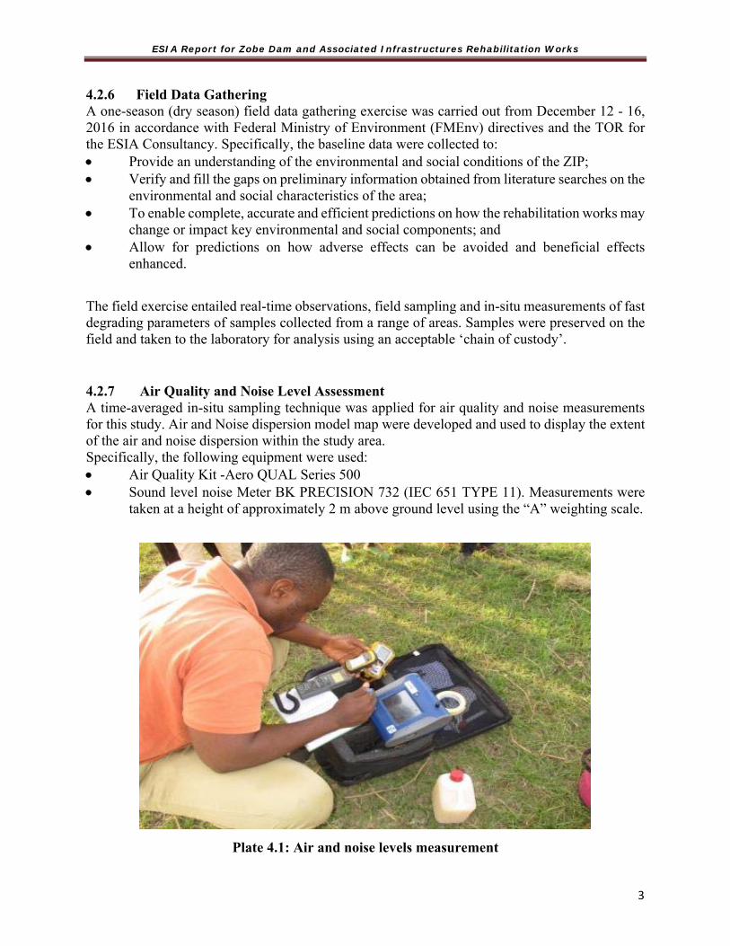
ESIA Report for Zobe Dam and Associated Infrastructures Rehabilitation Works
3
4.2.6 Field Data Gathering A one-season (dry season) field data gathering exercise was carried out from December 12 - 16, 2016 in accordance with Federal Ministry of Environment (FMEnv) directives and the TOR for the ESIA Consultancy. Specifically, the baseline data were collected to: Provide an understanding of the environmental and social conditions of the ZIP; Verify and fill the gaps on preliminary information obtained from literature searches on the
environmental and social characteristics of the area; To enable complete, accurate and efficient predictions on how the rehabilitation works may
change or impact key environmental and social components; and Allow for predictions on how adverse effects can be avoided and beneficial effects
enhanced.
The field exercise entailed real-time observations, field sampling and in-situ measurements of fast degrading parameters of samples collected from a range of areas. Samples were preserved on the field and taken to the laboratory for analysis using an acceptable ‘chain of custody’.
4.2.7 Air Quality and Noise Level Assessment A time-averaged in-situ sampling technique was applied for air quality and noise measurements for this study. Air and Noise dispersion model map were developed and used to display the extent of the air and noise dispersion within the study area. Specifically, the following equipment were used: Air Quality Kit -Aero QUAL Series 500 Sound level noise Meter BK PRECISION 732 (IEC 651 TYPE 11). Measurements were
taken at a height of approximately 2 m above ground level using the “A” weighting scale.
Plate 4.1: Air and noise levels measurement

ESIA Report for Zobe Dam and Associated Infrastructures Rehabilitation Works
3
4.2.8 Soil Sampling/Collection
Soil samples were collected on the 13, 14 and 15 December, 2016. Soil samples were randomly collected from the bank of Zobe Dam, upstream, midstream and downstream to cover the entire area of the project. Sample collection, handling and storage were carried out in accordance with Federal Ministry of Environment, guidelines and standards. Soil samples were collected with the aid of stainless steel Dutch auger and bulked. Sampling depths were 0 – 15 and 15 – 30 cm at each point. Each composite soil sample was replicated three times. Samples for physical and chemical analysis were collected into coded plastic bags after being wrapped in aluminum foil. Soil samples were placed into containers made of Ultra Violet (UV) resistant material. Global positioning System (GPS) was used to take the coordinate, elevation and distance of the sampling points. The soil samples collected were taken to laboratory for physical and chemical properties determination using standard methods.
Plate 4.2 Soil samples collection in the vicinity of Zobe Dam
4.2.9 Water Quality Sampling/Collection
Surface and ground water samples were collected using sterile 100 ml bijou bottles that are UV resistant. Fast changing physical and chemical parameters such as Temperature, pH, Dissolved Oxygen (DO), Conductivity and Total Dissolved Solids (TDS) were measured in-situ using an in-situ water analyzer. Samples for heavy metal were preserved with Nitric acid (HNO3). Samples for physical and chemical studies were stored in cooler boxes with ice and later transferred to the laboratory and preserved in refrigerators at 4oC prior to analysis. Hanna HI 991300 pH/EC/TDS

ESIA Report for Zobe Dam and Associated Infrastructures Rehabilitation Works
3
Meter was used for water sample analysis (In-situ). In-Situ kit EXTECH DO 700 was used in conducting the in-situ analysis for water.
4.2.10 Land Use / Land Cover, Flora and Fauna Studies
Land use / Land cover (LULC) investigation was carried out along the bank of Zobe Dam, Upstream, midstream and downstream. Land use / Land cover investigated were recreational, agricultural, forestry, industrial, residential, institutional and commercial trends. For agricultural, the major crop species, farming system, habitat and non-farming activities along each of the sections were documented.
However, encouraged by observed isolated tree species in the study area, a combination of random 100 m by 100 m (ha) sample plots and plot less sampling technique were adopted in the assessment of the flora. The assessment of flora in the study area includes; bank of Zobe Dam, Upstream, midstream and downstream. All plant species were identified on the field and those that could not be readily identified were taken to the laboratory for identification.
The fauna of the study area was assessed by identifying faecal droppings or footprints. Local hunters were also interviewed for their experiences.
4.2.11 Scope and Design of Socioeconomic Assessment
Public Participation and consultation with community members is essential during any ESIA process. The Zobe Dam irrigation project area covers the communities that are situated very close to the dam embankment. Five communities were selected for the purpose of this research which include those from the upstream and downstream of the dam. The communities are Zango, Makera, Garhi, Dogon Ruwa and Marke.
Data Collection Methods and Sampling Procedure
The study design for the project area followed a descriptive cross-sectional survey. It involved questionnaire administration, onsite observations, anthropometric measurements, biomarker assessment and collection of health records from healthcare facilities at community clinics and Dutsin-Ma General Hospital.
One hundred participants (Twenty-five participants per community) were randomly recruited for the survey section of the study based on their willingness to participate. A total of 80 participants comprising men, women and children were selected for the biomarker assessment and anthropometric measurement. Twenty individuals were selected from each community and they were made up of 10 men, 5 women and 5 children (3 boys and 2 girls).
The quality of any research and program fundamentally relies on the ability to collect and analyze data. Thirty (30) questionnaires were administered in each of the 5 communities visited. 20 of which were administered to the male respondents and 10 for the female. As such, a total number of 150 questionnaires were used in all the 5 communities. Each of the questionnaires contains 20 questions, therefore a total of 19 tables will be presented which shows the number of respondents and percentage of their response to each question.
Data collection was divided into the following six phases:

ESIA Report for Zobe Dam and Associated Infrastructures Rehabilitation Works
3
Phase 1: Survey – a semi-structured interviewer administered questionnaire was used to elicit information from all consenting randomly selected community residents on socio-demographic characteristics, building characteristics, environmental characteristics, information on under-five (U-5) children, health conditions and health-seeking behaviour. A total of 100 questionnaires were retrieved at the end of the survey (Appendix 4). Phase 2: On site observation - An observational checklist comprising key environmental health indicators like sanitary facilities, water facilities, environmental/health conditions, solid waste management, radiation sources and health facilities was used to obtain information on environmental conditions within the communities (Appendix 4). Phase 3: Anthropometric measurement - information on weight and height in the surveyed communities was collected using a weighing scale and meter rule respectively in order to determine their Body Mass Index (BMI). This was used to determine if they were underweight, normal weight, overweight and obese individuals within the communities. Phase 4: Exposure Assessment – FEV1, PEFR, body temperature, blood pressure and pulse rate were determined within the surveyed communities. A portable PIKO-I electronic peak flow meter was used to determine FEV1 and PEFR values while an electronic thermometer and electronic sphygmomanometer were used to determine body temperature and blood pressure respectively. This helped to assess exposure to environmental risk factors within the selected communities. Phase 5: Collection of health records – Records of morbidities and mortalities resulting from ailments such as malaria, typhoid, rheumatism, diarrhea, RTIs, hypertension, eye disorder, skin infections, HIV/AIDS and other health-related problems were obtained from the health facilities present in the study area using the Health Log (Appendix 4).
Issues covered in the socio-economic survey Socio-economic profiling of the communities such as population pyramid, workforce, socio-economic activities, access to facilities (hospitals, dispensaries, schools etc). Specifically, the survey focused on the following issues: Community based measures of poverty Important socio-economic institutions such as markets, hospitals, dispensaries, schools Migration pattern Women dimension of the survey-what do they do? Meetings with stakeholders such as the religious and community leaders KII with community and religious leaders Land tenure system and issues surrounding it such as disputes between herders and the
farmers (dispute resolution mechanisms) Effects and impacts of the scheme on livelihood of the people
Data Analysis Data analysis was done using the Statistical Package for Social Science (SPSS) version 20. Descriptive statistics was used to summarize the data while inferential statistics was used to establish relationships between quantitative variables across the communities at p<0.05.

ESIA Report for Zobe Dam and Associated Infrastructures Rehabilitation Works
4
4.3 GENERAL DESCRIPTION OF THE PHYSICAL ENVIRONMENT 4.3.1 Climate and Meteorology Katsina State can be classified into two climatic zones: tropical continental and semi-arid continental. The south of the state (from Funtua to Dutsin Ma) belongs to the former climatic zone with total annual rainfall figures ranging from 1000 mm around Funtua to over 800 mm around Dutsin Ma. The north of Katsina State (from around Kankia to the extreme northeast) has total rainfall figures ranging from 600 – 700 mm annually. Generally, climate varies considerably according to months and seasons. The climates are: a cool dry (harmattan) season from December to February; a hot dry season from March to May; a warm wet season from June to September; a less marked season after rains during the months of October to November, characterized by decreasing rainfall and a gradual lowering of temperature. a. Rainfall. The study area is influenced by two seasonal periods, namely the dry and rainy season. The dry season is associated with the tropical continental air mass. The rainy season as the name suggest is the season of rain in the region. The wet season starts from May and lasts up to September (4 months) during which mean annual rainfall of about 750 mm is recorded, with peak amount receive in August. The long dry season during which no rainfall is recorded commences just after the wet season in October and lasts up to May (8 months) when the rain starts again. Katsina gauge has an annual average of 526 mm; see figure 4.1 below.
Fig. 4.1: Monthly Rainfall Pattern in the Project Area

ESIA Report for Zobe Dam and Associated Infrastructures Rehabilitation Works
4
b. Evaporation Based on existing records of evaporation data for the SRRB in Katsina, the evaporation is at its peak during the months (Apr-May) and the lowest recorded during rainy season (Aug-Sep) as presented in Fig.4.2. The average evapotranspiration obtained from CLIMWAT 2.0 climatic database is presented in the same Fig 4.2.
Fig 4.2 Mean Monthly Evapotranspiration (ETo in mm) in the Project Areas
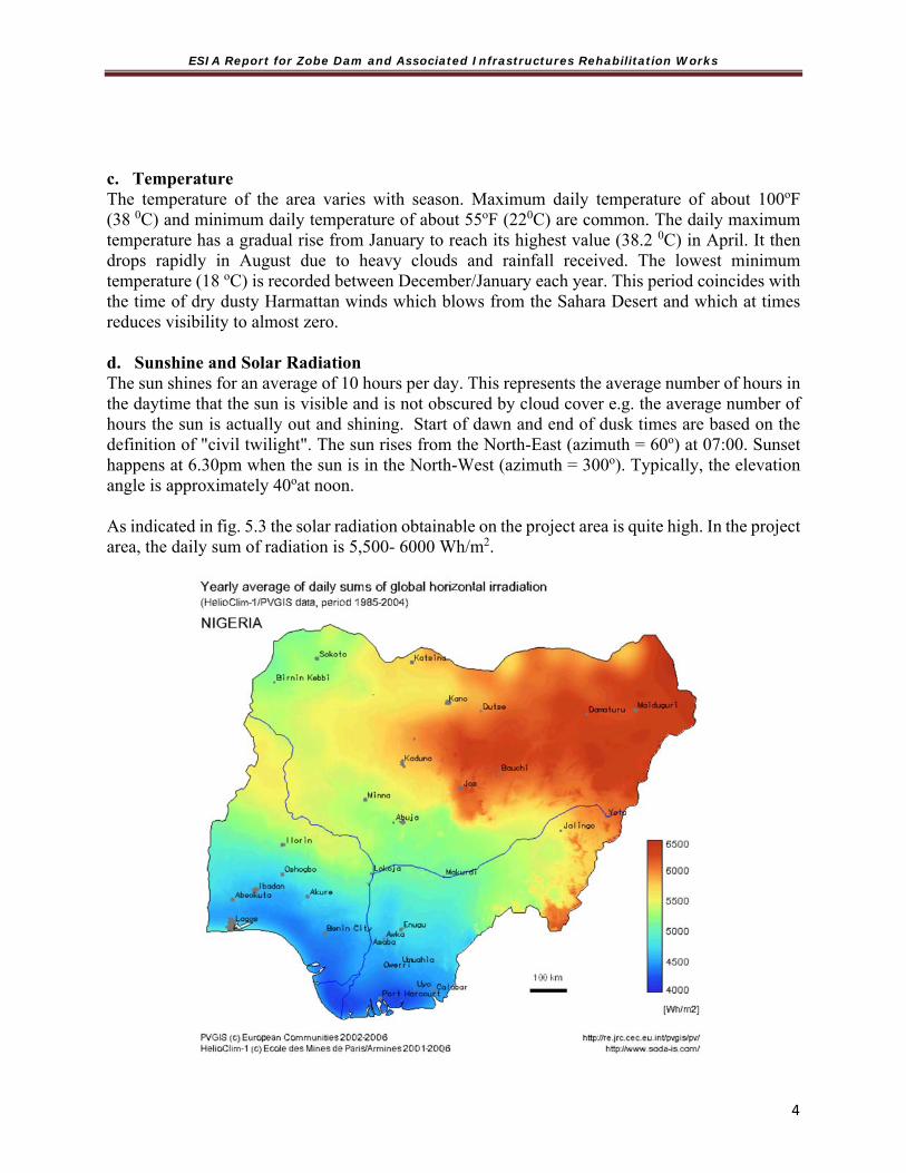
ESIA Report for Zobe Dam and Associated Infrastructures Rehabilitation Works
4
c. Temperature The temperature of the area varies with season. Maximum daily temperature of about 100oF (38 0C) and minimum daily temperature of about 55oF (220C) are common. The daily maximum temperature has a gradual rise from January to reach its highest value (38.2 0C) in April. It then drops rapidly in August due to heavy clouds and rainfall received. The lowest minimum temperature (18 oC) is recorded between December/January each year. This period coincides with the time of dry dusty Harmattan winds which blows from the Sahara Desert and which at times reduces visibility to almost zero. d. Sunshine and Solar Radiation The sun shines for an average of 10 hours per day. This represents the average number of hours in the daytime that the sun is visible and is not obscured by cloud cover e.g. the average number of hours the sun is actually out and shining. Start of dawn and end of dusk times are based on the definition of "civil twilight". The sun rises from the North-East (azimuth = 60o) at 07:00. Sunset happens at 6.30pm when the sun is in the North-West (azimuth = 300o). Typically, the elevation angle is approximately 40oat noon. As indicated in fig. 5.3 the solar radiation obtainable on the project area is quite high. In the project area, the daily sum of radiation is 5,500- 6000 Wh/m2.

ESIA Report for Zobe Dam and Associated Infrastructures Rehabilitation Works
4
Source: www.power.gov.ng Fig. 4.3: Nigeria’s Solar Radiation
4.3.2 Air Quality and Noise Analysis The result of measurements of the ambient noise level in the study area for Zobe dam shows that the recorded mean level is 61.6 dB (with levels ranging between 58.0dB and 64.3dB). These levels were below FMEnv permissible noise level of 90 dB (A) for 8-hour working period and also within the WHO guideline value of 70 dB (A). The rehabilitation/construction phase of the project will be accompanied with increased noise levels within the area, which might be due to the use of heavy-duty equipment during the construction phase. These increases will be short term and mostly localized.
The result of ambient air quality measurement around the project area is presented in the table 4.3 below. The concentrations of CO, NO, and SO2 were below equipment detection limit (<0.0ppm) in all the sampling locations. Similarly, Hydrocarbons (Volatile Organic Carbon) levels were below equipment detection limit (<0.0ppm) at all the sampling locations. TABLE 4.3: NOISE AND AIR QUALITY RESULT
Parameter Air Quality Measurement Station FMENV Limits
NESREA
Limits WHO Limits
WORLD BANK Limits
ZANGO MAKERA GARHI MARKE DOGONRU
WA TASHEMAG
ORO
KWARI-MAIZURFI
RESERVOIR DUSTIN-
MA
SPM
(µG/M3) 16.8 15.2 15.8 15.3 16.0 14.7 15.9 16.6 16.6 250.0 250.0 80 50
RH (%) 18.2 17.7 16.9 16.1 15.1 14.7 14.7 14.8 11.8 - - - -TEMP (0C) 26.8 27.5 30.0 30.0 31.2 31.5 31.3 31.1 34.4 - - - -NH3 (PPM) 0.00 0.00 0.00 0.00 0.00 0.00 0.00 0.00 0.00 - - - - CO2 (PPM) 3.73 3.26 3.30 4.00 3.52 3.38 3.60 3.66 2.90 - 500* - -O2 (%) 20.9 20.9 20.9 20.9 20.9 20.9 20.9 20.9 20.9 - - - - VOC (PPM) 0.00 0.00 0.00 0.00 0.00 0.00 0.00 0.00 0.00 - - - -NO (PPM) ND ND ND ND ND ND ND ND ND 0.01-0.1^ - 150* -CO (PPM) ND ND ND ND ND ND ND ND ND 10-20 - - - SO2 (PPM) ND ND ND ND ND ND ND ND ND 0.04-0.06 450* 20* -H2S (PPM) ND ND ND ND ND ND ND ND ND - - - - Noise dB(A)
Noise Level Measurements 62.3 61.3 62.6 64.3 58.0 59.1 58.6 67.2 65.2 90.0 90.0 70
NOTE * = μg/m3, ^= No2 (ppm), ND= Not Detected, μG/M3=PPM X 40.9 X Molecular Weight (MW). The conversion of PPM to μG/m3 is a function of the molecular weight of a particular compound. There is no constant that can be generally used. However, this formula is worth taking note of : PPM to μG/m3 = MW/0.0224 and μG/m3 to PPM = 0.0224/MW.
With respect to CO2, values ranged from 2 to 4% in all the sampling locations, which is below the Federal Ministry of Environment (FMEnv) guideline of 20%. The concentration of particulates in the ambient air ranged from14.2 µg/m3 to 16.8 µg/m3and these values are also below the FMEnv limit of 250 μg/m3.
4.3.3 Soil Type and Soil Analysis In the Zobe area, soil types are predominantly Lithic Leptosols. These soils are runoff type with very slow infiltration rates when wet. The findings from the review of the Wakutids report and the feasibility report conducted on the Zobe scheme show that most soils in the Zobe scheme are sandy with very high infiltration rates

ESIA Report for Zobe Dam and Associated Infrastructures Rehabilitation Works
4
and low fertility. These have been found to be unsuitable for surface irrigation and marginal for sprinklers. The 2013 Feasibility report also revealed that there is insufficient head to drive gravity sprinklers over most of the command area as only 1000ha of land in the command area with head below canal elevation can be irrigated from gravity fed-sprinkler irrigation system. In view of this therefore, the TRIMING project intervention in Zobe irrigation scheme has been limited to the dam and associated infrastructures alone.” The Sand thickness (m) above sandy loam to sandy clay is outlined below: Table 4.4 Sand Thickness Characteristics Sand thickness (m) above sandy loam to sandy
clay > 1.0 0.6 - 1.0 0.3 - 0.6 < 0.3
1 Loamy sand and sandy loam textures 1 4 7 10 2 Sand and loamy sand textures 2 5 8
3 Soils with pronounced hydromorphism
3 6 9 11
Map 4.2: Soil types in Zobe Catchment Area
Soil Analysis of sampled area The results of physical, chemical and heavy metal analysis are shown in Tables 4.5 to 4.7.
Soil texture: The entire soil depth is texturally loamy-sand. It was observed that the soils are sandy both in the top and subsoil. In general, sand had the larger percentage followed by the silt and clay. This indicated that silt and clay in the soils were considerably low. The ability of a soil to absorb and retain water provides a reservoir from which growing plants may withdraw water during

ESIA Report for Zobe Dam and Associated Infrastructures Rehabilitation Works
4
periods between rainfall or irrigation. Growing plants depend on the reservoir of stored water in the soil because of erratic and occasional rainfall and continuous evaporative demand. To be available, stored water has to be loosely bound to soil particles, that is, at energy levels the plant roots can extract the water
Moisture: The soil moisture is low in the samples collected. The low moisture reflected the coarse textural nature of the soil in the study area.
Table 4.5: Physical properties of the soil samples collected Location Community Soil Depths (cm) pH EC (µS/cm)
Moisture (%) Texture
Upstream Zango 0-15 8.28 0.05 8.3 Loamy sand
15-30 8.08 0.03 3.8 Loamy sand
Midstream Makera 0-15 7.07 0.18 8.4 Loamy sand
15-30 7.24 0.15 1.4 Loamy sand
Dam Area Marke 0-15 6.82 0.39 8.4 Loamy sand
15-30 7.05 0.26 2.2 Loamy sand
Downstream Garhi 0-15 7.45 0.35 8.1 Loamy sand
15-30 7.42 0.15 2.3 Loamy sand
Downstream Doguruwa 0-15 7.59 0.23 8.2 Loamy sand
15-30 7.67 0.22 1.2 Loamy sand
Table 4.6: Chemical properties of the soil samples collected
Location Community Soil Depths (cm)Total N (g/kg)Avil P (g/kg)Na (mg/g)K (cmol/kg) Ca (mg/g)Mg (mg/g)
Upstream Zango 0-15 0.06 7.20 0.58 0.08 2.44 0.18
15-30 0.03 4.51 0.45 0.04 1.82 0.11
Midstream Makera 0-15 0.05 5.20 0.62 0.05 2.41 0.42
15-30 0.04 4.25 0.32 0.03 2.11 0..32
Dam area Marke 0-15 0.08 6.32 0.73 0.06 1.82 0.51
15-30 0.06 4.25 0.56 0.04 1.48 0.48
Downstrem Garhi 0-15 0.05 6.33 0.65 0.03 1.55 0.68
15-30 0.03 4.22 0.44 0.01 1.32 0.43
Downstrem Doguruwa 0-15 0.05 6.20 0.68 0.07 2.31 0.61
15-30 0.04 3.44 0.41 0.05 1.81 0.34

ESIA Report for Zobe Dam and Associated Infrastructures Rehabilitation Works
4
Table 4.7: Heavy metals concentrations of the soil samples collected
Location Community
Soil Depths (cm)
Cu (g/kg)
Co (g/kg)
Cr (g/kg)
Cd (g/kg)
Fe (g/kg)
Mn (g/kg)
Zn (g/kg)
Ni (g/kg)
Pb (g/kg)
Upstream Zango 0-15 15.54 0.15 0.04 0.3 4.07 0.75 0.11 0.23 0.22
15-30 2.54 1.15 0.07 0.2 2 0.3 0.06 0.08 0.13
Mid stream Makera 0-15 1.82 0.19 0.04 0.2 4.15 0.3 0.06 0.15 0.17
15-30 2.36 0.08 0.11 0.2 3.85 0.35 0.08 0.15 0.17
Dam area Marke 0-15 2.27 0.12 0.07 0.4 9 0.45 0.06 0.15 0.17
15-30 2.09 0.08 0.04 0.3 9.44 0.75 0.03 0.08 0.13
Down stream Garhi 0-15 1.36 0.12 0.04 0.1 2.67 0.4 0.06 0.31 0.13
15-30 1.36 0.12 0.07 0.2 8.15 0.85 0.11 0.23 0.13
Down stream Doguruwa 0-15 2.45 0.12 0.07 0.2 4.3 0.5 0.08 0.15 0.17
15-30 0.64 0.08 0.07 0.2 0.19 0.15 0.06 0.15 0.09
pH: The pH of the samples ranged from 6.82 to 8.28. FMEnv PH limit for soils used in irrigation is between 6 and 9. A pH above or below this is a warning that an abnormal situation exists and needs either further evaluation or immediate remedial measures. The pH sample concentrations were within limits.
Electrical Conductivity (EC): This is a measure of the amount of soluble salts present in the soil. EC is also a measure of water capability to transmit electric current. Electrical conductivity as measured by the salinity of the soil and water can cause yield reductions in crops. Crops vary widely in tolerance to salinity. Salinity effects are generally only of concern in arid region where accumulated salts are flushed from the soil by natural precipitation. From the EC results, the soil is adequate. Low electrical conductivity can be attributed to many factors such as regular farming activity in the area, higher permeability of the soil and low organic matter. The EC levels of the all sampled locations were within FMEnv permissible limits ranging from 0.01 to 0.42 µS/cm.
Organic Carbon (OC): The organic carbon content of the soil samples ranged from 27.52 to 76.38 mg/kg across the soil depth. The low organic carbon can be attributed to many factors such as wind erosion, soil texture, temperature and continuous cropping activities. This means that the soils have low stable soil organic matter, thus the benefits of a stable soil organic matter such as enhancing aggregate stability, improving water holding capacity and reduces the stickiness of clay soils making them easier to till.
Total Nitrogen (TN) and Available Phosphorus (P): The total nitrogen and available phosphorus ranged from 0.03 – 0.08 g/kg and 3.44 – 7.20 g/kg respectively. The soil of the area was low in TN and P when compared to nutrient rating for soil fertility classes in Nigeria (FPDD,

ESIA Report for Zobe Dam and Associated Infrastructures Rehabilitation Works
4
1990). The low nutrients can be attributed to many factors such as wind erosion, soil texture, temperature and continuous cropping activities.
Sodium (Na), Potassium (K), Calcium (Ca) and Magnesium (Mg): The sodium, potassium, calcium and magnesium content of the soil samples ranged from 0.32 mg/g, 0.01 – 0.08 cmol/kg, 1.32 – 2.44 mg/g and 0.11 – 0.68 mg/g respectively. The low Na, K, Ca and Mg can be attributed to nature of the soil samples (low clay and organic matter). This indicates that the soil may not inherently be fertile and may not retain more applied fertilizer element.
Heavy metal content of the soil samples: The concentrations of the heavy metals analysed were low when compared to corresponding naturally occurring concentrations in unpolluted soils as reported by Alloway (1995) thus there is no evidence of heavy metal accumulation in the soil as at the time of the field investigation. 4.3.4 Sediment Based on available literature, some level physicochemical parameters in sediments collected from seven dams in Katsina State established the possible explanations for the observed trends of sediment quality. It was found that Zn, Fe, and Cr had the highest concentrations in all the seasons with most of the values being higher than the maximum recommended values by EPA (Fatima and Abdul 2013). 4.3.5 Drainage and Relief Major rivers which originate in or traverse the state include; the Koza, Sabke, Tagwai and Gada systems in the northern half of the state (all flowing either north or northwestwards). Rivers in the south include the Karaduwa, Bunsuru, Gagare, Turami, Sokoto, Tubo, Chalawa and Galma rivers (flowing either northwest, southeast or east). However, all these river systems contain water in their channels only during the rainy season and have little or no water in the dry season. Among them, Rivers Gada, Karaduwa and Sabke have dams mainly for irrigation purposes and the dams are known as Jibia, Zobe and Daberam dams respectively. The general relief of the catchment area is 500 m at the summits to 455m at the western edge (Map 4.3) with slopes of 2 to 70 identified in places using digital elevation model (Map 4.4).

ESIA Report for Zobe Dam and Associated Infrastructures Rehabilitation Works
4
Map 4.3: Relief and Drainage Map of the Zobe catchment area
Map 4.4: Slopes of Zobe PCA
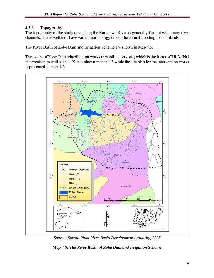
ESIA Report for Zobe Dam and Associated Infrastructures Rehabilitation Works
4
4.3.6 Topography The topography of the study area along the Karaduwa River is generally flat but with many river channels. These wetlands have varied morphology due to the annual flooding from uplands. The River Basin of Zobe Dam and Irrigation Scheme are shown in Map 4.5. The extent of Zobe Dam rehabilitation works (rehabilitation zone) which is the focus of TRIMING intervention as well as this ESIA is shown in map 4.6 while the site plan for the intervention works is presented in map 4.7.
Source: Sokoto Rima River Basin Development Authority, 1995
Map 4.5: The River Basin of Zobe Dam and Irrigation Scheme

ESIA Report for Zobe Dam and Associated Infrastructures Rehabilitation Works
5
Map 4.6 Zobe Dam Rehabilitation Zone

ESIA Report for Zobe Dam and Associated Infrastructures Rehabilitation Works
5
Map 4.7: Zobe Dam Rehabilitation Work Site Plan
4.3.7 Geology Zobe Dam is located within the Basement Complex. In this region, the complex is comprised of migmatised gneiss, heavily weathered and jointed in the upper parts. In the southern part of the Zobe dam area it is mostly overlain by laterite originating from the weathered zone. The northern part of the dam axis consists of sediments with mainly sandy and gravelly loams which cover the basement rock (Wakuti Karl Erich Gall WG, Part I, 1979). The bedrock in the vicinity of the dam site consists of mignatised gneiss of the basement complex, weathered to a considerable depth. South of the river the basement rock is overlain by residual
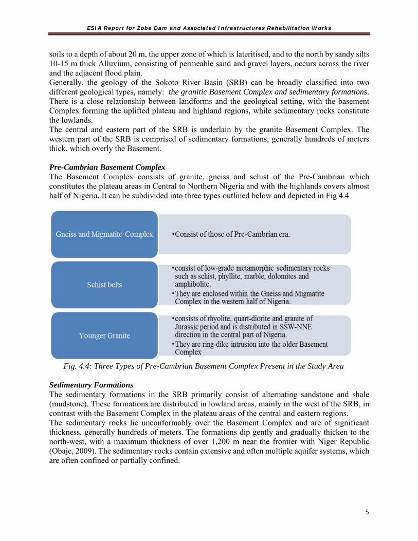
ESIA Report for Zobe Dam and Associated Infrastructures Rehabilitation Works
5
soils to a depth of about 20 m, the upper zone of which is lateritised, and to the north by sandy silts 10-15 m thick Alluvium, consisting of permeable sand and gravel layers, occurs across the river and the adjacent flood plain. Generally, the geology of the Sokoto River Basin (SRB) can be broadly classified into two different geological types, namely: the granitic Basement Complex and sedimentary formations. There is a close relationship between landforms and the geological setting, with the basement Complex forming the uplifted plateau and highland regions, while sedimentary rocks constitute the lowlands. The central and eastern part of the SRB is underlain by the granite Basement Complex. The western part of the SRB is comprised of sedimentary formations, generally hundreds of meters thick, which overly the Basement. Pre-Cambrian Basement Complex The Basement Complex consists of granite, gneiss and schist of the Pre-Cambrian which constitutes the plateau areas in Central to Northern Nigeria and with the highlands covers almost half of Nigeria. It can be subdivided into three types outlined below and depicted in Fig 4.4
Fig. 4.4: Three Types of Pre-Cambrian Basement Complex Present in the Study Area Sedimentary Formations The sedimentary formations in the SRB primarily consist of alternating sandstone and shale (mudstone). These formations are distributed in lowland areas, mainly in the west of the SRB, in contrast with the Basement Complex in the plateau areas of the central and eastern regions. The sedimentary rocks lie unconformably over the Basement Complex and are of significant thickness, generally hundreds of meters. The formations dip gently and gradually thicken to the north-west, with a maximum thickness of over 1,200 m near the frontier with Niger Republic (Obaje, 2009). The sedimentary rocks contain extensive and often multiple aquifer systems, which are often confined or partially confined.
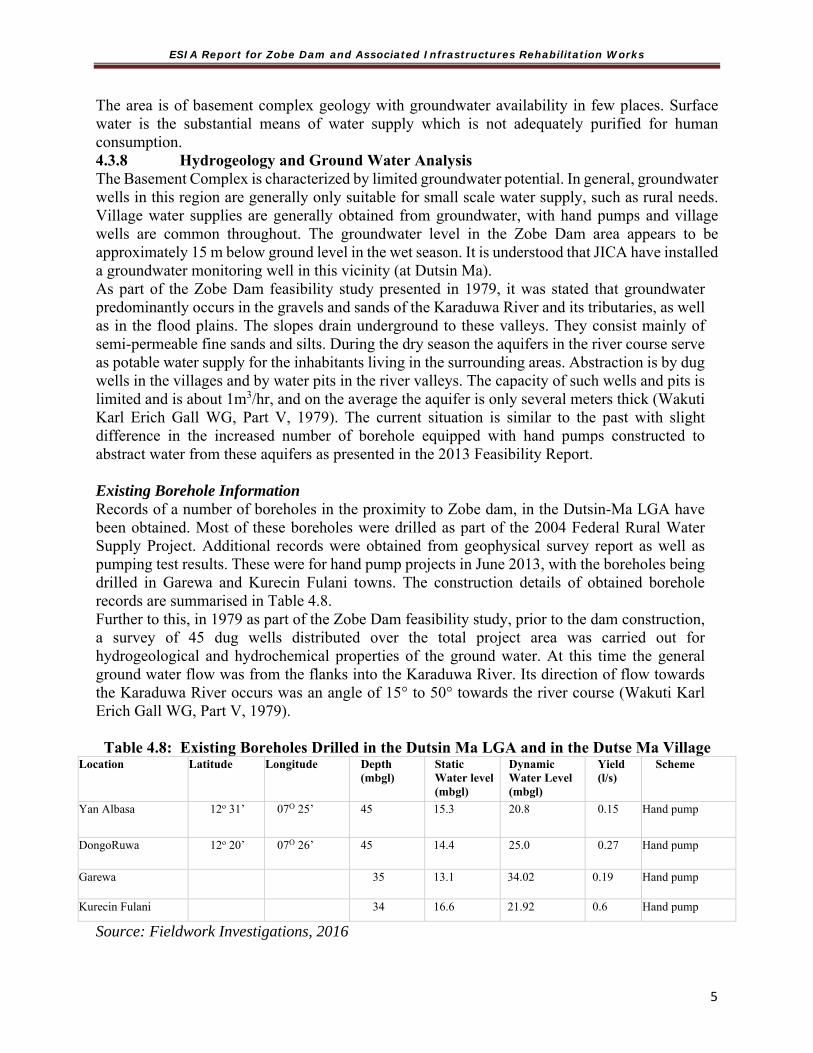
ESIA Report for Zobe Dam and Associated Infrastructures Rehabilitation Works
5
The area is of basement complex geology with groundwater availability in few places. Surface water is the substantial means of water supply which is not adequately purified for human consumption. 4.3.8 Hydrogeology and Ground Water Analysis The Basement Complex is characterized by limited groundwater potential. In general, groundwater wells in this region are generally only suitable for small scale water supply, such as rural needs. Village water supplies are generally obtained from groundwater, with hand pumps and village wells are common throughout. The groundwater level in the Zobe Dam area appears to be approximately 15 m below ground level in the wet season. It is understood that JICA have installed a groundwater monitoring well in this vicinity (at Dutsin Ma). As part of the Zobe Dam feasibility study presented in 1979, it was stated that groundwater predominantly occurs in the gravels and sands of the Karaduwa River and its tributaries, as well as in the flood plains. The slopes drain underground to these valleys. They consist mainly of semi-permeable fine sands and silts. During the dry season the aquifers in the river course serve as potable water supply for the inhabitants living in the surrounding areas. Abstraction is by dug wells in the villages and by water pits in the river valleys. The capacity of such wells and pits is limited and is about 1m3/hr, and on the average the aquifer is only several meters thick (Wakuti Karl Erich Gall WG, Part V, 1979). The current situation is similar to the past with slight difference in the increased number of borehole equipped with hand pumps constructed to abstract water from these aquifers as presented in the 2013 Feasibility Report. Existing Borehole Information Records of a number of boreholes in the proximity to Zobe dam, in the Dutsin-Ma LGA have been obtained. Most of these boreholes were drilled as part of the 2004 Federal Rural Water Supply Project. Additional records were obtained from geophysical survey report as well as pumping test results. These were for hand pump projects in June 2013, with the boreholes being drilled in Garewa and Kurecin Fulani towns. The construction details of obtained borehole records are summarised in Table 4.8. Further to this, in 1979 as part of the Zobe Dam feasibility study, prior to the dam construction, a survey of 45 dug wells distributed over the total project area was carried out for hydrogeological and hydrochemical properties of the ground water. At this time the general ground water flow was from the flanks into the Karaduwa River. Its direction of flow towards the Karaduwa River occurs was an angle of 15° to 50° towards the river course (Wakuti Karl Erich Gall WG, Part V, 1979). Table 4.8: Existing Boreholes Drilled in the Dutsin Ma LGA and in the Dutse Ma Village
Location Latitude Longitude Depth (mbgl)
Static Water level(mbgl)
Dynamic Water Level (mbgl)
Yield (l/s)
Scheme
Yan Albasa 12o 31’ 07O 25’ 45 15.3 20.8 0.15 Hand pump
DongoRuwa 12o 20’ 07O 26’ 45 14.4 25.0 0.27 Hand pump
Garewa 35 13.1 34.02 0.19 Hand pump
Kurecin Fulani 34 16.6 21.92 0.6 Hand pump
Source: Fieldwork Investigations, 2016
ESIA Report for Zobe Dam and Associated Infrastructures Rehabilitation Works
5
Current Groundwater Situation Aside from drinking water supply, there was no evidence of extensive groundwater use in the vicinity of the Zobe Dam. It is understood that in the dry season fadama tubewells are used to irrigate crops in the immediate vicinity of the river, although the floodplain is not extensive. A number of village hand pumps and wells are present in the Zobe Irrigation Project (ZIP). The depth to groundwater was estimated to be between 10 and 15 metres below ground level (mbgl) in the wet season, which is beyond the ability for tubewell suction. There does not appear to be any other significant groundwater abstraction occurring at the ZIP area. 4.3.9 Water Quality Analysis The suitability of water for irrigation purposes depends on the extent to which the problems of salinity, toxicity and other related problems are reduced by its use. Soil texture, soil structure, drainage characteristics, nature of crop grown and climatic conditions are equally important in determining water quality for irrigation. Applied agrochemical could contaminate ground and surface water due to Eutrophication. Groundwater Sources and Quality Water quality in the Basement Complex is generally good, as it predominantly comprises recharge from local rainfall. Where residence time in the weathered aquifer is extended, salinity may become a problem, however water quality results from Project area indicate good water quality meeting potable water standards; as analyzed in Table 4.7 below. Underground water from tube wells and river water were sampled at suitably determined points and intervals for water quality assessment. Parameters considered included; water pH, electrical conductivity, basic cation, carbonates and bicarbonates, boron, chlorine, nitrate, sulphate and heavy metals (Cd, Cr, Se). Surface Water Sources and Quality Zobe dam is very important to the area, since majority of the people living within the PCA depends on the watershed for water either for irrigation or domestic purposes. However, despite the unavailability of water resources, communities depend heavily on the available water that can be mined from the river beds (plate 4.3) which is unhygienic and of little quantity. The water samples were analysed by standard analytical methods. The following parameters were determined.
Odour Colour Turbidity pH Calcium, Magnesium and Total Hardness Manganese Nitrate-Nitrogen Chloride

ESIA Report for Zobe Dam and Associated Infrastructures Rehabilitation Works
5
Copper Dissolved Oxygen Dissolved Solids Phosphates Sulphate Zinc Chromium Salinity
Water Bacteriological Analysis The membrane filter with M-FC broth were used for the enumeration of Faecal Coliform (FC) indicator organisms from samples of water obtained from Zobe (Karaduwa) River (ZBD) and Well Water within project area.
Plate 4.3: Mining water from the river bed for domestic uses

ESIA Report for Zobe Dam and Associated Infrastructures Rehabilitation Works
5
Table 4.9: Physiochemical properties of surface and ground water in Zobe dam project area
Parameters Surface Water Ground Water Dutsin-Ma (up)
Dutsin-Ma (Down)
Dutsin-Ma (Down)
FMEnva
Limits Tube Well (TW), Zobe Dam
Zango Dongo Ruwa
WHOb Limits
Appearance (mg/l)
Turbid Fairly clear
Odour Unobjectionable Unobjectionable
E.C(μS/cm) 43.2 46.5 49.7 - 197.5 231 211
1*
PH 6.92 6.76 6.87 6-9 7.4 7.51 7.27 6.5-8.0
Nitrate as NO3 (mg/l)
10.51 16.81
9.11 20 12.61 7 9.81
50
Dissolved Oxygen (mg/l)
5.6 9
4.4
- 6.0 7
6.8
7.5
Iron (mg/l) 0.02 0.07
0.04 - 0.33 0.11 0.33
0.3
Manganese (mg/l)
0.15 0.15
0.1 5 0.05 0.1 0.15
0.4
Zinc (mg/l) 0.08 0.11 0.06 <1.0 0.03 0.06 0.06 3.0
Sulphate (mg/l)
0.61 0.39 0.54 500 0.01 0.01 0.07 500
BOD (mg/l) 1.2 4.2 2.8 30 1.4 3 1.2
0
Copper (mg/l)
0.18 0.27
0.27 <1.0 0.18 0.18 0.18
2.0
Nickel (mg/l) 0.23 0.46
0.15 - 0.15 0.15 0.23
-
CO (mg/l) 0.04 0.04
0.08 0.04 0.12 0.04
Lead (mg/l) 0.4 0.04
0.04 <1.0 0.09 0.04 0.09
0.01

ESIA Report for Zobe Dam and Associated Infrastructures Rehabilitation Works
5
Parameters Surface Water Ground Water Dutsin-Ma (up)
Dutsin-Ma (Down)
Dutsin-Ma (Down)
FMEnva
Limits Tube Well (TW), Zobe Dam
Zango Dongo Ruwa
WHOb Limits
Hardness (mg/l)
1189.5 331.5
253.5 200 1384.5
1228.5 1014
300
Dissolved Solid (mg/l)
26.8 27.6
29.3 2000 117.9 132.5 123.4
600
Suspended Solid (mg/l)
42 20
20 30 14 16 38
Salinity (mg/l)
44.8 51.2 49.7 194.7 221 208
Phosphate (mg/l)
11.45 14.31
10.02 5 7.16 7.16 8.59 -
Chromium (mg/l)
0.08 0.04
0.08 0.11 0.11 0.11
Cd (mg/l) 0.4 0.3 0.3 0.4 0.3 0.3
a Federal Ministry of Environment National Guideline and Standards for Water Quality in Nigeria 1996
b World Health Organisation Guideline 1993 *EC(dS/cm)
Physico-Chemical Analysis of Water The physio-chemical properties of surface and ground water samples around Zobe dam are presented in table 4.9 above. The table revealed that all surface water parameter results are within acceptable limits of FMEnv and WHO drinking water standards/guidelines except for phosphate, hardness and suspended solid. Surface water phosphate value of 11.45mg/l is above FMEnv acceptable limit of 5mg/l. This may be attributed to chemical used to enhance farm productivity being washed down after rainfall. High limits of phosphates could lead to a process called eutrophication while also having impact on other aquatic life. Diatoms are particularly sensitive to phosphorus levels (UTAG, 2008) while fish are sensitive to pH levels. Zobe dam surface water sample pH values are within acceptable limits and pose no threat to fishing as an important livelihood for the dam communities. The PH values are also within normal range (6.5-8.4) for irrigation, the range in which crops have done well. Zobe dam surface water samples have a value of 1189.5 for hardness which is most commonly expressed as milligrams of calcium carbonate equivalent per litre. Water containing calcium carbonate at concentrations below 60 mg/l is generally considered as soft; 60–120 mg/l, moderately hard; 120–180 mg/l, hard; and more than 180 mg/l, very hard (McGowan, 2000). Zobe dam surface water sample hardness value of 1189.5 as against FMEnv limit of 200 could be regarded as very hard. The value for suspended solids is within FMEnv acceptable limits for water samples taken from Karaduwa River at the mid and downstream section of Zobe dam. However, a value of 42mg/l for the upstream section is slightly above FMEnv limit of 30mg.

ESIA Report for Zobe Dam and Associated Infrastructures Rehabilitation Works
5
All groundwater parameter results show values within acceptable limits of FMEnv and WHO drinking water standards/guidelines except for hardness. The elevated value of hardness may be attributed to the high calcium and magnesium content in the local geological composition of the study area. With particular reference to water quality of Zobe dam environment for the purpose of irrigation, table 4.7 show low salinity expressed as total dissolved solid (TDS) when compared with guideline for the interpretation of water quality for irrigation adapted from university of California committee of consultant 1974, which stipulates no restriction to the use of water with a TDS of <450 for irrigation purposes, slight to moderate restriction for TDS value of 450-2000 and sever restriction for TDS value of >2000. TDS value of 26.8 and 117.9 was recorded for Zobe dam surface water sample and ground water sample respectively. Suspended solid value of 38mg/l for tubewell at Dongo Ruwa is above FMEnv limit of 30mg/l. pH: test is an important preliminary test. Small changes in pH – 03 units, or even less, are usually associated with relatively large changes in other water qualities. The solubility of iron, copper, calcium, manganese, and other metals, and the proportions of carbon dioxide, bicarbonate and carbonate are greatly changed by small numerical changes in the pH measurement. The carbon dioxide produced by respiration of animals and plants in water is sufficient to depress pH – the carbon dioxide and bicarbonate taken up by processes of aquatic plants is sufficient to raise pH. The same processes alter the dissolved oxygen content; it rises with photosynthetic activity. The pH values produced by the three sources of water analysed are within normal limit. Turbidity: is another simple test that can be used as a starting point. We cannot see pH, but can see turbidity. Turbidity is the milky or muddy look that comes with light scattering from very small particles in water. Alkalinity: the normal conditions of the alkalinity of natural waters such as the three sources analysed from Zobe area are associated with carbon dioxide, bicarbonate, carbonate and hydroxide components. These factors are characteristic of the source of water and the natural processes taking place at any given time. Chromium (Chromate): may be present in water containing waste from industry, such as the metal plating industry or in overflow water from large air conditioning units where chromate compounds are frequently added to cooling water for corrosion control. It is considered to be a toxic chemical, if present in an amount over 0.5mg/l. The value recorded for Zobe water is 0.08 mg/l thus, it is evidence of non- contamination from agricultural chemicals. Odour: this is often recorded as unobjectionable if it does not produce trace of smell or odour. If smell or odour is present, it is recorded as objectionable. The values for the three sources of water tested are unobjectionable. Odour is a physical characteristic that water-consumers often reject even if such waters do not contain any pollutant. Copper: the copper content of drinking water generally falls below 0.03mg/l and a copper content as high as 1.0 mg/l will impart a bitter taste to water. Water testing as high as 1.0 mg/l copper, has probably been treated with a copper compound, such as is used in the control of algae, or have been contaminated from untreated industrial wastes. The addition of copper sulphate to dams or lakes causes an increase in the copper content of the sediments. Acid water and those high in free carbon dioxide may cause the corrosion of “eating away” of copper, brass and bronze pipe and fittings.

ESIA Report for Zobe Dam and Associated Infrastructures Rehabilitation Works
5
The two sources of water analysed for copper content are greater than the permissible level of 0.03 mg/l. These two sources are therefore, unacceptable for copper quality content. Dissolved Oxygen: Oxygen is vital to the life cycle common to water. It is essential to keep organisms living, to sustain species reproduction, and for the development of populations. Salt water holds less oxygen than fresh water. Oxygen enters the water by absorption directly from the atmosphere or by plant photosynthesis. It is removed by respiration of organisms and by organic decomposition. Standards for dissolved oxygen varies but the following recommendations serve as a guide for fresh water fish. Habitats for warm water fish population should contain Dissolved Oxygen concentrations of not less than 4.0 mg/l. Habitat for cold water fish population should contain Dissolved Oxygen concentrations not less than 5.0 mg/l. The dissolved oxygen obtained from the two water sources, ZBD (5.6 mg/l) and WWT (6.0 mg/l) are therefore within acceptable limit. Dissolved Solids: Dissolved solids in a natural water such as the Zobe (Karaduwa) river are usually composed of the sulphate, bicarbonate and chlorides of calcium, magnesium and sodium. The limit for potable water is 500 mg/l. The values obtained from ZBD were 26.8mg/l and 117.9mg/l for WWT source, both were within acceptable limits. Hardness: Calcium, magnesium and total hardness factors of water are considered as a group, since the total hardness of water generally represents the total concentration of calcium and magnesium ions expressed as calcium carbonate. When the hardness of water is greater than the sum of the carbonate and bicarbonate alkalinity, the amount in excess is called ‘non-carbonate hardness’ and such water may contain considerable amounts of chloride and sulphate ions. Water containing small concentrations are referred to as ‘soft’, those containing large concentrations as ‘hard’. From the domestic standpoint, hard water consumes excessive quantities of soap, foaming curds and depositing a film on hair, fabrics and glassware. The limits of hardness in drinking water quality standards are as follows:
Water with a total hardness in the range of 0 to 60 mg/l are termed soft; From 60 to 120 mg/l, medium hard; From 120 to 180 mg/l, hard and above 180 mg/l very hard.
Applying the above standards, the total hardness of (ZBD = 1189.5 mg/l) Zobe (Karaduwa) River and (WWT = 1384.5 mg/l) is therefore, very hard. Iron: Most natural waters contain some iron. Its presence may vary from the smallest trace to very large amounts in water which is contaminated by acid mine wastes. For domestic use, the concentration should not exceed 0.2 mg/l and for some industrial applications, not even a trace of iron can be tolerated. There are many ways available for removing or reducing the iron content of water. Water softening resins are effective for removing small amounts of iron and special ion exchange materials are selective for iron removal. High concentrations of iron can be removed by such chemical processes, as oxidation and lime or lime-soda softening. The iron values from WWT are within acceptable limits. Manganese: Manganese is a trace element important to the life cycle of plants and animals. It may enter natural water as a result of organic decomposition, solution of mineral rocks or by industrial dumping. Manganese often exists in various forms of chemical composition, some of which add color to water. The limit for drinking water of manganese is 0.1 mg/l concentration. Both ZBD and WWT concentrations of manganese (0.15 mg/l and 0.05 mg/l) are therefore within acceptable limit.

ESIA Report for Zobe Dam and Associated Infrastructures Rehabilitation Works
6
In treating Zobe (Karaduwa) river water to remove excess manganese, use of aeration, chemical precipitation, super chlorination, or use of special ion exchange materials are recommended. Nitrate: Nitrogen is essential for plant growth, but the presence of excess amounts in water supplies is indicative of a major pollution. Nitrogen compounds may enter water as nitrates or be converted to nitrite from agricultural fertilizers, sewage, industrial and packing house wastes, etc. Nitrates in conjunction with phosphate stimulate the growth of algae with all the related difficulties associated with excessive algal growth. The upper limit of nitrate concentration in potable water supply is 10.0 mg/l. Applying this standard, both Well Water sample (WWT) and ZBD, therefore, contains very large amounts of nitrates, hence unacceptable. Nitrate removal is done through the process of aeration, and sodium-hydrogen zeolitesoftening. The concentration found in Well Water (WWT = 12.61mg/l) may be due to use of chemical fertilizers for the production of legumes in the area. Phosphorus (phosphates): is an important nutrient for aquatic plants. The upper limit for potable water supply is 0.1 mg/l. When phosphate is present in excess of the concentration required for normal aquatic plant growth, a process called eutrophication takes place. This creates favourable environment for the increase in algae and weed nuisance. When algae cells die, oxygen is used in the decomposition and fish kills often result. Rapid decomposition of dense algae scums with associated organisms give rise to foul odours and hydrogen sulfide gas. The Zobe (Karaduwa) river, ZBD and Well Water around Zobe, WWT with concentrations of 11.45mg/l and 7.16mg/l respectively are high and unacceptable. Removal of excess phosphate in water therefore requires a combination of proper use of fertilizers and other farm chemicals as well as use of superchlorination process. Sulphate: The most common mineral forms of sulfur are as iron sulfide, lead sulfide, zinc sulfide, calcium sulfide and magnesium sulphate. Many bacteria obtain sulfur from sulphate for the synthesis of amino acids. The upper limit of sulphate in potable water supply is between 3 and 30 mg/l. The values obtained from the water sources tested are within permissible limits and are therefore acceptable. Zinc: is one of a number of trace elements considered essential to plant growth and the physiological function of organisms. The permissible limit level for zinc in potable water is 5.0mg/l. at concentrations above 5.0 mg/l, zinc can cause a bitter, astringent taste and turbidity in alkaline waters. Zinc may be present in natural water as a result of the discharge of industrial waste. The values recorded for the sources of water tested are within permissible limits. BOD: Biochemical oxygen demand (BOD) is a measure of the organic matter present in water which can be metabolized by bacteria in a given period of time, usually 5 days. BOD in excess of 30 mg/l, show the pollution of the water sample of organic matter, hence unacceptable for human consumption. The concentration of BOD in Table 4.10 is very low, that is, within acceptable limits, meaning the water contains little or no organic matter. Control of Bacteriological and Chemical Pollutants in the Water Apart from restricting use of detergents/chemicals to kill fish in the dam and dumping refuse or faeces, the following water treatment package should be adopted: Complete standard water treatment beginning with aeration, coagulation, sedimentation (i.e. clarifiers), filtration and chlorination should be used. In addition, if dissolved solids are excessive, use of sodium-hydrogen zeolite softening and lime-soda softening may affect a reduction in dissolved solids.
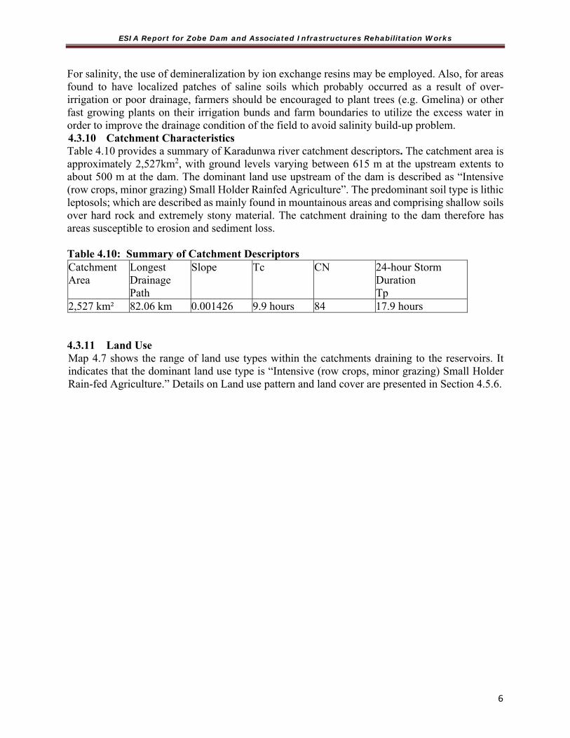
ESIA Report for Zobe Dam and Associated Infrastructures Rehabilitation Works
6
For salinity, the use of demineralization by ion exchange resins may be employed. Also, for areas found to have localized patches of saline soils which probably occurred as a result of over-irrigation or poor drainage, farmers should be encouraged to plant trees (e.g. Gmelina) or other fast growing plants on their irrigation bunds and farm boundaries to utilize the excess water in order to improve the drainage condition of the field to avoid salinity build-up problem. 4.3.10 Catchment Characteristics Table 4.10 provides a summary of Karadunwa river catchment descriptors. The catchment area is approximately 2,527km2, with ground levels varying between 615 m at the upstream extents to about 500 m at the dam. The dominant land use upstream of the dam is described as “Intensive (row crops, minor grazing) Small Holder Rainfed Agriculture”. The predominant soil type is lithic leptosols; which are described as mainly found in mountainous areas and comprising shallow soils over hard rock and extremely stony material. The catchment draining to the dam therefore has areas susceptible to erosion and sediment loss. Table 4.10: Summary of Catchment Descriptors Catchment Area
Longest Drainage Path
Slope Tc CN 24-hour Storm Duration Tp
2,527 km² 82.06 km 0.001426 9.9 hours 84 17.9 hours 4.3.11 Land Use Map 4.7 shows the range of land use types within the catchments draining to the reservoirs. It indicates that the dominant land use type is “Intensive (row crops, minor grazing) Small Holder Rain-fed Agriculture.” Details on Land use pattern and land cover are presented in Section 4.5.6.

ESIA Report for Zobe Dam and Associated Infrastructures Rehabilitation Works
6
Map 4.8: Land use in Zobe Dam catchment Area
4.4 General Description of the Biological Environment 4.4.1 Agro-ecozone The study falls within Zone II of the Sudan Savanna as identified by KTARDA (2003). In Katsina State there are three agro-ecological zones namely: o Zone I (Ajiwa, Katsina Zone consists of 15 LGAs), o Zone II (Funtua Zone consists of 8 LGAs) and; o Zone III (Dutsin-Ma Zone consisting of 11 LGAs) (KTARDA, 2003). 4.4.2 Flora and Fauna As observed during the reconnaissance survey, there is relatively high vegetation cover compared to the other areas in the upland. A visual assessment reveals a number of different species of plants in the area. Exotic species especially eucalyptus, and azaracticaindica become high in the area. The Zobe Dam area is characterised by the occurrence of woodland, shrub savannah formed parks and floodplain parkland. The ecological characteristics of the area is greatly influenced, to an extent, by the water bodies and their aquatic component Faunal survey reveals disappearing species of mammals, birds, reptiles, amphibians and fish from the project area. Many birds and mammals are threatened by hunters and a number of habitats and wildlife species are under threat within the PCA and forest as well as in the park land areas.

ESIA Report for Zobe Dam and Associated Infrastructures Rehabilitation Works
6
Plate 4.4: Typical Vegetation and Existing Farms in the Project Location 4.4.3 Hydrobiology The physical and chemical conditions of aquatic systems affect to a large extent the structure and function of the inhabiting flora and fauna. In the aquatic environment, the flora is composed of the phytoplankton and aquatic macrophytes (primary producers), while the fauna is made up of the zooplankton and other aquatic animals including the benthic invertebrates. Fish is also discussed in this subsection. Phytoplankton Phytoplanktons are microscopic plants found in aquatic habitats where they function as primary producers. Important groups in the phytoplankton include but not limited to members of the division Bacillariophyta (diatoms), Chlorophyta (green algae) and Cyanophyta (blue-green algae). Zooplankton These are minute animals found mainly in the pelagic zone of water bodies, where they drift along with water current because of their poorly developed locomotory structures. They include the meroplankton (temporary zooplankton) and holoplankton (permanent zooplankton). Zooplankton consists mainly of three groups- Rotifera, Cladocera and Copepoda (Egborge, 1970; 1978; 1994; Onwundinjo, 1990). Benthos

ESIA Report for Zobe Dam and Associated Infrastructures Rehabilitation Works
6
Macroinvertebrate fauna also referred to as benthos are bottom dwelling animals in water bodies (Ogbeibu 1995, Olomukoro, 1996). They are either infauna (living in or on the bottom sediments) or epifauna (attached to plants, substrate or hard objects). Fish Fish catches carried out at both the reservoir and downstream reveals that there are more fish variety in the impounding reservoir than in ponds downstream (Plate 4.5). Construction of a fish ladder would improve conditions for fish passage downstream.
Plate 4.5 Fish catch in the PCA and its variety 4.4.4 Ecological Problems The state suffers from the perennial ecological problems of drought, desertification and the menace of pest invasion. These are experienced mostly in the northern part of the state. The marked fall in the level of ground water has also compounded the problem of sustaining the ecological balance in some parts of the state. The project area has granitic intrusions which are coated with regolith that can easily be weathered. In many parts of the area separate pieces of weathered rock and the loose material moves downhill to form hill-side waste, outwash fans, and other formations. This phenomenon is usually associated with areas of granitic outcrops like GanuwarDansadau (Plate 4.6). In the plain surface like Maikada, YarLilo and UnguwarMati and areas close to the dam erosion is not a conspicuous phenomenon. The accumulated material is coarse-grained, gravelly, stony, or even boulder because in most cases the rock is not completely weathered. The sandy plain areas have moderate erosion due to sand clumping. At Zobe Dam there is little capacity to manage outflows during floods. The maximum capacity of the draw-off pipework is about 22 m3/s which will have little impact on inflows experienced during floods.

ESIA Report for Zobe Dam and Associated Infrastructures Rehabilitation Works
6
Granitic outcrop at GanuwarDangandau Deep Gully incision toward the river at GanuwarDangandau
Plate 4.6: Granitic Outcrops Weathering with Loose Material Moving Downhill 4.5 General Description of the Social Environment 4.5.1 The Project Area - Katsina State Katsina, Nigeria is located at latitude 12.9894 degrees and longitude 7.60063 degrees at an average elevation of 521 m, in the North-Western region of Nigeria, bordering Niger republic, Kaduna, Kano and Jigawa States. The state with a land area of approximately 24,000 Square Kilometres was created out of old Kaduna State in September 1987. The state is also made up of two emirates, namely; Katsina and Daura emirates which feature prominently in the establishment of the seven Hausa Kingdoms. The famous Bayajidda lineage had produced the founders and Kings of Katsina, Zaria, Kano, Biram, RanoGobir and Daura. The legendary Kusugu well in which the snake called Sarki was slain serves as a major tourist attraction in Daura. The majorities of the working population in Katsina State are farmers and cattle rears with rich cultural values and are highly regarded for their honesty, hard-work and hospitality.
4.5.2 Study Location and Population Study population included residents of Zango, Makera, Garfi and Dogonruwa communities. Selection of communities for the study was based on their relative location to the dam i.e upstream, midstream and downstream. Zango community (N12.37578˚; E007.59251˚) was selected in the upstream, Makera community (N12.32348˚; E007.46264˚) in the midstream while Garfi (N12.37349˚; E007.46106˚), Dogonruwa (N12.32531˚; E007.39568˚) and Marke (N12.35616; E007.49410) communities were selected in the downstream.
4.5.3 The Impacted Local Government Areas There are six (6) LGAs within the basin of the Zobe Dam and Irrigation Project as indicated in Map 4.8. The present Federal government/World bank intervention (Zobe dam rehabilitation work) through TRIMING instrument geared towards Zobe dam safety appears to impact on Dutsin

ESIA Report for Zobe Dam and Associated Infrastructures Rehabilitation Works
6
Ma LGA as well as Dan Musa and Safan LGAs. The other three local government areas will be indirectly impacted to different scales. Dutsin-Ma Local Government Area
Zobe dam is situated in Dutsin-Ma LGA and the dam rehabilitation works will directly impact on its inhabitants/communities. Communities that will be affected in Dutsin-ma LGA include Garhi, S/GarinTurare, DogonRuwa, U/Gulbi, Sabaru, KwanamaiZurfi, S/GarinButurkai, TasharMangoro, KurechinGiye, Kurechin Fulani, Sanawa.
Dan Musa Local Government Area: Dan Musa LGA Aidun Mangoro, Gurza Kura and Shakafito are possible communities to be beneficiary of the rehabilitation works.
Safana Local Government Area: Kunamawa, DogonRuwan Dan Kwanbo, Ganuwa and Wabi are the likely communities to be affected under Safana LGA.

ESIA Report for Zobe Dam and Associated Infrastructures Rehabilitation Works
6
Map 4.8: Project Affected LGAs
ZIP PCA
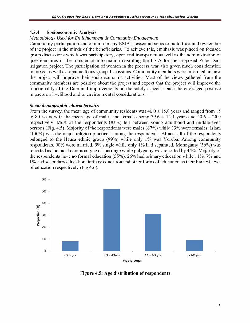
ESIA Report for Zobe Dam and Associated Infrastructures Rehabilitation Works
6
4.5.4 Socioeconomic Analysis Methodology Used for Enlightenment & Community Engagement Community participation and opinion in any ESIA is essential so as to build trust and ownership of the project in the minds of the beneficiaries. To achieve this, emphasis was placed on focused group discussions which was participatory, open and transparent as well as the administration of questionnaires in the transfer of information regarding the ESIA for the proposed Zobe Dam irrigation project. The participation of women in the process was also given much consideration in mixed as well as separate focus group discussions. Community members were informed on how the project will improve their socio-economic activities. Most of the views gathered from the community members are positive about the project and expect that the project will improve the functionality of the Dam and improvements on the safety aspects hence the envisaged positive impacts on livelihood and to environmental considerations. Socio demographic characteristics From the survey, the mean age of community residents was 40.0 ± 15.0 years and ranged from 15 to 80 years with the mean age of males and females being 39.6 ± 12.4 years and 40.6 ± 20.0 respectively. Most of the respondents (83%) fell between young adulthood and middle-aged persons (Fig. 4.5). Majority of the respondents were males (67%) while 33% were females. Islam (100%) was the major religion practiced among the respondents. Almost all of the respondents belonged to the Hausa ethnic group (99%) while only 1% was Yoruba. Among community respondents, 90% were married, 9% single while only 1% had separated. Monogamy (56%) was reported as the most common type of marriage while polygamy was reported by 44%. Majority of the respondents have no formal education (55%), 26% had primary education while 11%, 7% and 1% had secondary education, tertiary education and other forms of education as their highest level of education respectively (Fig.4.6).
Figure 4.5: Age distribution of respondents

ESIA Report for Zobe Dam and Associated Infrastructures Rehabilitation Works
6
Fig 4.6: Occupation of Respondents
4.5.5 Baseline Data of Host Communities/Villages The homogenous nature of the three local government areas in virtually every aspect (working population are farmers and cattle rears with rich similar cultural values) makes their common treatment/appreciation inevitable in the study. The majority of the LGAs for instance, dry season farming is essentially by irrigation. Animal husbandry is integrated into the farming system and animals such as cattle, sheep, goat, donkey and camels are bred, bought, fattened and sold. The host communities include the following: 1.Sabon Grain Turare 2. Garhi 3. Dogon Ruwa 4. Kwari Maizurfi 5. Sanawa. 6. Sabon Garin Buturkai 7.Tashar Mangoro 8.Marke 9.kurechin Giye 10.Kurechin Fulani. 11 Sabaru. 12. Kunamawa 13. Ganuwa 14. Wabi 15. Dogonruwan Dankwambo. Socioeconomic Baseline of the study area of the project include the following description: Population and Main Language Five communities were selected for the purpose of this research which includes those from the upstream and downstream of the dam. The communities are Zango, Makera, Garhi, Dogon Ruwa and Marke. An estimated population of the communities is 2,920, 10,500, 4,800, 7,600 and 670 respectively. Most people are generally Hausa speaking with Islam as the main religion.
Age Distribution The distribution of farmers by age in the proposed project area shows more of the youth than old aged people. Information on Under-five (>5) children Majority of the respondents (80%) had under-five children in their households. All of the under-five children as reported by respondents were said to have been vaccinated previously (though the

ESIA Report for Zobe Dam and Associated Infrastructures Rehabilitation Works
7
particular vaccine received by the child was not known and the exact time of vaccination could not be ascertained). Infrastructural Facilities The roads to the headquarters of the benefitting local governments are motorable but rural roads are almost impassable. Standard school and primary health facilities are more in the local government headquarters than in the surrounding villages- Potable water is a problem in the study area. Wells less than 20 m depth are the main sources of water supply, with few boreholes. Transportation The LGAs are linked with good or fairly motorable roads; however, camel, donkey and cattle are used to carry loads, especially harvest, from the farms. Traditional Structure The hierarchical structure in the study area indicates that each Emirate is headed by the Emir and administered traditionally by the Emirate Council with the Emir as the Chairman. Each emirate is subdivided into districts, which are headed by District Heads (Hakimi). Each district is also made up of villages headed by Village Heads (Dagatai/Magaji). Further, town wards and hamlets are headed by the MasuUnguwa Ward Hamlet Head.
Conflict and Conflict Resolution The major conflict in the area occurs between farmers and Fulani herdsmen and this is virtually perennial. It happens as a result of cattle encroachment into farmlands and the destruction of crops. Encroachment and lack of clear demarcation of grazing land and stock route are the main causes. However, majority of conflicts are resolved amicably by the traditional leadership structure. Homestead Local houses enclosed together comprising many huts made from mud are the major housing structures in the area. Cooperative Organizations There are no water users associations in all the communities, rather some of the communities have registered Fadama Cooperative Association. Agriculture Agriculture is the mainstay of the economy of the project area. Over 92% of the entire population engages in one agricultural activity of one form or another, such as crop production, animal rearing, irrigated farming, and fishing. There is hardly any crop that is not cultivated in the area, ranging from cash crops such as cotton, groundnuts, soya beans and sugarcane to food crops such guinea corn, millet, beans, maize and cassava. The production of all these crops on a large scale is a potential for the establishment of small scale agro-allied industries in the study area. Pastoralism Pastoral activity is one of the important aspects worth noting in the area. In depth interview with Fulani nomads at Gimurya village some 2 km downstream on rights to access to water, grazing field access, conflicts with farmers, and environmental consequences of their pasture activities revealed mutual relations and suggest little or no problem on many issues discussed (Plate 4.7).

ESIA Report for Zobe Dam and Associated Infrastructures Rehabilitation Works
7
Plate 4.7: Pastoral activities within the PCA 4.5.6 Land Use Pattern, Land Cover and Crop Production Mixed cropping is widely adopted in the area during both the dry and wet seasons. Arable cropping of cereal (wheat, millet and guinea corn) and legumes (groundnuts and cowpeas) are the prominent crops cultivated in the area. Other crops include onions, tomatoes/pepper, vegetable, cassava, potatoes and sugarcane. Farmers in the area use chemical and organic fertilizer. Use of herbicide is also widespread. Wheat is produced and brings in a substantial amount of income. Other cereals like sorghum, maize and millet are planted in all the three LGAs. Mixed cropping is widely adopted in all the areas. In many instances, leguminous cowpea is planted in rows of sorghum or millet to replenish the soil. This is an evidence of an effective agricultural extension within the study area and probably the state. Other crops include onions, tomatoes/pepper, vegetables, cowpea, cassava, potatoes and sugarcane. Fertilizer is liberally applied and brands such as NPK, Urea and Golden are used. Organic fertilizer from animal dung, plant biomass and domestic waste are also applied. Use of herbicide is also widespread with agro, goingoin, democide, emulsion herbicide by tract brands. Shifting cultivation is practiced to evade the ‘pepper rot’ (pepper rot could reduce yield by up to 80%). Bank of the Zobe Dam The land use at the bank of Zobe Dam is predominantly agriculture; for examples vegetable, wheat, onion and maize production. Neem plants also grow in this location. Fish farming is also practiced. Zango Community (Upstream) Land use / Land cover observed in Zago community include residential buildings with Neem plant. Farming activates such as maize, onion, tomatoes, wheat and garden egg production. Hand dug borehole powered by generator was used to irrigate the farm land during dry season. The hand dug borehole was donated to the community by Sokoto Rima River Basin for dry season farming.

ESIA Report for Zobe Dam and Associated Infrastructures Rehabilitation Works
7
Cattle, goat and sheep rearing were also observed, and make use of cow during cultivation (to plough and harrow).
Makera Community (Midstream) Agricultural activities for examples crop (maize, wheat, cucumber, cabbage, onion and tomatoes) and animal (cattle, goat and sheep) production is one of the land use observed in this community. Residential building also occupied some part of the land. While Neem plants were observed in both the agricultural and residential areas of the community. Hand pump borehole for domestic use was also observed in this community Garhi community (Downstream) Land use / Land cover observed in Garhi community include residential, agricultural and institutional. In the residential area, there was open well and some parts of the land were covered with Neem plant. One Government Primary School was observed with motorized borehole powered by solar energy. Crop production such as Onion, garden egg and water melon was observed. The people in the community also engaged in livestock (Cattle, goat and sheep) production. DoguRuwa community (Downstream) Land use / Land cover observed in Dogun Ruwa community include residential, agricultural, institutional and commercial. Neem plants were found in residential, agricultural and institutional areas. The residential area is not far from the public primary school in the community. Farming system is both crop (maize, onion, tomatoes, wheat and garden egg production) and livestock (Cattle, goat and sheep) production and they make use of their cattle during cultivation (to plough and harrow). A market place with hand pump borehole was also observed in DoguRuwa community. 4.5.7 Floral and Fauna Investigation The Zobe Dam area (upstream, midstream and downstream) were cultivated for arable crop such as tomato, onion, pepper, watermelon, sorghum, millet, cowpea, groundnut etc. as enumerated above (under Land use / Land cover results). Isolated trees on croplands were limited to ≤ 1 per hectare. However, more than one tree per hectare was observed most of which provided shed for resting on very hot days. Shrub and trees identified in the study area are listed in Table 4.11. Table 4.11: Shrub and trees identified in the study area
Scientific name Common name Habit Local uses Adansoniadigitata Baobab Tree Edible leaves and fruits Afromosialaxiflora Makerfo (Hausa) Tree Fuel woodAfzelia Africana Kawo (Hausa) Tree Fodder for livestock Albiziachevalieri Albizia Tree Shade plantAnogeissusleicarpa Marike (Hausa) Tree Chewing stick, medicinalAzadirachtaindica Neem Tree Fuel wood, medicinal Borassuseathiopum Ron palm Tree Edible fruits Bombaxcostatum Red silk cotton Tree Edible leaves and fruits Brachiariassp Grass Cattle feedCeibapentandra Silk cotton Tree Edible leaf, Timber Danielliaoliveri Maje (Hausa) Tree Fuel woodDigitariasp Grass Cattle feed

ESIA Report for Zobe Dam and Associated Infrastructures Rehabilitation Works
7
Fauna No game mammals were sighted. However, Table 4.12 shows fauna identified in the project area.
Table 4.12: Some Common animal of the study area Common name Scientific name
Termites TrinervitermesSppCattle Bovine sppSheep Ovine sppGoat CaprinesppDogs Canine spp 4.5.8 Gender Issue Traditionally, women in the area have no place in the leadership structure of the communities but could be involved in farming. The women are also at liberty to control their farming activity as well as attend meetings and be heard. There are discussions around various forms of gender base violence (GBV) which is very sensitive and controversial in the northern part of the country due to cultural issues. What is regarded as violence against women varies and depends to some extent on cultural interpretation. There are no known or reported Cases of gender-based violence (GBV) in the project area. However, issues of gender base violence particularly sex related (SGBV) among construction workers have been known in some part of the country. A situation where male construction workers intimidate female worker demanding for sex for better treatment should be discouraged. There is therefore need to put a mechanism in place where such vulnerable people could seek redress. To prevent possible case of GBV during project implementation in Zobe dam and vicinities, there is need to put in place a redress system as well as institutions serving this purpose.
There are no evidence of Sexual Assault Referral Centre (SARC) within the Zobe Dam project area. where cases of sexual assault could be reported and offenders prosecuted by trained prosecutors. However, office of federal and state ministries of women affairs set up primarily to
Khayasenegalensis Mahogany Tree Timer treeMangiferaindica Mango Tree Fruit edibleParkiabiglobosa Locust bean Tree Fruit ediblePhoenix doctylifera Date palm Tree Edible fruitPiliostigniareticulatum Kalgo (Hausa) Tree Fruit eatenSennaoccidentialis Coffee senna Herb Leaves edible Tamarindusindica Isamiya (Hausa) Tree Fruits eaten by cattle Terminaliaavicennoides Boushe (Hausa) Tree Fuel woodVitellariaparadoxa Shea butter tree Tree Edible fruit and vegetation oilEucalyptus camaldulensis Euslyptus Tree Planted shelter tree Hymenocardiaacida Janyaro (Hausa) Tree Fuel woodHyphaenethebaica Dum palm Tree Fruit for livestock feed Isoberliniadoka Doka (Hausa) Tree Fuel wood

ESIA Report for Zobe Dam and Associated Infrastructures Rehabilitation Works
7
provide protection and assistance to women is present in Katsina State. Also available are federal and state ministries of youth, sports and social development which deals with women development as part of its responsibility.
4.5.9 Health and Safety Dutsin-ma and Safana LGA have a general hospital. There are primary health centers and many dispensaries. Malaria is endemic in the study area. Water-borne diseases such as diarrhea, dysentery, cholera and cerebro-spinal meningitis are also reported diseases in the area. However, herbs and other local therapies are used in treating diseases by local herbal doctors. Emergency Preparedness Plan There is no formal Emergency Preparedness Plan although ‘target reservoir’ water levels and releases are made from the draw off pipework to manage flood disaster risk. However, the capacity of the pipework is small in comparison with the reservoir inflow hence the pipework offers little risk management. The dam break analysis is to be carried out as part of the Zobe Dam project and the flood extents will be mapped separately by a Dam Safety Expert to identify areas most at risk and in need of evacuation. 4.5.11 Environment Health Determinants Air quality Majority (93%) of the respondents reported that Agricultural production and processing of agricultural produce was the major source of air pollution in the area, which was followed by domestic activities (7%). Most of the respondents (99%) reported the use of the wood and corn cobs for domestic cooking while 1% made use of kerosene as cooking fuel. About 88% of respondents claimed to cook in separate rooms used as kitchens. Kitchens were observed to be detached from the main houses but within the compounds, although dark and poorly ventilated (Plate 4.8). There were no generator emissions, bush burning and dumpsites observed during the course of the study while traffic emissions were minimal even though two of the surveyed communities were situated close to highways. Suspended dust particles were observed in almost all the communities due to harmattan conditions during the study period.
Plate 4.8: A typical kitchen in Dogon Ruwa community.

ESIA Report for Zobe Dam and Associated Infrastructures Rehabilitation Works
7
Table 4.13: Air Pollution Sources
Observations Present Absent Generator emissions - Bush burning - Traffic emissions - Dump site - Key: present (+); absent (-)
Water Quality and Supply Majority of respondents (80%) stated hand-pumped well as their main source of water for drinking and other domestic purposes while 20% used a solar-powered water system to meet their water needs (Plate 4.9). A good proportion of the respondents from the communities (80%) reported that the quality of water was good, while 5% considered it as fair and 15% perceived their water quality to be poor. When asked whether they treat the water, 97% of them reported that they do not subject the water to any form of treatment before consumption while 3% reported that the use chlorine for water treatment. Wells and solar-powered water supply system were also observed in one of the communities. When asked about the last case of flooding in their communities, 88% of respondents claimed to have experienced flooding less than a year ago while 12% reported having experienced it between 1-5 years ago. All respondents (100%) in the midstream had experienced flooding less than a year ago while all respondents in the downstream had last experienced flooding between 1-5 years ago.
Plate 4.9: Water sources (a) Hand-pumped well (b) solar-powered water supply (c)
unprotected well

ESIA Report for Zobe Dam and Associated Infrastructures Rehabilitation Works
7
Table 4.14: Water Sources at the communities Sources Present non functional Present functional Absent
Tap - Bore-hole ++
River/stream +
Well +
Others -
Key: present non-functional (+); present functional (++); absent (-)
Figure 4.7: Last case of flooding in various communities
Housing Conditions All respondents (100%) reported the use of mud bricks as the main building materials of their houses (Plate 4.10). The roofs were mainly thatched and there was an average of one window per room. Majority of the households generally reported average room occupancy of three (3) persons per room and that over-crowdedness in rooms was never an issue in their households.

ESIA Report for Zobe Dam and Associated Infrastructures Rehabilitation Works
7
Plate 4.10: Typical housing structures at (a) Makera (b) Zango
General sanitation Majority (70%) of the community respondents were satisfied with the level of sanitation in their communities while only 29% and 1% were not satisfied and undecided respectively. About 97% of respondents stated that there was no stagnant water in their community while 3% stated otherwise. Excreta disposal practices were generally observed to be satisfactory. The major form of excreta disposal facility observed in the community were pit latrines. All respondents reported not sharing their toilets with other households. There were very few drainages within the communities and those found were filled with litters. Stagnant water was also observed around the water sources within the communities (Plates 4.11).
Plates 4.11: Sanitary conditions (a) Pit latrine (b) Drainage filled with litters (c) Stagnant
water
ba
b ca

ESIA Report for Zobe Dam and Associated Infrastructures Rehabilitation Works
7
Table 4.15: Sanitary facilities Facilities Present non functional Present functional Absent
Water closet - Pit latrine ++
VIP - Others -
Key: present non-functional (+); present functional (++); absent (-) Table 4:16 Sanitary Conditions
Observations Present Absent Stagnant water -
Blue-green algae - Bushes -
Smell/bio-decay +
Water log/Mash -Sewage -
Drainage +Others -
Key: present (+); absent (-) Solid Waste Management All (100%) of the respondents reportedly stated that they practice open burning and use the ashes on their farmlands. Waste management was poorly done within the communities with waste littered indiscriminately around the streets (Plate 4.12). There were no waste bins nor waste baskets spotted within the communities. There were also no signs of dumpsites or water surface disposal but open burning, random surface dumping and clogged drains were observed.
Plates 4.12: Refuse littering drainages and streets

ESIA Report for Zobe Dam and Associated Infrastructures Rehabilitation Works
7
Table 4.17: Solid waste management Waste management Practices Present Absent Waste baskets/bins - Dumpsite - Burning of waste + Disposal of waste in water body -
Clogged drains - Random surface dumping + Others - Key: present (+); absent (-) Vector burden All of the respondents reported the presence of all kinds of insect vectors including mosquitoes (100%), houseflies (100%) and cockroaches (95%) as being prevalent in their communities. Use of Insecticide Treated Nets (ITN) was common with 98% of respondents while use of chemical sprays and no pest control was only reported by 1% each of the respondents. Onsite observations showed possible breeding and dwelling sites of insect vectors and vermin (Plate 4.13).
Plate 4.13: Possible insect and vector breeding site

ESIA Report for Zobe Dam and Associated Infrastructures Rehabilitation Works
8
Noise pollution
Noise level was generally observed to be low within the communities but 26% of respondents believed noise to be a major health challenge in their community while 74% did not report noise as a major health challenge. Table 4.18: Noise Pollution Sources Source Present Absent
Industrial -
Religious -
Marine -
Key: present (+); absent (-) Food hygiene and safety Food hygiene practices were observed to be poor as food was openly displayed with possible infestation from houseflies and settling of dust particles (Plate 4.14). Food handlers and consumers were observed not to have washed their hands prior to handling of food.
Plate 4.14: Food handling practices
Key Environmental Risk factors
Poor Hygiene and sanitation Open dumping of refuse Proliferation of Vectors Unhygienic display of food Poor drainages and stagnant water
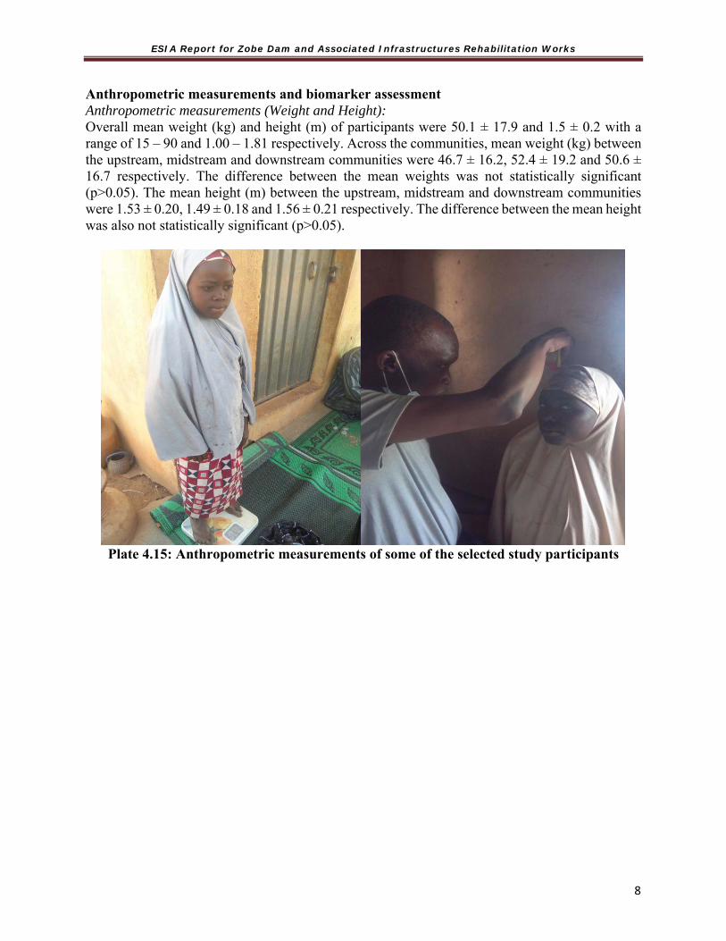
ESIA Report for Zobe Dam and Associated Infrastructures Rehabilitation Works
8
Anthropometric measurements and biomarker assessment Anthropometric measurements (Weight and Height): Overall mean weight (kg) and height (m) of participants were 50.1 ± 17.9 and 1.5 ± 0.2 with a range of 15 – 90 and 1.00 – 1.81 respectively. Across the communities, mean weight (kg) between the upstream, midstream and downstream communities were 46.7 ± 16.2, 52.4 ± 19.2 and 50.6 ± 16.7 respectively. The difference between the mean weights was not statistically significant (p>0.05). The mean height (m) between the upstream, midstream and downstream communities were 1.53 ± 0.20, 1.49 ± 0.18 and 1.56 ± 0.21 respectively. The difference between the mean height was also not statistically significant (p>0.05).
Plate 4.15: Anthropometric measurements of some of the selected study participants

ESIA Report for Zobe Dam and Associated Infrastructures Rehabilitation Works
8
Figure 4.8: Comparison of weight across communities
Figure 4.9: Comparison of height across communities
Exposure Assessment
Body Mass Index (BMI) Results showed that 30.0% of participants were underweight, 57.0% normal weight, 9.0% overweight and 4.0% obese. Furthermore, among men 7.5% were underweight, 7.5% overweight, 85% normal weight and none was obese. About 15% of women were underweight, 54% had

ESIA Report for Zobe Dam and Associated Infrastructures Rehabilitation Works
8
normal weight, 19% were overweight and 12% were obese. Among children, 95% were underweight while only 5% had normal weight. Upstream, 45% of participants were underweight while 50% and 5% were normal weight and overweight respectively. In the midstream community, 27% were underweight, 46% normal weight while 18% and 9% were overweight and obese respectively. About 32% of downstream participants were underweight while 59% and 9% were normal weight and overweight respectively.
Figure 4.10: Comparison of BMI among communities
Body temperature (˚C) Overall mean body temperature of participants was 35.8 ± 1.6 with a range of 33.0 – 37.1. Mean body temperature for men was 35.8 ± 1.7 while women and children had an average of 35.6 ± 1.8 and 36.2 ± 0.9 respectively. There was a statistically significant difference in mean body temperature between these groups (p<0.05). Across the communities, mean body temperature between the upstream, midstream and downstream communities were 36.1 ± 1.7, 36.2 ± 1.4 and 35.4 ± 1.4 respectively. There was a statistically significant difference in mean body temperature across the selected communities (p<0.05). 4.6 Public Consultation/Stakeholders’ Engagement 4.6.1 Introduction As a way of initiating the process of continual consultation and involvement of the public in the project, various discussions were initiated by the project and during the reconnaissance survey with some key relevant community groups, and other relevant stakeholders. In addition, as part of the process of public consultation/participation a program for the disclosure of the ESIA to facilitate the work was developed.

ESIA Report for Zobe Dam and Associated Infrastructures Rehabilitation Works
8
The main goal of Stakeholder Engagement or Public Participation Process (PPP) in this ESIA exercise is to ensure a coordinated, consistent and comprehensive approach for public consultation as an integral part of the ESIA process. Consultation is essential because they afford the concerned members of the public/stakeholders opportunity to contribute to both the design and implementation of the project activities and reduce the likelihood for conflicts. The growing socio-economic situation prevailing in Nigeria makes public consultation with the relevant stakeholders’ indispensable. 4.6.2 The Objectives of Consultations The specific objectives of PPP include the following:
Promote a good understanding of the remedial work and the relationship with the environmental and social resources related process;
Understand the perception and expectations of stakeholders; Gain knowledge to better manage stakeholders’ expectations and clarify their possible
misunderstandings; Gather inputs and local knowledge from stakeholders and include their relevant
contributions in the ESIA exercise; Generate a process of mutual learning; Create a space for dialogue and sharing of ideas; Develop social and environmental civic maturity and a sense of shared responsibility for
the future; and To incorporate stakeholders’ views and concerns into the ESIA mitigation measures.
4.6.3 Approach for Public Participation Process In order to ensure appropriate and adequate consultations are carried out in the preparation of the ESIA document, the following Stakeholder mapping steps have been adopted:
Identify/define the stakeholders Analyse stakeholders by impact and influence Plan and Manage stakeholder communications and reporting Engage with the stakeholders
4.6.4 Stakeholder Identification
Stakeholders, for the purpose of this project are defined as all those people and institutions that have an interest in the successful planning and execution of the project. These include those positively and negatively affected by the project. Stakeholders will be identified as individuals or groups that may be affected by development activities of the Remedial works. Some stakeholders who would act as spokespeople or leaders of various representative sectors of society and fields of discipline related to the ESIA in the study area and beyond which will be the most efficient for the purpose of the ESIA have also been taken into consideration. There are wide range of potential stakeholders for this ESIA, from local communities with limited levels of education and specific cultural values to government, research, social media and private sector with relatively high levels of education, skills and understanding. The challenge is,

ESIA Report for Zobe Dam and Associated Infrastructures Rehabilitation Works
8
therefore, to develop an engagement strategy for all stakeholder groups taking into account this complexity and diversity. The following criteria are useful in recognising the relevant stakeholders to involve, in which way, why, when and to what degree at any given time:
The significance of the effect of the project in the view of the stakeholder; The importance of the stakeholder group to the proposed project; The risk of getting incomplete information by excluding a group; and The opportunity to access new ideas.
(a) Stakeholder Mapping/Assessment of Importance and Influence
The Stakeholder assessment deepens the understanding of power relations, networks, and interests associated with the proposed project. The stakeholder analysis is designed to integrate a set of criteria—influence, interest, impact, power, resource and legitimacy—to characterize stakeholders.
Thus, the identified stakeholders are mapped/assessed for their importance and influence with respect to the realization of planned projects and, their effects.
Influence is the power which stakeholders have over decisions to be made related to the projects. It is the extent to which stakeholders are able to persuade or coerce others into making decisions.
Importance indicates the priority given to satisfying stakeholders’ needs and interests through plan implementation of the projects.
Stakeholder Importance and Influence Matrix Template has been developed. Fig 4.11 shows the quadrant upon which the Level of interest and influence in supporting the development of the ESIA was assessed.

ESIA Report for Zobe Dam and Associated Infrastructures Rehabilitation Works
8
Fig 4.11 Stakeholder Mapping Quadrant
4.6.5 The Stakeholders Consulted The various groups of organisations and individuals who were identified during the study as appropriate to consult are shown in Table 4.19. It should be noted that others could emerge later, who may show interest in the project.
The starting point was the Federal Ministry of Environment (FMENV) and later the Katsina State Ministry of Environment (MoE) who have to be notified of the project.
Table 4.19: Identified Stakeholders Group Groups met so far Remarks 1 Environmental
Authorities
Katsina MoE SEPA FMEnv*
Other stakeholders consulted include the surrounding and host communities of the project
2 Other Government Institutions
Min of Land & Survey, Min of Agriculture Min of Water Resources, FMWR Ministry of Physical Planning LGCs World Bank Primary Health Care Development Agency. Sokoto Rima Basin Authority
ESIA Report for Zobe Dam and Associated Infrastructures Rehabilitation Works
8
3 Communities Heads and other members of the communities of Numerous villages around project area
4 Trade association & other interested stakeholders.
Farmers Association, Fishermen Religious organisation Women Economic Empowerment
Organization Other interested parties, e.g. NGOs Herdsmen
4.6.6 Stakeholder Engagement and Plan In order to obtain the views representative of a broad spectrum of the stakeholder including those in disadvantaged positions, a multi-pronged approach was followed by reaching out to every segment of the identified stakeholders announcing the project and the opportunity to participate both verbally and in writing, electronically and in print media. In other words, the opportunity to comment and to raise issues for evaluation was announced to the broadest range of stakeholders. 4.6.6.1 Mechanism for Consultation The techniques for public involvement included a combination of the followings depending on the target audience: Focus Groups -Includes small discussion groups who give “typical” reactions of the general
public. Interviews - Face-to face interviews with key persons or stakeholders. Meetings -Less formal meetings of persons to present information, ask questions, etc. Workshops - Smaller meetings that were designed to complete a task or communicate detailed or
technical information. Surveys/Polls - Carefully designed questions were asked of a selected portion of the public.
(Appendix 5 contains the various instruments that have been developed and used for reaching out to the various target audiences)
Notification of Stakeholders A number of methods were used to notify relevant stakeholders. These included, but not limited to, the following: Formal Letters of Invitation: Formal letters of invitation were delivered to
stakeholders identified, specifically formal and traditional authorities. Background Information Document: In addition to the formal letters of
invitation, background information document (BID) were prepared in English and Hausa which provides a description of the proposed project, an overview of the ESIA process and contact details in order for stakeholders to provide comments on the project. The BID were distributed during the notification period and the meetings.
Site Notices: A number of site notices (in English and/Hausa) were placed at locations conspicuous to the public, market places, public notice boards etc.
4.6.6.2 Summary of Outcome of Public Consultations Community participation and opinion in any ESIA is essential so as to build trust and ownership of the project in the minds of the beneficiaries. The participation of women in the process was also given much consideration through interviews directed at women to specifically get their views of
ESIA Report for Zobe Dam and Associated Infrastructures Rehabilitation Works
8
the project and other concerns. They were also encouraged to participate in community meeting. Community members were informed on how the project will improve their socio-economic activities. Most of the views gathered from the community members are positive about the project and expect that the project will improve the safety of the Zobe Dam hence ensuring the safety of downstream communities. The stakeholders generally were happy that the Zobe dam rehabilitation project ensuring the safety of downstream communities from loss of lives and properties resulting from a potential dam failure was being planned. However, the fear within the communities include land take by the government. The communities also believe that an influx of people to their communities is inevitable as a result of the dam remediation works and would bring with its social problems and extension. The communities saw the need to establish cooperative in such a way that owners of farmlands work together instead of working individually. In order to ensure sustainability of sunk investment, the Staff of the Zobe Irrigation Project office and Sokoto Rima River Basin Development Authority were trained on ways of helping the farmers sustain their cooperatives. Further details on the stakeholders’ engagement are presented in appendix 2.

ESIA Report for Zobe Dam and Associated Infrastructures Rehabilitation Works
8
CHAPTER FIVE POTENTIAL AND ASSOCIATED IMPACT ASSESSMENT
5.1 Introduction Following identification of all project activities, biophysical, socio-economic and health receptors have been identified. The key inputs for the identification of receptors included: literature and legislative review, environmental, socioeconomic and health baseline conditions and Stakeholder consultation. 5.2 Identified Receptors of the Potential Impacts of Remedial Works Table 5.1 lists the identified project biophysical, socio-economic and health receptors. Table 5.1: Identified Project Environmental and Socio-economic Receptors
Receptor RemarkBiophysical Components
Climate Associated effects on climatic pattern (local and global effects)
Air Air quality (including gases with Global Warming Potential (GWP)) in and around the proposed project sites.
Noise Noise disturbance in and around the proposed project development sitesGroundwater / Aquifers
The groundwater resources and aquifers of areas in which project activities are proposed to occur.
Surface Water and sediment quality
The surface waters and sediment in creeks and rivers in areas around which project activities are proposed to occur.
Soil The soils of areas in and around the proposed project development sites
Subsurface Geology The subsurface structures and rock strata of terrestrial areas in which project activities are proposed to occur.
Landscape / Topography
The geomorphological land forms and terrain of areas in which project activities are proposed to occur.
Hydrobiology (plankton/benthos)
Plankton living in the water column and benthos organisms living in and/or on the benthic sediments in which project activities are proposed to occur.
Terrestrial Flora
Plant species that occur in the inland areas in which project activities are proposed to occur.
Terrestrial Fauna (Wildlife)
Animal species that occur in the inland areas in which project activities are proposed to occur.
Socioeconomic Components
Land Use Existing uses (e.g. herding/grazing, farming, industrial) of the land areas in which project activities are proposed to occur.
Local and National Employment Base
The total number of fishing jobs (temporary, part-time, fulltime) within the project area
Utilities The utilities (source of water) of areas in which project activities are proposed to occur.
Transport The road transport systems (i.e. physical network and vehicles that use them) of the areas in which project activities are proposed to occur.

ESIA Report for Zobe Dam and Associated Infrastructures Rehabilitation Works
9
Receptor RemarkInternational procurement
International economies that benefit from project related expenditure through the procurement of goods and services outside of Nigeria
Waste management Waste management practices in the area Livelihood Existing economic activities and livelihood system GBV, SEA, VAC, VAW
Existing redress systems and institutions
Health ComponentsHealth Indicators Mortality rate; Morbidity rate; Life expectancy etcVector Related Diseases
Malaria, Schistosomiasis, dengue, Onchocerciasis, yellow fever etc
Sexually transmitted infection HIV/AIDS
HIV/AIDS, Syphilis, Gonorrhoea, Chlamydia, Hepatitis B
Hazards and risk Road-traffic related, spills and releases, construction (project-related) etc
Health services infrastructure and capacity
Physical infrastructure, staffing levels and competencies, technical capabilities of health care facilities at district levels; program management delivery systems; coordination and alignment of the project to existing national- and provincial-level health programs (for example, TB, HIV/AIDS), and future development plans
Source: MDS & MOA Planners (2014) 5.3 Identifying Project Activities and Biophysical, Socio-Economic and Health Aspects Identified project activities, and biophysical, socio-economic and health, receptors were integrated into matrices with the activities on the y-axis and receptors on the x-axis, and a matrix was compiled for each of the project elements (Table 5.2). Each matrix was subsequently assessed to identify every possible case of potential activity-receptor interaction. Where it was considered that an activity-receptor interaction was possible, the cell was marked denoting an identified environmental aspect.

ESIA Report for Zobe Dam and Associated Infrastructures Rehabilitation Works
9
Table 5.2: Proposed Remedial works &Environmental and Social Receptors
DEVELOPMENT ACTIVITIES*
Environmental and Social Receptors
Top
ogra
ph
y an
d
Bat
hym
etry
Cli
mat
e an
d
Met
eoro
logy
Air
Qu
alit
y an
d N
oise
Lan
d U
se a
nd
Soi
l
Ter
rest
rial
Eco
logy
Fre
shw
ater
Eco
logy
Mar
ine
Eco
logy
Hyd
roge
olog
y
Fis
her
ies
Hea
lth
Soc
io-E
con
omic
s
Was
te
Tra
nsp
orta
tion
General remedial work on the seepage of the dam
X X X X x x X x X
Removal of all vegetation and root bowl from the downstream face of the dam, and the dugout root bowl surface will be replaced with compacted fill
X X x
Removal of anthill and termite mound and the area dug out and re-compacting
X X x x
The bowl of larger trees that have developed on the crest will be dug out, and new material placed and compacted into the resulting holes
X X x
Servicing of the flap valve on the drain from the pipe culvert
X x x
Restoring of all butterfly and hollow jet valves
x
Cleansing of the relief wells cleansed using clean water
x X
Cleaning out and modifying of ditches to ensure free discharge to the river
X X X x
Provision of Access along the crest from the left abutment to the valve tower
X X X x X

ESIA Report for Zobe Dam and Associated Infrastructures Rehabilitation Works
9
DEVELOPMENT ACTIVITIES*
Environmental and Social Receptors
Top
ogra
ph
y an
d
Bat
hym
etry
Cli
mat
e an
d
Met
eoro
logy
Air
Qu
alit
y an
d N
oise
Lan
d U
se a
nd
Soi
l
Ter
rest
rial
Eco
logy
Fre
shw
ater
Eco
logy
Mar
ine
Eco
logy
Hyd
roge
olog
y
Fis
her
ies
Hea
lth
Soc
io-E
con
omic
s
Was
te
Tra
nsp
orta
tion
Modification of ditches on the right hand side to separate seepage flow from other drainage
X X X x
Reinstating of the V-notch in both the left and right hand side system
X X X
Level point will be installed on the crest with a large number in the area of the alluvium in the base.
X X X
5.4 Impact Assessment Method This section describes methods for the assessment of impact of the remedial works (described under construction, operation and maintenance and decommissioning activities). The potential impacts of the proposed development on each environmental and social component have been assessed by the following three methods; significance assessment, risk assessment or compliance assessment. Figure 5.1 shows how each method was applied to the impact assessment process, which is reflected in the structure of each the subsequent relevance. Significance assessment was adopted where an understanding of the vulnerability of the environmental receptor was important to the assessment. For example; an understanding of the sensitivity of ecosystems in their current state provides a sound basis for determining the severity of potential impacts. Potential impacts that arise through the management of materials and substances (e.g., waste) are more appropriately assessed using the principle of risk management. Compliance assessment was adopted for environmental aspects regulated by statutory guidelines, e.g., air quality and noise.

ESIA Report for Zobe Dam and Associated Infrastructures Rehabilitation Works
9
Fig 5.1: Impact Assessment Process
5.5 Significance Assessment Method An explicit assessment of the vulnerability of the environmental and social receptor is the basis of the significance assessment method. This method assumed that the impact will occur and that the worst case will be identified and assessed. The significance of the impact were assessed by considering the vulnerability or sensitivity of the environmental and social receptors and the magnitude of the impact before and after the application of mitigation and management measure. The significance of the residual impact were assessed assuming successful implementation of proposed mitigation and management measures.
5.5.1 Sensitivity of an Environmental and Social Receptor The sensitivity of an environmental and social receptor were determined from its susceptibility or vulnerability to threatening processes, and as a consequence of its intrinsic value. Archetype attributes that define sensitivity were revised to reflect the specific focus of this study. The model attributes of sensitivity included:
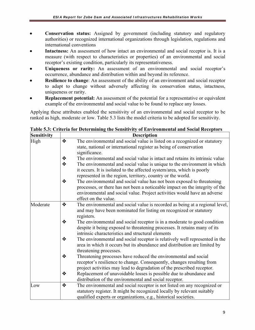
ESIA Report for Zobe Dam and Associated Infrastructures Rehabilitation Works
9
Conservation status: Assigned by government (including statutory and regulatory authorities) or recognized international organizations through legislation, regulations and international conventions
Intactness: An assessment of how intact an environmental and social receptor is. It is a measure (with respect to characteristics or properties) of an environmental and social receptor’s existing condition, particularly its representativeness.
Uniqueness or rarity: An assessment of an environmental and social receptor’s occurrence, abundance and distribution within and beyond its reference.
Resilience to change: An assessment of the ability of an environment and social receptor to adapt to change without adversely affecting its conservation status, intactness, uniqueness or rarity.
Replacement potential: An assessment of the potential for a representative or equivalent example of the environmental and social value to be found to replace any losses.
Applying these attributes enabled the sensitivity of an environmental and social receptor to be ranked as high, moderate or low. Table 5.3 lists the model criteria to be adopted for sensitivity. Table 5.3: Criteria for Determining the Sensitivity of Environmental and Social Receptors Sensitivity Description High The environmental and social value is listed on a recognized or statutory
state, national or international register as being of conservation significance.
The environmental and social value is intact and retains its intrinsic value The environmental and social value is unique to the environment in which
it occurs. It is isolated to the affected system/area, which is poorly represented in the region, territory, country or the world.
The environmental and social value has not been exposed to threatening processes, or there has not been a noticeable impact on the integrity of the environmental and social value. Project activities would have an adverse effect on the value.
Moderate The environmental and social value is recorded as being at a regional level, and may have been nominated for listing on recognized or statutory registers.
The environmental and social receptor is in a moderate to good condition despite it being exposed to threatening processes. It retains many of its intrinsic characteristics and structural elements
The environmental and social receptor is relatively well represented in the area in which it occurs but its abundance and distribution are limited by threatening processes.
Threatening processes have reduced the environmental and social receptor’s resilience to change. Consequently, changes resulting from project activities may lead to degradation of the prescribed receptor.
Replacement of unavoidable losses is possible due to abundance and distribution of the environmental and social receptor.
Low The environmental and social receptor is not listed on any recognized or statutory register. It might be recognized locally by relevant suitably qualified experts or organizations, e.g., historical societies.

ESIA Report for Zobe Dam and Associated Infrastructures Rehabilitation Works
9
Sensitivity Description The environmental and social receptor is in a poor to moderate condition as
a result of threatening processes which have degraded its intrinsic value The environmental and social receptor is not unique or rare, and numerous
representative examples exist throughout the area The environment receptor is abundant and widely distributed throughout
the host areas. There is no detectable response to change or change does not result in
further degradation of the environmental and social receptor The abundance and wide distribution of the environmental and social
receptor ensures replacement of unavoidable losses is assured. Source: MDS & MOA Planners (2014) 5.5.2 Magnitude of Impact The magnitude of an impact on an environmental and social receptor is an assessment of the geographical extent, duration and severity of the impact. These attributes are defined as follows:
Geographical extent an assessment of the spatial extent of the impact where the extent is defined as site, local regional or widespread (meaning state wide or national or international).
Duration the timescale of the effect, i.e., if it is short (less than 1 years), medium (1-20 years) or long (more than 20 years) term.
Severity an assessment of the scale or degree of change from the existing condition, as a result of the impact. This could be positive or negative.
Applying these attributes enables the magnitude of an impact to be ranked as high, moderate or low. Table 5.4 lists the model criteria adopted for determining the magnitude of impacts. Table 5.4: Criteria for Determining the Magnitude of Impacts
Magnitude DescriptionHigh An impact that is widespread, long lasting and results in substantial and possibly
irreversible change to the environmental and social receptor. Avoidance through appropriate design responses or the implementation of site specific environmental and social management controls are required to address the impact
Moderate An impact that extends beyond the area of disturbance to the surrounding area but is contained within the region where the project is being developed. The impacts are short term and result in changes that can be ameliorated with specific environmental and social management controls
Low A localized impact that is temporary or short term, and either unlikely to be detected or could be effectively mitigated through standard environmental and social management controls.
Source: MDS & MOA Planners (2014) 5.5.3 Significance of an Impact The significance of an impact on an environmental receptor is determined by the sensitivity of the receptor itself and the magnitude of the impact it experiences. The model significance assessment matrix (Table 5.5) shows how, using the criteria above, the significance of an impact is determined.
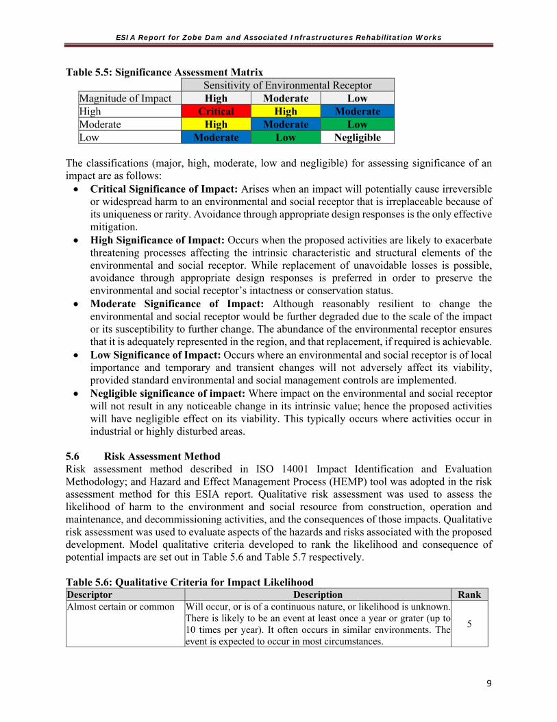
ESIA Report for Zobe Dam and Associated Infrastructures Rehabilitation Works
9
Table 5.5: Significance Assessment Matrix Sensitivity of Environmental ReceptorMagnitude of Impact High Moderate Low High Critical High Moderate Moderate High Moderate Low Low Moderate Low Negligible
The classifications (major, high, moderate, low and negligible) for assessing significance of an impact are as follows: Critical Significance of Impact: Arises when an impact will potentially cause irreversible
or widespread harm to an environmental and social receptor that is irreplaceable because of its uniqueness or rarity. Avoidance through appropriate design responses is the only effective mitigation.
High Significance of Impact: Occurs when the proposed activities are likely to exacerbate threatening processes affecting the intrinsic characteristic and structural elements of the environmental and social receptor. While replacement of unavoidable losses is possible, avoidance through appropriate design responses is preferred in order to preserve the environmental and social receptor’s intactness or conservation status.
Moderate Significance of Impact: Although reasonably resilient to change the environmental and social receptor would be further degraded due to the scale of the impact or its susceptibility to further change. The abundance of the environmental receptor ensures that it is adequately represented in the region, and that replacement, if required is achievable.
Low Significance of Impact: Occurs where an environmental and social receptor is of local importance and temporary and transient changes will not adversely affect its viability, provided standard environmental and social management controls are implemented.
Negligible significance of impact: Where impact on the environmental and social receptor will not result in any noticeable change in its intrinsic value; hence the proposed activities will have negligible effect on its viability. This typically occurs where activities occur in industrial or highly disturbed areas.
5.6 Risk Assessment Method Risk assessment method described in ISO 14001 Impact Identification and Evaluation Methodology; and Hazard and Effect Management Process (HEMP) tool was adopted in the risk assessment method for this ESIA report. Qualitative risk assessment was used to assess the likelihood of harm to the environment and social resource from construction, operation and maintenance, and decommissioning activities, and the consequences of those impacts. Qualitative risk assessment was used to evaluate aspects of the hazards and risks associated with the proposed development. Model qualitative criteria developed to rank the likelihood and consequence of potential impacts are set out in Table 5.6 and Table 5.7 respectively. Table 5.6: Qualitative Criteria for Impact Likelihood Descriptor Description Rank Almost certain or common Will occur, or is of a continuous nature, or likelihood is unknown.
There is likely to be an event at least once a year or grater (up to 10 times per year). It often occurs in similar environments. The event is expected to occur in most circumstances.
5
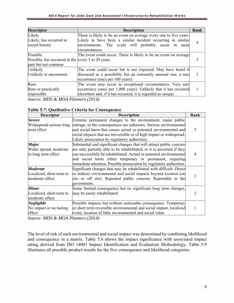
ESIA Report for Zobe Dam and Associated Infrastructures Rehabilitation Works
9
Descriptor Description Rank Likely Likely, has occurred in recent history
There is likely to be an event on average every one to five years. Likely to have been a similar incident occurring in similar environments. The event will probably occur in most circumstances.
4
Possible Possible, has occurred in the past but not common
The event could occur. There is likely to be an event on average every 5 to 20 years. 3
Unlikely Unlikely or uncommon
The event could occur but is not expected. May have heard it discussed as a possibility but an extremely unusual one, a rare occurrence (once per 100 years).
2
Rare Rare or practically impossible
The event may occur in exceptional circumstances. Very rare occurrence (once per 1,000 years). Unlikely that it has occurred elsewhere and, if it has occurred, it is regarded as unique.
1
Source: MDS & MOA Planners (2014) Table 5.7: Qualitative Criteria for Consequence
Descriptor Description Rank Severe Widespread serious long term effect
Extreme permanent changes to the environment, major public outrage, or the consequences are unknown. Serious environmental and social harm that causes actual or potential environmental and social impacts that are irreversible or of high impact or widespread. Likely prosecution by regulatory authorities.
5
Major Wider spread, moderate to long term effect
Substantial and significant changes that will attract public concern are only partially able to be rehabilitated, or it is uncertain if they can successfully be rehabilitated. Actual or potential environmental and social harm either temporary or permanent, requiring immediate attention. Possible prosecution by regulatory authorities.
4
Moderate Localized, short term to moderate effect
Significant changes that may be rehabilitated with difficult. Direct or indirect environmental and social impacts beyond location (on site or off site). Repeated public concern. Reportable to the government.
3
Minor Localized, short term to moderate effect
Some limited consequence but no significant long term changes, may be easily rehabilitated 2
Negligible No impact or no lasting effect
Possible impacts but without noticeable consequence. Temporary or short term reversible environmental and social impact, localized event, location of little environmental and social value
1
Source: MDS & MOA Planners (2014) The level of risk of each environmental and social impact was determined by combining likelihood and consequence in a matrix. Table 5.8 shows the impact significance with associated impact rating derived from ISO 14001 Impact Identification and Evaluation Methodology, Table 5.9 illustrates all possible product results for the five consequence and likelihood categories.

ESIA Report for Zobe Dam and Associated Infrastructures Rehabilitation Works
9
Table 5.8: Qualitative Risk Assessment Matrix Consequence Increasing Probability
1 2 3 4 5
Severity
People
Assets
Environment
Reputation
Never heard of incident in industry (0-20%)
Incident has occurred in industry (21-40%)
Incident has occurred in (41-60%)
Happens several times per year (61-80%)
Happens several times per year in asset/ facility (81-100%)
5 Multiple Fatalities
Extensive damage
Massive effect
International impact 5 10 15 20 25
4 Single Fatality
Major damage
Major effect National impact 4 8 12 16 20
3 Major Injury
Localized damage
Localized effect
Considerable impact 3 6 9 12 15
2 Minor Injury
Minor damage
Minor effect Limited impact 2 4 6 8 10
1 Slight Injury
Slight damage
Slight effect Slight impact 1 2 3 4 5
0 No injury
No damage
No effect No impact 0 0 0 0 0
Source: ISO 14001 Impact Identification and Evaluation Methodology. Table 5.9: Degree of Impact Significance Ranking (consequence x likelihood) Significance >16 Critical 9-16 High 6-8 Medium 2-5 Low <2 Negligible
The positive impacts of the proposed project activities on all valued receptive components rated as beneficial (+);
5.7 Evaluation of Potential Impacts The Leopold Matrix was used for the initial impact prediction by interacting project activities with environmental parameters. Qualitative determination of the possible project impacts (both positive and negative) was done. The identified environmental impacts were further quantitatively screened to determine the significance and importance. To achieve this, application of basic set of criteria to the preliminary information available about each identified impacts following the Nigerian regulations and other international criteria. The significant environmental impacts identified were then subjected to detailed assessment through acceptable models. Other rigorous impact

ESIA Report for Zobe Dam and Associated Infrastructures Rehabilitation Works
9
quantification and characterization techniques were also employed. Impacts that cannot be quantified were qualified using acceptable methods. The results of the quantitative and qualitative analysis were used to connote impact severity levels. On this basis, various mitigation measures (including design change, location change, project timing and operational procedures) recommended as appropriate. Impact assessment was conducted using three broad criteria, namely:
The characteristics of the proposed development (e.g. size, use of natural resources, quantities of pollution and waste generated);
The sensitivity of the areas likely to be affected by the development; and The characteristics and significance of the potential effects (severity and duration).
In generic terms, three stages are required to enable identification of significance of impact which are:
Identification of the baseline conditions and the sensitivity and importance of the receptors; Identification of the magnitude of change (impacts) upon the receptor; and, Identification of the impact significance, which is the product of a combination of the above
variables. The process for combining the sensitivity of the receptor with the magnitude of change to evaluate the significance is shown as a matrix in the table 5.10 below. Table 5.10: Matrix for the Evaluation of Significant Environmental Impacts*
Magnitude of Change
Importance of receptor High Medium Low Negligible
High Severe Major Moderate None Medium Severe Major Moderate None Low Major Moderate Slight None Negligible None None None None Definition: None =No known effect, Slight =Minimal effect, Moderate =Prolonged but recoverable effect, Major =Prolonged Effect (how long?), Severe =Adverse Effect
* These generic terms were defined specifically for this Project as part of the ESIA process
Expert judgment was used to apply such classifications, with full consideration of all collated data. The identified significant impacts were assessed using current practice methods. In the description of the impacts, reference was made to the following:
Exposure extent, Intensity and duration of exposure, Nature of effects, Reversibility or irreversibility of effects, Primary and secondary effects & Cumulative effects and expected changes
All significant potential impacts (both positive and negative) which are expected to result from the activities associated with the Project were enumerated and evaluated. Some of the parameters for the qualification and quantification of the significance of the impact were based on the criteria in Table 5.11 below.

ESIA Report for Zobe Dam and Associated Infrastructures Rehabilitation Works
1
Table 5.11: Criteria for Qualification and Quantification of Significant Impact
S/No Type Description
1 Disturbance - direct: physical; indirect (chain of events): physical, social
2 Potential Extent - surface area affected (local, regional, global)
3 Duration - permanent (life-time of the project or longer), temporary
4 Magnitude – percentage of environmental and social components affected
5 Nature – negative, positive, neutral
The method of assessment examined the severity of the predicted environmental and social impacts. The impacts upon the cultural heritage receptor (site/feature) were determined by two variables, as follows.
Importance of Receptor: The determination of this was based mainly on existing relevant legislation and/or professional judgment where features are found that do not have any formal national or local limits.
Magnitude of Change: This was based on the level of impact, the nature of the impact and the condition of the receptor. Magnitude of change could be difficult to predict with certainty as the extent and condition of archaeological deposits, for instance, within any given area is often uncertain and because a number of variables need to be considered, such as the vulnerability of the site to impact and the extent of past impacts.
The severity of environmental impacts was determined, using the two variables defined above, through application of a simplified version of the scale of impacts as shown in table 5.12 below.
Table 5.12: Types of Significant Effects
Nature of Impact Sources
Site specific effects
Result from a geographical localized impact and which are significant primary at a neighbourhood or local level.
Wider effects Individual significant at a state level, but which are unlikely to be significant locally.
Positive effects Beneficial influence on receptors and resources.
Negative effects An adverse influence on receptor and resources.
Temporary effects Persist for a limited period only, due to particular construction activities. Where possible, the likely duration of effects is identified.
Permanent effects
Result from an irreversible change to the baseline environment (e.g. land take) or which persist for the foreseeable future.
Direct effect Arise from the impact of activities that form an integral part of the project (e.g. new infrastructure).

ESIA Report for Zobe Dam and Associated Infrastructures Rehabilitation Works
1
Indirect effects
Arise from impact of activities not explicitly forming part of the project (e.g. increased road traffic in neighbourhood authorities due to changes in uses).
Secondary effects Arise as a result of an initial effect of the Project
Cumulative effects Arise from the combination of different effects at a specific location, the same type at different locations and the interaction of different effects over time.
The eventual risk from any activity was assessed by comparing the magnitude of the predicted change from an identified activity to the importance of the receptor to be impacted. Consequently, an impact or ‘change’ of high importance to a receptor of comparatively negligible importance to the project or wider community may result in an environmental impact that is deemed to be ‘moderate’ or ‘low’. Significance criteria for all relevant impacts as they relate to specific environmental and social components were further elaborated during the course of the ESIA using the following template:
Table 5.13: Significance Criteria
Significance Criteria
Severe adverse
Impacts represents key factors in the decision making process. They are generally associated with recognised or designated sites and features of international or national importance or they involve significant exceedance of accepted standards or guideline values for level of pollution. Typically, mitigation measures would be unlikely to remove or modify such impacts because of their magnitude.
Major adverse
Impacts would be important considerations on a regional or country level or would involve quantifiable significant increase in level of pollution, although not necessarily significantly above relevant standards or guideline values mitigation measures would be expected to reduce the impacts but may not be wholly successful by virtue of their magnitude.
Moderate Adverse
Impact would be important at a district level. But would not represent key factor in the design making process nor result in exceedance of relevant standards and guidelines values for pollution. Mitigation measures and/or detailed design work may ameliorate some of the consequences of adverse impact t this scale.
Slight adverse Effects are those which are relevant in the local context. Yet can generally be reduced, removed or even reversed by appropriate mitigation.
None Effects are assigned this level of significance if they are nil. Imperceptible, negligible or within margin of forecasting error when compared to the existing situation.
Slight benefit Are those which are experienced at a local level, they may arise directly or from implementation of locally successful mitigation measures. They may involve marginal reductions in levels of pollutants
Moderate benefit
Are those which are important considerations at a local level and are directly or indirectly attributable to the Project. In the case of pollution, this would represent significant quantifiable reduction in levels.
Major benefit Are those which would be experienced throughout a region and are directly or indirectly attributable to the Project. In the case of pollution, this would represent large quantifiable

ESIA Report for Zobe Dam and Associated Infrastructures Rehabilitation Works
1
Significance Criteria
reductions in pollutants levels, possibly leading to re-classification of environmental assets on a regional scale.
Maximum benefit Are those which are directly attributable to the Project and which are experienced at national or even international levels or involve the eradication of pollution?
5.8 Impact Assessment Method Statutory guidelines set out in environmental and social protection policies and other regulatory documents are designed to protect the relevant environmental and social receptors. The guidelines include an implicit assessment of the vulnerability of the environmental value through the setting of limits or thresholds or by providing the framework for determining the vulnerability of an environmental receptor e.g., indicators of ecosystem health, as evidenced by water quality standards. Impact Qualification The Impact qualification was used to classify the impacts as direct (D) or indirect (I), adverse/negative (N) or beneficial/positive (P), short term (S) or long term (L), reversible (R) or irreversible (IR).
Adverse impacts are those, which impact negatively on the environment and social resources.
Beneficial impacts are those, which enhance the quality of the biophysical, health and social environments.
Local impacts are limited to the immediate surroundings while the widespread impacts go far beyond the immediate area the impact is occurring.
Short term means a period of time less than three months while any period greater than three months is considered long term.
Reversible/irreversible is meant whether the impact can either be reverted to previous conditions or remains permanent once the activity causing the impact is terminated.
5.9 Some Identified Potential (Positive and Negative) Impacts of the Zobe Dam and associated Infrastructure Rehabilitation work Based on the initial site reconnaissance survey and available literatures and consultation that have been initiated some potential impacts have been identified (Table 5.14). 5.9.1 Positive Impacts Dam Safety Zobe Dam hydraulic model revealed that a flooded area of 1,712km2 and flooding extending downstream past Sokoto will result as a consequence of dam failure. Zobe Dam and associated infrastructure rehabilitation will therefore hugely decrease risk to lives and properties in the event of a dam breach due to piping or overtopping. Creation of Employment opportunities Zobe dam and associated infrastructure rehabilitation work will bring a positive impact of job creation throughout the duration of the project. Direct damsite and indirect job opportunities

ESIA Report for Zobe Dam and Associated Infrastructures Rehabilitation Works
1
associated with the start of the project are anticipated. However, the level of work to be generated will depend on the skills available in the project area communities as dam rehabilitation works are very specialized and require highly skilled and skilled persons like Engineers, drillers, builders. Unskilled persons could benefit from allied jobs such as security, housekeeping and catering that will be created by the project. Improved commercial activities Existing commercial activities will be enhanced and new one created at various scale during the rehabilitation phase of project in line with the increase in population of the damsite communities and environ. Improved infrastructure & Services Zobe Dam and infrastructure rehabilitation is likely to improve existing social amenities and rise of new ones (hospital, school) in the project area in an effort to meet up with the challenge posed by the increase in population. Increase in vehicle movement could lead to road rehabilitation or building of new ones. Flood prevention Localised flooding (damsite) due to present poor state of flood control system (inverted filter, pressure relief well and drainage collection system) will be greatly reduced or averted with the implementation of the rehabilitation project. 5.9.2 Negative Impacts. While it is good to highlight and enhance the positive impacts Zobe Dam and associated infrastructure rehabilitation project will bring, it is also important to recognise that the proposed project is not without negative impacts. These negative impacts could be environmental, social-economic or health related. It is therefore necessary to weigh all negative impacts of the project and proffer mitigation measures to ameliorate the negative impacts in order to safeguard lives, properties and the environment. The below negative impacts have been identified at the different phases (pre-rehabilitation, rehabilitation and operational) of the project. Pre-rehabilitation Impacts Mobilization of personnel, material and equipment to site at this stage will cause: Disturbance/Nuisance to people: Inhabitants of damsite and environ are likely to complain
of noise and air pollution from increased movement as a result of site mobilisation. Traffic Congestion: Congestion resulting from increased traffic associated with truck
moving material to site as well as equipment transport to site will be witnessed. Pressure on the Dutsin-Ma to Malumfashi road leading to the Zobe damsite is likely to raise the level of road accidents.
Rehabilitation Impacts Impacts on the rehabilitation phase can be of the following types. Soil Contamination: Equipment maintenance and fuelling may cause contamination of the soil and possible ground water if fuel and lubricants are not properly handled. Operation of machinery during embankment rehabilitation could also lead to accidental spill of oil and fuel.

ESIA Report for Zobe Dam and Associated Infrastructures Rehabilitation Works
1
Noise & Vibration Disturbance: Increase in noise from plants/machineries (excavators, compactors and trucks) during embankment rehabilitation and seepage control works is likely to be a source of disturbance Air Quality Deterioration: Earth work activities during rehabilitation phased of Zobe Dam is envisaged to cause air quality deterioration. Activities such as removal tree trunks/ant hills, filling of cracks created by tree trunk and ant hills as well as fill compaction using rollers is likely to send dust as well as gaseous emissions from exhaust into the atmosphere. Water Quality Deterioration: Operation of pressure relief well after rehabilitation works as well as planned drainage ditch cleaning and modification work is likely to cause sediments to flow into Karaduwa thus increasing the river turbidity. Disposal of Excavated Material & Construction Waste: Waste generation is inevitable throughout the rehabilitation phase of Zobe dam. General maintenance of dam embankment which include removal of vegetation, root and tree bowl is envisage to generate large amount of waste. Flushing of gauged and pressure relief wells with water as part of seepage control measure will inevitably generate waste. These waste if not properly managed could lead to significant deterioration of the environment. Degradation of landscape & Embankment Erosion: Remediation works at embankment crest and slope could lead to removal of slope protection exposing the embankment to the risk of erosion as well as destruction of landscape asthetic value. Public Health and Safety: The proposed Zobe dam rehabilitation project has the potential to increase the transmission of HIV and other STIs due mainly to a male workforce with a comparatively larger disposable income engaging in casual sexual activities in local communities. This envisaged negative social impact of the project is ultimately likely to affect the health and wellbeing of Zobe dam host communities and in turn their economic activities. The construction workers are also likely to be affected health wise consequently they will be unable to undertake their duties to the detriment of the project completion time. Gender Based Violence (GBV) and a risk of HIV: Sexual form of GBV (SBGV) have largely been related to HIV in a number of quarters and is not unlikely in a project like Zobe Dam and associated infrastructure rehabilitation considering the fact that hotels and brothels are not common place in dam area. While various forms (rape, domestic violence, FGM) of GBV indirectly increase the risk of HIV, SBGV seem to have the strongest direct relationship. Victims of early sexual abuse are more likely to be HIV positive, and usually show high risk behaviour. Although cases of GBV whether in the form of verbal abuse, physical abuse or emotional abuse have not been reported in dam area and environ, SGBV is still a reality that should be guarded against. Sexual assault referral centres (SARC) are not present in the project area to provide protection for the vulnerable. It is therefore important to have special prosecutors in addition to aforementioned institution to provide needed grieviance address system. Occupational Health and Safety: Zobe Dam Rehabilitation Project will come with health risk to the communities at the vicinity of the dam site as dust/particulate matter raised during construction work could likely lead to respiratory diseases. However, the construction workers are likely to be more affected. There are also added risks of accidents and injuries from operation of equipment.

ESIA Report for Zobe Dam and Associated Infrastructures Rehabilitation Works
1
Fishing: Fishing is an important economic activity of the project host communities, as stated earlier, Zobe dam reservoir holds more variety of fish than downstream Karaduwa River. Remedial works at the dam site is envisaged to have a temporary impact on fishing as this activity cannot be allowed during dam rehabilitation in the interest of health and safety. Table 5.14: Summary of Major Positive Impact in the Project
Key+ Low Positive
Impact ++ Medium
Positive Impact +++ HighPositive
Impact
S/No Potential Issue/ Activity Potential Positive Impacts Impact Qualification Low Medium HighEmbankment Rehabilitation 1 Contractor's Camps 1.Improved economy of the community (local food vendors
make more income) 2.Employment opportunity (security) 3. Local community benefitting from security arrangement
+++
2 Embankment Remedial work (excavation, filling and compaction)
1. Improvement of local economies 2. Improvement of dam safety by reducing internal and external erosion risk.
+++
3 Dam Crest Access Route (Left bank abutment to valve tower)
1.Providing access route to the community for emergencies. +++
Drainage Monitoring Instruments 1 Gauged well
(Piezometer) cleaning 1.Provides improved indication of piping failure from foundation seepage for safety planning
+++
2 Replacement of v-notch weir for measuring flow from inverted filter and the installation a v-notch weir to monitor flow from pressure relief well.
1.Quantify flow from pressure relief well +++
3 Crest Levelling and pin installation
1. Improves crest level monitoring (deformatiom/settlement) for structural stability of dam
+++
Seepage Control System 1 Inverted Filter remedial
work 1. Improving efficiency of filter to drain seepage flow. 2.
+++
2 Pressure Relief Well cleaning
1.Improving well performance/efficiency and decreasing uplift pressure on dam due to seepage to acceptable level.
++
3 Drainage Collection Syste(channel & ditch) Cleaning & modification self- cleaning)
1. prevention of localized flooding at the damsite. 2.Conveying artesian flow from pressure relief well and inverted filter back to the river Karaduwa downstream ensuring safety of dam
+++
Dam Inlet & Outlet Control Work 1 Pipe & Valve (butterfly,
hollow jet and flap ap valvrepairs.
1. Preventing backward flow and flooding of valve chamber as well as piping due to draw off conduit
+++

ESIA Report for Zobe Dam and Associated Infrastructures Rehabilitation Works
1
Table 5:15: Summary of Major Negative Impacts in the Project
S/No Negative Issue/Activity Potential Negative Impacts Impact Qualification Low Mediu
m High
Pre-rehabilitation (Environment) 1 Mobilization to Site Fume/gaseous emissions from equipment and
machine are likely to cause air pollution during mobilisation of material and equipment to site.
XX
2 Installation of Contractor’s Camp Construction of site structure could lead to generation of dust and harmful gaseous emission from equipment and machine. Oil and fuel leaks are also envisaged from storage.
X
Pre-rehabilitation (Social) 1 Disturbance/Nuisance to people Inhabitants of damsite and environ are likely to
complain of noise and air pollution from increased movement as a result of site mobilisation.
X
2 Traffic Congestion Congestion resulting from increased traffic associated with truck moving material to site as well as equipment transport to site will be witnessed. Pressure on the Dutsin-Ma to Malumfashi road leading to the Zobe damsite is likely to raise the level of road accidents.
XXX
Rehabilitation (Environment) 1 Soil Contamination Equipment maintenance and fuelling may cause
contamination of the soil and possible ground water if fuel and lubricants are not properly handled. Operation of machinery during embankment rehabilitation could also lead to accidental spill of oil and fuel.
XX
2 Air Quality Deterioration Earth work activities during rehabilitation phased of Zobe Dam is envisaged to cause air quality deterioration. Activities such as removal tree trunks/ant hills, filling of cracks created by tree trunk and ant hills as well as fill compaction using rollers is likely to send dust as well as gaseous emissions from exhaust into the atmosphere.
XX
3 Water Quality Deterioration Operation of pressure relief well after rehabilitation works as well as planned drainage ditch cleaning and modification work is likely to cause sediments to flow into Karaduwa thus increasing the river turbidity..
XXX
Degradation of landscape & Embankment Erosion
Remediation works at embankment crest and slope could lead to removal of slope protection exposing the embankment to the risk of erosion as well as destruction of landscape aesthetic value.
X

ESIA Report for Zobe Dam and Associated Infrastructures Rehabilitation Works
1
Rehabilitation (social) 1 Noise & Vibration Disturbance Increase in noise from plants/machineries
(excavators, compactors and trucks) during embankment rehabilitation and seepage control works is likely to be a source of disturbance
X
2 Public Health & Safety The proposed Zobe dam rehabilitation project has the potential to increase the transmission of HIV and other STIs due mainly to a male workforce with a comparatively larger disposable income engaging in casual sexual activities in local communities. This envisaged negative social impact of the project is ultimately likely to affect the health and wellbeing of Zobe dam host communities and in turn their economic activities. The construction workers are also likely to be affected health wise consequently they will be unable to undertake their duties to the detriment of the project completion time.
XX
3 Gender Based Violence (GBV) and a risk of HIV Sexual form of GBV (SBGV) have largely been
related to HIV in a number of quarters and is not unlikely in a project like Zobe Dam and associated infrastructure rehabilitation considering the fact that hotels and brothels are not common place in dam area. While various forms (rape, domestic violence, FGM) of GBV indirectly increase the risk of HIV, SBGV seem to have the strongest direct relationship. Victims of early sexual abuse are more likely to be HIV positive, and usually show high risk behaviour. Although cases of GBV whether in the form of verbal abuse, physical abuse or emotional abuse have not been reported in dam area and environ, SGBV is still a reality that should be guarded against. Sexual assault referral centres (SARC) are not present in the project area to provide protection for the vulnerable. It is therefore important to have special prosecutors in addition to aforementioned institution to provide needed grievances address system.
X
4 Occupational Health & Safety Zobe dam rehabilitation project will come with health risk to the communities at the vicinity of the dam site as dust/particulate matter raised during construction work could likely lead to respiratory diseases. However, the construction workers are likely to be more affected. There are also added risks of accidents and injuries from operation of equipment.
XXX
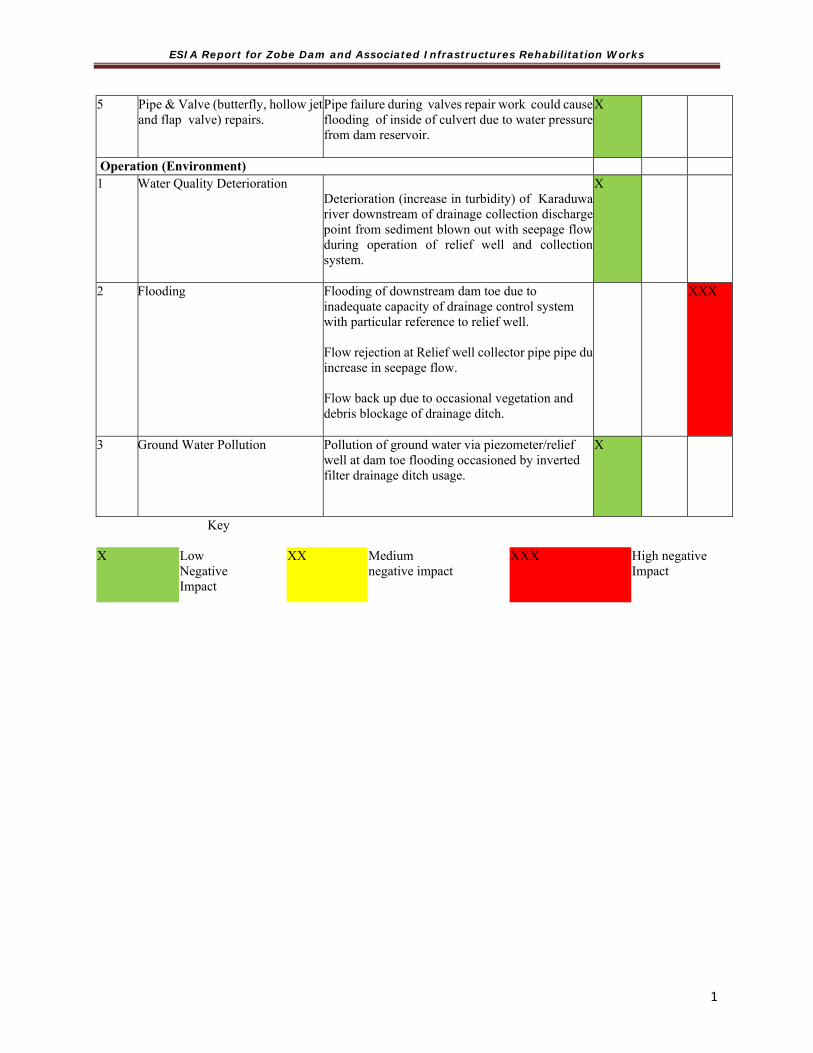
ESIA Report for Zobe Dam and Associated Infrastructures Rehabilitation Works
1
Key X Low
Negative Impact
XX Medium negative impact
XXX High negativeImpact
5 Pipe & Valve (butterfly, hollow jet and flap valve) repairs.
Pipe failure during valves repair work could cause flooding of inside of culvert due to water pressure from dam reservoir.
X
Operation (Environment) 1 Water Quality Deterioration
Deterioration (increase in turbidity) of Karaduwa river downstream of drainage collection discharge point from sediment blown out with seepage flow during operation of relief well and collection system.
X
2 Flooding Flooding of downstream dam toe due to inadequate capacity of drainage control system with particular reference to relief well. Flow rejection at Relief well collector pipe pipe duincrease in seepage flow. Flow back up due to occasional vegetation and debris blockage of drainage ditch.
XXX
3 Ground Water Pollution Pollution of ground water via piezometer/relief well at dam toe flooding occasioned by inverted filter drainage ditch usage.
X

ESIA Report for Zobe Dam and Associated Infrastructures Rehabilitation Works
1
CHAPTER SIX MITIGATION MEASURES
6.1 Introduction to Impact Mitigation Based on the inferences from the Consultation/participation with various stakeholders and the general public, mitigation measures were drawn against the above identified impacts. In proposing a strategy for the implementation of social mitigation measures, experience suggests that certain cardinal principle will be adopted as follows:
Care will be taken to ensure that proposed measures are accepted widely Proposed mitigation measures will assign specific responsibility to parties, Measures will be couched in a manner that they are easily incorporated into policies
pertaining to social investment strategy and public consultation and disclosure plan Generally, in the suggestion of the mitigation measures, the reduction of potential impacts to levels which are As Low as Reasonably Practicable (ALARP) would involve balancing reduction in risk against the time, trouble, difficulty and cost of achieving it. All identified environmental and social impacts, which can be eliminated or minimized to an acceptable level were complemented by option and measures to avoid, minimize or mitigate such harmful effects. This involved, for example, from recommendation of practical measures for rehabilitation to restore impaired features, environmental awareness programmes for operational staff, etc. Ways to enhance the beneficial ones have been documented in this ESIA. The mitigation approach development guiding principles adopted are outlined in Table 6.1. Table 6.1: Approach to Mitigation Measure Development
Mitigation Measure General Practice
1 Seek Alternatives to avoid particular impacts.
Consider alternatives to a proposed project activity.
Examine alternative ways to achieve the objectives to maximize benefits and minimize undesirable impacts.
2 Arrange Compensation where particular impacts are unavoidable.
Restore damaged resources, such as, water source, forest.
Proper rehabilitation scheme, such as, skills training, new employment.
Adequate compensation payments to affected persons for damage or loss of property, livelihood and provision of rehabilitation measures.
3 Take Corrective Measures to reduce unavoidable effects.
Consider corrective measures to reduce adverse impacts to acceptable standards, such as, remove spoil material during construction, assist in school expansion to handle influx of labourers' children, and others.

ESIA Report for Zobe Dam and Associated Infrastructures Rehabilitation Works
1
4 Implement Preventive Measures to avoid some impacts altogether.
Pre-preparation for minimizing adverse impacts, such as, implement health education program, initiate public awareness programs.
6.2 Proposed Mitigation Measure With due consideration given to the above mitigation development approaches and envisaged potential impact of Zobe Dam Rehabilitation Project, the below mitigation measures have been proposed to ameliorate to an acceptable level the potentially significant adverse environmental and social consequence of carrying out remedial works at Zobe dam. Measures have also been suggested to enhance beneficial impact of the project. Table 6.2: Proposed Mitigation Measure
S/N Potential Issue/Activity
Potential Impact Impact Qualification
Mitigation measures
Low MediumHigh
Pre-construction phase
Temporary land uptake
Temporary land take for construction sites and contractor camps arising from the need for equipment & machine yards/Store for construction materials
Installation of temporary site layout involving clearing and removal of soil
XX Where land acquisition is necessary, a resettlement action plan should be prepared
Movement of materials to site
Traffic congestion on roads and accidents
XX Limit movement to off traffic peak periods
Avoid movement during friday Jumaat periods
Movement of equipment & machines to site
Pressure on the high way due to movement of heavy-duty equipment and materials for construction
XX Movement of heavy machines and materials should be done in the dry season to avoid damage to roads
Adequate protection for the drainages Regular maintenance of vehicles to
prevent leaking oil and grease Offloading of materials at site
Noise and fugitive dusts as trucks off load materials on site
XX Control dusts by applying water
Frequent movement on unpaved roads and clearing of new routes
Road compaction erosion of alternative roads opened up for vehicles
XX Always move chain-track wheeled machines on low bed 18 tyre trucks

ESIA Report for Zobe Dam and Associated Infrastructures Rehabilitation Works
1
S/N Potential Issue/Activity
Potential Impact Impact Qualification
Mitigation measures
Low MediumHigh
Construction phase
Contractor’s Camps
Temporary loss of land and impacts of inadequate physical
and social management of camps and workforce
XX Adequate seminars and trainings to staff, Barricade construction site,
Adequate compensation for PAPs in the case of land uptake
Prepare a resettlement action plan for farmers whose farmlands are taken by dyke construction
Avoid felling of trees and if such occurs, adequate management measure must be taken
Construction workers are often involved in risky behaviour off-site such as patronage of night clubs, commercial sex workers
and joints at night; therefore potentially subject to high rates
of infection diseases..
XX In the case of ‘risky’ behavior, corresponding awareness plus rewards and punishments for wrongful acts must be incorporated
Emphasis on protective sex Labour management plan, codes of
conduct on sexual activity with communities
Cut off walls (including excarvation)
Due to construction activities, underwater noise and vibration
would lead to temporary disturbance of fish and benthic
organisms.
Displacement of sediment, and benthic organism.
Increase in water temperature due to drilling
XXX Apply best practices in all engineering works to minimize vibration
Waste Management and Pollution/ improper spoil disposal
Improper location of quantum of waste generated during river
dredging and poor disposal/treatment of construction wastes
XXX Prepare proper waste management plan of action (Liaise with Sokoto ministry of environment)
Identification of proper disposal sites like burrow pits
Proper waste collection and disposal arrangement with organized waste collectors
Proper treatment of toxic wastes like batteries, oil , grease and paints
Dust from construction
Dust nuisance or hazard X Adequate wetting of work area to avoid dusts

ESIA Report for Zobe Dam and Associated Infrastructures Rehabilitation Works
1
S/N Potential Issue/Activity
Potential Impact Impact Qualification
Mitigation measures
Low MediumHigh
and civil works Use of mufflers on machines and equipment
Wearing of PPE by workers Loss of habitat Direct loss of habitat during
clearing of drains etc X Avoid all sensitive habitats (although
there is very low occurrence of sensitive habitats and loss)
Construction Access & Traffic
Unsafe access routes and construction traffic hazards
XX Avoid indiscriminate path creation
Accidents from construction Materials
H&S hazards of operation and closure of borrow pits and
quarries.
Hazards from toxic materials
Procurement from non-environmentally and socially
responsible suppliers
X Adequate provision of PPE HSE plans must be in place Safety precautions must be enforced
and Proper labelling of risky and
dangerous areas
Impacts on wildlife
Disturbance and exploitation of wildlife during construction
XX Avoid very sensitive wildlife habitats (this is not common in the area)
Cultural Heritage
Impacts on known & unknown physical heritage
X Avoidance of cultural heritages
Social Impact Mitigation
Rapid Change as a result of entrants of strangers
Social dislocation and social resistance/ Disruption of social network
X Organised stakeholders groups such as Water User Association. Give them sense of belonging through sensitization
Regular orientation of staff to respect the culture of the people
Land Loss Permanent loss of land and other assets from construction sites, alternative roads and dyke extensions
X Resettlement/compensation
Land Redistribution
Disruption of livelihoods due to reallocation and consolidation of lands taken by dyke extensions
X Resettlement/compensation
Settlements within Irrigation sector
Disruption of settlements & associated impacts & health hazards
X Appropriate education on safety and hygienic practices. E.g Use of Insecticide Treated Mosquito Nets (ITMN) proper handling of human waste and hygienic practices.
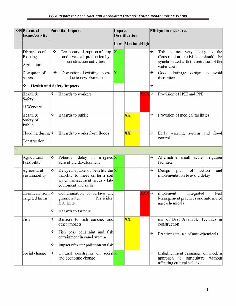
ESIA Report for Zobe Dam and Associated Infrastructures Rehabilitation Works
1
S/N Potential Issue/Activity
Potential Impact Impact Qualification
Mitigation measures
Low MediumHigh
Disruption of Existing
Agriculture
Temporary disruption of crop and livestock production by
construction activities
X This is not very likely as the Construction activities should be synchronized with the activities of the water users
Disruption of Access
Disruption of existing access due to new channels
X Good drainage design to avoid disruption
Health and Safety Impacts
Health & Safety
of Workers
Hazards to workers XXX Provision of HSE and PPE
Health & Safety of Public
Hazards to public XX Provision of medical facilities
Flooding during
Construction
Hazards to works from floods XX Early warning system and flood control
Agricultural Feasibility
Potential delay in irrigated agriculture development
X Alternative small scale irrigation facilities
Agricultural Sustainability
Delayed uptake of benefits dueinability to meet on-farm soil water management needs - laboequipment and skills
X Design plan of action and implementation to avoid delay
Chemicals from irrigated farms
Contamination of surface andgroundwater Pesticides,fertilizers
Hazards to farmers
XXX implement Integrated Pest Management practices and safe use of agro-chemicals
Fish Barriers to fish passage and other impacts
Fish pass constraint and fish entrainment in canal system
Impact of water pollution on fish
XX use of Best Available Technics in construction
Practice safe use of agro-chemicals
Social change Cultural constraints on social and economic change
X Enlightenment campaign on modern approach to agriculture without affecting cultural values

ESIA Report for Zobe Dam and Associated Infrastructures Rehabilitation Works
1
S/N Potential Issue/Activity
Potential Impact Impact Qualification
Mitigation measures
Low MediumHigh
Gender and Vulnerable
Impacts on women and vulnerable groups; including gender based violence and vulnerability to succumb to sexual harassment because of poverty status. Similarly, extension of routes as a result of dykes extension blocking the accustomed routes to farms , markets, neighboring communities and water points
XX Training and enlightenment for women and vulnerable groups on available opportunities. linking them with opportunity sources (like IFAD)
Energy Fuel wood and energy
The area will have less of wood fuel
X Alternative energy (such as solar stoves etc) sources are introduced
Access Restricted wet season access, barrier effects on new channels
X Repair and open up all existing alternative routes
Benefits and
Equity
Inequitable distribution of benefits - incomes & employment
Price reductions in local markets and associated impacts on rain-fed producers
XX 1. Educate the rain fed users to key into the value chain of the produce of the irrigation farmers
2. Association of farmers to be encouraged to control middle men and glut
3. Storage and processing of farm produce must be encouraged
4. Safety nets such as savings and cooperatives
Health Extended malaria season
Increased schistosomiasis
Changes in other diseases
Impacts of continuing low health status on beneficiaries’ ability to benefit from project
Inadequate water, sanitation and hygiene reducing project benefits
Safety hazards
XX 1. Training on Use of Mosquito nets hygiene and sanitation
2. Equip existing health centers with personnel and drugs where new facilities cannot be established
On-farm management
Ineffective operation of WUAs X Help in organising WUAs into vibrant and active bodies

ESIA Report for Zobe Dam and Associated Infrastructures Rehabilitation Works
1
S/N Potential Issue/Activity
Potential Impact Impact Qualification
Mitigation measures
Low MediumHigh
Off-farm
management
Risks of experimental O&M model and inappropriate reservoir management
XX TRIMING in conjunction with SSRBDA and MRVIS to ensure effective reservoir management
Services and
inputs for
agriculture
Reduced project benefits due to inadequate provision of essential agricultural services & inputs including research, knowledge, credit, crop
storage and processing, and links to markets
XX Involve the University, ADPs, Agricultural banks, Agricultural research stations etc in the scheme.
Capital and
operating
costs of
scheme
Reduced project benefits due to under-funding of costs of compensation and resettlement, social support, agricultural research, extension services & farmer training, equipment, environmental & social mitigation and monitoring, etc.
X TRIMING to involve the University, ADPs, Agricultural banks, Agricultural training research stations etc in the scheme.
Key X Low
Negative impact
XX Medium negative impact
XXX High negative impact
6.3 Project Options and analysis of Alternatives
1. No Project Option
The No-project option is the non-implementation option. It assesses the environmental, social and economic pro and cons of leaving the dam and associated infrastructure in their present condition. Not executing the proposed remedial work at the dam embankment with particular emphases on filling and compaction of vegetation and root bowls as well as removal of anthill and termite mounds from the downstream face of the embankment will ultimately serve as a catalyst for internal erosion (piping) and eventual collapse of the embankment with catastrophic consequences of extensive downstream flooding which could lead to possible loss of lives and economic activities.
Failure to monitor uplift pressure on dam structure emanating from dam foundation seepage problem using gauge well (piezometers) and v-notch weir as well as rehabilitating existing seepage control system (inverted filters, relief well and drainage collector) will increase uplift pressure on the dam with a threat on the structural stability of the dam. Therefore, the No-Go Alternative is

ESIA Report for Zobe Dam and Associated Infrastructures Rehabilitation Works
1
not a reasonable alternative and it is necessary to implement the remedial action to avoid such a situation.
2. Delayed Project Option
This option suggests that the proposed dam and associated work rehabilitation project be delayed until a later date. The delayed project option will cause further deterioration of the dam embankment which could be currently corrected by simple maintenance work. Noticed vegetation, root and tree bowls will degenerate into large seepage channels. This will bring about a situation of both embankment and foundation seepage problem necessitating more extensive and expensive seepage control measure such as cutoff wall which could have been avoided.
Postponing rehabilitation works on dam seepage control system, crest level regulation and pipe work (dam appurtenances) will put pressure/stress on the dam structure leading to possible collapse.
For the above reasons, this option is not a viable option and is rejected.
3. Immediate Project Intervention Option
This option means that the project rehabilitation works which involve maintenance of dam monitoring equipment as well as dam and associated infrastructure will go ahead. The proposed dam and associated infrastructure rehabilitation will restore to working condition dam monitoring instruments such as level pin, Piezometer and v-notch weir that provide early signals of faults such as dam crest deformation (settling), increase in uplift/hydrostatic pressure due to foundation seepage as well as increase seepage discharge from relief well that could compromise dam safety.
Maintenance work on the dam embankment with reference to excavation and filling of vegetation root and tree bowls noticed during dam inspection will prevent the emergence of avenues for seepage (piping/internal erosion) through dam embankment. Maintenance and modification of seepage control system which include inverted filter, relief well and collector system of ditches and channels will relief dam structure of excess uplift/hydrostatic pressure associated with foundation seepage as well as improve conveyance of relief well flow downstream. Servicing inlet and outlet pipework as well as valves during rehabilitation works will reassure reservoir safety. Downstream flooding of valve chamber will cease with the proposed servicing of the flap (non-return) valve on the drain pipe. Construction of dam access road from right abutment to valve tower as part of Zobe dam rehabilitation will provide access for maintenance and emergency.
Judging from the above benefits of the go-ahead option as well as the environmental and social impacts of carrying out remedial work under this option, the go-ahead option is considered the most viable and recommended for implementation.
4. Alternative Option for Project Execution
In making recommendations for remedial work at Zobe Dam following dam safety inspection, the consultant concentrated efforts in proposing ways of restoring to working conditions existing dam monitoring and seepage control instruments. However, it is important to compare and contrast in terms of cost, benefit and environmental risk of possible/existing alternatives to suggested rehabilitation methods (execution options) under the go-ahead option.

ESIA Report for Zobe Dam and Associated Infrastructures Rehabilitation Works
1
Water levels in observational wells at the downstream face of the dam or within the vicinity of the dam could indirectly be used to gauge dam site uplift pressure. However, there will be need to drill so many more of such observational well at additional cost to the project. Moreso, observational well within the vicinity of the dam are further away from the dam and may have least response to changing uplift pressure at the dam site.
Generally speaking, results obtained using observational wells using an indirect approach will not be as accurate as results from piezometers which are very sensitive to low pressure changes. Environmentally speaking, it is safer to use piezometer to gauge piezometric levels in the foundation downstream of the dam as against using observational well. Therefore, flushing piezometers with water to bring them to working conditions for the purpose of monitoring increase in hydrostatic pressure from foundation seepage flow is the best option.
When operational, flow from inverted filter as well as pressure relief well should be monitored. Flow meters could be placed in the drainage ditches and used to monitor flows from pressure relief well. However most of the available flow meters are not as sensitive to low flow as v-notch weir suggested by the consultants. Replacing submerged and damaged v-notch weir on drainage ditch which monitors flow from inverted filter at dam toe is the most reasonable option offering the best result.
Crest level deformation/settlement monitoring using high resolution Light Detection And Ranging (LiDAR) could offer an alternative option to the recommended pin leveling using differential global positioning system (DGPS). LiDAR has the advantage of providing accurate height information over a long length of embankment in shorter time than DGPS leveling. However, the cost of using aerial LiDAR is prohibitive and its use can only be justified in very difficult dam terrain or where time is of essence. For the purpose of Zobe dam and associated infrastructure rehabilitation, crest level deformation monitoring by DGPS will be the best viable option.
The Feasibility study observed that compressed air was used to lift silt like material from the gauged well (piezometer) and artesian pressure relief well. This method is ineffective and likely to displace sand around well screen which will adversely affect flow through the well screen. Flushing well with water as suggested by the consultants will flush sand upwards into a settlement tank and be safely disposed off. This method is more effective and environmentally friendly and is the most viable option.

ESIA Report for Zobe Dam and Associated Infrastructures Rehabilitation Works
1
CHAPTER SEVEN ENVIRONMENTAL AND SOCIAL MANAGEMENT PLAN (ESMP)
7.1 Introduction In the heart of every ESIA is the provision of an essential link between the impacts predicted and mitigation measures specified within the report and final design, implementation and operational activities. This is the ESMP. The ESMP serves as ‘a tool that ensures undue or reasonably avoidable adverse impacts of the project are prevented during the construction, operation and decommissioning’ phases. It serves as an essential tool for ensuring that the mitigation of negative impacts and enhancement of positive impacts are carried out effectively during the project life-cycle. The ESMP is intended to document the actions necessary to prevent or minimize predicted negative impacts, and to provide a framework for the systematic management of environmental responsibilities, impacts and risks. It will contribute greatly to the success or failure of the sustainability of a project since it is designed to mitigate negative impacts of developments and includes monitoring which measures compliance to established requirements. The main elements of the ESMP include the following:
Mitigation - Identifies and summarizes all anticipated significant adverse environmental impacts including a waste management strategy.
Monitoring & Auditing Schemes - Provides information about key environmental aspects of the project, particularly the environmental impacts of the project and the effectiveness of mitigation measures.
Institutional arrangement/measures – mechanism put in place to implement the mitigation measures, the monitoring and auditing plans to ensure continual improvement.
Budget – A budget for implementing the ESMP will be included in the Draft Final Report for guidance and planning purposes. It will be designed in a manner that it could serve as a standalone documents for easy extraction for project implementation.
This chapter discusses the Environmental and Social Management Plan and outlines the measures to be taken during project pre-implementation, implementation and operation phases to control adverse environmental and social impacts and the actions needed to implement these measures. The ESMP includes the following components: Summary of the potential impacts of the proposed project; Description of the recommended mitigation measures; Description of monitoring program; Institutional arrangement (responsibilities for mitigation and monitoring) including
recommendations for strengthening existing institutional capacity; Implementation schedule and reporting procedures; Cost estimates and sources of funds. 7.2 Impact Assessment Management The significant potential environmental and social impacts for which mitigation is required have been identified and discussed extensively in Chapter five. The mitigation measures are based on recommended good practice, regulatory requirements and contributions received from relevant stakeholders. The primary objectives of the mitigation measures are: Avoidance – To avoid project activities that could result in adverse impacts and certain
types of resources considered to be environmentally sensitive

ESIA Report for Zobe Dam and Associated Infrastructures Rehabilitation Works
1
Prevention – To consider measures aimed at impeding the occurrence of negative environmental impacts and/or preventing such an occurrence having harmful environmental and social impacts.
Minimization – To limit or reduce the degree, extent magnitude or duration of adverse impacts.
Compensation – To consider measures aimed to remedy or compensate for unavoidable residual impacts.
Tables 7.1 to 7.3 outlines the corresponding mitigation/enhancement measures for potential environmental and social impacts that are envisaged to occur during project activities.

ESIA Report for Zobe Dam and Associated Infrastructures Rehabilitation Works
120
Table 7.1 ESMP of Zobe Dam Rehabilitation Project (Pre-Rehabilitation Phase Component Sub
Component Activities Potential Impact Mitigation Measures Monitoring Indicators Monitoring
Frequency Institutional Responsibility
Cost (Naira)
Environment
Air
Mobilisation of workers,
equipment and materials to Zobe
Dam site
Air quality deterioration from release of dust and exhaust fumes from movement of heavy
duty vehicle and equipment in work
area
Reduce effect of dust by spraying water.
Air quality parameters are within acceptable limits.
Daily Mitigation: Contractor Monitoring: NESREA, FMEnv, Contractor
1,500,000.00 450,000.00
Ensure that vehicles are serviced; undergo vehicle emission testing (VET) and vehicle exhaust screening (VES) as laid down in the NESREA guidelines.
Ensure that vehicles are serviced; undergo vehicle emission testing (VET) and vehicle exhaust screening (VES) as laid down in the NESREA guidelines.
Every two Months
Vegetation
Mobilisation of workers,
equipment and materials to Zobe
Dam site
Loss of vegetal cover at dam site
Limit vegetation removal during site clearance for contractor’s camp site.
Area cleared is limited and just enough for setting up
Contractor’ camp. One-off
Mitigation: Contractor Monitoring: NESREA, FMEnv, TRIMING
1,200,000.00 550,000.00
Exposing soil to erosion.
Soil
Mobilisation of workers,
equipment and materials to Zobe
Dam site
Loss of top soil and compaction due to movement of vehicle to site and stacking of heavy duty equipment
Limit vehicle and equipment stacking to suitable designated areas
Demarcated parking area for vehicle as well as equipment stacking. Visible warning signs and directional arrows leading to designated areas for parking and stacking.
Weekly
Mitigation: Contractor
Monitoring: NESREA, FMEnv,
TRIMING
6,000,000.00 2,000,000.00 Soil contamination
from fuel and lubricant leakages from stacked equipment and vehicle.
Provide paved area or impermeable platform for vehicle parking and stacking of equipment.
Installation of impermeable platform at designated parking and stacking areas.
Weekly
Noise Mobilisation of workers, equipment and materials to Zobe Dam site
Increase in noise level above permissible limit (90dB) during movement of vehicle and equipment to site.
To minimise anticipated increase in noise level at this stage, develop a noise reduction plan. Consider moving heavy vehicle and equipment in the evening to reduce disturbances.
A noise reduction plan developed and implemented
Weekly
Mitigation: Contractor Monitoring: FME, Contractor
3,500,000.00 1,000,000.00
Social Traffic Mobilisation of
workers, Traffic Congestion and increase risk of
Provide training for drivers on road safety with
Number of trained drivers. Daily Mitigation: Federal Road

ESIA Report for Zobe Dam and Associated Infrastructures Rehabilitation Works
121
Component Sub Component
Activities Potential Impact Mitigation Measures Monitoring Indicators Monitoring Frequency
Institutional Responsibility
Cost (Naira)
equipment and materials to Zobe
Dam site
road accident and injuries
particular emphasises on haulage and pedestrian safety.
Number of road traffic accidents (RTA) recorded. Number of complaint received from dam site communities.
Safety Corps (FRSC),
Contractor.
Monitoring: FRCS
2,500,000.00 1,000,000.00
Implement traffic Management plan (TMP) such as strict enforcement of speed limit, use of road safety signage and minimization of peak period movement to avoid any form of congestion or delay in travel time to other road users as a result of increase in volume of traffic. Mobilization to dam site should be carried out during off peak hours.
Submission of TMP, flow of traffic as well as installation of safety signage and signals
Social Interactions
Influx of people due to employment opportunities
Pressure on social amenities and increase in the rate of criminal activities including gender based violence
Increase the number of facilities and locations. Constructing and designating those for males and females to reduce rate of interactions with opposite sex
Public facilities labeled for males and females
Daily Mitigation: Contractor Monitoring: TRIMING
5,000,000.00
Noise Mobilisation of workers,
equipment and materials to Zobe
Dam site
Disturbance to dam site communities
Fit silencers and sound proofing devices to construction vehicle and equipment
Silencers and sound proofing equipment are being fitted.
Daily Mitigation: Contractor Monitoring: FME, NESREA
3,400,000.00 1,000,000.00

ESIA Report for Zobe Dam and Associated Infrastructures Rehabilitation Works
122
Component Sub Component
Activities Potential Impact Mitigation Measures Monitoring Indicators Monitoring Frequency
Institutional Responsibility
Cost (Naira)
Air Mobilisation of workers, equipment and materials to Zobe Dam site
Dam site communities being put at respiratory and eye health risk from raised dust and vehicle fume in the air.
Provide face mask and appropriate PPE for residents of dam site and environ as well as project staff. Barricade rehabilitation/construction area prior to commencement of work to limit movement around project area in anticipation of dust and fume emission.
Facemask and PPE are being provided Installation of barricade and provision of warning signs around rehabilitation/construction area.
Mitigation: Contractor, TRIMING PMU Monitoring: FMEn, NESREA, TRIMING Safe Guard unit
1,800,000.00 850,000.00
Occupational Health and Safety
Diseases and disorders. Water safety
Access road construction, embankment rehabilitation
Risk of occupational diseases e.g respiratory eye disorders, noise related problems, stings and bites as a result of exposures to hazards.
Provision of PPE to workers; Emergency contingency plans; Education of workers; Incident/accident reporting; Provision of First Aid onsite. Installation of hand washing devices and hand sanitizers at designated points. Reduce person to person contacts, maintaining physical distance
Use of appropriate PPE around project site during working hours. Frequent hand wash and sanitizers Awareness training on associated risks such as that from working near water as well as excavations. Sensitization on the risks of communicable diseases.
Daily Mitigation: Contractor Monitoring: Environmental Specialist TRIMING PMU, Social Development specialist. Ministry of Health.
2,000,000..00 1,500,000.00
PRE-REHABILITATION PHASE TOTAL 40,650,000

ESIA Report for Zobe Dam and Associated Infrastructures Rehabilitation Works
123
Component Sub Component
Activities Potential Impact Mitigation Measures Monitoring Indicators Monitoring Frequency
Institutional Responsibility
Cost (Naira)
Table 7.2 ESMP of Zobe Dam Rehabilitation Project (Rehabilitation Phase) Component
Sub component
Activities Potential Impact Mitigation Measures Monitoring Indicators Monitoring Frequency
Institutional Responsibility
Cost (N)
Environment
Air Embankment crest and slope remediation work (excavation, burrowing, filling, backfilling and compaction)
Air quality deterioration from particulate matter (dust) raised during embankment remediation earthwork.
Use adequate water during backfilling and compaction of excavated animal burrow areas and root bowels
Suspended particulate matter (SPM)/dust in the air. Operated water distributor or other means of adding required amount of water evenly to fill
Daily Daily
Mitigation: Contractor, Project Consultant Monitoring: TRIMING PMU Project engineer/PMU Environmental safeguard specialist
2,300,000.00 1,500,000.00
Embankment Slope
Embankment crest and slope remediation work (excavation, burrowing, filling, backfilling and compaction)
Plant waste generated during embankment remedial work will impede free flow of water creating slope gullies that could undermine the dam integrity if not properly disposed of
Vegetal waste should be safely disposed of by using shrub/tree grinder.
Dam site tree grinding activity
Daily
Mitigation: Contractor, Project Consultant Monitoring: TRIMING PMU Project engineer/PMU Environmental safeguard specialist
2,000,000,00 1,200,000.00
Loss of downstream slope protection (grass cover) creating avenue for slope erosion.
Provide slope protection in affected areas as part of embankment crest and slope maintenance work
Contractor’s Compliance
Soil
Onsite equipment maintenance and fueling
Fuel and lubricant leak could be a source of soil and
Onsite maintenance work should be avoided as much as possible. If inevitable, Onsite/ dam
Soil test (pH, TOC, Heavy metals, THC. Ground water quality test (pH, TSS, DO, TDS, EC,
Monthly Mitigation: Contractor, Project Consultant
1,350,000.00

ESIA Report for Zobe Dam and Associated Infrastructures Rehabilitation Works
124
Component Sub Component
Activities Potential Impact Mitigation Measures Monitoring Indicators Monitoring Frequency
Institutional Responsibility
Cost (Naira)
ground water pollution
site maintenance work should be undertaking on Impervious surface to reduce risk of soil and ground water contamination
BOD5, Heavy Metals, hydrocarbon, turbidity). Sound Management practice and standard operating procedure (SOP)
Monitoring: TRIMING PMU Project engineer/PMU Environmental safeguard specialist
950,000.00
Cleaning/ flushing of relief wells and gauge well (piezometer) with water to bring them to working condition
Soil contamination from mucky water blown out of well during rehabilitation (redevelopment)
Mucky or dirty water and sediments flushed out during well rehabilitation should be collected using PVC drum and safely disposed of later. Flushed mucky water should be pumped away beyond well area of influence to avoid recirculation and then treated before discharge to water body.
Observance of standard environmental management procedures in well rehabilitation. Undertake ground water contamination risk assessment and develop a protection plan.
One-off Mitigation: Contractor, Project Consultant Monitoring: TRIMING PMU Project engineer/PMU Environmental safeguard specialist
1,750,000.00 870,000.00
Solid Waste Indiscriminate disposal of other construction wastes (equipment packaging materials, plastics, sanitary and office wastes).
Possible soil and water contamination from poor management of solid/construction waste.
Liaise with Dutsin Ma LGA to ensure that construction waste is properly collected and disposed.
Proper arrangement for routine disposal of other construction waste.
Weekly Mitigation: Contractor, Dutsin Ma LGA Monitoring: Katsina State Waste Management agency. KSMEnv
1,600,000.00 1,200,000.00
Noise General construction work
Noise pollution from construction/ rehabilitation work
Limit noise to the confines of rehabilitation
Contractor’s compliance One-off Mitigation: Contractor
900,000.00

ESIA Report for Zobe Dam and Associated Infrastructures Rehabilitation Works
125
Component Sub Component
Activities Potential Impact Mitigation Measures Monitoring Indicators Monitoring Frequency
Institutional Responsibility
Cost (Naira)
work space by providing noise barriers.
Monitoring: FME, NESREA
700,000.00
Surface Water quality/ Sediments
Drainage ditch manual cleaning and bed slope modification for a self-cleaning discharge is likely to cause deterioration of water quality downstream at point of discharge
Sediments and debris removed from inverted blanket drainage ditch is likely to affect water quality downstream at point of discharge if not properly disposed of.
Collect and dispose sediments and debris in an environmentally friendly manner away from point of discharge of ditch into Karaduwa river downstream
Ditch flowing freely One-off Mitigation: Contractor Monitoring: TRIMING Environmental Specialist
6,000,000.00 4,200,000.00
Air Access road construction from Dam Crest to right abutment.
Providing access road for maintenance and emergencies along the dam crest from the right abutment will necessitate earthworks which will lead to air quality deterioration as dust will inevitably be raised.
Spray water during excavation, grading and road surfacing works.
Gaseous emissions (CO, NOX, SOX, VOC) and suspended particulate matter (SPM)/dust . Operated water distributor or other means of adding required amount of water evenly to fill
Daily
Mitigation: Contractor, Project Consultant Monitoring: TRIMING PMU Project engineer/PMU Environmental safeguard specialist
3,400,000.00 1,000,000.00
Social Noise & Vibration
Compaction and/or grading during embankment remediation/ access road
Disturbances from heavy duty equipment such as roller compactors will bring great discomfort to dam site residents.
Use small light vibratory hand operated roller compactors with the required number of passes to achieve the desired density of compaction.
Presence of hand operated compactor or excavator with a vibrating plate compactor attachment.
Daily Mitigation: Contractor Monitoring:
1,400,000.00 800,000.00

ESIA Report for Zobe Dam and Associated Infrastructures Rehabilitation Works
126
Component Sub Component
Activities Potential Impact Mitigation Measures Monitoring Indicators Monitoring Frequency
Institutional Responsibility
Cost (Naira)
construction works.
Project engineer/PMU Environmental safeguard specialist
Occupational Health and Safety
Accidents and Injuries.
Use of machinery and equipment during dam and appurtenances rehabilitation.
Risk of occupational accidents and injuries from the use of machineries and equipment. Risks of injuries due to slippery floors and materials not appropriately disposed.
Provide workers with appropriate PPE Use of appropriate floor materials. Construction of access points for the physically challenged. Provide first aide on site and train first aiders. Implement HSE plan and encourage workers to assess generic and site specific risk before undertaking a task.
Contractor’s compliance with provision of appropriate PPE. Number of trained first aiders amongst construction staff. Number of personnel trained on basic health and safety observance (including risk assessment)
Daily Daily Daily
Mitigation: Contractor Monitoring: Environmental Specialist TRIMING PMU, Social Development specialist. Ministry of Health.
2,300,000.00 1,600,000.00
Public Health and Safety
Public Health Impacts (Including wellbeing, communicable & non-communicable diseases)
Male construction staff involving in casual sexual activities in local communities within the project area.
Risk of transmitting infectious diseases such as HIV/AID and other STDs Risk of communicable diseases such as
Conduct training on occupational health and associated diseases for construction workers. Increase community awareness through campaigns on sexually transmitted infection and other infectious diseases.
Occupational health risk assessment conducted. Health screening in project affected areas. Awareness campaign conducted in communities
One-off Monthly
Mitigation: Contractors, Monitoring: Environmental Specialist TRIMING PMU, Social
1,800,000.00 1,100,000.00

ESIA Report for Zobe Dam and Associated Infrastructures Rehabilitation Works
127
Component Sub Component
Activities Potential Impact Mitigation Measures Monitoring Indicators Monitoring Frequency
Institutional Responsibility
Cost (Naira)
COVID-19 pandemic amongst others associated with closed working environment and physical contact.
with the support of health officials.
Quarterly Development specialist. Ministry of Health. Use of appropriate PPESocial distancing.
REHABILITATION PHASE TOTAL 37,920,000

ESIA Report for Zobe Dam and Associated Infrastructures Rehabilitation Works
128
Table 7.3 ESMP of Zobe Dam Rehabilitation Project (Operation & Maintenance Phase) Component Sub
component Activities Potential Impacts Mitigation Measure Monitoring Indicators Monitoring
Frequency Institutional Responsibility
Cost (N)
Environment
Water quality Operation of relief well and the use of collector drain/pipe
Deterioration (increase in turbidity) of Karaduwa river downstream of drainage collection discharge point from sediment blown out with seepage flow.
Routinely clean well (well rehabilitation). Incorporate sump in the drainage collection system design to settle down/filter relief well flows before discharging into Karaduwa river downstream. Separate seepage flow from relief well from other drainage flows for easy identification of problem.
Examine flow over v-notch weir for sediment while taking readings. In-situ water quality test at discharge/injection point (Karaduwa river downstream)
Monthly. Monthly.
Mitigation: Contractor Monitoring: Project engineer Environmental Specialist TRIMING PMU
1,000,000.00 500,000.00
Separated and modified self-cleaning drainage ditch.
Increase in turbidity at the drainage ditch injection point into river Karaduwa due to sediments and debris in flows contributed to the drainage collection system from other sources (eg. Inverted filter, toe drain) other than relief well flow
Provide debris barrier and settling points in the design of the drainage collection system to prevent/reduce sediment discharge into Karaduwa river. Regularly monitor inverted filter and v-notch weir for evidence of soil detachment or migration.
Examine flow over v-notch weir for sediment while taking readings. . In-situ water quality test at discharge/injection point (Karaduwa river downstream
Monthly Monthly
Mitigation: Contractor Monitoring: Project engineer Environmental Specialist TRIMING PMU
1,000,000.00 500,000.00
Flooding Operation of overall drainage control system (inverted drainage
Flooding of downstream dam toe due to inadequate capacity of drainage
Monitor rise in seepage flow by using v-notch weir on the collector drain to measure flow
Available readings form V-notch weir as well as piezometer.
Monthly
Mitigation: Contractor
1,000,000.00

ESIA Report for Zobe Dam and Associated Infrastructures Rehabilitation Works
129
blanket and relief well).
control system with particular reference to relief well. Flow rejection at Relief well collector pipe due to increase in seepage flow.
rates and piezometers to determine the saturation levels (phreatic surface) at the embankment. Using flow net programme or ground water hydraulic (finite element/ finite difference method) model to determine hydrostatic/uplift pressure at the embankment and ascertain the adequacy or otherwise of the present relief well layout and suggest quantity and location of additional relief wells.
Availability of verified and calibrated hydraulic model
One-off
Monitoring: Project engineer Environmental Specialist TRIMING PMU
500,000.00
Inverted filter drainage ditch
Flow back up due to occasional blockage from vegetation and debris
Routinely observe ditch for blockages. Remove blockages to clear ditch path way. If available, use drain CCTV camera for more regular check
Contractor’s Compliance Weekly Daily
Mitigation: Contractor Monitoring: Project engineer Environmental Specialist TRIMING PMU
500,000.00
Ground water Pollution
Pollution of ground water via piezometer/relief well at dam toe flooding occasioned by inverted filter drainage ditch usage.
Provide protective cover for piezometer.
Compliance with respect to protective cover.
500,000.00
ESIA Report for Zobe Dam and Associated Infrastructures Rehabilitation Works
130
OPERATION & MAINTENANCE PHASE TOTAL 5,500,000.00

ESIA Report for Zobe Dam and Associated Infrastructures Rehabilitation Works
131
7.3 Monitoring Program
Monitoring is a mechanism or tool to ensure adherence to agreed actions, to assess compliance, and to provide enhanced data for refined risk management purposes. Environmental monitoring during project implementation provides information about key environmental aspects of the project and the effectiveness of mitigation measures, which enables proper evaluation of the success of the mitigation and allows for any additional corrective action to be taken when needed. Specifically, the objectives for instituting a monitoring program are to: Ensure implementation and check effectiveness of recommended mitigation measures; Demonstrate that project activities are carried out in accordance with the prescribed mitigation
measures and existing regulations procedure; and Provide early warning signals whenever an impact indicator approaches a critical level. In order to effectively and efficiently implement this ESMP, an environmental performance monitoring program has been designed to attain the above objectives. The monitoring program provides specific description and technical details of monitoring measures, including the parameters to be measured, methods to be used, sampling locations, frequency of measurements, detection limits (where appropriate), and definition of thresholds that will signal the need for corrective actions. It also includes monitoring and reporting procedures to (i) ensure early detection of conditions that necessitate particular mitigation measures, and (ii) furnish information on the progress and results of mitigation. Monitoring plan (indicators, frequencies and institutional responsibility) have been incorporated in Environmental and Social Management plan (ESMP) in tables 7.1-7.3 above. Monitoring and Reporting Procedure The environmental monitoring activities will be based on observed indicators of emissions, effluents, and resource use applicable to Zobe Dam Rehabilitation Project. Monitoring frequency will be such that sufficient data on the parameter being monitored is provided for further analysis. Monitoring data will be analysed and routinely compared with the operating standards for necessary corrective actions. For effective monitoring, the following measures will be taken: Monitoring will be conducted by trained Environmental Officers and other relevant
personnel; Measuring equipment will be accurately calibrated; Quality control of sampling undertaken will be ensured; Accredited laboratories will be used; Certified methods of testing will be employed and where legal specifications exist for testing
and sampling methods, these will be taken into account. Monitoring Environmental monitoring will be undertaken internally as well as externally using various methods. Internal monitoring will be carried out onsite by the contractor and the supervisor engineer on an on-going basis as specified in the monitoring plan. TRIMING Environment and Social Safeguard Officer (ESO) is to provide further supervision to ensure that mitigation measures specified in the monitoring plans are satisfactorily implemented. ESO monitoring activities will be done by checking regularly monitoring reports to be submitted by the contractor and by carrying out regular site visit.

ESIA Report for Zobe Dam and Associated Infrastructures Rehabilitation Works
132
External monitoring will be carried out by Katsina State Ministry of Environment (KSME), Federal Ministry of Environment (FMEnv), World Bank (WB) and other relevant agencies such as National Environmental Standard and Regulation Enforcement Agency (NESREA) that may be required. These institutions /agencies will check report received periodically and carry out an independent inspection and/or audit. Reporting and Corrective Actions Reporting is an important tool for progress review. The following reports shall be required and submitted to cover all environment management plan monitoring activities for Zobe dam rehabilitation work. Monthly Progress and Monitoring Reports: These reports are to be prepared on a
monthly basis by contractor’s environment officer (EO) or any person in similar capacity to cover all monitoring activities or any specific event as the case may be. These reports are to be made available to FMEnv and Katsina State Ministry of Environment on specified or agreed dates.
Quarterly report: This report essentially summarises all the monthly reports covering on a quarterly basis. The quarterly monitoring report should contain the following aspects of the ESMP implementation:
1. Brief introduction to activities 2. Objectives and scope of monitoring 3. Monitoring parameters 4. Field observations and analysis. 5. Percentage of safeguard compliance 6. Non-compliance issues, gaps and weaknesses 7. Recommendations for corrective measures 8. Data, analysis results and pictures
Records Record keeping is the documentation of mitigation and monitoring activities and provides evidence of compliance. They are required to track performance and other data necessary to achieve and demonstrate compliance with the ESMP. Records to be kept will include the followings:
Complaint records; Training records; Inspection, maintenance and calibration records; Monitoring data and audit results; Identified problems and corrective actions taken; Incident reports; and Significant communications with regulators.
The proper organisation of these records is essential to the successful implementation of this ESMP. Procedures for the identification, collection, indexing, filing, storage, maintenance, retrieval and retention of records will therefore be established, implemented and maintained.

ESIA Report for Zobe Dam and Associated Infrastructures Rehabilitation Works
133
7.4 Environmental Management Responsibility The successful implementation of this ESMP depends on the commitment and capacity of various institutions and stakeholders to implement the ESMP effectively. The ESMP identifies for each potential impact, proposed mitigation measures and institutions (parties or agencies) charged with the responsibility of implementing those measures. These institutions can be separated into executing and supervising agencies. The execution agencies will include for this project the contracted design institute/consultant and construction contractors. The consultant will be responsible for obtaining all necessary permits from state and local government agencies before the rehabilitation works are tendered out. The contractors shall be responsible for physical implementation of the mitigation measures provided under the ESMP during the rehabilitation phase according to the World Bank (WB) policies. The supervising agencies are responsible for supervising the execution agencies to ensure that they execute the mitigation measures as planned. The arrangement as well as the roles and responsibilities of the institutions and persons that will be involved in the implementation, monitoring and review of the ESMP are further discussed below. The roles and responsibilities of the various institutions in the implementation of this ESMP are outlined in Table 7.4. Table 7.4: Institutional Responsibilities S/N Category Roles & Responsibilities 1. Federal Ministry of
Environment / SRRBA
Implementing authority, has the mandate to: Co-ordinate all policies, programmes and actions of TRIMING
intervention in Zobe dam rehabilitation project. Ensure the smooth and efficient implementation of the project’s
dam rehabilitation components.2 Federal Ministry of
Environment/EIA Department and NESREA
Lead role - provision of advice on screening, scoping, review of draft ESMP report, receiving comments from stakeholders, public hearing of the project proposals, and convening a technical decision-making panel, Project
Receive comments (require revisions where necessary), provide approval and needed clearance for the ESMP and other environmental clearance in collaboration with the Katsina State Ministry of Environment (KSME);
Review Monitoring Reports from KSME; Ensure that corrective actions are taken for significant
environmental and social impacts; Undertake periodic site visits to inspect and verify the nature
and extent of impacts and the success or lack of, of the mitigation measures.
3 Katsina State Ministry of Environment (KSME)
Environmental compliance overseer at the State level Lead role - provision of advice on screening, scoping, review of
draft ESMP report (in liaison with Federal Ministry of Environment)
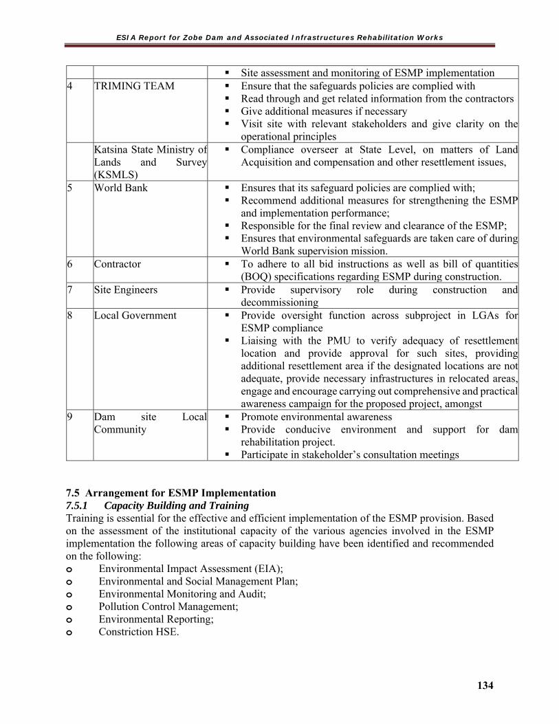
ESIA Report for Zobe Dam and Associated Infrastructures Rehabilitation Works
134
Site assessment and monitoring of ESMP implementation4 TRIMING TEAM
Ensure that the safeguards policies are complied with Read through and get related information from the contractors Give additional measures if necessary Visit site with relevant stakeholders and give clarity on the
operational principles Katsina State Ministry of
Lands and Survey (KSMLS)
Compliance overseer at State Level, on matters of Land Acquisition and compensation and other resettlement issues,
5 World Bank Ensures that its safeguard policies are complied with; Recommend additional measures for strengthening the ESMP
and implementation performance; Responsible for the final review and clearance of the ESMP; Ensures that environmental safeguards are taken care of during
World Bank supervision mission.6 Contractor To adhere to all bid instructions as well as bill of quantities
(BOQ) specifications regarding ESMP during construction.7 Site Engineers Provide supervisory role during construction and
decommissioning8 Local Government Provide oversight function across subproject in LGAs for
ESMP compliance Liaising with the PMU to verify adequacy of resettlement
location and provide approval for such sites, providing additional resettlement area if the designated locations are not adequate, provide necessary infrastructures in relocated areas, engage and encourage carrying out comprehensive and practical awareness campaign for the proposed project, amongst
9 Dam site Local Community
Promote environmental awareness Provide conducive environment and support for dam
rehabilitation project. Participate in stakeholder’s consultation meetings
7.5 Arrangement for ESMP Implementation 7.5.1 Capacity Building and Training Training is essential for the effective and efficient implementation of the ESMP provision. Based on the assessment of the institutional capacity of the various agencies involved in the ESMP implementation the following areas of capacity building have been identified and recommended on the following: o Environmental Impact Assessment (EIA); o Environmental and Social Management Plan; o Environmental Monitoring and Audit; o Pollution Control Management; o Environmental Reporting; o Constriction HSE.
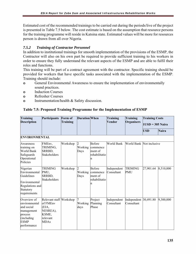
ESIA Report for Zobe Dam and Associated Infrastructures Rehabilitation Works
135
Estimated cost of the recommended trainings to be carried out during the periods/live of the project is presented in Table 7.5 below. The cost estimate is based on the assumption that resource persons for the training programme will reside in Katsina state. Estimated values will be more for resources person is drawn from all over Nigeria. 7.5.2 Training of Contractor Personnel In addition to institutional trainings for smooth implementation of the provisions of the ESMP, the Contractor will also on his own part be required to provide sufficient training to his workers in order to ensure they fully understand the relevant aspects of the ESMP and are able to fulfil their roles and functions. This training will be part of a contract agreement with the contractor. Specific training should be provided for workers that have specific tasks associated with the implementation of the ESMP. Training should include: o General Environmental Awareness to ensure the implementation of environmentally
sound practices. o Induction Courses o Refresher Courses o Instrumentation/health & Safety discussion. Table 7.5: Proposed Training Programme for the Implementation of ESMP
Training Description
Participants Form of Training
Duration When Training Vendor
Training Organisers
Training Costs
1USD = 305 Naira
USD Naira
ENVIRONMENTAL
Awareness training on World Bank Safeguards Operational Policies
FMEnv, TRIMING, SRRBD, Stakeholders
Workshop 2 Working Days
Before commencement of rehabilitation
World Bank World Bank Not inclusive
Nigerian Environmental Guidelines
Environmental Regulations and Statutory requirements
TRIMING PMU, SRRBD, Stakeholders
Workshop 2 Working Days
Before commencement of rehabilitation
Independent Consultant
TRIMING PMU
27,901.64 8,510,000
Overview of environmental and social management process (including ESMP performance
Relevant staff of FMEnv (EIA, NESREA), KSME, relevant MDAs
Workshop 7 Working days
Project Planning Phase
Independent Consultant
Independent Consultant
30,491.80 9,300,000

ESIA Report for Zobe Dam and Associated Infrastructures Rehabilitation Works
136
Training Description
Participants Form of Training
Duration When Training Vendor
Training Organisers
Training Costs
1USD = 305 Naira
USD Naira
Monitoring and Reporting).
DAM SAFETY
Dam instrumentation training & GIS/GPS
SRRBDA Refresher Course
2 Working days
Operation Phase
Independent Consultant (Dam Expert)
Independent Consultant (Dam Expert)
30,573.77 9,325,000
Dam Break (Failure Modes & introductory breach modelling)
TRIMING
SRRBDA
Lecture & Field visit
2 Working days
Operation Phase
Independent Consultant (Dam Expert)
Independent Consultant (Dam Expert)
16,918.03 5,160,000
Disaster Management/Emergency preparedness
Local Government.
FMEnv
KSME
Workshop 2 Working Days
Before commencement of rehabilitation
NEMA TRIMING 17,147.54 5,230,000
HEALTH, SAFETY & ENVIRONMENT
Overview of Public Health Impact Assessment
Local Communities, Stakeholders
Lecture 1 Working Day
Before commencement of rehabilitation
Federal Ministry of Health (FMH)/KSMH
TRIMING 6,681.97 2,038,000
Environmental health
Local Community, Stakeholders, FMEnv, Contractors
Lecture 1 Working Day
Before commencement of rehabilitation Phase
Federal Ministry of Health (FMH)/KSMH
TRIMING 6,681.97 2,038,000
OCCUPATIONAL HEALTH AND SAFETY (OHS)
Occupational health and safety management system.
Contractor, FMEnv, Relevant MDAs
Lecture/ e-training
1 Working Day
Project Rehabilitation Phase
Federal Ministry of Health (FMH)/KSMH
TRIMING 10,472.13 3,194,000
Occupational Safety Assessment (Generic & Specific)
Contractor, FMEnv, Relevant MDAs
Lecture/ e-training
1 Working Day
Project Rehabilitation Phase
Federal Ministry of Health (FMH)/KSMH
TRIMING 10,472.13 3,194,000
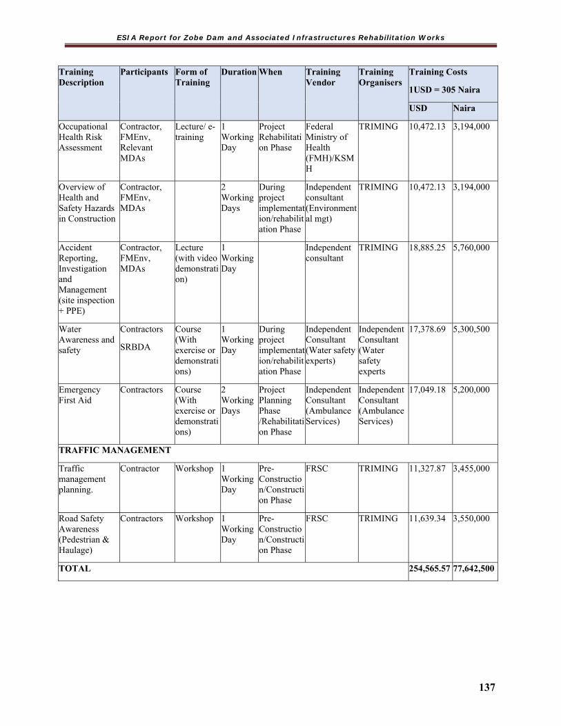
ESIA Report for Zobe Dam and Associated Infrastructures Rehabilitation Works
137
Training Description
Participants Form of Training
Duration When Training Vendor
Training Organisers
Training Costs
1USD = 305 Naira
USD Naira
Occupational Health Risk Assessment
Contractor, FMEnv, Relevant MDAs
Lecture/ e-training
1 Working Day
Project Rehabilitation Phase
Federal Ministry of Health (FMH)/KSMH
TRIMING 10,472.13 3,194,000
Overview of Health and Safety Hazards in Construction
Contractor, FMEnv, MDAs
2 Working Days
During project implementation/rehabilitation Phase
Independent consultant (Environmental mgt)
TRIMING 10,472.13 3,194,000
Accident Reporting, Investigation and Management (site inspection + PPE)
Contractor, FMEnv, MDAs
Lecture (with video demonstration)
1 Working Day
Independent consultant
TRIMING 18,885.25 5,760,000
Water Awareness and safety
Contractors
SRBDA
Course (With exercise or demonstrations)
1 Working Day
During project implementation/rehabilitation Phase
Independent Consultant (Water safety experts)
Independent Consultant (Water safety experts
17,378.69 5,300,500
Emergency First Aid
Contractors Course (With exercise or demonstrations)
2 Working Days
Project Planning Phase /Rehabilitation Phase
Independent Consultant (Ambulance Services)
Independent Consultant (Ambulance Services)
17,049.18 5,200,000
TRAFFIC MANAGEMENT
Traffic management planning.
Contractor Workshop 1 Working Day
Pre-Construction/Construction Phase
FRSC TRIMING 11,327.87 3,455,000
Road Safety Awareness (Pedestrian & Haulage)
Contractors Workshop 1 Working Day
Pre-Construction/Construction Phase
FRSC TRIMING 11,639.34 3,550,000
TOTAL 254,565.57 77,642,500

ESIA Report for Zobe Dam and Associated Infrastructures Rehabilitation Works
138
7.5.3 Cost Estimate for ESMP Implementation Cost estimates have been prepared for the implementation of the mitigation & monitoring measures as well as capacity building provided in this ESMP. The cost of mitigation by the Contractor will be included in the contract as part of the implementation cost by the Contractor and is not included in the total sum in Table 7.6. The total estimated cost inclusive of contingency for the ESMP with regards to implementation of monitoring measures and capacity building is N178,248,525.00, i.e., One hundred and Seventy-Eight million, Two hundred and Forty-Eight Thousand, Five hundred and Twenty Five naira only.
Table 7.6 Estimated Cost for ESMP Implementation S/N Item Responsibilities Cost (N) 1 Mitigation TRIMING PMU OFFICE,
contractors, 93,900,000.00
2 Monitoring TRIMING, WUA, SRRBDA 18,360,500.00 3 Capacity Building World Bank, TRIMING,
Independent consultant, FRSC,NEMA, FMH, KSMH
57,500,000.00
Sub-total 169,760,500.00 Contingency 5% of sub total 8,488,025.00 Total 178,248,525.00 7.6 ESMP Disclosures After approval from World Bank following review of ESIA, the ESIA will be disclosed at the FMEnv, Katsina State Ministry of Environment (SMEnv) as well as the World Bank Info Shop. The purpose will be to inform stakeholders about the project activities, impacts anticipated and proposed environmental management actions. The FMENv could provide further guidance on how country system could be met in the disclosures.

ESIA Report for Zobe Dam and Associated Infrastructures Rehabilitation Works
139
CHAPTER EIGHT DECOMMISSIONING AND ABANDONMENT
8.1 Introduction Decommissioning refers to the dismantling, decontamination and removal of project equipment and facility structures; the removal of surface installations; and re-contouring the land and planting vegetation to prevent soil erosion as appropriate. When a Dam project is closed down permanently, the facility must be decommissioned by safely removing it from service and reducing residual environmental aspects to a level that permits the termination of operation.
The proposed rehabilitation project has a designed lifespan. However, with regular maintenance it is anticipated that the useful life of the project could extend well beyond the designed lifespan. There is currently no agreement in place which defines what will happen to the facility at the end of its useful lifecycle, but it is anticipated that the project might be decommissioned with the intention for reuse or redevelopment, or returned to its original state/owner. Decommissioning is, however; also implemented after each temporary structure and installations has ceased functioning, out of service and has been deactivated. This section provides an overview of the probable decommissioning activities that will be undertaken if the Zobe Dam project cease to exist and planned to stop operation. However, the decommissioning phase shall be with the approval and in accordance with all relevant regulatory bodies. 8.2 Decommissioning Activities In line with statutory requirements in Nigeria, a detailed Decommissioning Plan will be developed prior to initiation of decommissioning activities. Such decommissioning and abandonment activities are expected to incorporate remediation/restoration of the project environment at the end of the project/facility lifespan. The Decommissioning Plan for the proposed rehabilitation and construction of the facilities will comply with the provisions and requirements of the Federal Ministry of Environment and/Katsina State Ministry of Environment or any other regulatory body that has authority at the time of the decommissioning.
The process currently in place in Nigeria would require proponent to undertake an assessment as part of the Decommissioning Plan to identify the best environmental and economic solution for the disposal/ reuse of the emptied and cleaned structures and equipment. The project management (Proponents) would submit the Feasibility Assessment report for review and approval by appropriate regulatory authority prior to implementation. The requirements for the proposed project decommissioning activities may be divided into two phases, initial activities, major decommissioning activities and abandonment activities. These are described within this section.
Initial Activities When the proponent decides to shut down permanently, it must first seek decommissioning approval from the Federal Ministry of Environment/Katsina State Ministry of Environment and any other applicable regulatory authority as at the time of decommissioning. A complete and comprehensive Decommissioning Plan will be prepared, specifying the activities

ESIA Report for Zobe Dam and Associated Infrastructures Rehabilitation Works
140
that will be undertaken during the decommissioning and abandonment phase of the project. This plan/report will contain processes that lead to a complete deactivation of the facility as well as restoration of the environment suitable for its planned re-use. The plan will also contain the schedule for which the above processes are to be accomplished as well as an estimate of the expected costs. Consultation will also be undertaken with appropriate stakeholders including host communities and regulatory authorities on the Decommissioning Plan. Discussions with authorities and land owners would be carried out to assess reuse of the site and handing over to owner. Major Decommissioning Activities After due approval of decommissioning plan by the appropriate regulatory bodies; TRIMING on behalf of the FMWR will begin decommissioning activities. These activities will include removal of infrastructure at the end of the construction phase as well as the permanent removal of such major components structure after the end of the operational phase. Construction/ Installation Phase During construction, temporary support infrastructure including access roads, storage yards, and camps will be located near or adjacent to project site. During the construction of each facility, the site will be cleared and topsoil from the site will be stripped and stored for later use. As the infrastructure, logistics, and the Zobe Dam ceases to operate from areas where construction and rehabilitation has been completed, the support facilities will be decommissioned if no further use is warranted. Buildings, installed equipment, machineries, fencing, and other components will be demolished and removed, or reused at another location, as appropriate. Construction related facilities to be decommissioned and reclaimed will be re-contoured and restored so that the pre-disturbance vegetation can re-establish itself in a short period of time. Reclamation will be limited to disturbed areas of the site. Close attention will be paid to areas where erosion potential is high. The general order of preference of decommissioning options available for redundant structures and equipment are as follows:
Re-use: by sale and/or transport to another project or company; Recycle: breaking down structures and equipment for raw materials, either at the site or
after transport to a breaking or salvage yard, dependent upon ease of transport and safety considerations. The majority of the metal structures and equipment will be recycled;
Disposal: some materials are not suitable for recycling and must be disposed to a licensed waste management facility; and
Leave in-situ: in some cases the best environmental and economic option may be to leave material in-situ. The most obvious example in this respect are pipelines as once emptied and cleaned empty steel pipes do not impose a significant environmental hazard, however pulling such pipes out would cause additional damage in the extraction process.
8.3 Abandonment After decommissioning of facility, abandonment of the entire facility will be guided by Operational Excellence and Protection of People and the Environment. Strict adherence to international best practice ensures that the environment in areas of operation will be returned as close to their natural state as possible. Prior to the abandonment process, project proponent will establish a standard procedure for incorporating the following practices:

ESIA Report for Zobe Dam and Associated Infrastructures Rehabilitation Works
141
Identification of the components that will be abandoned and/or removed; The proposed method(s) for abandonment/removal disposal or re-use of
equipment/material applicable; Processes put in place to mitigate all environmental impacts associated with the
decommissioning/abandonment process; and Appropriate site rehabilitation program to return the project area to its use prior to project
development. 8.4 Anticipated Impacts The key biophysical, socio-economic and unplanned impacts related to decommissioning activities are summarized in Table 8.1 Table 8.1 Environmental and Social Aspects Related to Decommissioning Components Sub-components IMPACTS Environment Air Quality Increased levels of dust, PM10, CO, NOx from the demolition
of buildings and an increase from vehicular movement Soils Removal of hard standing causing a disturbance and
associated soil compaction resulting in increased soil erosion. Soil profile to be re- established through artificial means and through colonization by plants. The decommissioning and knock down of infrastructure may result in spills and leaks, particularly of fuel and waste storage areas.
Groundwater Leaks and spills may occur due to the decommissioning and removal of fuel storage tanks and dismantling of the effluent treatment plant
Waste Potential contamination related to spills and incorrect waste handling and chemical spills (including residual sludge from the wastewater treatment works and diesel). It is possible to recycle demolition waste (rubble etc) if there is a suitable use for this kind of material, e.g. access roads.
Socio-economic
Community Health
Air pollution and noise nuisance due to decommissioning activities can result in deterioration in community health conditions. Impacts on surface water and groundwater quality due to unplanned events i.e. spills of hazardous materials, fuel and wash down and risks of explosions may also exacerbate impacts on community health
Cultural Heritage Changes in sociocultural heritage practices may occur as a result of changes in demographics due to the influx of workers during the decommissioning phase.
Influx and Demographics
An influx of workers for short term decommissioning work as well as retrenchments of permanent employees may result in ethnic tension and conflict as well as an increase crime.
Community The increased number of workers and migrant job seekers will

ESIA Report for Zobe Dam and Associated Infrastructures Rehabilitation Works
142
Infrastructure require access to health and education services, which will result in a potential strain on already under resourced facilities.
Traffic Transportation of large and bulky loads of materials and equipment from the site including waste removal may cause damage to road infrastructure and cause traffic congestion in the area.
Occupational health and safety
Accidents and Explosions
Transportation of large and bulky loads of materials and equipment from the site via High way and site roads increases the risk of vehicle accidents and/or explosions for hazardous material transport.
Worker Health and Safety
Noise/vibration and air emissions from decommissioning including the use of heavy duty equipment and vehicles pose a health risk to employees on site. Furthermore, exposure to hazardous materials and moving vehicles poses a safety risk to employees.
ESIA Report for Zobe Dam and Associated Infrastructures Rehabilitation Works
143
CHAPTER NINE CONCLUSION AND RECOMMENDATION
9.1 Conclusion The Zobe Dam (Irrigation) and Associated Infrastructures Rehabilitation Works Project was conceived with the aim of increasing farm output through irrigation, water supply to Katsina town and possibly through its generated electricity. However, since its near-completion, the dam and reservoir have been grossly underutilized because the irrigation component was not fully completed.
The review of the soil results in the Feasibility Report of Zobe Dam and Irrigation Project revealed that the dominant soil type was sandy soil with very high infiltration rates and low fertility. This was considered not suitable for surface irrigation and marginal for sprinklers. Based on this, it was decided by the Trimming and the World Bank that surface irrigation development on this very sandy soil in the project location was inappropriate. Hence the TRIMING project intervention at the location is limited to the rehabilitation of Zobe Dam and its associated infrastructures alone. The proposed key activities include remedial works to the embankment dam and the concrete gravity dam. Also proposed to be carried out are repairs and replacement work for the Monitoring system of the dam and development of an Instrumentation Plan and rehabilitation of the mechanical and electrical (M&E) equipment.
Since these activities are anticipated to have some negative and positive impacts, this ESIA was carried out to identify the range of impacts that would be emanate in the course of actual work.
The ESIA identified and assessed a range of potential environmental and social impacts associated with the proposed rehabilitation work for which adequate mitigation measures have been recommended. Adherence to the implementation of the environmental and social mitigation/management measures alongside the ESMP will put the majority of the negative impacts in a highly reduced levels and even negligible levels of significance.
This conclusion is arrived at based on the overall assessment by the experts and views expressed by and at various stakeholders’ meetings.
9.2 Recommendation
For future dam safety maintenance works at the Dam as well as for the improvement of health and wellbeing of the project host communities, the following recommendations are considered relevant:
As a follow up to the rehabilitation works at Zobe Dam with particular reference to reliving seepage uplift pressure on the dam, an evaluation of the capacity of the current relief well design (well diameter, number & spacing) to effectively decrease uplift pressure and prevent piping be carried out using a ground water seepage model such as SEEPAGE/W. A safety factor of the dam toe against uplift pressure should be ascertained and used to

ESIA Report for Zobe Dam and Associated Infrastructures Rehabilitation Works
144
monitor performance and answer question such as “what is the number of relief well required to be installed at Zobe Dam to meet a set safety target.
Future dam safety programme should include dam monitoring, regular preventive maintenance, routine surveillance inspection and the identification of problem in the early stages to ensure dam remain in good operating system.
Tube well should be drilled especially in areas away from canal route to help boost minor irrigation activities since the irrigation component of the bigger Zobe Dam Irrigation project has been shelved in line with the recommendation of soil study carried out at Zobe Dam. Government should also consider after a careful cost –benefit analysis, completing the canal and releasing water downstream for minor irrigation activities as this will raise the economic base of the communities and discourage rural-urban labour migration.
Dam reservoir siltation problems and consequent washing of nearby farmland leading to nutrient loss as well as erosion as raised during stakeholders’ meeting should be addresses. Dredging of the dam reservoir, as well as important tributaries of the river Karaduwa should be included in future rehabilitation works at Zobe Dam.
Diseases such as malaria and river blindness prevalent in communities around Zobe Dam have been connected to the presence of Zobe Dam as well as lack of potable water in most of the communities. Government should endeavour to complete the water supply component of Zobe Dam project as this will help alleviate the suffering of the people and improve their health conditions. Provision of other infrastructures such as schools and health centres should also be considered.
In conclusion the ESIA shows that there is no potentially significant negative residual impact following the application of identified mitigation measures and implementation of the ESMP. To this end, it is therefore solicited that an approval of the ESIA Report be granted, while appropriate mitigation measures and post ESIA monitoring will be carried out by the project proponent (TRIMING, Federal Ministry of Water Resources, supported by the World Bank) during implementation.

ESIA Report for Zobe Dam and Associated Infrastructures Rehabilitation Works
145
REFERENCES
Adviento-Borbe, M.A.A., J.W. Doran, R.A. Drijber and A. Dobermann (2006). Soil electrical conductivity and water content affect nitrous oxide and carbon dioxide emissions in intensively managed soils. journal of Environmental Quality 35:1999-2010.
Anderson, J.M. & Ingram, J.S.I. (1989). TSBF: A Handbook of Methods of Analysis. CAB Internatnl, p.39
APHA STD METHODS 3111B 19th Edn. 1995 API-RP 45 Black, C.A (ed.) (1965) Methods of Soil Analysis Agronomy No.9, Part 2 Amer. Soc. Agronomy,
Madison, Wisconsin. Dee, N., J. Baker, N. Drobny, K. Duke, and D. Fahringer. 1973. Environmental evaluation system
for water resource planning (to Bureau of Reclamation, U.S. Department of Interior). Battelle Columbus Laboratory, Columbus, Ohio, January, 188 pages.
Ensminger, L.E. (1954). Some Factors Affecting the Absorption of Sulphate by Alabama Soils. SoilSci. Soc. Amer. Proc. 18: 259-264.
Environmental Impact Assessment (Agriculture) (2006). Guidance on EIA (Agriculture) No. 2 Regulations 2006, www.detfra.govuk/ farm environment/landuse/eia/pdf.
EPA 1664 FEPA. (1991). Guidelines to Standards for Environmental Pollution Control in Nigeria. Federal
Environmental Protection Agency (FEPA), Lagos. Lal, R (1974). Soil erosion and shitting Agriculture, F.A.O. Soil Bulletin 48-41 Leopold, L. B. Clarke, F. E., Henshaw, B. B. and Balsley, J. R. (1971): A procedure for evaluating
environmental impacts. Geological Survey Circular. 645. Government Print Office. Washington , U.S.A.
Margalef R. (1968) - Perspectives in ecological theory. 111 pp. University of Chic. Press. Morris, P. and Emberton, R. (2009). Ecology. In: P. Morris and R. Therivel (Eds.). Methods of
Environmental Impact Assessment. 3rd Edition. Routledge (Publ.). London, United Kingdom. Sobulu, R. A. and Adepetu, J. A. (1987) Soil Testing and Fertilizer Formulation for Crop
Production in Nigeria. Unpublished Udo, E.J., Ogunwale, J.A.1986. Laboratory manual for the analysis of soil, plant and water
samples. Walkley, A. and I.A. Black (1934). An Examination of the Degtjareff Method for Determining
Soil Organic Matter and Proposed Modification of the Chromic Acid Titration Method. Soil Sci. 37: 29-38.
WHO (2000) Air Quality Guidelines for Europe (2nd Ed.) World Health Organization, Regional Office for Europe, Copenhagen, WHO Regional Publications, European Series, No. 91. 273 pp.
World Bank (1999) Pollution Prevention and Abatement Handbook 1998: Toward Cleaner Production. The World Bank Group in Collaboration with the United Nations Environment Programme and the United Nations Industrial Development Organization. The World Bank Group, Washington DC., USA. 457 pp.
World Bank (1999) Pollution Prevention and Abatement Handbook 1998: Toward Cleaner Production. The World Bank Group in Collaboration with the United Nations Environment Programme and the United Nations Industrial Development Organization. The World Bank Group, Washington DC., USA. 457 pp.
World Bank. (1998). Pollution Prevention and Abatement Handbook, Washington, DC: World Bank, United States.
World Bank. (1998). Pollution Prevention and Abatement Handbook, Washington, DC: World Bank, United States.
Zhao, Y., Krzic, M., Buloner, C.E., Schmidt, M.G., and Sinard, S.W. (2010). Relative bulk density as a measure of compaction and its influence on tree height. Can. J. Forest Res. 40: 1724-1735.
Short, K.C and Stauble, A.J.(1967).Outline of Geology of Niger Delta, A.A.P.G Bulletin51, pp.761-779.
ESIA Report for Zobe Dam and Associated Infrastructures Rehabilitation Works
146
James, W.C. (1971). A manual of assessment keys for plant diseases. Publ. 1458,Agric. Canada, Ottawa.
Sundaram, B., Feitz, A., Caritat, P. de, Plazinska, A., Brodie, R., Coram, J. and Ransley, T.(2009). Groundwater Sampling and Analysis– A Field Guide. Geosciences’ Australia, 2009/27 95 pp.
Adviento-Borbe, M.A.A., J.W. Doran, R.A. Drijberand Dobermann,A. (2006). Soil electrical conductivity and water content affect nitrous oxide and carbon dioxide emissions in intensively managed soils. journal of Environmental Quality 35:1999-2010.
Anderson, J.M. & Ingram, J.S.I. (1989). TSBF: A Handbook of Methods of Analysis. CAB Internatnl, p.39APHA STD METHODS 3111B 19th Edn. 1995API-RP 45
Black, C.A (ed.) (1965) Methods of Soil Analysis Agronomy No.9, Part 2 Amer. Soc. Agronomy, Madison, Wisconsin.
Dee, N., J.Baker, N. Drobny, K. Duke, and D. Fahringer. 1973. Environmental evaluation system for water resource planning (to Bureau of Reclamation, U.S. Department of Interior). Battelle Columbus Laboratory, Columbus, Ohio, January, 188 pages.
Ensminger, L.E. (1954). Some Factors Affecting the Absorption of Sulphate by Alabama Soils. SoilSci. Soc. Amer. Proc. 18: 259-264.
International standard: Environmental management systems – Requirements with guidance for use (ISO 14001:2004), International Organization for Standardization, ISO copyright office, Geneva, 2004
Environmental Impact Assessment (Agriculture) (2006). Guidance on EIA (Agriculture) No. 2 Regulations 2006, www.detfra.govuk/ farm environment/landuse/eia/pdf.EPA 1664
FEPA. (1991). Guidelines to Standards for Environmental Pollution Control in Nigeria. Federal Environmental Protection Agency (FEPA), Lagos.
Kershaw, K.A. and Looney, J.H.H. (1985). Quantitative and dynamic Plant Ecology. Edward Arnold (Publishers) Ltd., London
Steentoft, M (1986).Vegetation in West Africa. In:Lawson,G.W.(Ed) Plant Ecology in West Africa.Systemsand processes. Chichester, John Wiley, London.
Lal, R (1974). Soil erosion and shitting Agriculture, F.A.O. Soil Bulletin 48-41 Leopold, L. B. Clarke, F. E., Henshaw, B. B. and Balsley, J. R. (1971): A procedure for evaluating
environmental impacts. Geological Survey Circular. 645. Government Print Office. Washington, U.S.A.
Margalef R. (1968) - Perspectives in ecological theory. 111 pp. University of Chic. Press. Morris, P. and Emberton, R. (2009). Ecology. In: P. Morris and R. Therivel (Eds.). Methods of
Environmental Impact Assessment. 3rd Edition. Routledge (Publ.). London, United Kingdom. Sobulu, R. A. and Adepetu, J. A. (1987) Soil Testing and Fertilizer Formulation for Crop
Production in Nigeria. Unpublished Udo, E.J., Ogunwale, J.A.1986. Laboratory manual for the analysis of soil, plant and water
samples. Walkley, A. and I.A. Black (1934). An Examination of the Degtjareff Method for Determining
Soil Organic Matter and Proposed Modification of the Chromic Acid Titration Method. Soil Sci. 37: 29-38.
WHO (2000) Air Quality Guidelines for Europe (2nd Ed.) World Health Organization, Regional Office for Europe, Copenhagen, WHO Regional Publications, European Series, No. 91. 273 pp.
World Bank (1999) Pollution Prevention and Abatement Handbook 1998: Toward Cleaner Production. The World Bank Group in Collaboration with the United Nations Environment Programme and the United Nations Industrial Development Organization. The World Bank Group, Washington DC., USA. 457 pp.
World Bank (1999) Pollution Prevention and Abatement Handbook 1998: Toward Cleaner Production. The World Bank Group in Collaboration with the United Nations EnvironmentProgramme and the United Nations Industrial Development Organization. The World Bank Group, Washington DC., USA. 457 pp.

ESIA Report for Zobe Dam and Associated Infrastructures Rehabilitation Works
147
World Bank. (1998). Pollution Prevention and Abatement Handbook, Washington, DC: World Bank, United States.World Bank. (1998). Pollution Prevention and Abatement nHandbook, Washington, DC: World Bank, United States.
Zhao, Y., Krzic, M., Buloner, C.E., Schmidt, M.G., and Sinard, S.W. (2010). Relative bulk densityas a measure of compaction and its influence on tree height. Can. J. Forest Res. 40: 1724-1735.
Akobundu, I and Agyakwa,C.W.(1987). A handbook of West African weeds. IITA. Sutherland, W.J. 1997 .Ecological census techniques. a handbook. Cambridge University Press,
Cambridge. Hopkins,B (1981) Forest and savanna. Heinneman Education Publishers, Bannerman, D. A. (1953). Birds of West and Equatorial Africa. 2 Vols. London Cansdale, G. S. (1953). Reptiles of West Africa. Penguin, London. Dorst, J. &Dandelot, P. (1972). A Field Guide to the Larger Mammals of Africa. Collins, London. Elgood, J. H., Heigham, J. B., Moore, A. M., Nason, A. M., Sharland, R. E. & Skinner, N. J.
(1994). The Birds of Nigeria: An annotated checklist. B.O.U., Tring. Happold, D. C. D. (1973). Larger Mammals of West Africa. Longman, London. Happold, D. C. D. (1987). The Mammals of Nigeria. Oxford University Press. Hayman, P., Marchant, J. &Prater, T. (1986). Shorebirds: An Identification Guide to Waders of
the World. Helm, London. Mackworth-Praed, C. W., & Grant, C. H.B. (1970-1973). African Handbook of Bird Series, Series
III. Birds of West Central and Western Africa. 2 Vols. Longman, London. Powell, C. B. (1997). Discoveries and priorities for mammals in the freshwater forests of the Niger
Delta. Oryx, 31: 83-85. Serle, W., Morel, G. J. & Hartwig, W. (1977). A Field Guide to the Birds of West Africa. Collins,
London. ABC Technology Labs India PVT LTD. (2017): Environmental Impact Assessment report for
proposed Industrial Park at Village Jansali, Taluka Limbdi, District Surendranagar, Gujarat. Retrieved fromhttp://environmentclearance.nic.in/writereaddata/FormB/EC/EIA_EMP/22072017DJD4SBIRAnnexure-documentofEIA.pdf on July 18, 2018.
Canadian Environmental Sustainability Indicators CESI, 2017 Dehghani, M., Mehdi, Taghizadeh, M.M., Hashemi, H., and Rastgoo, E. (2013): A preliminary
Assessment of Dispersion Level of SO2 in Fars Industrial Region, South of Iran, by GIS. Journal of Environmental and Public Health. Retrieved from http://dx.doi.org/10.1155/2013/670590
Ding, Y., Li, X., Chen, C., Ling, J., Li, W., Guo, Y., Yan, J., Zha, L., and Cai, J. (2017): A rapid evaluation of acute hydrogen sulfide poisoning in blood based NDA-Cu/Ag nanocluster fluorescence probe. Scientific Reports 7, 9638 doi: 10.1038/s41598-017-09960-1
Hamdun, A.M and Arakaki, T. (2015): Analysis of ground level ozone and nitrogen oxides in the city of Dar es Salaam and the rural area of Bagamoyo, Tanzania. Open Journal of Air Pollution 4,224-238
Myanmar Japan Thilawa Development LTD. (2016): Environmental Impact Assessment for Industrial Area of Zone B. Retrieved from https://www.jica.go.jp/english/our_work/social_environmental/id/asia/southeast/myanmar/c8h0vm00009we624-att/c8h0vm00009we6r7.pdf on July 5 2018.
Rajasthan State Industrial Development and Investment Corporation Limited (2017): Environmental Impact Assessment for Proposed Industrial Area Development (Baggad Industrial Area), India. Retrieved from http://environmentclearance.nic.in/writereaddata/EIA/21022017JDZSERQGEIAREPORT.pdf on July 15, 2018.
Vedal S. (1995): Health effects of Inhalable particles: Implications for British Colombia. Air http://www.cnv.gov.bc.ca/ske/skeair.pm10/pm10rx.html

ESIA Report for Zobe Dam and Associated Infrastructures Rehabilitation Works
148
Slootweg, R. and Van Beukering, P. J. H. (2008). Valuation of Ecosystem Services and Strategic Environmental Assessment: Lessons from Influential Cases. Report of the Netherlands Commission for Environmental Assessment. www.eia.nl.
Slootweg, R., Kolhoff, A., Verheem R. and H¨oft, R. (2006). Biodiversity in EIA and SEA. Background Document to CBD Decision VIII/28: Voluntary Guidelines on Biodiversity-Inclusive Impact Assessment. Netherlands Commission for Environmental Assessment, Utrecht. (Spanish and French version published as Technical Paper No. 26 by the Secretariat of the Convention on Biological Diversity. www.biodiv.org/programmes/outreach/awareness/ts.shtml.)
Slootweg, R., Vanclay, F. and van Schooten, M. L. F. (2003). Integrating environmental and social impact assessment. In International Handbook of Social Impact Assessment: Conceptual and Methodological Advances, eds. H. Becker and F. Vanclay. Cheltenham: Edward Elgar, pp. 56–74.
Roe, D. (2004). The Millennium Development Goals and Conservation Managing:Nature’s Wealth for Society’s Health. London: International Institute for Environment and Development (IIED).
Millennium Ecosystem Assessment. (2005a). Ecosystems and Human Wellbeing: Biodiversity Synthesis. Washington, DC: World Resources Institute.
Millennium Ecosystem Assessment. (2005b). Synthesis. Washington, DC: Island Press. CBD. (2004a). Decision VII/11 Ecosystem Approach. www.cbd.int/convention/ cop-7-dec.shtml?m=COP-07&id=7748&lg=0. Birley, M.H. (1995): The health impact assessment of Development. HMSO Publications, London. Muller, R. and Baker, J.R. (1990): Medical Parasitology. Gower Medical Publishing Ltd. London
and New York. OGP (2000): Strategic Health Management, Principles and Guidelines for the oil and gas industry.
Report No. 6.88/307. International Association of Oil and Gas Producers (OGP) Publication. Ukoli, F.M.A. (1992): Introduction to Parasitology in Tropical Africa. John Wiley & Sons Ltd.
Chichester. WHO (1997): Annual Report of the Tropical Diseases Research (TDR).
World Health Organisation (WHO), Geneva 27, Switzerland. Okhakhu, P.A., 2016. Assessment of the Urban Climate of Benin City, Nigeria. Journal of
Environmental and Earth Science. Vol.6, No.1, p. 131-143. Daniel, J. H., Williard, K.W.J., Edwards, P.J., Schoonover, J.E., 2015. Soil Erosion in Humid
Regions: A Review. Journal of Contemporary Water Research and Education. Issue 154, p. 48-59.
ESIA Report for Zobe Dam and Associated Infrastructures Rehabilitation Works
149
APPENDIX 1 Terms of Reference for Environmental and Social Impact Assessment
for Zobe Dam Associated Infrastructures Rehabilitation works 1.0 Background 2.0 Objectives of the ESIA Studies The specific objectives of the proposed studies are as follows:
To conduct an Environmental and Social Impact Assessment of the planned remedial work on Zobe dam in order to identify and assess their potential environmental and social impacts; taking into consideration impacts of previous seepage remedial works carried out in 1983 and 1984 given the seepage history of the dam ;
To carry out consultations with relevant stakeholders, including potential project-affected persons/communities, and obtain their views and suggestions regarding the environmental and social impacts of the proposed rehabilitation work on the Zobe dam and associated infrastructures. The outcome of the consultations will be reflected in the ESIA report and incorporated into the project design and rehabilitation work as appropriate.
Develop a spatial analysis of the area of influence of the project and prepare a map base with appropriate overlays as specified below using GIS and image treatment software (e.g. Arc View).
To assess the capacity of existing agencies and institutions to monitor and manage the ESMP
To prepare and cost an Environmental and Social Plan (ESMP) detailing mitigation measures as well as institutional roles and responsibilities in the operationalization of the ESMP;
Establish and benchmark the existing state of the environment and identify sensitive components of the existing environment within the project area and area of influence.
Propose project design and planning by identifying those aspects of location, construction which may cause adverse environmental, social, health and economic effects, including strong focus on conflict management, cohesion and inclusion;
Provide a detailed description and analysis of the environmental and social pre-project baseline situation as a basis for development, mitigation and future monitoring;
Identify and provide recommendations to the project design to build on developmental opportunities;
Identify and assess gender aspects of the project; Recommend measures during construction, commissioning, operation and
decommissioning to avoid and mitigate these adverse effects and to enhance beneficial impacts that will be part of the ESMP;
Identify existing and expected environmental and social regulations that will affect the development and advice standards and targets;
Identify any future environmental and social issues and concerns which may affect the development of the project, including induced impacts;
Identify communities on the downstream of the dam and assess the rate of sedimentation and its impact on the downstream ecologies and their impact on the social-economic activities of the surrounding communities.

ESIA Report for Zobe Dam and Associated Infrastructures Rehabilitation Works
150
APPENDIX 1 Terms of Reference for Environmental and Social Impact Assessment
for Zobe Dam Associated Infrastructures Rehabilitation works
Provide the basis for co-operation and consultation with regulatory and non- regulatory authorities and the public.
3.0 Scope of the study Based on findings from the prefeasibility soil review report of Zobe (which shows that most soils are sandy with very high infiltration rates and low fertility, which is unsuitable for surface irrigation and marginal for sprinklers), it was decided by the client and the World Bank that irrigation development on very sandy land that is not suitable for surface irrigation was inappropriate, as such the TRIMING project intervention in Zobe Irrigation scheme is limited to the Zobe dam and its associated infrastructures alone. It is expected that the consulting firm will also take cognizance of / impacts of previous seepage remedial work carried out on the dam in 1983 and also repeated in 1984. The EIA shall assess the environmental and social impacts of the proposed TRIMING rehabilitation work ( as stated under proposed remedial work) in accordance with the Nigerian environmental laws and regulations, the World Bank Safeguard Policies as well as with international best practice; and will design appropriate measures to avoid, mitigate, offset or compensate such impacts where possible and provide instruments for their implementation in form of environmental / social management and monitoring plans. This study shall include all necessary assessments relating to potentially triggered safeguard policies. All necessary preparatory studies, field work, research and investigations (including the generation of new field data, as deemed necessary or appropriate) to compile the information required for the work including carrying out all necessary preparatory studies( review of all feasibility studies and project disclosed safeguards documents), field work, research and investigations (including the generation of new field data, as deemed necessary or appropriate) shall be carried out. The study will be divided into four major parts to ensure adequate coverage and ease of potential impact evaluation: scoping report, draft report, draft final report which will include extensive stakeholders’ consultation, and final report. This is to reduce complexity of the proposed project and ensure a comprehensive study. As earlier stated, the study will take into cognizance all other project safeguards instruments (RPF, ESMF and PMP) that have been prepared and disclosed and all relevant feasibility and dam safety reports prepared for Zobe project. The consulting firm will work closely with the Sokoto Rima River Basin Development Authority, the TRIMING environmental and social safeguards team and possibly with the proposed TRIMING Dam Panel of experts. This ESIA and impact assessment study shall include the following:
1. Scoping Report This report will outline the methodology and a time table for the consulting team to accomplish the various tasks. It will also include the results of a preliminary sampling of expert opinion and institutional stakeholders on the key topics of concern regarding environmental, social and solid cumulative impacts assessment. The scoping report will be submitted within four weeks of contract signing.
2. Executive Summary

ESIA Report for Zobe Dam and Associated Infrastructures Rehabilitation Works
151
APPENDIX 1 Terms of Reference for Environmental and Social Impact Assessment
for Zobe Dam Associated Infrastructures Rehabilitation works
This section shall present in a non-technical language a concise summary of the ESIA Report with a particular attention on the processes and procedures used; baseline conditions; the alternatives considered; mitigation/enhancement measures; monitoring program; consultations with stakeholders; capabilities of environmental and social units, cumulative impact assessment and actions to strengthen those capacities; and cost implications. Since this is a category ‘A’ project, the Executive Summary shall be written in English and a local language (Hausa) for public consultations.
3. Introduction
The Introduction shall indicate the purpose of the ESIA and the impact assessment for the sub-basin, present an overview of the proposed project to be assessed, as well as the project’s purpose and needs. This section identifies the project sponsor and the consultant assigned to carry out the ESIA. It shall also briefly mention the contents of the ESIA Report and the methods adopted to complete the assessment. It shall also include a short analysis of political economy issues in the project area.
4. Legal and Administrative Framework The ESIA shall discuss the policy, legal and administrative framework, within which the study is carried out. The ESIA shall be guided by the Environmental and Social Management Framework ,Resettlement Policy Framework and Pest Management Plan (PMP) prepared for the project, the Land Use Act, environmental requirements of the local regulations and other relevant international guidelines and conventions; and industry best management practices and World Bank Safeguard Policies that are likely to be triggered by the project.
5. Project and Process Description The ESIA shall present, in clear and concise language, the scope and extent of the project activity. This shall address the different project development phases, namely: design, construction, commissioning and operation. Anticipated inputs of materials as well as a general quantification of expected waste streams shall be identified. Safety and environmental issues, especially safety in design, pollution prevention and waste management, emergency response and evacuation plans, shall also be discussed. Appropriate maps, indicating the general facility layout, and environmental features of the field, shall be provided. Overall the description of the Zobe dam and its associated infrastructures shall cover at
least the following elements: Spatial requirements Project layout characteristics (including site location map). Land tenure and ownership including informal or customary land rights. Existing Water User Associations and rights. Affected groups (directly or indirectly) including pastoralists. Stakeholders’ water uses, demands and needs, etc. Induced impacts (e.g. hydrology, drainage, socio-economic, population growth/shifts) Socio-cultural factors or constraints, such as customs and beliefs, social conflict and
impacts on vulnerable groups. Natural and human resources requirements.

ESIA Report for Zobe Dam and Associated Infrastructures Rehabilitation Works
152
APPENDIX 1 Terms of Reference for Environmental and Social Impact Assessment
for Zobe Dam Associated Infrastructures Rehabilitation works
Pest Management issues including current pest management methods; Public Health and disease; analysis of disease vectors; Waste water and drainage issues. Degree of siltation of Zobe dam reservoir.; Seasonal variation in rainfall, river and reservoir levels; Annual trends attributable to climate change and expectations from modelling; Soil conservation issues, risks of erosion, salinization, water logging, siltation, etc. Impacts on critical natural habitats, including forests, rivers, lakes, wetlands Temporary (during construction) and permanent infrastructures. Existing and proposed location of human settlements and public services such as health
centres and accident and emergency units. Construction activities (land clearing, burning, excavation, grading, blasting (if
necessary), extracting, filling, compacting, waterways crossing, use of heavy machinery, etc.).
Anticipated liquid, solid (including waste) and gaseous emissions, and sources of nuisances including noise, dust and safety hazards (at construction and operation stages).
Maintenance works and associated costs. Health and safety impacts. Consultation approaches and participation mechanisms.
6. Description of the State of the Environment A survey (field sampling) to acquire prevailing data shall be carried out complemented with existing data sets of the project area and environs. These shall be used to describe the project environment. The specific study area and area of potential project influence shall be defined in the ESIA. The current state of the environment in the project area shall be described, with emphasis on major environmental challenges The ESIA methodology shall be consistent with those established by the Federal Ministry of Environment guidelines, including World Bank Safeguards Policies and other relevant guidelines and standards. The environmental, biochemical and physical characterization of the project area shall be considered.
The following biophysical issues shall be taken into consideration; Climate, Air quality, Geology and hydrogeology, hydrology and water quality, storm water run-off, drainage patterns and aquifer characteristics, soil, biological aspects: flora and fauna, endemic and endangered species, invasive alien species. The socio-economic characteristics of interest will cover issues likely to affect the sustainability of the project and potential impacts on the coastline settlement and go a step further to give details on the health and safety impacts. 7. The following socio-economic issues shall be evaluated and presented in the ESIA:
a. Community safety with respect to dam and related infrastructure: As per policy requirements, a separate technical study will be carried out by Dam safety experts, (the ESIA will need to note that this study is under way and will address the issue of community safety); the ESIA will also assess health and safety aspects for the other project activities;;

ESIA Report for Zobe Dam and Associated Infrastructures Rehabilitation Works
153
APPENDIX 1 Terms of Reference for Environmental and Social Impact Assessment
for Zobe Dam Associated Infrastructures Rehabilitation works
b. Project impact on communities: location, access, population (number, demographic and social characteristics); economy (employment rate, income distribution); access to public and private services (types, capacity, and adequacy) and housing. The focus is both on the ability to provide work force, service new development and also to absorb and adjust to growth (worker/family, local governance);
c. Determining the views of the population including vulnerable groups to the proposed project through discussions with local communities. These meetings and discussions must be documented and should show how issues and problems raised are resolved;
d. Cultural: Carrying out a study of the possible effects of the project on historical/archaeological sites, heritage/artifacts, native religious or harvest sites, shrines, graveyards of the affected communities and mechanism for handling chance finds;
e. Information will be gathered from field surveys and secondary data sources (interviews, structured questionnaires, in-depth interviews and focus group discussions).
f. Land issues: Concerning ownership, tenure and conflict. This will be further explored in a separate study under the Resettlement Action Plan (RAP) where necessary.
8. Potential Impacts
This chapter presents a detailed analysis of beneficial and adverse impacts of various components of the selected project alternative on the physical, biological and human (social, cultural and economic) environments. The assessment methodology is based on a rigorous scientific method, shall be first presented. Then all environmental and social, direct and indirect, short and long-term, temporary and permanent impacts shall be described and assessed, indicating their magnitude and their probability of occurrence. The importance level may be assessed on the basis of the nature, extent, intensity and duration of the impact, as well as on the sensitivity of the concerned environmental and social components and perceptions of the public. Irreversible or unavoidable impacts shall be clearly identified. Cumulative effects shall also be addressed taking into account other projects or actions planned in the study area including a capacity assessment of the parties that will be in charge of implementing the ESMP.
9. Analysis of Alternatives
The various project alternatives shall be described objectively. The basis of selection of a preferred alternative shall be presented with comparative analyses of alternatives based on costs, benefits and environmental risks. The “no project” scenario as well as differing degrees of development or technologies shall be included in these analyses.
10. Mitigation Measures Options and measures available to prevent and mitigate any identified negative impact, and measures to enhance beneficial effects, shall be prescribed. Steps to minimize unavoidable adverse impacts shall be clearly outlined and any residual impacts shall be discussed and presented in clear formats. Appropriate mitigation measures shall be

ESIA Report for Zobe Dam and Associated Infrastructures Rehabilitation Works
154
APPENDIX 1 Terms of Reference for Environmental and Social Impact Assessment
for Zobe Dam Associated Infrastructures Rehabilitation works
identified to prevent, minimize, mitigate or compensate for adverse environmental and/or social impacts. Roles and responsibilities to implement such measures shall be clearly defined. The cost of the measures shall be estimated, including the cost for environmental and social capacity building and gender mainstreaming, if necessary. Residual impacts shall be presented. The analysis will specifically address the advisability of dredging, flushing or other measures to increase the efficiency of the dam, and assess potential risks.
11. Environmental and Social Management Plan
Administrative, engineering and environmental measures to mitigate all avoidable and unavoidable identified impacts shall be described, along with the work plan, Implementation timetable, responsibilities, and resource requirements (detailed budget). The mitigation measures and environmental monitoring (including parameters and scope) for the different phases of the project development (design, construction commissioning, operation) shall be clearly presented including capacity strengthening measures as needed per the capacity assessment results.
12. Public Consultation Public consultation requirement. During the work, the consultant will undertake extensive wide-ranging consultations. The consultations will require the consultant to keep written records of the meetings and outcomes. Specific recommendations or demands emanating from such meetings shall be forwarded to the appropriate decision-making authorities for consideration.
13. The ESIA/ESMP Report The ESIA Report shall be presented in a concise format containing all studies, processes, analyses, tests and recommendations for the project. The report shall focus on the findings, conclusions and any recommended actions, supported by summaries of the data collected and citations for any references used. The format of the reports shall be as follows: The ESIA report will include the following sections:
Cover page Table of contents List of acronyms Executive Summary Introduction Maps of Project Area showing dam, reservoir, command area, possible
expansion areas, relevant environmental features including wetlands, elevations, streams, bird nesting areas, wildlife habitats, grazing lands, corrals, croplands, roads, human settlements, public and private facilities, storage and commercial facilities, power transmission lines, canals, pipelines, pumping stations, and other relevant aspects of the built environment. These will be presented as overlays to a base map using standard image processing and GIS technology.
Description of the proposed project Description of the area of influence and environmental baseline conditions Discussion of Nigeria’s policy, legal, regulatory, and administrative frameworks

ESIA Report for Zobe Dam and Associated Infrastructures Rehabilitation Works
155
APPENDIX 1 Terms of Reference for Environmental and Social Impact Assessment
for Zobe Dam Associated Infrastructures Rehabilitation works
Discussion of the World Bank safeguard policies triggered by the proposed project
Methods and techniques used in assessing and analyzing the environmental and social impacts of the proposed project
Discussion of the environmental and social impacts of the proposed project Discussion of the proposed mitigation measures, including in each
implementation phase, responsible entity, and estimated budget Discussion of alternatives to the current project Presentation of consultations with relevant stakeholders and affected persons Environmental and Social Management Plan (ESMP) for the proposed project
including timetable, budget and institutional responsibilities, including monitoring and capacity strengthening plans.
Monitoring indicators for the proposed project Recommendations
APPENDIX 2: PROJECT SCHEDULE GUIDE
The assignment shall be completed within 6 months after signing of contract and additional 3 months for the mandatory disclosure period.
Activities Weeks 1 4 12 16 26 36Signing of Contract
Submission of Scoping report
Submission of Draft Report
Submission of Draft Final Report
Submission of Final Report

156
Appendix III Stakeholders Engagement/Public Consultation Documents
A. Stakeholders Engagement - Establishing Contacts
Consultation with the Client In a Strategic Meeting with Project Staff, the following was achieved:
Agreed to meet with Atkins for the prefeasibility studies and discuss Agreed to meet all the relevant stakeholders for the project during the course of the work Need for the Project to develop a Disaster Risk Management Plan
In Meeting with SOKOTO-RIMA Basin Officer, MDS was assured of support throughout the project and provision of relevant literature for the project area. For Notification/Registration with Federal Ministry of Environment, Notification and registration of the project with the government was concluded; and the proposed Project site was visited. Consultation with Stakeholder Community The affected community members were also met. The meeting focused on informing them of the proposed remedial work and soliciting their opinion on how best to achieve the proposed work activities with less impact on their environment and social well-being. There were consultations with the community members and other relevant stakeholders as the need arose in the course of the study. All the meetings and public involvement adopted one or a combination of the followings depending on the target audience:
a) Focus Groups -Includes small discussion groups to give “typical” reactions of the general public.
b) Interviews - Face-to face interviews with key persons or stakeholders. c) Meetings -Less formal meetings of persons to present information, ask questions, etc. d) Workshops - Smaller meeting designed to complete a task or communicate detailed or
technical information. e) Surveys/Polls - Carefully designed questions were asked of a selected portion of the
public. Result from Consultation Zango, Makera, Garhi, Marke and Dongoruwa were selected for consultation based on their closeness to the dam. Zango community was selected in the upstream, Makera community in the midstream while Garhi and Dongoruwa communities were selected in the downstream. Meetings with stakeholders in various communities took the following form:
Introduction of the project to stakeholders and community leaders. Sensitization on environmental and social safeguard. Entertainment of questions and comments from stakeholders Addressing concerns raised by stakeholders.

157
B. STAKEHOLDERS CONSULTATION PICTURES AT HOST COMMUNITIES A series of stakeholders’ engagement activities were carried out in and around the project host communities to educate them on the project, seek their opinions, solicit and obtain their acceptance. These include general stakeholder’s forum, focus group discussions and personal interviews. I. Some pictures of the consultation meetings/occasions are as presented below:
Sabon Garin Turare (Makera) Elders Farmers At Sabon Garin Turare
Sabon Garin Turare (Makera) Community Members
Farmers At Garhi Village

158
B. STAKEHOLDERS CONSULTATION PICTURES AT HOST COMMUNITIES
Community Members Of Sabaru Village Farmers In Kunamawa Village Safana
Dogon ruwan yar magarya (1) Kureicin Fulani
Kwari Mai Zurfi Marke

159
B. STAKEHOLDERS CONSULTATION PICTURES AT HOST COMMUNITIES
Sabon Garin Burturkai
Tashar Mangoro
Kurecin Geye
Sokoto Rima Basin Authority Staff
Participants at the stakeholders’ meeting
Participants addressing stakeholders’ meeting

160
B. STAKEHOLDERS CONSULTATION PICTURES AT HOST COMMUNITIES
MDS Consultant addressing stakeholders
MDS Consultant giving opening remark
A cross section of women at Zango community during public consultation.
A cross Section of Men at Makera community during public comsultation
A cross section of Women at DongonRuwa community during public consultation
Sensitization of Makera community members on zobe irrigation project

161
B. STAKEHOLDERS CONSULTATION PICTURES AT HOST COMMUNITIES
Cross section of Makera community members during consultation
Meeting with Makera community village head
Consultation with women at Makera community
At the SRRBA office during selection of communities to visit
C. Attendance of Stakeholders Met Onsite

162
C. Attendance of Stakeholders Met Onsite

163
C. Attendance of Stakeholders Met Onsite

164
C. Attendance of Stakeholders Met Onsite
D. STAKEHOLDERS’ MEETING ATTENDANCE LISTS

165

166

167

168

169

170

171
E. DOCUMENTED MINUTES OF THE STAKEHOLDERS’ MEETING MINUTES OF THE STAKEHOLDERS’ MEETING ON THE REHABILITATION OF ZOBE DAM HELD AT THE CONFERENCE HALL OF SOKOTO RIMA RIVER BASIN DUTSINMA, KATSINA STATE ON 10/8/2017 The meeting began with an opening prayer by one of the community member at exactly 9:30am.After the opening prayer, introduction of the purpose of the gathering was done by one of the facilitators in person of Hajiya Jummai Garba. She discussed on the need to rehabilitate the Dam for proper utilization by the communities living within the area and beyond. Emphasis was also made on the importance of cooperation from the communities for a smooth implementation of the project. Involvement of women and youth in the planning and implementation of the project was also discussed by the speaker. Mr. Oyebankole Agbelusi took the stage and talked on the need to rehabilitate the dam in order to save it from collapse for proper utilization. He further said that the project is going to be implemented by the Federal Government in collaboration with the World Bank. On the issue of irrigation activities in zobe dam, he said the soil in zobe dam is not suitable in terms of fertility for large scale irrigation farming. The speaker told the stakeholders that there is still alternative irrigation scheme program such as minor irrigation activities conducted by the community members and hope for more research to be conducted which will pave way for larger scale irrigation activities in the area. The need to address the issue of flooding in the area results in the need for the rehabilitation of the dam. He said the project will focus more on the construction of additional spill way and civil works on the embankment of the dam to save it from collapse. The speaker also discussed on the significance of involving the stakeholders so as to deliberate on the environmental and social impact of the project. He emphasized to the community members to keenly monitor the activities of the project implementation in relation to their livelihood. He gave example of the rise in inflation due to additional flow of cash in the area due to the project. Another issue discussed by the speaker is the possibility of sexual harassment by the visiting laborers. He cautioned the community members to be vigilant. He ended his discussion by pointing out the importance of planning and implementation of the project through the bottom – top approach which gives rise to the need for the stakeholders interaction. The discussion was translated in Hausa for better understanding of the community members. After the discussion there were questions and comments from the community members on the issues raised. The first speaker Ya’u Dikko Garhi from Garhi community spoke on the diseases faced by the community which includes malaria and river blindness. He also talked on the threat caused by some unknown type of birds on their crops. Lastly, he urged on the Government to assist in the provision of drugs and medical personal in their health centre. Sale Bala Wanzan who is also from Garhi community called on the stakeholders to assist the Governmemnt in achieving its set objective. He ended by calling on the authorities to include them as laborers during the implementation of the project. Another speaker from Zango in the name of Lawal Mamuda urged the Government to build a bigger health centre in their community. He further said that they are facing a problem of diseases such as malaria and river blindness. Haruna Umar from Zango community said they faced a problem of short fall in water they use for their minor irrigation activities during raining season. He further analysed that this is as a result of their location with the dam which is the eastern tail part of the dam. Therefore, he called on the Government to assist in drilling tube wells for them in order to solve the problem.

172
E. DOCUMENTED MINUTES OF THE STAKEHOLDERS’ MEETING Badare Sale from Garhi community complained of problem of mosquitoes which causes malaria especially among children. He called on the Government to assist in equipping their health centre with adequate malaria parasite drugs. Duduwa Sankira from Makera community called on the Government to provide adequate health facilities in their health centre to solve the problem of maternal and child lost in the area.Abdullahi Na Ali from Dogon Ruwa community emphasized on the need to release more water from the dam to compliment their minor irrigation activities in the area. He also called on the need to include the rehabilitation of the canals which projects through their farmlands so as to improve their irrigation activities. Malam Muntari Suleiman from Zango Community complained on the siltation of the dam which makes the dam water to flow back to their farmlands and thereby results in the damage of the farmlands and produce. Another problem caused by the siltation is the lost in soil nutrient due to the conversion of the soil to sandy soil after the reversed water is drained. The speaker also pointed out the problem of erosion in farmland. He however called on the Government to assist in dredging the dam and its tributaries for easy flow of the water. Another speaker from Makera Abdullahi Hashimu called on the need to provide doctors, medical personals and drugs in their existing health center. Daharatu Lawal from Zango called on the need to train more women on traditional birth attendance so as to assist women in delivery. She made this call due to lack of qualified health personal and poor access road. Rayyanatu Umar from Dogon Ruwa emphasized on the need for access road in the community. This she said makes it difficult to transport pregnant women to Dutsinma when they are in labor. Yahuza Abubakar from Dogon Ruwa spoke on the problem of rural to urban migration especially among the youth which is caused by lack of economic activities in the area. He urged the government to upgrade their minor irrigation activities to improve their livelihood status. Abubakar Lawal who is the traditional Leader (Magaji Wangarawa) called on the need to clear the trees and shrubs in and within the dam embankment. He further said the trees if not uprooted from the dam can cause the collapse of the embankment due to the strength of the stretching of the roots. Alhaji Aliyu Shehu a traditional Leader (Magaji Makera) called on the need to clear ants and rodents within the dam area as they can cause threat to the life and safety of the dam. Both the traditional leaders present emphasized their total commitment and support to the implementation of the project. They called on those who are going to implement the project to always consult them for the smooth actualization of the project. SUMMARY OF STAKEHOLDERS MEETING ON THE REHABILITATION OF ZOBE DAM HELD ON 10TH AUGUST 2017 The idea to construct Zobe Dam was conceived in the late 1970s during the military administration of General Olusegun Obasanjo. The Dam was planned to supply 50% of drinking water for Katsina State and also support irrigation farming in the area. Zobe dam was completed and commissioned in 1983 during Second Republic under the leadership of President Shehu Shagari. A stakeholders meeting was organized in order to consult and discuss with community members residing within or close to the dam. The need to brainstorm with them gives rise to the stakeholders meeting on the rehabilitation of the dam for proper utilization. Five communities were selected for the purpose which includes those from the upstream and downstream of the dam. The communities are Zango, Makera, Garhi, Dogon Ruwa and Marke. Each community is represented by sixteen members, bringing it to the total of eighty participants.

173
E. DOCUMENTED MINUTES OF THE STAKEHOLDERS’ MEETING The interactive session with the stakeholders results to so many issues which were raised by the community members in relation to the proposed rehabilitation of the dam. Below are the issues raised by the stakeholders: Diseases which are caused by the dam such as; malaria, river blindness and rashes on
their body Lack of infrastructure such as hospitals The need for employment as laborers during the rehabilitation of the dam Lack of medical personals such as doctors and nurses Silting of the dam and its tributaries Erosion in farmlands caused the siltation of the dam Lost of soil nutrients Inadequate drugs Lack of access road in dogon ruwa community which also causes maternal child
mortality Rural to urban migration especially among the youth Animal diseases caused by water consumption Clearing of trees and shrubs in and within the embankment of the dam as the roots can
cause the collapse of the embankment Threat of ants and rodents in the dam area which serve as a threat to the dam as it can cause collapse of the embankment Summary of stakeholder meeting with MDS Venue of Meeting Conference Hall Sokoto Rima River Basin Dutsin-Ma, Katsina StateDate of Meeting 10th August, 2017Participants Garhi, Zango, Makera, Marke and DongonRuwa Communities (A tot
participants, 16 participants from each community)Introduction Hajiya Jummai Garba, one of the facilitators of the meeting spoke on the
rehabilitate the Dam for proper utilization by the communities living withinand beyond. She also stressed the importance of cooperation amocommunities for a smooth implementation of the project. Involvement of woyouth in the planning and implementation of the project was also discussefacilitator.
Mr. Oyebankole Agbelusi highlighted the justification for the Dam rehabilitpositive impacts. He also told the gathering that the Federal Government othrough the TRIMING Project is responsible for the implementation of theOn the issue of irrigation activities in Zobe dam, he said the feasibility studconcerns on the soil in Zobe dam as not suitable in terms of fertility for lairrigation farming. However, the improved functioning of the Dam will ascurrent irrigation practices by the community members and hope for moreto be conducted which will pave way for larger scale irrigation activities in
The need to address the issue of flooding in the vicinity of the dam mentioned as a consequent for the dam rehabilitation. As a result, he said thfocuses on the dam assurances to save it from collapse and promote full uti
The Environmental and Social Safeguards Specialist also touched on the sigof involving the stakeholders on deliberations on the environmental and sociof the project. He advised the community members to keenly monitor the

174
E. DOCUMENTED MINUTES OF THE STAKEHOLDERS’ MEETING
of the project implementation in relation to their livelihood. He gave example of the rise in inflation due to additional flow of cash in the area due to the project. With regards to possible sexual harassment by the visiting construction workers, he asked the community members to be vigilant.
He ended his introductory speech by pointing out the importance of planning and implementation of the project through the bottom – top approach which gives rise to the need for the stakeholder’s interaction.
The discussion was translated in Hausa for better understanding of the community members.
Questions & Concerns
Ya’u Dikko Garhi from Garhi community spoke on the diseases faced by the community which includes malaria and river blindness. He also talked on the threat caused by some unknown type of birds on their crops. Lastly, he urged on the Government to assist in the provision of drugs and medical personal in their health centre.
Malam Muntari Suleiman from Zango Community complained on the siltation of the dam reservoir which makes the water to flow back to their farmlands and thereby results in the damage of the farmlands and produce. Another problem caused by the siltation is the lost in soil nutrient due to the conversion of the soil to sandy soil after the reversed water is drained. Mallam Sulieman called on the Government to assist in dredging the dam and its tributaries for easy flow of the water.
Abdullahi Na Ali from Dogon Ruwa community emphasized on the need to release more water from the dam to complement their minor irrigation activities in the area. He also called on the need to include the rehabilitation of the canals which projects through their farmlands so as to improve their irrigation activities.
Abubakar Lawal who is the traditional Leader (Magaji Wangarawa)called on the need to clear the trees and shrubs in and within the dam embankment. He further said the trees if not uprooted from the dam can cause the collapse of the embankment due to the strength of the stretching of the roots.
Alhaji Aliyu Shehu a traditional Leader (Magaji Makera) called on the need to clear ants and rodents within the dam area as they can cause threat to the life and safety of the dam.
Abdullahi Hashimu from Makera called on the need to provide doctors, medical personals and drugs in their existing health center.
Yahuza Abubakar from Dogon Ruwa spoke on the problem of rural to urban migration especially among the youth which is caused by lack of economic activities in the area. He urged the government to upgrade their minor irrigation activities to improve their livelihood status.
175
E. DOCUMENTED MINUTES OF THE STAKEHOLDERS’ MEETING
Rayyanatu Umar from Dogon Ruwa emphasized on the need for access road in the community. This she said makes it difficult to transport pregnant women to Dutsinma when they are in labor.
Badare Sale from Garhi community complained of problem of mosquitoes which causes malaria especially among children. He called on the Government to assist in equipping their health centre with adequate malaria parasite drugs.
We are happy as a people that the seemingly comatose project will come alive.
Will the remedial activities impact on our farms?
Will people be displaced of the means of livelihood?
Once the job is completed, shall we still be able to fish?
How questions and concerns were resolved
Questions and concerns were addressed in the following manner. Q10: This is the intent of the proposed work activities and for the dam not to
fail. Q11: No land take is expected to happened as the work is only a remedial action
for existing components of the Dam. However, where farms are to be impacted, these will be taken into consideration and adequate mitigation measures taken,
Q12: The policy setting the project up says that all displacement should be avoided. However, in the event of any displacement, adequate mitigation is ensured for project affected persons.
Q13: The project will not dispose any one of his or her means of livelihoods It was made known that the project will not agriculture or irrigation because of poor return on investment due to sandy nature of the dominant soil in the environment.
APPENDIX V . SOCIO ECONOMICS/HEALTH SURVEY Introduction Information provided by you will be kept strictly confidential. Thanks in anticipation for your cooperation. Instruction: Please tick or provide the correct responses accordingly. Section A: Socio-Demographic Characteristics 1. Age of Respondent (last birthday) ..................... years. 2. Gender: (1) Male (2) Female

176
3. Educational Level: (1.) No formal education (2) Islamic (3) Primary (4) Secondary(5) Tertiary (6) Others (specify)....................
4. Occupation: (1.) Teaching (2.) Non-teaching (3.) Civil servant (4.) Professional (5) Farming (6) Students (7) Artisans (8) others (specify) …………………..
5. Marital status: (1) Single (2) Married (3) Widow (4) Separated (5) Others (specify).... 6. Marriage type (1) Monogamy (2) Polygamy 7. If polygamy, how many wives ……………. 8. Religion: (1) Christianity (2) Islam (3) Others (specify)..................... 9. Ethnicity: (1) Hausa (2) Yoruba (3) Ibo (4) Others (specify)................ 10. Household size …………… Section B: Building Characteristics 11. Type of dwelling: (1) Detached house/bungalow (2) Semi-detached (3) Others
(specify).................. 12. Major material used for construction of building: (1) Cement bricks (2) Thatch/Grass
(3) Wood/Bamboo (4) Mud (5) Others (specify)................. 13. How many rooms does your household have? …………. 14. Average number of persons that sleeps in a room? …………… Section C: Environmental Characteristics 15. Main source of drinking water for members of your household? (1) Tap water (2)
Borehole (3) Well (4) Spring (5) Stream/Lake (6) Bottled water (7) Sachet water (8) Rain water (9) Others (specify)...............
16. Main source of water used by your household for other purposes such as cooking and hand washing? (1) Tap water (2) Borehole (3) Well (4) Spring (5) Stream/Lake (6) Rain water (7) Others (specify)...............
17. Where is the water source located? (1) Within your dwelling place (2) Elsewhere 18. How long does it take to get water from source? ………. minutes. 19. What is the quality of the water? (1) Good (2) Fair (3) Poor 20. Is your water treated to make it safe for drinking? (1) Yes (2) No 21. If yes, what treatment do you give to the water? …………………………… 22. Are there stagnant pools of water within your neighborhood? (1) Yes (2) No 23. Do you have toilet facility in your household? 1. Yes 2. No 24. If yes, what type of toilet facility is present in your household (1) Pit Latrine (2) Bush
(3) Stream/lake (4) Water closet (5) Others (specify) ……………… 25. Do you share toilet with other households? (1) Yes (2) No 26. If yes, what is the number of households sharing the toilet facility ……………… 27. What types of vector (insects) do you experience in your community? (1) Flies (2)
Mosquitoes (3) Cockroaches (4) Sandflies (5) Others (specify)……. 28. How do you control the pests in your household? (1) Chemical Spray (2) Use of ITN
(3) Others (Specify)……………………………… 29. What are the major activities that contaminate the air in this environment?
(1)Domestic (2) Farming (3). Industrial (4) others (specify)………………. 30. How is the quality of air you breathe in this area? (1) Good (2) Fair (3) Poor 31. How is solid waste managed in this area? (1) Incineration (2) Open dumping (3)
Landfill (4) Burning (5) Stream/Lake dumping (6) Others (specify)…………… 32. What is the level of sanitation in this area? (1) Satisfactory (2) Undecided (3) Not
Satisfactory. 33. Is your company/neighborhood overgrown with weeds and bushes? (1) Yes (2) No

177
34. If yes, how often is this cleared? (1) Weekly (2) Once a month (3) Twice a month (4) Every six months.
35. Is noise a major health problem in this area? (1) Yes (2) No 36. If yes, what are the noise sources? (1) Commercial activities (2) Automobiles (3)
Industrial activities (4) Others (specify)…………… 37. Is exposure to radiation a major problem in this area? (1) Yes (2) No 38. If yes, what are sources of radiation in this area? (1) Wireless routers (2) Mobile phone
base station (3) Others (specify)…………… 39. What type of fuel does your household mainly use for cooking? (1) Kerosene (2)
Charcoal (3) Wood (4) Agricultural crop (5) Animal dung (6) Natural gas (7) Electricity (8) Others (specify)…….
40. Where is the cooking usually done? (1) In the house (2) In a separate building(3) Outdoors
41. Do you have a separate room which is used as a kitchen? (1) Yes (2) No 42. Does your kitchen have a chimney or hood? (1) Yes (2) No Section D: Information on Under-five Children 43. Is there any child under-5 in this household? (1) Yes (2) No 44. What is the age of the youngest child under-5 …………… (months) 45. Indicate the antigen received by the child in the last 2 years
S/N Antigen History (tick) a. BCG b. Oral Polio c. DPT d. Measles e. Hepatitis B
Section F: Health Conditions 46. What is your current health status? (1) Well (2) Undecided (3) Unwell 47. If unwell what is the problem with you? ……………………………… 48. What are your common health problems? (1) Malaria (2) Typhoid fever (3) Eye
defects (4) Skin disorder (5) Rheumatism (6) Respiratory disorder (7) Cardiac ailment (8) Others (specify) ……….
49. When was the last time you visited a clinic? ……………. 50. What were your complaints? …………………………………… 51. Are you prone to waterborne ailments? (1) Yes (2) No 52. If yes, when was the last time you complained about any water borne ailment? (1) 1
month (2) 3 months (3) 6months (4) A year (5)> 1 year 53. What type of waterborne ailments are you prone to? (1)Diarrhea (2) Typhoid fever
(3) Parasitic infection (4) Skin infection (5) others (specify)………….. 54. How often do you suffer the effects? (1) Daily (2) Weekly (3) Monthly (4) Others
(specify)……… 55. In the last 3 months has anyone in your household been ill? 1. Yes 2. No 56. If yes to the above, state the cause? …………………… 57. Have you had any death in this household in the last one year? (1) Yes (2) No 58. If yes, (a) age at death …………. (b) Cause of death …………………. 59. Is there any member of your household with any of these medical conditions?
a. Hypertension (1) Yes (2) No

178
b. Heart disease (1) Yes (2) No c. Diabetes (1) Yes (2) No d. Asthma (1) Yes (2) No e. Tuberculosis (1) Yes (2) No f. Kidney disease (1) Yes (2) No g. Liver disease (1) Yes (2) No h. HIV (1) Yes (2) No i. Others (specify) ……………….
60. How are you affected by these ailments? S/N Ailment (1)Severely (2)Sparingly (3)Rarely (4)Never
a. Malaria b. Typhoid fever c. Eye defects d. Skin disorder e. Respiratory disorder f. Cardiac problem g. Rheumatism h. Musculo-skeletal disease i. Diarrhea j. Cancer k. Nervous disorder l. Blood disorder m. Tingling in the ear n. Headache
61. Are you prone to traffic accidents in this community? (1) Yes (2) No Section G: Health seeking behavior 62. Is there any health facility close to your residential area? (1) Yes (2) No 63. If yes, what type of health facility? (1) Primary health centre (2) Private clinic (3)
General hospital (4) Maternity center (5) Others (specify)………….. 64. How do you manage your health problems? (1) Self-medication (2) Health Centre (3)
General Hospital (4) Private Clinic (6) Traditional homes (7) Use herbal medicine (8) Spiritual homes (9) None
65. Why don’t you visit any health facility when you are sick? ………………………….. 66. During the last episode of illness in your family, what means of treatment did they
seek? (1) No treatment (2) Self-medication (3) Herbal therapy (4) Traditional healer/birth attendant (5) Patent medicine store/chemist (6) Spiritual Home (7) Others (specify)….
67. How did you pay for the treatment? (1) Cash payment from personal funds (2) NHIS (3) Employer (4) Group/Voluntary association health insurance (5) Private health insurance (6) Sale of possessions (7) Loan/Gifts from friends/neighbors/relatives (8) Others (specify)………………
OBSERVATIONAL CHECKLIST WATER FACILITIES
Sources Present non functional
Present functional
Absent Proximity to community

179
Tap Bore-hole River/stream Well Others
SANITARY FACILITIES
Facilities Present non functional
Present functional
Absent Condition 1. Good 2. Poor
Water closet Pit latrine VIP Others
SANITARY CONDITIONS
Observations Present Absent Comment Stagnant water
Blue-green algae
Bushes
Smell/bio-decay
Water log/Mash Sewage Drainage Others
SOLID WASTE MANAGEMENT
Waste management Practices
Present Absent Comment
Waste baskets/bins Dumpsite Burning of waste Disposal of waste in water body
Clogged drains Random surface dumping Others
AIR POLLUTION SOURCES Present Absent Generator emissions Bush burning Traffic emissions Dump site
NOISE POLLUTION SOURCES
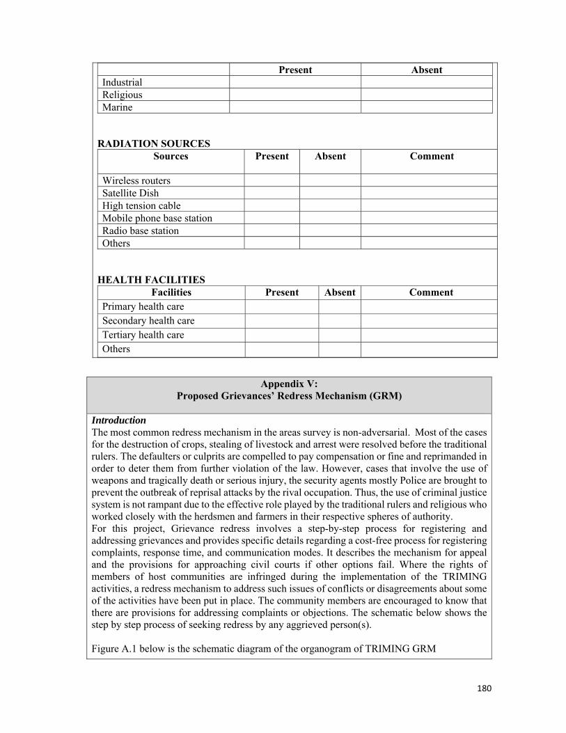
180
Appendix V: Proposed Grievances’ Redress Mechanism (GRM)
Introduction The most common redress mechanism in the areas survey is non-adversarial. Most of the cases for the destruction of crops, stealing of livestock and arrest were resolved before the traditional rulers. The defaulters or culprits are compelled to pay compensation or fine and reprimanded in order to deter them from further violation of the law. However, cases that involve the use of weapons and tragically death or serious injury, the security agents mostly Police are brought to prevent the outbreak of reprisal attacks by the rival occupation. Thus, the use of criminal justice system is not rampant due to the effective role played by the traditional rulers and religious who worked closely with the herdsmen and farmers in their respective spheres of authority. For this project, Grievance redress involves a step-by-step process for registering and addressing grievances and provides specific details regarding a cost-free process for registering complaints, response time, and communication modes. It describes the mechanism for appeal and the provisions for approaching civil courts if other options fail. Where the rights of members of host communities are infringed during the implementation of the TRIMING activities, a redress mechanism to address such issues of conflicts or disagreements about some of the activities have been put in place. The community members are encouraged to know that there are provisions for addressing complaints or objections. The schematic below shows the step by step process of seeking redress by any aggrieved person(s). Figure A.1 below is the schematic diagram of the organogram of TRIMING GRM
Present Absent Industrial Religious Marine
RADIATION SOURCES
Sources Present Absent Comment
Wireless routers Satellite Dish High tension cable Mobile phone base station Radio base station Others
HEALTH FACILITIES
Facilities Present Absent Comment Primary health care Secondary health care Tertiary health care Others

181
Appendix V: Proposed Grievances’ Redress Mechanism (GRM)
Fig. A.1 TRIMING
PROJECT GRM Organogram TRIMING’ GRM takes into cognizance the traditional dispute resolution framework, especially at the grassroots level; extending an efficient modern method that guarantees incorporation of equitable service delivery with elements of the traditional system, especially for matters beyond the purview of the Project components. Grievance Redress Tradition in Project Areas Traditional administration in a large part of Northern Nigeria, where the TRIMING Project is situated, is predominantly predicated on the emirate systems which historically spread from the Sokoto sultanate. These emirate systems are also derived from the Islamic religion which was the motivation for the establishments of the various emirates in the first instance (Roger Blench et al, 2006). The emirate systems’ is sustained at the grassroots by hierarchical district heads and village heads who are widely respected and obeyed. Another organ of the system is the Islamic courts which adjudicate in personal matters and sometimes on communal issues and even criminal issues in recent times. A major function of these traditional systems is the prevention of conflicts and maintenance of social stability and advising the local government. Over the years a synergy has been found and maintained between these traditional systems and the structures of democratic governance in the concerned states. Naturally grievance redress issues passed through the village head through to the district head to the Emir in extreme cases. The TRIMING Project sites fall within the purview of these intertwined but effective systems of conflict prevention. In spite of this cultural uniformity, there are certain socio-economic features that set each of these intervention sites apart from one another, which may impact the outcomes of grievance redress processes for the TRIMING Project beneficiaries. The TRIMING GRM Structure A bottom-up GRM structure is recommended for the uptake of grievances in the Zobe Dam Project as contained in the TRIMING Grievance Redress Mechanism. Grievances are initially received at the intake, then to sector and then to the scheme level safeguards officer before getting to the social safeguards manager. Where this system does not conform, then legal

182
Appendix V: Proposed Grievances’ Redress Mechanism (GRM)
arbitration becomes the last resort. Specifically, the responsibilities of GRM functionaries as contained in the GRM is as stated below: Unit Level Social Contact (Volunteer):
S/he collect and register grievances brought to the unit level of the WUA S/he will acknowledge receipt of grievances to the complainant S/he will investigate grievances where facts exist at the unit level S/he will help resolve easy matters that would not require more than apologies and
mediation in consultation with other non-disputing unit member S/he will refer cases upwards or sideways to the traditional authorities or law
enforcement in case of complications beyond the purview of the unit WUA (communal clashes, crimes, cases outside the project’s direct responsibilities)
S/he will also hold executive role within the WUA structure (Chair or Alternate) S/he will feed back GRM decision from levels above to grievant at the unit when
applicable
Intake/Sector Level Social Officer (part of the elected WUA structure):
S/he collect grievances referred to the intake level from the unit level of the WUA S/he will collect and register grievances brought directly to the sector level She will acknowledge receipt of grievances to the complainant S/he will investigate issues brought directly before the intake WUA S/he will help resolve matters that show face-value simplicity and involve temperate
personalities who are ready for such resolution in consultation with the woman leader in the sector and the social contact officer.
S/he will refer cases to appropriate authority in the WUA S/he will refer cases upwards in case of complications beyond the purview of the Intake
WUA S/he will feed back GRM decision from levels above to grievant at the unit or sector as
applicable
Scheme Level Social Officer: In addition to the other social contact job description specified for social safeguards manager by the PMU
S/he will coordinate the GRM at the WUA level S/he will keep a record of all grievances presented before the scheme at all levels in a
master register for the scheme S/he will refer cases to appropriate authority in the WUA and the scheme office after
investigation S/he will report to the Social Safeguards Manager at the PMU S/he will liaise with the Scheme office and the WUA to resolve issues that show little
complication S/he will communicate decisions downwards to the grievant and other stakeholders S/he will document grievances and report progress monthly to the Social Safeguards
Manager

183
Appendix V: Proposed Grievances’ Redress Mechanism (GRM)
Social Safeguards Manager:
S/he will be saddled with the overall responsibility of implementing the GRM of TRIMING
S/he will collect and register all grievances reported directly to the PMU S/he will coordinate grievances referred form the Schemes and facilitate thorough
investigation in consultation with concerned experts in the system S/he will communicate redress decisions downwards to the grievant She will keep a record of all grievances that come into the system and the solutions
proffered for them. S/he will gather and organise grievance data for the sake of evaluation within the project S/he will document grievances and report progress quarterly to the Project Coordinator
Steps in the process of handling grievances When a grievance is received and registered through the GRM, necessary steps will be taken to resolve the issues namely:
1. Screening of the grievance, mainly through sorting research and investigation to ensure that the complaint qualifies to be a TRIMING grievance and that it can be handled by the established redress mechanism. In the case of GBV/SEA complaint, this will not be investigated but rather referred to the appropriate authority and GBV service provider around the project area
2. Investigation of the grievance - The GRM Office would then identify the GRM channel to refer the complaint to including where required independent authorities to investigate some of the complex and highly sensitive grievances, as well as those involving and affecting a very large number of stakeholders – particularly those that have not been resolved through the lower level structures. In the case of GBV/SEA complaint, the GRM officer shall not under any circumstance, investigate any GBV complaint or document any information save the information the survivor is willing to give.
3. Resolving and disposing of the conflict – this will involve resolving the conflict particularly through the GRM structure at all levels. The stakeholders may also still revert back to the informal mechanisms, i.e. the cultural and religious leaders.
4. Conclusion and registration of disposed cases –The GRM Office will develop a mechanism for documenting concluded cases. The documentation will be aimed at presenting a concluded case file to the different stakeholders in each case, and also providing a copy of each concluded case to the registry at the TRIMING GRM office. Fig. 1.1 summarizes the steps in uptake of grievances from the community level
5. Monitoring and tracking the grievance, as well as continuing to share information with the concerned parties, especially regarding the process of resolving the dispute. This will keep the stakeholders aware of the level at which their grievance is, in terms of finding a solution acceptable to majority, if not all the parties.
184
Appendix V: Proposed Grievances’ Redress Mechanism (GRM)
6. Resolving and disposing of the conflict – this will involve resolving the conflict
particularly through the GRM structure at all levels The stakeholders may also still revert back to the informal mechanisms, i.e. the cultural and religious leaders
7. Conclusion and registration of disposed cases –The GRM Office will develop a mechanism for documenting concluded cases. The documentation will be aimed at presenting a concluded case file to the different stakeholders in each case, and also providing a copy of each concluded case to the registry at the TRIMING GRM office. Fig. 1.1 summarizes the steps in uptake of grievances from the community level
Gender Based Violence (GBV) and Sexual Exploitation and Abuse (SEA) Cases related to GBV shall be treated in a private and confidential manner, limiting information to what the survival or complainant is freely willing to provide. A separate register shall be opened for this category of cases and shall ONLY be accessed by the Grievance Redress Committee (GRC) secretary and the GRM focal person at the PMU. The complainant (if a survival) shall be attended to with empathy, assurance of safety and confidentiality. In the event that the complainant is not willing to divulge any information, this view should be respected by the GRM officer, and the complainant referred to the appropriate nearest medical centre, approved available GBV service provider or police, depending on the complainant’s choice. Such a complaint should be reported to the World Bank Task Team as well by the PMU GRC within 24 hours. Complaint Case Closing This is the period where the complaint or feedback passes through the full cycle and a feedback is agreed. The resolution of the committee at the various level shall be documented and a monthly report transmitted to the PIU. Where there is need for external referral of the matter the complainant shall be appropriately guided on the next steps.
Gender Based Violence Reduction The specific risks of gender-based violence (GBV) that will likely be triggered by the project activities under MRVIS interventions by TRIMING could include Increased vulnerability to sexual assault such as using existing knowledge on tradition as a tool to limit women from participating in the male-dominated irrigation farming and associated economic activities and responsibilities. It is also quite possible to have harassments inform of verbal assaults as well as use of inappropriate languages on women in public places such as markets, community meetings due to social taboos that restrict women from fully participating in male-dominated occupations as farming. The third possibility is transactional sex; including risk of sexual exploitation by a facilitator, a trainer, resource disseminators or other implementing entity in return for project benefits; this can occur wherever men are at vantage position. Sometimes, there could also be harmful widowhood practices that subject widows to offensive widowhood rites such as being forced to give up their husband’s money, landed properties and other assets to close kinsmen. With increased women participation in the project and concomitant improvement in their livelihood opportunities, economic power, their increased mobility, their participation in Women’s Affinity Groups (WAGs) and public forums, there is the likelihood of a demonstration of the women’s greater confidence and self-esteem, this can lead to intimate partner violence. The men feeling threatened by potential insubordinations by their wives may tend to use physical assault to suppress their spouses.

185
Gender Based Violence Prevention Measures To prevent or mitigate possible risks of GBV as identified above the following measures are suggested:
1. Setting up a GBV reduction and advocacy/campaign group as part of the GRM The grievance redress mechanism must include a structure that will consist of a GBV reduction panel to handle GBV complaints with a very rapid response. The GBV resolution platform must include in its functions, advocacy to promote improved household relations. The group must embark on campaigns to explain the project to all and ensure that families, including husbands, are aware of the project’s aims, objectives, activities, and benefits. There must be effective models aimed at improved household relations and gender dynamics that the project can use to reduce incidence of GBVs. The campaigns must employ multiple communication channels to ensure that all project beneficiaries are aware of the intention of the project and its benefits. The GBV vulnerable communities must be well informed of the GBV redress mechanism, communication channels, and how and where to get support, protection, and services. The campaign must involve community members, religious leaders, community groups, and male gatekeepers for project buy-in. The campaign must incorporate a robust behavior change communications crusade alongside other behavioral change interventions to challenge harmful gender norms that promote GBV, including: – using respected clerics and religious leaders to correct misconceptions regarding the religious teachings and texts used in justifying GBV; – Promoting the ideas about the shared roles and responsibilities of men and women in providing for the family; – Changing the negative perception that surrounds women economic or social empowerment. Rather than using terms as pompous, incorrigible, women who bring in money should be praised and described as supportive, virtuous, peaceful, hard-working, considerate and kind-hearted woman always happy to assist her husband and her extended family.
2. Collaborations with existing GBV reduction groups The structure on GBV reduction should not only relent on campaigns, but should work with informal and formal GBV service providers including Civil Society Organizations at the community, state, and national level, to strengthen its service delivery efforts. The GBV reduction panel should use the existing Women Activity Group as a platform to provide immediate psychosocial, emotional, and referral support to previous victims of GBV in the area. The GBV panel should hold group meetings and trainings in safe spaces that are acceptable to the community’s ethical and moral standards, and do not expose women to many men. Utilize existing safe space programs in the country. They should ensure that project activities involving women take place in the morning or afternoon to reduce their need to seek permission and the risk of travelling in the evening.
3. GBV Service centers The host local government areas would require setting up centers that will among other things conduct GBV diagnostics surveys and provide services for GBV victims including health services like first aid, post-exposure prophylaxis, and emergency contraceptives as well as psychosocial services, legal aid, police, civil society organizations, and any other informal structures that could support survivors. Apart from identifying these structures, actors leading the assignment should be given necessary tools
4. Strict adherence to codes of conduct

186
Appendix V: Proposed Grievances’ Redress Mechanism (GRM)
The project must to protect beneficiaries especially females by ensuring that the project implementing personnel including facilitators, trainers, distributors of resources and contractors, adhere to specific codes of conduct that restrict behaviors with the potential to harm beneficiaries. These codes should be included in implementing partners’ contracts and should specifically prohibit engaging in any actions that could contribute to sexual exploitation and abuse defined as sexual relations with anyone below the age of 18. Project staff and implementing partners should be briefed and trained so they understand and implement these rules; they should be held responsible. Community members should also be sensitized on their rights and the codes of conduct so they can hold actors accountable if such incidences take place during the course of the project.
5. Grievance Redress Mechanism and Social Accountability Framework There should be specific protocols in the project’s grievance-redress mechanism and social account-ability framework to monitor and respond to GBV related issues. The project should give women access to fair hearing and quick response to any complaint lodged through the women representatives. The project should utilize innovative citizen engagement platforms that will allow confidential reporting, especially through technological tools and other communication platforms, such as mobile phones, radios, and dry erase boards. The grievance-redress mechanism should develop protocols specific to GBV complaints that allow for confidential reporting. It should also have a response mechanism in line with the urgency of the complaint. Serious GBV cases will be escalated to the TRIMING project coordinating units and to the World Bank task team leader for a real-time response. First Level of Redress: Community Level The main targets at this level are the communities and all stakeholders in mining at the community level. At every community proposed for intervention, there shall be an established committee headed by a chairperson who shall be appointed by the traditional rulers in the community and trained to take up and handle complaints at the community level. The Committee shall comprise of: • Traditional leaders • Women leaders • Youth leaders • Representative of Mines union/association/society/cooperatives • Community Based Organization (CBOs) The traditional leader shall appoint a chairperson and a secretary (preferably a woman) among the committee, who will relate directly with the TRIMING representative at the state level. This committee shall be available to receive complaints throughout dedicate days in the week for uptake and resolution of complaints/grievances. Once a complaint is received, the committee registers it, sends an acknowledgement to the complainant and screens to authenticate the complaints investigates and recommend an action. All received complaints will be documented but cases related to GBV and personal details of the complainant will however, not be documented in the public grievance log book if the complainant decides to provide any information. The complainant / survivals confidentiality should be kept in mind when attending to any GBV / SEA related complaint. Incidences should be referred to relevant authority the police or service provider. The outcome of the resolution should be made available to the complainant within 5 working days. Where the complainant is not satisfied with the recommendations, they shall be advised to report to the second level for redress.

187
Appendix V: Proposed Grievances’ Redress Mechanism (GRM)
Complaint uptake at Community level The community members can/shall register their complaints at the following points: with the i. Chairperson or secretary of the Grievance redresses committee at the community level. ii. Any of the heads of Community Based Organizations (CBOs), and specifically, for instance a GBV case should goes through the secretary/women leader. Mode of receipt and recording of Complaints The step for receiving and recording complaints are highlighted below • The complaints shall be made in writing, verbally, over the phone or submitted in complaint boxes in each location. • The officer receiving the complaints obtains relevant basic information regarding the grievance. • The two points of receiving complaints as illustrated above shall be in possession of a standardized complaint receiving form which must be filled in for every complaint including complaint boxes. • As soon as a complaint is received, an acknowledgement shall be issued to the complainant. • After registering the complaint, the Grievance Handling Team (GHT) under the guidance of the chairperson shall set a date to investigate the matter; • After which they shall provide a recommendation. If necessary, the concerned officer will convene a meeting between the parties involved to find a solution to the problem and make arrangements for resolution. Timeline The resolution at the first level will be done within 5 working days and the decision of the committee notified to the concerned which shall be acknowledged by the complainant. If the Grievance is not resolved within this period, it would be referred to the next level of Grievance Redress. However, if the complainant requests for an immediate transfer of the issue to the next level or is dissatisfied with the recommendation, the issue will be taken to the next level. Second Level of Redress: The main targets at this second level are the project implementers, executers (contractors, consultants) communities and project beneficiaries and their related institutions. At every state implementation level, a grievance handling committee shall be trained to handle TRIMING related complaints. All stakeholders shall be informed of the existence of the grievance committee. The committee shall dedicate days when they are available to receive and resolve complaints. Once the committee receives a complaint, it shall be mandated to register the complaint, investigate and recommend an action. If the complainant is not satisfied with the recommendation, they shall be advised to report to the third level of redress. This committee shall be obligated to do a monthly report to Grievance handling team of TRIMING. Complaint uptake/receipt points at second level Any aggrieved person/organization/community shall be advised to register their complaints with any of the GRM committee member in each state as listed below: • Representative of the Local Government Council • Non-Governmental Organization (NGO) • Project Manager of the Executing Entity Mode of receipt and recording of Complaints The step for receiving and recording complaints are highlighted below
188
Appendix V: Proposed Grievances’ Redress Mechanism (GRM)
• The complaints shall be made in writing, verbally, over the phone. Any member of the Committee receiving the complaints should obtain relevant basic information regarding the grievance(s). • All the points of complaints, uptake must be in possession of standardized complaint form which must be completed by or for every complainant. • An acknowledgement must be issued to the complainant as soon as a complaint is received with an assurance that he/she gets a feedback within 5 working days. After registering the complaint, the Grievance Handling Team shall set a date to investigate the matter (screen to authenticate claims and hear the plaintiff and defendant), after which they shall provide a recommendation. • If necessary, meetings have to be held between the complainants and the committee in order to find a solution to the problem and make arrangements for grievance redress. • The deliberations of the meetings and decisions taken are recorded Timeline At the second level, the resolution period will take a maximum of 10 working days and the concerned shall be notified through a form. Should the Grievance not be solved within this period, this would be referred to the next level of Grievance Redress. However, if the complainant requests for an immediate transfer of the issue or is dissatisfied with the recommendation, the issue will be referred to the next level. Third Level of Redress: There shall be a constituted TRIMING GRM Committee who shall work with the Grievance Handling Officer (Social Safeguards Specialist). The members of this committee shall be trained to operationalize the grievance handling processes. All stakeholders shall be informed of the existence of the grievance committee. Dedicate days shall be fixed to receive and resolve complaints. Once the committee receives a complaint it shall be mandated to register the complaint, investigate and recommend an action. If the complainant is not satisfied with the recommendation, they shall be advised to seek redress through Alternative Dispute Resolution (ADR). The TRIMING GRM committee shall be obligated to do a monthly report of registered complaints. Complaint uptake/receipt points of receipt of complaints Any aggrieved person/community/organization shall be advised to register their complaints at the following points: i. The TRIMING Grievance Handling Officer (Social Safeguards Specialist) ii. Environmental Safeguards Specialist iii. TRIMING Monitoring and Evaluation Specialist (M&E) iv. The TRIMING Project Coordinator Mode of receipt and recording of Complaints The step for receiving and recording complaints are highlighted below • The complaints can be made in writing, verbally, over the phone, through any of the previous levels of GRM. • Any member of the committee receiving the complaint should obtain relevant basic information regarding the grievance. • The points of receiving complaints shall be in possession of forms which will be used to record each complaint. • As soon as a complaint is received, a second form will be issued to the complainant as acknowledgement. After registering the complaint, the Grievance Handling Committee under

189
Appendix V: Proposed Grievances’ Redress Mechanism (GRM)
the guidance of the Grievance Handling Officer shall set a date to investigate the matter, after which they shall provide a recommendation. • If necessary, meetings have to be held between the complainants and the concerned officers to find a solution to the problem and make arrangements for grievance redress. The deliberations of the meetings and decisions taken are then recorded. Timeline At the national level, the resolution period will take maximum 21 calendar days and the concerned shall be notified. Should the grievance not be solved within this period, the complainant will be advised to seek recourse through Alternative Dispute Resolution (ADR). The GRM assumes a three-level mechanism namely; community level, state level and national level. It assumes a pyramidal structure Grievance Redress Process
GBV/SEA
21
10
5days
N
Complaint/ Complainant
Complaint Receiving Points
Solution
Level 3: World Bank GRM Unit
Redress via Alternate
TRIMING
Primary Level
Tertiary Level
GBV Service Provider or
Responsible
Level 1: Community Level
Level 2: project /LGA Level
Secondary Level
Solution
Solution
Yes
Yes
No
Yes
No

190
Appendix V: Proposed Grievances’ Redress Mechanism (GRM)

191
APPENDIX 7: HEALTH LOG
S/N Months Dec15 Jan16 Feb16 Mar16 Apr16 May16 Jun16 Jul16 Aug16 Sep16 Oct16 Nov16
M F M F M F M F M F M F M F M F M F M F M F M F
1 Malaria
2 Typhoid
3 Rheumatism
4 Diarrhoea
5 Injury
6 RTI
7 Hypertension
8 Eye disorder
9 Skin infection
10 HIV/AIDS
11 Referrals
12 Cholera
13 Bilharziasis
KEY: RTI: Respiratory Tract Infection