Windsor Castle: Photogrammetric And Archaeological Recording After The Fire
16
Photogrammetric Record, 15(86): 225–240 (October 1995) WINDSOR CASTLE: PHOTOGRAMMETRIC AND ARCHAEOLOGICAL RECORDING AFTER THE FIRE By R. W. A. DALLAS Consultant and J. B. KERR, S. LUNNON and P. G. BRYAN English Heritage (Paper read at a Technical Meeting of the Society on 18th October, 1994) Abstract Following the disastrous fire in the State Apartments at Windsor Castle in 1992, a programme of photogrammetric surveying followed by archaeological recording was carried out by English Heritage. This paper details the background to this work, the provision of the photogrammetric surveys and the use and analysis of the data by the archaeology team. HISTORICAL BACKGROUND WINDSOR CASTLE (Fig. 1) is thought to have been founded soon after the Norman Conquest and was certainly in existence by 1086 (Hope, 1913; Brown et al., 1963). The construction of the massive earthwork fortress is thought to have established the overall form of the Castle, with two large baileys or wards separated by the large surviving motte. By 1110, when Henry I held his Easter court there, the Castle had become an important royal residence. The main royal accommodation seems to have been in the upper ward for most of the Castle’s history, situated along the crest of the steep slope on the north side of the ward. The core of these buildings is thought to have been formed by Henry II in the late 12th century as part of his major building campaign which also saw the rebuilding of much of the defences in stone. Since then, Windsor has seen a number of large scale building campaigns along with a host of minor works, some documented, some not. The principal events are relatively well known and include the extensive works of Henry III in the first half of the 13th century, the rebuilding by Edward III in the 1360s and 1370s (the most expensive recorded English secular building campaign of the Middle Ages according to Brown et al. (1963)), and the conversion into a baroque palace by Hugh May for Charles II in the late 1670s and 1680s (Colvin et al., 1976). The last major work was carried out by Sir Jeffrey Wyatville in the 1820s and 1830s (Crook and Port, 1973). This saw a radical re-organization of the royal accommodation which was moved to the south and east ranges, with refurbishment or rebuilding of most of the private and State Rooms throughout the upper ward. The scale of these works was enormous but their impact on the earlier fabric was not known in any detail. Sir William St. John Hope (1913), in his study of the Castle, produced an analysis of the buildings including coloured phase plans which showed his understanding of the sequence of development and the survival of early elements. This has formed the basis for all subsequent analysis and discussion including (with some revisions) the History of the Kings’ Works. However, Hope could only base his analysis on documentary evidence, the plans (both historic and modern), and on the few architectural details which pre-dated the works of Wyatville. Most of the evidence we can now see revealed was hidden behind plaster, panelling and render. 225
Transcript of Windsor Castle: Photogrammetric And Archaeological Recording After The Fire
Photogrammetric Record, 15(86): 225–240 (October 1995)
WINDSOR CASTLE: PHOTOGRAMMETRIC ANDARCHAEOLOGICAL RECORDING AFTER THE
FIREBy R. W. A. DALLAS
Consultant
and J. B. KERR, S. LUNNON and P. G. BRYAN
English Heritage
(Paper read at a Technical Meeting of the Society on 18th October, 1994)
AbstractFollowing the disastrous fire in the State Apartments at Windsor
Castle in 1992, a programme of photogrammetric surveying followed byarchaeological recording was carried out by English Heritage. This paperdetails the background to this work, the provision of the photogrammetricsurveys and the use and analysis of the data by the archaeology team.
HISTORICAL BACKGROUND
WINDSOR CASTLE (Fig. 1) is thought to have been founded soon after the NormanConquest and was certainly in existence by 1086 (Hope, 1913; Brownet al., 1963).The construction of the massive earthwork fortress is thought to have established theoverall form of the Castle, with two large baileys or wards separated by the largesurviving motte. By 1110, when Henry I held his Easter court there, the Castle hadbecome an important royal residence. The main royal accommodation seems to havebeen in the upper ward for most of the Castle’s history, situated along the crest of thesteep slope on the north side of the ward. The core of these buildings is thought tohave been formed by Henry II in the late 12th century as part of his major buildingcampaign which also saw the rebuilding of much of the defences in stone.
Since then, Windsor has seen a number of large scale building campaigns alongwith a host of minor works, some documented, some not. The principal events arerelatively well known and include the extensive works of Henry III in the first halfof the 13th century, the rebuilding by Edward III in the 1360s and 1370s (the mostexpensive recorded English secular building campaign of the Middle Ages accordingto Brown et al. (1963)), and the conversion into a baroque palace by Hugh May forCharles II in the late 1670s and 1680s (Colvinet al.,1976). The last major work wascarried out by Sir Jeffrey Wyatville in the 1820s and 1830s (Crook and Port, 1973).This saw a radical re-organization of the royal accommodation which was moved tothe south and east ranges, with refurbishment or rebuilding of most of the private andState Rooms throughout the upper ward. The scale of these works was enormous buttheir impact on the earlier fabric was not known in any detail. Sir William St. JohnHope (1913), in his study of the Castle, produced an analysis of the buildingsincluding coloured phase plans which showed his understanding of the sequence ofdevelopment and the survival of early elements. This has formed the basis for allsubsequent analysis and discussion including (with some revisions) theHistory of theKings’ Works.However, Hope could only base his analysis on documentary evidence,the plans (both historic and modern), and on the few architectural details whichpre-dated the works of Wyatville. Most of the evidence we can now see revealed washidden behind plaster, panelling and render.
225

FIG. 1. Windsor Castle: a view of the present Castle looking east.
PRE-RESTORATIONANALYSIS OF THE FIRE DAMAGED AREAS
The fire on Friday, 20th November, 1992 destroyed a large section of the privateand State Rooms in the north-east corner of the upper ward. The scale of thedevastation is difficult even now to appreciate fully (Fig. 2).
Before the ashes had cooled, thought was being given to the reconstruction ofthe buildings which was to become the subject of a national and, at times, heateddebate. Representatives from English Heritage were quickly on site to advise on theclearance of the buildings. Experience of previous fires at Hampton Court Palace in1986 and Uppark House in 1989 had shown that if authentic restoration was to becarried out (that is to say the accurate reconstruction of damaged structures anddecorative finishes using the original methods and where possible salvaged materials)then the fire debris had to be collected and sorted for the retrieval of structural anddecorative materials. In this case, salvage also included items of furniture andsculpture.
The first priority for fabric recording was the rapid assessment of the damagedtimber structures. Demolition of damaged roof structures began almost immediately,
FIG. 2. An illustration of some of the damage caused by the fire in St. George’s Hall.
226
as it was clear that many of these were in a dangerous condition, and there was alsoan urgent need to provide temporary roofs. Large sections of some of the roofstructures were also included in the loose debris. This work allowed the identificationand preservation of the only medieval roof damaged by the fire, the 15th centuryKitchen roof, which is now being repaired rather than replaced. An archaeologicalrecord was also created of the 17th and 19th century roofs which were removed.
This period also saw the first on site involvement by the Photogrammetric Unitof English Heritage Survey Services, which photographically recorded some of themasonry elements which were in too dangerous a condition to remain in place.
As the clearance of the buildings progressed, it became more and more evidentthat enormous areas of the underlying masonry structure had been exposed. Laterstill, the effects of water saturation, resulting from the extinguishing and dampeningdown of the fire, and the need to accelerate the dehumidification process would meanthat much of the surviving panelling and plasterwork would have to be removed. Inthe event this has revealed more of the underlying fabric than the fire exposed.Clearly, an enormous amount of new archaeological information had been revealedand the recording and analysis of this would greatly increase the understanding of thedevelopment, form and function of this important monument. An important aim of theproject, therefore, was the production of a comprehensive archaeological recordwhich would be capable of further analysis.
From the outset, however, the recording programme, which started in earnest inApril and May 1993, was also geared to assist the reconstruction project. Theprovision of accurate measured survey of the elevations has been enormously usefulto the project architects and engineers in the design of the replacement structures andfinishes. The archaeological information has also helped to inform the reconstructionprocess, as in the early identification and preservation of the Kitchen roof as a highlyimportant medieval structure. The archaeological recording of this roof has been acritical element in its reconstruction. Representative buildings from later periods havealso been saved, which might otherwise have been demolished, such as the late 17thor early 18th century “new” Kitchen and the Kitchen Cloister of 1843, designed byEdward Blore. In addition the archaeological records which have been provided havebeen invaluable in assisting the English Heritage Inspector of Ancient Monuments inthe curation of the buildings, providing clear information on how the proposed repairswill affect the historic fabric and on the effectiveness of mitigation measures. Thusthe survey is helping to ensure that the damage to the historic fabric, during thereconstruction process, is minimized.
These were the aims of the recording project. When it came to the discussion ofthe methodology to be employed in recording such a large area, it was clear thatphotogrammetric recording was by far the most cost effective way to capture data onsuch an enormous scale.
THE USE OFPHOTOGRAMMETRY FOR THERECORDINGWORK
It is perhaps a measure of the establishment of architectural photogrammetryover recent years that Survey Services was one of the first departments within EnglishHeritage to be contacted after the fire. A representative of the Branch was on site,within 48 hours of the fire erupting, to make a detailed inspection of the charredremains. Although the fire was out by this time, steam was still rising from the ruinsin places and, more importantly, no scaffolding had yet been erected. For forwardplanning it was fortunate that this inspection was carried out so soon after the fire, forat that point it was possible to gain maximum access to virtually all the fire damagedareas. Within days, large sections of the structure were cordoned off for reasons ofsafety and the erection of scaffolding commenced.
Adoption of Photogrammetric Methodology
From this initial inspection, it seemed clear that a photogrammetric solutionwould be needed for the work. In this decision, Survey Services followed not only theYork Photogrammetric Unit’s own experiences, at York Minster and St. Mary-at-Hill
227
Church in London, but had information on the application of photogrammetry atanother disaster site at Uppark, the National Trust property burned out in 1989.Indeed the Head of the Unit at the time directly advised the Trust after the disaster.
The Photogrammetric Unit had been involved in producing photogrammetricsurvey following the fire in the South Transept of York Minster in 1984. In June 1988the Unit was also involved at St. Mary-at-Hill Church in London. Both theseexperiences had provided valuable knowledge not only on procedures, but on whattype of product would be needed for reconstruction. Information was also availablefrom Uppark, where the very substantial photogrammetric survey was carried out byAtkins AMC on the instructions of the National Trust (Stevens, 1992).
In the first place, the sheer scale of the exercise suggested that logistically anyform of hand survey would be very difficult to achieve. Second, it was clear that evenwhen the interiors had been cleared, it would be difficult to obtain good access forhand survey. Rectified photography was also considered as it was clear that in manyareas this would be a valuable tool, since many surfaces had a complex texture ofbrick, stone, plaster and timber. However it also seemed that line drawings at largescale would be essential. Given the scale of the task, a photogrammetric programmeseemed the way forward. Furthermore it seemed very likely that computers, threedimensional modelling and computer aided drafting would be, or should be, usedextensively in any reconstruction programme.
The conclusion therefore was that central to the programme should be photo-grammetric recording. This was duly recommended internally in English Heritageand in turn to the Steering Committee in charge of the restoration of the fire-damagedareas of the Castle. The proposals were accepted and a substantial programmeof photogrammetric survey was initiated. The detailed proposals for recordingwere produced in collaboration with the Central Archaeological Service of EnglishHeritage. The work procured and carried out by Survey Services was referred to asthe Primary Measured Survey (PMS),to differentiate it from the archaeologicalinterpretation and survey which followed.
Existing Photogrammetric and Survey Coverage
It was known that, a few years previously, some photogrammetric recordingwork had been carried out at Windsor Castle, but only the sketchiest details wereavailable. After the fire, however, some interesting facts became available. In 1985,the Department of the Environment Property Services Agency (PSA) had started ona programme of photogrammetric recording of the State Apartments. This was a“fieldwork only” package, although one small part of St. George’s Hall was plotted.The work, carried out by Engineering Surveys Ltd., covered all the State Apartmentsincluding two of the severely damaged rooms, St. Georges Hall and the GrandReception Room.
This material was called thepre-firephotography and the new work, carried outthrough English Heritage, thepost-firephotography. The pre-fire photography provedto provide very generous cover of these two rooms and one of the very first contractslet was for plotting from this photography (Fig. 3).
The photography had been taken in black and white using a Zeiss UMK 10/1318camera and was fully controlled. For St. George’s Hall, there were about 100 suchmetric photographs available with the smallest photoscale of 1:80.
Two other existing survey products were very important to the programme. Firstof all, as part of the Kingsbury project to rewire Windsor Castle, a very extensive planand section measured survey had been prepared, on behalf of the PSA/RoyalHousehold, by Sterling Surveys Ltd. (Fig. 4). This provided a pre-existing grid onwhich to base all the new work and a vital “as existed” survey for the subsequentstages of the reconstruction work. Also this saved what would have been theextremely difficult task of creating plans in the burnt-out sections of the building.Sterling Surveys Ltd. were most helpful in providing information on this survey.
Additionally, as part of the Kingsbury project, virtually all the Private Apart-ments were recorded as rectified photography. This work was carried out on behalfof the Royal Household by Plowman Craven and Associates. At the time, Survey
228
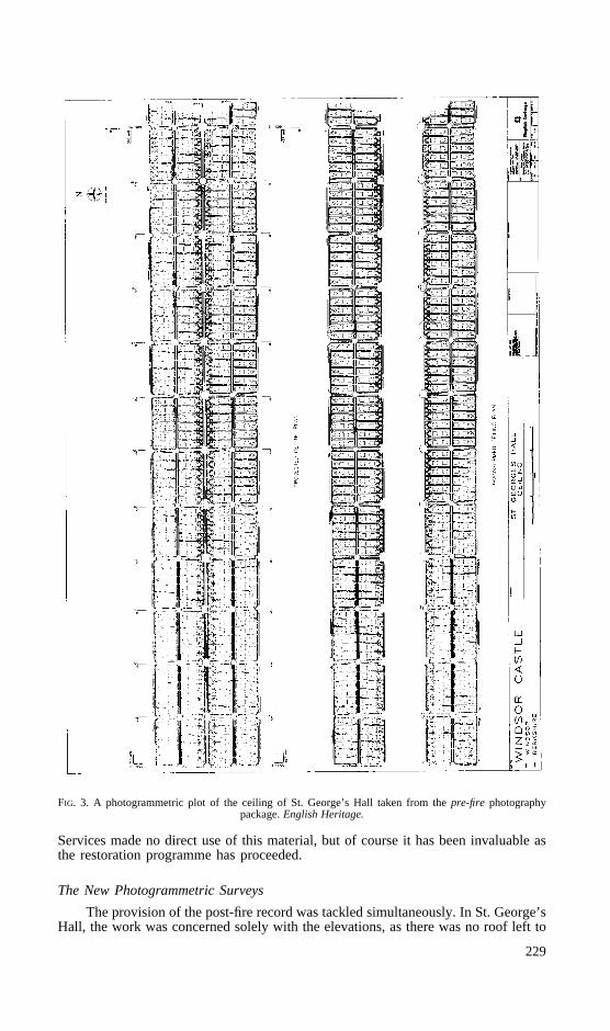
FIG. 3. A photogrammetric plot of the ceiling of St. George’s Hall taken from thepre-fire photographypackage.English Heritage.
Services made no direct use of this material, but of course it has been invaluable asthe restoration programme has proceeded.
The New Photogrammetric Surveys
The provision of the post-fire record was tackled simultaneously. In St. George’sHall, the work was concerned solely with the elevations, as there was no roof left to
229

FIG. 4. Part of a sample sheet taken from the existing building survey.Royal Household.
TABLE I. Surveys carried out at principal floor level.
Location Nature of Survey Contractor
St. George’s Hall Pre- and post-fire Plowman Craven andAssociates (PCA)
Extra rectified photography RamsburyGrand Reception Room Pre- and post-fire PCA
Extra rectified photography RamsburyPrivate Chapel Post-fire PCAOld Kitchen Post-fire Atkins AMCCrimson Drawing Room Post-fire PCAPrince of Wales’ Tower Post-fire English Heritage
Photogrammetric Unit (EH PU)PCA
Brunswick Tower Post-fire EH PUPCA
Chester Tower Post-fire Atkins AMCKitchen Court Post-fire LTG Survey InternationalHolbein Room/ EH PU
Chapel Gallery Post-fire LTG Survey International
survey. An interesting aspect of St. George’s Hall was that it was not wholly burntout, as towards the west end significant portions of elevation survived. A practical andeconomical solution was reached, commencing with the full plotting of the pre-firephotography of the elevations. The post-fire condition was completely photographedand surveyed but only the damaged areas were plotted onto the “pre-fire” plotting,although in separate layers. In this way, not only was some expense saved but a directcomparison of existing and lost fabric could be made from the drawings.
It is not practical to describe every aspect of every survey, so for informationTable I shows the different surveys which were carried out at principal floor level.
It should be noted that further substantial survey work was required at theground floor level (basement) of the building. These areas, comprising several largevaulted chambers, were not so much fire damaged as water damaged. It had not beenexpected in the early days of the project that so much survey work would be needed
230

FIG. 5. Plan of Windsor Castle, Upper Ward, State Apartments and Private Apartments. All areas inside theheavy line were largely destroyed in the fire. The Kitchen Court area, included in one survey, is shown with
a dashed line.
in this area. However, with the need to remove large areas of panelling and plasterto aid the drying out process of the walls themselves, significant areas of earlierinteresting masonry were uncovered which also required full recording. As this phaseof work is still being undertaken, it will not be described further in this paper.
At this point, it should also be mentioned that virtually all the above mentioned
231
work was let out to competitive tender, other than the work carried out directly by thePhotogrammetric Unit of English Heritage Survey Services and some quite small butvery urgent survey tasks. For example, Ramsbury Photographic Services carried outsome very urgent rectified photography work, needed before beams were lifted out ofthe remains of the roof within St. George’s Hall and the Grand Reception Room.More typically, the substantial St. George’s Hall contract was won in competitivetender by Plowman Craven and Associates.
In procuring such a large body of survey at one time, several routes could havebeen taken as, for example, letting the whole contract in one, or establishing ameasured term contract to allow for the vagaries of working on a large and difficultsite. However, it was recommended to the Steering Committee that several smallersized contracts should be let, rather than one large one. This was for several reasons.
First of all, the total volume of plotting was very substantial and it was believedthis would severely stretch the resources of any one company trying to fulfil thewhole contract. Second, access to the different areas of the site had to be phased inany case. Even with considerable co-operation, there were inevitable conflicts ofinterest, particularly relating to the presence of and/or use of scaffolding. By lettingreasonable size contracts, the process was made more controllable. Third, eachpackage of survey required different treatment and separate specification. Apart fromtaking time in any case to prepare specifications and go out to tender, againcompanies were able to assess the work involved more accurately with smallercontracts.
From Table I, it can be seen that three principal contractors were used. Thesewere Plowman Craven and Associates, Atkins AMC and LTG Survey International.Some smaller elements of the work were let by direct contract to the same companies,but over 80 per cent of the work was carried out through competitive tender. Overall,Plowman Craven and Associates probably carried out the largest amount of work.Atkins AMC certainly carried out the dirtiest work, with one contract in the OldKitchen area where the roof was stillin situ and pieces of sooty charcoal seemed tocontinually rain down. LTG Survey International carried out the largest single andcertainly most complex contract. This was of the Kitchen Court area (Fig. 5) wherethe presence of numerous cross walls made access particularly difficult. Indeed, thecontract subdivided the area into nine sections of work, each of which had to betackled almost as an individual contract, with a mixture of photogrammetry, rectifiedphotography and hand survey required to complete the Primary Measured Survey. Forthis area alone, a total of 445 stereophotographs was taken.
Some quite significant work was also carried out by the Photogrammetric Unitof English Heritage Survey Services. Within a week of the fire, a sortie was organizedto try and obtain as much general stereocover as possible before too much scaffoldingwas put up and localized demolitions took place to remove dangerous walls. Also theUnit carried out a significant portion of the recording of the Prince of Wales’ andBrunswick Towers at principal floor levels. These field data were then passed over tothe successful contractor (Plowman Craven and Associates in this case) for plottingand the completion of the survey at upper levels. Finally the Unit carried out the fieldwork necessary to cover all interior faces of the Holbein Room, prior to the erectionof fixed scaffolding. Again this package of data was plotted by the successfulcontractor, LTG Survey International.
Standards and Methodology
As regards methodology, all work was procured to the standards establishedthrough the document,A specification for the architectural photogrammetric surveyof historic buildings and monuments(Dallas, 1988). This specification, first used in1987, set out to codify good practice in architectural photogrammetry, primarily inthe United Kingdom. It has been extensively used by English Heritage and others inthe conservation field for the procurement of photogrammetric surveys.
All companies working in this field in the UK are now familiar with thisspecification and so for tender purposes Survey Services was able to call upon up toa dozen companies, all of whom could be relied upon to produce good survey
232

products under these most demanding circumstances. Indeed, without the existence ofa strong commercial sector in architectural photogrammetry, Survey Services wouldhave been much less confident in advising the Steering Committee that the necessarysurveys could be provided.
The basic scale for all work was 1:20. All the data were provided both as hardcopy on stable polyester and digitally, formatted for AutoCAD version 12 andcaptured as full three dimensional data. For several years now, Survey Services hasbeen procuring primary photogrammetric data in three dimensions, even though it isnot always utilized in this format, with the hard copy generally being used at present.There are still some operational problems with programs such as AutoCAD, whichlimit the optimum use of three dimensional data, but with each software release theusability of these data will be improved.
As well as providing stereocover for plotting, the required photography was alsotaken parallel to the wall plane wherever possible, to allow the printing of a rectifiedphotography product at 1:20 scale. The survey control was generally provided bytheodolite intersection, the standard method recommended in the specification. It wasnot considered that solutions such as bundle adjustments would add to the utility ofthe surveys. In fact, for most surveys, extra control targets were generally specifiedso as to define the many wall planes in existence. The targets were left in place andused extensively by the archaeologists to locate extra detail to be added to thephotogrammetric survey.
The photography was taken mostly in black and white and colour negative,although in certain areas of dense scaffolding, colour transparency was specified.While transparencies can be made from colour negatives, it is an expensive processand the results are often not very satisfactory. The colour transparencies provedexcellent for helping to view through the forest of scaffolding poles that so oftenobscured the direct view of the wall, as in the Kitchen Court. All the plotting datawere layered in AutoCAD, using a more complicated layering system than within thestandard specification. This was to reflect the complex range of materials on the wallsand thus aid the archaeologists in their analysis.
THE USE OFPHOTOGRAMMETRIC PRODUCTS ATWINDSOR
The English Heritage Central Archaeological Service (CAS) team, based on siteat Windsor, is now principally engaged in recording the make up of the fabric whichhas been revealed by the fire and the subsequent stabilization work, where wallcoverings, such as panelling or plaster, have been removed or where the demolitionof unsafe or redundant structures has taken place. As well as the initial co-ordinationand completion of the fire debris clearance, there has been a limited amount ofarchaeological excavation carried out within the site. The main discovery has beenthat of a large medieval well in what was originally the Kitchen Court.
The archaeological information gathered on site is being used to create both agraphic and textual database. The textual database gives a written description to beused in conjunction with the graphic record and it allows attributes which do notalways appear on drawings, for example the depth of a socket or the colour of amortar, to be recorded. Where possible, the text includes an interpretation of aparticular feature, its period and its stratigraphic relationships (how it relates to thesurrounding fabric). In some cases, the features, as with a whole range of smallsocket-like recesses found in medieval walls, prove impossible to interpret, assign toa period, or develop stratigraphic relationships. The text, combined with the graphicrecord, results in a data set capable of further analysis which, as described earlier, isa major aim of the project.
The range of data gathered exceeded that of the stone by stone drawing of theelevations concerned. In addition to the drawn record of the revealed fabric, infor-mation regarding other attributes was also recorded using a combination of text andpictorial representations, such as:
(a) materials and the different types of stone, brick and wood used;(b) detailed recordings of mouldings, which can be used as dating evidence;
233
(c) mortar types, areas of different mortars identified;(d) galletting/pointing, areas of different types identified and plotted;(e) pecking and other evidence for surface finishes;(f) graffiti and masons’ marks; and(g) blocking, patches, changes of build, erosion, weather and fire damage.
PRODUCTION OF THEDRAWN RECORD
The surveying methods and products available to the CAS team to create thedrawn record were photogrammetry, rectified photography and hand survey. All threeof these methods required a surveyor or archaeologist to provideX, Y and Zco-ordinates for features in the area covered, with the end product of each methodbeing the existence of an AutoCAD. DWG file containing line drawings and textualannotations.
Photogrammetry
Photogrammetry was to prove the basic method of obtaining the PrimaryMeasured Survey data within the majority of the areas to be recorded (Fig. 6). Toimprove its use on site and to allow additional detail to be recorded in the database,using digitizing techniques, the stereophotography was taken, wherever possible,parallel to the main plane of the elevation. Scaled images were then provided eitheras separate prints or photomosaics. The latter were of no immediate use to thearchaeologists but the architects and engineers found these complete scaled images ofgreat benefit.
The photogrammetric data were received via English Heritage Survey Serviceson floppy disc in .DWG format. This allowed viewing using AutoCAD version 12,which was the standard CAD package in use by CAS. From early in the project, itwas realized that an A3 drawing board was the most suitable size to manoeuvre onsite up and down the many ladders and along the endless scaffolding lifts that werealways present during recording. Therefore, on receiving the data, the file was viewedand plotted out in 5m squares at a scale of 1:20, with the size of plots suitablyconstrained. The scale of 1:20 is conventionally used for recording archaeologicaldetail and so was accepted as the basic scale for all recording.
The 1:20 scale plot squares were overlaid with Permatrace drawing film andtaken to the relevant point at the elevation. Once there, information was added to theoverlay with any gaps in the coverage completed and any errors, due mainly to themisinterpretation by the photogrammetrist during data capture, corrected. For in-stance, it is often very difficult for the operator to accurately interpret the edge of astone. An apparent joint may be an applied surface or damage caused by fire,weathering or demolition and so field checking is an essential part of the process.Additional required information is also added to the overlay using a system ofannotation.
The A3 overlays were then taken back to the site office and the original .DWGfile edited according to the revised information contained. Any edits, corrections andadditional information were entered by digitizing directly from the film overlay.
Rectified Photography
In the areas where access was restricted and where it would prove uneconomicalfor the use of photogrammetry, but which consisted of relatively large open and planeexpanses of masonry, rectified photography was employed to provide primary cover-age (Fig. 6). As with the hand survey recording, sufficient targets were placed on theplanes of the elevations to be covered by rectified photography, in order to scale theimages and define any major changes in wall plane.X, Y andZ co-ordinates of eachtarget related to the site co-ordinate system were observed using a total stationtheodolite. This control allowed a three dimensional impression of the elevation to bebuilt up directly from the rectified prints. These were provided at precisely 1:20 scale.
234

FIG. 6. An example of survey material prepared for the north elevation of the Crimson Drawing Room.Clockwise from top left: (a) the raw Primary Measured Survey; (b) enhanced Primary Measured Survey (theoriginal showed differences by colour); (c) the lower part of the north elevation prior to the fire; and (d)
rectified photography after the fire.English Heritage.
This was not absolutely necessary for digitizing purposes, but it was found to makelife easier when the archaeologist had to add details of areas which were obscured,either by fire debris, scaffolding or less than optimum lighting conditions.
Hand Survey Recording
Due to the cramped and confined conditions which exist in certain parts of theCastle, the only practical means of obtaining a drawn record for such areas was by
235
using hand recording methods. This complemented the photogrammetric and rectifiedphotography recording being used in other more accessible areas. To allow thisrecording to be tied into the overall site co-ordinate grid, every feature to be recordedwas measured from a defined arbitrary point. Targets, similar to the butterfly designused by the photogrammetrists, were placed on the different planes of the elevationand recorded in position onto the drawn record by the archaeologist. In addition, thesewere tied into the overall site grid by a surveyor using a total station to provideX, YandZ co-ordinates.
The hand drawn elevations were immediately digitized into AutoCAD, usingstandard hardware. To allow a three dimensional picture to be built up of the area, andto ensure that the elevations recorded by hand related to the data received from thephotogrammetric surveys, the co-ordinates for the observed targets were enteredduring setting up of the digitizing equipment. Even though this method did notproduce a true three dimensional value for all the features recorded by hand (astargets could not be placed on every feature), it was sufficient to integrate these datainto the overall three dimensional model of the site.
One of the aims of the fabric survey at Windsor was to build up a true threedimensional image of the fire damaged area. Hence all the data were required to bepresented with their original co-ordinates relating to the overall site grid and not tothe facade co-ordinate system that is often used by photogrammetrists during datacapture.
Layering Conventions
There are numerous layering conventions regularly used for recording work.With all the exposed material to be recorded and held in a digital format, acomprehensive system of subdivision of these data was required. A standard list wasdeveloped by CAS and issued to English Heritage Survey Services for distribution tothe contractors involved in providing the Primary Measured Survey. However, thefull list was often used for only one phase with CAS staff realizing that they actuallyneeded to separate the information according to different criteria and so it wasnecessary to redefine the convention and redistribute.
Using a Digital Approach to Recording
A significant problem which was encountered during the project lay in editingthe three dimensional Primary Measured Survey data which had been producedphotogrammetrically. As requested, the drawing files provided were either made upof a series of individual lines or three dimensional polylines (a series of individuallines joined together to form an entity such as a block of stone). To edit the individuallines proved time consuming and very tedious, and also presented manipulationproblems. The alternative, three dimensional polylines, were to have a limited editingfacility and it was found that, to be useful, they had to be exploded into individuallines, with all the associated problems (Fig. 7).
CONCLUDING REMARKS
The provision of Primary Measured Survey by photogrammetry and rectifiedphotography went remarkably smoothly, considering the difficult conditions on sitefor the majority of the fieldwork. This was in large part to the credit of thecommercial companies, which have made a considerable effort to understand therequirements of surveying historic structures.
As English Heritage Survey Services had worked with a range of companiesover a number of years, the well established standards enabled the requirements andspecification to be met. All the work was carried out as requested and on schedule.
236
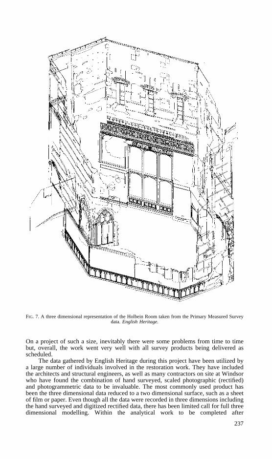
FIG. 7. A three dimensional representation of the Holbein Room taken from the Primary Measured Surveydata.English Heritage.
On a project of such a size, inevitably there were some problems from time to timebut, overall, the work went very well with all survey products being delivered asscheduled.
The data gathered by English Heritage during this project have been utilized bya large number of individuals involved in the restoration work. They have includedthe architects and structural engineers, as well as many contractors on site at Windsorwho have found the combination of hand surveyed, scaled photographic (rectified)and photogrammetric data to be invaluable. The most commonly used product hasbeen the three dimensional data reduced to a two dimensional surface, such as a sheetof film or paper. Even though all the data were recorded in three dimensions includingthe hand surveyed and digitized rectified data, there has been limited call for full threedimensional modelling. Within the analytical work to be completed after
237
the fieldwork, it is anticipated that there will be greater calls for three dimensionalviews to be produced and, given suitable hardware, this can now be achieved easily.
With the detailed recording work so far completed and even with a significantamount still outstanding, principally on the ground floor, the main phases of construc-tion of the Castle have become much clearer. A lot more is now known about themajor 14th, 17th and 19th century works and there remain much larger fragments ofearlier works than originally expected. The analytical programme which will followthe completion of site work may result in a better understanding of the 12th and 13thcentury works. The large archive of written and three dimensional graphical data nowdeveloped will be an invaluable resource for the future.
ACKNOWLEDGEMENTS
The authors would like to thank both the Royal Household at Windsor Castleand English Heritage Central Government and Palaces Branch for giving permissionto present this paper.
AutoCAD is a registered trademark of AutoDesk Ltd. Permatrace is a registeredtrademark.
REFERENCES
BAILEY , A., 1993.Fire protection measures for the Royal Palaces.H.M.S.O., London. 66 pages.BROWN, R. A., COLVIN, H. M. and TAYLOR, A. J., 1963.History of the Kings’ Works. Vols. I and II, The
Middle Ages. H.M.S.O., London. 469 pages.COLVIN, H. M., CROOK, J. M., DOWNES, K. and NEWMAN, J., 1976.Ibid. Vol. V, 1670–1782. 535 pages.CROOK, J. M. and PORT, M. H., 1973.Ibid. Vol. VI, 1782–1851. 744 pages.DALLAS, R. W. A., 1988. A specification for the architectural photogrammetric survey of historic buildings
and monuments.International Archives of Photogrammetry and Remote Sensing,27(B8): V24–V33.HOPE, W. ST. J., 1913.Windsor Castle: an architectural history.Country Life, London. Vols. 1 and 2, 639
pages. Vol. 3, folio of plans.STEVENS, D., 1992. Photogrammetry.Monitoring building structures(Ed. J. F. A. Moore). Blackie,
Glasgow. 155 pages: 32–67.
ResumeA la suite de l’incendie catastrophique survenu en 1992 dans les
appartements nationaux du chaˆteau de Windsor, les services anglais duPatrimoine ont mis sur pied un programme de leve´ photogramme´trique suivid’enregistrements arche´ologiques. On expose dans cet article le contexte dece travail, l’execution des leve´s photogramme´triques, l’utilisation desdonnees et leur analyse par une e´quipe d’archeologues.
ZusammenfassungNach dem verheerenden Brand in den Staatsgema¨chern von Schlob
Windsor im Jahre 1992 wurde durch English Heritage ein Programmphotogrammetrischer Messungen, denen archa¨ologische Aufzeichnungenfolgten, durchgefu¨hrt. Im Artikel wird der Hintergrund dieser Arbeiten, dieDurchfuhrung der photogrammetrischen Vermessungen und die Nutzung undAnalyse der Daten durch das Archa¨ologen-Team erla¨utert.
DISCUSSION
Chairman (Maj.-Gen. Wood):We’ve all heard a fascinating account of the workdone to recover from what was a real national tragedy. I’m sure you’d all like to joinme in thanking our three speakers for telling us about the tasks for which they wereresponsible, along with all those others who were part of this great operation. But nowI’m sure there are questions that you’d like to ask them.
238
Mr. Davies: I wonder if any of the three speakers could answer a question thatoccurred to me when I saw the excellent three dimensional reconstruction of the surveyarea (something which, sadly, we didn’t see on the screen). Are there any plans forreconstructing a series of three dimensional models of the structure as it was throughthe ages which the result of all the survey work could provide?
Mr. Kerr: The data which we recorded will be capable of being manipulated in thatway and that may well be one of the ways in which the analysis programme will proceed.But until we’ve actually completed gathering the data and have assessed its potentialfor analysis, we can’t say precisely what methods of analysis we’ll use. It’s clear thatwe are recording enormous amounts of data and their analysis is going to present us withsome interesting problems. We’ve already tried some three dimensional modelling ofthe Crimson Drawing Room that has proved to be very successful. It will be aninteresting way of presenting the information when it’s eventually published.
Chairman:Could I ask how you dealt with the overall control for this area? It wasclearly extremely complex and to be able to sort out where things were in relation toone another must have given you some considerable problems.
Mr. Dallas: Everything is related to the same three dimensional co-ordinate grid.As mentioned earlier, a very substantial measured survey had already been carried out.The surveyors (Sterling Surveys Ltd.) had left a series of control points on the terracesand in the main courtyard. We relocated several of these. Our surveyors traversed in fromthem and set up the co-ordinate system inside the building. My recollection is that wethen put some temporary points inside the building from which we could work.
Mr. Atkinson:Mr. Dallas told us, with a certain amount of pride, that everythingwas within 10 per cent of the budget that had had to be formulated so quickly after thefire. Can he give us some idea of the real magnitude of the photogrammetric operationin pounds?
Mr. Dallas: I think that the short answer to that is no. There were several zerosthough, if I may put it that way. I am sorry, but I am not in a position to give any figureson costings, as I am no longer an employee of English Heritage.
Mr. Stirling: We’ve heard a lot about the fact that this was a three dimensionalsurvey and three dimensional AutoCad design files were produced but all we saw wererectified photographs and drawings. I wonder why you did not illustrate any of thismagnificent three dimensional work tonight?
Ms. Lunnon:The amount of three dimensional reconstruction that has taken placeon site at Windsor is very limited. We do have some illustrations but had not producedany slides. This is an oversight which you only realise when you come to give a lecture.
Chairman:Mr. Dallas showed us the cover of his specification for such work. Didit prove to be appropriate or did you have to make many changes in the light of theexperiences you had at Windsor?
Mr. Dallas: Very few as, in general, we were following well tried and testedprinciples. Architectural photogrammetry is not the new fangled technique that somepeople still seem to think. The 25th anniversary of probably the largest architecturalphotogrammetric survey to be carried out in this country took place in 1993. This surveywas of the entire exterior elevations of Hampton Court Palace, carried out in 1967–68.This huge survey was carried out by the Survey Co-partnership (Plowman Craven andAssociates and Rylance and Associates). I think that that enormous survey really putdown a marker and architectural photogrammetry has been in continuous productionever since. I think that my specification, first introduced in 1987, helped to codify themethods and to give a standard to work to, so that we could define what we meant byarchitectural photogrammetry. The main area where it did not really prove appropriatewas in the layering conventions. So many different types of fabric had to be noted andrecorded that we had to introduce quite a different set of layering. Other than that, it wasused as we’d been using it for a number of years in procuring surveys for EnglishHeritage, mostly of the Historic Property sites.
Mr. Stevens:I was intrigued by Mr. Dallas’s decision to use colour transparencyfilm in areas where there was a lot of scaffolding. Was this for exposure latitude or doeshe know something about transparency film that I don’t?
Mr. Dallas: No, it just seemed to work! We could have taken colour negatives andmade colour positives from them but that would have been an extra process and it is very
239
expensive to make large size transparencies from negatives. Working directly withthe colour transparencies seemed to enable you to see through all the scaffoldingmuch more clearly than working with black and white negatives or diapositives. Ithink it might have been Mr. Davies who first used colour transparency film widelysome years ago. As you say, the usual problem with colour transparency work is thatif you have very much variation in brightness, it can be very difficult. But here, wewere able to control the illumination because, as you saw from the slides, thescaffolding was so dense and therefore so dark that we were working with artificiallight. The scaffold poles showed up very clearly as a silvery colour, whereas all thefabric showed up in shades of brown and stone. It seemed to work very well. Also,in terms of its archival qualities, we would be quite confident that professional colourtransparency, properly stored, is good for decades.
Mr. Bryan: We’ve already completed a great deal of survey, principally onground and upper floors. Mr. Dallas made mention of the basement area. How muchmore survey will be carried out in this area or is it unlimited?
Mr. Kerr: Probably one of the main problems with the work at Windsor is thedifficulty in quantification. We were able to make relatively good estimates of theimmediate post-fire damage but fairly large areas of additional fabric have beenexposed by the stripping out of later finishes and fittings. Some of the works whichwe were planning to do in 1994 have been deferred until 1995. They don’t come intothe refurbishment programme for some time because of continuing damp problems.So where we don’t have to record something immediately, they prefer us not to. Inother cases, some of the rendering has only just been removed from some of theground floor areas and more fabric has just been exposed in the last couple of weeks.I think that the experience in the Round Tower has shown that there will be somerecording work going on until virtually the completion of the recording project. Wehad someone on site in the Round Tower, for example, until the topping-outceremony there just two weeks before the fire. The two events are not connected!
Chairman:Has the experience of the Windsor fire encouraged a programme ofrecording of all the Royal Palaces and other major monuments? I know that a certainamount of work has been going on, but is the matter being treated much moreseriously?
Mr. Dallas: As a consultant, I am not speaking for any body responsible forthese buildings but I think that it is noticeable that there has been an increase inactivity. The Royal Household, responsible for the occupied Palaces, has carried outwork. The Historic Royal Palaces agency is in the process of carrying out work andHistoric Scotland, responsible for the Palace of Holyrood House, has also carried outwork. This all follows the Bailey Report (Bailey, 1993) after the fire, whichrecommended that drawn, measured and photographic records of all Royal Palacesshould be created. This was bound to result in quite a substantial programme of work.
Chairman: I would like to round off the evening by thanking all of you fordescribing this work. We hope that there won’t be any more fires but that there willbe more photogrammetry so that there are good records of the marvellous buildingswhich we have in this country.
240