Wildlife Management Plan
150
Wildlife Management Plan 2018 Prepared by Neo Human Foundation DRAFT COPY Shivpur-Kathautia New BG Electrified Line Submitted by:- IRCON INTERNATIONAL LIMITED 121/C, Mandir Marg, Ashok Nagar, Ranchi Jharkhand - 834002
-
Upload
khangminh22 -
Category
Documents
-
view
0 -
download
0
Transcript of Wildlife Management Plan

Wildlife Management Plan
2018
Prepared by
Neo Human Foundation
DRAFT COPY
Shivpur-Kathautia New BG Electrified Line
Submitted by:-
IRCON INTERNATIONAL LIMITED
121/C, Mandir Marg, Ashok Nagar, Ranchi
Jharkhand - 834002

DRAFT COPY
WILDLIFE MANAGEMENT PLAN
Shivpur – Kathautia New BG Electrified Line
IRCON INTERNATIONAL LTD.
Submitted by:-
IRCON INTERNATIONAL LIMITED
121/C, Mandir Marg, Ashok Nagar, Ranchi
Jharkhand - 834002
Prepared by:
Neo Human Foundation
New Forest Colony, Hurhuru, Hazaribag, Jharkhand
Phone:- 09934509213/06546222426 Email- [email protected]

C O N T E N T
CHAPTER CONTENT PAGE
NO.
PREFACE i
EXECUTIVE SUMMARY ii-iv
CHAPTER - 1 INTRODUCTION
1.1 Area details 1-6
1.2 Location of the project area 6-7
1.3 Project description 8-9
1.4 Status of forest diversion proposal 9
1.5 Status of environmental clearance 9
1.6 Villages and habitation within the project area 9
1.6.1 Project area 10
1.6.2 Project impact zone 10
1.7 Climate
1.7.1 Rainfall 10
1.7.2 Temperature 11
1.8 Terrain / Landscape / Geography 11-13
1.8.1 Geology, Rock and Soil 13
1.8.2 Water supply 14
1.9 Demographic details 14-17
1.9.1 Occupational profile of the villages 17-18
1.9.2 Agriculture cropping pattern 18-23
1.9.3 Cattle Population and dependency on forest 23-24
1.10 Forest based livelihoods 24-25
1.11 Industries 25
1.12 Statement of Significance 25-26
1.13 Forest of Project Area
1.13.1 Description of the forests 26
1.13.2 General description of growing stock 27
1.13.3 Forest types 27-33

CHAPTER CONTENT PAGE
NO.
CHAPTER - 1
IMPORTANT FLORA AND FAUNA
1.14 Forest Flora 34
1.14.1 Site specific flora 34-37
1.15 Forest Fauna 41-42
1.15.1 Site specific fauna 42-43
1.15.2 Habit and Habitat of threatened Species of
Fauna 43
1.15.3 Movement of Elephant in the project area 44-46
1.16 Habit and Habitat of Important Animals
MAMMALS
16.1 Elephant 47-48
16.2 Blue Bull 48-50
16.3 Striped Hyena 51-52
16.4 Monkey 52-53
16.5 Common Langur 53-54
16.6 Sloth Bear 54-55
16.7 Indian Porcupine 55-56
16.8 Indian Wild Boar 56-57
16.9 Jackal 57-58
16.10 Jungle Cat 58-59
16.11 Spotted Deer 59
16.12 Barking Deer 59-60
16.13 Sambhar 60-61
16.14 Hares 61- 62
16.15 Squirrels 62-63
16.16 Civet 63-64
16.17 Common Mangoose 64
REPTILES
16.18 Python 65-66
16.19 Common Indian Monitor 66-67
BIRDS
16.20 Peafowl 67-68
16.21 White-backed Vulture 68

CHAPTER CONTENT PAGE
NO.
16.22 Indian Vulture 69-70
1.17 Man animal conflict 70-71
1.18 Analysis of Forest Working/Management Plan 71-72
1.19 Conservation values of the proposed area 72-73
1.20 Methodology 73-75
CHAPTER - 2 ECOLOGICAL AND ENVIRONMENTAL IMPACT
2.1 Ecological & Environment impact 76-79
2.2 Detrimental effects of Railway Line 79
2.3 Environmental Impacts Found in Railway Projects 80
2.3.1 Wildlife Mortality/Injury (kill/accident) 81-82
2.3.2 Railway line as cause for habitat loss and degradation 83
2.3.3 Impacts of headlight glare on wildlife 84
2.3.4 Habitat impairment / Barrier effect 84-86
2.3.5 Genetic effects on animals 86
2.3.6 Conduits for invasive alien species 86-87
2.3.7 Landslides and soil erosion 87
2.3.8 Impacts on aquatic ecosystems 87
2.3.9 Ecological traps 87-88
2.3.10 Change in animal behaviour 88
2.3.11 Rail, people and pollution 88-89
2.3.12 Impacts on local and indigenous peoples 89
2.3.13 Human-Wildlife Conflict 89
2.4 Summary of threats to wildlife 90
2.5 Methodology 90-91
CHAPTER 3 3.1 Mortality of animals during accident-kill/Electrocution 92-93
3.2 Habitat loss/fragmentation/degradation 93-94
3.3 Conduits for invasive alien species 94
3.4 Landslide and soil erosion 94-95
3.5 Increased human presence and pollution 95
3.6 Effects on local and indigenous peoples 95

CHAPTER 3 CONTENT PAGE
NO.
3.7 Barrier causing habitat fragmentation 96-97
3.8 Higher daytime temperatures and greater range of temperature
extremes 97
3.9 Higher wind speeds and wind-throw of trees in forest areas 97
3.10 Cutting of vegetation resulting in weed proliferation and
suppression of native vegetation regeneration 97
3.11 Disturbance related to construction and maintenance 97-98
3.12 Increased risk of fires, deliberate and due to desiccation 98
3.13 Pollution, sedimentation, and changed discharge regimes into
water bodies
98-99
3.14 Additional enhancement measures 99-101
3.15 Strategies for mitigation action plan 101-102
CHAPTER - 4 PROPOSED MANAGEMENT STRATEGIES AND
INTERVENTION BY THE PROJECT AUTHORITIES
4.1 Wildlife Conservation and Awareness Programme 103-104
4.2 Artificial Nest or Man-made Nest 104-105
4.3 Community programme as social responsibility 105-106
4.4 Management of cleared vegetation on side of track 106
4.5 Signage 106-107
4.6 Research and monitoring 107-109
4.7 Budget 109
CHAPTER- 5
PROPOSED MANAGEMENT STRATEGIES AND
INTERVENTION BY THE DIVISIONAL FOREST OFFICER
5.1 Habitat Management for Flora and Fauna
A. Food Management 111-114
B. Water Management 114-115
C. Cover Management 115-116
5.2 Lantana Management 116-117
5.3 Wildlife Health 117
5.4 Illicit filling 117
5.5 Fire Management 117-118
CHAPTER 5 CONTENT PAGE
NO.
5.6 Eco – development work in surrounding village to reduce
conflict
118-120
5.7 Research and Monitoring 120-121
5.8 Monitoring and evaluation 121-122
REFERENCE 123-128
CHAPTER 6 PROPOSED BUDGET 129
Table : 1. Project Authorities (IRCON) 130
Table : 2.1. DFO (Hazaribag West Forest Division)
Table : 2.2. DFO (Chatra South Forest Division)
131-133
134-136
CHAPTER 7 APPENDICES
ANNEXURE ( I - XXXI )
PHOTOGRAPHS ( PLATE I- VI)
MAPS (1-7)

i
PREFACE
This Wildlife Management Plan has been prepared as per condition
stipulated in the Letter No. FP/JH/RAIL/11986/2015/591 dated 4th July, 2016
by Ministry of Environment, Forest and Climate Change, Govt. of India.
This document should be cited as:
Wildlife Management Plan for New BG Electrified line from Shivpur
to Kathautia in Chatra and Hazaribag district of Jharkhand.
The conservation of wildlife has gained utmost importance in the recent
past. The dwindling population of major fauna as well as lesser known species
has attracted attention of Government of India and State Government. This plan
has been prepared in accordance with guidelines issued by PCCF-cum-Chief
Wildlife Warden, Jharkhand for site-specific Wildlife Management Plan for
diversion of forest land (2015).
A long term Wildlife Management Plan for protection and conservation is
the need of the hour to save from extinction, keeping the above priority in mind
IRCON INTERNATIONAL LTD, a Govt. of India Undertaking has fulfilled
the condition with all due care for wild animals so that development and wild
animals can co-exist.
………………………………….
IRCON INTERNATIONAL LTD

ii
EXECUTIVE SUMMARY
The proposed New BG Electrified line from Shivpur to Kathautia in
Chatra and Hazaribag district of Jharkhand is mainly for connectivity of
existing rail infrastructures to coal blocks of North Karnapura and its
distribution to Northern and Eastern region of country after the fulfilment
of local requirement like DVC Koderma, NTPC Barh etc.
The proposed New BG Electrified line from Shivpur to Kathautia (49.085
km) in Chatra and Hazaribag district, passes through Hazaribag West
Forest Division and Chatra South Forest Division in Jharkhand requires
diversion 368.72 Ha of forest land for a project.
The proposed site of forest area diverted i.e. 368.72 Ha is situated within
the legal jurisdiction of Hazaribag West Forest Division (61.72 Ha) and
Chatra South Forest Division (307.01Ha).
Sal (Shorea robusta) is predominant species in Forest Division, with its
associates. Some areas have miscellaneous forests with species like Kend,
Piar, Dauntha, Sidha, Mahua, Salai, Khair etc. All the forests fall in
subgroup 5B, i.e. Northern Tropical Dry Deciduous Forests as classified
by Champion and Seth.
The hilly terrain of proposed area is suitable habitat to sustain wild
animals like Jackal, Wolf, Hyena, Mongoose, Nilgai, Porcupine, Jungle
cat, Rock Python etc. such animals are very important for a healthy
ecosystem. Besides these varieties of bird species raptors, wetland birds,
local migrants, bush birds etc. are found in the region.
The important schedule I species Indian Elephant, Pangolin, Sloth Bear,
White-rumped Vulture, Indian Vulture, Peafowl and Python are seen in
the project area and besides this, other animal listed in Schedule-II, III
and IV of wildlife Protection Act, 1972.
iii
The wildlife is in continuation threat due to developmental projects,
global warming, vehicle movement, noise pollution, fragmentation of
habitat barrier effect and man-animal conflict leading to loss of
biodiversity. They require food, water, shelter for breeding and fawning
cover to sustain its life in wild.
The purpose of this plan is to maintain wildlife habitat, restore degraded
habitats, improve biodiversity, reduce man and wildlife conflict and
organise village level institution for the realization of the above objective
as mitigation measures due to habitat loss by the project.
Before recommending activities in Wildlife Management Plan an
extensive survey has been made in all forest area and villages to meet the
people and assessing condition of wildlife habitat and also to know the
existing wildlife. Besides direct observation, a questionnaire has been
prepared to extract maximum knowledge of local people.
Since the railway line passes through the forest where elephant movement
has been seen in the recent five years, special mitigation measures has
been taken for safe crossing of Elephant/wildlife across the railway track.
The habitat requirement of different wild animals studied and
incorporated in this Wildlife Management Plan. Since, the Hazaribag area
is also identified as IBA (Important Bird and Biodiversity Area). Special
survey of birds has been conducted and mitigation measures has been
recommended.
While making this Wildlife Management Plan care has been taken to
identify the needs of the wildlife. The basic need of food, water and shade
(shelter), has been identified and budgetary provision for each item has
been incorporated in plan.

iv
The entire proposal has been divided in two broad category i.e. scheme to
be implemented by Forest Department officials and schemes to be
implemented by project authorities.
While dividing the work, care has been taken about the site of work. All
the schemes which needs implementation on forest land/department has
been proposed for Forest Department for example works related to
improvement/enrichment of habitat i.e. plantation activities, fire
protection, weed management on forest land etc.
The research and continuous monitoring of impact is necessary for
wildlife conservation. Hence provision for such activities has been made
in plan.
In order to conserve and protect wildlife, mitigation measures are
required which includes assessment of impact and proper implementation
of Wildlife Management Plan. So that loss of biodiversity at regional
level due to degradation of habitat, loss of wildlife, fragmentation of
forest, change in habitat, soil erosion and overall loss of biodiversity can
be mitigated.
**********
1 | P a g e
CHAPTER - 1
INTRODUCTION
ildlife management is a science and art of
maintaining/changing the characteristics and interactions of
habitats, wild animal populations and activities of people in order to achieve
specific goals of conservation. The Wildlife Science is of recent origin in
India and scientific information base is developing slowly. Wildlife
management in India is integral to mainstream forest management, yet, as a
resource needing scientific management. Management of wild life is
essentially multidisciplinary and the success of strategies lies in ensuring
multidisciplinary inputs to the extent needed.
Wildlife conservation aims to prevent the loss in the earth’s by taking
into consideration ecological principles such as carrying capacity,
disturbance, succession and environmental conditions such as physiological
geography, pedology and hydrology with the aim of balancing the needs of
wildlife with the needs of people.
1.1 AREA DETAILS
The geographical area of the Jharkhand state is 79,714 km2 which
account for 2.42% of the country's area. The state falls between 220 00'N -
W

2 | P a g e
24037'N latitude and 83015'E-87001'E longitude. The important rivers of the
state are Sone, Koel, Swarnrekha, Sankh, and Damodar. The state of
Jharkhand has a tropical climate with annual average rainfall of about
900mm. The temperature varies between 4 0C to 47 0C. The state's population
is 32.97 million (Census, 2011) constituting 2.72% of the country's
population. Of this, the rural population is 75.95% and urban population
24.05%.
The total recorded forest area of the Jharkhand state is 23,605 km²
which is 29.61% of the geographical area to Country's Geog. area. Of the
total recorded forest area of Jharkhand, Reserved Forests constitute 18.58%,
Protected Forests 81.28%, and Unclassed Forests 0.14%. As per India State
of Forest Report, 2013 published by Forest Survey of India, forest cover in
the state is 23, 473 km² which is 29.45% of the total geographical area of the
state Jharkhand. The total forest and tree cover of state, put together
constitutes about 32.74% of the geographical area of Jharkhand (MoFECC,
2012).
The main forest types of Jharkhand are (a) Peninsular Dry and Moist
Sal Forests, (b) Moist Sal Savannah,(c) Hill Valley Swamp Forest, (d) Moist
Mixed Deciduous Forest, (e) Riverine Forest, (f) Bamboo and Cane brakes
(MoEF, 1999).
Regarding forest canopy density classes, 2,587 km2 area is under very
dense forest, 9,917 km2 area under moderately dense forest and 10,470 km2
area are under open forest. The forest cover Map of Jharkhand has been
shown in Fig. 1.

3 | P a g e
Fig. 1. Forest Cover Map of Jharkhand (Courtesy, Forest Dept. Jharkhand)
Jharkhand has one National Park and 11 Wildlife Sanctuaries covering
2,182.15 km2 which constitutes 2.74% of the state's geographical area. The
protected areas (PA) of the State include the Betla (Palamau) National Park
(23167 ha), the only National Park and 11 Wildlife Sanctuaries viz. Dalma
Wildlife Sanctuary (19322 ha), Hazaribagh Wildlife Sanctuary (18625 ha),
Koderma Wildlife Sanctuary (17795 ha), Lawalong Wildlife Sanctuary
(20700 ha), Mahauaduar Wildlife Sanctuary (6325 ha), Palamau Wildlife
Sanctuary (79433 ha), Palkot Wildlife Sanctuary (18300 ha), Parasnath
Wildlife Sanctuary (4933 ha), Topchanchi Wildlife Sanctuary (875 ha),
Udhuwa Lake Bird Sanctuary (565 ha) and Gautam Buddha Wildlife
Sanctuary.
The proposed project for construction of New BG Electrified line from
Shivpur to Kathautia fall in Chatra and Hazaribag district of Jharkhand state,

4 | P a g e
a most prolific mineral producing state in the country, consisting primarily of
Chhotanagpur plateau.
1.1.1. CHATRA DISTRICT
The newly created district of Chatra in 1991 is situated within lush
green area with salubrious climate. Thus, former Chatra sub-division of
Hazaribag district attained the status of district. Chatra district forms the
western flank of North Chotanagpur division of Jharkhand state. It is
bounded on the north by district of Gaya (in Bihar state), on the south by
district of Ranchi (Jharkhand), on the east by district of Hazaribag
(Jharkhand) and on the west by districts of Palamu (Jharkhand) and
Gaya(Bihar), Chatra(M) is the headquarters of both Chatra district and Chatra
sub-division.
The district lies between 24.12' Latitude (N) and 84.56' longitude (E)
within northern hemisphere, with respect to area it occupies 3718 sq. km
(Census, 2011). Raja Ram Mohan Roy, the great social reformer and herald
of modern India had worked as a Deputy Registrar from the year 1805-06
A.D. at Chatra. As it remained a sub-division of Hazaribag district since 1914
to 1991, hence the history of Chatra district almost resembles with that of its
parent district of Hazaribag.
The district has only one subdivision, e.g., Chatra subdivision which
has in turn 12 C.D. Blocks, viz., Shaligram Ram Narayanpur (Hunterganj),
Pratappur, Kunda, Lawalaung, Chatra, Kanha Chatti, Itkhori, Mayur Hand,
Giddaur, Pathalgora, Simaria and Tandwa. In entire district there is only one
statutory town Chatra (M) under Chatra C.D. Block and one census town
Bachra under Tandwa C.D. block. There are Chatra & Simaria Legislative
Assembly segment in the district. Total no. of Panchayats in the district are
96 whereas total no. of villages are 1471.
Chatra ranks 15th in terms of population (10,42,886) and 10th in terms
of area (3718 sq.km.) in the state of Jharkhand. The economy of the district

5 | P a g e
mainly depends on cultivation or related work. More than 77% of the total
workers are engaged in Primary sector.
1.1.2. HAZARIBAG DISTRICT
The Hazaribag district is a part of Chotanagpur plateau. It is situated in
the north east part of North Chotanagpur Division. The total area of the
district is 3555 Sq. Km. (Census, 2011). It is situated at Latitude 24°00'0.00"
North; Longitude 85°14'60.00" East.
The area has several plateaus, mountains and valleys having three
natural divisions - Medium Plateau, Lower Plateau and Damodar
Valley. The headquarter of Hazaribag District is a part of medium plateau,
at about 2,000 ft from the sea level. The area is surrounded by the lower
plateau height is about 1,300 ft above the sea level except the western part of
the medium plateau. Damodar Valley is in the southern part of the district
where Ramgarh town is situated below about 1,000 ft from the districts
headquarter.
The boundary of Hazaribag district consists of districts of Gaya and
Koderma in the northern part, Bokaro and Giridih in the east, Ramgarh in the
southern part and Chatra and Palamu in the west. The Koderma, Chatra and
Giridih district have been bifurcated from this district. It is famous
for Hazaribagh Wildlife Sanctuary situated about 17 km from Hazaribag
Town.
Hazaribag Town is 93 km. from capital Ranchi. It is located on NH 33
bisecting the Hazaribag district. The principal town and administrative
headquarters is Hazaribag, which is situated towards the west of the higher
Hazaribag plateau at an elevation of about 2,000 feet. According to Sir John
Houlton, the town name Hazaribag is from the small villages of Okni and
Hazari, which is shown in old maps as Ocunhazry. This village is still in

6 | P a g e
Hazaribag in the western edge of the town. The district of Hazaribag has been
named after the town of Hazaribag.
Hazaribag district is divided into two sub-divisions: Hazaribagh and
Barhi. Hazaribagh sub-division comprises 11 blocks: Sadar Hazaribag,
katkamsandi, Barkagaon, Bishnugarh, Keredari, Ichak, Churchu,Katkamdag,
Daru, Tati Jhariya, Katkamdag and Dadi. Barhi sub-division comprises 5
blocks : Padma, Barhi, Chauparan, Barkatha and Chalkusha.
(http://www.jharkhand.gov.in/web/hazaribagh).
The major area of Hazaribag district are full of forests cover and
stones. The cultivable land is of two types -the Upper land and the Lower
land. The lower lands present on the banks of rivers are fertile but the upper
land is barren. Rabi and Kharif crops are generally grown here.
1.2 LOCATION OF THE PROJECT AREA
The proposed Railway Line will originate from Kathautia (km. 00.00)
in Hazaribag district and terminate at Shivpur (49.085 km) in Chatra District
of Jharkhand State. The proposed rail line passes through important 31
habitations falling in Hazaribag West Division and Chatra South Forest
Division.
The total length of the proposed railway line from Shivpur to Kathautia
is 49.085 km. The summery of the land use pattern (Table 1.1) of the
proposed project is shown below and the details is enclosed. (Annexure
I).The proposed land is predominantly forest land/JJ (68.46%) and the other
land (31.54%).

7 | P a g e
Table 1.1: Land Utilization Pattern of the project site
Type of Land
Area
(Ha)
Total Geographical Area 17429.39
Forest Area 9155.43
Area under Non Agricultural Uses 1501.58
Barren & Uncultivable Land Area 206.71
Permanent Pastures and other Grazing Land Area 121.69
Land Under Miscellaneous Tree Crops etc. Area 86.78
Culturable Waste Land Area 985.36
Fallows Land other than Current Fallows Area 270.46
Current Fallows Area 206.8
Net Area Sown 4894.58
Total Unirrigated Land Area 4428.74
Area Irrigated by Source 384.81
Total length of land acquisition is 538.56 Ha and diversion of forest
land is 368.72 Ha including forest land from Hazaribag West Forest Division
and Chatra South Forest Division. The forest land for diversion within the
PF/JJ areas in the two Forest Division is 368.72 Ha, which is in the stretch of
49.085 km from Shivpur to Kathautia.
The forest area proposed to be diverted is mostly undulating (90%).
Total area required for diversion is 368.72 Ha, comes under the jurisdiction
of Hazaribag West Division and Chatra South Forest Division in Hazaribag
and Chatra district. The draft notification for Eco-Sensitive Zone of
Hazaribag wildlife Sanctuary has been issued (The Gazette of India, 8th Feb
2018). The village Kathautia, Chirua, Hesakudar and Sahpur falling in the
Hazaribag West division is included in the draft notification of Hazaribag
Eco-sensitive Zone. The final notification is pending.
8 | P a g e
1.3 PROJECT DESCRIPTION
The proposed New BG Electrified line is mainly for connectivity of
existing rail infrastructures to coal blocks of North Karnapura and its
distribution to Northern and Eastern region of country after the
fulfilment of local requirement like DVC Koderma, NTPC Barh etc.
It is proposed to divert 368.72 Ha of forest land for a project.
Cost of the Project Land Cost ( Rs. 280.12Cr) + Construction cost (Rs.
1013.84 Cr.)= Rs. 1293.96 Cr.
Width proposed varies from 40m - 240 m.
This project is for single line having 6 nos. of crossing
stations/cabins, yards between Shivpur to Kathautia with 11 nos. of
Elephant underpass/Wildlife passes, 58 nos. minor bridges, 8 nos.
major bridges, 14 nos ROBs, 14 nos. RUBs and 10 nos. LHSs.
(Annexure II)
Cost to benefit analysis is attached as per proposal submitted by EC
Railway. (Annexure - III)
Displacement of families- Nil
The total length proposed site is 49.085Km.
The total no. of trees which comes under proposed site is 17637.
(Annexure - IV)
The details of the area diverted is 368.72 Ha, in Hazaribag West
Division (61.72 Ha) and Chatra South Division (307.01Ha) is enclosed.
(Annexure -V)
Map of proposed railway line on toposheet - RF 1:50,000 with GPS
Coordinate is enclosed (Map 1)
9 | P a g e
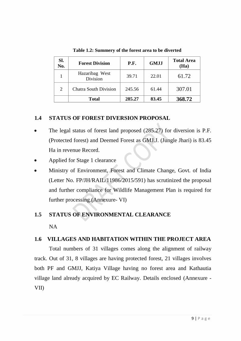
Table 1.2: Summery of the forest area to be diverted
Sl.
No. Forest Division P.F. GMJJ
Total Area
(Ha)
1 Hazaribag West
Division 39.71 22.01 61.72
2 Chatra South Division 245.56 61.44 307.01
Total 285.27 83.45 368.72
1.4 STATUS OF FOREST DIVERSION PROPOSAL
The legal status of forest land proposed (285.27) for diversion is P.F.
(Protected forest) and Deemed Forest as GMJ.J. (Jungle Jhari) is 83.45
Ha in revenue Record.
Applied for Stage 1 clearance
Ministry of Environment, Forest and Climate Change, Govt. of India
(Letter No. FP/JH/RAIL/11986/2015/591) has scrutinized the proposal
and further compliance for Wildlife Management Plan is required for
further processing.(Annexure- VI)
1.5 STATUS OF ENVIRONMENTAL CLEARANCE
NA
1.6 VILLAGES AND HABITATION WITHIN THE PROJECT AREA
Total numbers of 31 villages comes along the alignment of railway
track. Out of 31, 8 villages are having protected forest, 21 villages involves
both PF and GMJJ, Katiya Village having no forest area and Kathautia
village land already acquired by EC Railway. Details enclosed (Annexure -
VII)

10 | P a g e
1.6.1 PROJECT AREA
The construction of railway line will be done on forest land proposed
passing through 29 (i.e. 8+21) such villages which falls under forest
diversion. The total area diverted 368.72 Ha fall under Hazaribag West
Division (61.72 Ha) and Chatra South Division (307.01Ha).
1.6.2 PROJECT IMPACT ZONE
The project is linear and total length of proposed project site is 49.085
km. PF/GM (Jangle Jhari) areas falling in both the concerned Forest
Divisions. Since the project is linear all the 31 villages through which the
railway line is passing has been included as project impact zone.
List enclosed (Annexure- VIII).
1.7 CLIMATE
There are four season viz. winter, summer, rainy and autumn. The
winter season starts from the middle of November and goes upto the middle
of February. The summer season starts from the middle of February and goes
up to the middle of June. The rainy season starts from the middle of June and
goes up to the middle of September. The autumn seasons starts from the
middle of September and goes up to the middle of November.
Humidity varies from a maximum of about 90 percent during monsoon
to a minimum of around 10 percent, during March/April of the year. Since
both the district boundary of Hazariag and Chatra is the same the climatic
condition of both the area is almost same.
1.7.1 RAINFALL
The monsoon is between June to October The North westerly wind in
winter causes severe cold conditions in the area. Rainfall is heavier in the
month of July and August. Annual average rainfall is 1347 mm.

11 | P a g e
1.7.2 TEMPARATURE
Hazaribag and Chatra experiences Tropical Climate with hot summers
and cold winters. The maximum temperature during the summer months
(March to May) rises to a high of 46-47°C. The minimum temperature of the
region drops to a low of 4°C during winter (November to February).
However, places at lower altitude record quite high temperature during
summer. This, sometimes adversely affects the plantations. Hot westerly
wind, the ‘loo’ is experience all over the tract. The winter is generally
pleasant except for a short span when the night temperature almost touches
the freezing point. Though frost is not so common, certain low lying pockets
on the plateau near depressions and along the nalas become frosty during the
cold wave.
1.8 TERRAIN / LANDSCAPE /GEOGRAPHY
The topography is extremely variable. In Hazaribag West Division, in
the south, the forests of Ramgarh Range are mostly situated on the steep
northern slopes of Ranchi Plateau. In Barkagaon and Tandwa Ranges the
forests occur on the southern slopes of Hazaribagh plateau and on isolated
hills like Mahudi Pahar, Niri & Khapia etc. The topography of Mahudi hill
needs special mention. It is a high range with precipitous slopes. These slopes
are devoid of any vegetation. The forests of Hazaribag Range occur on the
main Hazaribag plateau where the topography is generally easy to undulating.
Hazaribag Wildlife Sanctuary is one of the important protected area in
Hazaribag with very rich biodiversity. The topography of Hazaribag Wildlife
Sanctuary Range is undulating to hilly. The terrain of the Sanctuary is
undulating with low to high hills in the central and western portions.
Forests of the Chatra South Division are spread over the south of the
Chatra district. This division consists of rugged topography with turbulent
streams, steep slopes, cliff and valleys. The forests lie mainly on its
12 | P a g e
undulating slopes. The tract is the eastern part of the Vindhyan Hill ranges.
The ground configuration varies considerably from place to place. The
topography is hilly with occasional plain tracts and some are upland. Most of
the hills are rocky and slops are steep. Western and Southern zones are more
hilly than the others. The hilly terrain of this division lie within the
Lawalong, Simariya and Tandwa range. In Chatra range, land is plain to
undulating. The average height of this division is 1300 ft to 1400 ft.
The drainage system of Chatra South Division is complex due to
rugged and undulating topography but general trend is east to west in the mid
and southern part of the tract and south to north in the eastern part of the
tract.
The table land near Hazaribagh town forms the origin of several
important rivers. The Bokaro and the Konar originate near village Sultana on
the Hazaribag – Chatra Road. The Barakar originates near Ichak. The
Mohane also originates near village Bendi and forms the western boundary
between Hazaribagh West and Chatra South Division. Bulk of the area falls
in the catchment of the Damodar. Only a small portion forming the western
and south-western portion of Hazaribagh Range lies outside the Damodar
catchment.
Due to forest fires, overgrazing and unplanned cultivation of uplands
soil erosion is very severe. The practice of extracting timber firewood etc. by
“gohars” (dragging by means of bullocks) has also been deleterious. Gullies
can be seen all over the area and sheet erosion is uncontrolled. Water, even
from small streams rushing down easy gradient carried a good quantity of
soil with it. All the soil dislodged from the upland goes to big river & its
tributaries and raises their beds.

13 | P a g e
1.8.1 GEOLOGY, ROCK & SOIL:
Geologically, two types of formations – Archaen type & gondwana
type exist in the area. Main rock types of Archaen formation are granite and
gneiss, whereas sandstone, shale and quartzite constitute Gondwana
formation
Hazaribag district is naturally rich in several ores and minerals. Coal
and Mica are the main minerals whereas China clay and limestone are also
found in the district. The portion of the Jharkhand mica belt and the
coalfields that lie in this district are economically the most important. North
Karanpura Valley is important for the coal block.
Soil is very deep in valleys and plains and is loamy or sandy loam in
texture, supporting dense semi deciduous Sal forests interspersed with
grasslands, making an ideal habitat for a variety of fauna. On the hills, soils
are shallow, while the forest is of miscellaneous type.
1.8.2 WATER SUPPLY
Rivers and Important Water bodies
Hazaribag district has a network of two major rivers, the Barakar and
Damodar rivers with a few minor tributaries like Naikari, Kusum, Bhera,
Bokaro, Mohana, and Kumari.
Hazaribag district consists of a total of 770 wetlands comprising an
area of 11307 hectares. Reservoir/Barrage (6571 ha) is observed to be a
dominant type comprising about 58 per cent of wetland extent. River/Stream
(3780 ha), which accounts for about 33 per cent of the area (National
Wetland Atlas, 2010).
Chatra District consist 179 wetlands > 2.25 ha and an additional 464
smaller wetlands comprising area of 5253 ha. Wetland types are dominated
by the River/Stream (3535 ha) and Reservoir/Barrage (854 ha) accounting for

14 | P a g e
about 67 and 16 per cent area under wetlands. The next significant wetland
type is Tank/Pond with 376 ha comprised of 70 numbers.
Amanat, Lilanjan, Mohane, Chako and Dhab are the prominent rivers
in the Chatra South Forest Division.
Generally supply of water for drinking purpose is not a problem. But
during severe draught years the areas specially in hilly terrain face acute
shortage of water. All these streams are rainfed and seasonal and therefore,
dry up in summer.
1.9 DEMOGRAPHIC DETAILS
According to the 2011 census Hazaribag district has a population of
17,34,495. Hazaribag ranks 7th in terms of population (17,34,495 ) and 12th in
terms of area (3555 sq.km.) in the state of Jharkhand. In terms of population
per sq.km. Hazaribag is the 11th densely populated district in the state with
488 persons per sq.km as against the state’s 414. Its population growth rate
over the decade 2001-2011 was 20.65%. Hazaribag ranks 16th in terms of
sex-ratio (947) against the state’s 949, and a literacy rate of 69.75 %.
Chatra ranks 15th in terms of population (10,42,886) and 10th in terms
of area (3718 sq.km.) in the state of Jharkhand. In terms of population per
sq.km. Chatra is the 19th densely populated district in the state with 280
persons per sq.km as against the state’s 414. Chatra ranks 11th in terms of
sex-ratio (953) against the state’s 949. The economy of the district mainly
depends on cultivation or related work. More than 77% of the total workers
are engaged in Primary sector.
The demographic details of the 29 villages of the project site is shown
in Annexure IX. The table show that the most populated village is Edla
(5788) followed by Duari (5642) and Nawadih Damoll (4484) and the lowest
population is of Bisnapur (160). The two village Chirua and Siuria is without

15 | P a g e
any population. The figure showing population and household of 29 sample
villages is shown in the figure 2.
.
The average percentage of Scheduled Castes population of these
village is 21.60 percent. The average percentage of Scheduled Tribe
Population of these Village is 3.79 percent. The highest percentage of SC is
in Duari (11.73%) followed by Edla (10.42%) and Singhani (10.32%)
whereas the lowest is in Lemoia (0.08 %). The highest percentage of ST is in
Shahpur (34.02 %) followed by Hesakudar (17.52 %) and Phulwaria
(16.89%) and the lowest is in Nawadih Damoll (0.17%). The detail are shown
in the figure 3.
0
1000
2000
3000
4000
5000
6000
7000
Fig. 2. Showing Household vs Population of 29 villages
Total Households Total Population of Village

16 | P a g e
0
5
10
15
20
25
30
35
40
Fig. 3. Showing Percentage of SC and ST Population of 29 villages
Scheduled Castes (%) Scheduled Tribes (%)
56.72
0
53.5249.54
56.0358.91
67.5
44.4843.11
68.33
55.92
66.88
60.67
48.19
63.54
55.7957.4
48.75
59.27
0
51.1952.0351.8252.8557.57
60.61
52.48
43.2346.72
0
10
20
30
40
50
60
70
80
Fig.4. Showing literacy rate of 29 villages
Literacy (%)

17 | P a g e
Average literacy rate is 53.92 %. So the literacy is poor in the area.
Literacy rate of population is defined as the percentage of literates to the total
population. The literacy rate 50% and above is found only in 20 villages in
the study area. The highest literacy rate is found in Lemoia (68.33%) and the
lowest was in Bandarchua (43.11%). The literacy level of the sample
households are provided in figure 4.
1.9.1 OCCUPATIONAL PROFILE OF THE VILLAGES
The Census classifies Workers into two groups namely, Main workers
and Marginal workers. Main Workers are those workers who had worked for
the major part of the reference period i.e. 6 months or more. Marginal
Workers are those workers who had not worked for the major part of the
reference period i.e. less than 6 months. The workers are classified on the
basis of Industrial category of workers into the following four categories such
as Cultivators, Agricultural Labourers, Household Industry Workers and
Other Workers. Data from the 2011 census shows that the work participation
is low in these villages (44.47%). Work participation rate is defined as the
percentage of total workers (main and marginal) to total population. The
highest work participation of 65 % is observed in Bisnapur Village whereas
it is only 21.74 percent in Angara Khurd. The census data also shows the
percentage of main workers and marginal workers are also low in this area
which indicates large number of non-workers in this area. It can be attributed
to the non-availability of employment and less developed nature of the study
area. The work participation in only 9 villages is more than 50 % (Figure 5).
This also suggests that employment opportunities are very less in the villages.
The details of work participation in sampled village are provided in Annexure
X.

18 | P a g e
1.9.2 AGRICULTURAL CROPPING PATTERN
The economy of the two district Hazaribag and Chatra mainly depends
on cultivation or related work. Agriculture is the main source of livelihood
for more than 75% of the population in the Chatra district either as cultivators
or agricultural labourers. Despite this, only 18.47% of total geographical area
is cultivated. Further, only 26.7% of net sown area has assured irrigation
against the national average of 45%. That is, nearly 73% of cropping area is
rainfed or dependent on unassured irrigation.
All these facts point towards the relatively poor health of irrigation
facilities in the district. Agriculture practiced in this region is characterised as
rainfed monocrop subsistence type cultivation mainly due to lack of
agricultural development, lack of irrigation facilities and a rolling terrain.
Paddy and Makai (Maize) are the two main crops grown in the district. Other
major crops include wheat, pulses, oilseeds. Among pulses, tur/arhar, gram
25.18
0
49.33
40.22
35.04
30.53
65
44.82
64
53.98
43.6647.94
37
21.74
46.57
57.4654.3353.35
50.07
0
40.3543.17
47.7
37.3134.32
44.67
52.4854.01
39.05
0
10
20
30
40
50
60
70
Fig. 5. Showing Work Participation rate in Sampled Villages

19 | P a g e
(chana), lentil are widely grown. Among oilseeds, mustard is most widely
grown crop. However, the district is deficient in food grain production. Due
to proximity to major towns such as Hazaribag and Gaya, vegetables and
fruits are widely cultivated – especially in areas where irrigation facilties are
available. For instance, Simaria, Gidhour and Pathalgadda blocks cultivate
tomato, potato, cabbage, cauliflower, capsicum, chillies, sweet potato to cater
to needs of Hazaribag. The fine texture of soil here further makes it favorable
for vegetable cultivation. Similarly, Hunterganj cultivates brinjal and bottle
guard to cater to needs of Gaya. Panchayats surrounding Chatra town are also
known for vegetable cultivation. Table 1.3 reveals cropping pattern of Chatra
district.
Table 1.3 Cropping Pattern in Chatra district
(Source: Department of Agriculture (PMKSY. 2016)
Crop
Season Grown in
Paddy Most widely grown crop in Chatra.
Grown during Kharif Season
All Blocks.
Maize Kharif All Blocks
Pulses Arhar, Urad are grown during Kharif. And
Gram, Lentil, Pea during Rabi
All Blocks
Wheat Rabi In areas with
irrigation facilites
during winter
Oilseeds
Predominantly during Rabi as they less
moisture. Mustard & Linseed are grown
during Rabi. Groundnut & Seasum during
Kharif.
All blocks
Vegetables All three seasons In irrigated parts of
Hunterganj, Chatra,
Pathalgada, Gidhour,
Simaria, Itkhori
Fruits
All three seasons Itkhori, Mayurhand,
Hunterganj.
Sugarcane Kharif Itkhori, Gidhour

20 | P a g e
Agricultural production in Hazaribag district is also characterized by
mono cropping practices with only 14.5% of the net sown area being
irrigated. About 61% of the agricultural land holding belongs to small and
marginal farmers which have contributed to poor level of mechanized farm
operations in the district. Agriculture is mainly rainfed, the major crops
cultivated are Paddy, Wheat, Maize and Vegetables. The climate is
favourable to Horticultural crops. The climate is highly conducive for
growing a variety of vegetables, which is presently being cultivated in an
unorganised way various blocks.
Majority of the rural population depend on agriculture with very little
nonfarm employment opportunity. Mono-cropping is generally practised in
the district due to lack of irrigation facilities and agriculture is mostly based
on the monsoon. The main Kharif crops grown are Paddy, Maize, Arhar and
Pigeon-peas. Maize is cultivated in the uplands and paddy on medium and
low lands. Black gram and wheat are grown in some areas during the Rabi
season. As irrigation facilities are limited, cultivation in summer is rare and is
confined to growing vegetable, cash crops in areas having irrigation facilities.
Table 1.4 : Cropping pattern in the Hazaribag District
Sl. No. Crop Kharif Rabi
1 Cereals Rice, Maize Wheat
2 Pulses
Arhar (Pigeon pea),
Urad (Black Gram),
Moong (Green Gram)
Gram (Chick Pea),
Linseed,
3 Oilseed Groundnut Mustard
4 Vegetables Bhindi, Capsicum,
Tomato, Brinjal,
Green Pea, Potato, Onion,
Source: NABARD, District Agriculture Plan Hazaribag District 2008-09 to 2011-12
About 43.94 % of land in Hazaribag and 60.4% land in Chatra district
is under forest cover which can be used for cultivation of Medicinal and
Aromatic plants and forest based units (NABARD, 2012; PMKSY. 2016).

21 | P a g e
Potato, Tomato and some other vegetables including coriander leaves
are major commercial crops of the district. Except for a few orchards of
mango and guava and some beehives, horticulture has not been adopted as a
commercial activity and no plantation crop is being taken up in the district.
Vegetables particularly potato, tomato, cabbage, cauliflower, etc. are
grown in large tracts in Sadar Hazaribag, Ichak, and Padma blocks in the
project area. Paddy is the main crop of the district followed by wheat, pulses
and vegetables. Organic farming is being carried out sporadically in many
parts of Hazaribag district by local farmers. There is urgent need for
sensitizing the inhabitants of the district to practice organic farming and use
of bio-fertilizers and bio-insecticides.
Few progressive farmers have also adopted Integrated horticulture
based on mixed vegetable cropping, afforestation, Dairy, Gobar Gas plants ,
application of Vermicompost in the fields with the agriculture units covered
with bamboo plantation/fencing. Three hatcheries under private sector have
been commissioned in the district which are supplying DOCs to broiler units
in the district. Under the leadership of the District administration, a poultry
Broiler scheme was launched in Barhi, Padma, Chauparan blocks under the
Rashtriya Sam Vikas Yojana (RSVY), (NABARD, 2012).
In the district, livestock rearing is mainly taken as an household
activity, being managed by family members particularly women members.
There is potential in the district to develop dairy as an additional activity for
farmers and main activity for unemployed youth in rural area. One breeding
farm of Animal Husbandry Dept. located at Gouriya Karma in Barhi Block is
engaged in breeding of the rare Red Sindhi breed cows. This will be great
importance in dairy production in the project area. The prospect of promoting
dairy projects is high in the project area. Further, Sheep, Goat and Pig rearing
has substantial potential in the district. Goatery is predominant activity
among many families as a supplementary activity in the area. Potential for the

22 | P a g e
sectors like poultry and fishery exists in the district. The poor level of skill
and awareness among farmers is the reason for low level of growth in these
sectors.
The climate of the Hazaribag district is suitable for dry land
horticulture crops. The Krishi Vigyan Kendra (KVK) provides training and
technical help to farmers. A reeling & twisting centre (Post Cocoon
Sericulture ) for SHG members has been established by PRADAN (an NGO)
in Barhi & Chauparan blocks with financial assistance from Central Silk
Board. SHG members of Barhi, Padma and Chauparan blocks are to be
provided with Trivedi Charkha (454 nos) and Motorised Charkha (46) for
spinning purpose.
The Krishi Vigyan Kendra, Chatra sanction by the Indian Council of
Agricultural Research (ICAR), was established in May, 2005 under
administrative control of Birsa Agricultural University, Ranchi. Training of
rural farmers, rural youth Extension functionaries to make aware about
agricultural technological development, conducting location specific research
are some of the important activities of the Kendra to improve the socio-
economic status of agriculturists in the district.
In the project area people mostly depend upon rainfed agriculture
which depends upon the vagaries of nature. Source of irrigation are few. The
main source of irrigation has been ahars (small earthen dams across
depressions). These ahars do not store enough water and in years of scanty
rainfall does not serve any purpose. Irrigation from wells is being practice
now a days. Due to their dependence upon rains, the chief crop of the area is
Kharif viz Paddy and Maize.
Among the winter crops gram and arhar are grown in some localities of
late some enterprising cultivators have started cultivating wheat also. Due to
traditional and unscientific agricultural practices the people and the land have
become poorer. According to census report 2011 the main cultivable Kharif

23 | P a g e
crop in the sampled area is rice. Village survey in the sampled village
reported cultivation of Kharif crop viz. Rice, maize, arhar, Urad, Moong,
Groundnut, Bhindi, chilli, Brinjal and Tomato and the Rabi crop viz. wheat,
gram, Mustard, Potato, Onion etc. (Annexure- XI)
1.9.3 Cattle Population and dependency on forest
It has been estimated from the sampling area of project site that the
average number of livestock population of about 60,124, including cows,
buffaloes, pigs, goats and poultry are found in the project site. The average
percentage of cattle population per village is shown in the figure 6. The
figure show that the goat population is maximum 49% followed by buffaloes
24 %, cow 15%, poultry 6% and the pig is also 6%. Stall feeding is not
popular or being implemented. So people use forest as grazing ground,
causing shortage of food and cover for wild herbivores. On account of this
direct competition for pasture, the wild herbivores like Blue Bull, Deer etc.
are force to come to open places like agricultural field. Excessive grazing
also causes soil compactness which in turn causes soil erosion, runoff,
siltation of water bodies, shortage of water, loss of vegetation etc.
Cow
15%
Buffalo
24%
Goat
49%
Pig
6%
Poultry
6%
Fig. 6. Percent Of Livestock Per Village
Cow
Buffalo
Goat
Pig
Poultry

24 | P a g e
Such habitat degradation due to domestic livestock grazing disturbs the
wild fauna and it also spreads contagious diseases to adversely affect the
health and population of the whole pyramid of ecosystem. Pastures areas
needs to develop and stall feeding implemented for cattle so they are not
depend upon the forest.
1.10 FOREST BASED LIVELIHOODS/NTFP
The villagers are mostly dependent for wood fuel. In the study area
people are not actively engaged in forest product collection. It is an important
livelihood source for many tribal communities. Forest is important source of
firewood and other minor forest produce like timber, herbs, fruits, gums, sal
seed, sal leaves etc. it contribute almost 20 percent of the total income of the
villagers in project. Sal seeds and sal leaves together gives 10 percent of the
forest income. Jamun and Kendu patha contribute almost 8 percent of the
income.
It is estimated 60% of the total production of NTFPs are consumed
locally. Various types of NTFP viz., Kendu leaf, Mahua flower & seeds, Sal
seed and leaves, fruits, flowers, roots, bark, gums, fiber, medicines etc. of
various species are collected from the forest of project area. Except kendu
leaf which is collected by the corporation through contractors, all other NTFP
are collected by the locals in an unorganized way. Recently lac culture is
being promoted in Hazaribag West Division. Training and support is being
given to villagers in these forest division.
Collection of NTFP form the forest in unorganised way has a negative
impact, as it leads to habitat degradation and disturbance causing shortage of
food and cover for wild animals. There are many incidences wherein the
collection of Mahua flower has led to outbreak of forest fires. Even for the
collection of Kendu leaf, fire is lit in order to encourage new flush of kendu
leaves, which is not in the interest of conservation. Regarding the collection

25 | P a g e
of other NTFP, local people need to be educated properly to avoid all kinds
of disturbance and degradation.
1.11 INDUSTRIES
Practically there is no industry worth the name. In fact there are some
installation of stone crushers machine/mining for making stone chips. In
order to earn their livelihood many peoples are employed in these.
1.12 STATEMENT OF SIGNIFICANCE
On the basis of observation made during several visit to study the
suitability of habitat it can be said that the hilly terrain of proposed area is an
habitat for wild animals like Jackal, Hyena, Deer, Sambhars, Fox, Mongoose,
Porcupine, Jungle cat, Rock python, Russell’s viper etc. such animals are
very important for a healthy ecosystem. Besides this verities of bird species
raptors including vultures, wetland birds (resident and migratory), bush birds,
etc are found in the region.
The forest area is having high anthropogenic pressure so it requires
better management and protection for survival of human and wildlife. The
forests of the Chatra also act as corridor for the internal movement of Indian
Elephant, connecting forests of Palamu, Hazaribag and Koderma and thereby
help in its migration and out breeding. The area is also valued for its
ecological functions such as soil and water conservation.
The project area falling in the West Forest Division also comes under
Hazaribag Wildlife Sanctuary Eco-sensitive zone. Hence the area is of
important significance.
The presence of two species of vanishing critically endangered species
Gyps bengalensis and Gyps indicus and movement of elephant in all the
concerned Chatra South Forest Division and Hazaribag West Forest Division
makes the area significant.

26 | P a g e
Recently seven Important Bird and Biodiversity Areas (IBAs) have
been identified in Jharkhand (Rahmani et al., 2016), which includes:
Hazaribag Wildlife Sanctuary (HWLS). So, Hazaribag is significantly
important biodiversity area and has significance values in relation to bird’s
diversity.
1.13 FOREST OF HAZARIBAG AND CHATRA DISTRICT
The proposed site is situated within the legal jurisdiction of Hazaribag
West Forest Division and Chatra South Forest Division. The total forest area
of Hazaribag district is 2,088 square Km which is 34.91%, whereas Chatra is
2,268 which is 60.4% of district’s area.
1.13.1 DESCRIPTION OF THE FORESTS:
The Chatra Forest Division is divided in to Chatra South (area 102580
Ha) and Chatra North Forest Division (area 93372 Ha). The major portion of
the proposed project falls in the Chatra South Forest Davison. The Chatra
South Forest Division is bounded by Chatra North Division from north,
Ranchi, Latehar and Hazaribag district from south, Palamau and Latehar
district from west and Hazaribag and Koderma from east. Chatra South
Division comprises six ranges viz. Chatra Range, Simaria Range, Lawalong
Range, Piri Range and Tandwa Range.
The Forest of Hazaribag district constitutes three Forest Division viz.
Hazaribag East Division (area. 103798 ha/1037.98 Km2), Hazaribag West
Division (area 177537 ha /1775.37 Km2) and Hazaribag Wildlife Division
(Hazaribag Wildlife Sanctuary) (186.25 sq. km). In terms of forest canopy
density classes, 271 km2 area is under very dense forest, 632 km2 area under
moderately dense forest and 1,185 km2 area are under open forest. (MoFECC,
2012).
27 | P a g e
1.13.2 General Description of Growing Stock
The forests of Hazaribag and Chatra Division are mostly confined to
hills and undulating lands. This unproductive nature of the soil coupled with
low rainfall and high drainage reflects itself in the poor condition of the
growing stocks, which has been accentuated by heavy tree felling over
grazing and fire. In some cases the proposed rotation has been transformed
into a scrub due to human interference. The anthropogenic factors have let
loose severe erosion which has continued over the past several decades and
brought down the productivity.
Thus a good quality forests is not present. All the forests fall in
subgroup 5B, i.e. northern Tropical Dry Deciduous Forests as classified by
Champion and Seth in their book. “A revised survey of the forests types of
India” (1968). Even in comparatively good forests the canopy is very
irregular and mostly open. A few shrubs occur. The most common grass is
Heteropogon contortus.
At the onset of summer all the trees shed their leaves, remaining
leafless for about 6 months in a year. The fallen leaves increase the fire
hazard and before adding nutrients to the soil, are burnt every year. The ashes
are washed out of the forests by next monsoon.
1.13.3 FOREST TYPES
Shorea robusta (Sal) is the predominant species of trees in the forests
of Hazaribagh district and Chatra district. According to the classification of
the Forest Types of India (Champion and Seth 1968), the forests of the area
fall under a broad category of Northern Tropical Dry Deciduous forest.
In the Chatra Forest Division, Sal (Shorea robusta) is predominant
species with its associates. Some areas have miscellaneous forests with
species like Kend, Arjun, Sidha, Mahua,Palash etc. Sal is generally confined

28 | P a g e
to plains, narrow valleys and foothills of hills. Because of severe problem of
grazing and hot climate, moisture retaining capacity of soil is very low. Soils
have become impoverished. As a result, xerophytic plants like Salai,
Bamboo, Khair, Harsingar out number other species.
This forest division is blessed with vast expanse of natural forests. It is
estimated that the extent of the natural forests will be about 109768.93 ha,
comprising tropical & deciduous type of forests. The type of a forest is the
resultant reconciliation of the floristic inheritance of the locality with the
habitant. A forest type can be defined as a unit of vegetation possesses broad
characteristics in physiognomy and structure, sufficiently pronounced to
permit its differentiation from other such units. Usually, a forest type will be
described with reference to its geographical location, climatic and edaphic
features, composition and condition. For ascertaining the type of forest, the
vegetation present at the time being only is considered, without taking in to
account the influence of physiographic, edaphic and biotic factors up on it.
According to Harry G. Champion and S. K. Seth 1968 the main forest types
met with in this tract are:-
1 Northern Dry Sal forest 5BC
2 Northern Dry Miscellaneous Forests
Northern Dry Sal forest 5BC
a) Top storey and second storey:- Shorea robusta, Anogeissus latifolia,
Buchnania latifolia, Diospyros melanoxylon, Boswellia serrata,
Dilleinia pentagyna, Lagerstromia parviflora,Emblica officinalis.
b) Shrub:- Lantana ,Gardenia sps,Phoneix sps,Nyctanthes arbostristis
c) Herb and Grasses:- Blumea sps,Petalidium barbericides,Eulaliopsis
binata etc
d) Climber:- Butea superb,Bauhinia vahlii

29 | P a g e
Northern Dry miscellaneous Forest
This type is formed by a mixture of trees practically which are
deciduous during the dry season, usually for several months though some for
a short period only. The number of species is much less than in the foregone
type and although a few tend to predominant over any selected area, the
majority is not particularly gregarious. The upper canopy is light but
probably fairly even and continuous in the climax form, the latter is however
very rarely encountered and an irregular often broken canopy is usual in
consequence, the tree is having a relatively short bole and poor form, and a
height rarely over 15 m and often much less. The canopy is formed entirely
deciduous trees, most of which extend to moist deciduous forest with far
better development. There is considerable inter-mixture of rather smaller
trees, which in this moist deciduous they may be in the second story. There is
usually thin shrubby undergrowth. The feature of the forest contract between
the hot weather condition when it is entirely leafless and the soil fully
exposed, and the monsoon condition when it takes on an almost luxuriant
appearance from the growth of ephemeral herbaceous vegetation coupled
with a leafing out of the trees and shrubs. Only on species of bamboo occurs,
namely, Dendrocalmus strictus. But it is an important feature in this sub type.
During the hot weather is found to be leafless. Grass is always present and is
nearly brunt off annually.
In general beside scientific classification the following distinct types of
forests are noticeable in different parts of this division.
1. Sal Forest
2. Miscellaneous Forests
3. Scrub with Lantana and other shrubs
Sal forests:-

30 | P a g e
Sal is the pioneer species in Chatra south Division .They are found
everywhere in tract but are bad suffers of over exploitation. Due to repeated
cutting the crop is severely destroyed and reached to sapling and rooted waste
stage. The associates of Sal are Diospyros melanoxylon, Buchanania lanzan,
Anogeissus latifolia, Adina cordifolia, Albizzia sps, Aegle marmelos, Emblica
officinalis, Terminalia sps etc. The common shrubs are woodfordia fruticosa,
Phoenix sps, Helicteres isora, Nytanthes arbostristis etc. amongst the
climbers the following are prominent Bauhinia vahlii etc.
Miscellaneous forests:-
There is a great impact of geology on the distribution of the
miscellaneous forests. It was more prominent in western side of tract. The
relative compositions of crop are found according to aspect, biotic factors and
topography. Miscellaneous forests occur in all the zones. Some where it is
confined to a small patch; elsewhere it forms a continuous belt in the eastern
and southern zones. In upper storey are Anogeissus latifolia, Terminalia
Belerica, Terminalia Chebula, Adina cordifolia, Butea monosperma,
Diospyros melanoxylon, Cassia fistula, Lagerstromia parvifolia, sterculia
urens, Albizzia sps, Buchannia lanzan , Aegle marmelos etc.
In the under storey are found Holehhrena antydysentrica, Croton
oblongifolius, Nycatanthes arbostristis, Ziziphus sps. Invasion of Lantana is
almost menacing in the plains. The commonest climbers are Bauhinia vahlii.
Scrub with Lantana
The tree species present in the tract belonging to several families. The
prominent families are Dipterocarpaceae, Ebenaceae, Fabaceae,
Anacardiaceae, Flacourtiaceae, Lytheraceae, Mimosaceae, Rubiaceae,
Sapindaceae, Tiliaceae, Arecaceae, Bombacaceae, Combretaceae, Moraceae,
Meliaceae, Euphorbiaceae
Regeneration status

31 | P a g e
In forest of this tract, the natural regeneration appears to be a complex
process. Most of the species do not exhibit the same type of liking to all the
localities within forest. They favor certain type of areas to regenerate
profusely. The dominant species regenerate under their own shade. At the
dawn of the favorable season, the natural regeneration of the important
species can be found to be prolific. Along the banks of the streams, nalas,
river and valley are where the conditions are more favorable accelerating the
rate of regeneration of species.
Hazaribagh West Forest Division has only one type 5B/C2- Northern
Dry Mixed Deciduous Forests.
5B/C2- Northern Dry Mixed Deciduous Forests
This type of forest is present throughout the district except in valleys
and depressions. In general this type of forests forms the climax type and it is
in most of the localities. But in some areas it has come as a result of
maltreatment of Sal forests. Preferential cutting of Sal, overgrazing, fire,
erosion, and too much exposure of the soil have replaced Sal with this type in
certain areas. It is found in hilly and undulating areas where the soil is drier
than in the sal areas. Malformed stems are not unusual and the height does
not exceed 15 m generally it is much less. Bamboo and Khair Acacia catechu
are also found in this type. On the moister side this forests yield to sal while
on the drier side or where it has received further maltreatment it gives way to
one of the types mentioned below. The crop is very open and the canopy is
irregular.
The dominant trees in these forests are Shorea robusta, Anogeissus
latifolia, Buchanania lanzan, Terminalia bellirica, Boswellia serrata,
Sterculia urens, Lagerstroemia parviflora, Acacia catechu,
Buteamonosperma, Mitragyna parviflora, Soymida febrifuga,
Gmelinaarborea, Aegele marmelos, Phyllanthus emblica, Bauhinia purpurea,

32 | P a g e
Bauhinia racemosa, Semecarpus anacardium, Diospyros melanoxylon, and
Ficus sp.
Other Vegetation:
Besides the above main types of forest, other available types of
vegetation deserve a special mention due to their importance from the food
and cover point of view. They are as follows :
i) Lantana Infestation:
Lantana weed has infested in menacious proportion at many
places. Though it acts as good cover for small fauna, it does not allow
other natural vegetation and grasses to come up in the area and thereby
decreases the food base of the wild animals.
ii) Under story vegetation:
The under storey vegetation consists of Ziziphus, Nyctanthes
arboritristis, Woodfordia fruticasa, Ixora parviflora, Casissa spinarum
etc. These species act as important food source of hervivores besides
grass, especially during dry periods.
iii) Climbers:
Common climbers of the area are Bauhinia vahli, Combretum
decandrum Butea superba, Smilax spp. etc.
iv) Grasses:
Main grasses of the area are Heteropogon contortus,
Chrysopogon spp. Dicanthium spp. etc. that occur in open patches
(blanks) and abandoned cultivated lands. Some of these grass spp. are
important sources of food for herbivores.

33 | P a g e
v) Aquatic vegetation:
It is found in the areas where there is a permanent water
accumulation. However, a few species like Tamorix dioca and
Saccharum spontaneum are found in the moist beds of streams. Among
regular aquatics the species such as Caratophyllum demersum,
Hydrilla verticillata, Cryotocoryne retrospiralis, Vallisnaria Spiralis
etc. are also found.
vi) Sub terrestrial vegetation:
The species having roots, rhizomes, bulbs tubers etc. find a
mention in this category. These are important sources of food for Wild
boars, Porcupine, Rodents, Monkeys etc. The Salmalia malabarica,
Asperagus recemosa, Dendrocalamus strictus and a few other species
having tuberous roots., come under this category.

34 | P a g e
IMPORTANT FLORA AND FAUNA
The list of flora and fauna in the project area was collected from the
working plan of Hazaribag West and Chatra South Forest Division. Further
the list of site specific flora and fauna actually present in the project region
was also enlisted on the basis of survey of project site.
1.14 FOREST FLORA
List of flora, present within the entire jurisdiction of Forest Division
has been taken from working plan, is enclosed. A total of 118 species of plant
is recorded in the West division having, 71 tree species, 31 species are shrub
and herbs, 16 species of climber and creeper and grasses (Annexure XII).
Further a total of 154 species of plant is recorded in the Chatra South Forest
Division having, 75 tree species, 46 species are shrub and herbs, 19 species
of climber, parasites, smi-parasites and orchids, and 14 species of grasses
and bamboo (Annexure XIII).
1.14.1 SITE SPECIFIC FLORA
A survey was conducted in the project area to prepare inventory of
flora as observed during site specific survey. Phyto-sociological aspects of
the study were carried out by sampling through quadrates method in the
project site. The site specific survey was conducted along the proposed
railway line/villages covering all the project site and forest which falls in the
project area.
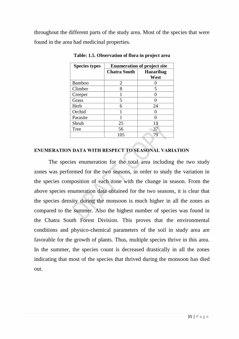
ENUMERATION DATA
The summery of the total species enumeration data of the two study
zones are given below. A total of 105 species belonging to 49 families in
Chatra South Forest division (Annexure- XIV), 79 species belonging to 44
families in Hazaribag West Forest division (Annexure-XV) was found
35 | P a g e
throughout the different parts of the study area. Most of the species that were
found in the area had medicinal properties.
Table: 1.5. Observation of flora in project area
Species types Enumeration of project site
Chatra South Hazaribag
West
Bamboo 2 0
Climber 8 5
Creeper 1 0
Grass 5 0
Herb 6 24
Orchid 1 0
Parasite 1 0
Shrub 25 13
Tree 56 37
105 79
ENUMERATION DATA WITH RESPECT TO SEASONAL VARIATION
The species enumeration for the total area including the two study
zones was performed for the two seasons, in order to study the variation in
the species composition of each zone with the change in season. From the
above species enumeration data obtained for the two seasons, it is clear that
the species density during the monsoon is much higher in all the zones as
compared to the summer. Also the highest number of species was found in
the Chatra South Forest Division. This proves that the environmental
conditions and physico-chemical parameters of the soil in study area are
favorable for the growth of plants. Thus, multiple species thrive in this area.
In the summer, the species count is decreased drastically in all the zones
indicating that most of the species that thrived during the monsoon has died
out.
36 | P a g e
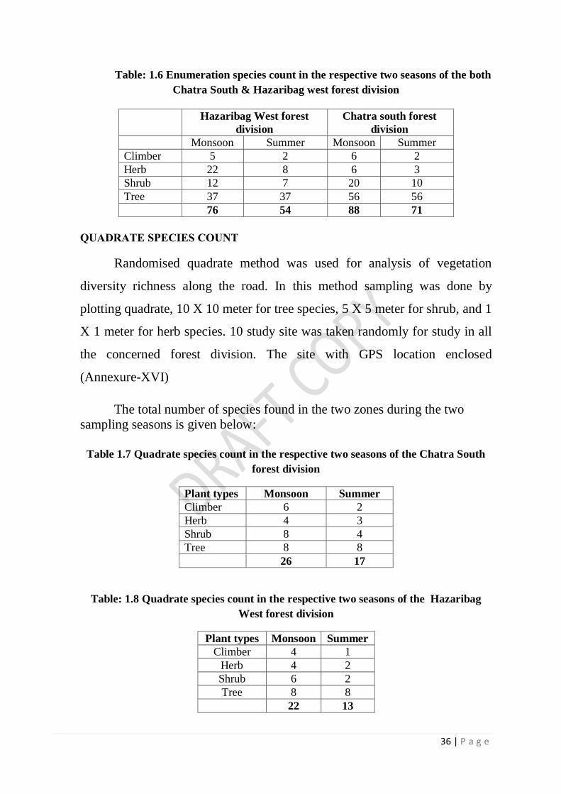
Table: 1.6 Enumeration species count in the respective two seasons of the both
Chatra South & Hazaribag west forest division
QUADRATE SPECIES COUNT
Randomised quadrate method was used for analysis of vegetation
diversity richness along the road. In this method sampling was done by
plotting quadrate, 10 X 10 meter for tree species, 5 X 5 meter for shrub, and 1
X 1 meter for herb species. 10 study site was taken randomly for study in all
the concerned forest division. The site with GPS location enclosed
(Annexure-XVI)
The total number of species found in the two zones during the two
sampling seasons is given below:
Table 1.7 Quadrate species count in the respective two seasons of the Chatra South
forest division
Plant types Monsoon Summer
Climber 6 2
Herb 4 3
Shrub 8 4
Tree 8 8
26 17
Table: 1.8 Quadrate species count in the respective two seasons of the Hazaribag
West forest division
Plant types Monsoon Summer
Climber 4 1
Herb 4 2
Shrub 6 2
Tree 8 8
22 13
Hazaribag West forest
division
Chatra south forest
division
Monsoon Summer Monsoon Summer
Climber 5 2 6 2
Herb 22 8 6 3
Shrub 12 7 20 10
Tree 37 37 56 56
76 54 88 71

37 | P a g e
The seasonal variation of the species count data collected from the two
representative zones of study areas showed clear inferences regarding the
change in the species diversity and composition pattern. This difference was
more prominent in case of herbaceous plants and shrubs. During monsoon,
due to high moisture contents and favourable growth conditions, a higher
number of herb and shrub species were observed, while, in case of summer,
most of the herbaceous and shrub species got wiped out due to the excessive
heat and dry conditions.
VEGETATION ANALYSIS
Frequency, Abundance, Density and Vegetation Classifications
Vegetation classification of the plant community of the study area was
done using the Raunkier’s Classification and the Whitford’s Classification. In
the Raunkier’s classification, the plant community was classified on the basis
of the frequency of the different plant species of the area. The Whitford’s
classification was done on the basis of the ratio of the species abundance to
its frequency.
Vegetation Community Structure Indices Based on the quadrat count
of the floral species in the study area, several vegetation community structure
indices were calculated as per standard formula. The index values were
calculated to study the effect of seasonal variation on them. In addition to
this, correlation coefficients were calculated between the species count of
herbs, shrubs and trees versus the soil nutrients (viz. N, P, K).
Raunkiaer’s Classification: (Raunkiaer’s, 1918) The plant community
was classified on the basis of the values of frequency of different plant
species of the area. The classification may be represented by the following
chart:
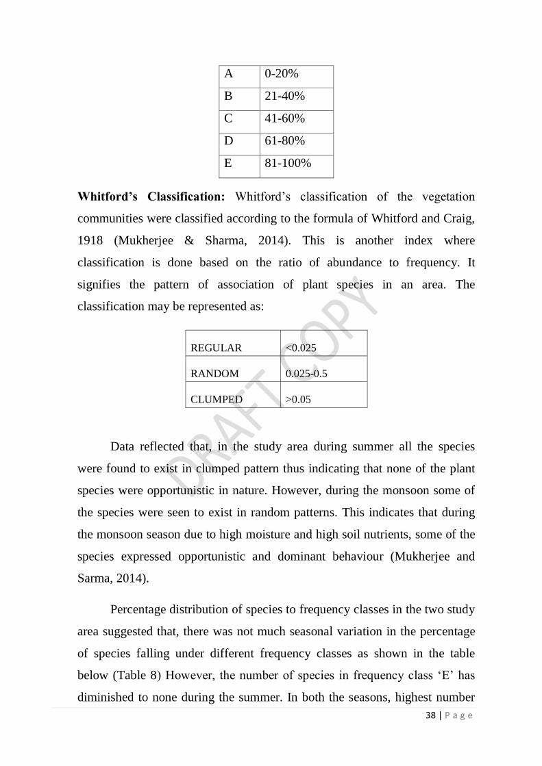
38 | P a g e
A 0-20%
B 21-40%
C 41-60%
D 61-80%
E 81-100%
Whitford’s Classification: Whitford’s classification of the vegetation
communities were classified according to the formula of Whitford and Craig,
1918 (Mukherjee & Sharma, 2014). This is another index where
classification is done based on the ratio of abundance to frequency. It
signifies the pattern of association of plant species in an area. The
classification may be represented as:
REGULAR <0.025
RANDOM 0.025-0.5
CLUMPED >0.05
Data reflected that, in the study area during summer all the species
were found to exist in clumped pattern thus indicating that none of the plant
species were opportunistic in nature. However, during the monsoon some of
the species were seen to exist in random patterns. This indicates that during
the monsoon season due to high moisture and high soil nutrients, some of the
species expressed opportunistic and dominant behaviour (Mukherjee and
Sarma, 2014).
Percentage distribution of species to frequency classes in the two study
area suggested that, there was not much seasonal variation in the percentage
of species falling under different frequency classes as shown in the table
below (Table 8) However, the number of species in frequency class ‘E’ has
diminished to none during the summer. In both the seasons, highest number

39 | P a g e
of species belonged to frequency class ‘C’ thus suggesting that about half of
the species existing in the zone is unstable and short-lived (Mancera et al.,
2013).
Table 1.9 Percentage distribution of species to frequency classes study sites
A B C D E
Chatra south forest
Monsoon 7.69 23.08 42.31 23.08 3.85
Summer 5.88 23.53 41.18 23.53 5.88
Hazaribag west forest
Monsoon 9.09 18.18 40.91 27.27 4.55
Summer 7.69 15.38 46.15 23.08 7.69
In the present study, it is observed that there was not much difference
in the species evenness seen in the different zones during monsoon, with
highest value in the Chatra South Forest division. This low evenness values
in all the zones indicated that during monsoon some of the species do take
opportunity of the favourable growth conditions and tend to dominate some
areas. This leads to highly scattered, uneven species distribution. During the
summer however the species evenness increases comparatively in all the
study area indicating uniform even distribution of species. This indicated that
only a few summer specific species thrive during this period, which covers
most of the study area thus forming evenly distributed populations. Among
the two Chatra forest division had the highest evenness value during summer.
As stated by Smith and Wilson (1996), a community in which each species
present is equally abundant has high evenness, while one in which the species
differ a lot in abundance has low evenness. Thus, in the summer season only
few summer specific species were abundant in all the study area and formed
highly even plant communities.

40 | P a g e
1.15 FOREST FAUNA
The forest of Chatra South and Hazaribag West is rich in faunal
diversity. The checklist of Working Plan of West Forest Division (2013-14 to
2022-2023), reports 34 Mammals, 11 Reptiles, 9 Fishes, and 93 birds
(Annexure- XVII). The checklist of Working Plan of Chatra South Forest
Division (2013-14 to 2023-24) , reports 39 species of Mammals, 12 Reptiles,
30 fish, 21 species of insects and 96 species of birds. (Annexure XVIII).
The historical records Working Plan, Hazaribag Wildlife Management
Plan of Forest Department and Hazaribag District Gazetteer (Choudhury,
1957), indicate presence of the major carnivores in the past, including tiger,
leopard, wolf, hyena and fox in the area. However, tiger and leopard which
were once seen frequently, has no trace now. Among the vertebrates,
documented information is available only for Mammalian, Reptiles and
Avifauna. However, other vertebrates like Amphibians (frogs, toads) are also
found. Recent studies on reptiles in Jharkhand revealed 25 species of snakes,
8 species of lizards and 1 species of Indian Flapshell Turtle (Lissemys
punctata) in the Hazaribag district. (Raziuddin, 2015). Report on the snake
fauna of Hazaribag district reports presence of 19 species of snakes found in
Hazaribag districts (Prakash and Raziuddin, 2009).
Hazaribag district is very rich in avifauna that had been well
documented in the past. The first published work on the Avi-fauna of
Hazaribagh district was a paper by V. Ball “The Birds of Chotanagpur”,
which appeared in Stray Feathers (Ball, 1874). Captain Baillie contributed a
paper on Hazaribag Bird recording the subject to the Journal of Bengal
Natural History Society (Baillie, 1946). In the District Gazette of 1957, Mr.
Roy Choudhary had mentioned that there were 205 breeding birds in the
district. He also mentioned that 62 bird species used to migrate to the district
during winter. Jamal Ara published a list of 97 birds commonly observed in
the Hazaribag Sanctuary (Ara, 1966).

41 | P a g e
The recent study conducted between 2009-2014, after more than four
decades by BNHS has revealed the presence of 183 species of birds in and
around Hazaribag Wildlife Sanctuary (IBA) that includes nine globally
threatened ones and 32 Biome restricted assemblage species that includes
Critically Endangered resident White-rumped Vulture (Gyps bengalensis)
and Indian Vulture (Gyps indicus) in Hazaribag district (Rahmani et al.,
2016). Based on the biome classification of BirdLife International, it lies in
the Indo-Malayan Tropical Dry Zone (Biome-11).
(Annexure XIX).
A study for presence of reptiles in Hazaribag Wildlife Sanctuary was
carried out by Neo Human Foundation (NHF) (2011-12) with support of
Hazaribag Wildlife Division. In the study an attempt has been made, perhaps
for the first time, to record the reptilian fauna of Hazaribag Wildlife
Sanctuary. During the study a total of 25 species of reptiles were recorded
which included 16 species of snakes, 8 species of lizard and 1 species of
turtle.
Important invertebrates, their status distribution and habitat:
As regards invertebrates, except for few documentation, there is no
proper scientific documentation whatsoever. However a number of
invertebrates exist in the area ranging from Annelids (earthworms,
Centipedes, millipedes) Moluscans (Snails and slugs) to a variety of insects
including beetles, bees, butterflies, bugs moths, crickets, grasshoppers,
termites etc., which are not only abundant but diverse in nature.
Butterfly and Beetles
A study for presence of Butterfly and Beetles in Hazaribag Wildlife
Sanctuary was carried out for the first time by AFNC (2011-12) supported by
Hazaribag Wildlife Division. A total of 38 species of butterfly belonging to 5

42 | P a g e
families found in Hazaribag wildlife sanctuary and a total of 51 species of
beetles belonging to 45 genera have been identified from the sanctuary.
1.15.1 SITE SPECIFIC FAUNA
During the present site specific study 25 species of mammals, 119
species of Aves, 21 species of reptiles, 3 species of amphibians, 14 species of
fishes, 18 species of butterfly, and 26 species of other Invertebrates were
recorded. The list is enclosed with their status in Wildlife (Protection) Act.
1972 as amended in 2006. (Annexure XX)
Among recorded mammals Elephant (Elephas maimus), Pangolin
(Manis crassiicaudata) and Sloth Bear (Melursus ursinus) are enlisted in
Schedule-I of wildlife (Protection) Act, 1972 and the others are in Sch. III
and IV.
The recorded avian fauna during the present study consisted of a total
of 119 species of birds belonged to 47 families. Among 119 species 90
(75.63%) species were resident, 17 (14.29%) species were resident migrant,
10 (8.40%) species were migrant (winter visitor) and 2 (1.68%) species were
summer visitor. Of the total species of birds 21 (17.65%) species were water
birds, 7 (5.88%) species were wetland dependent birds and the 91 (76.47%)
species were others birds which includes arboreal, bush birds and birds of
prey. Indian Peafowl (Pavo cristatus), White-rumped Vulture (Gyps
bengalensis), Indian Vulture (Gyps indicus) is enlisted in Schedule-I of
wildlife (Protection) Act, 1972 and the others are in Sch. IV except House
Crow. Some species are not enlisted in any schedule. The checklist of bird
species recoded during site specific survey is enclosed. (Annexure XXI)
Among 21 species of reptiles recoded 15 species were snakes and 6
species were lizards. Snakes serve the mankind in different ways which go
unnoticed. The two economic aspects of the snakes are their role in nature as
43 | P a g e
destroyers of insect and rodents. Among snakes, Spectacled Cobra, Banded
Krait, Common Krait, Russell’s viper, Green Pit-viper are poisonous. The
common non –poisonous snakes are India Rock Python, Rat Snake,
Checkered Keelback and Buff-stripped Keelback etc. Among Lizards,
Monitor Lizard, Indian house gecko, Rock lizard, Common Garden Lizard
and Skink etc. are found. Indian Rock Python (Python morulus) belong to
Schedule-I species. Monitor Lizard (Varanus monitor) is listed in Sch.II.
Among 14 species of fishes recorded Tilapia (Oreochromis
mossambicus) is enlisted as Near Threatened in IUCN Relist.
Village level survey for the presence of wildlife is enclosed (Annexure
XI). The species found in Chatra South Forest Division is also common to
West Forest Division, except for Sloth Bear which was only reported from
Chatra South Division.
1.15.2 HABIT AND HABITAT OF IMPORTANT THREATENED
SPECIES OF FAUNA
The habitat requirement of many threatened species or may probable
threatened in the future has been studied and habitat requirement for of
important species and their conservation is discussed. The wildlife
management and conservation plan for important fauna and their habitat
requirement will be the part of budget provision.
It is required to identify habit & habitat requirement of schedule -I.
Species so that their conservation requirement can be understood well and
planned well. The schedule-I species found in the study area are:
1) Elephant
2) Indian pangolin
3) Sloth Bear
4) Rock python
5) Peacock

44 | P a g e
6) White-backed Vulture
7) Indian Vulture
1.15.3 MOVEMENT OF ELEPHANT IN THE PROJECT AREA
The destruction of wildlife corridors means the destruction of
biodiversity of the region. A wildlife corridor or green corridor is an area of
habitat connecting wildlife populations separated by human activities. This
allows an exchange of individuals between populations, which may help
prevent the negative effects of inbreeding and reduced genetic diversity (via
genetic drift) that often occur within isolated populations. Corridors may also
facilitate the re-establishment of populations that have been reduced or
eliminated due to random events. This may potentially moderate some of the
worst effects of habitat fragmentation.
Wildlife corridors are susceptible to edge effects; habitat quality along
the edge of a habitat fragment is often much lower than in areas further from
the habitat edge. Wildlife corridors are important for large species requiring
significant sized ranges; however, they are also vital as connection corridors
for smaller animals and plants as well as ecological connectors to provide a
rescue effect.
Elephant corridors are narrow strips of land that allow elephants to
move from one habitat patch to another. There are 88 identified elephant
corridors in India. The elephant habitats of central India are spread over an
area of 17,000 km2 in the states of Jharkhand, Orissa and a part of southern
West Bengal. The 2500 elephants in the range occupy the most fragmented
elephant habitat of the country that has been degraded and fragmented due to
mining, shifting cultivation and developmental activities (The Right of
Passage, Wildlife Trust of India).
Jharkhand has two distinct elephant populations, viz. Palamau and
Singhbum and about 700 elephants. The Palamau population occupies about
1200 km2 of the Betla National Park, Palamau Tiger Reserve and adjoining

45 | P a g e
areas. The Singhbum population occupies about 2570 km2 of the available
forest area of Dalma Wildlife Sanctuary and the forest of Saranda, Porhat,
Kolhan, Saraikala (formerly North Chaibasa) and Dhalbhum Forest
Divisions.
The forest area of project site of the concerned Forest Division is not a
part of already identified 14 corridors in India (The Right of Passage,
Wildlife Trust of India).
Apart from this although no other scientific study has been made to
identify corridor of wild animals like elephant in the project area yet the
official records showing the payment of compensation for human life as well
as for crop damage and site specific survey proves the movement of
elephants around proposed site. Details of compensation paid by Divisional
Forest Officers, Chatra South, and West Forest Division is being enclosed.
(Annexure –XXII and XXIII)
The information provided the Chatra South Forest Division show that
the village affected and movement of Elephant is in all the fives ranges of
Chatra South Division. The details of the affected villages is enclosed
(Annexure XXIV). Data provided by the Forest Department show that the
affected villages Phulwaria, Badhbigha, Dhangada and Nongaon falls in
project area through which the proposed railway line is passing. Generally
the movement of elephant movement is seen in this corridor at least every
year in the recent years since 2014-15. Data show that only one human kill is
reported from Varudi villages in Simaria range and the rest are crop and
house damage in the Chatra South Division during this period. Data available
from 2012-13 to 2016-17 from the forest department show that the conflict
has taken place at many places in the division which is not part of the
proposed area but Bisanapur villages part of the project area is the most
affected village where compensation has been given to the victims. Map

46 | P a g e
showing the affected villages as provided by Chatra South Division is
enclosed (Map 2 and Map 3).
From the data available from the Hazaribag West Division show that
the movement of Elephant is mainly restricted to Barhi, Barkagaon,
Barkattha, Keraderi and Katkamshandi. Some incidence of elephant conflict
is reported Katkamsandi Block which falls in the rage of the project area
(Annexure XXIII). As reported by DFO West there is regular movement of
Elephant near Hesakudar, Khatautia, Sahpur, Manar and Katkamsandi region,
at least 2 or 3 times in a year. (Annexure XXV). The elephant from
Hazaribag Sanctuary enters in to this region and moves towards Chatra South
Forest Division and return back (Map 4).
During site specific study it was revealed that the movement of
elephant is seen in the project sites and at few places crosses the proposed
railway track. The movement of elephant was seen in 20 such villages in the
recent five years out of 29 villages in the proposed forest area. The number of
elephant seen ranges from minimum 1 to maximum 30. During movement
the elephant raid the agricultural filed, damages the crop and houses for
stored food grains. It was also found that the elephant crosses the railway
track at few places. The details of village survey in the study area for
elephant enclosed. (Annexure XXVI; Map 5)
Form the above study it was found that there is no regular movement
of elephant in normal condition neither resident population of elephants is
found in any of the Forest Division concerned. The forest area lying with the
railway line is not a part of identified corridor but it is part of area where
elephant moves occasionally, at least once or twice and sometime three times
in a year, during recent years. Their movement pattern is complex and further
study is needed after completion of project for further mitigation. After
discussion it is clear that elephant are not resident of this area but forms a
47 | P a g e
corridor in the project area, movement of elephant is seen in the project area
concerned, and mitigation measures are essential for movement of elephant.
1.16 HABIT AND HABITAT OF IMPORTANT ANIMALS
The habitat requirement, feeding & breeding behaviour of some
important animals found in and around project area are as follows :-
MAMMALS
16.1 ELEPHANT
Common Name: Indian Elephant
Scientific Name: Elephas maximus indicus
Habit:
Elephant are social animals and may form herds of 20-30 individuals
led by the oldest female. Herds usually break into stable family groups of 4-7
animals for foraging and may rejoin. Elephant is intolerant of hot summer
and retreats into a shady spot during noon. In the past, when forest ranges
were continuous, elephants used to migrate seasonally in search of better
pastures alternating with forests. Human activities like cultivation, highways,
townships, railways, dams, industries and mines have now fragmented their
habitat and made seasonal migrations virtually impossible.
Habitat :
Elephants are animals of grass lands and scrub forests who have
secondarily switched over to forests once grass lands were mostly brought
under cultivation. The mosaic of grass, scrub forests, open forests and dense
forests suits them well. Elephants consume a variety of diet, bark, roots,
leaves, stems and twinges, bamboos, vines, shrubs belongings to 100 plus
species. An average day’s intake for adults is 150 Kg of vegetation (20-25%
body weight). Elephant may drink 100-140 liters of water at least once in a

48 | P a g e
day. Elephants enjoy cultivated foods such as ripe paddy, banana, mango,
jack fruit, sugar cane.
Threats:
i. Habitat loss and fragmentation due to encroachment of forest.
ii. Poaching for tusk.
iii. Forest fire
iv. Conflict with human beings.
Conservation issue
i. Raid in the village and agricultural field for food leads to man-animal
conflicts.
ii. Loss of habitat for food and water.
iii. Particular attention should be paid to identifying ways to reduce human
conflict through promotion of methods that ensure to keep the elephant
away from human.
iv. Unawareness among the people. Awareness programme to reduce
conflicts.
16.2 BLUE BULL
Scientific Name : Boselaphus tragocamelus
Local Name : Nilgai
The Nilgai (Boselaphus tragocamelus), is the largest Asian antelope.
Nilgai, also known as Blue Bull, is one of the most commonly found wild
animals of northern India as well as eastern Pakistan. Even though it is an
antelope, it looks quite similar in appearance to an ox. Therefore, it has been
given the name of Blue bull in India. The average lifespan of the Blue bull is
21 years.
This is the largest antelope found in the division. The adult bull has a
coarse iron-grey coat, a white ring below and two white spots on each cheek.
Young bulls and cows are tawny. Bulls have stout come like horns-but not

49 | P a g e
long. Blue bull avoid dense forests. Their usual hunts are hills sparsely dotted
with trees, or level or undulating plains covered with grass and patches. Blue
bull are very bold in cultivated fields. They feed upon grasses, leaves and
wild fruits till late in the morning and evening and seek shade during the day
specially in hot summer days. Nilgai like other antelope have habit of
resorting to the same spot to deposit their droppings, forming in this way
considerable accumulations.
Natural Habitat
Nilgai is a diurnal creature, found inhabiting Indian grasslands and
woodlands. It avoids dense forest and has preference for plains and low hills
with shrubs. Blue bulls generally come to the same place to deposit their
droppings.
Behaviour
Nilgai antelope is a sociable creature, usually found in single-sex or
mixed-sex herds. The membership of a herd may be anywhere between four
and twenty. In winter, male blue bulls of northern India are known to form
herds of 30 to 100 animals. Male Blue bulls, after they reach old age, may be
found leading a solitary life. One can also come across individual male or
female in cultivated or semi-urban areas.
Diet
Blue bulls of India are herbivorous creatures, surviving primarily on
grasses, leaves, buds, and fruits. Blue bull can survive for a long period of
time without water.
Generally, Blue bull prefers the mature growth stage of different crops
(e.g., paddy, maize, mustard, chili, cauliflower, cow-pea, black gram,
cabbage, etc), while wheat, potato, radish and pumpkin are preferred in the

50 | P a g e
early stages of growth, and lentils are preferred at all stages. Blue bulls were
reported to feed on all the major crops grown in the boundary areas. Apart
from agricultural crops, Blue bulls also caused considerable damage to
vegetables..
Conservation Status
Nilgai antelope has been listed in the 'Low Risk' category by the
IUCN. The estimated population of Nilgai in India is approximately 100,000.
It is enlisted in schedule III of wildlife protection Act 1972. The main threat
to the Nilgai is from the destruction of its habitat to accommodate the ever-
swelling human population.
In India, it is believed that the Nilgai antelope is a sacred animal
(precisely a cow) and it is protected against hunting
THREATS AND CONSERVATION ISSUE
i. Although there has been a reduction in the overall range of nilgai, the
existing populations seem to be doing fairly well. This is largely
because of they are a protected species under the law, and more
importantly the protection they acquire from being considered sacred
due to their resemblance to domestic cows.
ii. Moreover, gradual degradation of dense forests into open scrub and
thickets, increasingly bordered by agricultural fields, has offered
favourable habitat conditions for the increase of nilgai numbers.
iii. Invariably, in such situations, nilgai has become serious pests as crop
raiders and a major issue of human-wildlife conflict. Possible solutions
voiced include a selective culling programme linked to licensed
hunting permits.
iv. Awareness generation among public.

51 | P a g e
16.3 STRIPED HYENA
Scientific Name: Hyaena hyaena
Local Name : Lakkar baggha
Habits :
The hyena is rare in forested districts, abundant in open country,
especially were low hills and ravines offer convenient holes and caves for
shelter. Many lie hidden by day in high grass, under bushes or in cane fields
but the den usually preferred is cave amongst rocks or a hole dug in the side
of a hill or ravine. Quite often a hyena enlarges a porcupine’s burrow to suit
its needs. They come out in quest of food by night, retiring before sunrise.
Pairs usually go about together, sometimes a group of 5 to 6 is seen but this is
probably a family party. In search of food the hyena tramps many miles. Its
‘spoor’ is much like a dog’s except that the imprint of the forefoot is much
larger than that have hind, and that of the main pad is uneven and oval.
Animals that have died of disease or those killed by the larger beasts of
prey are the usual food of the hyena. Its share is the coarser remain the
heavier bones which the others reject. These it breaks and crushes with its
powerful jaws and teeth, swallowing and digesting great fragments. Portions
of the meal may be carried to the den to be eaten in greater security. Though
scavengers by profession, performing useful services as such, hyenas do not
feed wholly on carrion, occasionally sheep and goats and quite often stray
dogs are carried off by them. Some individuals, developing the cattle- killing
habit, become perfect pests on livestock. Larger cattle are seldom attacked.
Despite its bulk and power our hyena does not attack big animals, though an
individual may be quite prepared, if need be, to appropriate the kills of
panthers or even tigers. Hyena is regularly reported from the project site,
particularly in Hazaribag Sanctuary and Canary Hill.

52 | P a g e
Little is known of the mating habits of this quite common animal.
Mating time is said to be in the cold weather. The young are born during the
hot season.
Threats
i. Road accident
ii. Killed by villagers when enters villages for cattle lifting.
iii. Habitat loss
Conservation issue
i. Lifting of cattle by Hyena leads to man-animal conflicts.
ii. Particular attention should be paid to identifying ways to reduce
human-carnivore conflict through promotion of methods that ensure
adequate numbers of prey persist and/or methods that reduce livestock
killing.
iii. Unawareness among the people. Awareness programme to reduce
conflicts.
16.4 MONKEY
Scientific Name: Macaca mulatta
Local Name : Hindi - Bandar,
Habits :
Captive or wild, this is the common monkey of Northern India. Large
troops live near or in villages and towns and in groves round taken and
temples. In the jungle, they usually keep to the fringes rarely penetrating into
the depths, except where driven to seek denser cover. Almost everywhere the
Rhesus enjoys freedom from molestation. To raid fields and gardens of a
morning or evening is their common and established practice, to which
popular and religious sentiment permits little check. Capture and export on a
53 | P a g e
large scale has now abandoned many areas. Like most macaques, the Rhesus
feeds mainly on the ground. Some live habitually among rocks and cliffs
Breeding:
The Rhesus shows a definite breeding season, correlated with climatic
conditions. Mating takes place in all months of the year except March but the
greatest frequency was from October to December. A major birth season
(March to June) preceded the monsoon and a secondary brief post monsoon
birth season in September- October.
Threats
i. Hunting
ii. Deforestation – affect the food availability and habitat loss
iii. Forest Fire
Conservation issue
i. Enters into agricultural fields leading to conflict.
ii. Human interaction to be reduced
iii. Needs to improve habitat.
iv. Awareness generation among public.
16.5 COMMON LANGUR
Scientific Name: Presbytis entellus
Local Name : Langur, Hanuman
Common langur prefer miscellaneous forests specially having
abundant fruit bearing trees. These is a long-limbed, long tailed, black-faced
monkey. These are more arboreal than macaques but can live on rocks and
cliffs. They feed upon fruits, flower, buds, shoots and leaves. Khair fruits are
specially liked by them. These are mainly reported from Sanctuary area.

54 | P a g e
They occasionally pillage gardens and cultivation, but are not such
habitual thieves and raiders as macaques. There is a marked breeding season
with a peak birth period in north India in April-May though young are seen
from February onwards.
Threat:
i. In spite of religious sentiments shown by tribals, primitive tribes like
Birhor and Birjas hunt them.
ii. Habitat loss due to intensive agriculture.
iii. Man-animal conflict and fires.
Conservation issue
i. Human-animal conflicts.
ii. Habitat management for wild population.
iii. Public education, monitoring, and limiting factor management.
16.6 SLOTH BEAR
Scientific Name : Melursus ursinus
Local Name : Bhalu
Habits:
Sloth Bear generally live where there is sufficient forest to provide
food and favour those places where projection of rock and fallen boulders
offer them shelter during the hot weather and during rain. These come out
shortly before sunset, hunt for food thought out to night and retire in the
morning. In cloudy and cool weather comes out during day. Food consists
mainly fruit and inset. Their favoured insect food is termite. Hungry Sloth
Bear may eat carrion. The fruit consists of banyan and other wild figs,
mangoes, bel etc. These also eat honey of large rock bee (Apis dorsata) &
Apis indica. Near human settlement they raid the sugarcane and maize crop
and climb the tree to drink toddy form the pots. These also eat Mahuwa fallen
on ground.

55 | P a g e
Matting is in hot weather and young are born in December and
January. Slough Bear has lived in captivity for 40 years.
Threat:
i. Habitat loss.
ii. Man-animal conflict and fires.
Conservation issue
i. Human-animal conflicts.
ii. Habitat management for wild population.
iii. Public education, monitoring, and limiting factor management.
16.7 INDIAN PORCUPINE
Scientific Name: Hystrix indica
Local Name : Sayal, sahi,
Habits:
The Indian Porcupine favours rocky hill-sides. It adapts itself to any
type of country, moist or arid, and inhabits both open land and forest.
Porcupines come out after dark. They have a keen sense of small and display
high intelligence in evading traps. Vegetable of all kinds, grain fruit, and
roots are their main food. They can be very destructive in gardens and
cultivation, tunnel line under walls and hedges to make an entry. When
irritated or alarmed, porcupines erect their spines, grunt and puff, and rattle
their hollow tail quills. Their method of attack is peculiar. The animals
launches itself backwards enemy, drives its erect quills deep into it with
painful, or even fatal, results. It has been reported from canary hill apart from
Sanctuary.
The popular belief that porcupine “shoot’ their quills can be
disregarded. Porcupines were found with young in Madhya Pradesh in
March. Both parents usually occupy the burrow with their offspring, which

56 | P a g e
may number 2 to 4. They are born are born with their eyes open and the body
covered with short soft spines.
Threat;
i. Hunting/Poaching for their quills and food.
ii. Habitat loss
Conservation issue
i. Habitat protection and conservation.
ii. Awareness generation among public
16.8 INDIAN WILD BOAR
Scientific Name: Sus scrofa
Local Name : Jangali suar
Habits:
Indian Wild boar live in grass or scanty bush jungle, sometime in
forest: after the rains, quite commonly in high crops. They are omnivours,
living on crops, roots, tubers, insects, snakes, offal, and carrion. They feed in
the early morning and late in the evening and, where much disturbed, chiefly
at night. These raid the agricultural field and eats crops and tubers. No animal
is more destructive to crops and in cultivated areas, it is impossible to make a
plea for its protection.
Wild boar display great intelligence and few animals show greater
courage and determination. The sense of smell is acute, the eyesight and
hearing moderate. Wild Boar are highly prolific. It is seen that breed at all
seasons. In central India the majority of young are born at two periods,
shortly before and shortly after the rains.
The period of gestation is said to be four months, four to six young are
born at a time. The mother shelters them in a heaped-up mass of grass or
branches which she builds before she litters.

57 | P a g e
After breeding the big boars live along or in company with another of
equal size or with one or two sows.
Threat:
i. Hunting for meat, sport or in revenge for crop damage.
ii. Habitat loss.
Conservation issue
i. Habitat loss hence enters into agricultural field.
ii. Increases in population.
iii. Awareness for conservation.
16.9 JACKAL
Scientific Name : Canis aureus
Local Name : Siyar
The Jackal’s long-down, eerie howling at dusk or just before down is
perhaps more familiar to most people. It lives almost in any environment, in
humid forest country or in dry open plains or desert. The greater number lives
in around town and villages and cultivation, sheltering in holes in the ground,
among ruins or in dense grass and scrub. These usually comes out at dusk and
retires at dawn. Usually they go about alone or two or more hunt together.
They are good scavengers and clears the carcasses. They may hunt poultry
and goat. It is some time known to hunt small deer and wounded animals. It
has been reported from all the forest division.
Apart from this Jackals raid melon patches and sugarcane fields. Also
feeds upon fallen fruits of Ber tree. In the study area it was found that these
raid the Groundnut and sugarcane agricultural fields. Little is known about its
family life, it is so secretive in habits. Life span is about 12 years.
Threat
i. Road accident

58 | P a g e
ii. Habitat loss
Conservation issue
i. A part from stealing poultry enters into agricultural field hence
conflict with the human.
ii. Little information is available on jackal densities, habitat use, and
ranging patterns in relation to food availability. Information on
dispersal, survival and mortality factors of adults, pups and
dispersing individuals is not known.
iii. Awareness generation programme for conservation
16.10 JUNGLE CAT
Scientific Name : Felis chaus
Local Name : Jangli billi,
Habit:
Jungle Cats inhabit the driver and more open parts of the country,
keeping more to grassland, scrub jungle, the reedy banks of river and
marshes. The Jungle Cat is frequently come out by day, more usually in the
mornings and evenings. Its movements in the open area much like those of a
small panther.
It preys on small mammals, birds, and when near villages on poultry.
There is record of one making bold to seize its prey even in the presence of
the owners. Very swift and exceedingly strong for its size, it is quite capable
of bringing down larger game.
Births have been recorded between January-April and in August and
November. The litter size usually 3 but occasionally up to 5 kittens. The eyes
open 11 to 15 days after birth.
Threats

59 | P a g e
i. Enter in villages for stealing poultry due to this conflict with the
people and gets killed.
ii. Habitat loss and decrease in prey.
Conservation issue
i. Needs awareness among the people.
ii. Habitat improvement
16.11 SPOTTED DEER
Scientific Name : Axis axis
Local Name : Chital
They are commonly seen in herd of 10-30 individuals. They prefer
company of langurs and monkeys. These animals feed upon fruits and shoots
of trees fallen on ground after langurs and monkeys have finished their food.
They are fond of Mahua flowers and are often seen under Mahua trees. These
may enters the cultivations and eats up the crops. They are less nocturnal
them Sambhar and feed till late in the morning and in the afternoon. They
prefer open and shrubby areas and do require cover also.
Threats
i. Poaching for meat and skin
ii. Habitat loss
iii. Comes out in open during summer near villages for water.
Conservation issue
Since it is killed for meat and its skin and horns is used as
trophy. It is important to generate awareness among public for
importance of conservation.
16.12 BARKING DEER
Scientific Name : Muntiacus muntjak
Local Name : Kakar

60 | P a g e
They are shy animal and hence are seen rarely. They are seen singly or
in pairs or in small family parties. They are best known by their call which is
quite distinctive than other deer. Their haunts are thickly wooded hills and
they peep more or less to thick jungle and come out to graze in the outskirts
of forests. They are fairly diurnal in habit. The food consists of various
leaves, grasses and wild fruits.
Threats
i. Poaching for meat and skin
ii. Habitat loss
iii. Comes out in open during summer near villages for water.
Conservation issue
Since it is killed for meat and its skin and horns is used as trophy. It is
important to generate awareness among public for importance of
conservation.
16.13 SAMBHARS
Sambhar, the largest of deer species in India, which is found all over
the P.A. The Sanctuary is suitable for the Sambhar on account of the fact that
it’s tract, the terrain, the climate and the vegetation make the habitat most
suitable for them. The Sambhars mostly browse on the leaves, young shoots,
flowers and fruits of the following species, Nyctanthes arbortristis, Bauhinia
species, Eugenia dalbergioides, Terminalia species, Zizyphus species, Leaves
of bamboo, Tender leaves of sal.
They have been rarely found grazing on grass. The food for sambhars
is usually available through out the year, though the intense heat and
incidences of fire make them strive hard for food during peak of summer.
Threats
iv. Poaching for meat and skin

61 | P a g e
v. Habitat loss
Conservation issue
Since it is killed for meat and its skin and horns is used as trophy. It is
important to generate awareness among public for importance of
conservation.
16.14 HARES
Scientific Name : Lepus nigricollis
Local Name : Khargosh
Habit:
Large tracts of bush and jungle alternating with cultivated plains are
ideal conditions for habitat. They are less numerous in forests. They ascend
the hill to some height. L.n. ruficaudatus is found in Kumaon at levels
nearing 8000 ft (2400m) while L.n. nigricollis is common in the Nilgiris and
other south Indian hill ranges.
Many hares live in the neighbourhood of villages and cultivation. Here
they become unclean feeders. During the hot weather, when grass is scanty,
hares come to roadsides or even enter compounds to feed on the grass
growing there. They are partly nocturnal and during day/evening a hare
usually makes itself comfortable in some patch of grass. Scraping the blades
this way and that with its paws, it scoops out a hollow. In this ‘form’ it settles
down to sleep. Sometimes they lie up in uncultivated fields. They have many
enemies, foxes, mongooses, wild cats, even village pie-dogs prey upon them.
Lying still the hare is not easily detected and remains safe, unless stumbled
upon. A common refuge in flight is a fox hole or some such burrow.
Its particular breeding season is not recorded. The blacknaped Hare
breeds chiefly between October and February. Two young born in captivity
(in Kanara) were produced early in November. Their eyes were open at birth
and they were able to move about within twelve hours.

62 | P a g e
Threats:
i. Poaching for meat.
ii. Threats from domestic dog which enters into forest.
Conservation issue
i. It is important to see that domestic or stray dog does not enters in
the forest.
ii. Habitat management.
16.15 SQUIRRELS
Scientific Name : Funambulus pennant, Funambulus palmarum.
Local Name : Gilhari
Habit:
The Five-striped Squirrel is the commonest and most familiar of all
Indian wild animals. It is not found in forest, but has forsaken forests to live
with man in and about his dwellings and fields. It has become almost as
department on man for food and shelter as house rats and mice, and lives in
crowded towns and cities, or in villages, it shelter in houses, gardens, groves
and hedges, and on roadside trees. Lively active sprites, frisking about on the
ground or scampering about the house or in the trees, their antics are always
pleasing to watch. But like most squirrels they are noisy creature.
The Three-striped Palm Squirrel on the other hand is a forest animal. It
has a particularly shrill bird-like call which it repeats again and again,
accompanying its music with quick jerks of its tail. Their food is the usual
food of all squirrels, fruits, nuts, young shoots, buds, and bark. When the silk
cotton trees are in bloom these squirrels visit the flowers to drink the nectar
and so probably help in their pollination. They also eat the pods. They are
partial to ‘prickly pears’ and, in fruiting time, may be seen in the thorny
cactus hedges, their mouths and feet stained red with the juice of the ripe

63 | P a g e
fruit. Insects are eaten at a pinch, as also the eggs of birds. They are persistent
egg robbers.
The male and female come together for only a day or two during which
period it is probable that the female mates with more than one male. The
period of gestation is about six weeks. When about to bring forth her young,
the female builds an untidy nest of grass and leaves and fibers. This is placed
in a tree, or in the rafters of a house, or in holes in the walls. Two or three
young are produced. They are born blind and remain in the nest till able to
fend for themselves.
Threats:
Poaching
Conservation issue
Awareness among the people and in schools
16.16 CIVET
Scientific Name : Viverricula indica (Small Indian Civet)
Paradoxorus hermaphrodites (Common Palm Civet)
Local Name : Khatash
Two type of civets namely small Indian Civet (Viverricula indica) and
common paim Civet (Paradoxorus hermaphrodites) are found in the area.
Former is tawny, Grey or greyish brown white the latter is blackish brown
with long coarse hair. Palm Civet prefers slightly denser forests then small
Indian civet. They seek their food during night and prey upon rats, squirrels,
small birds. Lizards, insects and their grubs. They also eat fruits, roots and
other vegetable matter.
Threats:
i. Conflict with human
ii. Sometimes steals poultry
Conservation issue

64 | P a g e
i. Awareness for conservation
ii. Habitat management.
16.17 COMMON MANGOOSE
Scientific Name : Hrpestes edwardsi
Local Name : Newala
They are not creature of forests but of open lands, of scrubs jungle and
cultivations near the villages. These prey upon rats, snakes, lizards, frogs,
scorpions and insects etc. It digs in moist soil for earthworm and eat eggs of
ground nesting birds. It also eats fruits, roots and carrion. It breeds all the
years and three litters may be produced in a year.
Threats
i. Hunted for keeping pet.
Conservation issue
i. Habitat management
REPTILES
A typical reptile is lizard-like in shape, with three main parts the head,
trunk and the tail constituting the body. Reptiles are the first vertebrates to
break their link with water and become truly adapted to terrestrial life. All
reptiles are covered by dry scales or horny plates. All are cold blooded
animals i.e. their body temperature is not constant and varies with the
surroundings. Most reptiles, barring the burrowing snakes and some
degenerate lizard, have fairly well developed eyesight. A vast majority of the
reptiles are carnivorous, insects constituting the principal food. Sexes are
separate but are not easily distinguishable. Most reptiles lay hard-shelled eggs
which are usually buried in pits in the soil for incubation but a few produce
live young. Parental care among reptiles is negligible.

65 | P a g e
The beneficial role played by reptiles is little known. Lizards destroy
countless harmful insects. Snakes are efficient destroyers of rats which
damage our food crops. It is suggested that snakes can even be utilized as
indicators of levels of pollution. Snakes are used in basic research because
they spend their lives in slow motion capable of subsisting on a fraction of
food input. Apart from providing antivenin - the life saving antidote for
snakebite, the venom of snake is put to other uses. Cobra venom is said to be
an effective pain killer while that of the Russell’s viper can prevent excess
bleeding during the dental surgery.
The poisonous snakes found in the study area were Spectacled Cobra,
Banded Krait, Common Krait, Russell’s Viper, Green Pit-viper. The common
non –poisonous snakes are India Rock Python, Rat Snake, Checkered
Keelback and Buff-stripped Keelback. Among Lizards, Monitor Lizard,
Indian house gecko, Rock lizard, Common Garden Lizard and Skink are
found. Indian Rock Python (Python morulus) belong to Schedule-I species
and Common Indian Monitor Lizard belong to Schedule-II species which is
discussed below.
16.18 PYTHON
Scientific Name : Python molurus
Local Name : Ajgar
Habit:
The Indian Rock Python is a serpent of marshes, and wet rocky areas
near streams and pools. It is a resident of burrows, dense clumps of
vegetation, large rotten logs, caves, crevices and old ruins namely, structures
and monuments. It is a good clumber and sometime suspends itself from the
branches of trees, waiting motionless for a prey to come within its easy reach.
It is extremely fond of water and is an expert swimmer.

66 | P a g e
Like all other species of reptiles it is cold blooded by nature and as
such it hibernates into hollows of trees, underneath rocks or rock-shelves.
The species is more nocturnal than diurnal.
Food:
Its dietary habits are largely restricted to reptiles (monitor lizard), birds
(peafowl, poultry, wild ducks) and mammals (hare, porcupine, langur, jackal,
mouse deer, hog deer, chital etc.) but seem to prefer mammals.
16.19 COMMON INDIAN MONITOR
Scientific Name : Varanus bengalensis
Local Name : Goha
Common Indian Monitor lizard famous in Indian history for its
reported use by Maratha heroes in scaling the walls of Mughal fortresses.
Monitors are distinguished by their long and flattened body, long tail, long
neck and the extremely elongated, slender, forked tongue, similar to that of
snakes. Eyes with well-developed eyelids. Head covered with small scales.
Body covered with small round or oval scales. Ventral scales arranged in
regular rows. Limbs well developed and the digits armed with strong claws.
Inhabits a variety of habitats from semi-deserts and scrub to evergreen
forests and plantations. Diet consists of a variety of insects and spiders,
snails, crabs, frogs, small mammals, birds.
Common threat to reptiles:
i. Several species of reptiles are killed for their valuable skin for
commercial use.
ii. A number of species of reptiles are, however, critically endangered
now due to the gradual loss of their habitat and overexploitation by
man for food, medicine and skin.
67 | P a g e
iii. Fear from death due to snake bites make them vulnerable to human
kill.
Conservation issues
In general the reptilian fauna of India is on decline due to various
factors including environment apathy, habitat loss, forest fire and ignorance
of the common people towards them and their over exploitation for
commercial uses; besides, non-implementation of the conservation measure is
also important. Snakes don't get much legal protection because of the public
prejudice.
BIRDS
Birds are amongst the most eye-catching forms of animal life. These
are bipedal egg laying vertebrates in which the forelimbs have modified into
wings. There are about 10,000 living bird species in the world. Birds are one
of the best indicators of environmental quality of any ecosystem (Ripley,
1978). Of the total number of different species of birds known to inhabit
earth, about one tenth is found in India alone. The avifauna of India includes
around 1313 species (Grimmett et al., 2011).
The site specific survey reveals presence of at least 119 species of
birds belonged to 47 families. Indian Peafowl (Pavo cristatus), Critically
endangered White-backed Vulture (Gyps bengalensis), Indian Vulture (Gyps
indicus) is enlisted in Schedule-I of wildlife (Protection) Act, 1972 which is
discussed below.
16.20 PEAFOWL
Scientific name: Pavo cristatus
Local name : Mor
Habit:
68 | P a g e
Inhabits dense scrub and deciduous jungle – plain and foot hill –
preferably in the neighbourhood of rivers & streams. Polygamous; usually
parties of one cock with 4 or 5 hens.
Food
Eats grains, vegetables shoots. Snakes, insects, lizards.
Peacocks lose their train during and after heavy rains, and feathers are
picked up to make brooms, fans, wing quills etc. in order times it was used
for the purpose of writing. The peafowl are also killed by eagles & leopards.
Men hunt them for table purpose.
16.21 WHITE BACKED VULTURE
Scientific name: Gyps begalensis
Local name : Giddh
Habit:
Our commonest vulture. A carrion feeder and useful scavenger on the
countryside and in the environs of towns and villages. Large gatherings
collect at animal carcasses with astonishing promptness and demolish then
with incredible speed. Thought a repulsive creature at close quarters, a
vulture gliding effortlessly in the sky is the very embodiment of graceful
motion.
Nesting:
October to March, Nest is a large untidy platform of sticks on top of a
Eucalyptus, Banyan, tamarind or similar tree, often along roadside or near
villages. Egg is a singleton, white, occasionally speckled and spotted with
reddish brown.
69 | P a g e
16.22 INDIAN VULTURE (Long Billed Vulture)
Scientific name: Gyps indicus
Local name: Giddh
Habitat:
A northern race inhabits the Himalayan foothills and other mountains
areas, while a southern race occupies the plains of India and Southeast Asia.
Food:
Like other vultures it is a scavenger, feeding mostly from carcasses of
dead animals which it finds by soaring over Savannha and around human
habitation. They often move in flocks.
Threats to Vultures:
1. Habitat loss eg. Eucalyptus, Peepal etc
2. Use of NSAID drug (Diclofenac) It is a non-steroidal anti-
inflammatory drug (NSAID) given to diseased animals to reduce
pain. When such animal dies the carcass is devour by vulture.
The residue left in the body of carcass acts as poison causing
liver & kidney failure leading to death of vultures.
3. Forest fire
4. Conflict with human beings
5. Pesticides and organic chemicals in food chain
Common threats to the bird
i. Hunting/Poaching
ii. Habitat loss
iii. Pesticides
iv. Use of NSAIDs
v. Electrocution due to transmission line
Conservation issue

70 | P a g e
i. Habitat loss due to anthropogenic activity should be compensated
by plantation of food yielding plants and nesting trees.
ii. The habitat of the wetland species of birds (water bodies like pond,
lakes etc.) for roosting, nesting and feeding is important. Hence the
water management is important survival.
iii. Artificial nest to be installed in villages and trees around the impact
zone to compensate the loss of habitat due to ground clearance
during construction and pruning work.
1.17 MAN ANIMAL CONFLICT
The information provided by DFO Chatra South division show that the
conflict with the elephant has taken place in Simaria, Piri, Tandwa, Chatra
and Lawalong range. Except for Bisnapur no other incident has taken place in
the project area in the last five year. One human death is reported from varudi
village (Simaria) in 2014-15 (Annexure XXII). A part from this cases of
hunting/poaching of Barking Deer, Spotted Deer and Hyena has been
reported from the Chatra South Forest Division in last five years from 2012-
13 to 2016-17. Although one seizure of skin of Leopard has taken place but
the poaching case was of not this division (Annexure XXVII).
Data provide by the West Division depicts that the man-elephant
conflict has been reported from Ichak, Barkattha, Katkamshandi, Padma and
Barhi. Katkamshandi falls in the project area. (Details Enclosed- Annexure
XXIII). A part from this cases of hunting and poaching of Barking Deer,
Deer, Wild Boar, Jackal, Birds and Blue Bull has been reported from the
West Forest Division in last five years from 2012-13 to 2016-17. Accidental
death of Hyena is also been reported. (Annexure XXVIII).
The recorded scenario from the data provided by the DFOs, depicts
that most of the conflicts are resultant of crop raiding by Elephant, Nilgai,

71 | P a g e
Wild Boar. Poaching is also an issue in both the division. Besides few
incidence of cattle killing and injuries to human is due to presence of Jackel
and Hyena. Apart from this during the village level survey in the sample
area and talking to local peoples it was found that most of the conflicts are
resultant of crop raiding by Elephant, Blue bull (Nilgai), Wild Boar and
conflict was due to Hyena and Jackal. Specially herbivores are found of
maize and paddy crop. Beside this snake bite cases have been reported from
almost all the places. A few incidences of cattle killing/lifting due to presence
of Hyena, Jackal, was reported during the survey. Such man-animal conflicts
should be resolved giving attention towards sensible scientific &
compassionate approach (Annexure XI).
The detail analysis of the data provided by the forest department and
village level survey during last five years clearly show that man animal
conflict has been taken place and as such compensation has been paid to the
people. Except for the fact that during the survey it was found that the
villagers are not getting compensation due to damage caused by Blue Bull
menace and death due to snake bite in the affected areas. This is mainly due
to non-reporting of cases to the forest department due to lack of evidence.
Since the Blue Bull raid the agricultural field in night they are unable to
collect photographic evidence except the damages done to the crop. Steps are
required to give compensation related to snake bite in the forest area.
1.18 ANALYSIS OF FOREST WORKING PLANS
The working/management plan of the concerned Forest Division
prescription for management of forest and wildlife has mentioned two major
strategy for wildlife management i.e. Habitat Management of protection of
micro habitat like caves, overhangs, dens, clefts, large rocks on river beds
and nalas.

72 | P a g e
Besides this working plan also prescribe for macro habitat like riparian
zones, wetlands, old growth stands and grasses etc. The matter has been
discussed with forest officials regarding the implementation of prescribed
recommendation in working plan. Due to paucity of fund for management of
special habitat of wildlife, prescription implemented are not satisfactory. So,
the microhabitat has been neglected or disturbed by the local people.
The other prescription includes prevention of poaching, management
of water, registration of fire arms and trophies, prevention against spread of
disease and awareness generation among the public. To reduce man animal
conflict compensation has been paid in the ranges but during site specific
survey it was found that some has not received compensation or they receive
compensation late in the in project area villages.
Problems specific to the Division
Scarcity of water during the month of April to June is of such extent
that wild animals die of starvation. Wild animals have very few water sources
during these months to drink the water. Restricted number of water
availability spots force them to come to these spots making them more
vulnerable to poaching. Incidence of poaching of wild animals have taken
place. Since the wild animals comes to villages for drinking water where
domestic cattle also drink on these sources of water, incidences of spread of
disease is high.
1.19 CONSERVATION VALUES OF THE PROPOSED AREA
(i) All the forests fall in subgroup 5B, i.e. northern Tropical Dry
Deciduous Forests as classified by Champion and Seth
(ii) Supports available population of wild life species like Blue bull,
Hyena, Jackal, Monkeys, Porcupine, Pangolin, Spotted Deer, Indian
Wild Boar, Jungle Cat, Hare, Squirrels, Cobra, Python, Vultures,
Peacock & many other birds etc.

73 | P a g e
(iii) The proposed area in the West Forest Division is close to the
boundary of Hazaribag Wildlife Sanctuary and falls in Hazaribag
Wildlife Sanctuary Eco sensitive Zone as per the draft notification.
(iv) Hazaribag Sanctuary has been identified as IBA (Important Bird
and Biodiversity Area).
(v) Catchments conservation of rivers and its tributaries.
(vi) Supports local population.
(vii) Scope for Wildlife Research and nature education.
1.20. METHODOLOGY
The railway line passes through 31 villages from Shivpur to Kathautia.
There are 29 villages in which the rail line passes through which have P.F./
Jungle Jhari. Since the project is site specific all the 29 villages of project
area were selected for sampling to have maximum representation of the area
of the concerned division for study.
The primary data of the study for flora and fauna was obtained by
survey in the study area by direct observations and the secondary data was
collected from the village survey/literature and Working/Management Plan of
the concerned forest division. The secondary data was also collected from the
concerned Forest Division for man-animal conflict. The study of flora and
fauna was conducted along the proposed railway track corridor in a stretch of
49 km area covering slightly more than 100 meters on both side of railway
line and covering all the 29 study sites passing through the forest in the
stretch. The socioeconomic, demographic details and land use pattern was
taken from census of India 2011. Village level survey was also conducted
with interviews/consultations and group meeting with the local people in the
villages.

74 | P a g e
Maximum number of 29 sites/villages were considered in the study.
Almost 100 % sampling was done to have maximum representation of the
area with a view to gather more data for better analysis by stratified random
sampling. Literature and data available in the management plan were also
consulted. The data provided by the forest department was also used for
analysis. The study was conducted between August 2017 to May 2018.
The study of flora was aimed at enumeration of the available plant
resources and obtaining a broad representation of the existing floristic
variations in the forest area and surrounding village/railway track areas.
Enumeration of the plant wealth was done by surveying the area through
walking along the gradients of hillocks and valleys followed by collection
and identification of plant specimens during the pre and post-monsoon
periods. Phyto-sociological aspects of the study were carried out by sampling
through quadrates method as mentioned above. Sample plots were selected
in such a way to get maximum representation of different types of vegetation
and plots were laid out in different parts of the areas within the forest area as
well as the surrounding village/road side. Selection of sites for vegetation
data was made by random sampling procedure. Frequency and density of the
flora were also studied and compare with withford’s index.
The study of fauna was conducted by random sampling method.
Survey were also conducted along the course of proposed railway line,
covering all the project sites, for the presence of different species of animals.
The primary data was collected by direct sighting method. The secondary
data was collected by interviews/consultations/group meetings with the
locals. Relevant literature and data available in the working plan were also
consulted and taken into account. The search for the vertebrates and selected
groups of invertebrates fauna was made frequently in the study area in
different seasons.

75 | P a g e
Standard binocular Olympus 10x50 DPS I and camera Sony Cybershot
63x were used during study. Standard books and guides were used for the
identification of species. The list of experts involved in the study are enclosed
as Annexure XXIX.

76 | P a g e
CHAPTER – 2
2.1 ECOLOGICAL AND ENVIRONMENTAL IMPACT
ailway, roads and electricity transmission lines (powerlines) are
an essential part of India's development, providing for vital
needs of transport, communication, and power. The creation, expansion, and
maintenance of such infrastructure also carries, however, significant
ecological and environmental impacts and social and cultural consequences.
Such impacts are particularly serious for sensitive natural areas, especially
Protected Areas (PAs) such as Wildlife Sanctuaries, National Parks,
Community Reserves, and Wetlands. Although protected areas are important
for wildlife yet consensus has been formed at national level that more number
of wildlife is reported in outside forest areas other than protected areas.
Hence, the developmental projects passing through forest areas other than
protected areas are much more important for wildlife management and
mitigation measures. The Apex Court as well as National Wildlife Board has
taken this view very seriously and has taken attempt to make it mandatory to
prepare a comprehensive wildlife plan for all development projects which
involves even forest areas outside protected areas.
R
77 | P a g e
Railway and road network systems are vital to today’s economy and
society. Not only do railway and road provide for safe and efficient
movement of goods and people across cities and continents, throughout the
world they have become a permanent part of our physical, cultural and social
environment. Railways and their networks are one of the most prominent
human-made features on the landscape today. However, as railway networks
extend across the landscape and their weave intensifies, natural areas become
increasingly fragmented and impoverished biologically.
Broad and long lasting impacts on wildlife are caused by habitat
impairment. The habitat requirements of many animal species do not permit
them to adjust to changes created by land disturbance. These changes reduce
living space. The degree to which a species or an individual animal tolerates
human competition for space varies. Some species tolerate very little
disturbance. Large mammals and other animals displaced from their home
ranges may be forced to use adjacent areas already stocked to carrying
capacity. This overcrowding usually results in degradation of remaining
habitat, lowered carrying capacity, reduced reproductive success, increased
interspecies and interspecies competition, and potentially greater losses to
wildlife populations than the number of originally displaced animals.
The Indian railways is the third largest railway network in the world. It
network of over 64,000 route-km has linked markets and connected communities
across the length and breadth of the country. Indian Railways operates 12,000
passengers trains every day and 7000 freight trains. It transports 2.8 million tons
of freight traffic and 30 million passenger every day (WII, 2016).
Indian Railways run on three gauges: the meter and narrow gauges are
mostly single line and non-electrified; broad gauge contributes about 91% of
total track km and accounts for 97.9% of passenger and almost 100% of the
freight traffic(WII, 2016).

78 | P a g e
Understanding the nature of ecological impacts of linear infrastructure is
essential to the identification of measures to avoid, reduce or remedy them. The
development of roads, railway lines and transmission lines can impact wildlife in
a variety of ways. The impacts of railways and road on wildlife are similar, as
they convert a strip of land into an area where fast-moving cars or trains can
collide with and kill or injure animals. Railways and roads also emit noise, light
and chemical pollution (Dorsey et al. 2015), and can act as barriers to
movement (WII, 2016).
However, railways are generally believed to provide a more eco-friendly
mode of transport than roads and highways (Borken-Kleefeld et al. 2010). This
view is true only in terms of fuel efficiency and air emissions. Their ecological
impact is also relatively low when compared to that of roads because of smaller
direct spatial footprint due to a narrower ROW and lower induced impacts
resulting from settlements, logging, poaching etc., in natural areas through which
they pass. Railways are known to have a negative impact on ecosystems during
the construction phase (e.g. laying of tracks and erecting buildings, bridges and
other infrastructure) and in the operational phase (e.g. running of trains,
maintenance of tracks, etc.).
During the 5th meeting of India's National Board for Wildlife (NBWL)
held on 18 March 2010, under the Chairmanship of the Honourable Prime
Minister, it was decided that there is a need to evolve guidelines to mitigate
the growing impact of various linear intrusions such as roads, pipelines,
transmission lines, etc., in wildlife habitats.
In the 20th meeting of the Standing Committee of the NBWL held on
13 October 2010, it was discussed that linear intrusions were a serious issue
and a sound policy needs to be framed consulting various experts. Keeping in
view the above opinion the steering committee, responsible for clearance of
forest land diversion proposal involving linear projects has started

79 | P a g e
recommending formulation of wildlife conservation/mitigation project as an
important component for stage 2 clearance (NBWL, 2011).
2.2 DETRIMENTAL EFFECTS OF RAILWAY LINE
Detrimental effects are defined as any effect that leads to loss,
conversion, or disturbance of natural areas, or that results in degradation,
fragmentation, spread of invasive alien species, pollution, or that causes
injury and death of individuals, or decline or extinction of populations of
native wildlife species (plants and animals). The following detrimental effect
may occurs due to linear project in the area, including but not restricted to
those listed in the following table.
Table 2.1 : Detrimental effect of railways
Sl.
No. Detrimental effect Remark
1 Wildlife mortality (accident and electrocution) Yes
2 Habitat loss and degradation Yes
3 Barriers causing habitat fragmentation Yes
4 Conduits for invasive alien species Yes
5 Effects on population genetics Yes
6 Landslides and soil erosion Yes
7 Increased human presence and pollution (including noise and air) Yes
8 Ecological traps Yes
9 Change in animal behaviour in or along linear instruction Yes
10 Effects on local and indigenous peoples Yes
11 Higher light penetration and desiccation of vegetation Yes
12 Higher wind speeds and wind-throw of trees in forest areas Yes
13 Cutting of all vegetation resulting in weed proliferation and
suppression of native vegetation regeneration Yes
14 Disturbance related to construction and maintenance Yes
15 Increased risk of fires, deliberate and due to desiccation Yes
16 Pollution, sedimentation, and changed discharge regimes into water
bodies Yes
17 Impairment of natural aesthetic and scenic values due to built
structures Yes

80 | P a g e
2.3 Environmental Impacts Found in Railway Projects
Impacts of railways have been documented mostly in Europe, North
America, Australia, and more recently in China (WII, 2016). Studies on the
ecological impacts of railways on wild animals in India are, however, generally
lacking, with the exception of a few studies that have highlighted mortalities of
animals like elephants and tigers on railway tracks (e.g. Singh et al., 2001).
As described in the detailed (Raman, 2011), road established as linear
intrusions in such natural areas, cause habitat loss and fragmentation, spread
of invasive alien species, desiccation of vegetation, wind-throw damage to
trees in forest areas, increased incidence of fires, animal injury and mortality
(e.g., road kill), changes in animal behaviour, increased developmental,
tourist and hunting pressures, increase in pollution, garbage, and various
disturbances. Road may also have negative effects on indigenous and
marginalised people, rural and forest-dwelling communities through loss of
land and relocation. These effect are also common in railway. Likewise,
railways may pollute water and air, cause noise, act as a source of garbage and
human wastes, and facilitate the spread of invasive species within wildlife
habitats. Altered drainage patterns and pollution or sedimentation of aquatic
ecosystems can also lead to degradation of habitats. Disturbance from poorly-
supervised construction workers could pose additional threats of unauthorised
activities.
Railways are known to be misused by the mafias in certain areas to
smuggle timber and wildlife from forest (WII, 2016).
Wildlife populations often decline due to the cumulative impacts of
railways over time. The area of forest habitat affected by railway track
(ecological footprint) may be much larger than the actual cleared footprint
due to negative edge effects that penetrate the forest to varying distances. The
most common categories of environmental impacts appearing in the study
area are described briefly in the following paragraphs.

81 | P a g e
2.3.1 Wildlife Mortality/Injury (Kill/accident)
Rail and road induced mortality and injury is probably the most
acknowledged effect on wildlife, kills ranging from those of reptiles, to small
rodents to deer, to large cats and mega herbivores such as elephant are a
common view along roads and rail tracks (WII, 2016). Railway track
represent an obstacle to maintaining ecological connectivity and viable
wildlife populations. Reduced landscape connectivity and impeded
movements due to railway track may result in higher mortality, lower
reproduction and ultimately smaller populations and lower population
viability. Perhaps the most obvious direct effect of railway track is the effect
on faunal mortality and injury due to collisions with moving trains. Death of
elephant due to trains have been well documented (Singh et. al., 2001;
Williams et al., 2001; Roy et al., 2009; Sharma 2009; Joshi 2010; Rangarajan
et al., 2010).
Trains cause mortality by direct collision, electrocution, entrapment and
wire strikes (Dorsey et al. 2015). A large number of wild animals are run over
by trains in India every year. In the past two and half decades, India has lost over
200 elephants (Elephas maximus) as a consequence of hits by trains (WTI, 2013)
in different parts of the country.
According to Eco-friendly measures to mitigate impacts of linear
infrastructure on wildlife (WII, 2016), aases of mortalities on railway tracks
have also been recorded for many other wildlife species including tiger
(Panthera tigris), lion (Panthers leo persica), leopard (Panthera pardus),
rhinoceros (Rhinoceros unicornis), gaur (Bos gaurus), sloth bear (Mlursus
ursinus), fishing cat (Prionalurus viverrina), leopard cat (Prionalurus
bengalensis), wild boar (Sus scrofa), hog deer (Axis porcinus), Chital (Axis
axis), barking dear (Muntiacus muntjak), sambar (Rucervus unicolor), blue
bull (Boselaphus tragocamelus), goral (Nemorhaedus goral). porcupine

82 | P a g e
(Hystrix indica), crocodile (Crocodilus palustris), monitor lizard (Varanus
spp., python (Python molurus) and various species of turtles, snakes and frogs.
Apart from direct collision, since the railway line will be electrified the
impacts on wildlife such as bats and bird will also vulnerable to electrocution
during operation phase.
These deleterious effects have underscored the need to maintain and
restore essential movements of wildlife species across roads, particularly
those with passing through the forest and elephant movement zone in the
project area. In view of their great mobility and extensive spatial
requirements for survival, large mammalian fauna are vulnerable to rail
effects. The railway track proposed in the area in near future due to high
traffic will restrict the animal from free movement.
Reptiles like snakes and turtles, which sometimes bask on the warm
rail track to regulate their body temperatures, are at greater risk of being run
over by moving train.
The animals are killed during railway track construction, earthwork
and annual maintenance operations, particularly slow-moving and burrowing
species such as turtles, snakes, and soil fauna. Direct impacts include plant
and animal death caused by construction equipment.
Many animals are struck and badly wounded by trains along rail track
but manage to flee or drag themselves away from the rail corridor to die
unseen and unrecorded some distance away. It is not unusual for rail-killed
animals to be removed off the rail or consumed by scavengers, and thereby
the kills go unrecorded. Another compounding factor is the attraction of
animals to killed carcasses, which may lead to further deaths from speeding
trains until the carcass is safely disposed away from the rail track.
Since these incident may happens during any time of the day or night
and there is no mechanism of monitoring all the time, these incidence goes
unnoticed.

83 | P a g e
2.3.2 Railway line as cause for habitat loss and degradation
There is direct loss of habitat during establishment and maintenance of
railway track. This happen due to clearing of vegetation, dumping of
excavated earth and materials, movement of heavy vehicles and earth-
movers, creation of labour camps etc. The effects of these disturbances may
persist in the landscape for years to decades.
Indirect impacts of habitat loss also include displacement of
individuals that may eventually die from predation or the greater competition
and less resources for each animal in the adjacent habitats into which animals
are forced. Some species with high fidelity to home range will be
detrimentally affected as they resist shifting and are forced to continue in the
same cleared or degraded location.
In forest areas, rail-related clearing may also result in higher wind-
speeds that may negatively affect trees, increase stress due to desiccation and
damage and mortality from wind-throw.
The condition of wildlife habitats adjacent to railway line often suffers as
a result of construction activities such as trenching and digging and the presence
of construction camps. Impacts typically include invasion by exotic weeds, and
pollution due to liquid or solid wastes or emissions. The effects of heavy metals
such as lead from motor vehicle on trees and soils, and numerous chemical
elements arising from vehicles, fuels and corrosion, and wear and tear of vehicle
components, are recognised impacts. In addition, the habitat may become less
attractive to wild animals due to noise, lights or human presence.
Roads and railway lines dissect contiguous habitat patches, resulting in
smaller patch sizes and higher edge-to-interior ratios, making them increasingly
vulnerable to outside disturbance. In the present case of railway line bisect the
forest from Shivpur to Khathotia in two half. The fragmentation of habitat into
spatially isolated parts is a major cause of the decline of biodiversity (Stuart et
al. 2004).

84 | P a g e
2.3.3 Impacts of headlight glare on wildlife
Artificial lights may contribute to disturbance of wildlife near roads
(Seller 2002). It may disorient birds (Poot et al. 2008), disturb breeding and
foraging behaviour in birds (Hill 1992), repel spiders and beetles (Mader et
al. 1990), and Influence the behaviour of nocturnal frogs (Buchanan 1993). It
is also thought that a flash of artificial light causes an animal to become
temporarily blind, popularly called the 'deer-in-the-headlights' effect,
reducing its chances of avoiding collisions with vehicles (Rich & Longcore
2006).
Headlight glare can interfere with the flights of birds and bats, it can
disrupt homing behaviour and mating calls (croaking) of amphibians in
wetland habitats, and influence navigational ability and decline in population
of reptiles (Perry & Fisher 2006).
2.3.4 Habitat impairment / Barrier effect
The barrier or fragmentation effects of railway line result when
animals within populations are unable to approach or cross railway track to
connect habitats, access mates or meet other biological requirements. The
avoidance of railway track or limiting crossing opportunities is generally
attributed to rails characteristics, such as traffic density, noise, gradient and
width of railway track. Other physical features of railway track and adjacent
habitat have been shown to limit animal movement or be associated with the
occurrence of rail track-killed animals. The traffic in the proposed railway
track is going to become high in coming years and it will go on increasing.
Rails may reduce access to saltlicks or waterholes by wild animals in
general, access to summer and winter ranges by ungulates, to wetland
breeding sites by amphibians, and to upland nesting habitat by turtles.
One of the major changes associated with landscape modification is the
loss and fragmentation of habitat. Less conspicuous than other forms of
85 | P a g e
habitat disturbance, linear features can have immense and pervasive impacts
on wildlife populations (Forman and Alexander 1998).
Many animals migrate each day and search for water, shelter and food.
Fragmentation can create a barrier that prevents animals from locating their
basic supplies in an efficient manner. This obstruction is especially critical in
extreme weather when food and water may not be available within close
range. Animals will have to seek out other areas that may not be as beneficial
to them. This hardship can affect the health and welfare of the creatures.
One of the major ways that habitat fragmentation affects biodiversity is
by reduction in the amount of available habitat for all organisms in an
ecological niche. Habitat fragmentation invariably involves some amount of
habitat destruction. Plants and other sessile organisms in these areas are
usually directly destroyed. Mobile animals (especially amphibians, reptiles,
birds and mammals) retreat into remnant patches of habitat. This can lead to
crowding effects and increased competition.
Additionally, habitat fragmentation leads to edge effects.
Microclimactic changes in light, temperature and wind can alter the ecology
around the fragment, and in the interior and exterior portions of the fragment.
Fires become more likely in the area as humidity drops and temperature and
wind levels rise. Exotic and pest species may establish themselves easily in
such disturbed environments, and the proximity of domestic animals often
upsets the natural ecology. Also, habitat along the edge of a fragment has a
different climate and favours different species from the interior habitat. Small
fragments are therefore unfavourable for species which require interior
habitat.
As railway line become wider and busier, the number of animals
crossing and the rate of accidental kill usually increases, but beyond a point it
may actually begin to decrease. This usually happens when railway track
become single to double catering heavy traffic every day. The reduction may

86 | P a g e
be due to the decimation of wildlife populations along the railway track as
well as a ‘barrier’ effect, where many animals actively avoid the rail track
and avoid crossing it. A railway track like this passing through a forest or key
natural habitat essentially cleaves it into two pieces. For many species, this is
an added fragmentation of an already fragmented habitat.
2.3.5 Rails and genetic effects on animals
The effect of rails as a barrier to individual movements may add
another indirect impact: the genetic alteration due to reduced exchange
between populations. A recent review by Holderegger and Di Giulio (2010)
reported that, although most roads and highways have only recently been
built and only few generations might thus have passed since road
construction, several studies have found negative effects of roads on genetic
diversity and genetic differentiation in animal species, especially for larger
mammals and amphibians. Railways may thus rapidly cause genetic effects
and wildlife crossing or passage structures may be required to stave off such
population genetic effects.
2.3.6 Rails as conduits for invasive alien species
The increased light levels, exposure, and microclimatic effects of
railway track such as heating and drying, produce conditions that favour the
establishment of alien (exotic) weed species. A road also provides a
movement corridor for the dispersal of weeds. This often results in the
development of exotic grasslands or shrubby swathes of woody weeds along
verges which enables the penetration of more weeds and animal pests alien to
the surrounding forest habitat.
Invasive alien weed species may spread into adjoining natural
ecosystems and affect the natural recruitment of native plant species. Weeds,
including species such as Lantana camara, Chromolaena odorata
(Eupatorium) may also increase fuel loads, resulting higher risk or intensity
87 | P a g e
of fire. Fire can strongly alter plant composition by allowing greater
infestation of species that are more prone to burning.
Besides plants, many animal species of other vegetation types,
including feral and domestic species may spread along railway track into
natural ecosystems.
2.3.7 Rails as cause for landslides and soil erosion
Railway track construction is associated with increased frequency of
landslides and other forms of erosion in steep forested landscapes. Railway
track drains divert water from the normal processes of overland runoff and
underground seepage, which instead passes into the substrate of the rail zone
perched on the hill slope. Therefore, slopes and verges need to be protected
from concentrated flows and erosion.
2.3.8 Rail impacts on aquatic ecosystems
Adjoining aquatic habitats may, be affected by erosion and landslides,
sedimentation, flow patterns and channelisation, with subsequent impacts on
aquatic and stream bank life both up- and down-stream from the clearing.
Alteration of stream flow, siltation and sediment loading, and pollution are
some main degradation concerns. Alteration of stream flow regime is both
caused and indicated by stream siltation.
2.3.9 Rails as ecological traps
In most cases, the railway track and verges are of little use to most
animals. Some species, usually common species such as Doves, Pigeon,
Mynas, Kite and Rodents, may be attracted to rails for scraps of food thrown
by the passengers. Some reptiles such as lizards and snakes may be attracted
to bask on the hot surface of rail track on a sunny day. In these cases, the road
becomes an ecological death-trap, where the very adaptations evolved over

88 | P a g e
millennia to enable these species to locate their food and thrive in their
environment now propel them to their death (Raman, 2009).
2.3.10 Rails and change in animal behaviour
Most of the animals that are killed on railway tracks, merely trying to
cross to the other side. Yet railway track crossing can be a risky affair, and
many species are behaviourally susceptible to avoiding rail track and road-
crossings. Animals may also be seriously stressed or change their behaviour
in the vicinity of rails. In African rainforests, Laurance et al. (2008) also
found that the species richness and abundance of several nocturnal primates,
smaller ungulates, and carnivores, many of which are affected by changes in
forest structure, were significantly depressed within approximately 30 m of
roads.
2.3.11 Rails, people and pollution
Water, land, air and sound pollution may adversely impact the general
health and fertility of wild animals (and livestock). Rails transporting, coal,
petroleum products, compressed/ liquefied gases, chemicals and other toxic or
hazardous materials are similar to factories in their potential impacts.
According to Parris (2015), if the noise is loud enough and present for
long it can have serious and significant impacts. Due to huge traffic volume
noise will also keep on disturbing the project area keeping the animal
separated from the adjoining habitat. Another long-term aspect is the issue of
increased access. This results in various forms of pollution (solid waste,
chemicals and heavy metals from vehicles and rail tarck construction,
garbage from passengers, noise pollution and air pollution. Waterways may
also be polluted by storm water runoff from adjoining areas (coal dust, heavy
metals and other contaminants).
Effects of chemical pollutants and nutrient runoff are likely to be
especially serious for streams and wetlands near rails, with major pulses of

89 | P a g e
waterborne pollutants and nutrients entering aquatic ecosystems with heavy
rains at the onset of the wet season. Such contaminants can have wide-
ranging effects: for example, many aquatic invertebrates and vertebrates are
sensitive to water pollution; waterborne nutrients can promote harmful
eutrophication; and heavy metals are often biomagnified in aquatic food
chains.”
The role of labourers who are staying within protected areas during
railway track construction is also a serious concern. The impacts of labour
camps (hunting, disturbance, erosion, garbage) can be severe.
2.3.12 Rails impacts on local and indigenous peoples
Rails can also lead to negative impacts on local and indigenous
peoples, as well as social imbalances resulting from market penetration or
iniquitous distribution of benefits. Proponents of rails take it as 'given' that
any railway line is beneficial to locals, yet proper assessments of benefits are
rarely carried out. A rail leading into a village, for instance, may benefit a
small number of traders or merchants, without substantial benefits to
agriculturists, or a rail through the hills, may primarily benefit distant
tourists, without bringing benefits to local populations.
2.3.13 Human-Wildlife Conflict
Linear structure like railways may disrupt the normal movement
pattern of wild animals. This may force them to enter human settlements
raiding the crop and lifting of livestock may increase, this results in increased
man-animal conflict.
90 | P a g e
2.4 SUMMARY OF THREATS TO WILDLIFE
In the present context the following are perceived to be the main
threats for the wildlife in the proposed area.
1. Significant mortality of invertebrates and vertebrates animals
particularly as amphibians, reptiles, soil fauna, Jackal and birds.
2. Disturbance in the movement of elephant in the area.
3. Major impact will be collisions of animals and habitat
fragmentation.
4. Nesting and breeding grounds of various species will get disturbed.
5. Shortage of food, cover and water base for wild fauna are expected
to due to habitat fragmentation in the corridor area.
6. The entire area is also being heavily grazed by domestic cattle.
7. Air, water and noise pollution.
8. Forest fire
9. Increase in man-animal conflict.
10. If the ground vegetation is not maintained or cut regularly it may
cause fire. Such incidence will adversely affect the flora and fauna
and microclimate of soil. This will further degrade the area leading
to its barren status. Besides valuable soil moisture; nesting sites of
innumerable birds & insects habitats, several palatable species of
grasses will be lost due to fire causing a lot of hardships to the
existing wildlife.
2.5 METHODOLOGY
Almost all the forest area of the proposed site were visited by the
expert team to have maximum interaction with villagers and field
observation. Besides detailed information has been obtained regarding crop
pattern, livelihood option, dependency on forest conflicts with wild animals
in 29 sampled village including almost all the villages falling in the proposed

91 | P a g e
forest. The summery/analysis of the interaction is being annexed (Annexure
XI and Annexure XXVI). Site specific observations were made and literature
of working/management plan of Chatra South Forest Division and West
Forest Division was consulted. Discussion with the DFOs, of concerned
Forest Division was made to incorporate his suggestions, observations and
experience. Views of other forest officers and staff were also taken.
Observations made and recommendations given in available literature
published in national and international journals were also consulted before
coming to any conclusion.
“Draft guidelines for linear infrastructure intrusions in natural areas:
roads and powerlines.” (NBWL, 2011), Ministry of Environment and Forests
and India and Eco-friendly Measures to Mitigate Impacts of Linear
Infrastructure on Wildlife. Wildlife Institute of India, Dehradun, India (Wll,
2016), were also taken into consideration before recommending plan for
wildlife conservation. Attempt has been made to cover the entire forest area
of the proposed site hence a conclusion drawn were not based on
extrapolation.

92 | P a g e
CHAPTER – 3
his chapter deals with the objective of the management and
strategies to mitigate and minimize adverse impact so observed
in the field. The objective of this project was to find solutions for mitigating
impact on wildlife in the project area. During the construction work the
disturbance of the habitat will be more and so the impact will be greater.
Regular contact with the Forest Department will be maintained to monitor
wildlife movement when the work starts. The mitigation work will starts
simultaneously with as the construction work starts on priority based in the
forest area diverted.
Based on identified detrimental effect of road in Chapter-2 the
following mitigation measure will be carried out.
3.1 Mortality of animals during accidents/kills/ Electrocution
i. Any mortality of wild animal will be reported to the Forest
Department.
T

93 | P a g e
ii. Speed Limit of 25-30 km/h in the elephant movement/corridor route
will be strictly followed. Signage at 500 mt. in the elephant zone of
forest area with suggestion to follow the speed limit.
iii. To check the speed limit signage of important species of animals
with short information will be erected on both side of forest area.
iv. Monitoring track kill for animal deaths and effectiveness of
implemented measures.
v. Safe passage for wild animals and special elephant crossing to
cross.
vi. Use of appropriate lighting systems for illumination of railway
track in mostly in elephant affected area can reduce attraction for
elephant and birds.
vii. At other places lights should generally be discouraged and
reflective posts should be used instead.
viii. In the project design every steel tower and pole will have a danger
sign and an anti-climbing barbed wire for the safety purposes for
wild animals.
ix. Exchange of information with railway department and forest
department regarding presence of elephant in the area.
3.2 Habitat loss/fragmentation/degradation
i. In any case, if there is a water course (whatsoever small or large
may be) will not be disturbed, blocked or diverted. Water to be
allowed to flow uninterrupted.
ii. Wildlife and wildlife habitat will be protected in accordance
with wildlife law and guideline issued by Chief Wildlife
Warden.

94 | P a g e
iii. Construction of underpass/culvert/passage before construction of
railway track. This will minimize the effect of fragmentation and
the animals will find alternative route during construction phase.
iv. In the project design every underpass/culvert/passage will be
natural, ecofriendly and ‘animal friendly’ with green corridor.
v. Habitat of both the side of under passes for wildlife/elephant
movement will have artificial water bodies in the forest land for
guiding the animal towards the underpasses with mixed
plantation.
vi. Artificial nests will be installed on trees near pond/waterbodies
and in villages for roosting and nesting of birds.
vii. Plantation of native trees species.
viii. Fences: Fences can be constructed if found essential on both
side of underpass of about 500 mt to guide the animals towards
the underpass/culvert etc. This will reduce the chance of barrier
effect and will also acts as shelter for animals from direct human
presence along the underpass.
3.3 Conduits for invasive alien species
i. In no case exotic/alien species will be planted in the project area.
ii. The invasion of alien species should be checked by eradication
at regular intervals.
3.4 Landslide and soil erosion
i. Soil and water conservation measures to be practiced
normally at the site.
ii. Installation of soil and debris traps and soak pits along side
drains at key location.
95 | P a g e
iii. Plantation of native species including grasses, sedges,
bamboo, trees or shrubs of plant on both side of railway track
and streams.
iv. Soil binders like Bamboo will be planted to protect soil
erosion particularly in the stream, water bodies and underpass
region where the chances of erosion is more.
3.5 Increased human presence and pollution
i. No blasting/drilling or sound producing activities will be
initiated between sun set and sun rise. It is binding for all units
to use modern noise reducing techniques during the work
operation or any other activity.
ii. Vehicles will not exceed speed limits and wildlife warning
signs to be installed in high density areas and at known
crossings locations as a result of wildlife monitoring.
iii. Hunting and disturbing of wildlife by project staff will not be
permitted while working on the project sites.
iv. No firearms will be permitted at construction sites.
v. Herbicides will not be used for weed eradication.
vi. The construction phase within the forest area should be quick,
with minimum disturbance.
3.6 Effects on local and indigenous peoples
i. Preference will be given to local people in employment during
construction period. No outside or camp labour will be
preferred for non-technical job.
ii. The project will take responsibility for awareness generation
and livelihood options among people of project village.

96 | P a g e
3.7 Barrier causing habitat fragmentation
i. Understory vegetation will be managed at access routes to limit
line of sight.
ii. Maintenance of hedgerows along the railway track to serve as
movement corridor.
iii. New by-pass trails and access routes not to be created as far as
possible and existing natural terrain should be used. The existing
vegetation will minimize the barrier effect.
iv. Underpasses: Well-designed tunnels, culverts, pipes, and other
structures will be as underpasses below railway track and bridges, for a
wide-range of terrestrial and aquatic species, especially frogs, turtles,
fish etc. It is important to also have underpasses below penstocks in
wildlife areas.
The Railway authority will already construct 58 minor bridges
and 8 major bridges, 14 ROBs, 14 RUBs and 10 LHSs throughout the
length of the railway track (Annexure II). These structure will also act
as wildlife corridor for animals.
Apart from this as per discussion with the DFOs of concerned
Forest Division, the railway authorities will also construct 11
elephant/wildlife passes (4 underpass and 7 overpass) for free elephant
movement with minimum 7 meters height and preferably 30-70 meters
length with 22 water bodies on both side of underpass/overpass at the
identified sites. The details of proposed area with location/chainage is
enclosed (Annexure XXX; Map 6). The site locations has been
identified by the site specific study conducted and as per discussion
with the DFOs of the concerned division. These structure is believed to
facilitate the free movement elephant including other wild animals
across the forest/water bodies and minimize the barrier effect in the
area, maintaining the green corridor.
97 | P a g e
v. Any movement of animal across the railway track will not be
disturbed. After construction work natural regeneration will be allowed
and plantation activity will be taken up so the impact will gradually
reduce.
3.8 Higher daytime temperatures and greater range of temperature
extremes
i. Hazaribag and Chatra district is becoming very hot during
summer in recent years and the temperature can rise up to 45-
460 during day time. The minimum temperature in winter
season falls below up to 40. This shows greater range of
temperature extremes.
ii. The higher temperature increases fire risks which can be reduce
by increasing moisture regime in surrounding areas.
3.9 Higher wind speeds and wind-throw of trees in forest areas
The impact of higher wind speed and wind through of trees due
to railway track can be reduced by plantation of more trees on
both the side.
3.10 Cutting of vegetation resulting in weed proliferation and
suppression of native vegetation regeneration
i. Removal of weed like Lantana management will be done.
ii. Clearing will undertaken in such a manner that there is no
slashing of all understory vegetation without destroying native
species.
iii. Regular attempt will be taken to eradicate alien species.
3.11 Disturbance related to construction and maintenance

98 | P a g e
i. During construction the digging of large pits are inevitable
leading to casualty of burrowing animals like reptiles, hares,
mongoose, porcupine etc. of animals at the project site.
ii. The project authority should take utmost care to motivate the
labourers to avoid conflict with wild animals.
iii. Wildlife will not be fed, befriended or harassed at construction
areas.
iv. Any problem related to wildlife will be reported immediately to
the Forest Department.
v. Orientation for Contractors and employees to be conducted that
should include awareness of environmental protection
measures for wildlife and wildlife habitat.
vi. Any wildlife killed or injured by vehicles during construction
phase will be reported to Forest Department.
vii. Regular contact with the Forest Department should be
maintained to monitor wildlife movement when the work starts
3.12 Increased risk of fires, deliberate and due to desiccation
i. The ground vegetation will be maintained or cut regularly to
avoid any case of fire.
ii. The cleared vegetation will be removed from the site.
iii. The laborer will made aware of fire hazard in forest areas
due to their smoking habits.
iv. The villagers deliberately create fire in forest area for new
flush of grasses for their domestic cattle so they should be
made aware of risk of serious fire. This will avoid deliberate
fire.
v. Fire line should be maintained to avoid spreading of
deliberate fires near on both side of road.

99 | P a g e
3.13 Pollution, sedimentation, and changed discharge regimes into water
bodies
i. Any substance creating pollution will not left at the project
sites.
ii. No substance will be discharged in the water regimes.
3.14 ADDITIONAL ENHANCEMENT MEASURES
(I) Monitoring for wildlife death
i. Carcasses of rail kills should be removed as soon as detected.
ii. Toll free/phone number on signage in the forest area for
information regarding any wildlife mortality on railway track.
(II) Habitat Management
Vegetation or other habitat features (e.g. rocks, fallen timber) are
strategically placed, planted or allowed to regrow so that animals are directed
to preferred crossing locations. At these locations, animals cross the railway
line or road without the aid of any structures (i.e. similar to a pedestrian
crossing).
(III) Corridor plantings:
Strips of vegetation to be planted on either side of the linear clearing to
provide attractive corridors for animal movement.
(IV) Measures to reduce use of railway track surfaces by snakes for
thermoregulation
It is recommended to place strips of different surfaces (Blacktop or
Cemented structure) that may be attractive to thermoregulating snakes next to
the railway track in the forest area to keep them away from railway line. The
size may be square (2/3x2/3m) or rectangular (2x3m) on both side of track in
forest. This trials will significantly reduce the mortality of snakes of high

100 | P a g e
conservation importance, including the Indian rock python and Russell's
viper found in the project forest area.
(V) Signage and warning systems
The purpose of animal warning signs and detection systems is to
prevent or reduce the number of Animal-Vehicle Collisions. Signs warning of
wildlife will be put up along stretches of railway lines or roads where animals are
known to occur or use local habitat, to caution drivers about the potential
presence of animals.
All warning signs can be grouped into the following five categories:
i. Caution signs
Simple caution signs are commonly used to alert loco pilot/drivers to the
presence of wildlife crossing zones. In India, the most common caution signs
near railway lines are simple warning signs with silhouettes/outline of the animal
that may be using the crossing, together with a prescribed speed limit or written
message.
ii. Enhanced caution signs
Many caution signs are enhanced by adding words like 'Deer Xing
(Crossing)' or illuminated with reflective tape, in addition to silhouettes
(Outline) of animals.
iii. Temporary wildlife warning signs
These signs may be put up to warn drivers of wildlife presence during
specific times of the day or year e.g. during animal migration or active and/or
breeding periods of amphibians and reptiles. These can be made and kept and
during need can be installed on the road. The structure should be similar to road
traffic police barrier.
iv. Posters and billboards
Colour posters and rail side billboards are put up on railway track as part

101 | P a g e
of programmes and campaigns to reduce animal mortalities due to collisions
with trains. They also help to generate awareness of this issue among the public.
The size, shape, colour and material (reflective, non-reflective) of signs
should be chosen to make the signs most effective.
Signs that highlight the conservation importance of the site through which
the transportation corridor passes, can help garner support for reducing traffic
speed and increased awareness of drivers, thereby helping to protect several
threatened species.
v. Animal Detection System
Should be installed in the elephant crossings underpass. Camera/Video
recorder can be installed on both side of underpass.
vi. Measures for noise attenuation
Attenuation or reduction in noise due to running train can be achieved by
the use of noise barriers, limitation of speeds and limitation of trains in near
future.
It is known that approximately 60 m width of dense vegetation can reduce
noise by 10 dB(A). So, enough vegetation along a railway track is required to
achieve such reductions. It would be ideal to create noise buffers using a
diversity of tree species, with a range of foliage shapes and sizes: a combination
of shrubs and trees may be necessary to achieve this effect. Evergreen species
that could provide a year-round buffer would be desirable.
3.15 STRATEGIES FOR MITIGATION ACTION PLAN
Mitigation is defined as measures to minimise detrimental effects of
the project on ecology, wildlife, local communities.
While preparing Wildlife Management Plan for mitigating the impact
on wildlife, special emphasis has been laid on schedule -I , II and III species
because they hold important position in the ecosystem and have threatened

102 | P a g e
status. The plan for protection of schedule-I species will take care for prey
base and their habitat. While preparing this plan special emphasis has to be
laid on mitigation measures for conservation of mammals, birds, reptiles and
other lesser known animals.
On the basis of above assumption, Wildlife Management Plan has been
prepared keeping in mind following them plans.
(i) Habitat Management for Flora and Fauna in Project Area
A. Food Management
B. Water Management
C. Cover Management
(ii) Lantana Management
(iii) Wildlife Health
(iv) Illicit felling
(v) Fire Management
(vi) Eco – development work in surrounding village
(vii) Research and Monitoring
The objective of above them plans and its importance for wildlife
management and protection of its habitat has been discussed in detail in
chapter -5.

103 | P a g e
CHAPTER – 4
his chapter deals with the interventions by the Project Authorities
within the impact area through which the railway line is passing.
The financial outlay and plan to be implemented has been distributed in 10
years for proper implementation. The suitable provision for interim review
has been made. Some essential work needs to be implemented on forest land.
Such scheme has been identified in a separate budgetary provision for
implementation by Forest Department in Chapter 5. The annual work
programme and annual outlay for each component is given in Chapter 6
under the heading budget.
PROPOSED MANAGEMENT STRATEGIES AND INTERVENTION
4.1 Wildlife Conservation and Awareness Programme
Organise awareness cum training programme regularly to deal with
wildlife conservation issues in the project area.
I. Apart from this general wildlife awareness programme will be
conducted in all schools, with the EDC, VFMC and villages in the
project site.
T

104 | P a g e
II. Training to staff and villagers to deal with local wildlife issues
related to poaching and man animal conflicts with Elephant, Blue
bull, snakes and birds etc.
4.2 Artificial Nest or Man-made Nest
Since the area is also declared as IBA (Important Bird and Biodiversity
Area), it is important to have habit management for birds. Man-made nests
should be installed on near water bodies, railway cabin and villages that
provide suitable conditions for the existence and reproduction of birds and at
the same time. Many species of birds find their homes in artificial nests
mostly Common Kestrels, Black kite, Owls, parakeets, sparrows etc. By
accepting the offered artificial nesting opportunities, these birds make it
possible for ornithologists to study their lives and behaviour.
Apart from this to cope up with the habitat loss due to clearance of
vegetation in the project site, artificial nest should be put up on big trees for
other birds for nesting. Artificial nest can also be put up in the houses in the
villages around the project site. Awareness and training programme will be
organised for birds and installation of nest in their houses for conservation of
avifauna as mitigation measures. These artificial nests should be put up in
and around the project impact site. The Schedule-I species of birds like
vulture Gyps bengalensis, Gyps indicus, and Peacock (Pavo cristatus) are
found in the project area. Chatra and Hazaribag district comes under
Provisional Vulture Safe Zone for conservation of vulture (Mukherje et. al.,
2014). So special mitigation measures are required for vulture conservation.
Intervention:
1. Installation of artificial nest in and around project sites.
2. Vulture conservation and awareness programme in the project area.
3. Bird Watching workshop and awareness programme.

105 | P a g e
4. Yearly Waterbird census in Chatra and Hazaribag district.
5. Scientific study of avifauna in the project area.
4.3 Community programme as social responsibility
An education and communication strategy for the mitigation plan is
vital to ensure successful implementation of the Plan. Early, effective and
frequent communication with project personnel and non-project parties is
critical on following ground -
I. To ensure the safety of workers and the public at large.
II. To protect the environment from access related effects.
III. To create an understanding among specific relevant groups and the
public at large.
IV. To gain the cooperation and support of all concerned parties in
encouraging citizens to respect the aim of the plan and abide by its
measures.
V. To foster a sense of trust between stakeholders, indigenous
communities, municipalities, landowners and the public.
Intervention:-
After construction of work following intervention will be implemented
in the project and project impact zone.
1. Human health care camp and distribution of medical kit in villages.
2. Veterinary health care camp.
3. Livelihood programme/income generation programme.
4. Eco-development work in different village, like construction and
renovation of Pond/check dam etc.
5. As per suggestions of DFO West, installation of solar lights throughout
the length of 5 km passing through west forest division at regular
interval on both side of the village along the railway track to keep the
elephant away. A part from this installation of solar street light/solar
fluorescent light in the villages (Kathautia, Hesakudar, Sahpur, Manar,
106 | P a g e
Katkamsandi, Baghia, Barakola, Jhongi, Dodhawa and Amjhar) as per
suggestion of DFOs West (Annexure XXV).
6. Preparation of microplan and follow up of the project impact villages.
4.4 Management of cleared vegetation on the side
If the cleared vegetation on the side of railway track is left as such
may cause fire when these dries up, it may become more dangerous during
summer. So it is important to manage by control burning after clearance or
by any means in consultation with Forest Department.
4.5 Signage :
Signs warning of wildlife will be put up along stretches of railway track.
The following five categories can be installed viz. Caution signs, Enhanced
caution signs, Temporary wildlife warning signs, Posters and billboards.
Some signage and Signboard with Neon Light can be installed in
consultation with the forest department. The signage should be installed at an
interval every 5 km in whole length of the railway line. Apart from this special
signage in the elephant underpass zone will be installed. Before installation of
signage suggestion of the DFOs will be taken regarding place and design of the
signboard/hording.
The following dimension of signage has been suggested by DFOs Chatra
South and West Forest Division. The signage design will be installed as per
instruction/suggestions of Forest Department.
Dimension as per suggestion of DFOs of the concerned Forest Division.
i. Signage/Hoarding- 20’ x 10’
ii. Signboard- 10’x10’
iii. Signboard 6’ x 4’
Apart from this, signage with speed limit of 30 Km and No Horn Zone
signboard, will be installed at every elephant/wildlife crossing zone. Toll

107 | P a g e
free/phone number on signage for information regarding any wildlife
mortality on railway track.
4.6 Research and Monitoring
After completion of project there is an urgent need for post scientific
study for movement of animals across the railway track. There is no concrete
information on the movement pattern of animals across the railway line
proposed in this region. In order to overcome this deficiency, information on
movement and mortality of animals can be undertaken by reputed
agency/NGO working in the field of Wildlife & Environment. The detailed
study of invertebrates, amphibians, reptiles, birds and mammals should be
made for carrying out research to elicit information on habit and habitat of
different species. This information and data collected will be helpful in future
for wildlife conservation and the findings and the results will be utilized for
implementation in next 10 year mitigation plan after completion of current 10
year plan.
Intervention:
I. Independent research and monitoring should be implemented by
Project Authorities in consultation with relevant experts/NGOs, to
improve our understanding of the impacts of railway line on
biodiversity, especially on the population dynamics of the main
affected species.
II. Local level scientific study of population and habitat used by
Mammals, Birds, Reptiles, Amphibians and invertebrate fauna.
Particularly the species reported in the present study during 1st 10 year
plan. Special study will be done on movement of elephant, snakes,
deer, Jackal, Hyena etc.
III. Special research project should be undertaken on the risk of rail kill
with train at least for consecutive three years with an interval of three
108 | P a g e
years. The rail kill report will be immediately reported to the forest
department concerned and yearly report to the concerned forest
department.
IV. Scientific study to for the genetic effect on long term basis to know
changes on both side of forest area.
V. Installation of Camera Trap on both side of elephant underpass and
around water bodies constructed to record the presence and movement
of animals across the underpass in consultation with Forest
Department.
VI. Further survey for avifauna should be regularly conducted for knowing
the present status of the birds.
VII. Research should be done on birds or any other specific animals
regularly involving research scholar to know the impact of railway line
in the area.
VIII. Spite specific survey for flora and fauna in general will be conducted
regularly and the checklist will updated and submitted to the forest
department.
IX. Research can be undertaken on any other issues related to wildlife
suggested by DFOs of the concerned forest division.
X. Research for conservation and monitoring of Schedule I species should
be taken on priority basis.
XI. The results of research should be published in reputed scientific
journals to ensure wider dissemination.
A safety officer will be at the construction site during the construction
phase, at all times. The safety officer will make sure a first aid kit is always
available and that the skilled workers are aware of the safety rules. A safety
campaign along the railway alignments should be conducted with local
population.

109 | P a g e
NGOs working in the field of wildlife conservation will be engaged in
research and wildlife awareness programme.
4.7 BUDGET
The annual work programme and annual outlay for component which
is to be implemented is given in Chapter 6 under the heading budget to be
implemented by project authorities (Railway). The component identified to
implemented by Forest Department is given in Chapter 6 under the budget to
be implemented by Forest Department.
110 | P a g e
CHAPTER- 5
his chapter deals with the intervention by the Divisional Forest
Officers (DFOs) in the project impact area. This include the
habitat improvement, measures to reduce the human-animal interface
conflicts and the measures to facilitate the movement of mega fauna across
the railway line causing hindrance in their movement. It also deals with
monitoring and evaluation arrangement for the activities undertaken for
initial 10 years with suitable provision for interim review and suitable
modification. The annual work programme and annual outlay for each
component is given Chapter 6 under the heading budget.
PROPOSED MITIGATION ACTION PLAN
(i) Habitat Management for Flora and Fauna
A. Food Management
B. Water Management
C. Cover Management
(ii) Lantana Management
(iii) Wildlife Health
(iv) Illicit filling
T

111 | P a g e
(v) Fire Management
(vi) Eco–development work in surrounding village to reduce conflict
(vii) Research and Monitoring
MITIGATION MEASURE
5.1 Habitat Management for Flora and Fauna
(A) FOOD MANAGEMENT
The grasses and palatable shrubs are very sparsely distributed and so
unable to fulfill the requirement of herbivores. Hence the area should be
managed in such a way that plenty of food should be available round the year
for herbivores. It will be done by ensuring habitat protection and its
improvement by developing grassland and other browse species like
Zyzyphus, Bija, Sissoo, Bauhinia, Karanj, Bamboos etc, fruit trees such as
Bargad, Pipal, Wild fig, Amla, Bel, Tut etc. at suitable places. Similarly a
number of salt licks should be provided at different places in the forest area.
Heteropogon controtus, Chrysopogon species, Dicanthium sp.,
Saccharum sp. are the main grasses constituting the ground cover. The
grasslands have been deteriorated due to weed infestation. This needs proper
management. The scrub forest supports food requirement of other ungulates,
Hyena, Jackal, Fox and bush living birds like Jungle Fowl, Quails, Warblers
etc.
Food and Feeding Habits of main species
The carnivores of the area feed mostly on the small herbivores and
occasionally kill village cattle, Goats etc. Hyena and Jackal thrive mostly on

112 | P a g e
smaller domesticated animals like Goat, Rabbits and birds like Hen, Peacock,
Jungle fowl, Partridges etc.
The food and feeding habitat of some species like Blue bull, Wild Boar
etc. creates severe problems for villagers leading to conflicting situation and
causing concern for management. So they are being dealt separately.
(i) Elephant
Elephants have been found to prefer, Karils and leaves of bamboos,
Bark, leaves and twigs of Bauhinia spp., Bridellia retusa etc. Elephants are
also often seen to attack neighboring agricultural crops like paddy, maize,
wheat, banana etc. A detail checklist of tree and grass species preferred by
elephant is enclosed (Annexure XXXI)
(ii) Sambhars
The Sambhars mostly browse on the leaves, young shoots, flowers and
fruits of the following species viz. Nyctanthes arbortristis, Bauhinia species,
Eugenia dalbergioides, Terminalia species, Zizyphus species, Leaves of
bamboo, Tender leaves of sal.
(iii) Cheetals
Cheetals have been found mostly grazing upon the following species of
grasses native to this sanctuary like Heteropogen controtus, Chrysospogon
species, Dicanthium species, Sanchharum species
The availability of grazing materials for the cheetals becomes scarce
by the end of the winter season, when the grasses dry up. They often visit
agricultural fields to graze during this critical period.
(iv) Blue Bull (Nilgai)
Blue bulls of India are herbivorous creatures, surviving primarily on
grasses, leaves, buds and fruits of field crop. The freshly fallen flower of
113 | P a g e
mahuwa tree attract Nilgai. The plantation of Ber and Shesam in the forest
area and creation of grassland may reduce the menace caused by Blue bull.
Blue bull can survive for a long period of time without water.
Generally, Blue bull prefers the mature growth stage of different crops
(e.g., paddy, maize, mustard, chili, cauliflower, cow-pea, black gram,
cabbage, etc), while wheat, potato, radish and pumpkin are preferred in the
early stages of growth, and lentils are preferred at all stages. Apart from
agricultural crops, Blue bulls also caused considerable damage to vegetables.
The Villagers should be encouraged for plantation/cultivation of
unpalatable Non-timber forest products (NTFPs) such as Sarpagantha and
Mentha etc in high crop damage areas as alternative crops and biofencing
(Plantation of unpalatable plant on the boundary of crop field).
(v) Wild Boars
Wild boars live mostly on rhizomes, roots and tubers of the species
like: Saccharum spp., Bamboo (Dandorocalamus strictus), Semal (Selmalia
malabaricum), Smilax spp.
(vi) Monkeys and Langurs
Monkeys and lagurs have been observed to thrive on: Tender shoots of
Bauhinia spp, Semal, Bamboo, Leaves and fruits of Acacia Spp, Ficus spp.,
Morus spp., Kend (Diospyros melanoxylon)., Kadamb (Anthocephalus
kadamba), Zizyphus spp, Aegel marmelos etc.
(vii) Sloth Bear
Sloth bears are expert hunters of termites. In the month of March and
April, they eat the fallen petals of mowha trees and are partial
to mangoes, sugar cane, jackfruit, and wood apple the pods of the Amaltas.
Sloth bears are extremely fond of honey. When feeding their cubs, sows are
114 | P a g e
reported to regurgitate a mixture of half-digested jack fruit, wood apples, and
pieces of honeycomb.
(viii) Birds
The birds mostly feed upon insects and fruits of the species like: Fiscus
bengalensis, Fiscus glomerata, Kend (Diospyros mel anoxylon), Piar
(Buchanania latifolia), Zizyphus spp., Bridellia retusa etc. Emphasis should
be given for plantation of fruit bearing plant species mentioned above
especially near water source or reservoir for providing perching and nesting
site. Apart from this the fruit yielding tree species listed in site specific
survey should be encouraged for habitat improvement of birds since they are
the native flora of the area.
(B) WATER MANAGEMENT
Water is essential not only for animals but also for plants, microbes
and all ecological processes. Both in-situ and ex-situ conservation of water
should be done by various means. It will be ensured that catchments remain
covered with vegetation at all times by protection and plantation, so that
erosion and run off will be kept at the minimum. Works like creation of
contour trenches; gully plugging etc. will be carried out wherever necessary
from time to time through annual plans. Desiltation of main reservoirs even
in the villages will also be done periodically, so that water will remain
available even in summer months.
It is important to take special measures for creation of at least 22 pond
for water management on both side of elephant crossing proposed (Annexure
XXX). This will motivate, trail the elephant including other wild animals to
guide them towards the underpass. During extreme scarcity of water in
summer the animals will become adapted to passes through the under pass for
drinking water, avoiding crossing the railway track. Apart from this the
management of water in all respect will be done per suggestion of DFOs of

115 | P a g e
both the concerned Division during the annual plan in the light of existing
situation.
The water becomes an important threat to wild animals immediately
after March. The condition remains same up to July. After rainy season water
is localized at few places. Such condition has arises due to siltation of all
streams which has reduced their water holding capacity. A series of check
dam/ water bodies (ponds) is required around the surrounding areas project
site to improve the water regime of the habitat.
Since water is an important component for survival of species and
requirement of water in increased during summer. So management of water is
a must for improving the water regime for the purpose of Wildlife
Conservation. In any case, if there is a water course (whatsoever small or
large may be) should not be disturbed and water should be allowed to flow
uninterrupted except for making series of check dam and treatment of
catchment area.
(C) Cover Management
Cover or shelter is another important requirement for the welfare of the
species. The cover may be natural or artificial. Caves or holes are required for
their resting and breeding period for carnivores and reptiles. Lack of such
natural caves or holes is limiting factor for animals. These animals will never
stay in an area which is devoid of above type of shelter.
In case of herbivores, sufficient cover of either grass, wood,
brushwood etc. is required for shelter, protection and breeding. Woods are
used as cover for small animals as well as big animals during hot summer
days. It also acts as shelter for birds. Grasses as used for breeding for hares,
deers and other species. Small bushes provide breeding, resting and
protective shelters for birds like Jungle Fowl, Quails and Partridge. Shrubs
provide protective shelters for herbivores and other pray animals from
predators.
116 | P a g e
On the whole it can be said that different kind of covers like winter
cover, summer cover, refuse cover, breeding cover, fawning cover, resting
cover, ambush cover and nesting cover are required for different animals for
different purpose. It can be ensured by strict protection of habitat, that
includes dens, caves, rocks, nalas, ravines, vegetal cover etc and further, by
improvement of habitat by planting in blanks with suitable plant species
listed in site specific survey separately listed for the conserned two divisions,
for rehabilitation of degraded forest areas as well as habitat change due to
construction of railway line and construction of underpass etc. The
occurrence of fire incidence greatly hampers the availability of nesting and
reproductive cover for birds. So incidence of fire should be checked
efficiently.
Apart from this for birds, since the area is also IBA, it is important that
for birds nesting and roosting the plant listed in site specific survey should be
encouraged for plantation, since they are the native flora of the area.
The project has included in its design planting of trees to replace those
that will have to cut down and as an effort to reverse the high rate of
deforestation. The program will be implemented in collaboration with the
Forest Department who have forestry offices and nurseries in their
jurisdiction. Recommended types of trees will be determined by the Forest
Department. The program shall be community based and accompanied by
awareness and sensitization of the people.
5.2 Lantana Management
Lantana weed has become a menace in some parts of the degraded
forest areas. In the interest of the wild life, therefore, it has to be cleared by
uprooting as far as possible. People may be allowed and encouraged to
collect it from forest for fuel or fencing purpose.

117 | P a g e
The eradication of lantana should be based on scientific knowledge i.e.
root cut back method. In this process lantana should be cut 5 cm below
ground level. Afterwards it should be turned upside down and grass species
should be planted.
However care should be taken to eradicate lantana in phase wise
because it is good soil cover and hiding place for some wild animals. Besides
varieties of insects and butterflies thrive on them. So Lantana should be
eradicated in phase wise manner and such areas should be developed as
grassland or for plantation of fodder species.
5.3 Wild Life Health
Efforts will be made to immunize the domestic animals in and around
the proposed area against contagious diseases like Food & Mouth disease,
Rinderpest etc. In order to avoid the spread of disease the stall feeding should
be encouraged by supporting grassland development on community or private
fellow land. The villagers should be given incentive to change crop pattern
and simultaneously motivated to reduce the number of cattle and rear hybrid
breed of cattle.
5.4 Illicit felling
The proposed area is will become venerable for illicit felling once the
railway line becomes functional and excess number of villages within or in
peripheral region. Besides local market & nearby township is a market of fuel
wood as well timber for building purpose.
Regular raid, seizure and carriage of seized materials should be undertaken.
5.5 Fire Management
With the onset of dry season in sensitive areas people will be educated
to prevent intentional fires and to extinguish them completely. For combating
the menace of fire a fire fighting squad will be employed on daily wage every

118 | P a g e
year during summer for the purpose of early detection and control.
Occurrence of fires, location, causes, extent of damage etc will be properly
documented for improving the fire management plan periodically. A network
of fire line should be created to avoid incidence of fire.
Most of the fires in forest are intentional fires set by villagers for
obtaining new flush of grasses for grazing and for the collection of Mahua
flower or Sal seed or Kendu leaves suitable for bidi making. In addition,
sometimes accidental fires are caused by throwing of cigarette butts or bidis
without extinguishing from running trains.
These fires naturally go against the conservation values of the area as
the food and cover base of the wild fauna is destroyed and the soil is exposed
to the danger of erosion and run off, weed infestation and, therefore,
replacement of natural flora with unnatural and unpalatable species.
It is always better to have controlled burning as a management tool.
Otherwise fire is harmful because it leads to loss of cover of herbivores as
well as destruction of eggs and nests of ground birds like Jungle fowl quail,
peafowl and partridge or bush living birds. Besides it accelerates soil
erosion, deteriorate the forest and ultimately reduce the aesthetic value of the
forest.
The adverse impact of fire should be highlighted by signboard &
distribution of pamphlets. Based on requirement creation of new fire line
after careful study and survey work can be undertaken in project zone.
5.6 Eco - development work in surrounding village to reduce conflict.
The conservation of wildlife or forest cannot be dealt in isolation. The
need of the people who were traditionally depended on forest for their
livelihood, should get benefit from the project so that their support in wildlife
conservation measures can be obtained. Eco-development measures can help
in wining confidence of local people. Specific issues related to conflicting

119 | P a g e
situation between wildlife conservation versus human development are as
follows.
(i) Cattle Grazing
The surrounding village’s economy is heavily dependent on animal
husbandry. Goats have been a traditional source of income generation for
poor people. Since the locals are mostly landless or marginal farmers, they
can’t produce fodder for their own cattle and practice stall-feeding. Low
productivity of the traditional breeds of milking cows also makes it
economically unviable to feed them on farm-produced fodder. The locals,
therefore, are left with no choice but to send their cattle to adjoining forests
for regular grazing.
(ii) Need for firewood and small timber
In the absence of firewood and small timber availability from their
private or community lands, the local villagers have to solely depend on the
forest for their regular supply. The major use of timber is in making ploughs
and fencing the farmlands.
(iii) Agricultural Productivity
The local villager economy is mostly dependent on agriculture.
However, due to small and fragmented land holdings, lack of proper
irrigation facilities, monsoon based single-crop cultivation pattern, use of
traditional farming methods etc; agricultural productivity is too low to
sufficiently meet the basic needs of the local population and so most of the
villagers are trying to encroach upon forest land to increase their land holding
under the cover of Forest Right Act 2006..
The specific issues of each village have to be considered separately, for
which inventory should be prepared for issues identified and techniques to

120 | P a g e
resolve the problems should be enlisted. The suggestions of DFOs in yearly
plan will be implemented.
(iv) Apathy/unawareness to wildlife
The common people are unaware about the importance of wildlife in
day to day life so they remain unconcern about its importance. There is the
need to establish link with wildlife through conservation awareness
programme.
5.7 Research and Monitoring
The research component used to be given less priority in forestry.
There has never been an attempt to conduct or promote research by any
project to generate information about ecology, biology etc. of various species
which are involved in conflict with the human eg. Elephant, Sloth Bear, Wild
Boar, Jackal, Blue bull, Hyena, etc. As a result of this, information on many
aspects is highly inadequate to make suitable plans and strategies for different
species. Lack or priority and funding for this purpose have been the main
cause behind this.
In order to overcome this deficiency, information on many aspects,
which do not involve any technical expertise, like animals sighted, number,
age/sex distribution, location, habitat description, general activity, plant
phenology, fire outbreaks, extent of burnt area, animal killings, observations
pertaining to dens, caves etc. should be initiated by the department on its own
or through support by project authorities.
On the other hand, for those aspects which need considerable skill and
technical expertise like ecology and biology of important wild animals eg.
Elephant, Sloth Bear, Jackal, Blue Bull, Hyena, reptiles, amphibians, fishes,
Birds, invertebrates and aquatic flora and fauna etc., causes of decline in
wild life populations, making detailed inventories of flora and fauna,

121 | P a g e
contractual engagements or consultancies with experience NGOs working in
the field of Wildlife & Environment or University should be made. The
detailed inventory of invertebrates, lower plants, medicinal plants,
amphibians, reptiles, birds, lesser known animals etc. for carrying out
research to elicit information on habit and habitat of different species, their
distribution, population trends, densities etc.
In addition a rainfall gauge and best quality scientific digital
thermometer should be placed at different location within project area and
regular data should be noted down beginning from the first year of the plan.
The forest staff deployed can be trained to the take observation and the report
should sent monthly to the concerned Forest Division. The data will be used
for preparation of next ten year plan.
5.8 MONITORING AND EVALUATION
The overall objective of environmental and social monitoring is to
ensure that mitigation measures are implemented.
Environmental monitoring will be carried out to ensure that all
construction activities comply and adhere to environmental provisions and
standard specifications. The project authorities will maintain regular contact
with all the DFOs concerned. The contractor will have responsibility to
ensure that the proposed mitigation measures are properly implemented
during the construction phase.
Internal Monitoring
It is the responsibility of Forest Department in collaboration with
Railway Authorities to conduct regular internal monitoring of the project to
verify the results of implementation of environmental mitigation measures
contained in the Wildlife Conservation Plan. The responsibility for mitigation
monitoring during the operation phase will lie with the Project Authorities.

122 | P a g e
External Monitoring and Evaluation
DFOs, of concerned two Forest Division has the overall responsibility
for issuing approval for the project and ensuring that their environmental
guidelines are followed during project implementation. Its role therefore is to
review compliance documentation submitted by the implementing
authorities. A midterm impact review is essential for implementation of
management plan. So, site specific wildlife management plan must be
reviewed at an interval of 5 years for proper implementation of mitigations
measures and if necessary further amendment can be made in the plan in the
existing situation. An undertaking is to be given by Project Authorities for
implementing the wildlife management plan.
Further, Project Authorities through third party evaluation/consultant
will provide Forest Department with reports on environmental/wildlife
compliance during implementation as part of their annual progress reports
and annual environmental auditing reports.
The intervention to be adopted by divisional forest officers in the
project impact area as well as the interventions by the project authority is
being included in the table. The provisions in the budget has been designed to
improve the habitat in terms of food, water and shelter. Attempt has been
taken to reduce the human-animal interface conflicts by habitat improvement
for wildlife, awareness programme and training programme for the villagers.
Provision for regular monitoring by the forest officials has been made to
ensure that all condition imposed by Govt. of India should be adhere to its
letter and spirit. The total budgetary provision has been summarized into
annual work plan with a provision of annual outlay in tabulate form for each
component.
123 | P a g e
REFERENCES
Ara, J. 1966. Hazaribagh National Park (Bihar) re-visited. J. Bombay Nat. Hist. Soc. 63:
123-138.
AFNC, 2012. Report on Butterfly and Beetles, Hazaribag Wildlife Sanctuary. Adhikari
Foundation For Nature Conservation, Hazaribag Wildlife Division, Forests and
Environment Department, Jharkhand.
Ball, V. 1874. Avifauna of Chuti (Chhota) Nagpur division, Sw. frontier of Bengal. Stray
Feathers 2: 355–440.
Baskaran, N. and D. Boominathan. 2010. Road kill of animals by highway traffic in the
tropical forests of Mudumalai Tiger Reserve, southern India. Journal of Threatened
Taxa 2: 753-759.
Book of Indian Animals by Mr. S.H. Prater., Bombay Natural History Society
Book of Indian Birds by Dr. Salim Ali, Bombay Natural History Society.
Book of Indian Reptiles by Sri J.C. Daniel, Bombay Natural History Society
Birds of Northern India. Richard Grimmett, Tim Inskipp, Satya Prakash Mehra, Bombay
Natural History Society.
Birds of the Indian Subcontinent (2011). Richard Grimmett, Carol Inskipp and Tim
Inskipp. Oxford University Press.
Borken-Kleefel, J, T. Bernsten and T. Fuglestvedt. 2010. Specific climate impact of
passenger and freight transport. Environmental Science and Technology 44: 5700-
5706.
Choudhury Roy P.C. 1957. Hazaribagh District Gazetteers, District Gazetteers, Revenue
Department, Bihar
Common Indian Snakes by Romulus Whitaker, Macmillan India Ltd.
Census 2011. http://www.census2011.co.in/census/state/districtlist/jharkhand.html
Champion, H.G. and Seth, S.K. 1968. A revised survey of the forest types of India,
Government of India, New Delhi.
Das, A., M. F. Ahmed, B. P. Lahkar and P. Sharma. 2007. A preliminary report of
reptilian mortality on road due to vehicular movement near Kaziranga National
Park, Assam, India. Zoos' Print Journal 22: 2742-2744.
Dasgupta G. and Raha S. 2004. Reptilia, pp. 143-179. In: State Fauna Series II: Fauna of
Fauna of Bihar (Including Jharkhand), Part 1. Zoological survey of India.
124 | P a g e
Daniel, J.C. 2008.The Book of Indian Reptiles and Amphibians.vi + 236 pp. Bombay
Natural History Society, Oxford University Press, Mumbai.
Dorsey, B., M. Olsson and L. J. Rew. 2015. Ecological effects of railways on wildlife.
Pages 219-227 in R van der Ree, D. J. Smith and C. Grilo, editors. Handbook of
road ecology. John Wiley & Sons, UK
Forman, R. T. T. and L. E. Alexander. 1998. Roads and their major ecological effects.
Annual Review of Ecology and Systematics 29: 207-
Forman, R. T. T., Sperling, D., Bissonette, J., Clevenger, A., Cutshall, C., Dale, V.,
Fahrig, L., France, R., Goldman, C., Heanue, K., Jones, J., Swanson, F.,
Turrentine, T., and Winter, T. (2003) Road Ecology: Science and Solutions. Island
Press, Washington, D. C.
Forest Flora of Bihar and Orissa by Mr. H.H. Haines.
Goosem, M. (2007) Fragmentation impacts caused by roads through rainforests. Current
Science 93: 1587-1595.
Goosem, M., Harding, E. K., Chester, G., Tucker, N. and Harriss, C. (2010) Roads in
Rainforest: Science Behind the Guidelines. Guidelines prepared for the Queensland
Department of Transport and Main Roads and the Australian Government’s
Marine and Tropical Sciences Research Facility. Reef and Rainforest Research
Centre Limited, Cairns (76pp.).
Grimmett R., Inskipp, C., And Inskipp, T. 2011. Helm Field Guide. Birds of the Indian
Subcontinent. Second Edition, Oxford University Press.
Hill, D. 1992. The impact of noise and artificial light on waterfowl behaviour: a review
and synthesis of available literature. British Trust for Ornithology. Tring, U.K.
Holderegger, R., and Di Giulio, M. (2010) The genetic effects of roads: A review of
empirical evidence. Basic and Applied Ecology 11: 522-531.
http://www.censusindia.gov.in/2011census
IUCN (2016). IUCN Red List of threatened Species.http://www.iucnredlist.org
Joshi, R. 2010. Train accidental deaths of leopards Panthera pardus in Rajaji National
Park: a population in threat. World Journal of Zoology 5: 156-161.
Laurance, W. F., Croes, B. M., Guissouegou, N., Buij, R., Dethier, M., and Alonso, A.
(2008) Impacts of roads, hunting, and habitat alteration on nocturnal mammals in
African rainforests. Conservation Biology 22: 721-732.
Laurance, W.F., Goosem, M. and Laurance, S.G. (2009) Impacts of roads and linear
clearings on tropical forests. Trends in Ecology and Evolution 24: 659-669.
125 | P a g e
MoFECC. 2012. Ministry of Forest, Environment and Climate Change Department
Official Website. http://forest.jharkhand.gov.in
Mader, H. J., C. Schell and P. Komacker. 1990. Linear barriers to arthropod movements in
the landscape. Biological Conservation 54: 209-222.
Meena, R. P., Meena, B. L., Nandal U., & Meena Chiranjee Lal. Indigenous measures
developed by farmers to curb the menace of blue bull (Boselaphus tragocamelus)
in district Rajsamand, Rajasthan, India. Indian Journal of Traditional Knowledge
Vol. 13 (l), January 2014, pp. 208-215
Murthy, T.S.N. and Ravichandran, M.S. (1998). Faunal Diversity in India: Reptilia. In
‘Faunal Diversity in India’ (Eds. J.R.B. Alfred, A.K.Das and A.K. Sanyal),
Zoological Survey of India, Calcutta.pp 435-447.
Mukherjee & Sarma, 2014. Community Structure of Plant Species in Okhla Bird
Sanctuary, Delhi, India, International Journal of Conservation Science, vol. 5(3),
pp.397-408.
Mukherjee, A., Galligan, T.H., Prakash, V., Paudel, K., Khan, U., Prakash, S., Ranade, S.,
Shastri, K., Dave, R., Donald, P. and Bowden, C. 2014. Vulture Safe Zones to save
Gyps Vultures in South Asia. Mistnet 15(3): 4-9.
Mancera et al., (2013). Plant Community Structure of a Secondary Forest at Barangay
Camias, Porac, Pampanga, The Philippines, Philippine Journal of Science, vol.
142, pp. 135-143.
NBWL, 2011, Draft guidelines for linear infrastructure intrusions in natural areas: roads
and powerlines. Ministry of Environment and Forests, India. Available from:
http://envfor.nic.in/assets/FIRSTDraft%20guidelines%20roads%20and%20powerlin
es.pdf
NABARD, District Agriculture Plan, Hazaribag District 2008-09 to 2011-12
National Transport Development Policy Committee (NTDPC). 2012. Report of the Working
Group on Civil Aviation. Government of India, New Delhi, India.
NHF 2012. Report on reptilian fauna survey of Hazaribag Wildlife Sanctuary. Neo Human
Foundation, Hazaribag Wildlife Division, Forests and Environment Department,
Jharkhand. Pp.1–27.
Perry, G. and R. N. Fisher. 2006. Night lights and reptiles: observed and potential effects.
In C. Rich and T. Longcore, editors. Ecological consequences of artificial night
lighting. Island Press, Washington,

126 | P a g e
Prakash, S. and Raziuddin,M. 2009. Report on snake fauna of Hazaribag district,
Jharkhand, India. Columban J. Life Sci.10, 9-14
Prakash, S. 2009. “Status of Critically Endangered Gyps Vulture in Hazaribag (IBA)” in
MISTNET (Volume 10, No.3; July-September, 2009.
Parris, K. M. 2015. Ecological impacts of road noise and options for mitigation. Pages
151-158 in R. van der Ree, D. J. Smith and C. Grilo, editors. Handbook of road
ecology. John Wiley & Sons, UK.
Prakash, S., Mishra A.K. and Raziuddin M. 2013. “Status of Vulture in Jharkhand with
special reference to Hazaribag (IBA)” in MISTNET, Volume 14, No.1; January-
March, 2013.
Prakash, S. 2015. “Vulture – The Natural Scavenger” published in “A window to The
Biodiversity of Jharkhand”, Department of Forest, Environment and Climate
Change, Govt. of Jharkhand (2015). Pp.47-54
Poot, H., B. J. Ens, H. de Vries, M. A. H. Donners, M. R. Wemand and J. M. Marquenie.
2008. Green light for nocturnally migrating birds. Ecology and Society 13: 47.
Pragatheesh, A. and A. Rajvanshi. 2013. Spatial pattern and factor influencing the
mortality of snakes on the National Highway-7 along Pench Tiger Reserve,
Madhya Pradesh, India. Oecologia Australis 17: 20-35.
Raziuddin, M. 2015. Chapter entitled “Snakes - The reptiles that dance” published in “A
window to The Biodiversity of Jharkhand”, Department of Forest, Environment
and Climate Change, Govt. of Jharkhand. Pp.33-39
Rahmani, A.R., Islam, M.Z. and Kasambe, R.M. 2016. Important Bird and Biodiversity
Areas in India: Priority Sites for Conservation (Revised and updated). Bombay
Natural History Society, Indian Bird Conservation Network, Royal Society for the
Protection of Birds and BirdLife International (U.K.). Pp. 1992 + xii
Right To Passage Elephant Corridors of India by Vivek Menon, Sandeep Kumar Tiwari,
P.S. Easa & R. Sukumar - Wild life Trust Of India
Raman, T. R. S. (2009) Death on the highway. The Hindu Survey of the Environment
2009: 113 – 118
Raman, T. R. S. 2011. Framing ecologically sound policy on linear intrusions affecting
wildlife habitats. Background paper for the National Board for Wildlife. Submitted
to the Standing Committee of the National Board for Wildlife during its 21st
meeting on 20 January 2011.
Ripley, S.D. (1978). Change in the bird fauna of a forest area: Simlipal Hills, Mayurbhanj
District and Dhenkanal District, Orissa. J. Bombay Nat. Hist. Soc., 75, 570-574.

127 | P a g e
Rangarajan, M., A. Desai, R. Sukumar, P. S. Easa, V. Menon, S. Vincent, S. Ganguly, B.
K. Talukdar, B. Singh, D. Mudappa, et al. 2010. Gajah: Securing the Future for
Elephants in India. Government of India, New Delhi, India.
Roy, M., N. Bhaskaran and R. Sukumar. 2009. The death of jumbos on railway tracks in
northern West Bengal. Gajaha 31: 36-39.
Sharma, N. 2009. Wildlife under wheels. Available from: http://blog.ncf-
india.org/2009/09/29/wildlife-under-wheels/. (accessed August 2015).
Stuart, S. N., J. S. Chanson, N. A. Cox, B. E. Young, A. S. L. Rodrigues, D. L. Fischman
and R. W. Waller. 2004. Status and trends of amphibian declines and extinctions
worldwide. Science 306: 1783-1786.
Seiler, A. 2002. Effects of infrastructure on nature. Pages 31-50 in COST 341. Habitat
fragmentation due to transportation infrastructure. The European Review.
European Commission, Directorate-General for Research, Brussels.
Seshadri K. S., Amit, Y. and Gururaja K. V. (2009). Roadkills of amphibians in different
land use areas from Sharavathi river basin, central Western Ghats, India. Journal of
Threatened Taxa 1(11): 549-552.
Sankar, K and Goyal, S.P. (Eds.) 2004. Ungulates of India. ENVIS Bulletin: Wildlife and
Protected Areas, Vol. 07, No. 1. Wildlife Institute of India, Deheradun, India. Pp.
448.
Spellerberg, I. F. 2002. Ecological effects of roads. Science Publishers, Enfield, New
Hampshire.
Smith and Wilson (1996). A consumer’s guide to evenness indices, Oikos, vol. 76, pp. 70-
82, Copenhagen.
Singh, A. K., A. Kumar, V. Menon and A. Mookerjee. 2001. Elephant mortality in train
accidents - a scientific approach to understanding and mitigating this problem in
Rajaji National Park. Wildlife Trust of India, New Delhi
The Wildlife (Protection) Act, 1972 with amendments. Ministry of Environment and
Forest. Govt. of India
Working Plan for East Forest Division (2010-11 to 2019-20)
Working Plan for West Forest Division (2013-14 to 2022-2023)
Wildlife Management Plan, Hazaribag Wildlife Division (2005-06 to 2014-2015)
128 | P a g e
Wll (2016). Eco-friendly Measures to Mitigate Impacts of Linear Infrastructure on Wildlife.
Wildlife Institute of India, Dehradun, India
Williams, A. C, A. J. T. Johnsingh and P. R. Krausman. 2001. Elephant-human conflicts
in Rajaji National Park, north western India. Wildlife Society Bulletin 29: 1097-
1104.
WTI. 2013. Staying connected: addressing the impacts of linear intrusions on wildlife in
Western Ghats. Presentation made at Five Year Participatory Assessment of CEPF
Workshop. Available from: http://indiabiodiversity.org/ project/show/89.

129 | P a g e
CHAPTER 6
BUDGET
Table :- 1. To be implemented by Project Authorities (Railway)
Table :- 2. To be implemented by DFOs:
2.1 Hazaribag West Forest Division
2.2 Chatra South Forest Division

13
0 | P
ag
e
Ta
ble: 1
. TH
E P
RO
PO
SE
D B
UD
GE
T F
OR
INT
ER
VE
NT
ION
BY
PR
OJ
EC
T A
UT
HO
RIT
IES
Sl.
No
. N
am
e of th
e activ
ity
Yea
r wise F
ina
ncia
l Ta
rgets (R
s. In L
ac.)
1st
Yea
r
2n
d
Yea
r
3rd
Yea
r
4th
Yea
r
5th
Yea
r
6th
Yea
r
7th
Yea
r
8th
Yea
r
9th
Yea
r
10
th
Yea
r
To
tal
(10
yea
rs)
1
2
3
4
5
6
7
8
9
10
11
12
13
1
Und
erpass/o
verp
ass for
eleph
ant/w
ildlife m
ovem
ent
(11
) H-7
m (m
inim
um
), L-3
0-7
0
m (N
o. 1
1)
11
55
.00
_
_
_
_
_
_
_
_
_
11
55
.00
2
Installatio
n o
f So
lar Street lam
p
in elep
han
t affected v
illages o
n
bo
th sid
e of railw
ay track
25
.00
_
_
_
_
_
_
_
_
_
25
.00
3
Sin
ag
e on
bo
th sid
e of tra
ck
_
_
_
_
_
_
_
_
_
0
.00
a S
inag
e with
speed
limit
_
_
_
_
_
_
b
Sin
age w
ith aw
areness an
d
warn
ing fo
r wild
life
50
.00
_
_
50
.00
_
_
50
.00
_
_
50
.00
20
0.0
0
4
Prep
aration o
f Wild
life
Man
anag
emen
t Plan
for N
ext 1
0
years
_
_
_
_
_
_
_
_
25
.00
_
25
.00
T
ota
l 1
230
.00
0.0
0
0.0
0
50
.00
0.0
0
0.0
0
50
.00
0.0
0
25
.00
50
.00
14
05
.00
N
ote:1
The p
roject w
ill be im
plem
ented
as per su
ggestio
ns o
f DF
Os (C
hatra S
outh
and
West F
orest D
ivisio
n).

13
1 | P
ag
e
Ta
ble
: 2.1
TH
E P
RO
PO
SE
D B
UD
GE
T F
OR
INT
ER
VE
NT
ION
BY
DF
O, H
aza
riba
g W
est F
ore
st D
ivis
ion
Sl.
No
. N
am
e o
f the
activ
ity
Ye
ar w
ise
Fin
an
cia
l Ta
rge
ts (R
s. In
La
c.)
1s
t Ye
ar
2n
d Y
ea
r 3
rd
Ye
ar
4th
Y
ea
r 5
th
Ye
ar
6th
Y
ea
r 7
th
Ye
ar
8th
Y
ea
r 9
th
Ye
ar
10
th
Ye
ar
TO
TA
L
1
2
3
4
5
6
7
8
9
10
11
12
13
M
AN
AG
EM
EN
T O
F F
OO
D
1
Ha
bita
t en
rich
me
nt w
ith
pla
nta
tion
of b
am
bo
o/ fru
it b
ea
ring
sp
ecie
s / fu
el &
fod
der
pla
nta
tion
10
.00
10
.00
5.0
0
_
5.0
0
5.0
0
5.0
0
_
3.0
0
3.0
0
46
.00
M
AN
AG
EM
EN
T O
F W
AT
ER
2
De
siltin
g, R
en
ova
tion
&
Ma
inte
nan
ce
of w
ate
r hole
s a
nd
o
ld p
on
ds
5.0
0
5.0
0
5.0
0
5.0
0
5.0
0
5.0
0
5.0
0
5.0
0
5.0
0
5.0
0
50
.00
3
Co
nstru
ctio
n o
f 6 p
on
d o
n b
oth
sid
e o
f 3 e
lep
ha
nt p
asse
s a
nd
m
ain
ten
an
ce
from
2n
d y
ea
r
48
.00
6.0
0
6.0
0
6.0
0
6.0
0
6.0
0
6.0
0
6.0
0
6.0
0
6.0
0
10
2.0
0
4
So
il & m
ois
ture
co
nserv
atio
n
me
asu
res
10
.00
10
.00
3.0
0
3.0
0
3.0
0
3.0
0
3.0
0
3.0
0
3.0
0
3.0
0
44
.00
M
AN
AG
EM
EN
T O
F S
HE
LT
ER
5
Fire
Pro
tectio
n
(a
) Fire
line
cuttin
g &
Co
ntro
lled
b
urn
ing
alo
ng
fore
st a
rea
2
.00
2.0
0
2.0
0
2.0
0
2.0
0
2.0
0
2.0
0
2.0
0
2.0
0
2.0
0
20
.00
(b
) Fire
pro
tectio
n th
rou
gh
V
FP
C.
E
CO
DE
VE
LO
PM
EN
T
6
Eco
- dev
elop
men
t wo
rk in
differen
t villag
es (eg.
Ren
ovatio
n o
f po
nd
, Check
Dam
etc)
5.0
0
5.0
0
5.0
0
5.0
0
5.0
0
5.0
0
5.0
0
5.0
0
5.0
0
5.0
0
50
.00
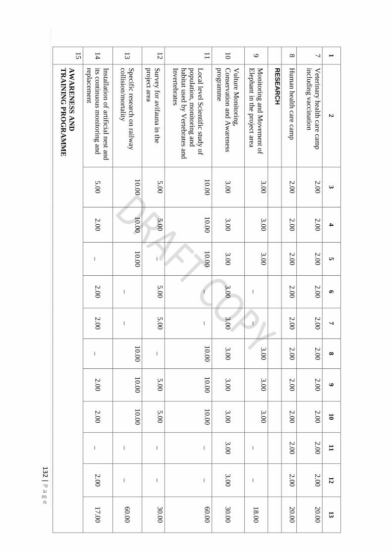
13
2 | P
ag
e
1
2
3
4
5
6
7
8
9
10
11
12
13
7
Veterin
ary h
ealth care cam
p
inclu
din
g v
accinatio
n
2.0
0
2.0
0
2.0
0
2.0
0
2.0
0
2.0
0
2.0
0
2.0
0
2.0
0
2.0
0
20
.00
8
Hum
an h
ealth care cam
p
2.0
0
2.0
0
2.0
0
2.0
0
2.0
0
2.0
0
2.0
0
2.0
0
2.0
0
2.0
0
20
.00
R
ES
EA
RC
H
9
Mo
nito
ring an
d M
ovem
ent o
f
Elep
han
t in th
e pro
ject area
3.0
0
3.0
0
3.0
0
_
_
3.0
0
3.0
0
3.0
0
_
_
18
.00
10
Vultu
re Mo
nito
ring,
Co
nserv
ation an
d A
waren
ess
pro
gram
me
3.0
0
3.0
0
3.0
0
3.0
0
3.0
0
3.0
0
3.0
0
3.0
0
3.0
0
3.0
0
30
.00
11
Lo
cal level S
cientific stu
dy o
f
po
pulatio
n, m
onito
ring an
d
hab
itat used
by V
ertebrates an
d
Inv
ertebrates
10
.00
10
.00
10
.00
_
_
10
.00
10
.00
10
.00
_
_
60
.00
12
Surv
ey fo
r avifau
na in
the
pro
ject area
5.0
0
5.0
0
_
5.0
0
5.0
0
_
5.0
0
5.0
0
_
_
30
.00
13
Sp
ecific research o
n railw
ay
collisio
n/m
ortality
10
.00
10
.00
10
.00
_
_
10
.00
10
.00
10
.00
_
_
60
.00
14
Installatio
n o
f artificial nest an
d
its contin
uo
us m
onito
ring an
d
replacem
ent
5.0
0
2.0
0
_
2.0
0
2.0
0
_
2.0
0
2.0
0
_
2.0
0
17
.00
15
AW
AR
EN
ES
S A
ND
TR
AIN
ING
PR
OG
RA
MM
E

13
3 | P
ag
e
1
2
3
4
5
6
7
8
9
10
11
12
13
a T
rainin
g p
rogram
me an
d
finan
cial sup
po
rt for In
com
e
gen
erating sch
eme lik
e Po
ultry
,
Piscicu
lture, B
ee keep
ing,
Duck
ery, M
ush
roo
m cu
ltivatio
n,
Lac cu
lture, B
amb
oo
article etc.
5.0
0
5.0
0
5.0
0
5.0
0
5.0
0
5.0
0
5.0
0
5.0
0
5.0
0
5.0
0
50
.00
b
Train
ing an
d aw
areness to
ED
C/V
FM
C, in
Sch
oo
ls,
Villag
e level V
olu
nteers fo
r
Wild
Life C
onserv
ation
&
Pro
tection
c P
rintin
g o
f bro
chures an
d
fold
ers, bo
ard &
sinag
es
d
Tra
inin
g p
rogra
mm
e fo
r ma
n-
an
ima
l co
nflic
t 1
.00
1.0
0
1.0
0
1.0
0
1.0
0
1.0
0
1.0
0
1.0
0
1.0
0
1.0
0
10
.00
M
ISC
EL
LA
NE
OU
S A
CT
IVIT
Y
16
Prep
aration o
f Micro
plan
of 4
villag
es in fo
rest area div
erted
and
its initiatio
n o
f
imp
lemen
tation (en
try p
oin
t
wo
rk) (1
.00
lakh/v
illage)
4.0
0
_
_
_
_
_
_
_
_
_
4.0
0
17
M
ixe
d p
lan
tatio
n fo
r sh
elte
r an
d
foo
d e
leph
an
t corrid
or
5.0
0
5.0
0
5.0
0
3.0
0
3.0
0
_
3.0
0
3.0
0
_
3.0
0
30
.00
18
W
atc
h T
ow
er o
n b
oth
sid
e o
f ra
ilwa
y tra
ck (3
+3
= 6
) 2
1.0
0
21
.00
0.0
0
0.0
0
0.0
0
0.0
0
0.0
0
0.0
0
0.0
0
0.0
0
42
.00

13
4 | P
ag
e
1
2
3
4
5
6
7
8
9
10
11
12
13
19
S
ite s
pe
cific
Ele
pha
nt M
itiga
tion
M
ea
su
res
2.0
0
2.0
0
2.0
0
2.0
0
2.0
0
2.0
0
2.0
0
2.0
0
2.0
0
2.0
0
20
.00
20
S
ola
r ligh
t
(a
) Sola
r Stre
et lig
ht in
Ele
ph
an
t a
ffecte
d v
illag
e (N
o. 5
0)
35
.00
35
.00
_
_
_
_
_
_
_
_
70
.00
T
OT
AL
1
93
.00
14
4.0
0
69
.00
46
.00
51
.00
64
.00
74
.00
69
.00
39
.00
44
.00
79
3.0
0
N
OT
E:-
1
The estim
ated am
ount o
f pro
posed
work
is subject to
chan
ge d
epen
din
g o
n ch
ange in
wag
e rates and estim
ates of G
ovt. o
f Jhark
han
d

13
5 | P
ag
e
Tab
le: 2
.1 T
HE
PR
OP
OS
ED
BU
DG
ET
FO
R IN
TE
RV
EN
TIO
N B
Y D
FO
, CH
AT
RA
SO
UT
H F
OR
ES
T D
IVIS
ION
Sl.
No.
Na
me o
f the a
ctiv
ity
Year w
ise F
inan
cia
l Targets (R
s. In L
ac.)
1st Y
ear
2n
d
Year
3rd
Year
4th
Year
5th
Year
6th
Year
7th
Year
8th
Year
9th
Year
10th
Year
TO
TA
L
1
2
3
4
5
6
7
8
9
10
11
12
13
M
AN
AG
EM
EN
T O
F
FO
OD
1
Hab
itat enrich
men
t with
plan
tation o
f bam
boo/ fru
it
bearin
g sp
ecies / fuel &
fodder p
lantatio
n
20.0
0
20.0
0
20.0
0
_
5.0
0
5.0
0
5.0
0
_
5.0
0
5.0
0
85.0
0
M
AN
AG
EM
EN
T O
F
WA
TE
R
2
Desiltin
g, R
enovatio
n &
Main
tenan
ce of w
ater holes
and o
ld p
onds
8.0
0
8.0
0
8.0
0
5.0
0
5.0
0
8.0
0
8.0
0
8.0
0
5.0
0
5.0
0
68.0
0
3
Constru
ction o
f 16 p
ond o
n
both
side o
f 8 elep
han
t passes
and m
ainten
ance fro
m 2
nd
year
128.0
0
16.0
0
16.0
0
16.0
0
16.0
0
16.0
0
16.0
0
16.0
0
16.0
0
16.0
0
272.0
0
4
Soil &
moistu
re conserv
ation
measu
res
15.0
0
15.0
0
5.0
0
5.0
0
5.0
0
5.0
0
5.0
0
5.0
0
5.0
0
5.0
0
70.0
0
M
AN
AG
EM
EN
T O
F
SH
EL
TE
R
5
Fire P
rotectio
n
(a) F
ire line cu
tting &
Contro
lled b
urn
ing alo
ng
forest area
4.0
0
4.0
0
4.0
0
4.0
0
4.0
0
4.0
0
4.0
0
4.0
0
4.0
0
4.0
0
40.0
0
(b
) Fire p
rotectio
n th
rough
VF
PC
.

13
6 | P
ag
e
1
2
3
4
5
6
7
8
9
10
11
12
13
E
CO
DE
VE
LO
PM
EN
T
6
Eco
- dev
elopm
ent w
ork
in
differen
t villag
es (eg.
Ren
ovatio
n o
f pond, C
heck
Dam
etc)
10.0
0
10.0
0
10.0
0
10.0
0
10.0
0
10.0
0
10.0
0
10.0
0
10.0
0
10.0
0
100.0
0
7
Veterin
ary h
ealth care cam
p
inclu
din
g v
accinatio
n
5.0
0
5.0
0
5.0
0
5.0
0
5.0
0
5.0
0
5.0
0
5.0
0
5.0
0
5.0
0
50.0
0
8
Hum
an h
ealth care cam
p
5.0
0
5.0
0
5.0
0
5.0
0
5.0
0
5.0
0
5.0
0
5.0
0
5.0
0
5.0
0
50.0
0
R
ES
EA
RC
H
9
Monito
ring an
d M
ovem
ent o
f
Elep
han
t in th
e pro
ject area
6.0
0
6.0
0
6.0
0
_
_
6.0
0
6.0
0
6.0
0
_
_
36.0
0
10
Vultu
re Monito
ring,
Conserv
ation an
d A
waren
ess
pro
gram
me
3.0
0
3.0
0
3.0
0
3.0
0
3.0
0
3.0
0
3.0
0
3.0
0
3.0
0
3.0
0
30.0
0
11
AW
AR
EN
ES
S A
ND
TR
AIN
ING
PR
OG
RA
MM
E
a T
rainin
g p
rogram
me an
d
finan
cial support fo
r Inco
me
gen
erating sch
eme lik
e
Poultry
, Piscicu
lture, B
ee
keep
ing, D
uck
ery, M
ush
room
cultiv
ation, L
ac cultu
re,
Bam
boo article etc.
15.0
0
15.0
0
15.0
0
15.0
0
15.0
0
15.0
0
15.0
0
15.0
0
15.0
0
15.0
0
150.0
0
b
Train
ing an
d aw
areness to
ED
C/V
FM
C, in
Sch
ools,
Villag
e level V
olu
nteers fo
r
Wild
Life C
onserv
ation &
Pro
tection

13
7 | P
ag
e
1
2
3
4
5
6
7
8
9
10
11
12
13
c P
rintin
g o
f bro
chures an
d
fold
ers, board
& sin
ages
d
Train
ing p
rogram
me fo
r man
-
anim
al conflict
2.0
0
2.0
0
2.0
0
2.0
0
2.0
0
2.0
0
2.0
0
2.0
0
2.0
0
2.0
0
20.0
0
M
ISC
EL
LA
NE
OU
S
AC
TIV
ITY
12
Prep
aration o
f Micro
plan
of
27 v
illages in
forest area
div
erted an
d its in
itiation o
f
implem
entatio
n (en
try p
oin
t
work
) (1.0
0 lak
h/v
illage)
17.0
0
10.0
0
_
_
_
_
_
_
_
_
27.0
0
13
Mix
ed p
lantatio
n fo
r shelter
and fo
od elep
han
t corrid
or
10.0
0
10.0
0
5.0
0
5.0
0
5.0
0
_
5.0
0
5.0
0
_
5.0
0
50.0
0
14
Watch
Tow
er on b
oth
side o
f
railway
track (1
5)
56.0
0
49.0
0
0.0
0
0.0
0
0.0
0
0.0
0
0.0
0
0.0
0
0.0
0
0.0
0
105.0
0
15
Site sp
ecific Elep
han
t
Mitig
ation M
easures
4.0
0
4.0
0
4.0
0
4.0
0
4.0
0
4.0
0
4.0
0
4.0
0
4.0
0
4.0
0
40.0
0
16
Solar lig
ht
(a) S
olar S
treet light in
Elep
han
t affected v
illage (N
o.
75)
50.0
0
50.0
0
_
_
_
_
_
_
_
_
100.0
0
T
OT
AL
358.0
0
232.0
0
108.0
0
79.0
0
84.0
0
88.0
0
93.0
0
88.0
0
79.0
0
84.0
0
1293.0
0
N
OT
E:-
1
The estim
ated am
ount o
f pro
posed
work
is subject to
chan
ge d
epen
din
g o
n ch
ange in
wag
e rates and estim
ates of G
ovt. o
f Jhark
han
d

138 | P a g e
CHAPTER – 7
APPENDICES
1. ANNEXURES
Annexure-I Village wise land utilization pattern of the project area
Annexure-II List of Bridges, ROBs, RUBs etc
Annexure-III Cost to benefit analysis
Annexure-IV Total no. of forest trees which comes under proposed site
Annexure – V The details of the forest land area diverted
Annexure- VI Letter of Ministry of Environment, Forest and Climate for preparation
of Wildlife Management plan
Annexure- VII Details of all Land from Shivpur to Kathautia
Annexure-VIII List of villages passing through the project area
Annexure IX Demographic details of the 29 villages of the project site
Annexure- X Occupational profile of villages of project site
Annexure- XI Summary of the survey in villages where railway track is passing
through forest land
Annexure- XII Flora of West Division (Working Plan 2013-14 to 2022-2023)
Annexure- XIII Flora of Chatra South Division (Working Plan 2013-14 to 2022-2023)
Annexure- XIV Inventory of site specific flora of Chatra South Division
Annexure - XV Inventory of site specific flora of Hazaribag West Forest division
Annexure- XVI Quadrate study sites with GPS location
Annexure-XVII Checklist of fauna of West Forest Division (Working Plan 2013-14
to 2022-2023)
Annexure- XVIII Checklist of fauna of Chatra South Forest Division (Working Plan
2013-14 to 2023-24)
Annexure- XIX IBA Chapter (Rahmani et al., 2016)
Annexure- XX Inventory of site specific fauna of project area
Annexure- XXI Inventory of Avifauna recorded in the project area
Annexure- XXII Payment of compensation for human life as well as for crop damage
given due to the movement of elephants in Chatra South Forest
Division

139 | P a g e
Annexure- XXIII Payment of compensation for human life as well as for crop damage
given due to the movement of elephants in Hazaribag West Division
Annexure- XXIV Elephant affected villages in Chatra South Forest Division
Annexure- XXV Suggestions of DFO, Hazaribag West Forest Division
Annexure- XXVI Sighting, movement and conflict with elephant in the study area
Annexure- XXVII Poaching/hunting and accident cases in Chatra South Forest Division
Annexure- XXVIII Poaching/hunting and in Hazaribag West Forest Division
Annexure- XXIX List of Expert
Annexure- XXX List of Elephant/Wildlife Underpass
Annexure- XXXI List of plant species preferred by Elephant
2. PHOTOGRAPHS
Plate I : Location of the project site
Plate II &III : Photographs of the study area.
Plate IV to VI : Photographs of some important fauna found in the project site
3. MAPS
Map 1. Map of Shivpur-Kathautia New BG Electrified line over SOI Toposheet-
RF 1:50,000
Map 2. Location map of elephant zone of Chatra South Forest Division (Provided
by Chatra South Forest Division)
Map 3. Location map of man elephant conflict (Provided by Chatra South Forest
Division)
Map 4. Location map of movement of elephant in West Division (Provided by
West Division)
Map 5. Site specific movement of elephant seen in last five year in the project area
Map 6. Location of Elephant/wildlife passes proposed
Map 7. Reference Map of Land Use Land Cover (LULC) Plates
Map 7.1. Land Use Land Cover (LULC) of Project Site (1)
Map 7.2. Land Use Land Cover (LULC) of Project Site (2)