
WHP and Subsea Fields AC/L7 & AC/L8 Drilling Program ...
315
JADESTONE ENERGY (AUSTRALIA)PTY LTD Level 8, 1 William Street, Perth, Western Australia 6000 | PO Box 5388 Perth WA 6000 Telephone: +61 8 9486 6600 Website: www.jadestone‐energy.com (ACN: 613 671 819) UNCONTROLLED WHEN PRINTED WHP and Subsea Fields AC/L7 & AC/L8 Drilling Program 2021 Environment Plan TM‐50‐PLN‐I‐00001 Rev 3 FACILITY TM ‐ Montara Field REVIEW INTERVAL 12 Months Rev No Date Approval Owner Reviewer Approver Drilling & Wells Manager Environment Lead Country Manager 0 06‐Jan‐20 E. Lintott M. Patt O. Hobbs 1 16‐Mar‐20 E. Lintott M. Patt O. Hobbs 2 15‐May‐20 E. Lintott M. Patt O. Hobbs 3 25‐May‐21 G. Hattersley M. Patt O. Hobbs Holders of Controlled Copies: Any hard copy of this document, other than those identified above, are uncontrolled. Please refer to the Jadestone Energy MIS for the latest revision.
-
Upload
khangminh22 -
Category
Documents
-
view
0 -
download
0
Transcript of WHP and Subsea Fields AC/L7 & AC/L8 Drilling Program ...
JADESTONE ENERGY (AUSTRALIA) PTY LTD
Level 8, 1 William Street, Perth, Western Australia 6000 | PO Box 5388 Perth WA 6000 Telephone: +61 8 9486 6600 Website: www.jadestone‐energy.com (ACN: 613 671 819)
UNCONTROLLED WHEN PRINTED
WHP and Subsea Fields AC/L7 & AC/L8 Drilling Program 2021 Environment Plan
TM‐50‐PLN‐I‐00001
Rev 3
FACILITY TM ‐ Montara Field
REVIEW INTERVAL 12 Months
Rev No
Date
Approval
Owner Reviewer Approver
Drilling & Wells Manager
Environment Lead Country Manager
0 06‐Jan‐20 E. Lintott M. Patt O. Hobbs
1 16‐Mar‐20 E. Lintott M. Patt O. Hobbs
2 15‐May‐20 E. Lintott M. Patt O. Hobbs
3 25‐May‐21 G. Hattersley M. Patt O. Hobbs
Holders of Controlled Copies:
Any hard copy of this document, other than those identified above, are uncontrolled. Please refer to the
Jadestone Energy MIS for the latest revision.

TM‐50‐PLN‐I‐00001 Rev 3
________________________________________________________________________________________________________________________
WHP and Subsea Fields AC/L7 & AC/L8 Drilling Program 2021 Environment Plan 2 of 315
REVISION HISTORY
Revision Author / Editor Amendment
0 M. Patt Prepared for assessment by NOPSEMA
1 M. Patt Revised in response to RFFWI from NOPSEMA
2 M. Patt Revised in response to RFFWI from NOPSEMA
3 N. Meredith/M.
Patt Updated for H6 & Skua 10 and Skua 11

TM‐50‐PLN‐I‐00001 Rev 3
________________________________________________________________________________________________________________________
WHP and Subsea Fields AC/L7 & AC/L8 Drilling Program 2021 Environment Plan 3 of 315
CONTENTS
Acronyms and Abbreviations .................................................................................................................. 14
1. INTRODUCTION ............................................................................................................................... 19
1.1 Background .............................................................................................................................. 19
1.2 Operator and Titleholder Details .............................................................................................. 19
1.3 HSE Policy ................................................................................................................................ 20
1.4 Legislative Framework ............................................................................................................. 20
1.5 This Environment Plan ............................................................................................................. 22
2. ACTIVITY DESCRIPTION .................................................................................................................... 26
2.1 Location ................................................................................................................................... 26
2.2 Timing and Duration ................................................................................................................ 27
2.3 Petroleum Safety Zone (PSZ) .................................................................................................... 27
2.4 Operational Area ..................................................................................................................... 27
2.5 MODU ...................................................................................................................................... 28
2.6 Montara Development Project (MDP) Infrastructure ................................................................ 29
2.7 Hydrocarbons ........................................................................................................................... 30
2.7.1 Montara crude oil ............................................................................................................................ 30
2.7.2 Skua crude oil .................................................................................................................................. 30
2.8 MODU positioning ................................................................................................................... 30
2.9 Drilling Activity ........................................................................................................................ 31
2.9.1 Skua‐10 workover ............................................................................................................................ 31
2.9.2 Skua‐11 Workover ........................................................................................................................... 33
2.9.3 H6 Well ............................................................................................................................................ 36
2.9.4 Cementing ....................................................................................................................................... 37
2.9.5 Drilling fluids and cuttings ............................................................................................................... 37
2.9.6 Loss of circulation ............................................................................................................................ 37
2.9.7 Chemical selection ........................................................................................................................... 38
2.9.8 Well evaluation ................................................................................................................................ 39
2.10 Drilling Support Operations ...................................................................................................... 39
2.10.1 Vessels ............................................................................................................................................. 39
2.10.2 Helicopters ....................................................................................................................................... 39
2.11 Out of Scope ............................................................................................................................ 40
3. EXISTING ENVIRONMENT ................................................................................................................. 41
3.1 Definition of Areas ................................................................................................................... 41

TM‐50‐PLN‐I‐00001 Rev 3
________________________________________________________________________________________________________________________
WHP and Subsea Fields AC/L7 & AC/L8 Drilling Program 2021 Environment Plan 4 of 315
3.2 Marine Regional Setting ........................................................................................................... 41
3.3 Physical Environment ............................................................................................................... 42
3.3.1 Climate ............................................................................................................................................. 42
3.3.2 Oceanography (Tides and Currents) ................................................................................................ 43
3.3.3 Waves .............................................................................................................................................. 45
3.3.1 Temperature, Salinity and Turbidity ................................................................................................ 46
3.3.2 Bathymetry and Seafloor Geology .................................................................................................. 46
3.3.3 Sediment Quality ............................................................................................................................. 46
3.3.4 Sediment Particle Size Distribution ................................................................................................. 46
3.4 Conservation Values and Sensitivities ...................................................................................... 47
3.4.1 Matters of National Environmental Significance (MNES) ............................................................... 47
3.4.2 Listed Threatened and Migratory Species ....................................................................................... 47
3.4.3 Others matters protected by the EPBC ........................................................................................... 48
3.4.4 Marine Parks .................................................................................................................................... 48
3.4.5 Terrestrial Values ............................................................................................................................. 48
3.4.6 Key Environmental Features (KEFs) ................................................................................................. 48
3.5 Biological Environment – Species and Communities’ Descriptions ............................................ 48
3.5.1 Benthic Habitat and Communities .................................................................................................. 48
3.5.2 Plankton and invertebrates ............................................................................................................. 49
3.5.3 Fish, Sharks and Rays ....................................................................................................................... 49
3.5.4 Marine Reptiles ............................................................................................................................... 56
3.5.5 Marine Mammals ............................................................................................................................ 61
3.5.6 Avifauna ........................................................................................................................................... 66
3.6 Social Values ............................................................................................................................ 73
4. CONSULTATION OF RELEVANT PERSONS .......................................................................................... 76
4.1 Definitions ............................................................................................................................... 77
4.2 Fulfilment of Regulatory Requirements .................................................................................... 77
4.3 Identification of Relevant Persons ............................................................................................ 78
4.4 Relevant Person Classification .................................................................................................. 84
4.4.1 Sufficiency of Information ............................................................................................................... 84
4.4.2 Reasonable Period ........................................................................................................................... 85
4.5 Assessment of Merit ................................................................................................................ 86
4.6 Sensitive Information ............................................................................................................... 86
4.7 Ongoing Consultation ............................................................................................................... 96

TM‐50‐PLN‐I‐00001 Rev 3
________________________________________________________________________________________________________________________
WHP and Subsea Fields AC/L7 & AC/L8 Drilling Program 2021 Environment Plan 5 of 315
4.8 Consultation in the event of a Tier 2/3 Oil Spill ......................................................................... 97
5. EVALUATION OF ENVIRONMENTAL IMPACTS AND RISKS ................................................................. 99
5.1 Assessment Method ................................................................................................................. 99
5.2 Risk Assessment ..................................................................................................................... 100
5.2.1 Identification of control measures ................................................................................................ 100
5.2.2 Risk ranking process for unplanned events ................................................................................... 101
5.3 Impact Assessment ................................................................................................................ 102
5.4 Demonstration of Acceptability .............................................................................................. 102
5.5 Demonstration of as Low as Reasonably Practicable (ALARP) ................................................. 104
5.6 Evaluation Summary .............................................................................................................. 105
5.7 Risk Assessment Approach for Worst‐case Hydrocarbon Spill Response ................................. 105
5.7.1 Determine Oil Spill Modelling Thresholds ..................................................................................... 106
5.7.2 Determine the RISK EMBAs ........................................................................................................... 106
5.7.3 Determine the impact threshold ................................................................................................... 106
5.7.4 Sensitive Receptor Identification .................................................................................................. 106
5.7.5 Priority Receptors .......................................................................................................................... 107
5.7.6 ALARP and Acceptability Evaluation for Spill Response ................................................................ 108
6. ASSESSMENT – PLANNED ACTIVITIES ............................................................................................. 110
6.1 Physical Presence ................................................................................................................... 110
6.1.1 Description of aspect ..................................................................................................................... 110
6.1.2 Impacts .......................................................................................................................................... 111
6.1.3 Environmental performance ......................................................................................................... 113
6.1.4 ALARP assessment ......................................................................................................................... 115
6.1.5 Acceptability assessment .............................................................................................................. 115
6.2 Light emissions ....................................................................................................................... 116
6.2.1 Description of aspect ..................................................................................................................... 116
6.2.2 Impacts .......................................................................................................................................... 116
6.2.3 Environmental performance ......................................................................................................... 119
6.2.4 ALARP assessment ......................................................................................................................... 120
6.2.5 Acceptability assessment .............................................................................................................. 120
6.3 Noise Emissions ..................................................................................................................... 121
6.3.1 Description of aspect ..................................................................................................................... 121
6.3.2 Impacts .......................................................................................................................................... 123
6.3.3 Environmental performance ......................................................................................................... 126

TM‐50‐PLN‐I‐00001 Rev 3
________________________________________________________________________________________________________________________
WHP and Subsea Fields AC/L7 & AC/L8 Drilling Program 2021 Environment Plan 6 of 315
6.3.4 ALARP assessment ......................................................................................................................... 127
6.3.5 Acceptability assessment .............................................................................................................. 128
6.4 Atmospheric Emissions .......................................................................................................... 129
6.4.1 Description of aspect ..................................................................................................................... 129
6.4.2 Impacts .......................................................................................................................................... 130
6.4.3 Environmental performance ......................................................................................................... 132
6.4.4 ALARP assessment ......................................................................................................................... 133
6.4.5 Acceptability assessment .............................................................................................................. 133
6.5 Operational Discharges .......................................................................................................... 134
6.5.1 Description of aspect ..................................................................................................................... 134
6.5.2 Impacts .......................................................................................................................................... 135
6.5.3 Environmental performance ......................................................................................................... 139
6.5.4 ALARP assessment ......................................................................................................................... 141
6.5.5 Acceptability assessment .............................................................................................................. 141
6.6 Drilling Discharges .................................................................................................................. 142
6.6.1 Description of aspect ..................................................................................................................... 142
6.6.2 Impacts .......................................................................................................................................... 144
6.6.3 Environmental performance ......................................................................................................... 147
6.6.4 ALARP assessment ......................................................................................................................... 149
6.6.5 Acceptability assessment .............................................................................................................. 150
6.7 Cement Discharges ................................................................................................................. 152
6.7.1 Description of aspect ..................................................................................................................... 152
6.7.2 Impacts .......................................................................................................................................... 152
6.7.3 Environmental performance ......................................................................................................... 154
6.7.4 ALARP Assessment......................................................................................................................... 155
6.7.5 Acceptability assessment .............................................................................................................. 155
6.8 Spill Response Activities ......................................................................................................... 156
6.8.1 Description of aspect ..................................................................................................................... 156
6.8.2 Impacts .......................................................................................................................................... 157
6.8.3 Environmental performance ......................................................................................................... 161
6.8.4 ALARP assessment ......................................................................................................................... 165
6.8.5 Acceptability assessment .............................................................................................................. 171
7. UNPLANNED RISKS ........................................................................................................................ 173
7.1 Marine Pest Introduction ....................................................................................................... 173

TM‐50‐PLN‐I‐00001 Rev 3
________________________________________________________________________________________________________________________
WHP and Subsea Fields AC/L7 & AC/L8 Drilling Program 2021 Environment Plan 7 of 315
7.1.1 Description of hazard .................................................................................................................... 173
7.1.2 Impacts and risks ........................................................................................................................... 173
7.1.3 Environmental performance ......................................................................................................... 177
7.1.4 ALARP assessment ......................................................................................................................... 178
7.1.5 Acceptability assessment .............................................................................................................. 178
7.2 Interaction with fauna............................................................................................................ 179
7.2.1 Description of hazard .................................................................................................................... 179
7.2.2 Impacts and risks ........................................................................................................................... 180
7.2.3 Environmental performance ......................................................................................................... 183
7.2.4 ALARP assessment ......................................................................................................................... 184
7.2.5 Acceptability assessment .............................................................................................................. 184
7.3 Unplanned Release of Solids .................................................................................................. 185
7.3.1 Description of hazard .................................................................................................................... 185
7.3.2 Impacts and risks ........................................................................................................................... 185
7.3.3 Environmental performance ......................................................................................................... 187
7.3.4 ALARP assessment ......................................................................................................................... 188
7.3.5 Acceptability assessment .............................................................................................................. 188
7.4 Unplanned Release of (Non‐Hydrocarbon) Liquids ................................................................. 189
7.4.1 Description of hazard .................................................................................................................... 189
7.4.2 Impacts and risks ........................................................................................................................... 190
7.4.3 Environmental performance ......................................................................................................... 192
7.4.4 ALARP assessment ......................................................................................................................... 193
7.4.5 Acceptability assessment .............................................................................................................. 193
7.5 Unplanned Release of Hydrocarbons – Worst Case Scenarios ................................................. 194
7.5.1 Worst case credible spill scenarios ................................................................................................ 194
7.5.2 Credible worst‐case scenarios ....................................................................................................... 196
7.5.3 Duration of LOWC worst case credible scenario ........................................................................... 196
7.5.4 Discounted scenarios ..................................................................................................................... 197
7.6 Worst Case Crude Oil Spills ..................................................................................................... 197
7.6.1 Description of hazard .................................................................................................................... 197
7.6.2 Montara and Skua Characteristics ................................................................................................. 198
7.6.3 Modelling Approach ...................................................................................................................... 198
7.6.4 Exposure pathways and impact thresholds ................................................................................... 199
7.6.5 Modelling results of the LOWC scenarios ..................................................................................... 199

TM‐50‐PLN‐I‐00001 Rev 3
________________________________________________________________________________________________________________________
WHP and Subsea Fields AC/L7 & AC/L8 Drilling Program 2021 Environment Plan 8 of 315
7.6.6 Impacts and risks ........................................................................................................................... 205
7.6.7 Level of Impact on Sensitive Receptors within the RISK EMBA ..................................................... 205
7.6.8 Priority receptors ........................................................................................................................... 221
7.6.9 Net Environmental Benefit Assessment (NEBA) ............................................................................ 224
7.6.10 Environmental performance ......................................................................................................... 229
7.6.11 ALARP assessment ......................................................................................................................... 232
7.6.12 Acceptability assessment .............................................................................................................. 252
7.7 Worst Case Diesel Spill ........................................................................................................... 257
7.7.1 Description of hazard .................................................................................................................... 257
7.7.2 Spill volume ................................................................................................................................... 257
7.7.3 Diesel characteristics ..................................................................................................................... 258
7.7.4 Modelling Approach ...................................................................................................................... 258
7.7.5 Diesel modelling results ................................................................................................................. 259
7.7.6 Impacts and risks ........................................................................................................................... 263
7.7.7 Environmental performance ......................................................................................................... 271
7.7.8 ALARP assessment ......................................................................................................................... 274
7.7.9 Acceptability Assessment .............................................................................................................. 274
8. IMPLEMENTATION STRATEGY ........................................................................................................ 276
8.1 Jadestone Business Management System ............................................................................... 276
8.1.1 Operational Excellence .................................................................................................................. 278
8.1.2 Value Discipline ............................................................................................................................. 279
8.1.3 People ............................................................................................................................................ 279
8.1.4 Stakeholder Management ............................................................................................................. 279
8.1.5 Risk Management .......................................................................................................................... 281
8.1.6 Produce .......................................................................................................................................... 281
8.1.7 Provide Goods and Services .......................................................................................................... 281
8.2 Key Roles and Responsibilities ............................................................................................... 282
8.2.1 Organisational Structure and Responsibilities .............................................................................. 282
8.2.2 Communication of Responsibilities ............................................................................................... 286
8.2.3 Competencies and Training ........................................................................................................... 286
8.3 Monitoring, Auditing, Management of Non‐conformance and Review ................................... 287
8.3.1 Routine Monitoring ....................................................................................................................... 287
8.3.2 Audits ............................................................................................................................................. 289
8.3.3 Non‐compliances and Corrective Actions ..................................................................................... 289

TM‐50‐PLN‐I‐00001 Rev 3
________________________________________________________________________________________________________________________
WHP and Subsea Fields AC/L7 & AC/L8 Drilling Program 2021 Environment Plan 9 of 315
8.3.4 Reporting ....................................................................................................................................... 289
8.4 Continuous Improvement (Operational Excellence) ................................................................ 289
8.4.1 Management of Change and Revisions of the Environment Plan ................................................. 293
8.4.2 Record Keeping .............................................................................................................................. 294
8.5 Emergency Preparedness and Response ................................................................................. 295
9. REPORTING ................................................................................................................................... 295
9.1 Routine Reporting .................................................................................................................. 295
9.2 Incident Reporting ................................................................................................................. 296
10. REFERENCES .................................................................................................................................. 298
APPENDICES .......................................................................................................................................... 315

TM‐50‐PLN‐I‐00001 Rev 3
________________________________________________________________________________________________________________________
WHP and Subsea Fields AC/L7 & AC/L8 Drilling Program 2021 Environment Plan 10 of 315
List of Appendices
APPENDIX A: RELEVANT LEGISLATION
APPENDIX B: EXISTING ENVIRONMENT RISK EMBA
APPENDIX C: STAKEHOLDER CONSULTATION DOCUMENTATION
APPENDIX D: PMST OPERATIONAL AREA
APPENDIX E: PMST RISK EMBA
APPENDIX F: HYDROCARBON IMPACT THRESHOLDS
APPENDIX G: EPBC 2002/755 CONSOLIDATED APPROVAL NOTICE (12 JUNE 2018)
APPENDIX H: PRIORITY RECEPTOR KEY VALUES AND CONTACT
APPENDIX I: POTENTIAL MONITORING SITE AND SMPS TO BE IMPLEMENTED
APPENDIX J: SMP FRAMEWORK
APPENDIX K: SMP APPENDIX 2
APPENDIX L: STAKEHOLDER SENSITIVE INFORMATION

TM‐50‐PLN‐I‐00001 Rev 3
________________________________________________________________________________________________________________________
WHP and Subsea Fields AC/L7 & AC/L8 Drilling Program 2021 Environment Plan 11 of 315
Table of Tables
Table 1‐1: Summary of Applicable International Conventions, Industry Standards, Guidelines and Policy Documents 23
Table 2‐1: Location of activities ................................................................................................................... 26
Table 2‐2: Locations of key sensitive receptors in relation to the Montara Venture FPSO ...................... 26
Table 2‐3: Montara Development Project Infrastructure Coordinates (Surface) (GDA 94, Zone 51) ....... 29
Table 2‐4: Indicative support vessel specifications .................................................................................... 39
Table 3‐1: Provincial bioregions in Operational Area ................................................................................. 42
Table 3‐2: Meteorological conditions representative of the Montara Field (Troughton Island) ................. 43
Table 3‐3: Summary of conservation values and sensitivities in the Operational Area ........................... 47
Table 3‐4: Fish, Sharks and Rays EPBC listed species ................................................................................... 50
Table 3‐5: Marine Reptiles EPBC listed species ............................................................................................ 57
Table 3‐6: Marine Mammal EPBC listed species .......................................................................................... 62
Table 3‐7: Avifauna Listed EPBC species ...................................................................................................... 68
Table 3‐8: Socio‐economic Values and Sensitivities within the Operational Area ....................................... 74
Table 4‐1: Regulatory Requirements ............................................................................................................ 77
Table 4‐2: Relevant Persons ......................................................................................................................... 80
Table 4‐3: Levels of Engagement .................................................................................................................. 84
Table 4‐4: Responding to merits of objections and claims .......................................................................... 87
Table 4‐5 Ongoing Consultation Requirements .......................................................................................... 96
Table 4‐6: Triggered Consultation ............................................................................................................... 97
Table 5‐1: Jadestone Qualitative Risk Matrix ........................................................................................... 101
Table 5‐2: Definition of consequence level ............................................................................................... 101
Table 5‐3: Definition of likelihood levels .................................................................................................. 102
Table 5‐4: Jadestone Energy’s acceptability matrix ................................................................................. 103
Table 5‐5: Summary of the environmental impact and risk assessment rankings for aspects and hazards associated with planned activities and unplanned events during the Drilling Activities .......................... 105
Table 6‐1: Summary of anthropogenic and natural underwater noise sources ...................................... 122
Table 6‐2: Gas volumes vented during bleed down process ..................................................................... 130
Table 6‐3: H6 well profile and cuttings and mud discharge volumes ...................................................... 143
Table 6‐4: Completion fluid discharges ...................................................................................................... 143
Table 6‐5: Impact assessment of spill response activities ........................................................................ 158
Table 6‐6: ALARP for spill response activities ............................................................................................. 166
Table 7‐1: Summary of the environmental risk assessment ranking for accidental events ...................... 173
Table 7‐2: Worst case credible hydrocarbon spill scenarios due to a loss of containment event ............. 195

TM‐50‐PLN‐I‐00001 Rev 3
________________________________________________________________________________________________________________________
WHP and Subsea Fields AC/L7 & AC/L8 Drilling Program 2021 Environment Plan 12 of 315
Table 7‐3: Worst case credible oil spills to the marine environment due to a loss of containment event196
Table 7‐4: Days drilling in the respective reservoir .................................................................................... 196
Table 7‐5: Relief Well Options and Timeframes ......................................................................................... 197
Table 7‐6: Summary of the contact thresholds applied in the impact assessment of the hydrocarbon spill modelling 200
Table 7-7 Worst case LOWC modelling results summary .......................................................... 202
Table 7‐8: Potential impacts to sensitive receptors present in the RISK EMBA ......................................... 205
Table 7‐9: Priority receptors rationale ....................................................................................................... 221
Table 7‐10: Impact of selected spill response strategy on the environmental values of Protection Priorities 225
Table 7‐11: ALARP assessment for increasing the level of resourcing in the OPEP for spill response strategies 234
Table 7‐12: Credible diesel releases to the marine environment .............................................................. 258
Table 7‐13 Potential Impacts to sensitive receptors from a diesel spill ..................................................... 264
Table 8‐1: Standard consultation actions ................................................................................................. 280
Table 8‐2: Triggered consultation actions ................................................................................................. 280
Table 8‐3: Responsibilities of Key Roles .................................................................................................... 284
Table 8‐4: Summary of routine monitoring .............................................................................................. 288
Table 8‐5: Summary of reporting requirements ........................................................................................ 290
Table 9‐1: Routine and incident reporting requirements ........................................................................ 296

TM‐50‐PLN‐I‐00001 Rev 3
________________________________________________________________________________________________________________________
WHP and Subsea Fields AC/L7 & AC/L8 Drilling Program 2021 Environment Plan 13 of 315
Table of Figures
Figure 2‐1: Operational Area for the Drilling Activities .............................................................................. 28
Figure 2‐2: Positioning the MODU alongside a Wellhead Platform ........................................................... 28
Figure 2‐3: Skua‐10 Well Schematic ............................................................................................................ 33
Figure 2‐4: Skua‐11 Well Schematic ............................................................................................................ 35
Figure 3‐1: Provincial Bioregions relevant to the Operational Area and RISK EMBA ................................... 42
Figure 3‐2: Key ocean currents influencing Western Australia .................................................................... 45
Figure 3‐3: Biologically important areas for fish, sharks and rays ............................................................... 53
Figure 3‐4: Biologically important areas for marine reptiles ....................................................................... 60
Figure 3‐5: Biologically important areas for marine mammals .................................................................... 64
Figure 3‐6: Figure Biologically important areas for avifauna ....................................................................... 71
Figure 3‐7: Shipping activity within the region ............................................................................................ 75
Figure 4‐1: JSE Stakeholder Engagement Process....................................................................................... 76
Figure 5‐1: Impact and risk evaluation process .......................................................................................... 99
Figure 5‐2: ALARP triangle ......................................................................................................................... 104
Figure 5‐3: Spill scenario evaluation and ALARP determination process ................................................ 109
Figure 5‐4: Spill control analysis and ALARP determination process ....................................................... 109
Figure 7‐1: Predicted RISK EMBA resulting from worst case scenario ....................................................... 201
Figure 7‐2: Priority receptors ..................................................................................................................... 223
Figure 7‐3: Predicted RISK EMBA for floating oil worst case ...................................................................... 260
Figure 7‐4: Predicted RISK EMBA for entrained oil worst case ................................................................ 261
Figure 7‐5: Predicted RISK EMBA for dissolved aromatic hydrocarbon worst case ................................... 262
Figure 8‐1: Business management system structure ................................................................................ 277
Figure 8‐2: Business activities and objective functions ............................................................................ 277
Figure 8‐3: Operational and excellence business functions ..................................................................... 278
Figure 8‐4: Drilling Operations organisation chart ................................................................................... 283

TM‐50‐PLN‐I‐00001 Rev 3
________________________________________________________________________________________________________________________
WHP and Subsea Fields AC/L7 & AC/L8 Drilling Program 2021 Environment Plan 14 of 315
Acronyms and Abbreviations
Abbreviation Description
AFZ Australian Fishing Zone
AHV Anchor handling vehicle
ALARP as low as reasonably practicable
AMP Australian Marine Parks
AMSA Australian Maritime Safety Authority
AQIS Australian Quarantine and Inspection Service
API American Petroleum Institute
APPEA Australian Petroleum Production and Exploration Association
BCF Bioconcentration factor
BIA Biologically important areas
BOD Biological oxygen demand
BOP Blowout preventer
CAA Civil aviation authority
CHARM Chemical Hazard and Risk Management
CMMS Computerised Maintenance Management System
DAH Dissolved aromatic hydrocarbons
DAWE Department of Agriculture, Water and the Environment
DAWR Department of Agriculture and Water Resources (now DOA)
DBCA Department of Biodiversity, Conservation and Attractions
DEC Department of Environment and Conservation (now DBCA)
DEWHA Department of the Environment, Water, Heritage and the Arts (now DoEE)
DIIS Department of Industry, Innovation and Science
DMIRS Department of Mines, Industry Regulation and Safety (previously Department of Mines and Petroleum, DMP)
DOA Department of Agriculture
DoF Department of Fisheries (now DPIRD)
DoEE Department of the Environment and Energy (now DAWE)
DP Dynamically Positioned
DPaW Department of Parks and Wildlife (now DBCA)
DPIRD Department of Primary Industries and Regional Development (previously Department of Fisheries)
DSD Department of Sustainable Development
DSEWPaC (now DoEE)
Department of Sustainability, Environment, Water, Population and Communities

TM‐50‐PLN‐I‐00001 Rev 3
________________________________________________________________________________________________________________________
WHP and Subsea Fields AC/L7 & AC/L8 Drilling Program 2021 Environment Plan 15 of 315
Abbreviation Description
DSV Dive Support Vessel
dwt Dry weight tonnes
EEZ Economic Exclusion Zone
EH&S Environmental Health & Safety
EMBA Environment that may be affected
ENVID Environmental hazard identification (process)
EPBC Act Environment Protection and Biodiversity Conservation Act 1999
EP Environment Plan
EPA Environmental Protection Authority
EP Act Environmental Protection Act 1986
EPO Environmental performance outcome
EPS Environmental performance standard
ESD Emergency Shut‐Down system
FPSO Floating production storage and offtake (facility)
FRC Fast response craft
HLO Helicopter landing officer
HP High pressure
HPU Hydraulic power unit
H2S Hydrogen sulphide
HSE Health safety and environment
IAP Incident Action Plan
ICAO International civil aviation organisation
ICCS Interface central control system
ICD Inflow control devices
IMCRA Integrated marine and coastal regionalisation of Australia
IMO International Maritime Organisation
IMPS Introduced marine pest species
IMR Integrity, maintenance and repair
IMT Incident Management Team
ITF Indonesian Throughflow (current)
IWC International Whaling Commission
JEE Jadestone (Eagle) Energy Pty Ltd
KEFs Key Ecological Features
Kl Kilolitre

TM‐50‐PLN‐I‐00001 Rev 3
________________________________________________________________________________________________________________________
WHP and Subsea Fields AC/L7 & AC/L8 Drilling Program 2021 Environment Plan 16 of 315
Abbreviation Description
KO Knock out (drum)
Ksm3 Thousand Standard Cubic Metres
LC50 Lethal concentration of a compound at which 50% of test species dies within a specified time frame
LAT Lowest astronomical tide
LMS Listed migratory species
LP Low pressure
LSA Low specific activity
MAOP Maximum Allowable Operating Pressure
MARPOL Marine pollution (legislation)
MCR Marine Conservation Reserve
MDP Montara Development Project
mg/L Milligrams per litre
MGPS Marine growth protection system
MMA Marine Management Area
mmscfd Million Standard Cubic Feet per Day
MODU Mobile offshore drilling unit
MPRA Marine Parks Reserves Authority
MSDS Material safety data sheet
NCB North Coast Bioregion
NEBA Net Environmental Benefit Assessment
NES National Environmental Significance
NOPSEMA National Offshore Petroleum Safety and Environmental Management Authority
NORMs Naturally Occurring Radioactive Materials
NSF Northern Shark Fishery
NWS North‐West Shelf
NWSTF North‐West Slope Trawl Fishery
OCIMF Oil Companies International Marine Forum
OCNS Offshore Chemical Notification Scheme
ODS Ozone Depleting Substances
OGP Oil and gas producers (association)
OIM Offshore Installation Manager
OIW Oil‐in‐water
OPEP Oil pollution emergency plan

TM‐50‐PLN‐I‐00001 Rev 3
________________________________________________________________________________________________________________________
WHP and Subsea Fields AC/L7 & AC/L8 Drilling Program 2021 Environment Plan 17 of 315
Abbreviation Description
OPGGS Act Offshore Petroleum and Greenhouse Gas Storage Act 2006
OPGGS (E) Regs Offshore Petroleum and Greenhouse Gas Storage (Environment) Regulations 2009
OPMF Onslow Prawn Managed Fishery
OSCP Oil Spill Contingency Plan
OSMP Operational and scientific monitoring plan
PAH Polycyclic aromatic hydrocarbons
PHG Pre‐hydrated gel
PLONOR Pose little or no risk
POB Persons on board
PPD Personal protection device
ppm parts per million
PRS Production Reporting System
PSZ Petroleum safety zone
PTS Permanent Threshold Shift
PW Produced water
ROV Remote Operated Vehicle
SBFTF Southern Bluefin Tuna Fishery
SCM Subsea control module
SCSSV Surface controlled subsurface safety valve
SDS Safety data sheet
SDU Subsea distribution unit
SIL Safety integrity level
SIMOPs Simultaneous operations
SMP Scientific monitoring program
SO2 Sulphur dioxide
SRB Sulphur Reducing Bacteria
SSS Side‐Scan sonar
STP Sewage Treatment Plant
SWL Safe Working Load
TEMPSC Totally enclosed motor propelled survival craft
TPH Total petroleum hydrocarbons
TRSV Tubing retrievable safety valve
TTS Temporary Threshold Shift
UPS Universal power supply

TM‐50‐PLN‐I‐00001 Rev 3
________________________________________________________________________________________________________________________
WHP and Subsea Fields AC/L7 & AC/L8 Drilling Program 2021 Environment Plan 18 of 315
Abbreviation Description
UV Ultraviolet
VBSA Vessel based support activity
VDU Vacuum distillation unit
VOC Volatile organic compounds
WA Western Australia
WAF Water accommodated fraction
WBM Water based mud
WHCP Wellhead hydraulic control panel
WHP Wellhead platform
WSTF Western Skipjack Tuna Fishery
WTBF Western Tuna and Billfish Fishery
WOMP Well Operations Management Plan
ENVIRONMENT PLAN SUMMARY
This Jadestone Drilling Activity Environment Plan Summary has been prepared from material provided in this Environment Plan and associated Oil Pollution Emergency Plan. The summary consists of the following as required by Regulation 11(4):
EP Summary material requirement Relevant section of EP containing EP Summary material
The location of the activity Section 2.1
A description of the receiving environment Section 3 and Appendix B
A description of the activity Section 2
Details of the environmental impacts and risks Section 6 and 7
The control measures for the activity Sections 6.1.3, 6.2.3, 6.3.3, 6.4.3, 6.5.3, 6.6.3, 6.7.3, 6.8.3, 7.1.3, 7.2.3, 7.4.3, 7.6.10 and 7.7.7.
The arrangements for ongoing monitoring of the titleholders’ environmental performance
Section 8.3
Response arrangements in the oil pollution emergency plan
Section 8.5 and Oil Pollution Emergency Plan
Consultation already undertaken and plans for ongoing consultation
Section 4 and Appendix C
Details of the titleholders nominated liaison person for the activity
Section 1.2

TM‐50‐PLN‐I‐00001 Rev 3
________________________________________________________________________________________________________________________
WHP and Subsea Fields AC/L7 & AC/L8 Drilling Program 2021 Environment Plan 19 of 315
1. INTRODUCTION
1.1 Background
Jadestone Energy (Eagle) Pty Ltd (Jadestone Energy) plans to drill development well H6 in permit area AC/L7 in the Montara Field and workover the Skua‐10 and ‐11 wells in AC/L8. All activities are within the Commonwealth waters of the Timor Sea, off northern Western Australia (Figure 1‐1). The activities described are collectively referred to as the Drilling Activities.
Figure 1‐1: Location of the WHP, Subsea Fields AC/L7 and AC/L8 2021 Drilling Activities
1.2 Operator and Titleholder Details
Jadestone Energy is engaged in exploration, appraisal and pre‐development activities in South East Asia, with a portfolio of ten exploration and pre‐development assets. Jadestone Energy is an active operator within the region and the Company's principal focus is on assets in Australia, Indonesia, Vietnam and the Philippines. Jadestone Energy is the sole titleholder of production licences AC/L7 and AC/L8 with operational control of the drilling and workover activities.
Jadestone Energy’s Australian office is located at:
Level 8, 1 William Street Perth, Western Australia, 6000. ACN 613 671 819
Jadestone Energy’s contact for the WHP and Subsea Fields AC/L7 and AC/L8 Drilling Activities 2021 is:
TM‐50‐PLN‐I‐00001 Rev 3
________________________________________________________________________________________________________________________
WHP and Subsea Fields AC/L7 & AC/L8 Drilling Program 2021 Environment Plan 20 of 315
Guy Hattersley, Drilling Manager Phone: +61 8 9486 6600 Email: GHattersley@jadestone‐energy.com
In the event contact details for Jadestone Energy or the liaison contact change within the timeframe of this EP, the Regulator, the National Offshore Petroleum Safety and Environment Management Authority (NOPSEMA) will be advised of the updated details.
1.3 HSE Policy
Protecting the environment, valuing cultural heritage and maintaining open stakeholder communication are an integral part of Jadestone Energy’s business approach. This is reflected in Jadestone Energy’s HSE Policy (Figure ) and this EP.
1.4 Legislative Framework
The Drilling Activities are located within the Commonwealth Petroleum Jurisdiction Boundary and therefore regulated under Commonwealth legislation; primarily under the OPGGS Act and the OPGGS(E) Regulations. In accordance with Regulation 13(4) of the OPGGS(E) Regulations, this section describes the Commonwealth legislation, international agreements and other relevant guidelines and codes of practice to the Drilling Program. In the unlikely event of an unplanned hydrocarbon release that migrates into state waters, WA or NT legislation will be triggered. Applicable Commonwealth and state legislation are listed in Appendix A, with key legislation summarised below:
Offshore Petroleum and Greenhouse Gas Storage Act 2006
The OPGGS Act and OPGGS(E) Regulations specify the requirements to manage the environmental impacts of petroleum activities. The Regulations require that an EP must be accepted by the regulatory authority (NOPSEMA) prior to commencing the proposed activity. NOPSEMA guidelines outline the requirements for the content of EPs.
Environment Protection and Biodiversity Conservation Act 1999
Under Commonwealth government streamlining arrangements, NOPSEMA’s assessment of this EP provides consideration of the impacts to matters of national environmental significance (MNES) protected under Part 3 of the Environment Protection and Biodiversity Conservation Act 1999 (EPBC Act). This obviates the requirement to refer the project to the Department of Agriculture, Water and the Environment (DAWE).
Ecologically Sustainable Development
Australia has developed a National Strategy for Ecologically Sustainable Development (ESD) (available at https://www.environment.gov.au/about‐us/esd/publications/national‐esd‐strategy‐part1), which identifies four principles and ways to apply them to a range of industry sectors and issues such as climate change, biodiversity conservation, urban development, employment, and economic activity, diversity and resilience. OPGGS(E) Regulation 3 states that any petroleum activity carried out in an offshore area is carried out in a manner consistent with the principles of Ecologically Sustainable Development (ESD) as set out in section 3A of the EPBC Act. These are listed below:
a. Decision‐making processes should effectively integrate both long‐term and short‐term economic, environmental, social and equitable considerations
b. If there are threats of serious or irreversible environmental damage, lack of full scientific certainty should not be used as a reason for postponing measures to prevent environmental degradation
c. Principle of inter‐generational equity: that the present generation should ensure that the health, diversity and productivity of the environment is maintained or enhanced for the benefit of future generations
d. The conservation of biological diversity and ecological integrity should be a fundamental consideration in decision‐making, and
e. Improved valuation, pricing and incentive mechanisms should be promoted.

TM‐50‐PLN‐I‐00001 Rev 3
________________________________________________________________________________________________________________________
WHP and Subsea Fields AC/L7 & AC/L8 Drilling Program 2021 Environment Plan 21 of 315
Figure 1‐2: Jadestone Energy’s HSE Policy (July 2019)

TM‐50‐PLN‐I‐00001 Rev 3
________________________________________________________________________________________________________________________
WHP and Subsea Fields AC/L7 & AC/L8 Drilling Program 2021 Environment Plan 22 of 315
Jadestone Energy has incorporated the principles of ESD into the decision‐making framework described in Section 5 and in the development of control measures and environmental performance outcomes proposed in Sections 6 and 7. Jadestone Energy believes that the commitments made within this EP demonstrate that the environmental management of the activity will be conducted in accordance of the principles of ESD.
Australia is signatory to several international environmental protection agreements and conventions which are relevant to the region, including for the protection of wetlands and environmental values. Australia is also a signatory to several international conventions of potential relevance to the activity, including:
Australia‐Indonesia Memorandum of Understanding regarding the Operations of Indonesian Traditional
Fishermen in Areas of the Australian Fishing Zone and Continental Shelf – 1974 (Memorandum of
Understanding Box);
Convention on the Conservation of Migratory Species of Wild Animals 1979 (Bonn Convention);
International Convention on Oil Pollution Preparedness, Response and Co‐operation 1990;
Protocol to International Convention on the Prevention of Marine Pollution by Dumping of Waste and
Other Matter 1996;
International Convention for the Prevention of Pollution from Ships (MARPOL); and
United Nations Convention on the Law of the Sea 1982.
A summary of conventions, standards, guidelines and policies relevant to the Drilling Activities is provided below in Table 1‐1.
1.5 This Environment Plan
The Drilling Activities for the WHP and Subsea Fields AC/L7 and AC/L8 2021 Environment Plan (this EP hereafter) has been prepared in accordance with the Commonwealth Offshore Petroleum and Greenhouse Gas Storage (Environment) Regulations 2009 (OPGGS(E) Regulations) under the Offshore Petroleum and Greenhouse Gas Storage Act 2006 (OPGGS Act) and as administered by NOPSEMA.
The objectives of this EP are to ensure that:
All activities associated with the Drilling Program are planned and conducted in accordance with
Jadestone Energy’s Health, Safety and Environmental (HSE) Policy in Section 1.3;
Potential adverse environmental impacts and risks associated with the proposed activities, during both
routine and non‐routine operations, are continually reduced to as low as reasonably practicable (ALARP)
and of acceptable levels; and
That the environmental performance outcomes (EPO) and environmental performance standards (EPS)
outlined in this EP are met.
This EP contains the environmental impact assessment for the Drilling Program. The assessment aims to systematically identify and assess the potential environmental impacts and risks associated with the drilling activity and to stipulate mitigation measures to avoid and/or reduce any adverse impacts to the marine environment to ALARP and acceptable levels. The implementation of the EPOs specified within this document will provide Jadestone Energy with the required level of assurance that the activities are being managed in an environmentally responsible manner.
NOPSEMA’s Guidance Note for Environment Plan Content Requirements (GN‐1344; Rev 4, April 2019) was referred to in the preparation of this EP.

TM‐50‐PLN‐I‐00001 Rev 3
WHP and Subsea Fields AC/L7 & AC/L8 Drilling Program 2021 Environment Plan 23 of 315
Table 1‐1: Summary of Applicable International Conventions, Industry Standards, Guidelines and Policy Documents
Guideline Description
Australian and New Zealand guidelines for fresh and marine water quality (online guidance tool, 2018 revision)
These guidelines provide a framework for water resource management and state specific water quality guidelines for environmental values, and the context within which they should be applied.
Australian Ballast Water Requirements, Version 7, 2017 Australian Ballast Water Management Requirements outline the mandatory ballast water management requirements to reduce the risk of introducing harmful aquatic organisms into Australia’s marine environment through ballast water from international vessels. These requirements are enforceable under the Biosecurity Act 2015.
Australian Marine Parks Australian Marine Parks are established by proclamation under the EPBC Act for the purpose of protecting and maintaining biological diversity in the parks.
An environment plan (EP) must be consistent with the Australian Marine Park Management plans. In all cases where an activity has potential to impact or present risk to AMPs, regardless of whether the activity is inside or outside a park, the EP should evaluate how these impacts and risks will be of an acceptable level and reduced to as low as reasonably practicable (ALARP).
Bilateral Agreements on the Protection of Migratory Birds Australia has negotiated bilateral agreements with Japan (Japan‐Australia Migratory Birds Agreement [JAMBA], 1974), China (China‐Australia Migratory Birds Agreement [CAMBA], 1986) and the Republic of Korea (Republic of Korea – Australia Migratory Birds Agreement [ROKAMBA], 2007) to protect species of migratory birds with international ranges.
In November 2006, the East Asian‐Australasian Flyway Partnership (Flyway Partnership) was launched in order to recognise and conserve migratory waterbirds in the East Asian – Australasian Flyway for the benefit of people and biodiversity.
Bonn Agreement for Cooperation in Dealing with Pollution of the North Sea by Oil and other harmful substances (Bonn Agreement)
The Bonn Agreement is the mechanism by which the North Sea states, and the European Union (the Contracting Parties), work together to help each other in combating pollution in the North Sea area from maritime disasters and chronic pollution from ships and offshore installations; and to carry out surveillance as an aid to detecting and combating pollution at sea.
The Bonn Agreement Oil Appearance Code (BAOAC) may be used during spill response activities.
Convention on Biological Diversity (1992) The objectives of the convention are the conservation of biological diversity, the sustainable use of its components and the fair and equitable sharing of the benefits arising out of the utilisation of genetic resources.
EPBC Act‐related guidelines Relevant guidelines/policies and marine bioregional plans are considered in the management of impacts and risks
International Convention for the Control and Management of Ships’ Ballast Water and Sediments (Ballast Water Convention) 2004
The International Convention for the Control and Management of Ships Ballast Water and Sediment entered into force on 8th September 2017 (IMO Briefing 22 2016). It aims to prevent the spread of harmful aquatic organisms from one region to another, by establishing standards and procedures for the management and control of ships' ballast water and sediments. Ballast Water Management systems must be approved by the Administration in accordance with this IMO Guidelines.
International Convention for the Prevention of Pollution from Ships, 1973/1978 (MARPOL 73/78)
This convention is designed to reduce pollution of the seas, including dumping, oil and exhaust pollution. MARPOL 73/78 currently includes six technical annexes. Special areas with strict controls on operational discharges are included in most annexes.
International Convention for the Safety of Life at Sea (SOLAS) 1974
In the event of an offshore emergency event that endangers the life of personnel, the International Convention for the Safety of Life at Sea (SOLAS) 1974 may take precedence over environmental management.
International Convention on Civil Liability for Oil Pollution Damage (1969)
The convention and the associated International Convention on the Establishment of an International Fund for Compensation for Oil Pollution Damage 1971 set up a system of compulsory insurance and strict liability up to a certain figure for damages suffered as a result of an oil spill accident.
International Convention on Oil Pollution Preparedness, Response and Co‐operation (1990)
This convention sets up a system of oil pollution contingency plans and cooperation in fighting oil spills.
International Convention on the Control of Harmful Anti‐fouling Systems on Ships 2001
This convention prohibits the use of harmful organotin in anti‐fouling paints used on ships and establishes a mechanism to prevent the potential future use of other harmful substances in anti‐fouling systems.
International Convention Relating to Intervention on the High Seas in Cases of Oil Pollution Casualties (1969)
The convention gives States Parties powers to intervene on ships on the high seas when their coastlines are threatened by an oil spill from that ship.
London (Dumping) Convention (1972) Dumping at sea is regulated by the convention on the Prevention of Marine Pollution by Dumping of Wastes and other Matter 1972 (the 'London Convention'). Article 4 provides a general prohibition on dumping of wastes except as specified in the Convention. The convention has annexed to it two lists of substances, the 'black list' of substances which may not be dumped at all, and the 'grey list' of substances which may only be dumped under a specific permit.
TM‐50‐PLN‐I‐00001 Rev 3
WHP and Subsea Fields AC/L7 & AC/L8 Drilling Program 2021 Environment Plan 24 of 315
Guideline Description
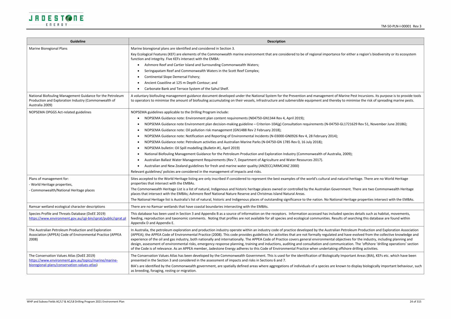
Marine Bioregional Plans Marine bioregional plans are identified and considered in Section 3.
Key Ecological Features (KEF) are elements of the Commonwealth marine environment that are considered to be of regional importance for either a region’s biodiversity or its ecosystem function and integrity. Five KEFs intersect with the EMBA:
Ashmore Reef and Cartier Island and Surrounding Commonwealth Waters;
Seringapatam Reef and Commonwealth Waters in the Scott Reef Complex;
Continental Slope Demersal Fishery;
Ancient Coastline at 125 m Depth Contour; and
Carbonate Bank and Terrace System of the Sahul Shelf.
National Biofouling Management Guidance for the Petroleum Production and Exploration Industry (Commonwealth of Australia 2009)
A voluntary biofouling management guidance document developed under the National System for the Prevention and management of Marine Pest Incursions. Its purpose is to provide tools to operators to minimise the amount of biofouling accumulating on their vessels, infrastructure and submersible equipment and thereby to minimise the risk of spreading marine pests.
NOPSEMA OPGGS Act‐related guidelines NOPSEMA guidelines applicable to the Drilling Program include:
NOPSEMA Guidance note: Environment plan content requirements (N04750‐GN1344 Rev 4, April 2019);
NOPSEMA Guidance note Environment plan decision‐making guideline – Criterion‐10A(g) Consultation requirements (N‐04750‐GL1721629 Rev 51, November June 20186);
NOPSEMA Guidance note: Oil pollution risk management (GN1488 Rev 2 February 2018);
NOPSEMA Guidance note: Notification and Reporting of Environmental Incidents (N‐03000‐GN0926 Rev 4, 28 February 2014);
NOPSEMA Guidance note: Petroleum activities and Australian Marine Parks (N‐04750‐GN 1785 Rev 0, 16 July 2018);
NOPSEMA bulletin: Oil Spill modelling (Bulletin #1, April 2019)
National Biofouling Management Guidance for the Petroleum Production and Exploration Industry (Commonwealth of Australia, 2009);
Australian Ballast Water Management Requirements (Rev 7, Department of Agriculture and Water Resources 2017).
Australian and New Zealand guidelines for fresh and marine water quality (ANZECC/ARMCANZ 2000)
Relevant guidelines/ policies are considered in the management of impacts and risks.
Plans of management for:
‐ World Heritage properties,
‐ Commonwealth/National Heritage places
Sites accepted to the World Heritage listing are only inscribed if considered to represent the best examples of the world's cultural and natural heritage. There are no World Heritage properties that intersect with the EMBAs.
The Commonwealth Heritage List is a list of natural, Indigenous and historic heritage places owned or controlled by the Australian Government. There are two Commonwealth Heritage places that intersect with the EMBAs; Ashmore Reef National Nature Reserve and Christmas Island Natural Areas.
The National Heritage list is Australia’s list of natural, historic and Indigenous places of outstanding significance to the nation. No National Heritage properties intersect with the EMBAs.
Ramsar wetland ecological character descriptions There are no Ramsar wetlands that have coastal boundaries intersecting with the EMBAs.
Species Profile and Threats Database (DoEE 2019) https://www.environment.gov.au/cgi‐bin/sprat/public/sprat.pl
This database has been used in Section 3 and Appendix B as a source of information on the receptors. Information accessed has included species details such as habitat, movements, feeding, reproduction and taxonomic comments. Noting that profiles are not available for all species and ecological communities. Results of searching this database are found within Appendix D and Appendix E.
The Australian Petroleum Production and Exploration Association (APPEA) Code of Environmental Practice (APPEA 2008)
In Australia, the petroleum exploration and production industry operate within an industry code of practice developed by the Australian Petroleum Production and Exploration Association (APPEA); the APPEA Code of Environmental Practice (2008). This code provides guidelines for activities that are not formally regulated and have evolved from the collective knowledge and experience of the oil and gas industry, both nationally and internationally. The APPEA Code of Practice covers general environmental objectives for the industry, including planning and design, assessment of environmental risks, emergency response planning, training and inductions, auditing and consultation and communication. The ‘offshore ‘drilling operations’ section of the Code is of relevance. As an APPEA member, Jadestone Energy adheres to this Code of Environmental Practice when undertaking offshore drilling activities.
The Conservation Values Atlas (DoEE 2019) https://www.environment.gov.au/topics/marine/marine‐bioregional‐plans/conservation‐values‐atlas)
The Conservation Values Atlas has been developed by the Commonwealth Government. This is used for the identification of Biologically Important Areas (BIA), KEFs etc. which have been presented in the Section 3 and considered in the assessment of impacts and risks in Sections 6 and 7.
BIA’s are identified by the Commonwealth government, are spatially defined areas where aggregations of individuals of a species are known to display biologically important behaviour, such as breeding, foraging, resting or migration.

TM‐50‐PLN‐I‐00001 Rev 3
WHP and Subsea Fields AC/L7 & AC/L8 Drilling Program 2021 Environment Plan 25 of 315
Guideline Description
United Nations Convention on the Law of the Sea (UNCLOS) (1982)
Part XII of the convention sets up a general legal framework for marine environment protection. The convention imposes obligations on State Parties to prevent, reduce and control marine pollution from the various major pollution sources, including pollution from land, from the atmosphere, from vessels and from dumping (Articles 207 to 212). Subsequent articles provide a regime for the enforcement of national marine pollution laws in the many different situations that can arise. Australia signed the agreement relating to the implementation of Part XI of the Convention in 1982, and UNCLOS in 1994.
United Nations Framework Convention on Climate Change (1992)
The objective of the convention is to stabilise greenhouse gas concentrations in the atmosphere at a level that would prevent dangerous interference with the climate system. Australia ratified the convention in December 1992, and it came into force on 21 December 1993.
Vienna Convention on the Protection of the Ozone Layer (1985) and the Montreal Protocol; on Substances that Deplete the Ozone Layer (1987)
The Convention (ratified by Australia in 1987) and the Protocol (ratified in 1989) concern the phasing out of ozone depleting substances.

TM‐50‐PLN‐I‐00001 Rev 3
_________________________________________________________________________________________________________________________
WHP and Subsea Fields AC/L7 & AC/L8 Drilling Program 2021 Environment Plan 26 of 315
2. ACTIVITY DESCRIPTION
2.1 Location
The Montara Development Project (MDP) includes developing the Montara, Swift, Skua and Swallow fields and operating the developed facilities for commercial production of the oil reserves. The MDP lies approximately 690 km (373 nautical miles) east of Darwin in a water depth of approximately 80 m (Figure 2‐1) in Commonwealth waters of the Timor Sea (Table 2‐1).
This EP encompasses drilling activities for one development well (platform well H6 within Production Licence AC/L7) as well as the workovers of Skua‐10 and Skua‐11 in Production Licence AC/L8.
Table 2‐1: Location of activities
Site H6 (surface well) Skua 10 workover (subsea well)
Skua 11 workover (subsea well)
Field Montara Skua Skua
Licence/Permit AC/L7 AC/L8 AC/L8
Water depth (LAT) m 78 80 80
Location 12° 40' 20.472'' S
124° 32' 22.297'' E
12° 30’ 04.605” S
124° 25’ 05.381” E
12° 30’ 04.560” S
124° 25’ 05.580” E
The locations of key environmental sensitive receptors in closest proximity to the drilling activities Operational Area are provided in Table 2‐2.
Table 2‐2: Locations of key sensitive receptors in relation to the Montara Venture FPSO
Sensitive receptor Approx. distance from the Operational Area (km)
Goeree Shoal 28
Vulcan Shoal 28
Eugene McDermott Shoal 40
Barracouta Shoal 39
Cartier Island 106
Hibernia Reef 126
Ashmore Reef 149
Cassini Island 181
Browse Island 187
Long Reef 188
Mainland Australia 211
Rote Island (Indonesia) 239
West Timor 244
Seringapatam Reef 288
Sandy Islet (Scott Reef) 322
Scott Reef 322
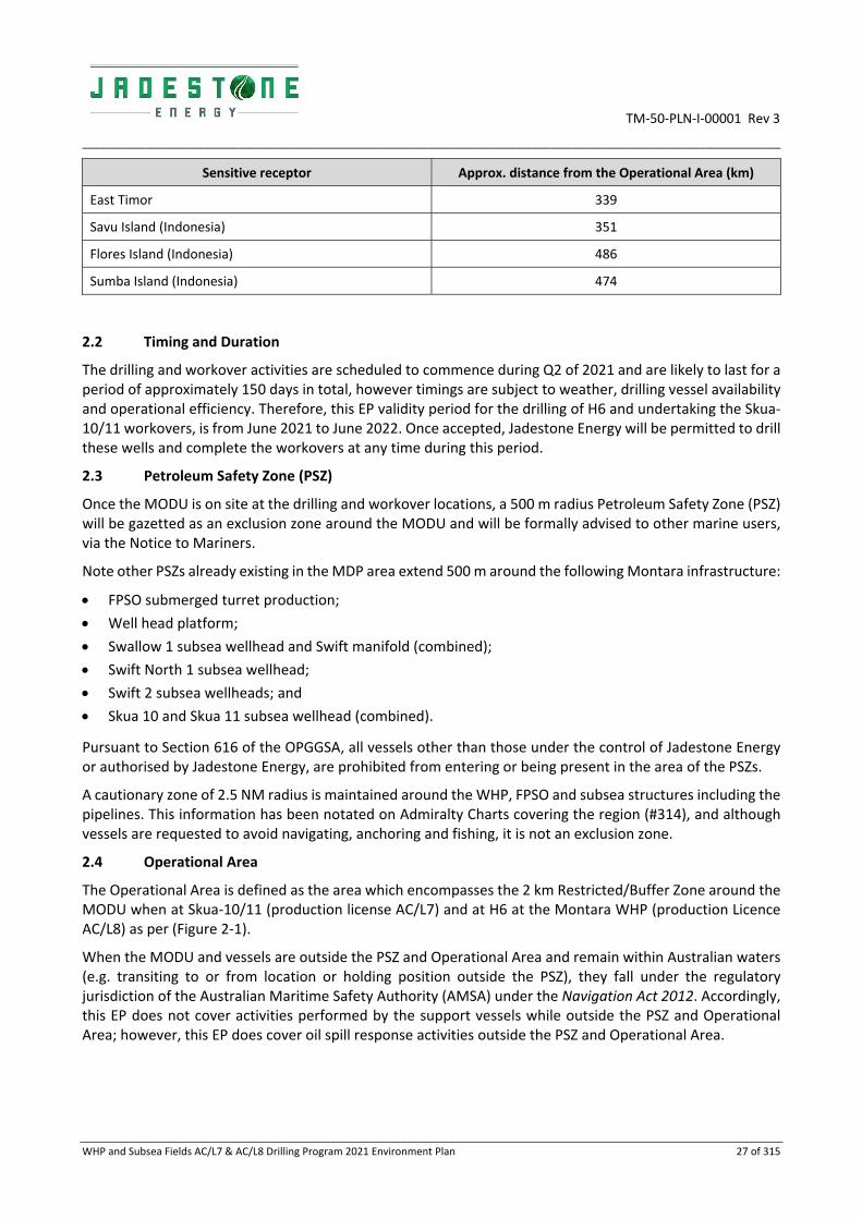
TM‐50‐PLN‐I‐00001 Rev 3
_________________________________________________________________________________________________________________________
WHP and Subsea Fields AC/L7 & AC/L8 Drilling Program 2021 Environment Plan 27 of 315
Sensitive receptor Approx. distance from the Operational Area (km)
East Timor 339
Savu Island (Indonesia) 351
Flores Island (Indonesia) 486
Sumba Island (Indonesia) 474
2.2 Timing and Duration
The drilling and workover activities are scheduled to commence during Q2 of 2021 and are likely to last for a period of approximately 150 days in total, however timings are subject to weather, drilling vessel availability and operational efficiency. Therefore, this EP validity period for the drilling of H6 and undertaking the Skua‐10/11 workovers, is from June 2021 to June 2022. Once accepted, Jadestone Energy will be permitted to drill these wells and complete the workovers at any time during this period.
2.3 Petroleum Safety Zone (PSZ)
Once the MODU is on site at the drilling and workover locations, a 500 m radius Petroleum Safety Zone (PSZ) will be gazetted as an exclusion zone around the MODU and will be formally advised to other marine users, via the Notice to Mariners.
Note other PSZs already existing in the MDP area extend 500 m around the following Montara infrastructure:
FPSO submerged turret production;
Well head platform;
Swallow 1 subsea wellhead and Swift manifold (combined);
Swift North 1 subsea wellhead;
Swift 2 subsea wellheads; and
Skua 10 and Skua 11 subsea wellhead (combined).
Pursuant to Section 616 of the OPGGSA, all vessels other than those under the control of Jadestone Energy or authorised by Jadestone Energy, are prohibited from entering or being present in the area of the PSZs.
A cautionary zone of 2.5 NM radius is maintained around the WHP, FPSO and subsea structures including the pipelines. This information has been notated on Admiralty Charts covering the region (#314), and although vessels are requested to avoid navigating, anchoring and fishing, it is not an exclusion zone.
2.4 Operational Area
The Operational Area is defined as the area which encompasses the 2 km Restricted/Buffer Zone around the MODU when at Skua‐10/11 (production license AC/L7) and at H6 at the Montara WHP (production Licence AC/L8) as per (Figure 2‐1).
When the MODU and vessels are outside the PSZ and Operational Area and remain within Australian waters (e.g. transiting to or from location or holding position outside the PSZ), they fall under the regulatory jurisdiction of the Australian Maritime Safety Authority (AMSA) under the Navigation Act 2012. Accordingly, this EP does not cover activities performed by the support vessels while outside the PSZ and Operational Area; however, this EP does cover oil spill response activities outside the PSZ and Operational Area.

TM‐50‐PLN‐I‐00001 Rev 3
_________________________________________________________________________________________________________________________
WHP and Subsea Fields AC/L7 & AC/L8 Drilling Program 2021 Environment Plan 28 of 315
Figure 2‐1: Operational Area for the Drilling Activities
2.5 MODU
The mobile offshore drilling unit (MODU) used to drill the wells and undertake the workovers is a ‘jack up’ drilling MODU towed to the drilling sites by support vessels. The Skua‐10/11 site is an existing well, while the H6 development well will be undertaken when the MODU is positioned alongside the Montara WHP (Figure 2‐2); the MODU will cantilever the drill floor over the WHP to allow positioning the MODU’s drill centre over the H6.
Figure 2‐2: Positioning the MODU alongside a Wellhead Platform

TM‐50‐PLN‐I‐00001 Rev 3
_________________________________________________________________________________________________________________________
WHP and Subsea Fields AC/L7 & AC/L8 Drilling Program 2021 Environment Plan 29 of 315
The MODU, (Jack‐Up), similar to the MODUs used in previous Montara campaigns, can operate in water depths of up to 122 m and drill to depths of up to 10,700 m. Typical maximum number of berths provides for approximately 120 persons onboard (POB).
2.6 Montara Development Project (MDP) Infrastructure
As described in the Montara Operations Environment Plan (MV‐90‐PLN‐I‐00001), the MDP consists of the following existing infrastructure and key location coordinates (Table 2‐3):
Unmanned WHP with six (6) well slots, five existing wells, three 14‐inch production risers, two 6‐inch gas
lift risers and one 12‐inch umbilical J‐tube;
Five subsea wells for development of the Skua, Swift and Swallow fields;
Production flowline system: two 6‐inch, one 10‐inch, three 14‐inch flowlines and associated tie‐in spools;
Gas lift flowline system ‐ one 6‐inch and three 4‐inch flowlines and associated tie‐in spools;
Five infield hydraulic control umbilicals and associated flying leads;
Four infield electrical control umbilicals and associated flying leads;
One Inter‐facility utility umbilical (FPSO‐WHP);
A subsea manifold (Swift field) for comingling production fluids and distributing the compressed gas and
electro‐hydraulic services to the subsea wells;
An FPSO facility and associated mooring system. Two 10‐inch Flexible Production Risers and associated
riser bases. One 6‐inch Flexible Gas Lift Riser and associated riser base. Two control umbilicals and
associated riser bases;
Support/supply vessels, work vessels and tugboats supporting third‐party offtake tanker movement,
facility logistics, maintenance and provisioning; and
Helicopter support.
Table 2‐3: Montara Development Project Infrastructure Coordinates (Surface) (GDA 94, Zone 51)
Well and Infrastructure Locations Latitude (South) Longitude (East)
Montara Venture FPSO (Turret centre) 12° 39' 35.3” 124° 32' 41.1”
Wellhead Platform 12° 40' 20.5” 124° 32' 22.2”
Swallow 1 Subsea well 12° 32' 29.5” 124° 26' 36.8”
Swift North 1 Subsea well 12° 31' 29.9” 124° 27' 33.7”
Swift‐2 Subsea well 12° 32' 3.6” 124° 27' 6.0”
Skua 10 Subsea well 12° 30' 4.6” 124° 25' 5.4”
Skua 11 Subsea well 12° 30' 4.6” 124° 25' 5.6”
Montara H5 ST‐2 well 12° 40’ 20.466” 124° 32’ 22.320”
Montara H4 well 12° 40’ 20.547” 124° 32’ 22.321”
Montara H3 ST‐1 well 12° 40’ 20.548” 124° 32’ 22.162”
Montara H2 well 12° 40’ 20.548” 124° 32’ 22.241”
Montara G2 well 12° 40’ 20.466” 124° 32’ 22.320”
The Montara development consists of subsea and platform wells. Apart from the differences in wellhead and Xmas tree designs, the basic well construction is similar. The subsurface completion consists of the wellbore drilled to penetrate the oil‐bearing sands, and all equipment items installed within the wellbore are designed

TM‐50‐PLN‐I‐00001 Rev 3
_________________________________________________________________________________________________________________________
WHP and Subsea Fields AC/L7 & AC/L8 Drilling Program 2021 Environment Plan 30 of 315
to allow well fluids to be produced in a safe and controlled manner. These items include the steel casing liner cemented into the wellbore. The casing of the wellbore serves several purposes:
To prevent deterioration of the hole, e.g. caving‐in, swelling, washouts;
To effectively isolate formations penetrated while drilling and hence prevent crossflow of fluids from
higher to lower pressure zones;
To provide a sealed passage for flow of well fluids to the production tubing. The production casing and/or
liner are the only sections that are exposed to the well fluid. This is important in avoiding leakage of well
fluids to the surface from outside of the wellbore; and
To provide pressure integrity for gas‐lift and well killing.
The production string consists of production tubing, flow control valves, isolation packers, landing nipples, sand excluder/control screens and other specialised equipment to provide a flow path for the reservoir fluids to the wellhead.
The Montara operations activity was granted EPBC Act approval in 2003 by the Commonwealth Environment Minister through the then Department of Environment and Heritage (DEH) subject to certain conditions (EPBC 2002/755) which were varied in December 2012 by the Commonwealth Minister for Sustainability, Environment, Water, Population and Communities (DSEWPaC), now Department of Environment and Energy (DoEE).
More recently, a number of the approval conditions were redacted resulting in a consolidated approval notice that contains a number of conditions relating to the Montara operations activities. A list of the conditions relevant to the operations activities is provided in Appendix G.
2.7 Hydrocarbons
The Montara and Skua crudes are described briefly below. More detail is provided in Section 7.6.2 and in the OPEP Appendices A5 and A6.
2.7.1 Montara crude oil
Montara crude is a medium crude oil. The oil is characterised by a low viscosity (4.5 cP) and a medium density of 845 kg/m3 (API 35.8) categorising it as a Group III oil in accordance with the International Tanker Owners Pollution Federation (ITOPF 2011). Based on oil assay data available, approximately 27% (by volume) of the Montara crude would be considered persistent hydrocarbons under international oil property benchmarks.
2.7.2 Skua crude oil
Skua crude is a medium crude oil. The oil is characterised by a low viscosity (3.114 cSt at 20oC) and a medium density (15oC) of 815 kg/m3 (API 41.9) categorising it as a Group II oil in accordance with the International Tanker Owners Pollution Federation (ITOPF 2011).
2.8 MODU positioning
The activities associated with moving the MODU into the field and setting up on location are detailed in a campaign specific MODU Move Plan.
A summary of activities when positioning the MODU at the WHP are as follows:
A series of preparations will be made at the Montara WHP prior to the MODU arriving and heavy lift
operations taking place. Key activities conducted prior to the MODU move include shutdown status of
the WHP during various MODU move phases. As a minimum, the WHP facilities will be shut in with normal
production suspended, when there is an increased risk of structural collision with the MODU, such as
during final MODU move on (within soft‐pin location) and during MODU preload;

TM‐50‐PLN‐I‐00001 Rev 3
_________________________________________________________________________________________________________________________
WHP and Subsea Fields AC/L7 & AC/L8 Drilling Program 2021 Environment Plan 31 of 315
The MODU will obtain approval from the Montara OIM prior to moving within 1 km of the Montara WHP;
The MODU will do a soft touchdown (rest on seabed with limited down weight) at a suitable distance
from the Montara WHP;
Three support vessels will be used to assist in positioning the MODU at Montara WHP;
The MODU will be pre‐loaded in accordance with the operator preload procedures to test seabed
stability;
The MODU will jack‐up to its working height alongside the WHP. Upon positioning, the MODU has three
legs (each approximately 169 m in length) that are lowered to the sea floor, so the working platform
remains elevated above the water surface. The bases of the legs are each fitted with a ‘spud can’ (each
18 m in diameter) that sit on the seabed, and due to the heavy weights applied, penetrate the surface
sediments to provide stability for the drilling MODU;
The MODU will then skid the cantilever deck across the WHP top deck until the rotary table is centred
above the H6 well slot; and
On completion of drilling, the cantilever will be skidded back, the MODU will “hull‐down” the legs until
afloat, the legs will be lifted, and the MODU will be towed off location.
A summary of activities when positioning the MODU at the subsea drilling locations are as follows:
Any subsea wells or infrastructure within 100 m of the planned location will shut in and be depressured
prior to arrival or departure of the MODU, and repressured when appropriate in accordance with the
Matrix of Permitted Operations;
The MODU will obtain approval from the Montara OIM prior to moving within 1 km of the planned
location;
Two/three support vessels will be used to assist positioning the MODU at the planned location;
The Surveyor and tow master will confirm the location is within the required tolerance;
All three legs will be jacked down simultaneously and the MODU preloaded in accordance with the
Operator’s preload procedures;
The MODU will jack‐up to its working height (+/‐ 35m above sea level). The bases of the legs are each
fitted with a ‘spud can’ (each 18 m in diameter) that sit on the seabed, and due to the heavy weights
applied, penetrate the surface sediments to provide stability for the drilling MODU;
The MODU will then skid the cantilever deck across until the rotary table is centred above the required
location; and
On completion of drilling, the cantilever will be skidded back, the MODU will “hull‐down” the legs until
afloat, the legs will be lifted, and the MODU will be towed off location.
2.9 Drilling Activity
The workover plans for Skua‐10 and ‐11, and well designs for H6 will be finalised in the Well Operations Management Plans (WOMP), which are to be accepted by NOPSEMA prior to commencement of drilling. Provided below is a summary for each of the activities.
2.9.1 Skua‐10 workover
The Skua‐10 workover is estimated to take 21 days. Scheduling of activities may be subject to delays (e.g. weather and MODU availability). The workover activities detailed below, provide the basis for identifying environmental impacts associated with the well activities and implementation of mitigation measures.

TM‐50‐PLN‐I‐00001 Rev 3
_________________________________________________________________________________________________________________________
WHP and Subsea Fields AC/L7 & AC/L8 Drilling Program 2021 Environment Plan 32 of 315
The Skua‐10 well design and casing schematic, showing the interval and casing details for each hole section is shown in Figure 2‐3 . The workover activity sequence may change depending upon well diagnostic work, hence the most likely workover activities are summarised below:
Skid cantilever to position over Skua‐10;
Remove corrosion cap from the HXT;
Install 406 mm (16 in) high pressure riser complete with TRT and install BOP;
Recover the ITC;
Install internal 178 mm (7 in) landing string complete with URT;
Install well services pressure control equipment;
Recover tubing hanger crown plug;
Bullhead well to seawater;
Install isolation plug in tail pipe below completion packer;
Pressure up gas lift system and run leak detection log;
Shift packer sleeve and pressure up to shear release;
Punch tubing above completion packer;
Circulate tubing and annulus to production flowline, removing all hydrocarbons from well;
Bleed off residual pressure in annulus via bleed off package;
Recover landing string and upper completion;
Perform USIT log of 244 mm (9⅝ in) casing;
Install 178 mm (7 in) scab liner above lower completion hanger;
Install internal casing patch across casing leak;
Install 140 mm (5½ in) completion and 178 mm (7 in) landing string;
Install surface pressure control equipment;
Set and test production packer;
Recover isolation bridge plug below old production packer;
Recover tubing hanger isolation sleeve;
Install tubing hanger crown plug;
Recover 178 mm (7 in) completion landing string;
Install ITC complete with crown plug in HXT;
Recover 406 mm (16 in) HP riser;
Install HXT corrosion cap;
Back load equipment; and
Jack down and rig move out of the field.
Alternative workover scenarios include installing casing patches internal to the 9‐5/8 inch casing and in a worst case, suspend the well.
The planned discharges during the workover are described below:
The first part of the workover will be for Operations to isolate the well from the production system and
hand the well over to Drilling. This may require bleed off and venting of hydrocarbons to atmosphere;
Gas will be bled down from the A annulus and from behind the packer tailpipe during the workover, and
the gas will be vented;

TM‐50‐PLN‐I‐00001 Rev 3
_________________________________________________________________________________________________________________________
WHP and Subsea Fields AC/L7 & AC/L8 Drilling Program 2021 Environment Plan 33 of 315
The wellbore clean‐up fluids used will include seawater, brine, viscous pills, acid soaking and a surfactant.
Fluids are discharged overboard (refer to Section 6.6 for volumes);
The brine returned from the well with an oil in water content greater than 15 mg/L will be cleaned to less
than 15 mg/L and discharged to the sea;
The components recovered with the upper completion string will be returned to shore where they may
either be subject to diagnostics, inspection or disposal; and
Entry into the well using slickline / wireline to perform intervention activities. Small volumes of gas
(approximately 100 scf (<3 m3)) may be vented to atmosphere from pressure control equipment during
slickline runs.
Figure 2‐3: Skua‐10 Well Schematic
2.9.2 Skua‐11 Workover
The Skua‐11 workover is estimated to take 31 days. Scheduling of activities may be subject to delays (e.g. weather and MODU availability). The workover activities detailed below, provide the basis for identifying environmental impacts associated with the well activities and implementation of mitigation measures.
The Skua‐11 well design and casing schematic, showing the interval and casing details for each hole section is shown in Figure 2‐4. The workover activity sequence may change depending upon well diagnostic work; hence the most likely workover activities are summarised below:
Rig Move from Montara WHP to Skua;
Pin, jack up and pre‐load;
Conduct an ‘as found’ survey via ROV;
Prepare the MODU for well intervention;

TM‐50‐PLN‐I‐00001 Rev 3
_________________________________________________________________________________________________________________________
WHP and Subsea Fields AC/L7 & AC/L8 Drilling Program 2021 Environment Plan 34 of 315
Remove corrosion cap from the horizontal Christmas tree (HXT);
Install 406 mm (16 in) high pressure riser complete with tree running tool (TRT) and install blowout
preventer (BOP);
Recover the internal tree cap (ITC);
Install internal 178 mm (7 in) landing string complete with universal running tool (URT);
Install well services pressure control equipment;
Recover tubing hanger crown plug;
Bullhead well to seawater;
Punch tubing below chemical injection valve;
Install isolation plug in tail pipe below completion packer;
Open HXT cross over valve and bleed / lubricate residual annulus gas (approximately 5,200 scf) through
bleed off package;
Cut tubing above completion packer;
Recover landing string and upper completion;
Perform an ultrasonic imager tool (USIT) log of the 244 mm (9⅝ in) casing;
Install isolation bridge plug above production packer;
Install surface isolation bridge plug;
Remove BOP and Recover HXT with high pressure riser;
Install 406 mm (16 in) HP riser with TRT and install BOP;
Recover 244 mm (9⅝ in) casing pack‐off;
Cut and recover casing approximately 50.0 m (164 ft) below logged casing leak;
Dress casing stump for external casing patch;
Install 244 mm (9⅝ in) external casing patch and 244 mm (9⅝ in) casing e back string and test;
Recover isolation bridge plug above production packer;
Install 178 mm (7 in) scab liner above production packer;
Install internal casing patch across external casing patch area;
Install surface isolation bridge plug;
Remove BOP and recover 406 mm (16 in) high pressure riser;
Install HXT with 406 mm (16 in) high pressure riser complete with TRT;
Install BOP;
Install 140 mm (5½ in) completion and 178 mm (7 in) landing string;
Install surface pressure control equipment;
Set and test production packer;
Recover isolation bridge plug below old production packer;
Recover tubing hanger isolation sleeve;
Install tubing hanger crown plug;
Recover 178 mm (7 in) completion landing string;
Install ITC complete with crown plug in HXT;
Recover 406 mm (16 in) HP riser; and
Install HXT corrosion cap.

TM‐50‐PLN‐I‐00001 Rev 3
_________________________________________________________________________________________________________________________
WHP and Subsea Fields AC/L7 & AC/L8 Drilling Program 2021 Environment Plan 35 of 315
Alternative workover scenarios include installing external casing patches to the 9‐5/8 inch casing and in a worst case, suspend the well.
The planned discharges during the workover are described below:
The first part of the workover will be for Operations to isolate the well from the production system and
hand the well over to Drilling. This may require bleed off and venting of hydrocarbons to atmosphere;
Gas will be bled down from the A annulus and from behind the packer tailpipe during the workover, and
the gas will be vented;
The wellbore clean‐up fluids used will include seawater, brine, viscous pills, acid soaking and a surfactant.
Fluids are discharged overboard (refer to Section 6.6 for volumes);
The brine returned from the well with an oil in water content greater than 15 mg/L will be cleaned to less
than 15 mg/L and discharged to the sea;
The components recovered with the upper completion string will be returned to shore where they may
either be subject to diagnostics, inspection or disposal; and
Entry into the well using slickline / wireline to perform intervention activities. Small volumes of gas
(approximately 100 scf (<3 m3) may be vented to atmosphere from pressure control equipment during
slickline runs.
Figure 2‐4: Skua‐11 Well Schematic

TM‐50‐PLN‐I‐00001 Rev 3
_________________________________________________________________________________________________________________________
WHP and Subsea Fields AC/L7 & AC/L8 Drilling Program 2021 Environment Plan 36 of 315
2.9.3 H6 Well
Drilling of the Montara H6 well is estimated to take 80 days. Scheduling of activities may be subject to delays (e.g. weather and MODU availability). The drilling activities, detailed below, provide the basis for identifying environmental impacts associated with the drilling activities and implementation of mitigation measures.
A preliminary well design and casing schematic, showing the interval and casing details for each hole section is shown in Figure 2‐6. A summary of the proposed drilling activities is detailed below:
Skid MODU to H6 well slot;
Drill 26” hole and run 20” conductor;
Drill 17 ½” hole and run 13 3/8” casing;
Installation of drilling BOPs;
Drill directional 12 ¼” hole, then run and cement the 9 ⅝” produc on casing;
Drill directional 8 ½” hole, then run and cement the 7” production liner;
Drill 6 1/8” horizontal hole section;
Run the lower 4” sand‐screen completion and hang off on packer;
Run the upper 3½” x 5½” completion;
Suspend the well and install the Xmas Tree; and
Move MODU off location.
Figure 2‐6: H6 well casing schematic
0
500
1000
1500
2000
2500
Montara‐6H
Grebe
Johnson
Puffin
Fenelon
Gibson/WoJameson
Lower Vulcan
Montara sands
7" liner2600mTVD
9.5/8" Casing2200mTVDset below fault
13.3/8" Csg+/‐1680m
20" Conducto
6‐1/8" hole / 4" screens ~1500m

TM‐50‐PLN‐I‐00001 Rev 3
_________________________________________________________________________________________________________________________
WHP and Subsea Fields AC/L7 & AC/L8 Drilling Program 2021 Environment Plan 37 of 315
Details of drilling fluids, cuttings and cement during the drilling and completion of H6 can be found in Section 6.6.
2.9.4 Cementing
Cement is used to form permanent barriers and fix casings in place. It may also be used to seal a lost circulation zone, and when abandoning the well. The majority of cement will remain downhole although minor volumes will be discharged at the mudline at the seabed surface, and at sea surface.
Once a hole section has been drilled, steel casing is run into the well. Cement is used to secure the steel casing in the well bore and cementing chemicals are used to modify the technical properties of the cement slurry.
Excess cement (up to a maximum of ~300%) as calculated in the well specific Drilling Program will be used for the riserless sections to account for potential wash outs, over gauge hole and small seepage losses into the formation. This excess typically accumulates on the seabed in the immediate locality of the well.
During cementing operations, there may be some volumes of dry cement (approx. 2 m3) that will be excess to requirements and may be discharged to sea from the storage hopper. In addition, minor quantities (approx. 2 m3) of excess mixed cement may also be discharged into the sea during clean‐up of the cementing unit (pumps, lines etc) after each job is finished. A number of additives with different chemical functions are required during cementing operations these include defoaming agents, dispersants and fluid loss control additives.
As for the selection and use of drilling fluids, Jadestone’s Chemical Selection Evaluation and Approval Procedure (JS‐70‐PR‐I‐00033) will be used to select and approve for use prior to application cement used in the drilling activities. At time of EP preparation, the cementing contractor had not been selected. Once selected and cement formulations finalised, proposed cement chemicals will be reviewed to ensure that they are CHARM rated Gold and Silver, or non‐CHARM rated D/E and therefore have the least potential for environmental impact. Where proposed chemicals do not meet this selection criteria, alternatives will be sought.
2.9.5 Drilling fluids and cuttings
A drilling fluid program will be developed for the Drilling program. The primary function of the drilling fluid is to control sub‐surface formation pressures, cool and lubricate the drill bit, transport the cuttings to the surface, maintain well bore stability and minimise reservoir damage. Drilling fluid is continually circulated down the drill string to the drill bit and returns to the surface via the annulus space between the drill string and the well bore.
The drilling fluids will be water‐based muds (WBM) only. WBM typically consist of between 80–90% by volume fresh, or saline water, with the balance made up of water soluble and insoluble drilling fluid additives give the mud the exact properties it requires to meet the desired functions for a particular hole interval. In the marine environment, these additives are either completely inert (naturally occurring benign materials) or readily biodegradable organic polymers, with a fast rate of biodegradation. Drilling fluid additives that are typically used include: sodium chloride, potassium chloride, bentonite (clay)/ pre‐hydrated gel (PHG), naturally occurring water soluble polymers, barite and calcium carbonate.
Cuttings will typically be removed at surface from the recirculating mud by shale shakers, desanders, desilters and centrifuges for very fine particles. All cuttings will be discharged overboard at sea surface or just below via a discharge pipe. The fluids are re‐used until out of specification, then they will be discharged overboard.
2.9.6 Loss of circulation
Lost circulation is a common occurrence during drilling. In top‐hole sections drilled with seawater loss zones do not present a problem and no action is taken to attempt to cure the losses. These normally cure as drilling
TM‐50‐PLN‐I‐00001 Rev 3
_________________________________________________________________________________________________________________________
WHP and Subsea Fields AC/L7 & AC/L8 Drilling Program 2021 Environment Plan 38 of 315
progresses and the loss zone gets plugged with drill cuttings. In intermediate and reservoir hole sections drilled with a closed fluid system, lost circulation is a major problem. As a result, lost circulation encountered while drilling with closed fluid systems will attempt to be cured. To cure losses there is a choice of options available, depending on loss rates. Conventional additives, such as calcium carbonate or cellulose fibres, are used for seepage or partial losses. When total losses occur, it may be necessary to pump cement or cross link polymers to heal the loss zones. Some lost circulation material may be brought back to the surface and discharged to sea, so as not to contaminate the mud system.
2.9.7 Chemical selection
The Drilling Fluid Program will detail the chemical additives that will and may be used in the various mud mixtures. In the absence of Australian standards regarding the suitability of chemical additives, the selection of chemicals will be guided by the Offshore Chemical Notification System (OCNS). The OCNS and the Jadestone Energy Chemical Selection Evaluation and Approval Procedure (JS‐70‐PR‐I‐00033) provide a framework and updated register which ranks the environmental performance of chemicals used in offshore petroleum activities and discharged to the environment. Chemical selection will be managed using Jadestone’s procedure to ensure environmental impacts and risks associated with chemical use are managed to a level that is ALARP and acceptable.
The OCNS uses the OSPAR Harmonised Mandatory Control System (HMCS) to manage chemical use and discharge. The HMCS was introduced with a view to unifying regulations regarding the use and reduction of the discharge of offshore chemicals across the OSPAR signatories. The objective of the HMCS is to protect the marine environment by identifying those chemicals used in offshore oil and gas operations with the potential for causing an adverse environmental impact and restricting their use and discharge to the sea. A series of associated recommendations provide guidance on how to compare the potential environmental impact of different chemicals, to preferentially select those with low potential for impact while fulfilling other (e.g. technical, HSE and availability) requirements. This involves the generation of an environmental data set (i.e. toxicity, persistence and bioaccumulation potential) and its evaluation using pre‐screening criteria and a decision‐support tool called the CHARM (Chemical Hazard Assessment and Risk Management) Model. In cases where the CHARM‐ranking is not amenable or applicable (e.g. for inorganic substances), equivalent assessments will be done by in accordance with the OCNS guidelines.
Jadestone Energy’s Chemical Selection Evaluation and Approval Procedure (JS‐70‐PR‐I‐00033) defines the process for the assessment of the offshore use and discharge of chemicals. This document shall be applied to the selection of all drilling chemicals which, through their mode of use, are expected to be discharged to sea. This includes chemicals discharged during drilling operations and extends to MODU washes, pipe dopes and hydraulic fluids used to control wellheads.
In summary, this procedure ensures:
Selected chemical substances comply with relevant regulatory requirements and approved activity environment plans;
Selected chemical substances are subject to mandatory risk review and formal approval before
procurement;
Transport, storage and handling of chemicals is in accordance with relevant regulations and
manufacturer requirements;
Least hazardous chemicals are preferentially selected for use thereby minimising and/ or eliminating
potential safety and environmental impacts;
If chemicals required are classified as hazardous and/ or dangerous goods, the control measures for safe
transport, storage and handling are deemed adequate;
Selected chemical substances meet technical specifications and are fit for purpose; and
Selected chemical substances are commercially evaluated and competitively priced.

TM‐50‐PLN‐I‐00001 Rev 3
_________________________________________________________________________________________________________________________
WHP and Subsea Fields AC/L7 & AC/L8 Drilling Program 2021 Environment Plan 39 of 315
2.9.8 Well evaluation
Mud logging
Mud logging will be undertaken during drilling operations to evaluate the formation. This will involve the collection and processing of cuttings samples, analysis of mud gas, monitoring and recording of all drilling parameters, pressure detection and full evaluation of the formation.
Formation Evaluation
Formation evaluation is the interpretation of a combination of measurements taken inside the wellbore to detect and quantify oil and gas reserves in the rock adjacent to the well. Mud logging will be undertaken during drilling to evaluate the drilled formations. This will involve collection and processing of cuttings samples, analysis of mud gas, monitoring and recording of all drilling parameters, pit levels and pressure detection. A wireline log is a continuous measurement of formation properties with electrically powered instruments to enable decisions to be made about drilling operations. Wireline logging may be required to confirm cement isolation in the 7” x 8‐1/2” casing annulus (H6), and the 9‐5/8” x 12‐1/4” (H6) casing annulus.
2.10 Drilling Support Operations
2.10.1 Vessels
Support for the drilling activities will be provided by three support vessels (Table 2‐4) which will operate out of Darwin. Support vessels (typically 60–90 m in length) will supply equipment, bulk chemicals, liquid drilling fluids, diesel fuels etc. to the drilling MODU.
Each vessel will have approximately 10 to 20 POB and an appropriately sized and maintained MARPOL compliant sewage and bilge systems.
Table 2‐4: Indicative support vessel specifications
Aspect Primary Tow Vessel/Support 180 MT
BP 2nd Support Vessel 140
MT BP 3rd Support vessel
Type/Service Tug/support/supply vessels/construction vessel
Length (m) 86 66 66
Gross Registered Tonnage (tonnes)
4,566 2,147 2,147
Maximum Speed (knots) 16 16 16
Accommodation (berths) 35 32 32
Total Fuel Tank Capacity (m3)
1594 827 827
Rescue Capabilities per vessel
1 fast rescue craft
>100 persons rescue capacity
1 fast rescue craft
>100 persons rescue capacity
1 fast rescue craft
>100 persons rescue capacity
2.10.2 Helicopters
Helicopter support will be provided by Babcock. A shared Sikorsky S‐92 helicopter and flight crew, along with shared technical back‐up helicopter, will be based at Mungalalu–Truscott air base to support the MODU as follows:
Personnel transfers between Mungalalu‐Truscott and the MODU for crew changes;

TM‐50‐PLN‐I‐00001 Rev 3
_________________________________________________________________________________________________________________________
WHP and Subsea Fields AC/L7 & AC/L8 Drilling Program 2021 Environment Plan 40 of 315
Down‐manning of the MODU for tropical cyclone response (note: an additional Helicopter and crew will
be available during cyclone season); and
Emergency response, including medivac, evacuation of the MODU, and search and rescue.
Routine helicopter operations are expected to be during daylight hours and helicopter flight time between Mungalalu‐Truscott and the MODU is 70 minutes with approximately five to seven flights per week anticipated. There will be no refuelling facilities on the MODU.
2.11 Out of Scope
Activities that are not covered by this EP are:
Vertical Seismic Profiling (VSP) or flaring;
Nearby shipping activity, third‐party offtake tankers, and Operational support activities outside the
Operational Area;
Vessel based seismic surveys or use of side scan sonar;
Anchoring of vessels (other than in an emergency) or MODU;
Drilling support vessels associated with the Activity outside the Operational Area (where they will adhere
to applicable maritime regulations, and Commonwealth and State environmental management
obligations);
Commissioning of new production wells;
Production and maintenance of the production wells is covered under the Montara Operations
Environment Plan (MV‐90‐PLN‐I‐00001 Rev 2); and
Decommissioning and removal of infrastructure ‐ which is required to be undertaken in accordance with
a separate approvals process under the OPGGS Act and Regulations.

TM‐50‐PLN‐I‐00001 Rev 3
_________________________________________________________________________________________________________________________
WHP and Subsea Fields AC/L7 & AC/L8 Drilling Program 2021 Environment Plan 41 of 315
3. EXISTING ENVIRONMENT
3.1 Definition of Areas
Offshore Petroleum and Greenhouse Gas Storage (Environment) Regulations 2009, Regulation 13(2) requires the proponent to:
‘(a) describe the existing environment that may be affected by the activity; and
(b) include details of the particular relevant values and sensitivities (if any) of that environment.’
To address this requirement, Jadestone has evaluated the values and sensitivities within two types of areas related to the activity:
The Operational Area – the geographical area encompassing the environment that may be affected by
the planned activities (Section 2.4); and
The Environments that May Be Affected (RISK EMBAs) – the geographical area encompassing the
environment that has the potential to be affected by the unplanned events associated with the activities
described (Section 2) depending upon the level of exposure.
The spatial extent of the RISK EMBA and location of the Operational Area is presented in Figure 3‐1. The RISK EMBA is based on the low‐level exposure of hydrocarbons on and in, the water and represents the largest extent of an oil spill due to the worst‐case scenario as per NOPSEMA Bulletin #1. This is further described in Appendix B Section 1.1. and below:
1. Surface hydrocarbons RISK EMBA– hydrocarbons that are ‘on’ the water surface (>1 g/m2)
2. Entrained hydrocarbons RISK EMBA– hydrocarbon that is entrained ‘in’ the water (>10 ppb)
3. Dissolved hydrocarbons RISK EMBA– the dissolved component of hydrocarbon in’ the water (>10 ppb), and
4. Shoreline loading RISK EMBA – hydrocarbons greater than 10 g/m2.
Details of the environmental values and sensitivities in the Operational Area are described here in Section 3 and in Appendix D. The environmental values and sensitivities in the RISK EMBA has been used to inform the assessment of the unplanned events in particular, LOWC, diesel spills, oil spill response planning and oil spill risk assessment (Section 8.6 and Section 8.7). Full details of the environmental values and sensitivities in the RISK EMBA is contained in Appendix B and E, and not discussed any further here.
3.2 Marine Regional Setting
Australia’s offshore waters have been divided into six marine regions in order to facilitate their management by the Australian Government under the EPBC Act. The Montara operations activity is located within the North West Marine Region (NWMR). The NWMR encompasses Commonwealth waters from the Western Australia/ Northern Territory border in the north, to Kalbarri in the south. The main physical features and values of the NWMR are:
Ashmore Reef, Cartier Island, Seringapatam Reef and Scott Reef which have been identified as regionally
important areas supporting a high biodiversity of marine life and supporting foraging and breeding
aggregations. Ashmore Reef and Cartier Island are located approximately 149 km and 106 km north‐west,
respectively, from the Operational Area;
A number of key ecological features (KEFs) have been identified in the region (Section 3.4.6). The
Continental Slope Demersal Fish Community has been identified as an important marine community, due
to its high species diversity and endemism. The Carbonate Bank and Terrace System of the Sahul Shelf

TM‐50‐PLN‐I‐00001 Rev 3
_________________________________________________________________________________________________________________________
WHP and Subsea Fields AC/L7 & AC/L8 Drilling Program 2021 Environment Plan 42 of 315
has also been identified as regionally important as it is a unique sea floor feature; contributing to the
biodiversity and productivity of the local area; and
Other priority areas in the NWMR include Rowley Shoals and Ningaloo Reef. However, these areas are at
least 700 km from the Operational Area.
Within the NWMR the Operational Area lies at the junction of two provincial bioregions summarised in Table 3‐1.
Table 3‐1: Provincial bioregions in Operational Area
Area Description
Timor Province The Timor Province covers an area of 24,040 km2 and predominantly covers shelf terrace and the continental slope, extending into waters 200 – 300 m deep in the Arafura Depression. The oceanographic environment is mainly influenced by tides, with some influence from the Indonesian Throughflow current. These open waters support pelagic species, including whale sharks, an unusual array of threadfin fish species and distinct genetic stocks of red snapper.
Northwest Shelf Transition
The Northwest Shelf Transition covers the mostly shallow waters (<100 m) between Cape Leveque (WA) and the Tiwi Islands (NT). This transition has a diverse seafloor topography including submerged terraces, carbonate banks, pinnacles, reefs and sand banks.
Figure 3‐1: Provincial Bioregions relevant to the Operational Area and RISK EMBA
3.3 Physical Environment
3.3.1 Climate
The Operational Area experiences a monsoonal climate with two predominant seasons including a hot wet summer season, October to March and a cool dry winter season April to September, which are referred to as the northwest and southeast monsoons, respectively. The climate is influenced by two major atmospheric pressure systems: the subtropical ridge of high‐pressure cells referred to as highs or anticyclones, and a broad
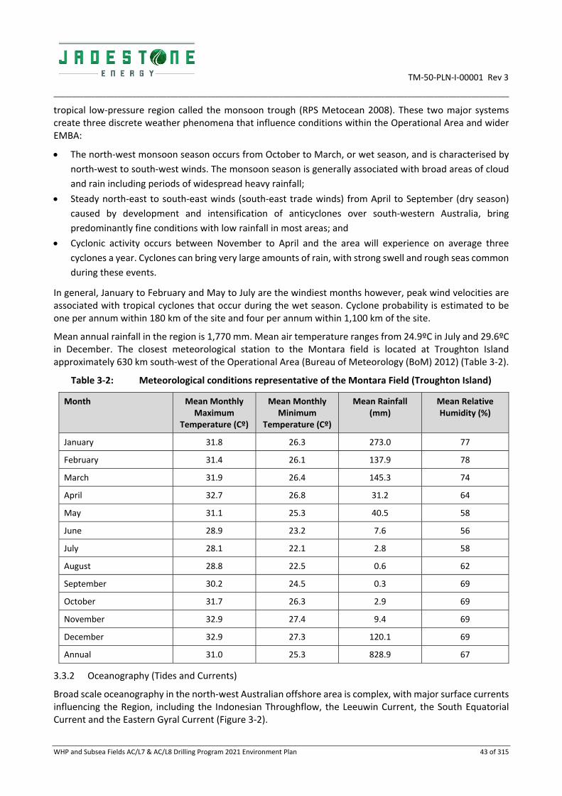
TM‐50‐PLN‐I‐00001 Rev 3
_________________________________________________________________________________________________________________________
WHP and Subsea Fields AC/L7 & AC/L8 Drilling Program 2021 Environment Plan 43 of 315
tropical low‐pressure region called the monsoon trough (RPS Metocean 2008). These two major systems create three discrete weather phenomena that influence conditions within the Operational Area and wider EMBA:
The north‐west monsoon season occurs from October to March, or wet season, and is characterised by
north‐west to south‐west winds. The monsoon season is generally associated with broad areas of cloud
and rain including periods of widespread heavy rainfall;
Steady north‐east to south‐east winds (south‐east trade winds) from April to September (dry season)
caused by development and intensification of anticyclones over south‐western Australia, bring
predominantly fine conditions with low rainfall in most areas; and
Cyclonic activity occurs between November to April and the area will experience on average three
cyclones a year. Cyclones can bring very large amounts of rain, with strong swell and rough seas common
during these events.
In general, January to February and May to July are the windiest months however, peak wind velocities are associated with tropical cyclones that occur during the wet season. Cyclone probability is estimated to be one per annum within 180 km of the site and four per annum within 1,100 km of the site.
Mean annual rainfall in the region is 1,770 mm. Mean air temperature ranges from 24.9ºC in July and 29.6ºC in December. The closest meteorological station to the Montara field is located at Troughton Island approximately 630 km south‐west of the Operational Area (Bureau of Meteorology (BoM) 2012) (Table 3‐2).
Table 3‐2: Meteorological conditions representative of the Montara Field (Troughton Island)
Month Mean Monthly Maximum
Temperature (Cº)
Mean Monthly Minimum
Temperature (Cº)
Mean Rainfall (mm)
Mean Relative Humidity (%)
January 31.8 26.3 273.0 77
February 31.4 26.1 137.9 78
March 31.9 26.4 145.3 74
April 32.7 26.8 31.2 64
May 31.1 25.3 40.5 58
June 28.9 23.2 7.6 56
July 28.1 22.1 2.8 58
August 28.8 22.5 0.6 62
September 30.2 24.5 0.3 69
October 31.7 26.3 2.9 69
November 32.9 27.4 9.4 69
December 32.9 27.3 120.1 69
Annual 31.0 25.3 828.9 67
3.3.2 Oceanography (Tides and Currents)
Broad scale oceanography in the north‐west Australian offshore area is complex, with major surface currents influencing the Region, including the Indonesian Throughflow, the Leeuwin Current, the South Equatorial Current and the Eastern Gyral Current (Figure 3‐2).

TM‐50‐PLN‐I‐00001 Rev 3
_________________________________________________________________________________________________________________________
WHP and Subsea Fields AC/L7 & AC/L8 Drilling Program 2021 Environment Plan 44 of 315
The oceanographic regime of the north west Australian offshore area is strongly influenced by the Indonesian Through Flow (ITF) which transports warm, low salinity, oligotrophic waters through a complex system of currents, linking the Pacific and Indian Ocean via the Indonesian Archipelago (Department of State Development (DSD) 2010). The strength of the ITF fluctuates seasonally and reaches maximum strength during the south‐east monsoon (May to September) and weakens during the north‐west monsoon.
Currents in the Kimberley region are also generated by several more localised factors, including tidal forcing, local wind forcing, inertial oscillations, shelf waves, seiche and trapped waves. Studies undertaken in the vicinity of Scott Reef and Seringapatam Reef suggest that the ITF does not directly influence these systems, but it is the eddies that peel off the min ITF current and travel along the shelf‐break that have a greater influence on the reefs. In general, the tidal regime and wind forcing are the major contributors to local currents in the area. The currents in the Operational Area the and wider EMBA are influenced by the semi‐diurnal tides that have four direction reversals per day. Both the semidiurnal and diurnal tides appear to travel north‐eastwards in the deep water leading to the Timor Trough prior to propagation eastwards and southwards across the wide continental shelf. The NWMR experiences some of the largest tides along a coastline adjoining an open ocean in the world.
In the eastern section of the EMBA, the area is influenced primarily by strong diurnal tidal flows and less by ocean currents. The Joseph Bonaparte Gulf is subject to the highest tidal range in the region (up to 7–8 m).
Wind driven currents from monsoons and cyclones and drift currents (ITF) are likely to prevail during neap tides or during periods of strong influence when one of the current reversals may be suppressed. Maximum tidal range is 5.7 m and tidal currents flood to the southeast and ebb to the northwest and under normal conditions (i.e. no storms), maximum recorded current speed at the surface is 0.95 m/s, mainly due to the tide. Current speeds decrease with depth below the surface. The strength and direction of tidal current flow is also strongly influenced by local bathymetry.
Wind induced currents result from local wind forcing at the surface and are most pronounced during cyclones with development of transient oscillations known as inertial currents following the passage of cyclones. Wind driven surface currents and their direction are generated by prevailing seasonal winds from the west in summer and from the east and south east during winter. The following current data has been estimated for one in 50‐year storm conditions:
Surface currents = 2 m/s;
Mid depth currents = 1 m/s; and
Seafloor currents = 0.67 m/s.

TM‐50‐PLN‐I‐00001 Rev 3
_________________________________________________________________________________________________________________________
WHP and Subsea Fields AC/L7 & AC/L8 Drilling Program 2021 Environment Plan 45 of 315
Source: DEWHA (2008)
Figure 3‐2: Key ocean currents influencing Western Australia
3.3.3 Waves
Surface waves and sea swell in the region can vary widely in direction depending on wind direction, locations of major storms and local bathymetric effects such as the shelf break or proximity to islands such as Ashmore Reef. Waves are subject to the following key influences:
Locally generated wind waves, seas: generally, from west during wet season and from the east during
the dry season; and
Remotely generated swells: South to south westerly swells persist from storms in the southern Indian
Ocean and occasional, low amplitude waves up to 1 m originate from earthquakes in the Sunda Trench,
between Australia and Indonesia.
In general, the maximum and mean sea swells are larger in winter than summer as a result of the strong easterly wind‐generated seas and larger winter swell from the Southern and Indian Oceans. Occasional monsoonal storms and cyclones can result in much larger waves and swell. Extreme winds associated with cyclones can generate waves up to 21 m in height from any direction (RPS Metocean 2008).
Significant wave heights are experienced in the Montara field are as follows:
Greater than 2 m, 7.7% of the time; and
Greater than 4 m, 0.4% of the time.
The following wave data has been estimated for one in 50‐year storm conditions as:
Maximum wave height = 16.1 m;

TM‐50‐PLN‐I‐00001 Rev 3
_________________________________________________________________________________________________________________________
WHP and Subsea Fields AC/L7 & AC/L8 Drilling Program 2021 Environment Plan 46 of 315
Significant wave height = 8.6 m; and
Peak wave period = 11.4 seconds.
3.3.1 Temperature, Salinity and Turbidity
Seawater temperature in the region generally ranges from 25ºC to 31ºC at the surface and 22ºC to 25ºC at the seafloor. The sub‐tropical water temperatures are largely influenced by the ITF and a highly‐pronounced thermocline, which is controlled by the ITF (Brewer et al. 2007).
Water quality monitoring at the Montara Venture found surface water temperatures ranged from 28.0ºC to 28.7ºC, with a slight reduction of <1ºC at 20 m depth. Salinity of surface waters was consistently around 33.9 PSU, with low variability (Jacobs 2017).
Turbidity in the surface waters (0.5 m to 23 m depth) near the Montara Venture are typically low (<0.2 NTU; Jacobs 2017).
3.3.2 Bathymetry and Seafloor Geology
Bathymetry of the region is broadly categorised into three distinct zones based on water depth and geometric features. The three zones are (Baker et al. 2008, Heap and Harris 2008):
Continental shelf;
Continental slope; and
Abyssal plain.
The inner continental shelf in the northwest region extends from the coast to approximately 30 m water depth and the middle continental shelf lies between 30 m and 200 m. The outer continental shelf and slope region descends from approximately 200 m water depth. The slope continues to descend over hundreds of kilometres until reaching the almost flat i.e. a less than 1:1,000 gradient, abyssal plain at water depths of approximately 4,000 m. The continental slope is steepest along the western flank of Scott Reef where a steep drop occurs. These steep slopes are incised by erosional gullies and canyons.
The Operational Area is located on the continental shelf and the Montara field (within the Operational Area) slopes from the east (76 m) to west (86.5 m) and is characterised by a north‐south trending gentle scarp. To the south of the area a slight mound rises to 78 m water depth.
The shallow geology of the Operational Area is interpreted as a thin, discontinuous layer of unconsolidated surficial sediment overlying a variably consolidated calcarenite sequence. The thickness of unconsolidated sediment varies across the site and ranges from being very thin or absent up to a local maximum of 3.7 m within the Montara survey corridor.
Geophysical interpretation and results from seabed sampling indicate that the unconsolidated sediments are fine to coarse carbonate sands. The sediments appear to be coarser closer to areas of significant relief and at the base of shallow depressions. Sub‐bottom profilers did not achieve significant penetration into the calcarenite material, indicating that the upper surface of the calcarenite is relatively hard.
3.3.3 Sediment Quality
Sediment quality sampling undertaken near the Montara Venture found that concentrations of metals, metalloids, hydrocarbons and phenolic compounds in sediment samples were either below the laboratory limit of reporting (LOR) and/or the ANZECC/ARMCANZ Sediment Quality Guidelines detailed in Simpson et al. (2013) (Jacobs 2017).
3.3.4 Sediment Particle Size Distribution
The particle size distributions (PSD) of sediments sampled near the Montara Venture were dominated by fine and coarse sands, with very little clay (Jacobs 2017).

TM‐50‐PLN‐I‐00001 Rev 3
_________________________________________________________________________________________________________________________
WHP and Subsea Fields AC/L7 & AC/L8 Drilling Program 2021 Environment Plan 47 of 315
3.4 Conservation Values and Sensitivities
Conservation values and sensitivities listed and protected under the EPBC Act include Matters of Environmental Significance (MNES) and Other Protected Matters. MNES occurring, or potentially occurring, in the Operational Area are summarised in Table 3‐3. The full EPBC Act Protected Matters report is provided in Appendix D.
Table 3‐3: Summary of conservation values and sensitivities in the Operational Area
MNES and Other Matters Protected under EPBC Act Operational Area
Commonwealth Marine Area ✔
Listed Threatened Species ✔ (20) Listed Migratory Species ✔ (32) Listed Marine Species ✔ (60) Whales and other cetaceans (many of which are also Listed Threatened or Migratory Species) ✔ (13) Australian Marine Parks ✖
State and Territory Marine Parks (MP) and Marine Management Areas (MMA) ✖
World Heritage ✖
Wetlands of International Importance (Ramsar) ✖
National Heritage Places ✖
Commonwealth Heritage Places ✖
Threatened Ecological Communities ✖
Key Ecological Features (KEFs) ✖
Nuclear actions and water resources, in relation to coal seam gas or coal mining ✖
Great Barrier Reef Marine Park ✖
3.4.1 Matters of National Environmental Significance (MNES)
Commonwealth Marine Areas
The Operational Area is within the EEZ and Territorial Sea which is a Commonwealth Marine Area. The Commonwealth marine area is any part of the sea, including the waters, seabed, and airspace, within Australia's exclusive economic zone and/or over the continental shelf of Australia, that is not State or Northern Territory waters.
3.4.2 Listed Threatened and Migratory Species
The PMST search (Appendix D) identified 20 Listed Threatened Species (LTS) and 32 Listed Migratory Species (LMS) as having the potential to occur within the Operational Area. The LTS included:
Four species of marine mammals;
Six species of marine reptiles;
Five shark species; and
Five marine bird species.

TM‐50‐PLN‐I‐00001 Rev 3
_________________________________________________________________________________________________________________________
WHP and Subsea Fields AC/L7 & AC/L8 Drilling Program 2021 Environment Plan 48 of 315
The relevant sections of this EP discuss the likelihood of these species and their biologically important areas occurring within the Operational Area. Those species that have been identified as likely to be present in the Operational Area are summarised in Table 3‐5 to Table 3‐8 and further detailed below.
Sensitive habitat areas such as an aggregation, resting or feeding or known migratory routes for these species are shown as Biologically Important Areas (BIAs) (Figures 3‐3 to 3‐6). The relevant sections also outline the management such as:
Recovery plans;
Conservation advice; or
Threat abatement plan for the impacts of marine debris on vertebrate marine life (DoEE 2018).
The requirements of the species recovery plans and conservation advices are considered to identify any requirements that may be applicable to the risk assessment.
3.4.3 Others matters protected by the EPBC
Listed marine species
A total of 60 Listed Marine Species are either likely to, or may, occur within the Operational Area, including 17 bird species and three reptile species). Sixteen of these species are also Listed Threatened Species.
Whales and other cetaceans
The Protected Matters search determined that 13 cetacean species or their habitat, may occur within the Operations Area. These species are discussed in Table 3‐66. Whales and cetaceans occurring in the RISK EMBAs are discussed in Appendix B.
3.4.4 Marine Parks
No State Marine Parks (MP) or Australian Marine Park’s (AMP) intersect with the Operational Area.
3.4.5 Terrestrial Values
The Operational Area is over 200 km from the closest landfall and therefore does not contain any terrestrial sensitivities or values. Specifically, the following terrestrial values are not represented within the Operational Area:
Ramsar wetland sites;
State protected wetlands;
marine and coastal zone;
nationally important wetlands; and
State protected terrestrial areas.
3.4.6 Key Environmental Features (KEFs)
Key ecological features (KEFs) are elements of the Commonwealth marine environment that are considered to be of regional importance for either a region’s biodiversity or its ecosystem function and integrity. The Operational Area does not include any KEFs. The nearest of the spatially defined KEFs is the Carbonate bank and terrace system of the Sahul Shelf at approximately 46 km from the Operational Area at its closest point.
3.5 Biological Environment – Species and Communities’ Descriptions
3.5.1 Benthic Habitat and Communities
The benthic habitats in the Operational Area generally dominated by soft sediments, sand and mud, with occasional patches of coarser sediments. Spatial and temporal distribution of benthic fauna depends on factors such as sediment characteristics, depth and season.
TM‐50‐PLN‐I‐00001 Rev 3
_________________________________________________________________________________________________________________________
WHP and Subsea Fields AC/L7 & AC/L8 Drilling Program 2021 Environment Plan 49 of 315
A benthic habitat assessment was undertaken in the area of Petroleum Production Licence AC/L7 during the 2010 wet season, which included the Montara field and surrounding areas (ERM 2011). Surveys were carried out using a towed video system and seabed sediment samples were also collected for sediment and macrobenthic fauna analysis. Benthic habitats surveyed were characterised by homogenous, flat, featureless soft sediment; predominately comprised of sand with small rubble/shell fragments and marked by low relief ripples with evidence of bioturbation. Sparse patches of epifauna were recorded and included hydroids, octocorals (soft corals, gorgonians and seapens), black corals and ascidians.
Macrobenthic faunal assemblages surveyed had a generally low and highly patchy abundance of individuals. Polychaete bristleworms from the Phylum Annelida contributed the highest relative abundance of macrobenthic assemblages across the surveyed area, ranging from approximately 40 to 60% followed by Malacostracan crustaceans (shrimps, crabs etc.; approximately 13 to 19%). Gastropoda was represented by 33 taxa across the surveyed area with abundance ranging from approximately 0.5 to 5% (ERM 2011).
Hydrozoa and Bryozoa were the other common groups encountered in samples. All other taxa identified across the surveyed areas were minor contributors to macrobenthic assemblages (relative abundance <5%) (ERM 2011).
3.5.2 Plankton and invertebrates
Plankton is divided into two categories: phytoplankton and zooplankton. Phytoplanktonic algae are important primary producers and range in size from 0.2 to 200 mm. Zooplankton are small, mostly microscopic animals that drift with the ocean currents, and it has been estimated that 80% of the zooplankton in waters off Australian continental shelf and shelf margin are the larval stages of fauna that normally live on the seabed (Raymont, 1983). A common feature of plankton populations is the high degree of temporal and spatial variability. Phytoplankton in tropical regions have marked seasonal cycles with higher concentrations occurring during the winter months (June–August) and low in summer months (December–March) (Hayes et al. 2005; Schroeder et al. 2009). Zooplankton rely on phytoplankton as food and are subject to similar seasonality.
3.5.3 Fish, Sharks and Rays
The Operational Area PMST report (Appendix D) identified:
Five threatened/ migratory; and
Four migratory.
A description of fish, sharks and rays is provided in Table 3‐4.
Numerous marine species occur in the region and have wide distributions that are associated with feeding and migration patterns linked to reproductive cycles. While the distance offshore, depth and lack of suitable foraging benthic habitat may preclude a number of these species, many are likely to occur within the Operational Area in transit to and from key mating and foraging grounds. Pelagic foragers are also likely to be feeding within the area.
The Operational Area intersects with the Whale Shark foraging BIA (Figure 3‐3).
Three offshore banks assessment surveys (2010, 2011 and 2013) were undertaken to identify and assess the level of impact, if any, to the submerged marine banks in the region of the 2009 Montara oil spill (Heyward et al. 2010, 2011a, 2013). The surveys used Baited Remote Underwater Video Stations (BRUVS) to characterise fish assemblages and included the following shoals/banks in the region: Vulcan Shoal, Barracouta Shoals, Echuca Shoal, Eugene McDermott Shoal, Goeree Shoal, Heywood Shoal, Shoal 25 and Wave Governor Bank. BRUVS were deployed on the seafloor from the shallowest areas of the shoals to depths of approximately 60 m for at least 60 minutes (Heyward et al. 2011a). No individuals from the Syngnathidae family were reported (Heyward et al. 2010, 2011a, 2013).

TM‐50‐PLN‐I‐00001 Rev 3
_____________________________________________________________________________________________________________________________________________________________________________________
WHP and Subsea Fields AC/L7 & AC/L8 Drilling Program 2021 Environment Plan 50 of 315
Table 3‐4: Fish, Sharks and Rays EPBC listed species
Common Name
(Scientific Name) EPBC Act Status Type of presence
BIA within Operational Area
Management
Conservation advice Recovery Plan Threat Abatement Plan
Whale Shark
(Rhincodon typus)
V,M Foraging, feeding or related behaviour known to occur within area
Conservation advice Rhincodon typus whale shark (Threatened Species Scientific Committee, 2015d)
Ceased
2010
Great White Shark
(Carcharodon carcharias)
V,M Species or species habitat may occur within area
No No
Recovery plan for the white shark (Carcharodon carcharias) (DSEWPaC 2013a)
Northern River Shark
(Glyphis garricki)
E Species or species habitat may occur within area
No
Approved Conservation Advice for Glyphis garricki (northern river shark) (DoE 2014a)
Sawfish and river shark multispecies recovery plan (Commonwealth of Australia, 2015b)

TM‐50‐PLN‐I‐00001 Rev 3
_____________________________________________________________________________________________________________________________________________________________________________________
WHP and Subsea Fields AC/L7 & AC/L8 Drilling Program 2021 Environment Plan 51 of 315
Common Name
(Scientific Name) EPBC Act Status Type of presence
BIA within Operational Area
Management
Conservation advice Recovery Plan Threat Abatement Plan
Green Sawfish
(Pristis zijsron)
V Species or species habitat may occur within area
No
Approved conservation advice for Pristis zijsron green sawfish
(Threatened Species Scientific Committee, 2008b)
Sawfish and river shark multispecies recovery plan (Commonwealth of Australia, 2015b)
Freshwater/ Largetooth sawfish
(Pristis pristis)
V, M Species or species habitat known to occur within area
No
Approved Conservation Advice for Pristis pristis (largetooth sawfish) (DoE 2014b)
Sawfish and river shark multispecies recovery plan (Commonwealth of Australia, 2015b)
Narrow/Knifetooth Sawfish
(Anoxypristis cuspidata)
M Species or species habitat may occur within area
No No No
Shortfin Mako
(Isurus oxyrinchus)
M Species or species habitat likely to occur within area
No No No

TM‐50‐PLN‐I‐00001 Rev 3
_____________________________________________________________________________________________________________________________________________________________________________________
WHP and Subsea Fields AC/L7 & AC/L8 Drilling Program 2021 Environment Plan 52 of 315
Common Name
(Scientific Name) EPBC Act Status Type of presence
BIA within Operational Area
Management
Conservation advice Recovery Plan Threat Abatement Plan
Longfin Mako
(Isurus paucus)
M Species or species habitat likely to occur within area
No No No
Giant Manta Ray
(Manta birostris)
M Species or species habitat known to occur within area
No No No
Reef Manta Ray
(Manta alfredi)
M Species or species habitat known to occur within area
No No No
CE = Critically Endangered; E = Endangered; V = Vulnerable; M = Migratory

TM‐50‐PLN‐I‐00001 Rev 3
_____________________________________________________________________________________________________________________________________________________________________________________
WHP and Subsea Fields AC/L7 & AC/L8 Drilling Program 2021 Environment Plan 53 of 315
Figure 3‐3: Biologically important areas for fish, sharks and rays

TM‐50‐PLN‐I‐00001 Rev 3
__________________________________________________________________________________________________________________________
WHP and Subsea Fields AC/L7 & AC/L8 Drilling Program 2021 Environment Plan 54 of 315
Whale Shark (Vulnerable/Migratory)
Whale sharks (Rhincodon typus) have a broad distribution in tropical and warm temperate seas. The whale shark is a highly migratory fish and only visits Australian waters seasonally (DoEE 2017b). They are known to aggregate at Ningaloo Reef (approximately 1,500 km south‐west of the Operational Area) between May and June, and in the Queensland Coral Sea (approximately 2,400 km east of the Operational Area) between November and December (DoEE 2017b). Neither of these locations are within the RISK EMBA.
Whale sharks are not known to feed or breed in the Operational Area, however, whale sharks may occur in the Operational Area due to their widespread distribution and highly migratory nature, albeit in very low numbers. The Operational Area is located in the migratory BIA for the whale shark (Figure 3‐3). The species migrates south to Ningaloo reef to feed during coral spawning, occurring in March/ April. It is unlikely that whale sharks will be encountered in significant numbers at the Operational Area.
Great White Shark (Vulnerable/Migratory)
The Great White Shark (Carcharodon carcharias) is widely, but sparsely, distributed in all seas, including cold temperate waters, having been recorded from central Queensland around the south coast to north‐west WA, with movements occurring between the mainland coast and the 100 m isobath (DoEE 2017b). The species is known to undertake migrations along the WA coast, with individuals occasionally travelling as far north as North West Cape during spring, before returning south for summer (DoEE 2017b). Given a preference for cooler, southern waters inhabited by seals and sea lions, great white sharks are considered unlikely to be encountered in either the Operational Area or RISK EMBA. No great white shark BIAs are intersected by either the Operational Area or RISK EMBA.
Northern River Shark (Endangered)
The Northern River Shark (Glyphis garricki) is known to inhabit rivers, tidal sections of large tropical estuarine systems, macrotidal embayments, as well as inshore and offshore marine habitats, although adults have only been recorded in marine environments (DoEE 2017b). Limited data suggests that the species displays a preference for highly turbid, tidally influenced waters with fine muddy substrate. However, the presence of individuals in offshore areas suggests that northern river sharks undertake movements away from rivers and estuaries and are therefore likely to move between river systems (DoEE 2017b). Given the offshore location of the Operational Area and the species’ preference for turbid, inshore waters, it is unlikely that the species will be encountered in the Operational Area, although their preferred habitat occurs within the RISK EMBA.
Shortfin and Longfin Mako Sharks (Migratory)
The shortfin mako (Isurus oxyrinchus) and the longfin mako (Isurus paucus) are both offshore epipelagic species found in tropical and warm‐temperate waters (DoEE 2017b). Both species occur in Australia in coastal waters off WA, NT, QLD and NSW at depths ranging from shallow coastal waters to at least 500 m (DoEE 2017b).
No BIAs for either of these species are intersected by the Operational Area. However, these species may migrate through the Operational Area and may be found within the RISK EMBA.
Reef Manta Ray (Migratory)
The reef manta ray (Manta alfredi) is commonly sighted inshore, but also found around offshore coral reefs, rocky reefs and seamounts, tending to inhabit warm tropical or sub‐tropical waters (Marshall et. al. 2011a). Long‐term sighting records of the reef manta ray at established aggregation sites suggest that this species is more resident to tropical waters and may exhibit smaller home ranges, philopatric movement patterns and shorter seasonal migrations than the giant manta ray (Marshall et al. 2011a).
No BIAs for the reef manta ray are intersected by the Operational Area and based on the species’ habitat preferences it is unlikely that the reef manta ray will be encountered in the Operational Area. Given the RISK

TM‐50‐PLN‐I‐00001 Rev 3
__________________________________________________________________________________________________________________________
WHP and Subsea Fields AC/L7 & AC/L8 Drilling Program 2021 Environment Plan 55 of 315
EMBA overlaps with a number of coral and rocky reefs in the region, it is possible the species may be encountered within the RISK EMBA.
Giant Manta Ray (Migratory)
The giant manta ray (Manta birostris) inhabits tropical, marine waters worldwide. In Australia, the species is recorded from south‐western WA, around the north coast to the southern coast of New South Wales (Australian Museum 2014). The species is commonly sighted along productive coastlines with regular upwelling, oceanic island groups, particularly offshore pinnacles and seamounts. Nearer to shore the giant manta ray is commonly encountered on shallow reefs, while being cleaned, or is sighted feeding at the surface inshore and offshore. It is also occasionally observed in sandy bottom areas and seagrass beds (Marshall et al. 2011b).
No BIAs for the giant manta ray are intersected by the Operational Area and based on the species’ habitat preferences it is unlikely that the giant manta ray will be encountered in the Operational Area. Given the RISK EMBA overlaps with a number of coral and rocky reefs in the region, it is possible that the species may be encountered within the RISK EMBA.
Freshwater/Largetooth Sawfish (Vulnerable/Migratory)
The freshwater, or largetooth, sawfish (Pristis pristis) may occur in all large rivers of northern Australia from the Fitzroy River in WA, to the western side of Cape York Peninsula, Queensland, although is mainly confined to the primary channels of large rivers (DoEE 2017b). In northern Australia, this species is thought to be confined to freshwater drainages and the upper reaches of estuaries, occasionally being found as far as 400 km inland. Few records exist of adults at sea, occurring in fresh or weakly saline water (DoEE 2017b).
No BIAs for the freshwater sawfish are intersected by the Operational Area and based on the distribution, and preferred habitat of the species, it is considered unlikely that freshwater sawfishes will be found at the Operational Area. Given the species’ known distribution individuals are likely to be found within the RISK EMBA.
Green Sawfish (Vulnerable/Migratory)
In Australian waters, green sawfishes (Pristis zijsron) have been recorded in the coastal waters off Broome in WA, around northern Australia to Jervis Bay, NSW (DoEE 2017b). It is unknown whether green sawfish migrate into Australian waters as adults or juveniles from populations outside Australia (DoEE 2017b). This species inhabits muddy bottom habitats and enters estuaries, although it has also been recorded in inshore marine waters, estuaries, river mouths, embankments and along sandy and muddy beaches, usually in shallow waters (DoEE 2017b).
No BIAs for the green sawfish are intersected by the Operational Area and based on the offshore, deeper‐water activity location, and the species’ preference for turbid, inshore water, it is unlikely green sawfishes will be encountered in the Operational Area. Based on the known distribution of the species, individuals are known to exist within the RISK EMBA.
Narrow Sawfish (Migratory)
Narrow sawfishes (Anoxypristis cuspidate) are bentho‐pelagic inhabiting estuarine, inshore and offshore waters to at least 40 m depth (IUCN 2017). Inshore and estuarine waters are critical habitats for juveniles and pupping females, while adults occur predominantly offshore (D’Anastasi et al. 2013). No BIAs for the narrow sawfish are intersected by the Operational Area and based on the species’ habitat preference it is highly unlikely to be found within the Operational Area, although may be encountered within the RISK EMBA.

TM‐50‐PLN‐I‐00001 Rev 3
__________________________________________________________________________________________________________________________
WHP and Subsea Fields AC/L7 & AC/L8 Drilling Program 2021 Environment Plan 56 of 315
3.5.4 Marine Reptiles
The Operational Area PMST report (Appendix D) identified:
Six threatened/ migratory; and
Four migratory
A description of marine reptiles is provided in Table 3‐5.

TM‐50‐PLN‐I‐00001 Rev 3
________________________________________________________________________________________________________________________________________________________________________________
WHP and Subsea Fields AC/L7 & AC/L8 Drilling Program 2021 Environment Plan 57 of 315
Table 3‐5: Marine Reptiles EPBC listed species
Common Name (Scientific Name)
EPBC Act
Status
Type of presence BIA within Operational Area
Management
Conservation advice Recovery Plan Threat
Abatement Plan
Loggerhead Turtle
(Caretta caretta)
E,M Species or species habitat may occur within area
Foraging, feeding or related behaviour known to occur within area.
No No
Recovery plan for marine turtles in Australia (DoEE
2017)
Marine debris
Green Turtle
(Chelonia mydas)
V,M Foraging, feeding or related behaviour known to occur within area.
No No
Recovery plan for marine turtles in Australia (DoEE
2017)
Marine debris
Leatherback Turtle
(Dermochelys coriacea)
E,M Foraging, feeding or related behaviour likely to occur within area.
No
Approved conservation advice for Dermochelys coriacea (Leatherback Turtle) (Threatened Species Scientific Committee, 2008a)
Recovery plan for marine turtles in Australia (DoEE
2017)
Marine debris
Hawksbill Turtle
(Eretmochelys imbricata)
V,M Foraging, feeding or related behaviour known to occur within area
No No
Recovery plan for marine turtles in Australia (DoEE
2017)
Marine debris
Olive Ridley Turtle
(Lepidochelys olivacea)
E, M Foraging, feeding or related behaviour likely to occur within area
No No
Recovery plan for marine turtles in Australia (DoEE
2017)
Marine debris
CE = Critically Endangered; E = Endangered; V = Vulnerable; M = Migratory

TM‐50‐PLN‐I‐00001 Rev 3
__________________________________________________________________________________________________________________________
WHP and Subsea Fields AC/L7 & AC/L8 Drilling Program 2021 Environment Plan 58 of 315
Marine Turtles
Six threatened/ migratory and four migratory marine turtles may be present in the Operational Area. Marine turtles are oceanic species, except during nesting seasons where they come ashore to lay eggs. Marine turtles utilise reefs, soft‐sediment habitats, seagrass and algal meadows as feeding areas, depending on species, and nest above the high‐water mark on sandy beaches and islets within their geographical ranges. The nesting periods are species‐dependent, although generally occur between September and March, peaking in December (Pendoley 2005). Hatchlings appear between January and May and immediately leave the shore, moving into open ocean environments for a number of years before returning to inshore areas.
Marine turtles have been observed in the vicinity of the Operational Area. Surveys conducted in response to the Montara oil spill in 2009 recorded a total of 25 individual turtles in open water. Two species were confidently identified; loggerhead and green turtles (Watson et al. 2009). Land based surveys recorded green and hawksbill turtle tracks on the islands associated with Ashmore Reef (Watson et al. 2009).
The Operational Area does not intersect with any marine turtle BIAs (Figure 3‐4). The Operational Area is approximately 106 km to the nearest nesting site at Cartier Island.
Green Turtle (Vulnerable/Migratory)
Green turtles (Chelonia mydas) are found in tropical and subtropical waters throughout the world (Marquez 1990; Bowen et al. 1992). The closest known significant breeding/nesting grounds to the Operational Area are the Ashmore Reef MP and Cartier Island MP, approximately 149 and 106 km to the northwest of the Operational Area, respectively (Figure 3‐4).
Green turtles may occasionally pass through the Operational Area, as satellite tracking studies have shown that green turtles migrate between breeding grounds and feeding grounds off the northwest coast (Pendoley 2005). However, due to the water depths the area does not provide foraging habitat.
Flatback Turtle (Vulnerable/Migratory)
The flatback turtle (Natator depressus) is found in the tropical waters of northern Australia, Papua New Guinea and Irian Jaya. It is the most widely distributed nesting marine turtle species in the Northern Territory (Chatto and Baker 2008), nesting on a wide variety of beach types around the entire coastline. The flatback turtle also nests in the Kimberley Region of Western Australia, with Cape Dommett (Bowlay and Whiting 2007) and Lacrosse Island being important nesting areas for the species. The closest nesting sites to the Operational Area are approximately 500 km to the south‐east (Lacepede Islands).
While flatback turtles make lengthy reproductive migrations, up to 1,300 km from nesting beaches (Limpus et al. 1983), movements are generally restricted to the continental shelf (DoEE 2017b). Flatback turtles nesting within the Pilbara region migrate to their foraging grounds in the Kimberley region along the continental shelf at the end of the nesting season (RPS 2010). Due to their migrations between the Pilbara and the Kimberley regions of WA, individual flatback turtles may transit the Operational Area during migration. However, given the distance from known aggregation areas, it is unlikely that significant numbers of flatback turtles will be encountered within the Operational Area. Due to the water depths the area does not provide foraging habitat.
Hawksbill Turtle (Vulnerable/Migratory)
Hawksbill turtles (Eretmochelys imbricata) are found in tropical, subtropical and temperate waters in all oceans of the world. There are no known nesting or breeding areas in or near to the Operational Area.
Leatherback Turtle (Endangered/Migratory)
The Leatherback turtle (Dermochelys coriacea) has the widest distribution of any marine turtle, and can be found in tropical, subtropical and temperate waters throughout the world (Marquez 1990). No major centres of nesting activity have been recorded in Australia, although scattered isolated nesting (1‐3 nests per annum)

TM‐50‐PLN‐I‐00001 Rev 3
__________________________________________________________________________________________________________________________
WHP and Subsea Fields AC/L7 & AC/L8 Drilling Program 2021 Environment Plan 59 of 315
occurs in southern Queensland and Northern Territory (Limpus and McLachlin 1994). As such, it is expected that very few leatherback turtles will be encountered in the Operational Area.
Loggerhead Turtle (Endangered/Migratory)
The loggerhead turtle (Caretta caretta) has a global distribution throughout tropical, sub‐tropical and temperate waters (Marquez 1990). The closest known breeding/nesting grounds to the Operational Area are found at Muiron Island and the beaches of the Northwest Cape (Baldwin et al. 2003), approximately 1,500 km south‐west of the Operational Area and outside the RISK EMBA. Loggerhead turtles have been recorded in the reserves of Ashmore Reef MP (149 km) and Cartier Island MP (106 km), west‐ northwest of the Operational Area (Guinea 1995). Loggerhead turtles are unlikely to be encountered within the Operational Area in significant numbers.
Olive Ridley Turtle (Endangered/Migratory)
The olive ridley turtle (Lepidochelys olivacea) has a circum‐tropical distribution, with nesting occurring throughout tropical waters. No concentrated nesting has been found in Australia, although low density nesting occurs along the Arnhem Land coast of the Northern Territory, including the Crocodile, McCluer and Wessel Islands, Grant Island and Cobourg Peninsula (Chatto and Baker 2008). Therefore, Olive Ridley turtles are unlikely to be encountered within the Operational Area in significant numbers. No olive‐ridley turtle BIAs are intersected by the Operational Area.

TM‐50‐PLN‐I‐00001 Rev 3
_______________________________________________________________________________________________________________________________________________________________________________
WHP and Subsea Fields AC/L7 & AC/L8 Drilling Program 2021 Environment Plan 60 of 315
Figure 3‐4: Biologically important areas for marine reptiles

TM‐50‐PLN‐I‐00001 Rev 3
__________________________________________________________________________________________________________________________
WHP and Subsea Fields AC/L7 & AC/L8 Drilling Program 2021 Environment Plan 61 of 315
3.5.5 Marine Mammals
The Operational Area PMST report (Appendix D) identified:
Four threatened/ migratory; and
Three migratory
A description of marine mammals is provided in Table 3‐6.
Cetaceans
The region is thought to be an important migratory pathway between feeding grounds in the Southern Ocean and breeding grounds in tropical waters for several cetacean species. Pygmy blue whales (Balaenoptera musculus), fin whales (Balaenoptera physalus), dwarf minke whales (Balaenoptera acutorostrata) and Antarctic minke whales (Balaenoptera bonaerensis) may travel through the region on their way to breeding grounds, which are thought to be in deep oceanic waters around the Indonesian Archipelago.
During ambient noise monitoring at the southern (AC/L7) permit area in June–December 2011, numerous cetacean vocalisations were recorded (McPherson et al. 2012). Two species of odontocetes (toothed whales and dolphins) were identified during the first six‐months of deployment, false killer whales and common bottlenose dolphins.
Pygmy blue whales (B. m. brevicauda) were detected at the nearby Cash‐Maple (AC/RL7 block) permit area, which coincided with the timing of the northern and southern migrations (McCauley 2011). Humpback whales were only recorded during two periods in July and August 2011 at the Southern station. The vocalisations of bryde’s whales were also detected at the southern permit area at the time of survey. Based on the most recent scientific literature (Cerchio et al. 2015) and re‐analysis of data, some of the Bryde’s whales (Balaenoptera edeni) reported are now believed to be the calls of Omura’s whale (Balaenoptera omurai) (McPherson et al. 2017). Omura’s whales therefore appear to be present year‐round along the region’s continental shelf but showed seasonal differences in occurrence at specific sites (McPherson et al. 2017). Overall, they are most commonly detected in the Timor Sea in winter.
The Operational Area does not intersect with any BIAs for listed marine mammal species (Figure 3‐5).

TM‐50‐PLN‐I‐00001 Rev 3
________________________________________________________________________________________________________________________________________________________________________________
WHP and Subsea Fields AC/L7 & AC/L8 Drilling Program 2021 Environment Plan 62 of 315
Table 3‐6: Marine Mammal EPBC listed species
Common Name
(Scientific Name)
EPBC Act Status
Type of presence BIA within Operational
Area
Management
Conservation advice Recovery Plan Threat
Abatement Plan
Humpback Whale
(Megaptera novaeangliae)
V,M Species or species habitat likely to occur within area
No
Approved Conservation Advice for Megaptera novaeangliae (humpback whale) (Threatened Species Scientific Committee, 2015a)
Ceased 2015
Marine debris
Blue whale
(Balaenoptera musculus)
Including Pygmy Blue Whale
E,M Species or species habitat likely to occur within area
No
No
Conservation management plan for the blue whale: A recovery plan under the EPBC Act 1999 2015‐2025 (Commonwealth of Australia, 2015a)
Marine debris
Sei Whale
(Balaenoptera borealis)
V, M Species or species habitat likely to occur within area
No
Conservation advice Balaenoptera borealis sei whale (Threatened Species Scientific Committee, 2015b)
Ceased in 2015
Marine debris

TM‐50‐PLN‐I‐00001 Rev 3
________________________________________________________________________________________________________________________________________________________________________________
WHP and Subsea Fields AC/L7 & AC/L8 Drilling Program 2021 Environment Plan 63 of 315
Common Name
(Scientific Name)
EPBC Act Status
Type of presence BIA within Operational
Area
Management
Conservation advice Recovery Plan Threat
Abatement Plan
Fin Whale
(Baleenoptera physalus)
V, M Species or species habitat likely to occur within area
No
Conservation advice Balaenoptera physalus fin whale (Threatened Species Scientific Committee, 2015c)
Ceased 2015
Marine debris
Bryde’s Whale
(Balaenoptera edeni)
M Species or species habitat may occur within area
No No No Marine debris
Orca, Killer Whale
(Orcinus orca)
M Species or species habitat may occur within area
No No No Marine debris
Spotted Bottlenose Dolphin (Arafura/Timor Sea populations)
(Tursiops aduncus)
M Species or species habitat may occur within area
No No No
CE = Critically Endangered; E = Endangered; V = Vulnerable; M = Migratory

TM‐50‐PLN‐I‐00001 Rev 3
________________________________________________________________________________________________________________________________________________________________________________
WHP and Subsea Fields AC/L7 & AC/L8 Drilling Program 2021 Environment Plan 64 of 315
Figure 3‐5: Biologically important areas for marine mammals
TM‐50‐PLN‐I‐00001 Rev 3
__________________________________________________________________________________________________________________________
WHP and Subsea Fields AC/L7 & AC/L8 Drilling Program 2021 Environment Plan 65 of 315
Blue Whale (Endangered/Migratory)
Blue whales (Balaenoptera musculus) are widely distributed throughout the worlds’ oceans. There are two subspecies in the Southern Hemisphere: the southern blue whale (Balaenoptera musculus intermedia) and the pygmy blue whale (Balaenoptera musculus brevicauda) (DEWHA 2008). In general, the southern blue whale is found south of 60° S and pygmy blue whales are found north of 55° S (DEWHA 2008), making it likely that any blue whales frequenting the waters of the Operational Area would be pygmy blue whales.
Blue whale migration is thought to follow deep oceanic routes, although little is known about their precise migration routes (DoEE 2017b). Sea noise loggers set at various locations along the coast of Western Australia have detected a seasonal presence indicating a pattern of annual northbound and southbound migration of pygmy blue whales past Exmouth and the Montebello Islands and locations to the north (McCauley and Jenner 2010). Pygmy Blue whales appear to migrate south from Indonesian waters passing Exmouth through November to late December each year. Observations suggest most Pygmy Blue whales pass along the shelf edge out to water depths of 1,000 m depth contour. The northern migration passes Exmouth over an extended period ranging from April to August (McCauley and Jenner 2010). They are believed to calve in tropical waters in winter and births peak in May to June, however the exact breeding grounds of this species are unknown (Bannister et al. 1996).
The Operational Area does not include any recognised blue whale migratory routes or known feeding, breeding or resting areas. However, low numbers of blue whales migrating to and from Indonesian waters may occasionally pass through the Operational Area, most likely during the southern migration (October to November) (DoEE 2017b). Ambient noise monitoring conducted for PTTEP AA in and around the Montara field documented the presence of cetacean species over a full 12‐month period between December 2010 and December 2011. The data support the well documented seasonal timings of pygmy blue whales in the region, and the low numbers recorded are consistent with the field area being outside the recognised BIAs for this species.
Humpback Whale (Vulnerable/Migratory)
Humpback whales (Megaptera novaeangliae) have a wide distribution, having been recorded from the coastal areas off all Australian states other than the Northern Territory (Bannister et al. 1996). Humpback whales migrate north and south along the eastern and western coasts of Australia from calving grounds in the tropical north to feeding grounds in the Southern Ocean (DoEE 2017b). Peak migration off the north‐western coast of Australia occurs from late July to early September. From June to mid‐September the inshore waters (landward of the 100 m isobath) between the Lacepede Islands and Camden Sound (approximately 400 km south‐west of the Operational Area) are used as a calving area for this species (Jenner et al. 2001).
The Operational Area is located outside of the recognised humpback whale migratory routes, which are usually within 30 km of the coastline. The RISK EMBA overlaps with the humpback whale BIA identified for breeding and calving at Camden Sound MP, adjacent to the Kimberley coast (Figure 3‐5).
Given the Operational Area is situated north of the northernmost point of the humpback whale migration it is considered unlikely that the species will be encountered. Individuals may be encountered within the RISK EMBA.
Sei Whale (Vulnerable/Migratory)
Sei whales (Balaenoptera borealis) are a cosmopolitan species, found in the waters off all Australian states (DoEE 2017b). The Australian Antarctic waters are important feeding grounds for sei whales, as are temperate, cool waters (DoEE 2017b). The species has also been observed feeding in the Bonney Upwelling area in South Australia, indicating the area as potentially being an important feeding ground.
Breeding in this species is known to occur in tropical and subtropical waters (DoEE 2017b). Currently, the movements and distributions of sei whales are unpredictable and not well documented. However,
TM‐50‐PLN‐I‐00001 Rev 3
__________________________________________________________________________________________________________________________
WHP and Subsea Fields AC/L7 & AC/L8 Drilling Program 2021 Environment Plan 66 of 315
information suggests that sei whales have the same general pattern of migration as most other baleen whales, although timing is later in the season and such high latitudes are not reached (DoEE 2017b).
Based on the cosmopolitan distribution of the species, sei whales may be encountered in low numbers within the Operational Area. Individuals of the species may be encountered within the RISK EMBA, although large numbers are unlikely.
Fin Whale (Vulnerable/Migratory)
Fin Whales (Balaenoptera physalus) are found in the waters all around Australia and the Australia Antarctic Territory (DoEE 2017b). The Australian Antarctic waters are also thought to be important feeding grounds for fin whales, while feeding has been observed in the Bonney Upwelling area indicating the area to be of importance as a feeding ground for the species (Morrice et al. 2004). No known mating or calving areas are known from Australian waters. Currently, the migration routes and locations of winter breeding grounds for this species are uncertain (DoEE 2017b).
Based on the cosmopolitan distribution of the species, fin whales may be encountered in low numbers within the Operational Area.
Bryde's Whale (Migratory)
Bryde's Whales (Balaenoptera edeni) are a cosmopolitan species, found in the waters of all Australian states, including both Christmas and the Cocos Islands (DoEE 2017b). Two forms of Bryde’s whale are known: the coastal and offshore form. The coastal from appears to be limited to habitat within the 200 m depth isobar, moving along the coast in response to availability of suitable prey (Best et al. 1984); the offshore form is known in deeper water (500 m to 1,000 m).
Ambient noise monitoring conducted in the Southern, Cash‐Maple and Oliver permits by JASCO (2012) over a 12‐month period between December 2010 and December 2011 recorded whale calls that were attributed to Bryde’s whales year‐round at all three permits, with no seasonal cycle observed. These data demonstrate that individuals may be encountered within the Operational Area and may be found within the RISK EMBA, however, no BIAs for Bryde's whales are intersected by the Operational Area.
Orca/Killer Whale (Migratory)
Orcas, or Killer Whales (Orcinus orca), are a cosmopolitan species, found in the waters off all Australian states in oceanic, pelagic and neritic regions, in both warm and cold waters. Killer whales are known to make seasonal movements, and are likely to follow regular migratory routes, however little is known about either local or seasonal movement patterns of the species (DoEE 2017b).
Given the lack of known migration routes or areas of significance in the region, the species is not expected to be encountered in either the Operational Area.
Spotted Bottlenose Dolphin (Migratory)
The spotted bottlenose dolphin (Tursiops aduncus) is generally considered to be a warm water subspecies of the common bottlenose dolphin (Tursiops truncates) and known to exist in waters off all Australian states. The spotted bottlenose dolphin appears to be restricted to inshore areas such as bays and estuaries, nearshore waters, open coast environments, and shallow offshore waters including coastal areas around oceanic islands (DoEE 2017b). BIAs for this species are illustrated in Figure3‐5.
Due to the distance from the coast and deeper waters of the Operational Area, spotted bottlenose dolphins are not expected to occur, particularly given the preference for shallower, coastal waters. Given their cosmopolitan distribution, the species may be encountered within the Operational Area and the RISK EMBA.
3.5.6 Avifauna
The Operational Area PMST report (Appendix D) identified:

TM‐50‐PLN‐I‐00001 Rev 3
__________________________________________________________________________________________________________________________
WHP and Subsea Fields AC/L7 & AC/L8 Drilling Program 2021 Environment Plan 67 of 315
Twelve threatened/migratory; and
Ten migratory.
A description of avifauna species is provided in Table 3‐7.
Numerous species of birds frequent the Timor Sea area or fly through the area on annual migrations. Seabird feeding grounds, roosting and nesting areas are found at the offshore atolls in the wider region, particularly Ashmore Reef. Many species are listed under the Japan‐Australia Migratory Bird Agreement (JAMBA), China‐Australia Migratory Bird Agreement (CAMBA) or Republic of Korea‐Australia Migratory Bird Agreement (ROKAMBA). Most seabirds breed at offshore sites, such as Ashmore Reef, Cartier Island and Browse Island, from mid‐April to mid‐May (Clarke 2010). Peak migration time of migratory shorebirds is between October and December (Clarke 2010). It is expected that some individuals of these species may pass through the Operational Area during their annual migrations.
No avifauna migration, resting, foraging or breeding BIAs are present within the Operational Area (
Figure 3‐6: Figure ). The nearest breeding/roosting site to the Operational Area is Cartier Island approximately 106 km away.
Red Knot (Endangered/Migratory)
The red knot is a migratory shorebird and the species includes five subspecies, including two found in Australia: Calidris canutus piersmai and Calidris canutus rogersi. It undertakes long distance migrations from breeding grounds in Siberia, where it breeds during the boreal summer, to the southern hemisphere during the austral summer. Both Australia and New Zealand host significant numbers of red knots during their non‐breeding period (Bamford et al. 2008). As with other migratory shorebirds, the species occurs in coastal wetland and intertidal sand or mudflats, where they feed on intertidal invertebrates, especially shellfish (Garnet et al. 2011).
They are likely to be found in these habitats throughout the RISK EMBA but is unlikely to occur frequently in the Operational Area, aside from individuals occasionally transiting through during migrations, due to the lack of emergent habitat.
Australian Lesser Noddy (Vulnerable)
The Australian lesser noddy (Anous tenuirostris melanops) is usually only found around its breeding islands including the Houtman Abrolhos Islands and on Ashmore Reef and Barrow Island in WA (DoEE 2017b). This species may forage out at sea or in seas close to breeding islands and fringing reefs (Johnstone and Storr 1998; Storr et al. 1986; Whittell 1942). Given the distribution of the species and the breeding population at nearby Ashmore Reef and Cartier Island, this species may be present in the Operational Area, although only in low numbers. Based on known distribution and the location of rookeries the species is known to occur within the RISK EMBA.
Curlew Sandpiper (Critically Endangered/Migratory)
In Australia, curlew sandpipers (Calidris ferruginea) occur around the coasts and are also quite widespread inland. In WA, they are widespread around coastal and subcoastal plains from Cape Arid to south‐west Kimberley, albeit rarely encountered in the north‐west of the Kimberley region (DoEE 2017b). Curlew sandpipers mainly occur on intertidal mudflats in sheltered coastal areas, such as estuaries, bays, inlets and lagoons, as well as around non‐tidal swamps, lakes and lagoons near the coast, occurring in both fresh and brackish waters (DoEE 2017b).
Given the offshore location of activities and habitat preferences, the species is unlikely to be encountered within the Operational Area other than occasional numbers during migration, although may be present within the RISK EMBA.

TM‐50‐PLN‐I‐00001 Rev 3
________________________________________________________________________________________________________________________________________________________________________________
WHP and Subsea Fields AC/L7 & AC/L8 Drilling Program 2021 Environment Plan 68 of 315
Table 3‐7: Avifauna Listed EPBC species
Common Name
(Scientific Name)
EPBC Act Status
Type of presence BIA within Operational
Area
Management
Conservation advice Recovery Plan Threat
Abatement Plan
Red Knot
(Calidris canutus) E, M
Species or species habitat may occur within area
No
Conservation advice Calidris canutus red knot (Threatened Species Scientific Committee, 2016a)
No
No
Australian Lesser Noddy
(Anous tenuirostris melanops) V
Species or species habitat may occur within area
No
Conservation advice Anous tenuirostris melanops Australian lesser noddy (Threatened Species Scientific Committee, 2015e)
No No
Curlew Sandpiper
(Calidris ferruginea) CE, M
Species or species habitat may occur within area
No
Conservation advice Calidris ferruginea curlew sandpiper (Threatened Species Scientific Committee, 2015f)
No No
Eastern Curlew
(Numenius madagascariensis) CE, M
Species or species habitat may occur within area
No
Conservation advice Numenius madagascariensis eastern curlew (Threatened Species Scientific Committee, 2015g)
No No
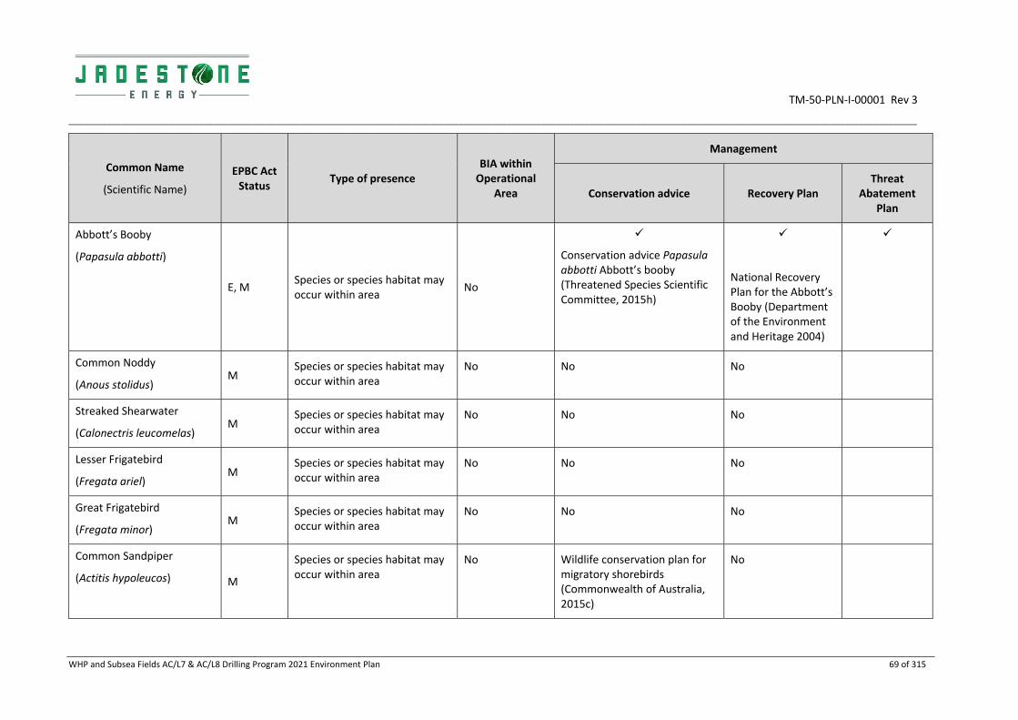
TM‐50‐PLN‐I‐00001 Rev 3
________________________________________________________________________________________________________________________________________________________________________________
WHP and Subsea Fields AC/L7 & AC/L8 Drilling Program 2021 Environment Plan 69 of 315
Common Name
(Scientific Name)
EPBC Act Status
Type of presence BIA within Operational
Area
Management
Conservation advice Recovery Plan Threat
Abatement Plan
Abbott’s Booby
(Papasula abbotti)
E, M Species or species habitat may occur within area
No
Conservation advice Papasula abbotti Abbott’s booby (Threatened Species Scientific Committee, 2015h)
National Recovery Plan for the Abbott’s Booby (Department of the Environment and Heritage 2004)
Common Noddy
(Anous stolidus) M
Species or species habitat may occur within area
No No No
Streaked Shearwater
(Calonectris leucomelas) M
Species or species habitat may occur within area
No No No
Lesser Frigatebird
(Fregata ariel) M
Species or species habitat may occur within area
No No No
Great Frigatebird
(Fregata minor) M
Species or species habitat may occur within area
No No No
Common Sandpiper
(Actitis hypoleucos) M
Species or species habitat may occur within area
No Wildlife conservation plan for migratory shorebirds (Commonwealth of Australia, 2015c)
No

TM‐50‐PLN‐I‐00001 Rev 3
________________________________________________________________________________________________________________________________________________________________________________
WHP and Subsea Fields AC/L7 & AC/L8 Drilling Program 2021 Environment Plan 70 of 315
Common Name
(Scientific Name)
EPBC Act Status
Type of presence BIA within Operational
Area
Management
Conservation advice Recovery Plan Threat
Abatement Plan
Sharp‐tailed Sandpiper
(Calidris acuminata) M
Species or species habitat may occur within area
No Wildlife conservation plan for migratory shorebirds (Commonwealth of Australia, 2015c)
No
Pectoral Sandpiper
(Calidris melanotos) M
Species or species habitat may occur within area
No No No
CE = Critically Endangered; E = Endangered; V = Vulnerable; M = Migratory

TM‐50‐PLN‐I‐00001 Rev 3
________________________________________________________________________________________________________________________________________________________________________________
WHP and Subsea Fields AC/L7 & AC/L8 Drilling Program 2021 Environment Plan 71 of 315
Figure 3‐6: Figure Biologically important areas for avifauna

TM‐50‐PLN‐I‐00001 Rev 3
__________________________________________________________________________________________________________________________
WHP and Subsea Fields AC/L7 & AC/L8 Drilling Program 2021 Environment Plan 72 of 315
Eastern Curlew (Critically Endangered/Migratory)
Within Australia, the eastern curlew (Numenius madagascariensis) has a primarily coastal distribution. They have a continuous distribution from Barrow Island and Dampier Archipelago in WA, through the Kimberley and along the NT, Queensland, and NSW coasts and the islands of Torres Strait. They are patchily distributed elsewhere.
The species nests in the northern hemisphere, from early May to late June and does not breed in Australia. During the non‐breeding season in Australia, the eastern curlew is most commonly associated with sheltered coasts, especially estuaries, bays, harbours, inlets and coastal lagoons, with large intertidal mudflats or sandflats (TSSC 2015). Given the offshore location of activities and habitat preferences, the species is unlikely to be encountered within the Operational Area other than occasional numbers during migration, although may be present within the RISK EMBA.
Abbott’s Booby (Endangered/Migratory)
In Australia, Abbott’s booby (Papasula abbotti) is only found on Christmas Island, where it nests in tall rainforest trees. It is a pelagic feeding species, spending long periods at sea and often foraging hundreds of kilometres from land (Olsen 2001). Given the offshore location of activities and habitat preferences, the species is may be present foraging within the Operational Area and RISK EMBA.
Common Noddy (Migratory)
In Australia, the common noddy (Anous stolidus) occurs mainly in oceanic waters off the Queensland coast, although is also known from the north‐west and central WA coast. The species is also rarely encountered off the coast of the NT, where only one breeding location of approximately 100‐130 birds is documented (DoEE 2017b). During the breeding season, the species usually occurs on, or near islands, on rocky islets and stacks with precipitous cliffs, or on shoals or cays of coral or sand. During the non‐breeding period, the species occurs in groups throughout the pelagic zone (DoEE 2017b).
Based on the distribution and habitat preferences the species may be encountered within the Operational Area and occurs within the RISK EMBA.
Streaked Shearwater (Migratory)
The streaked shearwater (Calonectris leucomelas) is usually found over pelagic waters and is known to breed on the coast and offshore islands mainly around Japan and Korea (Ochi et al 2010). The streaked shearwater migrates south during winter to Australia (Birdlife International 2015). The species does not breed in Australia. Streaked shearwaters are known to forage in areas of high concentrations of subsurface predators (e.g. tuna and dolphins) in tropical oceans during non‐breeding periods (Yamamoto et al 2010). Given the distribution of streaked shearwaters, this species may be present in the Operational Area, albeit in low numbers, and will occur within the RISK EMBA.
Lesser Frigatebird (Migratory)
The lesser frigatebird (Fregata ariel) is considered the most common and widespread frigatebird over Australian seas (Lindsey 1986). They are commonly found in tropical seas, breeding on remote islands (Marchant and Higgins 1990). A BIA has been identified for this species at Ashmore Reef and Cartier Island to highlight breeding and foraging behaviours in the area (DoEE 2017b). The Operational Area does not overlap with this BIA (Figure 3‐6). Breeding is known to occur between March and September.
Given its distribution and the large breeding population at nearby Ashmore Reef and Cartier Island, this species may be encountered within the Operational Area and will be present within the RISK EMBA.

TM‐50‐PLN‐I‐00001 Rev 3
__________________________________________________________________________________________________________________________
WHP and Subsea Fields AC/L7 & AC/L8 Drilling Program 2021 Environment Plan 73 of 315
Great Frigatebird (Migratory)
Great frigatebirds (Fregata minor) are found in tropical waters globally. A BIA has been identified at Ashmore Reef and Cartier Island for the species to highlight breeding and foraging behaviours in the area (DoEE 2017b). The Operational Area does not overlap with this BIA (Figure 5‐7). Breeding is known to occur between May to June and in August (DoEE 2017b). Given the distribution of the species and its low population in nearby Ashmore Reef and Cartier Island, this species may be present in the Operational Area in low numbers.
Common Sandpiper (Migratory)
The common sandpiper (Actitis hypoleucos) is a small, migratory species with a very large range through which it undertakes annual migrations between breeding grounds in the northern hemisphere (Europe and Asia) and non‐breeding areas in the Asia‐Pacific region (Bamford et al. 2008). The species congregates in large flocks and forages in shallow waters and tidal flats between spring and autumn. Specific critical habitat in Australia has not been identified due to the species’ broad distribution (Bamford et al. 2008).
The common sandpiper may be present in coastal wetland and intertidal sand or mudflats throughout the RISK EMBA, but is unlikely to occur in the Operational Area, aside from individuals occasionally transiting through during migrations, due to the lack of emergent habitat.
Sharp‐tailed Sandpiper (Migratory)
The sharp‐tailed sandpiper (Calidris acuminata) is a migratory wading shorebird and undertakes long distance seasonal migrations between breeding grounds in the northern hemisphere and over‐wintering areas in the southern hemisphere (Bamford et al. 2008). The species may occur in Australian between spring and autumn. The species is unlikely to occur within the Operational Area due to the lack of suitable habitat but may occur seasonally in coastal wetland and intertidal sand or mudflats throughout the RISK EMBA.
Pectoral Sandpiper (Migratory)
The pectoral sandpiper (Calidris melanotos) breeds in the northern hemisphere during the boreal summer, before undertaking long distance migrations to feeding grounds in the southern hemisphere (Bamford et al. 2008). The species occurs throughout mainland Australia between spring and autumn. The pectoral sandpiper prefers coastal and near‐coastal environments such as wetlands, estuaries and mudflats.
Given the species’ preferred habitat the pectoral sand piper is not expected to occur within the Operational Area but is expected to occur in suitable habitats within the RISK EMBA.
3.6 Social Values
The socioeconomic environmental values and sensitivities (cultural and socio‐economic) within the Operational Area, which also include all relevant matters of National Environmental Significance (NES) protected under the EPBC Act, are summarised in Table 3‐8.

TM‐50‐PLN‐I‐00001 Rev 3
__________________________________________________________________________________________________________________________
WHP and Subsea Fields AC/L7 & AC/L8 Drilling Program 2021 Environment Plan 74 of 315
Table 3‐8: Socio‐economic Values and Sensitivities within the Operational Area
Value/ Sensitivity Description Operational Area
Presence
World Heritage Properties
Sites accepted to the World Heritage listing are only inscribed if considered to represent the best examples of the world's cultural and natural heritage. There are no World Heritage properties that intersect with the Operational Area.
None
Shipping The Operational Area is not located on a major international shipping route. Heavy vessels following the charted Osborn Passage will pass through both permits to the north of the Montara Venture FPSO. Support vessels servicing the nearby infrastructure do pass through the Operational Area (AMSA, 2014) (refer Figure 3‐7).
Commercial Fishing
The Northern Demersal Scalefish Fishery (Area 2) has low levels of fishing activity in the vicinity the Operational Area. The following fisheries are permitted, and It is feasible that they may operate in the Operations Area:
JA Northern Shark Fishery (WA)
Mackerel Area 1 (WA)
Western Tuna and Billfish Fishery
Minimal effort
Recreational Fishing
Remoteness of Operational Area limits recreational fishing usage. Limited
Traditional Fishing
Traditional Australian indigenous fishing activities are generally concentrated within 3 nm of the NT/WA coastline (DPIF 2015).
Indonesian/Timor Leste indigenous fishing is concentrated in the vicinity of Sahul Bank, Echo Shoals and MoU Box and boats may pass through the Operational Area to reach these fishing grounds.
Transit
Defence No declared defence areas in Operational Area. –
Oil and Gas Various petroleum exploration and production activities have been undertaken within the Timor Sea, including some within close proximity of the Operational Area.
Adjacent
Tourism No regular tourism activity occurs in the Operational Area due to its remoteness.
–
Cultural Heritage No known sites of shipwrecks or Aboriginal Heritage significance within the Operational Area.
–

TM‐50‐PLN‐I‐00001 Rev 3
______________________________________________________________________________________________________________________________________________________________________________
WHP and Subsea Fields AC/L7 & AC/L8 Drilling Program 2021 Environment Plan 75 of 315
Figure 3‐7: Shipping activity within the region

TM‐50‐PLN‐I‐00001 Rev 3
__________________________________________________________________________________________________________________________
WHP and Subsea Fields AC/L7 & AC/L8 Drilling Program 2021 Environment Plan 76 of 315
4. CONSULTATION OF RELEVANT PERSONS
Jadestone is required under the OPGGS(E) Regulations 2009 to prepare a strategy for the identification and consultation of relevant persons as part of the process for acceptance by NOPSEMA of this EP.
Jadestone has developed a Consultation Process for Regulatory Approvals (JS‐70‐PR‐I‐00034) to assist in addressing this requirement across its approvals (Figure 4‐1).
Figure 4‐1: JSE Stakeholder Engagement Process
Step 1
•INPUTS
• Activity description
• Preliminary risk assessment and spatial footprints
Step 2
•RELEVANT PERSON IDENTIFICATION• Beneficial Use/Value Mapping
• Regulatory Review
• Benchmarking
• Self‐reporting
Step 3
• RELEVANT PERSON CLASSIFICATION• Engage
• Involve
• Monitor
Step 4
•PROVISION OF INFORMATION•Sufficiency of Information
•Communication Methods
Step 5
•OPPORTUNITY TO RESPOND•Follow up
•Assessment of Merit
Step 6•ONGOING CONSULTATION
TM‐50‐PLN‐I‐00001 Rev 3
__________________________________________________________________________________________________________________________
WHP and Subsea Fields AC/L7 & AC/L8 Drilling Program 2021 Environment Plan 77 of 315
4.1 Definitions
For the purposes of this section the following definitions have been used:
Function A role in the administration, management or regulation
Activity A thing that a person or group does or has done under a legal or proprietary right
Interest A person or organisation having a common concern
Commercial or academic pursuit which is regular and observable
4.2 Fulfilment of Regulatory Requirements
The Offshore Petroleum and Greenhouse Gas Storage (Environment) Regulations 2009 stipulate a number of requirements in relation to consultation associated with an EP (Table 4‐1).
Table 4‐1: Regulatory Requirements
Regulation Description Fulfilment
11A(1) In the course of preparing an environment plan, or a revision of an environment plan, a titleholder must consult each of the following (a relevant person):
(a) each Department or agency of the Commonwealth to which the activities to be carried out under the environment plan, or the revision of the environment plan, may be relevant;
(b) each Department or agency of a State or the Northern Territory to which the activities to be carried out under the environment plan, or the revision of the environment plan, may be relevant;
(c) the Department of the responsible State Minister, or the responsible Northern Territory Minister;
(d) a person or organisation whose functions, interests or activities may be affected by the activities to be carried out under the environment plan, or the revision of the environment plan;
(e) any other person or organisation that the titleholder considers relevant.
Section 4.2 of the EP outlines the process (as per JSE standard Stakeholder Engagement Process) that was used to identify relevant persons in each of the 5 groups required under the regulations. A list of the relevant persons can be found in Table 4.2.
A log of engagement with each of the relevant persons identified is provided in Appendix C.
11A(2) For the purpose of the consultation, the titleholder must give each relevant person sufficient information to allow the relevant person to make an informed assessment of the possible consequences of the activity on the functions, interests or activities of the relevant person.
Historical consultation was undertaken by PTEPP during the development of a draft EP prior to the purchase of the Montara facility by JSE. To reduce stakeholder fatigue, JSE built on this consultation.
For key stakeholders (particularly government agencies) email and phone discussions between staff were undertaken on specific issues. In addition to this all stakeholders were provided with targeted information sheets (Appendix C).

TM‐50‐PLN‐I‐00001 Rev 3
__________________________________________________________________________________________________________________________
WHP and Subsea Fields AC/L7 & AC/L8 Drilling Program 2021 Environment Plan 78 of 315
Regulation Description Fulfilment
11A(3) The titleholder must allow a relevant person a reasonable period for consultation.
At the time of the submission of the EP over two months has been allowed for since the information sheet was distributed.
14(9) The implementation strategy of the environment plan must provide for appropriate consultation with:
(a) Relevant authorities of the
Commonwealth, a State or Territory; and
(b) Other relevant interested persons or organisations.
As above
16(b) A report on all consultations between the titleholder and any relevant person, for regulation 11A, that contains:
(a) A summary of each response made by a
relevant person;
(b) An assessment of the merits of any
objections or claim about the adverse
impact of each activity to which the
environment plan relates;
(c) A statement of the titleholder’s response,
or proposed response, if any, to each
objection or claim; and
(d) A copy of the full text of any response by a relevant person.
a) A log of all engagement undertaken with relevant persons is provided in Appendix L (the separate Sensitive Information Report not published for privacy reasons).
b) An assessment of response merits is provided in Table 4‐4.
c) The assessment of merits provided in Table 4‐4 contains JSE’s response to any claims.
d) Full text of correspondence can be found in Appendix L (the separate Sensitive Information Report not published for privacy reasons).
27 Storage of records:
Records must be stored in a way that
makes retrieval reasonably practicable;
Records must be kept for five years; and
Records generated through preparation
of the environment plan, demonstrating
environmental performance, incidents,
emissions and discharges, calibration and
maintenance, and in relation to the
implementation strategy arrangements
must be kept.
The JSE Stakeholder Engagement Process stipulates internal requirements for the storage of records.
4.3 Identification of Relevant Persons
Regulation 11A (1) of the Offshore Petroleum and Greenhouse Gas Storage (Environment) Regulations 2009 identifies five groups as relevant persons who must be consulted with in the course of preparing an environment plan:
1) each Department or agency of the Commonwealth to which the activities to be carried out under the environment plan, or the revision of the environment plan, may be relevant;
2) each Department or agency of a State or the Northern Territory to which the activities to be carried out under the environment plan, or the revision of the environment plan, may be relevant;
3) the Department of the responsible State Minister, or the responsible Northern Territory Minister;

TM‐50‐PLN‐I‐00001 Rev 3
__________________________________________________________________________________________________________________________
WHP and Subsea Fields AC/L7 & AC/L8 Drilling Program 2021 Environment Plan 79 of 315
4) a person or organisation whose functions, interests or activities may be affected by the activities to be carried out under the environment plan, or the revision of the environment plan;
5) any other person or organisation that the titleholder considers relevant.
For each consultation process, Jadestone utilises standardised identification methods (in accordance with Consultation Process for Regulatory Approvals JS‐70‐PR‐I‐00034.) to compile a list of relevant persons across these categories. For each of the five groups of relevant persons above, four pathways were used to identify contacts:
1. Beneficial Use/Value Mapping: for each use associated with socio‐economic or cultural values
identified as having the potential to be impacted, identify stakeholders based on function, interest and
activity;
2. Regulatory Review: undertake review for Ministers of regulatory portfolios of relevance and for region;
3. Benchmarking: persons identified through benchmarking with other similar in‐house or external
projects; and
4. Self‐reporting: opportunities for self‐reporting should be encouraged – e.g. Contact details on
Jadestone website and information sheets.
The results of applying this process is summarised in Table 4‐2.

TM‐50‐PLN‐I‐00001 Rev 3
__________________________________________________________________________________________________________________________________________________________________________________
WHP and Subsea Fields AC/L7 & AC/L8 Drilling Program 2021 Environment Plan 80 of 315
Table 4‐2: Relevant Persons
Beneficial use/Interest
Relevant activities Group 1 & 2
Department or Agency (State and Commonwealth)
Group 3 & 4 People or Organisations whose Functions,
Activities or Interests affected
Group 5 Any other relevant person JSE
consider relevant
Shipping Physical presence (Section
6.1) Australian Hydrographic office (AHO), Australian Maritime Safety Authority (AMSA)
Department of Transport
Shipping operators (through AMSA) Hon. Bill Marmion MLA, Minister
for State Development, Transport
Release of hydrocarbons
(Sections 7.6 and 7.7) As above Darwin Port Authority, Kimberley Port
Authority (Port of Broome), Pilbara Port Authority
Commercial Fishing: Commonwealth (including biosecurity)
Physical presence (Section
6.1)
Introduction of Marine
Pests (Section 7.1)
Drilling and cement
discharges (Section 6.6 and
6.7)
Australian Fisheries Management Authority (AFMA)
Department of Agriculture and Water Resources
Commonwealth Fisheries Association (CFA)
Fishing licence holders in Operations area:
Western Tuna and Billfish Fishery, Australia Fisheries Trade Association
IMS consultant
Release of hydrocarbons
(Sections 7.6 and 7.7) As above As above
Australian Southern Bluefin Tuna Industry Association
Northern Prawn Fishery Industry P/L
Australian Council of Prawn Fisheries
Fishing licence holders in RISK EMBA
Southern Bluefin (due to migration)

TM‐50‐PLN‐I‐00001 Rev 3
__________________________________________________________________________________________________________________________________________________________________________________
WHP and Subsea Fields AC/L7 & AC/L8 Drilling Program 2021 Environment Plan 81 of 315
Commercial Fishing: State (including biosecurity)
Physical presence (Section
6.1)
Introduction of Marine
Pests (Section 7.1)
Drilling and cement
discharges (Section 6.6 and
6.7)
Department of Primary Industries and Regional Development – Fisheries (WA)
Department of Primary Industries and Resources (NT)
NT Seafood Council
Western Australian Fishing Industry Council (WAFIC)
Western Tuna and Billfish Fisheries
Australian Fisheries Trade Association
Fishing licence holders in operations area
Joint Authority Northern Shark Fishery (WA)
Mackerel Managed Fishery (Area 1) (WA)
Northern Demersal Scalefish Managed Fishery (Area 2) (WA)
Pearl Oyster Fishery Zone 3
Hon Alannah MacTiernan MLC, Minister for Regional Development; Agriculture and Food; Ports; Minister Assisting the Minister for State Development, Jobs and Trade Hon Dave J KELLY BA MLA, Minister for Water; Fisheries; Forestry; Innovation and ICT; Science
Release of hydrocarbons
(Sections 7.6 and 7.7) As above As above
Pearl Producers Association
Fishing licence holders in RISK EMBA
Recreational Fishing
Release of hydrocarbons (Sections 7.6 and 7.7)
Department of Primary Industries and Regional Development ‐ Fisheries (WA)
DPIF (NT)
Amateur Fisherman’s Association of the NT
Recfish West
NT Guided Fishing Association
Individual recreational fishers
Subsistence fishing/ Indigenous Fishing
Physical presence (Section 6.1)
Department of Foreign Affairs and Trade
Release of hydrocarbons (Sections 7.6 and 7.7)
As above Individual Indonesian/Timor/PNG traditional fishers, Individual Australian Indigenous fishers

TM‐50‐PLN‐I‐00001 Rev 3
__________________________________________________________________________________________________________________________________________________________________________________
WHP and Subsea Fields AC/L7 & AC/L8 Drilling Program 2021 Environment Plan 82 of 315
Defence Release of hydrocarbons (Sections 7.6 and 7.7)
Department of Defence
Australian Border Force (formerly Australian Customs and Border Protection Service)
N/A
Oil and Gas Release of hydrocarbons (Sections 7.6 and 7.7)
NOPSEMA
Department of Industry, Innovation and Science
Department of Mines, Industry Regulation and Safety (WA)
Department of Primary Industry and Resources – Mines, Energy and Fisheries (NT)
Australian Petroleum Production and Exploration Association (APPEA)
BHP, Carnarvon Petroleum, Chevron, PTTEP, Finder Pty Ltd, Eni Australia Limited, Quadrant Energy, Murphy Australia Oil Pty Ltd, Sinopec O&G Australia (Puffin) Pty Ltd, Shell Australia Pty Ltd, Bounty Oil and Gas NL, Vermillion Energy
Hon Josh Frydenberg ‐ Minister for Environment & Energy
Senator the Hon Matt Canavan ‐ Minister for Resources and Northern Australia
Hon Greg Hunt ‐ Minister for Industry, Innovation & Science
Bill Johnston Minister for Mines and Petroleum; Energy; Industrial Relations Minister for Mines and Petroleum; Energy; Industrial Relations
Tourism Release of hydrocarbons (Sections 7.6 and 7.7)
Department of Jobs, Tourism, Science and Innovation (WA)
Department of Tourism and Culture (Parks and Wildlife Commission of the NT)
Tourism NT
Tourism Top End
Australian Northwest Tourism
Tourism Western Australia
Kimberley Birdwatching, Kimberley Expeditions
Shire of Wyndham East Kimberley
Shire of West Derby/West
Kimberley, City of Karratha, Shire
of Broome
Cultural/ Indigenous Heritage
Release of hydrocarbons (Sections 7.6 and 7.7)
National Native Title Tribunal Tiwi Land Council
Northern Land Council (NT)
North Australian Indigenous Land and Sea Management Alliance
Kimberley Land Council
Individuals in coastal communities

TM‐50‐PLN‐I‐00001 Rev 3
__________________________________________________________________________________________________________________________________________________________________________________
WHP and Subsea Fields AC/L7 & AC/L8 Drilling Program 2021 Environment Plan 83 of 315
Environment/ Environmental Management
Release of hydrocarbons (Sections 7.6 and 7.7)
Director of Parks Parks Australia ‐ Australia Marine Parks
Department of Environment and Energy
Department of Biodiversity, Conservation and Attractions (WA)
Department of Water and Environmental Regulation (WA)
Department of Environment and Natural Resources (NT)
Department of the Chief Minister (NT)
Northern Territory EPA
Australian Conservation Foundation
WA Conservation Council
World Wildlife Fund
The Wilderness Society
Environs Kimberley
International Fund for Animal Welfare
Save the Kimberley
Australian Marine Conservation Society
World Dolphin Conservation Society
Australian Conservation Foundation
Greenpeace
General Public
The Hon Sussan Ley MP, Minister
for the Environment, Melissa Price
Member for Durack, Chris
Tallentire MLA, Member for
Gosnells Shadow Minister for
Environment
Research Release of hydrocarbons (Sections 7.6 and 7.7
CSIRO
Western Australian Museum
Geoscience Australia
Australian Institute of Marine Science (AIMS)
Emergency Response
Release of hydrocarbons (Sections 7.6 and 7.7)
Department of Foreign Affairs and Trade (DFAT)
Department of Transport (WA)
Department of Infrastructure, Planning and Logistics (NT)
Jacobs
Aerotech
OSRL
AMOSC
Hon Francis M LOGAN BA(Hons)
MLA, Minister for Emergency
Services; Corrective Services
WA Department of Transport

TM‐50‐PLN‐I‐00001 Rev 3
_________________________________________________________________________________________________________________________
WHP and Subsea Fields AC/L7 & AC/L8 Drilling Program 2021 Environment Plan 84 of 315
4.4 Relevant Person Classification
Relevant persons were classified according to criteria outlined in the Stakeholder Engagement Process to assist with determining sufficiency of information and level of engagement (Table 4‐3). Classification of relevant persons can be found in Appendix C.
Table 4‐3: Levels of Engagement
Classification Engagement Level Description Examples of methods
RP1 Inform ‐ invitation
for comment
Interested party but with no activity, function in Operations
Area
No risk from Planned Operations
‐ but may have be at risk of
impact in event of unplanned
event.
Information sheet sent with
overview of operations and
approval
Update by email of major
milestone
RP2 Inform – action
required
Regulator or Organisation that needs to action information
received regarding operations
e.g. Update maps, marine
notices
Information sheet sent with
overview of operations and
approval
Update by email of major
milestone
Engage in further correspondence to ensure receipt of information
and actioning of item
RP3 Consult Relevant person with an interest, activity, function in Operations
Area
Potential risk from Planned
activities
Information sheet sent with
overview of operations and
approval
Update by email of major
milestone
Phone calls or face to face meetings to ensure receipt of
information and dialogue on any
issues.
RP4 Regulator Relevant person with regulatory function in potentially affected
As per regulatory requirements
RP5 Response
Organisation
Primary interest in activity is
commercial to assist in response
should an unplanned spill occur
Direct communication (meetings or
email) to ascertain capabilities
Contracts
4.4.1 Sufficiency of Information
Jadestone is supportive of ensuring adequate and open information with relevant persons and its investors. The following methods have been used for community engagement:
Letters / emails: providing updates on key events and milestones (generally in the form of targeted
information sheets);
Meetings: meetings and phone calls with over numerous organisations and individuals to understand
requirements and capability regarding the proposed activity and response arrangements;

TM‐50‐PLN‐I‐00001 Rev 3
_________________________________________________________________________________________________________________________
WHP and Subsea Fields AC/L7 & AC/L8 Drilling Program 2021 Environment Plan 85 of 315
Website: Jadestone’s website (www.Jadestone.com.au) has been developed to ensure all activities have
current and comprehensive information covering location and development plans of its permits,
including Montara. The contact details provided on the website allow for self‐reporting of interest in
activities; and
Media: Media releases regarding the purchase and key operational milestones have been provided.
The information sheets were developed with sub‐regulation 11A(2) and associated guidance in mind to ensure it adequately described the activity – including the risks associated with the activities. As a minimum the following information was provided to all relevant persons:
• Location (permit numbers, latitude/longitude), including a map;
• Description of activity (including duration);
• Description of environment;
• Major risks and impacts to their activity/function/interests;
• How the risks and impacts will be managed and controlled; and
• Contact details.
A fisheries specific information sheet (Appendix C) was developed which included additional specific information, including:
• Fisheries with the potential to be active in the Operational Area; and
• Fisheries specific risk and impact information.
The information provided to the DNP had consideration to the NOPSEMA Petroleum Activities and the Australian Marine Park guidance note, with the supplementary information provided including:
• Name of company or titleholder EP;
• Contact details for a titleholder representative;
• Petroleum activity title number/s;
• Activity overview including type of activity, expected start and completion date of activities;
• A description of the Operational Area; and
• A brief description of any planned activities within AMP and risks and spill response actions in AMPs.
Where agencies had been engaged with throughout the process of developing the EP or supporting documents (eg.re development of IMS plan), the information sheet was still sent as another formal opportunity to comment in addition to the ongoing engagement. The information provided to these agencies should be considered in the context of all ongoing information provided.
4.4.2 Reasonable Period
Recipients of the information sheet were encouraged to provide comment within a four‐week period. Comments provided outside of this time will still be considered and incorporated into the approvals process wherever practicable. If no response was received following this period from Category 1 and some Category 4 stakeholders a reminder was sent indicating if no response was received, then it was considered that no comment was to be provided. For other categories of stakeholder where a response was required direct follow up was undertaken.

TM‐50‐PLN‐I‐00001 Rev 3
_________________________________________________________________________________________________________________________
WHP and Subsea Fields AC/L7 & AC/L8 Drilling Program 2021 Environment Plan 86 of 315
The Montara EP includes our emergency response plans. Pursuant to the environment regulations, state and federal government departments and agencies have been, and will continue to be, consulted on response preparedness for an uncontrolled discharge of oil from vessels or the well.
4.5 Assessment of Merit
For all responses received, the merit of each of these responses was assessed. For minor/administrative changes these are noted in the Response log (Appendix L Sensitive Information Report). Assessment of merit for all other responses is found in Table 4‐4.
4.6 Sensitive Information
Appendix C has been redacted prior to publishing to preserve the privacy of those persons or organisations consulted with. This can include the removal personal information (as defined by the Privacy Act 1988) and the removal of any information that was provided during consultation where that person has requested for that information not to be published as per OPGGS(E) Regulations sub‐regulation 11(A). Jadestone Energy has made reasonable efforts to inform each relevant person consulted that they may request for particular information not to be published during all stages of the consultation.
A separate sensitive information report (Appendix L) containing records of full consultation with relevant persons has not been published due to privacy reasons.

TM‐50‐PLN‐I‐00001 Rev 3
_____________________________________________________________________________________________________________________________________________________________________________________
WHP and Subsea Fields AC/L7 & AC/L8 Drilling Program 2021 Environment Plan 87 of 315
Table 4‐4: Responding to merits of objections and claims
Stakeholder Stakeholder Concern, Objection or Claim JSE Assessment of merit JSE Response
Australian Maritime Safety Authority
To notify AMSA’s JRCC ([email protected], Ph 1800 641 792) 24‐48 hrs prior to operations commencing and at cessation of operations
JSE considers these comments have merit and have incorporated these into the EP.
Item included in implementation section of EP to ensure notification 48 hrs prior to operations commencing and at cessation.
Australian Hydrographic Office ([email protected]) to be contacted no less than 4 working weeks prior to operations commencing for the promulgation of related notices to mariners.
JSE considers these comments have merit and have incorporated these into the EP.
Item included in implementation section of EP to ensure notification 4 working weeks prior to commencement.
Suggest where may request vessel traffic plot Noted JSE have requested a vessel traffic plot
Department of Agriculture (Biosecurity/Marine Pests)
The Department of Agriculture manages the regulation of ballast water in Australia and has released a Biofouling Consultation Regulation Impact Statement relating to Australia’s proposed mandatory biofouling regulations under the Biosecurity Act 2015, with an anticipated implementation in late 2020.
Noted No change to current EP but noted for future EPs
The Department considers the implementation of an effective biofouling management plan and biofouling record book in line with the International Maritime Organization’s 2011 Biofouling guidelines as integral to any vessel proactively minimising biosecurity risk associated with biofouling. An effective plan would address all activities that a vessel would implement to manage its biofouling during normal operation and set out contingency measures used to mitigate risk where the vessel deviates from its usual operational profile (e.g. extended lay‐ups).
Further information on biofouling management and biosecurity requirements can be found at http://www.marinepests.gov.au/commercial/offshore‐
JSE considers these comments have merit and have already addressed these into the EP.
ALARP assessment of biosecurity risk included in Section 7.1, including management of residual risks.
Vessels mobilised from international waters will have DoA approval and Ballast Management Plans and Ballast Record Books.
A performance standard included in EP that all vessels sourced from outside WA must use the Vessel check process and for this assessment to indicate low/acceptable risk rating.

TM‐50‐PLN‐I‐00001 Rev 3
_____________________________________________________________________________________________________________________________________________________________________________________
WHP and Subsea Fields AC/L7 & AC/L8 Drilling Program 2021 Environment Plan 88 of 315
Stakeholder Stakeholder Concern, Objection or Claim JSE Assessment of merit JSE Response
infrastructure. To comply with Australia’s ballast water regulations, all vessels using ballast water must meet the requirements detailed in the Australian Ballast Water Management Requirements. The Department expects that all vessels will comply with the Biosecurity Act 2015 and that this will be detailed within the Environment Plan.
DMIRS Send through activity commencement and cessation notifications to [email protected]
JSE considers these comments have merit and have incorporated these into the EP.
Item included in implementation section of EP to ensure notification
Director of National Parks
Noted that planned activities do not overlap any AMPS and no authorisations required
Noted No further action required
Consider guidance note including ensuring:
o Identify and manage all impacts and risks to AMP values including ecosystem values to an acceptable level and consider all options to reduce them to ALARP
o Clearly demonstrate that the activity will not be inconsistent with the management plan
JSE considers these comments have merit JSE has developed this EP in accordance with the guidance note and identified and shown how risk to AMPs will be managed
The North‐west Marine Parks Network Management Plan 2018 (management plan) came into effect on 1 July 2018 and provides further information on values for Cartier Island, Ashmore Reef and Kimberley marine parks. Australian marine park values are broadly defined into four categories: natural (including ecosystems), cultural, heritage and socioeconomic. Information on the values for the marine parks is also located on the Australian Marine Parks Science Atlas.
Noted JSE has reviewed the North‐west Marine Parks Network Management Plan 2018 in the preparation of this EP
The DNP requests notification to [email protected] if the EP is approved by NOPSEMA.
JSE considers these comments have merit and have incorporated these into the EP.
Item included in implementation section of EP to ensure notification

TM‐50‐PLN‐I‐00001 Rev 3
_____________________________________________________________________________________________________________________________________________________________________________________
WHP and Subsea Fields AC/L7 & AC/L8 Drilling Program 2021 Environment Plan 89 of 315
Stakeholder Stakeholder Concern, Objection or Claim JSE Assessment of merit JSE Response
The DNP should be made aware of oil/gas pollution incidences which occur within a marine park or are likely to impact on a marine park as soon as possible. Notification should be provided to the 24‐hour Marine Compliance Duty Officer on 0419 293 465. The notification should include:
‐ titleholder details
‐ time and location of the incident (including name of marine park likely to be affected)
‐ proposed response arrangements as per the Oil Pollution Emergency Plan (e.g. dispersant, containment, etc.)
‐ confirmation of providing access to relevant monitoring and evaluation reports when available; and
‐ contact details for the response coordinator.
JSE considers these comments have merit and have incorporated these into the EP.
Item included in implementation section of EP to ensure notification
The correct title of each Marine Park should be used i.e. Ashmore Reef Marine Park and Cartier Island Marine Park.
Both Marine Parks are assigned IUCN category 1a Sanctuary Zoning and are afforded the highest level of protection.
JSE considers these comments have merit and have incorporated these into the EP. Response provided to DNP.
Reference to Ashmore Reef Marine Park and Cartier Island Marine Park has been updated in the EP where appropriate.
Parks Australia would request that acronyms used in “Table 1 Offshore Spill Response Strategies” including SCAT, IAP OWR, LOWC and NEBA are defined in the document to aid in interpretation. These were communicated on the phone and is mentioned primarily for future submissions with DNP advising that there is no need to resubmit this current document to DNP.
Noted and response provided to DNP. This will be changed for future stakeholder information packages
The appropriateness of the spill response strategies is difficult to assess without an understanding of how NEBA
Comment considered and response provided to DNP.
DNP advised to please refer to the NOPSEMA website for the Environment Plan and Oil

TM‐50‐PLN‐I‐00001 Rev 3
_____________________________________________________________________________________________________________________________________________________________________________________
WHP and Subsea Fields AC/L7 & AC/L8 Drilling Program 2021 Environment Plan 90 of 315
Stakeholder Stakeholder Concern, Objection or Claim JSE Assessment of merit JSE Response
process works or what the Scientific Monitoring Program proposes.
Pollution Emergency Plan which explains these terms more fully.
In accordance with the zone objective of the two marine parks, which is that they are ‘managed to conserve ecosystems, habitats and native species in as natural and undisturbed a state as possible’ the response strategy should aim to ensure remediation is undertaken to a pre‐disturbed state (i.e. removal of contaminants), including the potential translocation of wildlife impacted by contaminants. This should be the aim of any rehabilitation regardless of the outcome of the NEBA ‐Net Environmental Benefit Analysis. In addition, the scientific monitoring program should include ongoing monitoring and management of the spill and related impacts (particularly at Ashmore Reef where access is possible), until such a time that the ongoing effects of the spill are determined by the relevant authority to no longer be a threat to Marine Park values.
Comment considered and response provided to DNP.
Subsequent deterministic modelling to support the EP has seen significantly lower worst‐case volumes (maximum of 4 m3 of hydrocarbons) at Cartier Island MP and Ashmore Reef MP. Regardless of this, the approach remains the same in that the NEBA is designed to ensure that the spill response strategies in the OPEP are undertaken to remove any oil in the most environmentally sensitive way, thus achieving the Marine Park Zone objectives.
The spill response ceases upon the agreement of all relevant stakeholders. Any rehabilitation plans will be undertaken in conjunction with State/Territory and Federal environmental agencies post the spill response activities cessation.
Operational monitoring – the DNP has some concerns regarding the potential approach to assessing impacts of oil contamination. The approach should differentiate between Cartier and Ashmore for monitoring. It is understood, given the potential for UXOs at Cartier Island MP, that on shore inspection and clean up would not be feasible. However if released hydrocarbons were to reach Ashmore Reef it may be preferable to conduct inspection of the islands without use of Unmanned Aerial Vehicles (UAVs). There is not the same access issue on these islands as at Cartier Island, and we consider it would be unlikely that the presence of a few
Comment considered and response provided to DNP.
The differences between Ashmore and Cartier were explained further and distinguished in the second submission to NOPSEMA of the OPEP.
Relevant State/Territory and Commonwealth agencies will be consulted throughout a response and their expert advice part of the decision‐making process.

TM‐50‐PLN‐I‐00001 Rev 3
_____________________________________________________________________________________________________________________________________________________________________________________
WHP and Subsea Fields AC/L7 & AC/L8 Drilling Program 2021 Environment Plan 91 of 315
Stakeholder Stakeholder Concern, Objection or Claim JSE Assessment of merit JSE Response
individuals conducting an inspection near the shore line would significantly disturb wildlife. Operational Monitoring/shoreline clean‐ups/Oiled Wildlife Response by personnel on the ground should be considered where appropriate. Inspection of the islands and fauna by use of UAVs are unlikely to yield as much information about minor contamination on the islands birdlife, and we consider that this is better observed from the ground. In addition, the use of a UAV near the island could put nesting birds to flight and result in loss of nestlings or eggs. Nearshore and shoreline protection and deflection – again the approach should differentiate between limited access at Cartier and mooring/anchor access at Ashmore, and potential approval for use of Australian Government moorings in an emergency response.
Scientific monitoring – as explained on the phone the monitoring program would be developed in response to an uncontrolled release of hydrocarbons. As such it should be noted that any monitoring to be developed should be done so with the above information regarding marine park access and the values and objectives of the Sanctuary Zones. It is also worth noting that science and monitoring activities occur on the islands at Ashmore Reef MP. Parks staff and scientists familiar with these environments should be consulted to inform operational strategies to minimise impacts and risks to vulnerable habitats and wildlife. Parks staff (and scientists) would expect to be consulted as part of the NEBA process to determine the most effective interventions and during the development of any scientific monitoring program.
JSE considers these comments have merit and have incorporated these into the EP. Response provided to DNP.
As committed to in Section 4.8, relevant State/Territory and Commonwealth agencies will be consulted throughout a response and their expert advice part of the decision‐making process.

TM‐50‐PLN‐I‐00001 Rev 3
_____________________________________________________________________________________________________________________________________________________________________________________
WHP and Subsea Fields AC/L7 & AC/L8 Drilling Program 2021 Environment Plan 92 of 315
Stakeholder Stakeholder Concern, Objection or Claim JSE Assessment of merit JSE Response
Under the NOPSEMA guidance note, and as per the advice provided 31/10/2019, the DNP should be notified ‘as soon as possible’, not within 72 hours as proposed, in order to provide appropriate time for consultation and advice to support the DNP’s response framework (prevention, preparedness, response and recovery) to protect park values, and consider the safety of park users and staff (AMP Environmental Incident and Emergency Response Strategy 2018. Particularly as the prediction is ‘potential for hydrocarbons above ecological impact thresholds to reach these sites within three days’.
JSE considers these comments have merit and have incorporated these into the OPEP. Response provided to DNP.
The OPEP which contains oil spill related notifications has been updated to ensure notification as soon as possible.
The NOPSEMA guidance note specifies the information that should be provided to the DNP in an incident notification, including the time and location of the incident, proposed response arrangements and locations as per the OPEP and contact details for the response coordinator. Note that the DNP may request daily or weekly Situation Reports, depending on the scale and severity of the pollution incident
Comment considered and response provided to DNP.
The OPEP includes notification of DNP in the event of an incident (including the details specified). Noted that additional situation reports may be requested.
Department of Transport
Ensure that the Department of Transport is consulted as outlined in the Department of Transport Offshore Petroleum Industry Guidance Note – Marine Oil Pollution: Response and Consultation Arrangements (September 2018)
Noted JSE has undertaken consultation during the development of this EP in accordance with the guidance note
Ensure six weeks for review Noted JSE will ensure that DoT has six weeks for review
The arrangements for responding to oil spills is contained across a number of documents. Has there been consideration of including a flowchart to set out the key steps and provide
JSE have considered the comment and provided a response to DoT.
Jadestone will consider this within the IMT structure of the organisation.

TM‐50‐PLN‐I‐00001 Rev 3
_____________________________________________________________________________________________________________________________________________________________________________________
WHP and Subsea Fields AC/L7 & AC/L8 Drilling Program 2021 Environment Plan 93 of 315
Stakeholder Stakeholder Concern, Objection or Claim JSE Assessment of merit JSE Response
reference to the different sections of the various documents to use during a response?
Can you please confirm the duration of the Worst Case Credible Scenario (WCCS)?
JSE have provided response to DoT. The worst‐case credible scenario is LOWC at H6 surface 77 days.
There are references to out of date documents, for example WestPlan – MOP and older versions of the Offshore Petroleum Industry Guidance Note – Marine Oil Pollution: Response and Consultation Arrangements which are no longer in affect. Please ensure that the WHP & Subsea Fields AC/L7 & AC/L8 Drilling Program 2020 Oil Pollution Emergency Plan and associated documents make reference to current arrangements and plans.
JSE considers these comments have merit and have incorporated these into the OPEP. Response provided to DNP.
The OPEP document has been updated.
There are references to the Department of Transport’s (DoT) control resting primarily in State waters. Please note that DoT’s control is only in State waters and does not extend to Commonwealth jurisdictions.
JSE considers these comments have merit and have incorporated these into the OPEP. Response provided to DNP.
The OPEP document has been updated.
It appears that there is some emphasis placed on the use of DoT’s resources for shoreline assessment and response. Please note that regardless of response arrangements this does not negate Jadestone’s requirement to have the required resources in place to respond to an incident commensurate with their risk.
JSE have considered the comment and provided a response to DoT.
Jadestone has the required resources in place to respond to an incident commensurate with their risk.
Have any regional operations centres been identified? And if so, where would they be located? This is referring to locations of where potential regional control points (e.g. forward operating bases) would be set up depending on your impact areas. For example, it is unlikely that you could control all of your operations from Darwin so where would the regional locations be set up?
JSE have considered the comment and provided a response to DoT.
Jadestone has considered regional operational centres. The local of a regional operational centre will depend upon the nature, direction and extent of any spill. The preferred regional operational centre would be Darwin as it has excellent port, airport and medical facilities,

TM‐50‐PLN‐I‐00001 Rev 3
_____________________________________________________________________________________________________________________________________________________________________________________
WHP and Subsea Fields AC/L7 & AC/L8 Drilling Program 2021 Environment Plan 94 of 315
Stakeholder Stakeholder Concern, Objection or Claim JSE Assessment of merit JSE Response
however Broome and potentially Truscott could be used as regional centres.
Please provide some details on the estimate of waste that could be expected from a WCCS.
JSE have considered the comment and provided a response to DoT.
Section 11.2.2 and Table 13‐3 of the OPEP details the potential waste generated in the worst case scenario.
What considerations are in place for the safety of personnel undertaking shoreline work in tropical areas where extreme temperatures and exposure of dangerous fauna may exist?
JSE have considered the comment and provided a response to DoT.
Shoreline cleanup teams will be working under Jadestone HSE Policy and Safe Work Standard. Any shoreline cleanup activities will include a safety risk assessment and operational NEBA, which will consider any specific remote and / or dangerous fauna issues.
There are references to the access of the State Response Team being through the Australian Maritime Safety Authority. Please note that request for this resource for Western Australia would come through DoT.
JSE have considered the comment and provided a response to DoT.
Noted
There are references to the State Marine Pollution Coordinator providing sign off on each Incident Action Plan. Can you please advise where this arrangement has come from?
JSE have considered the comment and provided a response to DoT.
The approval of Incident Action Plans will be made by the Jadestone Incident Controller (while the spill event is under Jadestone control). As part of the development and approval of Incident Action Plans, Jadestone IMT will liaise and consult with the State Marine Pollution Coordinator on the best course of action for relevant Incident Action Plans. This arrangement will be made clear in the Jadestone Incident Management Team Response Plan.
In regard to the initial 10 personnel that would be provided into the DoT Incident Management Team and Forward Operations Base, there are certain roles where the people are
JSE have considered the comment and provided a response to DoT.
Any non‐Jadestone personnel provided to DoT Incident Management Team would receive an induction into Jadestone business management

TM‐50‐PLN‐I‐00001 Rev 3
_____________________________________________________________________________________________________________________________________________________________________________________
WHP and Subsea Fields AC/L7 & AC/L8 Drilling Program 2021 Environment Plan 95 of 315
Stakeholder Stakeholder Concern, Objection or Claim JSE Assessment of merit JSE Response
required to have intimate knowledge of Jadestone’s documents and processes. How would this be fulfilled if the roles are proposed to be filled with non‐Jadestone personnel?
In accordance with the DoT Offshore Petroleum Industry Guidance Note – Marine Oil Pollution: Response and Consultation Arrangements (September 2018) it is DoT’s preference that the Deputy Planning Officer and the Deputy Logistics Officer roles are fulfilled by Jadestone Energy personnel as they must have an intimate knowledge of Jadestone OPEP’s, planning, logistics and contracts processes.
systems and practices. Induction will consist of online Induction modules and also face‐to‐face coaching session. This process can be facilitated as part of the mobilisation of personnel to DoT IMT. Further support into Jadestone systems and processes can be provided at anytime throughout the event.

TM‐50‐PLN‐I‐00001 Rev 3
_________________________________________________________________________________________________________________________
WHP and Subsea Fields AC/L7 & AC/L8 Drilling Program 2021 Environment Plan 96 of 315
4.7 Ongoing Consultation
Ongoing consultation activities build upon Jadestone’s consultation for the EP. The Stakeholder Engagement Process outlines a standard approach to interacting with relevant persons during the life of the EP, including revision of relevant persons’ list and process for dealing with feedback during this period. As part of ongoing consultation Jadestone will undertake activities as shown in Table 4‐5.
Table 4‐5 Ongoing Consultation Requirements
Activity Frequency and method Responsibility
Provisions of updates on
activity progress
Annual updates placed on Jadestone’s website and email
notification to relevant persons, including Commonwealth and
WA State government agencies identified as relevant persons.
HSE Manager
Notification of Australian
Hydrographic Office
No less than four working weeks prior to operations commencing
email AHO ([email protected]) for the promulgation of
related notices to mariners.
HSE Manager
Notification of AMSA Joint Rescue Coordination Centre (JRCC)
To notify AMSA’s JRCC ([email protected], Ph 1800 641 792)
24‐48 hrs prior to operations commencing and at cessation of
operations with following details regarding the unit:
• Name
• Call sign
• Maritime mobile service identity (MMSI)
• Satellite communications details (including INMARSAT‐C and
satellite telephone
• Area of operation
• Requested clearance from other vessels
Emergency
Response Lead
Notification of DPIRD
(Fisheries)
No less than 4 weeks prior to operations commencing notify
DPIRD (Fisheries) of actual commencement date and any change
to proposal.
HSE Manager
Notification of Director
National Parks
Notification to [email protected] when EP is
approved by NOPSEMA
HSE Manager
No less than 4 weeks prior to operations commencing notify DNP
of actual commencement date and any change to proposal.
HSE Manager
DMIRS Send activity commencement and cessation notifications to
HSE Manager
Update to website Place copy of Jadestone information sheet on Jadestone website HSE Manager
Provision of broader
information relating to
Jadestone environmental
policy
Website updates as required HSE Manager

TM‐50‐PLN‐I‐00001 Rev 3
_________________________________________________________________________________________________________________________
WHP and Subsea Fields AC/L7 & AC/L8 Drilling Program 2021 Environment Plan 97 of 315
In addition, Jadestone will undertake additional triggered consultation as outlined in Table 4‐6. An unplanned loss of well control will have trigger a separate engagement process. Jadestone will use the OPEP to guide response actions and work with supporting response organisations and regulators.
Table 4‐6: Triggered Consultation
Trigger Action Responsibility
Feedback received from relevant
person
Follow standard process outlined the Jadestone
Stakeholder Engagement Strategy (Appendix C).
HSE Manager
Suspected Introduced marine
species or disease
Report to DPIRD (Fisheries) within 24‐hours HSE Manager
Change to risk profile operations
area
Website update
Notification to relevant persons
Re‐engage for consultation if quantum of risk changes
significant
HSE Manager
Change to risk profile in RISK EMBA Notification to government agencies via email to key
contact
HSE Manager
Loss of Well Control event Refer to OPEP IMT Lead
AMP access Notify AMP Director General of SMP (or other response
activities) within AMP 10 days prior to entering (where
possible) and at the cessation of activities in AMPs.
IMT Lead
Change to Offshore Petroleum
Greenhouse Gas Storage
(Environment) Regulations 2009
consultative requirements
Review of Stakeholder Engagement Process HSE Manager
An element of Jadestone’s
continuous improvement process
identifies the procedure needs to be
amended
Review of Stakeholder Engagement Process HSE Manager
Change to infrastructure that affects
exclusion zone
Notify the Australian Hydrographic Office of activities
and infrastructure for inclusion in Marine Notices
Operations
Manager
4.8 Consultation in the event of a Tier 2/3 Oil Spill
In the event of a tier 2/3 hydrocarbon spill, Jadestone will notify all identified relevant persons within 72 hours of the event (refer Table 4‐6). In addition, if any scientific monitoring programs (SMPs) are triggered during the spill response the following steps will be undertaken.
1. Step 1: Confirm relevant persons
For the SMP that has been triggered, review relevant persons with a direct interest in either the area monitoring will be undertaken or values that may be affected.
As a minimum, if any SMP is triggered then the following relevant persons will be consulted with:
Director of National Parks;

TM‐50‐PLN‐I‐00001 Rev 3
_________________________________________________________________________________________________________________________
WHP and Subsea Fields AC/L7 & AC/L8 Drilling Program 2021 Environment Plan 98 of 315
WAFIC (based on WAFIC advice on behalf of individual fishers);
Indigenous bodies;
Department of Biodiversity, Conservation and Attractions (WA) and/or Department of Environment and
Natural Resources (NT); and
DPIRD (Fisheries) and/or DPIF (NT).
2. Step 2: Relevant person notification of activation
Prior to SMP activities being undertaken (10 days where possible), email or phone notification to identified SMP relevant persons including:
Summary of activities/methodology to be undertaken;
Location of activities;
Approximate timing of activities; and
Contact details with invitation for comment.
3. Step 3: Updates
Updates as required while SMP being undertaken.
4. Step 4: Relevant person notification of termination
Ten days prior to the cessation of the SMP activities, notify relevant persons of:
Proposed date of cessation;
Summary of results (or date when results will be available and invitation to be provided copy); and
Contact details with invitation for comment.

TM‐50‐PLN‐I‐00001 Rev 3
_________________________________________________________________________________________________________________________
WHP and Subsea Fields AC/L7 & AC/L8 Drilling Program 2021 Environment Plan 99 of 315
5. EVALUATION OF ENVIRONMENTAL IMPACTS AND RISKS
As required by Regulation 13(5) of the OPGGS(E) Regulations, this section of this EP provides an outline of Jadestone Energy’s approach to the evaluation of impacts and risks due to the Drilling Activity (Section 5.1), and the outcomes of the impact and risk assessment undertaken (Section 5.6).
5.1 Assessment Method
The environmental impacts and risks associated with the proposed drilling activities for H6 within production licence AC/L7 have been assessed using the Jadestone Risk Management Framework (JS‐70‐PR‐F‐00009 Rev 1) and methods consistent with HB 203:2012 and AS/NZS ISO 31000:2009.
‘Impact’ is evaluated in terms of the extent, duration, severity and certainty pertaining to the effect that will or may occur in the environment due a planned event associated with the activity.
‘Risk’ is evaluated in terms of likelihood and consequence. Likelihood is defined as the probability or frequency of the unplanned event occurring, and consequence, like ‘impact’, is defined as the extent, duration, severity and certainty pertaining to the effect that will or may occur in the environment due to the event associated with the activity.
The assessment methodology provides a framework to demonstrate:
That the identified impacts and risks are reduced to as low as reasonably practicable (ALARP) (Regulation
10A(b)); and
The impacts and risks are acceptable (Regulation 10A I).
The impact and risk management process is shown in Figure 5‐1.
Figure 5‐1: Impact and risk evaluation process
Further detail on the steps involved in the impact and risk evaluation process is provided below.

TM‐50‐PLN‐I‐00001 Rev 3
_________________________________________________________________________________________________________________________
WHP and Subsea Fields AC/L7 & AC/L8 Drilling Program 2021 Environment Plan 100 of 315
5.2 Risk Assessment
The assessment process evaluates impacts and risks associated with planned and unplanned events that will or have the potential to impact the environment. Impacts and risks are identified through several activities:
The Risk Workshop was attended by a team that includes relevant technical knowledge and experience
in the activities being assessed;
Information relating to previous environmental performance relevant to the activity being assessed such
as findings of audits and inspections, incident investigations and performance reports;
Consultation with relevant persons; and
Industry related information of exploration and production activities relevant to the activity being
assessed.
Analysis of the impacts and risks identified for the activity includes steps intended to treat the impacts and risks to levels that are acceptable and as low as reasonably practicable for the business. The steps are:
Identification of appropriate control measures (preventative and mitigative) to treat likelihood and
consequence; and
Determination of the residual impact/risk ratings (Section 5.5).
5.2.1 Identification of control measures
The following framework tools are applied, as appropriate, to assist with identifying control measures:
Legislation, Codes and Standards – identifies the requirements of legislation, codes and standards which
are to be complied with for the activity;
Good Industry Practice – identifies further engineering control standards and guidelines which may be
applied over and above that required to meet the legislation, codes and standards;
Professional Judgement – uses relevant personnel with the knowledge and experience to identify
alternative controls. When formulating control measures for each environmental impact or risk, the
‘Hierarchy of Controls’ philosophy (see below) is applied. This Hierarchy is used in the industry to
minimise or eliminate exposure to impacts and risks;
Risk Based Analysis – assesses the results of probabilistic analyses such as modelling, quantitative risk
assessment and/or cost benefit analysis to support the selection of control measures identified during
the assessment process;
Company Values – identifies values referenced in Jadestone Energy’s HSE Policy; and
Societal Values – identifies the views, concerns and perceptions of relevant persons and addresses their
concerns as gathered through the ongoing consultation process.
The Hierarchy of Control philosophy is used by Jadestone Energy to help evaluate potential management
controls to ensure alternative reasonable and practicable solutions have not been overlooked:
Elimination – it is preferable to remove the impact or risk altogether;
Substitution – substitute the impact or risk for a lower one;
Engineering control measures – use engineering solutions to prevent or detect the hazard or control the
severity of consequences/ impacts;
Administrative control measures – use of procedures, JHA etc. to assess and minimise the environmental
impacts or risks of an activity; and
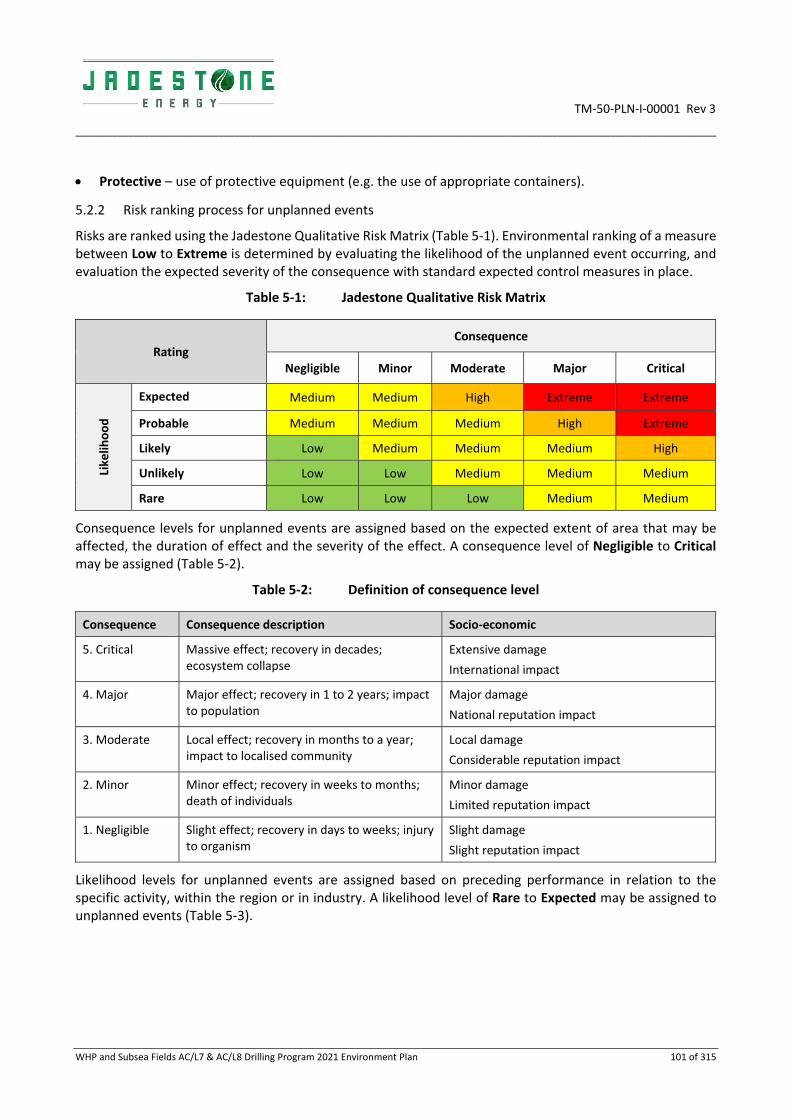
TM‐50‐PLN‐I‐00001 Rev 3
_________________________________________________________________________________________________________________________
WHP and Subsea Fields AC/L7 & AC/L8 Drilling Program 2021 Environment Plan 101 of 315
Protective – use of protective equipment (e.g. the use of appropriate containers).
5.2.2 Risk ranking process for unplanned events
Risks are ranked using the Jadestone Qualitative Risk Matrix (Table 5‐1). Environmental ranking of a measure between Low to Extreme is determined by evaluating the likelihood of the unplanned event occurring, and evaluation the expected severity of the consequence with standard expected control measures in place.
Table 5‐1: Jadestone Qualitative Risk Matrix
Rating Consequence
Negligible Minor Moderate Major Critical
Likelih
ood
Expected Medium Medium High Extreme Extreme
Probable Medium Medium Medium High Extreme
Likely Low Medium Medium Medium High
Unlikely Low Low Medium Medium Medium
Rare Low Low Low Medium Medium
Consequence levels for unplanned events are assigned based on the expected extent of area that may be affected, the duration of effect and the severity of the effect. A consequence level of Negligible to Critical may be assigned (Table 5‐2).
Table 5‐2: Definition of consequence level
Consequence Consequence description Socio‐economic
5. Critical Massive effect; recovery in decades; ecosystem collapse
Extensive damage
International impact
4. Major Major effect; recovery in 1 to 2 years; impact to population
Major damage
National reputation impact
3. Moderate Local effect; recovery in months to a year; impact to localised community
Local damage
Considerable reputation impact
2. Minor Minor effect; recovery in weeks to months; death of individuals
Minor damage
Limited reputation impact
1. Negligible Slight effect; recovery in days to weeks; injury to organism
Slight damage
Slight reputation impact
Likelihood levels for unplanned events are assigned based on preceding performance in relation to the specific activity, within the region or in industry. A likelihood level of Rare to Expected may be assigned to unplanned events (Table 5‐3).

TM‐50‐PLN‐I‐00001 Rev 3
_________________________________________________________________________________________________________________________
WHP and Subsea Fields AC/L7 & AC/L8 Drilling Program 2021 Environment Plan 102 of 315
Table 5‐3: Definition of likelihood levels
Likelihood
5. Expected Happens several times a month in similar exploration and production operations
4. Probable Happens several times a year in similar exploration and production operations
3. Likely Event has occurred in similar exploration and production operations
2. Unlikely Heard of in the exploration and production industry
1. Rare Never heard of in the exploration and production industry
Once assessed and treated, an assessment as to whether the risks recorded can be demonstrated as being acceptable and ALARP is made. The processes for determining if risks and impacts have been reduced to ALARP and acceptable levels are described below.
5.3 Impact Assessment
Environmental impacts that will occur as a result of planned activities may cover a wider range of issues, multiple species, persistence, reversibility, resilience, cumulative effects and variation in severity. The degree of impact and the corresponding level of acceptability is assessed against several guiding principles:
Principles of ecologically sustainable development (ESD);
Conservation and management advice;
Stakeholder feedback;
Reputational ramifications;
Environmental context; and
Jadestone’s HSE Policy and Management System.
The application of the guiding principles within the acceptability matrix are outlined in Table 5‐4.
The following process has been applied to demonstrate acceptability in the reduction of planned impacts:
GREEN residual impacts are Tolerable, if they meet management requirements, stakeholder
requirements, environmental context, and the Jadestone Energy HSE Policy and management system
requirements; and
ORANGE residual impacts are Intolerable and therefore unacceptable. Planned impacts with this
rating will require further investigation and mitigation to reduce them to a lower and acceptable
level. If after further investigation the impact remains in the unacceptable category, the impact
requires appropriate business sign‐off to accept the impact.
A reduction of impacts to as low as reasonably practicable (ALARP) follows the process described in Section 5.5.
5.4 Demonstration of Acceptability
An acceptable level of risk of an unplanned event occurring must be scored with a low or medium rating. Risks receiving a score of high (orange) or extreme (red) risk ratings in Table 5‐4 are unacceptable. For those risks found to have an unacceptable rating, a return to the planning process for the activity is required to determine if an alternative approach to undertaking the activity can be identified.
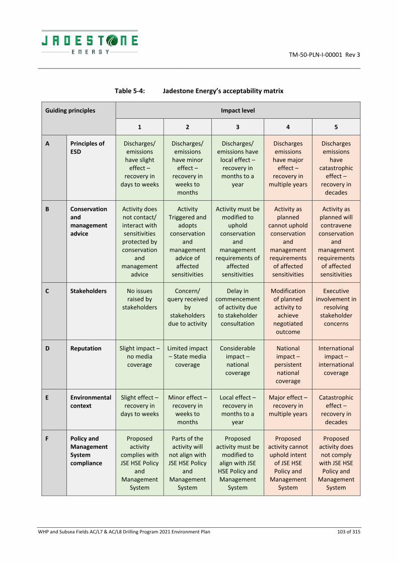
TM‐50‐PLN‐I‐00001 Rev 3
_________________________________________________________________________________________________________________________
WHP and Subsea Fields AC/L7 & AC/L8 Drilling Program 2021 Environment Plan 103 of 315
Table 5‐4: Jadestone Energy’s acceptability matrix
Guiding principles Impact level
1 2 3 4 5
A Principles of ESD
Discharges/ emissions have slight effect –
recovery in days to weeks
Discharges/ emissions have minor effect –
recovery in weeks to months
Discharges/ emissions have local effect – recovery in months to a
year
Discharges emissions have major effect –
recovery in multiple years
Discharges emissions have
catastrophic effect –
recovery in decades
B Conservation and management advice
Activity does not contact/ interact with sensitivities protected by conservation
and management
advice
Activity Triggered and
adopts conservation
and management advice of affected
sensitivities
Activity must be modified to uphold
conservation and
management requirements of
affected sensitivities
Activity as planned
cannot uphold conservation
and management requirements of affected sensitivities
Activity as planned will contravene conservation
and management requirements of affected sensitivities
C Stakeholders No issues raised by
stakeholders
Concern/ query received
by stakeholders due to activity
Delay in commencement of activity due to stakeholder consultation
Modification of planned activity to achieve
negotiated outcome
Executive involvement in
resolving stakeholder concerns
D Reputation Slight impact – no media coverage
Limited impact – State media coverage
Considerable impact – national coverage
National impact – persistent national coverage
International impact –
international coverage
E Environmental context
Slight effect – recovery in
days to weeks
Minor effect – recovery in weeks to months
Local effect – recovery in months to a
year
Major effect – recovery in
multiple years
Catastrophic effect –
recovery in decades
F Policy and Management System compliance
Proposed activity
complies with JSE HSE Policy
and Management
System
Parts of the activity will
not align with JSE HSE Policy
and Management
System
Proposed activity must be modified to align with JSE HSE Policy and Management
System
Proposed activity cannot uphold intent of JSE HSE Policy and
Management System
Proposed activity does not comply with JSE HSE Policy and
Management System

TM‐50‐PLN‐I‐00001 Rev 3
_________________________________________________________________________________________________________________________
WHP and Subsea Fields AC/L7 & AC/L8 Drilling Program 2021 Environment Plan 104 of 315
5.5 Demonstration of as Low as Reasonably Practicable (ALARP)
Regulation 10A(b) of the Environment Regulations requires a demonstration that risks are reduced to ALARP.
The ALARP principle states that it must be possible to demonstrate that the cost involved in reducing the risk further would be grossly disproportionate to the benefit gained. The ALARP principal arises from the fact that infinite time, effort and money could be spent attempting to reduce a risk to zero. An iterative evaluation process is employed until such time as any further reduction in the residual ranking is not reasonably practicable to implement. Following identification of the residual ranking, the ALARP principle is applied:
Where the residual rank is LOW as:
Good industry practice or comparable standards have been applied to control the risk, because any
further effort towards reduction is not reasonably practicable without sacrifices grossly disproportionate
to the benefit gained.
Where the residual rank is MEDIUM:
Good industry practice is applied for the impact or risk; and
Alternatives have been identified and the control measures selected to reduce the risks to ALARP. This
may require assessment of company and industry benchmarking, review of local and international codes
and standards, consultation with stakeholders, etc. to demonstrate that alternatives have been
considered, and reasons for adoption/rejection provided.
Where the residual rank is HIGH or EXTREME, the risk is not considered to be acceptable and the activity cannot continue as described. Further control measures must be applied such that an acceptable risk is demonstrated; and the residual risk is reduced to ‘Medium’ or lower as described above. The activity should not be carried out if the residual risk remains ‘High or Extreme’.
The process of evaluating the reduction of risks to ALARP is illustrated in Figure 5‐2.
Figure 5‐2: ALARP triangle
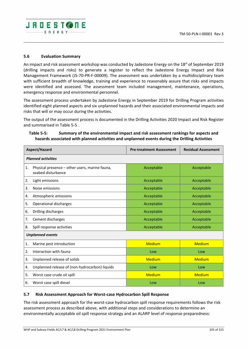
TM‐50‐PLN‐I‐00001 Rev 3
_________________________________________________________________________________________________________________________
WHP and Subsea Fields AC/L7 & AC/L8 Drilling Program 2021 Environment Plan 105 of 315
5.6 Evaluation Summary
An impact and risk assessment workshop was conducted by Jadestone Energy on the 18st of September 2019 (drilling impacts and risks) to generate a register to reflect the Jadestone Energy Impact and Risk Management Framework (JS‐70‐PR‐F‐00009). The assessment was undertaken by a multidisciplinary team with sufficient breadth of knowledge, training and experience to reasonably assure that risks and impacts were identified and assessed. The assessment team included management, maintenance, operations, emergency response and environmental personnel.
The assessment process undertaken by Jadestone Energy in September 2019 for Drilling Program activities identified eight planned aspects and six unplanned hazards and their associated environmental impacts and risks that will or may occur during the activities.
The output of the assessment process is documented in the Drilling Activities 2020 Impact and Risk Register and summarised in Table 5‐5 .
Table 5‐5: Summary of the environmental impact and risk assessment rankings for aspects and hazards associated with planned activities and unplanned events during the Drilling Activities
Aspect/Hazard Pre‐treatment Assessment Residual Assessment
Planned activities
1. Physical presence – other users, marine fauna, seabed disturbance
Acceptable Acceptable
2. Light emissions Acceptable Acceptable
3. Noise emissions Acceptable Acceptable
4. Atmospheric emissions Acceptable Acceptable
5. Operational discharges Acceptable Acceptable
6. Drilling discharges Acceptable Acceptable
7. Cement discharges Acceptable Acceptable
8. Spill response activities Acceptable Acceptable
Unplanned events
1. Marine pest introduction Medium Medium
2. Interaction with fauna Low Low
3. Unplanned release of solids Medium Medium
4. Unplanned release of (non‐hydrocarbon) liquids Low Low
5. Worst case crude oil spill Medium Medium
6. Worst case spill diesel Low Low
5.7 Risk Assessment Approach for Worst‐case Hydrocarbon Spill Response
The risk assessment approach for the worst‐case hydrocarbon spill response requirements follows the risk assessment process as described above, with additional steps and considerations to determine an environmentally acceptable oil spill response strategy and an ALARP level of response preparedness:

TM‐50‐PLN‐I‐00001 Rev 3
_________________________________________________________________________________________________________________________
WHP and Subsea Fields AC/L7 & AC/L8 Drilling Program 2021 Environment Plan 106 of 315
1. Determine threshold concentrations to be used in oil spill modelling to define the RISK EMBAs as per NOPSEMA Bulletin #1;
2. Determine the environment that may be exposed (RISK EMBA);
3. Determine the environmental receptors that may be affected within the RISK EMBA as per Appendix F;
4. Identify sensitive receptors;
5. Determine priority receptors; and
6. ALARP and acceptability evaluation for spill response activities.
5.7.1 Determine Oil Spill Modelling Thresholds
Threshold concentrations for each of the hydrocarbon component types (floating oil, entrained oil and dissolved aromatic hydrocarbons) are specified as inputs for the model to determine what potential exposure is recorded for each hydrocarbon type and the receptor/location, to ensure that potential exposure is assessed as per NOPSEMA Bulletin #1.
5.7.2 Determine the RISK EMBAs
The RISK EMBA for hydrocarbon concentration thresholds for the worst‐case spill scenario for this EP is shown in and described in Appendix B and E). These contact concentrations are used to describe potential exposure to receptors at risk from the worst‐case credible spill scenario. A description of the worst‐case credible spill scenario resulting in the RISK EMBA is provided in Section 7.5.
5.7.3 Determine the impact threshold
Threshold concentrations for each of the hydrocarbon component types (floating oil, entrained oil and dissolved aromatic hydrocarbons) are specified as inputs for the model to determine what contact is recorded for each hydrocarbon type and the receptor/location, to ensure that recorded contacts are assessed at environmentally meaningful concentrations. Meaningful concentrations are those concentrations at which environmental (or biological) impacts may occur, and at which societal values (e.g. visual aesthetics, economics) may be impacted.
The determination of environmentally meaningful impact thresholds is complex since the degree of impact will depend on the sensitivity of the value, the duration of the contact (exposure) and the toxicity of the hydrocarbon mixture making the contact. The chemical and physical properties of a hydrocarbon change over time due to weathering processes altering the composition. To ensure conservatism in defining the subsequent impact/risk assessment, the threshold concentrations applied to the model are based on the most sensitive environmental resources that may be exposed, the longest likely exposure times and on toxicity information for the hydrocarbon. Impact pathways and impact threshold concentrations are detailed in Appendix F.
5.7.4 Sensitive Receptor Identification
Jadestone Energy has generated spatial layers of known environmental and socio‐economic values within the marine and coastal environment in WA State, Northern Territory, Commonwealth and adjacent international jurisdictions, to identify sensitive receptors (locations with highest environmental and/ or socio‐economic values relative to other locations). The RISK EMBA is overlaid as a boundary to identify the sensitive receptors that exist within.
Sensitive receptor assessment considers:
Protected Area Status: used as an indicator of the biodiversity values contained within that area e.g.
World Heritage Areas, Ramsar sites and Marine Protected Areas;
TM‐50‐PLN‐I‐00001 Rev 3
_________________________________________________________________________________________________________________________
WHP and Subsea Fields AC/L7 & AC/L8 Drilling Program 2021 Environment Plan 107 of 315
Biologically Important Areas (BIA) of Listed Threatened and Migratory Species: these are spatially defined
areas where aggregations of individuals of a species are known to display biologically important
behaviour such as breeding, feeding, resting or migratory;
Social values: socio‐economic and heritage features (e.g. commercial fishing, recreational fishing,
amenities and aquaculture);
Economic values: recreational and commercial fishing areas;
Listed species status and predominant habitats (surface versus subsurface): critically endangered/
endangered species, listed species, surface species (e.g. reptiles and birds) and subsurface species (e.g.
mammals, sharks and fish); and
Recovery Plans, Conservation Advice for threatened species.
Once the sensitive receptors within the RISK EMBA have been identified, the potential oil pollution risks are described and evaluated (refer Sections 7.6 and 7.7). In addition, the environmental risks from implementing spill response activities are described and evaluated.
Sensitive receptors are further evaluated by considering what values are contained within them when determining appropriate spill response strategies (refer Table 7‐8). This informs the Oil Pollution Emergency Plan (OPEP) and guides spill response preparedness and planning.
The next step is to determine those sensitive receptors within the RISK EMBA that are considered the highest risk from the worst‐case credible oil spill scenario and are common across ALL modelled scenarios and seasons, that is, the priority receptors.
5.7.5 Priority Receptors
It is important to note that in the event of a single worst‐case hydrocarbon spill, not all sensitive receptors and areas within the RISK EMBA will be exposed or contacted at the same time or at all. Instead, the RISK EMBA is a collation of numerous possible scenarios (generally 100 or more) to develop the areas for focus in response preparedness and strategic planning. As such, only a portion would be contacted during a spill event.
It is best practice to develop spill response strategies for those areas most likely to be contacted in a single maximum credible worst‐case spill. To be able to develop these strategies, the sensitive receptors in the RISK EMBA and their vulnerability to a hydrocarbon event (considering nature and scale of spill) need to be understood. A critical first step is to identify these areas – a concept termed here as ‘priority receptors’. The selection of priority receptors is based on stochastic modelling of multiple hydrocarbon spills.
Defining priority receptors determines the scale and needs of the oil spill response strategy. Thus, priority receptors (as a subset of all the sensitive receptors present within the full extent of the RISK EMBA) specific to a particular spill are selected using the following criteria:
Sensitive receptor within RISK EMBA; AND
>5% probability of shoreline contact based on modelling results; OR
Has the largest volume of floating oil shoreline contact; OR
Has the shortest timeframe to floating oil shoreline contact; OR

TM‐50‐PLN‐I‐00001 Rev 3
_________________________________________________________________________________________________________________________
WHP and Subsea Fields AC/L7 & AC/L8 Drilling Program 2021 Environment Plan 108 of 315
Vulnerability to impact from hydrocarbons – e.g. mangroves are more vulnerable than intertidal rock
pavement; known turtle nesting beaches are vulnerable during nesting periods1; AND
Any other area of interest within the RISK EMBA including areas that have a high social value or are a
concern raised through stakeholder consultation (refer Section 4).
It is logical and best practice to focus spill response planning and strategies on those locations most likely to be contacted in the credible worst‐case oil spill scenario; that is, the scenario that represents the highest risk across all modelled scenarios covering any season, rather than attempt to cover the full spatial extent of the RISK EMBA. This allows for flexibility in response planning as plans are developed for environmental resources at greatest risk of being contacted by an oil spill and can be adapted for any scenario that occurs.
The evaluation of priority receptors is based upon stochastic modelling of multiple hydrocarbon spills. The focus for spill response planning and preparedness is based upon the level of risk (probability of contact, vulnerability to hydrocarbons, time to contact and volume/concentration of loading). Response Plans are based on the nature and scale of the worst‐case modelled hydrocarbon event for each Protection Priority, which includes estimation of shoreline loading volume and time to contact without consideration of response strategies interventions, which are provided in the OPEP.
For the purposes of spill response preparedness strategies, it is not necessary for all priority receptors to have specific operational response plans in place. For example, wholly submerged priority receptors may only be contacted by entrained oil, and the response will largely be the implementation of scientific monitoring to assess impact and recovery. Priority receptors with emergent features can have response actions prepared.
5.7.6 ALARP and Acceptability Evaluation for Spill Response
Jadestone Energy applies a robust and systematic process to ensure that credible spill scenarios are adequately evaluated, to promote a clear link between the nature and scale and the priority receptors, and, to ensure that effective control measures exist to mitigate environmental risks and impacts to a level that is ALARP and acceptable. This process is depicted in Figure 5‐3.
The process promotes a clear link between the nature and scale of the maximum credible worst‐case spill scenario and the identified priority receptors to ensure that selected response strategies are appropriate and demonstrated to be effective and adequate.
As part of the risk assessment process, the spill response strategies selected are evaluated for their environmental impact (Figure 5‐4).
1 IPIECA, the global oil and gas industry association for environmental and social issues, the International Maritime Organisation (IMO) and International Association of Oil and Gas Producers (OGP) developed a guidance document for ‘Sensitivity mapping for oil spill response’ IPIECA/IMO/OPG (2012). This document was used as a reference and basis for the sensitivity of habitats vulnerability assessment.

TM‐50‐PLN‐I‐00001 Rev 3
_________________________________________________________________________________________________________________________
WHP and Subsea Fields AC/L7 & AC/L8 Drilling Program 2021 Environment Plan 109 of 315
Figure 5‐3: Spill scenario evaluation and ALARP determination process
Figure 5‐4: Spill control analysis and ALARP determination process

TM‐50‐PLN‐I‐00001 Rev 3
_________________________________________________________________________________________________________________________
WHP and Subsea Fields AC/L7 & AC/L8 Drilling Program 2021 Environment Plan 110 of 315
6. ASSESSMENT – PLANNED ACTIVITIES
Note. In the following tables the OIM refers to the MODU OIM unless otherwise stated.
6.1 Physical Presence
6.1.1 Description of aspect
Physical presence
The MODU will be towed to site by support vessels. The legs may be lowered to the seabed (‘soft pinned’, i.e. not weighted down but just touching the seabed) in a standing off location before being towed (without touching the seabed) to the predetermined drilling position. It then becomes a static facility standing on the sea floor for the duration of the drilling at that site. The MODU is fixed to the seabed by three supporting legs, each with a base plate (spud can, typically ~18 m diameter) and due to the heavy weights applied penetrate the seabed surface. Support vessels are used to supply the MODU on a regular basis, with vessels transiting every few days to Darwin. A 500 m Petroleum Safety Zone (PSZ) is present around the MODU to ensure restricted and controlled vessel access within close proximity of the facilities. A support vessel remains on location (just outside the 500 m MODU safety exclusion zone unless working alongside the MODU) at all times during drilling activities.
The maximum possible area of undisturbed seabed that may be affected by positioning of the MODU and anchoring of support vessels is summarised below.
Activity Aspect Area
Soft pin of MODU 3 spud cans (~260 m2 each) 780 m2
Final position of MODU (H6) Disturbed site at WHP N/A
Final position of MODU (Skua‐10/11)
Disturbed site at Skua‐10/11 N/A
Total area 780 m2
The physical presence of the MODU, vessels and PSZ result in the preclusion of other users including commercial and recreational fishers, and commercial shipping traffic, to use the area for their purposes.
The physical presence of infrastructure may alter marine fauna behaviour such as avoidance or attraction. The spud cans compact benthic communities by direct contact with a temporary increase in turbidity due to seabed disturbance. The area alongside the WHP has previously been disturbed (i.e. site of MODU during H6 activities), as has the seabed at Skua‐10/11.
No vessels anchor within the Operational Area unless in emergency.
Helicopters operating at low altitude during ascent from and descent to the helidecks also have the potential to disrupt the behaviour of marine fauna due to the effects of noise. Avoidance behaviours in response to vessel and helicopter noise are assessed separately in Section 6.3.

TM‐50‐PLN‐I‐00001 Rev 3
_________________________________________________________________________________________________________________________
WHP and Subsea Fields AC/L7 & AC/L8 Drilling Program 2021 Environment Plan 111 of 315
6.1.2 Impacts
Sensitive Receptor
Impact description
Social receptors
Fishing
Shipping
Interaction between the MODU, support vessels and other marine users is expected to be minimal due to the remote location and low fishing effort expended within the Operational Area. In the immediate vicinity, the greater Montara facilities and PSZs have been established and effective since 2012, so this additional PSZ is not new, nor large (especially when alongside the existing wellhead platform which already has an PSZ gazetted around it). Any overlap with active fisheries is relatively small, with only the Northern Demersal Scalefish Managed Fishery having recent catch returns for the Operational Area or its immediate vicinity. The PSZ represents a very small part of the Northern Demersal Scalefish Managed Fishery licenced area, with numerous alternatives available. There is the potential for interactions between fishing activities and support vessels.
The temporary presence of the MODU and 500 m PSZ exclusion area, and the movement of support vessels, present obstacles for shipping traffic in the region and are potential navigational hazards and a collision. The Operational Area is located northwest of the nearest designated shipping route with heavy vessels utilising the Osborne Passage in the northern part of the permit areas, however it is not anticipated there will be high commercial shipping traffic in the Operational Area or immediate surrounds (refer to Section 3.6 and Figure 3‐7 for details on commercial shipping, including designated shipping routes) (AMSA, 2012). Any detour by shipping traffic that may occur is considered negligible in comparison to the area available for vessels to navigate through.
As such impacts to other users are considered negligible.
Environmental receptors
Seabirds, cetaceans
Fauna most susceptible to impacts from the temporary physical presence include birds, and cetaceans.
Migratory species such as seabirds may experience localised and short‐term effects through behavioural changes; such as resting or roosting on the MODU or changed feeding patterns in nearby waters in response to other factors such as attraction of fish to the infrastructure (Verhejen, 1985; Weise et al. 2001) with subsequent short‐term positive effects. This is predominantly attributed to the observation that structures in deeper water environments tend to aggregate marine life at all trophic levels, creating food sources and shelter for seabirds (Surman, 2002). Behavioural changes could affect the size and composition of the seabird community in the local area.
Birds striking infrastructure, causing injury/mortality, may cause a minor disruption to a small proportion of the population.
The only known biologically important areas (BIAs) that overlap the Operational Area are the most northern part of the Whale shark foraging BIA as described in Section 3. However, only occasional individuals are expected to traverse the area as there are no whale shark aggregations (such as the Ningaloo Reef aggregation) in the region and Pygmy blue whales are typically solitary animals. Both species may occur year‐round.
Slight deviations by migrating marine fauna including whale sharks and pygmy blue whales, to avoid the MODU may be required, however this impact is considered negligible given the large navigable area available and the relatively small Operational Area.
Impacts to marine fauna are considered negligible.
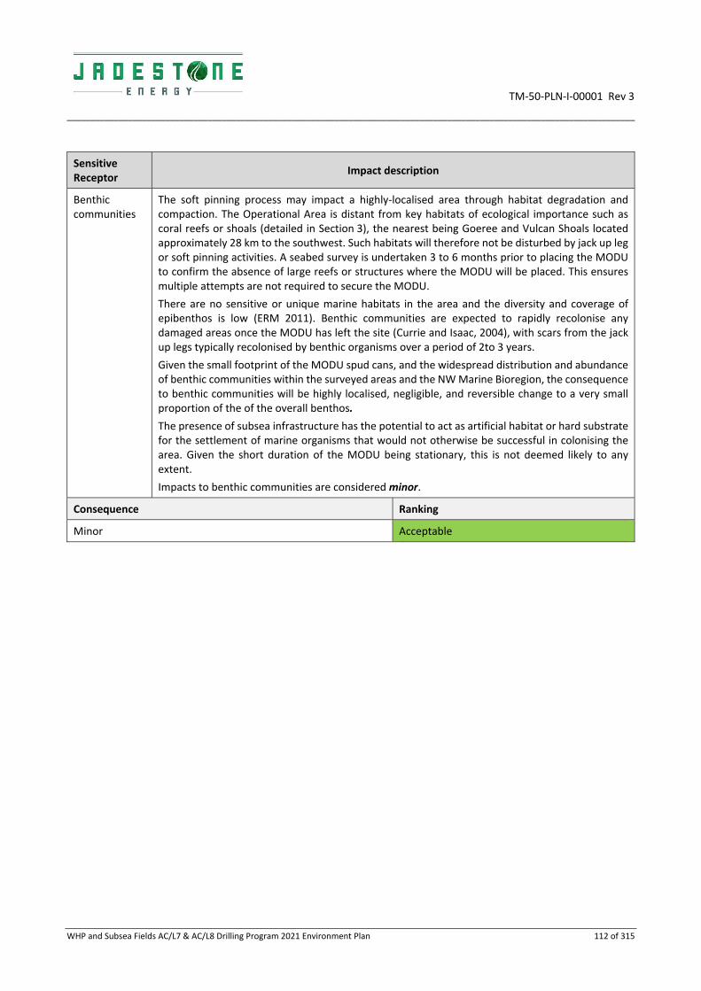
TM‐50‐PLN‐I‐00001 Rev 3
_________________________________________________________________________________________________________________________
WHP and Subsea Fields AC/L7 & AC/L8 Drilling Program 2021 Environment Plan 112 of 315
Sensitive Receptor
Impact description
Benthic communities
The soft pinning process may impact a highly‐localised area through habitat degradation and compaction. The Operational Area is distant from key habitats of ecological importance such as coral reefs or shoals (detailed in Section 3), the nearest being Goeree and Vulcan Shoals located approximately 28 km to the southwest. Such habitats will therefore not be disturbed by jack up leg or soft pinning activities. A seabed survey is undertaken 3 to 6 months prior to placing the MODU to confirm the absence of large reefs or structures where the MODU will be placed. This ensures multiple attempts are not required to secure the MODU.
There are no sensitive or unique marine habitats in the area and the diversity and coverage of epibenthos is low (ERM 2011). Benthic communities are expected to rapidly recolonise any damaged areas once the MODU has left the site (Currie and Isaac, 2004), with scars from the jack up legs typically recolonised by benthic organisms over a period of 2to 3 years.
Given the small footprint of the MODU spud cans, and the widespread distribution and abundance of benthic communities within the surveyed areas and the NW Marine Bioregion, the consequence to benthic communities will be highly localised, negligible, and reversible change to a very small proportion of the of the overall benthos.
The presence of subsea infrastructure has the potential to act as artificial habitat or hard substrate for the settlement of marine organisms that would not otherwise be successful in colonising the area. Given the short duration of the MODU being stationary, this is not deemed likely to any extent.
Impacts to benthic communities are considered minor.
Consequence Ranking
Minor Acceptable

TM‐50‐PLN‐I‐00001 Rev 3
________________________________________________________________________________________________________________________________________________________________________________
WHP and Subsea Fields AC/L7 & AC/L8 Drilling Program 2021 Environment Plan 113 of 315
6.1.3 Environmental performance
Aspect Physical presence
Performance outcome Recreational and commercial fishers, and shipping traffic, are aware of exclusion and cautionary areas and are not significantly disrupted. Seabed disturbance limited to planned activities and defined locations
ID Management control Performance standard Measurement criteria Responsible
001 MODU and vessels navigational and communication equipment installed, maintained and operated in alignment with AMSA requirements
The MODU when alongside the WHP will be alongside facilities already charted on Australian Hydrographic Office (AHO) nautical charts with gazetted PSZ. A new PSZ will be temporarily gazetted around other MODU locations
AHS Chart
Communications with AHS
OIM
002 Navigation and communication equipment on the MODU and vessels comply with Safety of Life at Sea (SOLAS) requirements
PMS records show evidence of fully functional navigation and communication equipment maintenance
OIM
003 ARPA with integrated AIS system are located on the MODU and vessels
CCR panel. OIM
004 A Marine VHF Radio is located and functioning in the MODU and WHP central control room and on all vessels
CMMS, PMS and assurance through daily use
OIM
005 Adherence to MODU Move Procedures
Adherence to MODU Move Procedures to minimise disturbance to the seabed via planned and controlled positioning of the spud cans
Records show the MODU movements align with the activity specific MODU Move Procedures
OIM
006 Jadestone Energy Consultation Process for Regulatory Approvals JS‐70‐PR‐I‐00034 details consultation requirements to
Consultation undertaken with relevant stakeholders as described in Section 4.
Other users who may be present in the area will be advised of drilling activities through:
Pre‐mobilisation consultation;
Stakeholder communication records
Records confirm that AHS have received notification of activity commencement prior to mobilisation and following demobilisation of the MODU.
Drilling Manager
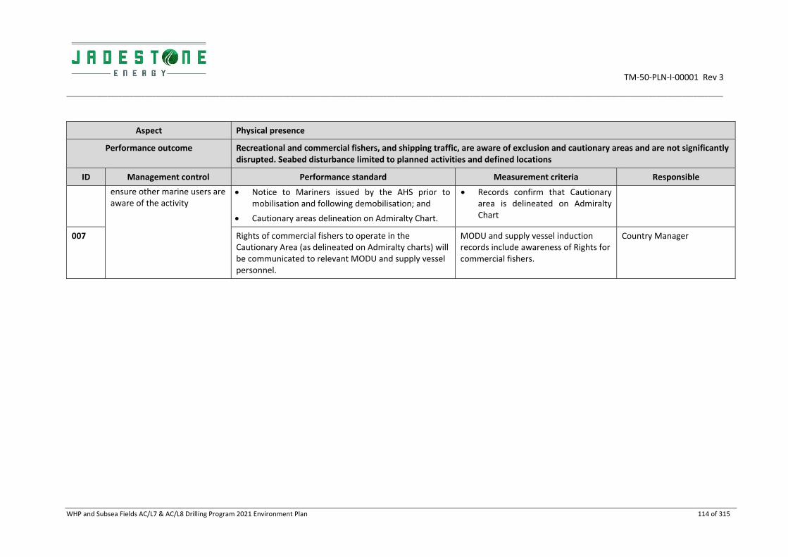
TM‐50‐PLN‐I‐00001 Rev 3
________________________________________________________________________________________________________________________________________________________________________________
WHP and Subsea Fields AC/L7 & AC/L8 Drilling Program 2021 Environment Plan 114 of 315
Aspect Physical presence
Performance outcome Recreational and commercial fishers, and shipping traffic, are aware of exclusion and cautionary areas and are not significantly disrupted. Seabed disturbance limited to planned activities and defined locations
ID Management control Performance standard Measurement criteria Responsible
ensure other marine users are aware of the activity
Notice to Mariners issued by the AHS prior to mobilisation and following demobilisation; and
Cautionary areas delineation on Admiralty Chart.
Records confirm that Cautionary area is delineated on Admiralty Chart
007 Rights of commercial fishers to operate in the Cautionary Area (as delineated on Admiralty charts) will be communicated to relevant MODU and supply vessel personnel.
MODU and supply vessel induction records include awareness of Rights for commercial fishers.
Country Manager

TM‐50‐PLN‐I‐00001 Rev 3
________________________________________________________________________________________________________________________
WHP and Subsea Fields AC/L7 & AC/L8 Drilling Program 2021 Environment Plan 115 of 315
6.1.4 ALARP assessment
Based on the impact and risk assessment completed, Jadestone considers the control measures described above are appropriate to reduce the imposition due to the physical presence of the MODU and support vessels to activities undertaken by relevant persons, as well as impacts to seabed. Additional controls considered but rejected are detailed below. The potential impacts are considered Acceptable (negligible to minor impacts). No further controls are required and therefore ALARP has been demonstrated.
Rejected control Hierarchy Practicable Cost effective
Justification
Reduce number or remove vessel and helicopter use or reduce use during key sensitive periods
Isolation No No
Reducing or removing vessel and helicopter activities during known migration periods of marine fauna is not a viable option as these activities are necessary for the safe and efficient operation of the facility.
The Operational Area is located outside of intensive shipping fairways and is not positioned in highly prized fishing habitat.
Additional activity specific navigational or communications requirements
Administrative No No The navigational management and monitoring measures in place are industry standard and internationally accepted measures to minimise the potential for interference with, or collision between, vessels. Frequent and informative communication with relevant persons regarding activities associated with the MODU and vessels are undertaken. Additional procedures would provide no further benefit.
Additional support vessels on location to inform third party vessels in the vicinity of the facility
Engineering No No The additional cost of 24/7 vessel presence in field is considered grossly disproportionate to the benefit gained given the facility is marked on hydrographic charts and is visible above water. The radio room on the MODU is manned 24/7 allowing contact to be made with 3rd part vessels in the vicinity as required. If radio from MODU or support vessels cannot raise the vessel, calls are made to the Home Affairs Office for their control.
6.1.5 Acceptability assessment
The potential impacts of physical presence from the MODU and vessels during drilling activities are considered ‘Acceptable' in accordance with Section 5, based on the acceptability criteria outlined below. The control measures proposed are consistent with relevant legislation, standards and codes, and the environmental consequence is considered negligible.
Policy & management system compliance
Jadestone’s HSE Policy objectives are met. Section 8 demonstrates that Jadestone’s HSE Management System is capable of meeting environmental management requirements for this activity.

TM‐50‐PLN‐I‐00001 Rev 3
________________________________________________________________________________________________________________________
WHP and Subsea Fields AC/L7 & AC/L8 Drilling Program 2021 Environment Plan 116 of 315
Social acceptability
Stakeholder consultation has been undertaken (Section 4), and no stakeholder concerns have been raised with regards to physical presence as denoted by the PSZ and preclusions within it. Impacts beyond temporary exclusion of areas local to the activity are not predicted.
Environmental context
While the MODU presents a restricted zone to other users, the impact and risk assessment process indicates that the area of restriction is localised and occurs at a location that is not likely to result in significant penalties to the activities of relevant persons currently active in the area.
The site around the WHP and Skua‐10 is already disturbed. The area of seabed impacted by the placing of the spudcans is negligible in size, with recovery predicted through local recruitment from adjacent unimpacted areas. Previous surveys in the area show soft sandy sediments with sparse benthic communities typical of the greater NW Bioregion. Impacts to protected species are negligible with no permanent or population effects, given the large navigable area available and the relatively small Operational Area. The disturbed seabed is negligible in comparison to the vast size of soft substrata habitats spanning the North‐West Marine Bioregion.
The potential impact is considered acceptable after consideration of:
Potential impact pathways: the pathways and consequences from the temporary localized presence of MODU and vessels are assessed in Section 6.1.1;
Preservation of critical habitats: localised disturbance is remote from Protected Areas;
Assessment of key threats as described in species and Area Management/ Recovery plans: see below under ‘Conservation and Management Advice’;
Consideration of North‐West Bioregional Plan: no impacts beyond ‘negligible’ (localized disturbance) predicted from the physical presence of the MODU or vessels to KEFs, shipwrecks/ other heritage places or protected species that are listed as values within the NW Bioregional Plan; and
Principles of ecologically sustainable development: impacts are fully recoverable, biological diversity and ecological integrity are not impacted.
Conservation and management advice
No management plans identified physical presence as described above as being a threat to marine fauna or habitats.
Jadestone Energy has had regard to the representative values of the protected areas within the EMBAs, and the respective management plans and other published information. Impacts from physical presence will have a negligible impact on any of the social and ecological objectives and values, of any AMPs, or state marine parks. This is consistent with the objectives of the protected area management plans (Appendix B) and considered acceptable.
6.2 Light emissions
6.2.1 Description of aspect
Artificial light
During periods of reduced visibility over the 150‐day drilling program, navigational and safety lighting on the MODU and support vessels will generate light emissions that may potentially affect marine fauna behaviour. Lighting typically consists of bright white (metal halide, halogen, fluorescent) lights attenuating with distance.
Direct light spill on surface waters will be limited to the area directly adjacent to the facility and support vessels as they operate within the Operational Area.
6.2.2 Impacts
Artificial lighting has the potential to affect marine fauna that use visual cues for orientation, navigation, or other purposes, resulting in behavioural responses which can alter foraging and breeding activity in marine

TM‐50‐PLN‐I‐00001 Rev 3
________________________________________________________________________________________________________________________
WHP and Subsea Fields AC/L7 & AC/L8 Drilling Program 2021 Environment Plan 117 of 315
reptiles, seabirds, fish and dolphins, create competitive advantage to some species and reduce reproductive success and/ or survival in others.
Potential impacts to marine fauna from artificial lighting associated with the drilling program are:
Disorientation, attraction or repulsion; and
Disruption to natural behavioural patterns and cycles.
These potential impacts are dependent on:
Density and wavelength of the light and the extent to which light spills into areas that are significant for
breeding and foraging;
Timing of overspill relative to breeding and foraging activity; and
Sensitivity and resilience of the fauna populations that are affected.
Sensitive Receptor
Impact description
Plankton;
Fish, Sharks and Rays
The response of fish to light emissions varies according to species and habitat. Experiments using light traps have found that some fish and zooplankton species are attracted to light sources (Meekan et al. 2001). Lindquist et al. (2005) concluded from a study that artificial lighting resulted in an increased abundance of clupeids (herring and sardines) and engraulids (anchovies); these species are known to be highly photopositive. Shaw et al. (2002), in a similar light trap study, noted that juvenile tuna (Scombridae) and jack (Carangidae), which are highly predatory, may have been preying upon higher than usual concentrations of zooplankton that were attracted to a vessels light field.
There is a potential for individuals to be impacted by light emissions from lighting. However, as the Operational Area does not contain any significant feeding, breeding or aggregation areas for fish it is more likely there will individuals traversing the area then large groups of species.
Light associated with the drilling will affect a small portion of the vast biologically important foraging area for whale sharks. However, impacts at a population level are not expected.
Light impacts to plankton, fish, sharks (including whale sharks) are considered negligible.
Marine reptiles Turtles are known to use a variety of cues for navigation when in the water. However, light is not thought to be an important cue for adults, although adults are considered to have a preference for non‐illuminated beaches (EPA 2010).
The most significant risk posed to marine turtles from artificial lighting is the potential disorientation of hatchlings following their emergence from nests. Hatchlings use the light of the oceanic horizon to orientate themselves towards the sea when making their way into the water for the first time; the oceanic horizon is almost always brighter than the elevated landward horizon (EPA 2010). Hatchling behaviour may therefore be affected when exposed to an artificial light source at certain intensities and distributions, potentially leading to disorientation when attempting to migrate to the ocean. The diffuse glow from light sources can cause disorientation to hatchlings up to 4.8 km from the light source (Limpus, 2006, in EPA, 2006).
National Light Pollution Guidelines for Wildlife have also been published in draft (Commonwealth of Australia 2019). According to the draft National Light Pollution Guidelines for Wildlife, a 20 km threshold provides a precautionary limit based on observed effects of sky glow on marine turtle hatchlings demonstrated to occur at 15‐18 km and fledgling seabirds grounded in response to artificial light 15 km away. The effect of light glow may occur at distances greater than 20 km for some species and under certain environmental conditions (Commonwealth of Australia 2019).
The closest turtle nesting habitat to the Operational Area is significantly beyond this distance as Cartier Island is approximately 106 km north‐west of the FPSO. The nearest BIA boundary for

TM‐50‐PLN‐I‐00001 Rev 3
________________________________________________________________________________________________________________________
WHP and Subsea Fields AC/L7 & AC/L8 Drilling Program 2021 Environment Plan 118 of 315
Sensitive Receptor
Impact description
marine reptiles (green turtle) is 92 km west of the Operational Area. As a result, impacts to adults and hatchlings are expected to be negligible.
Due to the paucity of information, the direct effect of artificial light on sea snakes is largely unknown. Sea snakes may experience indirect effects such as changes in predator‐prey relationships and disorientation, attraction or repulsion may occur. Sea snakes are thought to occur more commonly on reef habitats that are not present in the Operational Area. It is recognised that some pelagic sea snake individuals may occur and be attracted to the light from the MODU and vessels. However, while such individuals may come to investigate the light source it is considered unlikely that they will stay within the area. As such impacts to sea snakes are considered negligible.
Seabirds It is broadly accepted that seabirds do aggregate around offshore production facilities in above average numbers (Verhejen, 1985; Weise et al., 2001). This is predominantly attributed to the observation that structures in deeper water environments tend to aggregate marine life at all trophic levels, creating food sources and shelter for seabirds (Surman, 2002). The light from the MODU and vessels may also provide enhanced capability for seabirds to forage at night (BHPB, 2005). Studies in the North Sea indicate that migratory birds are attracted to lights on offshore platforms when travelling within a radius of 3–5 km from the light source. Outside this area their migratory path will be unaffected (Marquenie et al., 2008).
Given that the Operational Area is outside a flyway, and the nearest migratory bird breeding/ roosting site is Cartier Island which is located approximately 106 km north‐west of the locations only a small number of seabirds are expected to be affected by artificial light emissions whilst in transit, any behavioural disturbances such as disorientation and attraction would be a Slight effect; recovery in days to week. As such impacts to seabirds are considered negligible.
Other species There is no evidence to suggest that artificial light sources adversely affect the migratory, feeding or breeding behaviours of cetaceans. Cetaceans predominantly utilise acoustic senses to monitor their environment rather than visual sources (Simmonds et al. 2004), so light is not considered to be a significant factor in cetacean behaviour or survival. Light from the MODU and vessels is not considered to have an impact on marine mammal behaviour.
Consequence Ranking
Negligible Acceptable

TM‐50‐PLN‐I‐00001 Rev 3
________________________________________________________________________________________________________________________________________________________________________________
WHP and Subsea Fields AC/L7 & AC/L8 Drilling Program 2021 Environment Plan 119 of 315
6.2.3 Environmental performance
Aspect Light emissions
Performance outcome Activity lighting managed in accordance with OHS requirements
ID Management controls Performance standards Measurement criteria Responsibility
008 MODU and vessel navigation aids and equipment meet regulatory and safety requirements by aligning with AMSA
Marine Navigational lights are positioned on infrastructure such that at least one light is visible to a vessel approaching from any direction.
PMS confirms navigational equipment is maintained to regulatory and safety standards
OIM

TM‐50‐PLN‐I‐00001 Rev 3
________________________________________________________________________________________________________________________
WHP and Subsea Fields AC/L7 & AC/L8 Drilling Program 2021 Environment Plan 120 of 315
6.2.4 ALARP assessment
On the basis of the impact and risk assessment process completed, Jadestone considers the control measures described above are appropriate to manage the risk of light emissions to ALARP. Additional controls considered but rejected are detailed below. The potential impacts are ‘tolerable’ as they are within the green category (negligible impacts). No further controls are required (see below) and therefore ALARP has been demonstrated.
Rejected Control
Hierarchy Practicable Cost Effective
Justification
All activities completed in daylight hours only
Eliminate No No Daylight operations only considered to introduce unnecessary cost (i.e. 12 vs 24‐hour ops.), whilst delivering little/ no environmental benefit. Drilling cannot be shut down on a daily basis, and there would be a >100% increase in time taken to complete the activities resulting in significant costs and introduction of risk particularly while drilling the hydrocarbon bearing zone. Light from the MODU and vessels will not illuminate beaches where receptors (including turtle hatchlings) sensitive to light emissions are present.
Replace external lights or reduce the lighting
Substitute No No Lights are required to create illumination levels needed for safe working, emergencies and navigational requirements. No additional cost but introduces unacceptable safety risks to personnel and vessels. Little benefit given relatively low numbers of turtles and seabirds in Operational Area and surrounding waters.
Add filters to lights or re‐design placement/ positioning
Engineering No No Lighting has been positioned such that maximum illumination of work surfaces within asset structures is achieved. Costly and considered grossly disproportionate to any gain when considering the distances that the Operational Area is from turtle or seabird nesting areas.
Reduce usage of lighting in peak sensitive receptor windows
Isolation No N/a To ensure lighting meets health and safety requirements, lighting is required throughout the day/ night for the duration of the activities. To isolate usage such that lights were not used during sensitive receptor windows would create a non‐conformance with health and safety requirements.
None identified Administrative N/a Na/a N/a
6.2.5 Acceptability assessment
The potential impacts due to light emissions are considered acceptable in accordance with Section 5, based on the acceptability criteria outlined below. No control measures are proposed as a reduction below maintenance of light levels in accordance with health and safety regulations would compromise personnel health and safety, and the environmental consequence is considered negligible.
Policy & management system compliance
Jadestone’s HSE Policy objectives are met. Section 8 demonstrates that Jadestone’s HSE Management System is capable of meeting environmental management requirements for the activities.

TM‐50‐PLN‐I‐00001 Rev 3
________________________________________________________________________________________________________________________
WHP and Subsea Fields AC/L7 & AC/L8 Drilling Program 2021 Environment Plan 121 of 315
Stakeholders & reputation
Stakeholder consultation has been undertaken (see Section 4), and no stakeholder concerns have been raised with regards to impacts from lighting on sensitive receptors.
Environmental context & ESD
While there is direct light spill to sea surface immediately around the MODU and support vessels, the impact and risk assessment process indicates that the light spill will not cause significant effects to adult turtles or birds that may transit the Operational Area.
The potential impact is considered acceptable after consideration of:
Potential impact pathways;
Preservation of critical habitats;
Assessment of key threats as described in species and Area Management / Recovery plans;
Consideration of North‐West Bioregional Plan; and
Principles of ecologically sustainable development (ESD).
Conservation and management advice
Light is identified in the National recovery plan for Turtles (2017) as a threat to turtles on nesting beaches only. There will be no light spill on nesting beaches and therefore the activity is considered to be conducted in a manner that is consistent with the Recovery Plan and the draft National Light Pollution Guidelines for Wildlife (Commonwealth of Australia 2019.
Jadestone has had regard to the representative values of the protected areas within the EMBA, and the respective management plans and other published information. Impacts from light emissions will have a negligible impact on any of the social and ecological objectives and values, of any AMPs, or state marine parks. This is consistent with the objectives of the protected area management plans (Appendix B) and considered acceptable.
6.3 Noise Emissions
6.3.1 Description of aspect
Noise emissions
Throughout the 150‐day drilling program, low intensity underwater noise of a continuous nature will be emitted from the drilling MODU and support vessels. Noise will be generated during drilling activities from a number of sources, in particular, vessel engine rotation of propellers, by the bit, drill string and associated equipment and by machinery operated on the decks and working areas of the drilling MODU and supply vessels. Marine operations conducted on the decks and working areas of the vessel introduce strong sounds of varying characteristics into the water column, largely at low frequencies.
Noise produced from active drill MODUs is predominantly below 2 kHz, with peak frequencies below 500 Hz. A range of broadband source values (157 ‐ 162 dB re 1 μPa) with various tones have been quoted for drill MODUs (Hannay et al. 2004; McCauley 1998). These levels are expected to decrease rapidly moving from the source. For example, measurements of radiated underwater noise from an exploration drilling MODU in the Timor Sea reported noise levels from drilling operations to be 117 dB re 1 μPa at 125 m and 115 dB re 1 μPa at 405 m from the MODU (McCauley, 1998).
Vessel noise varies with the size, speed, and engine type and the activity being undertaken. The loudest noise level from support vessels are during MODU loading and unloading activities where thrusters are used to maintain position. Noise levels for a range of vessels have been measured at 164‐182 dB re μPa at 1 m (Wyatt 2008). Similar to the MODU, vessel noise is expected to decrease rapidly from the source.
The extent of helicopter noise impacts is limited to take off and landing at the facilities as they do not fly close to the ocean surface (typical cruising height of between approximately 1,000 to 1,400 m).
The main acoustic source associated with helicopters is the impulsive noise from the main rotor and high‐speed impulsive noise related to trans‐sonic effects on the advancing blade. Dominant tones in noise spectra from helicopters and fixed wing aircraft are generally below 500 Hz (McCauley, 1994).

TM‐50‐PLN‐I‐00001 Rev 3
________________________________________________________________________________________________________________________
WHP and Subsea Fields AC/L7 & AC/L8 Drilling Program 2021 Environment Plan 122 of 315
Other tones associated with the main and tail rotors and other engine noise can result in a larger number of tones at various frequencies (BHPB, 2005).
Sound travelling from a source in the air (e.g. helicopter) to a receiver underwater is affected by both in‐air and underwater propagation processes, which are further complicated by processes occurring at the air‐seawater surface interface. The received level underwater depends on source altitude and lateral distance, receiver depth, water depth, and other variables. The angle at which the line from the aircraft and receiver intersects the water surface is important. In calm conditions, at angles greater than 13° from vertical, much of the sound is reflected and does not penetrate the water (Richardson et al., 1995; NRC, 2003). Therefore, strong underwater sounds are detectable for a period roughly corresponding to the time the helicopter is within a 26° cone above the receiver (BHPB, 2005).
A summary of anthropogenic noise sources associated with the drilling activities, and natural underwater noise sources, are provided in Table 6‐1 below.
No vertical seismic profiling or side scan sonar will be used during the Drilling Activities.
Table 6‐1: Summary of anthropogenic and natural underwater noise sources
Source Sound Intensity (dB re 1 μPa) Dominant Frequency (Hz)
Natural Noises
Ambient sea sound 1, 2 80 – 120 Varied
Undersea earthquake 2 272 50
Seafloor volcanic eruption 2 255+ Varied
Lightning strike on sea surface 2 250 Varied
Breaching whale 2 200 10‐100
Bottlenose dolphin click 2 Up to 229 Up to 120,000
Humpback whales (tail fluke, fin slaps) 3 192 30 – 1,200
Humpback whale song 4 179 50 – 10,000
Sperm whale clicks 2 Up to 235 100 – 30,000
Blue whale vocalisations 2 190 12 – 400
Anthropogenic Noise Sources Expected from the MDP
FPSO noise (production operations) 5, 6 170‐185 dB re 1μPa@1 m (route‐mean‐square sound pressure level; SPL)
Non‐impulsive, predominantly low frequency (<500 Hz).
WHP noise (fixed platform production noise) 5, 7
129‐196 dB re 1μPa@1 m (SPL) Non‐impulsive, predominantly low frequency (<500 Hz).
Wellheads and flowlines 8, 9 Approx. 159 dB re 1 μPa @1 m (SPL)
Non‐impulsive, predominantly between 100 Hz and 2.5 kHz.
Support vessels (<100 m length) 5 150 – 189 (SPL), depending on size, age, speed and engine characteristics
Non‐impulsive, modulated by propeller cavitation and dynamic positioning. Tonal and broadband noise up to 100 kHz, dominant at low frequency (50‐150 Hz).

TM‐50‐PLN‐I‐00001 Rev 3
________________________________________________________________________________________________________________________
WHP and Subsea Fields AC/L7 & AC/L8 Drilling Program 2021 Environment Plan 123 of 315
Source Sound Intensity (dB re 1 μPa) Dominant Frequency (Hz)
Tankers (>100 m length) 5 175 – 190 (SPL), depending on size, age, speed and engine characteristics
Non‐impulsive, modulated by propeller cavitation. Tonal and broadband noise up to 10 kHz, dominant at low frequency (<100 Hz).
Helicopter flyover 5, 9 Depends on type and size of helicopter and height above sea level.
E.g. from 101 to 109 dB re 1 uPa measured at 3 m water depth for a helicopter at altitudes of 610 m and 152 m respectively.
Most acoustic energy is low frequency (<500 Hz).
Active MODU – within AC/L7 and AC/L8
Drilling MODU in Timor Sea (McCauley 1998)
157 ‐ 162 dB re 1 μPa, with rapid decreasing intensity of 117 dB re 1 μPa at 125 m and 115 dB re 1 μPa at 405 m from the MODU
Peak frequencies below 500 Hz
6.3.2 Impacts
Potential impacts to marine fauna due to noise and vibration in the underwater environment may occur, and can result in a range of responses including (Richardson et al., 1995; Southall et al., 2007):
Injury to hearing or other organs: hearing loss may be temporary (temporary threshold shift (TTS)) or
permanent (permanent threshold shift (PTS));
Masking or interfering with other biologically important sounds (including vocal communication,
echolocation, signals and sounds produced by predators or prey); and
Disturbance leading to behavioural changes or displacement of fauna. The occurrence and intensity of
disturbance is highly variable and depends on a range of factors relating to the animal and situation.
EPBC Act listed and threatened migratory species that may be present near the activities include whales migrating through the Operational Area, whale sharks and turtles. Noise is identified as a threat within the conservation advice or recovery plan for a number of the EPBC species that may occur in the Operational Area.
Sensitive Receptor
Impact description
Marine Mammals
Whales are low‐frequency hearing cetaceans with an estimated functional hearing frequency range of 7–22 kHz (Southall et. al.2007).
The thresholds of recommended root square mean sound pressure level (ms SPL) that could result in behavioural response for cetaceans is expected to be:
120 dB (ms SPL) for continuous noise sources; and
160 dB RMS SPL for impulsive noise sources.
More permanent injury would be expected to occur at 230 dB re 1 µPa (peak) (Parvin et al., 2007, Gomez et al. 2016).

TM‐50‐PLN‐I‐00001 Rev 3
________________________________________________________________________________________________________________________
WHP and Subsea Fields AC/L7 & AC/L8 Drilling Program 2021 Environment Plan 124 of 315
Sensitive Receptor
Impact description
Behavioural responses to noise are highly variable and context‐specific; higher received levels are not always associated with stronger behavioural responses (Southall et al. 2007; Gomez et al. 2016). Different individuals or groups may respond differently depending on their behaviours and motivation at the time (e.g. foraging, socializing, reproduction) and sudden exposure to noise may also result in more apparent responses than more gradual exposures (Gomez et al. 2016). Cetaceans approaching the MODU will be gradually exposed to increasing noise levels and, therefore, animals will not be startled by sudden or loud noises and behavioural responses are expected to be limited. Based on these findings however, it is reasonable to expect that significant behavioural responses such as avoidance are more likely to occur in closer proximity to the sound source and in response to higher sound levels. There is the potential for some cetaceans to display some level of avoidance when in close proximity to the facilities and vessels. Sound levels are expected to approach ambient levels over several kilometres.
Reactions of whales to circling aircraft (fixed wing or helicopter) are sometimes conspicuous if the aircraft is below an altitude of approximately 300 m, uncommon at 460 m and generally undetectable at 600 m plus (NMFS, 2001). Baleen whales sometimes dive or turn away during overflights, but sensitivity seems to vary depending on the activity of the animals. The effects on whales appear to be transient, and occasional overflights are not thought to have long‐term consequences to cetaceans (NMFS, 2001). Observations by Richardson and Malme (1993) indicate that, for bowhead whales, most individuals are unlikely to react significantly to occasional low‐flying single helicopter passes ferrying personnel and equipment to offshore operations at altitudes above 150 m. Leatherwood et al. (1982) observed that minke whales responded to helicopters at an altitude of 230 m by changing course or slowly diving.
Although there are likely to be transient whales passing through the Operational Area (refer Section 3), it does not contain any significant feeding, breeding or aggregation areas for marine mammals. The nearest BIA for cetaceans is the pygmy blue whale migration BIA, which is located 63 km at its closest point from the Operational Area and is therefore not expected to be impacted by noise from the MODU or vessels.
Impacts to cetaceans from underwater noise generated by drilling activities is considered negligible.
Marine reptiles The auditory sensitivity of marine turtles is reported to be centred in the 400–1,000 Hz range, with a rapid drop‐off in noise perception on either side of this range (Richardson et al. 1995). Turtles have been shown to respond to low frequency sound, with indications that they have the highest hearing sensitivity in the frequency range between 100 – 700 Hz (Bartol and Musick, 2003). Reported responses of turtles to high levels of anthropogenic noise include increased swimming activity and erratic swimming patterns (McCauley et al., 2002).
The Recovery Plan for Marine Turtles in Australia (2017) identifies noise interference as a threat to marine turtles and suggest the impact of noise on turtle stocks may vary depending on whether exposure is acute or chronic. This activity will result in chronic noise rather than acute, from the drilling activity and associated vessel movements.
No absolute thresholds are known for the sensitivity of turtles to underwater noise, or the levels required causing pathological damage. However, Popper et al. (2014), a working group of leading experts, suggested that behavioural responses which are less sensitive to noise than cetaceans, are more likely to occur within tens or hundreds of metres from vessels and other continuous/ non‐impulsive noise sources.
The Operational Area does not intersect any known inter‐nesting areas and is 106 km from nearest BIA and key nesting sites (Cartier Island). As such, it is more likely that a transient individual might be affected by noise. However, any impacts are expected to be limited to behavioural impacts, with recovery in days to weeks (negligible).

TM‐50‐PLN‐I‐00001 Rev 3
________________________________________________________________________________________________________________________
WHP and Subsea Fields AC/L7 & AC/L8 Drilling Program 2021 Environment Plan 125 of 315
Sensitive Receptor
Impact description
Sea snakes may also be affected by noise, although as they generally associated with reef systems including at submerged shoals (the closest are approximately 30 km away from the Operational Area), it is considered unlikely they will frequent the Operational Area.
Fish, Sharks and Rays
Fish sensitivity and resilience to underwater noise varies greatly depending on the species, hearing capability, habits, proximity to the noise source, and the timing of the noise (i.e. the noise may occur during a critical part of the fish’s lifecycle; McCauley and Salgado‐Kent, 2008). Most marine fish are hearing generalists (Amoser and Ladich, 2005) with relatively poor hearing. Hearing generalists are not as sensitive to noise and vibration as hearing specialists, which have developed hearing specialisations and can be particularly vulnerable to intense sound vibrations because many possess an air‐filled swim bladder (Gordon et al. 2004).
Popper et al. (2014), a working group of leading experts, suggested that behavioural responses in fish, which are less sensitive to noise than cetaceans, are more likely to occur within tens or hundreds of metres from vessels and other continuous/ non‐impulsive noise sources. While fish may show an initial behavioural response, fish are known to quickly habituate to continuous noise sources (Smith et al. 2004; Wysocki et al. 2006; Spiga et al. 2012; Nichols et al. 2015; Johansson et al. 2016; Holmes et al. 2017). In particular, many fish species are known to aggregate around the foundations of oil and gas platforms and subsea structures, despite operational noise. Therefore, behavioural impacts to turtles and fish are expected to be limited and highly localised.
There are also no known key feeding/ breeding areas occur within the Operational Area, however fish will likely transit the area. Scientific literature indicates that behavioural affects due to artificial noise may include changes to schooling behaviour and avoidance of noise sources.
A number of shark species may also occur in the region, including the EPBC Act listed whale shark. The whale shark foraging BIA intersects the Operational Area. Approved Conservation Advice for Rhincodon typus (whale shark) (2015) does not identify noise interference as a threat to the species. Elasmobranchs (rays, skates, sharks) rely on low frequency sound to locate prey (Myrberg 1978). The large hearing structure of the whale shark will be most responsive to long‐wave, low‐frequency sound (Myberg 2001) in the range of 20 and 800 Hz. Elasmobranchs do not have swim bladders and are not typical hearing specialists (Baldridge 1970).
As such any impacts to fish, sharks or rays are expected to be negligible.
Seabirds Birds generally hear at a narrower frequency range than mammals, with best hearing at frequencies between 1 and 5 kHz (Dooling & Popper 2007). However, there is little information available specific to seabird and shorebird hearing and thresholds for disturbance. It is not expected that noise generated from the MODU or support vessels will greatly affect seabirds and shorebirds that may overfly or land on the facility. Therefore, any impacts are expected to be limited to behavioural impacts, with recovery in days to weeks (negligible).
Consequence Ranking
Negligible Acceptable

TM‐50‐PLN‐I‐00001 Rev 3
________________________________________________________________________________________________________________________________________________________________________________
WHP and Subsea Fields AC/L7 & AC/L8 Drilling Program 2021 Environment Plan 126 of 315
6.3.3 Environmental performance
Aspect Noise emissions
Performance outcome Controls implemented to minimise potential harmful impacts to marine fauna from noise
ID Management controls Performance standards Measurement criteria Responsibility
009 Support vessels will comply with EPBC Regulations 8.05 and 8.06 as per Montara Marine Facility Operating Manual (MV‐90‐PR‐H‐00001)
Support Vessel Masters will comply with relevant parts of EPBC Regulation (2000): Reg. 8.05 & 8.06 respectively, where safe to do so:
Within the caution zone for a cetacean (including a calf) (within 300 m of a cetacean), the Vessel Master must operate the vessel at a constant speed of less than 6 knots and minimise noise; and
If a calf appears within an area that means the vessel is then within the caution zone of the calf, the Vessel Master must immediately stop the vessel and turn off the vessel’s engines or disengage the gears or withdraw the vessel from the caution zone at a constant speed of less than 6 knots.
Vessel Masters provided and required to operate in accordance with the Montara Marine Facility Operating Manual (MV‐90‐PR‐H‐00001) – Sign‐off sheet for completed by Vessel Master.
Incident reports record non‐compliances with EPBC Regulations 2000 ‐ Part 8 Division 8.1 (interacting with cetaceans)
Logistics Lead
010 Helicopters will comply with EPBC Regulations 8.07 as per Jadestone’s Aviation Operations Procedure (MV‐90‐PR‐G‐00004)
Helicopters will comply with the following elements of EPBC Regulations 2000 Regulation 8.07, except during take‐off/ landing, during an emergency or when action is required to maintain safe operations:
A helicopter will not operate at a height lower than 1,650 ft or within a horizontal radius of 500 m of a cetacean; and
A helicopter will not deliberately approach a cetacean from head‐on.
Helicopter operators are required to report any instances where these standards are breached, and any event involving injury to or death of marine fauna due to helicopter operations.
Helicopter Contractor’s provided Jadestone’s Aviation Operations Procedure (MV‐90‐PR‐G‐00004)
Incident reports record non‐compliances with EPBC Regulations 2000 – Part 8 Division 8.1 (interacting with cetaceans)
Logistics Lead
011 Safety Case requires MODU machinery is certified and maintained
MODU machinery is maintained in accordance with Safety Case maintenance and is conducted in accordance with PMS.
PMS shows maintenance has been completed as scheduled
OIM

TM‐50‐PLN‐I‐00001 Rev 3
________________________________________________________________________________________________________________________
WHP and Subsea Fields AC/L7 & AC/L8 Drilling Program 2021 Environment Plan 127 of 315
6.3.4 ALARP assessment
Based on the impact and risk assessment completed, Jadestone considers the control measures described above are appropriate to manage the impact and risk of noise due to operation of MODU, machinery, vessels and helicopters to ALARP. Additional controls considered but rejected are detailed below. The potential impacts are considered Acceptable as they are within the green category (negligible impacts). No further controls are required and therefore ALARP has been demonstrated.
Rejected Control Hierarchy Practicable Cost‐effective
Justification
Remove machinery that emits noise
Eliminate No N/a Noise from the MODU, vessels, ROVs, helicopters and machinery cannot be eliminated. Without these assets, the activities cannot be undertaken.
Replace machinery that emits noise with quieter machinery
Substitute No No All equipment as listed is required; no opportunities for substitution were identified.
Provide additional muffling on machinery, or design to reduce noise emissions
Engineering No No Machinery is generally designed with human health hearing requirements taken into consideration, reducing operating noise to as low as efficiently and cost effectively as possible.
Do not operate noisy machinery in areas of sensitivity
Isolation No N/a The activities are located at distance from sensitive receptors and the coastline. Other fauna in the vicinity may experience short term behavioural effects only.
Additional activity specific noise emissions procedures for assets
Administrative No No Through the application of EPBC Regulation 8 for helicopter and vessel marine fauna interaction procedures, and application of machinery maintenance, potential impacts are reduced. No further procedures are considered necessary.
Undertake site specific acoustic modelling as per Approved Conservation Advice for Megaptera novaeangliae (humpback whale) (2015))
Administrative No No Additional cost to undertake site specific acoustic modelling to increase the knowledge of potential impacts. However, noise emissions from these activities are already well documented and the operational area is not within critical habitat for humpback whales
Develop a noise management plan as per approved Conservation Advice for Megaptera novaeangliae (humpback whale) (2015)).
Administrative No No Additional cost to develop a noise management plan for an activity that is low risk to marine fauna due to the noise emissions and the activity is not within critical habitat for humpback whales.
Undertake drilling activity in alternate season to potentially further reduce
Substitution Yes No Activity timing can be any time of the year. As the impacts are localised and no significant impacts predicted to marine

TM‐50‐PLN‐I‐00001 Rev 3
________________________________________________________________________________________________________________________
WHP and Subsea Fields AC/L7 & AC/L8 Drilling Program 2021 Environment Plan 128 of 315
exposure to marine fauna from noise emissions e.g. outside of turtle nesting and whale migration periods
fauna/habitats or socio‐ economic receptors, any restriction on timing results in an unacceptable cost for little environmental benefit. No delay in the timing of this drilling activity is important to allow the wells to be brought on‐line, in a timeframe that supports the ongoing production requirements and economic viability of the Montara and Skua Fields.
Given the considerations above, any restriction on activity timing would not be considered reasonably practicable and would not achieve any significant environmental benefit by being seasonally specific.
6.3.5 Acceptability assessment
The impacts due to machinery, MODU, helicopter and vessel noise are considered acceptable in accordance with Section 5, based on the acceptability criteria outlined below. The control measures proposed are consistent with relevant legislation, standards and codes, and the environmental consequence is considered negligible.
Policy & management system compliance
Key Jadestone management system controls include EPBC Regulations (2000) pertaining to vessel and helicopter operations.
Jadestone’s HSE Policy objectives are met. Section 8 demonstrates that Jadestone’s HSE Management System is capable of meeting environmental management requirements for the proposed drilling activities.
Stakeholders & reputation
Stakeholder consultation has been undertaken (see Section 4), and no stakeholder concerns have been raised with regards to impacts from noise on sensitive receptors.
Environmental context & ESD
While there are noise emissions expected, the impact and risk assessment process indicate that noise will not result in death, injury or significant behavioral effects to marine fauna
The potential impact is considered acceptable after consideration of:
Potential impact pathways: the pathways and consequences from the temporary localised drilling and engine sources from the MODU and vessels are assessed in Section 6.3.2;
Preservation of critical habitats: remote from Protected Areas or aggregations of noise sensitive receptors;
Assessment of key threats as described in species and Area Management/Recovery plans: See ‘Conservation and management advice’ below;
Consideration of North‐West Bioregional Plan: vessel and offshore mining noise is regarded ‘of potential concern’ to multiple conservation values (see Section 6.3.2). As such, minimisation through maintenance and avoidance through application of EPBC Act Reg 8.05 and 8.06 are aligned with the objectives of the Plan; and
Principles of ecologically sustainable development (ESD): no impacts from noise sources beyond’ negligible’ to biological diversity or ecological integrity, no irreversible damage.
Conservation and management advice
Noise interference is identified as a threat in:
The Recovery Plan for Marine Turtles in Australia (2003)
Approved Conservation Advice for M. novaeangliae (Humpback Whale) (2015)

TM‐50‐PLN‐I‐00001 Rev 3
________________________________________________________________________________________________________________________
WHP and Subsea Fields AC/L7 & AC/L8 Drilling Program 2021 Environment Plan 129 of 315
The Conservation Management Plan (Recovery Plan) for the Blue Whale (B. musculus) (DoE 2015)
Which suggest noise may lead to the avoidance of important habitat in marine turtles and mask cetacean vocalisations.
The Operational Area does not overlap with any turtle or whale BIAs or migratory pathways. Given the distance from the Operational Area to the closest turtle nesting site at Cartier Island (106 km) and the large navigable area available in the open ocean, it is expected that the impact of noise interference on individual transient turtles or cetaceans travelling through the Operational Area is expected to result in temporary avoidance reactions. Avoidance of migratory or nesting seasons is not considered to be ALARP given the low levels of noise from the planned activities and the location of the activity outside of BIAs and migratory pathways.
The risk matrix presented within the Recovery Plan for Marine Turtles in Australia provides a risk rating of low to moderate associated with industrial and shipping noise on turtles. No further controls are considered appropriate given the distance from turtle BIAs and the low levels of noise from the proposed activity.
The Approved Conservation Advice for M. novaeangliae (Humpback Whale) (2015) suggests that Should acoustic impacts on humpback calving, resting, foraging areas, or confined migratory pathways be identified a noise management plan should be developed. Given the level of noise generated during this activity and the Operational Area does not overlap a humpback whale BIA or key area for this species, a management plan is not considered applicable.
The risk matrix presented within the Conservation Management Plan for Blue Whales (DoE (2015)) provides a risk rating of low to moderate associated with industrial and shipping noise on blue whales. The proposed controls including reduction of vessel speed in the vicinity of a whale align with the priority for action recommended in this management plan. Jadestone has had regard to the representative values of the protected areas within the EMBA, and the respective management plans and other published information. Impacts from noise will have a negligible impact on any of the social and ecological objectives and values, of any AMPs, or state MPs. This is consistent with the objectives of the protected area management plans (Appendix B) and considered acceptable.
EPBC Regulation 8 and the Australian National Guidelines for Whale and Dolphin Watching 2005 (DEH 2006) set the requirements for vessels interacting with cetaceans.
Commercial vessel noise is identified as a risk in the ‘Whale shark management with particular reference to Ningaloo MP’ (2013). The Operational Area overlaps a small portion of the Whale shark foraging BIA where aggregations are not as dense or sustained as the Ningaloo MP and the open ocean location does not restrain migratory routes.
6.4 Atmospheric Emissions
6.4.1 Description of aspect
Emissions
The main sources of atmospheric emissions during operational activities are:
Power generation for machinery and vessel operations; and
Emissions related to the well activities, in particular bleed down of annuli during workovers; and
Emergency conditions.
The use of fuel (specifically marine‐grade diesel) to power vessel engines, generators and mobile and fixed plant and equipment will result in emissions of greenhouse gases (GHG) such as carbon dioxide (CO2), methane (CH4) and nitrous oxide (N2O), and non‐GHG such as sulphur oxides (SOx) and nitrous oxides (NOx). Trapped gases will be released to atmosphere during the well activities (Section 2.8).

TM‐50‐PLN‐I‐00001 Rev 3
________________________________________________________________________________________________________________________
WHP and Subsea Fields AC/L7 & AC/L8 Drilling Program 2021 Environment Plan 130 of 315
During workover activities on Skua‐10/11, the A and B annuli of the well will be bled down of gas through displacement with a brine. The brine in the well becomes one of the well barriers for the activity. Gas volumes expected to be vented during the bleed down process are summarised in Table 6‐2. The volume estimates are based on existing or planned pressure measurements and well design.
Table 6‐2: Gas volumes vented during bleed down process
Well Annulus Existing or planned pressure (psi)
Gas volume (scf)
Skua‐10 A 780 92,000
B 1,378 110,000
Skua‐11 A 330 28,100
B 330 5,538
6.4.2 Impacts
Sensitive Receptor Impact description
Air quality Emissions can reduce air quality in the immediate vicinity of the MODU or vessels present in the Operational Area. The emissions will under normal circumstances quickly dissipate into the surrounding atmosphere. As such impacts to air emissions are considered negligible.
Birds A reduction in air quality may have a temporary effect on transient bird species passing through the Operational Area. No avifauna BIAs overlap the Operational Area (Section 3), however, eleven threatened and/or migratory seabirds were identified as potentially transiting, occurring within, or having habitat potentially occurring within the greater region. These species may be impacted by deterioration in air quality if they are transiting the immediate area of the MODU and vessel exhaust release points. Symptoms of exposure could include irritation of eyes and respiratory tissues or breathing difficulties.
Given that the Operational Area is outside a flyway, and the nearest migratory bird breeding/ roosting site is Cartier Island approximately 106 km north‐west of the Operational Area, only a small number of seabirds are expected to be affected by a reduction in air quality whilst in transit, any behavioural disturbances such as alteration of flight path would be a Slight effect; recovery in days to week.
There are no known air quality standards or guidelines specifically for avifauna. However, if avifauna are exposed, it is expected they would only be exposed to changes in air quality for an extremely short period. Chronic exposures are not considered credible given that avifauna would be transiting through the area.
As such impacts to seabirds are considered negligible.
Social receptors As the Operational Area sits in offshore waters, the combustion of fuels in such remote locations will not impact on air quality in coastal towns or other sensitive locations. No impacts are therefore expected negligible.
Consequence Ranking

TM‐50‐PLN‐I‐00001 Rev 3
________________________________________________________________________________________________________________________
WHP and Subsea Fields AC/L7 & AC/L8 Drilling Program 2021 Environment Plan 131 of 315
Sensitive Receptor Impact description
Negligible Acceptable

TM‐50‐PLN‐I‐00001 Rev 3
________________________________________________________________________________________________________________________________________________________________________________
WHP and Subsea Fields AC/L7 & AC/L8 Drilling Program 2021 Environment Plan 132 of 315
6.4.3 Environmental performance
Aspect Atmospheric emissions
Performance outcome No unplanned emissions to the atmosphere; Emissions to air meet regulatory requirements
ID Management controls Performance standards Measurement criteria Responsibility
012 MODU Safety Case requires equipment certification and maintenance
All engines, compressors and machinery on the MODU are maintained via the PMS
Pre‐start inspection shows maintenance has been satisfactorily completed as scheduled
Drilling Manager
013 Production flowline Where possible, emissions will be directed to the Montara Venture topside production infrastructure for processing.
Daily drilling report Drilling Manager
014 MODU bleed down package Bleed down gas from Skua‐10 and ‐11 will be directed to a bleed down package on the MODU and be vented to atmosphere.
Daily drilling report MODU OIM

TM‐50‐PLN‐I‐00001 Rev 3
________________________________________________________________________________________________________________________
WHP and Subsea Fields AC/L7 & AC/L8 Drilling Program 2021 Environment Plan 133 of 315
6.4.4 ALARP assessment
On the basis of the impact and risk assessment completed, Jadestone considers the control measures described above are appropriate to manage atmospheric emissions from production and operations equipment, as well as vessels to ALARP. Additional controls considered but rejected are detailed below. The potential impacts are considered Tolerable as they are within the green category (negligible impacts). No further controls are required and therefore ALARP has been demonstrated.
Rejected control Hierarchy Practicable Cost effective
Justification
All equipment producing emissions is removed
Eliminate, Engineering
No N/a Atmospheric emissions from drilling and operating equipment including vessels and helicopters is required to undertake the Activity. Equipment cannot be removed completely.
Risk and impact reduction are achieved through planned maintenance ensuring clean and efficient running of engines.
All emissions producing equipment is substituted for equipment that does not produce emissions
Substitute No N/a All equipment as listed is required; no opportunities for substitution were identified.
None identified Isolation N/a N/a The Activity is located at distance from sensitive receptors and the coastline.
None identified Administrative N/a N/a Compliance with relevant and appropriate MARPOL requirements
6.4.5 Acceptability assessment
The potential impacts of atmospheric emissions are considered acceptable in accordance with Section 5, based on the acceptability criteria outlined below. The control measures proposed are consistent with relevant legislation, standards and codes, and the environmental consequence is considered negligible.
Policy & management system compliance
Jadestone’s HSE Policy objectives are met. Section 8 demonstrates that Jadestone’s HSE Management System is capable of meeting environmental management requirements for the activities.
Laws, standards and Industry best practice
Compliance with relevant and appropriate MARPOL requirements.
The APPEA Code of Environmental Practice (CoEP) (2008) principles are met with regards to meeting the requirements of all laws and regulations, and meeting industry’s objective to maintain a social license to operate. In accordance with APPEA objectives, appropriate systems are in place to minimise impacts, manage complaints, document consultation and communicate with stakeholders.
Stakeholders & reputation
Stakeholder consultation has been undertaken (see Section 4), and no stakeholder concerns have been raised with regards to impacts from atmospheric emissions on sensitive receptors. The Activity is located at distance from aggregations of sensitive receptors and the coastal communities.
Environmental context & ESD
While there are atmospheric emissions to the airshed immediately around the facility and vessels, the impact and risk assessment process indicates that emissions will not result in significant effects to the environment or receptors.
The potential impact is considered acceptable after consideration of:

TM‐50‐PLN‐I‐00001 Rev 3
________________________________________________________________________________________________________________________
WHP and Subsea Fields AC/L7 & AC/L8 Drilling Program 2021 Environment Plan 134 of 315
Potential impact pathways: Section 6.4.2 assesses the pathways and consequences of the localised degradation of air quality potentially impacting transiting migratory shorebirds and protected seabirds;
Preservation of critical habitats: remote from Protected Areas and aggregations of sensitive receptors;
Assessment of key threats as described in species and Area Management/ Recovery plans: see Conservation and Management Plans’ below;
Consideration of North‐West Bioregional Plan: no specific actions noted regarding offshore air emissions but contributions to the global GHG inventory resulting in ocean acidification are noted. As such, minimisation of inefficient engine exhaust gases though timely PMS is aligned with the NW Bioregional objectives; and
Principles of ecologically sustainable development ESD: no impacts from air emissions beyond ‘negligible’ to biological diversity or ecological integrity.
Conservation and management Plans
No Management Plans identified air emissions such as those described above as being a threat to marine fauna or habitats.
Jadestone has had regard to the representative values of the protected areas within the EMBA, and the respective management plans and other published information. Impacts from atmospheric emissions will have a negligible impact on any of the social and ecological objectives and values, of any AMPs, or state MPs. This is consistent with the objectives of the protected area management plans (Appendix B) and considered acceptable.
6.5 Operational Discharges
6.5.1 Description of aspect
Liquid discharges
Liquid discharges generated from the MODU and vessels and routinely discharged to the marine environment include:
Slops water (deck drainage, bilge water, tank washing);
Cooling water;
Desalination brine; and
Sewage, greywater and putrescible waste.
A summary of each waste type is provided below.
Deck drainage and bilge water
Deck drainage from the MODU and support vessels consists primarily of stormwater and deck wash‐down water. It may include low levels of detergents, oil and grease, spilt chemicals, used machinery chemicals and general dirt from the deck. The volume of drainage likely to be generated is difficult to determine with accuracy as it depends on the rainfall and frequency of deck washing.
Oily water from bilges will be collected and treated via an oil‐water separator in accordance with MARPOL requirements (<15 mg/L (v) oil‐in‐water). Once separated, the oil and grease will be stored in suitable containers ahead of transfer ashore for recycling and the treated water discharged to ocean.
Cooling Water and Desalination Brine
Seawater will be pumped aboard the MODU and vessels, circulated through various process and marine heat exchangers prior to discharge back into the ocean at a temperature higher than ambient seawater. The seawater is typically treated with biocides then directed to sea chests, pump caissons etc to prevent blockage of marine growth inside pipes and exchangers.
Freshwater is produced on board the MODU and vessels via desalination. The freshwater makers on board the comparative facilities (for example, Montara Venture FPSO) result in discharge of maximum 40 tonnes per day of brine of 50.5ºC and a maximum salinity of 38.5 ppm.

TM‐50‐PLN‐I‐00001 Rev 3
________________________________________________________________________________________________________________________
WHP and Subsea Fields AC/L7 & AC/L8 Drilling Program 2021 Environment Plan 135 of 315
As a comparative study, the Montara FPSO was assessed by GEMS (2003). The potential behaviour of cooling water discharge from the Montara FPSO during production using wind and tidal driven currents during the dominant seasons (winter and summer). The report concluded that the zone of impact associated with temperature impact from the discharge of cooling water is predicted to be extremely limited in extent with the plume mixing to within 2ºC of the ambient temperature within 40 m from the point of discharge. A water quality monitoring program conducted in 2017 (Jacobs 2017) confirmed at 100 m from the point of discharge, the discharge was not greater than 3°C above the ambient water temperature.
Sewage, Grey water and Food waste
All sewage (including grey water) generated onboard the MODU and support vessels is discharged through an inline macerator to comminute solids to a diameter of less than 25 mm.
Tertiary treated wastewater on the MODU is discharged directly to the ocean via a sewage treatment plant (STP).
With the maximum persons on board (POB) of the MODU being typically a maximum of 112 personnel (with a lower average number typically on board), the volume of treated sewage and greywater is conservatively estimated to be <67 m3/d (based on 0.6 m3/person/d) and putrescible waste of 112 kg/d (based on 1 kg/person/d). These quantities are derived from existing Jadestone Montara Operations estimates.
Given the MODU is manned on a continuous basis, discharges of treated sewage, greywater and putrescible food waste is expected to occur daily throughout the drilling activities. In addition to the MODU, support vessels routinely discharge sewage and greywater and putrescible wastes. Given the lower POB of vessels and the intermittent nature of support activities, overall discharge volumes and frequencies are less than that from the MODU.
6.5.2 Impacts
Sensitive Receptor
Impact description
Water Quality The impacts associated with the discharge of liquids to the marine environment include a potential change to ambient water quality within the direct vicinity of the MODU and support vessels through chemical loading, increased water temperature, eutrophication, and change in salinity.
Deck drainage and bilge water
The potential impact associated with the discharge of treated deck drainage and bilge water is a change to ambient water quality through chemical loading within the direct vicinity of the operational facilities and support vessels. If not properly managed, the discharge of oily water has the potential to create an oil sheen on surface waters and a temporary localised decline in water quality. Dispersion and biodegradation of potentially contaminated oily water drainage is expected to be rapid and highly localised resulting in no long‐term or adverse effects on water quality and the consequence was assessed as negligible.
Cooling water and desalination brine
Cooling water discharges to the marine environment will result in a localised and temporary increase in the ambient water temperature of approximately 10ºC. Once discharged into the ocean, the cooling water will initially be subject to mixing due to ocean turbulence and some heat will be transferred to the surrounding waters. The plume will then disperse and rise to the ocean surface, where further loss of heat and dilution will occur (Black et al. 1994). The volume of water discharged will be small compared to the receiving waters, the environmental effects of the elevated temperature of discharged waters is therefore predicted to be insignificant due to the large buffering capacity of the ocean. The plume will quickly lose heat and water in only a small area around the outfall will have a substantially elevated temperature (Black et al. 1994). The consequence was assessed as localised with full recovery predicted at the end of the Program, hence ranked negligible.

TM‐50‐PLN‐I‐00001 Rev 3
________________________________________________________________________________________________________________________
WHP and Subsea Fields AC/L7 & AC/L8 Drilling Program 2021 Environment Plan 136 of 315
Sensitive Receptor
Impact description
Residual brine typically has a salinity of 40,000 ppm in comparison to seawater which has a salinity of 35,000 ppm. Any increase in salinity within the receiving environment as a result of desalination brine discharges is expected to be limited to the immediate point of discharge. As brine is of greater density than seawater and it is expected to sink and rapidly disperse in the currents. The consequence was assessed as localised with full recovery predicted in the short‐term following completion of the Program, hence ranked negligible.
Sewage, grey water and putrescible waste
The potential impact associated with the routine discharge of sewage, grey water and putrescible waste on water quality is changes to ambient water quality and BOD levels from nutrient loading within the direct vicinity of the MODU and support vessels. The discharges of treated sewage and grey water result in localised increases in nutrient concentrations, generate an increase in bacterial activity and associated Biological Oxygen Demand (BOD) in receiving waters and may promote localised elevated levels of phytoplankton due to nutrient inputs. However, the open water conditions and swift currents of the receiving environment will dilute the discharge and prevent environmentally significant reductions of oxygen levels in the water column (Somerville et al. 1987, cited in Swan et al. 1994). The consequence was assessed as localised with full recovery predicted in the short term at the end of the Program, hence ranked negligible.
The consequence of operational discharges to the water quality are considered to be negligible given the low toxicity of the discharges and expected dilution within the open water.
Marine fauna: cetaceans, turtles, fish, sharks, rays, seabirds
Changes in water quality as a result of liquid discharges can lead to impacts on fauna including:
Potential chemical toxicity to marine species within the direct vicinity of the MODU and support vessels;
Potential behavioral change in marine species;
Chemical effects to marine fauna;
Alteration of physiological processes of exposed biota;
Bio‐stimulation of planktonic communities;
Biological exposure to pathogens; and
Deposition and accumulation of solids/ particulates leading to a change in sediment quality.
Deck drainage and bilge water
The potential impact associated with the discharge of treated deck drainage and bilge water is chemical toxicity to marine species within the direct vicinity of the MODU and support vessels.
If not properly managed, the discharge of oily water has the potential to create an oil sheen on surface waters and a temporary localised decline in water quality and toxic effects to marine fauna. Toxicity to marine organisms would be from small amounts of dissolved hydrocarbons in the oily water drainage after treatment. Given that oil and grease residues in oily water drainage will be in low concentrations, the potential for impact is low and would be further reduced due to the strong tidal movements experienced in the region and the naturally turbid environment.
Dispersion and biodegradation of potentially contaminated oily water drainage is expected to be rapid and highly localised resulting in no long‐term or adverse effects on marine ecology. The consequence was assessed as negligible.
Cooling water and desalination brine
Discharge of cooling water has the potential to cause changes in marine ecology through elevated temperatures, as well as the presence of anti‐fouling biocides with trace chemical concentrations of copper and aluminium ions being discharged. These small amounts of biocides will disperse rapidly

TM‐50‐PLN‐I‐00001 Rev 3
________________________________________________________________________________________________________________________
WHP and Subsea Fields AC/L7 & AC/L8 Drilling Program 2021 Environment Plan 137 of 315
Sensitive Receptor
Impact description
on discharge to concentrations below levels of environmental concern to marine biota especially demersal fauna.
When discharged to the sea surface, cooling water will initially be exposed to the atmosphere and subsequently air‐cooled. Upon reaching sea surface cooling water will then be subjected to turbulent mixing and some transfer of heat to surrounding waters. The plume will disperse mainly within surface waters being thermally buoyant, primarily in the direction of prevailing tidal currents (northwest–southeast). A water quality monitoring program conducted in 2017 (Jacobs 2017) confirmed at 100 m from the point of discharge, there has not been greater than 3°C above the ambient water temperature.
Most marine species are able to tolerate short‐term fluctuations in salinity in the order of 20–30% (Walker and McComb 1990), and it is expected that most pelagic species would be able to tolerate short‐term exposure to the slight increase in salinity caused by the discharged brine.
Given the relatively low volume of discharge, low increase in salinity and deep, open water surrounding the Operational Area, impacts on fauna from increased salinity in the Operational Area is expected to be negligible.
Fish and plankton are likely to be at greatest risk from cooling water discharge impacts since they are most likely to be attracted to the discharge location (fish) or entrained within the discharge plume (plankton). Fish and plankton are relatively small organisms that may experience increased body temperature and altered physiological processes (e.g. increased respiration rate and oxygen demand). However, given that the area of raised water temperature will be highly localised and within the range of temperature on the North‐West Bioregion, significant impacts on a larger ecosystem or population levels to fish or plankton are not expected to occur.
Given the hydro‐dynamically active open water environment surrounding the Drilling Activities, it is expected that the surface discharges of cooling water and desalination brine would rapidly disperse, cool and dilute in the surrounding waters, therefore temperature, biocides and increased salinity loading leading to changes to water quality or behavioural changes in marine species would be negligible. Only receptors in close proximity to the discharge point have the potential to be impacted with full recovery predicted within weeks.
Sewage and greywater and putrescible food waste
The potential impact associated with the routine discharge of sewage and grey water and putrescible food waste is changes to water quality resulting in a change in BOD and behavioural responses of marine fauna to discharges as an alternative food source. As cited within NERA (2017), any potential change in phytoplankton or zooplankton abundance and composition is expected to be localised, typically returning to background conditions within tens to a few hundred metres of the discharge location (e.g. Abdellatif 1993; Axelrad et al. 1981; Parnell, 2003). Effects on environmental receptors further up the food chain, namely, fish, reptiles, birds and cetaceans are therefore not expected beyond the immediate vicinity of the discharge in deep open waters.
Some fish and oceanic seabirds may be attracted to the MODU and support vessels by the discharge of sewage. This attraction may be either direct, in response to increased food availability, or secondary, as a result of prey species being attracted to the area. Given the small quantities and intermittent nature of disposal however, any attraction is likely to be temporary and is not expected to result in adverse impacts at an ecosystem or population level and impacts ranked negligible.
Summary
No important foraging or nesting BIA for marine turtles, fish or marine mammals overlaps the Operational Area. While the northern boundary of the Whale shark foraging BIA does overlap providing potential for whale sharks to be present, their presence is expected to be limited to transiting individuals, due to the size of the whale shark foraging BIA. Impacts overall to marine fauna

TM‐50‐PLN‐I‐00001 Rev 3
________________________________________________________________________________________________________________________
WHP and Subsea Fields AC/L7 & AC/L8 Drilling Program 2021 Environment Plan 138 of 315
Sensitive Receptor
Impact description
are expected to be short term with rapid recovery and the consequence of operational discharges was assessed as negligible.
Consequence Ranking
Negligible Acceptable

TM‐50‐PLN‐I‐00001 Rev 3
__________________________________________________________________________________________________________________________________________________________________________________
WHP and Subsea Fields AC/L7 & AC/L8 Drilling Program 2021 Environment Plan 139 of 315
6.5.3 Environmental performance
Aspect Operational discharges
Performance outcome No unplanned operational discharges within the Operational Area; Operational discharges to sea are in accordance with legislative requirements
ID Management controls Performance standard Measurement criteria Responsibility
Deck drainage and bilge water
015 Oily water filtering and monitoring equipment fitted and maintained
If required under MARPOL, support vessels have oily water filtering and monitoring equipment that is compliant (e.g. discharges oily water with OIW <15 mg/L) and surveyed/ maintained as per MARPOL
Maintenance records or a pre‐mobilisation inspection report (e.g. OCIMF OVID, IMCA CMID, ISM inspection)
IOPP certificate
OIM
Vessel Master
016 Oily sludge is contained Oily residue (sludge) is not discharged to sea but is contained and transferred to shore for disposal.
Oil Record Book OIM
Vessel Master
017 MODU closed drain system and slops tank
No open drains to the sea confirmed in pre‐start audit. Pre‐start audit report OIM
Cooling water
018 Water cooled equipment on MODU is maintained in accordance with the PMS
Water cooled equipment/ machinery and heat exchangers maintained in accordance with the PMS
Pre‐start inspection shows maintenance is scheduled and completed
OIM
Desalination brine
019 Potable water systems are maintained
Potable water systems maintained in accordance with PMS
Pre‐start inspection shows maintenance is scheduled and completed
OIM
Sewage and greywater

TM‐50‐PLN‐I‐00001 Rev 3
__________________________________________________________________________________________________________________________________________________________________________________
WHP and Subsea Fields AC/L7 & AC/L8 Drilling Program 2021 Environment Plan 140 of 315
Aspect Operational discharges
Performance outcome No unplanned operational discharges within the Operational Area; Operational discharges to sea are in accordance with legislative requirements
ID Management controls Performance standard Measurement criteria Responsibility
020 MODU and vessels >400 t STP meets operational needs and is operated in line with MARPOL requirements
Pursuant to MARPOL, MODU and vessels have a current International Sewage Pollution Prevention (ISPP) Certificate or equivalent which confirms that required measures to reduce impacts from sewage disposal are in place
Valid ISPP Certificate OIM
Vessel Master
Putrescible waste
021 Garbage record book maintained
MODU and vessels’ garbage record book maintained to record quantities of food waste in accordance with MARPOL
Garbage Record Book OIM
Vessel Master

TM‐50‐PLN‐I‐00001 Rev 3
________________________________________________________________________________________________________________________
WHP and Subsea Fields AC/L7 & AC/L8 Drilling Program 2021 Environment Plan 141 of 315
6.5.4 ALARP assessment
Based on the impact and risk assessment completed, Jadestone considers the control measures described above are appropriate to manage liquid waste discharges from the MODU and support vessels to ALARP. Additional controls considered but rejected are detailed below. The potential impacts are considered Acceptable as per Section 5. No further controls are required and therefore ALARP has been demonstrated.
Rejected control
Hierarchy Practicable Cost effective
Justification
Wastes stored onboard and transferred to shore for onshore treatment and disposal
Eliminate No No Transfers increase the risks of spills/ leaks and safety risks to personnel during transfer operations. Costs associated with complete reengineering such that wastes contained onboard and disposed of onshore, onshore treatment and disposal costs and increase in fuel consumption due to multiple vessel transfers would be disproportionate to the environmental benefit gained given the rapid dilution in offshore water and low potential impact from discharges.
Re‐engineer equipment to retain wastes onboard
Engineering No No Costs associated with complete reengineering such that wastes contained onboard and disposed of onshore would be disproportionate to the environmental benefit gained. There is not enough space on board the MODU or vessels to have storage tanks for all the waste produced prior to transferring to a vessel for onshore treatment and disposal. Substantial additional costs for re‐engineering is grossly disproportionate to the benefit gained.
N/a Isolation N/a N/a The activity is located at distance from sensitive receptors and the coastline and no significant impacts on receptors are predicted.
N/a Administrative N/a N/a Maintenance management system implemented, compliance with relevant and appropriate MARPOL requirements and certified equipment ensure discharges meet regulatory requirements.
6.5.5 Acceptability assessment
The potential impacts of liquid waste discharges are considered acceptable in accordance with Section 5, based on the acceptability criteria outlined below. The control measures proposed are consistent with relevant legislation, standards and codes and the environmental consequence is considered negligible.
Policy & management system compliance
Jadestone’s HSE Policy objectives are met. Section 8 demonstrates that Jadestone’s HSE Management System is capable of meeting environmental management requirements for this activity.
Stakeholders & reputation
Stakeholder consultation has been undertaken (see Section 4), and no stakeholder concerns have been raised with regards to impacts from liquid waste discharges on sensitive receptors.
Legislation & Industry best practice
The APPEA Code of Environmental Practice (CoEP) (2008) objectives are met with regards to having appropriate management measures in place to minimise impacts and all wastes are disposed of or recycled at appropriate facilities in accordance with legislative requirements and agreed procedures.

TM‐50‐PLN‐I‐00001 Rev 3
________________________________________________________________________________________________________________________
WHP and Subsea Fields AC/L7 & AC/L8 Drilling Program 2021 Environment Plan 142 of 315
Maintenance management system implemented, compliance with relevant MARPOL requirements and certified equipment ensure discharges meet regulatory requirements and are acceptable with standards used globally.
Environmental context & ESD
The activity is located at distance from sensitive receptors and the coastline and no significant impacts on receptors are predicted. While there are liquid waste discharges to sea surface immediately around the MODU and vessels, the impact and risk assessment process indicates that discharges will not result in significant effects to marine fauna.
The potential impact is considered acceptable after consideration of:
Potential impact pathways: Section 6.5.1 and 6.5.2 assess the pathways and consequences of localized and degradation of water quality to the marine ecosystem;
Preservation of critical habitats: no impacts on Protected Areas or aggregations of sensitive receptors;
Assessment of key threats as described in species and Area Management/ Recovery plans: see Conservation and management advice’ below;
Consideration of North‐West Bioregional Plan: The Plan considers vessel and MODU marine discharges and effluents (with associated temperature, BOD and turbidity impacts) as potential concern to various KEFs (Seringapatam Reef and Commonwealth waters in Scott Reef complex, Rowley Shoals and Ningaloo Reef). No KEFs are impacted from drilling operational discharges. Avifauna, dolphin, turtle, sea snakes, shark, and dugong are also mentioned in the NW Bioregional Plan but no BIA are predicted to be affected by the MODU or vessel discharges above ‘negligible’; and
Principles of ecologically sustainable development ESD: there are no impacts from operational discharges to biological diversity or ecological integrity and no irreversible damage with full recovery in the short term predicted.
Conservation and management advice
No Management Plans identified operational discharges such as those described above as being a threat to marine fauna or habitats
Jadestone has had regard to the representative values of the protected areas within the EMBA, and the respective management plans and other published information. Impacts from liquid discharges will have a negligible impact on any of the social and ecological objectives and values, of any AMPs, or state MPs. This is consistent with the objectives of the protected area management plans (Appendix B) and considered acceptable.
6.6 Drilling Discharges
6.6.1 Description of aspect
Drilling discharges
Jadestone Energy proposes to drill the H6 well exclusively with water‐based drill fluids (WBM).
An estimated 478 m3 of drill cuttings from H6 is expected to be discharged to the ocean.
Residual WBM will be discharged from the MODU mud tanks at the end of the drilling activities. The anticipated maximum volume of WBM discharged during the program is 3,496 m3.
The WBM proposed consists of approximately 80–90% fresh or saline water, with the remaining 10–20% comprising drilling fluid additives that are generally inert or readily biodegradable organic polymers. Small quantities of select chemical additives will also be used to control borehole stability and to improve drilling performance and reliability. These chemical additives include viscosifiers, fluid loss additives, weighting agents (including barite), corrosion control, alkalinity control and engineered bridging materials.
During the workovers (Skua‐10/11) and completions (H6) an estimated maximum 6,000 m3 of brine (30,000 – 40,000 ppm salt solution) will be discharged to the ocean. This brine may contain small quantities of chemicals used to clean the wellbore (surfactants) or prevent corrosion (inhibitors) and

TM‐50‐PLN‐I‐00001 Rev 3
________________________________________________________________________________________________________________________
WHP and Subsea Fields AC/L7 & AC/L8 Drilling Program 2021 Environment Plan 143 of 315
control microbial growth (biocides).
In addition to drilling fluids that will be discharged to the marine environment, cuttings will also be discharged to the ocean. The volume of cuttings to be discharged during each drilling activity is determined by the hole size (diameter) and interval length.
H6 Drilling Discharges
The type of mud used in the various sections, corresponding hole diameters, volume of cuttings discharged, and volume of water‐based mud discharged is listed in Table 6‐3. 30 m3 of cuttings will discharged at 78 m water depth and the rest of the cuttings (448 m3) and muds (2,596 m3) at 1 m below sea surface.
Table 6‐3: H6 well profile and cuttings and mud discharge volumes
Well Section Mud Type
Hole diameter
Shoe Depth
Length Cuttings
discharged WBM
discharged
inches f/ ML m m3 m3
Conductor Hole SW & Bentonite Sweeps 26”
40 30 n/a
Surface Hole WBM (Gel /Polymer) 17½” 1,688 1,515 282 950
Contingency sidetrack
WBM (Gel /Polymer) 17½” 1,688 1,515 282 n/a
Intermediate Hole WBM (KCL/PHPA/Polyamine) 12¼” 2,412 731 69 500
Production Hole WBM (KCL/PHPA/Polyamine) 8½” 4,365 1,810 73 720
Reservoir hole WBM (NACL / Polymer / CaCO3) 6⅛” 5,240 1,010 24 426
Total 760 m3 2,596 m3
Well & drilling activities
In managing the stability of the well during drilling activities, pressure balance during drilling and workover, and clean up requirements associated with the activities will result in the fluids listed in Table 6‐4 being discharged to the marine environment.
Table 6‐4: Completion fluid discharges
Completion fluid type
Volume discharged
Skua 10
(m3)
Volume discharged
Skua 11
(m3)
Surfactant Volume discharged
H6
(m3)
Brine with 10% surfactant 120 120 120
Xanthan Gum biopolymer viscous pills 120 120 120
Completion brine – dosed with biocide, oxygen scavenger, corrosion inhibitor and caustic.
1,500 1,500 1,500
Any brine returned from a well with an oil in water content greater than 15 ppm will be transferred to the and processed before discharge. If the oil in water content is less than 15 ppm the brine will be discharged direct to the sea. The discharged brine will contain corrosion inhibitor and biocide.

TM‐50‐PLN‐I‐00001 Rev 3
________________________________________________________________________________________________________________________
WHP and Subsea Fields AC/L7 & AC/L8 Drilling Program 2021 Environment Plan 144 of 315
6.6.2 Impacts
Sensitive Receptor
Impact description
Seafloor ‐benthic communities and benthic fauna
International Association of Oil and Gas Producers (IOGP) Report 543 ‘Environmental fates and effects of ocean discharge of drill cuttings and associated drilling fluids from offshore oil and gas operations’ (2016) reports the following summary of drill cuttings fates, based on numerous field studies, that can be used to identify a conservative extent of cuttings discharge accumulation on the seabed:
Cuttings were detected visually or as elevated barium concentrations in sediments within 10 to 150 m of the discharge. Maximum height of the cuttings pile usually is less than 50 cm; and
WBDF cuttings discharged near the sea surface tend to accumulate on the seafloor down current from the discharge at distances of about 0.1 to 1 km, or occasionally more in deep water in excess of 300 m depth.
Numerous additional studies support this report and its findings of a conservative maximum extent of deposition in shallower waters of 1 km by indicating that biological effects from seabed communities associated with the deposition of cuttings are limited to ~500 m from a well site (Davies et al 1994; Daniels, C.B. 1998; Limia, J.M. 1996; Oliver et al 1999; Terrens et al.1998).
Based on this review of current available literature it is considered that a cuttings pile spreading out to an extent of 1 km from the drill site, at a depth of approximately 50 cm, was a conservative extent for this drilling activity given it is in shallow water of less than 300 m depth (77 to 80 m).
The following case studies on impacts of WBM on soft sediment and benthic fauna were considered:
For Apache’s East Spar development, the area of impact from WBM discharges was not more than 100 m from the drill site and short lived (recovery in less than 18 months) (Sinclair Knight Merz 1996, 1997; Kinhill 1997);
Benthic monitoring at the Stag production platform on the NWS 60 km from Dampier indicated that drilling‐induced impacts had less of an influence on infaunal assemblages through time than small spatial scale natural variability (Kinhill 1998; CSIRO 2001; IRC 2001). Two years after the initial production well drilling, the distribution of drill cuttings was mostly restricted to within 50 m of the platform, with minor traces out to 1,000 m; and
Cuttings mounds lay approximately 2 m high were found surrounding the Kitan‐1 well head in the Timor Sea in approximately 312 m of water (Eni, 2008). 330 m3 of cuttings were discharged during riserless drilling and 78 m3 following riser installation. Cuttings mounds of 5 m x 5 m to the North, 2 m x 5 m to the west and 2 m x 4 m to the southeast were identified, all within 2 m of the wellhead. Hermit crabs and fish were observed at these locations suggesting that smothering impacts were localised (Eni, 2008).
Physical alteration to benthic communities through smothering
Hinwood et al. (1994) explains that the main environmental disturbance from discharging drilling cuttings and fluids is associated with the smothering and burial of sessile benthic and epibenthic fauna. Impacts are generally localised (100–250 m from drill site) and short‐lived (<24 months).
The smothering effects of sedimentation depend on the mobility of benthic fauna and the rate of cuttings deposition (Kjeilen‐Eilertsen et al 2004). Generally, most species present in high‐energy environments are well adapted to changes in substrate, especially species with burying behaviour, experience little effect from sediment deposition (Bijkerek 1988 cited in Kjeilen‐Eilertsen et al 2004).
Threshold points for benthic fauna tolerance to sedimentation as Threshold points for benthic fauna tolerance to sedimentation as it depends on the species and sediment type. For instance, epibenthic fauna are generally unable to escape more than a 1 cm burial depth, whereas infauna, which are adapted to be covered with sediment, may escape from burial to 10 cm depth or more

TM‐50‐PLN‐I‐00001 Rev 3
________________________________________________________________________________________________________________________
WHP and Subsea Fields AC/L7 & AC/L8 Drilling Program 2021 Environment Plan 145 of 315
Sensitive Receptor
Impact description
(Bellchambers and Richardson 1995). Kjeilen‐Eilertsen et al. (2004] compiled a list of sediment burial threshold levels for different benthic species that have been studied. These burial thresholds ranged from 1 to >50 cm, depending upon taxon and their size and mobility. These data are almost exclusively from shallow‐water studies and taxa and are largely based on laboratory experimentation associated with dredged material disposal.
It has been found that the 50% hazardous level for burial of deepwater benthic fauna was at a depth of 5.4 cm (Smit et al 2008). In summarizing burial depths and potential harm to benthic macrofauna due to deposition of drilling fluids and cuttings, Smit et al. (2008] established a more conservative threshold depth of 0.65 cm (6.5 mm of deposited sediment below which would be the Predicted No Effect Concentration (PNEC). Therefore, deposits greater than 0.65 cm deep would be needed before benthic mortality occurred.
This indicates there is the potential for smothering impacts to result in benthic mortality over an area of ~1.5 km2 (based on cutting piles with a 1 km radius) around the drill site. However, any disturbance is expected to be limited to soft sediment infauna communities. Because these communities are known to recover over a longer period of time (Jones et al., 2012), the potential impacts associated with this program are considered to be limited to localised long‐term degradation of habitat.
Potential sediment chemical toxicity
Barite is not considered harmful when used in accordance with recommended workplace precautions, with disposal considered environmentally acceptable in almost all geographic areas (Bruton et al, 2006).
The industry has recognised that discharges of heavy metals may cause environmental damage and potentially human health problems. Due to the allowable and significant discharge of barite‐laden drilling fluids, most countries' regulatory bodies set maximum allowable levels of heavy metals in barite such as a mercury (Hg) and cadmium (Cd), and some are considering regulating lead (Pb) content. The U.S. Environmental Protection Agency limits mercury at no greater than 1 mg/kg and cadmium at no more than 3 mg/kg and considers heavy metal content below these limits not to impose a significant environmental threat.
Based upon the evaluation that there is the potential for biological impacts within conservatively 1 km of the well location, it is expected that these discharges would result in toxicity impacts to benthic infauna. However, benthic infauna within soft sediment communities are not considered to be restricted to the Operational Area and are well represented in the wider region.
In summary, because benthic fauna and communities are known to recover over a longer period of time (months to years), the potential impacts associated with this program is considered to be limited to localised long‐term degradation of habitat.
Based on past surveys of the region, given the sparsity of benthic communities surrounding the well locations, and given the discharge volume is expected is relatively small, and that cuttings piles from the top‐hole section are likely to remain close to the well centre for an extended period, it is considered credible that there be some smothering and toxicity impacts affect a localised benthic community but recovery is expected within a few years. Impacts are ranked moderate (impacts to localised communities).
Marine Fauna
Mammals, reptiles, whale sharks, sharks, sawfish & rays,
The potential for toxicity effects to fish and pelagic organisms, including larvae, due to impacts to water quality will be limited due to the use of WBM with a rating of non‐toxic, slightly toxic or low toxicity, therefore the consequence to marine fauna is considered in the context of a sub‐lethal, localised nuisance to individual or small populations of marine fauna. Also, given that fish and pelagic organisms are mobile and would have a temporary, transient exposure to the plume, the potential for toxicity effects to occur is considered negligible. Turbidity impacts are also likely to be
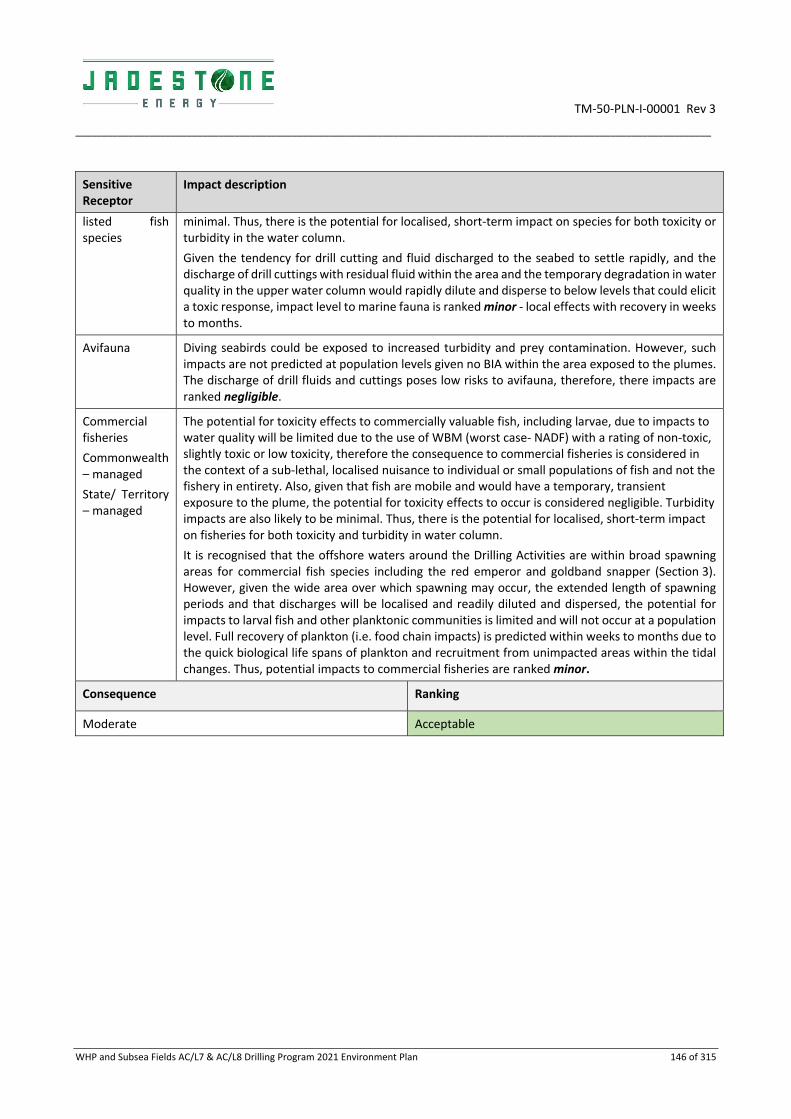
TM‐50‐PLN‐I‐00001 Rev 3
________________________________________________________________________________________________________________________
WHP and Subsea Fields AC/L7 & AC/L8 Drilling Program 2021 Environment Plan 146 of 315
Sensitive Receptor
Impact description
listed fish species
minimal. Thus, there is the potential for localised, short‐term impact on species for both toxicity or turbidity in the water column.
Given the tendency for drill cutting and fluid discharged to the seabed to settle rapidly, and the discharge of drill cuttings with residual fluid within the area and the temporary degradation in water quality in the upper water column would rapidly dilute and disperse to below levels that could elicit a toxic response, impact level to marine fauna is ranked minor ‐ local effects with recovery in weeks to months.
Avifauna Diving seabirds could be exposed to increased turbidity and prey contamination. However, such impacts are not predicted at population levels given no BIA within the area exposed to the plumes. The discharge of drill fluids and cuttings poses low risks to avifauna, therefore, there impacts are ranked negligible.
Commercial fisheries
Commonwealth – managed
State/ Territory – managed
The potential for toxicity effects to commercially valuable fish, including larvae, due to impacts to water quality will be limited due to the use of WBM (worst case‐ NADF) with a rating of non‐toxic, slightly toxic or low toxicity, therefore the consequence to commercial fisheries is considered in the context of a sub‐lethal, localised nuisance to individual or small populations of fish and not the fishery in entirety. Also, given that fish are mobile and would have a temporary, transient exposure to the plume, the potential for toxicity effects to occur is considered negligible. Turbidity impacts are also likely to be minimal. Thus, there is the potential for localised, short‐term impact on fisheries for both toxicity and turbidity in water column.
It is recognised that the offshore waters around the Drilling Activities are within broad spawning areas for commercial fish species including the red emperor and goldband snapper (Section 3). However, given the wide area over which spawning may occur, the extended length of spawning periods and that discharges will be localised and readily diluted and dispersed, the potential for impacts to larval fish and other planktonic communities is limited and will not occur at a population level. Full recovery of plankton (i.e. food chain impacts) is predicted within weeks to months due to the quick biological life spans of plankton and recruitment from unimpacted areas within the tidal changes. Thus, potential impacts to commercial fisheries are ranked minor.
Consequence Ranking
Moderate Acceptable

TM‐50‐PLN‐I‐00001 Rev 3
_________________________________________________________________________________________________________________________________________________________________________________
WHP and Subsea Fields AC/L7 & AC/L8 Drilling Program 2021 Environment Plan 147 of 315
6.6.3 Environmental performance
Aspect Drilling discharges
Performance outcome No unplanned chemical discharges within the Operational Area
ID Management controls Performance standard Measurement criteria Responsibility
022 Chemical Selection Evaluation and Approval Procedure (JS‐70‐PR‐I‐00033)
Drilling chemicals discharged to the ocean are Gold/ Silver/ D or E rated through OCNS, or PLONOR substances listed by OSPAR, or have a complete risk assessment so that only environmentally acceptable products are used
Chemical Risk Assessment completed form
Drilling Superintendent
023 Cuttings management system is installed and functional to ensure discharges overboard are minimised and maximum volumes available for re‐use
Cuttings returned to the MODU are treated through the onboard cuttings management system to reduce the concentration of drilling mud on cuttings prior to discharge
Surface losses as reported on the daily mud report
Drilling Superintendent
024 Shaker screens inspected daily during drilling operations to ensure shaker screens are operating as intended
Surface losses as reported on the daily mud report
Drilling Superintendent
025 MODU oily water separator
If brine discharges have an oil in water content greater than 15 ppm, discharge stream will be diverted to the MODU for treatment prior to overboard discharge
Operational discharges from the MODU have an oil in water content less than 15 ppm
MODU OIM
026 Inventory control work instructions are followed to ensure impacts do not exceed those forecast
Only water‐based mud, brine and drilling water will be diverted overboard.
Daily Report Mud Engineer
027
The volume of drill cuttings discharged to the seabed will not exceed those volumes defined in the EP
Daily Report Drilling Superintendent

TM‐50‐PLN‐I‐00001 Rev 3
_________________________________________________________________________________________________________________________________________________________________________________
WHP and Subsea Fields AC/L7 & AC/L8 Drilling Program 2021 Environment Plan 148 of 315
Aspect Drilling discharges
Performance outcome No unplanned chemical discharges within the Operational Area
ID Management controls Performance standard Measurement criteria Responsibility
028 Barite does not exceed concentrations of the following metals:
Mercury – maximum 1 mg/kg dry weight;
Cadmium – maximum 3 mg/kg dry weight
Lead ‐ maximum 1000 mg/kg dry weight
Purchase records confirm that the stock barite in drilling fluids do not exceed maximum concentrations
Drilling Superintendent

TM‐50‐PLN‐I‐00001 Rev 3
_________________________________________________________________________________________________________________________
WHP and Subsea Fields AC/L7 & AC/L8 Drilling Program 2021 Environment Plan 149 of 315
6.6.4 ALARP assessment
On the basis of the impact and risk assessment completed, Jadestone considers the control measures described above are appropriate to manage cuttings and WBM discharges from the MODU to ALARP. Additional controls considered but rejected are detailed below. The potential impacts are considered Acceptable (refer Section 5). No further controls are required and therefore ALARP has been demonstrated.
Rejected control
Hierarchy Practicable Cost effective
Justification
Collection of cuttings returns with residual WBM for onshore treatment/ disposal (i.e. no offshore discharge)
Elimination (of offshore impacts)
No No The option of onshore disposal has been evaluated considering:
Additional fuel consumption (and associated emissions) required by support vessels for transport;
Additional risk exposure to workers due to increased handling and loading activities;
Additional road transport and onshore landfill pressure;
Additional financial cost of approximately $2M AUD;
By contrast, offshore discharge will result in only limited and short‐term impact to marine benthos given the no‐low toxicity of drill fluids; and
No additional safety risk to personnel.
Given the relatively low potential environmental impact associated with offshore cuttings disposal, the elevated risk to personnel safety and the significant additional financial cost associated with backloading cuttings to onshore landfill facilities, Jadestone does not consider this option to be reasonably practicable.
Undertake drilling activity in alternate season to potentially further reduce exposure to marine fauna from drill fluids and cuttings
Substitution Yes No Drilling activity timing can be any time of the year. As the impacts are localised and no significant impacts predicted to marine fauna/habitats or socio‐ economic receptors, any restriction on timing results in an unacceptable cost for little environmental benefit. No delay in the timing of this drilling activity is important to allow the wells to be brought on‐line, in a timeframe that supports the ongoing production requirements and economic viability of the Montara and Skua Fields.
Given the considerations above, any restriction on activity timing would not be considered reasonably practicable and would not achieve any significant environmental benefit by being seasonally specific.

TM‐50‐PLN‐I‐00001 Rev 3
_________________________________________________________________________________________________________________________
WHP and Subsea Fields AC/L7 & AC/L8 Drilling Program 2021 Environment Plan 150 of 315
Alteration of well design to facilitate slim‐hole drilling thereby reducing fluid use and cuttings volumes
Engineering No No Jadestone have considered reducing the overall bore size of the H6 well, however, given this is a proposed production well a slim‐hole design would not be large enough to facilitate well completion. Therefore, Jadestone do not consider well design alterations reasonably practicable.
Installation of a riserless mud‐recovery system to enable WBM and cuttings to be returned to surface thereby reducing discharges
Engineering No No The use of an RMR system while drilling H6 is not possible due to the positioning of the MODU against the WHP, impeding access to the conductor guides that would used by the equipment.
6.6.5 Acceptability assessment
The impacts of drilling discharges are considered acceptable in accordance with Section 5, based on the acceptability criteria outlined below. The control measures proposed are consistent with relevant legislation, standards and codes and the environmental consequence is considered negligible.
Policy & management system compliance
With a commitment to using only low toxicity fluids additives during the activities, as well as Jadestone’s mitigation and management measures – including design of the well to minimise volumes of cuttings generated and mud/ cuttings – a reduced environmental impact footprint is achieved. Jadestone’s HSE Policy objectives are met.
Section 8 demonstrates that Jadestone’s HSE Management System is capable of meeting environmental management requirements for this activity.
Stakeholders & reputation
Stakeholder consultation has been undertaken (see Section 4), and no stakeholder concerns have been raised with regards to impacts from drilling discharges on sensitive receptors.
Industry best practice
The APPEA Code of Environmental Practice (CoEP) (2008) objectives are met with regards to offshore drilling activities.
Jadestone Energy apply ‘Industry Best practice” in relation to assessment of chemicals for offshore discharge in alignment with guidance provided by the Centre for Environment, Fisheries and Aquaculture Science (Cefas). Cefas administer the Offshore Chemical Notification Scheme (OCNS) and apply the Chemical Hazard and Risk Management (CHARM) model to rank offshore chemicals: https://www.cefas.co.uk/. The Jadestone Chemical selection procedure uses this to preferably select lower toxicity chemicals.
World Bank Group ‐ Environmental, Health, and Safety Guidelines Offshore Oil and Gas Development ‐ Drilling Fluids and Drilled Cuttings Guidance Number 53 requires that the direct loss system is to be considered an interim solution for the first drilling phase and applied only when the chemical content is low and water‐based drilling mud is used.
Environmental, Health, and Safety Guidelines Offshore Oil and Gas Development ‐ Drilling Fluids and Drilled Cuttings Guidance Number 59 requires that operators carefully select

TM‐50‐PLN‐I‐00001 Rev 3
_________________________________________________________________________________________________________________________
WHP and Subsea Fields AC/L7 & AC/L8 Drilling Program 2021 Environment Plan 151 of 315
drilling fluid additives, considering their concentration, toxicity, bioavailability, and bioaccumulation potential.
Environmental, Health, and Safety Guidelines Offshore Oil and Gas Development – Emissions and Effluent Guideline Number 134 (Table‐1) presents effluent guidelines for offshore oil and gas development. Guideline values for process effluents in this sector are indicative of good international industry practice, as reflected in the relevant standards of countries with recognized regulatory frameworks:
Hg: max 1 mg/kg dry weight in stock barite; and
Cd: max 3 mg/kg dry weight in stock barite
Environmental, Health, and Safety Guidelines Offshore Oil and Gas Development ‐ Drilling Fluids and Drilled Cuttings Guidance Number 59 requires that operators use high‐efficiency solids removal and treatment equipment to reduce and minimise the amount of residual fluid on drilled cuttings.
The industry‐standard cuttings treatment technology comprises shakers, cuttings dryers, and centrifuges. Shakers separate fluids from solids, thus reducing the overall volume of adhered drilling fluids discharged – as applicable to WBM.
Environmental context & ESD
The environment around the wells is well understood and described in Section 3 of the EP. Further, a detailed risk assessment has been undertaken to evaluate the potential impacts and risks of this activity’s particular values and sensitivities within the vicinity of the drilling and wider operational EMBA. A conservative extent of impact has been used for the activity based on recent available literature. The potential impact is considered acceptable after consideration of:
Potential impact pathways: Section 6.6.2 assesses the pathways and consequences of localised impacts to the immediate wellhead seabed and temporary degradation of water quality;
Preservation of critical habitats: no impacts on Protected Areas or aggregation of sensitive receptors;
Assessment of key threats as described in species and Area Management/ Recovery plans: see Conservation and Management Advise’ below;
Consideration of North‐West Bioregional Plan: The Plan considers drilling cuttings and muds as potential concern to KEFs – specifically Seringapatam Reef and Commonwealth waters in Scott Reef complex, Rowley Shoals and Ningaloo Reef) ‐ none of which are impacted from H6 drilling discharges; and
Principles of ecologically sustainable development ESD: no impacts from drilling cuttings and muds beyond ‘negligible’ to population levels hence biological diversity or ecological integrity, no irreversible damage.
Conservation and management advice
No Management Plans identified operational discharges such as those described above as being a threat to marine fauna or habitats.
Jadestone has had regard to the representative values of the protected areas within the EMBA, and the respective management plans and other published information. Impacts from drilling discharges will have a negligible impact on any of the social and ecological objectives and values, of any AMPs, or state MPs. This is consistent with the objectives of the protected area management plans (Appendix B) and considered acceptable.

TM‐50‐PLN‐I‐00001 Rev 3
_________________________________________________________________________________________________________________________
WHP and Subsea Fields AC/L7 & AC/L8 Drilling Program 2021 Environment Plan 152 of 315
6.7 Cement Discharges
6.7.1 Description of aspect
Discharge of cement
Cement is mixed on board the drilling MODU and used to secure the casings in place to ensure well integrity. Excess cement as per the drilling program will be used in all well bore sections and abandonment plugs to account for potential wash outs, over gauge hole and small seepage losses into the formation.
Cement volumes used in the H6 well are estimated to be approximately 58 m3. At the end of each cement job approximately 1 m3 of dry cement may be blown overboard from the hopper. In addition, approximately 1 to 3 m3 of cement slurry will be discharged as a result of cleaning cement pump and lines. This discharge is released at the sea and will disperse within the water column.
Activity Cement volume m3 Release location
H6
20 (extruded) Seabed
3 (mixed) Sea surface
45 (dry) Sea surface
Total 24 m3
There are potential environmental impacts relating to the toxicity of the cement and cement additives. A number of additives with different chemical functions are required (e.g. defoaming agents, dispersants and fluid loss control additives).
6.7.2 Impacts
Sensitive Receptor Impact description
Water column marine fauna
Marine Mammals
Marine Reptiles
Whale Sharks
Sharks, Sawfish & Rays
Listed Fish Species
The potential for toxicity effects to fish and pelagic organisms due to impacts to water quality will be limited due to the use of cement additives with a rating of non‐toxic, slightly toxic or low toxicity, as per the Jadestone Chemical Selection and Evaluation and Approval Procedure Furthermore, effects will be limited to a small number of individuals within the immediate vicinity of the discharge location given the minor quantities involved, the expected localised mixing zone and high level of dilution into the open water marine environment of the MDP area.
Given the small discharge volumes, localised mixing zone and the mobile nature of fish and pelagic organisms, exposure is expected to be temporary and transient and consequences are ranked negligible.
Avifauna The discharge of cement within the MDP area poses no hazard to avifauna, therefore, there is no potential for an impact to occur.
Benthic Communities The absence of sensitive benthic communities in the vicinity of the well should result in limited impacts to benthic communities as a result of smothering or toxicity effects from cement discharges. Any smothering or toxic effects to benthic communities or habitats from cement additives will be highly localised to around the well head and recovery by recruitment of new colonising organisms and migration from adjacent undisturbed seabed area is expected to commence shortly after drilling finishes (Neff, 2005; IOGP, 2016).
The closest shoals are located approximately 28 km south west of the Drilling Activities (Goeree and Vulcan Shoals) and therefore due to the localised nature of the cement discharges, no impacts are anticipated at the shoals. Due to the restitution time for communities to recover, the limited discharge volumes at the seabed of excess cement

TM‐50‐PLN‐I‐00001 Rev 3
_________________________________________________________________________________________________________________________
WHP and Subsea Fields AC/L7 & AC/L8 Drilling Program 2021 Environment Plan 153 of 315
Sensitive Receptor Impact description
and localised extent of potential smothering or toxicity effects, impact level for benthic communities is ranked moderate.
Protected areas, heritage places, tourism, recreation, Petroleum Exploration and Production, Ports and Commercial Shipping, Traditional and subsistence Fisheries or Commercial Fisheries
The plume of cement during Drilling Activities is so localised and water quality impacts of such short term, that the release of cement poses no hazard to these receptors, therefore, there is no potential for impacts to occur.
Consequence Ranking
Moderate Acceptable

TM‐50‐PLN‐I‐00001 Rev 3
________________________________________________________________________________________________________________________________________________________________________________
WHP and Subsea Fields AC/L7 & AC/L8 Drilling Program 2021 Environment Plan 154 of 315
6.7.3 Environmental performance
Aspect Cement discharges
Performance outcome No discharge of high‐risk profile chemicals to the marine environment
ID Management controls Performance standard Measurement criteria Responsibility
029 Selection of chemicals discharged to the ocean is aligned with the Jadestone Chemical Selection and Evaluation and Approval Procedure
Chemicals used are Gold/Silver/D or E rated through OCNS, or PLONOR substances listed by OSPAR, or have a complete risk assessment so that only environmentally acceptable products are used
Completed Chemical Risk Assessment form confirms drilling mud is ranked ‘acceptable’
Drilling Manager
030 Actual volumes of cement discharged match do not exceed forecast volumes stated in the well design and constituents are as forecast in the well design
The volume and constituents of cement discharged to the seabed and sea surface will be limited to that predicted by the well design
Daily report Drilling Superintendent

TM‐50‐PLN‐I‐00001 Rev 3
_______________________________________________________________________________________
WHP and Subsea Fields AC/L7 & AC/L8 Drilling Program 2021 Environment Plan 155 of 315
6.7.4 ALARP Assessment
On the basis of the impact and risk assessment completed, Jadestone considers the control measures described above are appropriate to manage cement discharges from the MODU to ALARP. Additional controls considered but rejected are detailed below. The potential impacts are considered Tolerable as they are within the green category (negligible impacts). No further controls are required and therefore ALARP has been demonstrated.
Rejected control
Hierarchy Practicable Cost effective
Justification
Return excess cement to shore for re‐use and disposal
Elimination of offshore impacts
No No The option of onshore disposal has been evaluated giving consideration to:
Additional fuel consumption (and associated emissions) required by support vessels for transport;
Additional risk exposure to workers due to increased handling and loading activities;
Additional road transport and onshore landfill pressure;
Additional financial cost;
Product often by nature hardened and hence off spec so has no on‐sell value; and
Use of limited landfill for unwanted product
The vessels bulk systems running at a higher pressure than shore‐based facilities, therefore creating a safety concern.
By contrast, offshore discharge will result in:
Only limited and short‐term impact to marine benthos given the no‐low toxicity of cement;
No onshore disposal impacts; and
No additional safety risk to personnel.
Given the relatively low potential environmental impact associated with offshore cuttings disposal, the elevated risk to personnel safety and the significant additional financial cost associated with backloading cuttings to onshore landfill facilities, Jadestone do not consider this option to be reasonably practicable.
Minimise excess cement
Engineering No No Excess cement is required for safety purposes and is a calculated volume to ensure well integrity. Given the low impact of generating a slight excess of cement (rather than underestimating excess volumes and requiring additional loads delivered) Jadestone do not consider this option to be reasonably practicable.
6.7.5 Acceptability assessment
The potential impacts of liquid waste discharges are considered acceptable in accordance with Section 5, based on the acceptability criteria outlined below. The control measures proposed are consistent with relevant legislation, standards and codes and the environmental consequence is considered negligible.

TM‐50‐PLN‐I‐00001 Rev 3
_______________________________________________________________________________________
WHP and Subsea Fields AC/L7 & AC/L8 Drilling Program 2021 Environment Plan 156 of 315
Policy & management system compliance
Jadestone’s HSE Policy objectives are met. Section 8 demonstrates that Jadestone’s HSE Management System is capable of meeting environmental management requirements for this activity.
Stakeholders & reputation
Stakeholder consultation has been undertaken (see Section 4), and no stakeholder concerns have been raised with regards to impacts from cement discharges on sensitive receptors.
Industry best practice
The APPEA Code of Environmental Practice (CoEP) (2008) objectives are met with regards to reducing impacts to benthic communities to ALARP through undertaking appropriate measures to reduce the footprint and monitoring and recording discharge characteristics
Environmental context & ESD
The environment around the wells is well understood and described in Section 4 of the EP. Furthermore, a detailed risk assessment has been undertaken to evaluate the potential impacts of this activity’s particular values and sensitivities within the vicinity of the drilling and wider EMBA. A conservative extent of impact has been used for the activity based on recent available literature. The potential impact is considered acceptable after consideration of:
Potential impact pathways: Section 6.7.1 and 6.7.2 assess the pathways and consequences of the localised impacts to seabed around the wellhead from smothering and the temporary degradation of water quality through turbidity and toxicity;
Preservation of critical habitats: the location is remote from Protected Areas or aggregations of sensitive receptors;
Assessment of key threats as described in species and Area Management/ Recovery plans: see ‘Conservation and Management Advise’ below;
Consideration of North‐West Bioregional Plan: Habitat modification from construction and installation of facilities is noted as a ‘potential concern’ to the NW Marine Bioregion in general and specifically the KEF ‐Seringapatam Reef and Commonwealth waters in the Scott Reef complex. As the location of this KEF is remote from H6 cement discharges, and discharges are managed to ensure low toxicity and short duration, this EP is aligned with the objectives of the NW Bioregional Plan; and
Principles of ecologically sustainable development ESD: no impacts from cement discharges beyond ‘negligible’ to biological diversity or ecological integrity, no irreversible damage
Conservation and management advice
No Management Plans identified drill cuttings and fluid discharges such as those described above as being a threat to marine fauna or habitats
Jadestone Energy has had regard to the representative values of the protected areas within the EMBAs, and the respective management plans and other published information. Impacts from cuttings and fluid discharges will have a negligible impact on any of the social and ecological objectives and values, of any AMPs, or state MPs. This is consistent with the objectives of the protected area management plans (Appendix B) and considered acceptable.
6.8 Spill Response Activities
6.8.1 Description of aspect
Spill Response
In the event of a hydrocarbon spill, contingency spill response activities will be undertaken to reduce the level of impact to sensitive receptors within the environment. In summary, the response activities include:
Source control;
Monitoring, evaluation and surveillance;
Protection and deflection;

TM‐50‐PLN‐I‐00001 Rev 3
_______________________________________________________________________________________
WHP and Subsea Fields AC/L7 & AC/L8 Drilling Program 2021 Environment Plan 157 of 315
Containment and recovery;
Shoreline clean‐up;
Dispersant application;
Oiled wildlife response; and
Scientific monitoring.
The WHP & Subsea Fields AC/L7 & AC/L8 Drilling Program 2021 OPEP (MV‐70‐PLN‐G‐00001) (the OPEP) provides further detail on how these strategies will be implemented.
While the aim of undertaking these spill response activities is to reduce environmental impacts from the spill, there is the potential for these activities to create additional impacts or to exacerbate existing oil spill impacts. Poorly selected or implemented spill response activities may therefore do more environmental harm than good.
Spill response activities will involve:
The use of vessels which are required at a minimum to display navigational lighting. Vessels may operate near shoreline areas during spill response activities;
Spill response activities may also involve onshore operations including the use of vehicles and temporary camps which may require lighting;
The use of aircraft and vessels which will generate noise both offshore and in proximity to sensitive receptors in coastal areas;
The use of equipment on coastal areas during clean‐up of shorelines (e.g. pumps);
The use of fuels to power vessel engines, generators and mobile equipment that will result in emissions of greenhouse gases (GHG) such as carbon dioxide (CO2), methane (CH4) and nitrous oxide (N2O), along with non‐GHG such as sulphur oxides (SOx) and nitrous oxides (NOx);
Operational discharges including those routine discharges (Section 6.5) from vessels and MODU used during spill response. In addition, there are specific spill response discharges and waste creation that may occur, including:
o Cleaning of oily equipment/vessels;
o Flushing water for the cleaning of shoreline habitats;
o Sewage/putrescible and municipal waste on vessels; and
o Creation, storage and transport of oily and contaminated waste.
Dispersant operations;
Movement and operation of vessels, personnel and equipment on the shoreline areas including the marine/ coastal habitats and fauna, which may include those habitats and fauna within protected areas; and
Oiled wildlife response activities may involve deliberate disturbance (hazing), capture, handling, cleaning, rehabilitation and release of wildlife.
6.8.2 Impacts
The key environmental impacts associated with the potential spill response strategies are provided together with a description of associated potential impacts to sensitive receptors. Some of these hazards are unique to spill response (e.g. shoreline clean‐up, oiled wildlife response). Some hazards common to the operations have also been detailed and re‐evaluated on the basis that the environment within which spill response activities take place may be of higher sensitivity than the environment within which the Drilling Activities occurs.

TM‐50‐PLN‐I‐00001 Rev 3
_______________________________________________________________________________________
WHP and Subsea Fields AC/L7 & AC/L8 Drilling Program 2021 Environment Plan 158 of 315
Table 6‐5: Impact assessment of spill response activities
Sensitive Receptor
Impact description
Light The receptors considered most sensitive to lighting from vessel and shoreline operations are seabirds/ shorebirds and marine turtles. Emerging turtle hatchlings on the beaches are particularly sensitive to light spill, however, the potential impact is considered negligible as stated below. Section 6.2 provides further detail on the nature of light impacts to fish, birds and marine turtles. Following restrictions on night‐time operations by spill response vessels, which will demobilise to mooring areas offshore with safety lighting only, light impacts from vessels are considered to be Negligible.
The positioning of temporary camps will be done in consultation with DBaC and any camp lighting will be restricted to minimum directional lighting that will reduce fauna disturbance. Following these controls, the consequence of shoreline lighting is considered Negligible.
These species are likely to be values of the protected area they occur in, and the impact to the protected area from light is also considered Negligible.
Response activities may occur within the highly sensitive locations of Ashmore Reef, Cartier Island, (priority receptors) response activities related light impacts to the key values within the applicable Management Plans are also expected to be Negligible due reasons described above.
Noise The receptor considered most sensitive to vessel noise disturbance are cetaceans. The humpback whale and Pygmy blue whale (distribution) BIAs overlaps the EMBA and species may be vulnerable during their peak activity season (July–October; April ‐ Aug) as they migrate north/ south through the EMBAs (Section 4).
Control measures, by means of compliance to Part 8 of EPBC Regulations, will reduce potential impacts from response activities within this area during whale activity seasons. Given the activity will only introduce vessel engine noise, the consequence is considered consistent with noise impacts from activities (Negligible). Section 6.3 provides further detail on these impacts from vessels.
With respect to noise from onshore operations (mobile equipment and vehicles), nesting, roosting or feeding birds are considered the most sensitive to noise, in particular, shorebirds aggregating at Tiwi and Indonesian coast lines. However, the equipment used is not considered to have excessive sound levels and following consultation with DoT and DBCA on the location of temporary camp areas, the consequence to birds from noise is expected to be Negligible. These species are likely to be values of the protected area they occur in, and the impact to the protected area from noise is also considered Negligible.
Atmospheric Atmospheric emissions from spill response equipment such as the use of mobile equipment, vessels and vehicles may result in a temporary, localised reduction of air quality in the environment immediately surrounding the emission points. Atmospheric emissions from spill response equipment will be localised and impacts to even the most sensitive fauna, such as birds, are expected to be Negligible.
Operational discharges
Operational discharges from vessels may create a localised and temporary reduction in marine water quality, which has the potential to impact shallow coastal habitats in particular. However, following the adoption of regulatory requirements for vessel discharges, which prevent discharges close to shorelines, discharges will have a Negligible impact. Furthermore, washing of vessels and equipment will take place only in defined offshore hot zones preventing impacts to shallow coastal habitats.
Onshore, the use of flushing water has the potential to damage sensitive shoreline and intertidal habitats, e.g. mangroves, however low pressure flushing only will be used, preventing further damage to habitats or erosion of sediments. For sensitive habitats, the deployment of booms will

TM‐50‐PLN‐I‐00001 Rev 3
_______________________________________________________________________________________
WHP and Subsea Fields AC/L7 & AC/L8 Drilling Program 2021 Environment Plan 159 of 315
Sensitive Receptor
Impact description
be considered to retain flushed hydrocarbons, if this presents a net benefit. Following these controls, the use of flushing to clean shorelines and intertidal habitats is seen to have a Negligible additional impact.
The cleaning of contaminated vehicles and equipment onshore has the potential to spread oily waste and damage habitats if not contained. Decontamination units will be used during the spill response thus containing waste and preventing any secondary contamination. The consequence of cleaning discharges is therefore ranked as Negligible.
Sewage, putrescible and municipal waste generated onshore will be stored disposed of at approved locations. There will be no discharges of this waste to the marine or coastal environment and the likelihood of an unplanned discharge is considered Unlikely following those controls provided. If those controls failed, and secondary contamination or loss of municipal waste occurred the additional consequence to coastal habitat has been assessed as Minor. The risk ranking for an unlikely event with a Minor consequence is Low.
The response activities may occur within the Protected Areas, response activities related discharge impacts to the key values within the Protected Area also expected to be Negligible, with low risk of any unplanned releases.
Physical presence
Physical presence of nearshore response vessels and spill equipment
The use of vessels and nearshore booms has the potential to disturb benthic habitats including sensitive habitats in coastal waters such as corals, seagrass, macroalgae and mangroves. A review of shoreline and shallow water habitats, and bathymetry, and the establishment of demarcated areas for access and anchoring will reduce the level of impact to Negligible.
Onshore vehicle movements, equipment use and camp set‐up
The use and movement of vehicles, equipment and personnel during shoreline response activities has the potential to disturb coastal habitats such as dune vegetation, samphire and mangroves, and important habitats of threatened and migratory fauna including nests of turtles and birds and bird roosting areas. A clean‐up can also involve physical removal of substrates that could cause impact habitats, fauna and alter coastal hydrodynamics. As with vessel use, an assessment of appropriate vehicles and equipment to reduce habitat damage, along with the establishment of access routes/demarcation zones, and operational restrictions on equipment/ vehicles use will limit sensitive habitat damage and damage to important fauna areas. The establishment of temporary camp areas will be done with consultation to DoT, DBCA and with a Heritage Advisor if access is sought to culturally significant areas. Following these controls, the overall resultant consequence to the physical environment and habitat is assessed as Minor, indicating that there may be a detectable reduction in habitat area from response activities (as separate from spill impacts), but recovery will be relatively rapid once spill response activities cease. As with all spill response activities this disturbance will only occur if there is a net benefit to accessing and cleaning shoreline areas.
Wildlife response
The main direct disturbance to fauna would be the hazing, capture, handling, transportation, cleaning and release of wildlife susceptible to oiling impacts, such as birds and marine turtles. This would only be done if this intervention were to deliver a net benefit to the species but may result in a Minor consequence following close adherence to the WA and NT Oiled Wildlife Response Plans and the Kimberley Region Oiled Wildlife Response Plan.
Physical disturbance in protected areas
These habitats/environments are likely to be values of the protected area they occur in, and the impact to the protected area from physical disturbance is considered Minor.

TM‐50‐PLN‐I‐00001 Rev 3
_______________________________________________________________________________________
WHP and Subsea Fields AC/L7 & AC/L8 Drilling Program 2021 Environment Plan 160 of 315
Sensitive Receptor
Impact description
Invasive Marine Pests‐ IMP
The mobilisation of vessels, vehicles and equipment into sensitive nearshore and coastal habitats brings the potential for non‐indigenous and potentially invasive species, either attached as biofouling, in the case of vessels or as seeds/plant propagules or invasive fauna within equipment and vehicles. The release of such species is an unplanned event which is considered to have a likelihood of Unlikely following vessel risk assessments (on all international and interstate Australian vessels) and pre‐cleaning and quarantine inspections of onshore equipment. The consequence of an outbreak of an invasive marine pest is considered Major in the nearshore/ coastal environment, which is more conducive to establishment of invasive marine pests than deeper offshore waters. Given the Unlikely likelihood, the overall Risk Ranking is Medium.
Disturbance to other users
The use of vessels in the nearshore and offshore environment and spill response activities at shoreline locations, and within townships, may exclude general public (community villages) and industry use. It should be noted that this is distinct from the socio‐economic impact of a spill itself which would have a far greater detrimental impact to industry and recreation. Following the controls outlined, it is considered that the additional impact of spill response activities on affected industries would be ranked Minor.
Dispersants While the aim of chemical dispersants is to provide a net benefit to the environment, the use of dispersants has the potential to increase exposure to habitats under the sea surface, including coral, seagrass and macroalgae, and to marine fauna (particularly fish and invertebrates) by increasing entrained oil concentration. These receptors are generally located in shallow coastal areas of the mainland and offshore islands.
Increased entrained and aromatic hydrocarbon concentration can contact marine fauna, and are most likely to be encountered by plankton, benthic filter feeding invertebrates, fish and sharks. Fish and sharks include threatened/ migratory species, which may ingest oil or uptake toxic compounds across gill structures. As a result of increased exposure to marine fauna and subtidal habitats, socio‐economic impacts may be felt through industries such as tourism and commercial fishing.
During a response, the area over which entrained oil will increase will be a function of the area treated with aerial dispersants. The increase in entrained oil concentration will be short term (minutes to hours) as the floating oil moves into the water column after which dispersion of the entrained oil will see concentrations decrease.
A description of the potential impacts from entrained oil and aromatic hydrocarbons from a maximum credible worst‐case spill is provided in Section 7.6.
Jadestone provided detailed assay information of Montara crude oil (Leeder 2013) to RPS to commission a report (RPS, 2018), to assess whether the application of chemical dispersants reduced the probability of contact to shorelines. Key findings of this report include a reduction in the predicted probabilities for shoreline contact by 40% total volume ashore, and greater prediction times to sensitive locations following application of chemical dispersant. These key findings support the use of chemical dispersants on Montara crude as they have potential to reduce hydrocarbon contact with sensitive locations and increase the time of the hydrocarbon contact to shorelines, thus giving time for other response strategies to take effect and further reduce impacts.

TM‐50‐PLN‐I‐00001 Rev 3
___________________________________________________________________________________________________________________________________
WHP and Subsea Fields AC/L7 & AC/L8 Drilling Program 2021 Environment Plan 161 of 315
6.8.3 Environmental performance
Hazard Oil Spill Response Activities
Performance Outcome Spill response has an overall net environmental benefit
ID Management Controls Performance Standard Measurement Criteria Responsibility
Spill response preparedness
031 Contracts valid and maintained in accordance with Jadestone Energy Contractor Management Framework (JS‐90‐PR‐G‐00002) to ensure access to competent personnel and appropriate equipment
Contracts for the supply of personnel and materials in place and current with competent service providers and suppliers
Contractor assessment records
Supply Chain Management
032 AMOSC MSC/ AMSA MOU/ OSRL MSC valid for life of the EP
AMOSC & OSRL memberships allowing access to mutual aid arrangements for spill response crew and equipment via a Master Services Contracts (MSC) for life of EP
AMSA MOU (access to NRT and resources) for life of EP
Current AMOSC & OSRL memberships and MSCs
AMSA MOU valid for 5 years from 2017
General Manager
033 Response personnel competent and trained in accordance with Jadestone Energy Training and Competency Management System (JS‐60‐PR‐Q‐0014) and WHP & Subsea Fields AC/L7 & AC/L8 Drilling Program 2021 OPEP (TM‐50‐PLN‐I‐00001) for life of EP
Assessment of proposed/ rostered response personnel as being competent and trained according to the requirements of response roles defined in Jadestone Energy Incident Management Team Response Plan (JS‐70‐PLN‐F‐00008)
Response personnel competency and training records
HR Manager
034 Spill response exercise and training completed in accordance with Jadestone Energy Incident Management Team Response Plan (JS‐70‐PLN‐F‐00008) to maintain spill preparedness readiness of Jadestone for life of EP
Training and exercising current and completed as required by the Incident Management Team Response Plan and OSRA (GF‐70‐PLN‐I‐00037)
Exercise schedule
Exercising close out reports
Training records
Emergency Response Lead

TM‐50‐PLN‐I‐00001 Rev 3
___________________________________________________________________________________________________________________________________
WHP and Subsea Fields AC/L7 & AC/L8 Drilling Program 2021 Environment Plan 162 of 315
Hazard Oil Spill Response Activities
Performance Outcome Spill response has an overall net environmental benefit
ID Management Controls Performance Standard Measurement Criteria Responsibility
035 OPEP maintained to ensure spill response is appropriate to nature and scale of risk for life of EP
Spill response planning and preparedness are aligned with nature and scale of risk of this EP
Review confirms drilling risks are aligned with the OPEP
Drilling Manager
036
MODU and vessels SOPEP are valid and tested to ensure ability to respond to spills as required by MARPOL
In line with MARPOL Annex 1, support vessels over 400 gross tonnage will have a current Shipboard Oil Pollution Emergency Plan (SOPEP)/ Shipboard Marine Pollution Emergency Plan (SMPEP) and International Oil Pollution Prevention (IOPP) certificate
Exercise reports
SMPEP/ SOPEP
OIM
Vessel Masters
037 MODU spill exercises are conducted monthly
038 Jadestone Energy Incident Management Team Response Plan (JS‐70‐PLN‐F‐00008) maintained to ensure ability to respond to spills by Jadestone
Provides current information for Jadestone spill response resources and matches risk as defined in the EP
Annual Performance Report
Emergency Response Lead
039 Personnel aware of roles and responsibilities in the event of a response in accordance with Montara Incident Response Plan (MV‐70‐PLN‐F‐00001)
Instructs offshore response roles and responsibilities and training requirements.
Exercise records
Training and induction records
Emergency Response Lead
040 Blowout Contingency Plan (JS‐70‐PLN‐D‐00001) in place one month prior to drilling commencing
Blowout Contingency Plan in place that addresses loss of well containment actions as defined in the EP that minimise risk to personnel and reduce environmental impact
Blowout Contingency Plan
Drilling Manager

TM‐50‐PLN‐I‐00001 Rev 3
___________________________________________________________________________________________________________________________________
WHP and Subsea Fields AC/L7 & AC/L8 Drilling Program 2021 Environment Plan 163 of 315
Hazard Oil Spill Response Activities
Performance Outcome Spill response has an overall net environmental benefit
ID Management Controls Performance Standard Measurement Criteria Responsibility
041 AMOSC Subsea First Response Toolkit (SRFT) membership is in place for the life of the EP, including appropriate insurance and an Operations, Training and Advice (OTA) Agreement with Oceaneering
Maintain AMOSC SRFT membership, appropriate insurance and an OTA Agreement with Oceaneering which allows access to equipment, dispersant stocks and technical support for subsea dispersant application
Current SRFT membership, insurance and OTA Agreement records
Country Manager
042 ROV support in place for SFRT activity Contract in place to provide ROV services for SFRT Current contract in place
Supply Chain Management
043 Labour hire contract in place for life of EP to source labour for
Labour hire contract in place to provide access to personnel
Labour hire contract HR Manager
044 Vessel availability for SFRT deployment is monitored monthly via Jadestone’s nominated vessel broker for life of EP
Monitor the availability of vessels that are suitable for deployment of the SRFT for life of EP
Monthly Monitoring reports
Logistics Lead
045 Maintain contract with Jadestone’s Waste Management Contractor for life of the EP
Waste management contract is maintained which enables access to waste storage facilities and waste transport
Contractor assessment records
Logistics Lead
046 Monitor MODU availability during the blowout exposure time of the EP every two weeks during the drilling campaign
Jadestone has a process for selection, conceptual agreement with owners or operators of MODUs prior to risk activities, and two weekly monitoring of availability of selected MODUs during the blowout exposure time of EP. This is detailed in Appendix H of the BCP and ensures compliance with the 77 days’ timeframe
Record of Pre‐selected rigs for use on relief wells.
Record of two weekly monitoring during period of blowout exposure
Drilling Superintendent
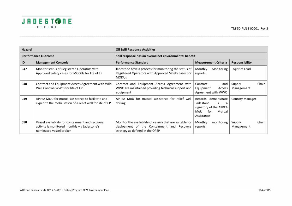
TM‐50‐PLN‐I‐00001 Rev 3
___________________________________________________________________________________________________________________________________
WHP and Subsea Fields AC/L7 & AC/L8 Drilling Program 2021 Environment Plan 164 of 315
Hazard Oil Spill Response Activities
Performance Outcome Spill response has an overall net environmental benefit
ID Management Controls Performance Standard Measurement Criteria Responsibility
047 Monitor status of Registered Operators with Approved Safety cases for MODUs for life of EP
Jadestone have a process for monitoring the status of Registered Operators with Approved Safety cases for MODUs
Monthly Monitoring reports
Logistics Lead
048 Contract and Equipment Access Agreement with Wild Well Control (WWC) for life of EP
Contract and Equipment Access Agreement with WWC are maintained providing technical support and equipment
Contract and Equipment Access Agreement with WWC
Supply Chain Management
049 APPEA MOU for mutual assistance to facilitate and expedite the mobilisation of a relief well for life of EP
APPEA MoU for mutual assistance for relief well drilling
Records demonstrate Jadestone is a signatory of the APPEA MoU for Mutual Assistance
Country Manager
050 Vessel availability for containment and recovery activity is monitored monthly via Jadestone’s nominated vessel broker
Monitor the availability of vessels that are suitable for deployment of the Containment and Recovery strategy as defined in the OPEP
Monthly monitoring reports
Supply Chain Management

TM‐50‐PLN‐I‐00001 Rev 3
_______________________________________________________________________________________
WHP and Subsea Fields AC/L7 & AC/L8 Drilling Program 2021 Environment Plan 165 of 315
6.8.4 ALARP assessment
The purpose of implementing spill response activities is to reduce the severity of impacts from an oil spill to the environment. However, if the strategies do more harm than good (i.e. they are not having a net environmental benefit) then the spill response is not ALARP. The key process in determining if the strategies employed are having a net benefit is the net environmental benefit analysis (NEBA). A NEBA is conducted for each operational period during a response to ensure the best strategies are being implemented and the ALARP principle is regularly tested (refer to the OPEP for further detail). The strategic NEBA has been conducted for chemical dispersant operations (refer to the OPEP) indicates an overall positive effect, based on reduced shoreline loading of oil and spatial extent of floating oil above the impact threshold.
It is best practice to ensure all possible response strategies have been evaluated and, if there is the potential to produce a net environmental benefit, to have them in the toolbox ready for implementation if determined feasible for the scenario (IPIECA (2015). Contingency planning for oil spill on water: Good practice guidelines for the development of an effective spill response capability).
For each of the environmental hazards associated with spill response strategies an ALARP evaluation was conducted as part of the hazard identification workshop (HAZID). A number of controls were identified as industry and/ or Jadestone standard controls that will be considered during a spill response while additional controls were evaluated and either accepted or rejected on the basis of the ALARP principal, i.e. a decision was based on whether the additional control would have a cost/effort disproportionate to the level of impact reduction it would provide. Results of the evaluation are shown in Table 6‐7.
Note that some of the potential impacts to fauna from spill response activities can be beneficial in the prevention of oiling by acting as deterrents. For example, if shoreline operations are being undertaken at a turtle nesting or bird breeding site, fauna may avoid the location as disturbed by noise or people and thereby not be oiled.

TM‐50‐PLN‐I‐00001 Rev 3
___________________________________________________________________________________________________________________________________
WHP and Subsea Fields AC/L7 & AC/L8 Drilling Program 2021 Environment Plan 166 of 315
Table 6‐6: ALARP for spill response activities
Strategy Description Environmental Benefits Decision
Source control Implementation of the MODU SOPEP Reduce the volume of oil entering the marine environment Adopt
Implementation of Blowout Contingency Plan (JS‐70‐PLN‐D‐00001) to ensure a planned, predictable and ALARP response to a loss of well control.
Reduce the volume of oil entering the marine environment Adopt
Subsea dispersants
Subsea dispersants are applied close to the release point with the objective of minimising the amount of oil from reaching the sea surface. This technique helps to break up the oil droplets so that they are dispersed, diluted and biodegraded more rapidly in the water column, and is beneficial in reducing the amount of volatile organic compounds at the sea surface in the vicinity of the well site.
This strategy is only suitable for a subsea loss of well control release.
Subsea dispersant application can reduce the amount of surface hydrocarbons drifting towards sensitive receptors, by increasing the availability of oil droplets for biodegradation. Subsea dispersant typically requires smaller volumes of dispersant to treat the oil as compared to surface dispersant application, resulting in lower volumes of dispersant being applied to treat the spill.
Subsea dispersant application will only be undertaken when there is a net environmental benefit determined in the IAP. Applicability of chemical dispersant is limited to the conditions, locations and circumstances described in the OPEP.
Adopt
Operational Monitoring
Surveillance actions are used to monitor and evaluate the trajectory and fate of the released hydrocarbon, to determine the effectiveness of response strategies and to identify and report on any potential/actual contacts to flora, fauna, or any other sensitive receptor that occurs. Surveillance results are used to assist in escalating or de‐escalating response strategies as required.
There are various measures (vessel/ aerial surveillance, tracking buoys, oil spill modelling, fluorometry, SCAT) within this response strategy which may be suitable. Their use, in combination or individually, will be determined based on the spill distribution as well as other considerations such as access to locations, environmental and metocean conditions.
This strategy is a primary response to ensure that there is sufficient information to gain situational awareness and make informed decisions on response planning, execution and termination.
Adopt
Surface chemical dispersion
Chemical dispersant is applied to break down the hydrocarbons and allow/enhance dispersion into the water column, thereby preventing/reducing potential shoreline contact and increasing biodegradation.
Surface chemical dispersant may be viable, either by vessel or plane, or subsea. Evidence from the Montara oil spill in 2009 from AMSA reported that ‘based on experienced personnel during the response the use of dispersant was highly effective in assisting the natural process of biodegradation and minimising the risk of oil impacts on reefs and shorelines’ (Refer Appendix 4 of the OPEP). If there is a weather condition
Adopt

TM‐50‐PLN‐I‐00001 Rev 3
___________________________________________________________________________________________________________________________________
WHP and Subsea Fields AC/L7 & AC/L8 Drilling Program 2021 Environment Plan 167 of 315
Strategy Description Environmental Benefits Decision
that prevents the application of dispersant (which is unusual for the environment around the Montara facilities), this creates dispersion.
The Oil Spill Modelling Report (RPS 2018) output for Montara oil comparing dispersant and non‐dispersant models indicated shoreline oil loading to be reduced by up to 40% when applied to oil thickness of 100 g/2, up to 56% when applied to oil thickness of 50 g/m2 and up to 58% when applied to oil thickness of 16 g/m2.
Chemical dispersants applied at sea surface can reduce the amount of floating oil but increase the oil concentrations in the water column, thereby increasing the risk of exposure to organisms that live in the water column.
Diesel is not considered a persistent hydrocarbon and has high natural dispersion rates in the marine environment. Chemical dispersant application is not recommended as a beneficial option for Diesel as it has a low probability of increasing the dispersal rate of the spill while introducing more chemicals to the marine environment.
Entrained oil concentrations are not constant; they are subject to frequent fluctuations due to metocean influences, mobility of receptors and the dilution of the dispersed oil by the sea. Subsequent potential contact to organisms in the water column and nearshore marine habitats is infrequent, of varying concentration, duration and consequence. The majority of potentially contacted shorelines are mangroves and tidal flats subjected to very high tidal influences, which make shoreline response infeasible, cause more damage than not responding or unsafe. Therefore, Jadestone consider that any potential shoreline loading reduction is more beneficial than the potential impact to organisms from entrained oil and this strategy is deemed to be a primary strategy.
Chemical dispersion will only be undertaken when there is a net environmental benefit determined in the IAP. Applicability of chemical dispersant is limited to the conditions, locations and circumstances described in the OPEP.
Physical dispersion
Physical dispersion is undertaken by running vessels through the hydrocarbon plume and using the turbulence developed by the propellers or hydro‐blasting from vessel hydrants to break up the slick. Once dispersed in the water
In general, this strategy is considered an opportunistic strategy; used on targeted, small, breakaway areas, especially patches close to shorelines. Given that oil is expected to emulsify by the time it approaches shorelines, and chemical dispersant application would be preferred as a means of dispersing bulk oil; this strategy has
Reject

TM‐50‐PLN‐I‐00001 Rev 3
___________________________________________________________________________________________________________________________________
WHP and Subsea Fields AC/L7 & AC/L8 Drilling Program 2021 Environment Plan 168 of 315
Strategy Description Environmental Benefits Decision
column in the form of smaller droplet sizes, biodegradation processes are enhanced.
limited effectiveness and is not considered to be a strategy requiring further planning and associated control measures.
Containment and recovery
Containment and recovery of hydrocarbons can offer a preventive form of protection to sensitive receptors. Skimmers (mechanical) and booms will be used at sea.
This strategy is only effective in calm conditions.
For a spill of Montara or Skua crude oil, this is the preferred way to remove hydrocarbons from the water surface before the risk of contacting shorelines/ sensitive receptors.
Given the fast spreading nature of diesel, and the expected moderate to high sea states of the area causing the slick to break up and disperse, this response is not considered to be effective in reducing the net environmental impacts of a diesel spill. The ability to contain and recover spreading diesel on the ocean water surface is extremely limited due the very low viscosity of the fuel.
Containment and recovery may be applicable once evaporation of highly volatile components has occurred. Containment and recovery will only be undertaken when there is a net environmental benefit determined in the IAP. Based on the crude oil assays, a solidified residual is expected which can be collected using containment and recovery methods. Given that shoreline booming and shoreline clean‐up are expected to be difficult across some locations within the RISK EMBA, this strategy is considered a primary strategy in the overall spill response.
Adopt
Protection and deflection
Protection and deflection activities involve the use of booms to:
Protect sensitive receptors;
Deflect spills away from sensitive receptors or shorelines; or
Deflect spills to an area that provides increased opportunity for recovery activities.
This strategy is typically not effective in areas experiencing large tidal variations and associated currents.
Anchoring of booms may result in additional damage to the subsurface environment (coral reef) surrounding most offshore islands. Booms themselves would also move around on the coral intertidal reef during periods of lower tides, potentially resulting in physical damage to the benthos of the reef platform.
Due to the types of shorelines that may be impacted (i.e. remote, high tidal ‐ high energy beaches/intertidal reef platforms), protect and deflect would under most circumstances, not be considered to result in a net environmental benefit. The use of vessels to deploy booming may be feasible to protect priority locations. If a tangible, positive outcome could be demonstrated a protect and deflect operation may be possible.
Protection and deflection will only be undertaken when there is a net environmental benefit determined in the IAP. Consequently, this strategy may not be applicable across
Adopt
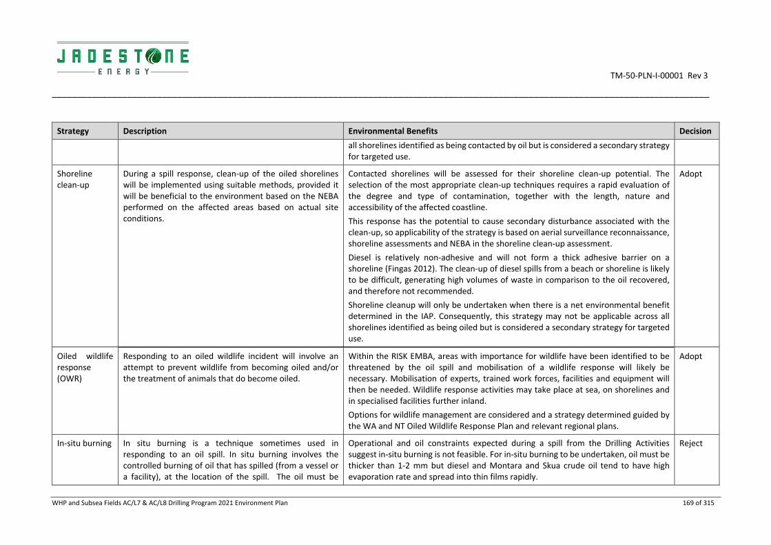
TM‐50‐PLN‐I‐00001 Rev 3
___________________________________________________________________________________________________________________________________
WHP and Subsea Fields AC/L7 & AC/L8 Drilling Program 2021 Environment Plan 169 of 315
Strategy Description Environmental Benefits Decision
all shorelines identified as being contacted by oil but is considered a secondary strategy for targeted use.
Shoreline clean‐up
During a spill response, clean‐up of the oiled shorelines will be implemented using suitable methods, provided it will be beneficial to the environment based on the NEBA performed on the affected areas based on actual site conditions.
Contacted shorelines will be assessed for their shoreline clean‐up potential. The selection of the most appropriate clean‐up techniques requires a rapid evaluation of the degree and type of contamination, together with the length, nature and accessibility of the affected coastline.
This response has the potential to cause secondary disturbance associated with the clean‐up, so applicability of the strategy is based on aerial surveillance reconnaissance, shoreline assessments and NEBA in the shoreline clean‐up assessment.
Diesel is relatively non‐adhesive and will not form a thick adhesive barrier on a shoreline (Fingas 2012). The clean‐up of diesel spills from a beach or shoreline is likely to be difficult, generating high volumes of waste in comparison to the oil recovered, and therefore not recommended.
Shoreline cleanup will only be undertaken when there is a net environmental benefit determined in the IAP. Consequently, this strategy may not be applicable across all shorelines identified as being oiled but is considered a secondary strategy for targeted use.
Adopt
Oiled wildlife response (OWR)
Responding to an oiled wildlife incident will involve an attempt to prevent wildlife from becoming oiled and/or the treatment of animals that do become oiled.
Within the RISK EMBA, areas with importance for wildlife have been identified to be threatened by the oil spill and mobilisation of a wildlife response will likely be necessary. Mobilisation of experts, trained work forces, facilities and equipment will then be needed. Wildlife response activities may take place at sea, on shorelines and in specialised facilities further inland.
Options for wildlife management are considered and a strategy determined guided by the WA and NT Oiled Wildlife Response Plan and relevant regional plans.
Adopt
In‐situ burning In situ burning is a technique sometimes used in responding to an oil spill. In situ burning involves the controlled burning of oil that has spilled (from a vessel or a facility), at the location of the spill. The oil must be
Operational and oil constraints expected during a spill from the Drilling Activities suggest in‐situ burning is not feasible. For in‐situ burning to be undertaken, oil must be thicker than 1‐2 mm but diesel and Montara and Skua crude oil tend to have high evaporation rate and spread into thin films rapidly.
Reject

TM‐50‐PLN‐I‐00001 Rev 3
___________________________________________________________________________________________________________________________________
WHP and Subsea Fields AC/L7 & AC/L8 Drilling Program 2021 Environment Plan 170 of 315
Strategy Description Environmental Benefits Decision
amenable to lighting e.g. unweathered, high lighter oil fractions and not prone to emulsification. When conditions are favourable and conducted properly, in situ burning will reduce the amount of oil on water.
Due to operational constraints and the expected hydrocarbon not being suitable for in‐situ burning, this response strategy is deemed inapplicable for the Drilling Activities.
Scientific Monitoring
This is the main tool for determining the extent, severity and persistence of environmental impacts from an oil spill and allows operators to determine whether their environmental protection outcomes have been met (via scientific monitoring activities). This strategy also evaluates recovery from the spill.
Scientific monitoring is especially beneficial for monitoring entrained and dissolved oil impacts as response strategies are generally targeted to manage the surface oil impacts.
Adopt

TM‐50‐PLN‐I‐00001 Rev 3
________________________________________________________________________________________________________________________
WHP and Subsea Fields AC/L7 & AC/L8 Drilling Program 2021 Environment Plan 171 of 315
6.8.5 Acceptability assessment
The potential impacts of spill response activities are considered 'Acceptable' in accordance with the Environment Regulations, based on the acceptability criteria outlined below. The control measures proposed are consistent with relevant legislation, standards and codes.
Policy & management
system compliance
Jadestone’s HSE Policy objectives are met. Section 8 and the OPEP demonstrate that Jadestone’s HSE Management System is capable of meeting environmental management requirements for this activity including spill response arrangements.
Stakeholders & reputation
Stakeholder consultation has been undertaken (Section 4), and no stakeholder concerns have been raised with regards to spill response activities. Consultation included engagement with the State and National response agencies of DoT and AMSA, nearby operators, AMOSC, as well as commercial and recreational fishing industry bodies and fishers. No stakeholder concerns have been raised with regards to impacts of the spill response activities on relevant persons.
During any spill response, a close working relationship with key regulatory bodies (e.g. DoT, DBCA, AMSA, DER) will occur and thus there will be ongoing consultation with relevant persons during response operations.
Environmental context & ESD
The worst‐case credible spill scenario for the drilling activities is a loss of well control at H6 resulting in a spill of 234,682 m3 over 77 days. The area over which the oil travels (>1 g/m2) is between roughly 84oE in the west, and 140oE (Arnhem Land) to the east. The oil is primarily floating and sensitive receptors at risk include seabirds, shorebirds, marine fauna and coastal habitats.
While some response strategies (e.g. application of chemical dispersants and booming operations) may pose additional risk to sensitive receptors, to not implement response activities would likely result in greater negative impact to the receiving environment and a longer recovery period. Response activities are undertaken in accordance with controls which reduce and/or prevent additional risks.
The mutual interests of responding and protecting sensitive receptors from further impact due to response activities is managed through the use of a net environmental benefit analysis during response strategy planning in preparedness arrangements as well as during a response.
The potential impact is considered acceptable after consideration of:
Potential impact pathways: pathways and proposed management are described under individual activities and aspects in Section 6.8.2;
Preservation of critical habitats: described under individual Tactical Response Plans, and ALARP measures considered (Section 6.8.4) to ensure response activities do not increase the risks to critical habitats from spills;
Assessment of key threats as described in species and Area Management /Recovery plan: see ‘Conservation and Management Advise’ below;
Consideration of North‐West Bioregional Plan: no specific discussion of spill response activities but impacts such as light, noise, vessel discharges, collision with fauna etc are discussed individually under the planned aspects above. The toxicity to marine life from dispersants is noted. As such, the proposed management control to minimise impacts under this EP, are aligned with the objectives of the NW Bioregional Plan; and
Principles of ecologically sustainable development ESD: Operational NEBA assessments ensure the environmental impacts are neutral or positive; thus, potential impacts to biodiversity and ecosystem integrity minimised.

TM‐50‐PLN‐I‐00001 Rev 3
________________________________________________________________________________________________________________________
WHP and Subsea Fields AC/L7 & AC/L8 Drilling Program 2021 Environment Plan 172 of 315
Conservation and management advice
Jadestone Energy will have regard to the representative values of the reserves and other information published and endeavour to ensure that priority is given to the social and ecological objectives and values, of any AMPs, or state MPs impacted by spill response activities to ensure that the objectives of the management plans are not contravened (Appendix B).
Noting ‘Emergency response’ is permitted in all AMPs and State MPs.
Actions required to respond to oil pollution incidents, including environmental monitoring and remediation, in connection with activities authorised under the OPGGS Act may be conducted in all zones. The Director will be notified in the event of an oil pollution incident that occurs within, or may impact upon, an Australian MP and, so far as reasonably practicable, prior to a response action being taken within a MP.
The Management Plans for EPBC protected species that identify light, noise and other risks through Sections 6.1 – 6.8 apply here.
The ‘Industry guidelines for avoiding, assessing and mitigating impacts on EPBC Act listed migratory shorebird species’ will be applied/used as guidance in the event of an oil spill.

TM‐50‐PLN‐I‐00001 Rev 3
________________________________________________________________________________________________________________________
WHP and Subsea Fields AC/L7 & AC/L8 Drilling Program 2021 Environment Plan 173 of 315
7. UNPLANNED RISKS
This section of the EP describes the potential risks and environmental impacts from accidental events that may arise during the Drilling Activities and associated mitigation and management measures that will be implemented to reduce risks and impacts to as low as reasonably practicable and acceptable levels.
The environmental risk assessment process identified five accidental environmental risks. The pre‐treatment and residual risk rankings are summarised in Table 7‐1 and presented in detail throughout this section.
Table 7‐1: Summary of the environmental risk assessment ranking for accidental events
Hazard Pre‐treatment Ranking Residual Ranking
Marine pest introduction and establishment Medium Medium
Interaction with fauna Low Low
Unplanned release of solids overboard Medium Medium
Unplanned release of non‐hydrocarbon liquids Low Low
Unplanned release of crude oil Medium Medium
Unplanned release of diesel Low Low
7.1 Marine Pest Introduction
7.1.1 Description of hazard
Invasive Marine Pests (IMP)
Biofouling on immersed surfaces (e.g. ship hulls), floating/ immersible equipment and within internal seawater circulation systems, as well as ballast water, are potential pathways for invasive marine pests (IMPs) to translocate on support vessels and the MODU.
Excluding tows between the MODU locations, the MODU will be a stationary facility within the Operational Area, located further than 12 NM from the nearest land and in water depths of approximately 70 to 80 m. Prior to arriving in Australian waters, the MODU will be required to exchange ballast waters in an open sea area.
There is the potential for support vessels to transfer IMPs from international waters into the Operational Area and for them to establish in the local environment. There is a smaller risk of transfer of IMPs from Australian waters. There is also a theoretical potential for IMPs to be transferred into Australian Territory and coastal waters via support vessels when commuting from the Operational Area to/ from State/ Territory or Commonwealth waters.
7.1.2 Impacts and risks
The introduction and establishment of IMPs can result in impacts on native marine fauna and flora, including:
Competition, predation or displacement of native species;
Alteration of natural ecological processes;
Introduction of pathogens with the potential to impact human and/or ecological health;
Reduction and/or competition with commercial fish and aquaculture species; and
Increased requirement for maintenance of vessels and marine infrastructure.
Potential sources for the transfer and establishment of IMPs include:
Biofouling on vessels and other external niches (e.g. propulsion units, steering gear and thruster tunnels);

TM‐50‐PLN‐I‐00001 Rev 3
________________________________________________________________________________________________________________________
WHP and Subsea Fields AC/L7 & AC/L8 Drilling Program 2021 Environment Plan 174 of 315
Biofouling of vessels or other internal niches (e.g. sea chests, strainers, seawater pipe work and anchor
cable lockers);
Biofouling on equipment that routinely becomes immersed in water (including but not limited to
equipment such as conductor casing and ROVs); and
Discharge of high‐risk ballast water taken up from international or domestic sources.
Ballast water is responsible for up to 30% of all IMS incursions into Australian waters, however, research indicates that biofouling (the accumulation of aquatic micro‐organisms, algae, plants and animals on vessel hulls and submerged surfaces) has been responsible for more foreign marine introductions than ballast water (DAWR 2017).
There are three key steps involved for a successful IMP incursion:
Colonisation and establishment of the IMP on a vector (e.g. vessel) in a donor region (e.g. home port);
Survival of the organism on the vector during the voyage from the donor to the recipient region; and
Colonisation (e.g. reproduction or dislodgement) of the recipient region by the IMP, followed by
successful establishment of a viable new population which then constitute a ‘pest’ presence
(Commonwealth Government, 2009).
Colonisation requires suitable environmental conditions for that particular species including water temperature, water depth, salinity and habitat type. As such, most exotic marine species introduced to Australian waters have distributions restricted to shallower coastal habitats. IMPs able to survive outside of their natural range may pose a significant threat to the Australian marine environment. It is estimated that Australia has over 250 established marine pests, and it is estimated that approximately one in six introduced marine species becomes pests (DoE 2015).
Following their establishment, eradication of marine pest populations is often extremely difficult and costly, limiting management options to ongoing control or impact minimisation. For this reason, increased management requirements have been implemented by Commonwealth and State agencies with the implementation of Australia's National System for the Prevention and Management of Marine Pest Incursions which focusses on managing biofouling and ballast water.
Biofouling
Under the National Biofouling Management Guidance for the Petroleum Production and Exploration Industry (2009), a risk assessment approach is recommended to manage biofouling.
The potential biofouling‐mediated IMP transfer risk presented by vessels (including MODUs), is influenced by a number of inter‐playing factors. These factors include the type and age of the anti‐fouling coating, operational and maintenance history since last drydocking (including where the vessel had been operating), length of time intended to operate in Australian coastal waters and whether the vessel has undergone biofouling inspection and/or cleaning prior to entering Australian waters.
Any vessel or marine infrastructure destined for WA waters from interstate or overseas is required to meet the aquatic biosecurity standards set out under the Fisheries Resources Management Act 1994, including, as may be warranted, a Marine Biosecurity Inspection for the purposes of assessing the presence of known and potential IMPs to ensure compliance with Regulation 176. The responsible agency, the WA Department of Primary Industries and Regional Development (DPIRD) has promulgated a list of declared marine pest species.
The MODU will have been inspected and verified to be clear of biofouling‐mediated IMP at the time of entry into Australian waters, and this is one of the foundations upon which the selected MODU will be contracted

TM‐50‐PLN‐I‐00001 Rev 3
________________________________________________________________________________________________________________________
WHP and Subsea Fields AC/L7 & AC/L8 Drilling Program 2021 Environment Plan 175 of 315
for the Montara drilling activity. The MODU will arrive into the Operational Area in a condition considered to be free of biofouling representing a marine biosecurity hazard to Australian waters.
None of the WA listed marine species of concern should be present on any vessel intended to visit WA waters due to legislated management requirements. In accordance with marine pest management guidelines (as enforced under the WA Fisheries Resources Management Act 1994; and Fish Resources Management Regulations 1995):
Immersible equipment and the vessel hull, sea chests and other niches must be ‘clean’ before vessels
enter WA waters and ports;
To minimise risk, a vessel should leave its last overseas port of call within seven days of the last anti‐
fouling coating application or IMP inspection, prior to direct transit to its target port/area in WA waters.
If experiencing delays or deviations, you should seek advice from the Department; and
The suspected or confirmed presence of any marine pests or disease must be reported within 24‐hours
by email ([email protected]) or telephone (FishWatch tel: 1800 815 507). This includes any
organism listed on the WA Prevention List of Introduced Marine Pests, and any other non‐indigenous
organism, that demonstrates invasive characteristics.
Ballast water
The Commonwealth Department of Agriculture (DoA: formerly the Department of Agriculture and Water Resources [DAWR]) is the lead agency for management of ballast water, with responsibility for the management of ballast water sourced both from international and domestic (i.e. Australian) locations. DoA introduced the Australian Ballast Water Management Requirements (DAWR 2017) that are enforced under the Biosecurity Act 2015 (as amended). Under these arrangements, all vessels that intend to discharge ballast water in Australian waters are obligated to assess and manage their ballast water in accordance with DoA requirements. These arrangements prohibit the discharge of high‐risk ballast water within Australian territorial seas (within 12 NM of the Australian territorial sea baseline) unless the ballast water has been managed to the satisfaction of DoA or is otherwise assessed to be ‘low risk’, and prior approval has been obtained for that discharge. By extension, all vessels (including MODUs), mobilised for the project and intending to discharge ballast water within the Australian territorial sea (i.e. within 12 NM of the Australian territorial sea baseline) will be required to manage ballast water to the satisfaction of DoA. For the MODU, and unless treated with an approved ballast water treatment system, this would entail the conduct of ballast water exchange ‘on the high seas’ to the satisfaction of DoA before arrival in Australian waters.
A MODU typically takes on ballast (including from international waters – such as after dry‐docking) and de‐ballasts as required (e.g. during mobilisation/ demobilisation) to maintain stability and to spud‐in effectively. In accordance with the International Convention for the Control and Management of Ships' Ballast Water and Sediments, 2004 (BWM Convention) vessels (including the MODU), should have Ballast Water Management Plans and Ballast Water Record Books which detail the arrangements in place to manage ballast water and record the time, location and details of any uptake and discharge of ballast water.
The DoA requires vessels that operate between Australian ports and offshore oil and gas installations within the Australian Exclusive Economic Zone (EEZ) to manage their ballast water before arrival at both the installation and the Australian port. The acceptable area for a ballast water exchange between an installation and an Australian port is in sea areas that are no closer than 500 m from the offshore installation, and no closer than 12 NM from nearest land.
Ballast water discharged in the same place where the ballast water is taken up is considered low risk. There is no requirement to manage ballast water that is taken up and discharged in the same place if the low risk

TM‐50‐PLN‐I‐00001 Rev 3
________________________________________________________________________________________________________________________
WHP and Subsea Fields AC/L7 & AC/L8 Drilling Program 2021 Environment Plan 176 of 315
water is at least 95 % from the ‘same place’ to be within one nautical mile of the point of uptake, or within the port limits of the same port.
Given that the MODU will exchange ballast water before entering Australian waters and will then be discharging low risk ballast water/ taking up seawater at location, no adverse impacts to marine ecology are expected.
Support vessels are similarly required to adhere to Australian ballast water management requirements, as detailed in the Australian Ballast Water Management Requirements, Version 7. As such and assuming adherence to mandatory Australian requirements, no adverse effects are expected from the discharge of ballast water by support vessels engaged in the drilling activity.
Sensitive Receptor
Impact description
Benthic habitats
The Operational Area benthic habitat comprises soft sandy sediments in 70 to 80 m water depth, open ocean conditions and lacking abundant light at this depth. The only hard substrate available is that associated with the WHP and subsea infrastructure such as flowlines. Given these conditions, the successful establishment of introduced species on the natural habitat is considered unlikely. There is a possibility of establishment on the artificial substrate in the area, but this too is considered to be unlikely. If IMPs were introduced and established successfully on the benthic habitat, it could result in an overall change in localised areas and some degradation of the ecosystem. The potential impact was assessed as Minor effect; recovery in weeks to months; death of individuals as impacts could result in potential mortality to fauna associated with the benthic habitat, with impacts likely localised to within approximately 1 km of the activity.
Fish and Fisheries
There are increased concerns regarding fishery impacts following the introduction of IMPs into Australian waters. Should IMPs be introduced, they have the potential to outcompete and displace native species which may in turn affect the local marine ecosystem, and potentially fisheries operating in the area affected. However, the Operational Area does not contain any known critical areas (i.e. feeding, breeding) or highly significant habitat (i.e. coral reef, seagrass) for fish. It is also unlikely that IMPs will be able to establish and reproduce in water depths of the Operations Area. However, if IMPs were established, it may have a Moderate impact ‐ Local effect; recovery in months to a year; impact to localised community.
Likelihood assessment
Asian green mussel, American slipper limpet and Black striped false mussel were detected in Darwin marinas in 1999 and were successfully eradicated. No recognised marine pest species are known to be established in Darwin harbour. Vessels operating from Darwin are expected to have arrived there free of IMPs, it is therefore unlikely that they would acquire any pest species from Darwin. Furthermore, it is not likely that IMPs entering the Operational Area would establish on the benthic habitat (soft sediments). The water depth, open ocean conditions and lack of available light provides a very different environment to that within sheltered port and shallow coastal areas which have historically been colonised by IMPs. Some possibility exists of establishment on the artificial substrate in the area, but if so, such colonisation would in all probability be confined to the artificial substrate. The likelihood of a potential introduction and establishment of IMPs is considered unlikely for this location with the intended controls in place.
Consequence Likelihood Ranking
Moderate Unlikely Medium

TM‐50‐PLN‐I‐00001 Rev 3
________________________________________________________________________________________________________________________________________________________________________________
WHP and Subsea Fields AC/L7 & AC/L8 Drilling Program 2021 Environment Plan 177 of 315
7.1.3 Environmental performance
Hazard Marine Pest Introduction
Performance outcome No introduction of marine species
ID Management controls Performance standards Measurement criteria Responsibility
051 Vessels and MODUs comply with the Biosecurity Manual (JS‐70‐MN‐G‐00001)*
All vessels and MODUs demonstrate compliance with the biosecurity manual requirements
Documented evidence of compliance with DAWE ballast water management requirements.
Documented evidence of effective management of ship biofouling management, consistent with National Biofouling Management Guidance for the Petroleum Production and Exploration Industry (2009).
Drilling Manager
Vessel Master
* The biosecurity manual applies to all marine vessel (with the exception of offtake tanker activities) and MODU operations in Operational Areas and has as its purpose to:
a) Describe the marine biosecurity management process for Jadestone Energy (Australia) Pty Ltd activities including vessels and MODUs contracted to perform marine operations.
b) Prevent the introduction of Invasive Marine Pests (IMP) into Australian Waters and the Operational Area through translocation vectors such as marine and petroleum vessels, immersible equipment and ballast water.
c) Ensure contracted vessels (including MODUs) and vessel operators are aware of and apply the marine biosecurity requirements when chartered to execute their scope of work.
d) Ensure compliance with Commonwealth and State Australian Government legislation.
e) Detail the risk‐based approach and mitigations used to reduce the risk of IMPs being introduced to the Operational Area to As Low as Reasonably Practicable (ALARP).

TM‐50‐PLN‐I‐00001 Rev 3
_________________________________________________________________________________________________________________________
WHP and Subsea Fields AC/L7 & AC/L8 Drilling Program 2021 Environment Plan 178 of 315
7.1.4 ALARP assessment
On the basis of the impact and risk assessment process completed, Jadestone considers the control measures described above are appropriate to manage the risk of IMPs being introduced and getting established to the level of ALARP. The residual risk ranking for this potential impact is Medium. Good industry practice has been applied for the situation or risk. Additional controls were considered but rejected as detailed below. No further controls are required and therefore ALARP has been demonstrated.
Rejected control Hierarchy Practicable Cost effective Justification
Support vessels to be sourced only from Australian waters
Eliminate No No Wherever possible, domestic vessels will be sourced, but this may not always be feasible.
Delays to activities can result from non‐availability of suitable vessels if only drawn from Australian waters. Regardless, all vessels are subject to IMP risk assessment and must manage their ballast water and biofouling in accordance with regulatory requirements. Minimal benefit gained given the implemented controls ensure only low IMP risk vessel are contracted.
Follow‐up marine pest inspection around 75 days after arrival if the vessel is still in WA waters
Isolation No No The objective is to ensure that vessels and the MODU engaged in project activities are free of IMPs at the time of mobilisation. Accordingly, the residual risk of IMP is considered low due to inspection and cleaning controls and the need for any follow‐up inspections of vessels 75 days after arrival is negated. If any IMP enters the Operational Area, the nearest habitat is the WHP structure or the benthic habitat (sandy seabed) and the environment is hostile compared to sheltered port and shallow coastal areas which have historically been colonised by IMPs.
Application of new anti‐fouling coating to all vessels prior to contract commencement
Engineering No No Substantial additional cost, potential delay to commencement of activity. Little benefit given the requirement to rank as low risk using the IMP risk assessment. Anti‐fouling coating on the in‐water surfaces of vessels, and the chemical dosing of sea chests (marine growth prevention system) will occur. Anti‐fouling coatings containing TBT are not an option as these biocides are prohibited from use in Australia.
7.1.5 Acceptability assessment
The potential impacts of marine pest introduction are considered 'Acceptable' as the residual risk is Medium and ALARP can be demonstrated (refer above), based on the acceptability criteria outlined below. The control measures proposed are consistent with relevant legislation, standards and codes.
Policy compliance Jadestone’s HSE Policy objectives are met.
Policy & management system compliance
Section 8 demonstrates that Jadestone’s HSE Management System is capable of continuously reviewing and updating activities and their practices to reflect the requirements of marine pest management in Australian waters.

TM‐50‐PLN‐I‐00001 Rev 3
_________________________________________________________________________________________________________________________
WHP and Subsea Fields AC/L7 & AC/L8 Drilling Program 2021 Environment Plan 179 of 315
Stakeholder & reputation
Stakeholder consultation has been undertaken (see Section 4), and no stakeholder concerns have been raised. Jadestone will continue to liaise with WA Department of Primary Industries and Regional Development (Fisheries) on current requirements for the management of the risk of marine pest introduction in WA and NT waters.
Law and industry best practice
The implementation of a Biofouling Management Plan and the maintenance of a Biofouling Record Book are consistent with the National Biofouling Management Guidance for the Petroleum Production and Exploration Industry (2009), and in the IMO Guidelines for the Control and Management of Ships' Biofouling to Minimise the Transfer of Invasive Aquatic Species.
Ballast water management will be consistent with the requirements of the Biosecurity Act 2015, as detailed in the Australian Ballast Water Management Requirements, Version 7.
Environmental context & ESD
Section 7.1.2 notes it is unlikely that IMPs entering the Operational Area will establish and propagate. The potential residual risk is considered acceptable after consideration of:
Potential impact pathways: section 7.1.1 and 7.1.2 assess risks from biofouling and ballast water;
Preservation of critical habitats: activities are remote from Protected Areas and shallow water, protected environments where the establishment of IMPs is more likely;
Assessment of key threats as described in species and Area Management/ Recovery plans: See ‘Conservation and management advice’ below;
Consideration of North‐West Bioregional Plan: The NW Bioregional Plan mentions the potential for Asian green mussels Perna viridis to cause damage in Commonwealth waters of the NW Marine Region, but these mussels typically prefer habitat up less than about 12 m deep. The proposed management actions align with the NW Bioregional Plan objectives by minimizing the risks; and
Principles of ecologically sustainable development (ESD): the proposed management of biofouling and ballast water risks minimizes the likelihood to adverse effects on biodiversity and ecosystem integrity from invasive species.
Conservation and management advice
Application of guidelines detailed in the National Biofouling Management Guidance for the Petroleum Production and Exploration Industry (2009), and in the IMO Guidelines for the Control and Management of Ships' Biofouling to Minimise the Transfer of Invasive Aquatic Species.
Jadestone has had regard to the representative values of the protected areas within the Operational Area, and the respective management plans and other published information. Impacts from any hypothetical successful establishment of marine pests will not impact on any of the social and ecological objectives and values, of any AMPs, or state MPs. This is consistent with the objectives of the protected area management plans (Appendix B) and considered acceptable.
7.2 Interaction with fauna
7.2.1 Description of hazard
Interaction with fauna
The movement of support vessels and helicopters in the Operational Area increases the potential for physical or disruptive interaction with marine fauna.

TM‐50‐PLN‐I‐00001 Rev 3
_________________________________________________________________________________________________________________________
WHP and Subsea Fields AC/L7 & AC/L8 Drilling Program 2021 Environment Plan 180 of 315
7.2.2 Impacts and risks
Fauna most susceptible to vessel strike include cetaceans, whale sharks and turtles, and this is reflected as a threat in many of the conservation advice and recovery plans for these species (refer Appendix B). Other fauna such as fish and sea snakes are more likely to avoid vessels and so are considered at low risk of potential strike and will not be discussed further.
Marine Mammals
Cetaceans are naturally inquisitive and often attracted to vessels underway; for example, dolphins commonly ‘bow ride’ with vessels. There have been recorded instances of cetacean deaths as a result of vessel collisions in Australian waters (e.g. a Bryde’s whale in Bass Strait in 1992) (WDCS 2006). The data indicates deaths are more likely associated with container ships and fast ferries. Collisions between vessels and cetaceans are more frequent on continental shelf areas where high vessel traffic and cetacean habitat occur simultaneously (WDCS 2006).
Vessel speed is a strong contributor to the rate of collisions with marine fauna, with increasing vessel speed resulting in a higher collision risk (Hazel et al. 2007; Silber et al. 2010). A study on collisions between ships and whales (Laist et al. 2001) observed that most lethal or severe injuries to cetaceans involved vessels 80 m or longer in length and were associated with vessels travelling at 14 knots or faster.
The reaction of whales to the approach of a vessel is variable. Some species remain motionless when in the vicinity of a ship while others are known to be curious and approach ships that have stopped or are slow moving, although they generally do not approach, and sometimes avoid, faster moving ships (Richardson et al. 1995).
The Conservation Management Plan for the Blue Whale (DoE 2015) identifies vessel strike as a threat to the species.
Marine Turtles and Sharks (Whale Sharks)
Marine fauna like turtles and whale sharks that are present in shallow waters or surface waters are susceptible to vessel strike due to their proximity to the vessel (hull, propeller or equipment), presence at the surface (breathing, basking etc) and their limited ability to avoid vessels.
Whale sharks may be behaviourally vulnerable to boat strike. They spend a significant amount of time feeding in surface waters (DEH 2005; Norman 1999) and scars have been observed on several whale sharks that have likely been caused by boat collision (DEH 2005). There have also been several reports of whale sharks being struck by bows of larger ships in other regions where whale sharks occur (Norman 1999).
Marine birds
Should listed or migratory bird species transit the Operational Area, the worst‐case consequence of a bird strike with a helicopter would be a fatality of individuals with no lasting effects to populations.
Sensitive Receptor
Impact description
Marine mammals
The likelihood of vessel/ whale collision being lethal is influenced by vessel speed: the greater the speed at impact, the greater the risk of mortality (Laist et al. 2001, Jensen and Silber 2003). Vanderlaan and Taggart (2007) found that the chance of lethal injury to a large whale as a result of a vessel strike increases from about 10% at 4 knots to 80% at 15 knots. Cetaceans demonstrate a variety of behaviours in response to approaching vessels (attributed to vessel noise), including longer dive times and moving away from the vessel’s path with increased speed (Baker and Herman, 1989; Meike et al., 2004). These behaviours may also contribute to reducing the likelihood of a vessel strike.
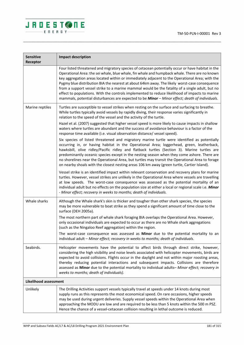
TM‐50‐PLN‐I‐00001 Rev 3
_________________________________________________________________________________________________________________________
WHP and Subsea Fields AC/L7 & AC/L8 Drilling Program 2021 Environment Plan 181 of 315
Sensitive Receptor
Impact description
Four listed threatened and migratory species of cetacean potentially occur or have habitat in the Operational Area: the sei whale, blue whale, fin whale and humpback whale. There are no known key aggregation areas located within or immediately adjacent to the Operational Area; with the Pygmy blue distribution BIA the nearest at about 64km away. The likely worst‐case consequence from a support vessel strike to a marine mammal would be the fatality of a single adult, but no effect to populations. With the controls implemented to reduce likelihood of impacts to marine mammals, potential disturbances are expected to be Minor – Minor effect; death of individuals.
Marine reptiles Turtles are susceptible to vessel strikes when resting on the surface and surfacing to breathe. While turtles typically avoid vessels by rapidly diving, their response varies significantly in relation to the speed of the vessel and the activity of the turtle.
Hazel et al. (2007) suggested that higher vessel speed is more likely to cause impacts in shallow waters where turtles are abundant and the success of avoidance behaviour is a factor of the response time available (i.e. visual observation distance/ vessel speed).
Six species of listed threatened and migratory marine turtle were identified as potentially occurring in, or having habitat in the Operational Area; loggerhead, green, leatherback, hawksbill, olive ridley/Pacific ridley and flatback turtles (Section 3). Marine turtles are predominantly oceanic species except in the nesting season when they come ashore. There are no shorelines near the Operational Area, but turtles may transit the Operational Area to forage on nearby shoals with the closest nesting areas 106 km away (green turtle, Cartier Island).
Vessel strike is an identified impact within relevant conservation and recovery plans for marine turtles. However, vessel strikes are unlikely in the Operational Area where vessels are travelling at low speeds. The worst‐case consequence was assessed as the potential mortality of an individual adult but no effects on the population size at either a local or regional scale i.e. Minor ‐ Minor effect; recovery in weeks to months; death of individuals.
Whale sharks Although the Whale shark's skin is thicker and tougher than other shark species, the species may be more vulnerable to boat strike as they spend a significant amount of time close to the surface (DEH 2005a).
The most northern part of whale shark foraging BIA overlaps the Operational Area. However, only occasional individuals are expected to occur as there are no Whale shark aggregations (such as the Ningaloo Reef aggregation) within the region.
The worst‐case consequence was assessed as Minor due to the potential mortality to an individual adult – Minor effect; recovery in weeks to months; death of individuals.
Seabirds.
Helicopter movements have the potential to affect birds through direct strike, however, considering the high visibility and noise levels associated with helicopter movements, birds are expected to avoid collisions. Flights occur in the daylight and not within major roosting areas, thereby reducing potential interactions and subsequent impacts. Collisions are therefore assessed as Minor due to the potential mortality to individual adults– Minor effect; recovery in weeks to months; death of individuals).
Likelihood assessment
Unlikely The Drilling Activities support vessels typically travel at speeds under 14 knots during most supply runs as this represents the most economical speed. On rare occasions, higher speeds may be used during urgent deliveries. Supply vessel speeds within the Operational Area when approaching the MODU are low and are required to be less than 5 knots within the 500 m PSZ. Hence the chance of a vessel‐cetacean collision resulting in lethal outcome is reduced.

TM‐50‐PLN‐I‐00001 Rev 3
_________________________________________________________________________________________________________________________
WHP and Subsea Fields AC/L7 & AC/L8 Drilling Program 2021 Environment Plan 182 of 315
Sensitive Receptor
Impact description
Due to the general low vessel speeds, warning noise of helicopters and lack of any significant bird or cetacean/reptile aggregations nearby, the chance of a vessel collision with marine fauna and bird strikes resulting in a lethal outcome is reduced as individuals are expected to take avoidance behaviour. Worst case risks are on an individual level and the risk ranking with controls in place (Section 7.2.3) was assessed as unlikely.
Consequence Likelihood Ranking
Minor Unlikely Low

TM‐50‐PLN‐I‐00001 Rev 3
_________________________________________________________________________________________________________________________________________________________________________________
WHP and Subsea Fields AC/L7 & AC/L8 Drilling Program 2021 Environment Plan 183 of 315
7.2.3 Environmental performance
Hazard Interaction with fauna
Performance outcome No death or injury to EPBC Act listed marine fauna due to activities in the Operational Area
ID Management Control Performance standards Measurement criteria Responsibility
052 Potential for collision with marine fauna reduced by vessels operating at speeds aligned with Montara Marine Facility Manual (MV‐90‐PR‐H‐00001)
Vessels operating within the PSZ must not exceed a speed of five (5) knots.
Vessel Masters provided and required to operate in accordance with the Montara Marine Facility Operating Manual – Sign‐off sheet for completed by Vessel Master.
Vessel Master
053 Competency and Training Management System [JS‐60‐PR‐Q‐00014] provides a process for ensuring that Contractors and Services Providers have the appropriate level of HSE capability
Online induction includes information on speed limits in the PSZ and requirements on interacting with marine fauna
Induction Records (Vessel Masters) HR Manager
054 Marine fauna collisions reported to National Ship Strike Database
Any vessel collision with a whale in the Operational Area is submitted to the National Ship Strike Database at:
https://data.marinemammals.gov.au/report/shipstrike
Death or injury to EPBC Act listed marine fauna (including cetaceans or whale sharks) from vessel collision are recorded/reported to NOPSEMA and DoEE in line with regulations
Vessel collision incident report
Database entry number
HSE Manager

TM‐50‐PLN‐I‐00001 Rev 3
________________________________________________________________________________________________________________________
WHP and Subsea Fields AC/L7 & AC/L8 Drilling Program 2021 Environment Plan 184 of 315
7.2.4 ALARP assessment
Based on the impact and risk assessment process completed, Jadestone considers the control measures described above are appropriate to manage the risk risk of fauna strike to ALARP. The residual risk ranking for this potential impact (minor) is considered Low. Additional controls considered but rejected are detailed below. No further controls are required and therefore ALARP has been demonstrated.
Rejected control
Hierarchy Practicable Cost
Effective Justification
Removal or reduce frequency of vessels and helicopter use
Eliminate No No Vessels and helicopters are required during drilling activities and there are no practicable alternatives. The potential for interaction between vessels and fauna cannot be eliminated, however the risk is low given the location, low volume of vessel activity and low speeds and helicopter noise acts as a deterrent.
Reduce or remove vessel and helicopter use during key sensitive periods
Isolation No No Reducing or removing vessel and helicopter activities during known migration periods of marine fauna is not a viable option as these activities are necessary for the safe and efficient operation of the MODU all year round.
Use of marine fauna observers on all vessels to identify fauna close to vessels
Administrative No No Vessel Masters will complete an environmental induction which includes the applicable requirements. The introduction of a specialist marine fauna observer is unlikely to increase detection and the additional cost is considered grossly disproportionate given the low vessel speeds reduce the potential for impacts on marine fauna.
7.2.5 Acceptability assessment
The potential impacts of helicopters and vessels on marine fauna during the operation are considered 'Broadly Acceptable' in accordance with the Environment Regulations, based on the acceptability criteria outlined below. The control measures proposed are consistent with relevant legislation, standards and codes.
Policy & management system compliance
Jadestone’s HSE Policy objectives are met. Section 8 demonstrates that Jadestone’s HSE Management System is capable of meeting environmental management requirements for this activity.
Stakeholder & reputation
Stakeholder consultation has been undertaken (Section 4), and no stakeholder concerns have been raised with regards to impacts from vessel/ helicopter operations on sensitive receptors.
Environmental context & ESD
The Operational Area overlaps a small area at the northern end of the Whale shark BIA. Risks to megafauna is considered low and acceptable as vessels will travel at low speeds within the Operational Area; minimal vessel activity in the area, and risk of mortality from a low‐speed vessel strike is low. In this way, aspects of the EPBC Regulations 2000, Division 8.1 – Interacting with Cetaceans – are addressed.
The potential impact is considered acceptable after consideration of:
Potential impact pathways: Section 7.2.2 describes the consequences and likelihood of vessel strike;
Preservation of critical habitats: location remote from Protected Areas and

TM‐50‐PLN‐I‐00001 Rev 3
________________________________________________________________________________________________________________________
WHP and Subsea Fields AC/L7 & AC/L8 Drilling Program 2021 Environment Plan 185 of 315
aggregations of most vulnerable cetaceans, dugongs and reptiles with proposed management minimizing residual risk to individuals;
Assessment of key threats as described in species and Area Management /Recovery plans: see ‘Conservation and Management Advice’ below;
Consideration of North‐West Bioregional Plan: The NW Bioregional Plan ranks vessel strike to cetaceans, dugongs, turtles within BIA as a ‘high risk of significant impact’. No specific actions were raised; hence the management controls are considered sufficient to maintain a residual consequence ranking of negligible; and
Principles of ecologically sustainable development ESD: as worst‐case consequences will not impact population levels of protected species, no impacts on biodiversity or ecosystem integrity are predicted.
Conservation and management advice
Recovery Plan for Marine Turtles in Australia, (EA 2003).
The Recovery Plan for marine turtles in Australia (DoEE, 2017) identifies the following risk ‐Vessel Disturbance. It requires that risk of vessel strikes is evaluated and, if required, appropriate mitigation measures are implemented. This EP and the proposed controls are consistent with this advice.
Conservation Management Plan for the Blue Whale, 2015‐2025.
The Management Plan identifies the following risk ‐ ‘Vessel Disturbance”. It requires that risk of vessel strikes is evaluated and, if required, appropriate mitigation measures are implemented. This EP and the proposed controls are consistent with this advice.
Conservation Advice for Humpback Whales (Megaptera novaeangliae) DoE 2015.
The Conservation Advice identifies the following risk’ Vessel Disturbance’. It requires that risk of vessel strikes is evaluated and, if required, appropriate mitigation measures are implemented. This EP and the proposed controls are consistent with this advice.
Jadestone has had regard to the representative values of the protected areas within the RISK EMBA, and the respective management plans and other published information. Interactions with fauna may have a minor impact on any of the social and ecological objectives and values, of AMPs, or state MPs. However, with controls in place to minimise the likelihood (to protect protected fauna), this is considered consistent with the objectives of the conservation advice or management plans (Appendix B) and considered Acceptable.
7.3 Unplanned Release of Solids
7.3.1 Description of hazard
Solid waste release
An unplanned release of solids to the environment has the potential to occur from:
Waste overboard from MODU or supply vessel operations (e.g. overfull and/or uncovered bins);
Lifting resulting in dropped objects; and
Accidental discharge of dry bulk products (e.g. during supply transfer).
7.3.2 Impacts and risks
Solids overboard has the potential to pollute marine habitats and injure or kill fauna through entanglement, ingestion or exposure (Ryan et al. 1988). The effects are dependent on the size and material.

TM‐50‐PLN‐I‐00001 Rev 3
________________________________________________________________________________________________________________________
WHP and Subsea Fields AC/L7 & AC/L8 Drilling Program 2021 Environment Plan 186 of 315
Sensitive Receptor
Impact description
Marine fauna
Release of hazardous solid wastes may result in the pollution of the immediate receiving environment, leading to detrimental health impacts to marine fauna through ingestion or absorption by individual fish, cetaceans, marine reptiles and seabirds. Foraging behaviour in turtles has resulted in turtles mistaking plastic for jellyfish (Mrosovsky et al. 2009). Marine fauna (including seabirds) encountered within the Operational Area are expected to be limited to small numbers of transient individuals as there are no known critical habitats within the Operational Area for EPBC listed species. The Operational Area overlaps with the northern section of the whale shark foraging however, only low numbers are likely to be present.
The accidental release of waste may result in injury or even death to individuals but is not expected to result in a threat to population viability; hence the consequence to marine fauna was assessed as Minor given the likely objects dropped overboard, the transient nature of marine fauna at this location and lack of foraging habitat within the Operational Area.
Benthic habitats
Benthic habitats have the potential to be impacted by accidental spills of solids resulting in possible damage to or loss of soft sediment communities within the area affected. The potential impact may be short term to long term depending on the waste type, degradation rate, and volume. The extent of physical seabed damage will be limited to the size of an inert dropped object and given the size of standard materials lifted overboard, impacts are expected to be very localised.
There are no sensitive or unique marine habitats in the Operational Area and the diversity and coverage of epibenthos is low (ERM 2011), benthic communities are expected to rapidly recolonise any damaged area (Currie and Isaac, 2004). Given the relatively small footprint of any dropped object, the widespread distribution and abundance of benthic communities within and beyond the Operational Area, the consequence to benthic communities would be a highly localised, negligible, and reversible change to a very small proportion of the overall benthos. The consequence of an unplanned release of solid waste on benthic habitats was assessed as Minor.
Other users
Buoyant solid waste accidentally released to the marine environment may create a navigational hazard to other marine users. The consequence of an unplanned solid waste on other marine users was assessed as Negligible given the likely objects that could be dropped overboard.
Likelihood assessment
Likely The control measures and checks will ensure that the risks of dropped objects, lost equipment or release of solid waste to the environment has been minimised. The likelihood of transient marine fauna occurring in the Operational Area is limited. As such, the likelihood of releasing solids to the environment resulting in a negligible consequence is considered likely.
Consequence Likelihood Ranking
Minor Likely Medium

TM‐50‐PLN‐I‐00001 Rev 3
_________________________________________________________________________________________________________________________________________________________________________________
WHP and Subsea Fields AC/L7 & AC/L8 Drilling Program 2021 Environment Plan 187 of 315
7.3.3 Environmental performance
Hazard Unplanned discharge of solid waste
Performance outcome Zero unplanned discharge of solid wastes into the marine environment
ID Management Control Performance standards Measurement criteria Responsibility
055 Waste generated during operations will be managed in accordance with MARPOL 73/78 Annex V Regulation 9 and the vessels’ and MODU Waste Management Plan as required
Solid waste materials are stored in fit for purpose storage containers and/or lifting skips, labelled and equipped with lids / covers to prevent loss of material during storage and handling.
Garbage Record Book shall be maintained on all facilities in accordance with MARPOL 73/78 Annex V Regulation 9
OIM
Vessel Masters
056 Hazardous solid wastes will be managed in accordance with Marine Orders – Part 94 (Marine Pollution Prevention – Packaged Harmful Substances), Navigation Act 2012 and Protection of the Sea (Prevention of Pollution from Ships) Act 1983 (Part III) requirements, and Environmental Protection Regs (Controlled Waste)
A waste register will be maintained to show that hazardous wastes are being collected and returned onshore for disposal
057 MODU and vessel lifting procedures align with Montara Lifting Operations Procedure (MV‐00‐PR‐F‐00006) to prevent dropped loads
All personnel involved with lifting equipment operations and maintenance receive adequate training and are competent appropriate to their level of responsibility
MODU training records and Competency matrix
058 JSA completed for all lifts under PTW system, and all lifts completed with certified lifting equipment rated for the task
Completed PTW documentation
059 A Lift Plan completed for Complex and/or Engineered Lifts Approved Lift Plan
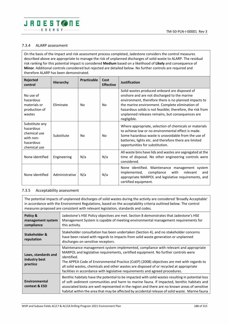
TM‐50‐PLN‐I‐00001 Rev 3
WHP and Subsea Fields AC/L7 & AC/L8 Drilling Program 2021 Environment Plan 188 of 315
7.3.4 ALARP assessment
On the basis of the impact and risk assessment process completed, Jadestone considers the control measures described above are appropriate to manage the risk of unplanned discharges of solid waste to ALARP. The residual risk ranking for this potential impact is considered Medium based on a likelihood of Likely and consequence of Minor. Additional controls considered but rejected are detailed below. No further controls are required and therefore ALARP has been demonstrated.
Rejected control
Hierarchy Practicable Cost
Effective Justification
No use of hazardous materials or production of wastes
Eliminate No No
Solid wastes produced onboard are disposed of onshore and are not discharged to the marine environment, therefore there is no planned impacts to the marine environment. Complete elimination of hazardous solids is not feasible; therefore, the risk from unplanned releases remains, but consequences are negligible.
Substitute any hazardous chemical use with non‐hazardous chemical use
Substitute No No
Where appropriate, selection of chemicals or materials to achieve low or no environmental effect is made. Some hazardous waste is unavoidable from the use of batteries, lights etc. and therefore there are limited opportunities for substitution.
None identified Engineering N/a N/a All waste bins have lids and wastes are segregated at the time of disposal. No other engineering controls were considered.
None identified Administrative N/a N/a
None identified. Maintenance management system implemented, compliance with relevant and appropriate MARPOL and legislative requirements, and certified equipment.
7.3.5 Acceptability assessment
The potential impacts of unplanned discharges of solid wastes during the activity are considered 'Broadly Acceptable' in accordance with the Environment Regulations, based on the acceptability criteria outlined below. The control measures proposed are consistent with relevant legislation, standards and codes.
Policy & management system compliance
Jadestone’s HSE Policy objectives are met. Section 8 demonstrates that Jadestone’s HSE Management System is capable of meeting environmental management requirements for this activity.
Stakeholder & reputation
Stakeholder consultation has been undertaken (Section 4), and no stakeholder concerns have been raised with regards to impacts from solid waste generation or unplanned discharges on sensitive receptors.
Laws, standards and industry best practice
Maintenance management system implemented, compliance with relevant and appropriate MARPOL and legislative requirements, certified equipment. No further controls were identified. The APPEA Code of Environmental Practice (CoEP) (2008) objectives are met with regards to all solid wastes, chemicals and other wastes are disposed of or recycled at appropriate facilities in accordance with legislative requirements and agreed procedures.
Environmental context & ESD
Benthic habitats have the potential to be impacted with solid wastes resulting in potential loss of soft sediment communities and harm to marine fauna. If impacted, benthic habitats and associated biota are well represented in the region and there are no known areas of sensitive habitat within the area that may be affected by accidental release of solid waste. Marine fauna

TM‐50‐PLN‐I‐00001 Rev 3
WHP and Subsea Fields AC/L7 & AC/L8 Drilling Program 2021 Environment Plan 189 of 315
can become entangled in waste plastics, which can also be ingested when mistaken as prey potentially leading to injury or death. Generally, no toxic effects are expected from non‐hazardous solids.
The potential scale of environmental harm from accidentally discharged solid waste is small in comparison to the vast size of soft substrata habitats spanning the region and the transient nature of marine fauna that may be present in the Operational Area. The potential impact is considered acceptable after consideration of:
Potential impact pathways: consequences and likelihood of pathways are assessed in section 7.3.1 and 7.3.2;
Preservation of critical habitats: the drilling location is remote from Protected Areas and aggregations of protected and migratory species that could be impacted above ‘negligible’ from solids discharges;
Assessment of key threats as described in species and Area Management /Recovery plans: see ‘Conservation and management advice’ below;
Consideration of North‐West Bioregional Plan: The NW Bioregional Plan considers marine debris (such as entanglement and ingestion) a threat to turtles, dolphin, dugong, and various KEF. The proposed management controls are aligned with minimizing this risk; and
Principles of ecologically sustainable development ESD; with the proposed management controls, any worst‐case impacts would not affect population levels, hence no impacts to biodiversity or ecosystem integrity are predicted.
Conservation and management advice
Marine debris is identified as a potential threat to a number of marine fauna species in relevant Recovery Plans and Conservation Advice:
Approved Conservation Advice for Megaptera novaeangliae (humpback whale);
Conservation management plan for the blue whale: A recovery plan under the EPBC Act 1999 2015‐2025;
Conservation advice Balaenoptera borealis (sei whale);
Conservation advice Balaenoptera physalus (fin whale);
Recovery Plan for Marine Turtles in Australia; and
Recovery Plan for the white shark (Carcharodon carcharias).
The controls implemented demonstrate that the activity will be conducted in a manner that reduces marine debris and therefore the activity will be conducted in a manner that is acceptable under the relevant Recovery Plans and Approved Conservation Advice to prevent accidental release of non‐hydrocarbon solids (marine debris).
The limited quantities associated with this event indicate that even in a worst‐case release of solid waste, fatalities would be limited to individuals and is not expected to result in a decrease of the local population size for any of the species identified.
7.4 Unplanned Release of (Non‐Hydrocarbon) Liquids
7.4.1 Description of hazard
Unplanned discharge of liquids
The MODU is designed to have no direct discharge to the marine environment as there are no direct drainage points. However, non‐hazardous and hazardous liquids and chemicals are routinely transported to and from, stored and used aboard the MODU from support vessels, therefore, there is potential for these to be accidentally spilled to the marine environment. The largest instantaneous volume of a non‐hydrocarbon hazardous liquid that could be inadvertently spilt is one mud pit, a total volume of approximately 80–120 m3.
The maximum volume of non‐hydrocarbons (such as solvents and detergents) released from the deck is likely to be small and realistically limited to the volume of individual containers (e.g. IBCs/ drums
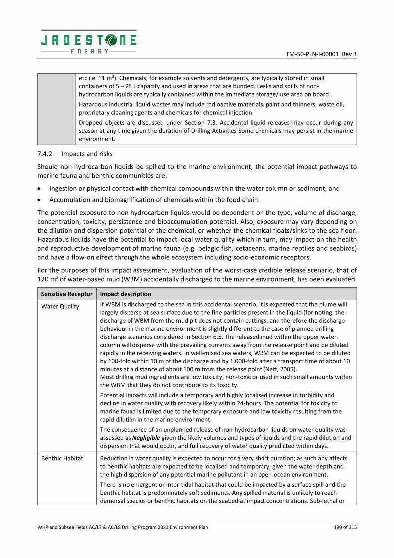
TM‐50‐PLN‐I‐00001 Rev 3
WHP and Subsea Fields AC/L7 & AC/L8 Drilling Program 2021 Environment Plan 190 of 315
etc i.e. ~1 m3). Chemicals, for example solvents and detergents, are typically stored in small containers of 5 – 25 L capacity and used in areas that are bunded. Leaks and spills of non‐hydrocarbon liquids are typically contained within the immediate storage/ use area on board.
Hazardous industrial liquid wastes may include radioactive materials, paint and thinners, waste oil, proprietary cleaning agents and chemicals for chemical injection.
Dropped objects are discussed under Section 7.3. Accidental liquid releases may occur during any season at any time given the duration of Drilling Activities Some chemicals may persist in the marine environment.
7.4.2 Impacts and risks
Should non‐hydrocarbon liquids be spilled to the marine environment, the potential impact pathways to marine fauna and benthic communities are:
Ingestion or physical contact with chemical compounds within the water column or sediment; and
Accumulation and biomagnification of chemicals within the food chain.
The potential exposure to non‐hydrocarbon liquids would be dependent on the type, volume of discharge, concentration, toxicity, persistence and bioaccumulation potential. Also, exposure may vary depending on the dilution and dispersion potential of the chemical, or whether the chemical floats/sinks to the sea floor. Hazardous liquids have the potential to impact local water quality which in turn, may impact on the health and reproductive development of marine fauna (e.g. pelagic fish, cetaceans, marine reptiles and seabirds) and have a flow‐on effect through the whole ecosystem including socio‐economic receptors.
For the purposes of this impact assessment, evaluation of the worst‐case credible release scenario, that of 120 m3 of water‐based mud (WBM) accidentally discharged to the marine environment, has been evaluated.
Sensitive Receptor Impact description
Water Quality If WBM is discharged to the sea in this accidental scenario, it is expected that the plume will largely disperse at sea surface due to the fine particles present in the liquid (for noting, the discharge of WBM from the mud pit does not contain cuttings, and therefore the discharge behaviour in the marine environment is slightly different to the case of planned drilling discharge scenarios considered in Section 6.5. The released mud within the upper water column will disperse with the prevailing currents away from the release point and be diluted rapidly in the receiving waters. In well‐mixed sea waters, WBM can be expected to be diluted by 100‐fold within 10 m of the discharge and by 1,000‐fold after a transport time of about 10 minutes at a distance of about 100 m from the release point (Neff, 2005). Most drilling mud ingredients are low toxicity, non‐toxic or used in such small amounts within the WBM that they do not contribute to its toxicity.
Potential impacts will include a temporary and highly localised increase in turbidity and decline in water quality with recovery likely within 24‐hours. The potential for toxicity to marine fauna is limited due to the temporary exposure and low toxicity resulting from the rapid dilution in the marine environment.
The consequence of an unplanned release of non‐hydrocarbon liquids on water quality was assessed as Negligible given the likely volumes and types of liquids and the rapid dilution and dispersion that would occur, and full recovery of water quality predicted within days.
Benthic Habitat Reduction in water quality is expected to occur for a very short duration; as such any affects to benthic habitats are expected to be localised and temporary, given the water depth and the high dispersion of any potential marine pollutant in an open‐ocean environment.
There is no emergent or inter‐tidal habitat that could be impacted by a surface spill and the benthic habitat is predominately soft sediments. Any spilled material is unlikely to reach demersal species or benthic habitats on the seabed at impact concentrations. Sub‐lethal or

TM‐50‐PLN‐I‐00001 Rev 3
WHP and Subsea Fields AC/L7 & AC/L8 Drilling Program 2021 Environment Plan 191 of 315
Sensitive Receptor Impact description
lethal effects from unplanned discharges at the seabed on marine fauna, is considered unlikely given the expected low concentrations and short exposure times. The consequence of an unplanned release of non‐hydrocarbon liquids was assessed as Negligible ‐ based on the likely volumes and types of liquids, the low sensitivity of the benthic habitat and the rapid dilution and dispersion that would occur.
Marine Fauna Liquid discharges may cause negligible short‐term water quality degradation (see above) and as a result a possible alteration to marine fauna behaviour. The changes to water quality that may result could potentially lead to short‐term impacts on marine fauna (e.g. pelagic/benthic fish, epifauna, cetaceans, marine reptiles and seabirds), with chronic impacts not expected owing to the short exposure times likely. The susceptibility of marine receptors will be dependent on the nature of the liquid released, toxicity and other chemical properties such as biodegradation and bioaccumulation potential.
The Operational Area overlaps the Whale shark BIA but aggregations such as those found in Ningaloo are unlikely. Potential impacts to water quality are likely to be limited to the immediate vicinity (tens to hundred metres) of the release point and are not expected to affect overall population viability of these protected species.
Contaminated fish stocks and filter feeders such as oysters and mussels can pass on harmful chemicals to humans, if contaminated organisms are consumed. Potential impacts are varied depending on characteristics and volumes of the spilt chemical and the sea state, and, are likely to be limited to the immediate vicinity and unlikely to affect overall population viability or have economic impacts.
The consequence of an unplanned release of non‐hydrocarbon liquids on marine fauna was assessed as Negligible given the likely volumes and types of liquids and the rapid dilution and dispersion that would occur in the Operational Area.
Likelihood assessment
Rare The control measures and checks proposed will ensure that the risks of unplanned releases of liquids to the marine environment are minimised. The likelihood of transient marine fauna occurring in the Operational Area is limited.
Given the controls in place, the likelihood of releasing non‐hydrocarbon liquids to the environment resulting in a negligible consequence is considered rare based on the presence of bunding around non‐hydrocarbon liquid containers, and drainage systems and volumes /types of liquids aboard.
Consequence Likelihood Ranking
Negligible Rare Low

TM‐50‐PLN‐I‐00001 Rev 3
__________________________________________________________________________________________________________________________________________________________________________________
WHP and Subsea Fields AC/L7 & AC/L8 Drilling Program 2021 Environment Plan 192 of 315
7.4.3 Environmental performance
Hazard Unplanned discharge of solid waste
Performance outcome Zero unplanned discharges into the marine environment
ID Management Control Performance standards Measurement criteria Responsibility
060 MODU and vessel chemical management aligns with requirements of the Jadestone Hazardous Substances & Dangerous Goods Standards (JS‐70‐STD‐I‐00035) and Marine Order 94
Any hazardous liquid storage on deck must be designed and maintained with at least one barrier (i.e. form of bunding) to contain and prevent deck spills entering the marine environment.
Pre‐start inspection HSE Manager
OIM
Vessel master
061 Safety data sheet (SDS) available for all chemicals to aid in the process of hazard identification and chemical storage and disposal management
Pre‐start inspection
062 Chemicals managed in accordance with SDS in relation to safe handling and storage, spill‐response and emergency procedures, and disposal considerations
Pre‐start inspection
063 MODU and Vessels are compliant with Marine Order 93 to prevent any contaminating liquids and chemicals from entering the marine environment
Vessels and MODU chemical management is compliant with Marine Order 93:
Having a valid International Pollution Prevention Certificate;
Reporting marine incidents to AMSA ‐ An incident involving a discharge from a vessel of a mixture containing a liquid substance, carried as cargo or as part of cargo in bulk, must be reported to AMSA via AMSA Form 196 (Harmful Substances Report form) within 24‐hours;
Enacting a compliant Shipboard Marine Pollution Emergency Plan;
Using a compliant Cargo Record Book; and
Washing vessel tanks in accordance with the Pollution Prevention Act.
Valid International Pollution Prevention Certificate
Valid SOPEP/SMPEP
Cargo Record Book
064 Spill kits on the MODU are present in areas of high spill risk
Spill kits are:
Located near high risk spill areas.
Intact, clearly labelled and contain adequate quantities of absorbent materials with waste managed as per MODU Waste Management Plan
Pre‐start inspection

TM‐50‐PLN‐I‐00001 Rev 3
_______________________________________________________________________________________
WHP and Subsea Fields AC/L7 & AC/L8 Drilling Program 2021 Environment Plan 193 of 315
7.4.4 ALARP assessment
Jadestone considers the control measures described above are appropriate to manage the risk of unplanned discharges of non‐hydrocarbon liquids to ALARP. The residual risk ranking for this potential impact is considered Low based on a likelihood of Rare and consequence of Negligible. Additional controls considered but rejected are detailed below. No further controls are required and therefore ALARP has been demonstrated.
Rejected control
Hierarchy Practicable Cost effective
Justification
No use of hazardous materials or production of wastes
Eliminate No No Liquid wastes produced onboard are disposed of onshore and are not discharged to the marine environment, therefore there is no planned impact to the marine environment. Complete elimination of hazardous materials, drilling muds and waste is not feasible; therefore, the residual risk of unplanned releases remains but is low.
Substitute any hazardous chemicals use with non‐hazardous chemicals
Substitute No No Where appropriate selection of chemicals or materials to achieve low or no environmental effect is made. Some hazardous liquids are unavoidable such as corrosion inhibitors and biocides, with limited opportunities for substitution.
None identified Engineering Isolation
N/a N/a All waste bins have lids and wastes are segregated at the time of disposal. No other engineering controls were considered.
Safeguards will be implemented as required, by the Protection of the Sea (Prevention of Pollution from Ships) Act 1983 and MARPOL Annexures I, II and III. Such safeguards include designated storage and handling areas, correct stowage, accurate labelling and marking, SDS information, spill clean‐up equipment and containment (e.g. bunds). No other potential controls were identified.
The Activity is remote from sensitive receptors and coastlines.
None identified Administrative N/a N/a Maintenance management system implemented, compliance with relevant and appropriate MARPOL and legislative requirements, certified equipment. No further controls were identified.
7.4.5 Acceptability assessment
The potential impacts of unplanned discharges of non‐hydrocarbon liquids during the activity are considered 'Acceptable' in accordance with the Environment Regulations, based on the acceptability criteria outlined below. The control measures proposed are consistent with relevant legislation, standards and codes.
Policy & management system compliance
Jadestone’s HSE Policy objectives are met. Section 8 demonstrates that Jadestone’s HSE Management System is capable of meeting environmental management requirements for this activity.

TM‐50‐PLN‐I‐00001 Rev 3
_______________________________________________________________________________________
WHP and Subsea Fields AC/L7 & AC/L8 Drilling Program 2021 Environment Plan 194 of 315
Stakeholder & reputation
Stakeholder consultation has been undertaken (Section 4), and no stakeholder concerns have been raised regarding impacts from unplanned discharges of non‐hydrocarbon liquids.
Laws, standards and industry best practice
The APPEA Code of Environmental Practice (CoEP) (2008) principles are met with regards to complying with relevant laws and regulations, and meeting industry’s objective to maintain a social licence to operate. MARPOL requirements are internationally recognised in the shipping industry to manage the potential for pollution.
Environmental context & ESD
While unplanned liquid discharges could occur from the activity, the risk assessment process indicates credible discharges would have a temporary and localised impact on marine waters and will not result in significant impacts to marine fauna. The residual risk is considered acceptable after consideration of:
Potential impact pathways: Section 7.4.1 and 7.4.2 assesses the likelihood and consequences to water quality and marine habitats, flora and fauna from liquid spills;
Preservation of critical habitats: the location is remote from Protected Areas and aggregations of sensitive receptors;
Assessment of key threats as described in species and Area Management /Recovery plans: see ‘Conservation and management Advice’ below;
Consideration of North‐West Bioregional Plan; the Plan regards chemical pollution/ contamination from oil and gas activities and vessels as a pressure on biodiversity, ecosystem function or integrity, social amenity or human health. This EP is aligned with the objectives of the NW Bioregional Plan by minimizing the risks of spills; and
Principles of ecologically sustainable development: the likelihood and consequence of the worst‐case credible liquids spill is not predicted to impact above individual marine fauna or localized habitats; hence biodiversity and ecosystem integrity are not at risk.
Conservation and management advice
Minimising chemical discharge is an action identified by the Recovery Plan for Marine Turtles in Australia 2017‐2027. This requires that best practice industrial management is implemented to minimise impacts to marine turtle health and habitats. A marine chemical spill is unlikely to result in population effects due to the controls in place for secure storage and on‐board clean‐up of spills, transient nature of marine fauna and the remote open ocean environment. There are no relevant management requirements in the recovery plan to implement for this hazard.
7.5 Unplanned Release of Hydrocarbons – Worst Case Scenarios
7.5.1 Worst case credible spill scenarios
Worst case hydrocarbon spill scenarios due to an unplanned event resulting in a Montara or Skua crude oil spill to the marine environment were identified during the Drilling Activities ENVID workshop. Table 7‐2 summarises the worst‐case credible scenarios due to loss of containment event. Refer Table 2‐3 for the well locations.
To determine the maximum worst‐case credible spill volumes for each identified spill scenario, Jadestone has considered the AMSA (2015) guideline: Technical guideline for preparing contingency plans for marine and coastal facilities and NOPSEMA Bulletin #1 Oil Spill modelling (April 2019). Jadestone considers that in adopting the AMSA guideline, the estimated spill volumes are appropriately conservative given that for the scenarios presented, there are multiple barriers/ controls in place; meaning the total volumes evaluated are much greater than what would most likely be released in the event of a spill.

TM‐50‐PLN‐I‐00001 Rev 3
_______________________________________________________________________________________
WHP and Subsea Fields AC/L7 & AC/L8 Drilling Program 2021 Environment Plan 195 of 315
Table 7‐2: Worst case credible hydrocarbon spill scenarios due to a loss of containment event
Well Surface or Subsea
Max spill volume and duration (m3)*
Rates (m3/d) Reservoir Pressure (PSI) Well
Architecture initial final initial final
H6 surface 234,682 8,983 2,078 3,633 3,573
Assumes full open hole horizontal length 6 1/8" hole, cased 7" and 9 5/8" hole (no completion)
H6 subsea 234,498 8,940 2,073 3,633 3,574
Assumes full open hole horizontal length 6 1/8" hole, cased 7" and 9 5/8" hole (no completion)
Skua 10
surface 47,773 942 500 3078 3679
upper completion out of the hole 5 1/2" sand screens and 9 5/8" casing
Skua 10
subsea 56,596 1064 679 3,078 2,954
upper completion out of the hole 5 1/2" sand screens and 9 5/8" casing
Skua 11
surface 47,773 942 500 3078 3679 upper completion out of the hole
Skua 11
subsea 56,596 1064 679 3,078 2,954 upper completion out of the hole
*Re‐analysed data from modelling previously done for H‐5ST2 also at WHP location for slightly larger volume and surface discharge (RPS, 2017) for 236,349m3 (77 days)

TM‐50‐PLN‐I‐00001 Rev 3
_______________________________________________________________________________________
WHP and Subsea Fields AC/L7 & AC/L8 Drilling Program 2021 Environment Plan 196 of 315
Table 7‐3: Worst case credible oil spills to the marine environment due to a loss of containment event
Scenario Maximum Worst Case Credible Spill Release Durations
Rupture of subsea flowline 1,700 m3 1 day
Release of diesel from FPSO vessel due to vessel collision/ dropped object ‐ surface
906 m3 5 hours
Leak or rupture of bunkering hose during support vessel to diesel transfer ‐ surface
5 m3 15 mins
7.5.2 Credible worst‐case scenarios
From the scenarios listed in Table 7‐2 and Table 7‐3, stochastic modelling was used to determine the greatest extent for exposure from each fraction of hydrocarbon (surface, shoreline, dissolved and entrained) to form the conservative combined RISK EMBA for all seasons for all identified scenarios (See Appendix B). The H6 modelling results are based on modelling undertaken in 2017 at the same location for the drilling of H5 and rerun for Jadestone. This previous modelling was for a larger surface release of 236,349 m3.
The LOWC scenario from surface release at well H6 is the greatest surface release for floating and shoreline oil loadings. The LOWC scenario from the H6 subsea release is the greatest subsea release for the entrained oil and dissolved hydrocarbon fractions. The surface diesel spill from a vessel collision is the greatest diesel spill (refer Section 7.7). Therefore, the RISK EMBA represents the greatest possible extent of each fraction and has been used to determine the area which identifies all the relevant environmental receptors to inform the hydrocarbon impact assessment.
7.5.3 Duration of LOWC worst case credible scenario
The worst‐case credible scenario for an oil spill in the EP is a LOWC from H6. The killing of the well using a relief well is the primary source control response, whereby a critical control is the timeframe for rig availability. To appropriately assess the timeframe to kill the well, Jadestone has undertaken a review of feasible rig availabilities and activities associated with relief well planning. This review found that 77 days is the number of days from the point of loss of containment to the point that the source is contained. The risk of LOWC is only feasible when drilling activities are in the hydrocarbon reservoir as per Table 7‐4.
Table 7‐4: Days drilling in the respective reservoir
Well Days in the reservoir
H6 46
Skua‐10 14.5
Skua‐11 24
The 77 days’ timeframe to kill the worst case well blow out scenario is based on the actual 54 days taken to drill the 2009 Montara relief well and kill the blow out. Based on the multiple suitable rigs available, to mobilise within 23 days to location and then spud the relief well and kill the well within 77 days is very realistic; and thus the 77 days response time used for the spill modelling in the EP is ALARP.
Table 7‐5 indicates a range of options for rig locations, mobilisation and relief well response times. With Multiple relief well rig options being available, this reduces the probability of no rig or a delayed rig (availability not within the predicted timing) to a very low level. The loss of one rig option will result in a

TM‐50‐PLN‐I‐00001 Rev 3
_______________________________________________________________________________________
WHP and Subsea Fields AC/L7 & AC/L8 Drilling Program 2021 Environment Plan 197 of 315
review of the other options to ensure coverage is still adequate and the 77 days is achievable. The availability of all options will be checked every 2 weeks during operations and notice given to the Titleholder using the rig and the rig operators of when loss of well containment is possible.
Table 7‐5: Relief Well Options and Timeframes
Activity Feasible Rig Options
Jack Up Rig stacked in Singapore
Suitable Semi‐submersible rig in
Northwest Shelf area
Suitable Semi‐submersible rig in Bonaparte or Browse
basins
Days Days Days
Prepare to Tow ‐ includes suspending previous well.
7 9 9
Pull anchors n/a 3 3
Tow to Location 14 8 3
Run anchors n/a 3 3
Drill relief well and kill blowout well
54 54 54
Total 75 77 72
7.5.4 Discounted scenarios
Refuelling of helicopters on the helideck of vessels or MODU/WHP was discounted as a credible spill scenario to the marine environment due to the high volatility of aviation fuel and that the refuelling system for helicopters is a fully self‐contained system on the WHP.
The scenario of a dropped object damaging the subsea export pipeline is covered in the in the Montara Operations Environment Plan (MV‐90‐PLN‐I‐00001).
The rigid riser section of the pipeline is also protected by a frame and runs inside the jacket leg footprint providing additional protection from swinging loads and vessel impacts.
A dragged anchor or misplaced anchor scenarios are discounted as neither the vessels nor the MODU will be using anchors.
7.6 Worst Case Crude Oil Spills
7.6.1 Description of hazard
Crude oil release
A loss of well control during drilling or workover activities may occur resulting in a release of crude oil at sea surface or subsurface due to:
Catastrophic damage to the Montara wellhead platform and associated wells;
Loss of function downhole of safety critical equipment (loss of barriers); and
Damage to subsea well infrastructure (well valves, wellhead) or existing flowlines.
Hydrocarbons may be released to the marine environment at either the WHP floor (sea surface), subsea wellheads/ infrastructure (seabed) or flowlines (Tables 7‐2 and 7‐3).

TM‐50‐PLN‐I‐00001 Rev 3
_______________________________________________________________________________________
WHP and Subsea Fields AC/L7 & AC/L8 Drilling Program 2021 Environment Plan 198 of 315
In a worst‐case credible loss of well control scenario, large quantities of hydrocarbon (worst‐case oil release 236,349 m3 Montara crude) will be released to the marine environment until well control can be re‐established.
7.6.2 Montara and Skua Characteristics
Two crude oil types were considered in the LOWC scenarios: Montara and Skua crude oils. The properties of these oils and their weathering behaviour are detailed in the OPEP (Appendices A5 and A6), in Section 2.7 of this EP and in Section 4.1 of the OPEP.
7.6.3 Modelling Approach
To determine the spatial extent of impacts from a potential crude oil spill (surface and subsurface) and the dispersion characteristics of the oil over time, modelling was completed by RPS (RPS 2017, 2018 and 2019). Spill modelling was performed using several simulated environmental conditions from two seasons (March to August, September to February) thus providing a range of realistic spill trajectories from which to determine the spatial extent of potential impacts and receptors which might be affected by a spill.
The quantitative hydrocarbon spill risk assessment evaluates three of the potential hydrocarbon spill scenarios due to LOWC (release scenarios for the well H‐6 at surface and subsea, as well as the Skua‐10/11 subsea wells at seabed).
Oil spill modelling was undertaken using a three‐dimensional oil spill trajectory and weathering model, SIMAP (Spill Impact Mapping and Analysis Program), which is designed to simulate the transport, spreading and weathering of specific oil types under the influence of changing meteorological and oceanographic forces. With a number of different release scenarios resulting in different surface oil, entrained oil and dissolved aromatic hydrocarbon affected areas, the results for each hydrocarbon component and scenario were combined to create total RISK EMBA to accommodate the modelling results.
A summary of the modelling method is described below.
1. Stochastic approach: stochastic modelling was carried out using an historic sample of wind and current data for the ‘study area’ that spanned ten years (2008–2017, inclusive). For each season, a large number of replicate simulations (100) were modelled for each season (i.e. 200 simulations in total), each initialised at different, randomly selected points in time for that seasonal period and hence under a different time series of environmental conditions. This stochastic sampling approach provides an objective measure of the possible outcomes of a spill, because environmental conditions will be selected at a rate that is proportional to the frequency that these conditions occur over the study area. More simulations will tend to use the most commonly occurring conditions, while conditions that are more unusual will be represented less frequently.
2. Contact thresholds: oil spill models can track hydrocarbon concentrations of surface oil, entrained oil and dissolved aromatic hydrocarbons below biologically significant impact levels. Consequently, threshold concentrations are specified for the model to control what contact is recorded for surface oil and subsurface locations (entrained oil and dissolved aromatic hydrocarbons) to ensure that recorded contacts are for biologically meaningful concentrations. Thus, it is important to describe the thresholds used as the boundary of the EMBAs will be influenced by the thresholds set in the hydrocarbon spill modelling.
3. Data generated: during each simulation (of which there are 100 for each season), the model recorded the location (latitude x longitude x depth) of each of the particles (representing a given mass of hydrocarbon) on or in the water column, at regular time steps.

TM‐50‐PLN‐I‐00001 Rev 3
_______________________________________________________________________________________
WHP and Subsea Fields AC/L7 & AC/L8 Drilling Program 2021 Environment Plan 199 of 315
The collective records from all simulations were then analysed by dividing the study area into a three‐dimensional grid. For oil particles classified as being at the water surface, the sum of the mass in all hydrocarbon particles located within a grid cell, divided by the area of the cell provided an estimate of the concentration of oil in that grid cell, at each time step.
For entrained and dissolved hydrocarbon particles, concentrations were calculated at each time step by summing the mass of particles within a grid cell and dividing by the volume of the grid cell. The concentrations of oil calculated for each grid cell, at each time step, were then analysed to determine whether concentration estimates exceeded defined threshold concentrations. The risks were then summarised as follows:
The probability of exposure at a location was calculated by dividing the number of spill simulations where contact occurred above a contact threshold at that location by the total number of replicate spill simulations. For example, if contact occurred at the location (above a contact threshold) 50 out of 100 simulations, a probability of exposure of 50 per cent is indicated; and
The minimum potential time to a shoreline location was calculated by the shortest time over which oil was calculated to travel from the source to the location in the replicate simulations.
4. Probability contours: the results were presented in terms of statistical probability maps based on the simulations considered, each generated under different environmental conditions. The contours of probability are not representations of a single spill event.
5. Completion of modelling: each of the 100 simulations was run for a period of three weeks allowing for the fate of dispersed hydrocarbons to be evaluated. Fate assessment stops once hydrocarbon concentrations fall below the defined contact thresholds. In this manner, the full extent of the spill scenario is assessed against the specified contact thresholds.
7.6.4 Exposure pathways and impact thresholds
To assess environmental effects from an unplanned hydrocarbon release, four separate hydrocarbon components that pose differing environmental risks were evaluated (refer Table 7‐5):
Surface hydrocarbons – hydrocarbons that are ‘on’ the water surface;
Entrained hydrocarbons – hydrocarbon that is entrained ‘in’ the water;
Dissolved hydrocarbons – the dissolved component of hydrocarbon in’ the water; and
Shoreline accumulation – hydrocarbons that accumulate along shorelines.
Threshold concentrations for each of the three hydrocarbon phases were developed and applied to the modelling outputs to define the EMBA for each phase. A receptor (biological organism) was considered ‘affected’ by one of the phases as soon as the threshold for the phase at that location was exceeded (i.e. instantaneous impact approach).
The rationale for the selection of the thresholds was determined by contemporary scientific knowledge. Appendix F provides a summary of the contact thresholds applied, and represents a consistent, logical and robust approach in the selection of oil exposure values.
7.6.5 Modelling results of the LOWC scenarios
Modelling results for potential exposure to surface, water column and stranded hydrocarbons are described in Table 7‐6 and depicted in Figure. The modelling does not take into consideration any of the spill prevention, mitigation and response capabilities that Jadestone propose to have in place during the campaign to reduce volumes and/or prevent hydrocarbons from reaching sensitive areas.

TM‐50‐PLN‐I‐00001 Rev 3
_______________________________________________________________________________________
WHP and Subsea Fields AC/L7 & AC/L8 Drilling Program 2021 Environment Plan 200 of 315
Table 7‐6: Summary of the contact thresholds applied in the impact assessment of the hydrocarbon spill modelling
Floating oil (g/m2) Shoreline Oil Entrained oil (ppb) DAHs (ppb)
1 Low (approximates range of socio‐economic effects and establishes
planning area for scientific monitoring)
100 Moderate
(loading predicts area
likely to require clean‐up effort)
100 High (as appropriate given oil
characteristics for informing risk evaluation)
70 Medium (approximates potential toxic effects)
10 Moderate (approximates lower limit for harmful exposures to birds
and marine mammals)

TM‐50‐PLN‐I‐00001 Rev 3
WHP and Subsea Fields AC/L7 & AC/L8 Drilling Program 2021 Environment Plan 201 of 315
Figure 7‐1: Predicted RISK EMBA resulting from worst case scenario

TM‐50‐PLN‐I‐00001 Rev 3
________________________________________________________________________________________________________________________
WHP and Subsea Fields AC/L7 & AC/L8 Drilling Program 2021 Environment Plan 202 of 315
Table 7-7 Worst case LOWC modelling results summary
Scenario Montara crude (236,349 m3), H5 surface spill. Source: RPS 2019
Surface Results of the worst‐case modelling indicate that surface sheens of floating oil (<1 g/m2) may pass over the following sensitive receptors:
Ashmore Reef, Cartier Island and surrounding Commonwealth waters KEF after 3 days;
Oceanic Shoals AMP after 6 days; and
Seringapatam Reef and Commonwealth waters in the Scott Reef Complex KEF after 10 days.
Submerged Banks, Shoals and Reefs
Sea surface exposure above a concentration of >10 g/m2 has the highest probabilities of occurring at the Barracouta (92 %), Vulcan Shoal (86 %), Goeree Shoal (72 %), Johnson (52 %), Woodbine (52%), Hibernia (48%), Seringapatam Reef (30 %). Probabilities at other shoals and banks were < 25%.
KEFS (all submerged)
The highest probabilities of sea surface exposure at a concentration of >10 g/m2 within KEFs were at Ashmore Reef, Cartier Island and surrounding Commonwealth Waters (88 %), Continental slope demersal fish communities (81 %), Seringapatam Reef and Commonwealth Waters in the Scott Reef Complex (30 %), Ancient coastline at 125 m depth contour (24 %). Other probabilities were < 10%.
Fisheries
The fisheries with the highest probability of exposure were the North‐west Slope Trawl Fishery (100 %), Southern Bluefin Tuna Fishery (100 %), Western Skipjack Fishery (100 %) and the Western Tuna and Billfish Fishery (100 %). All other fisheries were ≤ 5 %.
Australian Marine Parks
The Australian Marine Parks with the highest probability of exposure were Cartier Island MP (88 %), Ashmore Reef MP (72%), Oceanic Shoals AMP (46 %), Kimberley AMP (45 %), Argo‐Rowley Terrace (16 %) AMP. Probabilities at other Australian MPs were ≤ 15%.
State Marine and National Parks
The highest probability of exposure was the North Kimberley MP (3 % ‐@ 129 days). All other Marine and National Parks were <3% probability of exposure.
BIAs
The shark BIAs had a 100% probability of sea surface exposure (>10 g/m2), while seabirds BIA had 95 %, 88 % for marine turtle and 72 % for whales. Other receptors had exposure probabilities ≤ 3%.
Indonesia and Timor Leste
The Indonesian coastline has a maximum of 10 % probability of exposure to sea surfaces >10g/m2 and Timor Leste of 8 %.
Figure 7.1 shows the locations of potential floating oil above the threshold of 1 g/m2 and 10 g/m2.
Shoreline The maximum oil volume loading on all shorelines during a single spill event was predicted as 24, 169 m3 for a spill commencing during the September to February period.
The minimum time before shoreline accumulation at 100 g/m2 was 3 days and 5 days for Cartier Island and Ashmore Reef (MP boundaries) respectively and 7 days for the Kimberley coast.
The following sensitive receptors had the maximum accumulated volumes (m3) on shorelines in the worst replicate simulation:
Receptor Max accumulated volume (m3on shoreline in worst‐case replicate
Maximum daily accumulated oil ashore (m3)

TM‐50‐PLN‐I‐00001 Rev 3
________________________________________________________________________________________________________________________
WHP and Subsea Fields AC/L7 & AC/L8 Drilling Program 2021 Environment Plan 203 of 315
Kimberley Coast (North Kimberley MP
16 416 141
Joseph Bonaparte Gulf (NT) 5 845 45.0
Ashmore Reef MP /Cartier
Island MP
4 0.17
Tiwi Islands (Melville and Bathurst)
524 51.1
Darwin Coast 1,014 31.5
Indonesia 235 45.6
Timor‐Leste 7 0.24
Western NT (Kakadu, Coburgh, East Arnhem Land, West Arnhem Land)
884 83.1
Browse Island <1 0.25
Figure 7‐1 shows the locations of potential shoreline contact above the threshold of 100 g/m2.
Scenario Montara crude (234,498 m3), H6 subsea spill. Source RPS 2019
Entrained Maximum entrained hydrocarbon exposure at levels ≥100 ppb impact threshold at any depth in the worst replicate is shown below for all contact probabilities >25% within the RISK EMBA for the worst‐case scenario.
Submerged Banks, Shoals and Reefs
The shoal areas with the highest probability of exposure were the Barracouta (95 % ‐ 1 044 ppb), Johnson and Woodbine (90% ‐ 6 493 and 6 799 ppb respectively), Jabiru (83 % ‐ 5 465 ppb), Mangola Shoal (81 % ‐ 3 170 ppb), Eugene McDermott Shoal (77 % ‐ 1 121 ppb), Pee (74 % ‐ 4 884 ppb), Sahul Bank (71 % ‐ 8 852 ppb), Heywood Shoal (70 % ‐ 9 053 ppb), Vee Shoal (69% ‐ 2 198 ppb), Seringapatam Reef (67 % ‐ 1 784 ppb), Gale Bank (66 % ‐ 1 862 ppb), Hibernia (64 % ‐ 3 193 ppb), Barton Shoal (56 % ‐ 3 874 ppb), Favell Bank (55 % ‐ 1 701 ppb), Fantome (54 % ‐ 1 846 ppb), Dillon Shoal (49% ‐ 2 507 ppb), Karmt Shoal (48 % – 2 581 ppb), Baldwin Bank (43 % ‐1 128 ppb), Big Bank Shoals (37 % ‐ 2 582 ppb), Van Cloon Shoal (35 % ‐ 1 579 ppb),Bellona Bank (34 % ‐ 734 ppb). Probabilities at other shoals and banks are ≤ 25%.
KEFS
The KEFs with the highest probability of exposure were the Carbonate Bank and Terrace System of the Sahul Shelf (100 % ‐ 16 151 ppb), Continental Slope Demersal Fish Communities (100 % ‐ 16 505 ppb), Ashmore Reef and Cartier Island and surrounding Commonwealth Waters (100 % ‐ 8 852 ppb), Ancient Coastline at 125m Depth Contour (100 % ‐ 12 048 ppb), Seringapatam Reef and Commonwealth Waters in the Scott Reef Complex KEF (67 % ‐ 5 826 ppb), Pinnacles of the Bonaparte Basin (65 % ‐ 2 719 ppb), Carbonate Bank and Terrace System of the Van Diemen Rise (53% ‐ 4 609 ppb). Probabilities at the other KEFs were ≤ 25 %.
Fisheries
The fisheries with the highest probability of exposure were the North‐west Slope Trawl Fishery (100 % ‐ 46 860 ppb), Southern Bluefin Tuna Fishery (100 % ‐ 102 812 ppb), Western Skipjack Fishery (100 % ‐ 102 812 ppb), the Western Tuna and Billfish Fishery (100 % ‐ 102 812 ppb) and the Northern Prawn Fishery (71 % ‐ 3 327 ppb). All other fisheries were ≤ 25 %.

TM‐50‐PLN‐I‐00001 Rev 3
________________________________________________________________________________________________________________________
WHP and Subsea Fields AC/L7 & AC/L8 Drilling Program 2021 Environment Plan 204 of 315
BIAs
The BIA with the highest probability of exposure were the shark, seabird, whale and marine turtles, all with 100 % and 102 812 ppb, 19 151 ppb, 11 153 ppb and 11 153 ppb respectively. Dugong BIA was 92 % ‐ 6 144 ppb while all other BIAs had a probability of exposure ≤ 25 %.
Australian Marine Parks
The Australian Marine Parks with the highest probability of exposure were Cartier Island MP (100 % ‐ 8 400 ppb), Ashmore Reef MP (100% ‐ 8 574 ppb), Oceanic Shoals (90 % ‐ 6 232 ppb), Kimberley (64 % ‐ 15 816 ppb), Argo‐Rowley Terrace (25 % ‐ 1 602 ppb). Probabilities at other Australian MPs were ≤ 25%.
State Marine and National Parks
The highest probability of exposure was the North Kimberley MP (8 % ‐ 2 850 ppb). All other Marine and National Parks were ≤ 10% probability of exposure.
Figure 7.1 shows the zones of potential entrained oil exposure at ≥10 ppb threshold.
Dissolved Maximum dissolved hydrocarbon exposure at levels ≥70ppb impact threshold at any depth in the worst replicate is shown below for all contact probabilities >25% within the RISK EMBA for the worst‐case scenario.
Submerged Banks, Shoals and Reefs
The shoal areas with the highest probabilities were Barracouta (78 % ‐ 2 293ppb), Vulcan (75 % ‐ 1 259 ppb), Eugene Mc Dermott (64 % ‐ 2 544 ppb), Woodbine (35 % ‐ 1 293 ppb), Johnson (32 % ‐ 2 012 ppb) and Jabiru Shoals (25 % ‐ 1 165 ppb). All other reefs had probabilities ≤ 25 %.
KEFS
The KEFs with the highest probability of exposure were the Carbonate bank and terrace system of the Sahul Shelf (73 % ‐ 5 703 ppb), Ancient Coastline at 125m Depth Contour KEF (57 % ‐ 1 824 ppb), Continental Slope Demersal Fish Communities KEF (55 % ‐ 2 237 ppb) and Ashmore Reef and Cartier Island and surrounding Commonwealth Waters KEF (51% ‐ 2 563 ppb). The remaining KEFS have exposure probabilities ≤ 15 %.
BIAs
The BIA with the highest probability was the Shark (100 % ‐ 10 437 ppb), seabirds (100 % at 3 458 ppb), marine turtle (65 % at 2 237 ppb) and whales (37 % at 2 563 ppb). The likelihood of dissolved exposure to other BIAs was ≤ 15%.
Australian MPs
The highest probabilities were Cartier Island MP (51 % ‐ 1 675 ppb) and Ashmore Reef MP (22 % ‐ 864 ppb). All other Australian MPs had a probability of exposure ≤ 20 %.
State Marine and National Parks
North Kimberley NP had a probability of 1 % with 79 ppb. All other state marine and national parks had no contact.
Fisheries
The fisheries with the highest probability of exposure were the North‐west Slope Trawl Fishery (100 % ‐ 9 496 ppb), Southern Bluefin Tuna Fishery (100 % ‐ 10 437 ppb), Western Skipjack Fishery (100 % ‐ 10 437 ppb) and the Western Tuna and Billfish Fishery (100 % ‐ 10 437ppb). All other fisheries were ≤ 3 %.
Figure 7‐1 shows the zones of potential dissolved aromatic exposure ≥ the 10 ppb threshold.

TM‐50‐PLN‐I‐00001 Rev 3
________________________________________________________________________________________________________________________
WHP and Subsea Fields AC/L7 & AC/L8 Drilling Program 2021 Environment Plan 205 of 315
7.6.6 Impacts and risks
The environmental consequences of a loss of well control are highly variable, dependent on the characteristics of the hydrocarbon released, the dynamics of the receiving environment and the proximity of the release point to sensitive environmental receptors. They include:
Reduction in water quality;
Direct/indirect toxic or physiological effects on marine biota, including corals;
Direct/indirect loss/disturbance to marine mammals, marine reptiles, birds, fish and sharks/ rays;
Hydrocarbon/chemical contact with shoals/banks, reefs and islands at concentrations that result in
adverse impacts;
Direct/indirect loss/disturbance of significant habitat;
Disturbance of non‐conservation significant populations/ communities;
Disturbance of conservation significant individuals (e.g. change in fauna behaviour/ movement, or injury/
mortality);
Physical damage and/or disturbance to unique KEF and AMP values; and
Socio‐economic, human health impacts and reputational damage.
The determination of biologically meaningful impact levels is complex since the degree of impact will depend on the sensitivity of the biota contacted, the duration of the contact (exposure) and the toxicity of the hydrocarbon mixture making the contact. The toxicity of a hydrocarbon will change over time, due to weathering processes altering the composition of the hydrocarbon.
Impact pathways and impact threshold concentrations are detailed below for surface (floating) oil, entrained oil and dissolved aromatic hydrocarbons (DAHs).
7.6.7 Level of Impact on Sensitive Receptors within the RISK EMBA
Table 7‐7 lists key potential impacts to sensitive receptors present in the RISK EMBA. Appendix I summarises the scientific monitoring plans activated in response to predicted contact with AMPs.
Table 7‐8: Potential impacts to sensitive receptors present in the RISK EMBA
Shoreline habitats (excluding Mangroves)
Sensitivity
There are a wide variety of different types of shorelines found along Australia’s western and northern coast and offshore islands. The type of shoreline will influence the volume of hydrocarbon that could be stranded ashore and its thickness before the shoreline saturation point occurs. For instance, a sandy beach may allow hydrocarbon to percolate through the sand, and weathered oil may be buried, thus increasing its ability to hold more hydrocarbon ashore over tidal cycles and various wave actions in comparison to a rocky shore; hence hydrocarbon can increase in thickness onshore over time. Shoreline data was obtained from the OzCoasts Smartline data set sourced via Geoscience Australia.
Floating
Shoreline habitats which have the potential to be contacted by stranded oil include intertidal coral reefs, cays, sandy shorelines, rocky shorelines and intertidal mud/sandflats. Fauna associated with these can be exposed to toxic effects from ingestion as fauna attempt to clean themselves (e.g. preening of feathers or licking fur), reduced mobility and inability to thermoregulate due to oil coating. Contact to eyes, noses and breathing apparatus (invertebrates) from oil coating can result in irritation and/or inability to breathe or see.
While oil will likely be deposited at the surface of the beach there is also the possibility that a proportion of the stranded oil will contaminate sand deeper into the beach profile. This may occur through re‐suspension of

TM‐50‐PLN‐I‐00001 Rev 3
________________________________________________________________________________________________________________________
WHP and Subsea Fields AC/L7 & AC/L8 Drilling Program 2021 Environment Plan 206 of 315
sediments in the surf zone, the oil melting and moving down through the beach sediments or soluble fractions of the stranded oil percolating through to deeper beach sediments.
Oiling of tidal zones and rocky shores may cause coating of organisms present possibly leading to suffocation or loss of purchase on the substrate. While oil may stick to platform surfaces, in high energy areas high water movement and energy will remove oil over time; however, in lower energy areas stranded oil may persist and oil may also be ‘hidden’ under rubble, ledges and in pockets/crevices. Once oil has been removed from platform surfaces, re‐colonisation of the hard substrate surfaces by organisms is often rapid (weeks to months).
Entrained and dissolved
Intertidal and subtidal zones may be exposed to entrained and dissolved hydrocarbons with impacts similar to coral reefs. Impacts may occur due to increased hydrocarbon levels in the nearshore waters and in sediments above the low water mark. Concentrations of hydrocarbons in nearshore waters and sediments, will fluctuate over short time scales (days to weeks), due to volatilisation, wave and tidal action, biological processes and potential arrival of more oil. Fauna associated with these habitats may experience sub‐lethal effects. However, due to the expected weathering of crude, the accessibility of PAHs to aquatic organisms is decreased.
Potential impact from modelled event
Locations of shoreline habitats (sandy shores, rocky shores and intertidal flats are listed in Appendix B and could be impacted by surface oil.
Stranded oil was predicted to contact sandy beaches along the WA/NT coast and coasts of Indonesia and Timor Leste (Figures 7.2 and 7.3). These locations have the potential to provide habitat for EPBC Act listed reptiles and seabirds but also habitat for invertebrates including polychaetes, molluscs, marine crustaceans, semi‐terrestrial crustaceans and insects. Potential impacts to reptiles and seabirds are discussed under marine fauna below.
De La Huz et al. (2005) investigated the impacts of the Prestige oil tanker spill off the Galician coast on 17 exposed sandy beaches. The study investigated species richness of polychaetes, molluscs, marine crustaceans, semi‐terrestrial crustaceans and insects on the affected beaches, by comparing the total number of species in each group before and after the oil spill. The investigation identified that the most affected beaches lost up to 66.7% of the total species richness after the oil spill and dry sand areas received the highest volumes of hydrocarbons ashore.
Quantitative spill modelling conducted by RPS (2019) predicted that during the unlikely event of an uncontrolled well blowout the maximum hydrocarbon loads ashore would be 11 220 g/m2 at the Kimberley Coast and 8 694 g/m2 at the Joseph Bonaparte Gulf (NT). Based on the earliest predicted mainland shoreline contact of 7 days at the Kimberley coast it is anticipated that shorelines will be exposed to weathered Montara crude waxy sheets or flakes that are biodegradable and generally of lower toxicity than the oil itself, due to containing less of the more toxic lighter hydrocarbon fractions, which tend to be lost through volatilisation. Therefore, impacts on sensitive receptors at sandy beaches are limited to the physical effects from the presence of such waxy residues and coating as opposed to toxicity effects.
Thomas (1978 cited in French‐McCay 2009) observed recovery of invertebrates after three years on sandy beaches oiled by the 1970 Arrow spill of Bunker Oil. Additionally, Judd et al. (1991 cited in French McCay 2009) observed dune vegetation recovery after three years following removal experiments.
Timeframe to recover
Similar to benthic habitats, recovery of shoreline habitats exposed to entrained hydrocarbons and experiencing impacts would be expected within weeks to months of return to normal water quality conditions.
Consequence
The consequence of a loss of well control event on shoreline habitats was assessed as Major given recovery may take years.
Mangroves and saltmarshes
Sensitivity
Floating

TM‐50‐PLN‐I‐00001 Rev 3
________________________________________________________________________________________________________________________
WHP and Subsea Fields AC/L7 & AC/L8 Drilling Program 2021 Environment Plan 207 of 315
Mangrove root systems (including pneumatophores) are sensitive to physical coating by crude oil which may persist for long periods of time given the persistent components of crude oil and the tendency for mangrove root habitat to trap oil. Surface slicks that make their way into a mangrove will make contact with pneumatophores used by mangroves for gas exchange. Crude oil that coats pneumatophores will impede gas exchange that may result in yellowed leaves, defoliation and tree death depending on the extent and degree of oiling. Exposure of mangroves to surface oil may also cause toxicity including damage to cellular membranes leading to impairment of salt exchange, disruption of ion transport mechanisms, and growth of branched pneumatophores in response to tissue death of coated pneumatophores. More chronic toxicity impacts include genetic damage have population‐scale effects (e.g. reduction/ loss of chlorophyll content in leaves). A high sensitivity of seedlings to oiled sediments would also impact longer term recruitment of the affected population.
This could have prolonged negative effects on the faunal communities within mangroves. Of the emergent habitat types mangroves are likely to be one the most susceptible and slowest recovering habitat types with recovery potentially on a decadal scale if death of trees was to occur.
Salt marshes would likely trap floating crude oil to a certain degree and therefore persistent oil may remain within these areas even after tidal water has receded. This could have prolonged negative effects on the faunal communities within salt marshes. Depending upon the degree of weathering, crude oil may have toxic impacts from physical coating of salt marshes potentially ranging from death to sub lethal stresses such as reduced growth rates and reduced reproductive output/ success. Such impacts would be restricted to the seaward fringes of salt marsh communities.
Entrained and dissolved
Mangrove communities may be impacted through the sediment/ mangrove root interface. Where entrained hydrocarbons include contaminants that may become persistent in the sediments (e.g. trace metals, PAHs), this can lead to effects on mangroves due to uptake, or effects on benthic infauna leading to reduced rates of bioturbation and subsequent oxygen stress on the plants’ root systems (Lewis et al., 2011).
Impacts to mangroves include yellowing of leaves, defoliation, reduced reproductive output and success, mutation and increased sensitivity to other stresses (NOAA, 2010). This is in addition to impacts to the marine organisms utilised mangrove habitat (invertebrates, fish, birds).
Potential impact from modelled event
Quantitative spill modelling conducted by RPS (2019) predicted that during the unlikely event of an uncontrolled well blowout the maximum hydrocarbon loads ashore would be 11 220 g/m2 at the Kimberley Coast and 8 694 g/m2 at the Joseph Bonaparte Gulf (NT). Given the minimum shoreline contact time of 7 days any stranded oil reaching coastal mangrove communities is expected to be weathered. It is therefore anticipated that shorelines will be exposed to Montara crude wax, which could coat mangrove breathing pores and cause some sub‐lethal effects from toxicity. These mangroves are identified as KPI values within many of the respective management plans. Floating crude oil could reach salt marsh areas (e.g. North Kimberley MP), which are often landward of mangrove communities, on high spring tides.
Timeframe to recover
Depending upon the level of impact, recovery to affected mangrove areas can be on the scale of years to decades (NOAA, 2010).
Consequence
The consequence of a loss of well control event on mangroves and saltmarshes was assessed as Critical given recovery may take years.
Plankton
Sensitivity
Floating
Presence of surface oil can affect light qualities and the ability of plankton to photosynthesise. Reduced primary productivity could occur while surface oil is present

TM‐50‐PLN‐I‐00001 Rev 3
________________________________________________________________________________________________________________________
WHP and Subsea Fields AC/L7 & AC/L8 Drilling Program 2021 Environment Plan 208 of 315
Entrained and dissolved
There is potential for localised mortality of plankton due to reduced water quality and toxicity. Effects will be greatest in the upper 10 m of the water column and areas close to the spill source where hydrocarbon concentrations are likely to be highest.
Planktonic communities comprise sensitive receptors to hydrocarbon exposure including single‐celled organisms (e.g. phytoplankton) and larval stages of vertebrates and invertebrates. Smaller organisms are more likely to become entrained in a parcel of water; if contaminated with dissolved aromatic hydrocarbons, and organisms are entrained in a parcel of water for 96 hours or more acute/lethal effects may result. Where plankton are exposed to entrained hydrocarbons for a period less than 96 hours and at concentrations that may cause effect, chronic/non‐lethal impacts may occur including impaired movement, predatory/avoidance response, respiration.
Numerous studies on the influence of oil on plankton communities have been carried out, including a study conducted by Varela et al. (2006), which also compared their results with other published studies. Despite limitations (oil type, environmental conditions and planktonic communities) it was not possible to demonstrate any effects on plankton communities; and that any changes are within the range of natural ecosystem variability. Variations in the temporal scale of oceanographic processes typical of the ecosystem have a greater influence on plankton communities than the direct effect of spilt oil. However, if a shallow entrained/dissolved hydrocarbon plume were to intercept a mass, synchronous spawning event, recently spawned gametes and larvae would be particularly vulnerable to oil spill effects. Being generally positively buoyant they would be exposed to surface spills. Under most circumstances, impacts on plankton are expected to be localised and short term; however, if an entrained/dissolved surface expression reached a coral or fish spawning location during a spawning event, localised short to medium term impacts could occur.
Commercial target fish species have been reported to spawn in offshore waters within the RISK EMBA, with spawning and juveniles most likely to occur around reefs and bays in nearshore shallow waters (Section 4). The southern bluefin tuna in the Indian Ocean, spawning ground extends between northern WA and Java from 7° S to 20° S, approximately 200 km to the west of the Operational Area. Spawning occurs between August and April (with a peak period from October to February) (DOE 2015b). In the unlikely event of a spill occurring, there is potential for a reduction in successful fertilization and larval survival as a result of elevated entrained and to a lesser extent the dissolved hydrocarbons (Given the area of overlap of impact concentrations compared to the whole spawning grounds, any incidental impacts to fish larvae beyond the predicted area for impact are unlikely to be of consequence to fish stocks, particularly compared with significantly larger losses through natural predation and fishing.
Potential impact from modelled event
High abundance of phytoplankton typically occurs around topographical features that may result in upwelling or a disruption to the current flow which may be present around banks and shoals and offshore islands within the RISK EMBA. The RISK EMBA has the potential to overlap with spawning of some fish species given the year‐round spawning of some species and the ongoing operations activity. In the unlikely event of a spill occurring, fish larvae may be impacted by hydrocarbons entrained in the water column with effects greatest in the upper 10 m of the water column where most plankton concentrate and closest to the spill source. Larvae within small areas of the KEF ‐ Continental Slope Demersal Fish Communities have a 100 % probability that a part of the KEF could be exposed to entrained oil ≥100 ppb and 55 % probability of exposure to dissolved oil >70ppb (refer Table 7‐4), but likelihood is lessened significantly depending on the timing, species and location of the spawning.
Recovery timeframe
Reproduction by survivors or dispersion from unaffected areas (via sea surface currents) would be likely to rapidly replenish any losses from permanent zooplankton (Abbriano et al. 2011). Plankton have life cycles based on rapid reproduction with levels of high productivity. It is also in the nature of plankton to be dispersive – it is why many benthic taxa have adopted a pelagic early life history stage to increase dispersion via a vector with a consistent food supply. Field observations from oil spills have shown minimal or transient effects on marine plankton (Abbriano et al. 2011).
Once background water quality conditions have re‐established, the plankton community will take weeks to months to recover (ITOPF 2011), allowing for seasonal influences on the assemblage characteristics.

TM‐50‐PLN‐I‐00001 Rev 3
________________________________________________________________________________________________________________________
WHP and Subsea Fields AC/L7 & AC/L8 Drilling Program 2021 Environment Plan 209 of 315
Consequence
The consequence of a loss of well control event on plankton was assessed as Minor given recovery may take weeks to months.
Benthic habitat and communities (including deepwater habitats and shallow shoals, corals, intertidal zones)
Sensitivity
Floating
Contact of floating crude oil could occur with intertidal corals at low tide. The degree to which impacts such as bleaching, mortality or reduced growth could occur will depend upon the level of coating (concentration of oil and/or loading of oil on shorelines) and how fresh the oil is.
Prolonged contact of oil with corals has been observed to lead to tissue death and bleaching to exposed parts of colonies.
Impacts to hard corals could be intensified if a spill was to reach shallow coral areas during the peak spawning seasons since surface oil could smother intertidal corals in the process of spawning or could contact floating coral eggs and larvae following spawning events. Dependent on the level of contact, this could diminish coral recruitment, and impact longer term recovery.
Other benthic habitats are unlikely to be impacted by surface oil given the water depths of them.
Entrained and dissolved
Intertidal and subtidal zones may be exposed to entrained hydrocarbons with impacts similar to coral reefs. Impacts may occur due to increased hydrocarbon levels in the nearshore waters and in sediments above the low water mark. Concentrations of hydrocarbons in nearshore waters and sediments, will fluctuate over short time scales (days to weeks), due to volatilisation, wave and tidal action, biological processes and potential arrival of more oil.
The coating of submerged benthic habitats and those within tidal zones from water column oil has only been reported where very large oil spill quantities have affected these habitats or very sticky oil slicks have encountered exposed coral surfaces or polyps. Where entrained oil reaches the shoreline habitats of intertidal zones, sub‐lethal effects may occur, with mangroves and reef areas being the most sensitive.
There is a paucity of information on the long‐term impacts on coral reefs of hydrocarbons entrained in the water column although NOAA (2001) indicate that some effects may be transient whilst others are long‐lasting depending on the type of corals, reproduction period and health of the reef. Response to hydrocarbon exposure can include impaired feeding, fertilisation, larval settlement and metamorphosis, larval and tissue death and decreased growth rates (Villanueva et al., 2008).
Entrained hydrocarbon concentrations below parts per million (ppm) concentrations in marine waters have not been associated with any observed stress, degradation or death of corals. Macrophytes, including seagrasses and macroalgae, require light to photosynthesise. Presence of entrained hydrocarbon within the water column can affect light qualities and the ability of macrophytes to photosynthesise. Reduced primary productivity could occur while entrained hydrocarbons are present in the water column.
Waters that contain extensive fringing coral reef may experience impacts from entrained hydrocarbons as described below for benthic habitats. Reefs are often characterised by increased levels of biological productivity, which attracts commercially valuable fish species. Impacts from entrained hydrocarbons will be as described below for reef fish.
Epifauna associated with hard substrates such as ascidians and sponges may experience direct toxicity through ingestion.
Potential Impact from Modelled Event

TM‐50‐PLN‐I‐00001 Rev 3
________________________________________________________________________________________________________________________
WHP and Subsea Fields AC/L7 & AC/L8 Drilling Program 2021 Environment Plan 210 of 315
Benthic habitats in the RISK EMBA that may be impacted by entrained oil include soft sediments and benthic fauna, coral reef, sponges, macroalgae and seagrasses. The nearest shoals to the Operational Area are Goeree and Vulcan Shoals, approximately 28 km to the southwest, Eugene McDermott Shoal (approximately 41 km south) and Barracouta Shoal (approximately 39 km northwest).
The Barracouta and Vulcan Shoals plateau at approximately 20‐ 50 m depth (Heyward et al. 2011a). Occasional higher ground rises to within approximately 10 m of the sea surface, hence not be contacted by a surface slick. Contact with entrained hydrocarbons above the 100ppb concentration threshold is not predicted in water depths below 30m (RPS 2019) but can be encountered in the shallow waters (0‐20m) overlying a number of shoals in the RISK EMBA (refer Table 7‐4). Consequently, impacts to benthic habitats are possible in those shallow water areas. Exposure to dissolved aromatics above the 70 ppb threshold is predicted to be the highest at three shoals (Barracouta, Vulcan and Eugene MacDermott) with the probabilities >50% (refer Table 7‐4). Dissolved oil may be dispersed throughout the water column, so potential impacts may vary significantly, depending on well discharge (seabed or surface), shoal location and depth, spill volume and season.
In the event of exposure, filter feeders present at submerged reefs and shoals, including corals, are at risk of ingesting entrained hydrocarbons and absorb dissolved aromatics with lethal and various sub‐lethal effects. The latter include alteration in respiration rates, decreases infilter feeding activity, reduced growth rates, biochemical effects, increased predation, reproductive failure and mechanical destruction by waves due to inability to maintain a hold on substrate (Ballou et al. 1989; Connell and Miller 1981).
Emergent regionally important coral reef communities, including protected areas at Ashmore Reef MP, Cartier Island MP (approximately 149 km and 106 km respectively from the Operational Area), Seringapatam Reef, Browse Island and Scott Reef may be impacted by exposure to surface hydrocarbons and have contact with entrained hydrocarbons above the 100 ppb threshold. Ashmore Reef MP and Cartier Island MP are the most exposed with a probability of 100 % for entrained oil >100 ppb.
Exposure to dissolved aromatics above the 70 ppb threshold is predicted at Ashmore Reef MP and Cartier Island MP with a probability of 51 %.
Any contact by oil at coral reef locations during spawning events (October/November) has the potential to cause significant population level impacts.
The Montara Environmental Monitoring Program included a study to determine the level of impact of any Drilling Activity spill incident on the marine life of various submerged banks, shoals and coral reefs that are within the RISK EMBA (Heyward et al. 2010, 2011a). Key findings of this study identified that shoal and reef communities showed no obvious signs of recent disturbance attributable to the spill.
A review of the depth at which submerged reefs and shoals in the area surrounding the title area reach a plateau indicates that the area of highest biodiversity is at a water depth of 20 to 40 m which is where entrained oil may be present at above impact thresholds.
Within the RISK EMBA, seagrasses occur along the mainland coastline of the Northern Territory and Western Australia and within the protected coastal areas of islands, including Barracouta Shoal Vulcan Shoal located approximately 28 km southwest supports up to 36% seagrass cover (Thallasodendron ciliatum) (Heyward et al. 2010),the Tiwi Islands, outer Darwin Harbour and in the waters surrounding the Van Diemen Gulf adjacent to Arnhem Land (Roelofs et al. 2005) and Buccaneer Archipelago located north of the Dampier Peninsula (Wells et al. 1995). Ashmore Reef MP seagrass supports a small dugong population (Whiting and Guinea 2005).
A significant loss of seagrass was recorded at Vulcan Shoal in 2011 when compared with data from surveys conducted in 2010, six months after the Montara oil spill. The cause of seagrass loss at Vulcan Shoal cannot be determined, however is noted that a delayed effect from the Montara incident resulting in a change sometime between 6 and 18 months after the incident is considered unlikely to be due to the Montara spill (Heyward et al. 2011a).
Recovery Timeframe
Recovery of benthic habitats exposed to entrained hydrocarbons and experiencing impacts would be expected within weeks to months of return to normal water quality conditions. Several studies have indicated that rapid recovery rates may occur even in cases of heavy oiling (Burns et al., 1993; Dean et al., 1998).

TM‐50‐PLN‐I‐00001 Rev 3
________________________________________________________________________________________________________________________
WHP and Subsea Fields AC/L7 & AC/L8 Drilling Program 2021 Environment Plan 211 of 315
Consequence
The consequence of a loss of well control event on benthic habitats was assessed as Moderate given recovery may take months to a year depending on the habitat type and degree of exposure (duration and concentration).
Marine Reptiles
Sensitivity
Marine reptiles (including turtles) are potentially directly affected by the toxicity of in‐water and surface hydrocarbons through ingestion, volatile organic compounds through inhalation, as well as potentially suffering from effects of physical contact with surface hydrocarbons.
Floating
Marine turtles and sea snakes when basking on the surface or surfacing to breathe may be affected from surface slick hydrocarbons through damage to their airways and eyes. Turtles and sea snakes may be affected by oil through tainted food source or by absorption through the skin. Risk of contact would likely be greatest along intertidal sections of nesting beaches or within shallow waters adjacent to nesting beaches. Contact might also occur within foraging areas.
Depending on species, adult females will lay eggs on the beach above the high tide mark followed by emergence of hatchlings that will make their way to the water. Adult females will often wait in nearshore water before coming up onto the beach and may revisit the beach a number of times before exiting onto the beach and laying her eggs. Coating (particularly of hatchlings) can lead to reduced mobility and buoyancy‐ mortality, drowning, starvation, dehydration, increased predation and behavioural disruption.
Other impacts expected:
Inhalation of volatile compounds
Ingestion and internal adsorption
External contact and adsorption across exposed skin and membranes
Indirect impact to predators through ingestion of oiled prey
Mortality, cell damage, lesions, secondary infections, reduced metabolic capacity, reduced immune response, disease, reduced growth, reduced reproductive output, reduced hatchling success, growth abnormalities, behavioural disruption
Entrained
Turtles and seasnakes may be affected by oil through tainted food source or by absorption through the skin. Turtle hatchlings and turtle/seasnake adults may be exposed to hydrocarbon through ingestion of entrained hydrocarbons and tainted food source. These effects may cause physiological effects such as disruption of digestion. As for other megafauna that may be exposed to entrained hydrocarbons, acute impacts due to exposure to adult turtles are not expected. Whilst turtle nesting beaches may be contacted by crude (floating or accumulated), turtles will always nest above the high tide mark and any oil moving through the beach profile should not contact nests. Entrained and dissolved oil may harm to internal anatomy if ingested, irritation or damage sensitive external features such as eyes and skin and damage to respiratory processes if significant inhalation of volatile fumes occurs at the surface.
Dissolved
The majority of publicly available information detailing potential impacts to turtles and seasnakes due to exposure to hydrocarbons is based on impacts due to heavy oils. Impacts due to exposure to DAHs are less understood. One information source provides a case study detailing a spill of 440,000 gallons of aviation gasoline nearby to an island supporting approximately 1,000 green turtles that aggregate and nest at the atoll in the west Pacific Ocean annually (NOAA, 2010b). Timing of the spill was of concern as it coincided with expected peak hatchling emergence. Population comparisons with a census that had been completed just prior to the spill were undertaken to evaluate impacts; no impacts were reported during the spill response and population effects were not detected.
For marine reptiles that may be exposed to DAHs dosages that exceed the threshold, acute impacts to turtles and seasnakes are not expected. Impacts to turtle hatchlings may occur however due to the risk of them becoming

TM‐50‐PLN‐I‐00001 Rev 3
________________________________________________________________________________________________________________________
WHP and Subsea Fields AC/L7 & AC/L8 Drilling Program 2021 Environment Plan 212 of 315
entrained in a parcel of water allowing them to be continuously exposed to toxic hydrocarbons for an extended period
Whilst turtle nesting beaches may be contacted by weathered oil, turtles will always nest above the high tide mark and any oil moving through the beach profile should not contact nests. Entrained and dissolved oil may result in harm to internal anatomy if ingested, irritation or damage to sensitive external features such as eyes and skin and damage to respiratory processes if significant inhalation of volatile fumes occurs at the surface.
Potential Impact from Modelled Event
The RISK EMBA intersects with a number of nesting, inter‐nesting and foraging BIAs for Threatened and Migratory marine turtle (Appendix B). Significant habitats, in particular nesting areas, include Ashmore Reef MP and Cartier Island MP, Cassini Island, Sandy Islet (Scott Reef) and Browse Island. Minimum times to turtle BIA are: Surface concentrations above 10 g/m2 are predicted to reach the nesting BIA for green turtles (Ashmore Reef MP and Cartier Island MP) in a minimum time of 3.5 days; inter‐nesting BIAs (e.g. green turtle at Hibernia Reef) turtles in a minimum time of 8 days and foraging BIA in approximately olive ridley in 8 days.
Quantitative spill modelling conducted by RPS (2019) predicted that the surface oil will be highly weathered before shoreline contact is made and only waxy residues of a lesser toxicity are expected to accumulate on the shoreline. Turtles on the shoreline, in particular, hatchlings may be impacted by exposure to weathered hydrocarbons where impacts are more likely to be physical coating rather than acute toxicity. However, it is noted that while less toxic to eggs and embryos than freshly spilled oil, weathered oil residues can still have significant impacts on hatchlings and adult turtles including acute toxicity, impaired movement and normal bodily functions (Shigenaka, 2003 and increased vulnerability to predation.
Both hatchlings, juveniles, and adult turtles can be affected through the ingestion of tarballs typically through starvation from gut blockage, decreased absorption efficiency, absorption of toxins, and buoyancy problems caused by the build‐up of fermentation gases (floating prevents turtles from feeding and increases their vulnerability to predators and boats) (Shigenaka, 2003). However, turtles have been shown to have a well‐developed hepatic system of enzymes (cytochocrome P450‐1A) to metabolise organic contaminants and aid in elimination from the body. Glutathione transferases (a cellular defence against electrophilic DNA damage by such toxicants as PAHs) have also been isolated from green sea turtles. Therefore, when turtles are exposed to PAHs in crude oil in low dosages, endogenous mechanisms exist to enhance elimination of xenobiotics compounds out of the organism (Gagnon and Rawson, 2010).
Based on the above information, it is anticipated that in the unlikely event of an uncontrolled well blowout turtles, in particular hatchlings, may be impacted by exposure to hydrocarbons. Stranded oil with its proximity to sandy beaches with known turtle nesting habitats, in excess of the threshold, may have effects on populations, turtle nesting and juveniles
Two species of listed sea snakes were identified that may occur in, or have habitat in the RISK EMBA, short‐nosed sea snake and leaf‐scaled sea snake, both critically endangered. Sea snakes are known to occur at several locations in the RISK EMBA including Cartier Island and Hibernia Island with established populations of several species present (Guinea, 2013). Sea snakes have also been reported in high abundance at Ashmore Reef in the past, but recent evidence has shown a significant decline in numbers. Based on colour patterns of the sea snake species observed during a recent survey there is thought to be very little gene flow between reefs implying that if a species is lost from a reef, recolonisation may take several years (Guinea, 2013). The short‐nosed sea snake is known from Ashmore Reef and the leaf‐scaled sea snake is known from both Ashmore Reef and the reefs off Cartier Island.
Montara Commission of Inquiry reported one dead sea snake as a result of the Montara oil spill in 2009 (PTTEP AA 2010), during which surface hydrocarbons were present for more than 74 days, with an accumulative area exposed to Montara crude wax and sheen of 95,554 km2 (PTTEP AA 2012). However, a range of sub‐lethal impacts and further mortalities may have been occurred.
Recovery Timeframe
Recovery of marine reptiles will depend on the degree of oiling and potential impacts at critical life stages but could result in impacts at a population level resulting in recovery within years e.g. if a spill occurred in turtle hatchling season and significant numbers were affected when leaving turtle nesting beaches.
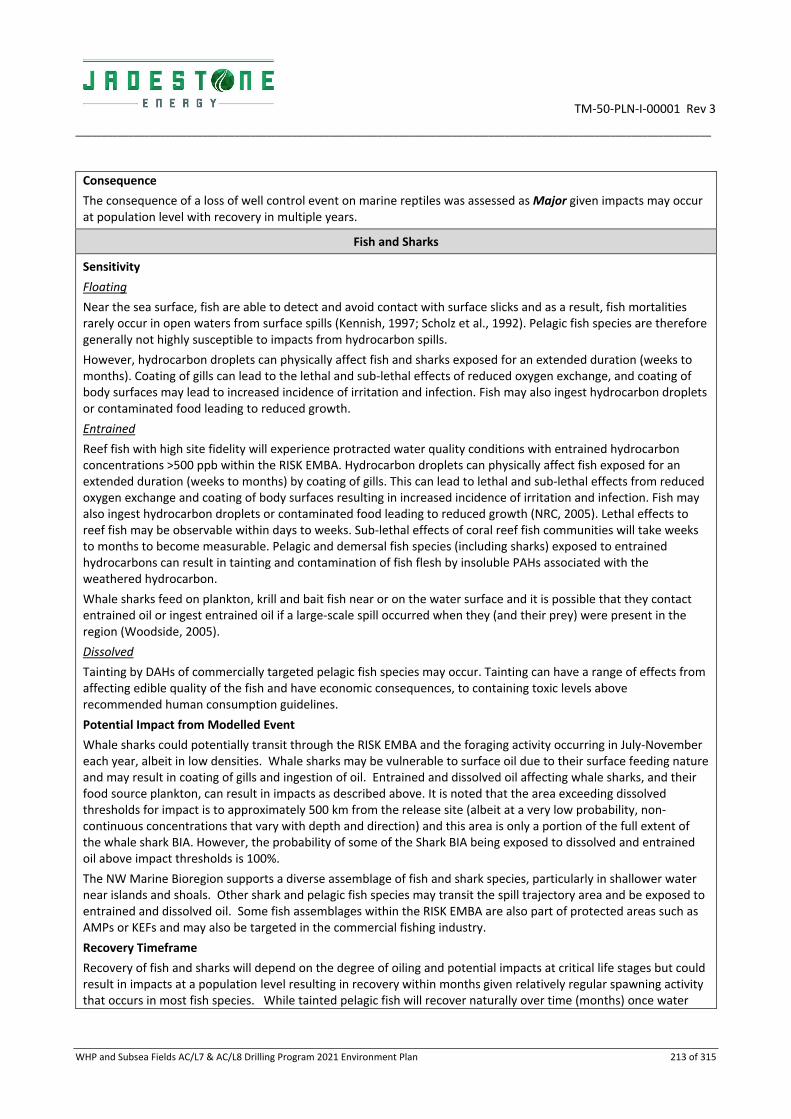
TM‐50‐PLN‐I‐00001 Rev 3
________________________________________________________________________________________________________________________
WHP and Subsea Fields AC/L7 & AC/L8 Drilling Program 2021 Environment Plan 213 of 315
Consequence
The consequence of a loss of well control event on marine reptiles was assessed as Major given impacts may occur at population level with recovery in multiple years.
Fish and Sharks
Sensitivity
Floating
Near the sea surface, fish are able to detect and avoid contact with surface slicks and as a result, fish mortalities rarely occur in open waters from surface spills (Kennish, 1997; Scholz et al., 1992). Pelagic fish species are therefore generally not highly susceptible to impacts from hydrocarbon spills.
However, hydrocarbon droplets can physically affect fish and sharks exposed for an extended duration (weeks to months). Coating of gills can lead to the lethal and sub‐lethal effects of reduced oxygen exchange, and coating of body surfaces may lead to increased incidence of irritation and infection. Fish may also ingest hydrocarbon droplets or contaminated food leading to reduced growth.
Entrained
Reef fish with high site fidelity will experience protracted water quality conditions with entrained hydrocarbon concentrations >500 ppb within the RISK EMBA. Hydrocarbon droplets can physically affect fish exposed for an extended duration (weeks to months) by coating of gills. This can lead to lethal and sub‐lethal effects from reduced oxygen exchange and coating of body surfaces resulting in increased incidence of irritation and infection. Fish may also ingest hydrocarbon droplets or contaminated food leading to reduced growth (NRC, 2005). Lethal effects to reef fish may be observable within days to weeks. Sub‐lethal effects of coral reef fish communities will take weeks to months to become measurable. Pelagic and demersal fish species (including sharks) exposed to entrained hydrocarbons can result in tainting and contamination of fish flesh by insoluble PAHs associated with the weathered hydrocarbon.
Whale sharks feed on plankton, krill and bait fish near or on the water surface and it is possible that they contact entrained oil or ingest entrained oil if a large‐scale spill occurred when they (and their prey) were present in the region (Woodside, 2005).
Dissolved
Tainting by DAHs of commercially targeted pelagic fish species may occur. Tainting can have a range of effects from affecting edible quality of the fish and have economic consequences, to containing toxic levels above recommended human consumption guidelines.
Potential Impact from Modelled Event
Whale sharks could potentially transit through the RISK EMBA and the foraging activity occurring in July‐November each year, albeit in low densities. Whale sharks may be vulnerable to surface oil due to their surface feeding nature and may result in coating of gills and ingestion of oil. Entrained and dissolved oil affecting whale sharks, and their food source plankton, can result in impacts as described above. It is noted that the area exceeding dissolved thresholds for impact is to approximately 500 km from the release site (albeit at a very low probability, non‐continuous concentrations that vary with depth and direction) and this area is only a portion of the full extent of the whale shark BIA. However, the probability of some of the Shark BIA being exposed to dissolved and entrained oil above impact thresholds is 100%.
The NW Marine Bioregion supports a diverse assemblage of fish and shark species, particularly in shallower water near islands and shoals. Other shark and pelagic fish species may transit the spill trajectory area and be exposed to entrained and dissolved oil. Some fish assemblages within the RISK EMBA are also part of protected areas such as AMPs or KEFs and may also be targeted in the commercial fishing industry.
Recovery Timeframe
Recovery of fish and sharks will depend on the degree of oiling and potential impacts at critical life stages but could result in impacts at a population level resulting in recovery within months given relatively regular spawning activity that occurs in most fish species. While tainted pelagic fish will recover naturally over time (months) once water

TM‐50‐PLN‐I‐00001 Rev 3
________________________________________________________________________________________________________________________
WHP and Subsea Fields AC/L7 & AC/L8 Drilling Program 2021 Environment Plan 214 of 315
quality conditions have returned to normal, re‐opening of a fishery will require an understanding of when recovery from tainting has occurred for the target species of interest.
Consequence
Following the Montara blowout, the Montara Environmental Monitoring Program included a study to determine effects of the spill incident on commercial fish species in Australian waters (Gagnon and Rawson 2012). The results of this study identified evidence of exposure of targeted fish species to petroleum hydrocarbons within the vicinity of the Montara well head platform, but limited signs of adverse health or reproductive effects related to hydrocarbon exposure, as captured fish were in good physical condition (Gagnon and Rawson 2012). Based on this evidence from within the same geographical region, in the unlikely event of an uncontrolled well blowout, significant impacts on fish are considered to be unlikely. Potential impacts to commercial fish spawning are considered below with other planktonic communities.
The consequence of a loss of well control event on fish and sharks was assessed as Moderate given impacts may occur to localised populations with recovery in months to a year.
Marine Mammals
Sensitivity
Floating
Physical and chemical effects of hydrocarbons in sea surface waters have been demonstrated through direct contact, for example through physical coating, adsorption to body surfaces and ingestion (NRC, 2005), lethal or sub‐lethal physical and toxic effects such as irritation of eyes/mouth; and potential illness can result.
Whales, dolphins and dugongs are smooth skinned, hairless mammals so hydrocarbons tend not to stick to their skin therefore physical impacts from surface oil coating is unlikely.
Physical impacts due to ingestion are applicable to surface slicks; however, the susceptibility of cetacean species varies with feeding habits. Baleen whales are more likely to ingest surface slick hydrocarbon than "gulp feeders" such as toothed whales and are particularly vulnerable to hydrocarbon ingestion while feeding. Oil may stick to the baleen while the whales "filter feed" near slicks. Humpback whales, whose BIA overlaps the RISK EMBA are more likely to occur in the area during the northern migration period in June/July and southern migration in Sep/Oct so a sea surface plume (>10 g/m2) of oil might contact humpback whales as they migrate. Similarly, blue whales may encounter a sea surface plume (>10 g/m2) as they pass through the area during their northern migration in May–August.
Dugongs are distributed off the northern coast of WA, extending around the Northern Territory coastline. Established seagrass habitats including Vulcan Shoal, Ashmore Reef, Cartier Island and shallow waters along the mainland coastline and islands of Australia and Indonesia may provide dugong habitat. Ashmore Reef is identified as a BIA for dugongs, with estimates of between ten and 60 individuals (Whiting and Guinea 2005).
Marine mammals are at risk of inhaling volatile compounds evaporating from a spill if they surface to breathe in an oil slick (Geraci and St Aubin, 1990).
Entrained
Impacts to marine mammals from entrained hydrocarbons could result in behavioural (e.g. deviating from migratory routes or commonly frequented feeding grounds) impacts. These impacts may affect individuals within or transiting the spill area during migration.
Whales, dolphins and dugongs are smooth skinned, hairless mammals so hydrocarbons tend not to stick to their skin therefore physical impacts from entrained oil coating is unlikely.
Impacts from ingested hydrocarbon can be lethal or sub‐lethal. However, the susceptibility of marine mammal species varies with feeding habits as with surface oil (described previously). Entrained oil attached to seagrass can also be ingested by dugongs. Dugong populations may be indirectly affected by the loss of seagrasses meadows impacted by entrained or dissolved oil phases at a number of shoals and island locations.

TM‐50‐PLN‐I‐00001 Rev 3
________________________________________________________________________________________________________________________
WHP and Subsea Fields AC/L7 & AC/L8 Drilling Program 2021 Environment Plan 215 of 315
Oil may foul sensory hairs around the mouth and/or contact eyes while surfacing to breathe which may cause inflammation and infections. Similar to cetaceans, inhalation of volatile compounds evaporating from a spill may also result in physiological impacts to dugongs.
Dissolved
Marine mammals that may occur within the RISK EMBA for DAHs include whales in offshore waters. According to Geraci and St Aubin (1990), inhalation of volatile compounds evaporating from a spill at sea surface is the greater risk to cetaceans when surfacing to breathe. For these marine mammals, the potential for chemical effects due to exposure is considered unlikely, particularly for highly mobile species such as dolphins because it is very unlikely that these animals will be constantly exposed to high concentrations for continuous durations (e.g. >96 hours) that would lead to toxic effects.
Potential Impact from Modelled Event
Marine mammals present within the RISK EMBA include threatened and migratory whales and dolphins, and potentially dugongs. The activity may be undertaken at any time in the year and may overlap with blue whale migration and humpback whale migration and calving as well as dugong calving and breeding. Crude oil may contact whales and dugongs during these life stages when the fauna are less likely to move away from affected areas if undertaking critical breeding activity.
Surface concentrations above the impact threshold of 10 g/m2 are predicted from the stochastic modelling to reach the BIA for Pygmy blue whale in a minimum time of 3 days, and the BIA for foraging (Scott Reef N) in a minimum time of 15 days. The likelihood of contact for some part of the BIA is predicted to be more than 72 % for exposure to concentrations of surface oil >10g/m2. For humpback whales, surface concentrations greater than 10 g/m2 are not predicted to reach the BIAs for calving, nursing, resting and migration (probability of contact (<1% Camden Sound/Prince Regent National Park). Dugong BIA have a <1% probability of exposure to surface oil >10g/m2. For coastal dolphin species (Australian snubfin and Indo‐pacific humpback dolphins), surface concentrations greater than 10 g/m2 are predicted to reach BIAs ranging from a minimum time of 7 days to 129 days, with a likelihood of contact with surface oil >10g/m2 ranging from 3% to 15%.
Entrained and/or dissolved hydrocarbons may reach parts of the BIAs for whales with a probability ≤ 95% and 63 % respectively at concentrations above the thresholds for impact. As such, individuals may pass through areas with exposure to elevated concentrations along parts of their migratory routes and therefore be affected.
Recovery Timeframe
Recovery of marine mammals will depend on the degree of potential impacts at critical life stages but could result in impacts at a population level resulting in recovery within years e.g. if a spill occurred in migration or calving season and significant numbers were affected by impeded migration and calving. Recovery of individual cetacean may be more rapid once moved away from the area of potential impact due to their smooth hairless skin.
Consequence
The consequence of a loss of well control event on marine mammals was assessed as Major given impacts may occur at population level with recovery in 1–2 years.
Avifauna
Sensitivity
Floating
Seabirds are highly susceptible to hydrocarbon spills and oiled birds may experience hypothermia due to matted feathers and an inability to fly. These impacts are primarily attributed to oiling of birds at the surface from slicks. Oiled birds may experience decreased foraging success due to a decline in prey populations following a spill (Andres 1997, NRC 2003) or due to increased time preening to remove oil from their feathers (Burger 1997). During both winter and migration, shorebirds spend much of their time feeding and depend on nonbreeding habitats to provide the fuel necessary for migratory flight (Withers, 2002).
Oil can reduce invertebrate abundance or alter the intertidal invertebrate community that provides food for nonbreeding shorebirds (Andres 1997, NRC 2003) such as at Ramsar sites. Reduced abundance of a preferred food may cause shorebirds to move and forage in other potentially lower‐ quality habitats. Prey switching has not been

TM‐50‐PLN‐I‐00001 Rev 3
________________________________________________________________________________________________________________________
WHP and Subsea Fields AC/L7 & AC/L8 Drilling Program 2021 Environment Plan 216 of 315
documented in shorebirds following an oil spill. However, shorebirds will feed in alternative habitats when the intertidal zone alone cannot fulfil their energy requirements.
A bird’s inability to obtain adequate resources delays its pre‐migratory fattening and can delay the departure for its breeding grounds. Birds arriving on their breeding grounds earlier realise higher reproductive success through increased clutch size and offspring survival (for a review, see Harrison et al. 2011). If coastal habitats are sufficiently degraded by oil that pre‐migratory fattening is slowed and birds delay departure for their breeding grounds, the individual effects could carry over into the breeding season and into distant breeding habitats (Henkel et al. 2012).
Entrained and dissolved
Seabirds may come into contact with entrained oil while searching for food (diving) below the sea surface, exposure times would be very short in this scenario limiting the opportunity for oiling of feathers. Short‐term physiological effects due to ingestion of entrained oil or contaminated prey may also occur. Ingested oil can have several sublethal toxicological effects, including haemolytic anaemia, reduced reproduction, and immunosuppression.
As most fish survive beneath floating slicks, they will continue to attract foraging seabirds, which typically do not exhibit avoidance behaviour.
Potential Impact from Modelled Event
Numerous species of birds frequent the Timor Sea area or fly through the area on annual migrations. Seabird feeding grounds, roosting and nesting areas are found at the offshore atolls in the wider region. In particular, Ashmore Reef, Cartier and Browse Islands support internationally significant numbers of breeding seabirds and migratory shorebirds with all species variously listed under the EPBC Act. Ashmore Reef is also a Ramsar wetland of international importance. Up to 33 migratory shorebirds species and 18,000 individuals have also been documented using the reserves (Clarke 2010). Peak migration time of migratory shorebirds is between October and December (Clarke 2010). It is expected that some individuals of these species may pass through the RISK EMBA during their annual migrations. A number of BIAs in addition to Ashmore Reef, Cartier and Browse Islands for seabirds have been identified within the RISK EMBA). Surface concentrations above the impact threshold of 10 g/m2 could reach breeding BIAs for crested terns; greater frigatebirds; lesser crested terns; little terns; red‐footed boobys; roseate terns; wedge‐tailed shearwaters, common noddy, bridled tern and white‐tailed tropicbirds; and a resting BIA for little terns. Surface concentrations at ≥10g/m2 threshold are expected to reach BIAs in a minimum time of 38 or 74 hours (to the edge of the BIA or shoreline) to 1216 hours (51 days) depending on the location of the BIA.
The full extent of shoreline habitats exposed to accumulated concentrations greater than the 100 g/m2 threshold is illustrated in Figure 7.2 and 7.3. It has been estimated that as little as four microliters of petroleum contaminating a fertile egg can cause the embryo to die (AMSA 1998), and there is potential for serious impact of oiling of birds from shoreline hydrocarbon contact should the nest be within tidal reach.
Given the earliest shoreline contact, during any season is 7 days at the Kimberley coast, hydrocarbons are expected to have weathered resulting in stranded hydrocarbons containing lower amounts of toxic volatile components.
However, weathered oil has been shown to reduce hatching success in exposed mallard eggs (Finch et al. 2011), and adverse effects from the leaching of PAHs from weathered oil have been observed years after the Exxon Valdez oil spill (Esler et al. 2002, 2010). Shorebirds foraging and feeding in intertidal zones are at potential risk of exposure to shoreline hydrocarbons, potentially causing acute effects.
Following the Montara well release in 2009, petroleum‐based products were reported in the vicinity of Ashmore Reef MP and Cartier Island MP. Small numbers of oiled seabirds were recovered both at sea and on the islands at Ashmore Reef, although search effort was limited (Clark and Herrod 2016). In a post‐impact study of the effects of the spill on bird populations, the total number of seabirds breeding at Ashmore Reef was found to increase after the spill event when compared to pre‐impact data (Clark and Herrod 2016). This trend also applied to breeding populations of individual seabird species. Declines in non‐breeding seabirds during were detected and some of these declines met the a priori definition of significant impact. As breeding populations increased over the same time period, Clark and Herrod (2016) conclude that these declines likely reflect variability in seasonal response rather than evidence for significant impact arising from the Montara oil spill. Declines in migratory shorebird numbers were detected at Ashmore Reef following the spill, however, this response was anticipated given ongoing declines of migratory shorebirds throughout the flyway. When compared with control sites at Eighty‐mile Beach,

TM‐50‐PLN‐I‐00001 Rev 3
________________________________________________________________________________________________________________________
WHP and Subsea Fields AC/L7 & AC/L8 Drilling Program 2021 Environment Plan 217 of 315
WA, the decline in numbers was not found to be significantly different and therefore no significant impact as a result of the Montara spill.
Recovery Timeframe
Recovery of avifauna will depend on the degree of oiling and potential impacts at critical life stages but could result in impacts at a population level resulting in recovery within years e.g. if a spill occurred in turtle nesting season and significant numbers were affected when foraging in the region resulting in impacts carrying over into the breeding season and other breeding habitats.
Consequence
The consequence of a loss of well control event on avifauna was assessed as Major given impacts may occur at population level with recovery in multiple years.
Socio economic
Sensitivity
Floating
Surface oil may impact upon socio‐economic receptors including the oil and gas industry, commercial shipping, fisheries (commercial and traditional)/aquaculture, recreation and tourism, resulting in an economic and social impact. Floating and stranded oil can be highly visible and have a resultant negative effect on tourism. Response activities can require temporary exclusion zones. A sheen of oil (1g/m2) may be visible slightly further than the RISK EMBA for biological impacts boundary and impact on the values of a MPs or tourism beaches.
Many of the protected areas have ‘wilderness’ and ‘seascapes’ identified as values, and these would be compromised by the presence of any oil.
Entrained
Impacts to fish may result in tainted flesh and fishery closure resulting in an economic impact on commercial, recreational and subsistence fishing. Entrained oil can also lead to impacts on aquaculture (e.g. pearls, seaweed) due to a decrease in water quality and reduced stock. Reduced marketability of products (perceived or real) could occur for target species.
Dissolved
Socio‐economic receptors will be affected by hydrocarbon exposure in three ways: Loss of income (e.g. reduction in catch for commercial fisheries), restriction of access and reduction in aesthetic values. Impacts to fish may result in tainted flesh and fishery closure resulting in an economic impact on commercial fishing. DAH in the water column can also lead to impacts on aquaculture (e.g. pearls, seaweed) due to a decrease in water quality and reduced stock. Reduced marketability of products (perceived or real) could occur for target species.
Potential Impact from Modelled Event
Impacts to fisheries could occur due to fish death and tainting of flesh resulting in potential fishery closures and loss of income. The potential area of impact may also be closed to fishers during clean‐up for health and safety reason, reducing the area and timeframe for fishing to occur and potentially affecting income. Perceived and actual impacts to areas popular for tourism can result in a loss of income to the local region through reduced numbers of visitors.
Generally, there is little recreational fishing that occurs within the RISK EMBA due to its distance from land and deep waters. Recreational day fishing is concentrated around the population centres of Broome, Derby and Wyndham, as well as other readily accessible coastal settlements which are generally at the edge of the RISK EMBA some distance away from the well location. These areas are predicted through stochastic modelling to be reached by a surface slick above the visible threshold of 1 g/m2. Commercial fisheries that transect the RISK EMBA predominantly operate in shallower waters with generally low levels of fishing activity reported (AMFA 2012) (Section 3.6).

TM‐50‐PLN‐I‐00001 Rev 3
________________________________________________________________________________________________________________________
WHP and Subsea Fields AC/L7 & AC/L8 Drilling Program 2021 Environment Plan 218 of 315
The MOU, within the Australian Fishing Zone encompasses Scott Reef and associated reefs, including Seringapatam Reef, Browse Island, Ashmore Reef, Cartier Island and various banks within the RISK EMBA. These areas are predicted through stochastic modelling to be reached by a surface slick above the impact threshold of 10 g/m2. Under the MOU, Indonesian and Timorese fishermen are legally permitted to harvest marine products using traditional methods. The peak fishing season is between August and October with fishers departing the region at the onset of the northwest monsoon season. Therefore, traditional fishing could be affected by impacts to fish and benthic habitats (discussed in the above subsections).
It is noteworthy that after the Macondo oil spill, the multi‐species tuna fishery landings had recovered within one‐year (Carroll et al. 2016) and the shrimp (prawn) harvest rebounded only two years after the spill. Inaccurate negative public perceptions towards a fishery following a spill could be mitigated at the time by positive marketing as was effective after Macondo. The overall consequence ranking for fishing from exposure to hydrocarbons is Major with recovery predicted in multiple years.
Most recreational and tourism activities in the region occur predominantly in WA State and NT waters. Coastal waters north of Broome, WA through to the eastern cape of East Arnhem, are predicted through stochastic modelling to be reached by a surface slick above the threshold of 1 g/m2. Limited tourism activities occur at Scott Reef, Ashmore Reef and Cartier Island (Section 3.6), which are predicted to be reached by a surface slick above the threshold of 10 g/m2. Natural features visited by tourist fishing charters and bird watching tours may therefore be affected in the event of a well blow out.
Shoreline exposure has the potential for localised short‐term impacts to marine‐based tourism and recreation in the area. Modelling predicts 46 % and 29 % probability that shoreline loads >10 g/m2 will occur at the Kimberley coast and Kakadu National Park respectively. The earliest predicted shoreline contact is 7 days at the Kimberley coast. As such, stranded oil is expected to weather naturally and breakdown with assistance of ocean currents and as a result, only waxy residues of a lesser toxicity are expected to accumulate on the shoreline.
Tourism also has the potential to be impacted if exclusion zones are implemented where AMSA’s spill response strategy overlaps with key visiting areas. Alaska’s tourism economy took approximately two years to recover from the Exxon Valdez (BOEM, 2017).The Eastern Research Group (2014) reported that while the Macondo spill had had a significant impact on several areas of tourism in the short term and had wide‐ranging impacts across the Gulf, the tourism economy has rebounded to pre‐spill levels within four years.
The overall consequence ranking for tourism and recreation activities from exposure to hydrocarbons is Moderate.
For the low level of commercial shipping activity transiting the RISK EMBA, exposure risk is limited to surface slicks potentially oiling vessel hulls and requirements to deviate around exclusion zones during the response activities. Similar exposure is predicted for Defense activities such as Customs Coastwatch, Navy and Customs vessels operating in the RISK EMBA as well as for Petroleum Exploration and Production operators in the Timor Sea. Overall consequences to shipping, defense and other Oil and Gas Operators is ranked Minor with recovery in weeks to months.
Recovery Timeframe
Recovery will depend on the degree of oiling along shorelines and that which is perceived by the public. Recovery of fish is likely to occur within months to years of water quality returning to normal given the regular spawning events that occur. Timeframes for fish may be based on tainting disappearing. Reputation may be impacted nationally with persistent national coverage, with full recovery taking multiple years.
Consequence
The consequence of a loss of well control event on socio‐economic receptors was assessed as Major given impacts on the values of tourism and fisheries may take multiple years to recover and have a national reputational impact.
Protected Areas
Sensitivity
Floating
Surface oil and/or shoreline loading may be expected at some AMPs affecting shoreline habitats and intertidal zones.

TM‐50‐PLN‐I‐00001 Rev 3
________________________________________________________________________________________________________________________
WHP and Subsea Fields AC/L7 & AC/L8 Drilling Program 2021 Environment Plan 219 of 315
Entrained and dissolved
Entrained hydrocarbons will or may impact the coral and seagrass habitats, as well as other MP values fauna including listed dugongs, sea snakes (protected), fish, avifauna and other marine mammals. Impacts to these receptors are described under individual receptors.
Potential Impact from Modelled Event
AMPs
The following AMPs are present within the RISK EMBA and have potential to be exposed to surface oil >10g/m2: Cartier Island MP (88 %), Ashmore Reef MP (72%), Oceanic Shoals MP (46 %), Kimberley MP (45 %), Argo‐Rowley Terrace (16 %) MP. Surface oil could be expected to accumulate at some locations (e.g. Cartier Island MP and Ashmore Reef MP have 100 % probabilities of exposure to >10g/m2. Elevated dissolved hydrocarbons may occur at or above impact concentrations within the Cartier Island MP and Ashmore Reef MP, Oceanic and Kimberley MP’s, Oceanic Shoals and Kimberley MPs. Elevated entrained hydrocarbons above impact thresholds are predicted in the Cartier Island MP, Ashmore Reef MP, Kimberley, Oceanic, and Argo Rowley Terrace MPs. Entrained hydrocarbons could therefore impact on the potential values and includes all marine fauna as described within this table, marine habitats and socio‐economic receptors.
With the deeper(>30m) MP features, the geomorphological features are unlikely to be affected by entrained hydrocarbons, but the receptors may be affected by the change in water quality and impacts to the food chain. However, shallower features within MPs such as coral reefs around Ashmore Reef and Mermaid Reef would potentially have long term impacts to the habitats supporting receptors as described within this table for coral reefs and other habitats.
Impacts on the values associated with Protected Areas may result in loss of fauna/ habitat diversity and/ or abundance, reduction in commercial/recreational/ subsistence fishing, loss of livelihood and loss of income from reduced tourism and commercial productivity. Several of the AMPs – such as the Kimberley MP, have conservation values associated with biological attributes including migratory seabirds, flatback turtles, humpback whales, freshwater, green and dwarf sawfish, Australian Snubfin, Indo‐Pacific Humpback and Indo‐Pacific bottlenose dolphins. Tourism may be impacted by real or perceived reduction in health or mortality of habitats that support tourism activities.
State and Territory Marine Parks
The minimum time before exposure to surface hydrocarbons above the impact threshold of 10 g/m2 for any protected area is predicted to be 7 days at the Kimberley CMR. The minimum time before shoreline accumulation at the impact threshold of 100 g/m2 is 7 days for the Kimberley coast. Considerable weathering of hydrocarbons will therefore occur before reaching the protected areas.
There are five marine parks within the RISK EMBA: Garig Gunak Barlu Marine Park (NT), Lalang Garram / Camden Sound (WA), Rowley Shoals Marine Park (WA), Scott Reef Nature Reserve (WA) and Browse Island. Values associated with these marine parks include marine fauna and coral reefs, mangroves, saltmarshes and sandy beaches. These values may be contacted by entrained and dissolved oil which would potentially impact the receptors as described in this table. The values of these marine parks are described in Appendix B.
World, National and Commonwealth Heritage Places
The Kakadu National Park is the only Australian world heritage place within the RISK EMBA and has an 8 % probability of surface oil >10g/m2 in 25 days and maximum 19 % probability of oil accumulated onshore >100g/m2. Receptors within this park include mangroves and wetlands which in turn support migratory birds. Impacts to these receptor types are described in this table from surface, entrained and dissolved oil.
The minimum time before exposure to surface hydrocarbons above the impact threshold of 10 g/m2 for any heritage area is predicted to be 4 days at the Kimberley National Heritage area. The minimum time before shoreline accumulation at the impact threshold of 100 g/m2 is 7 days for the Kimberley coast.
Threatened Ecological Communities
The Monsoon vine thickets on the coastal sand dunes of Dampier Peninsula is the only Threatened Ecological Community within the RISK EMBA. Receptors within this TEC include coastal sand dunes and beaches which may

TM‐50‐PLN‐I‐00001 Rev 3
________________________________________________________________________________________________________________________
WHP and Subsea Fields AC/L7 & AC/L8 Drilling Program 2021 Environment Plan 220 of 315
result in impacts to fauna utilising the beaches. Impacts to shoreline habitats are described in this table from both entrained and dissolved oil.
Wetlands of International Importance
Wetlands identified within or adjacent to the RISK EMBA include Ashmore Reef National Nature Reserve, Cobourg Peninsula, Hosnies Spring, Ord River Floodplain, Kakadu National Park Pulu keeling national park, and The Dales. Some of these wetlands represent wetland types near natural condition within the region and may be contacted by surface or entrained oil. Impacts to wetlands, tidal marshes and associated receptors are described within this table, with impact consequence depending on each site’s access to open ocean, degree and duration of oiling and the degree of weathering of the arriving oil.
KEFs
There are no KEFS that would be impacted by surface oil as the KEFs relate to geomorphologic features which are not expected to be impacted by hydrocarbons. Values and sensitivities associated with the KEFs include marine fauna due to the higher diversity of fish species associated with the higher diversity in fish communities or nutrients such as Continental Slope Demersal Fish Communities; or benthic habitats at Ashmore Reef and Cartier Island and surrounding Commonwealth waters ‐ as discussed individually above.
There are a number of KEFs that are overlapped by the RISK EMBA including: Continental Slope Demersal Fish Communities, Ashmore Reef and Cartier Island and Surrounding Commonwealth Waters, Seringapatam Reef and Commonwealth Waters in the Scott Reef Complex, Canyons Linking the Argo Abyssal Plain with the Scott Plateau, Mermaid Reef and Commonwealth Waters Surrounding Rowley Shoals, Pinnacles of the Bonaparte Basin, Ancient Coastline at 125 m Depth Contour Carbonate Bank and Terrace System of the Sahul Shelf, Shelf Break and Slope of the Arafura Shelf, Carbonate Bank and Terrace System of the Van Diemen Rise, Exmouth Plateau, Tributary Canyons of the Arafura Depression, Glomar Shoals and Gulf of Carpenteria Basin.
The minimum time before exposure to surface hydrocarbons above the impact threshold of 10 g/m2 for any KEF is predicted to be 32 hours for the Carbonate bank and terrace system of the Sahul Shelf. Impacts to features (such as canyons or pinnacles) in deep waters are not expected to be affected by entrained or dissolved oil due to the nature of these features. However, values associated with shallower KEFs such as reefs and islands and the surrounding waters will be affected by changes in water quality and impacts to receptors within the water as described in this table.
Contact with entrained hydrocarbons above the 100 ppb threshold is predicted at all the KEFs in the RISK EMBA albeit most at very low probabilities (<1%) for some, depending on the season, water depth and distance (e.g. Exmouth Plateau and Tributary Canyons of the Arafura Shelf,) consequently impacts are not anticipated. Likewise, exposure to dissolved aromatics above the 70 ppb threshold is predicted with the highest probability at the Carbonate bank and terrace system of the Sahul Shelf, Ancient Coastline, Ashmore Reef and Cartier Island KEF and Continental Slope Demersal Fish Communities with a low probability of < 1 for the remote KEFs.
Recovery Timeframe
Recovery of benthic habitats within Protected Areas exposed to entrained hydrocarbons and experiencing impacts would be expected within weeks to months of return to normal water quality conditions. Several studies have indicated that rapid recovery rates may occur even in cases of heavy oiling (Burns et al., 1993; Dean et al., 1998). The timeframe for recovery of receptors within these areas are described within this table.
Consequence
The consequence of a loss of well control event on protected areas was assessed as Critical given recovery to some habitats such as corals with longer restitution times within these protected areas may take decades to recover.
Overall Consequence
Likelihood Ranking
Critical (worst‐case of all above receptors)
Unlikely ‐ Heard of in the exploration and production industry.
IOGP 434‐02 Blowout Frequencies contains data based upon oil and gas
Medium

TM‐50‐PLN‐I‐00001 Rev 3
________________________________________________________________________________________________________________________
WHP and Subsea Fields AC/L7 & AC/L8 Drilling Program 2021 Environment Plan 221 of 315
industry experience for well workovers and development drilling of additional oil wells. Event frequencies quoted are 3.3 to 3.7x10‐4 which demonstrates that this is an unlikely occurrence that has been heard of in the industry. This supports the selection of a likelihood category of unlikely.
7.6.8 Priority receptors
For spill response planning purposes, priority receptors were identified from the sensitive receptors using the criteria outlined in Section 5. In a spill event, the IAP, NEBA and planning process takes over; utilising real‐time operational data and focusing operations on locations to be contacted (which will be a subset of what is planned for). This allows for preparedness and planning for the most credible scenarios whilst retaining flexibility in response to manage an event.
Eight priority receptors for spill response have been determined from the deterministic run for the worst‐case modelling results (Table 7‐8).
Table 7‐9: Priority receptors rationale
Priority receptors Individual locations included in receptor Rationale
Ashmore Reef / Cartier Island
Ashmore Reef and Cartier Island and surrounding Commonwealth waters
Shoreline loading volumes
Minimum time to contact
High value
>5% probability of contact
International Waters
Timor Leste
Indonesia
Shoreline loading volumes
High value
>5% probability of contact
Darwin Coast
Darwin Coast Shoreline loading volumes
Time to contact
High value
>5% probability of contact
Joseph Bonaparte Gulf NT
Joseph Bonaparte Gulf Northern Territory Shoreline loading volumes
High value
Time to contact
>5% probability of contact
Western NT
Kakadu Coast
Cobourg Peninsula
East Arnhem Land
West Arnhem Land
Shoreline loading volumes
High value
Time to contact
>5% probability of contact
Tiwi Islands
Melville Island
Bathurst Island
Shoreline loading volumes
High value
Time to contact
>5% probability of contact
Kimberley Coast
Kimberley Coast Shoreline loading volumes
High value

TM‐50‐PLN‐I‐00001 Rev 3
________________________________________________________________________________________________________________________
WHP and Subsea Fields AC/L7 & AC/L8 Drilling Program 2021 Environment Plan 222 of 315
Priority receptors Individual locations included in receptor Rationale
Time to contact
>5% probability of contact
Browse Island Browse Island Shoreline loading volumes
High value
Time to contact
>5% probability of contact

TM‐50‐PLN‐I‐00001 Rev 3
_________________________________________________________________________________________________________________________________________________________________________________
WHP and Subsea Fields AC/L7 & AC/L8 Drilling Program 2021 Environment Plan 223 of 315
Figure 7‐2: Priority receptors
TM‐50‐PLN‐I‐00001 Rev 3
________________________________________________________________________________________________________________________
WHP and Subsea Fields AC/L7 & AC/L8 Drilling Program 2021 Environment Plan 224 of 315
Table 7‐8 lists the rationale for the Priority Receptor selection (also refer Section 5) and Appendix H details the specific key values and modelled contact of the Priority receptors.
A NEBA was conducted to determine the Environmental Performance Outcome (EPO) for the locations and the spill response measures that would be required to meet the EPO and thereby reduce impacts associated with spill response to ALARP (Table 7‐9).
7.6.9 Net Environmental Benefit Assessment (NEBA)
Net environmental benefit assessment (NEBA) is a structured approach used by the spill response community and stakeholders to select spill response strategies that will effectively remove oil, are feasible to use safely in particular conditions, and will reduce the impact of an oil spill on the environment.
The NEBA process is used during pre‐spill planning (Strategic NEBA) and during a response (Operational NEBA). A Strategic NEBA is an integral part of the contingency planning process and is used to ensure that response strategies for scenarios are well informed. An Operational NEBA is used to ensure that evolving conditions are understood, so that the response strategy can be adjusted as necessary to manage individual response actions and end points.
Balancing trade‐offs may involve differing and conflicting priorities, values and perceptions of the importance of sensitive receptors. There is no universally accepted way to assign perceived value or importance and is not a quantitative process. Overall, the NEBA process provides an estimate of potential environmental effects which are sufficient to allow the parties to compare and select preferred combinations of response strategies to reduce environmental impacts to ALARP.
Table 7‐9 provides the NEBA for the Priority receptors and the potential impact that response strategy has on the environmental values of the area, noting that response strategies are not used in isolation. This information is to be considered during the development of the Incident Action Plan in a spill response (i.e. an Operational NEBA). An Operational NEBA will also consider feedback from operational and scientific monitoring activities (refer OPEP), real time monitoring of the effectiveness and potential impacts of a response and will also consider accessibility, feasibility and safety of responders.

TM‐50‐PLN‐I‐00001 Rev 3
_________________________________________________________________________________________________________________________________________________________________________________
WHP and Subsea Fields AC/L7 & AC/L8 Drilling Program 2021 Environment Plan 225 of 315
Table 7‐10: Impact of selected spill response strategy on the environmental values of Protection Priorities
Protection Priority environmental values
No controls
Source control
Dispersant (surface / Subsea) *
Operational Monitoring
Containment and recovery
Shoreline Protection
Shoreline Clean‐up
Oiled Wildlife Response
Scientific Monitoring
Environmental Outcomes ‐ Reduce oil volumes from reaching the shoreline to as low as reasonably practicable
‐ Prioritise sanctuary zones and KPI species and habitats (as per marine park management plan if relevant)
‐ Reduce impacts to marine and coastal fauna through the implementation of the WA Oiled Wildlife Response Plan
Ashmore Reef / Cartier Island
Seabirds
Mangroves n/a
Emergent reefs n/a
Turtle nesting beaches
Coral reefs n/a n/a n/a
Marine habitat n/a n/a n/a
Marine fauna n/a n/a
Protected Areas
Wetlands n/a
Socio‐economic
Darwin Coast
Seabirds
Mangroves n/a
Coral reefs n/a n/a n/a
Marine habitat n/a n/a n/a
Marine fauna n/a n/a
Socio‐economic
International waters (Timor Leste and Indonesia)
Seabirds
Mangroves n/a

TM‐50‐PLN‐I‐00001 Rev 3
_________________________________________________________________________________________________________________________________________________________________________________
WHP and Subsea Fields AC/L7 & AC/L8 Drilling Program 2021 Environment Plan 226 of 315
Protection Priority environmental values
No controls
Source control
Dispersant (surface / Subsea) *
Operational Monitoring
Containment and recovery
Shoreline Protection
Shoreline Clean‐up
Oiled Wildlife Response
Scientific Monitoring
Environmental Outcomes ‐ Reduce oil volumes from reaching the shoreline to as low as reasonably practicable
‐ Prioritise sanctuary zones and KPI species and habitats (as per marine park management plan if relevant)
‐ Reduce impacts to marine and coastal fauna through the implementation of the WA Oiled Wildlife Response Plan
Emergent reefs n/a
Turtle nesting beaches
Coral reefs n/a n/a n/a
Marine habitat n/a n/a n/a
Marine fauna n/a n/a
National Park
Wetlands n/a n/a
Socio‐economic
Joseph Bonaparte Gulf NT
Seabirds
Mangroves n/a
Coral reefs n/a n/a n/a
Marine habitat n/a n/a n/a
Marine fauna n/a n/a
Protected Areas
Wetlands n/a
Socio‐economic
Western NT (incl, Kakadu Coast, Coburg Peninsula, East and West Arnhem Land)
Seabirds
Mangroves n/a
Coral reefs n/a n/a n/a
Marine habitat n/a n/a n/a

TM‐50‐PLN‐I‐00001 Rev 3
_________________________________________________________________________________________________________________________________________________________________________________
WHP and Subsea Fields AC/L7 & AC/L8 Drilling Program 2021 Environment Plan 227 of 315
Protection Priority environmental values
No controls
Source control
Dispersant (surface / Subsea) *
Operational Monitoring
Containment and recovery
Shoreline Protection
Shoreline Clean‐up
Oiled Wildlife Response
Scientific Monitoring
Environmental Outcomes ‐ Reduce oil volumes from reaching the shoreline to as low as reasonably practicable
‐ Prioritise sanctuary zones and KPI species and habitats (as per marine park management plan if relevant)
‐ Reduce impacts to marine and coastal fauna through the implementation of the WA Oiled Wildlife Response Plan
Marine fauna n/a n/a
Protected Areas
Wetlands n/a
Socio‐economic
Turtle nesting beaches
Tiwi Islands (Melville Island and Bathurst Island)
Seabirds
Mangroves n/a
Coral reefs n/a n/a n/a
Marine habitat n/a n/a n/a
Marine fauna n/a n/a n/a
Socio‐economic n/a
Turtle nesting beaches
Kimberley Coast
Seabirds
Mangroves n/a
Coral reefs n/a n/a n/a
Marine habitat n/a n/a n/a
Marine fauna n/a n/a
Protected Areas
Wetlands
Socio‐economic

TM‐50‐PLN‐I‐00001 Rev 3
_________________________________________________________________________________________________________________________________________________________________________________
WHP and Subsea Fields AC/L7 & AC/L8 Drilling Program 2021 Environment Plan 228 of 315
Protection Priority environmental values
No controls
Source control
Dispersant (surface / Subsea) *
Operational Monitoring
Containment and recovery
Shoreline Protection
Shoreline Clean‐up
Oiled Wildlife Response
Scientific Monitoring
Environmental Outcomes ‐ Reduce oil volumes from reaching the shoreline to as low as reasonably practicable
‐ Prioritise sanctuary zones and KPI species and habitats (as per marine park management plan if relevant)
‐ Reduce impacts to marine and coastal fauna through the implementation of the WA Oiled Wildlife Response Plan
Turtle nesting beaches
Browse Island
Seabirds
Emergent reefs n/a
Turtle nesting beaches
Coral reefs n/a n/a n/a
Marine habitat n/a n/a n/a
Marine fauna n/a n/a
Protected Areas
Socio‐economic
Legend
Beneficial Impact
Possible beneficial impact dependent upon the situation (e.g. Timeframes and metocean conditions to dilute entrained oil)
Negative impact
n/a Not applicable for the environmental value

TM‐50‐PLN‐I‐00001 Rev 3
_________________________________________________________________________________________________________________________________________________________________________________
WHP and Subsea Fields AC/L7 & AC/L8 Drilling Program 2021 Environment Plan 229 of 315
7.6.10 Environmental performance
Environmental Risk Unplanned release of crude oil
Overall Performance Outcome No reportable spill of hydrocarbon to the marine environment.
I.D Management controls Performance Standards Measurement Criteria Responsibility
065 Implementation of the Jadestone Drilling Management System ‐ Well Integrity Manual
Barrier verification pressure testing and well barrier analysis undertaken
Records of well barrier verification and pressure testing maintained and reported in daily drilling report and end of well report.
Drilling Manager
066 Implementation of the Jadestone Drilling Management System ‐ Well Operations Management Plan
Overall well activity management processes and life cycle activities undertaken including well integrity performance monitoring and well integrity incidents excursion management in accordance with the NOPSEMA accepted WOMP.
Records of well integrity performance monitoring and well integrity incidents maintained and reported in daily drilling report and end of well report.
Drilling Manager
Completed Well Handover Data Books in CMMS
OIM
067 Wellhead valves installed and tested in accordance with the Well integrity Manual
Wellhead Valves are installed/maintained/ tested and found fit for purpose Wellhead Valves are installed/maintained/ tested and found fit for purpose
Installation and testing records in the Well Handover Data pack provided with the completed Well to Production
Drilling Manager
068 MODU move procedures followed and in alignment with the Marine Operating Manual
Functioning positioning equipment (DGPS) on MODU
Functioning AHTS for final positioning
Preload method as per underwriter and drilling contractor’s Marine Operating Manual
Position of infrastructure (platform, pipelines, subsea wellheads) marked into positioning software.
Surveyor on board MODU during MODU move in.
Wells shut in and depressured at surface for rig approach and positioning.
MODU move procedure reviewed and approved by JSE, drilling contractor and surveying company.
Realtime display and logging
Marine Operating Manual checklist completed
Inspection and survey reports
Master Mariner qualifications and experience
MODU and WHP OIM
Tow Master
Supply Chain Lead

TM‐50‐PLN‐I‐00001 Rev 3
_________________________________________________________________________________________________________________________________________________________________________________
WHP and Subsea Fields AC/L7 & AC/L8 Drilling Program 2021 Environment Plan 230 of 315
Environmental Risk Unplanned release of crude oil
Overall Performance Outcome No reportable spill of hydrocarbon to the marine environment.
I.D Management controls Performance Standards Measurement Criteria Responsibility
Rig move procedures in place (including minimum 3 support vessels for positioning)
Minimum bollard pull requirements for AHTS met or exceeded.
Weather window acceptable for tow and pre‐load phase.
Tow vessels inspected by Tow Master prior to commencement of tow.
Experienced Tow Master to move the MODU and on board for all transits and positioning
069 Tow equipment confirmed fit for purpose
Tow equipment certified as fit for purpose.
Tow equipment visually inspected by Rig Mover / Tow Master prior to commencement of tow.
Evidence inspection record Tow Master
070 Seabed study – no punch through of seabed risk.
Prior to commencement of activity, a survey using ROV will be undertaken which will include a visual survey of the seabed within the footprint of the mooring area.
Study reviewed independently by MODU underwriter.
Approved Seabed Study MODU OIM
071 SIMOPs Plan An interfacing alarm and shut down system will be employed to assist with the safe management of the operations.
A handheld radio UHF communications system will be available between the MODU and the FPSO.
A copy of the Simultaneous Operations Plan must be available to all personnel on the MODU and Jadestone
Approved SIMOPs Plan in place and available to all personnel on MODU and Jadestone
WHP OIM
MODU OIM
072 Blowout Contingency Plans (JS‐70‐PLN‐D‐00001)
Intervention actions undertaken in accordance with the Blowout Contingency Plan.
Records confirm the Blowout Contingency Plan was implemented.
Drilling Manager

TM‐50‐PLN‐I‐00001 Rev 3
_________________________________________________________________________________________________________________________________________________________________________________
WHP and Subsea Fields AC/L7 & AC/L8 Drilling Program 2021 Environment Plan 231 of 315
Environmental Risk Unplanned release of crude oil
Overall Performance Outcome No reportable spill of hydrocarbon to the marine environment.
I.D Management controls Performance Standards Measurement Criteria Responsibility
073 Implement Oil Pollution Emergency Plan (OPEP)
In the event of a Level 2 or Level 3 spill, compliance with OPEP including develop and implement an IAP using the processes described within the OPEP.
Response records confirm OPEP was adhered to and an IAP was developed and implemented.
IMT Lead
074 Incident Management Team Response Plan (JS‐70‐PLN‐F‐00008)
Implement the Incident Management Team Response Plan in the event of a spill of hydrocarbons to the marine environment
Incident log IMT Lead
075 Emergency Pipeline Repair Plan (GF‐09‐PLN‐L‐00039)
Repair of damage to subsea export pipeline to its original capacity such that pipeline license requirements are fulfilled, and the environmental and business consequence of any failure are minimised.
Incident log IMT Lead
076 Post spill scientific monitoring program undertaken
Monitor impacts and recovery of the values and sensitivities identified in this EP in accordance with the OSMP.
Monitoring reports indicate no long‐term impacts to the values and sensitivities identified in this EP.
IMT Lead
077 MODU and Montara Operations Safety case
Maintain safety critical aspects as per Safety Case Records confirm Safety Case standards met
MODU OIM
Operations Manager

TM‐50‐PLN‐I‐00001 Rev 3
________________________________________________________________________________________________________________________
WHP and Subsea Fields AC/L7 & AC/L8 Drilling Program 2021 Environment Plan 232 of 315
7.6.11 ALARP assessment
Since this is an infill drilling campaign, the oil type and well characteristics are well understood. As such, the control measures to be used to reduce the risk of oil spills to ALARP are likely to be similar to previous drilling campaigns within this field. All safety options have been considered for the Drilling Activity with no additional safety options possible, it is considered that the risk of a loss of containment occurring has been reduced to ALARP. The combination of the standard controls (which reduce the likelihood of the event happening), and the spill response strategies (which reduce the consequence) together aim to reduce potential impacts from a hydrocarbon spill. An oil spill response review was undertaken and a summary of the rationale behind the spill response measures selected is provided in Table 6‐7.
Subsea Controls
Pipeline rupture from external factors through anchor drag is not considered credible as the vessels and the MODU will not be using anchors. The scenario of a dropped object damaging the subsea export pipeline was considered not credible due to the final MODU position and supply arrangements for MODU not including the pipeline within the respective dropzone footprints. The rigid riser section of the pipeline is also protected by a frame and runs inside the jacket leg footprint providing additional protection from swinging loads and vessel impacts.
Controls are in place (refer Sections 7.6.10 and 7.7.7) which reduce the likelihood of spill events, in particular the wells and flowlines are shut in and depressured when moving the MODU in. There are no further controls that are considered to provide a net benefit in reducing the likelihood or consequence of a release of Montara or Skua crude to the marine environment and thus the controls are considered ALARP.
Spill Response Controls
For a Level 1 crude oil spill, containment and clean‐up is assisted through the bunding system provided around drilling equipment and the regular inspection programs. Spills are responded to as per emergency and spill response procedures which are practised through regular spill/ emergency response drills on the rig and vessels. In the event that diesel or crude oil is not contained through the barriers and procedures onboard the MODU, the OPEP, which outlines the detailed response and logistical requirements necessary to combat a worst‐case spill, will be implemented to reduce the impacts of a crude oil spill to ALARP.
A Net Environmental Benefit Analysis (NEBA) will be used to determine which spill response strategies are appropriate for a given spill scenario and is an integral part of the IAP process. Source control, operational monitoring activities and spill response strategies considered for a Level 2/3 spill are shown in Table 7‐9.
The spill response strategies have undergone a robust evaluation and environmental risk assessment process. The applicability of the control to the spill scenario and establishing requirements for each control to ensure its effectiveness in meeting the EPO was also undertaken.
The assumption was that existing controls were ineffective (i.e. 100% probability the spill occurred) and each control would be exposed to the full volume of oil under the maximum credible worst‐case scenario. This approach promoted a level of conservatism in the proposed control strategies, and, in particular, the measures for determining the effectiveness of controls and the requirements to achieve the level of effectiveness.
The ALARP assessment for the level of resourcing required for each of the spill response strategies adopted is provided in Table 7‐10, based on the capability described in the OPEP. This considers the incremental benefit of increasing resourcing levels for each spill response strategy and the associated upfront costs. The

TM‐50‐PLN‐I‐00001 Rev 3
________________________________________________________________________________________________________________________
WHP and Subsea Fields AC/L7 & AC/L8 Drilling Program 2021 Environment Plan 233 of 315
effectiveness of each of these response strategies has been increased to a point where further sacrifice made would result in a disproportionately small reduction in environmental benefit.
From this assessment, it is considered that through the resourcing arrangements outlined within the OPEP and in Section 6.8.3 (including spill response equipment and personnel from internal and external sources including via the AMOSPlan, AMSA, OSRL, other operators and other national suppliers) the spill response strategies and control measures reduce spill risk to ALARP.

TM‐50‐PLN‐I‐00001 Rev 3
____________________________________________________________________________________________________________________________________________________________________________________
WHP and Subsea Fields AC/L7 & AC/L8 Drilling Program 2021 Environment Plan 234 of 315
Table 7‐11: ALARP assessment for increasing the level of resourcing in the OPEP for spill response strategies
Strategy tasks and resources arrangement improvements considered
Environmental/Social/Economic consequences of additional
resources from those described in the OPEP
Practicality of additional resources
ALARP assessment Adopted?
Source Control – increase oil spill response capability of MODU and support vessels beyond a Level 1 response (as well as FPSO capabilities in the vicinity)
Section 8 of OPEP
Reduce volume or speed of spill entering marine environment.
Significant cost would be incurred for Jadestone to alter the contractual arrangements to increase capability with consideration for equipment, storage, maintenance, crew training and safety of crew when deploying gear.
The rig and vessel have the response capability as described in the SOPEP and geared towards a Level 1 incident.
The SOPEP is to provide shipboard notification and response procedures for stopping or minimizing the unexpected discharge of oil from a rig/vessel without compromising the safety of the crew, the rig/vessel or the environment. Unexpected discharge includes the discharge of oil during rig/vessel operations, or rig/vessel casualty.
It is consistent with the National Plan that the FPSO, MODU and vessels have a level 1 capability.
For Jadestone to increase the response capability above a Level 1, would be a disproportionate benefit for the effort.
In addition, the worst‐case spill results from a vessel collision and the priority of the vessel master is to safeguard the crew and remove all non‐essential personnel.
Therefore, there is no value in supplementing the vessels’ SOPEP capability, and therefore the arrangements described in the OPEP are considered ALARP.
No
Source Control – Monitor external drilling programs for MODU availability
Potentially reducing the time to drill the relief well, resulting in less hydrocarbons to the environment.
Accepted industry standard as aided by APPEA MOU
Jadestone can select, obtain conceptual agreement with owners or
operators of MODUs prior to risk activities. During the Blowout exposure times of the campaign, Jadestone will monitor availability of selected feasible
MODUs. This is detailed in Appendix H of the BCP. This assures rig availability within the response time for a relief well as stated in this document (Section 7.5.3).
Yes

TM‐50‐PLN‐I‐00001 Rev 3
____________________________________________________________________________________________________________________________________________________________________________________
WHP and Subsea Fields AC/L7 & AC/L8 Drilling Program 2021 Environment Plan 235 of 315
Source control ‐ Monitor status of Registered Operators/ Approved Safety cases for rigs
Potentially reducing the time to drill the relief well, resulting in less hydrocarbon to the environment.
Part of the process of planning for the relief well options.
Jadestone can, as part of the above selection process, monitor the status of Registered Operators for rigs operating within Australia, and those outside of Australia. This allows for a prioritised selection of rigs in the event of a response with priority given to those with an existing safety case for working in Australia.
Yes
Source control – Jadestone to become a signatory to the APPEA MOU for mutual aid to facilitate and expedite the mobilisation of a relief well
Potentially reducing the time to drill the relief well, resulting in less hydrocarbon to the environment.
Accepted industry Standard
The APPEA MoU commits the signatories to share rigs, equipment, personnel and services to assist another operator in the event of a LOWC incident. This enable Jadestone to obtain conceptual agreement of suitable relief well drilling rigs, and aids in arranging conceptual agreements for access to additional equipment.
Yes
Source control ‐ standby MODU available in‐field during drilling operations instead of having to source and deploy at the time of loss of containment
Potentially reducing the time to drill the relief well, resulting in less hydrocarbon to the environment.
The total cost is approx. $105 million during the 150‐day program. If adopted this cost is paid regardless if there is a loss of containment event or not.
A MODU on standby close to the well location for the duration of the EP in readiness to drill a relief well may remove 10 days from the base case required to source and mobilise the MODU. However, the MODU would be required to be on standby 24/7 over the 150 days of the Drilling Program– this is not feasible.
The costs, safety concerns and complexity of having a MODU and maintaining this arrangement for the duration of the EP is grossly disproportionate to the environmental benefit gained.
No
Source control ‐ Position Subsea First Response Toolkit (SFRT) to Darwin, closer to the potential spill location
Potentially reducing the time to start the application of subsea dispersants, resulting in a reduction of surface oil and shoreline loading
AMOSC does not agree to the relocation of the SFRT due to the risk to other SFRT members
Relocating the SFRT is not a reasonably practicable strategy as the SFRT is a shared resource.
Mobilisation of the SFRT will occur at the same time as mobilisation of a suitable construction class vessel to Darwin. The SFRT cannot be transported to the well location until the vessel is available in Darwin, which is expected to take 7 days.
No
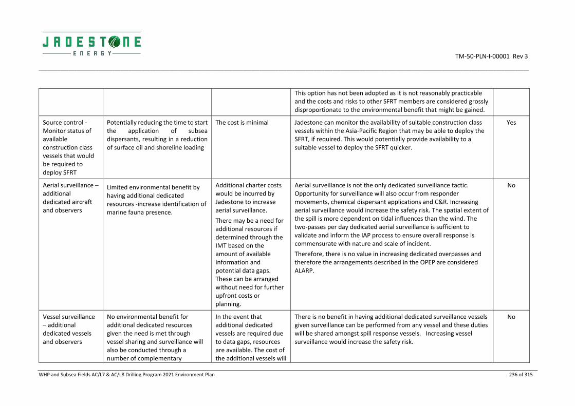
TM‐50‐PLN‐I‐00001 Rev 3
____________________________________________________________________________________________________________________________________________________________________________________
WHP and Subsea Fields AC/L7 & AC/L8 Drilling Program 2021 Environment Plan 236 of 315
This option has not been adopted as it is not reasonably practicable and the costs and risks to other SFRT members are considered grossly disproportionate to the environmental benefit that might be gained.
Source control ‐ Monitor status of available construction class vessels that would be required to deploy SFRT
Potentially reducing the time to start the application of subsea dispersants, resulting in a reduction of surface oil and shoreline loading
The cost is minimal Jadestone can monitor the availability of suitable construction class vessels within the Asia‐Pacific Region that may be able to deploy the SFRT, if required. This would potentially provide availability to a suitable vessel to deploy the SFRT quicker.
Yes
Aerial surveillance – additional dedicated aircraft and observers
Limited environmental benefit by having additional dedicated resources ‐increase identification of marine fauna presence.
Additional charter costs would be incurred by Jadestone to increase aerial surveillance.
There may be a need for additional resources if determined through the IMT based on the amount of available information and potential data gaps. These can be arranged without need for further upfront costs or planning.
Aerial surveillance is not the only dedicated surveillance tactic. Opportunity for surveillance will also occur from responder movements, chemical dispersant applications and C&R. Increasing aerial surveillance would increase the safety risk. The spatial extent of the spill is more dependent on tidal influences than the wind. The two‐passes per day dedicated aerial surveillance is sufficient to validate and inform the IAP process to ensure overall response is commensurate with nature and scale of incident.
Therefore, there is no value in increasing dedicated overpasses and therefore the arrangements described in the OPEP are considered ALARP.
No
Vessel surveillance – additional dedicated vessels and observers
No environmental benefit for additional dedicated resources given the need is met through vessel sharing and surveillance will also be conducted through a number of complementary
In the event that additional dedicated vessels are required due to data gaps, resources are available. The cost of the additional vessels will
There is no benefit in having additional dedicated surveillance vessels given surveillance can be performed from any vessel and these duties will be shared amongst spill response vessels. Increasing vessel surveillance would increase the safety risk.
No

TM‐50‐PLN‐I‐00001 Rev 3
____________________________________________________________________________________________________________________________________________________________________________________
WHP and Subsea Fields AC/L7 & AC/L8 Drilling Program 2021 Environment Plan 237 of 315
operational monitoring strategies (aerial surveillance, tracker buoys
be added to the cost of the response.
Aerial surveillance, tracker buoys and UAVs are more efficient and effective at determining extent of oil movement, vessel surveillance is a secondary tactic.
Therefore, there is no value in increasing dedicated vessel numbers and therefore the arrangements described in the OPEP are considered ALARP.
Tracking buoys – additional tracking buoys
No environmental benefit for additional dedicated resources. Tracker buoys require maintenance which can be scheduled from the CPF as part of the spill response equipment
Additional buoys are available through AMSA and AMOSC within days. There is no additional upfront cost for accessing these secondary buoys.
Tracking buoys are one tactic in the operational monitoring strategy. The number of buoys immediately available is sufficient to cover tracking of oil given the other response activities that will be undertaken.
Therefore, there is no value in increasing tracker buoy numbers and therefore the arrangements in the OPEP are considered ALARP.
No
Fluorometry – purchase or hire of additional fluorometers
The purpose of fluorometry is to: 1) inform the location and concentration of entrained oil plumes; 2) inform the scientific monitoring; 3) provide validation for trajectory modelling predictions and tracker buoys.
Additional fluorometers may limit missed data opportunities. Fluorometry will target subsea plumes approaching those sites that have the greatest potential for environmental impact (i.e. the most sensitive areas with the highest predicted concentration of entrained oil). Any additional fluorometers would be deployed to other sensitive areas in the RISK
Jadestone can access 5 subsea gliders with fluorometers through Blue Ocean Monitoring (via Astron) and additional fluorometers through CSIRO.
This is considered sufficient for upfront planning.
Additional tow behind fluorometers can be sourced from CSIRO if apparent there are data gaps that can’t be filled by existing arrangements. This would not be an upfront
The existing arrangements are considered sufficient to meet fluorometry purpose. Additional fluorometers can be arranged and deployed should the need arise this is not considered time critical and the additional benefit is considered low.
Therefore, there is no value in increasing fluorometry numbers and therefore the arrangements described in the OPEP are considered ALARP
No

TM‐50‐PLN‐I‐00001 Rev 3
____________________________________________________________________________________________________________________________________________________________________________________
WHP and Subsea Fields AC/L7 & AC/L8 Drilling Program 2021 Environment Plan 238 of 315
EMBA and once those fluorometers have confirmed presence of entrained oil, these units can be moved to other areas. Therefore, it is considered there is little additional environmental benefit in having more fluorometers.
cost, but the need and costs would be assessed after a spill event.
Ongoing real time collection of data prior to any spill event.
Greater awareness of the environment
An ongoing surveillance program would be at considerable cost to the project. Depending on the measured parameters this could involve ongoing costs in the order of hundreds of thousands each year.
Ongoing collection of real time environmental data would provide immediate inputs into decision making however this would require the use of aerial resources, satellite resources, ground surveys and marine surveys.
The existing contracts in place for aerial surveillance, satellite imagery, trajectory modelling, and shoreline surveys can be activated in a timeframe that provides short, medium, and long‐term access to data.
No
SCAT – additional resources to increase number of SCAT
Shoreline Clean up and Assessment Technique (SCAT) is a systematic method for surveying an affected shoreline after an oil spill. SCAT is designed to support decision‐making for shoreline clean up. It is flexible in its scale of surveys and in the detail of datasets collected
SCAT continues during the response to verify shoreline oiling, clean‐up effectiveness, and eventually, to conduct final evaluations of shorelines to ensure they meet clean‐up endpoints.
The cost of additional resources is not considered the limiting factor; the limiting factor is the availability to use resources at the physical location. Additional people from described in the OPEP could cause unnecessary environmental impacts. If required, additional equipment will be sourced, and the
Jadestone undertook an evaluation to determine the most effective resource capability to reduce the environmental risk from a worst‐case spill event (refer OPEP).
Not all of the shoreline in the RISK EMBA will be contacted. The potentially oiled shorelines are remote, and the majority is made up of mangroves, tidal wetlands and no access via land. Aerial and marine deployment of teams and surveys can be done efficiently for those areas able to be accessed. The limiting factor is being able to access those areas.
Current capability is 25 teams which can be deployed across the shorelines for accessible locations. The minimum time to contact for SCAT is 7 days at Kimberley Coast, which is enough time for Jadestone to determine the direction of the spill, deploy SCAT and gather information for the IMT.
No

TM‐50‐PLN‐I‐00001 Rev 3
____________________________________________________________________________________________________________________________________________________________________________________
WHP and Subsea Fields AC/L7 & AC/L8 Drilling Program 2021 Environment Plan 239 of 315
additional cost borne by Jadestone.
The existing arrangements are considered sufficient to meet SCAT purposes. Additional personnel can be sourced and deployed should the need arise; this is not considered time critical and the additional benefit is considered low.
Therefore, there is no value in increasing SCAT numbers and therefore the arrangements described in the OPEP are considered ALARP.
Chemical dispersant application – additional resources to that in the OPEP
Potential for further reduction of surface oil and shoreline loading (reducing/eliminating further environmental impacts ‐ clean‐up and protection and deflection intrusions, oiled wildlife) and an increased ability of the environment to biodegrade the oil more rapidly to below threshold levels; thus, reducing the severity and duration of the spill and subsequent economic and social impacts.
A negative consequence is the further increase in localised entrained and dissolved oil concentrations with subsequent risk of additional environmental impacts to organisms in the water column. This could have negative flow‐on social and economic consequences e.g. recreational and commercial fishing, diving.
Additional resources include:
Dispersant costs of $10,000 per m3.
FWADC aircraft $15,000 per aircraft per day.
Vessels $15,000 per day plus fuel costs of $1,600 per day.
Additional expert personnel.
Chemical dispersant operations are to be conducted in daylight hours only.
Indicative costs:
Cost of suitable aircraft (e.g. crop duster) USD$350,000
Standby for Jadestone specialist personnel $150,000 p.a.
Jadestone undertook an evaluation to determine the most effective resource requirements to reduce the environmental risk from a worst‐case spill event to ALARP. Aspects considered were weathering of oil, volume of surface oil, timeframe and spread of spill, best case target area (i.e. thickness of oil), location of sensitive receptors, geographic location of application, location and type of dispersant stocks, volume of dispersant required, number of vessels and aircraft and ancillary resources. Evidence from the Montara oil spill in 2009 from AMSA reported that ‘based on experienced personnel during the response the use of dispersant was highly effective in assisting the natural process of biodegradation and minimising the risk of oil impacts on reefs and shorelines’ (Refer Appendix 4 of the OPEP). If there is a weather condition that prevents the application of dispersant (which is unusual for the environment around the Montara facility), this in itself, creates dispersion.
The results of the best‐case capability evaluation for dispersant application is described in the Chemical Dispersant Plan as detailed in the OPEP Section 10.5 and 16.5 shows that Jadestone has access to enough dispersant through national and international stockpiles to exceed the required need. The OSRL Global Dispersant Stockpile volume was determined after evaluating global loss of well control events and accepted as being able to meet these events.
An analysis was undertaken to determine the most effective mix of aircraft and vessels applying dispersant. Comparisons made between
No

TM‐50‐PLN‐I‐00001 Rev 3
____________________________________________________________________________________________________________________________________________________________________________________
WHP and Subsea Fields AC/L7 & AC/L8 Drilling Program 2021 Environment Plan 240 of 315
Purchasing dispersant stock and maintenance in Darwin $400,000 p.a.
Purchasing dispersant vessel and application equipment $300,000.
4, 6 and 8 FWADC aircraft and different vessel numbers indicated that 6 FWADC, 1 Hercules, 1 Boeing 727 and 5 vessels was the optimum. Jadestone has calculated the amount of dispersant required based upon the volume of oil that is released each day and then liaised with agencies to evaluate the best delivery timeframes.
Jadestone is able to begin dispersant spraying on Day 2, ramp up by Day 4 and then meet and exceed the need from Day 8 onwards. This access to more dispersant than needed will allow Jadestone to spray on residual oil to account for the time prior to the need being met.
Application of Chemical Dispersant from the FPSO/WHP or
MODU. Storing sufficient resources for dispersant application on
the FPSO/WHP/ MODU to spray on the spill at source could result
in faster dispersant application at source, until the Chemical
Dispersant Plan resources are deployed. In the event of the worst‐
case spill, the priority is to ensure safety of people, manage the
integrity of the vessels and enact source control. Once these
aspects are managed, then spill response at site can be
implemented. A collision capable of causing a spill to the marine
environment would result in the MODU and FPSO and WHP being
evacuated except for personnel essential to undertake damage
repairs and tasks described in the SOPEP which, from a safety and
operational perspective, would be significantly hindered if
dispersant spraying was undertaken from the MODU and FPSO or
WHP.
The MODU, FPSO and WHP do not have the capacity to
appropriately store/maintain sufficient dispersant stocks and
application equipment, the skilled personnel to undertake the
spraying, nor the resources to solely allocate to dispersant spraying
in the event of a collision. This option is not feasible. Therefore,

TM‐50‐PLN‐I‐00001 Rev 3
____________________________________________________________________________________________________________________________________________________________________________________
WHP and Subsea Fields AC/L7 & AC/L8 Drilling Program 2021 Environment Plan 241 of 315
Jadestone consider that the Chemical Dispersant Strategy described
in the OPEP is ALARP.
Dedicated dispersant vessels stationed in the field. Specially adapted vessels (leased or owned) with dispersant, trained crew
and dispersant application equipment permanently stationed at the
Montara operations in the vicinity could begin spraying dispersant
within 12 hours at the spill site. Although the amount of dispersant
able to be stored on deck is limited, it would enable dispersion to
start until the Chemical Dispersant Plan resources are deployed. In
the event of the worst‐case spill, the priority is to ensure safety of
people, manage the integrity of the vessels and enact source
control. Once these aspects are managed, then spill response at
site can be implemented. To have vessels spraying dispersant near
the incident within 12 hours would hinder the emergency actions
and present a safety risk for personnel. The MODU, FPSO and WHP
have a 500m exclusion zone within which vessels are not allowed to
egress without approval and cannot be permanently moored within
for legal and safety reasons. Any vessel is required to moor outside
the exclusion zone. To have a vessel dedicated to dispersant
application moored permanently near the drilling activities
24/7/150 creates an unnecessary safety risk to vessel crew and is
grossly disproportionate to the environmental benefit. The
modelling undertaken indicates negligible environmental benefit in
terms of reduction of surface oil between Day 1 and Day 7 if
chemical dispersant was applied earlier. Therefore, Jadestone
consider that the Chemical Dispersant Strategy described in the
OPEP is ALARP.
Aircraft or vessels on 24/7 standby. Aircraft or vessels (leased or owned) on 24/7/150 standby with dedicated crew would result in a
faster chemical dispersant implementation time (application could

TM‐50‐PLN‐I‐00001 Rev 3
____________________________________________________________________________________________________________________________________________________________________________________
WHP and Subsea Fields AC/L7 & AC/L8 Drilling Program 2021 Environment Plan 242 of 315
begin within 2 days). Aircraft and vessels used for spill response and
dispersant application are normally employed in activities such as
crop dusting, firefighting and marine services, and adapted for
dispersant application when required. Jadestone would require
equipped vessels and supporting resources (crew, maintenance,
berthing etc) and suitably equipped aircraft and supporting
resources (pilots, hangars, maintenance, registration etc). It is not
practicable to have dedicated crews, aircraft or vessels in 24/7 state
of readiness in Darwin because the frequency of use would result in
cost being grossly disproportionate to the environmental risk. In
essence, Jadestone would be replicating the FWADC which has
been established for industry as a cost effective and fit for purpose
preparedness measure. The modelling undertaken indicates
negligible environmental benefit in terms of reduction of surface oil
between Day 1 and Day 7 if chemical dispersant was applied earlier.
Therefore, Jadestone consider that the Chemical Dispersant
Strategy described in the OPEP is ALARP.
Ownership / Storage of Dispersant by Jadestone in Darwin. Ownership by Jadestone of dispersant stock and storage in Darwin
waiting for use by FWADC or vessels. The limiting factor for
dispersant application is the availability of aircraft and associated
resources for application, not the availability of dispersant. If
Jadestone had its own dispersant stock, the FWADC is still the
preferred delivery mechanism to achieve ALARP; with the fastest
application beginning time by Day 3. By this time, Jadestone has
sufficient dispersant stock ready to be deployed by accessing the
AMSA and AMOSC stockpiles. The fastest vessel dispersant
application can begin is 36 hours (even if Jadestone has its own
stock) due to steaming time to location. The required dispersant
stocks can be sourced to conduct operations, without the need for
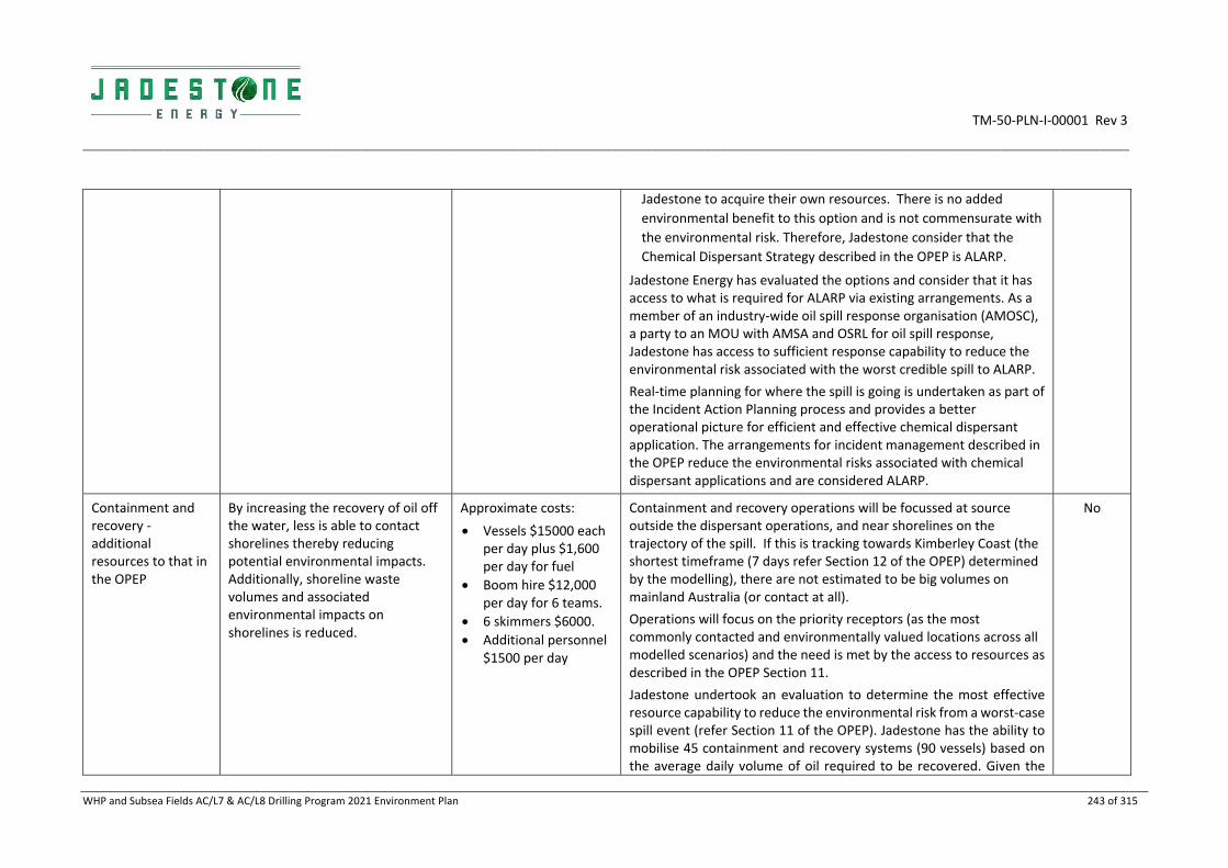
TM‐50‐PLN‐I‐00001 Rev 3
____________________________________________________________________________________________________________________________________________________________________________________
WHP and Subsea Fields AC/L7 & AC/L8 Drilling Program 2021 Environment Plan 243 of 315
Jadestone to acquire their own resources. There is no added
environmental benefit to this option and is not commensurate with
the environmental risk. Therefore, Jadestone consider that the
Chemical Dispersant Strategy described in the OPEP is ALARP.
Jadestone Energy has evaluated the options and consider that it has access to what is required for ALARP via existing arrangements. As a member of an industry‐wide oil spill response organisation (AMOSC), a party to an MOU with AMSA and OSRL for oil spill response, Jadestone has access to sufficient response capability to reduce the environmental risk associated with the worst credible spill to ALARP.
Real‐time planning for where the spill is going is undertaken as part of the Incident Action Planning process and provides a better operational picture for efficient and effective chemical dispersant application. The arrangements for incident management described in the OPEP reduce the environmental risks associated with chemical dispersant applications and are considered ALARP.
Containment and recovery ‐ additional resources to that in the OPEP
By increasing the recovery of oil off the water, less is able to contact shorelines thereby reducing potential environmental impacts. Additionally, shoreline waste volumes and associated environmental impacts on shorelines is reduced.
Approximate costs:
Vessels $15000 each per day plus $1,600 per day for fuel
Boom hire $12,000 per day for 6 teams.
6 skimmers $6000.
Additional personnel $1500 per day
Containment and recovery operations will be focussed at source outside the dispersant operations, and near shorelines on the trajectory of the spill. If this is tracking towards Kimberley Coast (the shortest timeframe (7 days refer Section 12 of the OPEP) determined by the modelling), there are not estimated to be big volumes on mainland Australia (or contact at all).
Operations will focus on the priority receptors (as the most commonly contacted and environmentally valued locations across all modelled scenarios) and the need is met by the access to resources as described in the OPEP Section 11.
Jadestone undertook an evaluation to determine the most effective resource capability to reduce the environmental risk from a worst‐case spill event (refer Section 11 of the OPEP). Jadestone has the ability to mobilise 45 containment and recovery systems (90 vessels) based on the average daily volume of oil required to be recovered. Given the
No

TM‐50‐PLN‐I‐00001 Rev 3
____________________________________________________________________________________________________________________________________________________________________________________
WHP and Subsea Fields AC/L7 & AC/L8 Drilling Program 2021 Environment Plan 244 of 315
significant decrease in volume from Week 2 onwards (Weeks 1 and 2 are not representative of the ongoing spill release), Jadestone considers it more effective to be able to ramp up as quickly as possible to meet the average need, which actually exceeds the estimated volume from Week 6 onwards.
The volume of oil released from the worst‐case LOWC scenario in Weeks 1 and 2 decreases significantly (by an estimated 50%) by Week 3. Jadestone is able to mobilise 24 systems within Week 1 and 45 in Week 3. From Week 6 onwards, Jadestone has access to the required number of vessels, equipment and resources to be able to exceed the need. These additional vessels from Week 6 onwards will be used to recover excess oil from previous weeks, and also provide Jadestone with the ability to focus operations on priority receptors if required.
In addition, C&R activities will be undertaken in areas outside those that have allowed for natural evaporation of the oil and been subject to chemical dispersant operations. C&R is targeted to discrete patches of oil.
For Jadestone to purchase and maintain suitable vessels and equipment to be on standby 24/7/150 is cost prohibitive and disproportionate to the risk. Access to supplies via AMOSC, DoT, AMSA, OSRL, contracted marine providers and marine brokers will address nearly half the volume in Week 2, meet the need in Week 6 and exceed the need from Week 7. Jadestone monitors the availability of larger vessels through existing marine brokers to meet specifications for containment and recovery operations.
It is not feasible to pre‐deploy containment and recovery equipment as modelling identifies many potential shoreline contact locations, largely remote, subjected to very high tides, mangroves and uninhabited. For example, only 33% of the shoreline between Darwin and Broome is beach (OPEP Section 13). Even when the priority receptors are focussed on, the intrusion caused by equipment deployment and maintenance would result in unnecessary additional

TM‐50‐PLN‐I‐00001 Rev 3
____________________________________________________________________________________________________________________________________________________________________________________
WHP and Subsea Fields AC/L7 & AC/L8 Drilling Program 2021 Environment Plan 245 of 315
impact to these locations and potential safety risks for personnel. In addition, the cost of doing this is disproportionate to the benefit.
The current level of resources meets for the need as it allows for flexibility in response operations as not all locations will be contacted in a single spill event, exceeds the need from Week 6 onwards and is therefore above to recover excess oil from previous weeks, and, is the maximum realistic resource deployment.
Containment and recovery arrangements described in the OPEP are considered ALARP.
Protection and Deflection ‐ additional resources to that in the OPEP
Additional Protection and Deflection resources reduces shoreline contact and accumulation of oil, and subsequent impacts to shorelines.
However, additional resources on shorelines will increase potential environmental contact and intrusion opportunities and increase safety risks of responders.
Boom hire costs are variable depending on the configuration and type used however they are estimated to be approximately $5000 per day.
The cost of additional resources is not considered the limiting factor; the limiting factor is considered to be the availability to use resources at the physical location. If required, additional equipment will be sourced and the additional cost borne by Jadestone.
Protection and deflection have limited application for most of the locations due to very high tidal influences, nature of shorelines, remoteness and lack of anchoring points for boom. Oil doesn’t contact all shorelines instantaneously but reaches various locations over a period, dependant on oceanic currents and wind directions. As such, implementing a greater initial response is not appropriate, however resources are ramped up as they are required.
Jadestone undertook an evaluation to determine the most effective resource capability to reduce the environmental risk from a worst‐case spill event (refer OPEP Section 12). Jadestone determined the resources required based upon the priority receptors estimated worst‐case shoreline volumes and timeframes to contact. Jadestone has access to resources via AMOSC, AMSA, OSRL and DoT, and has the ability to move across locations if this strategy is determined to be feasible and safe to implement in consultation with DoT.
Mobilising additional resources too early, may result in excess resources being on‐location that are not required. Consequently, this has the potential to cause additional environmental impacts if larger than required storage areas and increased personnel presence result in further sensitising coastal habitats without providing significant benefit.
No
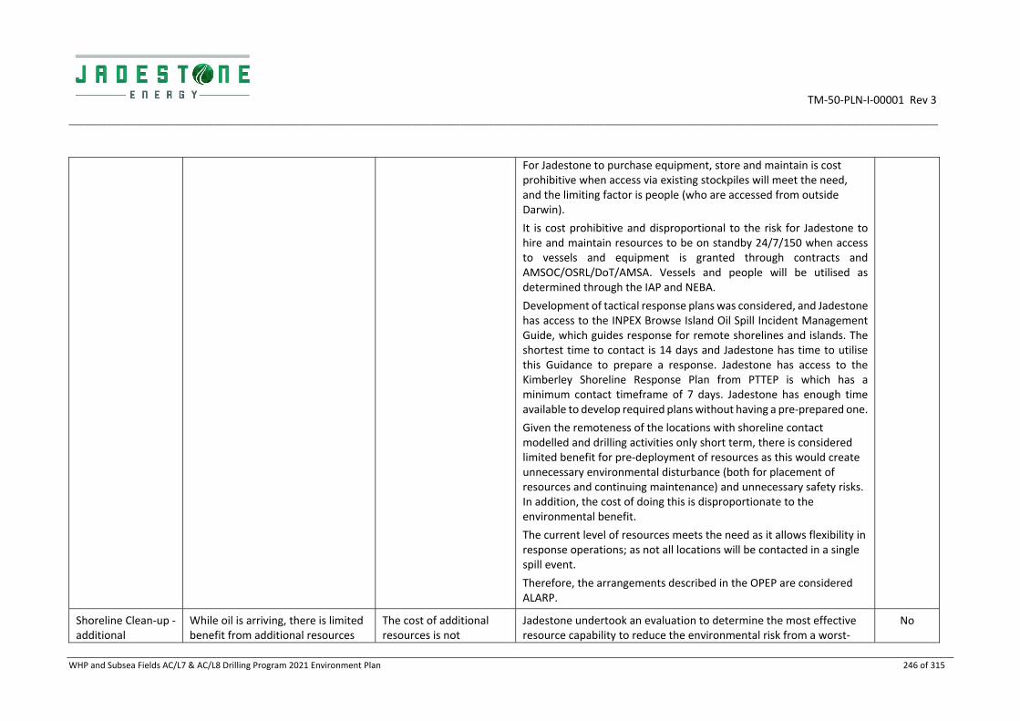
TM‐50‐PLN‐I‐00001 Rev 3
____________________________________________________________________________________________________________________________________________________________________________________
WHP and Subsea Fields AC/L7 & AC/L8 Drilling Program 2021 Environment Plan 246 of 315
For Jadestone to purchase equipment, store and maintain is cost prohibitive when access via existing stockpiles will meet the need, and the limiting factor is people (who are accessed from outside Darwin).
It is cost prohibitive and disproportional to the risk for Jadestone to hire and maintain resources to be on standby 24/7/150 when access to vessels and equipment is granted through contracts and AMSOC/OSRL/DoT/AMSA. Vessels and people will be utilised as determined through the IAP and NEBA.
Development of tactical response plans was considered, and Jadestone has access to the INPEX Browse Island Oil Spill Incident Management Guide, which guides response for remote shorelines and islands. The shortest time to contact is 14 days and Jadestone has time to utilise this Guidance to prepare a response. Jadestone has access to the Kimberley Shoreline Response Plan from PTTEP is which has a minimum contact timeframe of 7 days. Jadestone has enough time available to develop required plans without having a pre‐prepared one.
Given the remoteness of the locations with shoreline contact modelled and drilling activities only short term, there is considered limited benefit for pre‐deployment of resources as this would create unnecessary environmental disturbance (both for placement of resources and continuing maintenance) and unnecessary safety risks. In addition, the cost of doing this is disproportionate to the environmental benefit.
The current level of resources meets the need as it allows flexibility in response operations; as not all locations will be contacted in a single spill event.
Therefore, the arrangements described in the OPEP are considered ALARP.
Shoreline Clean‐up ‐ additional
While oil is arriving, there is limited benefit from additional resources
The cost of additional resources is not
Jadestone undertook an evaluation to determine the most effective resource capability to reduce the environmental risk from a worst‐
No
TM‐50‐PLN‐I‐00001 Rev 3
____________________________________________________________________________________________________________________________________________________________________________________
WHP and Subsea Fields AC/L7 & AC/L8 Drilling Program 2021 Environment Plan 247 of 315
resources to that in the OPEP
that might remove oil more quickly and any additional resources may be counterproductive in that additional impacts may outweigh benefits.
After the oil has finished arriving, there may be an additional benefit in having increased resources at particular locations dependent upon environmental considerations. For example, a turtle nesting beach during the nesting/hatching season may benefit in having additional resources deployed to clean the beach before nesting/hatching events.
There may be benefit in deploying additional machinery in the event of greater opportunities for use, given machinery has the capacity to remove far greater volumes of bulk oil in the right circumstances. The numerous factors and consideration in determining the best approach for shoreline clean‐up, the benefit of additional resources will be determined for each Operational Period.
However, additional resources on shorelines will increase potential environmental contact and intrusion opportunities, increase
considered the limiting factor; the limiting factor is considered to be the ability to use resources at the physical location.
If required, additional personnel and machinery will be sourced, and the additional cost borne by Jadestone.
case spill event. Section 13 of the OPEP describes how Jadestone’s plan is to focus resources on the priority receptors based upon the worst‐case maximum average daily oil ashore, the nature of the shoreline and the recoverable ability of the clean‐up teams.
The remoteness and character of potentially affected shorelines raises significant logistical challenges associated with mounting a shoreline response and the potential health and safety risks to personnel.
The combination of machinery for mechanical and manual removal of oil and personnel requirements have been considered based on opportunities for use and characteristic of shoreline (i.e. may not be appropriate for small offshore islands, tidal flats, remote rocky or mangrove lined shorelines).
It is the opportunity for use rather than the availability of machinery and personnel which is considered the limiting factor.
For Jadestone to purchase equipment, store and maintain it is cost prohibitive when access via AMOSC Mutual Aid/DoT/OSRL and mainstream suppliers will meet the need, and the limiting factor is people (who have to be accessed from outside Darwin), health and safety issues for shoreline work and suitable vessels.
Given the remoteness of the locations with shoreline contact modelled and short‐term nature of drilling activities, there is considered no benefit for pre‐deployment of resources as this would create unnecessary environmental disturbance (both for placement of resources and continuing maintenance) and unnecessary safety risks. Allocating shoreline clean‐up resources relies on understanding the trajectory of the oil and timeframe for expected contact. It is not practical to pre‐position teams ready for rapid deployment to reduce the timeframe for shoreline response. In addition, the cost of doing this is grossly disproportionate to the benefit.

TM‐50‐PLN‐I‐00001 Rev 3
____________________________________________________________________________________________________________________________________________________________________________________
WHP and Subsea Fields AC/L7 & AC/L8 Drilling Program 2021 Environment Plan 248 of 315
safety risks of responders, cause physical damage and could be a negative impact.
Jadestone considered increasing the number of resources to support shoreline response, however, the stated number is based upon the nature of the shorelines and the option of natural attenuation if to conduct operations there would be too environmental damaging. Real time modelling and assessment will determine if extra resources are required. If this is the case, then the resources required are able to be obtained within the shortest time to contact timeframes.
The current level of resources meets for the need as it allows flexibility in response operations and surge capacity; as not all locations will be contacted in a single spill event.
The arrangements described in the OPEP are considered ALARP.
OWR – additional resources to that described in the OPEP
The OWR level is a Level 6 (refer WAOWRP and NTOWRP).
OWR aims to prevent/reduce the impact to marine fauna (e.g. birds and turtles) and any long‐term effects.
Significant additional cost would be incurred if Jadestone were to purchase or hire a facility to base at a staging site or have OWR expert personnel on standby.
Significant additional cost would be incurred if Jadestone provided its own oiled wildlife response (personnel, experts, facilities, plans etc).
Jadestone undertook an evaluation to determine the most effective resource capability to reduce the environmental risk from a worst‐case spill event (refer OPEP).
Additional strategies that have been considered include:
Additional arrangements to improve mobilisation times of international OWR resources (e.g. additional contracts/arrangements with OWR organisations or pre‐mobilisation of international OWR personnel);
Jadestone to have OWR expert personnel on standby to improve response;
Jadestone to commission additional training of Australian based OWR personnel to increase numbers of competent OWR personnel; and
OWR resources purchased and based at Darwin and Broome to increase OWR facilities and process timeframes.
Given the local (AMOSC and DBAC) and global (OSRL/Sea Alarm) response capability through existing arrangements could be mobilised within required timeframes, the response arrangements are considered ALARP as these plans are contextualised for WA and NT.
No

TM‐50‐PLN‐I‐00001 Rev 3
____________________________________________________________________________________________________________________________________________________________________________________
WHP and Subsea Fields AC/L7 & AC/L8 Drilling Program 2021 Environment Plan 249 of 315
The NTOWRP, WAOWRP and the Kimberley regional plan were developed by the Territory and State environmental agency in conjunction with industry, AMSA, AMOSC, Perth Zoo and academia. Therefore, represents the best‐oiled wildlife response plans that NT, WA and Jadestone can utilise.
The cost for Jadestone to:
purchase/hire OWR equipment and pre‐set up facilities at Darwin and/or Broome;
have OWR expert personnel on standby; and
commission additional OWR training in WA
is grossly disproportionate to the risk. The Drilling Activities 24/7/150 and significant costs would be incurred to undertake these options. The equipment can be purchased/hired easily.
The level of oiled wildlife response required for a worst‐case impact event is potentially a Level 6 based on worst‐case population density and distribution of shorebirds and an examination of applicable case studies of similar characteristics (i.e. Macondo). The arrangements of OWR outlined within the OPEP are considered sufficient for a controlled escalation of response prior to the worst‐case minimum contact times for oil at the sites of highest abundance and sensitivity.
The arrangements described in the OPEP are considered ALARP.
Waste Management ‐ additional resources to that described in the OPEP
While oil is arriving on shorelines, there is limited benefit from additional resources that might remove waste more quickly as the waste is still being collected.
After the oil has finished arriving, there may be an additional benefit in having increased resources at particular locations dependent upon environmental considerations.
The cost of additional resources is not considered the limiting factor; the limiting factor is considered to be the ability to utilise resources at the physical location.
If required, additional resources will be sourced, and the
Jadestone undertook an evaluation to determine the most effective resource capability to reduce the environmental risk from a worst‐case spill event (refer OPEP).
The limiting factor for waste collection (which is a support service for Jadestone) is the collection of oily waste. As the arrangements in the OPEP are ALARP, the waste contractor can resource a plan that meets the nature and scale of the event within realistic timeframes.
The arrangements described in the OPEP are considered ALARP.
No

TM‐50‐PLN‐I‐00001 Rev 3
____________________________________________________________________________________________________________________________________________________________________________________
WHP and Subsea Fields AC/L7 & AC/L8 Drilling Program 2021 Environment Plan 250 of 315
For example, a turtle nesting beach during the nesting/hatching season may benefit in having additional resources deployed to clean the beach before nesting/hatching events.
additional cost borne by Jadestone.

TM‐50‐PLN‐I‐00001 Rev 3
WHP and Subsea Fields AC/L7 & AC/L8 Drilling Program 2021 Environment Plan 251 of 315
Further ALARP demonstration ‐ Engineering Risk Assessment ‐ Evaluation of Alternate Control Measures & Associated Comparative Assessment ‐ undertaken to further evaluate a range of control measure options in relation to the prevention of a blow‐out scenario
Hierarchy of control
Control Measure Options
Comparative Assessment of Risks, Cost & Benefit for Control Measure Options
Apply
Elimination Do not drill the well.
Drilling is required to establish the presence of hydrocarbons and meet the objectives of the title, so not drilling is not an option.
No
Substitution Undertake drilling in alternate season to potentially further reduce exposure to marine fauna from spilled hydrocarbon
The timing of the proposed activity is based upon the following considerations:
The schedule requires flexibility to avoid down time (e.g. cyclones)
Timeliness is important to bring online H6 and Skua‐10/11 wells to support the ongoing production requirements and economic viability of the Montara Field.
Any restriction on activity timing would not be considered reasonably practicable.
No
Engineering Use of a subsea cap and containment system in the event of a blowout.
Subsea Wells
1.The installation of a subsea capping and containment system is not feasible for a jack up with the BOP installed at the surface, as this will restrict access to deploy the capping stack. 2.Montara subsea wellheads are designed for jack up MODU intervention and workovers, with capping not feasible in the blowout scenario, as the Capping Stack weights exceed the tree connector capability
3.The water depth of the subsea wells is too shallow for the Wild Well recommended minimum water depth need for capping stack installation of 120m.
4.Lighter capping stacks that are CSV deployed have access restrictions due to the proximity of the jack up rig at the well. Jadestone is reviewing this option with the CSV operators currently. However, as yet, this is unproven as a viable option.
Platform Wells
There are forms of capping stacks that have been used for onshore wells, where access to the wellhead is feasible using a large crane to lower a BOP onto an existing well, once a fire has been extinguished. This option has been considered given the installation of the BOP at the surface could allow for a similar arrangement. However, the use of this type of equipment on offshore platforms is much more difficult as the well is located within the
No
TM‐50‐PLN‐I‐00001 Rev 3
WHP and Subsea Fields AC/L7 & AC/L8 Drilling Program 2021 Environment Plan 252 of 315
platform topsides structure, making access very hazardous, especially if the well is on fire.
The WHP is too compact to safely deploy a surface capping stack.
Consequently, the surface capping stack is not considered to be a feasible option for these wells, as the likelihood of successfully installing this type of equipment for the worst‐case scenario is very low and presents significant safety and other risks.
Offset technology for the deployment of capping stack
Offset Installation Equipment (OIE) is not feasible in the blowout scenario, as the related Capping Stack weights exceed the tree connector capability. Use of this sizeable equipment adjacent to the Jack‐up that is positioned over the subsea well further reduces viability of this solution.
In addition, the OIE system is unproven technology with a long lead time as it is located at OSRL in Italy.
NA
7.6.12 Acceptability assessment
The potential impacts of an unplanned crude release to the marine environment are considered 'Acceptable' in accordance with the Environment Regulations, based on the acceptability criteria outlined below. The control measures proposed are consistent with relevant legislation, standards and codes.
Policy & management system compliance
Jadestone’s HSE Policy objectives are met. Section 8 demonstrates that Jadestone’s HSE Management System is capable of continuously reviewing and updating activities and practices during the operation, including spill response arrangements.
Alignment with Jadestone Well Integrity Manual
Alignment with Jadestone Drilling Management System
Alignment with Jadestone Well Integrity Assurance Management System
Stakeholder & reputation
Stakeholder consultation has been undertaken (see Section 4), including engagement with the Director of National Parks, State and National response agencies of DoT and AMSA, Northern Territory government, commercial and recreational fishing industry bodies and fishers. No concerns have been raised with regards to impacts of a crude spill by relevant persons. During any spill response, a close working relationship with key regulatory bodies (e.g. DoT, DBCA, AMSA, DER) will occur and thus there will be ongoing consultation with relevant persons during response operations.
Legislation and Industry good practice
Alignment with Jadestone Drilling Management System ‐ Well Integrity Manual (D41‐504807‐WC): The Manual is part of the Jadestone Drilling Management System and provides all standards, procedures and practices to manage well integrity and includes the following requirements:
• Crews will be adequately experienced, trained in well control techniques and supervised;
• Well control drills undertaken prior to entering the reservoir;
Relevant control measures:
Well control training records
Well control drills records
Primary & secondary barriers

TM‐50‐PLN‐I‐00001 Rev 3
WHP and Subsea Fields AC/L7 & AC/L8 Drilling Program 2021 Environment Plan 253 of 315
• For Drilling, the primary barrier will be weighted drilling fluids and secondary barrier will be the BOP which will be regularly maintained and tested every 21 days;
• For completion and workover operations two independent tested barriers will always be available
• Stress analysis performed to select appropriate casing material for the well;
• Casing is pressure tested; and • Memorandum of Understanding between Jadestone & other
operators in the vicinity of the Drilling Activities for assistance including rig for a relief well.
All wells are designed to allow the installation of the required barriers where location, effectiveness and integrity can be verified for all barriers. Well barrier verification sheets documenting primary and secondary barriers shall be maintained and the well barrier verification sheet signed off prior to any of the following operations:
• Use of a new barrier; or • Replacement/removal of an existing barrier.
Casing material stress analysis
Casing pressure test results
Industry MoU
Well barrier verification sheets ‐ signed
Well Operations Management Plan (NOPSEMA Accepted)
The primary purpose of the WOMP is to reduce the potential for any loss of well control. It includes a suite of tools and procedures to proactively manage lifecycle well integrity from design to abandonment for planned and unplanned events; early identification of potential hazards and indicators that may lead to a breach of well integrity resulting in a major accident event.
WOMPs
Montara and MODU Safety Cases and Safety Case Revisions (NOPSEMA Accepted)
The primary purpose of the Safety Case is to reduce the potential for any MAEs to occur.
Maintenance and Inspection
BOP tested every 21 days.
Pressure and Stress analysis has been undertaken to select the appropriate casing material for the well.
Casing is pressure tested to ensure well integrity is maintained.
BOP testing and records
Casing stress analysis and records
MODU Management of Change: Well barrier verification sheets documenting primary and secondary barriers shall be maintained and the well barrier verification sheet signed off prior to any of the following operations:
Use of a new barrier; or
Replacement/removal of an existing barrier.
MODU MOC process
OPEP
In the event of an uncontrolled well blow out, the OPEP will be initiated. This includes development of an Incident Action Plan (IAP). The IAP will detail the response mechanisms and priority areas for protection based on the actual circumstances of the event, taking into account the spill trajectory, weather conditions, but also importantly safety considerations. Key activities to be addressed by the IAP include a review of the Net Environmental Benefit Assessment (NEBA), re‐modelling of oil spill trajectory modelling with relevant spill and
OPEP

TM‐50‐PLN‐I‐00001 Rev 3
WHP and Subsea Fields AC/L7 & AC/L8 Drilling Program 2021 Environment Plan 254 of 315
environmental data, and ongoing consultation with affected/involved parties that may be required.
Response strategy options that will be evaluated in the event of a hydrocarbon spill include:
Monitor and evaluate
Dispersant application
In‐situ burning
Containment and recovery
Protection and deflection
Shoreline clean‐up
Responding to oiled wildlife
Jadestone Blowout Contingency Plan / Jadestone Crisis and Emergency Response Plan
The Jadestone Blowout Contingency Plan covers Initial Organisation and Operations, including the Phases of Responsibility, Initial Response Levels, Intervention Action Plans, Notifications and Contacts, and Incident Command Systems. It also covers Source Control Organisations and Resources.
For a specific well, a Well Specific Addendum to the Blowout Contingency Plan (Appendix H of the Jadestone Blowout Contingency Plan), describes Source Control responses considered and the detailed planning and studies done in support of these responses.
Source control responses reviewed are Relief wells Subsea First Response Toolkit (SFRT) and Capping Stacks.
In the unlikely event of a well blowout during Montara production drilling activities, the drilling of a relief well is the primary source control strategy.
For relief wells, the main considerations are:
a) selection of the appropriate rigs (need multiple options) is based on the rig location, an approved Australian Vessel Safety Case, rig availability, mobilisation timing, minimum water depth operability, dynamic kill capability (rig pump and pit sizing); and
b) planning of relief well design, relief well directional design, sourcing the related equipment needed for the well design (Wellheads, Casing, Mud, etc) in the required time frame
For the SFRT, the main consideration is:
a) the effective and efficient mobilisation of the equipment to Darwin and the availability of suitable vessels for use of the SFRT.
For a Capping stack option, If appropriate, the main considerations are;
a) the Tree and or Wellhead are mechanically capable of supporting the capping stack;
b) the proximity of a rig working on the well does not restrict access for capping stack deployment; and
c) Plume modeling is conducted to ensure that the Capping Stack can be deployed.
Note A study is underway into the potential uses of a capping stack system for subsea drilling activities.
Jadestone Blow‐Out Contingency Plan

TM‐50‐PLN‐I‐00001 Rev 3
WHP and Subsea Fields AC/L7 & AC/L8 Drilling Program 2021 Environment Plan 255 of 315
As mentioned above, the considerations, related plans and studies are listed in the Well Specific Addendum to the BC (Appendix H of the BCP).
Petroleum industry oil spill response
In order to respond to a threatened or actual subsea oil discharge or well control incident, Jadestone has a Memorandum of Understanding (MoU) with other oil and gas operators that have drilling rigs in the vicinity of the proposed activities that could be made available should the drilling of a relief well become necessary. An approximate relief well schedule is detailed in the table below.
Jadestone MOU
Environmental context & ESD
The worst‐case credible crude spill scenario for the Drilling Activities is a result of a loss of well control with up to 234,682 m3 released from within the Operational Area from H‐6.
The potential impact is considered acceptable after consideration of:
Potential impact pathways: Section 7.6.7 and 7.6.8 assess potential pathways and risks from exposure to surface, entrained, dissolved and accumulated oil ashore.;
Preservation of critical habitats: Section 7.6.6 and 7.6.7 describe the modelling predictions of locations where protected areas and sensitive receptors may be exposed to oil, at what concentrations and for what durations;
Assessment of key threats as described in species and Area Management /Recovery plans: See ‘Conservation and management advise’ below;
Consideration of North‐West Bioregional Plan; The NW Bioregional Plan considers hydrocarbon spills as a threat to marine conservation values. This EP aligns with the requirement of the NW Bioregional Plan to assess potential impacts and to have an Oil Spill Contingency Plan in place; and
Principles of ecologically sustainable development: Given the predicted behavior and weathering of the crude, the location of the Drilling Program and the prevention and recovery plans, the risks from oil exposure are not predicted to impact population levels of marine fauna and communities. Biodiversity and ecosystem integrity impacts are predicted to recover fully in the long term as suggested by the Montara 2009 spill.
Conservation and management advice
Jadestone will have regard to the representative values of the reserves and other conservation advice published and endeavor to ensure that priority is given to the social and ecological objectives and values, of any AMPs, or state marine parks impacted by unplanned crude release to ensure that the objectives of the management plans are not contravened (Appendix B).
Noting ‘Emergency response’ is permitted in all AMPs and state marine parks.
Actions required to respond to oil pollution incidents, including environmental monitoring and remediation, in connection with activities authorised under the OPGGS Act may be conducted in all zones. The Director will be notified in the event of an oil pollution incident that occurs within, or may impact upon, an Australian Marine Park and, so far as reasonably practicable, prior to a response action being taken within a marine park.
Protected areas within the RISK EMBA predicted to potentially be impacted by crude above threshold levels have been identified as Priority receptors (Section 7.6.8).
The ‘Industry guidelines for avoiding, assessing and mitigating impacts on EPBC Act listed migratory shorebird species’ will be applied/used as guidance in the event of an oil spill.
Recovery Plan for Marine Turtles in Australia, 2017‐2027
The Recovery plan for marine turtles in Australia (DoEE 2017) identifies Marine pollution as a risk. The Plan requires that the risk of oil spill impact to marine turtles is evaluated and, if required, appropriate mitigation measures are implemented. This section and the proposed controls are consistent with this advice.

TM‐50‐PLN‐I‐00001 Rev 3
WHP and Subsea Fields AC/L7 & AC/L8 Drilling Program 2021 Environment Plan 256 of 315
Approved Conservation Advice for Calidris ferruginea (Curlew Sandpiper)
The Conservation advice for the curlew sandpiper identifies Marine pollution as a risk: The advice requires the risk of oil spill impact to nest locations and, if required, appropriate mitigation measures are implemented. Cartier Island has been identified as important bird nesting location. This section and the proposed controls are consistent with this advice.
Approved Conservation Advice for Calidris canutus (Red Knot)
The Conservation advice for the Red Knot identifies Marine pollution as a risk: The advice requires the risk of oil spill impact to nest locations and, if required, appropriate mitigation measures are implemented. Cartier Island has been identified as important bird nesting location This section and the proposed controls are consistent with this advice.
Approved Conservation Advice for Numenius madagascariensis (Eastern Curlew)
The Conservation advice for Eastern Curlew identifies Marine pollution as a risk: The advice requires the risk of oil spill impact to nest locations and, if required, appropriate mitigation measures are implemented. Cartier Island has been identified as important bird nesting location. This section and the proposed controls are consistent with this advice.
Approved conservation advice for green sawfish (Threatened Species Scientific Committee 2008b)
The Conservation advice for Green sawfish identifies Marine pollution as a risk: The advice requires measures to reduce adverse impacts due to pollution to be considered; and to reduce likely impact on green sawfish.
Approved Conservation Advice for Limosa lapponica bauera (Bar‐tailed Godwit
The Conservation advice for Bar‐tailed Godwit identifies Marine pollution as a risk: The advice requires the risk of oil spill impact to nest locations and, if required, appropriate mitigation measures are implemented. Cartier Island has been identified as important bird nesting location. This section and the proposed controls are consistent with this advice.
Approved Conservation Advice for Limosa lapponica menzbieri (Northern Siberian Bar‐tailed Godwit)
The Conservation advice for Northern Siberian Bar‐tailed Godwit identifies Marine pollution as a risk: The advice requires the risk of oil spill impact to nest locations and, if required, appropriate mitigation measures are implemented. Cartier Island has been identified as important bird nesting location. This section and the proposed controls are consistent with this advice.
Approved Conservation Advice for Pristis pristis (largetooth sawfish)
The Conservation advice for large tooth sawfish identifies Habitat degradation and Marine debris as risks: The advice requires measures to reduce adverse impacts of habitat degradation and/or modification to be considered; and to reduce marine debris likely to impact on large tooth sawfish.
Approved Conservation Advice for Glyphis garricki (northern river shark)
In a LOWC scenario, habitat important for the large tooth sawfish would be identified and given high priority for protection. Any spill response activities (Section 6.8) that generate marine debris are also managed to reduce further potential environmental impacts. This is consistent with the conservation advice.
Interim Recovery Plan 2018‐2023 for the Monsoon vine thickets on the coastal sand dunes of Dampier Peninsula
In a LOWC scenario, habitat important for the Monsoon vine thickets would be identified and given high priority for protection. Any spill response activities (Section 6.8) would be managed to reduce further potential environmental impacts. This is consistent with the conservation advice.

TM‐50‐PLN‐I‐00001 Rev 3
WHP and Subsea Fields AC/L7 & AC/L8 Drilling Program 2021 Environment Plan 257 of 315
Interim Recovery Plan for the Threatened Migratory Shorebirds visiting Western Australia
In a LOWC scenario, habitat important for Threatened Migratory Shorebirds would be identified and given high priority for protection. Any spill response activities (Section 6.8) would be managed to reduce further potential environmental impacts. This is consistent with the conservation advice.
Wildlife conservation plan for migratory shorebirds (Commonwealth of Australia 2015c)
In a LOWC scenario, habitat important for the migratory birds would be identified and given high priority for protection. Any spill response activities (Section 6.8) are also managed to reduce further potential environmental impacts to migratory habitats. This is consistent with the conservation advice for Common Sandpiper (Actitis hypoleucos) and Sharp‐tailed Sandpiper (Calidris acuminata).
Australian Marine Parks
Australian Marine Parks are established by proclamation under the EPBC Act for the purpose of protecting and maintaining biological diversity in the parks.
Environment plan (EP) must be consistent with the Australian Marine Park Management plans. There are nine AMPs within the RISK EMBAs.
In all cases where an activity has potential to impact or present risk to AMPs, regardless of whether the activity is inside or outside a park, the EP should evaluate how these impacts and risks will be of an acceptable level and reduced to as low as reasonably practicable (ALARP).
Actions required to respond to oil pollution incidents, including environmental monitoring and remediation, in connection with mining operations authorised under the OPGGS Act may be conducted in all zones. The requirement is that The Director should be notified in the event of an oil pollution incident that occurs within, or may impact upon, an Australian Marine Park and, so far as reasonably practicable, prior to a response action being taken within a marine park.
Consultation to notify the Director of Parks when the proposed response activities is completed as part of the Consultation process (Section 4, Section 8).
The Director notification in the event of a spill that would impact one of the AMPs is included in the OPEP and Implementation section of this EP (Section 8).
As such this EP is consistent with the Australian Marine Park Management plans.
7.7 Worst Case Diesel Spill
7.7.1 Description of hazard
Diesel spill
Release of diesel may occur from vessel collision within the Operational Area or a bunkering or dropped object event. The worst‐case diesel spill scenario is due to collision of a drilling support vessel with the FPSO resulting in damage to a fuel oil tank and diesel released to the ocean. The maximum worst‐case credible spill volume of diesel has been calculated as 906 m3 based on the largest fuel oil tank on the vessel.
7.7.2 Spill volume
The volume of diesel that could be released to the marine environment from vessel collision and subsequent rupture of fuel tank is largely dependent upon fuel tank position on the vessel, the degree and location of tank damage and tank volume. The AMSA (2015) guideline: Technical guidelines for preparing contingency plans for marine and coastal facilities has been used in determining the potential release volume of the credible scenarios. These calculations provide a spill volume of 80 – 250 m3 for typical support vessels, 906 m3 for the FPSO anchored in the vicinity of the drilling activities and 5 m3 during transfer of diesel between support vessels/MODU. For the purposes of determining potential impacts, the larger volume of 906 m3 has been used as it is considered a conservatively worst case and subsumes both the 5 m3 and 250 m3 scenarios.

TM‐50‐PLN‐I‐00001 Rev 3
WHP and Subsea Fields AC/L7 & AC/L8 Drilling Program 2021 Environment Plan 258 of 315
Table 7‐12: Credible diesel releases to the marine environment
Scenario Maximum Credible Spill Release duration
Credibility justification
Release of diesel due to vessel collision or dropped object
Based on AMSA (2015) ‘other vessel collision’ – volume of largest fuel tank = 80 m3 – 250 m3 (based on a typical operations and drilling support vessels with a ruptured wing tank);
906 m3 ‐ based on loss of the FPSO Montara Venture fuel tank
5 hours Typical drilling support vessels may carry a maximum total fuel cargo of 827–1,594 m3 total in tanks (see section 2.10). Previous modelling of a 906 m3 diesel spill in the Operational Area has been reviewed for a conservative assessment of potential worst‐case risks.
Leak or rupture of bunkering hose during support vessel to diesel transfer
Based on AMSA (2015) ‘Production platform refuelling – continuous supervision’
Transfer rate x 15 minutes (continuous supervision) = 20 m3/hr for 15 minutes = 5 m3
15 min AMSA (2015) Indicative maximum credible spill volumes table is directly applicable for production platform refuelling. Continuous supervision is the appropriate credible level of supervision given that transfers are of short duration and refuelling procedures stipulate continuous supervision.
7.7.3 Diesel characteristics
Marine diesel is typically a mixture of volatile and persistent hydrocarbons with a low percentage of volatiles (6%) and with the greater proportion having moderate to very low volatility (89%). The aromatic content is approximately 3%. Viscosity is 4.0cP (at 25oC) and density of approximately 829.1kg/m3 at 25oC.
In the marine environment, diesel will behave as follows:
Diesel will spread rapidly in the direction of the prevailing wind and waves;
Evaporation is the dominant process contributing to the fate of spilled diesel from the sea surface and
will account for >50% reduction of net hydrocarbon balance;
Diesel will entrain under the water surface particularly when wind speed and resultant wave action
increase;
The evaporation rate of diesel will increase in warmer air and sea temperatures such as those at the
Drilling Activities Operational Area; and
Diesel residues usually consist of heavy compounds that may persist longer and will tend to disperse as
oil droplets into the upper layers of the water column.
7.7.4 Modelling Approach
A diesel spill scenario of 906 m3 was modelled by RPS for a spill within the vicinity of the Drilling Activities Operational Area (i.e. where most vessel traffic will occur) to determine the dispersion behaviour of the released hydrocarbon within the marine environment. The modelling considered all seasons of the year and has been reviewed to ascertain the spatial extent of floating and entrained oil above impact thresholds.
A summary of the stochastic modelling methods used to evaluate the weathering and distribution of the 906 m3 diesel spill are as per those described in Section 7.6.2 with respect to crude oil spill modelling.
Provided below are details specific to the diesel spill modelling scenario:
1. Stochastic approach: stochastic modelling was carried out with 60 replicate simulations each
modelled for six locations within the permit area.

TM‐50‐PLN‐I‐00001 Rev 3
WHP and Subsea Fields AC/L7 & AC/L8 Drilling Program 2021 Environment Plan 259 of 315
2. Probability contours: the results were presented in terms of statistical probability maps based on
360 simulations.
3. Completion of modelling: each of the 360 simulations was run for a period of two to three weeks
allowing for the fate of dispersed hydrocarbons to be evaluated.
7.7.5 Diesel modelling results
Surface oil results
Results of the stochastic modelling indicated that surface sheens of surface oil (>1 g/m2) may pass over the following sensitive areas, with a probability of <1% of reaching these locations:
Vulcan Shoal after 35 hours;
Goeree Shoal after 62 hours;
Carbonate Bank and Terrace System of the Sahul Shelf after 68 hours; and
Eugene McDermott Shoal after 74 hours.
Surface oil at concentrations of 10 g/m2 were only predicted to reach Vulcan Shoals within 36 hours of commencement of release (at a probability of <1%). Oil was predicted to accumulate at Browse Island at a loading rate of 0.4 g/m2.
Entrained Oil results
Results of the stochastic modelling indicated that entrained oil concentrations greater than 100 ppb were predicted to reach the following locations (with the highest concentrations):
Vulcan Shoals (1,772 ppb);
Carbonate Bank and Terrace System of the Sahul Shelf (1,344 ppb);
Barracouta Shoals (733 ppb); and
Goeree Shoal (846 ppb).
The AMPs predicted to be impacted by entrained diesel >100 ppb include:
Oceanic ShoalsMP;
Ashmore Reef MP; and
Cartier Island MP.
The KEFs predicted to be impacted by entrained diesel >100 ppb:
Continental Slope Demersal Fish Communities;
Ashmore Reef and Cartier Island and surrounding Commonwealth waters; and
Ancient coastline at 125 m depth contour.
Dissolved aromatic results
Dissolved aromatic hydrocarbons at concentrations of 70 ppb or greater were not predicted to contact sensitive receptors evaluated. In fact, the highest dissolved aromatic hydrocarbon concentration predicted to contact a sensitive receptor location was 23 ppb at Vulcan Shoals. Refer to Figures 7‐9 to 7‐9 for the environment that may be affected due to a diesel spill of 906 m3.
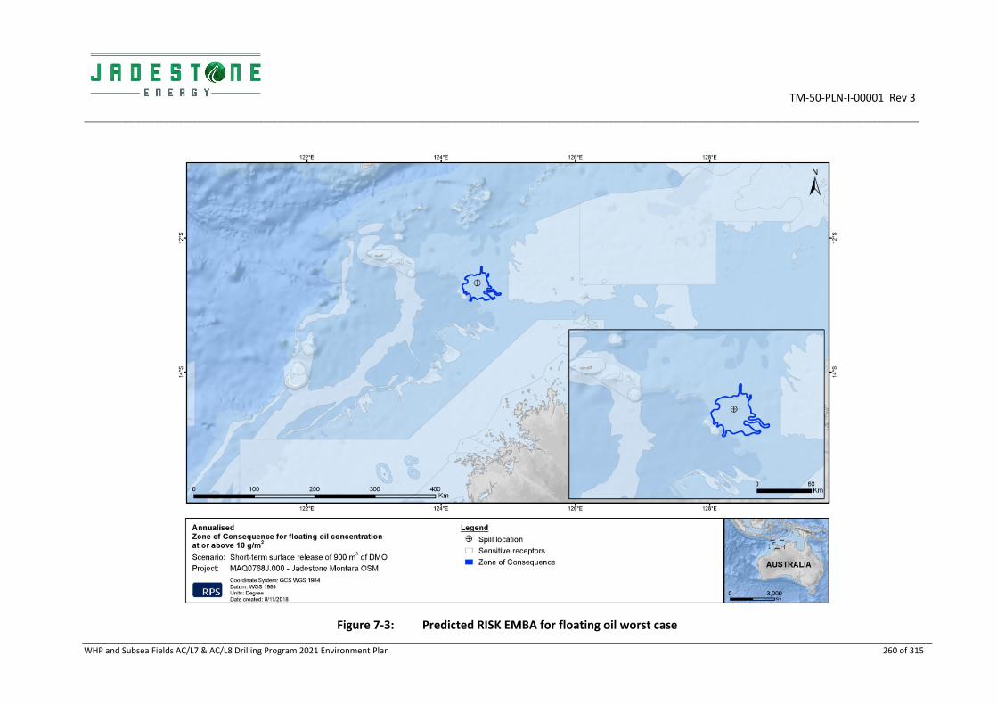
TM‐50‐PLN‐I‐00001 Rev 3
_________________________________________________________________________________________________________________________________________________________________________________
WHP and Subsea Fields AC/L7 & AC/L8 Drilling Program 2021 Environment Plan 260 of 315
Figure 7‐3: Predicted RISK EMBA for floating oil worst case

TM‐50‐PLN‐I‐00001 Rev 3
_________________________________________________________________________________________________________________________________________________________________________________
WHP and Subsea Fields AC/L7 & AC/L8 Drilling Program 2021 Environment Plan 261 of 315
Figure 7‐4: Predicted RISK EMBA for entrained oil worst case

TM‐50‐PLN‐I‐00001 Rev 3
_________________________________________________________________________________________________________________________________________________________________________________
WHP and Subsea Fields AC/L7 & AC/L8 Drilling Program 2021 Environment Plan 262 of 315
Figure 7‐5: Predicted RISK EMBA for dissolved aromatic hydrocarbon worst case

TM‐50‐PLN‐I‐00001 Rev 3
________________________________________________________________________________________________________________________
WHP ad Subsea Fields AC_L7 & AC_L8 Drilling Program 2020 Environment Plan 263 of 315
7.7.6 Impacts and risks
Marine diesel oil is a highly volatile hydrocarbon with a high proportion of toxic monocyclic aromatic hydrocarbons (MAHs) that are harmful in varying degrees to marine fauna. Diesel contains some heavy components (or low volatility components) that have a strong tendency to physically entrain into the upper water column in the presence of moderate winds (i.e. >12 knots) and breaking waves and can resurface if these energies abate.
In the event of a substantial diesel spill, the heavier components of diesel can remain entrained or at sea surface for an extended period. Given the properties of diesel, it is expected that marine fauna, marine habitats, protected and significant areas and socio‐economic receptors, have the potential to be impacted by surface and entrained thresholds.
A summary of impacts and risks to sensitivities and values within the marine environment is provided in Table 7‐13. For further information on the habitats, marine organisms and socio‐economic receptors refer to Appendix B and Section 7.6.6.

TM‐50‐PLN‐I‐00001 Rev 3
_____________________________________________________________________________________________________________________________________________________________________________________
WHP and Subsea Fields AC/L7 & AC/L8 Drilling Program 2021 Environment Plan 264 of 315
Table 7‐13 Potential Impacts to sensitive receptors from a diesel spill
Receptors Potential Impacts from a diesel spill
Floating and/or shoreline Entrained Dissolved
Plankton Potential impacts from diesel spill
There is potential for localised mortality of plankton due to reduced water quality and toxicity. Effects will be greatest in the upper 10 m of the water column and areas close to the spill source where hydrocarbon concentrations are likely to be highest.
Impact assessment to receptors within the RISK EMBA
High abundance of phytoplankton typically occurs around topographical features that may result in upwelling or a disruption to the current flow which may be present around banks and shoals. The RISK EMBA has the potential to overlap with spawning of some fish species given the year‐round spawning of some species. In the unlikely event of a spill occurring, fish larvae may be impacted by hydrocarbons entrained in the water column with effects greatest in the upper 10 m of the water column where the majority of plankton concentrate and closest to the spill source. However, following release, the diesel will rapidly evaporate, disperse and degrade in the offshore environment, reducing the concentration and toxicity of the spill. Given duration of fish spawning periods, lack of suitable habitat for aggregating fish populations near the surface, combined with the quick evaporation and dispersion of diesel, impacts to overall fish populations are not expected to be significant.
Benthic habitat and communities
(Including deepwater habitats and shallow shoals)
n/a – Benthic habitats not exposed to surface or surface oil Potential impacts from dissolved and entrained oil
Benthic habitats at shoals may be affected by marine diesel. This may result in toxic effects to both the habitat (in the case where the habitat is biological such as coral reefs) and associated flora and fauna. The degree of impact will depend on several variables, including the duration of exposure to DAHs and other diesel components. Sea grasses and macroalgae may experience a phytotoxic effect caused by absorption of DAHs from the water column. The hydrocarbon molecules can concentrate in membranes of aquatic plants, inhibiting photosynthetic efficiency (Runcie et al., 2004). Recovery of habitats experiencing chronic effects are expected within weeks to months of return to ambient water quality.
Direct contact to shallow hard corals by entrained diesel could lead to impacts such as short or long‐term sub‐lethal effects including reduced feeding capacity and growth, reduced reproductive output and increased mucous production

TM‐50‐PLN‐I‐00001 Rev 3
_____________________________________________________________________________________________________________________________________________________________________________________
WHP and Subsea Fields AC/L7 & AC/L8 Drilling Program 2021 Environment Plan 265 of 315
Receptors Potential Impacts from a diesel spill
Floating and/or shoreline Entrained Dissolved
(IPIECA, 1992). In the worst‐case instance irreversible tissue necrosis and death could occur.
Epifauna associated with hard substrates such as ascidians and sponges may experience direct toxicity through ingestion.
Impact assessment to receptors within the RISK EMBA
There are a number of shoals within the RISK EMBA for the worst‐case diesel spill: Goeree Shoal, Eugene McDermott Shoal, Barracouta Shoals and Vulcan Shoal. These shoals have a diversity of benthic habitats and associated fish and invertebrate assemblages which could be affected by entrained or dissolved oil. The shoals have a number of representative habitats including corals, sponges, seagrass
Marine mammals Potential impacts from surface oil
Physical and chemical effects of diesel in sea surface waters have been demonstrated through direct contact with organisms, for example through physical coating, adsorption to body surfaces and ingestion (NRC, 2005).
Lethal or sub‐lethal physical and toxic effects such as irritation of eyes/mouth and potential illness.
Whales and dolphins are smooth skinned, hairless mammals, so hydrocarbons tend not to adhere to their skin and the potential impacts of oiling on them is limited.
Potential impacts from dissolved and entrained oil
The high volatility of the diesel will result in the rapid evaporation and loss of the more toxic aromatic components of the diesel, resulting in a reducing toxicity threat to marine fauna with time. Surface respiration could lead to accidental ingestion of hydrocarbons or result in the coating of sensitive epidermal surfaces. For marine mammals that may be exposed to the more toxic aromatic components of the marine diesel, chemical effects are considered unlikely since these species are mobile and therefore not be constantly exposed for extended durations that would be required to cause any major toxic effects.
Clogging of baleen structures and toxicological effects from ingestion, although recorded, is sparse in the literature (Geraci and St. Aubin, 1985).
The susceptibility of marine mammal species to physiological effects through ingestion of surface and water column hydrocarbon varies with the feeding mechanism of each species:
Whales with a baleen mechanism filter nutrient‐rich waters containing food such as plankton and small fish over the baleen (a sieve type structure) before subsequently moving the food to the oesophagus using the tongue;
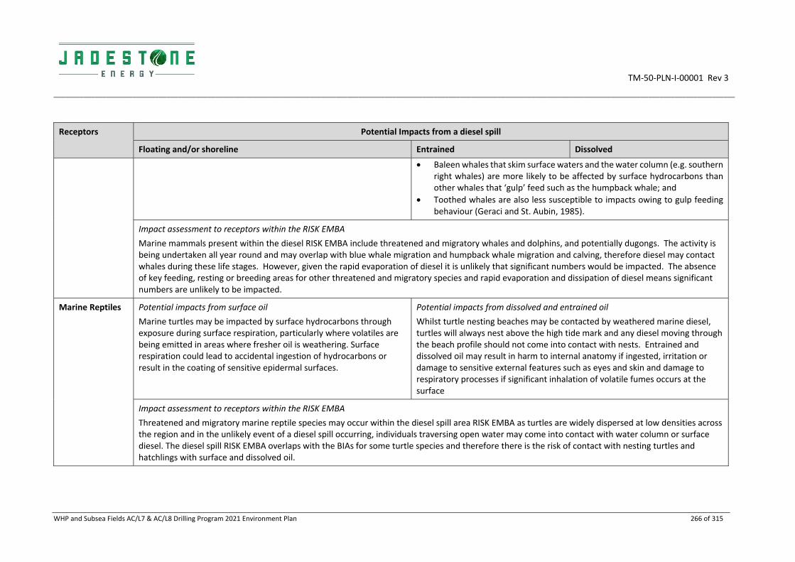
TM‐50‐PLN‐I‐00001 Rev 3
_____________________________________________________________________________________________________________________________________________________________________________________
WHP and Subsea Fields AC/L7 & AC/L8 Drilling Program 2021 Environment Plan 266 of 315
Receptors Potential Impacts from a diesel spill
Floating and/or shoreline Entrained Dissolved
Baleen whales that skim surface waters and the water column (e.g. southern right whales) are more likely to be affected by surface hydrocarbons than other whales that ‘gulp’ feed such as the humpback whale; and
Toothed whales are also less susceptible to impacts owing to gulp feeding behaviour (Geraci and St. Aubin, 1985).
Impact assessment to receptors within the RISK EMBA
Marine mammals present within the diesel RISK EMBA include threatened and migratory whales and dolphins, and potentially dugongs. The activity is being undertaken all year round and may overlap with blue whale migration and humpback whale migration and calving, therefore diesel may contact whales during these life stages. However, given the rapid evaporation of diesel it is unlikely that significant numbers would be impacted. The absence of key feeding, resting or breeding areas for other threatened and migratory species and rapid evaporation and dissipation of diesel means significant numbers are unlikely to be impacted.
Marine Reptiles Potential impacts from surface oil
Marine turtles may be impacted by surface hydrocarbons through exposure during surface respiration, particularly where volatiles are being emitted in areas where fresher oil is weathering. Surface respiration could lead to accidental ingestion of hydrocarbons or result in the coating of sensitive epidermal surfaces.
Potential impacts from dissolved and entrained oil
Whilst turtle nesting beaches may be contacted by weathered marine diesel, turtles will always nest above the high tide mark and any diesel moving through the beach profile should not come into contact with nests. Entrained and dissolved oil may result in harm to internal anatomy if ingested, irritation or damage to sensitive external features such as eyes and skin and damage to respiratory processes if significant inhalation of volatile fumes occurs at the surface
Impact assessment to receptors within the RISK EMBA
Threatened and migratory marine reptile species may occur within the diesel spill area RISK EMBA as turtles are widely dispersed at low densities across the region and in the unlikely event of a diesel spill occurring, individuals traversing open water may come into contact with water column or surface diesel. The diesel spill RISK EMBA overlaps with the BIAs for some turtle species and therefore there is the risk of contact with nesting turtles and hatchlings with surface and dissolved oil.

TM‐50‐PLN‐I‐00001 Rev 3
_____________________________________________________________________________________________________________________________________________________________________________________
WHP and Subsea Fields AC/L7 & AC/L8 Drilling Program 2021 Environment Plan 267 of 315
Receptors Potential Impacts from a diesel spill
Floating and/or shoreline Entrained Dissolved
Fish, Sharks, Rays Potential impacts from surface oil
Near the sea surface, fish are able to detect and avoid contact with surface slicks and as a result, fish mortalities rarely occur in open waters from surface spills (Kennish, 1997; Scholz et al., 1992). Pelagic fish species are therefore generally not highly susceptible to impacts from hydrocarbon spills.
However, hydrocarbon droplets can physically affect fish and sharks exposed for an extended duration (weeks to months). Coating of gills can lead to the lethal and sub‐lethal effects of reduced oxygen exchange, and coating of body surfaces may lead to increased incidence of irritation and infection. Fish may also ingest hydrocarbon droplets or contaminated food leading to reduced growth.
Potential impacts from dissolved and entrained oil
In offshore waters near to the release point, pelagic fish are at risk of exposure to the more toxic aromatic components of the marine diesel. Pelagic fish in offshore waters are highly mobile and comprise species such as tunas, sharks and mackerel. Due to their mobility, it is unlikely that pelagic fish would be exposed to toxic components for long periods in this spill scenario. The more toxic components would also rapidly evaporate, and concentrations would significantly diminish with distance from the spill site, limiting the potential area of impact. Rays are typically found on benthic habitats and may be present around shoals in the area and likely below the area of water column affected by a diesel spill.
Impact assessment to receptors within the RISK EMBA
Whale sharks could potentially transit through the spill trajectory area; however, this is considered unlikely given the small area affected by the diesel spill and its distance from known aggregation areas. Owing to the rapid evaporation expected and dispersion, impacts to the whale shark would be expected to be minimal.
The NWS supports a diverse assemblage of fish and shark species, particularly in shallower water near islands and shoals. Other shark and pelagic fish species may transit the spill trajectory area, but impacts would be anticipated to be negligible as most species will be well below the affected area of the water column.
Avifauna Potential impacts from surface oil
Estimates for the minimum thickness of surface oil that will harm seabirds (through ingestion from preening of contaminated feathers or loss of thermal protection of their feathers) range from 10 g/m2 (O’Hara and Morandin, 2010) to 25 g/m2 (Koops et al. 2004). Seabirds have the potential to become oiled through interactions with surface waters in the spill area or through secondary ingestion of toxins as a
Potential impacts from dissolved and entrained oil
As most fish survive beneath floating slicks, they will continue to attract foraging seabirds, which typically do not exhibit avoidance behaviour.
Potential impacts to avifauna due to entrained oil include:
Harm to internal anatomy if ingested;
Irritation or damage to sensitive external features such as eyes and skin;
Damage to feathers of marine birds;

TM‐50‐PLN‐I‐00001 Rev 3
_____________________________________________________________________________________________________________________________________________________________________________________
WHP and Subsea Fields AC/L7 & AC/L8 Drilling Program 2021 Environment Plan 268 of 315
Receptors Potential Impacts from a diesel spill
Floating and/or shoreline Entrained Dissolved
result of feeding on affected prey. Potential impacts to seabirds are from contact, ingestion and/ or oiling of feathers. In addition, diesel can erode feathers causing chemical damage to the feather structure that subsequently affects ability to thermo regulate and maintain buoyancy on water.
Seabirds may also come into contact with marine diesel around shorelines as it percolates through the beach profile during feeding, breeding and roosting activities. This may result in chemical impacts to feathers and exposed skin from the diesel.
Damage to respiratory processes of air breathing marine fauna if significant inhalation of volatile fumes occurs at the surface.
Impact assessment to receptors within the RISK EMBA
Threatened and migratory seabirds and shorebirds that may occur within the RISK EMBA may have foraging, feeding, breeding and or nesting habitat in the vicinity of the RISK EMBA.
The RISK EMBA intercepts with breeding BIAs for several migratory species and therefore foraging and breeding habitat in the area may be impacted by surface and water column while foraging (dive and skim feeding). Higher numbers would be expected during breeding periods. Due to the quick evaporation and dispersion of diesel, significant impacts are not anticipated.
AMPs Potential impacts from surface oil
Surface oil is not expected to occur at shorelines of AMPs.
Potential impacts from dissolved and entrained oil
Entrained and dissolved hydrocarbons will or may impact the coral and seagrass habitats, as well as other marine park values fauna including dugongs, sea snakes (protected), fish and other marine mammals. Impacts to these receptors are described above.
Three AMPS are present within the diesel RISK EMBA: Oceanic Shoals MP, Ashmore Reef MP and Cartier Island MP.
State Marine Parks
There are no State Marine Parks within the diesel RISK EMBA.

TM‐50‐PLN‐I‐00001 Rev 3
_____________________________________________________________________________________________________________________________________________________________________________________
WHP and Subsea Fields AC/L7 & AC/L8 Drilling Program 2021 Environment Plan 269 of 315
Receptors Potential Impacts from a diesel spill
Floating and/or shoreline Entrained Dissolved
World, National and Commonwealth Heritage Places
There are no World, National and Commonwealth Heritage Places within the diesel RISK EMBA.
Threatened Ecological Communities
There are no threatened ecological communities within the diesel RISK EMBA.
Wetlands of International Importance
There are no wetlands of international importance within the diesel RISK EMBA.
KEFs Potential impacts from surface oil
There are no KEFS that would be impacted by surface oil as the KEFs relate to geomorphologic features which are not expected to be impacted by hydrocarbons.
Potential impacts from dissolved and entrained oil
Values and sensitivities associated with the KEFs include marine fauna due to the higher diversity of fish species associated with the higher diversity in fish communities or nutrients such as Continental Slope Demersal Fish Communities; or benthic habitats at Ashmore Reef and Cartier Island and surrounding Commonwealth waters. Impacts to marine fauna are discussed above.
Impact assessment to receptors within the RISK EMBA
There are three KEFs which are overlapped by the diesel RISK EMBA, these include:
Continental Slope Demersal Fish Communities;
Ashmore Reef and Cartier Island and surrounding Commonwealth waters; and
Ancient coastline at 125 m depth contour
Consequence Likelihood Ranking
Minor Unlikely ‐ Heard of in the exploration and production industry. ITOPF has calculated that for the last 50 years the average number of
Low

TM‐50‐PLN‐I‐00001 Rev 3
_____________________________________________________________________________________________________________________________________________________________________________________
WHP and Subsea Fields AC/L7 & AC/L8 Drilling Program 2021 Environment Plan 270 of 315
Receptors Potential Impacts from a diesel spill
Floating and/or shoreline Entrained Dissolved
incidents involving medium sized (7‐700 tonnes) oil spills from vessels globally has decreased by over 90% and since 2009 stands at a yearly average of 6.6 spills per year globally. With the controls that are in place as detailed in this EP, the likelihood of a significant collision resulting in hydrocarbon release is therefore considered unlikely.

TM‐50‐PLN‐I‐00001 Rev 3
_____________________________________________________________________________________________________________________________________________________________________________________
WHP and Subsea Fields AC/L7 & AC/L8 Drilling Program 2021 Environment Plan 271 of 315
7.7.7 Environmental performance
Environmental Risk Unplanned release of diesel
Performance Outcome No spill of diesel to the marine environment from vessel collision or bunkering malfunction
I.D Management controls Performance Standards Measurement Criteria Responsibility
No spill of diesel to the marine environment from bunkering malfunction
078 MODU bunkering procedures and equipment integrity checks are aligned with requirements of the Montara Marine Facility Manual (MV‐90‐PR‐H‐00001)
All hoses are fitted with dry‐break couplings and are buoyant or fitted with floats
Bunkering checklist confirms preventative actions are undertaken
MODU OIM
079 Visual inspection of dry break couplings and hoses prior to diesel transfer to ensure they are in good condition
080 Permit‐to‐work documentation is complete and signed off to ensure refueling is undertaken in accordance with the refueling procedure
081 Bunding, sumps and drains are inspected prior to bunkering or transfer
082 Testing of emergency shutdown mechanism on the transfer pumps
prior to bunkering or transfer
083 No night‐time bunkering or transfer is permitted, unless a risk
assessment is undertaken and additional mitigation measures are
implemented (as identified as being necessary), and signed off by the
OIM
084 Maintain radio contact with vessel during bunkering or transfer
operations
085 Shipboard Oil Pollution Emergency Plan requires:
Valid SOPEP/SMPEP
Compliance with MARPOL 73/78 Annex I (Prevention of pollution by
oil) and Marine Order 91 (Marine pollution prevention – oil) (as
appropriate to vessel class), including valid SOPEP for managing spills
Records demonstrate
vessels have valid
SOPEP/SMPEP
OIM
Vessel Master

TM‐50‐PLN‐I‐00001 Rev 3
_____________________________________________________________________________________________________________________________________________________________________________________
WHP and Subsea Fields AC/L7 & AC/L8 Drilling Program 2021 Environment Plan 272 of 315
Environmental Risk Unplanned release of diesel
Performance Outcome No spill of diesel to the marine environment from vessel collision or bunkering malfunction
I.D Management controls Performance Standards Measurement Criteria Responsibility
086 Spill kits available
Timely exercises undertaken Vessels to have stocks of onboard spill response kits/bins available and accessible onboard to respond to a spill as per their SOPEP
Pre‐mobilisation inspection records spill response bins/kits are readily available and stocked
OIM
Vessel Master
087 Drills undertaken as per SOPEP Exercise records OIM, Vessel Master
088 Implement Montara Oil Pollution Emergency Plan (MV‐70‐PLN‐G‐00001)
In the event of a tier 2 or tier 3 oil spill, implement to reduce environmental impacts
Incident Log IMT Lead
089 Jadestone Energy’s Competency and Training management System (JS‐60‐PR‐Q‐00014) requires External Contractors to comply with project processes and procedures and have the appropriate level of HSE capability
MODU and vessel personnel trained and assessed competent in accordance with their role requirements as aligned with Recruitment Assessment Templates or Contractors equivalent Competency Assessment system
Records of competency OIM
Vessel Master
Drilling Manager
090 All support vessels requiring entry within the 500m safety zone shall adhere to the MODU permit to work procedures
A 500m PSZ has been established for the Montara facilities and the same safety zone will be in place for the proposed MODU activities when at Montara WHP and an additional PSZ gazetted for the Skua‐10/11 site.
Gazette Notice to Mariners
Records of reporting of unauthorised entry into the safety zone.
OIM
Vessel Master
091 Vessels fitted with lights, signals, an automatic identification system (AIS) transponders and navigation equipment in alignment with the Navigation Act 2012
Vessels will comply with maritime safety and navigation requirements including:
• International Regulations for Preventing Collisions at Sea 1972 (COLREGS);
• Chapter V of Safety of Life at Sea (SOLAS);
Records confirm that required navigation equipment is fitted to all vessels and MODU to ensure compliance with
OIM
Vessel Master

TM‐50‐PLN‐I‐00001 Rev 3
_____________________________________________________________________________________________________________________________________________________________________________________
WHP and Subsea Fields AC/L7 & AC/L8 Drilling Program 2021 Environment Plan 273 of 315
Environmental Risk Unplanned release of diesel
Performance Outcome No spill of diesel to the marine environment from vessel collision or bunkering malfunction
I.D Management controls Performance Standards Measurement Criteria Responsibility
• Marine Order 21 (Safety of navigational and emergency procedures) (as appropriate to vessel class);
• Marine Order 30 (Prevention of collisions) (as appropriate to vessel class);
• International Association of Marine Aids Navigation and Lighthouse Authorities (IALA) Recommendations 0–139 – The marking of man‐made offshore structures (applicable only to the MODU);
Vessels to maintain radio channels and other communication systems.
maritime safety and navigation requirements.
Records confirm MODU and vessels maintain communication systems.
092 In the event of a vessel collision resulting in a loss of diesel, environmental impacts will be reduced to ALARP through the implementation of response strategies.
In the event of a Level 2 or Level 3 spill, compliance with the OPEP including develop and implement an IAP using the processes described within the OPEP.
Response records confirm the OPEP was adhered to and an IAP was developed and implemented.
IMT

TM‐50‐PLN‐I‐00001 Rev 3
__________________________________________________________________________________________________________________________
WHP and Subsea Fields AC/L7 & AC/L8 Drilling Program 2021 Environment Plan 274 of 315
7.7.8 ALARP assessment
On the basis of the impact and risk assessment completed, Jadestone considers the control measures described above are appropriate to manage the risk of an unplanned release of diesel to the marine environment. The residual risk ranking for this potential impact is considered Low, and therefore ALARP has been demonstrated. Additional controls considered but rejected are detailed below.
Rejected control Hierarchy Practicable Cost effective
Justification
Use alternative energy sources
Eliminate N/A N/A The use of diesel for fuel for vessels and machinery cannot be eliminated, vessels and machinery are required for the operations and diesel is therefore required. Other energy sources are not readily available to power all equipment and vessels.
Substitute diesel for another hydrocarbon type
Engineering N/A N/A Machinery is designed for using diesel as the fuel oil which reduces the potential impact from an unplanned release to as low as possible. As no other hydrocarbon has been identified that is more environmentally friendly that could still fulfil the equipment requirements, no engineering controls have been identified.
N/A Isolation N/A N/A The Activity is located at distance from sensitive receptors and the coastline.
N/A Administrative N/A N/A Through the application of specific controls and procedures, and maintenance of hoses, no further administrative controls were identified.
7.7.9 Acceptability Assessment
The potential impacts of an unplanned diesel release to the marine environment are considered ‘Acceptable’ in accordance with the Environment Regulations, based on the acceptability criteria outlined below. The control measures proposed are consistent with relevant legislation, standards and codes.
Policy & management system compliance
Jadestone’s HSE Policy objectives are met. Section 8 demonstrates that Jadestone’s HSE Management System is capable of continuously reviewing and updating activities and practices during the Drilling Activities, including spill response arrangements.
Stakeholder & reputation
Stakeholder consultation has been undertaken (see Section 4), including engagement with the State and National response agencies of DoT and AMSA, commercial and recreational fishing industry bodies and fishers. No concerns have been raised with regards to impacts of a diesel spill by relevant persons.
During any spill response, a close working relationship with key regulatory bodies (e.g. DoT, DBaC, AMSA, DER) will occur and thus there will be ongoing consultation with relevant persons during response operations.
Environmental context & ESD
The worst‐case credible diesel spill scenario for the Drilling Activities is a result of a support vessel collision with the FPSO and 906m3 diesel released of over five hours. Surface oil may contact Browse Island. Entrained oil is predicted to contact the KEFs ‐ Carbonate Bank and Terrace System of the Sahul Shelf, Continental Slope Demersal Fish Communities and Ancient Coastline at 125m depth contour as well as several shoals (Barracouta, Vulcan and Goeree Shoals).

TM‐50‐PLN‐I‐00001 Rev 3
__________________________________________________________________________________________________________________________
WHP and Subsea Fields AC/L7 & AC/L8 Drilling Program 2021 Environment Plan 275 of 315
The potential impact is considered acceptable after consideration of:
Potential impact pathways: Section 7.7.1 (and 7.6.4) assesses the likelihood and consequence of the exposure of sensitive receptors to entrained, dissolved and surface diesel;
Preservation of critical habitats: Section 7.7.5 assesses the worst‐case exposure of protected habitats given three AMPs may be impacted (Oceanic Shoals MP, Ashmore Reef MP and Cartier Island MP). Sensitive receptors at risk include protected seabirds, shorebirds, marine fauna, intertidal and shoreline habitats
Assessment of key threats described in species and Area Management /Recovery plans: See ‘Conservation and management advice’ below;
Consideration of North‐West Bioregional Plan: The NW Bioregional Plan considers hydrocarbon oil spills (i.e. not specifically diesel) as a threat to marine conservation values. This EP aligns with the requirement of the NW Bioregional Plan to assess potential impacts and to have an Oil Spill Contingency Plan in place; and
Principles of ecologically sustainable development ESD: Given the nature of diesel, the location of the Drilling Program and the prevention and recovery plans, the risks from diesel exposure are not predicted to impact population levels of marine fauna and communities. Biodiversity and ecosystem integrity impacts are predicted to recover fully.
Conservation and management advice
Jadestone will have regard to the representative values of protected areas and other published information or conservation advice and endeavor to ensure that priority is given to the social and ecological values, of any AMPs, or State Marine Parks impacted by diesel.
Noting ‘Emergency response’ is permitted in all AMPs and state marine parks.
Actions required to respond to oil pollution incidents, including environmental monitoring and remediation, in connection with activities authorised under the OPGGS Act may be conducted in all zones. The Director will be notified in the event of an oil pollution incident that occurs within, or may impact upon, an Australian Marine Park and, so far as reasonably practicable, prior to a response action being taken within a marine park.
The ‘Industry guidelines for avoiding, assessing and mitigating impacts on EPBC Act listed migratory shorebird species’ will be applied/ used as guidance in the event of an oil spill.

TM‐50‐PLN‐I‐00001 Rev 3
__________________________________________________________________________________________________________________________
WHP and Subsea Fields AC/L7 & AC/L8 Drilling Program 2021 Environment Plan 276 of 315
8. IMPLEMENTATION STRATEGY
As required under Regulation 14(1) of the OPGGS 2009 (Environment) Regulations, Jadestone must provide an implementation strategy that will ensure:
All environmental impacts and risks of the activity will be continually identified and reduced to a level that is ALARP;
Control measures identified in the EP are effective in reducing the environmental impacts and risks of the activity to ALARP and acceptable levels;
That environmental performance outcomes and environmental performance standards are met;
Arrangements are in place to respond to, and monitor impacts of, oil pollution emergencies; and
Stakeholder consultation is maintained through the activity as appropriate.
To meet these requirements the implementation strategy outlined in this EP includes the following:
Details on the systems, practices and procedures to be implemented (Section 8.1);
Key roles and responsibilities (Section 8.2);
Training, competencies and ongoing awareness (Section 8.2.3);
Monitoring, auditing, management of non‐conformance and review (Sections 8.3 and 8.4);
Incident response including Oil Pollution Emergency Plan (Section 7.6 and OPEP);
Record keeping (Section 8.4.2); and
Stakeholder consultation (Section 4).
As Titleholder, Jadestone is responsible for ensuring that the drilling activities to occur within the Operational Area are managed in accordance with this EP, as well as the implementation strategy, the Jadestone HSE Policy and the Business Management System.
8.1 Jadestone Business Management System
Jadestone applies an integrated Business Management System that is aligned with ISO 55000: Asset Management. This covers all activities and includes provision for the systematic management of environment and safety and all other business functions. The Jadestone Business Management System ensures alignment between company objectives and the activities associated with operation of the Montara facilities in a structure that is illustrated by Figure 8‐1.
The management system sets a structured framework that provides governance across company processes for all organisational activities, with defined accountabilities and performance requirements for employees and contractors to deliver activities aligned to the vision and requirements of Jadestone Energy, including those identified in this EP. At the highest level, environmental performance expectations are communicated by the Jadestone HSE Policy.
The structure of the management system is organised to describe the business activities by objective functions (Figure 8‐2).

TM‐50‐PLN‐I‐00001 Rev 3
__________________________________________________________________________________________________________________________
WHP and Subsea Fields AC/L7 & AC/L8 Drilling Program 2021 Environment Plan 277 of 315
Figure 8‐1: Business management system structure
Figure 8‐2: Business activities and objective functions
The objective functions are organised into ‘Lead’, ‘Core’ and ‘Help’, which describe how the intent of the business is delivered. The Lead functions are the activities that provide direction to the Core functions, which represent the life cycle of oil and gas activities. The purpose of the Lead functions is to enact and inform strategy and to guide the Core functions in the delivery of their activities.
Delivery of HSE management and performance is fully integrated (including implementation of the EP) throughout the objective functions relevant to operation of the activity. The relevant functions are:
Operational excellence;

TM‐50‐PLN‐I‐00001 Rev 3
__________________________________________________________________________________________________________________________
WHP and Subsea Fields AC/L7 & AC/L8 Drilling Program 2021 Environment Plan 278 of 315
Value discipline;
People;
Stakeholder management;
Risk management;
Develop;
Produce; and
Provide goods and services.
Below is a summary of the mechanisms by which these functional areas contribute to HSE management and performance during the activity.
8.1.1 Operational Excellence
‘Operational Excellence’ provides the systems, tools and processes which ensure that all learning experiences that have the potential to improve operational safety, integrity and efficiency, and reduce negative impacts to the environment, to be captured, evaluated and disseminated for future implementation.
The Operational Excellence function is a continuous process and is summarised in Figure 8‐3.
The Operational Excellence function addresses the key points of:
Capturing of lessons learnt;
Review of lessons learnt; and
Incorporation of knowledge in future work.
Figure 8‐3: Operational and excellence business functions
Knowledge and best practices can be captured from many sources including internal and external, such as:
Audits and inspections;
Emergency response drills;
Incident reviews;
Technical papers, legislation and journals; and
Prior experience.
Plan
Operate
Learn
Improve
TM‐50‐PLN‐I‐00001 Rev 3
__________________________________________________________________________________________________________________________
WHP and Subsea Fields AC/L7 & AC/L8 Drilling Program 2021 Environment Plan 279 of 315
Any actions arising from the assessment of information are incorporated into CMMS. Processes, procedures and systems are improved based on the historical lessons learnt and applied in subsequent phases.
8.1.2 Value Discipline
The ‘Value discipline’ function represents the processes – including annual budgeting, capital funding – that ensure value and capital requirements are met and support the management system functions delivering their business objectives including HSE performance. Commonly HSE performance is a proxy for business performance and therefore HSE management is of interest to the Value discipline function of the management system.
8.1.3 People
The Jadestone Energy Competency Assurance Framework provides the formal systems, tools and processes which ensure that personnel are appropriately trained and competent to complete assigned tasks to an expected standard. Competency assurance is a necessary component of any approach to reduce safety, integrity and environmental risks to a level that is ALARP.
The Competency Assurance Framework addresses the key points of:
Competency requirements (qualification, experience and training) are maintained for all Jadestone Energy positions where the incumbent is required to undertake, supervise, review or verify critical tasks or where the incumbent has the technical authority to approve critical documents;
Competent persons are members of the workforce who meet the competency requirements for the respective positions to perform critical tasks without direct supervision;
Candidates being considered for appointment in a critical position are assessed against the applicable competency requirements before being formally appointed;
Incumbents must be reassessed against the competency requirements as per the required frequency stipulated in the competency matrix; and
All contractors with personnel in the field are prequalified in accordance with the Contractor Management Framework.
Jadestone Energy personnel are subject to the provisions of the Jadestone Competency Assurance Framework which outlines the training, development and assessment requirements necessary to ensure that all employees have the relevant knowledge and skills required to conduct their activities in a safe and environmentally responsible manner.
A training and skills matrix have been developed for all positions which identifies responsibilities, training and competency requirements. Personnel will complete relevant training and hold qualifications and certificates for their specific role (e.g. well control certificates, rigging and crane operator certificates etc.). Training records will be retained.
8.1.4 Stakeholder Management
Sub‐regulation 11A(3) of the Environment Regulations provides that:
The Implementation strategy of the environment plan must provide for appropriate consultation with:
a) Relevant authorities of the Commonwealth, a State or Territory; and
b) Other relevant interested persons or organisations

TM‐50‐PLN‐I‐00001 Rev 3
__________________________________________________________________________________________________________________________
WHP and Subsea Fields AC/L7 & AC/L8 Drilling Program 2021 Environment Plan 280 of 315
Ongoing consultation activities build upon Jadestone’s consultation for the activity. Section 4 outlines the processes that will be followed to ensure a standard approach to interacting with relevant persons during the life of the EP, including revision of relevant persons’ list and process for dealing with feedback during this period. As part of ongoing consultation Jadestone will undertake the following activities (Table 8‐1).
Table 8‐1: Standard consultation actions
ID Activity Frequency and method Responsibility
142 Provide response organisations with a copy of the OPEP
Email response organisations ER Lead
143 Notification of commencement and cessation of activity to NOPSEMA
Within 4 weeks of commencement date and at cessation
Environment Lead
144 Notification of AMSA Joint Rescue Coordination Centre (JRCC) of commencement of activity
48–24‐hours from commencement of operations
HSE Manager
In addition, Jadestone will undertake additional triggered consultation as outlined below, should an unplanned event occur (Table 8‐2).
Table 8‐2: Triggered consultation actions
ID Trigger Action Responsibility
145 Feedback received from relevant person
Follow consultative process outlined in the Consultation for Environmental Approvals procedure
HSE Manager
146 Deviation to the planned activity from those originally provided in consultation
• Notification to relevant persons via email; • Notify AMP Director General if any change to risk
within AMPs.
HSE Manager
147 Oil spill event Notification to response agencies and government agencies by phone.
Attempt to electronically notify all relevant persons listed in Montara EP Consultation plan as soon as possible.
Ongoing updates and communication in accordance with requirements and response procedures.
Notification of DPIRD via [email protected] within 24‐hours of incident report.
Notify AMP Director General within 24‐hours of incident report and prior to spill response activities within AMP on 0419 293 465. To include titleholder details, time and location of the incident, proposed response arrangements and locations as per the OPEP and contact details for the response coordinator.
IMT Leader

TM‐50‐PLN‐I‐00001 Rev 3
__________________________________________________________________________________________________________________________
WHP and Subsea Fields AC/L7 & AC/L8 Drilling Program 2021 Environment Plan 281 of 315
ID Trigger Action Responsibility
148 AMP access Notify AMP Director General of SMP (or other response activities) within AMP 10 days prior to entering (where possible) and at the cessation of activities in AMPs.
IMT Lead
149 Biosecurity incident: suspected marine pest or disease
Notification of DPIRD via [email protected] or 1800 815 507 within 24‐hours.
HSE Manager
150 Change to infrastructure that affects PSZ
Notify the Australian Hydrographic Office of activities and infrastructure for inclusion in Marine Notices
HSE Manager
8.1.5 Risk Management
Jadestone has an integrated approach to risk management to cover all its business activities.
The Risk Management function provides a view of risk that is independent of production delivery. This includes strategic, commercial, and control and compliance risks. In addition, it manages Health Safety and Environment activities, including the preparation and approval of regulatory approvals (including this EP) and the management of change process, which addresses all change activities regardless of type – technical, organisational, software or procedural. Further information on the management of change process is provided in Section 8.4.2.
At the activity level, the risk management function includes all the planned activities and accidental events. Risk identification and assessment is a continuous process that identifies all the physical control measures necessary to manage the risks. Control measures are subjected to regular assurance activities. In a similar way, audits of the management system are conducted according to review cycle with timing agreed in the annual planning process. Findings from assurance activities, audits and ongoing review of performance are considered in the Operational Excellence process, which considers opportunities for continuous improvement (refer Section 8.4).
The Risk Management function is accountable for approval of facility level risk assessments and risk reduction measures; and by so doing, providing a view of risk that is independent from production delivery.
8.1.6 Produce
The Produce function delivers safe and reliable operations as well as environmental performance.
The Produce function works closely with the Operational Excellence and Risk Management functions to evaluate operational performance, including environmental performance, and reduce risk through delivery of continuous improvement activities. Produce is responsible for asset optimisation, reliability, integrity and maintaining compliance. It thus interacts with most functions.
The Produce function delivers environmental management at the activity level via the Computerised Maintenance Management System (CMMS) including detailed work instructions and tasks allowing the activity to meet the environmental performance requirements of this EP. These instructions and tasks are monitored and reviewed to ensure appropriate close out of tasks is achieved as well as ensuring the required outcomes/ performance have been achieved.
8.1.7 Provide Goods and Services
HSE performance in all activities associated with operation is achieved either through management of personnel involved, or via management of contracted works.

TM‐50‐PLN‐I‐00001 Rev 3
__________________________________________________________________________________________________________________________
WHP and Subsea Fields AC/L7 & AC/L8 Drilling Program 2021 Environment Plan 282 of 315
The Jadestone Competency Management Framework provides personnel with a systematic and uniform approach for managing and improving Health, Safety and Environmental (HSE) performance throughout the life cycle of an individual’s appointment, from their selection through to post‐completion performance evaluation. The Personnel Management Framework addresses the key points of selection, competency, development requirements and management.
HSE performance is also achieved through Jadestone’s Contractor Management Framework. The contract management life cycle follows four steps: pre‐qualification; selection; engagement; and contract completion review process. Through each of these steps Jadestone and service provider/ supplier is evaluated for previous HSE performance and engaged in the mechanisms by which HSE performance will be achieved in the contract to be established.
8.2 Key Roles and Responsibilities
As per Regulations 14(4) and 14(5), a clear chain of command setting out the roles and responsibilities of personnel involved in operation is required as well as detail on what measures are in place to ensure personnel are aware of their role requirements and how Jadestone evaluates their competency and training needs in these roles. In response to these regulatory requirements, provided in this sub‐section is information on:
Section 8.2.1 Organisational Chart: outlines the key roles involved in operation of the Montara
drilling activities;
Section 8.2 Role responsibilities: summarises the responsibilities of each key role involved in
operation of Montara drilling activities;
Section 8.2.2 Communication requirements: outlines how personnel fulfilling key roles are made
aware of their responsibilities as described in the EP; and
Section 8.2.3 Assessment of Competency and Training: outlines how Jadestone assesses and
evaluate the competencies and training requirements of personnel responsible for achieving the
commitments with this EP.
8.2.1 Organisational Structure and Responsibilities
The organisational structure for the drilling activity is presented in Figure 8‐4.
Each position has a position description outlining their HSE role and responsibilities, accountabilities and reporting lines (Table 8‐3). It is the responsibility of all Jadestone personnel to ensure that the requirements of the HSE Policy are applied in their area of responsibility and that personnel are suitably trained and competent in their respective roles.

TM‐50‐PLN‐I‐00001 Rev 3
__________________________________________________________________________________________________________________________
WHP and Subsea Fields AC/L7 & AC/L8 Drilling Program 2021 Environment Plan 283 of 315
Figure 8‐4: Drilling Operations organisation chart

TM‐50‐PLN‐I‐00001 Rev 3
__________________________________________________________________________________________________________________________
WHP and Subsea Fields AC/L7 & AC/L8 Drilling Program 2021 Environment Plan 284 of 315
Table 8‐3: Responsibilities of Key Roles
Role Key Responsibilities
Country Manager Ensures that activities are conducted in accordance with the Jadestone’s HSE Policy.
Primary responsibility for Jadestone Australia operations and for meeting or exceeding corporate targets for all aspects of performance, including conducting activities in accordance with Jadestone’s HSE Policy and this Environment Plan.
Responsible for providing adequate resources for environmental management.
Accountable for Operational Excellence.
Ensures the incident response strategy is implemented in the case of an incident.
Responsible for compliance with the BMS.
Maintains communication with company personnel, government agencies and the media, where appropriate.
Drilling and Completions Manager
Responsible for ensuring that JSE policies, management principles and standards are
followed in the well design and operational phases.
Responsible for ensuring that best practices are used in the planning and execution of
wells during the campaign. This includes ensuring that lessons learned in previous
campaigns are applied to this current campaign.
Ensure that the requirements of this EP are implemented
Drilling Superintendent
The Drilling Superintendent is responsible for offshore well construction operations
meeting environmental performance and compliance requirements of the EP.
Coordinate all drilling and associated activities are undertaken by Company personnel
and its contractors in accordance with approved programmes and appropriate
legislation as detailed in this EP.
Ensure that all operational, technical and environmental incidents during well
construction operations are reported to the Drilling and Completions Manager
Responsible for regular reporting through daily reporting formats.
Manage HSE hazards and risks related to drilling maintenance activities by ensuring
procedures and risk reduction processes have been employed for all activities under
their control.
JSE Senior Drilling
Supervisor
The JSE Senior Drilling Supervisor is responsible for ensuring correct drilling procedures
and practices are followed.
Providing daily instructions to well operations, including well control procedures, or
other relevant information, and implementing the well control kill method which will be
agreed upon with the OIM.
Responsible for HSE and operational support for all phases of rig operations.
Ensures the Program is executed in compliance with JSE policies and is communicated,
verbally and in writing, to the appropriate representatives on board the MODU.
Acts as JSE’s senior representative and manages all JSE contractors on board the MODU.
Reports directly to the JSE Drilling Superintendent on all matters.

TM‐50‐PLN‐I‐00001 Rev 3
__________________________________________________________________________________________________________________________
WHP and Subsea Fields AC/L7 & AC/L8 Drilling Program 2021 Environment Plan 285 of 315
Role Key Responsibilities
Supply Chain Manager
Overall responsibility for implementation of the contractor management framework, including communication of EP requirements to contractors at the appropriate stages of contract management cycle.
Offshore Installation Manager (OIM)
Responsible for day to day operations at the facility.
Ensures completion of routine performance reporting for the activities.
Responsibility for the implementation and compliance with the requirements of the EP and the Jadestone's HSE Policy.
Ensures that risk management processes are employed to manage HSE hazards and risks at the facility.
Communicates the importance of appropriate levels of training, competency and environmental awareness to all personnel.
Ensures the importance of appropriate levels of training, competency and environmental awareness are communicated to facility personnel and that the training matrix is fully implemented.
Ensures all personnel undertake appropriate Montara inductions and are aware of their HSE responsibilities.
Ensures sufficient resources are made available for offshore environmental management to meet the requirements of the Environment Plan.
Ensures all relevant HSE incidents are reported in accordance with internal incident reporting and investigation procedures.
Conducts regular workplace inspections.
Implements corrective and preventative actions arising environmental inspections, audits, incidents and hazard reports.
Overall responsibility for HSE and emergency response management at the facilities.
Ensure that adequate skills are maintained for effective incident response.
Ensure regular drills and exercises are conducted and all personnel actively participate.
Ensure Facility HSE meetings are conducted as required by the BMS.
Communicates HSE hazards and risks to the workforce and the importance of following good work practices.
HSE Manager Ensures review of daily, weekly and monthly reporting, as applicable, from the MODU and support vessels.
Ensures environmental department liaison with the OIM to deliver compliance with all aspects of this EP.
Plans and schedules environmental audits of the activities.
Ensures regulatory documents are prepared and meet regulatory requirements.
Ensures emergency response plans are in place.
Develops and participates in oil spill response activities.
Ensures reporting of all relevant environmental incidents to NOPSEMA within the required timeframes.
Ensure environmental incident reporting meets regulatory requirements (as outlined in the EP) and incident reporting and investigation procedure.

TM‐50‐PLN‐I‐00001 Rev 3
__________________________________________________________________________________________________________________________
WHP and Subsea Fields AC/L7 & AC/L8 Drilling Program 2021 Environment Plan 286 of 315
Role Key Responsibilities
Ensures that proposed changes to environmental management activities are subject to Management of Change and approved prior to application.
HSE Advisor Works with the HSE Manager and Drilling team to support environmental management and delivery of EP commitments.
Contributes to inspections, audits and reviews of the Environment Plan.
MODU and vessel personnel and contractors
Adhere to work systems and procedures defined for the activities being undertaken.
Follow good housekeeping work practices.
Report HSE incidents, hazards or non‐conformances to supervisors in a timely manner.
Identify HSE improvement opportunities wherever possible.
8.2.2 Communication of Responsibilities
The primary mechanism for ensuring personnel involved in the drilling activities are aware of the environmental commitments as listed in this EP are via: provision of environmental performance commitments lists via the CMMS; management of service providers and suppliers (refer below); and online induction prior to attending the Montara field.
All personnel are required to complete an online induction that contains environmental components prior to arrival at the facility. Inductions are updated to account for site‐specific factors or activities, or EP management improvements. Induction attendance records for all personnel are maintained. At a minimum, inductions include:
The Jadestone HSE Policy;
Description of the environmental sensitivities within the Operational Area and surrounding waters;
Identification of environmental risks and mitigation measures;
Permit to work;
Procedures for reporting of any environmental incidents or hazards;
Waste management requirements;
Overview of incident response and spill management procedures, including roles and responsibilities;
Roles and environmental responsibilities of key personnel; and
Direction on where to find copies of the EP and OPEP.
8.2.3 Competencies and Training
Jadestone Energy’s Contractor Management Framework (JS‐90‐PR‐G‐00002) provides a process for ensuring that Contractors and Services Providers have the appropriate level of HSE capability. The assessment of Contractors and Service Providers competency provides a sound level of assurance that all key third‐party personnel involved in operations have the necessary skills, knowledge, experience, and ability to perform their work in accordance with their company’s training and competency systems.
Contractors and service personnel are assessed against their company’s criteria and any additional criteria required by Jadestone Energy. Records of competent people are maintained in EDMS.
Competencies and training arrangements for personnel involved in oil pollution response are detailed in the OPEP and records maintained in EDMS.

TM‐50‐PLN‐I‐00001 Rev 3
__________________________________________________________________________________________________________________________
WHP and Subsea Fields AC/L7 & AC/L8 Drilling Program 2021 Environment Plan 287 of 315
8.3 Monitoring, Auditing, Management of Non‐conformance and Review
As required under sub‐regulation 14(6), Jadestone must provide for sufficient monitoring, recording, audits, management of non‐conformance and review of Jadestone’s environmental performance and implementation strategy to ensure that environmental performance outcomes and standards in the EP are being met and continue to minimise impacts to the environment.
Environmental performance outcomes and standards as well as management controls as detailed in this EP (Sections 6 and 7 and the OPEP) are monitored and recorded as described. Ongoing monitoring activities to determine if environmental commitments as required in this EP are being met include the CMMS, inspection program, auditing and exercising of response arrangements. In particular, routine commitments in the EP have been loaded into the CMMS that directs work activities for onshore and offshore personnel. Work activities include review of monitoring checklists, audits, inspections, maintenance and continuous improvement reviews, allowing environmental performance of the activity to be monitored. Non‐conformances of EP commitments are reported, tracked and closed‐out in accordance with this EP.
The collection of data from environmental performance monitoring activities forms the basis of demonstration that the commitments as listed are being met, that specified mitigation measures are in place to manage environmental risks, and that they remain working, and contribute to continually reducing risks and impacts to ALARP and acceptable levels.
8.3.1 Routine Monitoring
The purpose of monitoring and inspections is to record performance data and routinely check conformance with environmental performance standards and achievement of environmental performance outcomes defined by the EP. Routine inspection activities are scheduled and records kept in the CMMS.
Emissions and discharges to the environment are monitored to assess the environmental performance of the operation on an ongoing basis. Table 8‐4 details the quantitative records that are maintained for all emissions and discharges during routine or emergencies within the Operational Area as per Regulation 14(7) of the Offshore Petroleum and Greenhouse Gas Storage (Environment) Regulations 2009.

TM‐50‐PLN‐I‐00001 Rev 3
_________________________________________________________________________________________________________________________________________________________________________________
WHP and Subsea Fields AC/L7 & AC/L8 Drilling Program 2021 Environment Plan 288 of 315
Table 8‐4: Summary of routine monitoring
Measurement Frequency Monitoring Strategy Record
Ballast water discharges Intermittently ‐ discharge events recorded as they occur
Discharges determined from ballast water record log
Ballast water records
Volumes of the following waste types are recorded: general and putrescible waste; hazardous waste; timber/ wood; recyclables; cardboard/ paper; scrap metal; metal drums & containers; batteries (lead acid); plastic drums and containers; and oily waste/ sludge.
Logged on facility when transferred via vessel to shore then to licensed waste facility. This is done fortnightly (supply run).
Vessel also records volumes on manifest
Invoicing process checks vessel manifest against waste disposal records of service provider, and evidence of disposal
Manifest documents
Oil Record Book
Garbage Record Book
Emissions will be directed to the Montara Venture topside production infrastructure for processing
Daily Emissions determined from MV PDMS Daily drilling report
Emissions will be directed to the MODU and vented to atmosphere at the top of the derrick via the BOP, choke line, choke manifold and the poor boy degasser.
Daily Manual volumetric estimate Daily drilling report
Cuttings discharge Daily Onboard cuttings management system Daily mud report
Brine discharge stream OIW Intermittently ‐ discharge events recorded as they occur
Oily water monitor on waste stream Daily drilling report
Barite does not exceed concentrations of the following metals: Mercury – maximum 1 mg/kg dry weight; Cadmium – maximum 3 mg/kg dry weight; Lead ‐ maximum 1000 mg/kg dry weight
As purchased Purchase records confirm that the stock barite in drilling fluids do not exceed maximum concentrations
Purchase records
Cement and drilling fluid used Daily Mud and Cementing Engineers monitor fluid and cement used/ discharged
Daily Drilling Report

TM‐50‐PLN‐I‐00001 Rev 3
__________________________________________________________________________________________________________________________
WHP and Subsea Fields AC/L7 & AC/L8 Drilling Program 2021 Environment Plan 289 of 315
8.3.2 Audits
An audit is a systematic examination and evaluation against defined criteria and performance indicators to determine whether activities/ processes and related results conform to planned arrangements, whether these arrangements are implemented effectively, and if they are suitable to achieve Jadestone’s performance outcomes and requirements.
Environmental audits provide assurance that the systems and processes in place to deliver the EP (i.e. the implementation strategy) are suitable and effective. The Jadestone Audit Manual (JS‐90‐PR‐G‐00003) describes the planning and conduct of audit activities.
At least one audit (‘pre‐start inspection’) of the MODU by Jadestone’s HSE Manager or delegate will be completed prior to commencement of the activity.
8.3.3 Non‐compliances and Corrective Actions
Non‐conformances from audits, inspections, incidents, regular monitoring or response testing are communicated immediately to the OIM and tracked and monitored by the HSE Manager until closed
Opportunities for improvement and corrective actions from daily operations, reviews, audits, inspections, monitoring and testing activities are documented and tracked to closure by Jadestone’s action tracking system.
8.3.4 Reporting
Table 8‐5 details the approach to routine environmental performance reporting to the Regulator. Reporting activities relating to reportable and recordable incidents will be as per Regulations 26, 26A, 26AA and 26B.
8.4 Continuous Improvement (Operational Excellence)
The review of environmental performance includes an assessment of:
Review of compliance with environmental performance outcomes and performance standards, and adequacy of measurement criteria;
Function of environmental management controls relevant to reportable and/or recordable incidents;
Monitoring data and trends;
Results of audits and incident investigations;
Inspection and checklist approaches; and
Adequacy of monitoring, inspections and audits.
The results of the review and any identified improvements or recommendations will be incorporated into processes and procedures used for the operation, or the EP, to facilitate continuous improvement in environmental performance.
In the event that new information (audits, inspections, reviews etc.) suggests risks and impacts are no longer reduced to acceptable levels, or controls are no longer effective in reducing the risks and impacts to ALARP and acceptable levels, then the process for identification of further controls through a risk assessment will follow that of the risk assessment methodology for this EP (refer Section 5).
Any opportunities for improvements identified through the risk assessment (i.e. new controls adopted) will be evaluated via a Management of Change process prior to the EP, procedures or processes being modified.
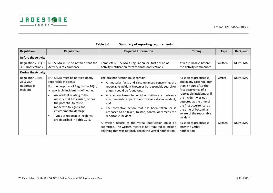
TM‐50‐PLN‐I‐00001 Rev 3
__________________________________________________________________________________________________________________________________________________________________________________
WHP and Subsea Fields AC/L7 & AC/L8 Drilling Program 2021 Environment Plan 290 of 315
Table 8‐5: Summary of reporting requirements
Regulation Requirement Required Information Timing Type Recipient
Before the Activity
Regulation 29(1) & 30 ‐ Notifications
NOPSEMA must be notified that the Activity is to commence.
Complete NOPSEMA’s Regulation 29 Start or End of Activity Notification form for both notifications.
At least 10 days before the Activity commences
Written NOPSEMA
During the Activity
Regulation 16(c), 26 & 26A – Reportable Incident
NOPSEMA must be notified of any reportable incidents
For the purposes of Regulation 16(c), a reportable incident is defined as:
An incident relating to the Activity that has caused, or has the potential to cause, moderate to significant environmental damage
Types of reportable incidents are described in Table 10‐1.
The oral notification must contain:
All material facts and circumstances concerning the reportable incident known or by reasonable search or enquiry could be found out;
Any action taken to avoid or mitigate an adverse environmental impact due to the reportable incident; and
The corrective action that has been taken, or is proposed to be taken, to stop, control or remedy the reportable incident.
As soon as practicable, and in any case not later than 2 hours after the first occurrence of a reportable incident, or if the incident was not detected at the time of the first occurrence, at the time of becoming aware of the reportable incident
Verbal NOPSEMA
A written record of the verbal notification must be submitted. The written record is not required to include anything that was not included in the verbal notification
As soon as practicable after the verbal notification
Written NOPSEMA

TM‐50‐PLN‐I‐00001 Rev 3
__________________________________________________________________________________________________________________________________________________________________________________
WHP and Subsea Fields AC/L7 & AC/L8 Drilling Program 2021 Environment Plan 291 of 315
Regulation Requirement Required Information Timing Type Recipient
A written report must contain:
All material facts and circumstances concerning the reportable incident known or by reasonable search or enquiry could be found out;
Any action taken to avoid or mitigate adverse environmental impact due to the reportable incident;
The corrective action that has been taken, or is proposed to be taken, to stop, control or remedy the reportable incident; and
The action that has been taken, or is proposed to be taken, to prevent a similar incident occurring in the future.
Must be submitted as soon as practicable, and in any case not later than 3 days after the first occurrence of the reportable incident unless NOPSEMA specifies otherwise.
Written NOPSEMA
Regulation 26B – Recordable Incidents
NOPSEMA must be notified of a breach of an EPO or EPS, in the environment plan that applies to the Activity that is not a reportable incident
Complete NOPSEMA’s Recordable Environmental Incident Monthly Report form via
The report must be submitted as soon as practicable after the end of the calendar month, and in any case, not later than 15 days after the end of the calendar month.
If no recordable environmental incidents have occurred during a particular month, a Nil Incident report must be submitted
Written NOPSEMA

TM‐50‐PLN‐I‐00001 Rev 3
__________________________________________________________________________________________________________________________________________________________________________________
WHP and Subsea Fields AC/L7 & AC/L8 Drilling Program 2021 Environment Plan 292 of 315
Regulation Requirement Required Information Timing Type Recipient
End of Activity
Regulation 29(2) – Notifications
NOPSEMA must be notified that the Activity is completed
Complete NOPSEMA’s Regulation 29 Start or End of Activity Notification form for both notifications
Within 10 days after finishing
Written NOPSEMA
Regulation 14 (2) & 26C – Environmental Performance
NOPSEMA must be notified of the environmental performance of the Activity
Report must contain sufficient information to determine whether or not environmental performance outcomes and standards in the EP have been met
Annual report submitted within 3 months after the anniversary of the reporting period, with the period commencing on the dated Regulation 29 notification form
Written NOPSEMA
Regulation 25A
Plan ends when titleholder notifies completion
NOSPEMA must be notified that the Activity has ended and all EP obligations have been completed
Notification advising NOPSEMA of end of the Activity Within six months of the final Regulation 29 (2) notification
Written NOPSEMA

TM‐50‐PLN‐I‐00001 Rev 3
WHP and Subsea Fields AC/L7 & AC/L8 Drilling Program 2021 Environment Plan 293 of 315
8.4.1 Management of Change and Revisions of the Environment Plan
Regulation 17 of the Offshore Petroleum Greenhouse Gas Storage (Environment) Regulations 2009 makes clear the following requirements in respect of a number of circumstances that may lead to the deviation of an activity from the EP, or a new activity requiring an EP.
17 Revision because of a change, or proposed change, of circumstances or operations
New activity
17(1) A titleholder may, with the Regulator’s approval, submit to the Regulator a proposed revision of an environment plan before the commencement of a new activity.
Significant modification or new stage of an activity
17(5) A titleholder must submit to the Regulator a proposed revision of the environment plan for an activity before the commencement of any significant modification or new stage of the activity that is not provided for in the environment plan as currently in force.
New or increased environmental impact or risk
17(6) A titleholder must submit a proposed revision of the environment plan for an activity before, or as soon as practicable after:
(a) The occurrence of any significant new environmental impact or risk, or significant increase in an existing environmental impact or risk, not provided for in the environment plan in force for an activity; or
(b) The occurrence of a series of new environmental impacts or risks, or a series of increases in existing environmental impacts or risks, which, taken together, amount to the occurrence of:
(i) A significant new environmental impact or risk; or
(ii) A significant increase in an existing environmental impact or risk;
That is not provided for in the environment in force for the activity.
Jadestone’s Management of Change process will determine whether a proposed change to activities Triggered the requirements of Regulation 17, which may result in a revision and resubmission of an EP to NOPSEMA. This process is described in the Jadestone’s Change Management Procedure (MoC) (JS‐90‐PR‐G‐00017). The procedure describes a system for identifying, tracking, responding, progressing and closing out change requests or queries raised by any party involved in Jadestone Energy activities. It also directs and instructs activity owners on the environmental regulatory requirements relating to a change in operations.
The procedure provides for proper consideration of temporary or permanent changes to activities, including an impact and risk assessment, approved and communicated to all appropriate stakeholders together with providing a record of the change. In particular, the system ensures the following:
All changes required to critical outputs will be identified, recorded, risk assessed and approved –
internally and externally as required – before being implemented;
Processes and procedures are in place to ensure requirements for change are identified and
unauthorised changes are prevented;
All changes must be assessed to determine if the change introduces a new risk or impact or increases
an existing impact or risk, as required by Regulation 17;
The MoC is prepared internally by Jadestone personnel which includes consultation with relevant
parties as necessary such as technical/ subject matter experts and external stakeholders as required;
Only authorised and competent members of the workforce can approve changes, including relevant
Technical Authorities. Technical Authorities are deemed as authorised and competent via the Technical
Authority Framework (GA‐60‐STD‐Q‐00001);

TM‐50‐PLN‐I‐00001 Rev 3
WHP and Subsea Fields AC/L7 & AC/L8 Drilling Program 2021 Environment Plan 294 of 315
Approval of a change internal to Jadestone requires confirmation that impacts and risks have been
assessed and appropriate reduction measures implemented (if required) to manage risk to ALARP and
impacts to acceptable levels;
All approved changes that affect the Environment Plan are properly documented and communicated
to all relevant internal and external members of the workforce, e.g. via toolbox talk or HSE meetings
and JSA; and
An audit trail is kept of all changes and documents and drawings are updated accordingly.
MOC must be designed to meet the particular requirements of the type of change required and will include:
Risk assessment to assess potential impacts to the receiving environment as detailed in this EP,
including matters of NES and those protected under the EPBC Act;
Strategies and actions to mitigate any adverse effects; identify opportunities offered by the change;
and determine how impacted interfaces shall be managed;
Timeframes for implementation;
Documents (e.g. drawing, plan, program, procedure) against which change is monitored;
Outline drawings or controlled documents affected; and
Responsibilities for execution, review and approval of the:
o Justification for the change,
o Assessment of the impact and risk to environment,
o Detailed implementation requirements,
o Dissemination of the change, training personnel and updating of documentation.
All alterations and updates to controlled documents, including regulatory approvals, procedures or drawings must be in accordance with Document Control requirements. If the change meets any of the criteria detailed by Regulation 17, a revision/resubmission of the EP to NOPSEMA will occur.
Maintenance work, which covers the replacement of parts or equipment with identical (or equivalent specification) parts or equipment, and with no change to operating arrangements, is not subject to change control.
8.4.2 Record Keeping
This section of the EP meets Regulation 27(2) by detailing a systematic, auditable record of the results of monitoring and auditing of the environmental performance of the activities. The records retained are linked to the performance outcomes, standards and measurement criteria, and monitoring and reporting requirements.
As a minimum, Jadestone will store and maintain the records for five years, where records include:
Written reports including monitoring, audit and review regarding environmental performance or the business management system;
Environmental performance reports and associated documentation;
Documentation generated through stakeholder consultation;
Records of emissions and discharges;
Records of calibration and maintenance; and
Reportable and recordable incident reports.

TM‐50‐PLN‐I‐00001 Rev 3
WHP and Subsea Fields AC/L7 & AC/L8 Drilling Program 2021 Environment Plan 295 of 315
8.5 Emergency Preparedness and Response
Under the Environment Regulations 14(8) the Implementation Strategy must contain an oil pollution emergency plan and provide for the updating of the plan containing adequate arrangements for responding to and monitoring oil pollution. These details are contained within the OPEP, which is part of this EP, and details the incident response arrangements in the event of an oil spill and should be referred to for all details.
Emergency response procedures and manuals are in place to describe how controls and consequences are mitigated. These documents are available on the Montara Venture FPSO and are made accessible to all personnel. The relevant incident response procedures and manuals are detailed in the OPEP.
The Montara Emergency Response Plan (MV‐70‐PLN‐F‐00001), Incident Management Team Response Plan (JS‐70‐PLN‐F‐00008) and associated manuals are regularly updated with the revised contact details of relevant organisations and individuals included. They are also frequently tested to determine where they can be improved. The Incident Management Team Response Plan (IMTRP) sets out the structure, organisation and activation, or trigger processes for responding to an incident as well as detailing the schedule for exercising and testing the major hazard incidents and OPEP response and preparedness. The IMTRP also includes as an appendix the Oil Spill Response Arrangements (OSRA). The OSRA sets out the initial actions, notifications and responses once the IMT has triggered an oil spill response.
The Incident Management Exercise & Testing Program (JS‐70‐PR‐F‐00001) provides more information on planning and testing cycles. As a minimum, Jadestone conducts quarterly IMT drills, an annual major oil spill exercise, six‐monthly oil spill response functional workshops, as well as ad‐hoc exercises to coincide with specific project campaigns. The HSE (Emergency Response) Lead maintains an IMT exercise program.
Wherever practical, the IMT exercises, including oil spill responses, may involve support from other agencies, contractors and oil & gas operators as part of resource sharing initiatives. Records of emergency exercises, including OPEP commitments are assessed against measurement criteria and recorded in Jadestone’s CMMS BASSnet.
In addition, assurance actions to meet OPEP requirements such as review of Scientific Monitoring capabilities, Waste Contractors compliance and availability of oil spill response vessels and aircraft are scheduled in BASSNet or contractual obligations.
Emergency response, including oil spill arrangements, as part of the implementation strategy are reviewed every 12 months. The scope of the review will be determined by the associated trigger for review. The triggers for the review are:
document control notification;
any significant change in the OPEP;
any change in the risk assessment; and
significant findings or any requirements from after‐action review of drills or incidents.
As the Drilling Activities EP is to address 2021 Drilling campaign, this review period is considered acceptable.
9. REPORTING
9.1 Routine Reporting
Table 9‐1 details the approach to routine environmental performance reporting to the regulator. Reports will be of sufficient detail to demonstrate whether specific environmental performance outcomes and standards have been met.

TM‐50‐PLN‐I‐00001 Rev 3
WHP and Subsea Fields AC/L7 & AC/L8 Drilling Program 2021 Environment Plan 296 of 315
9.2 Incident Reporting
Table 9‐1 defines the differences between a reportable and recordable incident. It also defines reporting protocols for initial notification of a reportable incident, written reportable incident reporting and monthly recordable incident reporting. The Incident Reporting Procedure (JS‐60‐PR‐F‐00016) incorporates reporting timeframes for incidents depending on their environmental impacts.
Table 9‐1: Routine and incident reporting requirements
Requirements Timing
Routine Reporting
Recordable Environmental Incident Monthly Report
A written report will be provided to NOPSEMA of any breaches of a performance outcome or performance standard identified in the EP and is not classed as a reportable incident (refer above).
The monthly report will include the following:
Circumstances and material facts concerning the incident;
Actions taken to avoid or mitigate any adverse environmental impacts;
Corrective action taken to prevent recurrence.
Not later than 15 days after the end of each calendar month.
Reportable Incidents: Notifications
NOPSEMA
NOPSEMA will be notified of reportable environmental incidents: i.e. any unplanned event identified as having caused or having the potential to cause moderate to significant environmental damage.
The following is a list of reportable environmental incidents that could occur:
Uncontrolled release of hazardous chemicals or hydrocarbons more than 80 litres to the marine environment;
Introduction of an IMS;
Harm or mortality to an EPBC listed marine fauna;
Gaseous releases of more than 300kg (~255m3 at Standard Ambient Temperature and Pressure); and
Any unforeseen event that has caused or has the potential to cause an impact with moderate or greater environmental consequence as outlined within this EP.
Verbal report to NOPSEMA as soon as practicable but not later than two hours of incident having been identified.
As soon as practicable a written record of the verbal notification will be provided to NOPSEMA.
Notifications to other regulators are described in Jadestone Energy Incident Management Team Response Plan (JS‐70‐PLN‐F‐00008)
AMSA
Oil pollution incidents in Commonwealth waters must be reported to AMSA.
Within 2 hours of incident having been identified: Tel: 1800‐641‐792
Department of the Environment and Energy (DoEE)
DoEE will be notified of the following incidents:
Harm or mortality to Commonwealth EPBC Act Listed Marine Fauna (attributable to the operations activity).
Spills of hydrocarbons or environmentally hazardous chemicals more than 80 litres to the marine environment.
Any unplanned event identified as having caused or having the potential to cause moderate to significant impact to a matter of NES.
Within 2 hours of incident having been identified:
Tel: 1800‐110‐395
Tel: 02‐6274‐1372

TM‐50‐PLN‐I‐00001 Rev 3
WHP and Subsea Fields AC/L7 & AC/L8 Drilling Program 2021 Environment Plan 297 of 315
Reportable Incidents: Written Reports
NOPSEMA
A written report of a reportable environmental incident will be provided to NOPSEMA and will contain:
Immediate action taken to prevent further environmental damage and contain the source of the release;
Arrangements for internal investigation;
All material facts and circumstances concerning the reportable incident that the operator knows or is able, by reasonable search or enquiry, to find out;
Immediate cause analysis; and
Corrective actions taken or proposed to prevent recurrence of similar incidents with responsible party and completion date.
Written report (Part 1) to NOPSEMA is required within three (3) days.
Within 7 days of submitting the written report (Part 1) to NOPSEMA, a copy of the written report will be provided to NOPTA and DMIRS.
Written report (Part 2) to NOPSEMA is required within 30 days.

TM‐50‐PLN‐I‐00001 Rev 3
WHP and Subsea Fields AC/L7 & AC/L8 Drilling Program 2021 Environment Plan 298 of 315
10. REFERENCES
ABARES 2019. Fishery status reports 2019. Research by the Australian Bureau of Agricultural and Resource Economics and Sciences. Available online: http://www.agriculture.gov.au/abares/Documents/research‐topics/fisheries/00_FishStatus2019_1.0.0.pdf. Accessed10/10/2019.
Abdellatif E. M, Ali O. M, Khalil I. F. & Nyonje B. M (1993). Effects of sewage disposal into the White Nile on the plankton community. Hydrobiologia 259: 195–201.
ADB (Asian Development Bank) (2014). State of the Coral Triangle: Indonesia. Asian Development Bank, Mandaluyong City, Philippines.
AHPI (2012). Australian Heritage Places Inventory. Web publication http://www.heritage.gov.au/cgi‐bin/ahpi/record.pl?RNE16462. Date of access 22 October 2012.
ANZECC & ARMCANZ. (2000). Australian guidelines for water quality monitoring and reporting. Volume 1, Chapter 1‐7. October 2000. Australian and New Zealand Environment and Conservation Council and Agriculture and Resource Management Council of Australia and New Zealand, Canberra.
Australian Petroleum Production and Exploration Association (APPEA) (2008). Code of Environmental Practice. Australian Petroleum Production and Exploration Association. Canberra, Australia
Axelrad, D.M., Poore, G.C.B., Arnott, G.H., Bault, J., Brown, V., Edwards, R.R.C, and Hickman, N. (1981). The Effects of Treated Sewage Discharge on the Biota of Port Phillip Bay, Victoria, Australia. Estuaries and Nutrients, Contemporary Issues in Science and Society. The Human Press Inc
Baker, C., Potter, A., Tran, M., & Heap, A.D. (2008). Geomorphology and Sedimentology of the Northwest Marine Region of Australia. Geoscience Australia, Record 2008/07. Geoscience Australia, Canberra.
Baldwin, R., Hughes, G., & Prince, R., (2003). Loggerhead Turtles in the Indian Ocean. In: Bolten, A. & B. Witherington, eds. Loggerhead sea turtles. Washington: Smithsonian Books.
Bamford, M., Watkins, D., Bancroft, W., Tischler, G., & Wahl, J. (2008). Migratory Shorebirds of the East Asian ‐ Australasian Flyway: Population estimates and internationally important sites. Canberra, ACT: Department of the Environment, Water, Heritage and the Arts, Wetlands International‐Oceania. Available at: http://www.environment.gov.au/resource/migratory‐shorebirds‐east‐asian‐australasian‐flyway‐population‐estimates‐and. Accessed: 17 April 2018.
Bannister, J.L., Kemper, C.M., & Warneke, R.M. (1996). The Action Plan for Australian Cetaceans. [Online]. Canberra: Australian Nature Conservation Agency. Available from: http://www.environment.gov.au/coasts/publications/cetaceans‐action‐plan/pubs/whaleplan.pdf
Bartol SM and Musick JA (2003). Sensory biology of sea turtles, In: Lutz, PL, Musick, JA and Wyneken, J, The biology of sea turtles. CRC Press, Boca Raton, Florida, USA, vol. 2, pp. 79–102.
BHP Petroleum (1997). Buffalo Offshore Oil Development. Notice of Intent. BHP Petroleum.
BHPP (1996). Elang Development Final Environmental Assessment Report. BHP Petroleum.
BirdLife International 2015. Species factsheet: Calonectris leucomelas. http://www.birdlife.org. Viewed on 30 June 2015
Black, K.P., Brand, G.W., Grynberg, H., Gwythe, D., Hammond, L.S., Mourtikas, S., Richardson, B.J., & Wardrop, J.A. (1994). Production Activities. Pages 209‐407 In: J.M. Swan, J.M. Neff, and P.C. Young, eds., Environmental Implications of Offshore Oil and Gas Development. In Australia Findings of an Independent Scientific Review. Australian Petroleum Production and Exploration Association, Canberra, Australia.

TM‐50‐PLN‐I‐00001 Rev 3
WHP and Subsea Fields AC/L7 & AC/L8 Drilling Program 2021 Environment Plan 299 of 315
Black SJ, Willing T and Dureau DM (2010). A comprehensive survey of the flora, extent and condition of the vine thickets on coastal sand dunes of Dampier Peninsula, west Kimberley 2000 – 2002. Final report September 2010. Prepared for Broome botanical Society. Unpublished.
BOM see Bureau of Meteorology
Bowen, B.W., Meylan, A.B., Ross, J.P., Limpus, C.J., Balazs, G.H., & Avise, J.C. (1992). Global Population Structure and Natural History of the Green Turtle (Chelonia mydas) in terms of Matriarchal Phylogeny. Evolution 46: 865–881.
Bowlay, A., & Whiting, A. (2007). Uncovering Turtle Antics. Landscope. 23 (2). Western Australia Department of Environment and Conservation, Perth, Western Australia.
Brewer, D.T., Lyne, V., Skewes, T.D., & Rothlisberg, P. (2007). Trophic Systems of the North West Marine Region. Report to the Department of the Environment, Water, Heritage and the Arts. CSIRO Marine and Atmospheric Research, Cleveland, Australia. 156 pp.
Bureau of Meteorology (BoM) (2012). Troughton Island Climate Statistics. Available from: http://www.bom.gov.au/ accessed 29/10/2012).
Bray, Dianne J. Anoxypristis cuspidata in Fishes of Australia, accessed 23 Oct 2019, http://fishesofaustralia.net.au/home/species/1842
Brewer DT, Lyne V, Skewes TD, Rothlisberg, P (2007) Trophic systems of the North West Marine Region. Report to the Australian Government Department of the Environment and Water Resources, CSIRO, Cleveland
Bruce, B.D. (2008). The Biology and Ecology of the White Shark, Carcharodon carcharias. In: Camhi, M.D, E.K. Pikitch and E.A Babcock, eds. Sharks of the Open Ocean. Page(s) 69‐76. Oxford, UK: Blackwell Publishing
Bruce, B.D., & Bradford, R.W. (2008). Spatial dynamics and habitat preferences of juvenile white sharks: identifying critical habitat and options for monitoring recruitment. Final Report to the Department of the Environment, Water, Heritage and the Arts ‐ Marine Species Recovery Program. Hobart: CSIRO.
Bruce, B.D., Stevens, J.D., & Bradford, R.W. (2005). Identifying movements and habitats of white sharks and grey nurse sharks. Final Report to the Australian Government Department of the Environment and Heritage. 14 pp. Available from: http://www.environment.gov.au/coasts/publications/white‐grey‐nurse‐habitats/index.html.
Bruce, B.D., Stevens, J.D., & Malcolm, H. (2006) Movements and swimming behaviour of white sharks (Carcharodon carcharias) in Australian waters. Marine Biology, 150: 161‐172.
Bruton, J. R., Bacho, J. P., & Newcaster, J. (2006, January 1). The Future of Drilling‐Grade Barite Weight Material ‐ A Case for a Substitute Specification. Society of Petroleum Engineers. doi:10.2118/103135‐MS
Source: The Future of Drilling‐Grade Barite Weight Material ‐ A Case for a Substitute Specification https://www.onepetro.org/conference‐paper/SPE‐103135‐MS
Cardno (2013a) Mangrove Community Health Remote Sensing Baseline Report. Ichthys Nearshore Environmental Monitoring Program. Report for INPEX. Cardno (NSW/ACT) Pty Ltd, Sydney.
Cardno (2013b) Coral Monitoring Baseline Report ‐ Ichthys Nearshore Environmental Monitoring Program. Report prepared for INPEX. Cardno (NSW/ACT) Pty Ltd, Sydney.
Cardno (2014) Seagrass End of Dredging Report ‐ Ichthys Nearshore Environmental Monitoring Program. Report prepared for INPEX. Cardno (NSW/ACT) Pty Ltd, Sydney.
Cerchio, S., Andrianantenaina, B., Lindsay, A., Rekdahl, M., Andrianarivelo, N. and Rasoloarijao, R. (2015) Omura’s whales (Balaenoptera omurai) off northwest Madagascar: ecology, behaviour and conservation needs. Royal Society Open Science, 2: 150301.
TM‐50‐PLN‐I‐00001 Rev 3
WHP and Subsea Fields AC/L7 & AC/L8 Drilling Program 2021 Environment Plan 300 of 315
CHARM (2005). Chemical Hazard Assessment and Risk Management. For the use and discharge of chemicals used offshore. User Guide Version 1.4. http://www.eosca.com/docs/CHARMManualFeb05.pdf
Chatto, R., and B. Baker (2008). The Distribution and Status of Marine Turtle Nesting in the Northern Territory‐Technical Report 77/2008. [Online]. Parks and Wildlife Service, Department of Natural Resources, Environment, The Arts and Sport. Northern Territory Government. Available from: http://www.nt.gov.au/nreta/publications/wildlife/science/pdf/marine_turtle_nesting.pdf.
Clark, J.R., Bragin, G.E., Febbo, R.J., and Letinski, D.J. (2001). Toxicity of physically and chemically dispersed oils under continuous and environmentally realistic exposure conditions:Applicability to dispersant use decisions in spill response planning. Proceedings of the 2001 International Oil Spill Conference. Pp. 1249‐1255, Tampa, Florida. American Petroleum Institute, Washington, D.C.
Clarke, R.H. (2010). The Status of Seabirds and Shorebirds at Ashmore Reef and Cartier and Browse Islands: Monitoring Program for the Montara Well Release – Pre‐Impact Assessment and First Post‐Impact Field Survey. Prepared on behalf of PTTEP Australasia and the Department of the Environment, Water, Heritage and the Arts, Australia.
Cobourg Peninsula Sanctuary and Marine Park Board and Parks and Wildlife Service of the Northern Territory, Department of Natural Resources, Environment, The Arts and Sport (2011). Cobourg Marine Park Plan of Management. https://dtc.nt.gov.au/__data/assets/pdf_file/0006/249045/Cobourg‐Marine‐Park.pdf (accessed 07/04/2017)
Commonwealth of Australia (2002). Ashmore Reef National Nature Reserve and Cartier Island Marine Reserve (Commonwealth Waters) Management Plans. Environment Australia, Canberra.
Commonwealth of Australia (2008). National Biofouling Management Guidance for Non‐trading Vessels. The National System for the Prevention and Management of Marine Pests Incursions.
Commonwealth of Australia (2009) National Biofouling Management Guidance for the Petroleum Production and Exploration Industry. Available at: http://www.marinepests.gov.au/marine_pests/publications/Documents/Biofouling_guidance_petroleum.pdf. Accessed 17 April 2018.
Commonwealth of Australia (2012). Key Ecological Feature, Commonwealth Marine Environment. National Conservation Values Atlas, Canberra. Available at: https://www.environment.gov.au/sprat‐public/action/kef/search. Accessed 17 April 2018
Commonwealth of Australia (2015a). Conservation Management Plan for the Blue Whale. A Recovery Plan under the Environmental Protection and Biodiversity Conservation Act 1999. Commonwealth of Australia. 57 pp.
Commonwealth of Australia (2015b). Sawfish and River Sharks Multispecies Recovery Plan. Available: http://www.environment.gov.au/biodiversity/threatened/publications/recovery/sawfish‐river‐sharks‐multispecies‐recovery‐plan.
Commonwealth of Australia (2015c). Wildlife Conservation Plan for Migratory Shorebirds. Commonwealth of Australia. 32 pp.
Commonwealth Scientific and Industrial Research Organisation (CSIRO) (2004). Indonesian Throughflow. CSIRO Marine Research Fact Sheets, No 64.
Commonwealth Scientific and Industrial Research Organisation (CSIRO) (2005). Collation and Analysis of Oceanographic Datasets for National Marine Bioregionalisation: The Northern Large Marine Domain, A report to the Australian Government, National Oceans Office.
Connell DW and Miller GJ. (1981). Petroleum hydrocarbons in aquatic ecosystems – behaviour and effects of sublethal concentrations. CRC Report: Critical Reviews in Environmental Controls.

TM‐50‐PLN‐I‐00001 Rev 3
WHP and Subsea Fields AC/L7 & AC/L8 Drilling Program 2021 Environment Plan 301 of 315
ConocoPhillips (2017). Barossa Area Development Offshore Project Proposal. July 2017.
Conservation Commission of Western Australia (2010). Status Performance Assessment: Biodiversity Conservation on Western Australian Islands, Phase II – Kimberley Islands Final Report. Conservation Commission of Western Australia, Perth, Western Australia.
Currie, D.R., Isaacs, L.R., (2004). Impact of exploratory offshore drilling on benthic communities in the Minerva gas field, Port Campbell, Australia.
D'Anastasi, B., Simpfendorfer, C. & van Herwerden, L. (2013). Anoxypristis cuspidata. The IUCN Red List of Threatened Species 2013: e.T39389A18620409. http://dx.doi.org/10.2305/IUCN.UK.2013‐1.RLTS.T39389A18620409.en.
Department of Agriculture and Water Resources. (2017). Australian Ballast Water Management Requirements, Version 7.
Department of Biodiversity, Conservation and Attractions (2018). Interim Recovery Plan 2018‐2023 for the Monsoon vine thickets on the coastal sand dunes of Dampier Peninsula. Interim Recovery Plan No. 383. DBCA, Perth.
Department of Environment (DoE) (2014a) Conservation Advice – Glyphis garricki ‐ Northern River Shark. http://www.environment.gov.au/biodiversity/threatened/species/pubs/82454‐conservation‐advice.pdf
Department of Environment (DoE) (2014b) Conservation Advice – Pristis pristis – Largetooth Sawfish. http://www.environment.gov.au/biodiversity/threatened/species/pubs/60756‐conservation‐advice.pdf
Department of the Environment (2014c). Threat abatement plan for disease in natural ecosystems caused by Phytophthora cinnamomi. Canberra, ACT: Commonwealth of Australia. Available from: http://www.environment.gov.au/resource/threat‐abatement‐plan‐disease‐natural‐ecosystems‐caused‐phytophthora‐cinnamomi.
Department of Environment (DoE) (2015). Ashmore Reef Commonwealth Marine Reserve http://www.environment.gov.au/topics/marine/marine‐reserves/north‐west/ashmore.
Department of Environment (DoE) (2016). Ashmore Reef Commonwealth Marine Reserve. Commonwealth of Australia, Canberra. Available at: http://www.environment.gov.au/topics/marine/marine‐reserves/north‐west/ashmore . Accessed 17 April 2018
Department of the Environment (DoEE) (2019). Rostratula australis in Species Profile and Threats Database, Department of the Environment, Canberra. Available from: http://www.environment.gov.au/sprat. Accessed Wed, 23 Oct 2019 15:37:00 +1100.
Department of Environment and Conservation (DEC) & Marine Parks and Reserves Authority (MPRA) (2005). Management Plan for the Ningaloo Marine Park and Murion Islands Marine Management Area 2005‐2015. Department of Environment and Conservation and Marine Parks and Reserves Authority. Perth, Western Australia.
Department of Environment and Conservation (DEC) & Marine Parks and Reserves Authority (MPRA) (2007). Management Plan for the Montebello/Barrow Islands Marine Conservation Reserves 2007‐2017. Department of Environment and Conservation and Marine Parks and Reserves Authority. Perth, Western Australia.
Department of Environment and Conservation (DEC) & Marine Parks and Reserves Authority (MPRA) (2010). Proposed Camden Sound Marine Park Indicative Management Plan 2010. Department of Environment and Conservation and Marine Parks and Reserves Authority. Perth, Western Australia.
Department of Environment and Conservation (DEC) (2005). Marine Parks and Reserves Authority Annual Report (2005 – 2006). Government of Western Australia. Available from:

TM‐50‐PLN‐I‐00001 Rev 3
WHP and Subsea Fields AC/L7 & AC/L8 Drilling Program 2021 Environment Plan 302 of 315
http://www.parliament.wa.gov.au/publications/tabledpapers.nsf/displaypaper/3711907a85406743868d7308482571f5002fe82f/$file/marine+parks+and+reserves+auth+ar+2005‐06.pdf
Department of Environment and Energy (DoEE) (2010). Montara oil spill scientific monitoring studies. Available at: http://www.environment.gov.au/marine/marine‐pollution/montara‐oil‐spill/scientific‐monitoring‐studies. Accessed 17 April 2018
Department of Environment and Energy (DoEE) (2016). Assessment of the Western Australian Marine Aquarium Fish Managed Fishery October 2016, Commonwealth of Australia 2016
Department of Environment and Energy (DoEE) (2017a). Recovery Plan for Marine Turtles in Australia. Australian Government, Canberra. Available at: http://www.environment.gov.au/marine/publications/recovery‐plan‐marine‐turtles‐australia‐2017.
Department of Environment and Energy (DoEE) (2017b). Species Profile and Threats (SPRAT) Database. Department of the Environment and Energy, Australian Government. Available at: http://www.environment.gov.au/cgi‐bin/sprat/public/sprat.pl . Accessed 17 April 2018
DoEE (2017c), Australia’s National Heritage List. Available from: http://www.environment.gov.au/heritage/places/national‐heritage‐list
Department of Environment and Energy (DoEE) (2018) Threat Abatement Plan for the impacts of marine debris on the vertebrate wildlife of Australia’s coasts and oceans. Available at: http://www.environment.gov.au/biodiversity/threatened/publications/tap/marine‐debris‐2018
Department of Environment and Energy (DoEE) (2018b). Oceanic Shoals Commonwealth Marine Reserve. Commonwealth of Australia, Canberra. Available at: http://www.environment.gov.au/topics/marine/marine‐reserves/north/oceanic‐shoals. Accessed 17 April 2018
Department of Environment and Heritage (DEH) (2005). Assessment of the Western Australian Specimen Shell Managed Fishery.
Department of Environment and Heritage (DEH) (2006). Australian National Guidelines for Whale and Dolphin Watching 2005. Australian Government, Canberra.
Department of Environment, Water, Heritage and the Arts (DEWHA) (2007a). A Characterisation of the Marine Environment of the North‐west Marine Region. A summary of an expert workshop convened in Perth, Western Australia, 5‐6 September 2007. Prepared by the North‐west Marine Bioregional Planning Section, Marine and Biodiversity Division. Available from: https://www.environment.gov.au/system/files/resources/b1760d66‐98f5‐414f‐9abf‐3a9b05edc5ed/files/nw‐characterisation.pdf
Department of Environment, Water, Heritage and the Arts (DEWHA) (2007b). Characterisation of the marine environment of the north marine region: outcomes of an expert workshop convened in Darwin., Northern Territory, 2‐3 April 2007, DEWHA, Canberra. http://www.environment.gov.au/resource/characterisation‐marine‐environment‐north‐marine‐region‐outcomes‐expert‐workshop‐2‐3‐april
Department of Environment, Water, Heritage and the Arts (DEWHA) (2008a). The North Marine Bioregional Plan, Bioregional Profile: Introduction, Department of the Environment, Water, Heritage and the Arts, Canberra, Australian Capital Territory
Department of Environment, Water, Heritage and the Arts (DEWHA) (2008b). The North‐West Marine Bioregional Plan. Bioregional Profile. A Description of the Ecosystems, Conservation Values and Uses of the North‐West Marine Region. Department of the Environment, Water, Heritage and the Arts, Canberra, ACT.

TM‐50‐PLN‐I‐00001 Rev 3
WHP and Subsea Fields AC/L7 & AC/L8 Drilling Program 2021 Environment Plan 303 of 315
DEWHA (2008c) A characterisation of the marine environment of the North‐west Marine Region: Perth workshop report. A summary of an expert workshop convened in Perth, Western Australia. 5‐6 September 2007, DEWHA, Hobart
Department of Environment, Water, Heritage and the Arts (DEWHA) (2011). Marine Protected Areas: Cartier Island Marine Reserve, Department of Environment, Water, Heritage and the Arts
Department of Parks and Wildlife (DPaW) (2013a). Lalang‐garram / Camden Sounds Marine Park management plan 73 2013‐2023. Department of Parks and Wildlife, Perth.
Department of Parks and Wildlife (DPaW) (2013b). Whale Shark Management. Retrieved from: https://www.dpaw.wa.gov.au/management/marine/marine‐wildlife/65‐whale‐sharks?showall=&start=2.
Department of Parks and Wildlife (DPaW) (2013c). Marine Environment – Marine parks and reserves. Western Australian Government. Available at: https://www.dpaw.wa.gov.au/management/marine. Accessed 17 April 2018.
Department of Parks and Wildlife (DPaW) and Australian Marine Oil Spill Centre (AMOSC) (2014). Western Australian Oiled Wildlife Response Plan. Available at: https://www.dpaw.wa.gov.au/images/documents/conservation‐management/marine/wildlife/West_Australian_Oiled_Wildlife_Response_Plan_V1.1.pdf. Accessed 17 April 2018.
Department of Parks and Wildlife (Dpaw) (2014). Western Australian Oiled Wildlife Response Plan. Available at:https://www.dpaw.wa.gov.au/images/documents/conservation‐management/marine/wildlife/West_Australian_Oiled_Wildlife_Response_Plan_V1.1.pdf.
DPaW 2016, Lalang‐garram/ Horizontal Falls and North Lalang‐garram marine parks joint management plan 2016. Management Plan 88. Department of Parks and Wildlife, Perth.
Department of State Development (DSD) (2010). Draft Strategic Assessment Report for Browse Liquefied Natural Gas Precinct, Part 3 Environmental Assessment – Marine Impacts. Department of State Development, Perth, Western Australia.
Department of Sustainability, Environment, Water, Population and Communities (SEWPaC) (2005). Australian National Guidelines for Whale and Dolphin Watching. [online] Available at: http://www.environment.gov.au/system/files/resources/fed9ff86‐0571‐43ff‐bb18‐32205fc6a62c/files/whale‐watching‐guidelines‐2005.pdf [Accessed 16 Aug. 2017].
Department of Sustainability, Environment, Water, Population and Communities (DSEWPaC) (2012a). Marine bioregional plan for the North Marine Region. Prepared under the Environment Protection and Biodiversity Conservation Act 1999. Available at: http://www.environment.gov.au/system/files/pages/0fcb6106‐b4e3‐4f9f‐8d06‐f6f94bea196b/files/north‐marine‐plan.pdf Accessed 17 April 2018.
Department of Sustainability, Environment, Water, Population and Communities (DSEWPaC) (2012b). Marine Bioregional Plan for the North‐west Marine Region. Department of Sustainability, Environment, Water, Populations and Community, Canberra.
DSEWPaC (Department of Sustainability, Environment, Water, Population and Communities) (2012c) Commonwealth marine environment report card. Commonwealth of Australia
Department of Sustainability, Environment, Water, Population and Communities (DSEWPaC) (2013). Approved Conservation Advice for the Monsoon vine thickets on the coastal sand dunes of Dampier Peninsula. Canberra, ACT: Department of Sustainability, Environment, Water, Population and Communities. Available from: http://www.environment.gov.au/biodiversity/threatened/communities/pubs/105‐conservation‐advice.pdf.

TM‐50‐PLN‐I‐00001 Rev 3
WHP and Subsea Fields AC/L7 & AC/L8 Drilling Program 2021 Environment Plan 304 of 315
Department of the Environment and Heritage (DoEH) (2005). Whale Shark (Rhincodon typus) Recovery Plan 2005‐2010. Available at: http://environment.gov.au/biodiversity/threatened/publications/recovery/whale‐shark‐rhincodon‐typus‐recovery‐plan‐2005‐2010. Accessed 17 April 2018.
Department of Transport (2019). State Hazard Plan Maritime Environmental Emergencies (MME), Oct 2019
WA DoT (2018) Offshore Petroleum Industry Guidance Note Marine Oil Pollution: Response and Consultation Arrangements, September 2018
Dewar, H., Mous. P., Domeier, M., Muljadi, A., Pet, J., & Whitty, J. (2008). Movements and site fidelity of the giant manta ray, Manta birostris, in the Komodo Marine Park, Indonesia. Marine Biology, 155: 121‐133.
DEWHA see Department of Environment, Water, Heritage and the Arts
Director of National Parks (DoNP) (2018a). Australian Marine Parks: North‐west Marine Parks Network Management Plan 2018. Director of National Parks, Canberra.
Director of National Parks (DoNP) (2018b). Australian Marine Parks: Northern Marine Parks Network Management Plan 2018. Director of National Parks, Canberra.
DOE see Department of Environment
DOEE see Department of Environment and Energy
DOEH see Department of the Environment and Heritage
DOF see Department of Fisheries
Donovan, A., Brewer, D., van der Velde, T., & Skewes, T. (2008). Scientific descriptions of four selected key ecological features (KEFs) in the north‐west bioregion: final report., A report to the Department of the Environment, Water Heritage and the Arts, CSIRO Marine and Atmospheric Research, Hobart.
DoNP see Department of National Parks
DPLH, 2019. Aboriginal Heritage Inquiry System. Department of Planning, Lands and Heritage. Available online: www.maps.daa.wa.gov.au/AHIS . Accessed 10/10/2019/
Duke, N., Wood, A., Hunnam, K., Mackenzie, J., Haller, A., Christiansen, N., Zahmel, K., & Green, T. (2010). Shoreline Ecological Assessment Aerial and Ground Surveys 7‐19 November 2009. As part of the Scientific Monitoring Study of the Montara Monitoring Plan. A report commissioned by PTTEP Australasia (Ashmore Cartier) PL for the Department of the Environment, Water, Heritage and the Arts.
Duke, N.C., Burns, K.A., & Swannell, R.P.J. (1999). Research into the Bioremediation of Oil Spills in Tropical Australia: with particular emphasis on oiled mangrove and salt marsh habitat. Final Report to the Australian Maritime Safety Authority, Canberra.
Ecosure (2009). Prioritisation of High Conservation Status Offshore Islands 0809‐1197. Report to the Australian Government Department of the Environment, Water, Heritage and the Arts. Ecosure, Cairns, Queensland.
Environment Australia. (2002). Australian IUCN Reserve Management Principles for Commonwealth Marine Protected Areas.
Erbe, C., McCauley, R.D., McPherson, C., and Gavrilov, A. (2013). Underwater noise from offshore oil production vessels. Journal of the Acoustical Society of America. 133(6): EL465‐EL470.
ERM (2011) – pp. 11
Fingas, M.F. (2002). A White Paper on Oil Spill Dispersant Field Testing, Prince William Sound Regional Citizens’ Advisory Council (PWSRCAC) Report, Anchorage, AK, 40 p.
TM‐50‐PLN‐I‐00001 Rev 3
WHP and Subsea Fields AC/L7 & AC/L8 Drilling Program 2021 Environment Plan 305 of 315
Fingas, M.F. (2008). A Review of Literature Related to Oil Spill Dispersants 1997‐2008 Prince William Sound Regional Citizens’ Advisory Council (PWSRCAC) Report.
Fingas, M.F. (2011). An Overview of In‐Situ Burning, Oil Spill Science and Technology (Chapter 7, pp737‐894).
Fletcher WJ, Mumme MD and Webster FJ. (eds). (2017). Status Reports of the Fisheries and Aquatic Resources of Western Australia 2015/16: The State of the Fisheries. Department of Fisheries, Western Australia.
Fletcher, W.J., & Santoro, K. (eds). (2015). Status reports of the fisheries and aquatic resources of Western Australia 2014/15. The state of the fisheries. Department of Fisheries, Western Australia.
Food and Agriculture Organization of the United Nations (FAO) (2017). Fisheries and Aquaculture – Indonesia.
French‐McCay, D.P. (2002). Development and Application of an Oil Toxicity and Exposure Model. OilToxEx, Environmental Toxicology and Chemistry, 21, pp. 2080‐2094.
French‐McCay, D.P. (2009). State‐of‐the‐Art and Research Needs for Oil Spill Impact Assessment Modeling. In Proceedings of the 32nd AMOP Technical Seminar on Environmental Contamination and Response, Emergencies Science Division, Environment Canada, Ottawa, ON, Canada, pp. 601‐653.
Fugro Multi Client Services Pty Ltd (Fugro) (2009). Cartier and Cartier West 3D Marine Seismic Surveys Environment Plan: Public Summary. Fugro, Perth, Western Australia. Available at: http://www.ret.gov.au/resources/upstream_petroleum/op‐environment/environment_approvals/nt/Pages/default.aspx (29/10/12).
Gagnon MM., Rawson C., (2012). Montara Well Release, Monitoring Study S4A Phase IV – Assessments of Effects on Timor Sea Fish. Curtin University, Perth, Western Australia. 66pp.
Garnet, S.T., Szabo, J.K., Dutson, G. (2011) The Action Plan for Australian Birds 2010. CSIRO Publishing, Melbourne.
Gilmour, J.P., Travers, M.J., Underwood, J.N., McKinney, D.W., Meekan, M.G., Gates, E.N., Fitzgerald, K.L. (2009). Long‐term Monitoring of Shallow‐water Coral and Fish Communities at Scott Reef. AIMS SRRP Annual Report September 2009, Project 1. Report produced for Woodside Energy Ltd. Australian Institute of Marine Science, Townsville, Australia. 224pp.
Global Environmental Modelling Services (GEMS) (2003). Oil Spill, Cooling Water and Produced Formation Water Modelling Studies at the Montara Field (Licence Area AC/RL3). Report 06/03, February 2003. An unpublished report prepared for Newfield Australia (Ashmore Cartier) Pty Ltd by Global Environmental Modelling Services, Perth, Western Australia.
Gomez, C. Lawson, J.W., WMODUht, A.J., Buren, A.D., Tollit, D. and Lesage, V. (2016). A systematic review on the behavioural responses of wild marine mammals to noise: the disparity between science and policy. Canadian Journal of Zoology. 94: 801–819.
Guinea, M. (2007). Marine Snakes: Species Profile for the North‐west Planning Area. Report for the National Oceans Office, Hobart.
Guinea, M. (2013). Monitoring Program for the Montara Well Release Timor Sea Monitoring Study S6 Sea snakes/Turtles.
Guinea, M.L. (1993). Reptilia, Aves and Mammalia. In: in Russell, B.C. & J.R. Hanley, eds. Survey of Marine Biological and Heritage Resources of Cartier and Hibernia
Guinea, M.L. (1995). The Sea Turtles and Sea Snakes of Ashmore Reef National Nature Reserve. Northern Territory University, Darwin, Australia.
Guinea, M.L. (2006a). Sea turtles, Sea Snakes and Dugongs of Scott Reef, Seringapatam Reef and Browse Island with notes on West Lacepede Island. Report to URS. Charles Darwin University, Australia.
TM‐50‐PLN‐I‐00001 Rev 3
WHP and Subsea Fields AC/L7 & AC/L8 Drilling Program 2021 Environment Plan 306 of 315
Guinea, M.L. (2006b). Survey 2005: Sea Snakes of Ashmore Reef, Hibernia Reef and Cartier Island. Charles Darwin University.
Guinea, M.L. (2007). Marine snakes: species profile for the north‐western planning area, report for the Australian Government Department of the Environment, Water, Heritage and the Arts, Charles Darwin University, Northern Territory
Gulec, I., Leonard, B., & Holdaway, D.A. (1997). Oil and Dispersed Oil Toxicity to Amphipod sand Snails. Spill Science and Technology Bulletin 4:1‐6.
Hale, J., & Butcher, R. (2013). Ashmore Reef Commonwealth Marine Reserve Ramsar Site Ecological Character Description. A report to the Department of the Environment, Canberra.
Hayes, D., Lyne, V., Condie, S. A., Griffiths, B., Pigot, S., and Hallegraeff, G. (2005). Collation and Analysis of Cceanographic Datasets for National Marine Bioregionalisation. Clayton, VIC: CSIRO Marine Research
Hazel, J., Lawler, I.R., Marsh, H.. & Robson, S. (2007). Vessel Speed Increases Collision Risk for the Green Turtle Chelonia mydas. Endangered Species Research 3: 105‐113.
Heap, A.D., & Harris, P.T. (2008). Geomorphology of the Australian margin and adjacent seafloor, Australian Journal of Earth Sciences, vol. 55, pp. 555‐585.
(Hayes et al., 2005; Schroeder et al., 2009) – pp. 18
Heyward, A et al. (2011b); Monitoring Study S6B Corals Reefs, Montara: (2011b) Shallow Reef Surveys at Ashmore, Cartier and Seringapatam Reefs. Final Report for PTTEP Australasia (Ashmore Cartier) Pty. Ltd. Australian Institute of Marine Science, Townsville. (163pp.).
Heyward, A. Peed, C. Meekan, M. Cappo, M. Case, M. Colquhoun, J. Fisher, R. Meeuwig, J. and Radford B. (2013) Montara: Barracouta East, Goeree and Vulcan Shoals Survey 2013. Prepared by the Australian Institute of Marine Science for PTTEP Australasia (Ashmore Cartier) Pty Ltd
Heyward, A., Jones, R., Meeuwig, J., Burns, K., Radford, B., Colquhoun, J., Cappo, M., Case, M., O’Leary, R., Fisher, R., Meekan, M. and Stowar, M. (2011a) Monitoring Study S5 Banks and Shoals, Montara 2011 Offshore Banks Assessment Survey. Report for PTTEP Australasia (Ashmore Cartier) Pty. Ltd. Australian Institute of Marine Science, Townsville. 253pp.
Heyward, A., Moore, C., Radford, B., & Colquhoun, J. (2010). Monitoring Program for the Montara Well Release Timor Sea: Final Report on the Nature of Barracouta and Vulcan Shoals. Report prepared by the Australian Institute of Marine Science for PTTEP AA, Perth, Western Australia.
Heyward, A., Pinceratto, E. and Smith, L.(eds.) (1997). Big Bank Shoals of the Timor Sea: An Environmental Resource Atlas. Prepared by Australian Institute of Marine Science and BHP Billiton Pty Ltd., Perth, Western Australia.
Heyward, A., Speed, C., Meekan, M., Cappo, M., Case, M., Colquhoun, J., Fisher, R., Meeuwig, J., Radford, B. (2013). Montara: Barracouta East, Goeree and Vulcan Shoals Survey 2013. Report prepared by the Australian Institute of Marine Science for PTTEP Australasia (Ashmore Cartier) Pty. Ltd. in accordance with Contract No 2013/1153
Holmes, L.J., McWilliam, J., Ferrari, M.C.O., McCormick, M.I. (2017). Juvenile damselfish are affected but desensitize to small motor boat noise, Journal of Experimental Marine Biology and Ecology, 494, 63‐68
Hutomo M and Moosa M K. (2005). Indonesian marine and Coastal biodiversity: Present Status. Indian Journal of Marine Sciences 34:1 88‐97.
INPEX (2010). Ichthys Gas Field Development Project: Draft Environmental Impact Statement. Available at: http://www.inpex.com.au/our‐projects/ichthys‐lng‐project/ichthys‐commitments/environment/environmental‐documents/. Accessed 17 April 2018.

TM‐50‐PLN‐I‐00001 Rev 3
WHP and Subsea Fields AC/L7 & AC/L8 Drilling Program 2021 Environment Plan 307 of 315
International Tanker Owners Pollution Federation Limited (ITOPF) (2011). Clean‐up of oil from shorelines. Technical Paper 7. The International Tanker Owners Pollution Federation Limited, London, United Kingdom.
International Union for the Conservation of Nature (IUCN) (2017). Red List Website. Available at: http://www.iucnredlist.org. Accessed September 2017
IPIECA. (2015). A guide to oiled shoreline clean‐up techniques. Good practice guidelines for incident management and emergency response personnel. International Association of Oil & Gas Producers (IOGP) Report 521.
Jacobs Group Australia Pty Ltd (2017) Montara Environmental Monitoring ‐ Produced Formation Water Toxicity and Potential Effects on the Receiving Environment Rev 2. Reported prepared for PTTEP AA. December 2017
JASCO. 2012. Ambient Noise Monitoring in the Timor Sea: December 2010 – December 2011. JASCO Document 00329, Version 1.1. Technical report by JASCO Applied Sciences for Environmental Resources Management.
Jenner, K.C.S., M.N. Jenner and K.A. McCabe (2001). Geographical and Temporal Movements of Humpback Whales in Western Australian Waters. APPEA journal, pps. 749‐765.
Jiménez‐Arranz, G., Glanfield, R., Banda, N. and Wyatt, R. (2017). Review on Existing Data on Underwater Sounds Produced by the Oil and Gas Industry. Prepared by Seiche Ltd. E&P Sound & Marine Life (JIP). August 2017.
Johansson, K., Sigray, P. ,Backstrom, T., Magnhaen, C. 2016. Stress response and habituation to motorboat noise intwo coastal fish species in the Bothnian sea. Adv ExpMed Biol 875: 513−521
Johnstone, R.E. and Storr, G.M. (1998). Handbook of Western Australian Birds. Vol. 1: Non‐passerines (Emu to Dollarbird). Perth, Western Australia: West Australian Museum.
Jones, J. (Ed.). (2013). A maritime school of strategic thought for Australia. Canberra: Sea Power Centre.
Koops, W, Jak, RG & van der Veen, DPC 2004. Use of dispersants in oil spill response to minimise environmental damage to birds and aquatic organisms, Proceedings of the Interspill 2004: Conference and Exhibition on Oil Spill Technology, Trondheim, presentation 429.
Laist, D.W., Knowlton, A.R., Mead, J.G., Collet, A.S. and Podesta, M. (2001). Collisions between Ships and Whales. Marine Mammal Science, 17(1):35‐75.
Limpus, C.J (2009). A biological review of Australian marine turtle species. 6. Leatherback turtle, Dermochelys coriacea (Vandelli). Queensland: Environmental Protection Agency.
Limpus, C.J. (1992b). The hawksbill turtle, Eretmochelys imbricata, in Queensland: population structure within a southern Great Barrier Reef feeding ground. Wildlife Research, 19(4): 489‐506.
Limpus, C.J. (2006). Marine Turtle Conservation and Gorgon Gas Development, Barrow Island, Western Australia. Report to Environmental Protection Authority and Department of Conservation and Land Management.
Limpus, C.J. (2008a). A biological review of Australian Marine Turtles. 1. Loggerhead Turtle Caretta caretta (Linneaus). Queensland Environment Protection Agency. Available at: http://www.austurtle.org.au/SeaTurtleBiology/loggerhead_Linnaeus.pdf. Accessed 17 April 2018
Limpus, C.J. and MacLachlin, N. (1994). The Conservation Status of the Leatherback Turtle, Dermochelys coriacea, in Australia. In: James, R, ed. Proceedings of the Australian Marine Turtle Conservation Workshop, Gold Coast 14‐17 November 1990. Page(s) 63‐67. Queensland Department of Environment and Heritage. Canberra: ANCA.

TM‐50‐PLN‐I‐00001 Rev 3
WHP and Subsea Fields AC/L7 & AC/L8 Drilling Program 2021 Environment Plan 308 of 315
Limpus, C.J., Couper, P.J. and Read, M.A. (1994). The green turtle, Chelonia mydas, in Queensland: population structure in a warm temperate feeding area. Memoirs of the Queensland Museum, 35(1): 139‐154.
Limpus, C.J., Miller, J.D., Parmenter, C.J., Reimer, D., McLachlan, N. and Webb, R. (1992). Migration of green (Chelonia mydas) and loggerhead (Caretta caretta) turtles to and from eastern Australian rookeries. Wildlife Research, 19(3): 347‐358.
Limpus, C.J., Parmenter, V. Baker, Fleay, A. (1983). The Flatback Turtle, Chelonia depressus, in Queensland: Post‐nesting Migration and Feeding Ground Distribution. Australian Wildlife Research.
Limpus, C.J., Walker, T.A. and West, J. (1994). Post‐hatchling sea turtle specimens and records from the Australian region. In: James, R., ed. Proceedings of the Australian Marine Turtle Conservation Workshop, Gold Coast 14‐17 November 1990. Page(s) 95‐100. Canberra, ANCA
Marchant, S & Higgins, PJ (eds) (1990). Handbook of Australian, New Zealand and Antarctic birds, volume 1: ratites to ducks, part A: ratites to petrels, Oxford University Press, Melbourne.
Marquenie, J., Donners, M., Poot, H., Steckel, W. and de Wit, B. (2008). Adapting the Spectral Composition of Artificial Lighting to Safeguard the Environment. pp 1‐6.
Marquez, R. (1990). FAO Species Catalogue; Sea Turtles of the World. An Annotated and Illustrated Catalogue of the Sea Turtle Species Known to Date. FAO Fisheries Synopsis. 125 (11):pp 81. Rome: Food and Agriculture Organisation of United Nations.
Marshall, A., Bennett, M.B., Kodja, G., Hinojosa‐Alvarez, S., Galvan‐Magana, F., Harding, M., Stevens, G. & Kashiwagi, T. (2011a). Manta birostris. The IUCN Red List of Threatened Species 2011: e.T198921A9108067. http://dx.doi.org/10.2305/IUCN.UK.2011‐2.RLTS.T198921A9108067.en. Downloaded on 02 April 2017.
Marshall, A., Kashiwagi, T., Bennett, M.B., Deakos, M., Stevens, G., McGregor, F., Clark, T., Ishihara, H. & Sato, K. (2011b). Manta alfredi. The IUCN Red List of Threatened Species 2011. Available from: e.T195459A8969079. http://dx.doi.org/10.2305/IUCN.UK.2011‐2.RLTS.T195459A8969079.en.
McCauley R.D. (1998), Radiated underwater noise measured from the drilling MODU Ocean General, MODU tenders Pacific Arki and Pacific Frontier, fishing vessel Reef Venture and natural sources in the Timor Sea, Report produced for Shell Australia. 54 pp.
McCauley R.D. (2011), Woodside Kimberly Sea Noise Logger Program, September 2006 to June 2009: Whales, Fish and Man‐made Noise, Perth, Centre for Marine Science and Technology (CMST), Curtin University
McCauley, R. D. (2004). Measurement of underwater noise produced during wellhead cutting operations and an estimation of its environmental influence. Centre for Marine Science and Technology Report. CMST Report No. 2003‐20, Curtin University, Perth, Australia.
McCauley, R. D. 1994. ‘‘Seismic surveys,’’ in Environmental Implications of Offshore Oil and Gas Development in Australia—The Findings of an Independent Scientific Review, edited by J. M. Swan, J. M. Neff, and P. C. Young ~Australian Petroleum Exploration Association, Sydney, pp. 19–122.
McCauley, R.D. (2002). Underwater noise generated by the Cossack Pioneer FPSO and its translation to the proposed Vincent petroleum field. CMST Report No. 2002‐13, Curtin University, Perth Australia.
McCauley, R.D. 1994. The environmental implications of offshore oil and gas development in Australia –seismic surveys. In: Environmental Implications of Offshore Oil and Gas Development in Australia ‐ The Findings of an Independent Scientific Review, J.M. Swan, J.M. Neff and P.C. Young, (eds.), pp. 123‐207. Australian Petroleum Exploration Association, Sydney.
McCauley, R.D. and Jenner, C. (2001). Underwater Acoustic Environment in the Vicinity of Vincent and Enfield Petroleum Leases, North West Cape, Exmouth, WA. Report prepared for Woodside Energy Ltd, Perth by The Centre for Marine Science and Technology. CMST Research Report #2001‐22.

TM‐50‐PLN‐I‐00001 Rev 3
WHP and Subsea Fields AC/L7 & AC/L8 Drilling Program 2021 Environment Plan 309 of 315
McCauley, R.D. and Jenner, C. 2010. Migratory Patterns and Estimated Population Size of Pygmy Blue Whales (Balaenoptera musculus brevicauda) Traversing the Western Australian Coast based on Passive Acoustics. Report for the International Whaling Commission, SC/62/SH26. 9pp.
McCauley, R.D., Day, R.D., Swadling, K.M., Fitzgibbon, Q.P., Watson, R.A. and Semmens, J.M. 2017. Widely used marine seismic survey air gun operations negatively impact zooplankton. Nature Ecology & Evolution, 1, Article 0195.
McCauley, R.D., Fewtrell, J. and Popper, A.N. (2003). High Intensity Anthropogenic Sound Damages Fish Ears. J.Acoust. Soc. Am. 113 (1): 638‐642.
McCauley, R.D., J. Bannister, C. Burton, C. Jenner, S. Rennie & C.S. Kent 2004. Western Australian Exercise Area Blue Whale Project. Final Summary Report. Milestone 6, September 2004. CMST Report R2004‐29, Project 350.71pp.
McPherson C, Martin B, and Erbe C (2012), Ambient Noise Monitoring in the Timor Sea: December 2010 – December 2011, JASCO Document 00329, Version 1.0, technical report by JASCO Applied Sciences for Environmental Resources Management
McPherson, C., Dularue, J. and Maxner, E. (2017). Investigating the presence of Omura’s whale in Northwest Australian waters using passive acoustic data. 22nd Biennial Conference on the Biology of Marine Mammals; Halifax, Nova Scotia.
Moore, C., Cappo, M., Radford, B., & Heyward, A. (2017). Submerged oceanic shoals of north Western Australia are a major reservoir of marine biodiversity. Coral Reefs, 36(3), 719‐734
Morrice, M.G., Gill, P.C., Hughes J. and Levings, A.H. (2004). Summary of aerial surveys conducted for the Santos Ltd EPP32 seismic survey, 2‐13 December 2003. Report # WEG‐SO 02/2004, Whale Ecology Group‐Southern Ocean, Deakin University.
Moss, SM and Van Der Wal, M., (1998), Rape and Run in Maluku: Exploitation of Living Marine Resources in Eastern Indonesia. Cakalele, VOL. 9, NO. 2: pp 85–97.
Mrosovsky, N., Ryan G.D. and James M.C. 2009. Leatherback turtles: The menace of plastic. Marine Pollution Bulletin, 58(2):287–289.
Myberg, AA. 2001. ‘The acoustical biology of elasmobranchs’, Environmental Biology of Fishes, vol. 30, pp. 31‐45.
National Energy Resources Australia, 2017. Environment Plan Reference Case: Planned discharge of sewage, putrecible waste and grey water
National Environmental Research Program Marine Biodiversity Hub (NERP MBH) (2014). Exploring the Oceanic Shoals Commonwealth Marine Reserve., NERP MBH, Hobart.
National Research Council (NRC) (2003). Oil in the Sea III. Inputs, Fates, and Effects. National Academy of Sciences.
National Research Council (NRC) (2005). Understanding oil Spill Dispersants: Efficacy and Effects, National Research Council of the National Academies, Washington DC.Nedwed, T., Coolbaugh, t., Demarco, G., (2012) The Value of Dispersants for Offshore Oil Spill Response. Offshore Technology Conference held in Houston, Texas USA, 30 Aprll‐3 May 2012.
Nedwell, J.R. and Edwards, B. (2004). A review of measurement of underwater man‐made noise carried out by Subacoustech Ltd, 1993‐2003. Subacoustech Rep. 534R0109
Nedwell, J.R. Edwards, B., Turnpenny, A.W.H. and Gordon, J. 2004. Fish and Marine Mammal Audiograms: A summary of available information. Subacoustech Report ref: 534R0214.

TM‐50‐PLN‐I‐00001 Rev 3
WHP and Subsea Fields AC/L7 & AC/L8 Drilling Program 2021 Environment Plan 310 of 315
Nedwell, J, Langworthy, J & Howell, D. 2003. Assessment of Subsea Noise and Vibration from Offshore Wind Turbines and Its Impact on Marine Wildlife; Initial Measurements of Underwater Noise during Construction of Offshore Wind Farms and Comparison with Background Noise, Report for the Crown Estates Office, UK, pp. 68.
Neff, J.M. 2010. Fates and Effects of Water Based Drilling Muds and Cuttings in Cold‐Water Environments. Prepared by Neff & Associates LLC for Shell Exploration and Production Company. Available at:https://www.researchgate.net/publication/265098562_Fate_and_effects_of_water_based_drilling_muds_and_cuttings_in_cold_water_environments. Accessed 17 April 2018
Nichol, SL, Howard, FJF, Kool, J, Stowar, M, Bouchet, P, Radke, L, Siwabessy, J, Przeslawski, R, Picard, K, Alvarez de Glasby, B, Colquhoun, J, Letessier, T and Heyward, A, (2013). Oceanic Shoals Commonwealth Marine Reserve (Timor Sea) Biodiversity Survey: GA0339/SOL5650 ‐ Post Survey Report., Record 2013/38, Geoscience Australia, Canberra.
Nichols, Anderson T. A., T. W., and Sirovic A. (2015). Intermittent Noise Induces Physiological Stress in a Coastal Marine Fish, Plos One, 10: 13.
NOPSEMA (2012). Oil Pollution Emergency Planning. Environmental Guidance Note N‐04700‐GN0940 Rev 2, July 2012
NOPSEMA (2013). Environment Plan Content Requirements Rev 1 ‐ Guidance Note 00‐GN1074 January 2013.
NOPSEMA (2014). Consultation Requirements under the Offshore Petroleum and Greenhouse Gas Storage (Environment) Regulations 2009 ‐ Information Paper N04750‐IP1411 Rev 2, December 2014
NOPSEMA (2015). ALARP ‐ Guidance Note N04300‐GN0166 Rev 6, June 2015
NOPSEMA (2016a). Offshore project proposal content requirements Rev 2 ‐ Guidance Note N‐04750‐GN1663 October 2016
NOPSEMA (2016b). Environment Plan Content Requirements Rv 3 ‐ Guidance Note N04750‐GN1344 April 2016
NOPSEMA (2017a). When to submit a proposed revision of an EP ‐ Guideline N04750‐GL1705 Rev 1, January 2017
NOPSEMA (2017b). Oil Pollution Risk Management ‐ Information Paper IP1488 Rev 1, February 2017
NOPSEMA (2017c). Environmental Plan Decision Making ‐ Guideline N04750‐GL1721 Rev 3, May 2017
NOPSEMA (2017d). Financial assurance for petroleum titles ‐ Guideline N04750‐GL1381 Rev 6, September 2017
NOPSEMA (2018) Oil Pollution Risk Management Guideline GL1488 Rev 2, February 2018
Ochi, D., Oka, N. & Watanuki, Y. (2010) Foraging trip decisions by the Streaked Shearwater Calonectris leucomelas depend on both parental and chick state. J. Ethol. 28: 313–321.
OGP (2005). Fate and effects of naturally occurring substances in produced water on the marine environment, Report No 364. International Association of Oil and Gas Producers. Report No.434‐1.1.
Pace, C.B., Clark, J.R. and Bragin, G.E. (1995). Comparing Crude Oil Toxicity Under Standard and Environmentally Realistic Exposures. Proc. Of the 1995 International Oil Spill Conference. API, Washington, DC.
Parnell PE (2003) The effects of sewage discharge on water quality and phytoplankton of Hawaiian coastal waters. Marine Environmental Research 55: 293‐311.
Parvin, S.J, J.R Nedwell, and E. Harland. 2007. Lethal and physical injury of marine mammals and requirements for Passive Acoustic Monitoring. Subacoustech Report

TM‐50‐PLN‐I‐00001 Rev 3
WHP and Subsea Fields AC/L7 & AC/L8 Drilling Program 2021 Environment Plan 311 of 315
Pendoley, K.L. (2005). Sea turtles and the environmental management of industrial activities in north‐west Western Australia. Ph.D. Thesis. PhD Thesis, Murdoch University: Perth. Western Australia
Peverell, S.C., 2005. Distribution of sawfishes (Pristidae) in the Queensland Gulf of Carpentaria, Australia, with notes on sawfish ecology. Environmental Biology of Fishes, 73(4), pp.391‐402.
Popper, AN, Hawkins, AD, Fay, RR, Mann, DA, Bartol, S, Carlson, TJ, Coombs, S, Ellison, WT, Gentry, RL, Halvorsen, MB, Løkkeborg, S, Rogers, PH, Southall, BL, Zeddies, DG and Tavolga, WN. 2014. Sound Exposure Guidelines for Fishes and Sea Turtles: A Technical Report prepared by ANSI‐Accredited Standards Committee S3/SC1 and registered with ANSI. ASA S3/SC1.4 TR‐2014. 73 pp.
PTTEP AA (2013). Montara Environmental Monitoring Program – Report of Research Edition 2. Available at: http://www.au.pttep.com/wp‐content/uploads/2013/10/2013‐Report‐of‐Research‐Book‐vii.pdf. Accessed 17 April 2018
Ramsar Sites Information Service (2012). Ashmore Reef Summary Description. Available at: https://rsis.ramsar.org/RISapp/files/RISrep/AU1220RIS.pdf. Accessed 17 April 2018.
Raymont, J. E. G. (1983). Plankton and productivity in the oceans‐Zooplankton. New York. Ed.
Rees, M., Colquohoun, J., Smith, L. and Heyward, A. (2003) Surveys of trochus, holothurian, giant clams and the coral communities at Ashmore Reef, Cartier Island and Mermaid Reef, northwestern Australia. Australian Institute of Marine Science (AIMS) Report. 64 pp. Available at: https://pdfs.semanticscholar.org/5ff3/6fa32e8f5ca5fb6a6b7935e001871b270de2.pdf. Accessed 17 April 2018
Richardson, W.J. and Malme, C.I. (1993). Man‐made noise and behavioural responses. In: he Bowhead Whales Book, Special publication of The Society for Marine Mammology 2 (Eds. D. Wartzok and K.S., Lawrence). The Society for Marine Mammology, pp. 631‐700
Richardson, W.J., C. Greene Jr., C.I. Malme, and D.H. Thomas. (1995). Marine mammals and noise. Academic Press, Sydney. 576 pp.
Roelofs, A., Rob C., and Neil S. (2005). A survey of intertidal seagrass from Van Diemen Gulf to Castlereagh Bay, Northern Territory, and from Gove to Horn Island, Queensland. Report to National Ocean’s Office, Department of Primary Industries and Fisheries, CRC Reef Research Centre and NT Department of Infrastructure, Planning and Environment.
RPS (2018). PTTEP AA ‐ Orchid‐1: Oil Spill Modelling, Prepared for ERM.
Ryan, P.G., Connell, A.D., Gardner, B.D. 1988. Plastic ingestion and PCBs in seabirds: is there a relationship? Marine Pollution Bulletin 19:174–176.
Salgado Kent, C., McCauley, R.D., Duncan, A., Erbe, C., Gavrilov, A., Lucke, K. and Parnum, I. (2016). Underwater Sound and Vibration from Offshore Petroleum Activities and their Potential Effects on Marine Fauna: An Australian Perspective. Centre for Marine Science and Technology (CMST), Curtin University. Produced for APPEA, April 2016. PROJECT CMST 1218, REPORT 2015‐13.
Silber, G.K., Slutsky, J. and Bettridge, S. (2010). Hydrodynamics of Ship/ Whale Collision. Journal of Marine Biology and Ecology 391: 15, pgs. 10‐19.
Simpson, S.L., Batley, G.B. and Chariton, A.A. (2013). Revision of the ANZECC/ARMCANZ Sediment Quality Guidelines. CSIRO Land and Water Science Report 08/07. CSIRO Land and Water.
Smith, M.E., Kane, A.S., Popper, A.N., 2004. Noise‐induced stress response and hearing loss in goldfish (Carassius auratus). J. Exp. Biol. 207, 427–435

TM‐50‐PLN‐I‐00001 Rev 3
WHP and Subsea Fields AC/L7 & AC/L8 Drilling Program 2021 Environment Plan 312 of 315
Southall, BL, Bowles, AE, Ellison, WT, Finneran, JJ, Gentry, RL, Greene Jr., CR, Kastak, D, Ketten, DR, Miller, JH, Nachtigall, PE, Richardson, WJ, Thomas, JA and Tyack, PL. 2007. Marine mammal sound exposure criteria: Initial scientific recommendations. Aquatic Mammals, vol. 33, iss. 4, pp. 411‐509.
Spiga, I., J. Fox, and R. Benson. 2012. 'Effects of Short‐and Long‐Term Exposure to Boat Noise on Cortisol Levels in Juvenile Fish.' in A. N. Popper and A. Hawkins (eds.), Effects of Noise on Aquatic Life (Springer: New York).
Storr, G.M., L.A. Smith & R.E. Johnstone (2002). Snakes of Western Australia. Page(s) 309. Perth, Western Australia: Western Australian Museum.
Storr, G.M., R.E. Johnstone & P. Griffin (1986). Birds of the Houtman Abrolhos, Western Australia. Records of the Western Australian Museum Supplement
Suharsono (2004). Poster presented at the Tenth International Coral Reef Symposium, Okinawa, Japan, cited in Hutomo M and Moosa M K. (2005). Indonesian marine and Coastal biodiversity: Present Status. Indian Journal of Marine Sciences 34:1 88‐97.
Threatened Species Scientific Committee (TSSC) (2008a). Approved Conservation Advice for Pristis zijsron (Green Sawfish). Available from: http://www.environment.gov.au/biodiversity/threatened/species/pubs/68442‐conservation‐advice.pdf
Threatened Species Scientific Committee (TSSC) (2008b). Commonwealth Conservation Advice on Dermochelys coriacea. Department of the Environment, Water, Heritage and the Arts. Available: http://www.environment.gov.au/biodiversity/threatened/species/pubs/1768‐conservation‐advice.pdf
Threatened Species Scientific Committee (TSSC) (2011). Commonwealth Conservation Advice on Aipysurus apraefrontalis (Short‐nosed Seasnake). Department of Sustainability, Environment, Water, Population and Communities. Canberra, ACT: Department of Sustainability, Environment, Water, Population and Communities. Available: http://www.environment.gov.au/biodiversity/threatened/species/pubs/1115‐conservation‐advice.pdf.
Threatened Species Scientific Committee (TSSC) (2014a). Approved Conservation Advice for Glyphis garricki (northern river shark). Canberra: Department of the Environment. Available: http://www.environment.gov.au/biodiversity/threatened/species/pubs/82454‐conservation‐advice.pdf.
Threatened Species Scientific Committee (TSSC) (2014b). Approved Conservation Advice for Pristis pristis (largetooth sawfish). Canberra: Department of the Environment. Available from: http://www.environment.gov.au/biodiversity/threatened/species/pubs/60756‐conservation‐advice.pdf.
Threatened Species Scientific Committee (TSSC) (2015a). Approved Conservation Advice for Megaptera novaeangliae (humpback whale). Canberra: Department of the Environment. Available: http://www.environment.gov.au/biodiversity/threatened/species/pubs/38‐conservation‐advice‐10102015.pdf.
Threatened Species Scientific Committee (TSSC) (2015b). Approved Conservation Advice for Balaenoptera borealis (sei whale). Canberra: Department of the Environment. Available: http://www.environment.gov.au/biodiversity/threatened/species/pubs/34‐conservation‐advice‐01102015.pdf
Threatened Species Scientific Committee (TSSC) (2015c). Approved Conservation Advice for Balaenoptera physalus (fin whale). Canberra: Department of the Environment. Available: http://www.environment.gov.au/biodiversity/threatened/species/pubs/37‐conservation‐advice‐01102015.pdf.
Threatened Species Scientific Committee (TSSC) (2015d). Approved Conservation Advice for Rhincodon typus (whale shark). Canberra: Department of the Environment. Available:
TM‐50‐PLN‐I‐00001 Rev 3
WHP and Subsea Fields AC/L7 & AC/L8 Drilling Program 2021 Environment Plan 313 of 315
http://www.environment.gov.au/biodiversity/threatened/species/pubs/66680‐conservation‐advice‐01102015.pdf.
Threatened Species Scientific Committee (TSSC) (2015e). Approved Conservation Advice for Anous tenuirostris melanops (Australian lesser noddy). Canberra: Department of the Environment. Available: http://www.environment.gov.au/biodiversity/threatened/species/pubs/26000‐conservation‐advice‐01102015.pdf.
Threatened Species Scientific Committee (TSSC) (2015f). Approved Conservation Advice for Calidris ferruginea (Curlew Sandpiper). Canberra: Department of the Environment. Available: http://www.environment.gov.au/biodiversity/threatened/species/pubs/856‐conservation‐advice.pdf
Threatened Species Scientific Committee (TSSC) (2015g). Conservation Advice Numenius madagascariensis eastern curlew. Commonwealth of Australia. Canberra. Available from: http://www.environment.gov.au/biodiversity/threatened/species/pubs/847‐conservation‐advice.pdf
Threatened Species Scientific Committee (TSSC) (2015h). Approved Conservation Advice for Papasula abbotti Abbott’s booby. Canberra: Department of the Environment. Available: http://www.environment.gov.au/biodiversity/threatened/species/pubs/59297‐conservation‐advice‐01102015.pdf
Threatened Species Scientific Committee (TSSC) (2016a). Approved Conservation Advice for Calidris canutus (Red knot). Canberra: Department of the Environment. Available from: http://www.environment.gov.au/biodiversity/threatened/species/pubs/855‐conservation‐advice‐05052016.pdf
Tomascik, T. (1997). The ecology of the Indonesian seas. Oxford University Press.
Tomascik, T., Mah, A.J., Nontji, A. and Moosa, M.K., The ecology of Indonesia series, volume VII: the ecology of the Indonesian Seas, part one, Periplus Editions: Hong Kong, (1997). Cited in: Hutomo M and Moosa M K. (2005). Indonesian marine and Coastal biodiversity: Present Status. Indian Journal of Marine Sciences 34:1 88‐97.
Veron JUN. (1993). Corals of Australia and the Indo‐Pacific. University of Hawaii Press, Honolulu.
Veron, JEN. (1986). Part II Reef‐building Corals. In Berry, P. (ed.) Fauna Surveys of the Rowley Shoals, Scott Reef and Seringapatam Reef, North‐western Australia. Records of the Western Australian Museum, Supplement No. 25, 1986: 27‐35.
WAFIC (2019). Trochus fishery. Available from: https://www.wafic.org.au/fishery/trochus‐fishery/
Watson, J.E.M., Joseph, L.N. and Watson, A.W.T. (2009). A Rapid Assessment of the Impacts of the Montara Field Oil Leak on Birds, Cetaceans and Marine Reptiles. Prepared on behalf of the Department of the Environment, Water, Heritage and the Arts by the Spatial Ecology Laboratory, University of Queensland, Brisbane.
Wells, F.E. Hanley, J.R. Walker, D.I. (1995). Marine Biological Survey of the Southern Kimberley, Western Australia. Western Australian Museum, Perth, WA.
Western Australian Museum (WAM) (2009). A Marine Biological Survey of Mermaid Reef (Rowley Shoals), Scott and Seringapatam Reefs, Marine Survey Team, Aquatic Zoology. Western Australian Museum, Perth, Australia. Records of the Western Australian Museum Supplement No. 77.
Whiting S.D. and Guinea M.L. (2005). Dugongs of Ashmore Reef and the Sahul banks: A review of Current Knowledge and a Distribution of Sightings. The Beagle ‐ Records of the Museums and Art Galleries of the Northern Territory. Supplement 1, pp. 207‐210.
Whiting, S, Long, JL and Coyne, M, (2007). Migratory routes and foraging behaviour of olive ridley turtles Lepidochelys olivacea in northern Australia. Endangered Species Research, 3: 1‐9.

TM‐50‐PLN‐I‐00001 Rev 3
WHP and Subsea Fields AC/L7 & AC/L8 Drilling Program 2021 Environment Plan 314 of 315
Whiting, S. (1999). Use of the remote Sahul Bank, Northwestern Australia, by Dugongs, including breeding females. In: Marine Mammal Science, Volume 15,Issue 2.
Whiting, S.D. (2008) Movements and distribution of dugongs (Dugong dugon) in a macro‐tidal environment in northern Australia. Australian Journal of Zoology, 56: 215‐222.
Whiting, S.D. and J.D. Miller (1998). Short term foraging movements of green turtles in Repulse Bay. Journal of Herpetology. 32(3):330‐337.
Whiting, S.D., J. Long, K. Hadden and A. Lauder (2005). Identifying the links between nesting and foraging grounds for the Olive Ridley (Lepidochelys olivacea) sea turtles innorthern Australia. Report to the Department of the Environment and Water Resources.
Woodside Energy Ltd (2015). Browse FLNG Development, Draft Environmental Impact Statement, EPBC Referral 2013/7079, November 2014. Available at: http://www.woodside.com.au/Our‐Business/Developing/Browse/Documents/Environmental%20Impact%20Statement/Browse%20FLNG%20Development%20Draft%20EIS.PDF. Accessed 17 April 2018
Wysocki L.E, Dittami J.P, Ladich, F. 2006. Ladich Ship noise and cortisol secretion in European freshwater fishes, Biol. Conserv., 128, pp. 501‐508
Yamada TK. (2009) Omura’s whale, Balaenoptera omurai. In: Ohdachi S, Ishibashi Y, Iwasa M, Saitoh T, editors. The Wild mammals of Japan. Kyoto, Japan: Shoukahoh Book Sellers and Mammalogical Society of Japan.
Yamamoto T, Takahashi A, Katsumata N, Sato K and Trathan PN. (2010). At‐Sea Distribution and Behavior of Streaked Shearwaters (Calonectris leucomelas) During the Nonbreeding Period. The Auk: October 2010, Vol. 127, No. 4, pp. 871‐881.

TM‐50‐PLN‐I‐00001 Rev 3
WHP and Subsea Fields AC/L7 & AC/L8 Drilling Program 2021 Environment Plan 315 of 315
APPENDICES
APPENDIX A: RELEVANT LEGISLATION
APPENDIX B: EXISTING ENVIRONMENT RISK EMBA
APPENDIX C: STAKEHOLDER CONSULTATION DOCUMENTATION
APPENDIX D: PMST OPERATIONAL AREA
APPENDIX E: PMST RISK EMBA
APPENDIX F: HYDROCARBON IMPACT THRESHOLDS
APPENDIX G: EPBC 2002/755 CONSOLIDATED APPROVAL NOTICE (12 JUNE 2018)
APPENDIX H: PRIORITY RECEPTOR KEY VALUES AND CONTACT
APPENDIX I: POTENTIAL MONITORING SITE AND SMPS TO BE IMPLEMENTED
APPENDIX J: SMP FRAMEWORK
APPENDIX K: SMP APPENDIX 2
APPENDIX L: STAKEHOLDER SENSITIVE INFORMATION