
Wet Dock Conservation Area Appraisal and Management Plan
13
WET DOCK CONSERVATION AREA APPRAISAL AND MANAGEMENT PLAN IPSWICH BOROUGH COUNCIL 6 This statement is supplementary to the Ipswich Core Strategy and Policies Development Plan 2011 and will be treated as a material consideration in all planning and development decisions. This statement describes briefly the purpose in declaring the area as a conservation area and sets out in detail the special character of the area. The Management Plan describes the particular supplementary policies that apply within the area to protect its special status; and specific measures for its protection and enhancement as required under Section 72 of the Planning (Listed Buildings & Conservation Areas) Act 1990 and as set out in the National Planning Policy Framework. The statement cannot cover every eventuality, but further advice on specific matters can be obtained from the Development Management and Conservation and Urban Design Service of the Council. This document has been adopted in 1994.
-
Upload
khangminh22 -
Category
Documents
-
view
1 -
download
0
Transcript of Wet Dock Conservation Area Appraisal and Management Plan

WET DOCK CONSERVATION AREAAPPRAISAL AND MANAGEMENT PLAN IPSWICH BOROUGH COUNCIL 6
This statement is supplementary to the Ipswich Core
Strategy and Policies Development Plan 2011 and will be
treated as a material consideration in all planning and
development decisions. This statement describes briefly
the purpose in declaring the area as a conservation area
and sets out in detail the special character of the area. The
Management Plan describes the particular supplementary
policies that apply within the area to protect its special
status; and specific measures for its protection and
enhancement as required under Section 72 of the Planning
(Listed Buildings & Conservation Areas) Act 1990 and as
set out in the National Planning Policy Framework.
The statement cannot cover every eventuality, but further
advice on specific matters can be obtained from the
Development Management and Conservation and Urban
Design Service of the Council. This document has been
adopted in 1994.

WET DOCK CONSERVATION AREA APPRAISAL AND MANAGEMENT PLANWET DOCK CONSERVATION AREA APPRAISAL AND MANAGEMENT PLAN
The Wet Dock Conservation Area Appraisal
1 Introduction 2
2 Extent of the Wet Dock Conservation Area 3
3 Reason for Designation 3
4 Summary of the Special Character of the Area 4
5 Historic Development 4
6 Archaeological Significance of the Area 4
7 Architectural and Historic Qualities of the Buildings 4
North Quays 10
East Quays 13
The Island Site 15
New Cut West 16
The Wet Dock Conservation Area Management Plan
1 The Council’s detailed Policies for the Wet Dock 19Conservation Area
2 Supplementary Policies for the Wet Dock 21Conservation Area
Appendices
Appendix 1: Listed Buildings in the Conservation Area 22
Appendix 2: Glossary of Architectural Terms 24
Reproduced from the Ordance Survey mapping with permission of the Controllor of Her Majesty’s StationeryOffice © Crown Copyright.
Unauthorised reproduction infringes Crown Copyright and may lead to prosecution or civil proceedings. LA 07831x 2005
Scale 1:4150
\
contentsWet Dock conservation area

WET DOCK CONSERVATION AREA APPRAISAL AND MANAGEMENT PLAN
This additional control is necessary because it isthe appearance of the area as a whole that isimportant and this could be spoiled byunsympathetic work that diminishes its specialcharacter. Conservation area designation andcontrol is intended to foster a more enlightenedattitude to change and enhancement.
This document has three main aims. These are to:• provide detailed guidance on the Council's
expectations for all kinds of development andrelated proposals affecting conservation areasby way of its approved policies for the area;
• promote schemes of preservation andenhancement where appropriate;
• provide an understanding of what is specialabout the character of the area.
Felaw Maltings prior to refurbishment with the Lock Keepers Cottage
and Harbour Master House in the foreground.
WET DOCK CONSERVATION AREA APPRAISAL AND MANAGEMENT PLAN
introductionIpswich is fortunate to have a long and important history reflected in many fine
buildings and areas, which are distinguished by their architecture and landscape setting.
This creates an attractive environment that is theproduct of many different eras. These areas areunique examples of our social, cultural andaesthetic past and must be safeguarded fromindiscriminate or ill-considered change.
The Planning (Listed Building & ConservationAreas) Act 1990 states that:"Every local planning authority shall, from timeto time, determine which parts of their areaare areas of special architectural or historicinterest, the character or appearance of whichit is desirable to preserve or enhance andshall designate such areas as ConservationAreas".
This designation is not intended to prevent allchange or development and parts of theconservation area have been the subject ofsubstantial change since the mid 1990s. Thedesignation aims to ensure that the specialcharacter of the relevant parts of area isprotected and enhanced and that proposedchanges are subject to particular scrutiny andwith the objective of ensuring that these areappropriate to the areas' special character.
Although conservation areas often contain"Listed Buildings" it is not always enough just toprotect these buildings in isolation. Theirsurroundings and general environment are oftenof equal importance and Conservation Areas areintended to protect that environment. This isdone through a number of additional planningcontrols, which mean that certain alterations; thedemolition of buildings or parts of them (withparticular exceptions); and works to trees requirethe prior approval of the Council.
1
This statement is supplementary to the Ipswich Local Development
Framework 2011 and will be treated as a material consideration in all planning
and development decisions. This statement describes briefly the purpose in
declaring the area as a conservation area and sets out in detail the special
character of the area. The Management Plan describes the particular
supplementary policies that apply within the area to protect its special status;
and specific measures for its protection and enhancement as required under
Section 72 of the Planning (Listed Buildings & Conservation Areas) Act 1990.
The statement cannot cover every eventuality, but further advice on specific
matters can be obtained from the Conservation and Urban Design Service of
the Council. This document has been adopted in 1994.
2

WET DOCK CONSERVATION AREA APPRAISAL AND MANAGEMENT PLANWET DOCK CONSERVATION AREA APPRAISAL AND MANAGEMENT PLAN
extent of the conservation areaThe originally designated area of 12th December 1990 comprised the buildings
and the curtilages of the properties surrounding the Wet Dock and New Cut
Bounded by Coprolite Street, rear quaysideboundaries of Orwell Quay, Eagle Wharf andHelena Road on the east side; part of ShipLaunch Road; the Wet Dock lock gates; crossingthe New Cut directly east-west to Griffin Wharfand then follows the rear quayside boundary ofNew Cut West (but also including the SteamboatTavern, Felaw Street Maltings, 1-5 MaltingsTerrace, Paul's Tenements); the rear quaysideboundary of Stoke Quays; Stoke Bridge Wharfand the rear quaysides of St Peters Wharf, AlbionWharf, Common Quay, Wherry Quay, the alley tothe side of No.90 Fore St, south side of ForeStreet and Duke Street to Coprolite Street.
On 28th September 1998 the designated areawas extended to include industrial premisesbounding dual frontages to the rear quaysides ofSt Peters Wharf, Albion Wharf and Common
Quay on the south and College Street and KeyStreet to the north (but also including St Mary-at-the-Quay Church).
The Wet Dock Conservation Area has commonboundaries with two other conservation areas. Tothe north is the Central Conservation Areadesignated in October 1974 with two extensionswhich have a common boundary with the WetDock Conservation Area - one to include thebuildings around the Custom House & NeptuneQuay as an extension of Fore Street (declared inDecember 1979) and one around St Peter's Dockas an extension of St Peter's Street (declared inMarch 1985). To the west is the StokeConservation Area declared in July 1987. Thishas a common boundary at Stoke BridgeMaltings.
2
reason for designationThe principal aim of designation was to protect the 26 acres of open water in
the Wet Dock, the Victorian quayside structures, the generally open, low scale of the Island Siteand New Cut river frontage.
An extension to the area was made in 1998 toinclude a number of picturesque large-scaleindustrial buildings on the quay frontage, KeyStreet and College Street and the inclusion of theGrade 2* Listed mediaeval St Mary at the Quaychurch. These buildings were included becauseof their significance to the character andappearance of the Wet Dock and the potential forthese buildings for conversion.
Subsequent to the designation of the extensionconsiderable changes have taking place in the
wet Dock Conservation area; the CentralConservation Area close by and to hinterlandbehind, but influential to the setting of the WetDock conservation Area as a consequence ofrealising the considerable potential forcomprehensive, non-port related development. Itwas considered that the features that give thisarea its special character should be safeguardedand, through investment from comprehensivedevelopment the public realm should beenhanced.
3
43
Wet Dock before redevelopment
statement of significance of the areaParts of the Northern Quays have enjoyed conservation area protection since1974 and 1979Elsewhere, although some of the older buildingshave disappeared, the early character of the WetDock is still much in evidence, with quaysides,the original lock gates entrance; the HarbourMaster’s house and office; the Lock KeepersCottages; Public Warehouse No.1 and threecargo cranes on the Island Site.
Obsolete, largely 20th Century industrial buildingshave been replaced by commercial andresidential development that has generallyemulated the same scale and massing. Along thewhole length of the northern quayside, a finecollection of buildings of all ages and uses,including recent additions, creates a townscapeof great interest and value with a varied silhouettenot only along the quays but also across the sitesfrom the quaysides to the roads to the rear.
The dockside industrial buildings at one timewere especially picturesque with many small-scale embellishments that added to the skylineinterest until the 1960s. This interest wasgradually lost as industrial processes were
modernised and plant and equipment re-clad.The original architects and engineers howeverdesigned the core buildings with an eye forinteresting and ornamental detailing that is still inevidence in the buildings that remain. Manybrickwork features at high level facing the dockhave polychromatic brickwork pilasters, dentilstring courses, arched openings in guageworkand brick or stone console brackets which turnwhat might otherwise be utilitarian buildings intoones of notable interest. The large expanse of water in the Wet Dock,measuring some 26 acres and the river flowingthrough the New Cut are of course the majorfeatures within the area. As with most largestretches of water in urban settings, thesefeatures often lend a fascinating and extremelyattractive extra dimension to urban character, butsince the 1990s this characteristic has beeneroded by the introduction of extensive marinaberths although this has introduced newcharacter in the form of movement and colourfrom recreational activity.
4
Northern Quays c1980

WET DOCK CONSERVATION AREA APPRAISAL AND MANAGEMENT PLANWET DOCK CONSERVATION AREA APPRAISAL AND MANAGEMENT PLAN
Clockwise from right:
Albion Mill before development
Cranfield Mill
Neptune Quay
Wet Dock 1990s
E White’s map of 1867
5
historic development of the areaThe waterfront was, from the Town's verybeginnings, a most important part of Ipswich. Thearea fronting the tidal basin contained importantbuildings that today are protected for theirspecial architectural or historic interest. Thenorthern foreshore is also of considerablearchaeological interest and a sequence ofexcavations in the past 50 years has enhancedour understanding of how Ipswich as a tradingsettlement developed.
In the 16th and 17th Centuries the wealth of thetown derived from its merchant trading andshipbuilding as well as its agricultural hinterlandand this has left a significant legacy of mediaeval
buildings particularly in the streets leading fromthe town centre to the port in streets such asFore Street and St Peter’s Street.
In the 18th Century the silting up and consequentinadequacy of the tidal basin for shippingresulted in economic stagnation and lowprosperity. Today this is reflected by the smallnumber of building in the town centre dating fromthe Georgian period.
The construction of the Wet Dock from theoriginal course of the River Orwell and thecreation of the New Cut between 1839 and 1842was a response to perceived economic decline
5

WET DOCK CONSERVATION AREA APPRAISAL AND MANAGEMENT PLAN
and an enormous undertaking at the start of theVictorian era. At the time of its construction itwas the largest Wet Dock in Europe. Its successin improving the facilities of the port andexpanding and re-energising trade and localmanufacturing had a profound impact on thegrowth and wealth of Ipswich and consequentlyon its character and appearance.
The manufacture of agricultural machinery byRansomes, Sims & Jefferies commencedelsewhere in Ipswich in 1789 but for about 150years until the 1970s operated at the OrwellWorks fronting the eastern quays. MessrsCranfields was established at the head of thedock in 1884 and became a substantial flourmanufacturer taking advantage of water-bornetransport by sailing barge to Ipswich from theshallow creeks and rivers of Suffolk. Milleroperations only ceased on the site in 1998. Inassociation with the flourmills, other firms wereengaged in food production. One of the largestand most important R & W Paul commence in1850 specialising in barley and malt for thebrewing industry. The closure and relocation ofthese facilities, particularly in the 1990spresented prominent sites suitable for substantialredevelopment incorporating historic buildings oflocal interest.
The original lock gates together with the HarbourMaster's House and Offices and Lock Keeper’sCottages were situated mid-way along the IslandSite off New Cut. The massive stone blocks ofthe lock gate entrance is still clearly evident onthe Island Site side of New Cut. When themanoeuvring of shipping in and out of the locks
proved unacceptably difficult, the lock gates weremoved in 1881 to the position they occupy todayat the southernmost end of the Wet Dock. Thepresent lock gates are modern.
In the 19th Century, the Island Site was a popularplace for public recreation. Along each side of theNew Cut, south of the original lock entrance anavenue of trees had been planted, adding to thebeauty of the walks and according to popularguide book accounts, `on summer eveningshundreds of the towns-people would enjoy thesea-breezes, the lively sights of the vessels andthe steamers coming and going and the pleasureboats on the water'. Gravelled walks were laidout and many seats were provided under the"umbrageous" trees. At the southern endadjacent to the relocated lock-gates, a circularshelter known as the "Umbrella" was erectedfrom which the best views of the river could beobtained. This was also occasionally used as abandstand. The unnamed writer in 1890 statedthat all these features `speak well for the public-spiritedness of Ipswich' and `strike a stranger aspeculiarly attractive'.
The planting on the Island site wascomplemented by trees planted on the oppositeback in New Cut West (now Stoke Quays), whichreflected the orchards of the district which hadexisted until the 1860s.
In the twentieth century, the avenue was lost asrailway lines were installed and the area givenover to port-related activities. As these havegradually been replaced by marine leisure uses,opportunities present themselves to reinstate thepublic perambulation in association withmeasures to control flooding and the proposedtidal barrier to the end of the New Cut will enablepeople to once again “enjoy the se breezes”.
Although the Port of Ipswich continues to be animportant centre of commercial shipping activity(with its associated ports of Felixstowe &Harwich; from the 1970s the Wet Dock played anever decreasing role in these activities as theyhave moved downstream to deepwater berthsand local port traffic was replaced by roadtransport. The area of open water in the WetDock also decreased over the years from 32acres in 1890 to 26 acres as a result of theadaptation and encroachment of quayextensions, the last of which, to accommodateroll-on, roll-off lorry ferries was on the east side atEagle Wharf in the late 1960s but was only inactive use for a short period. Generally usersbecame decreasingly reliant on their Wet Dockfrontage with sites becoming redundant orderelict. Nevertheless, the Wet Dock continues tobe a very important geographical feature of thetown and a destination for the new leisure and
educational activities introduced in the since the1990s, particularly with the opening of theUniversity Campus Suffolk in 2009.
As developments have come forward, particularlyon the Northern Quays, opportunities have beentaken to improve the quality of the public realm,Add wetdock Northern Quays 2 which respectsthe historic environment around the Old CustomHouse and Isaac Lords while introducing newuses which respect the importance of the historicWet Dock infrastructure. Opportunities have alsobee taken to make the waterfront moreaccessible from surrounding streets by openingnew spaces and pedestrian routes between andwithin redevelopments that were previouslyinaccessible industrial premises. Proposalsrelating to further enhancement are set out in theIpswich Local Plan and are outlined under thesection on Protection and Enhancement below.
WET DOCK CONSERVATION AREA APPRAISAL AND MANAGEMENT PLAN
Victorian quayside
Northern quays paving
Stoke Bridge 19th Century
7
archaeological significance of the area
The Wet Dock Conservation Area (and the CentralConservation Area immediately to the north) isarchaeologically important. Finds have beenuncovered from a variety of periods includingRoman, Saxon, Mediaeval and post Mediaeval.For more detailed information on the extensive
archaeological excavations and finds arecontained in the Suffolk Historic EnvironmentRecord [HER] (the former Sites and MonumentsRecord) and can be obtained via the HER Officeror the County Archaeologist at Suffolk CountyCouncil, Bury St Edmunds.
6
8

The character of the Wet Dock has been verymuch dominated by the large expanse of water,measuring some 26 acres, and by the principallandmark buildings and major landscape featuressuch as the tree-lined hills of the Ipswich basinbeyond the conservation area. These are crucialto the setting of the conservation area and areparticularly visible because of the uninterruptedwide views assisted by the low scale of thebuilding occupying the Island Site. The waterfrontsetting provides a unique backdrop for thenorthern quayside where a fine collection ofbuildings of varying ages and uses are found butthis has been compromised to a degree by thedensity of marina berths introduce since the1990s.
The open water character has been retained tothe Common Quay frontage opposite the OldCustom House. This is crucial to enable visitinghistoric vessels, especially those with strongIpswich maritime links - such as Thames barges- to manoeuvre and tie-up. Such vessels oncethronged the northern quays and were once acrucial aspect of the character of the dock andsuch historical links should be encouraged. Theremaining open water character should not befurther encroached upon by the introduction offurther yacht mooring proposals.
Despite significant changes to the character ofthe Wet Dock stemming from the disappearanceof many of its earlier industrial and port relatedactivities and buildings (particularly on theeastern side); modern cargo handlingaccommodated downstream and adaptations toaccommodate yachting and boating uses; theoriginal robust character of the Wet Dockstructures persists along much of the northernquays with Victorian quaysides stone cappings;brick dock facing walls and maritime streetfurniture, reinforced by complimentary modernstreet furniture.
The area is now generally commercial andresidential in character, particularly on thenorthern and eastern frontages where industryhas been replaced. Recently the opening ofUniversity College had introduced a higher-education content and associated new studentaccommodation to the waterfront.
North Quays, Wet DockThe Island Site is connected to the surroundingquays by a narrow tongue of land at its northwestend. Here the dock is at its shallowest and simple19th century cast-iron railings protect the dock atthis point. The full extent of the Wet Dock is notevident as the quayside over-sailing buildings and
architectural and historic characteristicsMany conservation areas are composed of individual parts that while
creating a cohesive overall character are often composed of smaller parts with specific identities.
The inclusion of buildings in this section is notintended to be comprehensive and is intended toillustrate the range of building types, styles andmaterials in the conservation area. If a building isnot included this should not necessarily be takento indicate that it is of no interest.
This description is based on the appearance ofthe area in 1994 but with minor revisions andresurvey in 2003 and 2004.
The conservation area contains six Listedbuildings: • St Mary-at-the-Quay Church, Key Street [Grade
2*] • Nos.132-138 Fore Street, a small terrace of four
timber framed and plastered houses bearingthe date 1620 (converted to shops and flats)[Grade 2];
• Nos.2-4 Duke Street (now studentaccommodation) [Grade 2]; and facing NewCut, Felaw Street
• Maltings, Felaw Street [Grade 2].
In addition, there are a number of buildingsand structures of local interest: • 32 Duke Street• Cranfield Mills [c.1882 ranges] Albion Warf,
• Northern Quays• Albion Mill, Albion Warf, Northern Quays• Tuscan Cast Iron Columns, Albion Warf,
Northern Quays• Former ‘Home’ Warehouse [1901] (ex-
Contship), Common Quay• The Harbour Master’s House, Island Site• Lock Keepers Cottages, Island Site• Public Warehouse No.1, Island Site• Cranes (x3) to South West Quay, Island Site• Original Lock Entrance Stonework, New Cut
East, Island Site• The Steamboat Tavern, New Quay West
The character of the conservation area isconsiderably enhanced by a number of importantListed buildings and building of special localinterest found in adjacent conservation areasincluding the Old Custom House [Grade 2*], theIsaac Lord complex [Grade 1 and 2*];, St Peter’sand St Clement’s churches [both Grade 2*] in theCentral Conservation Area; and the Bell PH andStoke Bridge Maltings [both Grade 2] and StMary-at-Stoke Church [Grade 1] in the StokeConservation Area.
7Neptune Quay
10
caption
Cranfield Mill
Albion Mill
9

WET DOCK CONSERVATION AREA APPRAISAL AND MANAGEMENT PLAN
quay walls curve eastward out of view. Intownscape terms the intrigue of the hiddenprospect and enhanced public realm encouragesthe pedestrian to explore further.
This section of the dock has seen a vast amountof redevelopment since 2005. The tall early 20thcentury concrete silos have been demolished andreplaced with a sequence of modern towers andmedium scale buildings that echo the complexscale and massing of the former industrialbuildings.
Dominating the northern end of the North Quay isthe 23-storey tower of the Cranfield development(‘The Mill’). This is significantly taller than the silospreviously occupying the site and was anarchitectural response to 1990s planning studiesrecommending a single tall ‘landmark’ building tothe waterfront. The design is also complexstructurally, spanning over the large spacesrequired at lower levels to accommodate thestudios for the regional dance house Dance East.This tower can be seen from many viewpointsaround the dock and from within the town as anorientating reference point.
The Victorian red brick steep gabled warehouseson this site are of special local interest and wereconsciously retained in the redevelopment butawait refurbishment. Other new buildings on thesite have been integrated with these in a processof ‘architectural dentistry’ essentially replicating inmodern form the massing and profile of the
former industrial buildings they replaced Theoverall timescale for the completion of thisproject is unclear.
Elements of the original industrial buildingsprojected over the over the quay on steelcolumns on the dock wall. Presently only thesteel structures remain, but the partiallycompleted redevelopment will reinstate these,thereby reintroducing a covered arcade to thissection of the northern quays. This was andshould again become a particularly memorablepiece of townscape. The Cranfields scheme hasalso met the objective of greater pedestrianpermeability by creating a large new centralspace linking College Street directly with thequays.
Adjacent to the east, the ‘Regatta Quay’ schemeon the former R & W Paul site has broadlyfollowed similar principles by retaining the onearchitecturally important building on the site andemulating the scale of the former industrialbuildings and modern silos. The historic buildingcentrepiece is the 19th Century former maltingsAlbion Mill. This is of special local architecturalinterest and was renovated in 2008-9 andconverted to residential use. Its central archwaywill eventually provide an attractive pedestrianalley linking the waterfront to Key Street thusforming part of the Council’s strategy to improvethe pedestrian permeability across these largesites.
The Regatta Quay development has madeprovision of a large as yet un-named central openspace linking the Waterfront with Key Street at StMary-at-the-Key Church. When completed thiswill be the most obvious link between the quaysand waterfront activity and the historic corebeyond.
On the quay front at two points, utilitarianmodern industrial buildings and heavy plant,which over-sailed the quay roadway, sat onmassive plain Tuscan cast-iron columns installedfor earlier structures. These now carry over-sailing residential accommodation, whichintermittently extend the colonnade towards theCommon Quay and give an effective sense ofenclosure and practical shelter. DSCF4190Together with the Cranfields colonnade, the effectof the strong rhythm created by theforeshortened view along the quay is amemorable aspect of the appearance of theconservation area.
Until 2005 a sheer concrete grail silo (equivalentto approximately 12 residential stories built by R& W Paul in the 1950s detrimentally affected thesetting of the Old Custom House. Thedevelopment of Regatta Quay emulated theheight of the silo in the vicinity, but to a smallerfootprint but set further away from the CustomHouse to improve its setting. The associatedparts of Regatta Quay are to a lower scale andthe massing emulates the scale of the industrialbuildings on the site previously.
The area around the Old Custom House andeastward to Wherry Lane is within the CentralConservation Area and also includes theContship building projects over the quay. Thisacts as a visual gateway to the historic buildingsbeyond. This large six storey red brick buildingformerly known as the Home Warehouse wasdesigned by the prominent Ipswich Civil EngineerThomas Miller in 1901 and was successfullyconverted to offices by the Norwich architectsFeilden and Mawson in 1985. It is an excellentexample of sensitive adaptation of a largeindustrial building to a new use while respectingits robust original character.
To the east of Contship (also within the CentralConservation Area) the scale of the buildings falls
dramatically to two and three storeys andconsists of largely mid-19th Century red brickwarehouses which have been successfullyconverted to a variety of new service uses(restaurants, offices and showrooms). Christie'sWarehouse designed by Cattermole & Eade in1873 has attractive polychromatic brickwork,which is unusually elaborate for a small Victorianwarehouse. At Wherry Lane, the lane has beenattractively surfaced in small concrete setts.
At Wherry Quay, about mid point along thenorthern quays;, there are attractive views across
the Island Site to the massiveFelaw Street Maltings in NewCut and the medium scaleresidential and educationalbuildings to the eastern quaysformerly occupied by the tall,single storey brick 19thcentury factory buildings ofMessrs Ransomes OrwellWorks. Marina berths nowdominate the formerlycompletely open watercharacter, which can now onlybe appreciated in front of theOld Custom House. There arealso attractive glimpsesbetween the taller buildings to
the wooded hillsides beyond.
The boundary of the conservation area leaves thedock frontages at the alleyway to the side of theSalthouse Harbour Hotel extension and No.90Fore Street where it then follows the back ofpavement line in Fore Street and Duke Street toCoprolite Street.
Alongside Neptune Marina is a medium-scale 6storey development the copper-clad gables ofwhich echo the gables of the retained industrialmills and maltings. Construction is in a mellowtraditional red brick that harmonises well with theexisting buildings. Immediately beside thisdevelopment is the large curving structure of theUniversity Campus Suffolk building.
Albion Mill
Above: Regatta Quay
Below left: Wherry Lane
11 12
Original Silo

South of Coprolite Street, the quay depth atOrwell Quay was extended in the late 1960s toaccommodate roll-on roll-off ferries. While thishas created the opportunity to provide aworthwhile promenade area the historic form ofthe dock has been compromised. The structure isunlikely to be removed in the foreseeable futurebut presents opportunities for enhanced publicspace in association with future commercial andeducational development proposals.
Beyond Orwell Quay, the original brick and stone-capped quay walls are no longer evident. Thebasin is shallow, and the quay edge is mainlyconstructed from sheet piled walls. An importantview is opened up across the Island Site to thehistoric cluster of Harbour Master's House, LockKeepers Cottages and Public Warehouse No.1,and beyond and above that to the impressivescale of the Listed kiln towers of Felaw StreetMaltings.
At intervals including Patterson Road there areattractive views out of the waterfront to the treelined hills and particularly the northwesterncorner of Holywells Park. These help amelioratethe effect of the enclosing buildings around thewaterfront and maintain the relationship to thewider town. Behind the quayside phasedredevelopment is taking place although openformer cargo storage sites and timber yards etccontinue. The first phase of a three-phase,medium rise, educational building forms the
second stage of the University Campus Suffolk.South of this is a large medium-rise 10 storeyresidential apartment development by PersimmonHomes completed in 2004.
The area around the lock gates includes a largeopen site near Ship Launch Road and amiscellaneous collection of small undistinguishedmodern buildings scattered around the lock gates
associated with their operation. From this pointthere are panoramic view to the south whichsweep round from the listed Tolly Brewery with itsbackdrop of trees to Holywells Park; south to themodern port on both banks of the estuary; theOrwell Bridge and south westward around to thewooded slopes of Belstead Road and westIpswich. These views again emphasise thesheltered setting of the Wet Dock in a naturaltopographical basin with distant tree lined slopeson three sides.
Built in 2008-9 it has an unusual form and uniquecladding which create a dramatic point at thecorner of the dock and an easily recognisablelandmark in views around the dock despite notbeing conspicuously tall.
The quayside wall is constructed from massivestone capping blocks set onto a white brick wall,but has suffered in places from unsympatheticrepair in inappropriate red engineering brick. Theoriginal quayside wall extends the whole length ofthe north quays to beyond Coprolite Street withthe exception of a small section to the east ofNeptune Quay where a modern raised platformdisfigures the graceful curvature of the dockbasin. Behind the quay walls from Foundry Laneto Coprolite Street, the footpaths are paved inyork stone with a tegular block roadway. Modern,very simple and appropriate quayside lighting,chain-links in place of bollards and hammer-headrailing posts with single linking chains have beenintroduced progressively throughout as adjacentdevelopments have proceeded.
At Coprolite Street the Wet Dock ConservationArea relinquishes it common boundary with theCentral Conservation Area and returns to the rearof the quayside frontages. An attractive andimportant westward view of the northern quays isprovided here as the foreshortening aspect of thetaller buildings is most attractive with the historicbuildings to Neptune and Wherry Quays in themiddle distance and the varied outlines of thenew high rise developments buildings beyondproviding a dramatic contrast in scale.
East Quays, Wet DockAt the junction of Coprolite Street with theEastern Quays, the Neptune Marina scheme byRedrow Homes was completed bin 2004designed by BMJ Architects of London. Thepredominantly medium rise commercial andresidential development has a twelve-storeyelement, which over-sails to quay, the soffit ofwhich contains a large sculpture representingripples in a pool. The higher element wasencouraged to provide a focal point to the elbowof the dock between eastern and northern quaysand to signify the location of the exiting CoproliteStreet. This upward extension was seendelivering a varied silhouette in similar principle tothe varied heights on northern quays. Thisscheme was the first major redevelopment of theeastern side to replace the historically modest,generally single storey height (Ransomes OrwellWorks). A medium scale development equivalentto 6-10 storeys for comprehensive developmentof all sites in this area was deemed would bestrespect the general Wet Dock setting but avariation of height between scheme frontageswould be expected.
WET DOCK CONSERVATION AREA APPRAISAL AND MANAGEMENT PLAN WET DOCK CONSERVATION AREA APPRAISAL AND MANAGEMENT PLAN
Clockwise from left:University Campus SuffolkNeptune QuayNorthern Quays
Neptune Marina
Felaw Maltings
13 14

WET DOCK CONSERVATION AREA APPRAISAL AND MANAGEMENT PLAN WET DOCK CONSERVATION AREA APPRAISAL AND MANAGEMENT PLAN
The Island SiteThe Island is located on land reclaimed from thetidal basin in 1842. It has four distinctcharacteristics. Firstly, on the northern side,marina berths to the Wet Dock frontage withopen yacht storage to the rear have replacedlargely port related open site uses. Several singlestorey buildings servicing the marina - café,chandlery etc have been erected in recent years.The open character and very low scale is clearlyevident. The quay itself is a modern extensioninto the dock from the original 1842 line.Secondly on the west side facing New Cut,throughout its length there are the numerousdisused railway lines and open land contains nostructures other than the concrete and sheet-piled walls of the 1970s flood defences. Thirdlythe ‘historic core’ to the centre of the Island Siteis where the original lock gates were locatedbefore 1881. This area contains buildings andstructures of special local architectural or historicinterest: The Harbour Master’s House; the LockKeepers Cottages; Public Warehouse No.1, andthe original Lock Entrance stonework. In this areaare also two large modern industrial buildings forboat building and the finishing large power-boatswhich perpetuate the boat-building, ship-buildingtraditions of Ipswich. Fourthly, the area south ofthe old lock gates has a quieter atmospherewhere industrial uses are being wound-down tobe gradually replaced by marina activities. On theSouth West Quay stand the last remaining cargocranes within the Wet Dock. 007623 These aremid-20th century but make an importantcontribution to the character and appearance ofthe conservation area and are identified asstructures of special local townscape interest.
The principal architectural and historic interest onthe Island Site relates to the old lock-gateentrance and associated buildings. The massivestonework to the entrance from New Cut is still in
place although the lock opening was bricked upin 1881. Stone steps on the south side still leaddown to a shallow platform above the ooze. Tothe north of the line of the old locks are threebuildings of interest, the two-storey brick Harbour
Master's Houseand Offices andthe corrugatedmetal cladWarehouseNo.1. Theseprovide apleasingdomestic scale
to this part of the Island Site and are worthy ofretention. There are no other features of interestand no evidence survives of the pleasure groundsof the 19th Century.
New Cut WestThe New Cut is tidal and in the 19th Century wasdescribed as being `almost wholly devoted topleasure purposes'. Where there had once been`pleasure boats innumerable', amateur rowingclubs and steamboats running to Harwich andFelixstowe in the summer months, the Cut is nowused almost entirely for the mooring and refittingof small yachts and other pleasure craft and thewaterway retains a quiet character in markedcontrast to the more intensive leisure activities onthe Island Site and the commercial portdownstream (outside the conservation area).
The concrete flood protection wall currentlydefines the river frontage. This runs from theStoke Bridge Maltings southward along the entirelength of Stoke Quays and New Cut West withinthe conservation area. Stoke Quays which runsfrom Stoke Maltings to the Steam Boat wasrepaved in block paving in 2003 and a raisedviewing platform installed at the midway point toenable better views of the Northern Quays acrossthe Island Site.
Within the New Cut itself a number ofunattractive scaffolded mooring platforms giveaccess to the numerous moorings for smallboats. On the Island side of the channel areseveral flooded abandoned hulks and togetherwith the debris in the inter-tidal zone these createan unattractive and uncared for appearance.
At the mid point in New Cut West, theconservation area extends westward to includethe very imposing six-storey red brick and slateroofed Felaw Street Maltings [Listed Grade 2].
This is a key landmark visible over a very widearea. The Maltings were designed for Messrs R &W Paul by the noted Ipswich Civil EngineerThomas Miller comprise kiln towers facing NewCut with maltings ranges behind, lying on aneast-west axis. The south range dates from 1904and the north range from 1911 and were listed in1972 while still fully in use. They became vacantand surplus to requirements in 1981 but wereacquired in 1997 North West Estatescomprehensively refurbishment and converted tocreate a mixture of office uses and managedworkspaces in 1998-9.
In contrast, to the rear of the Maltings is a smallterrace of red brick houses Nos.1-5 MaltingsTerrace, which provide a dramatic contrast ofscale. The terrace has retained most of itsoriginal painted timber window joinery and
Above: Dock CraneBelow: Harbour MastersHouse and Lock KeepersCottages
Stoke Quay
Felaw Maltings
1615

original doors. Tall iron railings to the maltingsyard contain the brick paved forecourt.
To Felaw Street are flats built as charitabletenements by the R & W Paul Tenement Trust in1914 but converted in 1982 to housingassociation flats. On the south side of FelawStreet at the junction with New Cut is theSteamboat Tavern, an attractive two-storey mid19th Century public house which dramaticallyaccentuates the scale of the maltings in viewsdown New Cut from both directions. To the southof Felaw Street adjacent to the conservation areaboundary is a mixture of vacant grassed sites;small industrial uses and a modern commercialbusiness and conference centre in welllandscaped grounds. The glazed administrativeoffices overlook the dock, thereby reducing theimpact of otherwise featureless grey metal cladpanel walls.
At the northern end of New Cut the view to thenorth-east gives foreshortened perspectives of asequence of important buildings: The CranfieldMill development; the Old Custom Housejuxtaposed with the Regatta Quay development;the glazed front of the former Home Warehouse;the flint and stone mediaeval tower of themariner's church St Clement's; the tree-lined hill-top skyline which extends a considerabledistance from Bishops Hill through HolywellsPark to the tree belts above Landseer Park.
As elsewhere, the regular glimpses between tallerbuildings to the tree-lined skyline beyond to theeast and north-east and around St Mary’s Stokechurch is an important characteristic of theconservation area and these views to the widerarea beyond the waterfront have been taken intoaccount in recent development schemes andmust be respected in future developmentproposals.
Towards the southern end of New Cut West innorthward views, the dominating scale of theFelaw Street Maltings hides the majority of thetall buildings of the Northern Quay. The slenderspire of St Mary-le-Tower Church can be seen inthe gap formed by Foundry Lane, visually linkingthe town centre with the port but the small scaleof the buildings on Neptune Quay are barelyvisible at this distance.
The general small scale of the town centrebuildings to the north beyond the new waterfrontcommercial development are important inenabling a view to the distant trees ofChristchurch Park on the skyline, againemphasising the location of the dock within anatural topographical basin.
Opposite the entrance to New Cut at GriffinWharf, the foreground buildings on the Island Siteassociated with the lock gates make nocontribution to the architectural interest but donot disrupt the wide appreciation of thewaterfront architecture. To the east there is a veryattractive view to the Tolly Brewery building(Listed Grade II) and beyond the wooded slopesbelow Holywells Park have a great influence onthe setting of the area as they form a naturalbackdrop to the small scale of the buildings.
Downstream outside the conservation area themodern port extends on both banks. On the NewCut side the view dominated by a large crane,while on the east bank the main features are thesilos of the grain terminal and the promontoryknown as Hog Highland. The medium scale scaleof these modern port related uses does notdominate the Wet Dock.
17
WET DOCK CONSERVATION AREA APPRAISAL AND MANAGEMENT PLAN
Stoke Bridge
Northern Quays18

WET DOCK CONSERVATION AREA APPRAISAL AND MANAGEMENT PLAN
IP1 Area Action PlanThe Area Action Plan covers an area that broadlyequates to the central part of Ipswich. Under thenew Local Development Framework system, localplanning authorities may prepare an area actionplan for any part of their authority wheresignificant change or conservation is needed.The Council considers that an area action plan isneeded for central Ipswich, including theWaterfront, because it is the focus for urbanrenaissance in the borough between now and2027.
The Plan sets out proposals for 12 opportunityareas identified within IP-One. These are areaswith development opportunities and wherespecific urban design objectives need to be met.One of the 12 opportunity areas is the island site,which falls within the wet dock conservation area.In recent decades the usage of the island haschanged as individual port activities have givenway to leisure based uses around thedevelopment of the Ipswich Haven Marina.
The development of the Island site can contributein a variety of ways to the regeneration of thewaterfront area. It is appropriate for provision oflower rise development, which would maintainthe essential character of the wet dockconservation area and protect significant viewsacross from the outer edges of the waterfront.Space is available for much needed greenspace,including reinstatement of the historic tree linedpromenade.
Where changes to the elevations of buildings oralterations affecting boundary walls etc., ownersand occupiers are advised to consult thePlanning, Transport & Regeneration Service forassistance and agreement on the need forconsent for any such change.
Any Planning Applications for development in thearea will receive particular advance publicity inthe local press and on site. Representationsabout them will be welcomed and will be takeninto account when considering such proposals.
The Council is aware that successfulconservation depends upon goodwill and co-operation between property owners, developersand the general public. The Head of Planning,Transport & Regeneration or their staff will alwaysbe pleased to discuss any proposal howeverminor, and advise upon the choice of suitablematerials and building methods and to give everyencouragement to individuals, amenity societiesand residents associations etc. to undertakeappropriate improvements to the environment ofthe conservation areas.
WET DOCK CONSERVATION AREA APPRAISAL AND MANAGEMENT PLAN
conservation area management planThe general objectives, policies and proposals for the control of development
and the use of land in Ipswich up to the year 2027 are contained in the Core Strategy and PoliciesDevelopment Plan Document.
Policy CS4: Protecting our AssetsThe Council will seek to protect and enhance thecharacter and appearance of conservation areasby preparing character appraisals andusing themto guide decisions about development.
Development Management Policy DM8Policy CS4: Protecting our assetsThe Council will seek to protect and enhance thecharacter and appearance of Conservation Areasthrough adopted Conservation Area Appraisalsand Management Plans. These will be used toinform the Council’s decisions when assessingthe impact of proposals for planning permission.
The Council is keen to protect and enhance thetown’s 14 designated Conservation Areas. Thecharacter appraisals and management plans foreach area highlight what is distinctive about thearea including building styles, street patterns,land form, historical development and key views.Proposals for development will need to indicateprecisely how each scheme will preserve andenhance the conservation area in which it islocated by a thorough appreciation of thesedistinctive charcteristics
National advice for identification and protectionof listed buildings, conservation areas,archaelogical remains is set out in the NationalPlanning Policy Framework (NPPF) and thePlanning (Listed Buildings and ConservationAreas) Act 1990. The general approach tomanaging heritage assets will also follow theguidance set out in BS79135.
PPS5 The NPPF states that local planningauthorities should look for opportunities for newdevelopment within Conservation Areas andWorld Heritage Sites and within the setting ofheritage assets to enhance or better reveal theirsignificance. Proposals that preserve thoseelements of the setting that make a positivecontribution to or better reveal the significance ofthe asset should be treated favourably.
Loss of a building (or other element), whichmakes a positive contribution to the significanceof a conservation Area or World Heritage Siteshould be treated either as substantial harm orless than substantial harm as appropriate, takinginto account the relative significance of theelement afflicted and its contribution to thesignificance of the Conservation Area or WorldHeritage Site as a whole.
19 20
WET DOCK CONSERVATION AREA APPRAISAL AND MANAGEMENT PLANWET DOCK CONSERVATION AREA APPRAISAL AND MANAGEMENT PLAN
In this Conservation Area, the Council attachesparticular importance to encouraging theretention and repair or reinstatement of specialfeatures of the area such as brick quayside walls,decorative ironwork and other features of interestand when considering any proposals within thearea the Council will actively encourage:• The correct use brick and stone for quayside
walls.• The use appropriately designed and robustly
detailed street furniture.• Careful study and analysis of existing buildings;
their form, materials, scale and treatment ofopenings and detailing so that new buildingwork can be designed to match andcomplement its surroundings.
Certain types of minor development outsideconservation areas do not require planningpermission. This is known as ‘permitteddevelopment’. Where the Council considers suchchanges might be detrimental to the characterand appearance of the area it will considerrequiring planning permission for thesealterations, subject to prior public consultation.
In special cases, the Council will considersupporting the relaxation of normal PlanningStandards, Building Regulations, Public Healthand Housing Standards where these otherwiseconflict with sound conservation principles orpractice for protecting or enhancing the characteror appearance of the conservation area.
Senior Conservation and Urban Design Officer01473 432935
Team Leader Development Managemant01473 432908
Team Leader Planning Policy01473 432931
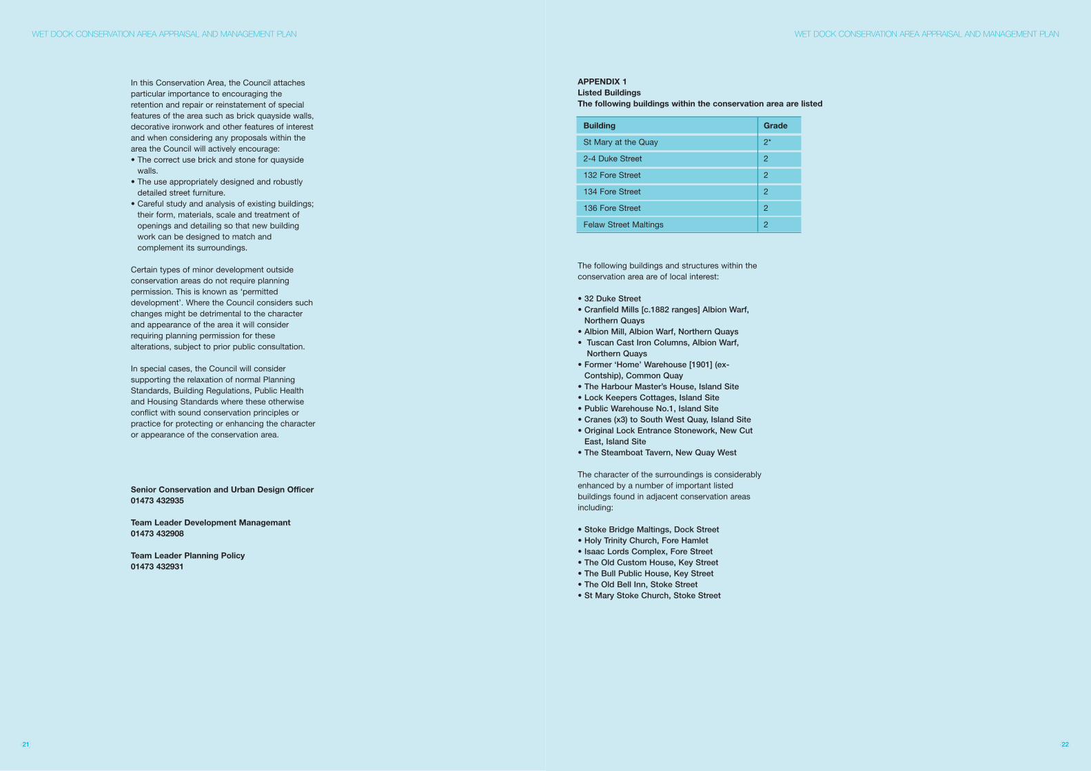
The following buildings and structures within theconservation area are of local interest:
• 32 Duke Street• Cranfield Mills [c.1882 ranges] Albion Warf,Northern Quays
• Albion Mill, Albion Warf, Northern Quays• Tuscan Cast Iron Columns, Albion Warf,Northern Quays
• Former ‘Home’ Warehouse [1901] (ex-Contship), Common Quay
• The Harbour Master’s House, Island Site• Lock Keepers Cottages, Island Site• Public Warehouse No.1, Island Site• Cranes (x3) to South West Quay, Island Site• Original Lock Entrance Stonework, New CutEast, Island Site
• The Steamboat Tavern, New Quay West
The character of the surroundings is considerablyenhanced by a number of important listedbuildings found in adjacent conservation areasincluding:
• Stoke Bridge Maltings, Dock Street• Holy Trinity Church, Fore Hamlet• Isaac Lords Complex, Fore Street• The Old Custom House, Key Street• The Bull Public House, Key Street• The Old Bell Inn, Stoke Street• St Mary Stoke Church, Stoke Street
21 22
APPENDIX 1Listed BuildingsThe following buildings within the conservation area are listed
Building Grade
St Mary at the Quay 2*
2-4 Duke Street 2
132 Fore Street 2
134 Fore Street 2
136 Fore Street 2
Felaw Street Maltings 2