Cospicua's Dock No.1 and what it replaced
8
Dock No.1 and what it replaced. Published on The Sunday Times of Malta on 3 rd May 2015 by Perit Stephen Serracino Inglott, Rehabilitation Projects Office (MTI) he author of William Scamp’s obituary can be forgiven for overlooking the social and commercial importance of the site on which the Dock No.1 had been built, and the drastic changes the urban reconfiguration brought about. After all, in 1872, the year of Scamp’s death, the British were following a policy of consolidating their naval forces in the Mediterranean. T William Scamp was sent to Malta under the Director of Engineering Works to the Admiralty in 1841. Here he designed and oversaw the construction of dry dock facilities in the Grand Harbour “... and so paved the way for making Malta, what it is, one of the chief naval stations in the world" (Obituary 274). There is no need for confirmation of the historic and strategic importance of having a strong British naval base in Malta, but its hard-hitting impact in relation to its location begs some important questions: What did Scamp demolish in order build the docks that the Admiralty wanted so much? Which livelihoods and spaces were affected or changed forever? The Market – Is-suq ta’ Bormla Through the latter half of 18 th and first half of 19 th centuries, the centre of Cospicua, along the Porto delle Galere had become a zone used for multiple purposes, lending itself to naval services and stores, it served as a fishermen’s haven, and the base for commercial expeditions in the Mediterranean and for corsair’s exploits, but probably more importantly, it housed a large market building. The inner Cospicuan water-side has long been referred to by locals as ‘is-Suq’, a market which today is conspicuous by its absence. Of course, the former names of the squares are telling: Piazza del Vecchio Mercato (Paolino Vassallo Square) and Piazza del Mercato Nuovo (Gavino Gulia Square). Architectural block plans, signed by William Scamp himself (Records & Archives Office, Projects House) show the proposed demolition of the market building which was located in today’s Gavino Gulia Square, but keep us guessing as to how it looked and functioned, as no detailed plans or elevations were found. Two watercolours recently auctioned in London are propitious in giving us a very good impression of not only how the building and its surroundings looked, but also of its value for local community by depicting frantic activity in the foreground and background alike. The seemingly rectangular building consisted of six smaller two storey blocks separated by courtyards and linked by terraces at the first floor level. It was characterized by a balustraded balcony along most of its façade, and could house numerous retail outlets. One can only speculate on what merchandise was sold but one can be sure that both local produce and imported goods were sold at the market. The paintings show colourful awnings shading the shop entrances with people and produce spilling out of the doors. A substantial number of fishermen used to populate Cospicua, filling the creek with fishing vessels. A statue of St Andrew, the patron saint of fishermen stood on a high pedestal overlooking the creek at the lower end of Triq Sant’Andrija. This remarkable mix of activities turned the geographic centre of town into a social hub and a meeting point for daily activities and trade. 1
-
Upload
independent -
Category
Documents
-
view
0 -
download
0
Transcript of Cospicua's Dock No.1 and what it replaced
Dock No.1 and what it replaced. Published on The Sunday Times of Malta on 3rd May 2015
by Perit Stephen Serracino Inglott, Rehabilitation Projects Office (MTI)
he author of William Scamp’s obituary can be forgiven for overlooking the social and commercial importance of the site on which the Dock No.1 had been built, and the drastic changes the urban reconfiguration brought about. After all, in 1872, the year of Scamp’s death, the British were following a policy of consolidating their naval forces in the
Mediterranean.TWilliam Scamp was sent to Malta under the Director of Engineering Works to the Admiralty in 1841. Here he designed and oversaw the construction of dry dock facilities in the Grand Harbour “... and so paved the way for making Malta, what it is, one of the chief naval stations in the world" (Obituary 274).
There is no need for confirmation of the historic and strategic importance of having a strong British naval base in Malta, but its hard-hitting impact in relation to its location begs some important questions: What did Scamp demolish in order build the docks that the Admiralty wanted so much? Which livelihoods and spaces were affected or changed forever?
The Market – Is-suq ta’ Bormla
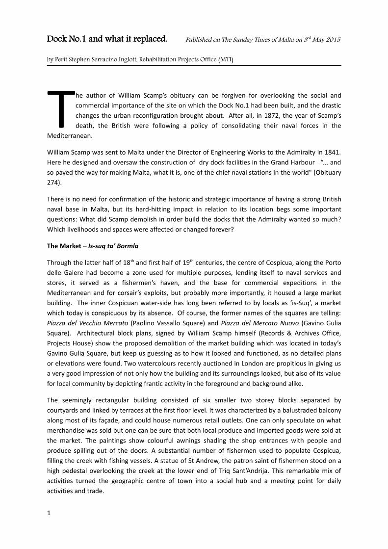
Through the latter half of 18th and first half of 19th centuries, the centre of Cospicua, along the Porto delle Galere had become a zone used for multiple purposes, lending itself to naval services and stores, it served as a fishermen’s haven, and the base for commercial expeditions in the Mediterranean and for corsair’s exploits, but probably more importantly, it housed a large market building. The inner Cospicuan water-side has long been referred to by locals as ‘is-Suq’, a market which today is conspicuous by its absence. Of course, the former names of the squares are telling: Piazza del Vecchio Mercato (Paolino Vassallo Square) and Piazza del Mercato Nuovo (Gavino Gulia Square). Architectural block plans, signed by William Scamp himself (Records & Archives Office, Projects House) show the proposed demolition of the market building which was located in today’s Gavino Gulia Square, but keep us guessing as to how it looked and functioned, as no detailed plans or elevations were found. Two watercolours recently auctioned in London are propitious in giving us a very good impression of not only how the building and its surroundings looked, but also of its value for local community by depicting frantic activity in the foreground and background alike.
The seemingly rectangular building consisted of six smaller two storey blocks separated by courtyards and linked by terraces at the first floor level. It was characterized by a balustraded balcony along most of its façade, and could house numerous retail outlets. One can only speculate on what merchandise was sold but one can be sure that both local produce and imported goods were sold at the market. The paintings show colourful awnings shading the shop entrances with people and produce spilling out of the doors. A substantial number of fishermen used to populate Cospicua, filling the creek with fishing vessels. A statue of St Andrew, the patron saint of fishermen stood on a high pedestal overlooking the creek at the lower end of Triq Sant’Andrija. This remarkable mix of activities turned the geographic centre of town into a social hub and a meeting point for daily activities and trade.
1
Population growth patterns indicate that the surrounding community was thriving confirming the contributions of the local activities to economic stability. From 1,200 inhabitants in the year 1565 to a peak of 12,148 individuals in 1901, the growth was ten-fold. The wish to live close to the creek was considerable. Notwithstanding, many enterprising folk spent years in other harbour towns along the Mediterranean coast trading goods, often financed by a wealthy investor. The majority of brigantines, a type of small merchant vessel, sailed to and fro Sicily and had a complement of around 6 to 12 crew members. They were engaged mainly in trading large quantities of wine, oil, fish, honey, livestock, cheese, ricotta, poultry, beans and snow from the Etna.
Others sailed as far as Spain and Portugal, stopping at Genoa, Marseille and Leghorn, in expeditions which lasted as long as two to three years. By contrast, this group did not bring back a lot of merchandise, but traded directly at different European ports. Records show that a large proportion of the captains and crew members of the merchant vessels were from Cospicua and Senglea. The flowing trade was ultimately reflected in the architecture. Elegant houses lined the waterfront, a result of the wealth generated by sturdy commerce.
Figure 1 Mons. Harbour, Malta. Early 19th Century. A view of the Market building in Cospicua prior to the construction of the dock.
2
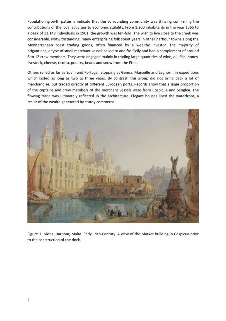
Figure 2 Anonymous. Harbour View, Continental School, Circa 1830. A view of the waterfront in Cospicua with the market building and the church in the background
The need for a dry dock
Almost suddenly the tables turn, and the British Admiralty in Malta arrives at a crossroads: it must either develop facilities for the growing demands of the Royal Navy, or lose momentum and influence in the Mediterranean. Enter Architect and Engineer William Scamp, and Cospicua’s centre seemed the natural choice for the first dry dock within these islands. Repairing the steel-lined hulls of the new warships could hardly continue to be done at the current facilities.
When cleared, the space created was large enough for both for the new dock and underground coal vaults, timber and metal sheds together with an engine house for the pumping machinery. This decision effectively separated the market building from the waterline. The residents of Bormla protested against the proposed location of the dockyard as it deprived them of their main access to the sea. An elaborate ceremony was held on 28 June 1844 on the occasion of the laying of the foundation stone of the new dry-dock. A cofferdam formed out of timber sheeting driven into the bedrock was used to keep the sea water out while the dock was being constructed. It was inaugurated on the 5th of September 1848 with the entry of a British warship for refitting. Scamp designed the workshops in a practical manner, along both sides of the dock.
On the side of Strada Marina, the workshops included a central block inside which was a plater’s shop. The smitheries, one used by the Department of Shipwrights and the other by the Department of Engineers were on each side of the central block. A small foundry was adjacent to smithery and on the other side of the dry-dock (still standing today) was a long and narrow block accommodating what were intended as open working sheds. Scamp created a perfectly symmetrical arrangement
3
with a rectangular enclosure around the dry-dock having identical facades facing each other across the dock. The new development marked a new era for Cospicua.
Fishing and trade slowly declined to make way for the new dominant industry: ship service and repair. A new breed of trained workers, whose skills were honed at the Admiralty’s Dockyard School, marched in replacing the fishermen, the brigantines’ crews and other merchants. The process, was gradual but definitive, the new industry demanded new skills, and what was once open urban space was enclosed behind new high walls, in a quasi-symbolic gesture of the magnitude of the empire’s might and its will to exert its commanding influence.
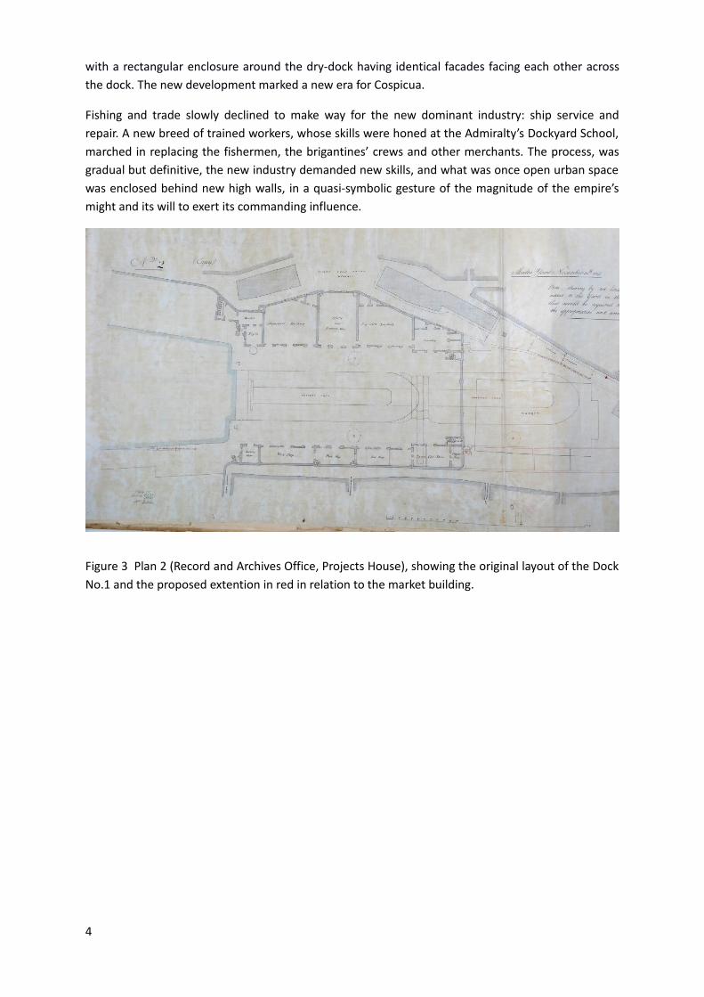
Figure 3 Plan 2 (Record and Archives Office, Projects House), showing the original layout of the Dock No.1 and the proposed extention in red in relation to the market building.
4
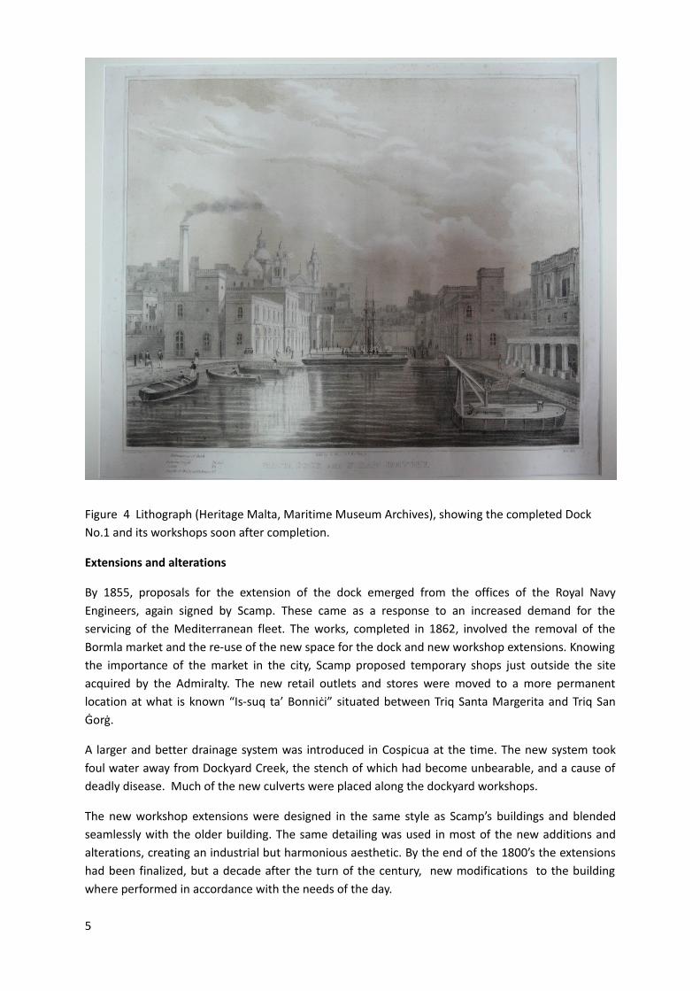
Figure 4 Lithograph (Heritage Malta, Maritime Museum Archives), showing the completed Dock No.1 and its workshops soon after completion.
Extensions and alterations
By 1855, proposals for the extension of the dock emerged from the offices of the Royal Navy Engineers, again signed by Scamp. These came as a response to an increased demand for the servicing of the Mediterranean fleet. The works, completed in 1862, involved the removal of the Bormla market and the re-use of the new space for the dock and new workshop extensions. Knowing the importance of the market in the city, Scamp proposed temporary shops just outside the site acquired by the Admiralty. The new retail outlets and stores were moved to a more permanent location at what is known “Is-suq ta’ Bonniċi” situated between Triq Santa Margerita and Triq San Ġorġ.
A larger and better drainage system was introduced in Cospicua at the time. The new system took foul water away from Dockyard Creek, the stench of which had become unbearable, and a cause of deadly disease. Much of the new culverts were placed along the dockyard workshops.
The new workshop extensions were designed in the same style as Scamp’s buildings and blended seamlessly with the older building. The same detailing was used in most of the new additions and alterations, creating an industrial but harmonious aesthetic. By the end of the 1800’s the extensions had been finalized, but a decade after the turn of the century, new modifications to the building where performed in accordance with the needs of the day.
5
Alterations to the extension were drawn up in 1910, evidence of which was found on plans archived at the Malta Maritime Museum. The changes enlarged the extension and created a number of boat sheds at the south-end of the building. The design matched that of William Scamp rendering the alterations hardly distinguishable.
The internal split level was again built using a separate steel structure, typical of Scamp’s preferred typology, found also at the Old Naval Bakery. The building was roofed over using stone slabs resting on steel beams, the details of which are noted on the documentation found. The parapet wall was lined with balusters over each section of the façade underlining the neo-classical style and proportions employed by the original architect. At roof level one finds a long skylight and ventilation shaft covered with a glazed pitched timber frame and enclosed with louvered panels on the sides.
It was inevitable that some degree of damage would be suffered by the building during the heavy bombardment of the Second World War. Plans dated 1945 indicate a number of minor changes and repairs. New concrete paving and bollards where installed on the dock, after digging new trenches and ducts for electricity, water and drainage systems. The integrity of the building façade was compromised with the addition of a number of small rooms housing boilers, wash and storage places. The wide doorways to the boat sheds were narrowed to small doors as their function was changed to a laundry and a battery shop.
Post-world war 2 marked a time of drastic unsympathetic changes to Scamp’s buildings. The changes happened as the combined result of damages, obsolescence, and the need to cater for changing technology.
The balustrade adorning the whole length of the parapet wall was removed and replaced with solid stone walls. The extra height of the original central area of the building was removed, possibly due to the extent of war damage: this single alteration effectively changing the general appearance of the façade. A new floor was built over the extension and used for dining and recreation. This new level was built in an alien style, with different heights and aperture details to what was designed on previous occasions. Instead, a modern/industrial approach was adopted. Moreover, a projecting section, housing the main staircase of the original building designed by Scamp was taken down to make more space on the dock for machinery. A small staircase tower at the dock’s inlet was also removed.
6
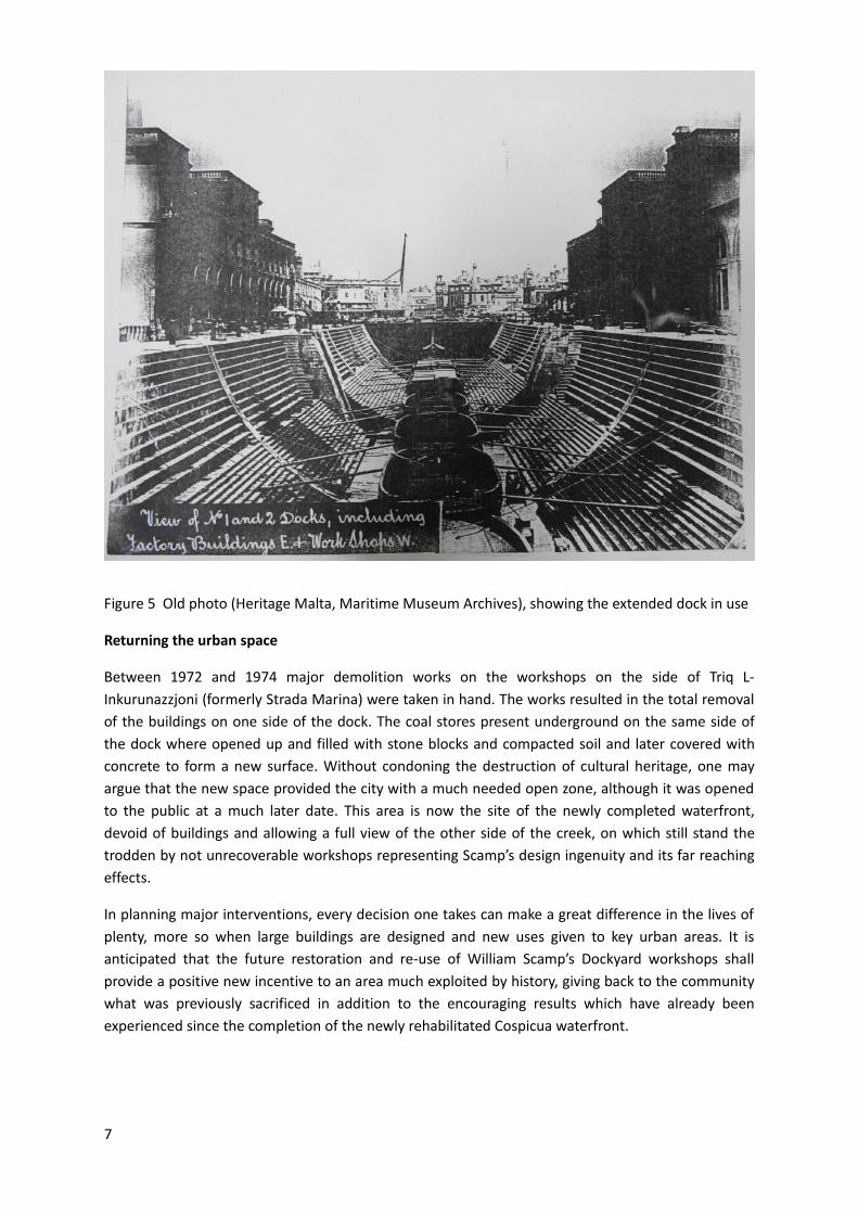
Figure 5 Old photo (Heritage Malta, Maritime Museum Archives), showing the extended dock in use
Returning the urban space
Between 1972 and 1974 major demolition works on the workshops on the side of Triq L-Inkurunazzjoni (formerly Strada Marina) were taken in hand. The works resulted in the total removal of the buildings on one side of the dock. The coal stores present underground on the same side of the dock where opened up and filled with stone blocks and compacted soil and later covered with concrete to form a new surface. Without condoning the destruction of cultural heritage, one may argue that the new space provided the city with a much needed open zone, although it was opened to the public at a much later date. This area is now the site of the newly completed waterfront, devoid of buildings and allowing a full view of the other side of the creek, on which still stand the trodden by not unrecoverable workshops representing Scamp’s design ingenuity and its far reaching effects.
In planning major interventions, every decision one takes can make a great difference in the lives of plenty, more so when large buildings are designed and new uses given to key urban areas. It is anticipated that the future restoration and re-use of William Scamp’s Dockyard workshops shall provide a positive new incentive to an area much exploited by history, giving back to the community what was previously sacrificed in addition to the encouraging results which have already been experienced since the completion of the newly rehabilitated Cospicua waterfront.
7
Sources and Bibliography:
Projects House, Records and Archives Office, Dockyard folder.
Heritage Malta, Maritime Museum Archives, Dockyard folder and photographs.
Mons. Harbour, Malta. Early 19th Century, Bonhams Auction 17849: Travel and Exploration, London, New Bond Street. Bonhams. 15 Sept. 2010.
Anonymous, Harbour View, Continental School, Circa 1830, Bonhams Auction 16208: Exploration, Travel and Topographical Pictures, London, New Bond Street. Bonhams. 21 May 2008.
Thake, Conrad, William Scamp (1801-1872): An Architect of the British Admiralty in Malta. Sta Venera, Malta: Midsea, 2011.
Vassallo, Carmel, The Brigantine in XVIII century Malta, Malta Historical Society Forthcoming, Proceedings of History Week ,1993.
Landow, George P., William Scamp (1801-1872), The Victorian Web. Brown University, 10 Mar 2010.
Mallia Milanes, V. ed. Hospitaller Malta 1530-1798, Malta, Mireva Publications Ltd. 1993.
Farrugia Ivana, Perit, Restoration of the external facades of the British Block at Dock 1, Bormla, Condition Report & Method, Restoration Directorate, 2013.
8